Danube Cycle Plans
121
P5 HR: Ministry of the sea, transport and infrastructure of Croatia WP A.T2.2: Define cycling-friendly infrastructure standards Author: Davorin Belamarić Version: Final Date: December 2021 Danube Cycle Plans Catalogue of Cycling-friendly Infrastructure Standards for the Danube Countries
-
Upload
khangminh22 -
Category
Documents
-
view
0 -
download
0
Transcript of Danube Cycle Plans

http://www.interreg-danube.eu/approved-projects/danube-cycle-plans
PP5 HR: Ministry of the sea, transport and infrastructure of Croatia
WP A.T2.2: Define cycling-friendly infrastructure standards Author: Davorin Belamarić
Version: Final Date: December 2021
Danube Cycle Plans
Catalogue of Cycling-friendly Infrastructure Standards
for the Danube Countries

2
Guidelines to define National Cycle Route Network
Contact Coordinator:
Environment Agency Austria
Agnes Kurzweil
Email Address: [email protected]
Web: www.umweltbundesamt.at
Authors:
Davorin Belamarić
Julijan Jurak
Zoran Klarić
Ivan Nemet
Marko Stančec
Email Address: [email protected]
Web: www.sindikatbiciklista.hr
More information about Danube Cycle Plans
and the project activities & results are available on:
http://www.interreg-danube.eu/danube-cycle-plans
Danube Cycle Plans | Policies, plans and promotion
for more people cycling in the Danube region
www.interreg-danube.eu/danube-cycle-plans

3
Guidelines to define a National Cycle Route Network
Table of contents 1. Introduction 5
1.1. Danube Cycle Plans project 5
1.2. General condition of cycling and infrastructure in DCP countries 6
1.3. The importance of cycling infrastructure 7
1.4. Working scope, methodology and document structure 9
1.5. Application of the catalogue of standards for cycling infrastructure in the Danube region 9
2. Approach in the comparison of standards for cycling infrastructure and real situation in DCP countries 10
2.1. Overview and structure of standards in DCP countries and additional documents 10
2.2. Aspects covered by analysis of standards 12
2.3. Analysis of different aspects 12
3. Mentioning the importance of cycling 13
4. Planning the cycling infrastructure 14
5. Types of infrastructure for cycling 18
6. Selection of appropriate infrastructure depending on the traffic situation 36
6.1. Appropriate infrastructure related to the interaction with motorized traffic 36
6.2. Infrastructure shared between cyclists and pedestrians 42
6.3. Two-ways cycle paths on both sides of the road 46
7. Cycle intersections 47
7.1. Continuity of cycling infrastructure 48
7.2. Curbs at the intersection 51
7.3. Types of intersections 53
7.3.1. Roundabouts 53
7.3.2. Intersections with four legs 56
7.3.3. Cycle lanes or cycle track passing through an intersection on priority road 58
7.3.4. Cycle lane when changing the direction of the priority road in the area of the intersection 60
7.3.5. Cycle tracks through the traffic island 61
7.3.6. Cycle lane or cycle track over the leg of the non-priority road 62
7.3.7. Stop lines for cyclists at intersections 65
7.3.8. Waiting area next to the cycle lane for turning cyclists to the left 68
7.3.9. Signalized intersections for cyclists 69

4
Guidelines to define a National Cycle Route Network
7.4. Pedestrians crossings over cycle tracks 72
8. Bridges, tunnels and stairs 74
9.1. Access to tunnels and bridges 75
9.2. Tunnels 76
9.3. Bridges 79
9. Bicycle parking 81
9.1. Policy 81
9.2. Storage solutions 83
10. Signalization 89
10.1. Vertical signalization 89
10.2. Horizontal signalization 96
10.3. Traffic lights 99
11. Maintenance 100
11.1. Road construction 101
11.2. Vegetation and winter maintenance 104
12. Bicycle and public transport 108
12.1. Shared lanes 108
12.2. Cycling infrastructure and public transport stops 109
12.3. Bicycle parking facilities at traffic nodes 110
13. Summary of standard analysis 110
14. Challenges in development and construction 111
14.1. Costs of cycling infrastructure 112
15. General recommendations 117
16. Conclusion 118
17. References 119
LIST OF APPENDICES
Appendix 1 Table 51. Example of the cost calculation in .xls format.
5
Guidelines to define a National Cycle Route Network
1. Introduction
1.1. DANUBE CYCLE PLANS PROJECT
In 2016, the United Nations Economic Commission for Europe started cooperating with the Transport, Health and
Environment Pan-European Programme (THE PEP) to develop the pan-European master plan for cycling. In its
report, the ECE (2020) proposes the definitions of various infrastructure types of importance in regard to cycling
and offers recommendations for further development of cycling networks at pan-European and national, regional
and local levels.
Afterwards, in 2019, nine European countries joined together to develop a project idea and submit a candidacy to
the Danube Transnational Programme with the application form for the Danube Cycle Plans project (DCP). The
Danube Cycle Plans project aims to address:
(1) Lack of, or poor cooperation between local/regional authorities and national/transnational authorities
crystallises in the low number of countries (AT, CZ, SK, HU) having national cycling policies, supported by National
Cycling Plans (NCP) in place;
(2) Lack of coordination also leads to fragmented cycling infrastructure development, differences in quality of
infrastructure conditions amongst participating countries, existing design standards (if any) differ a lot between
countries, and financial support is inadequate;
(3) Cycling is often treated as a side topic in transport policies and there is little awareness about the needs of
cyclists and benefits of cycling.
The project will address these challenges by setting actions to strengthen three main pillars of cycling promotion:
(1) Facilitate the development of cycling policies at a national and transnational level supported by National Cycling
Plans, based on a common transnational Danube Cycling Strategy;
(2) Support the provision of adequate cycling infrastructure by defining the Danube Cycle Route Network,
developing common standards and deriving an investment plan to upgrade current conditions;
(3) Increase the awareness of relevant stakeholders for the needs of cyclists and increase their capacity to promote
cycling in the whole Danube region by implementing a mentoring system, inspiration events and national cycling
conferences.
Within the DCP project, Project partner 5, the Croatian Ministry of the sea, transport and infrastructure, is
responsible for the task T2.2.1 Catalogue of Cycling-friendly Infrastructure Standards for the Danube Countries.
The Ministry engaged a team of external consultants to perform this task.
The Catalogue will be used following DCP project objectives (as explained in more detail in chapter 1.4.) but also
for other projects and initiatives supporting cycling development expected in the future.
6
Guidelines to define a National Cycle Route Network
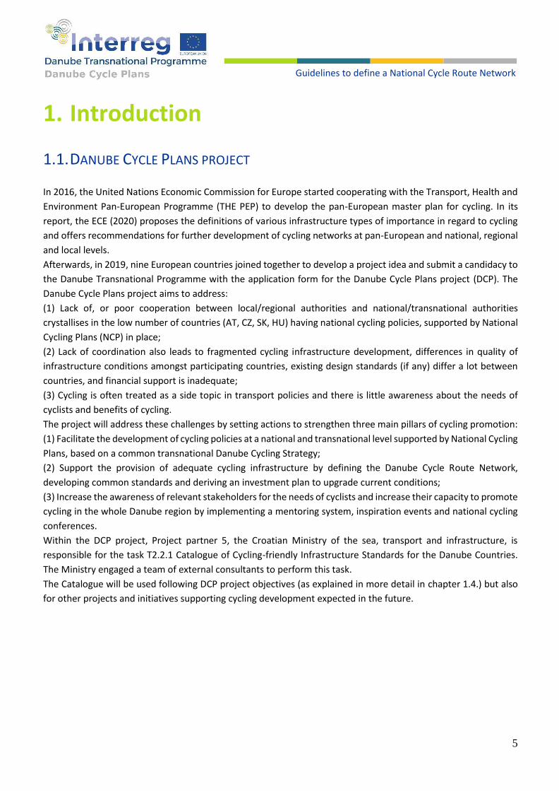
1.2. GENERAL CONDITION OF CYCLING AND INFRASTRUCTURE IN DCP COUNTRIES
Table 1 gives an overview about commuter cycling in DCP countries – source: questionnaires from project partners, and comparison with highly developed countries such as DK and NL. Not all data are actual, reliable and comparable, but they can still give a rough impression about differences in bicycle use in 9 DCP countries. The map shown in figure 1 gives an overview about the income from cycling tourism per capita in European countries.
Country Eurobarometer - Modal share of cycling as a mode most often used
Country reports - modal share bicycle - no. of trips
AT 6% 6.4% (2013/14)
BG 4% 0.5 - 2.5% (2019 - estimation)
CZ 8% 4.5% (2017 - 2019)
HR 6% 5.1% 2019
HU 22% 16.8% (2012)
RO 7% 1.5% (2012)
RS 1% 2020 - country data not available
SI 9% 4.5% (2017)
SK 7% 7% (2015)
DK 23% 16% (2016)
NL 36% 27% (2016)
Table 1. Overview about commuter cycling in DCP countries from questionnaires by project partners, and comparison with highly developed countries such as DK and NL. Source: Special Eurobarometer 422a - European Commission (12/2014)
Figure 1. Overview about the income from cycling tourism per capita in European countries. Source: http://www.eurovelo.org/wp-content/uploads/ 2015/01/AB-Presentation- European-Tourism Forum.pdf
7
Guidelines to define a National Cycle Route Network
1.3. THE IMPORTANCE OF CYCLING INFRASTRUCTURE
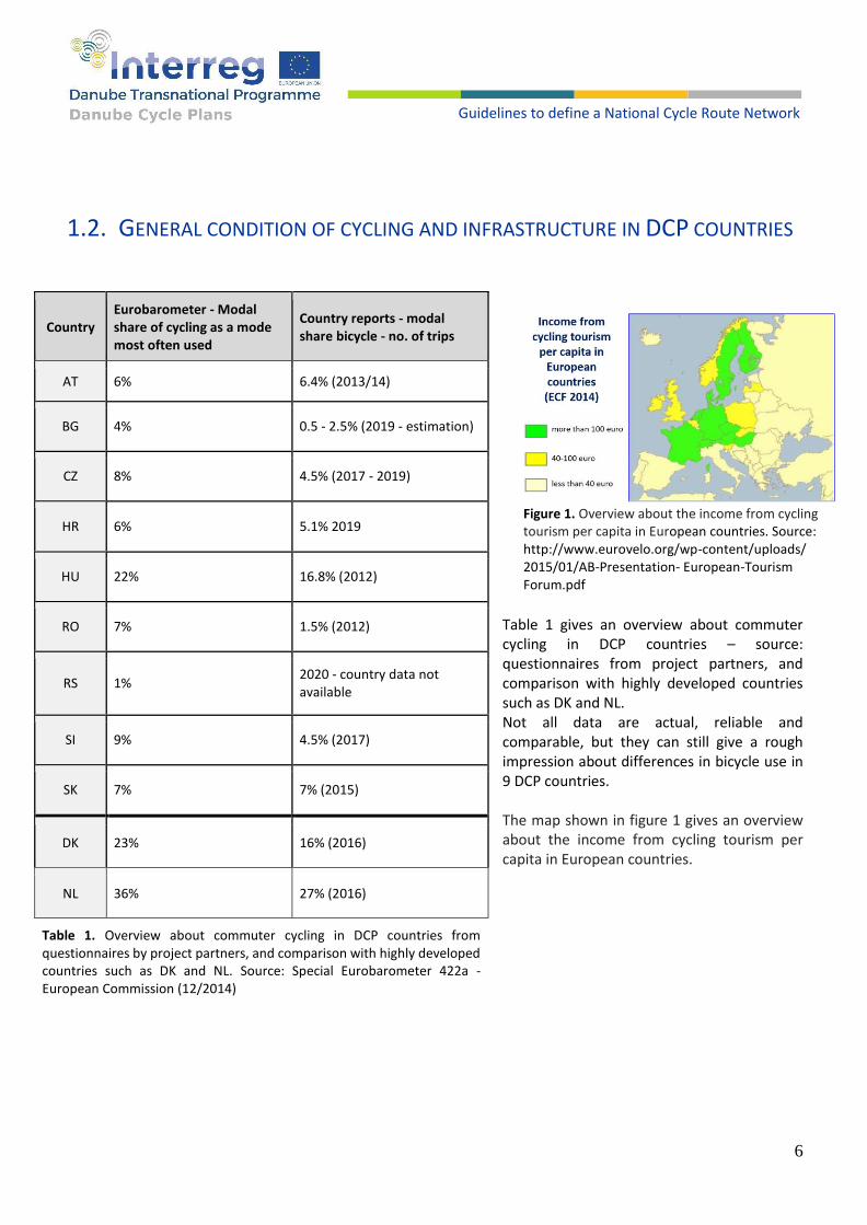
Numerous studies and articles point out and prove the benefits of cycling. Cycling is time and cost-efficient, safe, healthy, and environmentally friendly. Cycling brings significant benefits not only for persons who are cycling but for society in general: less pollution, fewer costs and energy consumption, higher productivity, lower public health costs, lower public infrastructure costs, new business opportunities through cycling tourism and bicycle industry, and even higher efficiency of the remaining motorized traffic. Table 2 gives an example of comparing costs of cycling and car driving costs per km, related to an individual and society. [1]
Table 2. Comparative costs of cycling and car driving costs per km, related to an individual and society. [1]
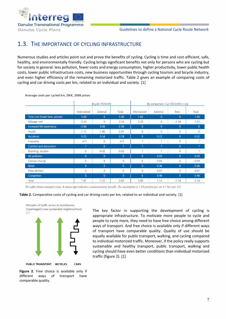
The key factor in supporting the development of cycling is appropriate infrastructure. To motivate more people to cycle and people to cycle more, they need to have free choice among different ways of transport. And free choice is available only if different ways of transport have comparable quality. Quality of use should be equally available for public transport, walking, and cycling compared to individual motorized traffic. Moreover, if the policy really supports sustainable and healthy transport, public transport, walking and cycling should have even better conditions than individual motorized traffic (figure 2). [1]
Figure 2. Free choice is available only if different ways of transport have comparable quality.
8
Guidelines to define a National Cycle Route Network
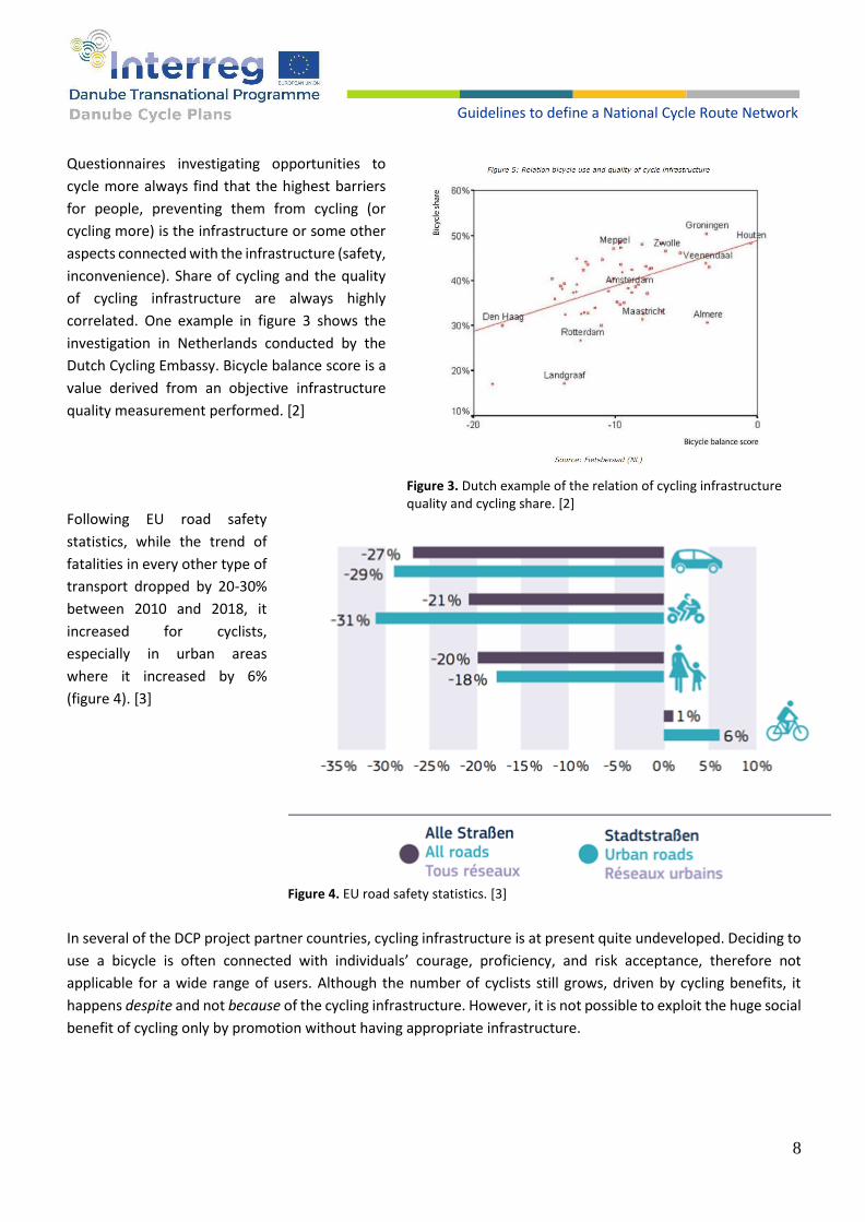
Questionnaires investigating opportunities to
cycle more always find that the highest barriers
for people, preventing them from cycling (or
cycling more) is the infrastructure or some other
aspects connected with the infrastructure (safety,
inconvenience). Share of cycling and the quality
of cycling infrastructure are always highly
correlated. One example in figure 3 shows the
investigation in Netherlands conducted by the
Dutch Cycling Embassy. Bicycle balance score is a
value derived from an objective infrastructure
quality measurement performed. [2]
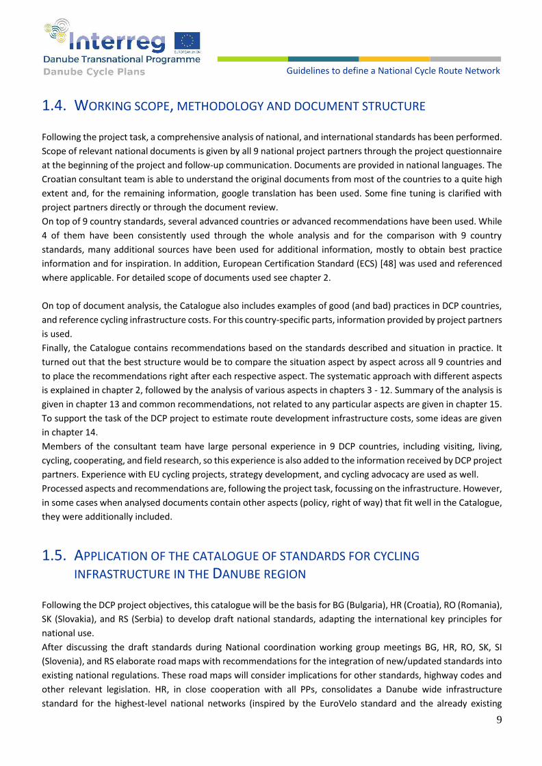
Following EU road safety
statistics, while the trend of
fatalities in every other type of
transport dropped by 20-30%
between 2010 and 2018, it
increased for cyclists,
especially in urban areas
where it increased by 6%
(figure 4). [3]
In several of the DCP project partner countries, cycling infrastructure is at present quite undeveloped. Deciding to
use a bicycle is often connected with individuals’ courage, proficiency, and risk acceptance, therefore not
applicable for a wide range of users. Although the number of cyclists still grows, driven by cycling benefits, it
happens despite and not because of the cycling infrastructure. However, it is not possible to exploit the huge social
benefit of cycling only by promotion without having appropriate infrastructure.
Figure 3. Dutch example of the relation of cycling infrastructure quality and cycling share. [2]
Figure 4. EU road safety statistics. [3]
9
Guidelines to define a National Cycle Route Network
1.4. WORKING SCOPE, METHODOLOGY AND DOCUMENT STRUCTURE
Following the project task, a comprehensive analysis of national, and international standards has been performed.
Scope of relevant national documents is given by all 9 national project partners through the project questionnaire
at the beginning of the project and follow-up communication. Documents are provided in national languages. The
Croatian consultant team is able to understand the original documents from most of the countries to a quite high
extent and, for the remaining information, google translation has been used. Some fine tuning is clarified with
project partners directly or through the document review.
On top of 9 country standards, several advanced countries or advanced recommendations have been used. While
4 of them have been consistently used through the whole analysis and for the comparison with 9 country
standards, many additional sources have been used for additional information, mostly to obtain best practice
information and for inspiration. In addition, European Certification Standard (ECS) [48] was used and referenced
where applicable. For detailed scope of documents used see chapter 2.
On top of document analysis, the Catalogue also includes examples of good (and bad) practices in DCP countries,
and reference cycling infrastructure costs. For this country-specific parts, information provided by project partners
is used.
Finally, the Catalogue contains recommendations based on the standards described and situation in practice. It
turned out that the best structure would be to compare the situation aspect by aspect across all 9 countries and
to place the recommendations right after each respective aspect. The systematic approach with different aspects
is explained in chapter 2, followed by the analysis of various aspects in chapters 3 - 12. Summary of the analysis is
given in chapter 13 and common recommendations, not related to any particular aspects are given in chapter 15.
To support the task of the DCP project to estimate route development infrastructure costs, some ideas are given
in chapter 14.
Members of the consultant team have large personal experience in 9 DCP countries, including visiting, living,
cycling, cooperating, and field research, so this experience is also added to the information received by DCP project
partners. Experience with EU cycling projects, strategy development, and cycling advocacy are used as well.
Processed aspects and recommendations are, following the project task, focussing on the infrastructure. However,
in some cases when analysed documents contain other aspects (policy, right of way) that fit well in the Catalogue,
they were additionally included.
1.5. APPLICATION OF THE CATALOGUE OF STANDARDS FOR CYCLING
INFRASTRUCTURE IN THE DANUBE REGION
Following the DCP project objectives, this catalogue will be the basis for BG (Bulgaria), HR (Croatia), RO (Romania),
SK (Slovakia), and RS (Serbia) to develop draft national standards, adapting the international key principles for
national use.
After discussing the draft standards during National coordination working group meetings BG, HR, RO, SK, SI
(Slovenia), and RS elaborate road maps with recommendations for the integration of new/updated standards into
existing national regulations. These road maps will consider implications for other standards, highway codes and
other relevant legislation. HR, in close cooperation with all PPs, consolidates a Danube wide infrastructure
standard for the highest-level national networks (inspired by the EuroVelo standard and the already existing

10
Guidelines to define a National Cycle Route Network
standards in AT (Austria), CZ (Czech), HU (Hungary)) which will be an important input for the definition of
investment necessities.
On top of particular DCP project objectives, this Catalogue of standards will contribute to the convergence of
European standards related to the cycling infrastructure. European countries are more and more connected due
to tourism, temporary assignments and migrations. Having different standards is inconvenient and risky, so a
tendency toward common standards could increase safety, comfort and efficiency. Therefore, UNECE documents
are included in this analysis and UNECE people are in the review process of this Catalogue.
Improving and unifying the cycling standards is especially important, having in mind ambitious objectives of a
significant increase of cycling traffic in the whole EU.
It is also important to be aware that drivers of motorized vehicles belong to the key contributors for cycling traffic
safety – in many cases responsible for traffic accidents with cyclists. Therefore, signs for motorized vehicles related
to cycling traffic should also be included in this consideration.
2. Approach in the comparison of standards for cycling infrastructure and real situation in DCP countries
2.1. OVERVIEW AND STRUCTURE OF STANDARDS IN DCP COUNTRIES AND
ADDITIONAL DOCUMENTS
Different countries regulate cycling infrastructure in significantly different ways. Not only the prescripts are
different: they are structured in different documentation sets, sometimes in one document, sometimes small parts
of several documents, and have different levels of power. Although the meaning of different document types may
slightly vary from country to country, the approximate order of the “document strength” is as follows:
laws;
regulations;
technical standards;
recommendations / guidelines / handbooks;
collections of examples and information.
The word “standards” used in this Catalogue of standards is used as a common word for all relevant documents.

11
Guidelines to define a National Cycle Route Network
Table 3 gives an overview of documents received and analysed per country. Full name of documents is given in the appendix – references: Country Document Facility Signage Parking Document type Issued
AT [4] RVS - 3.02.13 Road Engineering for bikes X technical standard 2014
AT [5] Bicycle parking in Carinthia X guideline 2015
BG [6] BG - Ordinance № RD-02-20-2 transport system urban X X rules 2018
CZ [10] CZ - TP 179 - road design for cyclists X X X technical standard 2017
HR [13] HR - Rules on CYCLING INFRASTRUCTURE X X rules 2016
HR [14] HR - Rules on traffic signs, signalization and equipment X rules 2019
HU [20] HU - Cycling public road design X X rules 2019
RO [22] RO - Ordinance no. 195/2002 Road Code X rules 2002
RO [23] RO - LAW no. 250 parking of bicycles in public space X law 2020
RO [25] RO - STAS 10144 2 91 - street design X technical standard 1991
RS [27] RS - Manual for road design - Bicycle X X handbook 2012
RS [28] RS - The Rulebook on traffic signals X rules 2021
SI [29] SI - RULES on cycling areas X X rules 2018
SI [30] SI - Bicycle-friendly infrastructure guidelines X X guideline 2017
SI [31] SI - Rules on traffic signs and equipment on roads X rules 2021
SK [33] SK - TP 085 - DESIGN OF CYCLING INFRASTRUCTURE X X X technical standard 2019 Table 3. Overview of documents received and analyzed per country.
Out of this overview, it can be seen that 7 – almost all DCP countries have an obligatory standard specifying the cycling infrastructure. Serbia has a manual that is not binding, while Romania has no specific documentation for cycling infrastructure standards, only several statements in the standard describing the road traffic infrastructure in general. In addition to the 9 country standard documentation sets, several advanced and/or international documents have been used in the analysis. Some of them have been analysed in detail, and consistently included in the comparison together with the 9 country standards through the whole Catalogue. The following 4 sources (5 documents) (table 4) have been selected as the most appropriate for this purpose:
Country Document Facility Signage Parking Document type Issued
DK [1] DK - Collection of Cycle Concepts X X publication 2012
EU [2] EU - PRESTO Cycling Policy Guide - EU project output X X publication 2010
NL [34] CROW-Fietsberaad - Design Manual for Bicycle Traffic X X manual 2016
UN [35] UNECE - THE PEP EU Cycling Master Plan – Infrastructure X X informal document 2020
UN [36] UNECE Signs and signals for cyclists and pedestrians X publication 2014
Table 4. Advanced and/or international documents used in the analysis and for comparison with DCP country standards.

12
Guidelines to define a National Cycle Route Network
Analysing the documents, many influences and even overtaking big parts of the document content from country
to country could be noted. However, further development in the countries that copied regulations could also be
noted. The whole document collection is a valuable source for innovative solutions and a source of inspiration
between the countries. Developed countries have collected significant experience which can be reused by
emerging countries, to speed up their development process without the need to reinvent the wheel. But the
countries developing cycling in recent years are not only copying practices from others but rethinking and
innovating, so the inspiration could go also in a different direction.
2.2. ASPECTS COVERED BY ANALYSIS OF STANDARDS
Cycling infrastructure analysis and comparison have been structured in different aspects. The following list gives
an overview of the aspects that are covered, each in one of the next chapters. In several cases, some complex
aspects have been sub-structured.
1. Mentioning the importance of cycling
2. Planning the cycling infrastructure
3. Types of infrastructure for cycling
4. Selection of appropriate infrastructure depending on the traffic situation
5. Cycle intersections
6. Bridges, tunnels and stairs
7. Bicycle parking
8. Signalization
9. Maintenance
10. Bicycle and public transport
2.3. ANALYSIS OF DIFFERENT ASPECTS
Every chapter deals with one aspect in the following structure:
1 Short introduction explains the aspect
2 Table(s) or diagram(s) compare this aspect in 9 DCP countries and 4 advanced documents. Additional textual
explanations pointing out special cases or differences follows.
3 Several examples from practice to get an impression of the real situation in 9 DCP countries (do they stick to the
standards or is the reality different) – depending on the available information from countries. As a main source for
the real situation check, the status quo questionnaires from every of 9 DCP countries have been used. [37] – [45]
4 Recommendations to this aspect are proposed
Scope of the chapter tries to find an optimum between the amount of relevant information and the size of the
chapter.
In addition to specific recommendations, related to a particular aspect, general recommendations are given
separately in chapter 15 (General recommendations).
13
Guidelines to define a National Cycle Route Network
3. Mentioning the importance of cycling
The benefits of cycling, mentioned in the introduction, are not widely known and adopted, especially in countries with cycling not yet established as a frequently used and equal form of transport, and the bicycle is perceived as something for sport, young or poor people.
Moreover, in car-dominated societies, the decision-makers and traffic engineers responsible for implementing the standards are frequently car-minded and are not using a bicycle at all, having several blind spots making it difficult to understand the aspects of the regulations.
Therefore, although the laws, regulations, and technical standards are generally written in a strictly formal style, avoiding any additional information, the cycling standard documents frequently contain an “inspirational section”, describing benefits of cycling for society and the importance of cycling infrastructure, as well as needs of cyclists.
Table 5 gives an overview of the documents which contain an inspirational part, mentioning at least cyclists’ needs or even a bit more: benefits of cycling and importance of the infrastructure. It’s clear that it fits more to the publications and informal documents than to the rulebooks, but it could be found in short even in some rulebooks.
Country Document Document type Mentioned
AT [5] Bicycle parking in Carinthia guideline benefits
HU [20] HU - Cycling public road design rules needs
RS [27] RS - Manual for road design - Bicycle handbook needs
SI [30] SI - Bicycle-friendly infrastructure guidelines guidelines benefits
DK [1] DK - Collection of Cycle Concepts publication benefits
EU [2] EU - PRESTO Cycling Policy Guide - EU project output publication benefits
NL [34] CROW - Fietsberaad - Design Manual for Bicycle Traffic manual benefits
UN [35] UNECE - THE PEP EU Cycling Master Plan – Infrastructure informal document
benefits
Table 5. Overview of the documents which contain an inspirational part.
RECOMMENDATIONS
1. Try to include a short part describing benefits of cycling for the whole society, or at least needs for cycling in every document where possible.
2. Use the wording that will oppose the notion of cyclists as a special group of people. We need an infrastructure for cycling not for cyclists – assuming that everyone would dare to use the bicycle if the infrastructure is adequate and therefore has a free choice of a mean of transportation.
14
Guidelines to define a National Cycle Route Network
4. Planning the cycling infrastructure
Essential element in building the cycling infrastructure is its planning, also including the evaluation of existing
situations for the next planning period. As stated in the previous chapter, many countries lack general conscience
about cycling benefits and therefore miss the important aspects of cycling as an end-to-end traffic connection. The
result of such a situation gives sporadic cycling infrastructure elements that are not connected in a useful network.
Without planning, money is spent and there are no results, or at least not optimal results that could have been
achieved with the available budget.
First step of planning the cycling infrastructure is plans, strategies or different laws that are mentioning or
regulating cycling transport and infrastructure. Regarding various literature which is composed of strategies or
regulation for every country of the DCP project, that literature has been analysed by aspects of planning.
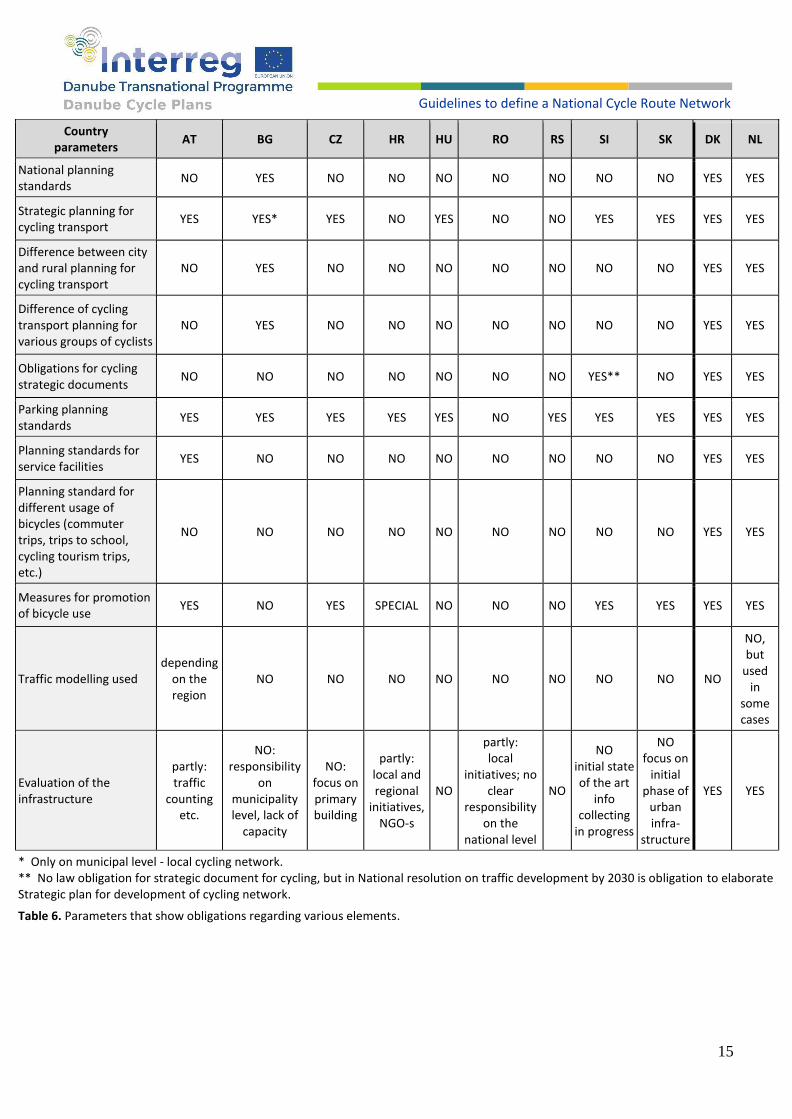
Table 6 represents parameters that show obligations regarding various elements. Parameters are divided
regarding to every one of the 9 countries covered by the DCP project. Parameters have been collected out of
country documentations [4] – [33], as well as out of the additional DCP partners’ questionnaires triggered by the
purpose of this catalogue [50] – last 2 questions.
First two parameters show if every country has implemented standards for the planning of cycling infrastructure
(not as a part of general transport planning). Parameter obligations for cycling strategic documents show that even
a single country of project area does not have any obligation for strategic documents in the field of cycling
infrastructure (only various strategies, like SUMPs or national Masterplans).
Some countries of the DCP project have planning standards for specific segments of cycling infrastructure (Austria).
In chapter 9 (Bicycle parking) is a more specific way to plan parking lots for bicycles for various buildings and zones
(retail, house, etc.).
Other parameters also show that only parking standards are present (but very simplified) with any consideration
to different cyclists (children, workers, elderly, or disabled people), usage (tourist, recreational, working, etc.) and
service facilities (for example resting stations, info boards, etc.). Planning of cycling infrastructure is not different
regarding urban, suburban or rural areas of the city or settlement by literature.
Analysing parameters in table 6, none of the countries included in the DCP project have the answer “yes” to these
parameters: national planning standard, difference between city and rural planning for cycling transport,
difference of cycling transport planning for various groups of cyclists and planning standard for different usage of
bicycles.
15
Guidelines to define a National Cycle Route Network
Country parameters
AT BG CZ HR HU RO RS SI SK DK NL
National planning standards
NO YES NO NO NO NO NO NO NO YES YES
Strategic planning for cycling transport
YES YES* YES NO YES NO NO YES YES YES YES
Difference between city and rural planning for cycling transport
NO YES NO NO NO NO NO NO NO YES YES
Difference of cycling transport planning for various groups of cyclists
NO YES NO NO NO NO NO NO NO YES YES
Obligations for cycling strategic documents
NO NO NO NO NO NO NO YES** NO YES YES
Parking planning standards
YES YES YES YES YES NO YES YES YES YES YES
Planning standards for service facilities
YES NO NO NO NO NO NO NO NO YES YES
Planning standard for different usage of bicycles (commuter trips, trips to school, cycling tourism trips, etc.)
NO NO NO NO NO NO NO NO NO YES YES
Measures for promotion of bicycle use
YES NO YES SPECIAL NO NO NO YES YES YES YES
Traffic modelling used depending
on the region
NO NO NO NO NO NO NO NO NO
NO, but
used in
some cases
Evaluation of the infrastructure
partly: traffic
counting etc.
NO: responsibility
on municipality level, lack of
capacity
NO: focus on primary building
partly: local and regional
initiatives, NGO-s
NO
partly: local
initiatives; no clear
responsibility on the
national level
NO
NO initial state of the art
info collecting
in progress
NO focus on
initial phase of
urban infra-
structure
YES YES
* Only on municipal level - local cycling network. ** No law obligation for strategic document for cycling, but in National resolution on traffic development by 2030 is obligation to elaborate Strategic plan for development of cycling network.
Table 6. Parameters that show obligations regarding various elements.

16
Guidelines to define a National Cycle Route Network
Austria is also the only country of the DCP project that has implemented parameter planning standards for service
facilities in regulations. Comparing countries from the DCP project with countries like Denmark [1] or Netherlands
[34] show how it is necessary to implement those standards. Partial implementation is not giving full development,
as may be expected.
Parameters from table 6 also show needs for implementing obligations for creating and implementing strategic
cycling planning documents. These documents should desegregate the needs of cyclists regarding their
characteristics (e.g., cycling tourists, children, elderly or people with disabilities), specific geographic regions or
bicycle use (work, school or recreational purposes).
For example, article 93. of Bulgarian regulation [9] can prove the thesis mentioned above, where there are only
general numbers of pedestrian, bicycle and motorized traffic (table 21 of the Regulation [9]) for determining new
pedestrian or cycle lanes (without mentioned usages, users or areas of that possible cycle lane).
Countries like Denmark or the Netherlands show that good and rational planning with long term visions can lead
to an increasing number of cyclists in urban and rural areas. Consideration about all elements of cycling
infrastructures, users, promotion, effect of cycling on urban development, interactions with other participants in
traffic (pedestrian, drivers, etc.) leads to developing smart and sustainable development of cycling culture.
Developing and implementing cycling infrastructure comes after planning segments. Reason for that lies in all the
literature of countries who become leaders in cycling transport.
Literatures like CROW – Design manual for bicycle traffic (Netherlands), Collection of Cycle Concepts 2012 or focus
on cycling – Copenhagen Guidelines for the Design of Road Projects (Denmark), documentation from PRESTO
project (financed from EEE – Intelligent Energy Europe), Practitioner Briefings: Cycling. Supporting and
encouraging cycling in Sustainable Urban Mobility Planning, Cost-benefit analysis for cycling, etc. have detected
setting goals and policies as a first step for creating sustainable, safe and improved cycling transport for all current
and potential cyclists.
Several documents describing standards take in consideration the „number of cyclists“ as a criterion if a specific
cycling infrastructure should be implemented, which type and where. It is not completely right. Needs for cycling
infrastructure should consider the future number of cyclists, which will increase anyhow and especially if
encouraged by the appropriate infrastructure. E.g. [10 – CZ] explicitly states that the cycling infrastructure should
be built where its lack makes a barrier for cycling and [20 – HU] states the future needs that should be taken into
account. Such an approach should be applied in all countries.
When planning the intercity cycling infrastructure, regulations consider traffic volume, speed etc. This might be a
too narrow approach, leading to too high costs and lower quality. In many cases, there is an alternative route (with
comparable distance and effort) using the roads with less traffic, and this should be the 1st choice which costs less
and is more attractive. Skipping this information might mislead the decision-makers to the paradigm of the
straightforward solution spending much money on widening the main roads with cycle tracks which is neither cost-
efficient nor attractive (noise, smell).
Modelling of cycling transport can also be part of planning of cycling infrastructure. Modelling can refer not only
to assessing the current number of cyclists at some specific area but also to determine with relevant accuracy the
number of future cyclists at the same area. Detecting the possible future number of cyclists is a possible way to
determine measures that can lead to achieving that future number of cyclists and even to increase it. By parcelling
different groups of cyclists (children, students, workers, elderly, etc.), specific ways for choosing routes to their
destinations can be detected. Workers may choose the fastest route, children the safest and students the route
that pass by their favourite object of interest.
17
Guidelines to define a National Cycle Route Network
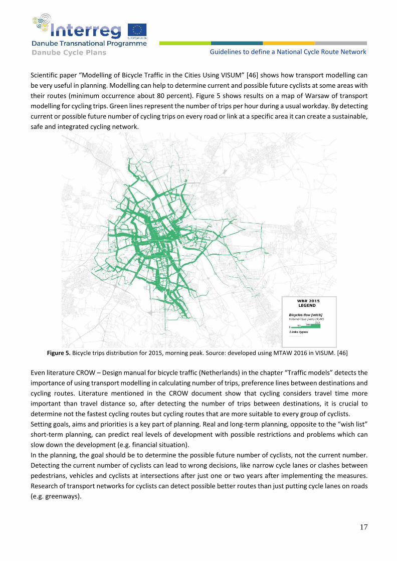
Scientific paper “Modelling of Bicycle Traffic in the Cities Using VISUM” [46] shows how transport modelling can
be very useful in planning. Modelling can help to determine current and possible future cyclists at some areas with
their routes (minimum occurrence about 80 percent). Figure 5 shows results on a map of Warsaw of transport
modelling for cycling trips. Green lines represent the number of trips per hour during a usual workday. By detecting
current or possible future number of cycling trips on every road or link at a specific area it can create a sustainable,
safe and integrated cycling network.
Figure 5. Bicycle trips distribution for 2015, morning peak. Source: developed using MTAW 2016 in VISUM. [46]
Even literature CROW – Design manual for bicycle traffic (Netherlands) in the chapter “Traffic models” detects the
importance of using transport modelling in calculating number of trips, preference lines between destinations and
cycling routes. Literature mentioned in the CROW document show that cycling considers travel time more
important than travel distance so, after detecting the number of trips between destinations, it is crucial to
determine not the fastest cycling routes but cycling routes that are more suitable to every group of cyclists.
Setting goals, aims and priorities is a key part of planning. Real and long-term planning, opposite to the “wish list”
short-term planning, can predict real levels of development with possible restrictions and problems which can
slow down the development (e.g. financial situation).
In the planning, the goal should be to determine the possible future number of cyclists, not the current number.
Detecting the current number of cyclists can lead to wrong decisions, like narrow cycle lanes or clashes between
pedestrians, vehicles and cyclists at intersections after just one or two years after implementing the measures.
Research of transport networks for cyclists can detect possible better routes than just putting cycle lanes on roads
(e.g. greenways).

18
Guidelines to define a National Cycle Route Network
Determining the possible future number of cyclists must be conducted after consultation with relevant
stakeholders (city administration, public transport companies, cyclists’ organizations, etc.) and user groups
(children, students, workers, etc.). Consultations can be organized as round tables, presentations or different
meetings where interested stakeholders and user groups can present their problems or visions how future cycling
networks can or should be created.
Planning of existing and future cycling infrastructures can be organised in four segments:
● Existing regulations can prescribe an obligation for country, regional or local governments to create plans,
masterplans or a strategy for development of cycling infrastructure;
● Involvement of relevant stakeholders and user groups to detect their needs and desired lines of travels;
● In those plans or strategies, different users, usage, areas, or other parameters should be respected;
● Regulations should prescribe controls of implementing those measures from plans or strategies for at least
every 3 years, even more often in the initial development phase.
Those four segments should achieve that the proposed measures can be implemented in real situations on the
field. Obligations to conduct plans and strategies, with control elements to implement proposed measures, are
the first and key steps for creating sustainable and integrated cycling infrastructure for every user and different
usage.
5. Types of infrastructure for cycling
In all countries covered by this catalogue, the legislation defines cycling infrastructure such as cycle lanes, cycle
tracks, and cycle and pedestrian tracks. No matter on which surface cyclists ride, it should always be ensured that
nothing enters the free profile area. The free profile can be explained as the profile of the cyclist increased by the
protective widths and heights, shown in table 7. In almost all countries of the Danube region, the free profile is
1.50 meters wide and 2.50 meters high, with exceptions in some countries, which can be seen in table 7. Free
profile in Croatian legislation is shown in figures 6 and 7.
Free profile AT BG CZ HR HU RO RS SI SK PRESTO
Width (m)
One way
1.50 1.50 1.50 1.50 not
specified 1.00 1.50 1.50 1.25 1.50
Two ways
2.50 not
specified 2.50 2.50
not specified
2.00 2.50 2.50 2.50 not
specified
Height (m) 2.50 2.40 2.50 2.50 not
specified 2.40 2.50 2.50 2.50 2.45
good practice
there is room for improvement
practices that need to be changed
Table 7. The free profile in DCP countries.

19
Guidelines to define a National Cycle Route Network
Figure 6. Free profile for one and two cyclists (in Croatian legislation). [13]
Figure 7. Free profile for one cyclist and pedestrian (in Croatian legislation). [13]
Detailed standards for cycling infrastructure design have been developed at a national level in all 9 countries
analysed in this document. Examples of existing types of infrastructure for cycling are provided below, with a
remark on some differences in categorization between national frameworks/legislatives.
The dimensions of cycle lanes and tracks are between 1 meter to 1.55 meters for one-way and between 2 meters
and 2.50 meters for two-way cycle lane / track, depending on the legislation in individual countries. The reason
for lanes / tracks only 1-meter-wide are often the spatial barriers for the implementation of wider infrastructure.
The minimum safety distance additionally contributes to this problem, as vehicles are often parked on streets in

20
Guidelines to define a National Cycle Route Network
urban areas, which are already spatially limited. Nevertheless, riding a bicycle next to parked vehicles poses a
certain risk, such as dooring, so defining minimum safety distances is considered necessary for the implementation
of this type of cycling infrastructure.
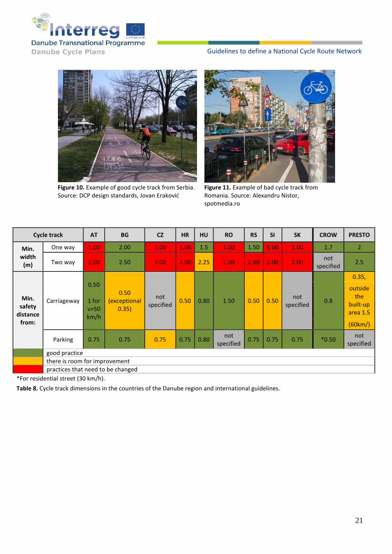
Separate infrastructure
Cycle track
A cycle track is an exclusive bicycle facility, physically separated from motorized traffic and distinct from the
sidewalk. Cycle tracks have different forms, but all share common elements—space provided exclusively or
primarily for cycling, separated from motor vehicle lanes, parking lanes, and sidewalks. Examples of good cycle
tracks are shown in figures 8, 9 and 10. Cycle tracks may be one-way or two-way, and may be at street level, at
sidewalk level, or at an intermediate level. If at the sidewalk level, a curb or median separates them from motorized
traffic, while different pavement colour/texture separates the cycle track from the sidewalk. If at street level, they
can be separated from motorized traffic by raised medians, on-street parking, or bollards. An example of a bad
cycle track is shown in figure 11. Cycle track legislative specifics and norms in Danube countries and international
guidelines are shown in table 8.
Figure 8. Example of good two-way cycle track from
Utrecht, Netherlands. Source:
https://bicycledutch.wordpress.com/2017/09/12/future-
fast-cycle-route-utrecht-amersfoort
Figure 9. Example of good cycle
track from Bulgaria. Source: DCP
design standards, www.debrecen.hu
21
Guidelines to define a National Cycle Route Network
Figure 10. Example of good cycle track from Serbia. Source: DCP design standards, Jovan Eraković
Figure 11. Example of bad cycle track from Romania. Source: Alexandru Nistor, spotmedia.ro
Cycle track AT BG CZ HR HU RO RS SI SK CROW PRESTO
Min. width
(m)
One way 1.00 2.00 1.00 1.00 1.5 1.00 1.50 1.00 1.00 1.7 2
Two way 2.00 2.50 2.00 2.00 2.25 2.00 2.00 2.00 2.00 not
specified 2.5
Min. safety
distance from:
Carriageway
0.50
1 for v>50 km/h
0.50 (exceptional
0.35)
not specified
0.50 0.80 1.50 0.50 0.50 not
specified 0.8
0.35,
outside the
built-up area 1.5
(60km/)
Parking 0.75 0.75 0.75 0.75 0.80 not
specified 0.75 0.75 0.75 *0.50
not specified
good practice
there is room for improvement
practices that need to be changed
*For residential street (30 km/h).
Table 8. Cycle track dimensions in the countries of the Danube region and international guidelines.

22
Guidelines to define a National Cycle Route Network
Cycle lane
Cycle lanes are designated lanes for cycling on the carriageway. In contrast to a cycle track, a cycle lane is not
separated from a carriageway but is marked on the road by painted lines, pavement markings, colour or, where
safety is of concern, with bollards, plastic posts, concrete blocks, planters, concrete or plastic barriers separating
the cycling area from other traffic. Examples of good cycle lanes are shown in figures 12 and 13. An example of a
bad cycle lane is shown in figure 14. Cycle lane legislative specifics and norms in Danube countries and
international guidelines are shown in table 9.
Figure 12. Example of good cycle lane from Slovakia. Source: DCP design standards, Peter Klučka
Figure 13. Example of a wide cycle lane from Netherlands. Source: https://bicycledutch.wordpress.com/
Cycle lane
AT BG CZ HR HU RO RS SI SK CROW PRESTO
Min
. wid
th (
m)
On
e w
ay
1.00 1.50 1.00 1.00 1.55 1.00 1.00 1.00 1.00 1.7 1.5
Two
way
2.00 not
specified 2.50
not specified
2.25 not
specified 2.00
not specified
2.50 not
specified not
specified
Min
. saf
ety
dis
tan
ce f
rom
:
Car
riag
ew
ay
Dividing line
Dividing line
Dividing line
Dividing line
Dividing line
not specified
Dividing line
Dividing line
Dividing line
>50 not
specified
Par
kin
g
Total width cycle + parking
lane min 3.5
0.75 m 0.75 m 0.75 m 0.80 m not
specified 0.60 m 0.75 m 0.75 m *0.50
0.50 – 0.70
good practice
there is room for improvement
practices that need to be changed
*For residential street (30 km/h).
Table 9. Cycle lane dimensions in the countries of the Danube region and international guidelines.

23
Guidelines to define a National Cycle Route Network
Cycle road
Cycle roads are built and arranged pavement structures
(mostly asphalt) outside carriageway profile and marked
with appropriate traffic signalisation (figure 15). The
definition of such cycle roads is explicitly mentioned in
Croatian and Slovenian legislation, for instance. Advanced
recommendations and developed countries within the DCP
project usually do not have this defined as a specific type,
but as a form of a cycle track, most common section of the
cycle highway. EuroVelo recommendations also distinguish
between cycle tracks along the road and separated cycle
roads. [49]
The minimum width of a cycle road in most countries is 2.50
meters, while the infrastructure for mixed traffic with
pedestrians depends on traffic intensity. However, even at
low traffic intensity, the minimum width varies from 1.50
meters in Croatia to 2.50 meters in Austria and Romania
(table 10).
Figure 15. Cycle road, capital region of Denmark. Source: https://cyclingsolutions.info/
Cycle road AT BG CZ HR HU RO RS SI SK DK
Min. width (m) not specified 2.50 not specified 2.50 2.30 2.50 2.50 2.50 2.50 3
good practice
there is room for improvement
Table 10. Minimum width of a cycle road in DCP countries.
Figure 14. Example of bad cycle lane from Bulgaria. Source: DCP design standards

24
Guidelines to define a National Cycle Route Network
Mixed infrastructure with motorized vehicles
Advisory cycle lane
An advisory lane is a form of mixing motorized traffic and cyclists, with suggested space for cyclists on the road,
without being exclusively reserved for their use. It is created with road markings, surface such as bicycle symbols,
lines, arrows and chevrons (in some countries also called suggestion or edge lane) (figure 17). Legally it is part of
the carriageway which means that motorized traffic is obliged to ride on it and is allowed to park on it. The advisory
lane is a design regulatory option to draw attention to the presence of cyclists and to visually narrow the
carriageway. It is meant to influence drivers’ behaviour: they expect to meet cyclists and more easily respect their
presence. The best example of the usage of suggestions lanes/advisory cycle lanes is from Denmark and the
Netherlands (figure 18), but event in those countries with a tradition of good cycling infrastructure there is no
regulation and there are only recommendations for the design of advisory cycle lanes. Example of a bad advisory
lane is shown in figure 19. Dutch and Danish studies that explore safety issues and recommendations are extensive
of this topic (source: https://transweb.sjsu.edu/sites/default/files/1925-Pande-Safety-Edge-Lane-Roads.pdf).
Figure 17. Example of good advisory cycle lane from Czech Republic. Source: DCP design standards
Figure 18. Example of advisory cycle lane from Netherlands. Source: PSU Delft multimodal transportation 2013
The following recommendations from the Netherlands
(Source: CROW design manual) apply to advisory cycle
lanes:
No different colouring between part of the road for
cyclists and for motorized vehicles
The centre lane width is minimum 3m
Width of suggestion lane from 1.25 to 1.5 meters for
cycle section
Preferably with parking ban
Preferably advisory cycle lanes can be installed where
the speed (85th percentile) does not exceed 60 km/h
and traffic between 2,000 to 3,000 ADT
Figure 19. Example of bad advisory cycle lane from Hungary. Source: www.index.hu

25
Guidelines to define a National Cycle Route Network
In Denmark, advisory cycle lanes or “2 minus 1 vej” (2-minus-1 roads) were introduced in the early 2000s as a new
type of road design. The design recommendations are presented in the rules of road signage use issued by the
Danish Road Directorate (Vejdirektoratet 2017):
the speed limit on such roads is 60 km/h in rural areas and 50 km/h in urban areas;
the centre lane width is between 3.0 and 3.5 m;
the edge lane width is between 0.9 and 1.5 m (Vejdirektoratet 2017).
Cycle street
A cycle street is a road designed in a way that cyclists dominate visually and motorized traffic is tolerated as a
guest. They are designed as a street-wide cycle track on which motorized traffic is allowed (figures 20 and 21).
Legally, a cycle street is a mixed traffic road. Legally, motorized traffic is allowed as in an ordinary street, but the
design strongly favours cyclists. Cycle streets are used in urban areas on routes with high intensities of cyclists and
where motorized traffic still needs to have access, usually in residential streets with only local traffic and with a
30km/h speed limit.
Figure 20. Cycle street in Nijmegen. Source: Cycle Highway Manual, Interreg NWE „CHIPS (Cycle Highways Innovation for smarter People transport and Spatial planning)“ project
Figure 21. Cycle street in Hamburg (German: Fahrradstraße). Source: Sebastian Bührmann, Difu

26
Guidelines to define a National Cycle Route Network
Contra-flow cycling in one-way street
Contra-flow cycling is a regulatory and infrastructure design measure. In streets and roads with a one-way traffic
restriction, cyclists are exempt from the one-way restriction and are allowed to drive in both directions, against
the flow of motorized traffic (figure 22). This can be implemented through different forms:
Unsegregated two-way cycling on an unmarked road
(quieter roads), which can be implemented through the use
of signage;
The use of designated contra-flow lanes on one-way roads
with a high traffic volume;
Since almost all conflicts take place at road crossings, it is
often considered sufficient to mark contraflow lanes at the
crossings only (10 m length). Usually, on straight stretches,
no markings are required.
Mixed infrastructure with pedestrians Greenway / multipurpose path
Greenways are communication routes reserved
exclusively for non-motorized journeys, developed in
an integrated manner which enhances both the
environment and quality of life of the surrounding
area (figure 24). These routes should meet
satisfactory standards of width, gradient, and surface
condition to ensure that they are both user-friendly
and low-risk for users of all abilities. In this respect,
canal towpaths and disused railway lines are a highly
suitable resource for the development of greenways (source: Lille Declaration, European Greenways Association).
A greenway is a long, narrow piece of land, often used for recreation and pedestrian and bicycle traffic and
sometimes including multiple transportation (car, light rail) or retail uses. The term greenway comes from the
"green" in green belt and the "way" in parkway implying a recreational or pedestrian use rather than a typical
street corridor, without a built pavement structure, as well as an emphasis on introducing or maintaining
vegetation on surface made by tarmac, gravel and similar. Cycle paths, as a category of greenway, are defined in
some of the national legislations analysed (e.g. Croatian, Slovenian).
Figure 22. Contraflow cycling in one-way streets. Source: European Transport safety Council, Briefing „CONTRAFLOW CYCLING“, 2018
Figure 23. Example of contra flow advisory cycle lane from Slovakia. Source: DCP design standards, Peter Klučka

27
Guidelines to define a National Cycle Route Network
Figure 24. Cycle path/Greenway Alpe-Adria in Austria. Source: Catalogue of tourism products based on greenways, European Greenway Association
Mixed-use zone
Mixed-use zones, also known as shared-use zones, shared zones and meeting zones, are areas that have been
designated for use by selected road users (figures 25 and 26). They don't necessarily allow all types of traffic to
use the zone and the types of transport modes allowed into the zone may be selectively specified. The mixed-use
zone can be newly created during the development of an urban area, or existing space(s) can be redesigned to
give access to multiple transport modes. Often, the speed of motorized traffic is reduced in mixed-use zones to
enhance safety for all road users.
Figure 25. Example of the pedestrian zone in Odense where cyclists are allowed from 9 p.m.- 9 a.m. Source: Collection of Cycle Concepts 2012, Photo by Troels Andersen
Figure 26. Example of pedestrian zone in the Netherlands where cycling is allowed. Source: www.bicycledutch.wordpress.com/
28
Guidelines to define a National Cycle Route Network
A mixed-use zone may allow bicycles and other non-motorized wheeled transport (such as push-scooters) to use
a pedestrian zone without having to dismount but enforce restricted access for motorized traffic. This type of
mixed-use zone may delineate pedestrian areas and cycling areas using signage or paint (Source: European
Commission, https://ec.europa.eu/transport/
themes/urban/cycling/guidance-cycling-projects-
eu/cycling-measure/mixed-use-zones_en).
Dutch guidance, based on empirical research,
suggests threshold indicators for sharing cycle and
pedestrian zone (table 11).
Most known examples for mixed-use zones are:
● cycle streets;
● advisory cycle lanes in shared space streets/
zones;
● pedestrian zones where cyclists or push-
scooters are allowed (see more in chapter on pedestrians and cycling);
● bus/tram lanes shared with cyclists (see more in chapter 12);
● mixed-use streets with sharrows as signage.
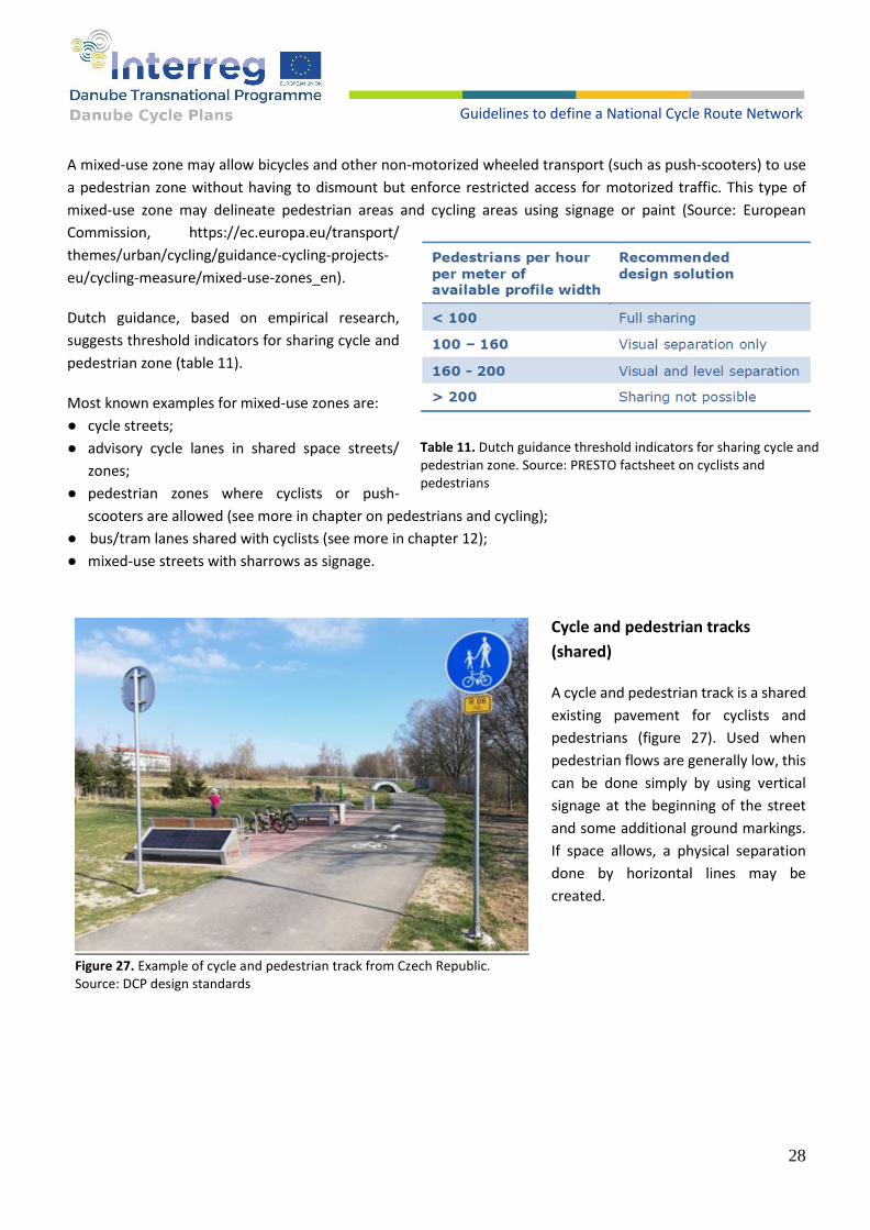
Cycle and pedestrian tracks
(shared)
A cycle and pedestrian track is a shared
existing pavement for cyclists and
pedestrians (figure 27). Used when
pedestrian flows are generally low, this
can be done simply by using vertical
signage at the beginning of the street
and some additional ground markings.
If space allows, a physical separation
done by horizontal lines may be
created.
Table 11. Dutch guidance threshold indicators for sharing cycle and pedestrian zone. Source: PRESTO factsheet on cyclists and pedestrians
Figure 27. Example of cycle and pedestrian track from Czech Republic. Source: DCP design standards
29
Guidelines to define a National Cycle Route Network
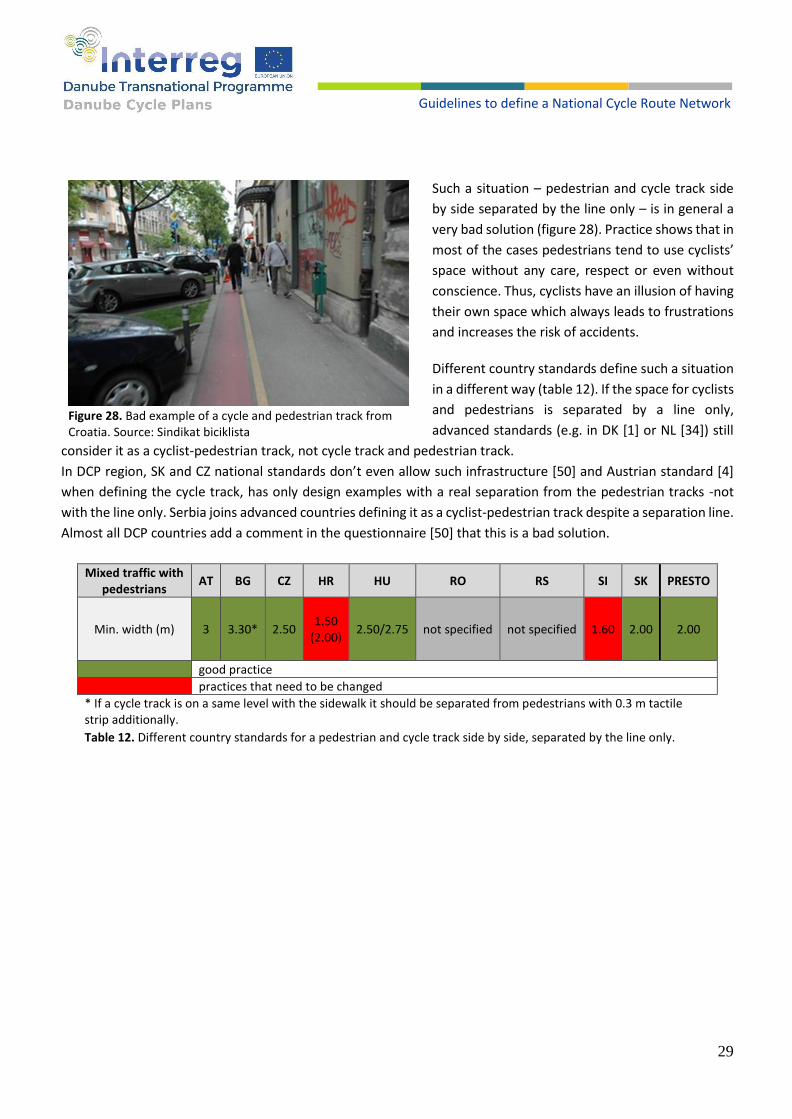
Such a situation – pedestrian and cycle track side
by side separated by the line only – is in general a
very bad solution (figure 28). Practice shows that in
most of the cases pedestrians tend to use cyclists’
space without any care, respect or even without
conscience. Thus, cyclists have an illusion of having
their own space which always leads to frustrations
and increases the risk of accidents.
Different country standards define such a situation
in a different way (table 12). If the space for cyclists
and pedestrians is separated by a line only,
advanced standards (e.g. in DK [1] or NL [34]) still
consider it as a cyclist-pedestrian track, not cycle track and pedestrian track.
In DCP region, SK and CZ national standards don’t even allow such infrastructure [50] and Austrian standard [4]
when defining the cycle track, has only design examples with a real separation from the pedestrian tracks -not
with the line only. Serbia joins advanced countries defining it as a cyclist-pedestrian track despite a separation line.
Almost all DCP countries add a comment in the questionnaire [50] that this is a bad solution.
Mixed traffic with
pedestrians AT BG CZ HR HU RO RS SI SK PRESTO
Min. width (m) 3 3.30* 2.50 1.50
(2.00) 2.50/2.75 not specified not specified 1.60 2.00 2.00
good practice
practices that need to be changed
* If a cycle track is on a same level with the sidewalk it should be separated from pedestrians with 0.3 m tactile strip additionally.
Table 12. Different country standards for a pedestrian and cycle track side by side, separated by the line only.
Figure 28. Bad example of a cycle and pedestrian track from Croatia. Source: Sindikat biciklista
30
Guidelines to define a National Cycle Route Network
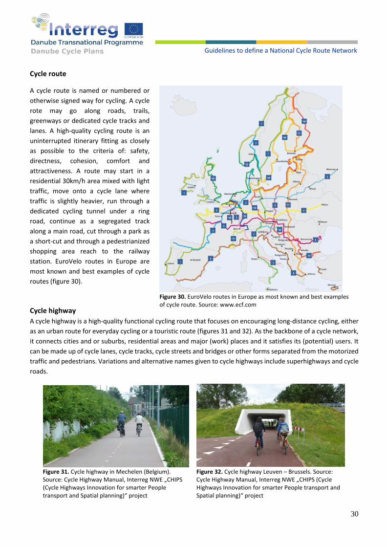
Cycle route
A cycle route is named or numbered or
otherwise signed way for cycling. A cycle
rote may go along roads, trails,
greenways or dedicated cycle tracks and
lanes. A high-quality cycling route is an
uninterrupted itinerary fitting as closely
as possible to the criteria of: safety,
directness, cohesion, comfort and
attractiveness. A route may start in a
residential 30km/h area mixed with light
traffic, move onto a cycle lane where
traffic is slightly heavier, run through a
dedicated cycling tunnel under a ring
road, continue as a segregated track
along a main road, cut through a park as
a short-cut and through a pedestrianized
shopping area reach to the railway
station. EuroVelo routes in Europe are
most known and best examples of cycle
routes (figure 30).
Cycle highway
A cycle highway is a high-quality functional cycling route that focuses on encouraging long-distance cycling, either
as an urban route for everyday cycling or a touristic route (figures 31 and 32). As the backbone of a cycle network,
it connects cities and or suburbs, residential areas and major (work) places and it satisfies its (potential) users. It
can be made up of cycle lanes, cycle tracks, cycle streets and bridges or other forms separated from the motorized
traffic and pedestrians. Variations and alternative names given to cycle highways include superhighways and cycle
roads.
Figure 31. Cycle highway in Mechelen (Belgium). Source: Cycle Highway Manual, Interreg NWE „CHIPS (Cycle Highways Innovation for smarter People transport and Spatial planning)“ project
Figure 32. Cycle highway Leuven – Brussels. Source: Cycle Highway Manual, Interreg NWE „CHIPS (Cycle Highways Innovation for smarter People transport and Spatial planning)“ project
Figure 30. EuroVelo routes in Europe as most known and best examples of cycle route. Source: www.ecf.com

31
Guidelines to define a National Cycle Route Network
In Western and Northern Europe usually there is a new concept of cycle highways – the cycle superhighway that
aims at challenging cars on middle distances of 5-10-20 km or more. It’s the second generation of cycle routes.
There is no precise definition of what constitutes a cycle superhighway because different areas have different
needs, available space, and finances. Each route is often unique and is designed according to the circumstances.
However, the feature they have in common is that they strive to provide an extra element that can attract new
cyclists
Special types of infrastructure
Contra flow Contra flow is cycling in the opposite direction of the one-way motorized traffic (exampled previously in figures 22 and 23). Formally, depending on the application, contra-flow can be seen as a special case of the mixed traffic or the cycle lane. Table 13 gives an overview of country standards for contra-flow. While some standards don’t mention the contra-flow concept, most of them include it. There are two slightly different approaches: (a) contra-flow is just a cycle lane on the opposite side in the opposite direction, or (b) contra-flow is allowed as a mixed traffic in another direction, but (b) always includes also (a). Although standards slightly vary in terms of condition set (speed, width, traffic density) and dimensions, they are going in the same direction. German study referenced in [1] and several studies mentioned in [2-5] found that the contra-flow cycling if done right (sufficient width, low traffic, appropriate signs etc.) has no safety issues and is even more safe than mixed traffic in the same direction with motorized traffic. In general, a common implementation of a contra flow in cities is recommended, rather than the special case in several streets.
definition minimal width signing with the line
AT
cycle lane or mixed traffic in general allowed in all residential streets
Separated with the line: 1.50 m if parking lane 1.25 m if no parking lane 2.50 m for motorized lane No separation lane: 3.50 m total 3 m total if escape points available
beginning of the street: bicycle exception for one way separation with a line if wide crossing: bicycle symbol, direction arrow, stop line
BG not defined / in process
CZ marked cycle lane 0.50 m safety distance to motorized traffic, can be reduced for v <= 40 km/h
HR marked cycle lane yes additionally: 10 m before and after crossing should be painted red
HU marked cycle lane
RO not defined
RS not defined
32
Guidelines to define a National Cycle Route Network
SI cycle lane or mixed traffic
total width 3,2 m if no more than 50 cars/h and no buses and lorries 3.00 m for calm traffic areas
not needed in access roads or calm traffic areas
SK
cycle lane or mixed traffic no more than 400 cars/h and <= 50 km/h
3 m total width if escape points available every 80 m
lines or sharrows or nothing if marked with the lines, 20 m before and after crossing should be painted green
CROW marked cycle lane 170 – 220 cm width like any cycle lane
DK marked cycle lane 2 m if parking lane 1.50 m if no parking lane
contrast surface material
PRESTO cycle lane or mixed traffic
1.50 m recommended if the speed is over 30 km/h (city) resp. 60 km/h (outside)
UNECE cycle lane or mixed traffic
not specified not specified
Table 13. An overview of country standards for contra-flow.
RECOMMENDATIONS
1. Implement a contra-flow as a legal opportunity in all DCP countries where not existing: BG, RO, RS. Try to use the best out of all regulations and adopt a common standard. AT and SK regulations are partly overlapping but partly complementary and with these two all important aspects are covered. Pay attention especially that the appearance of cyclists from the opposite direction is well-signed to car drivers.
2. Use recommended implementation strategy (whole district or town, not particular streets).
Cycle/moped track
CROW manual mentions cycle/moped track as joint track outside the build-up area in the Netherlands. The width
of this type of track is greater than usual cycle tracks. In the build-up area the situation is different and moped are
restricted from using cycle tracks. The usage of shared tracks therefore is recommended only if there is no other
design option and outside of urban areas.

33
Guidelines to define a National Cycle Route Network
Shared bus and cycle lanes
Shared bus and cycle lanes is a specific case where
there are special carriageway lanes for buses and
restricted to other motorized vehicles. In some
cases, those lanes are also allowed to be used by
cyclists, with signalization (figure 34). Bus/cycle
lanes can strengthen the network with additional
shortcuts, but only at low speeds, on short sections
and with a careful design to ensure safety. Bus/cycle
lanes are easy and inexpensive to implement. They are also a highly visible way of giving cyclists privileges over
other traffic (figures 35 and 36).
Figures 35. / Figure 36. Shared bus and cycle lanes. Source: PRESTO factsheet on BICYCLE and BUSES
The case is mentioned in Denmark, Netherlands, Austria, and in the analysed international guidelines in UNECE
and PRESTO. PRESTO specifically mentions where to use such lanes – in cities with dense public bus network, to
increase the flow of buses, special bus lanes have become widespread. They are attractive for cyclists, because
they also create the same shortcuts for cyclists and also allow them to jump the car queue. Safety, however, must
be guaranteed. Buses should drive at less than 30 km/h and the lane should be wide enough for buses to overtake
the cyclist.
Shared lanes with other public transport are not widespread but shared tram and cycle lanes are usual for some
countries such as the Netherlands and Austria. In the Netherlands the case of how to cycle safely alongside the
tram tracks is part of Bicycle Training for the kids, which ends with taking a traffic test (Dutch “Verkeersexamen”).
In table 14, the dimensions that should be applied in the countries of the Danube region, following the example
of advanced guidelines and literature, are highlighted in green. It is not always possible to implement the cycling
infrastructure in a desired way, but when planning, the cycling infrastructure should be immediately adjusted to
future needs, and the requirements should be set to be higher than what is prescribed by the minimum standards.
The cycling infrastructure must also be usable by those bicycles that do not make up the majority in traffic, such
as cargo bicycles or bicycles with a trailer, and which are slightly wider or longer in size than conventional bicycles.
Figure 34. Signaling for a bus/cycle lane in Belgium and UK. Source: PRESTO factsheet on BICYCLE and BUSES
34
Guidelines to define a National Cycle Route Network
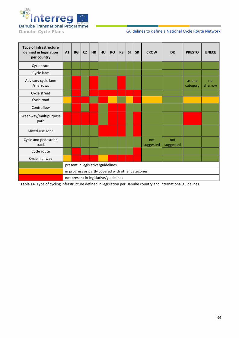
Type of infrastructure defined in legislation
per country AT BG CZ HR HU RO RS SI SK CROW DK PRESTO UNECE
Cycle track
Cycle lane
Advisory cycle lane /sharrows
as one
category no
sharrow
Cycle street
Cycle road
Contraflow
Greenway/multipurpose path
Mixed-use zone
Cycle and pedestrian track
not
suggested not
suggested
Cycle route
Cycle highway
present in legislative/guidelines
in progress or partly covered with other categories
not present in legislative/guidelines
Table 14. Type of cycling infrastructure defined in legislation per Danube country and international guidelines.
35
Guidelines to define a National Cycle Route Network
RECOMMENDATIONS
1. Harmonize the definitions of infrastructure elements with a strong link to UNECE and Vienna Convention for Road Signs and Signals, to clarify the distinction between categories and assure transparency among countries – each category has the same meaning in every country. Share findings of this document with UNECE and propose them to use it for further development of the Vienna Convention.
2. Following CZ and SK, avoid the mixed-use infrastructure where cyclists and pedestrians are separated by the painted line only, wherever possible. Shared cyclists-pedestrian track, if needed, may remain without an elusive separating line. If there is enough space, provide a real separation.
3. The minimum width of a cycle track or lane should be 2 m for one way (exceptionally 1.5 m*) and 3 m for two-way (exceptionally 2.50*). * Exceptions apply when there are spatial limits.
4. The minimum safety distance between the cycle track and the carriageway should be 0.75 m for speeds over 50 km/h and 0.50 m for speeds up to 50 km/h. If there are parked vehicles, then the minimum safety distance from the parking should be 0.75 m for speeds over 30 km/h and 0.50 m for speeds up to 30 km/h.
5. The minimum safety distance between the cycle lane and the carriageway should be 0.50 m for speeds over 50 km/h. If there are parked vehicles, then the minimum safety distance from the parking should be 0.75 m for speeds over 30 km/h and 0.50 m for speeds up to 30 km/h.
6. The minimum width of the cycle road should be 3 m.
7. Mixed traffic with pedestrians should be at a minimum width of 2 m.
8. If there is a parapet between cycle track and motorized traffic lane, request that it is constructed injury-safe - no sharp shapes from the cyclists’ side (figures 37 and 38).
9. Cycling route should be at least 50% perfectly rideable and no more than 20% moderately rideable at any daily section, and not any badly rideable section. Cycling highway should be at least 80% perfectly rideable and should not contain any moderately rideable or worse sections. Criteria for perfectly, well and moderately rideable is according to ECS. [48]

36
Guidelines to define a National Cycle Route Network
Figure 37. Example from Croatia: parapet between cycle track and motorway with the inner side trying to protect cyclists from injury – almost good but still with a short sharp edge. Source: Sindikat biciklista
Figure 38. Example from Austria - good injury protection for cyclists. Source: Sindikat biciklista
6. Selection of appropriate infrastructure depending on the traffic situation
Every country standard includes considerations which of the infrastructure elements should or may be built in a particular traffic situation. Although not always explicitly pointed out, this consideration is essential to meet an optimum between costs and safety level, and to prioritize investments and optimize development within available budget. A standard requesting too much will never be consistently implemented. It would rather cause sporadic investments without respecting priority. Two typical considerations are a part of almost every country standard:
1. relations between bicycle traffic and motorized traffic (shared vs. less or more separated); 2. relations between bicycle traffic and pedestrians (shared vs. less or more separated).
On top of that, one more important aspect will be considered in this chapter: 3. one-way vs. two-way cycle paths.
6.1. APPROPRIATE INFRASTRUCTURE RELATED TO THE INTERACTION WITH
MOTORIZED TRAFFIC
To decide if shared bicycle and motorized traffic is allowed or a separation is needed (to which extent), most of the country standards consider a combination of two criteria: motorized traffic speed and volume (figure 39).

37
Guidelines to define a National Cycle Route Network
Figure 39. Speed limit traffic density diagram to define appropriate cycling infrastructure. [29]
With low speed and/or volume, a mixed traffic is allowed. Mixed traffic might appear in different forms:
• without any special markings;
• sharrows painted on the right side of a traffic lane, suggesting a space dedicated for bicycles and reminding
motorized vehicle drivers that the road is significantly used also by bicycles;
• advisory cycle lane, pointing out mixed traffic even more, and defining a minimal safety distance by overtaking
bicycles.
Decision upon an appropriate choice of these 3 options might depend on the bicycle traffic volume, motorized
traffic volume, road width, safety distance to parked cars etc. Sharrows and advisory cycle lanes (see previous
chapter) are not defined in all national standards and even if defined, there are no exact criteria what to apply in
which situation. Designers should apply common sense.
Increasing the speed and/or volume of motorized traffic, a cycle lane would be needed. As a special form, a cycle
lane in a contra-flow is defined in most of the DCP countries. Cycle lane is OK for medium-sized motorized traffic
speed/volume, but in some cases also not safe enough: many intersections, private entrances, shops and parking
along the street.
For higher speeds/densities of motorized traffic, a separation of bicycles in the cycle track is a safe solution.
For even higher speeds/densities, some country standards request a routing completely separated from the busy motorized traffic road – cycle road and cycle street. Cycle roads and streets are appropriate for a high volume of cycling traffic. They give not only a high safety level but also a quality of cycling experience avoiding noise and smell from the high motorized traffic. It is the desired infrastructure for the cycle highways. Some countries define such an infrastructure element, but don’t use it as a mandatory element in this consideration – a cycle track seems to be good enough for safety, and a cycle road is an additional benefit for the comfort. In some cases (e.g. Austria), cycle track outside the city is generally routed separately from the road, so from the cycling quality point of view it is in fact the same category as the cycle road.

38
Guidelines to define a National Cycle Route Network
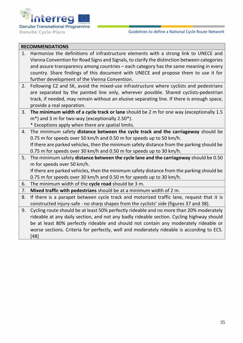
To be able to compare different country standards, expressed with different diagrams in an easy way, several diagrams – one for the given speed limit – are listed below (diagrams 1-4). In several standards, quite a high overlapping range for acceptable infrastructure is given. For this comparison a minimal quality requirement (i.e., maximal allowed speed or volume) is used in this overview. To compare different standards expressed in different units (traffic per day or traffic per hour), a ratio of 12% daily traffic per hour is used. Considering the high relevance of the DCP project for the long-distance routes, a comparison with the EuroVelo route safety criteria has also been done. For the EuroVelo routes, the European Certification Standard – ECS [48] is developed. ECS route assessment method uses a complex two-step approach to assess the routes in terms of safety. In the first step, a traffic category is defined out of the infrastructure type, traffic volume and traffic speed. Traffic category has 5 levels: very low, low, moderate, high and very high (and traffic free for segregated tracks or streets). Distribution of these 5 categories along the route gives a route certification level as a result. The EuroVelo route could be certified on 3 levels: essential, important and additional, and the relation to the share of different traffic levels is shown in table 15. [48]
traffic-free cycle
paths etc.
traffic
very low low moderate high very high
Essential no limit no limit no limit no limit max 50% on a daily section
not allowed
Important no limit no limit no limit max 50% on a daily section
not allowed not allowed
Additional no limit no limit max 50% on a daily section
not allowed not allowed not allowed
Table 15. The EuroVelo route could be certified on 3 levels: essential, important and additional, in relation to the share of different traffic levels. [48]
Therefore, comparison of ECS with national criteria can’t be done in general, but for a particular traffic level. In
this analysis two traffic categories are compared with the national standards: “moderate” and “low”.
EuroVelo also mentions the aspect of complete separation of the cycling traffic, pointing out that cycling alongside
the roads with more than 10,000 vehicles per day is not suitable for EuroVelo, even if separated from the
motorized traffic – EuroVelo, guidance to the route development process. [49] This document is not specifying
if/how this limitation is dependent on the speed, so for this comparison it will be assumed that a noise or smell of
this high traffic is critical for the speed above 50 km/h.
Following diagrams (diagrams 1-4) give an overview about allowed traffic volume limits for the particular
infrastructure on a given speed limit in different (country) standards.
39
Guidelines to define a National Cycle Route Network
Diagram 1.
Diagram 2.
Diagram 3. Diagram 4.
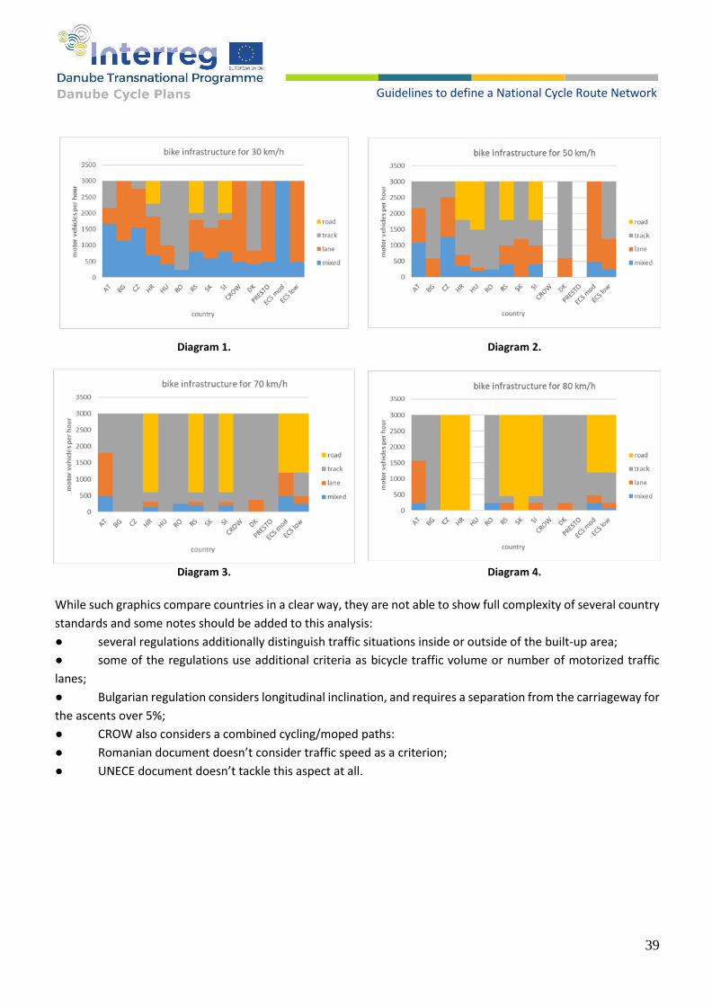
While such graphics compare countries in a clear way, they are not able to show full complexity of several country
standards and some notes should be added to this analysis:
● several regulations additionally distinguish traffic situations inside or outside of the built-up area;
● some of the regulations use additional criteria as bicycle traffic volume or number of motorized traffic
lanes;
● Bulgarian regulation considers longitudinal inclination, and requires a separation from the carriageway for
the ascents over 5%;
● CROW also considers a combined cycling/moped paths:
● Romanian document doesn’t consider traffic speed as a criterion;
● UNECE document doesn’t tackle this aspect at all.

40
Guidelines to define a National Cycle Route Network
Austria has a special possibility that use of the cycle track
could be not mandatory but optional (figure 40) – cyclists
could decide to use the carriageway for higher efficiency.
Such infrastructure is allowed if it contributes to lightness
and fluidity of the traffic, without endangering safety.
A dependency in which traffic circumstances such a
solution could be applied is given in diagram 5. [4-AT]
Many standards have been developed in recent years. Having in mind quite ambitious requests and high investment costs, it is a big question which of this infrastructure types have been implemented. Short questionnaire among DCP countries shows that in every country there has been least something done. Only Czech and Slovenia report a great deal of infrastructure implemented, and no country has a complete infrastructure (table 16).
AT BG CZ HR HU RO RS SI SK
partly - not always standard X X X X X
partly - stick to standard X X
great deal X X
completely
Table 16. Cycling infrastructure Implemented according to standards in DCP countries.
Motorized vehicles driving speed is an essential criterion to select the appropriate infrastructure. However, it is
not only about which infrastructure should be (or even is) built at which speed level: it is also about (1) how
many roads with the speed for a mixed traffic are available at all and (2) how good is the drivers’ respect of this
speed limit. Tables 17 and 18 give an overview among the DCP countries, pointing out additional differences on
top of the written cycling infrastructure standards.
AT BG CZ HR HU RO RS SI SK
not defined X X
few cases X X
sporadically X X
consistently X X X
Table 17. Spread of the 30 km/h zones.
Figure 40. Vienna, Austria, example of a cycle track without obligation. Cyclists may prefer to use the carriageway downhill in its direction and uphill to use the track as the only legal possibility in this street. Such special application of a cycle track is marked with a different horizontal and vertical sign, see chapter 10.1. Source: Sindikat biciklista
Diagram 5.

41
Guidelines to define a National Cycle Route Network
AT BG CZ HR HU RO RS SI SK
frequent speed limit override (km/h) 10 20 15 20 20 10 10 10 15
speed limit tolerance 15% 10 0 20 15 10 3-10 6
Table 18. Speed limit respect and tolerance.
RECOMMENDATIONS
1. Take a common criterion, define a minimal strict standard instead of overlapping, and simplify
presentation using realistic speed limits in 10 km/h steps. Table 18 shows a “better average” of
DCP countries.
2. Defined matrix, agreed among the countries, should be taken as a minimum. Consider stronger
criteria in case of significant share of truck traffic (e.g. > 10%), narrow road (e.g. < 3m per lane),
bad visibility, general separation of cycling traffic for speeds >70 km/h etc.
3. Separated cycle roads out of the corridor for motorized traffic should not be completely
mandatory. An exception of a cycle track along the public road could be accepted as a short
section (e.g. up to 3-5 km or up to 20% of the route) in the situation when sticking to the
separate routing is much longer or much more expensive.
4. In general, avoid cycle lanes in favour of cycle tracks. Space and costs are comparable, and the
track gives much more safety and comfort over the lane.
5. Try to influence essential contributors to the cycling infrastructure quality beyond cycling
infrastructure standards: respecting the speed limit; implementing of the zones 30 km/h in
urban areas.
speed km/h 30 40 50 60 70 80 90
v/h v/d
50 417
250 2083
500 4167
1200 10000
2000 16667
2500 20833 Table 18. Speed limit traffic density matrix to define appropriate cycling infrastructure, proposed as DCP standard.

42
Guidelines to define a National Cycle Route Network
6.2. INFRASTRUCTURE SHARED BETWEEN CYCLISTS AND PEDESTRIANS
There are two aspects of infrastructure sharing between pedestrians and cyclists: combined cycle-pedestrian
tracks and cycling in pedestrian zones.
Almost all standards mention the sidewalk sharing possibility, but do not recommend it for any higher number of
cyclists/pedestrians, and/or allow it only in exceptional situations when no alternative is feasible. A minimal total
width is defined, usually also exceptional minimal width, anticipating frequent limitation – lack of space in urban
areas.
Cycling to/from or through pedestrian zones is mentioned only in some standards and allowed under defined
circumstances. Table 20 gives an overview of sidewalk and pedestrian zone cycling in different standards.
cycle and pedestrian track (shared) minimum width cycling in pedestrian zone
AT 3 (2.5) m complex criteria – see below
BG 2.5 m allowed if no alternative
CZ 3 m allowed
HR 2 (1.5m) not defined on a national, but local level
HU depend regarding cycling and pedestrian flow conditions
depend regarding cycling and pedestrian flow conditions
RO not defined not defined
RS not specified not defined
SI 2 (1.60) m not defined
SK 2 m* not defined
CROW not defined complex criteria – see below
DK not defined not recommended not specified
PRESTO 2 m taken from CROW
UNECE not specified not defined
*elaborated system with 4 different categories, 2m is recommended only in cramped conditions but not more than 2 x 50 m in 2 km.
Table 20. An overview of sidewalk and pedestrian zone cycling in different country standards.
Slovenian (diagram 6) and Croatian standards define a relationship between minimal shared sidewalk width and
combined number of cyclists and pedestrians in a busy hour. Numbers are quite restrictive: minimal width of 1.50
m allows only 35 and grows linearly up to 100 units/h on the width of 3 m.
Slovakian standard (diagram 7) also defines the relationship between number of cyclists, number of pedestrians
and track width requested, but the numbers seem to be more realistic than for Slovenia/Croatia.
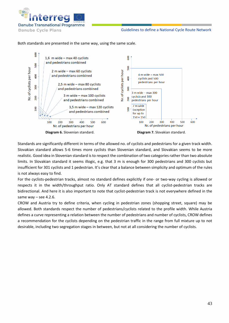
43
Guidelines to define a National Cycle Route Network
Both standards are presented in the same way, using the same scale.
Diagram 6. Slovenian standard. Diagram 7. Slovakian standard.
Standards are significantly different in terms of the allowed no. of cyclists and pedestrians for a given track width.
Slovakian standard allows 5-6 times more cyclists than Slovenian standard, and Slovakian seems to be more
realistic. Good idea in Slovenian standard is to respect the combination of two categories rather than two absolute
limits. In Slovakian standard it seems illogic, e.g. that 3 m is enough for 300 pedestrians and 300 cyclists but
insufficient for 301 cyclists and 1 pedestrian. It’s clear that a balance between simplicity and optimum of the rules
is not always easy to find.
For the cyclists-pedestrian tracks, almost no standard defines explicitly if one- or two-way cycling is allowed or
respects it in the width/throughput ratio. Only AT standard defines that all cyclist-pedestrian tracks are
bidirectional. And here it is also important to note that cyclist-pedestrian track is not everywhere defined in the
same way – see 4.2.6.
CROW and Austria try to define criteria, when cycling in pedestrian zones (shopping street, square) may be
allowed. Both standards respect the number of pedestrians/cyclists related to the profile width. While Austria
defines a curve representing a relation between the number of pedestrians and number of cyclists, CROW defines
a recommendation for the cyclists depending on the pedestrian traffic in the range from full mixture up to not
desirable, including two segregation stages in between, but not at all considering the number of cyclists.

44
Guidelines to define a National Cycle Route Network
Austrian standard is more restrictive in the low pedestrian traffic range (100 per hour per meter width) allowing only 20 cyclists per hour per meter width, but much more open in the high pedestrian traffic range, allowing as much as 17 cyclists per hour per meter width for any high level of pedestrian traffic. Comparison of both standards is given in diagram 8.
CROW, Austrian and Denmark standards consider also very useful possibilities to allow bicycle traffic in pedestrian zones in particular time windows only, allowing the bicycle traffic in rush hours and not disturbing pedestrians in leisure hours. Examples of cycle tracks separated from the pedestrians by the painted line only in Zagreb (figure 41) is in reality also a shared space for cyclists and pedestrians. Respecting this reality, in developed countries this situation is called “cyclists-pedestrian track” even if it has a separation line. See also section 2.6 – cyclist and pedestrian track. Shared cyclists-pedestrian tracks make sense only in places with sufficient space for both cyclists and pedestrians and with low traffic (figure 42).
Figure 41. Example of a shared space for cyclists and pedestrians in from Zagreb, Croatia. Source: Sindikat biciklista
Figure 42. Zagreb, Croatia: wide sidewalk with very few pedestrians and high traffic in 3 lanes: good place to allow a cyclists-pedestrian track. Source: Sindikat biciklista
Diagram 8.

45
Guidelines to define a National Cycle Route Network
RECOMMENDATIONS
1. Sidewalk: define in all country regulations that a separation between cyclists and
pedestrians by a painted line only is a combined cyclists-pedestrian track and not two
parallel tracks: one for pedestrians one for cyclists. Take care about the wording, depending
on the national language, so that there is no confusion. E.g. in Croatian there is a wording
“cyclists and pedestrian track”, not making clear if it that are two: cycle track and pedestrian
track or one combined track.
2. Harmonize criteria for the shared cyclists-pedestrian track use in all countries: proposal is
to use the appropriate width/traffic relation from Slovakian standard, and from Slovenian
standard the approach of combining cyclists and pedestrian traffic. Proposed criteria is
represented in diagram 9.
3. For cyclists-pedestrian tracks define that it could be bidirectional and request appropriate
signing with additional panels - see chapter 10.1.
4. Alternatively to 3., consider using Austrian standard where all combined cyclists-pedestrian
tracks are bidirectional.
5. Pedestrian zones: introduce this possibility in all country standards. Following CROW and
Austrian standards, include the possibility of defining a cycle track (corridor) through
pedestrian zone if free cycling is not appropriate. Use the possibility to allow the cycling in
pedestrian zones in specific time windows while restricting in others. Clearly define that
pedestrians have priority, and reduce the speed of cyclists. As the base for decision what is
appropriate, use rather the Austrian model with a slight correction than CROW (diagram
9).
Diagram 9.

46
Guidelines to define a National Cycle Route Network
6.3. TWO-WAYS CYCLE PATHS ON BOTH SIDES OF THE ROAD
While almost all standards define one-
way and two-ways cycle paths, just a few
of them specify when to use the two-
ways cycle path on both sides of the road.
Table 21 gives an overview how this
important aspect is treated in different
standards.
Almost every standard mention
“directness” as a key principle for the
design of a cycling infrastructure.
However, only CROW (explicitly) and
Austrian standard (indirectly) pays
attention to this principle in the relation
to the application of two-ways cycle
track.
Example of a real problem is shown figure
43. Lacking a bidirectional cycle track,
instead of 400 m directly cycling one
should cycle 1400 m and cross the street
up to 6 times.
Figure 43. Lacking a bidirectional cycle track, instead of 400 m directly cycling one should cycle 1400 m and cross the street up to 6 times.
Standard When to use two-ways 2 sides cycle track
AT important source, destination or target on the same side issues with safe crossing the street more space on one side
BG not specified
CZ not specified
HR not specified
HU not specified
RO not specified
RS two-ways cycle track not even mentioned
SI not specified
SK not specified
CROW shorten the route reducing crossing manoeuvres
DK two-ways cycle track not even mentioned
PRESTO important source, destination or target on the same side issues with safe crossing the street more space on one side
UNECE two-ways cycle track not even mentioned
Table 21. One-way and two-ways cycle paths standards in DCP countries.

47
Guidelines to define a National Cycle Route Network
RECOMMENDATIONS
1. On city avenues with 2 or more motorized traffic lanes or distances between avenue crossing possibilities (intersections) longer than 400 m, a bidirectional cycle track should be mandatory on both sides of the avenue.
2. On all intersections including at least one road with 2 or more motorized traffic lanes, bidirectional crossing for bicycles should be mandatory.
7. Cycle intersections
Cycle intersections can be described as places where cycling infrastructure is connected, separated, crossed or intertwined. Such locations may be intersections with motor roads, other cycling infrastructure, railways, etc. (figure 44). At intersections, the problem of cyclists’ safety is extremely present due to the potential conflict that may occur in the intersection zones. This problem is especially present at the intersections of cycling infrastructure with motor vehicles.
An additional problem that occurs at intersections is traffic congestion, which is present not only in car traffic, but also among cyclists, in those countries where bicycle traffic is well developed and where more people choose to ride a bicycle.
Intersections can occur in multiple design modalities, and we can generally classify them into level intersections and multilevel intersections. Multilevel intersections are safer and much more expansive and used for the situations with high traffic and/or safety risks. Elements of the multilevel intersections – tunnels and bridges – are analysed in the section 10. This section analyses level intersections.
Level intersections can be divided into classic intersections (with three, four or more arrival directions) and roundabouts.
Figure 44. Cyclist waiting for green light at intersection. Source: Sindikat biciklista

48
Guidelines to define a National Cycle Route Network
Figure 45 shows a heat map of traffic accidents involving cyclists in the City of Zagreb (period 2016 to 2018). As seen on the figure, it can be detected that black spots of traffic accidents in all cases appear at intersections or in locations where there is conflict between cyclists, pedestrians and motor vehicles.
7.1. CONTINUITY OF CYCLING INFRASTRUCTURE
Although a need to move continuously by bicycle is common sense, like for any other mobility, the infrastructure is often not realized in that way and therefore it becomes a topic of discussion or regulation.
In many countries in the Danube region, it is quite common, or even legal, that the cycle track is interrupted before the intersection without a legal way forward, or that the cycling facility ends “nowhere” without any safe and convenient transition to cycling in a mixed traffic mode (figures 46 and 47).
Figure 46. Zagreb, Croatia: an important and frequent cycle lane ends suddenly, immediately before a big intersection. Cars from the left lane are allowed to turn left and cyclists have no solution how to continue the route in a safe way. Source: Sindikat biciklista
Figure 47. Zagreb, Croatia, a cycle track along the 6-lanes city avenue ends before a junction of a minor non-priority street and starts again after the intersection. Source: Sindikat biciklista
Figure 45. Heat map of cyclist traffic accidents from 2016 to 2018 in the urban area of City of Zagreb – in most of the cases intersections.
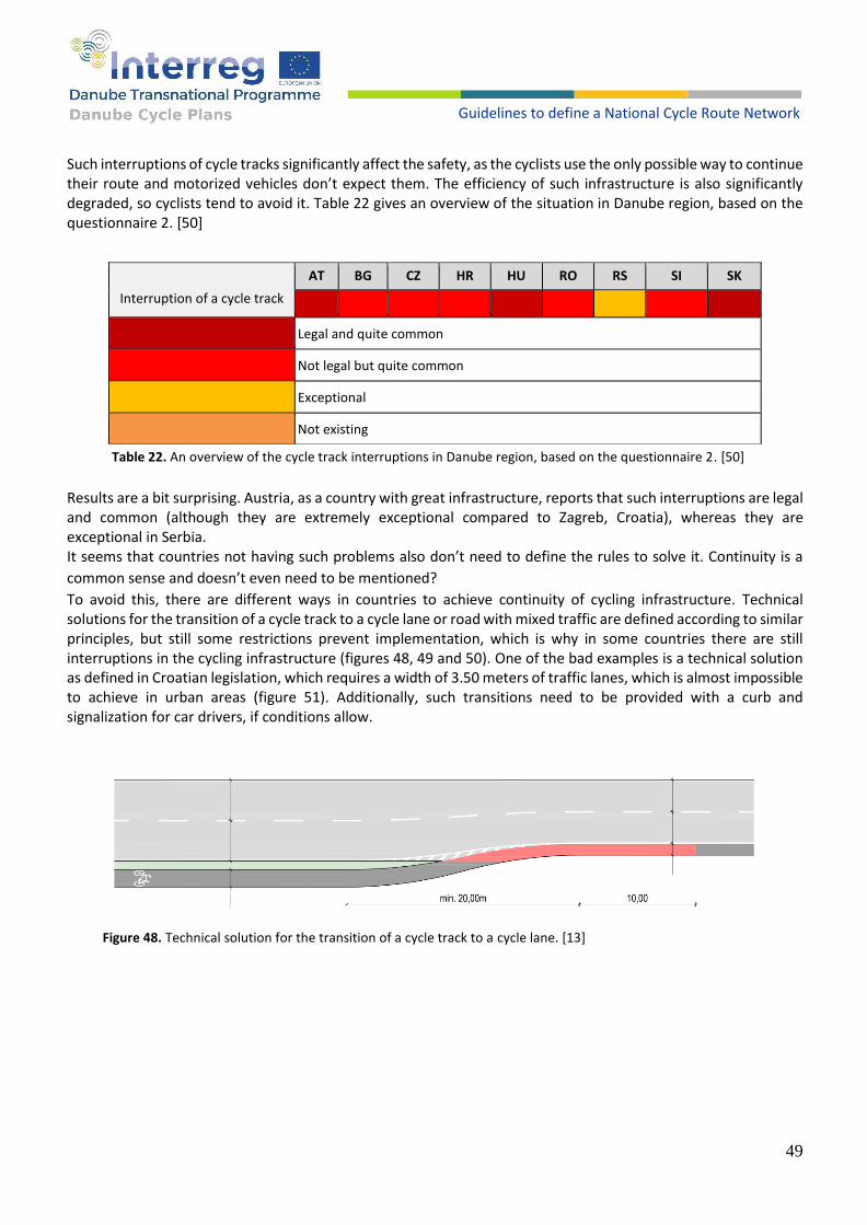
49
Guidelines to define a National Cycle Route Network
Such interruptions of cycle tracks significantly affect the safety, as the cyclists use the only possible way to continue their route and motorized vehicles don’t expect them. The efficiency of such infrastructure is also significantly degraded, so cyclists tend to avoid it. Table 22 gives an overview of the situation in Danube region, based on the questionnaire 2. [50]
Interruption of a cycle track
AT BG CZ HR HU RO RS SI SK
Legal and quite common
Not legal but quite common
Exceptional
Not existing
Table 22. An overview of the cycle track interruptions in Danube region, based on the questionnaire 2. [50]
Results are a bit surprising. Austria, as a country with great infrastructure, reports that such interruptions are legal and common (although they are extremely exceptional compared to Zagreb, Croatia), whereas they are exceptional in Serbia. It seems that countries not having such problems also don’t need to define the rules to solve it. Continuity is a
common sense and doesn’t even need to be mentioned?
To avoid this, there are different ways in countries to achieve continuity of cycling infrastructure. Technical solutions for the transition of a cycle track to a cycle lane or road with mixed traffic are defined according to similar principles, but still some restrictions prevent implementation, which is why in some countries there are still interruptions in the cycling infrastructure (figures 48, 49 and 50). One of the bad examples is a technical solution as defined in Croatian legislation, which requires a width of 3.50 meters of traffic lanes, which is almost impossible to achieve in urban areas (figure 51). Additionally, such transitions need to be provided with a curb and signalization for car drivers, if conditions allow.
Figure 48. Technical solution for the transition of a cycle track to a cycle lane. [13]
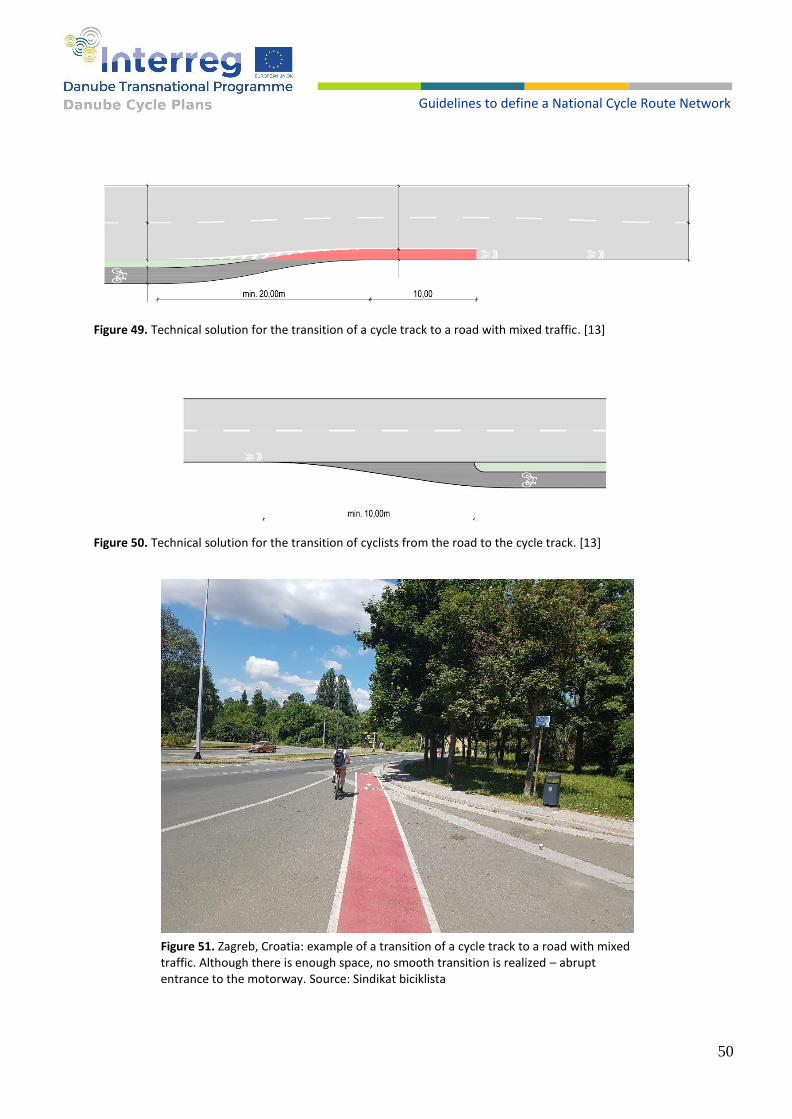
50
Guidelines to define a National Cycle Route Network
Figure 49. Technical solution for the transition of a cycle track to a road with mixed traffic. [13]
Figure 50. Technical solution for the transition of cyclists from the road to the cycle track. [13]
Figure 51. Zagreb, Croatia: example of a transition of a cycle track to a road with mixed traffic. Although there is enough space, no smooth transition is realized – abrupt entrance to the motorway. Source: Sindikat biciklista

51
Guidelines to define a National Cycle Route Network
RECOMMENDATIONS
1. All national standards request a continuity for cycling (example HR): if a specific cycling infrastructure (cycle lane, track etc.) ends, a transition to the mixed-use cycling on the carriageway should be constructed. Continuity request also includes that it is not allowed to interrupt a cycle track and expect pushing or carrying the bicycle over the intersection. Making absurd infrastructure illegal is a good step to fight against it.
7.2. CURBS AT THE INTERSECTION
Another problem that arises, regardless of the type of intersection through which the cycling infrastructure is run, are sharp and high curbs. Many national legislations of the countries of the Danube region do not even mention the issue of curbs that are located transversely to the cycle tracks (figure 52), although in some countries such deficiencies in infrastructure significantly reduce the safety and effectiveness of cycling. This practice should not be applied anywhere, but many examples show that it is necessary to mention this issue and give certain guidelines. In addition to illegal examples of curbs of 8 cm and more, the problem is the legislation that legalizes the construction of curbs on cycle tracks. A bad example is the Croatian legislation in which the construction of curbs up to 3 cm high is allowed (often in practice this is exceeded by a centimetre or two) (figures 52 and 53).
Figure 52. In Croatian legislation the construction of curbs up to 3 cm high is allowed.
Figure 53. An example of bad practice in Croatia where the construction of 3 cm high curbs is allowed. [13]
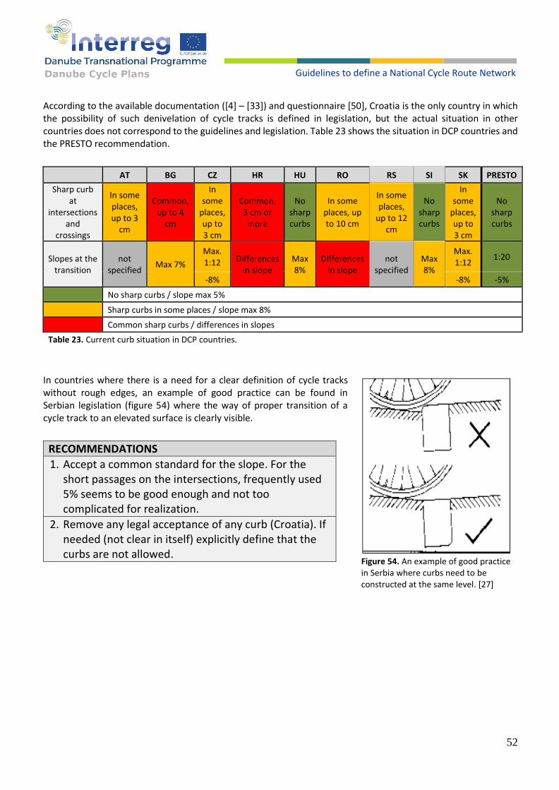
52
Guidelines to define a National Cycle Route Network
According to the available documentation ([4] – [33]) and questionnaire [50], Croatia is the only country in which the possibility of such denivelation of cycle tracks is defined in legislation, but the actual situation in other countries does not correspond to the guidelines and legislation. Table 23 shows the situation in DCP countries and the PRESTO recommendation.
AT BG CZ HR HU RO RS SI SK PRESTO
Sharp curb at
intersections and
crossings
In some places, up to 3
cm
Common, up to 4
cm
In some
places, up to 3 cm
Common, 3 cm or more
No sharp curbs
In some places, up to 10 cm
In some places,
up to 12 cm
No sharp curbs
In some
places, up to 3 cm
No sharp curbs
Slopes at the transition
not specified
Max 7%
Max. 1:12 Differences
in slope Max 8%
Differences in slope
not specified
Max 8%
Max. 1:12
1:20
-8% -8% -5%
No sharp curbs / slope max 5%
Sharp curbs in some places / slope max 8%
Common sharp curbs / differences in slopes
Table 23. Current curb situation in DCP countries.
In countries where there is a need for a clear definition of cycle tracks without rough edges, an example of good practice can be found in Serbian legislation (figure 54) where the way of proper transition of a cycle track to an elevated surface is clearly visible.
RECOMMENDATIONS
1. Accept a common standard for the slope. For the short passages on the intersections, frequently used 5% seems to be good enough and not too complicated for realization.
2. Remove any legal acceptance of any curb (Croatia). If needed (not clear in itself) explicitly define that the curbs are not allowed.
Figure 54. An example of good practice in Serbia where curbs need to be constructed at the same level. [27]

53
Guidelines to define a National Cycle Route Network
7.3. TYPES OF INTERSECTIONS This segment of the chapter shows how countries from the DCP project design cycling infrastructure at various types of intersections. There are two main types of intersections: roundabouts and four/three legs intersections. General directions of designing cycling infrastructures at intersections can be described as following:
Bigger number of motorized vehicles at intersections during a random characteristic day, also more distinct from cyclists.
This statement can be applied to all documents from DCP countries (no matter the type of documents). All documents have similar or almost the same disaggregation according to intersections, guidance and parameters of speed or traffic flow for choosing the best fitting type of intersection. In the next sections, structure, examples and graphic visualizations from Slovenian legislation will be used to
present the issues and rules on cycling areas. After examples from Slovenian legislation, examples will be
compared with other legislation from DCP project countries to check possible differences.
The Republic of Slovenia has defined different intersection types that have motorized traffic in collision with non-
motorized traffic. Examples contain possible cycling infrastructures at intersections:
● roundabouts;
● intersections with four legs with low traffic flows;
● intersections with four legs with high traffic flows;
● intersections with three legs with low traffic flows;
● intersections with three legs with high traffic flows;
● intersections containing traffic islands;
● a traffic island with pedestrian crossing;
● cycle crossings on low-traffic roads;
● over a branch of a non-priority road;
● cycle surfaces through central dividing islands;
● waiting areas for cyclists.
7.3.1. Roundabouts
Slovenian legislation states that cycling crossings in the area of the roundabout must be at least 5 meters away
from the outer edge of the roundabout at the crossing over the import and export traffic lanes. Cyclists could be
guided together with motor vehicles in smaller roundabouts and in roundabouts where detected speeds of 85%
of vehicles are equal or smaller than 30 km/h. In other roundabouts, cyclists are guided separately.
Figure 55 shows the driveway at the intersection where detected speeds of 85% of vehicles are higher than 30
km/h. In the area of an intersection, cycling traffic shall be conducted along a cycle track or sidewalk. Crossing
with the carriageway of the road shall be carried out along the pedestrian crossings. To ensure the most
appropriate horizontal curves, the cycle track shall be moved away from the edge of the carriageway at the
intersection (figure 55, left side). [29] Table 24 shows the comparison between DCP countries regarding to the
cycle track at the roundabout.

54
Guidelines to define a National Cycle Route Network
Figure 55. Course of the cycle track at the roundabout. [29]
Country AT BG CZ HR HU RO RS SI SK
Cycle track at the roundabout defined like in this example
1) 2)
1) AT points out a need for special marking of possible one-side-two-way cycle tracks.
2) AT recommends to prevent shortcuts or false direction of cyclists.
Table 24. Comparison between DCP countries regarding to cycle track at the roundabout.
For streets where detected speeds of
85% of vehicles are equal or smaller
than 30 km/h, cycle traffic may be
transferred to the carriageway. The
cycle lane may start 10 meters from
the line of completion of the
separating island with the ending 20
meters before the separating island of
the roundabout (figure 56). [29] Table
25 shows the comparison between
DCP countries regarding to cycle lane
at the roundabout.
Figure 56. Course of the cycle lane at the roundabout. [29]

55
Guidelines to define a National Cycle Route Network
Country AT BG CZ HR HU RO RS SI SK
Cycle lane at the roundabout defined like in this example
1)
1) AT also recommends a transfer to the motorway, for the one lane roundabouts up to 30 m diameter, even for the cycle tracks.
Table 25. Comparison between DCP countries regarding to cycle lane at the roundabout.
By example from Slovenian and other legislations compared with guidelines provided by PRESTO [2], the following
is recommended at roundabout intersections:
RECOMMENDATIONS
1. All curve radius for cyclists should be 5 m, at least. Below this, the cyclists need to slow down to 12 km/h and has difficulty maintaining stability. On link bends, 10 m allows for a speed of 20 km/h, 20 m for 30 km/h.
2. All transitions between different materials should be smooth. The transition from a track to a carriageway should be designed with flush curbs (without any difference in level).
These two recommendations above are valid for all intersections in general.
3. Cyclists must have precedence over motor vehicles, when those vehicles turn right or left and intersect the cycle track.
4. When transitioning from a cycle track to a carriageway, minimum width of lane must be the same as before the transition with a traffic signalization warning about cyclists on road.
5. Research regarding the number of vehicles that travel faster than 30 km/h is needed before implementation of roundabouts.

56
Guidelines to define a National Cycle Route Network
7.3.2. Intersections with four legs
Slovenian legislation states that cycling traffic along the cycle lane shall be conducted in the area of the intersection according to the direction of the priority road. Cycling traffic in the area of the intersection may be
conducted along cycle tracks or sidewalks. Intersection with
the carriageway is carried out at cycle crossings along
pedestrian crossings. [29]
At the intersection where the priority road is straight and it
is possible to safely guide cycling traffic in the priority
direction, cycling traffic can also be guided along the cycle
lane in the intersection area (figure 57). In this case, waiting
areas in the form of a bicycle box, forward-moving stop lines
and waiting areas for cyclists turning left must be
implemented (will be explained later in this chapter). [29]
Table 26 shows the comparison between DCP countries
regarding to cycle tracks at the intersection.
Country AT BG CZ HR HU RO RS SI SK
Cycle tracks at the intersection defined like in this example
1) 2) 1)
1) No explicit definition but also not in a contradiction.
2) BG - no explicit definition and regulations does not prohibit this either if this approach follows the general rule for shared bicycle/pedestrian track.
Table 26. Comparison between DCP countries regarding to cycle
tracks at the intersection.
Figure 57. Course of cycle tracks at the intersection. [29]
Figure 58. Passage of the cycle lane over the sidewalk in the area of the intersection. [29]
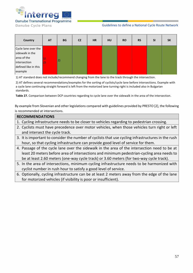
57
Guidelines to define a National Cycle Route Network
Country AT BG CZ HR HU RO RS SI SK
Cycle lane over the
sidewalk in the
area of the
intersection
defined like in this
example
1) 2)
2)
1) AT standard does not include/recommend changing from the lane to the track through the intersection.
2) AT defines several recommendations/examples for the sorting of cyclists/cycle lane before intersections. Example with a cycle lane continuing straight forward is left from the motorized lane turning right is included also in Bulgarian standards.
Table 27. Comparison between DCP countries regarding to cycle lane over the sidewalk in the area of the intersection.
By example from Slovenian and other legislations compared with guidelines provided by PRESTO [2], the following
is recommended at intersections.
RECOMMENDATIONS
1. Cycling infrastructure needs to be closer to vehicles regarding to pedestrian crossing.
2. Cyclists must have precedence over motor vehicles, when those vehicles turn right or left and intersect the cycle track.
3. It is important to consider the number of cyclists that use cycling infrastructures in the rush hour, so that cycling infrastructure can provide good level of service for them.
4. Passage of the cycle lane over the sidewalk in the area of the intersection need to be at least 20 meters before area of intersections and minimum pedestrian-cycling area needs to be at least 2.60 meters (one-way cycle track) or 3.60 meters (for two-way cycle track).
5. In the area of intersections, minimum cycling infrastructure needs to be harmonized with cyclist number in rush hour to satisfy a good level of service.
6. Optionally, cycling infrastructure can be at least 2 meters away from the edge of the lane for motorized vehicles (if visibility is poor or insufficient).
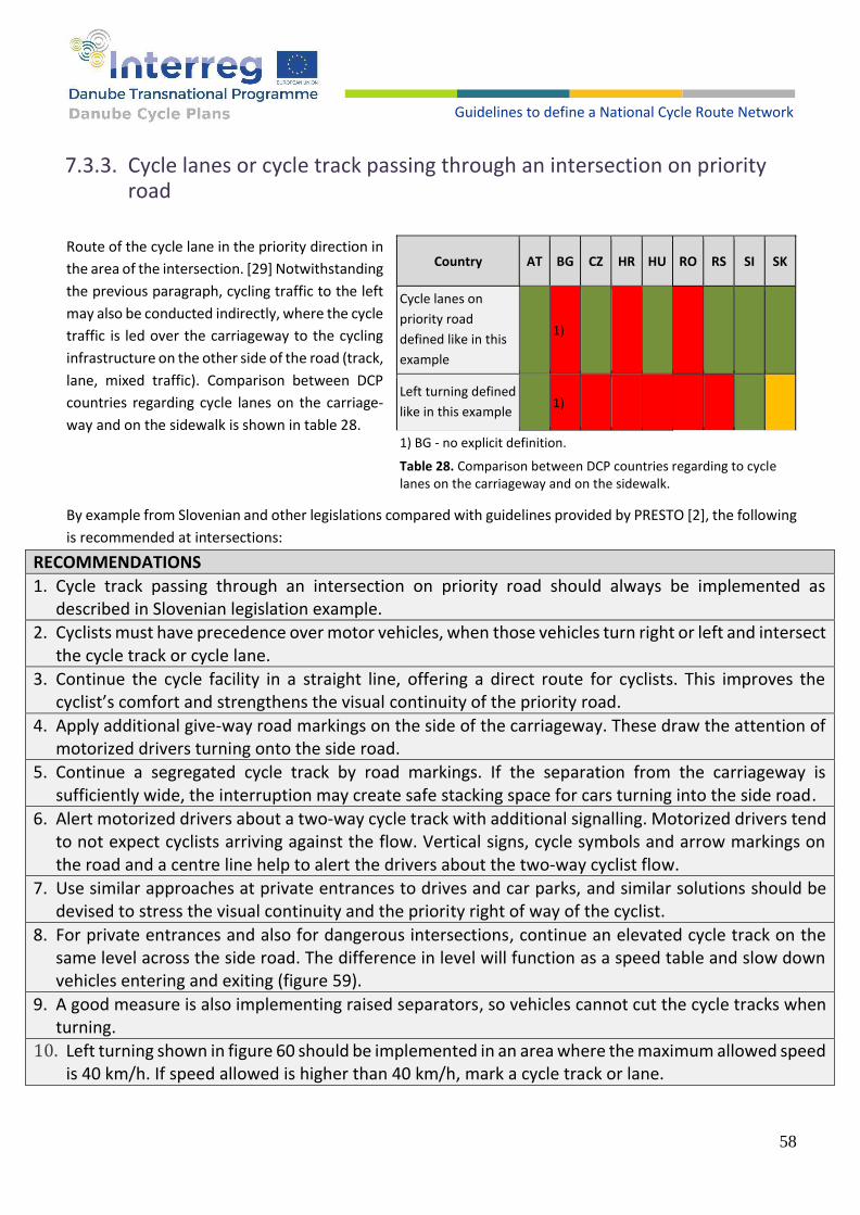
58
Guidelines to define a National Cycle Route Network
7.3.3. Cycle lanes or cycle track passing through an intersection on priority road
Route of the cycle lane in the priority direction in
the area of the intersection. [29] Notwithstanding
the previous paragraph, cycling traffic to the left
may also be conducted indirectly, where the cycle
traffic is led over the carriageway to the cycling
infrastructure on the other side of the road (track,
lane, mixed traffic). Comparison between DCP
countries regarding cycle lanes on the carriage-
way and on the sidewalk is shown in table 28.
By example from Slovenian and other legislations compared with guidelines provided by PRESTO [2], the following
is recommended at intersections:
RECOMMENDATIONS
1. Cycle track passing through an intersection on priority road should always be implemented as described in Slovenian legislation example.
2. Cyclists must have precedence over motor vehicles, when those vehicles turn right or left and intersect the cycle track or cycle lane.
3. Continue the cycle facility in a straight line, offering a direct route for cyclists. This improves the cyclist’s comfort and strengthens the visual continuity of the priority road.
4. Apply additional give-way road markings on the side of the carriageway. These draw the attention of motorized drivers turning onto the side road.
5. Continue a segregated cycle track by road markings. If the separation from the carriageway is sufficiently wide, the interruption may create safe stacking space for cars turning into the side road.
6. Alert motorized drivers about a two-way cycle track with additional signalling. Motorized drivers tend to not expect cyclists arriving against the flow. Vertical signs, cycle symbols and arrow markings on the road and a centre line help to alert the drivers about the two-way cyclist flow.
7. Use similar approaches at private entrances to drives and car parks, and similar solutions should be devised to stress the visual continuity and the priority right of way of the cyclist.
8. For private entrances and also for dangerous intersections, continue an elevated cycle track on the same level across the side road. The difference in level will function as a speed table and slow down vehicles entering and exiting (figure 59).
9. A good measure is also implementing raised separators, so vehicles cannot cut the cycle tracks when turning.
10. Left turning shown in figure 60 should be implemented in an area where the maximum allowed speed is 40 km/h. If speed allowed is higher than 40 km/h, mark a cycle track or lane.
Country AT BG CZ HR HU RO RS SI SK
Cycle lanes on
priority road
defined like in this
example
1)
Left turning defined
like in this example 1)
1) BG - no explicit definition.
Table 28. Comparison between DCP countries regarding to cycle lanes on the carriageway and on the sidewalk.

59
Guidelines to define a National Cycle Route Network
Figure 59. Croatia, Turanj: cycle track along the road is lowered every few meters due to the road entrances to the field. A few passes a week by cars should not be more important than continuous and safe cycling. Source: Google maps
Figure 60. Cycle lanes or cycle track passing through an intersection on priority road. [29]
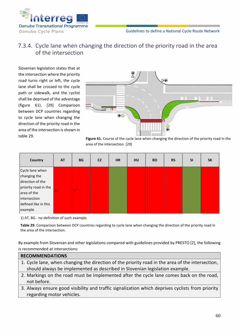
60
Guidelines to define a National Cycle Route Network
7.3.4. Cycle lane when changing the direction of the priority road in the area of the intersection
Slovenian legislation states that at
the intersection where the priority
road turns right or left, the cycle
lane shall be crossed to the cycle
path or sidewalk, and the cyclist
shall be deprived of the advantage
(figure 61). [29] Comparison
between DCP countries regarding
to cycle lane when changing the
direction of the priority road in the
area of the intersection is shown in
table 29.
Country AT BG CZ HR HU RO RS SI SK
Cycle lane when
changing the
direction of the
priority road in the
area of the
intersection
defined like in this
example
1) 1)
1) AT, BG - no definition of such example.
Table 29. Comparison between DCP countries regarding to cycle lane when changing the direction of the priority road in the area of the intersection.
By example from Slovenian and other legislations compared with guidelines provided by PRESTO [2], the following
is recommended at intersections:
RECOMMENDATIONS
1. Cycle lane, when changing the direction of the priority road in the area of the intersection, should always be implemented as described in Slovenian legislation example.
2. Markings on the road must be implemented after the cycle lane comes back on the road, not before.
3. Always ensure good visibility and traffic signalization which deprives cyclists from priority regarding motor vehicles.
Figure 61. Course of the cycle lane when changing the direction of the priority road in the
area of the intersection. [29]
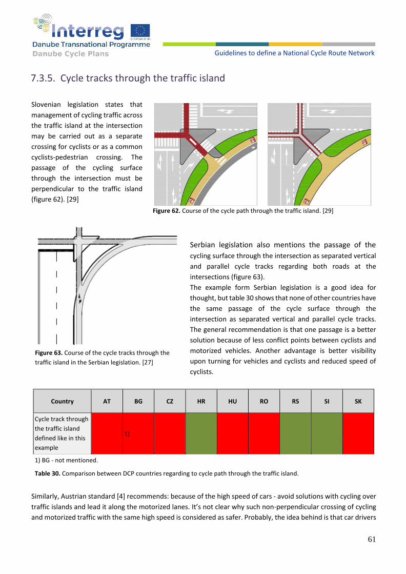
61
Guidelines to define a National Cycle Route Network
7.3.5. Cycle tracks through the traffic island
Slovenian legislation states that
management of cycling traffic across
the traffic island at the intersection
may be carried out as a separate
crossing for cyclists or as a common
cyclists-pedestrian crossing. The
passage of the cycling surface
through the intersection must be
perpendicular to the traffic island
(figure 62). [29]
Serbian legislation also mentions the passage of the
cycling surface through the intersection as separated vertical
and parallel cycle tracks regarding both roads at the
intersections (figure 63).
The example form Serbian legislation is a good idea for
thought, but table 30 shows that none of other countries have
the same passage of the cycle surface through the
intersection as separated vertical and parallel cycle tracks.
The general recommendation is that one passage is a better
solution because of less conflict points between cyclists and
motorized vehicles. Another advantage is better visibility
upon turning for vehicles and cyclists and reduced speed of
cyclists.
Country AT BG CZ HR HU RO RS SI SK
Cycle track through
the traffic island
defined like in this
example
1)
1) BG - not mentioned.
Table 30. Comparison between DCP countries regarding to cycle path through the traffic island.
Similarly, Austrian standard [4] recommends: because of the high speed of cars - avoid solutions with cycling over
traffic islands and lead it along the motorized lanes. It’s not clear why such non-perpendicular crossing of cycling
and motorized traffic with the same high speed is considered as safer. Probably, the idea behind is that car drivers
Figure 62. Course of the cycle path through the traffic island. [29]
Figure 63. Course of the cycle tracks through the
traffic island in the Serbian legislation. [27]

62
Guidelines to define a National Cycle Route Network
will see cyclists long before when driving in parallel. However, cyclists have much lower visibility of cars that
possibly turn right and cut their way by overtaking. This solution is safer only under the assumption of a driving
culture where car drivers take care of cyclists, which is not the case in all DCP countries.
By example from Slovenian and other legislations compared with guidelines provided by PRESTO [2], the following
is recommended at intersections:
RECOMMENDATIONS
1. In this situation, cyclists must always have advantage regarding to vehicles on the carriageway.
2. Crossings between cycle track and carriageway lanes must be implemented perpendicular (90 degrees).
3. It is recommended that the cycling surface is always marked with colour (red or orange);
4. Always ensure good visibility and traffic signalization which clearly gives cyclists priority regarding motor vehicles.
7.3.6. Cycle lane or cycle track over the leg of the non-priority road
Slovenian legislation states that cycling traffic at a crossroad over a branch of a non-priority road may be conducted directly along a cycle lane running in a priority direction or along a cycle track, on which cyclists have priority over vehicles entering or leaving the priority road (figure 64). [29] Table 31 shows a comparison between DCP countries regarding to cycle lane or cycle path over the leg of the non-priority road.
Figure 64. Course of the cycle lane or cycle track over the leg of the non-priority road. [29]
Country AT BG CZ HR HU RO RS SI SK
Cycle lane or cycle
tracks over the leg
of the non-priority
road as defined in
example on figure
64
1) 2)
1) BG - no explicit definition. 2) RO - in case of continuous bike track – defined. In case of discontinuing bike track no explicit definition.
Table 31. Comparison between DCP countries regarding to cycle lane or cycle path over the leg of the non-priority road.

63
Guidelines to define a National Cycle Route Network
Indirect control of bicycle traffic over the leg of the non-
priority road can be performed by shifting the cycle track,
which provides space for right turning of vehicles outside
the priority road carriageway (figure 65). [29] Comparison
between DCP countries regarding to cycle path over the
branch of the non-priority road is shown in table 32.
Country AT BG CZ HR HU RO RS SI SK
Cycle tracks over the branch of the non-priority road as defined in example on figure 65
1) 2)
1) AT recommends that a cycle track along the priority road keeps its level through the intersection, so motorized traffic crossing it will be slowed down. Keeping the same level includes entrances to houses, terrain, petrol stations etc. Also these entrances should perpendicularly cross the cycle track.
2) BG - no explicit definition.
Table 32. Comparison between DCP countries regarding to cycle path over the branch of the non-priority road.
By example from Slovenian and other legislations compared with guidelines provided by PRESTO [2], the following
is recommended at intersections:
RECOMMENDATIONS
1. Before deciding which solution will be implemented, it is recommended to conduct traffic
analysis to detect the number of vehicles that take right turns. If their number is significant
then always implement shifting the cycle track, which provides space for right turning of
vehicles outside the priority road carriageway, but only for one vehicle (not further than 5
meters from edge of the road).
2. Cyclists must have precedence over motor vehicles, when those vehicles turn right or left
and intersect the cycle track.
3. Always ensure good visibility and traffic signalization which gives cyclists priority regarding
motor vehicles.
Figure 65. Course of the cycle track over the branch of the non-priority road. [29]

64
Guidelines to define a National Cycle Route Network
Cycling surfaces through the central dividing island
Slovenian legislation states that the central separation island must be dimensioned in such a way that the
maximum speed of motorized vehicles across the passage for cyclists is a maximum of 50 km/h and its width is at
least 2 m. The cycle crossing in the part of the central dividing island must be in the same plane as the carriageway.
The provisions of this Article shall not apply to retail roads. [29] The course of cycling surfaces through the central
dividing island in Czech legislation is shown in figure 66. [10] The comparison between DCP countries regarding to
cycling surfaces through the central dividing island is shown in table 33.
Figure 66. Course of cycling surfaces through the central dividing island (Czech legislation). [10]
Country AT BG CZ HR HU RO RS SI SK
Cycling surfaces through the central dividing island defined like in this example
Table 33. Comparison between DCP countries regarding to cycling surfaces through the central dividing island.

65
Guidelines to define a National Cycle Route Network
By example from Slovenian and other legislations compared with guidelines provided by PRESTO [2], the
following is recommended:
RECOMMENDATIONS
1. Always use central dividing island if there is more than one vehicle track in one direction.
2. Always use central dividing island if there is maximum allowed speed bigger than 50 km/h.
3. Always use central dividing island if visibility is not good enough.
4. Always use central dividing island if traffic flow in rush hour is bigger than 750 vehicles per hour (in one direction).
5. Always use a central dividing island on state roads.
6. Take care that the motorized lane is not narrowed in the area of the dividing island, especially if there is a cycle lane along it (as in the example above).
7.3.7. Stop lines for cyclists at intersections
Slovenian legislation states that for cycle lanes, in order for
drivers to see them better, the stop line for cyclists shall be
moved forward from the stop line for motorized vehicles.
The stop line for cyclists must be moved 4 m to 5 m forward
from the stop line for vehicles. The forward-moving part of
the cycle lane must be marked with the bicycle symbol
(figure 67). [29] Comparison between DCP countries
regarding to forward-moving stop line for cyclists is shown in
table 34.
Country AT BG CZ HR HU RO RS SI SK
Forward-moving stop line for cyclists defined like in this example
3-5 m 3 m
Table 34. Comparison between DCP countries regarding to forward-moving stop line for cyclists.
A bicycle box is a waiting area for cyclists at a traffic light intersection, which allows cyclists to line up in front of
waiting vehicles due to a red light, which allows cyclists to turn in front of motor vehicles. The bicycle box must be
constructed on the entire width of the directional carriageway, and its length must be 4 to 5 m.
Bicycle boxing may be performed in combination with a cycle lane or sharing a traffic lane (figure 68). If the cycle
lane is separated from the traffic lane by a continuous longitudinal line, it must be marked with a dashed line 10
to 30 m in front of the waiting area for cyclists, which enables cyclists to move to the traffic lane and turn
classifications on the waiting area to the left. If the bicycle box is constructed in combination with the sharing of a
Figure 67. Forward-moving stop line for cyclists. [29]

66
Guidelines to define a National Cycle Route Network
traffic lane, the width of the traffic lane must enable cyclists to drive past standing vehicles and reach the waiting
area at a red light. [29] Comparison between DCP countries regarding to waiting area for cyclists turning left if
provided at a traffic light intersection is shown in table 35.
Figure 68. A waiting area for cyclists turning left may be provided at a traffic light intersection. [29]
Country AT BG CZ HR HU RO RS SI SK
Waiting area for
cyclists turning left
may be provided at
a traffic light
intersection
defined like in this
example
1) 2)
1) AT recommends that the waiting area should not be as wide as complete lane to assure better visibility. 2) BG - The length of the cycling box is 3-5 m, but not introduced in practice yet.
Table 35. Comparison between DCP countries regarding to waiting area for cyclists turning left may be provided at a traffic light intersection.

67
Guidelines to define a National Cycle Route Network
By example from Slovenian and other legislations compared with guidelines provided by PRESTO [2], the following
is recommended at intersections:
RECOMMENDATIONS
1. The stop line for motorized traffic is moved back and a cyclist stop-line drawn 4 to 5 m in
front of it. This creates an advanced waiting area across the entire carriageway for cyclists in
front of all motorized traffic lanes. This should be marked with a bicycle symbol. A coloured
surface may be considered.
2. A feeder cycle lane is recommended. This allows cyclists to bypass waiting traffic and leads
them to the advanced area. The length of the lane should correspond to the maximum length
of the traffic queue. The lane is mostly on the edge of the carriageway, but sometimes also
between traffic lanes. The feeder lane may be a bus/cycle lane.
3. The advanced area allows all cyclists (left-turning, right-turning, moving straight ahead) to
position themselves with maximum visibility in front of motorized traffic. In addition, they
get a head start when the light turns green and this measure can become a popular
generalized provision at all traffic light intersections, creating a citywide, uniform and easily
recognizable benefit. [2]
4. Always use this type of marking on signalized intersection on city avenues, main city roads
or state roads.
5. Always use this type of marking on signalized intersections if visibility is not good enough.

68
Guidelines to define a National Cycle Route Network
7.3.8. Waiting area next to the cycle lane for turning cyclists to the left
Slovenian legislation states that the construction of a waiting area for cyclists enables cyclists turning left to stop
at the waiting area next to the cycle lane at the intersection and allows free passage for cyclists riding straight, and
in the next phase of the signal plan they can move in their directions. For better visibility, the area for cyclists must
be marked with a bicycle symbol and an arrow (figure 69). [29] Table 36 shows the comparison between DCP
countries regarding to waiting area next to the cycle lane for cyclists turning left, and a waiting area next to cycle
tracks for cyclists turning left.
Figure 69. Waiting area next to the cycle lane for turning cyclists to the left and waiting area next to the cycle tracks for turning cyclists to the left. [29]
Country AT BG CZ HR HU RO RS SI SK
Waiting area next to the cycle lane for cyclists turning left and waiting area next to the cycle tracks for cyclists turning left defined like in this example
1)
1) BG - no explicit definition.
Table 36. Comparison between DCP countries regarding to waiting area next to the cycle lane for turning cyclists to the
left and waiting area next to the cycle tracks for turning cyclists to the left.

69
Guidelines to define a National Cycle Route Network
By example from Slovenian and other legislations compared with guidelines provided by PRESTO [2], the following
is recommended at intersections:
RECOMMENDATIONS
1. Example from Slovenian legislation should be implemented if there is enough space at signalized intersections.
2. At the green light, the cyclist first moves slightly to the right into the waiting area. This area is in front of the red traffic light on the right. As soon as there is a gap in traffic, the cyclist can cross. The disadvantage is that this manoeuvre may seem illogical and surprising to other road users: the cyclist crosses the intersection in a direction that has the red light. (Advanced countries in the field of cycling traffic set this as one of recommendations in some cases). [2]
3. Before implementing this type of waiting box, it is needed to ensure enough time for cyclists to move in their tracks without possible unwanted interactions with vehicles.
Figures and text, before mentioned within Slovenian documents, can very easily be applied to all other countries
from the DCP project. As mentioned before, the reason for that is a very similar or the same way of designing
cycling infrastructure. Some countries define guidelines, while others define regulation or tend to detail regarding
very simple designs.
7.3.9. Signalized intersections for cyclists
Signalized intersections are not defined or determined with this document's only appearance and types of
signalized traffic lights. At which intersections or how long the green light will last depends from case to case.
Traffic engineers create and design traffic flows of all modes of travel at signalized intersections. Creating and
designing traffic flows of cyclists at signalized intersections is conducted through knowledge, experience, examples
of good practices or guidelines on how to design traffic flows at signalized intersections (figures 70 and 71).
Figure 70. Example of a pushbutton for cyclist and pedestrians which is 4 m away of the cycle track crossing. Source: Sindikat biciklista
Figure 71. Example of waiting time for turning left for cyclists takes in total (over all sections) in average 144 sec, what is 7.5 times more compared to 19 sec. for the cars turning left (red) from their lane. Source: Google satellite view, drawing Sindikat biciklista
70
Guidelines to define a National Cycle Route Network
Conducted surveys at partner countries for the DCP project have examined the situation regarding traffic conditions for cyclists at signalized intersections (table 37). Questions regarding to traffic light where:
● Using a separate light for cyclists;
● Used methodology for calculating the phase duration for cyclists;
● Using push button exclusively for cyclists;
● Waiting times for cyclists.
Country AT BG CZ HR HU RO RS SK SI
Using a separate light for cyclists
in most cases
separate
in most cases
separate separate
in most cases
combined separate separate
partly combined
partly separated
separate separate
Used methodology for phase duration for cyclist
no data not using
any not using
any not using
any not using
any not using
any not using
any
not using any
not using any
Pushbutton for green light for cyclist
quite common
exceptional quite
common quite
common exceptional no data not used
quite common
exceptional
Longer waiting times for cyclists at signalized intersections
quite common
not existing exceptional quite
common exceptional exceptional
not existing
quite common
quite common
Table 37. Comparison between DCP countries regarding to survey conducted for questions about traffic lights for cyclists.
Table 37 shows that all countries from the DCP project have separate lights for cyclists and most of them push
buttons for green light (but not using them often). Bigger problems can be seen regarding phase duration for
cyclists and waiting times for cyclists. All countries do not have methodology for determining phase duration
exclusively for cyclists and waiting times for green light is more often longer than for private cars and motor
vehicles.
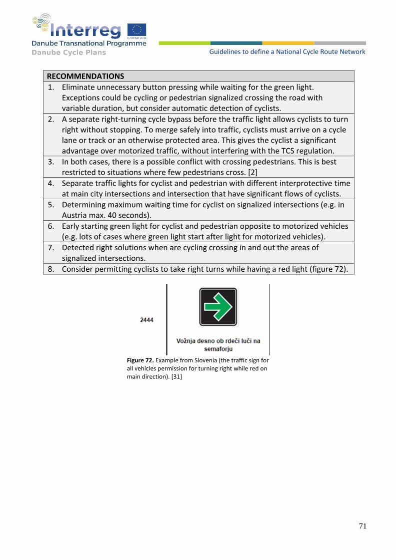
71
Guidelines to define a National Cycle Route Network
RECOMMENDATIONS
1. Eliminate unnecessary button pressing while waiting for the green light. Exceptions could be cycling or pedestrian signalized crossing the road with variable duration, but consider automatic detection of cyclists.
2. A separate right-turning cycle bypass before the traffic light allows cyclists to turn right without stopping. To merge safely into traffic, cyclists must arrive on a cycle lane or track or an otherwise protected area. This gives the cyclist a significant advantage over motorized traffic, without interfering with the TCS regulation.
3. In both cases, there is a possible conflict with crossing pedestrians. This is best restricted to situations where few pedestrians cross. [2]
4. Separate traffic lights for cyclist and pedestrian with different interprotective time at main city intersections and intersection that have significant flows of cyclists.
5. Determining maximum waiting time for cyclist on signalized intersections (e.g. in Austria max. 40 seconds).
6. Early starting green light for cyclist and pedestrian opposite to motorized vehicles (e.g. lots of cases where green light start after light for motorized vehicles).
7. Detected right solutions when are cycling crossing in and out the areas of signalized intersections.
8. Consider permitting cyclists to take right turns while having a red light (figure 72).
Figure 72. Example from Slovenia (the traffic sign for all vehicles permission for turning right while red on main direction). [31]

72
Guidelines to define a National Cycle Route Network
7.4. PEDESTRIANS CROSSINGS OVER CYCLE TRACKS
Pedestrian crossings over cycle tracks are defined in some countries of the Danube region. However, the application of such crossings can also be seen in those countries that do not have guidelines for placement which can result in unnecessary crossings or those that do not fulfil their function (figure 73). This can lead to unclear situations for guiding cyclists, but also pedestrians, or, in a better case, to unnecessary marking and maintenance costs. To avoid this, it is necessary to set clear guidelines for situations where markings are needed and how to mark pedestrian crossings over cycle tracks.
Figure 73. Pedestrian crossings over cycle tracks in Croatia where there is no marking guideline.
Figure 74. Safe crossing for pedestrians across the cycle track. [1]
Slovakia has a good example (figure 74) and clear guidelines, based on which other countries should consider introducing such crossings in their documents. In addition to technical specifications, in Slovakia several different pedestrian crossings over the cycle track are defined depending on the intensity of pedestrians crossing the cycle track.
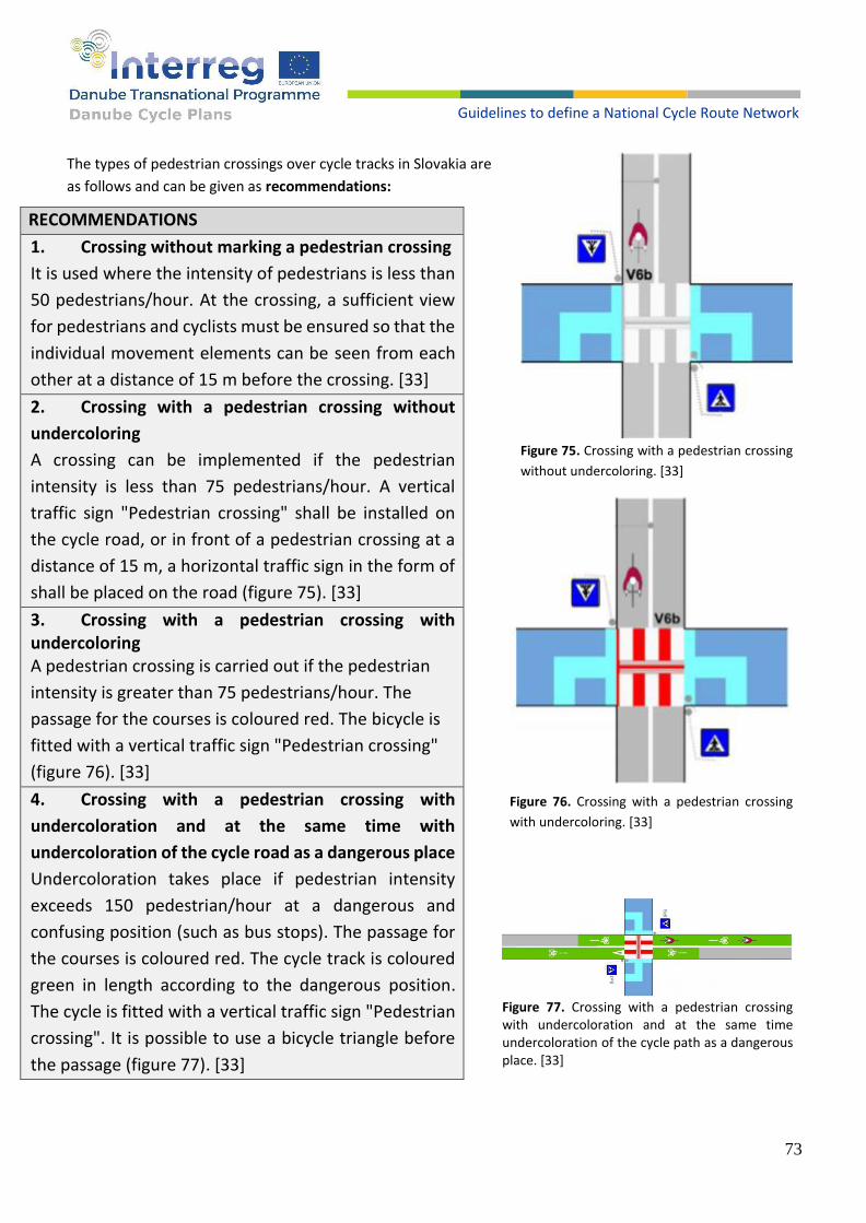
73
Guidelines to define a National Cycle Route Network
The types of pedestrian crossings over cycle tracks in Slovakia are
as follows and can be given as recommendations:
Figure 75. Crossing with a pedestrian crossing
without undercoloring. [33]
Figure 76. Crossing with a pedestrian crossing
with undercoloring. [33]
RECOMMENDATIONS
1. Crossing without marking a pedestrian crossing
It is used where the intensity of pedestrians is less than
50 pedestrians/hour. At the crossing, a sufficient view
for pedestrians and cyclists must be ensured so that the
individual movement elements can be seen from each
other at a distance of 15 m before the crossing. [33]
2. Crossing with a pedestrian crossing without
undercoloring
A crossing can be implemented if the pedestrian
intensity is less than 75 pedestrians/hour. A vertical
traffic sign "Pedestrian crossing" shall be installed on
the cycle road, or in front of a pedestrian crossing at a
distance of 15 m, a horizontal traffic sign in the form of
shall be placed on the road (figure 75). [33]
3. Crossing with a pedestrian crossing with undercoloring A pedestrian crossing is carried out if the pedestrian
intensity is greater than 75 pedestrians/hour. The
passage for the courses is coloured red. The bicycle is
fitted with a vertical traffic sign "Pedestrian crossing"
(figure 76). [33]
4. Crossing with a pedestrian crossing with
undercoloration and at the same time with
undercoloration of the cycle road as a dangerous place
Undercoloration takes place if pedestrian intensity
exceeds 150 pedestrian/hour at a dangerous and
confusing position (such as bus stops). The passage for
the courses is coloured red. The cycle track is coloured
green in length according to the dangerous position.
The cycle is fitted with a vertical traffic sign "Pedestrian
crossing". It is possible to use a bicycle triangle before
the passage (figure 77). [33]
Figure 77. Crossing with a pedestrian crossing with undercoloration and at the same time undercoloration of the cycle path as a dangerous place. [33]

74
Guidelines to define a National Cycle Route Network
8. Bridges, tunnels and stairs
There are two major kinds of barriers for cyclists: dangerous road crossings and intersections (even with
roundabouts or traffic lights), and physical obstacles such as rivers, canals and railroads. Grade-separated solutions
should be considered on any level of the cycle network, inside and outside of the built-up areas, for two key
reasons related to two cycle network quality requirements:
● To improve directness: avoiding the barrier would impose an unacceptable detour, considerably lengthen
cycling journeys and compromise the attractiveness of the network;
● To improve safety: there is no at-grade solution that sufficiently guarantees the cyclists’ safety when
crossing the barrier. [2]
Table 38 shows the advantages and disadvantages of bridges and tunnels by aspects.
Table 38. Advantages and disadvantages of bridges and tunnels by aspects. [2]
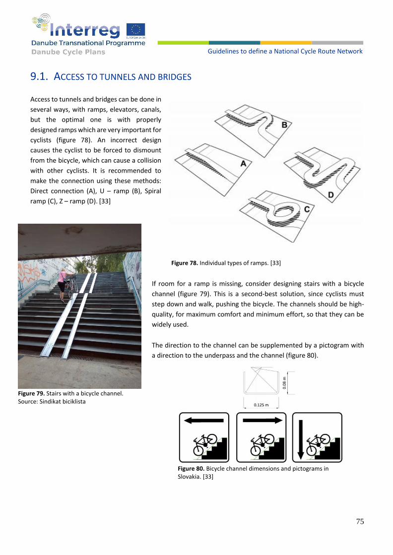
75
Guidelines to define a National Cycle Route Network
9.1. ACCESS TO TUNNELS AND BRIDGES
Access to tunnels and bridges can be done in
several ways, with ramps, elevators, canals,
but the optimal one is with properly
designed ramps which are very important for
cyclists (figure 78). An incorrect design
causes the cyclist to be forced to dismount
from the bicycle, which can cause a collision
with other cyclists. It is recommended to
make the connection using these methods:
Direct connection (A), U – ramp (B), Spiral
ramp (C), Z – ramp (D). [33]
If room for a ramp is missing, consider designing stairs with a bicycle
channel (figure 79). This is a second-best solution, since cyclists must
step down and walk, pushing the bicycle. The channels should be high-
quality, for maximum comfort and minimum effort, so that they can be
widely used.
The direction to the channel can be supplemented by a pictogram with
a direction to the underpass and the channel (figure 80).
Figure 78. Individual types of ramps. [33]
Figure 79. Stairs with a bicycle channel. Source: Sindikat biciklista
Figure 80. Bicycle channel dimensions and pictograms in Slovakia. [33]

76
Guidelines to define a National Cycle Route Network
In table 39, the maximum longitudinal slope is marked in green, as well as the maximum channel slope and the minimum width of channels according to which countries in which these standards are not defined should be guided.
Ramps and stairs
AT BG CZ HR HU RO RS SI SK PRESTO
Maximum longitudinal slope of cycling surface
not specified
not specified
not specified
10% 8%* 7%
12%
not specified
5%
gradient 1:20
-5%
Minimum width of channels on the stairs
not specified
not specified
not specified
0.15 m not
specified not
specified not
specified not
specified 0.125 m
0.08 – 0.12 m
Maximum channel slope
12%** not
specified not
specified not
specified not
specified not
specified not
specified 25%
not specified
25%
*Defined for pedestrian only.
** The maximum channel slope changes depending on height difference and length (from 3% to 12%).
Table 39. Channel profiles according to countries in which these standards are not defined should be guided.
RECOMMENDATIONS
1. Put in channels on both sides of the stairs.
2. Construct channels out of concrete, preferably. On existing stairs, metal channels can be installed, using the same quality criteria.
3. The channel incline should be no more than 25% for comfort.
4. The channel should be at 0.08 m to 0.12 m wide, and at a distance of 0.03m to 0.05m from the side of the stairs.
5. Set the handrail close to the wall, to avoid contact with the handlebars.
6. Make the top level with the top stair for easy entering and exiting. Mechanical devices such as lifts or escalators can provide assistance. However, many users are not comfortable with these solutions. They can therefore only be recommended as an additional solution, not as the only option to scale a difference in height. [2]
9.2. TUNNELS
Lighting is crucial inside and outside tunnels. It should be possible to see what is happening in the tunnel from the
outside, preferably throughout the entire tunnel. Window openings should be installed in new tunnels to let
essential daylight shine on cyclists. Pedestrians and cyclists should always be segregated in tunnels whenever
possible. Barriers, bollards and sharp bends should be avoided inside or directly outside the underpass. [1]
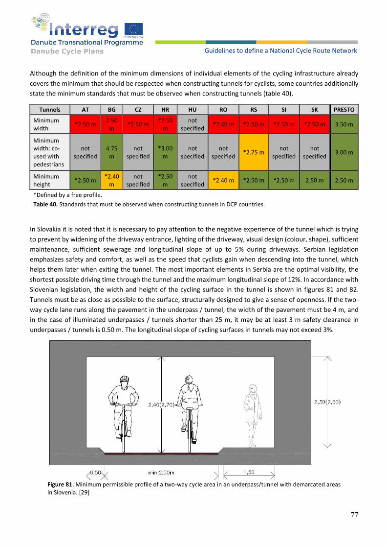
77
Guidelines to define a National Cycle Route Network
Although the definition of the minimum dimensions of individual elements of the cycling infrastructure already
covers the minimum that should be respected when constructing tunnels for cyclists, some countries additionally
state the minimum standards that must be observed when constructing tunnels (table 40).
Tunnels AT BG CZ HR HU RO RS SI SK PRESTO
Minimum width
*2.50 m 2.50
m *2.50 m
*2.50 m
not specified
*2.40 m *2.50 m *2.50 m *2.50 m 3.50 m
Minimum width: co-used with pedestrians
not specified
4.75 m
not specified
*3.00 m
not specified
not specified
*2.75 m not
specified not
specified 3.00 m
Minimum height
*2.50 m *2.40
m not
specified *2.50
m not
specified *2.40 m *2.50 m *2.50 m 2.50 m 2.50 m
*Defined by a free profile.
Table 40. Standards that must be observed when constructing tunnels in DCP countries.
In Slovakia it is noted that it is necessary to pay attention to the negative experience of the tunnel which is trying
to prevent by widening of the driveway entrance, lighting of the driveway, visual design (colour, shape), sufficient
maintenance, sufficient sewerage and longitudinal slope of up to 5% during driveways. Serbian legislation
emphasizes safety and comfort, as well as the speed that cyclists gain when descending into the tunnel, which
helps them later when exiting the tunnel. The most important elements in Serbia are the optimal visibility, the
shortest possible driving time through the tunnel and the maximum longitudinal slope of 12%. In accordance with
Slovenian legislation, the width and height of the cycling surface in the tunnel is shown in figures 81 and 82.
Tunnels must be as close as possible to the surface, structurally designed to give a sense of openness. If the two-
way cycle lane runs along the pavement in the underpass / tunnel, the width of the pavement must be 4 m, and
in the case of illuminated underpasses / tunnels shorter than 25 m, it may be at least 3 m safety clearance in
underpasses / tunnels is 0.50 m. The longitudinal slope of cycling surfaces in tunnels may not exceed 3%.
Figure 81. Minimum permissible profile of a two-way cycle area in an underpass/tunnel with demarcated areas in Slovenia. [29]
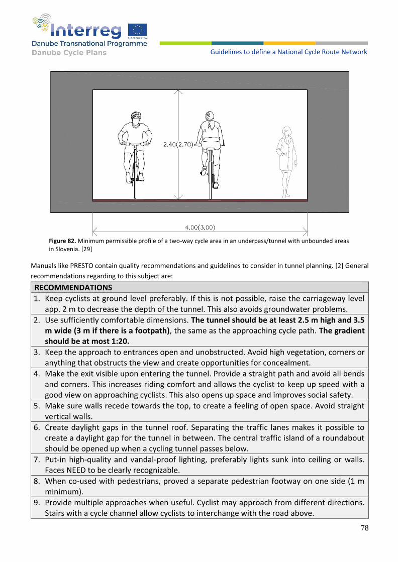
78
Guidelines to define a National Cycle Route Network
Figure 82. Minimum permissible profile of a two-way cycle area in an underpass/tunnel with unbounded areas in Slovenia. [29]
Manuals like PRESTO contain quality recommendations and guidelines to consider in tunnel planning. [2] General
recommendations regarding to this subject are:
RECOMMENDATIONS
1. Keep cyclists at ground level preferably. If this is not possible, raise the carriageway level app. 2 m to decrease the depth of the tunnel. This also avoids groundwater problems.
2. Use sufficiently comfortable dimensions. The tunnel should be at least 2.5 m high and 3.5 m wide (3 m if there is a footpath), the same as the approaching cycle path. The gradient should be at most 1:20.
3. Keep the approach to entrances open and unobstructed. Avoid high vegetation, corners or anything that obstructs the view and create opportunities for concealment.
4. Make the exit visible upon entering the tunnel. Provide a straight path and avoid all bends and corners. This increases riding comfort and allows the cyclist to keep up speed with a good view on approaching cyclists. This also opens up space and improves social safety.
5. Make sure walls recede towards the top, to create a feeling of open space. Avoid straight vertical walls.
6. Create daylight gaps in the tunnel roof. Separating the traffic lanes makes it possible to create a daylight gap for the tunnel in between. The central traffic island of a roundabout should be opened up when a cycling tunnel passes below.
7. Put-in high-quality and vandal-proof lighting, preferably lights sunk into ceiling or walls. Faces NEED to be clearly recognizable.
8. When co-used with pedestrians, proved a separate pedestrian footway on one side (1 m minimum).
9. Provide multiple approaches when useful. Cyclist may approach from different directions. Stairs with a cycle channel allow cyclists to interchange with the road above.
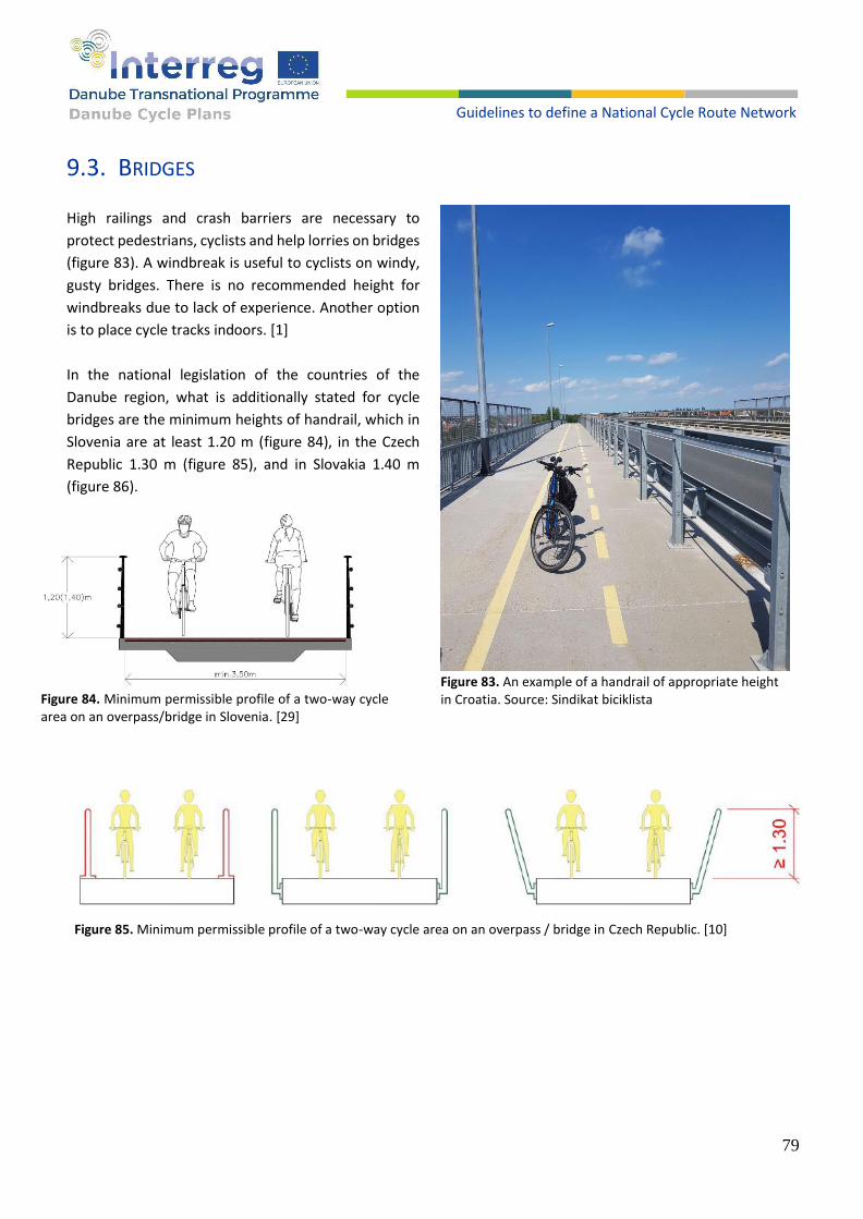
79
Guidelines to define a National Cycle Route Network
9.3. BRIDGES
High railings and crash barriers are necessary to
protect pedestrians, cyclists and help lorries on bridges
(figure 83). A windbreak is useful to cyclists on windy,
gusty bridges. There is no recommended height for
windbreaks due to lack of experience. Another option
is to place cycle tracks indoors. [1]
In the national legislation of the countries of the
Danube region, what is additionally stated for cycle
bridges are the minimum heights of handrail, which in
Slovenia are at least 1.20 m (figure 84), in the Czech
Republic 1.30 m (figure 85), and in Slovakia 1.40 m
(figure 86).
Figure 85. Minimum permissible profile of a two-way cycle area on an overpass / bridge in Czech Republic. [10]
Figure 83. An example of a handrail of appropriate height in Croatia. Source: Sindikat biciklista
Figure 84. Minimum permissible profile of a two-way cycle area on an overpass/bridge in Slovenia. [29]

80
Guidelines to define a National Cycle Route Network
Figure 86. Minimum permissible profile of a two-way cycle area on an
overpass/bridge in Slovakia. [33]
According to the guidelines from PRESTO, the minimum width should be 3.5 m, or 3 m if it is co-used with
pedestrians. Also, with bridges, it is important to take care of the height of the handrail, and a comparison of this
is made in table 41. Those countries that do not meet the minimum requirements are marked in red or yellow, i.e.
the element, and it is proposed to consider the introduction of standards in accordance with the green fields.
Bridges AT BG CZ HR HU RO RS SI SK PRESTO
Minimum width
*2.50 m 2.50 m *2.50 m *2.50
m **2.75 m
not specified
*2.50 m
3.50 m 3.00 m 3.50 m
Minimum width: co-used with pedestrians
not specified
4.75 m not
specified *3.00
m **2.75 m
not specified
*2.75 m
not specified
not specified
3.00 m
Minimum heights of handrail
not specified
not specified
1.30 m 1.20
m not
specified not
specified 1.10
m 1.20 m 1.30 m 1.20 m
*Defined by a free profile.
**Defined by a free profile for all vehicles categories.
Table 41. Comparison of the height of the handrail in DCP countries.
PRESTO contain quality recommendations and guidelines to consider in bridge planning as well. [2] General
recommendations regarding to this subject are:
RECOMMENDATIONS
1. Use sufficiently comfortable dimensions. The bridge should be at least 3.5 m wide (3 m for cycling if there is additional separate footpath), or the same as the approaching cycle track. The incline should be at most 1:20.
2. Provide at least 4.5 m headroom.
3. Provide a handrail or parapet, of at least 1.2 m high.
4. When space is lacking, a phased ramp can be considered.
81
Guidelines to define a National Cycle Route Network
9. Bicycle parking
9.1. POLICY
Bicycle parking provides dedicated infrastructure where people can leave their bicycles when they are carrying out
other activities. It aims to provide an organised means of ensuring that bicycles can be left in a convenient location.
The main requirements for bicycle parking are safety and security, in order to prevent theft and encourage its use.
The location, design, lighting and monitoring (e.g. with cameras) of bicycle parking can all help in this respect. It is
important to understand how the parking facilities will be used and whether the bicycles are likely to be left for
short or longer periods, in order to provide the correct facility. Short term parking may be used during a quick visit
to local amenities, while longer term parking can be provided at transport nodes for people who commute by
public transport. Longer-term bicycle storage could also be provided in high density or historic residential areas,
where the ability to store a bicycle in a secure place within the home might be limited.
Bicycle parking locations and facilities should be set out in the framework of a wider bicycle parking policy. A
bicycle parking policy should also be integrated into a city's overall planning processes and parking policy.
Location
The location of bicycle parking facilities must be considered before setting up the infrastructure. If the location is wrong, parking will not be used. Here are some basic rules for positioning bicycle parking facilities:
The bicycle parking facility should be a logical place to park by the route to the final destination.
An acceptable distance from the parking facility to the destination depends on the duration of parking (short-term, one hour, all-day, and all night parking).
The bicycle parking facility should be visible from the cycling route.
Access to the bicycle parking facility should be, without barriers, in direct continuation of the cyclist traffic flow.
Capacity
When planning bicycle parking facilities, it is important to establish an adequate number of spaces for bicycles.
Experience shows that good parking facilities increase demand and it is recommended to factor in a minimum of
25% extra stands in comparison to the current demand. Required capacity should be calculated on the basis of
short-term, one hour, all-day, and all night parking to establish the need for each individual standard.
Depending on the duration of parking (short-term, one hour, all-day, and all night parking), bicycle parking ranges
from a single cycle rack to extensive underground facilities containing thousands of spaces that have secure and
all-day access.
Current situation with bicycle parking in analysed Danube countries shows a great gap between the
legislative/planning phase and the implementation. This is especially an issue on long-term daily bicycle parking in
front of public buildings (shopping centres, cinema, educational public buildings and similar) where most of
countries (see tables below in this chapter) have good legislative or national guidelines, but in the implementation
phase, set minimums are not being monitored and, consequently, complied with.
Short-term parking has a better implementation phase with still lacking quality of good bicycle parking which
allows locking a bicycle by frame.

82
Guidelines to define a National Cycle Route Network
A quality and quantity of bicycle parking at transport nodes such as bus/train/metro stations is still lagging behind
countries champions such as Denmark and the Netherlands, especially in the implementation where there is a lack
of bigger supervised bicycle park facilities. Table 42 shows the current situation with bicycle parking norms and
standards in analysed Danube countries. In table 43, parking capacity at transport modes, residential areas and
public institutions in analysed Danube countries is presented.
Capacity defined in national legislation
AT BG CZ HR HU RO RS SI SK CROW DK PRESTO UNECE
At transportation nodes *
Parking in residential areas *
Public buildings *
Schools / faculties *
* Bicycle parking norms are defined in municipal spatial development plans, based on national legislation.
Table 42. Current situation with bicycle parking norms and standards in DCP countries.
Capacity details
At transport nodes Parking in residential
area Public buildings Schools / faculties
AT / 1 per 50m2 gross floor
area
1 per 10-50 visitors (depending on type of public
building) 1 per 5 students
BG 1 per every 30
passengers / hour
1.5 per dwelling (if no garage is available) and 6
bicycle parking spaces
1 piece per 100m2 gross floor area, 1 per 20 visitors but not less than 10 slots per building
1 per 5 students
CZ 10-30% of the
number of passengers per day
/ / /
HR 10% of the number
of passengers per day / 5 per 100m2 gross floor area 2 per 5 students
HU / / / /
RO At least 10 / At least 10 At least 10
RS 5-10% of the number of passengers per day
/ 3 per 100m2 gross floor area 1 per 5 students
SI 5-10% of the number of passengers per day
defined on local level 1 per 100m2 gross floor area for employees, 3 per 100m2 gross floor area for visitors
1 per 5 students / 1 per 10 teachers
SK 10-30 per 100
passengers 2-2.5 per 100m2 gross
floor area 5-10 per 100m2 gross floor
area
30-70 per 100 students (60-70 for
pupils, 40-60 for students)
CROW Location depended
(30-70 per passengers)
0.2 per apartment 25-35 per 100 visitors
30-70 per 100 students (30 for
pupils, 70 for students)
DK
10-30% of the number of passengers
(departures)
2 per apartment 5 per 10 students
PRESTO / min. 1 per apartment 1 per 75m2 gross floor area or
1 per 3 employees 30-50 per 100
students
UNECE / / / /
Table 43. Parking capacity at transport modes, residential areas and public institutions.
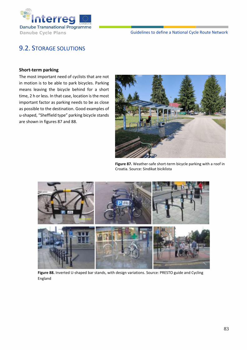
83
Guidelines to define a National Cycle Route Network
9.2. STORAGE SOLUTIONS
Short-term parking
The most important need of cyclists that are not
in motion is to be able to park bicycles. Parking
means leaving the bicycle behind for a short
time, 2 h or less. In that case, location is the most
important factor as parking needs to be as close
as possible to the destination. Good examples of
u-shaped, “Sheffield type” parking bicycle stands
are shown in figures 87 and 88.
Figure 88. Inverted U-shaped bar stands, with design variations. Source: PRESTO guide and Cycling
England
Figure 87. Weather-safe short-term bicycle parking with a roof in Croatia. Source: Sindikat biciklista

84
Guidelines to define a National Cycle Route Network
Long-term storage facilities
In this situation safe storing of bicycles is most important. Storing means leaving the bicycle inside an access
restricted and covered facility. Duration can range from an hour to a whole day/night or several days. A supervised
bicycle storage facility can be considered in almost any city centre and main public transport station (bus, train)
(figures 89, 90 and 91).
Figure 91. The entrance to Amsterdam South station parking
facility. Source: https://bicycledutch.wordpress.com/
Figure 89. The Bike Tower in Hradec Králové, Czech Republic. Source: www.cyklohradec.cz
Figure 90. Bicycle parking facility at Amsterdam South Train. Source: Jan de Vries

85
Guidelines to define a National Cycle Route Network
Individual and collective bicycle locker
Individual bicycle lockers are used in situations calling for protection against bicycle theft and vandalism, but where
the demand is too low to create a supervised storage facility (e.g. smaller public transport stations) (figures 92, 93
and 94).
Figure 94. Collective bicycle lockers (bicycle cages). Source: TIDE Guidelines for the implementation of Innovative bicycle parking scheme
Figure 93. Individual bicycle parking lockers. Source: PRESTO fact sheet on bicycle parking and storage solutions
Figure 92. Bicycle parking facility with lockers at Salzburg Central station. Source: Andreas Lindinger

86
Guidelines to define a National Cycle Route Network
Supervised bicycle storage facilities
A collective bicycle locker can contain a number of bicycles (figures 95 and 96). Each user pays rent and has a key.
The most important advantage of a collective locker is that it takes up considerably less space for the same number
of bicycles than individual lockers. Residential bicycle storage is mostly organized this way, as an indoor or outdoor
space shared by a number of local residents. Storage solutions defined in national legislation in analysed Danube
countries and international guidelines are shown in table 44.
Figure 95. Collective residential storage, on-street and inside. Sources: F. Boschetti, T. Asperges
Figure 96. Residential bicycle Parking in Nordhavn. Source:
copenhagenize.com

87
Guidelines to define a National Cycle Route Network
Storage solutions defined in national
legislation/guidelines AT BG CZ HR HU RO RS SI SK CROW DK PRESTO UNECE
Basic design for parking facilities – recommendations on a national level
Regulation on residential parking existing at regional and local level
Basic regulation of short-term parking
Basic regulation of long-term parking
Table 44. Storage solutions defined in national legislative in analyzed Danube countries.
Good practices from Danube region
In 2019, Slovenian Railways prepared a project for safe bicycle parking at the main railway station in Ljubljana (340
parking spaces). At the same time, within the Ministry of infrastructure, an expert group was established to set
the guidelines for safe bicycle parking within the national railway system. The Slovenian Railways elaborated the
documentation for implementing safe bicycle parking at 220 railway stations nation-wide. The bicycle parking is
free of charge and the number of bicycle parking spaces is defined from statistics based on the number of
passengers commuting daily to/from railway stations and the potential of users/passengers – number of residents
living in the distance from 1 to 4 km away from train station.

88
Guidelines to define a National Cycle Route Network
RECOMMENDATIONS
1. Outside parking should be well-lit and in a visible location.
2. Closing the gap between planning and implementation phase, especially regarding capacities of bicycle parking in long-term and daily parking in front of public building and transport nodes.
3. Parking should be accessible from the cycling infrastructure.
4. Short-term parking should be located directly at the destination.
5. Consider using pavement extensions for bicycle parking in areas using traffic-calming.
6. Designs should be functional and simple, and where street furniture has been specially designed, the design of bicycle parking should be considered to ensure its integration visually.
7. Depending on the duration of bicycle parking, differing levels of quality/provision may be applied, from freestanding or simple bicycle racks to more complex solutions.
8. Bicycle parking facilities need to be easy to use, which includes having a convenient location and being easy to access. Movement within the facility with a bicycle must be easy and obstacle-free. The racks themselves must be easy to use, particularly second tier racks that need to be raised.
9. For large facilities, consideration could be given to installing a bicycle parking monitoring system, to help users identify where there are free racks within the facility.
10. One of the important elements of managing a large bicycle parking facility, or ensuring that the bicycle parking facilities within a city are used efficiently, is to remove abandoned bicycle frames or wheels. If a parking facility has a bicycle parking monitoring system, this can be used to identify which bicycles have been left too long in the parking facility. In the Netherlands, dated stickers are placed on bicycles that appear to have been abandoned, during regular inspections. If the bicycle does not move after three weeks, it is then removed and kept in a storage facility for three months.
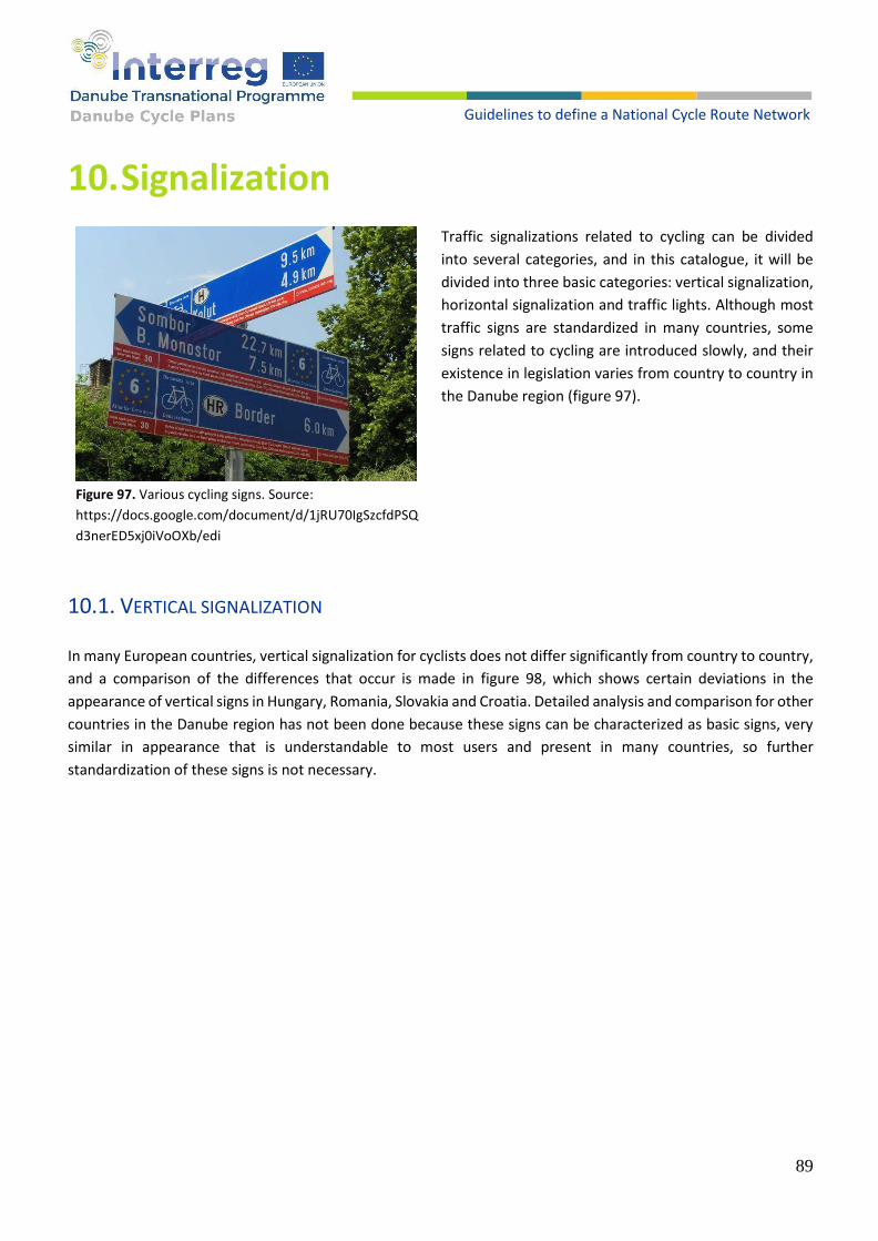
89
Guidelines to define a National Cycle Route Network
10. Signalization
Traffic signalizations related to cycling can be divided
into several categories, and in this catalogue, it will be
divided into three basic categories: vertical signalization,
horizontal signalization and traffic lights. Although most
traffic signs are standardized in many countries, some
signs related to cycling are introduced slowly, and their
existence in legislation varies from country to country in
the Danube region (figure 97).
10.1. VERTICAL SIGNALIZATION
In many European countries, vertical signalization for cyclists does not differ significantly from country to country,
and a comparison of the differences that occur is made in figure 98, which shows certain deviations in the
appearance of vertical signs in Hungary, Romania, Slovakia and Croatia. Detailed analysis and comparison for other
countries in the Danube region has not been done because these signs can be characterized as basic signs, very
similar in appearance that is understandable to most users and present in many countries, so further
standardization of these signs is not necessary.
Figure 97. Various cycling signs. Source:
https://docs.google.com/document/d/1jRU70IgSzcfdPSQ
d3nerED5xj0iVoOXb/edi

90
Guidelines to define a National Cycle Route Network
Cycle lane/track
Track for two categories of road uses
Shared path or track for two
categories of road uses
Pedestrian zone / Pedestrian and cycling
zone
Residential area / End of residential
area
Pedestrian and cyclist crossings
Forbidden for cyclists
Restricted speed zone
Cyclists on the road
Figure 98. Certain deviations in the appearance of vertical signs in Hungary, Romania, Slovakia and Croatia.
Table 45 highlights vertical signs that do not apply in all countries of the Danube region, but should be mentioned
as examples of good practice that exist in some countries. Other countries, for which the fields of individual
characters in the table are marked in red, should consider introducing individual signs into their legislation. The
yellow colour in table 45 indicates the signs defined in the regulations of individual countries, but the absence of
the application of the sign in the field. Green colour means both regulatory and practical application of signs.
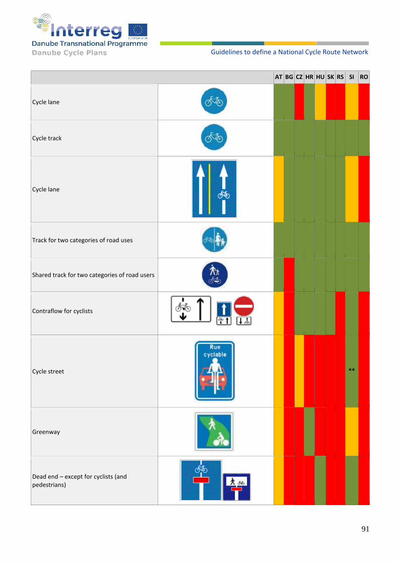
91
Guidelines to define a National Cycle Route Network
AT BG CZ HR HU SK RS SI RO
Cycle lane
Cycle track
Cycle lane
Track for two categories of road uses
Shared track for two categories of road users
Contraflow for cyclists
Cycle street
**
Greenway
Dead end – except for cyclists (and pedestrians)

92
Guidelines to define a National Cycle Route Network
The sign indicates that at a crossroads, if a cyclist wishes to continue to the left, classify it as a vehicle traveling on the right side of the crossing road in the direction of travel and cross the crossing.
Bus lane that can also be used by cyclists (the sign indicates that cyclists are also allowed to use the bus lane)
Traffic light for cyclists with a yellow
sign
Combined cyclist/pedestrian traffic
light
Sign for marking a charging station for electric bicycles
**Implementing cycle street/road in legislation
Used
Not used
Not defined
Table 45. Vertical signs that do not apply in all countries of the Danube region, but should be mentioned as examples of good practice.
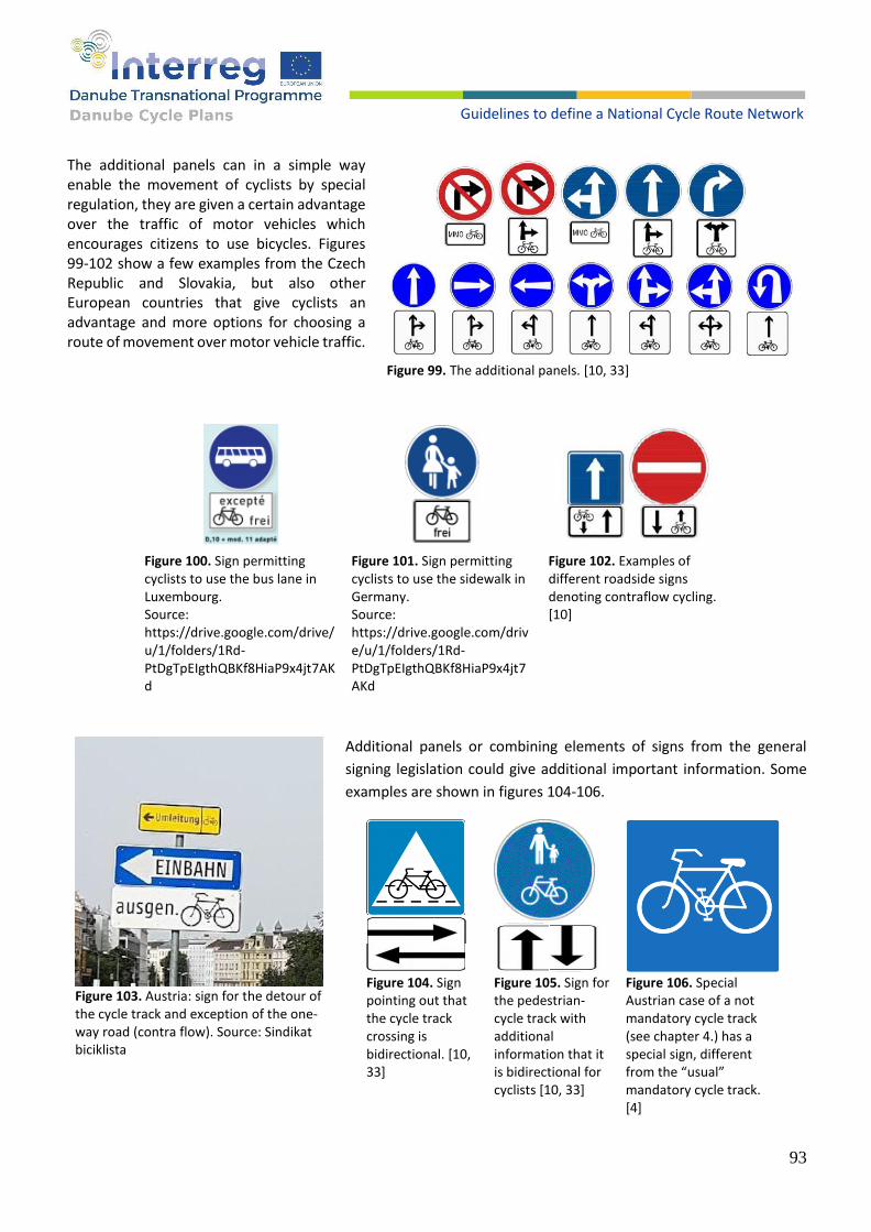
93
Guidelines to define a National Cycle Route Network
The additional panels can in a simple way enable the movement of cyclists by special regulation, they are given a certain advantage over the traffic of motor vehicles which encourages citizens to use bicycles. Figures 99-102 show a few examples from the Czech Republic and Slovakia, but also other European countries that give cyclists an advantage and more options for choosing a route of movement over motor vehicle traffic.
Figure 100. Sign permitting cyclists to use the bus lane in Luxembourg. Source: https://drive.google.com/drive/u/1/folders/1Rd-PtDgTpEIgthQBKf8HiaP9x4jt7AKd
Figure 101. Sign permitting cyclists to use the sidewalk in Germany. Source: https://drive.google.com/drive/u/1/folders/1Rd-PtDgTpEIgthQBKf8HiaP9x4jt7AKd
Figure 102. Examples of different roadside signs denoting contraflow cycling. [10]
Additional panels or combining elements of signs from the general
signing legislation could give additional important information. Some
examples are shown in figures 104-106.
Figure 99. The additional panels. [10, 33]
Figure 103. Austria: sign for the detour of the cycle track and exception of the one-way road (contra flow). Source: Sindikat biciklista
Figure 104. Sign pointing out that the cycle track crossing is bidirectional. [10, 33]
Figure 105. Sign for the pedestrian-cycle track with additional information that it is bidirectional for cyclists [10, 33]
Figure 106. Special Austrian case of a not mandatory cycle track (see chapter 4.) has a special sign, different from the “usual” mandatory cycle track. [4]

94
Guidelines to define a National Cycle Route Network
Most countries in the Danube region have a certain type of national guideline for the direction posting. Primary
focus is on the touristic cycle route networks and long-distance cycling, however there is also a need to route the
every-day cyclists across the districts and to important POI-s in an urban area.
Depending on the standard and route structure, signs may include destinations, distance, route number, route
name and route logo. Almost all countries recognize and include EuroVelo signs in their standard. Several examples
are shown in figures 107-110.
Figure 107. Bicycle direction signs in Hungary. [15]
Figure 108. Signalization of cycle routes in national guidelines in Hungary, Slovenia and Czech Republic. Source: https://docs.google.com/document/d/1m1voy42N2J-drO3kWvdzh4w2jXFITRGo/edit#heading=h.19c6y18 , https://docs.google.com/document/d/1zUW72kLsL5tF3MkR19iw_uMcLU5_7D7h/edit
Figure 109. Signs in Vienna, Austria for local destinations. Source: Sindikat biciklista
Figure 110. Examples of national wayfinding infrastructure, incorporating EuroVelo route information panels. Source: https://drive.google.com/drive/u/ 1/folders/1Rd-PtDgTpEIgthQBKf8HiaP9x4jt7AKd
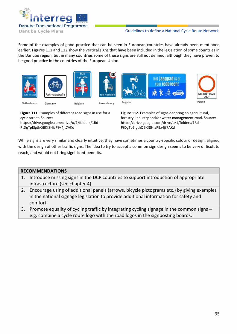
95
Guidelines to define a National Cycle Route Network
Some of the examples of good practice that can be seen in European countries have already been mentioned earlier. Figures 111 and 112 show the vertical signs that have been included in the legislation of some countries in the Danube region, but in many countries some of these signs are still not defined, although they have proven to be good practice in the countries of the European Union.
Figure 111. Examples of different road signs in use for a cycle street. Source: https://drive.google.com/drive/u/1/folders/1Rd-PtDgTpEIgthQBKf8HiaP9x4jt7AKd
Figure 112. Examples of signs denoting an agricultural, forestry, industry and/or water management road. Source: https://drive.google.com/drive/u/1/folders/1Rd-PtDgTpEIgthQBKf8HiaP9x4jt7AKd
While signs are very similar and clearly intuitive, they have sometimes a country-specific colour or design, aligned
with the design of other traffic signs. The idea to try to accept a common sign design seems to be very difficult to
reach, and would not bring significant benefits.
RECOMMENDATIONS
1. Introduce missing signs in the DCP countries to support introduction of appropriate infrastructure (see chapter 4).
2. Encourage using of additional panels (arrows, bicycle pictograms etc.) by giving examples in the national signage legislation to provide additional information for safety and comfort.
3. Promote equality of cycling traffic by integrating cycling signage in the common signs – e.g. combine a cycle route logo with the road logos in the signposting boards.

96
Guidelines to define a National Cycle Route Network
10.2. HORIZONTAL SIGNALIZATION
In addition to vertical signalization, the use of horizontal signs and markings is mandatory, but since the significant
development of bicycle traffic in some countries in the Danube region is still in its infancy. Colours, dimensions
and other characteristics of horizontal signalization differ slightly more than vertical signalization. The colours
applied from country to country differ from white, yellow, red, green (figures 113-118). The width and appearance
of road cycle crossing markings vary considerably, while in some countries, despite the existence of shared paths
for pedestrians and cyclists, crossings that would guarantee the continuity of such paths have not yet been
defined. Below are examples of horizontal markings for bicycle traffic in the countries of the Danube region.
Figure 113. Bicycle boxes / Moved stop line for cyclists. Figure 114. Sharrows / bicycle traffic area / road
designated for cycling.
Figure 115. Pedestrian and cycle track crossings. Figure 116. Cycle track crossings.

97
Guidelines to define a National Cycle Route Network
Horizontal markings for cyclists Marking sharrows on roads requires paying special attention to the side distance markings depending on hazards such as dooring. [13, 14, 15, 22] In Croatia, in the case of side-parked vehicles, sharrows are performed in the middle of the carriageway, while in Slovakia the distance is defined as in figures 119 and 120.
Figure 120. Marking sharrows on roads considering the side distance markings depending on hazards such as dooring. [33]
The yellow colour in table 46 indicates the horizontal signs defined in the regulations of individual countries, but
the absence of the application of the sign on the field. Green colour means both regulatory and practical
application of signs.
Figure 119. Appearance, dimensions and method of marking sharrows in Croatia. [13]
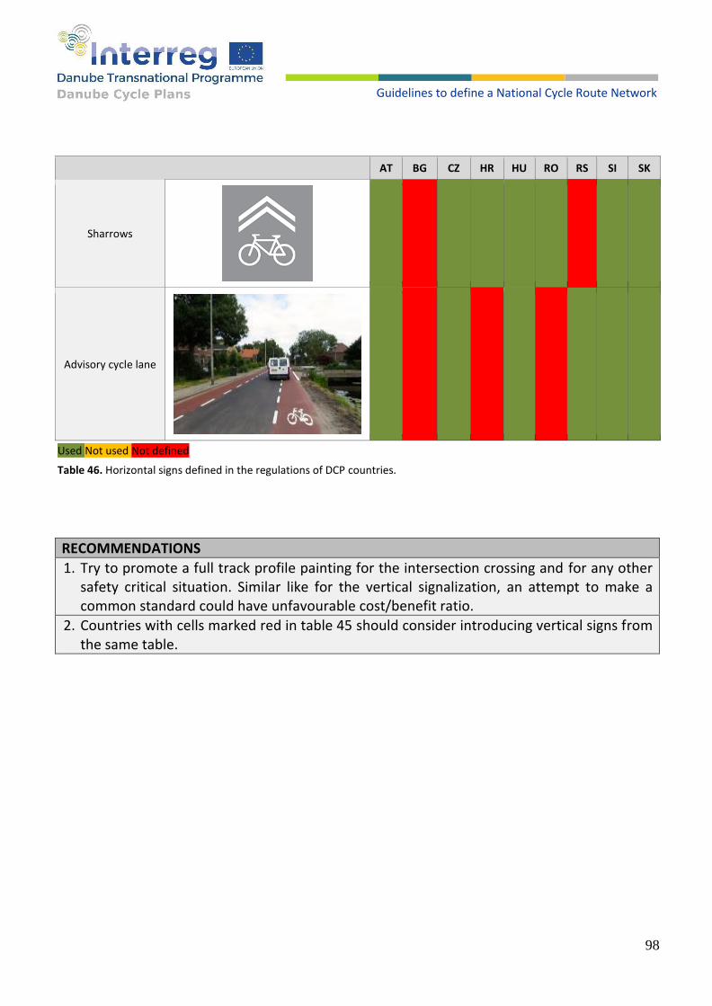
98
Guidelines to define a National Cycle Route Network
AT BG CZ HR HU RO RS SI SK
Sharrows
Advisory cycle lane
Used Not used Not defined
Table 46. Horizontal signs defined in the regulations of DCP countries.
RECOMMENDATIONS
1. Try to promote a full track profile painting for the intersection crossing and for any other safety critical situation. Similar like for the vertical signalization, an attempt to make a common standard could have unfavourable cost/benefit ratio.
2. Countries with cells marked red in table 45 should consider introducing vertical signs from the same table.
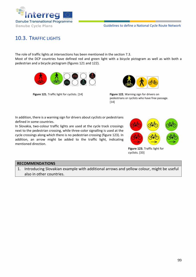
99
Guidelines to define a National Cycle Route Network
10.3. TRAFFIC LIGHTS
The role of traffic lights at intersections has been mentioned in the section 7.3. Most of the DCP countries have defined red and green light with a bicycle pictogram as well as with both a pedestrian and a bicycle pictogram (figures 121 and 122).
Figure 121. Traffic light for cyclists. [14]
Figure 122. Warning sign for drivers on pedestrians or cyclists who have free passage. [14]
In addition, there is a warning sign for drivers about cyclists or pedestrians defined in some countries. In Slovakia, two-colour traffic lights are used at the cycle track crossings next to the pedestrian crossing, while three-color signalling is used at the cycle crossings along which there is no pedestrian crossing (figure 123). In addition, an arrow might be added to the traffic light, indicating mentioned direction.
RECOMMENDATIONS
1. Introducing Slovakian example with additional arrows and yellow colour, might be useful also in other countries.
Figure 123. Traffic light for cyclists. [33]
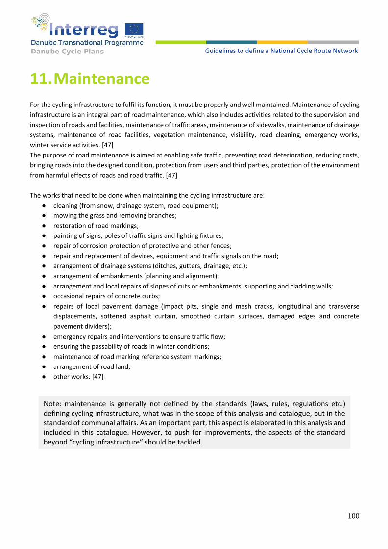
100
Guidelines to define a National Cycle Route Network
11. Maintenance
For the cycling infrastructure to fulfil its function, it must be properly and well maintained. Maintenance of cycling
infrastructure is an integral part of road maintenance, which also includes activities related to the supervision and
inspection of roads and facilities, maintenance of traffic areas, maintenance of sidewalks, maintenance of drainage
systems, maintenance of road facilities, vegetation maintenance, visibility, road cleaning, emergency works,
winter service activities. [47]
The purpose of road maintenance is aimed at enabling safe traffic, preventing road deterioration, reducing costs,
bringing roads into the designed condition, protection from users and third parties, protection of the environment
from harmful effects of roads and road traffic. [47]
The works that need to be done when maintaining the cycling infrastructure are:
● cleaning (from snow, drainage system, road equipment);
● mowing the grass and removing branches;
● restoration of road markings;
● painting of signs, poles of traffic signs and lighting fixtures;
● repair of corrosion protection of protective and other fences;
● repair and replacement of devices, equipment and traffic signals on the road;
● arrangement of drainage systems (ditches, gutters, drainage, etc.);
● arrangement of embankments (planning and alignment);
● arrangement and local repairs of slopes of cuts or embankments, supporting and cladding walls;
● occasional repairs of concrete curbs;
● repairs of local pavement damage (impact pits, single and mesh cracks, longitudinal and transverse
displacements, softened asphalt curtain, smoothed curtain surfaces, damaged edges and concrete
pavement dividers);
● emergency repairs and interventions to ensure traffic flow;
● ensuring the passability of roads in winter conditions;
● maintenance of road marking reference system markings;
● arrangement of road land;
● other works. [47]
Note: maintenance is generally not defined by the standards (laws, rules, regulations etc.) defining cycling infrastructure, what was in the scope of this analysis and catalogue, but in the standard of communal affairs. As an important part, this aspect is elaborated in this analysis and included in this catalogue. However, to push for improvements, the aspects of the standard beyond “cycling infrastructure” should be tackled.
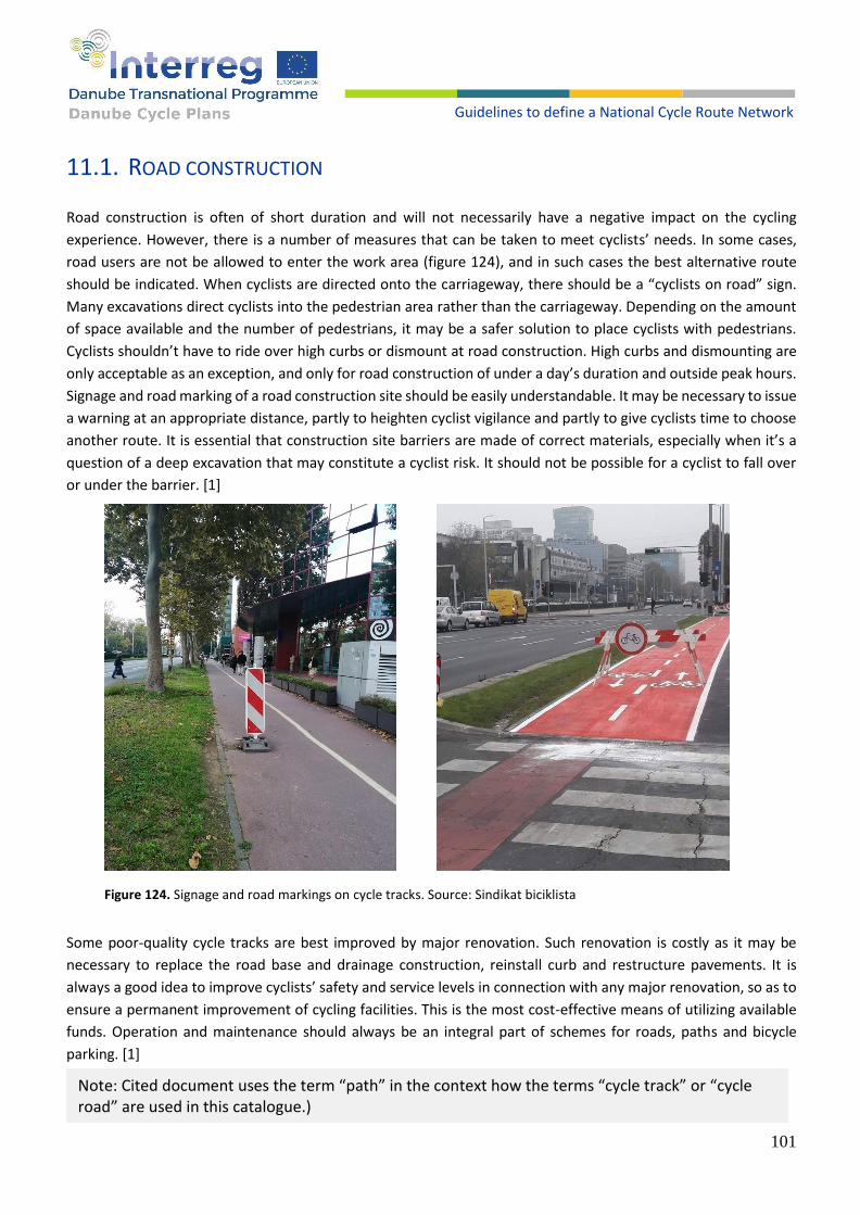
101
Guidelines to define a National Cycle Route Network
11.1. ROAD CONSTRUCTION
Road construction is often of short duration and will not necessarily have a negative impact on the cycling
experience. However, there is a number of measures that can be taken to meet cyclists’ needs. In some cases,
road users are not be allowed to enter the work area (figure 124), and in such cases the best alternative route
should be indicated. When cyclists are directed onto the carriageway, there should be a “cyclists on road” sign.
Many excavations direct cyclists into the pedestrian area rather than the carriageway. Depending on the amount
of space available and the number of pedestrians, it may be a safer solution to place cyclists with pedestrians.
Cyclists shouldn’t have to ride over high curbs or dismount at road construction. High curbs and dismounting are
only acceptable as an exception, and only for road construction of under a day’s duration and outside peak hours.
Signage and road marking of a road construction site should be easily understandable. It may be necessary to issue
a warning at an appropriate distance, partly to heighten cyclist vigilance and partly to give cyclists time to choose
another route. It is essential that construction site barriers are made of correct materials, especially when it’s a
question of a deep excavation that may constitute a cyclist risk. It should not be possible for a cyclist to fall over
or under the barrier. [1]
Figure 124. Signage and road markings on cycle tracks. Source: Sindikat biciklista
Some poor-quality cycle tracks are best improved by major renovation. Such renovation is costly as it may be
necessary to replace the road base and drainage construction, reinstall curb and restructure pavements. It is
always a good idea to improve cyclists’ safety and service levels in connection with any major renovation, so as to
ensure a permanent improvement of cycling facilities. This is the most cost-effective means of utilizing available
funds. Operation and maintenance should always be an integral part of schemes for roads, paths and bicycle
parking. [1]
Note: Cited document uses the term “path” in the context how the terms “cycle track” or “cycle road” are used in this catalogue.)

102
Guidelines to define a National Cycle Route Network
Proper maintenance of horizontal
signalization is especially important for
the crossings of the cycle track over
intersections (figures 125 and 126).
Faded signalization would not be
visible for the car drivers and cyclists
know that the crossing is there. Such
situation when both sides “know” they
have right of the way is extremely risky
and is a cause for many accidents.
Table 47 shows by colour how this is maintained in individual countries of the Danube region. [50]
Figure 125. Damaged and unmaintained cycling infrastructure. Source: Sindikat biciklista
Maintaining horizontal signalization on cycle track crossing over intersections
AT BG CZ HR HU RO RS SI SK
Regularly
Sometimes
Not really
Table 47. Maintaining horizontal signalization on cycle track crossing over intersections in DCP countries.

103
Guidelines to define a National Cycle Route Network
Figure 126. Zagreb, Croatia: faded signalization of a cycle track crossing an intersection. Right turning cars from the priority
road are not aware of cyclists having advantage. Source: Sindikat biciklista
Gully grates can get in the way of cyclists because of their placement, difference in level, or grating, or even missing
(figure 128). Gully grates can be height adjusted so they are flush with the road surface or moved into the curb.
Grates with longitudinal slots should be turned 90 degrees or replaced with a more cycle friendly type of grate
(figure 127). Older types of sewers’ cover that are fixed to the well frame are often unacceptable due to the
difference in level to the wearing surface, and should be replaced by an adjustable model. [1]
Figure 127. Properly and improperly directed gully grates. [13]
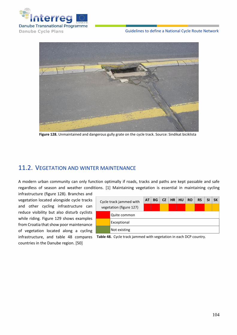
104
Guidelines to define a National Cycle Route Network
Figure 128. Unmaintained and dangerous gully grate on the cycle track. Source: Sindikat biciklista
11.2. VEGETATION AND WINTER MAINTENANCE
A modern urban community can only function optimally if roads, tracks and paths are kept passable and safe
regardless of season and weather conditions. [1] Maintaining vegetation is essential in maintaining cycling
infrastructure (figure 128). Branches and
vegetation located alongside cycle tracks
and other cycling infrastructure can
reduce visibility but also disturb cyclists
while riding. Figure 129 shows examples
from Croatia that show poor maintenance
of vegetation located along a cycling
infrastructure, and table 48 compares
countries in the Danube region. [50]
Cycle track jammed with
vegetation (figure 127)
AT BG CZ HR HU RO RS SI SK
Quite common
Exceptional
Not existing
Table 48. Cycle track jammed with vegetation in each DCP country.
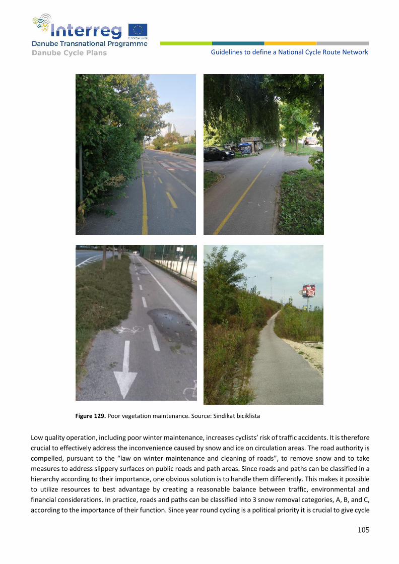
105
Guidelines to define a National Cycle Route Network
Figure 129. Poor vegetation maintenance. Source: Sindikat biciklista
Low quality operation, including poor winter maintenance, increases cyclists’ risk of traffic accidents. It is therefore
crucial to effectively address the inconvenience caused by snow and ice on circulation areas. The road authority is
compelled, pursuant to the “law on winter maintenance and cleaning of roads”, to remove snow and to take
measures to address slippery surfaces on public roads and path areas. Since roads and paths can be classified in a
hierarchy according to their importance, one obvious solution is to handle them differently. This makes it possible
to utilize resources to best advantage by creating a reasonable balance between traffic, environmental and
financial considerations. In practice, roads and paths can be classified into 3 snow removal categories, A, B, and C,
according to the importance of their function. Since year round cycling is a political priority it is crucial to give cycle

106
Guidelines to define a National Cycle Route Network
tracks high priority in winter. Category A contains primary segregated off-road cycle paths and cycle tracks along
primary roads. It is essential that the service level on such paths is high since snow and ice are highly inconvenient
for cyclists. Cyclists should not be tempted to use the carriageway instead of the cycle track. Such sections are so
important for bicycle traffic, and in the final analysis for the entire community, that they should be kept open
without major inconvenience 24 hours a day, 7 days a week. Category B includes school routes and feeder paths.
Snow removal and de-icing treatments are only carried out during daytime, 7 days a week. Category C includes
shorter paths of minor importance. Snow clearance and de-icing treatments are only carried out exceptionally.
Recreational paths, with a gravel surface, for example, should not usually be included in winter maintenance. [1]
The number of cyclists in winter conditions can be significantly lower compared to dry and warm weather, but this
should not be an excuse for road maintenance services not to remove snow or, in the worst case, to use cycle
lanes and tracks as snow storage areas after ploughing and removing snow from the road. Figures 130-132 show
the condition of cycle lanes and tracks in Zagreb a few days after the snow stopped. This approach of winter
services is not acceptable in countries that
want to encourage cycling.
Nevertheless, no country in the Danube
region pays enough attention to winter
maintenance, as can be seen in table 49, and
only the city of Vienna with timely
maintenance of cycling infrastructure during
the winter provides a good example. [50]
Uncleaned cycling
infrastructure from snow
AT BG CZ HR HU RO RS SI SK
* **
Regular, consistent and on time
With some delay or difficulties
Not really
* Regular and on time in Vienna
** No answer
Table 49. Uncleaned cycling infrastructure from snow in each DCP country.

107
Guidelines to define a National Cycle Route Network
Figure 130. Example of poorly maintained cycling infrastructure in winter conditions. Source: Sindikat biciklista
Figure 131. Example of poorly maintained cycling infrastructure in winter conditions. Source: Sindikat biciklista
Figure 132. Example of poorly maintained cycling infrastructure in winter conditions. Source: Sindikat biciklista
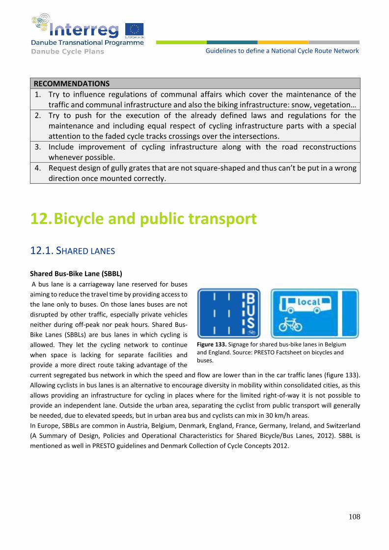
108
Guidelines to define a National Cycle Route Network
RECOMMENDATIONS
1. Try to influence regulations of communal affairs which cover the maintenance of the traffic and communal infrastructure and also the biking infrastructure: snow, vegetation…
2. Try to push for the execution of the already defined laws and regulations for the maintenance and including equal respect of cycling infrastructure parts with a special attention to the faded cycle tracks crossings over the intersections.
3. Include improvement of cycling infrastructure along with the road reconstructions whenever possible.
4. Request design of gully grates that are not square-shaped and thus can’t be put in a wrong direction once mounted correctly.
12. Bicycle and public transport
12.1. SHARED LANES
Shared Bus-Bike Lane (SBBL)
A bus lane is a carriageway lane reserved for buses
aiming to reduce the travel time by providing access to
the lane only to buses. On those lanes buses are not
disrupted by other traffic, especially private vehicles
neither during off-peak nor peak hours. Shared Bus-
Bike Lanes (SBBLs) are bus lanes in which cycling is
allowed. They let the cycling network to continue
when space is lacking for separate facilities and
provide a more direct route taking advantage of the
current segregated bus network in which the speed and flow are lower than in the car traffic lanes (figure 133).
Allowing cyclists in bus lanes is an alternative to encourage diversity in mobility within consolidated cities, as this
allows providing an infrastructure for cycling in places where for the limited right-of-way it is not possible to
provide an independent lane. Outside the urban area, separating the cyclist from public transport will generally
be needed, due to elevated speeds, but in urban area bus and cyclists can mix in 30 km/h areas.
In Europe, SBBLs are common in Austria, Belgium, Denmark, England, France, Germany, Ireland, and Switzerland
(A Summary of Design, Policies and Operational Characteristics for Shared Bicycle/Bus Lanes, 2012). SBBL is
mentioned as well in PRESTO guidelines and Denmark Collection of Cycle Concepts 2012.
Figure 133. Signage for shared bus-bike lanes in Belgium and England. Source: PRESTO Factsheet on bicycles and buses.
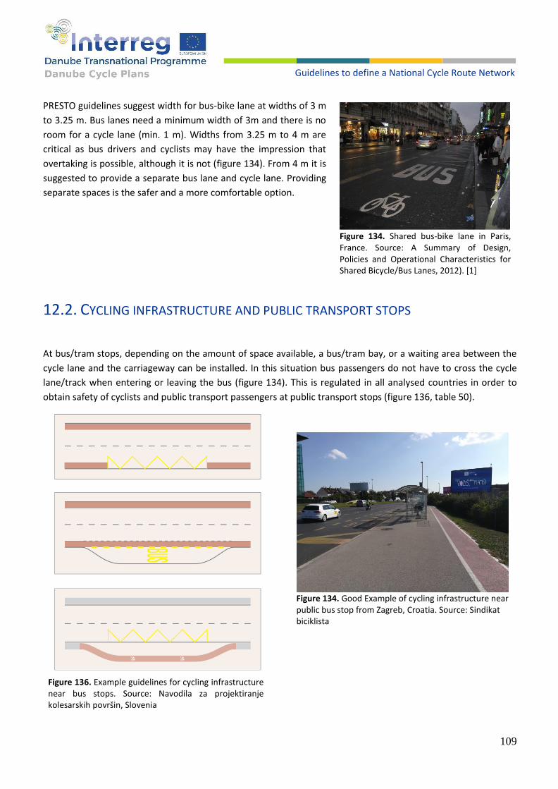
109
Guidelines to define a National Cycle Route Network
PRESTO guidelines suggest width for bus-bike lane at widths of 3 m
to 3.25 m. Bus lanes need a minimum width of 3m and there is no
room for a cycle lane (min. 1 m). Widths from 3.25 m to 4 m are
critical as bus drivers and cyclists may have the impression that
overtaking is possible, although it is not (figure 134). From 4 m it is
suggested to provide a separate bus lane and cycle lane. Providing
separate spaces is the safer and a more comfortable option.
12.2. CYCLING INFRASTRUCTURE AND PUBLIC TRANSPORT STOPS
At bus/tram stops, depending on the amount of space available, a bus/tram bay, or a waiting area between the
cycle lane and the carriageway can be installed. In this situation bus passengers do not have to cross the cycle
lane/track when entering or leaving the bus (figure 134). This is regulated in all analysed countries in order to
obtain safety of cyclists and public transport passengers at public transport stops (figure 136, table 50).
Figure 134. Shared bus-bike lane in Paris, France. Source: A Summary of Design, Policies and Operational Characteristics for Shared Bicycle/Bus Lanes, 2012). [1]
Figure 134. Good Example of cycling infrastructure near public bus stop from Zagreb, Croatia. Source: Sindikat biciklista
Figure 136. Example guidelines for cycling infrastructure near bus stops. Source: Navodila za projektiranje kolesarskih površin, Slovenia
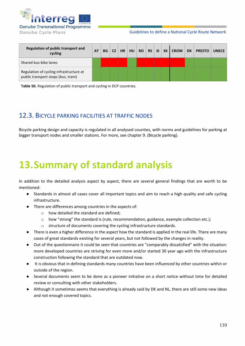
110
Guidelines to define a National Cycle Route Network
Regulation of public transport and cycling
AT BG CZ HR HU RO RS SI SK CROW DK PRESTO UNECE
Shared bus-bike lanes
Regulation of cycling infrastructure at public transport stops (bus, tram)
Table 50. Regulation of public transport and cycling in DCP countries.
12.3. BICYCLE PARKING FACILITIES AT TRAFFIC NODES
Bicycle parking design and capacity is regulated in all analysed counties, with norms and guidelines for parking at bigger transport nodes and smaller stations. For more, see chapter 9. (Bicycle parking).
13. Summary of standard analysis
In addition to the detailed analysis aspect by aspect, there are several general findings that are worth to be
mentioned:
● Standards in almost all cases cover all important topics and aim to reach a high quality and safe cycling
infrastructure.
● There are differences among countries in the aspects of:
o how detailed the standard are defined;
o how “strong” the standard is (rule, recommendation, guidance, example collection etc.);
o structure of documents covering the cycling infrastructure standards.
● There is even a higher difference in the aspect how the standard is applied in the real life. There are many
cases of great standards existing for several years, but not followed by the changes in reality.
● Out of the questionnaire it could be seen that countries are “comparably dissatisfied” with the situation:
more developed countries are striving for even more and/or started 30 year ago with the infrastructure
construction following the standard that are outdated now.
● It is obvious that in defining standards many countries have been influenced by other countries within or
outside of the region.
● Several documents seem to be done as a pioneer initiative on a short notice without time for detailed
review or consulting with other stakeholders.
● Although it sometimes seems that everything is already said by DK and NL, there are still some new ideas
and not enough covered topics.

111
Guidelines to define a National Cycle Route Network
14. Challenges in development and construction
There are several challenges related to the cycling infrastructure development and construction:
• Quite high costs;
• Conflict in space allocation, especially in urban areas: there is limited total space that needs to be divided
among cycling infrastructure, pedestrian infrastructure, motorized traffic infrastructure (lanes but also
parking space), public infrastructure as well as other public space;
• Several subjects (different public authorities, different experts) that need to cooperate;
• Quite a long and complex process including traffic plans, constriction plans, land acquisition and
construction works.
Planning the development of the cycling infrastructure should always try to find an optimum having in mind the
whole route instead of a particular section that should be improved.
Most of the routes that are in the development phase include several sections of the public road with too high
traffic. Although the 1st spontaneous idea is often to try to extend the road with the cycle track, there are very
often other possible solutions that are worth to be considered and could be better:
• Using the back road with low traffic volume;
• Using the agricultural road;
• Using of the service road along the railway;
• Using of river embankments;
• Using forest roads or paths, connect with small bridges if needed.
Such solutions are not always ready for use without some improvements: widening, improving surface quality,
pavement, signing. However, costs of such improvement are significantly lower than building a new cycle track
along the busy road.
Also, the process of improvement is in most cases significantly simpler than for a new construction. It doesn’t
require land acquisition and construction approval is easier for already existing roads. However, the process is not
always free of challenges (e.g. consent from the forest/water/agricultural administration).
Finally, the quality of the cycling experience is much better when cycling in the forest or along the river than along
a busy road with noise and smell. Even if there is no alternative, and new cycling infrastructure should be built,
one should always consider if there is a possibility to construct it a bit away from the existing road with high traffic.
This will always improve cycling infrastructure quality.
While building an infrastructure using alternative routing generally improves safety, attractiveness, comfort and
value for money, sometimes it stays in a contradiction with the directness if they are longer or include more
ascents. The alternative route should not increase travel time by more than factor of approx. 1.2. It is especially
important for everyday cyclists, while touristic or sportive cyclists have different priorities and could accept more.

112
Guidelines to define a National Cycle Route Network
Another alternative approach to the infrastructure building might be traffic calming. However, it is frequently in
conflict with powerful motorized lobby not wanting to lose any second of their efficiency. This should be rather
considered as a temporary measure on critical minor sections while waiting to build the infrastructure.
14.1. COSTS OF CYCLING INFRASTRUCTURE
A detailed and accurate cycling costs infrastructure planning is quite complex, as it needs to take into account
many specific data.
On the other hand, cycling infrastructure strategies and action plans need cost estimation, without having time
and budget to assess every detail on the terrain.
Therefore, a simplified cost estimation method is proposed. This method takes into account several different
categories of cycling infrastructure construction or improvement and associated average costs per unit (kilometre
or any other intervention). A simple route assessment could collect or estimate the no. of km or intervention on
the route per category, and multiplication could give an estimate of the infrastructure construction costs for this
route.
An example of the cost calculation is in table 51 (Appendix 1). Modelling of the initial route establishment
(definition) costs are also included.

113
Guidelines to define a National Cycle Route Network
input fields route parameter: km or No.
input fields costs per unit
calculated fields
checksum
fields not relevant
No. Category Explanation Unit price per Km or intervention (€)
Route 1
Route 2
Route 3
add routes
Total Km/Nr
Total costs (€)
1 Establishment Route establishment per route / total 220 € 102.000 € 27.500 € 102.000 € 231.500 €
1,1
Creation route investigation and optimization, route definition, route assessment, development action plan - km of the
route
50 €
0
0 €
125
6.250 €
0
0 €
125
6.250 €
1,2
Basic information for users
route web page including photographs - km of the route
50 € 0 0 € 125 6.250 € 0 0 € 125 6.250 €
1,3
Signposting
route signposting (elaborate and installation) - km of the route
120 € 850 102.000 € 125 15.000 € 850 102.000 € 1825 219.000 €
2 Infrastructure Route infrastructure construction per route / total 1117 50.020.000 € 125 4.220.000 € 135 9.410.000 € 1377 63.650.000 €
2,1
OK part of the route already in line with requirements (cycling infrastructure existing or low traffic) - km
0 997 114 105 1216 0 €
2,2
improvement needed
existing infrastructure could be used if improved (e.g. paving an agricultural macadam road) - km
150.000 € 30 4.500.000 € 4 600.000 € 2 300.000 € 36 5.400.000 €
2,3
new construction: flat
new cycle track or lane (or separated path) should be built - flat terrain - km
300.000 € 20 6.000.000 € 2 600.000 € 25 7.500.000 € 47 14.100.000 €
2,4
new construction: elevated
new cycle track or lane (or separated path) should be built - cut or elevated terrain - km
400.000 € 30 12.000.000 € 3 1.200.000 € 2 800.000 € 35 14.000.000 €
2,5
new construction: steep
new cycle track or lane (or separated path) should be built - steep terrain - km
550.000 € 30 16.500.000 € 0 0 € 0 0 € 30 16.500.000 €
2,6
new construction: urban
new cycle track or lane should be built in urban area (flat terrain, many intersections) - km
800.000 € 10 8.000.000 € 2 1.600.000 € 1 800.000 € 13 10.400.000 €
... <extend with new categories costs per km if needed> 0 € 0 € 0 € 0 0 €
2.10
special intervention - slight
new traffic signs, traffic light, transition, barrier, etc. - no.
10.000 € 2 20.000 € 2 20.000 € 1 10.000 € 5 50.000 €
2.11
special intervention - middle
reconstruction of the dangerous intersection, e.g. cycling/pedestrian overpass or underpass, elevator - no.
200.000 € 3 600.000 € 1 200.000 € 0 0 € 4 800.000 €
2,12
specia intervention - complex
e.g. widening of the road bridge or construction of the new cyclists/pedestrian bridge - no.
1.000.000 € 0 € 0 € 0 € 0 0 €

114
Guidelines to define a National Cycle Route Network
Table 51. An example of the cost calculation.
2.13
bridge extension
extension of existing road bridge with the cyclists/pedestrian section - m2
2.000 € 1200 2.400.000 € 0 € 0 € 1200 2.400.000 €
... <extend with new categories costs per intervention if needed>
0 € 0 € 0 € 0 0 €
Total costs per route development 50.122.000 4.247.500 9.512.000 63.881.500 Average costs per km of the route 44.872 33.980 70.459 46.392

115
Guidelines to define a National Cycle Route Network
Original table 51 in .xls format is attached to this document and can be used, modified, and further developed by every partner, respecting the country circumstances and needs like: • different costs per intervention category; • different level of prepared data about the routes; • different structure and no. of intervention categories; • different no. of the routes and or structuring of the data. The cost of land can vary considerably, so it is difficult to make any estimation. However, these costs are real and sometimes (in urban areas) contribute significantly to the total costs, so it would be good to estimate it as good as possible, at least as a range, or 2-3 ranges for different areas (urban – rural). In urban areas in most cases the land is anyway public, and its use should be reallocated. This table is mentioned as an overview table, already containing aggregated information category per route. To find out the distribution of the categories for one route, the route should be analysed section by section, attributing every minor section a corresponding category. One possibility how to do it, and an excel template is seen in table 52.
categories
Route. xxx 2.1 2.2 2.3 2.4 2.5 2.6 2.7
km Section length
OK paving flat elevated steep urban conversion
start 0
Location 1 1.5 1.5 x
Location 2 3.7 2.2 x
Location 3 14.9 11.2 x
Location 4 18 3.1 x
Location 5 21.3 3.3 x
Location 6 54 32.7 x
Location 7 67.2 13.2 x
Location 8 89.4 22.2 x
Location 9 93.5 4.1 x
Location 10 98.2 4.7 x
Location 11 134 35.8 x
Location 12 137.2 3.2 x
Location 13 147.8 10.6 x
Location 14 152.9 5.1 x
Location 15 160 7.1 x
Location 16 201.3 41.3 x
Location 17 209.4 8.1 x
End 257.8 48.4 x
Total km per category
198.2 6.3 23.8 10.4 10.3 4.7 4.1
Table 52. Excel template.
Infrastructure costs vary significantly from country to country, so every country needs to find out own cost estimation data set, supported by local authorities, construction firms and experience (real costs) from previous projects. There are several sources indicating cycling infrastructure costs, however they often give a very wide range that is not very useful if one needs to make an estimation within e.g. 30% accuracy. However additional information is useful also to widen the knowledge about the topic and to get a better understanding about complexity.
116
Guidelines to define a National Cycle Route Network
ECF: How Much Does a Cycle Track Cost? Aleksander Buczynski https://ecf.com/news-and-events/news/how-much-does-cycle-track-cost The costs of cycling infrastructure https://ecf.com/system/files/The_Costs_of_Cycling_Infrastructure_Factsheet.pdf DK - Collection of Cycle Concepts 2012 [1] – pages 28 and 110 Some of the DCP countries could have problems even with this simplified cost estimation model because the routes are not known enough in detail. Another model has been discussed in a meeting among DCP countries, to go in another direction and define a realistic budget for cycling investment, starting with the value of annual € per capita. Although this model might be far away from the real need for certain specific infrastructure costs in the country, it is very realistic in the budget allocation. If an annual budget, dedicated for cycling infrastructure investment is allocated, it will be used for the cycling infrastructure. Many projects and initiatives have quite accurate cost estimates but still lack of budget. To develop the cycling infrastructure, it is important to be aware of typical preconditions that should be met and could be forgotten: • Institutional support is needed on every level: country ministries, local authorities, government institutions like
roads, waterways, woods etc; • Budget should be allocated; • Key stakeholders should be coordinated and educated.

117
Guidelines to define a National Cycle Route Network
15. General recommendations
Recommendations related to the particular infrastructure elements or application aspects are given in the
corresponding sections. General aspects of the cycling infrastructure standards and its implementation will be
considered here.
Many national cycling infrastructure standards in emerging countries are quite ambitious, especially compared
with the poor current infrastructure. Following best practice examples from the leading cycling countries may help
to speed up own development, but sometimes it could be better to focus on the essential. In the car minded
countries, where the cycling benefits for the whole society are not really known, a large list of requests might
reduce acceptance and understanding from the key stake holders (traffic experts, decision makers) having limited
capacity for change, so maybe the strategy “less is more” and a step-by-step change is more appropriate.
Considering the current stage of the route development in the Danube region, a realistic objective for the next
few years could be to reach the level “essential” in an ECS classification [48] for all routes, and level “important”
for e.g. 50% of the routes. Level “additional” could be an aim for a few touristic routes but not a realistic goal to
be reached overall.
Applicability of the standards should be considered. First important step is defining of a transition period, what
emerging countries mostly do. However, knowing a bit about countries through communication with the DCP
project team and in general, it seems that no cost analysis and/or feasibility studies that could prove reality of the
desired transition period have been done.
In several cases documents are not always completely clear, not reviewed, or aligned with other documents. E.g.
Serbian document has some Slovenian words left (document obviously taken as a template), Croatian document
clearly defines terms for the infrastructure elements which are not overtaken in the Traffic Safety Law. It is
recommended to review documents and check and harmonize or comply interactions with other relevant
regulations and laws.
Improving the cycling infrastructure standard is not a stand-alone activity. It is just a part in a long-term
development initiative that should include involving of a wide range of affected stakeholders, national cycling
strategy, education of key stakeholders, dedicated cycling experts in regional government, experience sharing and
inspiring.
118
Guidelines to define a National Cycle Route Network
16. Conclusion
Purpose of this catalogue was defined within the DCP project objective and has its two main applications:
1. to support the Country Road Maps for the Implementation of Cycling-friendly Infrastructure Standards
For this purpose, this comprehensive study can be used to detect weak points in the national standards, to offer
improvement ideas from other countries and/or recommendations in the catalogue.
2. consolidates a Danube wide infrastructure standard for the highest-level national networks and defines an
investment necessity
This is supported by the catalogue with the minimal technical standards proposal that should be accepted by all
countries, as well as with the cost estimation model proposed in the chapter 14.
On top of the DCP project driven purpose, this catalogue is a valuable source of information and recommendations
that could contribute to cycling infrastructure development and improvement, learning and inspiration within and
outside of the DCP region
Following the project objective, analysis and recommendations are related to the cycling infrastructure. However,
quality cycling infrastructure is not an end in itself but a means to achieve the goal of safe and accessible bicycle
use. Several significant contributors to this goal are not in the core scope of cycling infrastructure standards and
should be taken separately:
● Motorized traffic speed limit, especially spread of the 30 km/h zones in the urban areas;
● Maintenance of the cycling infrastructure, especially horizontal signalization in the intersections;
● Engagement of the safety road inspection to make sure that cycling facilities are designed and
implemented following the safety standards.
Analysis results presented in this catalogue could contribute to a convergence towards a common infrastructure
standard within the Danube region, what would for sure be beneficial for the cyclists traveling or moving within
the region. However, another aspects of the integration as Traffic Safety Law and Technical standard for bicycles
and equipment might be even more important – safety related – topic to consider a convergence of. Therefore, a
similar analysis and comparison of these two areas, that were beyond the scope of this catalogue, are
recommended as a follow up activity within this or any follow up project.
Finally, such comprehensive analysis of cycling infrastructure aspects among 9 European countries is probably a
pioneer work that might support initiatives of converging of the standards within the whole Europe. Results of this
analysis should be shared with UNECE and proposed to be included in the further development of the Vienna
convention.
119
Guidelines to define a National Cycle Route Network
17. References
[1] DK – Collection of Cycle Concepts 2012, group of authors, Cycling Embassy of Denmark, 2012, https://issuu.com/cyclingembassy/docs/cycleconcepts2012 [2] EU – PRESTO Cycling Policy Guide, Cycling infrastructure, Dirk Dufour, Ligtermoet & Partners, the Netherlands, EU project PRESTO, 2012. Set of 16 documents, numbered 1-15 [3] EU Mobility and transport – road safety report http://ec.europa.eu/roadsafety, European commission, 2021 [4] AT – RVS – 3.02.13 Road planning, systems for non-motorized traffic, Austrian Research Association Road – Rail – Traffic, 2014 [5] AT – Bicycle Parking – Planning and implementation of parking facilities in Carinthia, Office of the Carinthian State Government, 2015 [6] BG – Ordinance № RD-02-20-2 of 20 December 2017 for planning and design of communication and transport systems in urban areas, Minister of Regional Development and Public Works, 2018, https://lex.bg/en/laws/ldoc/2137180231 [7] BG – ROAD LAW, 2011, article 5, (6a); art. 30 (4); https://www.lex.bg/bg/laws/ldoc/2134914560 [8] BG – Spatial Planning Law, Chapter 4, NETWORKS AND FACILITIES OF THE TECHNICAL INFRASTRUCTURE, Section III. Roads, streets and transport networks and facilities, Art. 79., https://www.lex.bg/laws/ldoc/2135163904 [9] BG – ORDINANCE № RD-02-20-2 OF AUGUST 28, 2018 ON ROAD DESIGN, Minister of Regional Development and Public Works, https://www.lex.bg/bg/laws/ldoc/2137187173 [10] CZ – TP 179 – SUGGESTION OF COMMUNICATIONS FOR CYCLISTS, Technical conditions, Ministry of Transport, 2017, https://www.mdcr.cz/Dokumenty/Strategie/Mobilita/Cyklodoprava/TP-179-%E2%80%93-N avrhovani-komunikaci-pro-cyklist [11] CZ – Design of local roads CSN 73 6110, CZECH TECHNICAL STANDARDS ICS 93080, MINISTRY OF LOCAL DEVELOPMENT, 2006 https://www.mmr.cz/cs/ministerstvo/stavebni-pravo/pravo-a-legislativa/prehled-platnych-pravnich-predpisu/dalsi-predpisy/norma-csn-73-6110-projektovani-mistnich-komunika and Design of local roads, ČSN 73 6110 AMENDMENT Z1, MINISTRY OF LOCAL DEVELOPMENT, 2010 [12] CZ – BICYCLE supporting infrastructure, bike parking BIKE AND RIDE, transporting bicycles on public transport, Centre for Transport Research, 2010 https://www.mdcr.cz/getattachment/Dokumenty/Strategie/Mobilita/Cyklodoprava/Metodika-Cyklisticka-doprovodna-infraatruktura/Metodika_Cyklisticka_doprovodna_infrastruktura.pdf.aspx [13] HR – RULEBOOK ON CYCLING INFRASTRUCTURE, MINISTRY OF MARITIME, TRANSPORT AND INFRASTRUCTURE, 2016 https://narodne-novine.nn.hr/clanci/sluzbeni/2016_03_28_803.html

120
Guidelines to define a National Cycle Route Network
[14] HR – Ordinance on traffic signs, signalization and equipment on roads, MINISTRY OF THE SEA, TRANSPORT AND INFRASTRUCTURE, 2019 https://narodne-novine.nn.hr/clanci/sluzbeni/2019_09_92_1823.html [15] HU – 1/1975. (II. 5.) KPM-BM joint decree on the rules of road traffic based on the authorization of the Council of Ministers, 1975
[16] HU – 19/1994. (V. 31.) KHVM Decree on the administration of public roads, 1994 [17] HU – 20/1984. (XII. 21.) KM Decree on regulation of road traffic and the affixing of road signs, 1984 [18] HU – 176/2011. (VIII. 31.) Decree on the traffic safety management of road infrastructure, 2011 [19] HU – 253/1997. (XII. 20.) Government Decree on the national settlement planning and construction requirements, 1997 [20] HU - Cycling public road design [21] RO – Norm for the design of car parks in urban localities, Ministry of Public Works and Spatial Planning, 1993 https://lege5.ro/gratuit/gm2tgmjuhe2q/normativ-pentru-proiectarea-parcajelor-de-autoturisme-in-localitati-urbane-indicativ-p-132-93-din-06041993 [22] RO – Emergency Ordinance no. 195/2002 regarding the traffic on public roads (Road Code), The Government of Romania, 2003 https://lege5.ro/Gratuit/heztgmjx/ordonanta-de-urgenta-nr-195-2002-privind-circulatia-pe-drumurile-publice [23] RO – LAW no. 250 on the adoption of measures necessary to facilitate the parking of bicycles in public spaces, THE ROMANIAN PARLIAMENT, 2020, http://legislatie.just.ro/Public/DetaliiDocument/233150 [24] RO – STAS 10144 1 90, Profiles for streets with special arrangements
https://dokumen.tips/documents/stas-10144-1-90-drumuri-profile-transversale.html
[25] RO – STAS 10144 2 91 (this standard establishes the design requirements for sidewalks and pedestrian alleys
in urban and rural localities, as well as for cycle paths in or outside localities)
https://pdfslide.tips/documents/stas-10144-2-91pdf.html
[26] RO – STAS 10144 4 95 (Arrangement of street intersections)
https://fdocumente.com/document/sr10144-4-95-amenajarea-intersectiilor.html
[27] RS – Manual for road design in the Republic of Serbia, 5. Functional elements of road surface, 5.6. Bicycle surfaces, Public company Roads of Serbia, 2012. https://www.putevi-srbije.rs/pdf/harmonizacija/prirucnik_za_projektovanje_puteva/SRDM5-6-biciklisticke-povrsine(120505-srb-konacna).pdf [28] RS – The Rulebook on traffic signals https://www.paragraf.rs/propisi/pravilnik-o-saobracajnoj-signalizaciji.html [29] SI – RULES on cycling areas, Minister of Infrastructure, 2018. [30] SI – Bicycle-friendly infrastructure guidelines for the placement of cycling infrastructure in urban areas, Ministry of Infrastructure of the Republic of Slovenia

121
Guidelines to define a National Cycle Route Network
[31] SI - Rules on traffic signs and equipment on roads, 2021 http://www.pisrs.si/Pis.web/pregledPredpisa?id=PRAV11505 [32] SK – Act on Construction (Draft, 2021) [33] SK- TP 085 TECHNICAL CONDITIONS, DESIGN OF CYCLING INFRASTRUCTURE, Ministry of Transport and Construction of the Slovak Republic, Section of Road Transport and Roads, 2019 https://www.ssc.sk/files/documents/technicke-predpisy/tp/tp_085.pdf [34] CROW-Fietsberaad – Design Manual for Bicycle Traffic (Netherlands), 2016, www.crow.nl [35] UNECE – THE PEP European Cycling Master Plan – Infrastructure Module – working copy, 2020, www.unece.org/fileadmin/DAM/trans/doc/2020/wp5/7_lukasz_wyrowski_wp.5_33rd_7-9_sept_2020.pdf [36] UNECE (Cerema) Signs and signals for cyclists and pedestrians, 2014, www.thepep.unece.org/sites/default/files/2017-05/signs_and_signals_for_cyclists_and_pedestrians.pdf Questionnaires – initial in DCP project: [37] AT [38] BG [39] CZ [40] HR [41] HU [42] RO [43] RS [44] SI [45] SK [46] Modelling of Bicycle Traffic in the Cities Using VISUM: https://www.sciencedirect.com/science/article/pii/S1877705817319276 [Access: 25/06/2021.] [47] Ščukanec, A.: Authorized lectures, Faculty of Transport and Traffic Sciences in Zagreb, 2020/2021. [48] EuroVelo – European certification standard – handbook for route inspectors http://eurovelo.com/download/document/ECS-Manual-2018_04_16.pdf [49] EuroVelo – guidance to the route development process https://pro.eurovelo.com/download/document/Guidance-on-the-Route-Development-Process.pdf [50] DCP Questionnaires – additional triggered by this catalogue development process