OLD LOUISVILLE/LIMERICK NEIGHBORHOOD PLANS
87
AMENDMENTS TO THE OLD LOUISVILLE/LIMERICK NEIGHBORHOOD PLANS PREPARED BY: PREPARED BY: OLD LOUISVILLE/LIMERICK NEIGHBORHOOD TASK OLD LOUISVILLE/LIMERICK NEIGHBORHOOD TASK FORCE, FORCE, CITY OF LOUISVILLE, CITY OF LOUISVILLE, & LOUISVILLE COMMUNITY DESIGN CENTER LOUISVILLE COMMUNITY DESIGN CENTER FINAL PLAN FINAL PLAN December 22, 2000 December 22, 2000 http://www.louky.org
-
Upload
khangminh22 -
Category
Documents
-
view
4 -
download
0
Transcript of OLD LOUISVILLE/LIMERICK NEIGHBORHOOD PLANS

AMENDMENTS TO THEOLD LOUISVILLE/LIMERICK
NEIGHBORHOOD PLANS
PREPARED BY:PREPARED BY:OLD LOUISVILLE/LIMERICK NEIGHBORHOOD TASKOLD LOUISVILLE/LIMERICK NEIGHBORHOOD TASK
FORCE,FORCE,CITY OF LOUISVILLE,CITY OF LOUISVILLE,
&&LOUISVILLE COMMUNITY DESIGN CENTERLOUISVILLE COMMUNITY DESIGN CENTER
FINAL PLANFINAL PLANDecember 22, 2000December 22, 2000
http://www.louky.org
ii
AMENDMENTS TO THEOLD LOUISVILLE/LIMERICK
NEIGHBORHOOD PLANS
PREPARED BY:PREPARED BY:OLD LOUISVILLE/LIMERICK NEIGHBORHOODOLD LOUISVILLE/LIMERICK NEIGHBORHOOD
TASK FORCE,TASK FORCE,CITY OF LOUISVILLE,CITY OF LOUISVILLE,
&&LOUISVILLE COMMUNITY DESIGN CENTERLOUISVILLE COMMUNITY DESIGN CENTER
FINAL PLANFINAL PLANDecember 22, 2000December 22, 2000
http://www.louky.org
iii
EXECUTIVE SUMMARYEXECUTIVE SUMMARYOld Louisville and Limerick together constitute a rich and outstanding architectural legacy of thegreat cultural and economic prosperity enjoyed by the City of Louisville after the Civil War thathas been eroded by encroachments and incompatible uses throughout the twentieth century. TheOld Louisville/Limerick Neighborhood Task Force was established to study current developmentpatterns, land use, and zoning regulations, and make recommendations to amend the OldLouisville Neighborhood Plan and the Limerick Action Plan adopted in 1982. The Task Force,acknowledging the fundamental soundness of Old Louisville's original urban design, seeks toestablish the original land use of parcels from existing patterns and historical evidence and to usethat information to guide future land uses in the neighborhood.
RECOMMENDATIONS:
§ Reclaim the residential character more typical of the neighborhood as originally built bycreating appropriate tools for development review.
§ Adopt incentives for carriage house rehabilitation or construction, re-creating the alley"walls" once typical in Old Louisville and Limerick.
§ Preserve private open space (rear yards) as part of the overall pattern of historicneighborhood character by implementing site design standards for alley-side surfaceparking.
§ Continue existing institutional uses without expansion, emphasizing the appropriate adaptiveuses of such structures within the context of possible broader impacts, especially parkingrequirements and perceived blighting influences.
§ Create a pedestrian-oriented, compact, neighborhood-shopping district at Fourth and Oak.
§ Permit high density, mixed-use development within the Neighborhood Transition-Center as aprogression between the Neighborhood Center and the adjacent Neighborhood General.
§ Encourage “live-work” residences within the neighborhood transition.
§ Develop a detailed master plan for the area South of Broadway (Sobro), using the frameworkestablished in the Task Force recommendations, to lay the foundation for the redevelopmentof Sobro as a cohesive mixed-use urban district tying Old Louisville and Limerick togetherwith Downtown.
§ Initiate a neighborhood traffic study to improve circulation, mitigate adverse impacts onresidents’ parking, improve heritage tourism access, and foster the growth of theneighborhood commercial center.
§ Seek priority study for the neighborhood’s public open spaces in the Metro ParksDepartment’s master plan update.
Acknowledgments
Mayor, City of Louisville
David L. Armstrong
Aldermen, City of Louisville
Greg Handy, 8th Ward
George Unseld, 10th Ward
Louisville Development Authority,City of Louisville
Bruce Traughber, Executive Director
Charles Cash, AIA
Lisa Hite, AICP
Mike Huston, AIA
Jay Narayana, AICP
Charles Raith, AIA
Louisville Community DesignCenter
Jack Trawick, AICP
Jennie Jean Davidson
Other
David Banks, Legal Counsel forthe Board of Aldermen
Steven Bourassa, Chair,Department of Urban &Public Affairs, University ofLouisville
Old Louisville/Limerick Task Force
Bob Bajandas
Nancy Ballard
Ish Burks
John Cooke
Herb Fink
Jed Johnson
Gary Kleier
Barry Kornstein
Sandy Mullins
Michael Mawood
Rose Nett
Zane Lockhart
Ben Sanders
Anita Solomon
Irene Spicer
Deborah Stewart
Jeff Underhill
Rhonda Williams
Doug Wilson
v
Table of Contents1. INTRODUCTION
1.1 Land Use, Zoning, and Historic Urban Character1.2 Neighborhood Plan Task Force Process1.3 Vision, Goals, and Objectives1.4 Identifying Neighborhood Form and Preserving Neighborhood Character1.5 Neighborhood General1.6 Neighborhood Center1.7 Neighborhood Edges
2. NEIGHBORHOOD PLANNING – A NEW APPROACH2.1 Current Tools for Neighborhood Land Use Planning2.2 A New Tool for Neighborhood Planning2.3 The Traditional Neighborhood Conservation District Concept2.4 Process2.5 Consistency with the Comprehensive Plan2.6 Non-conforming Rights
3. TRADITIONAL NEIGHBORHOOD CONSERVATIONDISTRICT REGULATIONS
3.1 TNCD Land Use Table3.2 Neighborhood General3.3 Neighborhood Transition3.4 Neighborhood Center3.5 Site Development Standards
4. TRANSPORTATION AND CIRCULATION4.1 Traffic4.2 Parking4.3 Public Transportation4.4 Recommendations
5. OPEN SPACE5.1 Central Park5.2 Third Street “Parkway”5.3 Stansbury Park5.4 Secondary Parks5.5 Recommendations
6. APPENDICES6.1 Glossary of Definitions6.2 Existing Zoning Map6.3 Original Land Use Map6.4 Current Land Use Map6.5 Property Survey Documentation6.6 Existing Traffic Conditions Map6.7 Analysis of Parking6.8 Old Louisville & Limerick
Historic Designation Reportexcerpts
6.9 Old Louisville & LimerickPreservation District summaries
6.10 Old Louisville Business &Professional AssociationRecommendations
6.11 Old Louisville Bed & BreakfastAssociation Recommendations
6.12 Current Zoning District Regulations6.13 Supporting Case Studies6.14 Excerpts from K.R.S 100
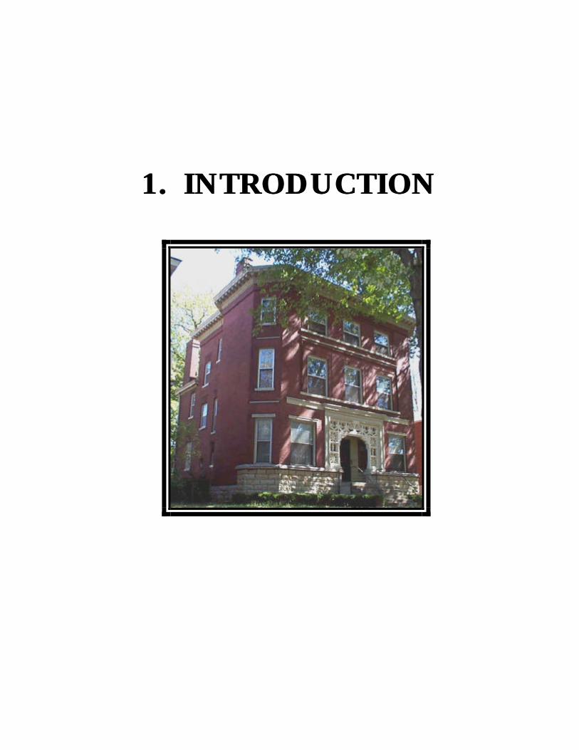
1.1. INTRODUCTION INTRODUCTION

FINAL PLANDecember 22, 2000
AMENDMENTS TO THE OLD LOUISVILLE/LIMERICK NEIGHBORHOOD PLANSAMENDMENTS TO THE OLD LOUISVILLE/LIMERICK NEIGHBORHOOD PLANS
1 - 2
1. INTRODUCTION
Old Louisville and Limerick together constitute a rich and outstanding architectural legacy of thegreat cultural and economic prosperity enjoyed by the city of Louisville during the decades afterthe Civil War. Throughout the Twentieth Century, this legacy endured significant assaults—suburbanization, speculation, an interstate highway, commercial, and industrial encroachments—defended meanwhile by succeeding generations of resident leaders and preservationists. In 1974and 1979, respectively, local government came to the support of these neighborhood leaders byestablishing the Old Louisville and Limerick historic preservation districts, a status that hassubsequently afforded strong protection to the unique and irreplaceable architectural character ofthese two contiguous neighborhoods. Nonetheless, throughout this same period the residents ofthe two neighborhoods have observed a frequent dissonance between neighborhood characterand use, where the uses permitted by zoning have served to compromise, to obscure, and toerode the original character of individual historic structures and, incrementally, that of the entireneighborhood.
The plan set forth on the following pages has been designed to restore the neighborhood to a setof uses appropriate to the unique character and context of Old Louisville and Limerick. TheTask Force responsible for developing the plan has spent considerable effort identifyingappropriate uses for the numerous sub-contexts that together constitute the two neighborhoods.These decisions, set forth in a land use table, reflect the very best judgment of a group ofknowledgeable, thoughtful, and concerned citizens, each representing a slightly different point ofview. Their ultimate decisions regarding appropriate use reflect consensus, rather than simpleunanimity of opinion. This consensus, in turn, reflects their collective hope for a combination offuture uses that may best reaffirm the original character and vitality of Old Louisville andLimerick.
The Old Louisville and Limerick Neighborhood Plan is proposed as amendments to the OldLouisville Neighborhood Plan and to the Limerick Action Plan. Each of these neighborhoodplans was originally adopted in 1982 following development by neighborhood task forcesthrough a planning framework established by city ordinance in 1980. The community effort thatproduced this plan amendment was the culmination of work commenced in 1998 by the OldLouisville Neighborhood Council, later formalized through appointment in 1999 of aneighborhood plan task force by Mayor David L. Armstrong.
The Old Louisville and Limerick Plan Task Force was established for the explicit purpose ofreconsidering the 1982 Old Louisville and Limerick neighborhood plans within the context ofCornerstone 2020, the county-wide comprehensive land use plan now being enacted. TheCornerstone Plan and recently adopted amendments to KRS 100 (100.201,3) togetheracknowledge the strength of “traditional” urban neighborhoods, whose diversity of land use andcharacter stands in contrast to the homogeneity of contemporary suburban developments andstandard zoning categories. Through appointment of the Task Force, Mayor Armstrong soughtto apply innovative concepts of planning and zoning in order to reinforce the great strength ofurban diversity that has always been the hallmark of Old Louisville and Limerick.

FINAL PLANDecember 22, 2000
AMENDMENTS TO THE OLD LOUISVILLE/LIMERICK NEIGHBORHOOD PLANSAMENDMENTS TO THE OLD LOUISVILLE/LIMERICK NEIGHBORHOOD PLANS
1 - 3
1.1 Land Use, Zoning, and Historic Urban Character
As the product of their deliberation, the Task Force recommends that zoning for theneighborhood be reformulated to better protect and promote the historic urban character of OldLouisville and Limerick. The Task Force recommends promoting uses that either reflect theoriginal use of a primary structure or allow contemporary uses that complement and benefit theresidential and historic urban character of Old Louisville and Limerick.
KRS 100.201(3) includes a provision for specifically defined areas called urban residential zonesin which “usage of structures may be regulated on a structure-by-structure basis, permitting amixture of uses in the zone, including single-family and multi-family residential, retail andservice establishments, which stabilizes and protects the urban residential character of the area”.This is applicable to any area that “embodies the distinctive characteristics of a type, period, ormethod of construction” and an area “where the majority of the structures were in use prior toNovember 22, 1926”. KRS 100.201(3) establishes that “the regulation of the usage of anystructure shall be guided by the architecture, size, or traditional use of the building” (seedefinition of Original Use).
The Task Force acknowledges the fundamental soundness of Old Louisville’s original urbandesign, and now seeks to institute a zoning mechanism that will be conducive to restoration ofthe neighborhood’s original urban character and pattern. This pattern, characterized by ahierarchy of primary and secondary uses within a single block, is quite distinct from thehomogeneous pattern of land uses promoted and enforced by existing zoning. Therefore, thezoning mechanisms recommended by the Task Force for Old Louisville and Limerick have beendesigned with two purposes in mind. The first is to construe from the existing pattern, as well asfrom historical evidence, the original intent and character of a particular parcel, block, or sub-block. The second purpose is to use that gleaning to promote and to guide contemporary landuse proposals so that they may, incrementally, recreate a fabric of uses that both reflects theoriginal character and incorporates appropriate modern adaptations.
The Task Force accepts the difficult responsibility of defining which contemporary uses seemedeither beneficial to an envisioned ideal, or not. Task Force members recommended how thosebeneficial uses might best be encouraged and blended within the existing, historic, anddeveloping architecture of the neighborhood. As the result of these deliberations, the Task Forceand its planning staff devised a land use table and map that will serve as the guide for decidingwhich uses will be appropriate for various contexts.
1.2 Neighborhood Plan Task Force Process
The Task Force convened first on Tuesday evening, September 21, 1999, and then met in generalsession on five occasions through November 30, 1999. These general sessions were followed inDecember 1999 by three “committee of the whole” meetings to confer additionally on land useand zoning issues.
At the first general meeting, members of the Task Force formulated individual vision statementsfor Old Louisville and Limerick, and then articulated a list of positive attributes, as well as a list
FINAL PLANDecember 22, 2000
AMENDMENTS TO THE OLD LOUISVILLE/LIMERICK NEIGHBORHOOD PLANSAMENDMENTS TO THE OLD LOUISVILLE/LIMERICK NEIGHBORHOOD PLANS
1 - 4
of factors having a negative impact on quality of life in the neighborhood. The individual visionstatements, along with the lists of positives and negatives, became the basis of a summary visionstatement and a set of plan goals that would serve as the foci of the planning process. The visionand goals were considered, amended, and adopted by the task force as follows:
1.3 Vision, Goals and ObjectivesOld Louisville/Limerick Plan Task ForceAdopted by the Task Force on October 21, 1999
1.3.1 VISION
Old Louisville/Limerick will be a vital, safe, attractive neighborhood that reflects itshistoric character and achieves its rightful place—as being home to Louisville’s “choicestaddresses”1—in the economic, civic, and cultural life of this community.
1.3.2 GOALS AND OBJECTIVES
The Old Louisville/Limerick Task Force will create a comprehensive, inclusive, citizen- basedplan that addresses the neighborhood environment and its historic character, as well as thehuman and social needs of residents. Fundamental elements of the plan will include:
§ defining and solidifying the neighborhood’s place in the cultural and emotional life ofLouisville;
§ careful attention to the preservation and restoration of historic properties;
§ encouraging the development of new housing in keeping with the character of theneighborhood;
§ revitalization of the commercial district at 4th and Oak Streets as a true neighborhoodserving center, commercial development in the area south of Broadway, known as“Sobro”, and appropriate commercial and retail amenities throughout theneighborhood;
§ appropriate, inclusive zoning and rigorous code enforcement;
§ attractive, useable public spaces;
§ improved public safety (actual and perceived);
§ streets and thoroughfares that reinforce neighborhood cohesiveness and facilitate themovement of pedestrians and vehicles.
1 Kleber, John E,. ed. The Encyclopedia of Louisville, The University Press of Kentucky, 2001: xxii

FINAL PLANDecember 22, 2000
AMENDMENTS TO THE OLD LOUISVILLE/LIMERICK NEIGHBORHOOD PLANSAMENDMENTS TO THE OLD LOUISVILLE/LIMERICK NEIGHBORHOOD PLANS
1 - 5
Individuals and neighborhood organizations in Old Louisville and Limerick alsorecognize the role of these neighborhoods as tourist destinations. Both residents andvisitors should perceive the neighborhoods as safe and attractive areas. Reinforcing thehistoric neighborhood character is a land use issue, but is also addressed throughstreetscape and transportation improvements as well as attention to parks and open spacein the neighborhood (see Sections 4 and 5).
1.4 Neighborhood Demographics
(2000 census summary for Old Louisville and Limerick neighborhoods will be inserted here)
1.5 Identifying Neighborhood Form and Preserving NeighborhoodCharacter.
Members of the Task Force examined the urban structure of the overall area by disassemblingthe neighborhood—like a jigsaw puzzle—into a number of interlocking districts, each possessingits own set of defining physical and functional characteristics. According to this analysis, theneighborhood could be subdivided into: the Neighborhood General, the Neighborhood Center,and the Neighborhood Transition-Center. The area remaining outside of these includes the“Sobro” (South-of-Broadway) area, which can be seen as a second transitional district betweenOld Louisville/Limerick and Downtown (Neighborhood Transition-Downtown). In the weeksfollowing this discernment, the Task Force debated and developed recommendations intended topromote and improve the respective character of each of the three districts, and of the wholeneighborhood.
1.6 Neighborhood General
NEIGHBORHOOD GENERAL is the area of Old Louisville and Limerick that has substantiallyretained its original residential character and integrity. This area is largely contained within theestablished local and National Register preservation districts. Within the Neighborhood Generalare corridors that might be considered “mansion districts” – e.g., Third and Fourth streets,especially south of Ormsby Avenue in Old Louisville; and St. Catherine Street in Limerick, fromThird to Seventh streets. Along with St. James and Belgravia courts, these corridors contain theresidential structures most identified with Old Louisville and Limerick—stately, late-Victorianhomes in Renaissance Revival, Italianate, Romanesque, and Victorian-eclectic styles—many ofwhich have been converted to multi-family residential, to institutional, or to office uses.Flanking these corridors stands the bulk of Old Louisville’s and Limerick’s residential fabric—typically one- and two-story brick and frame homes, originally single family or duplexstructures, that have either retained their original use or have been converted to apartments.Such residences are typical of Sixth Street from Hill to Breckinridge, as well as Second throughFloyd streets south of Kentucky.
1.6.1 RECOMMENDATIONS: NEIGHBORHOOD GENERAL
§ Reclaim residential character. The Task Force recommended that zoning applied to theNeighborhood General promote the reclamation of a residential character more typical ofthe neighborhood as originally built. Structures built as single family or duplex
FINAL PLANDecember 22, 2000
AMENDMENTS TO THE OLD LOUISVILLE/LIMERICK NEIGHBORHOOD PLANSAMENDMENTS TO THE OLD LOUISVILLE/LIMERICK NEIGHBORHOOD PLANS
1 - 6
residences would ultimately be restored to the type of occupancy for which they wereoriginally designed and constructed. New zoning, however, would not preclude retainingexisting higher density or reducing density to a level above the original. Instead,owner/developers would be allowed to convert multifamily structures, provided that theconversion resulted in fewer total units.
§ Adopt incentives for carriage house rehabilitation or construction. As a corollary to thegoal of returning the neighborhood to its original largely single-family residential usepattern within the residential core, the Task Force recommends incentives forconstruction and rehabilitation of carriage houses with accessory apartments alongneighborhood alleys. This will help re-create the alley “walls” once typical in OldLouisville and Limerick and provide the “eyes on the street” that help streets (and alleys)become safer places.
§ Preserve private open space (rear yards) as part of the overall neighborhood character.In conjunction with the goal of recreating alley structures, the Task Force advocatespreserving rear yards as private landscapes between principal structures and garages,consistent with the overall historic pattern of open space within the neighborhood; or, atvery least, as rear yards protected against encroachment by alley-side surface parking.
§ Accessory structure area standards. To accomplish these related goals, a rear lot zonecalled the “accessory structure area” will be established along existing alleys,approximately 25’-30’ deep parallel to the alley right of way, which will be reservedeither for surface parking or for a garage or carriage house structure.
§ Continue existing institutional and other cultural uses where identified. The Task Forceacknowledges that certain non-residential uses should continue to be accommodatedwithin the neighborhood—e.g., churches and cultural facilities. The Task Forcerecognizes that certain structures—such as the Filson Club or Conrad-Caldwell House—represent important cultural landmarks that will not likely be restored to their originalsingle family use in the very near future, and therefore rely upon a benign present use toguarantee their preservation. However, proposals for adaptive use of such structuresmust be considered within the context of possible broader impacts, especially parkingrequirements.
The Task Force also urges that institutional adaptation of historic residential structures berestricted to uses that contribute to the unique historic character of Old Louisville andLimerick. Observing the number of existing churches and non-residential structureswithin the area that currently or could potentially accommodate institutional uses, theTask Force concludes that no new institutional structures, including churches, should bepermitted within the residential district.
§ Home occupations and live/work uses. The Task Force discussed at great length thedesirability of broadening the definition of “home occupations” permissible within theresidential general area. Task Force members recognized that the changing nature ofwork seems to be moving increasingly toward home-based occupations, employinglimited “non-family” personnel, supported by the Internet and other telecommunications
FINAL PLANDecember 22, 2000
AMENDMENTS TO THE OLD LOUISVILLE/LIMERICK NEIGHBORHOOD PLANSAMENDMENTS TO THE OLD LOUISVILLE/LIMERICK NEIGHBORHOOD PLANS
1 - 7
links. After considerable debate, the task force decided that any such broadening of the“home occupation” use be addressed as a citywide issue. Therefore, expandedprofessional office use was confined to the Neighborhood Center and NeighborhoodTransition-Center.
§ Corner commercial and multi-family residential uses: A mix of mostly single- and two-family residences with convenient commercial uses anchoring key intersectionscharacterizes traditional neighborhoods. The Task Force recognizes that multi-familyresidential uses interspersed within the single-family fabric of the neighborhood adds toits diversity and unique character. The Task Force carefully balanced the need for thisdiversity and the need to encourage conformity with the neighborhood’s original single-and two-family character by allowing corner commercial establishments at keyintersections. Multi-family residential uses are permitted at specifically identifiedlocations depending on the immediate block context and potential for future single-familydevelopment.
1.7 Neighborhood Center
At the outset of its proceedings, the Task Force identified the intersection of Fourth and Oakstreets as the NEIGHBORHOOD CENTER, Old Louisville and Limerick’s business andcommercial district. Upon closer consideration, the Task Force recognizes that theneighborhood’s business center is composed of two sub-districts: a mixed use commercial corein the city block centered at Fourth and Oak where street-level commercial uses are required, anda surrounding transition district of high-density mixed uses including housing, street-levelneighborhood businesses, and offices.
1.7.1 RECOMMENDATIONS: NEIGHBORHOOD CENTER
§ Create a pedestrian-oriented neighborhood commercial district at Fourth and Oak. TheTask Force recommends that zoning be adopted for each sub-district that would reinforcethe dominant uses characteristic of each area. To promote the viability of neighborhood-serving businesses, the Task Force proposes that commercial retail use be the solepermitted street level use with a mixture of uses (office, residential, etc.) permitted onupper floors. Furthermore, the Task Force recommends that all new development withinthe commercial center have a “zero setback” from the sidewalk, in order to re-establishthe street presence and intimacy of an urban commercial district.
1.7.2 RECOMMENDATIONS: NEIGHBORHOOD TRANSITION-CENTER
§ Permit high density, mixed use development as a transition from the commercial core tothe Neighborhood General. The Task Force recommends that Neighborhood Transition-Center be regulated to maintain the existing neighborhood scale while permitting anexpanded set of commercial, office, and multi-family uses within. The added density andmixture of uses permitted in this area would help to support the commercial businesses inthe Neighborhood Center.
FINAL PLANDecember 22, 2000
AMENDMENTS TO THE OLD LOUISVILLE/LIMERICK NEIGHBORHOOD PLANSAMENDMENTS TO THE OLD LOUISVILLE/LIMERICK NEIGHBORHOOD PLANS
1 - 8
1.8 Neighborhood Edges
Old Louisville/Limerick has long recognized that the northern and southern peripheries of theneighborhood constitute substantial areas of ill-defined development whose lack of cohesivenessseems only to harm the neighborhood. These districts are best defined as TRANSITION AREAS,in reference to the well-defined districts that they separate (e.g., Old Louisville/Limerick &Downtown, or Old Louisville & the University of Louisville), rather than in reference to theirown individual characters. Redefining and then redeveloping these areas over the coming yearsshould have a significant bearing upon the neighborhood, possibly relieving Old Louisville andLimerick of some of the apartment-house density that has seemed to vex the neighborhood formuch of the last century. At the very least, increasing the residential population of thesedistricts, North and South, would increase the demand for goods and services available aroundFourth and Oak streets. Overall, the redevelopment of these transition areas can serve toredefine the physical and functional relationship between the neighborhood, downtown, and theUniversity of Louisville.
1.8.1 RECOMMENDATIONS: “SOBRO” AREA
As the appropriate next step, sponsor a master plan for the “Sobro” transition area. TheTask Force has defined a vision for Old Louisville and Limerick that derives from theessential strength and coherence of the neighborhood's original character. No such clues maybe easily gleaned through examination of the transition zones, whose original residentialcharacter has long since been destroyed by the proliferation of commercial land use and byUrban Renewal. Instead, the Task Force and the City of Louisville shall initiate a masterplanning process for the area South of Broadway beginning fall of 2000 based on theframework outlined in this plan, to lay the foundation for the redevelopment of North OldLouisville as a cohesive mixed-use urban district tying Old Louisville and Limerick togetherwith Downtown.
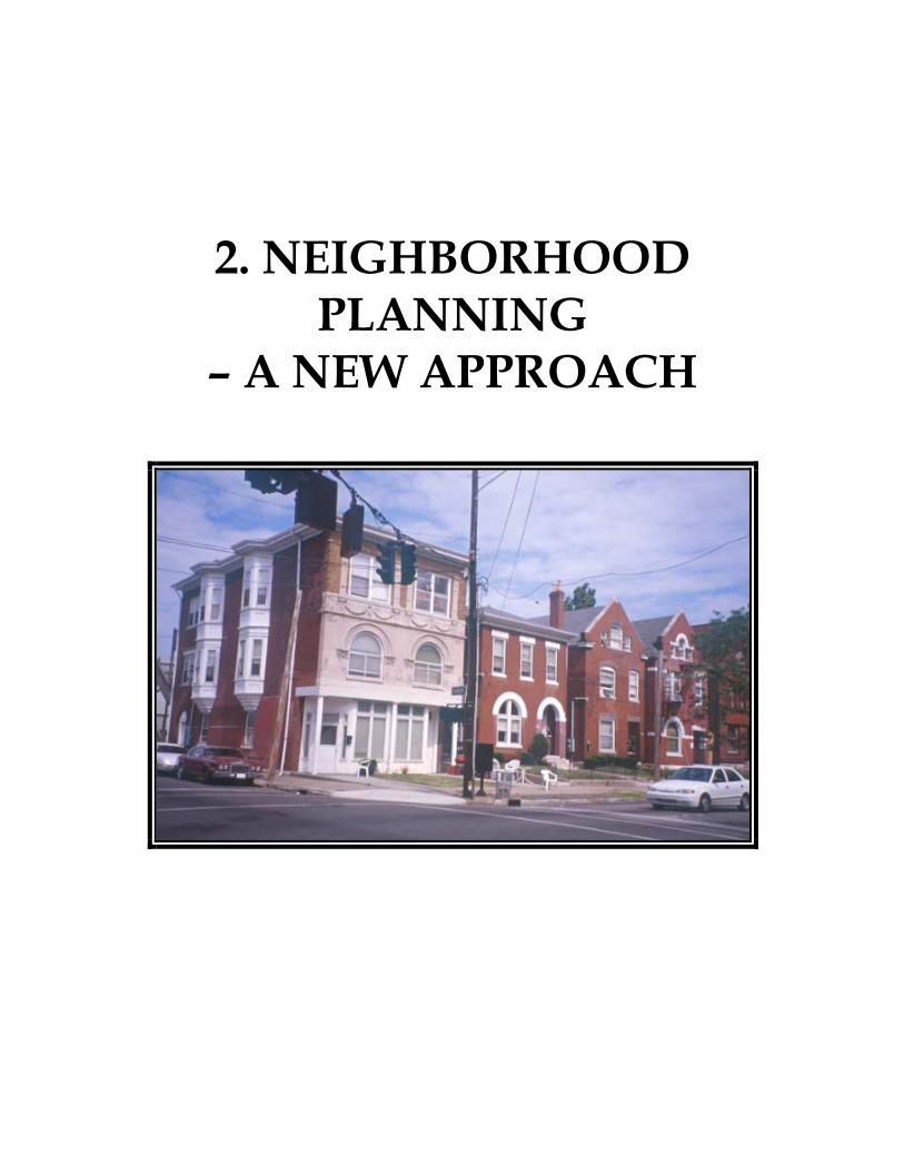
2. NEIGHBORHOOD PLANNING
– A NEW APPROACH

FINAL PLAN December 22, 2000
AMENDMENTS TO THE OLD LOUISVILLE/LIMERICK NEIGHBORHOOD PLANS
2 - 2
2. NEIGHBORHOOD PLANNING – A NEW APPROACH
2.1 Current Tools for Neighborhood Land Use Planning Neighborhoods in Louisville currently have three tools for land use planning and development review. These are: neighborhood plans, the zone change review process and, if applicable, the Landmarks Commission’s design review process. Neighborhood plans are based on Ordinance No. 21, Series 1980, and Ordinance No. 67, Series 1986. These ordinances require that neighborhood plans include a land use section that identifies the “existing pattern of … land uses, a future pattern of land use and recommendations for necessary land use and zoning changes to facilitate that pattern.” This land use section can be a basis for an area-wide rezoning. It is important to note that neighborhood plans may be used by the Planning Commission and the Board of Aldermen in consideration of zone changes and other issues related to the neighborhood. If, however, the neighborhood plan conflicts with the Comprehensive Plan, the decision must be based on the Comprehensive Plan. Any property owner can request a zone change. The proposed development must be consistent with the Comprehensive Plan and must meet the required setbacks, lot sizes, building heights and parking requirements, etc. for that zoning district. In addition, some neighborhoods, including Old Louisville and Limerick, have been locally designated as Historic Preservation Districts, and proposed development is required to undergo a careful design review by the Landmarks Commission’s Architectural Review Committee for the respective districts to ensure that their historic character is preserved. While there are many success stories using one or more of these three development review processes, there are some significant gaps. Traditional area wide zoning does not adequately recognize the mixture of uses that is prevalent in a traditional neighborhood. Also, current zoning standards, whose site development regulations are more geared to suburban development, require many trips to BOZA and the Planning Commission for variances and waivers just to make infill developments compatible with the neighborhood context. A new approach is needed so that site development standards promote, rather than impede, contextual development. Although neighborhood plans themselves are non-binding, they often recommend a process known as an area-wide rezoning to address land use problems. Typically, an area-wide rezoning results in a change in land uses for many parcels within a neighborhood. The rezoning serves as a kind of snapshot of what is considered appropriate for that neighborhood at that time. As demographic, economic and market trends change, however, the zoning often becomes outdated and may no longer support the vision of the neighborhood. Because the area-wide rezoning process is so cumbersome and controversial, it is often delayed until long after the neighborhood starts to experience inappropriate development as a result of the outdated zoning.
FINAL PLAN December 22, 2000
AMENDMENTS TO THE OLD LOUISVILLE/LIMERICK NEIGHBORHOOD PLANS
2 - 3
2.2 A New Tool for Neighborhood Planning The challenge then is to develop a tool that preserves the key elements of the neighborhood and the vision of the neighborhood residents over time while allowing some flexibility for the neighborhood to adapt to future market trends. This new tool should also address the importance of traditional neighborhood patterns and forms. The historic pattern of Old Louisville and Limerick, for example, included a healthy mixture of mostly owner-occupied homes yet with housing opportunities for lower and moderate-income workers as well. The housing needs of these workers were often provided by carriage houses, buildings designed for multifamily residents and apartments above shops or on the third floor of larger residences. This “critical mass” of residents supported the neighborhood-serving stores and services that were located in buildings and at sites that enhanced the neighborhood. Many residents of Old Louisville and Limerick would like to achieve that healthy mixture again. While an area-wide down-zoning might result in some additional conversions of houses back to single family residential– supporting a current market trend—it probably would not help achieve the healthy mixture of uses and densities needed to sustain a vibrant neighborhood with appropriate shops and services. The question is how to encourage the trend toward more owner-occupied residences while allowing higher density in certain circumstances and, in certain locations, to help attract desirable neighborhood retail. The Old Louisville/Limerick Task Force members recognize the need for a development review tool for their neighborhood that addresses these issues in a way that preserves historic character and can adapt to changing market needs that enhance a neighborhood. In addition, there is a need for a structure that provides a binding and permanent level of protection while allowing some flexibility of uses within certain circumstances. 2.3 The Traditional Neighborhood Zoning District Concept The Old Louisville/Limerick Task Force recommends the creation of a new zoning district, the Traditional Neighborhood Zoning District (TNZD), which could be applied to any city neighborhood with a traditional pattern of development. The new zoning district would require development of a neighborhood master plan. The plan would identify one to four types of land use patterns within the neighborhood. These patterns would include one or more of the following: • “Neighborhood Center” (mostly small-scale shops or services with some apartments and
offices on the upper floors); • “Neighborhood General” (mostly single-family residential homes, duplexes and triplex
apartment buildings; structures originally designed as multifamily apartment buildings; institutional structures and corner stores with apartments above);
FINAL PLAN December 22, 2000
AMENDMENTS TO THE OLD LOUISVILLE/LIMERICK NEIGHBORHOOD PLANS
2 - 4
• “Neighborhood Transition - Center” (uses that help ease a change from a more intense land use to a less intense one either within or at the edge of a neighborhood).
• “Neighborhood Transition - Downtown” (uses of a higher density, intensity and scale that
serve as a transition from the neighborhood to downtown). The areas where these patterns are prevalent and desirable would be clearly delineated on a map, and only certain land uses would be permitted within these areas. The boundaries of Neighborhood General closely coincide with Historic Preservation District boundaries. A neighborhood district plan report would then set out standards for the building and site design for lots that are located within each area. It would also address parking, signs, open space, streetscape, and similar issues affecting urban design character. Where the TNZD coincides with a historic preservation district boundary, as in the case of Old Louisville and Limerick, standards set forth in the district plan could be correlated and reinforced by Landmarks Commission standards governing improvements to properties within these districts. The TNZD concept has three components:
1. The Traditional Neighborhood Zoning District (TNZD) Ordinance – The enabling ordinance that will be used to formally adopt neighborhood zoning district plans for Old Louisville and other traditional neighborhoods.
2. The TNZD Regulations – This is the written document that sets forth the specific
permitted uses, development standards and performance and site design criteria for each area.
3. The TNZD Plan Map – Also known as the District Plan Map, this is the adopted map
that accompanies the plan. It sets forth the boundaries of the various component areas and specific use locations in Old Louisville and Limerick. The Task Force has designated the following: Neighborhood General, Neighborhood Center, Neighborhood Transition—Center, and Neighborhood Transition—Downtown
The proposed Traditional Neighborhood Zoning District would represent a very positive change in the review of development in historic neighborhoods. It would, for the first time, ensure that development regulations complement and support the preservation intent of the landmarks review process.
FINAL PLAN December 22, 2000
AMENDMENTS TO THE OLD LOUISVILLE/LIMERICK NEIGHBORHOOD PLANS
2 - 5
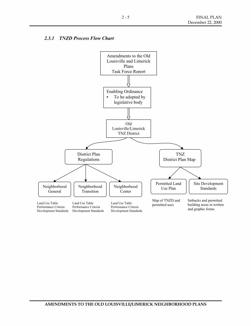
2.3.1 TNZD Process Flow Chart
Amendments to the Old Louisville and Limerick
Plans Task Force Report
Enabling Ordinance • To be adopted by
legislative body
Old Louisville/Limerick
TNZ District
District Plan Regulations
TNZ District Plan Map
Neighborhood General
Neighborhood Transition
Neighborhood Center
Permitted Land Use Plan
Site Development Standards
Land Use Table Performance Criteria Development Standards
Land Use Table Performance Criteria Development Standards
Land Use Table Performance Criteria Development Standards
Map of TNZD and permitted uses
Setbacks and permitted building areas in written and graphic forms

FINAL PLAN December 22, 2000
AMENDMENTS TO THE OLD LOUISVILLE/LIMERICK NEIGHBORHOOD PLANS
2 - 6
2.3.2 Neighborhood General
Permitted uses
Residential streetscape
• Residential: The primary use within this zone is for single- and two-family residential with the additional option of a single-unit carriage house apartment at the rear. Conversions may decrease the existing number of dwelling units, and shall not be permitted to exceed the existing number of dwelling units. Multi-family residential use is permitted either when it is the original use (see Definition) or where shown on the map.
Corner commercial on Second Street
• Corner Commercial: The corner commercial building was and remains an important element in the traditional neighborhood, bringing goods and services within walking distance of residents. Some of the buildings were originally built to incorporate ground floor commercial while others began as detached houses and were later modified and typically extended to the sidewalk in order to accommodate commercial businesses. The District Plan Map preserves the established corner commercial buildings as a permitted use and, in some cases, proposes future locations of corner commercial.
Church building, 6th & Hill streets
• Other uses and Original Use of the Structure: Structures and sites that were originally designed for purposes other than residential uses such as schools, community centers, public institutions, and churches are allowed to continue as permitted uses, or when so indicated by the plan map. These non-residential specific uses will be designated as such on the approved District Plan Map. Refer to the Land Use Table for additional information regarding permitted uses within the Neighborhood General.

FINAL PLAN December 22, 2000
AMENDMENTS TO THE OLD LOUISVILLE/LIMERICK NEIGHBORHOOD PLANS
2 - 7
2.3.3 Neighborhood Center:
Permitted uses:
Typical corner commercial building at Third & Oak streets
Ground Floor Commercial: The Neighborhood Center is intended to serve as the commercial center and main public meeting space for the surrounding neighborhoods. The list of permitted uses within the zone includes such things as grocery stores, drug stores, retail shops, movie theaters, etc. An important element of the area is that commercial uses are required on the ground floor level.
Other uses: The floors above the first floor commercial may have a variety of uses including housing and office space.

FINAL PLAN December 22, 2000
AMENDMENTS TO THE OLD LOUISVILLE/LIMERICK NEIGHBORHOOD PLANS
2 - 8
2.3.4 Neighborhood Transition - Center
Permitted uses:
The Neighborhood Transition-Center area will permit new multi-family housing developments like this existing apartment building on 2nd and Bloom Streets.
• As the name implies, Neighborhood
Transition-Center is intended to act as a transition area between the Neighborhood Center and the Neighborhood General. The permitted uses are to be similar to the Neighborhood General but also allow for a more intensive usage such as professional office, and multifamily and some limited retail uses.
2.3.5 Neighborhood Transition - Downtown
Permitted uses:
• To be determined as part of master plan charrette for Sobro and coordinated with the updated Downtown Development Plan. It is anticipated that there will be a high density of mixed uses including residential, commercial, offices, and institutions.
2.4 Process The applicant, usually the City of Louisville, would apply for a zoning change from the existing districts (e.g., R-5, R-6, R-7, C-1, C2, C-3, OR-1, OR-2) to the new zoning district of TNZD. The applicant (the City of Louisville) would be required to do the following:
• complete a public review and notification process; • conduct research on the historic character and land use patterns of the neighborhood
(designation by the Landmarks Commission or listing on the National Register of Historic Places of the district would constitute a “finding” of historic character);
• Prepare several documents including a map of the neighborhood master plan and the TNZD Regulations explaining the map. The map would:
- show the boundaries of the TNZD, - show which land uses would be permitted by right and which uses would be
permitted at certain locations by map designation or under certain circumstances (such as location of existing corner stores and possible locations for multifamily housing).
- describe in detail the site design standards for the entire TNZD, including the Neighborhood General, Neighborhood Center, Neighborhood Transition-Center, and Neighborhood Transition-Downtown;
• The Planning Commission would review the zone change application and the neighborhood master plan simultaneously and recommend adoption or denial by the Board of Aldermen.
FINAL PLAN December 22, 2000
AMENDMENTS TO THE OLD LOUISVILLE/LIMERICK NEIGHBORHOOD PLANS
2 - 9
After adoption by the Board of Aldermen, the owner of a parcel within the TNZ District would apply for a building permit from the Department of Inspections, Permitting and Licenses. Staff from the Department of Inspections, Permits, and Licenses (IPL), City of Louisville, would review the proposal for consistency with the master plan. If a property has historic significance, the Landmarks Commission’s staff or architectural review committees would continue to review proposals using the same process that is now in place.
2.5 Consistency with the Comprehensive Plan Neighborhood plans should be consistent with the Comprehensive Plan. If they are not, the Planning Commission and the Board of Alderman must honor the Comprehensive Plan rather than the neighborhood plan in consideration of zoning changes. The proposed new Comprehensive Plan, Cornerstone 2020, has as a central tenet the use of pattern, or form, of development as a deciding feature for making land use and zoning decisions. Thus, a community’s form must guide the Planning Commission and the legislative bodies in making such decisions. The TNZD is consistent with and supports the pattern of development identified as “traditional neighborhood” in Cornerstone 2020. The TNZD is also consistent with the existing 1979 Comprehensive Plan which allows: a mixture of uses to coexist provided proper design principles are applied (Principle 2); encourages preservation of historic buildings, sites and districts (Guideline E-19); protects neighborhoods from adverse impacts (R-1); allows commercial and office uses in mixed land use areas where they do not create nuisances and are compatible with their surroundings (C-6 and O-3); and allows small businesses serving neighborhoods to provide convenient shopping that is accessible to pedestrians (C-7).
2.6 Non-conforming Rights All uses within the neighborhood that lawfully exist at the time of the area-wide rezoning are allowed to continue. These are often known as “grandfather” situations. By State law, however, these uses may not expand beyond the scope and area of their operations from the time the use became non-conforming. Existing regulations as they pertain to non-conforming right under Article 8, Section 8.3 of the Louisville/Jefferson County Land Development Code shall apply to all uses, structures and lots that lawfully exist at the time of adoption of the TNZ District. Consequently, this proposed zoning district would not result in overnight changes in existing uses. It is intended, however, to result in the long-term transition of the neighborhood toward a mixture of uses which promote stability and preserve and enhance its historic character.

3. TRADITIONAL NEIGHBORHOOD ZONING DISTRICT REGULATIONS

FINAL PLAN December 22, 2000
AMENDMENTS TO THE OLD LOUISVILLE/LIMERICK NEIGHBORHOOD PLANS
3 - 2
3. TRADITIONAL NEIGHBORHOOD ZONING DISTRICT
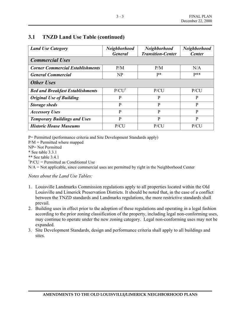
3.1 TNZD Land Use Table
Land Use Category Neighborhood General
Neighborhood Transition-Center
Neighborhood Center
Residential Uses Single Family Residential – One dwelling unit per lot
P P NP
Two-family Residential P P P Multi-family Residential P/M P P Garages and Accessory Residential Units (Carriage Houses)
P P P
Home Occupations P P P Office Uses Professional Office NP P P General/Business Office NP NP P
Institutional Uses Churches & Synagogues P/M P P/M Community Centers, Cultural Centers, and Civic buildings
P/M P NP
Clubs and Lodges P/M P/M NP Fraternities and Sororities NP NP NP Schools, public and private P/M P NP Trade, business, or industrial schools NP P NP Colleges and Universities NP P NP Day Care Centers NP P NP Family Day Care Home NP P NP
FINAL PLAN December 22, 2000
AMENDMENTS TO THE OLD LOUISVILLE/LIMERICK NEIGHBORHOOD PLANS
3 - 3
3.1 TNZD Land Use Table (continued) Land Use Category Neighborhood
General Neighborhood
Transition-Center Neighborhood
Center Commercial Uses Corner Commercial Establishments P/M P/M N/A General Commercial NP P* P**
Other Uses Bed and Breakfast Establishments P/CU† P/CU P/CU Original Use of Building P P P Storage sheds P P P Accessory Uses P P P Temporary Buildings and Uses P P P Historic House Museums P/CU P/CU P/CU
P= Permitted (performance criteria and Site Development Standards apply) P/M = Permitted where mapped NP= Not Permitted * See table 3.3.1 ** See table 3.4.1 †P/CU = Permitted as Conditional Use N/A = Not applicable, since commercial uses are permitted by right in the Neighborhood Center
Notes about the Land Use Tables: 1. Louisville Landmarks Commission regulations apply to all properties located within the Old
Louisville and Limerick Preservation Districts. It should be noted that, in the case of a conflict between the TNZD standards and Landmarks regulations, the more restrictive standards shall prevail.
2. Building uses in effect prior to the adoption of these regulations and operating in a legal fashion according to the prior zoning classification of the property, including legal non-conforming uses, may continue to operate under the new zoning category. Legal non-conforming uses may not be expanded.
3. Site Development Standards, design and performance criteria shall apply to all buildings and sites.
FINAL PLAN December 22, 2000
AMENDMENTS TO THE OLD LOUISVILLE/LIMERICK NEIGHBORHOOD PLANS
3 - 4
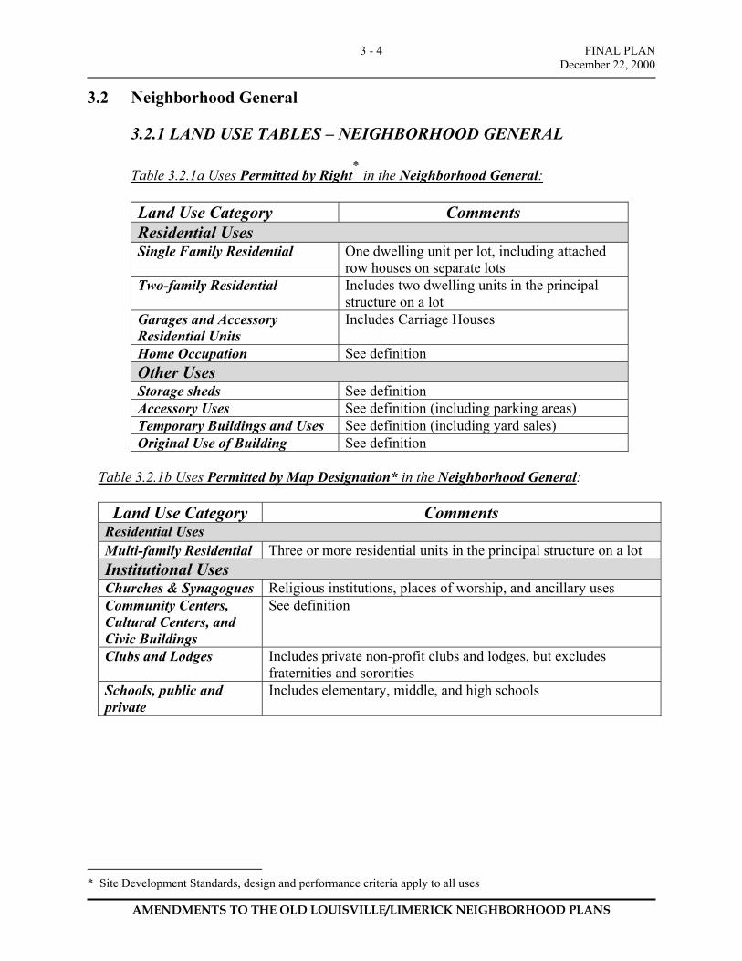
3.2 Neighborhood General
3.2.1 LAND USE TABLES – NEIGHBORHOOD GENERAL
Table 3.2.1a Uses Permitted by Right* in the Neighborhood General:
Land Use Category Comments Residential Uses Single Family Residential One dwelling unit per lot, including attached
row houses on separate lots Two-family Residential Includes two dwelling units in the principal
structure on a lot Garages and Accessory Residential Units
Includes Carriage Houses
Home Occupation See definition Other Uses Storage sheds See definition Accessory Uses See definition (including parking areas) Temporary Buildings and Uses See definition (including yard sales) Original Use of Building See definition
Table 3.2.1b Uses Permitted by Map Designation* in the Neighborhood General:
Land Use Category Comments
Residential Uses Multi-family Residential Three or more residential units in the principal structure on a lot Institutional Uses Churches & Synagogues Religious institutions, places of worship, and ancillary uses Community Centers, Cultural Centers, and Civic Buildings
See definition
Clubs and Lodges Includes private non-profit clubs and lodges, but excludes fraternities and sororities
Schools, public and private
Includes elementary, middle, and high schools
* Site Development Standards, design and performance criteria apply to all uses
FINAL PLAN December 22, 2000
AMENDMENTS TO THE OLD LOUISVILLE/LIMERICK NEIGHBORHOOD PLANS
3 - 5
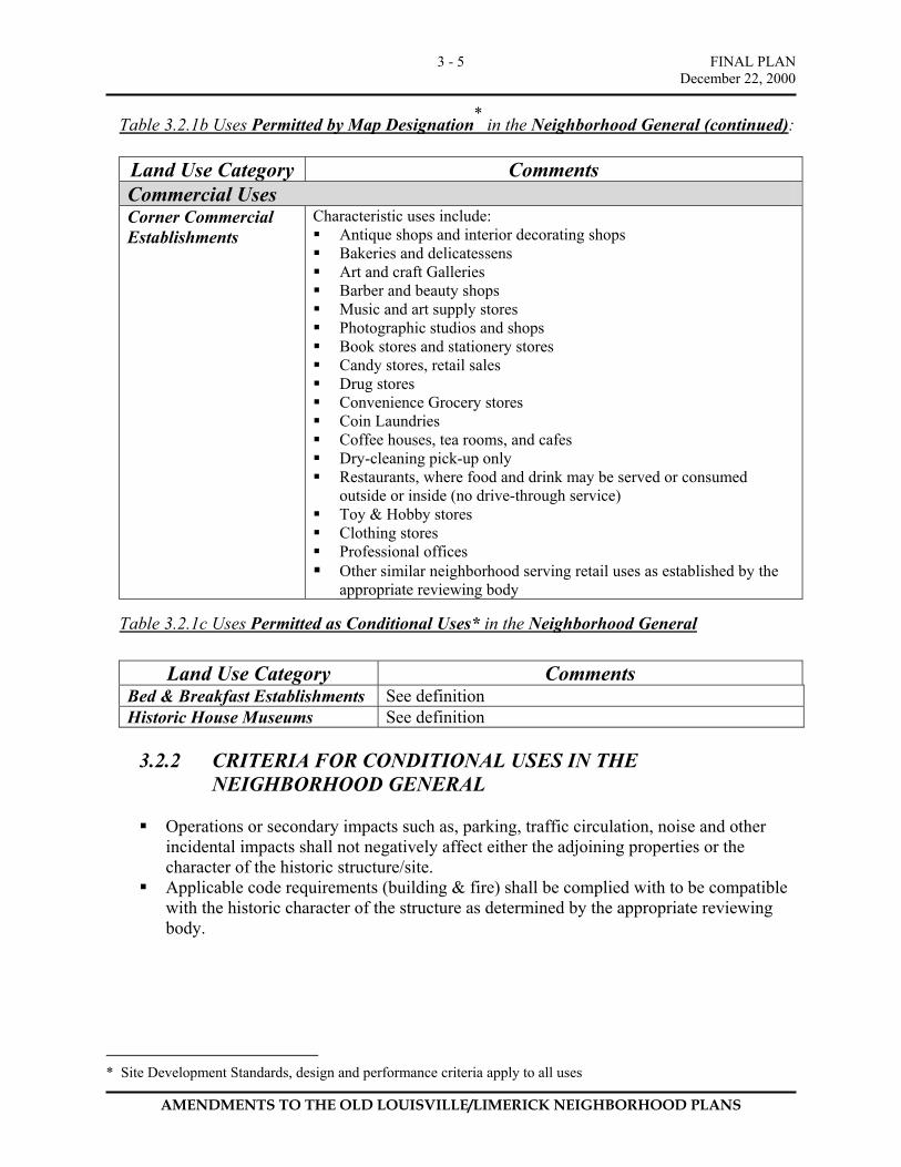
Table 3.2.1b Uses Permitted by Map Designation* in the Neighborhood General (continued):
Land Use Category Comments Commercial Uses Corner Commercial Establishments
Characteristic uses include: Antique shops and interior decorating shops Bakeries and delicatessens Art and craft Galleries Barber and beauty shops Music and art supply stores Photographic studios and shops Book stores and stationery stores Candy stores, retail sales Drug stores Convenience Grocery stores Coin Laundries Coffee houses, tea rooms, and cafes Dry-cleaning pick-up only Restaurants, where food and drink may be served or consumed
outside or inside (no drive-through service) Toy & Hobby stores Clothing stores Professional offices Other similar neighborhood serving retail uses as established by the
appropriate reviewing body
Table 3.2.1c Uses Permitted as Conditional Uses* in the Neighborhood General
Land Use Category Comments Bed & Breakfast Establishments See definition Historic House Museums See definition
3.2.2 CRITERIA FOR CONDITIONAL USES IN THE
NEIGHBORHOOD GENERAL Operations or secondary impacts such as, parking, traffic circulation, noise and other
incidental impacts shall not negatively affect either the adjoining properties or the character of the historic structure/site.
Applicable code requirements (building & fire) shall be complied with to be compatible with the historic character of the structure as determined by the appropriate reviewing body.
* Site Development Standards, design and performance criteria apply to all uses
FINAL PLAN December 22, 2000
AMENDMENTS TO THE OLD LOUISVILLE/LIMERICK NEIGHBORHOOD PLANS
3 - 6
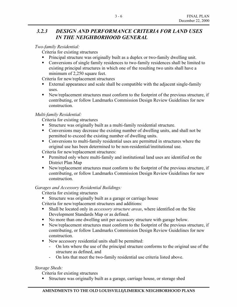
3.2.3 DESIGN AND PERFORMANCE CRITERIA FOR LAND USES IN THE NEIGHBORHOOD GENERAL
Two-family Residential:
Criteria for existing structures Principal structure was originally built as a duplex or two-family dwelling unit. Conversions of single family residences to two-family residences shall be limited to
existing principal structures in which one of the resulting two units shall have a minimum of 2,250 square feet.
Criteria for new/replacement structures External appearance and scale shall be compatible with the adjacent single-family
uses. New/replacement structures must conform to the footprint of the previous structure, if
contributing, or follow Landmarks Commission Design Review Guidelines for new construction.
Multi-family Residential:
Criteria for existing structures Structure was originally built as a multi-family residential structure. Conversions may decrease the existing number of dwelling units, and shall not be
permitted to exceed the existing number of dwelling units. Conversions to multi-family residential uses are permitted in structures where the
original use has been determined to be non-residential/institutional use. Criteria for new/replacement structures: Permitted only where multi-family and institutional land uses are identified on the
District Plan Map New/replacement structures must conform to the footprint of the previous structure, if
contributing, or follow Landmarks Commission Design Review Guidelines for new construction.
Garages and Accessory Residential Buildings:
Criteria for existing structures Structure was originally built as a garage or carriage house
Criteria for new/replacement structures and additions: Shall be located only in accessory structure areas, where identified on the Site
Development Standards Map or as defined. No more than one dwelling unit per accessory structure with garage below. New/replacement structures must conform to the footprint of the previous structure, if
contributing, or follow Landmarks Commission Design Review Guidelines for new construction.
New accessory residential units shall be permitted: - On lots where the use of the principal structure conforms to the original use of the
structure as defined, and - On lots that meet the two-family residential use criteria listed above.
Storage Sheds:
Criteria for existing structures Structure was originally built as a garage, carriage house, or storage shed
FINAL PLAN December 22, 2000
AMENDMENTS TO THE OLD LOUISVILLE/LIMERICK NEIGHBORHOOD PLANS
3 - 7
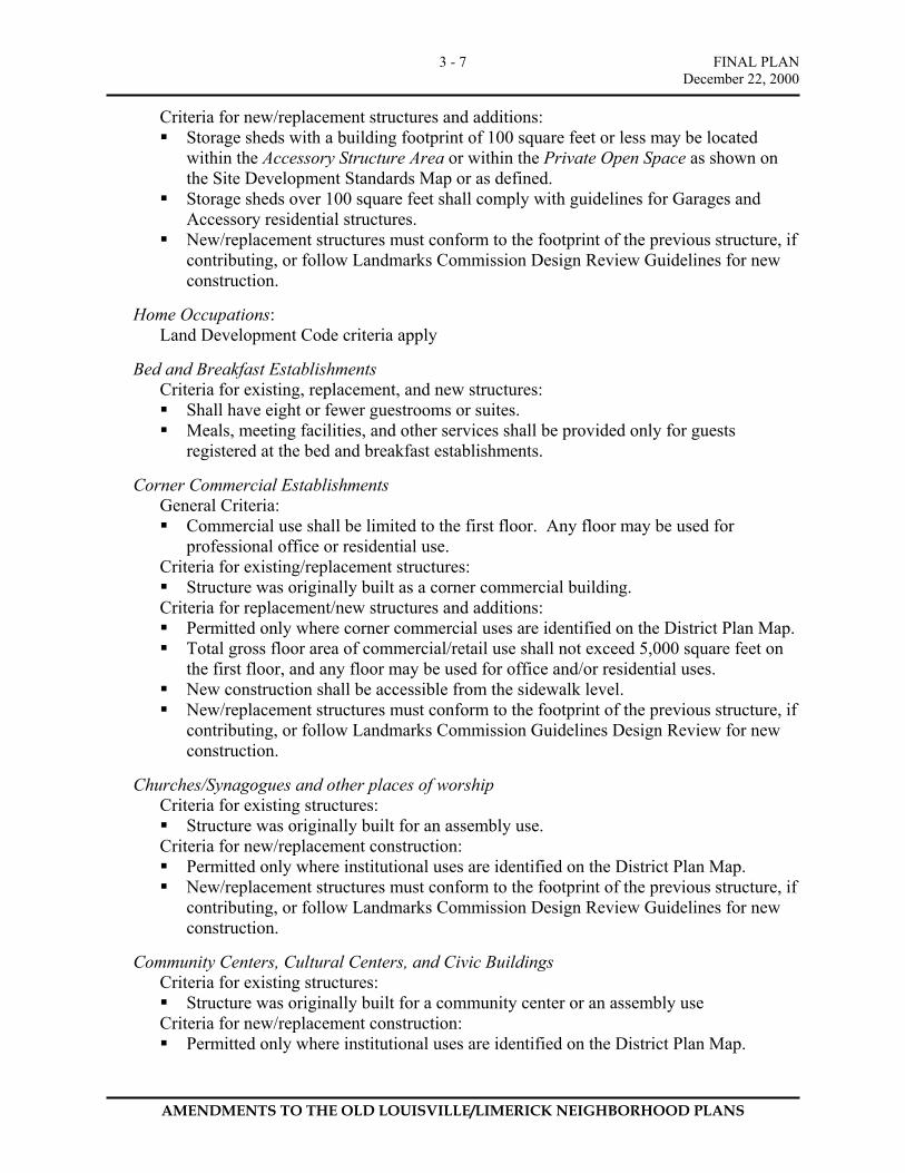
Criteria for new/replacement structures and additions: Storage sheds with a building footprint of 100 square feet or less may be located
within the Accessory Structure Area or within the Private Open Space as shown on the Site Development Standards Map or as defined.
Storage sheds over 100 square feet shall comply with guidelines for Garages and Accessory residential structures.
New/replacement structures must conform to the footprint of the previous structure, if contributing, or follow Landmarks Commission Design Review Guidelines for new construction.
Home Occupations:
Land Development Code criteria apply
Bed and Breakfast Establishments Criteria for existing, replacement, and new structures: Shall have eight or fewer guestrooms or suites. Meals, meeting facilities, and other services shall be provided only for guests
registered at the bed and breakfast establishments.
Corner Commercial Establishments General Criteria: Commercial use shall be limited to the first floor. Any floor may be used for
professional office or residential use. Criteria for existing/replacement structures: Structure was originally built as a corner commercial building.
Criteria for replacement/new structures and additions: Permitted only where corner commercial uses are identified on the District Plan Map. Total gross floor area of commercial/retail use shall not exceed 5,000 square feet on
the first floor, and any floor may be used for office and/or residential uses. New construction shall be accessible from the sidewalk level. New/replacement structures must conform to the footprint of the previous structure, if
contributing, or follow Landmarks Commission Guidelines Design Review for new construction.
Churches/Synagogues and other places of worship
Criteria for existing structures: Structure was originally built for an assembly use.
Criteria for new/replacement construction: Permitted only where institutional uses are identified on the District Plan Map. New/replacement structures must conform to the footprint of the previous structure, if
contributing, or follow Landmarks Commission Design Review Guidelines for new construction.
Community Centers, Cultural Centers, and Civic Buildings
Criteria for existing structures: Structure was originally built for a community center or an assembly use
Criteria for new/replacement construction: Permitted only where institutional uses are identified on the District Plan Map.
FINAL PLAN December 22, 2000
AMENDMENTS TO THE OLD LOUISVILLE/LIMERICK NEIGHBORHOOD PLANS
3 - 8
New/replacement structures must conform to the footprint of the previous structure, if contributing, or follow Landmarks Commission Design Review Guidelines for new construction.
Clubs and Lodges
Criteria for existing structures: Structure was originally built as a lodge or for an assembly use
Criteria for new/replacement construction: Permitted only where institutional uses are identified on the District Plan Map. New/replacement structures must conform to the footprint of the previous structure, if
contributing, or follow Landmarks Commission Design Review Guidelines for new construction.
Schools, public and private
Criteria for existing structures: Structure was originally built as a school or educational building
Criteria for new/replacement construction: Permitted only where institutional uses are identified on the District Plan Map. New/replacement structures must conform to the footprint of the previous structure, if
contributing, or follow Landmarks Commission Design Review Guidelines for new construction.
3.2.4 NEIGHBORHOOD GENERAL SITE DEVELOPMENT STANDARDS
The property development standards for the Neighborhood General are intended to preserve and reinforce the existing patterns of development. The most common pattern consists of the public realm, (front yard), principal structure area (the house), private open space (rear yard) and accessory structure area (carriage houses, garages, and vehicular surface areas along the alley). These development standards, with the official District Plan Map, also recognize historic developments that did not conform to the typical residential pattern, including the corner commercial and multi-family buildings.
In addition to these standards, Landmarks Commission Design Review Guidelines shall apply to all properties located within a Local Historic Preservation District. For properties located within the Traditional Neighborhood Zoning District, but outside the Local Preservation District, the appropriate reviewing body will review all new construction. In reviewing and approving development proposals, the appropriate reviewing body shall apply the following site standards in conjunction with Landmarks Commission Design Review Guidelines.
A. MINIMUM LOT DIMENSIONS:
None
B MINIMUM YARD REQUIREMENTS:
1. Front yard..........….. Shall be as shown on the Site Development Standards Map or
as defined
FINAL PLAN December 22, 2000
AMENDMENTS TO THE OLD LOUISVILLE/LIMERICK NEIGHBORHOOD PLANS
3 - 9
2. Side Yard............ Combined 10 feet, with a minimum of 3’ on each side, Exceptions: 1. A property that is located between two developed
properties may have a side yard setback equal to that of the average of the two existing adjacent side yard setbacks (for this option, a survey prepared by a licensed surveyor of the two existing side yards must be submitted).
2. Zero-lot line construction and rowhouse/townhouse may be exempted from the side yard requirement, subject to approval by the appropriate reviewing body.
3. Street Side Yard....... Shall be as shown on the Site Development Standards Map or as defined
4. Private Open Space (Rear Yard)
Shall be as shown on the Site Development Standards Map or as defined
5. Build-to Line........... Shall be as shown on the Site Development Standards Map or as defined
6. Accessory Structure Area
Where an accessory structure area is shown on the Site Development Standards Map, the area shall be 30’ deep as measured from the rear property line for single family residential lots or as defined.
C. MAXIMUM BUILDING HEIGHT:
1. In a developed context, the height of an infill building shall be within the range of
the height of the two nearest historically contributing structures in the neighborhood. For example, if the existing building on one side of a lot is 40 feet high, and the existing building on the other side is 30 feet high, then the new building may be at any height between 30 and 40 feet. For non-residential buildings, the building height shall relate to the nearest historically contributing buildings of similar use in the Neighborhood General. For example, corner commercial buildings and multi-family buildings shall be of similar height and number of stories as other existing corner commercial and multi-family buildings within the neighborhood context.
2. In an undeveloped context, maximum height shall be three and one-half stories and not to exceed 45 feet. However, the building height shall also relate to historically contributing buildings of similar use in the Neighborhood General.
D. MAXIMUM DENSITY:
1. Maximum Dwelling Units Residential General:.......... Two dwelling units per lot plus one dwelling unit
in the Accessory Structure Area. Map designated Multi-family :
34.8 dwellings per acre or for replacement structures, the number of units permitted shall not exceed previously existing density.
FINAL PLAN December 22, 2000
AMENDMENTS TO THE OLD LOUISVILLE/LIMERICK NEIGHBORHOOD PLANS
3 - 10
E. PARKING:
1. Parking shall be limited to the accessory structure area except as noted below. Exception: Parking for corner commercial and permitted multi-family buildings
may be accommodated in the Accessory Structure Area or the Private Open Space with the approval of the Louisville Landmarks Commission or the appropriate development review agency where applicable. Parking must be screened from adjacent residential properties. No parking shall be provided adjacent to a public right-of-way (except alleys).
2. Minimum parking requirement for map designated multi-family shall be 0.75 parking spaces/dwelling unit
3. Regulations and design standards for parking shall be the same as the regulations for the R-7 zone as outlined in Section 10 of the Land Development Code with the exception of the standards for minimum parking requirements.
F. SIGNS:
Signs shall conform to regulations in Article 11 of the current Land Development Code unless otherwise noted below:
1. Bed and Breakfasts
Establishments ………….... Permitted to have one sign, maximum of six square feet, that may be attached flat on the building or within six feet of the structure and illuminated with by one external light source. The sign shall not be internally illuminated.
2. Corner Commercial.............. One illuminated or non-illuminated sign attached flat on the face of the building and extending no more than 12 inches from the surface of the building is allowed to face each street bordering the site. Signs may not exceed 12 square feet in area. In lieu of an attached sign, a non-illuminated projected sign may be used. Projected signs shall be attached to the structure shall not exceed 6 square feet and shall not project more than 42 inches from the face of the building. No sign shall be located more than three feet above the ceiling of the first floor of the building. No freestanding signs shall be permitted.
G. FENCES AND WALLS:
Regulations for fences and walls in the Neighborhood General shall be the same as the regulations for the R-7 zone as outlined in section 9.1 of the Land Development Code.
FINAL PLAN December 22, 2000
AMENDMENTS TO THE OLD LOUISVILLE/LIMERICK NEIGHBORHOOD PLANS
3 - 11
H. LANDSCAPING:
No landscaping requirements except as follows:
1. “Vehicular Use Areas” shall be landscaped according to Article 12.10 Interior Landscaping for Vehicular Use Areas and Article 12.11 Landscaping for Service Structures of the current Land Development Code.
2. New Development shall comply with City plans and guidelines, including Landmarks Guidelines, streetscape plans for parkways, or any other adopted policies for street trees.
I. OTHER REQUIREMENTS:
None
3.3 Neighborhood Transition - Center
3.3.1 LAND USE TABLES – NEIGHBORHOOD TRANSITION - CENTER
Table 3.3.1a Uses Permitted by Right* in the Neighborhood Transition - Center:
Land Use Category Comments Residential Uses Single Family Residential One dwelling unit per lot, including attached row houses on
separate lots Two-family Residential Includes two dwelling units in the principal structure on a lot Multi-family Residential Three or more residential units in the principal structure on a lot Garages and Accessory Residential Units
Includes Carriage Houses
Home Occupation See definition (in the Land Development Code) Office Uses Professional Office See definition Institutional Uses Churches & Synagogues Religious institutions, places of worship, and ancillary uses Schools, public and private Includes nursery, elementary, middle, and high schools Trade, Business, or Industrial Schools
See definition
Colleges and Universities See definition Historic House Museums See definition Day Care Centers See definition Family Day Care Homes See definition
* Site Development Standards, design and performance criteria apply to all uses
FINAL PLAN December 22, 2000
AMENDMENTS TO THE OLD LOUISVILLE/LIMERICK NEIGHBORHOOD PLANS
3 - 12
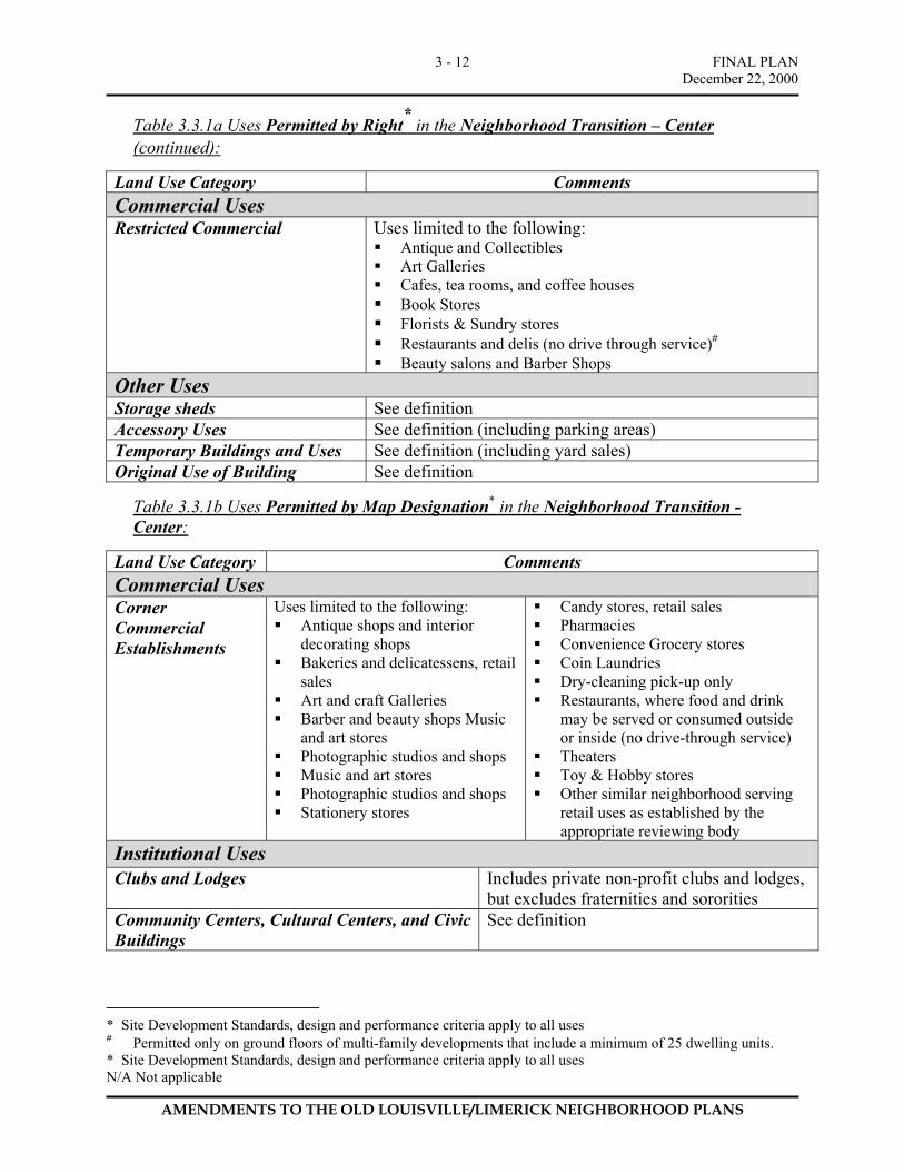
Table 3.3.1a Uses Permitted by Right* in the Neighborhood Transition – Center
(continued):
Land Use Category Comments Commercial Uses Restricted Commercial Uses limited to the following:
Antique and Collectibles Art Galleries Cafes, tea rooms, and coffee houses Book Stores Florists & Sundry stores Restaurants and delis (no drive through service)# Beauty salons and Barber Shops
Other Uses Storage sheds See definition Accessory Uses See definition (including parking areas) Temporary Buildings and Uses See definition (including yard sales) Original Use of Building See definition
Table 3.3.1b Uses Permitted by Map Designation* in the Neighborhood Transition - Center:
Land Use Category Comments Commercial Uses Corner Commercial Establishments
Uses limited to the following: Antique shops and interior
decorating shops Bakeries and delicatessens, retail
sales Art and craft Galleries Barber and beauty shops Music
and art stores Photographic studios and shops Music and art stores Photographic studios and shops Stationery stores
Candy stores, retail sales Pharmacies Convenience Grocery stores Coin Laundries Dry-cleaning pick-up only Restaurants, where food and drink
may be served or consumed outside or inside (no drive-through service)
Theaters Toy & Hobby stores Other similar neighborhood serving
retail uses as established by the appropriate reviewing body
Institutional Uses Clubs and Lodges Includes private non-profit clubs and lodges,
but excludes fraternities and sororities Community Centers, Cultural Centers, and Civic Buildings
See definition
* Site Development Standards, design and performance criteria apply to all uses # Permitted only on ground floors of multi-family developments that include a minimum of 25 dwelling units. * Site Development Standards, design and performance criteria apply to all uses N/A Not applicable
FINAL PLAN December 22, 2000
AMENDMENTS TO THE OLD LOUISVILLE/LIMERICK NEIGHBORHOOD PLANS
3 - 13
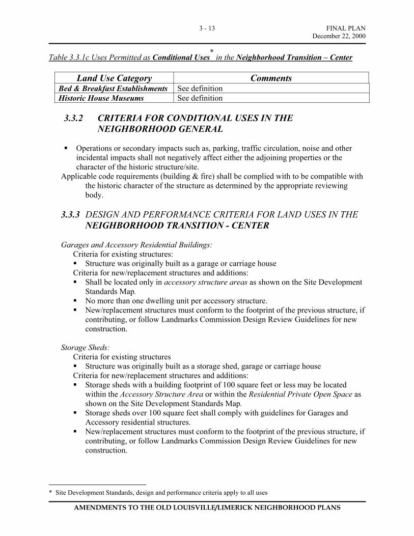
Table 3.3.1c Uses Permitted as Conditional Uses* in the Neighborhood Transition – Center
Land Use Category Comments
Bed & Breakfast Establishments See definition Historic House Museums See definition
3.3.2 CRITERIA FOR CONDITIONAL USES IN THE
NEIGHBORHOOD GENERAL
Operations or secondary impacts such as, parking, traffic circulation, noise and other incidental impacts shall not negatively affect either the adjoining properties or the character of the historic structure/site.
Applicable code requirements (building & fire) shall be complied with to be compatible with the historic character of the structure as determined by the appropriate reviewing body.
3.3.3 DESIGN AND PERFORMANCE CRITERIA FOR LAND USES IN THE
NEIGHBORHOOD TRANSITION - CENTER
Garages and Accessory Residential Buildings: Criteria for existing structures: Structure was originally built as a garage or carriage house
Criteria for new/replacement structures and additions: Shall be located only in accessory structure areas as shown on the Site Development
Standards Map. No more than one dwelling unit per accessory structure. New/replacement structures must conform to the footprint of the previous structure, if
contributing, or follow Landmarks Commission Design Review Guidelines for new construction.
Storage Sheds:
Criteria for existing structures Structure was originally built as a storage shed, garage or carriage house
Criteria for new/replacement structures and additions: Storage sheds with a building footprint of 100 square feet or less may be located
within the Accessory Structure Area or within the Residential Private Open Space as shown on the Site Development Standards Map.
Storage sheds over 100 square feet shall comply with guidelines for Garages and Accessory residential structures.
New/replacement structures must conform to the footprint of the previous structure, if contributing, or follow Landmarks Commission Design Review Guidelines for new construction.
* Site Development Standards, design and performance criteria apply to all uses
FINAL PLAN December 22, 2000
AMENDMENTS TO THE OLD LOUISVILLE/LIMERICK NEIGHBORHOOD PLANS
3 - 14
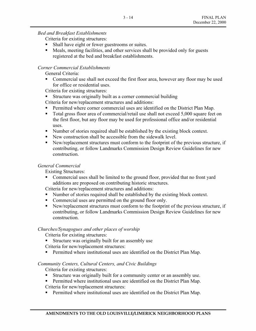
Bed and Breakfast Establishments Criteria for existing structures: Shall have eight or fewer guestrooms or suites. Meals, meeting facilities, and other services shall be provided only for guests
registered at the bed and breakfast establishments. Corner Commercial Establishments
General Criteria: Commercial use shall not exceed the first floor area, however any floor may be used
for office or residential uses. Criteria for existing structures: Structure was originally built as a corner commercial building
Criteria for new/replacement structures and additions: Permitted where corner commercial uses are identified on the District Plan Map. Total gross floor area of commercial/retail use shall not exceed 5,000 square feet on
the first floor, but any floor may be used for professional office and/or residential uses.
Number of stories required shall be established by the existing block context. New construction shall be accessible from the sidewalk level. New/replacement structures must conform to the footprint of the previous structure, if
contributing, or follow Landmarks Commission Design Review Guidelines for new construction.
General Commercial
Existing Structures: Commercial uses shall be limited to the ground floor, provided that no front yard
additions are proposed on contributing historic structures. Criteria for new/replacement structures and additions: Number of stories required shall be established by the existing block context. Commercial uses are permitted on the ground floor only. New/replacement structures must conform to the footprint of the previous structure, if
contributing, or follow Landmarks Commission Design Review Guidelines for new construction.
Churches/Synagogues and other places of worship
Criteria for existing structures: Structure was originally built for an assembly use
Criteria for new/replacement structures: Permitted where institutional uses are identified on the District Plan Map.
Community Centers, Cultural Centers, and Civic Buildings
Criteria for existing structures: Structure was originally built for a community center or an assembly use. Permitted where institutional uses are identified on the District Plan Map.
Criteria for new/replacement structures: Permitted where institutional uses are identified on the District Plan Map.

FINAL PLAN December 22, 2000
AMENDMENTS TO THE OLD LOUISVILLE/LIMERICK NEIGHBORHOOD PLANS
3 - 15
New/replacement structures must conform to the footprint of the previous structure, if contributing, or follow Landmarks Commission Design Review Guidelines for new construction.
Clubs and Lodges
Criteria for existing structures: Structure was originally built as a lodge or for an assembly use. Permitted where institutional uses are identified on the District Plan Map.
Criteria for new/replacement structures: Permitted where institutional uses are identified on the District Plan Map. New/replacement structures must conform to the footprint of the previous structure, if
contributing, or follow Landmarks Commission Design Review Guidelines for new construction.
Schools, public and private
Criteria for existing structures: Structure was originally built as a school or educational building. Permitted where institutional uses are identified on the District Plan Map.
Criteria for new/replacement structures: Permitted where institutional uses are identified on the District Plan Map. New/replacement structures must conform to the footprint of the previous structure, if
contributing, or follow Landmarks Commission Design Review Guidelines for new construction.
3.2.3 NEIGHBORHOOD TRANSITION – CENTER SITE DEVELOPMENT
STANDARDS The development standards for the Neighborhood Transition - Center are very similar to the Neighborhood General. The scale and character of the Neighborhood Transition - Center is generally the same as the Neighborhood General while permitting a greater mixture and intensity of uses including multi-family housing and other non-residential uses.
A. MINIMUM LOT AND DIMENSIONS: None
B MINIMUM YARD REQUIREMENTS:
1. Front Yard .....…… Shall be as shown on Site Development Standards Map or as defined
2. Side Yard.................... Combined 10 feet with a minimum of 5’ on each side, Exception: A property that is located between two developed properties may have a minimum side yard setback equal to that of the average of the two existing adjacent side yard setbacks (for this option, a survey prepared by a licensed surveyor of the two existing side yards must be submitted).
3. Street Side Yard.......... Shall be as shown on Site Development Standards Map or as defined
FINAL PLAN December 22, 2000
AMENDMENTS TO THE OLD LOUISVILLE/LIMERICK NEIGHBORHOOD PLANS
3 - 16
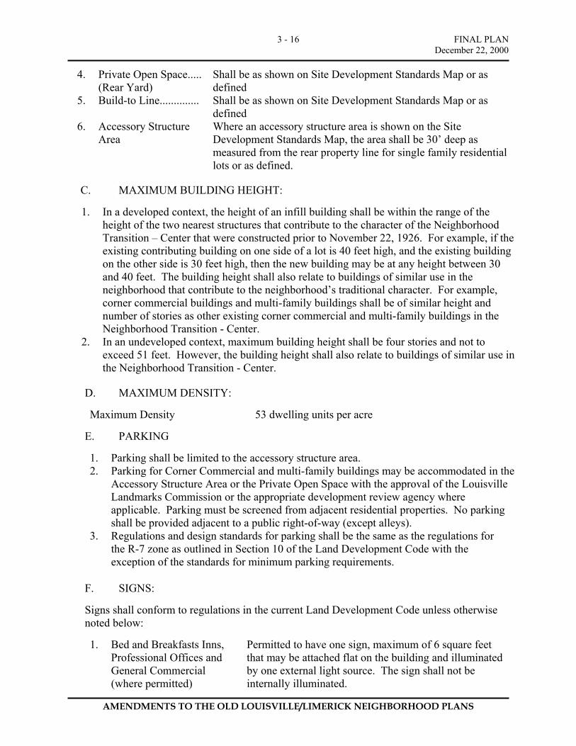
4. Private Open Space..... (Rear Yard)
Shall be as shown on Site Development Standards Map or as defined
5. Build-to Line.............. Shall be as shown on Site Development Standards Map or as defined
6. Accessory Structure Area
Where an accessory structure area is shown on the Site Development Standards Map, the area shall be 30’ deep as measured from the rear property line for single family residential lots or as defined.
C. MAXIMUM BUILDING HEIGHT:
1. In a developed context, the height of an infill building shall be within the range of the
height of the two nearest structures that contribute to the character of the Neighborhood Transition – Center that were constructed prior to November 22, 1926. For example, if the existing contributing building on one side of a lot is 40 feet high, and the existing building on the other side is 30 feet high, then the new building may be at any height between 30 and 40 feet. The building height shall also relate to buildings of similar use in the neighborhood that contribute to the neighborhood’s traditional character. For example, corner commercial buildings and multi-family buildings shall be of similar height and number of stories as other existing corner commercial and multi-family buildings in the Neighborhood Transition - Center.
2. In an undeveloped context, maximum building height shall be four stories and not to exceed 51 feet. However, the building height shall also relate to buildings of similar use in the Neighborhood Transition - Center.
D. MAXIMUM DENSITY:
Maximum Density 53 dwelling units per acre
E. PARKING
1. Parking shall be limited to the accessory structure area. 2. Parking for Corner Commercial and multi-family buildings may be accommodated in the
Accessory Structure Area or the Private Open Space with the approval of the Louisville Landmarks Commission or the appropriate development review agency where applicable. Parking must be screened from adjacent residential properties. No parking shall be provided adjacent to a public right-of-way (except alleys).
3. Regulations and design standards for parking shall be the same as the regulations for the R-7 zone as outlined in Section 10 of the Land Development Code with the exception of the standards for minimum parking requirements.
F. SIGNS:
Signs shall conform to regulations in the current Land Development Code unless otherwise noted below:
1. Bed and Breakfasts Inns,
Professional Offices and General Commercial (where permitted)
Permitted to have one sign, maximum of 6 square feet that may be attached flat on the building and illuminated by one external light source. The sign shall not be internally illuminated.
FINAL PLAN December 22, 2000
AMENDMENTS TO THE OLD LOUISVILLE/LIMERICK NEIGHBORHOOD PLANS
3 - 17
2. Corner Commercial............ One illuminated or non-illuminated sign attached flat on
the face of the building and extending no more than 12 inches from the surface of the building is allowed to face each street bordering the site. Signs may not exceed 12 square feet in area. In lieu of attached signs, a non-illuminated projected sign may be used. Projected signs shall be attached to the building, not exceed 6 square feet and shall not project more than 42 feet from the face of the building. No signs shall extend more than three feet above the ceiling of the first floor of the building.
3. Signs for existing non-conforming uses.................
Signs for existing non-conforming uses shall be permitted to remain and modified (as required for new businesses) provided that the total area of the existing building signs is not expanded.
G. FENCES AND WALLS:
Regulations for fences and walls in the Neighborhood Transition – Center shall be the same as the regulations for the R-7 zone as outlined in Section 9.1 of the Land Development Code.
H. LANDSCAPING:
No landscaping requirements except as follows: 1. “Vehicular Use Areas” shall be landscaped according to Article 12.10 Interior
Landscaping for Vehicular Use Areas and Article 12.11 Landscaping for Service Structures of the current Land Development Code.
2. New Development shall comply with City plans and guidelines, including Landmarks Guidelines, streetscape plans for parkways, or any other adopted policies for street trees.
I. OTHER REQUIREMENTS
None

FINAL PLAN December 22, 2000
AMENDMENTS TO THE OLD LOUISVILLE/LIMERICK NEIGHBORHOOD PLANS
3 - 18
3.4 Neighborhood Center 3.4.1 LAND USE TABLES
Table 3.4.1a Uses Permitted by Right* in the Neighborhood Center:
Land Use Category Comments Residential Uses Two-family Residential Includes two dwelling units in the principal structure on a lot Multi-family Residential Three or more residential units in the principal structure on a
lot Home Occupations See definition Garages and Accessory Residential Units
Includes Carriage Houses
Institutional Uses Community Centers, Cultural Centers, and Civic Buildings
See definition
Commercial Uses Commercial Uses limited to the following:
Neighborhood pubs and live music in restaurants
Video stores Antique & Collectibles’ Stores Art and craft Galleries Athletic facilities (Indoor) Bakeries and Delicatessens Banks, credit unions, savings and loans Beauty & Barber Shops Book Stores Bicycle sales and service Clothing stores Dressmaking or millinery shops Department stores Drug Stores/Pharmacies Appliance/furniture stores Florist shops Grocery stores Hardware and paint stores
Health spas Jewelry stores Laundries and Dry Cleaners Music Stores Nurseries, retail Package liquor stores (where alcoholic
beverages are not consumed on the premises)
Pet shops Photographic supplies Appliance repair stores Restaurants, tea rooms, and cafes Shoe repair shops and sales Tailor Tents, air structures and other temporary
structures (must not be displayed more than 10 days in a calendar year)
Retail stores Other similar retail uses.
Office Uses Professional Office See definition General/Business Office See definition Other Uses Storage sheds See definition Accessory Uses See definition (including parking areas) Temporary Buildings and Uses See definition (including yard sales) Original Use of Building See definition
* Site Development Standards apply to all uses
FINAL PLAN December 22, 2000
AMENDMENTS TO THE OLD LOUISVILLE/LIMERICK NEIGHBORHOOD PLANS
3 - 19
Table 3.4.1b Uses Permitted by Map Designation* in the Neighborhood Center:
Land Use Category Land Use Description Institutional Uses Churches & Synagogues Religious institutions, places of worship and ancillary uses
Table 3.4.1c Uses Permitted as Conditional Uses* in the Neighborhood General
Land Use Category Comments Bed & Breakfast Establishments See definition Historic House Museums See definition 3.4.2 CRITERIA FOR CONDITIONAL USES IN THE
NEIGHBORHOOD GENERAL
Operations or secondary impacts such as, parking, traffic circulation, noise and other incidental impacts shall not negatively affect either the adjoining properties or the character of the historic structure/site.
Applicable code requirements (building & fire) shall be complied with to be compatible with the historic character of the structure as determined by the appropriate reviewing body.
3.4.3 DESIGN AND PERFORMANCE CRITERIA FOR LAND USES IN
THE NEIGHBORHOOD CENTER Performance criteria are not applicable for the Neighborhood Center. General Site Development Standards regulate new development.
3.4.4 NEIGHBORHOOD CENTER SITE DEVELOPMENT STANDARDS
Development standards for new construction in the Neighborhood Center will address the relationship between the commercial space on the ground level and the street and sidewalk. Buildings will be required to be built up to the street fronting property lines or street right-of-way while maintaining a minimum 10-foot deep sidewalk in order to encourage street level activity. Building entrances are to be oriented towards the sidewalk. In addition to these standards, Landmarks Commission Design Review Guidelines shall apply to all properties located within a Local Historic Preservation District. For properties located within the Traditional Neighborhood Zoning District, but outside the Local Preservation District, the appropriate reviewing body will review all new construction. In reviewing and approving development proposals, the reviewing body shall apply the following site standards in conjunction with Landmarks Commission Design Review Guidelines.
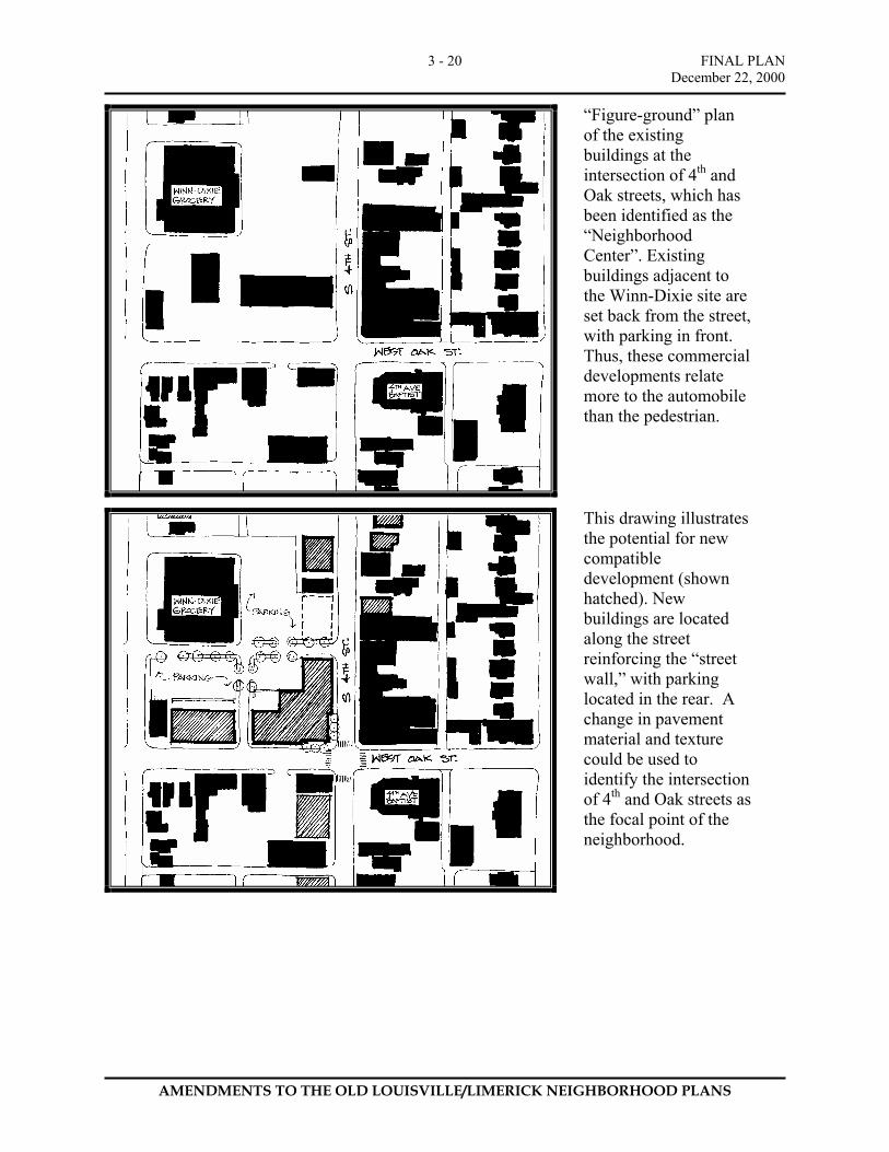
FINAL PLAN December 22, 2000
AMENDMENTS TO THE OLD LOUISVILLE/LIMERICK NEIGHBORHOOD PLANS
3 - 20
“Figure-ground” plan of the existing buildings at the intersection of 4th and Oak streets, which has been identified as the “Neighborhood Center”. Existing buildings adjacent to the Winn-Dixie site are set back from the street, with parking in front. Thus, these commercial developments relate more to the automobile than the pedestrian.
This drawing illustrates the potential for new compatible development (shown hatched). New buildings are located along the street reinforcing the “street wall,” with parking located in the rear. A change in pavement material and texture could be used to identify the intersection of 4th and Oak streets as the focal point of the neighborhood.
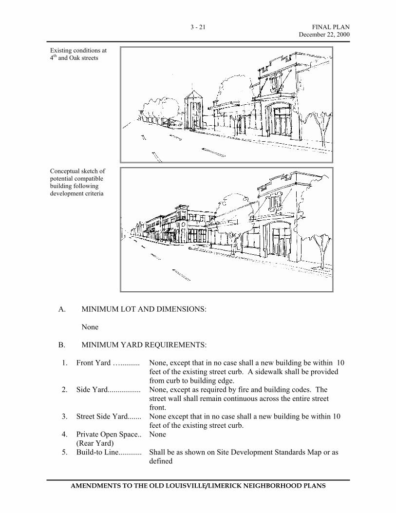
FINAL PLAN December 22, 2000
AMENDMENTS TO THE OLD LOUISVILLE/LIMERICK NEIGHBORHOOD PLANS
3 - 21
Existing conditions at 4th and Oak streets
Conceptual sketch of potential compatible building following development criteria
A. MINIMUM LOT AND DIMENSIONS:
None
B. MINIMUM YARD REQUIREMENTS:
1. Front Yard ….......... None, except that in no case shall a new building be within 10
feet of the existing street curb. A sidewalk shall be provided from curb to building edge.
2. Side Yard................. None, except as required by fire and building codes. The street wall shall remain continuous across the entire street front.
3. Street Side Yard....... None except that in no case shall a new building be within 10 feet of the existing street curb.
4. Private Open Space.. (Rear Yard)
None
5. Build-to Line............ Shall be as shown on Site Development Standards Map or as defined
FINAL PLAN December 22, 2000
AMENDMENTS TO THE OLD LOUISVILLE/LIMERICK NEIGHBORHOOD PLANS
3 - 22
6. Accessory Structure Area
Not applicable.
C. MAXIMUM BUILDING HEIGHT:
Four and one half stories, and not to exceed 60 feet.
D. MAXIMUM DENSITY:
Maximum Density 90 dwelling units per acre
E. PARKING
1. The minimum number of parking spaces required under Article 10 of the
current Land Development Code are established as the maximum number of parking spaces for the corresponding land uses permitted in the Neighborhood Center.
Exception: Parking maximum standards shall not apply to parking spaces located in structured parking facilities (parking garages), provided that any structured parking facility fronting a public street (except alleys) has a continuous retail space fronting the street at the sidewalk level with the exception of driveways and accesses into the parking garage.
2. Surface parking shall be located to the rear of the site.
F. SIGNS:
Signs shall conform to regulations in Article 11 of the current Land Development Code for a CN zone with the following exceptions:
1. “Illuminated Awning Signs” are not permitted (“Non-Illuminated Awning
Signs” are permitted). 2. “Outdoor Advertising Signs” are not permitted. 3. “Small Freestanding Signs” (i.e., portable signs, sandwich board signs or
banner) are permitted as for the C-2 zone.
G. FENCES AND WALLS:
Fences and walls shall be permitted as for the R-7 zone as outlined in Article 9.1 of the current Land Development Code.
H. LANDSCAPING:
No landscaping requirements except as followed: 1. “Vehicular Use Areas” shall be landscaped according to Article 12.10 Interior
Landscaping for Vehicular Use Areas and Article 12.11 Landscaping for Service Structures of the current Land Development Code.

FINAL PLAN December 22, 2000
AMENDMENTS TO THE OLD LOUISVILLE/LIMERICK NEIGHBORHOOD PLANS
3 - 23
2. New Development shall comply with City plans and guidelines, including Landmarks Guidelines, streetscape plans for parkways, or any other adopted policies for street trees.
I. OTHER REQUIREMENTS:
Building Orientation: principal entrances to the building shall be oriented to the street and accessible from the sidewalk.
3.5 SITE DEVELOPMENT STANDARDS MAP
The Site Development Standards Map for Old Louisville/Limerick will be published after the adoption of the official plan to address site design standards in a totally contextual manner as shown in the map below for a typical block. Written site development standards will establish the general guidelines to be used while formulating the Site Development Standards Map. The Site Development Standards Map shall graphically illustrate standards of setbacks, accessory structure area, principal building areas, and private open space on each block.
4. TRANSPORTATION AND CIRCULATION

FINAL PLAN December 22, 2000
AMENDMENTS TO THE OLD LOUISVILLE/LIMERICK NEIGHBORHOOD PLANS
4 - 2
4. TRANSPORTATION AND CIRCULATION
4.1 Traffic Many Old Louisville streets serve as major north-south and east-west routes intended to move traffic between destinations outside of the neighborhood, particularly downtown. Brook, First, Second, Third, Fifth, and much of Sixth and Seventh streets; Breckinridge, Kentucky, St. Catherine, Oak, and part of Ormsby are all one-way and carry a high volume of traffic each day, especially on weekdays. Decades ago, before the advent of the interstate highway system, the street grid that hosted the neighborhood’s original development was converted into one-way thoroughfares that seem to divide formerly unified blocks and districts. The residential character of the neighborhoods has been eroded to relieve downtown congestion and promote fuel-efficient traffic flow. While this traffic is not likely to decrease, Task Force members observed that the emphasis on “moving traffic” instead of “calming traffic” has increased cut-through traffic on alleys, restricted property access from principal streets, and hindered visitors’ enjoyment of the district’s historic character. The neighborhood function of streets as gathering spaces has diminished due to high travel speeds, restrictions on curbside parking during peak traffic hours, and the prevalence of one-ways streets into and out of downtown. The damage is compounded by large trucks using neighborhood routes, although regulation and voluntary abatement by area industries has helped to reduce this effect. On the west side of Old Louisville/Limerick, the Ninth Street extension to Myrtle (a project planned for over twenty years) may provide a remedy for the problem of through traffic, although new traffic patterns and problems could well emerge (such as where Ninth Street volume empties onto neighborhood streets). Along Oak Street, one-way traffic facilitates cross-town movement but significantly reduces access to the retail stores in the commercial corridor, since westward turns onto Oak from Fourth, Third, and Second streets—the most heavily traveled—are all prohibited. Merchants cite the bewildering maze of one-way streets as a barrier to patrons seeking Fourth and Oak as their destination. Additionally, on-street parking on Oak is restricted during peak afternoon traffic, further reducing the marketability of a commercial district where convenient parking alternatives are relatively scarce. 4.2 Parking The need of both residents and visitors to park cars has strained the capacity of neighborhood streets, alleys, and rear yards, which were created decades before the advent of the automobile. Old Louisville and Limerick were among the city’s first “streetcar neighborhoods”, whose development was made possible by mass transit. The neighborhood was not originally designed to accommodate one vehicle per resident - or even one per household. Consequently, the need for parking lots has created unsightly encroachments throughout the neighborhood, particularly along alleys previously lined by single-bay carriage houses, stables, and utilitarian sheds. On-street parking safety is also sometimes in conflict with speeding traffic on one-way streets.
FINAL PLAN December 22, 2000
AMENDMENTS TO THE OLD LOUISVILLE/LIMERICK NEIGHBORHOOD PLANS
4 - 3
The explosive growth of the University of Louisville since 1970 combined with the proximity to Manual High School and Youth Performing Arts School (YPAS) have created corresponding strains upon Old Louisville, particularly in the area south of Hill Street where commuting students compete with residents for on-street parking spaces. The aggravation to residents is immense and there seems to be no easy solution. Although the University has endeavored to meet the demand for on-campus parking, students will often ignore such offerings in favor of free (and often more convenient) on-street parking available in the adjoining neighborhood between Cardinal Boulevard and Hill Street. Thus far, there have been no experiments with permit parking in the area. 4.3 Public Transportation While both Old Louisville and Limerick are well served by the Transit Authority of River City (TARC), the Task Force observed that TARC must better maintain its bus stops. Suggestions included more frequent cleaning and more schedule postings (and replacement of missing schedules). The Task Force strongly recommends that TARC design more architecturally pleasing bus shelters, compatible with the neighborhood's historic character. TARC has announced plans to implement a light-rail system serving downtown Louisville and the south-central corridor along Preston Street. Future plans include a transit-oriented-development at the intersection of Preston and Oak streets. Consideration should be given to the impact of this development on the Oak Street corridor. As a unique heritage tourist destination close to downtown hotels and the Kentucky International Convention Center, consideration should be given to encouraging visits by providing trolley service along Fourth Street from Broadway to Central Park and beyond to Churchill Downs. 4.4 Task Force Recommendations In order to address the above transportation concerns, the Old Louisville/Limerick Task Force recommends that the City Public Works Department and the Transit Authority of River City (TARC) work with the Old Louisville Neighborhood Council and Limerick Neighborhood Association to implement the following recommendations. Public Works Department: • Conduct a Traffic Study: Focused on traffic flow changes that improve neighborhood
circulation, quality of life through the creation of two-way streets, and traffic calming measures including the elimination of one-way through streets, eliminating on-street parking restrictions, curb extensions at appropriate intersections, street closings, and improvements in conjunction with the update of the Louisville Downtown Development Plan.
• Oak Street: Implement two-way traffic consistent with recommendation of the city commissioned Kimley-Horn Traffic Study, 1979-80. The Task Force recommends a corridor improvement strategy along Oak Street that links the Neighborhood Center with the future light rail stop at Preston and Oak Streets.

FINAL PLAN December 22, 2000
AMENDMENTS TO THE OLD LOUISVILLE/LIMERICK NEIGHBORHOOD PLANS
4 - 4
• Parking strategy: Develop a neighborhood parking strategy, particularly for the area south of Hill Street impacted by the University and the public schools, in cooperation with the University of Louisville’s Master Plan update and analyze the feasibility of implementing a residential parking permit program. A comprehensive parking strategy should also review current policies of parking restrictions during peak periods throughout the neighborhood with the goal of allowing unrestricted parking wherever possible.
• 9th Street extension: Work closely with the neighborhood association during design and construction of the 9th Street extension and its expansion south of 7th and Myrtle Streets. The Task Force recommends studying several options proposed for this southward extension and pursuing state and federal funding for its implementation.
• Third Street Parkway: Develop Third Street from Broadway to Eastern Parkway as a parkway with wide tree-lined verges and sidewalks.
• Streetscape Plan: Adopt a streetscape plan with Landmarks Commission Architectural Review Committee approval that establishes a “brand identity” for Old Louisville & Limerick. This streetscape plan would coordinate landscaping, roadway marking, signage and graphics, sidewalks, period street lighting, furniture, and other streetscape improvements.
• Truck Routing Program: Establish designated truck routes with a program of signage and enforcement to reduce through truck traffic in the neighborhood.
• Neighborhood Underpasses: Most underpasses that serve the neighborhood are inadequate for the height of modern semi-trailers and result in frequent property damage and traffic delays. The Task Force recommends that the city implement a program to lower the street grade and improve the passable height of all underpasses serving the neighborhood.
• Study of Neighborhood Alleys: Work with neighborhood residents to survey and evaluate the condition of alleyways and recommend improvements in drainage, cleaning, maintenance, traffic flow, etc. Develop a plan for retaining and improving brick and cobblestone alleyways.
Transit Authority of River City: • Vintage trolley: Review the feasibility of developing a vintage trolley connection to support
the Neighborhood Center and access to heritage tourist destinations. • Light rail: Work with the neighborhood association on the potential impact of the proposed
light rail corridor along Preston Street and station area development. • Transit stops and maintenance: Improve maintenance of transit stops and study the
feasibility of alternative transit stop shelters that are in keeping with the historic character of Old Louisville and Limerick.
• Bus Schedules: Post and update bus schedules at transit stop locations. Other Recommendations: A heritage tourism program together with a wayfinding and signage package should be developed for Old Louisville and Limerick, targeting the neighborhoods’ historical assets.
5. PARKS AND OPEN SPACE
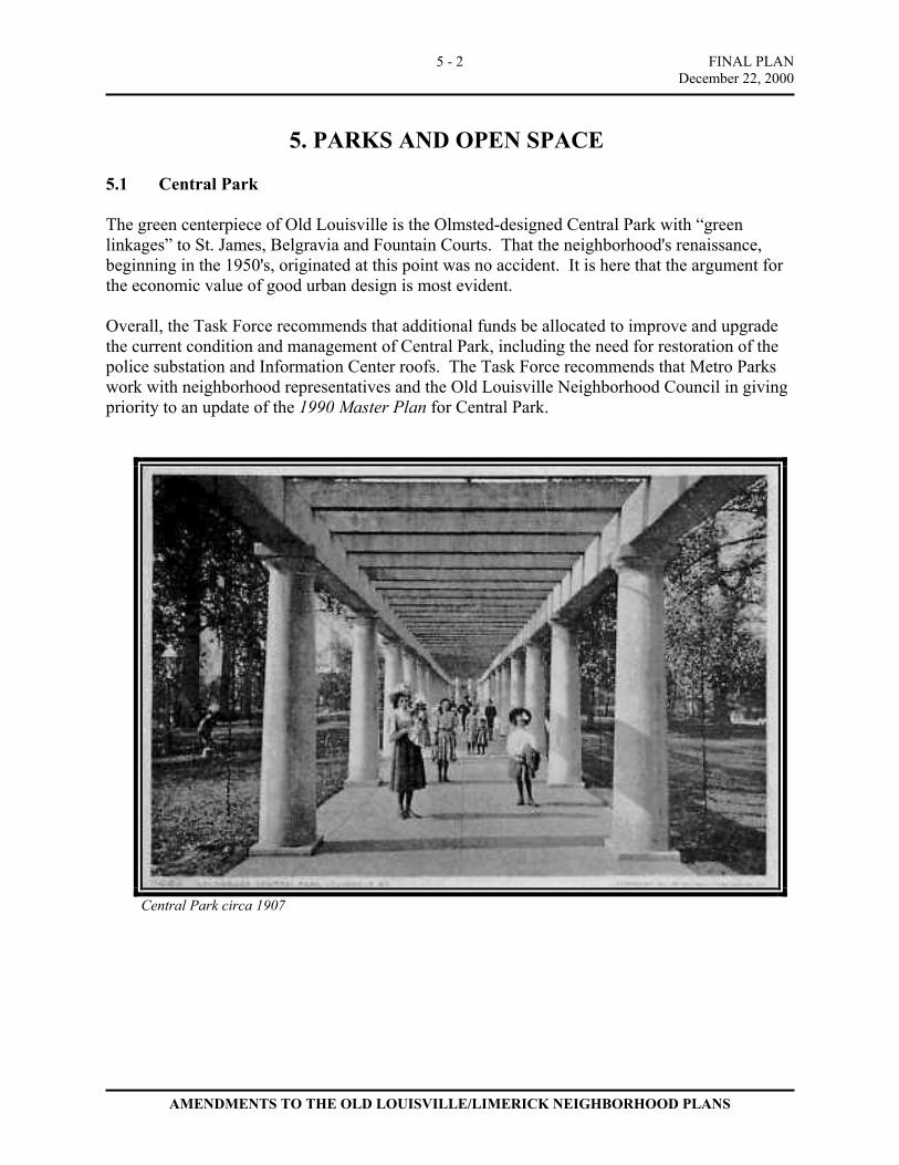
FINAL PLAN December 22, 2000
AMENDMENTS TO THE OLD LOUISVILLE/LIMERICK NEIGHBORHOOD PLANS
5 - 2
5. PARKS AND OPEN SPACE
5.1 Central Park The green centerpiece of Old Louisville is the Olmsted-designed Central Park with “green linkages” to St. James, Belgravia and Fountain Courts. That the neighborhood's renaissance, beginning in the 1950's, originated at this point was no accident. It is here that the argument for the economic value of good urban design is most evident. Overall, the Task Force recommends that additional funds be allocated to improve and upgrade the current condition and management of Central Park, including the need for restoration of the police substation and Information Center roofs. The Task Force recommends that Metro Parks work with neighborhood representatives and the Old Louisville Neighborhood Council in giving priority to an update of the 1990 Master Plan for Central Park.
Central Park circa 1907
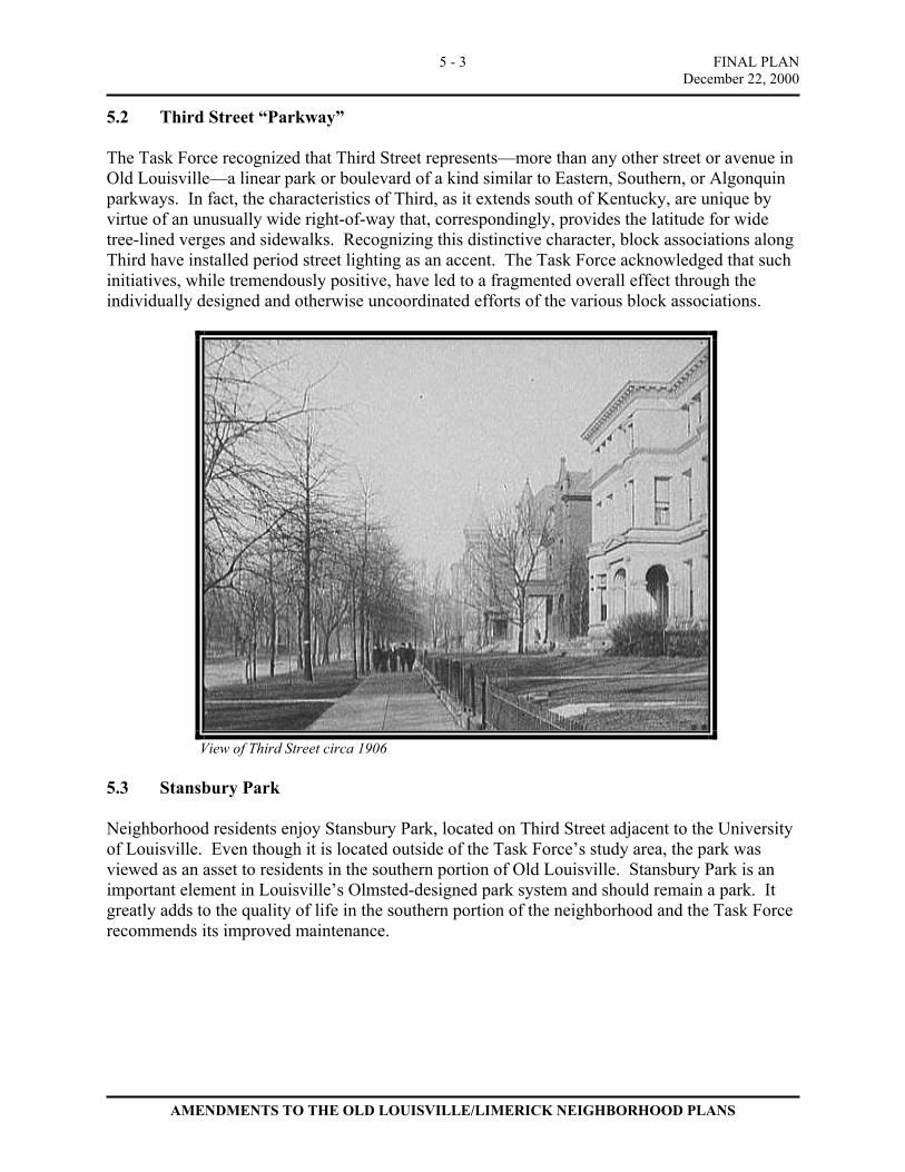
FINAL PLAN December 22, 2000
AMENDMENTS TO THE OLD LOUISVILLE/LIMERICK NEIGHBORHOOD PLANS
5 - 3
5.2 Third Street “Parkway” The Task Force recognized that Third Street represents—more than any other street or avenue in Old Louisville—a linear park or boulevard of a kind similar to Eastern, Southern, or Algonquin parkways. In fact, the characteristics of Third, as it extends south of Kentucky, are unique by virtue of an unusually wide right-of-way that, correspondingly, provides the latitude for wide tree-lined verges and sidewalks. Recognizing this distinctive character, block associations along Third have installed period street lighting as an accent. The Task Force acknowledged that such initiatives, while tremendously positive, have led to a fragmented overall effect through the individually designed and otherwise uncoordinated efforts of the various block associations.
View of Third Street circa 1906
5.3 Stansbury Park Neighborhood residents enjoy Stansbury Park, located on Third Street adjacent to the University of Louisville. Even though it is located outside of the Task Force’s study area, the park was viewed as an asset to residents in the southern portion of Old Louisville. Stansbury Park is an important element in Louisville’s Olmsted-designed park system and should remain a park. It greatly adds to the quality of life in the southern portion of the neighborhood and the Task Force recommends its improved maintenance.
FINAL PLAN December 22, 2000
AMENDMENTS TO THE OLD LOUISVILLE/LIMERICK NEIGHBORHOOD PLANS
5 - 4
5.4 Secondary Parks The Task Force’s principal concern was with the absence of other parks or playgrounds in the remainder of the neighborhood, although a few, such as Toonerville Trolley Park on Brook Street to Magnolia Park on Second Street, do exist. There was consensus that the urban design plan to be produced for the South of Broadway (Sobro) area should consider additional park space to serve the Limerick and South of Broadway neighborhoods. 5.5 Other Recommendations The Task Force recommends that Metro Parks give priority to updating its master plan for parks in Old Louisville and Limerick as an appropriate and necessary supplement to the amended neighborhood plan. A master plan for parks and green space in the study area should study the distribution of existing parks and identify locations for additional neighborhood serving parks and open spaces. The Task Force also recommends that Metro Parks devise a strategy that provides sufficient resources to maintain all neighborhood parks.
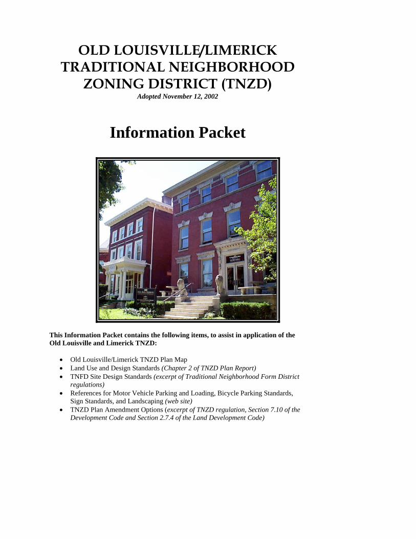
OLD LOUISVILLE/LIMERICK TRADITIONAL NEIGHBORHOOD
ZONING DISTRICT (TNZD) Adopted November 12, 2002
Information Packet
This Information Packet contains the following items, to assist in application of the Old Louisville and Limerick TNZD:
• Old Louisville/Limerick TNZD Plan Map • Land Use and Design Standards (Chapter 2 of TNZD Plan Report) • TNFD Site Design Standards (excerpt of Traditional Neighborhood Form District
regulations) • References for Motor Vehicle Parking and Loading, Bicycle Parking Standards,
Sign Standards, and Landscaping (web site) • TNZD Plan Amendment Options (excerpt of TNZD regulation, Section 7.10 of the
Development Code and Section 2.7.4 of the Land Development Code)
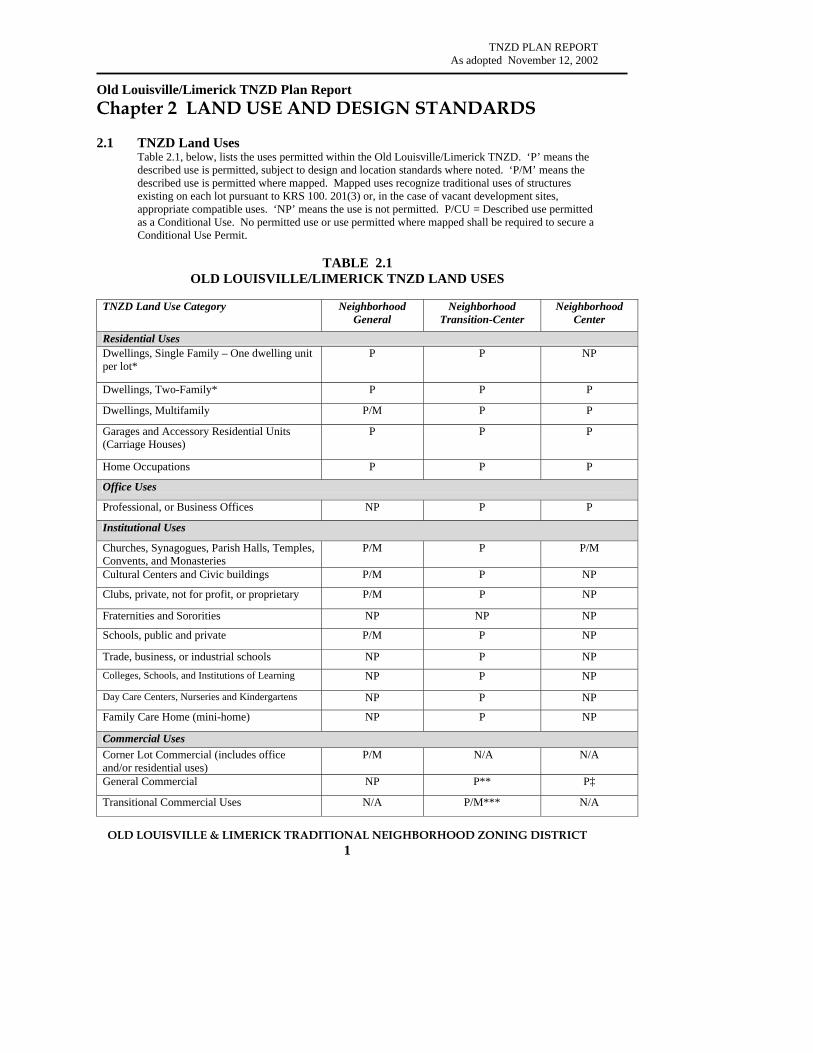
TNZD PLAN REPORT As adopted November 12, 2002
OLD LOUISVILLE & LIMERICK TRADITIONAL NEIGHBORHOOD ZONING DISTRICT 1
Old Louisville/Limerick TNZD Plan Report Chapter 2 LAND USE AND DESIGN STANDARDS 2.1 TNZD Land Uses
Table 2.1, below, lists the uses permitted within the Old Louisville/Limerick TNZD. ‘P’ means the described use is permitted, subject to design and location standards where noted. ‘P/M’ means the described use is permitted where mapped. Mapped uses recognize traditional uses of structures existing on each lot pursuant to KRS 100. 201(3) or, in the case of vacant development sites, appropriate compatible uses. ‘NP’ means the use is not permitted. P/CU = Described use permitted as a Conditional Use. No permitted use or use permitted where mapped shall be required to secure a Conditional Use Permit.
TABLE 2.1 OLD LOUISVILLE/LIMERICK TNZD LAND USES
TNZD Land Use Category Neighborhood
General Neighborhood
Transition-Center Neighborhood
Center
Residential Uses Dwellings, Single Family – One dwelling unit per lot*
P P NP
Dwellings, Two-Family* P P P
Dwellings, Multifamily P/M P P
Garages and Accessory Residential Units (Carriage Houses)
P P P
Home Occupations P P P
Office Uses
Professional, or Business Offices NP P P
Institutional Uses
Churches, Synagogues, Parish Halls, Temples, Convents, and Monasteries
P/M P P/M
Cultural Centers and Civic buildings P/M P NP
Clubs, private, not for profit, or proprietary P/M P NP
Fraternities and Sororities NP NP NP
Schools, public and private P/M P NP
Trade, business, or industrial schools NP P NP Colleges, Schools, and Institutions of Learning NP P NP
Day Care Centers, Nurseries and Kindergartens NP P NP
Family Care Home (mini-home) NP P NP
Commercial Uses Corner Lot Commercial (includes office and/or residential uses)
P/M N/A N/A
General Commercial NP P** P‡
Transitional Commercial Uses N/A P/M*** N/A

TNZD PLAN REPORT As adopted November 12, 2002
OLD LOUISVILLE & LIMERICK TRADITIONAL NEIGHBORHOOD ZONING DISTRICT 2
Table 2.1 (continued) Old Louisville/Limerick TNZD Land Uses
TNZD Land Use Category Neighborhood General
Neighborhood Transition-Center
Neighborhood Center
Other Uses
Bed and Breakfast Inns P/CU P/CU P/CU
Original Use of Structure P P P
Storage sheds P P P
Accessory Uses P P P
Temporary Buildings, Uses, or Activities P P P
Historic House Museums P/CU P/CU P/CU
Community Centers, Parks, and Playgrounds – not for profit
P/CU P NP
* Plus one dwelling unit in the Accessory Structure Area ** See Table 2.3.1 for the specific permitted uses *** See Table 2.3.2 for the specific permitted uses ‡ See Table 2.4.1 for the specific permitted uses. Commercial uses only are permitted at ground level facing the street where shown on the TNZD Plan Map. N/A = Not applicable, since commercial uses are permitted in the Neighborhood Transition—Center and Neighborhood Center Building uses in effect prior to the adoption of these regulations and operating in a legal fashion according to the prior zoning classification of the property, including legal non-conforming uses, may continue to operate under the Traditional Neighborhood Zoning District. Legal non-conforming uses may not be expanded. Subsequent sections of this chapter provide more detailed information on uses permitted in the three TNZD components. “Replacement structures” referenced in the following tables means new construction on sites that were occupied by contributing principal structures on the effective date of the TNZD zoning classification.
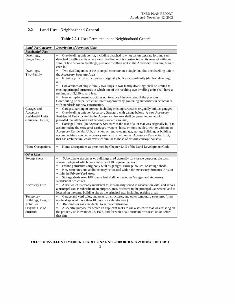
TNZD PLAN REPORT As adopted November 12, 2002
OLD LOUISVILLE & LIMERICK TRADITIONAL NEIGHBORHOOD ZONING DISTRICT 3
2.2 Land Uses: Neighborhood General
Table 2.2.1 Uses Permitted in the Neighborhood General
Land Use Category Description of Permitted Uses Residential Uses Dwellings, Single Family
One dwelling unit per lot, including attached row houses on separate lots and semi-detached dwelling units where each dwelling unit is constructed on its own lot with one zero lot line between dwellings, plus one dwelling unit in the Accessory Structure Area of each lot
Dwellings, Two-Family
Two dwelling units in the principal structure on a single lot, plus one dwelling unit in the Accessory Structure Area Existing principal structure was originally built as a two-family (duplex) dwelling
unit. Conversions of single family dwellings to two-family dwellings shall be limited to
existing principal structures in which one of the resulting two dwelling units shall have a minimum of 2,250 square feet. New or replacement structures not to exceed the footprint of the previous
Contributing principal structure, unless approved by governing authorities in accordance with standards for new construction.
Garages and Accessory Residential Units (Carriage Houses)
Garages, parking or storage, including existing structures originally built as garages One dwelling unit per Accessory Structure with garage below. A new Accessory
Residential Units located in the Accessory Use area shall be permitted on any lot, provided that all design and parking standards are met, Carriage House (an Accessory Structure at the rear of a lot that was originally built to
accommodate the storage of carriages, wagons, horse or mule stables, with or without an Accessory Residential Unit; or a new or renovated garage, storage building, or building accommodating another accessory use, with or without an Accessory Residential Unit, that has architectural characteristics similar to those of historic carriage houses)
Home Occupations Home Occupations as permitted by Chapter 4.4.5 of the Land Development Code
Other Uses Storage sheds Subordinate structures or buildings used primarily for storage purposes, the total
square footage of which does not exceed 100 square feet each. Existing structures originally built as garages, carriage houses, or storage sheds. New structures and additions may be located within the Accessory Structure Area or
within the Private Yard Area. Storage sheds over 100 square feet shall be treated as Garages and Accessory
Residential Structures. Accessory Uses A use which is clearly incidental to, customarily found in association with, and serves
a principal use; is subordinate in purpose, area, or extent to the principal use served; and is located on the same building site as the principal use, including parking areas.
Temporary Buildings, Uses, or Activities
Garage and yard sales, and tents, air structures, and other temporary structures (must not be displayed more than 10 days in a calendar year).
Buildings or uses incidental to active construction. Original Use of Structure
A specific purpose for which an applicant seeks to use a structure that was existing on the property on November 22, 1926, and for which said structure was used on or before that date.
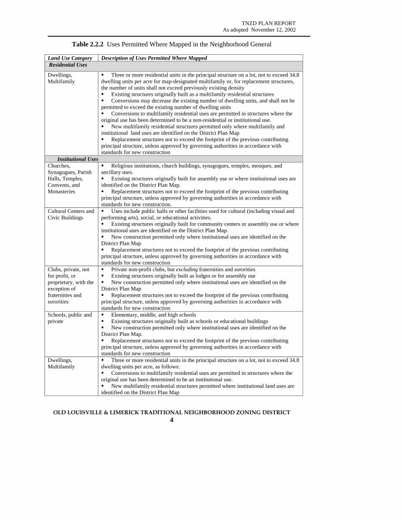
TNZD PLAN REPORT As adopted November 12, 2002
OLD LOUISVILLE & LIMERICK TRADITIONAL NEIGHBORHOOD ZONING DISTRICT 4
Table 2.2.2 Uses Permitted Where Mapped in the Neighborhood General
Land Use Category Description of Uses Permitted Where Mapped Residential Uses
Dwellings, Multifamily
Three or more residential units in the principal structure on a lot, not to exceed 34.8 dwelling units per acre for map-designated multifamily or, for replacement structures, the number of units shall not exceed previously existing density Existing structures originally built as a multifamily residential structures Conversions may decrease the existing number of dwelling units, and shall not be
permitted to exceed the existing number of dwelling units Conversions to multifamily residential uses are permitted in structures where the
original use has been determined to be a non-residential or institutional use. New multifamily residential structures permitted only where multifamily and
institutional land uses are identified on the District Plan Map Replacement structures not to exceed the footprint of the previous contributing
principal structure, unless approved by governing authorities in accordance with standards for new construction
Institutional Uses Churches, Synagogues, Parish Halls, Temples, Convents, and Monasteries
Religious institutions, church buildings, synagogues, temples, mosques, and ancillary uses. Existing structures originally built for assembly use or where institutional uses are
identified on the District Plan Map. Replacement structures not to exceed the footprint of the previous contributing
principal structure, unless approved by governing authorities in accordance with standards for new construction.
Cultural Centers and Civic Buildings
Uses include public halls or other facilities used for cultural (including visual and performing arts), social, or educational activities. Existing structures originally built for community centers or assembly use or where
institutional uses are identified on the District Plan Map. New construction permitted only where institutional uses are identified on the
District Plan Map Replacement structures not to exceed the footprint of the previous contributing
principal structure, unless approved by governing authorities in accordance with standards for new construction
Clubs, private, not for profit, or proprietary, with the exception of fraternities and sororities
Private non-profit clubs, but excluding fraternities and sororities Existing structures originally built as lodges or for assembly use New construction permitted only where institutional uses are identified on the
District Plan Map Replacement structures not to exceed the footprint of the previous contributing
principal structure, unless approved by governing authorities in accordance with standards for new construction
Schools, public and private
Elementary, middle, and high schools Existing structures originally built as schools or educational buildings New construction permitted only where institutional uses are identified on the
District Plan Map. Replacement structures not to exceed the footprint of the previous contributing
principal structure, unless approved by governing authorities in accordance with standards for new construction
Dwellings, Multifamily
Three or more residential units in the principal structure on a lot, not to exceed 34.8 dwelling units per acre, as follows: Conversions to multifamily residential uses are permitted in structures where the
original use has been determined to be an institutional use. New multifamily residential structures permitted where institutional land uses are
identified on the District Plan Map

TNZD PLAN REPORT As adopted November 12, 2002
OLD LOUISVILLE & LIMERICK TRADITIONAL NEIGHBORHOOD ZONING DISTRICT 5
Table 2.2.2 (continued) Uses Permitted Where Mapped in the Neighborhood General
Land Use Category Description of Uses Permitted Where Mapped Commercial Uses Corner Lot Commercial
Existing structures originally built as corner lot commercial buildings, with designated commercial uses limited to the first floor. Any floor may be used for office uses as permitted for Neighborhood Center—Transition and/or residential uses. New construction permitted only where corner lot commercial uses are identified
on the District Plan Map, provided total gross floor area of commercial/retail use does not exceed 5,000 square feet on the first floor and is accessible from the public sidewalk. Any floor may be used for office and/or residential uses. Replacement structures shall not to exceed the footprint of the previous
contributing principal structure, unless approved by governing authorities in accordance with standards for new construction.
Permitted corner lot commercial uses include: Antique shops and interior decorating shops Bakeries and delicatessens, retail sales Art and craft galleries Beauty salons and barber shops Music and art supply stores Photographic studios and shops Book stores and stationery stores Candy stores, retail sales Pharmacies Convenience grocery stores Coin laundries Dry-cleaning pick-up only Restaurants, including coffee houses, tea rooms, and cafes where food and drink may be
served or consumed outside or inside (no drive-through service permitted) Toy and hobby stores Clothing stores Other similar neighborhood-serving retail uses as established by the Planning
Commission
Table 2.2.3 Uses Permitted as Conditional Uses in the Neighborhood General Land Use Category Description of Uses Permitted as Conditional Uses Other Uses Bed & Breakfast Inns
Residential structures used by a resident thereof as a small inn which provides 8 or fewer temporary rooms for hire to short-term guests, and includes a breakfast for the guest or guests at a daily fixed price for the room and breakfast. Meals, meeting facilities, and other services shall be provided only for guests registered at the bed and breakfast inn.
Historic House Museums
Residences having historic and/or architectural significance which members of the public may view with or without charge for admission.
Community Centers, Parks, and Playgrounds – not for profit
Community center is defined as “a facility that is available for public use as a meeting place or for recreation that does not limit access only to members and does not charge membership dues.”
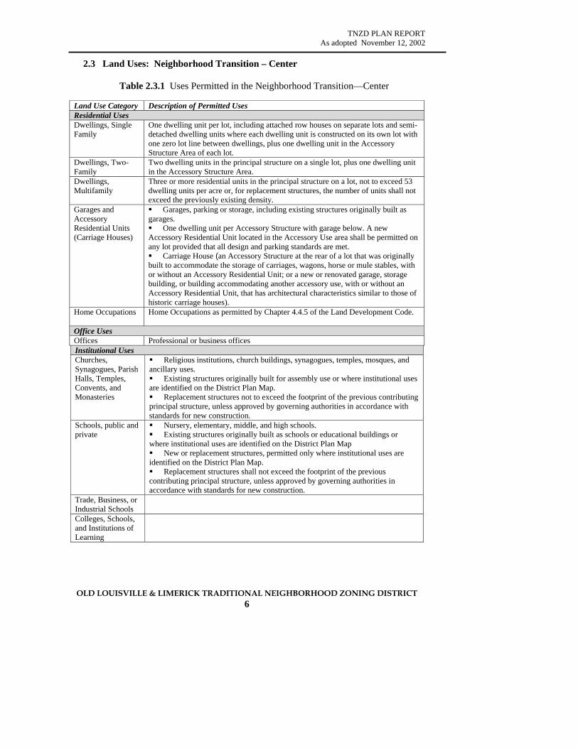
TNZD PLAN REPORT As adopted November 12, 2002
OLD LOUISVILLE & LIMERICK TRADITIONAL NEIGHBORHOOD ZONING DISTRICT 6
2.3 Land Uses: Neighborhood Transition – Center
Table 2.3.1 Uses Permitted in the Neighborhood Transition—Center
Land Use Category Description of Permitted Uses Residential Uses Dwellings, Single Family
One dwelling unit per lot, including attached row houses on separate lots and semi-detached dwelling units where each dwelling unit is constructed on its own lot with one zero lot line between dwellings, plus one dwelling unit in the Accessory Structure Area of each lot.
Dwellings, Two-Family
Two dwelling units in the principal structure on a single lot, plus one dwelling unit in the Accessory Structure Area.
Dwellings, Multifamily
Three or more residential units in the principal structure on a lot, not to exceed 53 dwelling units per acre or, for replacement structures, the number of units shall not exceed the previously existing density.
Garages and Accessory Residential Units (Carriage Houses)
Garages, parking or storage, including existing structures originally built as garages. One dwelling unit per Accessory Structure with garage below. A new
Accessory Residential Unit located in the Accessory Use area shall be permitted on any lot provided that all design and parking standards are met. Carriage House (an Accessory Structure at the rear of a lot that was originally
built to accommodate the storage of carriages, wagons, horse or mule stables, with or without an Accessory Residential Unit; or a new or renovated garage, storage building, or building accommodating another accessory use, with or without an Accessory Residential Unit, that has architectural characteristics similar to those of historic carriage houses).
Home Occupations Home Occupations as permitted by Chapter 4.4.5 of the Land Development Code.
Office Uses Offices Professional or business offices Institutional Uses Churches, Synagogues, Parish Halls, Temples, Convents, and Monasteries
Religious institutions, church buildings, synagogues, temples, mosques, and ancillary uses. Existing structures originally built for assembly use or where institutional uses
are identified on the District Plan Map. Replacement structures not to exceed the footprint of the previous contributing
principal structure, unless approved by governing authorities in accordance with standards for new construction.
Schools, public and private
Nursery, elementary, middle, and high schools. Existing structures originally built as schools or educational buildings or
where institutional uses are identified on the District Plan Map New or replacement structures, permitted only where institutional uses are
identified on the District Plan Map. Replacement structures shall not exceed the footprint of the previous
contributing principal structure, unless approved by governing authorities in accordance with standards for new construction.
Trade, Business, or Industrial Schools
Colleges, Schools, and Institutions of Learning
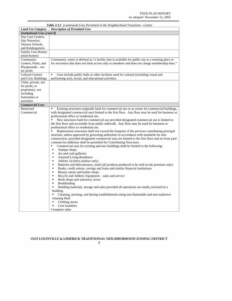
TNZD PLAN REPORT As adopted November 12, 2002
OLD LOUISVILLE & LIMERICK TRADITIONAL NEIGHBORHOOD ZONING DISTRICT 7
Table 2.3.1 (continued) Uses Permitted in the Neighborhood Transition—Center Land Use Category Description of Permitted Uses Institutional Uses (cont’d) Day Care Centers, Day Nurseries, Nursery Schools, and Kindergartens
Family Care Homes (mini-homes)
Community Centers, Parks, and Playgrounds – not for profit
Community center is defined as “a facility that is available for public use as a meeting place or for recreation that does not limit access only to members and does not charge membership dues.”
Cultural Centers and Civic Buildings
Uses include public halls or other facilities used for cultural (including visual and performing arts), social, and educational activities.
Clubs, private, not for profit, or proprietary, not including fraternities or sororities
Commercial Uses Restricted Commercial
Existing structures originally built for commercial use or as corner lot commercial buildings, with designated commercial uses limited to the first floor. Any floor may be used for business or professional office or residential use. New structures built for commercial use provided designated commercial use is limited to
the first floor and accessible from public sidewalk. Any floor may be used for business or professional office or residential use. Replacement structures shall not exceed the footprint of the previous contributing principal
structure, unless approved by governing authorities in accordance with standards for new construction, provided designated commercial uses are limited to the first floor and no front yard commercial additions shall be permitted for Contributing Structures. Commercial uses for existing and new buildings shall be limited to the following: Antique shops Art and craft galleries Assisted Living Residence Athletic facilities (indoor only) Bakeries and delicatessens, retail (all products produced to be sold on the premises only) Banks, credit unions, savings and loans and similar financial institutions Beauty salons and barber shops Bicycle and Athletic Equipment – sales and service Book shops and stationery stores Bookbinding Building materials, storage and sales provided all operations are totally enclosed in a
building Cleaning, pressing, and dyeing establishments using non-flammable and non-explosive
cleaning fluid Clothing stores Coin laundries
Computer sales

TNZD PLAN REPORT As adopted November 12, 2002
OLD LOUISVILLE & LIMERICK TRADITIONAL NEIGHBORHOOD ZONING DISTRICT 8
Table 2.3.1 (continued) Uses Permitted in the Neighborhood Transition—Center Land Use Category Description of Permitted Uses Restricted Commercial
Confectionery or candy stores, retail (all products produced to be sold on the premises only) Dancing instruction Department stores Dressmaking or millinery shops Drug stores / Pharmacies Dry cleaning, dyeing, pressing, and laundry; distributing stations or retail business where
no cleaning, dyeing, pressing or laundry is done for other distributing stations or cleaning establishments Dry goods and notion stores Electric appliance stores, including radio and television Engraving, watchmaking and jewelry manufacturing, where products are sold on premises Equipment rental, where all activities are within a building Extended stay lodging Family day care home Florists and sundry stores Funeral homes Furniture stores Governmental buildings Grocery stores Hardware and paint stores Health clubs & salons Homes for infirm and aged Hotels and motels Interior decorating shops Jewelry stores Libraries, museums, historical buildings and grounds, arboretums, aquariums, and art
galleries Medical laboratories, not including plasma or blood collecting centers Monument sales, provided that all activities are within a building Music and art supply stores Music and vocal instructions Nurseries, retail Nursing homes Pet shops Photocopying, duplicating, paper folding, mail processing and related services Photographic studios and shops Picture framing Printing, lithographing, or publishing establishments, if constructed to insure that there is
no noise or vibration evident outside the walls of the buildings Public transportation passenger terminals Restaurants, including coffee houses, tea rooms, and cafes, where food and drink may be
served or consumed outside or inside (no drive-through service permitted) Retail or wholesale stores or businesses not involving any kind of manufacture, processing
or treatment of products other than that which is clearly incidental to the business conducted on the premises, and provided that not more than fifty (50) percent of the floor area of the building is used in the manufacture, processing, or treatment of products, and that such operations or products are not objectionable due to noise, odor, dust, smoke, vibration, or other similar causes
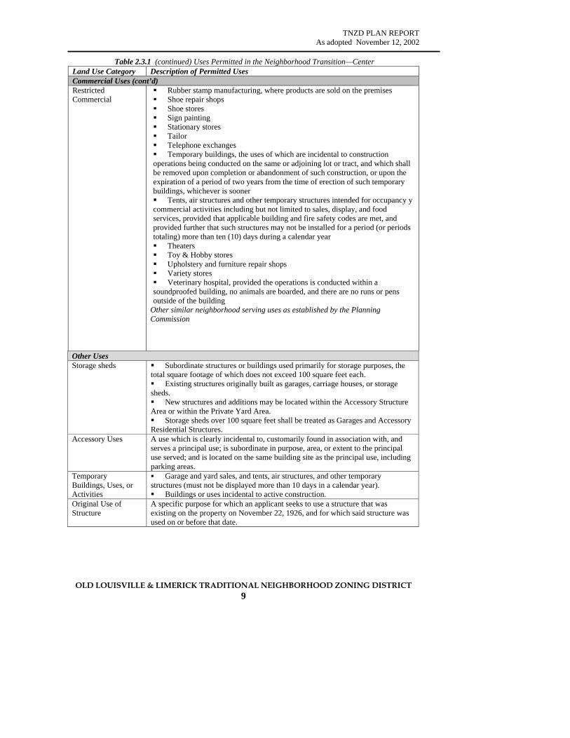
TNZD PLAN REPORT As adopted November 12, 2002
OLD LOUISVILLE & LIMERICK TRADITIONAL NEIGHBORHOOD ZONING DISTRICT 9
Table 2.3.1 (continued) Uses Permitted in the Neighborhood Transition—Center Land Use Category Description of Permitted Uses Commercial Uses (cont’d) Restricted Commercial
Rubber stamp manufacturing, where products are sold on the premises Shoe repair shops Shoe stores Sign painting Stationary stores Tailor Telephone exchanges Temporary buildings, the uses of which are incidental to construction
operations being conducted on the same or adjoining lot or tract, and which shall be removed upon completion or abandonment of such construction, or upon the expiration of a period of two years from the time of erection of such temporary buildings, whichever is sooner Tents, air structures and other temporary structures intended for occupancy y
commercial activities including but not limited to sales, display, and food services, provided that applicable building and fire safety codes are met, and provided further that such structures may not be installed for a period (or periods totaling) more than ten (10) days during a calendar year Theaters Toy & Hobby stores Upholstery and furniture repair shops Variety stores Veterinary hospital, provided the operations is conducted within a
soundproofed building, no animals are boarded, and there are no runs or pens outside of the building
Other similar neighborhood serving uses as established by the Planning Commission
Other Uses Storage sheds Subordinate structures or buildings used primarily for storage purposes, the
total square footage of which does not exceed 100 square feet each. Existing structures originally built as garages, carriage houses, or storage
sheds. New structures and additions may be located within the Accessory Structure
Area or within the Private Yard Area. Storage sheds over 100 square feet shall be treated as Garages and Accessory
Residential Structures. Accessory Uses A use which is clearly incidental to, customarily found in association with, and
serves a principal use; is subordinate in purpose, area, or extent to the principal use served; and is located on the same building site as the principal use, including parking areas.
Temporary Buildings, Uses, or Activities
Garage and yard sales, and tents, air structures, and other temporary structures (must not be displayed more than 10 days in a calendar year). Buildings or uses incidental to active construction.
Original Use of Structure
A specific purpose for which an applicant seeks to use a structure that was existing on the property on November 22, 1926, and for which said structure was used on or before that date.
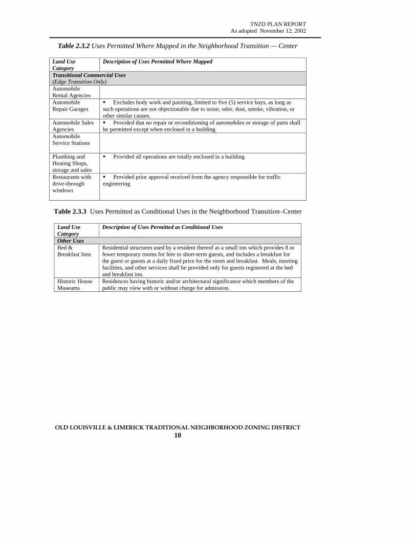
TNZD PLAN REPORT As adopted November 12, 2002
OLD LOUISVILLE & LIMERICK TRADITIONAL NEIGHBORHOOD ZONING DISTRICT 10
Table 2.3.2 Uses Permitted Where Mapped in the Neighborhood Transition — Center
Land Use Category
Description of Uses Permitted Where Mapped
Transitional Commercial Uses (Edge Transition Only) Automobile Rental Agencies
Automobile Repair Garages
Excludes body work and painting, limited to five (5) service bays, as long as such operations are not objectionable due to noise, odor, dust, smoke, vibration, or other similar causes.
Automobile Sales Agencies
Provided that no repair or reconditioning of automobiles or storage of parts shall be permitted except when enclosed in a building.
Automobile Service Stations
Plumbing and Heating Shops, storage and sales
Provided all operations are totally enclosed in a building
Restaurants with drive-through windows
Provided prior approval received from the agency responsible for traffic engineering
Table 2.3.3 Uses Permitted as Conditional Uses in the Neighborhood Transition–Center
Land Use Category
Description of Uses Permitted as Conditional Uses
Other Uses Bed & Breakfast Inns
Residential structures used by a resident thereof as a small inn which provides 8 or fewer temporary rooms for hire to short-term guests, and includes a breakfast for the guest or guests at a daily fixed price for the room and breakfast. Meals, meeting facilities, and other services shall be provided only for guests registered at the bed and breakfast inn.
Historic House Museums
Residences having historic and/or architectural significance which members of the public may view with or without charge for admission.
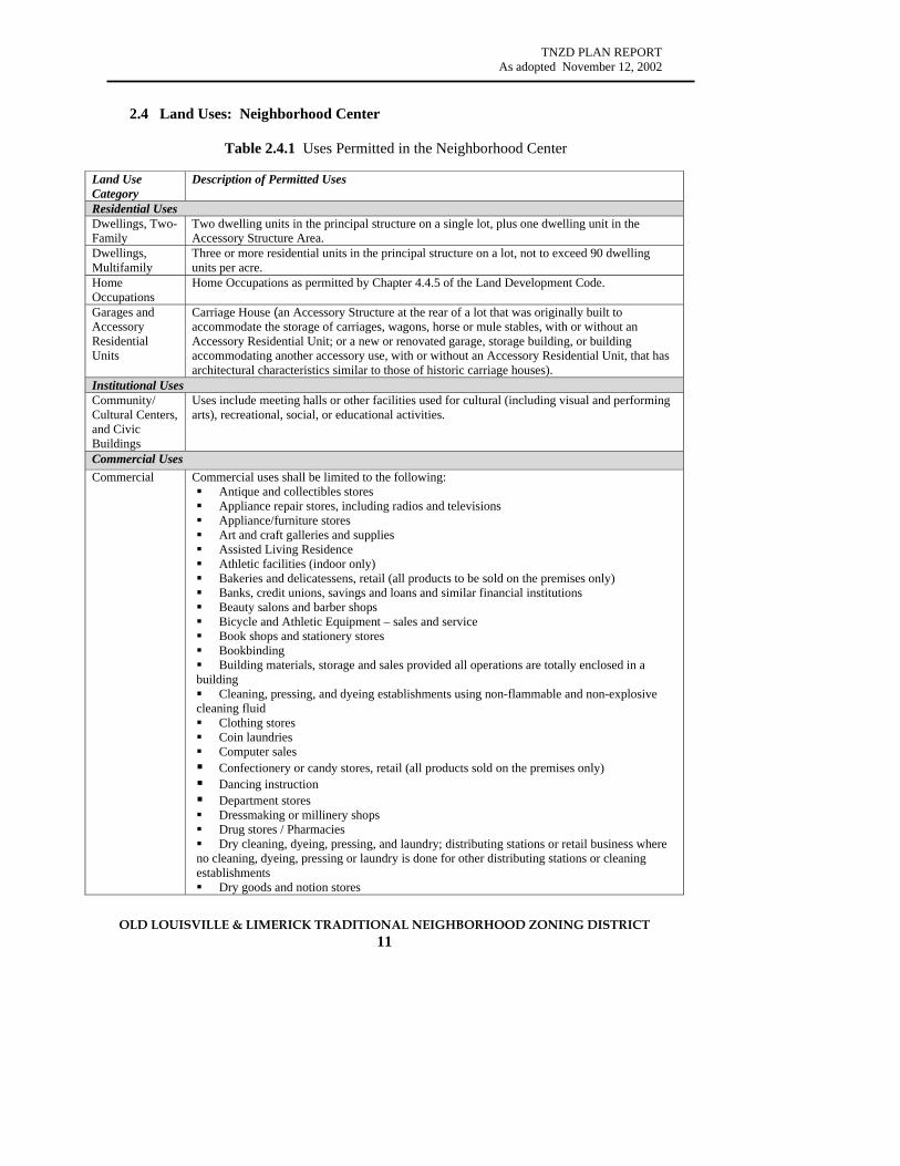
TNZD PLAN REPORT As adopted November 12, 2002
OLD LOUISVILLE & LIMERICK TRADITIONAL NEIGHBORHOOD ZONING DISTRICT 11
2.4 Land Uses: Neighborhood Center
Table 2.4.1 Uses Permitted in the Neighborhood Center
Land Use Category
Description of Permitted Uses
Residential Uses Dwellings, Two-Family
Two dwelling units in the principal structure on a single lot, plus one dwelling unit in the Accessory Structure Area.
Dwellings, Multifamily
Three or more residential units in the principal structure on a lot, not to exceed 90 dwelling units per acre.
Home Occupations
Home Occupations as permitted by Chapter 4.4.5 of the Land Development Code.
Garages and Accessory Residential Units
Carriage House (an Accessory Structure at the rear of a lot that was originally built to accommodate the storage of carriages, wagons, horse or mule stables, with or without an Accessory Residential Unit; or a new or renovated garage, storage building, or building accommodating another accessory use, with or without an Accessory Residential Unit, that has architectural characteristics similar to those of historic carriage houses).
Institutional Uses Community/ Cultural Centers, and Civic Buildings
Uses include meeting halls or other facilities used for cultural (including visual and performing arts), recreational, social, or educational activities.
Commercial Uses Commercial Commercial uses shall be limited to the following:
Antique and collectibles stores Appliance repair stores, including radios and televisions Appliance/furniture stores Art and craft galleries and supplies Assisted Living Residence Athletic facilities (indoor only) Bakeries and delicatessens, retail (all products to be sold on the premises only) Banks, credit unions, savings and loans and similar financial institutions Beauty salons and barber shops Bicycle and Athletic Equipment – sales and service Book shops and stationery stores Bookbinding Building materials, storage and sales provided all operations are totally enclosed in a
building Cleaning, pressing, and dyeing establishments using non-flammable and non-explosive
cleaning fluid Clothing stores Coin laundries Computer sales Confectionery or candy stores, retail (all products sold on the premises only) Dancing instruction Department stores Dressmaking or millinery shops Drug stores / Pharmacies Dry cleaning, dyeing, pressing, and laundry; distributing stations or retail business where
no cleaning, dyeing, pressing or laundry is done for other distributing stations or cleaning establishments Dry goods and notion stores

TNZD PLAN REPORT As adopted November 12, 2002
OLD LOUISVILLE & LIMERICK TRADITIONAL NEIGHBORHOOD ZONING DISTRICT 12
Table 2.4.1 (continued) Uses Permitted in the Neighborhood Center Commercial Uses (cont’d) Commercial Engraving, watchmaking and jewelry manufacturing, products are sold on
premises Equipment rental, where all activities are within a building Extended stay lodging Family day care home Florists and sundry stores Funeral homes Furniture stores Governmental buildings Grocery stores Hardware and paint stores Health clubs & salons Homes for infirm and aged Hotels and motels Interior decorating shops Jewelry stores Libraries, museums, historical buildings and grounds, arboretums, aquariums, and
art galleries Medical laboratories, not including plasma or blood collecting centers Monument sales, provided that all activities are within a building Music supply stores, Music and vocal instructions Neighborhood pubs and live music in restaurants Nurseries, retail Nursing homes Package liquor stores (where alcohol is not consumed on the premises) Pet shops Photocopying, duplicating, paper folding, mail processing and related services Photographic studios and shops Picture framing Printing, lithographing, or publishing establishments, if constructed to insure that
there is no noise or vibration evident outside the walls of the buildings Public transportation passenger terminals Restaurants, including coffee houses, tea rooms, and cafes, where food and drink
may be served or consumed outside or inside (no drive-through service permitted) Retail or wholesale stores or businesses not involving any kind of manufacture,
processing or treatment of products other than that which is clearly incidental to the business conducted on the premises, and provided that not more than fifty (50) percent of the floor area of the building is used in the manufacture, processing, or treatment of products, and that such operations or products are not objectionable due to noise, odor, dust, smoke, vibration, or other similar causes Rubber stamp manufacturing, where products are sold on the premises Shoe repair shops Shoe stores Sign painting Stationary stores Tailor Telephone exchanges
Temporary buildings, the uses of which are incidental to construction operations being conducted on the same or adjoining lot or tract, and which shall be removed upon completion or abandonment of such construction, or upon the expiration of a period of two years from the time of erection of such temporary buildings, whichever is sooner

TNZD PLAN REPORT As adopted November 12, 2002
OLD LOUISVILLE & LIMERICK TRADITIONAL NEIGHBORHOOD ZONING DISTRICT 13
Table 2.4.1 (continued) Uses Permitted in the Neighborhood Center Commercial Uses (cont’d)
Commercial Tents, air structures and other temporary structures intended for occupancy y commercial activities including but not limited to sales, display, and food services, provided that applicable building and fire safety codes are met, and provided further that such structures may not be installed for a period (or periods totaling) more than ten (10) days during a calendar year. Theaters Toy & Hobby stores Upholstery and furniture repair shops Variety stores Veterinary hospital, provided the operations is conducted within a soundproofed
building, no animals are boarded, and there are no runs or pens outside of the building Video stores Other similar neighborhood serving uses as established by the Planning
Commission
Office Uses Offices Professional or business offices
Other Uses Storage sheds Subordinate structures or buildings used primarily for storage purposes, the total square
footage of which do not exceed 100 square feet each. Accessory Uses A use which is clearly incidental to, customarily found in association with, and serves a
principal use; is subordinate in purpose, area, or extent to the principal use served; and is located on the same building site as the principal use, including parking areas.
Temporary Buildings, Uses, or Activities
Garage and yard sales, and tents, air structures, and other temporary structures (must not be displayed more than 10 days in a calendar year). Buildings or uses incidental to active construction.
Original Use of Structure
A specific purpose for which an applicant seeks to use a structure that was existing on the property on November 22, 1926, and for which said structure was used on or before that date.
Table 2.4.2 Uses Permitted Where Mapped in the Neighborhood Center
Land Use Category
Description of Uses Permitted Where Mapped
Institutional Uses Churches and Synagogues
Religious institutions, church buildings, synagogues, temples, mosques, and ancillary uses.
Table 2.4.3 Uses Permitted as Conditional Uses in the Neighborhood Center
Land Use Category
Description of Uses Permitted as Conditional Uses
Other Uses Bed & Breakfast Inns
Residential structured used by a resident thereof as a small inn which provides 8 or fewer temporary rooms for hire to short-term guests, and includes a breakfast for the guest or guests at a daily fixed price for the room and breakfast. Meals, meeting facilities, and other services shall be provided only for guests registered at the bed and breakfast inn.
Historic House Museums
Residences having historic and/or architectural significance which members of the public may view with or without charge fro admission
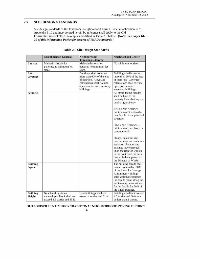
TNZD PLAN REPORT As adopted November 12, 2002
OLD LOUISVILLE & LIMERICK TRADITIONAL NEIGHBORHOOD ZONING DISTRICT 14
2.5 SITE DESIGN STANDARDS Site design standards of the Traditional Neighborhood Form District attached hereto as Appendix 3.10 and incorporated herein by reference shall apply to the Old Louisville/Limerick TNZD except as modified in Table 2.5 below. [Note: See pages 18-29 of this Information Packet for excerpt of TNFD standards.]
Table 2.5 Site Design Standards
Neighborhood General Neighborhood Transition—Center
Neighborhood Center
Lot size
Maintain historic lot patterns; no minimum lot sizes.
Maintain historic lot patterns; no minimum lot sizes.
No minimum lot sizes.
Lot coverage
Buildings shall cover no more than 60% of the area of their lots. Coverage calculations shall exclude open porches and accessory buildings.
Buildings shall cover no more than 90% of the area of their lots. Coverage calculations shall exclude open porches and accessory buildings.
Setbacks
All street-facing facades shall be built to the property lines abutting the public right-of-way. REAR YARD SETBACK - minimum of 5 feet to the rear facade of the principal structure. SIDE YARD SETBACK – minimum of zero feet to a common wall. Stoops, balconies and porches may encroach into setbacks. Arcades and awnings may encroach upon the right-of-way up to one foot from the curb line with the approval of the Director of Works.
Building façade
The building facade shall extend no less than 80% of the linear lot frontage. A minimum 4 ft. high solid wall that continues the façade plane along the lot line may be substituted for the facade for 50% of the linear frontage.
Building Height
New buildings in an undeveloped block shall not exceed 3.5 stories and 45 ft.
New buildings shall not exceed 4 stories and 51 ft.
Buildings shall not exceed 4.5 stories and 60 ft. nor be less than 2 stories.

TNZD PLAN REPORT As adopted November 12, 2002
OLD LOUISVILLE & LIMERICK TRADITIONAL NEIGHBORHOOD ZONING DISTRICT 15
2.6 BUILDING DESIGN STANDARDS
Building design standards of the Traditional Neighborhood Form District attached hereto as Appendix 3.10 and incorporated herein by reference, together with the Design Review Guidelines as adopted for the Old Louisville and Limerick Preservation Districts, shall apply to the Old Louisville/Limerick TNZD to ensure compatibility of building types and to relate new buildings to the building traditions of the neighborhood. To the extent that design standards of the Form District conflict with Preservation District Guidelines, the more restrictive requirement shall prevail. [Note: see pages 18-29 of this Information Packet for excerpt of TNFD standards.]
2.7 PARKING and LOADING
1. The provisions of the Motor Vehicle and Bicycle Parking and Loading Standards for Traditional Neighborhood Form Districts attached hereto as Appendix 3.11 and incorporated herein by reference shall apply to the Old Louisville/Limerick TNZD, except as modified below. [Note: Refer to page 30 of this Information Packet.]
2. Parking lots may not be adjacent to a street intersection or a square and may not
occupy lots that terminate a street vista. Parking lots otherwise located adjacent to a street or a residential use shall be screened in accordance with the standards of the Land Development Code. The sole access to all off-street surface parking shall be from the alley where an alley abuts the lot. Where existing alley design or configuration limits or significantly impedes access to the proposed parking; or when the addition of the proposed parking will significantly increase traffic on the affected alley, the Planning Commission can grant exceptions to this rule.
3. New Accessory Residential Units (Carriage Houses) on residential lots shall not
be considered as additional units for the calculation of minimum parking requirements but shall provide one additional parking space for the accessory residential unit.
4. Parking for commercial uses in the Neighborhood Center and Neighborhood
Transition – Center zones, as well as for corner commercial structures in the Neighborhood General, shall not exceed the parking minimum requirements established by Appendix 3.11. Uses in the Neighborhood Center may provide required parking anywhere in the Neighborhood Center without application for a waiver, provided that all site design standards are met. Shared parking facilities are encouraged in the Neighborhood Center and Neighborhood Transition – Center.
5. Table 2.7., “Parking Requirements by Zone and Use,” describes minimum
parking requirements for the TNZD.
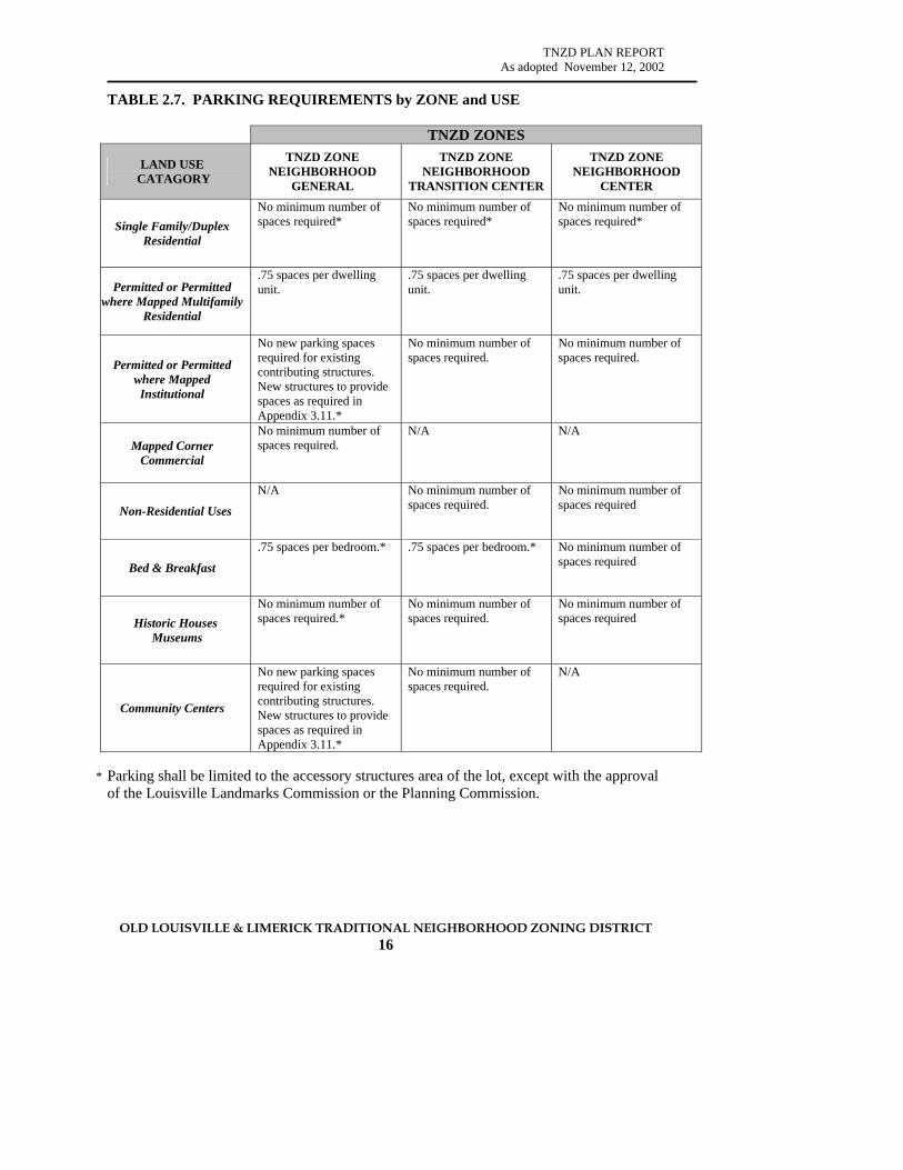
TNZD PLAN REPORT As adopted November 12, 2002
OLD LOUISVILLE & LIMERICK TRADITIONAL NEIGHBORHOOD ZONING DISTRICT 16
TABLE 2.7. PARKING REQUIREMENTS by ZONE and USE
TNZD ZONES
LAND USE CATAGORY
TNZD ZONE NEIGHBORHOOD
GENERAL
TNZD ZONE NEIGHBORHOOD
TRANSITION CENTER
TNZD ZONE NEIGHBORHOOD
CENTER
Single Family/Duplex Residential
No minimum number of spaces required*
No minimum number of spaces required*
No minimum number of spaces required*
Permitted or Permitted where Mapped Multifamily
Residential
.75 spaces per dwelling unit.
.75 spaces per dwelling unit.
.75 spaces per dwelling unit.
Permitted or Permitted where Mapped Institutional
No new parking spaces required for existing contributing structures. New structures to provide spaces as required in Appendix 3.11.*
No minimum number of spaces required.
No minimum number of spaces required.
Mapped Corner Commercial
No minimum number of spaces required.
N/A N/A
Non-Residential Uses
N/A No minimum number of spaces required.
No minimum number of spaces required
Bed & Breakfast
.75 spaces per bedroom.* .75 spaces per bedroom.* No minimum number of spaces required
Historic Houses Museums
No minimum number of spaces required.*
No minimum number of spaces required.
No minimum number of spaces required
Community Centers
No new parking spaces required for existing contributing structures. New structures to provide spaces as required in Appendix 3.11.*
No minimum number of spaces required.
N/A
* Parking shall be limited to the accessory structures area of the lot, except with the approval
of the Louisville Landmarks Commission or the Planning Commission.

TNZD PLAN REPORT As adopted November 12, 2002
OLD LOUISVILLE & LIMERICK TRADITIONAL NEIGHBORHOOD ZONING DISTRICT 17
2.8 SIGNS
The sign standards applicable within the Traditional Neighborhood Form District and as contained in the Design Review Guidelines for the Old Louisville and Limerick Preservation Districts shall apply to the TNZD, except as modified below. Until such time as the Land Development Code and sign regulations applicable to the TNFD are in effect, Article 11 of the Development Code shall apply to the TNZD. [Note: Refer to page 30 of this Information Packet.] a. Outdoor advertising signs, as defined in the Land Development Code, are
not permitted within the TNZD. b. All signs within the TNZD shall be attached, awning, canopy, or projecting
signs. Freestanding signs are not permitted, except for real estate rent/sale signs and Bed and Breakfast Inns as provided in paragraph 2.8.e. below.
c. Signs shall conform to the building design standards of the TNZD.
d. Corner commercial structures shall have not more than one lighted or non-lighted attached, awning, or canopy sign facing each street, which shall not exceed 12 sq. ft. in area and shall not extend more than 12” from the face of the façade. A projecting sign having a maximum area of 6 sq. ft. and projecting not more than 42” from the façade may be used in lieu of an attached, awning, or canopy sign.
e. Bed and Breakfast Inns and General/Business or Professional Offices (where
these uses are permitted, and excluding Home Occupations) shall have a maximum of one attached sign not to exceed 6 sq. ft. in area located on the principal façade or porch adjacent to the principal building entrance. Exception: Bed and Breakfast Inns may have one freestanding sign, in lieu of an attached sign, which shall not exceed 6 sq. ft. in area and shall be located within 6 feet of the principal façade of the structure.
f. No sign shall be mounted above the sill of the second floor windows of a
structure.
g. All lighted signs shall only be externally illuminated. 2.9 LANDSCAPING
The landscaping and buffering standards applicable within Traditional Neighborhood Form Districts shall apply to the TNZD. Until such time as the Land Development Code and landscaping standards applicable to the TNFD are in effect, Article 12 of the Development Code shall apply to the TNZD. [Note: see pages 30 of this Information Packet for excerpt of TNFD standards.]
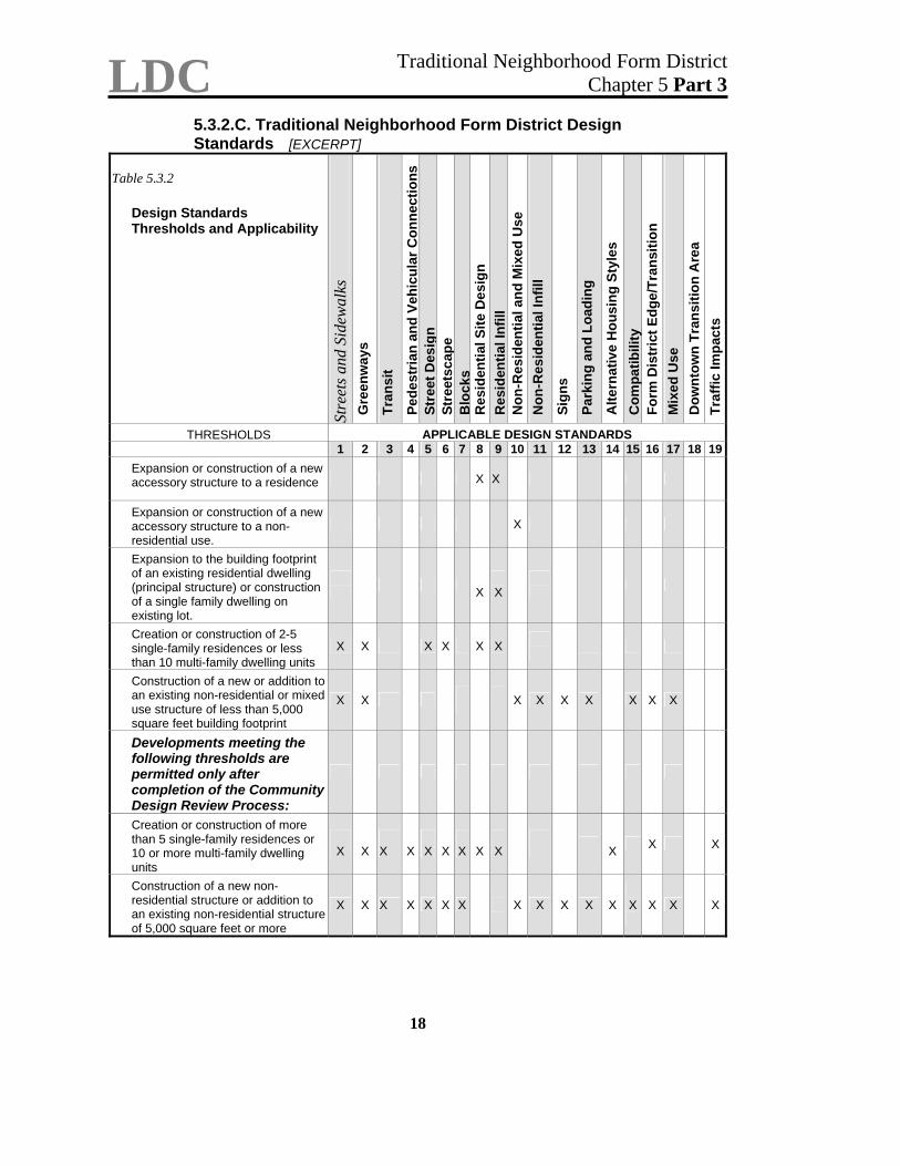
LDC Traditional Neighborhood Form District Chapter 5 Part 3
18
5.3.2.C. Traditional Neighborhood Form District Design Standards [EXCERPT]
Table 5.3.2
Design Standards Thresholds and Applicability
Stre
ets a
nd S
idew
alks
G
reen
way
s
Tran
sit
Pede
stria
n an
d Ve
hicu
lar C
onne
ctio
ns
Stre
et D
esig
n St
reet
scap
e B
lock
s R
esid
entia
l Site
Des
ign
Res
iden
tial I
nfill
N
on-R
esid
entia
l and
Mix
ed U
se
Non
-Res
iden
tial I
nfill
Sign
s
Park
ing
and
Load
ing
Alte
rnat
ive
Hou
sing
Sty
les
Com
patib
ility
Fo
rm D
istr
ict E
dge/
Tran
sitio
n M
ixed
Use
D
ownt
own
Tran
sitio
n A
rea
Traf
fic Im
pact
s
THRESHOLDS APPLICABLE DESIGN STANDARDS 1 2 3 4 5 6 7 8 9 10 11 12 13 14 15 16 17 18 19
Expansion or construction of a new accessory structure to a residence X X
Expansion or construction of a new accessory structure to a non-residential use.
X
Expansion to the building footprint of an existing residential dwelling (principal structure) or construction of a single family dwelling on existing lot.
X
X
Creation or construction of 2-5 single-family residences or less than 10 multi-family dwelling units
X X X X X X
Construction of a new or addition to an existing non-residential or mixed use structure of less than 5,000 square feet building footprint
X X
X X X X X X X
Developments meeting the following thresholds are permitted only after completion of the Community Design Review Process:
Creation or construction of more than 5 single-family residences or 10 or more multi-family dwelling units
X
X
X
X
X
X
X
X
X
X X
X
Construction of a new non-residential structure or addition to an existing non-residential structure of 5,000 square feet or more
X X X X X X X
X X X X X
X
X X
X
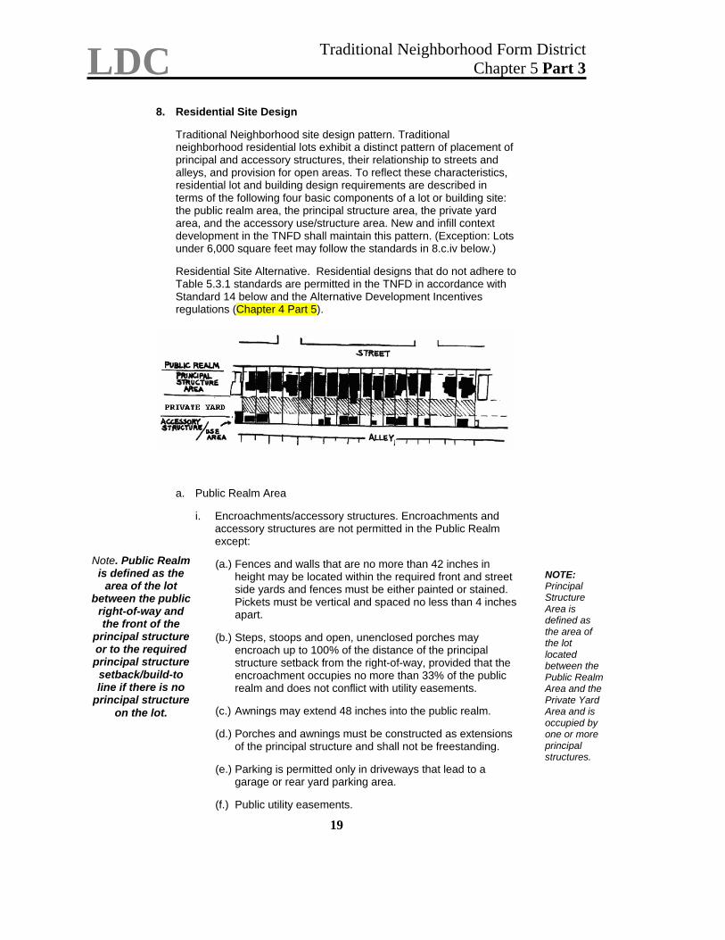
LDC Traditional Neighborhood Form District Chapter 5 Part 3
19
8. Residential Site Design
Traditional Neighborhood site design pattern. Traditional neighborhood residential lots exhibit a distinct pattern of placement of principal and accessory structures, their relationship to streets and alleys, and provision for open areas. To reflect these characteristics, residential lot and building design requirements are described in terms of the following four basic components of a lot or building site: the public realm area, the principal structure area, the private yard area, and the accessory use/structure area. New and infill context development in the TNFD shall maintain this pattern. (Exception: Lots under 6,000 square feet may follow the standards in 8.c.iv below.) Residential Site Alternative. Residential designs that do not adhere to Table 5.3.1 standards are permitted in the TNFD in accordance with Standard 14 below and the Alternative Development Incentives regulations (Chapter 4 Part 5).
a. Public Realm Area
i. Encroachments/accessory structures. Encroachments and
accessory structures are not permitted in the Public Realm except:
Note. Public Realm
is defined as the area of the lot
between the public right-of-way and the front of the
principal structure or to the required principal structure setback/build-to line if there is no
principal structure on the lot.
(a.) Fences and walls that are no more than 42 inches in height may be located within the required front and street side yards and fences must be either painted or stained. Pickets must be vertical and spaced no less than 4 inches apart.
NOTE: Principal Structure Area is defined as the area of the lot located between the Public Realm Area and the Private Yard Area and is occupied by one or more principal structures.
(b.) Steps, stoops and open, unenclosed porches may
encroach up to 100% of the distance of the principal structure setback from the right-of-way, provided that the encroachment occupies no more than 33% of the public realm and does not conflict with utility easements.
(c.) Awnings may extend 48 inches into the public realm. (d.) Porches and awnings must be constructed as extensions
of the principal structure and shall not be freestanding. (e.) Parking is permitted only in driveways that lead to a
garage or rear yard parking area. (f.) Public utility easements.
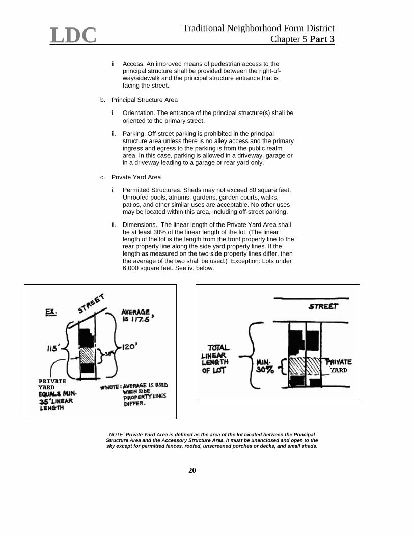
LDC Traditional Neighborhood Form District Chapter 5 Part 3
20
ii Access. An improved means of pedestrian access to the
principal structure shall be provided between the right-of-way/sidewalk and the principal structure entrance that is facing the street.
b. Principal Structure Area
i. Orientation. The entrance of the principal structure(s) shall be
oriented to the primary street. ii. Parking. Off-street parking is prohibited in the principal
structure area unless there is no alley access and the primary ingress and egress to the parking is from the public realm area. In this case, parking is allowed in a driveway, garage or in a driveway leading to a garage or rear yard only.
c. Private Yard Area
i. Permitted Structures. Sheds may not exceed 80 square feet.
Unroofed pools, atriums, gardens, garden courts, walks, patios, and other similar uses are acceptable. No other uses may be located within this area, including off-street parking.
ii. Dimensions. The linear length of the Private Yard Area shall
be at least 30% of the linear length of the lot. (The linear length of the lot is the length from the front property line to the rear property line along the side yard property lines. If the length as measured on the two side property lines differ, then the average of the two shall be used.) Exception: Lots under 6,000 square feet. See iv. below.
NOTE: Private Yard Area is defined as the area of the lot located between the Principal
Structure Area and the Accessory Structure Area. It must be unenclosed and open to the sky except for permitted fences, roofed, unscreened porches or decks, and small sheds.
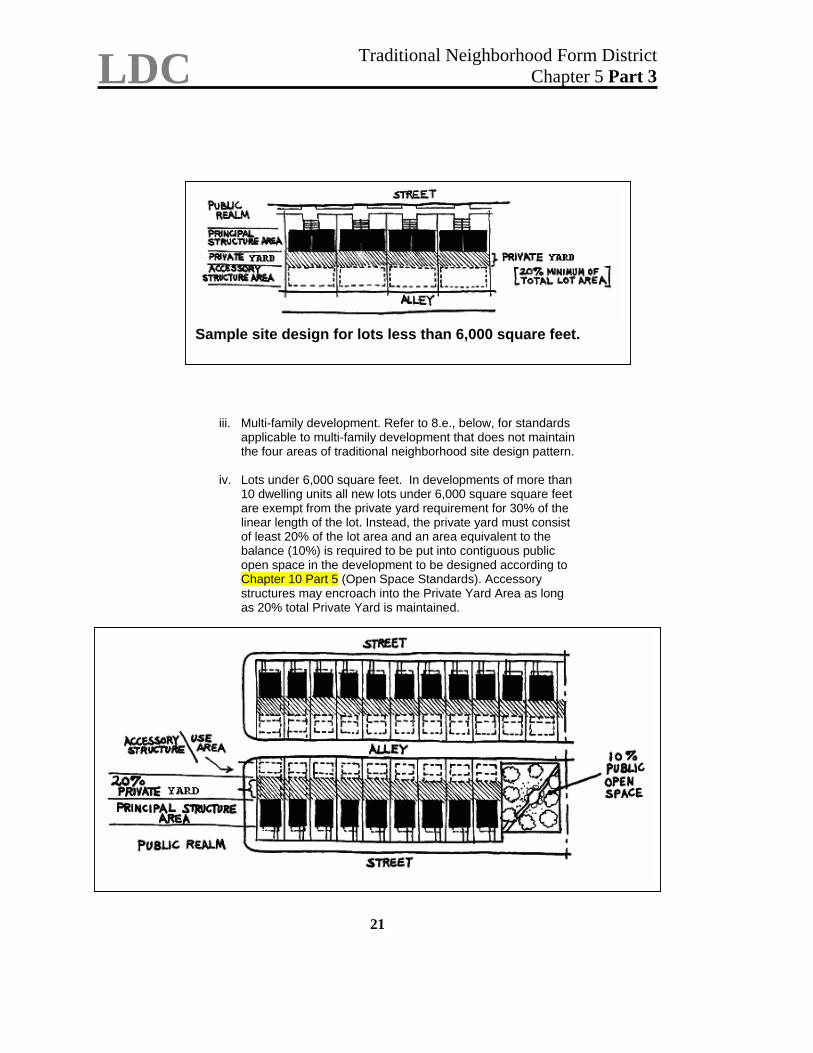
LDC Traditional Neighborhood Form District Chapter 5 Part 3
iii. Multi-family development. Refer to 8.e., below, for standards applicable to multi-family development that does not maintain the four areas of traditional neighborhood site design pattern.
iv. Lots under 6,000 square feet. In developments of more than 10 dwelling units all new lots under 6,000 square square feet are exempt from the private yard requirement for 30% of the linear length of the lot. Instead, the private yard must consist of least 20% of the lot area and an area equivalent to the balance (10%) is required to be put into contiguous public open space in the development to be designed according to Chapter 10 Part 5 (Open Space Standards). Accessory structures may encroach into the Private Yard Area as long as 20% total Private Yard is maintained.
Sample site design for lots less than 6,000 square feet.
21
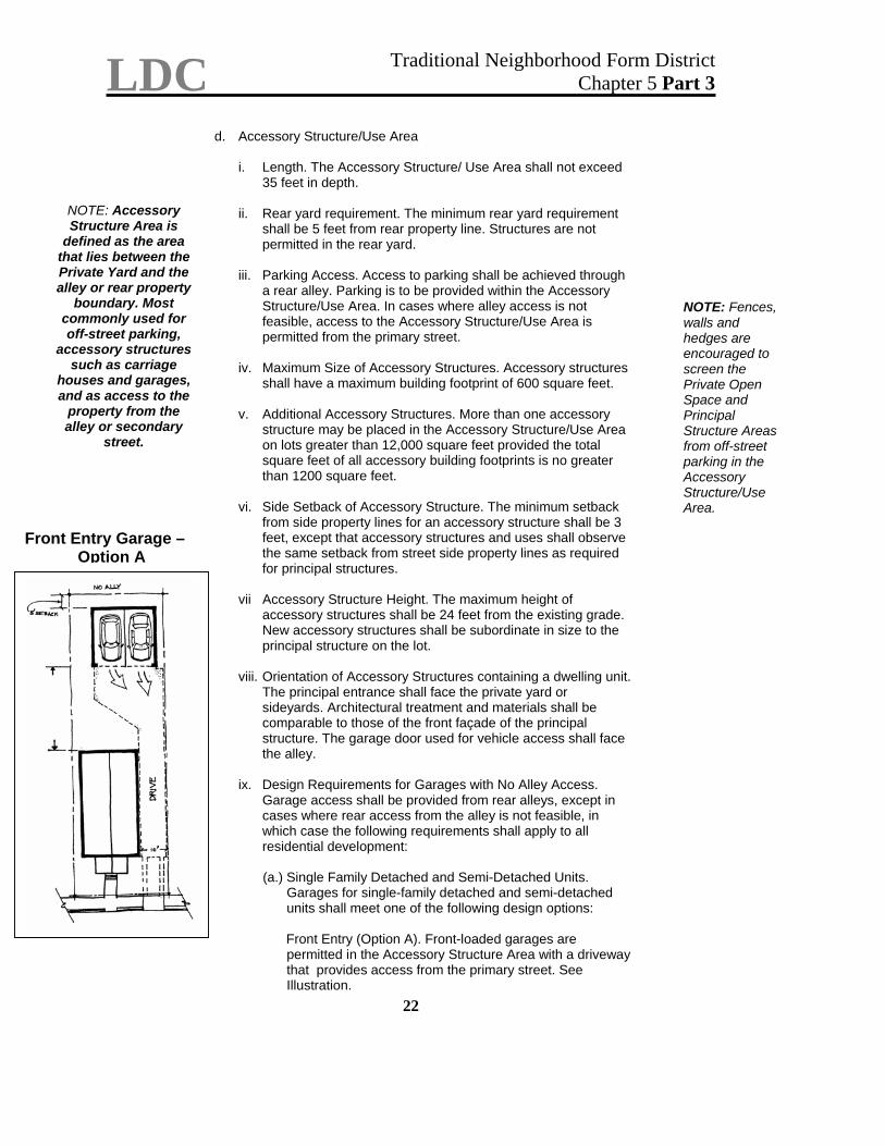
LDC Traditional Neighborhood Form District Chapter 5 Part 3
22
d. Accessory Structure/Use Area
i. Length. The Accessory Structure/ Use Area shall not exceed
35 feet in depth.
NOTE: Accessory Structure Area is
defined as the area that lies between the Private Yard and the alley or rear property
boundary. Most commonly used for off-street parking,
accessory structures such as carriage
houses and garages, and as access to the
property from the alley or secondary
street.
ii. Rear yard requirement. The minimum rear yard requirement shall be 5 feet from rear property line. Structures are not permitted in the rear yard.
iii. Parking Access. Access to parking shall be achieved through
a rear alley. Parking is to be provided within the Accessory Structure/Use Area. In cases where alley access is not feasible, access to the Accessory Structure/Use Area is permitted from the primary street.
NOTE: Fences, walls and hedges are encouraged to screen the Private Open Space and Principal Structure Areas from off-street parking in the Accessory Structure/Use Area.
iv. Maximum Size of Accessory Structures. Accessory structures
shall have a maximum building footprint of 600 square feet. v. Additional Accessory Structures. More than one accessory
structure may be placed in the Accessory Structure/Use Area on lots greater than 12,000 square feet provided the total square feet of all accessory building footprints is no greater than 1200 square feet.
vi. Side Setback of Accessory Structure. The minimum setback from side property lines for an accessory structure shall be 3 feet, except that accessory structures and uses shall observe the same setback from street side property lines as required for principal structures.
Front Entry Garage – Option A
vii Accessory Structure Height. The maximum height of
accessory structures shall be 24 feet from the existing grade. New accessory structures shall be subordinate in size to the principal structure on the lot.
viii. Orientation of Accessory Structures containing a dwelling unit.
The principal entrance shall face the private yard or sideyards. Architectural treatment and materials shall be comparable to those of the front façade of the principal structure. The garage door used for vehicle access shall face the alley.
ix. Design Requirements for Garages with No Alley Access.
Garage access shall be provided from rear alleys, except in cases where rear access from the alley is not feasible, in which case the following requirements shall apply to all residential development:
(a.) Single Family Detached and Semi-Detached Units.
Garages for single-family detached and semi-detached units shall meet one of the following design options:
Front Entry (Option A). Front-loaded garages are permitted in the Accessory Structure Area with a driveway that provides access from the primary street. See Illustration.
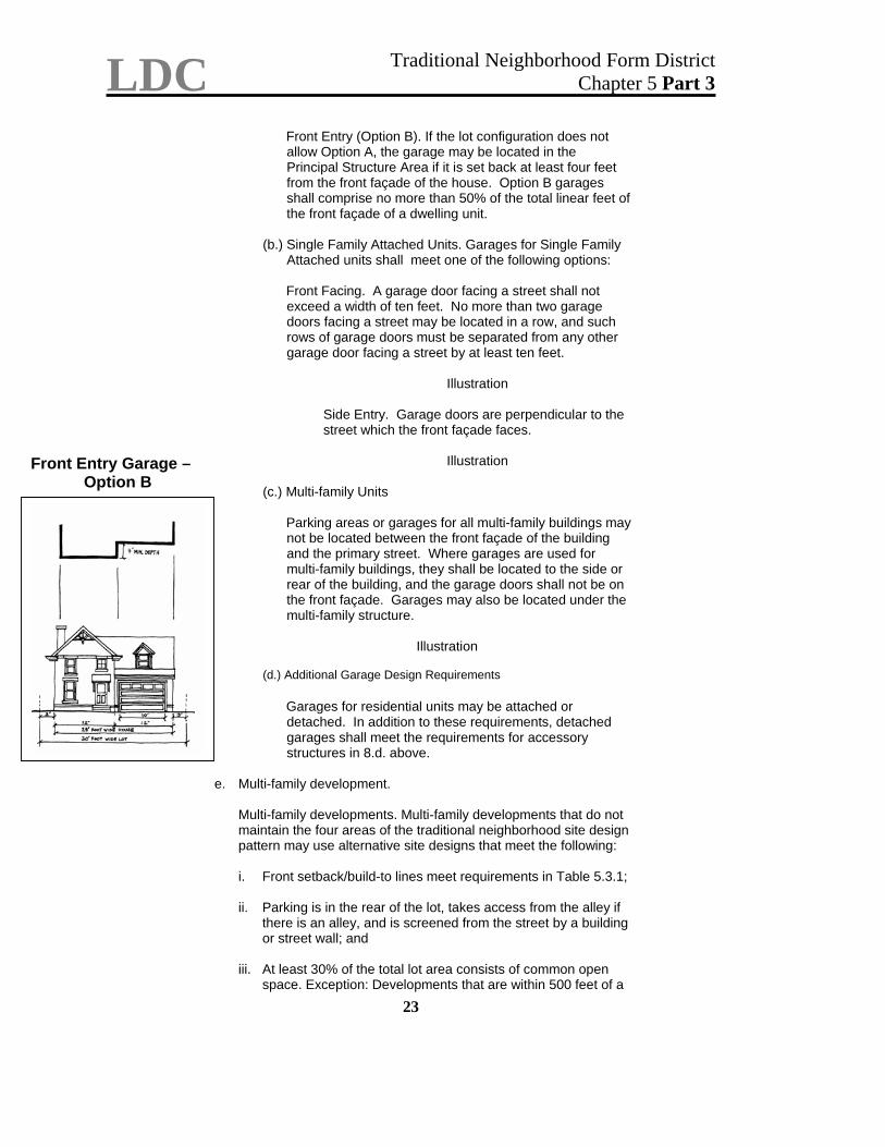
LDC Traditional Neighborhood Form District Chapter 5 Part 3
23
Front Entry (Option B). If the lot configuration does not allow Option A, the garage may be located in the Principal Structure Area if it is set back at least four feet from the front façade of the house. Option B garages shall comprise no more than 50% of the total linear feet of the front façade of a dwelling unit.
(b.) Single Family Attached Units. Garages for Single Family
Attached units shall meet one of the following options:
Front Facing. A garage door facing a street shall not exceed a width of ten feet. No more than two garage doors facing a street may be located in a row, and such rows of garage doors must be separated from any other garage door facing a street by at least ten feet.
Illustration
Side Entry. Garage doors are perpendicular to the street which the front façade faces.
Illustration
Front Entry Garage –
Option B (c.) Multi-family Units
Parking areas or garages for all multi-family buildings may not be located between the front façade of the building and the primary street. Where garages are used for multi-family buildings, they shall be located to the side or rear of the building, and the garage doors shall not be on the front façade. Garages may also be located under the multi-family structure.
Illustration
(d.) Additional Garage Design Requirements
Garages for residential units may be attached or detached. In addition to these requirements, detached garages shall meet the requirements for accessory structures in 8.d. above.
e. Multi-family development.
Multi-family developments. Multi-family developments that do not maintain the four areas of the traditional neighborhood site design pattern may use alternative site designs that meet the following:
i. Front setback/build-to lines meet requirements in Table 5.3.1; ii. Parking is in the rear of the lot, takes access from the alley if
there is an alley, and is screened from the street by a building or street wall; and
iii. At least 30% of the total lot area consists of common open
space. Exception: Developments that are within 500 feet of a
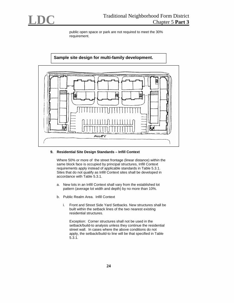
LDC Traditional Neighborhood Form District Chapter 5 Part 3
24
public open space or park are not required to meet the 30% requirement.
Sample site design for multi-family development.
9. Residential Site Design Standards – Infill Context
Where 50% or more of the street frontage (linear distance) within the same block face is occupied by principal structures, Infill Context requirements apply instead of applicable standards in Table 5.3.1. Sites that do not qualify as Infill Context sites shall be developed in accordance with Table 5.3.1.
a. New lots in an Infill Context shall vary from the established lot
pattern (average lot width and depth) by no more than 10%. b. Public Realm Area. Infill Context
i. Front and Street Side Yard Setbacks. New structures shall be
built within the setback lines of the two nearest existing residential structures.
Exception: Corner structures shall not be used in the setback/build-to analysis unless they continue the residential street wall. In cases where the above conditions do not apply, the setback/build-to line will be that specified in Table 5.3.1.
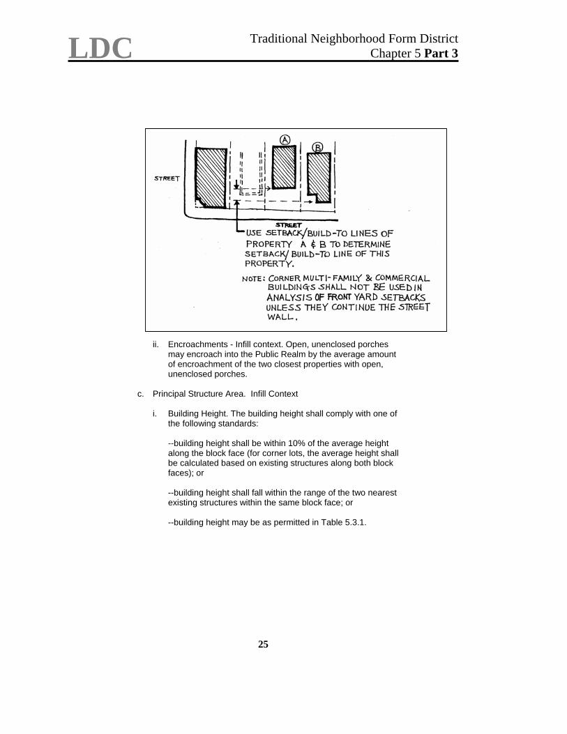
LDC Traditional Neighborhood Form District Chapter 5 Part 3
25
ii. Encroachments - Infill context. Open, unenclosed porches may encroach into the Public Realm by the average amount of encroachment of the two closest properties with open, unenclosed porches.
c. Principal Structure Area. Infill Context
i. Building Height. The building height shall comply with one of the following standards:
--building height shall be within 10% of the average height along the block face (for corner lots, the average height shall be calculated based on existing structures along both block faces); or
--building height shall fall within the range of the two nearest existing structures within the same block face; or
--building height may be as permitted in Table 5.3.1.
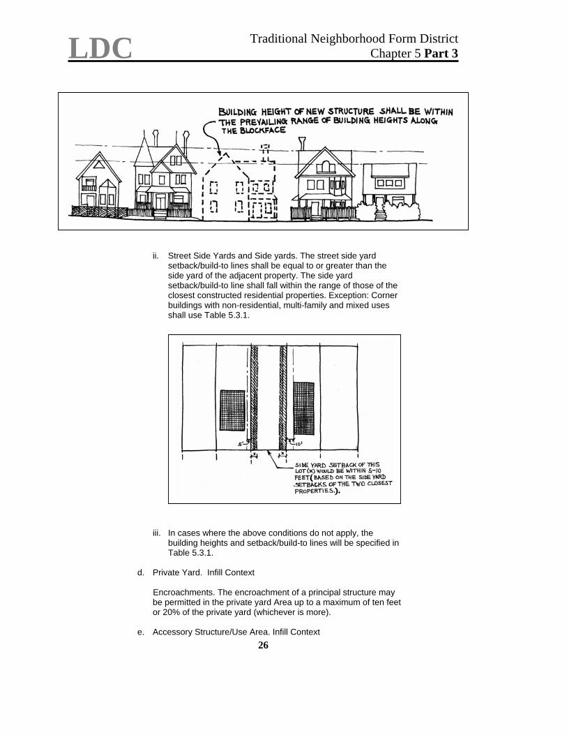
LDC Traditional Neighborhood Form District Chapter 5 Part 3
26
ii. Street Side Yards and Side yards. The street side yard setback/build-to lines shall be equal to or greater than the side yard of the adjacent property. The side yard setback/build-to line shall fall within the range of those of the closest constructed residential properties. Exception: Corner buildings with non-residential, multi-family and mixed uses shall use Table 5.3.1.
iii. In cases where the above conditions do not apply, the building heights and setback/build-to lines will be specified in Table 5.3.1.
d. Private Yard. Infill Context
Encroachments. The encroachment of a principal structure may be permitted in the private yard Area up to a maximum of ten feet or 20% of the private yard (whichever is more).
e. Accessory Structure/Use Area. Infill Context
LDC Traditional Neighborhood Form District Chapter 5 Part 3
27
i. Size and Scale. The permissible square footage of accessory
structures shall be within 10% of the average square footage of the accessory structures existing within the same block face. Where there are no existing accessory structures on the block face use the requirements in Paragraph 8.d.
ii. Rear Yard Setback. Accessory structures shall be located at
least five feet from the rear lot line. iii. Height. The permissible height of accessory structures shall
be a maximum of 24 feet from the existing grade of the Accessory Structure Area. New accessory structures shall be subordinate in height and area to the principal structure on the lot.
10. Non-residential and Mixed Use Development Site Design
a. Building Location and Orientation
i. Principal Building. Principal building entrances shall face the primary street serving the development or shall be oriented toward a focal point such as a landscaped public square, plaza or similar formal public open space. All structures that are located along the primary street serving the development shall also have doors or windows facing the primary street (see ii. below).
ii. Buildings facing two or more streets shall have at least one
customer entrance facing the primary street and one customer entrance facing the second street or instead of two entrances, a corner entrance.
Illustration
NOTE: Parking may be located no
closer to the street than the building; see section 9.1.4
iii. Building Frontage. Not less than 60 percent of the primary street linear frontage of each lot shall be occupied by a building at the required build-to line.
iv. Corner Lots. On corner lots, the building shall be constructed
at the right-of-way line along both of the streets for a minimum of 15 linear feet. Exceptions: 1) if a principal building or tenant entrance is at the corner, the entrance may be recessed within this 15 linear foot length at a 45 degree angle to both streets; 2) if the sidewalk abutting the required minimum 15 linear foot corner is less than 5 feet wide at the corner, the building may be set back a maximum of 8 feet from the right-of-way line.
NOTE: Internal measures to limit glare include blinds and curtains; external measures, such as awnings or roof overhangs, are also permitted.
v. Building Façade Treatment. There shall be no blank walls
facing streets and sidewalks. Ground floor facades that face public streets shall be articulated to provide visual interest and a human scale, consistent with the traditional character of the TNFD. Such facades shall have arcades, display windows, entry areas, awnings, or other architectural animating features along no less than 75 percent of their
Formatted
LDC Traditional Neighborhood Form District Chapter 5 Part 3
28
length. No facade shall exceed 25 feet of length uninterrupted by such features. Use columns, entrances, store front windows and other vertical elements to maintain vertical street-level patterns of architectural details.
vi. Windows. Enliven facades by providing visibility into building
interiors or merchandising display windows. 50% of the wall surface at the first street-level story shall consist of clear windows and doors that allow a view into the working areas, lobbies or display windows set into the wall. Measures to control sunlight are specifically authorized. Display cases with a depth of 18 inches or less that are attached to or recessed in the outside wall do not qualify. The top of the windows shall be at least 8 feet high measured from the sidewalk. The bottom of the windows shall be no more than two feet above the sidewalk. Exception: Churches, synogogues, mosques and other religious buildings are not required to have clear windows or doors.
b. Roofs. Roof lines shall be varied to reduce the massive scale of
large buildings and to complement the character of adjacent residential areas. Rooftop equipment shall be concealed behind parapets or screened from view by pedestrians. Sloping roofs with a vertical rise that exceeds the average height of suporting walls are not allowed.
c. Accessory Structures. Accessory structures for non-residential
and mixed use development (i.e., dumpsters, fast food ordering stations, drive-in facilities, and storage facilities) shall be subordinate in size to the principal structure. They shall not be visible from the primary street and shall be screened from adjacent residential areas by fencing or walls and shall not exceed the scale of adjacent residential uses. Accessory structures adjacent to residential uses shall be in scale with other accessory structures on the block. Open, unenclosed public seating or recreation areas or other similar types of areas are permitted to encroach into the front setback.
d. Setback from Alley or Rear Property line. Construction of any
structure in the rear yard shall be setback at least five feet from the rear property line.
e. Access. An improved and direct means of pedestrian access to
the principal structure(s) shall be provided between the right-of-way/sidewalk and a principal entrance to the structure that faces the street.
11. Non-residential and Mixed Use Development Site Design
Standards. Infill Context.
Where 50% or more of the linear street frontage within the same or opposing block face is occupied by principal structures exhibiting site design consistent with a traditional development pattern, the following additional standards shall apply:
a. Front Setback/Build-to Line and Street Sideyards. Where there
are highly uniform setback/build-to lines (at least 50% of the
LDC Traditional Neighborhood Form District Chapter 5 Part 3
29
structures on the block face have setbacks that vary by 10% or less), the setback/build-to line for the new structure shall be the average setback of existing structures in the block face. Where there is more than 10% variation in setbacks within the block face, the setback/build-to line shall fall within the range of the setbacks of the nearest constructed properties. Exception: Corner buildings with non-residential and mixed uses shall use Table 5.3.1.
b. Building Height. The maximum building height shall be 45 feet or
3.5 stories unless an adjacent building is taller in which case the proposed structure may be as tall as the tallest adjacent building.
c. Sites that do not qualify as Infill Sites (paragraph 11. above) shall
be developed in accordance with Table 5.3.1.
30
Parking, Sign and Landscape Regulations In addition to the standards of the TNZD Plan Report, the following portions of the Land Development Code and Development Code (until March 1, 2003) are applicable to new development in the Old Louisville/Limerick TNZD: Motor Vehicle Parking and Loading, Bicycle Parking Chapter 9 of the Land Development Code (www.co.jefferson.ky.us/PlanDev/LDC.htm) Sign Regulations:
Prior to March 1, 2003, Article 11, Development Code (www.co.jefferson.ky.us/PlanDev/DevelopmentCode.pdf) After March 1, 2003, Chapter 8, Land Development Code
(www.co.jefferson.ky.us/PlanDev/LDC.htm) Landscaping Regulations
Prior to March 1, 2003, Article 11, Development Code (www.co.jefferson.ky.us/PlanDev/DevelopmentCode.pdf) After March 1, 2003, Chapter 8, Land Development Code
(www.co.jefferson.ky.us/PlanDev/LDC.htm) Because of the length of these regulations, they are not reproduced in this information packet. Please refer to published copies of these codes, or the Internet version, or request a copy from Metro Louisville Planning and Design Services (574-6230).
Development Code Section 7.10 Land Development Code Section 2.7.4 TNZD
31
Development Code Section 7.10 (TNZD) Traditional Neighborhood Zoning District/Section 2.7.4 Land Development Code (excerpt)
4. AMENDMENTS TO APPROVED TNZD PLAN
Applications to amend the TNZD Plan to change the land use of a particular property from a permitted use to a permitted where mapped use, or to permit the original use of a particular building, may be filed by the Planning Commission, the legislative body with zoning authority, or the owner of the subject property. All other amendments to the TNZD Plan shall be initiated by the Planning Commission or the legislative body with zoning authority. Applications shall be accompanied by such written and graphic information as is necessary for the Planning Commission to determine whether the proposed amendment conforms to the Comprehensive Plan, the traditional pattern, the urban residential character of the area, the intent of the TNZD Plan, and the requirements of this Chapter.
a. Amendments to the TNZD Plan Map to change land use to a “permitted where mapped” use.
(1) Except as provided in paragraph (2) below with respect to original
uses, proposed amendments to the TNZD Plan Map to change the land use of a particular property from a permitted use to a permitted where mapped use in the applicable TNZD component shall be processed in accordance with the provisions of this paragraph. The Planning Commission shall hold at least one public hearing after notice is given to first tier adjoining property owners at least thirty (30) days in advance of the hearing by first class mail. After the public hearing, the Planning Commission may approve the proposed TNZD Plan Map amendment if it finds that the proposed land use change conforms to the Comprehensive Plan, the traditional pattern, the urban residential character of the area as described in the TNZD Plan.
(a) The owner of the subject property or any aggrieved person may appeal the decision of the Planning Commission to the legislative body with zoning authority by filing an appeal with the legislative body no later than ten (10) calendar days after the date of the action of the Planning Commission. Actions of the Planning Commission under this paragraph that have not been appealed to the legislative body within ten calendar (10) days shall not be subject to further review or appeal.
(b) Notice of the appeal shall be provided to the applicant, the appellant, and all first tier property owners at least seven (7) days prior to the meeting at which the legislative body will consider the appeal. The legislative body shall take one of the following actions:
Development Code Section 7.10 Land Development Code Section 2.7.4
TNZD
32
i. The legislative body may review the record made before the Planning Commission and may affirm the Planning Commission’s decision without a hearing;
ii. The legislative body may review the record made before
the Commission and overturn the Planning Commission’s decision based on findings of fact supported by the record which differ from the findings of fact of the Commission; or
iii. The legislative body may also hold its own public hearing after notice as set forth in this section, and may make as a result thereof findings which may differ from those found by the Commission.
(2) Original Use Exception. The Planning Director or designee may
amend the TNZD Plan Map with respect to a particular property to permit the original use of the primary structure thereon without a public hearing only if the original use is a permitted or permitted where mapped use in the applicable TNZD component, and if the applicant demonstrates that (1) the primary structure was existing on the property on November 22, 1926; and (2) said primary structure was used on or before November 22, 1926 for the specific purpose for which the applicant seeks to use the structure.
The decision of the Planning Director or designee may be appealed to the Board of Zoning Adjustment in accordance with KRS Chapter 100.
b. All other TNZD Plan Amendments. All amendments to the TNZD Plan
other than those described in paragraph a. above shall be initiated by the Planning Commission or the legislative body, and shall be processed in the following manner: (1) A public hearing shall be held by the Planning Commission after
notice of the hearing is given pursuant to KRS Chapter 424. (2) After the public hearing, the Planning Commission shall make a
recommendation on the proposed amendment to the legislative body with zoning authority.
(3) Final action on amendments to the TNZD Plan shall then be taken
by the legislative body with zoning authority. No amendment to the TNZD Plan shall become effective until approved by the legislative body with zoning authority. Failure of the legislative body to act on the proposed amendment shall not result in a deemed approval of the proposed amendment.
(4) Appeals of actions of the legislative body on TNZD Plan Amendments may be taken to a court of competent jurisdiction.