Appendix A Site Plans
658
www.essgroup.com Appendix A Site Plans
-
Upload
khangminh22 -
Category
Documents
-
view
0 -
download
0
Transcript of Appendix A Site Plans

www.essgroup.com
Appendix A
Site Plans

For Appendix A Site Plans, please see the separately bound volume entitled Drawing Package for Clear River Energy Center and Burrillville Interconnection Project included with the filing of this application.

www.essgroup.com
Appendix B
ROW Vegetation Management Plan

10/18/2013
Five Year Vegetation Management Plan 2014-2018

ii

iii
TABLE OF CONTENTS 1. INTRODUCTION 1 2. THE PRIMARY GOAL AND OBJECTIVES OF THE VMP 3 3. RIGHTS-OF-WAY VEGETATION AND IDENTIFICATION OF INCOMPATIBLE
TARGET VEGETATION
4 4. INTEGRATED VEGETATION MANAGEMENT AND RATIONALE FOR USE 7 5. VEGETATION MANAGEMENT AND OPERATIONAL GUIDELINES 11 6. VEGETATION MANAGEMENT CONTROL METHODS 14 7. JUSTIFICATION OF SELECTIVE HERBICIDE APPLICATIONS 21 8. DEFINITION, IDENTIFICATION AND TREATMENT OF SENSITIVE AREAS 25
9. ALTERNATE LAND USE 31 10. INDIVIDUALS SUPERVISING AND DEVELOPING THE IVM PROGRAM 32 11. REMEDIAL SPILL AND EMERGENCY PLAN 34
LIST OF TABLES
TABLE 1. HERBICIDE USE RATES 9 TABLE 2. CONTROL STRATEGIES FOR SENSITIVE AREAS 26 TABLE 3. HERBICIDE MANUFACTURERS 35 TABLE 4. STATE AGENCIES 35 TABLE 5. EMERGENCY SERVICES 36 TABLE 6. NATIONAL GRID’S CONTACTS IN THE CASE OF A SPILL OR ACCIDENT 36 TABLE 7. Local Boards of Health/Town Hall 36
APPENDICES
APPENDIX 1 333 CMR 11.00, RIGHTS-OF-WAY REGULATIONS APPENDIX 2 LIST OF MUNICIPALITIES THROUGH WHICH NATIONAL GRID MANAGES
RIGHTS-OF-WAY APPENDIX 3 CHAPTER 132B APPENDIX 4 CHAPTER 85, SECTION 10 APPENDIX 5 DEPARTMENT OF FOOD AND AGRICULTURE WETLAND DECISION APPENDIX 6 PREFACE TO 310 CMR 10.00 APPENDIX 7 SENSITIVE AREAS: ILLUSTRATIONS OF NO-SPRAY AND LIMITED SPRAY-
AREAS APPENDIX 8 REMEDIAL PLAN TO ADDRESS SPILLS FORM APPENDIX 9 BIBLIOGRAPHY

1
1. INTRODUCTION
The purpose of this Vegetation Management Plan (VMP) is to outline the
National Grid USA Electric Companies (hereafter referred to as National Grid)1 five year
plan for managing vegetation in compliance with 333 CMR 11.00 (Appendix 1).2
Removing incompatible vegetation is necessary on transmission and distribution rights-
of-way, and around associated structures and facilities to ensure safe, reliable delivery
of electric service. Tall growing tree species must be prevented from growing into or
falling onto the lines. Dense woody vegetation, vines, noxious3 (invasive plant species,
nuisance and poisonous vegetation), and all vegetation that interferes with access must
be removed from around structures, access roads and anywhere in which they prevent
access to the rights-of-way for inspections, maintenance, repairs and in emergencies.
National Grid manages approximately 20,000 acres and 1,500 miles of rights-of-
way within the Commonwealth of Massachusetts through the municipalities listed in
Appendix 2. These rights-of-way extend from the western border of the Commonwealth
through Worcester County, the Merrimack Valley, the North Shore, and the Southeast
down through to the Attleboro area and Somerset. They traverse all types of terrain
from steep mountainous topography to rolling hills and level lowlands, and from remote,
relatively inaccessible locations right through high density population centers.
Taking this variety of landscape conditions into consideration, National Grid
applies an Integrated Vegetation Management (IVM) approach to controlling vegetation
on its rights-of-way. IVM is the utility variation of Integrated Pest Management (IPM) in
which the pest is incompatible vegetation. IPM/IVM is the conscientious use of
1National Grid companies with rights-of-way in Massachusetts include Massachusetts Electric Company, New England Power Company and New England Hydro Transmission Electric Company. 2National Grid’s VMP takes into account not only 333 CMR 11.00 and Chapter 132B, but all applicable state and federal regulations that mandate the management of utility rights-of-way including but not limited to: all pertinent clauses in Chapter 85 of the Acts of 2000; MESA; MGL c. 131 A and 321 CMR 10.00; 310 CMR 10.00 and 310 CMR 22.00; 310 CMR 40.0000; applicable Federal Energy Regulatory Commission standards including NERC Standard FAC-003-1, Commissioner Order 693, FAC-003-2 (effective July 1, 2014), and all applicable Federal Occupational Safety and Health Act, Department of Transportation and Department of Environmental Protection regulations. 3“NOXIOUS WEED.—The term ‘‘noxious weed’’ means any plant or plant product that can directly or indirectly injure or cause damage to crops (including nursery stock or plant products), livestock, poultry, or other interests of agriculture, irrigation, navigation, the natural resources of the United States, the public health, or the environment.” (PUBLIC LAW 106–224—JUNE 20, 2000, TITLE IV—PLANT PROTECTION ACT).

2
appropriate management techniques to control pests in a program designed to minimize
the risk of unreasonable adverse effects on human health and the environment.
National Grid’s IVM program brings together a combination of treatment methods and
an understanding of the variety of New England ecosystems and the built environment.

3
2. THE PRIMARY GOAL AND OBJECTIVES OF THE VMP
The primary goal of this VMP is to outline the standard operating procedures for
vegetation management operations on National Grid’s rights-of-way. Its purpose is to
document National Grid's IVM Program standards, practices and procedures.
The VMP is intended to provide a basic source of information for state and
municipal officials and any interested parties regarding National Grid’s vegetation
management program. It also provides guidance for the technicians contracted by
National Grid to carry out the vegetation management treatment program.
The following items are, therefore, individual objectives that must be taken into
consideration as part of the primary goal of National Grid’s vegetation management
program:
- To ensure the reliable delivery of electric service to our customers; - To maintain an optimum three to five year maintenance cycle for all rights-of-
way4; - To ensure that vegetation management operations are conducted in a safe,
effective manner and in conformity with federal and state laws, regulations, and if applicable, permit conditions;
- To treat sensitive areas listed in 333 CMR 11.04 according to regulatory and National Grid policy as areas that require special consideration during vegetation management operations;
- To allow for unplanned tasks for which all precautions are taken to utilize the correct treatment methods and to protect sensitive areas (construction, restorations, hazard tree removal, etc.);
- Following the procedures in 333 CMR 11.05(4)(d), to maintain the flexibility necessary to accommodate unique situations and the need for more appropriate techniques as they arise (in accordance with regulations, scientific advances, operational experience and/or comments from municipalities, state agencies & contractors);
- To have a National Grid representative respond quickly to any questions or complaints from the public and/or governmental agencies that relate to rights-of-way vegetation management.
4Maintenance cycles are the years between treatments.

4
3. RIGHTS-OF-WAY VEGETATION AND IDENTIFICATION OF INCOMPATIBLE TARGET VEGETATION
More compatible non-target vegetation live on electric rights-of-way than
incompatible target vegetation. In fact, National Grid’s rights-of-way are one of the
primary remaining early successional ecological communities5 in New England. These
low growing plant communities help discourage the establishment of incompatible
vegetation, do not hinder access and do not generally interfere with the lines. Plant
species that are generally encouraged on the rights-of-way include herbaceous growth
and shrubs that mature less than 12 feet in height, unless due to their location or
attributes they interfere with the function of the rights-of-way. As a result, many plant
and animal species use our rights-of-way as their homes, feeding grounds or nurseries.
This early successional landscape, however, is not, by nature, stable; it is instead the
sustained result of the IVM program established on National Grid’s rights-of-way in the
late 1960’s.
Vegetation that obscures the right-of-way corridors and/or grows tall enough to
interfere with the lines is considered incompatible vegetation and must be removed as
targets. Incompatible vegetation includes trees and limbs, tall growing shrubs,
vegetation growing around substations, structures, access roads, gates, and anywhere
vegetation impedes access to the rights-of-way and equipment.
The primary incompatible plant species are trees, generally defined as woody
plant species that mature at heights exceeding 15 feet. Trees must be removed or
controlled within the cleared width and along the edges of National Grid’s rights-of-way
because they are capable of growing tall enough to grow into or fall onto the lines
causing electric service outages. Examples of incompatible vegetation include, but are
not limited to, maples, oaks, ash, cherries, birches, beeches, spruce, hemlocks and
pines.
In rare isolated instances trees may be left where the electric lines are high
enough off the ground so that mature trees will not interfere with the operation of the
line. Also, those species that are under the purview of the Natural Heritage and
Endangered Species Program of the Massachusetts Division of Fisheries and Wildlife 5 A simplified definition of early successional ecological communities is low growing vegetation including grasses, herbaceous and shrub species and the wildlife species that inhabit them.

5
(NHESP) will be treated on a case by case basis.
Certain categories of non-tree species are also considered incompatible
vegetation, some due to their location and others because of their nature. All woody
vegetation on/or encroaching upon existing roads or pathways or immediately adjacent
to line structures or equipment will be controlled to provide adequate access to
structures, equipment and along the rights-of-way. These include shrubs and vines,
including, but are not limited to, Viburnum, Mountain Laurel, Bush Honeysuckle, Grape
Vines, Virginia Creeper, etc.
If no permanent access route exists along a right-of-way, a pathway may be
created during the treatment cycle and maintained in a suitable location by managing all
woody vegetation within the selected route. Woody vegetation must be removed in
these areas to ensure access to and along the right-of-way and line structures for safe,
efficient inspection, maintenance and emergency operations.
Plant species that pose an environmental or safety problem will be removed
whenever practical. The categories of these plant species types that cause safety
problems are noxious vegetation plant species including nuisance and poisonous plant
species that have heavy thorn growth or dermal toxicity and may create hazards for
people working on or traversing the right-of-way. These also include invasive plant
species that poses environmental problems, some of which also fit one of the first two
categories of noxious vegetation.
Poisonous vegetation poses a health hazard to National Grid personnel,
contractors and the public-at-large, which can lead to increased incidences of first aid
and OSHA recordable incidents. Mechanical methods do not reduce the spread of
these populations, particularly Poison Ivy and Poison Sumac, therefore National Grid
plans to use herbicides to spot treat poisonous plants at sites under its rights-of-way
identified as having a high risk of posing a health hazard.
Other types of noxious and nuisance vegetation poses a risk to the safety and
health of all individuals working on or traversing a right-of-way and can further impede a
rapid response in an emergency. These plants have heavy thorns, dense foliage and/or
impenetrable stems; examples include, but are not limited to, federal and
Massachusetts classified noxious vegetation such as Multi-floral Rose, Common &

6
Glossy Buckthorn, and Blackberries, as well as nuisance vegetation such as
Hawthorne, Greenbrier and dense populations of grapevines.
Invasive plant species create hazards for the environment. Invasive plant
species have become an increasing concern throughout Massachusetts in areas that
include rights-of-way corridors where they can spread rapidly and then move into the
adjacent landscape. According to the Massachusetts Invasive Plant Advisory Group,
"Invasive plants" are non-native species that have spread into native or minimally
managed plant systems in Massachusetts. These plants cause economic or
environmental harm by developing self-sustaining populations and becoming dominant
and/or disruptive to those systems….”6 Some examples of invasive plant species
commonly found on rights-of-way include, but are not limited to, Japanese Knotweed,
Multi-flora Rose, Oriental Bittersweet and Glossy Buckthorn (some of these also fit the
noxious vegetation category).
To ensure the accurate identification of incompatible and compatible vegetation,
all vegetation management contractors are required to supply personnel familiar with
the vegetation typically found growing on utility sites.
6http://www.massnrc.org/mipag/invasive.htm.

7
4. INTEGRATED VEGETATION MANAGEMENT AND RATIONALE FOR USE National Grid has one of the oldest IVM programs in the Commonwealth of
Massachusetts, adopting this multi-faceted approach to rights-of-way vegetation
management in the late 1960’s. Following the “Purpose” of 333 CMR 11.00, National
Grid has, and continues to utilize, an IVM program that “…minimize our impact on
human health and the environment while allowing for the benefits to public safety
provided by the selective use of herbicides.”
National Grid’s approach relies on reducing the amount of herbicides used; using
selective herbicides/application techniques; timing applications for maximum effect;
avoiding fixed application schedules; using mechanical control techniques where
appropriate, and encouraging low growing plant communities. These techniques are
applied to individual rights-of-way on a three to five year treatment cycle when
incompatible vegetation averages heights of six to ten feet and low to medium average
densities.
National Grid’s IVM program actually begins with understanding the concept of
ecological succession. Plant life is by its nature unstable, it is, however, governed by
relatively predictable processes of change in composition or structure known as
succession. In New England, succession strives towards the climax forest, but is
interrupted by natural or man-made disturbances both intentional and accidental, which
can lead back to earlier stages. National Grid’s goal is to encourage early successional
landscapes including wetlands, vernal pools, heaths, barrens, scrub land, fields and
meadows, all of which, if left alone, are not stable; all of which dominate the landscape
of utility rights-of-way under an IVM program and all of which are ideally suited to the
requirements of the right-of-way. An additional benefit to this management strategy is
that these early successional communities are generally populated by diverse, well-
dispersed species that include many of New England’s plant, animal and insect species,
including many of those that are threatened or endangered.
IVM, as applied to electric utility rights-of-way, therefore is an environmentally
responsible means of combining chemical and mechanical treatment methods (mowing,
side pruning, hand-cutting and herbicide applications) with an understanding of the
stages of ecological succession and interspecies competition. The resulting right-of-

8
way corridor is dominated by vegetation below economically damaging heights that
could otherwise interfere with the delivery of electric service. IVM has many variations,
but here in New England, where the practice first began, IVM is scheduling treatment
crews to target incompatible vegetation as selectively as possible and then letting early
successional ecological communities help maintain compatible vegetation between
treatment programs. In this interim period competition (for light, moisture, and
nutrients), wildlife depredation (browsing/feeding) and other ecosystem processes
inhibit the germination and growth of incompatible woody vegetation, primarily trees.7
These biological processes or natural controls8 lower the dependence on
chemical and mechanical controls. Inhibiting the process of plant succession, however,
requires the use of all three components of IVM. All three depend upon the others in a
continuous cycle that employs the unique advantages of each. Without combining all
three, incompatible plant species develop increased stem densities that require more
intense control measures, and natural succession runs its course, forcing vegetation
management activities to start at ground zero every treatment cycle. Thus narrow, one-
dimensional management techniques, while frequently less expensive initially, decrease
biodiversity and increase the impact of long-term vegetation management activities on
the environment.
For example, a mechanical only program cannot control the roots of incompatible
vegetation resulting in increased stem densities of resprouting vegetation that grows at
a rapid rate. Likewise, there are areas of a utility right-of-way that cannot be treated
7Yahner. “Wildlife Response to More than 50 years of Vegetation Maintenance on a Pennsylvania U.S., Right-of-Way”: 123; Christopher A. Nowak & Benjamin D Ballard. “A Framework for Applying Integrated Vegetation Management on Rights-of-Way.” Journal of Arboriculture 31(1) (January 2005): 28-37; Richard H. Yahner “State Game Lands 33 Research and Demonstration Project—57 years of Continuous Study on the Shawville to Lewiston 230-kV line of First Energy (Penelec). 2009: 9; Yahner. “2009 Annual Report to Cooperators. Green Lane Research and Demonstration Project: 23 Years of Continuous Study.” (2009): 8; Yahner. “Wildlife Response to More than 50 years of Vegetation Maintenance on a Pennsylvania U.S., Right-of-Way.” Journal of Arboriculture 30(2) (March 2004): 123 United States Environmental Protection Agency. “Fact Sheet: Integrated Vegetation Management.” EPA 731-F-08-010 (Oct. 2008). 8National Grid recognizes that in addition to using the stages of ecological succession and interspecies competition to limit the germination and growth of incompatible vegetation, there are direct biological applications techniques. For example, the release of two leaf feeding beetles (Galerucella calmariensis and G. pusilla) can help control Purple Loosestrife (Lythrum salicaria). While National Grid does not rule out the potential use of these application techniques in limited areas, with approximately 20,000 acres of treatment area and the composition of our primary target species, they are not currently a significant part of our IVM program.

9
with herbicides. Combining the direct use of appropriate chemical and mechanical
treatments with an understanding of ecological succession, therefore lengthens the time
between management cycles, reduces the amount of herbicide applied per acre and
limits the need for intense mechanical controls.
Following this approach has, over time, significantly reduced the per-acre
application rate of herbicide formulations at National Grid (see Table 1).9 In the early
stages, when herbicide applications first replaced a pure mechanical program, our
rights-of-way were dominated by high stem densities of incompatible tree species. As a
result, the average rate per acre of applied herbicide formulations was approximately
three gallons (24 pints). Around, fifteen years ago, as years of selective herbicide
applications sustained a diverse desirable vegetation cover, the average rate per acre
was approximately 1-1½ (8-10 pints) gallons per acre. Currently, the average rate is
approximately 1 pint to 2 quarts per acre. Studies in New York have documented similar
reductions in herbicide use through stable plant community management.10
National Grid’s IVM program also recognizes and manages instances in which
landscape changes prescribe the IVM techniques. Control methods are adapted or 9National Grid Transmission Forestry Herbicide Use Summary Records. 10C.A. Nowak, C.A. and L.P. Abrahamson, “Vegetation Management on Electric Transmission Line Rights-of-Way in New York State: The Stability Approach to Reducing Herbicide Use”, Proceedings of the International Conference on Forest Vegetation Management, Auburn University, April 1993.
24
10
1.5
0
5
10
15
20
25
30
Average Pints/Acre
Pin
ts p
er A
cre
Table 1: Average Per Acre Rate of Herbicide Mix Applied
on National Grid's Rights-of-Way Over Time
Early Program 1990s 21st Century

10
limited to suit the management situation. These are areas of a right-of-way in which
geologic, geographic, climactic, environmental and legal factors along with economic,
agricultural, social and recreational uses of the landscape affect the application of IVM
management techniques. Treatment methods are determined by soil type, moisture
levels, elevation, density and growth rates; land use patterns such as golf courses,
inhabited areas, Christmas tree farms, active pasture and crop lands, or where
individual alternate control agreements are in place with landowners. These
landscapes limit or alter the applied treatment methods. For example, trees might not
grow in well-kept lawns but incompatible vegetation may still grow into structures, and
street trees need to be trimmed.
By the selective applications and judicious use of herbicides in combination with
mechanical controls and an understanding of ecological succession, National Grid’s
rights-of-way are meeting environmental and management goals. Taking a multi-
faceted approach minimizes the disadvantages and maximizes the benefits of each IVM
component, thereby reducing the environmental impact and the financial cost of
vegetation management while simultaneously increasing the overall effectiveness of the
program.

11
5. VEGETATION MANAGEMENT AND OPERATIONAL GUIDELINES
National Grid retains independent contractors for all vegetation management
treatment activities and requires that these contractors comply with all applicable state
and federal laws and regulations, and National Grid vegetation management
specifications. Furthermore, contractor performance and compliance with this VMP is
monitored and evaluated by National Grid Foresters.
Vegetation Management Guidelines
National Grid's IVM program is applied to the full width of each right-of-way to
remove or control all incompatible vegetation. Vegetation management activities must
result in l00% control or removal of all incompatible target plant species greater than or
equal to six feet in height and a minimum of 90% control or removal of all incompatible
vegetation less than six feet in height.
With a few exceptions, all incompatible tree species will be removed or controlled
during a treatment operation. This includes all woody vegetation and vines growing on
or encroaching upon access roads, gates, or on or within ten feet of guys, poles and
towers within the cleared width of the right-of-way. Treatments will also extend around
the perimeter of substations following all sensitive area restrictions.
The only exceptions are trees in or edging yards, visual screens and trees or
shrub species specified by NHESP in the Priority Habitat of state-listed species. All
exceptions, however, must be maintained at an acceptable height or condition that will
not exceed minimum vegetation clearance distances from the lines before the next
maintenance cycle.
National Grid uses two types of visual screens, shrub and tree/shrub, which
screen the general public from views of structures and substations. They are
maintained at sites where, in the opinion of National Grid, people may find the view of
structures or substations objectionable. These sites include, but are not limited to,
locations where rights-of-way cross roads,

12
recreational areas and inhabited areas.
Sensitive areas will be treated per 333 CMR 11.04. Vegetation management
operations on such sites are designed to prevent any unreasonable adverse
environmental effects. These no-spray and limited spray areas will be maintained using
the appropriate control methods (see Table 1 & Appendix 7).
Conifers are generally not treated with herbicides since most species do not re-
sprout. One exception to this general guideline is pine species that do resprout,
particularly Pitch Pine, which may be treated on a limited basis with herbicides.
Another exception is where White Pine regeneration has seeded in large thick carpets
and mowing might be more destructive than an herbicide application.
In cases where large areas of high density incompatible species have exceeded
maximum herbicide treatment heights, it may be more practical to do a mechanical
treatment followed in one or two growing seasons by an herbicide treatment to obtain
effective control.
Right-of-way access will be through the use of established roadways whenever
possible. The contractor will obtain permission to enter a right-of-way by any other
means in advance.
Unreasonable site damage or destruction during any phase of the vegetation
management operation by the contractor, his agents or employees, must be repaired
immediately to the satisfaction of National Grid; National Grid will determine what
constitutes unreasonable site damage.

13
General Operational Guidelines
The National Grid Forester will inform the contractor(s) which rights-of-way will
be treated, the range of treatment dates and the possible methods, materials and
mixing rates. National Grid will supply treatment restrictions data, maps and written
instructions outlining any special treatment considerations or instructions for each right-
of-way. No work will be done until the contractor has the appropriate data, permits,
restriction lists, mixing rate instructions and licensed staff unless authorized by National
Grid.
The contractor must provide:
- Appropriately licensed or certified supervisors who understand all aspects of the contracted treatment and who are responsive to the guidance of National Grid;
- Supervisors who effectively manage treatment crews to ensure the satisfactory completion of the contract;
- Supervisors who effectively communicate with the public ; - Experienced and/or trained workers, who are appropriately licensed or certified; - Workers who conduct themselves professionally at all times; - The appropriate equipment maintain the highest practical level of efficiency and
effectiveness; - Appropriately calibrated herbicide application equipment; - Equipment in good visual and working condition; - Completed paperwork.
The contractor must: - Comply with all applicable federal and state laws and regulations; - Have a copy of this VMP; - Have all treatment crews carry a copy of the current Yearly Operational Plan
(YOP); - Have all treatment crews carry National Grid right-of-way maps.
In conclusion, vegetation management operations must be conducted according
to this VMP and the written instructions of National Grid. Failure to do so is grounds for
removal of the crew from the treatment site and termination of the vegetation
management contract.

14
6. VEGETATION MANAGEMENT CONTROL METHODS Mechanical and chemical controls work together to support the viability of early
successional communities, therefore, National Grid utilizes a combination of hand
cutting, mowing, selective pruning, selective foliar treatments, low volume basal
treatments and cut stump treatments. Based on a three to five year cycle,11 the
treatment methods used on any given right-of-way are selected based on timing, site
sensitivity, species composition and density, site access, topography and treatment
methods.
National Grid inspects rights-of-way for incompatible vegetation density, height
and composition. A right-of-way is then scheduled for treatment when incompatible
vegetation height averages six to ten feet or densities reach low to moderate levels.
These inspections are important because although treatment cycles should remain
relatively consistent with the use of our IVM program, short term changes in growth
conditions, site disturbances or the effectiveness of past treatments may affect the
schedule on individual rights-of-way.
The advantage of a flexible IVM program is the ability to apply the appropriate
treatment methods to meet the conditions of individual rights-of-way. As the sole
means to control vegetation, mechanical controls are a short-term solution. With the
exception of most conifer species, cut vegetation re-sprouts, resulting in significantly
thicker stem densities. Selective herbicide application treatment methods effectively
remove vegetation that would otherwise compete with and dominate the desired early
successional ecological communities. In some areas, however, mechanical controls are
the preferred method, sometimes in combination with the appropriate herbicide
treatment method: on vegetation over 12 feet tall; on non-sprouting conifers (with
exceptions); in no-spray sensitive areas; in visual screens; around structures; on access
roads; in areas of thick, impenetrable vegetation, and where large areas of high density
incompatible species exceed maximum herbicide treatment heights. 11Extending treatment cycles results in average tree heights that exceed ten feet and high densities. This requires the use of more herbicide to get proper coverage of the resulting larger tree crown area. Since the coverage is more difficult on taller trees, it increases the chance of improper coverage, off-target drift and unsatisfactory results. Deferring treatment even one year beyond their optimum treatment cycle can result in an increased herbicide use of over sixty percent (National Grid Transmission Forestry Herbicide Use Summary Records).

15
Mechanical Control Methods
Hand Cutting
Hand cutting is the mechanical cutting of incompatible vegetation using chain
saws or brush saws, lopers or hand pruners:
- Hand cutting may be conducted at any time of the year; - Incompatible vegetation is cut as close to the ground as practical;
- Slash from the operation is cut and scattered so as to lay as close to the ground as practical, but not exceeding two feet in height.
Hand cutting is used to protect sensitive areas; around structures, gates and
access roads; to control incompatible vegetation greater than 12 feet in height; where
herbicide use is prohibited by regulation or easement restriction; on non-sprouting
conifer species greater than two feet in height, and on sites where terrain, site size or
sensitivity renders mowing impossible or impractical.
Mowing
Mowing is the mechanical cutting of vegetation using large brush mowers
mounted on rubber tired tractors or tracked vehicles:
- Mowing may be used at any time of the year except when deep snow precludes operations;
- Selection of specific equipment is based on terrain, vegetation size and equipment availability;
- Mowing is restricted by steep slopes, rocky terrain, obstructions, wet sites with deep, soft soils, and debris on the right-of-way.
Mowing is used on sites where herbicide use is prohibited by regulatory or
easement restriction, where a large number of the stems of incompatible species have
exceeded maximum control heights, where access is impeded by high woody
vegetation density and access is required in the short term, and where terrain, site size
and sensitivity permit the efficient use of the equipment.
Selective Pruning
Selective pruning is the mechanical removal of the tops or encroaching limbs of

16
tall-growing tree species to prevent them from growing into, or falling onto, the lines:
- Selective pruning may be done at any time of the year;
- Pruning will be accomplished using aerial lifts mounted on trucks, skidders or tracked vehicles or, if terrain or obstructions prevent equipment access, by climbing crews.
- Slash will be disposed of by dicing, chipping or piling, at the discretion of National Grid:
Slash will not be left in waterways, trails or roads, or in such a manner that would permit it to wash into these areas;
The placement of cut woody vegetation must comply with applicable State Fire Marshall’s regulations;
Slash from yards or recreational sites will be chipped or removed to an adjacent area or removed;
Slash will be piled in isolated areas or windrowed in parallel lines along the right-of-way in piles that should not exceed two feet in height and that do not obstruct access along or to the right-of-way;
Dicing will be accomplished by cutting the slash in pieces so that it lies as close to the ground as practical;
All slash and debris of cherry species will be removed immediately after treatment in active pastures to prevent any harm to livestock.
- Chipping is used when dicing and/or piling are prohibited or impractical: Wood chips will be removed from highly sensitive areas; When left on site, wood chips will be scattered uniformly over the site at
depths not exceeding four inches or piled in isolated areas; No chips will be left in wetlands.
This method is used in maintaining visual screens in the limited areas where tree
screens are desired and selective removals are not practical; on individual state or town
regulated road crossings where it is required or practical; along the edge of rights-of-
way where pruning will reduce or eliminate the threat of outages, and to provide
landowners with a viable alternative to the otherwise mandatory removal of trees for
electric line maintenance and integrity that are aesthetically desirable to the property
owner.
Chemical Controls
Herbicide applications include foliar, basal and cut stump surface treatments.
Herbicides are applied as mixtures consisting of herbicide formulation(s), adjuvants,
carriers and additives. The timing of herbicide applications, materials, and mixture rates

17
will be listed in National Grid’s YOP, twenty-one day notice letter and/or forty-eight hour
newspaper notice as required under 333 CMR 11.06 and 11.07 and Chapter 85 of the
Acts of 2000, Section 10 (see Appendices 1 & 4). National Grid’s first choice is to use
herbicides on the Sensitive Area Materials List administered by the Massachusetts
Department of Agricultural Resources (DAR).12 If the situation is appropriate, National
Grid, however, reserves the right to use other EPA and Massachusetts approved
herbicides, following all restrictions in 333 CMR 11.04. The National Grid Forester(s) will
further specify to the treatment crews the particular materials and mixture rates for
individual rights-of-way according to conditions and timing of the treatment(s).
Treatment crews will not deviate from National Grid’s specifications without the approval
of the Forester(s).
Individual herbicides have different levels of effectiveness on incompatible
vegetation and under different conditions. No herbicide is equally effective on all plant
species and certain herbicides are more effective on certain plant species than others.
National Grid selects the herbicide or combination of herbicides in conjunction with the
appropriate treatment method to obtain the most effective control on each right-of-way.
Individual herbicides and treatment methods also have distinctive physical effects
and environmental behaviors. For example, certain herbicides or treatment methods
cause foliar brownout while others do not, and certain herbicides have been formulated
for use in wet environments while others have not. The selection of specific herbicides
or herbicide mixtures coupled with the appropriate treatment methods is made with
equal consideration given to the visual and environmental sensitivity of a right-of-way or
site within a right-of-way. As a result, herbicides will not be used in certain areas if site
sensitivity, regulations, restrictions, plant species composition or height recommend
otherwise.
Selective Foliar Treatments
Selective foliar treatments are the application of materials to fully developed
leaves, stems, needles or blades of incompatible vegetation. Selective foliar treatments
12 A current list of the Sensitive Area Materials List and individual Fact Sheets on these herbicides are available at: http://www.mass.gov/eea/agencies/agr/pesticides/rights-of-way-vegetation-management.html.

18
are limited to the season when leaves are fully developed in the spring until fall and the
beginning of leaf abscission—i.e., when leaves begin dropping off the trees.
The equipment for selective foliar treatments includes: hand-pump backpack
sprayers, motorized backpack sprayer and off-road vehicle mounted hydraulic sprayers.
In each case, mixtures are applied as a uniform spray over the plant's entire foliage to
only dampen or lightly wet the targeted vegetation, instead of being applied to the point
of run-off. This minimizes the amount of herbicide drip onto desirable ground cover.
- Selective foliar treatments are used on hardwood trees and incompatible shrub species below 12 feet in height.
- In general, selective foliar treatments are not applied to conifer species; exceptions to this general guideline will be identified in National Grid’s YOPs.
- Foliar treatments are also not used where landowner agreements preclude their use, within visual screens on plant species greater than six feet in height and within mechanical only sensitive areas per 333 CMR 11.04.
- Foliar treatments are allowed in wetland areas where no standing water is present, per the Department of Food and Agriculture Decision, dated October, 1995, concerning the wetland impact study conducted pursuant to 333 CMR 11.04 (4)(C)(2) (Appendices 1, 5 & 6).
Low Volume Basal Treatment
Low volume basal treatments are the selective application of an herbicide, diluted
in specially formulated oil, to wet the entire lower 12 to 18 inches of the main stem of
incompatible vegetation. Using a hand pump backpack unit, the oil enables the
herbicide solution to penetrate the bark tissue and translocate within the plant. Low
volume basal treatments are extremely selective, and when used at appropriate
locations are applied at very low per acre rates:
- Optimum vegetation density is low with average heights greater than four feet, within visual screens and in areas where extreme selectivity is necessary;
- This treatment method can be used any time of year except in conditions that prevent adequate access to stems;
- The optimum treatment time frame is in the dormant season when applications are easier due to the lack of foliage and the obstruction caused by grasses and herbaceous growth;
- Restrictions include when snow is too deep or in extremely wet weather; - Basal treatments are not ideal in high stem densities because of high labor costs
and increased herbicide rates per acre.

19
Low volume basal treatments are used with the same rationale as selective foliar
treatments. Basal treatments have the advantage of extending the treatment season
into the dormant season thus facilitating the retention of experienced applicators and
spreading out the work load. They also have the advantage of being low profile with no
noisy motorized equipment and incompatible vegetation is generally controlled without
creating brownout when the treatments are completed during the dormant season.
Cut Stump Treatment
Cut stump treatments are the mechanical cutting of incompatible vegetation
followed by an herbicide treatment to the phloem and cambium tissue of the stumps.
The cut stump mixture is diluted in water or a non-freezing agent and is ideally applied
to freshly cut stumps. Application equipment includes: low-volume backpack; hand-
pump sprayers; hand held squirt bottles; paintbrushes, and sponge applicators.
This method is used where maximum control is desirable and/or to reduce the
visual impact of vegetation management treatments. It is commonly used:
- To prevent re-sprouts when hand cutting vegetation in preparation for a foliage application;
- To chemically treat incompatible vegetation in sensitive sites where other methods are not possible,
- On all woody vegetation (except non-sprouting conifers) removed from visual screen except within an environmentally sensitive area where restrictions take precedence.
Like basal treatments, cut stump treatments may be used at any time of the year
provided snow depth will not prevent cutting the stumps below three inches in height. It
is best to avoid during the season of high sap flow, in moderate to heavy rains, and is
not practical in moderate to heavy stem densities.
Herbicide Application Restrictions and Guidelines
Herbicide application will be restricted during certain adverse weather conditions,
such as rain, wind or deep snow.
Rain
Herbicide applications will not be made during periods of moderate or heavy rain fall: - Foliar applications are effective in light mist;

20
- Foliar applications will cease during measurable rainfall that creates leaf runoff; - Foliar applications interrupted by unexpected rainfall, will not resume until the
rain ends and active leaf runoff has ceased; - Basal and cut stump treatment applications are ineffective during measurable
rainfall; - Basal applications that are interrupted by rainfall will not be resumed until at least
fifty percent of the application area of the targeted plants is dry. Wind
Wind affects the individual herbicide treatment methods on different levels.
- Basal or cut stump treatments are not affected by all but the most extreme wind conditions because they are applied in such close proximity to the ground.
- During foliar applications, excessive winds can cause damage to compatible vegetation on or off the right-of-way, therefore, to prevent any significant herbicide drift, treatment crews will comply with the following restrictions:
During winds strong enough to bend the tops of trees’ main stems on the right-of-way, the treatment crew supervisor will periodically observe the foliar application to ensure no significant movement of the herbicide mixture. If the supervisor can see the mixture moving off the targeted plants, applications will immediately stop until the wind has subsided enough to continue.
Following the label, all foliar application mixtures will contain anti-drift agents to reduce the potential of herbicide drift beyond the targeted plants: In moderate wind conditions, as per label recommendations, more anti-
drift agents may be added, at the discretion of the contractor supervisor.
Deep Snow
Herbicides will not be applied in deep snow conditions. Deep snow renders it
impractical to basally apply herbicides to the lower six inches of the stems or to cut
stumps below acceptable maximum height limit.
General Operational Guideline Restrictions
Disposal: The contractor is responsible for the proper disposal of all excess materials and mixtures in accordance with all applicable federal and state laws, regulations and guidelines. Mixing: Mixing will take place according to all restrictions in 333 CMR 11.00 and according to the chemical labels.

21
7. JUSTIFICATION OF SELECTIVE HERBICIDE APPLICATIONS
Both regulatory and economic factors dictate the safe, reliable delivery of electric
service through our transmission and distribution lines. This requirement necessitates a
vegetation management program to control incompatible vegetation. Other regulations
require National Grid to minimize the impact our activities have on the environment.
National Grid’s IVM program allows us to stay in compliance with these various
regulations, including 333 CRM 11.00, by maximizing the control of incompatible
vegetation while minimizing the use of herbicides through their judicious use. Having
analyzed various vegetation management methods, National Grid’s chemical direct
control methods of choice are the selective herbicide treatments described in Section 6
which in combination with mechanical treatment methods and an understanding of
ecological succession, are the most sound and cost effective methods currently
available.
Research has determined that when used appropriately herbicides are a safe
method of vegetation control and can benefit public safety through selective use.13 The
small amount of herbicide applied selectively at low rates per acre and the herbicide
formulations listed in our YOP’s are low in acute toxicity, are not known to bio-
accumulate and, as applied, and have a short life span in the environment.14
The Sensitive Area Material List is an additional environmental protection tool at our
disposal. This list of herbicides helps us further reduce the potential of any negative
impact by limiting the herbicide formulations used in the limited spray sensitive areas
defined by 333 CMR 11.04. In addition to extensive testing by the Federal EPA before
13U.S.D.A., Forest Service, “Pesticide Background Statements, Volume 1,” Herbicides, Agriculture Handbook Number 633, 1984; U.S.E.P.A. Environmental Stewardship Strategy for Electric Utility Rights-of-Way, Pesticide Environmental Stewardship Program, Edison Electric Institute Vegetation Management Task Force, August 1996; 333 CMR 11.01, Rights of Way Regulations. 14(USDA Forest Service, 1984; K.H. Deubert. Studies on the Fate of Garlon 3A and Tordon 101 Used in Selective Foliar Application in the Maintenance of Utility Rights-of-Way in Eastern Massachusetts, Final Report prepared for New England Electric et al., 1985; Harrison Biotech, Inc. A Generic Environmental Impact Report on the Control of Vegetation on Utility and Railroad Rights-of-Way in the Commonwealth of Massachusetts, Final Report prepared for the Department of Food and Agriculture, Commonwealth of Massachusetts, 1985; N.H. Nickerson, G.E. Moore and A.D. Cutter,Study of the Environmental Fates of Herbicides in Wetland Soils on Electric Utility Rights-of-Way in Massachusetts over the Short Term, Final Report prepared for New England Electric et.al., December 1994; Massachusetts Department of Agricultural Resources. Surface Water Monitoring of Glyphosate used in Rights-of-Way Railroad Vegetation Management (2005–2006), Report, November, 2006.

22
being included on the Sensitive Area Materials List, the impact of these herbicides on
the environment are put through careful review by DAR and the Massachusetts
Department of Environmental Protection.
333 CMR 11.04(4) also limits the use of herbicides around various surface
waters. However, it makes an exception to the general rule for public utilities by
allowing herbicide treatments within wetlands as long as sensitive area approved
herbicides are not sprayed on or within ten feet of standing or flowing water. This
exception is based on a study cited in the DFA Decision Concerning The Wetland
Impact Study Conducted Pursuant to 333 CMR 11.04(4)(c)(2). This research shows
that selective herbicide applications do not adversely affect wetland plant composition
or function (Appendix 5). In fact, according to the study by Environmental Consultants,
Inc. quoted in the Decision, mechanical vegetation control techniques result in a
significantly greater impact on wetland composition and function.15
The high degree of selectivity and control inherent in selective herbicide
applications adds further protections. A potential route for public exposure to herbicides
is through drift during foliar treatments. National Grid's vegetation management
program does not allow significant drift from foliar treatments by requiring the use of low
drift agents, prohibiting treatments in high wind situations and following maximum height
limits of incompatible vegetation. Herbicides, particularly when applied selectively by
low-volume methods, also dry quickly on the plant surface thereby significantly
restricting the potential for dermal exposure. Selective herbicide applications further
reduce the visual impact of treatments by eliminating extensive foliar brownouts or the
drastic landscape changes cause by less selective herbicide or mechanical treatments.
The success of our selective herbicide application program in minimizing
unreasonable adverse effects is evidenced by the thriving early successional ecological
communities currently present on National Grid’s rights-of-way, which includes the
15Nickerson et al., 1993; Environmental Consultants, Inc., Study of the Impact of Vegetation Management Techniques on Wetlands for Utility Rights-of-Way in the Commonwealth of Massachusetts, Final report prepared for New England Electric et.al., 1989.

23
diversity and numbers of observed wildlife species taking advantages of our rights-of-
way.16
Selective herbicide applications offer varied degrees of selectivity and favor, or
release, certain types of plants; for example, broadleaf vegetation can be controlled with
little or no impact to grasses. This diversity can only be achieved by periodically and
selectively removing vigorously competitive tree species, including their root systems,
which is only practical through selective herbicide application.
Selective herbicide applications minimize the amount of manpower, equipment
and the impact of both on the environment compared to less selective mowing
operations. For example, when used judiciously, they can be much less destructive
than mowing to nesting sites and the vegetation necessary for food and cover. The
resulting low growing vegetation provides a more open right-of-way with more attractive
flowering plants and berries that support an increase in the diversity of wildlife species.
A selective herbicide program is also more cost effective than a purely
mechanical program. The comparatively increased density and height of incompatible
vegetation promoted by mechanical cutting requires the expenditure of more time and
resources to control. Estimates, based on actual costs for the limited cutting currently
done at National Grid, indicate that average expenditures for a mechanical cutting
program are two to over five times the cost of the current IVM program. The indirect
costs not factored into the estimate include lost income from reduced electric service
reliability, increased time and costs for line inspections, maintenance and repair,
increased insurance costs caused by higher accident rates, and the increased labor
costs required to attract workers to perform this type of work.
Mechanical controls are also relatively hazardous to workers, the public and the
environment. In a mowing operation, objects including rocks and pieces of wood are
thrown by the mower, often long distances. Chain saws can kick back and cause
injuries despite safety features and protective leg guards. Small diameter cut stumps
left by cutting operations may cause trips, falls or punctured tires. Mechanical only
treatment programs also facilitate the spread of injurious thorny or poisonous plants
Several research projects demonstrate the positive impacts of selective right-of-way vegetation
management to non-target organisms (See Appendix 9).

24
which results in unsafe conditions for the public, vegetation management and electric
line crews. Again, due to their growth habits, rapidly, in thick, impenetrable masses, and
their effect on human health, these plants are most practically controlled by herbicide
applications.
The use of mechanical equipment always includes the risk of hydraulic fluid, oil
and gas spills or leaks, and all mechanical equipment releases petroleum products into
the environment in the form of bar and chain oil. These mechanical operations are a
necessary and integral part of National Grid’s IVM program, but these hazards are an
important limitation that needs to be considered as part of the overall decisions made
regarding treatment options, especially when compared to the environmental and safety
history of the selected herbicides. 17
The net benefits of including selective herbicide applications in National Grid’s
IVM program are tied to their role in establishing early successional ecological
communities. Not only does reducing the density and inhibiting the growth of
incompatible tree species reduce the actual amount of herbicides needed for vegetation
control, but low-growing plant cover helps prevent the soil exposure and erosion that
can result from rutting caused by mowing. Treatment cycles are lengthened and there
are fewer incompatible plant species that require control which reduces both the long
and short term ecological impact of vegetation management activities.
17National Grid’s Incident Management System (IMS) is a Safety, Health and Environmental Services' online management tool; Calvert, Geoffrey, Plate, D.K., Das, R., Rosales, R., Shafey, O., Tomsen, C., Male, D., Beckman, J., Arvizu, E. & Lackovic, M. “Acute Occupational Pesticide-Related Illness in the US, 1998-1999: Surveillance Findings From the SENSOR-Pesticide Program”, American Journal of Industrial Medicine 45:14-23, 2004; Osha Logging Standard, Scope of this Advisor and the OSHA Standard: “Logging is one of the most dangerous occupations…and the felling of trees with a chainsaw is the most dangerous….”

25
8. DEFINITION, IDENTIFICATION AND TREATMENT OF SENSITIVE AREAS
The general definition of sensitive areas regulated by 333 CMR 11.04 is as
follows:
…any areas within Rights-of-Way, including No-Spray and Limited-Spray Areas, in which public health, environmental or agricultural concerns warrant special protection to further minimize risks of unreasonable adverse effects.
Protecting these environmentally sensitive sites is accomplished by defining specific
sensitive areas and establishing limited spray and no-spray areas and treatment
restrictions within these borders based on the sensitivity of each site and the
requirement to minimize any unreasonable adverse impacts within that area.
Sensitive Areas regulated by 333 CMR 11.00 include the following:
Water Supplies:
- Zone I’s - Zone II’s - IWPA’s (Interim Wellhead Protection Areas) - Class A Surface Water Sources - Tributaries to a Class A Surface Water Source - Class B Drinking Water Intakes - Private Wells
Surface Waters:
- Wetlands - Water Over Wetlands - The Mean Annual High Water Line of a River - The Outer Boundary of a Riverfront Area - Certified Vernal Pools
Cultural Sites:
- Agricultural Areas - Inhabited Areas
Wildlife Areas:
- Certified Vernal Pool Habitat - Priority Habitat.
These sensitive areas consist of no-spray areas in which herbicide use is
prohibited, larger limited spray areas where herbicide use is permitted under certain

26
conditions, general limited spray areas, and areas that require special treatment
recommendations (See Table 1 and Appendix 7).
TABLE 2: CONTROL STRATEGIES FOR SENSITIVE AREAS# Sensitive Area Limited Spray and No-
Spray Areas (feet) Control Method Restriction
Code Public Ground Water Supplies
400' Mechanical Only None
Primary Recharge Area Designated no-spray area or 1/2 mile radius
Mechanical, Recommended Herbicides*
24 months
Public Surface Water Supplies (Class A & Class B)
100' Mechanical Only None 100'-400' Recommended Herbicides 24 months
Tributary to Class A Water Source, within 400' upstream of water source
100' Mechanical Only None
100'-400' Recommended Herbicides 24 months
Tributary to Class A Water Source, greater than 400' upstream of water source
10' Mechanical Only None
10'-200' Recommended Herbicides 24 months Class B Drinking Water Intake, within 400' upstream of intake
100' Mechanical Only None 100'-200' Recommended Herbicides 24 months
Private Drinking Water Supplies
50' Mechanical Only None 50'-100' Recommended Herbicides 24 months
Surface Waters 10' Mechanical Only None 10'-100' Recommended Herbicides 12 months
Rivers
10' from mean annual high water line
Mechanical Only None
10'-200' Recommended Herbicides 12 months
Wetlands 100' (treatment in wetlands permitted up to 10' of standing water)+
Hand Operated Equipment with 5 gal. mix capacity+ Recommended Herbicides
24 months
Inhabited Areas 100' (for high-pressure foliar only)
Recommended Herbicides 12 months
Agricultural Area (Crops, Fruits, Pastures)
100' (for high-pressure foliar only)
Recommended Herbicides 12 months
Certified Vernal Pools 10' Mechanical Only when water is present
None
Certified Vernal Pool Habitat 10'-outer boundary of habitat
No treatment without written approval per 321 CMR 10.14(12)
Priority Habitat No treatment without written approval per 321 CMR 10.14(12) Restrictions: “24 Months": A minimum of 24 months shall elapse between applications. “12 Months": A minimum of 12 months shall elapse between applications. *Commonwealth of Massachusetts recommended herbicides from the Sensitive Area Materials List, rates and methods per 333 CMR 11.04. +Per "Decision Concerning the Wetlands Impact Study" (see Appendix 5). #Table Compiled by Jeffrey M. Taylor, Vegetation Control Service, Inc.

27
Treatment in the limited spray area requires the use of herbicides from the
Sensitive Area Materials List and the application restrictions in 333 CMR 11.04 or in the
case of Priority Habitat, approval of the YOP by NHESP.
The general characteristics of the herbicides included on the Sensitive Area
Materials List are: low toxicity to humans and other animal species; short term soil
persistence; biodegradation of active ingredients, and low soil mobility. It is National
Grid’s policy to primarily use the herbicides on the Sensitive Area Materials List, which
means as a rule, in most years and/or areas, limited spray areas do not need to be
identified in the field by treatment crews. Instead, they may concentrate on marking the
more sensitive no-spray areas.
A current list of the Sensitive Area Materials List and individual Fact Sheets are
available at: http://www.mass.gov/eea/agencies/agr/pesticides/rights-of-way-
vegetation-management.html. The specific herbicide formulations and mixtures to be
used in any given year will be listed in the YOP and the manufacturers’ labels and Fact
Sheets will be included in the appendices of the YOP.
Identification Methods
Two simple descriptions guide the complex identification of the sensitive areas
defined in 333 CMR 11.04: Readily identifiable in the field and Not readily identifiable in
the field. Readily identifiable in the field areas will be treated, identified and when
appropriate, marked according to all applicable restrictions listed in 333 CMR 11.00.
Not readily identifiable in the field areas will likewise be treated and marked when
appropriate, but they are identified by the use of data marked on maps and collected in
the YOP and notification processes before the time of treatment.
The individuals assigned the task of identifying and treating sensitive areas in the
field will use the appropriate sources and methods from the following list (some of which
are already included in National Grid’s records):
- National Grid right-of-way maps, records and institutional knowledge; - Massachusetts Department of Environmental Protection water supply maps
available through MassGIS; - DAR and Municipal Board of Health maps and lists of identified private wells
along the right-of-way;

28
- Correspondence, meetings and input from municipalities within the forty-five day YOP and twenty-one day municipal right-of-way notification letter review and comment periods and the 48 hour newspaper notification (under 333 CMR 11.06 & 11.07 and Chapter 85 of the Acts of 2000);
- Correspondence and meetings resulting from National Grid's abutter notification procedure;
- A point person who verifies identified sensitive areas and any additional areas that may require special precautions;
- United State Geological Survey (USGS) topographical maps; - Information from contractor’s knowledge and records; - Information from MassGIS; - Confidential information from NHESP; - A copy of the YOP and VMP.
The YOPs will contain maps with the most current data available at the time of
printing. The maps are a resource and a tool for both the public and the vegetation
management crews, therefore, they contain the data needed to identify, mark and treat
sensitive areas appropriately. The maps are printed on USGS topographic maps. The
most current data available through MassGIS, such as public water supplies and
certified vernal pools, and any data that National Grid has collected on items such as
private wells are then added on top of the USGS data. At the time of treatment,
additional sensitive area information that is collected will be added to the information
utilized by National Grid’s vegetation management contractors.
As appropriate, sensitive areas will be identified and marked in the field by either
National Grid personnel, trained and experienced vegetation management contractor
personnel, and/or by individuals trained in the identification of sensitive areas.
Public and Private Drinking Water Supplies
Public and private drinking water supplies come under the Not readily identifiable
in the field definition and deserve further discussion due to their sensitivity in
relationship to the public.
The appropriate sources and references listed above will be consulted to
determine the location of drinking water supplies, and in accordance with 333 CMR
11.04, known drinking water supplies are marked on the YOP maps and identified in the

29
field. In the various notification processes under 11.06 and 11.07, or at any point, we
request municipalities to assist in the identification new water supplies. Identified
private drinking supplies within one hundred feet of a right-of-way are included in our
permanent records and maps, and when made cognizant of new wells, these will also
be identified and added to our records and maps. Landowners are also encouraged to
post signs on the edge of the rights-of-way to help identify private water supplies.
The several different limited spray and no-spray areas mandated by 333 CMR
11.04(2)(a-b) for each type of water supply are included in the diagrams and table in
Appendix 7. In all cases, contractors will take all measures necessary to mark and/or
identify the appropriate no-spray areas for private and public drinking water supplies.
Priority Habitat of State-Listed Species National Grid recognizes the importance of the Massachusetts Endangered
Species Act, M.G.L.C. 131A, and its significance to right-of-way vegetation
management and will comply with all applicable portions of this act and the regulations
promulgated thereunder.
321 CMR 10.14, Massachusetts Endangered Species Act Regulations, Part II
Exemptions and 333 CMR 11.04(3)(a-c) exempts utility rights-of-way vegetation
management from the permit process under the following condition:
The management of vegetation within existing utility rights-of-way provided that the management is carried out in accordance with a vegetation management plan approved in writing by the Division prior to the commencement of work for which a review fee shall be charged, the amount of which shall be determined by the commissioner of administration under the provisions of M.G.L. c.7, § 3B…
To comply with this exemption, National Grid will submit this VMP and our YOPs for
approval by the NHESP.
The NHESP has delineated areas as Priority Habitat based on the "Best
Scientific Evidence Available" to protect state-listed species from a "take." Under the
approval process, details about the Priority Habitat of state-listed species that our
activities might affect and management recommendations are shared with National Grid
under strict confidentiality agreements. Using this data and best management

30
practices, National Grid and contract personnel will follow the appropriate vegetation
management treatment methods within these sensitive areas taking all practical means
and measures to modify right-of-way vegetation management procedures to avoid
damage to state-listed species and their habitat.
To identify Priority Habitats, National Grid personnel and vegetation management
crews must use proper identification procedures. Contractors are, therefore, required to
train their personnel to recognize Priority Habitats using one of the following tools:
training meetings, paper maps, GPS coordinates and/or GIS systems.
Provisions of 321 CMR 10.00, Part III, also allow the NHESP to designate
Significant Habitat on land in the Commonwealth as a legal easement. Vegetation
management activities within Significant Habitats require an Alteration Permit per 321
CMR 11.68. No such designations have been made to date, but in the eventuality that
any Significant Habitats are designated on a National Grid right-of-way, we would be
notified as an owner of interest. National Grid will, when it becomes necessary, seek a
permit under the terms of the coordinated permit review process.
Treatment of Wetlands
Pursuant to 333 CMR 11.04 based upon the results of two right-of-way wetland
impact studies, the Massachusetts Department of Food and Agriculture (now DAR) in
consultation with the Department of Environmental Protection and the Right-of-Way
Advisory Panel, made a determination that herbicides, when used under the guidance
of an IVM program and other conditions as set forth in the determination, have less
impact on wetlands than the sole use of mechanical techniques (see Appendices 5 &
6).
Based on the DFA Decision Concerning The Wetland Impact Study Conducted
Pursuant to 333 CMR 11.04(4)(c)(2), incompatible vegetation will, therefore, be
selectively treated following the recommendations in the Decision including the use of
sensitive area approved herbicides and a no-spray area on or within ten feet of
standing or flowing water.

31
9. ALTERNATE LAND USE Most National Grid right-of-way acreage, estimated at over eighty percent, is
owned by easement rights. This, in general, permits National Grid to construct, operate
and maintain the electric lines, control vegetation and access the lines. The easement
usually prohibits the landowner from erecting structures, inhibiting access by National
Grid and its contractors, growing trees or otherwise interfering with the operation of the
electric line. The property owner retains all other ownership rights and may use or
restrict the use of the property on the right-of-way in any manner that conforms to the
easement.
Alternative land uses that are compatible with the operation of electric utility lines
are acceptable on National Grid’s rights-of-way. Currently, land uses on rights-of-way
include, but are not limited to, parking lots, golf courses, parks, driveways, roadways,
crops, pastures, gardens, lawns and Christmas tree farms.
Sometimes landowners request that their property not be treated with herbicides.
Through the easement, National Grid purchased the right to maintain vegetation on the
right-of-way. National Grid utilizes the safest, most effective management program
available. Generally, when the program is described to the property owner and/or the
property owner observes the treatment application, their previous concerns are reduced
or eliminated. If the property owner still requests that National Grid refrain from using
herbicides on that property, National Grid may enter a formal agreement with that
property owner. Before executing an agreement, the property owner must agree to
maintain the vegetation on the right-of-way, at their expense, within National Grid's
specifications. Specifications vary with each individual property, but basically require
that woody vegetation be kept below a certain height and clear of access roads, gates,
guys, poles and towers. National Grid’s policy sets the maximum height criteria as the
smaller of 12 feet or at a height such that five years of growth will not put the tree into
the line.

32
10. Qualifications of Individuals Developing and Submitting the VMP and Supervising the IVM program
The professionals responsible for developing and submitting this plan are:
Dawn Travalini Lead Vegetation Strategy Specialist
National Grid 40 Sylvan Road, Waltham, MA
Tel. 781-907-2448
Ms. Travalini received a B.S. degree in Biology and has completed graduate
studies in Forestry. She has been at National Grid since 1993, initially working in the
environmental department and then joining the forestry department in 2008. In both
positions, she has been involved in the process of completing numerous regulatory
compliance documents included National Grid’s last VMP and multiple YOPs. She
previously worked at Goldman Environmental Consultants and WCH Industries,
environmental consulting firms.
She currently serves as a utility company representative on the Department of
Agricultural Resources Rights-of-Way Advisory Panel, and is a member of the
International Society of Arboriculture, Utility Arborist Association, and Society for
Women Environmental Professionals.
Wendy L. Priestley, Ph.D. Vegetation Control Service, Inc.
2342 Main Street, Athol, MA
Her qualifications extend from her education, work experience, and practical
experience in the field of herbicide application, crew management and VMP consulting:
She currently holds a Ph.D. from The George Washington University,
Washington, DC. In this capacity her research, analytical and organizational skill have
aided her efforts in writing Vegetation Management Plans.
She has worked since 1985 for Vegetation Control Service, Inc., a consulting and
service company that provides vegetation management programs for utilities,
municipalities, private business and landowners throughout New England. In this
capacity, she is a certified pesticide applicator and her experience includes both field
and administrative experience in IVM programs. Since 1985, she has written or co-

33
authored a number of Vegetation Management Plans for utilities both in Massachusetts
and throughout New England.
The professionals responsible for supervising this plan are:
National Grid retains qualified professionals to conceive, design, implement and
supervise all phases of vegetation management operations. Vegetation management,
especially herbicide application operations, requires an elevated level of technical
expertise and experience to design the best integrated management approach and to
adequately prescribe the proper treatments to control incompatible vegetation.
Overall supervision of the VMP and YOP’s will be performed by:
Anne-Marie Moran
National Grid
939 Southbridge Street Worcester, MA 01610
508-860-6925 Coordination of the VMP and YOP’s will be performed by National Grid and
contract foresters. The contract foresters are responsible for guaranteeing that their field
crews comply with the VMP and YOP while the National Grid foresters will supervise the
field implementation of the VMP and YOP:
Jason Magoon
National Grid
939 Southbridge Street Worcester, MA 01610
508-860-6212
Mariclaire Rigby
National Grid
939 Southbridge Street Worcester, MA 01610
508-860-6282

34
11. REMEDIAL SPILL AND EMERGENCY PLAN This section is offered as a general procedural guide for responding to chemical
spills or related accidents (related accidents include but are not limited to fire, poisoning
and vehicle accidents). National Grid contracts with independent, professional, certified
herbicide applicators that are responsible for the containment, clean up and reporting of
chemical spills or accidents. The following is, therefore, only a guide to the items that
shall be available to the treatment crew in the event of a chemical spill or emergency:
Types of Chemical Spills that Require Action
Chemicals include, but are not limited to the following:
Herbicides Diesel Fuel Bar and Chain Oil Gasoline Motor and Hydraulic Oil/Fluids Title 3 Hazmat Materials
Required Spill Response Equipment
As a minimum, the treatment crew should have available on the job site:
YOP with Emergency Contact List Shovel Safety Data Sheets (SDS) Broom Product Label Flagging Product Fact Sheets (when applicable) Leak Proof Container Appropriate Absorbent Material Heavy-duty Plastic Bags
Personal Contact
In the event of Personal Contact with hazardous chemicals:
Wash affected area with plenty of soap and water; Change clothing which has absorbed hazardous chemicals; If necessary, contact a physician; If necessary, contact the proper emergency services; If necessary, follow the procedures for Major or Minor Spills as outlined in
Appendix 8; Avoid breathing the fumes of hazardous chemicals.
Clean-up Procedures
Education and attention will constantly be directed at accident and spill
prevention, however, in the event of an unfortunate incident, a spill response check list
is included in Appendix 8 as a guide that will be included in the YOP’s.

35
Reference Tables (information subject to change as necessary) Table 3: Herbicide Manufacturers
MANUFACTURER TELEPHONE NUMBER
SPECIAL INSTRUCTIONS
Albaugh Inc. 800-247-8013 BASF Corporation 800-832-4357 Dow Agro Sciences 800-992-5994 E.I. du Pont de Nemours and Company
800-441-3637 Medical Emergencies
Monsanto 314-694-4000 Nufarm 877-325-1840 Medical Emergencies Rainbow Treecare 877-272-6747
Table 4: State Agencies
STATE AGENCY TELEPHONE NUMBER
SPECIAL INSTRUCTIONS
Massachusetts Pesticide Program
617-626-1700 A.S.A.P. (within 48 hours)
Massachusetts Department of Environmental Protection, Emergency Response Section
Main Office: (888) 304-1133
For emergencies involving reportable quantities of hazardous materials; required info: City/town, street address, site name (if applicable), material
Southeast Region: (508) 946-2700 Northeast Region: (978) 694-3200 Central Region: (508) 792-7650 Western Region: (413) 784-1100
Massachusetts Dept. of Public Health, Bureau of Environmental Toxicology Program
(617) 624-5757
Massachusetts Poison Information Centers
(800) 682-9211 For medical emergencies involving suspected or known pesticide poisoning symptoms

36
Table 5: Emergency Services
EMERGENCY SERVICE TELEPHONE NUMBER
SPECIAL INSTRUCTIONS
Massachusetts State Police, Central Office
617-566-4500 or 911
Local Fire / Police Dept. 911 ChemTrec 800-424-9300 Clean Harbors 800-OIL-TANK Pesticide Hotline 800-858-7378 PST: 6:30 am – 4:30 pm,
Web: www.NPIC.orst.edu
Table 6: National Grid’s contacts in the case of a spill or accident
Anne-Marie Moran
National Grid
939 Southbridge Street Worcester, MA 01610
508-860-6925
Jason Magoon
National Grid
939 Southbridge Street Worcester, MA 01610
508-860-66212
Mariclaire Rigby
National Grid
939 Southbridge Street Worcester, MA 01610
508-860-6282
Table 7: Local Boards of Health/Town Hall (to be filled as appropriate in the YOPs)
TOWN BOARD OF HEALTH/ TOWN HALL

Appendix 1
333 CMR 11.00, Rights-of-Way Regulations

Page 1 of 18 3/9/2007
333 CMR 11.00: RIGHTS OF WAY MANAGEMENT
Section 11.01 Purpose 11.02 Definitions 11.03 General Provisions 11.04 Sensitive Area Restrictions 11.05 Vegetation Management Plan (VMP) 11.06 Yearly Operational Plan (YOP) 11.07 Public Notification 11.08 Notice of Modification and Revocation 11.09 Right-of-Appeal 11.10 Penalties 11.11 Rights-of-Way Advisory Panel 11.01: Purpose
The purpose of 333 CMR 11.00 is to establish a statewide and uniform regulatory process which will minimize the uses of, and potential impacts from herbicides in rights-of-way on human health and the environment while allowing for the benefits to public safety provided by the selective use of herbicides. Specific goals of 333 CMR 11.00 are to:
1. Ensure that an Integrated Pest Management (IPM) approach to vegetation management is utilized on all rights-of-way covered by 333 CMR 11.00.
2. Establish standards, requirements and procedures necessary to prevent unreasonable risks to humans or the environment, taking into account the economic, social and environmental costs and benefits of the use of any pesticide.
3. Ensure ample opportunity for public and municipal agency input on potential impacts of herbicide application to rights-of-way in environmentally sensitive areas.
4. Establish a mechanism for public and municipal review of rights-of-way maintenance plans.
11.02: Definitions For the purposes of 333 CMR 11.00, unless the context clearly requires otherwise, the following definitions shall apply: Agricultural Area includes, but is not limited to, actively cultivated gardens, greenhouses, orchards, fields, pastures, and other areas under cultivation or agricultural management.
Applicant, any person representing any federal, state or local government or agency, utility, railroad or pipeline, that intends to maintain a right-of-way in the Commonwealth by application of herbicides.

Page 2 of 18 3/9/2007
Associated Surface Water Body, as identified on the most current available maps prepared by the Department of Environmental Protection, any body of water that is hydrologically connected to a Class A surface water source. Ballast, the coarse gravel or crushed rock on which the ties, tracks and switching, signaling and communication devices of a railroad are laid. Broadcast, any non-selective herbicide application technique which results in application to all vegetation within a target area. Certified Vernal Pool, a confined basin depression, certified and mapped by NHESP pursuant to the provisions of 310 CMR 10.57(2)(a)5,6, which, at least in most years, holds water for a minimum of two continuous months during the spring and/or summer, and which is free of adult fish populations. Certified Vernal Pool Habitat, that vernal pool habitat which has been certified and mapped by NHESP pursuant to the provisions of 310 CMR 10.57(2)(a)5,6 or, in the event that such habitat has not been mapped, the area extending 100 feet horizontally outward from the boundary of any Certified Vernal Pool. Class A Waters, waters which are designated as a source of public water supply, as defined in 314 CMR 4.05(3)(a). Class B Drinking Water Intakes, intakes to Class B waters suitable as sources of public water supply with appropriate treatment, as defined at 314 CMR 4.05(3)(b) and as identified on the most current available maps prepared by the Department of Environmental Protection. Department, the Department of Agricultural Resources. FIFRA, the Federal Insecticide, Fungicide and Rodenticide Act, Public Law 92-516. Foliar Treatment, any technique which applies herbicide to leaves of target vegetation. Inhabited Area, any area where people generally live, work or gather, including, but not limited to, any residence, school, hospital, park or recreational facility. Interim Wellhead Protection Area (IWPA), for public water systems using wells or well fields that lack a Department of Environmental Protection-approved Zone II, an interim wellhead protection area, as that term is defined in the Massachusetts drinking water regulations, 310 CMR 22.02, and as identified on the most current available maps prepared by the Department of Environmental Protection, shall apply. Generally, this is a ½- mile radius for sources whose approved pumping rate is 100,000 gallons per day or greater. For smaller sources, the radius in feet is determined by multiplying the approved pumping rate in gallons per minute by 32 and adding 400.

Page 3 of 18 3/9/2007
Limited Application Waiver, a waiver from the requirements of 333 CMR 11.05 and 11.06, granted at the Department’s sole discretion pursuant to 333 CMR 11.03(14), when the reason for the application is emergency public health or safety or when the application is for one time only.
Limited Spray Area, any area that is both within a Right-of-Way and within:
(a) any Zone II or IWPA (b) a distance of between 100 feet and 400 feet of any Class A Surface Water Source (c) a distance of between 10 and 200 feet of any tributary or associated surface water body where the tributary or associated surface water body runs outside the Zone A for the Class A surface water source (d) a lateral distance of between 100 and 200 feet for 400 feet upstream, on both sides of the river, of a Class B Drinking Water Intake (e) a distance of between 50 and 100 feet of any identified Private Well (f) a distance of between 10 and 100 feet of any Wetlands or Water Over Wetlands (g) a distance of between 10 feet from the mean annual high water line of any river and the outer boundary of the Riverfront Area (h) a distance of between ten feet from any Certified Vernal Pool and the outer boundary of any Certified Vernal Pool Habitat (i) a distance of 1oo feet of any Agricultural or Inhabited Area. Low Pressure, pressure under 60 pounds per square inch (psi).
Maps, United States Geological Survey maps of scale 1:25,000 or other maps, as determined by the Department, which are of such accuracy and scale to provide sufficient detail so that sensitive areas can be delineated.
NHESP, the Natural Heritage and Endangered Species Program within the Massachusetts Division of Fisheries and Wildlife.
No-Spray Area, any area that is both within a Right-of-Way and within:
(a) any Zone I (b) 100 feet of any Class A Surface Water Source (c) 100 feet of any tributary or associated surface water body where the tributary or associated surface water body runs within 400 feet of a Class A surface water source (d) 10 feet of any tributary or associated surface water body where the tributary or associated surface water body is at a distance greater than 400 feet from a Class A surface water source (e) a lateral distance of 100 feet for 400 feet upstream, on both sides of the river, of a Class B Drinking Water Intake (f) 50 feet of any identified Private Well (g) 10 feet of any Wetlands or Water Over Wetlands (h) 10 feet of the mean annual high-water line of any river (i) 10 feet of any Certified Vernal Pool. Person, an individual, association, partnership, corporation, company, business organization, trust, estate, the Commonwealth or its political subdivisions, administrative agencies, public or quasi-public corporation or body, or any other

Page 4 of 18 3/9/2007
legal entity or its legal representatives, agent or assignee, or a group of persons. Person Aggrieved, any person who, because of an act or failure to act by the Department may suffer an injury in fact which is different either in kind or magnitude from that suffered by the general public and which is within the scope of the interests identified in 333 CMR 11.00. Such person must specify in writing sufficient facts to allow the Department to determine whether or not the person is in fact aggrieved. Private Well, any private drinking water supply identified by the local Board of Health, the well owner or the Department of Agricultural Resources. Private Well Registry, a registry of private wells located within 100 feet of a right-of-way which is maintained by the Department of Agricultural Resources. Homeowners must notify the Department by completing a registration form which is available directly from the Department or online at the Department website. Public Ground Water Source, a source of water for a Public Water Supply System, as that term is defined in the Massachusetts drinking water regulations at 310 CMR 22.02. Public Water Supplier, as defined at 310 CMR 22.02(1), any person who owns or operates a public water supply system. Right(s)-of-Way (ROW), any roadway, or thoroughfare on which public passage is made and any corridor of land over which facilities such as railroads, powerlines, pipelines, conduits, channels or communication lines or bicycle paths are located. Rights-of-Way Advisory Panel, a panel established to advise the Department on issues relating to 333 CMR 11.00 and to fulfill specific functions as detailed within 333 CMR 11.05 and 11.11.
River, a river as defined at 310 CMR 10.04 and as identified on the most current available maps prepared by the Department of Environmental Protection. Riverfront Area, a riverfront area as defined at 310 CMR 10.58(2) and as identified on the most current available maps prepared by the Department of Environmental Protection. In general, this term shall mean the area between the mean annual high-water line of a perennially flowing river and a parallel line 200 feet away.
Selective Application, any application of herbicides, in such a manner that the delivery to the target vegetation is optimized and delivery to non-target vegetation and the environment is minimized.
Sensitive Areas, as defined in 333 CMR 11.04, any areas within Rights-of-Way, including No-Spray and Limited-Spray Areas, in which public health, environmental or agricultural concerns warrant special protection to further minimize risks of unreasonable adverse effects.

Page 5 of 18 3/9/2007
State-listed Species, any species on the Massachusetts list of Endangered, Threatened, and Special Concern Species as described in the Massachusetts Endangered Species Act (M.G.L. c. 131A; 321 CMR 10.02).
State-listed Species Habitat, the Estimated Habitats of Rare Wildlife (310 CMR 10.59 and 10.37) and the Priority Habitats for State-listed Species (321 CMR 10.02) as shown on the most recent edition of the Massachusetts Natural Heritage Atlas prepared by NHESP.
Stem Treatment, any technique including, but not limited to, stump, basal, stem, injection, banding, frill, or girdle and any other technique which delivers herbicide at low pressure to the stump, base or stem of the target vegetation.
Surface Water Source, any lake, pond, reservoir, river, stream or impoundment designated as a public water supply in the Massachusetts Surface Water Quality Standards, 314 CMR 4.00, as identified on the most current available maps prepared by the Department of Environmental Protection.
Target Vegetation, any plant species which has the potential to interfere with the operation and safety of the right-of-way.
Touch-up Application, any limited application of herbicides following an initial treatment, which is necessary to achieve the desired vegetation control.
Tributary, as identified on the most current available maps prepared by the Department of Environmental Protection, any body of running, or intermittently running, water which moves in a definite channel, naturally or artificially created, in the ground due to a hydraulic gradient, and which ultimately flows into a Class A surface water source, as defined in 314 CMR 4.05(3)(a).
Vegetation Management Plan (VMP), a long term management plan for the applicant's right-of-way system which describes the intended program for vegetation control over a five year period.
Vernal Pool, see Certified Vernal Pool.
Water Over Wetlands, the ocean or any estuary, lake or pond as defined at 310 CMR 10.04.
Wetland(s), any of the following areas as defined in 310 CMR 10.02(1)(a), (b), (c) and (f):
(a) Any bank, the ocean any freshwater wetland, any estuary any coastal wetland, any creek any beach, bordering any river any dune, on any stream any flat, any pond any marsh, or any lake or any swamp

Page 6 of 18 3/9/2007
(b) Land under any of the water bodies listed above (c) Land subject to tidal action (f) Riverfront area. Wetlands Determination, a written determination of the boundaries of Wetlands and boundaries of areas within 100 feet of Wetlands in accordance with the regulations of the Department of Environmental Protection (DEP) at 310 CMR 10.05(3)(a)1. and 2.. 310 CMR 10.03(6)(b) require applicants not eligible for a public utility exemption to submit these determinations with their VMPs if they will apply herbicides within 100 feet of wetlands and will not submit a Notice of Intent under M.G.L.c. 131, §40, the Wetlands Protection Act. In order to obtain a Wetlands Determination, the applicant should submit a request to the conservation commission on maps of a scale that will enable the conservation commission or Department of Environmental Protection to find and delineate the boundaries of Wetlands and buffer zones within the vicinity of the right-of-way herbicide management area. To be considered “valid”, the Wetlands Determination should be made no sooner than six months immediately prior to the submission of the Vegetation Management Plan. The Wetlands Determination shall cover the period of the Vegetation Management Plan only and shall expire at the end of the five year period of that Vegetation Management Plan. Yearly Operational Plan (YOP), the yearly operational plan which describes the detailed vegetation management operation for the calendar year consistent with the terms of the long term Vegetation Management Plan. Zone A, as identified on the most current available maps prepared by the Department of Environmental Protection, the protective land area for a Surface Water Source, Class A water source, Tributary, or Associated Surface Water Body defined in 310 CMR 22.02 as: (a) the land area between the Class A surface water source and the upper boundary of the bank; (b) the land area within a 400 foot lateral distance from the upper boundary of the bank of a Class A surface water source, as defined in 314 CMR 4.05(3)(a); and (c) the land area within a 200 foot lateral distance from the upper boundary of the bank of a Tributary or Associated Surface Water Body. Zone I, as identified on the most current available maps prepared by the Department of Environmental Protection and as defined at 310 CMR 22.02, the protective radius required around a public water supply well or wellfield. For public water system wells with approved yields of 100,000 gallons per day (gpd)or greater, the protective radius is 400 feet. Tubular wellfields require a 250 foot protective radius. Protective radii for all other public water system wells are determined by the following equation: Zone I radius in feet = (150 x log of pumping rate in gpd) –350. Zone II, as identified on the most current available maps prepared by the Department of Environmental Protection and as defined at 310 CMR 22.02, the aquifer recharge area for a public water supply well or wellfield.

Page 7 of 18 3/9/2007
11.03: General Provisions (1) No person shall use an herbicide for the purpose of clearing or maintaining a right-of-way unless appropriately certified by the Department, or licensed by the Department and working under the on-site supervision of an appropriately certified applicator. (2) No person shall use an herbicide for the purpose of clearing or maintaining a right-of-way except in accordance with a Vegetation Management Plan (VMP) and a Yearly Operational Plan (YOP) as approved by the Department. The YOP shall be available at the work site at all times during herbicide applications and be made available to the Department and municipal officials including the Conservation Commission and Board of Health upon reasonable request. (3) No person shall handle, mix or load an herbicide concentrate on a right-of-way within 100 feet of a sensitive area. (4) The perimeter of any sensitive areas which are not readily identifiable on the ROW shall be identified with a clearly visible marker system, consistent with the VMP, prior to any herbicide application. (5) No foliar application of herbicides shall be used to control vegetation greater than 12 feet in height except for side trimming. (6) No herbicide shall be applied when the wind velocity is such that there is a high propensity to drift off target and/or during measurable precipitation, and no person shall apply herbicides in such a manner that results in drift into any No-spray Area. (7) No person shall apply herbicides by aircraft for the purpose of clearing or maintaining a right-of-way. (8) No touch-up applications shall be carried out except under the following conditions:
(a) Touch-up applications must occur within 12 months of the initial application. (b) All applicable public notification procedures of M.G.L. c. 132B, § 6B, as outlined in 333 CMR 11.07(1) and (3), are followed. (c) No more than 10% of the initially identified target vegetation on the applicant's right-of-way in any municipality may be treated and the total amount of herbicide applied in any one year shall not exceed the limits specified by the label or Yearly Operational Plan. (d) The Department may impose such additional restrictions or conditions on the use of herbicides as it deems necessary to protect public health and the environment.
(9) The Department will maintain mailing lists of individuals and groups desiring to obtain notices on various aspects of the Program.

Page 8 of 18 3/9/2007
(10) No person shall apply any herbicide identified as a Potential Ground Water Contaminant pursuant to 333 CMR 12.00 to a right-of-way.
(11) No person shall use an herbicide for the purpose of clearing or maintaining a right-of-way unless that person has obtained the most current available map of public ground water sources from the Department of Environmental Protection.
(12) No person shall use an herbicide for the purpose of clearing or maintaining a right-of-way unless that person has done one or more of the following:
(a) obtained a current list of identified Private Wells within 100 feet of the right-of-way from the Board of Health, or (b) obtained a current list of all private wells, within 100 feet of the right of way from the Department of Agricultural Resources private well registry; or (c) followed an alternative Private Well identification method outlined in an approved YOP.
(13) The applicator shall provide any employee of any state agency, or authority as defined in M.G.L. c. 3, § 39, when such employee is, within a right-of-way, using pesticides, supervising the use of pesticides, or present during the use of pesticides, with personal protective equipment and clothing. Applicators should note that other federal or state laws or regulations pertaining to pesticide applications may require this personal protective equipment to include protections according to Material Safety Data Sheets (MSDS’s), the product label, and any other supporting technical data supplied by the manufacturer.
(14) Notwithstanding the provisions of 333 CMR 11.03(2) or other provisions of 333 CMR 11.00, the Department may, at its sole discretion, issue Limited Application Waivers to applicants wishing to apply herbicides to clear or maintain rights-of-way without VMPs or YOPs, but only under the following conditions:
(a) The applicant must demonstrate either: 1. that the application will not occur more than once in a five year period unless a VMP and a YOP are prepared and all other requirements of 333 CMR 11.00 are met; or 2. that the application is necessary to protect public health or safety.
(b) The applicant must still adhere to all public notification requirements established at 333 CMR 11.07(1) and (3). (c) The applicant must provide the Department with a letter establishing the concurrence of the chief elected official or board of selectmen of the municipality where the application is to be made. (d) The applicant may only use herbicides on the Department's "Herbicides Recommended for Use in Sensitive Areas List.” (e) If the application could impact Wetlands, the Department recommends that the applicant send a copy of its application for a Limited Application Waiver to the Department of Environmental Protection’s Division of Wetlands and Waterways no less than 21 days before the proposed application. (f) It should be noted that, with certain exceptions for public utilities, wetlands regulations at 310 CMR 10.03(6)(b) currently require

Page 9 of 18 3/9/2007
Wetlands Determinations prior to any application within 100 feet of a Wetland.
Limited Application Waivers shall be issued solely at the Department’s discretion, and the Department may impose such additional restrictions or conditions on the use of herbicides as it deems necessary to protect public health and the environment.
11.04: Sensitive Area Restrictions
(1) General
In any sensitive area:
(a) No more than the minimum labeled rate of herbicide for the appropriate site, pest, and application method shall be applied.
(b) Herbicides shall only be applied selectively by low pressure, using foliar techniques or basal or cut-stump applications, or other method approved for use by the Department.
(c ) No person shall apply herbicides for the purpose of clearing or maintaining a right-of-way in such a manner that results in drift to any area within 10 feet of standing or flowing water in a wetland; or area within 400 feet of a public drinking water supply well; or area within 100 feet of any Class A surface water used as a public water supply; or area within 50 feet of a Private Well.
(d) Only herbicides specified by the Department as acceptable for use in sensitive areas pursuant to the Cooperative Agreement executed between the Department of Agricultural Resources and the Department of Environmental Protection on July 1-2, 1987, or future amendments thereto, shall be used in sensitive areas. Applicants proposing to use an herbicide which has been registered for use on rights-of-way but has not yet been evaluated pursuant to the provisions of the Cooperative Agreement may request that such herbicides be evaluated pursuant to said provisions. For an herbicide that has been evaluated pursuant to the provisions of the Cooperative Agreement, applicants proposing to use such herbicide in a manner inconsistent with the terms and conditions of use imposed in the guidelines may request a modification or waiver of such terms or conditions. A request for such modification or waiver shall provide a detailed rationale for use, with all relevant data including but not limited to environmental fate, efficacy and human health effects of the proposed herbicide. Such herbicides and/or uses shall be subject to the evaluation standards adopted by the Departments of Agricultural Resources and Environmental Protection in the Cooperative Agreement.
Commentary Applicants not eligible for the public utilities exemption from the Wetlands Protection Act outlined at 310 CMR 10.03(6)(a), who wish to apply pesticides registered for use in Massachusetts to rights-of-way, may choose to apply herbicides determined to be suitable for use in sensitive areas in accordance with the provisions of the Cooperative Agreement mentioned above or, alternatively, such applicants may

Page 10 of 18 3/9/2007
proceed pursuant to the provisions of 310 CMR 10.00 as authorized by M.G.L. c. 131, § 40.
(e) The Department may impose such additional restrictions or conditions on the use of herbicides within or adjacent to sensitive areas as it determines necessary to protect human health or the environment. Such changes may be proposed by a municipal agency or individual during the public comment period.
(f) In the event of a question or dispute as to which setback applies to a sensitive area, the most restrictive setback shall apply.
(2) Water Supplies
(a) Public Ground Water Sources 1. No herbicides shall be applied within a Zone I. 2. No herbicides shall be applied within a Zone II or IWPA unless:
a. A minimum of 24 months has elapsed since the last application to the site; and b. Herbicides are applied selectively by low pressure, using foliar techniques or basal or cut-stump applications.
(b) Class A Public Surface Water Sources, Associated Surface Water Bodies, Tributaries and Class B Drinking Water Intakes
1. No herbicides shall be applied within 100 feet of any Class A public surface water source. 2. No herbicides shall be applied within 100 feet of any tributary or associated surface water body located within the Zone A of a Class A public surface water source, or within 10 feet of any tributary or associated surface water body located outside of the Zone A of the Class A public surface water source. 3. No herbicides shall be applied within a lateral distance of 100 feet for 400 feet upstream of any Class B Drinking Water Intake. 4. No herbicides shall be applied within a distance of between 100 feet from any Class A surface water source and the outer boundary of any Zone A, or within a distance of between 10 feet and the outer boundary of the Zone A for any tributary or associated surface water body located outside of the Zone A of a Class A surface water source, or within a lateral distance of between 100 and 200 feet for 400 feet upstream of a Class B Drinking Water Intake, unless:
a. A minimum of 24 months has elapsed since the last application to the site; and b. Herbicides are applied selectively by low pressure, using foliar techniques or basal or cut-stump applications.
(c) Private Wells 1. No herbicides shall be applied within 50 feet of an identified Private Well.
Page 11 of 18 3/9/2007

2. No herbicides shall be applied within a distance of between 50 feet and 100 feet of an identified Private Well, unless:
a. A minimum of 24 months has elapsed since the last application to the site; and b. Herbicides are applied selectively by low pressure, using foliar techniques or basal or cut-stump applications.
(3) State-listed Species Habitat
(a) Any person proposing to apply an herbicide within any State-listed Species Habitat who does not have a current Yearly Operational Plan approved in writing by the Division of Fisheries and Wildlife pursuant to 321 CMR 10.14(12), shall submit all necessary materials required for review pursuant to 321 CMR 10.18. (b )The management of vegetation within existing utility rights-of-way shall be exempt from the requirements of 321 CMR 10.18 through 10.23, provided that the management is carried out in accordance with a Yearly Operational Plan approved in writing by the Division of Fisheries and Wildlife, pursuant to 321 CMR 10.14(12). (c ) No person shall apply an herbicide within State-listed Species Habitat unless the application is approved by the Division of Fisheries and Wildlife pursuant to 333 CMR 11.04 (3a and 3b), and such approval is submitted to the Department.
(4) Wetlands, Waters Over Wetlands, Riverfront Areas, and Certified Vernal Pools
(a) No herbicide shall be applied on or within 10 feet of a Wetland or Water Over a Wetland, within 10 feet of the mean annual high-water line of any River, or within 10 feet of any Certified Vernal Pool. (b) No herbicide shall be applied on or within a distance of between 10 feet and 100 feet of any Wetland or Water Over a Wetland, within a distance of 10 feet from the mean annual high-water line of any River and the outer boundary of any Riverfront Area, or within a distance of 10 feet from any Certified Vernal Pool and the outer boundary of any Certified Vernal Pool Habitat unless:
1. A minimum of 12 months has elapsed since the last application to the site; and 2. Herbicides are applied selectively by low pressure, using foliar techniques or basal or cut-stump applications.
(c) Notwithstanding 333 CMR 11.04(4) (a) –(b), public utilities providing electric, gas, water, telephone, telegraph and other telecommunication services (and other applicants, if consistent with all relevant provisions of the Massachusetts Wetlands Protection Act and its regulations in effect at the time of application) may apply herbicides on or within 10 feet of a Wetland in accordance with the following conditions:
1. Submission of a study, the design of which is subject to prior approval by the Departments of Agricultural Resources and Environmental Protection, evaluating impacts of the proposed vegetation management
Page 12 of 18 3/9/2007

program utilizing herbicides on or within 10 feet of Wetlands, and comparing those impacts to those which would result if only non-chemical control methods were used in these areas. The study must detail vegetation management practices and use patterns specific to those used by the type of entity submitting the study; and
2. A finding by the Department, after consultation with the Rights-of-Way Advisory Panel, that the proposed vegetation management program utilizing herbicides on or within 10 feet of Wetlands will result in less impacts to the Wetlands than mechanical control. 3. Notwithstanding the above, no herbicides shall be applied on or within ten feet of any standing or flowing water in a Wetland.
(5) Inhabited and Agricultural Areas
No foliar herbicide shall be applied within 100 feet of any Inhabited Area or any Agricultural Area unless:
1. A minimum of 12 months has elapsed since the last application to the site; and 2. Herbicides are applied selectively by low pressure, using foliar techniques or basal or cut-stump applications.
11.05: Vegetation Management Plan (VMP)
(1) General.
(a) Unless otherwise specified by the Department, all VMPs should be submitted by the applicant no later than September 1st prior to the calendar year of the proposed first year of maintenance. All approved VMPs shall be effective for a five year period unless otherwise modified, or revoked by the Department. (b) The VMP shall be presented on forms and/or format approved by the Department.
(2) Requirements. The VMP shall include, but not be limited to, the following:
(a) General statement of goals and objectives of the VMP. (b) Identification of target vegetation. (c) Intended methods of vegetation management and rationale for use, including vegetation control techniques, equipment proposed for use, timing of applications and alternative control procedures. (d) Discussion of justification for proposed herbicide applications, including a description of the alternative control methods considered and the reasons that they were rejected. (e) Methods, references and sources for identifying sensitive areas and control strategies proposed for sensitive areas. Applicants should note that Department of Environmental Protection regulations at 310 CMR 10.03(6)(b) currently require Wetlands Determinations for applicants that are not eligible for a public utility exemption. (f) Operational guidelines for applicators relative to herbicide use.
Page 13 of 18 3/9/2007

(g) Identification and qualifications of individuals developing and submitting a plan. (h) A detailed description of the IPM Program, showing how it will minimize the amount and frequency of herbicide application. (i) Description of alternative land use provisions or agreements that may be established with individuals, state, federal or municipal agencies that would minimize the need for herbicides, including the rationale for accepting or denying any reasonable request made by any individual. (j) Description of a remedial plan to address spills and related accidents. (k) For state agencies and authorities as defined in M.G.L. c. 3, § 39, a description of the applicant’s policy to eliminate or, if necessary, reduce the use of pesticides for any vegetation management purpose along roadways, and a demonstration that, for the proposed application, the costs of non-chemical vegetation control significantly outweigh the benefits.
(3) Public Notice, Review and Comment.
(a) Upon receipt of the proposed VMP, the Department shall schedule and hold appropriate regional public hearings affording all interested parties the opportunity to comment, both at the hearings and in writing to the Department, on the proposed plan. (b) At least 21 days prior to the public hearings, the Department shall publish notice of the hearings in the Environmental Monitor and regionally located newspapers, and send notice to municipalities covered by the plan and to the appropriate mailing list. The notice will include locations where copies of the VMP can be reviewed. (c) The public shall have no less than 45 days, starting from publication of the Environmental Monitor notice, to comment upon proposed VMPs, unless the Department extends the comment period for good cause. (d) Wherever a chief elected official, Board of Health or Conservation Commission in a municipality covered by the proposed VMP requests a copy of the proposed plan, the applicant shall, at least 21 days prior to the end of the public comment period, respond to this request. The response must either include a copy of the proposed VMP, or an Internet address where the VMP may be viewed and a note that a hard copy will be provided promptly upon further request.
(4) Disposition of VMP. (a) 25 copies of the proposed VMP shall be submitted to the Department. The Department shall distribute copies of the proposed VMP to each member of the Rights-of-Way Advisory Panel. The Department may, at its sole discretion, allow electronic presentation of the VMP in lieu of some or all of the 25 copies that would otherwise be submitted pursuant to this subsection. (b) Within 30 days of the end of the public comment period unless extended for good cause, the Rights-of-Way Advisory Panel shall review the VMPs and recommend in writing to the Department
Page 14 of 18 3/9/2007

approval, denial or modification of each VMP; if necessary, the Advisory Panel may request additional information from the applicant. (c) Within 21 days of the end of the Rights-of-Way Advisory Panel review period, unless extended by the Department for good cause, the Department will notify the applicant and the Advisory Panel in writing one of the following:
1. request for additional information or modification; or 2. denial of VMP; or 3. approval of VMP.
(d) The VMP may be modified, withdrawn or amended by the applicant through a written request sent by certified mail to the Department. (e) Resubmission of a denied VMP, updating of a VMP, or a significant amendment to an approved VMP shall be processed according to 333 CMR 11.05. (f) The applicant must send a copy of the approved VMP, or an Internet address where the VMP may be viewed and a note that a hard copy will be provided promptly upon further request, to the chief elected official, Board of Health, and Conservation Commission in each municipality covered by the plan.
(5) Time for Action. Non-action by the Department on a VMP within the time specified herein does not constitute approval of the submitted plan. In the event that the Department fails to notify the applicant of a decision within the time specified above and upon written request from the applicant, the Commissioner must issue a finding within ten days of receipt stating the reason for the delay and providing an estimated completion date.
11.06: Yearly Operational Plan (YOP)
(1) General. (a) The applicant is responsible for the accuracy and completeness of all information submitted with the YOP. The YOP shall be consistent with the objectives of the VMP and shall describe the intended operational program for that calendar year. (b) The YOP shall be presented on forms and in a format approved by the Department.
(2) Requirements. The YOP shall include but not be limited to the following: (a) Maps locating the rights-of-way and sensitive areas not readily identifiable in the field; (b) Herbicides proposed including EPA Registration numbers, application rates, carriers and adjuvants; (c) Herbicide application techniques and alternative control procedures proposed. (d) The name, address and phone number of the company which will perform any herbicide treatment; (e) Identification of target vegetation; (f) The name, address and phone number of the individual representing the YOP applicant;
Page 15 of 18 3/9/2007

(g) Description of methods used to flag or otherwise designate sensitive areas on the right-of-way; (h) Herbicide Fact Sheets as approved by the Department; and (i) Procedures and locations for handling, mixing and loading of herbicide concentrates.
(3) Public Notice, Review and Comment.
(a) Upon submittal of the YOP for approval, the Department will publish a notice in the Environmental Monitor. Said notice shall be provided by the applicant and shall include the information on the municipalities through which the rights-of-way pass, a brief description of the intended program, and the procedure for public review and comment. The Department shall send notification of the publication to the applicant and the appropriate mailing list. (b) Upon submittal of the YOP to the Department, the applicant shall provide by certified mail under separate cover to the Board of Health, Conservation Commission, chief elected municipal official, and where applicable, the Massachusetts Water Resources Authority and Massachusetts Department of Conservation and Recreation, a copy of the proposed YOP (or an Internet address where the proposed YOP may be viewed and a note that a hard copy will be provided promptly upon request) and the Environmental Monitor notice for the municipality or municipalities in which the herbicide treatment is proposed. Community water suppliers shall receive electronic information or a one page notification by mail which provides details about where to receive more information. The applicant shall maintain copies of the packet sent to municipalities and certified mail receipts. The applicant shall make copies of the packet, certified mail receipts, and any further correspondence regarding hard copies of YOPs in lieu of Internet viewing, available to the Department upon request. (c) The Department shall allow a 45-day comment period on proposed YOPs, unless extended for good cause, commencing with the publication of the notice in the Environmental Monitor and receipt of the proposed YOP and Environmental Monitor notice by each municipality. (d) The Department may approve, deny or modify YOPs after the 45-day comment period has expired.
(4) Disposition of YOP.
(a) The applicant shall submit the YOP to the Department at least 90 days prior to the proposed commencement of application to allow completion of the comment and review period. (b) The Department shall review the YOP to ensure that the YOP is consistent with the approved VMP. Any inconsistencies or deficiencies will be noted by the Department and returned with the YOP to the applicant.

Page 16 of 18 3/9/2007
(c) Where practical, the Department shall approve or deny the YOP within 90 days of receipt. The Department will provide notice of the decision to the applicant, municipal agencies and commentators in writing. (d) The approved YOP in conjunction with the VMP shall govern the application of herbicide for a period not to exceed 12 months in accordance with other laws and regulations of the State and Federal governments and impose such conditions as necessary to minimize the risk of adverse effects on human health and the environment.
(5) Time for Action. Non-action by the Department on a YOP within the time specified herein does not constitute approval of the submitted plan. In the event that the Department fails to notify the applicant of a decision within the time specified above and upon a written request from the applicant, the Commissioner must issue a finding within ten days of receipt stating the reason for the delay and providing an estimated completion date.
11.07: Public Notification
(1) At least 21 days in advance of application of herbicide to a right-of-way in any city or town, the applicant shall notify the Department, the board of health and the local public water supplier and, by registered mail, the mayor, city manager or chairman of the board of selectman, and the conservation commission in the municipality where the right-of-way lies. The notice shall include the following information: the approximate dates on which such herbicide application shall commence and conclude, provided however, that said application shall not commence more than ten days before nor conclude more than ten days after said approximate dates; the method and locations of application; a Department-approved Herbicide Fact Sheet on the active ingredient(s) of the herbicide(s) used; the EPA registration number(s) for the herbicide(s) used; the name, title, business address and phone number of the certified commercial applicator or licensed applicator, or the contractor, employer or employees responsible for carrying out the application. Where specific information required for this notice is already contained in the current YOP that is on file with the local official, the applicant may incorporate the appropriate pages of the YOP by reference in its notice to that official, indicating that these pages are also directly available from the applicant upon request.
(2) This public notice may run concurrently with the public notice and comment period in 333 CMR 11.06(3), provided that the notice is distributed at least 21 days prior to the herbicide application, and that, prior to the herbicide application, the public notice and comment period has closed and the Department has granted YOP approval without modifications. When the Department’s final approval requires modifications or application dates are selected after YOP approval, separate notice under 333 CMR 11.07(a) is required.
(3) At least 48 hours prior to the application referred to in 11.07(a), the applicant must publish a conspicuous notice in at least one newspaper of general circulation in the city or town where the right-of-way lies. The notice must appear in the local section of the newspaper and measure at least four by five

Page 17 of 18 3/9/2007
inches in size. The notice shall contain the following information: the method and locations of pesticide application; the approximate dates on which the pesticide application shall commence and conclude, provided that the applications shall not commence more than ten days before nor conclude ten days after said approximate dates; a list of potential pesticides to be used; a description of the purpose of the application; and the name, title, business address and phone number of a designated contact person representing the applicant from whom any citizen may request further information. The notice should apply only to the calendar year in which the notice is published. Upon request the notice must be made available to the Department. 11.08: Notice of Modification and Revocation (1) The Department may suspend approval of any VMP or YOP, by written notice to the applicant and applicator, halting the application of herbicide to that right-of-way of the above mentioned YOP. After 21 days if the applicant does not request a hearing, the Department may revoke or modify the VMP and YOP, if it finds:
(a) that the terms, conditions of restrictions thereof, are being violated or are inadequate to avoid unreasonable adverse effects on the environment or on human health; or (b) that the applicant has made a false or misleading statement or has not provided information requested by the Department or Rights-of-Way Advisory Panel; or (c) that the applicant has violated any provision of the Massachusetts Pesticide Control Act or FIFRA, or any regulations, standards, orders or license issued under either.
(2) Upon notice of revocation or modification, the applicant may modify the YOP by written request to the Department. Applications to modify the YOP shall be submitted in the manner set forth in 333 CMR 11.06 and disposed of in the manner set forth in 333 CMR 11.06. The Department may waive all or part of the requirement if it determines that the proposed changes do not significantly change the terms of the approved YOP. 11.09: Rights of Appeal Any person aggrieved by the decision of the Department to approve, deny, modify or revoke a VMP or YOP may request an adjudicatory hearing. The request for a hearing must be received by the Department within 21 calendar days after receipt of the decision. The request should state clearly and concisely the facts of the proceeding, the reasons the decision is alleged to be inconsistent with 333 CMR 11.00 and the relief sought by the adjudicatory hearing. The adjudicatory hearing before the Pesticide Board shall be conducted in accordance with the informal rules of adjudicatory proceeding as set forth in the regulations promulgated pursuant to M.G.L. c. 30A. 11.10: Penalties

Page 18 of 18 3/9/2007
Any person who violates any provision of 333 CMR 11.00 shall be subject to the criminal and civil penalties set forth in M.G.L. c. 132 B, § 14. 11.11: Rights-of-Way Advisory Panel (1) A Rights-of-Way Advisory Panel shall be established to advise the Department on issues relating to 333 CMR 11.00 and to fulfill specific functions as detailed within 333 CMR 11.00. (2) The Department shall request that the following members participate on the Rights-of-Way Advisory Panel: the Commissioners/Secretaries or his/her designee of the Department of Environmental Protection, the Department of Public Health, and the Executive Office of Transportation and Construction; and a representative of each of the following, all to be appointed by the Department Commissioner: the Massachusetts Association of Conservation Commissions, the Massachusetts Association of Health Boards, the Massachusetts Department of Conservation and Recreation, and an Environmental Advocacy Organization Representative, a member of the University of Massachusetts Extension who is well versed in weed science and Integrated Pest Management of weeds, a representative of the Massachusetts Railroad Association, a representative of a utility company, and a commercial pesticide applicator. (3) Non-agency representatives shall remain on the panel for a term of five years. Any member absent from two or more consecutive meetings may be removed from the Advisory Panel at the discretion of the Commissioner of the Department, and a replacement requested from the representative agency, industry group, or association. (4) The Advisory Panel shall meet at least once each year, and shall hold further meetings upon the request of the Department of Agricultural Resources or at the request of any two members of the Advisory Panel. (5) All Advisory Panel members shall serve without compensation.

Appendix 2
List of Municipalities through which National Grid Manages
Rights-of-Way

Abington Adams Amesbury Andover Ashburnham Athol Attleboro Auburn Avon Ayer Barre Belchertown Bellingham Berlin Bernardston Beverly Billerica Blackstone Boxford Boylston Bridgewater Brimfield Brockton Brookfield Buckland Charlemont Charlton Chelmsford Cheshire Clarksburg Clinton Cohasset Colrain Conway Danvers Deerfield Dighton Douglas Dracut Dudley Dunstable East Bridgewater East Brookfield Easthampton East Longmeadow Easton Egremont Erving Everett Fall River Fitchburg Florida Foxborough Franklin Gardner Georgetown Gill Gloucester Grafton Granby Great Barrington Greenfield
Groton Groveland Halifax Hampden Hancock Hanson Hanover Hardwick Harvard Haverhill Heath Hingham Holbrook Holden Hopedale Hubbardston Hull Lancaster Lanesborough Lawrence Lee Leicester Lenox Leominster Leverett Leyden Littleton Lowell Ludlow Lunenburg Lynn Lynnfield Malden Mansfield Marlborough Medford Medway Melrose Mendon Merrimac Methuen Middleton Milford Millbury Millville Monroe Monson Montague Newbury Newburyport New Salem North Adams Northampton North Andover North Attleborough Northborough Northbridge North Brookfield North Reading Norton Norwell Oakham
Orange Oxford Palmer Paxton Peabody Pelham Pembroke Pepperell Petersham Phillipston Plainville Princeton Randolph Reading Rehoboth Revere Richmond Rockland Rockport Rowe Rowley Royalston Rutland Salem Salisbury Saugus Scituate Seekonk Sheffield Shelburne Shirley Shrewsbury Shutesbury Somerset Southborough Southbridge Spencer Sterling Stockbridge Stoughton Sturbridge Sunderland Sutton Swampscott Swansea Templeton Tewksbury Topsfield Tyngsborough Upton Uxbridge Wakefield Ware Warren Warwick Webster Wendell Wenham Westborough West Boylston West Bridgewater West Brookfield
Westford Westminster West Newbury Westport West Stockbridge Weymouth Wilbraham Williamstown Wilmington Winchendon Winthrop Whitman Worcester Wrentham

Appendix 3
Chapter 132B

Statutes - Pesticides MGL 132B Massachusetts Pesticide Control Act
Chapter 132B: Section 1. Title; purpose. Section 1. This chapter shall be known and may be cited as the Massachusetts Pesticide Control Act. The purpose of this chapter is to conform the laws of the commonwealth to the Federal Insecticide, Fungicide, and Rodenticide Act, Public Law 92-516, as amended, and the regulations promulgated thereunder and to establish a regulatory process in the commonwealth. The exclusive authority in regulating the labeling, distribution, sale, storage, transportation, use and application, and disposal of pesticides in the commonwealth shall be determined by this chapter. Chapter 132B: Section 2. Definitions. Section 2. Unless the context clearly requires otherwise, when used in this chapter, the following words and phrases shall have the following meanings:ª "Active ingredient", in the case of a pesticide other than a plant regulator, defoliant, or desiccant, an ingredient which prevents, destroys, repels, or mitigates any pest; in the case of a plant regulator, an ingredient which through physiological action accelerates or retards the rate of growth or rate of maturation or otherwise alters the behavior of ornamental or crop plants or the products thereof; in the case of a defoliant, an ingredient which causes the leaves or foliage to drop from a plant; and, in the case of a desiccant, an ingredient which artificially accelerates the drying of plant tissue. "Administrator", the Administrator of the United States Environmental Protection Agency. "Adulterated", when used with reference to a pesticide, any pesticide the strength or purity of which falls below the professed standard of purity as expressed on its labeling under which it is sold; a pesticide for which any substance has been substituted wholly or in part; or a pesticide from which any valuable constituent has been wholly or in part abstracted. "Advisory council", a council established by regulations adopted by the department for the purposes set forth in section five. "Agricultural commodity", a plant, or part thereof, or animal or animal product produced by a person primarily for sale, consumption, propagation, or other use by man or animals. "Animal", all vertebrate and invertebrate species, including but not limited to man and other mammals, birds, fish and shellfish. "Certified applicator", an individual who is certified under the provisions of section ten as authorized to use or supervise the use of any pesticide which is classified by the department as being for restricted use. "Private applicator", a certified applicator who uses or supervises the use of any pesticide which is classified by the department as being for restricted use for purposes of producing any agricultural commodity on property owned or rented by him or his employer or if applied without compensation other than trading of personal services between producers of agricultural commodities on the land of another person. "Commercial applicator", a certified applicator, whether or not he is a private applicator with respect to some users, who uses or supervises the use of any pesticide which is classified by the department as being for restricted use for any purpose or on any land other than as provided in the preceding paragraph. "Licensed applicator", an individual who is licensed under the provisions of section ten as authorized to be

present while pesticides classified by the department as being for restricted use are being applied under the direct supervision of a certified applicator, or to use or to be present to supervise the use or land of another for hire any pesticide classified by the department as being for general use. "Beneficial insects", insects which, during their life cycle, are effective pollinators of plants, are parasites or predators of pests, or are otherwise beneficial. "Board", the pesticide board, established by section three. "Commissioner", the commissioner of food and agriculture. "Defoliant", a substance or mixture of substances intended to cause the leaves or foliage to drop from a plant, with or without causing abscission. "Department", the department of food and agriculture. "Desiccant", a substance or mixture of substances intended to artificially accelerate the drying of plant tissue. "Device", an instrument or contrivance, other than a firearm, intended to hold or dispense a pesticide and used in conjunction with a pesticide, the purpose of which is to trap, destroy, repel, or mitigate any pest or any other form of plant or animal life, other than man and other than bacteria, virus, or other micro-organism on or in living man or other living animals, but not including equipment used for the application of pesticides when sold separately therefrom. "Director", the pesticides program director established by section four. "Distribution" or "Distribute", to offer for sale, hold for sale, sell, barter, ship, deliver for shipment, or receive. "Environment", includes water, air, land, and all plants and man and other living animals therein, and the interrelationships which exist among these. "Federally registered pesticide", a pesticide which is registered pursuant to FIFRA. "FIFRA", the Federal Insecticide, Fungicide, and Rodenticide Act, Public Law 92-516, as amended. "Fungi" or "Fungus", non-chlorophyll-bearing thallophytes of a lower order than mosses and liver-worts, as, for example, rusts, smuts, mildews, molds, yeasts, and bacteria, except those on or in living man or other living animals, and except those in or on processed food, beverages, or pharmaceuticals. "Imminent hazard", a situation in which the continued use of a pesticide would result in unreasonable adverse effects on the environment. "Inert ingredient", an ingredient which is not active. "Insect", a small invertebrate animal generally having the body more or less obviously segmented, for the most part belonging to the class insecta, comprising six-legged, usually winged forms, as for example, moths, beetles, bugs, bees, flies, and their immature stages, and to other allied classes of anthropods whose members are wingless and usually have more than six legs, as for example, spiders, mites, ticks, millipedes, and wood lice. "Label", the written, printed, or graphic matter, on or attached to, the pesticide or device or any of its containers or wrappers. "Labeling", all labels and all other written, printed or graphic matter accompanying the pesticide or device

at any time, or to which reference is made on the label or in literature accompanying the pesticide or device, but shall not include publications of the United States Environmental Protection Agency, the United States Department of Agriculture, or Interior, or Health, Education and Welfare, state experiment stations, state agricultural colleges, and other similar federal or state institutions or agencies authorized by law to conduct research or disseminate information in the field of pesticides, except as otherwise provided by regulation of the department. "Land", land and water areas, including airspace, and structures, buildings, contrivances, and machinery appurtenant thereto or situated thereon, fixed or mobile. "Licensed pesticide dealer", a person who distributes pesticides classified by the department as being for restricted use or pesticides whose uses or distribution are further restricted by regulations adopted by the department, with the approval of the board. "Misbranded", (a) in the case of a pesticide or device, if the labeling bears any statement, design, or graphic representation relative thereto or to its ingredients which is false or misleading in any particular;
(b) in the case of a pesticide or device, if it is an imitation of, or is offered for sale under the name of, another pesticide or device;
(c) in the case of a pesticide or device, if any word, statement, or other information required by or under authority of FIFRA or this chapter to appear on the label or labeling is not prominently placed thereon with such conspicuousness, as compared with other words, statements, designs, or graphic matter in the labeling, and in such terms as to render it likely to be read and understood by the ordinary individual under customary conditions of purchase and use;
(d) in the case of a pesticide, if it is contained in a package or other container or wrapping which does not conform to standards established pursuant to FIFRA or this chapter;
e) in the case of a pesticide, if it does not contain a label bearing the registration number assigned under FIFRA to each establishment in which it was produced;
(f) in the case of a pesticide, if the labeling accompanying it does not contain directions for use which are necessary for effecting the purpose for which the product is intended and if complied with, together with any requirements imposed under FIFRA or this chapter, is adequate to protect health and the environment;
(g) in the case of a pesticide, if its label does not contain a warning or caution statement which may be necessary and if complied with, together with any requirements imposed under FIFRA or this chapter, is adequate to protect health and the environment;
(h) in the case of a pesticide, if its label does not bear an ingredient statement on that part of the immediate container, and on the outside container or wrapper of the retail package, if there be one, through which the ingredient statement on the immediate container cannot be clearly read, which is presented or displayed under customary conditions or purchase, except that a pesticide is not misbranded if the administrator has permitted the ingredient statement to be placed on another part of the container pursuant to FIFRA;
(i) in the case of a pesticide, if its labeling does not contain a statement of the use classification under which it is registered;
(j) in the case of a pesticide, if there is not affixed to its container, and to the outside container or wrapper of the retail package, if there be one, through which the required information on the immediate container cannot be clearly read, a label bearing the name and address of the producer, registrant, or person for

whom the pesticide is produced; the name, brand, or trademark under which the pesticide is distributed; the net weight or measure of the content, as required by the administrator; and the registration number assigned to the pesticide by said administrator pursuant to FIFRA;
(k) in the case of a pesticide containing any substance or substances in quantities highly toxic to man, unless the label shall bear, in addition to any other matter required by FIFRA or this chapter the skull and crossbones; the word "POISON" prominently in red on a background of distinctly contrasting color; and a statement of practical treatment, first aid or otherwise, in case or poisoning by the pesticide; and (%93) in the case of a pesticide, if its container does not bear a label, as required by the department pursuant to this chapter. "Nematode", invertebrate animals of the phylum nemathelminthes and class nematoda, that is, unsegmented round worms with elongated, fusiform, or sac-like bodies covered with cuticle, and inhabiting soil, water, plants or plant parts. Nematodes may also be referred to as nemas or eel-worms. "Person", an individual, association, partnership, corporation, company, business organization, trust, estate, the commonwealth or its political subdivisions, administrative agencies, public or quasi-public corporation or body, or any other legal entity or its legal representative, agent or assign, or a group of persons. "Pest", an insect, rodent, nematode, fungus, weed, or any other form of terrestrial or aquatic plant or animal life or virus, bacterium, or other micro-organism, except viruses, bacteria or other micro-organisms on or in living man or other living animal, which is declared to be a pest by the administrator or by the department with the approval of the board. "Pesticide", a substance or mixture of substances intended for preventing, destroying, repelling, or mitigating any pest, and any substance or mixture of substances intended for use as a plant regulator, defoliant, or desiccant; provided that the term "Pesticide" shall not include any article that is a "new animal drug" within the meaning of section 201 (w) of the Federal Food, Drug and Cosmetic Act (21 U.S.C. s 321 (w), or that has been determined by the Secretary of the United States Department of Health, Education and Welfare not to be a new animal drug by a regulation establishing conditions of use for the article, or that is an animal feed within the meaning of section 201 (x) of such act (21 U.S.C. s 321 (x)). "Plant regulator", a substance or mixture of substances intended, through physiological action, to accelerate or retard the rate of growth or rate of maturation, or to otherwise alter the behavior of plants or the produce thereof, but shall not include substances to the extent that they are intended as plant nutrients, trace elements, nutritional chemicals, plant inoculants, and soil amendments. Also, the term "plant regulator" shall not include any nutrient mixtures or soil amendments commonly known as vitamin-hormone horticultural products, intended for improvement, maintenance, survival, health, and propagation of plants, and as are not for pest destruction and are nontoxic, nonpoisonous in the undiluted package concentration. "Produce", to manufacture, prepare, compound, propagate, process or repackage any pesticide or device. "Producer", a person who manufactures, prepares, compounds, propagates, processes or repackages any pesticide or device. "Protect health and the environment" or "protection of health and environment", protection against any unreasonable adverse effects on the environment. "Registrant", a person who has registered any pesticide pursuant to the provisions of this chapter. "Under the direct supervision of a certified applicator", unless otherwise prescribed by its labeling, a pesticide shall be considered to be applied under the direct supervision of a certified applicator if it is

applied by a competent person acting under the instructions and control of a certified applicator who is available if and when needed, and who is responsible for the pesticide applications made by that person, even though such certified applicator is not physically present at the time and place the pesticide is applied. "Unreasonable adverse effects on the environment", an unreasonable risk to man or the environment, taking into account the economic, social and environmental cost and benefits of the use of any pesticide. "Weed", a plant which grows where not wanted. "Wildlife", vertebrate animals, excluding man, that are wild by nature, including fish, birds, mammals, reptiles and amphibians. Chapter 132B: Section 3. Pesticide board. Section 3. There shall be within the department of food and agriculture a pesticide board which shall consist of the commissioner of environmental protection or his designee, the commissioner of food and agriculture or his designee, the director of the division of food and drugs or his designee, the commissioner of fisheries, wildlife and recreational vehicles or his designee, the commissioner of environmental management or his designee, the commissioner of public health or his designee, and seven persons appointed by the governor one of whom shall have been engaged in the commercial production of a plant-related agricultural commodity for at least the preceding five years on land owned or rented by him, one of whom shall have been an active commercial applicator of pesticides for at least the preceding five years, one of whom shall have expertise in the health effects of pesticide use, one of whom shall be a physician, one of whom shall be experienced in the conservation and protection of the environment, and two of whom shall represent the public at large. The commissioner of food and agriculture or his designee shall be chairman of the board. The appointive members of the board shall receive fifty dollars for each day or portion thereof spent in the discharge of their official duties and shall be reimbursed for their necessary expenses incurred in the discharge of their official duties. Each appointive member shall be appointed for a term of four years, except for persons appointed to fill vacancies who shall serve for the unexpired term. Any member shall be eligible for reappointment. The board shall hold an annual meeting in March, and regularly at three other times annually, and from time to time at the call of the chairman or upon the request of any two members. Seven members of the board shall constitute a quorum. The board may, by vote of a majority of its members then in office, adopt rules and regulations for the conduct of its business. Rules and regulations adopted may be amended or repealed by a two-thirds vote of its members. The board in addition to other powers conferred in this chapter shall advise the commissioner of food and agriculture with respect to the implementation and administration of this chapter. The pesticides program director established by section four shall attend meetings of the board, shall serve as secretary thereto, but shall have no vote in its deliberation. Chapter 132B: Section 3A. Pesticide board subcommittee. Section 3A. A subcommittee of the pesticide board shall be established and shall be charged with the responsibility of registering all pesticides for use in the commonwealth pursuant to section seven. Said subcommittee shall also be responsible for issuing all experimental use permits pursuant to section eight. Said subcommittee shall consist of five members, the director of the division of food and drugs, who shall act as chairman, the commissioner of the department of food and agriculture or his designee, the commissioner of the department of environmental management or his designee, the commissioner of public health or his designee, and one person appointed by the governor, who shall have been actively engaged in commercial application of pesticides for at least the preceding five years who shall be a

member of the pesticide board. Any person aggrieved by the decision of said subcommittee may appeal any such decision according to the provisions of section thirteen.
Chapter 132B: Section 4. Programs director. Section 4. The pesticide regulatory functions conferred upon the department under the provisions of this chapter shall be under the administrative supervision of a pesticide programs director who shall be qualified by training and experience to perform such duties. Said director shall be appointed by the commissioner with the approval of the board for a term of five years. Said person shall be eligible for reappointment, but may be removed by the commissioner for cause. The position of director shall not be subject to the provisions of chapter thirty-one or the provisions of section nine A of chapter thirty. If an employee serving in a position which is classified under chapter thirty-one or in which he has tenure by reason of section nine A of chapter thirty shall be appointed director, he shall upon termination of his service as director be restored to the position which he held immediately prior to such appointment or to a position equivalent thereto in salary grade in the same state department; provided, however, that his service in such unclassified position shall be determined by the civil service commission in administering chapter thirty-one. Such restoration shall be made without impairment of his civil service status or tenure under section nine A of chapter thirty and without loss of seniority, retirement, or other rights to which uninterrupted service in such prior position would have entitled him. During the period of such appointment, the person so appointed from a position in the classified service shall be eligible to take any competitive promotional examination for which he would otherwise have been eligible.
Chapter 132B: Section 5. Powers and duties of department. Section 5. The department with the approval of the board may cooperate and enter into cooperative agreements and contracts with appropriate federal agencies, the agencies of other states, interstate agencies, other agencies of the commonwealth or its political subdivisions, or private or nonprofit organizations in matters related to the purposes of this chapter or FIFRA, and may receive from and dispense to such agencies such funds as may be available for the purposes of this chapter and FIFRA. The department with the approval of the board shall take all action necessary or appropriate to secure for the commonwealth the benefits of FIFRA and other pertinent federal legislation. The department with the approval of the board and subject to the provisions of chapter thirty A may from time to time adopt, amend or repeal such forms, regulations and standards as it deems necessary for the implementation and administration of this chapter. The department with the approval of the board shall by regulation establish and formulate procedures whereby the advice or relevant advisory councils shall be sought incident to the development of policy or the adoption, amendment or repeal of regulations related to the administration of this chapter. The department may with the approval of the board declare such pests and devices as it deems necessary to be subject to the provisions of this chapter.
Chapter 132B: Section 6. Prohibited distributions, etc. Section 6. No person shall distribute a pesticide not registered pursuant to the provisions of section seven. This prohibition shall not apply to the transfer of a pesticide from one plant or warehouse to another plant or warehouse and used solely at such plant or warehouse as a constituent part to make a pesticide which is or will be registered pursuant to the provisions of this act; or the distribution of a pesticide pursuant to the provisions of an experimental use permit issued under section eight. No person shall distribute a pesticide classified by the department as being for restricted use to a person not appropriately certified to use that pesticide. This prohibition shall not apply to the distribution of a pesticide to a competent individual acting under the direct supervision of an individual appropriately certified to use that pesticide.

No person shall distribute a pesticide that is adulterated or misbranded or a device that is misbranded. No person shall distribute any pesticide unless it is in the registrant's or the producer's unbroken, unopened, and sealed container. This prohibition shall not apply to the repackaging of pesticides because of damage in transit. No person shall distribute any pesticide that does not conform to any requirement of its registration or permit. No person shall distribute any pesticide in containers that are unsafe due to damage or design. No person shall detach, alter, deface, or destroy, wholly or in part, any label or labeling provided for in this chapter or in regulations adopted thereunder, or to add any substance to, or take any substance from, a pesticide in a manner that may defeat the purposes of this chapter or regulations adopted thereunder. No person shall distribute, handle, dispose of, discard, or store any pesticide or pesticide container in such a manner as to cause injury to humans, vegetation, crops, livestock, wildlife, beneficial insects, to cause damage to the environment, or to pollute or contaminate any water supply, waterway, groundwater or waterbody. No person shall act in the capacity of, or advertise as, or assume to act as a licensed pesticide dealer unless that person is in possession of a currently valid license issued by the department pursuant to the provisions of section nine. No person possessing a pesticide dealer license shall violate or allow to be violated any term, condition, restriction or provision of said license. No person shall purchase or use a pesticide that is not registered by the department under the provisions of section seven; provided, however, that this prohibition shall not apply to the use of a pesticide consistent with the terms of an experimental use permit issued by the department under the provisions of section eight. Chapter 132B: Section 6A. Prohibited activities. Section 6A. No person shall use a registered pesticide in a manner that is inconsistent with its labeling or other restrictions imposed by the department. No person shall use a pesticide which is the subject of an experimental use permit inconsistently with the terms and conditions of said permit. No individual certified or licensed as a pesticide applicator shall violate any provision, condition, term or restriction of his certification or license. No person shall use a pesticide that has been classified by the department as being for restricted use unless he is an appropriately certified private applicator, an appropriately certified commercial applicator, or a competent individual acting under the direct supervision of an appropriately certified applicator. Chapter 132B: Section 6B. Herbicides; application by utilities; notice. Section 6B. No gas, electric, telephone or other utility company licensed to do business in the commonwealth shall spray, release, deposit, or apply any herbicide to any land which it owns or as to which it holds an easement or similar right and over which it maintains power, high tension or other lines without first notifying, by registered mail, the mayor, city manager or chairman of the board of selectmen and the conservation commission in the city or town where such land lies twenty-one days prior to such spraying. The notice shall contain the following information: the approximate dates on which such spraying shall commence and conclude; provided, however, that said spraying shall not commence more than ten days prior nor conclude more than ten days after said approximate dates; the type of herbicide to be used and a copy of all information supplied by the manufacturers thereof to the utility relative thereto; the name and address of the contractor who will make the application for the utility or the name, title and business

address of the employee who will be responsible for carrying out the application if it is to be made by utility company employees.
Chapter 132B: Section 7. Registration. Section 7. Pesticides, including pesticides that are federally registered may be registered by the subcommittee of the pesticide board for use in the commonwealth. Each applicant for the registration of a pesticide shall annually file with the subcommittee an application providing thereon such information as said subcommittee shall require. Said subcommittee may require of applicants for pesticide registrations any information that it deems necessary to determine whether, or how, the pesticide should be registered. An applicant desiring to register or reregister a pesticide shall pay such registration fee, not to exceed twenty-five dollars, as said subcommittee may by regulation require. All pesticide registrations shall be for a period not to exceed one year. In the event that any person files with said subcommittee an application to reregister a pesticide which is registered on the date of application for reregistration and pays the appropriate fee therewith, such registration shall be deemed to be in effect until the earlier of the following two events shall occur, ninety days have elapsed after the registration was scheduled to expire, or the subcommittee notifies the applicant for reregistration that the registration has been renewed, modified or denied. If said subcommittee determines that a pesticide, when used in accordance with its directions for use, warnings and cautions and for the uses for which it is registered, or for one or more such uses, or in accordance with a widespread and commonly recognized practice, will not generally cause unreasonable adverse effects on the environment, it may classify the pesticide, or the particular use or uses of the pesticide to which the determination applies, as being for general use. If said subcommittee determines that a pesticide, when used in accordance with its directions for use, warnings and cautions and for the use for which it is registered, or for one or more of such uses, or in accordance with a widespread and commonly recognized practice, may cause, without additional restrictions, unreasonable adverse effects on the environment, including injury to the applicator, it may classify the pesticide or the particular use or uses to which the determination applies, for restricted use. Said subcommittee shall register a pesticide if it determines that its composition is such as to warrant the proposed claims for it; its labeling and other material required to be submitted comply with the requirements of this chapter; it will perform its intended function without unreasonable adverse effects on the environment; and when used in accordance with widespread and commonly recognized practice it will not generally cause unreasonable adverse effects on the environment. As part of the registration of a pesticide, said subcommittee may require that the pesticide be colored or discolored if such requirement is necessary for the protection of health or the environment, may classify for restricted use any pesticide or pesticide use classified for general use under FIFRA, and may include in the registration such conditions of use as it deems necessary. If at any time it appears that a pesticide registration does not comply with the provisions of FIFRA, this chapter, or rules and regulations promulgated thereunder, or when used as registered, or a pesticide may cause unreasonable adverse effects on the environment, or a registered pesticide is an imminent hazard, the subcommittee as established in section three A, may, forthwith by an order suspend the registration of such pesticide. Notification of such order shall be sent to the applicant and shall be a public record.
Chapter 132B: Section 8. Experimental use permits. Section 8. Any person may apply to the subcommittee for an experimental use permit for a pesticide. Each applicant for an experimental use permit shall file with the department an application providing thereon such information as the department may require. Each applicant for an

experimental use permit shall pay such registration fee, not to exceed twenty-five dollars, as the department may by regulation require. The subcommittee may grant an experimental use permit to an applicant therefor if it determines that the applicant needs such a permit to accumulate information necessary to register a pesticide. The subcommittee shall refuse to grant an experimental use permit if it believes that the pesticide applications to be made under the proposed terms and conditions may cause unreasonable adverse effects on the environment, or if it believes that the applicant or person to conduct the experimentation is not competent to conduct such experimentation without causing unreasonable adverse effects on the environment. The subcommittee shall revoke any experimental use permit, at any time, if it believes that its terms or conditions are being violated, or that its terms and conditions are inadequate to avoid unreasonable effects on the environment. Chapter 132B: Section 9. Dealers' licenses. Section 9. A person may apply to the department to be a licensed pesticide dealer. Said applicants shall submit to the department a statement supplying such information thereon as the department may require. An applicant for such a license shall pay such registration fee, not to exceed twenty-five dollars, as the department may by regulation require, for each principal distribution center, branch outlet, or direct sales representative of an out-of-state distributor. In the event that any person files with the department an application to renew a pesticide dealer's license which is in effect on the date of application for renewal and pays the appropriate fee therewith, such license shall be deemed to be in effect until the earlier of the following two events shall occur: ninety days have elapsed after the license was scheduled to expire; or the department notifies the applicant for renewal that the license has been renewed, modified or denied. The department shall grant a pesticide dealer's license for a term not to exceed one year. The department shall grant such licenses subject to such terms, conditions and restrictions as it deems necessary or appropriate. The department shall refuse to grant a pesticide dealer's license if it finds that the proposed distributor or his agent has acted in a manner inconsistent with the purposes for requirements of this chapter or FIFRA. The department shall revoke any pesticide dealer's license, at any time, if it finds that its terms, conditions or restrictions are being violated or are inadequate to avoid unreasonable adverse effects on the environment. As part of its determination to refuse to grant, or to revoke, a pesticide dealer's license the department may specify a period, not to exceed two years, within which the applicant may not reapply for a pesticide dealer's license. In the event that the department has specified a period for nonapplication, the department may later, at its discretion, shorten or waive such period.
Chapter 132B: Section 10. Certificates and licenses; issuance, suspension and revocation. Section 10. Certifications and licenses to use pesticides may be issued to individuals by the department in accordance with the provisions, standards and procedures contained in and established pursuant to this chapter. Each certification and license issued pursuant to this section shall be valid only for the individual to whom it is issued, may not be transferred, and shall not continue in force and effect after the death of the individual to whom it is issued. All certifications and licenses shall be for a period not to exceed one year, unless sooner revoked or suspended. The department may authorize individuals to use pesticides in classifications as a certified commercial applicator, a certified private applicator, and a licensed applicator provided, however, that the department shall require that all persons who are applicators of pesticides in public and private places used for

human occupation and habitation, except residential properties with three or less dwelling units, shall be so licensed or certified with such special designation. The department may establish such categories and subcategories as it deems necessary to restrict or condition the scope of pesticide use permitted within each classification. The department may establish such standards and criteria, take such action and impose such requirements as it deems necessary to determine or redetermine levels of competence and experience to qualify for each classification and each category and subcategory thereof. Each applicant for a certification or license shall annually file with the department an application providing thereon such information as the department may require. Each applicant desiring to be certified or licensed shall annually pay such application fee, not to exceed twenty dollars, as the department may by regulation require. In the event that any individual files with the department an application to renew a certification or license which is in effect on the date of the application for renewal and pays the appropriate fee therewith, such certification or license shall be deemed to be in effect until the earlier of the following two events shall occur: ninety days have elapsed after the certification or license was scheduled to expire; or the department notifies the applicant that the certification or license has been renewed, modified or denied. The department may issue a certification or license to an applicant therefor if it determines that the applicant satisfies the criteria established for that certification or license and the category or subcategory for which the certification or license is sought. The department may thus issue a certification or license subject to such terms, conditions, restrictions and requirements as it deems necessary. The department may require that an applicant for a certification or license has obtained and maintains in effect a contract of liability insurance conforming to regulations established by the department. The department shall prior to issuing a certificate or license evaluate each applicant to determine his competence with respect to the use and handling of pesticides, or to the use and handling of the pesticides or class of pesticides covered or to be covered by said individual's certification or license. Said evaluation shall include such examinations as the department may require. Examinations may be taken only upon payment of a fee, not to exceed ten dollars for each examination given, as the department may require by regulation approved by the board. The department may revoke, suspend, cancel or deny any certification or license, or any class thereof, at any time, if it believes: that the terms or conditions thereof are being violated or are inadequate to avoid unreasonable adverse effects on the environment, or that the holder of or applicant for the certification or license has violated any provision of this chapter or FIFRA or any regulation, standard, order, license, certification or permit issued thereunder or that the holder or applicant for said certification or license is not competent with respect to the use and handling of pesticides, or to the use and handling of the pesticides or class of pesticides covered by said individual's certification or license. Any person whose certification or license is suspended or revoked hereunder shall also be subject to such other punishment, penalties, sanctions or liabilities as may be provided by law. As part of its determination to refuse to grant, to revoke, or to suspend a certification or license the department may specify a period, not to exceed two years, within which the applicant may not reapply for a certification or license. In the event that the department has refused to issue or has revoked or suspended such a certification or license, and has specified a period for non-application, the department may later, at its discretion, shorten or waive such period. The department may, at its discretion, appropriately license or certify any person possessing a valid certification or license, or equivalent rating, issued by the pesticide control agency of any other state or the federal government whose standards for the issuance of such rating are not less stringent than those of the department, provided that the pesticide control agency of that state extends similar privileges to persons so licensed or certified by the commonwealth. Any person so licensed or certified shall be subject to the annual fee requirements of this section.

Chapter 132B: Section 11. Protection of health and environment; regulations. Section 11. The department shall by regulation establish such restrictions and prohibitions upon the disposal and storage of pesticides, packages and containers of pesticides, and materials used in the testing or application of pesticides as it deems necessary to protect health and the environment.
Chapter 132B: Section 12. Departmental orders; hazards; adverse environmental effects; violations. Section 12. Whenever it appears to the department that there is an imminent hazard, or a potential threat of unreasonable adverse effect on the environment, or a violation or a potential violation of any provision of this chapter or of any license, certification, permit, order, registration or regulation issued or adopted thereunder, the department may issue to such persons as it deems necessary an order requiring the production of samples and records, or an order imposing restraints on or requiring such action, as it deems necessary. Issuance of an order under this section shall not preclude and shall not be deemed an election to forego any action to recover for damages to interests of the commonwealth or, under section fourteen of this act, for civil penalties or for criminal fines and penalties.
Chapter 132B: Section 13. Adjudicatory hearings. Section 13. Any person aggrieved by a determination by the department to register or not to register a pesticide, to suspend a pesticide registration, to issue, not issue or revoke an experimental use permit, to issue, deny, revoke or suspend any certification or license, or to issue an order, made under the provisions of this chapter, may request an adjudicatory hearing before the board under the provisions of chapter thirty A. Said determination shall contain a notice of a right to request a hearing and may specify a time limit, not to exceed twenty-one days, within which said persons may request a hearing before the board under the provisions of said chapter thirty A. If no such request is timely made, the determination shall be deemed assented to. If a timely request is received, the board shall within a reasonable time hold a hearing and comply with the provisions of said chapter thirty A. In hearings so held the board shall designate a hearing officer to preside over the hearing, to assemble an official record thereof, and to render a tentative decision as provided in paragraph (7) of section eleven of said chapter thirty A. The board shall make the final decision on the basis of the official record and tentative decision so rendered. If, in making a determination which under the provisions of the preceding paragraph may be the subject of an adjudicatory hearing, the department finds that an imminent hazard or an unreasonable adverse effect on the environment could result pending the conclusion of the adjudicatory hearing requested thereon, the department may order that the determination shall become provisionally effective and enforceable immediately upon issuance, and shall remain so notwithstanding and until the conclusion of any adjudicatory hearing procedures timely requested. In the event that the department has thus made a determination provisionally effective, it may later, at its discretion, shorten the duration of or waive such order. As part of a final decision in an adjudicatory proceeding held under the provisions of this section, the board may specify a reasonable time period within which the matter may be barred from further proceedings before the department or the board. In the event that the board has so specified a time period, the board may later, at its discretion, shorten or waive such period. A person aggrieved by a final adjudicatory determination of the board may obtain judicial review thereof pursuant to the provisions of chapter thirty A. Chapter 132B: Section 14. Violations; penalties; injunctions. Section 14. Any person who knowingly violates any provision of section six shall be punished by a fine of not more than twenty-five thousand dollars, or by imprisonment for not more than one year, or both such fine and imprisonment, for each such violation, or shall be subject to a civil penalty not to exceed twenty-five thousand dollars for each such violation, which may be assessed in an action brought on behalf of the commonwealth in any court of competent jurisdiction. Each day of violation shall constitute a separate offense.

Any person who violates any provision of section six A or six B or who violates any regulation adopted under the provisions of this chapter, (a) shall be punished by a fine of not more than one thousand dollars, or imprisonment for not more than six months, or both such fine and imprisonment, for the second and each subsequent offense knowingly committed, or (b), shall be subject to a civil penalty not to exceed ten thousand dollars for any offense, which may be assessed in an action brought on behalf of the commonwealth in any court of competent jurisdiction. Each day of violation shall constitute a separate offense. Any person who violates any order issued under the provisions of this chapter, (a) shall be punished by a fine of not more than twenty-five thousand dollars or imprisonment for not more than two years, or both such fine and imprisonment, for each violation knowingly committed, or (b) shall be subject to a civil penalty not to exceed twenty-five thousand dollars for each violation, which may be assessed in an action brought on behalf of the commonwealth in any court of competent jurisdiction. Each day of violation shall constitute a separate offense. The superior court shall have jurisdiction to enjoin violations of, or grant such relief as it deems necessary or appropriate to secure compliance with, any provision of this chapter or the terms of an order, license, certification, registration, permit or regulation issued or adopted thereunder. Chapter 132B: Section 15. Departmental personnel, agents and inspectors; powers; evidence; confidential information. Section 15. For the purpose of administering the provisions of this chapter, personnel or agents of the department and its inspectors shall have access and entry at reasonable times to any premises pursuant to a search warrant duly issued by a court of competent jurisdiction, provided that no sample of a pesticide obtained in the course of such inspection and no result of any analysis or test of any such sample shall be received in evidence in any criminal proceeding under this chapter unless the sample shall have been taken and the analysis or test conducted by a chemist in the agricultural extension service of the University of Massachusetts authorized by the department. Personnel or agents of the department may take such samples as are reasonably necessary to accomplish the purpose of their investigation and inspection. Any information relating to secret processes, methods of manufacture, production or use obtained in the course of such inspection shall be kept confidential upon request, when not required to be disclosed incident to the enforcement of this chapter. This section shall not be construed to abrogate any of the powers and duties, as defined by general or special law or common law, of any agency or political subdivision of the commonwealth.

Appendix 4
Chapter 85, Section 10

CHAPTER 85 OF THE ACTS OF 2000
SECTION 10.
Said chapter 132B is hereby further amended by striking out section 6B, as appearing in the 1998 Official Edition, and inserting in place thereof the following section:
Section 6B.
a. No gas, electric, telephone or other utility company licensed to do business in the commonwealth, nor any agency of the commonwealth or any of its political subdivisions, nor any authority, as defined in section 39 of chapter 3, nor any private entity or their agent, shall spray, release, deposit or apply any pesticide to any land which it owns, or as to which it holds an easement or similar right and over which it maintains power, high tension or other lines, or to any roadway, railway, or other transportation layout, without first notifying the department and, by registered mail, the mayor, city manager or chair of the board of selectmen and the conservation commission in the city or town where such application is to occur 21 days before such spraying, release, deposit or application, and without first publishing conspicuous notice in at least one newspaper of general circulation in each city or town where such land lies at least 48 hours prior to such spraying, release, deposit or application. Such notice shall appear in the local section of the newspaper and measure at least four by five inches in size. The published notice shall include: the method and locations of pesticide spraying, release, deposit or application; the approximate dates on which spraying, release, deposit or application shall commence and conclude, but such spraying, release, deposit or application shall not commence more than ten days before nor conclude more than ten days after such approximate dates; a list of potential pesticides to be used; a description of the purpose of the spraying, release, deposit or application; and the name, title, business address and phone number of a designated contact person from whom any citizen may request further information.
b. The notice to the city or town where the affected land lies shall contain the following information: the method and locations of pesticide spraying, release, deposit or application; the approximate dates on which such spraying, release, deposit or application shall commence and conclude, but such spraying, release, deposit or application shall not commence more than ten days before nor conclude more than ten days after such approximate dates; the type of pesticide to be used and a copy of all information supplied by the manufacturers thereof relative to the pesticide; a department-approved fact sheet and United States Environmental Protection Agency registration number for each pesticide; the name, title, business address and phone number of the certified commercial applicator, certified private applicator or licensed applicator, or the contractor, employers or employees responsible for carrying out the pesticide spraying, release, deposit or application.
c. Notwithstanding any other provision of law, all agencies of the commonwealth and all authorities, as defined in section 39 of chapter 3, shall develop policies to eliminate or, if necessary, reduce the use of pesticides for any vegetation management purpose along any roadway.
d. Any employee of any state agency, or authority, as defined in section 39 of chapter 3, when spraying, releasing, depositing or applying pesticides, supervising the use of pesticides, or when present during the spraying, release, deposit or application of pesticides, shall be provided with personal protection equipment and clothing in conformance with all federal and state laws and regulations pertaining to pesticide applications. This shall include, but not necessarily be limited to, protections according to Material Safety Data Sheets (MSDS), the product label, and any other supportive technical data provided by the manufacturer.

Appendix 5
Department of Food and Agriculture Wetland Decision


Appendix 6
Preface to 310 CMR 10.00

310 CMR: DEPARTMENT OF ENVIRONMENTAL PROTECTION
PREFACE TO WETLANDS REGULATIONS RELATIVE TO RIGHTS OF WAY
MANAGEMENT 1987 REGULATORY REVISION
In 1983, the Massachusetts Pesticide Control Act, M.G.L. c. 132B, was amended to require
notification of conservation commissions prior to application of herbicides on rights of way.
Many commissions became aware for the first time that application of herbicides on rights of
way may result in alteration of wetlands and, with the exception of exempt utilities, may require
action under the
M.G.L. c. 131, § 40. On July 18, 1986, the Department issued a final decision after adjudicatory
hearing in DEP Hearing Docket Nos. 83-28 and 83-35 (Clinton and Leverett) finding that the
application of specific herbicides by the railroads to track and ballastwithin100 feet of wetland
areas would alter those wetlands and was therefore subject to jurisdiction under M.G.L. c. 131, §
40, requiring the filing of Notices of Intent with the local conservation commissions.
The Department of Food and Agriculture (DFA) initiated a Generic Environmental Impact
Report (GEIR) evaluating alternatives for rights of way management. A technical advisory task
force of environmentalists, agencies and rights of way managers assisted in the GEIR preparation
and, based on results of the study, recommended to the Secretary of Environmental Affairs a
framework for a coherent state-wide rights of way regulatory program. DFA published draft
regulations to implement thisprogramin1986 and received extensive public commentary. Final
regulations, 333 CMR11.00, became effective on July 10, 1987.
The DFA regulations require persons proposing to apply herbicides to rights of way to first
receive approval of a five year Vegetation Management Plan (VMP) and Yearly Operating Plan
(YOP). These regulations identify certain "sensitive areas", including wetlands and public and
private surface and groundwater supplies, where the application of herbicides is, in most
instances, prohibited, and areas adjacent to the sensitive areas where use of herbicides is
curtailed.
DEP worked closely with DFA to include provisions which give maximum protection for
water supplies and provide protection for wetlands at least equal to that provided under the
M.G.L. c. 131, § 40 and 310 CMR 10.00. To eliminate duplicate review under M.G.L. c. 131, §
40, DEP has adopted changes to the wetlands regulations which allow herbicide applications on
rights of way in accordance with the DFA regulations without filing a Notice of Intent under the
M.G.L. c. 131, § 40. However, non-exempt applicants will still be required to file a Request for
Determination of Applicability to the appropriate conservation commission to establish
boundaries of wetlands on or near the right of way. Specifically, these regulations presume that
work performed in accordance with a VMP and YOP, as may be required under DFA
regulations, will not alter an area subject to protection under M.G.L. c. 131, § 40.
During the public comment period on its proposed regulations, the Department identified
several issues of major concern. After consideration of all comments, the Department has
determined that, except for minor points of clarification and the addition of an automatic
expiration date, no further changes in the regulations are warranted at this time. A discussion of
these issues follows.

A. Presumption vs. Limited Project. Several commentators suggested that conservation
commissions should retain the authority to review each herbicide application on rights of way
through the usual Notice of Intent process. These regulations create a presumption that herbicide
application carried out in accordance with an approved VMP and YOP under the DFA
regulations will not alter wetlands and that the filing of a Notice of Intent is therefore not
required. This procedure was established pursuant to the recommendation of the GEIR task force
which states:
The regulations which provide for approval of Vegetation Management Plans by the Department
of Food and Agriculture should be conditioned on review and approval by the Department of
Environmental Protection (DEP) of those portions of the Plans that deal with wetlands. The DEP
should be required to certify to the DFA that these portions of the Plans will result in compliance
with the substantive and procedural provisions which protect the interests of the M.G.L. c. 131, §
40. If the regulations are so drawn, activities under a Plan approved by DEP would not constitute
an alteration of wetlands as defined under 310 CMR 10.00.
Since the DFA regulations provide that DEP is a member of the VMP advisory panel which
reviews and makes recommendations on the approval of VMPs, the GEIR task force
recommendations have been fully implemented. Therefore, the Department has determined that
it would be duplicative to require the filing of individual Notices of Intent in each municipality
for each application of herbicides to rights of way.
B. Adequacy of Setback from Wetlands. The DFA rights of way regulations prohibit application
of herbicides on or within ten feet of wetlands and strictly limit herbicide application from ten
feet to 100 feet of wetlands. Many commentators questioned the adequacy of these setback
requirements and suggested that a 50 or 100 foot no spray zone would be more appropriate.
Several commentators suggested that the proposed setback requirements were inconsistent with
the Department's adjudicatory hearing decision in the Clinton and Leverett cases.
The no spray zone surrounding wetlands is necessary for three reasons: to compensate for
mapping errors, to compensate for applicator errors and to assure that herbicides will not migrate
into wetlands after application on the adjacent uplands. During the public comment period, the
Department received no evidence demonstrating that the ten-foot setback established in the DFA
regulations will not be adequate. The DFA regulations establish a procedure for selecting a
limited number of herbicides that may be applied in the limited spray zone (from 10 to 100 feet
from wetlands) which is adjacent to the no spray zone. Herbicides that will be selected for use in
these limited spray zones under the DFA regulations are those which available data demonstrate
will not migrate further than ten feet.
The applicators have argued that they can maintain a level of accuracy in mapping of
wetlands and in application of herbicides to assure that herbicides will not be inadvertently
applied within ten feet of wetland areas. The Department is not convinced that these claims are
unreasonable; however, in order to confirm their accuracy, the Department has included in the
final regulations an automatic expiration date two years from the effective date, which is
coterminous with the expiration date of the DFA regulations. During the two-year effective
period of these regulations, the Department expects applicators to conduct studies monitoring

herbicide application operations and to submit a report concerning impacts of herbicide
application on wetlands under these new regulations detailing the accuracy of wetlands mapping,
the accuracy of herbicide application, and the extent of herbicide migration. The results of this
study will provide a basis for recommendations by the Department for amendments to the DFA
regulations and a decision on reauthorization of these amendments to the Department's wetland
regulations.
Finally, the Department does not find the setbacks requirements established in the DFA
regulations to be inconsistent with its decision in the Clinton and Leverett cases. In that decision,
the Department assumed a worst-case analysis in terms of an herbicide known to be highly
mobile which was applied to the track and ballast areas adjacent to wetlands. The Department
found, based on the particular facts of these cases and the particular herbicide proposed for
application that there would be a migration of that herbicide into the wetlands from application
within the 100-foot buffer zone that would be sufficiently concentrated to cause alterations of
the wetlands plants. However, the DFA rights of way management regulations set up a procedure
for identification of herbicides which are relatively immobile and which are preapproved for
application on the buffer zone in order to avoid alteration of wetlands plants. Furthermore,
guidelines for application of the selected herbicides will also be established. Finally, no
herbicides may be applied within ten feet of wetland areas. In light of the strict controls placed
on application of herbicides within the 100-foot buffer zone under the DFA regulations, the
Department finds that adoptions of the proposed regulatory scheme is fully consistent with its
previous adjudicatory hearing decision in the Clinton and Leverett cases.
C. Impacts of Herbicides Application on Wildlife Habitat. The Department is currently
developing regulations under M.G.L. c. 131, § 40 to protect wildlife habitat, The effective date
of these regulations is November 1, 1987. One commentator expressed concern regarding the
impact of herbicide application on wildlife habitat in wetlands, and particularly on the habitat of
rare, "state-listed" wildlife species. As discussed above, the Department has determined that the
DFA regulations provide for protection of wetlands from alterations due to herbicide application.
However, the DFA regulations do not include flood plains in their definition of wetlands,
although those regulations do prohibit herbicide application within 10 feet of any standing or
flowing surface water. Beyond that, there is no specific protection of wildlife habitat, including
rare species, in floodplain areas.
The Department is concerned that the DFA regulations do not specifically address protection of
wildlife habitat in floodplains, in particular those rare, "state-listed" wildlife species. Therefore,
as a member of the VMP advisory panel, the Department will review VMPs for potential effect
on wildlife habitat and specifically will recommend disapproval of any VMP that will have an
adverse effect in areas mapped by the Natural Heritage and Endangered Species Program as
habitat of any rare, "state-listed" wildlife species. Furthermore, the Department expects
applicators to incorporate into the previously discussed two-year monitoring study a section
detailing the effects of herbicide application on wildlife habitat in floodplains and on the habitat
of rare, "state-listed" wildlife species. The Department will use the results of this study as the
basis for recommending any amendments to the DFA regulations and a decision on
reauthorization of these amendments to the Department's wetlands regulations.

Appendix 7
Sensitive Areas: Illustrations of No-Spray and Limited Spray Areas

11/23/2009
Vegetation Control Strategies in Sensitive Areas
Required by 333 CMR 11.00 and/or approved Vegetation Management Program and Yearly Operational Plan.
Sensitive areas not readily identified in the field:
Mapped on electronic USGS Topographic Maps. Contractor will be provided electronic and hard copy of maps with which to flag the bound -
aries of no-herbicide zones within the right-of-way (ROW) prior to herbicide application.
Public Ground Water Drinking Water Public Surface Water Source Supply Well Intake
Zone I Class B Class A
400'
Identified Private Drinking Water
Well

11/23/2009
Vegetation Control Strategies in Sensitive Areas continued
Sensitive areas readily identifiable in the field:
Consult USGS Topographic Maps Contractor will be provided electronic and hard copy of maps with which to flag the bound -
aries of no-herbicide zones within the right-of-way (ROW) prior to herbicide application. Contractor will mark additional areas not found on maps
Wetlands Surface Waters and Rivers All surface water and water over wetlands.
Mean high water for rivers. Defined by Chapter 131,
Section 40
Agricultural Areas Active - Growing Season
Inactive Agricultural

11/23/2009
Vegetation Control Strategies in Sensitive Areas continued
Sensitive areas readily identifiable in the field: continued
Consult USGS Topographic Maps Contractor will be provided electronic and hard copy of maps with which to flag the bound-
aries of no-herbicide zones within the right-of-way (ROW) prior to herbicide application. Contractor will mark additional areas not found on maps
Inhabited Areas Road Crossings Where people live, work, or gather
nationalgridd

Appendix 8
Remedial Plan to Address Spills Form

1
REPORTABLE SPILLS (Spills of reportable quantity of material per 310 CMR 40.0000):
FOLLOW STEPS 1-11 NON-REPORTABLE SPILLS:
FOLLOW STEPS 1-4, 7-11 as appropriate & contact the TransCanada representative.
Order ACTION Done
(√) 1 Use any and all PPE as directed by product label or SDS. 2 Cordon-off spill area to unauthorized people and traffic to reduce the spread
and exposure of the spill
3 Identify source of spill and apply corrective action, if possible stop or limit any additional amounts of spilled product.
4 Contain spill and confine the spread by damming or diking with soil, clay or other absorbent materials.
5 Report spills of "reportable quantity" to the Mass. DEP and MDAR: MDAR, Pesticide Bureau (617) 626-1700 Massachusetts Department of Environmental Protection, Emergency Response Section (call within 2 hours)
Main Office: (888) 304-1133 Fill in appropriate district office
6 If the spill cannot be contained or cleaned-up properly, or if there is a threat of contamination to any bodies of water, immediately contact any of the following applicable emergency response personnel:
local fire, police, rescue 911 National Grid’s Rep: (Listed in YOP)
Product manufacturer(s) 1 2 3
1
2 3
Chemtrec (800) 424-9300 additional emergency personnel
If there is a doubt as to who should be notified, contact local State Police Barracks: FILL IN
7 Remain at the scene to provide information and assistance to responding emergency clean-up crews
8 Refer to the various sources of information relative to handling and clean-up of spilled product
9 If possible, complete the process of “soaking up” with absorbent materials 10 Sweep or shovel contaminated products and soil into leak proof containers for
proper disposal at approved location
11 Spread activated charcoal over spill area to inactivate any residual herbicide

2
Appendix 9
Bibliography

1
Bibliography SENSITIVE MATERIALS LIST: A current list of the Sensitive Area Materials List and individual Fact Sheets on these herbicides are available at: http://www.mass.gov/eea/agencies/agr/pesticides/rights-of-way-vegetation-management.html SAFETY: Calvert, Geoffrey, Plate, D.K., Das, R., Rosales, R., Shafey, O., Tomsen, C., Male, D.,
Beckman, J., Arvizu, E. & Lackovic, M. “Acute Occupational Pesticide-Related Illness in the US, 1998-1999: Surveillance Findings From the SENSOR-Pesticide
Program." American Journal of Industrial Medicine 45:14-23, 2004. “Hazards Associated with All-Terrain Vehicles (ATVs) in the Workplace.” Safety and
Health Information Bulletin, SHIB 08-03-2006.
National Grid’s Incident Management System (IMS) a Safety, Health and Environmental Services' online management tool.
“Safety Hazard Information Bulletin: Employees' Exposure to Possible Pinch Point Hazard on Skid Steer Loaders Equipped with Backhoe Attachments,” Hazard Information Bulletin, November 12, 1986.
IVM and the Environment: Askins, Robert A. Restoring North America’s Birds; Lessons from Landscape Ecology, Yale University Press, New Haven, CT, 2000. _______________. “Sustaining Biological Diversity in Early Successional Communities:
The Challenge of Managing Unpopular Habitats,” Wildlife Society Bulletin 29(2) (Summer, 2001).
Belisle, Francis. “Wildlife Use of Riparian Vegetation Buffer Zones in High Voltage
Powerline Rights-of-Way in the Quebec Boreal Forest.” 7th International Symposium on Environmental Concerns in Rights-of-Way Management, 1999.
Bramble, W.C. and Burns, W.R. “A Long-term Ecological Study of Game Food and Cover on a Sprayed Utility Right-of-Way.” Bulletin No. 918, Purdue University, 1974:16. Bramble, W.C; W.R. Burns; R.J. Hutnik, and S.A. Liscinsky. “Interference Factors
Responsible for Resistance of Forb-Grass Cover Types to Tree Invasion on an Electric Utility Right-of-Way.” Journal of Arboriculture 22(2), March 1996: 99-105.
Bramble, W.C., W.R. Byrnes, and R.J. Hutnik. “Resistance of Plant Cover Types to Tree
Seedling Invasion on an Electric Utility Transmission Right-of-Way.” Journal of Arboriculture, 16(5), May 1990.

2
“Central Vermont Public Service Corporations 2006 Strategy; T&D Forestry.” Rutland, VT, 2006.
Confer, John L. “Management, Vegetative Structure and Shrubland Birds of Rights-of-
Way.” 7th International Symposium on Environmental Concerns in Rights-of-Way Management, 1999.
Deubert. K.H. Studies on the Fate of Garlon 3A and Tordon 101 Used in Selective
Foliar Application in the Maintenance of Utility Rights-of-Way in Eastern Massachusetts. Final Report prepared for New England Electric et. al.,1985.
Environmental Consultants, Inc. Study of the Impact of Vegetation Management
Techniques on Wetlands for Utility Rights of Way in the Commonwealth of Massachusetts. Final report prepared for New England Electric et.al, 1989.
__________________________. Determination of the Effectiveness of Herbicide Buffer
Zones in Protecting Water Quality on New York State Powerline Rights-of-Way. Final report for the Empire State Electric Energy Research Corporation, 1991.
Foster, David R. “Conservation Issues and Approaches for Dynamic Cultural
Landscapes,” Journal of Biogeography, Volume 29, Numbers 10/11, October/November 2002: 1533.
Goodrich-Mahoney, John W.; Abrahamson, Lawrence, P.; Ballard, Jennifer I.; Tikalsky,
Susan M. 8th International Symposium Environmental Concerns in Rights-of-Way Management, 2004.
Harrison Biotech, Inc. A Generic Environmental Impact Report on the Control of
Vegetation on Utility and Railroad Rights-of-Way in the Commonwealth of Massachusetts. Final Report prepared for the Department of Food and Agriculture, Commonwealth of Massachusetts, 1985.
Hickler, Matt, MANHESP approved Review Biologist, Reports for National Grid, NSTAR,
Northeast Utilities, TransCanada under 321 CMR 10.00 Massachusetts Endangered Species Act Regulations. (Also Reports in NH and VT), 2006-2013.
Marshall, James S. “Effects of Powerline Right-of-Way Vegetation Management on
Avian Communities.” 7th International Symposium on Environmental Concerns in Rights-of-Way Management, 1999.
Marshall, James S. and Vandruff, L.W. “Impact of Selective Herbicide Right-of-Way
Vegetation Treatment on Birds,” Environmental Management Vol. 30, No. 6, December 2002.

3
Nickerson, N.H, G.E. Moore and A.D. Cutter. Study of the Environmental Fates of Herbicides in Wetland Soils on Electric Utility Rights-of-Way in Massachusetts over the Short Term. Final Report prepared for New England Electric et.al, December 1994.
Neiring, W.A. and R.H. Goodwin. “Creation of Relatively Stable Shrublands With
Herbicides: Arresting Succession on Rights-of-Way and Pastureland.” Ecology 55(4), 1974.
Niering, W.A. “Roadside Use of Native Plants: Working with Succession, An Ecological
Approach in Preserving Biodiversity.” Roadside Use of Native Plants: http://www.environment.fhwa.dot.gov/ecosystems/vegmgmt_rdsduse.asp.
Nowak, Christopher.A. and L.P. Abrahamson. “Vegetation Management on Electric Transmission Line Rights-of-Way in New York State: The Stability Approach to Reducing Herbicide Use.” Proceedings of the International Conference on Forest Vegetation Management, Auburn University, April 1993.
Nowak, Christopher A. & Ballard, Benjamin D. “A Framework for Applying Integrated Vegetation Management on Rights-of-Way.” Journal of Arboriculture 31(1) (January 2005).
Oehler, James D., ed; Darrel F. Covell, ed; Steve Capel, ed, and Bob Long, ed. Managing Grasslands, Shrublands and Young Forests for Wildlife; A Guide for the Northeast. The Northeast Upland Habitat Technical Committee. 2006.
Schaefer, Valentin. “Rights-of-Way in Support of Biological Conservation“ 7th
International Symposium on Environmental Conserns in Rights-of-Way Management, 1999.
United States Environmental Protection Agency. “Fact Sheet: Integrated Vegetation Management.” EPA 731-F-08-010 (Oct. 2008). Yahner, Richard H. “Wildlife Response to More than 50 years of Vegetation
Maintenance on a Pennsylvania U.S., Right-of-Way.” Journal of Arboriculture 30(2), March 2004.
________________. “State Game Lands 33 Research and Demonstration Project—57
years of Continuous Study on the Shawville to Lewiston 230-kV line of First Energy (Penelec). 2009.
________________. “2009 Annual Report to Cooperators. Green Lane Research and Demonstration Project: 23 Years of Continuous Study.” (2009).

www.essgroup.com
Appendix C
Wetland Delineation Forms


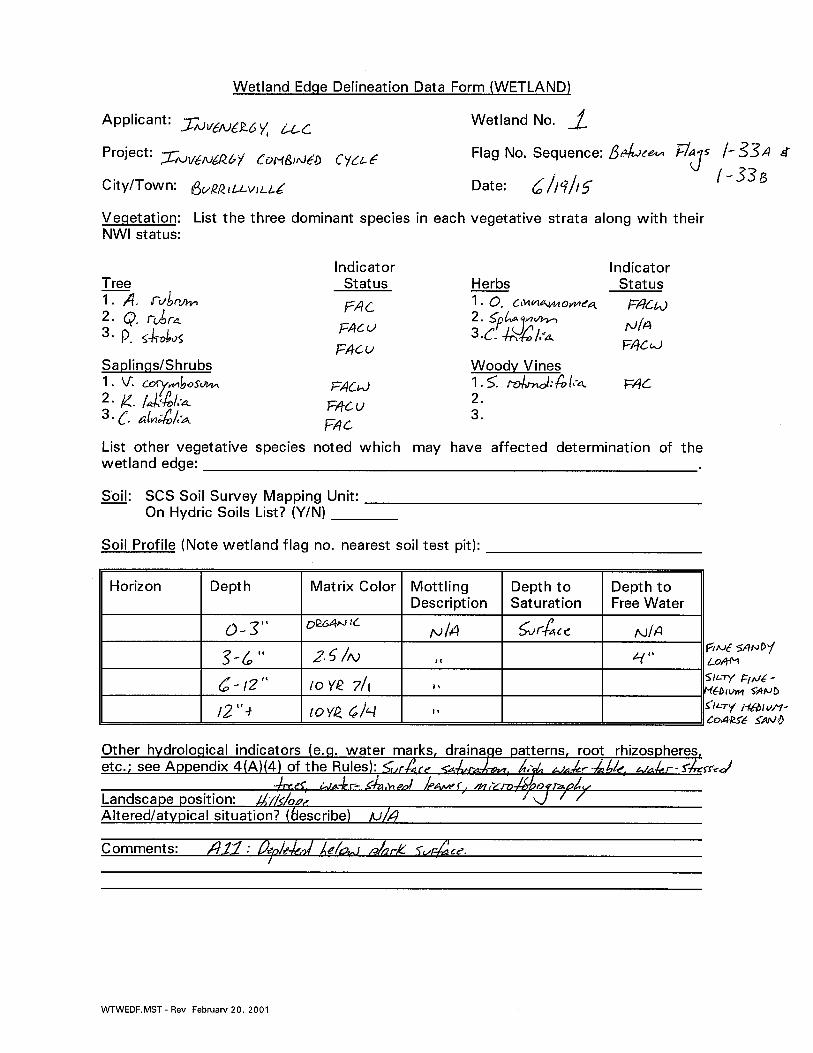


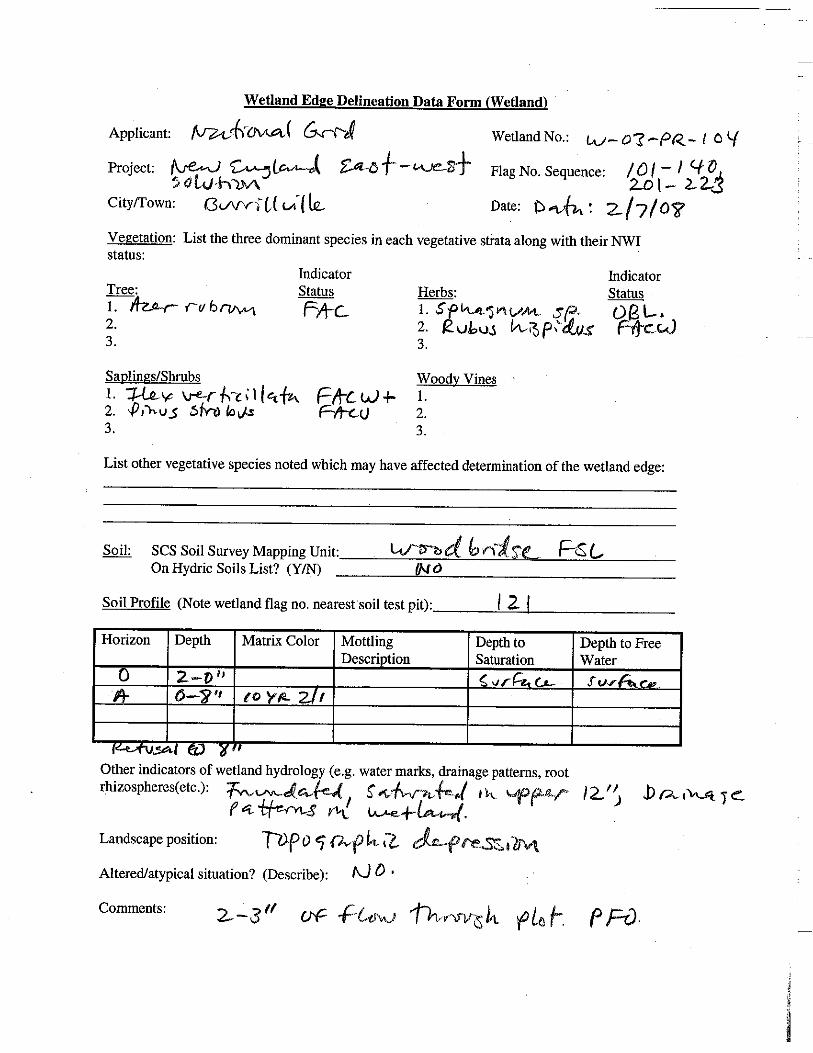


www.essgroup.com
Appendix D
Wetland Photo Log

Photographic Log
October 2014 – June 2015
Sheet 1 of 5
Photograph No.: 1
Northwestern Wetland 1
Photograph No.: 2
Woods road in eastern project area. Wetland 1 located to the left.
Invenergy, LLC Burrillville, Rhode Island © 2015 ESS Group, Inc.
environmental consulting & engineering services

Photographic Log
October 2014 – June 2015
Sheet 2 of 5
Photograph No.: 3
Iron Mine Brook at Wallum Lake Road, Wetland 1
Photograph No.: 4
Unnamed intermittent stream in northeastern Wetland 1
Invenergy, LLC Burrillville, Rhode Island © 2015 ESS Group, Inc.
environmental consulting & engineering services

Photographic Log
October 2014 – June 2015
Sheet 3 of 5
Photograph No.: 5
Wetland 2, eastern arm, south of woods road
Photograph No.: 6
Eastern hemlock stand in northeastern portion of Wetland 2
Invenergy, LLC Burrillville, Rhode Island © 2015 ESS Group, Inc.
environmental consulting & engineering services

Photographic Log
October 2014 – June 2015
Sheet 4 of 5
Photograph No.: 7
Perennial stream in western arm of Wetland 2
Photograph No.: 8
Upland adjacent to western arm of Wetland 2
Invenergy, LLC Burrillville, Rhode Island © 2015 ESS Group, Inc.
environmental consulting & engineering services

Photographic Log
October 2014 – June 2015
Sheet 5 of 5
Photograph No.: 9
Wetland 2 shrub/emergent wetland in Algonquin Gas Transmission Line
Photograph No.: 10
Wetland 3
Invenergy, LLC Burrillville, Rhode Island © 2015 ESS Group, Inc.
environmental consulting & engineering services

AECOM Environment
Wetland W-03-PR-095a, Photo taken 09/16/09
Wetland W-03-PR-095b, Photo taken 09/16/09

AECOM Environment
Wetland W-03-PR-096, Photo taken 09/17/09
Wetland W-03-PR-097, Photo taken 09/17/09

AECOM Environment
Wetland W-03-PR-098, Photo taken 09/17/09
Wetland W-03-PR-099 & S-03-PR-053, Photo taken 09/17/09

AECOM Environment
Wetland W-03-PR-100, Photo taken 09/17/09
Wetland W-03-PR-101, Photo taken 09/17/09

AECOM Environment
Wetland W-03-PR-102, Photo taken 09/17/09
Wetland W-03-PR-103, Photo taken 09/17/09

AECOM Environment
Wetland W-03-PR-104, Photo taken 09/17/09
Wetland W-03-PR-105, Photo taken 09/17/09

AECOM Environment
Wetland W-03-PR-106, Photo taken 09/17/09
Wetland W-03-PR-107, Photo taken 09/17/09

AECOM Environment
Wetland W-03-PR-108, Photo taken 09/17/09
Wetland W-03-PR-109, Photo taken 09/17/09

AECOM Environment
Wetland W-03-PR-110, Photo taken 04/17/08
Wetland W-03-PR-112, Photo taken 04/17/08

AECOM Environment
Wetland W-03-PR-113, Photo taken 09/17/09
Wetland W-03-PR-114, Photo taken 09/17/09

AECOM Environment
Wetland W-03-PR-115, Photo taken 09/16/09
Wetland W-03-PR-116, Photo taken 09/16/09

AECOM Environment
Wetland W-03-PR-117, Photo taken 09/16/09
Wetland W-03-PR-118, Photo taken 09/16/09

AECOM Environment
Wetland W-03-PR-119, Photo taken 09/16/09
Wetland W-03-PR-120, Photo taken 09/16/09

AECOM Environment
Wetland W-03-PR-121, Photo taken 09/16/09
Wetland W-03-PR-122, Photo taken 09/16/09

AECOM Environment
Wetland W-03-PR-124, Photo taken 09/16/09
Wetland W-03-PR-125, Photo taken 09/16/09
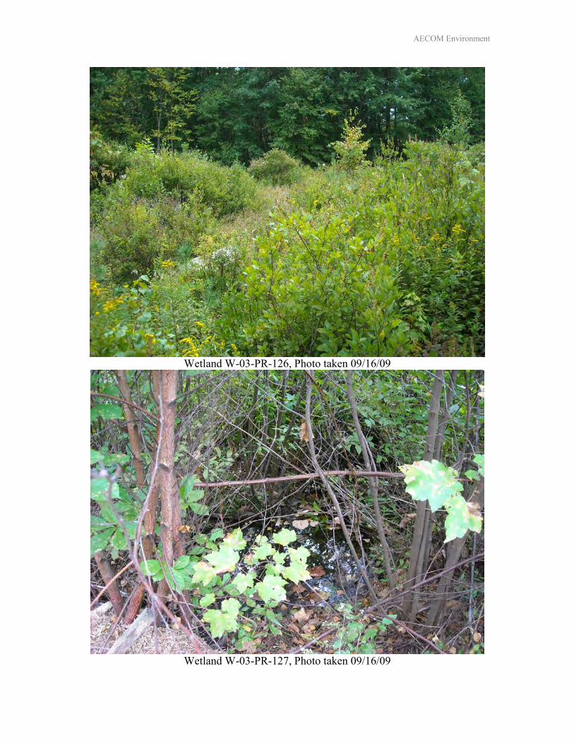
AECOM Environment
Wetland W-03-PR-126, Photo taken 09/16/09
Wetland W-03-PR-127, Photo taken 09/16/09

AECOM Environment
Wetland W-03-PR-128, Photo taken 09/16/09
Wetland W-03-PR-131, Photo taken 09/16/09

AECOM Environment
Wetland W-03-PR-132, Photo taken 09/16/09
Wetland W-03-PR-133, Photo taken 09/16/09

AECOM Environment
Wetland W-03-PR-135, Photo taken 09/16/09
Wetland W-03-PR-136, Photo taken 09/16/09

AECOM Environment
Wetland W-03-PR-138, Photo taken 09/23/09
Wetland W-03-PR-139, Photo taken 09/23/09

AECOM Environment
Wetland W-03-PR-141, Photo taken 09/23/09
Wetland W-03-PR-142, Photo taken 09/23/09

AECOM Environment
Wetland W-03-PR-143, Photo taken 09/23/09
Wetland W-03-PR-144, Photo taken 09/23/09

AECOM Environment
Wetland W-03-PR-146, Photo taken 09/23/09
Wetland W-03-PR-148, Photo taken 09/23/09

AECOM Environment
Wetlands W-03-PR-149 & W-03-PR-150, Photo taken 09/23/09
Wetland W-03-PR-151, Photo taken 09/23/09

AECOM Environment
Wetland W-03-PR-152, Photo taken 09/23/09
Wetland W-03-PR-153, Photo taken 09/23/09

AECOM Environment
Wetland W-03-PR-154, Photo taken 09/23/09
Wetland W-03-PR-155, Photo taken 09/23/09

AECOM Environment
Wetland W-03-PR-156 & S-03-PR-083, Photo taken 09/23/09
Wetland W-03-PR-157, Photo taken 09/23/09

AECOM Environment
Wetland W-03-PR-158, Photo taken 09/23/09
Wetland W-03-PR-159, Photo taken 09/23/09
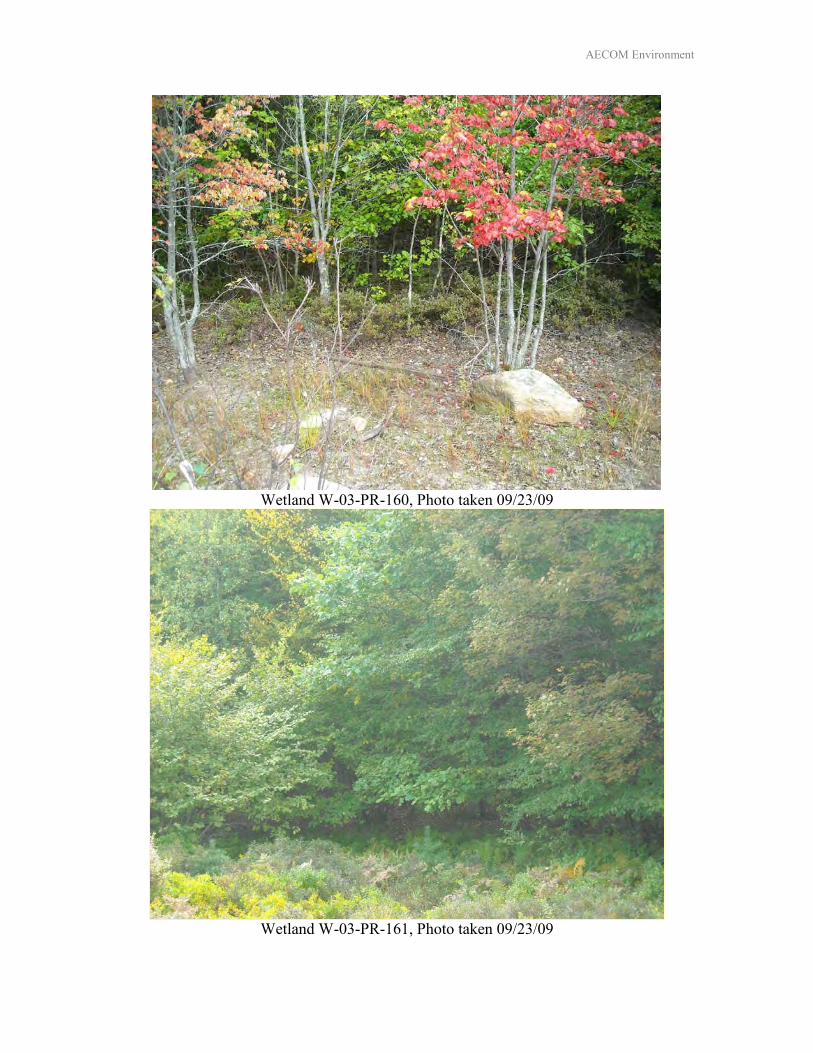
AECOM Environment
Wetland W-03-PR-160, Photo taken 09/23/09
Wetland W-03-PR-161, Photo taken 09/23/09

AECOM Environment
Wetland W-03-PR-162, Photo taken 09/23/09
Wetland W-03-PR-163, Photo taken 09/23/09

www.essgroup.com
Appendix E
List of Vegetation and Relative Abundance

Species/Stratum Scientific Name Wetland 1 Wetland 2 Wetland 3 Wetland 4
Special
Aquatic Site
1
Special
Aquatic Site
2
Staging
Area
Other
Upland
Trees
ash, green Fraxinus pennsylvanica O
aspen, bigtooth Populus grandidentata O
birch, black Betula lenta O O O C
birch, grey Betula populifolia C C
birch, yellow Betula alleghaniensis O O
cherry, black Prunus serotina O
elm, american Ulmus americana O
gum, black Nyssa sylvatica O O O O
hemlock Tsuga canadensis O O
hop hornbeam Ostrya virginiana O
maple, red Acer rubrum A A A A F O C
oak, black Quercus velutina F C
oak, red Quercus rubra F F C C O C C
oak, scarlet Quercus coccinea O O
oak, white Quercus alba O O O O
pine, white Pinus strobus C C C O C C
sassafras Sassafras albidum O O O O
Shrubs
barberry Berberis thunbergii O
birch, black Betula lenta O C C
blueberry, highbush Vaccinium corymbosum F C C C C F
blueberry, lowbush Vaccinium angustifolium O O
chestnut, American Castanea dentata O
chokeberry, red Aronia arbutifolia O
greenbriar Smilax sp. O O
huckleberry Gaylussacia frondosa O O O
laurel, mountain Kalmia latifolia C F C O C F
laurel, sheep Kalmia angustifolia O
maleberry Lyonia ligustrina O
swamp azalea Rhododendron viscosum O F
sweet pepperbush Clethra alnifolia A C C F C C
Virginia creeper Parthenocissus quinquefolia O O
wild raisin Viburnum cassinoides O
winterberry Ilex verticillata O O O
pussy willow Salix discolor O O
witchhazel Hamamelis virginiana C O C O O
Herbs
aster, New England
Symphyotrichum novae‐
angliae)O
beggar ticks Bidens sp. O O
bugleweed Lycopus uniflorus O O
Canada mayflower Maianthemum canadense O
deer‐tongue Dichanthelium clandestinum O
dogwood, silky Cornus amomum O
fern, bracken Pteridium sp. O
fern, cinnamon Osmunda cinnamomea F C C O
fern, hay‐scented Dennstaedtia punctilobula O O
fern, marsh Thylepteris palustris O O
fern, New York Thylepteris noveboracensis O O C O F
fern, royal Osmunda regalis C O O
fern, sensitive Onoclea sensibilis O C
fern, wood spinulose Dryopteris carthusiana O O O
goldenrod, Canada Solidago canadensis O O
goldenrod, wrinkle‐leaved Solidago rugosa O
goldthread Coptis trifolia O
woodgrass Brachyelytrum erectum O C O
greenbrier Smilax sp. C O
marsh dewberry Rubus flagellaris O
marsh st. john's wort Triadenum viginicum
meadowsweet Spiraea latifolia O
moss, haircap Polystricum spp. O
moss, sphagnum Sphagnum spp. C C C C C
multiflora rose Rosa multiflora O
oat‐grass Arrhenatherum elatius O
partridgeberry Mitchella repens O
poison ivy Toxicodendron radicans O O
rush, Canadian Juncus candensis O
rush, slender Junus tenuis O
rush, soft Juncus effusus O
sedge, fringed Carex crinata O O O
sedge, broom Carex scoparia O
sedge, Pennsylavania Carex pennsylvanica
List of Vegetation and Relative Abundance Observed Within CREC Site and 0.8‐mile ROW

sedge, shallow Carex lurida O O O
sedge, tussock Carex stricta O
sessile‐leaved bellwort Uvularia sessifolia O O
skunk cabbage Symplocarpus foetidus O O
snakeroot Ageratina altissima O
starflower Trientalis borealis O O O O
steeplebush Spiraea tomentosa O O
sundew, roundleaved Drosera rotundifolia O
swamp candles Lysimachia terrestris
swamp dewberry Rubus hispidus O O C O
wild grape Vitis sp. O O
woolgrass Scirpus cyperinus O
* A=Abundant >75%, F=Frequent 50‐75%, C=Common 15‐50%, O=Occasional <15%

www.essgroup.com
Appendix F
Floodplain Analysis

Clear River Energy Center | Revised HEC-RAS Model Technical Memorandum
Page 1 of 2
Technical Memorandum Date: Friday, January 20, 2017
Project: Clear River Energy Center Town of Burrillville, Providence County, Rhode Island
To: Type recipient(s) here
From: Type sender(s) here
Subject: Revised HEC-RAS Model of Dry Arm Brook and Iron Mine Brook
1.0 INTRODUCTION
The purpose of this technical memorandum is to describe the modeling completed by HDR in support of the determination of the base flood elevations (BFEs) for Dry Arm Brook and Iron Mine Brook in Burrillville, Rhode Island. Hodge WaterResources (HWR) determined the BFEs for these two brooks upstream of Wallum Lake Road in a Technical Memorandum dated October 11, 2016. HDR utilized this base model to show the effects of the culverts under Algonquin Road which allow water to flow from the Dry Arm Brook Basin into the Iron Mine Branch Basin. HDR completed the modeling using the Hydrologic Engineering Center’s River Analysis System (HEC-RAS), which is developed and maintained by the United States Army Corps of Engineers (USACE) Hydrologic Engineering Center (HEC). 2.0 MODEL SETUP
The process of setting up a steady-flow HEC-RAS model includes four components.
• Development of Model Geometry • Inclusion of Structures • Determination of Upstream Flow Boundary Condition • Determination of Downstream Water Level Boundary Condition
Model Geometry HDR developed the channel geometry by digitizing the stream centerline; stream bank lines and cross-section locations for each brook based on HWR’s October 11, 2016 Technical Memorandum. In addition, HDR added a stream from Algoquin Road to Iron Mine Branch to help model any spillover from Dry Arm Brook to Iron Mine Branch and a stream was added parallel to Wallum Lake Road to help model the spillover from Iron Mine Branch south to another road crossing. The HEC-RAS geometric model was developed from the stream centerlines, edge of banks, and cross-sections that were mapped by Lidar furnished by the ESS Group, Inc. (ESS). Modifications were made to the cross-sections just above and below the culvert crossings to ensure the ground matched the entrance and exit of the culverts. The attached drawing “HEC-RAS Model Geometry and Floodplain Delineation” shows the locations of the cross-sections. For clarity, not all of the model is shown.

Clear River Energy Center | Revised HEC-RAS Model Technical Memorandum
Page 2 of 2
Inclusion of Structures Both Dry Arm Brook and Iron Mine Branch cross under Wallum Lake Road through culverts. The culvert for Dry Arm Brook is a box culvert with a height of 2.42 ft, a width of 5.76 ft, and an upstream invert of 537.33 ft relative to the North American Vertical Datum of 1988 (NAVD88). The culvert for Iron Mine Brook is a double-barreled circular pipe culvert. Each pipe has a diameter of 2.5 ft and an upstream invert of 513.56 ft NAVD88. These dimensions were measured by ESS during a site survey conducted in August and October 2015. HDR used these measurements to incorporate the culverts into the HEC-RAS model. The culvert survey information was provided to HDR by ESS. In addition to the culverts, HDR used a lateral structure in the modeling of Algonquin Road. The lateral structure allows water to flow under Algonquin Road when the flood waters back up high enough from the Dry Arm Brook culvert and flows into the Iron Mine Branch basin. Also, at the location where Iron Mine Brook enters the culvert under Wallum Lake Road, the topography of the surrounding area is such that if a surcharge were to occur at the upstream end of the culvert, water would flow east, parallel to Wallum Lake Road and away from the culvert. HDR modeled the potential for water to flow away from the culvert by including another stream adjacent to where Iron Mine Brook meets Wallum Lake Road. Determination of Upstream Flow Boundary Conditions In order to determine the BFE for a stretch of either brook, it is necessary to make a determination of the flow in the brook during a 1% annual chance storm event (commonly called a 100-year storm event). StreamStats estimates flows in Rhode Island based on studies completed by the USGS (Zarriello et al., 2012; Bent et al., 2014). The prediction of flow from StreamStats depends on the size of the watershed upstream of the requested point. StreamStats has a recommended minimum drainage area limit of 4 sq. miles. Both the Dry Arm Basin and the Iron Mine Basin are below this limit and therefore StreamStats was not used. Dry Arm Brook has a stream gage on it by Wallum Lake Road so this data was used for the Dry Arm Book flows. In order to provide an appropriately conservative upstream steady-flow boundary for the model, HDR distributed the flow between the flow from the stream gage of Dry Arm Brook based on the relative sizes of their contributing watersheds. HDR drew the drainage areas based on the provided Lidar and calculated the flows for Iron Mine Branch using HydroCAD version 10.0. The subsequent flow values were applied to the boundary of Iron Mine Brook. Determination of Downstream Water Level Boundary Condition Dry Arm Brook and Iron Mine Brook drain to the western end of Wilson Reservoir, which in turn drains to the Clear River. The effective Flood Insurance Study (FIS) for Providence County (FEMA, 2015) provides a 1% annual chance flood profile of the Clear River, and the upstream limit is the outfall of Wilson Reservoir under East Wallum Lake Road. The 1% annual chance flood elevation at Wilson Reservoir at the location where Clear River flows from the Reservoir is 444 ft NAVD88. HDR used this water level as the downstream water level boundary condition in the HEC-RAS model. After developing the model geometry, including all relevant structures, and specifying boundary conditions, HDR ran the HEC-RAS model in the steady flow condition in order to determine the BFEs for Dry Arm Brook and Iron Mine Brook. See Figure 1 for additional detail. 3.0 MODEL RESULTS
The HEC-RAS model shows that 4.64 cfs during the 100 year storm flows from the Dry Arm Brook to the Iron Mine Branch. This additional water has no appreciable effect on the Iron Mine Branch Basin.


www.essgroup.com
Appendix G
Vernal Pool Data Forms


www.essgroup.com
Appendix H
Agency Correspondence

1
Joshua Burgoyne
From: vonOettingen, Susi <[email protected]>Sent: Friday, December 18, 2015 8:53 AMTo: Matt RobertsonCc: [email protected]; Mike FeinblattSubject: Re: NLEB Acoustic Report - Burrillville, Rhode Island
Good morning, Matt. I just reviewed the report, thank you very much for sending it. I agree, the survey was consistent with Service guidelines (and thank you for the conservative approach). I also appreciate that the bat call data were vetted. Based on your analyses, I would agree that NLEB are not present in the project area and no minimization or mitigation measures will be necessary. Susi *************************************** Susi von Oettingen Endangered Species Biologist New England Field Office 70 Commercial Street, Suite 300 Concord, NH 03301 (W) 603-223-2541 ext. 6418 Please note my new extension. www.fws.gov/newengland On Mon, Dec 14, 2015 at 12:09 PM, Matt Robertson <[email protected]> wrote:
Good Afternoon,
ESS Group, Inc., on behalf of Invenergy Thermal Development, LLC., is pleased to submit the results of an acoustic bat survey conducted at a proposed energy development site in Burrillville, Rhode Island. If you have any questions or concerns please feel free to contact me at any time. Also, could you please provide an approximate timeframe for your review of the report?
Best Regards,

2
Matt Robertson | Project Scientist
ESS Group, Inc.
10 Hemingway Drive, 2nd Floor, East Providence, RI 02915 | p 401.330.1212
www.essgroup.com
This email message and any attachments are confidential. If you are not the intended recipient, please immediately reply to the sender and delete the message from your email system. Thank you.

1
Joshua Burgoyne
From: Brown, Charles (DEM) <[email protected]>Sent: Wednesday, March 16, 2016 1:33 PMTo: Matt RobertsonSubject: RE: NLEB Acoustic Report - Burrillville, Rhode Island
Hi Matt, There are no known maternity roost trees in Rhode Island and there are no known hibernacula in Burrillville or Providence County. Feel free to cal if you have any questions. Charlie Brown Wildlife Biologist DEM Division of Fish and Wildlife 401‐789‐0281
From: Matt Robertson [mailto:[email protected]] Sent: Wednesday, March 16, 2016 1:25 PM To: Brown, Charles (DEM) <[email protected]> Subject: RE: NLEB Acoustic Report ‐ Burrillville, Rhode Island Good Afternoon Mr. Brown, Since we submitted the NLEB acoustic report (see email below), the ruling on NLEBs has been updated. To remain in compliance with the new rule can you please provide any information on any known hibernacula or maternity roost tree locations in or adjacent to the town of Burrillville? In previous research I could not identify any hibernacula or roost trees in Providence County at large. More recent research has shown that you have been doing surveys and identified some overwintering locations in the state so I wanted to confirm the status on hibernacula and roost tree locations. Thank you very much for your time. All the Best, Matt Robertson ESS Group, Inc. [email protected]
From: Brown, Charles (DEM) [mailto:[email protected]] Sent: Tuesday, December 15, 2015 7:47 AM To: Matt Robertson Subject: RE: NLEB Acoustic Report - Burrillville, Rhode Island
HI Matt, Thank you. I will try to review it this week or next and get back to you with any comments or questions. Charlie Brown
From: Matt Robertson [mailto:[email protected]] Sent: Monday, December 14, 2015 12:09 PM To: Brown, Charles (DEM) <[email protected]>; vonOettingen, Susi <[email protected]> Cc: Mike Feinblatt <[email protected]> Subject: NLEB Acoustic Report ‐ Burrillville, Rhode Island

2
Good Afternoon, ESS Group, Inc., on behalf of Invenergy Thermal Development, LLC., is pleased to submit the results of an acoustic bat survey conducted at a proposed energy development site in Burrillville, Rhode Island. If you have any questions or concerns please feel free to contact me at any time. Also, could you please provide an approximate timeframe for your review of the report? Best Regards, Matt Robertson | Project Scientist ESS Group, Inc. 10 Hemingway Drive, 2nd Floor, East Providence, RI 02915 | p 401.330.1212 www.essgroup.com This email message and any attachments are confidential. If you are not the intended recipient, please immediately reply to the sender and delete the message from your email system. Thank you.

3/21/2017 IPaC: Explore Location
https://ecos.fws.gov/ipac/location/53NAOXSWNFGVZJRSFYA3PWN27M/resources 1/5
Not for consultation
IPaC resource listLocation
Providence County, Rhode Island
Local o핺ceNew England Ecological Services Field O핺ce
(603) 223-2541 (603) 223-0104
70 Commercial Street, Suite 300Concord, NH 03301-5094
http://www.fws.gov/newengland
Endangered speciesThis resource list is for informational purposes only and should not be used for planning oranalyzing project level impacts.
Section 7 of the Endangered Species Act requires Federal agencies to “request of the Secretaryinformation whether any species which is listed or proposed to be listed may be present in the area ofsuch proposed action” for any project that is conducted, permitted, funded, or licensed by any Federalagency.
A letter from the local o핺ce and a species list which ful፮�lls this requirement can only be obtainedby requesting an o핺cial species list either from the Regulatory Review section in IPaC or from thelocal ፮�eld o핺ce directly.
For project evaluations that require USFWS concurrence/review, please return to the IPaC website andrequest an o핺cial species list by creating a project and making a request from the Regulatory Reviewsection.
Listed species are managed by the Endangered Species Program of the U.S. Fish and Wildlife Service.
1. Species listed under the Endangered Species Act are threatened or endangered; IPaC also shows speciesthat are candidates, or proposed, for listing. See the listing status page for more information.
The following species are potentially a꾿ected by activities in this location:
Mammals
1
NAME STATUS
Northern Long-eared Bat Myotis septentrionalisNo critical habitat has been designated for this species.http://ecos.fws.gov/ecp/species/9045
Threatened
U.S. Fish & Wildlife ServiceIPaC

3/21/2017 IPaC: Explore Location
https://ecos.fws.gov/ipac/location/53NAOXSWNFGVZJRSFYA3PWN27M/resources 2/5
Not for consultation
Critical habitatsPotential e꾿ects to critical habitat(s) in this location must be analyzed along with the endangered speciesthemselves.
THERE ARE NO CRITICAL HABITATS AT THIS LOCATION.
Migratory birds
The migratory birds species listed below are species of particular conservation concern (e.g. Birds ofConservation Concern) that may be potentially a꾿ected by activities in this location, not a list of every birdspecies you may ፮�nd in this location. Although it is important to try to avoid and minimize impacts to allbirds, special attention should be made to avoid and minimize impacts to birds of priority concern. To viewavailable data on other bird species that may occur in your project area, please visit the AKN HistogramTools and Other Bird Data Resources.
Birds are protected under the Migratory Bird Treaty Act and the Bald and Golden Eagle Protection Act .
Any activity that results in the take (to harass, harm, pursue, hunt, shoot, wound, kill, trap, capture, orcollect, or to attempt to engage in any such conduct) of migratory birds or eagles is prohibited unlessauthorized by the U.S. Fish and Wildlife Service . There are no provisions for allowing the take of migratorybirds that are unintentionally killed or injured.
Any person or organization who plans or conducts activities that may result in the take of migratory birds isresponsible for complying with the appropriate regulations and implementing appropriate conservationmeasures.
1. The Migratory Birds Treaty Act of 1918.2. The Bald and Golden Eagle Protection Act of 1940.3. 50 C.F.R. Sec. 10.12 and 16 U.S.C. Sec. 668(a)
Additional information can be found using the following links:
Birds of Conservation Concern http://www.fws.gov/birds/management/managed-species/ birds-of-conservation-concern.phpConservation measures for birds http://www.fws.gov/birds/management/project-assessment-tools-and-guidance/ conservation-measures.phpYear-round bird occurrence data http://www.birdscanada.org/birdmon/default/datasummaries.jsp
1 2
3
NAME SEASON(S)
American Bittern Botaurus lentiginosushttp://ecos.fws.gov/ecp/species/6582
Breeding
American Oystercatcher Haematopus palliatushttp://ecos.fws.gov/ecp/species/8935
Breeding
Bald Eagle Haliaeetus leucocephalushttp://ecos.fws.gov/ecp/species/1626
Year-round
Black-billed Cuckoo Coccyzus erythropthalmushttp://ecos.fws.gov/ecp/species/9399
Breeding
Blue-winged Warbler Vermivora pinus Breeding
Canada Warbler Wilsonia canadensis Breeding
Fox Sparrow Passerella iliaca Wintering
Least Bittern Ixobrychus exilishttp://ecos.fws.gov/ecp/species/6175
Breeding
Olive-sided Flycatcher Contopus cooperihttp://ecos.fws.gov/ecp/species/3914
Breeding

3/21/2017 IPaC: Explore Location
https://ecos.fws.gov/ipac/location/53NAOXSWNFGVZJRSFYA3PWN27M/resources 3/5
Not for consultationWhat does IPaC use to generate the list of migratory bird species potentially occurring in my speci፮�ed location?
Landbirds:
Migratory birds that are displayed on the IPaC species list are based on ranges in the latest edition of theNational Geographic Guide, Birds of North America (6th Edition, 2011 by Jon L. Dunn, and JonathanAlderfer). Although these ranges are coarse in nature, a number of U.S. Fish and Wildlife Service migratorybird biologists agree that these maps are some of the best range maps to date. These ranges were clippedto a speci፮�c Bird Conservation Region (BCR) or USFWS Region/Regions, if it was indicated in the 2008 list ofBirds of Conservation Concern (BCC) that a species was a BCC species only in a particular Region/Regions.Additional modi፮�cations have been made to some ranges based on more local or re፮�ned rangeinformation and/or information provided by U.S. Fish and Wildlife Service biologists with species expertise.All migratory birds that show in areas on land in IPaC are those that appear in the 2008 Birds ofConservation Concern report.
Atlantic Seabirds:
Ranges in IPaC for birds o꾿 the Atlantic coast are derived from species distribution models developed bythe National Oceanic and Atmospheric Association (NOAA) National Centers for Coastal Ocean Science(NCCOS) using the best available seabird survey data for the o꾿shore Atlantic Coastal region to date.NOAANCCOS assisted USFWS in developing seasonal species ranges from their models for speci፮�c use inIPaC. Some of these birds are not BCC species but were of interest for inclusion because they may occur inhigh abundance o꾿 the coast at di꾿erent times throughout the year, which potentially makes them moresusceptible to certain types of development and activities taking place in that area. For more re፮�ned detailsabout the abundance and richness of bird species within your project area o꾿 the Atlantic Coast, see theNortheast Ocean Data Portal. The Portal also o꾿ers data and information about other types of taxa thatmay be helpful in your project review.
About the NOAANCCOS models: the models were developed as part of the NOAANCCOS project:Integrative Statistical Modeling and Predictive Mapping of Marine Bird Distributions and Abundance on theAtlantic Outer Continental Shelf. The models resulting from this project are being used in a number ofdecision-support/mapping products in order to help guide decision-making on activities o꾿 the AtlanticCoast with the goal of reducing impacts to migratory birds. One such product is the Northeast Ocean DataPortal, which can be used to explore details about the relative occurrence and abundance of bird species ina particular area o꾿 the Atlantic Coast.
All migratory bird range maps within IPaC are continuously being updated as new and better informationbecomes available.
Can I get additional information about the levels of occurrence in my project area of speci፮�c birds or groups of birds listed in IPaC?
Landbirds:
The Avian Knowledge Network (AKN) provides a tool currently called the "Histogram Tool", which drawsfrom the data within the AKN (latest,survey, point count, citizen science datasets) to create a view of relativeabundance of species within a particular location over the course of the year. The results of the tool depictthe frequency of detection of a species in survey events, averaged between multiple datasets within AKN ina particular week of the year. You may access the histogram tools through the Migratory Bird ProgramsAKN Histogram Tools webpage.
Peregrine Falcon Falco peregrinushttp://ecos.fws.gov/ecp/species/8831
Wintering
Pied-billed Grebe Podilymbus podiceps Year-round
Prairie Warbler Dendroica discolor Breeding
Purple Sandpiper Calidris maritima Wintering
Short-eared Owl Asio 䴵�ammeushttp://ecos.fws.gov/ecp/species/9295
Wintering
Upland Sandpiper Bartramia longicaudahttp://ecos.fws.gov/ecp/species/9294
Breeding
Willow Flycatcher Empidonax trailliihttp://ecos.fws.gov/ecp/species/3482
Breeding
Wood Thrush Hylocichla mustelina Breeding
Worm Eating Warbler Helmitheros vermivorum Breeding

3/21/2017 IPaC: Explore Location
https://ecos.fws.gov/ipac/location/53NAOXSWNFGVZJRSFYA3PWN27M/resources 4/5
Not for consultation
The tool is currently available for 4 regions (California, Northeast U.S., Southeast U.S. and Midwest), whichencompasses the following 32 states: Alabama, Arkansas, California, Connecticut, Delaware, Florida,Georgia, Illinois, Indiana, Iowa, Kentucky, Louisiana, Maine, Maryland, Massachusetts, Michigan, Minnesota,Mississippi, Missouri, New Hampshire, New Jersey, New York, North, Carolina, Ohio, Pennsylvania, RhodeIsland, South Carolina, Tennessee, Vermont, Virginia, West Virginia, and Wisconsin.
In the near future, there are plans to expand this tool nationwide within the AKN, and allow the graphsproduced to appear with the list of trust resources generated by IPaC, providing you with an additionallevel of detail about the level of occurrence of the species of particular concern potentially occurring inyour project area throughout the course of the year.
Atlantic Seabirds:
For additional details about the relative occurrence and abundance of both individual bird species andgroups of bird species within your project area o꾿 the Atlantic Coast, please visit the Northeast Ocean DataPortal. The Portal also o꾿ers data and information about other taxa besides birds that may be helpful toyou in your project review. Alternately, you may download the bird model results ፮�les underlying the portalmaps through the NOAANCCOS Integrative Statistical Modeling and Predictive Mapping of Marine BirdDistributions and Abundance on the Atlantic Outer Continental Shelf project webpage.
Facilities
Wildlife refugesAny activity proposed on National Wildlife Refuge lands must undergo a 'Compatibility Determination'conducted by the Refuge. Please contact the individual Refuges to discuss any questions or concerns.
THERE ARE NO REFUGES AT THIS LOCATION.
Fish hatcheries
THERE ARE NO FISH HATCHERIES AT THIS LOCATION.
Wetlands in the National Wetlands InventoryImpacts to NWI wetlands and other aquatic habitats may be subject to regulation under Section 404 of theClean Water Act, or other State/Federal statutes.
For more information please contact the Regulatory Program of the localU.S. Army Corps of Engineers District.
This location overlaps the following wetlands:
FRESHWATER EMERGENT WETLANDPEM1E
FRESHWATER FORESTED/SHRUB WETLANDPFO4EPFO1E
FRESHWATER PONDPUBHh
A full description for each wetland code can be found at the National Wetlands Inventory website:https://ecos.fws.gov/ipac/wetlands/decoder

3/21/2017 IPaC: Explore Location
https://ecos.fws.gov/ipac/location/53NAOXSWNFGVZJRSFYA3PWN27M/resources 5/5
Not for consultation
Data limitations
The Service's objective of mapping wetlands and deepwater habitats is to produce reconnaissance levelinformation on the location, type and size of these resources. The maps are prepared from the analysis ofhigh altitude imagery. Wetlands are identi፮�ed based on vegetation, visible hydrology and geography. Amargin of error is inherent in the use of imagery; thus, detailed on-the-ground inspection of any particularsite may result in revision of the wetland boundaries or classi፮�cation established through image analysis.
The accuracy of image interpretation depends on the quality of the imagery, the experience of the imageanalysts, the amount and quality of the collateral data and the amount of ground truth veri፮�cation workconducted. Metadata should be consulted to determine the date of the source imagery used and anymapping problems.
Wetlands or other mapped features may have changed since the date of the imagery or ፮�eld work. Theremay be occasional di꾿erences in polygon boundaries or classi፮�cations between the information depictedon the map and the actual conditions on site.
Data exclusions
Certain wetland habitats are excluded from the National mapping program because of the limitations of aerial imagery as the primary data source used to detectwetlands. These habitats include seagrasses or submerged aquatic vegetation that are found in the intertidal and subtidal zones of estuaries and nearshore coastalwaters. Some deepwater reef communities (coral or tuber፮�cid worm reefs) have also been excluded from the inventory. These habitats, because of their depth, goundetected by aerial imagery.
Data precautions
Federal, state, and local regulatory agencies with jurisdiction over wetlands may de፮�ne and describe wetlands in a di꾿erent manner than that used in thisinventory. There is no attempt, in either the design or products of this inventory, to de፮�ne the limits of proprietary jurisdiction of any Federal, state, or local


www.essgroup.com
Appendix I
Wetland Functional Evaluation Forms

_____
______
____ _____
Wetland Function-Value Evaluation Form Wetland I.D.
Wetland 1
Total area of wetland 35 Human made? No Is wetland part of a wildlife corridor? Yes or a "habitat island"? No
Latitude 41.966798
Longitude -71.752007
Adjacent land use Residential, Mixed Deciduous Forest, Industrial Distance to nearest roadway or other development 5 ft.
Prepared by: JB Date 6/28/2016 Wetland Impact:
Dominant wetland systems present PFO1E Contiguous undeveloped buffer zone present Yes Type Area
Is the wetland a separate hydraulic system? No If not, where does the wetland lie in the drainage basin? Upper Evaluation based on:
How many tributaries contribute to the wetland? 1 Wildlife & vegetation diversity/abundance (see attached list)
Office_ X Field_ X
Corps manual wetland delineation
Suitability Rationale
Principal completed? Y X _ N _
Function/Value Y N (Reference #)* Function(s)/Value(s) Comments
Groundwater Recharge/Discharge
Floodflow Alteration
Fish and Shellfish Habitat
Sediment/Toxicant Retention
Nutrient Removal
Production Export
X 1,4,5,7,9,11,12,15 X wetland is upstream from designated groundwater recharge areas, aquifer, and WHPA
X 1,2,5,6,7,10,11,13,14,15,18 X wetland is upstream of downtown Pascoag, which has some floodplain development
X 1,2,4,8.10,11,14.16,17 X ~1 mile upstream of Wilson Reservoir, perennial stream bisects wetland
X 3,4,6,7,8,10,13,14,16 X some clayey loams exist, dense vegetation and perennial stream have sediment trapping potential
X 1-3, 7-14 X wetland has high potential for nutrient attenuation
X 1,2,4,6, 7,10,12 X wetland has high potential for primary and secondary production
Sediment/Shoreline Stabilization
Wildlife Habitat
Recreation
Educational/Scientific Value
Uniqueness/Heritage
Visual Quality/Aesthetics
ES Endangered Species Habitat
6-7, 12-15 wetland provides bank and sediment stabilization to Iron Mine Brook X 1-8,10,11,13,15,17-19,21 X designated by RIDEM as a wildlife corridor and contiguous forest patch >500 acres
X 5, 6 wetland is located on private property and access is restricted
X 2, 4-5 wetland is located on private property and access is restricted
X wetland is located on private property and access is restricted
X 8 wetland is located on private property and access is restricted
X no endangered species present during surveys
Other
Notes: * Refer to backup list of numbered considerations.
X
jburgoyne
Typewritten Text
jburgoyne
Typewritten Text
jburgoyne
Typewritten Text
jburgoyne
Typewritten Text
jburgoyne
Typewritten Text
jburgoyne
Typewritten Text
jburgoyne
Typewritten Text
jburgoyne
Typewritten Text
jburgoyne
Typewritten Text
jburgoyne
Typewritten Text
jburgoyne
Typewritten Text
jburgoyne
Typewritten Text
jburgoyne
Typewritten Text
jburgoyne
Typewritten Text
jburgoyne
Typewritten Text
jburgoyne
Typewritten Text
jburgoyne
Typewritten Text
jburgoyne
Typewritten Text
jburgoyne
Typewritten Text
jburgoyne
Typewritten Text
jburgoyne
Typewritten Text
jburgoyne
Typewritten Text
jburgoyne
Typewritten Text
jburgoyne
Typewritten Text
jburgoyne
Typewritten Text
jburgoyne
Typewritten Text

_____
______
____ _____
Wetland Function-Value Evaluation Form Wetland I.D.
Wetland 2
Total area of wetland 103 ac Human made? No Is wetland part of a wildlife corridor? Yes or a "habitat island"? No
Latitude 41.96729
Longitude -71.75972
crosses Adjacent land use Residential, Mixed Deciduous Forest, Industrial Distance to nearest roadway or other development transmission line
Prepared by: JB Date 6/29/2016 Wetland Impact:
Dominant wetland systems present PFO4, PF01E Contiguous undeveloped buffer zone present Yes Type Area
Is the wetland a separate hydraulic system? No If not, where does the wetland lie in the drainage basin? Upper Evaluation based on:
How many tributaries contribute to the wetland? 2 Wildlife & vegetation diversity/abundance (see attached list)
Office_ X Field_ X
Corps manual wetland delineation
Suitability Rationale
Principal completed? Y X _ N _
Function/Value Y N (Reference #)* Function(s)/Value(s) Comments
Groundwater Recharge/Discharge
Floodflow Alteration
Fish and Shellfish Habitat
Sediment/Toxicant Retention
Nutrient Removal
Production Export
Sediment/Shoreline Stabilization
Wildlife Habitat
Recreation
Educational/Scientific Value
Uniqueness/Heritage
Visual Quality/Aesthetics ES Endangered Species Habitat
X 1,4,5,7,9,11,12,15 X wetland is upstream from designated groundwater recharge areas, aquifer, and WHPA
X 1,2,5,6,7,10,11,13,14,18 X wetland is upstream of downtown Pascoag, which has some floodplain development
X 1,2,4,8.10,11,14-17 ~1 mile upstream of Wilson Reservoir, perennial stream bisects wetland
X 3,6,7,8,9,10,13,14,16 X dense vegetation and perennial stream have sediment trapping potential
X 1-3, 8-14 X wetland has potential for nutrient attenuation
X 1,2,4,6, 7,10,12 X wetland has high potential for primary and secondary production
X 1-9,11,13,14,15,17-19,21 X Designated by RIDEM as a wildlife corridor and contiguous forest patch >500 acres
X
X wetland is located on private property and access is restricted
X wetland is located on private property and access is restricted
X 8 wetland is located on private property and access is restricted
X no endangered species present during surveys
Other
Notes: * Refer to backup list of numbered considerations.
5-6 wetland is located on private property and access is restricted
2, 4-5
6-7, 12-15 wetland provides bank and sediment stabilization to Dry Arm Brook
X

Total area of wetland________ Human made?_______ Is wetland part of a wildlife corridor?_________ or a "habitat island"?_________
Adjacent land use__________________________________________ Distance to nearest roadway or other development_____________
Dominant wetland systems present_____________________________ Contiguous undeveloped buffer zone present________________
Is the wetland a separate hydraulic system?____________ If not, where does the wetland lie in the drainage basin?__________________
How many tributaries contribute to the wetland?____________Wildlife & vegetation diversity/abundance (see attached list)
Latitude_________ Longitude___________
Wetland I.D.____________________________
Prepared by:_________ Date_______________
Wetland Impact:Type__________________Area____________
Evaluation based on:Office_________ Field__________
Corps manual wetland delineation completed? Y_____ N______
Groundwater Recharge/Discharge
Floodflow Alteration
Production Export
Sediment/Toxicant Retention
Nutrient Removal
Sediment/Shoreline Stabilization
Wildlife Habitat
Recreation
Uniqueness/Heritage
Visual Quality/Aesthetics
Endangered Species Habitat
Wetland Function-Value Evaluation Form
Function/ValueSuitability Y N
Rationale(Reference #)*
PrincipalFunction(s)/Value(s) Comments
Notes: * Refer to backup list of numbered considerations.
ES
Other
Educational/Scientific Value
Fish and Shellfish Habitat
✔
smartin
Typewritten Text
3 No No No
smartin
Typewritten Text
Wetland 3
smartin
Typewritten Text
Residential, Mixed Deciduous Forest, Transmission Line l 500 ft.
smartin
Typewritten Text
PFO1E Yes
smartin
Typewritten Text
Yes
smartin
Typewritten Text
None
smartin
Typewritten Text
smartin
Typewritten Text
smartin
Typewritten Text
smartin
Typewritten Text
smartin
Typewritten Text
smartin
Typewritten Text
smartin
Typewritten Text
smartin
Typewritten Text
smartin
Typewritten Text
smartin
Typewritten Text
smartin
Typewritten Text
smartin
Typewritten Text
smartin
Typewritten Text
smartin
Typewritten Text
X
smartin
Typewritten Text
smartin
Typewritten Text
smartin
Typewritten Text
smartin
Typewritten Text
smartin
Typewritten Text
smartin
Typewritten Text
smartin
Typewritten Text
smartin
Typewritten Text
smartin
Typewritten Text
41.968307
smartin
Typewritten Text
-71.765734
smartin
Typewritten Text
smartin
Typewritten Text
smartin
Typewritten Text
smartin
Typewritten Text
smartin
Typewritten Text
smartin
Typewritten Text
smartin
Typewritten Text
smartin
Typewritten Text
smartin
Typewritten Text
smartin
Typewritten Text
smartin
Typewritten Text
smartin
Typewritten Text
smartin
Typewritten Text
smartin
Typewritten Text
smartin
Typewritten Text
smartin
Typewritten Text
smartin
Typewritten Text
smartin
Typewritten Text
smartin
Typewritten Text
X 1-2, 4-6 wetland is small but has some groundwater recharge potential
smartin
Typewritten Text
smartin
Typewritten Text
X 5-6, 8-9, 18 wetland has some flood storage capacity
smartin
Typewritten Text
smartin
Typewritten Text
X no open water habitat
smartin
Typewritten Text
smartin
Typewritten Text
smartin
Typewritten Text
smartin
Typewritten Text
smartin
Typewritten Text
smartin
Typewritten Text
smartin
Typewritten Text
smartin
Typewritten Text
smartin
Typewritten Text
smartin
Typewritten Text
smartin
Typewritten Text
smartin
Typewritten Text
smartin
Typewritten Text
smartin
Typewritten Text
smartin
Typewritten Text
smartin
Typewritten Text
smartin
Typewritten Text
X wetland is small and does not appear to have major sources of sediment
smartin
Typewritten Text
smartin
Typewritten Text
smartin
Typewritten Text
smartin
Typewritten Text
smartin
Typewritten Text
smartin
Typewritten Text
smartin
Typewritten Text
smartin
Typewritten Text
smartin
Typewritten Text
X wetland is small and does not appear to have major sources of nutrients
smartin
Typewritten Text
X does not appear to have high potential for export
smartin
Typewritten Text
X no open water shorelines associated with wetland
smartin
Typewritten Text
smartin
Typewritten Text
smartin
Typewritten Text
smartin
Typewritten Text
smartin
Typewritten Text
smartin
Typewritten Text
smartin
Typewritten Text
smartin
Typewritten Text
smartin
Typewritten Text
smartin
Typewritten Text
smartin
Typewritten Text
smartin
Typewritten Text
smartin
Typewritten Text
X 1, 3-5, 7,8,11,13,15, 19, 21 X wetland is small but located within a large unfragmented forest (>500 acres)
smartin
Typewritten Text
smartin
Typewritten Text
smartin
Typewritten Text
smartin
Typewritten Text
smartin
Typewritten Text
smartin
Typewritten Text
smartin
Typewritten Text
smartin
Typewritten Text
smartin
Typewritten Text
X Wetland is located on private property and access is restricted
smartin
Typewritten Text
smartin
Typewritten Text
smartin
Typewritten Text
smartin
Typewritten Text
smartin
Typewritten Text
smartin
Typewritten Text
X wetland is located on private property and access is restricted
smartin
Typewritten Text
smartin
Typewritten Text
smartin
Typewritten Text
smartin
Typewritten Text
smartin
Typewritten Text
smartin
Typewritten Text
X wetland is located on private property and access is restricted
smartin
Typewritten Text
smartin
Typewritten Text
smartin
Typewritten Text
smartin
Typewritten Text
smartin
Typewritten Text
X wetland is located on private property and access is restricted
smartin
Typewritten Text
smartin
Typewritten Text
X no endangered species present during surveys
smartin
Typewritten Text
smartin
Typewritten Text
smartin
Typewritten Text
smartin
Typewritten Text
smartin
Typewritten Text
smartin
Typewritten Text
smartin
Typewritten Text
smartin
Typewritten Text
JB 6/29/2016
smartin
Typewritten Text
smartin
Typewritten Text
smartin
Typewritten Text
X X
smartin
Typewritten Text
smartin
Typewritten Text
smartin
Typewritten Text
smartin
Typewritten Text
smartin
Typewritten Text
smartin
Typewritten Text
smartin
Typewritten Text
smartin
Typewritten Text
smartin
Typewritten Text
smartin
Typewritten Text
smartin
Typewritten Text
smartin
Typewritten Text
smartin
Typewritten Text
smartin
Typewritten Text
smartin
Typewritten Text
smartin
Typewritten Text
smartin
Typewritten Text
smartin
Typewritten Text
smartin
Typewritten Text
smartin
Typewritten Text
smartin
Typewritten Text
smartin
Typewritten Text
smartin
Typewritten Text
smartin
Typewritten Text
smartin
Typewritten Text
smartin
Typewritten Text
smartin
Typewritten Text
smartin
Typewritten Text
smartin
Typewritten Text
smartin
Typewritten Text
smartin
Typewritten Text
smartin
Typewritten Text
smartin
Typewritten Text

Total area of wetland________ Human made?_______ Is wetland part of a wildlife corridor?_________ or a "habitat island"?_________
Adjacent land use__________________________________________ Distance to nearest roadway or other development_____________
Dominant wetland systems present_____________________________ Contiguous undeveloped buffer zone present________________
Is the wetland a separate hydraulic system?____________ If not, where does the wetland lie in the drainage basin?__________________
How many tributaries contribute to the wetland?____________Wildlife & vegetation diversity/abundance (see attached list)
Latitude_________ Longitude___________
Wetland I.D.____________________________
Prepared by:_________ Date_______________
Wetland Impact:Type__________________Area____________
Evaluation based on:Office_________ Field__________
Corps manual wetland delineation completed? Y_____ N______
Groundwater Recharge/Discharge
Floodflow Alteration
Production Export
Sediment/Toxicant Retention
Nutrient Removal
Sediment/Shoreline Stabilization
Wildlife Habitat
Recreation
Uniqueness/Heritage
Visual Quality/Aesthetics
Endangered Species Habitat
Wetland Function-Value Evaluation Form
Function/ValueSuitability Y N
Rationale(Reference #)*
PrincipalFunction(s)/Value(s) Comments
Notes: * Refer to backup list of numbered considerations.
ES
Other
Educational/Scientific Value
Fish and Shellfish Habitat
✔
smartin
Typewritten Text
0.29 No No No
smartin
Typewritten Text
Wetland 4
smartin
Typewritten Text
Residential, Mixed Deciduous Forest, Transmission Line l 1250 ft.
smartin
Typewritten Text
PFO1E Yes
smartin
Typewritten Text
Yes
smartin
Typewritten Text
None
smartin
Typewritten Text
smartin
Typewritten Text
smartin
Typewritten Text
smartin
Typewritten Text
smartin
Typewritten Text
smartin
Typewritten Text
smartin
Typewritten Text
smartin
Typewritten Text
smartin
Typewritten Text
smartin
Typewritten Text
smartin
Typewritten Text
smartin
Typewritten Text
smartin
Typewritten Text
smartin
Typewritten Text
smartin
Typewritten Text
smartin
Typewritten Text
smartin
Typewritten Text
smartin
Typewritten Text
smartin
Typewritten Text
smartin
Typewritten Text
smartin
Typewritten Text
smartin
Typewritten Text
smartin
Typewritten Text
smartin
Typewritten Text
smartin
Typewritten Text
smartin
Typewritten Text
smartin
Typewritten Text
smartin
Typewritten Text
smartin
Typewritten Text
smartin
Typewritten Text
smartin
Typewritten Text
smartin
Typewritten Text
smartin
Typewritten Text
smartin
Typewritten Text
smartin
Typewritten Text
smartin
Typewritten Text
smartin
Typewritten Text
smartin
Typewritten Text
smartin
Typewritten Text
X 1-2, 4-6 wetland is small but has some groundwater recharge capacity
smartin
Typewritten Text
smartin
Typewritten Text
X 5-6, 8-9, 18 wetland is small and does not appear to hold standing water during most of the season
smartin
Typewritten Text
smartin
Typewritten Text
X no open water habitat
smartin
Typewritten Text
smartin
Typewritten Text
smartin
Typewritten Text
smartin
Typewritten Text
smartin
Typewritten Text
smartin
Typewritten Text
smartin
Typewritten Text
smartin
Typewritten Text
smartin
Typewritten Text
smartin
Typewritten Text
smartin
Typewritten Text
smartin
Typewritten Text
smartin
Typewritten Text
smartin
Typewritten Text
smartin
Typewritten Text
smartin
Typewritten Text
smartin
Typewritten Text
X wetland is small and does not appear to have major sources of sediment
smartin
Typewritten Text
smartin
Typewritten Text
smartin
Typewritten Text
smartin
Typewritten Text
smartin
Typewritten Text
smartin
Typewritten Text
smartin
Typewritten Text
smartin
Typewritten Text
smartin
Typewritten Text
X wetland is small and does not appear to have major sources of nutrients
smartin
Typewritten Text
X does not appear to have high potential for export
smartin
Typewritten Text
X no open water shorelines associated with wetland
smartin
Typewritten Text
smartin
Typewritten Text
smartin
Typewritten Text
smartin
Typewritten Text
smartin
Typewritten Text
smartin
Typewritten Text
smartin
Typewritten Text
smartin
Typewritten Text
smartin
Typewritten Text
smartin
Typewritten Text
smartin
Typewritten Text
smartin
Typewritten Text
smartin
Typewritten Text
X 1, 3-5, 7,8,11,13,15, 19, 21 X wetland is small but located within a large unfragmented forest (>500 acres)
smartin
Typewritten Text
smartin
Typewritten Text
smartin
Typewritten Text
smartin
Typewritten Text
smartin
Typewritten Text
smartin
Typewritten Text
smartin
Typewritten Text
smartin
Typewritten Text
smartin
Typewritten Text
X Wetland is located on private property and access is restricted
smartin
Typewritten Text
smartin
Typewritten Text
smartin
Typewritten Text
smartin
Typewritten Text
smartin
Typewritten Text
smartin
Typewritten Text
X wetland is located on private property and access is restricted
smartin
Typewritten Text
smartin
Typewritten Text
smartin
Typewritten Text
smartin
Typewritten Text
smartin
Typewritten Text
smartin
Typewritten Text
X wetland is located on private property and access is restricted
smartin
Typewritten Text
smartin
Typewritten Text
smartin
Typewritten Text
smartin
Typewritten Text
smartin
Typewritten Text
X wetland is located on private property and access is restricted
smartin
Typewritten Text
smartin
Typewritten Text
X no endangered species present during surveys
smartin
Typewritten Text
smartin
Typewritten Text
smartin
Typewritten Text
smartin
Typewritten Text
smartin
Typewritten Text
smartin
Typewritten Text
smartin
Typewritten Text
smartin
Typewritten Text
JB 6/29/2016
smartin
Typewritten Text
smartin
Typewritten Text
smartin
Typewritten Text
X X
smartin
Typewritten Text
smartin
Typewritten Text
smartin
Typewritten Text
smartin
Typewritten Text
smartin
Typewritten Text
smartin
Typewritten Text
smartin
Typewritten Text
smartin
Typewritten Text
smartin
Typewritten Text
smartin
Typewritten Text
smartin
Typewritten Text
smartin
Typewritten Text
smartin
Typewritten Text
smartin
Typewritten Text
smartin
Typewritten Text
smartin
Typewritten Text
smartin
Typewritten Text
smartin
Typewritten Text
smartin
Typewritten Text
smartin
Typewritten Text
smartin
Typewritten Text
smartin
Typewritten Text
smartin
Typewritten Text
smartin
Typewritten Text
smartin
Typewritten Text
smartin
Typewritten Text
smartin
Typewritten Text
smartin
Typewritten Text
smartin
Typewritten Text
smartin
Typewritten Text
smartin
Typewritten Text
smartin
Typewritten Text
smartin
Typewritten Text
smartin
Typewritten Text
smartin
Typewritten Text
smartin
Typewritten Text
smartin
Typewritten Text
smartin
Typewritten Text
smartin
Typewritten Text
smartin
Typewritten Text
smartin
Typewritten Text

www.essgroup.com
Appendix J
Stormwater Management Plan for Clear River Energy Center

For Appendix J, please see the separately bound volume entitled Stormwater Management Plan for Clear River Energy Center included with the filing of this application.

www.essgroup.com
Appendix K
Stormwater Management Plan for Burrillville Interconnection Project

For Appendix K, please see the separately bound volume entitled Stormwater Management Plan for Burrillville Interconnection Project included with the filing of this application

www.essgroup.com
Appendix L
Right-of-Way Access, Maintenance, and Construction Best Management Practices

Doc. No. EG-303NE
Page 1 of 49 Rev. 8
ENVIRONMENTAL GUIDANCE Date 10/21/16
SUBJECT Access, Maintenance and Construction Best Management Practices
Reference EP No. 3 – Natural Resource Protection (Chapter 6)
Approved for use per EP 10, Document Control PRINTED COPIES ARE NOT DOCUMENT CONTROLLED. FOR LATEST AUTHORIZED VERSION PLEASE REFER TO THE NATIONAL GRID ENVIRONMENTAL INFONET SITE.
SCOPE: This specification provides Environmental Procedures and Best Management Practices (BMPs) for work on electric and natural gas transmission and distribution rights-of-way (ROWs), fee-owned and easement, cross-country, and public/private roadways, as well as substations, company facilities and on customer-owned projects, and other facilities in New England.
Note that project-specific permits may have other BMPs/constraints that differ from this Environmental Guidance (EG). The projects shall be constructed in accordance with the project-specific permits and this specification. For maintenance work in New Hampshire, there is a state specific BMP manual which supersedes EG-303NE, where applicable1. For work in Vermont, there is a state specific BMP manual which may supersede EG-303NE, where applicable2. The Massachusetts Runoff, Erosion & Sedimentation Control Field Guide published by the Massachusetts Association of Conservation Commissions (MACC) is incorporated herein as a reference. The MACC Guide is intended as a supplement to EG-303NE and shall be superseded by EG-303NE in the case of an inconsistency or conflict.
PURPOSE: The purpose of this specification is to provide National Grid personnel, consultants
and contractors with BMPs to support work that is protective of the environment and that complies with all applicable environmental laws, regulations and company policies and procedures. Environmental policies require the Company to avoid, minimize and mitigate negative impacts to the environment.
POLICY: These BMPs are to be effectively and consistently followed by all personnel accessing
Company facilities, ROWs, and customer projects for inspection, maintenance and construction work purposes.
If there are any questions on this guidance, contact the local or project National Grid Environmental Scientist.
These BMPs do not apply to Company employees and contractors performing routine vegetation management activities that are not part of a construction or maintenance project. Employees and contractors maintaining vegetation on Company ROWs and substations shall follow the National Grid Right-of-Way Vegetation Management Plan; Right-of-Way Vegetation Management Specification; Substation, Switch Yard, and Pole Yard Vegetation Management Specification; and Right-of-Way Vegetation Mowing Specification. For more information regarding routine vegetation management, please contact a National Grid Forester.
1 The “Best Management Practices Manual For Utility Maintenance In And Adjacent To Wetlands and Waterbodies in New Hampshire” 2 Vermont DEC, 2006. The Vermont Standards and Specifications for Erosion Prevention and Sediment Control.

Doc. No. EG-303NE
Page 2 of 49 Rev. 8
ENVIRONMENTAL GUIDANCE Date 10/21/16
SUBJECT Access, Maintenance and Construction Best Management Practices
Reference EP No. 3 – Natural Resource Protection (Chapter 6)
Approved for use per EP 10, Document Control PRINTED COPIES ARE NOT DOCUMENT CONTROLLED. FOR LATEST AUTHORIZED VERSION PLEASE REFER TO THE NATIONAL GRID ENVIRONMENTAL INFONET SITE.
APPLICABLE REGULATIONS: Refer to Applicable Regulations in state-specific EG-301 documents.
CONTACTS: If there are any questions on this guidance, contact the National Grid Environmental
Scientist. 1.0 Definitions
Refer to Glossary in Appendix 1 and Acronyms in Appendix 2. 2.0 Project Planning
Prior to the start of any project (proposed new facilities or maintenance of existing facilities), the Project Engineer or other project planner shall determine whether any environmental permits or approvals are required, per the state-specific EG-301 environmental checklists. Any questions regarding which activities may be conducted in regulated areas or within environmentally sensitive areas shall be referred to the National Grid Environmental Scientist or Project Environmental Consultant
All new construction and maintenance projects shall follow clear and enforceable environmental performance standards, which is the purpose for which these BMPs have been compiled.
2.1 Avoidance and Minimization Measures shall always be taken to avoid impacts to wetlands, waterways, rare species habitats, known below and above ground historical/archeological resources and other environmentally sensitive areas. If avoidance is not possible, then measures shall be taken to minimize the extent of impacts. Alternate access routes or staging areas shall always be considered. Below is a list of methods that shall be considered where impacts are unavoidable:
• Use existing ROW access where available. Keep to approved routes and roads without
deviating from them or making them wider. • Off-ROW access shall never be assumed and shall be coordinated through National
Grid Real Estate before being implemented. • Where no existing ROW access is present, avoid wetlands and if a wetland crossing is
necessary, cross wetlands at the most narrow point possible or at the location of a previously used crossing (if evident). Figure 1 below illustrates this minimization technique.
• Avoid and minimize stream crossings; • Minimize the width of typical access roads through wetlands to a maximum width of 16
feet; • Conduct work manually (without using motorized equipment) in wetlands, wherever
possible;

Doc. No. EG-303NE
Page 3 of 49 Rev. 8
ENVIRONMENTAL GUIDANCE Date 10/21/16
SUBJECT Access, Maintenance and Construction Best Management Practices
Reference EP No. 3 – Natural Resource Protection (Chapter 6)
Approved for use per EP 10, Document Control PRINTED COPIES ARE NOT DOCUMENT CONTROLLED. FOR LATEST AUTHORIZED VERSION PLEASE REFER TO THE NATIONAL GRID ENVIRONMENTAL INFONET SITE.
• Use swamp, timber, or similar mats in wetlands to minimize soil disturbance and rutting when crossing or working within wetlands. When not using mats for access, standard vehicles shall not be allowed to drive across wetlands without the prior approval of the National Grid Environmental Scientist. Use of a low ground pressure (LGP) vehicle may be a feasible alternative to mats provided that such LGP vehicle use has been reviewed and approved by the National Grid Environmental Scientist. See Section 8.5.
• Coordinate the timing of work to cause the least impacts during the regulatory low-flow period under normal conditions, when water/ground is frozen, after the spring songbird nesting season, and, outside of the anticipated amphibian migration window (mid-February to mid-June). The United States Army Corps of Engineers (USACE) defines the low-flow period as July 1 through August 30 in MA, July 1 through October 1 in RI, July 1 through October 1 in NH, and July 1 through October 1 in VT.
• Seek alternative routes or work methods to minimize impact.

Doc. No. EG-303NE
Page 4 of 49 Rev. 8
ENVIRONMENTAL GUIDANCE Date 10/21/16
SUBJECT Access, Maintenance and Construction Best Management Practices
Reference EP No. 3 – Natural Resource Protection (Chapter 6)
Approved for use per EP 10, Document Control PRINTED COPIES ARE NOT DOCUMENT CONTROLLED. FOR LATEST AUTHORIZED VERSION PLEASE REFER TO THE NATIONAL GRID ENVIRONMENTAL INFONET SITE.

Doc. No. EG-303NE
Page 5 of 49 Rev. 8
ENVIRONMENTAL GUIDANCE Date 10/21/16
SUBJECT Access, Maintenance and Construction Best Management Practices
Reference EP No. 3 – Natural Resource Protection (Chapter 6)
Approved for use per EP 10, Document Control PRINTED COPIES ARE NOT DOCUMENT CONTROLLED. FOR LATEST AUTHORIZED VERSION PLEASE REFER TO THE NATIONAL GRID ENVIRONMENTAL INFONET SITE.
2.2 Historically Significant Areas Areas that have been identified as historically and/or culturally significant shall be avoided in accordance with site-specific avoidance plans, as applicable. Refer to the project-specific Environmental Field Issue (EFI) for any applicable avoidance plans or consult with the National Grid Environmental Scientist. Demarcation of these areas to be avoided shall use staked orange snow fencing or an equivalent physical barrier (not just ribbon flagging) and signage. Refer to Section 16.0 for signage guidance. 2.3 Rare Species Habitat Work within areas that have been identified as mapped rare species habitat shall follow site-specific requirements, as applicable. In Massachusetts, maintenance activities within mapped habitat (known as Priority Habitat of Rare Species) shall follow the BMPs outlined in the Natural Heritage Endangered Species Program (NHESP)-approved National Grid Operation and Maintenance Plan. Work in mapped rare species habitat may require, at a minimum, turtle training for crews and sweeps of work areas for turtles, botanist identification of rare plant locations and avoidance of these locations, and protection of vernal pools, all prior to the start of work. Demarcation of these areas to be avoided (e.g., rare plant populations, overwintering turtles, nests) shall use staked orange snow fencing or an equivalent physical barrier (not just ribbon flagging) and signage. Refer to Section 16.0 for signage guidance.
Other requirements may apply in NH, VT and RI. Refer to the project-specific EFI for any applicable measures or consult with the National Grid Environmental Scientist. 2.4 Meetings Pre-permitting meetings shall take place early in the project development process to determine what permits are triggered by the proposed work and the timeline required for permitting. During these meetings, the team shall develop access plans and BMPs to be used during construction of the project.
Field / Constructability review meetings shall take place on-site to evaluate construction site access and job site set-up, to ensure that the project can proceed as permitted. It is at this point in time where work areas, pulling locations, laydown areas, parking areas, and equipment storage areas are evaluated and located. Off-ROW areas under consideration should be included in this discussion.
Prior to submitting permit plans to regulatory authorities, the construction group (contractor or National Grid) shall review the plans for final sign off.
Pre-construction meetings are typically held prior to the commencement of all work to appoint responsible parties, discuss timing of work, and further consider options to avoid and/or minimize impacts to sensitive areas. These meetings can occur on- or off-site and shall include all the willing and available stakeholders (i.e., utility employees, contractors, consultants,

Doc. No. EG-303NE
Page 6 of 49 Rev. 8
ENVIRONMENTAL GUIDANCE Date 10/21/16
SUBJECT Access, Maintenance and Construction Best Management Practices
Reference EP No. 3 – Natural Resource Protection (Chapter 6)
Approved for use per EP 10, Document Control PRINTED COPIES ARE NOT DOCUMENT CONTROLLED. FOR LATEST AUTHORIZED VERSION PLEASE REFER TO THE NATIONAL GRID ENVIRONMENTAL INFONET SITE.
inspectors, and/or monitors, and regulatory personnel). Training of crews and supervisors of the EFI, Stormwater Pollution Prevention Plan (SWPPP), rare species, and other permit requirements shall be conducted at a pre-construction meeting.
Pre-job briefings shall be conducted daily or otherwise routinely scheduled meetings shall be conducted on-site with the work crew throughout the duration of the work. These meetings are a way of keeping everyone up to date, confirming there is consensus on work methods and responsibilities, and ensuring that tasks are being fulfilled with as little impact to the environment as possible. The Project Environmental Scientist/Monitor and Construction Project Manager shall communicate regularly (e.g. weekly or bi-weekly meetings or phone conversations) to discuss the work completed since last communication (i.e. work locations, wetland impacts, equipment used, and unexpected delays or work conditions). These meetings or calls shall include the expected schedule of construction for the upcoming week, the long term construction plans, and planned methods for working near/in wetlands. Both the Project Environmental Scientist/Monitor and Construction Project Manager shall work together so the Project complies with all environmental permits and regulations. When changes to the Project scope or agreed work plan are proposed they shall be done so with the final approval of the National Grid Environmental Scientist. 2.5 Communication of Project Specific Environmental Requirements Project specific environmental concerns, to include sensitive resources, permits, approved access and time-of-year or other restrictions, shall be communicated to the project team and be included as part of the Pre-Bid and Pre-Construction Meetings. Project specific requirements shall be communicated to the project manager/construction manager/engineering group using the following guidelines: Environmental Field Issue – The EFI will be a full document consisting of narrative, project permits, access and matting plans. A table summarizing pertinent (but not all) permit conditions and the responsible party for those conditions shall be included in the EFI. Copies of all permits should be included as attachments. This will be prepared for most projects with multiple permits or large, complex projects (siting board, Section 404, 401 WQC, SWPPP). There should be EFI training at the pre-construction meeting. Appendix 3 is a sample EFI template.
Simplified Environmental Field Issue – The Simplified EFI is a memorandum containing environmental resources present, project permit(s), access and matting plans and a table summarizing relevant permit conditions and responsible party for those conditions. Copies of all permits should be included as attachments. The Simplified EFI will be prepared for most projects with 1 or 2 permits (Order of Conditions, S404 Cat 1). The Simplified EFI should also be provided for projects that have environmental resources present, but the scope of the project

Doc. No. EG-303NE
Page 7 of 49 Rev. 8
ENVIRONMENTAL GUIDANCE Date 10/21/16
SUBJECT Access, Maintenance and Construction Best Management Practices
Reference EP No. 3 – Natural Resource Protection (Chapter 6)
Approved for use per EP 10, Document Control PRINTED COPIES ARE NOT DOCUMENT CONTROLLED. FOR LATEST AUTHORIZED VERSION PLEASE REFER TO THE NATIONAL GRID ENVIRONMENTAL INFONET SITE.
does not trigger environmental permitting (e.g., the scope of work qualifies for maintenance exemption(s)). The resources present shall be discussed at the Pre-Bid and Pre-Construction meetings and any changes in scope will require additional review by the National Grid project team. E-mail delivery of Permit and any Sediment/Erosion control or BMP plan – For those projects with only one permit (eg., MA Order of Conditions, RI DEM permit, RI CRMC permit, NH Utility Notification) or projects with a sediment & erosion control plan (local town requirement or for exempt maintenance work), a copy of the permit and any applicable plan will be emailed to the PM (and the project team where deemed necessary) to be incorporated into the Construction Field Issue.
STORMS work management system input – For STORMS work, no EFI is prepared unless multiple permits are required for the project (see guidance above). If only a MA Order of Conditions, MA Determination of Applicability, RI DEM permit, RI CRMC permit, RI SESC Approval, or NH Utility Notification is required, then the permit is attached in Documents tab and conditions noted in Remarks/comments section. Appendix 5 contains standard STORMS boilerplate language. 2.6 Timing of Work Regulatory authorities may place seasonal or time-of-year restrictions on project construction elements. These time-of-year restrictions may be state or permit-specific, and shall be adhered to. Work during frozen conditions. Activities conducted once wetland areas are frozen sufficient to minimize rutting and other impacts to the surrounding environment may be authorized by the National Grid Environmental Scientist. Work during this time also generally reduces disturbance of aquatic and terrestrial wildlife movement by avoiding sensitive breeding and nesting seasons. When not using mats for access, vehicles shall not be allowed to drive across wetlands without the prior approval of the National Grid Environmental Scientist. Work during the regulatory low-flow period. Conducting work during the low-flow period can reduce impacts to surface water and generally avoids spawning and breeding seasons of aquatic organisms. If the water is above normal seasonal levels, adjustments to work activities and methods are required. 2.7 Alternate Access
2.7.1 Manual Access In some cases such as for smaller projects, work areas can be accessed manually. This includes access on foot through upland and shallow wetland areas, access by boat through open water or ponded areas, and climbing of structures where possible. Smaller projects, such as repair of individual structures, or parts of structures, that do

Doc. No. EG-303NE
Page 8 of 49 Rev. 8
ENVIRONMENTAL GUIDANCE Date 10/21/16
SUBJECT Access, Maintenance and Construction Best Management Practices
Reference EP No. 3 – Natural Resource Protection (Chapter 6)
Approved for use per EP 10, Document Control PRINTED COPIES ARE NOT DOCUMENT CONTROLLED. FOR LATEST AUTHORIZED VERSION PLEASE REFER TO THE NATIONAL GRID ENVIRONMENTAL INFONET SITE.
not categorically require the use of heavy machinery, shall be accessed manually to the greatest extent practicable.
2.7.2 Use of Overhead/Aerial Access Using helicopters can be expensive and is not always feasible, but it may be appropriate in some situations in order to get workers and equipment to a site that otherwise may be very difficult to access. The use of overhead and/or aerial equipment may be beneficial for work in areas where larger water bodies, deep crevices, or mountainous areas hinder ground access. The landing area for helicopters shall be reviewed for environmentally sensitive resources. Use of helicopters requires Project Manager and Senior Management approval.
3.0 Inspection, Monitoring and Maintenance
All construction practices and controls shall be inspected on a regular basis and in accordance with all applicable permits and local, state, and federal regulations to avoid and correct ANY damage to sensitive areas.
The construction crews shall be responsible for completing daily inspections, and IMMEDIATELY bring any damage or observed erosion, or failed erosion controls to the attention of the Person-In-Charge and the National Grid Environmental Scientist. Where applicable and/or as directed by environmental permits issued for the project, the Project Environmental Consultant shall conduct weekly (at a minimum) inspections of the project work areas and shall document their inspection using the Stormwater, Wetlands & Priority Habitat Environmental Compliance Site Inspection / Monitoring Report form found in Appendix 6 and issue the report within 24 hours. The Person-in-Charge shall work with the National Grid Environmental Scientist and the Project Environmental Consultant to determine when and how the repairs shall be made.
Project-specific Action Logs and Long-Term Restoration Logs are prepared as needed by the National Grid Environmental Scientist or the Project Environmental Consultant to track issues and/or repairs and assign responsible parties.
4.0 Best Management Practices
The BMP sections presented in this EG address access, construction, snow and ice management, structures in wetlands, access road maintenance and repair, clean-up and restoration standards, ROW gates, field refueling and maintenance operations, management of spills/releases, and a summary of key construction BMPs.
Note that BMPs shown on any permit drawings for a specific project may need to be revised and or supplemented during the execution of a project based on unforeseen or unexpected factors such as extreme weather or unknown subsurface conditions. It is the responsibility of the Contractor to work with the National Grid Environmental Scientist and/or the Project

Doc. No. EG-303NE
Page 9 of 49 Rev. 8
ENVIRONMENTAL GUIDANCE Date 10/21/16
SUBJECT Access, Maintenance and Construction Best Management Practices
Reference EP No. 3 – Natural Resource Protection (Chapter 6)
Approved for use per EP 10, Document Control PRINTED COPIES ARE NOT DOCUMENT CONTROLLED. FOR LATEST AUTHORIZED VERSION PLEASE REFER TO THE NATIONAL GRID ENVIRONMENTAL INFONET SITE.
Environmental Consultant to identify necessary changes and to ensure that construction-related impacts to wetlands, water bodies and other environmentally sensitive areas are avoided.
Any deviation from the approved Best Management Practices shown in the EFI and/or SWPPP plans shall be communicated immediately to the National Grid Environmental Scientist as it may require additional permitting or could result in a permit violation.
4.1 Wetland Boundary Demarcation
Prior to the start of any activity conducted under an environmental permit, wetland boundaries shall be reviewed. Flagging for wetland boundaries, stream banks and other resource areas shall be refreshed as needed. This may become particularly important when the original flagging was placed in previous seasons and now may have become obscured.
4.2 Sedimentation and Erosion Controls
Appropriate sedimentation and erosion control devices shall be installed at work sites, in accordance with permit conditions and/or regulatory approvals, and as needed to prevent adverse impacts to water resources and adjacent properties.
The overall purpose of such controls is to prevent and control the movement of disturbed soil and sediment from work sites to adjacent, undisturbed areas, and particularly to water resources, public roads and adjacent properties. All proprietary controls shall be installed per manufacturer’s recommendations and specifications.
Appropriate sedimentation and erosion control devices include but are not limited to: silt fencing, straw bales, wood chip bags, straw wattles, compost socks, erosion control blankets, mulch, slope interruption practices, flocculent powder/blocks and storm drain/catch basin inlet protection. Such controls shall be installed between the work area and environmentally sensitive areas such as wetlands, streams, drainage courses, roads and adjacent property when work activities shall disturb soils and result in a potential for causing sedimentation and erosion. Staked straw bales often serve as the demarcation of the limits of work and/or sensitive areas to be avoided. Work shall never be conducted outside the limit of erosion controls without prior approval from the National Grid Environmental Scientist.
Project plans depict proposed erosion controls, however field conditions may warrant additional practices be implemented (e.g., wet conditions, frozen conditions, poorly drained soils, steep slopes, materials used for work pads, transition areas to swamp mats, number of trips across work areas, etc.).
Any deviation from the approved erosion controls shown in the EFI and/or SWPPP plans needs to be communicated immediately to the National Grid Environmental Scientist as it may require additional permitting or result in a permit violation.

Doc. No. EG-303NE
Page 10 of 49 Rev. 8
ENVIRONMENTAL GUIDANCE Date 10/21/16
SUBJECT Access, Maintenance and Construction Best Management Practices
Reference EP No. 3 – Natural Resource Protection (Chapter 6)
Approved for use per EP 10, Document Control PRINTED COPIES ARE NOT DOCUMENT CONTROLLED. FOR LATEST AUTHORIZED VERSION PLEASE REFER TO THE NATIONAL GRID ENVIRONMENTAL INFONET SITE.
Appendix 7 provides typical sketches of common sedimentation and erosion controls. If a SWPPP is required for the project, maintenance and inspection of erosion controls shall follow the SWPPP requirements. Sedimentation and erosion controls shall be properly maintained and inspected on a periodic basis, until work sites are properly stabilized and restored. Inspections shall be documented using the Inspection Form “Storm Water, Wetlands & Priority Habitat Environmental Compliance Site Inspection/Monitoring Report” (Appendix 6).
The sequence and timing of the installation of sedimentation and erosion control measures is critical to their success. Sedimentation and erosion controls shall be installed prior to commencing construction activities that may result in any soil disturbance or cause otherwise polluted site runoff. Inspection of these devices may be required by the National Grid Environmental Scientist or by regulators prior to the start of work. The installation of water bars and other erosion control measures shall be installed shortly thereafter.
4.3 Concrete Wash Outs
Concrete wash outs shall be used for management of concrete waste. Concrete and concrete washout water shall not be deposited or discharged directly on the ground, in wetlands or waterbodies, or in catch basins or other drainage structures. Where possible, concrete washouts shall be located away from wetlands or other sensitive areas. Consult the National Grid Environmental Scientist on proposed concrete wash out locations prior to their use. Following the completion of concrete pouring operations, the wash outs shall be disposed of off-site with other construction debris. Refer to BMPs in Appendix 7.
4.4 Construction Activities in Standing Water
The use of silt curtains or turbidity barriers may be required when working in or adjacent to standing water such as ponds, reservoirs, low flowing rivers/streams, or coastal areas. Silt curtains and turbidity barriers prevent sediment from migrating beyond the immediate work area into the resource areas. Coffer dams constructed using sheet piling or large sandbags (Trade names such as “the Big Bag” or “DamItDams”) may be used to temporarily isolate and contain a work area in standing water. When working in standing water, an oil absorbent boom, in addition to a silt curtain or other temporary barrier, shall be placed around the work area for spill prevention. Work in drinking water reservoirs or other waters may require extensive regulatory agency review, even for maintenance work, which could result in additional time required for permitting, review and material procurement prior to the start of work.

Doc. No. EG-303NE
Page 11 of 49 Rev. 8
ENVIRONMENTAL GUIDANCE Date 10/21/16
SUBJECT Access, Maintenance and Construction Best Management Practices
Reference EP No. 3 – Natural Resource Protection (Chapter 6)
Approved for use per EP 10, Document Control PRINTED COPIES ARE NOT DOCUMENT CONTROLLED. FOR LATEST AUTHORIZED VERSION PLEASE REFER TO THE NATIONAL GRID ENVIRONMENTAL INFONET SITE.
4.5 Dewatering
Where excavations require the need for dewatering of groundwater or accumulated stormwater, the water shall be treated before discharge. Appropriate controls include dewatering basins, flocculent blocks, filter bags, filter socks, or weir tanks. Schematics of these BMPs are included as in Appendix 7. Water trucks or fractionation tanks may be utilized if watertight containers are desired for controlled on-site discharge or for off-site discharge into an approved dewatering area when site restrictions make it difficult to utilize other dewatering methods on-site. Dewatering discharge water shall never be directed into wetlands, streams/rivers, other sensitive resource areas, catch basins, other stormwater devices, or substation Trenwa trenches. Dewatering flow shall be controlled so that it does not cause scouring or erosion through the use of a dewatering basin, filter sock, or equivalent. If it is determined that the chosen controls are not appropriately filtering the fine sediment from the dewatering pumpate then the National Grid Environmental Scientist shall be notified immediately and the controls shall be revised or supplemented. When establishing a dewatering basin, consideration should be given to the anticipated volume of water and rate of pumping in determining the size of the dewatering basin. Dewatering basins shall be constructed on level ground. Once pumping commences, the basin shall be monitored frequently to assure that the rate of water delivery to the structure is low enough to prevent water from flowing, unfiltered, over the top of the basin walls. The basin shall be monitored throughout the dewatering process because the rate of filtration shall decrease as sediment clogs the filter fabric. If the basin is not appropriately filtering the fine sediment from the dewatering pumpate then the basin may need to be supplemented with a flocculent block. Field conditions shall dictate how often the basin should be inspected. Distance to sensitive areas, direction of flow (toward or away from protected, or sensitive areas, such as wetlands, ponds, or streams), amount of vegetative ground cover between the basin and nearby sensitive areas, ground conditions (ledge, frozen, etc.), volume of water being pumped, and pump-rate, are some of the factors to be considered when determining an inspection frequency. Clogged filter fabric shall be replaced and accumulated sediment shall be removed as necessary from the basins to maintain efficacy. Unattended dewatering shall never be allowed. If 24-hour dewatering is required for on-site construction activities, a designated attendee shall be trained by the National Grid Environmental Scientist. Basins shall be cleaned and removed as soon as dewatering is complete. Sediment removed from the dewatering basin shall be allowed to dry before being disposed of by evenly spreading it over unvegetated upland areas where erosion is not a concern if clean or removing it from the site for proper disposal. Off-site trucking of wet soils is prohibited. The sediment disposal area shall be approved by the National Grid Environmental Scientist or the Project Environmental Consultant prior to use. Stabilization measures shall also need to implemented and approved

Doc. No. EG-303NE
Page 12 of 49 Rev. 8
ENVIRONMENTAL GUIDANCE Date 10/21/16
SUBJECT Access, Maintenance and Construction Best Management Practices
Reference EP No. 3 – Natural Resource Protection (Chapter 6)
Approved for use per EP 10, Document Control PRINTED COPIES ARE NOT DOCUMENT CONTROLLED. FOR LATEST AUTHORIZED VERSION PLEASE REFER TO THE NATIONAL GRID ENVIRONMENTAL INFONET SITE.
by the National Grid Environmental Scientist or the Project Environmental Consultant. Soils/sediments shall be dewatered or mixed with dry material such that they are appropriate for off-site transport. Any new dewatering location (not previously reviewed and approved by the National Grid Environmental Scientist during project planning or permitting) shall be reviewed and the discharge location approved by the National Grid Environmental Scientist before use. Complex projects that require large scale dewatering shall require individual review by the National Grid Environmental Scientist and may trigger additional permitting. Dewatering in areas of known chemical contamination may require a separate NPDES permit, or other approval, and treatment or containment system. Consult with the National Grid Environmental Scientist.
4.6 Check Dams
Check dams are a porous physical barrier installed perpendicular to concentrated storm water flow. They are used to reduce erosion in a swale by reducing runoff energy (velocity), while filtering storm water, thereby aiding in the removal of suspended solids. Check dams should only be used in small drainage swales that shall not be overtopped by flow once the dams are constructed. These dams should not be placed in streams. Check dams are typically installed in ROWs or on other construction sites prior to the start of soil disturbing work. Per the Rhode Island Soil Erosion and Sediment Control Handbook, no formal design is required for a check dam if the contributing drainage area is 2 acres or less and its intended use is shorter than 6 months; however, the following criteria should be adhered to when specifying check dams.
• The drainage area of the ditch or swale being protected should not exceed 10 acres. • The maximum height of the check dam should be 2 feet. • The center of the check dam must be at least 6 inches lower than the outer edges. • The maximum spacing between the dams should be such that the toe at the upstream
dam is at the same elevation as the top of the downstream dam. Per the NHDES stormwater manual, the use of check dams should be limited to swales with longitudinal slopes that range between 2 to 5 percent that convey drainage from an area less than 1 acre. Existing conditions that exceed these limitations should be assessed in the field and discussed with the National Grid Environmental Scientist to determine the viability of this BMP for the specific application. Check dams are often comprised of stone, straw bales, sand bags, or compost/silt socks. Use of check dams should be coordinated with the National Grid Environmental Scientist to ensure that the material selection, spacing and construction method are appropriate for the site. Check dams composed of biodegradable materials (e.g. straw bales

Doc. No. EG-303NE
Page 13 of 49 Rev. 8
ENVIRONMENTAL GUIDANCE Date 10/21/16
SUBJECT Access, Maintenance and Construction Best Management Practices
Reference EP No. 3 – Natural Resource Protection (Chapter 6)
Approved for use per EP 10, Document Control PRINTED COPIES ARE NOT DOCUMENT CONTROLLED. FOR LATEST AUTHORIZED VERSION PLEASE REFER TO THE NATIONAL GRID ENVIRONMENTAL INFONET SITE.
or wattles, wood chip bags) may require periodic replacement for continued proper functioning3. Refer to BMPs in Appendix 7.
4.7 Water Bars
Water bars should be used on sloping ROWs to divert storm water runoff from unstabilized or active access roads when needed to prevent erosion. Surface disturbance and tire compaction promote gully formation by increasing the concentration and velocity of runoff. Water bars are constructed by forming a ridge or ridge and channel diagonally across the sloping ROW. Each outlet should be stable. The height and side slopes of the ridge and channel are designed to divert water and to allow vehicles to cross. When siting water bars, consideration shall be given to the sensitivity of the area receiving the diverted runoff. For example, runoff should not be directed into a wetland, waterbody, other environmentally sensitive areas, or to private property or public roadways. Refer to BMPs in Appendix 7.
4.8 Retaining Walls
In some situations, retaining walls comprised of concrete blocks, gabions, boulders or other comparable materials may be required to stabilize the shoulder of existing access roads and/or supplement required erosion controls. Installation of such measures shall not be allowed as a maintenance activity. Should these controls be considered for a project, it shall be reviewed by the National Grid Environmental Scientist, as design and additional permitting may be required.
4.9 Slope Stabilization
Temporary slope stabilization practices help to keep exposed, erodible soils stabilized while vegetation is becoming established. Acceptable temporary slope stabilization practices may include the use of erosion control blankets, or hydraulic erosion control. Erosion control blankets, often comprised of natural fibers (e.g., jute, straw, coconut, or other degradable materials) are a useful slope stabilization, erosion control and vegetation establishment practice for ditches or steep slopes. Blankets are typically installed after final grading and seeding for temporary or permanent seeding applications. Hydraulic erosion control practices, including Bonded Fiber Matrix or hydroseed with a soil stabilizer (e.g., tackifier and/or mulch) may be an acceptable or desirable alternative form of temporary slope stabilization. For all practices, manufacturer’s specifications should be followed for installation depending on slope and other field conditions. Consult the National Grid Environmental Scientist prior to selecting and installing any slope stabilization practices. Refer to BMPs in Appendix 7.
4.10 Maintenance of Sedimentation and Erosion Controls
Sedimentation and erosion controls shall be maintained in good operational condition during the course of the work. This includes , but is not limited to, replacing straw bales that are no
3 Grass growth on a biodegradable type check dam is evidence that the material is decomposing. While this doesn’t mean it is no longer functioning, it means it may be in a weakened condition and could potentially fail under high flow velocity. It is acceptable for grass to be growing on a stone check dam.

Doc. No. EG-303NE
Page 14 of 49 Rev. 8
ENVIRONMENTAL GUIDANCE Date 10/21/16
SUBJECT Access, Maintenance and Construction Best Management Practices
Reference EP No. 3 – Natural Resource Protection (Chapter 6)
Approved for use per EP 10, Document Control PRINTED COPIES ARE NOT DOCUMENT CONTROLLED. FOR LATEST AUTHORIZED VERSION PLEASE REFER TO THE NATIONAL GRID ENVIRONMENTAL INFONET SITE.
longer in good condition, re-staking straw bales, replacing or re-staking silt fence, and removing accumulated sediment. Remove sediment before it has accumulated to one half the height of any exposed silt fence fabric, straw bales, other filter berm, check dams or water bars. Accumulated sediment shall be removed from sedimentation basins to maintain their efficacy. Manage the removed sediment by evenly spreading it over unvegetated upland areas where erosion is not a concern, by stockpiling and stabilizing, or by disposing of off-site. Stabilization measures shall also need to be implemented and approved by the National Grid Environmental Scientist or the Project Environmental Consultant. Where a SWPPP has been prepared for a specific site, the guidelines documented therein shall govern the management of sediment.
5.0 Right-of-Way (ROW) Access
Whenever possible, access shall be gained along existing access routes or roads within the ROW. However, in some cases there is no existing access. In many cases, temporary access can be utilized. The following practices provide general guidance on accessing a ROW. Check with a National Grid Environmental Scientist to determine if any environmental permitting is required before utilizing a temporary access. National Grid operates substations and has cross-country ROW with overhead electric power lines in four New England States. MA, NH and RI also have transmission and distribution natural gas pipelines. Access is needed to substations, ROWs, and customer property, for inspection, maintenance and construction activities. Many projects are located in or near environmentally sensitive areas, such as rivers/streams, wetlands, floodplains, or rare species habitat, etc., which are protected from activities that may disturb these resources. Note that the building of new roads or enlargement of existing roads is prohibited unless this activity is allowed by a project-specific permit, and the new roads appear on the Site Plans that were authorized in the regulatory approvals.
5.1 Off-ROW Access
Off-ROW access shall be evaluated for wetlands, rare species, cultural resources and other potential sensitive receptors, as applicable. National Grid Real Estate and Stakeholder Relations shall also be contacted as soon as possible once off-ROW access is determined to be needed.
5.2 Stabilized Construction Entrance/Exit for Access to ROWs from Public or Private Roads
A suitable (minimum 15-foot wide by 50-foot long) construction entrance/exit shall be installed at the intersection of the ROW access road/route with public/private paved roads, or other such locations where equipment could track mud or soil onto paved roads. The construction entrance/exit should be comprised of clean stone installed over a geotextile fabric. Geotextile

Doc. No. EG-303NE
Page 15 of 49 Rev. 8
ENVIRONMENTAL GUIDANCE Date 10/21/16
SUBJECT Access, Maintenance and Construction Best Management Practices
Reference EP No. 3 – Natural Resource Protection (Chapter 6)
Approved for use per EP 10, Document Control PRINTED COPIES ARE NOT DOCUMENT CONTROLLED. FOR LATEST AUTHORIZED VERSION PLEASE REFER TO THE NATIONAL GRID ENVIRONMENTAL INFONET SITE.
fabric may be omitted for permanent construction entrances/exits on a case-by-case basis with the approval of the National Grid Environmental Scientist. Refer to BMPs in Appendix 7. Construction entrance areas shall be monitored and maintained to ensure that stone or other material is not deposited onto the roadway, causing a safety concern. Where track-out of sediment has occurred onto a roadway, it shall be swept off the road by the end of that same work day. If a construction entrance/exit is clogged with sediment and no longer functions, the sediment and stone may require removal and replacement with additional clean stone (clean stone refreshment) to ensure this tracking pad is performing its intended function adequately. Heavier traffic use may require this clean stone refreshment multiple times throughout a project. Reinforcement of these stabilized construction entrance/exits with asphalt binder or asphalt millings is not likely to be considered “maintenance” and may trigger additional permitting requirements4. In some cases, heavily used construction entrances/exits may benefit from the installation of a 5-15 foot strip of asphalt binder or asphalt millings closest to the paved roadway to capture any stone that is tracked from the stone apron. Such cases shall be evaluated on an individual basis with the National Grid Environmental Scientist. Once work is complete, the construction entrance/exit shall either be removed or retained, depending upon future maintenance-related access needs, property ownership, and/or project-specific approvals. If removed, the area shall be graded, seeded (if adequate root and seed stock are absent) and mulched. Proper approvals for leaving access roads in place shall be obtained; contact the National Grid Environmental Scientist and Property Legal.
5.3 Maintenance of Existing Access Roads
In many cases, the existing access road may need to be maintained to allow passage of the heavy equipment required for scheduled maintenance work. Access roads cannot deviate from the approved and permitted access plans. Maintenance of these roads may include adding clean gravel or clean crushed stone to fill depressions and eroded areas. This activity shall be conducted only within the width of the existing access road footprint and does not include widening existing access roads If gravel begins to migrate onto the existing vegetated road shoulder, this gravel shall be removed during the project and/or after the completion of use of the road to ensure the road fill is not spreading into adjacent resource areas, or resulting in the road becoming much wider than its pre-existing or permitted condition. In some areas of mapped rare species habitat or other sensitive areas where project-specific permit conditions require the prevention of the migration of sediments into adjacent resources, an engineered stabilization system (e.g.,
4 Depending on the road, use of an asphalt binder or asphalt millings as a construction entrance/exit may trigger state or local permit requirements.

Doc. No. EG-303NE
Page 16 of 49 Rev. 8
ENVIRONMENTAL GUIDANCE Date 10/21/16
SUBJECT Access, Maintenance and Construction Best Management Practices
Reference EP No. 3 – Natural Resource Protection (Chapter 6)
Approved for use per EP 10, Document Control PRINTED COPIES ARE NOT DOCUMENT CONTROLLED. FOR LATEST AUTHORIZED VERSION PLEASE REFER TO THE NATIONAL GRID ENVIRONMENTAL INFONET SITE.
GeoWeb or similar) may be suitable to prevent sedimentation while allowing for unrestricted wildlife migration. Major reconstruction projects may require multiple permits. In all cases, the fill to be used for existing access roads shall be clean and free of construction debris, trash or woody debris. Use of processed gravel may be approved by the Person-In-Charge or the National Grid Environmental Scientist, on a case-by-case basis. If clean stone is used then addition of more erosion controls may not be necessary.
5.4 Maintenance of Existing Access Routes (Cross Country Routes)
Ruts and depressions along existing access routes and within the existing ROW may only be leveled and graded. Addition of fill or stone may require permitting as well as additional erosion controls, and needs to be approved by the National Grid Environmental Scientist
5.5 Maintenance of Existing Culverts
Damaged culverts may not be repaired or replaced without consulting with the National Grid Environmental Scientist to determine if a permit is required. For functioning culverts, care shall be taken to protect adjacent wetlands and watercourses by installing appropriate sedimentation and erosion controls around the downstream end of the culvert. Culverts shall be repaired/replaced in kind and shall not be changed in size unless approval has been obtained from the National Grid Environmental Scientist. In-kind replacement is replacement using the same material, functional inverts, diameter and length as the existing culvert. Changes to any of these characteristics shall require permitting. Installation of any new culvert is not allowed without obtaining all necessary permits first. Refer to BMPs in Appendix 7. If, at the time of anticipated replacement, there is heavy flow through the culvert, the Person-In-Charge shall consult with the National Grid Environmental Scientist, to verify whether the culvert shall be replaced at that time. Water may need to be temporarily diverted during culvert repair/replacement. There typically are seasonal restrictions limiting both the replacement of existing culverts as well as installation of new culverts to the low-flow period. The low-flow period can vary from state to state. If any unexpected conditions are encountered during culvert replacement, the National Grid Environmental Scientist shall be contacted immediately prior to the work being completed for additional consultation.
5.6 Temporary Construction Access over Drainage Ditch or Swale
In some situations, construction access from paved roads onto ROWs may require the crossing of drainage ditches or swales along the road shoulder. In these situations, the installation of swamp mats, mat bridges or temporary culverts may facilitate construction access over the ditches or swales. These culverts shall be temporary only, sized for peak flow, and shall be removed after construction is complete. Consult with the National Grid Environmental

Doc. No. EG-303NE
Page 17 of 49 Rev. 8
ENVIRONMENTAL GUIDANCE Date 10/21/16
SUBJECT Access, Maintenance and Construction Best Management Practices
Reference EP No. 3 – Natural Resource Protection (Chapter 6)
Approved for use per EP 10, Document Control PRINTED COPIES ARE NOT DOCUMENT CONTROLLED. FOR LATEST AUTHORIZED VERSION PLEASE REFER TO THE NATIONAL GRID ENVIRONMENTAL INFONET SITE.
Scientist prior to installation. In addition, if access over existing culverts may require extending the culvert, consult with the National Grid Environmental Scientist. Refer to BMPs in Appendix 7.
5.7 Construction Material along ROW
After preparing a site by clearing and/or installing any necessary erosion and sediment controls and prior to the start of construction, material such as poles, cross-arms, cable, insulators, stone and other engineered backfill materials may be placed along the ROW, as part of the project. The stockpiling of stone and other unconsolidated material on swamp mats shall be avoided, if determined necessary due to access and workpad constraints, the material must be placed on a geotextile fabric and be properly contained with a sedimentation barrier such as straw wattle. No construction material shall be placed in wetlands or other sensitive resource areas unless authorized by the National Grid Environmental Scientist or Project Environmental Consultant
6.0 Winter Conditions
6.1 Snow Management
DO NOT stockpile or dispose of snow in any water body, including wetlands, rivers/streams, the ocean, reservoirs, ponds, or stormwater catch basins. A buffer of at least 25 feet shall be maintained between any snow disposal area and any the high water mark of any surface water. A silt fence or equivalent barrier shall be securely placed between the snow storage area and the high water mark of rivers, streams, ponds, or the ocean. In addition to water quality impacts and flooding, snow disposed in surface water can cause navigational hazards when it freezes into ice blocks. Some state and local authorities have specific snow management requirements. Consult with the National Grid Environmental Scientist on specific restrictions.
DO NOT deposit snow within a wellhead protection area (e.g., a Zone II), in a high or medium-yield aquifer, or within 200 feet of a private well, where road salt may contaminate water supplies. Consult with the National Grid Environmental Scientist to determine if a proposed disposal area is located within one of these sensitive areas. Avoid disposing of snow on top of storm drain catch basins or in storm water drainage swales or ditches. Snow combined with sand and debris may block a storm drainage system, causing localized flooding. A high volume of sand, sediment, and litter released from melting snow also may be quickly transported through the system into surface water and could also result in fines or a violation being assessed against National Grid.
All debris in a snow storage area shall be cleared from the site and properly disposed of no later than May 15 of each year.
Care shall be taken not to plow road materials away when removing snow. 6.2 De-Icing

Doc. No. EG-303NE
Page 18 of 49 Rev. 8
ENVIRONMENTAL GUIDANCE Date 10/21/16
SUBJECT Access, Maintenance and Construction Best Management Practices
Reference EP No. 3 – Natural Resource Protection (Chapter 6)
Approved for use per EP 10, Document Control PRINTED COPIES ARE NOT DOCUMENT CONTROLLED. FOR LATEST AUTHORIZED VERSION PLEASE REFER TO THE NATIONAL GRID ENVIRONMENTAL INFONET SITE.
Where allowed, calcium chloride is preferred as a de-icing agent when applied according to manufacturer’s guidelines in upland areas. Sand shall be used on swamp mats through wetland areas. Consult with the National Grid Environmental Scientist on de-icing agents when working in a facility or substation close to resource areas. Many municipalities have specific requirements for de-icing agents allowed within 100 feet of wetland resources and other sensitive areas.
6.3 Snow and Ice Management on Swamp Mats
Proper snow removal on swamp mats shall avoid the formation of ice. To avoid the formation of ice, snow shall be removed from swamp mats before applying sand. Prior to their removal from wetlands, sand shall be collected from the swamp mats and disposed of in an upland area. A round street sweeping brush mounted on the front of a truck may be an effective way to remove snow from swamp mats. Propane heaters may also be suitable solutions for snow removal and/or de-icing of swamp mats.
Once swamp mats are removed, wetlands shall be inspected for build up of sand that may have fallen through swamp mats. Care shall be taken to inspect wetland crossings as each mat is removed to ensure sand is properly removed and disposed of off-site.
7.0 Swamp Mats
The use of swamp mats allows for heavy equipment access within wetland areas. The use of swamp mats minimizes the need to remove vegetation beneath the access way and helps to reduce the degree of soil disturbance and rutting in soft wetland soils. Swamp mats most often used by National Grid are wooden timbers bolted together typically into 4-ft by 16-ft sections, wooden lattice mats, or composite mats. In some cases, swamp mats or other mats are used for staging or access in upland areas based on site conditions (e.g., agricultural field access). Refer to BMPs in Appendix 7.
Typically swamp mats may be installed on top of the existing vegetation, however in some instances cutting large woody vegetation may be required. Check with National Grid Environmental Scientist prior to cutting or clearing vegetation for swamp mat placement.
Follow the approved plans in the EFI for swamp mat installation and do not deviate from the plans. Any deviation from the approved plans needs to be communicated immediately to the National Grid Environmental Scientist as it may require additional permitting, require stopping the project or result in a permit violation or revocation.
7.1 Swamp Mats and Mowing
Close coordination with the mowing contractor shall be required to ensure that access plans are followed, and swamp mats are utilized when necessary. Sometimes mowing contractors may

Doc. No. EG-303NE
Page 19 of 49 Rev. 8
ENVIRONMENTAL GUIDANCE Date 10/21/16
SUBJECT Access, Maintenance and Construction Best Management Practices
Reference EP No. 3 – Natural Resource Protection (Chapter 6)
Approved for use per EP 10, Document Control PRINTED COPIES ARE NOT DOCUMENT CONTROLLED. FOR LATEST AUTHORIZED VERSION PLEASE REFER TO THE NATIONAL GRID ENVIRONMENTAL INFONET SITE.
have to work off the leading edge of a swamp mat to mow in order to lay the next swamp mat and continue further into the wetland. Under no circumstances shall trees or shrubs be allowed to be pulled out of the wetland by the root ball. The root ball of trees and shrubs shall remain intact. Chipping debris and excessive amounts of slash shall not be placed in wetlands or other resource areas. In some instances, it may be beneficial to pile a reasonable amount of slash within a nearby upland area to create habitat for wildlife. This activity shall be approved by the National Grid Environmental Scientist.
7.2 Stream Crossings and Stream Bank Stabilization
Stream crossings shall be bridged with swamp mats or other temporary minimally-intrusive measures unless fording is acceptable for the site and is authorized by the National Grid Environmental Scientist. Care shall be taken when installing a swamp mat bridge to insure that the stream bed and banks are not damaged during installation and removal and that stream flow is not unduly restricted. An environmental permit may be required to cross or disturb protected waters, depending upon state-specific regulatory requirements. Refer to BMPs in Appendix 7. Immediately following swamp mat removal, all stream banks shall be stabilized and restored to prevent sedimentation and erosion.
7.3 Cleaning of Swamp Mats
Mats shall be certified clean by the vendor prior to installation. The vendor shall use the certification form provided as Appendix 8 to document compliance. Clean is defined as being free of plant matter (stems, flowers, roots, etc), soil, or other deleterious materials prior to being brought to the project site. Any equipment or timber mats that have been placed or used within areas containing invasive species within the project site shall be cleaned of plant matter (stems, flowers, roots, etc), soil, or other deleterious materials at the site of the invasive species prior to being moved to other areas on the project site to prevent the spread of invasive species from one area to another5. Mats shall be cleaned prior to being removed at the completion of the project: exceptions to this requirement may be made on a case-by-case basis. Consult with the National Grid Environmental Scientist prior to discharging or disposing of any waste water or waste material from the cleaning of swamp mats.
7.4 Stone Removal for Swamp Mat Placement
For situations where the matting contractor determines that stones or boulders must be removed or relocated within wetland areas in order to install safe and level structure work pads or access roads the boulders shall be moved in a manner which does not result in significant soil disturbance (i.e., pushing with a bull dozer is not allowed). The boulders shall not be placed on any existing vegetated areas within wetlands or within vernal pools. When numerous boulders shall be removed from a wetland area, they shall be deposited in an upland area outside of the
5 On ROW projects where multiple wetlands may be dominated by the same invasive species, cleaning may not be required for movement along the ROW. Check with the National Grid Environmental scientist for guidance.

Doc. No. EG-303NE
Page 20 of 49 Rev. 8
ENVIRONMENTAL GUIDANCE Date 10/21/16
SUBJECT Access, Maintenance and Construction Best Management Practices
Reference EP No. 3 – Natural Resource Protection (Chapter 6)
Approved for use per EP 10, Document Control PRINTED COPIES ARE NOT DOCUMENT CONTROLLED. FOR LATEST AUTHORIZED VERSION PLEASE REFER TO THE NATIONAL GRID ENVIRONMENTAL INFONET SITE.
flagged wetland limits, outside of any cultural resource areas and outside of any RTE species populations. Any boulders that shall be placed within buffers (In MA, the 100-foot buffer zone, and in RI, the 50-foot Perimeter Wetland, 100-foot or 200-foot Riverbank Wetlands) shall be placed to avoid causing soil disturbance and they shall be within an approved limit of work. When there is a significant number of boulders that shall be removed, the National Grid Environmental Scientist shall be consulted for guidance.
7.5 Transition onto Mats
Erosion controls and stone or wood chip ramps shall be installed to promote a smooth transition to and minimize sediment tracking onto swamp mats. Geotextile may be added beneath stone or wood chip transitions to facilitate removal, as necessitated by site or permit conditions. Mat transitions shall be removed once swamp mats have been removed and during restoration. Refer to BMPs in Appendix 7.
7.6 Corduroy Roads
Corduroy roads are a wetland crossing method where logs are cut from the immediate area and used as a road bed to prevent rutting from equipment crossing. This technique is designed to be used in areas of wetland crossings where there is no defined channel or stream flow and should never be used in streams. Corduroy logs shall be placed in the narrowest area practicable for crossing with the logs placed perpendicular to the direction of travel across wet area. The use of corduroy logs shall only be in emergencies when approved by the National Grid Environmental Scientist or when they have been specifically permitted as part of a project. Refer to BMPs in Appendix 7.
7.7 Swamp Mat Removal
Once swamp mats are removed, wetlands shall be inspected for build up of sand or other materials that may have fallen through swamp mats. Care shall be taken to inspect wetland crossings as each mat is removed to ensure any materials are properly removed and disposed of off-site.
7.8 Bridging over other utility facilities
In ROWs where other utility facilities (including but not limited to gas, oil, fiber optic, electric, water, and sewer) are co-located within the transmission ROW, bridging may be required to cross those facilities. The project team shall coordinate with the respective utility company prior to determining if bridging or permanent crossings are required.
8.0 LGP Equipment Use

Doc. No. EG-303NE
Page 21 of 49 Rev. 8
ENVIRONMENTAL GUIDANCE Date 10/21/16
SUBJECT Access, Maintenance and Construction Best Management Practices
Reference EP No. 3 – Natural Resource Protection (Chapter 6)
Approved for use per EP 10, Document Control PRINTED COPIES ARE NOT DOCUMENT CONTROLLED. FOR LATEST AUTHORIZED VERSION PLEASE REFER TO THE NATIONAL GRID ENVIRONMENTAL INFONET SITE.
Only when approved by the National Grid Environmental Scientist on a case-by-case basis shall equipment with LGP of less than 3 psi when loaded be allowed to access through wetlands. The National Grid Environmental Scientist’s approval of the use of LGP equipment through wetlands depends on several criteria including:
• Time of year. LGP equipment use may be allowed if weather and field conditions at the
time of construction are suitable to eliminate/minimize the concern of rutting or other impacts. Frozen, frozen snow pack, low flow, or drought conditions are typically acceptable conditions. Spring and fall construction, due to the typical higher precipitation, are not suitable times of year for LGP equipment use.
• Number of trips. Multiple trips through a wetland have shown to increase the potential for damage and require matting. LGP equipment use shall likely only be approved if trips are limited to one trip in and one trip out.
• Type of wetland system. Some wetlands have harder soils/substrate, and may be passable without causing significant damage. Some of the wetlands along National Grid ROWs have existing hard bottom roads that have been vegetated over time and may be traversed with LGP equipment without swamp mats.
• Emergencies. LGP equipment use may be allowed during emergency or storm conditions for outage restoration.
• State-specific USACE General Permit Performance Standards. The standard is for no impact to the wetland, which may be obtained by using LGP equipment (<3 psi when loaded). “Where construction requires heavy equipment operation in wetlands, the equipment shall either have low ground pressure (<3 psi), or shall not be located directly on wetland soils and vegetation; it shall be placed on swamp mats that are adequate to support the equipment in such a way as to minimize disturbance of wetland soil and vegetation.”
• Local bylaws. Municipal wetland bylaws, where applicable, shall be reviewed for prohibitive conditions or applicable performance standards.
LGP equipment approval is required at the time of construction for each wetland crossing and shall be dependent upon the above conditions. In addition, LGP equipment use and approval shall be assessed by the National Grid Environmental Scientist during construction on a continuing basis; LGP equipment use shall cease immediately if field conditions are found to be unsuitable. Please note that if LGP vehicles are used, and wetlands damage occurs, the use of the LGP equipment shall be suspended.
9.0 Soil Disturbing Activities
9.1 Dust Control
Cutting activities shall be conducted to minimize the impacts of dust on the surrounding areas. Dust suppression is an important consideration. Water or application of calcium chloride or other National Grid approved equivalent in accordance with the manufacturer’s guidelines may

Doc. No. EG-303NE
Page 22 of 49 Rev. 8
ENVIRONMENTAL GUIDANCE Date 10/21/16
SUBJECT Access, Maintenance and Construction Best Management Practices
Reference EP No. 3 – Natural Resource Protection (Chapter 6)
Approved for use per EP 10, Document Control PRINTED COPIES ARE NOT DOCUMENT CONTROLLED. FOR LATEST AUTHORIZED VERSION PLEASE REFER TO THE NATIONAL GRID ENVIRONMENTAL INFONET SITE.
be used for dust control along ROWs in upland areas. During application of water for dust control, care shall be taken to ensure that water does not create run-off or erosion issues. Refer to BMPs in Appendix 7.
9.2 Clearing
Clearing is not allowed without specific permission as it constitutes soil disturbance under several regulatory programs and may trigger permitting by increasing the project’s footprint of disturbance. If clearing is required for a project, the limit of clearing shall be established with flagging or construction fencing and/or erosion controls. Clearing shall be done in accordance with project specific permits. Following the completion of clearing, the limits of work shall be re-established. Refer to BMPs in Appendix 7.
9.3 Grubbing
Grubbing is not allowed without specific permission as it constitutes soil disturbance under several regulatory programs and likely triggers permitting by increasing the project’s footprint of disturbance. If grubbing is required for a project, the limit of grubbing shall be re-established after clearing has been completed. The area of grubbing shall be identified with flagging or construction fencing and/or erosion controls. Grubbing shall be conducted in accordance with project-specific permits.
9.4 Blasting, Noise and Vibration Control
If blasting is anticipated, the project team, including the National Grid Environmental Scientist, shall be consulted. If possible, plan work in residential areas to avoid noisy activities at night, weekends or during evenings. Emergency work in residential areas should be carried out in such a way as to keep noise to a minimum at night and weekends. Equipment should be maintained as per the manufacturer’s guidance to minimize noise and vibration. Work plans must consider local noise ordinances and provide specific controls to ensure noise levels are maintained within specified limitations. All equipment shall be maintained in good working condition in order to minimize noise and vibration impacts.
9.5 Site Grading
The work site shall not be graded other than in accordance with project permits. Any proposed grading shall be reviewed by the National Grid Environmental Scientist for wetlands, rare species habitat, areas of cultural and historical significance, and other environmentally sensitive

Doc. No. EG-303NE
Page 23 of 49 Rev. 8
ENVIRONMENTAL GUIDANCE Date 10/21/16
SUBJECT Access, Maintenance and Construction Best Management Practices
Reference EP No. 3 – Natural Resource Protection (Chapter 6)
Approved for use per EP 10, Document Control PRINTED COPIES ARE NOT DOCUMENT CONTROLLED. FOR LATEST AUTHORIZED VERSION PLEASE REFER TO THE NATIONAL GRID ENVIRONMENTAL INFONET SITE.
areas prior to start of work. In some cases, additional testing for cultural or historical resources may be triggered by proposed grading; alternatives to grading may be sought due to protracted time frame of obtaining the permit associated with testing and performing the testing. Grading outside of a regulated area shall be kept to the minimum extent necessary for safe and efficient operations and shall comply with the project permit plans. Grading shall be performed in a manner which does not increase the erosion potential at the Site (e.g., terraces or slope interruptions shall be utilized). Graded sites shall be promptly stabilized by applying a National Grid approved seed mix (if adequate root and seed stock are absent), and mulching with hay, straw or cellulose (use straw or cellulose hydromulch where the potential introduction of invasive plant species is of concern) to reduce erosion and visual impact, as soon as possible following completion of work at the site. Grading within a regulated area shall be subject to the review and approval of the National Grid Environmental Scientist. In some municipalities, site grading activities require the prior approval of the Town Engineer, Building and Zoning Official, or Public Works Director. Local ordinances or bylaws should be reviewed for applicable restrictions and permitting thresholds
9.6 Site Staging and Parking
During the project planning and permitting process, locations shall be identified for designated crew parking areas, material storage, and staging areas. Where possible, these areas should be located outside of buffer zones, watershed protection areas, and other environmentally sensitive areas. Any proposed locations shall be evaluated for all sensitive receptors and for new projects requiring permitting, shall be incorporated onto permitting and access plans.
9.7 Soil Stockpiling
Soil stockpiles shall be located in upland areas and, if in close proximity to wetlands and wetland buffers, shall be enclosed by staked straw bales or another erosion control barrier. The stockpiling of stone, drill spoils and other unconsolidated material on swamp mats shall be avoided unless determined necessary due to access and work pad constraints. Additional controls, such as watertight mud boxes and geotextile/filter fabric over or between swamp mats shall be considered for stockpile management. If material is placed on swamp mats and falls through into wetlands, the material must be removed by hand. Saturated soils shall be allowed to dewater prior to off-site transport for sufficient time to ensure that water/sediment is not deposited onto swamp mats or public roads during transport.
9.8 Top Soil/High Organic Content Soil

Doc. No. EG-303NE
Page 24 of 49 Rev. 8
ENVIRONMENTAL GUIDANCE Date 10/21/16
SUBJECT Access, Maintenance and Construction Best Management Practices
Reference EP No. 3 – Natural Resource Protection (Chapter 6)
Approved for use per EP 10, Document Control PRINTED COPIES ARE NOT DOCUMENT CONTROLLED. FOR LATEST AUTHORIZED VERSION PLEASE REFER TO THE NATIONAL GRID ENVIRONMENTAL INFONET SITE.
When the work site requires excavation and grading, the top soil shall be stockpiled separately from the material excavated. This top soil shall be spread as a top dressing over the disturbed area during restoration of the site. In some instances where work is occurring within wetlands, high organic content soil may be displaced. Such high organic content soil shall be segregated from other excavated materials and stockpiled for use in wetland restoration areas. Care shall be taken to minimize the handling of high organic content soil. Preferably, the soil shall be stockpiled in one location until it is moved to the restoration area.
10.0 Stone Wall Dismantling and Re-building
Removal or alteration of stonewalls shall be avoided, whenever possible. As appropriate, some stonewalls removed or breached by construction activities shall be repaired or rebuilt. Rebuilt stone walls shall be placed on the same alignment that existed prior to temporary removal, to the extent that it shall not interfere with operations. The removal and rebuilding of stone walls requires approval from the National Grid Environmental Scientist and Property Legal, and may require several weeks lead time for coordination. Note that not all states allow this technique. Dismantling may not be allowed at all due to quality or significance of the wall. Once a stone wall has been identified as requiring dismantling, the following procedures shall be followed:
• Identify stone wall that is required to be temporarily dismantled and notify project team that
a site visit is warranted to review the stone wall.
• The National Grid Environmental Scientist, with support from Property Legal and/or cultural/historical consultant, shall determine if permitting or additional permissions are required prior to dismantling stone wall.
• Once permit or permissions have been received, full documentation of wall dimensions (measurements and photographs) shall be submitted to the National Grid Environmental Scientist. Documentation of the wall dimensions shall be marked onto a copy of the applicable EFI access plan (or equivalent plan) with a useful reference for future locating such as GPS coordinates and/or measurement from a permanent reference point (closest structure location or closest cross street, etc.). The wall shall be photographed from all sides with a written description of the photograph (i.e. southern side of wall looking north). In addition, documentation of the length of wall to be dismantled shall be recorded. Take special care to note if granite property bounds (or other marker) are located within the wall so additional survey can be accomplished prior to dismantling in cases where the stone wall represents a property boundary. Site visits by project team (which shall include the National Grid Environmental Scientist) are a mandatory requirement prior to dismantling.
• No dismantling shall take place until documentation has been submitted to the National Grid Environmental Scientist and approved as sufficient documentation.

Doc. No. EG-303NE
Page 25 of 49 Rev. 8
ENVIRONMENTAL GUIDANCE Date 10/21/16
SUBJECT Access, Maintenance and Construction Best Management Practices
Reference EP No. 3 – Natural Resource Protection (Chapter 6)
Approved for use per EP 10, Document Control PRINTED COPIES ARE NOT DOCUMENT CONTROLLED. FOR LATEST AUTHORIZED VERSION PLEASE REFER TO THE NATIONAL GRID ENVIRONMENTAL INFONET SITE.
• Stones from the wall shall be removed from the work area and temporarily stored in nearby location, away from wetlands; buffer zones; rare species habitat and other historical/archeological concerns.
• Avoid dismantling via the “bulldozer” method when possible as this method makes it nearly impossible to rebuild the wall in the same alignment due to its uncontrolled nature. Dismantling shall be conducted either by hand, with stones stacked as they are removed, or on less “sensitive” walls to use an excavator with a thumb to grab each stone and build a stockpile. Significant ground disturbance below the wall shall be avoided.
Once construction and access in the area has been completed, the wall shall be rebuilt to pre-dismantled conditions or better. If rebuilding a stone walls can not be placed on the same alignment that existed prior to temporary removal, approval from the National Grid Environmental Scientist and Property Legal is required. Note that if the wall represents a legal property boundary or is historically or culturally significant (or was previously determined to be in a very high quality condition), a professional stone masonry company may be required to document wall alignment, and conduct the dismantling and rebuilding
11.0 Avian Nest Removal
Avian nest removal shall be done in accordance with EG-304. Consult the National Grid Environmental Scientist prior to removing any nests. There are seasonal restrictions of the removal of avian nests and federal or state permits may be necessary prior to removal
12.0 Drilling Fluids and Additives
Notify the National Grid Environmental Scientist if drilling fluids/additives are proposed to be used on a project. Use and disposal of spent drilling fluids/slurries shall be approved by the National Grid Environmental Scientist, as regulatory approvals and drinking water wells may be of concern. Deactivation and sampling may be required prior to disposal.
13.0 Grounding Wells
The installation of grounding wells shall require erosion controls and proper soil management. Due to the typical depth required for grounding wells (typically 50 to 200 feet or more), erosion controls shall be installed around the proposed well location when working in buffer zone, in proximity to sensitive resources or near slopes. Also, dewatering basins may be required for the proper management of groundwater. The National Grid Environmental Scientist shall be consulted for the disposal of any excess soil.
14.0 Counterpoise and Cathodic Protection

Doc. No. EG-303NE
Page 26 of 49 Rev. 8
ENVIRONMENTAL GUIDANCE Date 10/21/16
SUBJECT Access, Maintenance and Construction Best Management Practices
Reference EP No. 3 – Natural Resource Protection (Chapter 6)
Approved for use per EP 10, Document Control PRINTED COPIES ARE NOT DOCUMENT CONTROLLED. FOR LATEST AUTHORIZED VERSION PLEASE REFER TO THE NATIONAL GRID ENVIRONMENTAL INFONET SITE.
The installation of counterpoise or cathodic protection shall require erosion controls and proper soil management. The National Grid Environmental Scientist shall be consulted for the disposal of any excess soil.
15.0 Gates
When not in use, gates shall be locked with a company-approved lock or double locked with the property owner’s lock. New gates may be installed during a project, however, installation of a gate requires permission from the property owner, and may require environmental permitting. Consult with National Grid Real Estate and the National Grid Environmental Scientist prior to installing a new gate, as well as with the appropriate engineering department for the current company gate specifications. Refer to BMPs in Appendix 7. Installation of ROW access restrictions (e.g., stone, bollards, other) at road crossings also require consultation with the National Grid Environmental Scientist and Property Legal.
16.0 Signage
Specific signage may be required by permits or be specified in the EFI to limit access in certain sensitive areas. Signs shall be used to clarify allowed access and sensitive areas, such as: • “No snow stockpiling beyond this point,” • “Approved access (to structures A-F)”; • “Do not cross this area until swamp mats are in place”; • “No vehicle crossing”; • “Areas to avoid”; and • “Environmentally Sensitive Area – Keep Out.”
Signs shall be used in conjunction with snow fencing or other physical barriers as demarcation for sensitive areas (e.g., rare species areas, sensitive archeological locations, etc.) that need to be protected and avoided by construction activities. In addition, permit signs required by the regulatory agencies shall be present (i.e. MADEP, RIDEM, EPA (SWPPP), ACOE, etc) at construction sites and/or ROW access points. Construction signage shall be installed and maintained by the contractor performing the work during the project. Absence of signage does not eliminate the need to comply with access plans, permit conditions, and other regulatory requirements. Refer to BMPs in Appendix 7.
17.0 Refueling and Maintenance Operations
17.1 Spill Prevention and Response Plan
Spill controls shall be provided on every field vehicle. Bulk storage of fuels (55 gallons or greater) shall be approved by the National Grid Environmental Scientist prior to being brought on site. The need for a field spill plan shall be evaluated specific to the project for regulatory requirements under SPCC regulations or local ordinances. A field spill plan would include

Doc. No. EG-303NE
Page 27 of 49 Rev. 8
ENVIRONMENTAL GUIDANCE Date 10/21/16
SUBJECT Access, Maintenance and Construction Best Management Practices
Reference EP No. 3 – Natural Resource Protection (Chapter 6)
Approved for use per EP 10, Document Control PRINTED COPIES ARE NOT DOCUMENT CONTROLLED. FOR LATEST AUTHORIZED VERSION PLEASE REFER TO THE NATIONAL GRID ENVIRONMENTAL INFONET SITE.
information on fuels and oils being used, approximate amounts in each container or type of equipment, location, fueling location, secondary containment, response and notification procedures, including contact phone numbers, etc. All personnel shall be briefed on spill prevention and response prior to the commencement of construction. The state-specific EG-501 and EG-502 shall be followed in the event of a spill. Typical construction activities do not require the use or storage of large quantities of oil or hazardous materials (i.e., greater than 55 gallons). However, oil and/or hazardous materials (OHM) may be required in limited quantities to support construction or vehicle operations. Best practices shall be followed in the use and storage of OHM which include but are not limited to: storage and refueling greater than 100 feet from resource areas; maintenance of spill response equipment at work locations sufficient to handle incidental releases from operating equipment; general training for on-site personnel for spill clean up response for incidental releases of OHM; and contracting with an on-call spill response contractor that is capable of managing incidental and significant releases of OHM. There may situations that additional precautions shall be required for the storage or use of OHM (i.e., within wellhead protection areas, GA/GAA areas, Zone IIs). Storage of OHM shall be done in accordance with any applicable regulatory requirements.
17.2 Field Refueling
Small equipment such as pumps and generators shall be placed in small swimming pools or on absorbent blankets/pads, to contain any accidental fuel spills. Small swimming pools with absorbent blankets/pads, and/or other secondary containment, shall be used for refueling of fixed equipment in wetlands and should be maintained to prevent accumulation of precipitation.
17.3 Grease, Oil, and Filter Changes
Routine vehicle maintenance shall not be conducted on project sites.
17.4 Other Field Maintenance Operations
When other vehicle or equipment maintenance operations (such as emergency repairs) occur, company personnel or contractors at field locations shall bring vehicles or equipment to an access location a minimum of 100 feet away from environmentally sensitive areas (e.g., wetlands or drinking water sources). A paved area, such as a parking lot or roadway, is a preferred field maintenance location to minimize the possibility of spills or releases to the environment. Crews shall take all usual and reasonable environmental precautions during repair or maintenance operations. Occasionally, it is infeasible to move the affected vehicle or equipment from an environmentally sensitive area to a suitable access area. When this situation occurs, precautions shall be taken to prevent oil or hazardous material release to the environment. These precautions include (but are not limited to) deployment of portable basins or similar secondary

Doc. No. EG-303NE
Page 28 of 49 Rev. 8
ENVIRONMENTAL GUIDANCE Date 10/21/16
SUBJECT Access, Maintenance and Construction Best Management Practices
Reference EP No. 3 – Natural Resource Protection (Chapter 6)
Approved for use per EP 10, Document Control PRINTED COPIES ARE NOT DOCUMENT CONTROLLED. FOR LATEST AUTHORIZED VERSION PLEASE REFER TO THE NATIONAL GRID ENVIRONMENTAL INFONET SITE.
containment devices, use of ground covers, such as plastic tarpaulins, and precautionary placement of floating booms on nearby surface water bodies.
17.5 Tools and Equipment
Cleaning of tools and equipment shall be conducted away from environmentally sensitive areas (such as wetlands, buffer zones or drinking water sources) to the maximum extent possible. A paved area such as a parking lot or roadway is preferred, to minimize the possibility of spill or release to the environment. Crews shall wipe up all minor drips or spills of grease and oil at field locations.
18.0 Stabilization Deadlines for Projects Subject to EPA Construction General Permit
18.1 Deadlines to Initiate Stabilization Activities (Permanent and Temporary)
Soil stabilization measures shall be implemented immediately whenever earth-disturbing activities have permanently or temporarily ceased on any portion of the project. The following are some examples of activities that constitute initiation of stabilization: • Preparing the soil for vegetative or non-vegetative stabilization; • Applying mulch or other non-vegetative product to the exposed area; • Seeding or planting the exposed area; • Finalizing the arrangements to have stabilization product fully installed in compliance with the deadlines to complete stabilization in Section 18.2 below.
18.2 Deadlines to Complete Stabilization Activities (Permanent and Temporary)
As soon as practicable, but no later than 14 calendar days or 7 calendar days (for areas discharging to a sensitive water) after the initiation of soil stabilization measures commence the following should be completed: • For vegetative stabilization, all activities necessary to initially seed or plant the area to be stabilized; and • For non-vegetative stabilization, the installation or application of all such non-vegetative measures.
18.3 Vegetative Stabilization (all except for arid, semi-arid, or on agricultural lands)
• Provide established uniform vegetation (e.g., evenly distributed without large bare areas), which provides 70% or more of the density of coverage that was provided by vegetation prior to commencing earth-disturbing activities. Avoid the use of invasive species as cover. • For final stabilization, vegetative cover must be perennial; and • Immediately after seeding or planting a disturbed area to be vegetatively stabilized, a non-vegetative erosion control must be implemented to the area while the vegetation is becoming established. Examples include; mulch and rolled erosion control products.

Doc. No. EG-303NE
Page 29 of 49 Rev. 8
ENVIRONMENTAL GUIDANCE Date 10/21/16
SUBJECT Access, Maintenance and Construction Best Management Practices
Reference EP No. 3 – Natural Resource Protection (Chapter 6)
Approved for use per EP 10, Document Control PRINTED COPIES ARE NOT DOCUMENT CONTROLLED. FOR LATEST AUTHORIZED VERSION PLEASE REFER TO THE NATIONAL GRID ENVIRONMENTAL INFONET SITE.
18.4 Vegetative Stabilization (Agricultural Lands) • Disturbed areas on land used for agricultural purposes that are restored to their pre-construction
agricultural use are not subject to vegetative stabilization standards.
18.5 Non-Vegetative Stabilization If using non-vegetative controls to stabilize exposed portions of your site, or if you are using such controls to temporarily protect areas that are being vegetatively stabilized, you must provide effective non-vegetative cover to stabilize any such exposed portions of the site. Examples of non-vegetative stabilization techniques include, but are not limited to, rip-rap, gabions, and geotextiles.
19.0 Clean-up and Restoration Standards
The following steps shall be taken once construction has been completed at each location along the ROW or within the project site. The following are minimum guidelines for clean-up and stabilization standards. Please refer to permit conditions for project-specific related standards. Refer to the EFI for applicable permit requirements andto determine if the site needs to be reviewed and approved by the permitting authorities prior to removal of erosion controls.
19.1 Removal of Sedimentation and Erosion Controls After all work has been satisfactorily completed and vegetation has been re-established to a minimum of 75% cover, and upon approval by the National Grid Environmental Scientist, all non-biodegradable materials (e.g., siltation fencing, straw bale strings, stakes, straw wattle mesh casing, etc.) shall be disposed of properly off-site. Dependent on permit requirements, sedimentation and erosion controls may not be allowed to be removed until after inspection and approval by one or more permitting authority. In most cases, removed straw bales may be used to mulch disturbed areas. Remaining straw bales that do not block the flow of water may be left in place unless they are required to be removed pursuant to permit conditions. Straw bales that block the flow of water shall be removed. Prior to project construction being completed, the project team will develop post-construction inspection intervals to ensure timely removal of temporary BMPs. BMPs will be removed when the area is stabilized, which typically occurs when the area has either naturally stabilized (75 % cover), or seed and mulch that was installed has achieved 75% cover. 19.2 In-Situ Restoration

Doc. No. EG-303NE
Page 30 of 49 Rev. 8
ENVIRONMENTAL GUIDANCE Date 10/21/16
SUBJECT Access, Maintenance and Construction Best Management Practices
Reference EP No. 3 – Natural Resource Protection (Chapter 6)
Approved for use per EP 10, Document Control PRINTED COPIES ARE NOT DOCUMENT CONTROLLED. FOR LATEST AUTHORIZED VERSION PLEASE REFER TO THE NATIONAL GRID ENVIRONMENTAL INFONET SITE.
Unless otherwise specified in permits or prescribed by the National Grid Environmental Scientist or the Project Environmental Consultant, all disturbed areas, including stream banks, wetlands and access routes, shall be restored following the completion of work. When the work is completed and swamp mats have been removed, the National Grid Environmental Scientist or Project Environmental Consultant shall conduct an inspection. Wetlands shall be inspected for build up of sand or other materials that may have fallen through swamp mats. Care shall be taken to inspect wetland crossings carefully after swamp mat removal to ensure any materials are properly removed and disposed of off-site. Restoration of Soil Compaction. If rutting or soil compaction following swamp mat removal is observed, the area shall be returned to pre-existing conditions, and comparable to the surrounding area, by light hand raking or by back-blading with machinery. Restoration shall be overseen by the Project Environmental Consultant or National Grid Environmental Scientist. Deep ruts (>12”) shall be filled in using available, loose soil from the work area. Seeding and Mulching. If adequate root and seed stock are absent and have been stripped from the area, graded sites shall be promptly stabilized by applying an approved seed mix and mulching with straw to reduce erosion and visual impact. Seeding and mulching shall be completed as soon as possible following completion of work at the site. For some wetland areas, natural re-vegetation may be more appropriate than seeding disturbed sites. Wetland areas where adequate root and seed stock are absent will be seeded using an approved wetland native seed mix. For some wetland areas, natural re-vegetation may be more appropriate than seeding disturbed sites. Refer to BMPs in Appendix 7 for seed mix tables and mulch ratio tables. If needed, the import of quality topsoil onto the ROW will be required. Topsoil should be tested, and approved by the Project Environmental Consultant or National Grid Environmental Scientist to determine its suitability for site conditions. Fertilizers will be approved on a case-by-case basis. For upland areas, the disturbed vegetation and soil shall be restored and stabilized6 by regrading the area to pre-existing conditions, if needed, seeding (if adequate root and seed stock are absent) and mulching the exposed soil, and removing strings and stakes from straw bales and using broken up straw bales for the mulch. Siltation fencing, strings and stakes shall be removed for disposal as ordinary waste. Refer to BMPs in Appendix 7 for seed mix tables and mulch ratio tables. Excess boulders. Additional boulders could be used at proposed and existing gate locations to use on either side of the gates as a deterrent for unauthorized vehicle access or be placed along the edges of work pads where steep slopes are present for safety purposes. The final placement of boulders should be reviewed prior to installation with Stakeholder Relations and the National Grid Environmental Scientist or Project Environmental Consultant.
6 For projects subject to the 2012 CGP, stabilization is required within 14 days, or within 7 days for sensitive areas.

Doc. No. EG-303NE
Page 31 of 49 Rev. 8
ENVIRONMENTAL GUIDANCE Date 10/21/16
SUBJECT Access, Maintenance and Construction Best Management Practices
Reference EP No. 3 – Natural Resource Protection (Chapter 6)
Approved for use per EP 10, Document Control PRINTED COPIES ARE NOT DOCUMENT CONTROLLED. FOR LATEST AUTHORIZED VERSION PLEASE REFER TO THE NATIONAL GRID ENVIRONMENTAL INFONET SITE.
Unless otherwise specified in Project-specific permit conditions, the National Grid Environmental Scientist or Project Environmental Consultant shall develop an inspection frequency to monitor restored areas for stabilization, germination and successful revegetation. 19.3 Invasive Species All equipment shall be certified clean7 utilizing the attached form (Appendix 8) or equivalent as approved by by the vendor prior to mobilization to the work site. The vendor shall use the certification from provided as Appendix 8 to document compliance with invasive species management BMPs, Clean is defined as being free of plant matter (stems, flowers, roots, etc), soil, or other deleterious materials prior to being brought to the project site. Any equipment that has been placed or used within areas containing invasive species within the project site shall be cleaned of plant matter (stems, flowers, roots, etc), soil, or other deleterious materials at the site of the invasive species prior to being moved to other areas on the project site to prevent the spread of invasive species from one area to another8. Equipment shall be cleaned prior to being removed at the completion of the project: exceptions to this requirement shall be determined on a case-by-case basis. Consult with the National Grid Environmental Scientist prior to discharging or disposing of any waste water or waste material from the cleaning of equipment.
19.4 Cleaning of Equipment At the completion of the project, Equipment shall be cleaned prior to being de-mobilized to prevent tracking of material onto roads and causing safety issues. Consult with the National Grid Environmental Scientist prior to discharging or disposing of any waste water or waste material from the cleaning of equipment
19.5 Access Routes (Cross Country Routes) Cross country access routes shall be returned to pre-construction grade (if needed), seeded (if adequate root and seed stock are absent) and mulched. Pre-existing sandy soils within mapped rare turtle habitat shall not be seeded unless directed by the National Grid Environmental Scientist so as to not alter nesting habitat.
19.6 Access Roads Constructed gravel roads shall be left in place following project completion unless permit conditions require their removal. Refer to the specific permit conditions for these provisions. If the road is to be removed, the crushed stone and geotextile fabric shall be removed from the work site. This excess material can be retained off-site for future maintenance-related access needs.
7 The Appendix 8 certification form (or equivalent as approved by National Grid Environmental scientist) shall be used to document the clean certification 8 On ROW projects where multiple wetlands may be dominated by the same invasive species, cleaning may not be required for movement along the ROW. Check with the National Grid Environmental scientist for guidance.

Doc. No. EG-303NE
Page 32 of 49 Rev. 8
ENVIRONMENTAL GUIDANCE Date 10/21/16
SUBJECT Access, Maintenance and Construction Best Management Practices
Reference EP No. 3 – Natural Resource Protection (Chapter 6)
Approved for use per EP 10, Document Control PRINTED COPIES ARE NOT DOCUMENT CONTROLLED. FOR LATEST AUTHORIZED VERSION PLEASE REFER TO THE NATIONAL GRID ENVIRONMENTAL INFONET SITE.
Seeding and/or mulching of gravel roads is generally not required, unless necessary to prevent erosion.
19.7 Stone Work Pads Unless permit conditions or property owner’s require the removal of constructed stone work pads following project completion, constructed work pads shall be left in place. Refer to the specific permit conditions for these provisions.
19.8 Construction Materials on ROWs As soon as the structure work has been completed, all used parts and trash are to be picked up and removed from the project site. Retired poles shall be removed in accordance with National Grid Engineering Standard SP,06.01.301. In some cases, the used material from structure work may be temporarily stored at the work area by placing it out of the wetlands or other sensitive resource area until work in the adjacent areas has been completed. However, treated wood poles shall never be stored in standing water or in wetlands. If the project is cancelled, all material shall be removed from the project site. Excess material brought to the project site shall be removed upon project completion. Consult with the National Grid Environmental Scientist on whether the work site shall be restored in addition to the measures outlined in 8.14.1 to 8.14.5 above
19.9 Improved Areas Yards, lawns, agricultural areas, and other improved areas shall be returned to a condition at least equal to that which existed at the start of the project. Alternately, if requested, the property owner may be reimbursed to perform their own restoration, after the site has been left in an environmentally sound manner. If this option is requested, it shall be documented in a written release signed by the property owner. Consult with National Grid Real Estate and/or Stakeholder Relations for the details on existing agreements. Off-ROW access shall never be assumed and shall be coordinated through Real Estate before being implemented. Depending on the access point, swamp matting, composite matting or other BMPs may be required to prevent ruts, lawn damage, or other property damage. Restoration following the completion of work and any use of improved areas shall be conducted in accordance with 8.14.2 above 19.10 Property Damage All damage to property occurring as a result of a project shall be immediately repaired or replaced. In some locations, it may be desirable to document pre-existing damage prior to work commencing in that area in order to demonstrate afterwards that the damage did not result from the project. Work crews, the Project Environmental Consultant or the National Grid Environmental Scientist shall document repairs that were performed in response to damage from unauthorized vehicle use. 19.11 Overall Work Site

Doc. No. EG-303NE
Page 33 of 49 Rev. 8
ENVIRONMENTAL GUIDANCE Date 10/21/16
SUBJECT Access, Maintenance and Construction Best Management Practices
Reference EP No. 3 – Natural Resource Protection (Chapter 6)
Approved for use per EP 10, Document Control PRINTED COPIES ARE NOT DOCUMENT CONTROLLED. FOR LATEST AUTHORIZED VERSION PLEASE REFER TO THE NATIONAL GRID ENVIRONMENTAL INFONET SITE.
Upon satisfactory completion of work, the construction personnel shall remove all work-related trailers, buildings, rubbish, waste soil, temporary structures, and unused materials belonging to them or used under their direction during construction, or waste materials from previous construction and maintenance operations. All areas shall be left clean, without any litter or equipment (wire, pole butts, anchors, insulators, cross-arms, cardboard, coffee cups, water bottles, etc.) and restored to a stable condition and as near as possible to its original condition, where feasible. Debris and spent equipment shall be returned to the operating facility or contractor staging area for disposal or recycling (cardboard) as appropriate in accordance with EG-111.
19.12 Material Storage/Staging and Parking Areas Upon completion of all work, all material storage yards, staging areas, and parking areas shall be completely cleared of all waste and debris. Unless otherwise directed or unless other arrangements have been made with an off ROW or off-property owner, material storage yards and staging areas shall be returned to the condition that existed prior to the installation of the material storage yard or staging area. Regardless of arrangements made with a landowner, all areas shall be restored to their pre-construction condition or better. Also any temporary structures erected by the construction personnel, including fences, shall be removed by the construction personnel and the area restored as near as possible to its original condition, including seeding and mulching as needed.
20.0 Notification of Emergency Work Because it is sometimes difficult to identify wetlands and other sensitive environmental areas, the National Grid Environmental Scientist shall be notified within 24 hours or by the next working day whenever emergency off-road repair work takes place. Although the routine maintenance and emergency repair work is generally allowed, due to site conditions or the scope of the project, notification to the regulating agencies may be required 21.0 Appendices
APPENDIX 1: Glossary APPENDIX 2: Acronyms APPENDIX 3: EFI Template APPENDIX 4: Simplified EFI Template APPENDIX 5: Standard STORMS boilerplate language APPENDIX 6: Storm Water, Wetlands & Priority Habitat Environmental Compliance
Site Inspection / Monitoring Report Form APPENDIX 7: BMP Drawings and Guidelines
APPENDIX 8: Certification Sheet for Invasive Species Control

Doc. No. EG-303NE
Page 34 of 49 Rev. 8
ENVIRONMENTAL GUIDANCE Date 10/21/16
SUBJECT Access, Maintenance and Construction Best Management Practices
Reference EP No. 3 – Natural Resource Protection (Chapter 6)
Approved for use per EP 10, Document Control PRINTED COPIES ARE NOT DOCUMENT CONTROLLED. FOR LATEST AUTHORIZED VERSION PLEASE REFER TO THE NATIONAL GRID ENVIRONMENTAL INFONET SITE.
Appendix 1 – Glossary
Access Road – An existing, periodically maintained road often consisting of gravel and/or exposed soils or vegetated with grasses but devoid of woody vegetation, that is visible on aerial photography and shown on ROW T-sheets. May include newly permitted permanent roads (i.e., roads to be constructed in accordance with a project-specific permit).
Access Route - A pathway previously used or proposed to be used by crews for access along the ROW. Routes may be shown on ROW T-sheets or previous project access plans but are not improved as maintained gravel/exposed soil roads. Access routes may be mown and can consist of trails utilized by recreational vehicles.
Action Logs – Project-specific log used to document action items required for permit compliance. The log identifies timeframes for completion and responsible parties. The log is typically updated by the Project Environmental Consultant or the National Grid Environment Scientist and circulated to the project team on a weekly, or more frequent, basis.
Bank – The transitional slope immediately adjacent to the edge of a surface water body, the upper limit of which is usually defined by a break in slope, or, for a wetland, where a line delineated in accordance with applicable state and federal regulations that indicates a change from wetland to upland.
BMP – Best Management Practice. Individual engineered constructions or operating procedures intended to minimize and mitigate soil disturbance, erosion, sedimentation, turbid discharges, and/or impacts to sensitive receptors.
Clean - free of plant matter (stems, flowers, roots, etc), soil, or other deleterious materials prior to being brought to the project site.
Clean Gravel – Gravel is a type of coarse-grained soil that consists of small stones and other mineral particles. Clean Gravel shall meet the requirements in accordance with National Grid Standard Construction Specification for Electric Stations (Engineering Standard SP.08.00.001) Clean Gravel will not have fine materials that could lead to a turbid discharge.
Clean Stone (Crushed Stone) – Clean Stone (Crushed Stone) shall meet the requirements in accordance with National Grid Standard Construction Specification for Electric Stations (Engineering Standard SP.08.00.001). Clean Stone will not have fine materials that could lead to a turbid discharge.
Clearing – The cutting of trees and large bushes by hand and/or mechanical means.
Compost Socks – Tubular devices comprised of non-degradable, photodegradable, or biodegradable mesh tubing containing organic compost matrix. Compost socks are effective for intercepting site runoff, trapping sediment, and treating for soluble pollutants by filtering stormwater runoff. .

Doc. No. EG-303NE
Page 35 of 49 Rev. 8
ENVIRONMENTAL GUIDANCE Date 10/21/16
SUBJECT Access, Maintenance and Construction Best Management Practices
Reference EP No. 3 – Natural Resource Protection (Chapter 6)
Approved for use per EP 10, Document Control PRINTED COPIES ARE NOT DOCUMENT CONTROLLED. FOR LATEST AUTHORIZED VERSION PLEASE REFER TO THE NATIONAL GRID ENVIRONMENTAL INFONET SITE.
Compost socks are a useful sedimentation control device along construction site perimeters, as check dams in drainage channels, as a slope interruption practice on long and/or steep slopes, and around drain or street curb inlets.
Corduroy Road – Corduroy roads are cut trees and/or saplings with the crowns and branches removed, and the trunks lined up next to one another.
Dewatering Basin – An established containment area for saturated materials and pumped discharges. This measure is used for the purpose of de-watering soils prior to transport off site or for use in another location on site, and for allowing suspended sediment to settle out of pumped discharges.
Detention/Retention Basin – A detention/retention basin is designed for the purpose of detaining or retaining water. A dewatering basin is a form of detention basin
Dewatering – Use of a system of pumps, pipes and temporary holding dams to drain or divert waterways or wetlands, or lower the groundwater table before and during excavation activities.
Drainage Ditch or Swale – a clearly noticeable channel that is typically dry, except after precipitation events. Intermittent and perennial streams and rivers are not included in this definition.
Dredge – To dig, excavate, or otherwise disturb the contour or integrity of sediments in the bank or bed of a wetland, a surface water body, or other area within the regulating bodies’ jurisdiction.
Dredge Spoils – Material removed as the result of dredging.
Embankment – A protective bank constructed of mounded earth or fill materials located between a roadway (or rail bed) and a seasonal stream or other wetland.
Environmental Field Issue – Document that contains copies of all project-specific environmental permits and summarizes all environmental permit conditions. The EFI is prepared by the Project Environmental Consultant or the National Grid Environment Scientist and copies are provided to the Project Manager, Construction Supervisor(s), and other team members as appropriate.
Environmental Monitoring Records – Examples of checklists and/or monitoring reports suggested for use by the Company Environmental Engineer to document conformance of the project with this Environmental Guidance and or project specific permit/license conditions.
Environmental Scientist – Formerly Environmental Engineer. The National Grid Environmental Department representative for the project or the territory where the work is located. For a map of Environmental Department staff territories, refer to the Environmental page of the National Grid infonet.

Doc. No. EG-303NE
Page 36 of 49 Rev. 8
ENVIRONMENTAL GUIDANCE Date 10/21/16
SUBJECT Access, Maintenance and Construction Best Management Practices
Reference EP No. 3 – Natural Resource Protection (Chapter 6)
Approved for use per EP 10, Document Control PRINTED COPIES ARE NOT DOCUMENT CONTROLLED. FOR LATEST AUTHORIZED VERSION PLEASE REFER TO THE NATIONAL GRID ENVIRONMENTAL INFONET SITE.
Environmentally Sensitive Areas – Examples of environmentally sensitive areas that may be found on National Grid properties are rivers, streams, ponds, lakes, wetlands, bogs, swamps, salt marshes, rare species habitat, wellhead protection areas, cultural sites, parks, preserves, schools and as otherwise defined by Federal, State or local regulations. Refer to EG-301.
Erosion Controls – The utilization of methods to prevent soil detachment and minimize displacement or washing down slopes by rainfall or run-off. Common practices include, but are not limited to:
(a) Temporary and Permanent Seeding
(b) Mulching, Soil Binders, Tackifiers
(c) Erosion Control Blankets
(d) Hydraulic Erosion Control
Excavate/Excavation – To dig, remove, or form a cavity or a hole in an area within the department’s jurisdiction.
Fill (n.) – Any rock, soil, gravel, sand or other such material that has been deposited or caused to be deposited by human activity.
Fill (v.) – To place or deposit materials in or on a wetland, surface water body, bank or otherwise in or on an area within the jurisdiction of the department.
Flats – Relatively level landforms composed of unconsolidated mineral and organic sediments usually mud or sand, that are alternately flooded and exposed by the tides and that usually are continuous with the shore.
Frozen condition – Field conditions when the upper portion of the ground surface freezes or when areas of standing water freeze solid such that vehicle passage over these areas is supported without any resulting soil disturbance. The frozen conditions must have been affected by severe cold (maximum daily temperatures less than 32 degrees F) for a continuous 2-week period.
GAA – Rhode Island groundwater classification, groundwater resources that are know or presumed to be suitable for drinking water use without treatment and are located in one of the three areas described below.
a) The state’s major stratified drift aquifers that are capable of serving as a significant source for a public water supply (“groundwater reservoirs”) and the critical portion of their recharge area as delineated by DEM;

Doc. No. EG-303NE
Page 37 of 49 Rev. 8
ENVIRONMENTAL GUIDANCE Date 10/21/16
SUBJECT Access, Maintenance and Construction Best Management Practices
Reference EP No. 3 – Natural Resource Protection (Chapter 6)
Approved for use per EP 10, Document Control PRINTED COPIES ARE NOT DOCUMENT CONTROLLED. FOR LATEST AUTHORIZED VERSION PLEASE REFER TO THE NATIONAL GRID ENVIRONMENTAL INFONET SITE.
b) The wellhead protection area for each public water system community water supply well. Community watrer supply wells are those that serve resident populations and have at least 15 service connections or serve at least 25 individuals, e. g. municipal wells and wells serving nursing homes, condominiums, mobile home parks, etc.; and
c) Groundwater dependent areas that are physically isolated from reasonable alternative water supplies and where existing groundwater warrants the highest level of protection. At present only Block Island has been designated as meeting this criterion..
GA – Rhode Island groundwater classification, groundwater resources that are know or presumed to be suitable for drinking water use without treatment. However, groundwater classified by GA does not fall within any of the three priority areas described under the GAA classification.
Grade/Grading – The movement of soil and fill material to change the elevation of the land. The term refers to the combined actions of excavating and filling to change elevation or shape.
Grubbing – The removal of stumps/roots by mechanical means during site preparation activities.
Immediately - As soon as practicable, but no later than the end of the next work day, following the day when the earth-disturbing activities have temporarily or permanently ceased.
In-kind replacement - replacement using the same material, functional inverts, diameter and length as the existing item. In-kind replacement includes the substitution of a structure with a similar structure in approximately the same location as is practicable, and is approximately the same in design. The design may be altered to meet applicable utility standards, and may include alternate materials designed to prolong the life of that service.
Intermittent Stream – A stream that flows for sufficient time to develop and maintain a defined channel, but which might not flow during dry portions of the year.
In the Dry – Work done either during periods of low water or behind temporary diversions, such as Earth Dike / Drainage Swale and Lined Ditches designed and installed in accordance with best management practices.
Limit of Work/Disturbance – The approved project limits within regulated areas. All project related activities in regulated areas must be conducted within the approved limit of work/disturbance. The limit of work/disturbance shall be depicted on the approved permit site plans and in the EFI plans. Where it is warranted National Grid may require that these limits be identified in the field by flagging, construction fencing, and/or perimeter erosion controls.
Long-Term Restoration Logs - Project-specific log used to document restoration required following the completion of construction or as areas of the project have been completed (i.e., segments of ROW for a multi-mile project). The log is typically updated by the Project Environmental Consultant or the

Doc. No. EG-303NE
Page 38 of 49 Rev. 8
ENVIRONMENTAL GUIDANCE Date 10/21/16
SUBJECT Access, Maintenance and Construction Best Management Practices
Reference EP No. 3 – Natural Resource Protection (Chapter 6)
Approved for use per EP 10, Document Control PRINTED COPIES ARE NOT DOCUMENT CONTROLLED. FOR LATEST AUTHORIZED VERSION PLEASE REFER TO THE NATIONAL GRID ENVIRONMENTAL INFONET SITE.
National Grid Environment Scientist Environment Scientist and circulated to the project team on a weekly basis.
Low Flow Conditions – Low water flow that generally occurs during the summer, as a result of decreased precipitation and the removal of water by increased evaporation and evapotranspiration by vegetation. Work done under low-flow conditions minimizes the potential for environmental damage. The USACE defines the calendar dates for low flow conditions in its New England state-specific Programmatic General Permits.
Low Ground Pressure – equipment that meets the regulatory requirement of < 3 Pounds per Square Inch (PSI) ground pressure when loaded. Use of LGP equipment requires approval from the National Grid Environmental Scientist.
Marsh – A wetland:
a) That is distinguished by the absence of trees and shrubs;
b) Dominated by soft-stemmed herbaceous plants such as grasses, reeds, and sedges; and
c) Where the water table is at or above the surface throughout the year, but can fluctuate seasonally.
Methods – Are the construction practices and procedures that take place through choosing the proper equipment, trucks and labor to execute the earth moving activities based on the existing conditions and implementing creative and sensitive scheduling for the daily activities.
NHESP - Natural Heritage Endangered Species Program; a department within the Massachusetts Division of Fisheries and Wildlife that is responsible for protecting the 176 species of vertebrate and invertebrate animals and 259 species of native plants that are officially listed as Endangered, Threatened or of Special Concern in Massachusetts.
Perennial – A stream that contains water at all times except during extreme drought.
Permanently Ceased – Is applicable to earth disturbance activities when clearing and excavation within any area of the Project that will not include permanent structures has been completed.
Person-in-Charge – A National Grid Project Engineer, Manager, Supervisor, Field Construction Coordinator or equivalent Contractor personnel assigned to oversee and coordinate work activities.
Processed Gravel – Processed Gravel shall meet the requirements in accordance with National Grid Standard Construction Specification for Electric Stations (Engineering Standard SP.08.00.001) Processed Gravel will not have fine materials that could lead to a turbid discharge. Gravel consisting of inert material that is hard, durable stone and is free from loam and clay, surface coatings and deleterious materials.

Doc. No. EG-303NE
Page 39 of 49 Rev. 8
ENVIRONMENTAL GUIDANCE Date 10/21/16
SUBJECT Access, Maintenance and Construction Best Management Practices
Reference EP No. 3 – Natural Resource Protection (Chapter 6)
Approved for use per EP 10, Document Control PRINTED COPIES ARE NOT DOCUMENT CONTROLLED. FOR LATEST AUTHORIZED VERSION PLEASE REFER TO THE NATIONAL GRID ENVIRONMENTAL INFONET SITE.
Regulating Body – Federal, State, or local authority that has jurisdiction over resource areas that may be impacted by company operations
Regulated Wetland Area – Those areas that are subject to federal, state or local wetland regulation, including certain buffer or adjacent areas.
Repair – The restoring of an existing legal structure by partial replacement of work, or broken, or unsound parts (Env-Wt 101.73).
Replacement – The substitution of a new structure for an existing legal structure with no change in size, dimensions, location, configuration, construction, or which conforms in all material aspects to the original structure
Right-of-Way – A corridor of land where National Grid has legal rights (either fee ownership, lease or easement) to construct, operate, and maintain an electric power line and/or natural gas pipeline and may include work on customer owned properties.
River – A watercourse that is larger than a perennial stream and flows all year long.
Routine Utility Rights-of-Way Maintenance Activity – Includes but is not limited to vegetation management and repair or replacement of existing utility structures.
Sedimentation Controls – Silt fences, straw bales, compost socks/berms and other barrier devices strategically placed to intercept and treat sediment-laden site runoff.
Sensitive Water - Includes any sediment or nutrient impaired water or a water that is identified by the state, tribe or EPA as Tier 2, 2.5 or Tier 3 for antidegradation purposes.
Siltation Curtain – An impervious barrier erected to prevent silt and sand and/or fines from being washed into a wetland, surface water body or other area of concern.
Surface Water Body or Surface Waters – Those portions of waters which have standing or flowing water at or on the surface of the ground.
Spill Prevention, Control and Countermeasure Plans – Required for site operations that involve the storage of 1,320 gallons or greater of fuel and oils, both in storage containers and stored in equipment. Response actions to spills and releases are specified in these plans.
Swamp Mats – Components of a temporary wood, plastic or other suitable material used as a BMP to cross sensitive areas or provide a stable working surface.
Stormwater Pollution Prevention Plan – A site-specific, written document that, among other things: (1) identifies potential sources of stormwater pollution at a construction site; (2) describes stormwater control measures to reduce or eliminate pollutants in stormwater discharge from a construction site;

Doc. No. EG-303NE
Page 40 of 49 Rev. 8
ENVIRONMENTAL GUIDANCE Date 10/21/16
SUBJECT Access, Maintenance and Construction Best Management Practices
Reference EP No. 3 – Natural Resource Protection (Chapter 6)
Approved for use per EP 10, Document Control PRINTED COPIES ARE NOT DOCUMENT CONTROLLED. FOR LATEST AUTHORIZED VERSION PLEASE REFER TO THE NATIONAL GRID ENVIRONMENTAL INFONET SITE.
and (3) identifies procedures the operator will implement to comply with the terms and conditions of EPA NPDES Construction General Permit (CGP). SWPPPs must be prepared, maintained on-site, and amended as necessary in order to obtain NPDES permit coverage for specific construction site stormwater discharges under the EPA NPDES CGP.
Temporarily Ceased - Is applicable when there are earth disturbance activities such as clearing, grading, and/or excavation that are not complete, but will be idle in one area for a period of up to 14 or more calendar days, and which will resume in the future. The 14 calendar day timeframe begins as soon as you now that construction work on a portion of the Project will be left incomplete and idle. In circumstances where there are unanticipated delays and you do not know at first how long the work stoppage will continue, the requirement to immediately initiate stabilization is triggered as soon as you know with reasonable certainty that work will be stopped for 14 or more additional calendar days.
Tidal Wetlands – A wetland whose vegetation, hydrology or soils are influenced by periodic inundation or tidal waters.
Topsoil – The uppermost part of the soil, ordinarily moved in tillage, or its equivalent in uncultivated soils and ranging in depth from 2 to 10 inches.
Turbidity – The condition in which solid particles suspended in water make the water cloudy or even opaque in extreme cases.
United States Geological Survey topographic map – A map that uses contour lines to represent the three-dimensional features of a landscape on a two-dimensional surface. These maps use a line and symbol representation of natural and artificially created features in an area.
Wetland – An area that is inundated or saturated by surface or ground water at a frequency and duration sufficient to support, and that under normal conditions does support, a prevalence of vegetation (more than 50 percent) typically adapted for life in saturated soil conditions (hydric soils). Wetlands include but are not limited to swamps, marshes, bogs, and similar areas.
Work Site – An area where work is performed.
Worker – Company employee, contractor, consultant working on site.
Zone II - Massachusetts - That area of an aquifer which contributes water to a well under the most severe pumping and recharge conditions that can be realistically anticipated (180 days of pumping at safe yield, with no recharge from precipitation). It is bounded by the groundwater divides which result from pumping the well and by the contact of the aquifer with less permeable materials such as till or bedrock. In some cases, streams or lakes may act as recharge boundaries. In all cases, Zone IIs shall extend up gradient to its point of intersection with prevailing hydrogeologic boundaries (a groundwater flow divide, a contact with till or bedrock , or a recharge boundary).

Doc. No. EG-303NE
Page 41 of 49 Rev. 8
ENVIRONMENTAL GUIDANCE Date 10/21/16
SUBJECT Access, Maintenance and Construction Best Management Practices
Reference EP No. 3 – Natural Resource Protection (Chapter 6)
Approved for use per EP 10, Document Control PRINTED COPIES ARE NOT DOCUMENT CONTROLLED. FOR LATEST AUTHORIZED VERSION PLEASE REFER TO THE NATIONAL GRID ENVIRONMENTAL INFONET SITE.
Appendix 2 – Acronyms
ASTM American Society for Testing and Materials
BMP Best Management Practices
EFI Environmental Field Issue
EG Environmental Guidance
EPA Environmental Protection Agency
GA/GAA Rhode Island Groundwater Classifications – see glossary
LGP Low Ground Pressure
MA Massachusetts
MA DEP Massachusetts Department of Environmental Protection
MassDOT Massachusetts Department of Transportation
NE New England
NH New Hampshire
NH DES New Hampshire Department of Environmental Services
NHESP Natural Heritage Endangered Species Program
NPDES National Pollutant Discharge Elimination System
OHM Oil and/or Hazardous Materials
PSI Pounds per square inch
RI Rhode Island
RI DEM Rhode Island Department of Environmental Management
RI CRMC Rhode Island Coastal Resources Management Council
RI SESC Rhode Island soil erosion and sediment control ROW Right-of-Way
RTE Rare, Threatened or Endangered
SPCC Spill Prevention, Control and Countermeasure
SWPPP Storm Water Pollution Prevention Plan
TOY Time-of-Year
USACE United States Army Corps of Engineers
USGS United States Geological Survey
VT Vermont
VT DEC Vermont Department of Environmental Conservation

Doc. No. EG-303NE
Page 42 of 49 Rev. 8
ENVIRONMENTAL GUIDANCE Date 10/21/16
SUBJECT Access, Maintenance and Construction Best Management Practices
Reference EP No. 3 – Natural Resource Protection (Chapter 6)
Approved for use per EP 10, Document Control PRINTED COPIES ARE NOT DOCUMENT CONTROLLED. FOR LATEST AUTHORIZED VERSION PLEASE REFER TO THE NATIONAL GRID ENVIRONMENTAL INFONET SITE.
Zone II Massachusetts Groundwater Protection district – see glossary

Doc. No. EG-303NE
Page 43 of 49 Rev. 8
ENVIRONMENTAL GUIDANCE Date 10/21/16
SUBJECT Access, Maintenance and Construction Best Management Practices
Reference EP No. 3 – Natural Resource Protection (Chapter 6)
Approved for use per EP 10, Document Control PRINTED COPIES ARE NOT DOCUMENT CONTROLLED. FOR LATEST AUTHORIZED VERSION PLEASE REFER TO THE NATIONAL GRID ENVIRONMENTAL INFONET SITE.
Appendix 3 – EFI template
See EG303NE_Form1 for the EFI template

Doc. No. EG-303NE
Page 44 of 49 Rev. 8
ENVIRONMENTAL GUIDANCE Date 10/21/16
SUBJECT Access, Maintenance and Construction Best Management Practices
Reference EP No. 3 – Natural Resource Protection (Chapter 6)
Approved for use per EP 10, Document Control PRINTED COPIES ARE NOT DOCUMENT CONTROLLED. FOR LATEST AUTHORIZED VERSION PLEASE REFER TO THE NATIONAL GRID ENVIRONMENTAL INFONET SITE.
Appendix 4 – Simplified EFI template
See EG303NE_Form2 for the Simplified EFI template

Doc. No. EG-303NE
Page 45 of 49 Rev. 8
ENVIRONMENTAL GUIDANCE Date 10/21/16
SUBJECT Access, Maintenance and Construction Best Management Practices
Reference EP No. 3 – Natural Resource Protection (Chapter 6)
Approved for use per EP 10, Document Control PRINTED COPIES ARE NOT DOCUMENT CONTROLLED. FOR LATEST AUTHORIZED VERSION PLEASE REFER TO THE NATIONAL GRID ENVIRONMENTAL INFONET SITE.
Appendix 5 – Standard STORMS boilerplate language
See EG303NE_Form3 for examples of standard STORMS boilerplate language

Doc. No. EG-303NE
Page 46 of 49 Rev. 8
ENVIRONMENTAL GUIDANCE Date 10/21/16
SUBJECT Access, Maintenance and Construction Best Management Practices
Reference EP No. 3 – Natural Resource Protection (Chapter 6)
Approved for use per EP 10, Document Control PRINTED COPIES ARE NOT DOCUMENT CONTROLLED. FOR LATEST AUTHORIZED VERSION PLEASE REFER TO THE NATIONAL GRID ENVIRONMENTAL INFONET SITE.
Appendix 6
See EG303NE_Appendix6_Reporting Form published separately

Doc. No. EG-303NE
Page 47 of 49 Rev. 8
ENVIRONMENTAL GUIDANCE Date 10/21/16
SUBJECT Access, Maintenance and Construction Best Management Practices
Reference EP No. 3 – Natural Resource Protection (Chapter 6)
Approved for use per EP 10, Document Control PRINTED COPIES ARE NOT DOCUMENT CONTROLLED. FOR LATEST AUTHORIZED VERSION PLEASE REFER TO THE NATIONAL GRID ENVIRONMENTAL INFONET SITE.
Appendix 7 – BMPs
See EG303NE_Form4 for a list of BMPS
See EG303NE_Form5 for BMP details

Doc. No. EG-303NE
Page 48 of 49 Rev. 8
ENVIRONMENTAL GUIDANCE Date 10/21/16
SUBJECT Access, Maintenance and Construction Best Management Practices
Reference EP No. 3 – Natural Resource Protection (Chapter 6)
Approved for use per EP 10, Document Control PRINTED COPIES ARE NOT DOCUMENT CONTROLLED. FOR LATEST AUTHORIZED VERSION PLEASE REFER TO THE NATIONAL GRID ENVIRONMENTAL INFONET SITE.
APPENDIX 8 CERTIFICATION FORM FOR INVASIVE SPECIES CONTROL
Certain permit conditions, therefore a Condition of Contracts for the Prime Contractor, any Subcontractors, and any equipment or mat vendors for National Grid Projects shall be required to Certify their equipment9 {each piece of equipment used on site} as ‘clean’10. (name of firm) hereby Certifies that (make, model, and/or type) ______________________________________ (equipment ID tag or #) meets the following
1. before entry on to the job site, has been sufficiently cleaned to remove all accumulated mud, debris, plant fragments, and detritus that could harbor seeds, roots, or plant fragments of so-called invasive plant species; and
2. that the above piece of equipment has neither been off-loaded nor operated in the interval between cleaning and
delivery to the jobsite.
3. that equipment deployed in areas of invasive species (as identified in project plans) shall be cleaned prior to redeployment
_____________________________ (signed) ______________ (dated) _____________________________ (printed name) ______________________________ (title) _____________________________ (Firm) The signed original of this form {one for each piece of equipment (or lot11 of mats)} is to be given to the NG Field Construction Coordinator assigned to the project.
9 Equipment may include, but is not limited to bulldozers, excavators, backhoes, bucket trucks (tracked or wheeled),
pulling equipment, concrete trucks, compressors, drilling equipment, and mats (composite, wood, or other materials). 10 With regard to invasive species, the definition of clean means free of accumulated mud, debris, plant fragments, and
detritus that could harbor seeds, roots, or plant fragments of so-called invasive plant species. 11 Lot of mats is the number of mats that may be transported by one forwarder/truck at a time.

Doc. No. EG-303NE
Page 49 of 49 Rev. 8
ENVIRONMENTAL GUIDANCE Date 10/21/16
SUBJECT Access, Maintenance and Construction Best Management Practices
Reference EP No. 3 – Natural Resource Protection (Chapter 6)
Approved for use per EP 10, Document Control PRINTED COPIES ARE NOT DOCUMENT CONTROLLED. FOR LATEST AUTHORIZED VERSION PLEASE REFER TO THE NATIONAL GRID ENVIRONMENTAL INFONET SITE.
Record of Change
Date of Review/Revision:
Revision Date Description
0 1/23/12 Issued New England Specific EG-303 NE
1 04/22/13 Stone wall dismantling edits.
2 1/23/14
added bmp # 39, edited text on p40 to reference form1 and form2
3 08/29/14 Added section on communication of project specific environmental requirements (2.5), added appendices for EFI, simplified EFI, and STORMS boilerplate language. Added language concerning removal of BMPs (18.1). Minor edits to BMP details, and renumbered appendices. Added swamp mat transition, mat air bridge and silt sack BMP details.
4 2/5/15 Adding additional language about signage and demarcation of rare species populations and historic resources.
5 07/01/2015 Revised construction entrances/exits (5.2) per R170 audit findings.
6 09/28/2015 Added 4.1 (Refreshing of wetland flagging), revised 9.7 (stockpiling on mats), added 18.0 (stabilization deadlines) revised 19.2 (in-situ restoration), and edited BMP details (straw wattle, seeding options), added rock ford detail.
7 10/03/16 Added text to 2.5 for Simplified EFI (documentation of environmental resources present on projects where no permitting required).
8 10/21/2016 Amended Sections 9.1 and 9.4, adding guidance on dust, noise and vibration control requirements.

1 Weed�free�bale�barrier2 Sediment�control�fence3 Silt�fence�/�weed�free�barrier4 Silt�Soxx5 Straw�Wattle6 Erosion�Control�Blanket���Ditch7 Erosion�Control�Blanket���Slope8 Hydroseeding�with�Tackifier�(slope�stabilization)9 Mulch�materials,�rates�and�uses�(from�NY)10 Seeding�options���Upland�Seed�Mixes11 Seeding�options���Wetland�Seed�Mix
12 Prefabricated�mats13 Mat�bridge14 Swamp�mat�layout�(with�transition)15 Swamp�mat�layout�(with�transition�and�BMPs)16 Swamp�mat���Air�Bridge17 Corduroy�road18 Rock�Ford19 Temporary�construction�entrance�/�exit20 Temporary�construction�culvert21 Access�way�stabilization22 Construction�signage
23 Reinforced�silt�fence24 Sediment�filter25 Stone�check�dams26 Straw�/�haybale�check�dam27 Waterbar28 Sandbag�check�dam29 Earth�dike30 Drainage�swale�and�lined�ditch31 Sedimentation�basin32 Dewatering�basin���Small�scale33 Dewatering�basin���Large�scale34 Dirtbag35 Concrete�waste�sump36 Outpak�concrete�washout37 Barrier�fence�(construction�fence)38 ROW�gates�/�fences39 Bollard40 Dust�control41 Catch�Basin�Inlet�Protection42 Silt�Sack43 Turbidity�Curtain
Advanced
�App
lications
Crossing�M
easures
Sedimen
t�&�Erosion
�Con
trols
BMP�# Measure


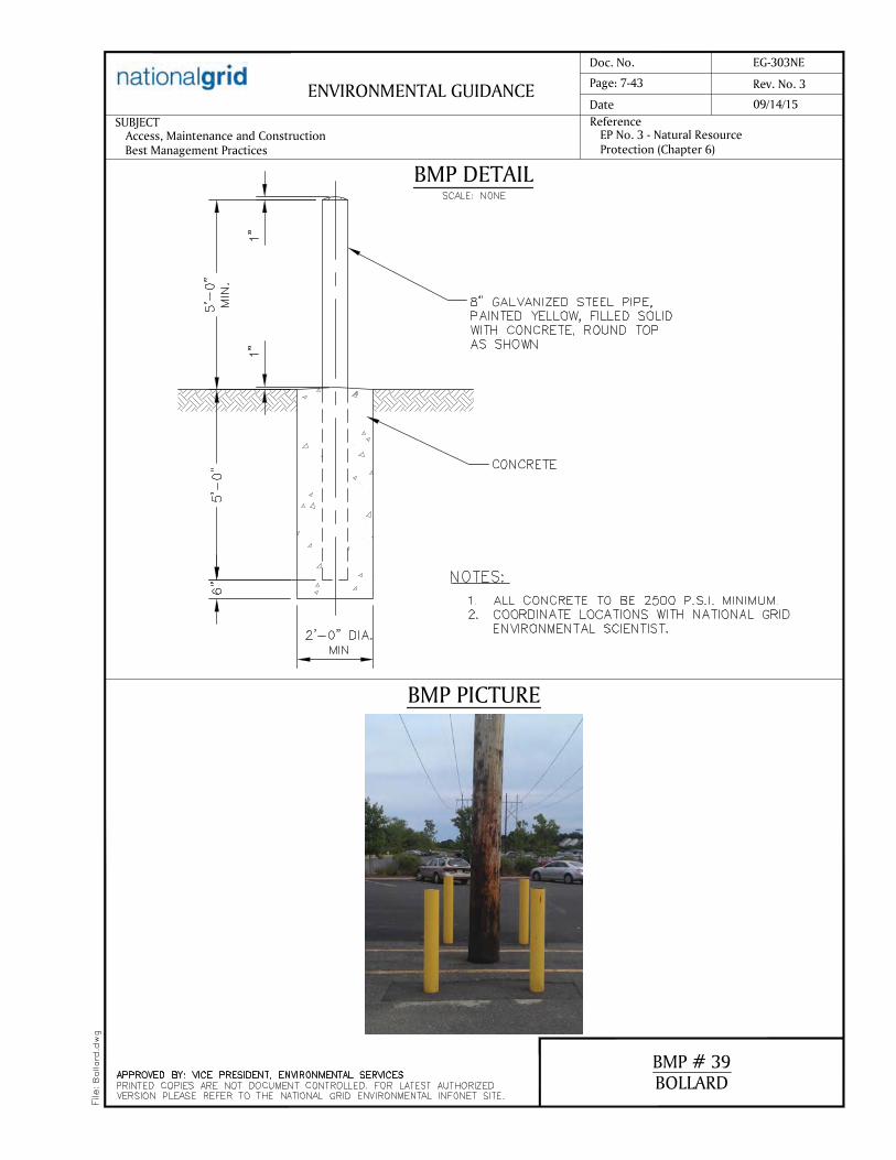


www.essgroup.com
Appendix M
Resumes

CRAIG WOOD Principal Ecologist
Qualifications
Mr. Wood has over 27 years of experience and is a recognized expert in the area of freshwater and coastal wetlands. He has conducted and managed ecological investigations, NEPA compliance documentation, as well as other state and local environmental permitting for both public and private sector clients throughout New England.
Representative Project Experience
National Park Service – Herring River Tidal Restoration Plan & Environmental Impact Statement, Cape Cod, MA. Served as lead restoration ecologist for the preparation of an Environmental Impact Statement analyzing the impacts of restoring approximately 1,100 acres of salt marsh located within the Cape Cod National Seashore and the Towns of Wellfleet and Truro, Massachusetts. Restricted tidal flow and marsh subsidence due to 100 years of diking have severely degraded the aquatic/marsh habitat, resulting in a system dominated by freshwater wetland vegetation and upland shrubs, as well as fish kills and shellfish bed closures. Along with NEPA, the project is conducting a coordinated review under the Massachusetts Environmental Policy Act (MEPA) and Development of Regional Impact (DRI) review under the Cape Cod Commission, a regional planning authority.
NOAA Restoration Center – Fresh Meadow Brook Fish Passage Improvement, South Kingstown, RI. Project Manager responsible for baseline investigation, wetland delineation, GPS survey, restoration plans and permitting for improving fish passage in Fresh Meadow Brook. In the spring of 2007, a substantial vertical drop in the stream channel below the recently completed fishway at the outlet to Indian Lake was discovered. To facilitate adult and juvenile anadromous fish passage the project includes development of a base map and longitudinal profile for the project area, summarizing the existing hydrologic and hydraulic information to identify the appropriate flows to use in passage design and the development of preliminary and final plans, details and specifications for construction purposes.
Block Island Land Trust – Vulnerability Assessment and Shoreline Stabilization Alternatives, Spring House Pond, Block Island, RI. Project Manager of a technical investigation of historic and potential future shoreline changes adjacent to Spring House Pond which lies at the crest of an eroding bluff. The Land Trust is concerned with the vulnerability of the coastal pond to beach and bluff erosion. Bluff failure or mass wasting events are influenced by soil conditions (surficial geology), precipitation, groundwater discharge (seeps), and undercutting of the bluff toe caused by wave attack. The investigation evaluate the practicality and effectiveness of potential short- and long-term solutions to allow the Land Trust to make informed decisions on the measures necessary to maintain the scenic qualities, historical significance and habitat values associated with the pond balanced against the risks associated with a large-scale bluff failure.
SunEast Solar Farms - Cranston and Situate, RI. Project Manager for initial resource areas constraint mapping and wetland delineation for two
Experience ESS Group, Inc.: 2014 to present
Years of Prior Related Experience: 26
Education BS, Natural Resource Conservation, University of Connecticut, 1983
MS, Natural Resource Science, University of Rhode Island, 1986
Professional Registrations/Training Professional Wetland Scientist #800
NH Certified Wetland Scientist #109
RI Certified Coastal Invasives Manager #215
US Forest Service Stream Simulation Methodology for Designing Aquatic Organism passage at Road-Stream crossings
NE Corps of Engineers Regional Supplement to Wetland Delineation Manual Training
Affiliations Society of Wetland Scientists
Society for Ecological Restoration
New Hampshire Association of Natural Resource Scientists
Association of Massachusetts Wetland Scientists
New England Estuarine Research Society
Narrow River Preservation Association-Board of Directors
Restore America’s Estuaries-Conference Organizing Committee
University of Rhode Island Watershed Watch-River Monitor

Craig Wood Page 2 of 2
10.0 MW AC / 12.6 MW DC site layouts along with electrical interconnections. The Scituate Solar site encompasses approximately 129 acres of primarily cleared fields. The Cranston Solar site (Hope Farm) encompasses approximately 70 acres of agricultural lands.
National Grid Mohican - Battenkill 115 kV Transmission Project, Washington and Saratoga Counties, NY. Senior Wetland Scientist responsible for the preparation of a Jurisdictional Determination (JD) Report and Section 404 Permit Application to the US Army Corps of Engineers to support the reconstruction of approximately 15 miles of 115 kV overhead electrical transmission line between the Mohican Substation and Battenkill Substation in the State of New York.
Rhode Island Airport Corporation and Federal Aviation Administration – Environmental Assessment of Block Island Airport Proposed Improvement Projects, Block Island, RI. Under contract with the Rhode Island Airport Corporation and Federal Aviation Administration, performed environmental tasks for an Environmental Assessment (EA) in accordance with NEPA. The EA was performed to evaluate the potential environmental impacts associated with short-term improvements recommended in the Block Island Airport Master Plan. Proposed improvements included runway reconstruction, increased parking for aircraft and autos, and construction of a new terminal building.
NOAA Restoration Center – Marsh Island Restoration Project, Fairhaven, MA. Served as Project Manager to develop restoration plans, permitting and construction documents for the Marsh Island Habitat Restoration Project. Marsh Island is a 22-acre peninsula located at the junction of the Acushnet River and New Bedford Harbor in Fairhaven, Massachusetts. At one time, the majority of the island was a salt marsh. The placement of dredged material in the late 1930’s and early 1950’s resulted in the filling of the majority of the island. This project will restore as much salt marsh and fish nursery habitat on the island as feasible by removing the dredged material and re-establishing intertidal elevations.
Invenergy – Clear River Energy Center – Burrillville, RI. Senior Wetland Scientist responsible for the wetland and wildlife components of the Rhode Island Energy Facility Siting Board application for the construction and operation of nominal 1,000 MW combined cycle electric generation plant. Wetlands were delineated on the approximately 75-acre site in preparation of an Edge Verification and Application to Alter Freshwater Wetlands to be submitted to RIDEM as well as an Individual Permit to the Army Corps of Engineers.
New England Army Corps of Engineers – South Coast Rail Project, Boston-New Bedford, MA. Working for the U.S. Army Corps of Engineers, served as principal scientist for development of third party EIS intended to advance restoration of passenger rail between the cities of Fall River and New Bedford and downtown Boston. The project, as proposed by The Executive Office of Transportation and the Massachusetts Bay Transportation, is envisioned as a key economic development initiative for the South Coast region and as a means to promote sustainable economic growth. Key environmental issues include indirect impacts on habitat fragmentation, impacts within the Hockamock Swamp ACEC bisected by the former rail corridor, and wetland habitat mitigation strategies. EIS intended to advance the restoration of passenger rail between the cities of Fall River and New Bedford and downtown Boston.
Town of Concord Public Works – Cambridge Turnpike Reconstruction Project, Concord, MA. Environmental Task Manager for the design and permitting of the reconstruction of Cambridge Turnpike which is impacted by extensive flooding at two crossings of the Mill Brook causing the Town to detour traffic. Improvements to the Cambridge Turnpike include redesign and construction of two crossings of the Mill Brook, modifications in roadway profile and geometry, construction of retaining walls, enhancements to pedestrian facilities, as well as management and control of stormwater and floodplain compensatory storage. Flood Insurance Studies (FIS) Maps will be amended to reflect the more up to date flood data. Due to constant high water conditions within this portion of Mill Brook and its associated wetlands and floodplain, the project also involves a watershed-wide identification of flow impediments and a long-term maintenance plan for improvements to drainage and waterways.

JOSHUA M. BURGOYNE Ecologist
Qualifications
Joshua Burgoyne is an Environmental Scientist with background concentration in wetland science. His experience includes wetland delineation/identification, field botany, soil profile analysis, hydrologic/water quality assessment, environmental impact/site assessment, wildlife biology, invasive species mapping, and GIS/remote sensing. Josh has experience with energy generation and transmission projects in New York, Maine, Massachusetts, and Rhode Island.
As a former biologist for the RIDEM OC&I Freshwater Wetlands program, Joshua is particularly familiar with environmental regulations and permitting for freshwater wetlands, stormwater management, air quality, septic systems, and waste management. Josh will assist with on-the-ground collection of vegetation inventory program data.
Representative Project Experience
National Grid – Mohican-Battenkill 115kV Transmission Project – Washington & Saratoga Counties, NY. Prepared State and Federal environmental permit applications, mitigation reports, and served as on-call third-party Environmental Monitor for a 14-mile transmission line rebuild
project. Conducted various field work and onsite supervision of construction and restoration activities to ensure use of best management practices and compliance with Department of Public Service regulations.
National Grid – Clay Teall #10/Clay Dewitt #3 Reconductoring Project – Onondaga County, NY. Conducted wetland delineations and prepared documents for a U.S. Army Corps of Engineers Section 404 Jurisdictional Determination and Individual Permit application for a 14-mile electrical transmission line rebuild project to satisfy.
Invenergy, LLC – Clear River Energy Center and Burrillville Interconnection Project – Burrillville, RI. Conducted wetland delineations, other various field work, and prepared permit applications for filings with the RI Energy Facility Siting Board and Rhode Island Dept. of Environmental Management. Project includes construction of a 1,000 MW natural gas fired facility and 7-mile 345 kV transmission line.
Green Line Devco, LLC – Routing Evaluation for Maine Green Line Projects – ME to MA. Performed a preliminary field survey for wetland crossings, invasive species, and general constructability along several potential routes for a submarine/underground electrical transmission project between Plymouth MA and Penobscot County, ME.
Poseidon Transmission LLC – Poseidon Transmission Project Environmental Assessments and Permitting – NY to NJ. Assisted with State environmental permit applications including wetland delineation and impact analysis.
Massachusetts Department of Conservation and Recreation – Marshfield Ponds Hydrilla Pioneer Aquatic Plant Management Project – Marshfield, MA. Prepared a Notice of Intent with the Conservation Commission of the Town of Marshfield for the proposed Hydrilla control project at Magoun, Oakman, Hatch and Mounce Ponds.
Town of Westford – Nutrient Budget for Comprehensive Lakes Management Plan – Westford, MA. Collected water samples for measurement of total nitrogen and phosphorous, conducted water quality field surveys for pH, dissolved oxygen, turbidity, temperature, and flow velocity at several different ponds and tributaries in support of Comprehensive Lakes Management Plan.
Schnitzer Northeast – Stormwater Compliance Services – Attleboro, MA. Collected and submitted stormwater samples from multiple pre-discharge treatment system locations to support NPDES compliance.
Rhode Island Department of Environmental Management – Office of Compliance and Inspection – Providence RI. Senior Natural Resources Specialist responsible for conducting biological field
Experience ESS Group: 2015 to present
Years of Prior Related Experience: 4
Education BS, Environmental Science and Management, University of Rhode Island
Professional Certifications New England Onsite Wastewater Treatment Training, U.S. Coast Guard Personal Survival Techniques Affiliations Pawtuxet River Authority

Joshua Burgoyne
Page 2 of 2
inspections for Freshwater Wetlands, Water Pollution, and Onsite Wastewater Treatment Systems programs. Delineated and classified wetlands based on vegetative community, presence/absence of hydric soils, and hydrology. Assisted businesses and property owners in achieving and maintaining regulatory compliance. Reviewed permit applications, construction plans, site aerial photo history, draft correspondence, biological site assessments/reports, and detailed site sketches. Served as project manager for wetland restorations, represented the Department at meetings and hearings, and responded to complaints of violations from the public.
Pawtuxet River Authority – Pawtuxet River Watershed Improvements – Pawtuxet, RI. Associate Board Member responsible for writing grant proposals and plans for projects including anadromous fish passages, water quality assessments, boat ramps, and other site improvements within the Pawtuxet River Watershed.
Massachusetts Department of Public Health – Arbovirus Program – Boston, MA. Laboratory/Field Technician responsible for setting and retrieving CDC mosquito traps in wetland habitat throughout Massachusetts. Identified mosquitoes to species level, submitted potential disease vectors to lab for EEE/WNV testing, maintained trapping equipment and state vehicles. Evaluated and chose trap sites based on wetland habitat type and breeding potential.
Mason & Associates – Seasonal Wetland Services Support – Scituate, RI. Wetland Technician responsible for supporting wetland delineations, restorations, invasive species control, and identifying plant species. Used Northeast Regional wetland soil indicators to determine wetland-upland boundaries.
Narragansett Bay Estuary Program – Narragansett, RI. Volunteer Research Intern responsible for conducting analysis of coastal imagery and created maps of macroalgae density in Narragansett. Assisted with EPA-funded stormwater system upgrades, pavement removal and native planting to improve water quality in Roger Williams Park ponds, coordinated outreach and volunteer efforts.
SAFE Project – Oil Palm Plantation Studies – Sabah, Malaysia. Research Assistant responsible for conducting field work and supervising field assistants for three studies on an oil palm plantation. Surveyed and identified amphibians, fish, and macroinvertebrate populations. Measured changes in water quality/primary productivity across a gradient of land-use change.
National Parks Service – Northeast and Mid-Atlantic Regions – Kingston, RI. Biological Technician responsible for uploading and managing data from park archives to the NPS Data Portal for widespread access. Collected field data for salt-marsh monitoring project, monitored sea level rise on salt marshes. Used acoustic data loggers to monitor frog populations in vernal pools, isolated calls using software.

JASON R. RINGLER, PWS, CWB® Project Manager
Qualifications
Jason Ringler is a Senior Scientist with more than 19 years of experience in wildlife assessments, environmental compliance monitoring, and wetland and terrestrial ecology. Mr. Ringler is a Certified Wildlife Biologist, Professional Wetland Scientist, licensed arborist, and an invasive species manager. Mr. Ringler has supported and managed a wide range of projects for federal, state, and private sector clients many of which has been associated with energy projects. His experience includes power plants, and transmission line impact assessments, utility siting and permitting, ecological surveys, wetland delineation and permitting and regulatory agency coordination.
Representative Project Experience
Green Line Devco, LLC – Routing Evaluations for Maine Green Line Project – ME to MA. Senior Scientist responsible for preparing preliminary land base routing analysis, scheduling of multi-state field crews, and environmental due diligence for the proposed 340-mile transmission line, which involves both upland and submarine project segments. Supervised the development of environmental due diligence mapping along the upland route alternatives in Maine and Massachusetts to identify wetland and stream features, threatened and endangered species habitat, invasive species, and vernal pools in an effort select a preferred route alternative.
Poseidon Transmission, LLC – Environmental Assessments and Permitting Support – NY to NJ. Senior Scientist who coordinated field crews and supervised the delineation of tidal and freshwater wetlands in accordance with US Army Corps of Engineers guidelines along a proposed electrical cable route in Middlesex and Monmouth Counties, New Jersey. Coordinated with NJDEP with issuance of a Letter of Interpretation (LOI). Assisted with the development of a DLUR application to NJDEP for the New Jersey portion of the cable route.
National Grid – Mohican-Battenkill 115kV Transmission Project – Washington & Saratoga Counties, NY. Senior scientist responsible for directing the layout of wetland plantings in 7.5-acre mitigation site for a portion of the project. Planting included endemic herbaceous, shrub and tree species. Several invasive species were noted which resulted in the development of a subsequent invasive species management plan.
Appalachian Power Company – 138-kV Wythe Area Improvements Project – Wythe County, VA. Senior environmental scientist responsible for developing a desktop habitat assessment methodology for the 17.6-
mile-long proposed project route specifically for the state threatened loggerhead shrike (Lanius ludovicianus). The habitat assessment was reviewed and approved by Virginia Department of Game and Inland Fisheries, and Mr. Ringler validated the results of the desktop habitat assessment in the field and search for loggerhead shrikes during the 2014 breeding season. The purpose of the habitat assessment was to locate the proposed 100-foot right-of-way in a manner that avoids and/or
Experience ESS Group: 2016 to present Years of Prior Related Experience: 19 Education BS, Wildlife Biology and Management, University of Rhode Island, 1998 Professional Certifications Certified Wildlife Biologist, The Wildlife Society Federal Aviation Administration Qualified Airport Wildlife Biologist Professional Wetland Scientist #1953, Society of Wetland Scientists Rhode Island Certified Arborist #261, Rhode Island Department of Environmental Management Rhode Island Coastal Invasive Manager #25, Rhode Island Coastal Resource Management Council Technical Service Provider #10-6520, Natural Resources Conservation Service OSHA 30-hour Construction Safety & Health Training OSHA Compliance & Workplace Safety Training RCRA Waste Management Regulation Training Wildlife & Oil Spill Response Training

Jason R. Ringler, PWS, CWB®
Page 2 of 2
minimizes impacts to suitable habitat of the loggerhead shrike and to identify areas where ground clearing and tree removal activities cannot occur between April 1 to July 31 of any given year.
FirstEnergy – Bruce Mansfield-Glenwillow 345-kV Transmission Line Project – OH to PA. Senior Environmental Scientist who provided routing and permitting services for FirstEnergy's proposed Bruce Mansfield- Glenwillow 345-kV Transmission Line Project. The project will run more than 100 miles from FirstEnergy's Bruce Mansfield Plant in Beaver County, Pennsylvania, to a new substation in Cuyahoga County, Ohio. As a wetland delineator, Mr. Ringler performed the routine delineation method described in the USACE 1987 Wetland Delineation Manual and the Regional Supplement to the Corps of Engineers Wetland Delineation Manual: Northcentral and Northeast Region (Version 2.0) that consisted of a pedestrian site reconnaissance, including identifying the vegetation communities, soils identification, a geomorphologic assessment of hydrology, and notation of disturbance. During field surveys, the physical boundaries of observed wetlands and other WOUS were recorded using sub-meter accurate Trimble Global Positioning System units. The GPS data were then reviewed, geo-corrected using GPS Pathfinder Office software (version 4.20), and edited for errors. The Ohio Environmental Protection Agency (Ohio EPA) Ohio Rapid Assessment Method for Wetlands v. 5.0 (ORAM) and the qualitative habitat evaluation index (QHEI) were used to determine the relative ecological quality and level of disturbance of a particular wetland and to provide a rapid determination of habitat features assessing physical characteristics of streams most desirable by fish and, to a lesser extent, macroinvertebrates and smaller microinvertebrates, respectively. The Ohio EPA Primary Headwater Habitat Evaluation Index, a rapid field assessment method for physical habitat was used to appraise the biological potential of most Primary Headwater Habitat.
Environmental and Social Impact Assessment for the Lekki Port and Harbor Facilities – Lagos, Nigeria. Senior environmental scientist responsible for a conducting a biological assessment of flora and fauna which included local avian, mammalian, and threatened and endangered marine turtles to update the environmental and social impact assessment for a proposed port near Lagos, Nigeria. Mr. Ringler assisted in revising several environmental sections of the environmental and social impact assessment per the guidance of the African Development Bank Group and the International Finance Corporation. Upon completion, the Port at Lekki will feature a 1,500-meter-long main breakwater; a 6-kilometer-long, 14.5-meter-deep approach channel; a 1,500-meter-long quay wall; and cargo-handling equipment, enabling the facility to accommodate container vessels of up to 4,000 twenty-foot equivalent units and liquid bulk vessels of up to 45,000 deadweight tons.
Massachusetts Division of Ecological Restoration (MassDER) – Mill Pond Restoration Project: Site Survey, Base Mapping and Vegetation Assessment – Truro, MA. Project Manager responsible for coordinating a topographic survey of the restoration area, resource area delineation, the establishment of vegetation benchmarks in the salt marsh as well as a vegetation assessment of the restoration area. Wetlands were delineated based on the presence of three parameters: hydrophytic vegetation, wetland hydrology, and hydric soils, as outlined in the U.S. Army Corps of Engineers (USACE) Corps of Engineers 1987 Wetland Delineation Manual, the Regional Supplement to the Corps of Engineers Wetland Delineation Manual: Northcentral and Northeast Region (Version 2), and the Massachusetts Wetlands Protection Act. The classification of wetlands and uplands were based on field observations and the Classification of Wetlands and Deepwater Habitats of the United States Cowardin et al. and Classification of the Natural Communities of Massachusetts.

ALEXANDER PATTERSON, AWB Lead Ecologist
Qualifications
Alex Patterson has conducted ecological field studies throughout the eastern United States and abroad. His work on projects has included wildlife surveys, surface water monitoring, wetland delineation, aquatic and terrestrial plant mapping, sediment mapping and sampling, waterbody bathymetry surveys, wildlife habitat evaluations, invasive species mapping and management, benthic invertebrate sampling, stream assessments, stormwater compliance monitoring, groundwater sampling and monitoring, and spatial analysis of data using GIS. He has prepared and filed numerous environmental permitting documents, from large regional energy developments to local resource improvement projects in New York, New Jersey, Massachusetts and Rhode Island. Alex regularly reviews projects with respect to their potential impacts on wetland and wildlife resources, both through field work and desktop data analysis. On this project, he will serve as a field supervisor, and will be responsible the field data collection effort and provide quality control/quality assurance for all field generated data.
Representative Project Experience
Green Line Devco – Routing Evaluations for Maine Green Line Project – ME to MA. Prepared preliminary routing analysis and environmental due diligence for the proposed 340-mile transmission line, which involves both upland and submarine project segments. Environmental due diligence involved characterizing the existing environmental conditions – primarily wetland and stream features – along the upland route alternatives in Maine and Massachusetts, including identifying potential environmental constraints.
Poseidon Transmission LLC – Poseidon Transmission Project Environmental Assessments and Permitting – NY to NJ. Delineated tidal and freshwater wetlands in accordance with US Army Corps of Engineers guidelines along a proposed electrical cable route on Long
Island, New York and in Middlesex and Monmouth Counties, New Jersey. Prepared a Letter of Interpretation (LOI) to the NJDEP and an Environmental Impact Statement (EIS) to the Town of South Brunswick for the proposed New Jersey Converter Station parcel. Prepared a DLUR application to NJDEP for the New Jersey portion of the cable route.
National Grid – Mohican-Battenkill 115kV Transmission Project – Washington & Saratoga Counties, NY. Prepared a Jurisdictional Determination (JD) Report and Section 404/10 Individual Permit Application to the US Army Corps of Engineers to support the reconstruction of approximately 15 miles of 115 kV overhead electrical transmission line between the Mohican Substation and Battenkill Substation in the State of New York. Work involved examining the wetland resources areas within the Project Right-of-Way, determining whether and how the proposed Project may affect wetland resources, report writing, GIS mapping, and coordinating with regulators. Conducted survey for state-listed bird species along the project ROW as required by the project’s permit.
Experience ESS Group: 2011 to present
Years of Prior Related Experience: 5
Education BS, Wildlife & Conservation Biology, Summa cum Laude, University of Rhode Island, 2009
Professional Registrations and Affiliations Associate Wildlife Biologist Certification, The Wildlife Society, 2014 Member of The Wildlife Society, 2014 Massachusetts Association of Conservation Commissions, Wetland Delineation Workshops, 2013 OSHA 40-hour HAZWOPER Training (first issued 4/19/2012, annual refresher and supervisor training 4/9/2013) SafeGulf Marine Safety Training (issued 8/20/12) Rhode Island Dept. of Environmental Management Boater Safety Education Course (issued 7/25/11)

Alexander Patterson
Page 2 of 2
National Grid – Clay Teall #10/Clay Dewitt #3 Reconductoring Project – Onandaga County, NY.
Delineated wetland and stream resources along the 14-mile project right-of-way in support of the project’s Article VII application, Jurisdictional Determination (JD), and other required permit filings. Preparation the Wetlands & Water Resources section of the project’s Article VII application pursuant to the New York Public Service Law. Prepared and filed the JD and permit application with the USACE Buffalo District.
National Grid – GlobalFoundries Surveys and Permitting Support – Malta, NY. Conducted surveys for invasive plant species along a four-mile proposed gas pipeline route in upstate New York. Created maps in ArcGIS in accordance with ACOE requirements that displayed the location and abundance of invasive plants along the proposed route. Used ArcGIS to conduct analysis of wetlands along the proposed project route and created wetlands figures to ACOE specifications.
Confidential Client – Wetland Delineation – Northern RI. Delineated wetland and stream resource areas at a 200+ acre site to provide baseline data for evaluating the feasibility of the proposed project. Prepared GIS maps which displayed the extent of wetland and waterbodies at the site. Prepared Request to Verify Wetland Edges to RIDEM and prepared wetlands, wildlife, vegetation, and surface water resources sections of Rhode Island Energy Facilities Siting Board application.
EmKey, LLC – Northern Independence Pipeline Article VII – Madison, Chenango, & Broome Counties, NY. Prepared the Wetland & Water Resources and the Vegetation, Wildlife, & Rare Species sections of the Article VII application to the New York Public Service Commission for the proposed 75-mile gas pipeline in upstate New York.
Red Oak Pipeline Lateral – Environmental Permitting – Sayreville, NJ. Performed delineation of wetland resource areas along a 0.75-mile proposed gas pipeline route in accordance with ACOE guidelines. Oversaw the preparation and filing of state and local environmental permit applications to support construction of a 0.75-mile gas pipeline route in Sayreville, NJ. Permits required included New Jersey DEP Land Use Regulation permit (LURP), Construction Activities Stormwater General permit, Hydrostatic Test permit, and Middlesex County Utilities Authority (MCUA) Temporary Discharge Authorization permit.
New England Interstate Transmission Co., LLC – Montreal, Maine, and Atlantic Rail Transmission Corridor Feasibility Study. Reviewed existing information regarding an abandoned railroad right-of-way in Maine proposed for use as a transmission corridor as part of a development feasibility assessment. Created a summary of sensitive environmental and cultural resources along the right-of-way. Collected and compiled a variety of relevant GIS data layers and associated metadata from electronic sources and in coordination with state officials.
West Point Partners, LLC – Wildlife, Vegetation, and Rare Species Desktop Study – Hudson River, NY. Researched and complied data regarding wildlife and plants, including federally and state listed threatened and endangered species that could potentially occur along the proposed route of a 75-mile electrical transmission line in the Hudson River. Documented the existing conditions of wildlife and plant communities in the region, identified potential project impacts to the environment, and developed possible mitigation measures to reduce or eliminate these impacts. Generated reports for federally and state listed species, as well as GIS figures displaying the spatial distribution of known habitats of listed species along the proposed project route.

JAMIE DURAND
ENVIRONMENTAL PROJECT MANAGER
YEARS OF EXPERIENCE
26
EDUCATION
B.S., Natural Resources Science,
Concentration in Wildlife Biology,
University of Rhode Island, 1988
M.S., Coursework Soil Science,
University of Massachusetts
M.S., Coursework Soil Science,
University of New Hampshire
SPECIAL TRAINING
> U.S. Army Corps of Engineers Wetlands
Delineator Certification Program
Training
CERTIFICATION
> Professional Wetland Scientist #891
> New Hampshire Certified Wetland
Scientist #174
AFFILIATIONS
> New England Regional Soil Science
Certificate
> Associate Certified Wildlife Biologist
> Registered Professional Soil Scientist -
Society of Soil Scientists of Southern
New England
EXPERIENCE SUMMARY
Mr. Durand is a project manager and environmental scientist with extensive
experience in the energy and facilities fields. Mr. Durand is experienced with
natural resource field surveys, environmental impact assessments and
environmental permitting and licensing. He brings experience in routing
evaluations, environmental feasibility studies and fatal flaw analyses to the
industry. He is responsible for managing complex, multidisciplinary and
multi-state projects, conducting constructability reviews, managing field
studies, writing environmental reports, preparing permit applications at the
federal, state, and local levels, and representing clients at agency meetings
and hearings. Mr. Durand brings knowledge of the permitting and licensing
requirements for electrical transmission lines, natural gas pipelines (FERC
7(c) filings), and facilities ancillary to these energy projects. He has
completed projects sited onshore and offshore, including impact assessments
on freshwater and coastal/ marine resources. His scientific expertise
encompasses wetland ecology, soil science, and wildlife biology. He has
experience with development projects in New England and the Northeast.
National Grid, Confidential Program, Multiple States
Environmental Project Manager coordinating the evaluation of
approximately 70 miles of 16 separate electric transmission lines and 13
substation improvement projects to address system reliability needs identified
by the Independent System Operator of New England. Preparation of
environmental siting, licensing and permitting assessments for individual
project components to determine environmental constraints, permitting
requirements and potential fatal flaws. Performing environmental due
diligence and routing analysis for potential overhead and underground
transmission solutions, in consultation with engineering, real estate,
stakeholder relations and legal project team members. Managing biological
field programs, data collection and the development of environmental
constraints mapping. Established environmental and engineering criteria for
evaluation and comparative analysis of candidate solutions.
The Narragansett Electric Company d/b/a National Grid, sea2shore: The Renewable Link, Rhode Island
Environmental Project Manager assisting The Narragansett Electric
Company (TNEC) to secure all remaining environmental permits, approvals
and pre-construction commitments for the installation of approximately 20
miles of 34.5 kV bi-directional submarine transmission cable from mainland
Rhode Island in the town of Narragansett to the town of New Shoreham
(Block Island), approximately 1 mile of underground cable on Block Island
and approximately 5 miles of underground cable in Narragansett.
Responsible for the preparation of environmental bid documents; permit
preparation and agency consultation for supplemental marine surveys;
consultation with federal, state, and local regulatory agencies; and

JAMIE DURAND | 2
POWER ENGINEERS, INC.
coordination with project fishery liaison. Preparation of pre-construction
filings and reports with the Bureau of Ocean Energy Management (BOEM),
National Marine Fisheries Service (NMFS), U.S. Army Corps of Engineers,
Rhode Island Coastal Resources Management Council, and the Rhode Island
Department of Environmental Management. Assisting TNEC with
Environmental Compliance Monitoring during marine cable-lay installation,
an onshore HDD, a land-sea HDD, and terrestrial installation of the cable,
including coordination with the contractors, project fishery liaison, protected
species observers, third party environmental compliance monitor, and
regulatory agencies.
The Narragansett Electric Company d/b/a National Grid Sherman Road Switching Station Rebuild Project, Rhode Island
Environmental Project Manager for the reconstruction and expansion of a
115/345 kV switching station, as a component to The Narragansett Electric
Company’s Interstate Reliability Project. Managed environmental field
surveys, alternatives analysis, development of wetland mitigation program,
storm water management design, and erosion and sediment control plan.
Secured federal, state and local licenses and permits including approvals
from the U.S. Army Corps of Engineers, Rhode Island Energy Facility Siting
Board, Rhode Island Department of Environmental Management, and town
of Burrillville Zoning and Planning Boards. Coordinated with McPhee and
McPhee’s subcontractors to provide environmental compliance monitoring
during construction, including implementation of the Project Environmental
Field Issue (environmental compliance plan).
The Narragansett Electric Company, New England Power Company, and the Connecticut Light & Power Company - Interstate Reliability Project - NEEWS Project, Rhode Island, Massachusetts and Connecticut
Environmental Project Manager responsible for managing the environmental
field surveys, natural resource data collection and permitting for the
installation of approximately 75 miles new 345 kV transmission line,
reconstruction of 9 miles of existing 345 kV transmission line and
reconstruction of two switching stations. This project was permitted jointly
by three companies as a tri-state project. Responsibilities included federal
(USACOE Section 404/10 permit), state (RIDEM Section 401, Freshwater
Wetlands and RIPDES permits ) and local soil and erosion control
permitting, and preparing the environmental report (including evaluating
underground alternatives) for filings with the Rhode Island Energy Facility
Siting Board, Massachusetts Energy Facilities Siting Board and Connecticut
Siting Council. Mr. Durand served as an expert witness for environmental-
related issues during the RI EFSB and MA EFSB public hearings. Mr.
Durand was responsible for coordinating constructability field reviews,
coordinating the other utilities including three interstate pipeline companies,
developing compensatory wetland mitigation plans, stakeholder outreach and
assisting National Grid with Section 106 consultations. Managing the
Environmental Compliance Monitoring for The Narragansett Electric
Company construction.

JAMIE DURAND | 3
POWER ENGINEERS, INC.
Connecticut Light & Power Company and Western Massachusetts Electric Company, NEEWS Project - Greater Springfield Reliability Project, Connecticut Interstate Reliability Project, Connecticut and Massachusetts
Project Manager responsible for managing the environmental field surveys,
natural resource data collection and permitting for the installation of new 345
kV transmission lines, including expansion of existing substations and
rebuilds of existing 115 kV transmission lines. Responsibilities included
federal, state and local permitting, and filings with the Connecticut Siting
Council and the Massachusetts Energy Facilities Siting Board.
National Grid – The Narragansett Electric Company, T7 115 kV Transmission Line Reconductoring Project, Rhode Island
Project Manager responsible for managing the environmental field surveys,
natural resource data collection and permitting for the reconstruction and
upgrade of an existing 115 kV transmission line. Responsibilities included
federal, state and local permitting, and filings with the Rhode Island Energy
Facility Siting Board.
The Connecticut Light & Power Company, Oxford 115 kV Substation Project, Connecticut
Project Manager responsible for managing the siting and permitting of a new
115 /13.8 kV electric power substation. Conducted field surveys, performed
alternative site evaluation, rare species assessment, prepared environmental
permit applications and documentation in support of Municipal Location
Approvals, Municipal Consultation Filing, Connecticut Siting Council Filing,
and U.S. Army Corps of Engineers Category 2 Programmatic General Permit
Screening.
Tennessee Gas Pipeline Company, Northampton Expansion Project, Massachusetts
Project Manager for the preparation of FERC 7c Resource Reports, and
federal and state environmental permitting for the newly proposed 2,000
horsepower electric motor-driven centrifugal compressor station (a.k.a.
Southwick Compressor Station 260A), including an emergency generator;
and a new mainline valve and pipeline interconnection with the existing
Northampton Lateral.
Algonquin Gas Transmission, Ramapo Expansion Project, New York, New Jersey, and Connecticut
Project Manager responsible for managing a multi-scope and multi-state
natural gas pipeline project in the States of Connecticut, New York and New
Jersey. Project activities included the replacement and upgrade of 5.0 miles
of pipeline, construction of a new meter station, modifications to three
compressor stations, and construction of the new compressor station.
Managed the FERC 7c filing and all Federal, state, county and local
environmental permit applications, including consultations with the
NYSDEC regarding wetlands & watercourses, threatened and endangered
species, and project impacts and mitigation.

ALISON MILLIMAN
ENVIRONMENTAL SPECIALIST
YEARS OF EXPERIENCE
12
EDUCATION
M.S., Natural Resources Science,
University of Rhode Island, 2007
B.S., Summa Cum Laude, Wildlife and
Conservation Biology, University of
Rhode Island, 2005
MILITARY SERVICE
SPECIAL TRAINING
> OSHA 40-Hour HAZWOPER
CERTIFICATION
> Certified Professional in Erosion and
Sediment Control (CPESC #6825,
Connecticut)
HARDWARE/SOFTWARE
> Jump-In SAS
> GPS Pathfinder
> Dreamweaver
> ArcGIS
EQUIPMENT
PUBLICATIONS
> Addy, K.A., L. Green, E. Herron, and
A.J. Milliman. In press. “Nitrogen and
Water Quality,” Natural Resources
Facts, Fact Sheet No. 050307.
Cooperative Extension, University of
Rhode Island.
EXPERIENCE SUMMARY
Ms. Milliman is an environmental scientist with experience conducting
natural resource investigations and managing associated environmental
permitting tasks. She is experienced in environmental inspection duties to
verify permit compliance for electrical transmission line corridors. She is
experienced with permitting and regulatory issues across all levels of
government including, but not limited to, MA and RI wetlands permits, RI
Energy Facility Siting Board Environmental Reports, EPA NPDES NOI and
SWPPPs, U.S. Army Corps 401 Water Quality Certifications, and Section
404 permits. She is also a Certified Professional in Erosion and Sediment
Control with capability producing and signing Storm Water Pollution
Prevention Plans (SWPPP) for electric transmission projects. Field work
experience includes threatened and endangered species surveys, invasive
plant surveys, wetland delineation surveys, cultural resource surveys, and
breeding bird surveys.
National Grid, New England East-West Solution (NEEWS) 115/345 kV Projects, Massachusetts and Rhode Island
Environmental Specialist responsible for providing oversight of
environmental monitoring during construction activities, and preparing and
submitting construction updates and reports to the Rhode Island Department
of Environmental Management, U.S. Army Corps of Engineers, and Local
Town Offices. POWER is providing program management and owner's
engineering services for a $700M program to construct new EHV
transmission facilities and upgrades in Massachusetts and Rhode Island.
Projects include over 50 miles of new 345 kV transmission lines,
reconductoring of existing 345 kV lines, rebuilds of existing 115 kV lines,
new 115 kV taps to multiple substations, expansions and modifications to
two existing 345/115 kV substations, and upgrades to several 115 kV and
345 kV line terminations.
The Narragansett Electric Company d/b/a National Grid, sea2shore: The Renewable Link Project, Rhode Island
Environmental Specialist responsible for preparing the Rhode Island
Pollution Discharge Elimination System (RIPDES) NOI and Soil Erosion
and Sediment Control Plan (SESC Plan) for the Mainland Cable portions of
the Project, and providing environmental monitoring during construction
activities. The Project is approximately 20 miles of 34.5kV bidirectional
submarine transmission cable from mainland Rhode Island in the town of
Narragansett to the town of New Shoreham (Block Island).

ALISON MILLIMAN | 2
POWER ENGINEERS, INC.
Western Massachusetts Electric Company, Connecticut Light & Power Company and National Grid, The Narragansett Electric Company, NEEWS Project (Greater Springfield Reliability Project; Connecticut Interstate Reliability Project; and Rhode Island Interstate Reliability Project.), Connecticut, Rhode Island and Massachusetts
Project Scientist involved in field investigations for wetland delineations,
U.S. Army Corps of Engineers wetland forms, vernal pool surveys, invasive
and threatened and endangered species surveys (including use of radio
telemetry), and environmental monitoring. Developed permitting documents
for the RI Energy Facility Siting Board Environmental Report, the RIPDES
SWPPP and NOI, and the Conceptual Wetlands Mitigation Plan and
Highway Methodology Wetland Function and Values forms for the U.S.
Army Corps 404 Application. The Project involves a set of improvements to
the electric transmission system in Connecticut, Rhode Island, and
Massachusetts that will enable continuation of safe, reliable, and economic
transmission service to these states, and in particular, will increase the
regional transmission system’s ability to meet growing demand for power
and comply with federal and regional reliability standards and criteria. The
Project consists of approximately 75 miles of a new 345 kV transmission line
to improve the transmission system’s capacity to move power into
Connecticut from Massachusetts and Rhode Island, and also includes
modifications to existing systems in Connecticut and Rhode Island, and
modifications to the existing Substations in Connecticut, Rhode Island and
Massachusetts.
National Grid – New England Power Company, T7 115 kV Transmission Line Reconductoring Project, Rhode Island and Massachusetts
Project Scientist responsible for preparation of MA State Freshwater
Wetlands Protection Act Notices of Intents, U.S. Army Corps Individual
Permit for General Use of Swamp Mats, and RIPDES and MA NPDES
SWPPP. Field efforts included conducting environmental compliance
inspections, and threatened and endangered species monitoring and
contractor training. The project involved installing new, larger conductors
along its existing line for a distance of approximately 17 miles in length
through the towns of Somerset, Swansea, Rehoboth and Seekonk,
Massachusetts and Pawtucket, Rhode Island.
National Grid – The Narragansett Electric Company, Q143/R144 Clearance Improvement Project, Rhode Island
Project Scientist responsible for preparation of the U.S Army Corps 404
Permit, and conducted environmental compliance inspections. The purpose
of the project was to replace damaged structures as well as structures that do
not meet the clearance requirements of the 2007 National Electric Safety
Code (NESC) along approximately 4 miles of transmission line ROW.
National Grid – The Narragansett Electric Company, Mansfield Tap Project, Massachusetts
Project Scientist responsible for preparation of the MA State Freshwater
Wetlands Notice of Intent and co-ordination with MA Natural Heritage and

ALISON MILLIMAN | 3
POWER ENGINEERS, INC.
Endangered Species Program (NHESP) to obtain rare and endangered
species clearances. Conducted environmental compliance inspections, and
threatened and endangered species monitoring and contractor training. The
project involved refurbishing tap lines to feed a municipal power substation.
National Grid – New England Power Company, 303/3520 Guy Strain Replacement Project, Massachusetts
Project Scientist responsible for preparation of the U.S. Army Corps
Individual Permit for General Use of Swamp Mats, environmental
compliance inspections, and field surveys for wetland delineation,
construction access routes and swamp mat requirements. The scope of the
project involved the replacement of the insulators and crossarms on 26 of the
structures on transmission lines.
National Grid – New England Power Company, B154S/C154S Structure No. 17 to South Danvers Substation Project, Massachusetts
Project Scientist responsible for the preparation of the U.S. Army Corps
Individual Permit for General Use of Swamp Mats, Construction Guidance
document (Environmental Field Issue), and environmental compliance
inspections. The purpose of the project was to refurbish the structures from
Structure No. 17 to South Danvers Substation No. 42 on both lines, as
applicable, and to install a new shield wire atop each circuit.
Northeast Utilities, 1990 Transmission Line Project, Connecticut
Project Scientist involved in the preparation of the CT Siting Council
Development & Management Plan, rare and endangered species monitoring,
and environmental compliance inspections. This 21-mile project involved the
replacement of aging transmission line structures in southeastern
Connecticut.
Warwick Sewer Authority, Phosphorus Removal/Upgrade/ Flood Control and Mitigation Project, Rhode Island
Project Scientist responsible for field investigations for wetlands delineation,
U.S. Army Corps wetland forms, and development of the Soil Erosion and
Sediment Control Plan for the RI Preliminary Determination Application and
U.S. Army Corps 404 permit. The purpose of the project is to upgrade the
existing levee and facilities at a waste-water treatment facility located within
the floodplain of the Pawtuxet River in Warwick, Rhode Island.
TransCanada and Exxon-Mobil, Alaska Pipeline Project, Alaska
Project Scientist involved in conducting pedestrian field survey field
investigations for cultural resources along a proposed natural gas pipeline
ROW. The project is designed to connect Alaska's North Slope natural gas
resources to new markets.

EDUCATION Bachelor of Science, Civil Engineering, Georgia Institute of Technology, 2001
REGISTRATIONS Professional Engineer, FL, LA, OH, PA, TX, WV
ISI Envision Sustainability Professional, Pennsylvania, United States
Certification Technical Toolboxes Horizontal Directional Drill classroom certification, 2015
Chad Jacobs, PE
Chad is HDR's northeast region oil and gas lead and has been involved in FERC linear projects and oil and gas treatment projects. He has served as project manager and owner's engineer on civil, environmental and construction service related projects. He is experienced with site/civil design including heavy industrial process and environmental work and is competent in hydraulics, hydrology and environmental related subjects.
RELEVANT EXPERIENCE
UGI Utilities, Inc., Horizontal Directional Drill Projects, PA HDR has permitted and designed over 20 horizontal direction drill (HDD) projects for UGI. The scope of work for these projects include alignment selection, geotechnical investigation, environmental field surveys, permitting, HDD design including bore hole stability calculations and preparation of construction bid documents. These projects cover both plastic and steel pipe design under waterways, wetlands or roads. Self-preforming the geotechnical investigation and reporting work has allowed HDR to streamline the design process and turn around a fully designed project within a week after the bore log is finalized. Role: QC Lead
UGI Utilities, Inc., Cleona Reinforcement Project UGI Utilities, Inc., Lebanon County, PA HDR completed planning, permitting and design of a 3-mile high/medium pressure pipeline system. In addition to the linear footage of pipe, the project included two tie-ins, three directional drills and one regulator station. We self-performed all activities including field biological and geotechnical survey. The project remained on schedule and budget as it headed into construction. We also provided construction as-built survey services and utilized our web based asset management and data tracking tool, TecHub to view real time progress of the construction process. Role: Engineering Design
UGI Utilities, Inc., International Waxes Pipeline Project, Smethport, PA The purpose of this project is focused on reinforcing the pipeline distribution system to serve new demand, improve system reliability, and to reinforce localized low pressure areas. This project will meet these goals through installation of approximately 8 miles of new 12-inch diameter high pressure steel gas main which will provide additional pressure to an industrial facility in Smethport, Pennsylvania. The project was divided into two phases, Constructability/Feasibility Analysis and Permitting/Detailed Design. Role: QA/QC; Route Selection
Spectra Energy, Nexus Gas Transmission Line, MI, OH Nexus Gas Transmission (NEXUS) proposes to construct a 255-mile interstate natural gas transmission pipeline. HDR is tasked with providing FERC compliance oversight on engineering documents prepared for the FERC 7C filing, environmental inspection services, evaluation of erosion and sediment control

compliance, coordination with the construction contractor to determine appropriate resolution for non-compliances, and documenting non-compliances, and post-construction and restoration monitoring. Role: Project Manager
NiSource, Tri-County Bare Steel Replacement Project, PA HDR was selected to provide environmental support services for the Columbia Gas Pipeline replacement project in southwestern Pennsylvania. The project includes approximately 34 miles of Line 1570 pipeline and associated aboveground and appurtenant facilities in three replacement segments. HDR is currently supporting Columbia through the FERC Pre-filing Process. Role: Senior Technical Lead
Antero Resources, National Gas Pipeline Environmental Surveying and Permitting, WV HDR completed environmental and cultural surveying for a planned pipeline project in the Marcellus region and deliver an Environmental Clearance Report to determine the extent of environmental and cultural impact, the type of permits required to move forward with pipeline development, and hold informal negotiations with the USACE and environmental regulatory authorities. Role: Project Manager
Confidential Client, Design-Build, Oil & Gas Exploration And Production Waste Processing Atascosa Facility HDR provided integrated design-build services for multiple oil/water processing and separation facilities in various locations throughout the southern, southwestern, and Rocky Mountain regions of the United States. These facilities receive and treat liquid and solid oilfield Exploration and Production (E&P) wastes. Role: Project Manager
Hydro Recovery, LP, Produced Water Reclamation Facility, PA HDR performed a treatability analysis and developed a basis of design for a new 15,000 BPD produced water reclamation facility. The facility will receive produced water and drilling muds, treat the water in preparation for returning back into the well field for hydro fracturing purposes, dewater/dispose of the drilling muds, and have available long-term storage of treated produced water. HDR completed the mass balance, process flow diagram and general arrangement for the facility. Role: Project Manager
Nuverra Environmental Solutions, Haynesville Pipeline Design, LA Preliminary engineering services included review of the current water/wastewater facilities; hydraulic modeling; wastewater characterization; cost evaluation; pipeline material chemical compatibility and pressure rating; treatment processes evaluation; and monitoring and controlling systems evaluation. HDR Constructors then provided design-build services for 24 miles of pipe; two oil/water separation systems and booster pump stations; pipeline under the Sabine River; and a control system.

EDUCATION Master of Science, Civil Engineering, Hydrology & Water Resources, University of California, Irvine, 2011
Bachelor of Science in Civil Engineering, Cum Laude, University of Pittsburgh, 2009
REGISTRATIONS Professional Engineer, PA
Alex Deuson, PE
Alex is a project engineer capable of executing and overseeing the execution of projects from concept to construction; grading, drainage, erosion and sedimentation control, and water quality design; local, state, and federal permitting; and client and outside discipline coordination. He has worked on natural gas pipeline gathering, transmission, and utility projects in a project engineer capacity executing the preparation of permitting documents, bid documents, and construction packages. Alex is experienced performing NPDES and aquatic resource crossing permits in Pennsylvania, HOP permitting at the local and state level and railroad permitting. Alex is proficient in hydrologic and hydraulic modeling.
RELEVANT EXPERIENCE
HDR Engineering, Project Engineer
• Civil and environmental engineer for industrial site development and utility projects.
• Designed grading, drainage, erosion and sediment control, utility, and layout plans for proposed natural gas fired power plants, wastewater treatment plants, existing coal fired power plants, and natural gas distribution appurtenant facilities.
• Prepared pipeline alignment and permitting plans for approximately 60 miles of proposed natural gas transmission and distribution pipelines (over 30 projects).
• Designed 15+ Horizontal Directional Drills including bore profile, stress calculations, borehole stability, and pullback loads.
• Permitted approximately 10 sites under PAG-02, PAI-02, and ESCGP-2.
Civil & Environmental Consultants, Assistant Project Manager
• Assistant PM to Principal in Charge, Civil/Site Design practice area, oil and gas group.
• Prepared scopes and budgets for oil and gas development projects including pipelines, well pads, compressor facilities, gas processing plants, and impoundments.
• Primarily acted as permitting and civil engineer to oil and gas clients and Assistant PM for integrated services including civil engineering, ecological, geotechnical, cultural resources, survey, and environmental.
• Prepared ESCGP-2 and Centralized Impoundment permit applications, plans, reports, and calculations in support of gas development activities in Pennsylvania. Prepared Land Development plans and packages for submission to municipalities, as applicable, in support of such development.
• Prepared E&S permit packages in support of gas development activities in West Virginia.
• Responsible for full project lifecycle permitting and civil services from conceptual grading and drainage plans, to final site design and PCSM (and/or Site Restoration) and E&S plans, calculations, and reports, to roadway permitting and Notice of Termination filing.

Albert A Webb Associates, Associate Engineer
• Drainage engineer for public and private development in Riverside, San Bernardino, Orange, and Los Angeles Counties.
• Lead design engineer for high-conflict multi-jurisdictional agency storm drain and channel projects including federal, military, rail, county, city, DOT, state and federal regulatory agencies.
• Lead engineer of Civil3D implementation committee, “software mentor” of Civil3D 2012-2014.
• Developed company-wide workflow for client compliance with state-wide Construction General Permit requirements (SWPPP/E&S).
• Daily client contact and coordination with utilities, stakeholders, regulators, special districts, and approval agencies.
• Prepared numerous WQMPs and implemented HCOC mitigation measures for a variety of commercial, industrial, residential, and transportation projects.
Riverside County Flood Control and Water Conservation District, Assistant Engineer
• Scoped, scheduled, designed, produced Plans Specifications and Estimate (PS&E), and provided construction support to numerous infrastructure projects such as:
o 7+ miles of storm drain and channel, ranging in size from 18” to 108” and larger RCB.
o Numerous basin projects with storage ranging from 1-500 ac-ft o Access road, levee, channel, and dam design and grading o Special structures design for rehabilitation projects.
• Hydrologically modeled and calibrated numerous climatically diverse basins ranging in size from 10 to over 5,000 acres.
• Helped develop District-wide configuration workflow for HEC-RAS hydraulic models, greatly increasing efficiency throughout the organization.
• Pioneered expedient hydrologic parameter aggregation system using available resources, yielding no hard cost to the District and greatly reducing model computational effort.
• Produced innovative design solutions to complex constrained systems, especially as related to projects seeking FIRM revision.
• Hosted in-house master class on basin routing/design for all staff levels. • Experience with EPA CWA water quality and hydromodification mandates as
related to watershed planning and operation.

www.essgroup.com
Appendix N
Water Supply Plan


www.essgroup.com
Appendix O
Burrillville Interconnection Project Alternatives Analysis

Burrillville Interconnection Project RI EFSB Environmental Report
February 2017
PHX (170-008) NATIONAL GRID (02/14/2017) 142704 GG PAGE 5-1
5.0 PROJECT ALTERNATIVES
5.1 Introduction
This section describes the alternatives to the Project that were considered to address the need to interconnect the proposed CREC to the existing electric transmission system. The need for this Project is driven exclusively by the proposed interconnection of the CREC to the New England electric system. As a result, the alternatives are limited by the need for a direct connection to Sherman Road Switching Station, as identified by the ISO-NE.
Selecting a preferred design option involves evaluating a suite of feasible project alternatives, which includes screening of each project component, analyzing the alternative routes and configurations, general ranking of alternatives and identification of initial recommendations in the selection of a preferred solution. TNEC’s overriding goal has been to select the alternative that best meets the Project need, with a minimum impact on the environment, at the lowest possible cost.
Section 5.2 describes the no-action alternative. Section 5.3 describes the electrical alternatives. Section 5.4 and Section 5.5 describe an alternative overhead route and the overhead alternatives using the existing ROW, respectively. Section 5.6 describes several underground transmission alternatives.
5.2 No-Action Alternative
This alternative was dismissed as it would not address the need to interconnect the proposed CREC to the existing electric transmission system.
5.3 Electrical Alternatives
5.3.1 Connection to Existing Transmission Lines
ISO-NE analyzed connecting CREC directly to the existing 341 Line or the existing 347 Line or both. These options were rejected by ISO-NE as they all presented unacceptable reliability issues and power transfer limitations. Ultimately, ISO-NE determined that a new 345 kV transmission line to the Sherman Road Switching Station would be the required solution for connecting CREC to the transmission system.
5.3.2 115 kV Alternative
TNEC evaluated installing one new overhead 115 kV transmission line from the CREC to the Sherman Road Switching Station as an alternative to the Project. This alternative would use a similar H-Frame structure and monopole structure configuration proposed as for the Project.
The Sherman Road Switching Station is a 345 kV facility, therefore this alternative would require adding a 115/345 kV transformer, which would take up additional space within the fenced in area and add to the cost of the Project. The use of the additional space is problematic because it limits TNEC’s ability to fully utilize the station in the future due to site constraints associated with neighboring wetlands and high pressure gas pipelines located near the station. Additionally, this alternative would

Burrillville Interconnection Project RI EFSB Environmental Report
February 2017
PHX (170-008) NATIONAL GRID (02/14/2017) 142704 GG PAGE 5-2
have similar environmental and other impacts on the ROW as the proposed Project. For these reasons TNEC rejected this alternative.
5.4 Overhead Route Alternatives
TNEC considered two overhead routing alternatives for the 3052 Line. These alternatives involve paralleling existing utility corridors.
5.4.1 Construct Overhead Transmission Line in Project ROW (Proposed Option)
As discussed in greater detail in Section 4.0 of this ER, the Project involves (i) the construction of a new 6.8-mile 345 kV transmission line in the existing TNEC ROW and the new CREC ROW; and (ii) improvements to the existing Sherman Road Switching Station. This alternative was found to be superior to others considered for a variety of reasons discussed in this section. Consequently, it has been advanced as the proposed alternative.
5.4.2 Overhead Transmission Line Adjacent to Algonquin Gas Transmission Pipeline ROW
TNEC also evaluated the use of an existing Algonquin Gas Transmission (AGT) pipeline ROW which runs from southwest to northeast as shown on Figure 5-1. TNEC considered constructing an overhead 345 kV transmission line adjacent to AGT ROW from the CREC to the Sherman Road Switching Station, utilizing H-Frame construction as an alternative to the Project. This alternative would require the same improvements to the Sherman Road Switching Station as the proposed alternative.
This routing alternative would parallel an existing ROW corridor and has the advantage of not having to relocate the existing 341 and 347 Lines to accommodate the new line. However, the AGT ROW is not currently wide enough to accommodate the 3052 Line and it is unlikely AGT would permit the construction of an overhead transmission line within its gas pipeline ROW. This option would require creating and clearing of forested wetlands and upland forest for a new approximately 150-foot-wide ROW and building new access roads along the AGT ROW that are located away from the existing high pressure gas pipelines. Thus, this alternative would require obtaining additional easement rights along the entire length of the AGT ROW. This land acquisition would add significantly to Project costs, would result in increased impacts to the natural and social environments from creating a new 6+ mile corridor, and would delay the Project schedule. In addition, installing electric and natural gas facilities within the same corridor can introduce constraints to both operations in regard to safe access, work space requirements and future replacement and/or expansion of facilities within the shared corridor.
After consideration of this alternative, TNEC determined that locating an overhead transmission line within or adjacent to the AGT ROW would result in additional costs and delays associated with the need to acquire additional land; increased environmental and other impacts; and operational and safety constraints from the collocation of a transmission line near a high pressure gas line. TNEC therefore concluded that use of the TNEC and CREC ROWs was its proposed alternative.

Burrillville Interconnection Project RI EFSB Environmental Report
February 2017
PHX (170-008) NATIONAL GRID (02/14/2017) 142704 GG PAGE 5-3
5.5 Overhead Configuration Alternatives
The Applicant considered three alternative configurations (combinations of transmission line structure types) for constructing the Project within the existing TNEC ROW:
• Install 3052 Line in the Project ROW utilizing a combination of H-frame and monopole construction (the proposed Project).
• Install 3052 Line in the Project ROW utilizing monopole construction.
• Install 3052 Line in the TNEC ROW utilizing double-circuit monopole construction.
TNEC assessed the impacts of each of these configurations on Project cost, reliability, visibility of the structures, wetlands, and the level of disturbance caused by construction. The following sections describe the advantages and disadvantages of each alternative.
5.5.1 Construction Using Combination of H-Frame Structures and Monopoles (the Proposed Project)
As proposed, the Project will use steel H-frame structures for the 3052 Line and monopole structures for the shifted 341 Line. This option was chosen as it is the most cost-effective and reliable overhead solution. Monopoles and H-frame structures are relatively comparable in terms of their allowable span lengths, and as such, both designs would utilize approximately the same number of structures along the transmission line route. Monopoles and H-frame structures are comparable in terms of their structural reliability and their electrical reliability and performance. The narrower configuration of the monopole permits the 341 Line to be shifted north in Segment 2 without having to rebuild the 347 Line which was recently constructed as part of IRP. By using the monopoles for only 1.6 miles, the Applicant is able to minimize the visual impact of the taller structures as well as to minimize the impact of the larger reinforced concrete caisson foundations required for each monopole.
5.5.2 Construction Using Monopole Structures
TNEC evaluated using monopole structures both for the entire length of the 3052 Line and for the shifted 347 Line. The structures in Segments 1 and 3 would be approximately 110 feet tall, approximately 22 feet taller than the proposed H-frame structures. The typical steel H-frame structure includes two poles that are each approximately 5.5 feet in diameter whereas the steel monopole structure has a single pole that is approximately 10 feet in diameter. Each monopole structure would require a reinforced concrete caisson foundation, which would result in greater areas of excavation and fill for the structure installations. In addition, the monopole structures would be more expensive than the proposed configuration.
Ultimately, this option was rejected because of the increased environmental impact from the larger footprint of the reinforced concrete caisson foundations, the visual impact from the taller structures, the additional cost of the structures, and because the 3052 Line could be built using H-frame structures in Segments 1 and 3.
5.5.3 Construction Using Double-Circuit Monopole Structures
As an alternative to constructing the Project using H-frame structures, TNEC also evaluated the use of double-circuit structures to carry the 3052 Line and the existing 347 Line. To achieve this

Burrillville Interconnection Project RI EFSB Environmental Report
February 2017
PHX (170-008) NATIONAL GRID (02/14/2017) 142704 GG PAGE 5-4
configuration, the 3052 Line and the existing 347 Line would be constructed on a common single-shaft steel structure and the existing parallel 347 Line would be removed from its present location. TNEC determined that the double-circuit structure alternative had the following advantages and disadvantages relative to the proposed H-frame structure:
Advantages: • The natural and social environmental impacts of the single circuit monopole configuration
would be generally similar to those of the double-circuit monopole configuration.
• Use of a double-circuit structure could reduce tree removal requirements by approximately 10 to 15 feet in width, in portions of the ROW.
• Double-circuit structures and H-frame structures would be relatively comparable in terms of their allowable span lengths, and as such, both designs would utilize approximately the same number of structures along the transmission line route.
• Double-circuit structures and single-circuit H-frame structures would be comparable in terms of their structural reliability.
Disadvantages: • Double-circuit structures would be inferior to single-circuit H-frame structures in terms of
their electrical reliability and performance. Common mode failure of double-circuit structures could result in the loss of both lines. Double-circuit structures would increase the risk of a lightning strike or single transmission line fault causing both transmission lines to be interrupted simultaneously.
• Double-circuit monopoles would be larger in diameter to accommodate the weight of two circuits, and would not resemble the existing H-frame structures on the TNEC ROW.
• Typically, double-circuit structures would be approximately 135 feet in height (approximately 45 to 50 feet taller than the proposed single-circuit H-frame structures), and as such would be more visible.
• Each double-circuit structure would require a reinforced concrete caisson foundation, as opposed to the H-frame structures which would only require concrete foundations at points of line angle and dead-end locations. The additional foundations required for the double-circuit alternative would significantly increase the excavation, rock removal and soil disturbance required for installation, and would increase the potential for impacts (access roads, construction pads, support work pads) to environmental resources.
• The larger and heavier steel structures required for a double-circuit transmission line, together with the need to get concrete trucks safely along the access spur roads to each foundation location may increase the level of access road improvements required for the Project, and the impacts associated with those improvements.
• The use of double-circuit structures would increase the installed cost of the Project.
• Constructing a double-circuit transmission line would unnecessarily remove, retire and replace existing transmission line segments which are functioning adequately. This incremental cost would be borne by ratepayers and not Invenergy.
• If the 3052 Line and the existing 347 Line shared double-circuit structures (towers), the simultaneous loss of these lines would be treated as a double-circuit tower (DCT) contingency in transmission planning studies; this would lower official interface transfer capabilities.

Burrillville Interconnection Project RI EFSB Environmental Report
February 2017
PHX (170-008) NATIONAL GRID (02/14/2017) 142704 GG PAGE 5-5
After considering the relative advantages and disadvantages of utilizing double-circuit structures, TNEC concluded that utilizing single-circuit H-frame and monopole structures as proposed for the Project offered more advantages, provided greater reliability, created fewer impacts, and was a more cost-effective solution.
5.6 Underground Transmission Alternatives
TNEC developed and analyzed underground alternatives to compare with the proposed overhead transmission line configuration for the Project. Underground transmission lines typically have much higher installation costs than overhead transmission lines. Underground transmission cables, particularly long underground cables, have very different electrical characteristics than overhead transmission lines. This can lead to operational and power flow issues, and can require additional system reinforcements to address these issues. Construction techniques for underground transmission lines create different environmental impacts than overhead transmission line construction. Reliability issues associated with underground transmission lines are different than those associated with overhead transmission lines. In developing the underground alternative, TNEC addressed these differences between overhead and underground transmission lines. The following sections describe the underground alternatives considered and their advantages and disadvantages.
5.6.1 Underground Transmission Routes
TNEC considered the following three underground routes:
• Project ROW from the CREC to the Sherman Road Switching Station.
• AGT ROW from the CREC to the Sherman Road Switching Station.
• Public roadways from CREC to the Sherman Road Switching Station.
5.6.1.1 Project ROW
The advantages of installing an underground transmission line along the Project ROW include use of the existing TNEC utility corridor, fewer traffic impacts during construction than if a roadway route were used, and a somewhat shorter route in this particular case. These factors might lead to somewhat lower costs and lower traffic disruptions/ impacts than a public roadway underground route.
However, the TNEC ROW is ill-suited for an underground transmission line for a number of reasons. The ROW traverses multiple wetlands and wetland buffer zones, and crosses multiple waterbodies, including Dry Arm Brook (twice), Clear River, Mowry Brook (twice), Round Top Brook, Chockalog River, and several smaller streams. With overhead construction, it is frequently possible to span wetlands and other sensitive resource areas. This has been demonstrated on the TNEC ROW with the existing transmission lines, and is proposed for the new overhead transmission line. By contrast, with underground construction, it is necessary to either trench the entire route, or to use trenchless techniques such as horizontal directional drilling or pipe jacking. Trenchless installation techniques create additional design, construction, and economic issues, and have their own associated environmental issues. Underground transmission construction techniques have the potential to cause an increase in short and long term impacts to wetlands and other sensitive resources along the overhead ROW.

Burrillville Interconnection Project RI EFSB Environmental Report
February 2017
PHX (170-008) NATIONAL GRID (02/14/2017) 142704 GG PAGE 5-6
A substantial permanent access road would need to be constructed along the ROW for purposes of construction and maintenance of an underground transmission line, causing permanent impacts to the ROW, and potentially affecting wetlands, stream crossings, rare species habitat, and other sensitive resources.
In addition, there is significant visible rock along portions of the ROW, which would make constructing an underground transmission line difficult and costly.
Finally, TNEC does not own the majority of the overhead ROW in fee, but rather holds easements. These easements generally do not include the right to install underground lines. Acquisition of the underground rights from numerous parties would significantly increase the timeframe and cost of this routing alternative as well. These constraints and considerations led TNEC to dismiss the TNEC ROW as a potential route for an underground transmission line.
5.6.1.2 Existing Algonquin Gas Pipeline ROW
Similar to the TNEC ROW, the AGT ROW is ill-suited for an underground electric transmission line. The AGT ROW crosses multiple wetlands, wetland buffer zones, and water bodies. A substantial permanent access road would be required for construction and maintenance of an underground line, potentially causing permanent impacts to wetlands, rare species and other sensitive resources, as discussed in Section 5.7.1.1.
TNEC would need to acquire additional property rights from AGT or individual property owners along the corridor for this alternative. Obtaining new property rights would significantly increase the timeframe and cost of this routing alternative. The AGT ROW is 75 feet wide and has two existing natural gas transmission lines within the ROW. In some areas, the ROW may not be wide enough to accommodate an underground electric transmission line, which would trigger the need for acquisition of additional property rights. These constraints and considerations led TNEC to dismiss the existing AGT ROW as a potential route for an underground transmission line.
5.6.1.3 Existing Public Roadways
There are several advantages to installing an underground transmission line beneath the public roadway network, as compared to using the utility corridors. These relative advantages could include:
• Reduced impacts on the natural environment. By using the established roadway network, most construction would not directly impact wetlands or environmentally sensitive areas. Some construction could fall in areas where the roadway is within wetland buffer zones. In these cases, suitable environmental controls and BMPs would be employed to control sedimentation.
• There would likely be less rock removal with a roadway network route, since original road construction would have graded and removed a portion of the rock along the route. Roadway geometry generally is more suitable for underground transmission installation, since there would not be severe grade changes to contend with.
• Access for construction and ongoing maintenance is generally simpler within the roadway network.

Burrillville Interconnection Project RI EFSB Environmental Report
February 2017
PHX (170-008) NATIONAL GRID (02/14/2017) 142704 GG PAGE 5-7
• In general, rights for installation of underground facilities within the roadway network are obtained via a permit from a limited number of agencies (municipal Departments of Public Works, RIDOT, etc.).
There are some potential disadvantages to using the roadway network for an underground transmission line:
• During installation of the conduit and manhole system, there would be construction related impacts on vehicular traffic. There would also be some traffic impacts during cable installation and splicing, but these would be confined to manhole locations.
• The roadway network is relatively sparse in this portion of the state, and does not directly parallel the TNEC ROW. As a result, the roadway route is somewhat longer than the overhead ROW route.
5.6.1.4 Selection of Roadway Network as Preferred Underground Route
Overall, TNEC concluded that the roadway network presented fewer environmental and property acquisition issues, and had significant operational benefits as compared to installing an underground transmission line within an existing cross-country utility corridor. For these reasons, TNEC developed a “representative” roadway route between the CREC and the Sherman Road Switching Station using the existing public roadway network. The underground roadway route would start at the CREC and be installed in the proposed CREC access road to Wallum Lake Road (Route 100). The underground route would proceed southeast on Wallum Lake Road, east onto Laurel Hill Road, south onto Grove Street, northeast onto Centennial Street, east along Hill Road to its intersection with Sherman Farm Road (Route 98), and then proceed north along Sherman Farm Road to the Sherman Road Switching Station. The length of the underground roadway route is approximately 7.2 miles long. The representative roadway route is shown in Figure 5-1. This route was selected as a reasonably direct interconnection between the two endpoints and is not the result of exhaustive routing analysis. Other roadway routes would be approximately the same length, and would be expected to have similar construction and operational issues, and similar costs. The public roadway underground alternative was developed in further detail for comparison to the Project.
5.6.2 Underground Cable Design and Construction
A solid dielectric cross-linked polyethylene (XLPE) cable system was selected to develop a conceptual design and cost estimate for the public roadway underground alternative. An XLPE cable system would be expected to have high reliability, lower cable charging, and lower maintenance requirements compared to other available transmission cable technologies at 345 kV (such as high pressure fluid filled pipe type cable).
The overhead transmission capacity of the bundled 1,590 kcmil ACSR proposed for the Project is approximately 3,000 amps (A), or 1,790 Megavolt Ampere (MVA). The overhead conductor size selected somewhat exceeds the immediate rating need, but overhead conductors are also selected based on sag requirements, conductor strength requirements under ice and wind loadings, and other factors. The immediate ampacity need for the interconnection to CREC is approximately 2,000 amps.
For underground construction, the cable system would consist of a single-circuit, initially consisting of two sets of 5,000 kcmil enamel coated copper 345 kV XLPE insulated cables per phase. This would satisfy the 2,000 amp need for the CREC project. These cables would be installed in a ductline

Burrillville Interconnection Project RI EFSB Environmental Report
February 2017
PHX (170-008) NATIONAL GRID (02/14/2017) 142704 GG PAGE 5-8
and manhole system that would have spare capacity for additional cables for maintenance or replacement purposes.
Preliminary cable ampacity calculations were performed for the alternative underground cable system. Ampacity calculations were executed using CYME International’s Cable Ampacity Program 7.1 Revision 1 to model the cable system based on the following design criteria:
TABLE 5-1 CABLE SYSTEM DESIGN CRITERIA
Nominal Voltage 345 kV Conductor 5,000 kcmil Copper (coated) Cable System Extruded Dielectric Cross Linked Polyethylene Maximum Normal Operating Temperature 90 degrees Celsius (°C) Installation Depth (top of duct bank):
Minimum Depth 3 feet Maximum Depth 8 feet Earth Ambient Temperature 25°C (Assumed) Native Soil Thermal Resistivity 90°C - centimeters per watt (cm/W) (Assumed) Duct Bank Thermal Resistivity 60°C - cm/W Load Factor 100% Steady-State Ampacity Rating 2,000 A
Note: The final circuit rating would depend on detailed engineering and final configuration of the underground transmission line. For the portions of the underground cable route within roadways, the duct bank for the cables would be installed using open-cut trench design. Open trenching involves cutting and removing the pavement, excavating a trench, installing the conduit system, and backfilling the trench. Precast manholes would be installed at pre-determined locations, typically every 2,000 to 2,500 feet along the route. For a 345 kV system, manhole dimensions would be approximately 30 feet long by 7 feet wide by 8 feet high. PVC conduit is assembled and placed in the trench to form a duct bank. Typically a 20-foot-wide construction working area is utilized on streets for a single trench.
The approximately 6.2-feet wide by 2.6-feet tall concrete encased duct bank would consist of nine 8-inch Schedule 40 PVC conduits for the 345 kV Power Cables, three 2-inch PVC conduits for Ground Continuity Conductors, and two 4-inch conduits for communication cables. There would be a minimum of 36 inches of cover from grade to the top of the duct bank, resulting in a 6.2 foot wide by 5.6 foot deep trench. The final duct bank size and layout may vary somewhat from this and would be determined during detailed design. Factors to be considered during detailed design include electrical requirements, heat dissipation, minimal burial depths, existing facility/utility locations and cable installation requirements.
The underground transmission line would also require the following:
• Three large manholes (one manhole per cable set), each approximately 30 feet long by 7 feet wide by 8 feet high at every splice location;
• The installation of multiple cable terminal positions at the switching stations to accommodate the cables. This would require significant area at the switching stations to connect the cable terminations; and,

Burrillville Interconnection Project RI EFSB Environmental Report
February 2017
PHX (170-008) NATIONAL GRID (02/14/2017) 142704 GG PAGE 5-9
• Installation of three Shunt Reactors at the terminal switching station due to significant MVARs generated by the cable system. This would require additional land at the switching station.
The underground alternative would also take several additional years to design, license and build.
5.6.3 Underground Alternative Cost
TNEC prepared a conceptual cost estimate for the existing roadway underground alternative. A breakdown of the costs is shown below in Table 5-2.
TABLE 5-2 ESTIMATED UNDERGROUND CONSTRUCTION COST
COMPONENTS ESTIMATE
Underground Transmission Cable Costs $148,000,000 Incremental Switching Station Modifications, Transition
Stations and Shunt Reactors $30,000,000
Switching Station Modifications (common with preferred overhead alternative) $6,200,000
Total $184,200,000 Note: These costs do not include property acquisition, if required.
5.6.4 Environmental and Other Considerations
For construction of the overhead transmission line in the TNEC ROW, TNEC would use construction techniques that minimize impacts on the natural environment. Disturbed areas would be allowed to re-vegetate with low growing plant species, similar to existing vegetation within the cleared portions of the ROW.
In the case of the underground alternative along existing roadways, the majority of the construction would occur within existing roadways. Assuming an on-road route, most of the environmental impacts would be to the manmade environment, and would primarily occur during the construction of the line. These would include temporary impacts on traffic during conduit and cable installation. The majority of the installation of an underground transmission system would be performed utilizing cut and cover techniques, where the roadway is excavated, the conduit and manhole system is installed, the trench is backfilled, and roadway is repaved. For much of the route, the roadway is only two lanes wide. Lane closures with alternating traffic patterns would be required during construction. There would also be temporary noise impacts to the homes and businesses located along the roadway route from construction equipment and vehicles.
The underground roadway route would cross a number of streams and small rivers, where the streams are culverted or where the roadway is in a bridge over the waterways. Wetlands and waterways would be crossed by installing the cables on bridges (if available and suitable), by cut and cover over or under culverted streams, or by trenchless techniques such as Horizontal Directional Drilling. Where the underground route would pass through buffer areas adjacent to wetlands, proper construction techniques and BMPs, such as the use of hay bales or other sedimentation barriers, would be employed to protect these areas.

Burrillville Interconnection Project RI EFSB Environmental Report
February 2017
PHX (170-008) NATIONAL GRID (02/14/2017) 142704 GG PAGE 5-10
In addition to the impacts summarized above, an underground line will also require the following equipment installed above ground at the terminal switching station: shunt reactors, circuit breakers and associated switches, multiple cable terminations, and surge arresters. The additional equipment potentially increases the environmental impact of an underground project as additional space within the switching stations will be needed to connect the underground line to the switching station.
5.6.5 Underground Operational Issues
In addition to the significantly higher costs and the schedule impacts summarized in Section 5.6.3, there are a number of system and operational issues associated with underground transmission lines. These include:
• Lengthy Outage Repair Times: When an overhead transmission line experiences an outage, it can typically be repaired within 24 to 48 hours. In the case of a failure of an underground transmission cable, repair times for a 345 kV XLPE circuit can be in the range of a month or more. The extended outage times for underground cables would limit the ability of CREC to generate power during this time period. Extended underground outage repair times can expose the remainder of the transmission system to emergency loadings for longer periods of time. There is also increased exposure to loss of another transmission element, with possible loss of load, during the extended underground outage.
• Cable Capacitance: Underground cables have significantly higher capacitance than overhead transmission lines, meaning that it takes reactive power (Megavolt Ampere Reactive [MVARs]) to “charge up” the cable before the cable can transmit real power (Megawatt [MWs]). This has several ramifications:
− Part of the cable’s capacity is used up by the charging current, so larger conductors are needed to transmit an equivalent amount of power. These have been included in the system design described above.
− Capacitance can create voltage control problems, meaning that the voltage can get too high when the transmission system is at light load. If the CREC interconnection were to be constructed underground, there would be approximately 140 MVAR of cable charging per cable, or 280 MVAR for the initially developed two cable system. The transmission system cannot absorb this much charging MVARs and it would be necessary to install additional equipment, in the form of shunt reactors, at one or both terminal switching stations.
− Cable capacitance causes higher switching transient voltages on the system (voltage “spikes” during switching). This can damage other system components, may trigger the need to replace surge arresters throughout the area, and complicates future system expansions.
• Effect on Reclosing: Many faults on overhead lines are temporary in nature. Often it is possible to “reclose” (re-energize) an overhead line after a temporary fault, and return the line to service with only a brief interruption, measured in seconds. Faults on underground transmission cables are almost never temporary, and the cable must remain out of service until the problem is diagnosed and repairs can be completed.

Burrillville Interconnection Project RI EFSB Environmental Report
February 2017
PHX (170-008) NATIONAL GRID (02/14/2017) 142704 GG PAGE 5-11
• Ratings: It is often difficult to match overhead line ratings with underground cables. It is also much more difficult to upgrade ratings on underground lines should that become necessary in the future. The proposed design for the underground alternative makes some accommodation for this, but the issue remains.
5.6.6 Underground Dips
During siting of overhead transmission lines, questions are often raised regarding the possibility of installing short segments of underground transmission line at discrete locations along the route. This type of short underground segment is often referred to as a “dip.” TNEC developed an estimated cost for a “generic” one mile underground dip for the 3052 Line. This underground dip would utilize two sets of 5,000 kcmil cu 345 kV XLPE cable per line, installed in a ductline. For a generic dip, the route would follow the existing ROW alignment. See Figure 5-2 (trench cross section). At each end of the dip, there would be a transition station. This would be a fenced switching station, approximately 125 feet by 125 feet at a minimum, and similar in appearance to an electrical substation. The transition station would terminate the overhead line, and would contain cable terminations, a control house, and accessory equipment. The cost of a one mile generic underground dip, utilizing similar assumptions as the underground alternative, is as follows: TABLE 5-3 ESTIMATED GENERIC COSTS FOR A ONE-MILE DIP SEGMENT
SYSTEM COMPONENT ESTIMATED COST (MILLIONS) Underground Transmission Cable Costs $18,000,000 Transition Stations $10,000,000 Total $28,000,000
The average overhead transmission line cost along the route is approximately $4.43 million per mile. For a one mile dip, the underground line represents more than a six-fold increase in costs over the overhead line. An underground dip would expose the entire line segment to the underground transmission operational issues discussed above. These include:
• Lengthy outage repair times for underground transmission cables.
• Effect on reclosing for temporary faults.
• Cable capacitance effects (less for dips).
• Ratings – potential for future bottlenecks.
Underground dips represent a large cost increase, may require additional property rights, and introduce operational disadvantages when compared to the proposed overhead line.

Figure 5-2 Underground Transmission Trench Detail PAGE 5-12

Burrillville Interconnection Project RI EFSB Environmental Report
February 2017
PHX (170-008) NATIONAL GRID (02/14/2017) 142704 GG PAGE 5-13
This page intentionally blank

Burrillville Interconnection Project RI EFSB Environmental Report
February 2017
PHX (170-008) NATIONAL GRID (02/14/2017) 142704 GG PAGE 5-14
5.6.7 Underground Alternative Conclusions
Both the overhead and underground alternatives would meet the identified needs of the Project and would be expected to have high levels of reliability. The underground alternative has significant operational issues, longer restoration times, and voltage control issues that make it technically inferior to the proposed Project. Generally, the underground alternatives on the public roadway network would have fewer environmental impacts than the preferred overhead alternative. There would, however, be greater temporary impacts to the public during construction of an underground alternative in the public roadways. In most instances, a cross-country underground alternative would have more environmental impacts than the preferred overhead alternative because of the need to excavate a continuous open trench along the ROW and the need to construct a continuous access route. The significantly higher cost and the operational issues make the underground alternative much less preferred than the Project as proposed.
5.7 Summary of Alternatives and Conclusions
In the development of the Project and selection of the preferred alternative, TNEC evaluated a variety of alternatives. Alternatives to the construction of the 345 kV transmission line included electrical alternatives, alternative overhead routes, and underground transmission alternatives.
Following an evaluation of the relative merits and disadvantages of the various alternatives, the overhead alternative as proposed is superior to other routing alternatives because it:
• Utilizes an existing ROW dedicated to existing overhead transmission lines, thus avoiding acquisition of new ROW and reducing environmental impacts.
• Meets the energy needs of the state and region by providing an interconnection for the proposed generation plant.
• Provides the lowest reasonable Project cost and is substantially less expensive than any of the other alternatives considered.
• Is designed to not cause unacceptable harm to the environment, and to enhance the socioeconomic fabric of the state by providing a reliable energy source.

www.essgroup.com
Appendix P
Wetland Invasive Species Management Plan

WETLAND INVASIVE SPECIES CONTROL PLAN
Burrillville Interconnection Project Burrillville, Rhode Island
Prepared For:
The Narragansett Electric Company 280 Melrose Street
Providence, RI 02907
March 2017

i
TABLE OF CONTENTS
1.0 INTRODUCTION ......................................................................................................... 1-1
1.1 Overview of the Project and Wetland Resources ............................................... 1-1 1.2 Wetland Invasive Species Control Plan Objectives ............................................ 1-3
2.0 INVASIVE SPECIES OF CONCERN IN WETLANDS ................................................. 2-1
3.0 BASELINE CHARACTERIZATION OF PROJECT WETLANDS AND LOCATIONS OF INVASIVE SPECIES.............................................................................................. 3-1
4.0 REVIEW OF EXISTING VEGETATION MANAGEMENT PROGRAMS AND HABITAT BENEFITS .................................................................................................. 4-1
4.1 ROW Vegetation Management Requirements ................................................... 4-1 4.2 Habitat Benefits of ROW Management .............................................................. 4-3
5.0 INVASIVE SPECIES MANAGEMENT IN WETLANDS DURING PROJECT CONSTRUCTION ........................................................................................................ 5-6
5.1 Pre-Construction Phase Measures .................................................................... 5-6 5.2 Construction Phase Measures ........................................................................... 5-7
Attachments
ATTACHMENT 1 SUMMARY OF WETLANDS CONTAINING INVASIVE SPECIES
Attachment 1:1: Rhode Island Wetlands
Index of Tables
Table 2-1: Common Invasive Species Found in Wetlands in the Project Area .............. 2-1
Table 3-1: Summary of Wetlands and Wetlands with Invasive Species along Project
ROWs .............................................................. Error! Bookmark not defined.

ii
ABSTRACT
The Narragansett Electric Company d/b/a National Grid (TNEC), and Clear River Energy LLC, a
project company of Invenergy Thermal Development LLC (Invenergy) (collectively the Applicant)
are proposing to construct a new approximately 6.8 mile 345 kilovolt (kV) transmission line (the
3052 Line) in the Town of Burrillville, Rhode Island, to interconnect the proposed Clear River
Energy Center (CREC) to the existing electric transmission system (the Burrillville Interconnection
Project or the Project). The 3052 Line will begin at the proposed CREC to be located off of Wallum
Lake Road in Burrillville. From the CREC facility, it will extend approximately 0.8-mile within a new
right-of-way (ROW) on an easement owned by CREC (CREC ROW) to its intersection with an
existing TNEC transmission line ROW (TNEC ROW). The 3052 Line will then continue east
approximately six miles within the TNEC ROW to the existing Sherman Road Switching Station in
Burrillville (refer to Figure 1-1). The 3052 Line will share the TNEC ROW with the two existing
345 kV lines, the 347 Line and the 341 Line. The 341 Line was recently installed as part of the
Interstate Reliability Project (IRP).
This Wetland Invasive Species Control Plan (WISCP) addresses the procedures the Applicant will
implement to minimize the spread and/or introduction of invasive species in wetlands along the
Project ROWs during construction. The WISCP first identifies the invasive wetland plant species
that are of concern in the Project region and then reviews the wetlands along the Project ROWs
where such species have been found.
Although not all of the wetlands within the transmission line ROWs will be affected as a result of
Project construction activities, those that will be disturbed could be more susceptible to
colonization by invasive species. In addition, movement of construction equipment and materials
through wetlands that presently contain invasive plants could promote the spread of invasive
species to nearby, un-infested wetlands.
The overall objective of the WISCP is to define the procedures to be used during Project
construction to preserve the value and functions of wetlands along the Project ROWs that
presently do not contain invasive species and to minimize the further spread of invasive plants
within wetlands that already contain them.

1-1
1.0 Introduction
1.1 Overview of the Project and Wetland Resources
The Applicant is proposing to construct the 3052 Line for the purpose of interconnecting the CREC
to the existing electric transmission network. The 3052 Line will be built within the CREC and
TNEC ROWs. The TNEC ROW is currently occupied by two 345kV transmission lines, designated
as the 341 and 347 Lines. The 341 Line is primarily supported by steel H-frame structures, with a
typical height of approximately 88 feet. The 347 Line is currently primarily supported by wooden H-
frame structures, with a typical height of approximately 78 feet. The components of the Project are
as follows:
• Construct a new 6.8-mile 345 kV transmission line between the CREC and the Sherman
Road Switching Station, which includes modifications to the 341 and 347 Lines. The
Project ROW consists of the following three segments:
o Segment 1 – CREC ROW from the CREC to the TNEC ROW (0.8 mile)
o Segment 2 – TNEC ROW from the junction of CREC ROW to a point 0.19 mile
west of the Clear River (1.6 miles)
o Segment 3 – TNEC ROW from 0.19 mile west of the Clear River to the Sherman
Road Switching Station (4.4 miles)
• Improvements to the existing Sherman Road Switching Station, including the realignment
of an approximate 260 foot span of the existing 345 kV 328 Line at the station.
The ROWs along which the proposed new transmission line will be located range in width from
approximately 150 to 300 to 500 feet and are sufficiently wide to accommodate the proposed 345-
kV transmission line adjacent to the existing transmission line, with the exception of the new 0.8
mile CREC ROW. Mandatory federal standards require that TNEC operate and maintain the
transmission lines to provide specified clearances between vegetation (trees) and the overhead
transmission line conductors. The objective of National Grid’s well-established vegetation
management program is to maintain safe access to its transmission facilities and to promote the
growth of vegetative communities along its ROW that are compatible with transmission line

1-2
operation and in accordance with federal and state standards. TNEC has conducted Integrated
Vegetation Management (IVM) within ROWs as a matter of good utility practice since the late
1980s. National Grid’s vegetation management program is designed to allow the safe operation of
transmission lines by preventing the growth of incompatible vegetation that would interfere with
the transmission facilities or access along the ROW. As a result, the vegetation within the
maintained portions of TNEC’s ROW typically consists of shrubs, herbaceous species, and other
low-growing species. Portions of TNEC’s ROW that are not proximate to an existing line may
support taller vegetation, as long as it will not conflict with the construction or operation of the
lines.
As part of the Project planning process, the Applicant conducted extensive field investigations to
delineate jurisdictional wetlands within the ROWs. Some of these wetlands are within the
presently managed portions of the ROWs, whereas others are within portions of the ROWs that
currently are undisturbed. In most areas, Project construction activities will not affect the entire
width of the existing easements.
As part of the water resource delineations along the Project ROWs, wetlands in which invasive
plant species are prevalent were identified. Invasive plants are species that are not native or
indigenous to a region and that can thrive in areas beyond their natural dispersal range, often out-
competing native plants for space, nutrients, sunlight, and water. Invasive species are highly
adaptable and have few natural control agents in the environment into which they have been
introduced, making them very prolific plant species. Invasive species may also be referred to as
nuisance, undesirable, noxious, or exotic species.
Generally, disturbances to wetlands caused by land use development, flooding, erosion, or similar
activities leave areas more susceptible to colonization by invasive plants. Project construction will
involve certain activities that will affect wetlands, either temporarily or permanently, along the
ROWs. Such disturbances could make the affected wetlands more prone to colonization by
invasive plant species. Further, construction activities in wetlands in which invasive species are
already prevalent could promote additional colonization or the spread of invasive species along
the ROWs to other wetlands that are not presently infested.
The construction of the new overhead 345-kV transmission line will involve a series of sequential
activities, most of which will not disturb wetland vegetation or soils and thus will not present a risk

1-3
for the spread of invasive wetland plants. However, the construction activities with the potential to
influence the spread of invasive plant species in wetlands include:
• Vegetation clearing within wetlands for the construction and subsequent operation and maintenance of the transmission line;
• Temporary or permanent improvements to existing access roads or the development of new access roads (temporary or permanent) across wetlands;
• The use of temporary access routes across wetlands to facilitate the movement of vegetation clearing equipment;
• The installation of temporary work pads in wetlands;
• Drilling or other types of excavation for transmission line structure foundations within wetlands containing invasive plant species (soil disturbance); and
• The removal of temporary fills (e.g., access roads, work pads) and the restoration of affected wetlands.
1.2 Wetland Invasive Species Control Plan Objectives
This WISCP describes the baseline procedures that the Applicant proposes to apply for
minimizing the potential for the spread of invasive plant species in wetlands located within the
Project ROWs during construction. This WISCP was developed in light of the U.S. Army Corps of
Engineers (USACE) Invasive Species Control / Management (ISCP) Guidance. The procedures
described in this WISCP will be implemented in wetlands containing invasive species that are
affected by Project development activities.
Accordingly, the specific objectives of this plan are as follows:
• List the invasive plant species known to occur in wetlands along the Project ROWs that were identified based on wetland delineations of the Project ROWs.
• Identify as a baseline the wetlands along the ROWs in which such invasive species presently exist.
• Describe TNEC’s existing ROW vegetation management programs (e.g., integrated vegetative management), discuss how these existing programs contribute to minimizing the

1-4
proliferation of invasive species within the ROWs, and explain the constraints to long-term invasive species management along portions of the ROWs.
• Summarize the procedures that the Applicant proposes to implement to minimize the potential for the spread of wetland invasive species during the construction of the Project.
Overall, the goal of the wetland invasive species control program is to protect the ecological
conditions of wetlands within the Project ROWs, specifically focusing on minimizing the spread of
invasive species within affected wetlands and avoiding the introduction of invasive species to
those wetlands in which invasive species are not currently present.
It should be noted that certain wetlands containing invasive plants extend well beyond the Project
ROWs and outside of areas in which any Project activities are proposed. Therefore, attempting to
eradicate invasive species from portions of such wetlands within the proposed work areas within
the ROWs is unlikely to be successful and is not considered a practical goal of this program.

2-1
2.0 Invasive Species of Concern in Wetlands
Federal and State resource agencies maintain information regarding invasive wetland plants. For
example the Rhode Island Department of Environmental Management (RIDEM) maintains lists of
invasive wetland species. Similarly, the U.S. Department of Agriculture, Natural Resource
Conservation Service (NRCS) also maintains a list of noxious plants, by state.
Based on a review of these lists and the characteristics of the existing Project ROWs (as
determined by field investigations), the most abundant invasive species located in wetlands along
the ROWs are multiflora rose, reed canary grass, purple loosestrife, common reed, Japanese
barberry, and tartarian honeysuckle. Where there is an ample seed stock or a system of rhizomes
of these invasive species, communities of these plants will tend to be the first “pioneer” species to
populate and colonize areas that have been disturbed and left exposed. Table 2-1 lists the
wetland invasive plants that are generally found in the Project region.
Table 2-1: Common Invasive Species Found in Wetlands in the Project Area
Common Name Latin Name
Purple loosestrife Lythrum salicaria L. Common reed Phragmites australis Multiflora rose Rosa multiflora Asiatic bittersweet Celastrus orbiculatus Japanese barberry Berberis thunbergii Glossy Buckthorn Frangula alnus Tatarian honeysuckle Lonicera tatarica Autumn olive Elaeagnus umbellata Reed canary grass Phalaris arundinacea L. Japanese knotweed Polygonum cuspidatum Privet Ligustrum vulgare Spurge (leafy) Euphorbia esula L.

3-1
3.0 Baseline Characterization of Project Wetlands and Locations of Invasive
Species
During the Project planning process, field surveys were conducted to identify vegetative
communities, including wetlands, along the transmission line ROWs. The field delineations of
wetlands along the Project ROWs included the identification of predominant vegetation species in
each wetland.
During the wetland delineations, invasive wetland plant species observed were recorded on the
wetland delineation data forms. Invasive plants were reported based on the abundance criteria
identified on the wetland data forms: that is, S = Sparse (< 5 % total cover); C = Common (6 to 25
% total cover); A = Abundant (26 to 50 % total cover); D = Dominant (> 50 % total cover). Thus,
while the data compiled from the wetland delineation forms does not necessarily encompass every
wetland in which small quantities of invasive plants are present, it does indicate the wetlands
where invasive species constitute a large enough percentage of total wetland vegetation cover to
warrant inclusion on the data forms.
Because the proposed Project will involve construction activities only within portions of the entire
width of the ROWs, not all of these wetlands will be affected. The Applicant anticipates that the
consistent implementation of best management practices (BMPs) during construction will minimize
the potential for spreading invasive species to wetlands that presently do not contain such
species.

3-2
In addition, using the information compiled during the field delineations, the wetland characteristics
and functional attributes of each wetland were assessed based on the following functions and
values:
• Ecological integrity
• Wildlife habitat
• Finfish habitat
• Educational potential
• Visual/aesthetic quality
• Water-based recreation
• Flood control
• Groundwater availability
• Nutrient and sediment retention opportunity / removal efficiency
Wetland scientists assigned each wetland a rating (i.e., “high”, “medium”, or “low”) based on
wetland functional quality criteria.
To provide a baseline for designing and implementing an invasive species control program for the
Project, the information compiled regarding invasive plant species during the field surveys was
assembled from the wetland data forms/reports and is compiled in Attachment 1 of this WISCP.
Attachment 1summarizes baseline information concerning the wetlands along the Project ROWs
and the types and abundance of invasive species, if present.
• Lists each of the wetlands along the Project ROWs;
• Identifies the predominant vegetative species in each wetland;
• Identifies the wetland rating; and
• Indicates the types of invasive species (if any) present, using the list of such species contained in Table 2-1.

3-3
This baseline information provides the framework for the methods that the Applicant will use to
minimize the spread of invasive wetland plants as a result of Project construction activities. The
most common species are multiflora rose, Phragmites, purple loosestrife, and reed canary grass.

4-1
4.0 Review of Existing Vegetation Management Programs and Habitat Benefits
4.1 ROW Vegetation Management Requirements
New 345-kV transmission lines will be aligned along TNEC’s existing ROWs, portions of which are
presently managed according to national and regional standards and regulations for electric
transmission line operation, including required clearances between conductors and vegetation.
These standards and regulations include but are not limited to:
• Federal Energy Regulatory Commission (FERC) Commissioner Order 603, effective date of March 16, 2007;
• North American Electric Reliability Corporation (NERC) Standard FAC-003-1 – Transmission Vegetation Management Program, effective date of April 7, 2006; and
• National Electrical Safety Code (NESC) Section 21, Part 2, Rule 218 and the American National Standards Institute (ANSI) pruning standards, A300, Part 1, Part 7 and Z-133.
National Grid has established plans and procedures for applying an IVM approach to manage
vegetation along the ROWs in accordance with these standards1. These IVM programs focus on
managing vegetation that could obstruct access along the ROWs and/or has the potential to grow
tall enough to interfere with the overhead lines, or otherwise violate minimum clearance
requirements, causing a disruption in service.
IVM is defined as a system of managing plant communities in which managers set objectives;
identify compatible and incompatible vegetation; consider action thresholds; and evaluate, select,
and implement the most appropriate control methods to achieve those objectives2 (Miller, 2007).
IVM provides a proven range of techniques to manage ROW vegetation to conform to federal and
regional standards for transmission line operation; accommodate the varying interests of
1 National Grid’s vegetation management program is defined in its Right-of-Way Vegetation Management Plan. 2 Miller, Randall H. 2007. Best Management Practices: Integrated Vegetation Management. ANSI A300, Part 7: Tree, Shrub and Other woody Plant Care Maintenance-Standard Practices.

4-2
stakeholders along the ROW; minimize environmental effects; and balance cost considerations3
(Ferrandiz, 2008).
In accordance with the primary objective of managing the ROWs to promote scrub-shrub habitats
or other low-growth vegetation that will not interfere with the operation of the overhead
transmission lines, various mechanisms have proven effective. For example, mechanical and
chemical controls (i.e., mowing, hand cutting and herbicide application) are the direct techniques
used to target vegetation that may impact the operation and safety of the transmission lines.
However, ultimately the goal is to manage the upland and wetland vegetation within the ROWs
using natural vegetative control. Natural control (i.e., the result of the conscientious, educated use
of mechanical and chemical controls) is the process of working with the cycles of plant succession
and interspecies competition to facilitate the spread and stabilization of native, early successional
plant communities that discourage the establishment of taller woody vegetation4 (Bramble et al.
1990).
Therefore, target undesirable vegetation such as trees and limbs, tall growing shrubs, vegetation
growing around substations, structures, guy wires, access roads, gates, and anywhere vegetation
impedes access to the ROW. Because of this IVM approach, ROWs are one of the primary
remaining early successional ecological communities in New England. These dense, low growing
plant communities help discourage the establishment of undesirable vegetation, do not hinder
access to the ROWs, and do not generally interfere with the operation and maintenance of the
transmission lines.
Plant species that are generally encouraged on the ROWs include herbaceous and shrub species
and other vegetation that has a mature height of less than approximately 12 feet. These types of
vegetative communities are generally compatible with ROW management objectives for
maintaining safe clearances between conductors and vegetation. As a result of these ROW
3 Ferrandiz, L.S. 2008. A Broad-Based, IVM Approach to Right-of-Way Management on Long Island, NY. In Proceeding of the Eighth International Symposium on Environmental Concerns in Rights-of-Way Management. (J. W. Goodrich, L. P. Abrahamson, J. L. Ballard, S. M. Tikalsky, Eds.). Electric Power Research Institute, Washington, D.C., pages 65-69.
4 Bramble, W.C., W.R. Byrnes, and R.J. Hutnik. May 1990. Resistance of Plant Cover Types to Tree Seeding Invasion on an Electric Utility Transmission Right-of-Way. Journal of Arboriculture, 16(5); W.A. Neiring and R.H. Goodwin. 1974. Creation of Relatively Stable Shrublands with Herbicides: Arresting Succession on Rights-of-Way and Pastureland. Ecology, 55(4); F.E. Putz and C.D. Canham. Mechanisms of Arrested Succession in Shrublands: Root Comparison between Shrubs and Tree Seedlings. Ecology and Forest Management 49, April 1993.

4-3
vegetation management practices, most of the wetland habitats within the managed portions of
the ROWs consist of scrub-shrub or emergent marsh.
4.2 Habitat Benefits of ROW Management
The management and maintenance of ROW creates early successional habitats dominated by
scrub-shrub vegetation and open areas with dense grasses and other herbaceous vegetation.
Many animal species use the habitats provided along the ROWs as their homes, feeding and
breeding grounds, migration corridors or nurseries, and many plant species adapt to the growing
conditions provided within the managed portions of the ROWs. The early successional landscape
maintained within the ROWs, however, is not by nature stable; it is instead the sustained result of
the IVM program National Grid established in the late 1980s.
The removal of the forested areas and subsequent maintenance of the ROW to promote scrub-
shrub and emergent habitats to accommodate the Project will not result in a loss of overall wetland
habitat, but rather will create a change in habitat type, from forested to scrub-shrub or emergent
wetland.
Different types of successional communities have various benefits to flora and fauna. For
example, a study in Massachusetts indicated an increase in wildlife use, notably avian species,
following clearing of ROWs5 (Nickerson and Thibodeau, 1984). This study attributed the increase
in wildlife use to the conversion of forested areas into wetland and upland shrub and emergent
plant communities.
Creating and maintaining additional shrub-land habitat along the ROWs, in many instances,
represents a long-term positive effect on some species, since shrub-land habitat is otherwise
declining in New England. This is important because land use trends suggest that this habitat
type will continue to decline and ROWs will become increasingly significant6. This decline is a
result of various factors (e.g., development, ecological succession, absence of fire). A managed
5 Nickerson, N.H. and F.R. Thibodeau. 1984. Wetlands and Rights-of-way. Final report submitted to the New England Power Company, 25 Research Drive, Westboro, Massachusetts.
6 Confer, J.L. 2003. The diversity and abundance of birds nesting under power lines of New England Electric System Companies and Eastern Utilities Associates.

4-4
transmission ROW is considered a major source of shrub-land habitat7,8, in fact in the eastern
United States, utilities maintain more acreage of managed shrub-lands on ROWs than all other
sources of this habitat combined9 (Saucier, 2003; Confer and Pascoe, 2003; Confer et al. 2004).
Other studies also have indicated that this change may be beneficial10,11,12 (King et.al., 2009;
Yahner et. Al., 2004; Bramble et. al. 1992). Scrub-shrub habitats within the ROW can provide
wildlife habitat such as nesting for birds, browse for deer, and cover for small mammals13 (Ballard
et al., 2004). The establishment of low-growing species, i.e., grasses and forbs, is also a form of
biological control that reduces the re-invasion of the ROW corridor by tree species13 (Money,
2008). Some plant species also have the ability to inhibit the growth or invasion of other species
which is referred to as allelopathy14 (Money, 2008). Establishment of such dense shrub and
herbaceous emergent plant communities that do not require continued disturbances for
management activities may contribute to minimizing the spread of invasive species.
In this regard, some invasive plant communities have been shown to provide some beneficial
effects such as breeding bird nesting habitat, cover for animals traversing the ROWs, food
sources (fruit-bearing plants), buffers to sensitive areas (such as along riparian zones) and, in
some instances, serve as a deterrent to unwarranted access (e.g., all-terrain vehicle use) along
the ROWs due to the dense thickets and thorn-producing shrubs that may colonize certain areas.
The eradication of invasive plants could, therefore, eliminate some of the beneficial uses on the
7 Shrubland habitat information from “Wildlife Habitat in Connecticut: Shrubland”, Laura Saucier, Habitat Management Program, in Connecticut Wildlife, July/August 2003.
8 Confer, J.L. and S.M. Pascoe. 2003. Avian communities on utility rights-of-ways and other managed shrublands in the northeastern United States. Forest Ecology and Management 185:193-205.
9 Confer, J.L., T. Hauck, M.E. Silvia, and V. Fray. 2004. Avian shrub land management and shrub land nesting success. In Proceeding of the Eighth International Symposium on Environmental Concerns in Rights-of-Way Management. (J. W. Goodrich, L. P. Abrahamson, J. L. Ballard, S. M. Tikalsky, Eds.). Electric Power Research Institute, Washington, D.C., pages 407-412.
10 King, D.I., R.B. Chandler, J. Collins, W.R. Peterson, and T.E. Lautzenheiser. 2009. Effects of width edge and habitat on the abundance and nesting success of scrub-shrub birds on powerline corridors.
11 Yahner, R.H., R.J. Hutnick, and R.J. Lisccinsky. 2004. Long-term trends in bird population on an electrical transmission right-of-way.
12 Bramble, W.C., Yahner, R.H., and W.R. Byrnes. 1992. Nesting of breeding birds on an electric utility line right-of-way.
13 Ballard, B.D., H.L. Whittier, and C.A. Nowak. 2004. Northeastern Shrubs and Short Tree Identification, A Guide for Right-of-way Vegetation Management. State University of New York-College of Environmental Science and Forestry.
14 Money, Nelsen, R. 2008. Development of an Integrated Resource Management Strategy for Transmission Right-of-Way Corridors for Successful Implementation of Integrated Vegetation Management in California. In Proceeding of the Eighth International Symposium on Environmental Concerns in Rights-of-Way Management. (J. W. Goodrich, L. P. Abrahamson, J. L. Ballard, S. M. Tikalsky, Eds.). Electric Power Research Institute, Washington, D.C., pages 33-36.

4-5
ROWs. In addition continued regular treatment of invasive plants could inadvertently result in
minimizing wildlife use of the ROWs through the frequency of human contact, removal of cover
(albeit invasive), and reduction of food sources.

5-6
5.0 Invasive Species Management in Wetlands During Project Construction
During the construction of the Project, the Applicant will implement measures to control the spread
of invasive plant communities during performance of construction activities and as a result of the
movement of construction vehicles and equipment across wetlands along the Project ROWs. The
main objectives will be to:
• Perform construction activities so as to minimize the spread of invasive plant species within wetlands or from wetland-to-wetland along the ROWs; and
• Restore wetlands affected by the Project promptly to limit the potential for invasive species to colonize disturbed soils.
5.1 Pre-Construction Phase Measures
As part of Project planning conducted to date, the Applicant has:
• Identified the invasive plant species of concern in wetlands along the ROWs.
• Determined the location of wetlands populated with invasive plant communities where specific construction BMPs should be used to target invasive species control.
• Developed Project-wide invasive species control BMPs to be implemented during construction. Such measures will typically include identifying the locations of wetlands containing invasive species on Project mapping provided to contractors, and also training construction workers in the BMPs required to avoid the spread of invasive wetland plants within the ROW. The BMPs also require cleaning of equipment after removal from wetlands with invasive species, prior to being redeployed to other wetlands.
Invasive species control requirements will be incorporated into construction contracts for the
Project. Prior to construction, the Applicant will provide environmental training to the contractors,
inspectors, and work crews responsible for implementing this WISCP. This training will also
include an overview of the WISCP, a review of the ROW mapping, a discussion and listing of the
target species and the known locations, ways to identify invasive plants in the field, and
presentation of the BMPs to be implemented during construction in these areas.

5-7
5.2 Construction Phase Measures
During construction, the Applicant will reinforce to all Project construction personnel the
importance of adherence to the WISCP and will require contractors to attend environmental
training in an effort to promote a full understanding of the WISCP requirements applicable to the
construction work. Further, Applicant’s Project teams will include monitors, who will perform site
inspections and will oversee the contractors’ compliance with applicable federal, state, and local
permit conditions, Project plans (including this WISCP), and National Grid policies and
procedures.
Care and consideration will be taken during construction to prevent and/or reduce the introduction
of, or the spread of target invasive species. Wetland invasive species control efforts will be
important throughout the construction of the Project, but the focus of these efforts will be during
the following construction phases, which will involve work directly in wetlands and thus will have
the greatest potential for construction equipment to come into contact with invasive species:
• Clearing vegetation;
• Placing and removing swamp (timber) mats, corduroy roads, and other temporary access roads and work pads; and
• Moving equipment and vehicles through areas containing invasive species, such as for the installation, maintenance, and final removal of temporary soil erosion and sedimentation controls.
Other construction activities (e.g., foundation work, structure installation, conductor and wire
stringing) typically will not require work outside of pre-established access roads and work pads.
As a result, the equipment and vehicles involved in these activities will not come into contact with
wetland soils or plant materials.
To control the spread of target wetland invasive plant species, the Applicant will require
construction contractors to implement the procedures described below, as appropriate to the
phase of construction that each contract will perform:
• All construction equipment, vehicles, and materials (e.g., equipment mats) must be clean and free of excess soil, debris, and vegetation before being mobilized to the Project ROWs.

5-8
• Swamp mats or equivalent (e.g., corduroy roads) will be used in wetlands during clearing operations to minimize spread of invasive species within a wetland by the clearing equipment itself.
• To minimize the potential for spreading invasive plant species from wetland-to-wetland along the ROW, any equipment working in or traversing a wetland containing invasive plant species will be cleaned prior to relocating to another work site. Cleaning of vehicles and other equipment (including the tracks and tires) will involve removal of visible dirt, debris and vegetation through the use of brooms, shovels, and, if needed, compressed air.
• Swamp mats or equivalent will be used at wetland crossings so construction vehicles that frequently travel along on-ROW access roads, such as pickups carrying personnel or material delivery trucks, can avoid direct wetland interaction.
• Mats used in wetlands containing invasive species will be cleaned prior to relocation to other work areas or wetlands. Cleaning of matting will involve dropping mats one on top of another to shake loose any sediment and debris. The matting will then be swept to remove loose soil and any plant material.
• Construction equipment and excavated soil material will be contained within the approved limits of work areas within the ROW; these limits of work will be defined on Project plans.
• Soils excavated from wetlands or riparian areas containing a predominance of target invasive plants will be stockpiled separately (to the extent that there is sufficient work space) and contained within staked bales, silt fence or other approved soil erosion and sedimentation control device to minimize the potential of spreading these soils elsewhere onto the ROW.
• Final restoration of the ROW will be performed in accordance with National Grid’s Environmental Guidance Document EG-303 – ROW Access, Maintenance and Construction Best Management Practices.
As described previously, once construction is completed, National Grid’s IVM programs may
contribute to minimizing the spread of invasive species through the establishment of relatively
stable, dense shrub and herbaceous plant communities. By implementing the pre-construction
and construction-phase measures described above, in combination with these long-term IVM
procedures, the introduction, spread, and increased risk of proliferation of invasive plant species in
the Project area wetlands will be minimized.

ATTACHMENT 1
SUMMARY OF WETLANDS CONTAINING INVASIVE SPECIES

1
INTRODUCTION
As part of the Project planning process, National Grid commissioned field surveys to identify
vegetative communities, including wetlands, along the Project transmission line ROWs. During
the jurisdictional wetland delineations conducted as part of these surveys, information regarding
the presence and relative abundance of invasive species in each wetland was documented.
Specifically, invasive species identified in wetlands were listed on the standard wetland delineation
data forms. These data forms and associated representative photographs of the delineated
wetlands are appended to the state-specific wetland and watercourse reports included in
Appendix F of RIDEM Application to Alter.
Attachment 1 tabulates information regarding all the wetlands along the Project transmission line
ROWs. This attachment consists of a table that identifies each wetland by Project-specific
number and location (municipality), and list the wetland’s classification, functions and values,
principal overall vegetative species, and whether invasive plant species were identified in the
wetland and, if so, the relative abundance of the invasive species found. The attachment includes
all wetlands delineated within National Grid’s ROWs along which the proposed 345-kV
transmission lines will be located. However, not all of the wetlands listed will be affected by
Project construction, operation, and maintenance.
The information regarding the location and abundance of invasive plant species in wetlands along
the Project ROWs provides a baseline for planning construction activities to minimize the potential
for spreading invasive species along the ROWs to other, non-infested wetlands. This information
also illustrates the locations of high-quality wetlands (exhibiting high functions and values) where
particular attention should be paid during construction to avoid the spread of invasive species.

2
Attachment 1 Summary of Existing Wetland Characteristics, including Invasive Species
Wetland No.
Wetland Classification
Type
Wetland Functions /
Values Rating Principal Vegetative Species
Invasive Species
Currently Present
Relative Abundance of
Invasive Species within ROW
(S/C/A/D)
W03PR164 PFO/PEM Moderate Gray birch, black gum, red maple, swamp azalea, sweet pepperbush, highbush blueberry, cattail, skunk cabbage.
N
W03PR163 PFO/PEM Moderate Red maple, black gum, speckled alder, witch-hazel, sweet pepperbush, maleberry, gray birch, sensitive fern.
N
W03PR162 PEM/PFO Moderate Red maple, gray birch, witch-hazel, highbush blueberry, sweet pepperbush, maleberry, steeplebush, woolgrass, tussock sedge.
N
W03PR161 PFO Moderate Red maple, gray birch, witch-hazel, yellow birch, cinnamon fern, New York fern.
N
W03PR160 PEM Moderate Red maple, steeplebush, gray birch, woolgrass, bentgrass. N
W03PR159 PFO Moderate Red oak, red maple, sweet pepperbush, highbush blueberry, swamp azalea.
N
W03PR158 PEM/PFO Moderate Scarlett oak, red maple, witch-hazel, highbush blueberry, sweet pepperbush, maleberry, gray birch, goldenrod.
N
W03PR157 PEM/PFO Moderate Witch-hazel, arrowwood, meadowsweet, goldenrod, cinnamon fern, dewberry.
N
W03PR156 PFO Moderate Red maple, gray birch, sweet pepperbush, winterberry, highbush blueberry, dewberry, black gum.
N
W03PR155 PFO Moderate Red maple, gray birch, sweet pepperbush, highbush blueberry, N
W03PR154 PEM Moderate Red maple, sweet pepperbush, steeplebush, sensitive fern, goldenrod, maleberry, witch-hazel, gray birch.
N
W03PR153 PSS Moderate Highbush blueberry, maleberry, meadowsweet, steeplebush, witch-hazel.
N
W03PR152 PEM Moderate Maleberry, witch-hazel, meadowsweet, steeplebush, sensitive fern, goldenrod, Joe-pye-weed, blackberry, sphagnum moss.
N
W03PR151 PFO/PEM Moderate Sweet pepperbush, maleberry, goldenrod, cinnamon fern, dewberry. N W03PR150 PFO/PEM Moderate Red oak, gray birch, witch-hazel, winterberry, sweet pepperbush,
woolgrass, goldenrod, dewberry, N
W03PR149 PFO/PEM Moderate Yellow birch, red maple, hemlock, arrowwood, sweet pepperbush, Buckthorn C

3
Attachment 1 Summary of Existing Wetland Characteristics, including Invasive Species
Wetland No.
Wetland Classification
Type
Wetland Functions /
Values Rating Principal Vegetative Species
Invasive Species
Currently Present
Relative Abundance of
Invasive Species within ROW
(S/C/A/D)
cinnamon fern, meadowsweet, buckthorn, sensitive fern. W03PR148 PFO/PEM Moderate Hemlock, red maple, sweet birch, maleberry, highbush blueberry,
woolgrass, meadowsweet, steeplebush, sweet pepperbush, Sphagnum, sensitive fern.
N
W03PR147 PFO Moderate Hemlock, red maple, sweet birch, maleberry, highbush blueberry. N W03PR146 PFO/PEM Moderate Hemlock, Witch-hazel, gray birch, arrowwood, goldenrod. highbush
blueberry. N
W03PR145 PFO Moderate Red maple, red oak, hemlock, cinnamon fern, winterberry, black gum. N W03PR144 PFO Moderate Red maple, red oak, witch-hazel, highbush blueberry, swamp azalea,
cinnamon fern, meadowsweet, steeplebush, goldenrod, bluejoint grass, sweet pepperbush.
N
W03PR143 PFO/PEM Moderate Red maple, red oak, sweet pepperbush, witch-hazel, cinnamon fern, black gum, steeplebush, goldenrod, sensitive fern, cattail, sphagnum moss
N
W03PR142 PFO/PEM Moderate Red oak, green ash, sweet pepperbush, witch-hazel, meadowsweet, steeplebush, sensitive fern, Joe-pye-weed, dewberry, greenbrier.
N
W03PR141 PEM Moderate Red maple, sweet pepperbush, steeplebush, woolgrass, goldenrod, sphagnum moss, sheep laurel,
N
W03PR140 PFO Moderate Red oak, green ash, red maple, black birch, winterberry, American hornbeam, Sphagnum moss.
N
W03PR139 PEM Moderate Red maple, maleberry, sheep laurel, goldenrod, Joe-pye-weed, dewberry, fox grape
N
W03PR138 PFO Moderate Red maple, red oak, green ash, winterberry, arrowwood, witch-hazel, steeplebush, sedge, cinnamon fern, greenbrier.
N
W03PR137 PEM High Red maple, highbush blueberry, sweet pepperbush, cinnamon fern, greenbrier.
N
W03PR136 PFO/PEM Moderate Red maple, red oak, white oak, witch-hazel, sweet pepperbush, highbush blueberry, cinnamon fern, arrowwood, sassafras, sensitive fern, cinnamon fern, Joe-pye-weed, fox grape,
N

4
Attachment 1 Summary of Existing Wetland Characteristics, including Invasive Species
Wetland No.
Wetland Classification
Type
Wetland Functions /
Values Rating Principal Vegetative Species
Invasive Species
Currently Present
Relative Abundance of
Invasive Species within ROW
(S/C/A/D)
W03PR135 PFO Moderate Red maple, red oak, green ash, black gum, yellow birch, witch-hazel, sweet pepperbush, highbush blueberry, winterberry, spicebush, cinnamon fern
N
W03PR134 PFO Moderate Red maple, red oak, yellow birch, highbush blueberry, withe-rod, hazelnut, winterberry, cinnamon fern, sphagnum moss, poison ivy, green ash,
N
W03PR133 PFO Moderate Red maple, red oak, green ash, yellow birch, highbush blueberry, American hornbeam winterberry, sweet pepperbush, cinnamon fern, sphagnum moss.
N
W03PR132 PFO/PEM Moderate Red maple, tulip tree, yellow birch, sweet pepperbush, maleberry, spicebush, witch-hazel, woolgrass, meadowsweet, steeplebush, goldenrod, cinnamon fern, dewberry.
N
W03PR131 PFO/PEM Moderate Red maple, red oak, green ash, black gum, gray birch, sweet pepperbush, highbush blueberry, woolgrass, winterberry, spicebush, cinnamon fern, tussock sedge.
N
W03PR130 PEM Moderate Meadowsweet, steeplebush, willow, cinnamon fern, woolgrass. N
W03PR129 PFO/PEM Moderate Red maple, gray birch, black birch, highbush blueberry, cinnamon fern, New York fern.
N
W03PR128 PFO Moderate Red maple, black birch, black gum, green ash, white pine, yellow birch, speckled alder, sweet pepperbush, winterberry, spicebush, cinnamon fern.
N
W03PR127 PFO/PEM Moderate Red maple, black gum, green ash, white pine, yellow birch, red oak, tulip tree, sweet pepperbush, winterberry, steeplebush, meadowsweet, highbush blueberry, New York fern, cinnamon fern.
N
W03PR126 PSS/PFO Moderate sweet pepperbush, steeplebush, meadowsweet, blackberry, water horehound, panic grass, bluejoint grass, fox grape, dewberry, cranberry.
N
W03PR125 PFO Moderate Red maple, green ash, highbush blueberry, sweet pepperbush, witch-hazel, steeplebush, bog muhly, panicgrass, Canadian rush, beggartick, woolgrass, dew berry.
N

5
Attachment 1 Summary of Existing Wetland Characteristics, including Invasive Species
Wetland No.
Wetland Classification
Type
Wetland Functions /
Values Rating Principal Vegetative Species
Invasive Species
Currently Present
Relative Abundance of
Invasive Species within ROW
(S/C/A/D)
W03PR124 PFO Moderate Red maple, blackgum, green ash, red oak, witch-hazel, sheep laurel, cinnamon fern, highbush blueberry.
N
W05PR002 PSS High Sweet pepperbush, multiflora rose, steeplebush, woolgrass, giant goldenrod, sensitive fern,
Multiflora rose S
W03PR123 PFO Moderate Red maple, white oak, red oak, swamp azalea, winterberry, sweet pepperbush, highbush blueberry, steeplebush, sensitive fern, dewberry, bluejoint grass, goldenrod, flat-top goldentop, marsh fern, golden rod, water horehound, cinnamon fern, greenbrier,
N
W03PR122 PFO/PEM Moderate Red maple, swamp azalea, highbush blueberry, winterberry. N
W05PR005 PFO Low Red maple, white pine, red oak, highbush blueberry, maleberry, witch-hazel.
N
W03PR121 PFO Moderate Red maple, black birch, sweet pepperbush, witch-hazel, highbush blueberry,
N
W03PR120 PFO Moderate Red maple, yellow birch, witch-hazel, sweet pepperbush. N W03PR119 PSS Moderate Steeplebush, meadowsweet, sweet pepperbush, sheep laurel,
dewberry, horehound. N
W03PR118 PSS Moderate Sweet pepperbush, highbush blueberry, maleberry, sheep laurel, woolgrass, dewberry,
N
W03PR117 PEM Moderate Steeplebush, meadowsweet, sweet pepperbush, sensitive fern, dewberry, fox grape, sphagnum moss.
N
W03PR116 PFO Moderate Red maple, gray birch, black birch, swamp azalea, sweet pepperbush. N W03PR115 PFO Moderate Red maple, red oak, gray birch, highbush blueberry, winterberry, sweet
pepperbush, witch-hazel. N
W03PR114 PFO/PEM Moderate Hemlock, red oak, red maple, highbush blueberry, sweet pepperbush, mountain laurel, sheep laurel, cinnamon fern, princess pine, goldthread.
N
W03PR113 PEM Moderate Sheep laurel, steeplebush, dogwood, woolgrass, sedge, sensitive fern. N W03PR112 PSS Moderate Red maple, white oak, gray birch, sheep laurel, winterberry, highbush
blueberry, marsh fern. N

6
Attachment 1 Summary of Existing Wetland Characteristics, including Invasive Species
Wetland No.
Wetland Classification
Type
Wetland Functions /
Values Rating Principal Vegetative Species
Invasive Species
Currently Present
Relative Abundance of
Invasive Species within ROW
(S/C/A/D)
W03PR111 PFO Moderate Ash, white pine, highbush blueberry, arrowwood, Alder, multiflora rose, silky dogwood, sensitive fern, horehound.
multiflora rose C
W03PR110 PFO/PEM High Hemlock, red maple, yellow birch, hornbeam, white pine, winterberry, highbush blueberry, sweet pepperbush, maleberry, steeplebush, tussock sedge, cinnamon fern, sensitive fern, cattail, woolgrass, skunk cabbage.
N
W03PR109 PFO High Red maple, green ash, hemlock, winterberry, arrowwood, highbush blueberry, cattail, lurid sedge, soft rush, beggartick.
N
W03PR108 PFO High Red maple, winterberry, arrowwood. N W03PR106 PFO Moderate Red maple, green ash, white pine, winterberry, sweet pepperbush,
steeplebush, cinnamon fern, sensitive fern, elderberry. N
W03PR107 PFO Moderate Red maple, black birch, winterberry, greenbrier, highbush blueberry. N W03PR105 PSS/PEM Moderate Sweet pepperbush, dewberry, woolgrass, bluejoint grass. N W03PR104 PFO/PSS Moderate Red maple, white pine, winterberry, dewberry, sphagnum moss. N W03PR103 PFO Moderate Red maple, highbush blueberry, sphagnum moss. N W03PR102 PFO Moderate Red maple, sweet pepperbush, maleberry, highbush blueberry,
winterberry, cinnamon fern, goldthread. N
W03PR101 PEM Moderate Maleberry, highbush blueberry, willow, maleberry, steeplebush. N W03PR100 PFO/PEM Moderate Red maple, white pine, speckled alder, winterberry, highbush blueberry,
woolgrass, steeplebush, tussock sedge, goldthread, dewberry. N
W03PR099 PEM/PFO High Red maple, gray birch, silky dogwood, speckled alder, steeplebush, leather leaf, tussock sedge, Phragmites.
Phragmites C
W03PR098 PEM High Speckled alder, willow. N W03PR097 PFO/PEM High Speckled alder, willow, elderberry, steeplebush, cattail, reed
canarygrass, purple loosestrife. Reed canary grass, Purple
loosestrife
C,C
W03PR097A PFO/PEM Low Red maple, white pine, swamp white oak, sweet pepperbush, highbush blueberry, swamp azalea.
N

7
Attachment 1 Summary of Existing Wetland Characteristics, including Invasive Species
Wetland No.
Wetland Classification
Type
Wetland Functions /
Values Rating Principal Vegetative Species
Invasive Species
Currently Present
Relative Abundance of
Invasive Species within ROW
(S/C/A/D)
W03PR098A PFO Low Red maple, white pine, willow, witch-hazel, cinnamon fern, sensitive fern, horse tail, hayscented fern.
N
W03PR099A PFO Low Red maple, white pine, witch-hazel, cinnamon fern, sensitive fern, hayscented fern.
N
W03PR096 PEM/PFO High Red maple, Phragmites, sweet pepperbush, winterberry, white pine, willow, speckled alder, and cinnamon fern, reed canary grass.
Phragmites, Reed canary
grass.
C,C
1. Invasive wetland species are: Phragmites (common reed grass), purple loosestrife, tartarian honeysuckle, Japanese barberry, Japanese knotweed,
buckthorn, multiflora rose, autumn olive, reed canary grass, privet (Ligustrum), and spurge. 2. The principal vegetation species listed for each wetland were compiled from the results of wetland delineations. Species listed in this table are those identified
on the wetland delineation as abundant – moderate density in each wetland. However, any occurrence of an invasive species is identified; invasive species are assumed to be either abundant – moderate unless otherwise noted.
3. Wetland classification is based on the Cowardin et al. (1979) system. PFO = palustrine forested, PSS = palustrine shrub/scrub, PEM = palustrine emergent, POW = palustrine open water.
4. Relative abundance : S = Sparse (< 5 % total cover); C = Common (6 to 25 % total cover); A = (26 to 50 % total cover); Abundant D = Dominant (> 50 % total cover)