Constructing the Danube Monarchy - Georgetown University
368
CONSTRUCTING THE DANUBE MONARCHY: HABSBURG STATE-BUILDING IN THE LONG NINETEENTH CENTURY A Dissertation submitted to the Faculty of the Graduate School of Arts and Sciences of Georgetown University in partial fulfillment of the requirements for the degree of Doctor of Philosophy in History By Robert Mevissen, M.A. Washington, DC December 11, 2017
-
Upload
khangminh22 -
Category
Documents
-
view
4 -
download
0
Transcript of Constructing the Danube Monarchy - Georgetown University

CONSTRUCTING THE DANUBE MONARCHY:
HABSBURG STATE-BUILDING IN THE LONG NINETEENTH CENTURY
A Dissertation
submitted to the Faculty of the
Graduate School of Arts and Sciences
of Georgetown University
in partial fulfillment of the requirements for the
degree of
Doctor of Philosophy
in History
By
Robert Mevissen, M.A.
Washington, DC
December 11, 2017
ii
CONSTRUCTING THE DANUBE MONARCHY:
HABSBURG STATE-BUILDING IN THE LONG 19TH CENTURY
Robert Shields Mevissen, M.A.
Dissertation Advisor: James Shedel, Ph.D.
ABSTRACT
The Habsburg Monarchy existed until 1918 and its collapse ushered in a period of skepticism
and, in some cases, antipathy toward the multinational state, which many contemporary
observers portrayed as hopelessly backward. Recent scholarship has begun to reexamine the
monarchy, reevaluating reforms that central, provincial, and local governments and
bureaucracies implemented, which situated the imperial state favorably among its
paradigmatically ‘more modern’ peers in Europe.
While the historiography has increasingly revealed the social and political circumstances that
precipitated and enabled such reforms, this dissertation traces another avenue of reform; the
physical-natural world – and plans for its modification – which provided both an impetus and an
opportunity for reform and modernization. Tracing technical and natural developments along the
Danube, I argue that the river and its extensive tributary network provided the authorities in
Vienna and Budapest a multifaceted site to inspire loyalty to the dynasty and government and a
means to foster transnational connections between different industrial, commercial, social, and
national groups in the monarchy.
Modernizing arrangements on the Danube were not without their setbacks. A lack of political
and financial cooperation kept earlier regulations and improvements local in scope, which
perennial Danube floods frequently destroyed. After mid-century, local and central governments
began employing more holistic, monarchy-wide approaches to the Danube’s transformation,
using the latest technological innovations. Local hydraulic works took on intra-regional and
imperial significance and required actors to negotiate the at times conflicting interests and
visions for the river. Unfortunately, large-scale works also had unintended ecological and
environmental consequences.
Physical arrangements were coupled with new expectations and regulations of both individual
and communal practices along the river. Much like the transformed river itself, these newly
regulated activities and behaviors were meant to help ensure greater safety, guarantee common
access to the river, and provide for the populace’s general well-being. Together, environmental
interventions and new practices ultimately served to underpin efforts to forge the Habsburg
Monarchy into a more cohesive, modern state.

iii
DEDICATION
To Elisabeth, who patiently and even enthusiastically supported me while I studied, researched,
and wrote my dissertation. And to Eleanor, whose birth delayed but whose presence ultimately
motivated me to finish my dissertation faster than I may have otherwise thought possible.

iv
ACKNOWLEDGEMENTS
I’ll always remember that Professor Goldfrank once joked at a history department holiday
party that a dissertation requires a lot of “Sitzfleisch” – an ability to sit alone and think for long
periods of time. However, I’ve also been pleased to discover how collaborative the research and
writing process can be as well. Therefore, I’d like to thank Professor James Shedel for being the
most committed advisor and drawing me deeper into this history with his inexhaustible
knowledge of the Habsburgs. Our conversations helped me to refine my thoughts, and he pointed
out revelations in my work that I was not always aware I had uncovered. I would also like to
thank Professor Aviel Roshwald and Professor John McNeill for their help and insight as
dissertation committee members. Having discussions with both before my research and at times
throughout writing, their wisdom was both supportive and enlightening. Professor Martin
Schmid and Professor Verena Winiwarter challenged many of my thoughts in the initial stages of
my research in Austria and helped me hone my topic. Professor Robert Győri in Hungary
provided invaluable support and always invited me to dine on delectable Hungarian delicacies in
Budapest. Zoltan Huszar helped widened my perspectives and welcomed me warmly in Pécs for
a spontaneous tour of his stomping grounds. Bernhard Hammer at the IFF library in Vienna was
a good conversation companion in my last months of otherwise solitary writing.
I would also like to thank the benefactors that have financially supported me during this
journey. The Department of Education and Balassi Institute provided me scholarships to study
Hungarian in summer 2014, without which this project would not have been possible.
Georgetown’s history department and Center for German and European Studies funded my
studies for five years, for which I am eternally grateful. The history department also provided
funds toward my Hungarian lessons in Washington DC, the Georgetown Graduate School and
history department generously offered me several years of conference travel funds, which
allowed me to share my preliminary research with other scholars. The Fulbright Commissions in
Vienna and Budapest as well as the Austria Exchange Service (ÖAD) funded my research in
Austria and Hungary from 2015 to 2016, which permitted me to make the discoveries I did.

v
TABLE OF CONTENTS
Introduction: Identity and Nature.................................................................................................... 1
Historiography ............................................................................................................................ 3
Conversations and Contributions ................................................................................................ 7
Methodology ............................................................................................................................. 12
Structure and Thesis .................................................................................................................. 15
Chapter 1: Creating the Imperial Danube ..................................................................................... 19
The Danube and the Dynasty: A Brief Background ................................................................. 21
New Arrangements for New Practices ...................................................................................... 27
State Support for the Danube Steam Navigation Company .................................................. 32
Public Consumption on the Imperial Danube ........................................................................... 43
Imperial-Royal Family in the Flood ..................................................................................... 44
Sites of Celebration, Locations of Loyalty ............................................................................... 47
Franz Joseph’s Era ................................................................................................................ 49
Conclusion ................................................................................................................................ 65
Chapter 2: The Danube as Life Artery .......................................................................................... 68
The Danube: Building Imperial Bureaucracy ........................................................................... 71
Neoabsolutism to the Compromise of 1867.............................................................................. 81
New Bureaucracy, Same Agenda ............................................................................................. 95
First Canal Legislation ............................................................................................................ 100
Donauverein ............................................................................................................................ 106
European Interest in the Danube ............................................................................................. 108
Actors and Advocates ............................................................................................................. 110
Advocacy Leads to Action ...................................................................................................... 113
European Waterways .............................................................................................................. 117
Dissatisfaction ......................................................................................................................... 119
Wasserstrassefrage/Csatornakérdés ....................................................................................... 122
Final Years of the Monarchy .................................................................................................. 134
The First World War ............................................................................................................... 137
Conclusion .............................................................................................................................. 139
Chapter 3: The Danube as a People Network ............................................................................. 143
Early Practices and Connections ............................................................................................. 145
vi
1830: Early Steam Power, Innovative but Modest ................................................................. 149
The New Coal Economy ..................................................................................................... 156
A Flood of New Regulations and Practices on the Danube .................................................... 160
1856: Freedom for All, but on Austrian Terms .................................................................. 165
Counting on the Danube ......................................................................................................... 167
The Circulation of Goods on the “Life Artery” around Mid-Century .................................... 175
1885-1900: Battling the Rising Tide....................................................................................... 184
Passenger Traffic ................................................................................................................ 188
Jahrhundertwende: A Renaissance ......................................................................................... 195
Austria-Hungary’s Danube ................................................................................................. 206
Conclusion .............................................................................................................................. 210
Chapter 4: Overcoming Danubian Dangers ................................................................................ 213
A Monarchy-Wide View of the 1830 Flood ........................................................................... 216
Floods and the Imagined Danube Community ....................................................................... 221
Science, Technology, and an Early Flood Warning System ............................................... 227
Different Rivers, Different Solutions .................................................................................. 229
1847- 1875: Floods, Reform, and the Common Good............................................................ 234
Constitutionalism ................................................................................................................ 243
1876: Testing New Arrangements and Practices .................................................................... 247
Work Outside the Capitals ...................................................................................................... 252
Local Actors’ Preparations ..................................................................................................... 258
Conclusion: Final Thoughts and Precautions ......................................................................... 267
Chapter 5: The Danube and Its Local Practices .......................................................................... 271
Transformations on the Urban Danube ................................................................................... 276
Industrial-Commercial Zones ............................................................................................. 276
Physical and Municipal Health ........................................................................................... 282
Riverbanks as Recreation .................................................................................................... 286
Case Studies: Linz and Győr................................................................................................... 292
Conclusion .............................................................................................................................. 316
Chapter 6: Conclusion................................................................................................................. 320
Appendix: Copyright Permissions for Images ............................................................................ 325
Bibliography ............................................................................................................................... 334

vii
LIST OF FIGURES
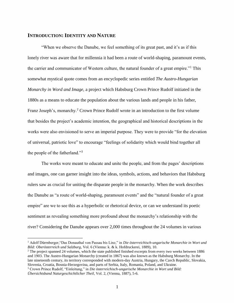
Figure 1. The Habsburg Monarchy with Danube ........................................................................... 2
Figure 2. Franz II/I During the 1830 Flood (left) and Franz Joseph I during the 1862 Flood
(right) ................................................................................................................................ 45
Figure 3. Sisi’s Bridal Trip Down the Danube ............................................................................. 50
Figure 4. Crowds Celebrating the Danube Regulation’s Opening, 1875 ..................................... 58
Figure 5. Franz Joseph Crossing the Newly Opened “Franz Joseph Bridge” in Budapest, October
1896................................................................................................................................... 62
Figure 6. 1901 Canal and River Regulation Law Proposed Projects (author’s coloration) ........ 126
Figure 7. Linz during the 1899 Summer Flood (Flooded Building in the Middle is the DDSG’s
local office) ..................................................................................................................... 259
Figure 8. Volunteer Fire Brigade’s Water Brigade Division Practicing in the Winter Harbor .. 265
Figure 9. Ferenc Reitter’s Suggested Canal Through Pest ......................................................... 280
Figure 10. Rowing Regatta in the Danube Canal, 1903 ............................................................. 290
Figure 11. The Positions of Linz and Győr (RAAB) in relation to Vienna (WIEN), Bratislava
(Pressburg), and Budapest .............................................................................................. 293
Figure 12. Linz, Strasser Island, and the “Fabrikarm” in the Late Nineteenth Century ............. 294
Figure 13. Historical Map of Győr on Mosoni Danube with Main Bed ..................................... 295
Figure 14. The Swimming Facilities in the Fabrikarm, circa 1880 ............................................ 306
Figure 15. Linz's Transshipment Hub (center), DDSG office (right), and Steamship Traffic ... 313
Figure 16. Győr’s Mosoni Danube, the Landing Place (center right), and the Grain Elevator (far
right) ................................................................................................................................ 315
Figure 17. Thirteen of Top Twenty Largest Cities in the Monarchy, 1910 ................................ 317
Figure 18. Bombardment of Belgrade ........................................................................................ 320
viii
LIST OF TABLES
Table 1. DDSG Freight Traffic on Hungarian Waterways, 1870-1914. ....................................... 43
Table 2. Hydraulic Engineering Directorate Budgets for New Construction and Maintaining
Existing Works, 1837-1859. ............................................................................................. 84
Table 3. Hydraulic Engineering Directorate Budgets, including Hungary, 1852-59. .................. 85
Table 4. River Regulation Expenses in Hungary (forints). ......................................................... 114
Table 5. DDSG Freight and Passenger Traffic, 1835-1917. ....................................................... 162
Table 6. DDSG Passenger Traffic, 1842-65. .............................................................................. 166
Table 7. Types of Goods Arriving in Vienna (in centner): 1835,1849-56. ................................ 176
Table 8. DDSG Freight on Danube and Tisza (in tons), 1860-65. ............................................. 178
Table 9. DDSG Steamship Freight Traffic of 11.5 million zoll-centner Wheat and Merchants’
Goods to Cities on the Danube in Austria and Hungary, 1865. ...................................... 180
Table 10. DDSG Steamship Freight Traffic Export-Import at Vienna, 1877-86. ...................... 182
Table 11. DDSG Steamship Freight Traffic Export-Import at Pest, 1877-86. ........................... 182
Table 12. DDSG Steamship Freight Traffic Export-Import at Mauthausen, 1877-86. .............. 183
Table 13. DDSG Steamship Freight Traffic Export-Import at Bezdán, 1877-86. ...................... 183
Table 14. Two Largest Passenger Companies in Hungary. ........................................................ 191
Table 15. Total Passenger Traffic in Hungary. ........................................................................... 196
Table 16. Largest Companies’ Passenger Traffic in Hungary (excl. DDSG), 1870-1914. ........ 197
Table 17. DDSG Up and Downstream Freight Traffic (in tons) on Danube, Tisza, Drave, Save,
and the Bega Canal. ........................................................................................................ 198
Table 18. Eighteen Largest Steam Nav. Companies in Hungary (excl. DDSG). ....................... 199
Table 19. DDSG Passenger Traffic in Hungary by River. ......................................................... 203
Table 20. DDSG Danube Passenger Traffic in Hungary by Stretch........................................... 204
Table 21. Frequency and Severity of Floods in Vienna, 1500-2000. ......................................... 223
Table 22. Linz Passenger Traffic, 1872-1914. ............................................................................ 312
Table 23. Linz Freight Traffic (goods, wheat, fruit, wood, concrete) in Centner, 1872-1914. .. 312
Table 24. Győr Steam Navigation Company Freight Transportation (in tons), 1874-1892. ...... 314

ix
GLOSSARY OF TERMS AND ABBREVIATIONS
Imperial and Royal Nomenclature
The Habsburg Monarchy was named for the family ruling it. Separate kingdoms, archduchies,
duchies, principalities, and margraves – of which there were 20 ‘crownlands’ from 1804-1867 –
had their own bureaucracies and diets. When Emperor Franz II/I declared the Austrian Empire in
1804, the monarchy became imperial or ‘kaiserlich’. The empire included several kingdoms such
as Bohemia, Hungary, and Lombardy-Venetia, which gave the empire royal ‘königlich’ status as
well. The highest authorities were therefore kaiserlich-königlich, “k.k.” or “imperial-royal.” The
Kingdom of Hungary’s autonomous status following the 1867 Austro-Hungarian Compromise,
led to the distinction kaiserlich und königlich or “imperial and royal.” Austrian ministries after
1867 retained k.k. to indicate that they were part of Imperial Austria.
Currency in the Monarchy
Currency before 1892 was the gulden (German)/forint (Hungarian), which is translated as
“florin” in English. After a currency reform in 1892, currency was the Krone “crown.” 2 crowns
= 1 florin. I offer a few rough approximations in the work about modern-day parity in dollars.
Government Organs and Structures
While I try to translate German and Hungarian terms – or at least explain – there are several I
keep in the original language because of the political connotations today that make a translation
difficult.
- Statthalter was the emperor’s personal representative in any of his different provinces.
The Statthalterei was his office.
- Nádor or “Palatine” was the emperor’s special representative in Hungary.
- Hélytartótanács or “Lieutenancy Council” was an advisory body created in 1723, the
palatine was generally the head of it, and certain nobles were in the assembly
- Landtag(e) are the provincial diets in the Austrian lands
- megye was the county-level administration in Hungary. After 1867, Hungary was divided
into 49 Hungarian counties, 8 Transylvanian, and 8 Croatian counties, and 89 cities with
municipal rights
- alispán or “lieutenant governor” was the county’s head official
Weight Conversions
1 centner = 56.0060 kilograms (as specified in 1872 law)
1 zoll-centner = 50 kilograms
1 metric centner = 100 kilograms = 2 zoll-centner
1 metric ton = 1,000 kilograms = 10 metric centner = 20 zoll-centner
1
INTRODUCTION: IDENTITY AND NATURE
“When we observe the Danube, we feel something of its great past, and it’s as if this
lonely river was aware that for millennia it had been a route of world-shaping, paramount events,
the carrier and communicator of Western culture, the natural founder of a great empire.”1 This
somewhat mystical quote comes from an encyclopedic series entitled The Austro-Hungarian
Monarchy in Word and Image, a project which Habsburg Crown Prince Rudolf initiated in the
1880s as a means to educate the population about the various lands and people in his father,
Franz Joseph’s, monarchy.2 Crown Prince Rudolf wrote in an introduction to the first volume
that besides the project’s academic intention, the geographical and historical descriptions in the
works were also envisioned to serve an imperial purpose. They were to provide “for the elevation
of universal, patriotic love” to encourage “feelings of solidarity which would bind together all
the people of the fatherland.”3
The works were meant to educate and unite the people, and from the pages’ descriptions
and images, one can garner insight into the ideas, symbols, actions, and behaviors that Habsburg
rulers saw as crucial for uniting the disparate people in the monarchy. When the work describes
the Danube as “a route of world-shaping, paramount events” and the “natural founder of a great
empire” are we to see this as a hyperbolic or rhetorical device, or can we understand its poetic
sentiment as revealing something more profound about the monarchy’s relationship with the
river? Considering the Danube appears over 2,000 times throughout the 24 volumes in various
1 Adolf Dürrnberger,“Das Donauthal von Passau bis Linz,” in Die österreichisch-ungarische Monarchie in Wort und
Bild: Oberösterreich und Salzburg, Vol. 6 (Vienna: k. & k. Hofdruckerei, 1889), 10. 2 The project spanned 24 volumes, which the state published finished excerpts from every two weeks between 1886
and 1903. The Austro-Hungarian Monarchy (created in 1867) was also known as the Habsburg Monarchy. In the
late nineteenth century, its territory corresponded with modern-day Austria, Hungary, the Czech Republic, Slovakia,
Slovenia, Croatia, Bosnia-Herzegovina, and parts of Serbia, Italy, Romania, Poland, and Ukraine. 3 Crown Prince Rudolf, “Einleitung,” in Die österreichisch-ungarische Monarchie in Wort und Bild:
Übersichtsband Naturgeschichtlicher Theil, Vol. 2, (Vienna, 1887), 5-6.
2
scientific, romantic, economic, artistic, and political contexts, the river incontrovertibly played
an important role in the monarchy’s history.4
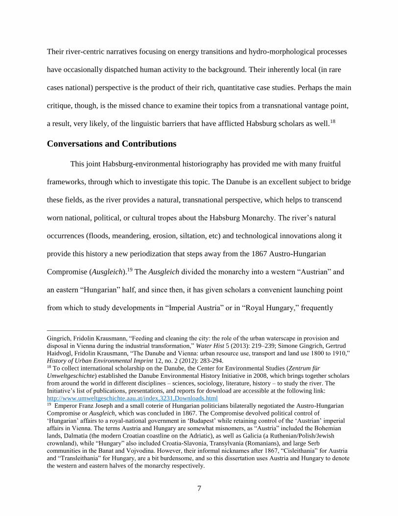
Figure 1. The Habsburg Monarchy with Danube. Source: “Österreichisch-ungarische Monarchie und die
Schweiz, Staatenkarte.” Lange-Diercke Volkschulatlas. Braunschweig: Westermann Verlag, 1898-1904. ©
Westermann Gruppe
4 This history began in 1278 when Habsburg ruler Rudolf I – newly elected Holy Roman Emperor – defeated
Bohemian King Ottokar II on the banks of the Danube and took control of the Duchy of Austria, the Habsburg
family’s first foothold on the Danube. The family expanded their hold along the river in Upper Austria. In 1526,
after the death of Hungarian and Bohemian King Lajos II, Austrian Archduke Ferdinand I convinced the Bohemian
and Hungarian diets to elect him their next king, in exchange for which he would protect their kingdoms from the
invading Ottomans. These diets duly crowned him, and Habsburg lands increased in size along the Danube. After
150 years, the Ottomans under Mehmed IV took advantage of Hungarian discontent with the Habsburgs to launch
another invasion of Vienna in 1683. The Habsburg Emperor Leopold I. with the Polish King Jan Sobieski III
defeated the Ottomans. Under the brilliant military leadership of Prince Eugene of Savoy, Austrian forces went on
the offensive and by the end of the 17th century, they had liberated the Kingdom of Hungary. Leopold’s new
expansion along the Danube led him to conduct diplomatic overtures with the Ottomans, to allow free navigation
along their respective stretches. He even sponsored the establishment of an Oriental Trading Company to open trade
with the former opponents. Leopold’s son, Charles VI, would later expand the monarchy even further along the river
in the 18th century, though he only regained this territory temporarily from the Ottomans.

3
The Austro-Hungarian Monarchy in Word and Imagine was published from 1886 to
1903, and large portions of its geographical and historical overviews specifically described the
significant transformations occurring along the Danube throughout the nineteenth century.
Successive Habsburg monarchs oversaw an increase in river traffic and trade on the monarchy’s
9,000 kilometers of navigable waterways, they approved the construction of additional canals,
undertook massive engineering works to secure banks and clear rivers of navigational
hindrances, and ordered the draining and securing of alluvial floodplains for agricultural and
industrial use as well as for urban expansion. These projects were intended to enhance the
Danube’s safety and utility for citizens in the monarchy, with the intention that it would bolster
their identification with and loyalty to the imperial state.
Historiography
The idea that the Habsburg ‘state’ – the dynasty, bureaucracy, and government –
modernized, let alone united, elements in its multinational territory runs counter to traditional
conceptions about the state’s “backward” nature. Nineteenth century historians like Ranke,
Fichte, and others in the Borussian School of Historiography already depicted Prussia as the
nation-state par excellence fulfilling its historical destiny in Europe, while the Habsburg
Monarchy’s anachronistic and medieval multi-confessional and multiethnic state they castigated
as essentially without a future.5 This negative narrative unsurprisingly strengthened as new,
‘homogeneous’ nation-states appeared in Central Europe following the monarchy’s collapse in
1918. These new, successor states legitimated their existence by arguing that they represented
the culmination of liberal, nationalist sentiments from the nineteenth century and that they were
5 Stefan Berger, “Prussia in history and historiography from the nineteenth to the twentieth centuries,” in Modern
Prussian history, 1830-1947, ed. Philip G. Dwyer, (Harlow, England: Pearson Education, 2001), 21-40.

4
inherently more modern and democratic than their imperial predecessor.6 In their version of the
monarchy’s history, the “Nationality Question” had caused incessant political strife, social
instability, and economic decay, making the monarchy’s collapse all but inevitable.7
Scholarship since the 1970s and 1980s has thoroughly revised this view by revealing the
strength of socio-economic relations and political institutions, which opposed the “centrifugal
forces” that Oszkár Jászi famously described in the monarchy.8 Works in the 1980s began to
challenge old assumptions about the monarchy’s economic weakness and political instability,
arguing instead that key economic and political institutions were reforming and improving
rapidly in its last few decades in existence.9 Additional monographs have looked more closely at
the common institutions in the monarchy, such as the bureaucracy, army, the Catholic Church,
and dynasty, Oszkár Jászi’s supposedly weak “centripetal forces.” These works reveal that these
“Habsburg” connections provided sources of supranational identities and associations, which
6 Certain nationalist movements in the 19th century argued that only national self-governance which based laws on
the will of a single nation could ensure truly democratic rule. These advocates argued that a multinational state had
to compromise to reflect the will of many nations (“ethnicities”), and as such was inherently undemocratic. These
arguments were undercut by the fact that democratic values themselves were less egalitarian in the nineteenth
century, even in more homogenous states. Social, economic, racial and gender differences continued to limit
suffrage across Europe – in 1907, Austria’s universal manhood suffrage made it arguably “more democratic” than
Britain, which still limited the vote to certain groups of men until 1918. 7 There are mountains of books devoted to the monarchy’s “Nationality Question,” though crucial works that
influenced the English-speaking world were frequently written by Austrian, Czech, Hungarian, and other émigrés,
who came to the United States and Britain after 1918. 8 Oszkár Jászi was a Hungarian political scientist and politician, who emigrated to America after the First World
War and became a professor at Oberlin. His work The Dissolution of the Habsburg Monarchy explores the
consolidating “centripetal” forces – the bureaucracy, army, dynasty, aristocracy, and the Catholic Church, as well as
socialism, free-trade in the monarchy, and capitalism – which were nevertheless unable to overcome the
disintegrative “centrifugal” forces, which were, among others the persistence of feudalist elements, territorial
struggles, and nationalist and irredentist ideologies. 9 Just a few examples include, David F. Good, The Economic Rise of the Habsburg Empire, 1750-1914, (Berkley;
Los Angeles: University of California Press, 1984); Gerald Stourzh, Die Gleichberechtigung der Nationalitäten in
der Verfassung und Verwaltung Österreichs 1848-1918, (Vienna: Verlag der Österreichischen Akademie der
Wissenschaft, 1985); Alan Sked, The Decline and Fall of the Habsburg Monarchy, 1815-1918, (London; New York:
Longman, 1989); John W. Boyer, “The End of an Old Regime: Visions of Political Reform in Late Imperial
Austria,” The Journal of Modern History 58, no. 1 (1986): 159-193.
5
united people across different classes and ethnicities and inspired loyalty to the imperial state.10
Other scholars have even begun to question recalcitrant opinions that national identities were
widespread, monolithic and irrevocably divisive, instead pointing to regional identifications and
“national indifference” as counterpoints to nationalism’s identity politics.11
Newer Habsburg historiography also argues that the imperial authorities played an active
role in reforming society for the general well-being. John Deak’s work Forging a Multinational
State: State Making in Imperial Austria from the Enlightenment to the First World War studies
the central bureaucracy’s growing function, from a state apparatus intended to facilitate the
collection of revenue to bolster the army in the eighteenth century to a “pillar” of the monarchy
in the nineteenth century that ministered to the population’s needs in the provinces.12 In a similar
vein, James Shedel has recently argued for a new understanding of the Habsburg monarchs as
themselves a source of reform, asserting that under Maria Theresia, the imperial authorities
began to see their citizens’ happiness and comfort as the ultimate goal of the state’s interventions
and interactions with society. Shedel labels this modus operandi the “eudaemonic state” given
that it pursued policies that supported citizens’ welfare.13 These works strongly influence my
10 István Deák, Beyond Nationalism: A Social and Political History of the Habsburg Officer Corps, 1848-1918,
(Oxford: Oxford University Press, 1990); James Shedel, “Emperor, Church, and People: Religion and Dynastic
Loyalty During the Golden Jubilee of Franz Joseph,” The Catholic Historical Review, Vol. 76, (1990): 71-92;
Daniel Unowsky, The Pomp and Politics of Patriotism: Imperial Celebrations in Habsburg Austria, 1848-1916,
(West Lafayette: Purdue University Press, 2005). 11 Jeremy King, Budweisers into Germans and Czechs: A Local History of Bohemian Politics, 1848-1948,
(Princeton: Princeton University Press, 2002); Pieter M. Judson, Guardians of the Nation: Activists on the Language
Frontiers of Imperial Austria, (Cambridge, MA: Harvard University Press, 2006); Tara Zahra, Kidnapped Souls:
National Indifference and the Battle for Children in the Bohemian Lands, 1900–1948, (Ithaca: Cornell University
Press, 2012). 12 John Deak, Forging a Multinational State: Making in Imperial Austria from the Enlightenment to the First World
War, (Standford: Standford University Press, 2015). 13 James Shedel, “The Mother of it All: Maria Theresia and the Creation of Hybrid Monarchy,” paper presented at
the conference Maria Theresa - An Enlightened Reformer and Grandmother of Central Europe, Ljubljana, Slovenia,
June 2017.
6
dissertation, which frequently seeks to understand how physical reforms and changes to the
Danube played a role in promoting citizens’ well-being.
By looking at Habsburg “reforms” in the context of the Danube River, my dissertation
also hopes to contribute to the rather “large tent” of environmental historiography, which John R.
McNeill argues encompasses no less than “the history of the mutual relations between
humankind and the rest of nature.”14 My work broadly belongs in the subfield ‘river
historiography,’ which includes further subsets such as ‘rivers and identity’ and ‘Danube
environmental history.’ Most river identity literature has, until now, emphasized how river are
imbued with or contribute toward local and national identities.15 The following work contributes
to this environmental historiography by presenting the Danube as a source of imperial identity.16
On the other hand, scholars in Austria have published extensively and brilliantly on the
environmental history of the Danube – particularly the Viennese stretch – for the past decade.17
14 J. R. McNeill, “Observations on the Nature and Culture of Environmental History,” History and Theory 42, no. 4
(2003): 5-43. 15 Christof Mauch and Thomas Zeller, “Rivers in History and Historiography: An Introduction,” in
Rivers in history: perspectives on waterways in Europe and North America, ed. Christof Mauch and Thomas Zeller,
(Pittsburgh: University of Pittsburgh, Digital Research Library, 2011), 1-10. 16 Over the years, historians, authors, journalists, poets, and linguists have published countless works about the
Danube River, some which indeed depict the river as an imperial route. However, in most cases, the titular river
disappears quickly from the work’s narrative and authors, instead, launch into familiar tropes about the people and
events located within the Danube Basin, but fail to meaningfully explore this history’s relationship to the river, other
than anecdotally. Such works may emphasize political or military developments, such as Erwin Lessner The
Danube: The Dramatic History of the Great River and the People Touched By Its Flow, or focus on cultural and
historical events such as Andrew Beattie’s The Danube: A Cultural History; both of these focus on developments
independent of the Danube. Nick Thorpe’s The Danube: A Journey Upriver from the Black Sea to the Black Forest
retains a distinctly personal narrative along the river, and Simon Winder’s Danubia features anecdotal narratives
about different groups, such as the Habsburgs, who happened to live on the Danube. Claudio Magris’ seminal work,
Danube: A Sentimental Journey from the Source to the Black Sea meanders across literary, historical, and
intellectual sites along river without having much to say about the river’s specific role in shaping this history itself.
Peter Coates explicitly acknowledges this pitfall in A Story of Six Rivers. History, Culture and Ecology, (London,
Reaktion Books, 2013), however, his chapter on the Danube is filled with tidbits and anecdotes about the Danube’s
origin, size and ‘habits,’ but presents more a chronological recitation of interspersed events rather than a rigorous
analysis of their meaning for the monarchy’s history. 17 Severin Hohensinner, Mathew Herrnegger, Alfred P. Blaschke, Christine Habereder, Gertrud Haidvogl, Thomas
Hein, Mathias Jungwirth, Michael Weiβ, “Type-specific reference conditions of fluvial landscapes: A search in the
past by 3D-reconstruction,” Catena 75 (2008): 200–215; Severin Hohensinner, Christoph Sonnlechner, Martin
Schmid, Verena Winiwarter, “Two steps back, one step forward: reconstructing the dynamic Danube riverscape
under human influence in Vienna,” Water Hist 5 (2013):121–143; Sylvia Gierlinger, Gertrud Haidvogl, Simone
7
Their river-centric narratives focusing on energy transitions and hydro-morphological processes
have occasionally dispatched human activity to the background. Their inherently local (in rare
cases national) perspective is the product of their rich, quantitative case studies. Perhaps the main
critique, though, is the missed chance to examine their topics from a transnational vantage point,
a result, very likely, of the linguistic barriers that have afflicted Habsburg scholars as well.18
Conversations and Contributions
This joint Habsburg-environmental historiography has provided me with many fruitful
frameworks, through which to investigate this topic. The Danube is an excellent subject to bridge
these fields, as the river provides a natural, transnational perspective, which helps to transcend
worn national, political, or cultural tropes about the Habsburg Monarchy. The river’s natural
occurrences (floods, meandering, erosion, siltation, etc) and technological innovations along it
provide this history a new periodization that steps away from the 1867 Austro-Hungarian
Compromise (Ausgleich).19 The Ausgleich divided the monarchy into a western “Austrian” and
an eastern “Hungarian” half, and since then, it has given scholars a convenient launching point
from which to study developments in “Imperial Austria” or in “Royal Hungary,” frequently
Gingrich, Fridolin Krausmann, “Feeding and cleaning the city: the role of the urban waterscape in provision and
disposal in Vienna during the industrial transformation,” Water Hist 5 (2013): 219–239; Simone Gingrich, Gertrud
Haidvogl, Fridolin Krausmann, “The Danube and Vienna: urban resource use, transport and land use 1800 to 1910,”
History of Urban Environmental Imprint 12, no. 2 (2012): 283-294. 18 To collect international scholarship on the Danube, the Center for Environmental Studies (Zentrum für
Umweltgeschichte) established the Danube Environmental History Initiative in 2008, which brings together scholars
from around the world in different disciplines – sciences, sociology, literature, history – to study the river. The
Initiative’s list of publications, presentations, and reports for download are accessible at the following link:
http://www.umweltgeschichte.aau.at/index,3231,Downloads.html 19 Emperor Franz Joseph and a small coterie of Hungarian politicians bilaterally negotiated the Austro-Hungarian
Compromise or Ausgleich, which was concluded in 1867. The Compromise devolved political control of
‘Hungarian’ affairs to a royal-national government in ‘Budapest’ while retaining control of the ‘Austrian’ imperial
affairs in Vienna. The terms Austria and Hungary are somewhat misnomers, as “Austria” included the Bohemian
lands, Dalmatia (the modern Croatian coastline on the Adriatic), as well as Galicia (a Ruthenian/Polish/Jewish
crownland), while “Hungary” also included Croatia-Slavonia, Transylvania (Romanians), and large Serb
communities in the Banat and Vojvodina. However, their informal nicknames after 1867, “Cisleithania” for Austria
and “Transleithania” for Hungary, are a bit burdensome, and so this dissertation uses Austria and Hungary to denote
the western and eastern halves of the monarchy respectively.

8
independent of the other half of the monarchy. Employing German and Hungarian sources has
enabled me to discuss the monarchy’s history without truncating the Danube into national
stretches.
Above all, an environmental perspective of the Habsburg Monarchy reveals that the
Donaufrage or “Danube Question” – whether documents directly referred to it as such or not –
was ubiquitous throughout the monarchy. It influenced discussions about land ownership,
construction projects, natural disaster relief, not to mention urban renewal projects, commercial
interests, health and sanitary concerns, communication, and even leisure time activities. While
the aforementioned historiography has studied the political, economic, and social implications of
reform in the Habsburg Monarchy, the Donaufrage provides insight into the environmental
impetuses for it as well. The imperial authorities’ interventions along the Danube provided them
the opportunity to display and employ their hydraulic projects as a modern means to protect the
physical and to promote the material well-being of its citizens, to earn their loyalty and trust.
Trust in state institutions, or loyalty to them, was crucial at a time when nationalists claimed that
only national rather than imperial governance could be truly democratic. How then does one
‘measure’ this loyalty or trust?
Habsburg historians have described practices, relationships, and behaviors that seem to
denote loyalty to a group or idea. For historians like Laurence Cole, Daniel Unowsky, and James
Shedel, the participation of citizens in imperial celebrations and their presence at ceremonial
events provided the population with opportunities to demonstrate their loyalty to the Habsburg
state. These historians maintain that despite the population’s diversity, which led them to
9
interpret dynastic displays through national, imperial, or religious convictions, they still
ultimately supported the institution of the monarchy.20
Both structural and momentary events and ideologies fostered the circumstances that led
people to feel loyal to a person or idea. In his work The Habsburg Empire: A New History, Pieter
M. Judson explores in one chapter what drew people to express nationalist ideas. Judson argues
that nationalism should be understood as a process and that it “helps to approach questions of
identification by thinking more in terms of particular practices that expressed feelings of loyalty
or commitment rather than in terms of people’s fixed identities (author’s emphasis).”21 Jeremy
King also succinctly describes such situational associations in the Habsburg Monarchy in his
work Budweisers into Czechs and Germans: A Local History of Bohemian Politics, 1848-1948.
He argues that “if languages divided a population vertically, into protonational columns, then
corporative and socioeconomic solidarities divided it horizontally, into Habsburg layers – and
had far more institutional anchoring and sociopolitical significance.”22 Both Judson’s and King’s
works implicitly acknowledge that personal sentiments and group dynamics were multifaceted,
and that identities and loyalties at imperial, national, local levels did not necessarily preclude
other group associations. Such shifting group identifications – influenced by social, economic,
cultural, and political factors – were a dynamic feature of the monarchy.
My dissertation looks at interactions, practices, behaviors among local, provincial,
national, and imperial groups and further asks: how did the physical space along the Danube
20 Daniel Unowsky, The Pomp and Politics of Patriotism: Imperial Celebrations in Habsburg Austria, 1848-1916,
(West Layette: Purdue University Press, 2005); Laurence Cole and Daniel L. Unowsky (eds), The Limits of Loyalty:
Imperial Symbolism, Popular Allegiances, and State Patriotism in the Late Habsburg Monarchy, (New York:
Berghahn Books, 2007); James Shedel, “The Elusive Fatherland: Dynasty, State, Identity and the
Kronprinzenwerk,” in Inszenierung des kollektiven Gedächtnisses: Eigenbilder, Fremdbilder, eds. Moritz Csáky and
Klaus Zeyringer, (Innsbruck; Vienna; Munich; Bozen: Studien Verlag, 2002). 21 Judson, The Habsburg Empire, 312. 22 Jeremy King, Budweisers into Czechs and Germans: A Local History of Bohemian Politics, 1848-1948
(Princeton; Oxford: Princeton University Press, 2002), 7.

10
shape these practices and relationships? Who or what controlled this process? What was the
result of modification or changes to the riverscape?
Sociologists – some the front runners of environmental historians – have provided
thoughts on this question, studying the spaces humans inhabit and create to theorize how they
influence daily experiences, actions, and behaviors. In his work, The Production of Space, Henri
LeFebvre delineates how different spaces serve different purposes. Humans create associations
and rules that dictate how they act and interact within a space.23 Andreas Reckwitz has expanded
on notions of practice theory associated with Pierre Bourdieu, presenting human behavior and
activity as an intersection of two concepts: ‘practices,’ which are the conscious and unconscious
actions, movement, activities, and habits, which guide human behavior, and ‘arrangements,’
which are the material spaces – artificial and natural – which enable, limit, influence, or define
those ‘practices.’24 Theodore R. Schatzki argues that scholars can use the notion of arrangements
and practices to avoid the ontological habit of dividing the natural and human world into two
separate analytical spheres.25 In this manner, practices all take place in a ‘social site,’ a material
arrangement, irrespective of whether the space is natural (a riverbank) or artificial (an
embankment).
A river offers a concrete way to visualize these concepts. People settle along a river for
the benefit of the transportation, protection, or nourishment it provides. Constructing a bridge
(arrangement) may enable people to cross the river (practice), but it can also affect additional
practices and arrangements. Foot or cart traffic may change within a city (practices) with the
23 Henri Lefebvre, The Production of Space, translated by Donald Nicholson-Smith, second edition (Malden, Mass.:
Blackwell Publishers, 2000). 24 Andreas Reckwitz, “Toward a Theory of Social Practices: A Development in Culturalist Theorizing,” European
Journal of Social Theory 5 (2002): 243–263. 25 “Nature and Technology in History,” History and Theory 42, no. 4 (2003): 82-93.
11
construction of a new river crossing, as will the river’s hydrology – the water’s interaction with
its physical surroundings based on natural principles – because of the bridge’s pylons. If people
change their daily routes to cross the bridge, this may influence the location of new marketplaces
or streets (arrangements) taking advantage of new human traffic. If the bridge’s construction
changes the river’s speed or course, the altered current could affect everything from how fish
spawn downstream to the rate of erosion along its banks. Changes to arrangements invariably
lead to changes in practices and vice versa. As the following work reveals, both humans and the
Danube shaped arrangements and practices, and in a way, both reacted to these changes with
new ‘behavior’ as well.
Using a composite of these practice-arrangement theories and the identification-loyalty
work of Habsburg historians, I propose that the daily interactions, common experiences, and
intersecting (at time conflicting) interests embedded in a shared physical-natural space in the
monarchy – the Danube – drove crucial processes of negotiation and compromise necessary for
the proper functioning of the social, political, and economic relationships in the monarchy. These
processes were constantly in flux as both nature and technology changed this common space.
Bridges, steamship landing places, quays, warehouses, boat mills, embankments, and other
physical arrangements influenced arrangements for municipalities on the river and their
connections to other regional and transnational communities. Authorities and communities
modified arrangements to enhance commercial connections, to protect communities, to improve
navigation, or to prioritize other practices on the river.
The state’s interventions in this Danubian space frequently provided a method of
modernizing practices in the monarchy, which relied on drawing populations together through
geo-physical, rather than ethno-national state-building. Newspaper discussions and imperial
12
celebrations provided monarchy-wide opportunities to create spaces and rituals to commemorate
these changes together. My dissertation does not argue that national identities did not exist. Aviel
Roshwald has expertly elucidated how ethnic nationalism certainly remained a credible albeit
evolving ideology among politicians, intellecturals, and other social groups to coalesce and
alienate segments of the population in the nineteenth and early twentieth century, especially
during the First World War.26 However, it’s also clear that many other factors contributed to the
daily associations, connections, behaviors and interactions, which influenced identification.
Rogers Brubaker has argued that group identifications aren’t necessarily a priori constructs, and
that people’s reasons for associating with a group may be as much as question of ‘interest’ as
‘identity’ politics.27 Therefore, we need to study people’s habits, actions, and behaviors to
understand their interests and how changes to their environment succeeded in fulfilling those
interests or changing their relationship with others in the monarchy.
Methodology
To provide a balanced study of the Danube’s influence on its transnational communities
within the monarchy, I undertook research in six different cities on the river. While Linz, Melk,
and Vienna are in modern day Austria, and Győr, Esztergom, and Budapest are in Hungary, they
were hardly “German” or “Hungarian” cities in any national sense, with the exception of certain
“nationalized” spaces in late-nineteenth-century Budapest.28 Large and even middle-sized urban
26 Aviel Roshwald, Ethnic Nationalism and the Fall of Empires: Central Europe, Russia and the Middle East, 1914-
1923, (London; New York: Routledge, 2001). 27 Gary Cohen, The Politics of Ethnic Survival: Germans in Prague, 1861-1914, (West Lafayette: Purdue University
Press, 2006), 2-10. Cohen’s comments regarding “mass literacy” likely refer to Benedict Anderson’s Imagined
Communities and the role of vernacular and mass press/literacy in helping create national bonds. Eugen Weber’s
Peasants into Frenchmen falls precisely into the positivist mode of thinking that Cohen warns against, as he points
to modern, state-driven processes like education and rails in France, which he argues changed provincial lifestyles
and habits enough to forge a French national identity from regional ‘peasant’ identities. 28 Robert Nemes’ observations on this topic appear more in Chapter 5, The Once and Future Budapest, (DeKalb, IL:
Northern Illinois University Press, 2005).
13
centers on the Danube – such as Vienna, Budapest, Linz, and Győr – were frequently the
destination for internal migration during the mid and late nineteenth century.29 Few cities were
ethnically, religiously, linguistically or culturally homogenous, and changes to the Danube
environment affected members irrespective of ethno-cultural markers, unless those markers
correlated with socio-economic standing, which did from time to time influence historical
vulnerabilities vis-à-vis the Danube.30
Nevertheless, these six cities provide a good distribution of ‘case studies’ from both
halves of the monarchy, which reveal similarities and differences, though most based on
common concerns and investments in the river, rather than national visions for the river’s
transformation. Vienna and Budapest provided the perspective of the imperial-royal centers, Linz
and Győr were mid-sized industrial and commercial cities, and Melk and Esztergom were
smaller towns. My archival visits in Esztergom and Melk, unfortunately, revealed that few
documents I was looking for still existed, so these towns provide more anecdotal than analytical
evidence in the following history. All together, these six cities also fall on different hydrological
regimes on the river; the Austrian cities are on the so-called “Upper Danube” which has the
characteristics of a “mountain stream,” whereas after Vienna, the “Middle Danube” slows its
course, which changes the conditions under which the river freezes, how it behaves with its
29 Annemarie Steidl, Engelbert Stockhammer, and Hermann Zeitlhofer, “Relations among Internal, Continental,
and Transatlantic Migration in Late Imperial Austria,” Social Science History 31, no. 1 (2007): 61-92. 30 An obvious example of this are the Jewish communities in Pest and Vienna. The districts within which many Jews
settled or to which they were forced to relocate tended to be peripheral to the main city center, which often meant
regions near the river that were frequently inundated during floods.

14
tributaries, and its propensity to flood.31 As the dissertation will reveal, these different
hydrological profiles frequently influenced human practices along the river.32
Environmental history enables scholars to disregard, or at the very least forget for a
moment, specific political demarcations, by tracing climatic, geological, and hydrological events
and processes that are best understood in the longue durée where patterns and connections
emerge more readily than in shorter or specifically political periodizations. While this
dissertation nominally spans the “long nineteenth century,” broadly defined as the period 1789-
1914, it does not claim to cover it equally in its entirety. While newspapers operated in Vienna
for hundreds of years and provide snapshots into the imperial capital’s more quotidian
operations, minutes for communal councils or other parliamentary bodies are only available after
31 Different geological and therefore hydrological relations also affected the river’s course and behavior in the
monarchy. Due to its high elevation, the Upper Danube – which extends until Bratislava – has the characteristics of
a mountain stream, meaning it discharges more water, flows more rapidly and carries more sediment in its current
than lower downstream. In the uppermost stretches in the Empire, granite banks and bed hem the river’s path,
significantly reducing lateral erosion or meandering. A break in the Bohemian Massif led to a natural north-south
route from Bohemia, crossing the Danube at Linz on the commercial path toward Italy, which enhanced the city’s
importance. At Melk, in the Wachau region the Danube also remains in a narrow path. Past the Wachau, the Danube
emerges into softer floodplains, the Machlands, where historically the river branched into several, shallow arms. At
Vienna, the Danube branched into several arms, the main, southern arm at the edge of the river’s floodplain, became
the site for the city’s main settlement. The hills surrounding Vienna’s northern and western boundaries are the last
iteration of the Alps, and from here, the elevation decreases, which causes the river to drastically reduce its speed
and thus ‘drop’ much of the sediment in carried from its upper stretches. This phenomenon over millennia led to the
creation of large islands in the Danube, where sediments collected. These islands deflect the river’s course into
numerous arms, and north of Győr, the river splits into three main channels. Győr lay on the southernmost channel,
which until regulation in the mid-19th century was the only route on which ships could navigate, making the city a
crucial stopover for goods traveling downstream or agricultural goods heading upstream to Vienna. At Esztergom,
warm hot springs at initially influenced Neolithic settlement at the Danube’s banks. At Budapest, the Danube’s
‘narrowed’ path led to a natural place for trade routes to ford the Danube for hundreds of years, which established its
importance for east-west and north-south trade. These differing geological, hydrological, and historical relations
with the Danube are important to remember, as they provide some clues into the differing usage, maintenance, and
demands people had from the river. 32 The Danube’s geo-morphology and geological conditions influence cities’ and communities’ development along it
as well. Most larger cities are located on the Danube’s southern (right) bank. This location had both historical and
natural influences: the Roman’s extensive military frontier – the limes – ran along the length of Danube’s southern
banks, and both Vienna and Budapest were near the sites of Roman forts, Carnunthum and Aquintum respectively.
Likewise, the Danube’s west-to-east course is naturally drawn toward the equator, which means that, with the
exception of certain stretches, the river naturally flows toward the right, or southern, direction. The hydrological
effect is that the river’s speed is on average slower on the right bank than the left bank, which makes it safer for
navigation.
15
mid-century of later. However, I intentionally avoided framing my project around key years like
1848 or 1867 simply because their political weight too often tempts historians to use them as
convenient bookends. I did find it necessary to avoid including the First World War, because the
commercial and physical hindrances that accompanied the war ruptured many of the normal
practices and behaviors on the Danube.
The longer periodization consequently magnified my source base. Indeed, as this work
analyzes both ‘state’ intentions and societal responses, it was necessary to consult an (at times)
overwhelming flood of sources. Government reports, engineering surveys and suggestions, inter-
ministerial memos, statistical overviews, parliamentary debates, public notices, laws, and city
council meeting minutes are just a few of the documents which provide insight into the
government and bureaucracy’s reasons for modifying, intervening in, or regulating the physical
and social spaces along the Danube. The public’s responses and behaviors were varied and were
apparent from newspaper articles, petitions, associational minutes and activities, popular
celebrations, and other forms of recorded behavior. These documents have enabled me to
determine whether people considered these hydraulic projects sufficient to address local or
general needs, or what other actions would be necessary to secure their goodwill and well-being.
Structure and Thesis
In Chapter One, I present the Habsburg dynasty’s actions and the imperial bureaucracy’s
expansion to equip the state apparatus with the knowledge and technology required for
transforming the Danube into a space that would serve the imperial common good. The chapter
looks at how the successive Habsburg monarchs used celebrations and physical improvements
along the river to draw the public’s attention to the institution of the monarchy as a source of
modernization. These dynastic displays underpinned the imperial monarchy’s legitimacy as an
16
important agent of reform seeking to promote their well-being in an age of competing, popular
ideologies. Although these projects occurred in a variety of geographical contexts, and thus
served different segments of the population, local celebrations and commemorations indicated a
certain level of genuine public support for the dynastic family’s efforts.
The next two chapters, Chapter Two and Three, provide an overview into the work that
political and technical bodies undertook to transform the Danube into a unitary waterway with its
tributary network, which facilitated integrative social and commercial practices between
different regions in the monarchy. In both chapters, steam power served as a critical tool for the
imperial administration and communities alike to accomplish their intended agenda on the river.
Steamships radically changed the relationship of humans living on the Danube with each other
and the river itself, and provided a means to balance riverine commercial practices between the
Hungarian and Austrian halves of the monarchy. Petitions from the public, as well as their
actions, demonstrated a strong reliance on imperial governing structures as a mechanism to
respond to the public’s needs.
While Chapter Three looked at the practices that integrated communities and provided
commercial opportunities to advance the population’s ‘financial’ well-being, Chapter Four looks
at the question of well-being from a more physical perspective. Floods perennially threatened
communities, and as the century progressed, citizens and governments throughout the monarchy
recognized the need for a more integrative and holistic approach to preventing them, which had
not been politically, technically, or financially possible in earlier eras. Only by cooperating with
several levels of government and enacting both physical protections and developing new
responsive practices to floods, were local communities able to implement more effective flood
protection measures.
17
Chapter Five narrows the spatial parameters considerably, and rather than focusing on
transregional networks or the river’s monarchy-wide, hydrographic profiles, it looks at the
practices and arrangements that developed within cities themselves in the nineteenth century.
The chapter studies the Danube in its multifaceted roles in cities: a carrier of disease and hygiene
and as a source of work and leisure. It was a site where transregional, commercial, and non-
national exchanges intersected, which ensured that new arrangements and modifications to the
river within cities benefited much of the urban population, regardless of national or other
ideological tendencies.
The following work presents the nineteenth-century arrangements that influenced
people’s behavior and interactions along the Danube and seeks to understand how the river’s
physical environs were engineered to serve as a source of loyalty and cohesion in the monarchy.
For the authorities, the river’s natural connections throughout the monarchy and the ubiquity of
its presence in many people’s daily lives made the Danube a natural place to regulate practices
and construct arrangements which protected citizens, improved their well-being, and channelized
loyalty to the dynasty and imperial state.
Citizens were also actively involved in this ‘state-building’ process. They turned the
imperial government’s attention to local needs, relying on the appropriate structures of
interaction between ‘state’ and ‘society’ – political petitions, associational movements, elections,
and representation – and, in rare cases when those did not suffice, on agitation and revolution.
They were flexible and pragmatic in pursuing local needs, knitting together governmental and
commercial support for their endeavors.
The Danube was also instrumental in state-building processes. Its nature and behavior
represented both threats and opportunities for the monarchy’s inhabitants, and through its wide-

18
ranging influence on daily life, the river forced governments, businesses, and people to consider
it in terms of monarchy-wide arrangements and practices. This story therefore relates how the
Danube became “the natural founder of a great empire.”
19
CHAPTER 1: CREATING THE IMPERIAL DANUBE
In October 1823, Vienna’s conservative paper, the Österreichischer Beobachter
announced that a new, steam-powered ship would leave its workplace at Fischamend, located ten
miles downstream from Vienna, on Friday, October 10, and would travel up the Danube to the
Lusthaus [Pleasure Pavilion], a popular destination for crowds in Vienna’s Prater Park, for a
public viewing. After a few days, the ship would then continue its journey downstream to Pest
before returning to Vienna. The ship’s name Franz I paid homage to the Habsburg emperor, who
in July 1813 had promised an imperial monopoly for any company able to establish steam
navigation on the Danube. Emperor Franz had envisioned that steamships would provide the
means to utilize the monarchy’s natural river network to promote economic activity and
encourage cohesion among his subjects.33
The Beobachter promised to keep readers apprised of Franz I’s progress in the coming
days. The ship and its plans, however, were not without their hiccups. The Danube branched into
numerous segments as it passed Vienna’s eastern boundaries, and on October 12, the company
reported that due to the Danube’s low water levels in the branch next to the Prater Park, the ship
would dock on a different branch instead. The company assured the public that they would still
have a chance to visit the new steamship as it remained on display all day at the new location
before starting its long journey down the Danube to Pest. Crowds gathered to see the ship once it
arrived, and a festive atmosphere pervaded the Danube’s banks.34 Emperor Franz, his son Crown
33 Franz I ruled over the Austrian Empire (a newly coined moniker in 1804), which corresponded to territory from
most of modern day Austria, Czech Republic, Slovakia, Slovenia, Croatia, Hungary, and parts of Italy, Poland,
Ukraine, and Romania. About 3/5 of the Danube’s path flowed through the monarchy. The river originated in
Baden, and after passing through the monarchy, it flowed between Wallachia (later Romania) and Bulgaria, and
emptied into the Black Sea. 34 Grössing, Funk, Sauer, and Binder, Rot-Weiss-Rot auf blauen Wellen 150 Jahre DDSG, (Vienna: Eigenverlag,
1979), 9.
20
Prince Ferdinand, and other notable aristocrats visited the berthed ship. A few days later, the
Franz I departed Vienna, arriving in Pest on October 16. Emperor Franz’s brother Archduke
Joseph, Hungary’s popular palatine, likewise showed his support for the new technology by
riding the steamship with his wife out to the Margaret Island in the Danube between Buda and
Pest.
The ship departed Pest October 20, but technological, hydrological, and meteorological
challenges plagued the ship’s trip upstream. After departing the city, it stopped for the night in
Vác, and the following day it had to stop again at Esztergom to load more coal for the ship’s
engine. This stop delayed the ship till the following day, the 22nd, which brought misty
conditions and yet another delay. Strong currents, sandbanks, storms and low water levels further
upstream provided constant hindrances to the ship’s progress. On the ship’s eighth day traveling
upstream, it reached Pressburg/Pozsony (modern day Bratislava, Slovakia), where a pontoon
bridge was strung across the Danube. As the residents had not opened the bridge in time, the ship
had to idle against the current as they prepared an opening. Crowds once again lined the banks to
witness the spectacle. On the ninth travel day, the ship – fighting winds, waves, and low water
levels – finally reached Fischamend. On its tenth day, it made it back to the Prater’s Lusthaus,
where it had begun its journey. Despite many navigational delays, the newspaper reviews a few
weeks later reported that the Franz I managed to overcome “all hindrances” and were
particularly impressed that it did so in late autumn when conditions were especially
unfavorable.35
The Franz I’s journey indicated a transitional moment in the relationship between natural
and human interactions, with steam navigation representing a crucial step forward in the
35 “Wien, den 6. November,” Österreichischer Beobachter, (Vienna, Austria) November 6, 1823, 1408-10.

21
Habsburg dynasty’s decades-long work to modernize and improve conditions on the Danube.
Observers lauded the trip’s technical achievement, but for the dynasty, it provided an opportunity
to display the emperor’s personal interest in technological innovation, while embedding his
support into the Danube’s riverscape, where large, diverse crowds could consume dynastic
celebrations and hydraulic engineering accomplishments. In order to make such choreography
possible, successive Habsburg monarchs had consciously taken steps for decades to make the
Danube a viable site for imperial state-building.
The following chapter will explore two elements of the imperial-dynastic endeavors to
create an ‘imperial’ Danube. Firstly, it will look at the dynastic initiatives, which provided the
bureaucratic and technical preconditions for largescale hydraulic engineering projects on the
Danube. The state’s early, geo-physical interventions coincided with a determination to establish
a steam navigation company to serve the interests of cohesion and connection in the monarchy.
The chapter’s second half will then explore how the Habsburgs utilized the Danube as a site for
dynastic displays and imperial celebrations to legitimate itself as a modernizing and attentive
force for the population’s well-being. The Danube’s transnational nature provided a site where
state interventions benefited large swaths of the population regardless of ethno-linguistic, social,
or religious distinctions. These modern arrangements and the subsequent practice of celebrating
them also provided a chance for local populations to spontaneously express their loyalty to the
imperial family.
The Danube and the Dynasty: A Brief Background
During the mid to late eighteenth century, the Habsburg monarchs undertook enlightened
reforms to consolidate their political holdings, develop commercial ties, and generally build up
and strengthen institutions of a centralized state. As James Shedel has argued, these reforms

22
starting under Maria Theresia demonstrated the emergence of a Habsburg “eudaemonic state,”
which existed to provide for the well-being of its subject citizens.36 These reforms contributed to
state-building efforts, a necessary but difficult endeavor in the multiethnic, multi-confessional,
politically diverse Habsburg Monarchy. Rulers faced several factions and factors resisting any
change to the status quo. Their, at times, beleaguered reforms faced an emergent Prussian power
challenging their traditional hegemony in German affairs, a sullen aristocracy, and later a
Catholic Church, which disliked the erosion of their traditional privileges. Certain reforms faced
resistance from provincial diets looking to avoid centralizing tendencies, and other policies
encountered and contributed to the friction generated by the gradual breakdown of traditional
feudal relations and the legal elimination of religious and economic particularism.
Beyond the various economic, social, and political reforms, which changed the landscape
of laws, norms, and mores, the Danube’s transformation also seemed a logical place for
Habsburg rulers to expand their state-building energies. When Maria Theresia ascended the
throne in 1740, the Habsburgs had already spent centuries expanding their territorial hold along
the Danube.37 Particularly after the War of Austrian Succession (1740-48) and the failure to
regain Silesia after the Seven Years’ War (1756-63), Maria Theresia consolidated the
government’s structure, increased educational opportunities, and encouraged mercantilist
expansion, to strengthen the monarchy’s economy and military. As part of these enlightened
reforms, she vigorously sought to improve navigation and commerce along the Danube and its
tributaries. Many hindrances existed. Burdensome customs duties at many cities or bridges
36 James Shedel, “The Mother of it All: Maria Theresia and the Creation of Hybrid Monarchy,” paper presented at
the conference Maria Theresa - An Enlightened Reformer and Grandmother of Central Europe, Ljubljana, Slovenia,
June 2017. 37 Rudolf I became Holy Roman Emperor in 1273 and subsequently defeated the Bohemian king Ottokar II in 1278
to control the Duchy of Austria. The family inherited territories up and downstream, eventually expanding from
where the Danube entered Upper Austria from Bavaria to where it departed the Habsburgs’ Hungarian territories
upstream from Orsova.
23
increased the costs of transporting goods and hampered commercial ties.38 The Danube’s
cataracts, shallows and winding paths, along with its tendency to freeze during the winter and
flood in the spring and fall, physically limited activity on it.39 A plethora of competing practices
and arrangements by the river – ship mills, towpaths, flood embankments, fishing weirs, and
others – changed the river’s dynamics and complicated navigation.
To achieve her goals, Maria Theresia pursued both political and technological solutions
to navigation’s many hindrances along the monarchy’s rivers. In 1751, she abolished ‘illegal
river dues’ on the Danube, according to article 17 of her second decree, and in 1770, she tried to
get rid of additional tolls and customs. Joseph II likewise pursued agreements and policies to
shore up the Danube’s role in the state’s developing economy, for example, renewing the
Passarowitz (1718) and Belgrade (1738) Treaties with Sultan Abdülhamid I of the Ottoman
Empire, on February 24, 1784 to enable free shipping on the Lower Danube. He also drastically
lowered the customs rates on goods shipped along the river.40 Both Maria Theresia and Joseph II
based their actions to a large extent on the recommendation of a prominent Statthalterei member,
Franz Balassa. In 1764, the empress’ secretary had asked Balassa what issues were important for
the population, to which he wrote an evaluation highlighting the importance of regulating and
building the monarchy’s waterways.41
38 Alfred Hoffman, “Die Donau und Österreich,“ Südosteuropa-Jahrbuch 5 (Munich: Südosteuropa-
Verlagsgesellschaft m.b.H., 1961): 31. 39 The river’s ‘behavior’ – its flooding and mutability – also caused damages and inconveniences for the monarchy’s
population and forced the imperial state to intervene as best it could. Starting in the 1760s, river engineers suggested
largescale projects to protect Vienna from flooding, they were never implemented. Furthermore, climatic variations
in the last decades of the Little Ice Age in the 1770s and 1780s and Iceland’s 1783/4 volcanic eruption increased
‘fluvial activity’ and caused an inordinate number of severe floods on the Danube and other European rivers in the
last quarter of the eighteenth century, Severin Hohensinner, Bernhard Lager, Christoph Sonnlechner, Gertrud
Haidvogl, Sylvia Gierlinger, Martin Schmid, Fridolin Krausmann, Verena Winiwarter, “Changes in water and land:
the reconstructed Viennese riverscape from 1500 to the present,” Water Hist 5, no. 2 (2013):159. 40 Béla Gonda, Die ungarische Schiffahrt, (Budapest: Technisch-Litterarische und Druckerei-Unternehmung, 1899),
6-8. 41 István Kállay, “Ungarischer Donauhandel, 1686-1848,” Historisches Jahrbuch der Stadt Linz, 1987 (Linz: Archiv
der Stadt Linz, 1988): 43.

24
In 1771, Maria Theresa established the Navigation Directorate as her first major initiative
to begin the physical improvement of the Danube with two primary objectives for improving its
navigation. To achieve the first goal of improving navigation on the Upper Danube, Maria
Theresia sent Joseph Walcher, a Jesuit scientist and engineer, with a group of surveyors to map
out two particularly treacherous stretches, the Strudel in Lower Austria and the Wirbel
downstream from Linz. At the Strudel, sailors feared the rocky outcrops – to which many a ship
fell victim – and at the Wirbel, whirlpools formed as the Danube passed a large rocky island,
which likewise endangered ships. The second objective was to map the Danube and tributaries in
the Hungarian lands, and determine which ones required the imperial authorities’ attention. The
Danube’s major tributary on the monarchy’s southern border, the Save River and its tributary the
Kupa, were particularly crucial to regulate due to their importance for delivering grain from the
monarchy’s southern territories to Croatia and Slavonia.42
These Upper and Middle Danube each had their own challenges, which required very
different solutions. The Upper Danube primarily required rock blasting to create a navigable
channel through the Strudel, and technical work was undertaken (for the first time) in 1777-92.
The Middle “Hungarian” Danube featured obstacles of a more human nature. During their survey
work in Hungary, the Directorate’s agents found that one of the greatest hindrances to navigation
was the presence of ship mills on the river. Danube regulation plans had also pointed out this
problem in 1759. Mills endangered navigation by both physically blocking ships and by
changing the river’s hydrology, which resulted in the formation of new sandbanks, made
channels shallower, and eroded the riverbanks. Despite the Directorate’s directives to have mills
42 Klára Dóka, “A Vízügyi Szakigazgatás Fejlődése, I. rész (1772-1867),” Vízügyi Közlemények 4 (1982): 516.
25
moved to the Danube’s unnavigable side channels, millers frequently disregarded these
commands, sometimes not even moving their ships when the Directorate’s inspectors appeared.43
In order to more effectively pursue improvements on the Danube, which these
commissions suggested, Maria Theresia and later her son Joseph II expanded the imperial
bureaucracy and its agents responsible for overseeing river engineering work. Maria Theresia’s
Directorate itself had the authority to oversee regulation plans and demanded updates from local
engineers about the river’s conditions. In 1785, the Hungarian Kamara and Helytartótanács set
up the “Navigational and Architectural Department” [Hajózási és épitészti osztály], which had a
Navigation Director to oversee the department’s goal to survey, regulate, and build up rivers in
Hungary to make them more navigable. In 1788, Joseph issued an edict establishing the General-
Baudirektion; an overarching authority meant to direct engineering projects in the entire
monarchy.
Joseph II also ensured that these departments and commissions had access to the
engineering staff required to undertake their initiatives. Vienna’s military academy had
traditionally been the primary institute responsible for training military engineers, and in 1782,
Joseph II established the Institutum Geometrico-Hydrotechnicum in Buda to supplement its
output and to educate a new generation of engineers in the latest mathematical and hydrological
principles.44 Some of the Danube’s most influential engineers in the following decades emerged
from these propitious circumstances. Military engineer Joseph Kiss was responsible for
regulating the Danube near Pressburg/Pozsony and organizing the construction of the Franz
43 Horst Glassl, “Der Ausbau der ungarischen Wasserstraßen in den letzten Regierungsjahren Maria Theresias,”
Ungarn-Jahrbuch. Zeitschrift für die Kunde Ungarns und verwandte Gebiete 2 (Mainz: V. Hase & Koehler
Verlag, 1970): 47. 44 According to Madaline Valeria Veres, military engineers became “foot soldiers of Enlightenment” by undertaking
the state’s engineering directives – such as Joseph II’s largescale Military Surveys, “Agents of Enlightenment:
Habsburg Military Engineers and the Implementation of Imperial Cartographic Projects in the Eighteenth Century,”
Paper presented at Central European University, Budapest, Hungary (February 3, 2016).
26
Canal (1793-1802) connecting the Danube and Tisza rivers. József Beszedés headed numerous
regulation surveys along the Danube after graduating from the Institutum Geometricum in 1813.
Pál Vásárhelyi was instrumental in drafting a plan to remove arguably the largest hindrance to
navigation along the Danube, after he accompanied István Széchenyi to the Iron Gates in the
1830s.45 Already by the end of the eighteenth century, more than half of engineers emerging
from the Institutum received practical training working along the Danube or within the Danube
valley.46
Hindrances nevertheless persisted. Projects on the Danube’s tributaries and other
waterways, such as the Sió and Sárvíz regulations, lacked coordination and funding, and several
officials from Navigation Director Joseph Walcher to Royal Commission Károly Sigray to
Engineer Böhm eventually ceased work on them.47 Efforts to drain swampy or water-covered
lands, which particularly plagued the flatter, Hungarian territories in the east, encountered
resistance from farmers and millers who had developed their own practices based on a particular
location’s hydrological situation.48 Nevertheless, the expanded engineering corps and
institutional support did set the groundwork for more successful, largescale projects under
Emperors Franz, Ferdinand, and Franz Joseph.
45 The Iron Gates was a segment of the Danube where the river considerably narrowed and then immediately
widened, after which point the river depth became much shallower and the rocky cataracts made navigation
extremely difficult. The rapids bedeviled navigation despite efforts in the 1830s under Széchenyi and Vásárhelyi,
work done by the DDSG in the 1840s, the imperial authorities in the 1850s (before the Crimean War), and
European-wide attention after the 1878 Berlin Congress. Only in 1896 did Habsburg Emperor Franz Joseph,
Hungarian Prime Minister Tisza, the Romanian king Carol I, and the Serbian king Alexander Obrenovich inaugurate
the so-called “Sip Channel,” blasted through the rocks to enable permanent navigation, though the Danube’s speed
through the channel hindered independent navigation without the help of towing locomotives, Henry Hajnal, The
Danube: its historical, political and economic importance, (The Hague: Martinus Nijhoff, 1920), 99-103. 46 Ihrig Dénes, (ed), A Magyar Vízszabályozás Története.(Budapest, 1973), 78. 47 Franz’s brother Joseph, the Hungarian Palatine, intervened in 1810 to ensure the establishment of the “Sárvízi
Csatorna Társulat,” which had more success raising funds to undertake the Sárvíz regulation, László Fejér, Árvizek
és belvizek szorításában: A vízkárelhárítás jogi szabályozásának fejlődése, különös tekintettel a védekezés szervezeti
oldalára és gazdasági feltételeire, (Budapest, 1997), 17. 48 Dóka, “A Vízügyi Szakigazgatás,” 518.
27
New Arrangements for New Practices
Under Franz II/I,49 the Habsburg state continued to promulgate reforms and undertake
new arrangements, which expanded the length and connection of waterways in the monarchy and
supported greater commercial ties amongst its subjects. The first successful efforts at the end of
the eighteenth century reveal a willingness to invest in largescale infrastructure projects despite
the ongoing fighting and expenses of the French Revolutionary (1792-1802) and Napoleonic
Wars (1793-1815).50 In 1794, Franz supported plans to construct a canal connecting Vienna to its
industrial hinterland at Wiener Neustadt. Maria Theresia had also envisioned such a canal, which
would have been part of a much larger waterway network throughout her realm, but successive
wars against Prussia delayed construction.51 The men who suggested the plan to Franz,
Hungarian Count Apponyi, merchant Bernhard von Tschoffen, and Court Agent Reiter argued
that the canal would enable the Neustadt Coal Company to lower transport costs from its coat
mine near Sopron (Ödenburg) to Vienna. Franz donated a huge sum of money from his own
private wealth to fund the canal, and in 1797, he compensated the owners and took over personal
ownership.52 The men planned to extend the canal southwest toward Trieste and eventually
connect it to the Adriatic Sea, though the necessary technical knowledge and tools to overcome
49 From his ascension in 1792 to 1804, Franz was officially “Franz II” given his title as Holy Roman Emperor (his
grandfather Francis Stephan, Maria Theresia’s husband, was Franz I). After Napoleon crowned himself emperor,
Franz responded in kind and unilaterally created the “Austrian Monarchy” in 1804, for which he was the first
monarch, thus becoming Franz I. 50 Admittedly, the war’s outbreak hindered some efforts: in 1779, Maria Theresia had expanded navigation along
Middle Danube tributaries, but during the war, expansion on the Save and Kupa had to be halted, Glassl, “Der
Ausbau der ungarischen Wasserstraßen,” 64. 51 Arthur Oelwein, Die Binnen-Wasserstrassen im Transportgeschäfte der Gegenwart, Vortag gehalten im
Niederosterr. Gewerbeverein am 6. November 1891, (Vienna: Verlag des Niederoesterreichischen Gewerbevereins,
1891), 3. 52 Felix Czeike, “Wiener Neustädter Kanal,” Historisches Lexikon Wien, s.v., (Vienna: Kremayr & Scheriau, 2004),
639.
28
massive terrain and elevation challenges had not progressed sufficiently to make it a reality.53
The canal’s approval and construction (1797-1803) presaged the government’s approach to early
water and rail infrastructure projects, which frequently linked resources like coal mines,
industrialized, or important agricultural regions to the Danube to facilitate transportation. When
the first rail lines emerged in the 1830s, they followed the same pattern.54 The Wiener Neustadt
Canal experienced lively traffic, which reached its high point in the 1860s before rails ran along
the same stretch, diminishing its commercial importance.55
At the same time, Franz’s approval for the much larger “Franz Canal” signaled the
beginning of state-directed infrastructure projects to not only improve but expand waterways in
the monarchy, which would enhance commercial connections from agrarian regions in the east to
urban centers further west on the Danube.56 The 4 million-florin, 120-kilometer long canal
between the Danube and Tisza shortened southern travel between the two rivers by almost 230
kilometers.57 Engineers had discussed a so-called Danube-Tisza canal for almost a century, and
although many hoped to see a canal connecting the Tisza and the Danube further north at Pest,
the area’s sandy terrain had stymied engineering designs.58 The Franz Canal passed through a
53 In lieu of a waterway, in the 1840s and 1850s, various joint stock companies completed rail sections connecting
Vienna to Trieste, so that by 1859, the Südbahn ran trains between the capital and Adriatic. In the 1840s, when
steamships sailed up the Save River to Siszek (where the Kupa River flowed into the Save), it renewed interest in
digging a canal from Karlsstadt – locating upstream from Sisszek on the Kupa – to Fiume, in order to connect the
Danube River, via the Save and Kupa Rivers, to the Adriatic Sea. 54 The monarchy’s first rail line opened in 1831 between Linz to Budweis. Rulers had envisioned a canal connecting
these two regions from the 14th century onward, but the mountainous geography stymied technical knowledge. The
route connected Bohemia to the Danube’s booming salt trade (coming from the Salzkammer region via the Traun
River) and the Danube to Bohemia’s important industry. Franz B. Fray, Allgemeiner Handlungs-Gremial-Almanach
für den oesterreichischen Kaiserstaat, (Vienna: 1837), 327. 55 Czeike, “ Wiener Neustädter Kanal,” 639. 56 Maria Theresia had also wished to expand connections between the Danube and Save, in order to shorten grain
routes to Vienna, however, financial difficulties prevented her projects from taking place. 57 The canal’s location passes through modern day Serbia in the semiautonomous, northern province of Vojvodina.
The Danube and Tisza were the two longest rivers in the monarchy. 58 József Beszédes, Duna-Tiszai hajózható csatornárol. (Über einen schiffbaren Donau-Theiß-Kanal), (Pest:
Trattner-Karoly, 1844), 4-6.
29
formerly swampy region, which the canal’s engineer József Kiss had drained in the 1780s to
reclaim 70,000 km² of arable land for settlers.59 Between 1793 and 1801, 5,000 workers dug
Kiss’ canal.
The canal influenced monarchy-wide traffic for decades and a joint stock company
maintained navigability on it. In the canal’s first year 513,339 centners (28.75 million kg)60 of
grain passed through it, much of that coming from Temesvár in Hungary’s southeastern Banat
region on its way to Vienna.61 After it opened in 1802, one of the era’s most consequential
Hungarian engineers who had himself designed plans for a Danube-Tisza Canal, István Vedres
published his impressions about its significance for the monarchy.62 He lauded the project’s aims
and the “meritorious, patriotic men, who assisted in building the canal, which supported the well-
being of the fatherland… [and] advantages from which were expected to benefit not only
Hungary but the entire Austrian states.”63 The advantages from the canal were certainly evident
for the local countryside: land value increased 4-5 fold, the treasury took in more taxes, living
standards increased and the Bácska became one of the most prosperous regions in Hungary.64 In
1836, merchants from the Transylvanian city Arad on the Maros River – a major tributary of the
59 In 1787, Kiss undertook a survey of the region at his own expenses to prepare plans for the canal connecting the
monarchy’s two most important rivers. 60 In the Austrian weight system, 1 centner (Zentner) = 56.0060 kg, 1 zoll-centner = 50 kg., and 1 metric centner
(after 1872) = 100 kg., 1 ton = 1,000 kg. 61 Gonda, Die ungarische Schiffahrt, 13; the Banat was a swath of border land between the Habsburg Monarchy and
Ottoman Empire, which the Habsburgs had gained after driving the Ottomans from Hungary and the upper Balkan
Peninsula between the 1680s and 1718. The Habsburgs re-settled the land with colonists and border troops – called
“Grenzer” – to populate and protect the monarchy’s southeastern flank. There were even Serbian sailors guarding
the Danube called “Šajkaši” from the boats they used, but their numbers dwindled in the nineteenth century due to a
declining Ottoman menace. 62 Vedres’ own suggestions for a canal between the Tisza and Danube remained mostly just plans – like many of his
ideas – because of the limitations that still existed during this period, including contradictory plans, arguments about
construction rights, differing plans for public embankments, bridges and routes, as well as its maintenance, 1785 87. 63 István Vedres, Ueber einen neuen Schiffbaren Kanal in Ungerland, mitelst dessen die Donau mit der Theiß am
vortheilhaftesten verbunden werden kann, trans. Nikolaus Stankovitsch (Seged: Grünn, 1805), 3. 64 Dénes, A Magyar Vízszabályozás, 72.
30
Tisza – reported strong commercial reaches, thanks to its connection to the Danube via the Tisza
and Franz Canal.65
Bureaucratic oversight to guide and direct infrastructure and construction programs on
the Danube grew in conjunction with state-led projects to modernize traffic on the Danube. In
1811, Franz set up the Hydraulics Directorate [Wasserbaudirection] in Buda, following a large
flood in 1810. He even donated money from his own wealth to fund projects, which the
Directorate approved. The Hydraulics Directorate, under the leadership of engineers Pál
Vásárhely and Mátyás Huszár, began its work in earnest in the 1820s and 1830s after a series of
surveys on the monarchy’s prominent rivers starting in 1817.66
Not content with a physical transformation of the Danube through new arrangements,
Franz also sought to use his imperial prerogative to encourage innovation, which would
modernize practices on the river. As the introductory paragraphs indicated, steam technology
provided one means to accomplish this modernization. In 1810, Professor Karl Friedrich from
Marburg suggested that steamships – recently introduced to American, British, and German
rivers – would be a great advantage for the Danube as well.67 Karl Friedrich realized, however,
that steamships’ introduction in the Habsburg Monarchy was more a financial than technical
question, which the state’s bankruptcy in 1811 only confirmed. To alleviate concerns that the
state would not be able to support the development or introduction of steam technology, Franz I
issued a decree on June 20, 1813 that offered a Danube steam navigation monopoly to any
65 Franz B. Fray, Allgemeiner Handlungs-Gremial-Almanach für den oesterreichischen Kaiserstaat, (Vienna: 1837),
488. 66 The royal engineer Joseph Beszédes also surveyed and designed changes to the Danube from 1811-1825, which
eventually resulted in four transections (Durchstriche/átvagások) to bends in the stretch between Fadd and Mohács,
in 1839, an additional 11 bends were cut, shortening the Danube 96 km, Notizen über die Donauregulierung im
österreichischen Kaiserstaate bis zum Ende des Jahre 1861 mit Bezug auf die im k.k. Staatsministerium
herausgegebenen Übersichtskarte der Donau, (Vienna: k.k. Hof- und Staattsdruckerei, 1862), 6. 67 Grössing et al., Rot-Weiss-Rot, 11.
31
company capable of producing ships to power themselves upriver without the assistance of draft
animals.68 This was part of the new general patent law, which Franz had introduced in 1810 to
protect technical developments (excluding chemical and agricultural processes), which another
law in 1820 extended to all fields.69 Even an American engineer wrote to Emperor Franz of his
conviction that the river-rich Habsburg Monarchy needed to prioritize the development of steam
navigation, which would “give invaluable advantages to their enterprisers themselves, and to the
community in general.”70
The imperial family took an active interest in early companies, and both financially and
symbolically championed their efforts to introduce steam navigation on the Danube. For several
years nothing resulted from Franz’s monopoly offer, until 1817, when Anton Bernhard from
Pécs designed the Carolina, which successfully plied the Danube from Brigittenau to
Fuchseninsel. That same year, Frenchmen Meras de St. Leon and Philipp Henri de Girard
developed the Duna, which traveled the Hungarian stretch Pest-Komárom. In 1818 both
undertakings received the imperial privilege from Franz. It was de St. Leon and de Girard who
later expanded on their success with the Duna by starting a joint stock steam navigation
company, which launched the Franz I in 1823. The ship’s success, however, never translated into
a lucrative business. Some public opinion likewise remained against steamships for another
decade, as people saw them as ‘Teufelwerk’ [devil’s work] and believed them to be ‘hazardous,’
no doubt a result of press reports detailing steamships’ explosions on American rivers. In 1829,
two British engineers, John Andrews and Joseph Prichard permanently established steam
68 Grössing et al., Rot-Weiss-Rot, 12. 69 David F. Good, The Economic Rise of the Habsburg Monarchy, 1750-1914, (Berkeley: University of California
Press, 1984), 64. 70 Richartson wrote to Franz because he sought his own Austrian patent for an “improved rotary system engine,”
Hajnal, The Danube, 122-3.
32
navigation on the Danube. They had the technical skills after years building steamships in
England, and the commercial-financial experience, after successfully introducing steamships to
the Po River, Lake Geneva, and Lago Maggiore. They founded their joint stock company – the
Donau-Dampfschiffsahrts-Gesellschaft (DDSG) or “Danube Steam Navigation Company” in
1828, and on January 24, 1829, they published a circular to attract financial backing. They
assured potential investors that they already had the support of illustrious and noble men such as
Crown Prince Ferdinand, Archduke Joseph, Archduke Ferdinand d’Este, Prince Metternich, and
Count Revitzky.71 Shortly thereafter, they sold all 200 stocks. After Franz granted the company a
15-year monopoly on all steam navigation on the Danube, it renamed itself as the k.k.
priviligierte Donau-Dampfschiffahrts-Gesellschaft or the “Imperial-Royal Privileged Steam
Navigation Company,” to designate its status as a state-sponsored enterprise. In the early 1830s,
the company sought to counter public distrust in steam technology, and by their 1834 General
Assembly meeting, members of the DDSG declared themselves content that the public was
finally clamoring for more steamship connections on the Danube.
State Support for the Danube Steam Navigation Company
Subsequent chapters will reveal the Danube Steam Navigation Company (DDSG)’s role
in growing commercial, recreational, and transport links throughout the monarchy, however, a
critical look at imperial and bureaucratic support for the DDSG in its initial decades reveals the
deep-seated belief that the company served official designs for promoting imperial unity. The
government bolstered the company through financial difficulties and international treaties, which
threatened to bankrupt or undermine the company’s de jure and later de facto monopoly in the
71 Prince Ferdinand was the emperor’s son and designated heir to the throne, Archduke Joseph was Franz’s brother
and Palatine to Hungary, Archduke Ferdinand d’Este was Franz’s cousin and governor of Galicia, Prince Metternich
was Franz’s imperial Chancellor, and Count Revitzky was Hungary’s Chancellor.
33
monarchy’s riverine commerce. The company’s dominance on the Danube even undermined
calls for founding a ‘national Hungarian’ steam navigation company in the early 1860s, as both
the imperial (“Austrian”) and royal (“Hungarian”) governments pragmatically recognized the
company’s continued importance after 1867. Both governments continued to subsidize the
company, even after regional and local shipping companies emerged to supplement shorter
passenger and freight lines. It was only much later in 1894 that the Hungarian government
established the Hungarian River and Sea Navigation Joint Stock Company (Magyar folyam- és
tengerhajózási részvénytársaság).
When the company first started in 1829, despite attracting some of the most powerful
politicians, bankers, and members of the imperial family, the company did not encounter
universal approbation in the monarchy. At the DDSG’s first shareholders’ meeting in March
1829, there were few from Hungary who supported the endeavor; the DDSG issued 200 stocks,
only 13 were bought by men from Hungary. 72 Admittedly, this may have also indicated a
financial rather than political problem. As many contemporaries in Hungary recognized in the
early 1830s, the land did not have a system of banking or ‘credit’ which enabled them to invest
in such schemes, and many noblemen instead had to rely on pedigree and family lands for their
income, a practice that István Széchenyi decried in his famous work Hitel (On Credit) in 1830.
Nevertheless, when the predominantly German-speaking group of bankers and aristocrats
decided to buy a shipyard at Erdberg, just downstream from Vienna, Hungarian nobleman István
Széchenyi argued that the Hungarian stretch of the Danube was longer and any shipyards should
be built there.73 He also pointed out that the Danube’s insurmountable speed for all but the
72 Jákó Csikvári, A közlekedési eszközök: A Vasutak, Posták, Távirdák és a gőzhajózás története, Vol. 2, (Budapest:
Franklin-Társulat Könyvnyomdája, 1883), 120. 73 Miklós Dezsényi and Ferenc Hernády, A Magyar Hajózás Története, (Budapest: Műszaki Könyvkiadó, 1967), 57.
34
strongest steamships, its shallowness and its sharp bends made even the short stretch between
Pressburg/Pozsony and Vienna difficult to ply.74 Széchenyi’s argument may have stemmed from
national pride, but it recognized a pragmatic concern for river travel. When regular steamship
service eventually started between Vienna and Pest in spring 1831, steamships could not
overcome the Danube’s current beyond Vienna, so steam traffic remained confined to the Middle
and Lower Danube until 1837.75
Széchenyi became a prominent supporter for Danube steam navigation and river
regulation, believing it would bring immense economic and commercial advantages. He
specifically believed that steam navigation would enable the Hungarians to play economic
catchup, stating “steam power and navigation… [have] established an era between past and
future, [and] their power will allow even those backward nations to spring forward and catch up
to developed ones.”76 He also believed that steam power would benefit all people along the
Danube, as long as the government and companies could convince the public to support it. In a
January 1835 DDSG General Assembly meeting, he argued that to win public confidence in
steam navigation, the DDSG would do well to run its newly acquired ship Argo up and down
from Vienna to Semlin (on the Danube’s southern bank across Save River from Belgrade),
stopping at a few major cities along the way to demonstrate the ship’s utility.77
The imperial authorities tried to ensure that steam navigation remained a non-national
issue, which strictly served the public’s well-being. In 1835, the government created the “k.k
Central Commission for DDSG Affairs” with Chancellor Metternich as its first president. The
74 Hajnal, The Danube, 134. 75 By 1834, the DDSG possessed three ships, the Pannonia (Vienna-Pest), Franz I (Pest-Moldova) and the Argo
(between Skela Gladowa and Galatz). 76 Stephan Széchenyi, Über die Donauschifffahrt, trans. Michael v. Paziazi, (Buda: Johann Gyurián and Martin
Bagó, 1836), 15. 77 Széchenyi, Über die Donauschifffahrt, 75.
35
following year, the new emperor Ferdinand instructed his cabinet that this matter should remain
firmly guided by the imperial authorities:
Dear Prince Metternich
As the Danube’s regulation and navigation is so obviously important for my
provinces, it cannot be left to private industry alone and a thriving result can only
be expected, if the state administration considers, concerns itself with, and in a
sense, guides the whole undertaking, with its various branches and relations, so
that collisions or really anything that could hinder its progress are removed. Thus,
it is my will for this matter, that a central directorate be set up, which will be
composed of members from the Court Chancellery, the War Council, the general
Court Chamber, and the Hungarian Court Chancellery, the leadership of which I
give to you, or in the event of your incapacitation, any representative you choose.
Because Ferdinand’s directions to actively manage the DDSG’s development on the
Danube included imperial (“Austrian”) and royal (“Hungarian”) representation, it came as a
shock when in 1840 DDSG co-founder John Andrews independently arranged with the
Hungarian government to set up a Pest-based Hungarian Danube Steam Navigation Company, to
which he would cede his personal monopoly for Danube steam navigation. The DDSG protested
to the imperial authorities in Vienna, and the Court Chancery sided with the company, forcing
the Hungarians to withdraw their offer. However, when the DDSG then went so far as to demand
exclusive privileges to ship on the Austrian and Hungarian Danube stretches, the emperor
refused to grant the company’s request. He only assured it that if it lowered its freight prices,
always checked with the government before raising them, and continued to trade along the
Lower Danube, the government would not grant those privileges to any other steam companies.78
The emperor’s physical and mental afflictions precluded him from formulating such policies
himself, and it likely stemmed from his uncles and Prince Metternich, who steered the affairs of
78 K.k. Direction der administrativen Statistik (ed), “Dampfschiffahrt und Eisenbahnen,” Tafeln zur Statistik der
österreichischen Monarchie für das Jahr 1842, Vienna: 1846, pg. 445-453, From Österreichische
Nationalbibliothek (ÖNB), http://digital.onb.ac.at/OnbViewer/viewer.faces?doc=ABO_%2BZ150837402 (accessed
Feb 10, 2017).
36
state in the State Conference during his reign (1835-48). Ferdinand did, however, engage in
ceremonial demonstrations on the Danube. When the shipyard at Óbuda completed the steamer
Maria Anna – named for Ferdinand’s wife – the emperor, his wife, and Prince Metternich went
to visit it in the Danube canal on September 12, 1837. The DDSG administration had requested
the emperor for months to visit a steamship, and the Maria Anna – the newest and most
luxurious ship in the fleet – had the prodigious task of opening steam navigation upstream from
Vienna. Ferdinand’s presence replicated his father’s ritualistic displays on the river, which
reiterated dynastic support and approval for the company’s progress. When the ship departed for
Linz, people in communities upstream from Vienna stood by the river to glimpse their first ever
steamship.79
Despite the Danube Steam Navigation Company’s rapid expansion in the early 1830s,
unfavorable international conditions in the Lower Danube and Black Sea imperiled the DDSG’s
sea services and provided the state another opportunity to reaffirm its support for the endeavor.
The company had already experienced foreign hostility to its expanding international commerce
shortly after its founding. Since the 1830s, the Russian government’s onerous quarantines in the
Danube Delta – ostensibly to protect from cholera and plague, but which were considerably
shorter for ships which opted to wait in Russian ports – severely handicapped DDSG ships
passing from the Danube into the Black Sea. The Habsburg War Ministry had already considered
constructing a canal from the Danube to the Black Sea to circumvent these conditions, but it had
never materialized. The idea was floated once again in 1840, only to be supplanted by British
plans and construction of a rail line along the proposed route. The imperial state tried to
ameliorate trade hindrances by signing free navigation agreements. The British signed a bilateral
79 Herbert Trautsamwieser, Weisse Schiffe am Blauen Strom, (Malek Verlag, 1996), 15-20.
37
agreement with Vienna in 1838, after which point the Ottomans and Russians reluctantly
conceded and permitted free navigation to “Austrian” ships in the Danube Delta and Black Sea
in 1839 and 1840 respectively. The Ottoman government, however, was soon displeased with the
quick expansion of DDSG ships into its ports. On June 22, 1842 at the Austrian Internuncio in
Constantinople, the Ottoman government declared that the DDSG was not a fair competitor, and
prohibited Ottoman subjects from using the company’s ships for transportation, a massive blow
to the DDSG’s business in the Black Sea.80
To counter such ambivalent international conditions, the DDSG set up a new committee
in 1843 to coordinate its business decisions with the Habsburg Court Chamber’s executive organ,
the k.k. Hofkammer Präsidium. The DDSG’s General Assembly had voted to cede complete
decision-making control to this committee to ensure that the company complied with all
conditions necessary to secure state support for its international business. The Court Chamber
took over supervision of the company in 1844 and crafted new statutes to come into effect by
1846. After successfully placing the company under more secure management, in 1846 the
emperor himself promised the DDSG an additional 40-year monopoly for the Danube, which de
facto undermined the bilateral agreements the government had signed with Bavaria (1836),
Britain (1838), the Ottoman Empire (1839), and the Russian Empire (1840) to allow free
navigation on the Danube.
One of the company’s potentially largest existential threats was the Danube’s
internationalization in 1856 following the Crimean War, which altered the de jure regime on the
Danube and permitted ships from any country to ply the river without paying customs or dues to
80 The sultan’s criticism of Habsburg support for the DDSG was understandable but hardly credible, when he
himself and several ‘high personalities’ in the Ottoman state were financially invested in their own steam navigation
company, founded in the Ottoman Empire in 1840, Henry Hajnal, The Danube, 62; 145.

38
riparian states. The Rhine and Elbe’s internationalization had already taken place in 1815 and
1821 respectively, though several factors had prevented the European powers from applying
these principles to the Danube as well.81 In 1856, the Treaty of Paris created the European
Commission of the Danube (ECD), which banded together Great Britain, France, Prussia,
Sardinia, the Russian, Ottoman, and Habsburg Empires to ensure free navigation and regulation
of the Danube Delta’s three largest channels. To secure European investment in the Delta’s
regulation, the treaty’s clauses on free navigation stipulated that Danube states should not
conclude monopoly agreements with domestic companies. Before the signatories could finalize
agreements about the Commission’s functions, Franz Joseph did, however, instruct his diplomats
to limit any foreign influence on the Danube to the Delta region alone. To offset the ECD’s
influence, his diplomats also established a rival “Danube Riparian State Commission,” which
would regulate – both physically and legally – commerce and navigation on the Upper and
Middle Danube. The Commission met several times over the following decade, but Habsburg
state diplomacy intentionally hobbled its mission to guarantee its hegemony, until it finally
collapsed. While the new international regime should have theoretically ended the DDSG’s
dominance – or at least its monopoly – on Danube shipping, a new era of state-sponsored
subsidies reaffirmed the spirit of Ferdinand’s 1846 monopoly agreement and codified its control
over river commerce.
To keep the DDSG competitive in an era of free trade on the Danube, the Habsburg neo-
absolutist government signed a contract with the DDSG in 1857, which required it to continue
81 Negotiations for the Danube failed due to national interests and questions of sovereignty. Württemberg, Bavaria,
the Habsburg, Ottoman and Russian Empires all touched the Danube, however, the Congress participants had not
extended an invitation to the Ottoman Empire, so all riparian states could not negotiate a solution. Russia in any
event eschewed negotiations regarding the Danube, as it had only recently gained territory on the river after the
Russo-Ottoman Wars (1806-1812) when the concluding Treaty of Bucharest (1812) granted it Bessarabia, Emil
Palotás, A Nemzetközi Duna-Hajózás a Habsburg-Monarchia Diplomáciájában, 1856-1883, (Budapest: Akadémiai
Kiadó, 1984), 10.
39
providing freight and passenger transport on the monarchy’s 4,000-kilometer-long river network,
helping maintain the Danube’s navigability, delivering mail, and transporting military personnel.
For its services, the state awarded the company with an almost 2-million-florin subsidy.82
Throughout the early 1860s, the k.k. Finance Ministry negotiated with the company to ensure
that it fulfilled the financial obligations of the subsidy, while the results of the negotiations were
discussed in the Reichrat’s House of Deputies and also shared with other branches of the
imperial bureaucracy, such as the k.k. Commerce Ministry.83
The DDSG remained under “state” protection, and even continued to secure financial
support from both imperial and national authorities in Vienna and Budapest after the 1867
Austro-Hungarian Compromise. Although Hungarian scholarship has emphasized the vocal
desire among parliamentarians and some commercial groups in Hungary to establish a national
company on the Danube (Chapter 3 will deal with this more), the Royal Hungarian Commerce
Ministry’s correspondence with the DDSG in 1867-8 reveal pragmatic negotiations, in which the
Ministry agreed to continue providing the DDSG with government subsidies, as long as it
fulfilled the original stipulations of the emperor’s decree from 1846 and the 1857 state agreement
following the Danube’s internationalization. After ending negotiations with the DDSG, the
Hungarian Minister President Gyula Andrássy even wrote a letter to Emperor Franz Joseph in
which he emphasized the company’s benefit for the “communication and interests of the state,”
which convinced the Hungarian government to provide it with generous subsidies, as well.
82 Franz Pisecky, “Die Grösste Binnenreederei der Welt: 140 Jahre Erste Donau-Dampfschiffahrts-
Gesellschaft - Gröβe und europäische Bedeutung der österreichischen Donauschiffahrt,” Tradition: Zeitschrift für
Firmengeschichte und Unternehmerbiographie, vol. 2/3 (1970): 55-56. 83 Franz Joseph’s 1861 February Patent permitted the establishment of the Reichsrat, a centralized ‘imperial
council,’ to which provincial diets elected deputies. The emperor suspended the patent in 1865.
40
While the Austrian and Hungarian governments offered financial support on condition
that the DDSG served state interests, by the late 1870s, the DDSG leadership felt the state’s
paternalism was threatening its survival. It viewed itself as a “patriotic enterprise,” which
supported both “patriotic trade interests” and the monarchy, such as its transportation of k.k.
army troops in times of war and during the Bosnia-Hercegovina occupation (in 1878 it
transported almost 240,000 soldiers). It felt the need to free itself from the imperial-royal
governments’ stipulations and re-gain its ‘independence.’84
Although the DDSG professed a desire for independence from government overview, it
nevertheless continued to rely on the imperial authorities to level the playing field in
international affairs. When the Romanian and Russian authorities began subsidizing their
national steamship companies and Romania raised its customs in 1886, the DDSG appealed to
the k.k. Commerce Ministry and Hungarian authorities to intervene on its behalf. The Hungarian
government complied by subsidizing the DDSG almost 400,000 florins (over $8.6 million) a
year to maintain its passenger traffic.85 In the late 1880s, the DDSG furthermore pleaded with the
k.k. Commerce Ministry to speak with the Romanian government, which had begun the practice
of allowing only the Romanian national fleet to land at private, well-maintained docks without
providing proper landing places for international traffic, contrary to the spirit of the 1878 Berlin
Treaty reiterating the Danube policy of free navigation. In 1890, the DDSG wrote to the
Commerce Minister and explained that it was losing money every year in its efforts to maintain
the Danube’s navigability, upkeep public harbors, and fight against rail competition and
84 Erste k.k. priv. Donau-Dampfschiffahrts-Gesellschaft, Geschäfts-Bericht der Betriebs-Direction über das
Verwaltungsjahr vom 1. December 1878 bis 30. November 1879, (Vienna: Selbstverlag der Gesellschaft, 1880), 3. 85 This rough estimation is according to the currency conversion algerithm of Dr. Rodney Edvinsson, an associate
professor at Stockholm University, and compares various conversion rates of florins into USD from 2015,
“Historical currency converter (test version 1.0),” accessed October 7, 2017,
http://www.historicalstatistics.org/Currencyconverter.html.
Dezsényi and Hernády, A Magyar Hajózás, 99.
41
Romanian tolls. It concluded by stating that the company served the best interests of everyone in
the monarchy – in Austria and Hungary – and it was important for the state’s prestige that it
retained shipping dominance on the Danube, especially vis-à-vis the Lower Danube riparian
rivals.
At the end of the century, the DDSG’s dominance in the monarchy was evident.
According to the Central Statistical Office in Budapest, in 1889 the company still transported
70% of the river freight, and, excluding ferry traffic, 98% of river passengers in Hungary.86 By
the early 1890s, moreover, the Hungarian government finally acquiesced to domestic political
pressure and sought ways to establish a national company to challenge the DDSG’s hegemony in
Hungary. In 1885, the Royal Commerce Minister Gábor Baross, famed for his massive
expansion of railways, ordained the organization of a “Hungarian State Railway and Navigation
Company.” The plans, however, remained unfulfilled until his death in 1894. Eventually, a
national company only emerged in Hungary after the DDSG entered into negotiations with the
Hungarian State Railways (MÁV) to set up the financial and statutory basis for a Hungarian
steam navigation company. As part of the negotiations, the DDSG secured its continued
operations on the Middle and Lower Danube, by mandating that the new company share
shipping routes to Romania and Serbia and by determining ratios between the two companies for
shipments around Budapest. After the Hungarian Commerce Minister approved the contracts in
May 1895, the “Hungarian River and Sea Navigation Joint Stock Company” [Magyar Folyam-
és Tengerhajózási Részvenytársaság, “MFTR”] was established.
86 József Jekelfalussy and Gyula Vargha (eds), Közgazdasági és Statisztikai Évkönyv. Újabb Harmadik-Negyedik
Évfolyam 1889/90, Budapest: Révai Testvérek Bizománya, 1890), 431-44; József Jekelfalussy and Gyula Vargha
(eds.), Közgazdasági és statisztikai évkönyv, újabb ötödik évfolyam, 1891, (Budapest: Pesti Könyvnyomda-
Részvény-Társaság, 1891), 450.
42
Even with a new national company, which admittedly grew enormously in the last
decades before the monarchy’s collapse,87 the population’s relationship with the DDSG remained
more favorable than was evident from the antipathy espoused in Hungarian political circles. At
the 1896 Millennial festivities, which Franz Joseph attended, the DDSG representatives were
gratified that the monarch visited their exhibit and “graciously” expressed his satisfaction with it.
More crucially, even the ‘appointed factions’ in Budapest showered the company with accolades
and presented them with the golden state medallion.88 Likewise, although the MGTR provided
the population in Hungary a “national alternative” for passengers and those shipping wares, the
DDSG’s business in Hungary continued to grow – albeit with some fits and starts – in the
monarchy’s last two decades in existence (Table 1). On average between 1895 and 1914, the
DDSG transported 2.5 times more passengers on the Danube in Hungary than the MFTR. Even
more telling, on the “Hungarian” river, the Tisza, the DDSG’s passenger traffic remained on
average 13% greater than the MFTR’s.89 While it is not always clear who traveled with each
company, it’s possible passengers chose the DDSG due to the company’s convenience,
competitive pricing, and perhaps even out of ‘brand loyalty’ over pure, nationalist calculations to
support the Hungarian company.
87 Data from the Hungarian Statistical Office recorded the MFTR’s rise in passenger traffic from 165,363 passengers
annually in 1895 to its height of 744,647 passengers in 1911. The MFTR had taken over transporting passengers
from the Hungarian State Railways and bought out several other local companies, so its numbers reflect the
passenger bases of other companies rather than an initial enthusiasm for the national company. 88 Erste k.k. priv. Donau-Dampfschiffahrts-Gesellschaft Geschäfts-Bericht für das Jahr 1896, (Vienna: Selbstverlag
der Gesellschaft, 1897), 2. 89 Based on data published in the Hungarian Statistical Office’s yearly Statistikai évkönyv, which collected
passenger and freight data for any registered steam navigation companies in the Kingdom of Hungary. According to
an aggregation of the data, while the MFTR transported 445,544 passengers between 1895 and 1914, the DDSG
transported 510,600 passengers.
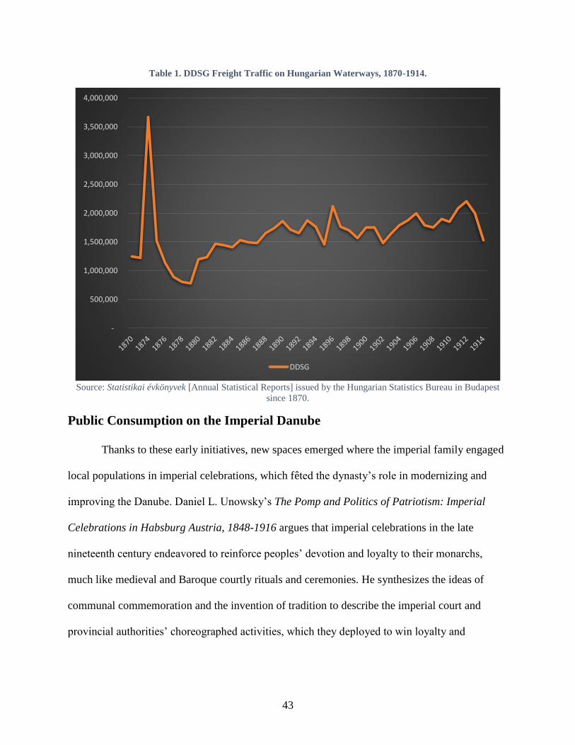
43
Table 1. DDSG Freight Traffic on Hungarian Waterways, 1870-1914.
Source: Statistikai évkönyvek [Annual Statistical Reports] issued by the Hungarian Statistics Bureau in Budapest
since 1870.
Public Consumption on the Imperial Danube
Thanks to these early initiatives, new spaces emerged where the imperial family engaged
local populations in imperial celebrations, which fêted the dynasty’s role in modernizing and
improving the Danube. Daniel L. Unowsky’s The Pomp and Politics of Patriotism: Imperial
Celebrations in Habsburg Austria, 1848-1916 argues that imperial celebrations in the late
nineteenth century endeavored to reinforce peoples’ devotion and loyalty to their monarchs,
much like medieval and Baroque courtly rituals and ceremonies. He synthesizes the ideas of
communal commemoration and the invention of tradition to describe the imperial court and
provincial authorities’ choreographed activities, which they deployed to win loyalty and
-
500,000
1,000,000
1,500,000
2,000,000
2,500,000
3,000,000
3,500,000
4,000,000
DDSG
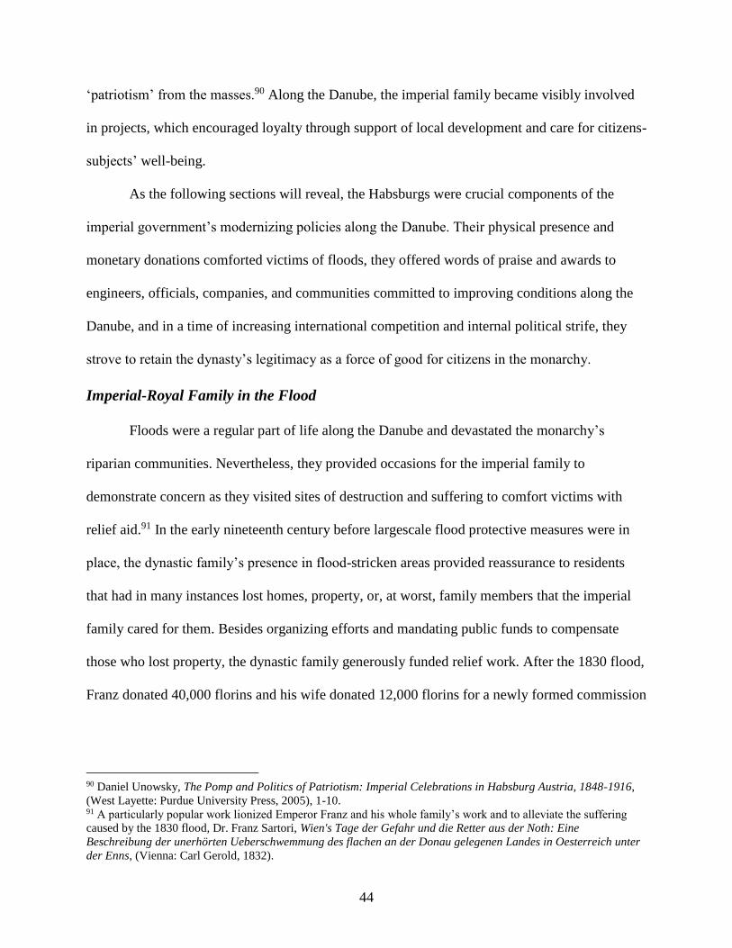
44
‘patriotism’ from the masses.90 Along the Danube, the imperial family became visibly involved
in projects, which encouraged loyalty through support of local development and care for citizens-
subjects’ well-being.
As the following sections will reveal, the Habsburgs were crucial components of the
imperial government’s modernizing policies along the Danube. Their physical presence and
monetary donations comforted victims of floods, they offered words of praise and awards to
engineers, officials, companies, and communities committed to improving conditions along the
Danube, and in a time of increasing international competition and internal political strife, they
strove to retain the dynasty’s legitimacy as a force of good for citizens in the monarchy.
Imperial-Royal Family in the Flood
Floods were a regular part of life along the Danube and devastated the monarchy’s
riparian communities. Nevertheless, they provided occasions for the imperial family to
demonstrate concern as they visited sites of destruction and suffering to comfort victims with
relief aid.91 In the early nineteenth century before largescale flood protective measures were in
place, the dynastic family’s presence in flood-stricken areas provided reassurance to residents
that had in many instances lost homes, property, or, at worst, family members that the imperial
family cared for them. Besides organizing efforts and mandating public funds to compensate
those who lost property, the dynastic family generously funded relief work. After the 1830 flood,
Franz donated 40,000 florins and his wife donated 12,000 florins for a newly formed commission
90 Daniel Unowsky, The Pomp and Politics of Patriotism: Imperial Celebrations in Habsburg Austria, 1848-1916,
(West Layette: Purdue University Press, 2005), 1-10. 91 A particularly popular work lionized Emperor Franz and his whole family’s work and to alleviate the suffering
caused by the 1830 flood, Dr. Franz Sartori, Wien's Tage der Gefahr und die Retter aus der Noth: Eine
Beschreibung der unerhörten Ueberschwemmung des flachen an der Donau gelegenen Landes in Oesterreich unter
der Enns, (Vienna: Carl Gerold, 1832).
45
for immediate distribution to the afflicted populace.92 After the 1838 flood, the emperor and
empress, as well as other Habsburg family members donated a total of 117,000 florins to the
victims.93 These were immense sums: an agricultural worker made on average 6 florins a month
in 1840.94
Figure 2. Franz II/I During the 1830 Flood (left) and Franz Joseph I during the 1862 Flood (right). Sources:
Anton Ziegler, ed., Gallerie aus der österreichischen Vaterlandsgeschichte in Bildlicher Darstellung, (Vienna:
1837), 861; August von Panttenkofen (1822-1889). Oil on panel. Wien Museum, Vienna, Austria.
Paintings and lithographs immortalized the Habsburgs’ magnanimity, and contemporary
papers and pamphlets widely published these images for the public’s consumption (Figure 2).95
Later dynastic members from Franz Joseph to Elisabeth to Rudolf would mirror these actions in
92 “Wien,” Wiener Zeitung, (Vienna, Austria), March 5, 1830. 93 Anonymous, Die Ueberschwemmung zu Pesth, Ofen und Gran im Monath März 1838 Von einem Augenzeugen,
(Wallishaußer, 1838), 37. 94 This approximation takes the average from Bohemia, which was the middle wage bracket between the higher
Viennese wages and the wages in Galicia, which could be 50% lower, Clemens Jobst and Helmut Stix, “Florin,
crown, schilling and euro: an overview of 200 years of cash in Austria,” Monetary Policy & the Economy (2016):
105-6. 95 Anton Ziegler (ed), Gallerie aus der Österreichischen Vaterlandsgeschichte in Bildlicher Darstellung, (Vienna,
1837).
46
their visits and donations to flood-struck sites across the monarchy in 1862, 1876, 1879, and
1884. Once flood protection measures multiplied, Franz Joseph even visited the sites of new
embankments to praise progress and remember victims of previous floods.96 Papers lauded the
dynastic members’ appearance and documented the widespread appreciation for their support.
Heidi Hakkarainen has argued in the work Catastrophe, Gender and Urban Experience,
1648-1920 that the 1862 flood witnessed the same tropes, which the Habsburg family and
newspapers reiterated at each flood of the dynasty; namely, the dynasty’s ability to reestablish
order and help citizens recuperate from the flood’s aftermath. Hakkarainen, however, criticizes
these tropes claiming that the portrayal of Franz Joseph or any other Habsburg figure rescuing
the people after the flood perpetuated a narrative of masculinity and dominance, which
completely neglected the contribution that women made in rescue and recovery efforts.97
Hakkarainen fails to note that contemporaneous newspapers celebrated female contributions
from the dynastic family – such as Emperor Franz’s wife and Empress Elisabeth, who insisted at
the time of her and Franz Joseph’s 25th wedding anniversary in 1879 that people donate to
Szeged flood relief funds rather than gift anything to the imperial couple.98 Furthermore, while
merely anecdotal, a local actress named Therese Krones famously braved the cold, wet weather
to aid in rescue efforts in 1830. She contracted a lung infection during her work, which later
proved fatal.99 After her untimely death, she was not only widely mourned, but on the 100-year
96 “Der Kaiser auf dem Marchfeld,” Tages-Post, (Linz, Austria), June 11, 1905. 97 Heidi Hakkarainen, “City Upside Down: Laughing at the Flooding of the Danube in the Late Nineteeth-Century
Vienna,” in Catastrophe, Gender and Urban Experience, 1648-1920, eds. Deborah Simonton and Hannu Salmi
(Routledge, 2017), unnumbered. 98 The Linz city council, for example, noted that although it would arrange an address from the city and organize a
festive mass, instead of lighting and decorating communal buildings, it would donate 300 florins (over 7,000 USD
on 2015 according to Edvisson) to the victims of Szeged’s flood and 200 florins for the victims of the Neumarkt fire,
“Festliche Anlässe,” Rechenschaftsbericht des Gemeinderathes der Landeshauptstadt Linz über seine Thätigkeit in
den Jahren 1879, 1880 (nebst anderen statistischen Daten), (Linz: K.k. Hof-Buchdruckerei von Jos. Feichtinger’s
Erben, 1881), 64. 99 Roland P. Herold, Brigittenau: Von der Au zum Wohnbezirk, (Vienna: Mohl Verlag, 1992), 33.
47
anniversary of her birth, her home district in Vienna put on a “Therese Krones Day” to
memorialize her time on the stage and her valiant work during the Danube’s flooding.100
Sites of Celebration, Locations of Loyalty
Besides official responses to frequent flooding, the Danube’s mercurial nature, the
damage of its flooding and ice flows, and its immense potential for commerce spurred the
monarchy, its bureaucrats, and engineer corps to overcome obstacles to trade, travel, and
communication. The engineering and technical institutes, which Maria Theresia and Joseph II
had established in the eighteenth century provided new generations of hydro-engineers, who
began to design and build more permanent structures across and along the Danube in the
nineteenth century. New, local arrangements such as bridges, quays, and embankments fostered
connections between citizens, underpinned municipal growth, and embodied dynastic largesse
and prestige throughout the nineteenth century.
Much as in all states – monarchical and republican, democratic, and despotic –
infrastructure and engineering projects were often named after notable rulers, personalities, and
events. Completed sites provided local populations lieux de mémoire, which reified civic or
mythical connections with figures and moments significant to both a state’s history and its
contemporaneous development. Given the Habsburgs’ half-millenium reign, it is unsurprising
that new constructs along the Danube received imperial monikers. Such sites became more
common – and arguably more important – as the century progressed as the dynastic state sought
to legitimate and consolidate popular support for itself.
These new ‘imperial’ structures facilitated daily connections across the river and
continued to modernize as the populace needed. In an early example, in 1799, a strong ice flow
100 “Theresa Krones: Zu ihrem hundertsten Geburtstag,” (Neuigkeits) Welt Blatt, (Vienna, Austria), October 8, 1901.
48
destroyed a bridge connecting Vienna’s historic city center with an island [Leopoldstadt] located
within the branching arms of the nearby Danube.101 The bridge was subsequently rebuilt, but the
military destroyed it during Napoleon’s invasion in 1809. After the war, the reconstructed bridge
was named Franzensbrücke [Franz’s Bridge] after the Austrian emperor. At the same time, when
engineers tore down a different bridge across the Danube Canal in 1819, they re-built its
replacement along the newest engineering principles and named it after Franz’s son Crown
Prince Ferdinand. The first suspension bridge in Vienna was opened in 1825, and the city opted
to name it for Archduchess Sophie [Sophiebrücke]. To integrate the monarchy’s northern and
southern territories, Franz I supported construction for the Crown Prince Ferdinand Northern
Railway. The Danube remained an obstacle to any permanent bridges across it, due to its flood-
prone, natural state and several shifting, lateral arms. Despite the engineering challenge, by
December 1837 the press reported that the new station and adjacent bridge opened to great
public enthusiasm.102 The station’s location on the island district Leopoldstadt relied on the
Franzensbrücke to provide access to the station. Traffic over the bridge soon increased to the
point that municipal engineers had to replace it with a suspension bridge in 1848. Continuous
municipal growth finally forced the city to re-build the Franzensbrücke as a modern latticed arch
bridge in 1898-1899, complete with tramlines and more secure pedestrian walkways.103 City
engineers likewise prepared the Sophie Bridge before the 1873 World Fair in Vienna by
101 Ice flows frequently formed on the Danube when changing meteorological conditions caused ice on the river to
dislodge and ‘flow’ downstream, frequently destroying structures on the river or piling up as ‘ice dams,’ which
blocked the river’s current and caused flooding along adjacent banks. 102 “Oesterreichische National-Chronik,” Der Adler, (Vienna, Austria), January 8, 1838; “Wien,” Pressburger
Zeitung, (Bratislava, Slovakia), January 5, 1838. 103 “Franzensbrücke,” Stadt Wien AT, accessed April 10, 2017,
https://www.wien.gv.at/verkehr/brueckenbau/kanalbruecken/franzens.html.
49
replacing it with a massive iron suspension bridge capable of handling larger cart and tram
traffic.104
These early projects were testaments to imperial rulers, but did not serve the same
legitimating role, which later rulers, namely Franz Joseph, pursued by embedding an additional
level of popular adulation during local visits to such sites. Emperor Franz II/I was a
fundamentally conservative ruler, whose Weltanschauung carried with it the memories of the
French Revolutionary and Napoleonic Wars and the concomitant nationalism and liberalism they
unleashed. As the nineteenth century unfolded, social and economic tensions caused by
industrialization, increased nationalist activism, and finally the rise in mass politics presented
competing political ideologies vying for peoples’ loyalties across Europe. While this milieu
threatened the European ancien régime, it represented an exceptional trial for the Habsburgs,
who could not rely on ethno-linguistic tropes or nationalist rhetoric to unite their diverse
citizenry or bind them to the dynastic-imperial order. To overcome the massive challenges to the
monarchy’s social and political order, Franz Joseph dramatically expanded upon Franz’s early
efforts to transform the Danube for society’s benefit. The emperor combined massive, technical
interventions along the Danube with large, public ceremonies, in order to strengthen the popular
association between monarch and modernity.
Franz Joseph’s Era
Franz Joseph’s reign (r. 1848-1916) featured some of the greatest political challenges to
the monarchy; he ascended during the 1848 revolutions and faced European-wide opprobrium to
remain neutral during the Crimean War; and France and Piedmont defeated his forces in 1859,
104 Csaba Szabó, “Brücken über die Donau zwischen Ofen und Pest: Kettenbrücke, Margaretenbrücke, Franz-
Joseph-Brücke, Elisabethbrücke,” in Budapest und Wien: Technischer Fortschritt und Urbaner Aufschwung im 19.
Jahrhundert, ed. Ferdinand Opll (Budapest; Vienna, 2003): 105.

50
after which he lost his wealthy Italian province of Lombardy. These developments undermined
Franz Joseph’s neo-Absolutist rule in the 1850s and led to his tentative constitutional
experimentation in the early 1860s. While the regime experienced several political difficulties in
the mid-century, its work on the Danube provided an opportunity for the imperial family to
remain involved and present in modernization outside the immediate realm of politics.
In 1854, a significant string of celebrations along the Danube welcomed the arrival of a
special steamship out of Germany. Aboard the Franz Joseph – just launched the previous year –
was Bavarian Duchess Elisabeth Amalie Eugenie, the future bride of Habsburg Emperor Franz
Joseph. As Elisabeth’s ship passed from Bavarian into Habsburg territory, the towns and
communities along the way had decorated their buildings near the waterfront with flags and
garlands. Residents crowded the banks to wave at their future empress and bands greeted her
appearance with music. Her first stop on Austrian soil was Upper Austria’s provincial capital
Linz, where cannon salutes and church bells pealed out across the river as her steamship docked.
Figure 3. Sisi’s Bridal Trip Down the Danube. Source: “Ankunft des bayrischen Schiffskonvois in Linz am 21.
April 1854.” http://4381strudengau.files.wordpress.com/2010/03/ankunft_linz.png, accessed March 18, 2013.

51
Unbeknownst to Elisabeth, her future husband Franz Joseph had also boarded his own steamship
in Vienna to ply upstream and surprise her when she arrived in her new homeland. After her
reception in Linz, she and Franz Joseph, in their separate ships, continued their way to Vienna,
where all court dignitaries, religious figures and ministers, civil servants and aristocrats
welcomed her with all the official pomp of the court.105 The Wiener Zeitung covered the
momentous occasion, indicating the joy and enthusiasm that the young woman inspired
throughout her journey along the river and throughout the monarchy.106 Elisabeth’s journey
represented a successful unification of two elements: the imperial state’s choreographed displays
to foster popular loyalty to the dynasty and the Danube’s backdrop as a site of state-sponsored
innovation and modernity.107 In contrast to the earlier retinue, which featured horse-drawn
carriages and far slower progress along muddy roads, the dynasty’s use of steamships for such an
important ceremony indicated a continued willingness to embrace and employ technology as a
tool to underpin its legitimacy.
The arrival of the young Elisabeth from Bavaria in 1854 provided several occasions to
fête both the empress and new engineering works on rivers across the monarchy. After her
travels down the Danube, Elisabeth’s wedding procession into Vienna officially began by
crossing a newly constructed bridge over the Vienna River, which subsequently carried the name
“Elisabeth’s Bridge.”108 A year after her marriage to Franz Joseph, residents in Děčín likewise
105 Brigitte Hamann, “Empress Elisabeth, 1837-1898,” in The Imperial Style: Fashions of the Habsburg Era: based
on the exhibition, Fashions of the Hapsburg Era, Austria-Hungary, at the Metropolitan Museum of Art, December
1979-August 1980, ed. Polly Cone, (New York, 1980): 135. 106 “Nicht Amtlicher Teil,” Wiener Zeitung, (Vienna, Austria), April 23, 1854. 107 Coming down the Danube in the 1850s, Elisabeth’s ship would have passed extensive local embankment
construction works, which the state had facilitated by passing laws allowing riparian communities access to
materials they needed for the work. Steamships themselves were becoming more modern, as the transition from
wood to iron-hulled ships occurred from 1839 onward. 108 Wien seit 60 Jahren. Zur Erinnerung an die Feier der 60-jährigen Regierung Seiner Majestät des Kaisers Franz
Josef I. der Jugend Wiens gewidmet von dem Gemeinderate ihrer Heimatstadt, (Vienna: 1908), 17.
52
named their newly constructed suspension bridge – the largest in Bohemia at the time – after her.
Franz Joseph even opened the first Franz Joseph Bridge in 1868 over the Vltava in Prague, a
surprising location given Czech nationalist misgivings toward the Austro-Hungarian
Compromise signed the previous year.
The opening of a new bridge was always the source of celebration and ceremony
honoring the imperial couple. For example, when the provincial capital Klagenfurt built a
pedestrian bridge over the picturesque Lend Canal, the city had a huge festival to welcome the
emperor and empress for its dedication. On September 4, 1856, the imperial pair proceeded
through town, surrounded by the imperial, provincial, and Bavarian colors and crowded on all
sides by its inhabitants. When they reached the bridge, it was adorned with arches of flowers,
masts of fluttering flags, and a blue-white tent graced with the imperial eagle for the couple to
stand underneath while the Statthalter informed them about the bridge’s construction and
introduced them to its engineer. Afterward, the couple crossed the flower-strewn bridge and, to
the joy of the city’s inhabitants, the empress “graciously permitted it to be called ‘Elisabeth’s
Bridge’ in remembrance of the day’s celebrations.”109 These displays provided local inhabitants
with a venue to receive and honor Empress Elisabeth, who was widely adored among many
people in the monarchy because of her relatively humble upbringing in a minor branch of the
Bavarian royal family. However, lingering ill-will toward Emperor Franz Joseph due to his
repression of the revolution in 1848-9 required more concerted efforts to win loyalty from the
general population.
At an official level, Franz Joseph and the imperial bureaucracy recognized and
highlighted the importance of hydraulic engineering works and expanding steam navigation
109 “Nichtamtlicher Theil. Kärnten,” Klagenfurter Zeitung, (Klagenfurt, Austria), September 5, 1856.
53
across the monarchy, by bestowing knightly honors on engineers and administrators involved in
the Danube’s ongoing improvement. At a ministerial meeting on October 4, 1853, the Minister
for Trade, Industry and Public Works recommended that M.R. Pasetti, the hydrological engineer
who had been responsible for guiding the regulation of the Noce, and was continuing to work on
both the Tisza and Danube, be granted the prestigious Austrian Imperial Order of the Iron Crown
– an honorific that carried with it immediate knighthood.110 Although the minister recommended
Pasetti only receive the order’s third class, it was nevertheless a distinction that only fifty
individuals in the monarchy were to hold at one time.111 Franz Joseph also personally conferred
the Franz-Joseph Order on Florian Menapace in 1852, who led Hungary’s Engineering
Directorate during the neo-Absolutist era.112 By 1865, even several administrative members of
the DDSG received medals for the Order of Franz Joseph, such as the Company’s Director M.
Cassian, the Administrative Secretary Zwecker, the Mercantile Department’s inspector
Ferdinand Wehler, and the Pest Nautical Section’s inspector Dom. Karl Feno.113 Taken together,
the monarchy’s new empress and technical advances on the Danube provided some occasion to
celebrate. However, the positive optics could not offset the political and military crises that the
regime also faced throughout the 1850s.
Franz Joseph’s personal involvement in politics and the military during the neo-
Absolutist reign in the 1850s meant that decisions inevitably reflected back on his leadership.114
The adverse result of poor decisions consequently affected the monarchy’s political structure and
110 The Napoleonic Kingdom of Italy had originated the Order of the Iron Crown, but after Napoleon’s fall in 1815
and the Austrian Monarchy one again controlled the territory of Lombardy-Venezia, the Habsburgs re-branded the
Order as Austrian and began bestowing the three classes upon individuals starting in 1816. 111 Václav Mĕr̆ic̆ka, Orden und Ehrenzeichen der Österreichisch-Ungarischen Monarchie, translated by Robert
Fenzl, (Wien & München: Schroll, 1974). 112 “Hivatalos” Pesti Napló, (Budapest, Hungary), August 17, 1852. 113 Pester Lloyd-Gesellschaft (ed), Pester Lloyd-Kalender fuer das Jahr 1865, (Pest: Khór & Wein, 1864), 16. 114 Steven Beller, Francis Joseph, (London: Longman, 1997).
54
altered the dynasty’s role in the monarchy’s governance. The European-wide opprobrium toward
Franz Joseph’s neutrality during the Crimean War (1853-6) and the military failure in 1859
against the combined French and Piedmontese-led forces weakened the Habsburg regime’s
international credibility and forced the emperor to reinstate crownland representation and,
ultimately, an imperial parliament. A humiliating military loss to Prussia in 1866 also bankrupted
the state, forcing the Emperor Franz Joseph into two ‘compromises.’ The 1867 Dual Settlement
(Ausgleich) ceded control of Transleithania’s internal affairs to Budapest in a sudden conclusion
to negotiations, which the emperor and Hungarian statesman István Deák had been undertaking
for two years.115 The 1867 December Laws placated liberals in Cisleithania by establishing a
new constitutional order. Deputies to the Reichsrat were no longer elected by provincial diets but
directly from the curia system.116
These Compromises led the emperor to retreat from the active political role he played
during the neo-Absolutist reign, and while he retained a great deal of de jure power, which he
infrequently wielded, in the latter half of Franz Joseph’s reign, his actions, behavior, and
eventually the personal circumstances surrounding his life enhancedhis ceremonial significance
115 The Leitha River provided the contemporaneous border between the Lower Austria and the historic Kingdom of
Hungary. The colloquial nomenclature “Cisleithania” (Latin for ‘this side of the Leitha river’) refers to the
“Austrian” half of the monarchy whereas “Transleithania” (‘beyond the Leitha’) refers to the “Hungarian” lands.
Like many historical provinces in the monarchy, its reference was geographical rather than ethno-linguistic. 116 Both the Reichsrat in 1861 and that in 1867 delineated voting curia – landowners, cities, chambers of commerce,
and rural community members who paid more than 10 florins in taxes – which had the power to elect deputies.
Franz Joseph pointedly allowed the diet and constitution through his own authority and refused to acknowledge any
popular sovereignty emanating from ‘the people,’ Alan Sked, The Decline and Fall of the Habsburg Monarchy,
1815-1918, (London: Longman, 1989), 196.
55
for his people.117 In particular, his coronation as Hungarian king following the 1867 Compromise
mollified the previously restive Magyars, who began to recognize his royal authority.118
The Danube’s aesthetical value also grew during this period. In 1866, Strauss composed
An der schönen, blauen Donau, the ‘Blue Danube’ waltz, which washed across the monarchy
and Europe, uniting the concept of the Habsburg court and Vienna’s imperial might with the
Danube. On December 24, 1869, near the recently-opened State Opera House, Franz Joseph
dedicated the immense Albrecht fountain to his Viennese subjects. The work depicted two main
figures, a crusty old man representing the river God Danubius and seated next to him, a young
woman representing Vindobona. Despite the river god’s fierce gaze, the figures’ gentle
positioning evoked the vital relationship between the river Danube and the city of Vienna.
Flanking these figures were other ten other statues representing other major rivers within the
Monarchy, which taken together were meant to project the empire’s enormous size and
strength.119 The Albrecht Fountain had a counterpart in Budapest. In 1880, one of Europe’s most
famous nineteenth-century architects, Miklós Ybl, unveiled his “Danubius Fountain,” located at
117 That isn’t to say that Franz Joseph became a mere figurehead. The Compromises technically retained Franz
Joseph’s rights to rule – he had continued power to dissolve the parliament or unilaterally pass decrees in the
Cisleithanian half of the monarchy in times of legislative crisis and he was crowned King of Hungary, which
granted him the position’s historical rights and obligations. However, after 1867, for the most part Franz Joseph
refrained from directly interfering with the political arrangements except in extenuating circumstances, such as
during the Reichsrat’s national gridlock following the 1897 Badeni crisis. There are many works that reveal Franz
Joseph’s popular appeal among different religious, social or national groups, such as Robert S. Wistrich, The Jews of
Vienna in the age of Franz Joseph, (Oxford: Oxford University Press, 1989), Daniel Unowsky’s The Pomp and
Politics of Patriotism: Imperial Celebrations in Habsburg Austria, 1848-1916, James Shedel, “Emperor, Church,
and People: Religion and Dynastic Loyalty During the Golden Jubilee of Franz Joseph,” The Catholic Historical
Review, Vol. 76, (Jan., 1990): 71-92; James Shedel, “The Elusive Fatherland: Dynasty, State, Identity and the
Kronprinzenwerk,” in Inszenierung des kollektiven Gedächtnisses: Eigenbilder, Fremdbilder, eds. Moritz Csáky and
Klaus Zeyringer (Innsbruck, Vienna, Munich and Bozen, 2002). 118 Peter Hanak spends a chapter in his book Der Garten und die Werkstatt (The Garden and the Workshop)
exploring the duality of the Austrian imperial and Hungarian royal constructs, particularly the parallel but separate
celebrations of Hungary’s 1896 Millennial anniversary and Franz Joseph’s 1898 anniversary of 50 years as emperor
– the Hungarians only recognized his monarchical authority after being crowned Hungarian king im 1867, so Franz
Joseph’s early 1848 ascension didn’t merit celebration. 119 The rivers were the Theiss, Raab, Enns, Traun, Inn, Save, March, Salzach, Mur and Drau.
56
the bustling Calvin Square.120 His fountain’s design mirrored in part its counterpart in Vienna,
likewise depicting the Danube as a herculean river god, and surrounded by beautiful young
maidens representing the Tisza, Drave, and Save Rivers. Attuned to the imperial-royal practices
on the river, crowds in Hungary also amassed on the banks of the Danube to witness Franz
Joseph’s occasional steamship travels, and newspapers provided fodder for additional literary
consumption of the imperial-royal family’s personal life, including their work and travels on the
river.121
In this post-Compromise era, modernization on the Danube continued with the active
participation and presentation of the dynastic family on the river. The Compromise had actually
come just a few short years after terrible monarchy-wide flooding in 1862, and the political
division only accelerated plans to regulate the Danube at both Vienna and Budapest.122 To secure
the monarchy’s two largest cities from flooding and increase their inhabitants’ economic
opportunities and industrial development on the river, the newly conceived “Danube Regulation
Commission” in Lower Austria and “Municipal Board of Public Works” at Budapest took charge
of regulating these stretches, raising embankments and quays, and building commercial
infrastructure.123 At Vienna, engineers fundamentally re-shaped the river’s bed and course,
120 Ybl had already gained attention when as a young architect, he designed the Catholic church in Fót (1855), and
two of what would later become his most famous works, the Hungarian State Opera House and Saint Stephen’s
Basilica in Budapest, were halfway through construction, the former opening in 1884 and the latter in 1891. 121 “Kleine Chronik,” Wiener Zeitung, (Vienna, Austria), May 6, 1872. 122 In Hungary, royal engineers had undertaken largescale surveys along the Danube from 1823-38, but few
regulation plans dealt with Buda, Pest or Óbuda, separately from Hungary-wide plans, so when the 1838 flood hit,
there were few embankments to protect the cities. After the flood, Pál Vásárhelyi – one of the era’s greatest
engineers – suggested that regulating/dredging the river stretch of its sandbanks would prevent the formation of ice
flows. 123 The Viennese municipal authorities agreed in 1866 to set up a Donau Regulierungs Commission and in 1867, the
commission’s operations began. Imperial, provincial and municipal funds supported the Viennese Danube
Regulation, which took place between 1870 and 1875. The Hungarian Diet likewise passed the Royal Law X in
1870 founding the Fővárosi Közmunkák Tanácsa modelled on London’s Metropolitan Board, which likewise
organized the Danube’s regulation, supported the Chain Bridge and designed the public transport networks between
Buda and Pest. Its work was administered by the Royal Hungarian Ministry for Transportation (kir. magyar
közlekedési minisztérium).
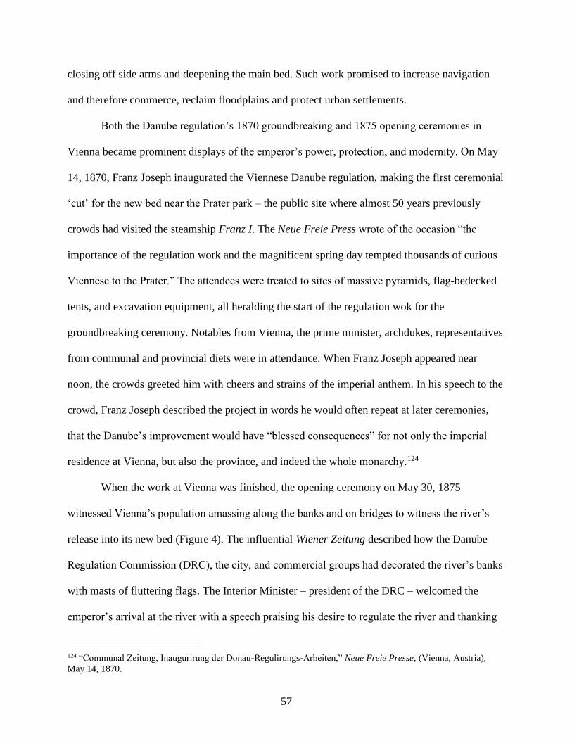
57
closing off side arms and deepening the main bed. Such work promised to increase navigation
and therefore commerce, reclaim floodplains and protect urban settlements.
Both the Danube regulation’s 1870 groundbreaking and 1875 opening ceremonies in
Vienna became prominent displays of the emperor’s power, protection, and modernity. On May
14, 1870, Franz Joseph inaugurated the Viennese Danube regulation, making the first ceremonial
‘cut’ for the new bed near the Prater park – the public site where almost 50 years previously
crowds had visited the steamship Franz I. The Neue Freie Press wrote of the occasion “the
importance of the regulation work and the magnificent spring day tempted thousands of curious
Viennese to the Prater.” The attendees were treated to sites of massive pyramids, flag-bedecked
tents, and excavation equipment, all heralding the start of the regulation wok for the
groundbreaking ceremony. Notables from Vienna, the prime minister, archdukes, representatives
from communal and provincial diets were in attendance. When Franz Joseph appeared near
noon, the crowds greeted him with cheers and strains of the imperial anthem. In his speech to the
crowd, Franz Joseph described the project in words he would often repeat at later ceremonies,
that the Danube’s improvement would have “blessed consequences” for not only the imperial
residence at Vienna, but also the province, and indeed the whole monarchy.124
When the work at Vienna was finished, the opening ceremony on May 30, 1875
witnessed Vienna’s population amassing along the banks and on bridges to witness the river’s
release into its new bed (Figure 4). The influential Wiener Zeitung described how the Danube
Regulation Commission (DRC), the city, and commercial groups had decorated the river’s banks
with masts of fluttering flags. The Interior Minister – president of the DRC – welcomed the
emperor’s arrival at the river with a speech praising his desire to regulate the river and thanking
124 “Communal Zeitung, Inaugurirung der Donau-Regulirungs-Arbeiten,” Neue Freie Presse, (Vienna, Austria),
May 14, 1870.
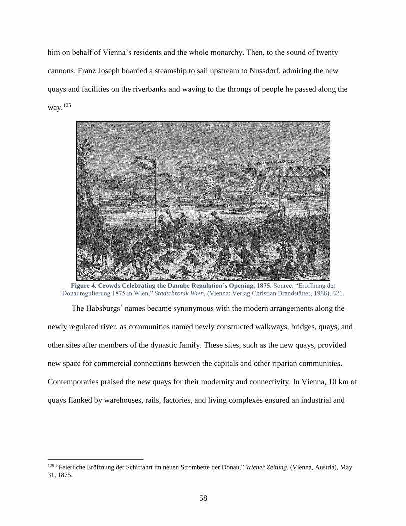
58
him on behalf of Vienna’s residents and the whole monarchy. Then, to the sound of twenty
cannons, Franz Joseph boarded a steamship to sail upstream to Nussdorf, admiring the new
quays and facilities on the riverbanks and waving to the throngs of people he passed along the
way.125
Figure 4. Crowds Celebrating the Danube Regulation’s Opening, 1875. Source: “Eröffnung der
Donauregulierung 1875 in Wien,” Stadtchronik Wien, (Vienna: Verlag Christian Brandstätter, 1986), 321.
The Habsburgs’ names became synonymous with the modern arrangements along the
newly regulated river, as communities named newly constructed walkways, bridges, quays, and
other sites after members of the dynastic family. These sites, such as the new quays, provided
new space for commercial connections between the capitals and other riparian communities.
Contemporaries praised the new quays for their modernity and connectivity. In Vienna, 10 km of
quays flanked by warehouses, rails, factories, and living complexes ensured an industrial and
125 “Feierliche Eröffnung der Schiffahrt im neuen Strombette der Donau,” Wiener Zeitung, (Vienna, Austria), May
31, 1875.
59
commercial connection to the Danube.126 Contemporaries in Budapest claimed that the 12.5
million florin127 price for regulating this segment of the Danube had improved navigation
dramatically and the 4.3 km of quays likewise witnessed lively river traffic.128 The Franz Joseph
Promenade (Ferenc József sétany) and Rudolf Quay (Rudolf rakpart) in Budapest and the Franz
Joseph Quay (Franz-Josef-Kai) in Vienna provided residents space for fish and fruit markets,
tree-lined promenades and modern streetcar lines. These quays also had steamship stations,
which enabled passengers to either conveniently cross the Danube – as millions did annually in
between Buda and Pest – or take ships up and down the river, which millions more did.129
Imperial names had already graced municipal structures on the Danube for most of the
century, and this practice was most common in the naming and re-naming of bridges, which
growing populations and communication networks required cities to construct and modernize.
Modern bridges not only facilitated daily crossings as citizens traversed the Danube, but
remained, as earlier in the century, a perfect site for the imperial-dynastic family to re-affirm
their commitment to modernization, imperial solidarity, and personal connections with local
citizenry. As Vienna and Budapest’s populations approximately doubled in size between 1870
and 1900, both state and local actors urged the construction of additional bridges at each site. As
part of the regulation plans at Vienna, Franz Joseph had insisted that another bridge cross the
Danube, which would enable the imperial road (Reichstrasse) to connect traffic from Vienna to
126 Wilhelm Franz Rudolf von Grimburg Exner, Adolf von Guttenberg, W. Hecke, and Emanuel Sar,
“Volkswirthschaftliches Leben in Wien,” in Die österreichisch-ungarische Monarchie in Wort und Bild: Wien und
Niederösterreich 1. Abtheilung, ed. F.X. von Neumann-Spallart, vol. 1 (Vienna: k. & k. Hofdruckerei, 1886), 322. 127 Roughly 305.6 million USD in 2015, “Historical currency converter (test version 1.0),” accessed October 7,
2017, http://www.historicalstatistics.org/Currencyconverter.html. 128 Béla Lukács, “ Közlekedési intézmények,” in Az Osztrák-Magyar Monarchia írásban és képekben.
Magyarország I, vol. 2 (Budapest: A Magvar Királyi Államnyomda Kiadás, 1888), 514. 129 In 1890, the DDSG recorded its highest level of traffic at 3,565,063 passengers, and the Hungarian Statistical
Office recorded tens of thousands of annual passengers for the DDSG and Magyar folyam- és tengerhajózási r.-társ.
(Hungarian River and Sea Navigation Company) on tributaries like the Drava and Tisza.
60
the monarchy’s northern provinces. In 1872 the city began work on a bridge, which it eventually
completed in 1876. Like many bridges before it, imperial celebrations surrounded its opening.
On August 21, 1876, Crown Prince Rudolf’s birthday, the emperor and the Lower Austrian
Statthalter opened the new bridge – aptly named for the young prince (Kronprinz-Rudolf-
Brücke) – to great festivities.130 Like earlier Danube engineers and DDSG administrators, the
emperor even honored the engineer responsible for working on the bridge by awarding him the
Knightly Cross of the Franz Joseph Order.131 Eventually, in Vienna, five new bridges of stone
and iron led across the river and ensured a connection between the monarchy’s northern and
southern territory.
In tangent with bridge construction over the main riverbed and as part of the city’s
preparations for the 1873 World Fair, Franz Joseph also concurred with engineers that Vienna’s
Danube Canal required additional crossings to facilitate the anticipated crowds. Two of the
planned bridges would connect the “highly populated third district” with the recreational Prater
park, the site of the fair. The aforementioned “Sophie’s Bridge” provided a chance to update an
older bridge and retain the name referring to Franz Joseph’s mother. The second of the three
bridges was named “Kaiser Joseph Bridge” in reference to the emperor who had opened the
Prater park up to the public.132
Much like Vienna’s municipal construction along the Danube, which provided new or
renewed sites for honoring the dynasty, Hungary’s ‘law 10’ [törvénycikk X] in 1870 also
mandated more bridges on the Danube, giving Hungarians the chance to recognize their royal
130 Peter Payer, “Die Reichsbrücke: Zur Geschichte eines Mythos,” in Querungen. Brücken – Stadt – Wien, ed.
Walter Hufnagel, (Sappl: Kufstein, 2002), 111-12. 131 “Personal Angelegenheiten,” Wochenzeitschrift des ö. Ingenieur- und Architektenvereins, (Vienna, Austria),
August 19, 1876. 132 Friedrich Paul, “Die Augarten-Brücke über den Wiener Donaukanal,” Allgemeine Bauzeitung, (Vienna, Austria),
1881.
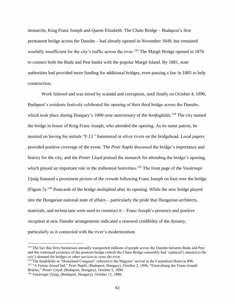
61
monarchs, King Franz Joseph and Queen Elisabeth. The Chain Bridge – Budapest’s first
permanent bridge across the Danube – had already opened in November 1849, but remained
woefully insufficient for the city’s traffic across the river.133 The Margít Bridge opened in 1876
to connect both the Buda and Pest banks with the popular Margít Island. By 1881, state
authorities had provided more funding for additional bridges, even passing a law in 1885 to help
construction.
Work faltered and was mired by scandal and corruption, until finally on October 4, 1896,
Budapest’s residents festively celebrated the opening of their third bridge across the Danube,
which took place during Hungary’s 1000-year anniversary of the honfoglalás.134 The city named
the bridge in honor of King Franz Joseph, who attended the opening. As its name patron, he
insisted on having his initials “F.J.I.” hammered in silver rivets on the bridgehead. Local papers
provided positive coverage of the event. The Pesti Napló discussed the bridge’s importance and
history for the city, and the Pester Lloyd praised the monarch for attending the bridge’s opening,
which played an important role in the millennial festivities.135 The front page of the Vasárnapi
Ujság featured a prominent picture of the crowds following Franz Joseph on foot over the bridge
(Figure 5).136 Postcards of the bridge multiplied after its opening. While the new bridge played
into the Hungarian national state of affairs – particularly the pride that Hungarian architects,
materials, and technicians were used to construct it – Franz Joseph’s presence and positive
reception at new Danube arrangements indicated a renewed credibility of the dynasty,
particularly as it connected with the river’s modernization.
133 The fact that ferry businesses annually transported millions of people across the Danube between Buda and Pest
and the continued existence of the pontoon bridge (which the Chain Bridge ostensibly had ‘replaced’) attested to the
city’s demand for bridges or other services to cross the river. 134 The honfolalás or “Homeland Conquest” referred to the Magyars’ arrival in the Carpathian Basin in 896. 135 “A Ferenc-József híd,” Pesti Napló, (Budapest, Hungary), October 2, 1896; “Einweihung der Franz-Joseph
Brücke,” Pester Lloyd, (Budapest, Hungary), October 5, 1896. 136 Vasárnapi Újság, (Budapest, Hungary), October 11, 1896.
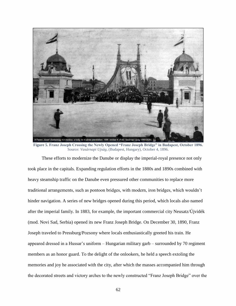
62
Figure 5. Franz Joseph Crossing the Newly Opened “Franz Joseph Bridge” in Budapest, October 1896.
Source: Vasárnapi Ujság, (Budapest, Hungary), October 4, 1896.
These efforts to modernize the Danube or display the imperial-royal presence not only
took place in the capitals. Expanding regulation efforts in the 1880s and 1890s combined with
heavy steamship traffic on the Danube even pressured other communities to replace more
traditional arrangements, such as pontoon bridges, with modern, iron bridges, which wouldn’t
hinder navigation. A series of new bridges opened during this period, which locals also named
after the imperial family. In 1883, for example, the important commercial city Neusatz/Újvidék
(mod. Novi Sad, Serbia) opened its new Franz Joseph Bridge. On December 30, 1890, Franz
Joseph traveled to Pressburg/Pozsony where locals enthusiastically greeted his train. He
appeared dressed in a Hussar’s uniform – Hungarian military garb – surrounded by 70 regiment
members as an honor guard. To the delight of the onlookers, he held a speech extoling the
memories and joy he associated with the city, after which the masses accompanied him through
the decorated streets and victory arches to the newly constructed “Franz Joseph Bridge” over the
63
Danube. From the bridge head, the emperor once again spoke, exclaiming that the new bridge
would serve the interests not only of Pressburg, but likewise the region and entire monarchy, and
as spectator to the celebration, he was filled with joy that the bridge represented the ‘triumph of
technology’ and would stand as a testament for later generations. With these words, he opened
the bridge, crossing to greet crowds on the other bank, all the while complimenting the bridge’s
‘exacting construction.’137 The Budapest-based paper Budapesti Hírlap also took the occasion of
reporting on the event to provide readers with a detailed description of the Danube’s
hydrography and historical significance.138
Such festivities played out again and again on the river. Between 1891 and 1892,
Hungary’s preeminent engineer János Feketeházy designed “Elisabeth Bridge” to connect
Komárom and Új-Szőny.139 Along with the Hungarian Minister President, Franz Joseph attended
the opening ceremony on September 1, 1892. The residents also named the small island near the
bridge after Queen Elisabeth, “in remembrance of the fact, that Her Majesty stepped on
Hungarian ground [there] for the first time on May 4, 1857.”140 Feketeházy also designed a
bridge in Esztergom, which opened on September 28, 1895 to great celebration. Franz Joseph
granted permission to have the bridge named for his youngest daughter Maria Valeria, to whom
Elisabeth had given birth in Budapest and raised as her ‘Hungarian’ daughter.141
The year 1898 represented 50 years of Franz Joseph’s reign on the throne, and book
sellers, merchants, and others sold literature, trinkets, and numerous objects to commemorate the
137 “Se. Majestät der Kaiser in Pressburg,” Wiener Zeitung, (Vienna, Austria), December 30, 1890. 138 “Hidavatás Pozsonybany,”Budapesti Hírlap, (Budapest, Hungary), December 30, 1890. 139 Komárom is today’s Komárno, Slovakia, and Új-Szőny is modern day Komárom, Hungary. 140 Bélá Gonda, “Die ungarische Donau,” Die österreichisch-ungarische Monarchie in Wort und Bild, 4. Band
Ungarn, (Vienna: k.k. Hof- und Staatsdruckerei, 1896), 34. 141 “A Mária Valéria híd története,” Felvidék.ma, last modified November 25, 2013, http://felvidek.ma/2013/11/a-
maria-valeria-hid-tortenete/; Martin Mutschlechner, “Franz Joseph: Ehe, Familie und Nachkommen,” Die Welt der
Habsburger, http://www.habsburger.net/en/chapter/franz-joseph-marriage-family-and-descendants, accessed April
26, 2017.
64
jubilee.142 One official publication described the young couple’s pre-wedding trip per steamship
on the Danube and the mass festivities that accompanied Elisabeth’s arrival to the monarchy.143
As part of the celebrations, the Danube Regulation Commission set up a huge exhibit to educate
people about the dynastic family’s support for the hydraulic projects taking place on the
Danube.144 Over 2.5 million people visited the Jubilee Exhibit grounds.145 But as celebrations
were underway, an Italian anarchist assassinated Empress/Queen Elisabeth while she was
visiting Geneva. Elisabeth’s death led to monarchy-wide mourning and countless memorials
dedicated to her, including sites connected to the Danube. Before Elisabeth’s untimely death,
Franz Joseph had traveled to Budapest in February 1898 to lay the ground stone for the so-called
Eskütéri híd (“Eskü Square Bridge”).146 In December, two months after Elisabeth’s death, Franz
Joseph consented to have the bridge re-named “Elisabeth Bridge,” in his wife’s honor.147 When
the bridge’s construction ended in September 1903, local Budapest papers advertised that the
king would personally come to Budapest in October to open it.148 At the same time, towns and
communities across the Hungarian lands petitioned to name parks after the queen because of her
love of nature.149 On the one year anniversary of Elisabeth’s death, the mayor of Linz gave an
142 Peter Hanák’s work Der Garten und die Werkstatt: ein kulturgeschichtlicher Vergleich Wien und Budapest um
1900 does explore the disconnect for the Hungarians, who only recognized Franz Joseph’s royal anniversaries (after
1867) and not his imperial anniversaries starting in 1848. 143 Julius Laurencic (ed), “In Linz und Gastein,” Österreich in Wort und Bild: Vaterländisches Jubiläums-
Prachtwerk, (Vienna: Georg Szelinski, o.J., 1898), 558-9. 144 Jubiläums-Ausstellung in Wien 1898. Special-Katalog der Ausstellung der Donau-Regulierungs-Commission in
Wien, (Vienna: Im Verlage der Donau-Regulierungs-Commission, 1898). 145 László Csorba, “Transition from Pest-Buda to Budapest, 1815-1873,” in Budapest: A History from Its Beginnings
to 1998, eds. András Gerő and János Poór, (Boulder, CO: Atlantic Research and Publications, Inc., 1997), 107. 146 The Vasárnapi Ujság’s 19th paper in 1898 had a large image of the projected bridge along with an article about
its construction. Story about Franz Joseph’s presence at the foundation-laying in Csaba Szabó, “Brücken über die
Donau zwischen Ofen und Pest: Kettenbrücke, Margaretenbrücke, Franz-Joseph-Brücke, Elisabethbrücke,” in
Budapest und Wien: Technischer Fortschritt und Urbaner Aufschwung im 19. Jahrhundert, ed. Ferdinand Opll
(Budapest; Vienna, 2003): 98. 147 “Napi hírek,” Budapesti Hírlap, (Budapest, Hungary), December 18, 1898. 148 The Budapesti Hírlap mentioned the opening in its papers September 20, 25, 29 149 For example, in Komárom, along the Danube’s bank next to Elisabeth Bridge, a nice, green space became
“Elisabeth Park.” In Göndöllő, one of Elisabeth’s favorite retreats, Franz Joseph opened Elisabeth Park in 1901,
Wojciech Bałus, Stadtparks in der österreichischen Monarchie 1765-1918: Studien zur bürgerlichen Entwicklung
65
impassionate speech, after which the city council unanimously voted to name their newly
regulated Danube stretch “Empress Elisabeth Quay” after the woman, who had “taken her first
step in her new home at this spot.”150 Even after the monarchy collapsed in 1918, devotion to
Queen Elisabeth lived on in Hungary. Budapest’s residents erected a statue to her in 1932, which
overlooked the “Elisabeth Bridge,” – the only dynastically-inspired bridge name that the
Hungarians kept in the capital in the postwar period. In 1926, the residents in Esztergom on the
Danube likewise commissioned a statue of the queen.151 The river’s modification had provided
the state the means to modernize, while fostering devotion to the dynasty, and in these instances
after Elisabeth’s death, these built environments became sites of remembrance, which local
residents dedicated to a beloved monarch.
Conclusion
From the mid-eighteenth century onward, along with an onslaught of political and
economic reforms, the Habsburg dynasty took an active role in physically transforming the
monarchy’s geo-hydrological conditions in its pursuit of a stronger, more unitary state. By
improving natural conditions, successive monarchs sought to foster commercial ties among
provinces and peoples. These mercantilistic policies promised to strengthen the imperial state’s
financial, political, and military foundation. These reforms did not merely serve institutional
goals, but revealed a new legitimating principle for the dynastic-imperial-bureaucratic state
itself, a distinct attempt to make the care of its citizens its raison d’être. The Danube became a
central site where the dynasty applied this eudaemonic principle.
des urbanen Grüns in Österreich, Ungarn, Kroatien, Slowenien und Krakau aus europäischer Perspektive, (Vienna:
Böhlau Verlag, 2007), 154. 150 Rechenschaftsbericht des Gemeinderathes der Landeshauptstadt Linz über seine Thätigkeit im Jahre 1899 nebst
anderen statistischen Daten, (Linz: Selbstverlag des Gemeinderathes, 1900), 305. 151 “Erzsébet királyné szobra,” BudapestCity.org, http://budapestcity.org/03-muemlekek/01/Erzsebet-kiralyne-
szobra/index-hu.htm, (accessed April 26, 2017).

66
The Habsburg dynasty took an active role in developing, improving, and expanding the
Danube’s utility for the well-being of its citizens. Such projects, it hoped, would constitute an
instrumental element in the monarchy’s modernization and provide the requisite conditions to
unite far-flung provinces and disparate populations. To pursue these goals, the dynastic family
assiduously supported innovations which fundamentally changed the relationship between
society and nature. The Habsburgs utilized these technological advances to undertake largescale
infrastructure, hydraulic engineering works at the imperial and municipal level. While these
hydraulic works remained more modest in the eighteenth century, with a few exceptions such as
the massive Franz Canal construction, they set up the necessary preconditions to expand
practices on the Danube in the nineteenth century.
Throughout the nineteenth century, the dynasty faced a difficult terrain, where social and
political ideologies began to compete for their citizens’ loyalty and support. In general, many of
these ideologies questioned the legitimacy of monarchies; in some instances they threatened their
very existence. The Habsburgs responded by reiterating the monarchical family’s crucial role in
modern, state-building work, which it was pursuing along the Danube.
These riverine schemes, whether constructing canals, commissioning bridges, supporting
steam navigation, or pursuing other means of modernization, sought to project the dynasty’s
vision for a non-national, imperial Danube, which served the common good. To demonstrate the
practical, positive effects of the Danube’s modernization, the dynasty also began to participate in
popular ceremonies to celebrate local development, surrounded by local populations. These
ceremonies provided the population a visual means to reify associations between the monarchy
and the Danube’s improvement, while fortifying the Danube’s place at the heart of the
monarchy. Finally, these ceremonies provided local actors and populations a space to display
67
their own sentiments toward the monarchs. A recurring trope that most newspapers employed
when describing these events was adoration, and sometimes curiosity, as motivating features,
which brought crowds to the Danube for dynastic displays. More telling still, the widespread
practice of attaching imperial-dynastic names to modern, riverine sites seemed to originate more
from local initiative than from imperial pressures, providing a sense that the dynasty retained its
legitimacy as a positive force for improvement and modernization along the Danube River.
68
CHAPTER 2: THE DANUBE AS LIFE ARTERY
In a speech on October 28, 1862, Professor Klun spoke to the Imperial-Royal
Geographical Society about the new Danube and Tisza maps, which the State Ministry’s “Street
and Hydraulic Engineering Directorate” had produced. In his introductory remarks, he discussed
how “in the organic life of our world” rivers are the “arteries, through which pulses the life
traffic of the people.”152 Klun’s speech highlighted the imperial projects that Maria Theresia,
Joseph II, and Franz II/I. had commissioned and even complimented the impressive designs that
had remained unfulfilled, averring that they collectively demonstrated how the state turned its
attention to expanding navigational networks in the monarchy and improving material interests.
Klun’s emphasis on the monarchy’s expansive river system aligned with a general sense
throughout the nineteenth century – iterated in hydraulic engineering plans, speeches,
governmental memos, travel guides, and official publications – that the Habsburg Monarchy was
blessed with an extraordinary number of natural waterways. Carl Freiherrn von Czoernig had
written a few years earlier in Österreich’s Neugestaltung, 1848-58 [Austria’s Reorganization,
1848-58] that “the Austrian Empire has more advantageous water networks through its natural
position than any other state on the European continent… even if the Austrian Empire didn’t
have all these connections, the Danube – Europe’s most beautiful and powerful river flowing
through the entire length of the Monarchy – with its hundreds of miles of navigable tributaries
would still position Austria as first rate among the European states for world trade.”153
Despite such unadulterated admiration, technical experts, bureaucrats, businesses, and
politicians generally recognized that to maximize the benefit of such propitious hydrographical
152 Dr. Klun, “Flusskarten der Donau und der Theiss,” in Mittheilung der kaiserlich-königlichen Geographischen
Gesellschaft VII. Jahrgang 1863, ed. Franz Foetterle, (Vienna: F.B. Geitler, 1863): 1. 153 Carl Freiherr von Czoernig, Österreich’s Neugestaltung, 1848-58, (Stuttgart;Augsburg: J.G. Cotta’scher Verlage,
1858), 321-2.

69
conditions, commercial and governmental interests had to improve and expand these natural
connections.154 This conviction applied most prominently to the Danube River, which beyond
Czoernig’s glowing praise, publications frequently referred to as the monarchy’s ‘life artery’
[Lebensader]. Indeed, politicians, engineers, business leaders, and many others also argued that
improving navigation on the Danube and its tributaries, paired with burgeoning steam power,
would forge new connections and result in clear advantages for the monarchy and its people.
In this sense, the Habsburg state was perfectly aligned with its neighbors. In Europe, the
era of canal building had started in England and France in the seventeenth and eighteenth
centuries, which focused on connecting coal-rich regions and other manufacturing areas to larger
markets. Louis XIV and Finance Minister Jean-Baptist Colbert had also had the massive Canal
du Midi constructed in the south of France to connect the Atlantic and Mediterranean. France’s
natural river network meant that most canals linked existing waterways. By the mid-nineteenth
century, rails had begun to eclipse canals in severals states, but in the 1870s and 1880s, there
were noticeable upticks in European waterway traffic.155 A new interest in canals gripped
Continental Europe, and the Habsburg Monarchy joined German and French, and later Russian
154 Retrospectively, some scholars have argued that historically Austria’s mountainous and forested geography was
not appropriate for large-scale canal construction, but contemporary technical experts were confident they could
overcome these obstacles, Karl-Heinz Erb, Simone Gingrich, Fridolin Krausmann, Helmut Haberl,
“Industrialization, Fossil Fuels, and the Transformation of Land Use: An Integrated Analysis of Carbon Flows in
Austria 1830–2000,” Journal of Industrial Ecology 12, no. 5-6 (2008): 686–703, accessed Dec 2, 2016; David F.
Good, The Economic Rise of the Habsburg Empire, 1790-1914, (Berkeley: University of California Press, 1894), 65. 155 In 1875-85, the German Empire’s waterway traffic increased by 66%, in 1878-88 France’s increased by 50%, in
1876-88 Russian grain exports on rivers increased from 38 to 79 million centners, the Rhine traffic alone in 1890-1
increased 80%, the Main traffic at Frankfurt in 1882-90 increased from 9,400 tons to 1,219,000 tons and on the
Berlin Spree, it carried 50% of citywide traffic. These figures are according to a speech by railway engineer Arthur
Oelwein, Die Binnen-Wasserstrassen im Transportgeschäfte der Gegenwart, Vortag gehalten im
Niederösterreichischen Gewerbeverein am 6. November 1891, (Vienna: Verlag des Niederoesterreichischen
Gewerbevereins, 1891), 10.

70
ministries, which fueled waterway traffic booms by investing in the improvement of rivers and
construction of new waterways.156
These hydraulic engineering projects corresponded with other infrastructure works, such
as the massive expansion of roads and railways, the latter holding a privileged place in national
narratives of modernization, industrialization, and state-building from the mid-nineteenth century
onward. And while recent historiographical trends have, to some extent, challenged ‘whiggish’
modernization theories, which postulate that the spread of infrastructure led to a direct awareness
of the nation, we cannot ignore the fact that for many at the time, rail – and earlier still
waterways’ – potential for state development engulfed the imagination of governments,
monarchs, and civil society across the globe from the early nineteenth century onward.157
The process of river regulation and canal construction appeared to fulfill goals for both
political elites and local communities. The imperial and national bureaucracies in the political
‘cores’ at Vienna and Buda saw the Danube’s regulation as a means to advance economic
development and social cohesion, in order to strengthen the state.158 The Danube’s transnational
quality even led at least some officials and engineers to remark that improved transportation and
trade networks along it would promote commercial and personal exchange between the
monarchy’s different regions; an agenda that likely endeavored to mitigate disparities, which
156 The British and French had already constructed thousands of kilometers of canals in the seventeenth and
eighteenth centuries for internal commercial exchange, though many were too small to compete with later railways
in the nineteenth century and fell into disrepair. When the Rhine was ‘internationalized’ in 1815 and later the Elbe in
1826, regional cooperation funded individual river regulation. Legislation in France, Russia and Germany from the
1870s onward also focused on developing largescale canal networks to connect existing rivers. 157 Alon Confino argues that such theories inherently ignore the actual processes in memory, rituals, and
imaginations, by which groups began to view themselves collectively beyond their local or communal
identifications, Alon Confino, The Nation as a Local Metaphor: Wurttemberg, Imperial Germany, and National
Memory, 1871-1918, (Chapel Hill: University of North Carolina Press, 1997). 158 Vienna was the capital and imperial residence, whereas Buda was the royal capital for the historical Kingdom of
Hungary after 1783. In 1873, the three cities Buda, Pest, and Óbuda united, and Budapest became the new, united
capital.
71
fueled social, economic, and ultimately national discontent. Civil society and ‘peripheral’
regions, for their part, assumed rhetoric similar to the imperial-national authorities to attract
development and promote local interests.
Through all of this, the Danube and its environs remained no mere passive feature for the
monarchy’s cadre of engineers to modify. As actors attempted to regulate, straighten, and control
the river, they eventually realized that the Danube’s ‘behavior’ (if we may personify
hydrological circumstances influenced by geological conditions, human practices, and
meteorological occurrences) also dictated the framework for their success or failure. As a result,
the Danube influenced commercial action and guided governmental investment indiscriminately
across territorial and lingual enclaves, as actors realized the need for holistic management of
regulation. Particularistic sentiments threatened this approach toward the end of the nineteenth
and early twentieth centuries. However, governmental ministries themselves, in the Josephinist
tradition of bureaucratic, enlightened reform from above, remained firmly committed to the
gradual progression of hydraulic works till the end of the monarchy.
The Danube: Building Imperial Bureaucracy
As Chapter 1 attested, imperial authorities and the dynastic family utilized and improved
the Danube to enhance the dynasty’s legitimacy as a source of modernization. The institutions
and administrations which the Habsburgs and their bureaucracy established in the course of the
eighteenth century augmented their administrative reach and expanded their technical capacity
for largescale hydraulic engineering works in the nineteenth century. The Danube’s regulation –
deepening it, removing obstacles, and straightening its course – became more urgent once
steamship trials in the 1810s and 1820s promised to revolutionize the Danube’s utility for freight
and passenger traffic. To make headway on regulation work, Emperor Franz commissioned
72
surveys of the monarchy’s rivers. From 1817 to 1819, engineers undertook a detailed survey of
the Danube from Passau to Theben/Dévény on the Hungarian border. From 1823 to 1838, they
surveyed the stretch from Theben/Dévény to Orsova, on the monarchy’s southeastern border.
These surveys were to serve as the basis for regulation plans, indicating where intervention was
necessary and keeping track of the collective progress.
In the early nineteenth century, while the central government could and did propose
projects, like river surveys, the funding and management of hydraulic works remained the
technical and financial purview of the provinces. Engineering Directorates [Baudirektion] and
Administrations [Bau-Verwaltung] in all provinces, excluding Hungary, were responsible for all
civil construction plans, which included river regulation, transection excavation, and bridge and
embankment construction.159 In 1811, Hungary’s Engineering Directorate [Építészeti
Igazgatóság] formed the Navigation Department, and these authorities coordinated with
engineering offices in each county and free city to facilitate navigation on rivers in Hungary,
which encompassed 66 county engineers and 17 municipal engineers by 1848.160 These
departments primarily focused on regulation, ignoring local projects such as bridge or
embankment construction, which they considered communal or private endeavors.
Funding for regulation works differed within the provinces and fluctuated based on
specific departments’ needs. Except in Lombardy, Venice, and Hungary, provinces’ engineering
departments taxed local populations directly to raise specific funds to run their administrations
and complete projects.161 Each departments’ budget was divided into various expenditures
159 Transections [Durchstiche/átvágás] were canals that straightened curves or meanders in the river’s bed. 160 Győző Ember, “A magyarországi építészeti igazgatóság történetének vázlata,” Levéltári
Közlemények A Magyar Országos Levéltár Folyóirata 20-23 (1945): 355. 161 Lower Austria, Upper Austria, Styria, Carinthia and Carniola, the Austrian Littoral, Tirol, Bohemia, Moravia and
Silesia, Galicia, and Dalmatia. The Tafel zur Statistik did not include Hungary either.

73
including departments’ administrative costs, maintenance costs for existent hydraulic works
(repairing embankments and bridges, dredging waterways), and undertaking new hydraulic
projects (constructing embankments and bridges, blasting cataracts, digging transections). In
1831, a year after regular steamship travel between Vienna and Pest began, hydraulic
engineering expenses in the monarchy amounted to over two million florins (excluding
Hungary), a little more than half of which was spent in the Kingdom of Lombardy-Venetia,
which had already been the site of large, ongoing hydraulic works long before falling under
Austrian rule in 1815.162 In 1831, the two million-florin expenditure on hydraulic projects was
equivalent to one-tenth of the currency that the government issued that year (19.9 million
florins).163
Given Hungary’s separate administrative structure, its funding for public works reflected
the National Diet’s aristocratic preference for laissez-faire rather than interventionist engagement
to promote socio-economic development, a point several reformers in the 1830s sought to
reverse. The Hungarian government covered the budgets and expenses of its engineering
departments with a tax on salt revenues. This became increasingly inadequate for the scale of
projects envisioned, although ironically much of the salt which funded these projects arrived in
the Hungarian coffers along Hungary’s waterways.164 In 1815, when Palatine Joseph reorganized
162 In 1829 total expenditures were 1,631,118; In 1830 they were 1,875,999; in 1831 they were 2,137,378; but in
1832 they dropped to 1,734,546, “Strassen- und Wasserbau Aufwand,” Tafeln zur Statistik der österreichischen
Monarchie, 3. Jahrgang 1831, (Vienna), accessed December 19, 2016,
http://digital.onb.ac.at/OnbViewer/viewer.faces?doc=ABO_%2BZ150836306. 163 Clemens Jobst and Helmut Stix, “Florin, crown, schilling and euro: an overview of 200 years of cash in Austria,”
Monetary Policy & the Economy (2016): 117. 164 Salt stemmed from Transylvania and Máramaros, and first arrived in Széged on smaller 800-1000-centner ships,
where it was loaded onto larger treasury ships, which took the salt to salt offices at Zimony, Mitrovicza, Zsupanje,
Bród, Ó-Gradiska, and Rugovicza, Béla Gonda, Die ungarische Schiffahrt, (Budapest: Technisch-Litterarische und
Druckerei-Unternehmung, 1899), 15.
74
Franz’s Hydraulic Directorate, he increased this tax to raise more funds to survey the Danube
with a view to expand navigation.
The first regular steamship service ran on the Danube between Vienna and Pest from
1830 onward, and this stretch’s subsequent regulation represented the imperial benefits of
regional work. In 1831, the Helytartótanács [Lieutenancy Council] in Buda issued a decree
mandating the regulation of the Danube’s main bed between Pressburg/Pozsony and Gútor,
estimating that costs could reach almost two million florins. Regulation work started in 1832,
and by 1837 workers also began regulating the stretch from Gútor to Védek.165 By January 1840,
the Pressburger Zeitung reported that Ferdinand I was so convinced that the Danube’s regulation
would benefit industry, trade, communication, and the ‘national well-being’ that he encouraged
the raising of salt prices to fund the work and personally ensured that the engineering department
and responsible offices had the resources and manpower it needed to be successful.166 The
Hungarian conservative paper Hazai ‘s Külföldi Tudósítások - Nemzeti Ujság reported the
emperor’s words in Hungarian, capturing his optimism and determination about the Danube’s
regulation.167
Commercial ventures and members of the public vocalized general support for the
Danube’s regulation, and steam navigation’s gradual expansion only reinforced opinions that the
royal-imperial authorities should continue their hydraulic work to make a unitary transportation
network. The Danube Steam Navigation Company (DDSG) administration wrote a circular in
November 1833, which underscored the Danube’s important position in the monarchy, and
averred that its many, navigable tributaries made it a safe and speedy way to travel. The same
165 Védek was located halfway between Pressburg/Pozsony and Pest. 166 “Ungarn,” Pressburger Zeitung, (Bratislava, Slovakia), January 21, 1840. 167 “Magyarország,” Hazai ‘s Külföldi Tudósítások - Nemzeti Ujság, (Budapest, Hungary), January 25, 1840.
75
circular both praised the imperial administration for focusing its attention on the Danube issue
and expressed particular appreciation that the Danube’s clearance at the Iron Gates had likewise
come to the ‘paternal attention’ of Franz I who had “commanded the greatest haste in securing a
favorable outcome in this matter.”168 The government’s expanding infrastructure drew praise
from an 1836 commercial guide, which argued that such projects “advance the empire’s unity”
and made the state “ever more a whole,” even hoping that one day “the bright colors of the long
faded national differences would disappear for the health of culture, civilization and the general
well-being.”169
Remembered among Hungarians as “the greatest Hungarian,” Count Széchenyi’s pursuit
of Danube regulation and steam navigation in the 1830s and 1840s advanced imperial goals to
transform the river into a commercial pathway for the monarchy. Speaking to the DDSG
stockholders in December 1833, he declared that the Hungarian government had authorized him
to purchase dredgers in England to clear the river and that he hoped it would “spur on the
Austrian authorities to follow suit.”170 When Széchenyi began publishing his thoughts on
Danube navigation in 1834, he claimed that the public’s interest in the Danube’s improvement
was certainly awakened, and that the fifty letters he alone possessed indicated their support for
its regulation. He acknowledged that many feared that improved river trade would affect their
way of life, but argued that it was a “spiritual victory” to clear riverbeds and that it was a
“patriotic undertaking,” which would help unite people.171
168 DDSG Circular, 18 Nov 1833, Széchenyi iratok 28-17.190, Magyar Környezetvédelmi és Vízügyi Múzeum
[Hungarian Environmental Protection and Hydrological Museum], Esztergom, Hungary. 169 Franz B. Fray, Allgemeiner Handlungs-Gremial-Almanach für den oesterreichischen Kaiserstaat, (Vienna:
1837), 327. 170 Henry Hajnal, The Danube: its historical, political and economic importance, (The Hague: Martinus Nijhoff,
1920), 129. 171 Stephan Széchenyi, Über die Donauschifffahrt, trans. Michael v. Paziazi, (Ofen: Johann Gyurián and Martin
Bagó, 1836), 5-30.
76
The Danube’s regulation received approbation in the 1830s, because its unregulated state
– although with its tributaries – endangered expanding commercial ties and passenger traffic. In
1833, the DDSG sent the steamship Duna (‘Danube’) up the Save River on an exploratory trip.
In 1838, the company launched the Galathea with the intention of opening regular traffic on the
river, however, a preponderance of sunken trunks and stumps severely hindered navigation,
leading the company to assign the ship to a more profitable Danube stretch instead.172 A three-
volume series, Panorama der Österreichischen Monarchie [Panorama of the Austrian
Monarchy] published in 1839-40 likewise argued that the Danube’s regulation remained an
important task for the government, citing numerous hindrances to the Danube’s navigability,
including the river’s tendency to branch into many side channels in lowlands, the accumulation
of sandbanks, and shipwrecks, and the presence of rocks, already dangerous, which imperiled
ships even more at low water levels.173 The river’s unregulated or particularly shallow stretches
tended to freeze sooner once the fall weather turned colder. The unusually dry weather in 1834
and shallower than-usual conditions meant the DDSG’s ships couldn’t traverse the Iron Gate
cataracts, stopping traffic into the Lower Danube. After the Russian Empire won control of the
Danube Delta’s only navigable channel, the Sulina branch, in 1829, it allowed the channel to silt
up, delaying Danube-Black Sea traffic and reducing the DDSG’s competition with Russian
merchants in the Black Sea. The DDSG also registered a large loss when an early frost in 1844
halted their operations earlier in the season. As Chapter 4 will explore in greater detail, the
Danube’s unpredictable water levels and frequently shifting beds and lateral arms not only
hindered regulation efforts, but also caused floods more frequently.
172 K.k. Direction der administrativen Statistik (ed), Tafeln zur Statistik der österreichischen Monarchie für das Jahr
1841, (Vienna: k.k. Hof- und Staatsdruckerei, 1844), accessed March 30, 2017,
http://digital.onb.ac.at/OnbViewer/viewer.faces?doc=ABO_%2BZ15083730X. 173 Dorner, Panorama der Österreichischen Monarchie, 11.

77
While domestic interests in trade and navigation drove the Danube’s regulation, several
international opportunities in the 1830s and 1840s also raised expectations that progress would
accelerate. Bilateral trade agreements between the Habsburg Monarchy and England (1836), the
Ottoman Empire (1838), and Russia (1840) theoretically opened the Danube to other states’
navigation. The partially cleared Iron Gates (1833-36) facilitated DDSG travel to the Lower
Danube and Black Sea. And Bavaria’s Ludwigkanal construction started in 1836 with the
purpose of connecting the Danube with the Main. All these factors put pressure on the Habsburg
government to complete the Danube’s regulation.
Officials in the monarchy hoped that all these developments would enhance Vienna’s
position in river trade. In 1840, Ludwig Freiherr von Forgách, a lieutenant in the ceremonial
“k.k. Erste Arcièren-Leibgarde,”174 published his second work on the Danube, which like the
first, emphasized the river’s unifying role for the monarchy’s traffic on both river and
burgeoning rail networks. He also argued that once the Danube and German rivers were
connected, Vienna would become the central point for traffic between England and the Black
Sea as well as along north-south commercial routes.175 As Chapter 5 will later point out, several
cities’ engineers and political bodies frequently iterated the trope of becoming a Europe or even
worldwide commercial center on the Danube, especially as municipal projects improved local
conditions toward the end of the nineteenth century. Forgách’s later work Die schiffbare Donau
von Ulm bis in das schwarze Meer began by stating that the Danube was a “life or death issue for
the Austrian Empire.”176
174 The royal-imperial first archer’s bodyguards 175 Ludwig von Forgách, Die schiffbare Donau von Ulm bis in das Schwarze Meer: den Mitgliedern des
verfaßunggebenden Reichstages zur gütigen Einsicht, (Franfurt an der Main: August Osterrieth, 1848), 4. 176 Ludwig von Forgách, Die schiffbare Donau von Ulm bis in das Schwarze Meer, (Vienna: Fr. Beck’schen
Universitäts-Buchhandlung, 1849), 3.

78
Expanding steamship traffic and free navigation agreements tempted private companies
to construct canals between the Danube and its tributaries, but technical difficulties, and funding
problems, prevented their implementation. After the Franz Canal’s successful opening, Fürsten
Anton von Lobkowitz became the chair of a hydro-technical company in 1807, which
endeavored to fulfill centuries-long dreams of connecting the Danube to the Moldau.
Engineering plans proved to be too complex and costs too prohibitive.177 Prior to the Ludwig
Canal’s groundbreaking in 1836, several publications had explored the idea of a Danube-Rhine
Canal.178 Plans postulated by prominent Hungarian engineer István Vedres in 1805 tempted the
National Diet to consider a Danube-Tisza Canal in 1840. One British encyclopedia opined in
1842 “no country is better adapted for, or more needs, canals than Hungary.”179 Széchenyi
organized the Duna-Tisza Csatorna Társaság [Danube-Tisza Canal Company] to fund it, and the
engineering directorate designed a plan for the canal, but when Hungary’s foremost engineer Pál
Vásárhelyi expressed doubt that it could be built, investors pulled their funds.180
Unfortunately, the Hungarian government’s tenuous finances and insufficient method for
funding public works even prevented it from adequately maintaining the waterways it already
possessed. After the Franz Canal’s opening in 1802, a joint stock company collected tolls to
maintain its navigability. In 1828 the permit expired, and the state did not renew it. Without
constant maintenance, the canal soon became unnavigable for all except local traffic. In 1842,
177 The Moldau, a tributary of the Elbe, became a frequent goal for projected Danube canals, because of the resulting
navigational potential to travel from the Baltic to Black Seas. Once rails took off, several companies sought the
private to build a route connecting the Moldau and Danube, Abhandlung der königlichen Böhmischen Gesellschaft
der Wissenschaft, vol. 4 (Prague: Gottleib Haas, 1814), 112. 178 Joseph von Baader, Ueber die Verbindung der Donau mit dem Mayn und Rhein und die zweckmäßigste
Ausführung derselben, (Sulzbach: Seidel, 1822); Friedrich Julius Heinrich Graf von Soden, Der Maximilians-Canal.
Über die Vereinigung der Donau mit dem Main und Rhein. Mit 1 Karte, (Nürnberg: Riegel und Wießner, 1822);
Carl Theodor von Kleinschrod, Die Kanal-Verbindung des Rheins mit der Donau, (München: Franz, 1834). 179 John Ramsay M'Culloch, A dictionary, geographical, statistical, and historical, of the various countries, places,
and principal natural objects in the world, vol. 2, (London: Longman, Brown, Green, and Longmans, 1842), 2. 180 Ihrig Dénes (ed), A Magyar Vízszabályozás Története, (Budapest, 1973), 103.
79
the canal passed into the hands of the Hungarian government, but financial difficulties stymied
the government’s efforts to manage it.181 Part of this difficulty came from the inadequate ‘salt
tax’ (sóalap). In the early 1840s, both Lajos Kossuth and István Széchenyi targeted this funding
method in their daily papers Házadó [Domestic Tax] and Az adó és két garas [Tax and Two
Coppers] respectively. Both pleaded for capital-based funding and criticized the government’s
backward taxation system, under which aristocrats were exempt from paying. Private companies
also complained of governmental neglect on the waterways. By 1842, the DDSG began
recording the company’s not insignificant expenses associating with its own, private efforts to
keep the Danube cleared, even calculating the cost that unregulated rivers and resultant low
water levels caused its ships’ schedules and business.182
While the National Diet’s financial underpinnings may have been underdeveloped, it
began to lay the legal framework for centralizing management of public waterways’ construction
and maintenance on a technical basis. In 1840, it passed Law X, which sought to ensure the
common good by prohibiting the modification of a river’s natural path if it would cause greater
damage to other communities. As a critical component of the government’s efforts to direct
projects, the law introduced “palatine justice,” which enabled the palatine to moderate disputes
between counties when hydraulic plans affected multiple jurisdictions. The law required the
181 Dénes, A Magyar Vízszabályozás, 72. It was only in 1873 that the canal received new ownership and renewed
maintenance. 182 In 1842, these two figures alone comprised more than 20% of all “additional ship costs” outside the ships’
maintenance expenses, and by 1843, this had risen to almost 25% of additional costs, but dropped to only 14% in
1844 (the expenses were similar, but other “additional costs” increased), K.k. Direction der administrativen Statistik
(ed), Tafeln zur Statistik der österreichischen Monarchie für das Jahr 1842, (Vienna: Hof- und Staatsdruckerei,
1846), accessed February 10, 2017, http://digital.onb.ac.at/OnbViewer/viewer.faces?doc=ABO_%2BZ150837402;
K.k. Direction der administrativen Statistik (ed), Tafeln zur Statistik der österreichischen Monarchie für das Jahr
1843, (Vienna: k.k. Hof- und Staatsdruckerei, 1847), accessed February 10, 2017,
http://digital.onb.ac.at/OnbViewer/viewer.faces?doc=ABO_%2BZ150837505; K.k. Direction der administrativen
Statistik (ed), Tafeln zur Statistik der österreichischen Monarchie für das Jahr 1844, (Vienna: k.k. Hof- und
Staatsdruckerei, 1848), accessed March 8, 2017,
http://digital.onb.ac.at/OnbViewer/viewer.faces?doc=ABO_%2BZ150837608.
80
palatine to consult with several engineers who shared their technical considerations with him
before he dispensed justice. Shortly thereafter, in 1844, the Diet also passed Law IX easing
funding problems by mandating that landowners near public work projects had to contribute
toward their construction.183
Despite progress on this front, the Danube’s regulation remained incomplete despite
several investments to improve it and many clear indications that failure to do so would
disappoint domestic demand. Statistics from the Hydraulic Engineering Directorates in Upper
and Lower Austria reveal that both provinces maintained relatively stable funding for
maintenance of hydraulic works from the late 1830s to 1840s. Their budgets for new works
stagnated, then declined until after the massive flooding in 1847 and 1848. Looking at the
Middle Danube regulation’s slow progress, Széchenyi wrote to Palatine Joseph in March 1847
and argued that trade would suffer – and public confidence would decline – if the government
didn’t complete the regulation. He suggested gathering together interested parties to determine
how best to regulate the river and connect steam navigation stations; two important issues he
claimed were in the state’s interest because they provided for the population’s general well-
being.184 The following year, the Engineering Directorate presented Széchenyi with regulation
plans they had been drafting for two years. This prompted the National Diet to take up the issue
again, incidentally expressing regret that the Danube’s regulation was hitherto considered mostly
an issue of private rather than public interest.185
183 László Fejér, Árvizek és belvizek szorításában: A vízkárelhárítás jogi szabályozásának fejlődése, különös
tekintettel a védekezés szervezeti oldalára és gazdasági feltételeire, (Budapest, 1997), 19. 184 István Széchenyi to Palatine Joseph, 29 May 1847, Széchenyi iratok, Magyar Környezetvédelmi és Vízügyi
Múzeum [Hungarian Environmental Protection and Hydrological Museum], Esztergom, Hungary. 185 Imre Gráfik, Hajózás és Gabonakereskedelem: “Gabonakonjunktúra vízen”, (Pro Pannónia Kiadói Alapítvány,
2004), 46.
81
Neoabsolutism to the Compromise of 1867
Different Hydraulic Engineering Directorates in Upper Austria, Lower Austria, and
Hungary, each working individually on their own projects, and at least one relying on antiquated
funding methods, complicated any overarching strategy for the Danube’s regulation. The
massive flooding in 1847 exposed the Danube’s incomplete regulation and catalyzed growing
discontent in the authorities. This lack of progress was antithetical to the Habsburgs’ efforts to
develop the ‘eudaemonic state’ and secure the population’s general well-being.186 Enlightened
reforms emanating from dynasty, its ministers, and the imperial bureaucracy since the mid-1750s
had sculpted Habsburg society, but the extremes of the French Revolution had tempered Franz
II’s enthusiasm for liberal concessions. In the Vormärz period, interventionist, Josephinist
reforms stagnated, and as conditions worsened in the monarchy, unfulfilled expectations led to
unrest.187 While there is no denying the national and social tones of the 1848 revolutions, it is
also possible to understand them not as a counter to the imperial government’s rule – except for
revolts in Italy and Hungary – but rather a desire for increased responsiveness to the public will.
During the revolution, the new Hungarian cabinet demonstrated its commitment to expanding its
public works on the Danube. Its Ministry for Transportation and Public Works promoted three
areas of national development – land and water communication and traffic, engineering works,
186 James Shedel, “The Mother of it All: Maria Theresia and the Creation of Hybrid Monarchy,” paper presented at
the conference Maria Theresa - An Enlightened Reformer and Grandmother of Central Europe, Ljubljana, Slovenia,
June 2017. 187 Starting with Maria Theresia and Joseph II’s edicts to rationalize the bureaucracy, educate their subjects,
consolidate political power from the nobles and Catholic Church, the so-called “revolution from above” introduced
several reforms, which solidified the state’s position as the source of reform. The most prestigious example under
Franz I. was the 1812 Allgemeines Bürgerliches Gesetzbuch which homogenized/rationalized the legal code among
the empire’s citizens, after which point he assumed the state could operate sufficiently without additional
intervention. See also John Boyer, Political Radicalism in Late Imperial Vienna: Origins of the Christian Social
Movement, 1848-1897, (Chicago; London: The University of Chicago Press, 1981), 1-5.
82
and bridge and street construction – all three of which touched on constitutive elements in the
Danube’s regulation.
The 1848 revolutions provided the imperial authority with an opportunity to address these
grievances, which indirectly promoted regulation work on the Danube. After Ferdinand I’s
ambivalent responses to Hungarian and Viennese demands, and his generals’ repression of
disturbances in Lombardy, Vienna, and Prague, Franz Joseph I ascended to the throne in
December 1848. After defeat of the Hungarians in 1849, he consolidated his authority through
the 1851 New Year’s Eve Patent, which repealed earlier constitutional arrangements and
abrogated provincial, national, and imperial diets. His generals established military rule in a
divided Hungary, and the 1850s neo-absolutist era is generally associated with Prince
Schwarzenberg and Interior Minister Alexander Bach.
To mitigate domestic resistance to the state’s illiberal turn, the state deployed massive
reforms to improve economic, commercial, and financial conditions in all provinces in the
monarchy. To communicate its progress to the public, the k.k. Trade Ministry published the
“Austria Daily Paper for Trade and Industry, Public Works, and Transportation” (Austria
Tagblatt für Handel und Gewerbe, öffentliche Bauten und Verkehrsmittel) to showcase its work.
The paper appeared six times a week in Vienna from 1850 to 1855, and once a week as the
“Weekly for Economy and Statistics” (Wochenschrift für Volkswirtschaft und Statistik) from
1856 to 1883.188 In the paper’s first edition in January 1851, it devoted its opening article to
explaining the imperial government’s myriad new reforms and infrastructure projects, such as
188 From 1883 to 1900, it appeared once a month.
83
the “vigorous regulation of rivers and canals” and the concurrent growth in steam navigation,
both of which would bring about greater state unity.189
To coordinate hydraulic projects on the Danube, the General Engineering Directorate
[General Baudirection] in Vienna now oversaw provincial engineering departments in the entire
monarchy, including Hungary’s. Hungary’s new political re-organization into five military
districts nominally affected its technical hierarchy.190 In practice, most engineers and technicians
filled the same roles as before the revolution.191 In 1852, the General Baudirection’s oversight
over the monarchy’s engineering departments and offices passed to the k.k. Trade Ministry’s
newly sanctioned “Engineering Section” [Bau-Section].
With pressure from the imperial authorities, the provincial Hydraulic Engineering
Departments’ budgets, particularly spending on new projects, increased for much of the 1850s
and were consistently higher than in previous decades. The imperial state’s focus on
infrastructure spending manifested itself strongly on the Danube, where regulation’s progress
189 “Die Zollreform in Österreich: I. Einleitung,”Austria Tagblatt für Handel und Gewerbe, öffentliche Bauten und
Verkehrsmittel, (Vienna, Austria), January 2, 1851. 190 To supplement the five main technical administrations in Hungary, the authorities also established the “River
Supervisory Offices” [folyamfelügyelők], where engineers based along the most prominent rivers measured the
water depth and sent reports on the local conditions to the national engineering directorate in Buda. In 1871, the
Hungarian budget accounted for 19 river engineering offices on the Bega Canal at Temesvár, Körösberettyó, and
Gyula, on the Tisza at Beregszász, Sárospatak, Dombrád, Tokaj, Szolnok, Szeged, and Török-Becse, on the Maros
at Károlyfehérvár, Arad, and Makó, and on the Danube at Pressburg/Pozsony, Komárom, Pest, Baja, Mohács,
Újvidék, and Orsova. The Croatian-Slavonian crownland also included an office on the Danube at Vukovár, on the
Save at Sissek, and on the Drave at Eszék and Barcs. Due to a dearth of local engineers, foreign engineers traveled
to Hungary to seek work, though this situation prompted political authorities to place engineering education reform
on the agenda, Győző Ember, “A magyarországi építészeti igazgatóság történetének vázlata,” Levéltári Közlemények
A Magyar Országos Levéltár Folyóirata 20-23 (1945): 368. 191 The technical administration in Hungary was directed by the Buda-based Országos Építészi Igazgatóság
[National Engineering Directorate], which oversaw district offices [Districtual Bauämte] in Pressburg/Pozsony,
Kasse (Kosice), Nagyvárad (Oradea), and Sopron. These district offices also established sub-district
[járás/Stuhlbezirk] administrations, whose engineers were holdovers from the previous county [megye] offices. The
engineering district offices were technically under Buda’s authority, led by Ferdinand Mitis (later in 1853 under
Florian Menapace), but in reality, the local political administrations controlled their work. In 1853, additional
reforms in Hungary placed its engineering department under the portfolio of the imperial governor’s office
[helytartóság/ Statthalterei],
Klára Dóka, “A Vízügyi Szakigazgatás Fejlődése, I. rész (1772-1867),” Vízügyi Közlemények 4 (1982): 525.
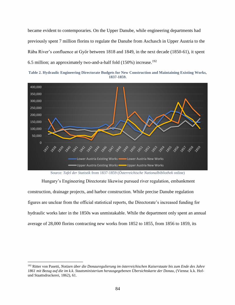
84
became evident to contemporaries. On the Upper Danube, while engineering departments had
previously spent 7 million florins to regulate the Danube from Aschasch in Upper Austria to the
Rába River’s confluence at Győr between 1818 and 1849, in the next decade (1850-61), it spent
6.5 million; an approximately two-and-a-half fold (150%) increase.192
Table 2. Hydraulic Engineering Directorate Budgets for New Construction and Maintaining Existing Works,
1837-1859.
Source: Tafel der Statistik from 1837-1859 (Österreichische Nationalbibliothek online)
Hungary’s Engineering Directorate likewise pursued river regulation, embankment
construction, drainage projects, and harbor construction. While precise Danube regulation
figures are unclear from the official statistical reports, the Directorate’s increased funding for
hydraulic works later in the 1850s was unmistakable. While the department only spent an annual
average of 28,000 florins contracting new works from 1852 to 1855, from 1856 to 1859, its
192 Ritter von Pasetti, Notizen über die Donauregulierung im österreichischen Kaiserstaate bis zum Ende des Jahre
1861 mit Bezug auf die im k.k. Staatsministerium herausgegebenen Übersichtskarte der Donau, (Vienna: k.k. Hof-
und Staattsdruckerei, 1862), 61.
0
50,000
100,000
150,000
200,000
250,000
300,000
350,000
400,000
Lower Austria Existing Works Lower Austria New Works
Upper Austria Existing Works Upper Austria New Works
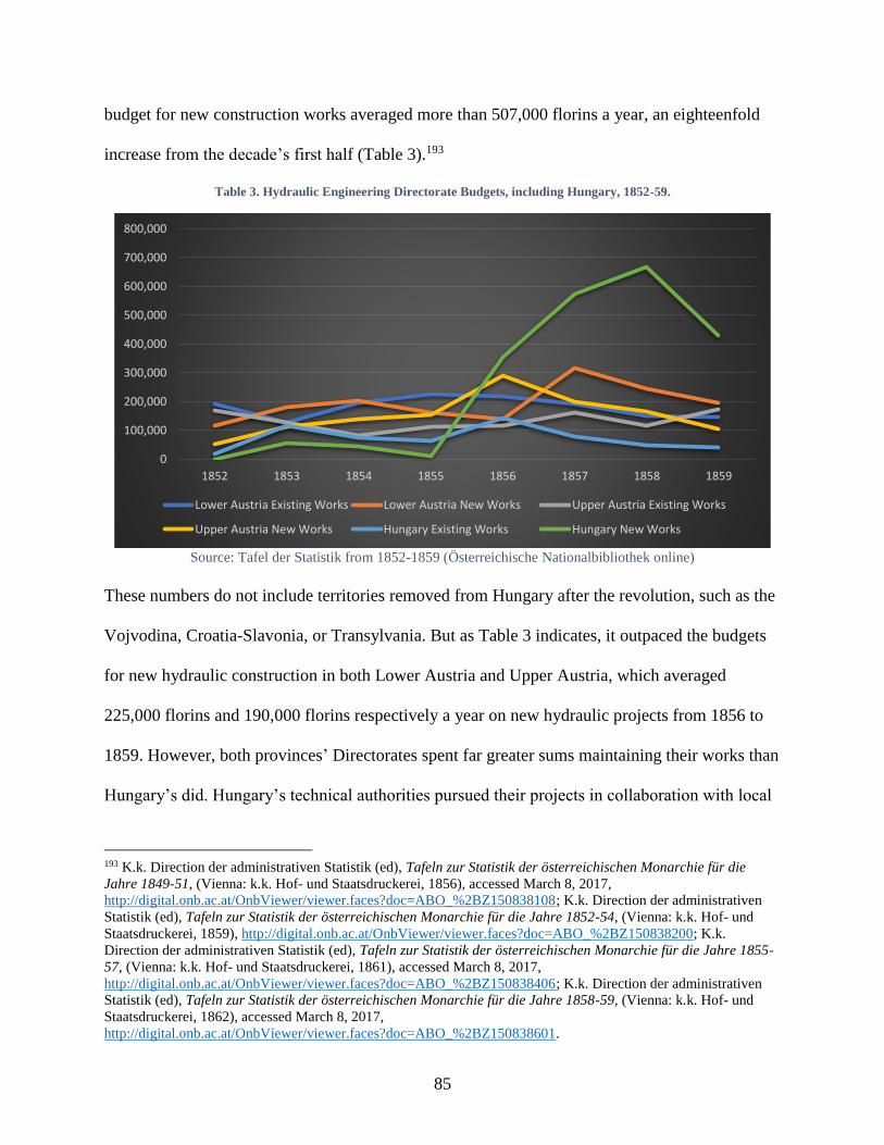
85
budget for new construction works averaged more than 507,000 florins a year, an eighteenfold
increase from the decade’s first half (Table 3).193
Table 3. Hydraulic Engineering Directorate Budgets, including Hungary, 1852-59.
Source: Tafel der Statistik from 1852-1859 (Österreichische Nationalbibliothek online)
These numbers do not include territories removed from Hungary after the revolution, such as the
Vojvodina, Croatia-Slavonia, or Transylvania. But as Table 3 indicates, it outpaced the budgets
for new hydraulic construction in both Lower Austria and Upper Austria, which averaged
225,000 florins and 190,000 florins respectively a year on new hydraulic projects from 1856 to
1859. However, both provinces’ Directorates spent far greater sums maintaining their works than
Hungary’s did. Hungary’s technical authorities pursued their projects in collaboration with local
193 K.k. Direction der administrativen Statistik (ed), Tafeln zur Statistik der österreichischen Monarchie für die
Jahre 1849-51, (Vienna: k.k. Hof- und Staatsdruckerei, 1856), accessed March 8, 2017,
http://digital.onb.ac.at/OnbViewer/viewer.faces?doc=ABO_%2BZ150838108; K.k. Direction der administrativen
Statistik (ed), Tafeln zur Statistik der österreichischen Monarchie für die Jahre 1852-54, (Vienna: k.k. Hof- und
Staatsdruckerei, 1859), http://digital.onb.ac.at/OnbViewer/viewer.faces?doc=ABO_%2BZ150838200; K.k.
Direction der administrativen Statistik (ed), Tafeln zur Statistik der österreichischen Monarchie für die Jahre 1855-
57, (Vienna: k.k. Hof- und Staatsdruckerei, 1861), accessed March 8, 2017,
http://digital.onb.ac.at/OnbViewer/viewer.faces?doc=ABO_%2BZ150838406; K.k. Direction der administrativen
Statistik (ed), Tafeln zur Statistik der österreichischen Monarchie für die Jahre 1858-59, (Vienna: k.k. Hof- und
Staatsdruckerei, 1862), accessed March 8, 2017,
http://digital.onb.ac.at/OnbViewer/viewer.faces?doc=ABO_%2BZ150838601.
0
100,000
200,000
300,000
400,000
500,000
600,000
700,000
800,000
1852 1853 1854 1855 1856 1857 1858 1859
Lower Austria Existing Works Lower Austria New Works Upper Austria Existing Works
Upper Austria New Works Hungary Existing Works Hungary New Works
86
groups. The Hungarian government had already started partnering with private companies in the
1830s and 1840s to reclaim floodplains in the Tisza Valley, and in 1850, further negotiations
stipulated that the state budget would cover the costs of regulation and keeping the rivers cleared
for navigation, whereas local landowners and private companies would share costs for building
embankments.
While clear objectives for regulation led to better success, opposing viewpoints, the
reorganization of Hungary’s technical administration, and the Danube’s unpredictable behavior
influenced the progress of individual projects. Two major regulation projects on the Upper
Danube – blasting dangerous stretches in Upper and Lower Austria – impressed
contemporaries.194 One paper at the time acknowledged that while the Danube may lose “an
idyllic point of natural beauty” by blasting these obstacles, ships and travelers increased security
would enable them to travel danger-free along the stretches, which had inspired so much fear.195
Already in late 1847, over 200 men had been busy blasting and removing rock from these
stretches. By 1858, progress on both was such that Czoernig expressed confidence that the two
dangerous stretches, the “Struden” and “Wirbel,” would soon be dangers ‘only living in
memory.’196 By 1861, at both locations the state had spent almost 400,000 florins to blast nearly
15,000 cubic fathoms of rocks above the Danube’s normal depth and an additional 3,000 cubic
fathoms underwater.197 Work continued until 1866.
Where opinions diverged, progress was more ambiguous. Following the 1847 and 1849
floods at Vienna, a new regulation commission in 1850 disagreed how best to regulate the river
194 The two projects involved blasting the Haussteinfelsen – a rocky outcropping at Strudel in Upper Austria, which
Franz Joseph ordered removed in 1854 – and from blasting a canal into the rocky, treacherous stretch at Wirbel in
Lower Austria. 195 “Donauregulirung am Strudel und Wirbel,” Austria. Zeitung für Handel und Gewerbe, öffentliche Bauten und
Verkehrsmittel, (Vienna, Austria), July 6, 1854. 196 Czoernig, 324. 197 Pasetti, 26-7.

87
near the capital. The river’s serpentine and braided nature made efficient regulation difficult, as
each of the braided arms was governed by its own hydrological conditions, effectively requiring
engineers to regulate multiple rivers at once.198 Unfortunately, unlike the consensus for removing
hindrances like rocks and sandbanks, the regulation committee’s deliberations disagreed whether
to merely improve the Danube’s natural course at Vienna or dig a singular, new bed. Head
engineer Florian Pasetti’s design to retain a more natural river bed prevailed, and from 1850 to
1861, the Danube’s regulation involved closing off a few branching side arms and strengthening
a single, existing channel for navigation. A flood in 1862 revealed the plans’ inadequacies. Only
later during the great regulation (undertake in 1870-75), celebrated in Chapter 1, would workers
and engineers excavate a whole new bed for the Danube at the imperial capital.
The Middle Danube’s progress was likewise ambiguous, and those who studying it
decades later assessed it more critically than those experiencing it in the 1850s. At the end of the
nineteenth century, a prominent Hungarian engineer averred that the Middle Danube’s regulation
work in 1850s had few overarching plans and instead dealt ad hoc with the “needs of the
moment.” He claimed that despite regulation projects, such as closing off side arms and dredging
sandbanks, there were few permanent changes to the Danube until after 1885.199 One Hungarian
historian has criticized the bureaucracy’s re-organization during the neo-autocratic period,
arguing that the “frequent exchange of personnel and re-ordering of offices top to bottom did not
favor construction work, though the tasks were greater than before.”200 Even Pasetti’s report
from 1861 acknowledged that the Danube’s regulation between Gutor and Szap, which the
198 Severin Hohensinner and Martin Schmid, “The More Dikes, the Higher the Floods: Vienna and its Danube
Floods,” in Donau-Stadt-Landschaften, Danube-City-Landscapes, eds. Máté Tamáska and Csaba Szabó, (Berlin: Lit
Verlag, 2016), 223. 199 Bélá Gonda, “A magyar duna,”Az Osztrák-Magyar Monarchia írásban és képben: Magyarország 4, vol. 16
(Budapest: Magyar Királyi Államnyomda, 1896), 27-8. 200 Dóka, 524.
88
Hungarian National Diet had approved funds for in 1831 and which Széchenyi complained were
still incomplete in 1847, were likewise still under construction even in the early 1860s.201
On the other hand, the expansion of construction work on the rivers provided the
authorities several opportunities to address the needs of the population. In Buda, the newly
created Baudirection für Ungarn and its director Florian Menapace exchanged communications
about the Danube’s regulation with local engineers, community petitioners, and the county-level
authorities. The end of serfdom in 1848 introduced a newly liberated class of non-landowning
peasants, many who supplemented their income by providing day labor on major construction
projects, such as river infrastructure. Local works also improved conditions for navigation. In
1855, Franz Joseph introduced plans to connect the Franz Canal at Bezdán with the Danube. A
mile-long transection of the Danube at Bogyisló both improved the river’s navigation and
reduced the danger of ice flows and dams flooding for nearby communities.
Furthermore, the reading public could follow the regulation’s progress in several papers
across the monarchy. The k.k. Trade Ministry’s Austria Tagblatt für Handel und Gewerbe,
öffentliche Bauten und Verkehrsmittel published the budget figures and general projects, which
the engineering departments in each province were working on. Vienna’s main papers Die
Presse and Wiener Zeitung and a few provincial papers covered the Danube regulation’s initial
planning phase in 1850, but a trickle in coverage followed in the next few years. In 1852, the
Hungarian Statthalter permitted publication of the Budapesti Hírlap, which became a semi-
official, Hungarian-language mouthpiece for the regime in Vienna. It primarily dealt with non-
political topics, such as economic and financial issues and later also became an important forum
for discussions about art. In 1855, it ran a series of articles about the Danube’s regulation, which
201 Pasetti, 26-7.
89
favorably covered the government’s work and iterated the oft repeated refrain that the Danube
and its regulation was a crucial part of imperial unity. One article even complimented imperial
authorities such as the k.k. Trade Ministry for undertaking such ‘patriotic’ work and employing a
more unitary vision, which earlier regulation endeavors had lacked.202 Such pro-regime positions
may not have resonated strongly with the Hungarian readership, however, prominent liberal-
nationalist Ferenc Deák set an example for many in Hungary by tacitly accepting the
government’s policies to develop the imperial economy and eschewing appeals for political
disruption. In January 1858, mainstream papers in Vienna once again began publishing articles
and opinion pieces about the Danube’s regulation, particularly as it related to Vienna’s expansion
and the city’s access to river trade. In May 1858, the Klagenfurter Zeitung’s Viennese
correspondent dished the news that “reliable sources” had informed him that regulation work
between Donauwörth and Vienna would intensify, news intriguing enough for the Fremden-Blatt
to repeat a few days later.
Officially, the regime and its representatives continued to tout its commitment to
regulating its rivers to expand waterway traffic throughout the monarchy. Hydraulic engineering
departments in the provinces also reported regulation and dredging projects on the Danube’s
tributaries such as the Traun, Salzach, Enns, Inn, Mur, Drave, and Save in order to secure
navigation on each river. Czoernig, recognizing the slow start to regulation in the 1850s,
nevertheless claimed in 1858 that “despite recent circumstances, which have hindered the state’s
ability to reach its full strength, there was no period in which so much has been done to improve
water transportation than in the last seven years.” 203
202 “Nem hivatolos rész,” Budapesti Hírlap, (Budapest, Hungary), February 8, 1855. 203 Czoernig, 320-22.
90
Domestic interest in the Danube bled into the international area when the Crimean War
injected the “Danube Question” into European discussions. European interest in the Danube
Principalities’ grain and commercial opportunities in the Black Sea convinced the Great Powers
to establish the European Commission for the Danube (ECD) in 1856 – following the Crimean
War – to manage the silted Sulina branch, which connected the Lower Danube through the Delta
into the Black Sea. The Russians had gained control of this singular, navigable channel in the
Peace of Adrianople (1829) but had neglected its maintenance to dissuade navigation from the
Lower Danube into the Black Sea, in order to protect its merchants’ trade interests. The other
question regarding the Danube was the elusive issue of its internationalization, first seriously
debated in Vienna in 1815, and ultimately only applied to the Rhine during the Congress of
Vienna and later also to the Elbe. Internationalizing the Danube would liberate it from customs
and dues and open it to free navigation. It would also undermine the Habsburg state’s diplomatic
power to decide which ships could sail on its river or grant monopolies to any domestic
steamship companies.
To conclude all formal agreements, Franz Joseph had entrusted Foreign Minister Buol
and ambassador to France, Baron Hübner, to represent his will in Paris. Before they had left, he
handed them detailed instructions for the negotiations, which his cabinet had drafted.204 In a
hand-written comment in the margins, Franz Joseph wrote “there must be a very clear distinction
made between the question of the Sulina and that of the Danube proper. On the former, all the
204 The minutes from this Cabinet meeting indicate that there had been some disagreement about how much
sovereignty Vienna should relinquish regarding the delta as well. Finance Minister Bruck believed that the Danube’s
riparian states should be responsible for clearing the Sulina channel rather than rely on foreign intervention, which
he believed would complicate the project. Foreign Minister Buol argued that the Preamble, which all Great Powers
had agreed to and signed in December 1855 agreeing to the Paris Congress, had specifically charged all European
powers with the task of clearing the delta. Buol’s argument won and when the representatives signed the Treaty of
Paris, the British, French, Ottoman, Serbian, Russian, and Habsburg governments formally established one of the
first international bodies to regulate behavior on a river; the European Commission for the Danube.
91
powers have equal rights, whereas, on the later, only the Riparian States have got a say in the
matter.”205
Franz Joseph’s reluctance to cede international sovereignty of the Danube meant that his
diplomats ensured that no directives or mandates undermined his or other riparian states’
authorities along the river itself. To ensure that the Great Powers would not unilaterally create a
commission to regulate the Danube within the Habsburg Monarchy, which they had essentially
done for Russia’s Sulina stretch with the ECD, representatives formed a Riparian State
Commission, which met for the first time in November 1856.206 The Commission empowered
three different committees, the third of which was to rid the Danube of physical obstacles to
navigation. It met a total of 33 times, and at its last meeting on November 7, 1857, the states
signed and issued the “Navigational Acts” which essentially codified Austrian interests on the
Danube by declaring that member states were able to collect tolls and only riparian states could
have ‘regular steamship services.’207 This commission had little power, Habsburg diplomacy
kept it weak, but the Great Powers still condemned its efforts to circumvent the spirit of the
Danube’s internationalization.208
The Habsburg Monarchy’s neutrality during the Crimean War led to major diplomatic
isolation in the aftermath, leaving it vulnerable to Franco-Italian forces three years later.209 Once
the Habsburg forces conceded defeat, losing the wealthy crownland Lombardy, the state’s
205 Henry Hajnal, The Danube: its historical, political and economic importance, (The Hague: Martinus Nijhoff,
1920), 71-2. 206 Danube riparian members were Bavaria, Württemburg, the Ottoman Empire, and the Danubian Principalities –
Wallachia, Moldavia, and Serbia. 207 Hajnal, The Danube, 83. 208 Eventually, an indefinite postponement of its convocation in 1871 led to its de facto demise. 209 The Russian government considered it ungracious not to support it after it had sent troops to help repress the
Magyars in 1849, and the French and British governments disliked that they had to shoulder the fight against the
Russians. In the Crimean War’s aftermath, the Piemontese and their French allies moved swiftly to reclaim Italian
provinces in the Habsburg Monarchy in 1859. The short war ended in disaster for Franz Joseph, who had personally
led the troops. Despite the war’s brevity, it disrupted financial and commercial functions in the monarchy.
92
bankruptcy forced the imperial government to find ways to retain the public’s confidence.210 As
a superficial panacea, the Finance Ministry floated the idea of starting a “central organ” for
advertising rail and steam navigation affairs to the public. The Ministry claimed that circulating a
leaflet would help the public stay informed about newly opened stretches, construction projects,
and the more current prices for travel. Much more drastically, Franz Joseph determined to issue
the 1860 October Diploma, which eased his neo-Absolutist governance and introduced modest
federalist reforms, such as reinstating provincial diets and reconstituting Hungary’s political
existence. Under the new, federalist arrangements, land-owning aristocrats regained their
traditional power in the provinces, which disappointed the wealthy, liberal bourgeoisie, who had
not minded the centralized, neo-Absolutist structure, but had simply desired greater
constitutional reforms to secure the rule of law and greater political representation.211 In response
to the widespread dismay, Franz Joseph changed course again and replaced his ‘irrevocable’
arrangement with the 1861 February Patent, which instituted a new, centralized diet, the
Reichsrat, to which provincial diets elected representatives. The February Patent, overseen by
1848 revolutionary Anton Ritter von Schmerling, aggravated nationalists, who believed it
subsumed their regional sovereignty into a centralized, strongly German system. Hungarians,
Croats, and Italians refused to send deputies to the new diet, which remained the status quo until
1865.
Despite this political impasse in the earlier 1860s, the placated liberal bourgeoisie and the
new constitutional order provided economic and commercial stability, which ensured engineers
210 The war plunged the monarchy massively into debt while the annual deficit grew from 100 to 283 million florins.
Basic services like trains and post weren’t running on their usual schedule, Ferenc Bay, A Győri Llyod Városáért és
Kereskedeleméért, 1856-1936, (Győr: Baross-Nyomda, 1942), 28-30. 211 Pieter M. Judson, The Habsburg Empire: A New History, (Cambridge, Mass.: Harvard University Press, 2016),
252-54.
93
and the provincial technical authorities had the necessary capital to pursue the Danube’s
regulation with renewed vigor, which contemporaneous papers and government publications
covered extensively. Provincial engineering directorates undertook myriads of local projects on
the Danube, such as strengthening or constructing embankments to narrow the river’s path and
maintain its depth, closing off side arms, and digging transections to straighten the river’s bed.
Budgets for the hydraulic engineering departments’ new projects varied but generally increased
from 1860 to 1865.212 In 1861, the State Ministry published lithographs of the Danube and Tisza
survey maps for public consumption. The following year, in conjunction with the prints, Section
Chief of the Hydraulic Engineering Bureau, Florian Pasetti, published Notizen über die
Donauregulierung im österreichischen Kaiserstaate bis zum Ende des Jahre 1861 [Notes about
the Danube’s Regulation in the Imperial State up until the End of 1861]. This work provided in
depth observations and positive assessments about the Danube’s regulation, which was required
as the river “formed the main artery for ship traffic in the Austrian state and its neighbors.”
Even before the liberal governance after the 1867 Compromise, there was evidence that
river reforms were a crucial element in municipal revitalization plans. In 1865, the renowned
Hungarian engineer Ferenc Reitter likewise published his opinions on the Danube’s regulation in
Duna-szabályozás Buda es Pest között, Pesti hajózási-csatorna, a csepelsziget s a soroksári
Duna-ág balpartján fekvő ártér árrmentesítése [Danube Regulation Between Buda and Pest,
Pest’s Navigational Canal, the Elimination of Flood Plains on the Csepel Island and Soroksár
Danube Branch’s Left Bank]. Like many works after the 1862 monarchy-wide flood, however,
212 In 1860, the total annual budget for all hydraulic engineering departments without Hungary, Transylvania,
Croatia-Slavonia, or the Banat and Military Border was 578,272 florins, which was 528,557 in 1861, 774,727 in
1862, 657,299 in 1863, 611,466 in 1864, and 713,530 in 1865, K.k. Statistische Central-Commission (ed), Tafel zur
Statistik für die österreichische Monarchie, accessed August 2, 2017,
http://digital.onb.ac.at/OnbViewer/viewer.faces?doc=ABO_%2BZ150838807.

94
Reitter’s emphasis on regulation focused more on augmenting flood protection than improving
navigation. The one exception was his plan to transform a swampy side arm at Pest into a
thoroughfare for commercial traffic arriving on the Danube, which Reitter argued would make
Budapest a center for world trade, consciously or not mirroring rhetoric from the 1840s onward.
After Reitter published his plans for the Danube, a commission convened to assess its financial
viability, publishing its report in 1868. Before the assessment was published, the Pesti Napló had
also run its own analyses from August 1865 till August the following year.213
From the Hungarians’ perspective, the Napló was a credible paper to cover the Danube
regulation. It had gained national admiration in April 1865 for publishing Deák’s open appeal to
the Habsburg regime to renegotiate the political arrangements in Hungary – a letter which set the
groundwork for the 1867 Austro-Hungarian Compromise. In September 1866, with negotiations
among Franz Joseph, Ferenc Deák, and Gyula Andrássy almost concluded and the state severely
bankrupted from its heavy military loss to the Prussians in July, the paper passionately
reaffirmed the common task that the Danube’s regulation served for the monarchy, arguing:
Danube navigation is so important not only for our country, but for the trade of
the entire monarchy… the need for the Danube’s regulation is so widely
acknowledged as a requirement for the promotion of domestic and imperial
prosperity, that it would be unnecessary to discuss. At the imperial-royal state
engineering office, I believe there are perfect designs for the Danube's regulation,
the only motivating force that has been lacking so far has been the money. It is
true that regulation will be giant work and cost millions, and yet there is hardly a
better time than now to undertake it.214
213 “A pesti csatornaterv,” Pesti Napló, (Budapest, Hungary), August 23, 1865; “Különfélék,” Pesti Napló,
(Budapest, Hungary), August 27, 1865; “Egy szakértő tekintély véleménye a Reitter-féle Duna-csatornáról,” Pesti
Napló, (Budapest, Hungary), August 26, 1866. 214 “Vidéki tudósítok,” Pesti Napló, (Budapest, Hungary), September 22, 1866.
95
New Bureaucracy, Same Agenda
Franz Joseph’s loss in the seven-week war with the Prussians essentially concluded the
ongoing political settlement with the Hungarians, and in February 1867, the Ausgleich or
“Compromise” divided the monarchy’s internal governance between Vienna and Budapest. In
practical terms, that meant the Hungarian government in Buda created its own set of ministries,
thus doubling the governmental institutions responsible for Danube affairs. In Austria, the Trade
and Interior Ministries took responsibility for Danube and general river regulation, whereas
Hungary established a new Ministry for Public Works and Transportation [Közmunka- és
Közlekedési Miniszterium or “KMKM”], which like the Engineering Directorate in Buda,
oversaw construction projects like embankments, steam navigation stations, and bridges. These
ministries within the imperial and royal governments retained the power to suggest legislation,
request budgets for their particular projects, and were responsible for overseeing hydraulic
engineering work. Continuity and cooperation initially characterized their work. New diets at
each capital later complicated ministerial plans for the Danube, as the increasingly democratic
system for approving budgets and passing legislation occasionally devolved into political
squabbles, mounting indecisiveness, and at times juvenile nationalist behavior.215
Despite the new political arrangements, shared concerns on the river dictated a common
solution, and the ministries in Vienna and Buda charged with river regulation continued to work
together after the Compromise. In May 1867, the k.k. Trade Ministry wrote to the KMKM and
discussed the need to craft a law which would govern inland shipping and navigation within the
215 Both diets had a bicameral system, where wealthy aristocrats, members of the House of Habsburg-Lorraine, the
clergy, and emperor-appointed citizens were selected for the House of Lords (Herrenhaus) in Vienna and similar
ecclesiastical and aristocratic representation filled the House of Magnates (Főrendiház) in Pest. The popular,
representative bodies, the lower chambers, were the House of Representatives (Képviselőház) in Pest and the House
of Deputies (Abgeordnetenhaus) in Vienna.

96
monarchy. In December 1867, the legislative bodies on both halves of the monarchy signed an
agreement for a continued customs union, which Franz Joseph declared law on December 24.
The new law provided a joint framework for trade, instigating both ministries to look for
common navigational guidelines as well.
To harmonize their approaches, each ministry requested examples of the laws the other
ministry was crafting, though these involved coordinating several governmental and committees’
deliberations. In June 1868, for example, the k.k. Trade Ministry requested two documents from
the KMKM, its “Navigation Law” and its “Order for Rivers, Canals, and Inland Lakes.” These
laws had already been under discussion since November 1867, when department advisor (osztály
tanácsos) Károly Langer led a committee which had the task of suggesting a regulation of
practices for Hungary’s waterways. By the following spring, in March 1868, Minister for Public
Works and Transportation Imre Mikó called together a larger committee with Langer as
president, which had governmental representatives from the Navigation Supervisory Directorate,
the Justice, Interior, and Trade Ministries, as well as agents from the DDSG and the “Első
Magyar Gőzhajótársaság” [First Hungarian Steamship Company], the supervisor for the Tisza’s
regulation, as well as assorted other delegates. Engineer and state secretary Ernő Hollán
instructed the navigational supervisor Albert Kenesseny to prepare notes from these committees.
For an already infamously bureaucratic state, the additional layer of bureaucracy
complicated any linear chain of command. In November 1868, when the k.k. Trade Ministry
declared itself close to finalizing its navigational laws, and requested notes from the KMKM
regarding its legal designs, several delays prompted a series of urgent memo exchanges between
the k.k. Trade Ministry and its royal counterparts. By summer of 1869, not only did the imperial
97
authorities repeatedly write to the KMKM, but even the Lower Austrian Statthalter’s office
requested these details as well.
Joint policies to regulate practices on the river certainly promised to alleviate some of the
potential trade conflicts between the two entities with potentially two different commercial
policies. Indeed, the river incentivized joint, or at least coordinated, endeavors for ensuring and
maintaining its navigability. Local and commercial voices expressed the same sentiments for the
Danube’s tributaries as well. Immediately after the Compromise, the Royal Hungarian KMKM
began receiving memos from businesses and local engineers reporting on the navigational
potential of the Danube and its tributaries. The DDSG, for its part, expressed its plans to extend
its navigation up the Tisza and along two of its tributaries, the Samos and Maros. One engineer
in Arad on the Maros River wrote that the river’s regulation, maintenance, and improved
navigability would benefit the surrounding countryside and be in the interests of the whole
country. These sentiments had also existed during neo-Absolutism. When other officials from
Torontál and Csanád county reiterated proposals to regulate the river in January 1868, the DDSG
agreed, pointing out that the unregulated stretches froze too readily, hindering its navigability.
After collecting shipping data for twenty years between 1849 and 1869, Dr. Johann Winckler
published an article in 1870 arguing that the Danube’s continued significance for trade was
contingent on the state’s investment in it. He concluded that the Danube – despite competition
with rails – would remain “the most important Lebensader for transporting particularly mass
goods, as long as the state could keep it in better condition as a shipping lane and build the
necessary facilities for trade such as landing places and transshipment sites”216
216 Dr. Johann Winckler, Übersicht des Schiffs- und Waarenverkehrs auf der oberen Donau zu Wien, Linz, und
Engelhartszell in den Jahren 1849-1869, (Vienna: k.u.k. Hof- und Staatsdruckerei, 1870), 2.
98
At the end of the decade, governmental discussions spilled into the public sphere as
scholars and politicians took up the regulation and canal issue. In 1868, nobleman and
parliamentarian Jenő Zichy published his plans for a Danube-Tisza Canal, which like many plans
before it, envisioned the route connecting the Danube at Pest to the Tisza. In 1869, two published
works in German, one a white paper and the other a technical report, suggested the construction
of a canal connecting the Danube and Save through Slavonia and the Military Border.217 The
publications in 1869 coincided with successful opening of the Suez Canal, which Franz Joseph
had traveled to Egypt to attend. The massive engineering feat influenced perceptions about the
monarchy’s potential for large-scale engineering works, as the white paper argued, such as
canals enhancing the Danube’s commercial links with crucial tributaries or other large rivers in
the monarchy. The publications also appeared concomitantly with deliberations in the Reichsrat
at Vienna and National Assembly in Budapest, which were focused on the concrete task of the
Danube’s regulation at the two capitals.
Regulation plans had already begun after the 1830 and 1838 floods, but the new diets
envisioned grand opportunities for the capitals’ developments in a period of liberal governance
(Vienna) and national autonomy (Budapest). In Vienna, in the wake of the 1862 flood, Franz
Joseph had issued a decree in 1864 to set up a Danube Regulation Commission (DRC) charged
with planning the river’s regulation at Vienna. The DRC’s international competition for
regulation plans were thoroughly discussed in Vienna’s legislative bodies, particularly after the
Interior Minister wrote to the House of Deputies in 1867 to propose that the imperial budget pay
for one third of the regulation, with Lower Austria and the city of Vienna covering the additional
217 Friedrich Ritter von Loessi, Technischer Bericht zum Projecte eines Schifffahrts-Kanales zwischen der Save und
Donau in der Militärgrenze und Slavonien, (Ried: Kränzel, 1869); Denkschrift über das Projekt eines Donau-Save-
Schiffahrt-Canales zwischen Vukovár und Samač in Slavonien und der Militärgränze, (Wien: Gerold Sohn, 1869).
99
two-thirds. The same French company completing the Suez Canal won the contract to regulate
the Viennese Danube.
Discussions in Vienna influenced debates in the National Diet, though several municipal
concerns complicated the negotiations. The dual nature of Buda and Pest led to disagreements
about sharing the costs of regulation near the two cities (which didn’t unite until 1873). In the
House of Representatives, some lawmakers expressed fear that the royal government was
infringing on Buda and Pest’s municipal rights or that the whole country would be put in debt
over a ‘municipal project.’
The stakes were high because both the government and the public expected river
regulations to have far-reaching commercial benefits. Hungary’s former Minister of Justice Sebő
Vukovics told the House of Representatives in 1869 that, due to the chamber’s prevarication, it
was only a dream that regulation could ever enable sea ships to sail up the Danube until Pest.218
In the House of Magnates a month later, the reasonable expectation arose that the Danube’s
regulation should provide spacious quays, harbors, and public warehouses to make the city a
commercial center on the Danube.219 Debates raged on in both chambers about the regulation’s
budget throughout summer and winter 1870, which witnessed public speeches by prominent
politicians of the day, such as the Prime Minister Gyula Andrássy, Ferenc Deák, and Kálmán
Tisza. All agreed in principle that the Danube’s regulation was crucial for both municipal and
national interests, though differing on the specifics how it should be paid for and which bodies
should have oversight of the budget. Eventually, in early 1871, the House of Representatives
218 Az 1869-dik évi april 20-dikára hirdetett országgyűlés képviselőházának naplója, vol 5 (Pest: Légrádt Testvérek,
1870), 34. 219 “A Duna-folyamnak a főváros mellett szabályozásáról s a forgalom és közlekedés érdekében Buda-Pesten
létesítendő egyéb közmunkák költségeinek fedezéséről és e közmunkák végrehajtási közegeiről,” Az 1869-ik évi
ápril hó 20-dikára hirdetett országgyűlés főrendi házának irományai, vol. 2 (Pest: Pesti Könyvnyomda-Részvény-
Társulat, 1870), 71.
100
initially approved 2,060,000 forints for the Danube’s regulation.220 The following March, it
approved 7.7 million forints for the regulation, quay and bridge construction, and other hydraulic
projects at Buda and Pest. An Austrian construction company won the bid to undertake the work,
which the newly established “Danube Regulation Committee” oversaw.221
First Canal Legislation
Concurrently with the discussions regarding the Danube’s regulation at each capital,
legislators were likewise allocating funds and pursuing projects that improved and expanded
other waterways in the monarchy. Because the budget for the Danube’s regulation increased so
dramatically from 1871 to 1873 (from 150,000 to 2.5 million florins annually), the Tisza’s
regulation budget, the next largest after the Danube’s, consequently declined almost two-thirds
from approximately 600,000 to 215,000 florins from 1872 to 1875. Only after the completed
capital projects and a massive flood in 1876 did the Tisza’s hydraulic engineering budget
increase from less than 145,000 florins that year to over 3 million by 1879.222 In Vienna, canal
discussions formally entered the Reichsrat in May 1872, when k.k. Trade Minister Banhaus
submitted a petition to the House of Deputies to consider a law that would arrange for the
construction of a canal between the Danube and Oder. Within a few days, a committee formed to
discuss the merits of the law. Newspapers excitedly reported the canal’s projected benefit to
alleviate freight traffic on the Kronprinz-Ferdinand-Nordbahn, to integrate Silesian coal into the
Danube economic sphere, and to provide access to the Baltic Sea. The Hungarian paper Vasuti és
Közlekedési Közlöny even acknowledged that while a Danube-Oder Canal would, on first glance,
220 The forint was merely the Hungarian equivalent of the florin in Austria. 221 “A Dunai szabályozása és rakpartok, 1870: A rakpartok építésének története,” BudapestCity.org,
http://budapestcity.org/02-tortenet/1870-a-duna-szabalyozasa/dunaszabalyozas-es-rakpartok-hu.htm, (accessed April
26, 2017). 222 Az 1892 évi február hó 18-ára hirdetett országyűlés képviselőházának irományai, vol. 29 (Budapest: Pest
Könyvnyomda-Részvény-Társaság, 1895), 192.
101
seem to threaten Hungarian railway interests between Kassa (mod. Košice) and Oderberg, it
would actually increase domestic river traffic and should therefore be “happily welcomed.”223
However, despite financial backing from the Anglo-Austrian Bank and Klein brothers, the
canal’s future wasn’t certain. A report in mid-June appeared in the Neues Wiener Tagblatt, which
indicated that hydrological considerations, namely the Oder’s insufficient water volume, may
scuttle plans.224 Additional excursions to study the hydrological and nearby geological conditions
proved these worries unfounded, and a year later in 1873, the committee submitted its report to
the House of Deputies. The report believed that the Danube-Oder Canal, with additional canals
connecting to the Moldau and Weichsel, would unite the hitherto inaccessible but vital rivers into
the Danube network. The committee submitted a proposal which pointed to the canal’s “national-
economic importance,” provided a technical evaluation how best to construct the canal and
suggested policies regarding how to fund its construction and ensure its profitability.225
During the subsequent debate in the House of Deputies on March 28, 1873, the law
evoked some grave concerns but also featured some ardent defenders. One deputy, Dr. Blitzfeld
from Silesia, argued that building a canal parallel to an existing railway, as the canal’s planned
path did, would be a mistake, as most countries in Europe had proven that such canals invariably
failed in competition with the rail and the canal would then become subsidized by the state rather
than profitably run by a private joint-stock company. He pointed to the Wiener Neustadt Canal’s
recent sale to a private company for only 300,000 florins – a mere 10% of the construction
expenses – as an example of canals’ waning usage in Austria. He undermined arguments that
transportation costs would decline by comparing the Nordbahn’s low prices for shipping coal
223 “Duna-odera-csatorna,” Vasuti és Közlekedési Közlöny, (Budapest, Hungary), June 20, 1872. 224 “Der kleine Aktionär,” Neues Wiener Tagblatt, (Vienna, Austria), June 11, 1872. 225 Stenographische Protokolle über die Sitzungen des Hauses der Abgeordneten des österreichischen Reichsrathes.
VII. Session, vol. 2 (Vienna: K.k. Hof- und Staatsdruckerei, 1873), 2760.
102
from the region, he disputed that the canal would possess the requisite water levels based on the
engineers’ technical reports, and when discussing the canal’s profitability, he also defended any
potential investors in the canal, claiming that the project’s financier, a bank, was heavily invested
in many projects, and it seemed to care more about its own profits than the worth of its stocks.226
The following speakers all disagreed with Blitzfeld and cited counter examples for why
the chamber should ratify the canal law. Deputy Kuh from Bohemia brought up the fact that
deputies and businesses had expressed similar concerns in Hungary that the Danube Steam
Navigation Company would collapse with the expansion of the Hungarian State Railways when,
in fact,the opposite had occurred, and the company’s business had ‘blossomed’ instead. Kuh also
postulated that if the canal’s path ran through any swamps, it could drain the excess water,
thereby reclaiming land and increasing its property value. The project’s next defender, the
chairman of the canal committee, Dr. Kaiser, assured the chamber that despite Blitzfeld’s fears,
the canal would definitely be technically possible to construct, and he vehemently disagreed with
the comment that the monarchy had “enough streets” as an untenable reason not to commission
additional infrastructure. Deputy d’Elvert from Moravia also supported the project, hoping it
would have a positive effect on the March River’s regulation. The law’s ‘reporter’ Dr. Weeber
then proceeded to read out each of the law’s articles for individual debate, which led to lengthy
discussion regarding the wording and spirit of the law. More deputies provided opinions how to
clarify the law, questions about its effect, and k.k. Trade Minister Banhaus even assured the
deputies that the government had given the matter much deliberation. After all articles had been
debated and the few modifications were voted upon, the president concluded discussion with an
affirmative vote for the law in its third reading.
226 Ibid., 1658.

103
While most deputies seemed inclined to support the law, Blitzfeld’s last concern about
stocks and financing turned out to be the most prescient for the monarchy. Two months later, on
May 9, 1873, over-speculation caused the Viennese stock market to collapse, and with it the first
plans for the Danube-Oder Canal.227 The canal idea didn’t disappear, and in fact, the following
year, even papers in Budapest reported that a representative in the Reichsrat submitted another
petition about its construction.228 Publications about the canal from 1873 onward helped lay the
foundation for the canal legislation at the turn of the century.229
The Hungarians also maintained great interest in the canal through the 1880s and 1890s.
Hungarian government and diet entertained lectures from experts about it. After plans stalled in
Vienna, the Pozsony County head [alispán] proposed in 1891 that it pass from the Danube’s
Hungarian border city Dévény to the Oder.230 His statement came a week before debates in the
House of Representatives regarding the Austro-Hungarian Rail, during which a member of the
financial and economic committee, economist Jenő Gaál claimed that the railways and economy
generally would benefit from the Danube-Oder Canal.231 Unfortunately, the canal also generated
controversy among Hungarians. As the German, Austrian, and Hungarian shipping associations
met in May 1896 to discuss common canal construction, some Hungarians cited expert opinions
227 Ibid., 1659-74. 228 “A ‘Budapesti Közlöny’ magántáviratai,” Budapesti Közlöny, (Budapest, Hungary), November 18, 1874. 229 A. Mayer, Der Donau-Oder-Kanal als Aktien-Unternehrnung, (Wien: Waldheim, 1873); Denkschrift über der
Ausbau der Wasserstrassen in Oesterreich und über den Bau eines Donau-Oder-Canales, (Wien: Steyrermühl,
1884); Viktor Rusz, Eine Schiffahrtsstrasse Donau-Moldau-Elbe, (Wien: Konegen, 1884); A. Skene, Der Donau-
Oder-Kanal, (Wien: Frick, 1886); Discussion über den Ausbau der Wasserstrassen in Oesterreich und insbesondere
über die Herstellung eines Donau-Oder-Canals, (Wien: Frick, 1891); Geo Gothein, Das Donau-Oder-Kanalprojekt,
(Berlin: Hayn, 1897); Arthur Oelwein, Das Donau-Oder-Kanalprojekt, (Berlin: Hayn, 1897); Arthur Oelwein and J.
Böhm, Das Donau-Oder-Kanalprojekt, (Berlin: Hayn, 1897); Kaftan et al, Das Donau-Moldau-Elbe-Kanalprojekt,
(Berlin: Hayn, 1897); J. Kaftan, F. Steiner, R. Urbanitzky, Gegenwartiger Stand des Donau-Moldau-Elbe-
Kanalprojekts, (Berlin: Hayn, 1897); E. von Weber, Das Donau-Oder-Kanalprojekt, (Berlin: Hayn, 1897); S.
Herczfeld, A Duna-Odera csatorna közgazdasági jelentőségéről, (A magy. hajózási egyesület, 1898); Kereskedelmi
és iparkamara, Bizottsági jelentés a Duna-Odera-csatorna ügyében, (Budapest: Pesti könyvnyomda, 1899). 230 “Csatorna a Duna és Odera közt,” Budapesti Hírlap, (Budapest, Hungary), June 13, 1891. 231 “A képviselőház ülés,” Budapesti Hírlap, (Budapest, Hungary), June 23, 1891.
104
that the Oderberg canal should connect to the Danube upstream from Pozsony/Pressburg, and
they claimed that only the Austrians’ desire to dominate river trade kept the planned route at
Vienna, a move they greatly resented.232 In 1897, the House of Representatives’ discussion about
a ministerial budget concerning hydraulic projects once again turned to the Danube-Oder Canal,
and the responsible minister, Ignác Darányi, aired his grievances that the Austrians also sought to
mobilize the Saxons and Prussians against any plans to connect the canal to the Hungarian
Danube stretch.233
While the Danube-Oder Canal plans remained in limbo for decades following the
legislation’s 1873 collapse, the Hungarian government quickly expanded its funding for
regulation of the Danube and its tributaries. In Budapest, the Ministry for Public Works and
Transportation increased its budget for maintaining waterways in Hungary from 73,000 florins in
1869 to 226,000 florins in 1871.234 The following year, the ministry wrote a budgetary overview
for the House of Representatives, which detailed the potential costs of regulating all waterways
in Hungary. The projected expense was 57 million florins.235 From 1876 to 1881, the Ministry
for Public Works and Transportation averaged more than 215,000 florins annually just to clear
navigational obstacles on the Danube, Tisza, Drave, Vág, Kőrös, Bega, and Temes Rivers. The
ministry even invited foreign experts to come assess its river regulation work, later publishing
the evaluations in 1879.236
232 “Közgazdaság,” Budapesti Hírlap, (Budapest, Hungary), September 3, 1896. 233 “Országgyűlés,” Budapesti Hírlap, (Budapest, Hungary), February 19, 1897. 234 Az 1872-ik évi szeptember hó 1-jére kihirdetett országgyűlés főrendi házának irományai, vol. 3 (Pest: Pesti
Könyvnyomda-Részvény-Társulat, 1873), 86. 235 Az 1872-ik évi szeptember hó 1-jére kihirdetett országgyűlés főrendi házának irományai, vol. 5 (Buda: A Magyar
Királyi Államnyomda, 1873), 52. 236 Magyarországi Közmunka- és közlekedésügyi miniszterium, A hazai folyón végrehajtott szabályozási
munkálatok megbirálására meghivott külföldi szakértőkből alakult bizottság jelentései, (Budapest: Pesti
könyvnyomda, 1879).

105
Besides improving Hungary’s existing rivers, both houses in the National Diet began to
recognize the need, despite the expense, to expand the waterways. In November 1879, the House
of Representatives’ Economics Committee issued a statement, on behalf of a recent meeting of
Hungarian farmers in Szekesfehérvár, in which it laid out a detailed strategy for promoting the
nation’s economic and agricultural development. Their sixth point called for the detailed plan for
the establishment of additional waterways in Hungary, citing several projects, which included the
Drava-Eszék-Karólyváros-Fiume Canal, and canals connecting the Tisza, Maros, and Fiume.
While the committee acknowledged the extraordinary expenses, they believed the benefits would
be worth the costs.237 During the same session, Counts Aurél Desewffy, Pál Széchényi, and Jenő
Zichy, as members of the Commission on the National Agricultural Situation wrote a
memorandum to the House of Magnates. They concurred with the representatives that while the
country needed to take its financial situation into account, it should realize that constructing
more waterways was in its national interest.238 While regulation budgets increased for several
rivers, including the Danube, new canal construction did not materialize.
A DDSG business report from 1879 described how, in Austria, “a lively discussion about
the river’s ‘correction’ has taken hold in the public, in governments, associations, communities,
and legislative bodies to actually improve the Danube bed, in order to promote Danube
navigation, but it hasn’t led to anything yet.”239 There were several hindrances to Danube
navigation, physical and political, that needed to be addressed. These included the still
unregulated Iron Gates, unfavorable Romanian customs’ duties on river wares (to support its
237 Az 1878. évi október hó 17-re hirdetett országgyűlés képviselőházának irományai, vol. 10 (Budapest: Pesti
Könyvnyomda-Részvénytársaság, 1880), 165. 238 Az 1878-ik évi október hó 17-ére kihirdetett országgyűlés főrendi hazának irományai, vol. 4 (Budapest: Pesti
Könyvnyomda-Részvény-Társaság, 1880), 127. 239 Erste k.k. priv. Donau-Dampfschiffahrts-Gesellschaft, Geschäfts-Bericht der Betriebs-Direction über das
Verwaltungsjahr vom 1. December 1878 bis 30. November 1879, (Vienna: Selbstverlag der Gesellschaft, 1880), 3.
106
domestic rail development), the Hungarian government’s delay in introducing chain navigation
on the Middle Danube, and Russia’s influence on lower Danube territories, which shut out
Austro-Hungarian towage between the Prut’s confluence and the Delta. The DDSG’s report the
following year maintained that general disregard for the Danube’s maintenance in the previous
few decades had hindered industrial and agricultural growth, but it expressed hope that recent
sympathies for navigational interests in Austria-Hungary augured well for future Danube and
waterway investment.240
Donauverein
The most prominent advocate for the Danube’s monarchy-wide regulation, which the
DDSG report was likely alluding to, was the newly-formed Donauverein or “Danube
Association,” which a group of commercially-minded individuals and representatives from
several cities on the Danube had established in 1879. Its inaugural meeting took place on June 9,
1879 in the meeting room of the Lower Austrian Business Association [Gewerbeverein]. The
following day it organized a “Dinner of Purpose” at the fancy Hotel Imperial in Vienna. The
Donauverein hosted representatives from Vienna, Pozsony/Pressburg, Theben/Dévény,
Budapest, Korneuburg, Krems, Linz, and other riparian cities, plus the royal administrators who
worked on the Danube’s regulation in Hungary, and members of the Hungarian and Austrian
business and trade corporations. The Donauverein’s secretary was the famed geologist Professor
Eduard Suess, one of the main advisors for the Viennese Danube regulation.
The dinner provided the attendees a chance to express their hopes and admiration for the
Danube’s regulation, and speeches emphasized the desire for joint initiatives on the river. Suess
240 Erste k.k. priv. Donau-Dampfschiffahrts-Gesellschaft, Geschäfts-Bericht der Betriebs-Direction über das
Verwaltungsjahr vom 1. December 1879 bis 30. November 1880, (Vienna: Selbstverlag der Gesellschaft, 1881), 3-4.

107
pointedly opined that the work represented not only “great cultural progress” but “a new moment
in the peaceful development within the monarchy,” which he believed would unite the two
halves in greater love and affection. He ended his words with a toast to Kaiser and King Franz
Joseph, whom the Hungarians and Austrians alike cheered. Vienna’s mayor spoke afterward and
reiterated Suess’ sentiments, asserting that “we would like nothing more than for all areas of the
monarchy to recognize that this undertaking is not a local one, nor one simply within Austria, but
rather its success will bring great fruit to both halves of the Austro-Hungarian Empire.” He
ended his toast to the Hungarian representatives at the meeting, whom he hoped would spread
the association’s agenda in Hungary. Further delegates described the Danube’s unitary place in
the monarchy, the river’s indifference to tribal or national differences, its universal threat, the
common call for its regulation among the populations in both halves of the monarchy, and finally
one participant even declared that the massive regulation work truly fit the emperor’s motto
“viribus unitis” (with united strength), promoting the well-being of the monarchy’s
population.241
The Donauverein’s activities in the following decades were manifold in pursuing the
Danube’s regulation through public and private encouragement. Beyond organizing its own
speaking events, it arranged speeches for both governmental and associational gatherings. It was
a consummate petitioner of the Reichsrat, especially on behalf of provincial interests. The
Donauverein even sponsored “Danube Study Trips” to ply the Danube on steamships to view
sites of both completed and requested regulation work both in Austria and Hungary. These took
place in 1879, 1884, 1890, and 1894 and traveled from sites in Upper Austria, down to the Iron
Gates and even along Hungarian tributaries like the Tisza and Maros. Participants on the trips
241 “Das Zweck-Essen des Donauvereins,” Die Presse, (Vienna, Austria), June 10, 1879.

108
held positions in all levels of government from both halves of the monarchy, they were
representatives from steam navigation companies, commercial and industrial associations, and
businesses interested in the river’s regulation. The association’s influence was palpable:
provincial and imperial governments subscribed to its publication Danubius, the Upper Austrian
provincial executive body even approved funds to become a due-paying ‘member’ of the
association. It gained imperial patronage from Crown Prince Rudolf and later stood under the
protectorate of Franz Ferdinand. By 1884, it already had almost 400 members, and a newspaper
credited it with inspiring the “Danube Question’s” resurgence among riparian cities, which
ensured funding for the Danube’s regulation in Lower Austria, mobilized efforts to send
excavators and blasting ships to the Iron Gates, encouraged the introduction of chain navigation
on the river, and helped organize plans for the Danube-Oder Canal.242 In May 1902, the
Donauverein renamed itself the “Central Association for River and Canal Navigation in Austria”
and petitioned the k.k. Trade Minister Baron Guido von Call for an annual subsidy for its efforts
“waking interest in the Danube’s regulation in all circles of the population.”243
European Interest in the Danube
The Donauverein’s formation dovetailed with general European interest in the Danube’s
regulation, which intensified after the 1877-78 Russo-Ottoman War. Following the war, new
riparian states Serbia and Romania formally gained independence from the Ottomans and
Bulgaria became autonomous. The Berlin Congress’ negotiations also took aim at the stagnant
progress clearing the Iron Gates. Different governmental and commercial factions had been
trying to regulate the Iron Gates for decades to no avail. In 1833, the Hungarian Transportation
242 “Volkswirthschaft,” Wiener Presse, (Vienna, Austria), January 6, 1884. 243 Donauverein to Trade Minister Baron Guido von Call, 22 May 1902, AT-OeStA/AVA Handel HMallg A 912.
109
Minister Széchenyi and engineer Pál Vásarhelyi had begun surveying the rocky stretch, but
thousands of workers couldn’t clear the bed and the two men eventually amended their plans to
construct a cart path next to the Danube, in order to allow commercial traffic to circumvent
rather than sail through the rapids. The DDSG’s private efforts to clear the rapids in the 1840s
and the neo-Absolutist regime’s work in the 1850s had likewise remained insufficient to make
the Iron Gates safe. The 1878 Berlin Congress therefore authorized the Habsburg authorities to
raise tolls on ships to fund its work, in clear acknowledgement that the 1856 internationalization
agreement, which abolished tolls and customs, had withdrawn a vital source of funding for the
river’s maintenance and regulation.
Even after the Berlin Congress, slow progress led to frayed emotions. In an 1886
Reichsrat debate, one deputy accused the Hungarians of deliberately failing to undertake the Iron
Gates’ regulation in order to prevent cheaper Romanian grain from threatening its domestic
production, which violated the Berlin Treaty and – clearly more annoyingly – hindered Austria’s
commercial interests.244 Despite delays, in 1888, the National Diet in Budapest approved
legislation, Law XXVI, which provided the necessary funding to complete the regulation. A new
plan to blast a canal through the cataracts started in 1891. Hungarian papers like the Vásarnapi
Újság featured images of men lined up to initiate the first, ceremonial detonation. Royal Trade
Minister Gábor Baross attended, as did k.k. Trade Minister Marquis de Bacquehem, Hungarian
Foreign Minister László Szőgyény-Marich, Jr., and several dignitaries from Serbia. Though the
canal would not be opened to traffic until 1898, an intermediate fête in October 1896 during the
Hungarian Millennial Celebrations witnessed Franz Joseph, Serbian king Alexander, and
Romanian king Carol sailing a steamship along the stretch to view progress on the canal.
244 Stenographische Protokolle über die Sitzungen des Hauses der Abgeordneten des österreichischen Reichsrathes
in den Jahren 1886 und 1887. X. Session, vol. 4 (Vienna: k.k. Hof- und Staatsdruckerei, 1887), 3856.

110
Actors and Advocates
The Donauverein and its activities were just one part of the flood of petitions and
advocacy from members of the public to all levels of government, requesting that the regime
regulate the Danube and its tributaries in the Habsburg Monarchy. Associations played a large
role in featuring presentations about the Danube’s regulation, the issue of improving waterways
in the monarchy, and construction of artificial canals. In Hungary, the Pest Chamber of
Commerce [Pesti Kereskedelmi Csarnok], formed by the Pest Lloyd in 1870, petitioned
municipal authorities and consulted with the National Diet regarding trade issues, including the
effect of river regulation.245 In Austria, the Lower Austrian Business Association, the Viennese
Trade and Business Association, the Upper and Lower Austrian Chambers of Commerce had
tens of thousands of members, and besides educating members, the associations occasionally
voted to take more proactive measures to promote trade. In February 1882, for example, the
Lower Austrian Chamber of Commerce’s plenary session drafted a petition to the House of
Deputies to address the waterway issue. Such advocacy was particularly powerful, as the
Chambers of Commerce were one of the four curia – along with large landowners, rural
communities, and cities – which elected officials to the House of Deputies and therefore wielded
actual political power.
Advocates were as likely to express a hope for imperial development and unity as they
were to excoriate Austria-Hungary’s lagging canal or regulation investments compared to other
European powers. As Donauverein secretary, member of the Vienna Gemeinderat (communal
council), and deputy to the Reichsrat, Professor Suess endeavored to spread the Danube gospel
245 In 1884, it became the Hungarian Chamber of Commerce, though there were several other Chambers of
Commerce throughout Transleithania. The Pest-based chamber had between 300 and 400 members.
111
in as many commercial, technical, and governmental proceedings as possible. Suess’ views in
many ways were similar to Széchenyi’s 50 years earlier, viewing the state’s spiritual-intellectual
development as a prerequisite to its material prosperity. He frequently indicated that one of the
contemporary age’s greatest tasks involved overcoming nature and ridding it of its hindrances. In
one speech, he argued that the Danube’s regulation could potentially enrich every city along it,
and, regardless of local differences, create a “peaceful Danube policy” that would succeed in
“spread[ing] culture and multiply[ing] the domestic and foreign well-being.”246 These views
enabled him to see the Danube as a joint responsibility in the monarchy. In 1886, when his
colleague in the House of Deputies alleged that the Hungarian government was intentionally
shirking its responsibility to Austria and Europe by not regulating the Iron Gates, Suess, who had
traveled to the Iron Gates with the Donauverein in 1879 and subsequently published a book
about it, defended the Hungarians’ efforts to regulate the rapids.247
Other technical experts frequently waded into the issue, expressing a general confidence
that hydraulic engineering would ultimately strengthen defenses against floods and broaden the
river’s utility, be it for navigation, irrigation, or industry. Viktor von Domaszewski, a hydraulic
engineer, published several works at the end of the 1870s touting the necessity to regulate rivers,
which otherwise ran amok, or to drain alluvial floodplains, which threatened settlements.248
Hungary’s prominent engineer Károly Hieronymi, who served as a secretary in Imre Mikó’s
Public Works and Transportation Ministry in 1868, gradually published works from a general
246 Prof. Dr. Eduard Suess, Die Aufgabe der Donau, (Vienna: Druck von A. Schaft im Verlag des Reform-Vereins
der Wiener Kaufleute, 1880), 1. 247 Stenographische Protokolle über die Sitzungen des Hauses der Abgeordneten des österreichischen Reichsrathes
in den Jahren 1886 und 1887. X. Session, vol. 4 (Vienna: k.k. Hof- und Staatsdruckerei, 1887), 3857-8. 248 Viktor von Domaszewski, Betrachtungen über die Ausnützung des Marchfeldes, (Vienna, 1878); Nutzwasser-
und Wasserkraftfrage der Stadt Wien, (Vienna, 1878); Regulirung des Wienflusses, (Vienna, 1878); Das Wasser als
Quelle der Verwüstungen und des Reichthums. Nach der Natur geschildert, (Vienna, 1879); Was kostet der
unvermeidliche Wasserkrieg im österr.-ungar. Donau-Gebiete, (Vienna, 1879).
112
view about public projects and transportation to specifically focusing on river regulations by the
1880s.249 Louis Zels, the eventual editor of the Donauverein’s weekly magazine “Danubius”
from 1886 onward, published several pieces dissecting the costs and benefits of regulation with
regards to navigation, as well as waterways’ general competitiveness against rails.250
Other converts to the waterway cause, such as Professor Arthur Oelwein and Reichsrat
deputy Dr. Viktor Ruß gave frequent speeches to commercial, technical, and engineering groups
in the 1880s and 1890s in which they enumerated artificial waterways’ advantages for the
monarchy. In an early speech to the “Club for Austrian Rail Functionaries,” Oelwein argued that
waterways would always outperform rails in the transportation of mass and heavy goods, and
they could more easily link to other waterways across Europe, unlike differing rail gauges, a
point he reiterated often in later speeches.251 He frequently compared Austria’s water-rich,
though canal-poor, monarchy with neighboring states, once applauding France for investing in its
canals after the humiliating loss to the Prussians, in order to strengthen trade, industry, and
national development. In his numerous speeches supporting the expansion of waterways in the
monarchy, Oelwein frequently found ways to declare that the Danube-Oder Canal’s construction
should be “the highest order of business.” He had consulted with the Anglo-Austrian Bank
regarding the project in 1871, and in the early 1890s, he was still reproaching the Landtage and
249 Károly Hieronymi, A közutak föntartásáról. Az útfentartás különböző módjainak, a fentartási költség tényezőinek
és ezek megszerzésének ismertetése. Főleg franczia kutfők után, (Pest, 1868); A közlekedés, (Pest, 1869); A
közmunkaügyek állami kezelése. I. Rész. A közmunkaügyek állami kezelése Francziaországban, (Budapest, 1874); A
budapesti Dunaszakasz szabályozása, (Budapest, 1880); Die Theissregulirung, (Budapest, 1888). 250 Die Regulirungskosten der Donau, (Vienna: Fromme, 1880); Schiffahrtscanal-Projekte aus der Josephinischen-
Zeit und deren Verwendbarkeit für die Gegenwart. Vortrag, gehalten im Wiener kaufmännischen Vereine am
20.December 1880, (Vienna: Selbstverlag, 1882); Die Selbstkosten des Eisenbahn-Transportes und die
Masserstrassen-Frage. Eine Polemik gegen das gleichnamige Buch des Wilhelm Ritter von Nördling, (Vienna:
Spielhagen u. Schurich,1886); Über Wasserstrassen. Vortrag, (Vienna: Spielhagen u. Schurich, 1887); Die Activen
der Donau- Dampfschiffahrts-Gesellschaft, (Vienna: Spielhagen, 1891); Versuch einer Statistik des Betriebes der
Ersten k.k. priv. Donau-Dampfschiffahrts-Gesellschaft in den Jahren von 1879 bis inclusive 1892, (Vienna: Stern &
Steiner, 1895). 251 Arthur Oelwein, Die Binnen-Wasserstrassen im Transportgeschäfte der Gegenwart, 12-13.
113
Landausschusse, which had not yet taken up the issue.252 After a meeting of the Austrian
Engineers and Architects’ Association, an organization he headed in 1891-94, he ridiculed
suggestions that Austria was too poor to invest in waterways.253 He believed that even if the
government needed to assume massive debt to pay for canal construction, it would be a
worthwhile investment.254
Advocacy Leads to Action
In such a propitious environment, government attention, cooperation, and funding for
hydraulic projects expanded in the 1880s and 1890s. In 1880, the Hungarian National Diet
passed Law XL regulating part of the Danube near Komárom downstream and at the capital,
providing the Public Works and Transportation Ministry almost 86,000 florins to cover expenses.
To put that in context, the annual budget also allocated 20,000 florins for removing “navigational
hazards” on the Danube, an expense it annually provided for, and it allocated 300,000 florins to
maintain its waterways (Table 4). In June 1882, both the Reichsrat and the Lower Austrian
Landtag expanded upon their earlier laws regulating the Danube at Vienna, by approving the
Danube’s entire regulation in Lower Austria.255 The projected costs were 24 million florins and
the law required its completion before December 1901. Franz Joseph charged his interior and
finance ministers with implementing the law. Perhaps anticipating their image at the First Annual
Inland Waterway Congress in 1885, the provincial and imperial diets in Austria began increasing
discussions about waterways the year before. In March 1886, Linz’s representative to the
252 Arthur Oelwein, Die Binnen-Wasserstrassen im Transportgeschäfte der Gegenwart, 15; Arthur Oelwein, Die
Wasserstraßenfrage in Oesterreich, (Vienna: Gerold, 1894), 10-12. 253 Arthur Oelwein, Die Wasserstraßenfrage in Oesterreich, (Vienna: Gerold, 1894), 10-12. 254 Oelwein, Ausbau der Wasserstrassen, 33. 255 While imperial and provincial authorities approved laws in 1869 and 1870 respectively to fund the Danube’s
regulation at Vienna, in 1877 and 1878, they approved another law to re-authorize funds, in order to complete the
task.

114
imperial House of Deputies, Dr. Vielguth, passionately supplicated his colleagues to help co-
fund Linz’s Danube regulation in Upper Austria, given the Danube’s role as an “imperial river,”
connecting cities in both halves of the monarchy. A few months later, the Reichsrat approved
funds, after which the Upper Austrian Landtag consented to helping fund local regulations on the
Danube in 1887.
Table 4. River Regulation Expenses in Hungary (forints).
Source: “Törvényjavaslat, a Közép-Duna egységes szabályozásáról, valamint az ország egyébb jelentősebb
folyóvizein első sorban szükséges szabályozási munkálatokról,” Az 1892. évi február hó 18-ára hirdetett
országgyűlés képviselőházának irományai, vol. 29 (Budapest: Pesti Könyvnyomda-Részvény-Társaság, 1895), 192.
In 1885, the National Diet in Budapest passed Law VIII providing 17 million florins to
regulate the Danube between Dévény (on the border to Austria) and Dunaradvány on Hungary’s
southern border.256 The work was to be completed within 12 years, and the following years’
256 Another law at the same time, Law XXIII, shifted hydraulic and hydrological issues from the Public Works and
Transportation Ministry to the Agriculture, Industry, and Trade Ministry [Földmivelés-Ipar- és Kereskedelmi
Miniszterium]. When the Agriculture Ministry became its own ministry in 1889 (Law XVIII), it retained the
portfolio for all hydraulic engineering projects, such as river regulation, irrigation and navigation canal excavation,
and embankment construction.
0
500,000
1,000,000
1,500,000
2,000,000
2,500,000
3,000,000
3,500,000
Danube Tisza Kőrös Drave

115
budgets allocated more than one million florins annually for the work. This overshadowed the
Hungarian engineering department’s previous expenditures of approximately 4.5 million florins
on Danube regulation work from 1850 to 1888.257 In 1896, the Kronprinzenwerk described the
law’s effect on the Danube riverscape in Hungary:
With the beginning of the regulation work, the whole image of the Upper Danube
suddenly changed. Worker colonies sprang up in the lonely parks and forests,
hitherto undisturbed wilderness and bird sanctuaries, which were disturbed by the
noise and bustle of the many thousand workers. The Danube was covered in large
ships transporting thousands of metric centners of granite from Dévény/Theben,
sturdy limestone from Almás, Sűttő, and Lábatlan, in order to fetter the
adventurous river and force it to flow wherever human invention dictated.
Everywhere, massive excavators droned at work, blending with the gyrating
rumble of excavated gravel falling from its buckets onto the barge, which once
full, was carried away by a steamer to fill in some side arm…. So work
proceeded, day and night, through the years, working hard and true toward its
intended goal. And the goal is no longer so distant, when the work will be
finished… free navigation will be secured into the west and with it Hungarian
export traffic, which will undoubtedly result in a strong increase in prosperity.258
This rather unsentimental view reflected the Hungarian government’s urgent desire to catch up
industrially and commercially to its neighbor states regardless of the ecological consequences.
This view of human power over nature resonated in most other states in Europe, few of which
experienced any major efforts to protect the ‘environment’ during the nineteenth century outside
the occasional ornithological concerns or more concerted efforts to boost fish populations. In
1898, the Lower Austria Landausschuss (executive branch) pursued a similar law to its 1882
law, which again allocated funds and established conditions for finishing the Lower Austrian
Danube regulation. The 1898 law was necessary as a result of the 1870-75 regulation. The new
bed developed siltation problems along its edges, which made the river too shallow near the
257 These figures nevertheless paled in comparison to the Rhine’s ongoing regulation costs, which amounted to 355
million marks (over 200 million florin/florins) from 1816 to 1891, Oelwein, Die Binnen-Wasserstrassen im
Transportgeschäfte der Gegenwart, 8. 258 Gonda, “A magyar duna,” 30-1.
116
banks for ships to land. The new law directed efforts to dredge this silt, so trade and travel could
continue unencumbered.259
Even Danube tributaries likewise received imperial and royal funds, though as Chapter 4
will point out, several of these first and foremost hoped to reduce flood danger and mitigate
flooding’s effects. Under the auspices of Gábor Baross’ “iron ministry” to improve transport and
commerce in Hungary, the Danube’s regulation– instigated by the 1885 law – gained additional
legislation to regulate its important tributaries. In 1890, the House of Representatives voted to
create their own “Water Affairs Committee” to consult with the ministry and prepare suggestions
for hydraulic engineering legislation. In early May 1893, they submitted a legislative proposal
and a few weeks later, the Agriculture Minister Gróf Andor Festetits formally requested the
National Diet consider the law ‘regarding the Middle Danube’s complete regulation as well as
the necessary regulatory work on the country’s other significant rivers.’ By October, both the
Finance and Water Affairs Committees briefed representatives on their assessments and
recommendations for the law’s implementation. By December, both chambers approved it, and
as usual Franz Joseph, as Hungary’s king, provided the final ratification.
The Upper Austrian authorities also approved regulation of their provinces’ tributaries in
the 1880s and 1890s; projects, which they viewed as warranting imperial support. The Upper
Austrian Landtag voted in September 1884 to petition the imperial government for funds to
regulate the Traun River, for which it agreed to provide the province 60,000 florins. The
regulation’s costs were higher than projected, and at the Landtag’s October 1888 assembly, a
delegate proposed requesting more funds from the imperial authorities. A few departments in the
imperial government studied the proposal but ultimately determined it was unlikely to augment
259 “Inland,” Wiener Zeitung, (Vienna, Austria), February 6, 1898; Karl Brunner and Petra Schneider, Umwelt Stadt:
Geschichte des Natur- und Lebensraumes Wien, (Böhlau Verlag: Wien, 2005), 312.
117
its offer.260 This did not stop the Landtag from deciding in 1890 to pursue imperial funds through
an intermediary, the Upper Austrian Statthalter’s office.261 The Upper Austrian authorities also
approved funds for the regulation of the Ager River from 1893 to 1896, the Asch in Mining and
Mühlheim, and the Traun at Ebensee. In September 1892, the Landtag successfully prompted the
imperial government to approve additional funds for the Inn’s regulation. In 1894 its dotation
was raised to an annual sum of 100,000 florins.262
European Waterways
The Danube’s regulation had far-ranging consequences within the monarchy because it
set the expectation that other rivers would also be regulated, regardless of their length or size.
Given the monarchy’s river-rich nature, this meant that populations living far from the Danube
could nevertheless expect imperial attention and support for local rivers, streams, or waterways.
The internal drive to regulate the Danube and its tributaries also matched the Zeitgeist’s renewed
enthusiasm for river transportation and free navigation in several European states.
As the chapter’s introduction indicated, waterway transport networks gained steam again
in the 1870s and 1880s in several neighboring states, such as the Russian Empire, the German
Empire, and France. Canal construction mostly united natural waterways and supplemented the
rail networks. Estimates suggest the German states had 870 kilometers of canals in 1870, and one
contemporaneous work from 1883 claimed that Germany had a total of 11,250 km of navigable
waterways. After the German states united in 1871, new projects on the empire’s largest rivers,
260 Oberösterreichischer Landesausschuss (ed), Bericht über die Thätigkeit des oberösterreichischen Landtages und
des von diesem gewählten Landesausschusses in der VII. Wahlperiode vom 15. September 1884 bis Sommer 1890,
(Linz: Verlag des Landesausschuss, 1890), 177. 261 As the Statthalter was the emperor’s official representative in each crownland, a petition to his office once again
represented a request from the imperial authorities. 262 Oberösterreichischer Landesausschuss (ed), Bericht über die Thätigkeit des oberösterreichischen Landtages und
des von diesem gewählten Landesausschusses in der VIII. Wahlperiode vom 14. Oktober 1890 bis Sommer 1896,
(Linz: Verlag des Landesausschuss, 1896), 143-44.

118
Rhine-Weser, Weser-Elbe, Spree-Elbe-Oder, a lateral Oder canal, and Baltic-North Sea canals,
resulted in a total of somewhere between 1,700 and 2,100 km of new waterways by 1913. In
Germany, groups like the Central-Verein für Hebung der deutschen Fluss- und Canal-Schiffahrt
stirred up support for such projects. In 1879, France already had 11,500 km of waterways,
including 5,000 km of canals, 80% of which stood under state control.263 In 1874, after its
humiliating loss to the Prussians, the French National Assembly decided to update many of its
older canals and in 1882 vowed to spend one billion francs constructing an additional 3,000 km
in waterways, dwarfing the 4.3 million florins (approximately 10 million francs) it had spent
between 1814 and 1870.264 In the late nineteenth century, the Russian Empire had 57,000 km of
navigable waterways, from which steamships could travel on 28,000 km.265 In only had 900 km
of canals, but they permitted navigation among the Volga, Dnepr, Don, Dvina, and Ob Rivers.266
These new waterway networks complemented rather than supplemented many of the
railways in Europe. By 1913, the combined length of the railway tracks in the Habsburg
Monarchy reached over 43,000 km. This was about ten times the length of steamship navigable
waterways. The monarchy had the third longest railway network after its larger neighbors, the
German Empire, which had over 60,000 km, and the the Russian Empire, which had over
70,000. On the other hand, the monarchy had more railways than France (41,000 km), the United
Kingdom (33,000), and Italy (19,000 km). As the next chapter will explain in greater detail,
263 Jákó Csikvári, A közlekedési eszközök: A Vasutak, Posták, Távirdák és a gőzhajózás története, Vol. 2, (Budapest:
Franklin-Társulat Könyvnyomdája, 1883), 217; 235. 264 Arthur Oelwein, Ausbau der Wasserstrassen in Mittel-Europa. Zwei Vorträge, gehalten am 6. December 1881
und am 31. Januar 1882 im Club österreichischer Eisenbahn-Beamten von Arthur Oelwein, Bau-Inspector der k.k.
Direction für Staatseisenbahn-Betrieb in Wien, (Vienna: Lehmann & Wentzel, 1882), 12. Currency conversion from
Rodney Edvinsson, “Historical currency converter (test version 1.0),” accessed August 14, 2017,
http://www.historicalstatistics.org/Currencyconverter.html. 265 Dr. Viktor Ruß, Der volkswirtschaftliche Wert der künstlichen Schiffahrtsstraßen, (München:
Verlagsbuchhandlung Georg D.W. Callwey, 1901), 6. 266 Arnulf Grübler, The Rise and Fall of Infrastructures: Dynamics of Evolution and Technological Change in
Transport, (Heidelberg: Physica-Verlag, 1990), 81-3.
119
several geographical factors determined the relative competitiveness of rails and waterways both
in Europe and in the monarchy itself.To coordinate waterway interest in Europe during the era of
colossal hydraulic engineering projects, Brussels played host to the first ever “Inland Waterway
Congress” in 1885, which brought together government representatives, commercial parties, and
technical experts to meet and discuss how to promote river regulation, canal construction, and
trade on European rivers. Inter-regional cooperation was already taking place in the Netherlands,
where Dutch canals already integrated several northern European states’ water transport
networks. To specifically coordinate plans on Central European rivers, German, Swiss, and
Austro-Hungarian states organized their own annual congresses starting in the late 1890s, which
brought together technical, navigational, commercial, agricultural, ministerial, and municipal
parties.
Dissatisfaction
While approval for regulation projects accelerated in the latter half of the nineteenth
century, the government’s generally positive assessment was sometimes at odds with its actual
work progress and the concerns of private interests. The DDSG, for example, complained its
annual business report from 1887-88 that when the company requested compensation for its
mounting excavation expenses, the Danube Regulation Commission (DRC) denied their
appeal.267 The DDSG pointed out that the Danube’s low water levels in fall 1887 hindered
navigation for its business and that of other steam navigation companies, and the report
denounced the DRC for failing to recognize the company’s contribution of removing obstacles to
navigation. The k.k. Trade Ministry, for its part, disagreed with the DRC’s decision not to pay
267 The DDSG estimated that from 1879 to 1887, it had spent 800,00 florins clearing the Danube and its tributaries;
an annual average of 90,000 fl. which it claimed most other states would pay for themselves. Die Erste k.k. priv.
Donau-Dampfschiffahrts-Gesellschaft an der Jahreswende 1887-88, (Vienna: Selbstverlag der Gesellschaft, 1888),
4-5.

120
the DDSG, arguing that if the state was intent on maintaining rivers, it must be willing to
compensate businesses, which helped to excavate them. In particular, it pointed out that it was in
the ‘national’ interest to subsidize the DDSG because it kept the river a profitable business.
Refusal to remunerate the DDSG likely emanated from the fact that the government was already
providing the company with subsidies, which justified its reliance on the DDSG for additional,
uncompensated services. While the DDSG may have been aware of its contractual obligations
under its subsidy agreement, the DRC’s rejection exacerbated the company’s sense that its labors
were unappreciated.
Internal memos between various imperial ministries clearly indicated the influence the
unregulated Danube had on the public, whose petitions expressed the overwhelming opinion that
the imperial authorities should take greater responsibility for the river’s maintenance. In July
1887, the k.k. Interior Ministry received a petition from Michael Kiener, the Shipmaster for
Lower and Upper Austria and for the Viennese Lumber Traders’ Coop, requesting that the
ministry continue to regulate and maintain the rivers as a public work, as it would the
Reichsstrassen or imperial highways, which it had always done. He indicated that any lapse in
regulation (leaving any small island or obstacle) led to sentiment build-up and greater hindrances
after moments of high water. He further indicated that the DDSG should be commemorated for
its important regulation work for the “public good.”268 Kiener’s request came during a summer
of unfavorable shipping conditions on the Danube, which the k.k. Trade Ministry referred the
following spring 1888 in a message to the k.k. Interior Ministry describing the outpouring of
complaints from navigation companies, which continued to demand the imperial authorities do
268 Michael Kiener writing to Interior Minister Eduard Taaffe, 8 July 1887 (received), Inneres MdI Allgemein A
459, AVA, Vienna, Austria.
121
more to promote the river’s regulation.269 A representative from the Lower Austrian Chamber of
Commerce and Industry wrote to the k.k. Interior Ministry to point out that hindrances to
navigation not only came from natural causes, such as low water levels or artificial obstacles,
such as particular bridge crossings, but even the lack of certain infrastructure drove down traffic,
such as the lack of a winter harbor between Vienna and Passau or of telegraph connections
between stations.270
For several years therefore, the k.k. Interior and Trade Ministries traded memos
discussing possible measures they could undertake to ensure proper depths on the Danube. Input
from the Statthalter in various provinces as well as from the Regulation Commission indicated
that it was perhaps necessary to utilize the administration’s subsidy agreement with the DDSG to
determine a mutually palatable solution. The DDSG for its part wrote to the Danube Regulation
Commission to offer the suggestion that the “River Police” [Strompolizei], which were charged
with implementing regulations on the Danube, enforced statues that riparian communities
publish water levels, preferably every three days. These communities, along with the “River
Bank Supervisory Body” [Stromuferseher], could publish dates when the water levels sank
below navigable depths, and, with an eye to its own navigational interests at stake, the DDSG
offered to work with the authorities to uphold the rule.271
Assessments of regulation’s progress were more equivocal in July 1892, when several
speeches at the Fifth Annual Inland Waterway Congress in Paris covered the monarchy’s river
network. One presentation claimed that while a lot had been done in the previous 20 years to
269 K.k. Trade Ministry to k.k. Interior Ministry, 25 February 1888, Inneres MdI Allgemein A 459, AVA, Vienna,
Austria. 270 Lower Austrian Chamber of Commerce and Industry to the k.k. Interior Ministry, 22 September 1891, Inneres
MdI Allgemein A 459, AVA, Vienna, Austria. 271 DDSG to the DRC, 25 April, 1891, Inneres MdI Allgemein A 459, AVA, Vienna, Austria.
122
make the Danube navigable in Austria, little had been done for its tributaries. The same speaker
mentioned that Hungary’s tributaries, with their gentler slopes, were navigable farther upstream
than Austria’s tributaries, yet most of Hungary’s regulation work on them was to avoid flooding
rather than to improve navigation.272
Wasserstrassefrage/Csatornakérdés
The natural result of decades-long civic engagement, governmental funding for
regulation projects, and international collaboration was the burgeoning issue of the “the canal
question” [Wasserstrassefrage/csatornakérdés] in both halves of the monarchy at the turn of the
century. Besides the failed 1873 Danube-Oder law, neither diet had again tried to pass legislation
to further these ideas. However, following the 1867 Compromise, the governments in Vienna
and Budapest were required to meet every 10 years to discuss issues of common interest, such as
conditions of the customs union and contributions to the joint budget for common finances like
diplomatic services and the army. After the passage of Danube regulation laws in Budapest and
Vienna in the 1880s and 1890s, the 1896 joint negotiations mentioned as a point of common
interest the construction of waterways – specifically the Danube-Oder and Danube-Moldau-Elbe
Canals.273 A flood of books dedicated to the theme of the monarchy’s waterways and canal
construction ideas magnified this discussion.274 In a propitious boost to infrastructural
272 Jacob Deutsch, Bericht an den löblichen Administrations-Rath der Ersten k.k. priv. Donau-Dampfschifffahrts-
Gesellschaft über die Verhandlungen des V. Binnenschiffahrts-Congresses in Paris 1892, Second Edition, (Vienna:
Druck und Verlag der I. k. k. priv. Donau-Damptschiffahrts-Gesellschaft, 1894), 122. 273 “Közgazdaság,” Budapesti Hírlap, (Budapest, Hungary), June 25, 1896. 274 Schuh, Das Donau-Main-Kanalprojekt. Vortrag, (Berlin: Hayn, 1897); L. O. Brandt, Das Donau-Main-
Kanalprojekt, (Berlin: Hayn, 1898); Schuh and B. Bing, Das Donau-Main-Kanalprojekt, (Berlin: Hayn, 1898); E.
Heubach, Das Verhältnis v. Wasserstrassen u. Eisenbahnen seit 1885 ti. die Wirkung des Rohstofftarifs auf des
Projekt des Donau-Main-Kanals, (Berlin: Hayn, 1898); Albert Heinz, Stand u. Ausbau des Franzens-Kanals,
(Berlin: Troschel, 1899); L. Koltor, Der Donau—Theiss-Kanal zwischen Budapest, Szegedin u. Csongrád, (Berlin:
Troschel, 1899); A. von Dorn, Die Konkurrenz des Binnenwasserweges gegen den Seeweg und hergestellter
Kanalverbindung der Donau mit dem deutschen Wasserstrassen-Netze, (Berlin: Troschel, 1899); Hensel, Studien
betr. d. Donau-Main-Kanal-Projekt, (Berlin: Troschel 1900); Wöhrl, Studien betr. d. Donau-Main-Kanal-Projekt,
(Berlin: Troschel, 1900); Pál Jeszenszky, Magyar hajózó csatornák, (Budapest: Pátria,1901); Gyula Rácskay, A
123
undertakings, Franz Joseph asked Ernest von Koerber to form a cabinet and serve as Minister-
President in January 1900. Koerber was the ultimate Josephist Beamter and vigorously pursued
the reform of the bureaucracy and modernization of the state, including the expansion of rail and
canal construction during the four years he held his position.275
To take advantage of this encouraging environment, in December 1900, the Donauverein
organized a “Wasserstraßentag” [Canal Congress] with the intended purpose of bringing
politicians, commercial leaders, engineers, and provincial leaders together to promote the
expansion of the “Austrian” – that is to say Cisleithanian – canal network. Diverse papers in
Prague, Linz, and Vienna advertised the “Wasserstraßentag,” as did socialist, commercial, and
engineering journals. The day before the event, the Neue Freie Presse surmised that the
assembly would pressure the Reichsrat to invest 400 million crowns to channelize the
monarchy’s rivers and build more canals.276
Like all Donauverein events, the congress on December 13, 1900 united men from
different provinces, representing different interests, and many holding different levels of office.
State and autonomous authorities, municipalities, and corporate bodies from Bohemia, Silesia,
csatornakérdés, (Budapest: Nagel, 1901); Geo Gothein, Die wirtschaftlichen Beziehungen Ostdeutschlands zu dem
Verkehrsgebiet des Donau-Oderkanals und seiner Verbindung mit Weichsel und Dniester, (Berlin: Troschel, 1901);
Magyar mérnök- és építészegylet, A hajózó csatornákról. Tárgyalások az 1901 2. évadban, (Budapest: Pátria, 1902);
Ed Faber, Über den Stand der Arbeiten f. die Herstellung eines generellen Entwurfs zu einem Grossschiffahrtswege
zw. Donau u. Main, (Berlin: Troschel, 1902); Magyarország. Kereskedelemügyi minisztérium, Adatok a Duna -
Tisza csatorna kérdéséhez, (Budapest: Athenaeum, 1905); Magyarország Kereskedelemügyi minisztérium, A
Duna—Tisza csatorna terveinek elbírálása tárgyában 1906 jún. 20 —22-én tartott szaktanácskozmány
jegyzőkönyve, (Budapest: Athenaeum, 1906); Rágóczy, Der Donau—Theiss-Kanal, (Berlin: Troschel, 1906);
Szegedi Törvényhatósági bizottság, Emlékirat a Duna-Tisza közötti csatorna szegedi torkolata érdekében, (Szeged:
Engel, 1906); Ede Krisztinkovich, A mesterséges viziutak kérdése Magyarországon. Budapest-csongrádi és
vukovár-samaci hajózó csatornák, (Budapest: Athenaeum, 1907); Magyarországi Kereskedelemügyi minisztérium,
A Duna—Tisza csatorna tervezetének tárgyalására kiküldött szakbizottság munkálatai, (Budapest: Athenaeum,
1907); Magyarország Kereskedelemügyi minisztérium, Adatok a Duna-Száva csatorna és az Adria felé vezetendő
viziút kérdéséhez, (Budapest: Athenaeum, 1908). 275 Fredrik Lindström, Empire and Identity: Biographies of the Austrian State Problem in the Late Habsburg
Empire, (West Lafayette: Purdue University Press, 2008), 43-44. 276 A crown in the 1890s equals approximately $24 today.
124
Lower Austria, Galicia and Upper Austria all attended. The day after the congress, the Budapesti
Hírlap reassured its readers that Hungarian interests were represented at the assembly, including
Alajos Hoszpocsky from the Commerce Ministry and György Rupcsics, the Hungarian
Navigation Association’s vice president. The imperial government had delegates from most
ministries at the event. Trade Minister von Call himself showed up, as did delegates from the
Imperial War Ministry and its Marine-Section, the Foreign, Finance, Railway, Agriculture, and
Trade Ministries. The elected president of the assembly, Dr. Proskowetz, pointed out the
excitement in all circles, and mentioned that the idea of a Danube-Waag-Oder Canal was even
becoming popular in Hungary. Several newspapers from Vienna, Linz, Graz, Marburg, and
Pilsen described how industrial, commercial, technical, and agricultural representatives found the
canal proposals a good idea, and the Germans and Czechs were also unanimous in their support.
The event was not completely apolitical. One avid support who took a very nationalist
view of the canal construction was Vienna’s mayor, Dr. Karl Lueger. Unsurprising given his
anti-Semitic views and negative view of Budapest and its large Jewish population, Lueger argued
that if waterway legislation did materialize, it should stipulate that the canals all radiate from
Vienna, to “keep down the Hungarians’ pretensions” and prevent Budapest from “decapitating
Vienna” as the monarchy’s capital.277 He finished his diatribe by encouraging participants to
actively engage the government and demand the project’s acceptance.
At the end of the day, the assembly managed to agree upon a few policy points that it
would pursue at the imperial and provincial levels. It determined that it should petition the
government to allocate 195 million crowns for Danube-Oder and Moldau-Elbe Canals. One
attendee from Laakirchen requested that a possible Danube-Moldau route from Linz to Budweis
277 “Oesterreichischer Wasserstraßentag,” Deutsches Volkblatt, (Vienna, Austria), December 14, 1900.

125
be studied, rather than just Vienna to Budweis. Others wished to have the plan declared an
“Imperial Affair,” for which they expected the imperial state to finance the entire project. All
these issues were unanimously approved. The event concluded with a banquet dinner for the
participants. The Budapesti Hírlap provided coverage of the event and sought to jumpstart the
“grand canal question” in the following days. One article mentioned Lueger’s opposition to the
Hungarians, but also cited a Prague teacher who stood up for Hungarian engineers and their
long-standing support for a Danube-Oder Canal.278 Another posed two questions, whether the
Austrians, after years, were finally going to embark on massive canal building projects, and
whether Hungary could solve its own canal question.279
The assembly’s success was immediate. By March 1, 1901 the Reichsrat’s House of
Deputies formed a “Canal Committee” to discuss the proposed canal plans. On March 14, an
Industry Council subcommittee meeting at the Trade Ministry implored the Trade minister to
submit a bill within the current legislative cycle to ensure a quick approval. Once again, papers
in Budapest took note of this process, particularly after the Budapest stock market rose in March,
thanks to a positive bump in the Viennese markets following Minister-President Koerber’s
announcement about potential canal legislation.280 The Budapest papers became desperately
obsessed with urging Hungarians to improve their canals and waterways to ensure that they
would be able to take advantage of the vastly augmented river traffic foreseen by Austria’s new
canals.281
278 “Napi Hirek,” Budapesti Hírlap, (Budapest, Hungary), December 14, 1900. 279 “A vizitak nagy kérdése,” Budapesti Hírlap, (Budapest, Hungary), December 15, 1900. 280 “Az osztrák trónbeszéd,” Pesti Napló, (Budapest, Hungary), February 5, 1901;“A reichsrat ülése,” Pesti Napló,
(Budapest, Hungary), February 23, 1901; “Közgazdaság,” Pesti Napló, (Budapest, Hungary), March 15, 1901; “A
budapesti értéktőzsde,” Pesti Napló, (Budapest, Hungary), March 22, 1901. 281 “A magyar vizutak kérdése,” Pesti Hírlap, (Budapest, Hungary), March 28, 1901.
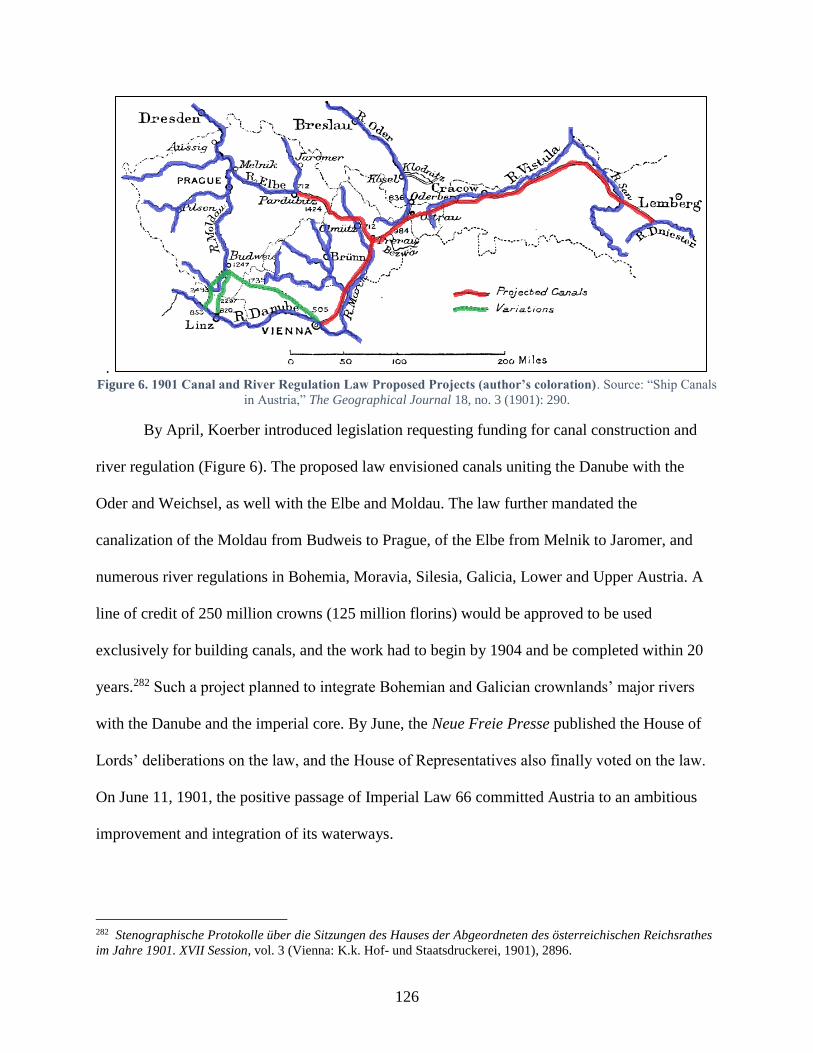
126
. Figure 6. 1901 Canal and River Regulation Law Proposed Projects (author’s coloration). Source: “Ship Canals
in Austria,” The Geographical Journal 18, no. 3 (1901): 290.
By April, Koerber introduced legislation requesting funding for canal construction and
river regulation (Figure 6). The proposed law envisioned canals uniting the Danube with the
Oder and Weichsel, as well with the Elbe and Moldau. The law further mandated the
canalization of the Moldau from Budweis to Prague, of the Elbe from Melnik to Jaromer, and
numerous river regulations in Bohemia, Moravia, Silesia, Galicia, Lower and Upper Austria. A
line of credit of 250 million crowns (125 million florins) would be approved to be used
exclusively for building canals, and the work had to begin by 1904 and be completed within 20
years.282 Such a project planned to integrate Bohemian and Galician crownlands’ major rivers
with the Danube and the imperial core. By June, the Neue Freie Presse published the House of
Lords’ deliberations on the law, and the House of Representatives also finally voted on the law.
On June 11, 1901, the positive passage of Imperial Law 66 committed Austria to an ambitious
improvement and integration of its waterways.
282 Stenographische Protokolle über die Sitzungen des Hauses der Abgeordneten des österreichischen Reichsrathes
im Jahre 1901. XVII Session, vol. 3 (Vienna: K.k. Hof- und Staatsdruckerei, 1901), 2896.
127
The new canal laws elicited a wide variety of reactions. Newspaper reports from Vienna,
Prague, and Graz immediately cover the law’s prospective effects, while other Viennese papers
communicated Dr. Lueger’s urgent request that the Lower Austrian Diet pass similar legislation
to affirm their financial commitments to the canal projects.283 The day after the law passed, the
Budapesti Hírlap’s headlines proclaimed the news. Unlike the affronted rhetoric that several
ministers and representatives had employed over the years during diet sessions about the canal –
oft quoted verbatim in the Hungarian papers – the Hírlap diplomatically referenced engineer,
recent interior minister (1892-1895), and current representative Károly Hieronymi’s levelheaded
assessment that the Danube-Oder Canal would undoubtedly influence the economic situation in
Hungary. Hieronymi suggested that it might even serve as a necessary impetus to revive the
government’s own, long-stagnant canal plans.284
Within the next few weeks and months, more moderated and detailed analysis provided a
critical view of the legislation and its perspective pitfalls. Viktor Ruß, House Deputy and
inveterate Danube and waterway lecturer, published a book about artificial waterways in the
aftermath of the Canal Law, in which he claimed that people were surprised about the legislation,
as many had not previously “had the occasion to busy themselves with the significance of this
type of travel.”285 This was a bit unexpected considering the near constant reference for decades
in papers across Austria about waterways, canals, or river regulation as well as the DDSG’s
ubiquitous advertising in papers across the monarchy. However, his first-hand experience
lecturing on the topic certainly lent credence to this observation. The Wiener Zeitung provided a
283 “Niederösterreichischer Landtag,” Deutsches Volksblatt, (Vienna, Austria), June 21, 1901;
“Niederösterreichischer Landtag,” Das Vaterland, (Vienna, Austria), June 21, 1901. 284 “Vasutak és csatornák,” Budapesti Hírlap, (Budapest, Hungary), June 12, 1901. 285 Dr. Viktor Ruß, Der volkswirtschaftliche Wert der künstlichen Schiffahrtsstraßen, (München:
Verlagsbuchhandlung Georg D.W. Callwey, 1901), 1.
128
substantial overview of the political work the Austrian provinces would need to prepare, in order
to implement the law with the greatest alacrity. The article still projected confidence that the
provinces involved – Upper Austria, Lower Austria, Bohemia, Moravia, and Galicia – would
benefit.286 Hungary’s most prominent German-language paper, the Pester Lloyd, dedicated three
days of front-page articles entitled “Our Waterways” to mourn Hungary’s lack of ambition –
even lack of discussion – on the issue of canals, and unreservedly blamed the decline in Danube
traffic on the river’s still incomplete regulation.287 Nevertheless, a few months later, the Pesti
Napló claimed that ever since the Austrians had passed canal legislation, it had taken over the
Hungarian agenda.288
As plans proceeded, there was speculation that the plans were too ambitious. In
September 1901, the British Geological Society published an article in the Geographical
Journal, which specifically delineated the challenges associated with digging canals in
mountainous Austria. The article pessimistically noted the difficulties of terrain and elevation
that engineers would be able to overcome, and negatively assessed plans to pour resources into
linking the Danube with Galician rivers like the Dniester, whose winding course toward Russia
the article claimed would never be consequential for imperial river traffic.289 On the other hand,
experts at the German-Austrian-Hungarian Inland Navigation Congress in Breslau expressed
confidence that they would overcome any technical issues that arose.290 However, when the
286 “Regulirung der Wasserläufe,” Wiener Zeitung, (Vienna, Austria), June 27, 1901. 287 “Unsere Wasserstraßen I.,” Pester Lloyd, (Budapest, Hungary), June 19, 1901; “Unsere Wasserstraßen II.,”
Pester Llyod, (Budapest, Hungary), June 20, 1901; “Unsere Wasserstraßen III.,” Pester Lloyd, (Budapest, Hungary),
June 21, 1901. 288 “Tudomány és Irodalom,” Pesti Napló, (Budapest, Hungary), October 10, 1901. 289 “Ship Canals in Austria,” The Geographical Journal, vol. 18, no. 3 (1901): 289-291. 290 “Fünfter deutsch-österreichisch-ungarischer Binnenschiffahrts-Congress,” Der Bautechniker, (Vienna, Austria),
September 13, 1901.

129
imperial government had made little headway in finalizing plans by the following April, some
Viennese papers voiced skepticism that the project would be implemented.
Part of the delay came from the monarchy’s federalized structure, as the law ceded
significant decision-making power to the provincial authorities, including the right to propose
specific canal routes. Upper Austrian lobbying revealed the entrenched provincial preferences.
On September 12, the Upper Austrian Trade and Business Association met to discuss, among
other topics, the Moldau-Donau Canal. The association was determined to petition the imperial
authorities to build the Danube-Moldau Canal from the Danube at Linz rather than Korneuburg
(near Vienna), and the business associations in Innsbruck and Salzburg supported its claim. The
association’s petition was just the latest in Upper Austrian advocacy. The “Action Committee for
Canal Construction Linz-Budweis” had already produced a policy paper, which had
recommended that the Danube-Moldau Canal be dug from Linz rather than from Korneuburg, as
it would be one-quarter the price and would promote the economic interests of Bohemia, Upper
Austria, Styria, and other provinces.291 The Upper Austrian governor Dr. Ebenhoch had urged
the k.k. Minister-President Koerber, k.k. Trade Minister Call, and the k.k. Section Chief Dr.
Stibral to consider plans to have the canal pass through his province. In October, the Linzer
Volksblatt published extracts from the Upper Austrian Landtag’s debates about the proposed
canal path, with one delegate asserting that taxpayers in Bohemia and the south and western
Alpine lands would only want to support a canal in Upper Austria.292
To coopt local loyalties and empower provinces to act in the imperial interests, the law
provided them with both an advisory role and legal authority to enact the legislation. A provision
291 Oberösterreichischer Landesausschuss (ed), Bericht über die Thätigkeit des oberösterreichischen Landtages und
des von diesem gewählten Landesausschusses in der IX. Wahlperiode vom Sommer 1896 bis Sommer 1902, (Linz:
Verlag des Landesausschuss, 1902), 244. 292 “Donau-Moldau-Canal,” Linzer Volksblatt, (Linz, Austria), October 16, 1901.

130
in the new law set up a Canal Council to coordinate canal construction and river regulation with
the interests of the provinces. The council was composed of half imperial appointees and half
provincial interests from different economic sectors – trade, industry, agriculture, forestry, Trade,
and labor. Local interests clamored to be represented in the council. Given the possible
trajectories for the canals, the Ölmutz Trade and Business Association in Moravia petitioned the
imperial government for the right to appoint representatives to the council, which the business
associations in Vienna, Linz, and Lemberg (Galicia’s capital) all backed. Land and forest
interests were concerned that the council would focus exclusively on trade and navigation
objectives for the canals and ignore forestry and agricultural needs.293 The new law authorized
provinces to employ eminent domain on behalf of the imperial projects to confiscate property
along proposed canal routes. In 1909, the k.k. Oberlandesgericht, the provincial appellate court
for Upper and Lower Austria, issued a ruling upholding the practice of eminent domain, set
down in law in 1878 and 1903, with regards to canal construction. Afterward, the court spent
more than a decade issuing annual modifications and clarifications to its ruling.
As the Reichsrat was finalizing its Canal Council legislation in October 1901, Franz
Joseph opened a new session of the National Diet in Budapest, where he took the opportunity, in
a litany of reforms, to suggest that the diet’s members pursue the improvement and expansion of
the kingdom’s natural and artificial waterways to solidify its economic and commercial
footing.294 One representative in the Képviselőház had already mentioned the “canal question” in
March 1900, but despite his impassioned appeal to construct more canals, the body remained
293 “Der Wasserstraßenbeirath und die Landwirthschaft,” Wiener Landwirtschaftliche Zeitung, (Vienna, Austria),
October 26, 1901; “Unsere “Wasserstraßen” und unsere Waldwirtschaft,” Österreichische Forst-Zeitung, (Vienna,
Austria), December 20, 1901. 294 Az 1901. évi október hó 24-ére hirdetett országgyűlés képviselőházának naplója, vol. 1 (Budapest: Pesti
Könyvnyomda-Részvénytársaság, 1901), 1-3.

131
indecisive.295 In early February 1902, after Franz Joseph’s speech, when the topic shifted to state
funding for infrastructure works, Count Béla Serényi argued that Hungary hardly had the
resources to expand its canal network, and he instead argued that the budget should focus on
making its Danube tributaries navigable first.296 He believed that this would increase traffic on
the country’s “main artery” of the Danube. Government ministers frequently moderated budget
discussions in the House of Representatives, and a few weeks later Finance Minister Lászlo
Lukács responded. He acknowledged that there were many voices for and against canals, but
reaffirmed the government’s commitment to building them and reassured the representatives that
the government would responsibly study the matter, so planned canals would benefit the whole
country and any ‘sacrifice’ was not disproportionate.297
The real debate about canals came later that year in April during a session on trade
ministry appropriations, when representatives animatedly exchanged concerns and questions
similar to the Reichrat’s about canals’ utility, cost, and purpose. Several acknowledged that the
press “feverishly covered” the topic and the public was beginning to welcome it. Csongrád’s
representative János Baross opened his discussion pointing to the evolving international customs
regimes and rail expenses, which should encourage Hungary to improve its waterways. In
particular, Baross believed a single canal between the Danube and Tisza, would overcome
Hungary’s inauspicious hydrography and open trade to the west for its raw materials. Besides
295 Deputy Pál Kovács, a rail engineer, gave an impassioned speech – pointing to the Netherlands and Belgium as
perfect examples – that regulating Hungary’s numerous rivers and even building new canals was the next step in
complementing its rail network, which would reduce transportation costs and encourage trade. Presaging larger
debates to come, he also postulated that a Danube-Tisza Canal would both improve navigation and help irrigate and
drain the land between the land’s two largest rivers, Az 1896. évi november hó 23-ára hirdetett országgyűlés
képviselőházának naplója, vol. 27 (Budapest: Pesti Könyvnyomda-Részvénytársaság, 1900), 37. 296 Az 1901. évi október hó 24-ére hirdetett országgyűlés képviselőházának naplója, vol. 2 (Budapest: Pesti
Könyvnyomda-Részvénytársaság, 1902), 243. 297 Az 1901. évi október hó 24-ére hirdetett országgyűlés képviselőházának naplója, vol. 3 (Budapest: Az
Athenaeum Irodalmi és Nyomdai Részvénytársulat, 1902), 89.
132
improving navigation, Baross and other colleagues argued that this one canal, and adjacent
drainage and irrigation canals, would transform the sandy, salty marshes between the Danube
and Tisza and open up fertile farmland, which beyond increasing the property value (and
concurrently growing the tax base), would draw Magyars back to the land, strengthening the
nation and convincing farmers to reject socialism.298 Despite the many advocates, who saw
canals and the Danube as a source of unity between both halves of the monarchy, Baross and his
colleagues, like Dr. Lueger in Vienna, viewed canals’ unifying principle from a more
nationalistic perspective.
Other representatives felt that Baross’ ideas were too myopic and missed the
opportunities that canal expansion could provide to strengthen the state. The representative from
Szombathely, Ferencz Major, who served on the Transportation Committee, believed that
Hungary had to massively expand its canal network to enhance the “natural treasure” of its river
system, which he claimed had been abandoned by greedy men pursuing unnecessary rail politics.
Rather than focusing on western trade, Major thought Hungarians should refine their own raw
materials, so they could dominate markets to the east.299 Baross’ colleague Lázár György agreed
with Major, but also reiterated Baross’ argument that irrigation would support the Hungarian
people. He also believed that expanded waterways would help in this endeavor by strengthening
Hungary’s place in Trade to the east. He cited the venerable Hieronymi to underscore the
importance of connecting and regulating the land’s many rivers – Tisza, Maros, Körös, Save, and
of course Danube – to connect both the German markets and the sea.
298 Az 1901. évi október hó 24-ére hirdetett országgyűlés képviselőházának naplója, vol. 5 (Budapest: Az
Athenaeum Irodalmi és Nyomdai Részvénytársulat, 1902), 126-35. 299 Ibid., 126-135.
133
These types of discussions continued annually over the next decade, though the National
Diet faced a perpetual impasse regarding canal expansion, despite the general support for at least
certain projects like the Danube-Tisza Canal. Partly, this came from the perpetual fear that it was
falling behind other nations. Representatives’ discussions frequently devolved into discussing
several solutions or assuring themselves that if they undertook plans they would become a world
economic power, but they never eventually coalesced around any definite plans. One impetus for
canal legislation – the initial fear that Austria would construct new canals and exclude Hungary
from river trade – faded as projects in the west remained in limbo. While successive government
ministers remained strong advocates for advancing canal construction – whether for agricultural
or transportation goals – representatives remained wedded to a policy of cautious indecision,
ambivalently approving consistent funds to regulate rivers but delegating nothing to expand their
reach.
Austria’s initial legislative success in 1901 aside, progress remained stagnant due to the
imperial government’s indecision about which projects it wanted to prioritize. Although
proposed plans for the Danube-Oder Canal existed, the other canals remained in the “study”
phase without definitive routes for several years. Furthermore, provincial diets in Moravia,
Lower Austria, and Galicia only approved legislation confirming their contribution for canal
construction and river regulation in March 1904, nearly three years after the original law.300
Some papers in Austria expressed doubt that canals’ construction would continue in the
originally envisioned form. However, as late as 1908 one claimed that “even the crownlands not
300 Gesetz 46 vom 2. März 1904, betreffend die Beitragsleistung zu den im Sinne des § 1 des Gesetzes vom 11. Juni
1901, R. G. Bl. Nr. 66, vom Staate auszuführenden Wasserstraßen; Gesetz 36, betreffend die im Sinne des § 1, lit. d,
des Gesetzes vom 11. Juni 1901, R. G. Bl. Nr. 66, in Galizien ausgeführten Wasserstraßenbauten; Gesetz 28,
wirksam für die Markgrafschaft Mähren, betreffend die Verpflichtung des Landes Mähren zur Beitragsleistung für
den in diesem Lande auszuführenden Teil der im § 1, lit. a), beziehungsweise c) des Gesetzes vom 11. Juni 1901,
R.-G.-Bl. Nr. 66, bezeichneten Wasserstraßen.
134
immediately touching the canal have been brought to the conviction that the completion of the
Danube-Oder-Weichsel Canal is a postulate of the state’s entire economy, for which the state’s
entire production cannot remain confined to individual lands or social orders.”301 This was in
direct contradiction to a report in the Hungarian papers that Austrian business circles were
turning against canal construction.
Despite the negligent progress and waxing pessimism about the canals in certain circles,
there were many who still supported hydraulic projects. In 1908, prominent river engineer and
Representative Iván Reök praised investment in river regulation, which had led to greatly
improved navigability on the Danube, Tisza, and major Tisza tributaries. In 1910, Franz Joseph’s
speech opening the National Diet exhorted the representatives to pass legislation to promote the
general well-being of all. Once again proposing reforms, he suggested initiatives crucial to
political, legal, and physical state-building, such as opening the franchise, respecting national
minorities’ rights, improving the public administration, and developing Hungary’s economy by
improving transportation on roads, rails, and waterways.302
Final Years of the Monarchy
In the last few years of the monarchy, the “canal question” in Austria became infused
with regional particularities, which the imperial government tried to weigh with its designs for
greater imperial integration. In 1910, papers covered Polish Club efforts in the Reichsrat to
introduce legislation for a “Weichsel-Dneistr-San-Canal,” to link Galicia’s three largest rivers.
The Galicians supported this canal because they believed it would lead to the development of
eastern Galician industry, which was dependent on cheap Galician coal. They hoped that access
301 “Massenkundgebung für den Bau des Donau-Oder-Kanals,” Die Arbeit, (Vienna, Austria), March 15, 1908; “Der
Donau-Oder-Weichselkanal,” Vorarlberger Volksblatt, (Bregenz, Austria), April 18, 1908. 302 Az 1910. évi junius hó 25-ére hirdetett országgyűlés képviselőházának irományai, vol. 1 (Budapest: Pesti
Könyvnyomda-Részvénytársaság, 1910), 1-3.
135
to cheap coal via canals would also help develop cheaper iron industry in western Galicia. The
imperial authorities initially suggested that it would give a certain subsidy for the project and
after forty years, it would obtain ownership via escheat. Funding would come from state (at the
Galician provincial level) and private funds.
Some voices demanded that any imperial canal investment necessitated canal integration
with the imperial capital rather than merely serve regional interests. The Catholic, pro-monarchy
mouthpiece, the Reichspost, claimed that such inter-Galician canals would not benefit the
imperial economy the same as a Danube-Oder-Dneister Canal – which it claimed “even honest
Poles would acknowledge.” It pointed to the Viennese tax burden and claimed that “as center and
heart of the empire,” it should not be excluded from the canal network.303 The government tried
to accommodate both perspectives, publishing its analysis of the costs and benefits of both plans.
The analysis took into consideration the canals’ pure costs, it analyzed previous years’ shipping
data on the rivers in question, calculated the future profitability of the canals themselves, and
predicted the state railways’ potential loss in revenue due to increased canal traffic and
competition.304 When rumors emerged in the papers two years later, spread by the Lemberger
Blatt in Galicia’s provincial capital, that Krakow was suspending its canal construction and that
workers were being posted to river regulation projects instead, the provincial authorities in
Lemberg tried to reassure the local population that Galicia’s interests in the Reichsrat –
dominated by the Polish Club – still unanimously supported the projects.305
By 1912, the difficulty balancing these projects led the government to acknowledge the
need to revise the 1901 Canal Law due to technical and financial difficulties. One paper
303 “Wien, die Deutschen und die Schiffahrtskanäle,” Reichspost, (Vienna, Austria), August 20, 1910. 304 “Regierungsbericht über die Wasserstrassenfrage,” Neue Freie Presse, (Vienna, Austria), September 6, 1910. 305 “Die Kanalbauten in Galizien,” Neue Freie Presse, (Vienna, Austria), August 27, 1912; “Parlamentarisches,”
Neues Wiener Tagblatt, (Vienna, Austria), August 28, 1912, p.4; Fremdenblatt, (Vienna, Austria), August 29, 1912.

136
succinctly summarized the Zeitgeist, saying “although the public opinion and government were
happily confronted with the canal idea, the politically viable moment had arrived too early. None
of the public discussions included exact studies of the proposed projects, which would provide
estimates for the profitability of the construction.”306 Instead, the government urged the
Reichsrat to craft another law to focus on implementing the most urgent regulation works and
requesting 193 million crowns to cover the project.307 The Reichsrat deputies negotiated the
conditions under which other crownlands would support regulation – mostly by extracting
promises that the Danubian lands themselves would shoulder most of the costs, though
sometimes tying their support to unrelated, regional interests as well.308
In Hungary, the same policy discussions were taking place regarding the integration of
different regions and economies via “Hungarian” rivers, but almost all proposals were devoid of
plans to coordinate with the Viennese authorities and implement a common waterway network.
Instead, as in Galicia, particularism manifested itself in the inveterate concern that Hungarian
waterways weren’t developed sufficiently to promote the national well-being. Discussions in the
House of Representatives from 1910 to 1914 revealed a genuine desire to expand waterways or
at least construct better infrastructure, such as transshipment stations, to ensure that river and rail
traffic could complement each other and grow simultaneously. Likewise, in 1912 Agriculture
Minister Count Béla Serényi requested expanding the budget to improve navigation on the
Hungarian rivers, which were instrumental in linking resource-rich regions via the Danube to
306 “Die Aenderung des Wasserstrassengesetzes,” Neues Wiener Tagblatt, (Vienna, Austria), January 18, 1911. 307 Richard van der Borght, Das Verkehrswesen, (Paderborn: Salzwasser-Verlag, 2011), 370. 308 In one instance, delegates desired to negotiate the issue of a Ruthenian-language university in Galicia in
conjunction with the proposed waterway budget and plans.
137
those areas in need.309 On the other hand, these policies fought against the tide of opinion, which
championed rails, not waterways, for the economy’s vitalization.
The First World War
Although the First World War was hardly foreseeable in January 1914, the German
Military Administration’s decision to develop greater waterway networks to “secure food supply
in the interests of the country’s defense” re-introduced an old argument for improving
waterways: survival and defense.310 As part of the defensive limes, the Romans had literally used
the river to protect themselves from the Germanic tribes, whereas the Germans in 1914 saw
waterways as an indirect source of their autarky and self-preservation. Unsurprisingly, this topic
also gained traction in the Habsburg Monarchy once the war began. The military alliance with
Bulgaria and the Ottoman Empire led some representatives in the House of Representatives to
speculate that the Danube would become an even more important trade route.311 Once Romania
entered the war on behalf of the Entente Powers in August 1916, however, it endangered not
only the Central Powers’ territorial integrity but also threatened to cut off the riverine connection
between allies. A few months later, Romanian forces were entrenched on the Danube’s northern
banks and one of Budapest’s papers claimed that the river, which Hungarians had taken for
granted for too long, was suddenly imperative to the war effort, with ships shuttling around food
and munitions, which “one could almost say are deciding the war.”312
Hungary was not alone in “re-recognizing” the Danube’s significance during the war.
The Central Powers met several times between 1916 and 1917 to discuss the Danube’s future
309 Az 1910 évi június hó 21-ére hirdetett országgyűlés képviselőházának naplója, vol. 17 (Budapest: Az Athenaeum
Irodalmi és Nyomdai Részvénytársulat, 1913), 360. 310 Die Zeit, (Vienna, Austria), January 29, 1914. 311 Az 1910 évi június hó 21-ére hirdetett országgyűlés képviselőházának naplója, vol. 17 (Budapest: Az Athenaeum
Irodalmi és Nyomdai Részvénytársulat, 1913), 393. 312 “A meghóditott Duna,” Fővárosi Hírlap, (Budapest, Hungary), January 3, 1917.
138
role in their cooperation and reconstruction. A month after Romania’s declaration of war, in
September 1916, over 600 delegates from Germany, Austria, and Hungary met in Budapest at
the “Danube Conference” to discuss the future of the Central Europe’s economic and
commercial integration. The day of the conference, the Pester Lloyd published an article about
forthcoming agenda, which it claimed “should lay a significant piece for the beginning of the
peaceful, postwar work, the basis for which is the ‘holy Danube’ [heilige Donau].”313 Some of
the delegates from Germany and Austria arrived in Budapest on board the newly built steamship
Franz Joseph I., on which the German delegates had already sailed from Passau to Vienna.
At the conference, the delegates outlined a future industrial, commercial, and agricultural
space – a Danube space – developing independently from other European powers after the war.
To accomplish this, the conference attendees resolved to commit to a massive, joint investment
in river regulation, transshipment facility construction, and canal expansion. The following
summer, in June 1917, delegates met in Vienna for another “Canal Congress” to solidify plans.
Papers around the monarchy covered the deliberations, and opinions filtered well outside the
capitals. Esztergom’s mayor Dr. Béla Antóny penned a piece on the congress’s goals, claiming
they were crucial for the postwar order. Antóny postulated that any future victory must be tied to
the question of “general human well-being and prosperity,” which required tackling the big
issues of the day – “Central European economic union, waterways, the right to vote, and the
question of democratic state organization.”314 Not unlike Franz Joseph’s speech in 1910, the idea
of reconstruction and state-building required the firm commitment to democratic and legislative
reforms, but also progression toward economic and geo-physical integration through
interconnected waterways.
313 “Die Donaukonferenz,” Pester Lloyd, (Budapest, Hungary), September 4, 1916. 314 Béla Antóny, “Osztrák vizi-utak kongreszszusa Bécsben,” Esztergom, (Esztergom, Hungary), July 5, 1917.
139
Even in war, members of the government and civil society in the Habsburg Monarchy
formulated ambitious Danube endeavors, which they and their forbearers had pursued for
centuries. They re-lit the spark of cooperation and unity along the Danube and re-positioned the
river as the key to states’ economic prosperity and material well-being. A presentation by k.k.
Chief Engineering Officer Rudolf Halter in November 1917 praised the slight, but ongoing
progress of hydraulic projects during the war itself; a river dam had been erected to provide
water for the Danube-Oder Canal, the Galicians had broken ground on their canal connecting the
Weichsel to the Danube-Oder Canal, and the Upper Elbe River regulation was underway.315
What none of the delegates ever envisioned, however, was the possibility of losing the war or
that the monarchy would collapse. Instead, they built a future for themselves along the Danube,
hoping to turn the river into an artery assimilating people and regions across Central Europe.
Conclusion
The goal of Central European integration, even during the war, was perhaps a natural
culmination to the centuries-long policies and agendas articulated in the Habsburg Monarchy to
regulate the Danube, improve the navigability of its tributaries, and eventually strive to extend
the reach of those waterways. As countless newspaper articles, commercial guides, associational
presentations, parliamentary debates, technical reports, and other documents made clear, the
Danube and its tributaries provided the monarchy with a natural network to connect people and
economies from east to west. The challenge was overcoming technical difficulties in engineering
and finding the financial and later political capital to implement hydraulic proposals.
315 Rudolf Halter, “Das zentraleuropäisclie Wasserstraßennetz. Vortrag, gehalten den 28. November 1917,”
ZOBODAT Zoological Botanical Database, accessed October 10, 2015,
http://www.zobodat.at/pdf/SVVNWK_58_0063-0090.pdf.

140
But it was not an easy or strictly linear progression. In the late eighteenth and early
nineteenth century, the Danube’s near wild, unregulated stretches acted as a catalyst for the
formation of bureaucratic departments to address the river’s shortcomings as a trade route.
Nevertheless, the persistence of provincial and county-level management for hydraulic
engineering projects precluded a coordinated plan for the Danube’s regulation. Chronic
underfunding, or stagnant progress on new works, along with perennial and destructive flooding,
continued to plague efforts to enact permanent improvements.
The neo-Absolutist era in the 1850s constituted the first time that political and technical
hierarchies across the Danube space were subordinated to an ultimate power in Vienna. The
Danube presented the imperial authorities there with a tangible project to ameliorate conditions,
which had aggravated discontent in the Vormärz period, and to regain legitimacy in the eyes of
the public. The newly appointed Minister for Trade, Industry, and Public Works Baron Karl
Ludwig von Bruck addressed Emperor Franz Joseph in November 1849, insisting that the new
“General Engineering Directorate” under his command would unite the previously separate
engineering departments and mobilize material, technical, and administrative support to
overcome deficiencies in each, which had encumbered earlier work.316 Funding for regulation
increased significantly throughout the monarchy, as the administration sought a more holistic
approach to regulation, which took into consideration the improvement of both the Danube and
its tributaries. Technical authorities also mindfully accepted petitions and granted audiences to
members of the public to guide this process.
316 “Allerunterthänigster Vortrag des treugehorsamsten Ministers für Handel, Gewerbe und öffentliche Bauten über
die Organisirung der Bau-Behörden,” Bauverordnungsblatt für das Kaiserthum Oesterreichs, (Vienna, Austria),
accessed September 1, 2017, http://anno.onb.ac.at/cgi-content/anno-
plus?aid=abz&datum=1850&size=45&page=768.
141
Regulation work was not enough to eliminate the particularistic demands in Hungary, yet
when the Ausgleich finally ceded internal autonomy back to the authorities in Buda, its newly
formed ministries nevertheless continued to work with those in Austria to ensure that shared
problems on the Danube sought common solutions between the two halves of the monarchy. The
additional bureaucracy complicated progress, but their continuity indicated the enduring
recognition that more than the official Joint Ministries (finance, war, and foreign affairs) linked
their people together.
New technical and hydraulic advancements – embodied by the opening of the Suez Canal
in 1869 – enlivened discussions about the Danube’s potential in the 1870s. Initial deliberations in
the newly-opened representative bodies in Vienna and Pest separately but similarly iterated the
river’s importance, particularly due to its far-reaching tributary network, for integrating
commerce in each half of the monarchy. Diets consistently approved ministerial budgets to
maintain waterways, and while deputies in Vienna’s Abgeordnetenhaus even pursued early
legislation to construct new waterways in Austria in 1873, encouragement from technical experts
and ministers could not convince representatives in Pest’s Képviselőház to invest in new canals
at the time. Increasing pressure from international organizations, associations with Hungarian
and Austrian participants, and civil society eventually prompted representatives to approve
legislation in the 1880s and 1890s targeted at completing regulation on the Danube and
tributaries once and for all.
In the last few decades of the monarchy, a renaissance in the “canal question”
underscored the persistent belief that building the state required more than political or economic
reforms, but involved a commitment to constructing a physically integrated space as well.
Admittedly, representatives did not always whole-heartedly embrace canal plans, and technical
142
difficulties and delays led to doubts about their eventual implementation. However, like earlier
governance under the emperor, ministers in each respective imperial and royal government
frequently and often convincingly suggested and defended proposals to expand waterways as
crucial to create a unitary state. Unfortunately, parallel conversations in Budapest and Vienna
evoked each other less and less frequently, except to compare rather than compliment the other’s
progress.
By the First World War, the monarchy contained more than 12,000 km of navigable
waterways, approximately 5,000 km of which steamships could ply.317 The war drew significant
attention to the Danube’s utility and launched hopes among the Central Powers that it would
underpin integration on a far greater scale than the imperial authorities had actually envisioned.
The war’s end cut short these discussions, and the monarchy’s successor states soon discovered
the painful realities of independence and separation from the beneficial, socio-economic space
that the monarchy and the Danube within it had provided.318
317 A Magyar Kir. Központi Statisztikai Hivatal (ed), Magyar Statistikai Évkönyv: Új Folyam XXII. 1914, (Budapest:
Az Athenaeum Irodalmi és Nyomdai Részvénytársulat Könyvnyomda, 1916), 183; K.k. Statistischen
Zentralkommision (ed), Österreichisches Statistisches Handbuch: Dreiundreissigster Jahrgang 1914, (Vienna:
Verlag der k.k. statistischen Zentralkommission, 1916), 162. 318 Ivan Berend and Gyorgy Ranki, “Economic Problems of the Danube Region after the Break-Up of the Austro-
Hungarian,” Journal of Contemporary History, vol. 4, no. 3 (1969): 169-185.

143
CHAPTER 3: THE DANUBE AS A PEOPLE NETWORK
“The Danube is not only a trade and traffic path, but is also significant for the
cultural-historical relations along it. The history and development of many nations
in middle and south Europe, are tightly bound with this mighty river… The trade
and ship traffic brought all these people together.”319
This description of the Danube appeared in a German travel guide published in 1880 for travelers
taking a trip down the river. It mentions not only the economic role that the river played but also
the socio-cultural function it served as a unifying, natural feature in a diverse region. While the
tone is rather hifalutin, its sentiment mirrors other publications at the time, which underscored
this important connection between Danube and people.320
As the previous chapter explored, governments from the municipal to imperial level re-
arranged physical spaces along the Danube to provide a suitable pathway for the movement of
goods and people. This chapter looks at the intersection of those physical arrangements with the
social practices and policies to imagine how they forged an imperial people network from the
Danube’s natural riverine connections.
The Danube was a distinct feature of state-building for the Habsburg imperial regime.
While other rivers, such as the Rhine, Seine, or Thames certainly played into popular narratives
of ‘national’ rivers, they were not geographically coterminous with the national state. The
Danube Basin very nearly touched the entire Habsburg Monarchy, and concerted efforts existed
in the last half of the nineteenth and early twentieth centuries to extend remaining canals and
waterways to incorporate populations in the Bohemian and Galician provinces. Practices and
319 Alexander F. Heksch, Illustrirter Führer auf der Donau von Regensburg bis Sulina, (Vienna; Pest; Leipzig,
1880), v, vi. 320 Carl Freiherr von Czoernig, Österreich’s Neugestaltung, 1848-1858, (Stuttgart; Augsburg: J. G. Cottáscher
Verlag, 1858), 329; Franz Foetterle, Mittheilung der kaiserlich-königlichen Geographischen Gesellschaft, (Vienna:
Druck und Verlag von F. B. Geitler, 1863), 121; Amand von Schweiger-Lerchenfeld, Die Donau als Völkerweg,
Schiffahrtstrasse, und Reiseroute, (Vienna; Budapest; Leipzig: R. Hartleben’s Verlag, 1896), v.
144
interactions along these waterways revealed a population that relied on the river for its
livelihood. Trade and passenger traffic took on greater importance, because they represented and
underpinned social and economic cohesion when extreme political disunity sometimes
characterized the monarchy’s functioning. As the century progress, new arrangements and
evolving practices nevertheless strengthened the Danube’s position as an imperial space for the
citizens working, traveling, and living along it.
The famed Habsburg bureaucratic state has left behind a paper trail of activities on the
river. Scores of bureaucratic memos, commercial reports, governmental petitions, and statistical
studies detail everything from the business concluded and the number of passengers conveyed, to
the practices regulated, some which thrived thanks to the Danube’s ‘improvement’ and others
which declined in the face of competition and state-led efforts to ‘modernize’ the river.
A small snapshot of the social and commercial connections on the river is revealing: from
1840 to 1868, the number of people traveling on the Upper Danube increased from 74,000 to
over 2,000,000 annually.321 In 1870, approximately three-quarters of the goods reaching Vienna
still did so via the Danube.322 In 1851, the Imperial-Royal First Privileged Danube Steam
Navigation Company (DDSG) had 85 steamship stations on the monarchy’s waterways, and by
1893, it had over 300 freight and passenger stations throughout Central Europe.323 By the early
321 “ K.k. Statistische Central-Commission (ed), Statistisches Jahrbuch für das Jahr 1868, (Vienna: K.k. Hof- und
Staatsdruckerei, 1870), 127. 322 Jan Mokre, “The Environs Map: Vienna and Its Surroundings c.1600-c.1850,” Imago Mundi 49 (1997): 91, 93. 323 K.k. Direction der administrativen Statistik (ed), “Dampfschiffahrt,” Tafeln zur Statistik der österreichischen
Monarchie für die Jahre 1849-51, Vienna: 1856, pg. 281-97, From Österreichische Nationalbibliothek (ÖNB),
http://digital.onb.ac.at/OnbViewer/viewer.faces?doc=ABO_%2BZ150838108 (accessed March 8, 2017); The
DDSG had 155 stations total across Europe, 128 were on the Danube, 3 on the Drave, 10 on the Tisza, 11 on the
Save, 2 on the Bega Canal and 1 on the Franz Canal, locations which translated to 6 in Bavaria, 28 in Austria, 82 in
Hungary, 4 in Bosnia, 9 in Serbia, 18 in Romania, and 8 in Bulgaria. Jacob Deutsch, Bericht an den löblichen
Administrations-Rath der Ersten k.k. priv. Donau-Dampfschifffahrts-Gesellschaft über die Verhandlungen des V.
Binnenschiffahrts-Congresses in Paris 1892, Second Edition, (Vienna: Druck und Verlag der I. k. k. priv. Donau-
Damptschiffahrts-Gesellschaft, 1894), 202.
145
1880s, it had become the largest inland shipping company in the world. The Hungarian Central
Statistical Office recorded shipping data from 1870 onward, which registered over 50 steamship
companies of varying sizes operating on the Danube, Tisza, Save, and Drave Rivers.324
These numbers indicate the Danube’s continued salience for daily travel and trade in the
monarchy but present a narrow view of the interactions between people, products, and policies,
which intersected to influence daily life on the river. This chapter will explore the policies that
governed interactions between humans and their environment, and how the Danube also
influenced these policies. Because of the rich complexity of people and practices on the river, the
chapter provides an at times sporadic view of the long nineteenth century. I have chosen to
emphasize interactions, some which deepened the people’s connection to the Danube, others
which fostered intra-imperial communication and relations. These exchanges – not without some
tension – nevertheless reveal that despite the somewhat antagonistic, nationalistic rhetoric in
high political realms, commercial and personal traffic on the Danube continued to strengthen
bonds between both halves of the monarchy up until the First World War.
Early Practices and Connections
In the early nineteenth century, while practices such as fishing, sailing, or milling
remained virtually unchanged from earlier centuries, the Danube itself was in constant
transformation, as people actively and inadvertantly modified the river’s environs through the
arrangements that facilitated these practices. These were inherently local projects. To enable rafts
and ships to pass rocky rapids and avoid sandbanks heading downstream, communities and
technical experts dredged and blasted hindrances in various stretches of the river.325 Boats
324 The Magyar Statistikai Évkönyv [The Annual Hungarian Statistical Report] published starting in 1872 for the
year 1870. The editor’s introduction indicates that collecting statistics for Hungary was a tricky endeavor. 325 Otto Meissinger, Historische Donauschiffahrt: Holzschiffe u. Flösse, (Melk and Vienna: Verlag Kurt Wedl,
1975), 39.
146
traveling upstream relied on favorable winds or muscle-powered labor such as rowing and
towing; practices which had profound impacts on the Danube.326 Towing required local
communities to maintain towpaths along the river, along which teams of horses, oxen, and men
could walk when pulling ships upstream.327 To clear pathways, these communities denuded trees
on the river banks, which would hinder progress.328 Without tree roots to anchor the bank’s soil,
the rivers found less resistance and began to erode the banks. Over time, this process forced the
river to meander laterally, sometimes branching into shallower side arms unsuitable for
navigation.329
While the river’s dynamic behavior sometimes made navigation difficult, it nevertheless
offered the easiest way to transport heavier or bulkier items given the monarchy’s
underdeveloped overland routes.330 One author claimed in 1813 that ships were the preferred
326 According to István Széchenyi, social and ecological factors limited the profitability of earlier shipping industry,
which hired men and cattle to pull boats upstream. Széchenyi contended that it was only profitable where wild land
along the river provided unbounded fodder for cattle and small towns’ residents had no other profession or trade
other than as a laborer – a situation which landownership along the river made unprofitable (too expensive to pay for
land-access) or larger towns’ work opportunities made unappealing, Széchenyi, Über die Donauschiffahrt, 14. 327 The duration of towing depending on the boat sizes, water levels, path quality, and amount of available daylight.
In the summer, an average trip from Vienna to Linz took 14 days, whereas in the fall, this could take three to four
weeks. A trip from Pest to Vienna took five to six weeks, Raimund Hinkel, Wien an der Donau: Der große Strom,
seine Beziehung zur Stadt und die Entwicklung der Schiffahrt im Wandel der Zeiten, (Vienna: Christian Brandstätter,
1995), 113. 328 Until steamships and eventually railroads made towpaths superfluous, they facilitated movement of goods
upstream. Successful upstream trade required the proper maintenance of towpaths. In the 18th century and earlier,
swampy land adjacent the river, particularly along the Hungarian stretch, made it difficult for merchants to pull ships
upstream. To clear these towpaths, the Navigation Directorate suggested to the imperial authorities that residents
along navigable rivers clear trees away from river banks – up to six fathoms – to enable the construction and
maintenance of towpaths. Incidentally, during their 1773 examination, the Directorate indicated other problems for
towpath maintenance, for example, when the Danube flooded near Bratislava, the tow paths were completely
inundated and useless for merchants. There were even stretches on the Danube where towpaths didn’t exist at all –
such as the 53-mile stretch between Semlin and Földvár. The state took other measures to regulate this practice to
maximize efficiency: the state encouraged merchants to use oxen rather than humans to tow ships, as it would keep
shipping costs down and make products more competitively priced in upstream market – an argument it would later
make to ease the transition to steamships. 329 Ritter von Pasetti, Notizen über die Donauregulierung im österreichischen Kaiserstaate bis zum Ende des Jahre
1861 mit Bezug auf die im k.k. Staatsministerium herausgegebenen Übersichtskarte der Donau, (Vienna: k.k. Hof-
und Staattsdruckerei, 1862), 7. 330 Any time rain fell in Hungary during the early 19th century, half the country, “became a swamp,” and only public
roads leading to the coast or in the mountains, “could be used on a permanent basis,” Zsuzsa Demény and Gyula
Holka (eds), Statistics of the Centuries, (Budapest: Hungarian Central Statistical Office, 2002), 140. Towing not

147
method for travel, as rivers were smoother, less prone to accidents, and more scenic than
roads.331 Regular passenger traffic had already arisen in 1696, when a so-called “Ordinarischiff”
took people from Regensburg to Vienna once a week. The journey lasted one week in favorable
conditions but up to 20 days if it encountered low water, storms, fog, wind, or difficulty when
passing bridges.332
Considering the relative ease and lower expense of shipping goods on the Danube, even
accounting for labor costs and customs dues, cities relied on this flow of goods for trade,
consumption, and growth. Lumber and firewood, construction materials, foodstuffs, and
industrial goods among other items arriving in masses along the Danube fueled urban
development.333 A plethora of groups in the monarchy depended on it for their livelihood:
merchants, lumberjacks, sailors, miners, blacksmiths, farmers, landowners, fishermen, millers,
and many others used the river for transport, trade, irrigation, and industry. This connection
made the river an attractive location to be near. In the 1820s, papers in large cities like Vienna
and Pressburg/Pozsony published housing advertisements that frequently cited the property’s
distance to the Danube.334 In January 1829, for example, an owner advertised in the Pressburger
Zeitung (in Hungary) that his house was close to the Austrian border, near the Danube, which
only affected the river’s hydrology, but Hungarian historical geographers like Róbert Győri and Pál Beluszk have
argued that the distance between towns on the Hungarian Danube even corresponded to the distance a tow team
could travel upstream in a day. 331 Reise auf der Donau von Ulm bis Wien, mit Angabe aller Städte, Flecken, Dörfer, Schlösser, u. an beyden Ufern,
ihrer vornehmsten Merkwürdigkeiten, und der Flüsse, welche sich mit der Donau vereinigen, (Nördlingen:
Beck‘schen Buchhandlung, 1813), foreword. 332 Meissinger, Historische Donauschiffahrt, 16. 333 Simone Gingrich, Gertrud Haidvogl, Fridolin Krausmann, “The Danube and Vienna: urban resource use,
transport and land use 1800 to 1910,” History of Urban Environmental Imprint 12, no. 2 (2012): 283-294. 334 These small advertisements were printed in the last pages of the newspaper, where houses, businesses and plots
of land were sold. A very frequent descriptor indicated a property’s proximity to the Danube, which combined with
qualifiers such as “fertile land” and “perfect for commerce on the Danube.” One ad in the Wiener Zeitung even
mentioned that the property was three hours away from “a river, which flowed into the Danube and would enable
trade with Turkey,” which also mentioned that it would facilitate trade with Hungary, which would likely need
goods from upstream.
148
connected it to commercial markets and would allow any future owner to profit greatly from any
products from the land.335
Imperial initiatives or local ordinances did try to regulate or influence practices along the
river, though these revealed conflicting priorities for the river’s usage. For example, Joseph II
strove to reduce the customs and duties that different cities could raise on merchants passing by
on the river. On the other hand, an obvious hindrance to trade were the imperially-bestowed
Stapelrechte or “stacking rights,” which forced merchants to unload their wares in privileged
cities and offer them for sale before they could continue their journey.336 Even more onerous was
the customs barrier which hobbled trade between Austria and Hungary. The barrier existed
because the Hungarian National Diet exempted nobles from paying taxes. To ensure that
Hungary nevertheless contributed funds to the imperial coffers, the imperial government raised
tariffs on agricultural products that Hungary exported to Austria and levied dues on any
industrial goods that Hungary imported from Austria.
At the local level, divergent practices also caused inherent tensions and conflicts
regarding the river’s usage. To promote navigation, a Lower Austrian circular requested that
people living along the March River maintain towpaths. The provincial ordinance gave clear
preference to river commerce over other activity, as it commanded citizens to move milling and
fishing equipment to a location that wouldn’t hinder navigation whenever ships were present.337
These directives also emphasized the protection of property. With rising ship traffic, the Austrian
State Chancellery issued a decree to monitor ships’ movements to avoid collisions that would
335 “Lizitation Curialhaus,” Pressburger Zeitung, (Bratislava, Slovakia), January 16, 1829. 336 Alfred Hoffman, “Die Donau und Österreich,“ Südosteuropa-Jahrbuch 5 (Munich: Südosteuropa-
Verlagsgesellschaft m.b.H., 1961): 31. 337 The last requirement indicated a clear preference for navigation rather than small, local businesses on the river,
K.k. Landesregierung im Erherzogthum Oesterreich unter der Enns, Polizie Vorschrift für den March-Fluss,
(Vienna, 7. May 1825).

149
damage ships or interfere with the provincial governments’ hydraulic engineering projects.338
Regulations sought to guarantee a few key points: safety, commercial benefit, and, when
properly implemented, communal well-being. However, the reality of such laws was more
multifaceted and reflected a multitude of interests such as imperial or municipal privileges,
strong commercial voices, and the desire to improve navigation.
1830: Early Steam Power, Innovative but Modest
Practices, usage, dependencies, and connections along the Danube gradually shifted with
the introduction of steam navigation. Passenger traffic became more common as travel became
easier. Traditional shipping continued to exist throughout the century, but along stretches where
steamships could overcome the Danube’s current, rafts and galleys dwindled and slowly
disappeared. With new practices on the river, the monarchy’s citizens developed new
commercial and personal connections. The central government also increasingly intervened to
work with local authorities to oversee and regulate progress on the river and to ensure that the
Danube remained a source of common use and benefit.
As steam navigation arrived on European rivers in the early nineteenth century, it
represented a major boon to many contemporary observers. One commercial guide opined that it
was merely necessary to look at the steamship companies rapidly expanding on the rivers and
lakes throughout Europe to discern its advantages.339 In 1830,the Habsburg Monarchy had one
338 The decree protected ships from damaging each other and ensured that the Hydraulic Engineering Directorates’
projects remained undisturbed, Anonymous, Donau-Strom-Polizei-Vorschrift. Hofkanzlei-Decret vom 24. December
1827. Regierungs-Verordnung vom 30. März 1828, accessed January 1, 2017,
https://play.google.com/books/reader?id=UJJpAAAAcAAJ&printsec=frontcover&output=reader&hl=en&pg=GBS.
PA3. 339 For example, the Cölner-Niederrheinische-Dampfschiffgesellschaft had 15 steamers and in 1833 transported
100,000 people on the Rhine, with services running from Cologne to Kehl, Siegfried Becher, Handelsgeographie
zum Gebrauche für Kaufsleute, Fabrikanten, Geschäftsmänner und Handelschule, vol. 1 (Vienna: Verlage bei Carl
Gerold, 1837), 173.
150
steamship company on its waterways, the Danube Steam Navigation Company (DDSG), whose
relationship with the imperial government was discussed in Chapter 1. In spring 1830, the DDSG
operated a single steamship between Vienna and Pest once a month. By 1835, the DDSG’s
steamships traveled from Vienna down to the Danube Delta into the Black Sea, making 64 trips
on the Upper Danube, which by 1841 had increased six-fold to 364 trips. In 1836, an Irish
journalist published his account from the Danube, declaring “steam navigation of the Danube
will be a most powerful instrument of civilization: for it is quite true that steam and civilization
are daily becoming almost convertible terms.”340 Of course, the river still dictated the terms of
navigation, and the DDSG general assembly in 1838 acknowledged that “nowadays, the
regularity of our goods-transport arrivals remains entirely dependent on the river’s mood.”341
Despite popular enthusiasm for steam navigation’s potential, steamships didn’t replace
traditional shipping on the Danube for several decades. In 1835, the DDSG only had six
steamships, whereas one of the wealthiest shipbuilders in the monarchy, Matthias Feldmüller,
managed 350 ships regularly going upstream from Persenbeug in Lower Austria to Regensburg
in Bavaria and another 850 ships traveling downstream from Vienna to Pest.342 One 1839
statistical overview of the monarchy suggested that the total number of ships and rafts on the
Danube was likely between 6,000 and 7,000.343 While steamships eventually increased in
significance, even in 1875, an official for the k.k. River Engineering Office [Strombauleitung] in
Grein, Upper Austria counted vessels passing the town from 1858 to 1874 and calculated that of
the nearly 127,000 boats, only 29% were steamships, while the rest were traditional galleys and
340 Michel J. Quin, A Steam Voyage Down the Danube: With Sketches of Hungary, Wallachia,
Servia, Turkey, Etc, 3rd London Edition (New York: Theodore Foster, 1836), 88. 341 Sitzungs-Protocoll der General-Versammlung der k.k. priv. ersten Donau-Dampfschiffahrts-Gesellschaft vom 29.
Jänner 1838 (Vienna: A. Strauß’s fel. Witwe, 1838), 8. 342 Otto Meissinger, Historische Donauschiffahrt, 39. 343 Johann Gottfried Sommer, Das Kaiserthum Oesterreich, geographisch-statistisch dargestellt, (Prague: J.G.
Calve’sche Buchhandlung, 1839), 9.
151
rafts. Because steamships could overcome currents and sail upstream, while they only accounted
for approximately 18% of all traffic sailing downstream, they made up 80% heading upstream.344
Despite the small number of steamships in the 1830s and 1840s, the imperial authorities
were extremely accommodating to the modern technology. Besides Franz granting the company
a 15-year monopoly on all steam navigation in the monarchy in 1830, the administration also
signaled its willingness to modify both natural and human-built environs to assist steamships. In
September 1837, the DDSG constructed a steamship strong enough to overcome the Danube’s
current above Vienna for the first time, and within two weeks of its maiden voyage, the company
was advertising regular Lustreisen [pleasure cruises] in the newspapers, which departed from
Vienna for Melk in the Wachau. Immediately thereafter, the Central Ministry’s Head of Internal
Affairs Franz Ottenfels-Gschwindt informed the DDSG that the State Treasury would take on all
costs associated with rebuilding bridges between Linz and Vienna, in order to permit steamships
to pass.345 This was of genuine concern: the first steamship arriving in Linz could not have sailed
any further upstream because of town’s wooden bridge spanning the Danube.
Steamships also led to a new era of personal travel on the Danube. The arrival of
steamships in Pest after 1830 led to a flowering of tourism. Modern, luxurious hotels welcomed
foreign visitors from the Danube, who could now stay at the Angol Királynő (Queen of
England), István Főherczeg (Crown Prince Stephen), and Európa Hotels opening in the late
1830s and 1840s.346 In 1838, the Vienna-based paper Der Adler rhetorically asked whether
Austria was ‘progressing,’ and answered by delineating its advances in technology and industry,
344 “Schiffverkehr auf der oberen Donau,” Statistische Monatsschrift 1 (Vienna: Alfred Hölder, 1875): 34. 345 Franz Ottenfels-Gschwindt to DDSG Administration, 27 September 1837, Széchenyi iratok, Magyar
Környezetvédelmi és Vízügyi Múzeum [Hungarian Environmental and Hydrological Museum], Esztergom,
Hungary. 346 Zsuzsa Demény and Gyula Holka (eds), Statistics of the Centuries, (Budapest: Hungarian Central Statistical
Office, 2002), 164.
152
trade, population, and the like, with enterprising cooperation manifested by railways and “the
Danube’s coverage in steamships.”347
Steam-powered Danube traffic was highly valued because traditional shipments already
played such a large role connecting communities along the Danube and driving commercial ties
to the river’s hinterlands. In 1838, a source described how the inhabitants in Stein and its
adjacent town Krems lived well from trade along the river. They welcomed ships and rafts
coming down the Danube and Inn from Swabia, Bavaria, and Tirol, as well as ships rowing up
from Hungary carrying wine, grains, or other wares. Steamships landed there to supply
themselves with coal, or to pick up or drop off passengers, and the source even mentioned that
the proprietor of the inn ‘Zum Elephanten,’ Mr. Eder, was the DDSG’s agent in town. The city’s
connections on the river drew commerce from several surrounding provinces. For example,
“Stein serve[d] as the entrepôt for Moravia and Bohemia. Wine, wood, and fruit are all brought
there en masse and shipped along on the Danube.”348
Besides connecting the commercial hinterlands to the Danube, steamships also offered
opportunities to enhance the transport of agricultural products upstream from the heavily
agrarian Hungarian territories. Customs statistics measuring trade between Hungary and the
other provinces in the monarchy indicate that between 1830 and 1840 Hungary’s most valuable
‘exports’ were raw agricultural and industrial material, such as wool, wheat, and livestock, and
its highest-value imports included finished goods such as textiles, iron, and steel wares.349 In
347 “Ob Oesterreich fortschreitet” Der Adler, (Vienna, Austria), January 2, 1838. 348 Joseph von Dorner, Panorama der Österreichischen Monarchie oder malerisch-romantisches Denkbuch der
schönsten und merkwürdigsten Gegenden derselben, der Gletscher, Hochgebirge, Alpenseen und Wasserfälle,
bedeutender Städte mit ihren Kathedralen, Pallásten und alterthümlichen Bauwerken, berühmter Badeörter,
Schlösser, Burgen und Ruinen, sowie der interessantesten Donau-Ansichten mit Stahlstichen von vorzüglichsten
englischen und deutschen Künstlern nach eigends zu diesem Werke aufgenommenen Originalzeichnungen, vol. 3,
(Pest; Leipzig: C.A. Hartleben’s Verlag, 1840), 86. 349 Between 1831 and 1840, Hungary ‘exported’ an annual, average value of 5 million florins in wheat, over 6
million florins in livestock, and nearly 19 million florins in wool to the other provinces in the monarchy, whereas it
153
1839, the DDSG’s records indicated that the company had started to run livestock ships, a
lucrative business that jumped from 9,000 heads of cattle transported in 1839 (more than 1/10
the annual average amount of cattle exported from Hungary to the rest of the monarchy) to
almost 60,000 in 1847.350 However, the late 1830s were not completely auspicious for Danube
traffic on its middle and lower stretches. A trade crisis and plague outbreak in 1837 dampened
wares and passenger transportation, massive ice flows caused damages in winter 1838, and
October storms and low water levels curtailed the season’s duration in 1839.351
An expansion of steamships in the 1840s made passenger traffic even more practical and
increased the connections between Vienna, Pressburg/Pozsony, and Pest. In 1840, to alleviate
complaints that its fleet didn’t adequately serve domestic demand, the DDSG’s general assembly
voted to expand the number of Danube steamships it operated on the monarchy’s rivers.352 In
1839, 10 steamships operated on the Danube within the monarchy, which more than quadrupled
to 44 by 1847. Already in the early 1840s, the DDSG manned 35 steamship stations on the
monarchy’s Danube, and while only 8 of those stations were between Vienna and Pest, this
‘imported’ almost 19 million florins in textile products made from cotton, wool, and canvas, and 1.5 million florins
in steel and iron wares, “Werth der Waaren-Einfuhr aus Ungern und Siebenbürgen in die anderen innerhalb der Zoll-
Linie befindlichen österrichischen Provinzen in den Jahren 1831 bis 1840, nebst dem Durchschnittswerthe in
demselben Zeitabschnitte in Dalmantien und den quarnerischen Inseln Statt gefunden Waaren-Einfuhr,” and
“Werth der Waaren-Ausfuhr nach Ungern und Siebenbürgen in die anderen innerhalb der Zoll-Linie befindlichen
österrichischen Provinzen in den Jahren 1831 bis 1840, nebst dem Durchschnittswerthe in demselben Zeitabschnitte
in Dalmantien und den quarnerischen Inseln Statt gefunden Waaren-Einfuhr,” Tafeln zur Statistik der
österreichischen Monarchie für das Jahr 1841, Vienna: 1844, pg. 535-46, From Österreichische Nationalbibliothek
(ÖNB), http://digital.onb.ac.at/OnbViewer/viewer.faces?doc=ABO_%2BZ15083730X (accessed September 23,
2017). 350 Between 1831 and 1840, Hungary ‘exported’ an average annual of 87,000 cows, calves, steer, and oxen to the
other provinces, ibid. 351 Sitzungs-Protocoll der General-Versammlung der k.k. priv. ersten Donau-Dampfschiffahrts-Gesellschaft vom 29.
Jänner 1838 (Vienna: A. Strauß’s fel. Witwe, 1838), 11; Sitzungs-Protokoll der General-Versammlung der k.k. priv.
ersten Donau-Dampfschiffahrts-Gesellschaft vom 10. Februar 1840, (Vienna: Selbstverlag, 1840), 18. 352 As Chapter 2 described, the late 1830s and early 1840s witnessed bilateral, free navigation agreements with
England, the Ottoman Empire, and the southern German states. Russia’s imposition of onerous quarantine measures
in 1840 made Black Sea travel less profitable for the company, though, and in 1844, it sold its entire Black Sea fleet
to the Austrian Lloyd.

154
stretch already accounted for over 60% of the DDSG’s passenger and freight traffic.353 Every
day, passengers could travel between Vienna and Pest, with the downstream journey lasting from
noon on departure day until the following evening.354 When the National Diet was in session in
Pressburg/Pozsony, there was an additional service daily between it and Vienna.355
In 1842, to better address public feedback, the DDSG administration created a 12-person
committee to watch its business and to keep it accountable to stockholders and the public.356
Many of the requests the committee received were from communities along the Danube, which
wished to be included in the company’s steamship network. In 1846, for example, the DDSG
received a request from landowners in Paks to build a landing bridge near their community “in
the interests of the company and the public.”357 On the same day that the Paks community
penned their request, the DDSG itself petitioned the Pest magistrate for the right to establish
ferry services between Buda and Pest. The petitioners indicated that the ferry would only transfer
353 The Carl, Stephan, and Johann ran from Linz to Vienna, made 23% of the Upper Danube fleet’s 504 total trips,
and carried 24% of the 160,100 passengers though only 7% of the freight. The Arpád (3,009 passangers/92,471
centner), Franz I. (16,158/38,089), Franz Carl (18,120/19,208), Hermine (18,627/23,197)), Ludwig
(13,343/23,411), Maria Anna (19,614/23,516), and Nádor (12,686/11,366) traversed the Vienna-Pest route, carrying
101,557 or 63% of passenger and 231,258 centner or 60.5% of freight traffic. The Galathea and Samson traved from
Pest to Drenkova, while the Erős covered towage from Gönyű down to Drenkova, K.k. Direction der
administrativen Statistik (ed), “Dampfschiffahrt und Eisenbahnen,” Tafeln zur Statistik der österreichischen
Monarchie für das Jahr 1842, Vienna: 1846, pg. 445-453, From Österreichische Nationalbibliothek (ÖNB),
http://digital.onb.ac.at/OnbViewer/viewer.faces?doc=ABO_%2BZ150837402 (accessed Feb 10, 2017). 354 Within the monarchy, the company’s seat was at Vienna and had administrative buildings in Pest,
Neusatz/Újvidék, Semlin/Zemun, Drenkowa, and Old Orsova, plus it had agencies in Linz, Stein, Nussdorf,
Pressburg/Pozsony, Raab/Győr, Gönyű, Comorn/Komárom, Gran/Esztergom, Waitzen/Vác, Ercsi/Ercsény, Földvár,
Paksch/Paks, Tolna, Baja, Mohács, Abthausen/Apatin, Dálya, Vukovár, Illok/Újlak (in Slavonia on border to
Vojvodina), Pancsova, Basiasch, and Alt-Moldova. Every city, town and municipality with a DDSG office or
agency had an accompanying steamship station, and even a few towns just had steamship stations, such as
Mauthausen, Pöchlarn, Ybbs, Melk, Hainburg, Újpalánka, and Szlenka. 355 The result of these services was that on the Upper Danube, more than 60% of passengers (142,320 out of
230,628) and goods (344,527 out of 570,606 centners) traveled between Vienna, Pressburg/Pozsony and Pest. 356 This did not dampen all criticism. For example, in 1842, one investor, Moritz Trier, wrote to the committee and
declared that the company was a “patriotic undertaking” but should be coupled with greater responsibility to its
stockholders, Moritz Trier writes to DDSG Committee, 5 July 1842, Széchenyi iratok, Magyar Környezetvédelmi és
Vízügyi Múzeum [Hungarian Environmental Protection and Hydrological Museum], Esztergom, Hungary. 357 István Kovács writes to István Széchenyi, 3 June 1846, Széchenyi iratok, Magyar Környezetvédelmi és Vízügyi
Múzeum [Hungarian Environmental Protection and Hydrological Museum], Esztergom, Hungary.
155
people and not goods, ostensibly to assuage concerns that it would undermine the city’s revenue
from tolls over the pontoon bridge between Buda and Pest.358
During its expansion on the Danube, steamship traffic began to gradually connect to
tributary communities as well. In September 1838, the steamship “Sophie” took a trial run from
Pest up the Save River to Sziszek (modern day Sisak, Croatia) at the confluence of the Save and
Kupa Rivers. Although Sziszek’s townspeople celebrated the Save’s first steamship, seasonal
floods and fluctuating water levels on both the Save and Kupa closed traffic for several months a
year, and the next ship did not arrive for another four years. In 1843, the DDSG opened a new
line up the Drave River on the 25-kilometer stretch to Eszék (modern day Osijek, Croatia),
Croatia-Slavonia’s most populous city.359 The Tisza, the Danube’s second longest tributary after
the Save, had welcomed its first DDSG steamship in 1833, when Széchenyi traveled up to
Törökbecse (Novi Bečej, Serbia) on the Franz I. By 1845, the DDSG had extended its lines to
Szeged and requested that the city provide the company with warehouse and harbor space.360 Just
a few years later, ships traveled up the Tisza to Tokaj several hundred kilometers upstream from
Szeged.
By the mid-1840s, passenger lines had raised expectations that steamships would provide
regular and dependable traffic on the Danube. When steamships failed to deliver – due to delays
358 Rozda Nann writes to Pest Free City Magistrate [előljáróság], 3 June 1846, Széchenyi iratok, Magyar
Környezetvédelmi és Vízügyi Múzeum [Hungarian Environmental Protection and Hydrological Museum],
Esztergom, Hungary. 359 k.k. Direction der administrativen Statistik (ed), “Dampfschiffahrt und Eisenbahnen,” Tafeln zur Statistik der
österreichischen Monarchie für das Jahr 1843, Vienna: 1847, pg. 417 - 427, From Österreichische
Nationalbibliothek (ÖNB), http://digital.onb.ac.at/OnbViewer/viewer.faces?doc=ABO_%2BZ150837505 (accessed
Feb 10, 2017). 360 Imre Gráfik, Hajózás és Gabonakereskedelem: “Gabonakonjunktúra vízen”, (Pro Pannónia Kiadói Alapítvány,
2004), 84-5.
156
or other hindrances such as poor conditions – complaints followed.361 Businesses and
commercial ventures increasingly relied on steamships for their own operations. Post carriages in
Scheibbs, for example, offered passenger connections from the Danube into the countryside,
operating the same duration as ships and coordinating with the DDSG agencies to offer
complementary transportation.362
Steamships also increasingly expanded the types of freight and goods they transported.
While they continued to traffic agricultural and merchants’ goods around the monarchy, such as
grains, livestock, and finished merchantile wares, individuals could send cash, and by the 1840s,
reports even mentioned items arriving by ship such as horses, dogs, and forte pianos.363 In 1847,
the Hungarian Central Rail Company spent weeks advertising parts, machines, equipment, and
materials it needed to produce and assemble its railcars, which it proposed that companies from
around Vienna ship down the Danube to Pest.364
The New Coal Economy
The expansion of steam navigation tied the monarchy’s social and commercial landscape
closer to the river, and it also required the DDSG to promote the integration of new, resource-
rich regions to the river’s transport networks. Specifically, the DDSG’s need to secure large
quantities of coal made especially Hungary’s coal-rich southern and eastern territories valuable
for the company. In an 1833 letter to Palatine Joseph, István Széchenyi argued that the imperial
authorities could dramatically improve the DDSG’s fortunes if it guaranteed it wood and coal
361 “Aus und für Pressburg,” Pressburger Zeitung, (Bratislava, Slovakia), March 26, 1847. In a personal letter to
Széchenyi, one steamship supervision on the Balaton Lake also wrote that boat problems had caused delays, and the
company could only mollify passengers by promising free wine during the pleasure cruise. 362 “Anzeige des Stellwagens in Scheibbs,” Wiener Zeitung, (Vienna, Austria), March 3, 1847. 363 K.k. Direction der administrativen Statistik (ed), “Dampfschiffahrt und Eisenbahnen,” Tafeln zur Statistik der
österreichischen Monarchie für das Jahr 1844, Vienna: 1848, pg. 377-88, From Österreichische Nationalbibliothek
(ÖNB), http://digital.onb.ac.at/OnbViewer/viewer.faces?doc=ABO_%2BZ150837608, accessed March 8, 2017. 364 “Kundmachung,” Wiener Zeitung, (Vienna, Austria), January 20, 1847.
157
from state lands.365 In 1836, Széchenyi received a letter from Johann Dercsényi, a former
member of the National Diet who had helped rework laws regarding mining in Hungary, who
mentioned that there were particular coal deposits near Szeged, which could be extracted and
transported onto the Tisza and from there to the Danube. The company pursued several options
to guarantee a steady supply for its increasing consumption needs.
The need for coal translated into two practical arrangements on the Danube, which
integrated producing and consuming nodes along the river from Hungary to Austria. The first
arrangement involved regular coal deliveries to steamship stations, so steamships could re-fill
their supply. In 1838, the newly launched ship Erős served as the first tugboat in the fleet,
introducing mechanized (rather than manual) towage to the Danube and augmenting ships’
freight capability. Besides its commissioned freight transports, the Erős also began regular trips
bringing coal from the Banat in the southeast to stations on the Danube’s northwestern stretches.
In 1841, the DDSG’s river steamers used more than 280,000 centner of bituminous coal
[Steinkohle].366 By 1848, the company’s 50 steamers and 142 goods’ ships made it the
monarchy’s largest coal consumer.367 This was quite a feat considering the monarchy was the
first continental state to open steam-powered railways in the mid-1830s and by 1850 had the
third-longest rail network after Great Britain and the German states; an industry that also
consumed massive quantities of coal.368
While its coal shipments linked commodity chains across the monarchy, the DDSG also
pursued vertical consolidation of its coal supply, buying several mines near Pécs/Fünfkirchen (in
365 Hajnal, The Danube, 128. 366 K.k. Direction der administrativen Statistik (ed), “Dampfschiffahrt und Eisenbahnen,” Tafeln zur Statistik der
österreichischen Monarchie für das Jahr 1841, Vienna: 1844, pg. 535-46, From Österreichische Nationalbibliothek
(ÖNB), http://digital.onb.ac.at/OnbViewer/viewer.faces?doc=ABO_%2BZ15083730X (accessed March 30, 2017). 367 “DDSG von 1817 bis 1900,” DDSG Blue Danube, accessed September 27, 2017, http://www.ddsg-blue-
danube.at/ddsg-von-1817-bis-1900/. 368 B. R. Mitchell (ed), European Historical Statistics, 1750-1970, (Palgrave Macmillan UK, 1975), 581-2.
158
south central Hungary) in the early 1850s. Zoltán Huszár has published extensively about the
DDSG and its coal colonies in Pécs, discussing the company’s socially progressive policies
regarding healthcare, modern housing, schooling for the workers’ children, and generous pension
schemes.369 These mines not only produced enough coal to cover the DDSG’s own demands, but
the company initially turned a profit from the sale of excess supply. To transport coal from its
mines to the Danube, the DDSG built a railway connecting Pécs and Mohács, which opened in
1857.370
However, natural and commercial challenges disrupted the company’s ‘horizontal
linkages’ across the Danube space. In 1874, the DDSG began to compete with other steamship
companies for access to coal reserves. Bad weather could disrupt coal production. In 1879, for
example, excess rain flooded its mines, increasing the costs of extraction and diminishing the
quantity. By 1880, so many industries in the monarchy relied on coal that the monarchy itself
could not produce enough to cover domestic demand and had to begin intensively importing
coal. By 1902, domestic tensions boiled over. The vice president of the “Central Association for
Austria’s Coal Mine Owners” penned a series of letters to the Trade Ministry recommending
policies to promote the interest of domestic coal mines. He targeted the association’s ire at the
DDSG’s purchase of foreign (by which it meant Hungarian) coal, arguing that if the Austrian
state subsidized the company, it should be required to purchase coal from mines in Austria,
which priced their coal competitively and could transport it more easily to the Upper Danube
369 Zoltán Huszár, “Die DDSG – ein Vorreiter der sozialen Fürsorge,” Marine Verband, accessed June 20, 2017,
http://www.marineverband.at/downloads/collegium_hungaricum.pdf; “Die Geschichte des Kohlenbergbaus in
Ungarn im 19. und 20. Jahrhundert” in Népek együttélése Dél-Pannóniában, eds. István Lengvári and József Vonyó,
(Pro Pannónia Kiadói Alapitvány, 2003), 175-85; “Zu den Beziehungen zwischen Pécs und der Ersten Donau-
Dampfschiffahrts-Gesellschaft (DDSG), mit besonderer Berücksichtigung der Sozialpolitik,” in Donau-Schiffahrt,
ed. Arbeitskreis Schiffahrtsmuseum Regensburg, e.V. (Regensburg: Selbstverlag, 2004), 137-146. 370 A law in 1854 modernized mining practices in the monarchy, and total coal production increased from 30
kilotons in 1830 to 800 kilotons by 1867.
159
stretches.371 The DDSG defended itself from these accusations, retorting that it had
commissioned a Bohemian company at Ostrau Dobran in 1892 to cover its coal needs, and had
even extended its contract in 1897, after which point it noticed that the quantity and quality of
the coal was no longer adequate for the company’s needs. It also pointed out that, despite the
slanderous charges, it frequently purchased ‘domestic’ coal in the upper stretches near Linz.372
While the monarchy was transitioning to a coal-based energy regime, the commodity chains
served to link hitherto unconnected regions to the Danube. However, it was far from a smooth
process.
Late-century coal disputes were localized and were more contentious than disruptive,
whereas the tensions that boiled over in 1848 significantly upset practices on the Danube
temporarily. In 1848, during the monarchy-wide uprisings DDSG ships were commandeered by
the Hungarian honvéd (home guard), the Serbian forces, as well as the imperial troops. To defend
Vienna, the imperial army prevented ships from sailing up the Danube from Hungary, which
consequently also curtailed steamship trade and traffic. By September 1849, General Haynau
captured Komárom fortress and reopened the river to navigation, but the damage had been done.
A DDSG report later argued that the revolutions had affected its Danube traffic profoundly
because so much of its business took place in Hungarian territory. This disruption was not only a
concern for the DDSG and the producers who relied on the company for transportation. The
Lower Austrian provincial government also registered a large drop in its 1849 customs revenue
(600,983 florins less than in 1848), which the government attributed to the Danube’s closure.373
371 G. Setemmeng writing to the Trade Ministry, 27 January 1902, AT-OeStA/AVA Handel HMallg A 913. 372 DDSG writing to the Trade Ministry, 27 February 1902, AT-OeStA/AVA Handel HMallg A 913. 373 “Zoll Gefäll.” Tafeln zur Statistik der österreichischen Monarchie Neue Folge I. Das Jahr 1851 mit
übersichtlicher Einbeziehung der Jahre 1849 und 1850, ed. Direction der administrativen Statistik, (K.k. Hof- und
Staatsdruckerei, 1856): 4.

160
In a mark of passenger and freight traffic resilience, however, both rebounded rather
quickly once the fighting had ended. It helped that a year before the revolutions had broken out,
merchants and the government had implemented a reform that made freight transportation on the
Danube more dependable. Previously, tugboats had left the docks once their cargo load was full,
meaning that shipments ran according to supply and demand rather than on scheduled intervals.
The new 1847 policy assured consumers (and investors) that tugboats would leave from assigned
landing places on a fixed schedule, the result of which, according to one contemporary source
“was a new, massive flow of goods to the Danube.”374
A Flood of New Regulations and Practices on the Danube
The revolutions in 1848 highlighted the need for reform, and authorities applied new
guidelines and regulations to the Danube to make the space more utilitarian and integrative. The
new regulation of practices emerging in mid-century sought to increase traffic and exchanges on
the river while at the same time making them safer. In the year following the revolution, the
imperial bureaucracy issued new laws that released ships without freight from paying dues,
several ministries reiterated their support for the DDSG (even entrusting it with delivering the
post), and one local law also sought to increase ship safety in the Danube Canal through a simple
system of flag indicators.375 Other safety regulations ranged from making milling privileges
contingent on fulfilling embankments construction responsibilities to directing ships and mills to
bedeck themselves with lanterns at night to prevent ships from colliding with them.376 The
374 Johann Georg Kohl, Die Donau von ihrem Ursprunge bis Pesth, (Trieste: Verlag der literarisch-artistischen
Abtheilung der Oesterreichischen Lloyd, 1854), 306. 375 Landesgesetz- und Regierungsblatt für das Erzherzogthum Oesterreich unter der Enns, Jahrgang 1849 (Vienna:
K.k. Hof- und Staatsdruckerei, 1852), 27, 50; Allgemeines Reichs-Gesetz- und Regierungsblatt für das Kaiserthum
Oesterreich, Jahrgang 1849, (Vienna: K.k. Hof- und Staatsdruckerei, 1850), 234. 376 Allgemeines Landesgesetz- und Regierungsblatt für das Erzherzogthum Oesterreich ob der Enns, Jahrgang 1851,
(Linz: Johann Huemer’s Witwe, 1851), 152-4; 479.
161
DDSG for its part worked to expand its operations, broadly advertising the reforms and practices
that it was undertaking, which would decrease transport times and costs for freight and passenger
traffic.
Such reformed practices coincided with planned expansion of regulation work on the
Danube and its tributaries along with Commerce Minister Bruck’s policies seeking to install a
monarchy-wide customs union to integrate Hungary completely into the imperial economy.377 In
March 1849, a constitutional reform made tariffs within the monarchy illegal, and to make up for
the loss in imperial revenue, the authorities in Vienna implemented a general income tax across
the monarchy.378 The monarchy officially became a full customs union in 1851, and in June
1852, a Finance Ministry degree abolished all ship fees on the Danube and its tributaries from
the Bavarian to Hungarian border.379
John Komlos has argued that the new customs union produced little obvious effect on the
trade figures or industrial development in Austria or Hungary to suggest any immediate
benefits.380 On the other hand, after two decades of relatively meek growth, the DDSG’s freight
numbers exploded, witnessing sustained and substantial growth until 1914 (Table 5). In 1851-55,
the DDSG’s annual freight traffic (on average) was five times higher than the yearly average in
1846-50.381 And while Hungary still traded significantly outside the customs union in the 1850s,
377 Interestingly enough, in May 1850 the Leipziger Zeitung also praised Bruck’s dissolution of Elbe customs on the
Austrian stretch, and claimed that he would certainly follow suit on the Danube once it had been regulated, “Handel
und Industrie” Leipziger Zeitung, (Leipzig, Germany), May 22, 1850. 378 Good, The Economic Rise, 79-80. 379 Besides customs, local authorities charged money via tolls to cross bridges or use towpaths, to rent horses along
particular stretches, and for certain privileges (Wasserzoll, Zillenrecht, Zillenaufschlag, Bodenrecht, Stationszoll,
Pferdemauth, Wasser-Roßmauth), Allgemeines Reichs-Gesetz- und Regierungsblatt für das Kaiserthum Oesterreich,
Jahrgang 1852, (Vienna: K.k. Hof- und Staatsdruckerei, 1852), 643. 380 John Komlos, The Habsburg Monarchy as a Customs Union: Economic Development in Austria-Hungary in the
Nineteenth Century, (Princeton: Princeton University Press, 1983), 10. 381 In 1846-50, the DDSG transported 2,094,663 centners of goods on average per year, whereas in 1851-55, this
was 9,070,000 on average per year.

162
by the 1870s and 1880s, German and French tariffs, along with growing global trade
competition, caused a grain crisis, which the Hungarian producers compensated for by
increasingly selling to the monarchy’s internal consumers.382
Table 5. DDSG Freight and Passenger Traffic, 1835-1917.
Source: Grössing, Funk, Sauer, and Binder, Rot-Weiss-Rot auf blauen Wellen 150 Jahre DDSG, (Vienna:
Eigenverlag, 1979), 174.
On the other hand, despite the optimism and activity of the neo-Absolutist regime in the
1850s, the Danube’s essentially unregulated state and rail competition depressed passenger
traffic. In 1850, traffic between Vienna and Pest had risen to 45% of the DDSG long-distance
travel. Nevertheless, when a new rail line opened between the two cities the following year, the
Vienna-Pest stretch immediately dropped to 33% of long-distance passenger travel in 1851. The
DDSG tried to reverse by advertising a new, lower price for the route in the papers.383
382 Péter Gunst,, Agrarian Development and Social Change in Eastern Europe, 14th-19th Centuries, (Variorum,
1996), 18-28. 383 “Donau-Dampfschiffahrt,”Austria Tagblatt für Handel und Gewerbe, öffentliche Bauten und Verkehrsmittel,
(Vienna, Austria), Feb. 17, 1851.
-
500,000
1,000,000
1,500,000
2,000,000
2,500,000
3,000,000
3,500,000
4,000,000
18
35
18
38
18
41
18
44
18
47
18
50
18
53
18
56
18
59
18
62
18
65
18
68
18
71
18
74
18
77
18
80
18
83
18
86
18
89
18
92
18
95
18
98
19
01
19
04
19
07
19
10
19
13
19
16
Passengers Wares (in tons)
163
The weather had an even greater effect on the Danube’s water levels because the
unregulated river guaranteed no consistent depth. In the 1850s, popular Hungarian papers like
the Pesti Napló and Budapesti Hírlap advertised for the DDSG, notifying readers once weather
conditions allowed for passenger traffic on the Danube and its tributaries to start again for the
season. However, the DDSG cited unseasonably low water levels throughout 1854, which
hindered shipping around Orsova, on the Upper Tisza, and on the Save River. Passenger traffic,
already contracting in the face of rail competition, also followed the seasonal ebb and flow. The
DDSG’s business report in 1858 acknowledged that cold winters in the “previous years” had
halted navigation early on the Danube, cutting into the company’s operations (and profits).384
The DDSG’s passenger traffic declined during the 1850s, but the largest number of
passengers continued to be those utilizing its ferry service between Buda and Pest, indicating a
pressing practice on the river: river crossings. The Danube, its geography, and the need to cross
the river had historically prompted the establishment of settlements near fordable points on the
river, such as at Buda and Pest, Linz, and Carnunthum (the Roman capital of Pannonia).385
Ferries developed along stretches where the river’s hydrology made bridges impractical.386
Although several types of ferry systems, from “floating bridges” to rafts, existed along the
Danube, these increasingly came under scrutiny as unsafe, or at least unregulated. In 1850, the
Upper Austrian Statthalter’s office released a decree in which it declared that “ferries do not
384 Geschäfts-Bericht der Betriebs-Direction der ersten k.k. priv. Donau-Dampfschiffahrt-Gesellschaft über das
Verwaltungsjahr vom 1. December 1857 bis 30. November 1858, (Vienna: Carl Gerold’s Sohn, 1859), 52. 385 Pál Beluszky (ed), Magyarország történeti földrajza: I. Kötet, (Budapest: Dialóg Campus Press, 2005). 386 Explaining the crossing at Wilhering-Ottensheim in Upper Austria, where was the only narrow Danube passage
between Aschach and Linz: “the variable landscape through which the river passed and itself created in its upper
stretches reduced the suitability for traffic approaching the river from either direction. Upstream from Aschach, the
narrow Danube valley cut through high, steep cliffs, and the Sauwald along the Danube’s southern bank also
hindered traffic. Downstream from the Enns’ mouth, the Danube split into numerous side channels fanning out
across the Mach plains,” Karlheinz Manlik, Donauübergänge in Österreich: Geschichte und Technik der Fähren
und Brücken über die österreichische Donau, (Linz: Landesverlag, 1994), 15.
164
always ensure the safety of persons and property (particularly by stronger waters), and therefore,
the state has to have some say as to where and how ferries exist on the Danube.” This directive
was not limited to ferries’ location but also indicated where ferries should be safely stowed at
night to limit possible ship collisions.387
Safety measures included a combination of new arrangements and practices to take the
river’s physical danger into account. While technical authorities worked on blasting rocky
outcrops, the Upper Austrian Statthalterei also built warning stations above and below dangerous
stretches to warn ships when other ships were passing from the opposite direction.388 The Lower
Austrian authorities likewise implemented signaling rules to govern etiquette for ships passing or
encountering each other. Etiquette regulations took into consideration the dynamics of the river’s
current, which determined the best method for ships to pass each other safely.389 The authorities
reiterated general interdictions against navigating at night during stormy and foggy weather.
While these regulations were more exacting in the first decades of burgeoning steamship traffic,
in the early twentieth century, several changes in steamship ‘practices’ – such as the launch of
night traffic – continued to warrant inter-ministerial exchanges as the imperial government
updated its safety regulations to reflect the changing times.390
387 Allgemeines Landesgesetz- und Regierungsblatt für das Kronland Oesterreich ob der Enns, Jahrgang 1850,
(Linz: Johann Huemer’s Witwe, 1850), 87; 218-19. 388 Landes-Regierungs-Blatt für das Erzherzogthum Oesterreich ob der Enns, Zweite Abtheilung Jahrgang 1857,
(Linz: Joseph Feichtinger’s sel. Erben, 1857), 19. 389 Landesgesetz- und Verordnungsblatt für das Erzherzogthum Oesterreich unter der Enns, Jahrgang 1863,
(Vienna: K.k. Hof- und Staatsdruckerei, 1863), 1. 390 The k.k. Trade Ministry wrote to the k.k. Ministry for Foreign Affairs acknowledging receipt of Bavaria’s new
notification that it was expanding its regulations and protocols regarding navigation and raft ordinances. The new
law §14 stipulated a new process for ships to dock along the Danube when red signals were lit at certain stretches,
indicating that another ship was approaching, also indicating that ships sailing downstream should honk their horns,
k.k. Trade Ministry to k.k. Ministry for Foreign Affairs, 30 August 1909, AT-OeStA/AVA Handel MföA allg A 71;
in March 1911, the k.k. Trade Ministry wrote to several ministries to inform them about new Bavarian policies
regarding night trips and the necessity to properly illuminate ships. The k.k. Trade Ministry representative assured
his colleagues that it was done in conjunction with the Austrians, who had already passed Reichs-Gesetz-Blatt 201
in November 1910, a law, which already governed steamship regulations regarding night trips, k.k. Trade Ministry
to k.k. Ministry for Public Works, 9 March 1911, AT-OeStA/AVA Handel MföA allg A 71, Vienna, Austria.

165
1856: Freedom for All, but on Austrian Terms
Following the Crimean War (1853-56), the Treaty of Paris declared an elimination of all
tariffs and customs along the Danube. After the so-called “Danube Navigational Act” came into
force in 1857, a new regime of river traffic regulation monitored all ships entering and sailing on
the monarchy’s rivers to ensure they complied with imperial directives. In this new era of ‘free
navigation’ regulations revolved around protecting the river’s commercial value within the
monarchy.
To assert the monarchy’s interests on the river, ship activity was more actively policed. In
January 1858, the k.k. Trade Ministry ordered all ships on the Danube to display licenses, which
shipowners could procure at district political offices. This directive was aimed at long-haul and
foreign shipping companies, evidenced by the fact that it exempted rafts, ferries, and ships that
only transported goods and people between local communities.391 To oversee goods movement,
the Lower Austrian Statthalterei issued a decree in January denoting particular towns and
landing places, where ships and rafts were allowed to load and unload their wares. The Upper
Austrian Statthalterei followed up with a similar decree in August, and the Pressburg
Statthalterei likewise complied in November.392 To ensure that all citizens along the river knew
about the new landing zones, Statthalter offices in each province distributed each other’s
decrees. In an example of the reaches of such regulations, the k.k. Finance Ministry issued a
391 Verordnungs-Blatt für den Dienstbereich österreichischen Finanzministeriums, Jahrgang 1858, (Vienna: K.k.
Hof- und Staatsdruckerei, 1858), 52. 392 “Kundmachung der Statthalterei in Niederösterreich, womit jene Landungsplätze im Bereiche der
niederösterreichischen Donaustrecke bestimmt werden, an welchen den Schiffen und Flößen gestattet wird,
anzulegen, und Waaren ein- oder auszuladen,” Landes-Regierungsblatt für das Erzherzogthum Oesterreich unter
der Enns, Zweiter Abtheilung Jahrgang 1858, (Vienna: K.k. Hof- und Staatsdruckerei, 1858), 21; “Kundmachung
der k.k. Statthalterei von Oesterreich ob der Enns vom 30. Juli 1858, z. 12429,” Landes-Regierungsblatt für das
Erzherzogthum Oesterreich ob der Enns, Zweiter Abtheilung Jahrgang 1858, (Linz: Joseph Feichtinger’s sel. Erben,
1858), 89; “Kundmachung der k.k. Statthalterei im Erzherzogthume Oesterreich ob der Enns, ddo. 9. December
1858, z. 20424,” Landes-Regierungsblatt für das Erzherzogthum Oesterreich ob der Enns, Zweiter Abtheilung,
Jahrgang 1859, (Linz: Joseph Feichtinger’s sel. Erben, 1859), 1.
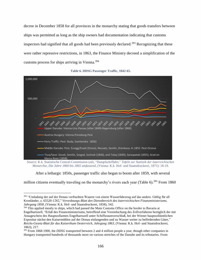
166
decree in December 1858 for all provinces in the monarchy stating that goods transfers between
ships was permitted as long as the ship owners had documentation indicating that customs
inspectors had signified that all goods had been previously declared.393 Recognizing that these
were rather repressive restrictions, in 1863, the Finance Ministry decreed a simplification of the
customs process for ships arriving in Vienna.394
Table 6. DDSG Passenger Traffic, 1842-65.
Source: K.k. Statistische Central-Commission (ed), “Dampfschiffahrt,” Tafeln zur Statistik der österreichischen
Monarchie, Die Jahre 1860 bis 1865 umfassend, (Vienna: K.k. Hof- und Staatsdruckerei, 1871): 18-19.
After a lethargic 1850s, passenger traffic also began to boom after 1859, with several
million citizens eventually traveling on the monarchy’s rivers each year (Table 6).395 From 1860
393 “Umladung der auf der Donau verfrachten Waaren von einem Wasserfahrzeug auf das andere. Gültig für all
Kronländer, z. 65520-1282,” Verordnungs-Blatt den Dienstbereich des österreichischen Finanzministeriums.
Jahrgang 1858, (Vienna: K.k. Hof- und Staatsdruckerei, 1858), 542. 394 This applied mostly to ships, which had passed the Main Customs Office on the border to Bavaria at
Engelhartszell, “Erlaß des Finanzministeriums, betreffend eine Vereinfachung des Zollverfahrens bezüglich der mit
Ansageschein des Hauptzollamtes Engelhartszell unter Schiffsraumverschluß, bei der Wiener hauptzollämtlichen
Expositur nächst den Kaisermühlen auf der Donau einlangenden und zu Wasser weiter zu befördernden Güter,”
Reichs-Gesetz-Blatt für das Kaiserthum Oesterreich, Jahrgang 1863, (Vienna: K.k. Hof- und Staatsdruckerei,
1863), 217. 395 From 1868-1900, the DDSG transported between 2 and 4 million people a year, though other companies in
Hungary transported hundreds of thousands more on various stretches of the Danube and its tributaries. From
-
500,000
1,000,000
Upper Danube: Vienna-Linz-Passau (after 1849)-Regensburg (after 1860)
Austria-Hungary: Vienna-Pressburg-Pest
Ferry Traffic: Pest- Buda, Szentendre 1856)
Middle Danube: Pest, Essegg/Essek (Drave), Neusatz, Semlin, Drenkova. In 1855: Pest-Orsova
Tisza/Save: Sissek, Semlin, Szeged, Szolnok (1846), and Tokaj (1849), Saraspatak (1855), Arad onMaros River (1858)
167
to 1872, passenger traffic on DDSG ships more than tripled from 600,000 passengers a year to
over 1,800,000. Within the monarchy, the DDSG’s largest passenger traffic was still ferry
service between Buda and Pest (approximately 40%), while the highest percentage of ‘long-
distance’ travelers shuttled between Vienna and Pest (20% of total passenger traffic and 35% of
non-ferry traffic). While passenger traffic decreased on the DDSG’s ferry line between Buda and
Pest in the mid-1860s, demand for this service remained high enough that in January 1869 three
men in Buda submitted a petition to the KMKM for permission to set up their own local-traffic
routes on the Danube.396 By the early 1870s, local ferry services had again increased to 70% of
the DDSG’s passenger traffic.397
Counting on the Danube
Like imperial policies in the 1850s, the Hungarian authorities also prioritized policies and
regulations that monitored commercial activity in the 1860s. After 1867, Hungary’s newly
autonomous national government was keen to measure how well navigational and regulation
policies affected traffic on the rivers under their control. In February 1869, the Public Works and
Transportation Ministry (KMKM) suggested an “official measurements” act, which charged its
15 River Engineering Offices, including 7 along the Danube with collecting information about
ships passing each location.398 The KMKM bureaucrats believed that this information would
enable them to compare ships’ end destinations, their form and size, as well as origins, material,
records in the Statistikai Évkönyv (Statistical Yearbooks) published by the Hungarian Statistical Office, between
1874 and 1914, the Pest-based Budapesti csavargőzös átkelési vállalat (Budapest Propeller-Steamer Ferry
Company) annually transported between 3 and 5 million people across the Danube between Buda and Pest. 396 János Frohner, Fülöss Frank, and Ottó Schlick to the KMKM, 26 January 1869, Box 17, Folder 8 hajózás, K173,
MNL, Budapest, Hungary. 397 K.k. Statistische Central-Commission (ed), “Dampfschiffahrt,” Tafeln zur Statistik der österreichischen
Monarchie, Die Jahre 1860 bis 1865 umfassend, (Vienna: K.k. Hof- und Staatsdruckerei, 1871), 2. 398 Bureaus on the Danube charged with recording data were located in Pressburg/Pozsony, Komárom, Esztergom,
Pest, Adony Szigozád, and Mohács. Six bureaus on the Tisza were in Bengszátt, Nagy Taskány, Tokaj, Szolmok,
Szeged, Török Becse, one on the Maros River was in Arad, and one on the Bega Canal was in Temeszvár.
168
and captains’ information. Several other official organs agreed that ship data would be useful to
possess. Collecting such data was not a new idea. Not only was it similar to work done by
customs agents in Engelhartszell, Linz, Stein, and Vienna, but it also mirrored collection work
that engineers in Hungary had been tasked with recording in the eighteenth century as well.399
While this data collection had theoretical benefits that allowed authorities to trace
commercial processes or shifts in traffic patterns, the response from local engineers in 1869-70
revealed that they hardly considered undertaking the task easy or worthwhile. For some, it
became a pointless exercise in counting ships, for others a waste of time – considering they had
far less river traffic than the river’s main junctions.400 One engineer complained that despite
protocols in place for requesting material, his predecessor failed to leave behind any records, and
the management minutes held no useful information. He pointed out that there was often little
time to inspect boats when they arrived, because workers loaded or unloaded goods from the
quay too quickly, and whenever boatmen arrived into their home town, he claimed that they
docked their boats near their houses rather than at public docks, making it nearly impossible to
record information about their boats. Finally, engineers condescendingly believed that local
boatmen were unreliable sources to learn about their boats’ origins or material, as they seemed
more aware about their responsibilities to transport goods than about the boat itself. One
engineer perhaps unwittingly uncovered the source of this ‘ignorance,’ reporting that his
399 The Navigations Directorate in the eighteenth century had charged local engineers with reporting hindrances on
their stretch of the river. The Viennese court had also expected engineers to report the number and type of ships
passing their post every year, Horst Glassl, “Der Ausbau der ungarischen Wasserstraßen in den letzten
Regierungsjahren Maria Theresias,” Ungarn-Jahrbuch. Zeitschrift für die Kunde Ungarns und verwandte
Gebiete 2 (Mainz: V. Hase & Koehler Verlag, 1970): 58-9. 400 One engineer, László Spilka up the Maros River in Arad said that he hadn’t submitted anything because another
engineer downstream on the lower Maros – Adolf Aigner – who was near the Maros’ confluence into the Tisza
already measured all the boats entering onto the Maros, so it didn’t seem necessary for him to count those boats a
second time upstream.
169
questions posed to boatmen only led to reluctant answers, as they somehow thought that any
questions regarding their boats’ carrying capacity were meant to deliver higher taxes on them.401
Based on these responses from the river engineers themselves, and considering the fact
that the KMKM had to send out an additional request for data the following year, one could
reasonably assume that data collection was a difficult and not always welcome task, which the
central authorities in Pest tried to impose on local river engineering offices. Furthermore, despite
the Ministry’s desires to quantify the river, even when engineers sought to uncover the requested
information from shipmen, they often found that there was a reluctance to volunteer information
to any authority, even a brand-new, national one, which could prove unfavorable to them.
While engineers may not have been able or willing to provide more detailed information
about local ships, new steamship companies – proliferating after the Compromise – were keen to
share commercial information, if at least to attract capital and business. After 1867, the KMKM
was inundated with dozens of petitions from local representatives requesting permission to set up
steam navigation companies, some even just requesting permission to operate a few steamers.
Many cited the 1857 Danube Navigation Act as the basis for their petition, which they claimed
the Statthalter in Hungary had already validated in 1859 by permitting a Pest-based company to
manufacture a freight ship to compete with DDSG. In the decade after 1867, over 30 steamship
companies received permission to ship freight on the Danube. Although there were several
voices at the national level opining that Hungary needed a national steamship company to rival
the “Austrian” DDSG, local reasons for establishing companies cited cost benefits for their
401 Box 27, Folder 8 hajózás, K173, MNL, Budapest, Hungary.
170
communities rather than national antagonisms. Indeed, they emphasized that a de-centralization
of steamship commerce would increase regional and Danube integration.402
In Szeged, a prominent city on the Tisza River, a local company wrote to the KMKM in
March 1867 averring that its establishment and functioning would accelerate trade up the Tisza
and connect its economy more firmly to the Danube. The petitioner pointed out that Szeged sat at
the juncture of the Tisza, Danube, Maros, and Körös (Romanian: Criș) confluences, which meant
that its location would be better suited than Pest or Vienna to arrange transportation to and
integrate markets in Bács, Csongrád, and Csanád counties and in the Banat. It pointed out that
besides housing the largest boat factory (in Hungary), the city possessed 230 larger and 100
smaller tugboats with almost 800,000 centner towing capacity, and it claimed that a quarter of all
private boats and ships on the Danube, Tisza, Drave, Maros, Körös, and Kupa stopped in Szeged
annually.403
There was certainly local enthusiasm for the company’s endeavor. Within two weeks of
selling stocks, it was able to raise enough capital to purchase two steamers, set up stations for
coal, and pay the crews’ salaries for both ships. Szeged’s mayor also wrote to the Royal
Agriculture, Industry, and Commerce Ministry in April to follow up with the authorities and
402 Some companies specifically sought to promote local traffic, such as the Győr, Szeged, and Nagy Becskerek
Steam Navigation Companies, or to support private business on the river, like the k.k. Railway Company’s river
freight needs. There were also efforts to create rival companies to the DDSG, like the Central Danube Steam
Navigation Company [Középdunai gőzhajózási társaság], First Hungarian Steam Navigation Company [Első
Magyar Gőzhajózási Társulat], and National Steam Navigation Company [Országos Gőzhajózási Társulat], which
tended to be more nationalist. These struggled the most to survive, and by 1871, they even formed a single company
“United Hungarian Steam Navigation Company,” which still failed to overcome the DDSG’s dominance, and like
the Bavarian-Württemburg Company a decade earlier, they eventually sold their ships and stocks to the DDSG in
1873. 403 The petitioner claimed that these ships transported “at least” 1.5- 2.4 million centner of grain from along the
Tisza, and 400,000 centner salt, 20-25,000 centner soap, 10-15,000 centner fish, and 6-10,000 pieces of port from
Transylvania. In addition, they carried Alföld articles such as wine, beer, spirits, flour, pepper, reeds, tiles, and –
when permitted – 600-700,000 centner tobacco, which the company could transport 15-20% cheaper than the private
rails or DDSG, Szeged Steam Navigation Company to Public Works and Transportation Minister, 11 March 1867,
Box 27, Folder 8 hajózás, K173, MNL, Budapest, Hungary.
171
request support. While various ministries exchanged memos throughout the spring, eventually, in
May, Public Works and Transportation Minister Imre Mikó made it clear that he supported the
company’s request, so long as it dutifully followed the legal precepts set down by the 1840 law
governing joint stock companies. By June, the Szeged Steam Navigation Company cheerfully
provided Trade Minister István Gorove with documents attesting to its ability to successfully run
its business. River traffic remained crucial for Szeged’s economy in the next few decades. As
late as 1893, despite rail connections in town, Szeged still registered 46% of freight goods
departing the city on the river, (43% departing on rails and 11% on wagons). Even more
impressive, 70% of freight traffic arriving in town came by boat.404
Like the Szeged Steam Navigation Company, other local companies looked to provide
passenger and freight traffic in small segments of the Danube or onto tributaries, though there
were certain hurdles to overcome. Many petitions to the central authorities in Pest requesting
permission to establish a streamship company also detailed the earlier problems that had de-
railed their efforts. Difficulties were not only financial or regulatory but were also tied to the
vicissitudes of the Danube’s ever-changing hydrological conditions. Nevertheless, while many of
the smaller operations either went bankrupt or were bought by larger companies, there were
several founded in the 1870s, which survived until the final decade of the monarchy,405
As steamship companies proliferated, the DDSG relentlessly competed to expand its
business on the Danube and its tributaries. In 1867, it began construction of rails to connect its
Pécs coal mines to the Drave River at Barcs, which it hoped would support the expansion of
404 In comparison with goods leaving Szeged by train and cart, the following goods departed by ships: 96% of the
exported wheat (222,810 metric centners), 99% of barley (90,156), 99% of corn (11,507), 45% of potatoes (41,575),
61% of wood (256,611), 92% of glass (45,795), 44% of tobacco (12,991), Gráfik, Hajózás és Gabonakereskedelem,
92. 405 Ferencz Rossmayer’s company in Tolna County (1872-1912), two steamship companies around Pancsova (1873-
1906), Guttmann Siblings (1874-1909), and József Eggenhofer (1878-1906), not to mentioned several others, which
formed around the Compromise and also lasted one or two decades.
172
steamships further up the river. In November 1867, a representative from the Pest office wrote to
the KMKM about the natural and manmade hindrances to navigation on the Maros, Samos, and
Tisza, which included the ubiquitous ship-mill obstacles, as well as masses of tree trunks and
branches blocking ship passage on the rivers. In April 1868, the DDSG informed the KMKM of
its intention to extend passenger service above Tokay on the Upper Tisza.
This widely expansive steam traffic in Hungary contrasted with the oscillating fortunes of
ship traffic around the Upper Danube. From 1858 to 1874, there was a gradual decline in
steamships traveling downstream and a precipitous drop in galley traffic.406 These trends were
particularly noticeable after 1862/3. Incidentally, there was a marked increase in the number of
rafts floating downstream.407 The decline in galleys and other non-mechanized ships around the
mid-century was likely more a result of changing transportation regimes and the uptick in
railway networks rather than just a result of the DDSG’s ballooning steamship fleet. In fact,
since 1838, the DDSG had been utilizing hundreds of traditional, non-mechanized vessels to
serve local needs and travel up smaller rivers. In 1865, the DDSG operated one hundred barges
and longboats (Plätte and Trauner) and almost 120 galleys and narrow boats (Ruderschiffe and
Waidzillen).408 As the next section will describe, traditional vessels remained more competitive
along middle and lower Danube stretches where the river’s current was slower and thus easier to
overcome. Unfortunately, the rapid current of the upper Danube all but guaranteed these vessels’
demise along this stretch by the century’s end.
406 At this point only the DDSG’s steamships were on the Upper Danube. Steamship traffic declined from around
1,000 traveling downstream a year to around 900. Large, 50-ton galleys declined from around 650 to only 200 a
year, and the smaller galleys less than 50 tons declined even more dramatically from around 3,600 to only 1,750. 407 In 1858 around 1,650 traveled downstream, which increased to 2,250 by 1874, though in 1868 this number
topped 3,000.
“Schiffverkehr auf der oberen Donau,” 34. 408 K.k. Statistische Central-Commission (ed), “Dampfschiffahrt,” 12.

173
The natural result of more steamships and rather lax – or unenforceable – regulations for
other types of traditional crafts was the growing danger of collisions and accidents. Accidents
were not always avoidable, but conflicting practices on the river seemed to increase the
likelihood of something happening. In 1869, for example, a local representative from Torda
County in Transylvania indicated the haphazard rafting practices on the Maros River, which
imperiled lives and damaged property. Multiple thousand rafters sailed down the Maros each
year, and besides passing each other in an unsafe manner, the rafters sometimes collided with
local infrastructure, damaging bridges, mills, ferry landings, and boat mills.409 The Hungarian
authorities took very careful records of all incidents occurring on steamships, and these figures
were published in the government’s annual statistical almanacs, perhaps to assure readers that
steamships, at least, were quite safe. While streamships themselves were safe, other physical
arrangements on the river imperiled their routes. In a series of petitions in early 1868, the DDSG
requested that the KMKM limit the “disadvantageous use of ferry lines,” which were still
common on the Tisza. The company complained that the cables slowed steam navigation,
endangered ships, and threatened lives. It cited the Paris Congress’ resolution against nuisances,
which ordered that “the Danube and its tributaries be given over to free navigation without
obstacles.”410
Although ferry lines disrupted steam traffic – at least on the Tisza River – elsewhere they
were instrumental for the public good. Unlike his colleague on the Tisza, a DDSG official
situated on the Maros River supported the establishment of ferries, arguing that they would make
crossing the river safer for local inhabitants.411 A municipal river engineer in Arad on the Maros
409 Torda county representative to KMKM, 12 September 1869, Box 27, Folder 8 hajózás, K173, MNL, Budapest,
Hungary. 410 DDSG to Public Works and Transportation Ministry, 20 January 1868; 20 February 1868, 411 DDSG to KMKM, 4 Nov 1867, Box 17, Folder 8 hajózás, K173, MNL, Budapest, Hungary.
174
concurred, writing to the KMKM that the ministry’s help launching and maintaining ferry
services would be in the public’s interest.412 Commnuities on the Upper Danube already utilized
a variety of practices and arrangments to ensure the public could cross the river. Enns’ city
council commissioned the construction of a flying bridge in 1828, which it sold it to Mauthausen
in 1876. The community at Grein, having no permanent arrangement to cross the Danube,
constructed a flying bridge in 1858 to reach Amstetten, whither the Empress-Elisabeth Western
Rails had just expanded. Traffic on this ferry fluctuated between 25,000 and 40,000 people per
year between 1860 and 1870, and by 1875, the two communities decided to replace it with a
cable ferry.413
In 1879, the k.k. Interior Ministry also granted the Lower Austrian Statthalter’s office the
right to regulate and approve ferry services for the public good, as long as local political
authorities had a say designating safe places for the crossings to take place.414 Much like at
Grein, this had immediate benefits for local communities’ connection within the imperial
infrastructure, as commercial groups and municipalities began establishing ferry lines to cross
the Danube at points where residents could then reach train stations.415 Unfortunately, ferries did
also cause problems for localcommunities. After Melk’s communal council bought a propeller
ferry and started operating it in April 1883, within a few days the ferry lost control during a
crossing and struck a passing steamer, the “Gisela.” Four people fell into the Danube and
drowned, and ferry crossings at Melk ceased for over a year. After the community began
412 László Szilka to KMKM, 16 Dec 1867, Box 17, Folder 8 hajózás, K173, MNL, Budapest, Hungary. 413 Karlheinz Manlik, Donauübergänge in Österreich: Geschichte und Technik der Fähren und Brücken über die
österreichische Donau, (Linz: Landesverlag, 1994), 56. 414 Amts-Blatt der k.k. Bezirkshauptmannschaft St.Pölten: II. Jahrgang, (St.Pölten: Redaktion und Verlag der k.k.
Bezirkshauptmannschaft St.Pölten, 1879), 177. 415 Amts-Blatt der k.k. Bezirkshauptmannschaft St.Pölten: III. Jahrgang, (St.Pölten: Redaktion und Verlag der k.k.
Bezirkshauptmannschaft St.Pölten, 1880), 196.
175
operating the ship again, three years later, it determined that it was too expensive to maintain and
ultimately sold it off.416
The Circulation of Goods on the “Life Artery” around Mid-Century
The Danube had long provided a route along which raw resources and finished products
traveled to communities up and down the river; a flow of merchants’ goods and grains
meticulously documented by toll authorities at the monarchy’s borders at at several customs
houses along the river. The shift to fossil-fuel-run ships on the Danube and the growth of larger
cities influenced the quantity and type of good circulating on the river. In 1845, almost 45% the
imported goods from Hungary, which were registered at the Main Customs Building in Vienna,
arrived on DDSG steamships. Just one year later, it was 62%.417 In the late 1840s and early
1850s, Vienna witnessed the arrival of all ship types transporting building material, victuals,
firewood, manufactured goods, and grain, among other things. In 1849, 58% of the arriving
freight was building material, which declined to 38% in 1856 as manufactured goods increased
their share from 13% to 35% in the same period (Table 7).418 Scholars in Austria have
documented the effect on Vienna’s relations with its hinterlands as the city shifted from wood to
coal consumption and steam navigation rose on the Danube.419
416 Franz Xaver Linde, Chronik des Marktes und der Stadt Melk umfassend den Zeitraum von 890 bis 1899 mit
besonderer Berücksichtigung der letzten 34 Jahre, (Melk: Selbstverlag der Gemeinde Melk, 1900), 234-5. 417 In 1845, 209,659 centner of goods arrived on DDSG ships from Hungary out of 469,258 centner total (45%), and
in 1846, this was 215,074 out of 345,500 centners (62%), “Handel des österreichischen Zollgebiets,” Tafeln zur
Statistik der oesterreichischen Monarchie 1845/6, vol. 2 (): 32; 64. 418 Hajnal, The Danube, 151. 419 Gingrich et al, “The Danube and Vienna,” 283-85.
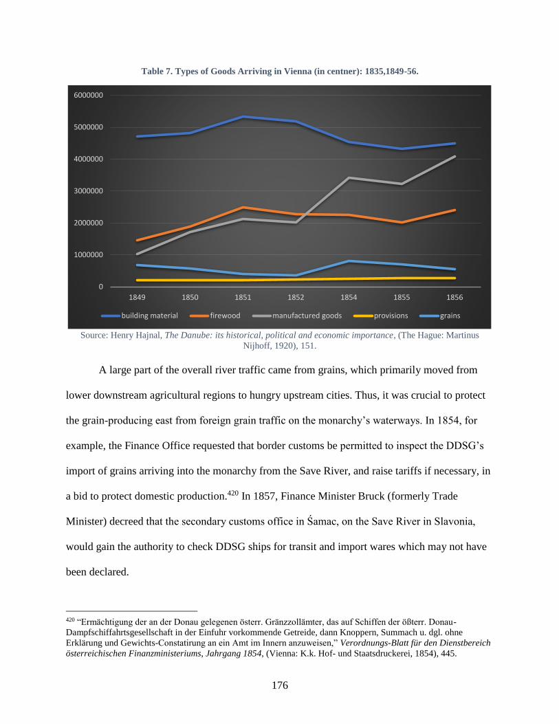
176
Table 7. Types of Goods Arriving in Vienna (in centner): 1835,1849-56.
Source: Henry Hajnal, The Danube: its historical, political and economic importance, (The Hague: Martinus
Nijhoff, 1920), 151.
A large part of the overall river traffic came from grains, which primarily moved from
lower downstream agricultural regions to hungry upstream cities. Thus, it was crucial to protect
the grain-producing east from foreign grain traffic on the monarchy’s waterways. In 1854, for
example, the Finance Office requested that border customs be permitted to inspect the DDSG’s
import of grains arriving into the monarchy from the Save River, and raise tariffs if necessary, in
a bid to protect domestic production.420 In 1857, Finance Minister Bruck (formerly Trade
Minister) decreed that the secondary customs office in Śamac, on the Save River in Slavonia,
would gain the authority to check DDSG ships for transit and import wares which may not have
been declared.
420 “Ermächtigung der an der Donau gelegenen österr. Gränzzollämter, das auf Schiffen der ößterr. Donau-
Dampfschiffahrtsgesellschaft in der Einfuhr vorkommende Getreide, dann Knoppern, Summach u. dgl. ohne
Erklärung und Gewichts-Constatirung an ein Amt im Innern anzuweisen,” Verordnungs-Blatt für den Dienstbereich
österreichischen Finanzministeriums, Jahrgang 1854, (Vienna: K.k. Hof- und Staatsdruckerei, 1854), 445.
0
1000000
2000000
3000000
4000000
5000000
6000000
1849 1850 1851 1852 1854 1855 1856
building material firewood manufactured goods provisions grains

177
This was influential for large and smaller cities, which depended on the river’s grain
trade for their livelihood. One city downstream from Pest, Baja, grew in importance by mid-
century because of the amount of grain transports arriving and departing from its docks. By
1857, over 250 boaters and 53 wheat merchants existed in the town of 20,000 people, around
2,400 houses were used as storehouses for grain, over one million carts came to the town ever
year for markets, and it was considered a “final destination” on the Danube, with many
entrepreneurs throughout the region listing it as crucial city to visit in their legers.421 One
hundred members formed the “Baja Commerce Guild” in 1857 to safeguard the river and grain
trade for the town. The river traffic was a strong representation of steam-powered and traditional
vessels. In 1860, nearly 130,000 centners of grain left Baja on steamships alone (about 2% of the
DDSG grain transport for 1861), in 1861, 695,000 centners of grain left Baja on wooden boats to
Győr (218,00 centner to Pest). In the 1860s, the region around Baja transported an average of
two million centner of grain a year to the city. In the 1850s, despite burgeoning rail lines, only
1/3 of the grain transported to Pest arrived via rails. Traditional ships transporting grain
continued to outpace the DDSG.422
While Danube traffic boomed at these cities on the Middle Danube below Pest, from
1860 to 1865, the DDSG’s most trafficked freight stretch by total goods’ weight was between
Vienna and Pest (Table 8). Vienna and Pest themselves were the main destination for goods on
the Danube, traditionally due to privileges requiring all trade to stop there, but increasingly also
due to burgeoning infrastructure and growing industrial populations at each city, which needed
raw materials to feed both people and machines. Commercial organizations also boosted the
cities’ allure for trade. In 1865, for example, a company calling itself the “Danube Trade
421 Gráfik, Hajózás és Gabonakereskedelem, 93-4. 422 Statistisches Jahrbuch 1869 (1871), 145; Gráfik, Hajózás és Gabonakereskedelem, 93, 98.
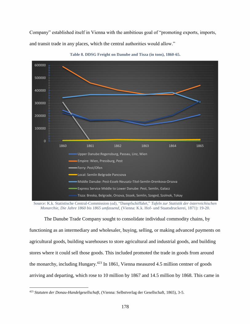
178
Company” established itself in Vienna with the ambitious goal of “promoting exports, imports,
and transit trade in any places, which the central authorities would allow.”
Table 8. DDSG Freight on Danube and Tisza (in tons), 1860-65.
Source: K.k. Statistische Central-Commission (ed), “Dampfschiffahrt,” Tafeln zur Statistik der österreichischen
Monarchie, Die Jahre 1860 bis 1865 umfassend, (Vienna: K.k. Hof- und Staatsdruckerei, 1871): 19-20.
The Danube Trade Company sought to consolidate individual commodity chains, by
functioning as an intermediary and wholesaler, buying, selling, or making advanced payments on
agricultural goods, building warehouses to store agricultural and industrial goods, and building
stores where it could sell those goods. This included promoted the trade in goods from around
the monarchy, including Hungary.423 In 1861, Vienna measured 4.5 million centner of goods
arriving and departing, which rose to 10 million by 1867 and 14.5 million by 1868. This came in
423 Statuten der Donau-Handelgesellschaft, (Vienna: Selbstverlag der Gesellschaft, 1865), 3-5.
0
100000
200000
300000
400000
500000
600000
1860 1861 1862 1863 1864 1865
Upper Danube:Regensburg, Passau, Linz, Wien
Empire: Wien, Pressburg, Pest
Ferry: Pest/Ofen
Local: Semlin Belgrade Pancsova
Middle Danube: Pest-Essek-Neusatz-Titel-Semlin-Drenkova-Orsova
Express Service Middle to Lower Danube: Pest, Semlin, Galacz
Tisza: Breska, Belgrade, Orsova, Sissek, Semlin, Szeged, Szolnok, Tokay
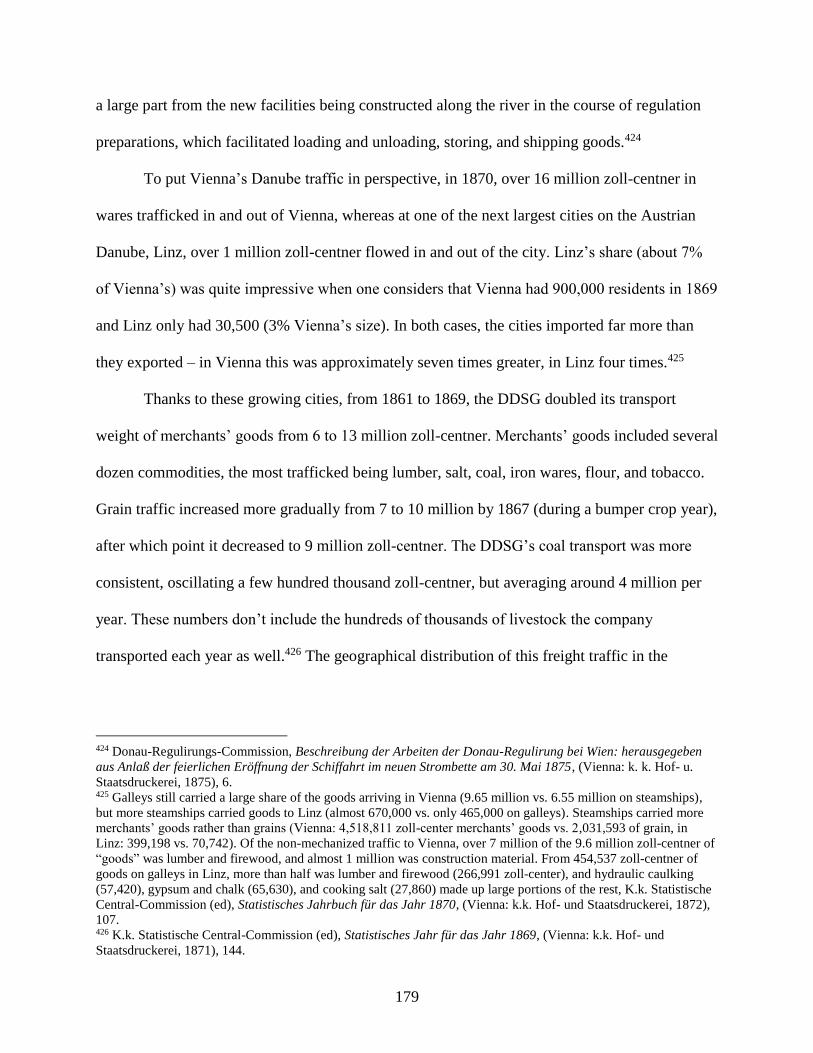
179
a large part from the new facilities being constructed along the river in the course of regulation
preparations, which facilitated loading and unloading, storing, and shipping goods.424
To put Vienna’s Danube traffic in perspective, in 1870, over 16 million zoll-centner in
wares trafficked in and out of Vienna, whereas at one of the next largest cities on the Austrian
Danube, Linz, over 1 million zoll-centner flowed in and out of the city. Linz’s share (about 7%
of Vienna’s) was quite impressive when one considers that Vienna had 900,000 residents in 1869
and Linz only had 30,500 (3% Vienna’s size). In both cases, the cities imported far more than
they exported – in Vienna this was approximately seven times greater, in Linz four times.425
Thanks to these growing cities, from 1861 to 1869, the DDSG doubled its transport
weight of merchants’ goods from 6 to 13 million zoll-centner. Merchants’ goods included several
dozen commodities, the most trafficked being lumber, salt, coal, iron wares, flour, and tobacco.
Grain traffic increased more gradually from 7 to 10 million by 1867 (during a bumper crop year),
after which point it decreased to 9 million zoll-centner. The DDSG’s coal transport was more
consistent, oscillating a few hundred thousand zoll-centner, but averaging around 4 million per
year. These numbers don’t include the hundreds of thousands of livestock the company
transported each year as well.426 The geographical distribution of this freight traffic in the
424 Donau-Regulirungs-Commission, Beschreibung der Arbeiten der Donau-Regulirung bei Wien: herausgegeben
aus Anlaß der feierlichen Eröffnung der Schiffahrt im neuen Strombette am 30. Mai 1875, (Vienna: k. k. Hof- u.
Staatsdruckerei, 1875), 6. 425 Galleys still carried a large share of the goods arriving in Vienna (9.65 million vs. 6.55 million on steamships),
but more steamships carried goods to Linz (almost 670,000 vs. only 465,000 on galleys). Steamships carried more
merchants’ goods rather than grains (Vienna: 4,518,811 zoll-center merchants’ goods vs. 2,031,593 of grain, in
Linz: 399,198 vs. 70,742). Of the non-mechanized traffic to Vienna, over 7 million of the 9.6 million zoll-centner of
“goods” was lumber and firewood, and almost 1 million was construction material. From 454,537 zoll-centner of
goods on galleys in Linz, more than half was lumber and firewood (266,991 zoll-center), and hydraulic caulking
(57,420), gypsum and chalk (65,630), and cooking salt (27,860) made up large portions of the rest, K.k. Statistische
Central-Commission (ed), Statistisches Jahrbuch für das Jahr 1870, (Vienna: k.k. Hof- und Staatsdruckerei, 1872),
107. 426 K.k. Statistische Central-Commission (ed), Statistisches Jahr für das Jahr 1869, (Vienna: k.k. Hof- und
Staatsdruckerei, 1871), 144.
180
monarchy was quite lopsided. In 1865, about 70% arrived and departed from cities in Hungary,
while only 30% was within Austria (Table 9).427
Table 9. DDSG Steamship Freight Traffic of 11.5 million zoll-centner Wheat and Merchants’ Goods to Cities
on the Danube in Austria and Hungary, 1865.
Source: K.k. Statistische Central-Commission (ed), “Dampfschiffahrt,” Tafeln zur Statistik der österreichischen
Monarchie, Die Jahre 1860 bis 1865 umfassend, vol. 2 (Vienna: K.k. Hof- und Staatsdruckerei, 1871): 21-22.
This uneven freight traffic in Austria and Hungary, and the types of goods that cities
imported and exported, reflected diverging consumption and production habits throughout the
monarchy.428 Grain imports provide a good example. In 1877, from the 31 towns with steamship
stations on the Austrian Danube, only three towns exported a significantly greater portion of
427 Of the 11.5 million zoll-centners, over half was at Vienna and Pest: Pest trafficked the most with 3.7 mil. and
Vienna next with 3.2 mil. Budapest’s 3,738,501 centner (q) was mostly comprised of merchants goods traffic to and
from the city- appr. 2.6 mill., whereas Vienna’s 3,242,388 q mostly came from 1.5 mil. q in merchants’ goods and 1
mil. q grains. 428 K.k. Statistische Central-Commission (ed), Statistisches Jahrbuch für das Jahr 1877, vol 4 (Vienna: K.k. Hof-
und Staatsdruckerei, 1880), 32.
AT Exported merchants’ goods
7%
AT Exported wheat1%
AT imported merchants’ goods
13%
AT imported wheat8%
HU Exported merchants’ goods
26%
HU Exported wheat19%
HU imported merchants’ goods
18%
HU imported wheat8%
Other29%
AT Exported merchants’ goods AT Exported wheat AT imported merchants’ goods
AT imported wheat HU Exported merchants’ goods HU Exported wheat
HU imported merchants’ goods HU imported wheat

181
grain than they imported.429 Cities in the 1870s needed to feed growing urban populations, some,
like Pest and Vienna, which were nearing one million residents. The DDSG’s steamships
imported 800,000 metric-centners430 of grain to Austrian cities in 1872, and by 1877, this had
risen to over 2,000,000. Grain imports to Austrian cities constituted 97% of the DDSG’s total
grain traffic from 1872 to 1876, indicating that almost no cities in Austria were exporting grain
(by steamship).431
In 1877-86, the DDSG recorded the largest commercial cities it traded at, based on the
criteria that sometime within decade it had loaded or unloaded at least 100,000 metric-centner of
agricultural or merchants’ goods.432 Of the 30 cities, 6 were in Austria and 24 were in Hungary.
From the DDSG’s total steamship freight from this period (143.6 million metric centner), cities
exported 45% of their wares while importing 55%. This varied by location, so Vienna’s DDSG
traffic was 76% imports and 24% exports, while Pest’s was 61% imports and 39% exports (Table
10; Table 11). In smaller towns on the Danube, which primarily served as entrepôts for other
traffic, this proportion could be reversed. At Mauthausen (Upper Austria), DDSG goods traffic
was 19% imports and 81% exports, and at Bezdán near the Franz Canal’s mouth into the Danube
(whence arrived wares from the Tisza), DDSG goods traffic was only 9% imports and 91%
exports (Table 12; Table 13).
429 Aschach exported 3,162 metric-centner versus 134 imported, Wallsee exported 1,020 and imported 169, and
Hainburg exported 3,664 and imported 159. 430 The metric-centner was equivalent to 100 kilograms. 431 K.k. Statistische Central-Commission (ed), Statistisches Jahr für das Jahr 1877, (Vienna: k.k. Hof- und
Staatsdruckerei, 1880), 52. 432 100,00 metric centners was equal to 200,000 zoll-centner or 20 million kilograms. In other words, the DDSG
records indicated cities that imported and exported large quantities of goods each year.

182
Table 10. DDSG Steamship Freight Traffic Export-Import at Vienna, 1877-86.
Source: K.k. Statistische Central-Commission (ed), Oesterreichisches Statistisches Handbuch für die im Reichsrathe
vertretenen Königreiche und Länder nebst einem Anhange für die Gemeinsamen Angelegenheiten der
österreichisch-ungarischen Monarchie. Sechster Jahrgang 1887, (Vienna: K.k. Statistische Central-Commission,
1888), 179.
Table 11. DDSG Steamship Freight Traffic Export-Import at Pest, 1877-86.
Source: K.k. Statistische Central-Commission (ed), Oesterreichisches Statistisches Handbuch für die im Reichsrathe
vertretenen Königreiche und Länder nebst einem Anhange für die Gemeinsamen Angelegenheiten der
österreichisch-ungarischen Monarchie. Sechster Jahrgang 1887, (Vienna: K.k. Statistische Central-Commission,
1888), 179.
1877 export2%1878 export
2%
1879 export2%
1880 export2%
1881 export2%
1882 export3%
1883 export3% 1884 export
3%
1885 export3%
1886 export3%
1877 import6%1878 import
6%1879 import
7%
1880 import7%
1881 import6%
1882 import8%
1883 import9%
1884 import9%
1885 import11% 1886 import
9%
Other24%
1877 import5%
1878 import5%
1879 import5%
1880 import6%
1881 import7%
1882 import7%
1883 import6%
1884 import7%
1885 import8%
1886 import7%
1877 export3%
1878 export3%
1879 export3%
1880 export3%
1881 export3%
1882 export4%
1883 export4%
1884 export4%
1885 export4%
1886 export5%
Other39%

183
Table 12. DDSG Steamship Freight Traffic Export-Import at Mauthausen, 1877-86.
Source: K.k. Statistische Central-Commission (ed), Oesterreichisches Statistisches Handbuch für die im Reichsrathe
vertretenen Königreiche und Länder nebst einem Anhange für die Gemeinsamen Angelegenheiten der
österreichisch-ungarischen Monarchie. Sechster Jahrgang 1887, (Vienna: K.k. Statistische Central-Commission,
1888), 179.
Table 13. DDSG Steamship Freight Traffic Export-Import at Bezdán, 1877-86.
Source: K.k. Statistische Central-Commission (ed), Oesterreichisches Statistisches Handbuch für die im Reichsrathe
vertretenen Königreiche und Länder nebst einem Anhange für die Gemeinsamen Angelegenheiten der
österreichisch-ungarischen Monarchie. Sechster Jahrgang 1887, (Vienna: K.k. Statistische Central-Commission,
1888), 179.
1877 export12%1878 export
4%
1879 export4%
1880 export10%
1881 export10%
1882 export12%
1883 export11%
1884 export7% 1885 export
5%1886 export
5%
1877 import2%1878 import
2%
1879 import2%
1880 import1%
1881 import2%
1882 import2%
1883 import2% 1884 import
2%
1885 import2%
1886 import2%
Other19%
1877 export10%
1878 export12%
1879 export14%
1880 export11%
1881 export6%
1882 export8%
1883 export9%
1884 export6% 1885 export
7%
1886 export7%
1877 import1%
1878 import1%1879 import
1%
1880 import1%
1881 import1%
1882 import1%
1883 import1%
1884 import1%
1885 import1%
1886 import1%Other
9%

184
Local communities were strongly integrated into the river economy, whether by
importing the goods they needed or exporting those that their livelihoods were tied to. As
Danube regulation work gained steam in the last decades of the century, the question arose how
new physical spaces on the regulated river would affect commercial activities. As the Danube’s
regulation was nearing completion in Vienna, a new customs building was opened in April 1875
next to the DDSG’s landing place, in order to more quickly process the expected increase in
goods traffic. Regulation work seemed to bring the desired results. Austrian waterways
experienced a 65.6% rise in freight traffic in 1881-91; a rate of growth higher than rails
(62.8%).433
1885-1900: Battling the Rising Tide
In the nineteenth century’s last decade and a half, rail competition forced practices on the
Danube to evolve, though this affected different parts of the Danube differently. As a result of
changing practices, which riparian communities did not always find favorable, citizens banded
together to demand new arrangements and adopt new practices to guarantee that the Danube
remained a space devoted to serving what they deemed as the general good. In pursuit of this
agenda, petitions and community action offered citizens an effective avenue to convince
provincial and imperial authorities to mediate between their local needs and other commercial
interests on the river.
In the late 1880s, the Hungarian government’s transportation and infrastructure policies
had wrought ambivalent results on its steam navigation. As Minister for Public Works and
Transportation, and later as Trade Minister, Gábor Baross implemented expansive railway
433 K.k. Statistische Central-Commission, “Waarenverkehr zwischen Oesterreich und Ungarn in den Jahren 1884 bis
1891,” Oesterreichische Statistik 37, no. 4/2 (Vienna: K.k. Hof- und Staatsdruckerei, 1894), 159.
http://anno.onb.ac.at/cgi-content/anno-plus?aid=ors&datum=0037&page=854&size=45 p. 282
185
policies from 1884 onward. Among other means to encourage rail travel, in 1887, the Hungarian
government levied a ‘transport tax’ on water transportation. The DDSG argued that this tax was
meant to discourage water travel and instead encourage the expansion of the Hungarian State
Railways [Magyar állami vasut or “MÁV”].434 Nevertheless, the Central Statistical Office
recorded 17 steamship companies operating on the lakes and waterways in Hungary in 1887 with
an additional 8 companies dedicated to providing local ferry services.435 The following year,
despite the tax, the Statistical Office recorded at least 37 steamship companies, which operated
between 1,000-1,200 ships (over 700 of which were the DDSG’s iron tugboats).436 During this
decade from 1880 to 1890, Hungary’s freight ratios between rail and river traffic grew
proportionally. Total freight traffic on water and railways rose from 15.7 to 24.1 million tons
between 1880 and 1890, and waterways’ share only minutely shifted from 11.8% to 11.7% of the
total freight traffic.437
434 This was not a clear cut “rail vs. water” rivalry, as both the Hungarian and Austrian State Railway Companies
also ran passenger lines on the Danube as well, Erste k.k. priv. Donau-Dampfschiffahrts-Gesellschaft
Geschäftsbericht der Betriebs-Direction über das Verwaltungsjahr vom 1. December 1887 bis 30. November 1888,
(Vienna: Carl Gerold’s Son, 1889). 435 The DDSG, k.k. Austro-Hungarian State Railway Company, Balaton Steam Navigation Comp, Győri/Raaber
Dampfschiffahrts-Actien-Gesellschaft, Paul Luczenbachers Nachkommen in Budapest, W. Huber in Pancsova,
Morovicz et Co. in Sisek, Josef Eggenhofer et Comp. in Budapest, Pancsova Propeller Company, Schleppdampfer-
Unternehmung auf dem Franzencanal, Dampfschiffahrts-Gesellschaft Drau in Barcs, Franz Rossmayer in Tolna,
Mirkovics et Kaier in Kamenicz, Georg Manó in Pancsova*, Nikolaus Nikolovics in Orsova* (*Local traffic),
Weisz et Guttenberg in Budapest, Süddeutsche Dampfschiffarts-Gesellschaft. The ferry companies were:
Dampffähre Bezdán-Batina, Budapest Propeller-Ueberfahr-Unternehmung, Cserovitz-Futtaker Dampffähre, Graner
Dampfschiffahrt (Esztergom), Komorner Propeller-Unternehmung, Dampffähre in Medve, Novoszelló-Szutiner
Dampffähre, Dampffähren-Actien-Gesellschaft Palánka-Illok. In addition to these companies, there were several
public and private ships that weren’t associated with public freight or passenger traffic but their own endeavors,
those were from the Hungarian state, the Upper Szabolcs Tisza Regulation Company, Austrian Construction
Company, the Regulation Main Enterprise of the Danube between Dévény und Radvány, Max Neuschloss, which
used their own ships to transport their construction material or aid their hydraulic engineering projects, Magyar
Statistikai Évkönyv: Tizenhetedik Évfolyam. 1887, (Budapest: Az Athenaeum Irodalmi és Nyomdai R. Társulat
Könyvnyomda, 1890), 145-6. 436 Magyar Statistikai Évkönyv: Tizennyolcadik Évfolyam, 1888, (Budapest: Az Athenaeum Irodalmi és Nyomdai R.
Társulat Könyvnyomda, 1891), 185. 437 Jacob Deutsch, Bericht an den löblichen Administrations-Rath der Ersten k.k. priv. Donau-Dampfschifffahrts-
Gesellschaft über die Verhandlungen des V. Binnenschiffahrts-Congresses in Paris 1892, Second Edition, (Vienna:
Druck und Verlag der I. k. k. priv. Donau-Damptschiffahrts-Gesellschaft, 1894), 124-5.
186
Part of Hungary’s continued strength in river freight traffic was its geography. Hungary’s
flatter plains kept the river’s current slower than upstream in Austria. As a result, both the
Middle Danube and its tributaries in Hungary provided less resistance to ships, which required
less fuel and, in turn, lowered shipping prices. This made river navigation more competitive with
rails in Hungary than in the mountainous western provinces.438 For example, freight arriving in
Budapest via waterways enjoyed relatively favorable growth rates compared to rails. From 1876
to 1896, rails went from transporting 17 to 47 million tons to Budapest per year, whereas
waterways increased from 6.6 to 14 million during this same period. While rails experienced a
176% increase over this period, it mostly occurred early on, whereas between 1885 and 1896 it
grew more modestly at 57%. Waterways, on the other hand, may have only experienced a total
growth of 112% in the century’s last quarter, but in contrast, the later decade witnessed a more
impressive 75% growth.439 One observer from Újvidék/Neusatz (mod. Novi Sad, Serbia) wrote
of this rail and river relation:
One might believe that river traffic would completely decline after the railways’
construction, but this view is refuted by the following data…until the construction
of the Budapest-Zimony railway, the traffic at the steamship station – with
exports – averaged 150,000 centners of cargo annually. Of that, 80,000 was grain,
15,000 was wine, and 30,000 was flour ... After 1883, the year the railway
opened, until today (1894), the station has averaged 200,000 centners of exports.
Of that, 100,000 is grains, 10,000 is wine, and 60,000 is flour.440
438 Deutsch, Bericht an den löblichen Administrations-Rath der Ersten k.k. priv. Donau-Dampfschifffahrts-
Gesellschaft über die Verhandlungen des V. Binnenschiffahrts-Congresses in Paris 1892, Second Edition, (Vienna:
Druck und Verlag der I. k. k. priv. Donau-Damptschiffahrts-Gesellschaft, 1894), 123. 439 Gráfik, Hajózás és Gabonakereskedelem, 99. 440 “Azt hinné az ember, hogy a hajózási forgalom a vasút fölépítése után teljesen pangásnak indult, e vélemenyt
azonban megcáfolják a következő adatok: 1822-ig, vagyis a Budapest-zimonyi vasút fölépítéséig az újvidéki első cs.
és kir. szab. gőzhajózás állomásának teherforgalma, illetőleg kivitele évi átlagos számításban ez volt: 150 ezer
métermázsa áru. Ebből 80 mm. gabona, 15 mm. bor, 30 ezer mm liszt... 1883 után, vagyis a vasút megnyitási évétől
számítva a mai napig (1894ig – Gr. I.) az évi átlagos kivitel 200 ezer métermázsára tehető. Ebből 100 ezer mm.
gabona, 10 ezer mm. bor, 60 ezer mm liszt...,” Ibid., 99.
187
Growth did not occur by happenstance but was the result of intentional cultivation. Besides
undertaking regulation projects, the Royal Trade Ministry, along with the Royal Rail and River
Inspectorate, audited the traffic entering and exiting steamship stations throughout Hungary in
the early 1890s. The ministry officials then made recommendations about which stations
remained viable to maintain and which had too little traffic to justify keeping open.441
While communities in Hungary appeared to adapt to new steamship practices, sailors and
commercial enterprises connected to the traditional boating practices on the Upper Danube
couldn’t keep pace. From 1870 to 1890, rafts, galleys of all sizes, and long ships sailing
downstream from Upper Austria decreased 90.8%. Their decline was inextricably linked to the
rise in steamship traffic along this stretch, which could more easily convey goods up the strong
current. Over 1,500 freight steamers and tugboats passed the border from each direction in
1890.442 On the other hand, more traditional shipping remained stronger on Danube’s middle
stretches. From 1887 to 1894, the number of rafts and galleys arriving in Vienna increased from
2,600 to 4,200.443 Even from 1896 to 1906, while almost 70% of vessels passing Grein (from
Upper to Lower Austria) were steamers and tugboats, several hundred rafts, barges, and galleys
still passed by each year. Combined with more traditional traffic on the Lower Austrian Danube
stretch, several thousand traditional ships and rafts continued to arrive in Vienna each year.444
441 Rail and River Inspectorate’s office writing to Trade Ministry, 2 September 1894, Folder 6, K228, MNL,
Budapest, Hungary. 442 K.k. Statistische Central-Commission, Statistik des Verkehrs in den im Reichsrathe vertretenen Königreichen und
Ländern vornehmlich für die Jahre 1881 bis 1891, (Vienna: k.k. Hof- und Staatsdruckerei, 1893), 1-15. 443 K.k. Statistische Central-Commission (ed), Österreichisches Statistisches Handbuch für die im Reichsrathe
Vertretenen Königreiche und Länder nebst einem Anhange für die gemeinsamen Angelegenheiten der
österreichisch-ungarischen Monarchie, 1897 (Vienna: k.k. Statistische Central-Commission, 1898), 225. 444 K.k. Statistische Central-Commission (ed), Österreichisches Statistisches Handbuch für die im Reichsrathe
Vertretenen Königreiche und Länder nebst einem Anhange für die gemeinsamen Angelegenheiten der
österreichisch-ungarischen Monarchie, 1907 (Vienna: k.k. Statistische Central-Commission, 1908), 337.
188
Generally speaking, though, steam navigation finally gutted much of the Danube’s
traditional shipping. For places like Komárom, which had transformed the lumber commerce
passing its town into a prominent ship-building industry, steamships ended the long trains of
rafts, thereby making lumber a transit rather than import good. The city’s renowned galleys
slowly disappeared from the river.445 While I am unaware of any such monographs, one could
likely study the environmental impact of these declining industries. The valley wood along the
Tisza which shipbuilders in Szeged used, the pine for large ships built in Komárom, the forests in
Croatia-Slavonia for the shipbuilding industries in Toszensva and Sziszek were henceforth
available for other practices instead.446
This was not a completely declensionist history. While draft animals and rafts slowly
diminished in the face of steam traffic and railways, some boatmen adopted new practices.
According to Otto Meissinger, fruit growers, who floated their wares from the Wachau in Lower
Austria to downstream markets on little Zillen (narrow wooden boats), bargained with steamship
captains to tow their empty boats back upstream for them. When the steamship was passing their
town, merchants signaled to the captain, who released the Zillen from the steamship, and another
local ship towed it to shore.447
Passenger Traffic
Passenger traffic on the Danube also faced challenges with rail competition, but like
Lower Austria’s fruit farmers, communities exhibited a resilience, which demonstrated local
fortitude and ingenuity in the face of changing conditions. In the last decades of the nineteenth
445 Bélá Gonda, “Die ungarische Donau,” Die österreichisch-ungarische Monarchie in Wort und Bild, Ungarn II,
vol. 4 (Vienna: k.k. Hof- und Staatsdruckerei, 1896), 33-34. 446 River Department Royal Engineering Bureau in Becse to KMKM, 22 April 1869, Box 27, Folder 8 hajózás,
K173, MNL, Budapest, Hungary. 447 Otto Meissinger, Historische Donauschiffahrt: Holzschiffe u. Flösse, (Melk and Vienna: Verlag Kurt Wedl,
1975), 38.

189
century and into the twentieth certain cities adopted new infrastructure to remain magnets for
river traffic. As some steam navigation companies, particularly the DDSG, tried to pare back on
less profitable stretches in response to rail competition, several municipal and provincial efforts
arose to negotiate and eventually use governmental petitions to convince companies to maintain
passenger traffic at the behest of local communities.
In Hungary, of 12.7 million passengers traveling on rail or waterways, approximately
80% (10.2 million) traveled by rail and 20% (2.5 million) by water in 1880. Rails averaged 12.6
million people annually from 1880-88, but in July 1889, Royal Trade Minister Baross introduced
new zonal pricing for the rails, making it cheaper to travel shorter distances. By the end of the
year, 19.2 million people had taken the rails. The following year 29.2 million did. This tripling of
rail passengers initially had little discernible effect on the number of river passenger traffic,
which remained steady at approximately 2.7 million people.
Smaller communities and companies adapted to rail traffic by modifying steamship
schedules to keep themselves competitive and connected. In spring 1893, MÁV functionaries
wrote to the Royal Trade Ministry requesting a change to its timetable for the steamships
between Vukovár to Ujvidék on the Danube and between Belgrade and Sabáczi (modern Šabac,
Serbia) on the Save River.448 Part of these changes were in response to the DDSG’s passenger
routes along the same stretches. The MÁV petitions wished to modify its timetable to align with
the DDSG, in order to ensure more regular, rather than competing, departure times. They would
also ensure that its steamship connections harmonized with departures and arrivals along its
other stretches as well.449
448 MÁV functionary writing to Trade Ministry, 30 March 1893, Folder 6, K228, MNL, Budapest, Hungary; MÁV
functionary writing to Trade Ministry, 13 April 1893, Folder 6, K228, MNL, Budapest, Hungary. 449 In November 1893, the MÁV confirmed that its new schedule from Belgrade to Dubrovicza and Galambócz
would come into effect in December.
190
Both practices and arrangements were, at times, flexible and could accommodate poor
weather. In early December 1893, while the Tisza and Save Rivers were still open to river traffic,
ice appeared on the Drave, whose MÁV steamship route was forced to close for the season. To
continue traffic on ice-free stretches, the company dismantled its boat docks at Drave steamship
stations and moved them onto different Danube branches instead.450 While corresponding with
the Trade Minister Béla Lukács, the MÁV functionaries also indicated that weather patterns did
not affect all rivers the same. On other routes, milder weather permitted shipping to run later in
the season, such as from Belgrade to Gradistje as well as from Sabácz to Mitrovicza; which
continued until the end of December and early January respectively.451
More detrimental to local steamship business in Budapest was the opening of several
bridges across the Danube in the 1880s and 1890s. As Chapter 1 describes, these bridges were
the site of patriotism for the Hungarian monarch, Franz Joseph I, however, they rapidly
undermined the two largest ferry services in Hungary, the DDSG and the Budapest Propeller
Ferry Company [Budapesti csavargőzös átkelési vállalat]. From 1884 to 1900, the Budapest
Ferry Company lost half of its clientele (Table 14).
450 Hungarian Royal State Rail to Trade Minister Béla Lukács, 8 December 1893, Folder 6, K228, MNL, Budapest,
Hungary. 451 Hungarian Royal State Rail to Trade Minister Béla Lukács, 21 December 1893, Folder 6, K228, MNL, Budapest,
Hungary; Hungarian Royal State Rail to Trade Minister Béla Lukács, 2 January 1894, Folder 6, K228, MNL,
Budapest, Hungary; Hungarian Royal State Rail to Trade Minister Béla Lukács, 7 January 1894, Folder 6, K228,
MNL, Budapest, Hungary.
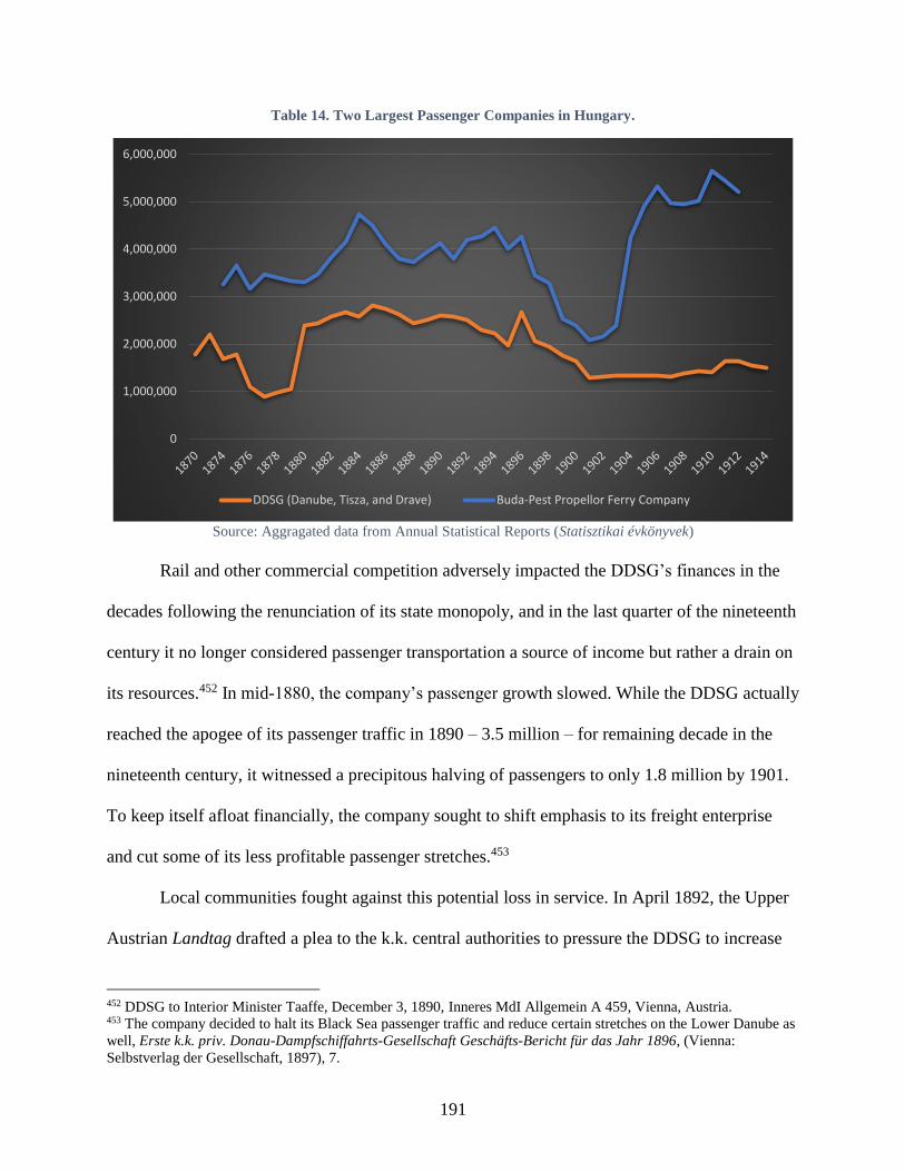
191
Table 14. Two Largest Passenger Companies in Hungary.
Source: Aggragated data from Annual Statistical Reports (Statisztikai évkönyvek)
Rail and other commercial competition adversely impacted the DDSG’s finances in the
decades following the renunciation of its state monopoly, and in the last quarter of the nineteenth
century it no longer considered passenger transportation a source of income but rather a drain on
its resources.452 In mid-1880, the company’s passenger growth slowed. While the DDSG actually
reached the apogee of its passenger traffic in 1890 – 3.5 million – for remaining decade in the
nineteenth century, it witnessed a precipitous halving of passengers to only 1.8 million by 1901.
To keep itself afloat financially, the company sought to shift emphasis to its freight enterprise
and cut some of its less profitable passenger stretches.453
Local communities fought against this potential loss in service. In April 1892, the Upper
Austrian Landtag drafted a plea to the k.k. central authorities to pressure the DDSG to increase
452 DDSG to Interior Minister Taaffe, December 3, 1890, Inneres MdI Allgemein A 459, Vienna, Austria. 453 The company decided to halt its Black Sea passenger traffic and reduce certain stretches on the Lower Danube as
well, Erste k.k. priv. Donau-Dampfschiffahrts-Gesellschaft Geschäfts-Bericht für das Jahr 1896, (Vienna:
Selbstverlag der Gesellschaft, 1897), 7.
0
1,000,000
2,000,000
3,000,000
4,000,000
5,000,000
6,000,000
DDSG (Danube, Tisza, and Drave) Buda-Pest Propellor Ferry Company
192
its passenger traffic on the Upper Austrian Danube, particularly for local communities from Linz
up to Engelhartszell and from Linz down to Grein.454 In response, the DDSG instated a twice-
weekly freight transport between Linz and Passau, which allowed passengers to buy tickets to
ride on the deck. This provided residents with some limited transport options. The DDSG also
offered the same service on its twice-weekly Vienna-Linz freight line. In 1893, once the Danube
opened for the season, the DDSG set up a local ship designated to carry passenger traffic
between Stein in Lower Austria and Linz and Aschach in Upper Austria.
In each of the following years, the Upper Austrian Landtag voted to appeal to the
imperial authorities to pressure the DDSG to guarantee certain local passenger services. By
1896, the body called for the company to guarantee local passenger service to small towns along
the Danube starting at the opening of the steamship season – a time when traditionally only post
ships were on the river – until ice and wintry conditions ended the season. The DDSG, despite
“unfavorable results” on local trips from Passau to Krems, complied “upon request from the high
government and in the interests of the local residents.”455
At the turn of the century, to improve passenger traffic on the Danube, Upper and Lower
Austrian Landtage discussed possibly linking river traffic with the burgeoning “Promotion of
Foreign Traffic” [Förderung des Fremdenverkehres] movements in the different provinces,
which had existed since 1884.456 These movements proposed boosting economic development by
attracting tourists, though certain agrarian interests voiced strong opposition to them. As local
groups founded associations in cities and provinces to support this goal, they distributed
454 Oberösterreichischer Landesausschuss (ed), Bericht über die Thätigkeit des oberösterreichischen Landtages und
des von diesem gewählten Landesausschusses in der VIII. Wahlperiode vom 14. Oktober 1890 bis Sommer 1896,
(Linz: Verlag des Landesausschuss, 1896), 141-3. 455 Geschäfts-Bericht für das Jahr 1896, (Vienna: Selbstverlag der Gesellschaft, 1897), 2. 456 Oberösterreichischer Landesausschuss (ed), Bericht über die Thätigkeit des oberösterreichischen Landtages und
des von diesem gewählten Landesausschusses in der VIII. Wahlperiode vom 14. Oktober 1890 bis Sommer 1896,
(Linz: Verlag des Landesausschuss, 1896), 141-3.
193
brochures in German, English, and French and petitioned the imperial authorities to subsidize
and advertise their activities.457
Melk’s city council also tried to promote Danube traffic in Lower Austria, which required
it to appeal to both provincial and commercial authorities. In fall 1895, the city council began
debating the train and ship schedules, which could maximize the efficiency of transporting
people to the Wachau from up or downstream. In these and later discussions, the council
recognized that local practices – such as local businesses’ opening hours – affected tourism to
the area. The following spring, certain council members argued that ‘hospitality locations’
should be permitted to stay open later – until 4 or 5 am – to cater to early or late arrivals into
town. The council also granted a local request to appeal to the DDSG for more convenient
passenger traffic.458 The “Tourist Club” in Melk also sent petitions to both the rail company and
the DDSG to request that the two companies coordinate their departure times, which would
preferably connect to the community twice a day.459
As tourism blossomed in the Wachau, Melk’s city council regretted its earlier decision to
sell its propeller ferry, which left it without a convenient means to cross the river. The council
therefore decided to construct a flying bridge, a type of ferry anchored in the middle of the river,
which swung like a pendulum between the banks. To construct it, the council requested subsidies
from the Lower Austrian authorities. In its petition, the council claimed that without the means to
cross the Danube, Melk’s tourism industry would decline. The request complained the Danube
lacked the traffic of the Rhine, but claimed that it was a source of great patriotism, and the
promotion of foreign traffic would better take advantage of the “imperial river.” Advocates
457 Rechenschaftsbericht des Gemeinderathes der Landeshauptstadt Linz über seine Thätigkeit im Jahre 1901 nebst
anderen statistischen Daten, (Linz: Selbstverlag des Gemeinderathes, 1902), 138; 484. 458 Melk municipal council meeting, 9 October 1895/15 February 1896, Gemeinderathsprotokolle, Melk, Austria. 459 Melk municipal council meeting, 30 April 1892, Gemeinderathsprotokolle, Melk, Austria.
194
realized, for example, that especially tourists from Vienna, such as singing groups
[Gesangvereine] liked to take excursions out to the Wachau. By 1898, the Landesausschuss
(provincial executive body) granted the city a 15,000-florin subsidy to construct the flying
bridge. This decision corresponded with arrival in town of the Lower Austrian Statthalter Count
Kielmannsegg, who along with ambassadors and delegates from Britain, France, Italy, Romania,
Saxony, and Berlin came to Melk to visit the Benedictine abbey and dine aboard a luxurious
steamship docked nearby.460
The DDSG itself certainly recognized the benefit of tourism and spectacle on its bottom
line. In its 1867 business report, it had recorded the positive effects that the Paris World Fair and
Franz Joseph and Sisi’s 1867 coronation in Buda had had on passenger traffic. In both instances,
travelers had used the occasion of other events to incidentally enjoy Danube cruises.461 When
Vienna hosted the World Fair in 1873, the DDSG had also attracted attendees by reducing tickets
down the Danube by 50% as well as reducing freight costs for objects and animals heading to
Vienna for the fair. Unfortunately, despite long-awaited crowds, for which the DDSG had
prepared ships and stations around Vienna for pleasure cruises in town and around the
fairgrounds at Prater at lowered prices, the poor weather and subsequent financial crisis
depressed turnout as well as disrupted general commerce and passenger traffic on the Danube.
The company glumly operated at a loss that year.
Tourism from the World Fairs intrigued the population in Hungary, which read extensive
reports in the papers about the innovations and progress on display. Especially after the 1867
Paris World Fair and somewhat after the 1873 flop in Vienna, local initiatives endeavored to
460 Linde, Chronik des Marktes und der Stadt Melk, 378-416. 461 Erste k.k. priv. Donau-Dampfschiffahrts-Gesellschaft Geschäfts-Bericht der Betriebs-Direction über das
Verwaltungsjahr vom 1. December 1866 bis 30. November 1867, (Vienna: Selbstverlag der Gesellschaft, 1868), 11.
195
bring attention to Budapest as well, with its modern features emerging from the city renewal
projects and Danube regulation, which had commenced in 1871.462 In 1876, papers described the
large delegation of visitors departing Budapest on DDSG ships to sail down the Danube to
Constantinople for the International Congress of Ancient History.463 In 1885, organizers in
Budapest hosted the Countrywide Exhibition [Országos Kiállítás], which displayed products
from around Hungary meant to attract foreign visitors. Budapest finally hosted the World Fair in
1896, which corresponded with its Millennial Celebrations (as described in Chapter 1). The
DDSG declared that its business in 1896 had taken off, thanks to both favorable river conditions
and the lively passenger traffic from Vienna to Budapest and local Budapest traffic related to the
celebrations.464
Jahrhundertwende: A Renaissance465
At the end of the nineteenth century and particularly the first decades of the twentieth
century, persistent local initiatives, along with more favorable navigational conditions from
regulated Danube stretches, led to a renaissance in traffic on the monarchy’s waterways.
Passenger traffic in Hungary, which in 1901 had reached its lowest point in decades with only 5
million passengers, nearly doubled to 9.2 million by 1912 (Table 15; Table 16). River traffic in
Austria also rose. From 1902 to 1912, there was a 72% increase in traffic on Danube between
462 Alexander Vari, “From “Paris of the East” to “Queen of the Danube”: International Models in the Promotion of
Budapest Tourism, 1885-1940,” in Touring Beyond the Nation: A Transnational Approach to European Tourism
History, ed. Eric G. E. Zuelow (Ashgate, 2011), 103-126. 463 “Az őstörténelmi nemzetközi kongresszusra,” Vasárnapi Újság, (Budapest, Hungary), May 28, 1876. 464 Geschäfts-Bericht für das Jahr 1896, 1-2. 465 James Shedel uses the term Jahrhundertwende (lit. ‘turn of the century’) to re-cast the monarchy as a site of
vitality and resilience at the end of the century as a challenge to Carl Schorske’s iconic depiction of Liberalism’s
retreat and the chaotic and dark forces of mass politics of fin-de-siècle Vienna, James Shedel, “Fin-de-Siècle or
Jahrhundertwende: The Question of an Austrian Sonderweg,” in Rethinking Vienna: 1900, edited by Steven Beller,
(New York; Oxford: Berghahn Books, 2001), 80-104; Carl Schorske, Fin-De-Siecle Vienna: Politics and Culture,
(New York: Vintage Books, 1981).
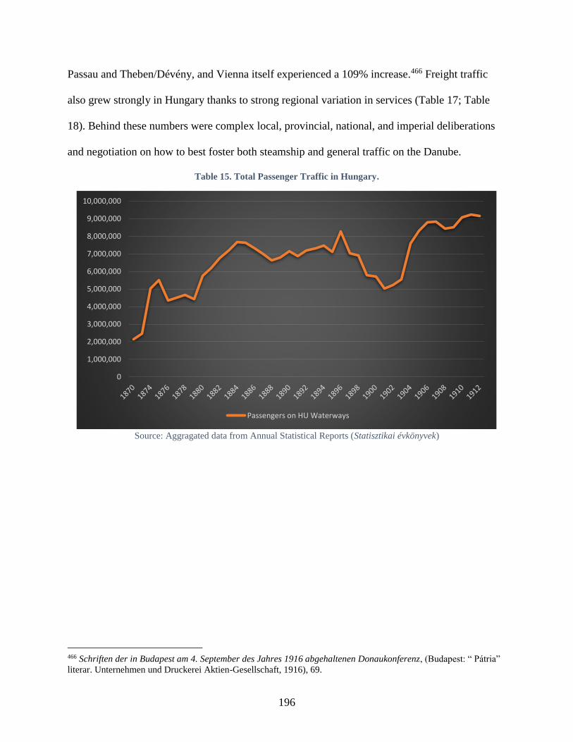
196
Passau and Theben/Dévény, and Vienna itself experienced a 109% increase.466 Freight traffic
also grew strongly in Hungary thanks to strong regional variation in services (Table 17; Table
18). Behind these numbers were complex local, provincial, national, and imperial deliberations
and negotiation on how to best foster both steamship and general traffic on the Danube.
Table 15. Total Passenger Traffic in Hungary.
Source: Aggragated data from Annual Statistical Reports (Statisztikai évkönyvek)
466 Schriften der in Budapest am 4. September des Jahres 1916 abgehaltenen Donaukonferenz, (Budapest: “ Pátria”
literar. Unternehmen und Druckerei Aktien-Gesellschaft, 1916), 69.
0
1,000,000
2,000,000
3,000,000
4,000,000
5,000,000
6,000,000
7,000,000
8,000,000
9,000,000
10,000,000
Passengers on HU Waterways

197
Table 16. Largest Companies’ Passenger Traffic in Hungary (excl. DDSG), 1870-1914.
Source: Aggragated data from Annual Statistical Reports (Statisztikai évkönyvek)
0
100,000
200,000
300,000
400,000
500,000
600,000
700,000
800,000
Balaton Steam Nav. Co
kk priv. oest. Staatsbahn Gesellschaft
Alföld-Fiume Rail (ferry between Gombos és Erdőd near Drave confl)
Lázár Günsberger
Medve Steam Ferry
Palánka-Illok Steam Ferry Co
Bezdán-Batina Steam Ferry
Novoszello-Szotin Steam Ferry
Mirkovics and Kaiser in Kamenicz (near Novi Sad)
Esztergom Steam Nav. Co
Cserovics-Futtak Steam Ferry
Hungarian Royal State Railway
Djakovics M., Kamenicza-ujvidek (Novi Sad) Steam Ferry
Hungarian River and Sea Nav. Co
Duna-Szekcső Public Ferry
Mohács Large Commune Co
Pressburg/Pozsony Ferry (Hörnes Henrik)
Visegrád-Nagymaros Ferry
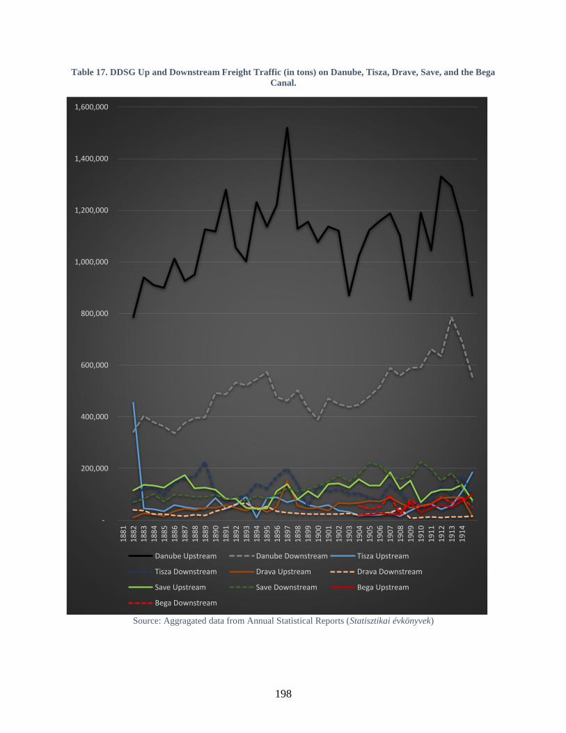
198
Table 17. DDSG Up and Downstream Freight Traffic (in tons) on Danube, Tisza, Drave, Save, and the Bega
Canal.
Source: Aggragated data from Annual Statistical Reports (Statisztikai évkönyvek)
-
200,000
400,000
600,000
800,000
1,000,000
1,200,000
1,400,000
1,600,000
18
81
18
82
18
83
18
84
18
85
18
86
18
87
18
88
18
89
18
90
18
91
18
92
18
93
18
94
18
95
18
96
18
97
18
98
18
99
19
00
19
01
19
02
19
03
19
04
19
05
19
06
19
07
19
08
19
09
19
10
19
11
19
12
19
13
19
14
Danube Upstream Danube Downstream Tisza Upstream
Tisza Downstream Drava Upstream Drava Downstream
Save Upstream Save Downstream Bega Upstream
Bega Downstream
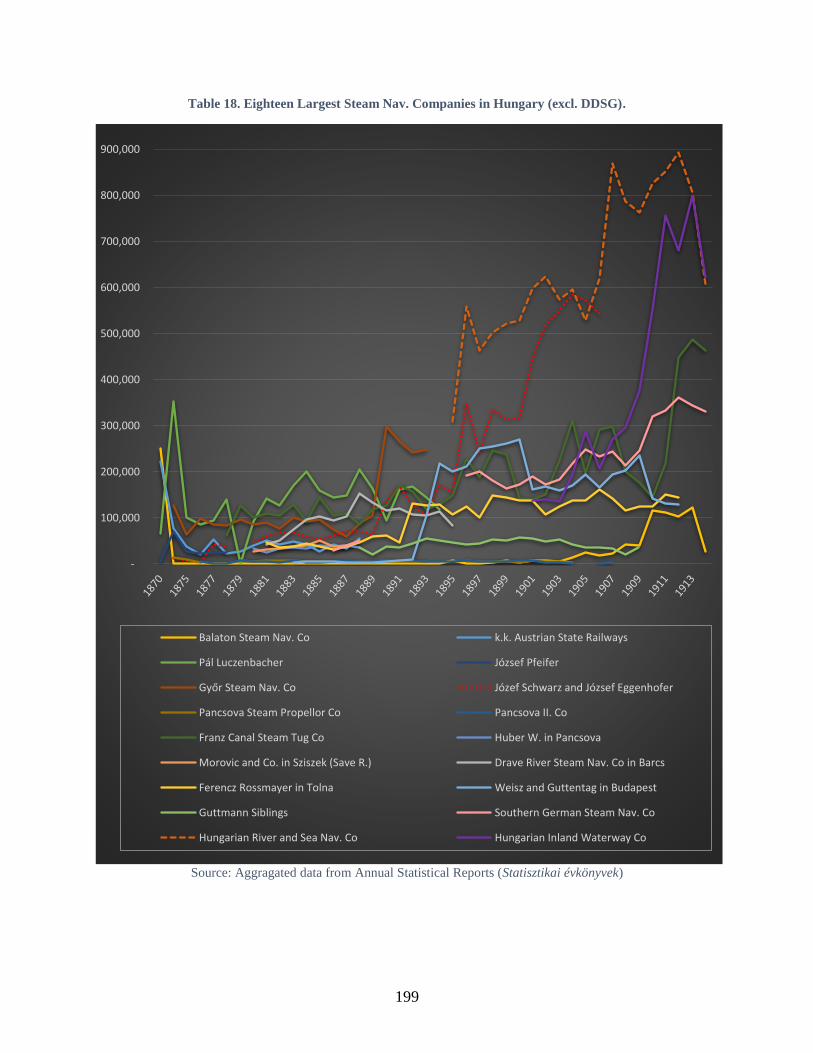
199
Table 18. Eighteen Largest Steam Nav. Companies in Hungary (excl. DDSG).
Source: Aggragated data from Annual Statistical Reports (Statisztikai évkönyvek)
-
100,000
200,000
300,000
400,000
500,000
600,000
700,000
800,000
900,000
Balaton Steam Nav. Co k.k. Austrian State Railways
Pál Luczenbacher József Pfeifer
Győr Steam Nav. Co Józef Schwarz and József Eggenhofer
Pancsova Steam Propellor Co Pancsova II. Co
Franz Canal Steam Tug Co Huber W. in Pancsova
Morovic and Co. in Sziszek (Save R.) Drave River Steam Nav. Co in Barcs
Ferencz Rossmayer in Tolna Weisz and Guttentag in Budapest
Guttmann Siblings Southern German Steam Nav. Co
Hungarian River and Sea Nav. Co Hungarian Inland Waterway Co
200
Even though numerous petitions and the Upper Austrian Landtag’s appeals to the k.k.
central government had successfully convinced the DDSG to not only maintain but to expand
passenger routes in the 1890s, at the turn of the century, they demanded even more from the
company. Petitioners frequently complained to the provincial authorities that local passenger
transports were inconvenient or non-existent, if ships arrived at all, and many complained about
the high prices of tickets. The provincial legislature decided in an October session in 1901 to
petition the authorities in Vienna and demand that the DDSG implement several measures to
improve safety and convenience for passengers. These requests including installing telephone or
telegraph lines between stations – so they could communicate with each other to notify travelers
about possible delays with steamships – and offering at least one, daily passenger service
traveling in both directions on the Danube. Should the DDSG not honor these requests, the diet
members argued that the imperial government should shoulder the costs to guarantee navigation
through other means.467
These efforts at the provincial level also reflected the strong civic engagement at the
municipal and associational level to maintain the Danube’s river network. In January 1902, the
small municipality of Aggsbach in Lower Austria banded together with 18 other communities to
request a steamship station from the DDSG. Their petition also arrived at the k.k. Trade
Ministry, and expressed hope that a new station would continue supporting efforts to bring
tourists to the region and connect their hinterland to the river.468 Later that April, the “Upper
Austrian Association for Foreign Traffic” [Landesverband für Fremdenverkehr in
467 Oberösterreichischer Landesausschuss (ed), Bericht über die Thätigkeit des oberösterreichischen Landtages und
des von diesem gewählten Landesausschusses in der IX. Wahlperiode vom Sommer 1896 bis Sommer 1902, (Linz:
Verlag des Landesausschuss, 1902), 468 Along with Aggsbach, the commubities included Groisbach, Willendorf, Köfering, Thalheim, Giesshübl,
Wiemannsreith, Leeb, Hublhof, Hof, Letzendorf, Schlanbing, Maria Laach, Zeising, Friedensdorf, Loitzendorf,
Nonnensdorf, Zintring, and Grimsing, Mayor of Aggsbach to DDSG, 3 June 1902, AT-OeStA/AVA Handel HMallg
A 914 Donauangelegenheiten (K/b), Zl. 25001-Ende.
201
Oberösterreich] suggested ways that the k.k. Trade Ministry could help coordinate rail and ship
schedules on the Danube for more favorable passenger traffic.469 Additional petitions took up
this thread, trying to determine how the company could better supplement arriving and departing
rails or ensure that its ships trafficked at more favorable hours to avoid inconveniencing
passengers with late-night arrival times.
Several solutions emerged to support more favorable passenger connections. The DDSG
responded by printing pocket schedules for travelers to have easier access to the company’s
steam schedules. It also maintained certain stretches “despite their unprofitability,” and even
expressed interest to the Statthalterei in Upper Austria that one community’s petition for a
steamship station at Akoven seemed worthy of consideration. The community’s petition had
argued that people who lived from agricultural products in the region needed access to markets,
but the town was 8 kilometers from the nearest rail station, 11.4 kilometers from the nearest
steamship station at Brandstatt, and 22.8 kilometers from Linz.470 Other solutions to support
steamship traffic required denying other practices on the Danube. When the k.k. Inland
Navigation Inspector received a petition in June 1902 from a man who wanted to establish a
ferry over the Danube, the inspector wrote to the k.k. Trade Ministry, the final arbiter, to express
his opinion that this shouldn’t be allowed because the increase in traffic across the river could
hinder ships traveling up and down the river.471
The Upper Austrian Landtag once again acted in November 1904 to induce the DDSG to
attend to the needs of its provincial economy. To improve the “prominent economic significance
469 Landesverband für Fremdenverkehr in Oberösterreich to the k.k. Trade Ministry, 10 May 1902, AT-OeStA/AVA
Handel HMallg A 914 Donauangelegenheiten (K/b), Zl. 25001-Ende. 470 Alkoven’s mayor to Upper Austria Statthalter, 24 November 1902, AT-OeStA/AVA Handel HMallg A 914
Donauangelegenheiten. 471 K.k. Inland Waterways Inspector to Trade Ministry, 3 June 1902, AT-OeStA/AVA Handel HMallg A 912.

202
of the Danube as a traffic way,” these needs included the expansion in the number and quality of
landing stations, telephone connections between those stations, and the company’s support in
pressuring Hungary to remove its ‘transport tax.’ The provincial body presumed that the
company would be more amenable to granting its petition in light of its impending contract
renewal with the imperial government.472
The Landtag’s assumptions were incorrect, and in February 1907, the Linz city council
confirmed that the DDSG and imperial government were unable to agree to the terms of its state
subsidy. Hurting from its loss of passenger business in Hungary (Table 19; Table 20) since 1899,
the DDSG threatened to reduce or even eliminate its passenger routes between Passau and
Vienna. This alarmed the population on the Upper Danube, and the Linz city council drafted the
following resolutions: the imperial government should force the DDSG to maintain the routes
that it had, and the imperial authorities should immediately introduce the groundwork to set up a
state navigation company for the stretch between Passau and Vienna. All local and provincial
representatives expressed their dissatisfaction with the DDSG given that it had a de facto
monopoly for Danube transport, which the authorities supported by providing it with generous
subsidies. Complainants declared that the company only used its subsidy to increase its fleet
rather than support its business along less profitable stretches.473 Despite or due to the DDSG’s
intransigence, the Upper Austrian Provincial Tourist Association deliberated how it could
effectuate its own plans to make the Danube stretch from Passau to Linz more accessible to
visitors. Although the DDSG did not see passenger traffic as profitable, the Association
472 Oberösterreichischer Landesausschuss (ed), Bericht über die Thätigkeit des oberösterreichischen Landtages und
des von diesem gewählten Landesausschusses in der X. Wahlperiode vom Sommer 1902 bis Herbst 1908, (Linz:
Verlag des Landesausschuss, 1908), 188. 473 Rechenschaftsbericht des Gemeinderathes der Landeshauptstadt Linz über seine Thätigkeit im Jahre 1907 nebst
anderen statistischen Daten, (Linz: Selbstverlag des Gemeinderathes, 1908), 157.
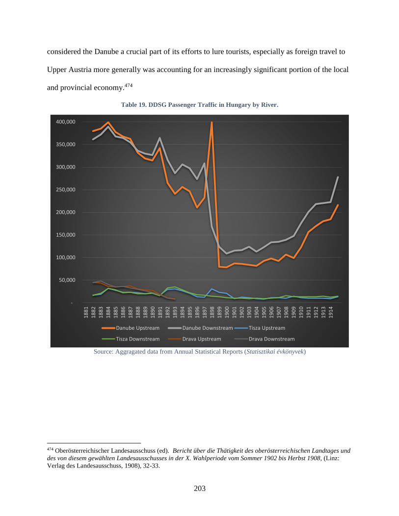
203
considered the Danube a crucial part of its efforts to lure tourists, especially as foreign travel to
Upper Austria more generally was accounting for an increasingly significant portion of the local
and provincial economy.474
Table 19. DDSG Passenger Traffic in Hungary by River.
Source: Aggragated data from Annual Statistical Reports (Statisztikai évkönyvek)
474 Oberösterreichischer Landesausschuss (ed). Bericht über die Thätigkeit des oberösterreichischen Landtages und
des von diesem gewählten Landesausschusses in der X. Wahlperiode vom Sommer 1902 bis Herbst 1908, (Linz:
Verlag des Landesausschuss, 1908), 32-33.
-
50,000
100,000
150,000
200,000
250,000
300,000
350,000
400,000
18
81
18
82
18
83
18
84
18
85
18
86
18
87
18
88
18
89
18
90
18
91
18
92
18
93
18
94
18
95
18
96
18
97
18
98
18
99
19
00
19
01
19
02
19
03
19
04
19
05
19
06
19
07
19
08
19
09
19
10
19
11
19
12
19
13
19
14
Danube Upstream Danube Downstream Tisza Upstream
Tisza Downstream Drava Upstream Drava Downstream
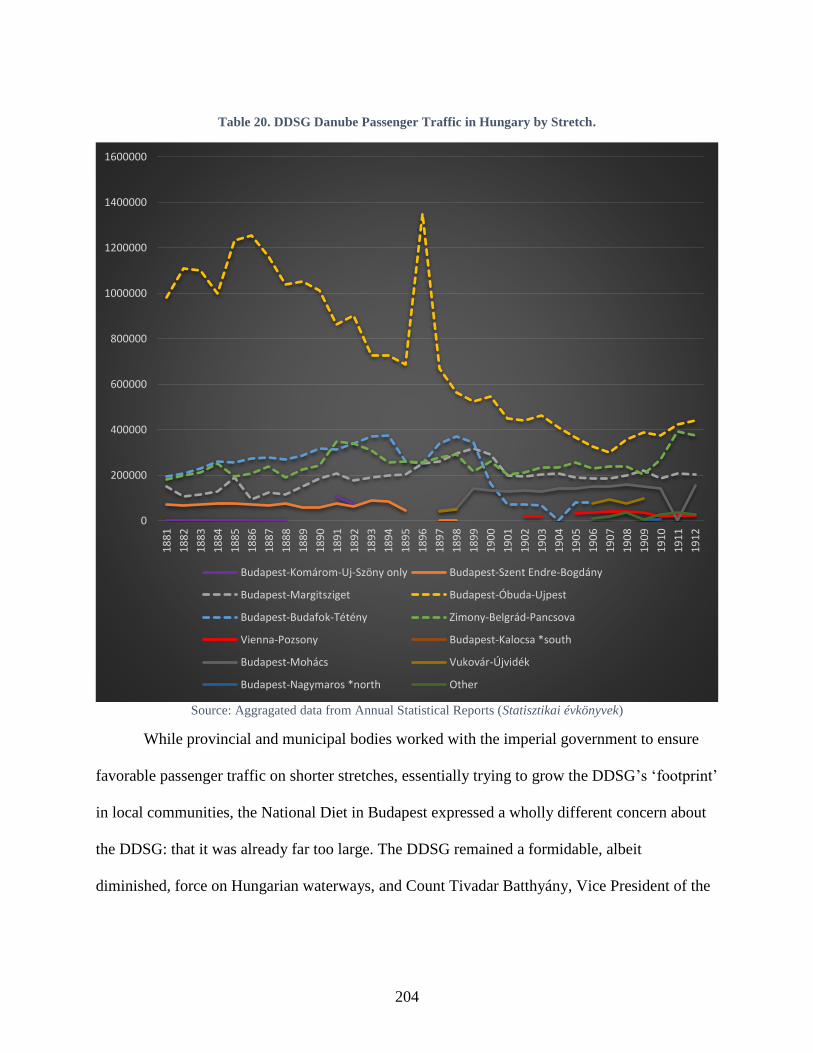
204
Table 20. DDSG Danube Passenger Traffic in Hungary by Stretch.
Source: Aggragated data from Annual Statistical Reports (Statisztikai évkönyvek)
While provincial and municipal bodies worked with the imperial government to ensure
favorable passenger traffic on shorter stretches, essentially trying to grow the DDSG’s ‘footprint’
in local communities, the National Diet in Budapest expressed a wholly different concern about
the DDSG: that it was already far too large. The DDSG remained a formidable, albeit
diminished, force on Hungarian waterways, and Count Tivadar Batthyány, Vice President of the
0
200000
400000
600000
800000
1000000
1200000
1400000
16000001
88
1
18
82
18
83
18
84
18
85
18
86
18
87
18
88
18
89
18
90
18
91
18
92
18
93
18
94
18
95
18
96
18
97
18
98
18
99
19
00
19
01
19
02
19
03
19
04
19
05
19
06
19
07
19
08
19
09
19
10
19
11
19
12
Budapest-Komárom-Uj-Szöny only Budapest-Szent Endre-Bogdány
Budapest-Margitsziget Budapest-Óbuda-Ujpest
Budapest-Budafok-Tétény Zimony-Belgrád-Pancsova
Vienna-Pozsony Budapest-Kalocsa *south
Budapest-Mohács Vukovár-Újvidék
Budapest-Nagymaros *north Other

205
newly re-formed “1848 and Independence Party,” led a spirited debate in May 1911 about the
need to counter Austrian influence, given, in his words, its pernicious efforts to repress Hungary.
Count Batthyany’s general antipathy to Austria applied specifically to the DDSG, which
he believed the Austrians used as a tool of aggression and dominance. Ironically, in his
discussion of the company, the first problem he cited regarding its operations in Hungary was the
same issue that upstream communities in Austria had likewise been complaining about; namely,
the company’s network was so large, it did not serve all its lines properly. Batthyány went on to
assume that because the DDSG was obliged to the Austrian government via its subsidy
agreement, its commercial activities in Hungary must be “in the service of Austria’s economy.”
This annoyed Battyány because he felt that while the Hungarian authorities treated the DDSG
royally, offering it the finest landing places, the Hungarian national company operating in
Austria was treated far worse by provincial and imperial authorities in harbors from Linz to
Vienna in what he saw as a clear violation of the Danube Act. Ultimately, he argued that
Hungary’s low proportion of freight movement via its waterways – compared to rails – did not
match their potential, and “there is no sanctity that God blessed the region with so many rivers,
with no match in the cultured world, only for there to be such small use of this cheap means of
transportation.”475
Batthyány and his colleagues in the diet recognized that to enhance trade, it was
necessary to support both more navigation, literally more ships, but also to construct river
infrastructure, like transshipment stations, to integrate river traffic to the booming rail network.
Batthyány declared that “one of the most important foundations of economic development in this
country is the development of Hungarian shipping,” because he believed that unlike rail policy, it
475 Az 1910. évi junius hó 21-ére hirdetett országgyűlés képviselőházának naplója, vol. 7 (Budapest: Az Athenaeum
Irodalmi és Nyomdai Részvénytársulat Könyvnyomda, 1911), 395-96.
206
was the one area Hungary could develop independently from the Austrians.476 A few months
later, in December, the Royal Trade Minister Lászlo Beöthy also supported Batthyány’s
passionate plea to develop Hungary’s water traffic. Beöthy, however, did not see a river policy
separately from a rail one, and instead thought that promoting the national steamship company
would enhance and relieve traffic on rails.477
Austria-Hungary’s Danube
Such nationalist concerns from Budapest were antithetical to the smooth functioning of
affairs between both halves of the monarchy, and it was likewise counterintuitive to the
exchanges actually occurring along the Danube. The Hungarians had already seemed to
acknowledge as much during customs union negotiations several decades earlier in 1875. While
the decennial negotiations478 between Vienna and Budapest regarding the customs union and
mutual contributions for common affairs (military, finance, and foreign affairs) were normally
fraught with antagonism, in 1875, the Hungarian delegation published several positive statistics
about the trade and relationship between both halves of the monarchy. While emphasizing the
DDSG’s prodigious growth figures between 1835 and 1875, one report stated, “it is common
knowledge that a large part of this company’s traffic is directly related to the traffic between
Austria and Hungary, as the Danube is a natural partner of two parts of the monarchy.”479
476 Ibid, 395. 477 Az 1910. évi junius hó 21-ére hirdetett országgyűlés képviselőházának naplója, vol. 13 (Budapest: Az
Athenaeum Irodalmi és Nyomdai Részvénytársulat Könyvnyomda, 1911), 144. 478 The 1867 Compromise stipulated that the responsible ministries from both halves of the monarchy would meet
every ten years to determine each half’s contributions to the common budget, to agree upon external tariffs, and to
negotiate other matters pertinent to the joint ministeries. 479 “Köztudomású, hogy ezen vállalat forgalmának tetemes része közvetlenül az Ausztria és Magyarország közti
forgalmare vonatkozik, miután a Duna a monarchia két felének természetes összefüzője,” Az 1875-ik évi augustus
hó 28-ára kihirdetett országgyűlés főrendi házának irományai, vol. 8 (Budapest: Pesti Könyvnyomda-Részvény-
Társulat, 1878), 165.
207
Even during the period of uncertain and uneven development in both halves’ trade and
passenger policies in the last decade of the nineteenth century, elements of commercial cohesion
did not suffer. A great variety of industries and agricultural practices remained linked between
both halves of the monarchy. In the period from 1886 to 1895, trade from Austria to Hungary
doubled from 10 to 20 million metric-centners. Over 6 million came from wood, coal, and peat,
nearly 700,000 from iron and iron wares, almost 600,000 from drinks, and over 500,000 from
‘minerals.’ Trade from Hungary to Austria likewise increased nearly 40% from 21 to 30 million
metric-centners. The largest increase by weight was 4.7 million more metric-centners in grains,
milled products, and rice, over 1 mil. metric-centner increase in fruit, vegetables and assorted
plants, and 1.4 million in animals.480 Although in much smaller quantities, the largest growth
percentage came from brush binders (Bürstenbinder) and goods for making sieves
(Siebmacherwaaren), flax, hemp, and goods made from those products, rubber and rosin, and
victuals (Esswaaren).481
Steamship freight traffic at the turn of the century indicated the large extent to which both
halves of the monarchy were linked in river trade. In 1901, DDSG reports measured the quantity
of goods it transported to and from cities on the Austrian Danube and grouped them based on
their point of origin (for arriving goods) and destination (for departing goods). Goods were
exported to and imported from Bavaria, Serbia, Bulgaria, Romania, Russia, Odessa, Batum, or
Constantinople and the Orient. For goods originating within or departing for locations in the
monarchy, the chart distinguished whether goods’ origins/destinations were Austrian waterways
or the Danube, Drave, Save, or Tisza in Hungary.
480 K.k. Statistische Central-Commission, Statistik des Verkehrs in den im Reichsrathe vertretenen Königreichen und
Ländern vornehmlich für die Jahre 1894 und 1895, (Vienna: k.k. Hof- und Staatsdruckerei, 1897), XLIII-XLIV. 481 The brush binder and sieve makers went up over 1,000%, flax/hemp 289%, rubber/rosin 282%, victuals 248%,
208
The graph data reveals that Hungarian and Austrian markets and products remained
intertwined by steamship freight networks. Of goods departing from Austrian towns on DDSG
steamships 79.61% of the total remained within the monarchy – destined for locations on
Austrian or Hungarian waterways – and specifically 52.18% departed for Hungarian waterways.
Thus, of the DDSG steamship freight departing Austrian towns for a destination in the
monarchy, 66% ended up in Hungary and only 34% ended up in Austria. Of the total goods
DDSG steamships unloaded at Austrian towns, 85.45% originated from within the monarchy,
and an astounding 72.71% originated from Hungarian waterways. That meant that of all the
DDSG’s goods originating from within the monarchy, 85% arriving in Austrian towns were from
Hungary and only 15% were from other Austrian towns.482
In 1900-6, freight traffic between both halves of the monarchy increasingly arrived on
steamships and waterways.483 Freight weight traveling from Hungary to Austria rose from 5.2 to
7.2 million metric-centners, a growth of 10.6% to 14.7% of total freight traffic from east to west.
These goods also increased in value from 8.4% to 13.8% of the total worth of goods. For goods
traveling downstream from Austria to Hungary, freight increased from 1.4 to 2.2 million metric-
centners, accounting for a rise from 6.23% to 7.4% of the freight share, and from 12% to 16.5%
in goods’ value.484 Almost four times more total freight headed upstream from Hungary to
Austria on steamships than arrived downstream in Hungary from Austria, however, this was a
482 AT-OeStAAVA Handel HMallg A 914. 483 In relation to the proportion of goods arriving by rail, waterway/steamship, sea navigation, or post lines. 484 K.k. Statistische Zentral-Commission (ed), “Der Zwischenverkehr der im Reichsrate vertretenen Königreiche und
Länder mit den Ländern der ungarischen Krone in den Jahren 1900 und 1901,” Oesterreichische Statistik 68, no. 1/2
(Vienna: Hof- und Staatsdruckerei, 1905): LXX; K.k. Statistische Zentral-Commission (ed), “Der Zwischenverkehr
der im Reichsrate vertretenen Königreiche und Länder mit den Ländern der ungarischen Krone für die Jahren 1902
bis 1905,” Oesterreichische Statistik 82, no. 3/2 (Vienna: Hof- und Staatsdruckerei, 1905): LXVII; Österreichisches
Statistisches Handbuch: Sechsundzwanzigster Jahrgang 1907, (Vienna: Verlag der k.k. statistischen
Zentralkommission, 1908), 327; K.k. Statistische Zentralkommission (ed), “Der Zwischenverkehr der im Reichsrate
vertretenen Königreiche und Länder mit den Ländern der ungarischen Krone in den Jahren 1906 u. 1907,”
Oesterreichische Statistik 91, no. 4/2 (Vienna: Hof- und Staatsdruckerei, 1911): LV-LVII.
209
common trend for steamship traffic (at Engelhartszell in Upper Austria, this ratio was even
higher). In both cases, however, the quantity, proportion, and value of goods trafficking between
Austria and Hungary continued to grow in the early twentieth century.
In the final years before the First World War started, both Hungarian and Austrian
steamship companies strongly trafficked between both halves of the monarchy. In the late 1900s,
there were five steamship companies operating on the Austrian Danube; the DDSG, the South
German Steam Navigation Company, the Royal Serbian Steam Navigation Company, and two
Hungarian companies, the Hungarian River and Sea Navigation Joint Stock Company and J. and
M. Weisz Budapest Company. In 1908-10, the two Hungarian companies transported an average
of 22% of Austrian waterways’ freight traffic, while the DDSG transported 48%.485 In Hungary,
the DDSG accounted for over 50% of freight transportation in 1900, which gradually diminished
to 40% by 1914.486 Much as it had in 1901, the DDSG’s freight loads departing and arriving at
Austrian towns on the Danube still revealed an unmistakably strong commercial link between
Austria and Hungary. In 1913, of the 4.3 million metric-centners of goods departing from
Austrian towns on DDSG ships, only 18% remained in Austria, whereas 58% went to Hungary.
Of the goods the DDSG unloaded at Austrian towns, only 14.5% originated from Austria
whereas 66.4% came from Hungary.487 In 1910-14, the Hungarian River and Sea Navigation
Joint Stock Company, which Count Batthyány claimed was “mistreated” by the Austrians,
exported an annual average of 1.8 million metric-centners from Hungary to Austria (92% of its
upstream trade), and imported more than 740,000 metric-centners (88% of its downstream trade)
485 K.k. Statistische Zentralkommission (ed), “Gesamtverkehr auf den österreichischen Flüssen in den Jahren 1908,
1909, und 1910,” Oesterreichische Statistik 93, no. 3 (Vienna: K.k. Hof- und Staatsdruckerei, 1916): X-XI. 486 These data aggragated from the statistical reports (évkönyvek) from the Central Statistical Office in Budapest. 487 K.k. Statistische Central-Commission (ed), Österreichisches Statistisches Handbuch für die im Reichsrathe
Vertretenen Königreiche und Länder nebst einem Anhange für die gemeinsamen Angelegenheiten der
österreichisch-ungarischen Monarchie, 1914 (Vienna: k.k. Statistische Central-Commission, 1916), 165.

210
from Austria to Hungary.488 From these figures, the company’s business did not seem adversely
affected by doing business with Austrian cities and markets, which accounted for the lion’s share
of its ‘foreign’ imports and exports up until the First World War.
Conclusion
In 1848, František Palacký wrote to the National Assembly assembled in Frankfurt
“assuredly, if the Austrian State had not existed for ages, in the interests of Europe and indeed of
humanity itself we would have to endeavor to create it as soon as possible.” Palacký’s belief that
the monarchy protected smaller nations and conferred advantages onto them through their
cooperation in a larger union could not have more clearly expressed the similar role that the
Danube played in the economic and social cohesion for cities and peoples within the monarchy.
The Danube drove economic activity and increased commercial connections in a
multitude of ways. Most obviously, it provided the path along which commerce – finished goods
and raw material – transferred up and downstream between communities. This movement, in
turn, encouraged commercial and agricultural actors from the river’s hinterlands and along its
tributaries to form supply networks, integrating traffic as diverse as the salt mines of
Transylvania to the mountain pastures of Tirol.
In the early half of the nineteenth century, human and natural influences still strongly
confined activity along this commercial pathway. Despite Maria Theresia and Joseph II’s
directives eliminating several tolls, customs, and tariffs in the monarchy, many legal-commercial
‘privileges’ for cities on the river remained and hindered the free movement of goods across the
monarchy. Hungary’s exclusion from the monarchy’s common customs union until the mid-
nineteenth century – a product of its fiercely guarded political autonomy – dampened some trade
488 Österreichisches Statistisches Handbuch 1914, 167.
211
between Austria and Hungary, but hardly along the Danube. The river’s natural state likewise
offered endlessly fluctuating obstacles to ships, from rocky rapids, whirlpools and volatile
currents, shifting sandbanks, and unpredictable water depths.
Groups living and working along the Danube both intentionally and inadvertantly
modified its natural space in pursuit of their daily practices. Activities like towing boats
upstream required tree-free footpaths, an arrangement, which increased the river’s capacity to
erode the bank and release sediment into its current. This sediment eventually settled in the river,
forming sandbanks, which required additional practices like dredging. With the introduction and
expansion of steam navigation from the 1830s onward, new arrangements like steamship stations
and ferry line chains likewise dotted the riverscape.
New practices led to other environmental effects in the monarchy as well. With the rise in
steam power and the monarchy’s energy transition from biomass (wood/human labor) to fossil
fuel (coal), coal mines and railways produced and shuttled necessary material from energy-rich
regions of the monarchy to the river to fuel steamships’ rise.489 As the next chapter will discuss,
commerce on the river affected the river’s physical form in other ways as well, as the rise and
enduring importance of the grain trade and other commercial products stimulated landowners
and others to transform swampy alluvial floodplains into more ‘useful’ arable land adjacent the
river.
For a monarchy feeling the strains of diverse populations and frequently competing
ideologies, advances in transportation and communication modernized and innovated citizens’
relationship with the Danube and with each other. Steamships made the river a significantly
489 This was not a dramatic shift. Firewood continued to be one of the heaviest/largest products moved along the
Danube, especially to Vienna, even in the late nineteenth and early twentieth century, Gingrich et al, “The Danube
and Vienna,” 292-4.

212
busier route for local, regional, and imperial travel as people suddenly had the means to voyage
more comfortably – and safely – on and around the Danube. With new practices associated with
steam navigation, however, governments and bureaucracies progressively intervened to regulate
behaviors on the river. These regulations sought to promote the well-being of citizens by
protecting their safety and encouraging commercial and personal linkages across local and
transregional spaces.
Habsburg monarchs, the imperial bureaucracy, commercial groups, and eventually
communities on the river utilized the new technology to pursue goals at the imperial and local
level. After the 1867 Compromise, in contrast to divisive political and national rhetoric in
parliamentary circles, regional steamship companies touted their success by the integrative role
that they served along the monarchy’s river network. When competition with rails threatened
passenger traffic in the late nineteenth century, and stagnancy and decline characterized certain
river activities, communities on the Danube adapted practices and rallied – using the might of the
imperial government – to maintain their connection to the river. In the Habsburg Monarchy’s
final years, the Danube experienced a revitalization, continuing to serve as a transnational, intra-
monarchical network and to grow the connections between peoples, goods, and services.

213
CHAPTER 4: OVERCOMING DANUBIAN DANGERS
The Danube served as a means of travel and trade in the Habsburg Monarchy, but those
living along it had to balance its benefits with the perennial danger and threat that it represented.
Floods, ice flows, and ice dams were part of life on the Danube. Early technical, commercial,
and political bodies that organized flood protection measures tended to be particularistic,
focusing on securing local stretches under their political jurisdiction or covered by their financial
means. This uncoordinated approach failed to permanently or even consistently defend
communities from floods, and instead represented the parochial view of the river’s hydrology
and possible ways of controlling it.
Floods caused untold damages to riparian communities, which incidentally brought
together people in tangible and ritualistic ways across social, political, and national differences in
the the course of reconstruction. In relief and donations, different parts of the monarchy
exhibited great solidarity for those afflicted by floods. As Chapter 1 discussed, Habsburg
monarchs burnished the dynastic image when they visited flood sites and demonstrated care for
their imperial subjects.
The improvement in hydraulic-technical engineering sciences in the late eighteenth
century widened the theoretical understanding of hydrological behavior and engineers suggested
several technical solutions for mitigating or removing the perils of floods. Already major works
such as Johann Gottfried Tulla’s regulation of the Upper Rhine in the early nineteenth century
demonstrated the practical application of these hydraulic engineering principles, though with
little understanding of the long-term, hydrological consequences.490 Throughout Europe and the
490 Joachim Radkau writes about Tulla’s technocratic approach to river regulation, which was the model for other
hydraulic engineers after him, in the work Nature and Power: A Global History of the Environment, “Rhine River
traffic and its regulation decreed by Napoleon was maintained also by the Congress of Vienna, even though the
Rhine became at that very time the “German river” for nationalistic romantics in Germany. Rhine romanticism was

214
wider world engineers were swarming to rivers to modify and contain the dangers that they
represented. The Army Corps of Engineers targeted several stretches of the Mississippi River in
America throughout the nineteenth and twentieth centuries. After the 1910 flood, residents along
the Seine received greater protections with a series of reservoirs which reduce water pressures
during flooding. Flood protection was an increasingly necessary engineering project, especially
as urban populations surged in the nineteenth century, forcing cities to reclaim and colonize
floodplains to provide more space.
The possible elimination of floods’ ubiquitous threat opened new avenues for the
Habsburg regime to gain the populace’s trust and loyalty, dovetailing with its political and
technical offices’ employment of other reforms to maintain legitimacy. The current
historiography regarding floods in the monarchy has focused exclusively on local or national
instances of flood control and its consequences. Austrian environmental historians have looked
at Vienna as a case study and counted historical references to floods in archival material but have
not stepped outside the Austrian context. Hungarian scholars have likewise focused on the
Carpathian Basin and limited their analysis to the historic territory of Hungary. Both miss the
integration of water systems outside these national boundaries or the interplay between
engineers, officials, and other actors from within the entire monarchy. Especially when
nineteenth-century efforts were ongoing to eliminate flood dangers, the multifaceted causes of
floods, even along a single river like the Danube, required a comprehensive combination of
a different world from the technological interaction with the river…. The “rectification” of the Rhine was for Tulla a
matter for the state, one that required a “consideration of the totality” beyond particular interests. The primary
concern was protection against flooding and the reclamation of agricultural land in the Rhine meadows. Just as one
person needs only one bed, declared Tulla, the Rhine, too, like any other river, needs no more than one bed,” 199.
215
physical arrangements and social practices spanning the entire monarchy to moderate, let alone
eliminate, its dangers.
While the monarchy’s early-nineteenth-century, decentralized political authority hindered
the implementation of far-reaching technical solutions, the population in both halves of the
monarchy gradually came to realize that regulation and physical safety measures for preventing
floods required the coordination of a more centralized authority. Due to both physical and
environmental occurrences, therefore, the mid- to late nineteenth century witnessed a gradual
centralization and organization of technical work and flood response measures across the
monarchy. The centralized authorities nevertheless worked assiduously with local communities
and commercial ventures to expand their reach over nature and to reify the association between
the state and safety.
Beyond physical protections, imperial representatives also worked with municipal
authorities to begin codifying new flood responses and relief practices, which were likewise
meant to mitigate the danger and destruction of floods. These new practices and arrangements
initially proved insufficient as floods continued to afflict beleaguered communities. Eventually,
governments and companies augmented aid and financial support – previously ad hoc measures
– by passing new laws and mechanisms to guarantee that different levels of government bore the
responsibility and costs of relief and reconstruction.
To afford a contemporaneous glimpse into monarchy-wide reactions to floods, the
following segment will look at how the 1830 flood unfolded in the press across the monarchy. It
not only reveals typical responses from different governmental and private responses to the
flood, but also provides insight into how the literate public read about events like floods across
the monarchy. Newspaper articles often argued that local floods were were still a monarchy-wide
216
issue, and the papers were the first sources to opine that the Danube and its complex,
hydrographical network required more holistic plans and responses to mitigate future disasters.
A Monarchy-Wide View of the 1830 Flood
On March 1, 1830 the Vienna-based Österreichischer Beobachter broke the news that the
previous evening, February 28, the frozen Danube had partially thawed and carried freed chunks
of ice (a so-called “ice flow”) downstream, which had torn away eleven supports from the large
Tabor bridge adjacent to Vienna.491 Just one day later on March 2, the Beobachter printed news
reports from further upstream at Linz that three days before the Vienna flooding had begun, ice
had been piling up along the bridge at Linz and had torn away three supports. The Beobachter
likewise updated readers on the current conditions in Vienna, describing how ice in the Danube
Canal was blocking the river’s passage, flooding many lower places in the city with as much as
four feet of water.492 Just downstream at Pozsony/Pressburg, the local Pressburger Zeitung
relayed that residents were watching the frozen Danube, expecting that the rainy weather from
earlier in the week would thaw the ice and lead to ice flows, and as a precaution ‘only pedestrian
traffic across the Danube was permitted.’493 Two days after breaking the flood news, the
Beobachter reported that the ice flows had continued downstream, partially damaging some
bridges, and the official count for flood-related deaths was seven people. The paper relayed that
many daring and heroic rescue attempts had saved lives during the flooding.494 The Wiener
Zeitung corroborated this report, and likewise re-printed the Linz report from February 25.495 For
491 “Wien, den 28. Februar,” Österreichischer Beobacher, (Vienna, Austria), March 1, 1830. 492 “Ober-Oesterreich” and “Wien den 1. März,” Österreichischer Beobacher, (Vienna, Austria), March 2, 1830. 493 “Ungarn,” Pressburger Zeitung, (Bratislava, Slovakia), March 2, 1830. 494 “Wien, den 2. Märch,” Österreichischer Beobacher, (Vienna, Austria), March 3, 1830. 495 “Vermischte Nachrichten,” Wiener Zeitung, (Vienna, Austria), March 3, 1830.

217
literary readers, the Blätter für literarische Unterhaltung even published a sad folk song
“Trauriges Erkennen,” which named the Danube an “Unglücksfluss” or “river of misfortune.”496
Three days after the initial flooding, on March 4, the “Intelligenzblatt” of the Wiener
Zeitung published a large, front-page appeal asking for “noble-minded, well-intended people” to
help with the monetary efforts to rebuild communities and get the poor classes affected back on
their feet. The appeal pointed to the fact that everyone in Vienna knew how these disasters
affected people, and indicated that many people lost everything – their house and possessions,
including the tools they needed to earn money. It also reminded readers that the Viennese had
always helped in the past – whether after fire or flood disasters – and hoped that people felt
compassion to help their fellow citizens.497 The Beobachter argued that the river’s progression
seems to indicate that the flooding would hopefully quickly drain and it revised its death count to
over thirty.498 That same morning, a non-Danubian city in the monarchy took up the story; a
paper from Moravia’s provincial capital, the Brünner Zeitung der k.k. priv. mähr. Lehenbank,
printed the original story from March 1 about the Danube’s initial thaw.499
On March 5, after four days of Danube flooding, the Wiener Zeitung graciously thanked
the Viennese for their generous and heroic response to the flood, many having donated or helped
during the period of flooding. The paper listed the donations – named and anonymous – and
advertised a benefit concert at the k.k. Redoutensaal to raise donations to help the residents and
reduce suffering and misery in town as quickly as possible.500 That same day, Brünn’s paper
reprinted the Beobachter assessment from the day before, and the Pressburger Zeitung claimed
496 Blätter für literarische Unterhaltung, (Vienna, Austria), March 3, 1830. 497 “Aufruf an edeldenkende, wohlthätige Menschen,” Wiener Zeitung, (Vienna, Austria), March 4, 1830. 498 “Wien, den 3. März,” Österreichischer Beobachter, (Vienna, Austria), March 4, 1830. 499 “Wien, den 28. Februar,” Brünner Zeitung der k.k. priv. mähr. Lehenbank, (Brno, Czech Republic), March 4,
1830. 500 “Einladung an die edlen und menschenfreundlichen Bewohner Wiens,” Wiener Zeitung, (Vienna, Austria),
March 5, 1830.
218
that although the river was free from ice in many stretches, it remained dangerous for ships
trying to cross.501
Just five days after the flood, the March 6 papers began to repeat and re-tell the story of
the flood. The Wiener Zeitung reprinted their ad calling for aid.502 The Brünner Zeitung once
again printed the Beobachter’s assessment that the flood water should drain quickly.503 And
another provincial capital’s paper, the Grazer Zeitung, retold the whole flood story starting with
the March 1 flooding and indicating what exactly went wrong – using language almost identical
at points to the March 2 Beobachter report. According to the article, despite Wachtposten in
place to warn against flooding, the water level rose too quickly to raise and spread the alarm, and
strong floodwaters washed away preparatory measures – such as staircases and boats – which
were meant to help residents quickly exit buildings and escape the water.504 Another poignant
account appeared from the Allgemeine Theaterzeitung editor Adolf Bäuerle, which later appeared
in papers across the monarchy: Pressburger Zeitung (March 12), Grazer Zeitung (March 13),
Vereinigte Laibacher (March 13), Kais. Königl. Schlesische Troppauer-Zeitung (March 15),
Brünner Zeitung der k.k. priv. mähr. Lehenbank (March 16), and finally the K. K. priv. Prager
Zeitung (March 18). Weeks after the event, papers across the monarchy reported on the post-
flood destruction and disruption – how floods had inundated the shores, washed away streets
near the Danube’s banks, destroyed buildings, hindered postal carriers, and even led to several
deaths. Some papers enumerated which communities the flooding had affected and how much
damage they had sustained.
501 “Wien, den 2. März,” Brünner Zeitung der k.k. priv. mähr. Lehenbank, (Brno, Czech Republic), March 5, 1830;
“Pressburg, 4tn März,” Presssburger Zeitung, (Bratislava, Slovakia), March 5, 1830. 502 “Aufruf an die Frauen Wiens,” Wiener Zeitung, (Vienna, Austria), March 6, 1830. 503 “Wien, den 2. März,” Brünner Zeitung der k.k. priv. mähr. Lehenbank, (Brno, Czech Republic), March 6, 1830. 504 “Wien,” Grazer Zeitung, (Graz, Austria), March 6, 1830.
219
In conjunction with messages of destruction, notices in the newspaper coordinated efforts
to alleviate suffering and simultaneously acknowledged the support people were receiving. Calls
for donations continued to spread to regional papers with advertisements delineating where and
how goods and aid could be delivered. Articles discussed the huge relief that flood victims had
already received, thanks in a large part to the generous donation of private Vereine. On March
30, the Wiener Theater-Zeitung composed a word of thanks – in poem form - on behalf of those
saved from the floods. The poem spoke of heartbreak and loss, but also evoked moments of
solidarity and heroism, and hope for rebirth after the tragedy.505 It reprinted the poem on its front
page a few days later. And on April 9, the Wiener Zeitung published an “Oeffentliches Dank”
(public thanks) from the Vorsteher of Leopoldstadt and Jägerzeil for the dedication, hard work
and donations that the residents in Vienna had poured out in their efforts to help those affected
by the flood.
Even as the flooding subsided, reports continued to appear in papers in provincial capitals
in March and intermittently throughout April. Donation solicitations, dramatic re-tellings, and
even historical analyses of the Danube’s conditions which led to such an historic flood all filled
pages of the daily news. When one local paper in Pressburg/Pozsony, for example, published a
story about efforts to re-open navigation on the Danube, several papers re-published the story in
the following days. Reports extensively covered the Viennese floods, but also conditions
upstream in Upper and Lower Austria as well as downstream at Pressburg/Pozsony, Pest and the
counties in between. After the Vereinigte Ofener Pester Zeitung described the continued
disruptions in the Hungarian lands, papers in Vienna, Graz, Laibach, Brünn and
Pressburg/Pozsony also took up the story. The papers made clear the geographic extent of the
505 “Züge erhabener Huld,” Wiener Theater-Zeitung, (Vienna, Austria), March 30, 1830.
220
damages – and some tried to argue about the indiscriminate effect of the flooding on different
social classes. To personalize it, on April 1, the Wiener Zeitschrift published a first-hand
narrative of a family, whom the flood had caught by surprise.506
Whenever analyses about the flood’s causes emerged, authors focused on systemic
problems, which entailed technical solutions. For example, on March 27, the Grazer Zeitung
pointed out that the flooding was magnified by Vienna’s construction, arguing that the high
roads, embankments, and buildings which residents had built near the river had considerably
hemmed the river in from its natural flood plains, carved over millenia. Consequently, when the
river’s high waters flooded over such barriers, it had no easy path to quickly drain. The paper
nevertheless proudly and without any apparent concern pointed out that Vienna suffered from
many historical floods and continued to weather it.507 In later April when the Wiener Theater-
Zeitung discussed conditions around Vienna, which caused floods, it blamed the river’s
numerous branching arms and hindrances like islands and sandbanks which slowed the river’s
current and caused it to spread out.508 What it failed to mention was that human activity– such as
denuding trees along the river’s banks, anchoring boat mills in the river’s current, or attempting
to modify the river’s course through transections – all contributed to and also exacerbated
‘natural’ conditions, which caused floods.
Opinion pieces and commercial advertisements highlighted the mercurial nature of the
Danube and its paradoxical role for citizens – destructive but functional, frightening but
‘fascinating.’ On one hand, the Vereinigte Laibacher Zeitung expressed the hope that the
extreme cold – while having dire effects on the Danube – would lead to the end of the plague
506 “Scenen aus der Überschwemmungen am 1. März 1830,” Wiener Zeitschrift, (Vienna, Austria), 1830. 507 “Wien,” Grazer Zeitung, (Graz, Austria), March 27, 1830. 508 “Hydrotechnisches,” Wiener Theater-Zeitung, (Vienna, Austria), April 22, 1830.

221
(mostly contained within a few hospitals in the Danubian Principalities), which had caused such
stringent quarantine regulations on the Danube. The paper reasoned, if the cold checked the
disease, it would lead to freer movement on the river.509 On the other hand, others seemed to
quickly capitalize on public interest in the event. On April 10, the Wiener Zeitung published
advertisements for two new Danube books coming out.510 It is unclear whether the books – both
travel guides – were scheduled to be released earlier, and had been delayed in consideration of
the flood, or if they opportunistically emerged in the weeks after the flood, while the Danube
remained a big news item. Just as likely, the widely published accounts of the DDSG’s
establishment the previous year had convinced editors to print Danube travel guides in
anticipation of a growing demand.
Floods and the Imagined Danube Community
The 1830 floods were some of the most severe that the monarchy had experienced up to
that point in the nineteenth century, but were hardly a new phenomenon. The intricate reporting
from numerous sources and within various provincial papers reveals the salience that such events
had for daily readers and the extent to which such news spread to other parts of the monarchy.
The papers covered these natural disasters with great precision. The summer flooding in June
1829, the March flooding in 1830, these stories unfolded across the monarchy. If newspapers
were conduits through which groups reading about the events almost simultaneously across a
shared geographic space created ‘imagined communities,’ then the Danube as an imagined space
provided a very real community of literate citizens who learned about the danger and conversely
509 “Osmanisches Reich,” Vereinigte Laibacher Zeitung, (Ljubljana, Slovenia), April 15, 1830. 510 “Ankündigungen,” Wiener Zeitung, (Vienna, Austria), April 15, 1830.

222
solidarity, which the Danube elicited.511 Given the press censorships during the Metternich era
after 1815, it is likely that natural occurrences garnered even more attention in the news.
Reading about the floods provided an opportunity for the literate public to imagine a
monarchy-wide Danube space, but in 1830, there was little monarchy-wide action to mitigate
these dangers. The separate political and technical authorities in different counties and provinces
notwithstanding, before 1830, arrangements to protect the population from flooding rarely
extended beyond municipal boundaries or aristocrats’ properties. Because residents only erected
barriers to prevent local flooding, they remained insufficient precisely because floods stemmed
from the intricacies of the Danube and its several tributaries’ differing hydrological profiles.512
Furthermore, meteorological conditions at the end of the “Little Ice Age” (c. 1300-1850) caused
a higher than average number of floods on the Danube in the period between 1768 and 1789
(Table 21).513 Intensive regulation and protection measures, which Viennese authorities
undertook near the imperial residence city in the late 1780s and 1790s failed to fundamentally
change the river from its natural state.514 Massive flooding along Danube in 1783 and 1789
caused so much damage to communities in the Szigetköz, a large ‘island’ between two branching
511 Benedict Anderson’s formulation focused on vernacular ‘print capitalism,’ and while it implies that only literate
communities took part in the rituals of reading papers and creating a joint sense of time and location, the spread of
news in the Habsburg Monarchy also followed informal networks such as book clubs and coffee houses, as well as
the role that pastors and others served in disseminating news to illiterate groups. Furthermore, thanks to education
reforms starting under Maria Theresia in the mid-eighteenth century, by the early nineteenth century, literacy was
common in the imperial and provincial capitals and some of the provinces, like the Alpine and Bohemian lands,
though it remained stubbornly low in rural Hungarian and Galician lands. 512 There are three types of rivers that flood, a simple regime, a mixed regime, or a complex mode. The simple
regime can be further distinguished as nival, pluvial, or glacial, depending on where the river’s water originates, for
example, whether its water primarily stems from high altitude glacial melts, seasonal precipitation, spring snow
melts, or other sources. Mixed regimes have some combination of these elements. Complex regimes characterize
certain larger rivers, whose tributaries themselves are different river regimes, due to differing altitudes, climates, or
other features. 513 Severin Hohensinner, “Historische Hochwässer der Wiener Donau und ihrer Zubringer,” Materialien zur
Umweltgeschichte Österreichs 1 (Vienna: Zentrum für Umweltgeschichte, 2015): 10. 514 Severin Hohensinner, Bernhard Lager, Christoph Sonnlechner, Gertrud Haidvogl, Sylvia Gierlinger, Martin
Schmid, Fridolin Krausmann, Verena Winiwarter, “Changes in water and land: the reconstructed Viennese
riverscape from 1500 to the present,” Water Hist 5, no. 2 (2013):160.

223
arms of the Danube downstream from Pressburg/Pozsony, that the residents from two counties
raised funds to build protective dikes. Unfortunately, they were “so primitively built” that an
1809 flood destroyed them.515 A 1775 flood at Budapest caused renewed efforts to build
embankments, but the 1799 flood also destroyed them.
Table 21. Frequency and Severity of Floods in Vienna, 1500-2000.
Source: Severin Hohensinner, “Historische Hochwässer der Wiener Donau und ihrer Zubringer,” Materialien zur
Umweltgeschichte Österreichs 1 (Vienna: Zentrum für Umweltgeschichte, 2015): 9.
While local efforts to reduce flooding were insufficient, attempting to coordinate actions
between them remained futile, due to county particularism, which calcified during the eighteenth
century’s periods of interrupted or abrogated National Diets. When cities in Pozsony county built
embankments in the eighteenth century, flooding in downstream Komárom county worsened. In
1801, Sopron and Vas county officials tried to coordinate actions to regulate the Rába River, a
prominent tributary starting in Styria and flowing into the Danube at Győr, to no avail. In 1816, a
Royal Commission brought together officials from Sopron, Moson, Győr, Vas, and Veszprém
515 Bélá Gonda, “Die ungarische Donau,” Die österreichisch-ungarische Monarchie in Wort und Bild, 4. Band
Ungarn, (Vienna: k.k. Hof- und Staatsdruckerei, 1896), 25.

224
counties. Nothing came of the discussions, and each county decided to deal with its own
respective stretch. Such discord heightened flood risks at downstream places like Győr, at the
confluence of two major rivers, because its residents’ local regulations alone could not prevent
flooding.516 When Franz I. called together Hungary’s National Diet in 1825 after a 13-year lapse,
the central body’s ability to implement hydrological policies on the entire Middle Danube (in
Hungary) faced resistance from local authorities [alispánság], who saw it as an effort to rescind
their political power. As the local authorities continued to lack the resources to undertake
changes themselves, more holistic approaches to flood control remained unresolved. Royal
commission efforts to coordinate local initiatives, while unsuccessful in the late eighteenth and
early nineteenth centuries, laid the foundation for the establishment of Árvízmentesítő Társulatok
(literally “flood eliminating companies”) in the 1830s. These commercial ventures coordinated
between private funding sources and municipal and regional governments to raise protective
embankments and reclaim floodplains on local stretches.517
Nevertheless, despite the fragmented and insufficient nature of flood protective measures
in the early nineteenth century, contemporaries realized that only by approaching the Danube as
a unitary hydrological entity would technical solutions succeed in overcoming the danger of
floods. In April the Maros River in eastern Hungary overflowed, flooding Torontal County.
Nearby, at Bács-Bodrog county’s capital Zombor, on the Danube, the water ripped a 200-fathom
gap in the embankment, much to the dismay of the numerous groups who had spent 38 years
working on it. An article in the Pressburger Zeitung soberly stated on April 20, 1830:
It is undeniable that nature opposes human force and only allows itself to be
guided by mortals. It is only through experienced hydro-technicians implementing
a regularization of the Danube, the Tisza, the Waag, the Maros, and so on, not
516 Zoltán Sárközi, Árvizek, Ármentesítés és Folyószabályozás a szigetközben és az alsó-Rába Vidékén, (Budapest:
Budapesti Műszaki Egyetem Központi Könyvtára Műszaki Tudománytörténeti Kiadványok, 1968), 17-18. 517 Ihrig Dénes, (ed), A Magyar Vízszabályozás Története.(Budapest, 1973), 64.
225
from the mere embanking of the rivers, that we in Hungary can expect the
elimination of so frequent recurring and untold losses due to floods!518
Despite this 1830 assessment, the National Diet would only pass ambitious embankment
plans in the aftermath of an 1838 flood, which affected more communities along the Middle
Danube. Much like the 1830 flood, the flood occurred during the early spring, when particularly
cold conditions and continuous, accumulating snowfall during the winter of 1837-8 prevented
typical, intermediate thaws until March 1838. On March 1, melting snow raised the river levels
perilously high and a few days later, the Danube began flooding its adjacent towns and
communities.
As in many such circumstances, the warming weather cracked the river’s ice cover and
set sheets of ice into motion. These blocks of ice piled up near the Danube’s curve southward at
Viségrad, damming the water behind it, exacerbating the water’s high levels, and overflowing
local embankments. The flood wreaked havoc in Esztergom, Komárom, Győr, Pozsony, Buda,
Pest, and Óbuda, and residents contributed to rescue efforts, both in large and small
communities. A city councilor from Esztergom, Jósef Heliser later wrote that millers, fishermen,
and woodworkers kept their rafts, ladders, and scaffolding prepared in case of need, and held
tightly to their tools after repairing the old and worn flood defenses.519 After the flood subsided,
a book dedicated to the flood’s victims also praised the heroism of those who had helped during
the flood, and enumerated several notables who had engaged in the rescue operations.520
518 “Pressburg,” Pressburger Zeitung, (Bratislava, Slovakia), April 20, 1830. “Es ist unläugbar, dass die Natur den
menschlichen Zwang widerstrebt und sich von den Sterblichen nur leiten lassen will. Nur von einer von erfahrenen
Hydrotechnikern ausgegührten Regulirung der Donau, Theiß, Waag, Maros, usw, nicht von blossen Eindämmungen
der Flüße, können wir in Ungarn Beseitigung der so häufig wiederkehrenden und unsäglichen Schaden
verursachenden Ueberschwemmungen erwarten!” 519 Jósef Heliser, Rövid tudosítás az 1838-iki esztergomi árvízről, annak következményeiről, a Kárvallottak számára
béfolytt Segedelmekről, és ezeknek Felosztasukról, (Esztergom: Esztergami k. Beimel J. betűivel, 1839), 4. 520 Phillip Weil, Denkbuch der Ueberschwemmung in Pesth und Ofen im Jahre 1838, (Pest: Ludwig v. Landerer,
1838).
226
The flooding drained a few days later, and while local communities undertook the
arduous task of rebuilding, they also relied on relief, which poured in from across the monarchy.
In Buda, Óbuda, and Pest, the flood had destroyed over 3,000 houses and caused over 150
deaths. In Esztergom’s historic center alone, floodwaters had destroyed 614 houses and left 89
only partially standing. In total 80% of the homes were affected. The Esztergom city council and
volunteers began to organize relief efforts. They moved any furniture, tools, or foodstuffs to
buildings, which were still standing. Without any mechanisms or permanent funds designated to
provide relief, residents sent petitions to the Palatine and the Austrian National Bank for
foodstuffs, relief materials, and funds to help rebuild. The requested funds were designated to
help widows (3,225 florins) and those who had lost arable land (several requests totaling over
100,000 florins). Communities from the surrounding area also donated food and clothes and sent
bread and other baked goods, flour, sugar, salt, potatoes, bacon, peas, and pork. Heliser recorded
the town’s gratitude for ‘the Viennese charity’ (a bécsi jótékony).521 In probably one of the most
famous instances of relief effort, Hungarian-born Franz Liszt also broadly advertised his return
to Vienna to give piano concerts to raise relief funds for flood victims of his native Hungary.522
The 1838 flood became legendary for people living on the Middle Danube stretches, and its
destruction remained part of literary, commercial, municipal-bureaucratic, and technical
discussions for decades to come.
521 Heliser, Rövid tudosítás, 7-19. 522 Christopher H. Gibbs has argued, however, that Liszt’s decision to give a series of concerts was hardly prompted
by charity but rather by his desire to establish himself in the imperial capital, and that although the Liszt legend now
states that the pianist gave eight concerts and donated nearly 50,000 florins, the programs themselves and Liszt’s
personal correspondences indicate that only one concert was designated as raising funds for flood relief, ““Just Two
Words, Enormous Success”: Liszt’s 1838 Vienna Concerts,” in Franz Liszt and His World, eds. Christopher H.
Gibbs and Dana Gooley, (Princeton, N.J.: Princeton University Press, 2006), 181-82.

227
Science, Technology, and an Early Flood Warning System
The 1830 and 1838 floods revealed the inadequacies of localized flood prevention
measures and the danger of shallow, unregulated Danube stretches, however, the scientific
community was laying the foundation to approach flood and flood prevention from a more
holistic point of view. Observation and distribution of the Danube’s water level information was
more theoretical than practical given the de-centralized technical-administrative structures for
raising embankments in the monarchy. However, while certain arrangements (embankments)
remained welded to specific locations, practices and mentalities began to imagine the Danube as
a whole.
In the eighteenth and into the nineteenth century, both the scientific community and
certain technical administrations began recording and publicizing water levels, to discern
patterns in hydrological relations. Starting between 1775 and 1780, several meteorological and
observation stations for the Mannheim-based Societas Meteorologica Palatina/Ephemerides –
the first club to record and publish weather conditions – measured the water levels on the
Danube at Buda and on the Vltava in Prague. In January 1784, the k.k. Hydraulics Administrator
Jean-Baptiste Brequin oversaw the beginning of Danube water level measurements at Tabor-
Prater in Vienna, which the Wiener Zeitung published until Brequin’s death in 1785. In 1811, the
Wiener Zeitung began publishing the Danube’s water levels at two points in Vienna; the Franz
Bridge and later the Tabor-Prater. Buda-based newspapers published Danube levels starting in
May 1817, and the Pressburger Zeitung recorded measurements at Pressburg/Pozsony starting in
1819. Stations also recorded the Danube’s measurements at Linz (1821), Stein, Vienna-Nußdorf
228
and Vienna-Kuchelau (1828), Melk (1831), Struden (1841), Tulln and Zwentendorf (1844),
Fischamend and Hainburg (1846), and Mauthausen (1847).523
When imperial authorities employed telegraphs in the mid-nineteenth century, newly laid
lines wove these outposts into a loose-knit network, which could warn citizens about imminent
danger on the river. According to Michael Neundlinger, when the first telegraph lines appeared
in the monarchy in 1849, they “were installed along the course of the Danube, connecting Upper
Austria to Vienna. Telegrams were then used to send flood warnings from the upper stretches
downstream to the capital city, where the k.k. Telegrafen-Centrale subsequently disseminated the
warning to city dwellers. The introduction of telegraph networks that spread across a large part
of the Habsburg Monarchy promised to lessen threats posed by Danube floods.”524
Franz Joseph’s neo-Absolutist rule (1850-59) subsumed the Hungarian bureaucratic and
technical administration into the Austrian hierarchy, and enabled a monarchy-wide
harmonization of scientific-technical practices. The new administrational organization
endeavored to create a unitary hydrographic overview, by uniting each province’s recorded
scientific data, such as the Danube’s water speeds, depths, ice formation, and other
measurements. This information, if recorded at all had previously been kept separate by region.
Uniting this information enabled the imperial authorities to create maps of the entire water
system, in order to determine where hydraulic engineering works were necessary.525 To receive
adequate input, the imperial state mandated that provinces which had previously failed to
523 Rudolf Brázdil, Zbigniew W. Kundzewicz, Gerardo Benito, Gaston Demarée, Neil Macdonald, and Lars A.
Roald, “Historical Floods in Europe in the Past Millenium,” in Changes in Flood Risk in Europe, eds. Zbigniew W.
Kundzewicz (Boca Raton: CRC Press, 2012), 124-5. 524 Michael Neundlinger, “Disaster ahead: How Danube floods created telegraph networks,” Arcadia in
Development: Online Explorations of Global Environmental History, (2012), accessed April 1, 2013,
http://www.environmentandsociety.org/arcadia/disaster-ahead-how-danube-floods-created-telegraph-networks. 525 “Über Zusammenstellung der gleichseitigen Wasserstandsbeobachtungen an sämmtlichen schiffbaren Gewässern
der österreichischen Monarchie,”Austria Tagblatt für Handel und Gewerbe, öffentliche Bauten und Verkehrsmittel,
(Vienna, Austria), Feb. 10, 1851.
229
maintain their records, actually begin to record and disseminate regular water levels, in order to
communicate conditions, which would affect other provinces, as well.
Hydrological observations on the Danube went hand in hand with a series of newly
established meteorological stations throughout the monarchy. In 1848, the Austrian Academy of
Sciences requested the establishment of a centralized meteorological institute. By 1851, Franz
Joseph I. approved plans, designed by the Prague observatory’s director Karl Kreil, for a
monarchy-wide meteorological observation system. Kreil and the “Central Institution for
Meteorology and Earth Magnetism” began publishing daily weather maps in 1865, which by
1877 was also forecasting weather for the following day.526 The work of the Central Institute was
crucial for the accurate prediction of weather patterns, which affected Danube water levels. The
Hydrographical Central Bureau, established in 1893, depended on these observations for its own
functioning. In Hungary, efforts to publish long-term and wide-scale observations led, in one
instance, to a pastor from the Central Hungarian Plains using publicly available data about
rainfall and water levels for several decades to try and mathematically calculate the exact
relations between the two phenomena in Hungary.527
Different Rivers, Different Solutions
Hydraulic-technical administrations in Upper and Lower Austria prescribed different
flood protections than those in Hungary, due in part to the different hydrological conditions in
the Middle Danube Basin, whose flood causes and hydrological behavior differed from the upper
stretch. Although floods were a regular phenomenon for the entire Danube, generally, the worst
floods for the Upper Danube resulted from heavy summer rainfall throughout the region. The
526 “Geschichte,” Zentralanstalt für Meteorologie und Geodynamik, accessed September 7, 2017,
http://www.zamg.ac.at/cms/de/topmenu/ueber-uns/geschichte. 527 J. Hegyfoky, “Wasserstand der Flüsse und Niederschlag in Ungarn,” Mathematische und Naturwissenschaftliche
Berichte aus Ungarn 27, no. 1 (1897): 239-84.
230
Middle and Lower Danube experienced worse flooding – which could last several months –
when heavy rainfall combined with largescale snowmelts.528 The local geology – the porosity of
the banks, the width of the floodplain, the composition of the river’s bed, the local water table
levels – all influenced the Danube environs’ capacity to absorb or drain floodwater. Unregulated
stretches, where branching arms dissipated and lowered water levels, froze more readily. As both
1830 and 1838 demonstrated, once frozen stretches began to thaw, ice flows tended to pile
together at bridge pylons or at rocky or shallow river segments, which formed so-called ‘ice
dams,’ blocking the river and causing localized flooding.529 Ice flows and floods frequently
destroyed local installments, such as embankments, bridges, mills, and of course buildings near
the river. All these conditions affected the length and severity of floods, and necessitated
different precautions.
In Upper and Lower Austria, Engineering Directorates – which undertook regulation
work – were also responsible for constructing embankments to prevented floods and for
repairing damages in floods’ aftermaths.530 These departments introduced price hikes on
commodities to raise money, which funded public works and repaired damages to those works.
528 Marián Melo, Pavla Pekárová, Pavol Miklánek, Katarína Melová, Cyntia Dujsíková, “Use of historical sources in
a study of the 1895 floods on the Danube River and its tributaries,” Geographica Pannonica 18, no 4 (2014): 108. 529 Ice flows also depend on particular meteorological and hydrological conditions to form: the greater a river’s
slope (and therefore the faster its flow), the longer it takes for ice to form. Lajos Rácz, “A Duna Jégjárása és a Pest-
Budai Hajóhíd,” in Víz és társadalom: Magyarországon a középtortól a XX. század végéig, ed. Gergely Krisztián
Horváth (Budapest : Balassi Kiadó, 2014), 249-50. 530 Assessments of the Danube’s flood effects and the need for protection colored contemporary descriptions of the
monarchy. One description of Stein complained that the constant flooding – “living in the memory of the residents”
– made secured use of the parish church impossible, Joseph von Dorner, Panorama der Österreichischen Monarchie
oder malerisch-romantisches Denkbuch der schönsten und merkwürdigsten Gegenden derselben, der Gletscher,
Hochgebirge, Alpenseen und Wasserfälle, bedeutender Städte mit ihren Kathedralen, Pallásten und alterthümlichen
Bauwerken, berühmter Badeörter, Schlösser, Burgen und Ruinen, sowie der interessantesten Donau-Ansichten mit
Stahlstichen von vorzüglichsten englischen und deutschen Künstlern nach eigends zu diesem Werke aufgenommenen
Originalzeichnungen, vol. 3, (Pest; Leipzig: C.A. Hartleben’s Verlag, 1840), 86; and one British encyclopedia
claimed that Vienna’s location made it “liable to inundations,” John Ramsay M'Culloch, A dictionary, geographical,
statistical, and historical, of the various countries, places, and principal natural objects in the world, vol. 2,
(London: Longman, Brown, Green, and Longmans, 1842), 2.
231
In local papers, these engineering departments published notices announcing upcoming
construction projects, which required residents to pay more for certain goods. The Lower
Austrian Hydraulics Directorate published announcements in the Wiener Zeitung to notify the
public when it was raising prices on items such as wood, iron, towing rates, rope, or material –
likely oils – used for illumination and lubrication. Such advertisements justified the cost by
delineating which public sites would benefit from the material and construction costs.
The Directorates also informed the public when and where the work might affect
businesses or residences near the river. For example, one article publicized that due to damages
to the “Danube Bridge” from recent ‘natural disasters,’ there would be a temporary ban on wine
carts crossing the bridge until the Directorate could stabilize it.531 Such announcements covered
various geographical regions, such as informing readers about decrees mandating construction of
flood protection works near Linz in Upper Austria. A series of announcements in April 1831
appeared in the Wiener Zeitung and Brünner Zeitung der k.k. priv. mähr. Lehenbank
broadcasting the imminent construction of embankments near Vienna, detailing specific houses
and industries near which it would be working. Such work was not minute. In the decade from
1830 to 1841, the Viennese authorities constructed around 90 kilometers of embankments, a
jump from the 40 kilometers of embankments they had constructed each decade from 1750 to
1780 during the worst flooding at the end of the “Little Ice Age.”532
In the Middle Danube, the National Diet’s policy of funding river regulation projects,
which promoted trade and navigation, explicitly required local landowners and associations to
531 “Kundmachung,” Wiener Zeitung, (Vienna, Austria), January 29, 1829. 532 Severin Hohensinner, Andreas Hahmann, “Historische Wasserbauten an der Wiener Donau und ihren
Zubringern,” Materialien zur Umweltgeschichte Österreichs 2 (Vienna: Zentrum für Umweltgeschichte, 2015): 14-
15.

232
organize their own embankment construction and floodplain reclamation.533 In the eighteenth
century and nineteenth centuries, it was the richest Hungarian families – the Esterhazys, the
Festetichs, and the Zichys – who initiated projects to help drain low-lying swamps and reclaim
the land for agricultural cultivation. Noblemen were motivated to undertake some efforts to
protect their pastures, where sheep produced wool, a valuable commodity in European trade.
During the Napoleonic Wars, they also sought to reclaim standing water from their properties
and to convert pastures to arable lands as grain’s demand and value increased as a result of the
war.534 While their work mostly benefited private gains, as nobles were rarely obliged to
maintain public works, there were certain, notable exceptions. A 1700 law in Pressburg/Pozsony
requiring serfs and nobles to contribute to embankment construction, and later in the century,
some nobles even freely provided materials to build dikes. In the late eighteenth and nineteenth
centuries, several noblemen supplied the land for the 34-km-long Hanság Canal, which devised a
drainage canal system around the Leitha and Hanság regions.535 These private, agricultural
interests provided a strong impetus for erecting dams along the river, which then transformed
into commercial practices in the 1830s.
With the threat of flooding increasing, the Hungarian government encouraged the
formation of more formally organized companies to reduce flood dangers and reclaim alluvial
plains. Nobles, entrepreneurs, and interested parties founded so-called Árvízmentesítő Társulatok
“flood prevention companies” to reduce local flood dangers. In a paradoxical twist, the Danube’s
533 László Fejér points out that the 1807 “Law XVII” which mandated that landowners undertake their own
improvements and protections also stipulated that they could also receive money from the state if they did not
receive full support from other stakeholders (the latter who could not receive profits derived from the enterprise),
Árvizek és belvizek szorításában: A vízkárelhárítás jogi szabályozásának fejlődése, különös tekintettel a védekezés
szervezeti oldalára és gazdasági feltételeire, (Budapest, 1997), 17. 534 Péter Gunst, Agrarian Development and Social Change in Eastern Europe, 14th-19th Centuries, (Variorum,
1996), 13. 535 Sárközi, Árvizek, Ármentesítés és Folyószabályozás, 18-19.

233
relative navigability and safety from flooding compared with the Tisza River meant that in
1833/4, the Royal Commissioner for Transportation, István Széchenyi, directed engineers like
Pál Vásárhelyi to focus first and foremost on Tisza surveys and embankment construction. Only
later did companies like the “Danube Valley Company” emerge to improve conditions on the
Danube. These companies were responsible for draining and narrowing floodplains, building
embankments and flood protection, and digging drainage canals. This was crucial in the
Hungarian lands, where flood plains covered an estimated 13.7% of the territory.536
After the 1838 flood, the Hungarian government, with the support of Emperor Ferdinand,
signaled that it would take a more proactive approach to regulating rivers with the intention of
reducing flood dangers. Engineers stipulated that flood defenses first required a general
regulation of the Danube to close side arms, deepen the river, and remove sandbanks; without
these measures, they postulated, other defenses would remain ineffective.537 Pál Vásárhelyi had
contributed by demonstrating that sandbanks between Buda and Pest caused continual flooding
of the cities. With that in mind, the National Diet passed “Law IV” in 1840 to regulate the
Danube and many of its tributaries. The law charged a newly formed ‘national council’ (oszágos
válaszmány) “to regulate the Danube and other rivers as well as the cities of Buda and Pest and
their neighboring territory, for the sake of ensuring them against elemental vicissitudes.”538 The
council had almost fifty members from cities and countries across the Kingdom of Hungary, who
represented technical, aristocratic, and administrative interests.539 A report in the Pressburger
536 Sándor Somogyi, A XIX. századi folyószabályozások és ármentesítések földrajzi és ökológiai hatásai
Magyarországon, (Budapest, 2000) 157., 247, quoted in Márton Simonkay, “Felső-Duna-völgy dualizmuskori
szabályozása,” (bachelor’s thesis, Eötvös Loránd University, 2013), 4. 537 Károly Hieronymi, A Budapesti Duna-Szakasz Szabályozása, (Budapest: Pesti Könyvnyomda-Részvény Társaság
Kidadmánya, 1880), 1-2. 538 “1840. évi IV. Törvénycikk a Duna s egyéb folyamok szabályozásáról,” 1000 év törvényei, accessed May 8,
2017, https://1000ev.hu/index.php?a=3¶m=5200. 539 This is ‘Hungarian’ in the territorial sense, so the council included representatives from Croatia, Dalmatia, and
the Banat.

234
Zeitung from April 14, 1840 credited Emperor Ferdinand for the council’s formation, due to his
insistence that the Diet address the Danube’s regulation.540 Once the council had finished its
deliberations, the law instructed it to disseminate its plans to the press and to present them to the
National Diet for discussion.541 Unfortunately, despite the organizational structure and support
from the public, the 1840 law hadn’t provided money to fund the work. Massive flooding in
1847 and 1849 highlighted the inactivity and disrupted further plans. Nevertheless, Széchenyi
expressed satisfaction that in 1843 the council began to set down the principle of water rights and
define the Danube’s regulation in the public’s interest, a huge step, as he saw it, in reforming the
funding mechanism for public works.542
1847- 1875: Floods, Reform, and the Common Good
A series of floods from 1847 to 1862 along all stretches of the Danube instigated
largescale reform, as authorities undertook both physical and social measures for preventing
floods and providing relief. Ad hoc measures for rescue and relief slowly transformed into more
institutionalized structures. Engineers proposed new plans to protect citizens, most notably at the
imperial capital, and the regime progressed moderately in its Danube embankment construction
and alluvial floodplains drainage, designed to mitigate the causes and reduce the risk of floods.
540 “Ungarn,” Pressburger Zeitung, (Bratislava, Slovakia), April 14, 1840. 541 Engineers and officials proposed several plans to protect the public at Buda and Pest. The most ambitious plan
from Jószef Beszédes involved constructing a canal between the Danube and Tisza, which would not only aid
navigation but through a complex series of structures would also drain the Danube valley in Pest county. Law IV in
1840 itself had indicated the need for embankments, but representatives from the three communities – Óbuda, Buda,
and Pest – along with Pest county authorities, disagreed on how to shoulder the nearly 1,050,000-florin cost. A third
solution, which the municipal authorities wouldn’t begin work on until 1871 proposed closing off the Danube’s
smaller Soroksár branch, which split from the ‘main’ branch downstream from Pest, and making the larger Budafok
branch the main, A Nagy Budai Árvíz, 1876,” BudapestCity.org, accessed April 26, 2017,
http://budapestcity.org/02-tortenet/1876-arviz/index-hu.htm; Jószef Major, “A Ráckevei (Soroksári)- Duna
szabályozásának fejlődése és helyzete,” in Árvízvédelem, Folyó- és Tószabályozás, Víziutak Magyarországon, ed.
Dezső Kovács, (Budapest: Országos Vizügyi Hivatal, 1978), 536. 542 Dénes, A Magyar Vízszabályozás, 104.

235
The floods in 1847 and 1849 underscored the un-coordinated and unfulfilled plans across
the monarchy and only deepened people’s suffering from agricultural, financial, and sanitary
crises in the 1840s.543 Working-class frustrations, exacerbated by quickly urbanizing cities and
labor-replacing mechanized processes, caused many unemployed workers to take part in the
1848 uprisings. As Chapter 2 describes, the subsequent social instability and national uprisings
in 1848-9 indicated a general discontent with the authorities’ perceived indifference to
stagnating, in cases declining, socio-economic conditions. After the 1847 flood, private groups
organized much of the relief. In Pressburg/Pozsony, for example, the Poverty Association
formed a committee to organize assistance, the Men’s Choral Association put on a benefit
concert, and an ad hoc committee determined how to distribute donated goods.544
Such initiatives from the population, rather than the government, caused various national,
commercial, and communal groups to advocate reforms that addressed social and political
grievances and provided structural changes to the government to ensure it remained responsive
to the will of the ‘people,’ by which liberals, at least, meant the bourgeoisie.545 While 1848
petitions did not specifically voice the need to protect people from floods, the imperial
bureaucracy – and later communal councils – attempted to address general concerns and
implement programs which would underpin citizens’ ‘general well-being.’ Given the frequency
of flooding at large urban centers at Vienna, and the burgeoning sizes of Pressburg/Pozsony,
Linz, and Pest, improving the Danube seemed like a good way to begin.
543 In 1845-46, a potato blight worsened an ongoing agricultural crisis, an economic slump followed in 1847, and a
cholera outbreak in 1849 even caused the Augarten in Vienna to set up an emergency hospital, Good, The Rise of the
Habsburg Empire, 77. 544 “Aus und für Pressburg. An die Bewohner Pressburgs,” Pressburger Zeitung, (Bratislava, Slovakia), February
24, 1847. 545 Pieter M. Judson, Exclusive Revolutionaries: Liberal Politics, Social Experience, and National Identity in the
Austrian Empire, 1848-1914, (Ann Arbor, MI: University of Michigan Press, 1997).
236
The authorities took both threats – social and natural – seriously. The 1847 and 1849
floods, while destructive, provided the imperial government means to re-channel energies into a
short-term ‘productive’ solutions. It immediately set up a ‘social work program,’ which sent
those without work to the Danube’s banks, where they could earn money strengthening the
river’s embankment system. Even though few coherent construction plans existed for the levees,
keeping unemployed – potentially revolutionary – groups busy repairing embankments
incidentally protected urban settlements and residents from social and natural disruption.546
To further defuse tensions, governments and companies even deemed it necessary to
apologize for flood-related inconveniences and seek accommodations for residents. For example,
when ice flows destroyed a few supports on the Crown Prince Ferdinand Rail Bridge in February
1847, forcing trains to depart from a station outside the city (Floridsdorf), the rail company
offered travelers supplementary rail services to the departure station. Likewise, after ice flows
prevented ships from crossing the Danube in January 1849, the k.k. Lower Austrian Postal
Service’s High Office posted notifications to inform residents that the weather and conditions on
the river had hindered postal and newspaper service and had temporarily stopped money
transfers. It acknowledged that this likely inconvenienced the public and claimed it was doing
everything in its powers to start correspondences again as soon as possible.547
Beyond ad hoc responses to the flood, governments across the monarchy hastened to
support both local and monarchy-wide protection from the Danube. Ideas for doing so stemmed
from the educated public and technical experts. In the course of the winter 1847/48, the
“Viennese Association for the Friends of Natural Sciences” drew together a familiar coterie of
546 Robert Schediwy, Städtebilder: Reflexionen zum Wandel in Architektur und Urbanistik, (Münster: LIT Verlag,
2005), 321. 547 K.k. provincial Lower Austrian High Postal Office, Polizei Blätter, January 21, 1849, AT-OeStA/AVA Inneres
Polizei OPB Flugblätter 1.18.
237
interested parties, which drew prescriptive conclusions about the work the imperial government
needed to undertake on the Danube. The gathering’s patron was Court Councilor Czoernig, who
a decade later profusely complimented progress on the Danube in his work Oesterreichs
Neugestaltung. Ludwig Freiherr v. Forgách, the same author who had penned works in 1835 and
1840 describing the Danube’s unitary role in the monarchy, also gave a speech. The gathering
lasted from January to April 1848 and, among many nature-related topics, extensively covered
numerous observations about ice formation on the Danube, a particularly aggravating
phenomenon that had caused the worst winter floods in the past two decades. In his speech,
Professor Joseph Arenstein very succinctly noted the two benefits in studying the Danube ice
formation; namely, that the knowledge would protect the Danube’s banks and residents from
danger and would deepen the scientific understanding of the river’s hydrology. He
acknowledged that while the first was more important for life, the second would enable scientists
to engineer the river, so as not to merely minimize flood damages but to remove their causes
altogether.548 Implied in this comment was the assumption that the “state” would be responsible
for undertaking the actual work.
Public notables also served with engineers as advisors on the Commission drawing up
plans to regulate the Danube at Vienna. The commission worked under k.k. Trade Minister Karl
Ludwig von Bruck and consisted of ten engineers to provide technical oversight and six notables
to represent the needs of the city. Technical disagreements about which solution would reduce
flood dangers most efficiently eventually prompted the Chief Engineer M.R. von Pasetti to
implement his own plan, leaving the river in its existing bed. He believed – erroneously as it
548 Joseph Arenstein, “Die Eisverhältnisse der Donau in Pesth,” in Bericht uber die Mitteilungen von Freunden der
Naturwissenschaften in Wien, ed. Wilheim Haidinger, vol. 4 (Vienna: Wilhelm Braumüller, 1848): 361. While his
short talk only included observations collected over a period of three weeks that winter, two years later in 1850, he
published a book, which covered several years’ worth of observations.

238
would turn out – that this would make the Danube less prone to flooding.549 However, the shift to
empower technical groups and commercial representative bodies, such as the newly constituted,
monarchy-wide Chambers of Commerce in 1848, while removing the provincial diets’ political
power, reflected Franz Joseph I.’s return to a type of Josephinist, bureaucratic rule.
In Buda and Pest, flood protection measures stemmed from a combination of technical-
administrative and private initiatives. While the Regulation Commission in Vienna was debating
and eventually implementing plans to modify the Danube, engineers in the new k.k. Engineering
Directorate in Buda began more basic work surveying the islands and low-lying land adjacent to
the river to rank territory based on its likelihood to flood. Although the National Diet had
arranged for Buda and Pest’s protection in 1840, the dearth of funds before the 1848 revolution –
which halted all independent, national planning – left it incumbent upon non-governmental
interest groups to undertake it. The DDSG privately commissioned quays (1853-59), which
flanked the Chain Bridge in Pest to provide a landing place for its ships.550 In 1858, a county
office introduced the k.k. Engineering Directorate in Buda to a private company, the
“Embankment and Canal Construction Company,” which was undertaking its local work. Given
the Directorate’s slow progress, it made overtures to start working with the private company as
well.
An engineer in the Engineering Directorate’s service, József Péch, wrote a series of
articles for the Pesti Napló’s considerable readership to explain the regulation work “in an easily
549 Severin Hohensinner and Martin Schmid write about the perpetual actions to raise flood embankments at Vienna
and the increasingly complex systems of dikes and culverts, which nevertheless exacerbated flooding and required
frequent modifications in the nineteenth and twentieth century, “The More Dikes, the Higher the Floods: Vienna and
its Danube Floods,” in Donau-Stadt-Landschaften, Danube-City-Landscapes, eds. Máté Tamáska and Csaba Szabó,
(Berlin: Lit Verlag, 2016), 222-25. 550 It was only after the 1867 Compromise that the Pest magistrate and the Public Works and Transportation
Ministry lengthened these for quays flood protection during the regulation work in 1871-75, Ferenc Vadas, “Die
Regulierung der Donau und die Kaianlagen,” in Budapest und Wien: Technischer Fortschritt und Urbaner
Aufschwung im 19. Jahrhundert, ed. Ferdinand Opll (Budapest; Vienna, 2003): 81.
239
understandable manner” and why it was so difficult. His articles described the seasonal and
hydrological conditions, which were causing the floods in Buda and Pest, and then went on to
describe the specific actions engineers hoped to undertake to mitigate causes that they could
control (like dredging sandbanks). Much like the indecisiveness at Vienna, the articles
consciously expressed the difficulty of uniting around any singular plan, given the contradictory
technical opinions on how best to satisfy interests in navigation, flood protection, and land
reclamation.551
While authorities focused much of their attention on regulating the Danube at the largest
cities in the monarchy, flood protection work continued along the whole Danube, and
commentators pointed to the favorable progress reducing flood risks. Between 1850 and 1855,
communities in Upper and Lower Austria built 130,300 fathoms (about 70 km) of new
embankments along the Danube. One law helped local communities requisition stone material
from quarries, to facilitate embankment construction. In 1858, Czoernig specifically praised
Pasetti’s plans and the imperial government’s expenditures, which unified various embankment
stretches along the Danube to create a more monarchy-wide system of protection.552 By 1861,
Upper and Lower Austria had a combined 212,350 fathoms (about 112 km) of embankments,
with an additional 14,000 fathoms in the Vienna Canal (7 km), and a more modest 6,000 fathoms
(3 km) from the Austro-Hungarian border downstream to Győr.553 Incidentally, hydraulic
551 József Péch, “Dunaszabályozási Levelek I.,” Pesti Napló, (Budapest, Hungary), December 24, 1858; József Péch,
“Dunaszabályozási Levelek III.,” Pesti Napló, (Budapest, Hungary), December 25, 1858; József Péch,
“Dunaszabályozási Levelek IV.,” Pesti Napló, (Budapest, Hungary), December 28, 1858; József Péch,
“Dunaszabályozási Levelek V.,” Pesti Napló, (Budapest, Hungary), December 29, 1858; József Péch,
“Dunaszabályozási Levelek VI.,” Pesti Napló, (Budapest, Hungary), December 31, 1858. 552 Carl Freiherr von Czoernig, Oesterreich’s Neugestaltung, (Stuttgart; Augsburg: J.G. Cotta’scher Verlag, 1858),
323-4; 334. 553 Ritter von Pasetti, Notizen über die Donauregulierung im österreichischen Kaiserstaate bis zum Ende des Jahre
1861 mit Bezug auf die im k.k. Staatsministerium herausgegebenen Übersichtskarte der Donau, (Vienna: k.k. Hof-
und Staattsdruckerei, 1862), 21.
240
projects in the monarchy also included embankment construction and river improvements on the
Weichsel (Vistula), the Dunajec, the San, and Dneister in Galicia, and the regulation of the
Vltava (Moldau) and Elbe in Bohemia.
In Hungary, while the Engineering Directorate oversaw general embankment
construction along the Danube, Tisza, and Maros, a few private companies drained and regulated
stretches to further reduce flood risks. In 1854, the Csallóköz Island Drainage Company
[Csallóközi Lecsapoló Társulat] build drainage canals and embankments in five locations on the
largest island in the Danube. Not only large landowners, but plenty of small and middle-sized
landowners supported the establishment of drainage companies to benefit from the profitable
grain trade by augmenting their arable land.554 The imperial regime also focused its attention on
the Tisza in the 1850s. In 1850, the emperor himself decreed an annual sum of 100,000 florins to
cover costs for a unitary management of the Tisza’s regulation. In 1856, the emperor extended
the purview of this organization to more holistically include the protection of floodplains along
its major tributaries as well. Despite these efforts, a series of floods in 1850, 1852, 1858, and
1860 in the Middle Danube and Upper Rába led to great misery, and in some cases destroyed
communities along the rivers.
To supplement physical flood protections, imperial and local authorities cooperated to
create new practices and behaviors of readiness to both prepare for floods and respond in an
organized fashion during rescue operations. Imperial and national governments more actively
managed efforts at embankment projects by interdicting local idiosyncrasies such as
unauthorized building material or designs. Franz Joseph’s imperial representatives in the
crownlands – the Statthalter and his offices – spearheaded local coordination. The Statthalter
554 Sárközi, Árvizek, Ármentesítés és Folyószabályozás, 27.
241
oversaw embankment construction, and his offices also increasingly intervened in local
government to develop a well-coordinated official response and presence in times of flood crisis.
To maximize preparation for and protection against flooding, the imperial authorities
tried to shape communal practices by delegating responsibilities before and during floods. To
clarify imperial and municipal duties, the Statthalter for Lower Austria issued an edict to the
Viennese mayoral office, the Lower Austrian Engineering Directorate, the Viennese Magistrat,
and the district captains [Bezirkshauptmannschaften] in Bruck, Klosterneuburg, St.Pölten,
Amstetten, Krems, Korneuburg, and Großenzersdorf in 1851. The Statthalter’s office in Hungary
wrote to the Pest mayor in 1860 with instructions that applied to both Pest and Buda’s
magistrates. In both the Lower Austrian and Hungarian offices, the imperial office outlined the
responsibilities that it took upon itself regarding the protection measures (arrangements), and
designated local authorities at the district or municipal level, which were charged with ensuring
safety and security before and during floods.
Imperial authorities along the river mandated similar approaches to both the physical
precautions on the Danube and the social practices necessary to mitigate flood damages and
chaos. In the Lower Austrian edict, the Statthalter declared that embankments were the best
means to prevent reoccurring floods, and he would take it upon himself to check them each April
for damages, which the technical experts would repair. He also mentioned that private
individuals wanting to undertake their own repairs would need Statthalter permission, and that
the office would not permit “planks or trees planted on top of the embankment.” In the
Hungarian edict, the Statthalterei charged the Pest city council with maintaining embankments,
which the Engineering Directorate was responsible for inspecting twice a year. In the event of a
flood, the cs.k. rendőrigazgatóság (police directorate) would help maintain “public calm and

242
order” and support the Buda and Pest councils, which would maintain communication channels
throughout the city and coordinate search and rescue efforts along with aid distribution. The
Directorate would be responsible for technical repairs during the flood.
In 1860, the Hungarian Statthalterei also created a permanent commission led by the
mayor and supported by members of the k.k. Engineering Directorate, which oversaw the
implementation of all flood protective measures. This commission also coordinated with sub-
commissions in each city-district to ensure that the proper number of rescue boats were on hand,
designate locations for food distribution, and determine which buildings might not survive
sustained flooding. Two years later after flooding hit the capital, the Vienna Gemeinderat
followed suit, setting up the “Advisory Commission for Protective Measures Against Flood
Dangers” [Kommission zur Berathung der Vorkehrungen gegen Überschwemmungsgefahren] in
February 1862. This commission operated for the next several decades to prepare the city’s
defenses and response efforts for floods. Like its Pest counterpart, it coordinated physical safety
measures, such as ordering rescue boats and overseeing levee construction. It also pre-arranged
warning and relief efforts, such as scheduling guards to watch water levels, ordering food
reserves to feed the city’s population in case flooding disrupted markets, and designating specific
buildings in each district, which would house any victims who lost their homes in floods.
The imperial and municipal authorities not only divided tasks at the governmental level,
they also mandated that citizens partake in preventative measures and rescue operations. To
prevent flooding in the Danube Canal through Vienna, the Lower Austrian Statthalter ordered
anyone with rafts and ships in the canal to remove them once the Engineering Department and
mayor’s office ended navigation on the Danube for the season. The city magistrate was charged
with commandeering ships found after this date to deter noncompliance. The edict exempted a

243
few groups, such as industrial workers using washing rafts and fishermen below the Ferdinand
Bridge, possibly to avoid disrupting practices that these groups deemed essential for their health
and livelihood.555 To warn citizens of impending flood danger, the Buda authorities sounded
canons, which additionally signaled to those involved in rescue efforts to ready themselves. Both
the Viennese and Pest authorities expected that crewmen from fishing and transport ships alike
would make themselves and their crafts available. Harsh punishment existed for those seeking to
profit from the misfortunes or caught raiding abandoned homes.
Constitutionalism
Experimental constitutionalism in the 1860s led to new power structures in the monarchy,
and new, representative bodies naturally coalesced around common issues, cooperating with the
imperial government and bureaucracy on the issue of flood protections and relief measures. This
cooperation was not immediately guaranteed. In 1860, when Franz Joseph permitted limited
representation from the provinces again after a decade of neo-Absolutist rule, the newly
constituted “Imperial Council” [Reichsrat] projected itself as a representation of ‘the people’
despite the emperor’s firm position that it remained a fixture of his authority. Delegates from the
Kingdom of Hungary – including those from Croatia – boycotted the Reichsrat for failing to
recognize the 1848 April Laws, granted by Emperor Ferdinand before his abdication, which had
guaranteed Hungary’s autonomous governance in the monarchy. Those who attended the diet
attempted to bolster their popular legitimacy by demanding that members of the emperor’s
cabinet follow a strict etiquette regarding legislation.556
555 “Erlass des Statthalters für Niederösterreich vom 22. December 1851, Nr. 42.942,” Landesgesetz- und
Regierungsblatt für das Erzherzogthum Österreich unter der Enns: Jahrgang 1852, (Vienna: k.k. Hof- und
Staatsdruckerei, 1852), 25-6. 556 Judson, The Habsburg Empire, 254-57.
244
The Reichsrat delegates’ particularistic demands did not always align with the imperial
bureaucracy’s interests, but responses to Danube disasters invariably united the Reichsrat, the
government, and Emperor Franz Joseph in common interest and provided one avenue to channel
support for victims of the river. February 1, 1862 reports emerged about the Vltava flooding in
Prague and two days later, the Danube started overflowing from Passau to Pressburg/Pozsony.557
In Vienna alone over 80,000 people were affected; many who lost their homes had to stay in
military barracks, hotels, workshops, and factories.558 During the flooding, Franz Joseph I. went
to the worst-hit districts to oversee relief effort and to ensure orderly recordkeeping for
compensating the victims.559 He also coordinated with the military to lead search and rescue
missions. These were the actions his predecessors had undertaken, and it reassured residents that
the emperor was actively engaged on their behalf.
A few days later, representative bodies also began their own relief efforts. As previously
mentioned, the Viennese Gemeinderat set up a permanent commission to oversee the city’s
preparation for future floods, moving beyond the ad hoc and insufficient practices that guided
official responses until that point. Also on February 10, the Reichrat’s president announced that
delegates wished to raise funds for the ‘kingdoms and provinces’ affected by flooding. Delegates
would sell subscriptions and receive donations, which Chancellery Vorstand Kupka would pass
to the State Ministry for distribution throughout the monarchy.560 Two weeks later, the keeper of
the minutes announced that they had raised 2,515 florins, which the State Ministry planned to
distribute to the Hungarian Chancellery (700 fl.), and the provincial executive committees
557 “Feuilleton,” Wiener Zeitung, (Vienna, Austria), February 3, 1862. 558 Roland P. Herold, Brigittenau: Von der Au zum Wohnbezirk, (Vienna: Mohl Verlag, 1992), 34. 559 “Wien, 3. Februar,” Wiener Zeitung, (Vienna, Austria), February 3, 1862. His parents, Archduke Franz Carl and
Archduchess Sophie, also visited Neubau to donate 400 fl. from their own private coffers. 560 Protokolle über die Sitzung des Hauses der Abgeordneten des Reichsrathes in der Zeit vom 29. April 1861 bis 16.
December 1862, (Vienna: k.k. Hof- und Staatsdruckerei, 1862), 2144.
245
[Landespräsidien] in Bohemia (400 fl.), Vienna (505 fl.), Lower Austria (225 fl.), Moravia (200
fl.), Upper Austria and Styria (each 150 fl.), Tirol (100 fl.), and Salzburg (85 fl.) for local relief.
Several letters – read aloud –offered thanks to the generous delegates.561
Despite monarchy-wide solidarity emerging during these crises, reoccuring floods
highlighted the need for radically different plans to regulate the Danube. Franz Joseph I issued a
decree in 1864 to form a commission which was tasked with formulating a better plan for
protecting Vienna. Although his previous flood commission from 1850 had included engineers
and a few notables from Vienna, the 1864 commission reflected the burgeoning, multifaceted
interest in the Danube and power of new, legislative actors. It united technical experts with
representatives from the new Reichsrat, as well as from the Lower Austrian provincial diet,
Chamber of Commerce, DDSG, and the Northern Railway Company.
Because delegates from Hungary refused to partake in the Reichsrat and had no
representative body until 1865, technocrats and companies determined the course of flood
protection plans. In 1866, the Pozsony Economic Association [Pozsonyi Gazdasági Egyesült]
published a report claiming that within 10 years, it hoped to complete the Danube embankments
from Gutor to Süly, and along the Szigetköz (the second largest island in the Danube), in order to
reclaim 2000 acres of alluvial plains. The Palatine supported this work by promoting the
improvement of the main Danube bed as crucial “for the national economy.” Engineers
continued their decades-long debates about the merits of closing side branches and strengthening
a single, navigable bed at Budapest. Ferenc Reitter sketched several plans in the mid-1860s to
secure not only Buda and Pest from floods but to eliminate the shallow stretches around the
river’s islands – predominantly Csepel Island south of the cities – which more readily froze and
561 Protokolle über die Sitzung des Hauses der Abgeordneten des Reichsrathes in der Zeit vom 29. April 1861 bis 16.
December 1862, (Vienna: k.k. Hof- und Staatsdruckerei, 1862), 2260.
246
which frequently caused floods by blocking the progress of drifting ice. Part of his plans to
mitigate flood danger suggested that the cities build up the river’s banks, assuming this would
help canalize and deepen the Danube.
While both Vienna and Budapest looked to more conventional arrangements for flood
protection, a professor of geography and history, Dr. Rochus Perkmann, published Der Canal
und dessen Bedeutung für Ungarn [“The Canal and its Importance for Hungary”] in 1866, in
which he argued that canals in Hungary had always been conceived to further goals like
navigation but could be utilized to drain and irrigate parts of the land and reduce flood risks.562
While engineers before him, such as József Beszedés and Joseph Kiss, had already implemented
drainage canals to improve low-lying areas, in Der Canal, Perkmann reflected the ongoing shift
in technical discussions and policies about constructing larger canals to eliminate Hungary’s
alluvial plains and standing water, particularly in the eastern plains. The National Diet’s
vehemently debated this usage of canals from the 1880s onward, particularly with regards to the
ubiquitous, albeit stagnant, Danube-Tisza Canal plans.
With newly constituted legislatures in Pest and Vienna after 1867, representatives finally
approved funding for the regulation at the two capitals in the late 1860s, and work took place in
1870-75. Regulation at each capital followed fundamentally different plans due to the divergent
nature of the river at each location. According to plans for Vienna, the Danube’s numerous
branches were confined to a single, gently-curving bed (based on the period’s most “modern
technical designs,” according to Vienna’s preeminent engineering papers). The French company
“Castor, Hersent and Couvreux” of Suez Canal fame won the contract to construct the new bed,
562 Rochus Perkmann, Der Canal und dessen Bedeutung für Ungarn, (Vienna: Verlag der K.k. Landwirthschafts-
Gesellschaft Wien, 1866), 1.
247
utilizing their newest excavators. The site also featured nearly a thousand workers from around
the monarchy – Czechs, Poles, Slovaks, and Italians – who hand-dug certain segments.563
In Budapest, debate also characterized plans to regulate the Danube, where its several
channels and much wider bed presented different challenges to overcome. In 1847, engineers
József Lechner and Paleocapa Pietro already disagreed whether a more holistic regulation, which
forced the wide river into a narrower bed, would be possible, or if Buda and Pest should invest
money in embankments and prepare flood relief funds.564 Eventually, as part of the plans to
narrow the river, engineers decided to close off the minor Soroksári arm, constructing the
Gubacsi embankment and a sluicegate to regulate the newly closed arm between 1871 and 1873.
The natural consequence was to diminish the water height and slow the river speed through the
closed off branch, which caused the river to silt up and become swampy. The residents in several
communities along the river complained about its diminished navigability and unhealthy
environs. Finally, in 1904, a new idea emerged to build a boat lock, an arrangement designed to
maintain a navigable water level in the branch and benefit the new port downstream from the
city.565
1876: Testing New Arrangements and Practices
Regulation work in Vienna and Budapest culminated in 1875, and in spring 1876, a
massive flood tested the cities’ new, protective measures, which included both physical
arrangements and new behaviors and practices. The embankments and channelized Danube beds
563 These men worked in abysmal conditions, living in wooden huts without sanitary facilities and contracting
diseases like typhus, “Die große Donauregulierung” Stadt-Wien.at, accessed September 8, 2017, http://www.stadt-
wien.at/gesundheit/umwelt/die-grosse-donauregulierung.html. 564 L. J.,“A buda-pesti dunaszabályozás,” A Magyar Mérnök és Építész Egylet Közlönye 5 (Pest: Athenaeum
Nyomda, 1871), 70. 565 Jószef Major, “A Ráckevei (Soroksári)- Duna szabályozásának fejlődése és helyzete,” in Árvízvédelem, Folyó- és
Tószabályozás, Víziutak Magyarországon, ed. Dezső Kovács, (Budapest: Országos Vizügyi Hivatal, 1978), 536.
248
were meant to mitigate the flood water damage and help quickly drain floodwater, while
municipal ordinances and imperial decrees since the early 1860s directed the river watch,
soldiers, boat owners, first responders, and citizens to maintain order and manage aid during and
after flooding.
The winter in 1875-76 was already so cold that ice started flowing down the Danube near
Budapest in December, which piled up in unregulated stretches south of the city, blocking the
river’s flow and threatened to raise water levels over the city’s embankments. Reports from the
county authorities and technical-hydrological supervisors in different cities along the river also
began pouring into the capital.566 Members from the royal and municipal governments, the
police, district-level authorities, and the DDSG formed a “flood committee” to inspect the
physical preparations and advise the city’s legislature, the Budapest General Assembly, what
material provisions would be necessary to secure the city’s safety. They were concerned because
a sudden summer deluge six months earlier in June had flooded hundreds of homes in Buda, in
spite of the nearly-finished embankment construction. At the time, the quick actions of Mayor
Károly Kamermayer had mobilized water pumps, organized soldiers and policemen, and
extracted emergency funds to cover the damages, but in a report to the General Assembly
afterward, he acknowledged the helplessness arising from the city’s lack of preparation for
unexpected floods.567 Therefore, with water rising that winter, the Budapest General Assembly
met and discussed the flood committee’s recommendations for protecting the city.
Initial coordination and protections seemed to confirm general preparedness. The
Vásárnapi Újság reported that a “Voluntary Rescue Committee” of 110 members attached to the
566 László Nagy, Az 1876 évi árvízek, (Budapest, 2007), 22-26. 567 “495. Polgármesteri beszámoló a Duna jobbpartján 1875. június 26-án düngött felhőszakadás és árvíz pusztítás a
után megtett intézkedésekről,” Budapest főváros törvényhatósági bizottsága közgyűlési jegyzőkönyvei, Session 14,
June 26, 1875.

249
river – the National Gymnastics Association, ship captains, voluntary fire brigade, and boating
and skating clubs took part in initial relief and safety efforts.568 Authorities in Vienna
coordinated “safety defense forces” [Sicherheitswache] from different cities along the Danube
for what appeared to be an inevitable flood. The “Central Inspectorate for Safety Defense”
assured the capital that hundreds of volunteers and boats stood ready for rescue efforts, and the
Statthalterei gave permission for troops from provincial cities like Linz and Pressburg/Pozsony
to be mobilized at Vienna to bolster the capital’s resources.569 Die Presse tried to reassure
readers that the regulation and physical barriers would protect citizens, though it warned them to
take precautions in the worst-case scenario that the city still flooded.570 The papers followed the
ice’s progress every day, noting whether the water levels had risen or not and parsing the
language of engineers who had claimed while constructing flood protective measures from 1870
to 1875 that a “complete guarantee of safety [was] beyond the ability of man.”571 In the stressful
buildup, one paper printed a rather dour opinion that the Danube’s regulation and Hungarian
Ausgleich were basically the same – matters which were ostensibly dealt with continued to
threaten and disappoint residents in Austria.572 However, by the end of January, defenses seemed
to be holding and the papers tentatively celebrated the passing of danger.
Nevertheless, low temperatures froze the Danube solid for weeks. Warm weather in mid-
February thawed the ice, causing ice flows and ice dams to occlude the river, and with melting
snow likewise flooding the river, water levels rose precipitously. As the floodwaters began
spilling over embankments on February 18, Vienna’s residents – of all classes – formed chains
568 “A Duna áradása,”Vásárnapi Újság, (Budapest, Hungary), January 30, 1876. 569 “Vorkehrungen gegen eine Ueberschwemmung,” Neue Freie Presse, (Vienna, Austria), January 12, 1876. 570 “Die Eventualität einer Ueberschwemmung” Die Presse, (Vienna, Austria), January 13, 1876. 571 “Vom Eisstoß,” Neues Wiener Tagblatt, (Vienna, Austria), January 19, 1876. 572 “Hinüber herüber,” Morgen-Post, (Vienna, Austria), January 20, 1876.
250
along the Danube Canal to clear water, and the Franz Joseph Quay was the center of frenzied
activity. Cannon fire signaled the highest level of danger.573 Reports of the flooding reached
Budapest immediately, which had several days to prepare before similar conditions hit them, but
other communities upstream were less lucky. Over 15,000 people lost their homes and eventually
headed to Budapest for aid. The Interior Minister sent 8,000 florins, and societal donations
amounted to another 4,400 florins for the Kisföld alone. Floodwaters overwhelmed the levees
and flooded Buda as well, where hundreds of buildings collapsed. Given the flooding along
tributaries as well, modern estimates claim that the floods covered 10,000 km2 of land,
amounting to one-quarter of the Carpathian Basin’s floodplains.574 Water lingered in towns and
the countryside for over a month.
The imperial-royal couple led relief efforts with their magnanimity, and inspired others to
follow suit. Franz Joseph I. and Elisabeth immediately donated 65,000 florins from their private
coffers for the flood victims, which the Hungarian Prime Minister Kálmán Tisza divided
between the flood-struck counties. Shortly thereafter, other members of the dynastic family
donated nearly 14,000 florins, the Rothschild family gave 5,000 florins, notables in Hungary
from both the ministry and commercial leaders also collected a respectable amount, while the
king and queen donated an additional 40,000 florins once damage assessments became clearer.
Members of the public also contributed- there were bakers who donated bread, wealthier
individuals offered to feed people for days, and lists of even modest donations were published in
the papers. Coteries of aristocratic women organized lotteries, benefits, and other social events to
573 “Ueberschwemmung in Wien,” Die Presse, (Vienna, Austria), February 19, 1876. 574 The Kingdom of Hungary’s borders were essentially enclosed within the basin, so this signified a high proportion
of potential flooded land in the Hungarian territories, Laszlo Bodi, Laszlo Nagy; Attila Takacs, “Review of Historic
Floods in Hungary and the Extent of Flooded Areas in Case of Levee Failures,” paper presented at the conference
6th Canadian Geohazards Conference, Kingston, Canada, June 2014.

251
raise and donate funds for the flood victims.575 Whenever floods hit provinces in Austria, such
ad hoc donations were followed up with imperial loans – willed by the emperor and legislated by
the House of Deputies – to help communities rebuild.
While the imperial population’s flood-time actions and post-flood donations indicated the
deep solidarity and well-established behavior corresponding to natural disasters within the
monarchy, the faulty performance of physical protective measures raised the ire of the public and
technical experts alike. As the floodwaters subsided in spring 1876, comparisons between the
1838 and 1876 floods appeared in the Hungarian papers. The greatest consensus was that while
they caused similar levels of damage, the flood in 1838 only lasted a few days, whereas
floodwater in 1876 continued to linger across the land for weeks. The chief Danube engineer at
Vienna, Gustav Ritter von Wex gave a speech in which he expressed concern that floods and ice
flows still presented threats for cities along the Danube from Linz to Budapest. He
acknowledged that such natural disasters remained a threat to all riparian communities,
reminding his audience that the recent thaw had also affected the Rhine, Elbe, and Seine, where
“many cities, and even Paris, suffered from higher and more destructive floods than have
occurred since the last century.”576 Like Budapest’s mayor Kamermayer, Wex warned his
audience that damages along the Danube were magnified by the unpredictability of natural
disasters.
However, what Wex and other engineers were forced to realize was their own
interventions and protections had also played a part in magnifying these disasters. In 1880,
engineer Károly Hieronymi wrote that after the 1876 flood, many debated the soundness of
575 Nagy, Az 1876 évi árvízek, 331-32. 576 Gustav Ritter von Wex, Lecture on the improvement of the Danube at Vienna, delivered before the Society of
Austrian engineers and architects on March 18, 1876, trans. G. Weitzel, (Washington: Government Printing Office,
1880), 8.

252
regulation plans at Budapest, castigating the decision to close off the Soroksári arm.577
Nevertheless, while Law L in 1881 continued the Danube’s regulation at Budapest, it continued
to follow earlier technical precepts. In Vienna, despite avoiding much of the damage that
Budapest sustained, engineers also questioned the decision to channelize the river into a single
bed. The 1850 flood commission had not pursued such a plan, because Chief Engineer Pasetti
had believed that it would not reduce flood dangers, though he later amended his original plans
when they proved unsatisfactory in holding back floods. Even during the 1870-75 construction,
engineers expressed some doubt that the new bed could handle the projected water volume of
larger floods. In 1876, von Wex published his calculations that the uncoordinated embankments
along various segments of the Viennese Danube, rather than protecting the city’s inhabitants, had
ironically raised water levels and made flooding more likely.578 Some engineers suggested
creating a relief channel parallel to the main bed of the Danube at Vienna in the late 1890s,
though these plans remained unfulfilled until the 1970s.579
Work Outside the Capitals
Danube protections in the provinces and counties also continued concurrently with work
at the capitals. The government and parliament in Budapest took active measures to ensure that
counties had adequate protection, often in conjunction with private companies. In February 1871,
577 Károly Hieronymi, A Budapesti Duna-Szakasz Szabályozása, (Budapest: Pesti Könyvnyomda-Részvény Társaság
Kidadmánya, 1880), 3. 578 Hohensinner and Schmid, “The More Dikes, the Higher the Floods,” 222-4. 579 Two massive floods in 1897 and 1899 confirmed fears about the river’s threat. Engineers proposed several plans
to improve protection, but it wouldn’t be until the mid-twentieth century after another massive flood in 1954, that a
second, relief channel was constructed parallel to the Danube, the so-called “New Danube,” Karl Brunner and Petra
Schneider, Umwelt Stadt: Geschichte des Natur- und Lebensraumes Wien, (Böhlau Verlag: Wien, 2005), 312.
Engineers in Linz likewise recognized in 1899 that having narrowed the inundation plain with embankments, it
likely made the flooding worse, Rechenschaftsbericht des Gemeinderathes der Landeshauptstadt Linz über seine
Thätigkeit im Jahre 1899 nebst anderen statistischen Daten, (Linz: Selbstverlag des Gemeinderathes, 1900), 167.
253
Baron Gyula Nyáry implored his colleagues in the House of Magnates to consider relief
arrangements in the counties:
Perhaps when we consider Budapest, water danger has largely subsided, but while
communities along the Danube are not yet saved from the threat of flooding –
allegedly Tolna environs are already under water – I venture to ask the members
of this high office: shall we not find out what precautionary measures and rescue
and relief arrangements should first be taken care of?
In response, the Public Works and Transportation Ministry founded the “River Engineering
Office,” [Folyammérnökségek, 1871: Folyammérnöki Hivatalok], which had 13 offices on the
Danube and “supervised waterways, provided hydrographic duties, checked regulated river
stretches, and directed flood protection measures.”580 The National Diet also passed legislation to
regulate the formation of flood protection companies to safeguard their proper management and
sound financial backing, deputizing commissioners from the national government to oversee and
suspend companies, which didn’t perform according to their charter.581 These companies had
proliferated after 1867 and had extended to all the major waterways in Hungary. Companies
included a mixture of nobles, local industrial and commercial interests, and individual riparian
residents. In one notably large company on the Danube, the Danube Valley Drainage and
Irrigation Association, most were middle and small landowners. In the 1870s, there were about
6-10 embankment construction companies [Gátépitési Társulatok], which both large landowners
and members of the public formed.
Several pressures from petitions and interest groups prompted legislatures in Vienna,
Budapest, and provincial diets to approve laws regulating rivers and drain floodplains along
several Danube tributaries as well. Communities had written to local and royal-imperial
governments to complain that local rivers, which were unimportant for navigation, had yet to be
580 Klára Dóka, “A Vízügyi Szakigazgatás Fejlődése, II. rész (1867-1948),” Vízügyi Közlemények 1 (1983): 55. 581 Dóka, “A Vízügyi Szakigazgatás Fejlődése,” 55.
254
regulated and were still flood threats.582 In 1881, the Upper Austrian Trade and Industry
Association published a work castigating the lack of embankment protection along the Inn River,
the international border with Bavaria. The association claimed that due to Bavaria’s 22-year-long
investment, flood waters were constantly deflected into Austrian territory, destroying large tracts
of arable land.583 In 1882, heavy rains and mountain torrents in Carinthia and Tirol led to
avalanches and flooding and some of the worst death tolls in the Habsburg Monarchy from
natural catastrophes.584 This finally prompted renewed action in the provinces. Imperial
legislation eventually included laws regulating the Narenta (1875/1887), Mur (1875/1883), Gail
(1875), Etsch (1879/1880/1883/1886), Drave (1884), and Glan (1884), and Inn (1906) and
provincial Landtage in Tirol, Carinthia, Upper and Lower Austria, Salzburg, and Styria
confirmed their contributions. After an 1883 flood, Law XV in 1885 provided seven million
florins for the Rába’s regulation and embankment. Justification for the Gail’s regulation
indicated the need for imperial-royal support. The law’s proposal clarified that the imperial
state’s previous neglect of this river had caused locals to try and regulate the river themselves.
582 Factory owners in communities like Schwertberg, Mistlberg, Altaift as well as residents from along the entire
Aist River wanted to see what measures the state could undertake to protect it from the “danger of new, disastrous
floods,” Oberösterreichischer Landesausschuss (ed), Bericht über die Thätigkeit des oberösterreichischen Landtages
und des von diesem gewählten Landesausschusses in der VII. Wahlperiode vom 15. September 1884 bis Sommer
1890, (Linz: Verlag des Landesausschuss, 1890), 179; the Upper Austrian Landtag provided 6,000 florin for the
inundation dam construction at Simling and Ettenau to protect again Salzach flooding, Oberösterr. Landesausschuss
(ed), Bericht über die Thätigkeit des oberösterreichischen Landtages und des von diesem gewählten
Landesausschusses in der VIII. Wahlperiode vom 14. Oktober 1890 bis Sommer 1896, (Linz: Verlag des
Landesausschuss, 1896), 144; in 1888 alone, the Lower Austrian Landtag approved funds and organizational
support communities to regulate the Thaya River (Landes Gesetz-Blatt 1), Poy Stream (L.G.Bl. 11 and L.G.Bl. 26),
the Mistel Stream (L.G.Bl. 28), Danube side arms (L.G.Bl. 32), the Königstetten drainage network (L.G.Bl. 38), the
Wultendorf, Hagendorf, Ungerndorf, and Altenmarkt Streams, as well as the drainage of land adjacent to those
streams (L.G.Bl. 52). 583 Statistischer Bericht über die gesammten wirtschaftlichen Verhältnisse Oberösterreichs in den Jahren 1876-
1880, (Linz: Verlag der oberösterreichischen Handels- und Gewerbekammer, 1881), 16. 584 “Die älteste Versicherung Tirols und ihre Vorgeschichte,” Tirol.gv.at, accessed September 14, 2017,
https://www.tirol.gv.at/fileadmin/themen/kunst-kultur/landesarchiv/downloads/versicherung.PDF.

255
When their work did not adequately secure the valley’s residents from flooding, petitioners
acknowledged that they needed the imperial authorities to intervene to protect them.585
Legislation reflected the shift from regulating rivers for navigational interests, to a focus
on attenuating persistent flood dangers, particularly as a result of flooding on the Danube, Maros,
Tisza, and Rába Rivers in 1879, 1881, and 1883. Immediately afterward, the executive and
legislative bodies in Hungary signaled their joint support to manage flood protections and secure
floodplains.586 The National Diet’s 1885 law regulating flood protection companies also placed a
floodplain development tax on landowners to provide funds for constructing and maintaining
embankments and drainage canals. The Diet’s 1885 Law XXIII shifted hydraulic and
hydrological issues from the “Public Works and Transportation Ministry” to the “Agriculture,
Industry, and Trade Ministry” [Földmivelés-Ipar-Kereskedelmi Miniszterium], which, by 1889,
fell under the exclusive purview of the newly independent Agriculture Ministry. The following
year, the new Agriculture Minister, Count András Bethlen, spoke in front of the House of
Representatives and declared his reliance on them to help with water management. He then
announced that the House, in turn, deigned to form its own 17-member “Water Affairs
Committee” to inform other representatives about the costs and benefits of legislation that the
585 “Bemerkungen zu dem Gesetzentwurf, betreffend die Beitragsleistung des Staatsschatzes zu den Kosten der
Regulirung des Gailflusses in Kärnten,” Stenographische Protokolle über die Sitzungen des Hauses der
Abgeordneten des österreichischen Reichsrathes, VIII. Session, accessed September 17, 2017,
http://alex.onb.ac.at/cgi-content/alex?aid=spa&datum=0008&page=18889&size=45. 586 The floods destroyed hundreds of houses and left over 10,000 people without shelter. While rescue operations
during the 1883 flooding revealed that flood-response practices had developed outside the capitals, it nevertheless
demonstrated that relief measures remained ad hoc and reactionary rather than proactive, established mechanisms.
During the flood, the Győr County head official [alispán] directed the flood response measures, which included
coordinating the efforts of the municipal emergency committee and local militia. The Győr fire brigade also tried to
save territories from flooding with little success. After the flooding, particular committees emerged to organize aid,
the Interior Minister prompted the National Diet to pass relief legislation, and private groups donated clothes, food,
and money. Like in every other instance, Franz Joseph also donated funds following the 1883 flood. Some money
even made its way to smaller communities, such as Melk, which thanked the district offices for distributing money
to them after the flood.

256
government suggested. This committee frequently submitted statements for the house members
to read about proposed hydraulic engineering plans.
By 1890, in its push to reclaim floodplains, build embankments, and regulate rivers the
Hungarian parliament had invested over 100 million florins. Flood protection companies had
reclaimed over 3.6 million hectares of land, built 4,000 kilometers of embankments, and
excavated 100 million cubic meters of land to straighten river beds. These efforts increased the
amount of arable land in Hungary, which helped large and middle-sized landowners as well as
former serfs, who cultivated newly reclaimed plots, which were likewise protected from
floods.587
Although regulation works frequently worked independently of each other, it did not go
unnoticed that regulation work affected multiple riparian communities along transregional,
riverine borders. At the same time that provincial and imperial diets were physically regulating
rivers, it also provided an opportunity to address the regulation of the political borders along
rivers, such as the Enns between Upper and Lower Austria, and international borders, such as the
monarchy’s border with the Modena along the Po River, and the Weichsel and San Rivers with
the Kingdom of Poland.
The Hungarian authorities also realized that a partial border with Austria – the Moravia
River – also presented problems due to unilateral embankment construction. In June 1897,
Ferencz Komlóssy, who had studied theology along the Danube in Esztergom and was
representing a small district near the border, described how Austrian embankments on the
Moravia River’s right bank were causing constant flooding in Hungary, which affected little
landowners and residents in Dévény, where the Moravia flowed into the Danube. He
587 Imre Gráfik, Hajózás és Gabonakereskedelem: “Gabonakonjunktúra vízen”, (Pro Pannónia Kiadói Alapítvány,
2004), 10.
257
acknowledged that the Hungarian government had been undertaking work to address this issue
for three years, but articulated that, “for 70 kilometers, the river Morava is not a purely
Hungarian river, but common river and therefore Austrian interests are necessary to respect as
well. However, negotiations with the Austrians are going really slowly.”588 He then read aloud
his interpellation to the Agriculture Minister, which he hoped would facilitate regulation work on
this border. In 1900, a statistical overview of Hungary said of the river, it was navigable by
neither ship nor raft and “its frequent floods surprised mainly those in the ‘lower areas’589
Despite Komlóssy’s appeals, plans didn’t progress, and this drew attention to the
differences between the Trans- and Austria authorities’ responses to flooding. In June 1903, a
representative from a district near Pozsony/Pressburg, János Trubinyi, likewise expressed his
frustration that the Hungarian state wasn’t doing anything to prevent the Moravia’s flooding or to
help its citizens. He excoriated the Interior Ministry, claiming that when the Moravia flooded,
Austrian officials came and examined the damage, and distributed bread and aid, whereas the
Hungarian officials did nothing. He requested that the Interior Minister feed and aid those
affected by the flood, otherwise, the residents would turn to Vienna for help. He likewise
petitioned the Agriculture Ministry to send a commission to survey the river and suggest
improvements, as was its responsibility.590
Thus, it was a major event for residents along the Moravia, even from Austria, when it
was finally announced that the river would be regulated and protected. In July 1914, a few days
after the assassination of Franz Ferdinand and his wife Sophie, the front page of the
588 Az 1896. évi november hó 23ára hirdetett országgyűlés képviselőházának naplója, vol. 7 (Budapest: Pesti
Könyvnyomda-Részvény-Társaság, 1897), 64. 589 Dr. Alexander von. Matlekovits, Das Königreich Ungarn: volkswirtschaftlich und statistisch dargestellt, vol. 1,
(Leipzig: Duncker und Humblot, 1900), 18. 590 Az 1901. évi október hó 24-ére hirdetett országgyűlés képviselőházának naplója, vol. 17 (Budapest: Az
Athenaeum Iroldalmi és Nyomdai Részvénytársaság, 1903), 385.

258
Niederösterreichische Volks-Vereins-Zeitung described the “Tragedy at Sarajevo.” The second
page, however, triumphantly declared “a significant day in the history of Marchfeld,” as the
Statthalterei in Lower Austria and the “Committee for the Moravia Protective Dike” approved
the Moravia’s regulation and embankment, which promised to increase the river’s navigability
and safety.591 Due to the war, construction on the 57-km embankment wasn’t started until 1936.
Local Actors’ Preparations
Toward the end of the century, the imperial and national governments relied on the social
structures that provinces and local communities and associations established to address the
ongoing threats of floods and to advocate for their needs after floods. These communities, in
turn, depended on the imperial authorities for funds and support when they were unable to
undertake preparations or relief efforts alone. Much of this coordination crystalized with two
summer floods in 1897 and 1899. The latter was particularly devastating, as a low-pressure zone
stretching from North Africa to the Baltics led to precipitation covering an area of 10,000 square
kilometers, flooding not only the Danube but its upper tributaries as well. Although natural
aquifers were empty from a snow-light winter (1898/9) and a dry summer, mitigating some of
the flooding effects, water levels on the Isar and Inn Rivers were the highest ever recorded.592
This run-off from the Danube’s tributaries, rather than flooding along the upper stretches,
exacerbated flooding for the Habsburg Monarchy’s riparian communities (Figure 7).593
591 “Die Erbauung des Marchschutzdammes,” Niederösterreichische Volks-Vereins-Zeitung, (Gänserndorf, Austria),
July 4, 1914. 592 Thomas Nester, Jürgen Komma, Juraj Parajka, Rui A.P. Perdigäo, Günter Blöschl, “Das Juni-Hochwasser 2013
in Österreich,” in Hochwasser und keine Ende! Statusberichte, aktuelle Vorhaben, neue Planungserkzeuge,
Fachtagung 3.und 4. Juli 2014 in Obernach, (Munich: 2014), 89. 593 Ernst Neweklowsky, “Die Donau bei Linz und ihre Regelung,” Naturkundliches Jahrbuch d. Stadt Linz 1955
(1955): 179-80.
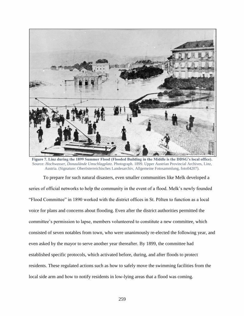
259
Figure 7. Linz during the 1899 Summer Flood (Flooded Building in the Middle is the DDSG’s local office).
Source: Hochwasser, Donaulände Umschlagplatz. Photograph. 1899. Upper Austrian Provincial Archives, Linz,
Austria. (Signature: Oberösterreichisches Landesarchiv, Allgemeine Fotosammlung, foto04207).
To prepare for such natural disasters, even smaller communities like Melk developed a
series of official networks to help the community in the event of a flood. Melk’s newly founded
“Flood Committee” in 1890 worked with the district offices in St. Pölten to function as a local
voice for plans and concerns about flooding. Even after the district authorities permitted the
committee’s permission to lapse, members volunteered to constitute a new committee, which
consisted of seven notables from town, who were unanimously re-elected the following year, and
even asked by the mayor to serve another year thereafter. By 1899, the committee had
established specific protocols, which activated before, during, and after floods to protect
residents. These regulated actions such as how to safely move the swimming facilities from the
local side arm and how to notify residents in low-lying areas that a flood was coming.
260
It also used existing associational events to promote its particular vision for regulation
and improvements in town. In 1882, the Lower Austrian Landtag passed legislation to regulate
the entire Lower Austrian stretch along the Danube, which the Danube Regulation Commission
(DRC) was charged with undertaking. Unsatisfied with the DRC’s plans for the local Melk side
arm, which the city council believed would leave the town open to additional flooding, council
members took the opportunity of the Donauverein’s 1884 “Danube Study Trip” to petition the
association to intervene with the imperial authorities on the town’s behalf. Because progress
remained slow on this regulation, plans remained in limbo for over a decade. However, in May
1897, during the Congress for the “German-Austrian-Hungarian Inland Waterways Association,”
members of the association took an excursion from Vienna up to Melk, where they were able to
enjoy views of the Danube from the Benedictine abbey and hear about local interest in regulating
the river.
Heavy flooding later that summer and two years later in September 1899 sped along the
DRC’s plans to complete the Danube’s regulation. The municipal council therefore petitioned
the DRC directly to request that it consider local plans for the Danube’s regulation, which were
tailored to ‘best protect the city’s property.’ The DRC responded that it would try to
accommodate any local wishes, so long as they fit the overall provincial plans. Its eventual
regulation respected the wishes of Melk’s residents, maintaining the local Danube branch leading
to the city. The council, through its own advocacy, also managed to secure funds from the
district offices to raise an embankment along the local alluvial plains.
The floods in 1897 and 1899 reveal the complex coordination between local, provincial,
and imperial authorities during times of flooding. Generally speaking, after flooding, Franz
Joseph I intervened with the Reichsrat and prompted the deputies to approve loans to

261
communities, which needed funds to rebuild. Franz Joseph’s decrees functioned as necessary
mechanisms to avoid politicized or provincialized responses from the deputies. Besides a decree
after the 1882 flood, in December 1897 (Reichs-Gesetz-Blatt 278), he also decreed an interest-
free loan of one million crowns as well as an additional 300,000 crowns to rebuild provisional
embankments. The flooding was so bad in 1899 that the Reichsrat passed bicameral legislation
in November that year, offering three million crowns in reconstruction loans and donations to
provinces across the monarchy. In December 1900, Franz Joseph I. again intervened and decreed
that the Reichsrat approve 2,000,000 florins relief for the several flooded provinces, including
Bohemia, Silesia, Upper and Lower Austria, and Vorarlberg.
In 1899, although the provincial authorities were not technically required by law to
support victims of natural disasters, the Upper Austrian Landtag and Landesausschuss both
recognized that supporting people in times of need was beneficial for both “economic and
financial reasons.” The imperial and municipal authorities, as well as the savings bank, all
donated funds to aid relief.594 This immediate action had been honed over the past few years’
experiences with flooding in Upper Austria. After floods in August 1896, for example, the
Landtag had already encountered some of its own limitations. Damages along Danube
communities exceeded 250,000 crowns, for which the diet’s session in March 1897 was only
able to muster 19,000 crowns for relief. Thus, after the August 1897 flooding, the provincial
government issued a province-wide emergency provision to help those affected, which including
the lessening of military duties and taxes, the preferential treatment of businesses affected by the
flooding, there was also discussion about offering emergency credit to those who needed
594 Oberösterreichischer Landesausschuss (ed), Bericht über die Thätigkeit des oberösterreichischen Landtages und
des von diesem gewählten Landesausschusses in der IX. Wahlperiode vom Sommer 1896 bis Sommer 1902, (Linz:
Verlag des Landesausschuss, 1902), 177.

262
financial relief. The emperor’s representative in the province, the Statthalter, also raised funds
for the “Provincial Aid Committee.”
In the aftermath of the disastrous 1897 and 1899 floods, local communities had to forge
new ties to the imperial authorities to rebuild and avoid future floods. These involved finishing
river embankments, reforming the mechanisms for warning communities, and the training of new
civil society groups, which would help during times of flooding and in the aftermath. The 1899
flood catastrophe, the likes of which “had not been observed in recent memory” sparked the
government to pass similar emergency measures to those in 1897. Petitions also flowed in to
construct protective dams along the Danube, Inn, Traun, and other rivers. In addition, the Upper
Austrian executive and legislative branches listed the Danube tributaries – and tributaries’
tributaries – which the authorities needed to regulate, with the projected costs.595 To cover the
possible 3.7 million-crown expense, the Upper Austrian provincial authorities committed to
providing 1 million crowns (27.5%) and expected local interested governments to provided
22.5%. It petitioned the imperial authorities to mobilize the Meliorations-Fond to cover the final
50%. In an article in the Wiener Zeitung the following year, the Danube Regulation Commission
for Lower Austria also reported a 50% rise in funds covering new flood embankments and
repairs for communities affected by the 1899 flood.596 The alpine provinces also recognized that
the best way to avoid future floods would be to not only continue regulating rivers but also to
construct ‘waterways’ to direct how flood and melting water flowed down mountains.
595 Total projected costs in crowns were: from the Rodl (14,400), Aist (260,000), Naarn (200,000), the Inn’s Mattig
(308,000), Asch (440,200), Lochbach (40,000), Andiesen (400,000), the Steyer itself (84,000), and its side arms
Steyerling (30,000), Dammbache (6,400), Salzachbache (6,400), Teichl (30,000), the Vöckla’s “Dürren Ager”
(120,000), the Ager’s Aurachbach (150,000), the Traun’s Ramsaubache (5,000), Ischl and side brooks (184,000),
Landbathbach (300,000), Alm (900,000), and Krems (18,000) and the protective dam in Ettenau on the Salzach
(242,200), Oberösterreichischer Landesausschuss, Bericht über die Thätigkeiten, 250. 596 “Nichtamtlicher Theil,” Wiener Zeitung, (Vienna, Austria), April 28, 1900.

263
New, civil associations supported imperial and provincial governments in distributing
flood relief. In 1886, the provincial diet had set up councils and district communes to educate
farmers and advocate for them at the political level. By 1895, there were 58 such collectives with
over 11,000 members. When the 1897 and 1899 flood occurred, the imperial Agriculture
Ministry charged members with distributing almost 9,000 crowns to alleviate farmers’ harvest
losses. In spring 1898, the Statthalterei also donated over 45,000 crowns to support farmers in
continued emergency need, and in 1899, the Agriculture Ministry donated another 10,000
crowns.597
Communities also took the lead in developing new practices to protect themselves during
floods, while working with provincial and imperial leaders to discuss other infrastructure that
would help in this endeavor. Communication and flood response was a large part of this reform.
Previously, local groups had used telegraphs to contact imperial groups like the Royal-Imperial
River Patrol [k.k. Stromaufsicht] to warn downstream communities during ice flows or floods
and to mobilize rescue boats if necessary.598 Communities also relied on fire brigades – or if
necessary imperial troops – to undertake rescue operations during floods.599 In 1899, the
Statthalter’s office raised the possibility of sharing costs to set up a hydrographical service in
Austria, which would be more effective than the existing “new services” in the provinces, which
had inadequately warned communities about the floods. The Upper Austrian authorities set up a
“hydrological services office” in Linz to monitor river conditions as part of the “Flood
Information Service.” After October 1901, the building included a telephone station for warning
different parts of the monarchy about dangerous water conditions, which worked together with
597 Oberösterreichischer Landesausschuss (ed), Bericht über die Thätigkeit, 86-88. 598 “Tages-Neuigkeiten,” Deutsches Volksblatt, (Vienna, Austria), February 6, 1893. 599 “Die Thätigkeiten der Feuerwehren bei Wassergefahr,” Mitteilungen des n.-öst. Landes-Feuerwehr-Verbandes,
(St.Pölten, Austria), September 1890.
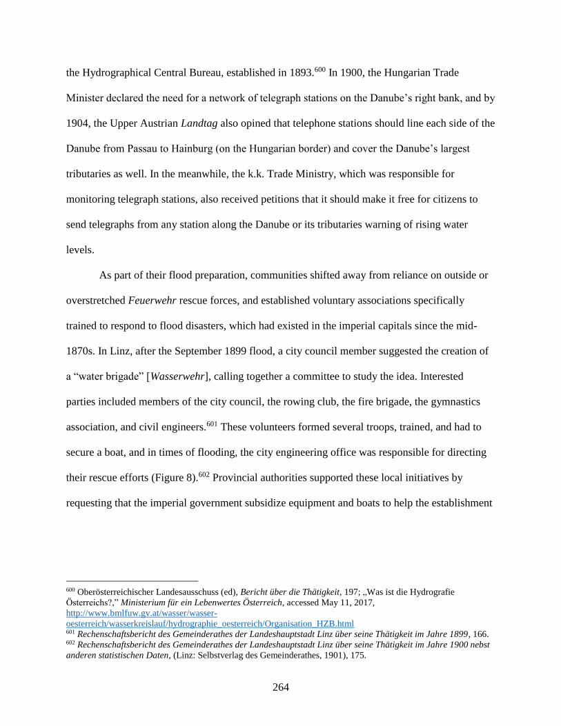
264
the Hydrographical Central Bureau, established in 1893.600 In 1900, the Hungarian Trade
Minister declared the need for a network of telegraph stations on the Danube’s right bank, and by
1904, the Upper Austrian Landtag also opined that telephone stations should line each side of the
Danube from Passau to Hainburg (on the Hungarian border) and cover the Danube’s largest
tributaries as well. In the meanwhile, the k.k. Trade Ministry, which was responsible for
monitoring telegraph stations, also received petitions that it should make it free for citizens to
send telegraphs from any station along the Danube or its tributaries warning of rising water
levels.
As part of their flood preparation, communities shifted away from reliance on outside or
overstretched Feuerwehr rescue forces, and established voluntary associations specifically
trained to respond to flood disasters, which had existed in the imperial capitals since the mid-
1870s. In Linz, after the September 1899 flood, a city council member suggested the creation of
a “water brigade” [Wasserwehr], calling together a committee to study the idea. Interested
parties included members of the city council, the rowing club, the fire brigade, the gymnastics
association, and civil engineers.601 These volunteers formed several troops, trained, and had to
secure a boat, and in times of flooding, the city engineering office was responsible for directing
their rescue efforts (Figure 8).602 Provincial authorities supported these local initiatives by
requesting that the imperial government subsidize equipment and boats to help the establishment
600 Oberösterreichischer Landesausschuss (ed), Bericht über die Thätigkeit, 197; „Was ist die Hydrografie
Österreichs?,” Ministerium für ein Lebenwertes Österreich, accessed May 11, 2017,
http://www.bmlfuw.gv.at/wasser/wasser-
oesterreich/wasserkreislauf/hydrographie_oesterreich/Organisation_HZB.html 601 Rechenschaftsbericht des Gemeinderathes der Landeshauptstadt Linz über seine Thätigkeit im Jahre 1899, 166. 602 Rechenschaftsbericht des Gemeinderathes der Landeshauptstadt Linz über seine Thätigkeit im Jahre 1900 nebst
anderen statistischen Daten, (Linz: Selbstverlag des Gemeinderathes, 1901), 175.
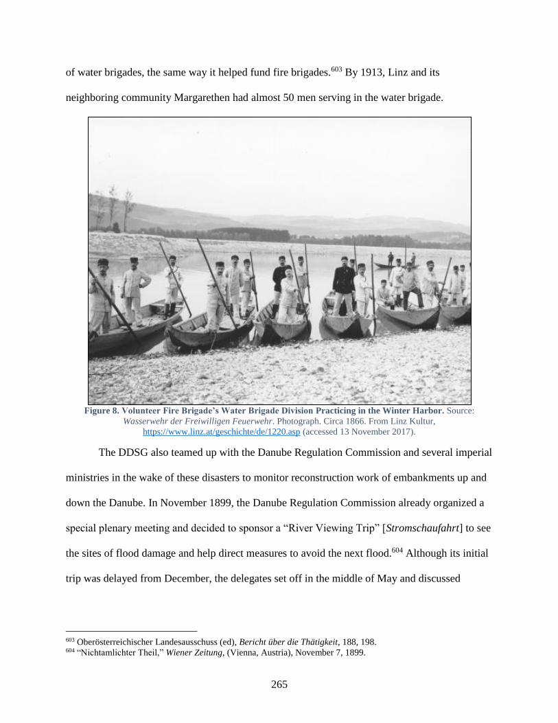
265
of water brigades, the same way it helped fund fire brigades.603 By 1913, Linz and its
neighboring community Margarethen had almost 50 men serving in the water brigade.
Figure 8. Volunteer Fire Brigade’s Water Brigade Division Practicing in the Winter Harbor. Source:
Wasserwehr der Freiwilligen Feuerwehr. Photograph. Circa 1866. From Linz Kultur,
https://www.linz.at/geschichte/de/1220.asp (accessed 13 November 2017).
The DDSG also teamed up with the Danube Regulation Commission and several imperial
ministries in the wake of these disasters to monitor reconstruction work of embankments up and
down the Danube. In November 1899, the Danube Regulation Commission already organized a
special plenary meeting and decided to sponsor a “River Viewing Trip” [Stromschaufahrt] to see
the sites of flood damage and help direct measures to avoid the next flood.604 Although its initial
trip was delayed from December, the delegates set off in the middle of May and discussed
603 Oberösterreichischer Landesausschuss (ed), Bericht über die Thätigkeit, 188, 198. 604 “Nichtamlichter Theil,” Wiener Zeitung, (Vienna, Austria), November 7, 1899.
266
building an embankment along the Danube from Melk to the Hungarian border.605 Along on the
trip was Lower Austrian Statthalter Count Erich Kielmansegg. The following year, the
Statthalter stood in front of the Lower Austrian Landtag to passionately urge delegates to
support river regulation, with the hopes of protecting residents.606 In 1902, the Trade and
Interior Ministries sponsored an additional trip. In February 1906, low water levels prompted yet
another trip to be able to examine the progress of construction properly, including an excursion
to the Hainburg embankments and pump station erected in 1904/5.607 Later that year in October,
another trip was designed for several days to examine the entire length of the Danube from
Passau to the Hungarian border, and included representatives from the DDSG, the Donauverein,
the k.k. Trade, Interior, and War Ministries, and delegates from the Bavarians as well.608 Parallel
to these Danube trips were “River Viewing Trips” on the Moldau and Elbe as well, which took
place more often after the Canal and River Regulation Law’s passage in June 1901. All told,
these trips lasted into the First World War, one taking place on the Moldau in 1915, and much
like other projects to improve navigation, even started to include Germans from the Upper
Danube as well.
In the last few decades of the monarchy, Hungaryhad increased embankment and
protection measures, including reclaiming alluvial floodplains to an impressive degree. Flood
protection and river regulation companies had invested nearly 350 million crowns609 to improve
protection, and from 1867 to 1905, the National Diet had invested almost 230 million crowns on
regulation work and almost 30 million maintaining its hydraulic engineering works. These were
605 “Nichtamtlicher Theil,” Wiener Zeitung, (Vienna, Austria), May 24, 1900. 606 “Niederösterreichischer Landtag,” Wiener Zeitung, (Vienna, Austria), July 18, 1901. 607 “Kleine Chronik,” Wiener Zeitung, (Vienna, Austria), February 14, 1906; “Kleine Chronik,” Wiener Zeitung,
(Vienna, Austria), February 18, 1906. 608 “Kleine Chronik,” Wiener Zeitung, (Vienna, Austria), September 29, 1906. 609 The currency reform introduced the crown in 1892 with 2 crowns equal to 1 florin. The records describing these
regulation and improvement expenses retrospectively converted the florin amounts to their crown equivalents.
267
not only along the Danube but several major tributaries as well, the Tisza, Szamos, Bodrog,
Kőrös, Temes, and Bega. In 1908, a representative from the House of Representatives put these
accomplishments into perspective. Iván Reök spoke to the chamber, pointing out that the Po
River’s regulation and land reclamation had long served as an example to emulate in Hungary, as
had the Netherlands’ land reclamation works, and France’s Loire Valley regulation. Reök
proudly stated that while those three projects had protected a total of 2.1 million hectares of land,
the investments in Hungary along the Danube and Tisza Valleys had embanked and protected an
impressive 3.6 million hectares.610 By 1914, the Danube River valley in Hungary had a total of
38 flood protection companies, which altogether had reclaimed over one million hectares of land,
built almost 3,000 kilometers of embankments, and dug almost 4,000 kilometers of canals,
almost all for drainage or irrigation.611
Conclusion: Final Thoughts and Precautions
The Danube today is still a risk for those living along it, due to the practices and
arrangements, which incidentally took off in the nineteenth century.612 Ever-higher concrete
embankments have cut the river off from its natural floodplains, which had previously served to
absorb and disperse floodwaters. The Danube’s channelization increased its speed, which was
meant to help drain floods more quickly, but has also increased the height of floods during times
of higher water volumes. Since the first major regulations in the 1870s onward, citizens have
also increasingly settled in higher-risk areas within historical floodplains, placing their faith in
610 Az 1906. évi május hó 19-ére hirdetett országgyűlés képviselőházának naplója, vol. 21 (Budapest: Az Athenaeum
Iroldalmi és Nyomdai Részvénytársaság, 1908), 55. 611 An additional 40 companies existed in the Tisza River Valley, which reclaimed over 2.5 million hectares of land,
built over 3,500 kilometers of embankments, and constructed over 9,000 kilometers of most drainage canals, Dénes,
A Magyar Vízszabályozás, 388-89. 612 Several 20th-century publications use the occasion of contemporaneous floods to look back on earlier, 19 th-
century precedents.
268
technical assurances and physical structures that promise to hold back any deluges. These
“former” floodplains are still the first places to flood, and the Danube’s historic floods in 1954
and 2013 demonstrated that such high modernist engineering projects rarely accounted for or
eliminated the river’s potential for danger.613
However, technical experts, governments, and the public in the late Habsburg Monarchy
could hardly be blamed for giving into the Zeitgeist, which trusted that technical innovation
would enable humans to modify and dominate nature and effectuate positive change. Riparian
residents had mobilized for centuries to construct local engineering works to protect them from
the Danube’s capricious nature. These frequently and abjectly failed. Therefore, when political
conditions and technical developments in the nineteenth century offered the chance to
holistically transform the Danube and tributaries into a safer space to inhabit, governments,
companies, and individuals cooperated to enact policies, provide funding, and initiate works to
pursue this goal.
But modifying the river was not a continually positive process, and much like rivers from
the Rhine to the Mississippi, engineering works on the Habsburg Monarchy’s rivers also had
unintended consequences.614 Not only did floods continue to plague communities, sometimes
modifications meant to mitigate their effects actually exacerbated them. Several experts,
representative and governmental bodies, and even journalistic observers slowly recognized that
narrowing the Danube’s floodplains to reduce flood zones actually appeared to make floods
worse. As engineers sought to secure a uniform river depth to reduce ice formation and
613 James C. Scott thoroughly castigates the efforts of certain state endeavors, pointing to the tendency to
oversimplify problems and solutions, which invariably fail to account for the intricacies of complex systems in order
to effectuate positive, intended changes, Seeing Like a State: How Certain Schemes to Improve the Human
Condition Have Failed, (New Haven; London: Yale University Press, 1998). 614 Christine A. Klein, Sandra B. Zellmer, Mississippi River Tragedies: A Century of Unnatural Disaster, (New
York: New York University Press, 2014); Mark Cioc, The Rhine: An Eco-Biography, 1815-2000, (Seattle and
London: University of Washington Press, 2002.

269
straighten bends where ice flows occluded the river’s flow, representatives ranging from the
National Diet in Budapest to local fishing associations in Upper Austria voiced concerns that
these projects strengthened the river’s current and harmed local fish populations. Even efforts to
reclaim floodplains and reduce standing water, a common flood multiplier, led to more cultivable
land but also lowered the water table levels, magnified the effect of droughts, and increased soil
salinity in places like the Great Hungarian Plains between the Danube and Tisza.
Nevertheless, executive and legislative bodies from the local to national and imperial
levels placed their faith in these projects, signaling their intention to consider state-building more
than a political or socio-economic matter, but also one that required them to guarantee the
physical-material well-being of their citizens as well. By funding and supporting hydraulic
engineering projects, governments attempted to secure what they craved most from the public:
their trust in state institutions and authorities, and perhaps even loyalty to them. Embankments,
drainage canals, and other physical constructions provided imperial and national authorities a
space to cooperate with and sometimes direct local technical and private interests.
As a result of persistent flood activity, municipalities later established their own practices
and arrangements, though they recognized that largescale, transregional flood protection required
them to turn to central officials for help funding and coordinating efforts. By petitioning
regional, national, and imperial authorities for their support for local initiatives, these
communities reinforced hierarchical structures of power within the monarchy. The imperial
government in Vienna, for its part, played such a prominent role in supporting and undertaking
this protection work that populations in Austria and Hungary both realized the necessity of
working with them.
270
But the Danube required more than a physical makeover to protect citizens, and floods
prompted ever deeper interventions in the physical and social ‘landscape’ of people’s lives to
ensure their well-being. The authorities progressively mandated a prescribed set of behaviors and
practices both before floods to reduce danger potential and during floods to organize rescue and
relief operations. Legislatures and governments alike began to codify relief obligations and to
assure the monarchy’s riparian populations that even as floods continued to affect their
communities, people could trust and depend on imperial and royal support when the floodwaters
finally receded.
271
CHAPTER 5: THE DANUBE AND ITS LOCAL PRACTICES
The visitor who sees Budapest for the first time, is surprised by the beautiful
layout of the double city. The Buda Royal Palace is prominent on its proud height,
Gellért Hill looks out over the unbounded plains of the Alföld, the violent Danube
flows down between two rows of palaces and under three permanent bridges, the
middle of which is the Chain Bridge, a masterpiece of the monumental bridge
construction, and in the river’s center calmly sits the Margaret Island, while a
swarm of steamships rush about. Smoking chimneys advertise the capital’s
developed factory industry, and swarming workforces on the quays affirm the
city’s burgeoning trade.615
This snapshot of Budapest from 1893 stems from the introduction to the Austro-Hungarian
Monarchy in Word and Image’s third volume about Hungary, in which it described the history of
the capital city. The preceding paragraph had asked how Budapest had become “the heart of
Hungary,” and the answer above reveals a city transformed by new commercial-industrial
arrangements (quays, factories, bridges) and busy with a mixture of traditional and modern
practices (steamship travel, factory and quay workforces). Interestingly, the focus is initially not
on any specifically national character. Renovated and ceremoniously re-opened by Franz Joseph
in 1893, the Royal Palace overlooking the twin cities alluded to the Habsburgs’ sovereignty over
Hungary; a territorial rather than ethnic concept. Based on statistical and advertising records, the
“swarm” of steamships described “rush[ing] about” would have been local ferries crossing
between Buda and Pest, several regional companies with single ships running to nearby towns,
the Danube Steam Navigation Company with its lines between Vienna, Pressburg/Pozsony, and
Budapest as well as downstream from Budapest to Orsova, as well as perhaps a few stray ships
615 “Az idegent, a ki Budapestet, először látja, meglepi e kettős város helyzeti szépsége, a büszke magaslaton álló
budai várlak, az Alföld határtalan sikjára áttenkintő Gellérthegy, a kettős palotasor a hatalmas Duna két partján,
melyek három álló híd köt össze, középütt a lánczhíd, a hídépítés e monumentális remeke, a regényes fekvésű
Margit-sziget, a folyamot szeldelő gőzösök raja. A füstölgő gyárkémények messziről hirdetik, hogy a főváros
kifejlett iparral bír, s a rakpartokon nyüzsgő munkásmozgalom, hogy itt virágzó kereskedés van,” Maurus Jókai,
“Bevezetés,” in Az Osztrák-Magyar Monarchia írásban és képben: Magyarország III (I), Vol. 12 (Budapest:
Magyar Királyi Államnyomda, 1893), 3.
272
from the German Empire, Serbia, or Romania. At the center of activity is the Danube River, the
scene’s nexus between the local, transnational, and international elements.616
For many cities on the Danube, such international, national, and local connections
reflected the cosmopolitan mixture of cultures, languages, and people, which had settled in many
larger commercial cities over the centuries. Historical networks of Serb Orthodox, Greek,
Jewish, and Armenian merchants characterized trade on the Middle Danube, and as cities grew in
the nineteenth century, so too did the variety of companies and individuals supplying them with
foodstuff, building materials, and the means to transport industrial and commercial wares.617
Mid- to late nineteenth-century internal migration magnified such heterogeneity. Once
regulation, embankment, and drainage projects reclaimed and secured large swaths of land for
urban growth near the river, many riparian cities built new industrial zones – mills, factories,
processing plants, which offered opportunities for the steady stream of migrants arriving from
within the monarchy.618 Already in the Vormärz period, Vienna’s population increased
dramatically, from 230,000 in 1800 to 400,000 in 1843, 85% of this growth from internal
migrants, who came from Bohemia, Lower Austria, Moravia, South Germany, and the Alpine
616 It is only a few paragraphs later, that this overview suggests that a stranger who stayed for a while and “got to
know Budapest,” which “had become Hungarian” in the past few decades, would able to perceive the “national
public life” (nemzeti közélet). By this, the author refers to the large investment in Hungarian public schools and
developed Hungarian culture, which he argues were striving to stay in step with European civilization, Jókai,
“Bevezetés,” 3. 617 Gábor Gyáni, “Das Verhältnis von Urbanisation, Großstadtentwicklung und der Donau in Budapest des 19. Und
20. Jahrhunderts,” in Donau-Stadt-Landschaften, Danube-City-Landscapes, eds. Máté Tamáska and Csaba Szabó,
(Berlin: Lit Verlag, 2016), 73-85; Simone Gingrich, Gertrud Haidvogl, Fridolin Krausmann, “The Danube and
Vienna: urban resource use, transport and land use 1800 to 1910,” History of Urban Environmental Imprint 12, no. 2
(2012): 283-294. 618 Friedrich Hauer utilizes historical hydromorphological data, which Viennese Danube projects URBWATER and
ENVIEDAN have compiled, and combined that information with district demographic data to show how certain
populations, such as in Leopoldstadt, grew and industrialized as the Danube’ alluvial floodplain was regulated,
“Wien und die Donau(auen): Zur Entstehung einer Stadtlandlandschaft,” in Donau-Stadt-Landschaften, Danube-
City-Landscapes, eds. Máté Tamáska and Csaba Szabó, (Berlin: Lit Verlag, 2016), 125-129; Statistics about
Donaustadt demonstrate that the district population increased from 3,608 people in 1869 to 26,833 by 1910, a more
than eightfold increase, which still only amounted to 1.3% of Vienna’s total population, “DONAUSTADT 22.
Wiener Gemeindebezirk,” wien.at, https://www.wien.gv.at/statistik/pdf/bezirke-im-fokus-22.pdf, accessed May 30,
2017.
273
lands where the handwork industry had declined. Between 1850 and 1914, approximately 1.6
million Bohemians and Moravians emigrated from their homes, with half of them settling in
more economically-lucrative regions in the Habsburg Monarchy, such as in and around Vienna.
Southern Bohemians were also drawn to close-by industrial towns in Austria’s heartland like
Linz and Steyr, which were located on the Danube and the Enns Rivers respectively.619 While in
1857 Vienna had approximately 100,000 internal migrants, by 1910 that number had become
470,000.620 Budapest’s construction in the mid-nineteenth century responded in a large part to
population booms in the later 1850s. By the late 1860s, every third person in the city was a
newcomer. Many of these people came from neighboring Pest and Fehér counties, but also
included migrants from Bohemia, Moravia, Lower and Upper Austria, Galicia, Bukovina, and
Silesia.621 Beyond the ethnic differences characterizing the cities, religious diversity also
increased as Jewish citizens gained the unrestricted freedom to reside in larger cities after the
1848 revolutions.Immediately thereafter, large numbers of bourgeois, Jewish families left
Moravia and Bohemia for Vienna. Subsequent waves of Jewish families arrived from Felvidék
(modern-day Slovakia) in Hungary, and the last mass migration wave at the end of the nineteenth
century came from poorer provinces like Galicia. By 1910, Vienna had 175,000 Jews and one
quarter of Budapest’s population was Jewish.622
While the imperial and royal authorities in Vienna and Budapest recorded citizens’ daily
language usage in the census every ten years, which indicated a general consolidation of national
619 Annemarie Steidl, Engelbert Stockhammer, and Hermann Zeitlhofer, “Relations among Internal, Continental,
and Transatlantic Migration in Late Imperial Austria,” Social Science History 31:1 (Spring 2007), 73. 620 Steidl et al., “Relations among Internal,” 73. 621 László Csorba, “Transition from Pest-Buda to Budapest, 1815-1873,” in Budapest: A History from Its Beginnings
to 1998, eds. András Gerő and János Poór, (Boulder, CO: Atlantic Research and Publications, Inc., 1997), 70-2. 622 These were the two largest communities of Jews in Central Europe, Walter Watznetter, “Danube Islanders:
Population Growth and Social Change in Vienna’s Second and Twentieth Districts, from the Regulation of the
Danube to Current Patterns of Gentrification,” in Donau-Stadt-Landschaften, Danube-City-Landscapes, eds. Máté
Tamáska and Csaba Szabó, (Berlin: Lit Verlag, 2016), 92.
274
languages in certain regions and cities in the monarchy’s last few decades, more recent
scholarship asserts that these results tend to conceal the presence of multilingual populations,
citizens’ situational identification with certain languages for pragmatic rather than national
reasons, and cross-cultural interactions, all which defy standard narratives of monolithic and
separate national groups.623
One can talk about a nationalization of certain spaces and social activities in Habsburg
cities, as Gary Cohen has discussed in Prague or Robert Nemes has described in Budapest, but
the Danube’s arrangements and practices facilitated more ambivalent and pragmatic relations,
because of the intersecting imperial, transnational, and local interests on the river.624 This isn’t to
say national sentiments weren’t embedded within the Danube, such as Budapest’s imposing, neo-
Gothic Hungarian Parliament finished in 1904 or calls for a national, Hungarian steamship
company. But as Chapter 1 discussed, riverine arrangements such as new bridges, quays,
riverside promenades held imperial, national, and local significance for a city in a layered rather
than mutually exclusive manner. As the current chapter will explore, practices on the river
623 Pieter M. Judson’s Guardians of the Nation explores how imperial censuses questioned inhabitants in the
monarchy about their daily language usage, forcing people to choose one language and hiding instances of
bilingualism. Judson argues that nationalists used census results to target regions where the ‘nation’ was endangered
(where other languages were increasingly ‘crowding out’ German-speakers), where in reality, many people
pragmatically switched between languages depending on circumstances. Robert Nemes has argued in his work The
Once and Future Budapest that in the eighteenth and early nineteenth century, Budapest had a heterogenous society
though dominated by German burghers and the German-speaking civil servants, though there were also Magyars,
Serbs, Greeks, Armenians, some Jews, though lingual flexibility ensured that few saw language as the basis for an
ethno-national identity. Nemes’ work explores many facets of identity, from the “Hungarian patriots” in the late
eighteenth century, who supported the “Hungarian Kingdom” but had no ethno-linguistic notion of “Hungarianness”
to Magyar nationalists, who attempted to magyarize/nationalize the city and its multitude of cultural and social
practices after the royal authorities regained autonomy in Hungary after 1867. Ironically, Nemes concludes that
despite nationalist efforts to transform these spaces and practices, and disregarding the purportedly high percentage
of “Hungarian” speakers in turn of the century Budapest, the surrounding countryside hardly saw capital as
“Hungarian” because of the “non-religious” (highly Judaized), socialist, and widespread German-speaking elements
within it, The Once and Future Budapest, (DeKalb, IL: Northern Illinois University Press, 2005). 624 Both Cohen and Nemes also challenge the historiographical assumption that national divisions were monolithic
by exploring the spaces and activities, which enabled polylingual and national actors to partake in cross-cultural
interactions, Gary Cohen, “Cultural Crossings in Prague, 1900: Scenes from Late Imperial Austria,” Austrian
History Yearbook 45 (2014): 1–30; Nemes, The Once and Future Budapest.
275
frequently eschewed stringent nationalist ideology for pragmatism. Indeed, Egbert Klautke has
argued that urban histories provide us with a chance to study modernity without the baggage of
nationalist narratives.625 Similarly, the edited volume Capital Cities in the Aftermath of Empires:
Planning in Central and Southeastern Europe supports this assertion with concrete examples of
‘national’ municipal developments after the Austro-Hungarian and Ottoman Empires collapsed.
The work cautions that “while it is indisputable that many of these cities were becoming
increasingly national during this period, they were also becoming ‘modern’ and modernity was,
and remains, something much larger than nationality.”626 For its part, the Danube’s transnational
nature enables a more integrated insight into urban populations throughout the monarchy and
helps escape the historiographical assumption that national was coterminous with modern, as is
typical in Austrian or Hungarian narratives.
This chapter will first briefly look at a few evolving practices and arrangements in cities
on the Danube, where technical innovation affected all municipal inhabitants. Burgeoning
Austrian and Hungarian urban environmental historiographies have already begun to explore
mutual river and municipality evolution, though both focus heavily on the Danube’s
development at Vienna and Budapest. The chapter’s second half will therefore explore how
changes to the Danube affected two communities outside the royal-imperial metropoles – Linz,
the provincial capital of Upper Austria, and Győr, a commercial town in Hungary between
Vienna and Budapest. Comparing how changing arrangements presented both opportunities and
threats to these communities, the section will explore how the Linz and Győr communities
625 Egbert Klautke, “Urban History and Modernity in Central Europe,” The Historical Journal 53, 1 (2010): 177. 626 Nathaniel D. Wood, “Not Just the National: Modernity and the Myth of Europe in the Capital Cities of Central
and Southeastern Europe,” in Capital Cities in the Aftermath of Empires: Planning in Central and Southeastern
Europe, ed. Emily Gunzburger Makaš and Tanja Damljanović Conley, (London and New York: Routledge, 2010),
260.
276
responded to each in kind. It highlights how local Danube conditions affected the population’s
relations with the local, provincial, and royal-imperial authorities as well as with non-
governmental, transnational, and commercial groups.
Transformations on the Urban Danube
New arrangements on the Danube were designed to support the general well-being of
local populations, as well as bring them together in largely non-national practices. Swimming
facilities and promenades, new sewage systems and commercial connections, industrial
opportunities and recreation, the river served local citizens equally. The Danube remained a
space for local authorities and populations to pursue utilitarian arrangements, which served
practical, popular, and at times political ends.
Industrial-Commercial Zones
Historically, industry had developed along the Danube because it facilitated
transportation of goods, and its kinetic energy flushed effluent and generated work for mills, and
paper and textile industries. Industrial sites in the nineteenth century also concentrated near coal
mines, waterways, and rails, to decrease transportation costs for heavy goods such as iron and
coal, to cool iron during its processing, and to wash away the chemical industry’s byproducts and
waste.627 Cities with transport infrastructure and large workforces offered the requisite conditions
to attract industry. In the nineteenth century, the Danube’s regulation accommodated steam
navigation and protected riparian settlements, but it also produced additional space in former
alluvial plains to promote industry and integrate commercial networks between river, rail, and
city.
627 Herbert Matis and Karl Bachinger, “Österreichs industrielle Entwicklung,” in Die Hasburgmonarchie, 1848-
1914 Band I: Wirtschaftliche Entwicklung, ed. Alois Brusatti, (Vienna, 1973), 225.
277
Even before the Danube’s largescale regulation, the steamship industry provided the
impetus for new industrial sites on the Danube, as political leaders and companies saw the need
to build and repair new steamships. When the DDSG founded the Óbuda shipyard in 1835 during
the Reform Period, it was one of the largest-scale industrial institutions in Hungary.628 River
conditions affected these industries. In 1837, the company switched from repairing ships it had
bought from Britain to building their own at the Óbuda shipyard, though when two new ships
“Arpád” and “Erős” were completed, the company couldn’t initially launch them because of the
low water levels on the Danube.629 The shipyard on the Óbuda Island expanded the city’s
industrial development, and although it initially offered employment to 60 men, by 1841, it was
employing over 400 men.630 The establishment of shipyards, such as the ones at Floridsdorf near
Vienna and in Hungary at Óbuda “[became] of extreme importance and constitute[d] a vast
industrial zone specialized in naval construction.”631 In 1879, the DDSG had 1,655 workers at
their Óbudu shipyard and over 200 at each of their Korneuburg and Turn-Severin shipyards. The
company had even purchased a series of coalmines in Pécs in the 1850s to mine its own coal. At
the shipyards and mines, the company built schools for the employees’ children, hospitals,
apartments, and even churches, becoming little communities unto themselves.632 Qualified
British technicians in the 1830s and 1840s received lucrative salaries to repatriate and work in
628 Miklós Dezsényi and Ferenc Hernády, A Magyar Hajózás Története, (Budapest: Műszaki Könyvkiadó, 1967),
58. 629 Henry Hajnal, The Danube: its historical, political and economic importance, (The Hague: Martinus Nijhoff,
1920), 137. 630 K.k. Direction der administrativen Statistik (ed), “Dampfschiffahrt und Eisenbahnen,” Tafeln zur Statistik der
österreichischen Monarchie für das Jahr 1841, Vienna: 1844, pg. 535-46, From Österreichische Nationalbibliothek
(ÖNB), http://digital.onb.ac.at/OnbViewer/viewer.faces?doc=ABO_%2BZ15083730X (accessed March 30, 2017). 631 Noël Buffe, Marines du Danube, 1526-1918, (Panazol: Lavauzelle, 2011), 216. 632 Stefan Wunderl has shown how the Korneuburg shipyard’s worker colony population went from over 2,000 to
over 9,000 people from 1850 to 1910 and traces the care they received from the company, “Die Geschichte der
Schiffswerft Korneuburg unter Berücksichtigung der Situation der Arbeiterschaft” (Vienna: unpublished MA thesis,
2008), 28.

278
the DDSG’s shipyards or on ships as mechanics, often securing roundtrip passage for themselves
and spouses. One Hungarian historian has claimed that the DDSG’s “Austrian leadership
typically did not consider Hungarian workers very desirable.”633 Nevertheless, Zoltan Huszár has
argued that the DDSG’s social care was among the most modern of its time.634
With increasing rail networks, cities and communities arranged new sites where river
commerce would integrate with the urban infrastructure. Most obviously in Budapest and
Vienna, rails connected warehouses and steamship landing places with customs’ houses and rail
stations. When the first rails were laid down in Budapest after 1846, they connected these
riverine sites with regional networks.635 Warehouses in 1868 and by 1879 public warehouses in
Pest likewise mirrored Vienna’s construction of public and private storage facilities on the river
to store goods transferred between rail and water. The famous Hungarian architect Miklós Ybl
designed a new Customs’ House for Pest, which 400-500 workers constructed between 1871 and
1874. The building had four tunnels running between it and the Danube’s ports, as well as a
railway connection to the new Western Rail Station [Nyugati Pályaudvar]. Budapest’s large
milling industry – the second most extensive grain processing center in the world after
Minneapolis, Minnesota – concentrated in two Danube districts of Pest, Lipótváros and
Ferencváros. While new steam mills in the 1850s and 1860s started to make the river’s kinetic
energy superfluous for milling, a brand-new Elevator House, designed by the Austrian architect
Christian Ulrich and constructed on the Danube’s banks in 1881-83 became a “monumental
633 Dezsényi and Hernády, A Magyar Hajózás, 62. 634 Zoltán Huszár, “Die DDSG – ein Vorreiter der sozialen Fürsorge,”
http://www.marineverband.at/downloads/collegium_hungaricum.pdf, accessed June 20, 2017. 635 Martin Pilsitz, “Die Donau als Faktor der industriellen Stadtentwicklung in Pest im 19. Jahrhundert,” in Donau-
Stadt-Landschaften, Danube-City-Landscapes, eds. Máté Tamáska and Csaba Szabó, (Berlin: Lit Verlag, 2016),
195.
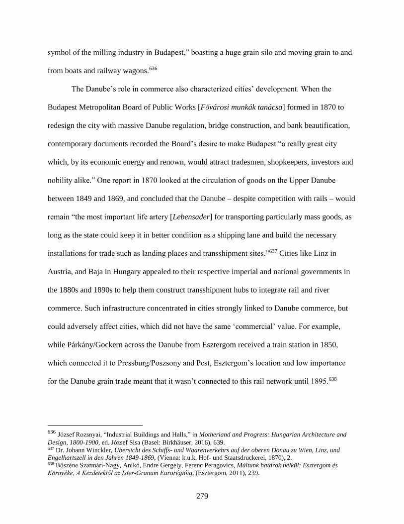
279
symbol of the milling industry in Budapest,” boasting a huge grain silo and moving grain to and
from boats and railway wagons.636
The Danube’s role in commerce also characterized cities’ development. When the
Budapest Metropolitan Board of Public Works [Fővárosi munkák tanácsa] formed in 1870 to
redesign the city with massive Danube regulation, bridge construction, and bank beautification,
contemporary documents recorded the Board’s desire to make Budapest “a really great city
which, by its economic energy and renown, would attract tradesmen, shopkeepers, investors and
nobility alike.” One report in 1870 looked at the circulation of goods on the Upper Danube
between 1849 and 1869, and concluded that the Danube – despite competition with rails – would
remain “the most important life artery [Lebensader] for transporting particularly mass goods, as
long as the state could keep it in better condition as a shipping lane and build the necessary
installations for trade such as landing places and transshipment sites.”637 Cities like Linz in
Austria, and Baja in Hungary appealed to their respective imperial and national governments in
the 1880s and 1890s to help them construct transshipment hubs to integrate rail and river
commerce. Such infrastructure concentrated in cities strongly linked to Danube commerce, but
could adversely affect cities, which did not have the same ‘commercial’ value. For example,
while Párkány/Gockern across the Danube from Esztergom received a train station in 1850,
which connected it to Pressburg/Poszsony and Pest, Esztergom’s location and low importance
for the Danube grain trade meant that it wasn’t connected to this rail network until 1895.638
636 József Rozsnyai, “Industrial Buildings and Halls,” in Motherland and Progress: Hungarian Architecture and
Design, 1800-1900, ed. József Sisa (Basel: Birkhäuser, 2016), 639. 637 Dr. Johann Winckler, Übersicht des Schiffs- und Waarenverkehrs auf der oberen Donau zu Wien, Linz, und
Engelhartszell in den Jahren 1849-1869, (Vienna: k.u.k. Hof- und Staatsdruckerei, 1870), 2. 638 Bőszéne Szatmári-Nagy, Anikó, Endre Gergely, Ferenc Peragovics, Múltunk határok nélkül: Esztergom és
Környéke, A Kezdetektől az Ister-Granum Eurorégióig, (Esztergom, 2011), 239.
280
Sometimes the Danube’s regulation and subsequent commercial-industrial development
did not match plans or expectations. In 1867, Táncsics Mihály’s published his work Városunk
[Our City], which included plans for the Danube’s regulation in Budapest. He envisioned two
large canals in the city, which small steamers would ply up and down on, and along the canal
banks, promenades and parks would provide green spaces for Budapest’s residents. Tácsics’
plans were not the first to envision navigable canals through the city. As Chapter 2 described,
Ferenc Reitter, later the first president of the “Fővárosi Közmunkák Tanácsa,” had designed
plans in 1862 to regulate a swampy side arm of the Danube to create a practical shipping channel
and promenade through Pest (Figure 9).639 Reitter’s plan never materialized, and the city instead
filled in the side arm to make Budapest’s prominent “Grand Boulevard” [Nagykörút].
Nevertheless, in November 1913, the progressive social scientific journal Huszadik Század once
again brought up the notion of navigable canals in Budapest, arguing “the capital’s development
makes a practical necessity to surround it with a circular, navigable canal.”640
Figure 9. Ferenc Reitter’s Suggested Canal Through Pest. Source: Ferenc Reitter, Donau-Regulirung zwischen
Pest und Ofen. Pester Schiffahrts-Canal. Schutz der Insel Csepel und des linkseitigen Ufers des Soroksárer
Donauarmes gegen Ueberschwemmung. Drei Anträge, (Pest: Gebrüder Pollak, 1865), 1.
639 Ferenc Reitter, Donau-Regulirung zwischen Pest und Ofen. Pester Schiffahrts-Canal. Schutz der Insel Csepel und
des linkseitigen Ufers des Soroksárer Donauarmes gegen Ueberschwemmung. Drei Anträge, (Pest: Gebrüder Pollak,
1865). 640 “Hajózható csatorna terve Budapest körül,” Huszadik Század, http://www.huszadikszazad.hu/1912-
november/gazdasag/hajozhato-csatorna-terve-budapest-korul, accessed May 30, 2017.

281
Ten years after the Danube’s regulation at Vienna, an account from The Austro-
Hungarian Monarchy in Word and Image described the new industrial segment of town the so-
called “Danube City” [Donaustadt], where industry and commerce were developing in the
imperial capital thanks to the river’s regulation:
More significant to us is that the trade and business life is slowing transferring to
the banks of the mighty river, in the newly developed Donaustadt… industrial
establishments are already starting to develop there, which are directed to process
raw materials and mass goods, the storehouses have already been erected, which
these mass goods, especially the base products of the fruitful east, take on and fill
up a long-felt gap in the Viennese wholesale trade organization. New life is
stirring on the banks of the majestic river, which is no longer threatening in its
new bed, and instead only more fruitfully and usefully serves to cultivate the
welfare of the whole monarchy. Out of the restlessly busy drive, which is
awakening in the Donaustadt, a magnificent Vienna on the magnificent Danube is
blooming.641
While official positions praised the regulation’s positive impact on trade in the imperial capital,
Lower Austrian Gewerbeverein members expressed their disappointment with the Donaustadt’s
lackadaisical growth in an 1891 policy paper.642 Nevertheless, the river and burgeoning steam
transport played a crucial role in the city’s development. With the construction and population
booms in the mid to late century, Vienna’s dependence on Danube shipments was evident.
Between 1830 and 1870, “the overall volume of wood, coal, food, feed and building materials
brought into the city roughly tripled from 700 kt/year to almost 2.1 million tons/yr… [while the]
total amount of materials imported on the Danube more than doubled.”643
641 Later, it even emphasized the financial success of renting and selling land reclaimed through the Viennese
Danube regulation, claiming “from the available modes of loans and from the revenues from ground parcels and
various uses not only was the entire cost of 32 million florins defrayed, but also 14 million in land ownership and
other values were leftover,” Wilhelm Franz Exner, Rudolf von Grimburg, Adolf von Guttenberg, W. Hecke, and
Emanuel Sar, “Volkswirthschaftliches Leben in Wien,” in Die österreichisch-ungarische Monarchie in Wort und
Bild: Wien und Niederösterreich 1. Abtheilung, edited by F.X. von Neumann-Spallart, vol. 1 (Vienna: k. & k.
Hofdruckerei, 1886): 325. 642 Hauer, “Wien und die Donau(auen),” 125. 643 Sylvia Gierlinger, Gertrud Haidvogl, Simone Gingrich, and Fridolin Krausmann, “Feeding and cleaning the city:
the role of the urban waterscape in provision and disposal in Vienna during the industrial transformation,” Water
Hist 5 (2013): 224-5.

282
Physical and Municipal Health
As urban spaces grew and featured ever more smoke-belching factories, slaughterhouses,
growing populations with limited sewage facilities, and overpacked housing spreading
communicable diseases, technical and medical experts began to imagine arrangements and
practices to design a healthier city for healthier citizens.644 Beyond the more benevolent
intentions, physical health began to play a prominent role in many nationalist historiographies,
where the trope of citizens’ health served as an allegory for the health of the ‘nation.’645 Healthy
bodies indicated a strong moral and national health, and vice versa. Such rhetoric emerged in
non-nationalist, political discourse as well, such as the concern that Socialist and Social
Democratic parties placed on the health and morality of the proletariat classes.646 Tied up in
these politico-philosophical discussions were the real-life circumstances which affected people’s
physical health. In the period of urbanization, these circumstances were rooted in the balance
between built and natural environment that people found themselves in. This question of space
644 There are several great works that explore this in the American context, such as the works by Martin Melosi and
Joel A. Tarr’s The Search for the Ultimate Sink: Urban Pollution in Historical Perspective. Genevière Massard-
Guilbaud has also compared he environmental impact of urban practices in French cities. Dieter Schott has a useful
overview of urban environmental historiography, “Urban environmental history: What lessons are there to be
learned?” Boreal Environmental History 5 (2004): 519-528. 645 Discussions and consequences of the ‘national body’ differed in extremity. The gymnastics organization Sokol in
the Bohemian lands functioned as an ersatz national organization, emphasizing a “strong mind in a strong body,” for
Slavs without a national state. In The Dreyfus Affair and the Crisis of French Manhood, Christopher E. Forth writes
about how defenders of French assimilationist policies used the Dreyfus Affair to draw comparisons between
physical maladies and weaknesses and the dangers of a moral weakness in the body politic. The twentieth century
also experienced the extreme manifestations of eugenics discussions and the need for a “pure” national body, seen in
pogroms, ethnic cleansing, and later genocidal programs, Isabel V. Hull, Absolute Destruction: Military Culture and
the Practices of War in Imperial Germany, (Cornell: Cornell University Press, 2004); Norman Naimark, Fires of
Hatred: Ethnic Cleansing in Twentieth-Century Europe (Cambridge: Harvard University Press, 2002); Matthias
Bjørnlund, “A Fate Worse Than Dying,” in Brutality and Desire: War and Sexuality in Europe’s Twentieth
Century, ed. by Dagmar Herzog (Palgrave, 2009), 16-58; Lerna Ekmekcioglu, “A Climate for Abduction, a Climate
for Redemption: The Politics of Inclusion during and after the Armenian Genocide,” Comparative Studies in
Society and History 55 (July 2013): 522-553. 646 Although Helmut Gruber writes about interwar Austria, he nevertheless reveals the concern that Social
Democratic leaders had for the physical and moral education of workers in Vienna. Gruber concludes, however, that
such paternalistic treatment couldn’t convince workers to change certain ‘immoral’ or ‘unhealthy’ practices in order
to turn toward the Socialist utopia that political leaders advocated, Red Vienna: Experiment in Working-class
Culture, 1919-1934, (Oxford: Oxford University Press, 1991).

283
applied to work, home, and leisure time, everything from proper ventilation in a workspace or
fresh water in a living complex to access to sewage infrastructure or green spaces and fresh air.
The Danube became integrally linked with discussions about the health of cities and
citizens. Early practices of waste disposal already used the river as a sewer system. The Romans
at Vindobona (Vienna) developed a sophisticated system for flushing debris outside the city
limits. While the Middle Ages saw a return to sinkholes and other measures nominally keeping
waste separate from fresh water supplies, Maria Theresa oversaw a return to a municipal sewage
system in Vienna’s historic core. When new laws sought to prevent disposal of garbage and
waste in public, many residents jettisoned ordure and debris into the Danube Canal and the
several municipal open water sources (Wienfluss, Ottakringbach, Alsbach), which flowed to the
Danube.647 In the early nineteenth century, the magistrate in Buda instructed citizens to place
garbage near the Danube’s edge so that subsequent floods would carry it away.648 None of these
practices took the river’s hydrology into consideration, and before microbial discoveries replaced
miasmatic theories in the 1880s, few understood precisely how dangerous such practices could
be for the municipal or public health.
Changing weather patterns and urban growth exacerbated the spread of diseases in the
late eighteenth and into the nineteenth century, which led authorities to reconsider these
practices. During the latter half of the eighteenth century, severe flooding, aggravated by heavier
rainfall, greater runoff (from melting glaciers at the end of the Little Ice Age), and newly
emerging land-usage practices (to more open field cultivation) devastated drinking water. Floods
inundated sinkholes, spilling contaminating material into wells and other fresh water sources
647 Heinz Krejci, Expedition in die Kulturegeschichte des Abwassers, (Vienna: Bösmüller, 2004), 128-44. 648 Eleonóra Géra, “Wechselwirkung zwischen Donau und Alltag in Ofen-Pest in den Jahren 1686 bis 1800,” in
Donau-Stadt-Landschaften, Danube-City-Landscapes, eds. Máté Tamáska and Csaba Szabó, (Berlin: Lit Verlag,
2016), 68.
284
nearby.649 In the late 1820s, cholera spread from India and affected countries around the world
from Russia to Great Britain to America. Without knowing its causes or that it spread rapidly
through feces-infected water, flooding in 1830 Vienna only worsened the city’s cholera outbreak,
eventually leading to the death of 2,000 people. During the Crimean War, cholera took the
largest number of victims. Heavy rains and wide-spread flooding in August 1869 combined with
a bad harvest also demonstrated the danger of widespread, stagnant water in Hungary, as 14% of
its population contracted malaria. Another cholera outbreak in 1872-3 was far more devastating
with nearly half a million deaths in Hungary. While the greatest loss of life was along the Tisza
River, in Pest, districts near the river where poorer and less educated residents lived experienced
higher fatality rates than among wealthier, educated residents.650 Small cities like Esztergom
experienced cholera outbreaks in 1866 and 1886, and the Melk city council fretted constantly
that the local Danube arm would silt up and cause serious hygienic problem for its residents.
Arrangements in the early half of the century presaged largescale canalization in the
1860s onward, but while miasmatic theories continued to form assumptions about disease
causation, these arrangements proved insufficient for urban needs. In 1830, Vienna already
possessed 110 km of sewage canals, and after the cholera outbreak, the city built a sewage canal
adjacent to the Vienna River (1836-39), which residents called the ‘cholera canal.’ In the 1840s,
the city authorities turned the city’s brooks into subterranean sewage canals. Likewise, Palatine
Joseph’s decree in 1801 to beautify Buda mandated underground canal construction to rid the
streets of ordure. Unfortunately, the ice dams, which caused the 1830 and 1838 floods, not only
649 Matthias Jungwirth, Gertrud Haidvogl, Severin Hohensinner, Herwig Waidbacher, Gerald Zauner, Österreichs
Donau: Landschaft-Fisch-Geschichte, (Vienna: Institut für Hydrobiologie und Gewässermanagement (BOKU),
2014), 141-47. 650 In Ferencváros, residents had 6x higher rates of contracting cholera than residents in the center of town, and
Kőbánya, had 20x higher rates, Zsuzsa Demény and Gyula Holka (eds), Statistics of the Centuries, (Budapest:
Hungarian Central Statistical Office, 2002), 85.

285
blocked the Danube’s path, but consequently backed up streams and rivers flowing into the
Danube as well. In 1838, Buda’s sewage canals overflowed, causing widespread contamination
and demonstrating the vulnerability of a system without sluicegates or other protections against
floodwater.
Recurring epidemic outbreaks and social uprisings throughout the century convinced
municipal, national, and imperial authorities to revise cities’ ‘irrational’ layout and antiquated
construction, which relied on unsophisticated methods for refuse removal in the Danube. From
the 1850s onward, a new epoch of city planning occurred in large cities, such as Paris’
“Haussmannization,” Vienna’s “Founding Era” [Gründerzeit] and Ringstrasse style, and
Budapest’s renewal through the Metropolitan Board of Public Works [Fővárosi Közmunkák
Tanácsa] under Ferenc Reitter and Frigyes Podmaniczky’s leadership. Engineers in the German
and Habsburg Monarchys influenced city planning with new engineering theories about
improving water-city relations, particularly how best to provide fresh water and discharge
waste.651 Their suggestions improved earlier sewage canals and reaffirmed Vienna’s practices –
already implemented in 1867 – to keep water supply and refuse canals separate and to bar
cesspits altogether, provided sewage canals existed nearby. Pest was canalized between 1869 and
1910, as was Buda between 1873 and 1914, though the 1873 financial crisis initially hampered
this work. These more complex city canalization projects then flushed even greater volumes of
waste directly into the Danube. Eventually, this brought the river’s hydrology to the forefront as
authorities realized the danger that the unregulated river and un-monitored practices of dumping
garbage into rivers and brooks had on the current’s ability to sufficiently remove waste.
651 Anna Hagen, Friedrich Hauer, “Hygiene und Wasser in der städtebaulichen Fachliteratur um 1900,” Materialien
zur Umweltgeschichte Österreichs 7 (Vienna: Zentrum für Umweltgeschichte, 2015): 1-57.
286
While sewage and industrial effluent remained tied to the river for removal, authorities
began to emphasis the need for healthier public practices regarding garbage disposal. Imperial
and provincial “water rights laws” in Austria in 1869/70 delineated the proper usage of public
water and promised to prosecute any infractions, though these were not always successful in
changing practices. In 1879, the St.Pölten district head excoriated the pollution of water sources
in the Amtsblatt, informing residents “in recent times, the most unsanitary conditions have been
observed and natural watercourses are generally seen as misused, with the introduction of all
kinds of waste and pollution of everyday life, such as waste from industry, humans, and partially
from cattle, so that streams and smaller rivers, rather than bringing the beneficial influence of a
flowing, pure body of water, have become places of putrefaction, which pollute the air and
contaminate drinking water.”652 In smaller communities, the local councils voted to erect signs
forbidding such practices and in Melk, council members even voted to close off the pathway
leading to the river to prevent people from dumping garbage along its banks.
Riverbanks as Recreation
Beyond protracted technical-political interventions, which oscillated between protecting
the water quality and utilizing the Danube for waste disposal, the river likewise became a site
dedicated to other public health arrangements, which also enriched the river’s recreational
appeal. In 1799, Franz II. permitted the Lower Austrian government to establish two public baths
– one for men and one for women – in the Tabor Arm of the Danube. Donations from “patriotic”
individuals funded the baths. Later, cheaply-run Flussbäder or “river baths” appeared during the
Vormärz period, which municipal authorities set up to provide cheap bathing opportunities for
652 Amts-Blatt der k.k. Bezirkshauptmannschaft St.Pölten: II. Jahrgang, (St.Pölten: Redaktion und Verlag der k.k.
Bezirkshauptmannschaft St.Pölten, 1879), 143-44.
287
the poor, in a distinct reversal to the centuries long ban on public bathing in the Danube.653 To
ensure public modesty remained intact, officials monitored access to designated bathing spots on
the river. “Ship baths,” essentially wooden bathing houses floating on pontoons on a section of
the river bank, also provided services to up to 1,000 bathers a day during the summer.654
Likewise, in 1858, a private “Bathing Facility” opened in Melk along the Danube sidearm
flowing past the city. By 1863, the Korányi József pool was opened on Esztergom’s “Small
Danube” channel, and the pool operated until the turn of the century. At the end of the nineteenth
century, there were five bathhouses along the Danube Canal (in Nussdorf, above the Augarten
Bridge, at the Verbindungsbahn Bridge, at the Rotunda Bridge and at the Slaughterhouse
Bridge), and they were extremely populated at the turn-of-the-century when the newly built main
sewer lines on either of the canal made the canal water appropriate and clean for swimmers.655
The Städtische Badeanstalt [Public Bathhouse] on the Danube’s main arm had a massive
swimming pool, bathing basins for ‘non-swimmers’ as well as private baths, all of which could
accommodate 1,200 guests. The Bathhouse’s café-restaurant also provided an attraction for
guests, as it afforded diners a view over the newly-regulated river. Even during the First World
War, people of all stripes escaped the summer heats down by the canal. According to a Neue
Freie Presse article in August 1915, “if you want to become conscious of the metropolitan
summer, you have to make your way to the Danube Canal on a sultry late afternoon. On the
embankments soldiers and convalescents enjoy a modest recovery. However, poor people have
also established their summer freshness here. Their miserable-looking shaggy dogs bathe, they
take sunbaths free of charge, or sit on their shores with their trousers tucked up, leaving their feet
653 Ernst Gerhard Eder, Bade- und Schwimmkultur in Wien, (Vienna; Cologne; Weimar: Böhlau, 1995), 90; 124. 654 Ibid., 135. 655 Raimund Hinkel, Wien an der Donau: Der große Strom, seine Beziehung zur Stadt und die Entwicklung der
Schiffahrt im Wandel der Zeiten, (Vienna: Christian Brandstätter, 1995), 44.
288
in the water. But soon enough they are scared off by guards, apparently an illegal footbath
without concession or certificate of permission.”656
Beyond the river’s appeal for swimming and bathing, an 1883 English edition of
Badaecker’s popular travel guides made it clear that the riverside was rife with amusement for
people of all classes. The Danube’s regulation had, in many instances, created these new spaces
for people to enjoy the river. Already in 1766, Joseph II had opened the imperial hunting grounds
at the Prater, an immense island between two arms of the Danube, to the public. From 1781 to
1783 Isidor Canevale built the Lusthaus at one end of the Prater Allee, which served as the site
for many imperial and local celebrations, including as, Chapter 1 indicated, the location where
one of the first steamships, Franz I, docked for the Viennese to inspect and fête in 1823. In the
nineteenth century, the Prater was a meeting ground for the bourgeoisie, especially after the main
thoroughfare leading to the park, Jägerzeile, became one of the most fashionable and desired
locations to live in Vienna.657 By the late nineteenth century, as the Badaeker guide explains, the
Prater was likewise “the favourite haunt of the lower classes, especially on Sunday and holiday
afternoons” because of the “attractions adapted to their tastes.”658 As Chapter 3 discussed, the
1873 World Fair also took place in the Prater, though poor, rainy weather and the suddenly
financial crash greatly reduced the visitor count, much to the chagrin of the DDSG.
New quay promenades and even bridges on the water provided opportunities for public to
enjoy the river views. While Budapest’s quay construction belatedly began in the 1860s onward,
political leadership required the entire 24-km site to have a uniform style, which incidentally
656 As quoted in Raimund Hinkel, Wien an der Donau: Der große Strom, seine Beziehung zur Stadt und die
Entwicklung der Schiffahrt im Wandel der Zeiten, (Vienna: Christian Brandstätter, 1995), 47. 657 Hauer, “Wien und die Donau(auen),” 124. 658 Karl Badaeker, Southern Germany and Austria, including Hungary and Transylvania. Handbook for Travelers,
(Leipzig, Karl Badaeker, 1883), 225.
289
provided a more aesthetic perspective. When suggesting designs for a bridge connecting Buda
and Pest with Margaret Island in 1832, Pál Vásárhelyi had envisioned lookout points on the
bridge to enjoy the view of the twin cities, and when the Margaret Bridge was later completed in
1876, it provided pedestrians with a panorama of the city “hitherto only experienced by ship
passengers.”659 In 1864, the “Large Danube” promenade in Esztergom opened, which Ágost
Forgách, the town’s mayor, helped support. The promenade enabled pedestrians to enjoy the
beautiful sight of the new Esztergom Basilica – the seat of the Catholic Church in Hungary – the
commemoration for which Franz Joseph attended in August 1856. Linz likewise created new
walkways along the Danube. The local beautification club installed banks for walkers to sit on,
and planted gardens adjacent the river, in particular near the new DDSG headquarters near the
quay. In April 1899, Imre Miller even opened a few confectionaries along the Danube at
Kioszkot to feed passersby. By 1913, Esztergom’s “Sétahelyszépítő Egylet” [Promenade
Beautification Club] adopted the Little Danube’s bank as their next project to enhance.
The proliferation of educational, recreational, and political clubs [Vereine/egyelet]
connecting communities across the monarchy also opened the venue for organized socialization
along and on the Danube. Rowing clubs, for example, became a popular activity on the river, one
which both entertained local communities and brought together different teams from around the
monarchy in friendly competitions. Széchenyi, as an Anglophone, promoted the British activity
in the 1840s with the club “Csolnakda” for rowers, though participation grew after April 1861,
when 29 individuals – 23 of whom were counts or barons – founded the “Budapest Boat Club”
659 Julianna Szabó, “Budapester Stadtpanorama mit der Donau: Zeitgenössische Fragen in historischem Kontext,” in
Donau-Stadt-Landschaften, Danube-City-Landscapes, eds. Máté Tamáska and Csaba Szabó, (Berlin: Lit Verlag,
2016), 138.
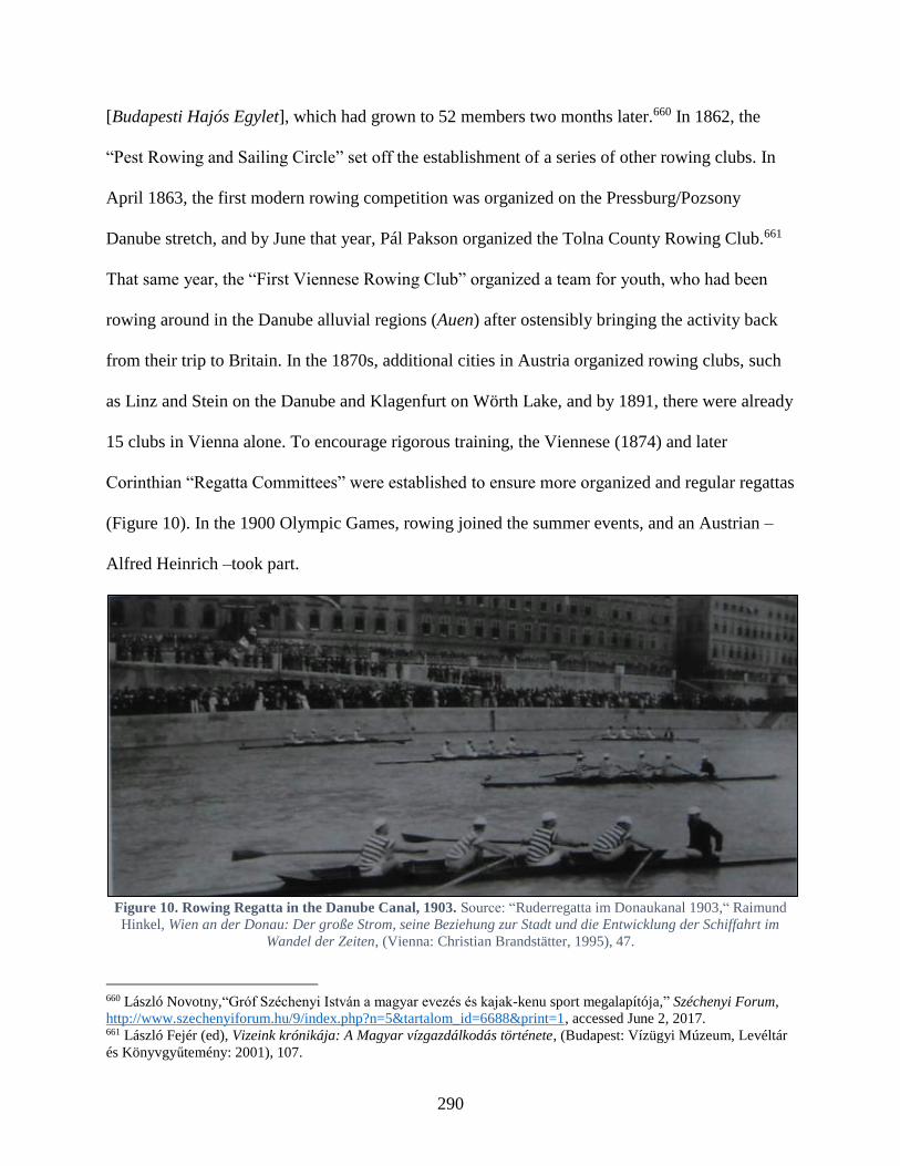
290
[Budapesti Hajós Egylet], which had grown to 52 members two months later.660 In 1862, the
“Pest Rowing and Sailing Circle” set off the establishment of a series of other rowing clubs. In
April 1863, the first modern rowing competition was organized on the Pressburg/Pozsony
Danube stretch, and by June that year, Pál Pakson organized the Tolna County Rowing Club.661
That same year, the “First Viennese Rowing Club” organized a team for youth, who had been
rowing around in the Danube alluvial regions (Auen) after ostensibly bringing the activity back
from their trip to Britain. In the 1870s, additional cities in Austria organized rowing clubs, such
as Linz and Stein on the Danube and Klagenfurt on Wörth Lake, and by 1891, there were already
15 clubs in Vienna alone. To encourage rigorous training, the Viennese (1874) and later
Corinthian “Regatta Committees” were established to ensure more organized and regular regattas
(Figure 10). In the 1900 Olympic Games, rowing joined the summer events, and an Austrian –
Alfred Heinrich –took part.
Figure 10. Rowing Regatta in the Danube Canal, 1903. Source: “Ruderregatta im Donaukanal 1903,“ Raimund
Hinkel, Wien an der Donau: Der große Strom, seine Beziehung zur Stadt und die Entwicklung der Schiffahrt im
Wandel der Zeiten, (Vienna: Christian Brandstätter, 1995), 47.
660 László Novotny,“Gróf Széchenyi István a magyar evezés és kajak-kenu sport megalapítója,” Széchenyi Forum,
http://www.szechenyiforum.hu/9/index.php?n=5&tartalom_id=6688&print=1, accessed June 2, 2017. 661 László Fejér (ed), Vizeink krónikája: A Magyar vízgazdálkodás története, (Budapest: Vízügyi Múzeum, Levéltár
és Könyvgyűtemény: 2001), 107.

291
The clubs established themselves and their boathouses along the Danube, and they also
partook in the social life of the cities, hosting parties and events during the year. In January 1871,
the Budapest literary journal Fővárosi Lapok advertised the annual carnival lineup, announcing
that the “National Boat Club” and the “Duna Rowing Club” were joining together to put on the
Boat Ball (hajósbál), which the journal claimed was “always very fancy.”662 The Linz-based
“Viking” rowing club invited guests to celebrate with the team before rowing meets. During the
winter, it petitioned the city council to set up an ice-skating rink near the river, which was such a
success, they repeated each winter thereafter. When boat traffic decreased on Wiener Neustadt
Canal, the waterway evolved into a site for non-navigational, social usage. Skating on the frozen
waterways in Vienna – previously forbidden by municipal decrees – turned into a strictly
regulated practice as authorities designated particular spaces, such as the Canal, to participate in
the winter activity. Over the course of the century, the Canal’s informal, natural ice rink became
‘institutionalized’ as an association took over construction and maintenance of an increasingly
sophisticated rink. The new space provided Vienna’s bourgeoisie a place to ice skate and
occasionally brush shoulders with Emperor Franz Joseph I., who opened social galas on the
waterway-cum-ice rink.663 After the First World War’s onset, many clubs on the river
disappeared due to members being mobilized and the military requisitioning boathouses for
supply purposes.
While previous chapters have indicated how environmental factors prompted imperial
interventions and commercial ventures, the following case study will demonstrate how local
actors negotiated regulation and transformation of local Danube conditions. Their interactions
662 Fővárosi Lapok, (Budapest, Hungary), January 17, 1871. 663 Friedrich Hauer and Christina Spitzbart-Glasl, “Nebenvorteile und Erbschaften einer Wasserstraße, Bedeutung
und Permanenz von sekundären Nutzungen am Wiener Neustädter Kanal in Wien,” Wiener Geschichtsblätter 72.
Jahrgang, vol. 2 (2017): 1-33.
292
with commercial and governmental organizations demonstrated a flexible willingness to work
with any groups – national, commercial, imperial – which helped them secure local interests.
This flexibility strengthened mechanisms to ensure local communities’ vitality and resilience in
the face of changing Danube arrangements and practices.
Case Studies: Linz and Győr
Franz Joseph’s 1849 imperial decree established Gemeinderäte or ‘communal councils’
in Austria and the Hungarian Diet’s 1870 Municipal Authorities Act (XLII) permitted local,
elected councils in Hungary, enabling self-governing communities and cities. Local governance
provided a chance for communities to “interact” with the highest state authorities, such as the
imperial or national bureaucracies. These interactions took the form of petitions, legislative
elections, and through the mediated connection between imperial representatives [Statthalter]
and provincial populations. These negotiated interactions provided an avenue for both imperial
and local actors to advance their interests.
Austrian and Hungarian authorities unsurprisingly wanted local initiatives to serve their
state-building goals. For the imperial bureaucracy, the Danube’s modification was promoted in
the interests of the general well-being. Engineer Jenő Kvassay described the Hungarian
government’s barrage of land reclamation and embankment projects as “the Second Homeland
Conquest” [a második honfoglalás]. Regional actors and communities tended to negotiate
between statist ideologies, employing the rhetoric of ‘national’ or ‘imperial’ interests to best
secure support for their own local designs on the river. However, imperial or national
governments at times designed plans and neglected local needs, which imperiled local reliance
on the river. When it suited them, community representatives therefore utilized transnational
actors, groups, and organizations operating along the Danube – across national/territorial
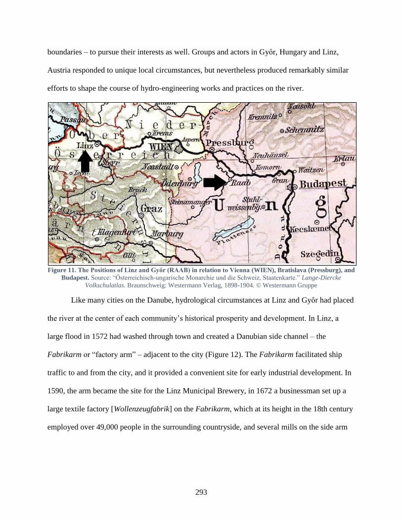
293
boundaries – to pursue their interests as well. Groups and actors in Győr, Hungary and Linz,
Austria responded to unique local circumstances, but nevertheless produced remarkably similar
efforts to shape the course of hydro-engineering works and practices on the river.
Figure 11. The Positions of Linz and Győr (RAAB) in relation to Vienna (WIEN), Bratislava (Pressburg), and
Budapest. Source: “Österreichisch-ungarische Monarchie und die Schweiz, Staatenkarte.” Lange-Diercke
Volkschulatlas. Braunschweig: Westermann Verlag, 1898-1904. © Westermann Gruppe
Like many cities on the Danube, hydrological circumstances at Linz and Győr had placed
the river at the center of each community’s historical prosperity and development. In Linz, a
large flood in 1572 had washed through town and created a Danubian side channel – the
Fabrikarm or “factory arm” – adjacent to the city (Figure 12). The Fabrikarm facilitated ship
traffic to and from the city, and it provided a convenient site for early industrial development. In
1590, the arm became the site for the Linz Municipal Brewery, in 1672 a businessman set up a
large textile factory [Wollenzeugfabrik] on the Fabrikarm, which at its height in the 18th century
employed over 49,000 people in the surrounding countryside, and several mills on the side arm
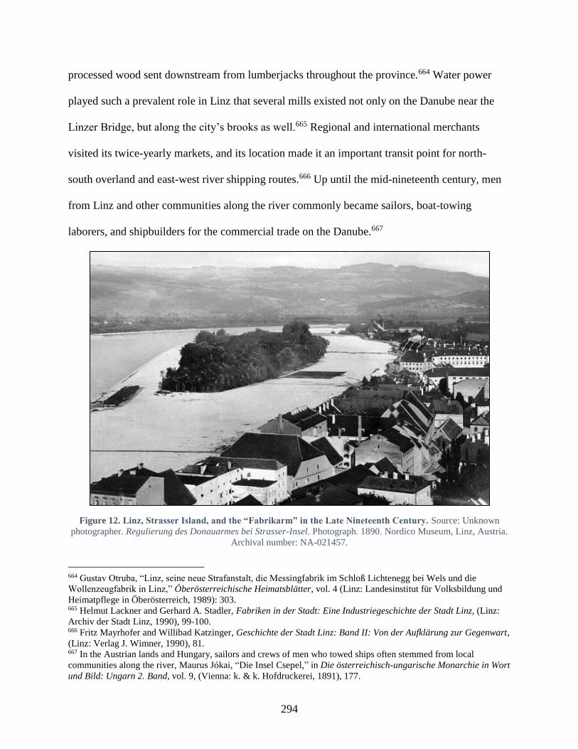
294
processed wood sent downstream from lumberjacks throughout the province.664 Water power
played such a prevalent role in Linz that several mills existed not only on the Danube near the
Linzer Bridge, but along the city’s brooks as well.665 Regional and international merchants
visited its twice-yearly markets, and its location made it an important transit point for north-
south overland and east-west river shipping routes.666 Up until the mid-nineteenth century, men
from Linz and other communities along the river commonly became sailors, boat-towing
laborers, and shipbuilders for the commercial trade on the Danube.667
Figure 12. Linz, Strasser Island, and the “Fabrikarm” in the Late Nineteenth Century. Source: Unknown
photographer. Regulierung des Donauarmes bei Strasser-Insel. Photograph. 1890. Nordico Museum, Linz, Austria.
Archival number: NA-021457.
664 Gustav Otruba, “Linz, seine neue Strafanstalt, die Messingfabrik im Schloß Lichtenegg bei Wels und die
Wollenzeugfabrik in Linz,” Öberösterreichische Heimatsblätter, vol. 4 (Linz: Landesinstitut für Volksbildung und
Heimatpflege in Öberösterreich, 1989): 303. 665 Helmut Lackner and Gerhard A. Stadler, Fabriken in der Stadt: Eine Industriegeschichte der Stadt Linz, (Linz:
Archiv der Stadt Linz, 1990), 99-100. 666 Fritz Mayrhofer and Willibad Katzinger, Geschichte der Stadt Linz: Band II: Von der Aufklärung zur Gegenwart,
(Linz: Verlag J. Wimner, 1990), 81. 667 In the Austrian lands and Hungary, sailors and crews of men who towed ships often stemmed from local
communities along the river, Maurus Jókai, “Die Insel Csepel,” in Die österreichisch-ungarische Monarchie in Wort
und Bild: Ungarn 2. Band, vol. 9, (Vienna: k. & k. Hofdruckerei, 1891), 177.
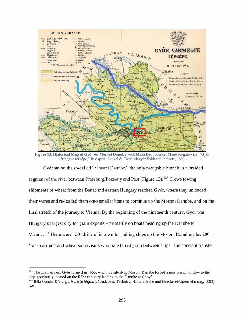
295
Figure 13. Historical Map of Győr on Mosoni Danube with Main Bed. Source: Manó Kogutowicz, “Győr
vármegye térképe,” Budapest: Hölzel és Társa Magyar Földrajzi Intézete, 1891.
Győr sat on the so-called “Mosoni Danube,” the only navigable branch in a braided
segment of the river between Pressburg/Pozsony and Pest (Figure 13).668 Crews towing
shipments of wheat from the Banat and eastern Hungary reached Győr, where they unloaded
their wares and re-loaded them onto smaller boats to continue up the Mosoni Danube, and on the
final stretch of the journey to Vienna. By the beginning of the nineteenth century, Győr was
Hungary’s largest city for grain exports – primarily on boats heading up the Danube to
Vienna.669 There were 150 ‘drivers’ in town for pulling ships up the Mosoni Danube, plus 200
‘sack carriers’ and wheat supervisors who transferred grain between ships. The constant transfer
668 The channel near Győr formed in 1653, when the silted-up Mosoni Danube forced a new branch to flow to the
city, previously located on the Rába tributary leading to the Danube at Gönyű. 669 Béla Gonda, Die ungarische Schiffahrt, (Budapest: Technisch-Litterarische und Druckerei-Unternehmung, 1899),
6-8.
296
of grains between boats and carts even required a consistent supply of sacks, so there were six
rental places for sacks as well as businesses that repaired sacks, which offered 50 people, mostly
women, work.670 According to some numbers, every tenth person in Győr lived from the
Danube’s grain commerce. The Danube fostered Győr’s commercial ties with agricultural
suppliers downstream and markets upstream, functioning as an important fount for the city’s
livelihood.
After the introduction of steam navigation, ships integrated into the commercial practices
of both Linz and Győr and promised to expand commercial opportunities for each city. However,
the Danube’s unregulated state and the later rise in rail traffic quickly took the wind out of the
new ships’ sails, forcing cities to turn to commercial rather than national-imperial solutions. In
spring 1831, Győr welcomed steamship traffic every few weeks once the DDSG began running
the Franz I regularly between Vienna and Pest. By 1832, the ship expanded its route
downstream, which resulted in a lively goods trade between Győr and Zemun, a town on the
Danube’s northern bank across the river from Belgrade.671 In an 1833 letter to the Palatine,
Hungarian nobleman István Széchenyi mentioned that “passenger traffic from Győr to Semlin
and back through Pest is now getting brisk” leading to a hefty profit for the DDSG.672 The river’s
traffic was so important for residents that many built granaries instead of houses, particularly
near the riverfront, which had long held the city’s highest property values due to its proximity to
670 Imre Gráfik, Hajózás és Gabonakereskedelem: “Gabonakonjunktúra vízen”, (Pro Pannónia Kiadói Alapítvány,
2004), 72. 671 K.k. Direction der administrativen Statistik (ed), “Dampfschiffahrt und Eisenbahnen,” Tafeln zur Statistik der
österreichischen Monarchie für das Jahr 1841, Vienna: 1844, pg. 535-46, From Österreichische Nationalbibliothek
(ÖNB), http://digital.onb.ac.at/OnbViewer/viewer.faces?doc=ABO_%2BZ15083730X (accessed March 30, 2017). 672 While the company expanded its lucrative Lower Danube and Black Sea commerce by 1833, the Russian and
Ottoman governments eventually and successfully challenged their presence, so by 1844, the company eventually
sold its Black Sea passenger lines to the Austrian Lloyd, a sea navigation company, Henry Hajnal, The Danube: its
historical, political and economic importance, (The Hague: Martinus Nijhoff, 1920), 128.
297
river commerce. By mid-century there were 147 granaries in town and the Danube riverfront was
completely built up.
Even before steamships arrived in Linz, the city’s residents were reading about traveling
on the Danube. One local paper Österreichs Bürgerblatt für Verstand, Herz, und gute Laune
[“Austria’s Civic Paper for Understanding, Heart, and Good Spirits”] published a series of
articles in August 1836, in which it expressed its general enthusiasm for the romantic and
practical potential of steam travel on the Danube. Much like travel literature at the time, it carried
readers down the Danube, describing the historical and natural wonders that travelers could
expect to experience on a Danube steamship ride. Unsurprisingly, when steamships started
arriving in Linz after 1837, their landing place was prominently located just below the city’s
wooden bridge, which spanned the Danube upstream from the Fabrikarm. The bridge’s low
height prevented ships from sailing any further upstream and offered a Bavarian steamship
company with the opportunity to send a ship, Ludwig I. down from Regensburg, opening a
shipping lane further upstream from Linz. The presence of ships was such a novelty that cannon
fire signaled each one’s arrival in town.673 Their landing place shared the Danube with industrial
(mills and factories) and institutional (swimming facilities and barracks) arrangements along the
Fabrikarm.
As Chapter 2 discussed, steam navigation’s expansion invigorated political and
communal calls to regulate the Danube, to ensure that the river had sufficient depth and wasn’t
encumbered by sandbanks or shoals, which endangered steamships’ progress. The difference
between Győr and Linz’s locations led to conflicting responses from each city’s residents. When
the Helytartótanács decreed the regulation of the Danube’s main (Komárom) branch in 1831, the
673 Mayrhofer, and Katzinger, Geschichte der Stadt Linz, 83.

298
plan stood to undermine Győr’s privileged position. A newly regulated Komárom branch would
send ships sailing along a completely different route, bypassing Győr located on the narrower
Mosoni channel. By the mid-1840s, the Hungarian authorities had only partially regulated the
stretches between Pressburg/Pozsony and Védek and yet in 1846, the DDSG considered skipping
Győr altogether and making Gönyű (on the main branch) a stop on its daily trips between Vienna
and Pest. This plan sent municipal authorities scurrying to plead with the DDSG’s administration
that Győr remain on the travel route.674 The DDSG’s head Joseph Voigt wrote to Count
Széchenyi to complain, declaring that poor conditions in the “Győr channel” were slowing river
traffic and suggesting that Széchenyi bring this up with Győr’s commercial parties.675
Over the next decade, the slow progress on the regulation of the Danube’s main bed
ensured that the Mosoni Danube’s traffic nevertheless remained steady. Győr’s city council did
little to dredge or regulate the river till the 1850s due to the continued strength of grain transports
arriving in town and the absence of Hungarian rails undermining its river traffic. Even in 1856,
the Pest-based paper Pesti Hírlap reported that Győr’s grain traffic was still three times that of
Pest’s.676 However, the next few years witnessed a distinct downturn in the river’s commerce, as
the spread of railways soon threatened to derail Danube navigation at Győr. In 1855, the city’s
first rail line arrived, connecting it to Bruck, and by the following August of 1856, it extended to
Ujszőny (modern day Komárom). Once the rail line opened and connected Győr to markets in
674 István Széchenyi to the Győr Free Royal City Council, 14 March 1846, Széchenyi iratok 28-17.117, Magyar
Környezetvédelmi és Vízügyi Múzeum [Hungarian Environmental and Hydrological Museum], Esztergom,
Hungary. 675 Széchenyi had worked assiduously since the early 1830s to both regulate the Danube and spread steam
navigation, and in the early 1840s was serving as the co-president for the Commission for Communication in
Hungary. Joseph Voigt to István Széchenyi, 24 March 1846, Széchenyi iratok 28-17.117, Magyar Környezetvédelmi
és Vízügyi Múzeum [Hungarian Environmental and Hydrological Museum], Esztergom, Hungary. 676 Writing a history of Hungarian navigation in 1899, the engineer Béla Gonda also wrote that “the city Győr was
the most important trade center on the Danube... which even pushed the capital into the background,” Béla Gonda,
Die ungarische Schiffahrt, (Budapest: Technisch-Litterarische und Druckerei-Unternehmung, 1899), 6-8.
299
the west, wheat arriving on the Danube could simply transfer to rails heading to the Vienna or
send it on the Südbahn down to Trieste, rather than continue upward on the Mosoni Danube.
Even as rail travel expanded, commercial interests stepped in to advocate for the river’s
maintenance. In 1856, a group of merchants founded the “Commercial Guild” to promote the
town’s commercial interests, particularly vis-à-vis the Danube grain trade. By fall 1857, the
Guild wrote to the mayor to decry the unmaintained Danube near the city. The Guild claimed the
river’s conditions were causing low water levels and preventing larger ships from traversing up
the Mosoni Danube to Győr from Gönyű. To continue transporting shipments, merchants had to
pay to unload and re-load goods from larger to smaller ships, which supposedly cost 400 florins
per boat in delays and labor costs. Unsurprisingly, the Guild feared that these costs would harm
business.677 The Guild believed that commerce’s importance for the town and region meant that
the Danube’s maintenance was good ‘not only for the city’s residents but for the entire public as
well.’678 Nevertheless, by December 1858, the local paper Győri Közlöny bemoaned the fact that
due to the growing rail competition, the DDSG was halting its “Little Danube” [Mosoni branch]
traffic.679
The Danube’s unregulated state likewise rankled Linz’s Chamber of Commerce, which
complained in 1852 that the river prevented larger, iron steamships from safely or easily
reaching the city. The Chamber was interested in transitioning to the larger ships for transport,
arguing that constructing ships from wood was a waste of lumber.680 The Chamber’s assertion
stemmed in part from new local industry; three years after steamships began arriving in Linz, a
677 Ferenc Bay, A Győri Llyod Városáért és Kereskedeleméért, 1856-1936, (Győr: Baross-Nyomda, 1942), 19. 678 Bay, A Győri Llyod Városáért, 19. 679 “Napló,” Győri Közlöny, (Győr, Hungary), Dec 16, 1858. 680 Helmut Lackner and Gerhard A. Stadler, Fabriken in der Stadt: Eine Industriegeschichte der Stadt Linz, (Linz:
Archiv der Stadt Linz, 1990), 19.
300
local shipbuilder, Ignatz Mayer, had founded a shipyard in the Fabrikarm (1840). By 1854, 200
employees were building and repairing steamships for both the DDSG and its Bavarian-
Württemberg competitors, and in 1867, it even constructed a ship for a Hungarian national
steamship company. By 1869, there were 550 men working there. In 1852, before any rail
connections existed between Vienna and Linz, the Chamber of Commerce continued to view the
Danube’s improved navigation as critical, given that goods arriving in Vienna from Trieste via
the Südbahn would naturally continue their commercial route to Linz via steamship. Once the
Westbahn reached Linz in 1858, a gradual decrease in passenger traffic resulted until new
arrangements in 1894 reversed this trend.
Despite an increase in some rail travel, residents continued to pressure navigational
groups to keep the Danube a functional avenue for personal and freight traffic. The DDSG also
confounded expectations, and rather than drop Győr as a steamship stop, it continued to
extensively advertise its routes and rates in the local paper, the Győri Közlöny in the 1850s.
Nevertheless, the city’s residents weren’t pleased with its schedule. In April 1859, the paper
aired residents’ grievance that steamships departing from Pest habitually arrived in Győr
between 2 and 3 o’clock in the morning, after which point passengers had to stumble home in the
dark from the steamship station.681 When the DDSG directed its ships to depart a few hours
earlier to address residents’ concerns, they next complained that arriving at midnight wasn’t
much better. It wasn’t surprising that residents wanted more convenient steamship connections,
particularly after May 1859, when Buda’s local authorities (helyhatóság) issued decree 1017
prohibiting horse-drawn ships from entering their city. The decree attempted to modernize
Danube shipping practices and reduce ‘inefficient’ river traffic. This stood to drastically affect
681 “Napló,” Győri Közlöny, (Győr, Hungary), April 10, 1859.
301
additional cities and their commerce on the Danube, should it set an example for other municipal
authorities.
Eventually, the DDSG acquiesced to local pressure to improve passenger connections,
which, in any event, dovetailed with its own interests in improving the nearby Danube. For over
a decade, the company had spent its own funds to clear other Danube stretches of navigational
hindrances. In October 1860, the company launched a ship to survey the Mosoni Danube.682 At
the same time, the city approved funds to cover the costs of dredging the local Danube stretch.
Unfortunately, a year later in spring 1862, monarchy-wide flooding caused massive damage, and
reconstruction costs strained the city’s finances, endangering its plans to clear the river. In
response, the DDSG offered to help pay for the dredging.683 This move, besides ensuring the
Danube’s navigability, likely endeavored to shore up local support for the DDSG against
competition from the Royal Bavarian Steam Navigation Company, which had recently started
advertising their freight services in the Győri Közlöny in September 1861 and had even
employed a business representative in town (one of only four in Hungary).684
The DDSG’s efforts weren’t enough to persuade Győr’s merchants that their commercial
industry on the Danube was safe. In August 1865, Károly Tóth wrote a series of introspective
articles for the Közlöny waxing about the Danube’s traditional place in the city’s development
and contemplated what affect the newly expanding railroads would mean for Danube navigation.
In parallel with those articles, the paper published a series from the Új Korszak [New Era], which
advocated the need for a specifically Hungarian steam navigation company. Shortly thereafter, a
682 K.k. Direction der administrativen Statistik (ed), “Dampfschiffahrt und Eisenbahnen,” Tafeln zur Statistik der
österreichischen Monarchie für das Jahr 1842, Vienna: 1846, pg. 445-453, From Österreichische
Nationalbibliothek (ÖNB), http://digital.onb.ac.at/OnbViewer/viewer.faces?doc=ABO_%2BZ150837402 (accessed
Feb 10, 2017); “Napló,” Győri Közlöny, (Győr, Hungary), Oct 18, 1860. 683 Bay, A Győri Llyod Városáért, 43; 57. 684 “Napló,” Győri Közlöny, (Győr, Hungary), Sept 15, 1861.

302
group of merchants from Győr founded the Győr Steam Navigation Company to combat the
DDSG’s unfavorable shipping rates, promote commerce, and enable the “reasonable transport of
wares via steamship on the Danube and its tributaries.”685 The company employed a large
number of workers and crew, as it had five freight steamers, 21 tugboats, and an additional 31
wooden boats for trade.686 Győr’s steamship company had relatively steady success maintaining
its shipping numbers, but this came in part from the company’s negotiations with the DDSG to
help transport grain shipments to Vienna. By the 1870s, Győr only managed to remain a
competitive commercial center vis-à-vis Pest by extending train lines and opening new grain
markets in Austria and Trieste, shifting away from its traditional orientation on the Danube.687
Győr’s travails with its poor local condition and rising rail competition were compounded
by regional competition with Pest. In the 1850s, Pest’s milling industry had begun to rival
regional grain centers such as Győr.688 While 817 ships had transported 6.3 million centners of
grain to the Győr in 1858, less than a decade later in 1867, 422 ships transported 2.9 million
centners.689 In 1867, following the Austro-Hungarian Compromise, the Hungarian government
began administering its own internal affairs, including setting up new ministries to facilitate
domestic ‘communication’ – which included improving all modes of transportation. The
following year, the Royal Transportation Ministry declared that the Upper Danube and its
tributaries, as well as the Small Danube from Győr to Gönyü would be regulated, though the
state didn’t begin this work until 1885. The new domestic state of affairs in Hungary led the
685 Béla Jankó, A Magyar dunai gőzhajózás története, (Budapest: Gépipari tudományos egyesület, 1968), 89-90. 686 This fleet paled in comparison to the DDSG, which in 1860 had 95 paddle steamers, 24 screw propellers, 381
iron goods transports, 26 iron cattle transports, 42 iron coal ships, 17 iron ‘Stehschiffe’ and 15 miscellaneous other
ships. However, it was one of the first non-DDSG Danube steam navigation companies in the monarchy to exist. 687 Vörös, “Győr és Pest,” 485-90. 688 Károly Vörös, “Győr és Pest Harca a Dunai Gabonakereskedelemért, 1850-1881,” Arrabona 7 (Győr: Győri
Xántus János Múzeum, 1965): 471-2. 689 A centner or “quintal” is 100 kg, so 10 centners is approximately one ton. Imre Gráfik, Hajózás és
Gabonakereskedelem: “Gabonakonjunktúra vízen”, (Pro Pannónia Kiadói Alapítvány, 2004), 72.
303
Commercial Guild to re-establish itself in 1868, and it promised to build on these opportunities
to boost commercial performance on the Danube. The following year in 1869, 285 men in town
even formed a Győri hajós egylet (Győr Boat Club).
Beyond local concerns about the Danube’s continued usage for transportation, the river
remained a considerable source of unease for residents, due to its perennial flooding. An 1876
ice jam on the Danube not only caused massive flooding along its banks, but blocked water
flooded local tributaries as well, including the Rába, which flowed through town. In 1883,
another flood on the Danube led the county’s head official [alispán] to declare a state of
emergency, given that 10,000 people remained without homes.690 By February 1883, the
situation on the Danube, and the under regulated Rába and Little Rába Rivers appeared so dire
that the Győri Lloyd penned a letter to the Royal Hungarian Transportation Minister. Its
complaints not only cited the decline in commercial ties – due to competition with Vienna and
Pest and those cities’ favorable commercial arrangements – but it also decried the existing
hazards that the un-regulated Danube and Rába rivers presented to the town’s residents.691
Despite near universal agreement among politicians and leaders that the Danube’s
unregulated state exacerbated flooding, not all individuals living on or near the river saw the
necessary solution (embankments) positively. For landowners near the river, their proximity to
the river provided direct access to river’s trade, which inflated the value of their property. They
therefore fought local authorities’ efforts to appropriate it as ‘public land’ for the purpose of
erecting embankments. Local groups who depended on the river were also reluctant to change
any arrangements, for fear that it would adversely affect their practices. Water mills exacerbated
690 Bay, A Győri Llyod Városáért, 163. 691 József Bana (ed), Győr: A Modelváltó Város, 1867-1918: Források a dualizmus kori Győr történetéből, (Győr:
Palatia Nyomda & Kiadó, 2011), 190
304
the conditions (siltation) which caused floods, but millers consistently thwarted organized efforts
to change their access to and usage of the river in the name of regulation.692 Hindrances to flood
protection measures were not only human but geological. The porous nature of the local rocks
made it difficult to use them for embankments, as they did not hold back flood waters.
The city council nevertheless examined ways it could help protect residents from the
Danube, determining which national and municipal offices and commercial ventures would aid
its efforts. In October 1884, for example, it proposed sending local representatives to examine
and improve embankments along the Danube to defend newly industrialized regions and
municipal plots in low-lying areas of town. To help fund local projects, however, it turned to the
national government. Frequent flooding from 1876 to 1883 and subsequent re-construction had
placed heavy tax burdens on the residents, the council debated the expenditures that local and
particularly national treasuries could be expected to shoulder to raise embankment and bridge
heights, and construct sewage canals and sluicegates.693 In 1885, the city council passed Law
XV, which provided it the authority to divert funds to implement public flood protection
measures.694 In 1886, the mayor coordinated with flood prevention committee members to
implement measures necessary to acquire private land near the Danube and Rába to erect
necessary embankments. In the city council’s March 29, 1886 meeting, it invoked Law XV in its
justifications for acquiring land near the Danube. The city spent the next few years liaising with
engineers and regulation companies in town to negotiate land acquisitions and embankment
specifications. Municipal engineers, for their part, provided detailed plans for where and how to
692 Marton Simonkay, “„Vagy ilyen szabályozás lesz, vagy semmilyen” A Rábaszabályozó Társulat első évtizede
(1873–1883),” (unpublished manuscript, 2013), 2-3. 693 Győr Város Tanácsának Iratai 1883 I. 200, Győr Megyei Levéltár, Győr, Hungary. 694 Győr szabad s királyi város közgyülési jegyzőkönyve, Győr Megyei Levéltár, Győr, Hungary.

305
regulate the city’s rivers to best protect the city’s residents and their property.695 Finally, between
1886 and 1894, the national government also undertook regulations of the Danube, including
near Győr, regulating the river’s depth and width, constructing flood control measures, and
managing water table levels.696
Such local initiatives reveal the perpetual concerns, which the unregulated Danube’s state
presented for each city’s practices and arrangements. Efforts to improve these hydrological
conditions required cooperation between local and commercial interests, and often resulted in
unintended consequences. The arrangements surrounding Linz’s bridge and Danube channel
highlight the precarious relationship between natural and human interactions. In 1864, a massive
flood tore a steamship loose from its mooring and crashed it into Linz’s wooden bridge
collapsing two of its yokes and prompting the city council to decide to rebuild the bridge in iron.
In 1872 the bridge opened to great fanfare and celebration. However, its construction had a
profound impact on the river’s morphology, which complicated various groups’ practices and
interactions on the river.
Before the bridge’s completion, the city had set out an ambitious sewage system plan for
the town in 1871. The plan was drawn up when the channel’s flow was still strong and it seemed
natural to direct the city’s waste into the channel’s lower end, where it could be washed away
into the Danube. Once the bridge’s construction was complete in 1872, however, its large pylons
shifted the river’s flow away from the channel opening and into the main current of the river. As
the water speeds in the Fabrikarm slowed, it minimized the river’s capacity to move debris and
695 Győr Város Tanácsának Iratai 1883 I. 200, Győr Megyei Levéltár, Győr, Hungary. 696 Imre Göcsei, “Győr földrajza,” Győr Megyei Jogú Város Levéltára, accessed March 22, 2017,
http://vleveltar.gyor.hu/post/65/.

306
wastes.697 People using the channel as a garbage dumping site also compounded the problem,
leading the current to stagnate further. The city reacted by passing laws forbidding the throwing
of garbage there, but this was so ineffective that a few years later, they passed another law
setting up collection points next to the river with designated carts to remove the garbage.698
Figure 14. The Swimming Facilities in the Fabrikarm, circa 1880. Source: Unknown photographer.
Schwimmschule. Photograph. 1880. Nordico Museum, Linz, Austria. Archival number: NWB-000249.
This settling waste affected business and recreational interests in the channel. In 1876,
the conditions in the channel were so bad that Linz’s bathing facility (Figure 14) asked the
Lower Austrian Danube Regulation Commission (DRC) to borrow an excavator to clear out the
Fabrikarm.699 When the DRC rejected their request, the facility asked the DDSG for one, which
697 Fortsetzung der Actenstücke und Verhandlungen seit dem Jahre 1882 bezugnehmend auf die Versandung des
Donau-Landungsplatzes und des sogenannten Fabriksarmes in Linz, (Linz: Verlag der Gemeinde Linz, 1883), 24. 698 Rechenschaftsbericht des Gemeinderathes der Landeshauptstadt Linz über seine Thätigkeit im Jahre 1882 (nebst
anderen statistischen Daten), (Linz: K.k. Hof-Buchdruckerei von Jos. Feichtinger’s Erben, 1883), 116. 699 The DRC was established by an 1868 law, which mandated the Danube’s regulation near Vienna. After the Suez
Canal opened in 1869, the French company sent its excavators to Vienna to start work, which ran in 1870-75.

307
only agreed to sell rather than loan them an excavator. Even the k.k. Interior Ministry claimed
that the channel’s regulation, unlike the Danube in general, was a purely municipal matter.700
Insufficient water levels in the channel and the increasingly unsanitary conditions forced the
bathhouse to move its position. The facility temporarily moved upstream above the bridge,
however, this clashed with the newly established rowing club in 1876, which also wanted access
to this part of the river bank for its practices. While the bathing facility was able to move,
numerous businesses such as the tobacco factory, various mills and industries relied on the
channel to facilitate river traffic, power mills, and wash away effluent, and these businesses still
had to find a solution to the channel problem.701 Engineer Arthur Oelwein suggested that the
only way to improve the channel’s conditions would be to modify the whole main bed of the
river. 702
As the channel slowly silted up, in February 1882, the steamship company requested
exclusive use of the banks above the bridge for its landing place. Surprisingly, the city council
denied this request in their next meeting in March, claiming that practices along the river needed
to serve the general good and not just one company’s interest.703 To appease the DDSG, the city
decided later that year in November 1882 to set up a transshipment hub [Umschlagplatz], where
ships could unload goods directly at the new train line, connecting the river traffic to the
Monarchy’s railway network.704 To convince the imperial state to back these plans, the
representatives from Linz and Upper Austria’s legislative bodies enlisted the help of the Danube
Association [Donauverein].
700 Rechenschaftsbericht im Jahre 1882, 120. 701 Fortsetzung der Actenstücke und Verhandlungen seit dem Jahre, 2. 702 Die Regulirung der Donau nächst Linz und die Anlage eines Hafens daselbst, (Linz: Druck von Joseph Wimmer,
1882), 1-10. 703 Ibid., 64. 704 Rechenschaftsbericht des Gemeinderathes der Landeshauptstadt Linz über seine Thätigkeit im Jahre 1884 nebst
anderen statistischen Daten, (Linz: Druck von Jos. Wimmer, 1885), 69.
308
As Chapter 2 described, the Donauverein was founded to promote navigation and more
broadly advocate for the Danube’s improvement.705 In June 1882, Upper Austrian Chamber of
Commerce President Wimhölzel had given a speech to the Donauverein general assembly in
which he dispassionately argued that despite the Reichsrat’s opinion that the Fabrikarm’s
siltation and its effect on businesses was an ‘internal matter’ for Linz, he believed it was the
Donauverein’s duty to use its burgeoning influence to petition the imperial state again.706
Because the Donauverein’s expressed purpose was to mobilize public opinion in the
Danube, Wimhölzel and others were convinced it would bring the imperial state’s attention to
Linz’s affairs. In June 1884, the association organized a “Donau-Stromschau-Fahrt” or ‘study
trip’ of the Danube, which stopped over in Linz on its way from Passau to Vienna, to see the
Fabrikarm’s conditions and discuss possible solutions. Linz residents festively decorated the
riverbanks to greet the men who partook in the trip.707 At the meeting, which the Donauverein
held at the large ballroom in town, 110 men from wide-ranging groups showed up.
Representatives from several imperial ministries attended, as did local and regional government
office heads and members from a dozen riparian communities, engineers from several cities, and
members of numerous commercial, technical, and navigational associations as well as those of
steamship companies in Austria and Hungary.708
These actions convinced the imperial authorities that Linz’s transit hub would be
important for the city’s development. They permitted Linz’s city council to set up a commission
705 Die Thätigkeit des Donau-Vereines im ersten Jahrzehnte seines Bestandes, 1879-1888, (Vienna: Verlag des
Donau-Vereines, 1889), 3. 706 Fortsetzung der Actenstücke und Verhandlungen seit dem Jahre 1882 bezugnehmend auf die Versandung des
Donau-Landungsplatzes und des sogenannten Fabriksarmes in Linz, (Linz: Verlag der Gemeinde Linz, 1883), 2. 707 Rechenschaftsbericht im Jahre 1884, 166. 708 Stenographisches Protokoll der Versammlung des Donau-Vereines zur gemeinschaftlichen Berathung mit dem
Gemeinderathe der Stadt Linz am 15. Juni 1884, (Linz: Verlag des Gemeinderathes der Landeshauptstadt Linz,
1884), 8-10.
309
in 1884, which consulted with local industries and military officials located in the Fabrikarm and
on Strasser Island, how best to approach the Fabrikarm’s improvement and the hub’s
construction.709 In December, the commission stressed that construction and river regulation
plans had to first consider “general public interest and navigation safety” before any plans for the
hub’s design. For example, Chamber of Commerce President Wimhölzel declared that for the
public’s safety and health, any plans had to address the sewage problems in the Fabrikarm.710
Likewise, when the commission raised the idea of closing off the Fabrikarm permanently, the
men whose businesses relied on the channel responded that their livelihoods would end unless
the city paid them an indemnity or could guarantee their relocation to another spot on the
Danube.711 The Donauverein, DDSG, and shipyard later suggested that the channel only be
partially filled in, leaving the far end connected to the river as a natural harbor. They believed
that having a winter harbor between Passau and Vienna would attract more ships and therefore
greater commerce to the city.712
While negotiations about the transit hub and Danube regulation near Linz stalled for a
few years, in February 1886, the city council decided to deploy delegates on its behalf to drum
up support at imperial and international venues. It allocated funds to enlist the help of the
Donauverein to present Linz’s transit hub plans at the annual “Inland Navigation Congress”
[Binnenschiffahrts-Congress] in June. It also charged its two delegates to the Reichsrat to once
again bring up the Linz regulation during the next legislative session. In March 1886, Linz’s
delegate Dr. Vielguth got up during the Reichsrat’s session to give a rousing speech on the
709 Rechenschaftsbericht im Jahre 1884, 69-70. 710 Rechenschaftsbericht des Gemeinderathes der Landeshauptstadt Linz über seine Thätigkeit im Jahre 1886 nebst
anderen statistischen Daten, (Linz: Druck von Jos. Wimmer, 1887), 86. 711 Rechenschaftsbericht im Jahre 1886, 71-2. 712 Rechenschaftsbericht im Jahre 1886, 86.
310
Danube’s importance and the role that a transit hub would serve in uniting various commercial
interests in the Monarchy. Dr. Vielguth requested imperial funding for the Danube’s regulation
and the city’s transit hub, which he opined had strong regional support among many
governmental, commercial, and navigational groups and was likewise crucial for the Monarchy’s
unity.713 He justified the expenses by saying the Danube was “the only great natural waterway,
which runs through our entire monarchy from the west to the east, which connects the imperial
capital with the capital cities of the other half of the monarchy… and thus should be restored and
preserved as is the legitimate requirement for navigation.”714
The Diet enthusiastically welcomed Dr.Vielguth’s speech and subsequently approved the
projects by May, the first in a string of successes for the city council’s efforts to mobilize support
for their plans. Likewise, before the Vienna-based Inland Navigation Congress began in June,
members first assembled in Linz, where the Congress’ president Dr. Russ implored them to
witness “what a magnificent waterway the Danube was” but “how little had been done at Linz to
improve it.”715 After a festive reception at the ballroom, congress members continued on their
way to Vienna on steamships.
Negotiations on the regulation and transit hub continued to seek solutions to ensure
common access to and usage of the Danube as well as fair joint funding from the numerous
interested parties involved. In late 1886, the city council was still debating how to regulate the
Danube to promote commercial interests, though it was increasingly crucial to support the
Bathing Facilities’ re-location and end the sewage problem in the canal, which were important
713 Pieter M. Judson indicates that such rhetoric was common from provincial representatives seeking imperial
support for infrastructure projects and investment, Pieter M. Judson, The Habsburg Empire: A New History,
(Cambridge, Mass.; London: Harvard University Press, 2016), 246. 714
Rechenschaftsbericht des Gemeinderathes der Landeshauptstadt Linz über seine Thätigkeit im Jahre 1885 nebst
anderen statistischen Daten, (Linz: Druck von Jos. Wimmer, 1886), 71-2. 715 Rechenschaftsbericht im Jahre 1886, 206.
311
for the municipal population’s health. It also deliberated how to compensate businesses in the
Fabrikarm affected by any plans the city undertook. Interested parties like the k.k. War
Ministry’s Marine Section even offered to help pay for sewage canals near their barracks on
Strasser Island. By January 1887, the Upper Austrian provincial diet [Landtag] approved their
contribution amount for the project on the condition that all types of boats – including rafts and
galleys – would have equal access to the Danube.716 By July 1889, the k.k. Upper Austrian
governor’s office approved the first payment installment and eventually in spring 1890, the
Danube’s regulation began.
While the city modified the Danube, political and commercial groups had to address
changing practices that the new riverfront brought with it. The Landtag determined in 1892 that
the imperial authorities had to press the DDSG to offer more passenger traffic between Linz and
important regional destinations like Engelhartszell on the Bavarian border and another large
trade city, Grein.717 The DDSG responded by placing a few passenger places on their freight
ships and opening a few local stretches on the Danube. In 1893, these didn’t suffice, so the
government once again pressed the DDSG to expand its operations, though it remained
‘passive.’718 In 1894, the new transit hub opened and traffic on the river – both passenger and
freight – increased markedly afterward (Table 22; Table 23).
716 Rechenschaftsbericht im Jahre 1886, 86-9; Oberösterreichischer Landesausschuss (ed), Bericht über die
Thätigkeit des oberösterreichischen Landtages und des von diesem gewählten Landesausschusses in der VII.
Wahlperiode vom 15. September 1884 bis Sommer 1890, (Linz: Verlag des Landesausschuss, 1890), 175. 717 Oberösterr. Landesausschuss (ed), Bericht über die Thätigkeit des oberösterreichischen Landtages und des von
diesem gewählten Landesausschusses in der VIII. Wahlperiode vom 14. Oktober 1890 bis Sommer 1896, (Linz:
Verlag des Landesausschuss, 1896), 141. 718 Ibid, 143.
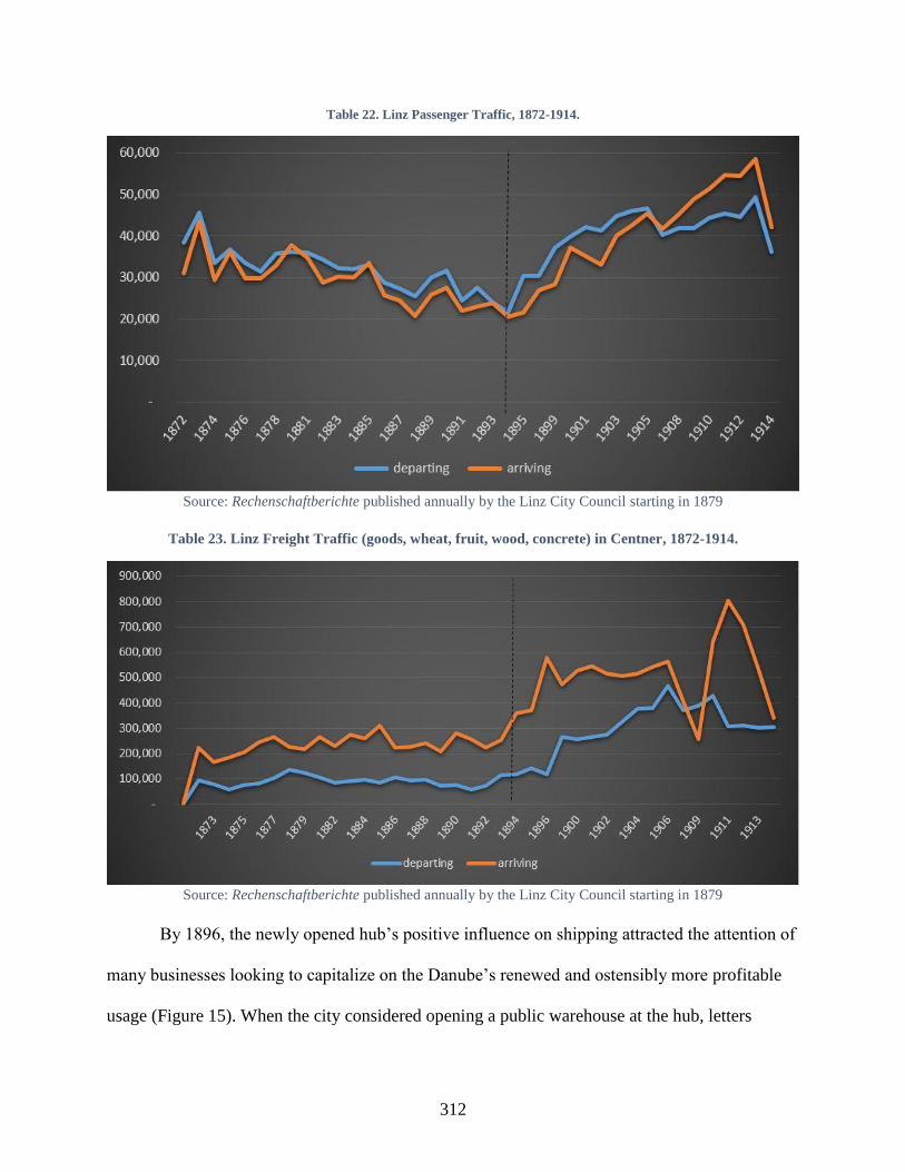
312
Table 22. Linz Passenger Traffic, 1872-1914.
Source: Rechenschaftberichte published annually by the Linz City Council starting in 1879
Table 23. Linz Freight Traffic (goods, wheat, fruit, wood, concrete) in Centner, 1872-1914.
Source: Rechenschaftberichte published annually by the Linz City Council starting in 1879
By 1896, the newly opened hub’s positive influence on shipping attracted the attention of
many businesses looking to capitalize on the Danube’s renewed and ostensibly more profitable
usage (Figure 15). When the city considered opening a public warehouse at the hub, letters
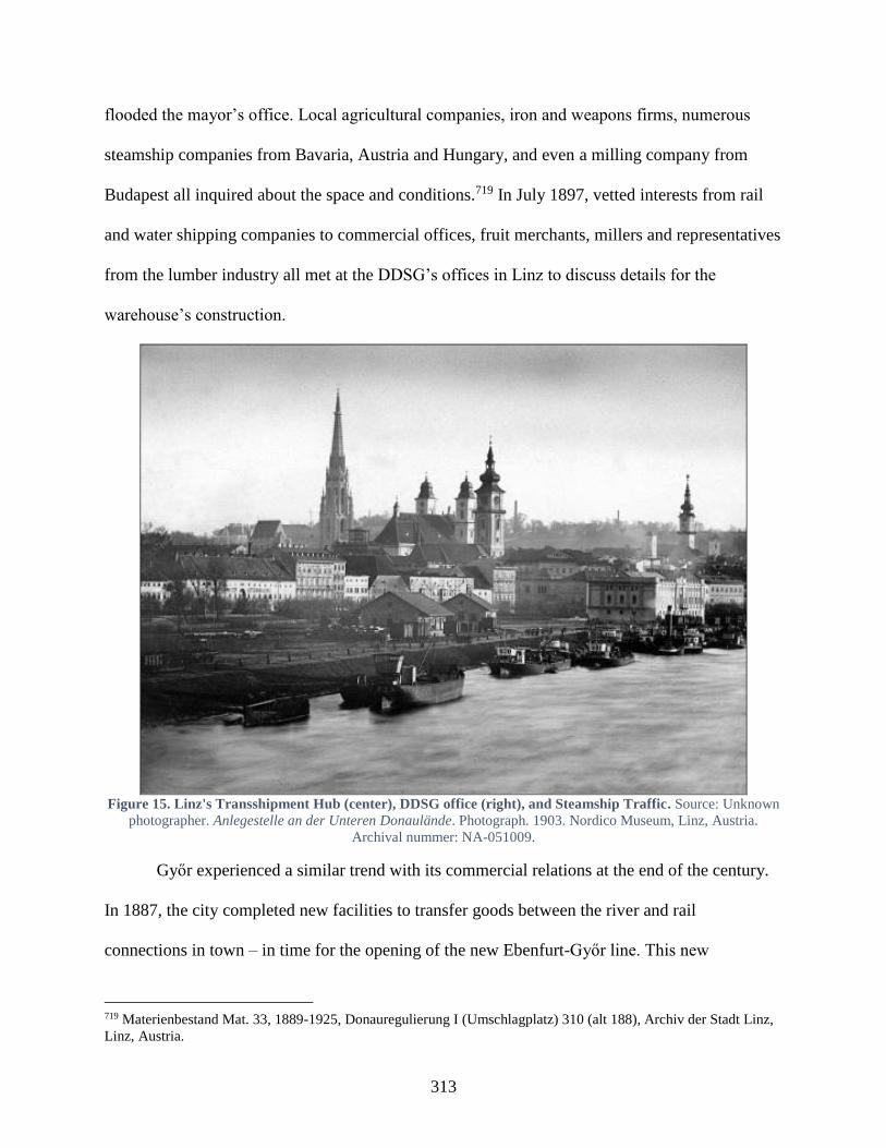
313
flooded the mayor’s office. Local agricultural companies, iron and weapons firms, numerous
steamship companies from Bavaria, Austria and Hungary, and even a milling company from
Budapest all inquired about the space and conditions.719 In July 1897, vetted interests from rail
and water shipping companies to commercial offices, fruit merchants, millers and representatives
from the lumber industry all met at the DDSG’s offices in Linz to discuss details for the
warehouse’s construction.
Figure 15. Linz's Transshipment Hub (center), DDSG office (right), and Steamship Traffic. Source: Unknown
photographer. Anlegestelle an der Unteren Donaulände. Photograph. 1903. Nordico Museum, Linz, Austria.
Archival nummer: NA-051009.
Győr experienced a similar trend with its commercial relations at the end of the century.
In 1887, the city completed new facilities to transfer goods between the river and rail
connections in town – in time for the opening of the new Ebenfurt-Győr line. This new
719 Materienbestand Mat. 33, 1889-1925, Donauregulierung I (Umschlagplatz) 310 (alt 188), Archiv der Stadt Linz,
Linz, Austria.
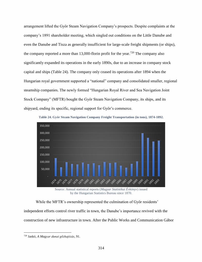
314
arrangement lifted the Győr Steam Navigation Company’s prospects. Despite complaints at the
company’s 1891 shareholder meeting, which singled out conditions on the Little Danube and
even the Danube and Tisza as generally insufficient for large-scale freight shipments (or ships),
the company reported a more than 13,000-florin profit for the year.720 The company also
significantly expanded its operations in the early 1890s, due to an increase in company stock
capital and ships (Table 24). The company only ceased its operations after 1894 when the
Hungarian royal government supported a “national” company and consolidated smaller, regional
steamship companies. The newly formed “Hungarian Royal River and Sea Navigation Joint
Stock Company” (MFTR) bought the Győr Steam Navigation Company, its ships, and its
shipyard, ending its specific, regional support for Győr’s commerce.
Table 24. Győr Steam Navigation Company Freight Transportation (in tons), 1874-1892.
Source: Annual statistical reports (Magyar Statistikai Évkönyv) issued
by the Hungarian Statistics Bureau since 1870.
While the MFTR’s ownership represented the culmination of Győr residents’
independent efforts control river traffic in town, the Danube’s importance revived with the
construction of new infrastructure in town. After the Public Works and Communication Gábor
720 Jankó, A Magyar dunai gőzhajózás, 91.
-
50,000
100,000
150,000
200,000
250,000
300,000
350,000
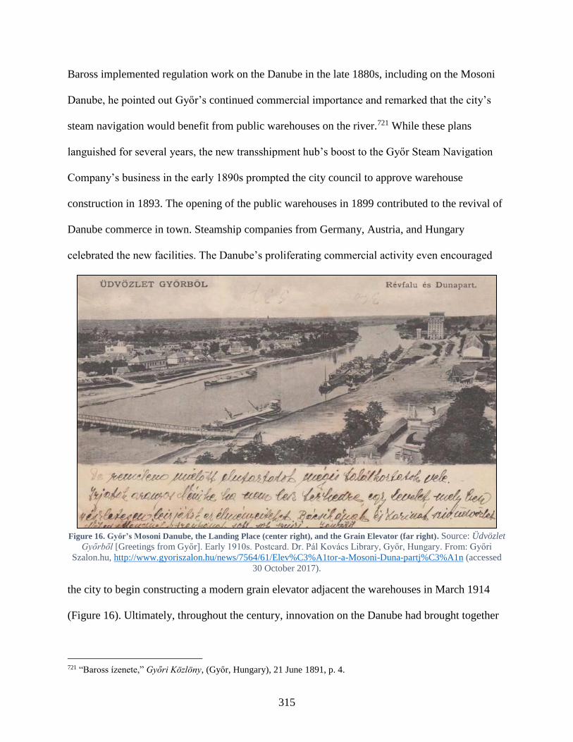
315
Baross implemented regulation work on the Danube in the late 1880s, including on the Mosoni
Danube, he pointed out Győr’s continued commercial importance and remarked that the city’s
steam navigation would benefit from public warehouses on the river.721 While these plans
languished for several years, the new transshipment hub’s boost to the Győr Steam Navigation
Company’s business in the early 1890s prompted the city council to approve warehouse
construction in 1893. The opening of the public warehouses in 1899 contributed to the revival of
Danube commerce in town. Steamship companies from Germany, Austria, and Hungary
celebrated the new facilities. The Danube’s proliferating commercial activity even encouraged
Figure 16. Győr’s Mosoni Danube, the Landing Place (center right), and the Grain Elevator (far right). Source: Üdvözlet
Győrből [Greetings from Győr]. Early 1910s. Postcard. Dr. Pál Kovács Library, Győr, Hungary. From: Győri
Szalon.hu, http://www.gyoriszalon.hu/news/7564/61/Elev%C3%A1tor-a-Mosoni-Duna-partj%C3%A1n (accessed
30 October 2017).
the city to begin constructing a modern grain elevator adjacent the warehouses in March 1914
(Figure 16). Ultimately, throughout the century, innovation on the Danube had brought together
721 “Baross ízenete,” Győri Közlöny, (Győr, Hungary), 21 June 1891, p. 4.
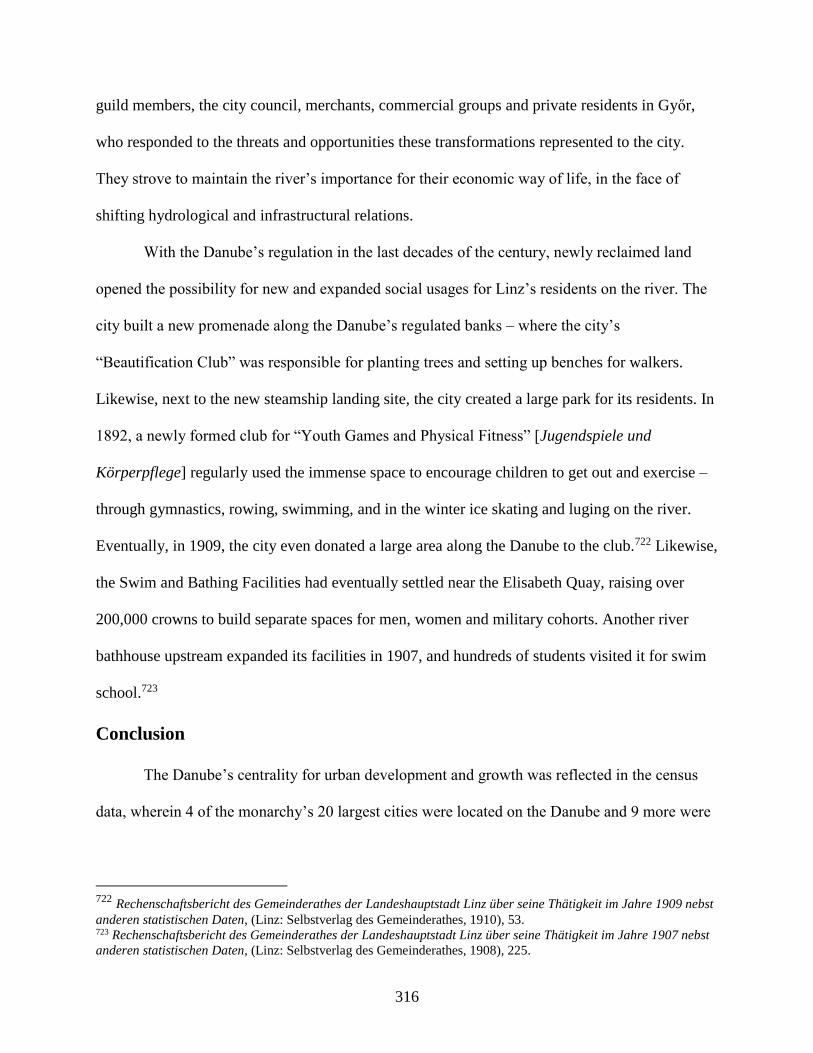
316
guild members, the city council, merchants, commercial groups and private residents in Győr,
who responded to the threats and opportunities these transformations represented to the city.
They strove to maintain the river’s importance for their economic way of life, in the face of
shifting hydrological and infrastructural relations.
With the Danube’s regulation in the last decades of the century, newly reclaimed land
opened the possibility for new and expanded social usages for Linz’s residents on the river. The
city built a new promenade along the Danube’s regulated banks – where the city’s
“Beautification Club” was responsible for planting trees and setting up benches for walkers.
Likewise, next to the new steamship landing site, the city created a large park for its residents. In
1892, a newly formed club for “Youth Games and Physical Fitness” [Jugendspiele und
Körperpflege] regularly used the immense space to encourage children to get out and exercise –
through gymnastics, rowing, swimming, and in the winter ice skating and luging on the river.
Eventually, in 1909, the city even donated a large area along the Danube to the club.722 Likewise,
the Swim and Bathing Facilities had eventually settled near the Elisabeth Quay, raising over
200,000 crowns to build separate spaces for men, women and military cohorts. Another river
bathhouse upstream expanded its facilities in 1907, and hundreds of students visited it for swim
school.723
Conclusion
The Danube’s centrality for urban development and growth was reflected in the census
data, wherein 4 of the monarchy’s 20 largest cities were located on the Danube and 9 more were
722 Rechenschaftsbericht des Gemeinderathes der Landeshauptstadt Linz über seine Thätigkeit im Jahre 1909 nebst
anderen statistischen Daten, (Linz: Selbstverlag des Gemeinderathes, 1910), 53. 723 Rechenschaftsbericht des Gemeinderathes der Landeshauptstadt Linz über seine Thätigkeit im Jahre 1907 nebst
anderen statistischen Daten, (Linz: Selbstverlag des Gemeinderathes, 1908), 225.
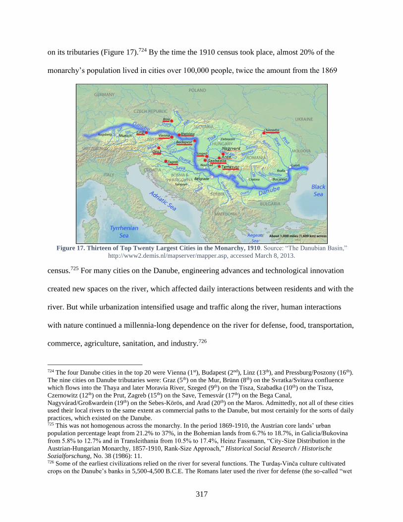
317
on its tributaries (Figure 17).724 By the time the 1910 census took place, almost 20% of the
monarchy’s population lived in cities over 100,000 people, twice the amount from the 1869
Figure 17. Thirteen of Top Twenty Largest Cities in the Monarchy, 1910. Source: “The Danubian Basin,”
http://www2.demis.nl/mapserver/mapper.asp, accessed March 8, 2013.
census.725 For many cities on the Danube, engineering advances and technological innovation
created new spaces on the river, which affected daily interactions between residents and with the
river. But while urbanization intensified usage and traffic along the river, human interactions
with nature continued a millennia-long dependence on the river for defense, food, transportation,
commerce, agriculture, sanitation, and industry.726
724 The four Danube cities in the top 20 were Vienna (1st), Budapest (2nd), Linz (13th), and Pressburg/Poszony (16th).
The nine cities on Danube tributaries were: Graz (5th) on the Mur, Brünn (8th) on the Svratka/Svitava confluence
which flows into the Thaya and later Moravia River, Szeged (9th) on the Tisza, Szabadka (10th) on the Tisza,
Czernowitz (12th) on the Prut, Zagreb (15th) on the Save, Temesvár (17th) on the Bega Canal,
Nagyvárad/Großwardein (19th) on the Sebes-Körös, and Arad (20th) on the Maros. Admittedly, not all of these cities
used their local rivers to the same extent as commercial paths to the Danube, but most certainly for the sorts of daily
practices, which existed on the Danube. 725 This was not homogenous across the monarchy. In the period 1869-1910, the Austrian core lands’ urban
population percentage leapt from 21.2% to 37%, in the Bohemian lands from 6.7% to 18.7%, in Galicia/Bukovina
from 5.8% to 12.7% and in Transleithania from 10.5% to 17.4%, Heinz Fassmann, “City-Size Distribution in the
Austrian-Hungarian Monarchy, 1857-1910, Rank-Size Approach,” Historical Social Research / Historische
Sozialforschung, No. 38 (1986): 11. 726 Some of the earliest civilizations relied on the river for several functions. The Turdaș-Vinča culture cultivated
crops on the Danube’s banks in 5,500-4,500 B.C.E. The Romans later used the river for defense (the so-called “wet

318
The Danube epitomized the primacy of environment, which shaped communities’
orientation to the river and the types of professions and groups that lived along it. It functioned
as a commercial path, a kinetic driver to produce work for mills and machines, a force to wash
away industrial and biological effluence, and often as a source of danger through flooding and
ice flows. Municipal populations identified the river with their prosperity, as it shaped their
practices along it. Thus, despite the prevalence of national strife in certain circles, many other
daily concerns, such as the effect that environmental transformations had on peoples’ livelihood
and well-being, brought together people in similar manners across the monarchy.
The river’s transformation likewise caused different vested interests to manifest
themselves in various administrative, commercial, and associational groups, which sought to
shape this process. For merchants and transportation companies, which relied on the river for
commerce, not only did the river require modifications, but cities also had to develop new
infrastructure to enable commercial ties and accommodate ever more traffic. Residents looked at
the river’s regulation as a new source of land on which to build factories, industrial works, and
housing, or as a protection against floods, as a solution to sanitary problems or as a site for
leisure and amusement.
The hierarchical structures of the monarchy also asserted themselves, even at the
municipal level. While independent to govern themselves, municipal councils and mayors’
offices continued to rely on the funding support and authority that imperial government and
legislative bodies provided to municipalities on the river. Regulations about safety and sanitation
limes”) and commerce, with several naval bases and three flotillas patrolling from Regensburg to the Black Sea. The
Romans even began to craft intricate sewage systems to flush waste into the river. The river provided a route for
crusaders in the 11th century and later the Ottoman army, as it marched into Balkans and Central Europe from the 14
to 16th centuries.
319
frequently stemmed from central directives, and new arrangements in cities could only be built
with the aid of provincial, national, and imperial governments.
The so-called Danube Question continued to animate not only the residents of Linz and
Győr but large swaths of the monarchy’s population. Its regulation or modification was often tied
up in questions of municipal development and domestic politics, dealing with flooding, land
reclamation, navigation, trade, as well as more recreational pursuits along the river. Competing
visions and evolving practices required negotiations, and many socio-economic, local and
transregional groups emerged to debate whether the Danube could remain a space where the
‘general well-being’ could reign amidst many disparate interests.
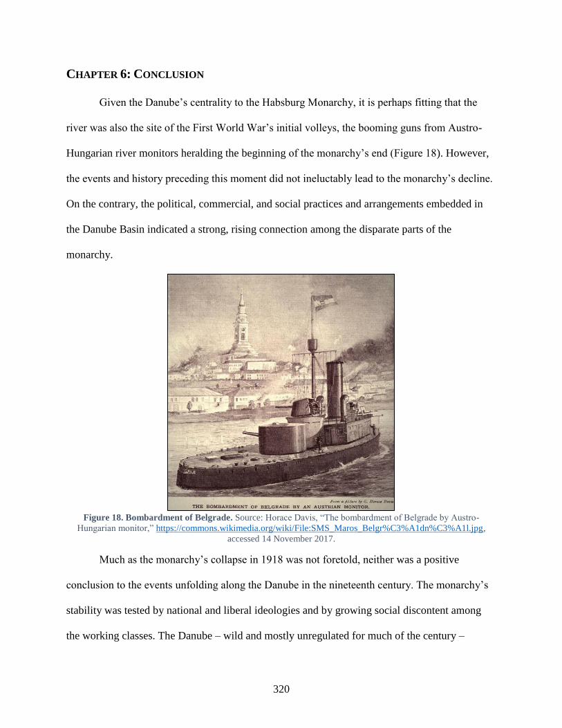
320
CHAPTER 6: CONCLUSION
Given the Danube’s centrality to the Habsburg Monarchy, it is perhaps fitting that the
river was also the site of the First World War’s initial volleys, the booming guns from Austro-
Hungarian river monitors heralding the beginning of the monarchy’s end (Figure 18). However,
the events and history preceding this moment did not ineluctably lead to the monarchy’s decline.
On the contrary, the political, commercial, and social practices and arrangements embedded in
the Danube Basin indicated a strong, rising connection among the disparate parts of the
monarchy.
Figure 18. Bombardment of Belgrade. Source: Horace Davis, “The bombardment of Belgrade by Austro-
Hungarian monitor,” https://commons.wikimedia.org/wiki/File:SMS_Maros_Belgr%C3%A1dn%C3%A1l.jpg,
accessed 14 November 2017.
Much as the monarchy’s collapse in 1918 was not foretold, neither was a positive
conclusion to the events unfolding along the Danube in the nineteenth century. The monarchy’s
stability was tested by national and liberal ideologies and by growing social discontent among
the working classes. The Danube – wild and mostly unregulated for much of the century –

321
visited disasters and catastrophes upon riparian communities. Engineering solutions to prevent
flooding were bedeviled by the monarchy’s de-centralized political and technical structure,
which reified particularistic rather than holistic perspectives.727
As the previous five chapters have explored, the Habsburg regime countered these natural
and political threats with reforms and improvements to shore up support for and reaffirm the
monarchy’s legitimacy. The Danube played an immense role in subsequent state-building efforts.
Imperial celebrations strengthened the association between the dynasty and modernization.
Newfangled steam power increased the capacity and desire to modify the riverscape and advance
a unitary vision for the monarchy’s waterways. As a result, largescale hydraulic engineering
projects tried to ensure the river’s utility for all, promoting commercial activity and passenger
traffic throughout the monarchy’s waterways. Extensive flood protection measures sought to
tame the river’s unpredictability. Toward the end of the century, communities huddled behind
higher flood protections and had developed more sophisticated flood response practices to keep
themselves safe and to help re-build. All these interventions likewise provided local, provincial,
and imperial authorities spaces and opportunities to protect the well-being of the monarchy’s
citizens by engineering both physical arrangements and social practices.
Certainly, hydraulic engineering works did not provide an uncomplicatedly positive
improvement to people’s environment. Changes to the river had negative consequences – both
socially and environmentally – which adversely affected groups as well. Mark Cioc says in The
Rhine: An Eco-Biography that “too often economic historians see only the steamship’s forward
progress, while environmental historians see but the smokestack’s plume. Depending on
perspective, a fishing village can be depicted as pleasingly arcadian or hopelessly backward...
727 This was further exacerbated by the Danube’s different dynamics in various stretches. The conditions which
caused flooding in Austria, for example, could be different than those that affected the Hungarian stretches.
322
Such simple abstractions, however, mask more than they reveal: rarely are the lines separating
progress and decline… so easily drawn.”728 Human activity – deforestation, agricultural activity,
bank erosion, embankments – contributed to the river’s changing hydrology with scant regard to
the long-term consequences. New practices on the river also affected the livelihood of many, not
always for the best. Competition drove smaller steamship companies and traditional boatmen out
of business, while the remaining steamers and companies disrupted fishing and milling practices
along the entire river as their actions and activities demanded exclusive rights to the river.729
Rivalries between the DDSG and its Hungarian competition did, at times, led to acrimonious
debates about state-sponsorship and fairness.730
Furthermore, despite engineers’ best efforts to construct a reliable and safe Danube
waterway, they could not control the climatic conditions that governed the river’s hydrology.
Extreme winters, heavy rainfalls, unexpected thaws, all led to unavoidable disruptions to
practices. Flood prevention measures, which narrowed the river’s flood plain and raised
impenetrable barriers along the river’s banks, exacerbated the effects that larger floods had on
riparian communities. Even after the river’s regulation at the end of the century was more or less
complete, poor hydrological conditions or climatic variations still prematurely ended navigation
for the season, leaving goods or shipments stranded in unplanned locations.731
728 Mark Cioc, The Rhine: An Eco-Biography, 1815-2000, (Seattle and London, 2002), 17. 729 Erste k.k. priv. Donau-Dampfschiffahrts-Gesellschaft Geschäfts-Bericht der Betriebs-Direction über das
Verwaltungsjahr vom 1. December 1879 bis 30. November 1880, (Vienna: Selbstverlag der Gesellschaft, 1881), 3. 730 Franz Pisecky, “Die Grösste Binnenreederei der Welt: 140 Jahre Erste Donau-Dampfschiffahrts-
Gesellschaft - Gröβe und europäische Bedeutung der österreichischen Donauschiffahrt,” Zeitschrift für
Firmengeschichte und Unternehmerbiographie 2, no. 3 (1970): 59-60. 731 Extraordinarily, the DDSG’s 1867 annual business report failed to mention the Ausgleich in the major factors
impacting its river traffic that year. Problematic harvests in the rest of Europe caused Romanian grain demand to
boom, which benefited the company. However, the DDSG also wrote that poor hydrological conditions adversely
affected its navigation. Even as late as 1899, not only did massively poor harvests in the Danube Principalities
reduce DDSG grain ships to a tenth of the previous year (1000 shipments passing the Iron Gates into Hungary in
1898 followed by 97 in 1899), but low water levels in August followed by a once-in-a-century flood in September
(described in Chapter 4) exacerbated commercial difficulties by halting all steam navigation for several weeks as
landing places were rebuilt and destroyed bridge segments removed from the river. A dry spell from July to
323
Such occurrences irrefutably demonstrate the Danube’s prominent agency in this history.
As Peter Coates cogently remarks in A Story of Six Rivers, we shouldn’t be surprised that a river
can have agency, as we frequently personify them – calling them lazy, violent, proud, dangerous
– and ascribe to them characteristics and powers that we do not normally afford other non-human
actants.732 But rivers move objects as large as ships and as small as sand particles, they wear
away at their banks, beds, and any structures within their path, they flow, sink and flood. Their
movement and activity are not passive, but prompt reactions and guide behavior.
Perhaps due to the river’s activity in the lives of its citizens, the Habsburgs unsurprisingly
found the Danube and its far-flung tributary system a perfect space to support regulations and
policies that pursued the gemeine Beste or “common good.” With eighty or so cities and
communities along the Danube,733 and hundreds of others on tributaries across the monarchy,
from Arad on the Maros River arising in eastern Hungary to Kufstein on the Inn River in Tirol in
the west, millions of people benefitted from new arrangements and improved practices and
spanned the entire monarchy.734 Citizens benefited from more convenient passenger travel and
November 1900 effectively halted shipping on the Drave and several other stretches, Erste k.k. priv. Donau-
Dampfschiffahrts-Gesellschaft Geschäfts-Bericht der Betriebs-Direction über das Verwaltungsjahr vom 1.
December 1866 bis 30. November 1867, (Vienna: Selbstverlag der Gesellschaft, 1868), 3; Erste k.k. priv. Donau-
Dampfschiffahrts-Gesellschaft Geschäfts-Bericht der Betriebs-Direction über das Verwaltungsjahr vom 1.
December 1878 bis 30. November 1879, (Vienna: Selbstverlag der Gesellschaft, 1880), 3; Erste k.k. priv. Donau-
Dampfschiffahrts-Gesellschaft Geschäfts-Bericht für das Jahr 1900, (Vienna: Selbstverlag der Gesellschaft, 1901),
2; Erste k.k. priv. Donau-Dampfschiffahrts-Gesellschaft Geschäfts-Bericht der Betriebs-Direction über das
Verwaltungsjahr vom 1. December 1898 bis 30. November 1899, (Vienna: Selbstverlag der Gesellschaft, 1900), 1-2. 732 Peter Coates, A Story of Six Rivers: History, Culture and Ecology, (Reaktion Books, 2013), 23-27. 733 Just counting those with access to steamship stations, though there were considerably more. 734 By 1910, over 4 million already lived in Budapest and Vienna. Four of the monarchy’s 20 largest cities were
located on the Danube and 9 more were on its tributaries. The four Danube cities in the top 20 were Vienna (1st),
Budapest (2nd), Linz (13th), and Pressburg/Poszony (16th). The nine cities on Danube tributaries were: Graz (5th) on
the Mur, Brünn (8th) on the Svratka/Svitava confluence which flows into the Thaya and later Moravia River, Szeged
(9th) on the Tisza, Szabadka (10th) on the Tisza, Czernowitz (12th) on the Prut, Zagreb (15th) on the Save, Temesvár
(17th) on the Bega Canal, Nagyvárad/Großwardein (19th) on the Sebes-Körös, and Arad (20th) on the Maros.
Admittedly, not all of these cities used their local rivers to the same extent as commercial paths to the Danube, but
most certainly for the sorts of daily practices, which existed on the Danube.
324
expanded commercial ties, more secure flood protection and guaranteed reconstruction aid, and
more convenient arrangements to navigate and utilize the river for work and leisure.
Because the river was a physical and social space where the interests and needs of the
authorities and the monarchy’s population intersected, discussions regarding hydraulic projects
also increasingly involved active input from commercial, associational, and civil groups.
Petitions, newspaper articles, associational activity, speeches, and interactions with the regime
indicated that citizens not only supported such projects but expected them. Naturally, citizens’,
companies’, and the government’s interests did not always align. The ability to negotiate
between these divergent interests determined how well state institutions retained the trust and
loyalty of the people. But the process of negotiation, and citizens’ actions more generally,
revealed that despite barbed political exchanges or frustrations that occasionally emerged,
citizens relied on and operated within the structures of the monarchy to pursue their interests,
which ultimately served – in Renan’s famous formulation about the ‘nation’ – as a daily
plebiscite that reaffirmed the Danube Monarchy’s legitimacy to exist.735
735 Ernest Renan’s 1882 lecture “What is the Nation?” formulated the nation as a product of collective remembering
and forgetting and other types of collective experiences that brought people together. He claimed that people’s daily
actions and decisions reaffirmed a nation’s legitimacy to exist as ‘daily plebiscites.’
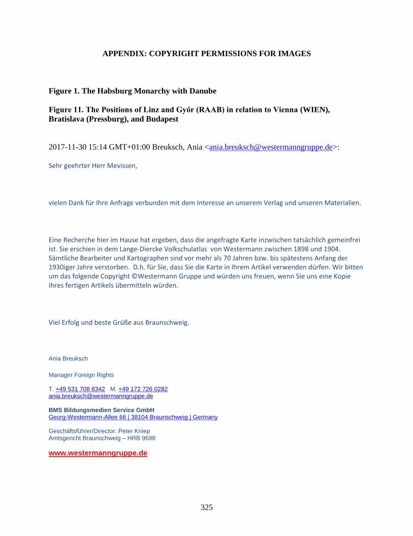
325
APPENDIX: COPYRIGHT PERMISSIONS FOR IMAGES
Figure 1. The Habsburg Monarchy with Danube
Figure 11. The Positions of Linz and Győr (RAAB) in relation to Vienna (WIEN),
Bratislava (Pressburg), and Budapest
2017-11-30 15:14 GMT+01:00 Breuksch, Ania <[email protected]>:
Sehr geehrter Herr Mevissen,
vielen Dank für Ihre Anfrage verbunden mit dem Interesse an unserem Verlag und unseren Materialien.
Eine Recherche hier im Hause hat ergeben, dass die angefragte Karte inzwischen tatsächlich gemeinfrei ist. Sie erschien in dem Lange-Diercke Volkschulatlas von Westermann zwischen 1898 und 1904. Sämtliche Bearbeiter und Kartographen sind vor mehr als 70 Jahren bzw. bis spätestens Anfang der 1930iger Jahre verstorben. D.h. für Sie, dass Sie die Karte in Ihrem Artikel verwenden dürfen. Wir bitten um das folgende Copyright ©Westermann Gruppe und würden uns freuen, wenn Sie uns eine Kopie Ihres fertigen Artikels übermitteln würden.
Viel Erfolg und beste Grüße aus Braunschweig.
Ania Breuksch
Manager Foreign Rights T. +49 531 708 8342 M. +49 172 726 0282 [email protected] BMS Bildungsmedien Service GmbH Georg-Westermann-Allee 66 | 38104 Braunschweig | Germany Geschäftsführer/Director: Peter Kniep Amtsgericht Braunschweig – HRB 9698
www.westermanngruppe.de
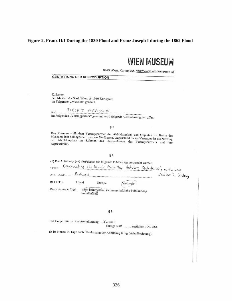
326
Figure 2. Franz II/I During the 1830 Flood and Franz Joseph I during the 1862 Flood

327
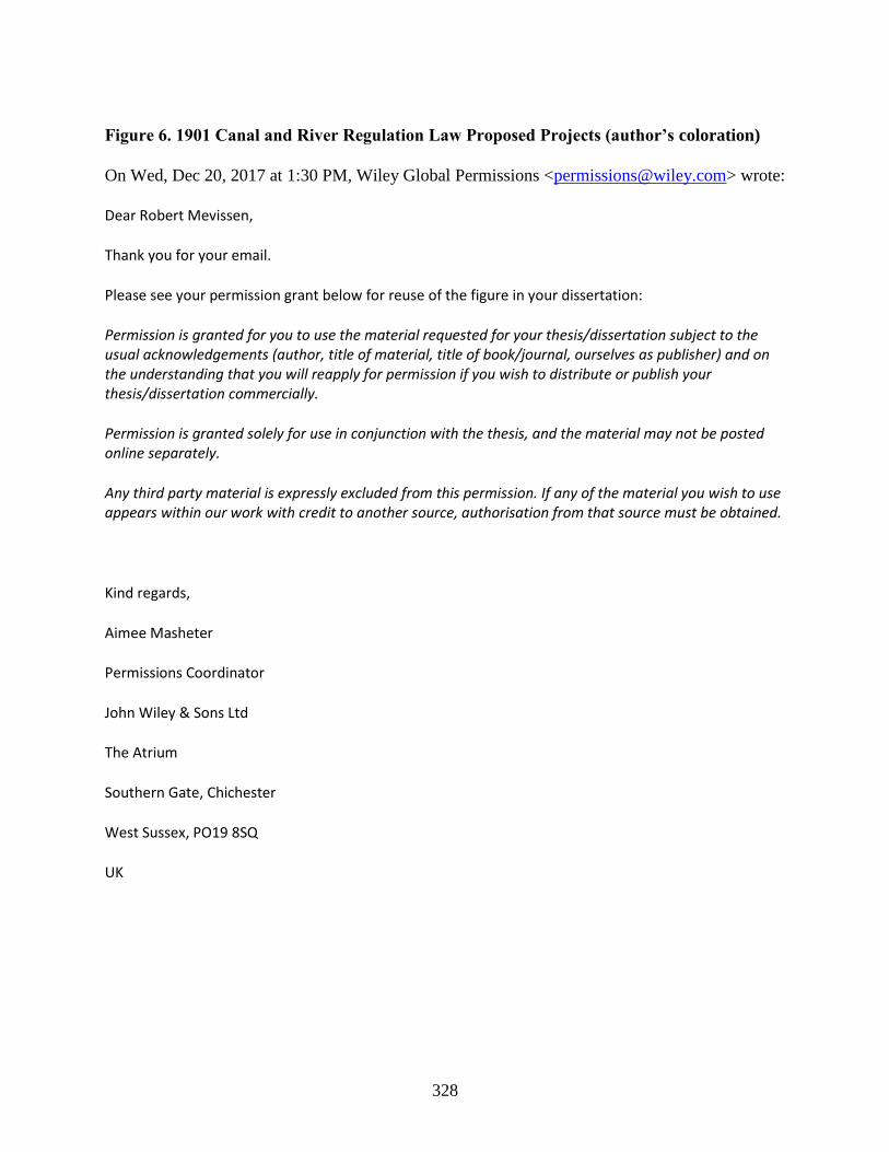
328
Figure 6. 1901 Canal and River Regulation Law Proposed Projects (author’s coloration)
On Wed, Dec 20, 2017 at 1:30 PM, Wiley Global Permissions <[email protected]> wrote:
Dear Robert Mevissen,
Thank you for your email.
Please see your permission grant below for reuse of the figure in your dissertation:
Permission is granted for you to use the material requested for your thesis/dissertation subject to the usual acknowledgements (author, title of material, title of book/journal, ourselves as publisher) and on the understanding that you will reapply for permission if you wish to distribute or publish your thesis/dissertation commercially.
Permission is granted solely for use in conjunction with the thesis, and the material may not be posted online separately.
Any third party material is expressly excluded from this permission. If any of the material you wish to use appears within our work with credit to another source, authorisation from that source must be obtained.
Kind regards,
Aimee Masheter
Permissions Coordinator
John Wiley & Sons Ltd
The Atrium
Southern Gate, Chichester
West Sussex, PO19 8SQ
UK
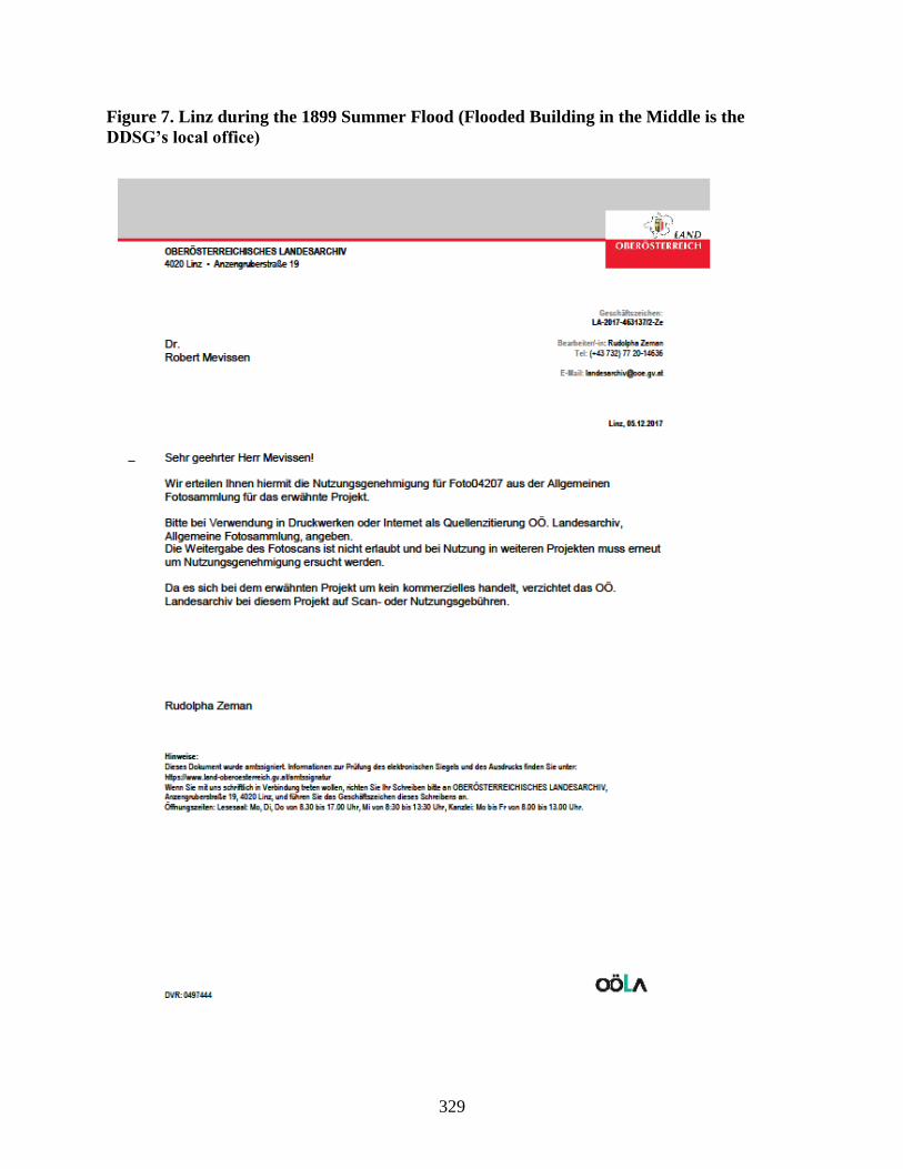
329
Figure 7. Linz during the 1899 Summer Flood (Flooded Building in the Middle is the
DDSG’s local office)
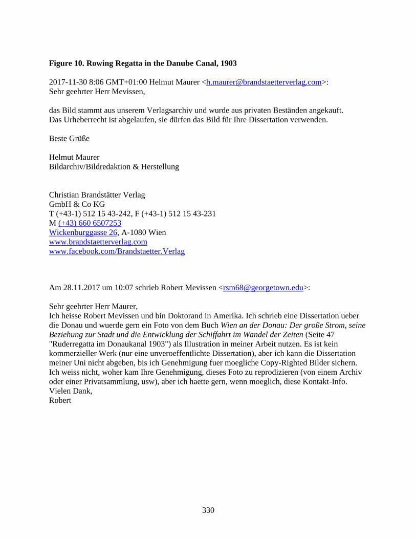
330
Figure 10. Rowing Regatta in the Danube Canal, 1903
2017-11-30 8:06 GMT+01:00 Helmut Maurer <[email protected]>:
Sehr geehrter Herr Mevissen,
das Bild stammt aus unserem Verlagsarchiv und wurde aus privaten Beständen angekauft.
Das Urheberrecht ist abgelaufen, sie dürfen das Bild für Ihre Dissertation verwenden.
Beste Grüße
Helmut Maurer
Bildarchiv/Bildredaktion & Herstellung
Christian Brandstätter Verlag
GmbH & Co KG
T (+43-1) 512 15 43-242, F (+43-1) 512 15 43-231
M (+43) 660 6507253
Wickenburggasse 26, A-1080 Wien
www.brandstaetterverlag.com
www.facebook.com/Brandstaetter.Verlag
Am 28.11.2017 um 10:07 schrieb Robert Mevissen <[email protected]>:
Sehr geehrter Herr Maurer,
Ich heisse Robert Mevissen und bin Doktorand in Amerika. Ich schrieb eine Dissertation ueber
die Donau und wuerde gern ein Foto von dem Buch Wien an der Donau: Der große Strom, seine
Beziehung zur Stadt und die Entwicklung der Schiffahrt im Wandel der Zeiten (Seite 47
"Ruderregatta im Donaukanal 1903") als Illustration in meiner Arbeit nutzen. Es ist kein
kommerzieller Werk (nur eine unveroeffentlichte Dissertation), aber ich kann die Dissertation
meiner Uni nicht abgeben, bis ich Genehmigung fuer moegliche Copy-Righted Bilder sichern.
Ich weiss nicht, woher kam Ihre Genehmigung, dieses Foto zu reprodizieren (von einem Archiv
oder einer Privatsammlung, usw), aber ich haette gern, wenn moeglich, diese Kontakt-Info.
Vielen Dank,
Robert

331
Figure 12. Linz, Strasser Island, and the “Fabrikarm” in the Late Nineteenth Century
Figure 14. The Swimming Facilities in the Fabrikarm, circa 1880
Figure 15. Linz's Transshipment Hub (center), DDSG office (right), and Steamship Traffic
332

333
Figure 16. Győr’s Mosoni Danube, the Landing Place (center right), and the Grain
Elevator (far right)
2017-10-18 13:44 GMT+02:00 Antaliné Hujter Szilvia <[email protected]>:
Tisztelt Robert Mevissen!
Hozzám irányították a levelét, annak idején találkoztunk a könyvtárban a kutatásai során.
Engedélyezzük a képek felhasználását, csak kérjük jelölje meg azok lelőhelyét és forrását.
Biztosan nagyon érdekes lett a disszertációja. Ha esetleg rövidebb publikációja jelenne meg a
témáról, kérjük küldje el nekünk.
További jó munkát kívánok:
--
Antaliné Hujter Szilvia
Helyismereti Osztály, osztályvezető
Dr. Kovács Pál Könyvtár és Közösségi Tér
Kisfaludy Károly Könyvtára
9021 Győr, Baross Gábor út. 4.
tel: 96/328-231
334
BIBLIOGRAPHY
Primary Sources
“A Duna-folyamnak a főváros mellett szabályozásáról s a forgalom és közlekedés érdekében
Buda-Pesten létesítendő egyéb közmunkák költségeinek fedezéséről és e közmunkák
végrehajtási közegeiről.” Az 1869-ik évi ápril hó 20-dikára hirdetett országgyűlés főrendi
házának irományai, vol. 2. Pest: Pesti Könyvnyomda-Részvény-Társulat, 1870.
Allgemeines Reichs-Gesetz- und Regierungsblatt für das Kaiserthum Oesterreich, Jahrgang
1849. Vienna: K.k. Hof- und Staatsdruckerei, 1850.
Allgemeines Landesgesetz- und Regierungsblatt für das Kronland Oesterreich ob der Enns,
Jahrgang 1850. Linz: Johann Huemer’s Witwe, 1850.
Allgemeines Landesgesetz- und Regierungsblatt für das Erzherzogthum Oesterreich ob der Enns,
Jahrgang 1851. Linz: Johann Huemer’s Witwe, 1851.
Amts-Blatt der k.k. Bezirkshauptmannschaft St.Pölten: II. Jahrgang. St.Pölten: Redaktion und
Verlag der k.k. Bezirkshauptmannschaft St.Pölten, 1879.
Amts-Blatt der k.k. Bezirkshauptmannschaft St.Pölten: III. Jahrgang. St.Pölten: Redaktion und
Verlag der k.k. Bezirkshauptmannschaft St.Pölten, 1880.
Anonymous. Donau-Strom-Polizei-Vorschrift. Hofkanzlei-Decret vom 24. December 1827.
Regierungs-Verordnung vom 30. März 1828. Accessed January 1, 2017.
https://play.google.com/books/reader?id=UJJpAAAAcAAJ&printsec=frontcover&output
=reader&hl=en&pg=GBS.PA3.
Anonymous. Die Ueberschwemmung zu Pesth, Ofen und Gran im Monath März 1838 Von einem
Augenzeugen. Wallishaußer, 1838.
Arenstein, Joseph. “Die Eisverhältnisse der Donau in Pesth.” In Bericht uber die Mitteilungen
von Freunden der Naturwissenschaften in Wien, edited by Wilheim Haidinger, vol. 4
(Vienna: Wilhelm Braumüller, 1848): 361-63.
Az 1869-dik évi april 20-dikára hirdetett országgyűlés képviselőházának naplója, vol 5. Pest:
Légrádt Testvérek, 1870.
Az 1872-ik évi szeptember hó 1-jére kihirdetett országgyűlés főrendi házának irományai, vol. 3.
Pest: Pesti Könyvnyomda-Részvény-Társulat.
Az 1878-ik évi október hó 17-ére kihirdetett országgyűlés főrendi hazának irományai, vol. 4.
Budapest: Pesti Könyvnyomda-Részvény-Társaság, 1880.
Az 1878. évi október hó 17-re hirdetett országgyűlés képviselőházának irományai, vol. 10.
335
Budapest: Pesti Könyvnyomda-Részvénytársaság, 1880.
Az 1896. évi november hó 23ára hirdetett országgyűlés képviselőházának naplója, vol. 7.
Budapest: Pesti Könyvnyomda-Részvény-Társaság, 1897.
Az 1896. évi november hó 23-ára hirdetett országgyűlés képviselőházának naplója, vol. 27.
Budapest: Pesti Könyvnyomda-Részvénytársaság, 1900.
Az 1901. évi október hó 24-ére hirdetett országgyűlés képviselőházának naplója, vol. 1.
Budapest: Pesti Könyvnyomda-Részvénytársaság, 1901.
Az 1901. évi október hó 24-ére hirdetett országgyűlés képviselőházának naplója, vol. 2.
Budapest: Pesti Könyvnyomda-Részvénytársaság, 1902.
Az 1901. évi október hó 24-ére hirdetett országgyűlés képviselőházának naplója, vol. 3.
Budapest: Az Athenaeum Irodalmi és Nyomdai Részvénytársulat, 1902.
Az 1901. évi október hó 24-ére hirdetett országgyűlés képviselőházának naplója, vol. 5.
Budapest: Az Athenaeum Irodalmi és Nyomdai Részvénytársulat, 1902.
Az 1901. évi október hó 24-ére hirdetett országgyűlés képviselőházának naplója, vol. 17.
Budapest: Az Athenaeum Iroldalmi és Nyomdai Részvénytársaság, 1903.
Az 1906. évi május hó 19-ére hirdetett országgyűlés képviselőházának naplója, vol. 21.
Budapest: Az Athenaeum Iroldalmi és Nyomdai Részvénytársaság, 1908.
Az 1910. évi junius hó 25-ére hirdetett országgyűlés képviselőházának irományai, vol. 1.
Budapest: Pesti Könyvnyomda-Részvénytársaság, 1910.
Az 1910. évi junius hó 21-ére hirdetett országgyűlés képviselőházának naplója, vol. 7. Budapest:
Az Athenaeum Irodalmi és Nyomdai Részvénytársulat Könyvnyomda, 1911.
Az 1910. évi junius hó 21-ére hirdetett országgyűlés képviselőházának naplója, vol. 13.
Budapest: Az Athenaeum Irodalmi és Nyomdai Részvénytársulat Könyvnyomda, 1911.
Az 1910 évi június hó 21-ére hirdetett országgyűlés képviselőházának naplója, vol. 17. Budapest:
Az Athenaeum Irodalmi és Nyomdai Részvénytársulat, 1913.
Badaeker, Karl. Southern Germany and Austria, including Hungary and Transylvania.
Handbook for Travelers. Leipzig, Karl Badaeker, 1883.
Becher, Siegfried. Handelsgeographie zum Gebrauche für Kaufsleute, Fabrikanten,
Geschäftsmänner und Handelschule, vol. 1. Vienna: Verlage bei Carl Gerold, 1837.
“Bemerkungen zu dem Gesetzentwurf, betreffend die Beitragsleistung des Staatsschatzes zu den

336
Kosten der Regulirung des Gailflusses in Kärnten.” Stenographische Protokolle über die
Sitzungen des Hauses der Abgeordneten des österreichischen Reichsrathes, VIII. Session.
Accessed September 17, 2017. http://alex.onb.ac.at/cgi-
content/alex?aid=spa&datum=0008&page=18889&size=45.
Beszédes, József. Duna-Tiszai hajózható csatornárol. (Über einen schiffbaren Donau-Theiß-
Kanal). Pest: Trattner-Karoly, 1844.
Boleszny, Antal. Széchenyi munkálatai az Al-Dunán: Tekintettel a Dunagőzhajózás és a
Széchenyiut történetére [Széchenyi's Works on the Lower Danube: With Regards to
Steam Navigation and the History of the Széchenyi Road]. Temesvár: szerző, 1878.
Braun-Konstanz, Hans (ed). Bericht über den Verlauf des X. Verbandstages abgehalten zu
Konstanz vom 19. bis 22. August 1913. Constance: Verlag des Deutsch-Oesterreichisch-
Ungarisch-Schweizerischen Verbandes für Binnenschiffahrt, 1913.
Claridge, R.T. A Guide Along the Danube: From Vienna to Constantinople Smyrna, Athens, the
Morea, the Ionian Islands, and Venice. London: F.C. Westley, 1837.
Csikvári, Jákó. A közlekedési eszközök: A Vasutak, Posták, Távirdák és a gőzhajózás története,
vol 1. Budapest: Franklin-Társulat Könyvnyomdája, 1882.
---. Csikvári, Jákó. A közlekedési eszközök: A Vasutak, Posták, Távirdák és a gőzhajózás
története, vol 2. Budapest: Franklin-Társulat Könyvnyomdája, 1883.
Czoernig, Carl Freiherr von. Österreich’s Neugestaltung, 1848-58. Stuttgart;Augsburg: J.G.
Cotta’scher Verlage, 1858.
“Der Schiffs-und Waaren-Verkehr auf der Donau und ihren Nebenflüssen.” Zeitschrift für die
gesamte Staatswissenschaft 24, no. 1 (1868): 166-169.
Deutsch, Jacob. Bericht an den löblichen Administrations-Rath der Ersten k.k. priv. Donau-
Dampfschifffahrts-Gesellschaft über die Verhandlungen des V. Binnenschiffahrts-
Congresses in Paris 1892. Second Edition. Vienna: Druck und Verlag der I. k. k. priv.
Donau-Damptschiffahrts-Gesellschaft, 1894.
Didaktische Episteln in Prosa an die Direktion der I. k.k. priv. Donau-Dampfschiffart-
Gesellschaft. Pancsova: Wittigschlager, 1871.
“Die Donaustraße.” Weltwirtschaftliches Archiv Vol. 10, (1917): 215-303.
“Die Vermessungs- und anderen topographischen Arbeiten in Österreich. II. Die Militär-
Mappirung.” In Österreichische Militärische Zeitschrift, edited by V. Streffleur, vol. 3
(Vienna: Kaiserl. Königl. Hof- und Staatsdruckerei, 1863): 17-33.
Donau-Regulirungs-Commission. Beschreibung der Arbeiten der Donau-Regulirung bei Wien:
337
herausgegeben aus Anlaß der feierlichen Eröffnung der Schiffahrt im neuen Strombette
am 30. Mai 1875. Vienna: k. k. Hof- u. Staatsdruckerei, 1875.
Donau-Verein. Die Thätigkeit des Donau-Vereines im ersten Jahrzehnte seines Bestandes,
1879-88. Vienna: Verlag des Donau-Vereines, 1889.
Dorn, Alexander von. Die Konkurrenz des Binnen-Wasserweges gegen den Seeweg nach
hergestellter Kanalverbindung der Donau mit dem deutschen Wasserstrassen-Netze.
Berlin: Siemenroth & Troschel, 1899.
Dorner, Joseph von. Panorama der Österreichischen Monarchie oder malerisch-romantisches
Denkbuch der schönsten und merkwürdigsten Gegenden derselben, der Gletscher,
Hochgebirge, Alpenseen und Wasserfälle, bedeutender Städte mit ihren Kathedralen,
Pallásten und alterthümlichen Bauwerken, berühmter Badeörter, Schlösser, Burgen und
Ruinen, sowie der interessantesten Donau-Ansichten mit Stahlstichen von vorzüglichsten
englischen und deutschen Künstlern nach eigends zu diesem Werke aufgenommenen
Originalzeichnungen, vol. 3. Pest; Leipzig: C.A. Hartleben’s Verlag, 1840.
Die Erste k.k. priv. Donau-Dampfschiffahrts-Gesellschaft an der Jahreswende 1887-88. Vienna:
Selbstverlag der Gesellschaft, 1888.
Erste k.k. priv. Donau-Dampfschiffahrts-Gesellschaft Geschäfts-Bericht der Betriebs-Direction
über das Verwaltungsjahr vom 1. December 1866 bis 30. November 1867. Vienna:
Selbstverlag der Gesellschaft, 1868.
Erste k.k. priv. Donau-Dampfschiffahrts-Gesellschaft Geschäfts-Bericht der Betriebs-Direction
über das Verwaltungsjahr vom 1. December 1872 bis 30. November 1873. Vienna:
Selbstverlag der Gesellschaft, 1874.
Erste k.k. priv. Donau-Dampfschiffahrts-Gesellschaft Geschäfts-Bericht der Betriebs-Direction
über das Verwaltungsjahr vom 1. December 1878 bis 30. November 1879. Vienna:
Selbstverlag der Gesellschaft, 1880.
Erste k.k. priv. Donau-Dampfschiffahrts-Gesellschaft Geschäfts-Bericht der Betriebs-Direction
über das Verwaltungsjahr vom 1. December 1879 bis 30. November 1880. Vienna:
Selbstverlag der Gesellschaft, 1881.
Erste k.k. priv. Donau-Dampfschiffahrts-Gesellschaft Geschäftsbericht der Betriebs-Direction
über das Verwaltungsjahr vom 1. December 1887 bis 30. November 1888. Vienna: Carl
Gerold’s Son, 1889.
Erste k.k. priv. Donau-Dampfschiffahrts-Gesellschaft Geschäfts-Bericht der Betriebs-Direction
über das Verwaltungsjahr vom 1. December 1898 bis 30. November 1899. Vienna:
Selbstverlag der Gesellschaft, 1900.
Erste k.k. priv. Donau-Dampfschiffahrts-Gesellschaft Geschäfts-Bericht für das Jahr 1896.

338
Vienna: Selbstverlag der Gesellschaft, 1897.
Erste k.k. priv. Donau-Dampfschiffahrts-Gesellschaft Geschäfts-Bericht für das Jahr 1900,
(Vienna: Selbstverlag der Gesellschaft, 1901
Erste k.k. priv. Donau-Dampfschiffahrts-Gesellschaft. Die Donau von Passau bis zum
Schwarzen Meer. Vienna: Selbstverlag, 1907.
Exner, Wilhelm Franz Rudolf von Grimburg, Adolf von Guttenberg, W. Hecke, Emanuel Sar.
“Volkswirthschaftliches Leben in Wien.” In Die österreichisch-ungarische Monarchie in
Wort und Bild: Wien und Niederösterreich 1. Abtheilung, edited by F.X. von Neumann-
Spallart, 277-326. Vienna: k. & k. Hofdruckerei, 1886.
Forgách, Ludwig von. Die schiffbare Donau von Ulm bis in das Schwarze Meer : den
Mitgliedern des verfaßunggebenden Reichstages zur gütigen Einsicht. Frankfurt an der
Main: August Osterrieth, 1848.
Fray, Franz B. Allgemeiner Handlungs-Gremial-Almanach für den oesterreichischen
Kaiserstaat. Vienna: 1837.
Geschäfts-Bericht der Betriebs-Direction der ersten k.k. priv. Donau-Dampfschiffahrt-
Gesellschaft über das Verwaltungsjahr vom 1. December 1857 bis 30. November 1858.
Vienna: Carl Gerold’s Sohn, 1859.
Götz, Wilhelm. Das Donaugebiet mit Rücksicht auf seine Wasserstrassen nach den
Hauptgesichtspunkten der wirtschaft. Stuttgart: Verlag von Carl Grüninger, 1882.
Gonda, Béla. “A magyar Duna.” Az Osztrák-Magyar Monarchia Írásban és Képben, vol. 4.
Budapest: Magyar Királyi Államnyomda, 1896.
Gonda, Béla. Die ungarische Schiffahrt. Budapest: Technisch-Litterarische und Druckerei-
Unternehmung, 1899.
Haidinger, Wilhelm (ed). Bericht uber die Mitteilungen von Freunden der Naturwissenschaften
in Wien, vol. 4 (Vienna: Wilhelm Braumüller, 1848).
Halter, Rudolf. “Das zentraleuropäisclie Wasserstraßennetz. Vortrag, gehalten den 28. November
1917.” ZOBODAT Zoological Botanical Database. Accessed October 10, 2015,
http://www.zobodat.at/pdf/SVVNWK_58_0063-0090.pdf.
Hegyfoky, J. “Wasserstand der Flüsse und Niederschlag in Ungarn.” Mathematische und
Naturwissenschaftliche Berichte aus Ungarn 27, no. 1 (1897): 239-84.
Heliser, Jósef. Rövid tudosítás az 1838-iki esztergomi árvízről, annak következményeiről, a
Kárvallottak számára béfolytt Segedelmekről, és ezeknek Felosztasukról. Esztergom:
Esztergami k. Beimel J. betűivel, 1839.
339
Hieronymi, Károly. A Budapesti Duna-Szakasz Szabályozása. Budapest: Pesti Könyvnyomda-
Részvény Társaság Kidadmánya, 1880.
“Inland Navigation of Europe.” Science 5, no. 120 (1885): 426-427.
Itzeles, Louis. Schifffahrtscanal-Projecte aus der Josefinischen Zeit und deren Verwendbarkeit
für die Gegenwart. Vienna: Im Selbstverlage des Verfassers, 1881.
Jekelfalussy, József and Gyula Vargha (eds). Közgazdasági és statisztikai évkönyv, újabb
harmadik-negyedik évfolyam, 1890. Budapest: Révai Testvérek Bizománya, 1890.
Jekelfalussy, József and Gyula Vargha (eds). Közgazdasági és statisztikai évkönyv, újabb ötödik
évfolyam, 1891. Budapest: Pesti Könyvnyomda-Részvény-Társaság, 1891.
J., L. “A buda-pesti dunaszabályozás.” A Magyar Mérnök és Építész Egylet Közlönye 5 (Pest:
Athenaeum Nyomda, 1871): 70-96.
Jubiläums-Ausstellung in Wien 1898. Special-Katalog der Ausstellung der Donau-Regulierungs-
Commission in Wien. Vienna: Im Verlage der Donau-Regulierungs-Commission, 1898.
K.k. Direction der administrativen Statistik (ed). Tafeln zur Statistik der österreichischen
Monarchie für das Jahr 1841, 14. Jahrgang. Vienna: K.k. Hof- und Staats-Druckerei,
1844. Accessed February 9, 2017.
http://digital.onb.ac.at/OnbViewer/viewer.faces?doc=ABO_%2BZ15083730X.
K.k. Direction der administrativen Statistik (ed). Tafeln zur Statistik der österreichischen
Monarchie für das Jahr 1842, 15. Jahrgang. Vienna: K.k. Hof- und Staats-Druckerei,
1846. Accessed February 10, 2017.
http://digital.onb.ac.at/OnbViewer/viewer.faces?doc=ABO_%2BZ150837402.
K.k. Direction der administrativen Statistik (ed). Tafeln zur Statistik der österreichischen
Monarchie für das Jahr 1843, 16. Jahrgang. Vienna: K.k. Hof- und Staats-Druckerei,
1847. Accessed February 10, 2017.
http://digital.onb.ac.at/OnbViewer/viewer.faces?doc=ABO_%2BZ150837402.
K.k. Direction der administrativen Statistik (ed). Tafeln zur Statistik der österreichischen
Monarchie für das Jahr 1843, 17. Jahrgang. Vienna: K.k. Hof- und Staats-Druckerei,
1847. Accessed February 10, 2017.
http://digital.onb.ac.at/OnbViewer/viewer.faces?doc=ABO_%2BZ150837505
K.k. Direction der administrativen Statistik (ed). Tafeln zur Statistik der österreichischen
Monarchie Neue Folge I. Das Jahr 1851 mit übersichtlicher Einbeziehung der Jahre
1849 und 1850. K.k. Hof- und Staatsdruckerei, 1856. Accessed February 10, 2017.
http://digital.onb.ac.at/OnbViewer/viewer.faces?doc=ABO_%2BZ150838005

340
K.k. Statistische Central-Commision (ed). Statistik des Verkehres in den im Reichsrathe
vertretenen Königreichen und Ländern vornehmlich für die Jahre 1881 bis 1891. Vienna:
K.k. Hof- und Staatsdruckerei, 1893.
K.k. Statistische Central-Commission (ed). Statistisches Jahrbuch für das Jahr 1868. (Vienna:
k.k. Hof- und Staatsdruckerei, 1870.
K.k. Statistische Central-Commission (ed). Statistisches Jahrbuch für das Jahr 1870. Vienna:
k.k. Hof- und Staatsdruckerei, 1872.
K.k. Statistische Central-Commission (ed). Statistisches Jahrbuch für das Jahr 1877, vol 4.
Vienna: K.k. Hof- und Staatsdruckerei, 1880.
K.k. Statistische Central-Commission (ed). Tafeln zur Statistik der österreichischen Monarchie,
Die Jahre 1860 bis 1865 umfassend. Vienna: K.k. Hof- und Staatsdruckerei, 1871.
K.k. Statistische Central-Commission (ed). “Waarenverkehr zwischen Oesterreich und Ungarn in
den Jahren 1884 bis 1891.” Oesterreichische Statistik 37, no. 4/2 (Vienna: K.k. Hof- und
Staatsdruckerei, 1894): 158-69.
K.k. Statistische Zentral-Commission (ed), “Der Zwischenverkehr der im Reichsrate vertretenen
Königreiche und Länder mit den Ländern der ungarischen Krone für die Jahren 1902 bis
1905,” Oesterreichische Statistik 82, no. 3/2 (Vienna: Hof- und Staatsdruckerei, 1905):
LVII- LXXII.
K.k. Statistische Zentral-Commission (ed). “Der Zwischenverkehr der im Reichsrate vertretenen
Königreiche und Länder mit den Ländern der ungarischen Krone in den Jahren 1900 und
1901.” Oesterreichische Statistik 68, no. 1/2 (Vienna: Hof- und Staatsdruckerei, 1905):
LXIII-LXXI.
K.k. Statistische Zentralkommission (ed). “Der Zwischenverkehr der im Reichsrate vertretenen
Königreiche und Länder mit den Ländern der ungarischen Krone in den Jahren 1906 u.
1907.” Oesterreichische Statistik 91, no. 4/2 (Vienna: Hof- und Staatsdruckerei, 1911):
XLVI-LXI.
K.k. Statistische Zentralkommission (ed). “Gesamtverkehr auf den österreichischen Flüssen in
den Jahren 1908, 1909, und 1910.” Oesterreichische Statistik 93, no. 3 (Vienna: K.k.
Hof- und Staatsdruckerei, 1916): X-XI.
K.k. Statistische Zentralkommission (ed). Österreichisches Statistisches Handbuch:
Sechsundzwanzigster Jahrgang 1907. Vienna: Verlag der k.k. statistischen
Zentralkommission, 1908.
Klun. “Flusskarten der Donau und der Theiss.” In Mittheilung der kaiserlich-königlichen
Geographischen Gesellschaft VII. Jahrgang 1863, edited by Franz Foetterle, (Vienna:
F.B. Geitler, 1863): 1-17.
341
Klunzinger, Paul. Der deutsch-österreichisch-ungarische Verband für Binnenschiffahrt.
Vienna: Im Selbstverlage des Donau-Vereins, 1897.
Kohl, Johann Georg. Die Donau von ihrem Ursprunge bis Pesth. Trieste: Verlag der literarisch-
artistischen Abtheilung der Oesterreichischen Lloyd, 1854.
Landesgesetz- und Regierungsblatt für das Erzherzogthum Oesterreich unter der Enns. Vienna:
K.k. Hof- und Staatsdruckerei, 1852.
Landesgesetz- und Verordnungsblatt für das Erzherzogthum Oesterreich unter der Enns,
Jahrgang 1863. Vienna: K.k. Hof- und Staatsdruckerei, 1863.
Landes-Regierungs-Blatt für das Erzherzogthum Oesterreich ob der Enns, Zweite Abtheilung
Jahrgang 1857. Linz: Joseph Feichtinger’s sel. Erben, 1857.
Landes-Regierungs-Blatt für das Erzherzogthum Oesterreich ob der Enns, Zweite Abtheilung
Jahrgang 1858. Linz: Joseph Feichtinger’s sel. Erben, 1858.
Landes-Regierungsblatt für das Erzherzogthum Oesterreich ob der Enns, Zweiter Abtheilung,
Jahrgang 1859. Linz: Joseph Feichtinger’s sel. Erben, 1859.
Liechtenstern, Joseph Marx Freiherr von. Statistische Uebersicht des oesterreichischen Kaiser-
Staats: nach dessen Zustande in dem Anfange des Jahres 1809. Wien: 1809. Accessed
December 12, 2016.
http://digital.onb.ac.at/OnbViewer/viewer.faces?doc=ABO_%2BZ184108903.
Linde, Franz Xaver. Chronik des Marktes und der Stadt Melk umfassend den Zeitraum von 890
bis 1899 mit besonderer Berücksichtigung der letzten 34 Jahre. Melk: Selbstverlag der
Gemeinde Melk, 1900.
Lukács, Béla. “Közlekedési intézmények.” In Az Osztrák-Magyar Monarchia írásban és
képekben. Magyarország I vol. 2, 512-526. Budapest: A Magvar Királyi Államnyomda
Kiadás, 1888.
Mayer, Dr. Friedrich. Panorama der Donau von Ulm bis Pressburg mit begleitendem Texte.
Pforzheim: Dennig Finck und Co., 1841.
Matlekovits, Dr. Alexander von. Das Königreich Ungarn: volkswirtschaftlich und statistisch
dargestellt, vol. 1. Leipzig: Duncker und Humblot, 1900.
M'Culloch, John Ramsay. A dictionary, geographical, statistical, and historical, of the various
countries, places, and principal natural objects in the world, vol. 2. London: Longman,
Brown, Green, and Longmans, 1842.
Müller, Adelbert. Die Donau vom Ursprunge bis zu den Mündungen. Zugleich ein Handbuch für
342
Reisende, welche diesen Strom befahren. Regensburg, Georg Joseph Manz, 1839.
Oberösterreichischer Landesausschuss (ed). Bericht über die Thätigkeit des oberösterreichischen
Landtages und des von diesem gewählten Landesausschusses in der VII. Wahlperiode
vom 15. September 1884 bis Sommer 1890. Linz: Verlag des Landesausschuss, 1890.
Oberösterr. Landesausschuss (ed). Bericht über die Thätigkeit des oberösterreichischen
Landtages und des von diesem gewählten Landesausschusses in der VIII. Wahlperiode
vom 14. Oktober 1890 bis Sommer 1896. Linz: Verlag des Landesausschuss, 1896.
Oelwein, Arthur. Ausbau der Wasserstrassen in Mittel-Europa. Zwei Vorträge, gehalten am 6.
December 1881 und am 31. Januar 1882 im Club österreichischer Eisenbahn-Beamten
von Arthur Oelwein, Bau-Inspector der k.k. Direction für Staatseisenbahn-Betrieb in
Wien. Vienna: Lehmann & Wentzel, 1882.
Oelwein, Arthur. Die Binnen-Wasserstrassen im Transportgeschäfte der Gegenwart. Vortag
gehalten im Niederosterr. Gewerbeverein am 6. November 1891 von k.k. Professor
Arthur Oelwein. Vienna: Verlag des Niederoesterreichischen Gewerbevereins, 1891.
Oelwein, Arthur. Die Wasserstraßenfrage in Oesterreich. Vienna: Gerold, 1894.
Pasetti, Ritter von. Notizen über die Donauregulierung im österreichischen Kaiserstaate bis zum
Ende des Jahre 1861 mit Bezug auf die im k.k. Staatsministerium herausgegebenen
Übersichtskarte der Donau. Vienna: k.k. Hof- und Staattsdruckerei, 1862.
Peez, Dr. Alexander. II. internationaler Binnenschiffahrts-Congress Wien 1886: I. Section: Der
wirthschaftliche Werth der Binnen-Wasserstrassen. Vienna: Verlag der Organisations-
Commission des Congresses, 1886.
Pester Lloyd-Gesellschaft (ed). Pester Lloyd-Kalender fuer das Jahr 1865. Pest: Khór & Wein,
1864.
Quin, Michel J. A Steam Voyage Down the Danube: With Sketches of Hungary, Wallachia,
Servia, Turkey, Etc, Third London Edition. New York: Theodore Foster, 1836.
Rally, Wilhelm von. Die Donaureise von Regensburg bis Linz. Vienna: Rohrmann, 1840.
Rechenschafts-Bericht des Ersten Fischer-Club’s für Oberösterreich in Linz. Linz: Druck von
Jos. Feichtiger’s Erben Selbstverlag, 1872.
Rechenschafts-Bericht des oberösterreichischen Landes-Fischereivereins in Linz für das Jahr
1909. Linz: Verlag des oberösterreichischen Landes-Fischereivereines, 1910.
Rechenschaftsbericht des oberösterreichischen Fischervereins in Linz für das Jahr 1891. Linz:
Verlag der oberösterreichischen Fischervereins, 1892.
343
Reichs-Gesetz-Blatt für das Kaiserthum Oesterreich, Jahrgang 1863. Vienna: K.k. Hof- und
Staatsdruckerei, 1863.
Reise auf der Donau von Ulm bis Wien, mit Angabe aller Städte, Flecken, Dörfer, Schlösser, u.
an beyden Ufern, ihrer vornehmsten Merkwürdigkeiten, und der Flüsse, welche sich mit
der Donau vereinigen. Nördlingen: Beck‘schen Buchhandlung, 1813.
Reitter, Ferenc. Donau-Regulierung zwischen Pest und Ofen, Pester Schiffahrts-Canal, Schutz
der Insel Csepel und des linkseitigen Ufers des Soroksárer Donauarmes gegen
Ueberschwemmung: Drei Anträge. Pest: Gebrüder Pollack, 1865.
Ruß, Dr. Viktor. Der volkswirtschaftliche Wert der künstlichen Schiffahrtsstraßen. München:
Verlagsbuchhandlung Georg D.W. Callwey, 1901.
Schebek, Dr. E. “Die Wasserstände der Elbe und Moldau.” In Statistische Monatschrift, edited
by Bureau der k.k. Statistischen Central-Commission. Vienna: Alfred Hölder, 1875.
“Schiffverkehr auf der oberen Donau.” Statistische Monatsschrift 1 (Vienna: Alfred Hölder,
1875): 34.
Schriften der in Budapest am 4. September des Jahres 1916 abgehaltenen Donaukonferenz.
Budapest: “Pátria” literar. Unternehmen und Druckerei Aktien-Gesellschaft, 1916.
Schultes, Dr. J.A. Donau-Fahrten: Ein Handbuch für Reisende auf der Donau, vol. 2. J.G.
Stuttgart und Tübingen: Cotta’schen Buchhandlung, 1827.
Schwab, C. G. Die Conflicte der Wasserfahrt auf den Flussen mit der Benutzung der letztern zum
Maschinenbetriebe, erörtert nach den Grundsatzen des gemeinen in Deutschland
gultigen Rechte. Ein Beitrag zur Lehre vom Wasserrechte, vol. 30. 1847.
Sendschreiben an die Aktionäre der k.k. privilegirten Donau-Dampfschifffahrts-Gesellschaft.
Dresden: Walther’sche Hofbuchhandlung, 1844.
“Ship Canals in Austria.” The Geographical Journal, vol. 18, no. 3 (1901): 289-291.
Sitzungs-Protocoll der General-Versammlung der k.k. priv. ersten Donau-Dampfschiffahrts-
Gesellschaft vom 29. Jänner 1838. Vienna: A. Strauß’s fel. Witwe, 1838.
Sitzungs-Protokoll der General-Versammlung der k.k. priv. ersten Donau-Dampfschiffahrts-
Gesellschaft vom 10. Februar 1840. Vienna: Selbstverlag, 1840.
Sitzungs-Protokoll der ausserordentlichen General-Versammlung der Ersten k.k. priv. Donau-
Dampfschuffahrts-Gesellschaft am 14. April 1874. Vienna: Selbstverlage der
Gesellschaft, 1874.
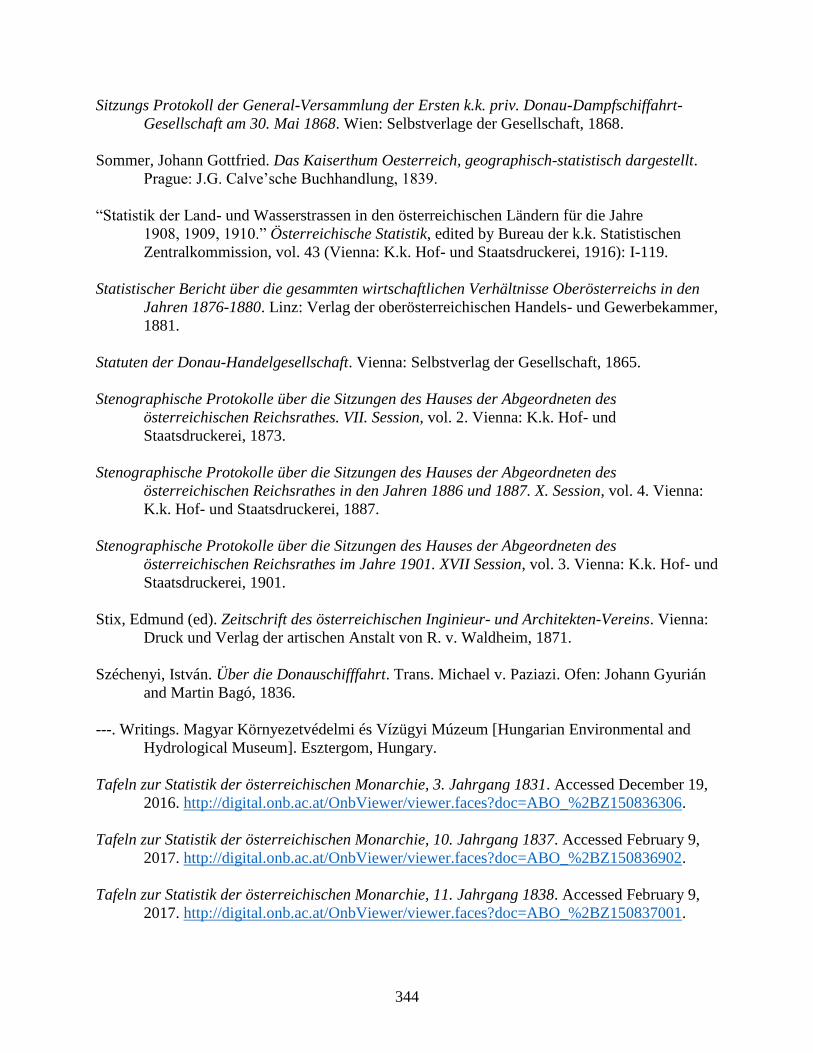
344
Sitzungs Protokoll der General-Versammlung der Ersten k.k. priv. Donau-Dampfschiffahrt-
Gesellschaft am 30. Mai 1868. Wien: Selbstverlage der Gesellschaft, 1868.
Sommer, Johann Gottfried. Das Kaiserthum Oesterreich, geographisch-statistisch dargestellt.
Prague: J.G. Calve’sche Buchhandlung, 1839.
“Statistik der Land- und Wasserstrassen in den österreichischen Ländern für die Jahre
1908, 1909, 1910.” Österreichische Statistik, edited by Bureau der k.k. Statistischen
Zentralkommission, vol. 43 (Vienna: K.k. Hof- und Staatsdruckerei, 1916): I-119.
Statistischer Bericht über die gesammten wirtschaftlichen Verhältnisse Oberösterreichs in den
Jahren 1876-1880. Linz: Verlag der oberösterreichischen Handels- und Gewerbekammer,
1881.
Statuten der Donau-Handelgesellschaft. Vienna: Selbstverlag der Gesellschaft, 1865.
Stenographische Protokolle über die Sitzungen des Hauses der Abgeordneten des
österreichischen Reichsrathes. VII. Session, vol. 2. Vienna: K.k. Hof- und
Staatsdruckerei, 1873.
Stenographische Protokolle über die Sitzungen des Hauses der Abgeordneten des
österreichischen Reichsrathes in den Jahren 1886 und 1887. X. Session, vol. 4. Vienna:
K.k. Hof- und Staatsdruckerei, 1887.
Stenographische Protokolle über die Sitzungen des Hauses der Abgeordneten des
österreichischen Reichsrathes im Jahre 1901. XVII Session, vol. 3. Vienna: K.k. Hof- und
Staatsdruckerei, 1901.
Stix, Edmund (ed). Zeitschrift des österreichischen Inginieur- und Architekten-Vereins. Vienna:
Druck und Verlag der artischen Anstalt von R. v. Waldheim, 1871.
Széchenyi, István. Über die Donauschifffahrt. Trans. Michael v. Paziazi. Ofen: Johann Gyurián
and Martin Bagó, 1836.
---. Writings. Magyar Környezetvédelmi és Vízügyi Múzeum [Hungarian Environmental and
Hydrological Museum]. Esztergom, Hungary.
Tafeln zur Statistik der österreichischen Monarchie, 3. Jahrgang 1831. Accessed December 19,
2016. http://digital.onb.ac.at/OnbViewer/viewer.faces?doc=ABO_%2BZ150836306.
Tafeln zur Statistik der österreichischen Monarchie, 10. Jahrgang 1837. Accessed February 9,
2017. http://digital.onb.ac.at/OnbViewer/viewer.faces?doc=ABO_%2BZ150836902.
Tafeln zur Statistik der österreichischen Monarchie, 11. Jahrgang 1838. Accessed February 9,
2017. http://digital.onb.ac.at/OnbViewer/viewer.faces?doc=ABO_%2BZ150837001.
345
Tafeln zur Statistik der österreichischen Monarchie, 12. Jahrgang 1839. Accessed February 9,
2017. http://digital.onb.ac.at/OnbViewer/viewer.faces?doc=ABO_%2BZ150837104.
Tafeln zur Statistik der österreichischen Monarchie, 13. Jahrgang 1840. Accessed February 9,
2017. http://digital.onb.ac.at/OnbViewer/viewer.faces?doc=ABO_%2BZ150837207.
Tirscher, Pál. “A hajózás és forgalom a Dunán és mellékfolyóin 1865/8-ban.” Statisztikai és
Nemzetgazdasági Közlemények 5 (1868): 195-231.
Vedres, István. Ueber einen neuen Schiffbaren Kanal in Ungerland, mitelst dessen die Donau
mit der Theiß am vortheilhaftesten verbunden werden kann. Translated by Nikolaus
Stankovitsch. Seged: Grünn, 1805.
Verordnungs-Blatt für den Dienstbereich österreichischen Finanzministeriums, Jahrgang 1854.
Vienna: K.k. Hof- und Staatsdruckerei, 1854.
Verordnungs-Blatt für den Dienstbereich österreichischen Finanzministeriums, Jahrgang 1858.
Vienna: K.k. Hof- und Staatsdruckerei, 1858.
Weil, Philipp. Denkbuch der Ueberschwemmung in Pesth und Ofen im Jahre 1838. Pest: Ludwig
v. Landerer, 1838.
Wex, Gustav Ritter von. Lecture on the improvement of the Danube at Vienna, delivered before
the Society of Austrian engineers and architects on March 18, 1876. Translated by G.
Weitzel. Washington: Government Printing Office, 1880.
Wien seit 60 Jahren. Zur Erinnerung an die Feier der 60-jährigen Regierung Seiner Majestät
des Kaisers Franz Josef I. der Jugend Wiens gewidmet von dem Gemeinderate ihrer
Heimatstadt. Vienna: 1908.
Zels, Louis. Die Activen der Ersten k.k. priv. Donau-Dampfschifffahrts-Gesellschaft. Vienna:
Spielhagen & Schurich, 1891.
Ziegler, Anton (ed). Gallerie aus der Österreichischen Vaterlandsgeschichte in Bildlicher
Darstellung. Vienna, 1837.
Zweiter Jahresbericht des Ersten Fischer-Club’s für Oberösterreich in Linz. Linz: Druck von
Jos. Feichtinger’s Erben Selbstverlag, 1873.
Parliamentary Minutes, Newspaper Articles, and Statistical Reports
Austrian Parliamentary Discussions, Legal Texts, Imperial Edicts:
http://alex.onb.ac.at/
Austrian Newspaper Articles:
http://anno.onb.ac.at/
346
Hungarian Statistical Reports
Magyar Statistikai Évkönyvek [The Annual Hungarian Statistical Reports] 1870-1914.
Hungarian Parliamentary Discussions and Reports:
http://www3.arcanum.hu/onap/opt/a110616.htm?v=pdf&a=spec:start
Hungarian Newspaper Articles:
https://adtplus.arcanum.hu/en/
Linz Annual Reports
Rechenschaftsbericht des Gemeinderathes der Landeshauptstadt Linz über seine Thätigkeit,
1878-1914.
Secondary Sources
“A Dunai szabályozása, 1870: a pesti rakpart építése.” BudapestCity.org. Accessed April 26,
2017. http://budapestcity.org/02-tortenet/1870-a-duna-szabalyozasa/index-hu.htm.
Ajtay, Gábor. Folyamhajózás a nemzetközi jogban és a Duna [River Navigation in International
Law and the Danube]. Budapest: Kir. Magyar Egyetemi Ny., 1933.
Bachinger, Karl. “Das Verkehrswesen.” In Die Hasburgmonarchie, 1848- 1914 Band I:
Wirtschaftliche Entwicklung, edited by Alois Brusatti, 278-322. Vienna: Verlag der
Österreichischen Akademie der Wissenschaften, 1973.
Bałus, Wojciech. Stadtparks in der österreichischen Monarchie 1765-1918: Studien zur
bürgerlichen Entwicklung des urbanen Grüns in Österreich, Ungarn, Kroatien,
Slowenien und Krakau aus europäischer Perspektive. Vienna: Böhlau Verlag, 2007.
Bana, József (ed). Győr: A Modelváltó Város, 1867-1918: Források a dualizmus kori Győr
történetéből [Győr: A Model City, 1867-1918: Sources from the City's History in the
Dualist Era]. Győr: Palatia Nyomda & Kiadó, 2011.
Bay, Ferenc. A Győri Llyod Városáért és Kereskedeleméért, 1856-1936 [The Győri Lloyd For its
City and its Commerce, 1856-1936]. Győr: Baross-Nyomda, 1942.
Beller, Steven. Francis Joseph. London: Longman, 1997.
Beluszky, Pál. Budapest – Zászlóshajó vagy vízfej? A főváros és az ország – történeti-földrajzi
áttekintés [Flagship or Waterhead? The Capital and the Country – A Historical-
Geographical Perspective]. Gödöllő, 2014.
Beluszky, Pál (ed). Magyarország történeti földrajza: I. Kötet [Historical Geography of
Hungary: Vol 1]. Budapest: Dialóg Campus Press, 2005.
347
Berend, Ivan and Gyorgy Ranki. “Economic Problems of the Danube Region after the Break-Up
of the Austro-Hungarian.” Journal of Contemporary History, vol. 4, no. 3 (1969): 169-
185.
Berger, Stefan. “Prussia in history and historiography from the nineteenth to the twentieth
centuries.” In Modern Prussian history, 1830-1947, edited by Philip G. Dwyer, 21-40.
Harlow, England: Pearson Education, 2001.
Blackbourn, David. ““Time is a violent current”: Constructing and Reconstructing German
Rivers in Modern German History,” in Rivers in history: perspectives on waterways in
Europe and North America, ed. Christof Mauch and Thomas Zeller, (Pittsburgh:
University of Pittsburgh, Digital Research Library, 2011).
Bodi, Laszlo, Laszlo Nagy, Attila Takacs. “Review of Historic Floods in Hungary and the Extent
of Flooded Areas in Case of Levee Failures” Paper presented at the conference 6th
Canadian Geohazards Conference, Kingston, Canada, June 2014.
Boyer, John W. Political Radicalism in Late Imperial Vienna: Origins of the Christian Social
Movement, 1848-1897. Chicago; London: The University of Chicago Press, 1981.
Boyer, John W. “The End of an Old Regime: Visions of Political Reform in Late Imperial
Austria.” The Journal of Modern History 58, no. 1 (1986): 159-193.
Bozovic, Marijeta and Matthew D. Miller (eds). Watersheds, Poetics, and Politics of the Danube
River. Boston: Academic Studies Press, 2016.
Brázdil, Rudolf, Zbigniew W. Kundzewicz, Gerardo Benito, Gaston Demarée, Neil Macdonald,
and Lars A. Roald. “Historical Floods in Europe in the Past Millenium.” In Changes in
Flood Risk in Europe, edited by Zbigniew W. Kundzewicz, 121-66. Boca Raton: CRC
Press, 2012.
Brunner, Karl and Petra Schneider. Umwelt Stadt: Geschichte des Natur- und Lebensraumes
Wien. Böhlau Verlag: Wien, 2005.
Cioc, Mark. The Rhine: An Eco-Biography, 1815-2000. Seattle and London: University of
Washington Press, 2002.
Coates, Peter. A Story of Six Rivers. History, Culture and Ecology. London: Reaktion Books,
2013.
Coen, Deborah R. “Climate and Circulation in Imperial Austria,” The Journal of Modern History
82, no. 4 (2010): 839-875.
Cohen, Gary. “Cultural Crossings in Prague, 1900: Scenes from Late Imperial Austria.” Austrian
History Yearbook 45 (2014): 1–30.

348
Cole, Laurence and Daniel L. Unowsky (eds). The Limits of Loyalty: Imperial Symbolism,
Popular Allegiances, and State Patriotism in the Late Habsburg Monarchy. New York:
Berghahn Books, 2007.
Confino, Alon. The Nation as a Local Metaphor: Wurttemberg, Imperial Germany, and National
Memory, 1871-1918. Chapel Hill: University of North Carolina Press, 1997.
Csendes, Peter. “Donauregulierung und Wienflusseinwölbung.” In Budapest und Wien:
Technischer Fortschritt und Urbaner Aufschwung im 19. Jahrhundert, edited by
Ferdinand Opll, 73-78. Budapest; Vienna, 2003.
Csorba, László. “Transition from Pest-Buda to Budapest, 1815-1873.” In Budapest: A History
from Its Beginnings to 1998, edited by András Gerő and János Poór, 69-101. Boulder,
CO: Atlantic Research and Publications, Inc., 1997.
Csukovits, Anita, Katalin Forró (eds). Duna. Az ember és a folyó [Danube. Person and the
River]. Budapest: Pest Megyei Múzeumok Igazgatósága, 2008.
Czeike, Felix. “Wiener Neustädter Kanal.” Historisches Lexikon Wien, s.v., (Vienna: Kremayr &
Scheriau, 2004): 638-9.
Deak, Antal András. “The Discovery of the Danube.” Duna Muzéum. Accessed December 20,
2016. http://www.dunamuzeum.hu/public/deaka/adunafelfedezeseangol.pdf.
Deák, István. Beyond Nationalism: A Social and Political History of the Habsburg Officer
Corps, 1848-1918. Oxford: Oxford University Press, 1990.
Deak, John. Forging a Multinational State: Making in Imperial Austria from the Enlightenment
to the First World War. Standford: Standford University Press, 2015.
“DDSG von 1817 bis 1900.” DDSG Blue Danube. Accessed September 27, 2017.
http://www.ddsg-blue-danube.at/ddsg-von-1817-bis-1900/.
Demény, Zsuzsa and Gyula Holka (eds). Statistics of the Centuries. Budapest: Hungarian
Central Statistical Office, 2002.
Dénes, Ihrig (ed). A Magyar Vízszabályozás Története [The History of Hungarian Water
Regulation]. Budapest, 1973.
Dezsényi, Miklós and Ferenc Hernády. A Magyar Hajózás Története [The History of Hungarian
Navigation]. Budapest: Műszaki Könyvkiadó, 1967.
“Die älteste Versicherung Tirols und ihre Vorgeschichte.” Tirol.gv.at. Accessed September 14,
2017. https://www.tirol.gv.at/fileadmin/themen/kunst-
kultur/landesarchiv/downloads/versicherung.PDF.
349
“Die große Donauregulierung.” Stadt-Wien.at. Accessed September 8, 2017.
http://www.stadt-wien.at/gesundheit/umwelt/die-grosse-donauregulierung.html.
Dóka, Klára. “A Vízügyi Szakigazgatás Fejlődése, I. rész (1772-1867).” Vízügyi Közlemények
4 (1982): 515-529.
Dóka, Klára. “A Vízügyi Szakigazgatás Fejlődése, II. rész (1867-1948).” Vízügyi Közlemények
1 (1983): 54-68.
Edvinsson, Rodney. “Historical currency converter (test version 1.0).” Accessed August 14,
2017. http://www.historicalstatistics.org/Currencyconverter.html.
Ember, Győző. “A magyarországi építészeti igazgatóság történetének vázlata.” Levéltári
Közlemények A Magyar Országos Levéltár Folyóirata 20-23 (1945): 345-75.
Eigl, Margit. Der Hafen Linz. Diplomarbeit. Institut für Wirtschafts- und Sozialgeographie an
der Wirschaftsuniversität Wien. Wien: 3. Mai 1983.
Erb, Karl-Heinz, Simone Gingrich, Fridolin Krausmann, Helmut Haberl. “Industrialization,
Fossil Fuels, and the Transformation of Land Use: An Integrated Analysis of Carbon
Flows in Austria 1830–2000.” Journal of Industrial Ecology 12, no. 5-6 (2008): 686–703.
Fassmann, Heinz. “City-Size Distribution in the Austrian-Hungarian Monarchy, 1857-1910: A
Rank-Size Approach.” Historical Social Research / Historische Sozialforschung, No. 38
(April 1986), 3-24.
Fejér, László. Árvizek és belvizek szorításában: A vízkárelhárítás jogi szabályozásának fejlődése,
különös tekintettel a védekezés szervezeti oldalára és gazdasági feltételeire. Budapest,
1997.
Fejér, László (ed). Vizeink Krónikája [Chronical of Our Waters]. Budapest: Vízügyi Múzeum,
Levéltár és Könyvgyűjtemény, 2001.
Fletcher, Ian and Natalia Ishchenko. The Crimean War: A Clash of Empires. Stablehurst:
Spellmount, 2004.
Frank, Alison Fleig. Oil Empire: Visions of Prosperity in Austrian Galicia. Cambridge;
London: Harvard University Press, 2005.
Frank, Alison F. “The Air Cure Town: Commodifying Mountain Air in Alpine Central Europe.”
Central European History 45 (2012): 185–207.
“Franzensbrücke.” Stadt Wien AT. Accessed April 10, 2017.
https://www.wien.gv.at/verkehr/brueckenbau/kanalbruecken/franzens.html.
Gatejel, Luminita. “Overcoming the Iron Gates: Austrian Transport and River Regulation on the

350
Lower Danube, 1830s–1840s,” Central European History 49 (2016): 162–180.
“Geschichte.” Zentralanstalt für Meteorologie und Geodynamik. Accessed September 7, 2017.
http://www.zamg.ac.at/cms/de/topmenu/ueber-uns/geschichte.
Géra, Eleonóra. “Wechselwirkung zwischen Donau und Alltag in Ofen-Pest in den Jahren 1686
bis 1800.” In Donau-Stadt-Landschaften, Danube-City-Landscapes, edited by Máté
Tamáska and Csaba Szabó, 59-71. Berlin: Lit Verlag, 2016.
Gibbs, Christopher H. ““Just Two Words, Enormous Success”: Liszt’s 1838 Vienna Concerts.”
In Franz Liszt and His World, edited by Christopher H. Gibbs and Dana Gooley, 167-
230. Princeton, N.J.: Princeton University Press, 2006.
Gierlinger, Sylvia, Gertrud Haidvogl, Simone Gingrich, Fridolin Krausmann. “Feeding and
cleaning the city: the role of the urban waterscape in provision and disposal in Vienna
during the industrial transformation.” Water Hist 5 (2013): 219–239.
Gingrich, Simone. “Foreign trade and early industrialisation in the Habsburg Monarchy and the
United Kingdom- Two extremes in comparison.” Ecol Econ 70, no. 7 (2011): 1280–
1288.
Gingrich, Simone, Gertrud Haidvogl, Fridolin Krausmann. “The Danube and Vienna: urban
resource use, transport and land use 1800 to 1910.” History of Urban Environmental
Imprint 12, no. 2 (2012): 283-294.
Glassl, Horst. “Der Ausbau der ungarischen Wasserstraßen in den letzten Regierungsjahren
Maria Theresias.” Ungarn-Jahrbuch. Zeitschrift für die Kunde Ungarns und
verwandte Gebiete 2 (Mainz: V. Hase & Koehler Verlag, 1970): 34-66.
Good, David F. The Economic Rise of the Habsburg Empire, 1750-1914. Berkley; Los Angeles:
University of California Press, 1984.
Gráfik, Imre. Hajózás és Gabonakereskedelem: “Gabonakonjunktúra vízen” [Navigation and
Grain Trade: “Grain Competition on Water”]. Pro Pannónia Kiadói Alapítvány, 2004.
Gross, Nachum T. “Economic Growth and the Consumption of Coal in Austria and Hungary
1831- 1913.” The Journal of Economic History 31, no. 4 (1971): 898-916.
Grössing, Funk, Sauer, and Binder. Rot-Weiss-Rot auf blauen Wellen 150 Jahre DDSG.
Eigenverlag, 1979.
Gunst, Péter. Agrarian Development and Social Change in Eastern Europe, 14th-19th Centuries.
Variorum, 1996.
Gyáni, Gábor. “Das Verhältnis von Urbanisation, Großstadtentwicklung und der Donau in
351
Budapest des 19. Und 20. Jahrhunderts.” In Donau-Stadt-Landschaften, Danube-City-
Landscapes, edited by Máté Tamáska and Csaba Szabó, 73-85. Berlin: Lit Verlag, 2016.
Hagen, Anna, Friedrich Hauer. “Hygiene und Wasser in der städtebaulichen Fachliteratur um
1900.” Materialien zur Umweltgeschichte Österreichs 7 (Vienna: Zentrum für
Umweltgeschichte, 2015): 1-58.
Hakkarainen, Heidi. “City Upside Down: Laughing at the Flooding of the Danube in the Late
Nineteeth-Century Vienna.” In Catastrophe, Gender and Urban Experience, 1648-1920,
edited by Deborah Simonton and Hannu Salmi. Routledge, 2017.
Hamann, Brigitte. “Empress Elisabeth, 1837-1898.” In The Imperial Style: Fashions of the
Habsburg Era: based on the exhibition, Fashions of the Hapsburg Era, Austria-Hungary,
at the Metropolitan Museum of Art, December 1979-August 1980, edited by Polly Cone,
129-52. New York: Metropolitan Museum of Art, 1980.
Hanák, Peter. Der Garten und die Werkstatt: ein kulturgeschichtlicher Vergleich Wien und
Budapest um 1900. Vienna; Cologne, Weimer: Böhlau, 1992.
Hauer, Friedrich. “Wien und die Donau(auen): Zur Entstehung einer Stadtlandlandschaft.” In
Donau-Stadt-Landschaften, Danube-City-Landscapes, edited by Máté Tamáska and
Csaba Szabó, 121-133. Berlin: Lit Verlag, 2016.
Hauer, Friedrich and Christina Spitzbart-Glasl. “Nebenvorteile und Erbschaften einer
Wasserstraße, Bedeutung und Permanenz von sekundären Nutzungen am Wiener
Neustädter Kanal in Wien.” Wiener Geschichtsblätter 72. Jahrgang, vol. 2 (2017): 1-33.
Herold, Roland P. Brigittenau: Von der Au zum Wohnbezirk. Vienna: Mohl Verlag, 1992.
Hinkel, Raimund. Wien an der Donau: Der große Strom, seine Beziehung zur Stadt und die
Entwicklung der Schiffahrt im Wandel der Zeiten. Vienna: Christian Brandstätter, 1995.
Hoffman, Alfred. “Die Donau und Österreich.” Südosteuropa-Jahrbuch 5 (Munich:
Südosteuropa-Verlagsgesellschaft m.b.H., 1961): 28-42.
Hohensinner, Severin. “Historische Hochwässer der Wiener Donau und ihrer Zubringer.”
Materialien zur Umweltgeschichte Österreichs 1 (Vienna: Zentrum für
Umweltgeschichte, 2015): 1-51.
Hohensinner, Severin, Andreas Hahmann. “Historische Wasserbauten an der Wiener Donau und
ihren Zubringern.” Materialien zur Umweltgeschichte Österreichs 2 (Vienna: Zentrum
für Umweltgeschichte, 2015): 1-351.
Hohensinner, Severin, Martin Schmid. “The More Dikes, the Higher the Floods: Vienna and its
Danube Floods.” In Donau-Stadt-Landschaften, Danube-City-Landscapes, edited by
Máté Tamáska and Csaba Szabó, 211-227. Berlin: Lit Verlag, 2016.
352
Hohensinner, Severin, Mathew Herrnegger, Alfred P. Blaschke, Christine Habereder,
Gertrud Haidvogl, Thomas Hein, Mathias Jungwirth, Michael Weiβ. “Type-specific
reference conditions of fluvial landscapes: A search in the past by 3D-reconstruction.”
Catena 75 (2008): 200–215.
Hohensinner, Severin, Matthias Jungwirth, S. Muhar, S. Schmutz. “Spatio-temporal habitat
dynamics in a changing Danube River landscape 1812–2006.” River Res Appl 27 (2011):
939–955.
Hohensinner, Severin, Bernhard Lager, Christoph Sonnlechner, Gertrud Haidvogl, Sylvia
Gierlinger, Martin Schmid, Fridolin Krausmann, Verena Winiwarter. “Changes in water
and land: the reconstructed Viennese riverscape from 1500 to the present.” Water Hist 5,
no. 2 (2013):145–172.
Hohensinner, Severin, Christoph Sonnlechner, Martin Schmid, Verena Winiwarter. “Two steps
back, one step forward: reconstructing the dynamic Danube riverscape under human
influence in Vienna.” Water Hist 5 (2013):121–143.
Horváth, Gergely Krisztián. Bécs vonzásában: Az agrárpiacosodás feltételrendszere Moson
vármegyében a 19. század elsõ felében. Budapest: Balassi Kiadó, 2013.
Horváth, Gergely Krisztián. “Határhelyzetben: Rendi érdekérvényesítés, közcélok és
magánérdekek a Lajta-szabályozás tükrében a XIX. század első felében” [Within a
Border Situation: Policy Stake-Holders, Public Goals, and Private Interests Mirrored in
the Leitha Regulation in the First Half of the 19th Century]. In Víz és társadalom:
Magyarországon a középtortól a XX. század végéig, edited by Gergely Krisztián Horváth,
282-311. Budapest: Balassi Kiadó, 2014.
Huszár, Zoltán. “Die DDSG – ein Vorreiter der sozialen Fürsorge.” Accessed June 20, 2017.
http://www.marineverband.at/downloads/collegium_hungaricum.pdf.
---. “Die Geschichte des Kohlenbergbaus in Ungarn im 19. und 20. Jahrhundert.” In
Népek együttélése Dél-Pannóniában, edited by István Lengvári and József Vonyó, 175-
85, Pro Pannónia Kiadói Alapitvány, 2003.
---. “Zu den Beziehungen zwischen Pécs und der Ersten Donau-Dampfschiffahrts-Gesellschaft
(DDSG), mit besonderer Berücksichtigung der Sozialpolitik.” In Donau-Schiffahrt,
edited by Arbeitskreis Schiffahrtsmuseum Regensburg, e.V., 137-146, Regensburg:
Selbstverlag, 2004.
Jankó, Béla. A Magyar dunai gőzhajózás története [The History of the Hungarian Danube Steam
Navigation]. Budapest: Gépipari tudományos egyesület, 1968.
Jobst, Clemens, and Helmut Stix. “Florin, crown, schilling and euro: an overview of 200 years of
cash in Austria.” Monetary Policy & the Economy (2016): 94-119.

353
Judson, Pieter M. Guardians of the Nation: Activists on the Language Frontiers of Imperial
Austria. Cambridge, MA: Harvard University Press, 2006.
Judson, Pieter M. The Habsburg Empire: A New History. Cambridge, Mass.; London: Harvard
University Press, 2016.
Jungwirth, Matthias, Gertrud Haidvogl, Severin Hohensinner, Herwig Waidbacher, Gerald
Zauner. Österreichs Donau: Landschaft-Fisch-Geschichte. Vienna: Institut für
Hydrobiologie und Gewässermanagement (BOKU), 2014.
Kállay, István. “Ungarischer Donauhandel, 1686-1848.” Historisches Jahrbuch der Stadt Linz,
1987 (Linz: Archiv der Stadt Linz, 1988): 41-49.
King, Jeremy. Budweisers into Germans and Czechs: A Local History of Bohemian Politics,
1848-1948. Princeton: Princeton University Press, 2002.
Klautke, Egbert. “Historiographical Review: Urban History and Modernity in Central Europe.”
The Historical Journal 53, 1 (2010): 177-195.
Klein, Christine A., Sandra B. Zellmer. Mississippi River Tragedies: A Century of Unnatural
Disaster. New York: New York University Press, 2014.
Komlos, John. The Habsburg Monarchy as a Customs Union: Economic Development in
Austria-Hungary in the Nineteenth Century. Princeton: Princeton University Press, 1983.
Krejci, Heinz. Expedition in die Kulturegeschichte des Abwassers. Vienna: Bösmüller, 2004.
Lackner, Helmut and Gerhard A. Stadler. Fabriken in der Stadt: Eine Industriegeschichte der
Stadt Linz. Linz: Archiv der Stadt Linz, 1990.
Lefebvre, Henri. The Production of Space. Translated by Donald Nicholson-Smith. Second
edition. Malden, Mass.: Blackwell Publishers, 2000.
Lettrich, Edit. Esztergom a dorogi iparvidék városa [Esztergom, City of the Dorog Industrial
Area]. Budapest: Akadémiai Kiadó, 1964.
Lindström, Fredrik. Empire and Identity: Biographies of the Austrian State Problem in the Late
Habsburg Empire. West Lafayette: Purdue University Press, 2008.
Major, Jószef. “A Ráckevei (Soroksári)- Duna szabályozásának fejlődése és helyzete” [The
Ráckeve (Soroksár) Danube’s Regulation Development and Situation]. In Árvízvédelem,
Folyó- és Tószabályozás, Víziutak Magyarországon, edited by Dezső Kovács. Budapest:
Országos Vizügyi Hivatal, 1978.
Manlik, Karlheinz. Donauübergänge in Österreich: Geschichte und Technik der Fähren und
354
Brücken über die österreichische Donau. Linz: Landesverlag, 1994.
Matis, Herbert, and Karl Bachinger. “Österreichs industrielle Entwicklung.” In Die
Hasburgmonarchie, 1848-1914 Band I: Wirtschaftliche Entwicklung, edited by Alois
Brusatti, 105-232. Verlag der Österreichischen Akademie der Wissenschaften, 1973.
Mauch, Christof, and Thomas Zeller. “Rivers in History and Historiography: An Introduction.”
In Rivers in history: perspectives on waterways in Europe and North America, edited by
Christof Mauch and Thomas Zeller. Pittsburgh: University of Pittsburgh, Digital
Research Library, 2011.
Mayrhofer, Fritz, and Willibad Katzinger. Geschichte der Stadt Linz: Band II: Von der
Aufklärung zur Gegenwart. Linz: Verlag J. Wimner, 1990.
McNeill, J. R. “Observations on the Nature and Culture of Environmental History.” History and
Theory 42, no. 4 (2003): 5-43.
Melo, Marián, Pavla Pekárová, Pavol Miklánek, Katarína Melová, and Cyntia Dujsíková. “Use
of historical sources in a study of the 1895 floods on the Danube River and its
tributaries.” Geographica Pannonica 18, no 4 (2014): 108-116.
Mĕr̆ic̆ka, Václav. Orden und Ehrenzeichen der Österreichisch-Ungarischen Monarchie.
Translated by Robert Fenzl. Wien & München: Schroll, 1974.
Mészáros, Vince. Gróf Széchenyi István al-dunai diplomáciai kapcsolatai [Count Széchenyi’s
Lower Danube Diplomatic Relations]. Budapest, 1991.
Mitchell, B. R. (ed). European Historical Statistics, 1750-1970. Palgrave Macmillan UK, 1975.
Mokre, Jan. “The Environs Map: Vienna and Its Surroundings c.1600-c.1850.” Imago Mundi 49
(1997): 90-103.
Nagy, László. Az 1876 évi árvízek. Budapest, 2007.
Nemes, Robert. The Once and Future Budapest. DeKalb, IL: Northern Illinois University Press,
2005.
Nester, Thomas, Jürgen Komma, Juraj Parajka, Rui A.P. Perdigäo, Günter Blöschl. “Das Juni-
Hochwasser 2013 in Österreich.” In Hochwasser und keine Ende! Statusberichte, aktuelle
Vorhaben, neue Planungserkzeuge, Fachtagung 3.und 4. Juli 2014 in Obernach, 89-98.
Munich: 2014.
Neundlinger, Michael. “Disaster ahead: How Danube floods created telegraph networks.”
Arcadia in Development: Online Explorations of Global Environmental History (2012).
Accessed April 1, 2013. http://www.environmentandsociety.org/arcadia/disaster-ahead-
how-danube-floods-created-telegraph-networks.
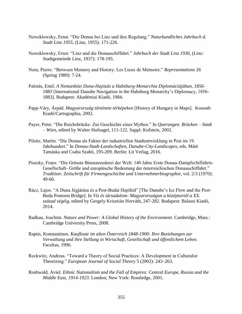
355
Neweklowsky, Ernst. “Die Donau bei Linz und ihre Regelung.” Naturkundliches Jahrbuch d.
Stadt Linz 1955, (Linz, 1955): 171-226.
Neweklowsky, Ernst. “Linz und die Donauschiffahrt.” Jahrbuch der Stadt Linz 1936, (Linz:
Stadtgemeinde Linz, 1937): 178-195.
Nora, Pierre. “Between Memory and History: Les Lieux de Mémoire.” Representations 26
(Spring 1989): 7-24.
Palotás, Emil. A Nemzetközi Duna-Hajózás a Habsburg-Monarchia Diplomáciájában, 1856-
1883 [International Danube Navigation in the Habsburg Monarchy’s Diplomacy, 1856-
1883]. Budapest: Akadémiai Kiadó, 1984.
Papp-Váry, Árpád. Magyarország története térképeken [History of Hungary in Maps]. Kossuth
Kiadó/Cartographia, 2002.
Payer, Peter. “Die Reichsbrücke: Zur Geschichte eines Mythos.” In Querungen. Brücken – Stadt
– Wien, edited by Walter Hufnagel, 111-122. Sappl: Kufstein, 2002.
Pilsitz, Martin. “Die Donau als Faktor der industriellen Stadtentwicklung in Pest im 19.
Jahrhundert.” In Donau-Stadt-Landschaften, Danube-City-Landscapes, eds. Máté
Tamáska and Csaba Szabó, 195-209. Berlin: Lit Verlag, 2016.
Pisecky, Franz. “Die Grösste Binnenreederei der Welt: 140 Jahre Erste Donau-Dampfschiffahrts-
Gesellschaft- Größe und europäische Bedeutung der österreichischen Donauschiffahrt.”
Tradition: Zeitschrift für Firmengeschichte und Unternehmerbiographie, vol. 2/3 (1970):
49-66.
Rácz, Lajos. “A Duna Jégjárása és a Pest-Budai Hajóhíd” [The Danube’s Ice Flow and the Pest-
Buda Pontoon Bridge]. In Víz és társadalom: Magyarországon a középtortól a XX.
század végéig, edited by Gergely Krisztián Horváth, 247-282. Budapest: Balassi Kiadó,
2014.
Radkau, Joachim. Nature and Power: A Global History of the Environment. Cambridge, Mass.:
Cambridge University Press, 2008.
Raptis, Konstantinos. Kaufleute im alten Österreich 1848-1900: Ihre Beziehungen zur
Verwaltung und ihre Stellung in Wirtschaft, Gesellschaft und öffentlichem Leben.
Facultas, 1996.
Reckwitz, Andreas. “Toward a Theory of Social Practices: A Development in Culturalist
Theorizing.” European Journal of Social Theory 5 (2002): 243–263.
Roshwald, Aviel. Ethnic Nationalism and the Fall of Empires: Central Europe, Russia and the
Middle East, 1914-1923. London; New York: Routledge, 2001.

356
Rozsnyai, József. “Industrial Buildings and Halls.” In Motherland and Progress: Hungarian
Architecture and Design, 1800-1900, edited by József Sisa, 637-51. Basel: Birkhäuser,
2016.
Sárközi, Zoltán. Árvizek, Ármentesítés és Folyószabályozás a szigetközben és az alsó-Rába
Vidékén [Floods, Flood Protection and River Regulation in the Szigetköz and the Lower
Raba in the Countryside]. Budapest: Budapesti Műszaki Egyetem Központi Könyvtára
Műszaki Tudománytörténeti Kiadványok, 1968.
Schediwy, Robert. Städtebilder: Reflexionen zum Wandel in Architektur und Urbanistik.
Münster: LIT Verlag, 2005.
Schmid, Martin. “Die Donau als sozionaturaler Schauplatz. Ein konzeptueller Entwurf für
umwelthistorische Studien in der Frühen Neuzeit.” In “Die Natur ist überall bey uns”.
Mensch und Natur in der Frühen Neuzeit, edited by Ruppel, S. & A. Steinbrecher, 59-79.
Zürich: Chronos Verlag, 2009.
Schmid, Martin and Verena Winiwarter. “Legacies from the Past: The Danube's riverine
landscapes as socio-natural sites.” Danube News 12, no. 21 (2010): 2-5.
Schmid, Martin. Towards an Environmental History of the Danube /Zu einer Umweltgeschichte
der Donau: Understanding a great European river through its transformation as a socio-
natural site, c.1500-2000. Vienna: unpublished Habilitation manuscript, 2013.
Schorske, Carl. Fin-De-Siecle Vienna: Politics and Culture. New York: Vintage Books, 1981.
Schott, Dieter. “Urban environmental history: What lessons are there to be learned?” Boreal
Environmental History 5 (2004): 519-528.
Scott, James C. Seeing Like a State: How Certain Schemes to Improve the Human Condition
Have Failed. New Haven; London: Yale University Press, 1998.
Schatzki, Theodore R. “Nature and Technology in History.” History and Theory 42, no. 4
(2003): 82-93.
Schulze, Max-Stephan and Nikolaus Wolf. “Economic Nationalism and Economic Integration:
The Austro-Hungarian Empire in the Late Nineteenth Century.” Cesifo Working Paper
No. 2813 Category 8: Trade Policy, (Oct 2009).
Shedel, James. “The Elusive Fatherland: Dynasty, State, Identity and the Kronprinzenwerk.” In
Inszenierung des kollektiven Gedächtnisses: Eigenbilder, Fremdbilder edited by Moritz
Csáky and Klaus Zeyringer, 70-82. Innsbruck; Vienna; Munich; Bozen: StudienVerlag,
2002.
Shedel, James. “Emperor, Church, and People: Religion and Dynastic Loyalty During the
357
Golden Jubilee of Franz Joseph.” The Catholic Historical Review 76 (1990): 71-92.
Shedel, James. “Fin-de-Siècle or Jahrhundertwende: The Question of an Austrian Sonderweg.”
In Rethinking Vienna: 1900, edited by Steven Beller, 80-104. New York; Oxford:
Berghahn Books, 2001.
Shedel, James. “The Mother of it All: Maria Theresia and the Creation of Hybrid Monarchy.”
Paper presented at the conference Maria Theresa - An Enlightened Reformer and
Grandmother of Central Europe, Ljubljana, Slovenia, June 2017.
Siklóssy, László. Hogyan épült Budapest? 1870-1930 [How Was Budapest Built? 1870-1930].
Budapest: Fővárosi Közmunkák Tanács, 1931.
Simonkay, Marton. “„Vagy ilyen szabályozás lesz, vagy semmilyen” A Rábaszabályozó Társulat
első évtizede (1873–1883).” Unpublished manuscript, 2013.
Sked, Alan. The Decline and Fall of the Habsburg Monarchy, 1815-1918. London; New York:
Longman, 1989.
Smith, Anthony D. The Ethnic Origins of Nations. Oxford and Cambridge: Blackwell, 1986.
Steidl, Annemarie, Engelbert Stockhammer, and Hermann Zeitlhofer. “Relations Among
Internal, Continental, and Transatlantic Migration in Late Imperial Austria.” Social
Science History 31, no. 1 (2007): 61-92.
Stourzh, Gerald. Die Gleichberechtigung der Nationalitäten in der Verfassung und Verwaltung
Österreichs 1848-1918. Vienna: Verlag der Österreichischen Akademie der
Wissenschaft, 1985.
Szabó, Csaba. “Brücken über die Donau zwischen Ofen und Pest: Kettenbrücke,
Margaretenbrücke, Franz-Joseph-Brücke, Elisabethbrücke.” In Budapest und Wien:
Technischer Fortschritt und Urbaner Aufschwung im 19. Jahrhundert, edited by
Ferdinand Opll, 89-105. Budapest; Vienna, 2003.
Szabó, Julianna. “Budapester Stadtpanorama mit der Donau: Zeitgenössische Fragen in
historischem Kontext.” In Donau-Stadt-Landschaften, Danube-City-Landscapes, edited
by Máté Tamáska and Csaba Szabó, 135-151. Berlin: Lit Verlag, 2016.
Szatmári-Nagy, Bőszéne, Anikó, Endre Gergely, Ferenc Peragovics. Múltunk határok nélkül:
Esztergom és Környéke, A Kezdetektől az Ister-Granum Eurorégióig [Our Past Without
Borders: Esztergom and Its Environs, From Its Beginnings Until the Ister-Granum
Euroregion]. Esztergom, 2011.
Trautsamwieser, Herbert. Weisse Schiffe am Blauen Strom. Malek Verlag, 1996.
Tőry, Kálmán. Az Al-Duna szabályozása [Regulation of the Lower Danube]. Budapest, 1972.
358
Unowsky, Daniel. The Pomp and Politics of Patriotism: Imperial Celebrations in Habsburg
Austria, 1848-1916. West Layette: Purdue University Press, 2005.
Vadas, Ferenc. “Die Regulierung der Donau und die Kaianlagen.” In Budapest und Wien:
Technischer Fortschritt und Urbaner Aufschwung im 19. Jahrhundert, edited by
Ferdinand Opll, 79-87. Budapest; Vienna, 2003.
van der Borght, Richard. Das Verkehrswesen. Paderborn: Salzwasser-Verlag, 2011.
van Rahden, Till. Jews and Other German: Civil Society, Religious Diversity, and Urban
Politics in Breslau, 1860-1925. Translated by Marcus Brainard. Madison: The University
of Wisconsin Press, 2008.
Vari, Alexander. “From “Paris of the East” to “Queen of the Danube”: International Models in
the Promotion of Budapest Tourism, 1885-1940.” In Touring Beyond the Nation: A
Transnational Approach to European Tourism History, edited by Eric G. E. Zuelow, 103-
126. Ashgate, 2011.
Veres, Madalina Valeria. “Agents of Enlightenment: Habsburg Military Engineers and the
Implementation of Imperial Cartographic Projects in the Eighteenth Century.” Paper
presented at Central European University, Budapest, Hungary February 3, 2016.
“Volkszählung vom 15. Mai 2001 Endgültige Wohnbevölkerung und Bürgerzahl (mit der
Bevölkerungsentwicklung seit 1869).” Statistik Austria. Accessed October 23, 2015.
https://www.statistik.at/web_de/statistiken/index.html.
“Was ist die Hydrografie Österreichs?” Ministerium für ein Lebenwertes Österreich. Accessed
May 11, 2017. http://www.bmlfuw.gv.at/wasser/wasser-
oesterreich/wasserkreislauf/hydrographie_oesterreich/Organisation_HZB.html.
Watznetter, Walter. “Danube Islanders: Population Growth and Social Change in Vienna’s
Second and Twentieth Districts, from the Regulation of the Danube to Current Patterns of
Gentrification.” In Donau-Stadt-Landschaften, Danube-City-Landscapes, edited by Máté
Tamáska and Csaba Szabó, 87-98. Berlin: Lit Verlag, 2016.
Weber, Eugen. Peasants into Frenchmen: The Modernization of Rural France, 1870-1914.
London: Chatto and Windus, 1977.
Winiwarter, Verena, Martin Schmid, Gert Dressel. “Looking at half a millennium of co-
existence: the Danube in Vienna as a socio-natural site.” Water Hist 5 (2013): 101–119.
Wood, Nathaniel D. “Not Just the National: Modernity and the Myth of Europe in the Capital
Cities of Central and Southeastern Europe.” In Capital Cities in the Aftermath of
Empires: Planning in Central and Southeastern Europe, edited by Emily Gunzburger

359
Makaš and Tanja Damljanović Conley, 258-269. London and New York: Routledge,
2010.
Wunderl, Stefan. “Die Geschichte der Schiffswerft Korneuburg unter Berücksichtigung der
Situation der Arbeiterschaft.” Vienna: unpublished MA thesis, 2008.
Zahra, Tara. Kidnapped Souls: National Indifference and the Battle for Children in the
Bohemian Lands, 1900–1948. Ithaca: Cornell University Press, 2012.