Daniel Maudlin PhD thesis
246
HIGHLAND PLANNED VILLAGES : THE ARCHITECTURE OF THE BRITISH FISHERIES SOCIETY Daniel Maudlin A Thesis Submitted for the Degree of PhD at the University of St Andrews 2002 Full metadata for this item is available in St Andrews Research Repository at: http://research-repository.st-andrews.ac.uk/ Please use this identifier to cite or link to this item: http://hdl.handle.net/10023/14485 This item is protected by original copyright
-
Upload
khangminh22 -
Category
Documents
-
view
0 -
download
0
Transcript of Daniel Maudlin PhD thesis

HIGHLAND PLANNED VILLAGES : THE
ARCHITECTURE OF THE BRITISH FISHERIES SOCIETY
Daniel Maudlin
A Thesis Submitted for the Degree of PhD
at the University of St Andrews
2002
Full metadata for this item is available in St Andrews Research Repository
at: http://research-repository.st-andrews.ac.uk/
Please use this identifier to cite or link to this item: http://hdl.handle.net/10023/14485
This item is protected by original copyright

Highland Planned Villages:The Architecture ofthe British Fisheries Society
PhD thesis: Daniel Maudlin
Submitted: 23rd January 2002

ProQuest Number: 10171028
All rights reserved
INFORMATION TO ALL USERSThe quality of this reproduction is dependent upon the quality of the copy submitted.
In the unlikely event that the author did not send a complete manuscript and there are missing pages, these will be noted. Also, if material had to be removed,
a note will indicate the deletion.
uest.ProQuest 10171028
Published by ProQuest LLC(2017). Copyright of the Dissertation is held by the Author.
All rights reserved.This work is protected against unauthorized copying under Title 17, United States Code
Microform Edition © ProQuest LLC.
ProQuest LLC.789 East Eisenhower Parkway
P.O. Box 1346Ann Arbor, Ml 48106- 1346

ABSTRACT
The British Fisheries Society, founded in 1786, was a semi-charitable joint stock com
pany, similar to other improvement trusts of the period established to fund the construction
of roads, bridges, canals and hospitals. The Society was however unique in the breadth of
its ambition to create a chain of complete settlements or villages the length of the northern
Scottish coastline from Dornoch on the east to Oban on the west. These new settlements
were intended to be fishing stations focussed on the perceived wealth to be gained from the
herring fishery. Four settlements were established at Ullapool, Wester Ross, Tobermory,
Mull, Lochbay, Skye and Pulteneytown, Wick, Caithness and the specific intention of this
thesis has been to examine those four built environments created by the Society. This in
cludes all elements of the building and design process necessary to "create’ a fishing village
incorporating town planning, civil engineering, industrial and vernacular buildings as well
as ‘architecture’ by Robert Mylne and Telford. The construction of each village is followed
from the design of the street plan, contracting for works through to the design and con
struction of diverse works such as inns, storehouses, harbours and bridges. Varying cir
cumstance resulting in each settlement developing its own architectural character despite
the Society’s standardised plans and policies The settlements are also considered within the
wider context of planned villages, New Towns ports, and harbours with specific analysis
of individual buildings and types such as Robert Mylne’s inn at Tobermory.

I, Daniel Maudlin, hereby certify that this thesis, which is approximately 80,000 words
in length, has been written by me, that it is the record of work carried out by me and that it
has not been submitted in any previous application for a higher degree
. 8 ...
tV date signature of candidate
I was admitted as a research student in September 1997 and as a candidate for the deg
ee of PhD in September 1998; the higher study for which this is a record was carried out in
the University of St. Andrews between 1997 and 2001.
date signature of candidate
I hereby certify that the candidate has fulfilled the conditions of the Resolution and
Regulations appropriate for the degree of PhD in the University of St. Andrews and that
the candidate is qualified to submit the thesis in application for that degree.
date signature of supervisor

In submitting this thesis to the University of St. Andrews I understand that I am giving
permission fpr it to be made available for use in accordance with the Regulations of the
University Library for the time being in force, subject to any copyright vested in the work
not being affected thereby. I also understand that the title and abstract will be published,
and that a copy of the work may be made and supplied to any bona fide library or research
worker
U date signature of candidate

CONTENTS
Abbreviations
Introduction: Nothing North of Dornoch 1
1. The British Fisheries Society and the Age of Improvement 7
2. Neat a»nd Regular: Town Plans 16
3. UllapQol 64
4. Toberpiory 97
5. Lochhay 132
6. Pulteneytown 162
7. Solid pnd Substantial: 191
An Assessment of the Society’s Building Programme
8. Molehills: Settlers Domestic Buildings 195
Conclusion 216
Bibliography 222
Appendix 228

ABBREVATIONS
AHSS Architectural Heritage Society of Scotland
BFS British Fisheries Society
MMA Mull Museum Archive
NAS National Archives of Scotland (formerly SRO)
NLS National Library of Scotland
NMRS National Monuments Record of Scotland
OS Ordinance Survey
RCAHMS Royal Commission on Ancient and Historic Monuments of Scotland
RIBA Royal Institute of British Architects
RIAS Royal Incorporation of Architects in Scotland
SAHGJ3 Society of Architectural Historians of Great Britain
SPCK Society for the Propagation of Christian Knowledge
SRO Scottish Records Office
SVBWG Scottish Vernacular Buildings Working Group

INTRODUCTION
'Nothing North of Dornoch’
A defining characteristic of the Highlands of Scotland is the juxtaposition of the moun
tainous landspape and the small ordered villages of white rendered or plain stone cottages
that line the arterial roads crossing the straths, glens and loch shores. There is a visible
austerity and often poverty of aspect often disappointing to the visitor looking for the
village green and twisting lanes that can be found in areas such as the English Lake District.
The Highlands do not have the established history of comfortable village life found else
where in Britain and until the late eighteenth century was still considered a wild hinterland,
feared by gepteel society and inhabited by ravaging war lords and impoverished subsist
ence farmers. The villages of the Highlands that exist today did not gradually evolve but
appeared suddenly in the hundred years between 1750 and 1850, and for the most part
were brought to and imposed on the Highlands and Highlanders for economic reasons.1
The beauty of the scenery can detract from the fact that Highland villages were generally
planned and built as functional places to house workers. In this respect comparisons should
be drawn with the colonial settlements of North America and the planned industrial vil
lages of Lanarkshire or Lancashire.
1
Introduction
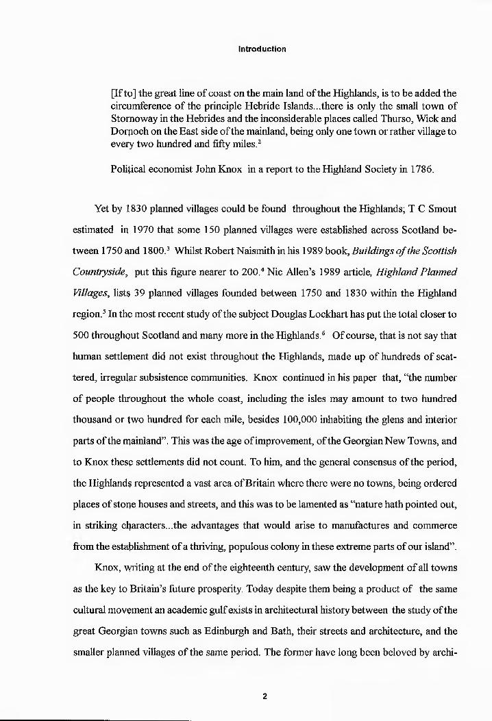
[If tp] the great line of coast on the main land of the Highlands, is to be added the circumference of the principle Hebride Islands...there is only the small town of Stornoway in the Hebrides and the inconsiderable places called Thurso, Wick and Dorpoch on the East side of the mainland, being only one town or rather village to every two hundred and fifty miles.2
Political economist John Knox in a report to the Highland Society in 1786.
Yet by 1830 planned villages could be found throughout the Highlands; T C Smout
estimated in 1970 that some 150 planned villages were established across Scotland be
tween 1750 and 1800.3 Whilst Robert Naismith in his 1989 book, Buildings of the Scottish
Countryside, put this figure nearer to 200.4 Nic Allen’s 1989 article, Highland Planned
Villages, lists? 39 planned villages founded between 1750 and 1830 within the Highland
region.5 In the most recent study of the subject Douglas Lockhart has put the total closer to
500 throughput Scotland and many more in the Highlands.6 Of course, that is not say that
human settlement did not exist throughout the Highlands, made up of hundreds of scat
tered, irregular subsistence communities. Knox continued in his paper that, “the number
of people throughout the whole coast, including the isles may amount to two hundred
thousand or two hundred for each mile, besides 100,000 inhabiting the glens and interior
parts of the mainland”. This was the age of improvement, of the Georgian New Towns, and
to Knox thesp settlements did not count. To him, and the general consensus of the period,
the Highlands represented a vast area of Britain where there were no towns, being ordered
places of stope houses and streets, and this was to be lamented as “nature hath pointed out,
in striking characters...the advantages that would arise to manufactures and commerce
from the establishment of a thriving, populous colony in these extreme parts of our island”.
Knox, vyriting at the end of the eighteenth century, saw the development of all towns
as the key to Britain’s future prosperity. Today despite them being a product of the same
cultural movement an academic gulf exists in architectural history between the study of the
great Georgian towns such as Edinburgh and Bath, their streets and architecture, and the
smaller planned villages of the same period. The former have long been beloved by archi
2
Introduction
tectural historians, generating innumerable books and articles whereas the study of the
latter has remained largely ignored by architectural historians, with the odd exception such
as William Adam at Inveraray. It has fallen to other historical disciplines such as geogra
phy, economic and social history to shed light on the subject. The principal source remains
T C Smout’s article in which he established the principle that planned villages were for the
most part founded by landowners for the purpose of encouraging industry upon their
estate. Smouf, chiefly an economic and social historian, divided planned villages into four
categories according to the type of industry intended, viz. agriculture, the fisheries, villages
with small rural industiy and factory villages. This has proved a useful system in under
standing the economic logic behind the geographic spread of Scottish planned villages, i.e.
fishing villages around the northern coasts or agricultural villages in the Lothians, but is not
concerned w}th their architecture and its relationship to the economic imperative. In Nic
Allen’s article he has expanded upon Smout’s analysis by reconsidering the role of govern
mental organisations such as the Annexed Estates Commission and privately funded com
panies in the establishment of grid plan villages. Douglas Lockhart’s recent work on the
role of planned villages within the Highland agricultural economy comments upon the con
sistency and uniformity of feuing and building regulations and recognises this as a distinc
tively Georgian planning element brought to the Scottish countryside. Significant excep
tions to this lack of focused architectural studies are Colin McWilliam’s, The Scottish
Townscape, ip which he considers the emergence of planned villages in their various forms
and the emphasis upon the notion of the ‘ideal town’, “symmetrical, self-contained and
complete”.7 And the continuing study of the subject of Highland architecture by Elizabeth
Beaton.8
An architectural link is apparent across the academic gulf between the city and the
village and a,s McWilliam infers the Highland planned village is as much a deliberate visual
construct as James Craig’s Edinburgh New Town or John Wood’s Bath.9 This has been
well examined in the case of overtly architectural works such as the contrived rustic charm
3

Introduction
of John Nash or the geometric visions of Claude Ledoux, but not in relation to the austere
and deceptively straight forward planned villages of the Scottish Highlands, despite the fact
these village^ form and define the character of the region. With this in mind, the rapid
appearance of such a definable architectural group upon the landscape within such a short
period should draw the attention of the architectural as well as the economic historian. The
immediate question that poses itself is what is the precise nature of the architecture and
planning of these settlements and how does it relate to the wider architectural practice of
the late Georgian period? This requires analysis upon two levels; first, the establishment of
the architectural style or aesthetic of the buildings and streets. Secondly, exploration of
why that stylp was chosen, what it represents as deliberate symbolism and as an architec
tural mirror reflecting a political and economic agenda.
To look at these questions I have concentrated specifically upon the four Highland
planned villages founded by a semi-charitable organisation, the British Fisheries Society
(the Society or the BFS) between 1785 and roughly 1820, looking in detail at the planning
and building of each settlement, viz. Ullapool, Wester Ross; Tobermory, Isle of Mull;
Lochbay, Isle of Skye and Pulteneytown, Wick, Caithness. The Society’s settlements offer
a unique point from which to enter the general debate on Highland planned villages. As will
be seen, whatever its numerous flaws and failures may have been, the Society was hugely
influential as it was amongst the first to establish planned villages in the Highlands and
unique in attempting to do so on a Highland-wide scale. To this can be added its singular
position amongst village founders as a national, i.e. British, organisation with strong con
nections with Westminster and the Scottish land-owning classes. Hence though only four
settlements vyere founded their impact was massive and to a large extent established the
formula for planned villages in the Highlands throughout the nineteenth century. The ar
chitecture of the Society’s settlements reflected ideas of improvement, rationalism, coloni
alism and industrialisation, creating some of the finest neo-classical architecture and town
planning attempted in the Highlands. This is in spite of a surprising level of architectural
4

Introduction
irregularity apd variety within a national organisation. To this end I have approached the
topic in rougfily two parts. The first dealing with the inspiration, ideals and theory behind
the Society’s programme of town building and how they hoped to realise them in streets
and building^. In the second part I have reversed this top down view and looked at the
actual realities of the Society’s building works in detail, stone by stone, town by town, in
order to buil<j a true account of how succesfully those aims were realised or not.
Of the various references to the Society by previous studies Jean Dunlop’s 1978, The
British Fisheries Society has been of most value.10 Though the approach is that of the
political and economic historian, its detailed account of the Society’s foundation, develop
ment and deipise, within the context of the fishing industry and Westminster politics, has
enabled me tp pursue the architectural history of the settlements from a solid historical
base. The suryey of the building of Ullapool in particular provides a useful starting point. I
also owe a particular debt of gratitude to Jean Dunlop for securing the deposition of the
Society’s archives at the Scottish Records Office in Edinburgh from their former homes at
Dunvegan ap0 Inveraray, making study of the original manuscripts a much simpler practi
cal process tfyan she must have faced herself. And where we have fished in the same archi
val waters I fyave aimed to provide a different, architectural perspective rather than rebuff
or reject her conclusion. On the same note, I have endeavoured to avoid being side tracked
by well-covered ‘issues’ of Highland history such as Jacobites, emigration and the Clear
ances except where they have had a specific bearing on the built environment of the Soci
ety’s settlements.
The Society’s building programme included works by Robert Mylne, Thomas Telford
and John Rerjnie, and these must be placed within the context of the whole planned urban
environments. The Directors of the Society, the patrons, were concerned with drainage,
land distribution and tenure as much as street plans and public edifices and perhaps above
all they were interested in location. Subsequently, in the arrangement of the thesis I have
followed the process implemented by the Society itself for the establishment of each
5

Introduction
settlement as a whole, rather than as refuges of the odd architectural masterpiece. First, the
planning process, from the foundation of the Society and choice of location for each settle
ment through to the laying out of the town plan on site. Second, those works provided by
the Society a| each settlement are considered, i.e. storehouses, inns, harbour works, with
each analyser) in detail. The purpose being to provide an architectural study of the buildings
but also in a jnore archaeological manner, to establish the precise nature of the built envi
ronments created during the founding and early years of the Society’s settlements. Finally,
the settlers’ Rouses are considered.
Whilst ip the first two sections the research was based upon the letters, contracts and
plans in the Society’s archive a different approach had to be adopted for the last as the
settlers built their own houses according to Society regulations and no detailed accounts
exist. Therefore, in order to establish any definable architectural character amongst the
early houses pt each settlement, I have used R W Brunskill’s coded index survey system,
which is base^l upon an extensive field work survey and designed to establish shared char
acteristics or variations of build within the survey groups, rather than to provide intensive
survey analysis of individual buildings.11 At each stage of the process of founding and
building the settlements, the effectiveness of the Society in establishing uniformity is con
sidered against the different challenges and changes both at the settlements and within the
Society itself,
1 Comparable vyith Northern Pakistan, Afghanistan or areas of the Balkans today.
Edinburgh, SRQ/GD9/1/1. Knox, John, A Discourse on the Expediency of Establishing Fishing Stations in the Highlands of Scotland, Edinburgh, 1786.
3T C Smout, “The Landowner and the Planned Village in Scotland, 1730-1830”, in N T Philipson and RMitchison (e^s), Scotland in the Age of Improvement, Edinburgh University Press, Edinburgh, 1970, p75
4R Naismith, Efuildings of the Scottish Countryside, Victor Gollancz, London, 1985, p 38
5N Allen, “Highland Planned Villages”, SVBWG Regional and Thematic Studies No 1, MDPrint & Design, Edinburgh, 1990, p 27
6

Introduction
6D Lockhart, “Planned Villages in North East Scotland, 1750-1860”, J Frew & D Jones (eds,),77ze New Town Phenomenon, St Andrews University Press, St Andrews, 2000, pp 25-40
7 C Me William, The Scottish Townscape, Collins, London, 1975, 98
8 for instance, s?e E Beaton, “Building Traditions in Lochbroom and Gairloch Parishes”, J R Baldwin (ed), People artf Settlement in North-West Ross, Scottish Society for Northern Studies, Galloway Gazette, Newtpp Stewart, 1994, pp 159-192
9 Perhaps understandably a result of the general lack of grand architectural buildings.
10 J Dunlop, Thf British Fisheries Society, John Donald, Edinburgh, 1978. Being the publication of her PhD thesis, Edinburgh University, 1952.
nR W Brunskil|, Illustrated Handbook of Vernacular Architecture, Faber and Faber, London, 1971
7

CHAPTER ONE
The British Fisheries Society and the
Age of Improvement
The British Fisheries Society was formed to establish outposts of British civilisation
that would bring social order, profit and salvation to the Highlands and it was with spirit of
colonists and improvers that the Society’s Directors approached their subject, from re
search, exploration through to planning and building. The Society arrived at the decision to
build planned villages from the confluence of two topical debates, a desire to promote the
fisheries throughout Britain and a desire to find a solution to the growing concern for the
perceived problem of the Highlands, the two wedding neatly in the form of the planned
fishing village.1 Once resolved upon their building programme the Society adopted proc
esses based on the recently-founded planned villages in Scotland but there was also a clear
colonial element to an operation of such ambitious, Highland-wide objectives. The foun
dation of the Society and the surrounding issues are well documented elsewhere and these
issues may be summarised briefly.
The development of the fisheries was a popular cause dating back to the seventeenth
century both to tackle the phenomenal success of the Dutch herring fleet and for the train
ing of sailors for the navy. In 1750 an Act of Parliament introduced a bounty of 30 shillings
per ton to entourage a British herring fleet to take on the Dutch. The Act also provided for
the forming of a fishery company, The Society of Free British Fishery. This was a commer
cial venture backed by the City of London which built and equipped busses (large, deep sea
fishing boats) of 80 tons and employed over 300 Orkney men every year for crew. How
ever, this first British Fisheries Society was by 1771 bankrupt and many of its vessels were
sold to the cpastal goods trade. With the end of the war with America in 1783 and the
expiry of the fishery laws in 1785 a House of Commons Committee was established to
examine the fishing industry. It is out of the recommendations of the Committee that the
8

British Fisheries Society and the Age of Improvement
idea of establishing a chain of fishing stations along the coast of Britain emerged. The new
Fishery Act of 1786 incorporated the abandonment of an official fleet rendezvous offBressay,
permitting thp large fishing busses to buy from small boats and changing the bounty from
shillings per ton basis to shillings per barrel. Critically these changes allowed the possibility
of local, small scale fisheries to develop and for Scotland to become a new focus as the sea
lochs of the yvest coast were famed for their herring shoals. The 1786 Committee recog
nised that “the joint labour of many individuals aided by the skill of several classes of
manufacture’’ was needed and the idea for the establishment of fishing villages to pursue
the inshore fisheries was born.2 However, the impetus to build planned villages in the High
lands also came from a prevailing spirit of improvement and frustrated colonial ambitions.
This was most clearly stated in a paper entitled, A Discourse on the Expediency of Estab
lishing Fishing Stations in the Highlands of Scotland, by John Knox, a retired Edinburgh
bookseller and political economist, presented to the Highland Society of London in 1786.
Knox and other commentators saw the Highlands as a great untapped natural resource, a
wilderness waiting for colonisation by men of industry and entrepreneurial spirit willing to
turn those resources into revenue for the benefit of the nation as a whole. He compares
Scotland favpurably to the British colonial experience in America and the money squan
dered on that venture for little return. This was not only topical but shows a perception of
the Highlands as a colonial resource, akin to Canada or India in the nineteenth century, not
as a part of Britain’s internal growth like the manufacturing and producing centres of Eng
land and the Rowlands:
Let us colonise in America, by which we shall be enriched, was the language of the last century. Let us abandon that distant country, by which we have been impoverished, is the language of the present day. Let us look at home, improve and strengthen the centre, is happily the favourite topic of mankind, of whatever description or party from one end of the island to the other... During these distressful ages and almost down to the present day, the remote districts of Scotland called the Highlands, remained exactly in the state in which Nature had formed them, a terra incognita, deemed unworthy of notice and incapable of being rendered useful to government or to the public.3
9

British Fisheries Society and the Age of Improvement
With the loss of America, the search for a new arena for economic expansion and
WICK
ULLAPOOL
LOCHBAY
TOBERMORY
fig. 1. Map of Scotland. Thomas Telford. Atlas to the Life of Thomas Telford, 1838. (photo: National Monuments Record of Scotland)
improvement had begun and by the 1780s the attention had turned towards the Highlands.
The Highlands themselves had changed since the 1745 rebellion. The Highlands though
still wild and remote were no longer considered a place of danger and wild tribes, that
10

British Fisheries Society and the Age of improvement
needed contrplling and containing (fig. 1). The Disarming Acts and changes to the tenanting
system had done much to break down the clan system and ‘pacify the natives’ long before
the enclosures and clearances of the early 1800s. Moreover, the resulting peace that en
sued in the years 1750 to 1780 had done more than anything to undermine the basis of the
clan system, war, and the landlords no longer estimated their rent in men but in cash. The
social status of the Highlander himself had changed as a consequence from a proud warrior
serving a chief, to a feudal peasant. With recurring famines in the Highlands between 1770
and 90, Highlanders were increasingly attracted by emigration to America and the pros
pect of free fertile land and independence from landlords.4 Therefore, what the political
economist saw in the 1780s was huge tracts of unimproved land commanding very low
rents, a wilderness of untapped human and natural resources. To compound this waste the
peasantry appeared unwilling to attempt to work: “the inhabitants of the mountains,
unacquainted with industry and the fruits of it stick, close to their antient and idle way of
life”.5 Improvement was clearly required but what form was it to take? Knox’s imperial
sized recommendation was for the establishment of forty fishing stations, or one for every
twenty five miles of coast, from Dornoch on the east coast round to Arran on the west.
This was the great eighteenth century obsession with Improvement on a grand scale to
combat a wilful squandering of natural resources. Knox continued:
The attention of all well regulated states hath generally been directed to such objects of national utility, as contributed assist Nature, and to employ the great body of the people. The courses of rivers have been directed into new channels, internal navigations have opened from sea to sea through seemingly insurmountable difficulties, and in many parts the face of Nature hath undergone a total change. Immense tracts of desert land have been brought into cultivation, and regions, whiph served only to give shelter to the wild animals, became, through the perse- veripg hand of man, the feats of populous cities, of science and refinement.6
The principles of improvement were to be applied to the Highlands, where there was
“a body of people without capital, and a coast without towns where the natives can be
supplied with nets, hooks, lines and provisions”. Two Highland resources, people and the
11

British Fisheries Society and the Age of Improvement
herring fishery, brought together through the founding of villages. The creation of villages
as the modus operandi of improvement in the Highlands appealed to the eighteenth century
mind as a centre of order in the wilderness where organised, planned activity and progress
could be imppsed. “The village was the focus par excellence of civilising influences”.7 The
Highland Society had had various schemes for the encouragement of Highland Industry
from flax and wool spinning factories to investment in the Crinan Canal under considera
tion but following Knox’s paper resolved to invest their funds in the fisheries, fishing vil
lages being the best idea put to them.8 The fishing village was to become the favourite
solution in the Western Highlands as it did not require much land nor procuring of re
sources as the tenants would get the fish themselves, compounded with the generally held
faith in the bounty of the Scottish seas.9
Knox had clearly assimilated Adam Smith’s idea of the political economy, the Wealth
of Nations having been published nine years earlier. The fishing village was presented by
Knox as an efficient pooling of labour and resources in a single product that would break
the Highlanders out of subsistence farming. Within the village a division of productive
labour could be generated including not only fishermen and coopers but bakers, grocers,
blacksmiths and masons. Thereby creating a currency exchange economy that, through
trade, would expand the domestic market. The eighteenth century notion of the Nation
State verged on the metaphysical, every person and every pursuit was subordinate to an
idea that had turned its attention to the Highlands.
This wap the Age of Reason and an ideological link can be traced between art, archi
tecture, government, commerce and industry. Through the application of reason Society
would progress. It would improve. The eighteenth century saw man finally win control
over nature vyith agricultural, industrial and transport revolutions. This was an age of pride
and self confidence. “A brief union of art and industry in the first stages of the industrial
revolution thgt appealed to the imagination of poets as well as to the reason of econo
mists”. 10 The British Fisheries Society, incorporated by Act of Parliament in July 1786, was
12

British Fisheries Society and the Age of Improvement
typical of its type and its age, the language of improvement evident in its full title, The
British Society for Extending the Fisheries and Improving the Sea Coasts of the King
dom.11 The original list of Directors included an impressive selection of British Society, the
fifth Duke of Argyll was the Governor and Chairman of the Board of Directors, he was
supported by his Deputy the Earl of Breadalbane, both of whom had introduced sweeping
agricultural improvements to their estates and rebuilt their respective estate villages, Inveraray
and Kenmore. Other improving peers on the Board included the Marquis of Graham, The
Earl of Moray, The Earl of Abercorn, The Earl of Gower and Lord Suffield. To which can
be added the MPs Henry Beaufoy, Isaac Hawkins Browne, John Call, George Dempster,
Francis Humberstone Mackenzie of Seaforth, the anti-slavery campaigner William
Wilberforce and Sir William Pulteney, MP for Shrewsbury and friend of David Hume, John
Anderson, John Knox, Adam Smith and Robert Adam. This illustrious group of Improvers
were supported by the ordinary members who bought shares at £50 each, to a maximum of
ten, though at £50 the ordinary member was still clearly a gentlemen of private means.
Books of subscription were opened on 23 rd May 1786 at the Shakespeare Coffee House in
London and including subscriptions from India and Edinburgh raised a total of £15,000.12
It was a typical, if exceptionally high powered, Improvement Society. What was different
about the British Fisheries Society was its choice of improvement project. Not a new road
nor canal but through the chosen means of fishing villages, the Highlands of Scotland. A
project of such a scale was only possible due to the high rank and influence of its Directors
at the centre pf government and Society. The Directors were mostly connected to Scotland
whether as MPs or landowners. The Duke of Argyll was also Chairman of the Highland
Society. Hence the Directors’ personal interest in bringing improvement and progress to
the Highlands. However, London was the centre of financial and political power and the
Society’s aims, structure, funding and membership all came out of the Coffee Houses of
Westminster. Furthermore, committee meetings of the Board of Directors were always
held in London as the Directors spent the Parliamentary year at their London residences.
The British Fisheries Society was a British, London based institution born of three con
13

British Fisheries Society and the Age of improvement
verging interests; the state of the fisheries, the state of the British Empire and the state of
the Scottish Highlands, all set against the spirit of improvement. Hence, 1786 saw the
newly appointed Directors of this ambitious improvement society convinced they had found
the solution tp the Highland problem and with Knox’s words ringing in their ears laid out
their plans in the Society’s Prospectus:
That the Directors shall employ the Capital Stock of the Company in purchasing Ground for the building of Free Towns, Villages, and Stations, in dividing and laying out the same into proper lots of Houses, Gardens, and also Quays, Churches, Schools and other necessary Buildings; and shall have powers to sell or grant Leases or Feus of such Lots, to those who may be inclined to build Houses; and to build Houses thereon with the Company’s stock, provided the same be done by public advertised Contracts... In the Highlands and Islands of Scotland, as the most effectual means of improving the Fisheries, Agriculture, Manufactures and other useful branches of industry there, and of employment for the Inhabitants at home, and thereby putting a stop to the dangerous spirit of Emigration now prevalent in many parts of that Country.13
A new age for the Highlands that would be reflected in the architecture, planning and
design of the Society’s fishing villages.
1J Dunlop, The British Fisheries Society, John Donald, Edinburgh, 1978, 2-5
2 Dunlop, The British Fisheries Society, 9-28
3 Edinburgh, SRO/GD9/1/1
4 A J Youngson, After the '45, Edinburgh University Press, Edinburgh, 1973, 30-42
5D Forbes, The Culloden Papers: Memoirs of the Right Honourable Duncan Forbes, 1815, 298
6 Edinburgh, SRO/GD9/1/1
7 Youngson, After the '45, 37
8 Dunlop, The British Fisheries Society, 23
9T C Smout, “The Landowner and the Planned Village in Scotland, 1730-1830”, in N T Philipson and R Mitchison (eds), Scotland in the Age of Improvement, Edinburgh University Press, Edinburgh, 1970, 73-107
14

British Fisheries Society and the Age of Improvement
11 Cumbersome even for eighteenth century standards this was quickly abbreviated.
12 Dunlop, The British Fisheries Society, 23
13 Edinburgh, SRO/GD9/1/10
15

CHAPTER TWO
Neat and Regular: Town Plans
February 1787; the Society had been incorporated by Act of Parliament, a Board of
Directors appointed, subscriptions had been raised and banking arrangements made with
the Royal Batik of Scotland and Bank of Scotland. The Society was now in a position to
start looking for potential sites for building their villages, though it would be over a year
before the foundation stones would be laid at the first two villages. The year between these
two landmarks saw intensive activity by the Society as they had to carry out a detailed
period of research, consultation and surveying to find and secure the best possible loca
tions. The first task was to find suitable locations. These had to meet strict requirements.
Good natural harbours with level ground suitable for building were essential. These sites
had to be accessible to the known herring fishery grounds by small sail boats, i.e. within a
day’s sailing. They also had to have natural resources on site to support the settlements
such as fresh water, workable stone, improvable arable and pasture land and fuel reserves,
either wood or more likely peat mosses. Perhaps the most important resource of all was an
indigenous population who could be attracted to settle in the villages. Once possible areas
were checked to meet these criteria surveys had to be carried out not only to assure the
quality of the sites but to establish the value of the land. Prices then had to be negotiated
with the landpwners for the sale of lands to the Society. Only then could contracts be drawn
up and signed. The laying out of streets and settlers plots was the last stage of this initial
survey process and the first step towards the actual building of settlements. The first step
the Society took was sensibly one of consultation. In February 1787 the Earl of Breadalbane
sent out a circular letter to two hundred landowners and people connected with the fisher
ies in the Highlands setting out the aims of the Society and requesting advice and informa
tion on the state of the fisheries and potential sites. “The Directors request that you would
16

Neat and Regular: Town Plans
be pleased to mention the terms on which you may be inclined to transfer in perpetuity, any
parcel of land upon your estate, bordering upon any bay, harbour or navigable loch, which
may be thought a proper situation for one of the Society’s villages”.1 The letter also made
specific enquiry into what parts of the coast would be most suitable and what quality of
land would be required. The Society received numerous replies some such as that from
Hugh Rose of Tain, dated 24th February 1787, are concerned with reporting the conditions
of the Highlands and it’s people.2 He correctly anticipated that the promise of industry
would not attract settlers to break from their “present mode of living and to betake them
selves to villages, and in short to give up a life of sloth and idleness and to betake them
selves to a life of universal industry, which may prove beneficial to themselves and to the
general good of society”. He also warned that the lower classes had a wicked cunning and
fondness for (spirits and that a man paying half a guinea in rent for a farm would have no
desire to moye to a village where he had only a house and had to work hard for a living at
sea and that the herring was well known to be ambulatory and, as such, an unreliable source
of income for a village. Much of his warnings were well made and supported by several
other replies fo the Earl of Breadalbane’s letter. Alex Mclean of Coll and Colin Macdonald
of Boisdale both warned that people would be reluctant to become fishermen until forced
by land enclosures by which time they would be too destitute to afford equipment such as
nets and boats.3 The Society however, chose to ignore these impartial letters of warning
though time would show that they would have done well to heed them with the failure of
their west coast settlements of Ullapool and Lochbay. The informed warnings were out
weighed by the strong support of the Highland Society of Edinburgh and a catalogue of
letters from landowners supporting the Society’s plans wholeheartedly. These gentlemen
landowners vyere not merely keen to bring the new wave of improvements to the Highlands
but to sell their land to the Society. For example, the Society received offers from Alex
Mcleod of Harris for land on Loch Tarbert, from Kenneth Mackenzie for a station he had
already set up on Loch Torridon, from Sir Hector Mackenzie of Gairloch for Poolewe and
17

Neat and Regular: Town Plans
Fig. 2. George Langlands, Plan of Tobermory Harbour In the Island of Mull, 1787 (photo: National Monuments Record of Scotland. Permission to reproduce from the Duke of Argyll).
Badechro in Gairloch, from Colonel Macleod of Macleod for land on Skye at Dunvegan,
from Lachlan Maclean of Torloisk for land on the Isle of Ulva, from James Macleod of
18

Neat and Regular: Town Plans
Raasay for the Isle of Rona and from many others.4 All of these correspondents recom
mend their land for its excellent harbour and proximity to the herring grounds but as sellers
their appraisal of the lands had to be taken lightly. Most interesting were the several offers
of lands on Lochbroom and Tobermory on Mull. From the outset these were the obvious
natural choices for settlements as the replies from fishing bus captains showed they already
had established reputations amongst the fishing fleets for good harbours with safe anchor
ages.5
Tobermpry was considered the best harbour on the west coast and a popular stopover
for ships of p.11 class heading further north or down to Glasgow and Liverpool whilst
Lochbroom was known for its herring shoals (fig. 2). However, the British Fisheries Soci
ety certainly gave those not chosen inspiration as several went onto found their own planned
villages, for example, fishing stations were found by Col. Macleod at Glenelg in 1788 and
by Sir Hector Mackenzie at Poolewe in 1808.6 Tobermory had another advantage that
favoured it with the Board of Directors - two thirds of the land comprising the harbour of
Tobr Mohr was owned by the chairman of the Board of Directors, the Duke of Argyll. This
was not only convenient for the Society but cheap as he was willing to sell to the Society at
well below the market price. The Duke himself submitted a reply to the Society’s circular
offering Tobermory in March 1787. Having commissioned a report by John Campbell of
Auchnacroisfi in February, into possible suitable sites on his estates, the Duke observed
that:
The harbour is esteemed one of the best in Scotland, it is well situated for fishing of every kind and is in a populous part of the country, is well supplied with running watpr, and with turf, fuel or peat, and has many other advantages- one side of it belongs to the Duke of Argyle and the other to a private Gentleman. It would appear that the society should first establish a village at this harbour.7
To the north both John Mackenzie of Gruinard and Col. Alexander Mackenzie of
Coul’s land offers were on the shores of Lochbroom at Tean and Inverlael respectively.
19

Neat and Regular: Town Plans
Mackenzie of Gruinard had also recommended Ullapool as having an excellent harbour and
he had been preceded in this recommendation by John Mackenzie of Bishopsgate, London,
who with Roderick Morrison owned a fishing station on the Isle of Tanera in Lochbroom
(fig 3).
Fig. 3. General Idew of Ullapool and Beinn Ghobhlach, c. 1930 (photo: National Monuments Record of Scotland).
He commented that Ullapool was “flat with a good harbour, fine beaches, an abun
dance of fuel and the terminal of the Dingwall and Tain roads”. As with Tobermory, Ullapool
appeared to meet most the Society’s requirements. Following this promising information
the Board of Directors resolved at their Committee Meeting of 18th May 1787 that their
first two settlements should be built at Tobermory and Lochbroom.8 However, it was also
decided that before any land or building contracts were made a sufficient acreage had to be
secured or feued from the owner to support the settlements and that an exact survey of any
potential site must be done including water depth, stone for building, lime, turf, coal or
wood and wholesome freshwater conveniently near to any establishment.9 The Directors
were fearful of wasting money and keen to prove their venture a success and the selection
20

Neat and Regular: Town Plans
of a site was therefore taken seriously, perhaps more so than the actual laying out of the
towns once the site was chosen. It was stressed again later in the Earl of Kinnoul’s report to
the Annual General Meeting of the Society in 1798:
Though the object of the Society was thus a great public improvement, and though the mode of effecting it was thus directed to be by the purchase of lands and erection of buildings, yet the Directors of the Society were of the opinion, and to that opinion they have carefully adhered, that not only all bold and inconsiderate expenditure of money should be avoided, and that the stock of the Society should be saved as much as the object of the institution could possibly admit, but even that the plan and operation of the Society should be so conducted, as to admit of a return in due time to the individual subscribers, of a part at least of their public spirited contributions... The selection of fit situations for the villages was [thus] a matter of great importance.10
The settlements had above all to be successful, sustainable and economically viable
fishing stations. To this end location was all important and unlike an estate village they had
the whole of the Scottish Highlands from which to choose sites. In this respect, although
settlements Ayere intended to be populated by the indigenous population the Society’s ap
proach was closer in scale, method and aims to the British colonial settlements established
in Virginia and Maryland, North America under the seventeenth century New Towns Act;
towns such as Yorktown and Jamestown were set up as ports of entry for colonists and
traders.11 As peen in the previous chapter, the American experience was an acknowledged
factor in the Society’s remit and was made clear in John Knox’s crucial 1786 discourse
already refered to:
The system of colonisation begun and carried on at great expense of Great Britain, was warmly but ineffectually opposed by some able politicians of the last century, whose predictions have been too completely fulfilled, with the additional mortifying circumstance, which they could not have imagined, that our new customers have cost this country above one hundred and fifty millions, in supporting their civil establishment; in bounties on the American produce; in defending the colonies against the Indian depredations, and the encroachment of the French; and finally, in an unsuccessful struggle to retain their allegiance.In consequence of this enormous burden, the state hath been crippled, as to be
21

Neat and Regular: Town Plans
scarcely able to assist in any rational plan of national utility, that may require the aid pf a few thousand pounds. The effects of this expenditure have reached all descriptions of men, and afforded ample matter for political declamation, both in Parliament and out of it. Let us colonise in America, by which we shall be enriched, was the language of the last century. Let us abandon that distant country, by vyhich we have been impoverished, is the language of the present day. Let us look at home, improve and strengthen the centre, is happily, the favourite topic of mankind, of whatever description. During these distressful ages and almost down to tfie present day, the remote districts of Scotland, called the Highlands, remained exactly in the state in which Nature formed them.12
With the loss of the American Colonies still fresh in the mind the Society was in effect
transferring the programme of commercially led colonisation to the New World of the
Highlands and their systematic methods and logistics were, if public spirited, distinctly
colonial in application as well as concept.
Once thp sites were approved the next step was to carry out a tour of inspection of
Tobermory and Lochbroom. The Committee met at Inveraray on 24th June 1787.13 This
expedition was carried out by sea with great pomp and festivity. The gentleman’s maga
zine, The Bee, carried an article by an unnamed Director on the leg from Oban to Mull in
the March 1792 edition.14 The article reports that the Directors, including the Duke of
Argyll, the Earl of Breadalbane, George Dempster and Adam Fergusson, sailed from Oban
in three Custom’s cutters with Argyll liveried crews and pipers in the bows. On arrival they
dined in great tents on the beach at Tobr Mohr. The Duke of Argyll officially named the site
‘British Harbour’ but the writer prophetically comments that he believes the local name
Tobr Mohr would prevail as Tobermory in English. The Committee of Directors were duly
impressed with Tobermory bay as a location and resolved, assuming a satisfactory survey,
to purchase lands there. The Duke of Argyll had recommended that the purchase should
include the nprthem part of the harbour owned by a “private gentleman” which should be
the Society’s first choice of site. However, the private gentleman, John Campbell of Knock,
was not willing to sell “just a few acres along the shore” as this would cut his Mishnish
estate off from sea access and after some negotiation agreed to sell some five hundred acres
22

Neat and Regular: Town Plans
not including his half of the harbour. The Society had to settle for this and another one
thousand five hundred acres of the Duke’s land which marched with the Mishnish Estate
across Mull and included the southern half of the harbour.15 These lands were surveyed
and valued by George Langlands, a Campbeltown surveyor previously employed by the
Duke and th? Duke’s factor on Mull, James Maxwell.16 Langlands’ survey map of the
proposed lands, dated June 1787, shows the acreage of arable, pasture, woods, mosses
and moorlan^ and includes features such as springs, wells, streams and harbour depths
taken from soundings.17 On the basis of this survey Langlands and Maxwell valued the five
hundred acres of Campbell of Knock at five hundred pounds down and fifty three pounds
per year for tfiose of Campbell of Knock, whilst the Duke of Argyll sold his on the terms of
his existing tenants rent of thirty pounds per year and waived any lump sum payment, a
total of two thousand acres for five hundred pounds down and eighty three pounds per
year.18
The Director Henry Beaufoy had travelled overland to Lochbroom arriving ahead of
the main party travelling on by boat from Mull, he had brought with him David Aitken, a
surveyor previously employed by the Annexed Estates Commission on the Coigach estate
which included Ullapool, and together they had gone over the possible sites and had con
cluded that Lfllapool was the best location for a village. As with Tobermory the decision to
attempt to purchase lands at Ullapool was made unanimously by the Directors on site,
although the Puke of Argyll had not proceeded to Loch Broom. When the Directors recon
vened in London in the December of 1787 the Secretary announced that Lord Macleod,
son of the Eafl of Cromarty, was willing to transfer the lands to the Society, having recently
had the family lands returned by the Annexed and Forfeited Estates Commission. The Di
rectors’ first resolution was to employ the surveyor Mr. Aitken to travel to Ullapool and
carry out a valuation survey of the land with Lord Macleod’s factor George Mackenzie.
Aitken submitted his report on 11th February 1788 for the value of the land at one thousand
and thirty one acres including the small island of Ristol. This comprised fifty seven acres of
23

Neat and Regular: Town Plans
arable, seventy four of pasture and nine hundred mainly moss and muir, at a value of fifty
pounds per year. The Secretary was immediately dispatched to Bath where Macleod was
wintering, to seek his agreement with the valuation. On the 21st February 1788 the Com
mittee accepted Macleod’s proposal to offer the land on terms of a perpetual feu duty of the
rent stated by Aitken and agreed that “a solemn contract on stamped paper be executed for
Lord Macleod to sign”. The two survey reports and valuations both being satisfactory the
contracts for the lands of Tobermory and the farm of Ullapool were signed on 28th
February 1788.19
So in March 1788 the British Fisheries Society owned two sites made up of coastline,
farmland and a few crofts on which they planned to create bustling, successful fishing
villages. The process of systematic planning began long before the first streets were marked
out with the careful researching of sites across the Highland region. Tobermory and
Lochbroom had been carefully selected as the Directors believed they matched a strict set
of criteria that would ensure success. With the lands inspected, surveyed and finally pur
chased the Spciety could now lay out by plough the lines of the streets along which its
villages were to be built.
The minutes of the Directors’ Committee meeting of the 17th May 1788 note that the
Directors had received and considered Mr. George Langlands charges for “surveying and
planning the Society’s land at Tobermory and planning an intended town and harbour there”.20
At the same meeting the Directors also examined Aitken’s account of charges for survey
ing and planning the village at Ullapool. The street plans for the two settlements were
drawn up and approved within three months of the property contracts being signed. Both
Langlands and Aitken were land surveyors not architects and their expertise was in the
accurate measuring and mapping of estates. This is reflected in their town planning. The
earliest dated plan by George Langlands for Tobermory is of 1787.21 The topology of
Tobermory harbour comprises a thin stretch of flat ground at sea level along the waterfront
some one hundred and twenty feet in width. Directly behind this the ground rises steeply to
24

Neat and Regular: Town Plans
Fig. 4. George Langlands. Plan of Tobermory proposed by Mr Maxwell, 1789 (photo: National MonumentsRecord of Scotland).
form a densely wooded and rocky bank. The top of the bank, some hundred feet above sea
level, levels out to form a relatively flat plateau. Langlands’ plan adapts to this terrain by
situating the main public buildings such as stores and customs houses along the shore
behind a breastwork wall, the whole waterfront being enclosed by two flanking L-shaped
piers, whilst the settlers’ building lots are laid out on the flat plateau above. Langlands’
street system for these lots is elaborate, if confused. The main component is an irregular
asymmetrical grid of six main blocks varying in shape from square to trapezoid and trian
gle. On the left edge of the grid a five point junction is proposed joining three streets and
two other roads that appear to serve no purpose. Situated at some distance to the left and
on a diagonal axis to this grid is a church. The square is symmetrically bisected by two
25

Neat and Regular: Town Plans
1 tfrS iifSavr
. 4*- - • . 4U6>**36 vi ?** Vft <„ fajt
t*. £*r,4wfcwA**'^ Jfc. >>yU »'>■»' 4>-'/<*» *»-» Aeyt.
\
Fig. 5. James Maxwell. Sketch...for a Port and Village...at Tobermory. 1790 (photo:National Monuments Record of Scotland).
roads, one of which links to the principal grid to the right and travels off into nowhere to
the left, the other traversing the square taking a road from nowhere to nowhere. Langlands
appears to have taken the square, diagonal routes and radial junction from the baroque
European Grand Manner. Little is known of Langlands’ education, life and his influences
but his planning vocabulary is that of the seventeenth century planning tradition, such as
John Evelyn’s proposals of 1666 for the reconstruction of the City of London, though he
does not use the baroque elements in a unified manner with each other or with the principal
street grid to form a coherent or workable street plan.22 The irregularity of the plan prob
ably had more to do with lack of skill than ingenuity on Langlands’ part as it cannot even
26

Neat and Regular: Town Plans
ffon.tr \
tftoof\ i x aijtv
;•
iLWr , ■ hvlrt tor f'ftdi w/ nlr /t/n. X
'>/// /x, tfnfrtUMIUIM IIKIt
r ii k
lutfiti.vf nui/irl
11 A R BO V R
Fig. 6. Tobermory, first edition OS map, 1875 (National Library of Scotland).
be explained by relation to the undulations of the plateau area. Though perhaps an excellent
land surveyor, Langlands appears to have had little skill as a town planner either in terms of
practicality or design theory and the design elements he employed were not only unwork
able but a century out of date. Perhaps sharing the same opinion, the Duke of Argyll wrote
in an accompanying note to Langlands’ plan that “It is meant to be subject to any improve
ment and alterations which may be suggested by the undertakers”.23 This suggestion was
taken up by the highly efficient and practical factor James Maxwell, who had assisted
Langlands with the original land survey. He abandoned Langlands’ scheme and drew up
one of his own devising and it is subsequently he and not Langlands who should be credited
with the executed plan of Tobermory as it exists today. The first evidence of Maxwell’s
revisions is in his plan of the harbour and shoreline of 1789 drawn up by Langlands (fig.
4).24 In this he has retained Langlands’ principle of dividing the public and domestic build
ings to below and above the bank as it is the only practical solution to the topography of the
27

Neat and Regular: Town Plans
Fig. 7. Tobermory Harbour. 1978 (photo: National Monuments Record of Scotland).
site but has reduced the harbour scheme to a continuous breastwork and single pier, still
effective but cheaper. He has also simplified Langlands proposal for the public buildings to
be built as a series of cloisters or courtyard blocks to a single row of terraced buildings
parallel to the breastwork. Maxwell refined this layout in a measured plan of the proposed
harbour front of 1789.2? Here the warehouse, customs house and comptroller’s house are
arranged symmetrically in a U-shape open to the seaward side. This created a neat complex
for the regulation, shipping and storing of goods and produce. The shaded buildings behind
the proposed complex on the plan were the already extant inn of Portmore. This was the
only building in the harbour prior to 1789 and was removed by the Society when they built
their own inn. According to the printed regulations of the Society for building at Tobermory,
printed by Stevenson of Oban in May 1789, the final and executed scheme for the town was
drawn up by Maxwell and approved by the Society in October 1790 (fig. 5).26 In this
scheme Maxwell has extended his plan for the harbour front to include the inn located on
28

Neat and Regular: Town Plans
Fig. 8. Donald Macleod of Geanies. sketch of David Aitken’s plan of Ullapool. (1789) NAS GD9/3/617 (photo: National Archives of Scotland).
the edge of the Society’s land to the right of the stores and customs complex.27 A necessar
ily winding path leads up the steep bank from the foot of the pier to the edge of the domes
tic lots. The contrast with Langlands’ scheme is at its greatest at this point, where Langlands
proposed a web of diagonals Maxwell planned a hierarchical, modular grid system of rec
tangular blocks, initially planned as only six blocks, in two columns three blocks deep. This
formed a street system of three streets and a service lane parallel to the bank and a central
cross street running between the two columns. The street running along the front two
blocks behind the bank was to be called Argyle Terrace and each block on Argyle Terrace
was divided into five settlers lots facing the sea. Moving inland a service lane ran parallel
with Argyle Terrace and divided the backs of the garden lots on Argyle Terrace from those
29

Neat and Regular: Town Plans
Fig. 9. Ullapool, first edition OS map. 1875 (National Library of Scotland).
of Breadalbane Street, the next parallel street. Breadalbane Street was to have houses on
both sides. The blocks that backed onto those of Argyle Terrace divided into six lots and
those on the opposite side of the street seven, each block being made up of smaller units the
further inland one went and further from the intended workplace, the harbour (fig. 6). This
was reflected in the correspondingly decreasing rental value of the lots. The logic if not the
imagination of Maxwell’s scheme is impressive. The services of Langlands as a surveyor
and map maker were retained despite the rejection of his plan and he drew up another
survey map of Tobermory in 1791 that was made to provide a record of the marked out and
numbered settlers lots for leasing purposes, as well as the distribution and size of the arable
and pasture lots for settlers on the land outside the town.28 The 1847 Admiralty Chart of
Tobermory Harbour shows that over nearly sixty years the town had expanded by the
extension of the original grid to form another two blocks behind Breadalbane Street, though
with settlers lots facing the cross street not parallel to the existing alignment.29 This
30

Neat and Regular: Town Plans
Fig. 10. Shore Street, Ullapool (photo: National Monuments Record of Scotland).
growth created a second service lane, the extension of the original cross street and the
addition of a second cross street on the right edge of the grid. As Maxwell intended, the
modular grid system was easy to expand by the addition of new modules or blocks of lots
(fig-7).
David Aitken’s plan for Ullapool was marked out by the Society’s Agent and Aitken
in 1789 and is similar to Maxwell’s plan of Tobermory.30 The original drawings by Aitken
have been lost but a sketch of the plan was made by Donald Macleod of Geanies, Deputy
Sheriff of Ross, who carried out an inspection of the village for the Society in 1789 (fig.
8).31 Macleod of Geanies’ sketch shows that the plan was intended to be a regular grid, and
as at Tobermory, logic and the practicalities of the site were the main driving forces. Again,
the main street, Shore Street marked CC on Macleod of Geanies’ sketch, was to run paral
lel to the shore and was to include a terrace of houses and the public buildings, such as
stores and the inn, while behind this was a steep bank, though much smaller than that at
Tobermory. Above the bank was the second street, Argyll Street, marked DD on the
sketch and parallel to the first, though unlike Tobermory all settlers lots were to face
inward towards the street. The bank being much smaller, it was incorporated into the rear
31

Neat and Regular: Town Plans
gardens or kq.il yards of the lots on Shore Street. These parallel streets were intersected at
the mid point by a central cross street, marked EE on the sketch and named Quay Street, in
line with the pier, Quay Street linked the harbour area of Shore Street with Argyle Street
and beyond qs expansion required. Potential expansion was restricted to the west by the
mouth of the Ullapool River. Whilst to the east the grid could be, and later was, expanded
by one more block and cross street, Ladysmith Street, where it met the main road north to
Coigach. The first OS map of Ullapool of 1875 shows that the grid expanded to the north
by two double blocks adding two more principal streets, Pulteney St and Market St and the
smaller Customs House Street (fig. 9). The lots of Pulteney Street backing onto the rear of
those on Argyll Street on the southern side of the road and to the rear of those on Market
Street on the northern side whilst those on Market Street and Customs House Street still
backed onto farm land. This expansion from Aitken’s plan probably occurred in the intial
period of growth between 1790 and 1810, as the fortunes of the village declined rapidly
from this point on with the disappearance of the herring. As Geanies’ sketch shows, Shore
St was built flush to the shore and hence not parallel with Argyll Street, upsetting the
balance and uniformity of the grid plan (fig. 10). This was in contravention of Aitken’s plan,
as the dotted line in the sketch shows, and was the result of an error by one of the building
contractors, Robert Melvill who was also the principal merchant at Ullapool. However,
following Melvill’s warping of the town plan, a new plan was drawn up by Thomas Telford
in 1790 and proposed in a letter to Melvill:
I haye decided to draw up an entirely new general plan...The streets are first set out along the Terrace facing Lochbroom there is in every division an allowance for (wo depths of eighty ft each and passages twelve feet wide making 185 ft between the streets, the streets are drawn up 60 ft wide. The third street from the harbour points exactly to the customs house which regulates that direction, the ends of the streets which are next to the inn are found by dividing the space from the ,ine of the customs house street back to the terrace fronting the harbour into three equal parts. The street which runs from the pier towards the shrine is drawn parallel to the terrace fronting the loch.32
32

Neat and Regular: Town Plans
. iTT? A.z*x4 lf»« FHHlItM
Fig. 11. A Survey and design for a Village at Ullapool, Annexed Estates Commission. 1756. NAS RHP3400 (photo: National Archives of Scotland)
What Telford proposed was a fundamental realignment of the town’s north-south
cross streets in an attempt to take up the slack caused by Melvill’s erratic lotting along the
33

Neat and Regular: Town Plans
shore and most importantly realigning the east-west axis so that the supremacy of the
geometric grid is reasserted. He did this by ignoring the existing plan and redrawing the
street grid bajsed on the location of the buildings then already built. Unfortunately, no copy
of this plan survives but Telford’s intentions are nonetheless clear. He also proposed for a
circular market place, similar to that at Lochbay discussed later in the chapter, on the
principal north-west axis above the pier, to be lined with arcades and shops. In a similar
letter to the directors, Telford outlines a plan but suggests an octagon instead of a circle for
the market place. There was enthusiastic support for Telford’s scheme, showing the Direc
tors were not altogether pleased with the collapse of the Ullapool plan, and at a committee
meeting of 16th December 1790 resolved to create Telford’s market but as a cautious
square rather than as a circle. They also agreed to his proposed drains network but as open
gullies not upderground arched tunnels, even agreeing to construct the water fountains
suggested by Telford. The Ullapool agent was also enthusiastic for the market place adding
his idea for a large communal well as a centre piece in a letter of February 1791.33 How
ever, that is the last surviving reference to the scheme and it appears to have been quietly
forgotten and Melvill’s building distorts the parallel lines of Aitken’s grid plan to this day.
Two further suggestions were later taken up, to extend housing lots towards the point of
the river from Melvill’s house and to build stores on the loch shore opposite the Red Her
ring House.
Both Maxwell and Aitken created formal, symmetrical street plans. A strong influence
on the Society’s Directors in their choice of plan was their colleague Sir James Grant of
Grant, founder of the planned village of Grantown-on-Spey, 1766. This was based on a
formal cross plan by Alexander Taylor, for which he had won the Highland Society’s prize
for improvement.34 On 3rd April 1787 he addressed a paper to the Society in which he
recommended that, “It may be proper at the first establishment to line out the intended
town on a regular plan according to the characteristic situation of the ground that the
streets may be regular and convenient”.35 The Society’s correspondence, inspired by Grant
34

Neat and Regular: Town Plans
Fig. 12. John Baxter. Plan of Fochabers. 1764. NAS RHP 2358 (photo: National Archives of Scotland)
of Grant, gave little attention to the street plans of their first two settlements beyond the
general desire that they should be neat and convenient, as underlined by the Duke of Ar
gyll’s note to Langlands first plan that the scheme could be changed as the undertakers saw
fit.36 However, that the regular grid plan was seen as the obvious, most suitable even
inevitable choice points to a broader cultural and architectural context. The first point of
reference is the British Colonial settlements of North America, as we have seen, the aspi
rations of the Society were directly based on replicating the pioneering of America with
clear similarities in the open non-urban, even non-agricultural nature of the virgin land
scapes of Yorktown or Jamestown, North Carolina. The grid system was also simple to
lay out, regulate, expand and replicate, if unimaginative. The Directors of the Society
were after all concerned with efficiency of construction and efficiency of fishing, beauty
was not a factor. The Society’s settlements at Tobermory and Ullapool were what Spiro
35

Neat and Regular: Town Plans
Kostof describes as the “practical model”, or “the city as machine, is factual, functional,
cool, not in the least magical. It is the concept that motivates colonial towns and company
towns”, perfectly suited to remote fishing.37 The grid plan at its simplest provided a straight
forward model for dividing land on flat ground and for setting and collecting rents. How
ever, the grid plan also implies an imposed order over nature beyond these practical con
cerns, indeed at both settlements the grid is laid down irrespective of a natural steep bank
through its centre. As the Crown had tried in America, the Society aimed to harness and
control the wild Highlands by imposing urban centres of order, “factual, functional, cool”.
The true visual impact of this imposition can be seen in Aitken’s unexecuted, 1756 plan for
an Annexed Estates Commission village at Ullapool showing the contrast between the
formality of the planned village and the irregularity of the existing farmstead communities
of Ullapool, Blairdu and Kannchrine. The largest on the Ocheil road consisted of some
fourteen buildings (fig. 11). There is no pattern, consistency or formal order to these farm
ing communities and the overall impression is of the buildings huddling together for warmth
like cattle. Ip this earlier, vernacular Highland tradition, superseded by the planned vil
lages, the layout evolved organically and hapharzardly rather than as a planned whole.
These communities were remnants of the traditional Highland estate before the 1745 rebel
lion, self-sufficient, isolated farming communities based on the flat alluvial straths and raised
beaches of the region where these small areas offertilitly could support a community of up
to fifty people- Telford’s report of his visit to Ullapool in 1790 highlights the natives’ reluc
tance to have this new order imposed on them. They proceeded to build “huts” on the site
for the new tpwn, “scattered over the ground”, and that the Society’s Agent was instructed
to remove them until the streets and the lots marked out by Aitken properly restored. “The
whole was getting into confusion and the Agent was at a loss to know how to fix the lots,
so much so that in setting out the lengths in front I found it necessary to direct the founda
tions of two houses that were begun to be taken up and moved”.38
Another colonial model already existed in the Highlands in the form of the settlements
36
Neat and Regular: Town Plans
established by the Annexed and Forfeited Estates Commission, such as that planned by
Aitken for Ullapool. In the decades following the 1745 uprising the Commissioners had
been responsible for the management of the forfeited Highland estates of Jacobite land
owners on behalf of the Crown, as with the Earl of Cromarty’s Coigach estate. Their objec
tives were security and commerce and planned villages were proposed as centres of order
and control. Jn 1771 they were instructed “to have a particular attention...to the erection of
towns and villages, to the end that the inhabitants by neighbourhood and mutual com
merce, may be better enabled to assist each other in agriculture and in securing their prop
erty against theft and rapine”39 The Commissioners called these settlements coloniae, suit
ably based upon the Roman Empire’s veteran settlements established to pacify conquered
territory, in this instance, Britain’s own veterans of the Seven Years War.40 The Commis
sion’s aborted scheme for Ullapool was typical of the type, bearing in mind Aitken was
himself the Commission’s surveyor for Coigach and the Society’s Director who accompa
nied him to Ullapool in 1788, George Dempster, was himself a Commissioner.41 The land
above the bank was divided into square arable plots laid out in a two by eight grid and the
main north-south axis at the centre of the grid as in the Society’s plan but centred upon a
U-shape square with a church or court house in the centre.42 The central U-shape was
characteristic of all Annexed Estates settlements; Fochabers, for example, was laid out by
the Commission to plans by surveyor John Baxter in 1764 with the town square to the
north side of the grid plan as opposed to the bottom centre (fig. 12).43 Callander and
Kinloch Ranuoch were also laid out to the same plan by the Commission.44 The U-shape
square linked to the central axis was derived from the trivium of the baroque European
Grand Manner like George Langlands’ scheme for Tobermory, although this element of
the grid plan was not adopted by the Society.45
Tobermpry and Ullapool can also be taken in the wider British context of new indus
trial town planning, rational and efficient. The austere planning of the Society’s planned
villages with, in this context, the emphasis on industry finds its closest comparison in the
37
Neat and Regular: Town Plans
planned, industrial villages springing up across the new industrial heartlands of Britain at
this time such as Lancashire, Yorkshire, Staffordshire and Lanarkshire. Ullapool and
Tobermory, as fishing stations, represented the other half of the model later described by
Kostof as the “the city as machine” in the form of company towns.46 A well known com
parison would be Josiah Wedgwood’s Etruria founded in 1769 on the banks of the Trent
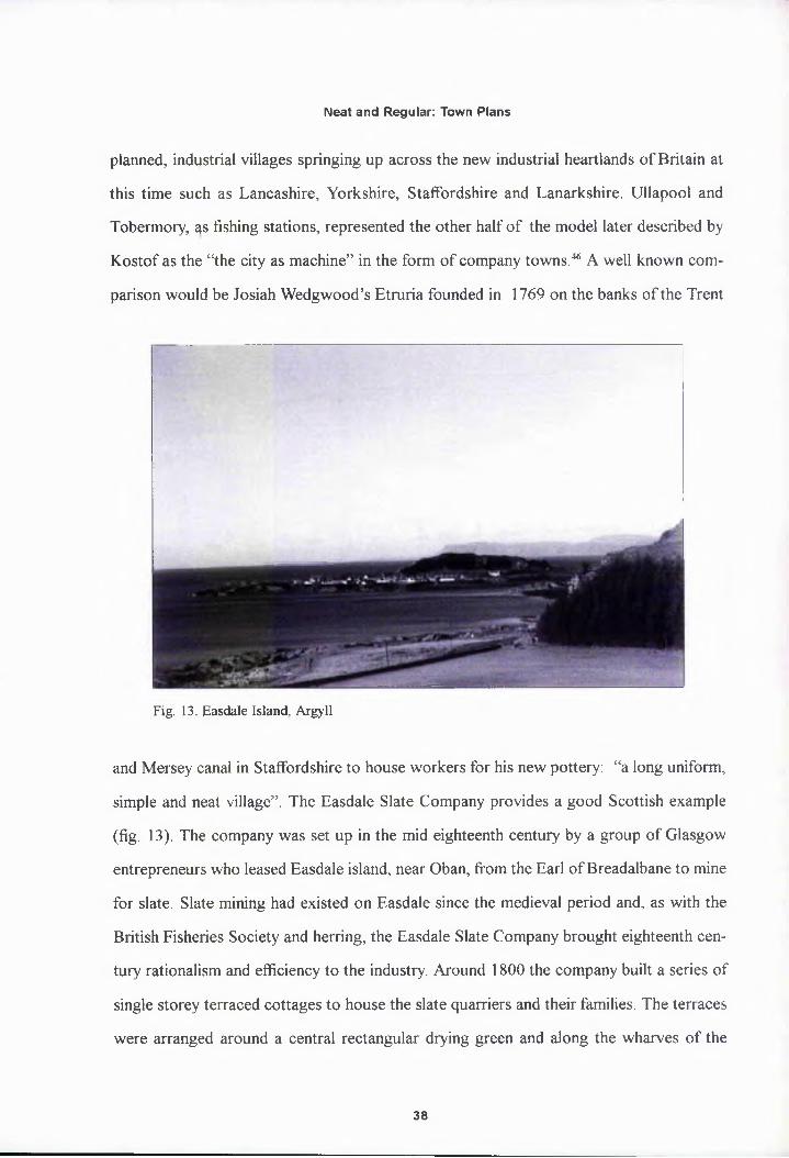
Fig. 13. Easdale Island. Argyll
and Mersey canal in Staffordshire to house workers for his new pottery: “a long uniform,
simple and neat village”. The Easdale Slate Company provides a good Scottish example
(fig. 13). The company was set up in the mid eighteenth century by a group of Glasgow
entrepreneurs who leased Easdale island, near Oban, from the Earl of Breadalbane to mine
for slate. Slate mining had existed on Easdale since the medieval period and, as with the
British Fisheries Society and herring, the Easdale Slate Company brought eighteenth cen
tury rationalism and efficiency to the industry. Around 1800 the company built a series of
single storey terraced cottages to house the slate quarriers and their families. The terraces
were arranged around a central rectangular drying green and along the wharves of the
38

Neat and Regular: Town Plans
Fig. 14. Map and plan of porposcd new town at Inveraray, surveyor unknown, c. 1755 (photo: National Monuments Record of Scotland).
harbour.47 Another example is Glenelg, founded by Col. Macleod of Macleod in 1788 and
planned by the surveyor, George Brown, Glenelg was to be based on spinning and weaving,
for “If a manufacture for coarse cloths on a small scale was established in the village lately
planned out it cannot fail to succeed”. Finally it is worth noting that the influential Grant of
Grant had concieved Grant own-on-Spey as an industrial, spinning and weaving centre not
a prestige estate village.48
However, the Society’s Board of Directors was principally made up of land owners
whose immediate, first hand experiences of planned villages were for the most part not the
commercial, colonial or industrial grid but the estate model village. In the late 1780s, when
the Society was commissioning Langlands and Aitken to plan Tobermory and Ullapool, the
regular plan and neat terrace was still considered the most appropriate design, an aesthetic
that would rarely be challenged until the early nineteenth century with the advent of the
39
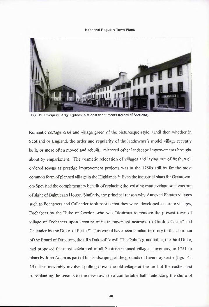
Neat and Regular: Town Plans
Fig. 15. Inveraray, Argyll (photo: National Monuments Record of Scotland).
Romantic cottage orne and village green of the picturesque style. Until then whether in
Scotland or England, the order and regularity of the landowner’s model village recently
built, or more often moved and rebuilt, mirrored other landscape improvements brought
about by emparkment. The cosmetic relocation of villages and laying out of fresh, well
ordered towns as prestige improvement projects was in the 1780s still by far the most
common form of planned village in the Highlands.49 Even the industrial plans for Grantown-
on-Spey had the complimentary benefit of replacing the existing estate village so it was out
of sight of Balmicaan House. Similarly, the principal reason why Annexed Estates villages
such as Fochabers and Callander took root is that they were developed as estate villages,
Fochabers by the Duke of Gordon who was “desirous to remove the present town of
village of Fochabers upon account of its inconvenient nearness to Gordon Castle” and
Callander by the Duke of Perth. 50 This would have been familiar territory to the chairman
of the Board of Directors, the fifth Duke of Argyll. The Duke’s grandfather, the third Duke,
had proposed the most celebrated of all Scottish planned villages, Inveraray, in 1751 to
plans by John Adam as part of his landscaping of the grounds of Inveraray castle (figs 14 -
15). This inevitably involved pulling down the old village at the foot of the castle and
transplanting the tenants to the new town to a comfortable half mile along the shore of
40

Neat and Regular: Town Plans
Loch Fyne. Adam proposed “a symmetrical facade made up of a town house and inn flank
ing the arched entrance to an estate mall”.51 The town was laid out from 1771 and modified
by Robert Mylne in 1774 to a cruciform plan with a town square and church as the centre
of the crossiqg and it has been argued that “Inveraray is without equal among small British
towns in having achieved by deliberate planning just that balance of man and nature, func
tion and ceremony which is the essence of the townscape”52 After the 1745 rebellion the
Scottish aristocracy became increasingly British rather than Scottish in outlook, and their
time was divided between the London court and Westminster and their country estates.53
Consequently, the Scottish estate village must be viewed in a broader context along with
schemes similar to those in Scotland being planned and built throughout Britain. The much
feted village pf Milton Abbas in Dorset, 1773 was built by Lord Dorchester to replace the
old village that disrupted the sweeping vistas of Capability Brown’s Arcadian landscape.
Though picturesque in the use of local vernacular building methods, William Chambers’s
village emplQyed a strict grid plan. The same plan can be seen at Nuneham Courtney,
Oxfordshire, built by the Earl of Harcourt and at Harewood House, Yorkshire, designed
by John Carr, both built in the 1760s.54
However, there remains a fundamental difference between the estate village and the
Society’s fishing villages, one which favours the colonial and industrial grid plan models,
viz. that the fishing stations were remote, far removed from the Directors’ lives and rarely,
if ever to be yisited by them. Therefore, unlike the estate village they were not intended as
visual statements of the landowner’s wealth, improving zeal and artistic refinement. Any
attempt at classification of the aesthetics and meaning within the Society’s planning must
be tempered by the ubiquitous, generic nature of late eighteenth century town planning.
The spirit of improvement and the stylistic dominance of classicism meant the straight
street and regular plan was to a large extent the immediate and inevitable town plan of
choice for any project. Although John Wood’s groundbreaking circuses and crescents at
Bath had reached London as early as 1767 with George Dance the Younger’s scheme for
41

Neat and Regular: Town Plans
the Minories, Tower Hill, the rational straight street, “neat and regular”, still held sway
with town improvers nationally.55 Road staightening and widening schemes were initated at
mediaeval market towns across Britain, for example Thomas Telford, in his role of County
Surveyor of Shropshire, introduced a scheme to straighten and widen Shrewsbury High
Street in 178£.56
A further impetus for the grid system at Ullapool and Tobermory was the issue of
health and hygiene; a broad, straight street being wholesome and clean, the antidote to the
slum overcrowded centres of Britain’s medieval towns, made up of multiple phases of
building to create irregular plots, narrow, winding streets and open sewers. By the turn of
the century a taste for the picturesque would start to restore such planning to aesthetic
favour but in the late eighteenth century new towns such as Bath and Edinburgh were
praised for their healthiness as much as for their beauty, with legislation following numer
ous cholera and typhus outbreaks. Hence the Society also aimed to eradicate the perceived
problems of squalor and disease in the traditional Highland communities from which they
hoped to attract settlers. To this end, Thomas Telford devised a street building scheme for
Ullapool in 1790 that was the “cheapest way of making the streets clean and comfortable
for the inhabitants”. Each settler was to dig a drainage ditch six feet in front of their prop
erty and running its entire length. The street in front was to be cleared of moss and soft
matter “until they come to the hard bottom” and the earth from the ditches to be added to
42

Neat and Regular: Town Plans
the centre of the road surface to create a camber so that water would run off into the
ditches. “If \yater is permitted to run over the whole plain it will always be uncomfortable
and apt to destroy any street that may be formed”. As a final surface, shingle from the beach
was then to be spread over the road surface and in the gap between the settler’s lot and the
Fig. 17. Thomas Telford, Atlas to the Life of Thomas Telford, 1838 (photo: National Monuments Record of Scotland).
ditch creating a pathway (fig. 16).57
It is impossible in late eighteenth century town planning to separate architecture and
design from other ‘improvements’ in agriculture, industry, communications and health. The
street plans fpr Tobermory and Ullapool are simple grids but they reflect the quasi-colo
nial, industrial and improving ideals of the British Fisheries Society. A more fashionable,
sophisticated, architect designed plan would not have cost more to lay out. There was
43

Neat and Regular: Town Plans
simply no incentive for the Society to do so, and symbolic reasons against it. However, in
1790 William Pulteney joined the Board of Directors and the Society’s planning changed
immediately. Pulteney was what Telford described as a “great, bold and enlightened em
ployer capable of comprehending the finest and most extensive schemes”, precisely what
had been lacking at Ullapool and Tobermory, and his first act was to appoint Thomas
Telford as Surveyor to the Society (fig. 17).58 Telford was immediately despatched to
survey and report on the progress of the first two settlements, some of the comments from
which have been previously referred to, and to visit a site at Lochbay on the north west
coast of Skye which the Society had purchased in 1789.59
On the 17th March 1788 the Directors had agreed to treat (enter into a contract) with
the trustees of Col. Norman Macleod of Macleod regarding the purchase or feu of his lands
at Stein on the eastern side of Lochbay.60 The idea to purchase Stein had been put forward
by George Dempster on the 1787 tour, who believed it needed only a pier “ to be one of the
first situations for a seaport town in Europe”.61 The site was inspected by James Maxwell,
the Duke of Argyll’s factor on Mull and recently appointed the Society’s agent at Tobermory,
inspected the site in June 1788.62 Terms were eventually agreed and the Society contracted
for one thousand acres in December 1790. Telford’s report on Lochbay that year was in
favour of the scheme and concluded that:
Though this place is remarkably well located of the fisheries little or nothing has yet been done about it. It has been proposed to build a pier and breastwork and I believe they are much wanted. The place for the pier is along a reef of rocks which will make an excellent foundation for it. The greatest depth at high tide will be about twenty feet. The breastwork is proposed to have at high water a depth of about twelve feet. There is fine limestone and excellent quarry stone at hand.63
Telford went on to propose that an inn, pier, breastwork and storehouse should be
built, he also proposed to abandon a simple grid plan that had been drawn up by the sur
veyor James Chapman and put forward one of his own devising.64 Telford took this as an
opportunity to try his hand at fashionable town planning. Telford is considered one of the
44

Neat and Regular: Town Plans
great British civil engineers of the nineteenth century, amongst his many works on canals,
dockyards, harbours and bridges, perhaps the most celebrated are the Caledonian Canal,
started in 18Q3, and the Menai Suspension Bridge, 1819-26 but conceived in 1790. It is
significant to note that Telford considered himself an architect. His arrival as surveyor to
the British Fisheries Society totally transformed their town planning, as the practical, sim
ple grid was replaced with schemes altogether more complex and sophisticated, which
took the Society’s town plans into the domain of architecture and design. Where the
previous schemes had “stopped short always at the point where art should animate and
inspire”, Telford introduced “form inspired by considerations that are intellectual, ab
stract, spiritual - considerations that modify the strict requirements of utility”.65 Telford had
been introduced to both Sir William Chambers and Robert Adam by the London merchant
John Palsey and though employed by Chambers he found his style “stiff and formal” prefer
ring Adam’s “playful and gay” manner.66 In 1788 Telford was appointed Surveyor to the
County of Shropshire through his new patron Sir William Pulteney, MP for Shrewsbury
and husband of Lady Bath, heiress to the estates of the last Earl of Bath.67 Pulteney’s
patronage was of critical importance to Telford’s career as through Pulteney, Telford gained
his first architectural commissions in and around Shropshire, in which he tended towards
the current, stripped neo-classical style of James Wyatt and Robert Mylne.68 Most impor
tantly, Pultepey brought Telford to Bath to inspect building works with which Pulteney
was involved on his wife’s Bathwick estate.69 As an employee of Pulteney , he would have
been involve^ with the development scheme of Great Pulteney Street, Laura Place and
Sydney Gardens begun in 1788 to plans by Thomas Baldwin, the City Surveyor of Bath.70
Telford deafly found time to study the new planning and architectural achievements in
Bath, the new curves of the domestic circus and crescent and the use of the unified fa
cade.71 Not pnly did he admire these, but he also understood the conditions that enabled
their creation:
...Modern Bath has been created by a Mr. Wood, an Architect, a man of very
45

Neat and Regular: Town Plans
superior talents to whom, I will, I hope do justice. Since his time, altho’ the rage for building has been unbounded, yet there has none inherited even a portion of his Qenius. I will not even except their present Surveyor who is sinking fast into obliyion. He has lost, or rather not succeeded, in the finest attempt which the World ever afforded of finding fame above that of any other man as an Architect... In Lady Bath’s new Town every circumstance was most fortunately combined- the whole the property of one person, the greatest plenty of beautiful Material at the cheapest rate in the World, a great demand of every species of Buildings supported by a great, bold and enlightened employer capable of comprehending the finest and most extensive schemes and the growing in the Bosom of Wealth. I know of no instance in Ancient or Modern History of the conjunction of so many favourable circumstances. ..far excell’d the Bath of Diocletian or any of the Ro-
PLAN
l/tr/nt. I >ttt tim hthtml nt
SKY
► xrtrtxuwo
-TOM'I» /Ota
Fig. 19. Thomas Telford. The General Plan of Lochbay in the Island of Skye, 1790. NAS RHP11791 (photo: National Archives of Scotland).
man Works. 72
At Lochbay all the circumstances for a good coherent scheme were evident. The
property, the former farm of Lusta, had been bought outright and was solely the property of
46

Neat and Regular: Town Plans
the Society apd included a potential stone quarry, as at Ullapool and Tobermory. The sole
purpose of the settlement was the herring fishing and as before lots were to be marked out
and feued to settlers who were to build their own houses but according to the Society’s
regulations. Ip this way the Society, theoretically, had total control over the project. Telford’s
incentive for producing something out of the ordinary at Lochbay appears to have been
simply that given these conditions, the opportunity to try his hand at the town planning he
had witnessed in Bath was irresistible. Moreover, it would not cost the Society anything as
he would only accept basic expenses.
Telford’s Lochbay scheme is a blend of the imaginative and the practical, with lessons
clearly learnt from Bath (fig. 18). The site was an area of flat land at sea level surrounded
by rising gropnd to the north landward side and a saucer shaped hill to the immediate west.
As John Wood had done at Bath, Telford used this topography to maximum effect, “estab
lishing multiple relationships with nature. The antithesis of the colonial grid plan [which is]
an artificially imposed order”.73 The square, grid format was replaced with a long rectangu
lar form that is flush against the rising ground to the rear and curves to fit the coastline to
the seaward side. There are two main focuses of the plan, the church square and the market
square. The plain street along the sea front rises up the hill where the church creates a visual
full stop at the summit. The church sits in the centre of a lozenge-shaped square, with a
second axial street running north to meet a residential block square on and south, directly
to the pier and storehouses. As Telford was also working on Sir William Pulteney’s Bathwick
estate at this time Baldwin’s Laura Place would seem to be the obvious inspiration for this
arrangement, though James Craig’s 1785 plan for the South Bridge area of Edinburgh also
included a lozenge-shaped square centred on the Tron Kirk.74 A concave crescent curves
around the hijl with the houses facing seaward. The plan is brought to a deliberate terminus
on the western foot of the hill with a straight row backed onto the river, a natural outer
limit of the tpwn plan. At the centre of the plan lies the market place, a semicircular space
formed by a crescent made of three blocks of row houses and the prominent feature of the
47
Neat and Regular: Town Plans
square is a series of colonnaded markets. A flesh and potato market around the crescent
and a free standing semicircular corn and meal market stand in the centre, with one of
many proposed water fountains as a visual and practical feature. The colonnaded market
was a popular eighteenth century idea based on the Roman Forum, however, the direct
influence of Thomas Baldwin and Bath on Telford is again evident in Baldwin’s 1786
development of Bath St, linking the Pump Room to the New Private Baths and the Great
Pump Room, In particular, the colonnaded semicircle of Cross Bath, with the Pump Room
at the centre of the space is strikingly similar although, unlike Cross Bath, Telford appears
to have proposed for the colonnades to be free standing or projecting from the main
building facades. His source for this departure is not clear though he is known to have had
a large architectural library including Volume I of Stuart and Revett’s Antiquities of Ath
ens, which included plans of the Stoa in Athens which feature projecting colonnades.75
Another difference from the Bath St development is the addition of a street that meets the
centre of the straight side of the market place, to form a central axis for the five radial
streets converging on the square. Telford, who lived in London from 1782 to 1784 and
visited many times, possibly took this arrangement from the junction of Hamet St and the
Crescent in George Dance the Younger’s Minories development at Tower Hill, referred to
earlier.76 Perhaps the most interesting feature of Telford’s plan is the use of the crescent and
concave crescent to create an enclosed semicircular street, the crescent being normally
employed for panoramic purposes to front a view or open ground. As was the case with
most previous examples such as John Wood’s Royal and Lansdown Crescents, Bath; The
Crescent, Buxton, 1780 by John Carr of York; Royal Crescent, Brighton, 198-1807, by J.
B. Otto or the half-built Crescent by John Rawsthome and Charles Norton of 1795 in
Birmingham.77 As even the use of two or three crescents to form a circus involves a central
void, the only other example of the period appears in the unrealised scheme for the north
London estate of Lord Camden of c. 1790 again by George Dance the Younger, with which
Telford may or may not have been familiar.78 Both squares in Telford’s plan for Lochbay
48

Neat and Regular: Town Plans
focus town life inland away from the sea. In contrast to the previous two settlements,
where all the principal buildings are laid out in a strip along the shore and the pier, store
houses and blacksmith’s are moved away from their central location in the previous plans.
Whilst boundaries are clear to the north and west the plan allows for possible town expan
sion along thp coast to the east in the form of another concave crescent. The overall effect
is of a well thought out, carefully controlled plan with a coherent overall shape, yet com
plex and sinuous within its own limits and using the landscape to great effect. Despite the
Scottish location, Telford’s links with Bath are more apparent when it is considered that the
plan for Lochbay was drawn up in 1790 whilst it was not until the 1820s that similarly
curvaceous sphemes were laid out in Edinburgh, viz. Royal Circus by W. H. Playfair and
the Moray estate by James Gillespie Graham. Although Lord Garlies had laid out Garliestown,
Wigtownshire to a crescent plan in 1760 and James Playfair had proposed a circular plan
for Dunninald, Angus in 1780.79
The plan for Lochbay was never executed beyond the main street up to the hill, the
beginnings of the parallel street behind and the building of the pier, inn and blacksmith’s;
the rest remained on paper. Though Telford’s plan was undeniably too large from the out
set, over one hundred lots compared to an initial forty at Ullapool and Tobermory, the
failure of Lophbay was principally brought about by the Society’s failure to secure settlers
rather than the attempt to introduce crescents to the Highlands. Lots were not laid out until
1795, by which time most of the initially interested population had emigrated, and only
twenty seven lots were feued.80 Telford’s second opportunity for town planning came with
the Society’s decision to develop a new town and harbour at Wick in Caithness.81 To be
named Pulteneytown in honour of Telford’s patron and mentor, Sir William, who died in
1805, this was the fourth and final settlement founded by the British Fisheries Society.
Wick, on the north east corner of Caithness, was already an ancient fishing port. The
Statistical Account of 1792 for the parish of Wick submitted by the Rev. William Suther
land states that there was a population of 3,938 of which some thousand resided within
49

Neat and Regular: Town Plans
Wick itself. It was the sort of town the Society had hoped to create on the west coast, with
ten shopkeepers, ten shipmakers and fifty coopers - the rest being fishermen. As the Rev.
Sutherland observed “The inhabitants in the burgh of Wick have multiplied as the fisheries
have become more extended and successful”. Telford had visited Wick during his tour for
the Society ip 1790 and had been impressed with the potential for improvements. The Rev.
Sutherland succinctly summarised the situation in Wick as follows:
A new harbour is of great importance to the town but also to the country at large. Proyiding an essential shelter for vessels between Cromarty and Stromness. A harbour commodious for a number of vessels, and safe in all weather, might be made. This would be particularly beneficial during the herring season, which has beep much retarded for want of a safe haven. In 1791 34 vessels lay on the bounty, pent up in very narrow bounds, and in constant danger of running foul of one another. The hoped for harbour could not be executed without considerable expense. The British Fisheries Society, who sent persons [Telford] of skill to take an exact survey of the grounds, and to report their opinions, which was in favour the measure. A correspondence has been entered into with Sir Benjamin Dunbar of Hepipriggs, the proprietor, for feuing out, on the south side of the water, opposite to tbe town of Wick, several hundred acres of land for building a village.82
In 1792 the Society were preoccupied with their west coast settlements and it was not
until 11th March 1803 that a contract was signed between the Society and Sir Benjamin
Dunbar for 390 acres of land on the south side of the river. The availability of fuel, fresh
water and building stone had, as always, been checked and the whole of the land purchased
was good arable. It was the smallest land purchase by the Society and marked a change in
their approach resulting from the failure of the west coast settlements as fisheries in the
intervening years. The settlers of Ullapool were facing starvation as the herring was ambu
latory and had failed to appear in Lochbroom for four years whilst the settlers in Lochbay
had proved tp be idle and reluctant fishermen. The soil on Skye had proved more fertile
than Lochbrpom and the settlers were able to grow enough food without having to go near
the sea.83 Whilst at Tobermory ships of all nations continued to use the harbour turning the
settlement into a flourishing port and trading post with precious few fishermen. Therefore
50

Neat and Regular: Town Plans
Fig. 19. Thomas Telford, first scheme for Pulteneytown. 1807, NAS RHP42242 (photo: National Archives of Scotland)
the plan for Wick was to be different, a New Town was to be laid out on flat farm land
away from the existing town in the manner of Bath or Edinburgh. The requirements were
therefore different too, the new town was to be primarily a residential quarter for profes
sional men such as fishermen, coopers, wrights and their families with no grants of arable
land to settlers. The additional land was to be enclosed and let to tenant farmers whilst
settlers were to survive by fishing alone, relying entirely on a local market economy and
deliberately excluding crofters. The requirements in the residential area of Pulteneytown
were also different, as amenities such as shops and a market place were already provided
by the old town. By 1803 the Society was keen to invest money wisely and saw the sense
in developing an existing fishery, in need of investment, to realise its potential.84 Indeed,
Pulteneytown proved to be the Society’s most successful venture with the 1834 Second
Statistical Account reporting that the population had risen to some 10,000 and rising.
Telford’s initial plan of 1807 divided the new town into two distinct zones, one strictly
51

Neat and Regular: Town Plans
&
#AU»M
-.....Fig. 20. Thomas Telford, revised scheme for Pulteneytown. 1808. NAS RHP11805 (photo: National Archives of Scotland).
residential on the flat ground above the bank, the other strictly industrial, for store and
curing houses, on the smaller area of flat ground next to the river and the proposed site of
the new harbour (fig. 19).85 Telford deliberately employed two different design aesthetics
for each zone. The industrial zone, later referred to as Lower Pulteneytown, was laid out
on a strict grid pattern of nineteen lots grouped into four rectangular blocks and a half
block to fit the site. Each block comprised two lots facing the harbour and four lots facing
the rear of those in the parallel block. While Telford went to such lengths to avoid a grid
pattern in his plan for Lochbay it is clear that here he is using it deliberately to stress the
practical, functional, industrial nature of the streets and buildings in the zone. This was
originally enforced by Telford’s proposed street names, as can be seen in the plan, Salt
Row, Herring Row and Cask Row.86 The residential zone was of a completely different
nature. Telford’s first scheme is based around a long shallow crescent of twenty lots. Fac
ing away from the sea to fit the promontory marked D the landward bowl to create a semi-
52

Neat and Regular: Town Plans
jTTJf.Vf 2473
. RAI Kir
iir/mrtJ Ihiutc ,
■L - \_A- •-‘zmz/.« r
2480W.V/4-South < 'hu/irtel f‘>>(iris AftS
Lon erPttft•,-k
’O/H Ai IA Si,
IKXER HAWBOVR
■ *>?r<*v u *H.MJ1.1 248!«
jrv«v *UrtWHtl
1M.S1 «•KFTz/ry/z/rzz/i’
’‘JvtuJjMius (fatpetHA! 1.1
mterhin ct ’
tonwriv J/I M U A
nv ti
HAMS .1
Stuifn \ *!'„rf X*Wzv-
n M M
M Its-*,
" 8 ** ♦ « v;I 'nnw^Pu llene\ hm y/ A
Fig. 21. Pulteneytown. Wick, Caithness, first edition OS map. 1872 (National Libray of Scotland)
53

Neat and Regular: Town Plans
circular square with the block opposite as at the market place proposed for Lochbay. This
crescent was to be abutted to blocks at each end to form part of a more conventional grid
It is likely that Telford got the particular form of the crescent from Ardrossan, Ayrshire,
which was lajd out by 1807 to plans by Peter Nicholson and where Telford had advised on
the building of the harbour. However, he quickly saw the awkwardness of the plan and had
by 1808 developed a new scheme for the residential area (fig. 20). The final executed plan
of 1808 radiates from a central square in the form of a chamfered rectangle.87 The central
area was turfed in the manner of existing squares in London’s West End or Edinburgh
Fig. 22. Argyle Square. Pulteneytown, Wick. Caithness.
North New Town, such as Drummond Place by Robert Reid and William Sibbald, 1801
1802, though it was probably intended as much as a practical drying green as a suburban
park. As at Lochbay the immediate inspiration for Telford again suggests itself to have been
Thomas Baldwin’s plan for the Bathwick estate, in this instance Sydney Place, 1788-92.88
As in Sydney Place the square was symmetrically bisected length ways by a main axis
running roughly east-west parallel to the bank and a second cross axis led up steps from the
54

Neat and Regular: Town Plans
Fig. 23. Argyle Square, Pulteneytown. Wick. Caithness. 1978 (photo: National Monuments Record of Scotland).
industrial zone across the park and out to the south. Telford scaled down and simplified
Baldwin’s plan by omitting the four diagonal streets on the angled corners of Sydney Place,
reducing the number of terraces required from eight to four. Finally two streets, to the
north and south of the square, running parallel with the main east-west axis but following
the contour of the square formed shallow crescents and completed the unity and coherence
of the plan. Telford’s use of the suburban square affirms the zones purpose and contrasts
with the industrial zone. As at the Society’s other settlements the streets were named after
Directors of the Society; Argyle Square; Grant Street, Beaufoy Street and Dempster Street
(figs 21-23).
Unlike Ullapool and Tobermory, Telford’s two schemes also provided designs for the
intended buildings. Again following the example of Bath, and Robert Adam’s Charlotte
55

Neat and Regular: Town Plans
Fig. 24. Thoipas Telford. The General Plan of Lochbay in the Island of Sky. 1790. detail. NAS RHP11791 (photo: National Archives of Scotland).
Square, Edinburgh, he proposed terraces of row housing which formed continuous fa
cades. As with the street plans this was possible because the towns were the property of
one organisation and strict building regulations could be enforced in order to regulate any
anomalies that could have arisen from the policy of self-build by settlers. This had been
done to some extent at Ullapool and Tobermory, houses had to be built of stone, roofed
with tiles or slates and built to the street line, but the aim had been to ensure safe and
healthy conditions not good design beyond a general neatness.89 At Lochbay, Telford pro
posed two elevations for united Palladian facades for ‘Macleod Terrace’, both of which are
clearly indebted to Robert Adam (fig. 24).
No. 1 was for a three storey central block with two protruding pedimented wings
flanking a recessed central block with single storey row housing stretching to the left and
right in the manner of quadrants, broken half way with a two storey pedimented block and
terminating in narrower two storey blocks, the illusion of pediments being created by py
ramidal roofs. No. 2 elevation is based on the same principle but is based on three storey
blocks linked by two storey quadrant rows. The arrangement is slightly different too, em
ploying a tripartite central arrangement of a central block flanked by two identical blocks,
56

Neat and Regular: Town Plans
Fig. 25. Thomas Telford, elevations for two storey houses at Pulteneytown. 1808. NAS RHP11798 (photo: National Archives of Scotland).
long quadrants terminating in paired blocks. Despite cost naturally excluded detailing or
ornament both facades can still be seen as a cocktail of various Robert Adam elevations
such as Charlotte Square, Edinburgh, under construction in 1791. Comparison with work
on a similar scale to the Telford’s scheme is also rewarding, for example Cherry Park
Offices, Inveraray, 1758, by James Adam and Robert Adam’s Lowther Village, Cumbria,
Fig. 26. 52 Argyle Square. Pulteneytown, Wick. Caithness.
57

Neat and Regular: Town Plans
Fig. 27. Telford Street. Lower Pulteneytown .Wick, Caithness.
1766 show great similarities with Telford’s Macleod Terrace, notably the arrangement of
single storey terraces as quadrant wings between two storey blocks with pavilion roofs.90
As a collector of architectural treatises and pattern books and an admirer of Robert Adam,
it is likely that Telford owned a copy of either the 1773 or 1779 volumes of Works in
Architecture of Robert and James Adam. It is also probable that he stopped at Inveraray on
his 1790 tour of the Highlands for the Society as it was the seat of the Society’s Chairman,
the Duke of Argyll.
However, Telford’s Lochbay elevations were clearly, even at a single storey, more
than was required or feasible at such a remote location and the setting of rents with such
varied elevations per lot would have been extremely complicated. In this second attempt at
Pulteneytown Telford did achieve a workable synthesis of the continuous facade and of
houses built by individual settlers by the simple device of prescribing a plain, symmetrical
two storey elevation, three bay elevation for each house and a suggested ground plan that
could be endlessly repeated (figs 25 - 26).91 The architectural impact rested upon the
58

Neat and Regular: Town Plans
streetscape as a whole rather the individual houses. The ‘Telford’ elevation was incorpo
rated into thy Society’s building regulations regarding materials with a smaller two bay
alternative provided for the cheaper lots in the surrounding side streets. Telford achieved
a succesful architectural compromise, the articulation of a Palladian frontage was lost to
the practical problems of feuing lots at a standard rent but the desired effect of coherence
was retained. Telford may have been familiar with Richard Arkright’s Derbyshire milltown
of Cromford, 1771-6 where a similar approach had been emplyed with success.
Controlling the design of the industrial units at Pulteneytown was easier as store and
curing houses were built to a generic, functional type similar to the bonded warehouses of
the Port of Leith or the Port of Glasgow. As building regulations required stone built walls
and slate roofs and stipulated standard dimensions of 60 ft by 22 ft by 18 ft, room for
deviation was limited anyway and a prescribed elevation was not thought necessary.92 Lots
were sold by auction in 1808 with eleven being taken; all twenty one were leased out by
1817.93 The resulting solemn blocks of plain high walled buildings of the Lower Pulteneytown
industrial grid are unquestionably industrial and functional in appearance and can be asso
ciated with the architectural trend, increasingly popular in Britain after 1800, for “relentless
repetition” and “obsessive geometry” in large building complexes such as docks, prisons,
barracks or asylums which Mark Girouard has described as “heroic geometry” (fig. 27).94
Lower Pulteneytown realised in small scale Telford’s monumental unrealised plans for a
single span bjidge, warehouse and embankment complex on the Thames of 1800 and pre
empted his sphemes for Gloucester Docks, 1826, St. Katharine’s Docks, London, 1827-8
or Jesse Hartley’s Albert Docks, Liverpool, 1841 to 1847,
The single autocratic vision of the British Fisheries Society that enabled Telford to
create such coherent town plans also ensured the towns themselves became anachronisms.
Whilst Lochbay never get off the drawing board, Pulteneytown was entirely dependent on
the herring industry and the local economy collapsed with the industry in the early twenti
eth century.95 Nonetheless, in design terms Telford’s plans stand out from Tobermory and
Ullapool and the general catalogue of eighteenth and nineteenth century Highland Planned
59

Neat and Regular: Town Plans
Thomas Telford and his patron William Pulteney directly from Bath. The aspirations
of the Society were not for great architecture and at Ullapool and Tobermory their primary
goal had been to build practical and efficient fishing stations based upon a resident popula
tion of fisherpien. To this end their efforts, and correspondence, were taken up with the
practical and logistical issues of choosing the best sites, laying out a plan, establishing what
works were essential to be built at each settlement and then getting them built as quickly
and cheaply as possible so fishing could begin. The Society’s concept of architecture and
planning could at best be described as “neat and regular”. If there was no deliberate archi
tectural expression in the simple grid plans of the first two settlements then there is archi
tectural meaning. The grid plans have left indelible marks on the Highland landscape, marks
that reflect the self-image of the Society as an organisation of economic and colonial pio
neers and the then contemporary preception of the Highlands and its people as that of a
wild frontier. And it is Ullapool and Tobermory, not Pulteneytown, that established the
pattern for Highland planned villages through the nineteenth century. Though these were
only two smqll settlements, the profile of the Society ensured numerous imitators.
Finally, it is interesting to observe how a great national plan was susceptible to spec
tacular success or failure due to the actions of individuals. The regularity of Maxwell’s
Tobermory stands in contrast to Ullapool, forever skewed by a building contractor’s mis
take. Though above all stood Thomas Telford, solely responsible for the architectural suc
cess, at least, of the Society’s third and fourth settlements. He single-handedly changed the
architectural direction of the Society and architectural meaning and symbolism of its settle
ments. Admittedly, this was only possible because the Directors were not sufficiently inter
ested in street plans to notice his radical change of course. At Lochbay, on paper at least,
Telford initiated a new second phase in the Society’s town planning which provides an
excellent example of the impact and importance of planning, the cost of drawing up a
scheme and laying it out with rope on the ground remained the same but the visual differ
ence and effect on the intended residents is vast. Telford created plans for towns not settle-
60

Neat and Regular: Town Plans
merits, urban environments equally efficient but pleasant places to live too, gentility and
urbanity broqght to the Highlands. And if Lochbay never gained more than a main street
leading to nowhere, at Pulteneytown Telford created what is arguably a planning master
piece, unique in Scotland.
1 j Dunlop, The British Fisheries Society, John Duncan, Edinburgh, 1978, 26
’Edinburgh, SRO/GD9/3/60
’Edinburgh, SRO/GD9/3/84
'Edinburgh, SRQ/ GD9/3/55-80
’Edinburgh, SRO/GD9/3/54
6N Allen, “ Highland Planned Villages”, SVBWG Regional and Thematic Studies No 1, MD Print & Design, Edinburgh, 1990, 40
’Edinburgh, SRO/GD9/3/49
’Edinburgh, SRO/GD9/3/17
9 Dunlop, The British Fisheries Society, 35
’“Edinburgh. SRO/GD9/4
11S Kostof, The City Shaped, Urban Patterns and Meanings Through History, Thames and Hudson, London, 1991, 116
’’Edinburgh, SRO/GD9/1/1.
It should also bp noted that agricultural planned towns in the Lowlands and North East, as exemplified by Grantown-op-Spev were also being actively promoted by the Highland Society at this time and provided further inspiration for the formation of similar planned fishing villages (see also p 3 & p 34).
13 Dunlop, The British Fisheries Society, 34
’4Mull, MMA/TyfM/ 2/27, The Bee, 1792, 81
’’Edinburgh, SRO/GD9/3/54
16 various survey maps of the Duke of Argyll’s lands by Langlands are held at the Scottish Records
61

Neat and Regular. Town Plans
Office including Mull and Morvern.
17 Edinburgh, NMRS/AGD/496/1
18 Later Campbell of Knock’s son, Colonel Campbell of Knock, saw the growth of Tobermory over the next few decades and was keen to develop his part of the harbour and in 1835 he built a pier and breastwork ruiping directly from the northern edge of the British Fisheries Society’s land and feued out building lots, leaking a handsome profit from the growing fortunes of the village. A Whitaker, A Walk Around Tobermory, Oban Times, 1988, 20
Edinburgh, SRO/GD9/3/28-30
“Edinburgh, SRO/GD9/3/38
21 Mull, MMA/MM/3-2-7, Unfortunately unable to obtain a reproduction as the Museum has the plan on display in a glared frame.
22Kostof, The Qty Shaped, 218
“Mull, MMA/IyIM/3-2-7
“Edinburgh, S£O/GD9/4/618
“Edinburgh, SRO/GD9/4/296 & GD9/4/294
26Mull, MMA/PylM/ 3/1
“Edinburgh, SRO/GD9/4/213
28MMA/MM/3-rg-2.
“Mull, MMA/tyfM/3-1-1
“Edinburgh, SRO/GD9/3/617
’’Edinburgh, SRO/GD9/3/617
“Edinburgh, SRO/GD9/32/41/1/11/90
’’Edinburgh, SRO/GD9/32/56
“Allen, The Highland Planned Villages, 45. H Woolmer, “Grantown-on-Spey: An Eighteenth Century New Town”, Town Planning Review, Vol. 41, no 3, 1970, 238-245
“SRO/GD9/3/95
36 It was also Grant of Grant who outlined the key elements in choosing a site and who suggested the issuing of long leases discussed later.
37Kostof, The Cfty Shaped, 15
“Edinburgh, SRO/GD9/3/583
“Edinburgh, SRO/E730/32
62

Neat and Regular: Town Plans
40C McWilliam, Scottish Townscapes, Collins, London, 1975, 99. Allen, The Highland Planned Village, 28
41Edinburgh, SRO/RHP/3400
42The scheme \yas abandoned when the estate reverted to Lord Macleod of Macleod under the 1782 Restoration of forfeited Estates Act.
“Edinburgh, SRO/RHP/2312/3 & RHP/2312
44McWilliam, The Scottish Townscape, 99. Edinburgh, SRO/E777/313/290
45Kostof„ The City Shaped, 220
46Kostof, The Cfty Shaped, 15. Kostof cites the later nineteenth century example of the bleak, grid plan American railvyay towns. A different period and a different industry but the model is the same.
47Information provided by the Easdale Folk Museum The Easdale Slate Company flourished through the nineteenth ccntuiy providing much of the slates for the Glasgow tenements. With the collapse of the industry in the parly twentieth century the island’s streets, square and cottages fell into disrepair, much like as happened at Ullapool. The cottages have been gradually renovated and reoccupied since the 1970s.
48Woolmer, Grqntown-on-Spey, 239
49Though this vyould change with the herring boom in the nineteenth century and pressure for industrial settlements growing in response to increasing number of clearances.
“Edinburgh, SRO/RHP/2312
5IM Glendinning, R Maclnnes & A MacKechnie, A History of Scottish Architecture, Edinburgh University Press. Edinburgh. 136
52C McWilliam, The Scottish Townscape, 92
“Edinburgh, SRO/GD9/3/161. As discussed in chapter one the Society itself was run from Westminster even though thp principal Directors were Scottish landowners. And whilst Inveraray is located on Loch Fyne both the Duke of Argyll and Robert Mylne were for the most part located in London.
54RReid, The Georgian House and Its Details, Bath Press, Bath, 1989, 75
55D Stilman, English Neo-Classical Architecture, Zwemmer, London, 1988, 216. H M Colvin, Biographical Dictionary of British Architects 1680-1840, 3rd edition, Longmans, London, 1995, 288
“Colvin, Biographical Dictionary, 970
“Edinburgh, SRO/GD9/3/583. Telford’s street drainage system was still evident in photographs of Argyll street in the 1930s on display at the Ullapool Museum. The pathway and drainage ditches now being buried under small front gardens and tarmac.
“Edinburgh, SRO/GD9/3/476. Dunlop, The British Fisheries Society, 134
“Edinburgh, SRO/GD9/3/33. Terms were agreed in April 1789 but the contract was not signed until December 1790.
63

Neat and Regular: Town Plans
“Edinburgh, SRO/GD9/3/32. Chief of the clan Macleod, owner of vast estates on Skye and resident of nearby Dunvegan Castle.
61 Dunlop, The British Fisheries Society, 87
“Edinburgh, SRO/GD9/3/33
“Dunlop, The British Fisheries Society, 89
“Edinburgh, SRO/GD9/3/448 & GD9/3/553
65H Read, The Qrigins of Form in Art, Thames and Hudson, London, 1965, 99
66L T C Rolt, Tfromas Telford, Longmans, London, 1958, 9. Palsey was the brother of Miss Palsey of Langholm, close to Telford’s home in the Scottish Borders, a wealthy spinster who appointed herself the guardian of the young Telford’s education.
“Colvin, Biographical Dictionary, 970. This fortunate match was born out of shared roots in Langholm. Telford was recommended to Pulteney by his brother Sir James Johnstone of Westerhall who was planning some alterations to his home at Eskdale and suggested to his brother that Telford should be consulted.
68To cite a few; St. Mary’s Church, Bridgnorth, 1792-4; Madeley Church, Salop, 194-6, both in a simple neo classical style; alterations to Shrewsbury Castle for Pulteney, 1787 and alterations to Boreaton Hall, Salop for Roland Hunt, 1791. Colvin, p.970
“Rolt, Thomas Telford, 24. Rolt quotes a letter from Telford to a friend Andrew Little alluding to the trip. A letter from the previous year asking Little if he knew of any good wrights in Eskdale wanting work in Bath, " I could get three or four employed”, suggests that Telford’s visit of 1793 was one of several visits since 1788. Pulteney’s works on his Bathwick estate having commenced in 1788 and were suspended in 1793 due to the economic slump of that year.
70J S C Curl, Georgian Architecture, David and Charles, Newton Abbot, 1993, 175
71Kostof, The City Shaped, 72
72 The reference to Diocletian’s Baths at Split is important as it indicates Telford was familiar with the concept of interconnecting spaces of varying forms, circles, semicircles and ovals, that lay at the root of both new architecture, particular the work of Robert Adam, and new town planning such as Wood’s Royal Crescent at Bath and George Dance the Younger’s similar proposals for the Minories and Camden in Loqdon.Rolt, Thomas Afford, 24. Letter to Andrew Little, 1793. Rolt suggests that the surveyor referred to is John Palmer w|io succeeded Thomas Baldwin as City Surveyor in September 1792 and designed Lansdown Crescent, 1789-1792.The criteria necessary for succesfully planning the Ideal City as outlined by Telford, in particular the need for a strong controlling hand are repeated in strikingly similar terms in Kostof, The City Shaped, 159-208. Whilst Telford goes on to lament the loss of the plans coherence at the hands of private speculative building as Bath grew, Kostof cites this as common to any planned city that has not withered, the inevitable result of success. Kostof further adds to Telford’s list the need for a single driving purpose to a planned city such as religion or in the case of Bath, the leisure economy.
73P Davey, “Building Berlin”, Architectural Review, E Map Construction Ltd, January 1999, 30
74Stilman, English Neo-Classical Architecture, 234
75Rolt, Thomas Telford, 1964

Neat and Regular: Town Plans
77K Downes, The Georgian Cities of Britain, Phaidon, Oxford, 1979, 120
78Stilman, English Neo-Classical Architecture, 239. Most probably Telford did ape the scheme from Dance, as in architecture at least he was a great rearranger and interpreter of other people’s ideas rather than an innovator.
79C Me William, The Scottish Town scape, 99
80The failure of Lochbay will be considered in more detail in the next chapter. See also Dunlop, The British Fisheries Society, 182
81Edinburgh, SROZGD9Z3Z200
82Edinburgh, SROZGD9Z3Z200
83Dunlop, The British Fisheries Society, 150
8<,Dunlop, The British Fisheries Society, 157
85Edinburgh, SROZGD9Z7Z264
86These were unfortunately later changed to Saltoune Terrace, Telford St and Burn St, losing the intended industrial imagery.
87Colvin, Biographical Dictionary, 970
88Colvin, Biographical Dictionary, 97
89Mull, MMA, pFS Regulations (on permanent display)
90D King, The Complete Works of Robert and James Adam, Butterworth Architecture, OzXford, 1991, 385
’’Edinburgh, SRO/RHPZ 11798
92Dunlop, The British Fisheries Society, 161
’’Edinburgh, SROZ GD9/3/30
9ZM Girouard, The English Town, Yale University Press, New Haven and London, 1990, 94. The architecture of (he storehouses at Pulteneytown are considered in more detail in the next chapter.
95 As Spiro Kos|pf observed on Palmanova, Italy, “ If [it] has come through more or less intact, it is not as a viable comniunity but as an unwitting exhibit in a museum of ideal cities”, Kostof, The City Shaped, 162
65

CHAPTER THREE
Ullapool
From tfye perspective of an architectural historian, Ullapool was the least successful
and most flawed of the Society’s villages, resulting from poor workmanship from the main
contractor, a weak ineffectual agent and a lack of supervision or control from London. As
the building went on, Ullapool became the experience which the Directors would
learn from and hope not to repeat. Lord Macleod, the owner of the Lochbroom estate that
included the farm of Ullapool, had transferred to the Society a total of 1200 acres in De
cember 1787 and from this point the Directors were anxious to start building works as soon
as possible.1 Qn the 26th February 1788 Sir Adam Fergusson placed adverts in the English
and Scots papers appealing for estimates and proposals from potential contractors.2 These
included the Edinburgh Evening Courant 20th February and 6th March 1787 and Caledo
nian Mercury 8th March 1788.3 The advertisements stipulated that the Society initially
intended to cpntract for three works at Ullapool; a warehouse, pier and an Inn. The ware
house was to be built of stone and lime with a slate roof, three stories high with a cellar and
60 ft in length. Estimates were required for three different widths; 18 ft, 24 ft and 30 ft. The
advertisement asked for contractors to provide their own dimensions for the pier stating
intended materials, cost and reason for choosing their intended location of pier. The Inn
had also to bp of stone with a slate roof, two stories high with garrets and a cellar plus a
parlour and offices, i.e. scullery, kitchen, brewhouse, oven.4
Robert Melyill: “The Little Emperor of Ullapool”
Minutes of the Committee meeting of 17th March noted that the Society had received
a letter from a Mr. Robert Melvill of Dunbar proposing to carry out the works for £1,200.5
Melvill had considerable experience in the fishing industry having been a partner in the
66

Ullapool
fisheries merchants, Falls of Dunbar, which had held a monopoly on the fishing industry in
the north of Scotland prior to its collapse in 1786.6 Melvill’s proposal was far reaching, he
offered not only to carry out all the core building works but then to manage the village’s
commercial fishing interests wholesale. He argued convincingly that the Society would
need to attract a merchant to be based at Ullapool, who could supply the settlers with salt,
casks, nets and boats and who could buy their catch from them at a reasonable price,
pointing out correctly that the settlers would not be able to afford these necessities them
selves nor would they have the experience to negotiate proper terms with independent
merchants.7 This represented a massive opportunity for Melvill, who found himself short
of funds following the collapse of the family firm of Falls, and he had the experience and
reputation of Falls to support his bid, though its bankruptcy when Melvill was a partner
should have raised some doubts with the Society as to his business skills. Most attractive to
the Society was that Falls had developed a system where the catch was purchased directly
from small fishing boats, which was particularly well suited to their planned fishing villages,
the Society itjself being restricted by its Act of Incorporation from taking an active business
role in the fishery.8 Melvill’s plans for the village were clear:
If a town is intended in process of time to be built it should be done on a regular plan and a system of neatness and cleanness adopted, it should be at a convenient distance from the beach or where the fish is dressed and cured, if too near the people would be apt to carry the fish to clean and dress them at the town which would occasion it to be dirty as the other villages in the north.9
In order to establish the settlement Melvill proposed to take various artisans with him
to Ullapool such as builders, carpenters, boatbuilders, ropemakers, a netmaker, a black
smith, two CQopers, two fishcurers and “several industrious fishermen in order to set up the
fishery quickly and efficiently and to take on settlers as apprentices”. Moreover, he also
knew exactly what buildings he required and adjusted the Society’s advertised brief accord
ingly. There was to be a dwelling house for himself at an estimated £100, a house for salt
curing white herring and cod at £84, a smoking house for red herring at £290, a general
67

Ullapool
storehouse at £427 and a storehouse for salt and casks at £75, a net drying shed with
artificers’ workshops to the rear at £150 and ten artificers’ houses for his men at £20 each.
These buildings would be paid for by the Society and Melvill would then pay a yearly rent
of 7.5% of |heir cost. Melvill was a merchant and fishcurer not an architect or mason,
therefore, he went into partnership with James Miller, a building contractor also from Dunbar.
The plans and construction details of the buildings Melvill wanted were worked up by
Miller and presented to the Society by Melvill in person. After meeting Melvill in London
in late April, the Directors accepted his suggestions and amendments to their proposals and
a contract was drawn up and approved by the Committee of Directors on May 8th on the
condition that Melvill became a permanent resident at Ullapool. Plans for the pier were
postponed for a year as Mevill did not consider it necessary for his trade that season.
Whilst the contract was being drawn, Miller’s plans were sent to the architect Robert Mylne
for evaluation10 However, Mylne’s comments did not reach the Directors until the begin
ning of July 1788, by which time Melvill and Miller had arrived at Ullapool and started
work and in the event he was satisfied with their designs and estimates.11 The month previ
ously, the Customs House at Dunbar had issued the following Certificate of Shipping:
These certify that at the desire of Mr. Robert Melvill we have been on board the sloop Gilmerton of Dunbar, Robert Leslie Master, which vessel is loaded with and cleared at this Customs House for Ullapul in the port of Isle Martin with the following goods, viz.: Eight thousand bricks and tiles, nineteen hundred and sixty seven pieces of fir timber being the roofing frames of a range of herring houses and a storehouse; twenty cartloads of lime, thirty barrels of oatmeal, ten barrels of barley, six cartloads of household furniture, two pairs of cart wheels, one cart and a plough, and we further certify that we mustered passengers on board the vessel above mentioned as follows; five builders, two joiners, a Slater, a blacksmith, two labourers, a heckler, a netmaker, a fisherman, a cooper and a fishcurer. These persons being under engagements to Mr. Robert Melvill to work at Ullapul in their respective trades.12
The Gilmerton sailed out of Dunbar with a fair wind on June 5th.13 Before departure,
Melvill sent a letter to the Society asking for payment of £94 for the materials listed on the
port certificate, supplied by Mr. Crive Wilson of Dunbar, as well as a further eighteen
68
Ullapool
thousand brinks sent from Aberdeen by a merchant, Mr. George Auldjo.14 Before a founda
tion was laid it can be seen how East Lothian building practice was being transported
wholesale to the north west Highlands: the plans were drawn up by a Dunbar mason, based
on warehouse buildings in Leith, the materials, tiles, timber, lime, were from Dunbar mer
chants and the masons, joiners and slaters were all from the Lothians, with only the freestone
for walling to be quarried on site. Contrary to normal practice of the period, where mate
rials and workmen were procured by the contractor on site, Melvill was in effect taking the
unusual step of building an East Lothian Village on the shore of Lochbroom.15 Melvill and
Miller themselves travelled overland to Lochbroom hiring some extra masons at Dingwall,
which had a well established Guild, “so that our work will go expeditiously on” and arrived
at Ullapool two days before the Gilmerton on 18th June 1788.16 Melvill wrote to the Soci
ety to report his arrival, anticipating that the herring houses and net drying sheds would be
finished within seven weeks. He noted that “Mr. Miller and I are well pleased with the
country and everything around us I hope to soon see a flourishing colony”17
The subsequent progress of the works by Miller and Melvill can be followed in two
surveys carried out for the Society at Ullapool.18 The first in August 1789 by Donald/
Macleod of Geanies, Sheriff of Ross-shire, with the professional assistance of the Edin
burgh architect James McLarin and the second a year later in August 1790 by Thomas
Telford.19 The work went ahead at good speed as George Dempster commented on reading
Macleod of Geanies’ report; “if it does not rise to the sound of the lyre, it springs very fast
to that of the bagpipe.”20 However, two of the buildings originally proposed by Melvill and
Miller were not built by them, the contracts for the great storehouse, 60 ft long, 20 ft wide
and 21ft high, and the Inn, which Melvill did not tender for, being awarded to Roderick
Morrison, who had built similar buildings for his successful fishing station on the Isle of
Tanera, to the north of Lochbroom.21 Melvill’s proposed White Herring and Cod Houses
some 50 ft long with a large loft for storing barrels and stone cellar beneath, was abandoned
as he found the Society had over estimated the potential for cod fishing in the loch and the
69

Ullapool
small boats intended for settlers would not reach the offshore deep water fishing banks.
This opinion yvas supported by Telford and accepted by the Directors. The first and princi
pal criticism |n both reports against Melvill was that he had deviated from the street plan
drawn up by the surveyor David Aitken and the lines laid out by plough by Aitken and
Melvill himself, discussed in the previous chapter. Macleod of Geanies included a useful
sketch of the intended plan and Melvill’s deviance from it in his report.22 Instead of build
ing along the line of Shore Street, parallel to the street behind and flush to the bank, marked
CC on Geanies’ sketch, Melvill aligned his buildings parallel with the shore, marked DD.
The resulting distortion being that the cross street, called Quay Street and marked EE,
meets Shore Street at an angle of 70 degrees rather than at a clean right angle and ensuring
that the line of Shore Street would eventually cut into the bank as it extended south. The
most regrettable consequence of this according to both reports is that the two store houses
on the comers of Quay and Shore Street had had to have been built with irregular ground
plans. When challenged by Macleod of Geanies, Melvill agreed there was a deviation but
blamed Aitken though this was not believed by either Macleod of Geanies, or Telford the
next year as Aitken was a surveyor of good reputation and wide experience as a former
employee of the Annexed Estates Commission. But it was too late to rectify the plan as
Melvill’s buildings were well under way.
The Storehouse
The storehouse for salt and casks was completed in the first season of 1788 and was
contracted to be 46 ft long, 14 ft wide and 12.5 ft high, a relatively small building built with
stone walls, coated with lime, lined with brick and roofed with pantiles, Telford later, con
firmed that it had been built to these specifications. Macleod of Geanies’ sketch shows the
storehouse with its irregular form marked I, its length stretching up Quay Street. Though a
structure of similar size and plan is evident on the first edition OS map, 1875, it has since
been demolished and a bar and restaurant of 1960s origin now occupies the site. The
70

Ullapool
building had a hipped or “pavilion”, as opposed to the more typical gabled roof structure
generally seep in similar storehouses in Leith and elsewhere. Gable ends provided more
roof space for storage and less expensive imported fir timber was required for the roofing
structure. Miller’s original design had employed a gabled roof but the unfortunate Melvill
had adopted a hipped roof to match Morrison’s Great Storehouse, which was not yet built
but showed a hipped roof in the drawings. He could not have foreseen that Morrison’s plan
was to be revised by Robert Mylne to a plain gable end. Melvill also considered that as the
end was facing the shore a hipped roof would be more attractive as “surely nothing can hurt
the eye more than an upright dead gable end”.23 The vast roof structure was constructed
from imported Norwegian deal, the floor raised one foot above the ground, originally to be
paved with brick and the area divided into five compartments partitioned with brick walls.24
The whole having five doors and a “proper” number of windows. The floor was in fact
paved with flagstones as the bricks would not lie evenly making cleaning difficult. In addi
tion Melvill had not anticipated the dampness of the climate and brick proved to allow too
much moisture to rise through the floor and spoil the salt.25 Pantiles were chosen against
slates for the roof, transposing the regional roofing tradition of the Lowland east coast,
where they were a cheap and commonly used material for poorer houses and farm out
buildings, as is still evident today.26 In the north west they were unheard of in 1789 and
rarely used since so the bright orange would have been an unusual splash of colour in a
region more accustomed to slates or thatch. Melvill had brought eight thousand pan tiles
from Dunbar and this was bound to have had a wider impact on the village as a whole.27
Melvill would himself deny the unsuitability of pantiles in the Highlands but though cheap
they were totally unsuited to the region’s heavy rain and high winds and, despite Melvill’s
views, doubts as to their fitness were voiced by both Geanies and Telford.28
The masonry of the walls was considered by Telford to be “tough and strong” but not
properly harled, the execution of which would remain a contentious issue until 1792, Melvill
simply refused to harl the storehouse without additional cost and despite the other con
71

Ullapool
tractors Cowie and Morrison harling their buildings as a matter of course. The Directors
eventually resolved in 1791 that it was up to Melvill to prove that harling was not a com
mon practice in the region and to this end he obtained affidavits from three Inverness
master masops, John Symon, Hugh Suter and John Davidson.29 Telford, however, pointed
out that Melvill’s ignorance of building matters had failed to reveal to him that his witnesses
were actually saying that roughcasting is extra to pinning and pointing all the stones whereas
Melvill had done neither and Telford had suggested harling as a cheaper and quicker alter
native to pointing. Telford continued:
Likewise Cowie [ a later contractor at Ullapool] is from Perthshire and intends to roughcast and Stevenson of Oban says he would have roughcast if he had not pointed and drawn all the joints as he went along at the Tobermory Customs House buildings as he had used good square cut blocks, his father telling him to use Jhis method as harling covered up poor work. The storehouse is also roughcast at Tobermory... Melvill’s masonry was much inferior to both the inn and the storehouse but was the only one to claim not to harl as normal practice.30
The question of harling was a serious financial matter as it was not simply a matter of
a decorative eoating like paint but was a waterproofing layer to ensure a longer life for the
building. Serious enough that the Society’s secretary observed tcMr. Melvill will not bear
the pruning knife with patience and a law suit will probably result”.31 Telford advised the
Directors thaf he should be charged and compelled to carry out the work “If Melvill goes
looking for evidence that roughcasting is different from building walls he will get it, but he
was required to point or harl the walls correctly and if he put too much mortar on the face
of his buildings than is normal this does not make a roughcast but is carelessness of his
workmen whp are not good”.32 Telford is further supported by research by Ingval Maxwell
who argues that Melvill’s heavy mortar pointing as opposed to harling was common only
in Angus and Aberdeen at this period.33
Other anomalies included the extension of the back wall of the storehouse by 5 ft
creating the irregular plan already mentioned, so as to fit the street plan. An external stone
72

Ullapool
staircase or forestair, common to the east coast, was also added to reach the loft. Both
these unplanned changes were accepted by Telford but both Telford and Macleod of Geanies
strongly criticised the use of timber lintels and the use of green birch for the doors and
windows. Melvill was repeatedly instructed to have them removed and replaced with stone
but he argued that he was forced to use timber as Morrison, being familiar with the area,
had taken possession of the only quarry that turned out large enough stones . 34 It is unclear
whether this was true but it nonetheless took several years before the lintels were replaced.
The Red Herring Houses
Actually a single gabled building, 18ft wide, 110ft long and 22 ft high, the main
structure was subdivided into five sections or houses by brick partition walls with six smoking
rooms within each containing wooden hanging frames stacked in layers up to the lofts.
Located on Shore Street between the sites of Melvill’s own house and the net drying shed,
Fig. 28. Former Red Herring Houses. Caledonian Macbrayne Offices. Shore Street, Ullapool
73

Ullapool
Fig. 29. Red Herring Houses, Shore Street, Ullapool, 1968 (photo: National Monuments Record of Scotland).
marked G on Macleod of Geanies’ sketch map (fig. 8). The building survives today as the
Caledonian Macbrayne ferry terminal, though it was truncated in the 1970s as a result of
road widening that gives rise to the present unusually steep pitch of the roof and a Modern
ist ground to eaves window column has been added to the south gable (figs 28-29).35 It is
a long, rectangular-plan building and as with all Melvill’s buildings originally roofed with
pantiles which have been replaced with slates. The roof frame was constructed with the
same foreign timber brought from Dunbar as the storehouse but the roof beams were two
inches narrower than specified in the contract suggesting cost cutting by Melvill which
Telford believed would weaken the roof. The masonry walls were lined with brick and
considered by both surveys to be rough but strong and again in need of harling and the floor
was paved with bricks set in a thick bed of mortar. Once again wooden lintels were used
throughout. The most notable divergence from the contract was in the difference in the
number and size of the windows which were both fewer and smaller than specified with six
small, square windows running the length of the main front. Melvill maintained that the
rain and win^l made large windows, as used in the south, impractical. An argument that
would have tyeld some logic had it also been applied to pantiles.
74
Ullapool
The Shade?
Situate^ between the red herring houses and the storehouse was the combined netdrying
shed and artisans workshops, marked H on Macleod of Geanies’ sketch. This was intended
as a simple structure consisting of a roof supported on stone pillars and open to seaward
and the rear subdivided to provide small workshops for the blacksmith, cooper, boatbuilder
and netmaker. Erected in 1788 and though matching the dimensions given in the plans by
Miller, the gable ends were built up with stone walls to counter the strong cross winds and
built with circular rather than square section pillars. Telford thought these good improve
ments for which Melvill should be reimbursed. The cooper’s and boat builder’s booths
were occupied by the end of 1788 but the blacksmith’s was wisely moved to the edge of
the village. The main criticism made by Macleod of Geanies was the failure to build the
roof according to contract, a concern springing from the large span involved. The shed
appears to have been over twice the width of the red herring house which was 18ft wide.
Macleod of Geanies also included a sketch of the proposed roof section compared to that
which Melvill had actually built revealing that instead of “a regular framed and bound roof
with tye bearps, joists, principal braces, purloins and collar beams as specified in the plan
and section” Melvill had instead built “the most simple roof that can be imagined” and
unlikely to hold the weight of the tiles. Melvill had again been caught for cutting costs on
expensive imported timber and though he accepted the criticism and agreed to have the
roof rebuilt he had not done so when Telford arrived in 1790, who recommended adding
some joists to shore it up rather than a total rebuild. A relatively temporary structure, it has
not survived though the site remains vacant.
The Artificers’ Houses
Melvill was also responsible for erecting two terraces of cottages to house his im
ported artisans. Macleod of Geanies and Telford both confirmed they were built of good
masonry according to the planned dimensions, 22 ft long, 13 ft broad and 7 ft high in the
75
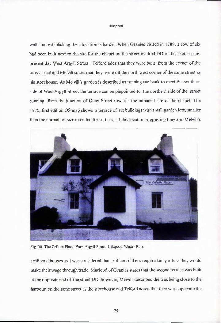
Ullapool
walls but establishing their location is harder. When Geanies visited in 1789, a row of six
had been built next to the site for the chapel on the street marked DD on his sketch plan,
present day ^Vest Argyll Street. Telford adds that they were built from the corner of the
cross street apd Melvill states that they were off the north west corner of the same street as
his storehouse. As Melvill’s garden is described as running the bank to meet the southern
side of West Argyll Street the terrace can be pinpointed to the northern side of the street
running from the junction of Quay Street towards the intended site of the chapel. The
1875, first edition OS map shows a terrace of six buildings with small garden lots, smaller
than the normal lot size intended for settlers, at this location suggesting they are Melvill’s
Fig. 30. The Ceilidh Place. West Argyll Street, Ullapool, Wester Ross.
artificers’ houses as it was considered that artificers did not require kail yards as they would
make their wage through trade. Macleod of Geanies states that the second terrace was built
at the opposite end of the street DD, however, Melvill described them as being close to the
harbour on the same street as the storehouse and Telford noted that they were opposite the
76

Ullapool
Fig. 31 Cottage. Red Row. West Argy ll Street. Ullapool, Wester Ross.
pier (fig. 8). It therefore seems most probable that Geanies meant EE not DD and that they
were in a row extending uphill on the eastern side of Quay Street from the end of Morrison’s
store house, marked L and opposite Melvill’s storehouse. This is by no means certain but is
supported by the 1875 OS map which shows another row of houses in this position with
out proper garden lots (fig. 9).
All ten houses were covered with pantiles and floored with coarse unequal flagstones.
The walls were covered with lime and with two windows either side of a central door, all
considered of reasonable quality. Again the use of timber lintels was criticised, especially
over the hearths as a fire risk, though luckily for Melvill this was not actually the case as
peat fires do not spark and wooden hearth canopies had long been used in the Highlands.36
Telford was concerned that the floor level of the interior of the houses was level with the
ground outside rather than raised eighteen inches as specified in the plan as this would lead
to damp and possible flooding and drainage ditches were ordered to be dug around the
77

Ullapool
houses and tfye moss cleared. Though again Melvill refused to bear the cost of this silently
and overcharged claiming the fault was Aitken’s for laying out the streets on heavy moss.37
The roof frarpes were made of foreign timber couples with lath and plaster ceilings and it
was pointed out that it would have been of greater utility to have either left the rafters
exposed for storage or to have floored the ceiling properly and created a loft with an
internal stair pr ladder. Melvill claimed the cost was prohibitive. Of the six houses built by
Melvill on West Argyll Street several remain today, the first house remains fairly unaltered
and is now the Ceilidh Place Coffee Shop, the second was rebuilt in the 1980s to form a cut
away roof terrace restaurant and the third and fourth were extended in the mid to late
nineteenth century to include attic stories (fig. 30). A further two original houses remain to
the east of the church (fig. 31). Houses one, five and six are converted single storey
cottages and the front elevations have Miller’s dimensions, 22 ft long and 7 ft high in the
walls, as planned by Miller they are the simplest type of two room improved artisans cot
tage, meagre as Macleod of Geanies put it, with two gable end hearths, two small, four
pane windows which are deeply recessed into the wall, and a central front door.38 Although
slated today the local name for this row is “Red Row’; clearly derived from Melvill’s red
pantiled roofs which were still in some evidence in living memory of the older residents of
Ullapool. Melvill’s four other artificers houses on Quay Street have been subsequently
rebuilt as much larger two and a half story houses.
Robert Melvill’s House
Little is known of Melvill’s own house, besides the cost of £100 paid for by the Soci
ety. Despite tfre Society’s funding it was considered a private dwelling so was not subject to
either report ppr discussed in Miller’s initial submissions to the Society. Macleod of Geanies
notes simply that in 1789 the foundations were laid and the walls only raised to a height of
two feet and by 1790 Telford merely observes that the house was still incomplete but
78

Ullapool
Fig. 32. Old Ullapool Manse. Shore Street. Ullapool. Wester Ross.
inhabited. However, when Melvill died in 1808 his house was put up for by public auction
in Tain to cover his debts to the Society and the advertisement of sale in the Inverness
Journal provides the only surviving description:
The commodious and very substantial dwelling house in Ullapool, consisting of parlpur, housekeeper’s room, a large cellar, kitchen, with large pantry in the Dutch style, on the ground floor; dining room 24 ft by 15ft and 11 ft 9 inches high, three bedrooms, two bed closets, and a large pantry, with a light closet, on the second floor; light closet, and three bedrooms in the garret floor. Attached to the house are a kitchen, servants room, and light closet, a large poultry garden, hen house, with a garden of nearly two acres of excellent soil enclosed with a high stone wall.39
A two and a half story house, built of stone and harled with a tiled roof, probably of
the plain, three bay symmetrical form typical of the period. Macleod of Geanies’ sketch
plan shows that the house, marked K, was located on the lot to the immediate west of the
red herring house (fig. 8). The house was set back from the street with a small front garden
79

Ullapool
plot. Ornsay House, stands in the same position today but although of typical symmetrical,
two storey, three bay form and built of harled stone it is not Melvill’s house. Melvill’s house
did not sell apd was kept on begrudgingly by the Society with only minor repairs made and
was probably demolished to make way for the extant house which is the Ullapool parish
manse built to a design by Telford in 1817 to complement the new church.40 The present
M-gabled manse also differs slightly architecturally from Melvill’s house, it does not have
garrets or a kitchen wing as described in the sale advertisement nor do the gables have
stone skews as in Melvill and Miller’s other buildings, but the similarity of overall design
means that the Shore Street streetscape Is still recognisable as that of Melvill’s time (fig.
32).41 A side effect of Melvill’s domestic arrangements is that along with building his house
he had enclosed a huge garden in the ground behind his house, extending along the backs
of the red herring house, shades (covered work areas) and storehouse as well as a 198 ft
further towards the river of Ullapool andback up thebarik to Argyll Street. Melvill had no
remit to enclose such a large area which took up some of the best ground for building lots
in the settlement, and in doing so created a vast gap site in the middle of the village. The
first edition, 1875 OS map shows that though subdivided into smaller lots, including the
glebe, there yvere still no buildings in this area. Melvill had once again managed to distort
the Society’s plans for a regular, neatly laid out village (fig. 9) 42
Church and Schoolhouse
In the spring of 1789, prior to Macleod of Geanies’ visit in August, Melvill visited
London and was granted a further contract to build “a suitable school house to answer
occasionally for a chapel and a house for the schoolmaster”, neither of which exist today.43
The chapel was replaced with a standard, plain gothic Parliamentary Church in 1833, which
is currently the home of the Ullapool Museum on West Argyll Street.44 Some information
on these earlier buildings is provided by Telford’s 1790 report. Telford was conducting a
80

Ullapool
surveyor’s report so does not describe the buildings but whether they meet the contract
specification? and what alterations or further work was required though it is probable that
the schoolhouse was a simple gabled building similar to a storehouse but of smaller dimen
sions. The school house was built of good masonry but like Melvill’s other works was not
properly harlpd outside and needed plastering inside. Typical for Melvill’s work, the pulpit
and pews wejre of shoddy manufacture, the ceiling needed to be properly lathed and plas
tered, the porch properly finished and a fireplace and two wooden galleries to be installed.45
Macleod of Geanies helpfully provides the location as being on the west side of the street
marked DD, present day West Argyll Street, adjacent to the artificers houses. As Melvill’s
garden ran up to the southern edge of the street the church and schoolhouse must therefore
have stood op exactly the same site as the Parliamentary Church. By 1792, the pulpit had
been moved from the gable end to the centre of the church; Melvill had replaced three of
the pews and the galleries had been contracted for with John Gillanders, wright of Ullapool.
The schoolmaster’s house, was of the same dimensions and model as the artificers’
house which Macleod of Geanies considered “too mean and incommodious for a clergy
man and his family to be comfortable and happy, “although the incumbent missionary was
himself apparently quite satisfied.4* The house, or rather cottage, had a chimney and fire
place at both gable ends and a wooden loft had been installed with a staircase running up to
it. Telford drew up a plan in 1791 for a proper manse but this was rejected by the Directors
who instead instructed for the cottage to be replastered and whitewashed it being their
opinion that jt “has a good kitchen and parlour with a small middle room and very good
garrets with proper floors, perhaps some rendering and beam filling is wanted in the garrets
and he will be able to live clean and decent”.47
81

Ullapool
Pier and Breakwater
On Melyill’s 1789 visit to London he had urged the Directors that a pier and breakwa
ter that had been postponed the previous year was essential, arguing that “the surf at present
comes with such ferocity upon the beach as to make it utterly unsafe and impractical vio-
Fig. 33. Sketch Plan of Ullapool Harbour. 1854, NAS RHP4286 (photo: National Archives of Scotland).
lence during a great part of the year for vessels of any kind to lie or land there”.48 The
Directors accepted his advice and plans for a pier and breakwater were drawn up by Sir
John Call, one of the Society’s Directors and a former military engineer, and a site was
chosen opposite the main cross street that led up the bank as orginally planned by Aitken,
and approved by Melvill. The Society advertised for contractors but when none were forth
coming the contract was granted to Melvill himself shortly after his return to Ullapool.49
82

Ullapool
The pier and breastwork, marked F on the sketch map, were well under way by the time of
Macleod of Geanies and McLarin’s visit and McLarin issued Melvill with a certificate of
executed work to date but on discussion with several passing ship masters they agreed that
the pier was too short for vessels to come along side and that the planned breakwater
should be reduced in width from 32 ft to 28 ft to allow vessels to pass safely between it and
the pier. Telford, however, on surveying the completed work the next summer considered
the extended pier to be too long at 136 ft. He was also of the opinion that Melvill had no
justification fpr extending the length of the breakwater by 18 ft and that he, Melvill, was
liable for the extra cost, a debt that was to remain unpaid on his death. Telford was also
quick to notice that due to the soft bed of the loch the foundations were sinking and
spreading and thus ever increasing the amount of stone required and consequently the cost
(fig. 33). Telford contested Melvill’s £4,629.7.9 bill for both works as Melvill had used
nearly one hundred cubic foot of masonry more than agreed and was also to blame for
building the breakwater in deeper water than necessary, a situation brought about by the
pier being too long. Telford also drew up plans for the sides of the pier to be clad with
wooden planking to save wear on ship’s sides and ropes and to dig a basin 40 ft wide on
both sides of the pier, shored up with planks and pilings, to provide deep water berths for
ships alongside. Sir John Call approved Telford’s subsequent plans for a 60 ft stone breast
work and single basin to be built around the pier (fig. 34).50 However, as with Telford’s
revised town plan for Ullapool no action was taken and in 1791 Melvill was still in dispute
over the bill for the initial work and for not providing wooden defenders as agreed. The
Committee of Directors authorised the agent at Ullapool to immediately employ masons to
build a breastwork, but not a basin in 1792. Mr Gillanders, who was involved with the
Society at Lochbay, was contracted to carry out the work but the work was indefinitely
postponed wjien the Society decided to commission the civil engineer John Rennie to carry
out a proper survey of the site.51 The problem was, however, a fundamental one, the pier,
breakwater and breastwork were never a real success as the narrowness of the gap between
83

Ullapool
Fig. 34. ThomasTclford. Sketch plan for a harbour basin at Ullapool, 1790.NAS GD9/3/330 (tracing taken from original).
the breakwater and the pier was a navigational hazard and the position of the pier itself in
relation to the river of Ullapool caused a dangerous build up of shingle around its base. This
had been antiepated by Morrison of Tanera when he visited Lochbroom in 1788 before
submitting his initial estimates to the Society but he had been over ruled by both Aitken
and Melvill who felt his suggestion to have the pier further to the east would be inconven
ient and spoil the line of the village.52 The original pier and breakwater were rebuilt in 1854
and have been altered several times since, most recently in 1992.53 Seriously over budget,
overdue, poorly built, in the wrong location and never satisfactorily completed, the pier at
Ullapool was not a good start to the Society’s building programme and remained a sore
point that wpuld effect future pier programmes at Lochbay and Tobermory.
84

Ullapool
Robert fyfelvill was the principal contractor at Ullapool and his influence on the town
grew until the Committee of Directors referred to him as the “little Emperor of Ullapool, in
whose own realm not even Napoleon held such sway”. Through his ambition, refusal to
accept criticism and lack of experience in building works he managed to single handedly
permanently influence the built environment of Ullapool for the worse. The Directors of
the Society are not without blame either, being too eager and inexperienced themselves in
building matters to put their trust for such a large undertaking in the hands of one totally
unqualified man. This would be a lesson they would not forget and which instilled in them
an over cautipus attitude with regard to contracting that would seriously effect the viability
of the settlements, especially at Lochbay. Fortunately, however, Melvill did not secure the
contract for the two principal buildings at Ullapool, the great storehouse and the inn.
The second contractor at Ullapool, Roderick Morrison, first came to the attention of
the Directors in April of 1787 when his partner John Mackenzie of Bishopsgate, London
had responded to the Earl of Breadalbane’s circular letter of that February recommending
Lochbroom.54 Mackenzie had informed the Directors that Morrison had run their fishing
station on the Isle of Tanera in Lochbroom since 1784 where they had erected warehouses
for salt and casks, five smoking houses and a pier.55 The Directors invited Mackenzie to
their Committee meeting on 17th April “in order to discuss his establishment on Tanera”
but Messrs Morrison and Mackenzie were ahead of the Society, they had seen the adver
tisement for contractors and had drawn up plans and estimates in advance of the meeting.56
The Directors considered their proposals “not unreasonable” and requested that the part
ners submit more detailed plans, elevations, measurements and estimates and instructed
that in the meantime they should take steps for providing the materials “in such a manner as
if a contract had been entered into” and plans, materials and labourers were all assembled
waiting word from the Directors within two months.57 Ironically, in his rejected proposal
for the pier Morrison had argued that the pier should be located to the south of the village,
85

Ullapool
as the beach directly in front of the site was composed of shingles on a bed of clay that
would cause the foundations to spread, and for shingle to build up to the sides preventing
access for vessels.58 His proposals for the curing houses were also passed over in favour of
Melvill but his plans for an inn and great storehouse were accepted. A fair divide of the
available contracts, as though Morrison only won two they were the larger and more pres
tigious.
The Inn
Morrison’s proposal was for a two storey building, 46 ft in length, 20 ft wide and 18
ft high, “built of stone and lime, roofed with slate, lofted and divided into apartments all
with doors and windows and two wings also of stone and lime, one for the kitchens and
servants the other as a byre and hay loft”.59 As before, Morrison’s plans were sent to
Robert Mylne for consideration, for which Mylne was given “a vote of thanks” for his
“several emendations and attestations to the plans of the buildings proposed at Ullapool”,
when presented to the Board of Directors on 5th May 1788.60 Mylne greatly preferred
Morrison’s plan for the Inn to that proposed by the contractors for To'bermory and recom
mended that Morrison’s plan should be used there. This would suggest that the Ullapool
inn was therefore of similar design to that at Tobermory, which had two flanking pavilions
even though in the end Mylne actually provided his own plan for the Tobermory. Mylne
made “several alterations to Mr. Morrison’s plan for the Inn at Ulapul”, in particular, “He
[Mylne] has made a new elevation and section of the Inn... only enlarging the Inn by addi
tion of a sunk storey and drawing it’s wings closer up to the body”, again indicating the use
of pavilion wings. This layout is confirmed by Telford, who tells us that there were three
parts, viz. the main house, the kitchen wing and the stable wing with a large walled court
yard to the rear. Both wings are described as adjacent to the main house of two and a half
storeys and linked directly to the house via the waiters room and stores.61 A two storey,
three bay symmetrical building with attic and flanking single storey wings would have been
86
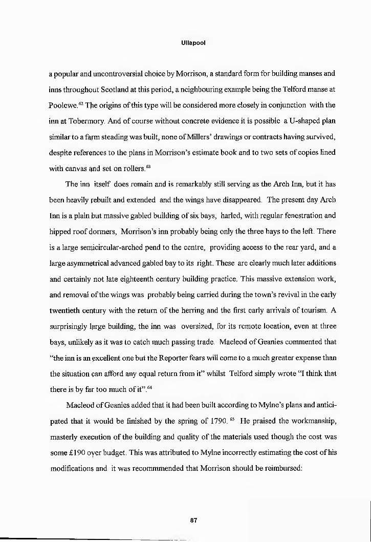
Ullapool
a popular and uncontroversial choice by Morrison, a standard form for building manses and
inns throughout Scotland at this period, a neighbouring example being the Telford manse at
Poolewe.62 The origins of this type will be considered more closely in conjunction with the
inn at Tobermory. And of course without concrete evidence it is possible a U-shaped plan
similar to a farm steading was built, none of Millers’ drawings or contracts having survived,
despite references to the plans in Morrison’s estimate book and to two sets of copies lined
with canvas and set on rollers.63
The inn itself does remain and is remarkably still serving as the Arch Inn, but it has
been heavily rebuilt and extended and the wings have disappeared. The present day Arch
Inn is a plain but massive gabled building of six bays, harled, with regular fenestration and
hipped roof dormers, Morrison’s inn probably being only the three bays to the left. There
is a large semicircular-arched pend to the centre, providing access to the rear yard, and a
large asymmetrical advanced gabled bay to its right. These are clearly much later additions
and certainly not late eighteenth century building practice. This massive extension work,
and removal of the wings was probably being carried during the town’s revival in the early
twentieth century with the return of the herring and the first early arrivals of tourism. A
surprisingly large building, the inn was oversized, for its remote location, even at three
bays, unlikely as it was to catch much passing trade. Macleod of Geanies commented that
“the inn is an excellent one but the Reporter fears will come to a much greater expense than
the situation pan afford any equal return from it” whilst Telford simply wrote “I think that
there is by faj* too much of it”.64
Macleod of Geanies added that it had been built according to Mylne’s plans and antici
pated that it would be finished by the spring of 1790.65 He praised the workmanship,
masterly execution of the building and quality of the materials used though the cost was
some £190 oyer budget. This was attributed to Mylne incorrectly estimating the cost of his
modifications and it was recommmended that Morrison should be reimbursed:
87
Ullapool
In the infancy of the Society’s undertaking a man who has executed the plans laid before him with so much propriety and had the spirit to launch out his own money trusting entirely for reimbursement of a part to the justice and honour of the Board ought not to suffer from so well founded a confidence... The Reporter has little knowledge of Mr. Morrison but feels a real pleasure in reporting merit where it is due.66
Telford concurred with that the workmanship and quality of the materials are gener
ally excellent and accepted that Morrison was disadvantaged by the isolated location and
the consequent difficulty and expense. However, he did not accept that the shortfall in the
finances is the fault of Mylne but rather a direct result of Morrison not being a trained
architect. This was a significant comment at a time when architects, surveyors and engi
neers were beginning to assert their individual professional status against that of the builder
or gentleman dabbler. Telford accepted the honesty and industry of Morrison but further
accused him of long absences due to other business interests when proper supervision was
required, “leaving the works at Ullapool under the charge of workmen not interested in its
success and the materials open to pilfering of not only the workmen but the other inhabit
ants”. Of the finished building Telford made two specific criticisms. First that the chimneys
in the kitchen and principal apartments smoked excessively which he attributed to poor
execution of the flues, recommending that grates were provided:
Grates- the cheapest and best are made at Carron, all of cast iron. Three bars horizontally stacked at front of the grate which is some one foot above the floor. For the two rooms with tin fenders flanking the grate as a surround . For all the bed rooms there are a sort with small fronts, long and narrow. The fronts are all cast iron in one piece and there are looses bars which are built in the brickwork and these should do for all the rooms except the two lower ones the principal house and one up stairs in the kitchen wing which should have the first sort. These grates might be had I should think either from the east coast or else down on the west coast.67
The agent bought three grates that winter which were installed in the dining rooms
and the room above the kitchen though the problem with smoke persisted when the wind
was from the south and earthenware cans were later ordered from Prestonpans, East Lo
ss

Ullapool
thian. Telford’s second criticism being that the sash and case window frames did not have
weight and pulley mechanisms to prevent them “falling down with great violence when
once lifted up” creating a continual expense for replacement panes. He was astounded that
such a practice was common in the area, Telford himself had travelled from the south where
the evolution of the sash and case window was in advance of the remote Highlands. The
agent agreed with Telford that “the windows will be better with catches and will immedi
ately write to Cowie to get it done”. Several of the numerous windows were also ordered
to be closed up:
I think that some of the windows may be spared in order to lessen the number whi<?h is intolerable and I will state those I have thought of I think that one window may do in each of the end garrets in the large house, the two small closets in the yhamber store may be dark closets. This will save four windows in the large house. In the kitchen wing the window on the right hand side of the fireplace in the east room upstairs maybe spared and the one in the small closets joining the stairs, one of the kitchen windows and one of the byre windows if there are two as in the plan. In the stable wing the one in the end of the hay loft and that in the closet. The necessary and pantry might likewise be done without an opening as the doors would give all the light wanted. In this way there would be; 4 saved in the a large houpe, 6 in the kitchen wing, 2 in the stable wing and 2 in the pantry and necessary a to|al of 13 and still there would be left I think 18 which is still too many.68
Alteratipns took place in 1792 with the provision of a public bar to the rear of the inn.
In a remarkable example of Georgian sensibility dictating over sense it was decided that the
oversized and underused Inn should exclude settlers and be reserved for the sole use of
gentlemen travellers. Telford agreed: “I think it will prove a desirable thing for both the
Society and the Innkeeper if the principle house should be constantly filled with reputable
people as to jnake it necessary to build another house for the lower class, I do not see how
a complete distinction can be made in the present building, because there should be sepa
rate doors, sitting rooms and bed rooms and all those in such a situation that no noise
made by one party should be heard by the other...”. He then recommends an extension
being built adjoining the end of the kitchen and along the existing courtyard wall, “...this
would be sufficient accommodation for all the class of person which ought to be kept out of
89
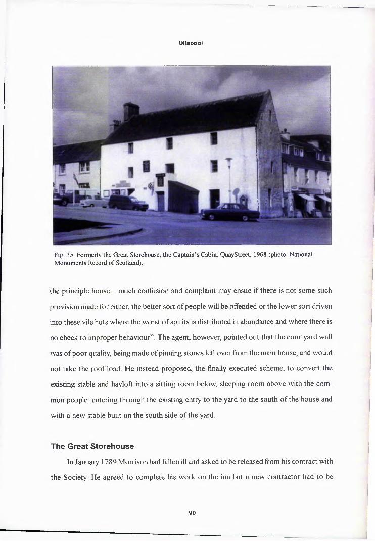
Ullapool
Fig. 35. Formerly the Great Storehouse, the Captain’s Cabin, QuayStreet, 1968 (photo: National Monuments Record of Scotland).
the principle house... much confusion and complaint may ensue if there is not some such
provision made for either, the better sort of people will be offended or the lower sort driven
into these vile huts where the worst of spirits is distributed in abundance and where there is
no check to improper behaviour”. The agent, however, pointed out that the courtyard wall
was of poor quality, being made of pinning stones left over from the main house, and would
not take the roof load. He instead proposed, the finally executed scheme, to convert the
existing stable and hayloft into a sitting room below, sleeping room above with the com
mon people entering through the existing entry to the yard to the south of the house and
with a new stable built on the south side of the yard.
The Great Storehouse
In January 1789 Morrison had fallen ill and asked to be released from his contract with
the Society. He agreed to complete his work on the inn but a new contractor had to be
90
Ullapool
found for thy great storehouse, marked L on Macleod of Geanies’ sketch map (fig. 8).
Macleod of Geanies was entrusted to appoint a new contractor and chose the master ma
son William £owie, whom he had used for work on his own house in Tain. The original
advertised specifications were to be adhered to for a warehouse of stone and lime with a
slate roof, three stories high with a cellar and 60 ft by 30 ft in plan. Work on the storehouse
was behind apd only the foundations had been laid when Macleod of Geanies had visited
Ullapool in 1789. Morrsion had attributed this to the persistently poor weather that had
prevented the start of the carpentry work and caused the initial shipment of lime to react
and catch fire in the rain sinking the delivery boat.
Under Qowie’s supervision by the time Telford arrived in 1790 the storehouse was
almost completed, the outside walls were finished except for harling, the floor laid, most of
the roof slated and the floor boards, doors and windows all prepared. Telford confirms that
the whole was executed according to Morrison’s plan, with a gable roof instead of a hipped
roof as suggested by Mylne. According to his description a stone stair ran up the outside to
the first floor with a wooden stair up the inside from that to the next storey and the garrets.
Telford thought this would be inconvenient for loading from the pier and ordered that
doors be opeped in the south gable end with a crane above. “A strong beam projecting out
15ft and 1 ft square fixed to the external wall with a strong iron hoop, strap and bolt and
alight roof oyer that part of the beam which projects without, being some 5 ft”. For this
addition Coxyie was paid £9.4.2. Telford, generally highly critical of the work of others,
was impressed with William Cowie:
The masterly and complete manner in which every part of the masonry of this building has been finished is I think the best I ever saw of the sort and the carpenters and joiners work is if possible still better, I never saw better work in any building and I think it my duty to say that Mr. Cowie deserves the notice of the Society in any further operation they may have to carry out, for the integrity he has discovered in this and further he is a very sensible and well informed man.69
The finished storehouse did not get the expected usage and plans were put forward by
91

Ullapool
Telford in 1791 for dividing the ground floor into a kitchen, small bedroom and scullery for
a spinning teacher and spinning school on the first floor with two storerooms for flax and
wool. Estimates were obtained from two Ullapool settlers, a mason John Mackay and a
wright John Gillanders but no action was taken. Of course, the chief deviation from the
original plan jhiad been when Morrison had been forced to lay the foundations of the south
east corner af an acute angle to meet Melvill’s street line.
The grept storehouse, designed by Morrison, modified by Mylne and built by Cowie is
remarkably iptact and unaltered today housing the Captain’s Cabin gift shop, having been
employed by the herring fishery up until the 1930s (fig. 35). The Society’s tall, stone walled,
gabled fisheries buildings at Ullapool are functional, practical buildings similar to store
houses, warehouses, mills and grains stores built throughout Scotland in the mid eight
eenth to mid nineteenth centuries, though there are obvious direct influence derived from
those he would have been familiar with at Dunbar and Leith; a ubiquitous building type
portrayed by Robert Naismith as a happy confluence of classicism and the traditional skills
of the Scottish mason:The larger mills and warehouses simply followed forms that had been in use in the Scottish burghs for centuries such as the three storey mill of Haddington of 1660 at Efaddington or that at Kirkwall from 1614. The eighteenth century builders freely borrowed the forms and details of earlier traditional building as they saw it at tlpe time. Their contribution, and it was an important one, was to reconstitute the ingredients into building types delightfully simple yet convincingly composed because the builders had the secret of near perfect proportioning, as well as the craftsmen’s variety in technique that has not since been surpassed. Their joint resppnse went far beyond the simple need to provide better shelter which had beep the main concern of their forerunners in the countryside. They were expressing (he artistic ideals of their time.70
This cap be seen in farm buildings of similar form, close to Ullapool in Wester Ross,
but which predate the Society’s arrival in the area, such as Bank Barn, Poolewe or Flowerdale
Bam, Gairloph, 1730.71 Though the relationship between the vernacular of the regional
mason and neo-classicism was perhaps more developed and direct in the late eighteenth
century than Naismith suggests through the circulation of builder’s manuals and pattern
92

Ullapool
books such as the Rudiments of Architecture, considered more fully in relation to the store
houses at Pulteneytown.
The Society’s final account at Ullapool was itemised in an advertised published in
1792 in ordef to attract settlers:
The Society’s settlement at Lochbroom is provided with the following accommodations for the benefit of all persons who shall settle on their land:1. An excellent harbour which is now improved by the addition of a pier and breakwater at the Society’s expense.2. A large storehouse from which the necessary stores for the fisheries will be sold to all settlers3. A school where an education is given to the children of the settlement.4. A church within the town of Ullapool5. A blacksmith’s shop and working house for a cooper6. A boatbuilders shed7. An excellent Inn72
Ullapool was for the most part created and built within the short space of five years,
1788 to 1793 (fig. 36). The Society was able to benefit from two pre-existing buildings, a
mill belonging to the former farm of Ullapool and a customs house, serving Isle Martin,
Fig. 36. Reconstruction of Ullapool, c. 1800.
93

Ullapool
later rebuilt, later rebuilt on Customs House Street.73 There were numerous later schemes
for enterprises such as a bakehouse, a spinning school, a permanent school house and an
attractively pprticoed, two storey bank house.74 As for the wider built environment, regula
tions were set for the laying of the village streets which are still discernible today, a drain
network was devised by Telford and the question of a permanent water supply was inves
tigated though remained unresolved in 1800 after plans had been rejected for wooden
aqueducts, laying pipes, digging wells and “an engine for bringing up water”. Whilst in
1792 the Society had agreed to go into partnership with Kenneth Mackenzie of Torridon to
build a road from Dingwall to Ullapool.
Despite the collapse of the herring industry through most of the nineteenth century
Ullapool suryived. As the Society Secretary observed the problem with Ullapool was not
the plan but it’s execution with a poor contractor, Melvill and a timid and inaccurate
Agent, Mackenzie:
It by no means struck me with so flourishing an aspect as I expected. The place has Jiowever made progress such as is on the whole by no means discouraging but rather the contrary all things considered. The houses for the artisans are wretched, it is lucky that he [Melvill] has not yet built further settlers houses as they would have deterred settlers [though] The Inn is a capital premises... Melvill carried on everything at Ullapool so much in the style of the sole master of the place that the ageqt was somewhat confounded... the sweeping importance of the Little Em- perqr of Ullapool has soured our purpose.75
‘Edinburgh, SRO/GD9/3/17
Edinburgh, SRO/GD9/3/20.
’3 DG Lockhart to MM, 6 September 1996, Mull, MMA
4 J Dunlop, The British Fisheries Society, John Donald, Edinburgh, 1978, 47
Edinburgh, SRO/GD9/4/29-35
94

Ullapool
6Edinburgh, SRQ/GD9/4/18. Dunlop, The British Fisheries Society, 46
7 Dunlop, The British Fisheries Society, 47
8J Dunlop, “PqKeneytown and the Planned Villages of Caithness”, in J R Baldwin (ed), Caithness a Cultural Crossroads, Edina Press, Edinburgh, 1982, p 131.
Edinburgh, SRQ/GD9/3/75. Melvill was to be offered a subsidy to establish his business in a deprived area in a similar scheme to those offered by government Regional Development grants today. For their part the Society believed that for a single outlay it would gain the entire business infrastructure necessary for the settlement to prosper, this would save them a lot of time and expense in advertising and contracting for the works and for merchants.
’Edinburgh, SRO/GD9/3/37
10Edinburgh, SRO/GD9/1/218 & GD9/3/37. Mylne’s principal patron being the Duke of Argyll, for whom he had carried out various commissions at Inveraray. For details of Mylne’s works at Inveraray see Lindsay, I.G, Inveraray and The Dukes of Argyll, Edinburgh University Press, Edinburgh, 1973
“Edinburgh, SRO/GD9/4/87 & GD9/4/107
' ’Edinburgh, SRO/GD9/4/63
13 Dunlop, The British Fisheries Society, 49
“Edinburgh, SRO/GD9/4/65 & GD9/4Z68
15A Fenton, Building Construction in Scotland, Edinburgh, 1976, 45.
“Dunlop, The British Fisheries Society, 50
“Edinburgh, SRO/GD9/4/68
“There being a notable absence amongst the Society’s papers of plans and contracts relating to works at Ullapool.
“Edinburgh, SRO/GD9/3/617
2027 J Dunlop, The British Fisheries Society, John Donald, Edinburgh, 1978, 194
2'Edinburgh, SRO/GD9/4/315
22Edinburgh, SRO/GD9/3/617
“Edinburgh, SRO/GD9/4/107
“The high cost of building timber due to the necessity of importing if any great expanse was intended, lead to many improving landlords, including the Society at Ullapool and their neighbour Lochbroom Kenneth Mackenzie of Dundonnell laying aside land for fir plantations. See E Beaton, “Building Traditions in Lochbroom and Gairloch Parishes”, J R Baldwin (ed), People and Settlements in North West Ross, Scottish Society for Northern Studies, Galloway Gazette, Newton Stewart 1994, 171
“Edinburgh, SRO/GD9/3/607
95

Ullapool
26Industry of the Lothians, Royal Scottish Geographic Society, Department of Education, HMSO, 1971
27A handful of pantiled houses survived through to the early twentieth century and fragments of pantile can be found throughout the village pinning garden walls and mixed with the pebbles on the beach around the harbour.
28Edinburgh, SRO/GD9/4/29 & GD9/3/151. J Munro, “Ullapool and the British Fisheries Society”, People and Settlements in North West Ross, 255
29Edinburgh, SRO/GD9/3/105
30Edinburgh, SRO/GD9/3/131
31Edinburgh, SRO/GD9/32/3
32Edinburgh, SRO/GD9/32/3
33I Maxwell, I, ^Building Materials of the Scottish Farmstead”, SFBWG Regional and Thematic Studies No 3, MDPrint & Design, Edinburgh, 1996, 12
34Edinburgh/GD9/32/5
35A much maligned but intelligent modernisation of the building, as a smoke house the building had few windows making internal lighting a problem for reuse. The simple slice of plate glass wall, sparsely modem, sits well with the austere simplicity of the original design.
36A Fenton, The Hearth in Scotland, MDPrint & Design, Edinburgh, 1981
37Edinburgh, SRO/GD9/3/106
38R J Naismith, Buildings of the Scottish Countryside, Victor Gollancz, London, 1981, 135
39Dunlop, The British Fisheries Society, 143
40Thomas Telfofd, Atlas to the Life of Thomas Telford, Payne and Foss, London, 1838, 58
41R W Brunskil|, Handbook of Vernacular Architecture, Faber and Faber, London, 1971, 126
42Melvill’s gap site has caused problems to this day with the area becoming much coveted by developers hoping to build within the present Conservation Area. Source: Historic Scotland.
43Edinburgh, SRO/ GD9/3/192
44Beaton, Building Practices in Lochbroom, 159
45Edinburgh, SRO/GD9/3/132
46Edinburgh, SRO/GD9/620
47Edinburgh, SRO/GD9/3/68
48Edinburgh, SRO/GD9/3/183
49Edinburgh, SRO/GD9/8/119
96

Ullapool
’"Edinburgh. SRO/GD9/4/385-410
“Edinburgh, SRO/GD9/4/400
"’Edinburgh, SROZGD9Z1Z218
53Plans for the 1854 rebuild incidentally providing excellent drawings of Melvill’s pier and breakwater.
"4Edinburgh, SRO/GD9/3/35. Dunlop, Ullapool and the British Fisheries Society, 245
55The ruins of t|iis complex can still be seen on Tanera.
’"Edinburgh. SRO/GD9/3/15
"Edinburgh. SRO/GD9/4/75
"Edinburgh, SROZRHP/4286
’"Edinburgh, SRO/GD9/4/76
""Edinburgh, SRO/GD9/3/37
"‘Edinburgh, SRO/GD9/3/140-147
"2E Beaton, Building Patterns in Loch Broom, 165
“Edinburgh, SRO/GD9/4/75
“Edinburgh, SRO/GD9/3/593 & GD9/3/627
“Edinburgh, SRO/GD9/3/630
""Edinburgh, SRO/GD9/3/600
“Edinburgh, SRO/GD9/3/54
“Edinburgh, SRO/GD9/3Z142
""Edinburgh, SRO/GD9/3/615
70Naismith, Buildings of the Scottish Countryside, 34
71Beaton, Buil^ngs Patterns in Lochbroom, 185
’’Edinburgh, SRO/GD9/3Z500
73J Munro, Ullqpool and the British Fisheries Society, 261
74E Beaton, Building Patterns in Lochbroom, 176
’"Edinburgh, SROZGD9Z32Z4
97

CHAPTER FOUR
Tobermory
The history of the building of Tobermory, the Society’s second settlement, lies in
complete contrast to that of Ullapool with every detail of construction and design com
pleted on time and on budget. The eventual appearance of the town can be attributed, as
with Melvill at Ullapool, to the all pervasive influence of one individual, James Maxwell,
the Society’s agent at Tobermory. And by one remove to the possibly unhealthy interest of
his true emplpyer the Duke of Argyll, whose concern for the settlement led him to appoint
his own highly regarded and highly valuable Chamberlain as agent. Although as a fishing
station Tobermory is generally considered a failure for the Society as it was located too far
from the fishing grounds when taken from a different perspective Tobermory was, and still
is an extremely successful, well planned, new town.1 The perspective of most relevance is
that of the fifth Duke of Argyll as, arguably, Tobermory from the outset was a personal
scheme of the Duke’s using the Society’s mandate and money. Putting to one side the facts
that not only was the Duke was the founding Governor of the Society but that he had also
offered his lapds at Tobr Mhor to the Society at such a low rate that they could not refuse,
despite it being widely reported that Mull was perhaps not the most practical location for
a fishing statipn based upon a small inshore fleet. It is intersting to observe that a village at
Tobermory was, on the other hand, extremely useful to the fifth Duke of Argyll as it held
a pivotal geqgraphic position at the centre of the northern Argyll estates, commanding
views of Ardpamurchan, the entrance to Loch Sunart, the Morvern peninsula from Drimnin
to Lochaline and the Sound of Mull towards Oban.2 Tobermory provided the Duke with a
strategic, administrative and business centre at the very heart of former Maclean territory
at a time when the Duke of Argyll was busy improving his estates and reissuing tacks
(leases) to Campbell tacksmen in favour of the former Maclean tackholders who had
98

Tobermory
rebelled with the Macleans in 1745 despite their legal overlord being Argyll and who could
never therefore be trusted.3 New mercantile success, as opposed to the fisheries, was also
guaranteed Joy the Sound of Mull’s convenience for shipping out of Oban, Glasgow,
Inveraray and the Western Isles and by Tobermory bay’s long established reputation as a
safe anchorage, still held by today’s leisure yachtsmen.
After offering the site, the Duke of Argyll’s personal involvement continued with the
appointment pf his own architect Robert Mylne to design the buildings and with instruc
tions to his Chamberlain to ensure that settlers were “friendly to my name”, echoing the
earlier orders of the third Duke in the 1730s “ to introduce tenants that are well affected to
the Government and my family” on Mull.4 It is with obvious delight that the Duke re
counted to Maxwell how he had met a boatbuilder and carpenter who wanted to set up
business at Tpbermory when he was on Mull in May 1788; “They had good characters and
one of them yvas a Campbell!”5
It appears that the Duke of Argyll deliberately co-opted the Society’s programme to
build himself an Argyll outpost, or regional capital and it was worth considering that during
the Society’s investigative tour of the West coast in 1787 the Duke had returned to Inveraray
immediately after he had provided the liveried banquet on the beach at Tobermory.6 Admit
tedly, the Duke of Argyll would not have made any direct financial gain from the mercantile
success of Tpbermory but this was part of the improvement and long term success of the
Argyll political empire with, the Campbell’s leading the way in the improvement of Scottish
Highland estates with the first enclosures, auction of tenancies, removal of subtenants and
of course the re-building of Inveraray. As Eric Creegan has argued, part of a wider Argyll
plan:
The fifth Duke, for all his love of economy and efficiency was a man of broad humanity. Whilst running his own highland estate... he saw that if the future of the highlands was to be other than that of a colonial territory, supplying raw materials and labour to the lowland industries, there had to be a master plan to channel the benefits of the industrial revolution into the highlands... he discouraged emigration as a solution, advocating instead the fullest exploitation of highland
99

Tobermory
resources.. .The new role of the house of Argyll was that of protector and leader to the whole area.7
Cregeen continues to point out that the Dukes of Argyll had always managed to com
bine improvement with advantage for the Campbells with a persistent clannishness suppos
edly forgottep in the wave of improvement after 1745. For example, it is interesting to note
that all new magistrates appointed in Argyll between 1770 and 1800 were Campbells as
were all the pirectors of the various spinning, whaling and planting enterprises that emerged
in the west highlands at this time. As with the appointment of Maxwell on Mull a Campbell
monopoly over local government and business was established.
The Isle of Mull itself was also central to Argyll policy. In 1780 despite changes in
tenancy over a third of farms remained in Campbell hands - colonists installed by the third
Duke to suppress the conquered Macleans, but many were threatening to leave the island.
This was a epneern to the Duke, as through lease auctions some of the native Maclean
gentry were regaining their lands and this threatened to affect the Duke’s control over the
peace and justice of the whole region. The foundation of a village by the Society offering
land on cheap secure leases would relieve the problem of overpopulation faced by every
improving landlord but also came to the aid of the Campbell tacksmen who had lost their
leases at auction and threatened to emigrate taking their sub-tenantry with them. Argyll
policy regarding Tobermory is explicitly clear on this point, in a letter of April 1789 from
Maxwell to the Duke of Argyll, Maxwell notes that a meeting of the Duke’s tacksmen had
been arrange^ on Mull to discuss mercantile opportunities at Tobermory.
Such Argyll interest in Tobermory affected every possible aspect of the town’s foun
dation and growth, principally through the good offices of James Maxwell, a man far
above the Society’s other agents in terms of ability and social class. Correspondingly, the
building programme and executed architecture at Tobermory was exemplary and far above
that of Ullappol and Lochbay. The first, amusing entry for the building of Tobermory must
be that three weeks before the contract for the Mishnish land sale with Campbell of Knock
had been sent up to Mull for him to sign in April 1788, Robert Melvill, merchant of Ullapool,
100

Tobermory
had already applied to the Directors for the building contracts at Tobermory. The minutes
noted “Regarding Melvill’s proposal there is not the slightest chance of him getting the
Tobermory contract”.8 His application had been an unexpected outcome of the advertise
ments put in (he Edinburgh Evening Courant, Caledonian Mercury and Glasgow Mercury,
in February 1788, for contractors for various works at Tobermory on similar specifications
to those advertised for Ullapool, viz.
1. A warehouse to be employed partly as a Magazine for salt, nets, lines, meal and sucl) other stores as are required in navigation and the fisheries and partly as a placp of temporary stowage, till the time of sale of such cod, ling and herrings on the <poast shall cure. Such persons as may wish to contract with the Directors for the prection of the said warehouse, will please to take notice: that the building must be of stone and lime, and the roof of slate; that it must contain three stories and a cellar; that it’s dimensions must not be less than 60 ft in length; and that all the proposals must express the respective sums for which the proposer will complete the warehouse, on the supposition of its being 18 ft wide, 24 ditto, 30 ditto. It is proposed that this building shall be erected on the beach between high water mark and the foot of the adjacent hill
2. A breastwork along the beach...(of the length of 220 ft, of such a breadth as shal| render it perfectly secure; of such a height as not to be overflowed by the spripgtides; and in such a situation as shall afford, at high water, even in neep tide?, a depth of water not less than from seven to nine feet. Every proposal for this work must particularise the sort of masonry to be employed, together with the width of the foundation, also the width at the top).
3. An Inn, consisting of a parlour, and proper offices, and cellars below; and two stor|es, exclusive of that for garrets above- The walls must be of stone, the roof of slat^.9
Those offers taken more seriously were Messrs. Rodgers and Richardson of Stanley,
Perthshire who were offered five guineas per day to visit the site with a view to submitting
estimates “as he was a builder of considerable experience and character and likely to con
tract with the Society” and the firm of Stevenson of Oban who “deserved encouragement”
but needed some competition, as they were “already in possession of the little traffic at
Oban, as well as the building branch and if they were put in the same position at Tobermory
101

Tobermory
all rivalship apd competition would be excluded which would not be to the advantage of the
undertaking”,10 The work was divided between the two contractors and contracts signed
before the 1^88 parliamentary summer recess.11 Maxwell had also stressed the need for a
Customs House at Tobermory which the Directors agreed to add to the list of works,
providing they could arrange a partnership with the Commissioners of Customs.
The Storehpuse
On return to London in autumn 1788, the Directors announced that they had con
tracted with Rodgers and Richardson for the storehouse, having given them preferential
treatment to ^void the feared Stevenson monopoly, and it was the first building to go up at
the start of the 1789 building season.12 Whilst Rodgers and Richardson arranged for pro
vision of materials, meal, peat and shelter for their workers, their plans for the storehouse
were submitted to Robert Mylne for approval. Mylne considered that, “the design for a
warehouse of four stories and a loft wholly in the height of the roof is much too lofty for
that climate. The upper part of it would be dry, to be sure, but very troublesome for the
transmission of goods, in and out if it. To make warehouses serviceable and dry in the
lower parts, they should be raised in the first floor, a foot or 18 inches above all the grounds
adjoining and paved with dry, soft, absorbing materials. To compare it with the warehouse
or storehouse contracted for with Melvill at Ullapool, the price of £693, is reasonable
enough. For it ought to be £1000 and upwards if the circumstances of the materials are the
same in both pases”. Mylne’s recommendations were added to the storehouse contract with
provision for any extra cost, viz. lowering the storehouse by one storey, lining the ground
floor and putting up brick partition walls.13
As seen in Maxwell’s May 1789 plan, the storehouse was to be built close against the
bank, its bro^d side facing the harbour and was to be flanked by the Customs buildings to
create a court or works-yard.14 Work must have started prior to the Directors receiving
Maxwell’s plan as by early April the walls were “rising fast but it was necessary to dig
102

Tobermory
-mOTKsr
LUJJ
Fig. 37. James Maxwell, Sketch plan of Tobermory. 1791 (photo: National Monuments Record of Scotland).
through a bed of clay before reaching solid foundations'".15 And by May “the north end of
the storehouse is placed at a distance of 134 ft from the March burn of Mishnish and 80 ft
Fig. 38. William Daniell. Tobermory, July 13th 1815. pencil sketch. (photo:National Monuments Record of Scotland, permission to reproduce from A Brown).
103

Tobermory
back from thp front of the breastwork’. Maxwell wrote that “I have always been attentive
to the sufficiency of the workmanship and materials used in the storehouse which are sub
stantial and I am persuaded will be permanent”.16 In July Rodgers and Richardson were
paid the first instalment of £100 for work done and another £100 for timber, with the end of
the 1789 season seeing the storehouse roofed and the floors nearly completed. Maxwell’s
1791 sketch pf the harbour shows a regular, gabled, three storey building with a segmentally
arched door to centre (fig. 37). Maxwell also ordered several modifications to be incorpo
rated into the cost; the ground floor was to be paved with brick, drains were to be dug all
around and pross drains inside to prevent dampness, the staircase to be relocated to the
centre of the building facing the door, fireplaces installed at every level, three skylights to
enable the gajrets to be used for the storage of “articles of greater bulk than weight” and no
ceiling to the roof to gain more storage space, whilst all windows and doors were to have
proper cut stpne dressings. Telford was able to report in 1790 that:
I haye examined the plans, sections and contracts and surveyed the work along with Mr Mclnnes a Mason from Perthshire chosen and authorised by Rodgers and Richardson to settle the business on their part. We found that upon the whole the worfcs were executed in a sufficient and workmanlike manner and that the general dimensions and particular scantlings answered fully to the plan and contract.We next proceeded to ascertain the sum to be deducted on account of one storey being kept off the storehouse with the allowance for extra work, half the price for coalp and for the delay in taking the building off the hands of the contractor.... I regrpt that Mr Maxwell did not order four chimneys on each flat instead of two as the house could have been divided into smaller apartments....The whole of the exterior and interior harled, though not in the contract was in the original estimate A beam in front of the storehouse to have block added as in the original estiipate on Mr Maxwell’s request. The general balance is in favour of the contractors due to good reports from Maxwell and other gentlemen in the area and the adverse conditions faced due to the area and weather, especially with regards to tfje soft mud foundations... some concern that the wooden floorboards and doors will shrink in the summer as they are of unseasoned wood not deals properly seasoned.17
The storehouse was completed in under ten months, either side of the 1789 October
104

Tobermory
to April winter break. Minor alterations were made in 1792 when part of the ground floor
was partitioned off to create a King’s or bonded warehouse. Remarkably, the storehouse
was not only finished to the highest standard as approved by Telford but also on budget
including harling.18 The final appearance of the storehouse is confirmed by William DanielTs
1815 view of Tobermory, which clearly shows a gabled, three storey storehouse set back
from the harbour against the bank (fig. 38).
The Boatbyilders Shed
In March 1789 Rodgers and Richardson were awarded a second contract to build a
boatbuilders shed according to plans by Telford, ‘due to urgency rather than the reasona
bleness of thpir quote’.19 Work was to start on a site chosen on the left or south western
bank of the y/ater of Baliscate away from the proposed building lots along the quay and
where the bcfich provided a natural slipway. Telford’s simple plan for the shed shows a
single-storey building of three bays with a steeply pitched, piended roof and large doors ten
feet wide to the front facing the beach (fig. 39).20 As with the shades at Ullapool the roof
was to be supported upon four stone piers and two central timber columns one ft thick on
stone plinths, The walls were to be eight ft high and two ft thick, built of “whinstone laid
in lime mortar and pointed. In general composed of large stone of irregular shape and laid
as near one another as can conveniently be done”.21
However, by 1791 Maxwell reported that “nothing has been done to the boat builders
shed since thp walls were levelled three months ago” as Rodgers had become too involved
in contracts elsewhere.22 Work on the shed was taken over by the waiting tenant, David
Urquhart, fallowing Rodgers and Richardson withdrawal, and by March 1792 he was
slating the ropf himself.23 Urquhart was paid the outstanding balance of £25 but a year later
was trying to sell the business for want of work and the shed later lost its west end in a river
flood in January 1793.24 The shed can be seen in William Daniell’s View of 1815, adjacent
105

Tobermory
---- ---
.4^/
■ Ar^ ■•*** *^X«z z*
'*'•' 4» .»4W /*£ 4»W£*A»nsi>» .«v.v vt. .„„
rc *■ y X.,^, ,„,.^ t, . i«. ♦,6,-f*
Fig. 39. Thomas Telford, plan and elevation for boat builder’s shed at Tobermory, 1789 (photo: National: Monuments Record of Scotland).
to the group of later buildings at Ledaig, but was later demolished to make way for the
Tobermory pistillery buildings in the mid-19th century.
The Smithy
A smithy was also under consideration in April 1789 and the contract was again
awarded to Rodgers and Richardson for £110, to be completed by July 1790.25 With work
under way the first bill for £37 was submitted in July 1789 and the smithy was certified as
completed in a “good and sufficient manner” a month ahead of schedule in June 1790.26
Subsequently demolished, the only evidence for the location of the smithy is that the
boatbuilder’s shed was specified to be built ‘below’ the smithy, suggesting it was close to
the bank on the Ledaig side of the Water of Baliscate. This would follow the pattern also
106

Tobermory
adopted at Ullapool and Lochbay to build the smithy at a distance from other buildings as
a fire precaution. As no evidence survives describing the smithy it can only be speculated
that it was prpbably a small, single storey gabled cottage housing the smith and his family
as well as thp smithy itself, similar to that built at Lochbay.27
The Breastwork
Whilst tfre foundations of the storehouse were being laid in April 1789 the Directors
and Maxwell concurred that the next essential contract was for the breastwork, as “other
works cannot begin until it is up because of the great flux of the sea” though a pier was not
considered necessary at first and as Ullapool was proving pier building was a very expen
sive venture. Maxwell was ordered to contract for an initial length of 60 ft directly in front
of the storehpuse, built of rough stone laid in courses and bonded with mortar, five ft thick,
buttressed apd sloping back at a quarter height, the ground behind levelled with clay and
stones rammed and consolidated.28 The breastwork would leave only a distance of 36 ft
between the pea and the public buildings, therefore, the hill behind had to be cut back and
the breastwork moved forward 24 ft. Three estimates were submitted, a Mr Udney of
South Queenpferry at £3,039, Rodgers and Richardson at £1280 and Stevenson of Oban at
£384. Maxwell was ordered to contract with Stevenson in November 1789 and though the
final agreed price was £600 it was by far still the cheapest price and by December their
men had buil| to above the level of the tide, the whole to be completed by the first day of
November 1791,29 Telford further suggested that though the line laid out by Maxwell was
good the breastwall should turn into the Water of Baliscate to protect from the force of the
stream which was steep and forceful. The wisdom of this was proved when flooding pulled
down the boatbuilder’s shed over the winter of 1793 but the revised breastwall stood firm.
Stone steps were sunk into the wall in front of the customs house and cross drains dug
from the hasp of the bank and through the breastwork to prevent a build of water behind the
retaining wall. Maxwell reported in July 1791 that though the breastwork was a much
107

Tobermory
heavier job than imagined at the beginning, it was nearly finished, with the coping being laid
and most of the infill completed and by October the whole was finished at 700 ft long
‘executed with great strength and solidity’. The breastwall was by far the biggest undertak-
Fig. 40. Harbour front, Tobermory, Mull.
ing at Tobermory and was again completed within precisely two years, on budget and on
time (fig. 40),
The Pier
The subject of a pier at Tobermory became an ongoing issue between Maxwell and
Telford who argued that a pier was essential to the success of the settlements as the harbour
was otherwise exposed in foul weather and that there was not enough depth at the breastwall
for larger vessels and the Directors who were determined to wait and see that the traffic at
the settlement merited the huge cost. The idea of a pier was dropped as early as April 1789
when the breastwork was first discussed.30 It was again refused when Maxwell petitioned
108

Tobermory
them on the completion of the breastwork in 1791,31
However, they need not have been so prudent at Tobermory and when a pier was
eventually bqilt to a design by Thomas Telford in 1814 it was long overdue. There had been
much debate pf the form the pier should take ever since Langlands’ plan of 1788 where he
had propose^ two canted piers creating a large basin. Although, this is the scheme eventu
ally adopted by Telford at Pulteneytown in 1788 it was out of the question. Whilst the
mariner-conspltant to the Society, Captain Huddart, had recommended a curved pier. Then
came Maxwell’s 1789 town plan where he included a simple straight pier, extending some
100 ft, with it’s root at the far east of the breastwall, between the proposed sites for the
customs hou$e and the inn (fig. 5). Telford’s sketch shows the plan, elevation and section of
the 300 ft pier as built, with a parapet wall to the east side and a stair to the west of the
pier’s root. The eventual cost was £8000, half of which was paid by the Commission for
Highland Rpads and Bridges, built to design identical to that by Maxwell’s plan 25 years
earlier (fig. 4Q). A second pier ‘Sinclair’s Quay’ was built at Ledaig in 1820 and a third at
Mishnish to tjie east in 1864.
Customs House and Officer’s Lodgings
Despite not being in the advertised contracts, the third project to be undertaken was
the Customs House. A Customs House was first suggested by Maxwell immediately after
his appointment in June 1788.32 Having come from Campbelltown he knew that the pres
ence of a warranted officer to authorise the landing of cargoes and issue salt was absolutely
essential to the success of the settlement in attracting and then sustaining both settlers and
trade as would also prove the ease at Ullapool and Pulteneytown. In a most out of charac
ter concordance with the views of one of their agents, highlighting the unusual status of
Maxwell, the Directors immediately applied to the Treasury for the funds and warrant to
build a Customs House. In the first reply the Treasury stated it was reluctant to grant
109

Tobermory
permission uptil some real evidence of trade could justify it.33 However, following some
heavy lobbying by various Directors over the following months the Treasury had a sudden
change of he^rt in January 1789 and the Directors received a copy of a report from the
Commissioners of Customs of North Britain to the Lords of the Treasury stating that the
Commissioners found the aims of the Society were consistent with those of the Commis-
Fig. 41. Former Customs House, Post Office, Tobermory, Mull.
sion and that plans and estimates should be immediately submitted to them. A warrant was
signed by the Treasury in February and the Duke of Argyll ordered plans from Robert
Mylne according to the dimensions specified by the warrant contrived “so as to connect the
several buildings to the storehouse in order to give the whole an appearance of uniformity”,
viz. the U-plan shown on Maxwell’s plan of 1790 (fig. 5). However, having received Mylne’s
plan for the Customs House and Officer’s Lodgings they found his estimates were so high
that they requested Maxwell, increasingly trusted and depended upon in all matters relating
110

Tobermory
Fig. 42. Customs House, pavilion roof and rear elevation.
to Tobermory, to draw up a scheme of
his own. These were received in April and
thought ‘judicious and well adapted to
the situation’ and that ‘Mylne’s is the
more commodious and elegant but too
expensive’. In June the Treasury wrote
to the Directors agreeing that the cus
toms complex was to go ahead on the
terms that the Society would pay for their
construction and the Commission would then lease the buildings from the Society at 5% of
their cost and to pay for wages and maintenance. They did not require that the mason work
of the Customs House and Collectors Lodgings be elegant or expensive but of the most
common kind provided they were substantial. Neither did they require the finishing within
to be expensive merely that the walls were lathed to prevent dampness and plastered. The
Customs House was to have one room 20 ft by 18ft for the public office and another
similar room for a warehouse, two further rooms 16 ft square and two bedrooms, a kitchen
and garrets for the house for the Collector and his family Accordingly both plans were sent
to the Commissioners of Customs in Edinburgh ‘so they may chose their favourite’ and the
Society would concur with their choice “most cheerfully in every measure that may render
the buildings as little expensive as is consistent with solidity and sufficiency”.34 Inevitably
Maxwell’s cheaper scheme was to prevail. The contract was awarded to Stevenson of
Oban being the cheapest bid at £484.19.12 compared to Rodgers and Richardson at
£1188.0.8. Stevenson started the work in September 1789 and had built above the high tide
mark by Christmas whilst working on the breastwork at the same time. By the time of
Telford’s visit in June 1790 he was able to report that the dimensions and workmanship of
the Customs House were again ‘sufficient and workmanlike’; the roof was covered in, the
rooms lathed and the joiners and plasters were finishing off the apartments. Whereas the
111

Tobermory
Officer’s Lodgings had their side walls levelled with the roof and the floors, doors and
windows were ready for both houses. Overall he deemed that the works ‘had progressed
well’.35 In October 1790 Maxwell wrote to the Directors that the Customs buildings were
finished and plated. ‘Both with hipped roofs with two central chimney stacks. Arranged at
right angles tp the Storehouse to form a courtyard’.36 The Commissioners of Customs were
duly informed in April 1791 and the Officers installed in May with Stevenson keen to be
paid. Another building project under the supervision of Maxwell finished well and on time
though over jmdget at £972.6.7.
The design of these two buildings is again shown in Maxwell’s sketch of the town of
1791.37 Flanging the storehouse, the Customs House to the right and Officer’s Lodgings to
the right, they are identical 2-storey, rectangular-plan buildings with hipped roofs, central
chimney stacks, central doorways facing each other across the courtyard with regular fen
estration, as peen in William Daniell’s sketch. A more detailed idea of how the buildings
were fitted apd finished is provided by Stevenson’s expenses submitted on completion of
the contract. The walls were harled all over with freestone rybats to the doors, windows
and corners; freestone coped chimney stacks and hearths, the lobby and kitchen paved with
freestone flags, the roof slated with lead ridging and four glass skylights. There were weighted
sash and case windows, 11 pairs of bound window shutters, seven bound doors including
frames, locks and hinges, four deal doors to the garrets and pantry, two stairs of timber
containing 3? steps, three large presses in the office and three lined presses in the dining
room. All thp rooms had wooden skirting, washboard facing and belt rails and all rooms
were lathed apd plastered whilst the dining room is itemised as having architrave mouldings
and a plaster cornice.
These details are revealing as they show that beyond the basic form of the buildings
the level of finish is high with architraves, cornices, wall presses and shutters, yet these
buildings were to be completed in the cheapest manner possible. Maxwell found the work
‘satisfactory’ except for the door to the Custom House which leaked above the lintel. Of
112

Tobermory
this rather handsome complex of Customs Buildings and Warehouse only the Customs
House remains. Now serving as the Post Office, it has retained the hipped roof but lost a
chimney stacfc to the rear and lost its principal facade to the west, which has been obscured
by modern additions. The entrance is now through a door to the east side and the windows
to the street elevation have been replaced with bipartites. The Officer’s Lodging was de
molished in tfie late nineteenth century to be replaced with the Aros Hall.
The Inn
Novy that the breastwork, storehouse and Customs House are under fair way the inn yvill probably go up this season. It is a building that ought to be very particularly studied and attended to. As Tobermory will I have not the least doubt be a place of resort in a little time. Strangers will of course set the edge of their criti- cisn| upon the Inn in the first place. There seems to be an excellent inn and offices at Ljllapool, too good perhaps for the probable resort to that place, but not too good I should think for the numerous calls Tobermory may expect.
The Duke of Argyll to James Maxwell, 1st January 1790.
The inn was going to be the jewel in Tobermory’s, or perhaps the Duke’s, crown. As
at all the settlements, an inn was considered an essential building from the outset. Though
many works went on at Ullapool and Tobermory the initial advertised contracts for both
settlements vyere for a storehouse, a quay and an inn. In July 1788 Robert Mylne had
submitted his report and comments on the initial plans for an inn submitted by Rodgers and
Richardson. Jn this he simply observed that he preferred Morrison’s plan for the inn at
Ullapool to vyhich he added a few alterations of his own.38 By April 1789 the Duke argued
the inn should be “amongst the first buildings to go up at Tobermory”.39 At this time the
various plans and proposals for the Customs House were being considered by the Directors
and having chosen Maxwell’s simpler Customs House design they requested Mylne to
113

Tobermory
Fig. 43. Robert Mylne. plan and elevation for the inn at Tobermory. 1790 (photo: National Monuments Record of Scotland).
114
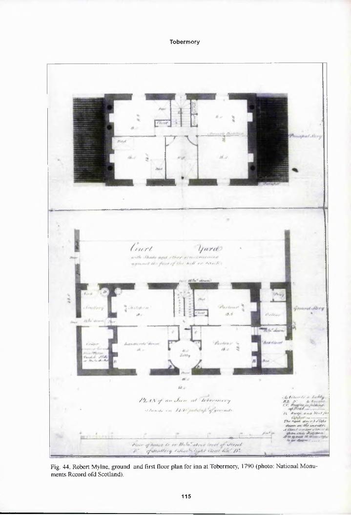
Tobermory
/f /< r/ Ijurrt
fUAl
IZU/.A-M
Z ■#•////
n-rftt ZZ<7 <-■' ft . . tm -fs.t
/t> ■ .<?.■/’ /,// <•>• Zl>>x, A
*» .is <
/>, / 1 / ft t» ^ftt ft /f tr r'+ft c-t y
•V ///A, </«. r Z? /.* ,yl .$/» .-■ "Z/r/'
™
.....„.,. ■,
/’/, • ' Z> zA ,/, , «ZZzxr/
sfiSfttMrrf afarSfaf ,)M-r K»‘'/)*
Z**/
, tf t <(•. ' < tl A.S!A 2f* A ft
Zi AftM -»x.* >A»Z/*» _. - ---------
JTfcr ^<*4 Azvr**f «Z2SH>* Jmiv* m t& •imxwOZ
.1 z <bu> Z r« >r «iz»r wZffr -OrZ 4A«m »#zA AWZ*««».#*><*(»»»*’4>><linr>e ,,.z..
Fig. 44. Robert Mylne, ground and first floor plan for inn at Tobermory, 1790 (photo: National Monuments Record ofd Scotland).
115

Tobermory
Of**
CtyfHJbti/ry
fstrnr/er-
fci/MrryRf/rAr/t *-4f. 0 V
O/Zr/1Z.<»/»zi54'v»& /itwwParAt»nr*ZoA^V
ZF • iz dirrt
Fig. 45. Thomas Telford, revised ground floor plan for the inn at Tobermory. 1790 (photo: NationalMonuments Record of Scotland).
116

Tobermory
submit his own designs for the Inn having admired his Customs House designs.40 As the
Duke of Argyll was the Governor and chair of the Board of Directors it is hard to discern
in the Board’s resolutions what was general opinion and what pushed through by the Duke
but it can be observed that at no other settlement was it considered necessary for the Inn to
be such a landmark. Mylne’s plan was finally approved by the Board of Directors in May
1790 and Thomas Telford was contracted to inspect the work.41 Telford was given
Mylne’s plan for the Inn and was to secure a contractor on site.42 Mylne belatedly submit
ted a final amended version of the plan late in May which was then forwarded to Telford
and approve^ by him as he travelled north. These final plans show the Directors had finally
given the go ohead for a two storey, three bay gabled building with stone skews and coped
gable chimney stacks (figs 43-44). Regularly fenestrated to the front with oculi to the gable
heads at the ^ides, to light the garrets, and three steps leading to a central fan-lit doorway.
Flanking the main body of the building were two single storey pavilions with blind arches
and ball finiat ornaments and a walled courtyard to the rear. The ground floor plan shows
the main door leading to a circular lobby 10 ft in diameter with wall presses leading through
a short, narrpw corridor to a central staircase at the rear of the building. Either side of the
stairs were dpors leading to the kitchen on the left, 18 ft by 11 ft 8 in, and a parlour to the
right, 13 ft 6 in by 11 ft 8 in, with a closet and bed recess on the left side of the room. A
room described as the Landlord’s Room was to the front left, 16 ft by 14 ft, but it was
reached via tl)e kitchen to the rear and a second parlour was to the front right, again reached
through the back room. The rooms to the front were of the same dimensions and both
rooms had recesses for folding beds occupying the cavity created by the returns of the
lobby walls. The pavilion wings formed an extended ground floor rather than offices reached
from the outside. Accessed from the kitchen on the left were a scullery leading to the cellar
with its own putside door. The pavilion to the right comprised a privy and cellar to the rear
accessed frorp outside with a bed closet to the front and door off the front parlour. The first
floor or Principal Story [sic] was divided into five bed rooms. Off a small central landing
117

Tobermory
were; a small square room, 11 ft in by 13 ft, with a recessed bed space to the rear left; a
larger room, 16 ft by 14 ft, with two beds to the left front; opposite the stairs to centre
front was a smaller room, 10 ft by 14 ft, with a single bed and canted comers either side of
the door to create a bowed press to the left and access space for a door to the other bed
rooms to the right; to the right hand side were two rooms, 16 ft by 16 ft, with an ingenious
moveable partition but no beds shown. The garret floor was also divided into further sleep
ing accommpdation, the space divided into thirds with large dormitory rooms filling the
roof space to both sides each with four beds. Whilst the central portion was divided into
closet space and a small central room with two beds lit by a skylight.43 On arriving at
Tobermory Tplford was of the opinion that:
The situation proposed for this building [the inn] as shown in the sketch to the Society by Mr Maxwell appears by much the most proper for it about the bay and upop considering the plan and adapting it to the situation we have made some inconsiderable alterations by reversing the arrangements of the apartments on the groqnd floor, in order to throw the kitchen and scullery into that end of the house which will stand next to the march burn of Mishnish and we have proposed to annyx an oven and some other conveniences as shown in the ground plan.44
Telford’p revised ground floor plan clearly shows this rearrangement, literally swap
ping the rooms over from right to left and adding a bake-house to the rear of the right
pavilion (fig. 45). He continued:
In the execution of this work we had the advantage of a competition between Rodgers and Richardson and Stevenson of Oban in consequence of it we have beep able to ascertain the lowest possible rate at which works of this sort can be executed at this place, the difference on the whole being in favour of Mr Steyenson...we were induced to prefer him to the contract also because he appeared to understand the plan better, to be fitter for the execution of it, and had plepty of well seasoned timber and boards in his yards which other people must have taken a considerable time to provide as well as to procure workmen which Mr Stevenson had on the spot. We have fixed conditions for the contract and in them he is bound to have the house covered in November 1790 and to have it completely finished by 1st May 1791.
118

Tobermory
Stevenson’s estimate was indeed the lowest at £626 and accordingly the Directors
decided to contract with him immediately.45 Other estimates submitted were Rodgers and
Richardson at £773 and Udney of Queensferry at £1,038. Maxwell was officially ordered
to draw up the contract with Stevenson at the end of June though it was not actually
signed until November when work was already well under way.46 Stevenson must have got
on with the vyork immediately but with only five months under his contract to have the inn
roofed though by October Maxwell reported that the Inn was still under construction.47
But work went well and by May of 1791 he wrote, “As the Inn will be completed in the
course of a month or six weeks it is time to look around for some fit person to keep it” 48
This puts the work a month behind schedule but finished at an impressive speed none the
less and at a final cost of £792.4.9, only £166 over budget. A Mr Walker was appointed inn
keeper at Tobermory on Maxwell’s recommendation in November 1791 and the following
spring Maxwpll ordered furniture to furnish the ground and first floors at a sum of £80.49
This arrived in August except for “a proper set of dining tables” which were still on order
and there are unfortunately no further details of the inn’s furniture. A proposal was made in
1793 for a stable block to be added and plans and estimates were drawn up by Telford but
the scheme \yas dropped when the Inn Keeper refused to pay extra rent.50
On the Duke of Argyll’s request the plans for the inn ‘soiled whilst in the hands of the
builder’ were sent to Inveraray. Maxwell included in the postal package a design ‘that
came to by accident into my hands and which with some improvement might be a good
house for a country gentleman’, labelled by Maxwell “plan of a house fit for a gentleman of
moderate fortune”. The Duke’s interest in the inn’s plans and their eventual resting place in
the family archives at Inveraray has ensured their survival as the only complete plans from
all the Society’s extensive building programme.
Supplementing Mylne’s plans, Stevenson’s contract and estimate give a fuller idea of
how the finished inn must have looked and are worth summarising:
Walls built of whinstone two foot six inches thick, laid and pointed with lime
119

Tobermory
mortar. Doors, windows, corners, skews, chimney pieces, hearths and chimney stacks all finished with squared free stone.. .Four arches and small ornaments on the puds of the sheds. The roofs covered with the best Easdale slates... All ridges covered with sheet lead...The roof couples of imported fir timber at least nine inches by three inches and one foot apart.. .The lobby, kitchen and passage in the ground floor paved with free stone flags, the cellar and scullery gravelled...All other apartments floored with deal boards one inch thick... Stairs of thirty six stepp with a fir hand rail and square baluster... Crown glass and painted sash frames witl| weights and pulleys for the windows.. Bound window shutters...The main doof with two folding leaves, flush bound and lined on the back with strong box locl^s and hinges... The inner doors in the lower stories to be bound on both sides witlj locks and hinges and those of the garrets of plain deal boards... All the closets qnd recesses finished with bound doors, locks and hinges, including the dining room closet eight feet by four feet with folding doors and shelves. Four pairs of foldjng doors for bed recesses. [These were for the folding down beds or press bedp in the parlour, landlord’s room, kitchen and right rear bed room on the first floof]... Inside walls and ceilings finished with two coats of fine lime plaster... All apartments with beaded deal skirting, wash boards and belt rails... The rear court- yarcj wall to be two foot six inches thick coped whinstone with a bound timber gatq with a lock... The oven wing to be of the same walling, slated with a pebble floof.51
An eveq higher standard of finish than the customs buildings and certainly genteel.
These specifications of the Inn compare favourably to an earlier Robert Mylne building,
Pitlour FIousp, near Strathmiglo, Fife, 1783, built for General Robert Skene. Pitlour was
designed as q country house for the General’s retirement as a country gentleman after a
career with General Wade’s Highland road and bridge building programme. The influence
of the Duke pf Argyll was again present as General Skene met Mylne whilst working at
Inveraray, l fie inn was meant to serve a similar clientele, a place to make the gentleman
visitor comfprtable and as Telford’s survey showed the workmanship was far superior to
Morrison’s Iqn at Ullapool.
The inn is just recognisable today as the town supermarket. It has been extended by
two bays to the left at some point in the nineteenth century losing the pavilion to that side
but reproducing the oculi to the gable head. The pavilion to the right remains though
without its filial and blind arcade, as does Telford’s bakehouse to the rear though unfortu
nately the ground floor interior has been completely gutted losing Mylne’s elegant circular
120

Tobermory
Fig. 46. Former inn. Co-Op supermarket, Tobermory, Mull.
lobby. Maxwell’s sketch of the town shows the inn next to the Customs House exactly as
in Mylne’s elevation including the ball fmials to the pavilions, however this was only a
projection by Maxwell from the plans as at the time of drawing the inn was still under
construction (fig. 5). Though Stevenson’s contract, for which he was paid for completing
in full as contracted, included the pavilions, blind
arches and finials and Williams Daniell’s 1815 sketch
of the harbour front confirms the presence of the
left oculi and pavilions (fig. 3 8).52
Robert Mylne’s inn at Tobermory was not
only above the criticism of visitors and superior to
the inn at Ullapool, as the Duke of Argyll had de
sired, but was the only frilly realised building com
missioned by the Society to have had any architec
tural merit above and beyond the requirements ofFig. 47. Inn. Tobermory, Side elevation showing former bakehouse to rear.
121

Tobermory
utility and ‘neatness’ for which the Duke of Argyll’s particular interest in Tobermory must
be attributed. Prior to the vandalism of the supermarket refit the inn was a ‘handsome’
building, practical, solid and substantial and perhaps more surprisingly, considering its sim
plicity, identifiably Mylne’s work (figs 46-47). However, the inn’s two storey, symmetrical
arrangement yvas certainly not unique being an established Scottish building type by the late
eighteenth ceptury.53 Numerous examples can be found throughout Scotland of plain, three
bay houses with a central fanlit door, symmetrically arranged windows and flanking single
storey pavilions. Across the Sound of Mull from the inn the Duke of Argyll’s tacksmen’s
houses on the Morvern peninsula provide close comparisons, with Mungasdale, Achleek
and Laudale all being of similar date and design (fig. 48).
Dismissing the possiblity of an acquired knowledge of geometric proportion amongst
Fig. 48. Laudale House, Morvern (permission to reproduce from Iain Thomber).
masons, Naismith has ascribed the prevalence of these plain but perfectly proportioned
buildings to “their [Scottish masons] natural instinct for disciplined thinking coupled to the
spirit prevailing in the eighteenth and nineteenth centuries for classical order and balance.... It
122

Tobermory
would not by beyond expectation to find that the builders of the Scottish countryside,
working in an age when order and balance were regarded as imperative, created well pro
portioned designs without effort... All if it down to earth and practical.”54 A tradition that
Robert Mylny, descended from a celebrated dynasty of Edinburgh Master Masons, would
have been wqll familiar with irrespective of his Italian architectural training.
However, Naismith fails to acknowledge that Scottish masons of the period, operat
ing at a level beneath that of the trained architect, were using published pattern books of
designs and builder’s manuals such as the Rudiments of Architecture, first published in
1772 (fig. 49).55 The Rudiments includes chapters on proportion, scale and trigonometry
as well as illustrations of the classical orders and designs for buildings and it is attractive if
unrpovable to argue that “although its five Scottish printings must have ensured that virtu
Fig. 49. Design X, Rudiments of Architecture (Photo: National Library of Scotland).
Fig. 50. Dalzell Manse. Motherwell, Lanarkshire
ally everyone engaged in building or land management must have had a copy, it was a hard
used book which was discarded when it was either completely worn out or finally became
obsolete from the 1840s onwards”.
The Church of Scotland built numerous manses from the late eighteenth century through
to the mid nineteenth the Church of Scotland built in this simplified neo-classical form,
such as Dalzell manse, Motherwell, North Lanarkshire, to attract learned ‘civilising’ minis
ters to remote Highland parishes (fig. 50).56 Such manses are often referred to as ‘Telford
Manses’ as he included plans and elevations of the type in his Atlas but Telford was merely
123

Tobermory
reproducing fhe long established form found in the Rudiments of Architecture. Similarly, it
is improbable that Mylne would not have been familiar with the Rudiments and the Tobermory
inn is noticeably similar to Design X except for the ornament to the wings.
It is Mylne’s ornament that elevates the inn at Tobermoiy above the generic. To the
centre of each wing is a semicircular arched niche with projecting cill. In Mylne’s design the
niches were to be low relief plasterwork but in his revised version Telford changed the
drawings to indicate actual recesses. Around each niche is a blind relieving arch to create
a single bay pf an arcade, the wall to the sides representing pilasters with a single string
course for the entablature level with the door head to centre. The parapets supporting a
central ball fipial counter the normally awkward difference in height between the gables of
the main block and the low pavilions. The single arched bay to the pavilions is taken from
Mylne’s earlier designs for Maitland Court, 1774-82, a riding school proposed for the
Duke of Argyll’s estate at Inveraray consisting of a five bay central block sporting a tetrastyle,
pedimented portico to centre with arcaded wings. Mylne utilises the arrangement of
Bramante’s spminal cloister of S. Maria della Pace, Rome, 1500-04, where the entablature
of the arcades runs into the central block to form the entablature of the giant order sup
porting the central pediment. This is the arrangement he also uses at Tobermory and is the
same as the sqreen wall at Inveraray, 1787. All Mylne’s works reflect an interest in Bramante,
notably the pprity of Bramante’s geometry and the refusal to ornament. Mylne must have
studied Brarqante during his time in Rome, 1755-59, later producing numerous schemes
for domed, cylindrical doocots as variations of Bramante’s Tempietto for the Duke of
Argyll. Agaip and again in Mylne’s work there is the same desire to strip away all unneces
sary detail a^ seen at Garron Lodge, Inveraray, 1777; Pitlour House, 1783 where the
arcade appears in the south terrace wall and later Inveraray Church, 1795. The arrange
ment and sca|e change but Mylne’s stripped, pure white, neo-classicical style is consisent.
The ‘fasti diops restraint’ in this severe form of neo-classicism developed by Mylne was
seen by Colvin as prophetic of the next generation of architects, exemplified by Sir John
124

Tobermory
Soane and Jphn Playfair, the origins of which were born in France and the designs of
Claude Ledoux.57 Macaulay goes so far as to suggest Mylne “had been turning his eyes to
France and in particular to the pavilion at the chateau of Louveciennes by Ledoux”.58 Whilst
this may be the case Mylne did not employ this restraint to emphasise geometric form and
massing like Ledoux and later Schinkel, his elevations and plans remaining resolutely
Palladian. Prophetic perhaps but Mylne was also rooted in history; Bramante, Palladio and
the more severe designs of Lord Burlington.
Mylne was very much an architect of his time and his particular style finds many
contemporary comparisons. Robert Adam chose the pared-down approach on occasion,
such as the south west elevation of Bellevue House, Edinburgh, 1774 or the west elevation
at Balavil House, Highlands, 1792.59 David Henderson’s 1775 elevation for The Whim and
unexecuted 1780 elevation for Caprington Castle also show a clear affinity with Mylne.60
As does much of Samuel Wyatt’s output. ‘Gentleman’s farm’ houses Kemp stone Lodge,
Norfolk, 1788 and Leicester Square Farm, Holkham, Norfolk, 1791 are of similar size to
the Inn at Tobermory and have pavilions or links and blind arches. Such simplicity suited
the steading as much as an inn in terms of both budget and architectural decorum, for
example: Bl^iruachder, Blair Atholl, Perthshire, 1777 by George Steuart; Parlington Home
Farm designs by John Carr of York or Samuel Wyatt’s Hatch Farm, Essex, 1777.
In terms of ground plan, the central staircase to the rear with rooms to each side front
and back was also typical of late eighteenth century Scottish house building as can be seen
again in Design X from the Rudiments of Architecture. A similar arrangement with par
lours and offjces, but no drawing room or dining room, as in a contemporary country
house, would have been found in the home of a tacksman, factor, minister or merchant.
Illustrating the parlour’s descent from its status as the Great Parlour of the seventeenth
century counfry house. Mylne’s addition of the circular lobby to this other standard plan
is notable as it is found in grander buildings such as Robert Adam’s circular saloon at
Gosford House, East Lothian, 1790, and only previously featured as a central tribune at
125

Tobermory
Luton Hall, 1771, and in the lobby of Adam’s 1788 scheme for Edinburgh University (re
tained by Playfair). James Macaulay ascribes these infrequent appearances of the circular
lobby to Isaa^ Ware’s dictum that ‘The antients...knew the capacity and beauty of a circular
figure therefore...they employed it to the nobels purposes4 and should be reserved for greater
rooms.61 Thpugh presumably to Mylne and the visitor to the inn the lobby provided an
handsome and unusual entrance, setting the gentlemanly tone the Duke of Argyll hoped
would prevail.
Other WorKs
A bridge over the Water of Baliscate was first proposed in 1792 as a simple wooden
structure initially to be thrown over the river until the funds for a stone bridge were allo
cated. Estimates for a stone bridge with a wide single span were sought in spring 1793
following flooding in January.62 Again the contract was given to Stevenson with works
ready to begip in May. The bridge was presumably completed that season and from William
Daniell’s second 1815 sketch it appears that the bridge was built as stated with parapets
rising to a point at the apex of the arch and canted at both ends (fig. 50). A road over the
bridge to Aros, where Maxwell was rebuilding Aros House for his family home, was started
at the same time by a new contractor, D. Connel, at a cost of £50, which Maxwell thought
Fig. 10. William Daniell. Tobermory July 1815 (photo: National Monuments Record of Scotland, permission to reproduce from A Brown).
126

Tobermory
inadequate, but the road was ‘well advanced’ by 1794 and the budget increased to £100.63
As early as 1791 Maxwell was also petitioning the Directors for a road to link the upper
and lower villages other than by the circuitous route across the Baliscate and round to the
west.64 The pirectors agreed but were keen to have precise information on the incline of
the bank and more importantly whether this would require the road to cross into the Mishnish
estate which }vould require permission and further cost as the breastwork would have to be
extended. Tejford argued that the bank was too steep unless ‘what I believe is called a zig
zag’ path wa? taken, the route to start from behind the Inn and to hairpin up to the eastern
end of Argyll Terrace. The zig-zag was eventually approved but not until 1794 with £20
The various works at Tobermory were fewer in number than at Ullapool yet by 1792
the town had a more successful, more attractive appearance. Mylne’s inn represents the
Society’s sole foray into architecture and elevated the appearance of the harbour front but
did not stand alone. The success of Tobermory as a town depended on the neatness of
planning and good execution of the various other works amongst which the inn formed the
hub of a united whole. This is perhaps the greater achievement and can be attributed to the
skill and vigilant supervision of the agent James Maxwell and behind him the hand of the
Duke of Argyll. Not only was Maxwell largely responsible for the layout of the town but his
supervision of works ensured that this plan was kept to, personally marking out the ground
for each building, giving Tobermory a sense of coherence and order absent from Ullapool.
Maxwell achieved the not inconsiderable feat of bringing his 1792 sketch plan into reality,
a neat wharf find open courtyard flanked by the Customs buildings and the storehouse, an
handsome inp to the right and settlers terraces to the left and above the bank. Moreover,
Maxwell’s close consultation with Telford and the contractors whilst the works were going
up ensured the highest standards were maintained. It was also no doubt his good fortune to
have the firm of Stevenson of Oban just across the Sound of Mull but the failure of Rodgers
and Richardson highlighted that Maxwell worked on practicalities constantly measuring
the works as they were rising and paying the contractors for work done following each
survey. If a contractor withdrew, as in the case of Rodgers and Richardson, no money was
127

Tobermory
lost and there were no contractual obligations from which they had to extricate themselves.
These measures were recommended by Telford to be adopted for the later harbour works
at Pulteneytown and would have greatly benefited the efforts at Ullapool had there been an
agent with enough authority and wit to employ. Such piece work was not a new concept
but its benefits only seemed to have occured to Maxwell. Pointedly, unlike the other agents
Maxwell nevyr once wrote a letter of complaint to the Directors, nor did he ever receive
one against him and it should be remembered that whilst designing Customs Houses and
measuring breastwork he was also laying out settlers lots, arable and pasture allocations,
vetting, authprising and issuing leases and collecting rents. Tasks alone which seemed to
tax Mr Mackenzie, the Ullapool agent. And most remarkably, of all the Society’s works at
Tobermory vyere completed according to contract, largely on budget and all within two
years. Recalling the miserable descriptions of Melvill’s empire at Ullapool , it is perhaps
best to conclude Tobermory with some contemporary testaments:
On |he whole the works at this settlement are carrying on with great spirit they havy from the beginning been conducted by Mr Maxwell with great propriety.
Thopias Telford 1790
It must give your Grace great pleasure to hear a favourable account of the progress of Tobermory. I make no doubt but it will answer in time the most sanguine expectations of every zealous friend to the undertaking. The buildings have been planned with great judgement and solidity. Those already executed are an excellent Inn, a large storehouse, a Customs House, two Houses one for the Collector and one for the Comptroller, two or three houses with shops two stories high. Othyr lots are being taken and probably the whole extent of the breastwork will be lined with buildings by the end of the year.... The face of the place already assumes an air of industry highly pleasing. Maxwell appears to be in every way qualified for such a trust uniting information and activity with prudence and caution, the enterprise of the former makes him adopt measures only which bear the test pf the latter.
Earl of Breadalbane, 1791
128

Tobermory
Whilst Ullapool struggled throughout the nineteenth century Tobermory thrived. The
town proved so popular that in 1821 the Society changed policy and issued building plots
without land rights. This was not a problem for a trading port, the land was extremely poor
anyway, but it did have the best natural harbour between Stornoway and Glasgow. Even
prior to the fpunding of the town Boswell had observed on his and Dr Johnson’s visit to
Mull in 1773, that ‘the port had a very commercial appearance, there are some sixty or
seventy vessels here’. With a wharf, a storehouse, customs house and an inn the residents
of Tobermory never needed to fish or farm. The new urban population was subsequently
largely unaffected by the devastating harvest failures of the 1830s that caused crofters from
around Mull to storm the town for food. Cashing in on the town’s success Campbell of
Mishnish, whpse father had orginally refused to sell the land, extended the quay across his
part of the bpy in 1835 and issued feus for building lots, which, as land pressure grew,
mainly took the form of four storey speculative tenements with shops at the ground. These
later buildings predominantly feature high nepus gables, such as Black’s Land, 24-26, Main
Street, and Brown’s Land, 21-23 Main Street. The replacement of the customs buildings
and storehouse with a large church, the 1878 Free Church, and the Aros Hall are further
testament to the town’s continued growth and evolution. Today Tobermory is still by far
the most prosperous town in the Western Isles, its economy is still mercantile and harbour
is a major destination for the numerous yachts and ferries full of tourists.
1 A great benefit of Maxwell’s industry and the Duke of Argyll’s special concern is that a thorough documented history of the early settlement survives that includes plans, contracts and surveys for every building work. The Duke ordered Maxwell to correspond directly with himself on all matters pertaining to Tobermory apt through the Society Secretary, a barrister of the Fig Tree Inn of Court in London, the channel used by all other Society members and agents. Documentation regarding the other settlements is no where near as comprehensive and it is worth mentioning that the archive material on Tobermory came to the Scottish Record Office directly from Inveraray Castle.
2 The strategic jmportance of Tobermory within this context became strikingly apparent when standing on the north wqst peninsula of Morvern looking back at Tobermoiy across the Sound of Mull from the Maclean’s last strong hold at Drimnin.
3 P Gaskell, Morvern Transformed, Cambridge University Press, Cambridge, 1968, 5
129

Tobermory
4 P Gaskell, Morvern Transformed, 2
'Edinburgh, SRO/GD9/4/47
6 J Dunlop, The British Fisheries Society, 134
7E Cregeen, “The Changing Role of the House of Argyll in the Scottish Highlands”, (ed) N T Phillipson and R Mitchispn, Scotland in the Age of Improvement, Edinburgh University Press, Edinburgh, 1970, 21
•Edinburgh, SRQ/GD9/4/23
9 Dunlop, The British Fisheries Society, 150
'••Edinburgh, SRO/GD9/3/32
“Edinburgh, SRO/GD9/4/23
•’Edinburgh, SRO/GD9/4/113
•’Edinburgh, SRO/GD9/3/177
“Edinburgh, SRO/GD9/59/6/5/89
“Edinburgh, SRO/GD9/3/379
"Edinburgh, SRO/GD9/3/386
•’Edinburgh, SRO/GD9/3/441. Scantlings: small beams or pieces of wood...applied to roof trusses. G L Pride, Glossary of Scottish Building, Framedram, Scotland, 1975, 67
“Edinburgh, S^O/GD9/4/117
•’Edinburgh, SRO/GD9/4/207 & GD9/186
“Edinburgh, SRO/GD9/3/572
21A walling mefhod known as pinning
’’Edinburgh, SRO/GD9/4/334
’’Edinburgh, SRO/GD9/4/457
’Edinburgh, SRO/RCD/31/1
“Edinburgh, SRO/GD9/99 & GD9/3/379
“Edinburgh, SRO/GD9/3/415 & GD9/4/565
“See section op Lochbay
“Edinburgh, SRO/GD9/3/200
“Edinburgh, SRO/GD9/59
130

Tobermory
’"Edinburgh, SRO/GD9/248/29/4/89
’■Edinburgh, SRO/GD9/334/16/11/91
’’Edinburgh, SRO/GD9/3/57
Access to a Cqptoms House was a prerequisite to the success of any remote fishing station as salt, so essential to fish curing, was heavily taxed and it’s purchase, storage and consumption carefully regulated.
’’Edinburgh, SRO/GD9/4/113/5/9/88
’-'Edinburgh, SRO/GD9/3/399
’’Edinburgh, SRO/GD9/3/553
’‘Edinburgh, SRO/GD 9/4/313
’’Edinburgh, SRO/GD9/4/1I7
’"Edinburgh, SRO/GD9/4/248
’’Edinburgh, SRO/GD9/4/233
“‘Edinburgh, SRO/GD9/4/251
“■Edinburgh, SRO/GD 9/162
’•’Edinburgh, SRO/GD9/3/476
“’Edinburgh, SRO/GD9/3/553
““Edinburgh, SRO/GD9/4/535
“’Edinburgh, SRO/GD9/4/275
“‘Edinburgh, SRO/GD9/186
“’Edinburgh, SRO/GD9/4/313
“’Edinburgh, SRO/GD9/4/319 & GD9/4/375
“’Edinburgh, SRO/GD9/4/408
’‘Edinburgh, SRO/GD9/4/476
’■Edinburgh, SRO/GD9/4/535
’’Edinburgh, SRO/GD9/4/117
’’Naismith, Buildings of the Scottish Countryside, 65
’“Naismith, Buildings of the Scottish Countryside, 145
”D M Walker, preface to Rudiments of Architecture, 2nd edition, 1773, reprinted Black & Harris,
131

Tobermory
Whittinghame, East Lothian, 1992
56Naismilh, Buddings of the Scottish Countryside, 28
S7H M Colvin, biographical Dictionary of British Architects, 1660-1800, Longmans, London, 3rd edition, 1995, £80
58J Macaulay, The Classical Country House in Scotland, 1660-1800, Faber and Faber, London, 1987, 178
59D King, The Complete Works of Robert and James Adam, Butterworth, Oxford, 1991, 145
60I Gow and A Rowan, Scottish Country Houses 1600-1914, Edinburgh University Press, Edinburgh, 1995, 188
61Macaulay, Tly? Classical Country House in Scotland, 161
“Edinburgh, SRO/GD9/4/459 & GD9/4/472
“Edinburgh, SRO/GD9/4/4S9 & GD9/59/5/6Z94
“Edinburgh, SRO/GD9/32/107
“Edinburgh, SJ£O/GD9/4/551
132

CHAPTER FIVE
Lochbay
The Society’s third settlement of Stein on the northern shore of Lochbay, near Dunvegan
on Skye, was its great failure though it was intended to be the grandest to date. Despite
being founded on the same principles and systems established at Ullapool and Tobermory it
was never more than a half built hamlet. As before, once a site was chosen the first step to
building eacl| settlement was for the land rights to be signed by deposition between the
landowner apd the Society, until this was done no building work could begin. The deposi
tion for Ullapool had been signed in 1787 and for Tobermory in 1788. At both settlements
the Society’s core buildings then went up with considerable speed. The storehouses, inn,
pier, breastwprk and curing shed at Ullapool were all completed by 1791, attention then
turning to building the road to Dingwall, whilst works at Tobermory were completed a year
later in 1792, again efforts then turning to road infrastructure. In both cases, irrespective of
their subsequent growth, a settlement ready for the industry and business of settlers was
built upon bpjre land within three years.
The contrast with the pace of works at Lochbay is extraordinary. The site at Stein was
surveyed by fames Maxwell as early as 1788, terms were agreed with Macleod of Macleod’s
trustees in 1789 and a committee of works appointed. Telford visited Lochbay in May 1790
when he drevy up the town plan. There was then a delay until December 1790 when Macleod
of Macleod finally signed the deposition. A temporary inn was built to house workmen and
visitors in 1791 but then nothing was done until 1795, with storehouse and schoolhouse
not being completed until the end of that year, the pier and breastwork not begun until
January 1796 and not completed until 1802. A period of thirteen years. As at the previous
settlements, $ group of core public buildings was to be built. Telford informed the new
agent Charles Robertson in July 1791, “The plan on which the Society proceeds is not to
133

Lochbay
build villages or become fishers but to make conveniences for and render such assistance to
the native as |o enable them to build for themselves and enter profitably upon the fisheries.1
This being the case the making of a harbour, erecting a storehouse, Inn, Customs House,
Blacksmiths Shop, Coopers, Boatbuilders Shed and Schoolhouse are what perfectly fall
within the Spciety’s Plan”. So stood the Society’s intentions in 1791 and each building is
accordingly iparked on Telford’s plan of the year before. However, at this stage, though the
Society had been in full possession of the farms of Stein and Fasach since the beginning of
the year only the makeshift temporary inn and three houses had been built. In the event the
next decade would see a much reduced scheme emerge at a tortuously slow pace with only
a harbour, stpres, schoolhouse and smithy built.
The Tempprary Inn
Due to Macleod of Macleod’s delay in signing the deposition, it was decided first of
all to build a temporary inn along the main building line of Macleod Terrace to accommo
date strangers, contractors and the agent. It was to be built as a simple long house with a
stable or byr<? to one end that could later be divided into three houses taking up one and a
half lots.2 Telford sent a plan for a gabled, single storey building 90 ft long, furnished inside
with box bec)s arranged to form small dormitory rooms and which could be finished with
a four horse stable for thirty pounds.3 The inclusion of box beds in Telford’s plan is the most
interesting aspect of this otherwise very basic structure.4 Telford was himself the son of a
Selkirkshire shepherd and his specifications for making the beds stem from this background
rather than lfper architectural knowledge:
Yoy will see by the plans that it is proposed that closed or box beds be made use of because these serve well as partitions for part of the house. I don’t recall that I saw any of these box beds in Skye but they are very common in the borders and can pe made as follows: the size is four foot four inches by six foot long, they are boayded on the back and both ends six foot high and covered with boards on the top, the front open for curtains or sliding doors except a flat board about nine inches wide and one inch thick placed with the edge upwards which is fixed from head to foot at the height of about one foot from the ground and in the inside a
134

Lochbay
ledge of wood is nailed along the back on the inside of the nine inch board in front at the same height of 16 inches from the ground. Small spars of wood or straight sticks are laid across the bed upon the ledges about two or three inches asunder over which straw or heather laid lengthways is placed and over that the bed which is generally fitted with chaff and then the bed cloaths [sic]; if necessary a mattress may be put over the chaff bed but great care must be taken that neither the straw nor jhe chaff have any smell and both should be made perfectly dry. The beds to be made two feet high above the floor to allow storage.5
There vyere to be eight box beds in the kitchen with two as a partition wall in the
kitchen for tl)e inn keeper and his family, the other six in pairs in the three guest rooms. In
the kitchen tjiere was also to have been “a press on the left side of the fire which may
project a littl<p, the upper part for kitchen furniture and above it a dresser and further back
a press with ^helves above for glass, earthenware etc”.6
The mason’s and carpenter’s particulars for the work only cover the building not its
contents so it is not known whether Telford’s advice was followed and the box beds built.7
The walls wefe to be of random stone rubble from the shore with plain clay mortar and cast
with lime, the roof of imported timber and covered with divots of turf secured with ropes,
with gable end chimneys plastered with clay and coped with stone. The walls were to be
twenty inches thick and 9 ft 6 in high above the ground, the floor raised one foot inside. The
doors and windows were to have roughly dressed stone lintels, fixed sashes of six panes,
the upper mpst row hinged outwards. The floor was to be of pebbles set in clay. Telford
states this wnp a method of building he had seen in Ross and Cromarty and was a traditional
method of hQuse building throughout the Highlands. James Roy the first agent at Stein,
who would leave in April 1791 to take up the post of Customs Officer at Tobermory, found
“the contrivance very ingenious and hope it will be put in execution immediately”. Roy
agreed with a local small holder and trader, Angus Shaw, to start work on the inn in Sep
tember 1790. Shaw was a great supporter of the Society’s aims on Skye and would start the
work on Roy's assurance that the Society would reimburse him at a later stage. The inn was
completed by Christmas 1790 on lots 13 and 14 of Macleod Terrace adjacent to the burn of
Lusta though Telford had wanted it built on the row behind.
135

Lochbay
Though built, the building never served as an inn as Shaw built it as three houses, two
of which were immediately tenanted.8 Unsolicited, he also built floored garrets with inter
nal timber stairs and skylights. By October 1791 Shaw was demanding payment for the
three houses. At this point disagreement between Shaw and the Society emerged that would
last until 180£. Telford had sent plans and details for a cheap building of no more than thirty
pounds, the pirectors took into account Roy’s argument that it could not be done so cheaply
at such a rempte place and were willing to offer Shaw sixty pounds. It was with incredulity
that Mackenzie the Secretary received a bill in November 1791 for three hundred pounds,
which the Directors refused to pay.9 Shaw replied that Roy had been in charge of the works
and he had trusted the business to him as the Society’s agent. Roy escaped from Shaw’s
threat of suing him over the matter as he had it in writing that Shaw was to do the work for
£30. To further incredulity on the part of Mackenzie, Shaw stated they were built to the
agreed dimensions of 90 ft long, 15 ft broad and 9 ft high, Mackenzie having assumed they
must have been rather grand two storey houses to cost so much. He had invested much of
his capital and his credit rating as a merchant was now at risk. Through the following six
r
Fig. 52. The Stein Inn, Lochbay, Skye.
136

Lochbay
years the dispute rumbled on with the Directors arguing that their duty was to the ‘public
spirit’ and th^t they could not justify paying Shaw. They suggested instead that he rented
out the houses himself as a landlord within the settlement. This offer he refused until in
1797 he was pffered £240 for the houses which the Directors thought generous considering
the extravagant overcharging.10 A survey by the pier contractor valued the work at £276 at
1797 prices but the houses were by then reported to be in very poor condition. This was
again offered in early 1801 and when rejected again an exasperated William Pulteney inter
vened and offered £299 on condition of immediate possession in a watertight condition.11
The present Stein Inn on Macleod Terrace is a single storey building with first floor
gabled dormyrs windows breaking the eaves dating from the middle of the nineteenth
century(fig. ^2). It is of stronger squared rubble build than the original building and con
sists of three buildings of slightly different height joined through, suggesting a later com
plete rebuild pf the original building. Telford drew up specifications for a permanent inn to
be built at Styin in 1791.12 A two storey building 25 ft high, on the same model as the Inn
at Tobermory with parlour, dining room and offices on the ground floor and ten bedcham
bers to the first and garret floor with the bakehouse, brewhouse and kitchen wings abutted
to the rear. Tfiis plan, like many of Telford’s for Stein, remained unexecuted.13 The tempo
rary inn, the first building to go up at Stein, was a resounding failure and it was not until
1800 that a (ater inn, of unknoiwn location, was opened by an entrepreneurial settler
Donald Maclyod.
The Pier, Breastwork and Basin
Due to tfie lack of safe anchorage, especially following the early loss of a ship carrying
a consignment of slates in the bay, a pier was to be built out upon the ledge of rocks at the
north west eqd of Stein as the first priority.14 In 1790 Telford was requested to draw up a
detailed plan and conditions for a pier 180 ft long and an adjacent breastwork 200 ft long,
60 ft broad.15 Advertisements were subsequently placed in the Caledonian Mercury and
137

Lochbay
Edinburgh Eyening News:
The British Society for Extending the Fisheries do hereby give notice that a plan and conditions of a breastwork of about two or three hundred yards long to be built at Lochbay on the Isle of Skye maybe seen at the house of William Macdonald Esq, of Princes Street Edinburgh, any builders willing to contract for executing the pame is desired to give in proposals forthwith as it is intended to begin the worjc this season and to send a duplicate there addressed to Mr James Roy, Society’^ Agent, Dunvegan, Isle of Skye who will also show a copy of the plans and conditions.16
Estimates were received from a Mr Boak of Rothsay at £1,580 who was then involved
with works at Dunvegan and from a John Brown. Both estimates were found so extrava
gant as to m^ke the Society doubt ever getting the works built. This began a protracted
period of five years of evaluations, reports and surveys relating to the pier with no other
work being considered in the meantime. Macleod of Macleod reached such a point of
exasperation in 1792 that he wrote to the Society regretting ever having anything to do
with them on account of their neglect of Stein and requested a reconveyance of the site so
he could build the village himself.17 Instead the Society returned to fundamentals and
ordered the agent James Roy to take full soundings of the bay. He reported that water at
the end of thp ledge of rocks was 12 ft at high tide and flowed 150 ft up the shore. From
this the genuinely useful conclusion was drawn that the declivity of the beach was so shal
low that a broad ended pier must be built as the main landing place as a breastwork would
have to be eqormous if it was to draw enough water. In August 1791 Roy’s successor as
agent, Roberfson, was sent out to measure the ledge of rocks for the pier.18 He reported
that the ledge °f rocks was 3 ft high, 6 ft broad and 150 ft long. Telford then decided he
had enough information to draw up a detailed plan for the pier with the breastwork re
duced to a ropgh retaining wall built merely to support the road to the village. This scheme
was supported by a director, Sir John Call, who was a military engineer. In February 1792,
the Stein agent, Robertson, wrote to Telford that he was glad to receive news that the pier
was to proceed at once but was concerned that it would only protect from the west and
138

Lochbay
north and a parallel pier or breakwater would need to be built to protect from the south
easterly gales. This was not done by the Society but proved to be a valid point as the
eventual pier never offered full protection and a second pier had to be built by Stein’s
subsequent owner later in the nineteenth century. Some activity then occurred when Shaw
and Boak were contracted to quarry for stone for the pier and the breastwork. But no other
work was to proceed as the cautious Directors then decided that Telford’s survey, plans
and specifications had to be checked on site by the civil engineer John Rennie, then em
ployed on the Crinan Canal.19 Late in October 1792 Rennie’s deputy, Mr. Baine, was sent
to Lochbay, because Rennie was unable to leave his work at the canal. Rennie had in
structed Bain to observe the tides and declivity of the beach, determine whether the situa-
Fig. 53. William Mackenzie, Sketch of the pier at Stein in the Island of Skye, 1807, NAS RHP11800 (photo: National Archives of Scotland).
139

Lochbay
Fig. 54. Steps to pier. Lochbay, Skye
tion for the pjer proposed by Telford was well chosen and to examine his plan for the pier;
in fact to reppat the survey work done by Telford, Roy and Robertson.20 The Directors
resolved that no work could proceed until Baine’s report was handed in, which he did not
do until April 1793.21 In the event, amidst pages of reflections upon the local geology,
Baine’s only useful comment was that he found the freestone in the bank too soft to use.22
Rennie, however, promptly provided plans, specifica
tions and estimates for the pier and breastwork which
were nearly identical to Telford’s of two years earlier,
observing that he had found Telford’s plans ‘very use
ful’.23 The Directors found Rennie’s estimate for the
pier high at £1,246. Then in May 1793 the Directors
finally resolved to build the pier and breastwork but to
cheaper, reduced dimensions. Rennie provided new speci
fications for a breastwork from the line of high water,
starting at the ledge of rocks and to continue in a line
parallel with the shore to a distance of 60 ft allowing for
a stair at the end and another at the angle of the pier (fig.
54).24 Foundations were to be dug to a depth of 16 ft
below the level of high tide. The works were to be of
hammer dressed stone laid in regular courses up to a height of 5 ft above high water mark,
6 ft thick at the bottom and 3 ft thick at the top and regularly buttressed. As at Tobermory
the space from the back of the wall to the bottom of the bank was to be filled with stone
rubbish and earth taken from the bank to within one foot of the top of the breastwork and
filled with gravel to the top. The pier was to be built out on top of the ledge of rocks to a
length of 100 ft. The two side walls were to be 5 ft thick and tied with cross walls 25 ft apart
and 5 ft wide and then the cavity infilled with rock and gravel. A parapet was to be carried
up on the outer wall to a height of 4 ft 6 in, 5ft thick, rounded at the top and stopping 5
140

Lochbay
ft short of the rounded end of the pier. The main surface was to then to be flag stoned (fig.
53). A year later in April 1794 the Society had received an estimated from only one con
tractor willing to go to Skye, John Forsyth of Avoch, Cromarty. Forsyth agreed to contract
according to Rennie’s particulars and the Directors decided to accept his offer that July.
However, then came the summer parliamentary break so it was not until February 1795 that
Forsyth signed the contract for harbour works at Stein according to Rennie’s original esti
mate of £1,246, during which time Forsyth had repeatedly written to the Society enquiring
whether he was to get the contract as he was withholding men from other work. Delay
further plagqed the works when Forsyth was stuck at Avoch waiting for a ship to take
supplies to Lpchbay and he did not arrive on Skye till August, so late in the season that only
quarrying coqld be done but he quarried further back in the bank than Bain had done and
had found good free stone.
It then passed to Forsyth himself to be the cause of interminable delay having only laid
the foundatiqns for the breastwork by October 1796, and it was not until twelve months
later that he proudly announced that enough stone had been cut for the pier building work
to start with fhe first good weather the following spring.25 It was now the Directors turn to
be irritated by delay and they became increasingly unhappy with Forsyth’s long absences
from Lochbay. Forsyth appears to have done nothing throughout 1798 with not even the
pier foundatipns being laid until the following May. Neither pier nor breastwork were yet
finished when crisis struck in the summer of 1800 with workmen suspended due to a short
age of meal on Skye and Forsyth claiming he could not raise sufficient credit to advance the
Fig. 55. Remains of the pier. Lochbay, Skye.
141
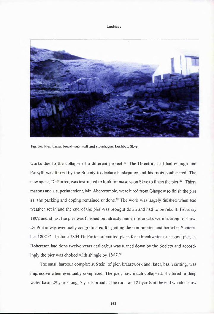
Lochbay
Fig. 56. Pier, basin. breastwork wall and storehouse, Lochbay, Skye.
works due to the collapse of a different project.26 The Directors had had enough and
Forsyth was forced by the Society to declare bankrputcy and his tools confiscated. The
new agent, Dr Porter, was instructed to look for masons on Skye to finish the pier.27 Thirty
masons and a superintendent, Mr. Abercrombie, were hired from Glasgow to finish the pier
as the packing and coping remained undone.28 The work was largely finished when bad
weather set in and the end of the pier was brought down and had to be rebuilt. February
1802 and at last the pier was finished but already numerous cracks were starting to show.
Dr Porter was eventually congratulated for getting the pier pointed and harled in Septem
ber 1802.29 In June 1804 Dr Porter submitted plans for a breakwater or second pier, as
Robertson had done twelve years earlier,but was turned down by the Society and accord
ingly the pier was choked with shingle by 1807.30
The small harbour complex at Stein, of pier, breastwork and, later, basin cutting, was
impressive when eventually completed. The pier, now much collapsed, sheltered a deep
water basin 29 yards long, 7 yards broad at the root and 27 yards at the end which is now
142

Lochbay
choked and there are still remains of the broad, triangular wharf before the bank and
storehouse building (figs 55 - 5 6).31 William Mackenzie’s 1807 sketch of the harbour illus
trates the work as it then stood before the second pier was added (fig. 53).32 The pier and
breastwork hpve today sunk considerably so that the end of the pier is submerged at high
tide but the qverall shape of the harbour is still evident and ironically as a work of civil
engineering i( is clearly more elaborate than those found at Ullapool and Tobermory. It is a
sadness of the failure of Stein as a settlement that the harbour has never been properly used
and that it wqs the length of time taken to build it that was the key factor in that failure. Dr
Porter had frequently complained of slow progress at Lochbay but was told by the Society
that this was 0ue to a fear of wasting money through impatience as at Ullapool. And when
finally agreed, it then took Forsyth seven years to carry out works that were executed
within two years at the previous settlements. Significantly there was no road linking the
harbour to the village in Mackenzie’s survey of 1807, illustrating the work was isolated and
quite useless, This is still the case today and reaching the harbour involves a walk along the
beach at low tide.
The Storehouse
The first actual building to be completed at Stein was the storehouse. A small building
in comparison with the Great Storehouse at Ullapool or the King’s Warehouse building at
Tobermory, if is none-the-less remarkable that it was built at all and built according to
Telford’s 179Q plan, where it is marked B at the foot of the bank before the pier and wharf.
John Forsyth was asked to send in an estimate for a storehouse after the contract for the
harbour had lpeen drawn up in October 1794 (fig. 19).33 Telford recommended a building
60 ft long, 2Q ft wide and two stories high and Forsyth was offered £116 for the job in May
1795, which he accepted but with reduced dimensions, to be completed by Whitsunday
1796. Work y/as well underway by September 1795 and largely completed in October, with
an extra vent and glazed window in the upper storey. Having withstood a violent storm in
143

Lochbay
Fig. 57. Rebuilt storehouse, Lochbay, Skye.
November, Robertson issued an early certificate of completion including an additional fire
place, though the floor was not yet done due to the Directors reluctance to pay for stone
flagging, which Forsyth insisted was necessary to prevent damp rising up. To solve this
problem Telford recommended Forsyth use a method used in canal building to stop water
escaping called puddling, “A layer of earth twelve inches thick laid on the floor then cov
ered with water to bed down and then trod flat by labourers until no lumps are left, then left
to dry until able to support a man’s weight, repeat this with another layer containing some
sand to prevent cracking. Then tread in a layer of coal ashes four inches thick to absorb the
damp, the flagging to then be laid atop with a bed of lime mortar”.34 This is typical of
Telford who was in the habit of sending useful construction tips rather like recipes to the
various contractors, as with the box beds for the Inn. In this case Forsyth decided puddling
would not work as the winter weather was too wet for each layer to set choosing brick
instead. 1330 “fine bricks” were ordered from Liverpool and shipped by a settler, Rory
McNeil, on a sloop, ‘Jean’ from Oban in December 1795. The bricks arrived three months
later in February 1796, the floor was laid and the storehouse opened immediately. An idea
of its final appearance comes from a report by Telford a decade later in 1807, when he
144

Lochbay
visited after purveying at Wick:
The storehouse consists of two apartments on the ground floor sixteen foot square and 6 ft 9 in high each and one door each, the floors are paved with brick. The upp^r floor is boarded and the whole is one apartment with an outside stone stair at tl}e west end. The roof is good and when the slating, skews and chimney are repaired the whole will be in excellent condition.35
It was a plain two storey building, slightly over half the original intended length, built
in the east coast tradition with skews and a forestair as at Ullapool (fig. 57). The entrepre
neurial Rory McNeil was appointed storekeeper in 1795 and loaned £180 by the Society to
stock salt, cqsks, nets, hooks and supplies which he procured from Glasgow and Liver
pool. The Directors thought he “seems very fit for the purpose”.36 The actual completion
of a building at Lochbay and the appointment of the industrious McNeil, gave the Direc
tors a renewed interest and hope in the settlement and the annual report for 1796 stated,
“This station which has been several years a nominal settlement only has at length begun to
have real existence by the commencement of public buildings...there is every reason to
think that th$ neighbourhood of Lochbay is better provided than they have ever hitherto
been”. The storehouse was still doing business in 1810 and was well stocked with salt and
casks though none were sold to the villagers, as Macneil’s trade was derived entirely from
the surrounding area.
The Church and School House
The Society intends to build immediately accommodations for a school house and placp of worship at Lochbay. The school master’s house should be 30ft long by 16ft over the walls with an upper storey, that there should be a staircase in the middle and a room on each side of it and divided into three rooms above, that another building of the same height and dimensions should be joined to the said house for a church and to have a gallery at one end and under such gallery a school room can be made with a fireplace. This plan has been executed at Ullapool and a copy of the plan of the gallery and school room is sent. The Society proposes that
145

Lochbay
foreign timber should be used and the roof slated in a very complete manner by nailing the slates to lathes and rendering the inside with mortar which will save the expanse of any ceiling for the church but the upper storey of the schoolmasters houpe must be ceiled. The Society are not inclined to go beyond £150 for the whqle of these buildings and the plans are made accordingly.37
Instructions from the Directors of the British Fisheries Society to Thomas Telford, 4th February 1793.
In the cfise of building a school house and church for Lochbay the Directors’ inten
tions were fo[ once clear; a simple gabled cottage with a larger gabled church adjacent as at
Ullapool. However, Telford, as with the town plan for Lochbay, had ideas of his own. In
1793 Telford still believed that Lochbay could be more than a simple settlement and was
striving to epsure his grandiose plan, discussed in chapter two, was adhered to. Conse
quently, his reply to the Directors two months later in April 1793 was not what they had
been anticipating:
The best place for a school master’s house is where I suggested it on the plan whiph will at present and for some years be at a distance from the site of the village, near the market and terrace and good land nearby and lying on the boundary pf the Society’s land at the burn of Fasach, from the plan it will easily be seen that the situation is on elevated ground in a line with the terrace street and if the village increases and is built according to the general plan this church would in the end t>e in the centre of four streets. The plan enclosed is made out to correspond in spme measure with all these views, it is nearly of the dimensions pointed out by the pirectors, contains all the accommodations required for the school master.38
Telford |iad rejected the Society’s plan for a simple but functional church and school
house and proposed instead an elegant neo-classical, pilastered cube with double height
windows and a pyramidal roof, which ingeniously combined a separate house and church
within the ope volume. A public work intended to grace its hill top location, to form an
axial landmark at the centre of the town square and provide the focal point of the main road
down to the sea as with the churches at Bowmore and Inveraray. The Directors approved
of Telford’s design but thought the school room too small, which Telford resolved by sug
146

Lochbay
gesting that the division for the school room was brought forward from under the gallery to
the side of th^ pulpit. As this division would be high and expensive he suggested a wooden
wainscot 5 ft high and a canvas screen on a roller fixed to the ceiling above that, which
could be lowered and when down would allow the fire to warm the room. Telford’s par
ticulars for tfte building give an excellent impression of how this building was to have been
constructed (appendix B). The impression is of a building of a higher quality, standard of
materials and detailing than any other previously built by the Society, the only building in
all its works that would have genuinely stood as an independent work of architecture.40
A symmetrical square plan building, 36 ft to each side, the form is derived from the
Greek pseudo distyle in antis temple front (fig. 58). Severely rational and plain yet elegant
with a slim fyase course, plain walls and plain entablature beneath deep overhanging; four
central pilasters to each side, framing recessed window bays, except the principal elevation
where the entrance door stands at the centre with plain tablet above. The roof capped with
a birdcage bell tower and weathervane fmial. As with Mylne’s inn at Tobermoiy, the stripped
down neo-classicism of Telford’s church design was at the forefront of contemporary
architecture ip the manner of Robert Mylne or Samuel Wyatt. And the design is comparable
with the smaft, axially planned, neo-classical group of outstanding planned village churches
principally CQmprising those of Inveraray and Bowmore. The two storey, classical ‘Round
Church’ at EJowmore, Islay, 1768, with its prominent entrance tower and circular nave
designed by fhe town’s founder, Daniel Campbell of Shawfield, probably based upon an
unexecuted Resign by William Adam.41 Bellie Church in the centre of the main square at
Fochaber, 17p5-7, is a similarly austere, classical box with piended roof, central steeple and
front portico,42 But the greatest is Robert Mylne’s church at Inveraray, 1795-1800. Stand
ing in the nuftn square on the central street axis through the town, Inveraray Church is a
rectangular plan, porticoed building with a similar pilastered elevation to Telford’s design
for Lochbay,(hough Mylne uses a larger pseudo tetrastyle portico than Telford’s pseudo
distyle in antisIn both designs the principal point of reference is Inigo Jones’ St Paul’,
147

Lochbay
Covent Garden, 1631, particularly in Telford’s use of heavily overhanging eaves and ex
posed rafters supported upon a plain Doric order. Such allusion was not uncommon as the
late neo-classicists looked back to the early Palladians for a renewed lease of purity. There
is no doubt t|iat Telford was an architectural cuckoo copying and reworking the ideas of
others, rather than an innovative designer but his church at Lochbay does nonetheless fit
well within h>s own body of works. He designed two other churches in roughly the same
period, both ps pared down classical buildings with simple geometric plans, the rectangular
St Mary’s Cfyurch, Bridgnorth, 1972-4 and the octagonal Madeley Church, Salop, 1794-
b.44
Of course, the similarity between Telford’s proposed church at Lochbay and those at
Inveraray and Bowmore is no coincidence. These examples stand out as a group principally
because most other landowners in the Highlands building planned villages were not willing,
or interested, in spending the large sums of money required on a prestigious, fashionable
building. In the broader Scottish context these churches belong to the tradition of William
Adam’s Dundee Town House, 1731-4 and Alexander McGill’s Donibristle Chapel, Fife,
1729-32.45
The interior plan of the building was also a cut above average in the combination of
the school, church and school master’s lodgings within the one square block. The building
was divided across the centre by a strong wall that ultimately supported the heavy roof
structure and bell tower. The lower or front half of the building, open to the rafters, was to
house the chyrch, with the central main entrance facing a raised pulpit with pews to the
right and a gallery to the left with the school room housed underneath. The rear or upper
part of the bqilding housed the school master/clergyman’s house, entered through a small
door to the rear. This was divided into two floors with a generous parlour and kitchen with
scullery, clospts and cellar on the ground floor and a central stair case leading up to five
bedrooms op the upper floor, the stair case also opening onto the pulpit through the divid
ing wall at mid height. The windows to the sides and rear being contrived so as to be
148

Lochbay
Fig. 58. Thomas Telford, plan for a church and school house at Lochbay, 1793, NAS RHP11794 (photo: National Archives of Scotland).
i 6‘err/itn, .z «. J Ann & **«• /»* "Jst,
t ft when
.43 4
separate windows on both floors but to appear as single double height windows from the
outside. The roof plan is notable for its well ordered complexity: “wall plates six by four
149

Lochbay
inches; tie be^m ten by five; angle or hip pieces; blade and couples seven by five; king posts
eight by five; purlins seven by five; braces five by five; rafters four by four; top pieces to
bear cupola $even by five; uprights seven by seven; ceiling joists three by two”. A final
observation pf Telford’s particulars is the inclusion of tables, pews and seats as a part of the
basic carpentry work for the building, like the inclusion of box beds and presses in his plan
for the inn.
The Directors received estimates for Telford’s school house and church building, in
July 1793, at £882 from William Cummings and £637 from Shaw and Boak. These were
considered sq high that the combined building plan was abandoned, “despite it being such
a handsome tyuilding”. This was compounded by the SPCK refusing to supply a clergy man,
only a school master, on the same terms as at Tobermory and Ullapool, so a church building
was no longer necessary. Telford was instructed to come up with a simpler, cheaper house
just for the school that could be done for £150, suggesting the congregation could be
housed in the storehouse if space was required.46 Accordingly, with no recorded protest,
Telford provided a new plan for a simple, single storey gabled building of harled, random
rubble walls, slated roof open to the rafters. Little more than a byre or storehouse in design
but with a firp at each end to warm the scholars. As removed as possible from the architec
tural design and complicated planning of Telford’s intended building, simpler even than the
building originally proposed by the Society.
The question of the school house was quietly dropped until December 1794 when it
was decided fo offer the job to Forsyth as he was on site working on the pier and breast
work and a contract was agreed in February 1795 at a cost of £170, to be completed by
that November. Work was underway by September 1795 and Forsyth thought it would be
finished by Ute December, despite having to build a road from the shore to the site at the
top of the hil) on the site originally allocated for it by Telford, marked F on his 1790 plan
(figs. 19 & 59). Though nearly completed by Christmas, a violent storm early in January
1796 brought down the gable tops of the house due to its exposed position on the hill top
150

Lochbay
and it was decided to leave repairs and completion till the weather turned, although Forsyth
actually had the walls up, the roof covered with slates and the walls plastered by the end of
February. Thp building was finally finished in July 1796 and a school master, Mr. Bethune,
appointed in [September.
Four ye^rs later in December 1800, the agent Dr Porter reported that the school house
was of a conyenient size for a teacher and a school but insignificant as a place of worship
and requested one should be built to the line of the main street rather than occupying the
centre of a square as intended, and once again Telford’s grand plan was scaled down. Dr
Porter also observed that the school room remained incomplete with half the room flagged
and the rest ()are earth, the walls were unplastered and the roof not lathed or plastered.
Wire netting yvas also required for the windows to protect them from “boys breaking them
as fast as they could be mended”. Of the poverty of the school, itself he commented, “The
school is presided over by a man of excellent morals and uncommon abilities, nevertheless
I cannot say piuch for the proficiency of the school as the school master is often absent as
he preaches fpr a field but mainly for want of books which their parents refuse to pay for so
each scholar |s given an old catechism, leaf of some book or piece of newspaper.”
Inevitably, whilst the surrounding area evolved and Lochbay decayed, others rose to
meet the problems unresolved by the Society and in 1815 the Directors agreed with Charles
Grant of Waternish to fund a new school house on his estate for 130 pupils, to be built by
a Mr. Mitchejl for £128, and for the school house at Lochbay to be repaired and converted
to a chapel fpr £70. However, by 1823 the Society’s agent was again being solicited. This
time by Macleod of Macleod’s factor for a subscription for a new Highland parliamentary
church and rpanse, that Macleod of Macleod was setting up at Waternish. Together with
the rebuilding of Dunvegan parish church in 1823, this sealed the obsolescence of the
building at Lpchbay. It was leased out to a private tenant in 1826 and then finally sold off
when the neyv church and manse on Grant’s Waternish estate were completed in 1828.
Having lost the advantage of being the first settlement in the region and the chance to build
151

Lochbay
Fig. 59. Shore road leading upto hill to intended site of church. Lochbay. Skye.
a church of real substance that would serve the whole area and become a community focus
the Society simply conceded any claim to developing the area to those who were prepared
to undertake works they had, themselves, promised to build in 1789. The school house was
demolished apd the site is now occupied by a late nineteenth century crowstepped mansion,
Lochbay Hoyse.
The Smithy
In his plan of 1790, Telford allocated a site for the smithy slightly away from the
village next to the burn of Lusta, marked E (fig. 19). It was eventually completed, in that
location, and a smith installed in 1800. Building the smithy was, once again, to prove a
drawn out and unhappy process typical of works at Lochbay. On request from the Society,
Telford first sent plans for a smithy to the agent, Robertson, in May 1793 47 The approved
plan was for a single storey gabled house and shop, in the manner of a semi-detached with
152

Lochbay
Fig. 60. John Forsyth, plan, elevation and section for smithy at Lochbay, 1798. NAS GD9/32/2/7 (tracing from original).
the smithy to the right and the house to the left
both with their own entrances. With no connect
ing door inside the smithy was to be open to the
rafters with the hearth and bellows on the gable
wall whilst the house was to be divided into a
ground and garret floor. The whole building
was to have been built of random rubble, harled
and slated with stone skews and coped chimney
stacks. Deal stair with handrail and balusters,
were to lead to the garret on the house side of
the building with tongue and grooved deal doors
and timber sash windows with common glass
through out.
Shaw and Boak estimated for the contract
at £126, a sum which the Directors considered
too high and the smithy was dropped until after
the completion of the stores and school house in 1797. Forsyth was then offered the con
tract and a new plan submitted by Telford. Telford’s new plan was similar to his first but
with a piended roof and garrets on both sides of the building, which Forsyth estimated a
final cost of £219, claiming he could not offer the same terms as the school house due to
increases in the cost of men and materials. Typical of the malaise that prevailed in all mat
ters relating to Lochbay the Directors resolved to abandon all plans for a smithy as the cost
was too great, with the reply to Forsyth, “So there is an end of Mr. Telford’s plan and your
estimate”.48 forsyth was not put off however and submitted his own scaled down design,
which was approved by William Pulteney at an estimated cost of £88 in June 1798 and the
building was quickly completed by April 1799. Forsyth’s sketch plan shows a simple, single
storey, gabled cottage design, divided in two with a small smithy to one side and a single
153

Lochbay
living room tp the other (fig. 60).49 The ruins of this smithy can be seen today with much of
the walling sfill standing and one gable end and chimney stack (fig. 61). Matters with the
smithy did not run smoothly even when built as when the new agent, Dr Porter, arrived in
early 1800 he found that the smithy was complete but Forsyth refused to hand over the keys
as he had sided with the settlers in a dispute over the tenancy agreements. This continued
into late August when Porter threatened to resign as Forsyth would not relinquish the keys,
Fig. 61. Ruin of smithy, Lochbay. Skye.
despite the smith, Neil Grant, waiting to move in on a three year lease. The smithy was later
reharled and slated on Telford’s orders in 1807 but by 1814 the smith was refusing to pay
rent as there was no trade, despite it being a good smithy, as two other smithies had re
cently opened in the neighbourhood.50 The smith eventually left and in 1826 the building
was leased as a dwelling house to a widow, Mrs Macleod.51
Fishermen^’ Houses
The last and most ill advised of all works carried out by the Society at Lochbay was a
row of four ‘^fishermens’ cottages” built on Macleod Terrace. It was the agent, Dr Porter’s
idea that the Society should build the terrace like Red Row at Ullapool. His theory was
154
Lochbay
that the prohjem of getting the settlers out to sea and fishing could be solved if they built
houses and offered them rent free to east coast fishermen who would settle and teach the
natives to fish. The Society’s acceptance of this idea show their desperation regarding
Lochbay, as ft was in direct contravention of the Society’s regulations to provide settlers’
housing. The contract went to a local carpenter and builder James Cummings who agreed
to build the terrace of four simple houses for £255 to a plan of his own devising.32 The
work was dope quickly and the Directors even accepted a rise in cost to £343. However, it
soon became clear that the houses were built too quickly and cheaply. By 1805 all the roofs
needed replacing, the continuous rear wall was rent in several places, the rooms were cold
and damp as there were no ceilings and the clay and straw partition walls were crumbling.
Worse still, no fishermen had been attracted to settle and the houses were eventually
subdivided into seven apartments and let individually to the poor. They had to be repaired
in 1806 and again in 1807 involving reslating, wall repairs and replacing the partitions with
timber. By 1812, then agent Donald Grant reported that, “as for the houses for fishermen... I
wish they haft never been built. They have never been properly tenanted due to their small
size and are ip constant need of repair”. Two years later only two were occupied and Grant
considered the houses “decaying dead stock that will only be taken by the destitute”. Once
again the hopses were repaired and leased out in 1815 but were vacant again by 1817.
Tenanted ag<pn in 1823, the tenants threatened to quit if the houses were not repaired,
despite the fqct they had never paid rent, the terrace being ‘^wretched and close to falling
down.. .in suyh a state of delapidation to be not worth six pence”.53 This miserable cycle of
ruin and repair continued until the lands were sold to Macdonald of Skeabost for £2800 in
1837.54
At Locftbay the Society had intended to provide the basic infrastructure for a fishing
village, as at the other settlements, that would attract settlers to build their own houses
155

Lochbay
from which 4 town would grow. And like at Ullapool and Tobermory they did indeed build
a pier and breakwater, a storehouse, a school house, a smithy and an inn of sorts. Lochbay
was to have l^een the most elegant, the largest and the most beautiful planned village in the
Highlands. TJiat this elegant Highland metropolis did not emerge is disappointing to the
architecturaHy minded, but as the Directors of the Society knew the aesthetic appearance
of the place was not fundamental to its success beyond it ‘being neat and regular’, as was
proved at Tobermory. Neither did it mattered that each building when completed was on a
smaller scale than at the other settlements. And yet, as widely observed, warned and pre
dicted Lochbay was a failure:
Having just arrived here six days ago travelling by boat via Tobermory where I saw many fine buildings including a Customs House and an excellent harbour and the appearance of a growing town. If the same money had been expended at Lochbay, if a Customs House had been established, it would by this time be a considerable place. The ground feued to the British Fisheries Society is rich arable and pasture and the country round it some of the best in the Highlands. Yet the towp is not begun and two summers have rolled away without the least advance to the settlement. I find here Mr. Robertson appointed as agent for the Society, he seeips to me to be a sensible intelligent man and very fit for the employ but from a tojal want of powers and instructions he has been able to execute nothing. He informs me that the general opinion of the people here that the Society is not in earnest about making a town because they see nothing done and indeed this is confirmed to me by the gentlemen of the country. I shall do all I can to encourage people to take lots, a great part of my estate is now out to lease and many of the farms occupied by small tenants are crowded with people. I shall endeavour to perspade many of them to settle at Lochbay. There are also many sorts of tradesmen; weavers, shoemakers, carpenters etc scattered over the country. I mean to collect these people and make them build in the town. But these endeavours of minp will be in vain without the hearty concurrence of the Directors. I therefore advise the following measures:
1. Tfie agent to be immediately empowered to build the pier andbreastwork.2. He should be empowered to build the storehouse so salt can bedeppsited for next spring.3. Above all things the Society must use its influence to get a Customs House at Loc(ibay as there is none nearer than Stornoway. Any merchant wishing to supply Lochbay with salt will have to go there first to secure bonds and certificates. Several merchants and bus captains assure me that if there was a Customs House
156

Lochbay
at Lpchbay it would be greatly desirable andthey would have laid up salt and casks for next season already sufficient for the whpje country.55Letter from Colonel Macleod of Macleod to the Directors of the British Fisheries Society, Dunvegan Castle, 25th July 1791
A more succinct summary of the problems at Lochbay would be hard to find though
his astute recommendations were either ignored or taken up so late as to be redundant.
Regarding a Customs House, Macleod of Macleod was informed that one would be con
sidered only when the settlement had progressed enough to justify one, missing his point
that settlemept would be ensured by one’s presence and should be a first step not a last as
had been dope at Tobermory. However, the fundamental problem was delay. Robertson
concluded tfip same himself three years later in 1794; “there are no new settlers since last
year’s report, owing they say to the Society not having begun any of the public buildings
and that they have from thence concluded that this station is forgotten”.56 The conse
quences of cjplay were again stressed by the next agent Dr Porter in 1800, nine years later:
It appears that the number of persons who are considering to be settlers amount to forty eight, that the number who have built houses according to the regulations amount to two, that none have enclosed land and none have applied to the fishing and that no disposition prevails generally beyond that of rearing the greatest possible number of cattle for the drover at the least possible labour and expense. Mapy have been eight or nine years at the settlement without coming up to a sing,e article in the regulations. It is not intended to enquire into the reason why the Society has bestowed fewer buildings upon Lochbay than on the other villages it is sufficient to remark that the fewness of public houses may be attributed to this, The public and gentlemen who took lots have lost all confidence in the Society as they took so long to start to build and then so long to finish to build. The tacksmen even having been willing to force all artificers on their land to settle at Lpchbay but this was given up. The opportunity of attracting favourable and useful and respectable settlers was lost. And to supply the deficiency people of no meaps or character were admitted. Lochbay became notorious for idleness and intoxication and people of character spoke of it with abhorrence.57
The Society’s works had proceeded too slowly, something at length was finished but
the spirit of settlement in the village had passed away. And by 1820, the agent Lachlan
157

Lochbay
Mackinnon \yas of the view that:
Th^ settlers are all very poor,...and are so far gone in debt and would run withtheir cattle if I did not keep watch on them..... I am at a total loss as to what to say.Thefe certainly never was anything of the sort so ill managed as it has been. The village of Lochbay is now entirely occupied by poor widow women and hardly a mal^ inhabitant in the place. An opinion is prevalent in that part of the country that the Society are illiboral and give no encouragement.58
Macleod of Macleod had been correct, Lochbay was not inherently disadvantaged
from the outlet. As seen in the previous chapter, the choice of Lochbay as a site for village
was a sensible one, it was on the shipping route from Stornoway to Glasgow, favourable
terms were offered for the land and resources were good in terms of fresh water, popula
tion and fishing banks.59 Yet all the potential the village may have had was lost through
delay, leading to mass emigration from the Duirnish region of Skye.
There \yere several causes of that delay, for example, in contrast to the firm hand of
James Maxwell at Tobermory, Lochbay was plagued by trouble with agents during the
crucial years when the building works were carrying on. The first, James Roy, left after only
a year to work at the new Customs House at Tobermory. Next was Charles Robertson who
was engaged jas Macleod of Macleod’s factor as well as his post with the Society and had to
be dismissed for neglect of duty as well as for causing a riot by whipping settlers with his
riding crop, during which he was dragged from his horse and severely beaten by the set
tlers. In 180Q came Dr Porter, the most skilled agent who saw the Society’s works to
completion, established a proper rent collection and was much loved by the settlers. He,
unfortunately, left on an intended brief trip to Jamaica in 1812 to sell some slaves, was
caught by Spanish pirates and robbed of his money. He then escaped with an unknown
English lady from a jail in Cadiz only to be press ganged into the navy on arrival in South
ampton and ^ent to the Mediterranean onboard the HMS Eagle as ship’s surgeon. Finally,
on his return from sea in 1815 he was arrested at Dover and sent to debtor’s prison as his
finances had collapsed in his absence and his wife had died in poverty in a rented room in
158

Lochbay
Durham. Her landlord had burnt all his papers including the Society’s Lochbay accounts
for the loss of which the Society in their magnamity sued Porter.60
There vyere numerous other delays that prevented building works going ahead, find
ing contractors, the poor quality of the local stone, poor contractors, bad weather, supply
vessels sinking, unmanageable distances and the initial problem of Macleod of Macleod’s
two year deluy in signing the land deposition. There was also an underlying lack of drive
and enthusiasm for Lochbay amongst the Directors. Stein suffered as it had to follow after
the first wave of keen activity that pushed through the building of Ullapool and Tobermory
and by 1790 fewer Directors were attending Board Meetings. Moreover, Tobermory had,
had the benefit of the personal interest and zeal of the Duke of Argyll, Governor of the
Society. In 1790 the Duke’s wife died, Tobermory was largely complete and the Duke
increasingly withdrew from Society matters. But most of all Stein was choked by over
caution. The rnost crucial work in establishing a workable fishing village and thereby reas
suring the islanders was correctly deemed the harbour. But it took the Directors five long
years of survey, resurvey and second opinions before they would even proceed with any
work and by the time it was completed seven years on from then, for which Forsyth must
take the blame, it was simply too late. Storehouses and schools appeared but also too late
and the recopimended customs house and jail that would have secured Lochbay’s local
importance never materialised despite Lord Macdonald postponing the building of a jail at
Portree until he saw whether the society was going to raise a subscription to get one at
Fig. 62. Lochbay. Skye.
159

Lochbay
Lochbay. Unfortunately, this was a deliberate policy, in spite of the clear need for haste,
adopted fforp fear of falling into the financial problems of Ullapool caused by lack of cau
tion.
For a national, quasi-governmental organisation born out of the spirit of rationalism
and improvement, it is remarkable that despite repeated warning and imploring the failure
of Stein and the massive implications of that failure upon emigration, came down to as
simple a problem as delay. The visitor to Stein today would be hard put to recognise the
place as a planned village let alone the grand streets and buildings of Telford’s vision of a
well ordered fishing and market town sweeping down in crescents from the classical church
on the brow pf the hill overlooking the bay, past stores and customs house by the harbour
to the shore front houses of Macleod Terrace. The village today consists of a row of shore
front houses nobody calls Macleod Terrace, the terrace of houses to the rear is largely
ruinous with pne or two recently restored and the ruins of the smithy stand next to the burn
of Lusta (fig, 62).
‘Edinburgh, SRp/GD9/103/16.7.91
Edinburgh, SRO/RHP/11787
’Edinburgh, SRO/GD9/82/15.9.90
“Edinburgh, SRO/GD9/93/28/8/90
SLT C Rolt, Thpmas Telford, Longmans, London, 1958, 2
6This supplies interesting negative evidence that box beds were possibly not common in the Islands in the eighteenth <pentury though common by the late nineteenth, (see D Jones, “Box Beds in Eastern Scotland”, Regional Furniture, Volume V, 1991, 6). If the beds were made on Skye this would represent an early example of regional traditions migrating within Scotland.
’Edinburgh, SRO/GD9/125
8 The present two storey, seven bay Stein Inn on Macleod Terrace is often mistakenly identified as being related to Telford’s temporary imi as it has a similar tripartite internal division.
160

Lochbay
’Edinburgh, SRO/GD9/110/7.11.91
10Edinburgh, SRO/GD9/21/30,6,97
"Edinburgh, SRO/GD9/22/24.6.01
“Edinburgh, SRO/GD9/100/6.1.91
“Edinburgh, SRO/GD9/1/73
14The blow by t|low chronological account must be forgiven for it’s emphasis of the teeth drawing protraction of t|ie whole business
15Edinburgh. SRO/GD9/93/7.9.90
’‘Edinburgh, SRO/GD9/21/14.9.90
“Edinburgh, SRO/GD9/21/28.8.92
"Edinburgh, SRO/GD9/40
’’Edinburgh, SRO/GD9/21/28.5.92
20 A small histojrical footnote revealing two of the greatest civil engineers in British history being drawn into the Society’s mismanaged scheme.
"Edinburgh, SRO/GD9/181
“Edinburgh, SRO/GD9/155
"Edinburgh, SRO/GD9/176
"Edinburgh, SRO/GD9/168
25 J R Hume, Industrial Archaeology of Scotland, Highlands and Islands, Batsford, 1977, 217. Pier dated 1796.
“Edinburgh, SRO/GD9/1/72
“Edinburgh, SRO/GD9/1/97
“Edinburgh, SRO/GD9/22/9.5.01
“Edinburgh, SRO/GD9/1/151.
“Edinburgh, SRO/GD9/12/20
"Edinburgh, SRO/GD9/9/13
“Edinburgh, SRO/GD9/RHP/11800
"Edinburgh, SRO/GD9/21/15.12.94
"Edinburgh, SRO/GD9/34/13
161

Lochbay
^Edinburgh, SRO/GD 9/191
“Edinburgh, SRO/GD9/112
’’Edinburgh, SRO/GD9/155/4.2.93
“Edinburgh, SRO/GD9/161/30.4.93
39 scabbled: roughly worked with a pick, also known as droved or tooled. G L Pride, Glossary of Scottish Building, 66
'Edinburgh, SRO/GD9/127
41E Beaton, Scotland's Traditional Houses, Historic Scotland, HMSO, 1997, 79
42M Glendinniitg, R Machines and A MacKencliie, A Flistory of Scottish Architecture, Edinburgh University Press, Edinburgh, 1996, 181
43I G Lindsay, fiveraray and the Duke's of Argyll, Edinburgh University Press, Edinburgh, 1973, 100
44Colvin, Biographical Dictionary, 970
45Glendinning, Rfaclnnes and MacKencliie, A History of Scottish Architecture, 140
“Edinburgh, SRO/GD9/9/225
'’Edinburgh, SRO/GD9/9/225
“Edinburgh, SRO/GD9/10/192
'’Edinburgh, SRO/GD9/10/222
“Edinburgh, SRO/GD9/204
51 Renting a cotyage to a widow at this period in the Highlands typically indicated it was in poor condition and could pot be let to anyone able to pay a decent rent.
52 Edinburgh, SRO/GD 9/155
53 Edinburgh. SRO/GD9/189
54 Dunlop, The British Fisheries Society, 182
55 Edinburgh, SRO/GD9/105
56 Edinburgh, SRO/GD9/132
57 Edinburgh, SRO/GD9/155
58 Edinburgh, SRO/GD9/215
39 Of course, today when travel and the transportation of goods is done primarily by road Lochbay is one of the most remote and inaccessible parts of the British Isles. But from the seafaring perspective of the late eighteenth century it was really very well located.
60 Edinburgh, SRO/GD9/100
162

CHAPTER SIX
Pulteneytown
As seen in chapter two, the intention at Pulteneytown was to provided an expanded
infrastructure for the existing town of Wick. Therefore, the public building requirements
for the site were very different to the other settlements. At Ullapool, Tobermory and Lochbay
the Society had, with varying success, created complete but small villages on what was
previously npthing but farmland. At each every type of public building that would be
required was planned; harbour, storehouses, curinghouses, ‘a good inn’, a church, a school
and a Customs House. In contrast Wick was not only well located, as Telford had proved,
but a well established town of several hundred inhabitants, with a church and a school run
by the Corporation of Wick and a growing fishing fleet of thirty three vessels.1 Subse
quently at Wfck the plan was one of urban investment requiring fewer works but on a
considerably piore ambitious scale, principally in the form of infrastructure such as a har
bour, a bridge to link the harbour and new town to Wick proper, roads to link the various
sites and a waiter supply. This new strategy was to prove a resounding success surpassing
every expectation of all involved. Sir John Sinclair of Thurso, writing in 1823, was in no
doubt of the success of Pulteneytown:
Never, was money so well bestowed .A scene of industry is here displayed, nowhere to be surpassed. Along the eastern coast of Caithness alone, no less than 150Q boats go out in an evening to carry on the fishery, and about 100 decked vessels have been seen in the harbour at once, besides 20 or 30 at anchor in the Bay. Above 200,000 barrels are caught in a season, the very refuse of which will manpre several hundred acres of land; a new harbour is nearly completed, The old one being too small to accommodate the number of vessels that flock to it from varipus parts of Scotland, England and Ireland. Indeed some vessels have come front Cornwall and even from France and the Hanseatic to prosecute the fisheries here. Nothing is wanting, but the erection of a breakwater at the entrance in the Bay of Wick to render this remote district the greatest scene of improvement in Europe.2
163

Pulteneytown
The Directors of the Society were well meaning but gentlemen amateurs of the sort
derided by tl^e new emerging class of professionals of which Telford himself was at the
head. Patricians and philanthropists, the Board of Directors did not include a single mer
chant, fish cprer, exporter or man of business. And the varied success of the earlier settle
ments can, to some extent, be attributed to the fundamental basis of their activities on
theory and idealism rather than solid economics or business sense. To try and create thriv
ing market economies out of bare hillside, with limited finances and little government sup
port was a course of speculative action only a company formed at a Westminster Coffee
House would have attempted. All the large and economically successful harbour and dock
schemes from the late eighteenth century through to the mid nineteenth century, such as
those at Liverpool, Hull and London or even Whitehaven, Cumbria were built as responses
to existing depiand. In fact, the sums of money involved in these commercial harbour works
were rarely ventured until the situation at a port had become intolerable.3 At Pulteneytown
it was the Society’s adoption of this precedent that changed its fortunes as the firm evi
dence of success brought the private and government finance that enabled the building of
the Society’s largest works.
The sc^le of the works at Pulteneytown would not have been possible without the
Society’s partnership with the Highland Road and Bridge Commission. This would later
prove be a key moment in the history of the Society and of development in the Highlands as
a whole, wh$n the Society and it’s active role in the Highlands was absorbed into the grand
scale plans of the Commission. Through its building programme, political activity, and not
least its recnjitment of Telford to the Highland cause, the Society was largely responsible
for instigating development in the Highlands but was ultimately reduced to supplying match
funding for ope of the Commissions numerous projects.4 This was an inevitable and in no
way regrettable process as the number and scale of works in the Highlands had increased
far beyond the funding potential of a single private organisation.
164

Pulteneytown
At Pultepeytown, as elsewhere in the Highlands, the activity of Thomas Telford was at
the very heart of the settlements success. From the initial recommendation and promotion
of Wick, to surveying the river and land, the planning of the town, drawing up the feuars
building regulations, the design, contracting and supervision of the harbour works, bridge,
watercourse find mill Telford was involved. He continuously liased with, and between, the
Society, Sir Benjamin Dunbar, the Society’s agent Williamson, the contractors Burn and
Ross, the Corporation of Wick and the Commissioners for Highlands Roads and Bridges.
Indeed throughout the construction works at Pulteneytown, it is unclear whether Telford is
working for the Society or the Commission, bringing in the Commission’s surveyors from
other projects to Pulteneytown and using the Society’s contractor, George Burn, for Com
mission worlds at Kirkwall harbour and Helmsdale bridge. Following his appointment by
the Treasury fo report on Highland infrastructure matters in 1801 Telford became increas
ingly confidept and independent in his work, continuously incurring reprimands from both
the Treasury pnd the Society for carrying out surveys without permission, initiating works
and hiring contractors. Early in his career Telford had been warned by Sir William Pulteney
to dampen hip republican spirit and behind this maverick approach was the firm belief that
he was working for the good of Scotland rather than either organisation, whom he referred
to as “official insects”. Consequently, in the foundation and building of Pulteneytown
Telford was piore influential even than James Maxwell at Tobermory.
The Bridge of Wick
Although the Society had overall responsibility for its construction, the bridge, the
Society’s firsf work at Pulteneytown, was funded by a £1,000 grant from the Commission
ers for Highland Roads and Bridges in 1806. This sum represented half of Telford’s esti
mated cost of £2,000; a further £517 was raised in subscriptions by the Corporation of
Wick and £500 contributed by the Society. Building work could then proceed, despite the
first of many objections by the Corporation of Wick to what they perceived as the Soci-
165

Pulteneytown
Fig. 63. Bridge of Wick, Wick, Caithness.
ety’s high handed approach to the management of their mutual funds.5 Telford’s design
was for a stone bridge of three arches to replace an existing ageing and unstable wooden
structure.6 The plan, approved by the Commission in July 1805, was to have a central arch
spanning 60 ft span and flanking smaller arches of 48 ft with coped stone parapets lining a
roadway 17 ft broad. This would become Telford’s first bridge for the Highland Roads and
Bridges Commission.7 And was to form ‘Tart of the grand road to the north” that would
eventually include the Spey, Conon, Beauly and Dornoch Firth bridges (fig. 65).8 The
design for the River of Wick Bridge, and the majority of his later bridges, was a reduced
version of Telford’s seven arch Tay Bridge at Dunkeld built for the Duke of Atholl and
completed in 1806.9 The Tay Bridge formula was for a classically minded tripartite, hierar
chical arrangement of elliptical arches with a massive central arch flanked by smaller arches
of diminishing span (fig. 64). The bridge piers were supported upon lozenge shaped break
waters, mirrored at the top of each pier with a para
peted triangular passing place. A more successful
design than the clumsier castellated style, he occa
sionally adopted as at the privately financed
Tongueland Bridge, Kirkudbrightshire, 1805. At
156ft, the three span bridge at Wick is a middling• j ir* j i - j Fig. 64. Bridge of Wick. Thomas
sized Telford bridge. Telford Atlas to the Life of ThomasTelford, 1838 (photo: National Monuments Record of Scotland).
166
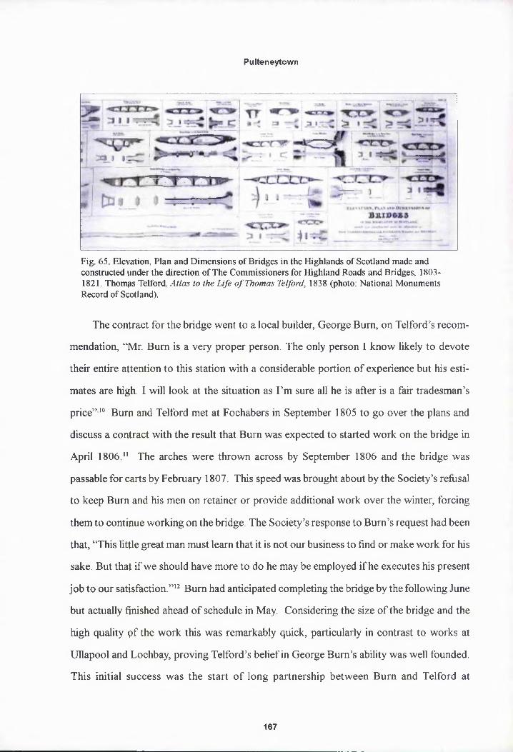
Pulteneytown
Fig. 65. Elevation, Plan and Dimensions of Bridges in the Highlands of Scotland made and constructed under the direction of The Commissioners for Highland Roads and Bridges. 18031821. Thomps Telford. Atlas to the Life of Thomas Telford, 1838 (photo: National Monuments Record of Scotland).
The contract for the bridge went to a local builder, George Burn, on Telford’s recom
mendation, “Mr. Burn is a very proper person. The only person I know likely to devote
their entire attention to this station with a considerable portion of experience but his esti
mates are high. I will look at the situation as I’m sure all he is after is a fair tradesman’s
price”10 Burn and Telford met at Fochabers in September 1805 to go over the plans and
discuss a contract with the result that Burn was expected to started work on the bridge in
April 1806.11 The arches were thrown across by September 1806 and the bridge was
passable for carts by February 1807. This speed was brought about by the Society’s refusal
to keep Burn and his men on retainer or provide additional work over the winter, forcing
them to continue working on the bridge. The Society’s response to Burn’s request had been
that, “This little great man must learn that it is not our business to find or make work for his
sake. But that if we should have more to do he may be employed if he executes his present
job to our satisfaction.”12 Burn had anticipated completing the bridge by the following June
but actually finished ahead of schedule in May. Considering the size of the bridge and the
high quality pf the work this was remarkably quick, particularly in contrast to works at
Ullapool and Lochbay, proving Telford’s belief in George Burn’s ability was well founded.
This initial success was the start of long partnership between Burn and Telford at
167

Pulteneytown
Pulteneytown and elsewhere. A second bridge, larger but of similar design, was built in
1875 to cope with an umanageable increase in traffic (fig. 63).
The Harbour
A deep water harbour at Wick was the primary recommendation of Telford’s 1790
report and tlqe Society responded swiftly requesting John Rennie to draw up a feasible
scheme. Unfprtunately, the scheme Rennie proposed was extravagantly expensive and prob
ably unworkable involving the diversion of the river into a series of basins, linked by
canals contrqlled with sluices and the whole spanned by a series of draw bridges. Rennie
estimated the cost of this scheme at £14,500 and claimed that if his scheme was not consid
ered the mo§t the Society could hope for was a wharf along the existing town wall to
service local traders.13 Not surprisingly, the Society were so put off by Rennie that the
project was shelved for eight years until Telford’s Highland Report to the Treasury in
1801:
On the west coast of Scotland and the north east they dare not wait the equinoctial gales and cannot fish a full season but push off as soon as they have anything like a cafgo. At Wick they have no place but the beach on which to land and flack their fly apd they frequently cannot get over the bar even to reach the beach but lye with their fish in their open boats exposed to the sun until they are spoiled. It is generally allowed that the deep sea fishing might be carried on in this quarter but no perspn will risk his vessel and capital while there is no place of security for them to run into. Nor any convenience whatever for them to carry on their business. It is therefore very evident that to promote the extension and success of the fisheries therp should be a harbour on the coast of Caithness and there is no place excepting Wicjc which is fit for such a harbour.14
Telford estimated the work for a harbour at a more modest £6,000 and the Board of
Directors imrpediately applied to the Treasury for funding. However, negotiations with the
Treasury were drawn out for a further five years until 1806 when the Commissioners for
Highland Roads and Bridges allocated the Society £7,500 under the new Scottish Har
bours Act.15 Telford wrote to the Directors from his Tay Bridge site office at Dunkeld in
168

Pulteneytown
March 1807 enclosing the final plans and specifications:
Wick Harbour, to be constructed on the southern shore of the bay, a little eastward of the mouth of the river. The south quay or pier is to be laid down along the northern side of a bank which is now covered with large stones and the portion of the inner wall of this pier which is a straight line is to be 600 ft in length. The outer wall will be about 560 ft. From the eastern extremity of this south pier an outer head of 400 ft in length is to be carried with a curve which will admit of vessels lying alongside of it... from the western extremity of the inner wall of the south pier a breastwall must be carried which is to be 560 ft in length. From the northern end of this breastwall the north pier is to be laid... 100 ft from the base of the northern extremity of the outer head and 280 ft from the base of the inner wall of the south pier.16
The two pier arms of the harbour forming a trapezoid shaped basin, the inner walls of
both piers were to be 6 ft thick and 17 ft high, the outer walls 4 ft 6 in broad and 16 ft high
and the two joined by cross walls 30 ft apart and 3 ft thick. The whole was to be built of
rubble masonry laid in regular courses without mortar, the cavities between the walls of the
piers then infilled with compressed rubble, except the pier heads which were to be solid
masonry. Finally, as at Lochbay parapets were to run on the outside of both piers. The
breastwall between the piers, which formed the wharf to the rear of the harbour, was to be
three feet thick, 12 ft high and set with counterforts. The land behind was then back-filled
Fig. 66. Wick Harbour. Wick, Caithness.
169

Pulteneytown
Fig. 67. Plans and Dimensions of Harbours, Wharfs and Ferry-Piers made or improved under the direction of the Commissioners for Highland Roads Bridges, 1808-1821. Thomas Telford. Atlas to the Life of Thojnas Telford, 1838 (photo: National Monuments Record of Scotland).
and levelled as with the previous breastworks at Ullapool and Tobermory. The enclosed
basin was to be excavated to the depth of low water. The final estimate being £10,000
requiring the Society to only provide 2500.17
The harbour works began early in 1807, with the foundations of the south pier well
under way by that summer. In November 1808, Burn wrote to Telford in Sweden, where he
was surveying the route for the Gothenburg canal, informing him that the south pier had
been raised to a height of fifteen feet along its whole length and the breastwall raised to ten
ft. At this point, on Burn’s recommendation, Telford reduced the length of the south pier
head by 22 ft to increase the width of the harbour entrance to 120 ft. Work continued to
progress well and by 1809,160 ft of the north pier was also raised to 6 ft and the south pier
completed. At this point, a problem in the design of the harbour became apparent as the
head of the north pier had the effect of throwing the sea along the inside of the south pier
and causing agitation within the basin. The head of the south pier had to be then extended
by 40 ft so that it overlapped the head of the north pier. There was also trouble because the
sea hit the breastwall so violently that the curing house feuars considered the wharf unus
able and refused to pay rent on building lots. Burn suggested a slope be built instead of the
breastwall immediately before the curing houses, to absorb the energy of the waves as the
170

Pulteneytown
beach had previously done. However, the curers found this solution equally unacceptable
and the matter remained unresolved, despite the agent Williamson reporting that, “I watched
the swell against the wall and fear it will yet prove useless as a harbour”. As worked
progressed Burn’s monthly accounts show his workmen were building an impressive 300
cubic yards pf masonry per month and excavating 400 cubic yards of mud for the basin,
work which qould only be done at low tide between three and six in the morning. The last
fenders and rpooring posts were secured in place in the summer of 1813 and according to
Williamson, “with the exception of further deepening of the basin and extension of the
parapet wall the harbour may be considered finished. Its great utility cannot be further
doubted”. To)ford’s final survey approved the work with Burn being £500 under Telford’s
own final costing at £12,669 (fig. 66). Williamson commented in his annual report for 1814
that:
It is admitted that unless for the Society no harbour would in all probability have ever been constructed at Wick and that until the south country boats were attracted by the harbour to fish upon the coast there could hardly been said to be any fishipg as the Caithness boats dared not venture. Arable land in the area has gone up ip rent from eight shillings per acre to three guineas and Dunbar’s estate has gone up in value from £800 per annumm to £5,000.18
Also included in his report was a table for the ‘Number of Boats in 1808 and 1814’,
which shows the effects the new harbour had on Wick as well as the growth of the whole
region:1808 1814
Wick - Pulteneytown 150 430Qunbeath 18 155Uybster 14 98Fpligoe 7 24
The harbour was officially taken off Burn’s hands in 1816 and correspondence relat
ing to the harbour for that year is concerned with the every day complaints of a busy
working harbour such as the cluttering of the piers with nets and casks. However, soon
after, criticism of the harbour began but not for once concerning the location or workman
171

Pulteneytown
ship rather thpt the harbour was already proving too small and congested with over 12,000
people workipg at the fishery during the height of the season. Subsequently a second har
bour was contracted for with Burn in 1820, again to a design by Telford and the work
supervised by Telford’s deputy surveyor with the Highland Roads and Bridges Commis
sion, Joseph Mitchell. The outer harbour was built immediately down river from the first
harbour. A rectangular basin 230 ft by 560 ft was formed to the east of the south pier by
building an earthwork jetty 100 ft broad along the length of the old pier’s eastern side.
Floowing the problems encountered at the old harbour a paved slope 50 ft broad was laid
instead of a breastwall, and a second narrow wharf ran along the southern bank of the
river, terminating in a short pier jutting northwards into the river. As the line of the shore
and existing ^outh pier were used the cost was considerably lower than the first harbour at
£2,828. A m$rk of the Society’s success at Pulteneytown is that this second harbour was
paid for entirely with revenue from harbour dues.
Pulteneytown harbour, like most on the Scottish north east coast, was principally a
port of refugq. Within Britain such ports were concentrated principally along the Cornish
coast and the north east of Scotland, where a pier built into the surrounding hills and cliffs
provided shelter on otherwise windy and dangerous coasts. As such, the type of harbour at
Pulteneytown, as with the Society’s smaller less successful harbour schemes at Ullapool
and Lochbay, was defined by the requirements of geography rather than by its intended
function as a flshing port. Strong fishing regions elsewhere in Britain with different hinterlands
adopted different harbour scheme, as in flat, East Anglia where extensive riverbank wharves
were prevalept. A group of similar harbours to Pulteneytown from this period would
include fishing ports such as St Ives in Cornwall by Smeaton, 1760, but also harbours such
as Ham, Caithness, built for exporting flagstones and Easdale Island, Argyll built for the
slate quarries. Several of Telford’s smaller projects for the Highlands Roads and Bridges
Commission, 1806-22, are also of this type where the location was similar such as Kirkwall,
Orkney, also built by George Burn also at Porthmahomack, Wester Ross, Portree, Skye
172

Pulteneytown
and East Target, Argyll. Pulteneytown harbour can therefore be grouped both with the
Society’s other works and with Telford’s other ports on the north east coast for the High
lands Road and Bridges Commission (fig. 67).19 The structural problems of cracking and
subsidence encountered at Ullapool and Lochbay and silting at Pulteneytown were also
common to his other works in the Highlands. As Rennie observed they were “built when
the science of civil engineering had made but comparatively little progress in Great Britain,
not finished in the substantial and durable manner which is so essential in all maritime
works. It was therefore not to be expected that they could withstand the test of the ages
much less the violent storms of the ocean, without continual heavy repairs, in addition to
the expense pf keeping the harbour free of mud and silt.”20
The Watercourse
As at all the settlements, a crucial element of the infrastructure for Pulteneytown was
a fresh water supply. At Ullapool, Tobermory and Lochbay this requirement had been con
sidered at th^ initial survey stage and in all cases had been satisfied by the presence of
burns. The relatively small size of these villages meant that this had more or less been
sufficient, however, again the intended scale of Pulteneytown required a more elaborate
scheme. Telfprd’s survey of 1801 concluded that a watercourse, and mill race for a pro
posed mill, qould be created by diverting a burn from the Loch of Hempriggs situated to
the south of Wick in the Yarrow foothills on the boundary of Sir Benjamin Dunbar’s and
Sir John Sinclair’s estates.21 Telford estimated that a watercourse cut into the ground with
canted side \yalls, 3 ft broad at the bottom and 12 ft at the top, could be brought from the
loch to the settlement over a distance of just over two miles for £4,400:
The ground to be excavated to form a bank and there is to be a puddle gutter in each bank cut through the loose soil and the puddle is to be eighteen inches thick and to rise to within four inches of the top of the finished bank. The general line of the cut to be made in the direction marked on the ground so as to have a declivity of six inches in every four chains.22
173

Pulteneytown
It would be easy to overlook such a simple engineering work but the massive financial
outlay involved indicates the importance and value to the success of the settlement placed
upon it by th§ Society and Telford. In comparison, the Society’s previous architectural high
point of Robert Mylne’s inn at Tobermory had cost £792 whilst Melville’s final bill for the
completed pi<?r and breastwork at Ullapool was contested at £4,629. As with the harbour
and bridge it took time for such a large amount to be agreed and it was not until February
1807 that Geprge Ross of Invercarron, near Tain was contracted for the work. Like George
Burn, Ross anticipated that he would have to stop work over the winter as the puddling
could not be done when it was frosty but was also compelled by the Society to continue
work and the watercourse was completed in May 1808.23 Six, small single span stone
bridges were then built across the watercourse by George Burn’s men for £75.236. A
seventh bridge had to be added when Sir Benjamin Dunbar complained that the water
course had cpt off his house from the main road. Burn also covered over the watercourse
with flagstones as it ran across the site of the proposed town in a 112 ft stone drainage
channel. A sluice gate was built at the loch head in order to raise the water level by one
foot, flooding several acres for which the tenants had to be compensated.24
The Mill
In July 1306, the agent, Williamson warned that the old mill inherited from Sir Benjamin
Dunbar would on^Y last another season once patched up and recommended that estimates
were sought Immediately to build a new mill. With the Society’s new found speed at deci
sion making tenders were invited a month later, to be based upon plans drawn up by Telford
and in line with his estimate that “the expense of a good mill with an overshot wheel 15ft
in diameter, ipcluding house, machinery and two pairs of French mill stones costs £350”25
Despite the ffyct that a mill had not previously been considered an essential, core building.
George Burp was the only contractor to put in a bid, with a most reasonable estimate of
£314, and was duly appointed to build the mill “above the proposed village”. Whilst the
174

Pulteneytown
Fig. 68. Mill. Pulteneytown. Wick. Caithness (photo: John Hume)
actual mill machinery was to be constructed and
erected by John Sinclair of Wick:
The mill works to consist of one water wheel 15 ft wide and 4 ft in breadth with a proper axle. Two large wheels for turning two pairs of mill stones, one large wheel for turning two barley mills also two small wheels and one for the hoisting tackle. There are to be hoppers.. for the corn and barley, also one strong upright shaft.26
Other specifications included, a stone
forestair to the first floor entrance with a two
leaf deal door and an adjacent, stone-lined mill
pool with two sluice gates and wooden water roughs to carry water from the pool to the
wheel. The outer walls of the mill building were complete but not roofed by May 1808 and
Sinclair, a young local house carpenter who had impressed Burn, was preparing the ma
chinery. The building work was completed by November and Sinclair’s machinery installed
and inspected by Peter Macadam, a mill wright from Watten, in March 1809, running at a
rate of twenty five bolls a year. Williamson wrote favourably that he, “saw the mill set to
work and I consider it a very completely finished piece of machinery and I have not a doubt
it is very creditable to the young contractor Sinclair.”
Telford’s plans for the mill have not survived but it was probably similar to a gabled
storehouse with forestair, built of Caithness flagstones and slated. Certainly, at three stories
high the new Pulteneytown mill would have been for some time the largest building on the
south side of (he river, dominating the town from a hill top position to the south (fig. 68).27
The new mill was so efficient it not only replaced Dunbar’s old mill but also the work of six
other mills w)iich had been demolished for the water course.
175

Pulteneytown
Fig. 69. The Black Stairs. Pulteneytown, Wick. Caithness.
Roads, Stairs and Boundaries
At the previous settlements the feuars had been responsible for the erection of bound
ary dykes and forming the road surfaces in the village. Each feuar responsible for the area
before their feu as described for Ullapool. The Society only later contributed to the cost of
larger public roads such as the Dingwall-Ullapool road. Again, due to the increased scale of
Pulteneytown a different approach was required and in this case the Society contracted and
funded the building of the important link roads between the harbour, bridge and new town.
The first road to be laid was from the southern end of the bridge across the links to the
harbour, a distance of some 600 yards. George Ross started the work in May 1808 after
completion of the water course, his proposal being the only one tendered and his estimate
of £90 considered reasonable. Problems arose when the Society had to compensate an
angry tenant farmer, William Sutherland, as the road had to cross his land and required the
demolition of several outhouses and a boundary wall. However, this was swiftly dealt with
by the agent ^Villiamson and Ross had the road completed within four months to Telford’s
specifications of 18 ft broad, mettled with 14 inches of broken stones and a further 2 inches
of sea gravel, “The road from the bridge to the links has stood the winter well and is an
176
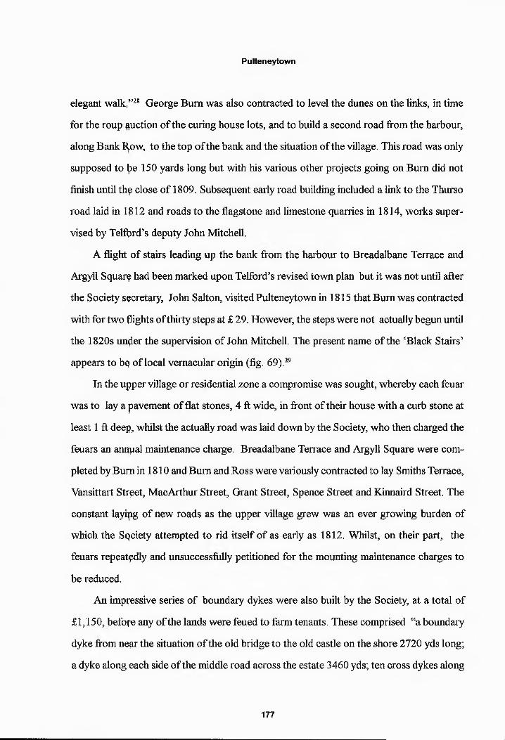
Pulteneytown
elegant walk,”’28 George Burn was also contracted to level the dunes on the links, in time
for the roup Ruction of the curing house lots, and to build a second road from the harbour,
along Bank Row, to the top of the bank and the situation of the village. This road was only
supposed to Ipe 150 yards long but with his various other projects going on Burn did not
finish until thq close of 1809. Subsequent early road building included a link to the Thurso
road laid in 1B12 and roads to the flagstone and limestone quarries in 1814, works super
vised by Telfbrd’s deputy John Mitchell.
A flight of stairs leading up the bank from the harbour to Breadalbane Terrace and
Argyll Squarq had been marked upon Telford’s revised town plan but it was not until after
the Society secretary, John Salton, visited Pulteneytown in 1815 that Burn was contracted
with for two flights of thirty steps at £ 29. However, the steps were not actually begun until
the 1820s under the supervision of John Mitchell. The present name of the ‘Black Stairs’
appears to bq of local vernacular origin (fig. 69).29
In the upper village or residential zone a compromise was sought, whereby each feuar
was to lay a pavement of flat stones, 4 ft wide, in front of their house with a curb stone at
least 1 ft deep, whilst the actually road was laid down by the Society, who then charged the
feuars an annual maintenance charge. Breadalbane Terrace and Argyll Square were com
pleted by Burn in 1810 and Burn and Ross were variously contracted to lay Smiths Terrace,
Vansittart Street, MacArthur Street, Grant Street, Spence Street and Kinnaird Street. The
constant layipg of new roads as the upper village grew was an ever growing burden of
which the Sqciety attempted to rid itself of as early as 1812. Whilst, on their part, the
feuars repeatedly and unsuccessfully petitioned for the mounting maintenance charges to
be reduced.
An impressive series of boundary dykes were also built by the Society, at a total of
£1,150, before any of the lands were feued to farm tenants. These comprised “a boundary
dyke from near the situation of the old bridge to the old castle on the shore 2720 yds long;
a dyke along each side of the middle road across the estate 3460 yds; ten cross dykes along
177

Pulteneytown
each side of the cross roads of the public Thurso and Ulbster roads, between them 122,230
yards.” Each dyke consisted of two ditches, three feet wide at the bottom and six feet wide
at the top, th^ soil dug out was built up between the ditches to a height of 8 ft and the whole
faced with turf- Despite Dunbar refusing to contribute to the cost where it marched with
his estate, thq boundary was completed in early 1809 and three bushels of furze seed sown
along the top.
As discussed, the Society did not have to provide the range of buildings considered
essential at tfye other earlier settlements such as churches, inns and later schools as these
facilties were already available across the river. However, the success and growth of the
settlement m^ant these buildings soon appeared in Pulteneytown itself.
The Inn
The ‘Ropnd House’ as it is known locally is located on Harbour Place below the bank
to the east of fhe root of the south pier. It was built by George Burn as a speculative venture
to a design by Telford in 1808 and was supposed to have been the Pulteneytown Inn, for
which purpose its prominent location and outlook across the harbour were well suited.30
However, opce built, Burn decided to make the building his own house depriving
Pulteneytowp of a landmark quality inn as stipulated at the other settlements, although
many small, private inns or ‘dram shops’ and cook houses naturally sprung up around the
harbour and plong Bank Row to meet demand, a trend the Society was not keen on:
The Society must clamp down on dram shops that are prevalent on the north east coast if not already across the whole Highlands.... whose shrivelled image is perceptible everywhere [which] if allowed to continue to predominate will be oppressive to a well regulated inn when the progress of the settlement shall require such an accommodation.31
However, despite never actually being used as a working inn, the prominent location
178

Pulteneytown
Fig. 70. The Round House. Harbour Place, Wick. Caithness.
and design of the Round House has nonetheless the same visual impact and central place
within the settlement’s designed landscape as the inns at Ullapool and Tobermory. The
Round House is a symmetrical, two storey house of three bays with prominent semicircu
lar outer bays. The hipped roof has oversailing eaves above the central entrance bay be
tween the projecting outer bays and the whole is capped by a central chimney stack which
runs the full length of the roof ridge (figs 70-72). The overall elevation is similar to the two
storey, three bay type familiar from the inns at Ullapool and Tobermory and is “an example
of neatness.”32 However, the semicircular bays and oversailing eaves are a new element on
the standardised British Fisheries Society harbour front. Bowed outer bays were them
selves well established as a central feature of villa design, but primarily in the rear elevation,
for example at Robert Adam’s Bellevue House, Edinburgh, 1774 or Jerviston House, Moth
erwell, 1782.33 Amongst others, Robert Mylne had also used the device in his initial pro
posals for Piflour House, Strathmiglo, Fife, 1773.34 Bowed outer bays had also found
some popularity in the designs for New Town townhouses in both Bath and Edinburgh
such as Somersetshire Building, Milson St, Bath, 1782 and 39-43 North Castle St, Edin-
179

Pulteneytown
Fig. 71. West elevation, the Round House. Pulteneytown. Wick, Caithness.
burgh, 1792. Whilst as early as 1765 Robert Adam had built two large, speculative
townhouses with bowed outer bays on Adam Square, Edinburgh, demolished in the mid
nineteenth century to form South Bridge Street.35 Inspiration could also be found in the
prolusion of villa pattern books targeted at “persons of moderate income and for comfort
able retirement”.36 Houses intended as “a retreat for a gentleman and supposed to be in the
neighbourhood of a large town”.37 A model can even be found in the perennial Rudiments
of Architecture, where the villa depicted in design VII employs a similar hipped roof, cen
tral roof stack and bowed outer bays, though these are to the rear as with Adam’s villas.
However, the roof’s oversailing eaves reveal Telford had a more contemporary edge
taken from fashionable pattern books such as Robert Lugar’s ‘The Country Gentleman's
Architect', 1807 and ‘Architectural Sketches for Cottages, Rural Dwellings and Villas’,
1811 or John Claudius Loudon’s ‘A Treatise on Forming, Improving and Managing Coun
try Residences’, 1806.38 Particular attention appears to have been paid to John Plaw’s
'Sketches for Country Houses, Villas and Rural Dwellings' published in 1800. The villas
illustrated in Plates II and XXXVIII both featuring hipped roofs, continuous central ridge
stacks, projecting outer bays and oversailing eaves above the central bay. Telford had not
failed to notipe the emerging picturesque or cottage ornee style illustrated by Plaw and
typified by the villas of John Nash such as Cronkhill, Salop, 1802.
Telford must have found a convenient confluence of purpose between villa design, in
180

Pulteneytown
Fig. 73. Toll House on the Holyhead Road. Thomas Telford. Atlas to the Life of Thomas Telford. 1838 (photo: National Monuments Record of Scotland).
which a primary considera
tion was a panoramic view
to engage the occupants
with nature and official
buildings also dependant
upon the visibility of the
world outside such as
tollhouses, gate lodges,
lock-keeper’s cottages and
harbour offices.39 The pro
jecting bowed bays being
well suited to the Round
House whether an inn or a
house. Within Scotland alone numerous bow-fronted tollhouses were built in the early
nineteenth century such as the Dalmarnock Toll or the Round Toll, Garscube Rd, Glasgow
both from circa 1820.40 Many smaller versions have survived throughout Scotland at places
as far apart as Bonkle, North Lanarkshire, Dunkeld, Perthshire and West Brechin, Angus
or Cramond, West Lothian (fig. 73).41
It was arguably Telford himself who established the generic style for these functional,
official buildings.42 From the Ellesmere Canal Company Offices buildings in the 1790s to
the numerous Holyhead Road tollhouses of the 1820s or Dinwoodie Tollhouse on the
Glasgow-Carlisle road Telford seeded long strips of Britain with his bow-fronted boxes.43
These form up overall architectural group within which the Round House sits as comfort
ably as it doep with the Society’s other inns.
181

Pulteneytown
Curing and Storehouses
“Thy finest group of curing depots [in Scotland] is at Pulteneytown.”44
As with every other aspect of Pulteneytown, a new approach was required for the
provision of storehouses. An existing demand from several large merchant and curing com
panies for curing facilities meant the Society could easily feu building lots and did not have
to involve itsplf financially with their building costs. As discussed in chapter two, Telford
set out twenty one lots for curing house lots, 60 ft by 120 ft, laid out in a strict grid on the
links. Building regulations then further specified that the buildings were to be built of stone,
properly roofed and slated and at least 60 ft by 22 ft in ground plan and at least 18 ft high
with sheds tq the rear (fig. 74). These simple regulations ensured that any curing houses
built would bp of largely uniform dimension and build (fig. 75). Also, curinghouses were
generally built to a standard, gabled functional type, as found the length of the Caithness
coast at Lybsfer, Staxigo or Clyth and similar to the bonded warehouses of the Port of Leith
or Port Glasgow.45 As such, a prescribed elevation was never necessary as the only possi
bility for variation was in the arrangement of the doors and windows. Lots were sold by
auction in 1808 with eleven taken immediately and all twenty leased by 1817. Leases were
taken by curprs based in Wick but also from large fishing and port centres such as the
Clyde, Dundee and Leith ensuring an influx of commercial building practices from across
Fig. 74. Harbour Quay. Pulteneytown. Wick. Caithness.
182

Pulteneytown
Reconstruction of a typical Pulteneytown curinghouse
Scotland to blend with the build
ing traditions of the Caithness ma
sons. The 1792 Statistical Ac
count lists ten masons and carpen
ters in Wick with other contrac
tors, such as the inexhaustible
George Burn, coming from re
gional Masonic centres such as
Dingwall.
The overall level of uniformity in the build and design is remarkable. As confirmed by
a fieldwork survey, all the curing or storehoues are built out of the local Caithness stone cut
in elongated, rectangular slabs dictated by the nature of the stone and laid in narrow regular
courses, a build unique to the region.46 This vernacular build can be seen in farm buildings
throughout Caithness, such as Pennyland Farm, Thurso (fig. 76). As the curing houses
were built independently of the Society, plans and detailed specifications were not kept by
the Society.
As fifteen of these build
ings still occupy the twenty lots
relatively intact it is possible to
look at their design in more
detail. As observed ,all are built
in neat courses of Caithness
slabstones and just under half
are harled or rendered. This is
modern covering as harling is not common to older Caithness buildings as the strength of
the stonework does not require extra protection, as is the case with random rubble builds
found elsewhere. Like the storehouses at Ullapool and Tobermory the gabled roof type is
Fig. 76. Pennyland Barn. Thurso. Caithness.
183

Pulteneytown
Fig. 77. Former curinghouse. Stevenson & Co. depot. Harbour Quay. Pulteneytown. Wick. Caithness.
predominant and the majority have raised stone skews whilst two buildings have hipped
roofs. All are roofed with thick slates as prescribed by Society regulations and was the only
viable option for buildings of such size in Caithness. The windows, where original, are
rectangular often still with twelve pane sash and case frames of surprisingly high quality for
industrial buildings. The tallest, three storey stores remaining have square windows to the
upper storey. The doorways are harder to analyse as most have been moved or filled in,
however, the infilled openings indicate square headed doors and
segmentally arched central pends for access to the sheds and
store yards to the rear of the buildings. Half of the buildings are
two storeys, the rest are either three storeys or two storeys with
dormer attic windows. The dormers are generally more recent
modifications to two storey curing houses that have been con
verted into residential properties.
Principally built between 1808 and 1817, the typical
curinghouse in Lower Pulteneytown would have appeared as aFig. 78.Curing yard. Wick Heritage Centre.
184

Pulteneytown
Fig. 79. Pesigns XX & XXI. Rudiments of Architecture, 1773.
rather imposing gabled building. As can be seen in the remarkably intact Stevenson and Co
depot at the centre of Harbour Quay, the main building fronted a complete fish processing
factory that would have occupied the rear of the lot (fig. 77). The central archway would
have lead through the pend to a large open air flagstoned curing yard behind. This yard was
surrounded on the remaining three sides of the lot by lean-to single storey outhouses for
salt stores, cooperages and the smokeries set against the outer wall. From the street outside
all that could be seen of this activity would have been smoke rising over the high walls
running the eptire length of the lot (fig. 78).
The regularity and simplicity of neo-classicism was clearly suited to industrial or com
mercial desigp being cheap and straightforward to build. However, the regular fenestration
and proportipn common to all the store or curinghouses, even though built by different
contractors and tenants, is indicative of the deeper theoretical impact of neo-classical ar
chitecture upon the wider building trade. Numerous comparisons can be found in Leith and
Port Glasgow or on a massive scale in the seven storey blocks then recently completed at
David Dale’s New Lanark site.47 The link between the practical, work-a-day storehouse
building and more polite architecture can again be found in the widely influential the Rudi
ments of Architecture. The Rudiments contains several chapters on proportional geometry
and includes numeric scales of modular proportion. The large but plain three storey house
with graduated windows illustrated in Design XX alone provides the design for a store-
185

Pulteneytown
house (fig. 79). However, the most characteristic feature of the Pulteneytown buildings as
a group is th$ predominance of the central arch. These have been referred to as ‘Telford
arches’ but Jelford was not involved in the design of the storehouses and the more likely
source is, again, the Rudiments of Architecture, where the shallow, segmental is clearly
Fig. 80The Construction of Brick and Stone Arches, Plate XXXIII. The Rudiments of Architecture. 1773.
illustrated (fig. 80).
The Customs House
The Society achieved a coup in 1820 when the Lords Commissioners of the Treasury
agreed to thejr application to have the Customs House at Thurso moved to Pulteneytown,
despite strong official protest from the Heritors and inhabitants of Thurso. The Society’s
then agent, Macleay, had recommended the application to the Directors in 1818 following
petitions frorp Merchants and Fishcurers of Leith and the Magistrates and Burghers of
Wick. The application was also supported by the Edinburgh Board of Customs on the
grounds that merchants had to leave their ships in the open Bay of Wick whilst the captain
travelled to Thurso to report his cargo then returned to his ship before entering Wick.
186

Pulteneytown
Fishcurers likewise had to send their fish to Leith for legal export which was costly and
time consuming as Wick was bringing in over 100,000 barrels of herring per year. A plain
two storey, three bay Customs House was subsequently built in the 1820s without funding
from the Society overlooking the Bay of Wick on the comer of Bexley St and Nicholson at
the eastern edge of Pulteneytown.
Churches
The first church built in Pulteneytown was Wick New Parish Church on Argyll Square,
1842, now Pulteneytown Parish Church, which was founded as a chapel-of-ease as num
bers in Pulteneytown grew. A plain, neo-classical, gabled building with an arched bellcote
to the centre of a tripartite facade by William Davidson, the church forms the belated axial
centre point of Telford’s plan (fig. 81).48 The simple galleried interior is given a classical
architectural flourish with a full height, painted timber backboard, behind the pulpit to the
Fig. 81. Pulteneytown Parish Church. Argy le Square, Pulteneytown. Wick, Caithness.
187
Pulteneytown
south end wall, a set piece of pilasters supporting a central arch with a pediment above
flanked by urps. It was jointly funded at a cost of £3,817, according to feudal law, by Sir
Benjamin Dunbar, the Heritors of Wick, the Pulteneytown feuars by subscription and
despite the bpst legal efforts to avoid doing so the Society and as such represented their last
building work.
As the tpwn grew other denomination churches were also built. St Joachim’s Roman
Catholic Church, Malcolm St by William Robertson of Elgin is a simple three bayed classi
cal church bqilt to commemorate the 1832 cholera epidemic. Pulteneytown Free Church,
Dempster St pf 1853 a five bay, gothic church with bell tower and St John the Evangelist
Episcopal Church, Moray St by Alexander Ross, 1868, is a small plain gothic church.
Pulteneytown was the Society’s last and most successful settlement. The scale of the
engineering vyorks of the streets, water supply, bridge and harbour was unprecedented not
only for the Society but within the Highland region as a whole and set the example for the
next fifty years of the Highland Road and Bridge Commission’s programme. Where discus
sion of publip works at the previous settlements has been dominated by the erection of
storehouses tjie Society’s new policy at Pulteneytown involved massive infrastructure works
and little financial or practical involvement in actual buildings, instead enforcing uniformity
through stric^ building regulations.
1 Edinburgh, SftO/GD9/259/25/3/1793
2 Rolt, Thomas Telford, 112
3 G Jackson, The History and Archaeology of Ports, World’s Work, Tadworth, 1983, 45
4 Further information concerning the Society’s activities at Westminster can be found in Dunlop, The
188

Pulteneytown
British Fisheries Society, chapter 5.
5 Edinburgh, SRO/GD9/275/24
6 Edinburgh, SHO/GD9/282/150
7 Edinburgh, SRO/GD9/282/160
8 J R Hume, ‘Telford’s Highland Bridges’, (ed) A Penfold, Thomas Telford Engineer, Thomas Telford Ltd, London, l?80, 165
9Thomas Telford- Elevation, Plan and Dimensions of Bridge of Wick in the Highlands of Scotland made and constructed under the Direction of the Commissioners for Highlands Roads and Bridges,Atlas to the Life of Thomas Telford, Payne & Foss, London, 1838, pi. 51
10 Edinburgh, SJIO/GD9/289/1.7.05
11 Edinburgh, S^OZGD9/5/85
12 Edinburgh, SHO/GD9/282/13.9.07
13 Edinburgh, SftO/GD9/259/l
14 Edinburgh, SRO/GD9/259/25.3.93
15 Edinburgh, SRO/GD9/4/266
16 Telford’s decision not to use mortar was a result of the endless problems with cements at Lochbay.
17 Edinburgh, S}<O/GD9/263/16.6.03
18 Jackson, The flistory and Archaeology of Ports, 36
19 Other examples include Burghead, near Elgin, 1809, which had a harbour basin 200 yards by 50 yards formed from between two piers, Fraserburgh on the Moray Firth, which had two piers enclosing a harbour which <pould take vessels with loads upto 200 hundred tons and Peterhead the most easterly harbour in Scotland built from 1816 to 1819, also consisting of two piers enclosing a wharfed basin of some 300 ft by 100 ft
20 John Rennie, Theory, Formation and Construction of British and Foreign Harbours, 1854, foreword.
21 Edinburgh, S|<O/GD9/273
22 Edinburgh, S|<O/GD9/294
23 Edinburgh, SftO/GD9/289/6.5.08 & RHP/11801
24 The watercourse appears to still exist according to the current OS map. However, it was not possible to gain access acrpss the surrounding fields to confirm this due to the Foot and Mouth outbreak during fieldwork in Mpy 2001.
25 Edinburgh, SRO/GD9/294
26 Edinburgh, SRO/GD9/295/13.4.09
189

Pulteneytown
27 The Society’s mill maybe associated with an early to mid nineteenth century mill in Pulteneytown identified by Jofm Hume. However, this is impossible to prove as the exact location and appearance of the original repjain unclear.
28 Edinburgh, S£O/GD9/311/27.2.09
29 Edinburgh, SRO/GD9/289/21.5.08
30 Edinburgh, SJR.O/GD9/289/21.5.08
31 The Round Hpuse was, incidentally, but the beginning of Burn’s speculative building activities at Pulteneytown tfyat ran alongside his official contracts. These were not restricted to the taking up of feus and building hquses to sell on or sub let but also importing ship loads of slates and building timber to sell to feuars. The Society rightly became wary of this side of his business and refused him several feus including his ojfcr to lease land between the village and the harbour “to exercise his horses” at a suspiciously hi^h rate, the opinion was that “he is either stupid or cunning”.
32Edinburgh, SRO/GD9/289/14/05/08
33King, The Complete Works of Robert and James Adam, 132
34D Maudlin, “Robert Mylne at Pitlour House”, Architectural Heritage, vol. XII, 2001
35D Stilman, English Neo-classical Architecture, Zwemmer, London, 1988, 266 James Grant, Qld and New Edinburgh, Vol. I, Cassell, London, 1910, 48
36Robert Lugar, Villa Architecture, J Taylor, London, 1828
37 John Plaw, Sketches for Country Houses, Villas and Rural Dwellings, J Taylor, London, 1800
38A gazetteer of thirty eight such pattern books can be found in the appendix to Andrew Ballantyne’s recent essay, “Architecture and Resistance to the French Revolution: The Politics of Rustic Charm", Plus ca Change, SAHGB Symposium Proceedings, Nottingham University Press, 2000.
39I Gow, “The Edinburgh Villa Revisited”, in D Arnold (ed), The Georgian Villa, Allan Sutton, Stroud, 1996, 145
40 J Hume, “Buflding for Transport in Urban Scotland”, in D Mays (ed), The Architecture of Scottish Cities, Tuckwell Press, East Linton, 1997, 146
41Beaton, Traditional Buildings of Scotland, 85. D G Adams, Tollhouses of Angus District, Chanonry Press, Brechin, 1985, 20. N Cameron and I Fisher, Tollbooths and Townhouses, Civic Architecture in Scotland to 18$3, RCAHMS, HMSO, 1996
42B Bracegirdle, Great Engineers and their Works: Thomas Telford, David and Charles, Newton Abbot, 1973, 29
43Telford, Plans, Elevations and Details for Toll Houses on the Holyhead Road, Atlas, pi. 68. N Miller, Dinwoodie Tollhouse, privately published at Dinwoodie Toll House on the occasion of the visit by members of the The Insitute of Civil Engineers, June 1st 1991 (courtesy of Dr A Mackechnie). Dinwoodie Tollhouse is the last remaining Toll house on the Glasgow-Carlisle road and has been restored by the present owners.
44 Hume, The Industrial Archaeology of Scotland: Highlands and Islands, Batsford, London, 1977, 33
190

Pulteneytown
45J Dunlop, ‘Pulteneytown and the Planned Villages of Caithness’, (ed) J R Baldwin, Caithness a Cultural Crossroads, Edina Press, Edinburgh, 1982
46For further detail relating to the fieldwork survey see chapter four and the appendix.
47N Allen, David Dale, Robert Owen and the Story of New Lanark, Mowbray House, Edinburgh, 1986, 5
48Colvin, Biographical Dictionary of British Architects, 294. Davidson was a builder-architect working in Caithness. His other works include the cupola of Latheron Church, 1821 and Bower church, 1847. The gradual change over of responsibility for Pulteneytown to the Burgh of Wick, from national to local is reflected in tfie choice of a local architecture rather than one patronised by a Director.
191

CHAPTER SEVEN
Solid and Substantial:
An Assessment of the Society’s Building Programme
The beginning of 1788 saw the Society’s plans for a network of fishing settlements
shaping up in a satisfactory, quick and ordered manner with street plans drawn up for grid
systems at Ullapool and Tobermory. The task was to raise buildings to line the streets,
buildings that would further define the settlements’ character. And it was in the building
programme that the Society’s grand plans met success or failure according to the vagaries
of agents, building contractors, masons, engineers, surveyors, architects and even the So
ciety’s Direcfprs, each village developing its own distinct character.
By 182Q Ullapool, Tobermory, Lochbay and Pulteneytown had emerged as vastly
different places each with a distinct architectural character. Ullapool a hastily and poorly
thrown up frontier town, Tobermory a well planned, Argyll regional centre. Half-built
Lochbay, all ipfrastructure and no town and Pulteneytown, Telford’s planning masterpiece.
Despite the Society stipulating a prescribed number of public works there are huge differ
ences in type, quantity, size, design and quality of works between each settlement.
The predominant public buildings are storehouses and for the most part they are plain
utilitarian buddings designed and built to serve, not to impress, though are none-the-less
products of the late eighteenth century, symmetrical, regular and ordered in plan and eleva
tion. The smallest and simplest was at Lochbay, little more than a stone gabled barn in
structure. At Ullapool the storehouses by Cowie and Melville and Miller are larger three
storey buildipgs, the plans were vetted and approved by both Robert Mylne and Telford,
but are all still uniform, rectangular plan, gabled buildings with regular fenestration, despite
Melvill’s best efforts to undo the most simple of plans. The great storehouse and King’s
Warehouse af Tobermory is of similar form but was elevated by its axial position at the
centre of the square forming James Maxwell’s Customs House complex, the architectural
192
SolftJ and Substantial: An Assessment of the Society’s Building Programme
merit being in the planning rather than the building itself. The situation at Pulteneytown
was different as the curing houses were built by independent curers from across Scotland.
Yet the consistency of design and elevation is remarkable and attributable to Telford’s strict
building regulations as well as the generic nature of the form and buildings. As with
Tobermory tf^e architectural impact of Lower Pulteneytown is derived from the planning of
the industrial area as a whole rather than the plain, even monolithic, storehouses. Telford
using the repetition of these plain, high walled buildings throughout the area’s grid plan
created a deliberate industrial aesthetic. The architecture of such storehouses has a wider
context in the rapid growth of the building type across Britain through the eighteenth cen
tury. The century’s economic boom saw ‘"Wealth come wafted on each freighted gale” and
with it came the need for efficient and enlarged ports and storage facilities.1 The world’s
first commercial dock was constructed in Liverpool in 1710 and the first commercial ware
house in Britain was built at Bristol in 1718, introduced from Holland only seventy years
prior to the tyuilding of the Society’s storehouses. The tall gabled storehouses within an
independent commercial zone replaced the merchant houses with stores at ground level of
the seventeenth century.
The Society’s inns were deliberately intended as the architectural focus, the main at
traction, at e^tch new settlement. Lochbay only ever gained a mean temporary inn despite
Telford’s best efforts but even Ullapool boasted a fine two storey inn approved by Mylne
and considered far too good for the place even by the Society’s own Directors. The inn at
Tobermory, if sadly much altered today, was an architectural high point for the Society.
Mylne’s plan was a variation on the typical two storey, three bay house which sprung up
across the Sopttish countryside after 1780 but Mylne brought touches of late neo-classical
sophistication in the ornament. The flanking pavilion wings with blind arcading and ball
finials, delicately proportioned to compliment the fenestration of the main house, the oculi
to the gablehpads and the circular entrance lobby. Mylne’s inn was well complimented by
James Maxwell’s simple but elegant customs house complex; two pavilion roofed, rectan
193

Sol|0 and Substantial: An Assessment of the Society’s Building Programme
gular plan buildings flanking the great storehouse. Telford’s Round House at Pulteneytown,
originally intended as the inn, is of similar architectural quality. Telford’s design reflects, in
date and stylq, the succeeding architectural trend to the restrained neo-classicism of Mylne.
The rounded outer bays, hipped roof and overhanging eaves are typical of the emerging
picturesque style of John Nash, Telford clearly keeping up to date with contemporary pat
tern books, the overall design for the Round House being derived from JohnPlaw. Telford’s
proposed church and school house at Lochbay would have also made a great contribution
to architecture in the Highlands of that period, comparable to the churches at Inveraray and
Bowmore.
However, despite the architectural interest in these buildings, at each settlement the
Society spent the bulk of its money upon what we would call civil engineering works,
bridges, streets and, above all, harbours. Each harbour taking up more time, correspond
ence and cost than all the actual buildings combined and each forming the focal point of the
settlement. If today architecture and civil engineering are distinct disciplines, it should be
borne in min4 that this splitting of the two professions only emerged in the early nineteenth
century. It was a normal situation that the building contractors and materials used at each
settlement were the same for all works, whether harbour walls or inns. As were the archi
tects, both Rpbert Mylne and Thomas Telford divided their time between designing build
ings and roa<j, canal and harbour projects. This could produce works such as Mylne’s
graceful and structurally innovative, Blackfriars Bridge but it also lead to numerous unsta
ble harbour vyorks. Telford himself promoted the professional status of the civil engineer as
his own experience taught him that civil engineering works required specialised knowledge
of materials qnd structure, from both the designer and the contractor. Experience that in
cluded his involvement with the Society’s ill fated harbour works at Ullapool and Lochbay.
The scale of the harbour works at Pulteneytown also provided an early indication of the
cost and complexity of the massive civil engineering projects that would dominate Britain
through the nineteenth century.
194

Soljd and Substantial: An Assessment of the Society’s Building Programme
The waterfront arrangement of storehouses, inn, breastwork and pier common to all
the settlements, though new to the Highlands, was an established model imported by the
Society from the flourishing industrial and commercial centres of the Lowlands and Eng
land such as fhe River Lune Port, Lancaster designed and built by Richard Gillow in 1759.
As with the imposition of the grid plan the interest lies in the juxtaposition of imposed
urban order ip a remote and distant country.
Perhaps not the finest neo-classical architecture to be found in Scotland but neo
classical nonetheless. The Society’s grandiose and often ill fated ventures inspiring High
land landowpers and entrepreneurs alike to utterly transform and mould the environment of
the Highland seaboard in order to create the villages and towns familiar to us today, rows
of neat, symmetrical cottages, a store, a church and a harbour.
’Anon, “The Is|e of Wight, A Poem in Three Cantos”, 1782, in A Briggs, The Age of Improvement, Longmans, London, 1959
195

CHAPTER EIGHT
‘Molehills’ : Settlers Domestic Buildings
The public buildings, streets and wharves at each settlement were intended to create
an environment that would attract people to work at the fisheries and these settlers would
need dwelling houses. To this end, the majority of the land in the villages was divided into
building plots or feus for settlers’ housing. The established system of both estate villages
and industrial villages was for housing to be built at the expense of the landlord, whether
Duke or mill owner; Ormiston Engine, East Lothian, built as a planned market town, by
John Cockbiprn in the 1750s or New Lanark founded by David Dale in 1793. The designs
for such housing were generally prepared by architects, often prestigious names, but also
by land surveyors, for example Milton Abbas, Dorset where the houses were built to a
repeated design derived from the local vernacular by Sir William Chambers.
Architectural interest in the labourers’ cottage grew in the late eighteenth century out
of concern ip England for their squalid condition and what was perceived as the iminent
death of the traditional English village, as expressed in Oliver Goldsmith’s poem The De
serted Village of 1770. It was considered the social duty of the landowner to improve those
conditions; ‘The well-being of the country and the landowners delight in its scenery
interlinked”1 An idea promoted by works such as the agriculturist Nathaniel Kent’s Hints
to Gentlemep of Landed Property, 1775. Kent reasoned that neglect of labourers cottages
was comparable to a badly run stables or kennels and led to poor health and unproductivity
amongst the occupants. Architectural publications addressing the issue followed, the first
of which was; John Wood’s A Series of Plans for Cottages of Habitations of Labourers,
1781. Cottage design quickly came to have a visual aesthetic that reflected the emerging
picturesque yearning for a disappearing rural landscape. This theme of rusticity, within an
overall classical model, appeared in Sir John Soane’s Sketches in Architecture, 1798 and
196

Molehills: Settlers Domestic Buildings
J M Gandy’s, Claude Ledoux inspired, Designs for Cottages, 1805. In the pursuit of an
idyll, the design of the picturesque cottage turned towards an Elizabethan vision of Eng
land, reaching its “artistic high-point of the genre” in John Nash’s Blaise Hamlet, 1810.
The architect-designed estate workers cottages had to appeal to the client’s eye, to his
sense of duty and to the promise of increased productivity. The frequent employment of the
same architeqt for a country house and its estate buildings symbolised this relation between
the landowner and the labourer, such as the Duke of Argyll’s employment of Robert Mylne
in the design pf the housing at Inveraray as well as the estate offices and Inveraray Castle
itself
John Kpox recommended that the Society followed this approach and design and
build settlers houses in his inaugural lecture to the Society in 1786.2 The Society instead
broke with the established estate village model and adopted the policy that settlers would
pay for, and build, their own homes in favour of commissioning an architect. Though
superficially similar, and with the same starting points of practicality and public health, the
estate cottage differed from the housing at the Society’s villages, as key to the design of the
former was the relationship between the building and the informed observer, a visual dia
logue understood by architect, patron and visitor alike. This was of no concern to the
Society, however, as the planned settlements were to be in the remote north of Scotland not
decorating a pirector’s estate, indeed the majority of the Directors were unlikely ever to
visit one of tlqeir settlements. As with the town plans of Ullapool and Tobermory, the Soci
ety’s concerns were solely practical and good architecture was not an economic priority.
Rejecting even the possibility of building standardised cheap rudimentary cottages, except
with reluctance at Ullapool and Lochbay, such as those proposed by David Aitken’s 1787,
“plans and estimates of houses for composing the village and fishing establishment at
Ullapool” prepared for, and submitted to the Society by, the Director Henry Beaufoy (fig.
82). Aitken’s proposed cottages are cheap and rudimentary but still maintained control of
the built environment through allocating variations of a basic symmetrical design to differ-
197

Molehills: Settlers Domestic Buildings
Mt *4mb Un J EA'
of' ffoillfe^\ ('o^(^ompo’fc.intfrtAe CfrE.,‘dud hiIl»»H»y JiJ £"Kllr 1 eiflvtnetii., ft £ iT 11 <1 p 00 1 l^in . T j| 0 C HL IS O fM , wflAe 0v*€tt££Ke defiefe o*f\.
Henry BeUixfoy by </*.W 4
D^p
»,w XL X'
Q ■
r» p n .... __ n___ r”1' '■''A» LtV.: r •-'■.... .. JW'>L ’•1V
b n 1 ■ ■ ■ 0 ■
u-—J i____
Fig- 82. David Atiken, Plans and Estimates of Houses for Composing the Village in Lochbroom and Fishing Establishment at Ullapool, 1787 (photo: National Archives of Scotland),
ent classes of artisan, whether boat builder, carpenter, shoe maker or fisherman.
The Society’s decision not to build houses would help define the character of the
198

Molehills: Settlers Domestic Buildings
settlements but was based primarily upon the strictly economic and social concerns raised
by Sir James Grant of Grant:
Besses the buildings that may be necessary the society should interfere as little as possible with building. It will inevitably bring them into a great deal of useless expanse, any of the houses may remain uninhabited and those that are inhabited will not be taken near so much care for or so much enjoyed as those which they build for themselves... Having lined out the harbour and different streets it will be proper to mark off the different lots for building allowing room for necessary offices behind the houses and a small garden equal to the consumption of the family perhaps 60 ft by 300 ft to 350 ft. The lot should be the undoubted property of tl]e person who takes it, holding in feu of the proprietor, and as parchments and charters occasion intricacy, trouble and expense to poor people, I rather think that feu letters or long leases are more eligible.3
The san^e advice, mixed with scepticism, was given by Highland landowners such as
Lachlan Maojean of Torloisk, Colin Macdonald of Boisdale, Alex Mclean of Coll and Sir
Benjamin Dqpbar of Ackergill who replied to the Earl of Breadalbane’s circular letter of
February 1737. For example, Sir Benjamin Dunbar wrote:
To pne that has attentively examined the ideas and knows the sentiments of the inhabitants of the north, east and west coasts, it will be evident that if villages were to bp built and wharves made for their accommodation, the one would remain uninhabited and the business of the fishing would remain still inactive, This plan has been formed by the reasoning, by the thinking, and by the commercial part of the community [but] these are not the people who are to carry it on. Other arguments must be used than the national advantage, before actual fishermen will be movpd; patriotism will never launch their boat or stretch their net.4
At the rpot of much of this advice was the common belief that the Highland peasant
was idle and would be extremely reluctant to give up their traditional subsistence existence
to become a pettier in a planned township and fish for a living. And the subsequent policy
to offer ninety nine year secure leases for land, upon which the settler could build their own
home was thus intended to attract settlers and reduce the Society’s financial investment
risk.
199

Molehills: Settlers Domestic Buildings
Fig. 83. Example of traditional, stone built, cottage. Croft 5. Luib. north west Skye, 1976 (photo: National Monuments Record of Scotland.
A secure tenancy arrangement, devised by the Directors George Dempster, Neil
Malcolm, Donald Macleod of Geanies and James Maxwell, was adopted for all the settle
ments.5 Very much according to Grant of Grant’s advice 99 year feus were issued at £2 to
£5 per acre depending on the proximity a plot to the harbour, the settlers were also granted
rights to quarry stone, lime, sand and peat for fuel at no charge. Each lot was to be big
enough for a house and small kail yard, roughly 60 ft by 300 ft as recommended, but not big
enough to allow self sufficiency which would consequently leave the fishery neglected.6
Each settler was allotted a further half an acre of arable land on a five year lease and five
acres of outfield pasture on a five to ten year lease. An arrangement not dissimilar to the
traditional Highland division of infield and outfield with pasture beyond the head dyke, the
Society’s planned towns were acquiring a distinct Highland character.
Responsible for their own dwellings, settlers would naturally have built in a traditional
Highland vernacular manner (fig. 83). The presence of an indigenous population had been
a criterion in the selection of sites and this was reflected in the lists of feuars at each
200

Molehills: Settlers Domestic Buildings
settlement.7 for example, the thirty six lots allocated Tobermory by 1790 were all West
Highland narq.es such as Macdonald, Mackenzie, Maclachlan, Maclean and Campbell, with
only six Lowland names like Morrison and Livingstone.8 The earliest surviving rent return
at Ullapool fpr 1816 shows a similar assortment with a predominance of Mackenzies and
Macleods bpth names common to the Coigach and Gairloch regions of Wester Ross.9
Thomas Pennant’s, 1776, A Tour in Scotland described West Highland vernacular architec
ture in the following terms:
The Houses of the common people in these parts are shocking to humanity, formed of Iqosc stones and covered with clods, which they term devots, or with heath, bropm, or branches of fir; they look, at a distance, like so many black molehills. ..The mosj wretched hovels that can be imagined.
More recent analysis by Fenton and Walker has suggested the principal vernacular
build in the Highlands in the eighteenth century was turf and rough field-cleared stones,
either in sandwich layers or as turf coursers upon a stone foundation and a simple cruck
framed roof over a central hearth.10 The typical Highland vernacular house is described as
a long and low rectangular building with walls 1.5m in height, some 8m in length and
approximately 4m wide. A central front door opened onto a central hearth with lum
chimney (a hanging timber flue and stack) and divided internally into two parts, the byre
and the dwelling area. Windows were uncommon even without glazing as the primary need
was warmth pot light. Robert Melvill’s comments in a letter of 1790 regarding the first two
years at Ullapool confirm that new settlers and numerous families of illegal squatters were
building this |ype of vernacular dwelling:
At that time... not one single stone had been built at Ullapool except... two small houses with stone and clay walls, one with sods and stones, two or three others entirely with sods and all these without any windows at al, unless smoke holes can be called such, equally calculated to dispel smoke as impart the light, and in extreme cold or night closed with a few convenient pieces of turf or sometimes the landlady’s petitcoat.11
201

Molehills: Settlers Domestic Buildings
If not \yilling to provide houses, the Society was equally unwilling to allow such
unimproved qnd unhygenic building practices to prevail and introduced strict building regu
lations in 1738. The Society’s 1788 stipulated:
1. Houses had to be erected and completely built within three years.2. Houses to be built of stone and lime or clay mortar and pointed with lime.3. Built upto the street line according to others in the street and according to the town plan in the agent’s possession.4. Tjie ground floor to be six inches above the level of the middle of the street.5. Built uniformly in terms of elevation and door and window dimensions.6. Nor dormers or storm windows allowed.7. Houses of two stories in any street must have side walls not less than seventeen feet high, doors six foot by three and windows five foot by three.8. Hpuses of one storey in any street must have side walls not less than eight feet high., doors six foot by three and windows four foot by three.9. If two houses share one lot the same uniformity or elevation must stand as if only one house with two doors placed near to and at equal distance from the centre.10. All roofs must be slated.11. All yards behind to be enclosed by walls.12. Yards not to be used for any other purpose except dwelling houses including sheds.13. A privy with roof, door and seat must be provided prior to inhabitation.14. Before internally completed a flag pavement to be laid six foot wide with a curb stone two foot deep.15Jf the pavement is not laid by the feuar it will be done so by the Society’s agent at the feuars expense.16. Sewers and covered drains to be maintained by feuars.17. No stones to be removed from a quarry after it is closed nor any new quarry opeqed without permission from the Society’s agent.12
Regulations so prescriptive ensured that a uniform, stone and slate standard was
guaranteed apd traditional wall and roofing materials instantly eradicated. The only free
dom of choiop the settler had was in the ground plan, yet the prescribed building type was
different only in construction and materials to the vernacular sharing the basic plan and
elevation. Tfye Society also recognised that many settlers would not be able to afford the
cost of building which included many new and expensive items such as iron nails and
hinges, glass, lime for mortar, slates for and cut timber and offered loans to half the value
of the property. Settlers might also have had to employ one of the newly settled carpenters
to build the roof or masons to quarry the stone and build the walling if they were not skilled
enough. As seen in chapter two Melvill had brought five masons and two mason’s labour
ers to Ullapool with their families as permanent settlers for this purpose.
202

Molehills: Settlers Domestic Buildings
Fig. 84. Sketch of typical cottage with later porch. West Argyll Street. Ullapool.
The building regulations were a simple, low cost method by which to ensure a high
standard of uniformity and neatness. However, when built, the settlers houses were private
buildings, if on rented land, and evidence relating to their effectiveness is scarce (fig. 84).
An impression can be gleaned from the Earl of Kinnoul’s 1798 report to the Annual
General Meeting of the British Fisheries Society, in which he reviewed the status of each of
the west coast settlements.13 According to his account, by 1797 there were forty seven
actual settlers at Tobermory, all of whom had completed building their houses according to
the regulations, compared to twenty seven in 1792. Of these, it was estimated that “two
fifths were covered with slate, the rest with thatch” in contravention of the regulations. The
situation at Ullapool was similar with thirty nine houses built and inhabited, compared to
seven in 1791, of which twenty eight were either tiled with Melvill’s imported pantiles or
slated, the rest thatched. This indicates the regulations were highly effective where prop
erly enforced whereas at Lochbay, according to the Society’s agent, Dr Porter, the settlers
were idle and content to “vegetate like the plants in the field” with little ever built.14 A
203

Molehills: Settlers Domestic Buildings
Fig. 85. Survey map, Portree-Dunvegan road. 1820 (detail), NAS RHP 11673 (photo: National Archives of Scotland).
survey map drawn up for the proposed Portree-Dunvegan road in 1820 shows Lochbay
with a small terrace of houses upon Macleod Terrace, a second row behind (fig. 85).
Under new ownership these had been rebuilt by the late nineteenth century to the present
row of twelve, two storey houses.15 The failure of Lochbay is highlighted by the 1875 OS
map which shows that the crofters settlement at Lusta had more houses than Stein (fig. 86).
The 1861 Census of Scotland provides some general information on housing in the
Highlands, apd as a chief concern was the health risk of poorly ventilated rooms, unprec
edented information on housing conditions was included. The most relevant figures are for
the “number of families occupying houses of different sizes”. In the Civil County District of
Lochbroom incorporating Ullapool, there were 740 families of whom 141 lived in one
room dwellings with windows, 461 with two rooms, only 55 with three rooms, 22 with
four rooms, 13 with five and descending to four families with houses containing 16 to 25
rooms with windows, probably all cadet branches of the Mackenzie family and would have
included, Dupdonnel House and Flowerdale House. The most common form of house in
the District therefore being the two room improved cottage followed by the one room, a
considerable number of three room dwellings, probably inferring two room cottages with
204

Molehills: Settlers Domestic Buildings
Fig. 86. Lochbay, first edition OS map, 1875 (photo: National Library of Scotland).
converted loft space. The survey does not specify which houses are in Ullapool but the
majority of the two and three room houses most probably belong to the settlement. The
situation is surprisingly different for the Civil County District of Tobermory where 404
families live in 204 dwellings, i.e. nearly two families per building. This reflects the over
crowding problem arising from the success of the settlement and a pressure on available
land. Of the 404 families in Tobermory District a majority of 144 lived in two room dwell
ings and 32 in three room dwellings, 11 in four rooms, 14 in five rooms, six in six rooms
declining to nine families living in ten to 15 room houses. The two room improved
cottage established by the Society’s regulations appears still to have been the dominant
housing type. However, the census figures are general and it can at best be concluded that
settlers houses at the two settlements were predominantly of two and three rooms.
Without further documentary evidence to assess the effectiveness of the Society’s
building regulations, the actual physical evidence of the buildings themselves must be turned
to. A fieldwork survey was carried out of the extant early cottages at each settlement and
205

Molehills: Settlers Domestic Buildings
the results epilated to establish overall build patterns. Lochbay was excluded or dismissed
from the survey as the present houses are so few and related in no more than foundations to
the Society’s delapidated period of ownership. The results of the fieldwork survey have
been analysed in different sections, divided according to various aspects of the build such
as walling materials, walling technique, roof shape, roofing materials, windows, window
frames, dooryvays, sections, plans and building line. An overall picture of the building type
at each settlement can then be ascertained.16
Walling Materials
At both Ullapool and Tobermory all the dwellings surveyed comply with the building
regulations apd are built of sandstone, with local stone being used in both cases. Disused
sandstone quarries are located on the outskirts of both towns. The sole use of sandstone
in a survey arpa is unusual in the British Isles as a whole, though not uncommon in Scotland
due to the abundance of good quality building stone.17
Walling Method
The use of stone as a building material to a large extent dictates the walling technique
employed. A| both Ullapool and Tobermory the vast majority of dwellings are harled over
the stone, the harl being a protective sacrificial coating to protect the stone and mortar beds
from the heavy rain’ w*nd and damp of the region.18 The few houses with patchy harl offer
a glimpse of tfie walling technique underneath.19 At both settlements the build appears to be
of regular, square cut stone laid in neat, regular courses indicating the presence of skilled
masons at thp settlements. Examination of a semi-ruinous cottage at Ullapool revealed
that whilst thp front elevation was built of neat quarried stone the side and rear walls were
of pinned, rapdom rubble constructed with a traditional double skin of field cleared stones,
the uneven edges facing the central cavity to create a smooth outer wall. This suggests the
possibility that some settlers employed masons for the front elevation but built the other
206

Molehills: Settlers Domestic Buildings
walls themselves, an obvious cost saving method.
Roof Type
The horpogeneity of the settlers houses is again apparent with the simple gabled roof
being universal at both settlements. A natural choice as a simple A-frame roof would have
been easier apd cheaper to construct than a hipped roof, even though the hipped roof is
closer in forip to the traditional cruck framed roof An interesting difference between the
two settlements is the total absence of raised skews to the gable ends at Tobermory com
pared to over half the houses at Ullapool. Their absence at Tobermory fitting the wider
Fig. 87. Dorlinn Ferry House, Loch Sunart. Morvern.
regional pattern in Mull and Morvern, such as the late eighteenth century Dorlinn Ferry
House, Loch Sunart (fig. 87) whilst their presence at Ullapool reflects the fact that the first
masons on tfie site came from East Lothian. An exception is, Edinbrugh born, Robert
Mylne’s inn at Tobermory.
Roofing Materials
At both settlements, all buildings are covered with Ballachulish or Easdale slates
according to regulation. The few thatched roofs described by the Earl of Kinnoull having
207

Molehills: Settlers Domestic Buildings
been replace^ as have Robert Melvill’s pantiles at Ullapool, which were no match for the
west coast weather.
Windows
At Tobermory and Ullapool, in correspondence with regulation, the vast majority of
window openings are rectangular in shape, symmetrically flanking a central door to the
front, with spine smaller square windows and two examples at Tobermory of stone mul-
lioned bipartite windows. The ingoes are of a good, weather-beating depth of 15 to 20 cm,
typical of west coast improved cottages.
Three types of dormer windows are also evident at Ullapool; a few small gabled roof
dormers, a Wge swept dormer which is perhaps, not coincidentally, a common feature in
Dunbar, and fhe most common type; the wallhead dormer built by heightening the walls to
create a partial upper storey with windows half engaged in the wall.
Window Frames
Corresppnding to what would be expected of the late eighteenth to early nineteenth
century, all dwellings surveyed have four, eight or twelve pane sash and case frames except
where replaced by modern double-glazing.
Doorways
Predominantly centrally located, the doorways at both settlements are plain rectangu
lar openings yvith timber door frames and simple boarded doors. There is an absence of
mouldings such as architraves, stringcourses or pilasters and pediments. The exception is,
the porticoecj Ullapool Bank (fig. 88). Several houses have gabled entrance porches with
distinctive later nineteenth century weather boarding and overhanging eaves.
Section
At Ullapool only a fifth of the dwellings surveyed are single storey, three fifths are one
208

Molehills: Settlers Domestic Buildings
Fig. 88. The Old Bank House. Pulteney Street, Ullapool. Wester Ross.
and a half storeys and one fifth are two storeys, whilst only the bank has two and a half
storeys. The dominant one and a half storey cottages being single storey cottages that have
been extended by the addition of dormer windows to create an upper floor in the roof
space, dormer windows being forbidden by the building regulations. Ullapool declined in
the mid nineteenth century when it was described by visitors as mostly ruinous and eventu
ally rose in tfie late nineteenth to early twentieth century with the return of the herring
shoals when fishing boats crossed from Banffshire along the Caledonian Canal and due to
the opening of a steam packet from Ullapool to Stornoway.20 It has been suggested that
dormers at Ullapool date from this time as fishing gear became more bulky and people
required more space. The dormers are generally weather boarded which supports a late
nineteenth century date.21 The two storey house is more prevalent than expected, which
indicates a much higher number of relatively wealthy feuars, such as suppliers and mer
chants, than is suggested by the documentary evidence.
A different situation is found at Tobermory where only a few of the dwellings are
single storey, two fifths are one and a half storeys but a further two fifths are a full two
storeys with several at two and a half storeys (fig. 89). The single and one and a half storey
209

Molehills: Settlers Domestic Buildings
cottages correspond to those found at Ullapool with the same predominance of the wall
Fig. 89. Breadalbane Terrace. Tobermory, Mull.
head dormer yvindow. The large number of two storey houses reflects Tobermory’s greater
wealth.
Plans
The dominant ground floor plan for houses at the two settlements is the simple central
cross passage, consisting of a central front door opening onto a small hall with rooms to
the left and right. However, this simple pattern allows for a variety of internal arrange
ments; such as a through hallway to a rear door, a small central room or simply two rooms
divided by a partition wall.22
Building line
As the houses were built individually, not as terraces, a third at Ullapool and a fifth at
Tobermory are completely free standing. However, the regulation that settlers would lose
street frontage not built upon has ensured that the majority of dwellings are joined to at
least one other. The visible result being terr^gs of uneven height but straight lined (figs. 90

Molehills: Settlers Domestic Buildings
Fig. 90. West Pulteney Street, Ullapool. Wester Ross.
Fig. 91. Argyll Terrace, Tobermory, Mull.
-91).
The ftejd survey results confirm that the settlers’ cottages adhered closely to the
Society’s building regulations and, as such, can be considered as a coherent architectural
group within the wider context of the ‘improved cottage’ in Scotland (figs 92 - 93). The
level of homogeneity from house to house and between the settlements is remarkable.
Though it is interesting to note that regional differences are still evident due to the effects
of both regional builds such as the absence of skews at Tobermory, and differing levels of
later economic success such as Tobermory’s higher number of dormer windows and two
Fig. 92. West Pulteney Street, Ullapool. Fig. 93. The Shore, Ullapool.
211

Molehills: Settlers Domestic Buildings
Fig. 94.Breadalbane Terrace. Pulteneytown.
storey houses What also becomes apparent is the similarity in form between the traditional
turf dwelling, derided by Melvill and the stone cottage dictated by the Society’s regula
tions, viz. a long, narrow rectangular plan with low single storey walls and a central door
way (even a pentral cross passage was common to the traditional dwellings of the West
Highlands and Islands).23 The term ‘improved cottage’ generally applied to stone built
cottages such as those at Ullapool and Tobermory, can be taken to refer not to general
agricultural reform but to the im
provement of an old design, the dif
ference between the two types rest
ing solely upon the upgrading of
building materials and the straight
building line of the planned village
replacing the scattered ‘ferme
toun’.24
As with the street layout and
public buildings, the settlers houses
at Pulteneytown differ to the west
coast settlements and this must
again be attributed to Thomas_ ... , „ , . , . Fig. 95. Argyle Square. Pulteneytown.Telford. On his recommendation,
the Society intended to build a New Town. Seventy two lots at 50 ft by 100 ft were to be
let on the usual 99 year leases but they were considerably smaller than on the west coast
and no arable or pasture land was offered. Settlers had to declare themselves as belonging
to a specific profession, fisherman, cooper, blacksmith, specifically creating a town for
professionals, the streets correspondingly lined with townhouses not cottages. Despite
warnings that the natives would not willingly turn to the sea, the lots were quickly taken up
212

Molehills: Settlers Domestic Buildings
Fig. 96. Breadalbane Crescent, Pulteneytown. Wick. Caithness.
as people had not failed to notice the
money that herring was bringing to the
town. The residential lots were
marked out in 1808 and by 1810 sixty
were taken and by 1818 this had risen
to 108 expanding the original street
plan.25 Whilst settlers still had to build
their own property, or hire masons,
a much tighter control was kept over
the design of the buildings. If the set
tlers at Pulteneytown were to be pro
fessionals not crofters their houses had
to reflect this improved status not only were the building regulations stricter but prescribed
elevations by Telford also had to be observed. Therefore the domestic buildings at
Pulteneytown fall under the planning part of the process as much if not more than under the
final settlers self build stage. As was discussed in chapter two, Telford produced two
elevations, one for a symmetrical, two storey, three bay house and a two storey, double
bay for the lower priced lots in place of the single storey cottage. The settlers were free to
arrange the internal plans as they saw fit (figs 94 - 95).
A survey of Pulteneytown revealed the extent to which the Society’s building regula
tions were successfully enforced in order to create plain, but elegant, neo-classical terraces.
All the houses are of two storeys, as prescribed. All the houses are built of narrow courses
of Caithness flagstone, neatly cut and pointed with some harling. All the houses have ga
bled roofs covered with slates. All have identical, tall rectangular windows, ingoes of be
tween 15 and 20 cm in depth and twelve pane sash and case window frames. All have
rectangular dporways with some on Argyle Square displaying pilastered porticoes. The far
east end of Breadalbane Terrace is an exceptional group of eight paired, three storey town
213

Molehills: Settlers Domestic Buildings
houses built for the fish curers, the herring kings of Pulteneytown. Dating from the 1860s
they are grander buildings in the same simple neo-classical style with front gardens con
tained within cast-iron railings and paved work yards, worker’s bothies and storehouses to
the rear (fig. 96).26
Telford ’p Pulteneytown terraces form a model New Town and cannot be considered
in the same architectural terms as the cottages of Ullapool and Tobermory, but the build
ing regulations were fundamentally the same for all the settlements, the sole difference
being Telford’s decision to produce prescribed elevations.
The present townscape of all the settlements has as much to do with their subse
quent history and development as with the founding period of the Society. Ullapool stag
nated through most of the nineteenth century while Tobermory flourished as a trading
centre. This bas created a marked difference in the present built environment of the two.
Ullapool has Remained much the same in appearance as it must have looked in 1810 whereas
Tobermory continued to develop architecturally throughout the nineteenth century. The
main evolution of the built environment at Tobermory was the appearance of four storey
tenement blocks on the harbour front. Pulteneytown thrived until the Great War, 1914-18
but the town Jias since gone into a near total decline and has become a backwater in which
the only modern development is council housing. As the largest and most successful settle
ment it has alpo fallen hardest, ironically ensuring the presrvation of Telford’s terrace, if in
a somewhat ^habby condition.
’A Ballantyne, ’‘Architecture and Resistance to the French Revolution: The Politics of Rustic Charm”, in N Jackson (ed), Plus ca Change, SAHGB Symposium Proceedings, Nottingham University Press,Nottingham, 3
2Edinburgh, SRO/GD9/1/1
’Edinburgh, SRO/GD9/3/95
'Edinburgh, SRO/GD9/3/69
214

Molehills: Settlers Domestic Buildings
'Edinburgh, SRO/GD9/3/199
6 This is particularly significant in its variance from the English cry for the villagers’ “four acres and a cow”. The settlors were to be industrious and profitable fishermen not small scale farmers and they would be starved into compliance.
7 Unlike many Highland fishing stations before and after the ideological intention of the Society was to attract native settlers from the areas directly surrounding their settlements rather than attract skilled trades such as fishing, coopering or spinning from established fishing centres through the Scottish press such as the Sco{s Magazine , the Edinburgh Evening Courant and the Aberdeen Journal. The Directors were concerned that this objective was clear, as was expressed in a letter concerning Ullapool from the secretary, John Mackenzie, to Donald Macleod of Geanies in 1789. “We are told that the common people imagine the settlement is intended for the introduction and accommodation of Lowlanders, and the discouragement of the Natives - this would be a fatal mistake if suffered to prevail”.
’’Edinburgh, SRO/GD9/3/636
9 Ullapool, Ullapool Museum Archives.
10 A Fenton, A qnd B Walker, The Rural Architecture of Scotland, John Donald, Edinburgh, 1981, 75
"Edinburgh, SIJO/GD9/3/607
12Mull, MMA, j3FS Regulations (on permanent display)
13J Dunlop, The British Fisheries Society, John Donald, Edinburgh, 1978, 211
14Edinburgh, SIJO/GD9/6/195
15 J R Hume, Ttye Industrial Archaeology of Scotland, Highlands and Islands, Batsford, London, 1977, 217. Hume dates these buildings to 1796,
16A description pf the survey methodology can be found with percentage tables of survey data in the appendix. Comparisons with Scottish national and regional builds are based upon those established by R J Naismith, Buildings of the Scottish Countryside, Victor Gollancz, London, 1981
17 This is in direct contrast to the rest of the British Isles where the prevailing geology is chalk, friable sandstone, clayp, slates, shales and mudstones. A wider variety of building materials have been traditionally employed out of necessity and hence the large list of options suggested by Brunskill such as brick, flint, clay and cob, wood, plaster and tiles.
l8Naismith, Buildings of the Scottish Countryside, 85
19 Tobermory’s much celebrated tradition for multicoloured house painting was introduced in the 1960s by folksinger apd landlord of the Mishnish Hotel, Bobby Macleod. Not as the Scottish Tourist Board would have us believe, a vernacular tradition of fishermen using up left over boat paint.
2020E Beaton, “Puddings of Lochbroom”, in J R Baldwin (e<V, People and Settlements in North West Ross, Galloway Press, 245
21Letter to authpr, 10/2/98
22 B Walker, “Traditional dwellings of the Uists”, SVBWG Regional and Thematic Studies No 1, MDPrint and Design, Edinburgh, 1981, 63
215

Molehills: Settlers Domestic Buildings
2323 M Bangor-Jones, “Landholding, Settlement and Vernacular Heritage in West Ardnamurchan”, Vernacular Building, MDPrint And Design, Edinburgh, 1995, 27 and Walker, Traditional Buildings of the Uists, 50
24It is tempting |o observe that these traditional Highland dwellings considered so vile, actually, with their regular plan and symmetry, comply very well with Laugier’s vision of the primitive hut as the basis of classical architecture as expounded by British architects such as William Chambers in his Treatise on the Origins of buildings and Orders, 1757. J Rykwert, On Adam’s Hut in Paradise, MIT Press, London, 1981, 37. J Harris and M Snodin, Sir William Chambers Architect to George III, Yale University Press, London, 1996, 70
25J Dunlop, The British Fisheries Society, John Donald, Edinburgh, 1978, 161
26 E Beaton, Caithness, An Illustrated Architectural Guide, Rutland Press, Edinburgh, 1996, 41
216

CONCLUSION
The architecture of the British Fisheries Society, the four settlements of Ullapool,
Tobermory, lyochbay and Pulteneytown, embodied the ideals of British late eighteenth cen
tury neo-classicism and yet was unique and specific to the Scottish Highlands. The Society
was founded (n the climate of Enlightenment politics, economics and social reform that was
condensed apd expounded as improvement. Within this context, the Society’s aim was to
improve the utility, social and economic productivity of the Highlands through the estab
lishment of fishing stations, complete towns with harbours, streets, building plots, store
houses, inns pnd houses all driven by the herring fishery. An improvement scheme born in
response to the growing debate on the Highlands following its social and economic decline
through the cpntury and compounded by the aftermath of the 1745 rebellion. The architec
tural house style adopted for the implementation of the Society’s building programme was
defined by, ppd reflected, these conditions. A programme that incorporated specific archi
tectural and planning models such as the Roman colonial town, the New Towns of Bath
and Edinburgh and emerging building types such as the Church of Scotland manse. It in
volved architects such as Robert Mylne, Thomas Telford, utilised the ideas of Robert
Adam, John Wood and Robert Lugar and reflected contemporary themes of urbanism,
industrialisatipn and the coming split between architecture and civil engineering. And yet
whilst the noblest of plans were laid down not always the noblest of towns were built.
Ullapopl was the first settlement established by the Society in 1787 and architecturally
it was also tfie poorest. A strong initial will was confounded by spiralling costs, litigation
and the inexperience of the Society’s Directors in the formidable task of creating towns.
And above al) through the combined ineptitude of Robert Melville, principal contractor and
merchant at Ullapool and the Society’s agent, Robert Mackenzie. The vision of a model
planned town of regular streets and ordered, neat was buildings permanently spoilt by
217

Conclusion
Melville and Mackenzie’s failure to lay out the streets according to David Aitken’s simple
grid plan. Unchecked by the incompetent Mackenzie, Melville then proceeded to erect a
series of buildings of poor quality and incorrect alignment and a poorly positioned pier
with slipping foundations. On his tour of inspection in 1790, Telford found the only build
ings of merit were those built by other contractors. James Cowie’s solid and substantial,
three storey storehouse stands today but with unusual oblique angles due to Melville’s
building lines and the expensive inn erected by Morrison, and approved by Telford and
Robert Mylnp, was exemplary, if far grander than what was required. However, despite
continued failure at the fishery until the late nineteenth century, the Society’s first settle
ment today enjoys success as the principal tourist centre in the north west Highlands. In
both plan and architecture, Ullapool was concieved as classicism in its rawest, simplest
form applied as a rational, practical and, perhaps above all, rational model of urbanism.
And it is fair Jo say that design was a low priority but though simple it is still architecture
with a deliberate aesthetic and meaning. This was the architecture of industrialisation and
utility in stoqe, like New Lanark, representing efficiency and productivity. Ullapool was
not part of a landowner’s estate built to impress and to be admired, and architectural and
aesthetic comparisons can more favourably be drawn with Lancashire mill towns or Lan
arkshire minipg towns than with the overt English rustic charm of John Nash or the primi
tive classicist of J M Gandy. The second architectural model evident at Ullapool, again
pregnant with meaning despite its simplicity, was the colonial settlement. The grid plan, the
inn, storehouses and improved cottages were a deliberate imposition of order and control
on the Highland landscape by a distant London based organisation, emphasised by the
demolition of the settlements that already existed on the site. The use of the grid plan has
been a standard system of town building by colonists throughout history but direct models
for the Society were the classical example of Roman coloniae settlements and the contem
porary colonial towns of Virginia, North Carolina and Georgia.
Tobermory was the second and most successful settlement, flourishing continuously
218

Conclusion
through to the present today. Commenced shortly after Ullapool, it is in contrast a model
of grid-iron town planning with straight streets parallel to the shore divided by cross
streets. The harbour quay, lined with neat, well built buildings was, until the late nineteenth
century, centred on James Maxwell’s U-plan customs and storehouse complex, comple
mented by Rpbert Mylne’s elegant inn situated at the root of the pier. This architectural
success at Tobermory was due entirely to the Duke of Argyll’s Chamberlain on Mull,
James Maxwell. Not only did the extremely capable Maxwell revise George Langlands’
street plan before laying out the streets himself but he also supervised the building of all the
public works ensuring they were uniformly completed to his satisfaction, on time and on
budget. He administered the feuing of lots to settlers and enforced the Society’s building
regulations, a task which Mackenzie had failed to do effectively at Ullapool causing Telford
to complain qf the numerous traditional turf dwellings that still littered the site of the village
in the early nineteenth century. If Maxwell’s town cannot be recognised at Tobermory
today this is p result of continuous development and economic growth through the nine
teenth century. Yet in contrast to Mackenzie’s incompetence at Ullapool, suspicion is aroused
by Maxwell. Maxwell was the Duke of Argyll’s Chamberlain, a skilled administrator akin to
a high ranking civil servant today, of too high a station for the post in normal circumstances
whereas Mackenzie was more typically a clerk with poor numerical skills. Maxwell was
seconded frQpi his normal duties to manage Tobermory at the instigation of the Duke of
Argyll highlighting the Duke’s extraordinary interest in the settlement. The Duke having
previously repommended the site of Tobermory and donated the land to the Society. He
also provide^ the services of his own architect, Robert Mylne, and recommended
Stevensons of Oban as contractors. Maxwell was also instructed by the Duke to give pref
erential treatment to Campbells who applied for feus. Then soon after the last stone was
laid the Duke of Argyll resigned as governor of the Society. Tobermory is a model eight
eenth century planned town and in the west of Scotland is second only to his grandfather’s
Inveraray but was in effect an Argyll outpost, not a fishing station, despite being funded by
219

Conclusion
the Society, upd as such cannot be compared equally with the other settlements. Tobermory
was after all, as the quality of the public buildings suggests, an estate village, a grand
colonial centre designed and built to impress not produce. As with any type of art you get
what the partpn is willing to pay for.
The Society’s policy for the early settlements, that settlers built their own houses
without prescribed plans but according to strict building regulations, also differed from the
model of the pstate village. Without an overriding visual imperative, the Society’s aim was
to minimise i|s own financial risk whilst maintaining a basic level of neatness and public
health. The insistence upon ‘uniform’ stone built houses, covered with slates effectively
eradicated Highland vernacular turf and thatch dwellings from the Society’s settlements.
The results Qf the fieldwork survey revealed the success of this policy, with a virtually
universal consistency of form and build found in both cottages and larger two storey
houses across both settlements. These can be considered as a coherent architectural group
of their own but also reflected a wider situation common to the Highlands as a whole by the
mid nineteenth century, where the ‘improved cottage’ built as part of wider estate im
provements replaced the older vernacular to such an extent that it is now, itself, considered
the Highland vernacular. As with the grid plan the Society’s early and high profile adoption
of the ‘improved cottage’ model through its building regulations was of considerable
influence in t|iis process.
The Society’s third settlement at Lochbay was a complete failure but also conversely
saw the genesis of a new direction in the Society’s architecture and planning. Very little was
ever built excppt a temporary inn, a small storehouse, a costly but ineffectual harbour basin
and a handftil of feued houses thrown up along the shore. The location to the fishing
grounds and shipping routes were better than at Ullapool and the site of the village was
much the saipe but in 1790 the Society was reluctant to spend money due to the rising
costs at Ullapool and by 1800 was more concerned with the new, exciting prospect of
Pulteneytown to ever invest sufficiently or quickly enough. In addition, in the settlements’
220

Conclusion
initial stages when encouragement was most needed, from London, the Society was lack
ing direction ^s the Duke of Argyll and numerous Directors had stepped down. However,
despite the lqpk of actual building works, Thomas Telford’s plans for Lochbay suggested
what was to pome at Pulteneytown. With the increased absence of the Duke of Argyll from
the Board of pirectors after 1791 William Pulteney replaced Robert Mylne as house archi
tect with his pwn protege, Telford. Telford took to the task with more enthusiasm than
Mylne, involying himself with every stage of the planning and design process. Whereas
Mylne had Qply ever reluctantly and belatedly contributed his opinions and plans as an
obligation to the Duke of Argyll, Telford appears to have genuinely believed the Society
could make % difference in the Highlands. It was also fortuitous for the Society that at this
early stage ip his career Telford had not committed himself to civil engineering and still
craved architectural success. Telford threw out a proposed basic grid scheme for Lochbay
and produce4 his own graceful town plan based upon the crescents and circuses of Bath in
which simple cottages were to be replaced with sweeping continuous classical terraces and
an elegant design for a neo-classical church. Even if Lochbay had thrived, Telford’s scheme
was no doubt over ambitious in scale but more significantly, Telford subtly shifted the
Society’s architectural style and its meaning. The colonial or industrial grind of the grid
plan was replaced with the crescents and circuses of the spa town gentility, reflecting a
different attitude to the intended inhabitants as citizens rather than settlers and workers.
Pulteneytown, the final and most successful venture by the Society, was laid out in
1809 with Telford in complete control of the programme drawing up the street plan, plans
and elevations for houses, appointing contractors and supervising the extensive harbour
works, often pcting without prior approval from the Board of Directors. Pulteneytown was
on a completely different scale to the previous settlements, a genuine New Town, Telford’s
scheme was one of urbanity. The town plan of Pulteneytown was focused upon the cham
fered rectangle of Argyll Square, a form derived from Laura Place, Bath and Telford equalled
Mylne’s inn at Tobermory with the Robert Lugar inspired Round House. But the schemes
221
Conclusion
ultimate success came from the introduction of standard two storey townhouse elevations,
which through simple repetition overcame the problem of creating continuous unified fa
cades from individually built settlers that was inherent in the Lochbay scheme. The archi
tectural impapt lying in the line of a whole street not the individual buildings. Telford was
also careful tp divide the domestic, suburban area and the industrial area of warehouses
into two distinct zones. This use of zoning with deliberately contrasting plans and symbolic
meaning is unique amongst Highland planned villages.
Pulteneytown marked the architectural high point for the Society, convincingly bridg
ing the gap between the genteel New Town and the workers planned village, but it was also
a full stop, bfot only was it the last project under taken by the Society but the scale and
vision of Pulteneytown was never again attempted in the Highlands and remains unique.
The role of fhe Society as builders, and as Telford’s employer, was taken over by the
government Highland Roads and Bridges Commission, as the cost of the civil engineering
works reached a point where logistically and financially a private body could not operate.
But whilst ta}dng up the Society’s harbour building programme the Commission was not
concerned wjth town building. And across the Highland region as a whole, despite their
flaws, it was fJ llapool and Tobermory with their simple grid plans and rows of single storey
cottages that had the greater influence on the subsequent boom in planned villages.
Though not quite the first to establish planned villages in the Highlands, the high
public profile of the Society and its endeavours at Ullapool and Tobermory inspired private
landowners pn both coasts to establish their own planned fishing villages throughout the
nineteenth ceptury, such as Plockton, Portree or Helmsdale. And these model planned vil
lages and toyyns, the total number estimated between some one hundred and one hundred
and fifty, haye in turn defined the character of the Scottish Highlands. They are places
which occupy a curious position in our overall perception of the Highlands; places of order,
regulation and control juxtaposed against a surrounding landscape still infused with the
romanticism of the nineteenth century. Rational places of simple, classical design that re
flect, and remind us of, their function as outposts on an eighteenth century economic and
political frontier. 222

BIBLIOGRAPHY
Manuscript Sources
Edinburgh, Edinburgh Public Library, Journals and Ledgers of the British Fisheries Society
Edinburgh, Edinburgh Public Library, Minutes of the British Fisheries Society
Edinburgh, Royal Commission on Ancient and Historic Monuments of Scotland, National Monuments Records Service
Edinburgh, Scottish Records Office , British Fisheries Society Papers (GD9)
London, Royal institute of British Architects, Library Archives, The Mylne Papers (MYFAM)
Mull, Tobermory, Mull Museum, Photographic Archive and Records
Ullapool, Ullappol Museum, Ullapool (Lochbroom) Parish Records and Photographic Archive
Wick, Wick Heritage Centre, Archives and Records
Original Pyblished Sources
Anon, The Ruc|iments of Architecture or the Young Workman’s Instructor, 3rd edition, G.Millin, Edinburgh, 1799
Forbes, Duncan, The Culloden Papers: Memoirs of Duncan Forbes, London, 1815
Lugar, Robert, plans and Views of Buildings, J Taylor, London, 1811
Lugar, Robert, J'he Country Gentleman’s Architect, J Taylor, London, 1823
Lugar, Robert, yilla Architecture, J Taylor, London, 1828
Pennant, Thoipps, A Tour in Scotland and Voyage to the Hebrides, W Eyres, Warrington, 1774
Plaw, John, Sketches for Country Houses, J Taylor, London, 1800
Rennie, John, Theory, Formation and Construction of British and Foreign Harbours, London, 1854
Telford, Thomas, Atlas to the Life of Thomas Telford, Civil Engineer, Payne and Foss, London, 1838
223

Bibliography
Secondary Studies
Ackerman, J.S, The Villa: The Form and Ideology of Country Houses, Princeton University Press, London, 1990
Adams, D G, Tollhouses of Angus District, Chanonry Press, Brechin, 1985
Allen, N, Davi^ Dale, Robert Owen and the Story of New Lanark, Mowbray House, Edinburgh, 1986
Anson, PF, Fisjiing Boats and Fisherfolk, Saltire Society, Banff, 1929
Anson, P.F, Scots Fisherfolk, Saltire Society, Banff, 1950
Arnold, D, (ed), The Georgian Villa, Allan Sutton Publishing, Stroud, 1996
Arnold, D (ed), The Georgian Country House; Architecture, Landscape and Society, Sutton Publishing, Stroud, 1998
Arnold, J E, New Lanark, Preservation and Development, Mays, D, Moss, M S & Oglethorpe, M K (ed), Essays in Honopr of John R Hmne, Visions of Scotland’s Past: Looking to the Future, Tuckwell Press, East Linton, 2Q()0
Backhouse, R, A History of Modem Economic Analysis, Blackwell, London, 1985
Baldwin, J R (ed). Peoples and Settlements in North West Ross, Scottish Society for Northern Studies, Edinburgh, 1994
Ballanlyne, A, Architecture and Resistance to the French Revolution: The Politics of Rustic Charm, Plus Ca Change, SAHGB Symposium Proceedings, (ed) Neil Jackson, Nottingham University Press, 1999
Bangor-Jones, fyl, Landholding, Settlement and Vernacular Heritage in West Ardnamurchan, Vernacular Building, SVB^VG, MDPrint and Design, Edinburgh, 1995
Beaton, E, Caithness: An Illustrated Architectural Guide, Rutland Press, Edinburgh, 1996
Beaton, E, Scotland’s Traditional Houses, HMSO, 1997
Bracegirdle, B, Great Engineers and their Works: Thomas Telford, David and Charles, New ton Abbot, 1973
Braunfels, W, Urban Design in Western Architecture, 900 - 1900, Chicago University Press, London, 1988
Burton, A, Thqjnas Telford, Aurum Press, London, 1999
Briggs, A, The Age of Improvement, Longmans, London, 1959
Brunskill, R.W, Handbook of Vernacular Architecture, Faber and Faber, London, 1971
Brunskill, R.W, Traditional Buildings of Britain, Victor Gollancz, London, 1981
Burke, G, Towns in the Making, Edward Arnold, London, 1977
224

Bibliography
Cameron, N & fisher, I, Tollbooths and Townhouses, Civic Architecture in Scotland to 1833,RCAHMS, HMSO, 1996
Colvin, H.M, A Biographical Dictionary of British Architects 1680-1840, Longmans, London, 3rd edition, 1995
Cruft, K. & Frqjser, A, James Craig, 1774-1795, Mercat Press, Edinburgh, 1995
Curl, J.S, Georgian Architecture, David and Charles, Newton Abbot, 1993
Currie, J, Mull, the Island and its People, Birlinn, Edinburgh, 2000
Donnachie, I, Robert Owen of New Lanark and New Harmony, Tuckwell Press, East Linton, 2000
Downes, K, The Georgian Cities of Britain, Phaidon Press, London, 1979
Dunlop, J, The British Fisheries Society, John Donald, Edinburgh, 1978
Dunlop, J, Pulteneytown and the Planned Villages of Caithness, Caithness a Cultural Crossroads, (ed) J R, Baldwin, E^ina Press, Edinburgh, 1982
Emmerson, R, Some Aspects of Modernity in Scotland, Area, Journal of Scottish Architecture, Adleader Publications, 2001
Fenton, A (ed), Building Construction in Scotland, SVBWG,, Edinburgh, 1976
Fenton, A, The Hearth in Scotland, Highland Vernacular Building, Regional and Thematic Studies No 1, SVBWG, 19$9
Fenton, A & Wplker, B, The Rural Architecture of Scotland, John Donald, Edinburgh, 1981
Fleming, J, Robert Adam and liis Circle in Edinburgh and Rome, John Murray, London, 1962
Frew, J & Jonep, D (eds.), The New Town Phenomenon, St Andrews Studies in the History of ScottishArchitecture ap0 Design IV, St Andrews University Press, 2000
Gaskill, P, Moryern Transformed, Cambridge University Press, Cambridge, 1968
Gibb, A, The S(ory of Telford, London, 1935
Gifford, J, Highlands and Islands, Buildings of Scotland, Penguin, London, 1992
Girouard, M, TJie English Town, Yale University Press, London, 1990
Glendinning, M, A History of Scottish Architecture, Edinburgh University Press, Edinburgh, 1996
Gow, I and Rovyan, A, Scottish Country Houses, 1660-1914, Edinburgh University Press, Edinburgh, 1995
Grant, J, Old apd New Edinburgh, Cassell, London, 1910
Gray, M, The Fishing Industries of Scotland, Oxford University Press, Oxford, 1978
Gunn, N, The Silver Darlings, Faber and Faber, London, 1941
225

Bibliography
Harris, J, Sir William Chambers, Zwemmer, London, 1970
Haldane, A.R.R, New Ways Through the Glens, David and Charles, Newton Abbot, 1973
Heydenreich, L,H, Architecture in Italy, 1400 - 1500, Yale University Press, London, 1974
Hogg, J, A Touf of the Highlands in 1803, reprint James Thin, Edinburgh, 1986
Hume, J R, The Industrial Archaeology of Scotland, Batsford, London, 1977
Hume, J R, Telford’s Highland Bridges, Thomas Telford Engineer, (ed) Penfold, A, Thomas Telford Ltd, London, 1980
Jackson, G, Th^ History and Archaeology of Ports, World’s Work, Tadworth, 1983
Jackson, G, In-ports and Ex-Ports: The Problems and Promises of Constant Change, Mays, D, Moss, M S & Oglethorp^, M K (ed), Essays in Honour of John R Hume, Visions of Scotland’s Past: Looking to the Future, Tucpwell Press, East Linton, 2000
King, D, The Complete Works of Robert and James Adam, Butterworth, Oxford, 1991
Kostof, S, The pity Shaped: Urban Patterns and Meanings Through History, Thames and Hudson, London, 1991
Kruft, H. W, A History of Architectural Theory, Princeton University Press, London, 1994
Lindsay, I.G, Iqveraray and The Dukes of Argyll, Edinburgh University Press, Edinburgh, 1973
Lindsay, M, Loyvland Scottish Villages. Robert Hale, London, 1980
Lotz, W, Architecture in Italy, 1500 - 1600, Yale University Press, London, 1974
McWilliam, C, The Scottish Townscape, Collins, London, 1975
Macnab, PA, hfull and Iona, David and Charles, Newton Abbot, 1987
Macaulay, J, TJje Classical Country House in Scotland, 1660-1800, Faber and Faber, London, 1987
Markus, T (ed), Order in Space and Society, Architectural Form and its Context in the Scottish Enlightenment, Mainstream Press, Edinburgh, 1982
Mays, D (ed), The Architecture of Scottish Cities, Tuckwell Press, East Linton, 1997
Maxwell, I, Building Materials of the Scottish Farmstead, Regional and Thematic Studies No. 3, SVBWG, Edinburgh, 1996
Mitchison, R Sc, Phillipson, N T, Scotland in the Age of Improvement, Edinburgh University Press, Edinburgh, 1970
Naismith, R J, Buildings of the Scottish Countryside, Victor Gollancz, London, 1981
Pride, G L, Dictionary of Scottish Building, Rutland Press, Edinburgh, 1996
Harbison, R, Tfye Built, the Unbuilt and the Unbuildable, Thames and Hudson, London, 1991
226

Bibliography
Reid, R, The Georgian House and it’s Details, Bath Press, Bath, 1989
Roberts, D L, /yrchaism and Abberration in Scottish Arch Design, Vernacular Building, SVBWG,MDPrint and Resign, Edinburgh, 1995
Richardson, Ap, Robert Mylne, Batsford Press, London, 1955
Robinson, J, Georgian Model Farms; A study of Decorative and Model Farm Buildings in the Age of Improvement, j770-1846, Clarendon Press, Oxford, 1983
Rolt, L.T.C, Thpmas Telford, Longmans, London, 1958
Roussell, A, Nprse Building Customs in the Scottish Isles, Williams and Norgate, 1934
Ruddock, T, Tejford, Nasymth and Picturesque Bridges, Mays, D, Moss, M S & Oglethorpe, M K (ed), Essays in Honqpr of John R Hume, Visions of Scotland’s Past: Looking to the Future, Tuckwell Press, East Linton, 20p0
Rykwert, J, On Adam’s House in Paradise, MIT Press, London, 1981
Rykwert, J, Thp Brothers Adam, Collins, London, 1985
Sanderson, M.FJ.B, Robert Adam and Scotland, RCAHMS, HMSO, 1992
Scruton, R, Th^ Aesthetic Understanding, Methuen, London, 1983
Smith, A, The y/ealth of Nations, 1776, Everyman, London, reprint 1991
Stilman, D, English Neo-Classical Architecture, Zwemmer, London, 1988
Stroud, D, George Dance Architect, 1741 - 1825, Faber and Faber, London, 1971
Summerson, J, The Classical Language of Architecture, Thames and Hudson, London, 1980
Summerson, J, The Unromantic Castle, Thames and Hudson, London, 1990
Sutherland, D, A Highland Childhood, Birlinn, Edinburgh, 1996
Thompson, P, giving the Fish, Routledge, London, 1983
Vigler, A, Clause Ledoux, MIT Press, London, 1990
Walker, D, introduction to The Rudiments of Architecture, Black and Harris, Whittinghame House, Whittinghame, reprint 1992
Walker, F A, Argyll and Bute, Buildings of Scotland, Penguin, London, 2000
Watkin, D, English Architecture, Thames and Hudson, London, 1989
Wittkower, R, Architectural Principles in the Age of Humanism, St. Martin’s Press, London, 1949
Worsley, G, Classical Architecture in Britain: The Heroic Age, Yale University Press, London, 1995
Read, H, The Qrigins of Form in Art, Thames and Hudson, London, 1965
227

Bibliography
Youngson, A. J, After the Forty Five, Edinburgh University Press, Edinburgh, 1973
Youngson, A J, The Making of Classical Edinburgh 1750-1840, Edinburgh University Press, Edinburgh, 1966
Wittkower, R, Palladio and English Palladianism, Thames and Hudson, London, 1984
228

APPENDIX
A. Building Survey
Methodology
A fieldwork survey was carried out at Ullapool, Tobermory and Pulteneytown, using
the well established “systematic procedure for the extensive study of examples of minor
domestic architecture” or Extensive Recording Survey devised by Prof. Cordingley of Man
chester University, School of Architecture and laid out by Dr R W Brunskill in the Hand
book of Vernacular Architecture.1 The system was developed to collect “basic architec
tural informapon” which can be compiled and collated to draw a sketch of the architec
tural pattern pf a chosen group. The system is based upon the completion of record cards
for each builcjing surveyed, detailing location date and various aspects of the build such as
roofing materials, walling materials, window types and so forth in the form of a table, for
example, C3 fndicates a gabled roof structure (figs 1-2).2 The data from each card within
the survey group (usually a combination of region, period and class of building) is then
collated and translated into percentages to produce a statistical picture of the dominant
building features within the group. For the purposes of this Ullapool, Tobermory and
Pulteneytowp have been taken as three individual survey groups which can be taken indi
vidually as tqwn surveys or compared for similarities and differences within a collective
British Fisheries Society group.
The parameters of each survey group have been defined by concentrating solely upon
buildings relying to the initial period of Society’s involvement, c. 1785-1820. Therefore the
geographic survey area at each settlement had been restricted to that shown in the original
town plans by Aitken, Maxwell and Telford. At Ullapool this area comprises The Shore,
Quay St, Argyll St, Pulteney St and Ladysmith St. At Tobermory the area includes Breast
Street, along the shore between the pier and the Baliscate Bridge, and above the bank
229

Appendix
Argyll Street, Breadalbane Street and Victoria Street. At Pulteneytown the area covers
only Breadalbane Terrace, Breadalbane Crescent and Argyle Square in the upper town and
Harbour Quay, Bum St, Telford St and Saltoun St in the lower town. The survey group is
smaller for Pqlteneytown as due to the large size of the built area and homogeneity of the
buildings the pirn has been to provide a good sample group rather than a total survey of the
town. In addtyion, as many of the original cottages built on lots under the Society’s regula
tions will havp been destroyed, rebuilt or altered dating the existing buildings as accurately
as possible is essential so that those within the survey area which are clearly mid to late
nineteenth ceptury or later can also be excluded. For example many of the cottages on West
Argyll St, Ullapool, have been excluded as though of traditional form are clearly of an early
twentieth ceptury build. Cottages that date from the survey period but have been subse
quently extended or altered have been included only where it is possible to identify features
dating from the relevant period. Once these restrictions to the survey have been applied
there remained a survey group of twenty six at Ullapool out of a possible thirty nine cited
by the Earl qf Kinnoul’s 1798 report, twenty seven at Tobermory out of a possible forty
seven and a sample of fifteen at Pulteneytown.3
’As discussed ip chapter four Lochbay has been excluded from the survey as few houses were built by settlers during the Society’s period of ownership.R W Brunskill, Illustrated Handbook of Vernacular Architecture, Faber and Faber, London, 1971, 210215.As opposed to iptensive work on individual buildings. Brunskill points out that an extensive survey should serve as a compliment to documentary research “illuminating the surviving buildings and giving information on their forgotten predecessors”
2 The categories of build laid out by Dr Brunskill have proved to be of a particularly English bias and it has consequently been necessary to add a few supplementary items more relevant to Scotland: Ei, depth of window ingpes; Eii, dormer type; B9, Caithness slab stones; C9, stone skews.
3 J Dunlop, The British Fisheries Society, John Donald, Edinburgh, 1978, 211
230

FIELDVyORK RECORD CARDS
SMALL HOUSE
(tCvJ OF FOQK- CcTTA^es
COTTAGE
A&Ti F> C«.S COTTAO-fci
MAP REFERENCE
G U-A ftxu
SURVEY DATE
n*in
CODED DESCRIPTION
\Al CSTft £cV> Tne snoftK
ELEV PHOTO
FC.OMT Soot K
PHOTOGRAPH
EAST
WALLING MATERIAL
<, A*ODSroiJ£
DATE7R?®SCy
ITT1 - 180 +
5 KEy'15.7
dvArrets
large house SMAIL HOUSE COTTAGE
VtS0f£MA*>‘S U5-rTM<r£
LOCATION COUNTY ADDRESS MAP REFERENCE FI UNO
U W-AfOOL \Aj£-»re*- £os.-5. Poi.Te»cev St FUSSY c* itrr Fee r» 'CAST Puo,
SURVEYOR SURVEY DATE FILM No. EXPOSURE No. ELEV PHOTO ASPECT walling material DATE
3 14- Ffo’K.r (JOC.-TH •SAfjD-S1C>|0£ r?<v - '8c>7
CODED DESCRIPTION
I J J 4 5 « 7 I 9 0
A
B
C
D
E
F
G
K
I
K
A»Aii
G •
CG.
y r —y
Z s TONE 5 ^YJ i» z
yft? UU< ATC B l£C aJ r*
Z
z
z
Z
y ot tfrlN M-LY
z
z
z
/
-it-
L'C;',S< PITCHED fiCOF S.TIU- SM/tU
.‘...<=$T IT < s a FATCW- APPiTioW
PHOTOGRAPH
vijTH TMC (jALdluAt- CtVIM. (xxiSuXT

Appendix
1. Numeric results of 26 properties surveyed at Ullapool.
Tables of Results
1 2 3 4 5 6 7 8 9 10 None ModeA 26 1B 22 4 1C 26 12 3D 26 3E 3 23 6El 8 5 8 4 1 2/4Eii 2 2 1 1 1 1 8 10 10F 26 8G 23 1 2 3H 5 15 5 1 31 3 22 1 5J 8 8 10 3
2. Percentage results of 26 properties surveyed at Ullapool.
1 2 3 4 5 6 7 8 9 10 NoneA 100B 84 16
~C~ 100 (46)D 100E 12 88EH 3T 19 31 15 4Eii 8 8 4 4 4 4 31 37F 100G 88 4 8H 20 57 /■ :0 31 11 74 4 11J 31 31 38
233

Appendix
3. Numeric results of 27 properties surveyed at Tobermory.
1 2 3 4 5 6 7 8 9 10 None ModeA 27 1B 25 2 1C 27 3D 27 3E 2 1 24 6Ei 7 20 3Eii 1 1 1 1 7 16 11F 27 8G 27 3H 2 11 12 2 3/41 5 22 5J 4 1 22 3
4. Percentage results of 27 properties surveyed at Tobermory.
1 2 3 4 5 6 7 8 9 10 NoneA 100B 93 7C 100D 100 (7)E 7 3 90Ei 26 74Eii 3 3 3 3 29 59F 100G 100H 7 42 44 7I 19 81J 16 3 81
234

Appendix
5. Numeric results of 18 properties surveyed at Mishnish, Tobermory.
1 2 3 4 5 6 7 8 9 10 None ModeA 18 1B 18 1C 18 3D 18 3E 1 6 11 6Ei 15 3 2Eii 1 1 2 8 4 10F 18 8G 17 1 3H 1 9 2 6 51J 1 5 12 3
6. Percentage results of 18 properties surveyed at Mishnish, Tobermory.
1 2 3 4 5 6 7 8 9 10 NoneA 100B 100G TOQD 100E 5 34 61Ei 84 1bEii 5 5 13 44 33F 100G 95 5H 5 48 13 341J 5 27 68
235

Appendix
7. Numeric results of 15 properties surveyed at Pulteneytown.
1 2 3 4 5 6 7 8 9 10 None ModeA 15 1B 7 8 (9) 8C 15 JZL 3D 15 3E 15 6Ei 3 12 4Eii 2 1 1 11 NoneF 15 8G 7 8 3/5H 13 2 4IJ 2 13 3
8. Percentage results of 15 properties surveyed at Pulteneytown.
1 2 3 4 5 6 7 8 9 10 NoneA 100B 47 53 (60)C 100 (47)D 100E 100Ei 20 80Eii 12 6 6 76F 100G 45 55H 87 13I - - - - - - - - - -J 13 87
236

Appendix
9. Numeric Results of 15 curing houses surveyed at Pulteneytown.
1 2 3 4 5 6 7 8 9 10 None ModeA 15 1B 6 1 8 (15) 5C 12 (9) 22D 15 3E 2 13 6Ei “ITEii 1 2 12 NoneF r 14 8G 13 1 1 3H 8 7 4/5I -J 8 7 2/3
10. Percentage Results of 15 curing houses surveyed at Pulteneytown.
1 2 3 4 5 6 7 8 9 10 NoneA 100B 40 7 53 100C 21 79 60D 100E 13 87Ei 100Eii 8 13 79F 8 92G 84 8 3 5H 53 23 241 - - - - - - - - -J 52 47
237
Appendix
B. Specifications for a Church and Schoolhouse at Lochbay, Thomas Telford, 1793
To tye erected on a site pointed out by the agent near the village, foundations to be 1 ft tfeep, walls to be stone and lime mortar if good enough freestone is available use {hat, common walling to be scabbled in courses, steps, comers, window cills, lintejs, chimney and chimneytops, pilasters, caps, bases, facia, tabling to be chiselled and scabbled.39 Ground floors except the parlour to be to be paved with freestone of flat squares.. .hearth stones to the parlour and upper rooms to be of polished Easdale stone, The roof to the building and bell house to be slated with Easdale slates, the hips to be covered with freestone, hollowed in the same way as for the ridge only made so as to suit the angle of the building, to be well staid on the bottom with an iron pin which is to be fixed in the piece of timber which forms the hip, the roof to the building and bell house to be of deal.Floqr to be laid in the house part at the height of six inches from the ground to consist of joists nine by three properly staid and covered with deal boarding jointed and pailed. Partitions three inch standarding and lathed on both sides, inner porch to the church three inch standarding boarded with inch boards smoothed and planed and tongued. Outer doors of two inch deal framed, beaded and flush and square hung with T hinges, good stocks locks and thumb catches. Each door to be hung in two leaves, the standing doors to have bolts at top and bottom. All inside doors to school room and school masters house to be one inch thick, framed, square in four panels hung with three inch butt hinges with rim locks and thumb catches. All doors have plain deal jambs and soffits and beaded facing or single mouldings. Panfry and closets fitted with three shelves planed and fixed on brackets.Ground floor windows to be two inches thick deal with deal frames. Upper half of the window to be made so as to run down, the lower half to be fixed, upper windows also to be two inch thick sashes and frames but made so half slides to one side, all the windows to the houses have thick shutters framed square into boxing. All yvindows to have plain deal jambs, soffits bottom boards and beaded facing a sing|e moulding. All the apartments in the house and school room to have beaded skirting. All windows in crown glass... All windows except two in front of church to be divided into two heights as shown in section in order to suit the stones of the house and to suit any galleries which may be added. The windows really be divide^ in two in the inside yet to be raised and painted on the outside as to appear one yvindow, only the window in the front to be all sash frames and sash glazed as befqjre.All chimneys to have plain neat wood dressings round them. Stairs in the house, to the gallery and to the pulpit to be deal steps, risers, carriages and casings, a deal hanqrail, square baluster and plain navels. A partition boarded on both sides to the side and front of the stair to the gallery. Pulpit of deal of form and size in plan and section a back and top. The desk of the school master to be of framed deal with steps, seat desk board and a small drawer. A deal table with two drawers to be
238

Appendix
made and fixed in the school room opposite the windows, planed deal seats to be fixed on either side. The whole of the church and school room to be forms of one inch deal one foot wide with bearers and braces. A deal wainscot to be fixed across at the side of the pulpit next to the school room, to divide it off from the church in the week... A table to be fixed between the pillar to the gallery of writing on, spall drawer to be made and fixed under... Gallery to be erected at one end of the church over a part of school room to project six feet from the end wall, the front to be laid at a height of 7 ft 6 inches from the pavement of the floor, the beam to be nine inches by six inches. In the walls two columns seven inches at thebottqm and six inches at the top and two pilasters at the wall to them.... All paintedthree times in oil and finished oak colour. Ceiling partitions and under gallery to be lathe0 and plastered three coats white and walls two coats. If the walls of freestone all work to be pointed if whinstone roughcast after one year. The parlour floor of deal jlaned and jointed and nailed upon sleepers four inches square laid eighteen inches apart so air passes between them. A skylight of one square of glass to light the landing of stairs.
(Edinburgh, SRO/GD/1227)
239