A class I overview of the prehistoric cultural resources, Little ...
Upload
khangminh22Category
view
2download
0
CULTURAL RESOURCES STUDY FOR THE MERRILL COMMERCE CENTER
SPECIFIC PLAN PROJECT
CITY OF ONTARIO, SAN BERNARDINO COUNTY, CALIFORNIA
Lead Agency:
City of Ontario Planning Department 303 East B Street
Ontario, California 91764
Preparer: Brian F. Smith and Associates, Inc.
14010 Poway Road, Suite A Poway, California 92064
___________________
Signature
Project Proponent: Merrill Commerce Center East, LLC
Merrill Commerce Center West, LLC 3546 Concours Street, Suite 100
Ontario, California 91764
And
Liberty Property, L.P. 8827 North Sam Houston Parkway West
Houston, Texas 77064
August 27, 2019

Cultural Resources Study for the Merrill Commerce Center Specific Plan Project _____________________________________________________________________________________________________________________
i
Archaeological Database Information Authors: Elena C. Goralogia, Jennifer R.K. Stropes, and Brian F. Smith Consulting Firm: Brian F. Smith and Associates, Inc. 14010 Poway Road, Suite A Poway, California 92064 (858) 484-0915 Project Proponent: Merrill Commerce Center East, LLC Merrill Commerce Center West, LLC 3546 Concours Street, Suite 100 Ontario, California 91764 And Liberty Property, L.P. 8827 North Sam Houston Parkway West Houston, Texas 77064 Report Date: August 27, 2019
Report Title: Cultural Resources Study for the Merrill Commerce Center Specific Plan Project, City of Ontario, San Bernardino County, California
Type of Study: Phase I Cultural Resources Survey
Cultural Resources: SBR-33,019H, historic addresses Temp-2 to Temp-17, and P-36-
033020 USGS Quadrangle: Ontario, Prado Dam, and Corona North, California (7.5 minute) Acreage: 376.3 acres and up to 113.3 acres of off-site road and utility
improvements Key Words: Survey; 16 historic addresses (Temp-2 to Temp-17); historic
trash scatter (SBR-33,019H); isolated prehistoric artifact (P-36-033020); testing and site evaluations recommended.

Cultural Resources Study for the Merrill Commerce Center Specific Plan Project _____________________________________________________________________________________________________________________
ii
Table of Contents
Section Description Page MANAGEMENT SUMMARY/ABSTRACT ....................................................................... vii 1.0 INTRODUCTION ................................................................................................... 1.0–1 1.1 Project Description ........................................................................................... 1.0–1 1.2 Environmental Setting ...................................................................................... 1.0–6 1.3 Cultural Setting ................................................................................................. 1.0–6
1.3.1 Results of the Archaeological Records Search ........................................ 1.0–15 1.4 Applicable Regulations .................................................................................... 1.0–18
1.4.1 California Environmental Quality Act .................................................... 1.0–18 2.0 RESEARCH DESIGN ............................................................................................. 2.0–1 3.0 ANALYSIS OF PROJECT EFFECTS .................................................................... 3.0–1
3.1 Methods ............................................................................................................ 3.0–1 3.2 Results of the Field Survey ............................................................................... 3.0–1
3.2.1 Site SBR-33,019H .................................................................................... 3.0–10 3.2.2 Site Temp-2 .............................................................................................. 3.0–10 3.2.3 Site Temp-3 .............................................................................................. 3.0–10 3.2.4 Site Temp-4 .............................................................................................. 3.0–15 3.2.5 Site Temp-5 .............................................................................................. 3.0–15 3.2.6 Site Temp-6 .............................................................................................. 3.0–15 3.2.7 Site Temp-7 .............................................................................................. 3.0–15 3.2.8 Site Temp-8 .............................................................................................. 3.0–15 3.2.9 Site Temp-9 .............................................................................................. 3.0–19 3.2.10 Site Temp-10 .......................................................................................... 3.0–19 3.2.11 Site Temp-11 .......................................................................................... 3.0–19 3.2.12 Site Temp-12 .......................................................................................... 3.0–19 3.2.13 Site Temp-13 .......................................................................................... 3.0–19 3.2.14 Site Temp-14 .......................................................................................... 3.0–23 3.2.15 Site Temp-15 .......................................................................................... 3.0–23 3.2.16 Site Temp-16 .......................................................................................... 3.0–23 3.2.17 Site Temp-17 .......................................................................................... 3.0–23 3.2.18 Isolate P-36-033020 .............................................................................. 3.0–28
3.3 Summary of Field Investigations ...................................................................... 3.0–28 4.0 RECOMMENDATIONS FOR ADDITIONAL INFORMATION ......................... 4.0–1
4.1 Proposed Cultural Resource Evaluation and Mitigation Plan .......................... 4.0–1 4.2 Recommended Mitigation Monitoring Program for the Potential Discovery
of Additional Resources ................................................................................... 4.0–5
Cultural Resources Study for the Merrill Commerce Center Specific Plan Project _____________________________________________________________________________________________________________________
iii
Table of Contents (continued)
Section Description Page 4.3 Summary ........................................................................................................... 4.0–7 5.0 LIST OF PREPARERS AND ORGANIZATIONS CONTACTED ....................... 5.0–1 6.0 REFERENCES CITED ........................................................................................... 6.0–1
List of Appendices Appendix A – Resumes of Key Personnel Appendix B – Site Record Forms* Appendix C – Archaeological Records Search Results* Appendix D – NAHC Sacred Lands File Search Results* Appendix E – Confidential Maps* * Deleted for public review and bound separately in the Confidential Appendix
List of Figures
Figure Description Page Figure 1.1–1 General Location Map .................................................................................. 1.0–2 Figure 1.1–2a Northern Project Location Map ................................................................... 1.0–3 Figure 1.1–2b Southern Project Location Map .................................................................. 1.0–4 Figure 1.1–3 Project Development Map ............................................................................ 1.0–5 Figure 3.2–1 Cultural Resource Location Map* ................................................................ 3.0–9 Figure 3.2–2 Archaeological Site Location Map, Site SBR-33,019H* ............................. 3.0–11 Figure 3.2–3 Historic Structure Location Map ................................................................... 3.0–13 Figure 3.2–4 Isolate Location Map, Isolate P-36-033020* ................................................ 3.0–30 * Deleted for public review and bound separately in the Confidential Appendix

Cultural Resources Study for the Merrill Commerce Center Specific Plan Project _____________________________________________________________________________________________________________________
iv
List of Plates
Plate Description Page Plate 3.2–1 Overview of the southwestern area of the on-site portion of the project, facing west ....................................................................................................... 3.0–2 Plate 3.2–2 Overview of the south-central area of the on-site portion of the project,
facing east ........................................................................................................ 3.0–2 Plate 3.2–3 Overview of the southeastern area of the on-site portion of the project,
facing north ...................................................................................................... 3.0–3 Plate 3.2–4 Overview of the dairy cow corrals in the northeastern area of the on-site
portion of the project, facing southwest ........................................................... 3.0–3 Plate 3.2–5 Overview of the north-central area of the on-site portion of the project,
facing south ...................................................................................................... 3.0–4 Plate 3.2–6 Overview of the northwestern area of the on-site portion of the project,
facing southwest ............................................................................................... 3.0–4 Plate 3.2–7 Overview of the off-site portion of Euclid Avenue within the project,
facing south ...................................................................................................... 3.0–5 Plate 3.2–8 Overview of the off-site portion of Merrill Avenue within the project,
facing east ........................................................................................................ 3.0–5 Plate 3.2–9 Overview of the off-site portion of Grove Avenue between Eucalyptus and
Merrill avenues within the project, facing north .............................................. 3.0–6 Plate 3.2–10 Overview of the off-site portion of Grove Avenue north of Eucalyptus
Avenue within the project, facing south ....................................................... 3.0–6 Plate 3.2–11 Overview of the off-site portion of Walker Avenue within the project,
facing south ................................................................................................... 3.0–7 Plate 3.2–12 Overview of the off-site portion of Eucalyptus Avenue within the Project,
facing west .................................................................................................... 3.0–7 Plate 3.2–13 Overview of the off-site, easternmost portion of Merrill Avenue within the
project, facing west ....................................................................................... 3.0–8 Plate 3.2–14 Overview of the off-site portion of Carpenter Avenue within the project,
facing north ................................................................................................... 3.0–8 Plate 3.2–15 Overview of Site SBR-33,019H, Facing East ............................................... 3.0–12 Plate 3.2–16 Overview of Site Temp-2 at 8521 Eucalyptus Avenue, facing southeast ..... 3.0–14 Plate 3.2–17 Overview of Site Temp-3 at 8541 Eucalyptus Avenue, facing southeast ..... 3.0–14 Plate 3.2–18 Overview of Site Temp-4 at 8551 Eucalyptus Avenue, facing southeast ..... 3.0–16 Plate 3.2–19 Overview of Site Temp-5 at 8643 Eucalyptus Avenue, facing south ........... 3.0–16 Plate 3.2–20 Overview of the Site Temp-6 residence at 8731 Eucalyptus Avenue,
facing southeast ............................................................................................. 3.0–17

Cultural Resources Study for the Merrill Commerce Center Specific Plan Project _____________________________________________________________________________________________________________________
v
List of Plates (continued)
Plate Description Page
Plate 3.2–21 Overview of the Site Temp-6 milk barn at 8731 Eucalyptus Avenue, facing southeast ............................................................................................. 3.0–17
Plate 3.2–22 Overview of Site Temp-7 at 8831 Eucalyptus Avenue, facing south ........... 3.0–18 Plate 3.2–23 Overview of Site Temp-8 at 8888 Eucalyptus Avenue, facing south ........... 3.0–18 Plate 3.2–24 Overview of Site Temp-9 at 8911 Eucalyptus Avenue, facing south ........... 3.0–20 Plate 3.2–25 Overview of Site Temp-10 at 9032 Merrill Avenue, facing north ................ 3.0–20 Plate 3.2–26 Overview of Site Temp-11 at 8966 Merrill Avenue, facing north ................ 3.0–21 Plate 3.2–27 Overview of Site Temp-12 at 8810 Merrill Avenue, facing north ................ 3.0–21 Plate 3.2–28 Overview of Site Temp-13 at 8816 Merrill Avenue, Facing North .............. 3.0–22 Plate 3.2–29 Overview of the Site Temp-14 residence at 8920 Merrill Avenue, facing north .............................................................................................................. 3.0–24 Plate 3.2–30 Overview of the Site Temp-14 milk barn at 8920 Merrill Avenue, facing north .............................................................................................................. 3.0–24 Plate 3.2–31 Overview of the Site Temp-15 residence at 14651 Grove Avenue, facing east ................................................................................................................ 3.0–25 Plate 3.2–32 Overview of the Site Temp-15 milk barn at 14651 Grove Avenue, facing northeast ........................................................................................................ 3.0–25 Plate 3.2–33 Overview of Site Temp-16 at 14545 Grove Avenue, Facing East ................ 3.0–26 Plate 3.2–34 Overview of the Site Temp-17 residence at 14525 Grove Avenue, facing east ................................................................................................................ 3.0–27 Plate 3.2–35 Overview of the Site Temp-17 20 barn at 14525 Grove Avenue, facing southwest ....................................................................................................... 3.0–27 Plate 3.2–36 Prehistoric Mano Identified as Isolate P-36-033020 ..................................... 3.0–29
List of Tables
Table Description Page Table 1.3–1 Archaeological Sites Located Within One Mile of the Merrill Commerce
Center Project ................................................................................................. 1.0–15 Table 1.3–2 Additional Sources Consulted for the Merrill Commerce Center Project ...... 1.0–17 Table 4.1–1 Cultural Resources Inventory and Proposed Evaluation Requirements ......... 4.0–2

Cultural Resources Study for the Merrill Commerce Center Specific Plan Project _____________________________________________________________________________________________________________________
vii
MANAGEMENT SUMMARY/ABSTRACT
In response to a request by T&B Planning, Inc., Brian F. Smith and Associates, Inc. (BFSA) conducted a cultural resources study for the Merrill Commerce Center Specific Plan Project (referred to as the Merrill Commerce Center Project in this report). The project is located in the city of Ontario, San Bernardino County, California, on the 7.5-minute USGS Ontario, Prado Dam, and Corona North, California topographic quadrangles in the Santa Ana Del Chino Land Grant (Township 1 and 2 South, Range 7 West, projected). The 376.3 acres of on-site development are bound by Grove, Merrill, Carpenter, and Eucalyptus avenues, and the approximately 113.3 acres of off-site improvements are mainly located along Euclid, Merrill, Grove, Cucamonga, Eucalyptus, Walker, and Carpenter avenues and Francis Street. The project proposes the development of industrial and business park land uses totaling up to approximately 8,455,000 square feet of building space. The project also includes the installation of up to 113.3 acres of off-site infrastructure, including roadways and utilities to service the project with potable water, recycled water, sanitary sewer, storm drains, and fiber optic lines.
The purpose of this investigation was to locate and record any cultural resources present within the project and subsequently evaluate any resources as part of the City of Ontario’s environmental review process conducted in compliance with the California Environmental Quality Act (CEQA). The archaeological investigation of the project included the review of an archaeological records search performed at the South Central Coastal Information Center (SCCIC) at California State University, Fullerton (CSU Fullerton) in order to assess previous archaeological studies and identify any previously recorded archaeological sites within the project boundaries or in the immediate vicinity. BFSA also requested a review of the Sacred Lands File (SLF) by the Native American Heritage Commission (NAHC).
A review of the records search provided by the SCCIC indicates that 13 resources (12 historic and one prehistoric) and 25 historic addresses have been recorded within one mile of the project. Two of the historic addresses are located within the on-site portion of the project and three historic sites overlap the off-site linear street alignments. The NAHC SLF search was negative for the presence of any sacred sites or Tribal Cultural Resources. In accordance with the recommendations of the NAHC, BFSA contacted all Native American consultants listed in the NAHC response letter to request any information regarding Native American sites within the project.
The cultural resources survey of the project was conducted on February 6 and 7 and April 22 and 23, 2019 and resulted in the discovery of 16 historic addresses, one historic trash scatter, and one isolated prehistoric artifact. All of these resources will be impacted by the development of the Merrill Commerce Center Project. The historic refuse scatter and prehistoric isolate were recorded as SBR-33,019H and P-36-033020 with the SCCIC. The historic addresses, Temp-2 through Temp-17, will be recorded with the SCCIC once they have been evaluated. According to the proposed development plan, the Merrill Commerce Center Project will potentially impact the

Cultural Resources Study for the Merrill Commerce Center Specific Plan Project _____________________________________________________________________________________________________________________
viii
identified cultural resource sites. In order to assess the potential direct and indirect impacts to cultural resources, the identified sites and historic structures must be subjected to a significance evaluation program to determine if any of the resources qualify under CEQA criteria as significant historical resources. Once the sites are evaluated and an impact assessment can be conducted, specific recommendations for the mitigation of impacts can be prepared.

Cultural Resources Study for the Merrill Commerce Center Specific Plan Project _____________________________________________________________________________________________________________________
1.0–1
1.0 INTRODUCTION 1.1 Project Description
The archaeological survey program for the Merrill Commerce Center Project was conducted in order to comply with CEQA and City of Ontario environmental guidelines. The development parcels are bound by Grove, Merrill, Carpenter, and Eucalyptus avenues, while the off-site improvement corridors are mainly located along Euclid, Merrill, Grove, Cucamonga, Eucalyptus, Walker, and Carpenter avenues and Francis Street in the city of Ontario, San Bernardino County, California (Figure 1.1–1). The property, which includes Assessor’s Parcel Numbers (APNs) 218-261-27 to -29, -34, -35, and -37; 105-411-101 and -102; 105-412-101 and -102; 105-413-101 and -102; 105-414-101 and -102; 105-415-101 and -102; 105-416-101 to -103; 105-417-101 to -104; 105-418-101 and -102; 105-419-101 and -102; 105-420-101 and -102; 105-421-101 and -102; 105-422-101 and -102; 105-433-101 and -102; 105-434-101 and -102; 105-435-101 and -102; 105-436-101 and -102, is located on the 7.5-minute USGS Ontario, Prado Dam, and Corona North, California topographic quadrangles in the Santa Ana Del Chino Land Grant (Township 1 and 2 South, Range 7 West, projected) (Figure 1.1–2). The project proposes the development of industrial and business park land uses totaling up to approximately 8,455,000 square feet of building space. The project also includes the installation of up to 113.3 acres of off-site infrastructure, including roadways and utilities to service the project with potable water, recycled water, sanitary sewer, storm drains, and fiber optic lines, encompassing portions of APNs 216-312-08; 216-313-01; 216-321-01 and -07; 216-322-01 and -10; 216-323-01 to -04 and -09; 216-324-01 and -08; 218-221-01, -08, and -09; 218-231-04, -08, -12, -19, -20, and -33; 218-261-16, -22, -23, -23, and -32; 218-271-08, -10, -11, -13, -15, -18, and -19; 218-291-07 to -09; 218-292-05 and -14; 218-301-20 and -21; 218-311-02 and -09 to -11; 102-207-206; 102-608-111, -112, -114, and -115; 102-609-104; 105-355-101; 105-409-102; 105-410-102; 105-423-102; 105-428-101 and -102; 105-429-101 and -102; 105-430-101 and -102; 105-431-101 and -102; 105-432-101 and -102; 105-437-101 and -102; 105-438-103; 105-439-102 and -103; 105-440-101 to -103; and 105-501-101 (Figure 1.1–3)
The property is currently partially developed with dairies, trucking facilities, and associated structures and paved/gravel parking areas. The property has been previously graded for the dairy and trucking operations and ground visibility was also highly limited due to dense vegetation growth and flooding in the southwest and central areas of the on-site portion of the property. The decision to request this investigation was based upon the cultural resource sensitivity of the locality, as suggested by known site density and predictive modeling. Sensitivity for cultural resources in a given area is usually indicated by known settlement patterns, which in this particular case, include historic dairy businesses.


Cultural Resources Study for the Merrill Commerce Center Specific Plan Project _____________________________________________________________________________________________________________________
1.0–6
1.2 Environmental Setting The Merrill Commerce Center Project is located in southwestern San Bernardino County in the city of Ontario. The subject property is part of the Chino Basin, south of the San Gabriel Mountains, north of the Jurupa Mountains, and west of the San Bernardino Mountains. The Chino Basin is situated within the upper Santa Ana Valley and is a relatively flat alluvial plain formed from sediments deposited by the Santa Ana River and its tributaries, such as Chino Creek and Cucamonga Creek, within the Peninsular Ranges Geomorphic Province of southern California. The Peninsular Ranges are a series of northwest- to southeast-trending mountain ranges separated by similarly trending valleys, which make up the southernmost segment of a chain of North American Mesozoic batholiths that extend from Alaska to the southern tip of Baja California. Elevations within the project range between approximately 590 and 900 feet above mean sea level (AMSL).
Geologically, the project is located on the distal margins of the broad alluvial floodplain of the ancestral Santa Ana River (Morton and Miller 2006). The entire project is mapped as being underlain by late Quaternary (middle Holocene) young sandy alluvial fan deposits, which overlie at shallow depths middle to late Quaternary (middle to late Pleistocene) very old sandy alluvial fan deposits (Wirths 2019). Late Pleistocene to early Holocene young sandy axial channel deposits also occur in nearby steam channels in the southernmost areas of the project and late Pleistocene to early Holocene young alluvial fan deposits occur east of the northern off-site alignments (Wirths 2019). During the prehistoric period, vegetation near the project provided sufficient food resources to support prehistoric human occupants. Animals that inhabited the project during prehistoric times included mammals such as rabbits, squirrels, gophers, mice, rats, deer, and coyotes, in addition to a variety of reptiles and amphibians. The natural setting of the project during the prehistoric occupation offered a rich nutritional resource base. Fresh water was likely obtainable from the Chino Creek, Cucamonga Creek, and the Santa Ana River. Historically, the property likely contained the same plant and animal species that are present today.
1.3 Cultural Setting Paleo Indian, Archaic Period Milling Stone Horizon, and the Late Prehistoric Shoshonean
groups are the three general cultural periods represented in San Bernardino County. The following discussion of the cultural history of San Bernardino County references the San Dieguito Complex, the Encinitas Tradition, the Milling Stone Horizon, the La Jolla Complex, the Pauma Complex, and the San Luis Rey Complex, since these culture sequences have been used to describe archaeological manifestations in the region. The Late Prehistoric component in the southwestern area of San Bernardino County was represented by the Gabrielino and Serrano Indians. According to Kroeber (1976), the Serrano probably owned a stretch of the Sierra Madre from Cucamonga east to above Mentone and halfway up to San Timoteo Canyon, including the San Bernardino Valley and just missing Riverside County. However, Kroeber (1976) also states that this area has

Cultural Resources Study for the Merrill Commerce Center Specific Plan Project _____________________________________________________________________________________________________________________
1.0–7
been assigned to the Gabrielino, “which would be a more natural division of topography, since it would leave the Serrano pure mountaineers.” Absolute chronological information, where possible, will be incorporated into this discussion to examine the effectiveness of continuing to use these terms interchangeably. Reference will be made to the geologic framework that divides the culture chronology of the area into four segments: late Pleistocene (20,000 to 10,000 years before the present [YBP]), early Holocene (10,000 to 6,650 YBP), middle Holocene (6,650 to 3,350 YBP), and late Holocene (3,350 to 200 YBP). Paleo Indian Period (Late Pleistocene: 11,500 to circa 9,000 YBP)
The Paleo Indian Period is associated with the terminus of the late Pleistocene (12,000 to 10,000 YBP). The environment during the late Pleistocene was cool and moist, which allowed for glaciation in the mountains and the formation of deep, pluvial lakes in the deserts and basin lands (Moratto 1984). However, by the terminus of the late Pleistocene, the climate became warmer, which caused glaciers to melt, sea levels to rise, greater coastal erosion, large lakes to recede and evaporate, extinction of Pleistocene megafauna, and major vegetation changes (Moratto 1984; Martin 1967, 1973; Fagan 1991). The coastal shoreline at 10,000 YBP, depending upon the particular area of the coast, was near the 30-meter isobath, or two to six kilometers further west than its present location (Masters 1983). Paleo Indians were likely attracted to multiple habitat types, including mountains, marshlands, estuaries, and lakeshores. These people likely subsisted using a more generalized hunting, gathering, and collecting adaptation, utilizing a variety of resources including birds, mollusks, and both large and small mammals (Erlandson and Colten 1991; Moratto 1984; Moss and Erlandson 1995). Archaic Period (Early and Middle Holocene: circa 9,000 to 1,300 YBP) The Archaic Period of prehistory began with the onset of the Holocene around 9,000 YBP. The transition from the Pleistocene to the Holocene was a period of major environmental change throughout North America (Antevs 1953; Van Devender and Spaulding 1979). The general warming trend caused sea levels to rise, lakes to evaporate, and drainage patterns to change. In southern California, the general climate at the beginning of the early Holocene was marked by cool/moist periods and an increase in warm/dry periods and sea levels. The coastal shoreline at 8,000 YBP, depending upon the particular area of the coast, was near the 20-meter isobath, or one to four kilometers further west than its present location (Masters 1983).
The rising sea level during the early Holocene created rocky shorelines and bays along the coast by flooding valley floors and eroding the coastline (Curray 1965; Inman 1983). Shorelines were primarily rocky with small littoral cells, as sediments were deposited at bay edges but rarely discharged into the ocean (Reddy 2000). These bays eventually evolved into lagoons and estuaries, which provided a rich habitat for mollusks and fish. The warming trend and rising sea

Cultural Resources Study for the Merrill Commerce Center Specific Plan Project _____________________________________________________________________________________________________________________
1.0–8
levels generally continued until the late Holocene (4,000 to 3,500 YBP). At the beginning of the late Holocene, sea levels stabilized, rocky shores declined, lagoons filled with sediment, and sandy beaches became established (Gallegos 1985; Inman 1983; Masters 1994; Miller 1966; Warren and Pavesic 1963). Many former lagoons became saltwater marshes surrounded by coastal sage scrub by the late Holocene (Gallegos 2002). The sedimentation of the lagoons was significant in that it had profound effects on the types of resources available to prehistoric peoples. Habitat was lost for certain large mollusks, namely Chione and Argopecten, but habitat was gained for other small mollusks, particularly Donax (Gallegos 1985; Reddy 2000). The changing lagoon habitats resulted in the decline of larger shellfish, the loss of drinking water, and the loss of Torrey Pine nuts, causing a major depopulation of the coast as people shifted inland to reliable freshwater sources and intensified their exploitation of terrestrial small game and plants, including acorns (originally proposed by Rogers 1929; Gallegos 2002). The Archaic Period in southern California is associated with a number of different cultures, complexes, traditions, horizons, and periods, including San Dieguito, La Jolla, Encinitas, Milling Stone, Pauma, and Intermediate. Late Prehistoric Period (Late Holocene: 1,300 YBP to 1790) Approximately 1,350 YBP, a Shoshonean-speaking group from the Great Basin region moved into San Bernardino County, marking the transition to the Late Prehistoric Period. This period has been characterized by higher population densities and elaborations in social, political, and technological systems. Economic systems diversified and intensified during this period, with the continued elaboration of trade networks, the use of shell-bead currency, and the appearance of more labor-intensive, yet effective, technological innovations. Technological developments during this period included the introduction of the bow and arrow between A.D. 400 and 600 and the introduction of ceramics. Atlatl darts were replaced by smaller arrow darts, including the Cottonwood series points. Other hallmarks of the Late Prehistoric Period include extensive trade networks as far reaching as the Colorado River Basin and cremation of the dead. Protohistoric Period (Late Holocene: 1790 to Present) Gabrielino
The territory of the Gabrielino at the time of Spanish contact covers much of present-day Los Angeles and Orange counties. The southern extent of this culture area is bounded by Aliso Creek, the eastern extent is located east of present-day San Bernardino along the Santa Ana River, the northern extent includes the San Fernando Valley, and the western extent includes portions of the Santa Monica Mountains. The Gabrielino also occupied several Channel Islands including Santa Barbara Island, Santa Catalina Island, San Nicholas Island, and San Clemente Island. Because of their access to certain resources, including a steatite source from Santa Catalina Island, this group was among the wealthiest and most populous aboriginal groups in all of southern California. Trade of materials and resources controlled by the Gabrielino extended as far north as

Cultural Resources Study for the Merrill Commerce Center Specific Plan Project _____________________________________________________________________________________________________________________
1.0–9
the San Joaquin Valley, as far east as the Colorado River, and as far south as Baja California (Bean and Smith 1978a; Kroeber 1976).
The Gabrielino lived in permanent villages and smaller resource gathering camps occupied at various times of the year depending upon the seasonality of the resource. Larger villages were comprised of several families or clans, while smaller seasonal camps typically housed smaller family units. The coastal area between San Pedro and Topanga Canyon was the location of primary subsistence villages, while secondary sites were located near inland sage stands, oak groves, and pine forests. Permanent villages were located along rivers and streams, as well as in sheltered areas along the coast. As previously mentioned, the Channel Islands were also the locations of relatively large settlements (Bean and Smith 1978a; Kroeber 1976).
Resources procured along the coast and on the islands were primarily marine in nature and included tuna, swordfish, ray, shark, California sea lion, Stellar sea lion, harbor seal, northern elephant seal, sea otter, dolphin, porpoise, various waterfowl species, numerous fish species, purple sea urchin, and mollusks such as rock scallop, California mussel, and limpet. Inland resources included oak acorn, pine nut, Mohave yucca, cacti, sage, grass nut, deer, rabbit, hare, rodent, quail, duck, and a variety of reptiles such as western pond turtle and snakes (Bean and Smith 1978a; Kroeber 1976).
The social structure of the Gabrielino is little known; however, there appears to have been at least three social classes: 1) the elite, which included the rich, chiefs, and their immediate family; 2) a middle class, which included people of relatively high economic status or long-established lineages; and 3) a class of people that included most other individuals in the society. Villages were politically autonomous units comprised of several lineages. During times of the year when certain seasonal resources were available, the village would divide into lineage groups and move out to exploit them, returning to the village between forays (Bean and Smith 1978a; Kroeber 1976).
Each lineage had its own leader, with the village chief coming from the dominant lineage. Several villages might be allied under a paramount chief. Chiefly positions were of an ascribed status, most often passed to the eldest son. Chiefly duties included providing village cohesion, leading warfare and peace negotiations with other groups, collecting tribute from the village(s) under his jurisdiction, and arbitrating disputes within the village(s). The status of the chief was legitimized by his safekeeping of the sacred bundle, which was a representation of the link between the material and spiritual realms and the embodiment of power (Bean and Smith 1978a; Kroeber 1976).
Shamans were leaders in the spirit realm. The duties of the shaman included conducting healing and curing ceremonies, guarding the sacred bundle, locating lost items, identifying and collecting poisons for arrows, and making rain (Bean and Smith 1978a; Kroeber 1976).
Marriages were made between individuals of equal social status and, in the case of powerful lineages, marriages were arranged to establish political ties between the lineages (Bean and Smith 1978a; Kroeber 1976).
Men conducted the majority of the heavy labor, hunting, fishing, and trading with other

Cultural Resources Study for the Merrill Commerce Center Specific Plan Project _____________________________________________________________________________________________________________________
1.0–10
groups. Women’s duties included gathering and preparing plant and animal resources, and making baskets, pots, and clothing (Bean and Smith 1978a; Kroeber 1976).
Gabrielino houses were domed, circular structures made of thatched vegetation. Houses varied in size and could house from one to several families. Sweathouses (semicircular, earth-covered buildings) were public structures used in male social ceremonies. Other structures included menstrual huts and a ceremonial structure called a yuvar, an open-air structure built near the chief’s house (Bean and Smith 1978a; Kroeber 1976).
Clothing was minimal. Men and children most often went naked, while women wore deerskin or bark aprons. In cold weather, deerskin, rabbit fur, or bird skin (with feathers intact) cloaks were worn. Island and coastal groups used sea otter fur for cloaks. In areas of rough terrain, yucca fiber sandals were worn. Women often used red ochre on their faces and skin for adornment or protection from the sun. Adornment items included feathers, fur, shells, and beads (Bean and Smith 1978a; Kroeber 1976).
Hunting implements included wood clubs, sinew-backed bows, slings, and throwing clubs. Maritime implements included rafts, harpoons, spears, hook and line, and nets. A variety of other tools included deer scapulae saws, bone and shell needles, bone awls, scrapers, bone or shell flakers, wedges, stone knives and drills, metates, mullers, manos, shell spoons, bark platters, and wood paddles and bowls. Baskets were made from rush, deer grass, and skunkbush. Baskets were fashioned for hoppers, plates, trays, and winnowers for leaching, straining, and gathering. Baskets were also used for storing, preparing, and serving food, and for keeping personal and ceremonial items (Bean and Smith 1978a; Kroeber 1976).
The Gabrielino had exclusive access to soapstone, or steatite, procured from Santa Catalina Island quarries. This highly prized material was used for making pipes, animal carvings, ritual objects, ornaments, and cooking utensils. The Gabrielino profited well from trading steatite since it was valued so much by groups throughout southern California (Bean and Smith 1978a; Kroeber 1976). Serrano
Aboriginally, the Serrano occupied an area east of present-day Los Angeles. According to Bean and Smith (1978b), definitive boundaries are difficult to place for the Serrano due to their sociopolitical organization and a lack of reliable data:
The Serrano were organized into autonomous localized lineages occupying definite, favored territories, but rarely claiming any territory far removed from the lineage’s home base. Since the entire dialectical group was neither politically united nor amalgamated into supralineage groups, as many of their neighbors were, one must speak in terms of generalized areas of usage rather than pan-tribal holdings. (Strong [1929] in Bean and Smith 1978b)
Cultural Resources Study for the Merrill Commerce Center Specific Plan Project _____________________________________________________________________________________________________________________
1.0–11
However, researchers place the Serrano in the San Bernardino Mountains east of Cajon Pass and at the base of and north of the mountains near Victorville, east to Twentynine Palms, and south to the Yucaipa Valley (Bean and Smith 1978b). Serrano has been used broadly for languages in the Takic family including Serrano, Kitanemuk, Vanyume, and Tataviam.
The Serrano were part of “exogamous clans, which in turn were affiliated with one of two exogamous moieties, tukwutam (Wildcat) and wahiʔiam (Coyote)” (Bean and Smith 1978b). According to Strong (1971), details such as number, structure, and function of the clans are unknown. Instead, he states that clans were not political, but were rather structured based upon “economic, marital, or ceremonial reciprocity, a pattern common throughout Southern California” (Bean and Smith 1978b). The Serrano formed alliances amongst their own clans and with Cahuilla, Chemehuevi, Gabrielino, and Cupeño clans (Bean and Smith 1978b). Clans were large, autonomous, political and landholding units formed patrilineally, with all males descending from a common male ancestor, including all wives and descendants of the males. However, even after marriage, women would still keep their original lineage, and would still participate in those ceremonies (Bean and Smith 1978b).
According to Bean and Smith (1978b), the cosmogony and cosmography of the Serrano are very similar to those of the Cahuilla:
There are twin creator gods, a creation myth told in “epic poem” style, each local group having its own origin story, water babies whose crying foretells death, supernatural beings of various kinds and on various hierarchically arranged power-access levels, an Orpheus-like myth, mythical deer that no one can kill, and tales relating the adventures (and misadventures) of Coyote, a tragicomic trickster-transformer culture hero. (Bean [1962-1972] and Benedict [1924] in Bean and Smith 1978b)
The Serrano had a shaman, a person who acquired their powers through dreams, which were induced through ingestion of the hallucinogen datura. The shaman was mostly a curer/healer, using herbal remedies and “sucking out the disease-causing agents” (Bean and Smith 1978b).
Serrano village locations were typically located near water sources. Individual family dwellings were likely circular, domed structures. Daily household activities would either take place outside of the house out in the open, or under a ramada constructed of a thatched willow pole roof held up by four or more poles inserted into the ground. Families could consist of a husband, wife/wives, unmarried female children, married male children, the husband’s parents, and/or widowed aunts and uncles. Rarely, an individual would occupy his own house, typically in the mountains. Serrano villages also included a large ceremonial house where the lineage leader would live, which served as the religious center for lineages or lineage-sets, granaries, and sweathouses (Bean and Smith 1978b).
The Serrano were primarily hunters and gatherers. Vegetal staples varied with locality.

Cultural Resources Study for the Merrill Commerce Center Specific Plan Project _____________________________________________________________________________________________________________________
1.0–12
Acorns and piñon nuts were found in the foothills, and mesquite, yucca roots, cacti fruits, and piñon nuts were found in or near the desert regions. Diets were supplemented with other roots, bulbs, shoots, and seeds (Heizer 1978). Deer, mountain sheep, antelopes, rabbits, and other small rodents were among the principal food packages. Various game birds, especially quail, were also hunted. The bow and arrow was used for large game, while smaller game and birds were killed with curved throwing sticks, traps, and snares. Occasionally, game was hunted communally, often during mourning ceremonies (Benedict 1924; Drucker 1937; Heizer 1978). Earth ovens were used to cook meat, bones were boiled to extract marrow, and blood was either drunk cold or cooked to a thicker consistency and then eaten. Some meat and vegetables were sun-dried and stored. Food acquisition and processing required the manufacture of additional items such as knives, stone or bone scrapers, pottery trays and bowls, bone or horn spoons, and stirrers. Mortars, made of either stone or wood, and metates were also manufactured (Strong 1971; Drucker 1937; Benedict 1924).
The Serrano were very similar technologically to the Cahuilla. In general, manufactured goods included baskets, some pottery, rabbit-skin blankets, awls, arrow straighteners, sinew-backed bows, arrows, fire drills, stone pipes, musical instruments (rattles, rasps, whistles, bull-roarers, and flutes), feathered costumes, mats for floor and wall coverings, bags, storage pouches, cordage (usually comprised of yucca fiber), and nets (Heizer 1978). Historic Period The historic background of the project began with the Spanish colonization of Alta California. The first Spanish colonizing expedition reached southern California in 1769 with the intention of converting and civilizing the indigenous populations, as well as expanding the knowledge of and access to new resources in the region (Brigandi 1998). In the late eighteenth century, the San Gabriel (Los Angeles County), San Juan Capistrano (Orange County), and San Luis Rey (San Diego County) missions began colonizing southern California, and gradually expanded their use of the interior valley (presently western Riverside County) for raising grain and cattle to support the missions. The San Gabriel Mission claimed lands in what is presently Jurupa, Riverside, San Jacinto, and the San Gorgonio Pass, while the San Luis Rey Mission claimed land in what is presently Lake Elsinore, Temecula, and Murrieta (American Local History Network: Riverside County, California 1998). The indigenous groups who occupied these lands were recruited by missionaries, converted, and put to work in the missions (Pourade 1964). Throughout this period, the Native American populations were decimated by introduced diseases, a drastic shift in diet resulting in poor nutrition, and social conflicts due to the introduction of an entirely new social order (Cook 1976).
In the mid- to late 1770s, Juan Bautista de Anza passed through much of what is now Riverside County while searching for an overland route from Sonora, Mexico to San Gabriel and Los Angeles, describing fertile valleys, lakes, and sub-desert areas (American Local History Network: Riverside County, California 1998; Riverside County n.d.). Spanish missionaries formed Mission San Gabriel in the San Bernardino Valley in the early nineteenth century. The

Cultural Resources Study for the Merrill Commerce Center Specific Plan Project _____________________________________________________________________________________________________________________
1.0–13
mission established Rancho San Bernardino in 1819, which included the present-day areas of San Bernardino, Fontana, Rialto, Redlands, and Colton (City of San Bernardino 2015). Since there was no reliable water source in the area, from 1819 to 1820, the missionaries developed a zanja through the use of Native American labor from the Guachama Rancheria (Smallwood 2006). The creation of the zanja was implemented to divert waters from Mill Creek all the way through the city of Redlands, ending near the mission to assist with agricultural enterprises. The new water source allowed nearby ranching districts to develop during the nineteenth century (City of Redlands 2010; Smallwood 2006). Mexico gained independence in 1822 and desecularized the missions in 1832, signifying the end of the Mission Period (Brigandi 1998; Riverside County n.d.). By this time, the missions owned some of the best and most fertile land in southern California. In order for California to develop, the land would have to be made productive enough to turn a profit (Brigandi 1998). The new government began distributing the vast mission holdings to wealthy and politically connected Mexican citizens. The “grants” were called “ranchos,” and many of these ranchos have lent their names to modern-day locales (American Local History Network: Riverside County, California 1998).
The treatment of Native Americans grew worse during the Rancho Period. Most of the Native Americans were forced off of their land or put to work on the now privately-owned ranchos, most often as slave labor. In light of the brutal ranchos, the degree to which Native Americans had become dependent upon the mission system is evident when, in 1838, a group of Native Americans from the San Luis Rey Mission petitioned government officials in San Diego to relieve suffering at the hands of the rancheros:
We have suffered incalculable losses, for some of which we are in part to be blamed for because many of us have abandoned the Mission … We plead and beseech you … to grant us a Rev. Father for this place. We have been accustomed to the Rev. Fathers and to their manner of managing the duties. We labored under their intelligent directions, and we were obedient to the Fathers according to the regulations, because we considered it as good for us. (Brigandi 1998:21)
Native American culture had been disrupted to the point where they could no longer rely upon prehistoric subsistence and social patterns. Not only does this illustrate how dependent the Native Americans had become upon the missionaries, but it also indicates a marked contrast in the way the Spanish treated the Native Americans compared to the Mexican and United States ranchers. Spanish colonialism (missions) is based upon utilizing human resources while integrating them into their society. The Mexican and American ranchers did not accept Native Americans into their social order and used them specifically for the extraction of labor, resources, and profit. Rather than being incorporated, they were either subjugated or exterminated (Cook 1976).

Cultural Resources Study for the Merrill Commerce Center Specific Plan Project _____________________________________________________________________________________________________________________
1.0–14
In 1846, war erupted between Mexico and the United States. In 1848, with the signing of the Treaty of Guadalupe Hidalgo, the region was annexed as a territory of the United States, leading to California became a state in 1850. These events generated a steady flow of settlers into the area, including gold miners, entrepreneurs, health-seekers, speculators, politicians, adventurers, seekers of religious freedom, and individuals desiring to create utopian colonies.
In 1851, 500 Mormons moved to the Redlands/San Bernardino area and purchased Rancho San Bernardino from the Lugo family (City of Redlands 2010). The settlement that the Mormons created within the rancho was short-lived, however, as in 1857, Brigham Young recalled all Mormons in San Bernardino back to Utah. Approximately 1,400 Mormons returned to Utah, while the remaining 45 percent stayed in San Bernardino, choosing “to forsake the church rather than leave their homes” (Lyman 1989).
By the late 1880s and early 1890s, there was growing discontent between San Bernardino and Riverside, its neighbor 10 miles to the south, due to differences in opinion concerning religion, morality, the Civil War, politics, and fierce competition to attract settlers. After a series of instances in which charges were claimed about unfair use of tax monies to the benefit of only San Bernardino, several people from Riverside decided to investigate the possibility of a new county. In May 1893, voters living within portions of San Bernardino County (to the north) and San Diego County (to the south) approved the formation of Riverside County. Early business opportunities were linked to the agriculture industry but commerce, construction, manufacturing, transportation, and tourism also provided a healthy local economy (American Local History Network: Riverside County, California 1998; Riverside County n.d.). General History of the Ontario Area
In late 1881, Canadian brothers George and William Chaffey purchased 6,218 acres of land in the Cucamonga Desert known as the “San Antonio lands.” The Chaffey brothers soon expanded to the Southern Pacific Railroad tracks on the south and into the San Antonio Canyon to the north (City of Ontario n.d.). The Chaffey brothers intended to establish a “model colony” for migrants coming to the region and named the area “Ontario” after their hometown. Before the land could be used, however, water had to be found and brought into the town; because of this, George Chaffey laid miles of cement pipe leading from the San Antonio Canyon, which was later tapped into by the San Antonio Water Company. The need for electric power to lift the water from the deep wells in the San Antonio Canyon led to the establishment of the first commercially successful hydroelectric plant in the country, the Ontario Power Company (City of Ontario n.d.).
During the late nineteenth century, anyone purchasing land within the Ontario Colony automatically received shares in the water company, which ensured that water would be pumped to their property. This development aided in establishing agricultural properties, primarily citrus groves, within Ontario. The Ontario Colony was officially incorporated as a city in 1891 and continued to grow throughout the twentieth century (City of Ontario n.d.). The city became known for air flight after Judge Archie Mitchell, Waldo Waterman, and other airplane enthusiasts

Cultural Resources Study for the Merrill Commerce Center Specific Plan Project _____________________________________________________________________________________________________________________
1.0–15
established Latimer Field in 1923. Urban growth pushed the airfield further and further east until it reached its present location, which currently functions as the Ontario International Airport. During World War II, the airport served as a busy training center for fighter jet pilots (City of Ontario n.d.).
The dairy industry flourished in the area from the 1950s through the 1980s. Concerned with what many viewed as a decline in suitable agricultural land, the County of San Bernardino Board of Supervisors designated 14,000 acres of agricultural land south and west of the city of Ontario as an “agricultural preserve” (City of Ontario 2006). With the dairy-friendly zoning in the southwest corner of San Bernardino County, many Dutch, Basque, and Portuguese families relocated to the region and became the cornerstone of the dairy industry. By the 1980s, the area was recognized as having more cows per acre and higher milk yields than anywhere else in the world (City of Ontario 2006). Starting in the late twentieth century, much of the preserve began to be annexed by neighboring cities due to a housing boom and increased operating costs for dairies. In 1999, 8,200 acres were annexed by the City of Ontario with the remaining land annexed by the either the City of Chino or Chino Hills. The portion annexed by the City of Ontario was labeled the “New Model Colony,” creating a connection with the Chaffey brothers’ original “Model Colony of Ontario” (Galvin and Associates 2004; City of Ontario 2006).
1.3.1 Results of the Archaeological Records Search
The results of the records search (Appendix C) indicate that 13 resources (12 historic and one prehistoric) and 25 historic addresses have been recorded within one mile of the project (Table 1.3–1).
Table 1.3–1 Archaeological Sites Located Within
One Mile of the Merrill Commerce Center Project
Site Number Resource Name Site Description NRHP/CRHR Proximity to Project
P-36-012533 -
Historic-era building debris and
engineering road bed refuse underneath
the current alignment of Archibald Avenue
Not eligible Within Project
P-36-019871 Echeverria Property (Dairy); William C.
Koot Dairy
Historic single-family residence,
dairy buildings, and facilities
Not eligible/ not evaluated 465.0
P-36-019872 Clarke Ranch Historic single-
family residence, barn, and storage
Not eligible 750.0

Cultural Resources Study for the Merrill Commerce Center Specific Plan Project _____________________________________________________________________________________________________________________
1.0–16
Site Number Resource Name Site Description NRHP/CRHR Proximity to Project
structure
P-36-020415
Cingular Telecommunications
Facility Candidate SB-313-02; Lee Pickering Farm
Historic farm/ ranch complex
35.0
P-36-023548 Van Vliet Dairy Not evaluated 15.0
P-36-025440 Chino-Mira Loma
No. 1 Transmission Line
Historic Southern California Edison (SCE) electrical transmission line
Not eligible
Within Project
P-36-025597 The Lee Dairy Historic farm/ ranch complex 560.0
P-36-029054 Foxcraft Farm
Historic single-family residence and barn and 1970s-era
horse training/boarding
structures
Within Project
P-36-029055 -
Historic single-family residence, barn, and dairy
operation
440.0
P-36-029456
Brinkerhoff Property;
Hardwig/Cocke Property
Historic single-family property 1,050.0
P-36-029457 Haringa Property
Historic barn and dairy building
(no longer extant in 2015)
875.0
P-36-031558
-
Prehistoric isolate 875.0
P-36-032704
Historic foundations, irrigation features,
and a metal standpipe
485.0
Three cultural resources (P-36-012533, P-36-025440, and P-36-029054) have been
mapped as overlapping the off-site improvement street alignment sections of the proposed project. These resources are characterized as historic elements of Archibald Avenue (P-36-012533), the SCE Chino-Mira Loma No. 1 Transmission Line (P-36-025440), and a single-family residence, barn, and horse training/boarding facilities located at 15389 Carpenter Avenue (P-36-029054). All three of the resources mapped within the off-site alignments have been previously evaluated as not CEQA-significant and not eligible for the California Register for Historical Resources (CRHR) or
Cultural Resources Study for the Merrill Commerce Center Specific Plan Project _____________________________________________________________________________________________________________________
1.0–17
the National Register of Historic Places (NRHP). Two of the historic addresses (14545 Grove Avenue and 9032 Merrill Avenue) have been
documented within the on-site portion of the project. No formal site records have been filed for the two addresses; however, the Historic Resources Index lists them both as historic structures built in 1945 and 1956, respectively, which were identified in the 2004 City of Ontario’s New Model Colony Historic Context (Galvin and Associates 2004). Both have a NRHP status of “7R: Identified in Reconnaissance Level Survey: Not Evaluated.” Aerial photographs available from Google Earth and information found within the 2004 historic context report (Galvin and Associates 2004) indicate that the structures are associated with dairies, which are common resources found in the area. Both historic addresses were relocated during the current survey and have been designated as Temp-16 (14545 Grove Avenue) and Temp-10 (9032 Merrill Avenue) and are discussed in Section 3.0.
The records search results indicate that 69 studies have been conducted within one mile of the project. Twenty-nine of the previous studies overlap the on-site portion of the development, 27 of which also overlap the off-site alignments. The previously conducted studies include formal surveys, focused assessments of street, pipeline, and/or transmission line alignments, and general regional overviews. Although the 2004 City of Ontario historic context report identified two historic addresses within the on-site portion of the project (Galvin and Associates 2004), these parcels were not previously systematically surveyed for resources.
Table 1.3–2 lists all additional sources consulted as part of the records search for the Merrill Commerce Center Project.
Table 1.3–2
Additional Sources Consulted for the Merrill Commerce Center Project
Source Results
NRHP Negative CRHR Negative
Historic USGS topographic maps Structures visible within the project Historic aerial imagery
(Historic Aerials by NETR Online and Google Earth) “The City of Ontario’s Historic Context for the New Model Colony Area” (Galvin and Associates 2004)
Dairy farm structures located within the project
City of Chino Historic Resources Index Historic addresses located within one mile of the project
City of Ontario Historic Resources Index
Historic addresses located within one mile of the project and two historic addresses (14545
Grove Avenue and 9032 Merrill Avenue) located within the on-site development area

Cultural Resources Study for the Merrill Commerce Center Specific Plan Project _____________________________________________________________________________________________________________________
1.0–18
BFSA also requested a records search of the SLFs from the NAHC, which did not indicate the presence of any sacred sites or locations of religious or ceremonial importance within the project. In accordance with the recommendations of the NAHC, BFSA has contacted all Native American consultants listed in the NAHC response letter to seek additional information regarding Native American sites, traditional cultural landscapes, or tribal cultural properties. This outreach to the interested tribes is not part of any government to government consultation as required by Assembly Bill (AB) 52 or State Bill (SB) 18. One response has been received from the Gabrieleño Band of Mission Indians – Kizh Nation, who stated that if any ground disturbance takes place, their tribal government would like to consult with the lead agency.
Based upon the results of the records search, there is mainly potential for historic resources associated with the agricultural development of the region to be located within the project and off-site alignments.
1.4 Applicable Regulations Resource importance is assigned to districts, sites, buildings, structures, and objects that
possess exceptional value or quality illustrating or interpreting the heritage of San Bernardino County in history, architecture, archaeology, engineering, and culture. A number of criteria are used in demonstrating resource importance. Specifically, the criteria outlined in CEQA provide the guidance for making such a determination, as provided below.
1.4.1 California Environmental Quality Act
According to CEQA (§15064.5a), the term “historical resource” includes the following: 1) A resource listed in or determined to be eligible by the State Historical Resources
Commission for listing in the CRHR (Public Resources Code [PRC] SS5024.1, Title 14 CCR. Section 4850 et seq.).
2) A resource included in a local register of historical resources, as defined in Section 5020.1(k) of the PRC or identified as significant in a historical resource survey meeting the requirements of Section 5024.1(g) of the PRC, shall be presumed to be historically or culturally significant. Public agencies must treat any such resource as significant unless the preponderance of evidence demonstrates that it is not historically or culturally significant.
3) Any object, building, structure, site, area, place, record, or manuscript, which a lead agency determines to be historically significant or significant in the architectural, engineering, scientific, economic, agricultural, educational, social, political, military, or cultural annals of California may be considered to be a historical resource, provided the lead agency’s determination is supported by substantial evidence in light of the whole record. Generally, a resource shall be considered by the lead agency to be “historically significant” if the resource meets the criteria for listing on the CRHR (PRC

Cultural Resources Study for the Merrill Commerce Center Specific Plan Project _____________________________________________________________________________________________________________________
1.0–19
SS5024.1, Title 14, Section 4852) including the following: a) Is associated with events that have made a significant contribution to the broad
patterns of California’s history and cultural heritage; b) Is associated with the lives of persons important in our past; c) Embodies the distinctive characteristics of a type, period, region, or method of
construction, or represents the work of an important creative individual, or possesses high artistic values; or
d) Has yielded, or may be likely to yield, information important in prehistory or history.
4) The fact that a resource is not listed in, or determined eligible for listing in the CRHR,
not included in a local register of historical resources (pursuant to Section 5020.1(k) of the PRC), or identified in a historical resources survey (meeting the criteria in Section 5024.1[g] of the PRC) does not preclude a lead agency from determining that the resource may be a historical resource as defined in PRC Section 5020.1(j) or 5024.1.
According to CEQA (§15064.5b), a project with an effect that may cause a substantial
adverse change in the significance of a historical resource is a project that may have a significant effect on the environment. CEQA defines a substantial adverse change as:
1) Substantial adverse change in the significance of a historical resource means physical
demolition, destruction, relocation, or alteration of the resource or its immediate surroundings such that the significance of a historical resource would be materially impaired.
2) The significance of a historical resource is materially impaired when a project: a) Demolishes or materially alters in an adverse manner those physical
characteristics of a historical resource that convey its historical significance and that justify its inclusion in, or eligibility for, inclusion in the CRHR; or
b) Demolishes or materially alters in an adverse manner those physical characteristics that account for its inclusion in a local register of historical resources pursuant to Section 5020.1(k) of the PRC or its identification in a historical resources survey meeting the requirements of Section 5024.1(g) of the PRC, unless the public agency reviewing the effects of the project establishes by a preponderance of evidence that the resource is not historically or culturally significant; or,
c) Demolishes or materially alters in an adverse manner those physical characteristics of a historical resource that convey its historical significance and

Cultural Resources Study for the Merrill Commerce Center Specific Plan Project _____________________________________________________________________________________________________________________
1.0–20
that justify its eligibility for inclusion in the CRHR as determined by a lead agency for purposes of CEQA.
Section 15064.5(c) of CEQA applies to effects on archaeological sites and contains the
following additional provisions regarding archaeological sites: 1. When a project will impact an archaeological site, a lead agency shall first determine
whether the site is a historical resource, as defined in subsection (a). 2. If a lead agency determines that the archaeological site is a historical resource, it shall
refer to the provisions of Section 21084.1 of the PRC, Section 15126.4 of the guidelines, and the limits contained in Section 21083.2 of the PRC do not apply.
3. If an archaeological site does not meet the criteria defined in subsection (a), but does meet the definition of a unique archaeological resource in Section 21083.2 of the PRC, the site shall be treated in accordance with the provisions of Section 21083.2. The time and cost limitations described in PRC Section 21083.2 (c-f) do not apply to surveys and site evaluation activities intended to determine whether the project location contains unique archaeological resources.
4. If an archaeological resource is neither a unique archaeological nor historical resource, the effects of the project on those resources shall not be considered a significant effect on the environment. It shall be sufficient that both the resource and the effect on it are noted in the Initial Study or Environmental Impact Report, if one is prepared to address impacts on other resources, but they need not be considered further in the CEQA process.
Section 15064.5 (d and e) contain additional provisions regarding human remains.
Regarding Native American human remains, paragraph (d) provides: (d) When an initial study identifies the existence of, or the probable likelihood of, Native
American human remains within the project, a lead agency shall work with the appropriate Native Americans as identified by the NAHC, as provided in PRC SS5097.98. The applicant may develop an agreement for treating or disposing of, with appropriate dignity, the human remains and any items associated with Native American burials with the appropriate Native Americans as identified by the NAHC. Action implementing such an agreement is exempt from:
1) The general prohibition on disinterring, disturbing, or removing human remains
from any location other than a dedicated cemetery (Health and Safety Code Section 7050.5).
2) The requirements of CEQA and the Coastal Act.

Cultural Resources Study for the Merrill Commerce Center Specific Plan Project _____________________________________________________________________________________________________________________
2.0–1
2.0 RESEARCH DESIGN
The primary goal of the research design is to attempt to understand the way in which humans have used the land and resources within the project area through time, as well as to aid in the determination of resource significance. For the current project, the study area under investigation is in the city of Ontario in the southwestern portion of San Bernardino County. The scope of work for the cultural resources study conducted for the Merrill Commerce Center Project included the survey of 376.3 acres for future and 113.3 acres of potential off-site improvements. Given the area involved, the research design for this project was focused upon realistic study options. Since the main objective of the investigation was to identify the presence of and potential impacts to cultural resources, the goal here is not necessarily to answer wide-reaching theories regarding the development of early southern California, but to investigate the role and importance of the identified resources. Nevertheless, the assessment of the significance of a resource must take into consideration a variety of characteristics, as well as the ability of the resource to address regional research topics and issues. Although survey programs are limited in terms of the amount of information available, several specific research questions were developed that could be used to guide the initial investigations of any observed cultural resources:
• Can located cultural resources be associated with a specific time period, population, or individual?
• Do the types of located cultural resources allow a site activity/function to be determined from a preliminary investigation? What are the site activities? What is the site function? What resources were exploited?
• How do the located sites compare to others reported from different surveys conducted in the area?
• How do the located sites fit existing models of settlement and subsistence for the region?
For the historic residences, the potential for historic deposits is considered remote, and
therefore, the research process will focus upon the built environment and those individuals associated with the ownership, design, and construction of the buildings within the project footprint. Although historic structure evaluations are limited in terms of the amount of information available, several specific research questions were developed that could be used to guide the initial investigations of any observed historic resources:
• Can the building be associated with any significant individuals or events? • Is the building representative of a specific type, style, or method of construction? • Is the building associated with any nearby structures? Does the building, when studied

Cultural Resources Study for the Merrill Commerce Center Specific Plan Project _____________________________________________________________________________________________________________________
2.0–2
with the nearby structures, qualify as a contributor to a potential historic district? • Was the building designed or constructed by a significant architect, designer, builder,
or contractor? Data Needs
At the survey level, the principal research objective is a generalized investigation of changing settlement patterns in both the prehistoric and historic periods within the study area. The overall goal is to understand settlement and resource procurement patterns of the project area occupants. Further, the overall goal of a historic structure assessment is to understand the construction and use of the buildings within their associated historic context. Therefore, adequate information on site function, context, and chronology from both an archaeological and historic perspective is essential for the investigation. The fieldwork and archival research were undertaken with the following primary research goals in mind:
1) To identify cultural and historic resources occurring within the project; 2) To determine, if possible, site type and function, context of the deposit, and
chronological placement of each cultural resource identified, and the type, style, and method of construction for any buildings;
3) To place each cultural resource identified within a regional perspective; 4) To identify persons or events associated with any buildings and their construction; and 5) To provide recommendations for the treatment of each cultural and historic resource
identified.

Cultural Resources Study for the Merrill Commerce Center Specific Plan Project _____________________________________________________________________________________________________________________
3.0–1
3.0 ANALYSIS OF PROJECT EFFECTS
The cultural resources study of the project consisted of an institutional records search, an intensive cultural resource survey of the project’s 367.3 acres and 113.3 acres of possible off-site improvements, and preparation of a technical study. This study was conducted in conformance with City of Ontario environmental guidelines, Section 21083.2 of the California PRC, and CEQA. Statutory requirements of CEQA (Section 15064.5) were followed for the identification of cultural resources. Specific definitions for archaeological resource type(s) used in this report are those established by the State Historic Preservation Office (SHPO 1995).
3.1 Methods The survey methodology employed during the current investigation followed standard
archaeological field procedures and was sufficient to accomplish a thorough assessment of the on-site portion of the project. The field methodology employed for the project included walking evenly spaced survey transects set approximately 10 to 15 meters apart while visually inspecting the ground surface. All potentially sensitive areas where cultural resources might be located were closely inspected. Photographs documenting survey discoveries and overall survey conditions were taken frequently. All cultural resources were recorded as necessary according to the Office of Historic Preservation’s (OHP) manual, Instructions for Recording Historical Resources, using Department of Parks and Recreation (DPR) forms.
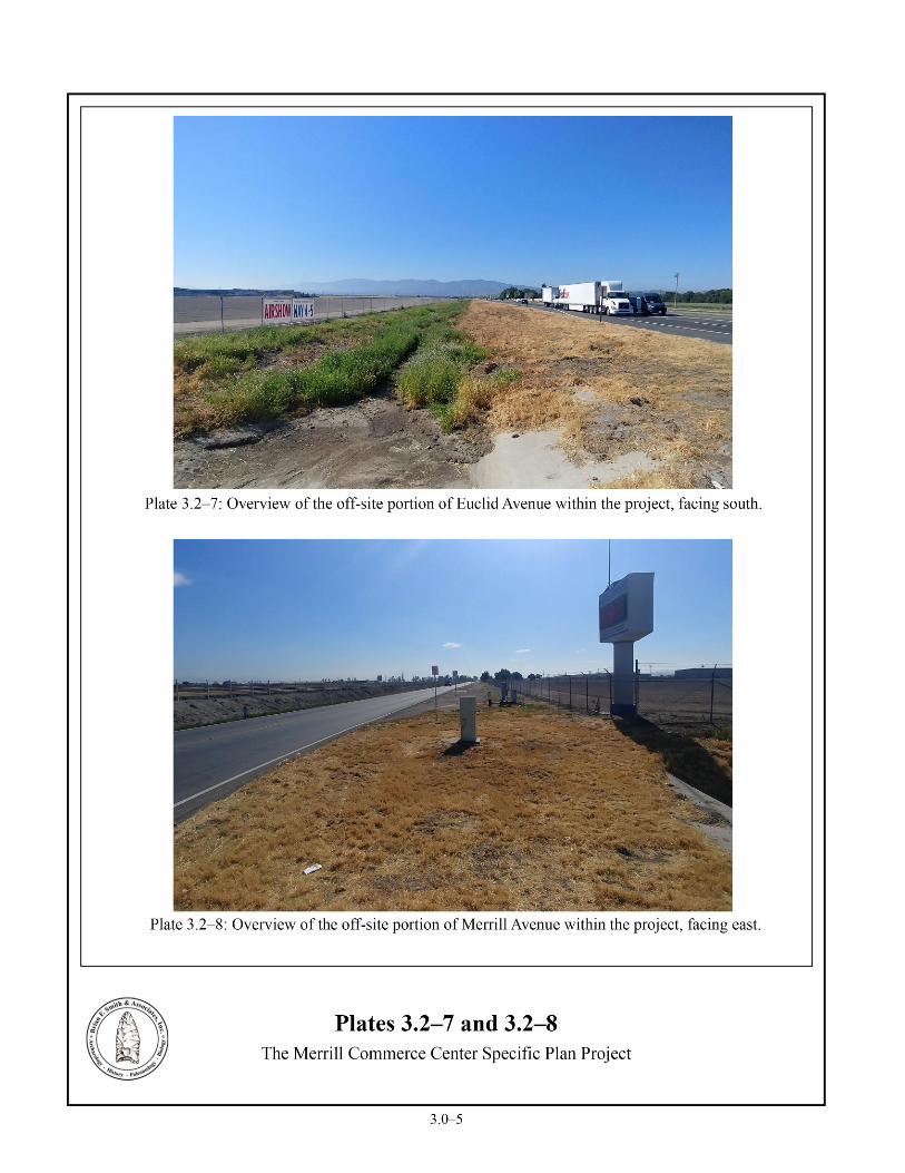
3.2 Results of the Field Survey Senior Project Archaeologist Jennifer Stropes conducted the intensive pedestrian survey
with assistance from Field Supervisor Clarence Hoff and field archaeologists Mary Chitjian and James Shrieve on February 6 and 7 and April 22 and 23, 2019. Ground visibility was limited due to active dairy operations, dense vegetation, development, pavement, and gravel (Plates 3.2–1 through 3.2–14). The entire property appears to have been previously rough-graded. As a result of the field survey, a circa 1930s historic refuse scatter, 10 historic single-family residences, one historic milk barn, four historic single-family residences and associated milk barns, one historic single-family residence and associated barn, and one isolated mano were identified within the on-site portion of the project. The historic refuse scatter and prehistoric isolate were recorded as SBR-33,019H and P-36-033020 with the SCCIC. The historic addresses, Temp-2 through Temp-17, will be recorded with the SCCIC once they have been evaluated. No other cultural resources were observed during the survey of the project. The locations of the sites are provided on Figure 3.2–1 and descriptions of the sites based upon the initial survey information are provided in Sections 3.2.1 through 3.2.18.


Cultural Resources Study for the Merrill Commerce Center Specific Plan Project _____________________________________________________________________________________________________________________
3.0–9
Figure 3.2–1 Cultural Resource Location Map
(Deleted for public review; bound separately)

Cultural Resources Study for the Merrill Commerce Center Specific Plan Project _____________________________________________________________________________________________________________________
3.0–10
3.2.1 Site SBR-33,019H Site SBR-33,019H was identified during the current archaeological survey as a historic refuse scatter located northeast of the intersection of Merrill and Grove avenues, west of a modern pump system (see Figure 3.2–1). The 20-by-500-foot, “L”-shaped site consists of over 10 artifacts scattered across the berm that separates this portion of the property from Grove and Merrill avenues. Approximately five glass fragments, five tableware fragments, a kitchen knife, and a glass insulator were observed. Preliminary review of the historic refuse suggests that the materials date to the 1930s, based upon tableware decorations and bottle glass technology. The items likely originated near a farm house, which has since been demolished, just south of the current dairy facility that is visible on historic aerial photographs in the 1930s. The artifacts were likely pushed away from the area where the farmhouse was located by a dozer. An overview of the site is provided in Plate 3.2–15 and the general configuration of the resource is shown in Figure 3.2–2.
3.2.2 Site Temp-2 Site Temp-2 was identified during the current archaeological survey as a single-family residence located at 8521 Eucalyptus Avenue (see Figure 3.2–1). Based upon aerial photographs, the building was constructed between 1966 and 1980, which means that it may not meet the minimum age threshold to be considered historic and further research will be required to better determine its age and whether it qualifies as a historic resource. An overview of the site is provided in Plate 3.2–16 and the general configuration of the resource is shown in Figure 3.2–3.
3.2.3 Site Temp-3 Site Temp-3 was identified during the current archaeological survey as a milk barn located at 8541 Eucalyptus Avenue (see Figure 3.2–1). Based upon aerial photographs, the building was constructed between 1966 and 1980, which means that it may not meet the minimum age threshold to be considered historic and further research will be required to better determine its age and whether it qualifies as a historic resource. An overview of the site is provided in Plate 3.2–17 and the general configuration of the resource is shown in Figure 3.2–3.
Cultural Resources Study for the Merrill Commerce Center Specific Plan Project _____________________________________________________________________________________________________________________
3.0–11
Figure 3.2–2 Archaeological Site Location Map
Site SBR-33,019H
(Deleted for public review; bound separately)


Cultural Resources Study for the Merrill Commerce Center Specific Plan Project _____________________________________________________________________________________________________________________
3.0–15
3.2.4 Site Temp-4 Site Temp-4 was identified during the current archaeological survey as a single-family residence located at 8551 Eucalyptus Avenue (see Figure 3.2–1). Based upon aerial photographs, the building was constructed between 1966 and 1980, which means that it may not meet the minimum age threshold to be considered historic and further research will be required to better determine its age and whether it qualifies as a historic resource. An overview of the site is provided in Plate 3.2–18 and the general configuration of the resource is shown in Figure 3.2–3.
3.2.5 Site Temp-5
Site Temp-5 was identified during the current archaeological survey as a single-family residence and milk barn located at 8643 Eucalyptus Avenue (see Figure 3.2–1). Based upon aerial photographs, the buildings were constructed in 1965. However, further research will be required to better determine their age and whether they qualify as historic resources. An overview of the site is provided in Plate 3.2–19 and the general configuration of the resource is shown in Figure 3.2–3.
3.2.6 Site Temp-6 Site Temp-6 was identified during the current archaeological survey as a single-family residence and milk barn located at 8731 Eucalyptus Avenue (see Figure 3.2–1). Based upon aerial photographs, the buildings were constructed in 1968. However, further research will be required to better determine their age and whether they qualify as historic resources. An overview of the site is provided in Plates 3.2–20 and 3.2–21 and the general configuration of the resource is shown in Figure 3.2–3.
3.2.7 Site Temp-7 Site Temp-7 was identified during the current archaeological survey as a single-family residence located at 8831 Eucalyptus Avenue (see Figure 3.2–1). Based upon aerial photographs, the building was constructed in 1969. However, further research will be required to better determine its age and whether it qualifies as a historic resource. An overview of the site is provided in Plate 3.2–22 and the general configuration of the resource is shown in Figure 3.2–3.
3.2.8 Site Temp-8 Site Temp-8 was identified during the current archaeological survey as a single-family residence located at 8888 Eucalyptus Avenue (see Figure 3.2–1). Based upon aerial photographs, the building was constructed in 1969. However, further research will be required to better determine its age and whether it qualifies as a historic resource. An overview of the site is provided in Plate 3.2–23 and the general configuration of the resource is shown in Figure 3.2–3.


Cultural Resources Study for the Merrill Commerce Center Specific Plan Project _____________________________________________________________________________________________________________________
3.0–19
3.2.9 Site Temp-9 Site Temp-9 was identified during the current archaeological survey as a single-family residence and milk barn located at 8911 Eucalyptus Avenue (see Figure 3.2–1). Based upon aerial photographs, the buildings were constructed in 1969. However, further research will be required to better determine their age and whether they qualify as historic resources. An overview of the site is provided in Plate 3.2–24 and the general configuration of the resource is shown in Figure 3.2–3.
3.2.10 Site Temp-10 Site Temp-10 was identified during the current archaeological survey as a single-family residence located at 9032 Merrill Avenue (see Figure 3.2–1). According to the Historic Resources Index and the 2004 City of Ontario New Model Colony Historic Context (Galvin and Associates 2004), the building was constructed in 1956. The residence was previously assigned a NRHP status of “7R: Identified in Reconnaissance Level Survey: Not Evaluated.” As such, further research will be required to verify its age and to conduct an evaluation to determine if it qualifies as a historic resource. An overview of the site is provided in Plate 3.2–25 and the general configuration of the resource is shown in Figure 3.2–3.
3.2.11 Site Temp-11 Site Temp-11 was identified during the current archaeological survey as a single-family residence located at 8966 Merrill Avenue (see Figure 3.2–1). Based upon aerial photographs, the building was constructed between 1948 and 1959. However, further research will be required to better determine its age and whether it qualifies as a historic resource. An overview of the site is provided in Plate 3.2–26 and the general configuration of the resource is shown in Figure 3.2–3.
3.2.12 Site Temp-12
Site Temp-12 was identified during the current archaeological survey as a single-family residence located at 8810 Merrill Avenue (see Figure 3.2–1). Based upon aerial photographs, the building was constructed in 1967. However, further research will be required to better determine its age and whether it qualifies as a historic resource. An overview of the site is provided in Plate 3.2–27 and the general configuration of the resource is shown in Figure 3.2–3.
3.2.13 Site Temp-13 Site Temp-13 was identified during the current archaeological survey as a single-family
residence located at 8816 Merrill Avenue (see Figure 3.2–1). Based upon aerial photographs, the residence was constructed between 1966 and 1980, which means that it may not meet the minimum age threshold to be considered historic and further research will be required to better determine its age and whether it qualifies as a historic resource. An overview of the site is provided in Plate 3.2–28 and the general configuration of the resource is shown in Figure 3.2–3.
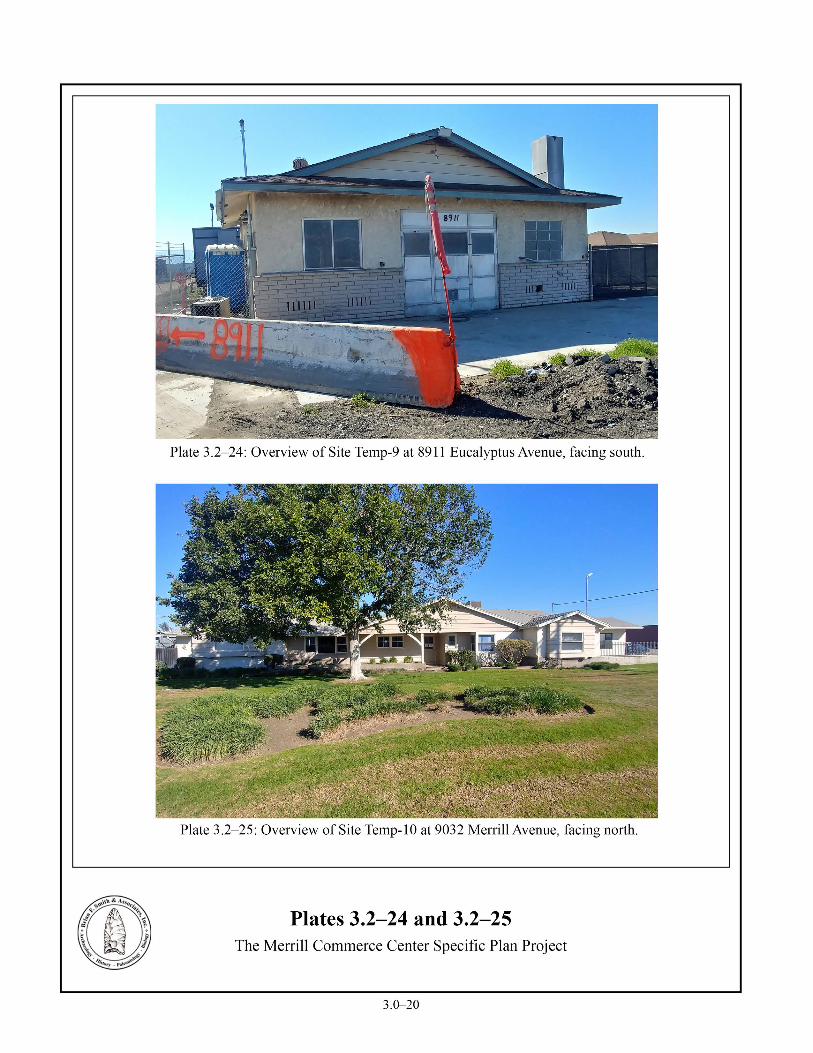

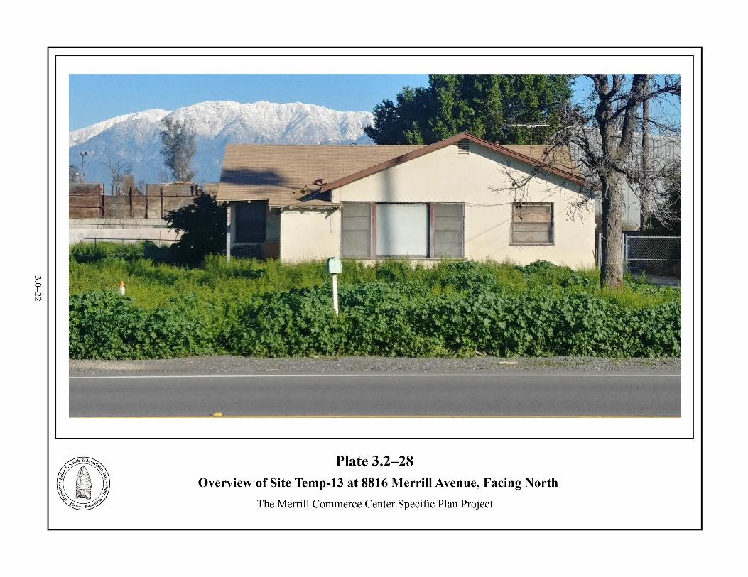

Cultural Resources Study for the Merrill Commerce Center Specific Plan Project _____________________________________________________________________________________________________________________
3.0–23
3.2.14 Site Temp-14 Site Temp-14 was identified during the current archaeological survey as a single-family
residence and milk barn located at 8920 Merrill Avenue (see Figure 3.2–1). Based upon aerial photographs, the buildings were constructed in 1967. However, further research will be required to better determine its age and whether it qualifies as a historic resource. An overview of the site is provided in Plates 3.2–29 and 3.2–30 and the general configuration of the resource is shown in Figure 3.2–3.
3.2.15 Site Temp-15
Site Temp-15 was identified during the current archaeological survey as a single-family residence and milk barn located at 14651 Grove Avenue (see Figure 3.2–1). Based upon aerial photographs, the buildings were constructed in 1958. However, further research will be required to better determine its age and whether it qualifies as a historic resource. An overview of the site is provided in Plates 3.2–31 and 3.2–32 and the general configuration of the resource is shown in Figure 3.2–3.
3.2.16 Site Temp-16
Site Temp-16 was identified during the current archaeological survey as a single-family residence located at 14545 Grove Avenue (see Figure 3.2–1). According to the Historic Resources Index and the 2004 City of Ontario New Model Colony Historic Context (Galvin and Associates 2004), the building was constructed in 1945 and assigned a NRHP status of “7R: Identified in Reconnaissance Level Survey: Not Evaluated.” However, no evidence could be located to suggest that the current building was constructed in 1945. Aerial photographs indicate that the current building was not constructed until sometime between 1966 and 1980, which means that it may not meet the minimum age threshold to be considered historic and further research will be required to better determine its age and whether it qualifies as a historic resource. An overview of the site is provided in Plate 3.2–33 and the general configuration of the resource is shown in Figure 3.2–3.
3.2.17 Site Temp-17 Site Temp-17 was identified during the current archaeological survey as a single-family
residence and barn located at 14525 Grove Avenue (see Figure 3.2–1). Based upon aerial photographs, the buildings were constructed in 1958. However, further research will be required to better determine its age and whether it qualifies as a historic resource. An overview of the site is provided in Plates 3.2–34 and 3.2–35 and the general configuration of the resource is shown in Figure 3.2–3.

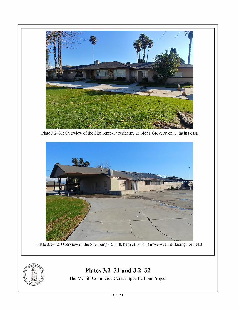


Cultural Resources Study for the Merrill Commerce Center Specific Plan Project _____________________________________________________________________________________________________________________
3.0–28
3.2.18 Isolate P-36-033020 Isolate P-36-033020 was identified during the current archaeological survey as an isolated
prehistoric mano located northwest of the intersection of Merrill and Carpenter avenues on a man-made berm that separates the roads from the leach fields (see Figure 3.2–1). The isolate, which was not collected at the time of the survey, is shown in Plate 3.2–36 and the general configuration of the resource is shown in Figure 3.2–4.
3.3 Summary of Field Investigations As a result of the records search analysis and field survey, one historic refuse scatter (SBR-
33,019H), 10 historic single-family residences (Temp-2, Temp-4, Temp-6 to Temp-8, Temp-10 to Temp-13, and Temp-16), one historic milk barn (Temp-3), four historic single-family residences and associated milk barns (Temp-5, Temp-9, Temp-14, and Temp-15), one historic single-family residence and associated barn (Temp-17), and one isolated mano (P-36-033020) were identified within the on-site portion of the project. No Native American sites were discovered during the survey process, which is consistent with the records search data for the vicinity surrounding the project. Only a single prehistoric artifact was identified.
This Phase I cultural resources study did not include any site evaluations to determine significance under CEQA criteria. All of the cultural resources identified will be impacted by future development, and therefore, the 18 cultural resources will require significance evaluations as part of any CEQA review process. This process would provide the basis for the impact analysis to identify where significant resources are located and where adjustments to the project design might be needed to avoid adverse impacts to significant or culturally sensitive resources.


Cultural Resources Study for the Merrill Commerce Center Specific Plan Project _____________________________________________________________________________________________________________________
3.0–30
Figure 3.2–4
Isolate Location Map Isolate P-36-033020
(Deleted for public review; bound separately)

Cultural Resources Study for the Merrill Commerce Center Specific Plan Project _____________________________________________________________________________________________________________________
4.0–1
4.0 RECOMMENDATIONS FOR ADDITIONAL INFORMATION
The cultural resources survey of the Merrill Commerce Center Project identified 18 cultural resources consisting of one historic refuse scatter (SBR-33,019H), 10 historic single-family residences (Temp-2, Temp-4, Temp-6 to Temp-8, Temp-10 to Temp-13, and Temp-16), one historic milk barn (Temp-3), four historic single-family residences and associated milk barns (Temp-5, Temp-9, Temp-14, and Temp-15), one historic single-family residence and associated barn (Temp-17), and one isolated mano (P-36-033020). This study was completed at a programmatic level and did not incorporate significance evaluations. Subsequent project-level processing of any portion of this project will require a cultural resource evaluation program to determine the significance of any recorded cultural resources affected by the project and to provide an assessment of potential impacts from the proposed development and associated mitigation measures.
In order to accurately evaluate the cultural resources and to assess the project’s potential impacts on these resources, additional study is required to augment the level of work currently completed. Because the majority of cultural resources within the project are characterized as historic structures or historic dairy operations, the resource evaluation process will focus on historic research and structure evaluations. The scope of the additional study, referred to as a Phase II resource evaluation study, is provided below. The goal of the Phase II study is to formally record each site and determine the specific measures that would need to be implemented for each site to avoid significant impacts to CEQA-significant historical resources, as defined by Section 15064.5(a) of CEQA. The following Cultural Resource Evaluation and Mitigation Plan (CREMP) has been prepared for this purpose. The historic refuse scatter and prehistoric isolate were recorded as SBR-33,019H and P-36-033020 with the SCCIC. The historic addresses, Temp-2 through Temp-17, will be recorded with the SCCIC once they have been evaluated.
In addition to the individual site evaluations, which will form the basis of any site-specific mitigation measures, a general recommendation is presented in Section 4.2 for mitigation monitoring of grading during project construction. Because of the potential to encounter historic features, artifacts, or deposits during grading that meet the CEQA definition of a historical resource or unique archaeological resource, as presented in CEQA Section 15064.5(a) and Section 21083.2(g) of the PRC, respectively, monitoring is needed during grading to identify any exposed features and address potentially adverse impacts to those previously unrecorded archaeological resources meeting the definition given in CEQA Section 15064.5(a) and Section 21083.2(g) of the PRC. Mitigation monitoring will be required during grading to address the potential for subsurface resources in addition to the specific evaluations required for the 18 recorded cultural resources.
4.1 Proposed Cultural Resource Evaluation and Mitigation Plan The level of effort to programmatically ensure that potential impacts to historic resources
will be mitigated to a level below significant will require the completion of a Phase II study and
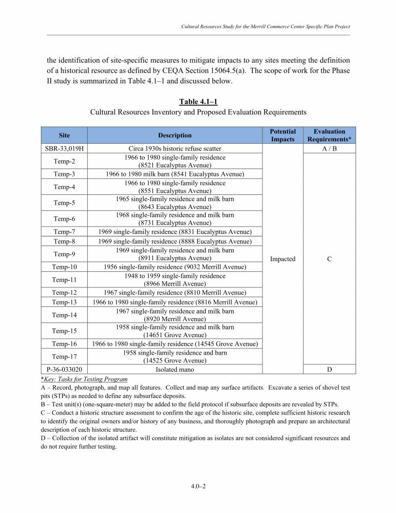
Cultural Resources Study for the Merrill Commerce Center Specific Plan Project _____________________________________________________________________________________________________________________
4.0–2
the identification of site-specific measures to mitigate impacts to any sites meeting the definition of a historical resource as defined by CEQA Section 15064.5(a). The scope of work for the Phase II study is summarized in Table 4.1–1 and discussed below.
Table 4.1–1
Cultural Resources Inventory and Proposed Evaluation Requirements
Site Description Potential Impacts
Evaluation Requirements*
SBR-33,019H Circa 1930s historic refuse scatter
Impacted
A / B
Temp-2 1966 to 1980 single-family residence (8521 Eucalyptus Avenue)
C
Temp-3 1966 to 1980 milk barn (8541 Eucalyptus Avenue)
Temp-4 1966 to 1980 single-family residence (8551 Eucalyptus Avenue)
Temp-5 1965 single-family residence and milk barn (8643 Eucalyptus Avenue)
Temp-6 1968 single-family residence and milk barn (8731 Eucalyptus Avenue)
Temp-7 1969 single-family residence (8831 Eucalyptus Avenue) Temp-8 1969 single-family residence (8888 Eucalyptus Avenue)
Temp-9 1969 single-family residence and milk barn (8911 Eucalyptus Avenue)
Temp-10 1956 single-family residence (9032 Merrill Avenue)
Temp-11 1948 to 1959 single-family residence (8966 Merrill Avenue)
Temp-12 1967 single-family residence (8810 Merrill Avenue) Temp-13 1966 to 1980 single-family residence (8816 Merrill Avenue)
Temp-14 1967 single-family residence and milk barn (8920 Merrill Avenue)
Temp-15 1958 single-family residence and milk barn (14651 Grove Avenue)
Temp-16 1966 to 1980 single-family residence (14545 Grove Avenue)
Temp-17 1958 single-family residence and barn (14525 Grove Avenue)
P-36-033020 Isolated mano D *Key: Tasks for Testing Program A – Record, photograph, and map all features. Collect and map any surface artifacts. Excavate a series of shovel test pits (STPs) as needed to define any subsurface deposits. B – Test unit(s) (one-square-meter) may be added to the field protocol if subsurface deposits are revealed by STPs. C – Conduct a historic structure assessment to confirm the age of the historic site, complete sufficient historic research to identify the original owners and/or history of any business, and thoroughly photograph and prepare an architectural description of each historic structure. D – Collection of the isolated artifact will constitute mitigation as isolates are not considered significant resources and do not require further testing.

Cultural Resources Study for the Merrill Commerce Center Specific Plan Project _____________________________________________________________________________________________________________________
4.0–3
Recommended Phase II Resource Evaluation Program
• The surface expression of each site shall be mapped and recorded. All artifacts observed on the surface of each site would be recorded and collected according to Global Positioning System (GPS) location.
• A series of STPs or mechanically excavated trenches shall be excavated at Site SBR-33,019H in order to determine if any subsurface deposits are associated with the surface expression. The number of trenches, STPs or other excavation units would be determined by the archaeological consultant, but will need to be adequate to define the limits of any subsurface deposits and address the potential of the site to contain significance deposits or features.
• Should the trenching program or STPs lead to the identification of a subsurface deposit at Site SBR-33,019H, additional focused archaeological testing would be conducted. This additional testing would consist of the excavation of one-square-meter archaeological test units using standard archaeological protocol. For this phase of study, two test units are projected as likely to be needed; however, if additional units are eventually required due to the discovery of subsurface cultural deposits, the testing plan may need to be expanded.
• Any artifacts recovered from the project must be subjected to laboratory analysis, including cleaning, cataloging, and interpretation.
• Because the projected date of construction for the buildings located within sites Temp-2 to Temp-4, Temp-13, and Temp-16 falls between 1966 and 1980, some may not meet the minimum age threshold to be considered historic. In order to determine the exact age of all of the buildings within the project, the Assessor’s building records for all parcels containing historic or potentially historic structures will be obtained. Historical research will be conducted to trace the historical record of the buildings’ ownership and construction. An evaluation of the buildings will be conducted in order to identify any historic significance or any association in the context of the community, the city, or any social groups. Research concerning the buildings’ possible association with master architects, noteworthy contractors, or locally important occupants will also be conducted. In addition, a formal chain of title and review of any available city directory listings will be required for the parcels to identify all persons previously associated with the property.
• For all of the sites, DPR site record forms and updates will be prepared and submitted to the SCCIC at CSU Fullerton. All new information gathered during this testing program will be reflected in the preparation of the site forms.
• All survey results, fieldwork, research, and laboratory analysis will be incorporated into a Phase II report that will provide the site significance analysis and impact evaluations. The report will be prepared in accordance with City of Ontario report

Cultural Resources Study for the Merrill Commerce Center Specific Plan Project _____________________________________________________________________________________________________________________
4.0–4
requirements and is intended to be used as a technical appendix for the project Environmental Impact Report (EIR).
Recommended Mitigation Measures Program
• For any standing structures that are evaluated by a Phase II assessment program and determined to be historically significant per the definition given in CEQA Section 15064.5(a), the following general mitigation program would be anticipated as a means to address potential impacts to significant historic resources. These general measures would be subject to modification on a site by site basis as a consequence of the Phase II evaluation and as approved by the CEQA lead agency to ensure that impacts are mitigated to a level less than significant.
o Any historic structural elements identified as significant and which will be
impacted as a consequence of the approval of the development plan will be subjected to a historic recordation program to generate an accurate and thorough recording of the structures that will be part of the cultural resources record at the local Office of Historic Preservation office. The recordation program will mirror the Historic American Building Survey (HABS) protocol for the documentation of historic structures. The standards for HABS is presented in the Secretary of the Interior’s Standards and Guidelines for Architectural and Engineering Documentation. While the HABS program is administered by the National Park Service, this mitigation program is not subject to federal review and any resulting documentation should not be addressed to any agency other than the City of Ontario. The HABS protocol is a basic standard to be followed to adequately record historic structures prior to demolition. For a HABS level mitigation program, the basic requirement is the production of as-built drawings and photographic recording prior to demolition to mitigate the impacts associated with the loss of the structure. A mitigation report will be prepared for submittal to the City that will satisfy the requirement for the historic structure recordation program. This effort will include a document that presents historical and descriptive information, character-defining features of the building, and professional quality photographs.
o The primary component of the mitigation document will be a HABS-level photographic survey and building record program conducted to document the structural elements of each significant structure or contributing structural elements. The HABS process will result in a complete documentation of historically important structure elements. The formal recording of the historic

Cultural Resources Study for the Merrill Commerce Center Specific Plan Project _____________________________________________________________________________________________________________________
4.0–5
building additions includes large format (4-inch by 5-inch negative or larger) archival photographs and 35mm photographs of additional spaces and features not documented in large format. The photographs shall be keyed to a floor and site plan to show the location of each photograph taken. Views shall include the setting, important site features including select landscape, all exterior elevations, detailed views of significant exterior architectural features, and interior views of significant spaces and features.
o A technical report will be prepared for submittal to the City of Ontario that will
present all of the information gathered regarding the property and the building. The report will provide the conclusions of the historic significance evaluation and present the HABS documentation. The report will also include the presentation of the completed State of California DPR site registration forms to be submitted to the SCCIC at CSU Fullerton.
• In the event that any archaeological excavations identify important historic or
prehistoric deposits or features, mitigation measures may be required to reduce impacts. Potential mitigation measures to address impacts to CEQA-significant archaeological deposits would include data recovery programs to recover archaeological data and laboratory analyses of collections. The scope of any data recovery programs would be determined following the Phase II investigations.
4.2 Recommended Mitigation Monitoring Program for the Potential Discovery of Additional Resources
The presence of structures on the site that were constructed more than 50 years ago, as well as a minimal presence of Native American use of this area, is the basis for the recommendation for mitigation monitoring of grading for the development of the project. Historic features, artifact deposits, foundations, and/or trash pits may be encountered that meet the CEQA definition of a historical resource or unique archaeological resource as presented in CEQA Section 15064.5(a) and Section 21083.2(g) of the PRC, respectively. While the potential for the discovery of historic materials is considered moderate to high, the potential for prehistoric resources is low. Nevertheless, the presence of a major drainage east of the property and the identification of a Native American milling tool on the property suggests that Native Americans had access to this area as part of their subsistence collecting and processing activity.
Monitoring of grading may be confined to the first five to ten feet of soil grading across the property, or until formational soils are encountered. Monitoring by an archaeologist should be conducted for all grading at depths until the potential for buried resources has been exhausted. Native American monitoring is not recommended unless and until a prehistoric site or deposit is identified, given that the potential for Native American sites in this area is low. The protocol for
Cultural Resources Study for the Merrill Commerce Center Specific Plan Project _____________________________________________________________________________________________________________________
4.0–6
a mitigation monitoring and reporting program (MMRP) is provided below.
Mitigation Monitoring and Reporting Program (MMRP) An MMRP to mitigate potential impacts to undiscovered buried archaeological resources
for the Merrill Commerce Center Project shall be implemented to the satisfaction of the lead agency. This program shall include, but not be limited to, the following actions:
1) Prior to issuance of a grading permit, the applicant shall provide written verification
that a qualified archaeologist has been retained to implement the monitoring program. This verification shall be presented in a letter from the project archaeologist to the lead agency.
2) The archaeological monitor shall attend the pre-grading meeting with the contractors to explain and coordinate the requirements of the monitoring program.
3) The archaeologist shall monitor all areas identified for construction within the project. 4) Isolates and clearly non-significant deposits will be minimally documented in the field
so the monitored grading can proceed. 5) In the event that previously unidentified resources are discovered, the archaeologist
shall have the authority to divert or temporarily halt ground-disturbance operation in the area of discovery to allow for the evaluation of potentially significant cultural resources. The archaeologist shall contact the lead agency at the time of discovery. The archaeologist, in consultation with the lead agency, shall determine the significance of the discovered resources. The lead agency must concur with the evaluation before construction activities will be allowed to resume in the affected area. For significant resources, a Research Design and Data Recovery Program to mitigate impacts shall be prepared by the consulting archaeologist and approved by the lead agency before being carried out using professional archaeological methods. If any human remains are discovered, the county coroner and lead agency shall be contacted. In the event that the remains are determined to be of Native American origin, the Most Likely Descendant, as identified by the NAHC, shall be contacted in order to determine proper treatment and disposition of the remains.
6) If any prehistoric resources are discovered during grading activities, a Native American monitor will be required to be on-site for the remainder of the monitoring program and to contribute any recommendations regarding the treatment of any Native American artifacts, deposits, or sites encountered during grading.
7) Before construction activities are allowed to resume in the affected area, the artifacts shall be recovered and features recorded using professional archaeological methods. The archaeological monitor(s) shall determine the amount of material to be recovered for an adequate artifact sample for analysis.
8) All cultural material collected during the grading monitoring program shall be

Cultural Resources Study for the Merrill Commerce Center Specific Plan Project _____________________________________________________________________________________________________________________
4.0–7
processed and curated according to the current professional repository standards. The collections and associated records shall be transferred, including title, to an appropriate curation facility, to be accompanied by payment of the fees necessary for permanent curation.
9) A report documenting the field and analysis results and interpreting the artifact and research data within the research context shall be completed and submitted to the satisfaction of the lead agency prior to the issuance of any building permits. The report will include DPR Primary and Archaeological Site Forms.
4.3 Summary
The goal of the programmatic cultural resource testing and evaluation program is to record all elements of the historical sites and, for those sites that meet the CEQA definition of a historical resource presented in CEQA Section 15064.5(a), determine site-specific measures to mitigate impacts to below a level of significance. All artifacts recovered from the significant sites will be prepared for curation and delivered to the appropriate curation facility. A Phase II report will be prepared to present all of the data collected during the testing program, including detailed GIS maps of the components of the surface expressions of the resources and the locations of all subsurface tests and present mitigation measures to reduce impacts to significant historical resources to below a level of significance.
In order to address potential impacts to significant cultural resources that are buried, masked, or have not been identified, a mitigation monitoring program is recommended during the grading of the project site to depths of five to ten feet. The monitoring program should also cover off-site road or utility improvements. While no observable resources were identified along the off-site improvement corridor, the corridors were characterized as paved streets or disturbed areas, and the potential for buried resources could not by assessed due to the paved streets or disturbed soil. Any resources encountered during on-site grading or off-site improvements must be recorded, evaluated for significance, and, if identified as significant pursuant to the CEQA definition of a historical resource or unique archaeological resource as presented in CEQA Section 15064.5(a) and Section 21083.2(g) of the PRC, be subjected to mitigation measures to reduce adverse impacts to less than significant levels.
Cultural Resources Study for the Merrill Commerce Center Specific Plan Project _____________________________________________________________________________________________________________________
5.0–1
5.0 LIST OF PREPARERS AND ORGANIZATIONS CONTACTED The archaeological survey program for the on-site portion of the Merrill Commerce Center Project was directed by Principal Investigator Brian F. Smith. The archaeological fieldwork was conducted by Senior Project Archaeologist Jennifer Stropes, Field Supervisor Clarence Hoff, and field archaeologists Mary Chitjian and James Shrieve. The report text was prepared by Elena Goralogia, Jennifer Stropes, and Brian Smith. Report graphics were provided by Carrie Kubacki. Technical editing and report production were conducted by Elena Goralogia. The SCCIC at CSU Fullerton provided the archaeological records search information.

Cultural Resources Study for the Merrill Commerce Center Specific Plan Project _____________________________________________________________________________________________________________________
6.0–1
6.0 REFERENCES CITED American Local History Network: Riverside County, California
1998 American Local History Network’s Page for Riverside County, California. Electronic document, http://www.usgennet.org/usa/ca/county/riverside/, accessed March 28, 2006.
Antevs, Ernst
1953 The Postpluvial or the Neothermal. University of California Archaeological Survey Reports 22:9-23, Berkeley, California.
Bean, Lowell John and Charles R. Smith
1978a Gabrielino. In California, edited by R.F. Heizer. Handbook of North American Indians, Vol. 8. William C. Sturtevant, general editor, Smithsonian Institution, Washington, D.C.
1978b Serrano. In California, edited by R.F. Heizer. Handbook of North American Indians,
Vol. 8. William C. Sturtevant, general editor, Smithsonian Institution, Washington, D.C.
Benedict, Ruth Fulton
1924 A Brief Sketch of Serrano Culture. American Anthropologist 26(3). Brian F. Smith and Associates, Inc.
Various dates. Research library holdings including Sanborn maps, USGS maps, aerial photographs, city directories, published regional histories, aerial photographs, and geologic and paleontological references.
Brigandi, Phil
1998 Temecula: At the Crossroads of History. Heritage Media Corporation, Encinitas, California.
City of Ontario
N.d. City History. Electronic document, https://www.ontarioca.gov/about-ontario/city-history, accessed August 6, 2018.
2006 Environmental Impact Report for Subarea 29 (Hettinga) Specific Plan, City of Ontario,
San Bernardino County, California. City of Ontario with Albert A. Webb Associates. Unpublished report on file at the City of Ontario, California.
City of Redlands
2010 City of Redlands General Plan.
City of San Bernardino 2015 History of San Bernardino. Electronic document, https://www.ci.san-

Cultural Resources Study for the Merrill Commerce Center Specific Plan Project _____________________________________________________________________________________________________________________
6.0–2
bernardino.ca.us/about/history/history_of_san_bernardino_(short_version).asp, accessed November 10, 2015.
Cook, Sherburne F.
1976 The Conflict Between the California Indian and White Civilization. University of California Press, Berkeley and Los Angeles, California.
Curray, Joseph R.
1965 Late Quaternary History: Continental Shelves of the United States. In Quaternary of the United States, edited by H.E. Wright Jr. and D.G. Frey, pp. 723-735. Princeton University Press, Princeton, New Jersey.
Drucker, Philip
1937 Culture Element Distributions: V. Southern California. Anthropological Records 1(1):1-52. University of California, Berkeley.
Erlandson, Jon M. and Roger H. Colten (editors)
1991 An Archaeological Context for Archaeological Sites on the California Coast. In Hunter-Gatherers of Early Holocene Coastal California. Perspectives in California Archaeology, Volume 1, Institute of Archaeology, University of California, Los Angeles.
Fagan, B.
1991 Ancient North America: The Archaeology of a Continent. Thames and Hudson. London.
Gallegos, Dennis
1985 A Review and Synthesis of Environmental and Cultural Material for the Batiquitos Lagoon Region. In San Diego State University Cultural Resource Management Casual Papers 2(1).
2002 Southern California in Transition: Late Holocene Occupation of Southern San Diego
County. In Catalysts to Complexity: Late Holocene Societies of the California Coast, edited by Jon M. Erlandson and Terry Jones. Institute of Archaeology, University of California, Los Angeles.
Galvin and Associates
2004 The City of Ontario’s Historic Context for the New Model Colony Area. Unpublished report on file at the City of Ontario, California.
Heizer, Robert F. (editor)
1978 Trade and Trails. In California, pp. 690-693. Handbook of North American Indians, Vol. 8. William C. Sturtevant, general editor, Smithsonian Institution, Washington, D.C.
Cultural Resources Study for the Merrill Commerce Center Specific Plan Project _____________________________________________________________________________________________________________________
6.0–3
Inman, Douglas L. 1983 Application of Coastal Dynamics to the Reconstruction of Paleocoastlines in the
Vicinity of La Jolla, California. In Quaternary Coastlines and Marine Archaeology, edited by Patricia M. Masters and N.C. Flemming. Academic Press, Inc., Orlando, Florida.
Kroeber, A.L.
1976 Handbook of the Indians of California. Reprinted. Dover Editions, Dover Publications, Inc., New York. Originally published 1925, Bulletin No. 78, U.S. Government Printing Office, Washington, D.C.
Lyman, Edward Leo
1989 The Rise and Decline of Mormon San Bernardino. Brigham Young University Studies 29(4):43-63. Brigham Young University, Provo, Utah.
Martin, P.S.
1967 Prehistoric Overkill. In Pleistocene Extinctions: The Search for a Cause, edited by P. Martin and H.E. Wright. Yale University Press: New Haven.
1973 The Discovery of America. Science 179(4077): 969-974.
Masters, Patricia M.
1983 Detection and Assessment of Prehistoric Artifact Sites off the Coast of Southern California. In Quaternary Coastlines and Marine Archaeology: Towards the Prehistory of Land Bridges and Continental Shelves, edited by P.M. Masters and N.C. Flemming, pp. 189-213. Academic Press, London.
1994 Archaeological Investigations at Five Sites on the Lower San Luis Rey River, San
Diego County, California, edited by Michael Moratto, pp. A1-A19. Infotec Research, Fresno, California and Gallegos and Associates, Pacific Palisades California.
Miller, J.
1966 The Present and Past Molluscan Faunas and Environments of Four Southern California Coastal Lagoons. Master’s thesis on file at the University of California at San Diego, San Diego, California.
Moratto, Michael J.
1984 California Archaeology. Academic Press, New York. Morton, M. and F.K. Miller
2006 Geologic Map of the San Bernardino and Santa Ana 30' x 60' Quadrangles, California, version 1.0. U.S. Geological Survey, Open-File Report 2006-1217 (map scale 1:100,000).
Cultural Resources Study for the Merrill Commerce Center Specific Plan Project _____________________________________________________________________________________________________________________
6.0–4
Moss, M.L. and J. Erlandson 1995 Reflections on North American Coast Prehistory. Journal of World Prehistory 9(1):1-
46. Office of Historic Preservation
1995 Instructions for Recording Historical Resources. Department of Parks and Recreation, Sacramento, California.
Pourade, Richard F.
1964 The Glory Years. Union-Tribune Publishing Company, San Diego. Reddy, Seetha
2000 Settling the Highlands: Late Holocene Highland Adaptations on Camp Pendleton, San Diego County California. Prepared for the Army Corps of Engineers by ASM Affiliates. Unpublished report on file at South Coastal Information Center at San Diego State University, San Diego, California.
Riverside County
N.d. Welcome to Riverside County, California: Riverside County History. Electronic document, http://www.co.riverside.ca.us/county_info/history.asp, accessed March 28, 2006.
Rogers, Malcolm J.
1929 Field Notes, 1929 San Diego-Smithsonian Expedition. Manuscript on file at San Diego Museum of Man.
State Historic Preservation Office (SHPO)
1995 Instructions for Recording Historical Resources. Office of Historic Preservation, Sacramento.
Smallwood, Josh
2006 Site record form for Site SBR-8092/H. On file at the South Central Coastal Information Center, California State University at Fullerton.
Strong, William Duncan
1971 Aboriginal Society in Southern California. Reprint of 1929 Publications in American Archaeology and Ethnology No. 26, University of California, Berkeley.
Van Devender, T.R. and W.G. Spaulding
1979 Development of Vegetation and Climate in the Southwestern United States. Science 204:701-710.
Warren, Claude N. and M.G. Pavesic
1963 Shell Midden Analysis of Site SDI-603 and Ecological Implications for Cultural Development of Batequitos Lagoon, San Diego County, Los Angeles. University of

Cultural Resources Study for the Merrill Commerce Center Specific Plan Project _____________________________________________________________________________________________________________________
6.0–5
California, Los Angeles, Archaeological Survey Annual Report, 1960-1961:246-338.
Wirths, Todd A. 2019 Paleontological Resource Assessment for the Proposed Merrill Commerce Center
Project, City of Ontario, Southern San Bernardino County, California. Brian F. Smith and Associates, Inc. Unpublished report on file at Brian F. Smith and Associates, Inc., Poway, California.

Cultural Resources Study for the Merrill Commerce Center Specific Plan Project _____________________________________________________________________________________________________________________
APPENDIX A
Resumes of Key Personnel

Brian F. Smith, MA Owner, Principal Investigator Brian F. Smith and Associates, Inc. 14010 Poway Road � Suite A � Phone: (858) 679-8218 � Fax: (858) 679-9896 � E-Mail: [email protected]
Education
Master of Arts, History, University of San Diego, California 1982
Bachelor of Arts, History, and Anthropology, University of San Diego, California 1975
Professional Memberships
Society for California Archaeology
Experience
Principal Investigator 1977–Present Brian F. Smith and Associates, Inc. Poway, California
Brian F. Smith is the owner and principal historical and archaeological consultant for Brian F. Smith and Associates. Over the past 32 years, he has conducted over 2,500 cultural resource studies in California, Arizona, Nevada, Montana, and Texas. These studies include every possible aspect of archaeology from literature searches and large-scale surveys to intensive data recovery excavations. Reports prepared by Mr. Smith have been submitted to all facets of local, state, and federal review agencies, including the US Army Crops of Engineers, the Bureau of Land Management, the Bureau of Reclamation, the Department of Defense, and the Department of Homeland Security. In addition, Mr. Smith has conducted studies for utility companies (Sempra Energy) and state highway departments (CalTrans).
Professional Accomplishments
These selected major professional accomplishments represent research efforts that have added significantly to the body of knowledge concerning the prehistoric life ways of cultures once present in the Southern California area and historic settlement since the late 18th century. Mr. Smith has been principal investigator on the following select projects, except where noted.
Downtown San Diego Mitigation and Monitoring Reporting Programs: Large numbers of downtown San Diego mitigation and monitoring projects submitted to the Centre City Development Corporation, some of which included Strata (2008), Hotel Indigo (2008), Lofts at 707 10th Avenue Project (2007), Breeza (2007), Bayside at the Embarcadero (2007), Aria (2007), Icon (2007), Vantage Pointe (2007), Aperture (2007), Sapphire Tower (2007), Lofts at 655 Sixth Avenue (2007), Metrowork (2007), The Legend (2006), The Mark (2006), Smart Corner (2006), Lofts at 677 7th Avenue (2005), Aloft on Cortez Hill (2005), Front and

Brian F. Smith and Associates, Inc. 2
Beech Apartments (2003), Bella Via Condominiums (2003), Acqua Vista Residential Tower (2003), Northblock Lofts (2003), Westin Park Place Hotel (2001), Parkloft Apartment Complex (2001), Renaissance Park (2001), and Laurel Bay Apartments (2001).
Archaeology at the Padres Ballpark: Involved the analysis of historic resources within a seven-block area of the “East Village” area of San Diego, where occupation spanned a period from the 1870s to the 1940s. Over a period of two years, BFSA recovered over 200,000 artifacts and hundreds of pounds of metal, construction debris, unidentified broken glass, and wood. Collectively, the Ballpark Project and the other downtown mitigation and monitoring projects represent the largest historical archaeological program anywhere in the country in the past decade (2000-2007).
4S Ranch Archaeological and Historical Cultural Resources Study: Data recovery program consisted of the excavation of over 2,000 square meters of archaeological deposits that produced over one million artifacts, containing primarily prehistoric materials. The archaeological program at 4S Ranch is the largest archaeological study ever undertaken in the San Diego County area and has produced data that has exceeded expectations regarding the resolution of long-standing research questions and regional prehistoric settlement patterns.
Charles H. Brown Site: Attracted international attention to the discovery of evidence of the antiquity of man in North America. Site located in Mission Valley, in the city of San Diego.
Del Mar Man Site: Study of the now famous Early Man Site in Del Mar, California, for the San Diego Science Foundation and the San Diego Museum of Man, under the direction of Dr. Spencer Rogers and Dr. James R. Moriarty.
Old Town State Park Projects: Consulting Historical Archaeologist. Projects completed in the Old Town State Park involved development of individual lots for commercial enterprises. The projects completed in Old Town include Archaeological and Historical Site Assessment for the Great Wall Cafe (1992), Archaeological Study for the Old Town Commercial Project (1991), and Cultural Resources Site Survey at the Old San Diego Inn (1988).
Site W-20, Del Mar, California: A two-year-long investigation of a major prehistoric site in the Del Mar area of the city of San Diego. This research effort documented the earliest practice of religious/ceremonial activities in San Diego County (circa 6,000 years ago), facilitated the projection of major non-material aspects of the La Jolla Complex, and revealed the pattern of civilization at this site over a continuous period of 5,000 years. The report for the investigation included over 600 pages, with nearly 500,000 words of text, illustrations, maps, and photographs documenting this major study.
City of San Diego Reclaimed Water Distribution System: A cultural resource study of nearly 400 miles of pipeline in the city and county of San Diego.
Master Environmental Assessment Project, City of Poway: Conducted for the City of Poway to produce a complete inventory of all recorded historic and prehistoric properties within the city. The information was used in conjunction with the City’s General Plan Update to produce a map matrix of the city showing areas of high, moderate, and low potential for the presence of cultural resources. The effort also included the development of the City’s Cultural Resource Guidelines, which were adopted as City policy.
Draft of the City of Carlsbad Historical and Archaeological Guidelines: Contracted by the City of Carlsbad to produce the draft of the City’s historical and archaeological guidelines for use by the Planning Department of the City.
The Mid-Bayfront Project for the City of Chula Vista: Involved a large expanse of undeveloped agricultural land situated between the railroad and San Diego Bay in the northwestern portion of the city. The study included the analysis of some potentially historic features and numerous prehistoric sites.

Brian F. Smith and Associates, Inc. 3
Cultural Resources Survey and Test of Sites Within the Proposed Development of the Audie Murphy Ranch, Riverside County, California: Project manager/director of the investigation of 1,113.4 acres and 43 sites, both prehistoric and historic—included project coordination; direction of field crews; evaluation of sites for significance based on County of Riverside and CEQA guidelines; assessment of cupule, pictograph, and rock shelter sites, co-authoring of cultural resources project report. February-September 2002.
Cultural Resources Evaluation of Sites Within the Proposed Development of the Otay Ranch Village 13 Project, San Diego County, California: Project manager/director of the investigation of 1,947 acres and 76 sites, both prehistoric and historic—included project coordination and budgeting; direction of field crews; assessment of sites for significance based on County of San Diego and CEQA guidelines; co-authoring of cultural resources project report. May-November 2002.
Cultural Resources Survey for the Remote Video Surveillance Project, El Centro Sector, Imperial County: Project manager/director for a survey of 29 individual sites near the U.S./Mexico Border for proposed video surveillance camera locations associated with the San Diego Border barrier Project—project coordination and budgeting; direction of field crews; site identification and recordation; assessment of potential impacts to cultural resources; meeting and coordinating with U.S. Army Corps of Engineers, U.S. Border Patrol, and other government agencies involved; co-authoring of cultural resources project report. January, February, and July 2002.
Cultural Resources Survey and Test of Sites Within the Proposed Development of the Menifee West GPA, Riverside County, California: Project manager/director of the investigation of nine sites, both prehistoric and historic—included project coordination and budgeting; direction of field crews; assessment of sites for significance based on County of Riverside and CEQA guidelines; historic research; co-authoring of cultural resources project report. January-March 2002.
Mitigation of An Archaic Cultural Resource for the Eastlake III Woods Project for the City of Chula Vista, California: Project archaeologist/ director—included direction of field crews; development and completion of data recovery program including collection of material for specialized faunal and botanical analyses; assessment of sites for significance based on CEQA guidelines; management of artifact collections cataloging and curation; data synthesis; co-authoring of cultural resources project report, in prep. September 2001-March 2002.
Cultural Resources Survey and Test of Sites Within the Proposed French Valley Specific Plan/EIR, Riverside County, California: Project manager/director of the investigation of two prehistoric and three historic sites—included project coordination and budgeting; survey of project area; Native American consultation; direction of field crews; assessment of sites for significance based on CEQA guidelines; cultural resources project report in prep. July-August 2000.
Cultural Resources Survey and Test of Sites Within the Proposed Lawson Valley Project, San Diego County, California: Project manager/director of the investigation of 28 prehistoric and two historic sites—included project coordination; direction of field crews; assessment of sites for significance based on CEQA guidelines; cultural resources project report in prep. July-August 2000.
Cultural Resource Survey and Geotechnical Monitoring for the Mohyi Residence Project, La Jolla, California: Project manager/director of the investigation of a single-dwelling parcel—included project coordination; field survey; assessment of parcel for potentially buried cultural deposits; monitoring of geotechnichal borings; authoring of cultural resources project report. Brian F. Smith and Associates, San Diego, California. June 2000.
Enhanced Cultural Resource Survey and Evaluation for the Prewitt/Schmucker/Cavadias Project, La Jolla, California: Project manager/director of the investigation of a single-dwelling parcel—included project coordination; direction of field crews; assessment of parcel for potentially buried cultural deposits; authoring of cultural resources project report. June 2000.

Brian F. Smith and Associates, Inc. 4
Cultural Resources Survey and Test of Sites Within the Proposed Development of the Menifee Ranch, Riverside County, California: Project manager/director of the investigation of one prehistoric and five historic sites—included project coordination and budgeting; direction of field crews; feature recordation; historic structure assessments; assessment of sites for significance based on CEQA guidelines; historic research; co-authoring of cultural resources project report. February-June 2000.
Salvage Mitigation of a Portion of the San Diego Presidio Identified During Water Pipe Construction for the City of San Diego, California: Project archaeologist/director—included direction of field crews; development and completion of data recovery program; management of artifact collections cataloging and curation; data synthesis and authoring of cultural resources project report in prep. April 2000.
Enhanced Cultural Resource Survey and Evaluation for the Tyrian 3 Project, La Jolla, California: Project manager/director of the investigation of a single-dwelling parcel—included project coordination; assessment of parcel for potentially buried cultural deposits; authoring of cultural resources project report. April 2000.
Enhanced Cultural Resource Survey and Evaluation for the Lamont 5 Project, Pacific Beach, California: Project manager/director of the investigation of a single-dwelling parcel—included project coordination; assessment of parcel for potentially buried cultural deposits; authoring of cultural resources project report. April 2000.
Enhanced Cultural Resource Survey and Evaluation for the Reiss Residence Project, La Jolla, California: Project manager/director of the investigation of a single-dwelling parcel—included project coordination; assessment of parcel for potentially buried cultural deposits; authoring of cultural resources project report. March-April 2000.
Salvage Mitigation of a Portion of Site SDM-W-95 (CA-SDI-211) for the Poinsettia Shores Santalina Development Project and Caltrans, Carlsbad, California: Project achaeologist/ director—included direction of field crews; development and completion of data recovery program; management of artifact collections cataloging and curation; data synthesis and authoring of cultural resources project report in prep. December 1999-January 2000.
Survey and Testing of Two Prehistoric Cultural Resources for the Airway Truck Parking Project, Otay Mesa, California: Project archaeologist/director—included direction of field crews; development and completion of testing recovery program; assessment of site for significance based on CEQA guidelines; authoring of cultural resources project report, in prep. December 1999-January 2000.
Cultural Resources Phase I and II Investigations for the Tin Can Hill Segment of the Immigration and Naturalization Services Triple Fence Project Along the International Border, San Diego County, California: Project manager/director for a survey and testing of a prehistoric quarry site along the border—NRHP eligibility assessment; project coordination and budgeting; direction of field crews; feature recordation; meeting and coordinating with U.S. Army Corps of Engineers; co-authoring of cultural resources project report. December 1999-January 2000.
Mitigation of a Prehistoric Cultural Resource for the Westview High School Project for the City of San Diego, California: Project archaeologist/ director—included direction of field crews; development and completion of data recovery program including collection of material for specialized faunal and botanical analyses; assessment of sites for significance based on CEQA guidelines; management of artifact collections cataloging and curation; data synthesis; co-authoring of cultural resources project report, in prep. October 1999-January 2000.
Mitigation of a Prehistoric Cultural Resource for the Otay Ranch SPA-One West Project for the City of Chula Vista, California: Project archaeologist/director—included direction of field crews; development of data recovery program; management of artifact collections cataloging and curation; assessment of
Brian F. Smith and Associates, Inc. 5
site for significance based on CEQA guidelines; data synthesis; authoring of cultural resources project report, in prep. September 1999-January 2000.
Monitoring of Grading for the Herschel Place Project, La Jolla, California: Project archaeologist/ monitor—included monitoring of grading activities associated with the development of a single-dwelling parcel. September 1999.
Survey and Testing of a Historic Resource for the Osterkamp Development Project, Valley Center, California: Project archaeologist/ director—included direction of field crews; development and completion of data recovery program; budget development; assessment of site for significance based on CEQA guidelines; management of artifact collections cataloging and curation; data synthesis; authoring of cultural resources project report. July-August 1999.
Survey and Testing of a Prehistoric Cultural Resource for the Proposed College Boulevard Alignment Project, Carlsbad, California: Project manager/director —included direction of field crews; development and completion of testing recovery program; assessment of site for significance based on CEQA guidelines; management of artifact collections cataloging and curation; data synthesis; authoring of cultural resources project report, in prep. July-August 1999.
Survey and Evaluation of Cultural Resources for the Palomar Christian Conference Center Project, Palomar Mountain, California: Project archaeologist—included direction of field crews; assessment of sites for significance based on CEQA guidelines; management of artifact collections cataloging and curation; data synthesis; authoring of cultural resources project report. July-August 1999.
Survey and Evaluation of Cultural Resources at the Village 2 High School Site, Otay Ranch, City of Chula Vista, California: Project manager/director —management of artifact collections cataloging and curation; assessment of site for significance based on CEQA guidelines; data synthesis; authoring of cultural resources project report. July 1999.
Cultural Resources Phase I, II, and III Investigations for the Immigration and Naturalization Services Triple Fence Project Along the International Border, San Diego County, California: Project manager/director for the survey, testing, and mitigation of sites along border—supervision of multiple field crews, NRHP eligibility assessments, Native American consultation, contribution to Environmental Assessment document, lithic and marine shell analysis, authoring of cultural resources project report. August 1997-January 2000.
Phase I, II, and II Investigations for the Scripps Poway Parkway East Project, Poway California: Project archaeologist/project director—included recordation and assessment of multicomponent prehistoric and historic sites; direction of Phase II and III investigations; direction of laboratory analyses including prehistoric and historic collections; curation of collections; data synthesis; coauthorship of final cultural resources report. February 1994; March-September 1994; September-December 1995.
Archaeological Evaluation of Cultural Resources Within the Proposed Corridor for the San Elijo Water Reclamation System Project, San Elijo, California: Project manager/director —test excavations; direction of artifact identification and analysis; graphics production; coauthorship of final cultural resources report. December 1994-July 1995.
Evaluation of Cultural Resources for the Environmental Impact Report for the Rose Canyon Trunk Sewer Project, San Diego, California: Project manager/Director —direction of test excavations; identification and analysis of prehistoric and historic artifact collections; data synthesis; co-authorship of final cultural resources report, San Diego, California. June 1991-March 1992.

Brian F. Smith and Associates, Inc. 6
Reports/Papers
Author, coauthor, or contributor to over 2,500 cultural resources management publications, a selection of which are presented below. 2015 An Archaeological/Historical Study for the Safari Highlands Ranch Project, City of Escondido,
County of San Diego. 2015 A Phase I and II Cultural Resources Assessment for the Decker Parcels II Project, Planning Case
No. 36962, Riverside County, California. 2015 A Phase I and II Cultural Resources Assessment for the Decker Parcels I Project, Planning Case
No. 36950, Riverside County, California. 2015 Cultural Resource Data Recovery and Mitigation Monitoring Program for Site SDI-10,237 Locus F,
Everly Subdivision Project, El Cajon, California. 2015 Phase I Cultural Resource Survey for the Woodward Street Senior Housing Project, City of San
Marcos, California (APN 218-120-31). 2015 An Updated Cultural Resource Survey for the Box Springs Project (TR 33410), APNs 255-230-010,
255-240-005, 255-240-006, and Portions of 257-180-004, 257-180-005, and 257-180-006. 2015 A Phase I and II Cultural Resource Report for the Lake Ranch Project, TR 36730, Riverside County,
California. 2015 A Phase II Cultural Resource Assessment for the Munro Valley Solar Project, Inyo County,
California. 2014 Cultural Resources Monitoring Report for the Diamond Valley Solar Project, Community of
Winchester, County of Riverside. 2014 National Historic Preservation Act Section 106 Compliance for the Proposed Saddleback Estates
Project, Riverside County, California. 2014 A Phase II Cultural Resource Evaluation Report for RIV-8137 at the Toscana Project, TR 36593,
Riverside County, California. 2014 Cultural Resources Study for the Estates at Del Mar Project, City of Del Mar, San Diego, California
(TTM 14-001). 2014 Cultural Resources Study for the Aliso Canyon Major Subdivision Project, Rancho Santa Fe, San
Diego County, California. 2014 Cultural Resources Due Diligence Assessment of the Ocean Colony Project, City of Encinitas. 2014 A Phase I and Phase II Cultural Resource Assessment for the Citrus Heights II Project, TTM 36475,
Riverside County, California. 2013 A Phase I Cultural Resource Assessment for the Modular Logistics Center, Moreno Valley,
Riverside County, California.

Brian F. Smith and Associates, Inc. 7
2013 A Phase I Cultural Resources Survey of the Ivey Ranch Project, Thousand Palms, Riverside County, California.
2013 Cultural Resources Report for the Emerald Acres Project, Riverside County, California. 2013 A Cultural Resources Records Search and Review for the Pala Del Norte Conservation Bank
Project, San Diego County, California. 2013 An Updated Phase I Cultural Resources Assessment for Tentative Tract Maps 36484 and 36485,
Audie Murphy Ranch, City of Menifee, County of Riverside. 2013 El Centro Town Center Industrial Development Project (EDA Grant No. 07-01-06386); Result of
Cultural Resource Monitoring. 2013 Cultural Resources Survey Report for the Renda Residence Project, 9521 La Jolla Farms Road, La
Jolla, California. 2013 A Phase I Cultural Resource Study for the Ballpark Village Project, San Diego, California. 2013 Archaeological Monitoring and Mitigation Program, San Clemente Senior Housing Project, 2350
South El Camino Real, City of San Clemente, Orange County, California (CUP No. 06-065; APN-060-032-04).
2012 Mitigation Monitoring Report for the Los Peñasquitos Recycled Water Pipeline. 2012 Cultural Resources Report for Menifee Heights (Tract 32277). 2012 A Phase I Cultural Resource Study for the Altman Residence at 9696 La Jolla Farms Road, La
Jolla, California 92037. 2012 Mission Ranch Project (TM 5290-1/MUP P87-036W3): Results of Cultural Resources Monitoring
During Mass Grading. 2012 A Phase I Cultural Resource Study for the Payan Property Project, San Diego, California. 2012 Phase I Archaeological Survey of the Rieger Residence, 13707 Durango Drive, Del Mar, California
92014, APN 300-369-49. 2011 Mission Ranch Project (TM 5290-1/MUP P87-036W3): Results of Cultural Resources Monitoring
During Mass Grading.
2011 Mitigation Monitoring Report for the 1887 Viking Way Project, La Jolla, California.
2011 Cultural Resource Monitoring Report for the Sewer Group 714 Project.
2011 Results of Archaeological Monitoring at the 10th Avenue Parking Lot Project, City of San Diego, California (APNs 534-194-02 and 03).
2011 Archaeological Survey of the Pelberg Residence for a Bulletin 560 Permit Application; 8335 Camino Del Oro; La Jolla, California 92037 APN 346-162-01-00 .
2011 A Cultural Resources Survey Update and Evaluation for the Robertson Ranch West Project and an Evaluation of National Register Eligibility of Archaeological sites for Sites for Section 106 Review (NHPA).
2011 Mitigation Monitoring Report for the 43rd and Logan Project.

Brian F. Smith and Associates, Inc. 8
2011 Mitigation Monitoring Report for the Sewer Group 682 M Project, City of San Diego Project #174116.
2011 A Phase I Cultural Resource Study for the Nooren Residence Project, 8001 Calle de la Plata, La Jolla, California, Project No. 226965.
2011 A Phase I Cultural Resource Study for the Keating Residence Project, 9633 La Jolla Farms Road, La Jolla, California 92037.
2010 Mitigation Monitoring Report for the 15th & Island Project, City of San Diego; APNs 535-365-01, 535-365-02 and 535-392-05 through 535-392-07.
2010 Archaeological Resource Report Form: Mitigation Monitoring of the Sewer and Water Group 772 Project, San Diego, California, W.O. Nos. 187861 and 178351.
2010 Pottery Canyon Site Archaeological Evaluation Project, City of San Diego, California, Contract No. H105126.
2010 Archaeological Resource Report Form: Mitigation Monitoring of the Racetrack View Drive Project, San Diego, California; Project No. 163216.
2010 A Historical Evaluation of Structures on the Butterfield Trails Property.
2010 Historic Archaeological Significance Evaluation of 1761 Haydn Drive, Encinitas, California (APN 260-276-07-00).
2010 Results of Archaeological Monitoring of the Heller/Nguyen Project, TPM 06-01, Poway, California.
2010 Cultural Resource Survey and Evaluation Program for the Sunday Drive Parcel Project, San Diego County, California, APN 189-281-14.
2010 Archaeological Resource Report Form: Mitigation Monitoring of the Emergency Garnet Avenue Storm Drain Replacement Project, San Diego, California, Project No. B10062
2010 An Archaeological Study for the 1912 Spindrift Drive Project
2009 Cultural Resource Assessment of the North Ocean Beach Gateway Project City of San Diego #64A-003A; Project #154116.
2009 Archaeological Constraints Study of the Morgan Valley Wind Assessment Project, Lake County, California.
2008 Results of an Archaeological Review of the Helen Park Lane 3.1-acre Property (APN 314-561-31), Poway, California.
2008 Archaeological Letter Report for a Phase I Archaeological Assessment of the Valley Park Condominium Project, Ramona, California; APN 282-262-75-00.
2007 Archaeology at the Ballpark. Brian F. Smith and Associates, San Diego, California. Submitted to the Centre City Development Corporation.
2007 Result of an Archaeological Survey for the Villages at Promenade Project (APNs 115-180-007-3,115-180-049-1, 115-180-042-4, 115-180-047-9) in the City of Corona, Riverside County.
2007 Monitoring Results for the Capping of Site CA-SDI-6038/SDM-W-5517 within the Katzer Jamul Center Project; P00-017.
2006 Archaeological Assessment for The Johnson Project (APN 322-011-10), Poway, California.

Brian F. Smith and Associates, Inc. 9
2005 Results of Archaeological Monitoring at the El Camino Del Teatro Accelerated Sewer Replacement Project (Bid No. K041364; WO # 177741; CIP # 46-610.6.
2005 Results of Archaeological Monitoring at the Baltazar Draper Avenue Project (Project No. 15857; APN: 351-040-09).
2004 TM 5325 ER #03-14-043 Cultural Resources.
2004 An Archaeological Survey and an Evaluation of Cultural Resources at the Salt Creek Project. Report on file at Brian F. Smith and Associates.
2003 An Archaeological Assessment for the Hidden Meadows Project, San Diego County, TM 5174, Log No. 99-08-033. Report on file at Brian F. Smith and Associates.
2003 An Archaeological Survey for the Manchester Estates Project, Coastal Development Permit #02-009, Encinitas, California. Report on file at Brian F. Smith and Associates.
2003 Archaeological Investigations at the Manchester Estates Project, Coastal Development Permit #02-009, Encinitas, California. Report on file at Brian F. Smith and Associates.
2003 Archaeological Monitoring of Geological Testing Cores at the Pacific Beach Christian Church Project. Report on file at Brian F. Smith and Associates.
2003 San Juan Creek Drilling Archaeological Monitoring. Report on file at Brian F. Smith and Associates.
2003 Evaluation of Archaeological Resources Within the Spring Canyon Biological Mitigation Area, Otay Mesa, San Diego County, California. Brian F. Smith and Associates, San Diego, California.
2002 An Archaeological/Historical Study for the Otay Ranch Village 13 Project (et al.). Brian F. Smith and Associates, San Diego, California.
2002 An Archaeological/Historical Study for the Audie Murphy Ranch Project (et al.). Brian F. Smith and Associates, San Diego, California.
2002 Results of an Archaeological Survey for the Remote Video Surveillance Project, El Centro Sector, Imperial County, California. Brian F. Smith and Associates, San Diego, California.
2002 A Cultural Resources Survey and Evaluation for the Proposed Robertson Ranch Project, City of Carlsbad. Brian F. Smith and Associates, San Diego, California.
2002 Archaeological Mitigation of Impacts to Prehistoric Site SDI-7976 for the Eastlake III Woods Project, Chula Vista, California. Brian F. Smith and Associates, San Diego, California.
2002 An Archaeological/Historical Study for Tract No. 29777, Menifee West GPA Project, Perris Valley, Riverside County. Brian F. Smith and Associates, San Diego, California.
2002 An Archaeological/Historical Study for Tract No. 29835, Menifee West GPA Project, Perris Valley, Riverside County. Brian F. Smith and Associates, San Diego, California.
2001 An Archaeological Survey and Evaluation of a Cultural Resource for the Moore Property, Poway. Brian F. Smith and Associates, San Diego, California.
2001 An Archaeological Report for the Mitigation, Monitoring, and Reporting Program at the Water and Sewer Group Job 530A, Old Town San Diego. Brian F. Smith and Associates, San Diego, California.

Brian F. Smith and Associates, Inc. 10
2001 A Cultural Resources Impact Survey for the High Desert Water District Recharge Site 6 Project, Yucca Valley. Brian F. Smith and Associates, San Diego, California.
2001 Archaeological Mitigation of Impacts to Prehistoric Site SDI-13,864 at the Otay Ranch SPA-One West Project. Brian F. Smith and Associates, San Diego, California.
2001 A Cultural Resources Survey and Site Evaluations at the Stewart Subdivision Project, Moreno Valley, County of San Diego. Brian F. Smith and Associates, San Diego, California.
2000 An Archaeological/Historical Study for the French Valley Specific Plan/EIR, French Valley, County of Riverside. Brian F. Smith and Associates, San Diego, California.
2000 Results of an Archaeological Survey and the Evaluation of Cultural Resources at The TPM#24003–Lawson Valley Project. Brian F. Smith and Associates, San Diego, California.
2000 Archaeological Mitigation of Impacts to Prehistoric Site SDI-5326 at the Westview High School Project for the Poway Unified School District. Brian F. Smith and Associates, San Diego, California.
2000 An Archaeological/Historical Study for the Menifee Ranch Project. Brian F. Smith and Associates, San Diego, California.
2000 An Archaeological Survey and Evaluation of Cultural Resources for the Bernardo Mountain Project, Escondido, California. Brian F. Smith and Associates, San Diego, California.
2000 A Cultural Resources Impact Survey for the Nextel Black Mountain Road Project, San Diego, California. Brian F. Smith and Associates, San Diego, California.
2000 A Cultural Resources Impact Survey for the Rancho Vista Project, 740 Hilltop Drive, Chula Vista, California. Brian F. Smith and Associates, San Diego, California.
2000 A Cultural Resources Impact Survey for the Poway Creek Project, Poway, California. Brian F. Smith and Associates, San Diego, California.
2000 Cultural Resource Survey and Geotechnical Monitoring for the Mohyi Residence Project. Brian F. Smith and Associates, San Diego, California.
2000 Enhanced Cultural Resource Survey and Evaluation for the Prewitt/Schmucker/ Cavadias Project. Brian F. Smith and Associates, San Diego, California.
2000 Enhanced Cultural Resource Survey and Evaluation for the Lamont 5 Project. Brian F. Smith and Associates, San Diego, California.
2000 Salvage Excavations at Site SDM-W-95 (CA-SDI-211) for the Poinsettia Shores Santalina Development Project, Carlsbad, California. Brian F. Smith and Associates, San Diego, California.
2000 Enhanced Cultural Resource Survey and Evaluation for the Reiss Residence Project, La Jolla, California. Brian F. Smith and Associates, San Diego, California.
2000 Enhanced Cultural Resource Survey and Evaluation for the Tyrian 3 Project, La Jolla, California. Brian F. Smith and Associates, San Diego, California.
2000 A Report for an Archaeological Evaluation of Cultural Resources at the Otay Ranch Village Two SPA, Chula Vista, California. Brian F. Smith and Associates, San Diego, California.
2000 An Archaeological Evaluation of Cultural Resources for the Airway Truck Parking Project, Otay Mesa, County of San Diego. Brian F. Smith and Associates, San Diego, California.

Brian F. Smith and Associates, Inc. 1 1
2000 Results of an Archaeological Survey and Evaluation of a Resource for the Tin Can Hill Segment of the Immigration and Naturalization and Immigration Service Border Road, Fence, and Lighting Project, San Diego County, California. Brian F. Smith and Associates, San Diego, California.
1999 An Archaeological Survey of the Home Creek Village Project, 4600 Block of Home Avenue, San Diego, California. Brian F. Smith and Associates, San Diego, California.
1999 An Archaeological Survey for the Sgobassi Lot Split, San Diego County, California. Brian F. Smith and Associates, San Diego, California.
1999 An Evaluation of Cultural Resources at the Otay Ranch Village 11 Project. Brian F. Smith and Associates, San Diego, California.
1999 An Archaeological/Historical Survey and Evaluation of a Cultural Resource for The Osterkamp Development Project, Valley Center, California. Brian F. Smith and Associates, San Diego, California.
1999 An Archaeological Survey and Evaluation of Cultural Resources for the Palomar Christian Conference Center Project, Palomar Mountain, California. Brian F. Smith and Associates, San Diego, California.
1999 An Archaeological Survey and Evaluation of a Cultural Resource for the Proposed College Boulevard Alignment Project. Brian F. Smith and Associates, San Diego, California.
1999 Results of an Archaeological Evaluation for the Anthony's Pizza Acquisition Project in Ocean Beach, City of San Diego (with L. Pierson and B. Smith). Brian F. Smith and Associates, San Diego, California.
1996 An Archaeological Testing Program for the Scripps Poway Parkway East Project. Brian F. Smith and Associates, San Diego, California.
1995 Results of a Cultural Resources Study for the 4S Ranch. Brian F. Smith and Associates, San Diego, California.
1995 Results of an Archaeological Evaluation of Cultural Resources Within the Proposed Corridor for the San Elijo Water Reclamation System. Brian F. Smith and Associates, San Diego, California.
1994 Results of the Cultural Resources Mitigation Programs at Sites SDI-11,044/H and SDI-12,038 at the Salt Creek Ranch Project . Brian F. Smith and Associates, San Diego, California.
1993 Results of an Archaeological Survey and Evaluation of Cultural Resources at the Stallion Oaks Ranch Project. Brian F. Smith and Associates, San Diego, California.
1992 Results of an Archaeological Survey and the Evaluation of Cultural Resources at the Ely Lot Split Project. Brian F. Smith and Associates, San Diego, California.
1991 The Results of an Archaeological Study for the Walton Development Group Project. Brian F. Smith and Associates, San Diego, California.

JenniferR.K.Stropes,MS,RPAProjectArchaeologist/HistorianBrianF.SmithandAssociates,Inc.14010PowayRoad�SuiteA�Phone:(858)484-0915�Fax:(858)679-9896�E-Mail:[email protected]
Education
MasterofScience,CulturalResourceManagementArchaeology 2016St.CloudStateUniversity,St.Cloud,Minnesota
BachelorofArts,Anthropology 2004UniversityofCalifornia,SantaCruz
SpecializedEducation/Training
ArchaeologicalFieldSchool 2014
PimuCatalinaIslandArchaeologyProject
ResearchInterests
CaliforniaCoastal/InlandArchaeology ZooarchaeologyHistoricStructureSignificanceEligibility HistoricalArchaeologyHumanBehavioralEcology TaphonomicStudies
Experience
ProjectArchaeologist/HistorianBrianF.SmithandAssociates,Inc.
November2006–Present
Dutiesincludereportwriting,editingandproduction;recordationandevaluationofhistoricresources;constructionmonitoringmanagement;coordinationoffieldsurveyandexcavationcrews;laboratoryandofficemanagement.Currentlyconductsfaunal,prehistoric,andhistoriclaboratoryanalysisandhasconductedsuchanalysisforover500projectsoverthepast10years.KnowledgeableinthemostrecentarchaeologicalandpaleontologicalmonitoringrequirementsforallSouthernCalifornialeadagencies,aswellasNativeAmericanmonitoringrequirements.

JenniferR.K.StropesPage2
UCSantaCruzMontereyBayArchaeologyArchivesSupervisorSantaCruz,California
December2003–March2004
SupervisinginternforarchaeologicalcollectionshousedatUCSantaCruz.SupervisedundergraduateinternsandmaintainedcuratedarchaeologicalmaterialsrecoveredfromthegreaterMontereyBayregion.
FaunalAnalyst,ResearchAssistantUniversityofCalifornia,SantaCruz
June2003–December2003
Intern assisting in laboratory analysis and cataloging for faunal remains collected from CA-MNT-234.Analysis included detailed zoological identification and taphonomic analysis of prehistoric marine andterrestrialmammals,birds,andfishinhabitingthegreaterMontereyBayregion.
ArchaeologicalTechnician,OfficeManagerArchaeologicalResourceManagement
January2000-December2001
Conductedconstructionmonitoring,fieldsurvey,excavation,reportediting,reportproduction,monitoringcoordinationandofficemanagement.
Certifications
CityofSanDiegoCertifiedArchaeologicalandPaleontologicalMonitor 40-HourHazardousWaste/EmergencyResponseOSHA29CFR1910.120(e)
ScholarlyWorks
BigGame,SmallGame:AComprehensiveAnalysisofFaunalRemainsRecoveredfromCA-SDI-11,521,2016,Master’sthesisonfileatSt.CloudUniversity,St.Cloud,Minnesota.
TechnicalReports
Buday,TracyM.,JenniferR.Kraft,andBrianF.Smith2014 MitigationMonitoringReportfortheParkandGProject,CityofSanDiego.PreparedforOliver
McMillan.ReportonfileattheCaliforniaSouthCoastalInformationCenter.Kennedy,GeorgeL.,ToddA.WirthsandJenniferR.Kraft
2014 Negative Paleontological, Archaeological, and Native American Monitoring and MitigationReport,2303OceanStreetResidencesProject,CityofCarlsbad,SanDiegoCounty,California(CT05-12;CP05-11;CDP05-28). Prepared forZephyrPartners. Reporton fileat theCaliforniaSouthCoastalInformationCenter.
2013 Negative Paleontological, Archaeological, and Native American Monitoring and Mitigation
Report, Tri-City Christian High School, 302 North Emerald Drive, Vista, San Diego County,

JenniferR.K.StropesPage3
California (APN 166-411-75). Prepared for Tri-City Christian School. Report on file at theCaliforniaSouthCoastalInformationCenter.
Kraft,JenniferR.
2012 Cultural Resources Monitoring Report for the Pottery Court Project (TPM 36193) City of LakeElsinore. Prepared for BRIDGE Housing Corporation. Report on file at the California EasternInformationCenter.
Kraft,JenniferR.,DavidK.Grabski,andBrianF.Smith
2014 Phase I Cultural Resource Survey for the Amineh Project, City of San Diego. Prepared forNakhshabDevelopmentandDesign.ReportonfileattheCaliforniaSouthCoastalInformationCenter.
Kraft,JenniferR.andBrianF.Smith
2016 CulturalResourcesSurveyandArchaeologicalTestPlanforthe1492KStreetProjectCityofSanDiego. PreparedforTrestleDevelopment,LLC. ReportonfileattheCaliforniaSouthCoastalInformationCenter.
2016 FocusedHistoricStructureAssessment for theFrederickaManorRetirementCommunityCityof
Chula Vista, San Diego County, California APN 566-240-27. Prepared for Front PorchCommunitiesandServices–FrederickaManor,LLC. ReportonfileattheCityofChulaVistaPlanningDepartment.
2016 Historic StructureAssessment for 8585LaMesaBoulevardCity of LaMesa, SanDiegoCounty,
California.APN494-300-11.PreparedforSiilvergateDevelopment.ReportonfileattheCityofLaMesaPlanningDepartment.
2016 Phase I Cultural Resource Survey for the 9036 La Jolla Shores Lane Project City of SanDiego
ProjectNo.471873APN344-030-20.PreparedforElizaandStuartStedman.ReportonfileattheCaliforniaSouthCoastalInformationCenter.
2016 PhaseICulturalResourcesSurveyfortheBeaconApartmentsProjectCityofSanDiegoCivicSan
Diego Development Permit #2016-19 APN 534-210-12. Prepared for Wakeland Housing &DevelopmentCorporation.ReportonfileattheCaliforniaSouthCoastalInformationCenter.
2016 A Phase I Cultural Resources Study for the State/Columbia/Ash/A Block Project San Diego,
California.PreparedforBomelSanDiegoEquities,LLC.ReportonfileattheCaliforniaSouthCoastalInformationCenter.
2015 CulturalResourceMonitoringReport for theSewerandWaterGroup687BProject,CityofSan
Diego. Prepared for Ortiz Corporation. Report on file at the California South CoastalInformationCenter.
2015 Cultural Resource Testing Results for the Broadway and Pacific Project, City of San Diego.
PreparedforBOSADevelopmentCalifornia,Inc.ReportonfileattheCaliforniaSouthCoastalInformationCenter.
2015 Cultural Resource Study for the Hatfield Plaza Project, Valley Center, San Diego County,
California. Prepared for JGConsulting&Engineering. Report on fileat theCalifornia SouthCoastalInformationCenter.

JenniferR.K.StropesPage4
2015 Cultural Resources Study for the Hedrick Residence Project, Encinitas, San Diego County,California.PreparedforWNCGeneralContractors,Inc. ReportonfileattheCaliforniaSouthCoastalInformationCenter.
2015 HistoricStructureAssessment for theStorQuestProject,CityofLaMesa, (APN494-101-14-00).
PreparedforRealEstateDevelopmentandEntitlement.ReportonfileattheCityofLaMesa.
2015 Mitigation Monitoring Report for the 1905 Spindrift Remodel Project, La Jolla, California.Prepared for Brian Malk and Nancy Heitel. Report on file at the California South CoastalInformationCenter.
2015 MitigationMonitoring Report for the Cisterra Sempra Office TowerProject, City of SanDiego.
Prepared for SDG-Left Field, LLC. Report on file at theCaliforniaSouthCoastal InformationCenter.
2015 APhaseICulturalResourceStudyfortheMarlowProject,Poway,California.PreparedforPeter
Marlow.ReportonfileattheCaliforniaSouthCoastalInformationCenter.2015 PhaseICulturalResourceSurveyforthePaseoGrandeProject,CityofSanDiego. Preparedfor
JoeGatto.ReportonfileattheCaliforniaSouthCoastalInformationCenter.2015 ResultsofaCulturalResourcesTestingProgramforthe15thandIslandProjectCityofSanDiego.
Prepared for Lennar Multifamily Communities. Report on file at the City of San DiegoDevelopmentServicesDepartment.
2014 Cultural Resource Monitoring Report for the ActivCare at Mission Bay Project, San Diego,
California. Prepared forActivCareLiving, Inc. Reporton fileat theCaliforniaSouthCoastalInformationCenter.
2014 CulturalResourceMonitoringReportfortheCesarChavezCommunityCollegeProject.Prepared
for San Diego Community College District. Report on file at the California South CoastalInformationCenter.
2014 CulturalResourceMonitoringReport for theGrantvilleTrunkSewerProject,CityofSanDiego.
PreparedforCassConstruction,Inc.ReportonfileattheCaliforniaSouthCoastalInformationCenter.
2014 Cultural Resource Monitoring Report for the Pacific Beach Row Homes Project, San Diego,
California.PreparedforArmstrongBuilders,Inc.ReportonfileattheCaliforniaSouthCoastalInformationCenter.
2014 CulturalResourceMonitoringReportforthePowayLowe’sProject,CityofPoway.Preparedfor
CSIConstructionCompany.ReportonfileattheCaliforniaSouthCoastalInformationCenter.2014 Cultural ResourceMonitoring Report for the Sewer andWater Group 761 Project, City of San
Diego. Prepared for Burtech Pipeline. Report on file at the California South CoastalInformationCenter.
2014 CulturalResourceMonitoringReportfortheSewerandWaterGroup770Project(PartofGroup
3014),CityofSanDiego.PreparedforOrtizCorporation.ReportonfileattheCaliforniaSouthCoastalInformationCenter.

JenniferR.K.StropesPage5
2014 Cultural ResourceMonitoring Report for the Sewer andWater Group 788 Project, City of San
Diego. Prepared for Ortiz Corporation. Report on file at the California South CoastalInformationCenter.
2014 HistoricStructureAssessment,11950ElHermanoRoad,RiversideCounty.PreparedforForestar
Toscana,LLC.ReportonfileattheCaliforniaEasternInformationCenter.2014 HistoricStructureAssessment,161WestSanYsidroBoulevard,SanDiego,California(ProjectNo.
342196;APN666-030-09).PreparedforBlueKeyRealty.ReportonfileattheCaliforniaSouthCoastalInformationCenter.
2014 HistoricStructureAssessmentfor8055LaMesaBoulevard,CityofLaMesa(APN470-582-11-00).
PreparedforLeeMachado.ReportonfileattheCityofLaMesa.2014 Historic Structure Inventory and Assessment Program for the Watson Corporate Center, San
BernardinoCounty,California.PreparedforWatsonLandCompany.ReportonfileattheSanBernardinoArchaeologicalInformationCenter.
2014 MitigationMonitoringReportfortheCeladon(9thandBroadway)Project.PreparedforBRIDGE
HousingCorporation.ReportonfileattheCaliforniaSouthCoastalInformationCenter.2014 MitigationMonitoringReportfortheComm22Project,CityofSanDiego.PreparedforBRIDGE
HousingCorporation.ReportonfileattheCaliforniaSouthCoastalInformationCenter.2014 MitigationMonitoringReportforthePinnacle15th&IslandProject,CityofSanDiego.Prepared
for Pinnacle International Development, Inc. Report on file at the California South CoastalInformationCenter.
2014 A Phase I and II Cultural Resource Study for the Perris Residential Project, Perris, California.
PreparedforGroundwurk,Inc.ReportonfileattheCaliforniaEasternInformationCenter.2014 Phase I Cultural Resource Survey for the Siempre VivaWarehouse Project, City of San Diego.
PreparedforTerrazasConstruction.ReportonfileattheCaliforniaSouthCoastalInformationCenter.
2014 Phase ICulturalResourceSurvey for theSilverStreetVillageHomesProject,CityofSanDiego.
Prepared forEHOFLa Jolla, LLC. Report on file at theCalifornia SouthCoastal InformationCenter.
2014 Phase ICulturalResourcesStudy for the915GrapeStreetProject. Prepared forBayViewSD,
LLC.ReportonfileattheCaliforniaSouthCoastalInformationCenter.2014 PhaseICulturalResourceStudyfortheAltmanResidenceProject,9696LaJollaFarmsRoad,La
Jolla, California 92037. Prepared for Steve Altman. Report on file at the California SouthCoastalInformationCenter.
2014 PhaseICulturalResourcesSurveyfortheClayStreetParcelProject,CityofJurupaValley,County
of Riverside. Prepared for CV Communities, LLC. Report on file at the California EasternInformationCenter.

JenniferR.K.StropesPage6
2014 PhaseICulturalResourcesSurveyfortheEcosDiamondValleyProject,CommunityofWinchester,County ofRiverside. Prepared forEcosEnergy, LLC. Report on fileat theCaliforniaEasternInformationCenter.
2014 Phase I Cultural Resources Survey for theHighland 44 Project. Prepared for29300 Baseline
Partners,LLC.ReportonfileattheSanBernardinoArchaeologicalInformationCenter.2014 APhaseICulturalResourcesSurveyofthePalmCreekRanchProject,ThousandPalms,Riverside
County, California (APNs 650-230-002, 650-310-001, and 650-310-002). Prepared for PalmCreekRanch,LLC.ReportonfileattheCaliforniaEasternInformationCenter.
2013 ArchaeologicalMonitoringReportfortheWebsterResidence,LaJolla,California. Preparedfor
KW Building and Development. Report on file at the California South Coastal InformationCenter.
2013 CulturalResourceMonitoringReportfortheAlvaradoTrunkSewerPhaseIIIProject,CityofSan
Diego.PreparedforOrtizCorporationGeneralEngineeringContractors.ReportonfileattheCaliforniaSouthCoastalInformationCenter.
2013 CulturalResourceMonitoringReportfortheAlvaradoTrunkSewerPhaseIIIAProject,CityofSan
Diego. Prepared for TC Construction, Inc. Report on file at the California South CoastalInformationCenter.
2013 Cultural Resource Monitoring Report for the Coral Mountain Apartments Project, City of LaQuinta, California. Prepared for Coral Mountain Apartments, LP. Report on file at theCaliforniaEasternInformationCenter.
2013 Cultural Resource Monitoring Report for the F Street Emergency Water Main Replacement
Project, City of SanDiego. Prepared forOrionConstruction. Report on file at theCaliforniaSouthCoastalInformationCenter.
2013 CulturalResourceMonitoringReportfortheHarborDriveTrunkSewerProject,CityofSanDiego.
Prepared for Burtech Pipeline. Report on file at the California South Coastal InformationCenter.
2013 Cultural Resource Monitoring Report for the Hyde Residence. Prepared for Dr. Paul Hyde.
ReportonfileattheCaliforniaSouthCoastalInformationCenter.
2013 CulturalResourceMonitoringReport for the JuniperStreetSidewalkProject,CityofSanDiego.Prepared for Palm Engineering Construction Company, Inc. Report on file at the CaliforniaSouthCoastalInformationCenter.
2013 Cultural ResourceMonitoring Report for theKatesResidenceProject. Prepared for Brad and
ShannonKates.ReportonfileattheCaliforniaSouthCoastalInformationCenter.2013 Cultural Resource Monitoring Report for the Pump Station 84 Upgrade and Pump Station 62
AbandonmentProject.PreparedforTCConstruction,Inc.ReportonfileattheCaliforniaSouthCoastalInformationCenter.
2013 CulturalResourceMonitoringReportfortheSewerandWaterGroup781Project.Preparedfor
TCConstruction,Inc.ReportonfileattheCaliforniaSouthCoastalInformationCenter.

JenniferR.K.StropesPage7
2013 CulturalResourceMonitoringReport for theWoolfResidenceProject. Prepared forA.J.Woolf
FamilyTrust.ReportonfileattheCaliforniaSouthCoastalInformationCenter.2013 Cultural Resources Study of the Fairway Drive Project. Prepared for CV Communities, LLC.
ReportonfileattheCaliforniaEasternInformationCenter.2013 CulturalResourceMonitoringReportfortheOldTownCommunityChurchProject,2444Congress
Street, San Diego, California 92110. Prepared for Soltek Pacific, Inc. Report on file at theCaliforniaSouthCoastalInformationCenter.
2013 Historic Structure Assessment, 2603 Dove Street, San Diego, California (APN) 452-674-32).
PreparedforBarzalandScottiRealEstateCorporation.ReportonfileattheCaliforniaSouthCoastalInformationCenter.
2013 HistoricStructureAssessmentat theWesternChristianSchool,3105PaduaAvenue,Claremont,
California91711(APN8671-005-053).PreparedforWesternChristianSchool.ReportonfileattheCityofClaremont.
2013 Mitigation Monitoring Report for the 7th and F Street Parking Project, City of San Diego.
Prepared for DZI Construction. Report on file at the California South Coastal InformationCenter.
2013 MitigationMonitoringReport for the1919SpindriftDriveProject. Prepared forV.J.andUma
Joshi.ReportonfileattheCaliforniaSouthCoastalInformationCenter.
2013 MitigationMonitoringReportfortheKnightResidenceProject,7970RoselandAvenue,LaJolla,California. Prepared for Mr. Dennis Knight. Report on file at the California South CoastalInformationCenter.
2013 Mitigation Monitoring Report for the Sewer Group 799-750 Project. Prepared for Burtech
Pipeline.ReportonfileattheCaliforniaSouthCoastalInformationCenter.2013 NegativeCulturalResourceMonitoringReportfortheCitywidePumpStationUpgradesGroupII
Project.PreparedforOrtizCorporationGeneralEngineeringContractors.ReportonfileattheCaliforniaSouthCoastalInformationCenter.
2013 NegativeCulturalResourceMonitoringReportfortheCitywidePumpStationUpgradesGroupIII
Project,CityofSanDiego. PreparedforTCConstruction,Inc. ReportonfileattheCaliforniaSouthCoastalInformationCenter.
2013 Phase I Cultural Resource Study for the 3364 Randy Lane Project, Chula Vista, California.
Prepared forH&MConstruction. Report on file at the California South Coastal InformationCenter.
2013 Phase I CulturalResources Survey for theEcosNuevoProject, Community ofNuevo, County of
Riverside.PreparedforEcosEnergy,LLC.ReportonfileattheCaliforniaEasternInformationCenter.
JenniferR.K.StropesPage8
2012 Cultural ResourceMonitoring Report for the Sewer andWater Group 754 Project, City of SanDiego(ProjectNo.177711/187301).PreparedforS.C.ValleyEngineering,Inc.ReportonfileattheCaliforniaSouthCoastalInformationCenter
2012 Cultural ResourceMonitoring Report for the Sewer Group 714 Project. Prepared for Burtech
Pipeline.ReportonfileattheCaliforniaSouthCoastalInformationCenter.2012 CulturalResourceMonitoringReportfortheSewerandWaterGroup780Project.Preparedfor
BurtechPipeline.ReportonfileattheCaliforniaSouthCoastalInformationCenter.2012 MitigationMonitoringofthe47thStreetWarehouseProject,SanDiego,California.Preparedfor
AardemaDevelopment.ReportonfileattheCaliforniaSouthCoastalInformationCenter.2012 Mitigation Monitoring Report for the Florida Street Apartments Project (The Kalos Project).
Prepared forFlorida StreetHousingAssociates. Report on file at theCalifornia SouthCoastalInformationCenter.
2012 Mitigation Monitoring Report for the Pacific Highway Trunk Sewer Project. Prepared for HPS
Mechanical.ReportonfileattheCaliforniaSouthCoastalInformationCenter.2011 Phase ICulturalResourceStudy for theWesleyPalmsRetirementCommunityProject,SanDiego,
California. Prepared forFront PorchDevelopment Company. Report on file at the CaliforniaSouthCoastalInformationCenter.
Kraft,JenniferR.andTracyA.Stropes
2013 Phase I Cultural Resources Survey for the Orange Street Project. Prepared for Mike Lesle.ReportonfileattheCaliforniaEasternInformationCenter.
2012 Mitigation Monitoring Report for the 13th & Market Project. Prepared for The Hanover
Company.ReportonfileattheCaliforniaSouthCoastalInformationCenter.
2012 Mitigation Monitoring Report for the T-Mobile West, LLC Telecommunications CandidateSD02867C(PresidioPark).PreparedforMichaelBrandmannAssociates. ReportonfileattheCaliforniaSouthCoastalInformationCenter.
Kraft,JenniferR.,TracyA.Stropes,andBrianF.Smith
2013 MitigationMonitoringReportfortheArielSuitesProject.PreparedforArielSuites,LP.ReportonfileattheCaliforniaSouthCoastalInformationCenter.
Smith,BrianF.,ClaireM.Allen,andJenniferR.Kraft
2015 APhaseIandIICulturalResourceReportfortheLakeRanchProject,TR36730,RiversideCounty,California. Prepared for Christopher Development Group. Report on file at the CaliforniaEasternInformationCenter.
Smith,BrianF.,ClaireM.Allen,MaryM.Lenich,andJenniferR.Kraft
2014 Phase I andPhase II CulturalResourceAssessment for theCitrusHeights II Project, TTM36475,RiversideCounty,California.PreparedforCVCommunities,LLC.ReportonfileattheCaliforniaEasternInformationCenter.

JenniferR.K.StropesPage9
Smith,BrianF.andJenniferR.Kraft2016 Archaeological Test Plan for the Broadway Block Project City of SanDiego Project No. 492554.
Prepared for BOSA Development California, Inc. Report on file at the City of San DiegoDevelopmentServicesDepartment.
2016 CulturalResourceSurveyandArchaeologicalTestPlanfortheMaker’sQuarter–BlockDProject,
CityofSanDiego.PreparedforL2HP,LLC.ReportonfileattheCityofSanDiegoDevelopmentServicesDepartment.
2016 Cultural Resource Testing Program for the 1919 Pacific Highway Project City of SanDiego City
Preliminary Review PTS #451689 Grading and Shoring PTS #465292. Prepared for WoodPartners.ReportonfileattheCityofSanDiegoDevelopmentServicesDepartment.
2016 Historical Resource Research Report for the 2314 Rue Adriane Building, San Diego, California
Project No. 460562. Prepared for the Brown Studio. Report on file at the City of San DiegoDevelopmentServicesDepartment.
2016 Historical Resource Research Report for the 4921 Voltaire Street Building, SanDiego, California
Project No. 471161. Prepared for Sean Gogarty. Report on file at the City of San DiegoDevelopmentServicesDepartment.
2016 Historical Resource Research Report for the 5147 Hilltop Drive Building, San Diego, California
ProjectNo.451707. Prepared for JORGAHomeDesign. Reporton fileat theCityofSanDiegoDevelopmentServicesDepartment.
2016 Historical Resource Research Report for the Midway Drive Postal Service Processing and
DistributionCenter2535MidwayDriveSanDiego,California92138ProjectNo.507152.PreparedforSteelwave,LLC.ReportonfileattheCityofSanDiegoDevelopmentServicesDepartment.
2016 HistoricResourceTechnicalReport for9036La JollaShoresLaneLa Jolla,CaliforniaProjectNo.
471873. Prepared for Eliza and Stuart Stedman. Report on file at the City of San DiegoDevelopmentServicesDepartment.
2015 Cultural Resource Mitigation Monitoring Program for the Urban Discovery Academy Project.
PreparedforDavisReedConstruction,Inc.ReportonfileattheCityofSanDiegoDevelopmentServicesDepartment.
2015 CulturalResourceSurveyandArchaeologicalTestPlanforthe520WestAshStreetProject,Cityof
SanDiego.PreparedforLennarMultifamilyCommunities.ReportonfileattheCityofSanDiegoDevelopmentServicesDepartment.
2015 CulturalResourceSurveyandArchaeologicalTestPlanforthe1919PacificHighwayProjectCityof
SanDiegoCityPreliminaryReviewPTS#451689GradingandShoringPTS#465292.PreparedforWoodPartners.ReportonfileattheCityofSanDiegoDevelopmentServicesDepartment.
2015 CulturalResourceSurveyandArchaeologicalTestPlanfortheBaysideFireStationProject,Cityof
SanDiego. Prepared forCivicSanDiego. Reporton fileat theCityofSanDiegoDevelopmentServicesDepartment.

JenniferR.K.StropesPage10
2015 CulturalResourceSurveyandArchaeologicalTestPlanfortheKettnerandAshProject,CityofSanDiego. PreparedforBOSADevelopmentCalifornia,Inc. ReportonfileattheCityofSanDiegoDevelopmentServicesDepartment.
2015 CulturalResourceSurveyandArchaeologicalTestPlanforthePRIMEProject.PreparedforInDev,
Inc.ReportonfileattheCityofSanDiegoDevelopmentServicesDepartment.2015 CulturalResourceTestingProgram for theBOSALot 1Project, City of SanDiego. Prepared for
BOSADevelopmentCalifornia,Inc.ReportonfileattheCityofSanDiegoDevelopmentServicesDepartment.
2015 HistoricalResourceResearchReportforthe921MuirlandsDriveBuilding,SanDiego,California
92037.PreparedforStephenKaras.ReportonfileattheCaliforniaSouthCoastalInformationCenter.
2015 HistoricalResourceResearchReport for the1311 Sutter StreetBuilding, SanDiego, California
92103. Prepared for A.K. Smith. Report on file at the California South Coastal InformationCenter.
2015 Historical Resource Research Report for 16929 West Bernardo Drive, San Diego, California.
Prepared forRanchoBernardoLHP,LLC. Reporton fileattheCityofSanDiegoDevelopmentServicesDepartment.
2015 Historical Resource Research Report for the 2002-2004 El Cajon Boulevard Building, SanDiego,
California 92014. Prepared for T.R. Hale, LLC. Report on file at the California South CoastalInformationCenter.
2015 Historical Resource Research Report for the 4319-4321 Florida Street Building, San Diego,
California 92104. Prepared for T.R. Hale, LLC. Report on file at the California South CoastalInformationCenter.
2015 HistoricResourceTechnicalReportfor726JerseyCourtSanDiego,CaliforniaProjectNo.455127.
PreparedforChadIrwin.ReportonfileattheCaliforniaSouthCoastalInformationCenter.2015 HistoricResourceTechnicalReportfor1111GoldenGateDriveSanDiego,California.Prepared
forAlexisandShawnaVolen.ReportonfileattheCaliforniaSouthCoastalInformationCenter.
2015 Islenair Historic Sidewalk Stamp Program for Sewer andWater Group 3014, City of SanDiego.Prepared for Ortiz Corporation. Report on file at the California South Coastal InformationCenter.
2015 A Negative Cultural Resources Survey Report for the Bonita 14 Project, San Diego County,
California.PreparedforSouthwestManagementCompany.ReportonfileattheCaliforniaSouthCoastalInformationCenter.
2015 APhaseIandIICulturalResourcesAssessmentfortheDeckerParcelsIIProject,PlanningCaseNo.
36962, Riverside County, California. Prepared for Trammell Crow Southern CaliforniaDevelopment,Inc.ReportonfileattheCaliforniaEasternInformationCenter.

JenniferR.K.StropesPage11
2015 APhase ICulturalResourcesAssessment for the IdyllwildCommunityCenterProject,ConditionalUse Permit No. 3673-RI, Riverside County, California. Prepared for San Jacinto MountainCommunityCenter.ReportonfileattheCaliforniaEasternInformationCenter.
2014 ArchaeologicalTestPlan for theAtmosphereProject,CityofSanDiego. Prepared forWakeland
Housing andDevelopment Corporation. Report on file at the City of SanDiegoDevelopmentServicesDepartment.
2014 Archaeological Test Plan for the Ballpark Village Project, San Diego, California. Prepared for
BallparkVillage,LLC.ReportonfileattheCityofSanDiegoDevelopmentServicesDepartment.2014 Cultural Resource Survey and Archaeological Test Plan for the Idea1 Project, City of SanDiego.
Prepared for Lowe Enterprises Real Estate Group. Report on file at the City of San DiegoDevelopmentServicesDepartment.
2014 CulturalResourceSurveyandArchaeologicalTestPlanfortheLennar15thandIslandProject,City
ofSanDiego. Prepared forLennarMultifamilyCommunities. Reporton fileat theCityofSanDiegoDevelopmentServicesDepartment.
2014 Historical Resource Research Report for 2850 Sixth Avenue, SanDiego, California (Project No.
392445). Prepared for Zephyr Partners – RE, LLC. Report on file at the City of San DiegoDevelopmentServicesDepartment.
2014 PhaseICulturalResourceSurveyfortheHotelFelicitaProject,CityofEscondido,California(APNs
238-102-41 and -45). Prepared for Blue Light Capital Corporation. Report on file at theCaliforniaSouthCoastalInformationCenter.
2013 Cultural Resources Study for the Los Peñasquitos AdobeDrainageProject. Prepared forHELIX
EnvironmentalPlanning,Inc.ReportonfileattheCaliforniaSouthCoastalInformationCenter.2013 Cultural Resources Study for the Rancho Peñasquitos Adobe Drainage MND Project, San Diego
County,California(CSD-04.03).PreparedforHELIXEnvironmentalPlanning,Inc.ReportonfileattheCaliforniaSouthCoastalInformationCenter.
Smith,BrianF.,JenniferR.Kraft,andMaryM.Lenich 2015 APhaseIandIICulturalResourcesAssessmentfortheDeckerParcelsIProject,PlanningCaseNo.
36950, Riverside County, California. Prepared for Trammell Crow Southern CaliforniaDevelopment,Inc.ReportonfileattheCaliforniaEasternInformationCenter.
Smith,BrianF.andJenniferR.K.Stropes 2016 Historical Resource Research Report for the 1852-1866 Bacon Street Buildings San Diego,
California 92107. Prepared for Cartega International. Report on file at the City of SanDiegoDevelopmentServicesDepartment.
2016 Historical Resource Research Report for 2001 Fourth Avenue, San Diego, California Project No.
523694.PreparedforH.G.FentonCompany.ReportonfileattheCityofSanDiegoDevelopmentServicesDepartment.

JenniferR.K.StropesPage12
Smith,BrianF.,TracyA.Stropes,TracyM.Buday,andJenniferR.Kraft 2015 Mitigation Monitoring and Reporting Program for the 1900 Spindrift Drive – Cabana and
LandscapeImprovementsProject,LaJolla,California.PreparedforDarwinDeason.ReportonfileattheCaliforniaSouthCoastalInformationCenter.
2015 Mitigation Monitoring and Reporting Program for the 1912 Spindrift Drive – Landscape
ImprovementsProject, La Jolla, California. Prepared forDarwinDeason. Report on file at theCaliforniaSouthCoastalInformationCenter.
Stropes,J.R.K.andBrianF.Smith 2016 CulturalResourceMonitoringReportfortheSewerandWaterGroup758ProjectCityofSanDiego
Project No. 230024 Sewer WBS No. B-00365; Water WBS No. B-00074. Prepare for BurtechPipeline,Inc.ReportonfileattheCaliforniaSouthCoastalInformationCenter.
2016 Phase I Cultural Resource Survey for the 2499 Pacific Highway Project City of San Diego
CCDP/CCPDP/CDP/CUPNo.2016-30APN533-021-01.PreparedforGaryMansour.ReportonfileattheCaliforniaSouthCoastalInformationCenter.
2016 ResultsofaCulturalResourceTestingProgramfortheMaker’sQuarter–BlockDProject,Cityof
SanDiego. PreparedforL2HP,LLC. ReportonfileattheCaliforniaSouthCoastalInformationCenter.
Stropes,J.R.K.,TracyA.Stropes,andBrianF.Smith 2016 Results of the MitigationMonitoring Program for the Amitai Residence Project 2514 Ellentown
RoadLaJolla,California92037ProjectNo.388734.PreparedforDavidAmitai.ReportonfileattheCaliforniaSouthCoastalInformationCenter.
Stropes,TracyA.,JenniferR.Kraft,andBrianF.Smith 2016 CulturalResourcesStudyfortheOceanBreezeRanchProject,Bonsall,SanDiegoCounty,California
(PDS2015-MPA-15-011).PreparedforOceanBreezeRanch,LLC.ReportonfileattheCaliforniaSouthCoastalInformationCenter.
Stropes,TracyA.,BrianF.Smith,andJenniferR.Kraft 2015 ResultsoftheMitigationMonitoringProgramfortheKeatingResidenceProject,LaJolla,California.
PreparedforBrianKeating.ReportonfileattheCaliforniaSouthCoastalInformationCenter.
ContributingAuthor/Analyst
2015 FaunalAnalysisandReportSectionforCulturalResourceDataRecoveryandMitigationMonitoringProgramforSiteSDI-10,237LocusF,EverlySubdivisionProject,ElCajon,CaliforniabyTracyA.StropesandBrianF.Smith.PreparedforSheaHomes.ReportonfileattheCaliforniaSouthCoastalInformationCenter.
2011 FaunalAnalysisandReportSectionforACulturalResourceDataRecoveryProgramforSDI-4606
LocusBforSt.Gabriel’sCatholicChurch,Poway,CaliforniabyBrianF.SmithandTracyA.Stropes.PreparedforSt.Gabriel’sCatholicChurch.ReportonfileattheCaliforniaSouthCoastalInformationCenter.
2010 FaunalAnalysisandReportSectionforAnArchaeologicalStudyforthe1912SpindriftDriveProject,
LaJolla,CaliforniabyBrianF.SmithandTracyA.Stropes.PreparedforIslandArchitects.ReportonfileattheCaliforniaSouthCoastalInformationCenter.

JenniferR.K.StropesPage13
2010 FaunalAnalysisandReportSectionforResultsofaCulturalMitigationandMonitoringProgramfor
RobertsonRanch:ArchaicandLatePrehistoricCampsneartheAguaHediondaLagoonbyBrianF.Smith.PreparedforMcMillanLandDevelopment.ReportonfileattheCaliforniaSouthCoastalInformationCenter.
2009 FaunalIdentificationfor“AnEarlierExtirpationofFurSealsintheMontereyBayRegion:Recent
FindingsandSocialImplications”byDianeGifford-GonzalezandCharlotteK.Sunseri.ProceedingsoftheSocietyforCaliforniaArchaeology,Vol.21,2009

Cultural Resources Study for the Merrill Commerce Center Specific Plan Project _____________________________________________________________________________________________________________________
APPENDIX B
Site Record Forms
(Deleted for Public Review; Bound Separately)

Cultural Resources Study for the Merrill Commerce Center Specific Plan Project _____________________________________________________________________________________________________________________
APPENDIX C
Archaeological Records Search Results
(Deleted for Public Review; Bound Separately)

Cultural Resources Study for the Merrill Commerce Center Specific Plan Project _____________________________________________________________________________________________________________________
APPENDIX D
NAHC Sacred Lands File Search Results
(Deleted for Public Review; Bound Separately)

Cultural Resources Study for the Merrill Commerce Center Specific Plan Project _____________________________________________________________________________________________________________________
APPENDIX E
Confidential Maps
(Deleted for Public Review; Bound Separately)

April 28, 2020
Attn: Ross S. Geller Applied Planning, Inc. 11762 De Palma Road, 1-C 310 Corona, CA 92883
RE: Proposed Merrill Commerce Center Specific Plan – Revised Historical Resource Survey
Mr. Geller,
At the request of Applied Planning, Inc. and the City of Ontario, Urbana Preservation & Planning, LLC (Urbana) has revised the February 7, 2020 historical resource survey package submitted for the proposed Merrill Commerce Center Specific Plan Project (proposed project) Environmental Impact Report (Attachment 1). As part of the revision effort, Urbana reviewed and responded to all comments provided by the City of Ontario (Attachment 2) and focused on enhancing analysis of whether the buildings and structures within the proposed project area are individually eligible for inclusion on the National Register of Historic Places, the California Register of Historical Resources, or the City of Ontario Register of Historic Landmarks, and whether the buildings qualify as contributing elements to the New Model Colony / Chino Valley Dairy Historic District identified within the City of Ontario New Model Colony Area Historic Context Statement. The period of significance for the district is 1915-1975. Contributor status is dependent upon several factors: an original construction date within the period of significance, meeting minimum characteristics of a property type or architectural style identified within the district context statement, and maintaining a moderate or high level of integrity to physically convey identified significance.
Urbana’s previous field survey efforts, completed by Candice Croix, MSHP, and Ginger Weatherford, MPS, on January 15 and January 31, 2020, formed the basis of the original and revised DPR 523 series forms (Attachment 3). In response to City Staff comments, Urbana personnel (Attachment 4) revised property descriptions within each DPR set to better identify modifications, to provide conclusions on whether each of the major buildings in the survey boundaries meets minimum characteristics and retains integrity, and to improve map labels to specify location of major buildings within the survey area. Updated descriptions further relied on previous field survey observations and additional review of Residential Building Records (and associated record types) included within each DPR set.
As part of this updated survey package, four properties, each with multiple buildings and structures, were documented and evaluated as described above. The four properties are identified as follows:
• Borba Property, • GH Dairy Property, • Minaberry Property, and • 9052 Merrill Ave LLC Property.
A fifth property, the Prologis LP property, was included in the survey boundaries, however, no buildings or structures were observed at the property.
• 8643 Eucalyptus Avenue (Post-1950 Scientific, Large Capacity Dairy / 1960s-1980s Ranch Style Residence),
• 8731 Eucalyptus Avenue (Post-1950 Scientific, Large Capacity Dairy / 1960s-1980s Ranch Style Residence), • 8831 Eucalyptus Avenue (1960s-1980s Ranch Style Residence),
]L4 F/J# 54H4%/"45 "#/"4#+$40 $,:%J54 ;< PJ$%5$,80 /# 0+#J:+J#402 Y/,4 /F +L4 ;< PJ$%5$,80 /# 0+#J:+J#40 7#4 $54,+$F$45 70 $,5$H$5J7%%K 4%$8$P%42 U/J# /F +L4 ;< PJ$%5$,80 /# 0+#J:+J#40 7""47# +/ MJ7%$FK 70 :/,+#$PJ+$,8 4%4?4,+0 +/ +L4 Y4X E/54% A/%/,K Z AL$,/ [7%%4K >7$#K I$0+/#$: >$0+#$:+ $54,+$F$45 X$+L$, +L4 A$+K /F N,+7#$/ Y4X E/54% A/%/,K !#47 I$0+/#$: A/,+4\+ 1+7+4?4,+ S!""#$%&'(" +T2 ]L4 F$H4 "/+4,+$7% 5$0+#$:+ :/,+#$PJ+/#0 7#4 $54,+$F$45 70-

Ross S. Geller – Applied Planning, Inc. Proposed Merrill Commerce Center Specific Plan – Revised Historical Resource Survey
April 28, 2020 – Page 2 of 2
• 8888 Eucalyptus Avenue (1960s-1980s Ranch Style Residence), and • 14651 S Grove Avenue (Post-1950 Scientific, Large Capacity Dairy / 1960s-1980s Ranch Style Residence).
The Proposed Project entails demolition or removal of all existing buildings and structures in order to establish new business park uses at the site. The identified district contributors would be materially impacted by the proposed project. Consistent with direction provided by the City, these contributors are recognized as likely eligible for listing on the local inventory. Mitigation for these impacts will be provided consistent with City requirements to include as applicable:
• Payment of mitigation fees, • Provision of as-built drawings and HABS photo documentation, • Issuance of a Certificate of Appropriateness, and • Demolition application approval will be provided prior to issuance of any City permit.
Please contact me with any questions or comments regarding Urbana’s survey efforts and eligibility conclusions.
Respectfully Submitted,
Wendy L. Tinsley Becker, RPH, AICP, Principal

Historical Resource Survey Proposed Merrill Commerce Center Specific Plan
Urbana Preservation & Planning, LLC | February 2020 – Revised April 2020
ATTACHMENT 1. PROPOSED SURVEY AREA OVERVIEW MAP

ProposedMerrillCommerceCenterSpecificPlanHistoricalResourceSurvey
Legend9052MerrillAveLLCPropertyBorbaPropertyGHDairyProperty/HenriettaLeePropertyMinaberryPorperty/SoaresPropertyMinaberryProperty/BaumaPropertyPrologisProperty
2000ftN
➤➤
N

Historical Resource Survey Proposed Merrill Commerce Center Specific Plan
Urbana Preservation & Planning, LLC | February 2020 – Revised April 2020
ATTACHMENT 2. COMMENT & RESPONSE TABLE

Comment Response Action Taken
1. Local designation criteria does not align specifically with the CRHR criteria as presented. As a result, some of the local criteria is missing from the evaluation such as Criterion D. which recognizes distinguishing architectural characteristics of a style, type, period, or method of construction. Please see local criteria below. Update survey as needed.
Noted - The significance statements on each BSO form includes a summary of eligibility criteria under the NRHP / CRHR / City of Ontario. Revise BSO significance statements to reflect alignment of criteria and to ensure that all criteria are addressed. Refer to tab 2 (Criteria Comparison) for alignment.
Revised accordingly.
2. Provide a sketch map and label the building and property location which corresponds with the survey record being completed. An aerial may be used in lieu of sketch map.
Sketch maps are contained within the Residential Building Record / Commercial Industrial Building Record included for each property (as available) in DPR 523 L (Continuation Sheets). Aerial imagery is additionally included demonstrating the evolution of improvements including contemporary arrangement of buildings and structures within each documented property.
A new aerial image is included on each DPR set depicting the location of existing features at each recorded property. This additional image supplements the previous maps / records and aerial views.
3. Include known or visible alterations to buildings, specifically residential buildings.
Each dwelling was reviewed for modifications that would affect integrity.
Updated current descriptions to identify modifications at dwellings.
4. State level of integrity (high, moderate, low) for each property/building that meets the minimum qualifications of one of these themes identified in the NMC dairy context. Use the integrity thresholds established in the context. Please note that properties which meet minimum characteristics and have high integrity will most likely be eligible for listing on the local inventory.
Noted - The significance statements on each BSO form includes an integrity conclusion.
Revised accordingly. Additionally, the integrity status is stated at the end of the current descriptions for dwellings.
5. If a property is determined to be eligible for listing on the local inventory and is determined to be a historic resource, additional mitigation measures will be included in the EIR for the demolition, including but not limited to, mitigation fees, as-built drawings, and HABS photo documentation. Issuance of a Certificate of Appropriateness and Demolition application approval is required prior to issuance of any City permit
None of the properties are opined as individually eligible for designation under the NRHP / CRHR / City of Ontario eligibility criteria.
However, in accordance with the New Model Colony Area Historic Context Statement, several of the documented properties appear eligible for recognition as contributing elements of the New Model Colony / Chino Valley Dairy District as they maintain moderate / high integrity and conform to the minimum qualifications within the established themes for the district.
Previous individual eligibility conclusions are revised to reflect district contributor status. Within the survey area, New Model Colony / Chino Valley Dairy District contributors, assigned 5D3 status codes are identified as follows.- 14651 S Grove Avenue with associated Milking Parlor,- 8731 Eucalyptus Avenue,- 8831 Eucalyptus Avenue, and- 8888 Eucalyptus Avenue.
Revision 1: Were the GH Dairy, Borba, and Minaberry properties, as currently documented, historically under single / unified ownership as they exist today? (1) Obtain complete ownership / chain of title from date of initial improvement forward. (2) Include additional narrative / paragraph and ownership summary table demonstrating when the property was historically combined into the present ownership configuration. (3) revise maps in DPR sets to reflect historic ownership boundaries / or insert a new map demonstrating historic ownership boundaries.
The Borba property was unified as such in ca. 1953 with the existing improvements dating between 1958 and 1980. The Borba's acquired the property in 1953 and completed the improvements.
The GH Dairy property was owned by Henrietta Lee, who acquired the property in 1965 from the Western Consumers Feed Co. Mrs. Lee is attributed to the 1965 construction of the existing dwelling.
The Minaberry Property was unified as such between 2000-2006. Portions of the property were owned by Joe & Eva Soares and later Candido & Maria Costa before being acquired by Minaberry. These portions are identified as 8810, 8816, and 8920 Merrill Avenue, which date to Other portions of the property were initially owned by the Long Beach Construction Company, who deeded the property to Theodore (Ted) and Janet Bauma / Bouma in 1968. The Bouma family retained ownership, through trustees or limited partnerships, until ca. 2003-2006 when it was acquired by the Minaberrys. This portion is identified as 8731, 8831, and 8888 Eucalyptus Avenue.
Revised accordingly.
Revision 2: Clarify whether each property meets moderate or high integrity - cannot reference both in spreadsheet. Revise spreadsheet and clarify in DPR sets (if not already done).
Revised accordingly. Revised accordingly.
Revision 3: GH Dairy property - verify whether the property maintains an association with Dutch history / ethnography provided in existing context statement. Gambrel Roof barn is already documented in DPR set.
Ownership by Mrs. Lee demonstrates an association with Dutch history, a major immigrant group that helped to establish dairy operations in the New Model Colony area. Henrietta Lee was born outside of Amsterdam and moved to the United States with her family at the age of 15, settling in Long Beach. She grew up working at her father’s dairy farm in nearby Cypress, milking and feeding cows and helping with the business. Within the New Model Colony area, the Dutch (and Portuguese) helped to modernize the dairy industry from free ranging dairy herds to dry-lot dairying that resulted in a quasi-factory setting. The Netherlands was a small country that lacked the space for free range dairying. Dutch farmers brought their knowledge of specialized dry-lot farming to the Los Angeles dairy industry, thereby countering the need for the expensive import of milk from the San Joaquin Valley.
Revised accordingly.

NRHP CRHR LocalA 1 a. The historic resource exemplifies or reflects special elements of the City’s history;B 2 b. The historic resource is identified with persons or events significant in local, state, or national history;C 3 c. The historic resource is representative of the work of a notable builder, designer, architect, or artist;
C 3d. The historic resource embodies distinguishing architectural characteristics of a style, type, period, or method of construction;
C 3 e. The historic resource is a noteworthy example of the use of indigenous materials or craftsmanship;
C 3f. The historic resource embodies elements that represent a significant structural, engineering, or architectural achievement or innovation;
N/A N/Ag. The historic resource has a unique location, a singular physical characteristic, or is an established and familiar visual feature of a neighborhood, community, or the City;
N/A N/Ah. The historic resource is one of the few remaining examples in the City, region, state or nation, possessing distinguishing characteristics of an architectural or historical type or specimen: or
D 4 i. The historic resource has yielded, or is likely to yield, information important to the City’s history or prehistory.

Historical Resource Survey Proposed Merrill Commerce Center Specific Plan
Urbana Preservation & Planning, LLC | February 2020 – Revised April 2020
ATTACHMENT 3. REVISED SURVEY FINDINGS SUMMARY TABLE

Property Resource Name Associated APNs Associated Addresses Year Built Associated Deed YearDoes Associated Deed Align With Year Built Date
Applicable Context / Evaluation Theme(s) Meets Minimum Characteristics Integrity / AbilityTo Convey SignificanceCRHR Status Code Assigned
Individually Eligible
New Model Colony Historic District Contributor
Significant Building Square Footage(Source: SB County PIMS)
Borba Property
105412101105412102105416101 105415101 105420101 105435101105411101105411102105422101105422102105433101105433102105413101105414101105421101105434101105413102105414102105421102105434102
14525 S Grove Avenue14545 S Grove Avenue14651 S Grove Avenue8321 Eucalyptus Avenue8477 Eucalyptus Avenue8521 Eucalyptus Avenue8551 Eucalyptus Avenue
1958196519651970198019601965
April 6, 1953Grantors: Leo J. Lucas; Henry L. Lucas; Katherine R. Lucas; Eileen Sauer; Gabrielle E. Mikesell; Betty Anne Embree; Paul A. Lucas; Daniel D. Mikesell; Otis M. Embree; Mary Gertrude Lucas; Richard M. Lucas; Donald L. Lucas; and John W. Lucas.Grantees: Pete Borba and Sons, a Partnership composed of Pete Borba Sr., Pete Borba Jr., Joe Borba and George Borba.Reference: Book 3212, Pages 457-459
Yes - the property was deeded in 1953 and was developed with improvements from 1960 forward, including the subject district contributor dating to 1965.
Pre-1959 Ranch Style Residence1960s-1980s Ranch Style ResidencePost-1950 Scientific, Large Capacity Dairy / 1960s-1980s Ranch Style ResidencePost-1950 Scientific, Large Capacity Dairy1960s-1980s Ranch Style ResidencePost-1950 Scientific, Large Capacity Dairy / 1960s-1980s Ranch Style ResidencePost-1950 Scientific, Large Capacity Dairy / 1960s-1980s Ranch Style Residence
Does Not Meet Minimum CharacteristicsDoes Not Meet Minimum CharacteristicsMeets Minimum CharacteristicsDoes Not Meet Minimum CharacteristicsNot Applicable / Age IneligibleDoes Not Meet Minimum CharacteristicsDoes Not Meet Minimum Characteristics
No IntegrityNot Significant But Retains IntegrityModerate IntegrityLow / No IntegrityNot Applicable / Age IneligibleNo IntegrityNot Significant But Retains Integrity
6Z6Z5D36Z6Z6Z6Z
NoNoNoNoNoNoNo
Non-ContributingNon-ContributingSurveyed Eligible / ContributingNon-ContributingNon-ContributingNon-ContributingNon-Contributing
Not SignificantNot Significant3,853Not SignificantNot SignificantNot SignificantNot Significant
GH Dairy Property
105416103105415102105420102105435102
8643 Eucalyptus Avenue 1965
September 1, 1965Grantor: Western Consumers Feed Co.Grantee: Henrietta C. Lee, a married woman as her sole and separate property.Reference: Book 6464, Page 563
Yes - the property was deeded in 1965 and was developed with improvements from 1965 forward, including the subject district contributor dating to 1965.
Post-1950 Scientific, Large Capacity Dairy / 1960s-1980s Ranch Style Residence Meets Minimum Characteristics High Integrity 5D3 No Surveyed Eligible / Contributing 2,542
Minaberry Property
105436102105419102105417101105417102105418101105419101105436101105416102105417103105417104105418102
8810 Merrill Avenue8816 Merrill Avenue8920 Merrill Avenue8731 Eucalyptus Avenue8831 Eucalyptus Avenue8888 Eucalyptus Avenue
196219581957196819691969
July 20, 1966Grantor: Andover Land CompanyGrantee: Joe Silva Soares and Eva Soares, husband and wife, as community property.Reference: Book 6665, Page 960Corresponding Addresses: 8810, 8816, 8920 Merrill Avenue*Joe and Eva Soares appear to have acquired the property with improvements at all three addresses.
August 2, 1968Grantor: Long Beach Construction Co., an corporation organized under the laws of the State of California.Grantee: Theodore Bouma and Janet Bouma, husband and wife, as community property.Reference: Book 7070, Page 516Corresponding Addresses: 8731, 8831, 8888 Eucalyptus Avenue*Ted and Janet Bouma appear to be the original owners of the 8731, 8831, and 8888 Eucalyptus Avenue improvements.
No - Joe & Eva Soares appear to have acquired the 8810, 8816, and 8920 Merrill Avenue properties with all or some of the existing improvements in place.
Yes - the property was deeded to the Boumas in 1966 and was developed with improvements from 1968 forward, including the subject district contributors dating to 1968, 1969, and 1969.
1960s-1980s Ranch Style ResidencePost-1950 Scientific, Large Capacity Dairy / Pre-1959 Ranch Style ResidencePre-1959 Ranch Style ResidencePost-1950 Scientific, Large Capacity Dairy / 1960s-1980s Ranch Style Residence1960s-1980s Ranch Style Residence1960s-1980s Ranch Style Residence
Does Not Meet Minimum CharacteristicsDoes Not Meet Minimum CharacteristicsDoes Not Meet Minimum CharacteristicsMeets Minimum CharacteristicsMeets Minimum CharacteristicsMeets Minimum Characteristics
Not Significant But Retains IntegrityNot Significant But Retains IntegrityLow / No IntegrityModerate IntegrityHigh IntegrityHigh Integrity
6Z6Z6Z5D35D35D3
NoNoNoNoNoNo
Non-ContributingNon-ContributingNon-ContributingSurveyed Eligible / ContributingSurveyed Eligible / ContributingSurveyed Eligible / Contributing
Not SignificantNot SignificantNot Significant3,1502,2533,050
9052 Merrill Ave LLC Property21826135021826137021826129
8911 Eucalyptus Avenue8966 Merrill Avenue9032 Merrill Avenue
196919561954
N/A N/APost-1950 Scientific, Large Capacity Dairy / 1960s-1980s Ranch Style ResidencePre-1959 Ranch Style ResidencePre-1959 Ranch Style Residence
Does Not Meet Minimum CharacteristicsDoes Not Meet Minimum CharacteristicsDoes Not Meet Minimum Characteristics
Low / No IntegrityLow / No IntegrityLow / No Integrity
6Z6Z6Z
NoNoNo
Non-ContributingNon-ContributingNon-Contributing
Not SignificantNot SignificantNot Significant
Prologis LP021826134021826127021826128
9031 Eucalyptus AveDemolished
N/A N/A N/A - Not Extant N/A - Not Extant N/A - Not Extant 6Z No N/A - Not Extant N/A

Historical Resource Survey Proposed Merrill Commerce Center Specific Plan
Urbana Preservation & Planning, LLC | February 2020 – Revised April 2020
ATTACHMENT 4. REVISED DPR 523 SERIES FORMS

Page 1 of 59 *Resource Name or #: (Assigned by recorder) Borba Property P1. Other Identifier: Not Identified
DPR 523A (9/2013) *Required information
State of California - The Resources Agency Primary # DEPARTMENT OF PARKS AND RECREATION HRI # PRIMARY RECORD Trinomial: CRHR Status Code: 5D3 / 6Z Other Listings: Review Code Reviewer Date
*P2. Location: o Not for Publication ý Unrestricted *a. County: San Bernardino County *b. USGS 7.5' Quad: Prado Dam and Corona North Date: 2018 T ; R of ; of Sec ; B.M.
c. Address: Multiple City: Ontario Zip: 91762 d. UTM: (Give more than one for large and/or linear resources) Zone: 11 , mE / mN e. Other Locational Data: The Borba Property includes 20 parcels on 189.75 acres: 105412101, 105412102, 105413101,
105413102, 105416101, 105411101, 105411102, 105414101, 105414102, 105415101, 105422101, 105422102, 105421101, 105421102, 105420101, 105433101, 105433102, 105434101, 105434102, 105435101. *P3a. Description: Located at 14525 S Grove Avenue, 14545 Grove Avenue, 14651 Grove Avenue, 8321 Eucalyptus Avenue, 8477 Eucalyptus Avenue, 8521 Eucalyptus Avenue, and 8551 Eucalyptus Avenue, the Borba Property includes five residences designed in the Ranch style and constructed between 1958-1980, two offices (1965 / 1970), three Milking Parlors (1963-1980), associated utilitarian pole structures, and ancillary shed and storage structures. The property is set within the New Model Colony, an area that developed from the 22,000-acre Rancho Santa Ana Del Chino land grant. Granted in 1841, the land has historically been utilized for agricultural and cattle grazing purposes, with an increased emphasis on dairy farming beginning in the 1900s. Today the property and its environs are characterized by low density development and agricultural uses, primarily dairy farming. See continuation sheet for additional information. *P3b. Resource Attributes: HP2, HP4, HP32, HP33 *P4. Resources Present: ý Building ý Structure o Object o Site o District o Element of District o Other (Isolates, etc.)
P5b. Description of Photo: View southeast of 14651 Grove Avenue (IMG_2515). *P6. Date Constructed/Age and Source: ý Historic 1958 / 1960 / 1965 *P7. Owner and Address: Joseph & Doleen Borba 400 N Mountain Ave #213, Upland, CA 91786 *P8. Recorded By: Candice Croix, MSHP Urbana Preservation & Planning, LLC www.urbanapreservation.com *P9. Date Recorded: February 2020 *P10. Survey Type: CEQA Review *P11. Report Citation: Urbana Preservation & Planning, LLC, Historical Resource Survey – Proposed Merrill Commerce Center Specific Plan, February 2020. *Attachments: o NONE ý Location Map ý Continuation Sheet ý Building, Structure, and
Object Record oArchaeological Record o District Record o Linear Feature Record o Milling Station Record o Rock Art Record o Artifact Record o Photograph Record o Other (List):

*Resource Name or # (Assigned by recorder) Borba Property *CRHR Status Code 5D3 / 6Z Page 2 of 59
DPR 523B (9/2013) *Required information
State of California - The Resources Agency Primary # DEPARTMENT OF PARKS AND RECREATION HRI#
BUILDING, STRUCTURE, AND OBJECT RECORD
(This space reserved for official comments.)
Property location is depicted on DPR 523J Location Map (page 3
of this DPR set).
Detailed aerial images showing property configuration are included on DPR 523 L Continuation Sheets (pages 27-31 of this
DPR set).
B1. Historic Name: Borba Property B2. Common Name: Borba Property B3. Original Use: Dairy Farm B4. Present Use: Dairy Farm *B5. Architectural Style: Ranch style dwellings with gable roof Milking Parlors and utilitarian pole structures *B6. Construction History: The Borba Property was initially improved circa 1930-1942 with eight buildings along S Grove Avenue. These buildings were sited within two parcels addressed as 14525 S Grove Avenue and 14715 Grove Avenue. By the 1960s, the majority of the original buildings were demolished or replaced. Between 1958-1980, a second construction campaign occurred, beginning in 1958 with a single-family residence and Milking Parlor at 14525 S Grove Avenue. In 1960, 8521 Eucalyptus was constructed, followed by a second residence and associated Milking Parlor at 8551 Eucalyptus Avenue in 1965 and 1971. In 1965, a single-family residence and office were constructed at 14651 Grove Avenue and 14545 Grove Avenue, with the associated Milking Parlor constructed between 1963-1967. An office building and numerous ancillary sheds were constructed at 8321 Eucalyptus in 1970, and a single-family residence and associated Milking Parlor were constructed at 8477 Eucalyptus Avenue in 1980. *B7. Moved? ý No o Yes o Unknown Date: N/A Original Location: N/A *B8. Related Features: N/A B9a. Architect: Unknown b. Builder: Unknown *B10. Significance: Theme Post-1950 Scientific Large-Capacity Dairy / Pre-1959 Ranch Homes / 1960s-1980s Ranch homes
Area Ontario New Model Colony Period of Significance N/A Property Type Dairy Farm Applicable Criteria NRHP / CRHR / City of Ontario
The subject property, as a complex, has not been found individually significant under the eligibility criteria of the NRHP / CRHR / City of Ontario. Although it developed as a post-1950 scientific large-capacity dairy, no information was identified in the New Model Colony Historic Context statement or within published and unpublished resources to attribute the subject property to important or innovative techniques, or high yields, in post-1950 dairy farming. The subject property has not been found individually eligible under NRHP / CRHR / City of Ontario Criterion A / 1 / a as the property has not in and of itself been directly associated with significant events or patterns of events in dairy farming in local, regional, state, or national history, nor does it individually exemplify or reflect special elements of the City’s history. By 1994 the Borba Dairy property contained 2,000 cows, which by today’s standards, may be regarded as a substantial milking herd. More information is needed to determine whether the property is regarded as a high-yielding facility within the local dairy industry, however, at this time, that assertion cannot be supported. The property, as a complex, is not individually eligible under NRHP / CRHR / City of Ontario Criterion B / 2 / b as it has not been identified as having a direct association with an important person or event in local, regional, state, or national history. Further study of Joseph Borba may identify Mr. Borba as important individual in post-1950s dairy farming in the Chino Valley, however, no specific information was identified to support that assertion at this time. Mr. Borba appears to have resided at 14651 S Grove Avenue, within the larger Borba property. That building may be an appropriate building to directly associate with Mr. Borba pending confirmation of his role and accomplishments in the Chino Valley dairy industry. The property is not individually eligible under NRHP / CRHR / City of Ontario Criterion C / 3 / c-f as the property has not been identified as embodying the distinctive or distinguishing characteristics of a style, type, period, or method of construction, nor has it been identified as representing the work of a master or notable builder, designer, architect, or artist, or an important or creative individual, and as a standard dairy property with multiple Ranch style home (several that do not meet minimum characteristics and one that is age ineligible), the property does not qualify as a significant structural, engineering, or architectural achievement or innovation. Similarly, the property does not in and of itself offer a unique location, a singular physical characteristic, or an established and familiar visual feature within the Ontario New Model Colony or the city of Ontario, nor is it in and of itself one of the few remaining examples in the City, region, state or nation, possessing distinguishing characteristics of an architectural or historical type or specimen. As such the property is not individually eligible under City of Ontario Criterion g and h. Beyond what is documented in this DPR set, further study of the property would not likely yield information which would be considered important in local, regional, state, or national history and therefore the property is not individually eligible under NRHP / CRHR / City of Ontario Criterion D / 4 / i. See continuation sheet for additional significance summary, and contextual and property specific history. B11. Additional Resource Attributes: N/A *B12. References: “The City of Ontario’s Historic Context for the New Model Colony,” Galvin & Associates, September 2004.; Ancestry.com for “Joseph Antonio Borba” and “Doleen D Bourgeois.” B13. Remarks: *B14. Evaluator: Candice Croix and Wendy L. Tinsley Becker; Urbana Preservation & Planning, LLC *Date of Evaluation: February 2020

Page 3 of 59 *CRHR Status Code: 5D3 / 6Z *Resource Name or # (Assigned by recorder) Borba Property Map Name: Prado Dam and Corona North Quadrangles Date: 2018 Scale: 1:24,000
DPR 523J (9/2013) *Required information
State of California - The Resources Agency Primary# DEPARTMENT OF PARKS AND RECREATION HRI#
LOCATION MAP Trinomial#
Borba Property 14525 S Grove Avenue 14545 S Grove Avenue 14651 S Grove Avenue
8321 Eucalyptus Avenue 8477 Eucalyptus Avenue 8521 Eucalyptus Avenue 8551 Eucalyptus Avenue

Page 4 of 59 *Resource Name or # (Assigned by recorder): Borba Property *Recorded by: Candice Croix, MSHP; Urbana Preservation & Planning, LLC *Date: February 2020 ý Continuation oUpdate
DPR 523J (9/2013) *Required information
State of California - The Resources Agency Primary # DEPARTMENT OF PARKS AND RECREATION HRI # CONTINUATION SHEET Trinomial:
*P3A: Description (continued): 14525 S Grove Ave (105412101) The parcel includes a single-family residence with a detached garage, three sheds, a barn, and multiple temporary storage containers, constructed between 1958 to circa 1980.
o 14525 S Grove Avenue—14525 S Grove Avenue is a single-family residence constructed in 1958 in a Ranch style. The 1,044 square foot residence features a side gable roof with composite shingles, beige stucco exterior, and brown trim. The west façade includes a hip roof bay on the southern end, a recessed entryway, and four gliding windows accented with brown trim. The north elevation includes an asymmetrically placed door flanked by two gliding windows accented with brown trim, and the south elevation includes one small window. There are two concrete steps leading to either door, and an L-shaped concrete driveway. The building has been altered through new stucco coat, new windows and surrounds, and new roofing. The dwelling does not meet the minimum characteristics of a Pre-1959 Ranch style residence and it does not retain integrity.
o Garage—The 360 square foot detached two-car garage is similar in style, with a gable roof and beige stucco exterior. The
garage is sited north of 14525 Grove Avenue, and features a square footprint with a simple, unornamented design.
o Sheds—A small ancillary shed is sited south of 14525 Grove Avenue and features a gable roof and corrugated metal siding. There is a plywood-covered door on the south elevation, and a single window on the west and north elevations, both covered with metal mesh. Two larger ancillary sheds are sited near the center of the parcel, arranged perpendicular to each other, and measure approximately 120’ x 30’ in total. Constructed circa 1959-1966, the northern structure features a metal gable roof, and the southern structure features a metal shed roof.
o Barn—Directly northwest of the two large ancillary sheds, there is a barn constructed circa 1966-1980 with concrete block
walls, a wood gable, and corrugated metal cross gable roof. The east elevation includes two door openings, two window openings of various sizes, and a loft window. The north elevation includes a door opening and chimney, and the west elevation includes one door opening and one window opening. The barn is in poor condition, with missing roof sections and weathered siding.

Page 5 of 59 *Resource Name or # (Assigned by recorder): Borba Property *Recorded by: Candice Croix, MSHP; Urbana Preservation & Planning, LLC *Date: February 2020 ý Continuation oUpdate
DPR 523J (9/2013) *Required information
State of California - The Resources Agency Primary # DEPARTMENT OF PARKS AND RECREATION HRI # CONTINUATION SHEET Trinomial:
View northeast of 14525 Grove Avenue, single-family residence and garage, January 2020. Source: Urbana Preservation & Planning, LLC.
View southeast of 14525 Grove Avenue, single-family residence and garage, January 2020. Source: Urbana Preservation & Planning, LLC.

Page 6 of 59 *Resource Name or # (Assigned by recorder): Borba Property *Recorded by: Candice Croix, MSHP; Urbana Preservation & Planning, LLC *Date: February 2020 ý Continuation oUpdate
DPR 523J (9/2013) *Required information
State of California - The Resources Agency Primary # DEPARTMENT OF PARKS AND RECREATION HRI # CONTINUATION SHEET Trinomial:
View northeast of parcel and equipment, south façade of residence in background on left, January 2020. Source: Urbana Preservation & Planning, LLC.
View east of parcel and equipment, January 2020. Source: Urbana Preservation & Planning, LLC.

Page 7 of 59 *Resource Name or # (Assigned by recorder): Borba Property *Recorded by: Candice Croix, MSHP; Urbana Preservation & Planning, LLC *Date: February 2020 ý Continuation oUpdate
DPR 523J (9/2013) *Required information
State of California - The Resources Agency Primary # DEPARTMENT OF PARKS AND RECREATION HRI # CONTINUATION SHEET Trinomial:
View northeast of ancillary shed, south and west facades, January 2020. Source: Urbana Preservation & Planning, LLC.
View southeast of ancillary shed, north and west facades, January 2020. Source: Urbana Preservation & Planning, LLC.

Page 8 of 59 *Resource Name or # (Assigned by recorder): Borba Property *Recorded by: Candice Croix, MSHP; Urbana Preservation & Planning, LLC *Date: February 2020 ý Continuation oUpdate
DPR 523J (9/2013) *Required information
State of California - The Resources Agency Primary # DEPARTMENT OF PARKS AND RECREATION HRI # CONTINUATION SHEET Trinomial:
View southwest of parcel, including (from left) cow pen, two large ancillary sheds, and barn, January 2020. Source: Urbana Preservation & Planning, LLC.
View south of two large ancillary sheds and barn, January 2020. Source: Urbana Preservation & Planning, LLC.

Page 9 of 59 *Resource Name or # (Assigned by recorder): Borba Property *Recorded by: Candice Croix, MSHP; Urbana Preservation & Planning, LLC *Date: February 2020 ý Continuation oUpdate
DPR 523J (9/2013) *Required information
State of California - The Resources Agency Primary # DEPARTMENT OF PARKS AND RECREATION HRI # CONTINUATION SHEET Trinomial:
8551 Eucalyptus Ave (105416101) The parcel includes two residences, 8551 Eucalyptus Avenue and 8521 Eucalyptus Avenue, and a Milking Parlor, constructed between 1960-1971. There are approximately 100 rows of free stalls sited on either side of the Milking Parlor.
o 8551 Eucalyptus Avenue—8551 Eucalyptus Avenue is a single-family residence with a detached garage constructed in 1965. The Residential Building Record originally recorded the address as 8561 Eucalyptus Avenue. The 928 square foot single-family residence features a pyramid hip roof with composite shingles, beige horizontal wood siding, and brown trim. The north façade includes a shed-style portico roof supported by two plain wood post columns. The portico is raised four steps. There are two windows on the north façade, a six-pane gliding window and a twelve-pane single-hung window. The original aluminum windows appear to have been replaced with vinyl. The west elevation includes two single-pane gliding windows. The 308 square foot garage is similar in design, with a rectilinear footprint, gable roof, beige wood siding, and brown trim. The dwelling does not meet the minimum characteristics of a 1960s-1980s Ranch style residence. Although the building is identified as an average example of domestic architecture and is inconsistent with the aesthetic of its established context, it does retain integrity. However, the building is not a significant example of architecture.
o Milking Parlor—The Milking Parlor was originally recorded on the Residential Building Record with the address 8561 Eucalyptus Avenue. Constructed in 1971, the Milking Parlor consists of two sections. The front section of the Milking Parlor, the Milk House, is a 1,080 square foot building with a box gable roof, beige stucco exterior, and brown trim. The north façade is symmetrical, with a three-paneled entrance, including a glass door and two additional glass panels, flanked by a gliding window. The west elevation includes milk storing / cooling tanks and a shed roof pole structure, and the east elevation includes two windows. The rear section of the Milking Parlor, a 1,150 square foot double herringbone parlor, is covered by two overlapping pole structures with corrugated metal gable roofs. The lower pole structure is partially open to the air, connecting to the front section of the milking parlor. The eastern roof segment of the higher pole structure extends past that of the lower pole structure, and the east elevation is enclosed with corrugated metal. The remaining elevations are open to the air, and the western roof segment extends a few feet over that of the lower pole structure. Behind the herringbone parlor is a 4,150 open air wash. The milking parlor includes a semi-circular concrete driveway, and is flanked by dirt roads on either side that are used to access the dairy farm. The Milking Parlor is associated with the Ranch style dwelling located at 8521 Eucalyptus Avenue described below.
o 8521 Eucalyptus Avenue—8521 Eucalyptus Avenue is a single-family residence with an attached garage constructed in 1960.
The Residential Building Record originally recorded the address as 8551 Eucalyptus Avenue. The 1,843 square foot residence and 600 square foot garage were designed with an L-shaped footprint, utilizing a wood frame structure on a concrete block foundation. The residence features a gable roof with 30” eaves, beige stucco exterior, and brown trim. The north façade includes four three-panel gliding windows, one two-panel gliding window, and a recessed porch. The porch is supported by one wood column, enclosed by a metal handrail with vertical supports, and accented by brown horizontal wood siding. The west elevation includes a three-panel gliding window on the north end and a brick chimney on the south end. The east elevation / garage includes one picture window. All windows are aluminum frame. At first glance, when viewed from the west, the dwelling appears to meet the minimum characteristics and retain integrity to the 1960s-1980s Ranch style. However, closer inspection of the dwelling reveals an extensive garage addition that comprises 50% of the north elevation and east elevations, leaving only the northwest corner of the dwelling intact. The property does not retain adequate integrity to convey the minimum characteristics and character-defining features of the 1960s-1980s Ranch style.

Page 10 of 59 *Resource Name or # (Assigned by recorder): Borba Property *Recorded by: Candice Croix, MSHP; Urbana Preservation & Planning, LLC *Date: February 2020 ý Continuation oUpdate
DPR 523J (9/2013) *Required information
State of California - The Resources Agency Primary # DEPARTMENT OF PARKS AND RECREATION HRI # CONTINUATION SHEET Trinomial:
View south of 8551 Eucalyptus Ave, garage on left, January 2020. Source: Urbana Preservation & Planning, LLC.
View southwest of 8551 Eucalyptus Ave with Milking Parlor and 8521 Eucalyptus Ave on right, January 2020. Source: Urbana Preservation & Planning, LLC.

Page 11 of 59 *Resource Name or # (Assigned by recorder): Borba Property *Recorded by: Candice Croix, MSHP; Urbana Preservation & Planning, LLC *Date: February 2020 ý Continuation oUpdate
DPR 523J (9/2013) *Required information
State of California - The Resources Agency Primary # DEPARTMENT OF PARKS AND RECREATION HRI # CONTINUATION SHEET Trinomial:
View southeast of 8551 Eucalyptus Avenue and garage, January 2020. Source: Urbana Preservation & Planning, LLC.
View southeast of Milking Parlor, with 8521 Eucalyptus Ave on right, January 2020 Source: Urbana Preservation & Planning, LLC.

Page 12 of 59 *Resource Name or # (Assigned by recorder): Borba Property *Recorded by: Candice Croix, MSHP; Urbana Preservation & Planning, LLC *Date: February 2020 ý Continuation oUpdate
DPR 523J (9/2013) *Required information
State of California - The Resources Agency Primary # DEPARTMENT OF PARKS AND RECREATION HRI # CONTINUATION SHEET Trinomial:
View south of free stalls in background, with Milking Parlor on left and 8521 Eucalyptus on right, January 2020. Source: Urbana Preservation & Planning, LLC.
View south of free stalls, January 2020. Source: Urbana Preservation & Planning, LLC.
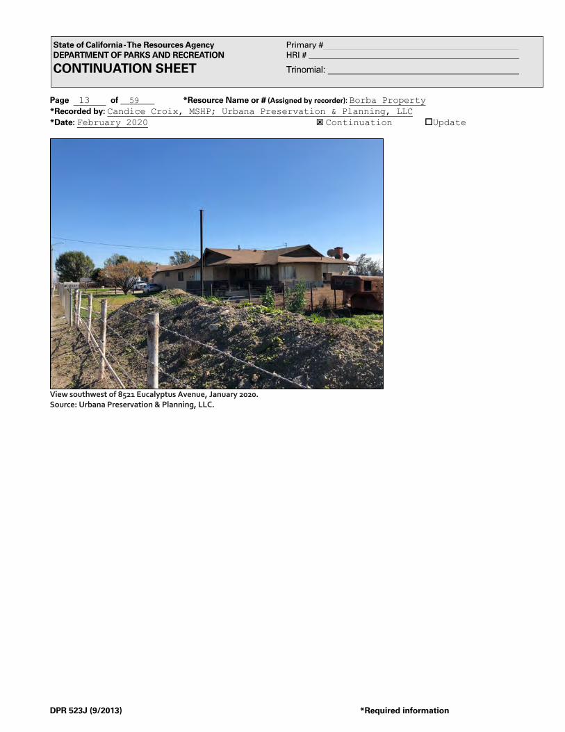
Page 13 of 59 *Resource Name or # (Assigned by recorder): Borba Property *Recorded by: Candice Croix, MSHP; Urbana Preservation & Planning, LLC *Date: February 2020 ý Continuation oUpdate
DPR 523J (9/2013) *Required information
State of California - The Resources Agency Primary # DEPARTMENT OF PARKS AND RECREATION HRI # CONTINUATION SHEET Trinomial:
View southwest of 8521 Eucalyptus Avenue, January 2020. Source: Urbana Preservation & Planning, LLC.

Page 14 of 59 *Resource Name or # (Assigned by recorder): Borba Property *Recorded by: Candice Croix, MSHP; Urbana Preservation & Planning, LLC *Date: February 2020 ý Continuation oUpdate
DPR 523J (9/2013) *Required information
State of California - The Resources Agency Primary # DEPARTMENT OF PARKS AND RECREATION HRI # CONTINUATION SHEET Trinomial:
14651 Grove Ave (105411101) The parcel includes a residence, 14651 Grove Avenue, an office, 14545 Grove Avenue, and a Milking Parlor constructed between 1963-1967. There are 18 pole structures associated with 14651 Grove Avenue, sited behind the residence.
o 14651 Grove Avenue—14651 Grove Avenue is a single-family residence with an attached garage constructed in 1965. The 3,853 square foot single-story residence features a cross-hip roof with 48” overhanging eaves, beige stucco exterior with horizontal wood siding and stone accents, and a rectilinear footprint. The west façade includes a recessed front porch in the center accessible by two concrete steps, flanked by one small standard gliding window and one three-pane gliding windows to the north and two three-pane gliding windows to the south. There is a decorative stone pilaster between these two windows. The north bay features a second decorative stone pilaster flanked by three-pane gliding windows. The south end includes a door, a standard gliding window, a shorter three-pane gliding window, and decorative stone and horizontal wood siding wainscoting. The south elevation features the attached garage, including two single garage doors. The north elevation features a small gliding window. The residence is accessible by a semi-circular concrete driveway. The residence is approximately 102’ long and 45’ wide, with a 24’ x 34’ garage. An original breezeway sited between the residence and the garage, and measuring 12’ x 34’, appears to have been partially enclosed with glazing although this suspected alteration appears reversible. The home exhibits the minimum characteristics of the Ranch style, and maintains a moderate level of character-defining features attributed to the 1960s-1980s timeframe including composition roofing, aluminum cased sliding windows, large picture windows (tri-partite rather than a single piece of glass), homogeneous exterior surface, stylized double doors with ornate panels and ornamental oversized hardware, horizontally arranged aluminum sliding windows, an attached two-car garage (connected via a breezeway). Additionally, the decorative stone elements appear to be period appropriate. Missing character-defining features include arch patterns along the walkways, plain metal or wood post porch supports, concrete slab front porches located under a long narrow shed roof attached to the principal roof or recessed within the central bay of the building (the subject residence features a very limited concrete covered porch recessed into the center facade), large surrounds around the main entry and windows, and an expansive low pitched gable or cross gable roof (the subject dwelling features a hipped roof).
o Milking Parlor—The Milking Parlor consists of two sections, constructed between 1963-1967. The front section of the Milking
Parlor, the Milk House, features a gable roof and stucco exterior. The 864 square foot Milk House includes a 30’ x 25’ (750 square foot) canopy that covers a segment of the circular driveway, supported by four metal poles. The west façade features a concrete step leading to a double door, with a covered window to the north and two gliding windows to the south. The south elevation includes a barred gliding window, and the north elevation includes a gliding window covered by a shed roof balcony supported by two metal poles. The rear of the Milking Parlor is 7,992 square feet and is divided into three sections that are covered by a corrugated metal gable roof. The north section measures approximately 27’ x 148’, and is used to house a press tank and pump. The south section, a herringbone parlor, measures 27’ x 50’, and the east section, a covered wash area, measures 34’ x 98’. An uncovered wash area is sited behind the Milking Parlor, measuring 34’ x 20’.
o 14545 Grove Avenue—14545 Grove Avenue is an office constructed in 1965 with an observant Ranch influence. The 600
square foot office features a pyramid hip roof with overhanging eaves, beige stucco exterior, and a square footprint. The west facade includes a front door asymmetrically placed between two three-pane gliding windows. There are three concrete steps leading to the front door, flanked by a metal handrail with vertical supports. The north elevation includes three windows. There is a three-pane gliding window on the west end and two small standard gliding windows on the east end. The south elevation includes two asymmetrically placed three-pane gliding windows. All windows are barred with the exception of the south elevation’s west window. The residence is surrounded by a brick planter and is accessible via a concrete driveway.

Page 15 of 59 *Resource Name or # (Assigned by recorder): Borba Property *Recorded by: Candice Croix, MSHP; Urbana Preservation & Planning, LLC *Date: February 2020 ý Continuation oUpdate
DPR 523J (9/2013) *Required information
State of California - The Resources Agency Primary # DEPARTMENT OF PARKS AND RECREATION HRI # CONTINUATION SHEET Trinomial:
View northeast of 14651 Grove Avenue, January 2020. Source: Urbana Preservation & Planning, LLC.
View southeast of 14651 Grove Avenue, January 2020. Source: Urbana Preservation & Planning, LLC.

Page 16 of 59 *Resource Name or # (Assigned by recorder): Borba Property *Recorded by: Candice Croix, MSHP; Urbana Preservation & Planning, LLC *Date: February 2020 ý Continuation oUpdate
DPR 523J (9/2013) *Required information
State of California - The Resources Agency Primary # DEPARTMENT OF PARKS AND RECREATION HRI # CONTINUATION SHEET Trinomial:
View northeast of Milking Parlor with cattle pen on right, January 2020. Source: Urbana Preservation & Planning, LLC.
View southeast of Milking Parlor, January 2020. Source: Urbana Preservation & Planning, LLC.

Page 17 of 59 *Resource Name or # (Assigned by recorder): Borba Property *Recorded by: Candice Croix, MSHP; Urbana Preservation & Planning, LLC *Date: February 2020 ý Continuation oUpdate
DPR 523J (9/2013) *Required information
State of California - The Resources Agency Primary # DEPARTMENT OF PARKS AND RECREATION HRI # CONTINUATION SHEET Trinomial:
View east of 14545 Grove Avenue, January 2020. Source: Urbana Preservation & Planning, LLC.
View southeast of 14545 Grove Avenue, January 2020. Source: Urbana Preservation & Planning, LLC.
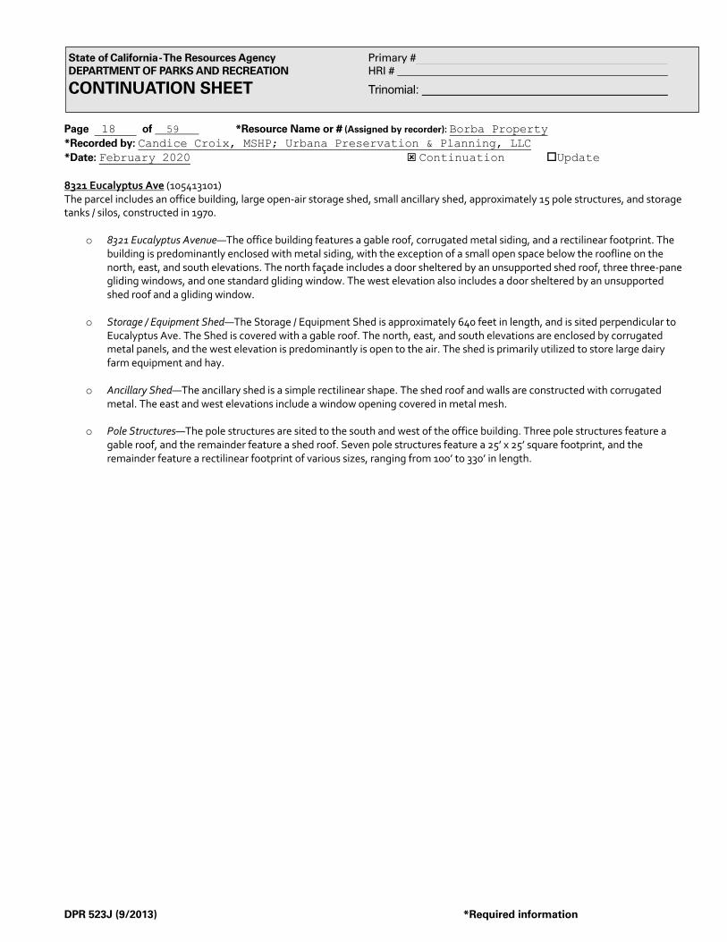
Page 18 of 59 *Resource Name or # (Assigned by recorder): Borba Property *Recorded by: Candice Croix, MSHP; Urbana Preservation & Planning, LLC *Date: February 2020 ý Continuation oUpdate
DPR 523J (9/2013) *Required information
State of California - The Resources Agency Primary # DEPARTMENT OF PARKS AND RECREATION HRI # CONTINUATION SHEET Trinomial:
8321 Eucalyptus Ave (105413101) The parcel includes an office building, large open-air storage shed, small ancillary shed, approximately 15 pole structures, and storage tanks / silos, constructed in 1970.
o 8321 Eucalyptus Avenue—The office building features a gable roof, corrugated metal siding, and a rectilinear footprint. The building is predominantly enclosed with metal siding, with the exception of a small open space below the roofline on the north, east, and south elevations. The north façade includes a door sheltered by an unsupported shed roof, three three-pane gliding windows, and one standard gliding window. The west elevation also includes a door sheltered by an unsupported shed roof and a gliding window.
o Storage / Equipment Shed—The Storage / Equipment Shed is approximately 640 feet in length, and is sited perpendicular to
Eucalyptus Ave. The Shed is covered with a gable roof. The north, east, and south elevations are enclosed by corrugated metal panels, and the west elevation is predominantly is open to the air. The shed is primarily utilized to store large dairy farm equipment and hay.
o Ancillary Shed—The ancillary shed is a simple rectilinear shape. The shed roof and walls are constructed with corrugated
metal. The east and west elevations include a window opening covered in metal mesh.
o Pole Structures—The pole structures are sited to the south and west of the office building. Three pole structures feature a gable roof, and the remainder feature a shed roof. Seven pole structures feature a 25’ x 25’ square footprint, and the remainder feature a rectilinear footprint of various sizes, ranging from 100’ to 330’ in length.

Page 19 of 59 *Resource Name or # (Assigned by recorder): Borba Property *Recorded by: Candice Croix, MSHP; Urbana Preservation & Planning, LLC *Date: February 2020 ý Continuation oUpdate
DPR 523J (9/2013) *Required information
State of California - The Resources Agency Primary # DEPARTMENT OF PARKS AND RECREATION HRI # CONTINUATION SHEET Trinomial:
View southeast of office at 8321 Eucalyptus Avenue, January 2020. Source: Urbana Preservation & Planning, LLC.
View south of ancillary shed at 8321 Eucalyptus Ave, with office on right, January 2020. Source: Urbana Preservation & Planning, LLC.

Page 20 of 59 *Resource Name or # (Assigned by recorder): Borba Property *Recorded by: Candice Croix, MSHP; Urbana Preservation & Planning, LLC *Date: February 2020 ý Continuation oUpdate
DPR 523J (9/2013) *Required information
State of California - The Resources Agency Primary # DEPARTMENT OF PARKS AND RECREATION HRI # CONTINUATION SHEET Trinomial:
View southeast of Storage / Equipment Shed at 8321 Eucalyptus Ave, January 2020. Source: Urbana Preservation & Planning, LLC.
View southwest of Storage / Equipment Shed at 8321 Eucalyptus Ave, January 2020. Source: Urbana Preservation & Planning, LLC.

Page 21 of 59 *Resource Name or # (Assigned by recorder): Borba Property *Recorded by: Candice Croix, MSHP; Urbana Preservation & Planning, LLC *Date: February 2020 ý Continuation oUpdate
DPR 523J (9/2013) *Required information
State of California - The Resources Agency Primary # DEPARTMENT OF PARKS AND RECREATION HRI # CONTINUATION SHEET Trinomial:
8477 Eucalyptus Ave (105413102) The parcel includes a single-family residence and Milking Parlor constructed in 1980, as well as approximately 30 rectilinear pole structures of various sizes.
o 8477 Eucalyptus Avenue—8477 Eucalyptus Avenue is a single-story single-family residence constructed in 1980. The Ranch style residence features an L-shaped footprint, cross-hip roof with composite shingles, beige vertical wood siding with brick wainscoting, and brown trim. The north elevation features three standard gliding windows and one three-panel gliding window. East of the front door, the north elevation includes a floor-to-ceiling window with geometric frame, flanked by a brick accent column on either end. The east elevation features a brick chimney and two-car attached garage. The west elevation features two gliding windows and a stucco exterior. At the time of this evaluation, the building is 40 years old and does not meet age eligibility criteria for the NRHP, nor does it meet the 45-year ‘rule of thumb’ for CRHR consideration. The building is age ineligible, and was constructed five years beyond the end date of the established period of significance for the New Model Colony / Chino Valley Dairy District. The period of significance for the district is 1915-1975.
o Milking Parlor—The Milking Parlor consists of two sections, constructed in 1980. The front section of the milking parlor is a
building with a gable roof and beige stucco exterior. The north façade includes a French door and two brick pilasters. The east elevation includes two large storage / cooling tanks, and the west elevation includes a corrugated metal addition with a shed roof. The rear section includes a pole structure that is partially open to the air, with a gable roof and corrugated metal siding. The Milking Parlor includes a semi-circular concrete driveway. At the time of this evaluation, the building is 40 years old and does not meet age eligibility criteria for the NRHP, nor does it meet the 45-year ‘rule of thumb’ for CRHR consideration. The building is age ineligible, and was constructed five years beyond the end date of the established period of significance for the New Model Colony / Chino Valley Dairy District. The period of significance for the district is 1915-1975.

Page 22 of 59 *Resource Name or # (Assigned by recorder): Borba Property *Recorded by: Candice Croix, MSHP; Urbana Preservation & Planning, LLC *Date: February 2020 ý Continuation oUpdate
DPR 523J (9/2013) *Required information
State of California - The Resources Agency Primary # DEPARTMENT OF PARKS AND RECREATION HRI # CONTINUATION SHEET Trinomial:
View south of 8477 Eucalyptus Ave, January 2020. Source: Urbana Preservation & Planning, LLC.
View southeast of Milking Parlor at 8477 Eucalyptus Ave, January 2020. Source: Urbana Preservation & Planning, LLC.

Page 23 of 59 *Resource Name or # (Assigned by recorder): Borba Property *Recorded by: Candice Croix, MSHP; Urbana Preservation & Planning, LLC *Date: February 2020 ý Continuation oUpdate
DPR 523J (9/2013) *Required information
State of California - The Resources Agency Primary # DEPARTMENT OF PARKS AND RECREATION HRI # CONTINUATION SHEET Trinomial:
View south of parcel with pole structures in background, view between Milking Parlor (on left) and 8477 Eucalyptus Ave (on right), January 2020. Source: Urbana Preservation & Planning, LLC.

Page 24 of 59 *Resource Name or # (Assigned by recorder): Borba Property *Recorded by: Candice Croix, MSHP; Urbana Preservation & Planning, LLC *Date: February 2020 ý Continuation oUpdate
DPR 523J (9/2013) *Required information
State of California - The Resources Agency Primary # DEPARTMENT OF PARKS AND RECREATION HRI # CONTINUATION SHEET Trinomial:
*B10. Significance (continued): The Borba Property is a large dairy property constructed after 1950, which includes at least one Ranch style residence, a herringbone style Milking Parlor, a circular driveway, numerous geometrically spaced rows of pole structures, and open space. However, of the seven primary structures that define the property, five do not meet minimum characteristics for either the Pre-1959 Ranch Style, the 1960s-1980s Ranch Style, or the Post-1950 Scientific, Large-Capacity Dairy, and one is less than 45 years old, having been built in 1980, five years after the end of the established period of significance for the New Model Colony / Chino Valley Dairy District. As such, the Borba Property, as a whole, has not been identified as a contributing element of the New Model Colony / Chino Valley Dairy District. The remaining / seventh building, a Ranch style dwelling located at 14651 S Grove Avenue with an associated Milking Parlor, meets the minimum characteristics for 1960s-1980s Ranch Style and Post-1950 Scientific, Large-Capacity Dairy. In accordance with the approved New Model Colony Area Historic Context Statement, the 14651 S Grove Avenue property, within the larger Borba Property, appears eligible for recognition as a contributing element of the New Model Colony / Chino Valley Dairy District. The period of significance for the district is 1915-1975. The residence was constructed in 1965 and the associated milking parlor was constructed between 1963-1967. Both fall within the 1915-1975 period of significance established for the district. History of the Subject Property and its Environs The subject property and its surrounding block are bound by Eucalyptus Avenue to the north, Carpenter Ave to the east, Merrill Avenue to the south, and Grove Avenue to the west. Between ca. 1930 and 1942, based on available aerial imagery, approximately 10 buildings or structures had been constructed in the survey area, with 8 located along Grove Avenue and 2 located along Eucalyptus. At this time, the survey area primarily included undeveloped land and agricultural fields. All circa 1930-1942 buildings and structures were demolished, the majority by the 1960s. By 1959, the northwest corner of the survey area became a large dairy farm (14525 Grove Ave), and buildings and structures were constructed at the southeast corner (9032 Merrill Ave). By 1967, three large dairy farms were constructed (14651 Grove Ave, 8643 Eucalyptus Ave, and 8810 Merrill Ave). By 1980, three additional large dairy farms were constructed along Eucalyptus Avenue (8731, 8911, and 9031 Eucalyptus Ave), including the construction of numerous pole structures throughout. A trucking operation was established in the southeast by 1994, and additional pole structures were constructed in the west. By 2002, the trucking operation expanded, reservoirs were constructed in the southeast, and additional pole structures were constructed throughout. By 2009, the southwest transitioned to agricultural fields, and the landscape of the northwest changed drastically. By 2014, the trucking operation expanded again, with a paved and graded lot extending from Merrill Avenue to Eucalyptus Ave. In 2019, all buildings and structures along Carpenter Ave were demolished, and is now a dirt lot. The earliest dairy farm in the survey area dates to the 1950s, with the majority of the farms developed in the 1960s-1970s, some with pole structures constructed through the 2000’s. Assessor records indicate that the property collectively termed herein as the “Borba Property” (APNs: 105412101, 105412102, 105413101, 105413102, 105416101, 105411101, 105411102, 105414101, 105414102, 105415101, 105422101, 105422102, 105421101, 105421102, 105420101, 105433101, 105433102, 105434101, 105434102, 105435101) was initially owned by the Chino Land and Water Company. Portions of the property were deeded to Southern California Edison, in 1910 and 1911, for utility easements. By the early 1950s the property was owned by multiple individuals including Leo J. Lucas, Henry L. Lucas, Katherine R. Lucas, Eileen L. Sauer, Gabrielle E. Mikesell, Betty Ann Embree, Paul A. Lucas, Daniel D. Mikesell, Otis M. Embree, Mary Gertrude Lucas, Richard M. Lucas, Donald L. Lucas, and John W. Lucas. This grouping of individuals deeded the property to Pete Borba and Sons, a partnership composed of Pete Borba Sr., Pete Borba Jr., Joe (Joseph) Borba, and George Borba on April 6, ,1953. By the early 1970s the property was owned solely by Joseph and Doleen Borba. The Borba family has milked cows in the Chino Valley since 1925. Joseph Borba was born in Lemoore, CA in 1920, while Doleen was born in 1929 and raised in Upland, CA. Joseph joined the U.S. Army in 1946, and he and Doleen were married in 1950 in San Bernardino. The Borbas raised six children, and began residing at 14545 / 14651 S Grove Ave between 1962 and 1970. A dairyman and farmer, Mr. Borba additionally served on the Board of Directors for several organizations that worked towards the promotion of the dairy and farming industries including American Western Banker, Upland National Bank, Valley Milk Producers, and the Chino Grain and Milling Company. By 1994 the Borba Dairy property was cited in the Chino Valley News as having 2,000 cows. Ownership by the Borba family demonstrates an association with Portuguese history, a major immigrant group that helped to establish dairy operations in the New Model Colony area. Within the New Model Colony area, the Portuguese (and Dutch) helped to modernize the dairy industry from free ranging dairy herds to dry-lot dairying that resulted in a quasi-factory setting. Portuguese milkers had been familiar with the dry-lot methods on the island of Azores and brought their knowledge of specialized dry-lot farming to the Los Angeles dairy industry, thereby countering the need for the expensive import of milk from the San Joaquin Valley.

Page 25 of 59 *Resource Name or # (Assigned by recorder): Borba Property *Recorded by: Candice Croix, MSHP; Urbana Preservation & Planning, LLC *Date: February 2020 ý Continuation oUpdate
DPR 523J (9/2013) *Required information
State of California - The Resources Agency Primary # DEPARTMENT OF PARKS AND RECREATION HRI # CONTINUATION SHEET Trinomial:
New Model Colony Historic Context Per the City of Ontario’s Historic Context for the New Model Colony Area, the County of San Bernardino designated 14,000 acres of agricultural land as the San Bernardino County Agricultural Preserve in 1967. The Preserve, located in the Chino Valley in the southwest area of San Bernardino County, was protected by Williamson Act contracts and the 1965 Land Conservation Act, and evolved into a world-class dairy center by 1980. By the 1990s, farmers within the Preserve were pressured to relocate their dairies as dairy operation costs and demand for housing increased. In 1999, the City of Ontario annexed 8,200 acres and named the area New Model Colony after the original Model Colony of Ontario established in 1882. Two historic contexts, “Post-1950 scientific, large-capacity dairy properties” and “Ranch style houses,” are applicable to the survey area. Post-1950 scientific, large-capacity dairy properties: The historic context for post-1950 scientific, large-capacity dairies coincides with the third phase of dairy farming, with a period of significance between 1950-1969. In this period, the introduction of scientific feeding and breeding resulted in larger herds and more productive operations. The average size of a property associated with this context was 40 acres or more, and included one or more large residences, an attached garage, milking parlor, numerous pole structures, and a large expanse of open space. The majority of residences were designed in the Ranch architectural style with a matching milking parlor, and a property may have included additional smaller residences to house hired workers. Additional residences were sited on either side of the milking parlor and designed and painted in the same color scheme. The milking parlors were designed in the herringbone style, a new milking parlor design in which stalls were placed at an angle and slight elevation to utilize space more efficiently and eliminate a worker’s need to kneel, saving labor and time. The properties featured a circular driveway in front of the milking parlor and typically included designed landscaping. Additional dairy facilities associated with a property, including pole structures, silos, etc., were laid out behind the milking parlor in a perpendicular or parallel fashion.
The minimum characteristics required to identify a post-1950 dairy property are: at least one residence dating to the period of significance, designed in the Ranch architectural style with little alteration; a large “herringbone style” milking parlor designed in the Ranch style; a circular driveway; numerous geometrically spaced rows of pole structures and related dairy facilities; and a vast expanse of open space to the rear of the property. A property may include multiple large residences and a few smaller workers’ residences.
A post-1950 dairy property exhibiting high integrity exhibits the minimum characteristics. The property must include one large residence and a milking parlor designed in the Ranch style and dating to the period of significance. Additional residences may have been constructed prior to 1949. Individual elements will possess high integrity of location, design, setting, association, feeling, materials, and workmanship individually, and the property will possess high integrity as a whole. Buildings and structures will retain their original uses. If abandoned, they should clearly depict their original operational uses.
A post-1950 dairy property exhibiting moderate integrity exhibits the minimum characteristics. The property must include one residence and a milking parlor designed in the Ranch style and dating to the period of significance. Additional residences may have been constructed prior to 1949. The property will possess original location and physical relationships, though the individual elements may have lost some historic integrity. The property conveys historic association with a post-1950 dairy property but has a few minor alterations.
A post-1950 dairy property exhibiting low integrity does not exhibit the minimum characteristics. One of more of the characteristics is missing, and the majority of buildings do not date to the period of significance. The property and individual resources lack integrity of location, design, setting, association, feeling, materials, and workmanship. The property no longer conveys historic association with a post-1950 dairy property. The majority of dairy properties in the New Model Colony study area are associated with the “Post-1950 scientific, large-capacity dairy properties” context. Ranch style houses: The historic context for Ranch style houses includes three distinct phases: pre-1959, 1960-1980, and post-1980. Originating in the mid-1930s in California, the Ranch style gained popularity during the 1940s and became the dominant style throughout the county during the decades of the 1950s and 1960s. Loosely inspired by the early Ranchos of the post-mission period that dotted the landscape of the Rancho Santa Ana del Chino, several local building magazines featured ranch style homes and building plans in the 1950s-1960s, and local builders and architects utilized large lots to design and construct large, rambling plans. The majority of large Ranch style houses in the New Model Colony area date to the 1960s, demonstrating the higher income levels associated with the mechanization and industrialization of dairy operations.
The minimum characteristics required to identify a Ranch style residence include: single-story, expansive, horizontally-emphasized rambling footprint; low-pitched gabled, hipped or intersecting gable roof with expansive overhanging open or boxed

Page 26 of 59 *Resource Name or # (Assigned by recorder): Borba Property *Recorded by: Candice Croix, MSHP; Urbana Preservation & Planning, LLC *Date: February 2020 ý Continuation oUpdate
DPR 523J (9/2013) *Required information
State of California - The Resources Agency Primary # DEPARTMENT OF PARKS AND RECREATION HRI # CONTINUATION SHEET Trinomial:
eaves; wood shingle roof; “U,” “L,” or “S”-shaped plan; attached garage, breeze port, or covered walkway; wide prominent chimney; integral or recessed front porch; concrete slab foundation; large picture windows; plain post porch supports; wide entry doors or French style paneled front entry door; sliding glass doors sited at rear of residence; and an emphasis on outdoor space via an orientation of windows toward a rear patio area. The residence must exhibit the majority of the minimum characteristics in addition to character-defining features specific to each period.
Character-defining features of the pre-1959 Ranch style include: wood single roofs with wide overhanging eaves and wood-cased multi-light windows; square or diamond pattern lights on the windows; glazed and paneled doors; a single-width entry door; a combination of siding materials such as horizontal wood siding and stucco with a contrasting treatment along the footing of the main façade; small square rooftop cupolas projecting from the gable line; small projecting rectangular bays on main façade; and a multi-light picture window or large picture window.
Character-defining features of the 1960s to 1980s Ranch style include: asbestos shingles, asphalt singles, or a composition roofing material; aluminum-cased sliding windows; a large picture window; attached two-car garage; plain metal or wood post porch supports; concrete slab front porch located under a long, narrow shed roof attached to the principal roof or recessed within the central bay of the building; homogenous exterior surface; the use or stone or masonry; arch patterns along walkways; main entry and window surrounds; stylized double doors with ornate panes; glazing and ornamental oversized hardware; and horizontally arranged aluminum siding windows sheltered by an expansive low-pitched gable or cross-gable roof.
Character-defining features of the post-1980 Ranch include: a clay tile roof; larger floor plan; split-level; contemporary and shed-building styles; diagonal siding; wide board trim; window surrounds; and false half-timbering, Spanish Colonial Revival influences.
A Ranch style exhibiting high integrity exhibits the minimum characteristics. The property maintains at least 90% of its original exterior features and must retain the essential features that were part of the original design intent. The property retains its original use. If it is abandoned, the original use is evident due to a lack of alterations. The property retains integrity of location, design, setting, association, feeling, materials, and workmanship.
A Ranch style exhibiting moderate integrity exhibits the minimum characteristics. The property maintains at least 50% of its original exterior features. The property may have a few minor alterations, but continues to convey its historic association. The property retains integrity of location, design, feeling, association, and the majority of its workmanship and materials.
A Ranch style exhibiting low integrity does not exhibit the minimum characteristics. The property does not maintain at least 50% of its original exterior features, and the major features of the residence have been altered or replaced. The property does not retain integrity of location, design, setting, association, feeling, materials, and workmanship, and is no longer being used as its original purpose.

Page 27 of 59 *Resource Name or # (Assigned by recorder): Borba Property *Recorded by: Candice Croix, MSHP; Urbana Preservation & Planning, LLC *Date: February 2020 ý Continuation oUpdate
DPR 523J (9/2013) *Required information
State of California - The Resources Agency Primary # DEPARTMENT OF PARKS AND RECREATION HRI # CONTINUATION SHEET Trinomial:
1938 Aerial View. Source/Citation: Historicaerials.com
Borba Property 14525 S Grove Avenue 14545 S Grove Avenue 14651 S Grove Avenue
8321 Eucalyptus Avenue 8477 Eucalyptus Avenue 8521 Eucalyptus Avenue 8551 Eucalyptus Avenue

Page 28 of 59 *Resource Name or # (Assigned by recorder): Borba Property *Recorded by: Candice Croix, MSHP; Urbana Preservation & Planning, LLC *Date: February 2020 ý Continuation oUpdate
DPR 523J (9/2013) *Required information
State of California - The Resources Agency Primary # DEPARTMENT OF PARKS AND RECREATION HRI # CONTINUATION SHEET Trinomial:
1959 Aerial View. Source / Citation: Historicaerials.com
Borba Property 14525 S Grove Avenue 14545 S Grove Avenue 14651 S Grove Avenue
8321 Eucalyptus Avenue 8477 Eucalyptus Avenue 8521 Eucalyptus Avenue 8551 Eucalyptus Avenue

Page 29 of 59 *Resource Name or # (Assigned by recorder): Borba Property *Recorded by: Candice Croix, MSHP; Urbana Preservation & Planning, LLC *Date: February 2020 ý Continuation oUpdate
DPR 523J (9/2013) *Required information
State of California - The Resources Agency Primary # DEPARTMENT OF PARKS AND RECREATION HRI # CONTINUATION SHEET Trinomial:
1994 Aerial View. Source / Citation: Google Earth
��������������� ���������
��������������� ���������
��������������� ���������
Borba Property 14525 S Grove Avenue 14545 S Grove Avenue 14651 S Grove Avenue
8321 Eucalyptus Avenue 8477 Eucalyptus Avenue 8521 Eucalyptus Avenue 8551 Eucalyptus Avenue

Page 30 of 59 *Resource Name or # (Assigned by recorder): Borba Property *Recorded by: Candice Croix, MSHP; Urbana Preservation & Planning, LLC *Date: February 2020 ý Continuation oUpdate
DPR 523J (9/2013) *Required information
State of California - The Resources Agency Primary # DEPARTMENT OF PARKS AND RECREATION HRI # CONTINUATION SHEET Trinomial:
2014 Aerial View. Source / Citation: Google Earth
Borba Property 14525 S Grove Avenue 14545 S Grove Avenue 14651 S Grove Avenue
8321 Eucalyptus Avenue 8477 Eucalyptus Avenue 8521 Eucalyptus Avenue 8551 Eucalyptus Avenue

Page 31 of 59 *Resource Name or # (Assigned by recorder): Borba Property *Recorded by: Candice Croix, MSHP; Urbana Preservation & Planning, LLC *Date: February 2020 ý Continuation oUpdate
DPR 523J (9/2013) *Required information
State of California - The Resources Agency Primary # DEPARTMENT OF PARKS AND RECREATION HRI # CONTINUATION SHEET Trinomial:
Borba Property 14525 S Grove Avenue Ranch Style Residence
Borba Property 14545 S Grove Avenue Ranch Style Residence
Borba Property 14545 S Grove Avenue Ranch Style Residence
Borba Property 8321 Eucalyptus Avenue
Dairy Structures
Borba Property 8477 Eucalyptus Avenue Ranch Style Residence
Borba Property 8521 Eucalyptus Avenue Ranch Style Residence
Borba Property 8521 Eucalyptus Avenue Ranch Style Residence

Page 32 of 59 *Resource Name or # (Assigned by recorder): Borba Property *Recorded by: Candice Croix, MSHP; Urbana Preservation & Planning, LLC *Date: February 2020 ý Continuation oUpdate
DPR 523J (9/2013) *Required information
State of California - The Resources Agency Primary # DEPARTMENT OF PARKS AND RECREATION HRI # CONTINUATION SHEET Trinomial:
Residential Building Record: 14525 Grove Ave / 105412101 Source / Citation: San Bernardino County

Page 33 of 59 *Resource Name or # (Assigned by recorder): Borba Property *Recorded by: Candice Croix, MSHP; Urbana Preservation & Planning, LLC *Date: February 2020 ý Continuation oUpdate
DPR 523J (9/2013) *Required information
State of California - The Resources Agency Primary # DEPARTMENT OF PARKS AND RECREATION HRI # CONTINUATION SHEET Trinomial:
Residential Building Record: 14525 Grove Ave / 105412101 Source / Citation: San Bernardino County

Page 34 of 59 *Resource Name or # (Assigned by recorder): Borba Property *Recorded by: Candice Croix, MSHP; Urbana Preservation & Planning, LLC *Date: February 2020 ý Continuation oUpdate
DPR 523J (9/2013) *Required information
State of California - The Resources Agency Primary # DEPARTMENT OF PARKS AND RECREATION HRI # CONTINUATION SHEET Trinomial:
Residential Building Record: 14525 Grove Ave / 105412101 Source / Citation: San Bernardino County

Page 35 of 59 *Resource Name or # (Assigned by recorder): Borba Property *Recorded by: Candice Croix, MSHP; Urbana Preservation & Planning, LLC *Date: February 2020 ý Continuation oUpdate
DPR 523J (9/2013) *Required information
State of California - The Resources Agency Primary # DEPARTMENT OF PARKS AND RECREATION HRI # CONTINUATION SHEET Trinomial:
Residential Building Record: 14525 Grove Ave / 105412101 Source / Citation: San Bernardino County

Page 36 of 59 *Resource Name or # (Assigned by recorder): Borba Property *Recorded by: Candice Croix, MSHP; Urbana Preservation & Planning, LLC *Date: February 2020 ý Continuation oUpdate
DPR 523J (9/2013) *Required information
State of California - The Resources Agency Primary # DEPARTMENT OF PARKS AND RECREATION HRI # CONTINUATION SHEET Trinomial:
Residential Building Record: 14525 Grove Ave / 105412101 Source / Citation: San Bernardino County

Page 37 of 59 *Resource Name or # (Assigned by recorder): Borba Property *Recorded by: Candice Croix, MSHP; Urbana Preservation & Planning, LLC *Date: February 2020 ý Continuation oUpdate
DPR 523J (9/2013) *Required information
State of California - The Resources Agency Primary # DEPARTMENT OF PARKS AND RECREATION HRI # CONTINUATION SHEET Trinomial:
Residential Building Record: 14525 Grove Ave / 105412101 Source / Citation: San Bernardino County

Page 38 of 59 *Resource Name or # (Assigned by recorder): Borba Property *Recorded by: Candice Croix, MSHP; Urbana Preservation & Planning, LLC *Date: February 2020 ý Continuation oUpdate
DPR 523J (9/2013) *Required information
State of California - The Resources Agency Primary # DEPARTMENT OF PARKS AND RECREATION HRI # CONTINUATION SHEET Trinomial:
Residential Building Record: 14525 Grove Ave / 105412101 Source / Citation: San Bernardino County

Page 39 of 59 *Resource Name or # (Assigned by recorder): Borba Property *Recorded by: Candice Croix, MSHP; Urbana Preservation & Planning, LLC *Date: February 2020 ý Continuation oUpdate
DPR 523J (9/2013) *Required information
State of California - The Resources Agency Primary # DEPARTMENT OF PARKS AND RECREATION HRI # CONTINUATION SHEET Trinomial:
Residential Building Record: 14525 Grove Ave / 105412101 Source / Citation: San Bernardino County

Page 40 of 59 *Resource Name or # (Assigned by recorder): Borba Property *Recorded by: Candice Croix, MSHP; Urbana Preservation & Planning, LLC *Date: February 2020 ý Continuation oUpdate
DPR 523J (9/2013) *Required information
State of California - The Resources Agency Primary # DEPARTMENT OF PARKS AND RECREATION HRI # CONTINUATION SHEET Trinomial:
Residential Building Record: 14525 Grove Ave / 105412101 Source / Citation: San Bernardino County

Page 41 of 59 *Resource Name or # (Assigned by recorder): Borba Property *Recorded by: Candice Croix, MSHP; Urbana Preservation & Planning, LLC *Date: February 2020 ý Continuation oUpdate
DPR 523J (9/2013) *Required information
State of California - The Resources Agency Primary # DEPARTMENT OF PARKS AND RECREATION HRI # CONTINUATION SHEET Trinomial:
Residential Building Record: 14525 Grove Ave / 105412101 Source / Citation: San Bernardino County

Page 42 of 59 *Resource Name or # (Assigned by recorder): Borba Property *Recorded by: Candice Croix, MSHP; Urbana Preservation & Planning, LLC *Date: February 2020 ý Continuation oUpdate
DPR 523J (9/2013) *Required information
State of California - The Resources Agency Primary # DEPARTMENT OF PARKS AND RECREATION HRI # CONTINUATION SHEET Trinomial:
Residential Building Record: 14525 Grove Ave / 105412101 Source / Citation: San Bernardino County

Page 43 of 59 *Resource Name or # (Assigned by recorder): Borba Property *Recorded by: Candice Croix, MSHP; Urbana Preservation & Planning, LLC *Date: February 2020 ý Continuation oUpdate
DPR 523J (9/2013) *Required information
State of California - The Resources Agency Primary # DEPARTMENT OF PARKS AND RECREATION HRI # CONTINUATION SHEET Trinomial:
Residential Building Record: 14525 Grove Ave / 105412101 Source / Citation: San Bernardino County

Page 44 of 59 *Resource Name or # (Assigned by recorder): Borba Property *Recorded by: Candice Croix, MSHP; Urbana Preservation & Planning, LLC *Date: February 2020 ý Continuation oUpdate
DPR 523J (9/2013) *Required information
State of California - The Resources Agency Primary # DEPARTMENT OF PARKS AND RECREATION HRI # CONTINUATION SHEET Trinomial:
Residential Building Record: 14525 Grove Ave / 105412101 Source / Citation: San Bernardino County

Page 45 of 59 *Resource Name or # (Assigned by recorder): Borba Property *Recorded by: Candice Croix, MSHP; Urbana Preservation & Planning, LLC *Date: February 2020 ý Continuation oUpdate
DPR 523J (9/2013) *Required information
State of California - The Resources Agency Primary # DEPARTMENT OF PARKS AND RECREATION HRI # CONTINUATION SHEET Trinomial:
Residential Building Record: 8551 Eucalyptus Ave / 105416101 Source / Citation: San Bernardino County

Page 46 of 59 *Resource Name or # (Assigned by recorder): Borba Property *Recorded by: Candice Croix, MSHP; Urbana Preservation & Planning, LLC *Date: February 2020 ý Continuation oUpdate
DPR 523J (9/2013) *Required information
State of California - The Resources Agency Primary # DEPARTMENT OF PARKS AND RECREATION HRI # CONTINUATION SHEET Trinomial:
Residential Building Record: 8551 Eucalyptus Ave / 105416101 Source / Citation: San Bernardino County

Page 47 of 59 *Resource Name or # (Assigned by recorder): Borba Property *Recorded by: Candice Croix, MSHP; Urbana Preservation & Planning, LLC *Date: February 2020 ý Continuation oUpdate
DPR 523J (9/2013) *Required information
State of California - The Resources Agency Primary # DEPARTMENT OF PARKS AND RECREATION HRI # CONTINUATION SHEET Trinomial:
Residential Building Record: 8551 Eucalyptus Ave / 105416101 Source / Citation: San Bernardino County

Page 48 of 59 *Resource Name or # (Assigned by recorder): Borba Property *Recorded by: Candice Croix, MSHP; Urbana Preservation & Planning, LLC *Date: February 2020 ý Continuation oUpdate
DPR 523J (9/2013) *Required information
State of California - The Resources Agency Primary # DEPARTMENT OF PARKS AND RECREATION HRI # CONTINUATION SHEET Trinomial:
Residential Building Record: 8551 Eucalyptus Ave / 105416101 Source / Citation: San Bernardino County

Page 49 of 59 *Resource Name or # (Assigned by recorder): Borba Property *Recorded by: Candice Croix, MSHP; Urbana Preservation & Planning, LLC *Date: February 2020 ý Continuation oUpdate
DPR 523J (9/2013) *Required information
State of California - The Resources Agency Primary # DEPARTMENT OF PARKS AND RECREATION HRI # CONTINUATION SHEET Trinomial:
Residential Building Record: 8551 Eucalyptus Ave / 105416101 Source / Citation: San Bernardino County

Page 50 of 59 *Resource Name or # (Assigned by recorder): Borba Property *Recorded by: Candice Croix, MSHP; Urbana Preservation & Planning, LLC *Date: February 2020 ý Continuation oUpdate
DPR 523J (9/2013) *Required information
State of California - The Resources Agency Primary # DEPARTMENT OF PARKS AND RECREATION HRI # CONTINUATION SHEET Trinomial:
Residential Building Record: 8551 Eucalyptus Ave / 105416101 Source / Citation: San Bernardino County

Page 51 of 59 *Resource Name or # (Assigned by recorder): Borba Property *Recorded by: Candice Croix, MSHP; Urbana Preservation & Planning, LLC *Date: February 2020 ý Continuation oUpdate
DPR 523J (9/2013) *Required information
State of California - The Resources Agency Primary # DEPARTMENT OF PARKS AND RECREATION HRI # CONTINUATION SHEET Trinomial:
Residential Building Record: 8551 Eucalyptus Ave / 105416101 Source / Citation: San Bernardino County

Page 52 of 59 *Resource Name or # (Assigned by recorder): Borba Property *Recorded by: Candice Croix, MSHP; Urbana Preservation & Planning, LLC *Date: February 2020 ý Continuation oUpdate
DPR 523J (9/2013) *Required information
State of California - The Resources Agency Primary # DEPARTMENT OF PARKS AND RECREATION HRI # CONTINUATION SHEET Trinomial:
Residential Building Record: 14651 Grove Ave / 105411101 Source / Citation: San Bernardino County

Page 53 of 59 *Resource Name or # (Assigned by recorder): Borba Property *Recorded by: Candice Croix, MSHP; Urbana Preservation & Planning, LLC *Date: February 2020 ý Continuation oUpdate
DPR 523J (9/2013) *Required information
State of California - The Resources Agency Primary # DEPARTMENT OF PARKS AND RECREATION HRI # CONTINUATION SHEET Trinomial:
Residential Building Record: 14651 Grove Ave / 105411101 Source / Citation: San Bernardino County

Page 54 of 59 *Resource Name or # (Assigned by recorder): Borba Property *Recorded by: Candice Croix, MSHP; Urbana Preservation & Planning, LLC *Date: February 2020 ý Continuation oUpdate
DPR 523J (9/2013) *Required information
State of California - The Resources Agency Primary # DEPARTMENT OF PARKS AND RECREATION HRI # CONTINUATION SHEET Trinomial:
Residential Building Record: 14651 Grove Ave / 105411101 Source / Citation: San Bernardino County

Page 55 of 59 *Resource Name or # (Assigned by recorder): Borba Property *Recorded by: Candice Croix, MSHP; Urbana Preservation & Planning, LLC *Date: February 2020 ý Continuation oUpdate
DPR 523J (9/2013) *Required information
State of California - The Resources Agency Primary # DEPARTMENT OF PARKS AND RECREATION HRI # CONTINUATION SHEET Trinomial:
Residential Building Record: 14651 Grove Ave / 105411101 Source / Citation: San Bernardino County

Page 56 of 59 *Resource Name or # (Assigned by recorder): Borba Property *Recorded by: Candice Croix, MSHP; Urbana Preservation & Planning, LLC *Date: February 2020 ý Continuation oUpdate
DPR 523J (9/2013) *Required information
State of California - The Resources Agency Primary # DEPARTMENT OF PARKS AND RECREATION HRI # CONTINUATION SHEET Trinomial:
Residential Building Record: 14651 Grove Ave / 105411101 Source / Citation: San Bernardino County

Page 57 of 59 *Resource Name or # (Assigned by recorder): Borba Property *Recorded by: Candice Croix, MSHP; Urbana Preservation & Planning, LLC *Date: February 2020 ý Continuation oUpdate
DPR 523J (9/2013) *Required information
State of California - The Resources Agency Primary # DEPARTMENT OF PARKS AND RECREATION HRI # CONTINUATION SHEET Trinomial:
Residential Building Record: 14651 Grove Ave / 105411101 Source / Citation: San Bernardino County

Page 58 of 59 *Resource Name or # (Assigned by recorder): Borba Property *Recorded by: Candice Croix, MSHP; Urbana Preservation & Planning, LLC *Date: February 2020 ý Continuation oUpdate
DPR 523J (9/2013) *Required information
State of California - The Resources Agency Primary # DEPARTMENT OF PARKS AND RECREATION HRI # CONTINUATION SHEET Trinomial:
Residential Building Record: 14651 Grove Ave / 105411101 Source / Citation: San Bernardino County

Page 59 of 59 *Resource Name or # (Assigned by recorder): Borba Property *Recorded by: Candice Croix, MSHP; Urbana Preservation & Planning, LLC *Date: February 2020 ý Continuation oUpdate
DPR 523J (9/2013) *Required information
State of California - The Resources Agency Primary # DEPARTMENT OF PARKS AND RECREATION HRI # CONTINUATION SHEET Trinomial:
Residential Building Record: 14651 Grove Ave / 105411101 Source / Citation: San Bernardino County

Page 1 of 15 *Resource Name or #: (Assigned by recorder) GH Dairy Property P1. Other Identifier: N/A
DPR 523A (9/2013) *Required information
State of California - The Resources Agency Primary # DEPARTMENT OF PARKS AND RECREATION HRI # PRIMARY RECORD Trinomial: CRHR Status Code: 5D3 Other Listings: Review Code Reviewer Date
*P2. Location: o Not for Publication ý Unrestricted *a. County: San Bernardino County *b. USGS 7.5' Quad: Corona North Date: 2018 T ; R of ; of Sec ; B.M.
c. Address: 8643 Eucalyptus Ave City: Ontario Zip: 91762 d. UTM: (Give more than one for large and/or linear resources) Zone: 11, mE / mN e. Other Locational Data: The GH Dairy Property includes four parcels on a total of 37.3 acres: 105416103, 105415102,
105420102, 105435102. *P3a. Description: Located at 8643 Eucalyptus Avenue, the GH Dairy Property includes a single-family residence designed in the Ranch style and constructed in 1965, a Milking Parlor, cow pen, and approximately 28 associated pole structures. The property is set within the New Model Colony, an area that developed from the 22,000-acre Rancho Santa Ana Del Chino land grant. Granted in 1841, the land has historically been utilized for agricultural and cattle grazing purposes, with an increased emphasis on dairy farming beginning in the 1900s. Today the property and its environs are characterized by low density development and agricultural uses, primarily dairy farming. See continuation sheet for additional information. *P3b. Resource Attributes: HP2, HP4, HP32, HP33 *P4. Resources Present: ý Building ý Structure o Object o Site o District o Element of District o Other (Isolates, etc.)
P5b. Description of Photo: View southeast of 8643 Eucalyptus (IMG_2084). *P6. Date Constructed/Age and Source: ý Historic 1965 *P7. Owner and Address: GH Dairy 14651 S Grove Ave Ontario, CA 91762 *P8. Recorded By: Candice Croix, MSHP Urbana Preservation & Planning, LLC www.urbanapreservation.com *P9. Date Recorded: February 2020 *P10. Survey Type: CEQA Review *P11. Report Citation: Urbana Preservation & Planning, LLC, Historical Resource Survey – Proposed Merrill Commerce Center Specific Plan, February 2020. *Attachments: o NONE ý Location Map ý Continuation Sheet
ý Building, Structure, and Object Record oArchaeological Record o District Record o Linear Feature Record o Milling Station Record o Rock Art Record o Artifact Record o Photograph Record o Other (List):

*Resource Name or # (Assigned by recorder) GH Dairy Property *CRHR Status Code 5D3 Page 2 of 15
DPR 523B (9/2013) *Required information
(This space reserved for official comments.)
State of California - The Resources Agency Primary # DEPARTMENT OF PARKS AND RECREATION HRI#
BUILDING, STRUCTURE, AND OBJECT RECORD
Property location is depicted on DPR 523J Location Map (page 3
of this DPR set).
Detailed aerial images showing property configuration are included on DPR 523 L Continuation Sheets (pages 11-15 of this
DPR set).
B1. Historic Name: Henrietta Lee property B2. Common Name: GH Dairy Property B3. Original Use: Dairy Farm B4. Present Use: Dairy Farm *B5. Architectural Style: Ranch style dwelling with gambrel roof Milking Parlor and utilitarian pole structures *B6. Construction History: The GH Dairy Property was initially improved in 1938 with three buildings and structures. These original improvements were demolished and replaced with the construction of the single-family residence (1965), Milking Parlor (1965), and cow pen (1965). Pole structures within the cow pen were constructed between 2002-2005. *B8. Related Features: N/A B9a. Architect: Unknown b. Builder: Unknown *B10. Significance: Theme Post-1950 Scientific Large Capacity Dairy / 1960s-1980s Ranch Homes Area Ontario New Model
Colony Period of Significance N/A Property Type Dairy Farm Applicable Criteria NRHP / CRHR / City of Ontario Without evidence to indicate otherwise, the subject property has not been found individually significant under the eligibility criteria of the NRHP / CRHR / City of Ontario. Although it developed as a post-1950 scientific large capacity dairy, no information was identified in the New Model Colony Historic Context statement or within published and unpublished resources to attribute the subject property to important or innovative techniques, or high yields, in post-1950 dairy farming, and as such, the subject property has not been found individually eligible under NRHP / CRHR / City of Ontario Criterion A / 1 / a as the property has not in and of itself been directly associated with significant events or patterns of events in dairy farming in local, regional, state, or national history, nor does it individually exemplify or reflect special elements of the City’s history. The property is not individually eligible under NRHP / CRHR / City of Ontario Criterion B / 2 / b as it has not been identified as having a direct association with an important person or event in local, regional, state, or national history. Further study of Harold and Henrietta Lee may identify the Lees as important individuals in post-1950s dairy farming in the Chino Valley, however, no specific information was identified to support that assertion relative to the subject property. Moreover, the Lees do not appear to have resided at the subject property. Rather, the couple resided in Orange County from the time of their marriage in the early 1960s until Mrs. Lee’s death in 2008. Henrietta’s last documented address was in the city of Buena Park. The property is not individually eligible under NRHP / CRHR / City of Ontario Criterion C / 3 / c-f as the property has not been identified as embodying the distinctive or distinguishing characteristics of a style, type, period, or method of construction, nor has it been identified as representing the work of a master or notable builder, designer, architect, or artist, or an important or creative individual, and as a standard dairy property with an indistinctive 1960s Ranch style home, the property does not qualify as a significant structural, engineering, or architectural achievement or innovation. Similarly, the property does not in and of itself offer a unique location, a singular physical characteristic, or an established and familiar visual feature within the Ontario New Model Colony or the city of Ontario, nor is it in and of itself one of the few remaining examples in the City, region, state or nation, possessing distinguishing characteristics of an architectural or historical type or specimen. As such the property is not individually eligible under City of Ontario Criterion g and h. Beyond what is documented in this DPR set, further study of the property would not likely yield information which would be considered important in local, regional, state, or national history. As such, the property is not individually eligible under NRHP / CRHR / City of Ontario Criterion D / 4 / i. The GH Dairy Property meets the minimum characteristics of a post-1950 scientific, large-capacity dairy property including a single-family residence, circular driveway, geometrically spaced rows of pole structures, and open space to the rear of the property. It additionally meets the minimum characteristics of a 1960s-1980s Ranch style residence including a one-story, rambling floor plan, hip roof, cupola, and covered breezeway. Although it is not an individually significant example under either historic context, the subject property does possess a high level of integrity. As such, in accordance with the approved New Model Colony Area Historic Context Statement, the GH Dairy Property appears eligible for recognition as a contributing element of the New Model Colony / Chino Valley Dairy District. The period of significance for the district is 1915-1975. The subject property was constructed in 1965 within the last ten years of the district’s period of significance. B11. Additional Resource Attributes: None *B12. References: “The City of Ontario’s Historic Context for the New Model Colony,” Galvin & Associates, September 2004.; Ancestry.com. B13. Remarks: *B14. Evaluator: Candice Croix and Wendy L. Tinsley Becker; Urbana Preservation & Planning, LLC *Date of Evaluation: February 2020

Page 3 of 15 *CRHR Status Code: 5D3 *Resource Name or # (Assigned by recorder) GH Dairy Property Map Name: Prado Dam and Corona North Quadrangles Date: 2018 Scale: 1:24,000
DPR 523J (9/2013) *Required information
DEPARTMENT OF PARKS AND RECREATION HRI#
LOCATION MAP Trinomial#
GH Dairy Property 8643 Eucalyptus Ave.

Page 4 of 15 *Resource Name or # (Assigned by recorder): GH Dairy Property *Recorded by: Candice Croix, MSHP; Urbana Preservation & Planning, LLC *Date: February 2020 ý Continuation oUpdate
DPR 523J (9/2013) *Required information
State of California - The Resources Agency Primary # DEPARTMENT OF PARKS AND RECREATION HRI # CONTINUATION SHEET Trinomial:
*P3A: Description (continued): 8643 Eucalyptus Avenue (105416103)
o 8643 Eucalyptus Avenue—8643 Eucalyptus Avenue is a single-family residence constructed in 1965. The Ranch style home features a combination hip roof, stucco exterior with horizontal board accents, and aluminum gliding windows. A detached garage is connected to the residence by a covered breezeway. The north façade of the garage includes two gliding windows set within a bay. The north façade of the residence includes a picture window and gliding window at the east end, a double-door, a four-panel gliding window set within a bay, and two gliding windows at the west end. Both bays are covered in painted brown horizontal wood siding. The west elevation includes two gliding windows, and the east elevation is void of windows. The residence also features a cupola with a pyramid hip roof sited at the east elevation, a brick chimney sited in the center of the residence, and aluminum frame windows. There is minimal decorative landscaping around the residence, limited to a grass lawn and four trees. There is a low concrete block wall surrounding the west, south, and portion of the east boundaries of the lawn, separating the residence from the cow pen. The residence is accessible by a concrete driveway, which splits from the Milking Parlor’s circular driveway. Limited modifications were observed at the dwelling, and none were identified in available municipal records. A single window appears to have been replaced with a vinyl unit. Although it is an average example of the Ranch style, the home does appear to retain a high degree of integrity.
o Milking Parlor—The Milking Parlor consists of two sections, constructed in 1965. The front section of the Milking Parlor, the
Milk House, features a gambrel roof and stucco exterior. The north façade features a glass-paneled entrance, with a gliding window on either side. The east elevation includes a shed roof covered area, and the west elevation includes a plywood-covered opening and a gliding window. The back section of the Milking Parlor features a gable roof and stucco exterior, and the rear of the Milking Parlor is open air, enclosed on the east and west boundary with a concrete wall. The Milking Parlor is accessible by a semi-circular concrete driveway.
o Pole Structures—One pole structure features a square footprint, and is sited to the west of the residence. The remainder
feature a rectilinear footprint in various sizes, and are sited behind the residence. All pole structures feature a shed roof.

Page 5 of 15 *Resource Name or # (Assigned by recorder): GH Dairy Property *Recorded by: Candice Croix, MSHP; Urbana Preservation & Planning, LLC *Date: February 2020 ý Continuation oUpdate
DPR 523J (9/2013) *Required information
State of California - The Resources Agency Primary # DEPARTMENT OF PARKS AND RECREATION HRI # CONTINUATION SHEET Trinomial:
View southeast of 8643 Eucalyptus Ave, January 2020. Source: Urbana Preservation & Planning, LLC.
View south of 8643 Eucalyptus Ave, January 2020. Source: Urbana Preservation & Planning, LLC.

Page 6 of 15 *Resource Name or # (Assigned by recorder): GH Dairy Property *Recorded by: Candice Croix, MSHP; Urbana Preservation & Planning, LLC *Date: February 2020 ý Continuation oUpdate
DPR 523J (9/2013) *Required information
State of California - The Resources Agency Primary # DEPARTMENT OF PARKS AND RECREATION HRI # CONTINUATION SHEET Trinomial:
View south of Milking Parlor associated with 8643 Eucalyptus Ave, January 2020. Source: Urbana Preservation & Planning, LLC.
View southeast of Milking Parlor associated with 8643 Eucalyptus Ave, January 2020. Source: Urbana Preservation & Planning, LLC.

Page 7 of 15 *Resource Name or # (Assigned by recorder): GH Dairy Property *Recorded by: Candice Croix, MSHP; Urbana Preservation & Planning, LLC *Date: February 2020 ý Continuation oUpdate
DPR 523J (9/2013) *Required information
State of California - The Resources Agency Primary # DEPARTMENT OF PARKS AND RECREATION HRI # CONTINUATION SHEET Trinomial:
View south of parcel, view between 8643 Eucalyptus Ave (right) and its associated Milking Parlor (left). Source: Urbana Preservation & Planning, LLC.
View southeast of pole structures, west of 8643 Eucalyptus Ave, January 2020. Source: Urbana Preservation & Planning, LLC.

Page 8 of 15 *Resource Name or # (Assigned by recorder): GH Dairy Property *Recorded by: Candice Croix, MSHP; Urbana Preservation & Planning, LLC *Date: February 2020 ý Continuation oUpdate
DPR 523J (9/2013) *Required information
State of California - The Resources Agency Primary # DEPARTMENT OF PARKS AND RECREATION HRI # CONTINUATION SHEET Trinomial:
*B10. Significance (continued): History of the Subject Property and its Environs The subject property and its surrounding block are bound by Eucalyptus Avenue to the north, Carpenter Ave to the east, Merrill Avenue to the south, and Grove Avenue to the west. Between ca. 1930 and 1942, based on available aerial imagery, approximately 10 buildings or structures had been constructed in the survey area, with 8 located along Grove Avenue and 2 located along Eucalyptus. At this time, the survey area primarily included undeveloped land and agricultural fields. All circa 1930-1942 buildings and structures were demolished, the majority by the 1960s. By 1959, the northwest corner of the survey area became a large dairy farm (14525 Grove Ave), and buildings and structures were constructed at the southeast corner (9032 Merrill Ave). By 1967, three large dairy farms were constructed (14651 Grove Ave, 8643 Eucalyptus Ave, and 8810 Merrill Ave). By 1980, three additional large dairy farms were constructed along Eucalyptus Avenue (8731, 8911, and 9031 Eucalyptus Ave), including the construction of numerous pole structures throughout. A trucking operation was established in the southeast by 1994, and additional pole structures were constructed in the west. By 2002, the trucking operation expanded, reservoirs were constructed in the southeast, and additional pole structures were constructed throughout. By 2009, the southwest transitioned to agricultural fields, and the landscape of the northwest changed drastically. By 2014, the trucking operation expanded again, with a paved and graded lot extending from Merrill Avenue to Eucalyptus Ave. In 2019, all buildings and structures along Carpenter Ave were demolished, and is now a dirt lot. The earliest dairy farm in the survey area dates to the 1950s, with the majority of the farms developed in the 1960s-1970s, some with pole structures constructed through the 2000’s. Assessor records indicate that all of the property collectively termed herein as the “GH Dairy Property” (APNs: 1054-151-02-0-000; 1054-161-02-0-000; 1054-161-03-0-000; 1054-201-02-0-000; and 1054-351-02-0-000) was initially owned by the Western Consumers Feed Company and was granted to Henrietta Lee, a married woman as her sole and separate property, on September 1, 1965. Henrietta Lee was born outside of Amsterdam and moved to the United States with her family at the age of 15, settling in Long Beach. She grew up working at her father’s dairy farm in nearby Cypress, milking and feeding cows and helping with the business. There, she met Harold Lee, who would later become her husband. Harold E. Lee owned a construction company and specialized in construction work for dairy farms. After they were married, Henrietta Lee helped her husband’s sister, June, with the bookkeeping for the construction company. Their main office was in Garden Grove, and much of their building work was done in the Chino area. Mr. Lee passed away in 1990. Subsequent to her husband’s death, in 1997, Mrs. Lee established the Harold E. and Henrietta C. Lee Breast Center within the USC/Norris Comprehensive Cancer Center and Hospital. Mrs. Lee passed away in 2008. The subject property remained under the ownership of the Lee Trust until August 6, 2013 when it was sold to G.H. Dairy. The property was acquired by Liberty Property Limited Partnership in 2019 per San Bernardino County property information records. Ownership by Mrs. Lee demonstrates an association with Dutch history, a major immigrant group that helped to establish dairy operations in the New Model Colony area. Within the New Model Colony area, the Dutch (and Portuguese) helped to modernize the dairy industry from free ranging dairy herds to dry-lot dairying that resulted in a quasi-factory setting. The Netherlands was a small country that lacked the space for free range dairying. Dutch farmers brought their knowledge of specialized dry-lot farming to the Los Angeles dairy industry, thereby countering the need for the expensive import of milk from the San Joaquin Valley. New Model Colony Historic Context Per the City of Ontario’s Historic Context for the New Model Colony Area, the County of San Bernardino designated 14,000 acres of agricultural land as the San Bernardino County Agricultural Preserve in 1967. The Preserve, located in the Chino Valley in the southwest area of San Bernardino County, was protected by Williamson Act contracts and the 1965 Land Conservation Act, and evolved into a world-class dairy center by 1980. By the 1990s, farmers within the Preserve were pressured to relocate their dairies as dairy operation costs and demand for housing increased. In 1999, the City of Ontario annexed 8,200 acres and named the area New Model Colony after the original Model Colony of Ontario established in 1882. Two historic contexts, “Post-1950 scientific, large-capacity dairy properties” and “Ranch style houses,” are applicable to the survey area. Post-1950 scientific, large-capacity dairy properties: The historic context for post-1950 scientific, large-capacity dairies coincides with the third phase of dairy farming, with a period of significance between 1950-1969. In this period, the introduction of scientific feeding and breeding resulted in larger herds and more productive operations. The average size of a property associated with this context was 40 acres or more, and included one or more large residences, an attached garage, milking parlor, numerous pole structures, and a large expanse of open space. The majority of residences were designed in the Ranch architectural style with a matching milking
Page 9 of 15 *Resource Name or # (Assigned by recorder): GH Dairy Property *Recorded by: Candice Croix, MSHP; Urbana Preservation & Planning, LLC *Date: February 2020 ý Continuation oUpdate
DPR 523J (9/2013) *Required information
State of California - The Resources Agency Primary # DEPARTMENT OF PARKS AND RECREATION HRI # CONTINUATION SHEET Trinomial:
parlor, and a property may have included additional smaller residences to house hired workers. Additional residences were sited on either side of the milking parlor and designed and painted in the same color scheme. The milking parlors were designed in the herringbone style, a new milking parlor design in which stalls were placed at an angle and slight elevation to utilize space more efficiently and eliminate a worker’s need to kneel, saving labor and time. The properties featured a circular driveway in front of the milking parlor and typically included designed landscaping. Additional dairy facilities associated with a property, including pole structures, silos, etc., were laid out behind the milking parlor in a perpendicular or parallel fashion.
The minimum characteristics required to identify a post-1950 dairy property are: at least one residence dating to the period of significance, designed in the Ranch architectural style with little alteration; a large “herringbone style” milking parlor designed in the Ranch style; a circular driveway; numerous geometrically spaced rows of pole structures and related dairy facilities; and a vast expanse of open space to the rear of the property. A property may include multiple large residences and a few smaller worker’s residences.
A post-1950 dairy property exhibiting high integrity exhibits the minimum characteristics. The property must include one large residence and a milking parlor designed in the Ranch style and dating to the period of significance. Additional residences may have been constructed prior to 1949. Individual elements will possess high integrity of location, design, setting, association, feeling, materials, and workmanship individually, and the property will possess high integrity as a whole. Buildings and structures will retain their original uses. If abandoned, they should clearly depict their original operational uses.
A post-1950 dairy property exhibiting moderate integrity exhibits the minimum characteristics. The property must include one residence and a milking parlor designed in the Ranch style and dating to the period of significance. Additional residences may have been constructed prior to 1949. The property will possess original location and physical relationships, though the individual elements may have lost some historic integrity. The property conveys historic association with a post-1950 diary property but has a few minor alterations.
A post-1950 dairy property exhibiting low integrity does not exhibit the minimum characteristics. One of more of the characteristics is missing, and the majority of buildings do not date to the period of significance. The property and individual resources lack integrity of location, design, setting, association, feeling, materials, and workmanship. The property no longer conveys historic association with a post-1950 dairy property. The majority of dairy properties in the New Model Colony study area are associated with the “Post-1950 scientific, large-capacity dairy properties” context. Ranch style houses: The historic context for Ranch style houses includes three distinct phases: pre-1959, 1960-1980, and post-1980. Originating in the mid-1930s in California, the Ranch style gained popularity during the 1940s and became the dominant style throughout the county during the decades of the 1950s and 1960s. Loosely inspired by the early Ranchos of the post-mission period that dotted the landscape of the Rancho Santa Ana del Chino, several local building magazines featured ranch style homes and building plans in the 1950s-1960s, and local buildings and architects utilized large lots to design and construct large, rambling plans. The majority of large Ranch style houses in the New Model Colony area date to the 1960s, demonstrating the higher income levels associated with the mechanization and industrialization of dairy operations.
The minimum characteristics required to identify a Ranch style residence include: single-story, expansive, horizontally-emphasized rambling footprint; low-pitched gabled, hipped or intersecting gable roof with expansive overhanging open or boxed eaves; wood shingle roof; “U,” “L,” or “S”-shaped plan; attached garage, breeze port, or covered walkway; wide prominent chimney; integral or recessed front porch; concrete slab foundation; large picture windows; plain post porch supports; wide entry doors or French style paneled front entry door; sliding glass doors sited at rear of residence; and an emphasis on outdoor space via an orientation of windows toward a rear patio area. The residence must exhibit the majority of the minimum characteristics in addition to character-defining features specific to each period.
Character-defining features of the pre-1959 Ranch style include: wood single roofs with wide overhanging eaves and wood-cased multi-light windows; square or diamond pattern lights on the windows; glazed and paneled doors; a single-width entry door; a combination of siding materials such as horizontal wood siding and stucco with a contrasting treatment along the footing of the main façade; small square rooftop cupolas projecting from the gable line; small projecting rectangular bays on main façade; and a multi-light picture window or large picture window.
Character-defining features of the 1960s to 1980s Ranch style include: asbestos shingles, asphalt singles, or a composition roofing material; aluminum-cased sliding windows; a large picture window; attached two-car garage; plain metal or wood post porch supports; concrete slab front porch located under a long, narrow shed roof attached to the principal roof or recessed within the central bay of the building; homogenous exterior surface; the use or stone or masonry; arch patterns along walkways; main entry and

Page 10 of 15 *Resource Name or # (Assigned by recorder): GH Dairy Property *Recorded by: Candice Croix, MSHP; Urbana Preservation & Planning, LLC *Date: February 2020 ý Continuation oUpdate
DPR 523J (9/2013) *Required information
State of California - The Resources Agency Primary # DEPARTMENT OF PARKS AND RECREATION HRI # CONTINUATION SHEET Trinomial:
window surrounds; stylized double doors with ornate panes; glazing and ornamental oversized hardware; and horizontally arranged aluminum siding windows sheltered by an expansive low-pitched gable or cross-gable roof.
Character-defining features of the post-1980 Ranch include: a clay tile roof; larger floor plan; split-level; contemporary and shed-building styles; diagonal siding; wide board trim; window surrounds; and false half-timbering, Spanish Colonial Revival influences.
A Ranch style exhibiting high integrity exhibits the minimum characteristics. The property maintains at least 90% of its original exterior features and must retain the essential features that were part of the original design intent. The property retains its original use. If it is abandoned, the original use is evident due to a lack of alterations. The property retains integrity of location, design, setting, association, feeling, materials, and workmanship.
A Ranch style exhibiting moderate integrity exhibits the minimum characteristics. The property maintains at least 50% of its original exterior features. The property may have a few minor alterations, but continue to convey its historic association. The property retains integrity of location, design, feeling, association, and the majority of its workmanship and materials.
A Ranch style exhibiting low integrity does not exhibit the minimum characteristics. The property does not maintain at least 50% of its original exterior features, and the major features of the residence have been altered or replaced. The property does not retain integrity of location, design, setting, association, feeling, materials, and workmanship, and is no longer being used as its original purpose.

Page 11 of 15 *Resource Name or # (Assigned by recorder): GH Dairy Property *Recorded by: Candice Croix, MSHP; Urbana Preservation & Planning, LLC *Date: February 2020 ý Continuation oUpdate
DPR 523J (9/2013) *Required information
State of California - The Resources Agency Primary # DEPARTMENT OF PARKS AND RECREATION HRI # CONTINUATION SHEET Trinomial:
1938 Aerial View. Source/Citation: Historicaerials.com
GH Dairy Property 8643 Eucalyptus Ave.

Page 12 of 15 *Resource Name or # (Assigned by recorder): GH Dairy Property *Recorded by: Candice Croix, MSHP; Urbana Preservation & Planning, LLC *Date: February 2020 ý Continuation oUpdate
DPR 523J (9/2013) *Required information
State of California - The Resources Agency Primary # DEPARTMENT OF PARKS AND RECREATION HRI # CONTINUATION SHEET Trinomial:
1959 Aerial View. Source / Citation: Historicaerials.com
GH Dairy Property 8643 Eucalyptus Ave.

Page 13 of 15 *Resource Name or # (Assigned by recorder): GH Dairy Property *Recorded by: Candice Croix, MSHP; Urbana Preservation & Planning, LLC *Date: February 2020 ý Continuation oUpdate
DPR 523J (9/2013) *Required information
State of California - The Resources Agency Primary # DEPARTMENT OF PARKS AND RECREATION HRI # CONTINUATION SHEET Trinomial:
1994 Aerial View. Source / Citation: Google Earth
��������������� ���������
��������������� ���������
��������������� ���������
GH Dairy Property 8643 Eucalyptus Ave.

Page 14 of 15 *Resource Name or # (Assigned by recorder): GH Dairy Property *Recorded by: Candice Croix, MSHP; Urbana Preservation & Planning, LLC *Date: February 2020 ý Continuation oUpdate
DPR 523J (9/2013) *Required information
State of California - The Resources Agency Primary # DEPARTMENT OF PARKS AND RECREATION HRI # CONTINUATION SHEET Trinomial:
2014 Aerial View. Source / Citation: Google Earth
GH Dairy Property 8643 Eucalyptus Ave.

Page 15 of 15 *Resource Name or # (Assigned by recorder): GH Dairy Property *Recorded by: Candice Croix, MSHP; Urbana Preservation & Planning, LLC *Date: February 2020 ý Continuation oUpdate
DPR 523J (9/2013) *Required information
State of California - The Resources Agency Primary # DEPARTMENT OF PARKS AND RECREATION HRI # CONTINUATION SHEET Trinomial:
GH Dairy Property Henrietta Lee parcels 8643 Eucalyptus Ave. Milking Parlor with
Circular Drive GH Dairy Property Henriette Lee parcels 8643 Eucalyptus Ave. Ranch style dwelling

Page 1 of 45 *Resource Name or #: (Assigned by recorder) Minaberry Property P1. Other Identifier: N/A
DPR 523A (9/2013) *Required information
State of California - The Resources Agency Primary # DEPARTMENT OF PARKS AND RECREATION HRI # PRIMARY RECORD Trinomial: CRHR Status Code: 5D3 / 6Z Other Listings: Review Code Reviewer Date
*P2. Location: o Not for Publication ý Unrestricted *a. County: San Bernardino County *b. USGS 7.5' Quad: Corona North Date: 2018 T ; R of ; of Sec ; B.M.
c. Address: Multiple City: Ontario Zip: 91762 d. UTM: (Give more than one for large and/or linear resources) Zone: , mE / mN e. Other Locational Data: The Minaberry Property includes 11 parcels on 73.85 acres: 105416102, 105417101, 105417102,
105418101, 105419101, 105436101, 105417103, 105417104, 105418102, 105419102, 105436102. *P3a. Description: The Minaberry Property includes six residences designed in the Ranch style and constructed between 1957-1969, two Milking Parlors (1966 / 1968), and approximately 30 pole structures. The residences are addressed as 8810 Merrill Avenue, 8816 Merrill Avenue, 8920 Merrill Avenue, 8731 Eucalyptus Avenue, 8831 Eucalyptus Avenue, and 8888 Eucalyptus Avenue. A short road within the property, Vineyard Avenue, provides access to a fertilizer center sited between 8888 Eucalyptus Avenue and 8810 Merrill Avenue. The property is set within the New Model Colony, an area that developed from the 22,000-acre Rancho Santa Ana Del Chino land grant. Granted in 1841, the land has historically been utilized for agricultural and cattle grazing purposes, with an increased emphasis on dairy farming beginning in the 1900s. Today the property and its environs are characterized by low density development and agricultural uses, primarily dairy farming. See continuation sheet for additional information. *P3b. Resource Attributes: HP2, HP4, HP 32, HP33 *P4. Resources Present: ý Building ý Structure o Object o Site o District o Element of District o Other (Isolates, etc.)
P5b. Description of Photo: View northwest of Minaberry property from Merrill Avenue (IMG_2510). *P6. Date Constructed/Age and Source: ý Historic 1957 / 1968-1969 (see B6) *P7. Owner and Address: Henri Laurant Minaberry 8731 Eucalyptus Ave Ontario, CA 91762 *P8. Recorded By: Candice Croix, MSHP Urbana Preservation & Planning, LLC www.urbanapreservation.com *P9. Date Recorded: February 2020 *P10. Survey Type: CEQA Review *P11. Report Citation: Urbana Preservation & Planning, LLC, Historical Resource Survey – Proposed Merrill Commerce Center Specific Plan, February 2020. *Attachments: o NONE ý Location Map ý Continuation Sheet ý Building, Structure, and
Object Record oArchaeological Record o District Record o Linear Feature Record o Milling Station Record o Rock Art Record o Artifact Record o Photograph Record o Other (List):

*Resource Name or # (Assigned by recorder) Minaberry Property *CRHR Status Code 5D3 / 6Z Page 2 of 45
DPR 523B (9/2013) *Required information
State of California - The Resources Agency Primary # DEPARTMENT OF PARKS AND RECREATION HRI#
BUILDING, STRUCTURE, AND OBJECT RECORD
(This space reserved for official comments.)
Property location is depicted on DPR 523J Location Map (page 3
of this DPR set).
Detailed aerial images showing property configuration are included on DPR 523 L Continuation Sheets (pages 22-26 of this
DPR set).
B1. Historic Name: Not Identified B2. Common Name: Minaberry Dairy B3. Original Use: Dairy Farm B4. Present Use: Dairy Farm *B5. Architectural Style: Ranch style dwelling with gable roof Milking Parlor and utilitarian pole structures *B6. Construction History: The Minaberry Property was initially improved with three residences: 8920 Merrill Avenue (built in 1957 per County records), 8816 Merrill Ave (built in 1958 per County records), and 8810 Merrill Ave (built in 1962 per County records), as well as the associated Milking Parlor (built in 1966 and addressed with 8920 Merrill Avenue). While Residential Building Records for these buildings indicate effective years of 1962, 1958, 1957, and 1966 respectively, historic aerial imagery shows the land area as vacant in 1966, and improved by 1967, thus revealing a circa 1967 construction date. In 1968, 8731 Eucalyptus Avenue and an associated Milking Parlor were constructed. One year later, in 1969, the 8831 Eucalyptus Ave and 8888 Eucalyptus Avenue properties were constructed. Additional cow pens were constructed behind 8831 and 8888 Eucalyptus between 1980-1994, and utilitarian pole structures were erected within these cow pens between 1994-2002. *B7. Moved? ý No o Yes o Unknown Date: N/A Original Location: N/A *B8. Related Features: N/A B9a. Architect: Unknown b. Builder: Unknown *B10. Significance: Theme Post-1950 Scientific Large Capacity Dairy / 1960s-1980s Ranch homes Area Ontario New Model
Colony Period of Significance N/A Property Type Dairy Farm Applicable Criteria NRHP / CRHR / City of Ontario Without evidence to indicate otherwise, the subject property has not been found individually significant under the eligibility criteria of the NRHP / CRHR / City of Ontario. Although it developed with multiple post-1950 scientific large capacity dairies, no information was identified in the New Model Colony Historic Context statement or within published and unpublished resources to attribute the subject property to important or innovative techniques, or high yields, in post-1950 dairy farming. The subject property has not been found individually eligible under NRHP / CRHR / City of Ontario Criterion A / 1 / a as the property has not in and of itself been directly associated with significant events or patterns of events in dairy farming in local, regional, state, or national history, nor does it individually exemplify or reflect special elements of the City’s history. The property is not individually eligible under NRHP / CRHR / City of Ontario Criterion B / 2 / b as it has not been identified as having a direct association with an important person or event in local, regional, state, or national history. The property, collectively, or divided into six separate addresses (8810 Merrill Ave., 8816 Merrill Ave., 8920 Merrill Ave., 8731 Eucalyptus Ave., 8831 Eucalyptus Ave., and 8888 Eucalyptus Ave.) is not individually eligible under NRHP / CRHR / City of Ontario Criterion C / 3 / c-f as neither the property in its entirety, or its individual addresses within, has been identified as embodying the distinctive or distinguishing characteristics of a style, type, period, or method of construction, nor has it been identified as representing the work of a master or notable builder, designer, architect, or artist, or an important or creative individual, and as a standard dairy property with Ranch style homes built in the 1950s and 1960s, the property does not qualify as a significant structural, engineering, or architectural achievement or innovation. Similarly, the property is not individually eligible under City of Ontario Criterion g and h as the property does not in and of itself offer a unique location, a singular physical characteristic, or an established and familiar visual feature within the Ontario New Model Colony or the city of Ontario, nor is it in and of itself one of the few remaining examples in the City, region, state or nation, possessing distinguishing characteristics of an architectural or historical type or specimen. Beyond what is documented in this DPR set, further study of the property would not likely yield information which would be considered important in local, regional, state, or national history. As such, the property is not individually eligible under NRHP / CRHR / City of Ontario Criterion D / 4 / i. See continuation sheet for additional significance summary, and contextual and property specific history. B11. Additional Resource Attributes: N/A *B12. References: “The City of Ontario’s Historic Context for the New Model Colony,” Galvin & Associates, September 2004.; Ancestry.com for “Henri Minaberry” and “Michel Minaberry.” B13. Remarks: *B14. Evaluator: Candice Croix and Wendy L. Tinsley Becker; Urbana Preservation & Planning, LLC *Date of Evaluation: February 2020

Page 3 of 45 *CRHR Status Code: 5D3/6Z *Resource Name or # (Assigned by recorder) Minaberry Property Map Name: Prado Dam and Corona North Quadrangles Date: 2018 Scale: 1:24,000
DPR 523J (9/2013) *Required information
DEPARTMENT OF PARKS AND RECREATION HRI#
LOCATION MAP Trinomial#
Minaberry Property 8810 Merrill Avenue 8816 Merrill Avenue 8920 Merrill Avenue
8731 Eucalyptus Avenue 8831 Eucalyptus Avenue 8888 Eucalyptus Avenue

Page 4 of 45 *Resource Name or # (Assigned by recorder): Minaberry Property *Recorded by: Candice Croix, MSHP; Urbana Preservation & Planning, LLC *Date: February 2020 ý Continuation oUpdate
DPR 523J (9/2013) *Required information
State of California - The Resources Agency Primary # DEPARTMENT OF PARKS AND RECREATION HRI # CONTINUATION SHEET Trinomial:
*P3A: Description (continued): 8810 Merrill Avenue (105436102) The parcel includes three residences (8810 Merrill Avenue, 8816 Merrill Ave, and 8920 Merrill Avenue), a Milking Parlor, a storage shed, two ancillary buildings, and approximately 20 utilitarian pole structures.
o 8810 Merrill Avenue –8810 Merrill Avenue is a single-story single-family residence constructed in 1962. The 1,451 square foot Ranch style dwelling features a hip and valley roof, stucco exterior, rectilinear footprint, and attached 399 square foot garage. The south façade features four gliding windows, one double gliding window, and a covered porch. The stucco exterior between the garage and front door is accented with red-colored vertical wood wainscoting, and the double gliding window is accented with terracotta-colored wood trim and vertical wood siding. The garage features a wood double door that opens left and right, accessible by a concrete driveway. The east elevation includes two gliding windows. All windows throughout the residence appear to be original aluminum frames. Landscaping is minimal, limited to a simple grass lawn and a few trees, and the residence is surrounded by a low concrete block wall on the north, east, and west elevations. The building is identifiable as a Ranch style dwelling with some minimum characteristics, however, it is missing several minimum characteristics and character-defining features attributed to the 1960s-1980s period including: breeze port and covered walkway, wide prominent chimney, plain metal or wood post porch supports, a concrete slab front porch located under a long narrow shed roof attached to the principal roof or recessed within the central bay of the building, the use of stone and masonry, arch patterns along walkways, large surrounds around the main entry and windows, stylized double doors with ornate panels, glazing and ornamental oversized hardware, horizontally arranged aluminum sliding windows all sheltered by an expansive low pitched gable or cross gable roof. The home is an average example of the Ranch style and does not rise to the minimum characteristics or character-defining features such that it can be regarded as significant under the 1960s-1980s context for Ranch style dwellings. Although integrity appears to be high, the building lacks the necessary qualities to be significant in the first place.
o There is a large storage shed behind 8810 Merrill Avenue. Constructed between 1980 and 1994, the structure is approximately 160’ x 45’, sited perpendicular to Merrill Ave, and is set back approximately 200’ from the road. The structure features a shed roof and is enclosed on three sides, with the west elevation open to the air.
o 8816 Merrill Avenue—8816 Merrill Avenue is a single-story, single-family residence constructed in 1958. The 1,661 square foot residence exhibits an aesthetic appearance closer to a Minimal Traditional style home, but with an extended floor plan indicative of the Ranch style. The building features a cross gable roof with 12” eaves, stucco exterior, attached garage, and an L-shaped footprint. The south façade features a covered porch in the southwest corner supported by a single plain post, as well as four double-hung windows of various sizes. The west elevation features three double-hung windows, a stone chimney, and the front entrance, and the east elevation features three double hung windows. All windows are wood-framed. The 420 square foot attached garage is sited at the north end of the residence, accessible by a concrete L-shaped driveway. 8816 Merrill Avenue is sited directly west of 8810 Merrill Avenue, between 8810 Merrill Avenue and the Milking Parlor. Visual observation and a review of the Residential Building Record disclosed that half of the original front porch has been infilled for additional interior space. This awkwardly placed addition is demarcated by the shed roof extension, and it is not delineated on the Residential Building Record. The boxy appearance of the front, street-facing volume conflicts with the true Ranch aesthetic, which is generally more low-slung and horizontal massing. Beyond its L-shaped plan, cross-gabled roof, and attached garage, the dwelling does not appear to meet the minimum characteristics of the Ranch style and additionally, does not exhibit the majority of character-defining features attributed to pre-1959 Ranch style homes including: wood shingle roof with wide overhanging eaves, square or diamond pattern lites at the windows, glazed and paneled doors, a combination of exterior siding materials such as horizontal wood siding combined with board and batten siding and smooth stucco with some type of contrasting treatment along the footing of the main façade, small square roof top cupola projecting from the gable line, and small projecting rectangular bays on the principal facades. The home is a below average example of the Ranch style and does not rise to the minimum characteristics or character-defining features such that it can be regarded as significant under the pre-1959 context for Ranch style dwellings. Although integrity appears to be high, the building lacks the necessary qualities to be significant in the first place.

Page 5 of 45 *Resource Name or # (Assigned by recorder): Minaberry Property *Recorded by: Candice Croix, MSHP; Urbana Preservation & Planning, LLC *Date: February 2020 ý Continuation oUpdate
DPR 523J (9/2013) *Required information
State of California - The Resources Agency Primary # DEPARTMENT OF PARKS AND RECREATION HRI # CONTINUATION SHEET Trinomial:
o Milking Parlor—The Milking Parlor includes three sections, a Milk House, Cow Barn, and Feed Tank Area, and was
constructed in 1966. The 792 square foot Milk House features a gable concrete tile roof and stucco exterior. The south façade is symmetrical, with a commercial storefront entrance flanked on either side by a twelve-pane fixed window. The east elevation includes a small shed roof addition, and the west elevation includes a plywood-covered opening and a sliding barn door. Behind the Milk House, there is a 4,608 square foot cow barn that features an aluminum gable roof, louvered clerestory, and concrete wall with angled posts. At the rear of the Milking Parlor, there is an 864 square foot open-air Feed Tank Area. The Milking Parlor is sited directly west of 8816 Merrill Avenue, between 8816 Merrill Avenue and 8920 Merrill Avenue.
o Twenty utilitarian pole structures are sited north and west of the Milking Parlor. Two pole structures west of the Milking Parlor feature a gable roof, and the remainder feature a shed roof. All pole structures have a rectilinear footprint in various sizes, ranging from 50’ to 460’ in length.
o 8920 Merrill Avenue—8920 Merrill Avenue is a single-story single-family residence constructed in 1957. The 3,297 square foot Ranch style residence features a hip and valley roof with 24” eaves, stucco exterior, irregular L-shaped footprint, and an attached garage. The south façade features two covered porches, both accessible by a concrete pathway and two concrete steps. The exterior includes stone siding, horizontal wood wainscoting, and stone wainscoting. The west elevation includes two gliding windows. The 462 square foot garage is sited at the east elevation and includes two garage doors and a standard door. 8920 Merrill Avenue is sited directly west of the Milking Parlor. The bottom half of the property’s Residential Building Record has been covered over / replaced which indicates that substantial notations have occurred, or erroneous information was presented. By 1978, when the replacement record was created, the front elevation was notated as featuring stucco walls with “siding” and “sierra” materials. These two notations may be a single product or may refer to the horizontal siding and the stone veneer. Searches for “sierra siding” yields multiple results for cement board siding, which may be the existing horizontal board siding installed along the front elevation and for vinyl siding, which does not appear to exist at the front elevation. With a rustic appearance, the stone veneer could also be the “sierra” product. The existing stone veneer likely dates to the ca. 1970s and may have been installed in ca. 1978 when a portion of the garage was finished out and enclosed / separated from the rest of the original garage space. This ca. 1978 finished space comprises the southeast corner of the building and the front elevation. Other noted alterations include replacement of original roofing (likely shake roofing or composition) with composite roofing, and possible replacement of original wood windows with the existing aluminum units. The building dates to 1957, which places it within the pre-1959 Ranch context. While the home maintains the minimum characteristics to be recognized as a Ranch style dwelling, it does not feature many of the character-defining features attributed to the context including a wood shingle roof with wide overhanging eaves, wood-cased multi-light windows, square or diamond pattern lights on the windows, and single width entry door. The home appears to have been remodeled in or by ca. 1978, and as such it no longer retains integrity to the pre-1959 context.
o Two ancillary buildings are sited northwest of 8920 Merrill Avenue. The south building features an aluminum shed roof and wood siding, and the north building feature an aluminum gable roof and siding.

Page 6 of 45 *Resource Name or # (Assigned by recorder): Minaberry Property *Recorded by: Candice Croix, MSHP; Urbana Preservation & Planning, LLC *Date: February 2020 ý Continuation oUpdate
DPR 523J (9/2013) *Required information
State of California - The Resources Agency Primary # DEPARTMENT OF PARKS AND RECREATION HRI # CONTINUATION SHEET Trinomial:
View north of 8810 Merrill Ave, February 2020. Source: Urbana Preservation & Planning, LLC.
View northwest of 8810 Merrill Ave with ancillary storage shed behind (on right), February 2020.

Page 7 of 45 *Resource Name or # (Assigned by recorder): Minaberry Property *Recorded by: Candice Croix, MSHP; Urbana Preservation & Planning, LLC *Date: February 2020 ý Continuation oUpdate
DPR 523J (9/2013) *Required information
State of California - The Resources Agency Primary # DEPARTMENT OF PARKS AND RECREATION HRI # CONTINUATION SHEET Trinomial:
Source: Urbana Preservation & Planning, LLC.
View northwest of 8816 Merrill Avenue, February 2020. Source: Urbana Preservation & Planning, LLC.

Page 8 of 45 *Resource Name or # (Assigned by recorder): Minaberry Property *Recorded by: Candice Croix, MSHP; Urbana Preservation & Planning, LLC *Date: February 2020 ý Continuation oUpdate
DPR 523J (9/2013) *Required information
State of California - The Resources Agency Primary # DEPARTMENT OF PARKS AND RECREATION HRI # CONTINUATION SHEET Trinomial:
View northeast of 8816 Merrill Avenue, February 2020. Source: Urbana Preservation & Planning, LLC.
View northwest of Milking Parlor, between 8816 Merrill Ave (not pictured) and 8920 Merrill Ave (on left), February 2020. Source: Urbana Preservation & Planning, LLC.

Page 9 of 45 *Resource Name or # (Assigned by recorder): Minaberry Property *Recorded by: Candice Croix, MSHP; Urbana Preservation & Planning, LLC *Date: February 2020 ý Continuation oUpdate
DPR 523J (9/2013) *Required information
State of California - The Resources Agency Primary # DEPARTMENT OF PARKS AND RECREATION HRI # CONTINUATION SHEET Trinomial:
View northeast of Milking Parlor, between 8816 Merrill Ave and 8920 Merrill Ave, February 2020. Source: Urbana Preservation & Planning, LLC.
View north of 8920 Merrill Ave, February 2020. Source: Urbana Preservation & Planning, LLC.

Page 10 of 45 *Resource Name or # (Assigned by recorder): Minaberry Property *Recorded by: Candice Croix, MSHP; Urbana Preservation & Planning, LLC *Date: February 2020 ý Continuation oUpdate
DPR 523J (9/2013) *Required information
State of California - The Resources Agency Primary # DEPARTMENT OF PARKS AND RECREATION HRI # CONTINUATION SHEET Trinomial:
View north of ancillary buildings, 8920 Merrill Ave on right, February 2020. Source: Urbana Preservation & Planning, LLC.

Page 11 of 45 *Resource Name or # (Assigned by recorder): Minaberry Property *Recorded by: Candice Croix, MSHP; Urbana Preservation & Planning, LLC *Date: February 2020 ý Continuation oUpdate
DPR 523J (9/2013) *Required information
State of California - The Resources Agency Primary # DEPARTMENT OF PARKS AND RECREATION HRI # CONTINUATION SHEET Trinomial:
8731 Eucalyptus Avenue (105417101 / 105417102) The parcels include a single-family residence, Milking Parlor, and sixteen rectilinear pole structures of various sizes.
o 8731 Eucalyptus Avenue—8731 Eucalyptus Avenue is a single-family Ranch style residence with a detached garage constructed in 1968. The split-level residence features a hip and valley roof with overhanging eaves supported by masonry columns, a stucco exterior, and gliding windows. The north façade is primarily a large bay, accented by asymmetrically placed brick columns. Beginning at the east end of the north bay, the residence features two masonry columns, a gliding window, two masonry columns with an ornamental metal arch between them, a three-panel gliding window, a recessed French door, a gliding window, and a three-panel gliding window. East of the north bay, there is a gliding window. West of the north bay, the split-level features a balcony with a metal guardrail on the upper level and a gliding window on the lower level. The east elevation includes gliding windows and a standard door. The west elevation includes a gliding window on the lower level. The residence is accessible by a circular concrete driveway. The detached garage features a simple hip roof with overhanging eaves and a stucco exterior. The north elevation of the detached garage includes two three-panel gliding windows, sited within window bays. There are three ornamental railings along the exterior, one on either end of the north elevation and one in between the window bays. The east elevation includes one picture window. The garage is accessible by a concrete driveway, sited between the residence and the Milking Parlor. The home exhibits the minimum characteristics of the Ranch style, and maintains a moderate level of character-defining features attributed to the 1960s-1980s timeframe including composition roofing, aluminum cased sliding windows, large picture windows (tri-partite rather than a single piece of glass), homogeneous exterior surface, stylized double doors with ornate panels with ornamental oversized hardware, arch patterns along the walkways, and horizontally arranged aluminum sliding windows. Missing character-defining features include an attached two-car garage (the subject residence features a detached garage), plain metal or wood post porch supports (the subject property features slumpstone / brick posts), concrete slab front porches located under a long narrow shed roof attached to the principal roof or recessed within the central bay of the building (the subject residence features a very limited concrete covered porch recessed into the center facade), large surrounds around the main entry and windows, and an expansive low pitched gable or cross gable roof (the subject dwelling features a hipped roof).
o Milking Parlor (105417102)—The Milking Parlor consists of multiple sections, constructed in 1968. The front section of the Milking Parlor, the Milk House, features a gable roof and stucco exterior. The north façade of the 1,050 square foot Milk House is symmetrical, with a three-panel entrance flanked by a single picture window on either side. The west elevation is obscured by a large storage tank, and the east elevation includes a three-panel gliding window. Behind the Milk House is a 1,200 square foot barn with a gable roof and concrete wall. Behind the barn is a covered pre-wash structure with a gable roof concrete wall. The barn and pre-wash sections feature a louvered clerestory and concrete wall with angled posts. Behind the pre-wash section is a 1,152 square foot enclosed shop, covered by a shed roof. The Milking Parlor is accessible by a semicircular concrete driveway.
o Pole Structures—There are sixteen utilitarian pole structures associated with the 8731 Eucalyptus Avenue and the Milking
Parlor, the majority sited within cow pens. One pole structure is sited to the east of the Milking Parlor, three are sited to the southeast, and the remainder are sited to the south. Two pole structures feature a gable roof, and the remainder feature a shed roof. All pole structures have a rectilinear footprint in various sizes, ranging from 50’ to 420’ in length.

Page 12 of 45 *Resource Name or # (Assigned by recorder): Minaberry Property *Recorded by: Candice Croix, MSHP; Urbana Preservation & Planning, LLC *Date: February 2020 ý Continuation oUpdate
DPR 523J (9/2013) *Required information
State of California - The Resources Agency Primary # DEPARTMENT OF PARKS AND RECREATION HRI # CONTINUATION SHEET Trinomial:
View southeast of 8731 Eucalyptus Ave, January 2020. Source: Urbana Preservation & Planning, LLC.
View south of 8731 Eucalyptus Ave, January 2020. Source: Urbana Preservation & Planning, LLC.

Page 13 of 45 *Resource Name or # (Assigned by recorder): Minaberry Property *Recorded by: Candice Croix, MSHP; Urbana Preservation & Planning, LLC *Date: February 2020 ý Continuation oUpdate
DPR 523J (9/2013) *Required information
State of California - The Resources Agency Primary # DEPARTMENT OF PARKS AND RECREATION HRI # CONTINUATION SHEET Trinomial:
View southeast of 8731 Eucalyptus Ave (right), attached garage (middle), and Milking Parlor (left), January 2020. Source: Urbana Preservation & Planning, LLC.
View south of Milking Parlor, January 2020. Source: Urbana Preservation & Planning, LLC.

Page 14 of 45 *Resource Name or # (Assigned by recorder): Minaberry Property *Recorded by: Candice Croix, MSHP; Urbana Preservation & Planning, LLC *Date: February 2020 ý Continuation oUpdate
DPR 523J (9/2013) *Required information
State of California - The Resources Agency Primary # DEPARTMENT OF PARKS AND RECREATION HRI # CONTINUATION SHEET Trinomial:
View south of cow pen, east of Milking Parlor, January 2020. Source: Urbana Preservation & Planning, LLC.

Page 15 of 45 *Resource Name or # (Assigned by recorder): Minaberry Property *Recorded by: Candice Croix, MSHP; Urbana Preservation & Planning, LLC *Date: February 2020 ý Continuation oUpdate
DPR 523J (9/2013) *Required information
State of California - The Resources Agency Primary # DEPARTMENT OF PARKS AND RECREATION HRI # CONTINUATION SHEET Trinomial:
8831 Eucalyptus Avenue (105417103) The parcel includes a single-family residence.
o 8831 Eucalyptus Avenue—8831 Eucalyptus Avenue includes a single-family residence constructed in 1969. The 2,253 square foot split-level residence features a hip and valley roof, stucco exterior, aluminum gliding windows, and an attached 3-car garage. The split-level is sited at the east of the residence. The upper level of the north façade features a gliding window and ornamental railing, while the lower level, the garage, features a decorative brick arch and pilasters surrounding a gliding window. West of the split level, the north façade features a gliding window, two three-panel gliding windows, a recessed French door and patio supported by an ornamental metal column, and a large three-panel gliding window. A brick wall with barred openings extends west of the north façade. The east elevation includes a three-door garage, and the residence is accessible by a semicircular concrete driveway. The home exhibits the minimum characteristics of the Ranch style, and maintains a moderate level of character-defining features attributed to the 1960s-1980s timeframe including composition roofing, aluminum cased sliding windows, large picture windows (tri-partite rather than a single piece of glass), homogeneous exterior surface, stylized double doors with ornate panels, arch patterns along the walkways, horizontally arranged aluminum sliding windows, and an attached two-car garage (the subject property features a three-car garage). Missing character-defining features include plain metal or wood post porch supports (the subject property features slumpstone / brick posts), concrete slab front porches located under a long narrow shed roof attached to the principal roof or recessed within the central bay of the building (the subject residence features a very limited concrete covered porch recessed into the center facade), large surrounds around the main entry and windows, and an expansive low pitched gable or cross gable roof (the subject dwelling features a hipped roof).

Page 16 of 45 *Resource Name or # (Assigned by recorder): Minaberry Property *Recorded by: Candice Croix, MSHP; Urbana Preservation & Planning, LLC *Date: February 2020 ý Continuation oUpdate
DPR 523J (9/2013) *Required information
State of California - The Resources Agency Primary # DEPARTMENT OF PARKS AND RECREATION HRI # CONTINUATION SHEET Trinomial:
View southeast of 8831 Eucalyptus Ave, January 2020. Source: Urbana Preservation & Planning, LLC.
View southwest of 8831 Eucalyptus Ave, January 2020. Source: Urbana Preservation & Planning, LLC.
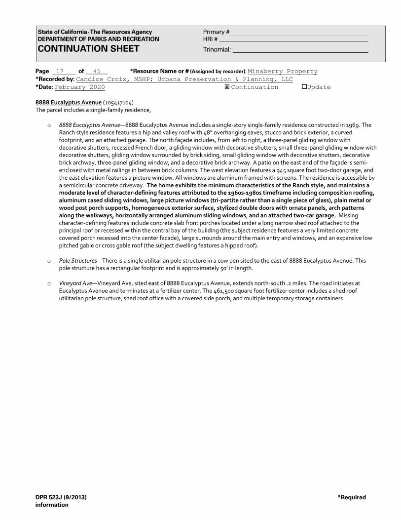
Page 17 of 45 *Resource Name or # (Assigned by recorder): Minaberry Property *Recorded by: Candice Croix, MSHP; Urbana Preservation & Planning, LLC *Date: February 2020 ý Continuation oUpdate
DPR 523J (9/2013) *Required information
State of California - The Resources Agency Primary # DEPARTMENT OF PARKS AND RECREATION HRI # CONTINUATION SHEET Trinomial:
8888 Eucalyptus Avenue (105417104) The parcel includes a single-family residence,
o 8888 Eucalyptus Avenue—8888 Eucalyptus Avenue includes a single-story single-family residence constructed in 1969. The Ranch style residence features a hip and valley roof with 48” overhanging eaves, stucco and brick exterior, a curved footprint, and an attached garage. The north façade includes, from left to right, a three-panel gliding window with decorative shutters, recessed French door, a gliding window with decorative shutters, small three-panel gliding window with decorative shutters, gliding window surrounded by brick siding, small gliding window with decorative shutters, decorative brick archway, three-panel gliding window, and a decorative brick archway. A patio on the east end of the façade is semi-enclosed with metal railings in between brick columns. The west elevation features a 945 square foot two-door garage, and the east elevation features a picture window. All windows are aluminum framed with screens. The residence is accessible by a semicircular concrete driveway. The home exhibits the minimum characteristics of the Ranch style, and maintains a moderate level of character-defining features attributed to the 1960s-1980s timeframe including composition roofing, aluminum cased sliding windows, large picture windows (tri-partite rather than a single piece of glass), plain metal or wood post porch supports, homogeneous exterior surface, stylized double doors with ornate panels, arch patterns along the walkways, horizontally arranged aluminum sliding windows, and an attached two-car garage. Missing character-defining features include concrete slab front porches located under a long narrow shed roof attached to the principal roof or recessed within the central bay of the building (the subject residence features a very limited concrete covered porch recessed into the center facade), large surrounds around the main entry and windows, and an expansive low pitched gable or cross gable roof (the subject dwelling features a hipped roof).
o Pole Structures—There is a single utilitarian pole structure in a cow pen sited to the east of 8888 Eucalyptus Avenue. This
pole structure has a rectangular footprint and is approximately 50’ in length.
o Vineyard Ave—Vineyard Ave, sited east of 8888 Eucalyptus Avenue, extends north-south .2 miles. The road initiates at Eucalyptus Avenue and terminates at a fertilizer center. The 461,500 square foot fertilizer center includes a shed roof utilitarian pole structure, shed roof office with a covered side porch, and multiple temporary storage containers.

Page 18 of 45 *Resource Name or # (Assigned by recorder): Minaberry Property *Recorded by: Candice Croix, MSHP; Urbana Preservation & Planning, LLC *Date: February 2020 ý Continuation oUpdate
DPR 523J (9/2013) *Required information
State of California - The Resources Agency Primary # DEPARTMENT OF PARKS AND RECREATION HRI # CONTINUATION SHEET Trinomial:
View southeast of 8888 Eucalyptus Ave, January 2020. Source: Urbana Preservation & Planning, LLC.
View southwest of 8888 Eucalyptus Ave, January 2020. Source: Urbana Preservation & Planning, LLC.

Page 19 of 45 *Resource Name or # (Assigned by recorder): Minaberry Property *Recorded by: Candice Croix, MSHP; Urbana Preservation & Planning, LLC *Date: February 2020 ý Continuation oUpdate
DPR 523J (9/2013) *Required information
State of California - The Resources Agency Primary # DEPARTMENT OF PARKS AND RECREATION HRI # CONTINUATION SHEET Trinomial:
View southeast of cattle pen and pole structure, east of 8888 Eucalyptus Ave, January 2020. Source: Urbana Preservation & Planning, LLC.

Page 20 of 45 *Resource Name or # (Assigned by recorder): Minaberry Property *Recorded by: Candice Croix, MSHP; Urbana Preservation & Planning, LLC *Date: February 2020 ý Continuation oUpdate
DPR 523J (9/2013) *Required information
State of California - The Resources Agency Primary # DEPARTMENT OF PARKS AND RECREATION HRI # CONTINUATION SHEET Trinomial:
*B10. Significance (continued): Within the Minaberry Property complex, the 8731, 8831, and 8888 Eucalyptus Avenue properties meet the minimum characteristics of a post-1950 scientific, large-capacity dairy including a single-family residence, milking parlor, circular driveway, geometrically spaced rows of pole structures, and open space to the rear of the property. These three dwellings additionally meet the minimum characteristics of a 1960s-1980s Ranch style residence and possess a moderate level of integrity. As such, in accordance with the approved New Model Colony Area Historic Context Statement, the 8731, 8831, and 8888 Eucalyptus Avenue properties appear eligible for recognition as a contributing element of the New Model Colony / Chino Valley Dairy District. The period of significance for the district is 1915-1975. The subject properties were constructed in 1968, 1969, and 1969 respectively within the last six to seven years of the district’s period of significance. History of the Subject Property and its Environs The subject property and its surrounding block are bound by Eucalyptus Avenue to the north, Carpenter Ave to the east, Merrill Avenue to the south, and Grove Avenue to the west. Between ca. 1930 and 1942, based on available aerial imagery, approximately 10 buildings or structures had been constructed in the survey area, with 8 located along Grove Avenue and 2 located along Eucalyptus. At this time, the survey area primarily included undeveloped land and agricultural fields. All circa 1930-1942 buildings and structures were demolished, the majority by the 1960s. By 1959, the northwest corner of the survey area became a large dairy farm (14525 Grove Ave), and buildings and structures were constructed at the southeast corner (9032 Merrill Ave). By 1967, three large dairy farms were constructed (14651 Grove Ave, 8643 Eucalyptus Ave, and 8810 Merrill Ave). By 1980, three additional large dairy farms were constructed along Eucalyptus Avenue (8731, 8911, and 9031 Eucalyptus Ave), including the construction of numerous pole structures throughout. A trucking operation was established in the southeast by 1994, and additional pole structures were constructed in the west. By 2002, the trucking operation expanded, reservoirs were constructed in the southeast, and additional pole structures were constructed throughout. By 2009, the southwest transitioned to agricultural fields, and the landscape of the northwest changed drastically. By 2014, the trucking operation expanded again, with a paved and graded lot extending from Merrill Avenue to Eucalyptus Ave. In 2019, all buildings and structures along Carpenter Ave were demolished, and is now a dirt lot. The earliest dairy farm in the survey area dates to the 1950s, with the majority of the farms developed in the 1960s-1970s, some with pole structures constructed through the 2000’s. Assessor records indicate that portions of the property collectively termed herein as the “Minaberry Property” were initially owned by the Andover Land Company (all or portions of APNs: 1054-191-02-0-000 and 1054-361-02-0-000) who in July 1966 sold the property to Joe Silva Soares and Eva Soares. Mrs. Soares retained ownership after her husband’s death in ca. 1979 and deeded the property to Candido and Maria Costa on June 13, 1991. The Costas deeded the property to Bouma Dairy on March 30, 2000, who retained ownership until October 24, 2003 when the property was deeded to the Minaberry Family Trust. Other portions of the Minaberry Property (all or portions of APNs: 1054-171-04-0-000, 1054-181-01-0-000, 1054-181-02-0-000, 1054-191-01-0-000, 1054-361-01-0-000, 1054-171-01-0-000, 1054-171-03-0-000, and 1054-161-02-0-000) were initially owned by the Long Beach Construction Company, who on August 2, 1968 deeded the property to Theodore (Ted) and Janet Bauma (recorded as “Bouma” in Grant Deeds). The Bouma family retained ownership, through trustees or limited partnerships, until ca. 2003-2006. By 2006 all Bouma ownership had been deeded to the Minaberrys. Eva Soares was born on March 2, 1924, in Tipton. Joe Silva Soares was also born in Tipton, on March 8, 1920. By the age of 21 he cited his occupation as a “milker”. Joe and Eva Soares established their dairy farm in the Chino Valley in 1967. Mr. Bauma, a native of Friesland, Netherlands, was born in 1902. He resided in Chino with his wife, Janet, for 29 years before his death in 1997. Mrs. Bauma was born in 1908 and died in 2002. Originally named Janke Reitama, Mrs. Bauma was born in Nes Ameland, Netherlands, and became a naturalized citizen in 1942, at which time she resided in Artesia, California. The Baumas were dairy farmers and occupied the Ranch style dwelling at 8888 Eucalyptus Avenue, now part of the Minaberry Pr0perty. The Bauma’s holdings were acquired by the Minaberry Family Trust in 2003. Henri and Michel Minaberry were born circa 1965, and are documented as residing in Chino, CA in 1980. Ownership, and initial development by the Bauma and the Soares interests, demonstrates an association with Dutch and Portuguese history, both major immigrant groups that helped to establish dairy operations in the New Model Colony area. Within the New Model Colony area, the Dutch and Portuguese helped to modernize the dairy industry from free ranging dairy herds to dry-lot dairying that resulted in a quasi-factory setting. The Netherlands was a small country that lacked the space for free range dairying; Portuguese milkers also had been familiar with the dry-lot methods on the island of Azores. Dutch and Portuguese farmers brought their knowledge of specialized dry-lot farming to the Los Angeles dairy industry, thereby countering the need for the expensive import of milk from the San Joaquin Valley.

Page 21 of 45 *Resource Name or # (Assigned by recorder): Minaberry Property *Recorded by: Candice Croix, MSHP; Urbana Preservation & Planning, LLC *Date: February 2020 ý Continuation oUpdate
DPR 523J (9/2013) *Required information
State of California - The Resources Agency Primary # DEPARTMENT OF PARKS AND RECREATION HRI # CONTINUATION SHEET Trinomial:
New Model Colony Historic Context Per the City of Ontario’s Historic Context for the New Model Colony Area, the County of San Bernardino designated 14,000 acres of agricultural land as the San Bernardino County Agricultural Preserve in 1967. The Preserve, located in the Chino Valley in the southwest area of San Bernardino County, was protected by Williamson Act contracts and the 1965 Land Conservation Act, and evolved into a world-class dairy center by 1980. By the 1990s, farmers within the Preserve were pressured to relocate their dairies as dairy operation costs and demand for housing increased. In 1999, the City of Ontario annexed 8,200 acres and named the area New Model Colony after the original Model Colony of Ontario established in 1882. Two historic contexts, “Post-1950 scientific, large-capacity dairy properties” and “Ranch style houses,” are applicable to the survey area. Post-1950 scientific, large-capacity dairy properties: The historic context for post-1950 scientific, large-capacity dairies coincides with the third phase of dairy farming, with a period of significance between 1950-1969. In this period, the introduction of scientific feeding and breeding resulted in larger herds and more productive operations. The average size of a property associated with this context was 40 acres or more, and included one or more large residences, an attached garage, milking parlor, numerous pole structures, and a large expanse of open space. The majority of residences were designed in the Ranch architectural style with a matching milking parlor, and a property may have included additional smaller residences to house hired workers. Additional residences were sited on either side of the milking parlor and designed and painted in the same color scheme. The milking parlors were designed in the herringbone style, a new milking parlor design in which stalls were placed at an angle and slight elevation to utilize space more efficiently and eliminate a worker’s need to kneel, saving labor and time. The properties featured a circular driveway in front of the milking parlor and typically included designed landscaping. Additional dairy facilities associated with a property, including pole structures, silos, etc., were laid out behind the milking parlor in a perpendicular or parallel fashion.
The minimum characteristics required to identify a post-1950 dairy property are: at least one residence dating to the period of significance, designed in the Ranch architectural style with little alteration; a large “herringbone style” milking parlor designed in the Ranch style; a circular driveway; numerous geometrically spaced rows of pole structures and related dairy facilities; and a vast expanse of open space to the rear of the property. A property may include multiple large residences and a few smaller workers’ residences.
A post-1950 dairy property exhibiting high integrity exhibits the minimum characteristics. The property must include one large residence and a milking parlor designed in the Ranch style and dating to the period of significance. Additional residences may have been constructed prior to 1949. Individual elements will possess high integrity of location, design, setting, association, feeling, materials, and workmanship individually, and the property will possess high integrity as a whole. Buildings and structures will retain their original uses. If abandoned, they should clearly depict their original operational uses.
A post-1950 dairy property exhibiting moderate integrity exhibits the minimum characteristics. The property must include one residence and a milking parlor designed in the Ranch style and dating to the period of significance. Additional residences may have been constructed prior to 1949. The property will possess original location and physical relationships, though the individual elements may have lost some historic integrity. The property conveys historic association with a post-1950 diary property but has a few minor alterations.
A post-1950 dairy property exhibiting low integrity does not exhibit the minimum characteristics. One or more of the characteristics is missing, and the majority of buildings do not date to the period of significance. The property and individual resources lack integrity of location, design, setting, association, feeling, materials, and workmanship. The property no longer conveys historic association with a post-1950 dairy property. The majority of dairy properties in the New Model Colony study area are associated with the “Post-1950 scientific, large-capacity dairy properties” context. Ranch style houses: The historic context for Ranch style houses includes three distinct phases: pre-1959, 1960-1980, and post-1980. Originating in the mid-1930s in California, the Ranch style gained popularity during the 1940s and became the dominant style throughout the county during the decades of the 1950s and 1960s. Loosely inspired by the early Ranchos of the post-mission period that dotted the landscape of the Rancho Santa Ana del Chino, several local building magazines featured ranch style homes and building plans in the 1950s-1960s, and local builders and architects utilized large lots to design and construct large, rambling plans. The majority of large Ranch style houses in the New Model Colony area date to the 1960s, demonstrating the higher income levels associated with the mechanization and industrialization of dairy operations.

Page 22 of 45 *Resource Name or # (Assigned by recorder): Minaberry Property *Recorded by: Candice Croix, MSHP; Urbana Preservation & Planning, LLC *Date: February 2020 ý Continuation oUpdate
DPR 523J (9/2013) *Required information
State of California - The Resources Agency Primary # DEPARTMENT OF PARKS AND RECREATION HRI # CONTINUATION SHEET Trinomial:
The minimum characteristics required to identify a Ranch style residence include: single-story, expansive, horizontally-emphasized rambling footprint; low-pitched gabled, hipped or intersecting gable roof with expansive overhanging open or boxed eaves; wood shingle roof; “U,” “L,” or “S”-shaped plan; attached garage, breeze port, or covered walkway; wide prominent chimney; integral or recessed front porch; concrete slab foundation; large picture windows; plain post porch supports; wide entry doors or French style paneled front entry door; sliding glass doors sited at rear of residence; and an emphasis on outdoor space via an orientation of windows toward a rear patio area. The residence must exhibit the majority of the minimum characteristics in addition to character-defining features specific to each period.
Character-defining features of the pre-1959 Ranch style include: wood single roofs with wide overhanging eaves and wood-cased multi-light windows; square or diamond pattern lights on the windows; glazed and paneled doors; a single-width entry door; a combination of siding materials such as horizontal wood siding and stucco with a contrasting treatment along the footing of the main façade; small square rooftop cupolas projecting from the gable line; small projecting rectangular bays on main façade; and a multi-light picture window or large picture window.
Character-defining features of the 1960s to 1980s Ranch style include: asbestos shingles, asphalt singles, or a composition roofing material; aluminum-cased sliding windows; a large picture window; attached two-car garage; plain metal or wood post porch supports; concrete slab front porch located under a long, narrow shed roof attached to the principal roof or recessed within the central bay of the building; homogenous exterior surface; the use of stone or masonry; arch patterns along walkways; main entry and window surrounds; stylized double doors with ornate panes; glazing and ornamental oversized hardware; and horizontally arranged aluminum siding windows sheltered by an expansive low-pitched gable or cross-gable roof.
Character-defining features of the post-1980 Ranch include: a clay tile roof; larger floor plan; split-level; contemporary and shed-building styles; diagonal siding; wide board trim; window surrounds; and false half-timbering, Spanish Colonial Revival influences.
A Ranch style exhibiting high integrity exhibits the minimum characteristics. The property maintains at least 90% of its original exterior features and must retain the essential features that were part of the original design intent. The property retains its original use. If it is abandoned, the original use is evident due to a lack of alterations. The property retains integrity of location, design, setting, association, feeling, materials, and workmanship.
A Ranch style exhibiting moderate integrity exhibits the minimum characteristics. The property maintains at least 50% of its original exterior features. The property may have a few minor alterations but continue to convey its historic association. The property retains integrity of location, design, feeling, association, and the majority of its workmanship and materials.
A Ranch style exhibiting low integrity does not exhibit the minimum characteristics. The property does not maintain at least 50% of its original exterior features, and the major features of the residence have been altered or replaced. The property does not retain integrity of location, design, setting, association, feeling, materials, and workmanship, and is no longer being used as its original purpose.

Page 23 of 45 *Resource Name or # (Assigned by recorder): Minaberry Property *Recorded by: Candice Croix, MSHP; Urbana Preservation & Planning, LLC *Date: February 2020 ý Continuation oUpdate
DPR 523J (9/2013) *Required information
State of California - The Resources Agency Primary # DEPARTMENT OF PARKS AND RECREATION HRI # CONTINUATION SHEET Trinomial:
1938 Aerial View. Source/Citation: Historicaerials.com
Minaberry Property 8810 Merrill Avenue 8816 Merrill Avenue 8920 Merrill Avenue
8731 Eucalyptus Avenue 8831 Eucalyptus Avenue 8888 Eucalyptus Avenue

Page 24 of 45 *Resource Name or # (Assigned by recorder): Minaberry Property *Recorded by: Candice Croix, MSHP; Urbana Preservation & Planning, LLC *Date: February 2020 ý Continuation oUpdate
DPR 523J (9/2013) *Required information
State of California - The Resources Agency Primary # DEPARTMENT OF PARKS AND RECREATION HRI # CONTINUATION SHEET Trinomial:
1959 Aerial View. Source / Citation: Historicaerials.com
Minaberry Property 8810 Merrill Avenue 8816 Merrill Avenue 8920 Merrill Avenue
8731 Eucalyptus Avenue 8831 Eucalyptus Avenue 8888 Eucalyptus Avenue

Page 25 of 45 *Resource Name or # (Assigned by recorder): Minaberry Property *Recorded by: Candice Croix, MSHP; Urbana Preservation & Planning, LLC *Date: February 2020 ý Continuation oUpdate
DPR 523J (9/2013) *Required information
State of California - The Resources Agency Primary # DEPARTMENT OF PARKS AND RECREATION HRI # CONTINUATION SHEET Trinomial:
1994 Aerial View. Source / Citation: Google Earth
��������������� ���������
��������������� ���������
��������������� ���������
Minaberry Property 8810 Merrill Avenue 8816 Merrill Avenue 8920 Merrill Avenue
8731 Eucalyptus Avenue 8831 Eucalyptus Avenue 8888 Eucalyptus Avenue

Page 26 of 45 *Resource Name or # (Assigned by recorder): Minaberry Property *Recorded by: Candice Croix, MSHP; Urbana Preservation & Planning, LLC *Date: February 2020 ý Continuation oUpdate
DPR 523J (9/2013) *Required information
State of California - The Resources Agency Primary # DEPARTMENT OF PARKS AND RECREATION HRI # CONTINUATION SHEET Trinomial:
2014 Aerial View. Source / Citation: Google Earth
Minaberry Property 8810 Merrill Avenue 8816 Merrill Avenue 8920 Merrill Avenue
8731 Eucalyptus Avenue 8831 Eucalyptus Avenue 8888 Eucalyptus Avenue

Page 27 of 45 *Resource Name or # (Assigned by recorder): Minaberry Property *Recorded by: Candice Croix, MSHP; Urbana Preservation & Planning, LLC *Date: February 2020 ý Continuation oUpdate
DPR 523J (9/2013) *Required information
State of California - The Resources Agency Primary # DEPARTMENT OF PARKS AND RECREATION HRI # CONTINUATION SHEET Trinomial:
Minaberry Property Soares Parcel
8810 Merrill Ave. Ranch style dwelling
Minaberry Property Soares Parcel
8816 Merrill Ave. Ranch style dwelling
Minaberry Property Soares Parcel
8920 Merrill Ave. Ranch style dwelling
Minaberry Property Soares Parcel
8920 Merrill Ave. Milking Parlor
Minaberry Property Bauma Parcel
8731 Eucalyptus Ave. Ranch style dwelling
Minaberry Property Bauma Parcel
8731 Eucalyptus Ave. Milking Parlor
Minaberry Property Bauma Parcel
8831 Eucalyptus Ave. Ranch style dwelling
Minaberry Property Bauma Parcel
8888 Eucalyptus Ave. Ranch style dwelling

Page 28 of 45 *Resource Name or # (Assigned by recorder): Minaberry Property *Recorded by: Candice Croix, MSHP; Urbana Preservation & Planning, LLC *Date: February 2020 ý Continuation oUpdate
DPR 523J (9/2013) *Required information
State of California - The Resources Agency Primary # DEPARTMENT OF PARKS AND RECREATION HRI # CONTINUATION SHEET Trinomial:
Residential Building Record: 8810 Merrill Ave / 105436102 Source / Citation: San Bernardino County
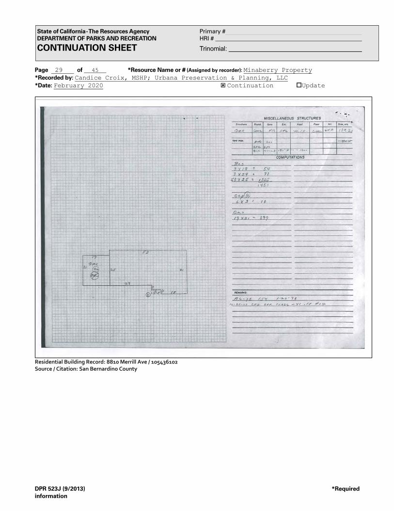
Page 29 of 45 *Resource Name or # (Assigned by recorder): Minaberry Property *Recorded by: Candice Croix, MSHP; Urbana Preservation & Planning, LLC *Date: February 2020 ý Continuation oUpdate
DPR 523J (9/2013) *Required information
State of California - The Resources Agency Primary # DEPARTMENT OF PARKS AND RECREATION HRI # CONTINUATION SHEET Trinomial:
Residential Building Record: 8810 Merrill Ave / 105436102 Source / Citation: San Bernardino County

Page 30 of 45 *Resource Name or # (Assigned by recorder): Minaberry Property *Recorded by: Candice Croix, MSHP; Urbana Preservation & Planning, LLC *Date: February 2020 ý Continuation oUpdate
DPR 523J (9/2013) *Required information
State of California - The Resources Agency Primary # DEPARTMENT OF PARKS AND RECREATION HRI # CONTINUATION SHEET Trinomial:
Residential Building Record: 8816 Merrill Ave / 105436102 Source / Citation: San Bernardino County

Page 31 of 45 *Resource Name or # (Assigned by recorder): Minaberry Property *Recorded by: Candice Croix, MSHP; Urbana Preservation & Planning, LLC *Date: February 2020 ý Continuation oUpdate
DPR 523J (9/2013) *Required information
State of California - The Resources Agency Primary # DEPARTMENT OF PARKS AND RECREATION HRI # CONTINUATION SHEET Trinomial:
Residential Building Record: 8816 Merrill Ave / 105436102 Source / Citation: San Bernardino County

Page 32 of 45 *Resource Name or # (Assigned by recorder): Minaberry Property *Recorded by: Candice Croix, MSHP; Urbana Preservation & Planning, LLC *Date: February 2020 ý Continuation oUpdate
DPR 523J (9/2013) *Required information
State of California - The Resources Agency Primary # DEPARTMENT OF PARKS AND RECREATION HRI # CONTINUATION SHEET Trinomial:
Residential Building Record: 8920 Merrill Ave / 105436102 Source / Citation: San Bernardino County

Page 33 of 45 *Resource Name or # (Assigned by recorder): Minaberry Property *Recorded by: Candice Croix, MSHP; Urbana Preservation & Planning, LLC *Date: February 2020 ý Continuation oUpdate
DPR 523J (9/2013) *Required information
State of California - The Resources Agency Primary # DEPARTMENT OF PARKS AND RECREATION HRI # CONTINUATION SHEET Trinomial:
Residential Building Record: 8920 Merrill Ave / 105436102 Source / Citation: San Bernardino County
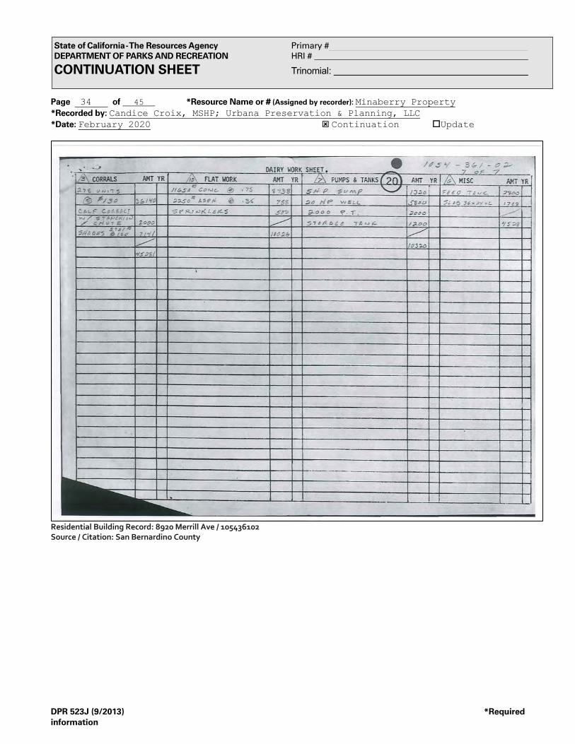
Page 34 of 45 *Resource Name or # (Assigned by recorder): Minaberry Property *Recorded by: Candice Croix, MSHP; Urbana Preservation & Planning, LLC *Date: February 2020 ý Continuation oUpdate
DPR 523J (9/2013) *Required information
State of California - The Resources Agency Primary # DEPARTMENT OF PARKS AND RECREATION HRI # CONTINUATION SHEET Trinomial:
Residential Building Record: 8920 Merrill Ave / 105436102 Source / Citation: San Bernardino County

Page 35 of 45 *Resource Name or # (Assigned by recorder): Minaberry Property *Recorded by: Candice Croix, MSHP; Urbana Preservation & Planning, LLC *Date: February 2020 ý Continuation oUpdate
DPR 523J (9/2013) *Required information
State of California - The Resources Agency Primary # DEPARTMENT OF PARKS AND RECREATION HRI # CONTINUATION SHEET Trinomial:
Residential Building Record: 8920 Merrill Ave / 105436102 Source / Citation: San Bernardino County

Page 36 of 45 *Resource Name or # (Assigned by recorder): Minaberry Property *Recorded by: Candice Croix, MSHP; Urbana Preservation & Planning, LLC *Date: February 2020 ý Continuation oUpdate
DPR 523J (9/2013) *Required information
State of California - The Resources Agency Primary # DEPARTMENT OF PARKS AND RECREATION HRI # CONTINUATION SHEET Trinomial:
Residential Building Record: 8920 Merrill Ave / 105436102 Source / Citation: San Bernardino County

Page 37 of 45 *Resource Name or # (Assigned by recorder): Minaberry Property *Recorded by: Candice Croix, MSHP; Urbana Preservation & Planning, LLC *Date: February 2020 ý Continuation oUpdate
DPR 523J (9/2013) *Required information
State of California - The Resources Agency Primary # DEPARTMENT OF PARKS AND RECREATION HRI # CONTINUATION SHEET Trinomial:
Residential Building Record: 8920 Merrill Ave / 105436102 Source / Citation: San Bernardino County

Page 38 of 45 *Resource Name or # (Assigned by recorder): Minaberry Property *Recorded by: Candice Croix, MSHP; Urbana Preservation & Planning, LLC *Date: February 2020 ý Continuation oUpdate
DPR 523J (9/2013) *Required information
State of California - The Resources Agency Primary # DEPARTMENT OF PARKS AND RECREATION HRI # CONTINUATION SHEET Trinomial:
Residential Building Record: 8920 Merrill Ave / 105436102 Source / Citation: San Bernardino County

Page 39 of 45 *Resource Name or # (Assigned by recorder): Minaberry Property *Recorded by: Candice Croix, MSHP; Urbana Preservation & Planning, LLC *Date: February 2020 ý Continuation oUpdate
DPR 523J (9/2013) *Required information
State of California - The Resources Agency Primary # DEPARTMENT OF PARKS AND RECREATION HRI # CONTINUATION SHEET Trinomial:
Residential Building Record: 8731 Eucalyptus Ave / 105417101 Source / Citation: San Bernardino County

Page 40 of 45 *Resource Name or # (Assigned by recorder): Minaberry Property *Recorded by: Candice Croix, MSHP; Urbana Preservation & Planning, LLC *Date: February 2020 ý Continuation oUpdate
DPR 523J (9/2013) *Required information
State of California - The Resources Agency Primary # DEPARTMENT OF PARKS AND RECREATION HRI # CONTINUATION SHEET Trinomial:
Residential Building Record: 8731 Eucalyptus Ave / 105417101 Source / Citation: San Bernardino County

Page 41 of 45 *Resource Name or # (Assigned by recorder): Minaberry Property *Recorded by: Candice Croix, MSHP; Urbana Preservation & Planning, LLC *Date: February 2020 ý Continuation oUpdate
DPR 523J (9/2013) *Required information
State of California - The Resources Agency Primary # DEPARTMENT OF PARKS AND RECREATION HRI # CONTINUATION SHEET Trinomial:
Residential Building Record: 8731 Eucalyptus Ave / 105417101 Source / Citation: San Bernardino County

Page 42 of 45 *Resource Name or # (Assigned by recorder): Minaberry Property *Recorded by: Candice Croix, MSHP; Urbana Preservation & Planning, LLC *Date: February 2020 ý Continuation oUpdate
DPR 523J (9/2013) *Required information
State of California - The Resources Agency Primary # DEPARTMENT OF PARKS AND RECREATION HRI # CONTINUATION SHEET Trinomial:
Residential Building Record: 8731 Eucalyptus Ave / 105417101 Source / Citation: San Bernardino County

Page 43 of 45 *Resource Name or # (Assigned by recorder): Minaberry Property *Recorded by: Candice Croix, MSHP; Urbana Preservation & Planning, LLC *Date: February 2020 ý Continuation oUpdate
DPR 523J (9/2013) *Required information
State of California - The Resources Agency Primary # DEPARTMENT OF PARKS AND RECREATION HRI # CONTINUATION SHEET Trinomial:
Residential Building Record: 8831 Eucalyptus Ave / 105417103 Source / Citation: San Bernardino County

Page 44 of 45 *Resource Name or # (Assigned by recorder): Minaberry Property *Recorded by: Candice Croix, MSHP; Urbana Preservation & Planning, LLC *Date: February 2020 ý Continuation oUpdate
DPR 523J (9/2013) *Required information
State of California - The Resources Agency Primary # DEPARTMENT OF PARKS AND RECREATION HRI # CONTINUATION SHEET Trinomial:
Residential Building Record: 8831 Eucalyptus Ave / 105417103 Source / Citation: San Bernardino County

Page 45 of 45 *Resource Name or # (Assigned by recorder): Minaberry Property *Recorded by: Candice Croix, MSHP; Urbana Preservation & Planning, LLC *Date: February 2020 ý Continuation oUpdate
DPR 523J (9/2013) *Required information
State of California - The Resources Agency Primary # DEPARTMENT OF PARKS AND RECREATION HRI # CONTINUATION SHEET Trinomial:
Residential Building Record: 8831 Eucalyptus Ave / 105417103 Source / Citation: San Bernardino County

Page 1 of 32 *Resource Name or #: (Assigned by recorder) 9052 Merrill Ave LLC Property P1. Other Identifier: N/A
DPR 523A (9/2013) *Required information
State of California - The Resources Agency Primary # DEPARTMENT OF PARKS AND RECREATION HRI # PRIMARY RECORD Trinomial: CRHR Status Code: 6Z Other Listings: Review Code Reviewer Date
*P2. Location: o Not for Publication ý Unrestricted *a. County: San Bernardino County *b. USGS 7.5' Quad: Corona North Date: 2018 T ; R of ; of Sec ; B.M.
c. Address: Multiple City: Ontario Zip: 91762 d. UTM: (Give more than one for large and/or linear resources) Zone: , mE / mN e. Other Locational Data: The 9052 Merrill Ave LLC Property includes three parcels on a total of 39.25 acres: 021826135,
021826137, and 021826129. *P3a. Description: The 9052 Merrill Ave LLC Property includes three dwellings designed in the Ranch style and constructed between 1954-1969 (located at 8911 Eucalyptus Avenue, 8966 Merrill Avenue, and 9032 Merrill Avenue), a Milking Parlor constructed in 1969 (associated with the 8911 Eucalyptus Avenue dwelling), two utilitarian structures / Commercial Centers constructed in 1954 and 1960-1975, and a contemporary-period Transportation Facility (the dominant land use encompassing the entire property). The property is set within the New Model Colony, an area that developed from the 22,000-acre Rancho Santa Ana Del Chino land grant. Granted in 1841, the land has historically been utilized for agricultural and cattle grazing purposes, with an increased emphasis on dairy farming beginning in the 1900s. Today the subject property is characterized by light industrial non-dairy uses that are visually dissimilar to the surrounding environs characterized by low density development and agricultural uses, primarily dairy farming. See continuation sheet for additional information. *P3b. Resource Attributes: HP2, HP4, HP6 *P4. Resources Present: ý Building ý Structure o Object o Site o District o Element of District o Other (Isolates, etc.)
P5b. Description of Photo: View northwest of 9032 Merrill Avenue transportation facility (IMG_2441). *P6. Date Constructed/Age and Source: ý Historic 1954-1969 *P7. Owner and Address: 9052 Merrill Avenue LLC 60 State St Ste 1200 Boston, MA 02109 *P8. Recorded By: Candice Croix, MSHP Urbana Preservation & Planning, LLC www.urbanapreservation.com *P9. Date Recorded: February 2020 *P10. Survey Type: CEQA Review *P11. Report Citation: Urbana Preservation & Planning, LLC, Historical Resource Survey – Proposed Merrill Commerce Center Specific Plan, February 2020. *Attachments: o NONE ý Location Map ý Continuation Sheet ý Building, Structure, and
Object Record oArchaeological Record o District Record o Linear Feature Record o Milling Station Record o Rock Art Record o Artifact Record o Photograph Record o Other (List):

*Resource Name or # (Assigned by recorder) 9052 Merrill Ave LLC Property *CRHR Status Code 6Z Page 2 of 32
DPR 523B (9/2013) *Required information
State of California - The Resources Agency Primary # DEPARTMENT OF PARKS AND RECREATION HRI#
BUILDING, STRUCTURE, AND OBJECT RECORD
(This space reserved for official comments.)
Property location is depicted on DPR 523J Location Map (page 3
of this DPR set).
Detailed aerial images showing property configuration are included on DPR 523 L Continuation Sheets (pages 17-21 of this
DPR set).
B1. Historic Name: Not Identified B2. Common Name: Gardner Trucking, Inc. B3. Original Use: Dairy Farm B4. Present Use: Transportation Facility *B5. Architectural Style: Ranch style dwellings with gable roof Milking Parlor; Utilitarian *B6. Construction History: The 9052 Merrill Ave LLC Property was initially improved in 1954 with 8966 Merrill Avenue, a Ranch style dwelling, and its associated Commercial Center, in the southeast corner of the property, followed by 9032 Merrill Avenue, a second Ranch style dwelling, in 1956 and its associated Commercial Center in 1960-1975 to the west. In 1969, 8911 Eucalyptus Avenue, a third Ranch style dwelling, and its associated Milking Parlor, was constructed along the northern boundary of the property fronting Eucalyptus Avenue. The Transportation Facility was established by 1994 at 9032 Merrill Ave, doubling in size westward by 2002. A second expansion occurred northward between 2009-2010. Between 2012-2014, the Transportation Facility expanded northward again, eliminating all dairy uses. Between 2012-2014 75% of the Milking Parlor was removed from 8911 Eucalyptus Avenue; all pole structures were additionally removed. Between 1967-1980 the 9032 Merrill Avenue property was modified through an addition at the east elevation, with additional fenestration changes to the west elevation. The stucco finish and black window units match the materials employed at Commercial Center #1, which indicates that structure has been similarly remodeled. *B7. Moved? ý No o Yes o Unknown Date: N/A Original Location: N/A *B8. Related Features: N/A B9a. Architect: Unknown b. Builder: Unknown *B10. Significance: Theme Post-1950 Scientific Large Capacity Dairy / Pre-1959 Ranch Homes / 1960s-1980s Ranch homes
Area Ontario New Model Colony Period of Significance N/A Property Type Dairy Farm Applicable Criteria NRHP / CRHR / City of Ontario
Without evidence to indicate otherwise, the subject property has not been found individually significant under the eligibility criteria of the NRHP / CRHR / City of Ontario. Although it developed with multiple post-1950 scientific large capacity dairies, no information was identified in the New Model Colony Historic Context statement or within published and unpublished resources to attribute the subject property to important or innovative techniques, or high yields, in post-1950 dairy farming. The subject property has not been found individually eligible under NRHP / CRHR / City of Ontario Criterion A / 1 / a as the property has not in and of itself been directly associated with significant events or patterns of events in dairy farming in local, regional, state, or national history, nor does it individually exemplify or reflect special elements of the City’s history. The property is not individually eligible under NRHP / CRHR / City of Ontario Criterion B / 2 / b as it has not been identified as having a direct association with an important person or event in local, regional, state, or national history. The property, collectively, or divided into three separate addresses (8911 Eucalyptus Ave., 9032 Merrill Ave., and 8966 Merrill Ave.) is not individually eligible under NRHP / CRHR / City of Ontario Criterion C / 3 / c-f as neither the property in its entirety, or its individual addresses within, has been identified as embodying the distinctive or distinguishing characteristics of a style, type, period, or method of construction, nor has it been identified as representing the work of a master or notable builder, designer, architect, or artist, or an important or creative individual, and as a standard dairy property with Ranch style homes built in the 1950s and 1960s, the property does not qualify as a significant structural, engineering, or architectural achievement or innovation. Similarly, the property is not individually eligible under City of Ontario Criterion g and h as the property does not in and of itself offer a unique location, a singular physical characteristic, or an established and familiar visual feature within the Ontario New Model Colony or the city of Ontario, nor is it in and of itself one of the few remaining examples in the City, region, state or nation, possessing distinguishing characteristics of an architectural or historical type or specimen. Beyond what is documented in this DPR set, further study of the property would not likely yield information which would be considered important in local, regional, state, or national history. As such, the property is not individually eligible under NRHP / CRHR / City of Ontario Criterion D / 4 / i. See continuation sheet for additional significance summary, and contextual and property specific history. B11. Additional Resource Attributes: N/A *B12. References: “The City of Ontario’s Historic Context for the New Model Colony,” Galvin & Associates, September 2004.; Ancestry.com for “Ronald Lanting.” B13. Remarks: *B14. Evaluator: Candice Croix and Wendy L. Tinsley Becker; Urbana Preservation & Planning, LLC *Date of Evaluation: February 2020

Page 3 of 32 *CRHR Status Code: 6Z *Resource Name or # (Assigned by recorder) 9052 Merrill Ave LLC Property Map Name: Corona North Date: 2018 Scale: 1:24,000
DPR 523J (9/2013) *Required information
State of California - The Resources Agency Primary# DEPARTMENT OF PARKS AND RECREATION HRI#
LOCATION MAP Trinomial#
9052 Merrill Ave LLC Property 8911 Eucalyptus Avenue
8966 Merrill Avenue 9032 Merrill Avenue

Page 4 of 32 *Resource Name or # (Assigned by recorder): 9052 Merrill Ave LLC Property *Recorded by: Candice Croix, MSHP; Urbana Preservation & Planning, LLC *Date: February 2020 ý Continuation oUpdate
DPR 523J (9/2013) *Required information
State of California - The Resources Agency Primary # DEPARTMENT OF PARKS AND RECREATION HRI # CONTINUATION SHEET Trinomial:
*P3A: Description (continued): 9032 Merrill Avenue (21826137) The parcel includes two single-family residences, 9032 Merrill Avenue and 8966 Merrill Avenue, two Commercial Centers, and a Transportation Facility.
o 8966 Merrill Avenue—8966 Merrill Avenue is a single-story single-family residence constructed in 1954. The 1,054 square foot Ranch style residence features a cross gable roof, white stucco and wood siding exterior, attached garage, and rectilinear footprint. The south elevation includes all replacement vinyl / metal gliding windows and a replacement tri-partite window, all set within beige trim. The Residential Building Record indicates that windows were originally double-hung units, likely wood. A covered porch supported by four wood posts and accessible by a concrete walkway, spans along the length of the front elevation. The west elevation includes two replacement vinyl / metal gliding windows. A 480 square foot garage is sited at the east elevation, including two garage doors. This is accessible by an L-shaped concrete driveway. Exterior building materials include board and batten siding on a portion of the south elevation, stucco, and scallop edge board siding in the south and west elevation gables. Presently, all windows and door openings have been boarded up with plywood. Additionally, a review of the Residential Building Record disclosed that the dwelling was originally constructed to include a covered concrete porch / breezeway between the house and garage. Today, that breezeway is not extant which indicates that the feature was infilled to create additional interior space, therein altering the home’s original footprint. Based on these observed and recorded modifications, the dwelling does not retain integrity. The dwelling is not a good example of the pre-1959 Ranch style.
o Commercial Center #1—The Commercial Center sited between 8966 Merrill Avenue and 9032 Merrill Avenue is a 3,692 square foot center constructed in 1954, composed of two buildings. The south building is sited approximately 80 feet from Merrill Avenue and includes a shop, office, and storage space, while the north building includes an office and shop. The 1,600 square foot shop was constructed with a structural steel gable roof and structural steel exterior, and the south façade features a large barn door. Behind the shop, there is an 80 square foot office and 1,112 square foot storage space. The office was constructed with a shed roof, and the storage space was constructed with a shed Quonset roof, both using structural steel. The north building includes a 100 square foot office and 800 square foot shop, both constructed with a shed roof and structural steel.
o 9032 Merrill Avenue—9032 Merrill Avenue is a single-story single-family residence constructed in 1956. The 1,885 square foot
Ranch style dwelling features a cross gable roof, stucco and wood siding exterior, brick wainscoting, and an attached garage in a rectilinear footprint. The south façade includes a variety of windows, including a combination window, a four-pane gliding window, three single-hung windows, and a three-panel gliding window. The covered front porch is recessed, supported by two posts with an arched brace. There is horizontal wood siding covering the window bays, porch, and front gable. The east elevation includes gliding windows and a commercial side door, and the west elevation, where the garage is sited, includes a gliding window and a standard door. A review of the property’s Residential Building Record disclosed that the home has experienced several major alterations including removal of original shake roofing (date unknown), infill of an original breezeway (in 1967) sited between the west elevation garage and the residence, now demarcated by a tri-partite window, installation of horizontal board siding and brick veneer at the wall base (post-1967), and construction of an addition at the east elevation, which is visually demarcated by stucco siding, and larger window openings with vinyl / metal sliding units. While the home appears to be in good exterior condition and is visually attractive when compared to other nearby Ranch style dwellings, due to the noted modifications it does not retain integrity. The dwelling is not a good example of the pre-1959 Ranch style.
o Commercial Center #2—The Commercial Center sited behind 9032 Merrill Avenue is a 5,480 square foot center constructed in
1960 and 1975, and includes a shop (1960) and three sheds (1975). The 1,440 square foot shop was constructed with a gable roof, concrete exterior, and gliding windows. The north façade of the shop features two entrance doors and two three-panel gliding windows. Behind the shop, a 1,400 square foot shed was constructed with a shed roof and concrete exterior. Two additional pole structure sheds, 2,080 square feet and 420 square feet, were constructed with shed roofs.

Page 5 of 32 *Resource Name or # (Assigned by recorder): 9052 Merrill Ave LLC Property *Recorded by: Candice Croix, MSHP; Urbana Preservation & Planning, LLC *Date: February 2020 ý Continuation oUpdate
DPR 523J (9/2013) *Required information
State of California - The Resources Agency Primary # DEPARTMENT OF PARKS AND RECREATION HRI # CONTINUATION SHEET Trinomial:
o Transportation Facility—The Transportation Facility covers the majority of the property area. Constructed circa 1994-2014, it extends from Eucalyptus Avenue to Merrill Avenue, and consists of a graded lot enclosed with a chain link fence near Eucalyptus Avenue and a primarily paved lot near Merrill Avenue. It includes paved lots with two 115’ x 70’ open air pole structures. These pole structures were constructed with corrugated metal gable roofs, and are sited perpendicular to Merrill Ave. The Transportation Facility is enclosed by a brick wall approximately 75’ from Merrill Avenue, accessible at two points by an automatic metal gate.

Page 6 of 32 *Resource Name or # (Assigned by recorder): 9052 Merrill Ave LLC Property *Recorded by: Candice Croix, MSHP; Urbana Preservation & Planning, LLC *Date: February 2020 ý Continuation oUpdate
DPR 523J (9/2013) *Required information
State of California - The Resources Agency Primary # DEPARTMENT OF PARKS AND RECREATION HRI # CONTINUATION SHEET Trinomial:
View northwest of 8966 Merrill Ave (south façade and east elevation), January 2020. Source: Urbana Preservation & Planning, LLC.
View northeast of 8966 Merrill Ave (south façade and east elevation), January 2020. Source: Urbana Preservation & Planning, LLC.

Page 7 of 32 *Resource Name or # (Assigned by recorder): 9052 Merrill Ave LLC Property *Recorded by: Candice Croix, MSHP; Urbana Preservation & Planning, LLC *Date: February 2020 ý Continuation oUpdate
DPR 523J (9/2013) *Required information
State of California - The Resources Agency Primary # DEPARTMENT OF PARKS AND RECREATION HRI # CONTINUATION SHEET Trinomial:
View northeast of Commercial Center #1, January 2020. Source: Urbana Preservation & Planning, LLC.
View northwest of 9032 Merrill Ave, January 2020. Source: Urbana Preservation & Planning, LLC.

Page 8 of 32 *Resource Name or # (Assigned by recorder): 9052 Merrill Ave LLC Property *Recorded by: Candice Croix, MSHP; Urbana Preservation & Planning, LLC *Date: February 2020 ý Continuation oUpdate
DPR 523J (9/2013) *Required information
State of California - The Resources Agency Primary # DEPARTMENT OF PARKS AND RECREATION HRI # CONTINUATION SHEET Trinomial:
View northeast of 9032 Merrill Ave, January 2020. Source: Urbana Preservation & Planning, LLC.
View north of Commercial Center #2, with 9032 Merrill Ave in foreground (on right), January 2020. Source: Urbana Preservation & Planning, LLC.

Page 9 of 32 *Resource Name or # (Assigned by recorder): 9052 Merrill Ave LLC Property *Recorded by: Candice Croix, MSHP; Urbana Preservation & Planning, LLC *Date: February 2020 ý Continuation oUpdate
DPR 523J (9/2013) *Required information
State of California - The Resources Agency Primary # DEPARTMENT OF PARKS AND RECREATION HRI # CONTINUATION SHEET Trinomial:
View northwest of Commercial Center #2, January 2020. Source: Urbana Preservation & Planning, LLC.
View north of Transportation Facility, including pole structure (in background), January 2020. Source: Urbana Preservation & Planning, LLC.

Page 10 of 32 *Resource Name or # (Assigned by recorder): 9052 Merrill Ave LLC Property *Recorded by: Candice Croix, MSHP; Urbana Preservation & Planning, LLC *Date: February 2020 ý Continuation oUpdate
DPR 523J (9/2013) *Required information
State of California - The Resources Agency Primary # DEPARTMENT OF PARKS AND RECREATION HRI # CONTINUATION SHEET Trinomial:
8911 Eucalyptus Avenue (21826135) The parcel includes a single-family residence and associated Milking Parlor constructed in 1969, as well as the majority of the Transportation Facility.
o 8911 Eucalyptus Avenue—8911 Eucalyptus Avenue is a single-story single-family residence constructed in 1969. The Ranch style dwelling features a hip and valley roof, beige stucco exterior with brick wainscoting, an L-shaped footprint, and an attached garage. The north elevation features a recessed front porch, with three concrete steps and a white metal handrail leading to a French door. The façade includes three three-panel gliding windows, brick wainscoting, and a brick and metal retaining wall. The east elevation features a three-door garage, two picture windows, two gliding windows, and a side door. The side door includes a covered patio with a decorative white metal handrail. The west elevation includes one single-hung window. The residence is accessible by an L-shaped concrete driveway. Presently, all window openings have been boarded with plywood. The Residential Building record was not available to review recorded modifications, however, it is noted that nearly all windows are replacement units with few remaining original wood sills observed at the garage units and at the rear west elevation walls. The brick veneer is likely an alteration although the installation date is unknown, and the stucco coat additionally appears to be a contemporary finish. Additionally, the northwest corner of the front, north, elevation appears to have been altered via an addition, covered by a hipped roof extension, built out to the lot line. Due to the noted modifications the dwelling does not retain integrity, and is not a good example of the 1960s-1980s Ranch style.
o Milking Parlor—The Milking Parlor includes a Milk House constructed in 1969, which features a gable roof, stucco exterior,
and rectilinear footprint. The north façade is symmetrical, with a stucco exterior, brick wainscoting, and horizontal wood siding within the box gable. The commercial storefront entrance is flanked by a gliding window to the east and a twelve-pane fixed window to the west. The west elevation includes a plywood-covered storage opening, an 8-pane fixed window, and a recessed rear patio supported by a single column. The east elevation includes an 8-pane fixed window, a small picture window, and a recessed rear patio supported by a single column. The bottom four panes from the 8-pane window have been broken or removed. The rear 75% of the Milking Parlor was been demolished / removed between 2012-2014. Additionally, the circular drive, characteristic to Milking Parlors, has eroded over the past 20 years such that it no longer presents as a complete semi-circle design. The structure does not retain integrity to adequately convey its historic use as a Milking Parlor.

Page 11 of 32 *Resource Name or # (Assigned by recorder): 9052 Merrill Ave LLC Property *Recorded by: Candice Croix, MSHP; Urbana Preservation & Planning, LLC *Date: February 2020 ý Continuation oUpdate
DPR 523J (9/2013) *Required information
State of California - The Resources Agency Primary # DEPARTMENT OF PARKS AND RECREATION HRI # CONTINUATION SHEET Trinomial:
View south of 8911 Eucalyptus Ave, January 2020. Source: Urbana Preservation & Planning, LLC.
View southwest of 8911 Eucalyptus Avenue with Transportation Facility behind (on left), January 2020. Source: Urbana Preservation & Planning, LLC.

Page 12 of 32 *Resource Name or # (Assigned by recorder): 9052 Merrill Ave LLC Property *Recorded by: Candice Croix, MSHP; Urbana Preservation & Planning, LLC *Date: February 2020 ý Continuation oUpdate
DPR 523J (9/2013) *Required information
State of California - The Resources Agency Primary # DEPARTMENT OF PARKS AND RECREATION HRI # CONTINUATION SHEET Trinomial:
View south of Milking Parlor at 8911 Eucalyptus Ave, January 2020. Source: Urbana Preservation & Planning, LLC.
View southeast of Milking Parlor at 8911 Eucalyptus Ave with Transportation Facility behind (on left), January 2020. Source: Urbana Preservation & Planning, LLC.

Page 13 of 32 *Resource Name or # (Assigned by recorder): 9052 Merrill Ave LLC Property *Recorded by: Candice Croix, MSHP; Urbana Preservation & Planning, LLC *Date: February 2020 ý Continuation oUpdate
DPR 523J (9/2013) *Required information
State of California - The Resources Agency Primary # DEPARTMENT OF PARKS AND RECREATION HRI # CONTINUATION SHEET Trinomial:
View south of Trucking Facility from Eucalyptus Avenue, January 2020. Source: Urbana Preservation & Planning, LLC.
View east of Eucalyptus Ave road closure sign, with Trucking Facility on right, January 2020. Source: Urbana Preservation & Planning, LLC.

Page 14 of 32 *Resource Name or # (Assigned by recorder): 9052 Merrill Ave LLC Property *Recorded by: Candice Croix, MSHP; Urbana Preservation & Planning, LLC *Date: February 2020 ý Continuation oUpdate
DPR 523J (9/2013) *Required information
State of California - The Resources Agency Primary # DEPARTMENT OF PARKS AND RECREATION HRI # CONTINUATION SHEET Trinomial:
*B10. Significance (continued): The 9052 Merrill Avenue LLC Property does not, as a complex or as any of the individual addresses within, meet the minimum characteristics of a post-1950 scientific, large-capacity dairy property, nor does it retain adequate integrity to represent the Ranch style of architecture in the pre-1959 or 1960s-1980s periods. The property does not presently include a herringbone milking parlor, pole structures, or related dairy facilities. All such facilities have been removed or substantially altered. The ca. 1950s Ranch style dwellings, dating to 1954 and 1956 do not feature some of the more visually prominent characteristics including wood shake roofing, cupolas, multi-lite windows in a square or diamond sash pattern and have been altered. Replacement windows are observed at both 1950s homes , breezeways have been infilled, and the 9032 Merrill Ave dwelling features additional fenestration changes and an addition at the east elevation. The 8911 Eucalyptus Avenue dwelling has been similarly altered with new windows, an addition at the west elevation, and material changes. The utilitarian land uses that have overtaken the property have resulted in a loss of feeling and association such that the existing historic-era buildings no longer represent the contexts identified for the New Model Colony Area. As such, the 9052 Merrill Ave LLC Property, and the individual addresses located within, has not been identified as a contributing element to the New Model Colony / Chino Valley Dairy District. History of the Subject Property and its Environs The subject property and its surrounding block is bound by Eucalyptus Avenue to the north, Carpenter Ave to the east, Merrill Avenue to the south, and Grove Avenue to the west. Circa 1930s-1942, 10 buildings or structures had been constructed in the survey area, with 8 located along Grove Avenue and 2 located along Eucalyptus. During this period, the survey area was primarily characterized by undeveloped land and agricultural fields. All circa 1930-1942 buildings and structures were demolished, the majority by the 1960s. By 1959, the northwest corner of the survey area became a large dairy farm (14525 Grove Ave), and buildings and structures were constructed at the southeast corner (9032 Merrill Ave). By 1967, three large dairy farms were constructed (14651 Grove Ave, 8643 Eucalyptus Ave, and 8810 Merrill Ave). By 1980, three additional large dairy farms were constructed along Eucalyptus Avenue (8731, 8911, and 9031 Eucalyptus Ave), including the construction of numerous pole structures throughout. A trucking operation was established in the southeast by 1994, and additional pole structures were constructed in the west. By 2002, the trucking operation expanded, reservoirs were constructed in the southeast, and additional pole structures were constructed throughout. By 2009, the southwest transitioned to agricultural fields, and the landscape of the northwest changed drastically. By 2014, the trucking operation expanded again, with a paved and graded lot extending from Merrill Avenue to Eucalyptus Ave. In 2019, all buildings and structures along Carpenter Ave were demolished, leaving what is now a dirt lot. The majority of dairy farms in the survey area were constructed in the 1960s-1970s, with pole structures were constructed through the 2000s. Since the first dairy farm was established in the survey area in the 1950s, the area has been utilized primarily as dairy farmland. Limited historical information was discovered for the subject property during the course of contextual and property-specific research. The property was owned by the Lanting Family circa 1992 to 2019, when it was acquired by 9052 Merrill Ave LLC per San Bernardino County property information records. Ronald Lanting was born in Kalamazoo County, MI in 1939, and died in Chino, CA in 2016. No additional biographical information was located. New Model Colony Historic Context Per the City of Ontario’s Historic Context for the New Model Colony Area, the County of San Bernardino designated 14,000 acres of agricultural land as the San Bernardino County Agricultural Preserve in 1967. The Preserve, located in the Chino Valley in the southwest area of San Bernardino County, was protected by Williamson Act contracts and the 1965 Land Conservation Act, and evolved into a world-class dairy center by 1980. By the 1990s, farmers within the Preserve were pressured to relocate their dairies as dairy operation costs and demand for housing increased. In 1999, the City of Ontario annexed 8,200 acres and named the area New Model Colony after the original Model Colony of Ontario established in 1882. Two historic contexts, “Post-1950 scientific, large-capacity dairy properties” and “Ranch style houses,” are applicable to the survey area. Post-1950 scientific, large-capacity dairy properties: The historic context for post-1950 scientific, large-capacity dairies coincides with the third phase of dairy farming, with a period of significance between 1950-1969. In this period, the introduction of scientific feeding and breeding resulted in larger herds and more productive operations. The average size of a property associated with this context was 40 acres or more, and included one or more large residences, an attached garage, milking parlor, numerous pole structures, and a large expanse of open space. The majority of residences were designed in the Ranch architectural style with a matching milking parlor, and a property may have included additional smaller residences to house hired workers. Additional residences were sited on either side of the milking parlor and designed and painted in the same color scheme. The milking parlors were designed in the herringbone style, a new milking parlor design in which stalls were placed at an angle and slight elevation to utilize space more

Page 15 of 32 *Resource Name or # (Assigned by recorder): 9052 Merrill Ave LLC Property *Recorded by: Candice Croix, MSHP; Urbana Preservation & Planning, LLC *Date: February 2020 ý Continuation oUpdate
DPR 523J (9/2013) *Required information
State of California - The Resources Agency Primary # DEPARTMENT OF PARKS AND RECREATION HRI # CONTINUATION SHEET Trinomial:
efficiently and eliminate a worker’s need to kneel, saving labor and time. The properties featured a circular driveway in front of the milking parlor and typically included designed landscaping. Additional dairy facilities associated with a property, including pole structures, silos, etc., were laid out behind the milking parlor in a perpendicular or parallel fashion.
The minimum characteristics required to identify a post-1950 dairy property are: at least one residence dating to the period of significance, designed in the Ranch architectural style with little alteration; a large “herringbone style” milking parlor designed in the Ranch style; a circular driveway; numerous geometrically spaced rows of pole structures and related dairy facilities; and a vast expanse of open space to the rear of the property. A property may include multiple large residences and a few smaller workers’ residences.
A post-1950 dairy property exhibiting high integrity exhibits the minimum characteristics. The property must include one large residence and a milking parlor designed in the Ranch style and dating to the period of significance. Additional residences may have been constructed prior to 1949. Individual elements will possess high integrity of location, design, setting, association, feeling, materials, and workmanship individually, and the property will possess high integrity as a whole. Buildings and structures will retain their original uses. If abandoned, they should clearly depict their original operational uses.
A post-1950 dairy property exhibiting moderate integrity exhibits the minimum characteristics. The property must include one residence and a milking parlor designed in the Ranch style and dating to the period of significance. Additional residences may have been constructed prior to 1949. The property will possess original location and physical relationships, though the individual elements may have lost some historic integrity. The property conveys historic association with a post-1950 diary property but has a few minor alterations.
A post-1950 dairy property exhibiting low integrity does not exhibit the minimum characteristics. One of more of the characteristics is missing, and the majority of buildings do not date to the period of significance. The property and individual resources lack integrity of location, design, setting, association, feeling, materials, and workmanship. The property no longer conveys historic association with a post-1950 dairy property. The majority of dairy properties in the New Model Colony study area are associated with the “Post-1950 scientific, large-capacity dairy properties” context. Ranch style houses: The historic context for Ranch style houses includes three distinct phases: pre-1959, 1960-1980, and post-1980. Originating in the mid-1930s in California, the Ranch style gained popularity during the 1940s and became the dominant style throughout the county during the decades of the 1950s and 1960s. Loosely inspired by the early Ranchos of the post-mission period that dotted the landscape of the Rancho Santa Ana del Chino, several local building magazines featured ranch style homes and building plans in the 1950s-1960s, and local buildings and architects utilized large lots to design and construct large, rambling plans. The majority of large Ranch style houses in the New Model Colony area date to the 1960s, demonstrating the higher income levels associated with the mechanization and industrialization of dairy operations.
The minimum characteristics required to identify a Ranch style residence include: single-story, expansive, horizontally-emphasized rambling footprint; low-pitched gabled, hipped or intersecting gable roof with expansive overhanging open or boxed eaves; wood shingle roof; “U,” “L,” or “S”-shaped plan; attached garage, breeze port, or covered walkway; wide prominent chimney; integral or recessed front porch; concrete slab foundation; large picture windows; plain post porch supports; wide entry doors or French style paneled front entry door; sliding glass doors sited at rear of residence; and an emphasis on outdoor space via an orientation of windows toward a rear patio area. The residence must exhibit the majority of the minimum characteristics in addition to character-defining features specific to each period.
Character-defining features of the pre-1959 Ranch style include: wood single roofs with wide overhanging eaves and wood-cased multi-light windows; square or diamond pattern lights on the windows; glazed and paneled doors; a single-width entry door; a combination of siding materials such as horizontal wood siding and stucco with a contrasting treatment along the footing of the main façade; small square rooftop cupolas projecting from the gable line; small projecting rectangular bays on main façade; and a multi-light picture window or large picture window.
Character-defining features of the 1960s to 1980s Ranch style include: asbestos shingles, asphalt singles, or a composition roofing material; aluminum-cased sliding windows; a large picture window; attached two-car garage; plain metal or wood post porch supports; concrete slab front porch located under a long, narrow shed roof attached to the principal roof or recessed within the central bay of the building; homogenous exterior surface; the use or stone or masonry; arch patterns along walkways; main entry and window surrounds; stylized double doors with ornate panes; glazing and ornamental oversized hardware; and horizontally arranged aluminum siding windows sheltered by an expansive low-pitched gable or cross-gable roof.

Page 16 of 32 *Resource Name or # (Assigned by recorder): 9052 Merrill Ave LLC Property *Recorded by: Candice Croix, MSHP; Urbana Preservation & Planning, LLC *Date: February 2020 ý Continuation oUpdate
DPR 523J (9/2013) *Required information
State of California - The Resources Agency Primary # DEPARTMENT OF PARKS AND RECREATION HRI # CONTINUATION SHEET Trinomial:
Character-defining features of the post-1980 Ranch include: a clay tile roof; larger floor plan; split-level; contemporary and shed-building styles; diagonal siding; wide board trim; window surrounds; and false half-timbering, Spanish Colonial Revival influences.
A Ranch style exhibiting high integrity exhibits the minimum characteristics. The property maintains at least 90% of its original exterior features and must retain the essential features that were part of the original design intent. The property retains its original use. If it is abandoned, the original use is evident due to a lack of alterations. The property retains integrity of location, design, setting, association, feeling, materials, and workmanship.
A Ranch style exhibiting moderate integrity exhibits the minimum characteristics. The property maintains at least 50% of its original exterior features. The property may have a few minor alterations, but continue to convey its historic association. The property retains integrity of location, design, feeling, association, and the majority of its workmanship and materials.
A Ranch style exhibiting low integrity does not exhibit the minimum characteristics. The property does not maintain at least 50% of its original exterior features, and the major features of the residence have been altered or replaced. The property does not retain integrity of location, design, setting, association, feeling, materials, and workmanship, and is no longer being used as its original purpose.

Page 17 of 32 *Resource Name or # (Assigned by recorder): 9052 Merrill Ave LLC Property *Recorded by: Candice Croix, MSHP; Urbana Preservation & Planning, LLC *Date: February 2020 ý Continuation oUpdate
DPR 523J (9/2013) *Required information
State of California - The Resources Agency Primary # DEPARTMENT OF PARKS AND RECREATION HRI # CONTINUATION SHEET Trinomial:
1938 Aerial View. Source/Citation: Historicaerials.com
9052 Merrill Ave LLC Property 8911 Eucalyptus Avenue
8966 Merrill Avenue 9032 Merrill Avenue

Page 18 of 32 *Resource Name or # (Assigned by recorder): 9052 Merrill Ave LLC Property *Recorded by: Candice Croix, MSHP; Urbana Preservation & Planning, LLC *Date: February 2020 ý Continuation oUpdate
DPR 523J (9/2013) *Required information
State of California - The Resources Agency Primary # DEPARTMENT OF PARKS AND RECREATION HRI # CONTINUATION SHEET Trinomial:
1959 Aerial View. Source / Citation: Historicaerials.com
9052 Merrill Ave LLC Property 8911 Eucalyptus Avenue
8966 Merrill Avenue 9032 Merrill Avenue

Page 19 of 32 *Resource Name or # (Assigned by recorder): 9052 Merrill Ave LLC Property *Recorded by: Candice Croix, MSHP; Urbana Preservation & Planning, LLC *Date: February 2020 ý Continuation oUpdate
DPR 523J (9/2013) *Required information
State of California - The Resources Agency Primary # DEPARTMENT OF PARKS AND RECREATION HRI # CONTINUATION SHEET Trinomial:
1994 Aerial View. Source / Citation: Google Earth
ImageU.S.GeologicalSurvey
ImageU.S.GeologicalSurvey
ImageU.S.GeologicalSurvey
9052 Merrill Ave LLC Property 8911 Eucalyptus Avenue
8966 Merrill Avenue 9032 Merrill Avenue

Page 20 of 32 *Resource Name or # (Assigned by recorder): 9052 Merrill Ave LLC Property *Recorded by: Candice Croix, MSHP; Urbana Preservation & Planning, LLC *Date: February 2020 ý Continuation oUpdate
DPR 523J (9/2013) *Required information
State of California - The Resources Agency Primary # DEPARTMENT OF PARKS AND RECREATION HRI # CONTINUATION SHEET Trinomial:
2014 Aerial View. Source / Citation: Google Earth
9052 Merrill Ave LLC Property 8911 Eucalyptus Avenue
8966 Merrill Avenue 9032 Merrill Avenue

Page 21 of 32 *Resource Name or # (Assigned by recorder): 9052 Merrill Ave LLC Property *Recorded by: Candice Croix, MSHP; Urbana Preservation & Planning, LLC *Date: February 2020 ý Continuation oUpdate
DPR 523J (9/2013) *Required information
State of California - The Resources Agency Primary # DEPARTMENT OF PARKS AND RECREATION HRI # CONTINUATION SHEET Trinomial:
9052 Merrill Ave LLC Property 8966 Merrill Avenue Ranch style dwelling
9052 Merrill Ave LLC Property 8911 Eucalyptus Avenue
Ranch style dwelling
9052 Merrill Ave LLC Property 9032 Merrill Avenue Ranch style dwelling
9052 Merrill Ave LLC Property 8911 Eucalyptus Avenue
Milking Parlor
9052 Merrill Ave LLC Property Commercial Center #2 Transportation Facility
9052 Merrill Ave LLC Property Commercial Center #1

Page 22 of 32 *Resource Name or # (Assigned by recorder): 9052 Merrill Ave LLC Property *Recorded by: Candice Croix, MSHP; Urbana Preservation & Planning, LLC *Date: February 2020 ý Continuation oUpdate
DPR 523J (9/2013) *Required information
State of California - The Resources Agency Primary # DEPARTMENT OF PARKS AND RECREATION HRI # CONTINUATION SHEET Trinomial:
Residential Building Record: 9032 Merrill Ave / 21826137 Source / Citation: San Bernardino County
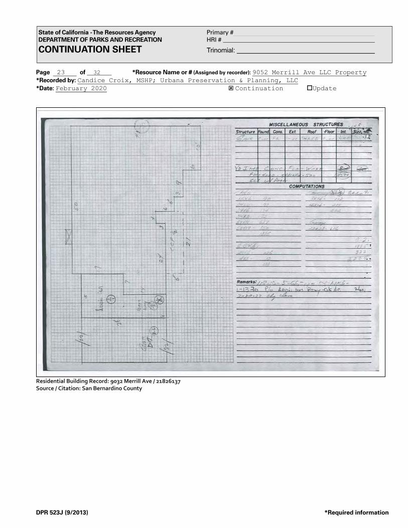
Page 23 of 32 *Resource Name or # (Assigned by recorder): 9052 Merrill Ave LLC Property *Recorded by: Candice Croix, MSHP; Urbana Preservation & Planning, LLC *Date: February 2020 ý Continuation oUpdate
DPR 523J (9/2013) *Required information
State of California - The Resources Agency Primary # DEPARTMENT OF PARKS AND RECREATION HRI # CONTINUATION SHEET Trinomial:
Residential Building Record: 9032 Merrill Ave / 21826137 Source / Citation: San Bernardino County
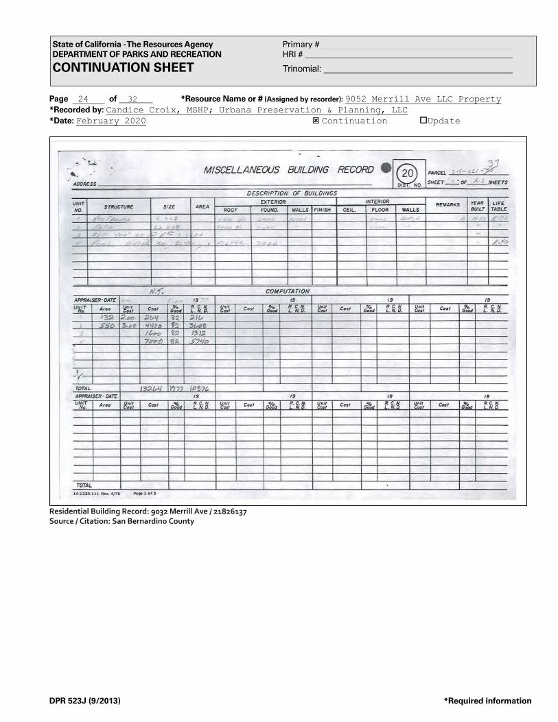
Page 24 of 32 *Resource Name or # (Assigned by recorder): 9052 Merrill Ave LLC Property *Recorded by: Candice Croix, MSHP; Urbana Preservation & Planning, LLC *Date: February 2020 ý Continuation oUpdate
DPR 523J (9/2013) *Required information
State of California - The Resources Agency Primary # DEPARTMENT OF PARKS AND RECREATION HRI # CONTINUATION SHEET Trinomial:
Residential Building Record: 9032 Merrill Ave / 21826137 Source / Citation: San Bernardino County

Page 25 of 32 *Resource Name or # (Assigned by recorder): 9052 Merrill Ave LLC Property *Recorded by: Candice Croix, MSHP; Urbana Preservation & Planning, LLC *Date: February 2020 ý Continuation oUpdate
DPR 523J (9/2013) *Required information
State of California - The Resources Agency Primary # DEPARTMENT OF PARKS AND RECREATION HRI # CONTINUATION SHEET Trinomial:
Residential Building Record: 9032 Merrill Ave / 21826137 Source / Citation: San Bernardino County

Page 26 of 32 *Resource Name or # (Assigned by recorder): 9052 Merrill Ave LLC Property *Recorded by: Candice Croix, MSHP; Urbana Preservation & Planning, LLC *Date: February 2020 ý Continuation oUpdate
DPR 523J (9/2013) *Required information
State of California - The Resources Agency Primary # DEPARTMENT OF PARKS AND RECREATION HRI # CONTINUATION SHEET Trinomial:
Residential Building Record: 9032 Merrill Ave / 21826137 Source / Citation: San Bernardino County

Page 27 of 32 *Resource Name or # (Assigned by recorder): 9052 Merrill Ave LLC Property *Recorded by: Candice Croix, MSHP; Urbana Preservation & Planning, LLC *Date: February 2020 ý Continuation oUpdate
DPR 523J (9/2013) *Required information
State of California - The Resources Agency Primary # DEPARTMENT OF PARKS AND RECREATION HRI # CONTINUATION SHEET Trinomial:
Residential Building Record: 9032 Merrill Ave / 21826137 Source / Citation: San Bernardino County

Page 28 of 32 *Resource Name or # (Assigned by recorder): 9052 Merrill Ave LLC Property *Recorded by: Candice Croix, MSHP; Urbana Preservation & Planning, LLC *Date: February 2020 ý Continuation oUpdate
DPR 523J (9/2013) *Required information
State of California - The Resources Agency Primary # DEPARTMENT OF PARKS AND RECREATION HRI # CONTINUATION SHEET Trinomial:
Residential Building Record: 9032 Merrill Ave / 21826137 Source / Citation: San Bernardino County

Page 29 of 32 *Resource Name or # (Assigned by recorder): 9052 Merrill Ave LLC Property *Recorded by: Candice Croix, MSHP; Urbana Preservation & Planning, LLC *Date: February 2020 ý Continuation oUpdate
DPR 523J (9/2013) *Required information
State of California - The Resources Agency Primary # DEPARTMENT OF PARKS AND RECREATION HRI # CONTINUATION SHEET Trinomial:
Residential Building Record: 9032 Merrill Ave / 21826137 Source / Citation: San Bernardino County

Page 30 of 32 *Resource Name or # (Assigned by recorder): 9052 Merrill Ave LLC Property *Recorded by: Candice Croix, MSHP; Urbana Preservation & Planning, LLC *Date: February 2020 ý Continuation oUpdate
DPR 523J (9/2013) *Required information
State of California - The Resources Agency Primary # DEPARTMENT OF PARKS AND RECREATION HRI # CONTINUATION SHEET Trinomial:
Residential Building Record: 9032 Merrill Ave / 21826137 Source / Citation: San Bernardino County

Page 31 of 32 *Resource Name or # (Assigned by recorder): 9052 Merrill Ave LLC Property *Recorded by: Candice Croix, MSHP; Urbana Preservation & Planning, LLC *Date: February 2020 ý Continuation oUpdate
DPR 523J (9/2013) *Required information
State of California - The Resources Agency Primary # DEPARTMENT OF PARKS AND RECREATION HRI # CONTINUATION SHEET Trinomial:
Residential Building Record: 9032 Merrill Ave / 21826137 Source / Citation: San Bernardino County

Page 32 of 32 *Resource Name or # (Assigned by recorder): 9052 Merrill Ave LLC Property *Recorded by: Candice Croix, MSHP; Urbana Preservation & Planning, LLC *Date: February 2020 ý Continuation oUpdate
DPR 523J (9/2013) *Required information
State of California - The Resources Agency Primary # DEPARTMENT OF PARKS AND RECREATION HRI # CONTINUATION SHEET Trinomial:
Residential Building Record: 9032 Merrill Ave / 21826137 Source / Citation: San Bernardino County

Historical Resource Survey Proposed Merrill Commerce Center Specific Plan
Urbana Preservation & Planning, LLC | February 2020 – Revised April 2020
ATTACHMENT 5. PREPARER QUALIFICATIONS

CandiceCroix,[email protected]
Historian Preservation Specialist, Candice Croix, holds a Master of Science in HistoricPreservation fromBallStateUniversity,andaBachelorofArtsdegree fromCaliforniaBaptistUniversity.Candice meets The Secretary of the Interior's Historic Preservation Professional QualificationsStandards in thedisciplineofArchitecturalHistory. She isexperienced in completinghistoricsites inventories, performing contextual and property-specific historic research, conductingconditions assessments, and preparing preservation and interpretation plans, includingpreparation of a Preservation Plan for the grounds and funeral tunnel at Dayton NationalCemetery, located in Dayton, Ohio. Prior to joining Urbana, Candice worked for ExpeditorsInternational where she provided project management for new and existing technicalapplications, produced and edited support documentation, and performed incident-specifictechnicalresearchforaglobalclientele.SheadditionallyworkedfortheDisneyVacationClub,whereshecoordinatedoperationslogisticsandmanagedinformationforrealestateproposalsand strategies. Her previous professional experience is an asset to the firm, and is directlyappliedtomarketing,clientcommunications,andpreservationprojectmanagement.Ms.Croixisexperienced in fieldsurveyandresearch,materialconservation,andpreservationadvocacy.SheispracticedininurbanandruralsettingsinCaliforniaandthemid-west.
SELECT PROJECT EXPERIENCE In-progress HistoricResourceSurvey–ProposedMerrillCommerceCenterSpecificPlan,
Ontario,CAIn-progress HistoricResourceSurvey–FredMoiolaSchool,FountainValley,CAIn-progress Historic-EraBuiltEnvironmentSurveyReport–SCEKernRiverTransmissionLine
RatingRemediationProgram,KernandLosAngelesCounties,CAIn-progress Historic-EraBuiltEnvironmentSurveyReport–Ivanpah-ControlTransmission
Project,Inyo,Kern,andSanBernardinoCounties,California2019 HistoricPropertyAnalysisReport–EvanHewesHighwayandSouthForkCoyote
WashBridge,ImperialCounty,CA2019 HistoricalResourceAnalysisReport–VicBradenTennisCenter,VCS
Environmental,CotodeCaza,CA2019 DeterminationofHistoricSignificance,241JAvenue,CityofCoronado,
Coronado,CA2019 HistoricalResourceAnalysisReport/HistoricPropertySurveyReport–SCE
EasternSierrasTransmissionSystem,MonoandInyoCounties,CA2019 ConditionAssessmentandReuseStudy–1801MechanicStreet,Galveston
HistoricalFoundation,Galveston,TX2019 OldfieldsChauffeur’sResidenceBuildingAssessmentandPreservationPlan-
IndianapolisMuseumofArt/Newfields,Indianapolis,IN2019 HistoricAmericanBuildingSurveyDocumentation–Chauffeur’sResidenceat
IndianapolisMuseumofArt,IN-320-A,Indianapolis,Indiana2019 HistoricAmericanLandscapeSurveyDocumentation–FuneralTunnelatDayton
NationalCemetery,OH-3-A,Dayton,Ohio2019 CommunityAttachmentPlan–CityofElwood,Elwood,IN2019 FeasibilityStudy–MillerMilkhouse,Muncie,IN2018 BordermanGymnasiumNationalRegisterNomination–Converse,IN
EDUCATION MasterofScience–Historic
Preservation,CollegeofArchitecture&
PlanningBallStateUniversity
GraduatePracticum:
Preservation&InterpretationPlanofDaytonNationalCemetery
—BachelorofArts–PsychologyCaliforniaBaptistUniversityMember:UniversityChoir&
Orchestra
PROFESSIONAL EXPERIENCE HistoricPreservationSpecialist:UrbanaPreservation&Planning,
LLC(SanDiego,CA)2019-present
—ResearchAssistant:Collegeof
Architecture&Planning(Muncie,IN)2018-2019
—InformationServicesSpecialist:
ExpeditorsInternational(Seattle,WA)2014-2017
—SalesCenterCoordinator:Disney
VacationClub(Anaheim,CA)2012-2014
BOARDS & MEMBERSHIPS BoardMember:Preservation
Action
SKILLS + INTERESTS NaturalResourcesConservation
PreservationAdvocacy

Ginger Weatherford, MPS
Associate Historian / Preservation Specialist
Associate Historian / Preservation Specialist, Ginger Weatherford, holds a Master of
Preservation Studies from Tulane University, and a Bachelor of Science degree from the California State University, San Diego. Ginger meets The Secretary of the Interior's Historic Preservation Professional Qualifications Standards in the disciplines of History and Architectural History. She brings diverse geographic and typological experience including historic-era building assessments in Texas, Montana, and throughout California; completing Section 106 compliance reviews for cell sites and collocation towers throughout California; preparation of CEQA historical resource surveys for transportation projects in the Southern California region; Historic American Buildings Survey (HABS) documentation; local landmark applications; and design review analysis under The Secretary of the Interior’s Standards for the Treatment of Historic Properties. Ginger is experienced in conducting historic paint analysis and material conservation projects at historic buildings. In addition to her technical expertise, she is an architectural photographer specializing in cultural and natural landscapes, and historic objects. Her work has been featured in local photography exhibitions.
SELECT PROJECT EXPERIENCE
September 2019 Historical Resource Analysis Report, A&I Development, Inc., Alvarado Specific Plan, La Mesa, California.
September 2019 Historical Resource Research Report, 2214 31st Street, San Diego, California. August 2019 Historical Resource Research Report, 3629 Front Street, San Diego,
California. June 2019 Historic Site Designation Report, 10446 Russell Road, La Mesa, California. June 2019 Determination of Historic Significance for 840-846 A Avenue, Coronado,
California. June 2019 Historical Resource Research Report, 7345 Remley Place, La Jolla, California. May 2019 Determination of Historic Significance for 1309 Fifth Street, Coronado,
California. April 2019 Determination of Historic Significance for 545 Alameda Boulevard,
Coronado, California. March 2019 Determination of Historic Significance for 500 Palm Avenue, Coronado,
California. March 2019 Determination of Historic Significance for 654 J Avenue, Coronado,
California. February 2019 Historic-Era Built Environment Survey Report – Control Silver Peak
Transmission Project, Mono and Inyo Counties, California. January 2019 Historical Resource Analysis Report, H & H Properties, Second Street and
Pacific Avenue Master Plan, Norco, California. October 2018 Historic Property Survey Report, SCE Allen and Playa Substations, Santa
Barbara and Altadena, California. October 2018 Southern California Edison Company Transmission Line Rating and
Remediation Program Control-Silver Peak Transmission Corridor, Historic-Era Built Environment Survey Report – Phase 1 Desk Survey.
September 2018 Southern California Edison Gale to Pisgah Communications System Historic-Era Built Environment Survey Report, San Bernardino County, California.
September 2018 Historical Resource Analysis Report / Historic Property Survey Report, Southern California Edison Company, Saticoy Substation Property, Santa Paula, California.
EDUCATION
Master of Preservation Studies – School of Architecture
Tulane University Graduate Practicum:
Documentation, Conservation, and Restoration of Grant-Kohrs Ranch
National Historic Site —
Bachelor of Science – Business Administration | California State
University, San Diego Concentrations: Environmental
Design, Art, Architecture, Information Systems
PROFESSIONAL EXPERIENCE
Associate Historian / Preservation Specialist: Urbana Preservation &
Planning, LLC (San Diego) 2018-present
— Principal / Owner: Ginger
Weatherford | Historic Preservation Consulting / Historic Visions Photography (San Diego)
2003-2018 —
Architectural Historian: LSA Associates, Inc. (Carlsbad) 2016
— Architectural Historian: EBI
Consulting (San Diego) 2010-2012 —
Architectural Historian: ICF International (Los Angeles) 2008-
2009 —
Historical Resources Board Staff: City of San Diego (San Diego)
2006-2007 —
Historical Researcher: Brian F. Smith and Associates (Poway)
2005-2006 —
Architectural Historian: Galveston Historical Foundation (Galveston,
TX) 2004-2005

Ginger Weatherford, MPS
Associate Historian / Preservation Specialist
SELECT PROJECT EXPERIENCE (CONT.) September 2018 Historical Resources Research Report, 1025 Devonshire Drive, San Diego,
California. August 2018 Southern California Edison Company Transmission Line Rating and
Remediation Program ICKI Transmission Corridor, Historic-Era Built Environment Survey Report – Phase 1 Desk Survey.
July 2018 Southern California Edison Company Transmission Line Rating and Remediation Program Control-Haiwee Transmission Corridor, Historic-Era Built Environment Survey Report – Phase 1 Desk Survey.
June 2018 Southern California Edison Company Transmission Line Rating and Remediation Program Eldorado-Lugo-Pisgah Transmission Corridor, Historic-Era Built Environment Survey Report – Phase 1 Desk Survey.
June 2018 Southern California Edison Company Transmission Line Rating and Remediation Program Kern River to Los Angeles Transmission Corridor, Historic-Era Built Environment Survey Report – Phase 1 Desk Survey.
May 2018 Designation and Mills Act Rehabilitation Reporting and Consulting for the Lottie and Michael Falahy House, 1030 26th Street, San Diego, California.
May 2018 Designation and Mills Act Rehabilitation Reporting and Consulting for the William Templeton Johnson House No. 2, 4154 Lark Street, San Diego, California.
March 2018 Historic Preservation and Exterior Color Consulting for 2829 Broadway, San Diego, California.
January 2018 Determination of Historic Significance Report, 908 Pomona Avenue, Coronado, California.
November 2017 Historic Preservation Subject Matter Expert, AC Hotel (743 Fifth and 744 Sixth Avenues) - Gaslamp Quarter Development Permit/Variance/ Neighborhood Use Permit No. 2017-27 - Gaslamp Quarter Neighborhood of the Downtown Community Plan Area, San Diego, California.
October 2017 Designation and Mills Act Rehabilitation Reporting and Consulting for the Charles and Audala Edwards Jr. House, City of San Diego HRB No. 1289, 1050 Cypress Avenue, San Diego, California.
July 2017 Assessment of Architectural Significance Report, 3134 Franklin Avenue, San Diego, California.
July 2017 Assessment of Architectural Significance Report, 3551 Boston Avenue, San Diego, California.
June 2017 Assessment of Architectural Significance Report, 2829 Broadway, San Diego, California.
May 2017 Assessment of Architectural Significance Report, 4209 Madison Avenue, San Diego, California.
December 2016 Historical Resources Research Report, 3021 B Street, San Diego, California. September 2016 Designation and Mills Act Rehabilitation Reporting and Consulting for the
Edward Booker House, City of Coronado HR No. 2016-08, 1144 Isabella Avenue, Coronado, California.
April 2016 Determination of Historic Significance Report, 550 J Avenue, Coronado, California.
March 2016 Historical Resources Research Report, 2766 - 2768 Bayside Walk, San Diego, California.
November 2015 Visual Effects Assessment and Department of Parks and Recreation Forms for Section 106 Review for Verizon Wireless Saratoga Santa Cruz Site, 236 North Santa Cruz Avenue, Santa Cruz, California.
May 2015 Historical Resources Research Report, 1901 - 1923 E Street, San Diego, California.
June 2014 Designation Reporting and Consulting for the Jim Morrison Apartment Courtyard, 8214 - 8218 1/2 Norton Avenue, West Hollywood, California.
PROFESSIONAL EXPERIENCE
(CONT.)
Preservation Intern: National Park Service Grant-Kohrs Ranch
National Historic Site (Deer Lodge, MT) 2003
— Annual Conference & Workshop
Volunteer: California Preservation Foundation (Southern California
locations) 2006-present
MEMBERSHIPS
Honorary Member: American Institute of Architects, San Diego
Chapter —
National Trust for Historic Preservation
— California Preservation Foundation
— Museum of Photographic Arts
— Save Our Heritage Organization
VOLUNTEER POSITIONS
Preservation Committee Member / Secretary: American Institute of
Architects, San Diego Chapter (San Diego) 2017-present
— Photo Archivist: Santa Monica
Historical Society (Santa Monica) 2001
— Architectural Assistant: Ferris
Johnson Preservation Architects (San Diego) 1993
PHOTOGRAPHY EXHIBITIONS
Third Sun (San Diego) 2017 —
Viz Cult (San Diego) 2014 —
Raw Artists (San Diego) 2010 —
Eyes & Ears (San Diego) 2010 —
Whistle Stop – Solo Show (San Diego) 2006
— Ray at Night (San Diego) 2006

Ginger Weatherford, MPS
Associate Historian / Preservation Specialist
SELECT PROJECT EXPERIENCE (CONT.) 2010 – 2014 Various Telecommunications Visual Effects Projects in California and
Arizona. November 2008 Survey of I-15 for a Caltrans Freeway Improvement Project, Corona,
California. March 2006 Historic Paint Analysis Project for the San Diego Gas and Electric Station B
Building, City of San Diego HRB No. 354, 903 Kettner Blvd, San Diego, California.
September 2004 Architectural Building Survey for the Kempner Park Historic District, Galveston, Texas.
September 2003 Historic Paint Analysis, Materials Conservation and Building Rehabilitation Projects for Grant-Kohrs Ranch National Historic Site, 266 Warren Lane, Deer Lodge, Montana.
November 2001 Photographic Archiving Project for the Santa Monica Historical Society, Santa Monica, California.
August 1993 Historic American Building Survey Package for the Heilman Villas, 706-720 Orange Avenue & 1060-1090 Seventh Street, Library of Congress Call No. HABS CAL, 37-CORO, 3-4, Coronado, California.

Wendy L. Tinsley Becker, RPH, AICP, Principal Architectural Historian + Urban / Preservation Planner [email protected]
Founding Principal, Wendy L. Tinsley Becker, RPH, AICP, brings an expert background in American history, architecture, and urban planning, with a particular emphasis on issues relating to historic preservation. Her experience includes extensive historical resources survey work, design review under The Secretary of the Interior’s Standards for the Treatment of Historic Properties, single-site historic property research and documentation, and practice in municipal regulatory planning and cultural resources compliance issues including code compliance, revision and review, CEQA, NEPA, and Section 106 of the National Historic Preservation Act. As a preservation-planning consultant she participates in the development and administration of local land use regulations, policies, programs and projects; prepares reports involving research and analysis of various planning issues; conducts site-specific project and design review; and facilitates project coordination between contractors, architects, developers, citizens and other stakeholders. Wendy meets the Secretary of the Interior's Historic Preservation Professional Qualifications Standards in the disciplines of History and Architectural History and the draft standards established for Historic Preservation and Land Use/Community Planning. She is included on the California Council for the Promotion of History’s Register of Professional Historians and also maintains professional certification in the American Institute of Certified Planners (AICP). Wendy is a co-author and editor of the AICP Certified Urban Designer Exam Study Guide (V1.0) released in March 2016. From 2013 forward she has provided professional training to AICP exam applicants as part of the American Planning Association California Chapter – San Diego Section annual exam training program. Wendy has assisted municipalities, utility providers, and lead agencies in preservation planning program development and implementation efforts. She regularly consults for private and agency applicants on historical resource and historic property analysis for discretionary projects and undertakings pursuant to Section 106 of the National Historic Preservation Act and the California Environmental Quality Act, as well as Federal Rehabilitation Tax Credit proposals at National Register listed or eligible properties, which are subject to review by the State Office of Historic Preservation and the National Park Service. She was the author / facilitator and lead historic preservation consultant for the City of Chula Vista’s award-winning Municipal Preservation Planning Program. She authored the Historic Preservation Element for the City of La Mesa’s award winning 2011 / 2030 General Plan update process. She provides survey, architectural history, context development, programmatic agreement, and historic preservation planning consulting services for the Southern California Edison Company including preparation of a programmatic guide for the treatment of all historic-era properties in the company’s 55,000 square mile service territory. She served as the lead Architectural Historian for the City and County of Honolulu High Capacity Transit Corridor Project’s Kako’o (Section 106 Programmatic Agreement Program manager) consultant team. Wendy’s professional analysis and determinations are reviewed for compliance and concurrence by numerous municipalities, and state and federal agencies including the California State Office of Historic Preservation, the California Public Utilities Commission, the USDA Forest Service, the Bureau of Land Management, and the National Park Service. Her current interests include facilitating approvals for brick and mortar construction and building rehabilitation projects, and working with community-based organizations that emphasize public participation while striving for the improvement of the built environment through good urban and architectural design and associated social programs.
EDUCATION Master of City Planning, Historic
Preservation & Urban Design Concentration | California State
University, San Diego —
Bachelor of Arts – History, Public History & Urban Studies
Concentration | California State University, San Diego
PROFESSIONAL REGISTRATIONS
American Institute of Certified Planners (#022838)
Register of Professional Historians (#612)
PROFESSIONAL EXPERIENCE
Founding Principal: Urbana Preservation & Planning, LLC, (San Diego & Oakland) 04/2005-present
— Faculty + Lecturer: San Diego State
University Master of City Planning Graduate program, 2012
— Instructor: University of California, San
Diego – Extension, 2006-2017 —
Architectural Historian & Preservation Planner: Architectural Resources
Group (San Francisco & Los Angeles), 10/2002-04/2005
— Architectural Historian & Preservation
Planner: HRS, (San Diego) 12/2001-10/2002
— Historian & Historic Preservation
Planner: Office of Marie Burke Lia, Attorney at Law, (San Diego)
01/2000-11/2001 —
Assistant Coordinator + Researcher: SHPO/CHRIS-South Coastal
Information Center, 12/1996-08/1999

Wendy L. Tinsley Becker, RPH, AICP, Principal Architectural Historian + Urban / Preservation Planner
PROJECT EXPERIENCE* 2020 Southern California Edison Company Transmission Line Rating and
Remediation Program Kern River to Los Angeles Transmission Corridor, Historic-Era Built Environment Survey Report.
2020 Southern California Edison Company Transmission Line Rating and Remediation Program Ivanpah-Control Transmission Corridor, Historic-Era Built Environment Survey Report.
2020 Historic District Nomination Package, Arizona Street Tract, Park Villas Subdivision, City of San Diego, CA.
2020 Historical Resource Analysis Report, Moiola School, Fountain Valley, CA. 2020 Historical Resource Survey, Proposed Merrill Commerce Center Specific Plan,
Ontario, CA. 2020 Historic Property Survey Report, Evan Hewes Highway and Bridge
Evaluation, Imperial County, CA. 2019 Historic Context and Preservation Element Historical Resource Analysis
Report / Historic Property Survey Report for Southern California Edison Company Lindsay Substation and Bliss-Lindsay 66kV Sub-Transmission Line.
2019 To Kalon Vineyard / Robert Mondavi Winery Patent Litigation Expert Witness Consulting, Oakville, CA.
2019 Historical Resource Analysis Report, Vic Braden Tennis College, 23333 Ave La Caza, Coto De Caza, CA.
2019 Church of God in Christ Bulletin 580 Package. 2019 Historical Resource Analysis Report, 7407 Alvarado Road, La Mesa, CA. 2019 City of Laguna Beach Preservation Ordinance and Program Consulting. 2019 Historic Resource Research Report and Conditions Consulting, 8445 Avenida
de las Ondas, La Jolla, CA. 2019 Southern California Edison Company Transmission Line Rating and
Remediation Program Control-Silver Peak Transmission Corridor, Historic-Era Built Environment Survey Report.
2019 Southern California Edison Catalina Island Historic-Era Water System Management Program, Catalina Island, CA.
2019 Historical Resource Analysis Report / Historic Property Survey Report, Southern California Edison Catalina Island Wrigley Pipeline Project, Catalina Island, CA.
2019 Retroactive Historical Resource Research Report, 31st Street, San Diego, CA. 2019 Historical Resource Analysis Report / Historic Property Survey Report
Southern California Edison Pedley Powerhouse Complex, Norco, California. 2019 Historical Resource Analysis Report / Historic Property Survey Report
Southern California Edison Company Eastern Sierras Transmission System, Mono County and Inyo County, California.
2019 Historical Resource Research Report, 3629 Front Street, San Diego, CA. 2019 Programmatic Agreement Among the Bureau of Land Management –
California, the USDA Forest Service, Pacific Southwest Region, California Utility Providers, and the California Office of Historic Preservation, Regarding the Identification, Evaluation, Management, and Exemption of Historic-Era Electrical Infrastructure Facilities in the State of California.
2019 City of San Diego Clairemont Community Plan Update, Historic Context and Preservation Element.
2019 Historic Site Report, 10446 Russell Road, La Mesa, CA. 2019 City of Coronado, As-Needed Historic Research Consulting, Coronado, CA. 2019 Historical Resource Research Report, 4250-52 Cleveland Ave, San Diego, CA. 2018 Southern California Edison Company Transmission Line Rating and
Remediation Program Control-Silver Peak Transmission Corridor, Historic-Era Built Environment Survey Report – Phase 1 Desk Survey.
BOARDS + COMMITTEES Chair / Immediate Past Chair:
American Planning Association National Urban Design & Preservation
Division, 04/2012-12/2016 —
Founder + Volunteer Executive Director / Ex –Officio Director: Built
Environment Education Program (BEEP) San Diego, 2008-2015
— Education Committee Member:
California Preservation Foundation, 04/2012-04/2014
— Vice-Chair + Newsletter Editor: APA
National Urban Design & Preservation Division, 01/2010-03/2012
— Director & Education Chair: San Diego
Architectural Foundation, 11/2008-2011
— Appointed Public Member: City of San
Diego Historical Resources Board Incentives Subcommittee, 08/2008-
02/2010 —
Advisor/Member – UCSD Extension Advisory Group Urban Planning &
Development Certificate Program, 2007 forward
— Founding President – Jack London
District Association, 2005-2006
SELECT PROJECT AWARDS 2016 - Award of Excellence for
Preservation Advancement - City of San Diego Historical Resources Board
(recognized for Urbana's preservation planning study for the San Diego State
Normal School Campus & San Diego City Schools Historic District).
— 2014 - American Planning Association
(APA) San Diego Chapter – Planning Agency Award for preparation of La
Mesa 2030 General Plan. *Historic Preservation Element prepared by
WLTB / Urbana.

Wendy L. Tinsley Becker, RPH, AICP, Principal Architectural Historian + Urban / Preservation Planner
2018 Southern California Edison Company Transmission Line Rating and Remediation Program Control-Haiwee Transmission Corridor, Historic-Era Built Environment Survey Report – Phase 1 Desk Survey.
2018 Southern California Edison Company Transmission Line Rating and Remediation Program ICKI Transmission Corridor, Historic-Era Built Environment Survey Report – Phase 1 Desk Survey.
2018 Southern California Edison Company Transmission Line Rating and Remediation Program Eldorado-Lugo-Pisgah Transmission Corridor, Historic-Era Built Environment Survey Report – Phase 1 Desk Survey.
2018 City of San Diego Park Boulevard Residential Historic District Historic Context Statement and Nomination Package.
2018 California Department of General Services, Metropolitan State Hospital Project Historical Resource Analysis Report.
2018 City of San Juan Capistrano, River Street Marketplace Historical Resource Analysis Report.
2018 Southern California Edison Company Transmission Line Rating and Remediation Program Kern River to Los Angeles Transmission Corridor, Historic-Era Built Environment Survey Report – Phase 1 Desk Survey.
2017 Historic Site Designation Package, Wexler House 1088 Sierra Vista Avenue, La Mesa, California.
2017 Nelson-Sloan Otay Rock Plant Property, Chula Vista, California 91910. 2017 Adams Avenue, Murrieta, California, Tract Map Historical, Cultural, and
Paleontological Report. 2017 4 Greenwood Common (Berkeley Landmark No. 125) Mills Act Application
Package, Berkeley, CA. 2017 Historical Resource Analysis Report, 1201 S. Grand Avenue, Los Angeles,
California. 2017 Design Review Analysis and Historical Resource Research Report, 4884
Marlborough Avenue, San Diego, California. 2017 Historical Resource Analysis Report / Historic Property Survey Report, SCE
MacNeil Substation, Burbank, California. 2017 Peer Review Statement, 400 S. Alameda Street, Los Angeles, California. 2017 4617-4619 and 4621-4625 Park Boulevard, San Diego, California, Historical
Resource Technical Report. 2017 Historical Resource Research Report, 707 17th Street, San Diego, California. 2017 5064 Lotus Street, San Diego, California, Historical Resource Technical
Report. 2017 Historical Resource Technical Report, 550 Sicard Street, San Diego,
California. 2017 Historic Landmark Designation Package, 9415-9425 Eldorado Lane, La
Mesa, California. 2017 6035 University Avenue, San Diego, California, Historical Resource Technical
Report. 2016 Expert Witness Consulting, Bernati Ticino Trust v. City of San Diego 2016 4365-4369 Ohio Street, San Diego, California, Historical Resource Technical
Report. 2016 4505 Park Boulevard, San Diego California, Historical Resource Technical
Report. 2016 Designation and Mills Act Rehabilitation Reporting and Consulting for the
Edwin K. Hurlbert House, 2930 Chatsworth Boulevard, San Diego, CA. 2016 NHPA Section 106 Historic Property Analysis and Findings of Effect
Statement for the Southern California Yeshiva High School, San Diego, CA.
SELECT RECENT AWARDS (CONT.) 2013 – American Planning Association
National Division Executive Committee Recipient – Division Achievement Award (recognized for professional
development webinars on historic preservation, urban design, and
development topics developed on behalf of the APA Urban Design & Preservation
Division). —
2012 - American Association of Environmental Professionals San Diego
Chapter – Outstanding Planning Document Award for preparation of the City of Chula Vista Historic Preservation
Program & Ordinance. *Historic Preservation Ordinance& Program
prepared by WLTB / Urbana. —
2012 - American Planning Association National Division Executive Committee
Recipient – Education Excellence Award (recognized for education efforts on
behalf of the APA Urban Design & Preservation Division).
— 2011 - American Planning Association
National Division Executive Committee Recipient Branding Award (recognized
for visibility, outreach, and education efforts on behalf of the APA Urban
Design & Preservation Division). —
2010 - Award of Excellence in Education - City of San Diego City Planning &
Community Investment Department Historical Resources Board (recognized
for the Built Environment Education Program developed for the San Diego Architectural Foundation / BEEP San
Diego). —
2009 - San Diego Public Library Foundation / Friends of the San Diego
Public Library 2008-2009 Chapter Volunteer Award, University Heights
Branch (recognized for preservation planning work at the historic San Diego
State Normal College campus).

Wendy L. Tinsley Becker, RPH, AICP, Principal Architectural Historian + Urban / Preservation Planner
2016 Peak Valley Solar Farm CEQA Cultural Resources Analysis (Historical Resources, Cultural Resources, and Paleontological Resources), San Bernardino County, CA.
September 2016 City of Oceanside / Caltrans, Coast Highway (Hill Street) Bridge over the San Luis Rey River Replacement Project Historical Resources Evaluation Report, Oceanside, CA.
August 2016 Historical Resource Technical Report – 715 Muirlands Vista Way, La Jolla, CA. June 2016 Class III Cultural Resources Inventory / NRHP Eligibility Determination, SCE
Eldorado 500kV Transmission System, California, Arizona, Nevada. June 2016 Casa de las Flores Property Carriage House / Garage Building, Historical
Resource Analysis Report, Chula Vista, CA. May 2016 Historic American Engineering Record (HAER) No. CA-167-O – Southern
California Edison Company Big Creek Hydroelectric System Vincent 220kV Transmission Line, Kern, Fresno, and Los Angeles Counties.
May 2016 San Diego Gas & Electric Company Eastern Division Property Eligibility Review Memo, El Cajon, CA.
March 2016 Historical Resource Review - 1347-1349 Locust Street, Walnut Creek, CA. March 2016 City of La Mesa Collier Park NHPA Section 106 Review, La Mesa, CA. March 2016 Redwood Solar Farm 4 CEQA Cultural Resources Analysis (Historical
Resources, Cultural Resources, and Paleontological Resources), Kern County, CA.
March 2016 City of La Mesa Vista La Mesa Park NHPA Section 106 Review, La Mesa, CA. February 2016 City of Chula Vista Third Avenue Community Character + Business
Improvement Guidelines. February 2016 City of San Diego HRB No. 461 / Anderson House, San Diego County Historic
Site Designation and Mills Act Rehabilitation Consulting, 3841 Sweetwater Road, Bonita, CA.
January 2016 Historic American Landscapes Survey (HALS) No. CA-122 – Collier Park, La Mesa, CA.
December 2015 Historic American Engineering Record (HAER) No. CA-2138 – Southern California Edison Company Substations: Monumental Type, Santa Barbara, Kern, Fresno, and Los Angeles Counties.
December 2015 Pacific Gas & Electric Company South of Palermo Project Historical Resource Analysis Report / Historic Property Survey Report.
November 2015 Historic American Engineering Record (HAER) No. CA-167-N – Amendment to Southern California Edison Company Big Creek Hydroelectric System East & West Transmission Line.
November 2015 Designation and Mills Act Rehabilitation Reporting and Consulting for the Alexander Schreiber Spec House No. 1 / Payne House, 1429 Dale Street, San Diego, CA.
October 2015 Designation and Mills Act Rehabilitation Reporting and Consulting for the Florence Palmer Spec. House II of III, 350 Fern Glen, San Diego, CA.
May 2015 Historic-era Electrical Infrastructure Management Program: A Program for the Identification, Review, Exemption, and Treatment of Generating Facilities, Transmission Lines, Sub-transmission Lines, Distribution Lines, and Substations within the Southern California Edison Company’s Service Territory.
March 2015 Class III Cultural Resources Inventory for Southern California Edison’s Coolwater-Lugo Transmission Project, San Bernardino County, California – Volume 1: Historic-Era Built Environment Survey Report.
2014-2015 Los Angeles Regional Intercommunications System NHPA Section 106 Assessment of 125 sites located throughout Los Angeles County.
RELATED EXPERIENCE Member: County of San Diego Valle de
Oro Community Planning Group, 09/2016 forward
— Director + Civic Improvement Chair, Grossmont-Mt. Helix Improvement
Association, 08/2016 forward —
Mentor: San Diego State University Aztec Mentor Program, Spring 2016
Cohort —
Co-Author / Editor: AICP Certified Urban Designer Exam Study Guide, Version 1.0
(released March 2016) —
AICP Exam Course Speaker: California Chapter, San Diego Section, (annually)
02/2013-present —
Retreat Facilitator: Beautiful Pacific Beach, Annual Board of Directors Retreat, (annually) 2016-present
— Invited Panel Speaker: Density and
Design: The Future of Housing in San Diego, American Planning Association
San Diego Section, San Diego, 09/2017 —
Invited Speaker: Building Community and Character – Preservation is Place; 1st
Annual Historic Preservation Conference Nebraska State Office of Historic Preservation, Omaha (NE),
06/2013 —
Panel Speaker: Preservation Toolkit for Small Cities, American Planning
Association California Chapter Conference, 10/2012
— Invited Speaker: Preliminary Findings –
The Status of Preservation Planning Regulatory Programs in the San Diego
Region - 2012, Association of Environmental Professionals San
Diego Chapter September Luncheon, 09/2012

Wendy L. Tinsley Becker, RPH, AICP, Principal Architectural Historian + Urban / Preservation Planner
2014 Historic Preservation and Urban Planning Expert Witness, Brandon Milan v. City of San Diego, State of California Superior Court Case No. 37-2013-00067039-CU-EI-CTL.
2013-2014 Historic Preservation and Urban Planning Expert Witness, Edward Valerio v. City of San Diego, U.S.D.C. Case No. 12C1200W (WMC)
November 2014 Historic-Era Built Environment Survey Report, NRHP / CRHR Eligibility Evaluations, and Concurrence Consulting for proposed Coolwater Lugo Transmission Project (approx. 200 built environment sites over 13 segments in the vicinity of Apple Valley, Barstow, and Hesperia, California).
November 2014 Herald Examiner Building, 1101-1139 S. Broadway, Los Angeles, CA, Historic Preservation Certification Application: Part 1 – Determination of Eligibility – Draft Submittal.
November 2014 Cecil Hotel Building, 640 Main Street, Los Angeles, CA, Historic Preservation Certification Application: Part 1 – Determination of Eligibility – Draft Submittal.
November 2014 Cecil Hotel Building, 640 Main Street, Los Angeles, CA, City of Los Angeles Historic Cultural Monument Application Package – Draft Submittal.
November 2014 Historic-Era Electrical Infrastructure Management Program: A Program for the Identification, Review, Exemption, and Treatment of Generating Facilities, Transmission Lines, Sub-transmission Lines, Distribution Lines, and Substations within the SCE Service Territory.
October 2014 Commercial Exchange Building, 416 W. 8th Street, Los Angeles, CA, Historic Preservation Certification Application: Part 2 – Description of Rehabilitation – Draft Submittal.
October 2014 NRHP / CRHR Eligibility Review, SCE Lighthipe and Laguna Bell Substations, Long Beach and Commerce, California.
October 2014 NRHP / CRHR Eligibility Review, SCE Eagle Rock Substation, Los Angeles, California.
October 2014 NRHP / CRHR Eligibility Review, SCE Colton Substation, Colton, California. September 2014 City and County of Honolulu Little Makalapa National Register of Historic
Places Nomination Peer Review. September 2014 City and County of Honolulu Big Makalapa National Register of Historic
Places Nomination Peer Review. September 2014 Sudberry Properties Strawberry Fields Historic Cultural Landscape Analysis
Report, Chula Vista, CA. July 2014 Friday Morning Club Building, 938 S. Figueroa, Los Angeles, CA, Historic
Preservation Certification Application: Part 2 – Description of Rehabilitation – Draft Submittal.
May 2014 Commercial Club of Southern California Building / Case Hotel Part 2 Determination of Eligibility, Los Angeles, CA.
May 2014 City and County of Fresno Tertiary Treatment and Disinfection Facility – Plant 2 NHPA Section 106 and CEQA Historical Resource Assessment.
April 2014 City and County of Honolulu Aloha Stadium Station Project Treatment Plan Peer Review, Honolulu, CA.
April 2014 Redwood Solar Farm Historic Property Survey / Historical Resource Report, Kern County, CA.
April 2014 4th@ Broadway EIR Mitigated Negative Declaration – Historical Resource
Assessment Report, Los Angeles, CA March 2014 Commercial Club of Southern California Building / Case Hotel Part 1
Determination of Eligibility, Los Angeles, CA. February 2014 Commercial Club of Southern California Building / Case Hotel Historic
Cultural Monument Application, Los Angeles, CA.
RELATED EXPERIENCE (CONT.) Invited Panel Speaker: Outsiders &
Fringe Dwellers – Preservation Partners of the Future, California Preservation
Foundation Conference, 05/2011 Guest Lecturer: Preservation, Housing,
and Sustainability, UCSD Urban Studies & Planning Program, 05/2011
— Invited Speaker: Harriett Wimmer,
Women, and Modern Landscape Architecture in California, Congress of
History of San Diego & Imperial Counties, 03/2011
— Guest Lecturer: Historic Preservation
Planning, San Diego State University Public Administration Program, 07/2010
— Attendee: AIA Webinar, The 2030
Commitment: Setting and Achieving Energy Goals with Integrated Design,
12/2009 —
Attendee: APA Webinar, Balancing the Land-Use Transportation Equation: At
the Community Level, 09/2009 —
Attendee: APA Webinar, LEED for Neighborhoods, 08/2009
— Attendee: San Diego APA, Making
Density Work – San Diego Density Symposium, 10/2008
Moderator: Planning for Preservation: A Survey of Municipal Preservation
Programs Throughout San Diego County, San Diego APA & UCSD Extension–UPD
Cert. Program, 08/2008 —
Invited Speaker: Local Historic Site Designation & The Mills Act Historic
Property Tax Credit Program, City of San Leandro (CA), 04/2005
— Attendee: CA Preservation Foundation
& CA Office of Historic Preservation, Historical Resource Surveys for Local
Governments, San Diego (CA) 02/2004

Wendy L. Tinsley Becker, RPH, AICP, Principal Architectural Historian + Urban / Preservation Planner
January 2014 1560 S. Escondido Boulevard NHPA Section 106 Review and Concurrence Consulting.
November 2013 Consulting for Two Historic House Relocations to the City of San Diego Development Services Department, Public Works Department, and City Attorney’s Office.
September 2013 Caltrans Section 106 Historic Property and CEQA Historical Resource Survey – Gilbert Street, Santa Ana, CA.
October 2013 NHPA Section 106 Historic Property and CEQA Historical Resource Survey Report, Proposed Coolwater Lugo Transmission Project.
June 2013 Historic Agricultural Landscapes of Visalia and Tulare County electronic book and exhibit – Tulare County Museum of Farm Labor and Agriculture, Visalia, CA
January 2013 National Park Service Historic American Engineering Record (HAER) Level II Documentation (Large Format Negative Photography & Narrative) – Big Creek Hydroelectric System East & West Transmission Line, Fresno to Los Angeles, CA
January 2013 Historical and Architectural Eligibility Evaluation of Delano Substation Complex.
October 2012 Historical and Architectural Eligibility Evaluations of the Southern California Edison Company Historic-Era Casitas, Santa Barbara, Carpinteria, Santa Clara, and Goleta Substations
October 2012 City and County of San Francisco, 2419-2435 Lombard Street Historical Resource Evaluation Report.
2011-2013 Historic Preservation Expert Witness, Academy of Our Lady of Peace v. City of San Diego, U.S.D.C. Case No. 09CV0962 WQH (MDD)
In-process San Diego Municipal Anglers Building Historical Resource Designation Report, San Diego, CA
July 2012 National Park Service Historic American Engineering Record (HAER) Level II Documentation (Large Format Negative Photography & Narrative) – SCE San Joaquin Cross Valley Loop Project, Visalia, CA
June 2012 Historic Structure Report - Casa Peralta, 384 West Estudillo Avenue, San Leandro, CA
June 2012 County of San Diego Historic Site Designation Report, John N. Mortenson’s Hines Residence, Mt. Helix, CA
April 2012 NHPA Section 106 Review, Lodi Municipal Stadium, Lodi, CA March 2012 Federal Rehabilitation Certification Application – Part 3 Request for
Certification of Completed Work – Imig Manor / Lafayette Hotel, 2223 El Cajon Boulevard, San Diego, CA
February 2012 National Register of Historic Places Nomination, Imig Manor / Lafayette Hotel, 2223 El Cajon Boulevard, San Diego, CA
February 2012 Sequoia National Forest Electric Power Conveyance Systems NRHP Eligibility Evaluations, Tulare County, CA
January 2012 NHPA Section 106 Review, La Mesa Youth Center, La Mesa, CA December 2011 City of La Mesa 2012 General Plan Update – 2030 Historic Preservation
Element, La Mesa, CA December 2011 Crown City Medical Center EIR Historical Resource Initial Study, Pasadena,
CA November 2011 NHPA Section 106 Review, 4470 Acacia Avenue, La Mesa, CA September 2011 Big Creek Hydroelectric System Historic District Vincent 220kV Transmission
Line NRHP Eligibility Evaluation and Historic Property Treatment Plan. July 2011 Historic-Era Electric Power Conveyance Systems Programmatic Agreement
(SCE, BLM, & CA, NV SHPO) (Context, Typology, Identification, Integrity Qualifications, & Treatment Processes)
RELATED EXPERIENCE (CONT.) Attendee: National Charrette
Institute, Introduction to Dynamic Planning (Level 1 NCI Charrette
Manager Certification Training), San Diego (CA) 10/2003
— Attendee: CA Preservation Foundation,
Incentives for Historic Preservation Projects, Berkeley (CA) 09/2003
— Attendee: University of Southern CA,
Preservation Planning & Law, Los Angeles (CA) 07/2003
— Attendee: League of CA Cities, Smart
Growth Zoning Codes, Lodi (CA) 12/2002 —
Invited Participant: Second Natures, Redefining The Los Angeles Riverfront,
Los Angeles (CA) 01/2002 (2-Day Planning & Design Charrette hosted by
MOCA & The Geffen) —
Selected Smart Growth Researcher: San Diego State University Foundation & City Planning Graduate Program, Dr.
Roger Caves, 01/2001 – 08/2001 (Grant Topic: Planning for Sprawl in the U.S)
— Attendee: Section 106 An Introductory
Course, National Preservation Institute, San Francisco (CA) 04/1999
COURSES CREATED & TAUGHT
BUSA 40687 - Historic Preservation Planning (UCSD 2006-2012)
— BUSA 40515 - Fundamentals of City
Planning (UCSD 2007) —
BUSA 40748 - Foundations of Urban Planning & The Built Environment
(UCSD 2009-2012) —
BUSA 40749 - Functions & Processes of City Planning (UCSD 2011-2012)
— ART 40436 - American Architectural
History I & II (UCSD 2008-2014) —
CP 670 - History of Urban Planning (SDSU 2012)

Wendy L. Tinsley Becker, RPH, AICP, Principal Architectural Historian + Urban / Preservation Planner
June 2011 Aesthetic impact Analysis Report, Hollywoodland Historic Rock Retaining Walls, Los Angeles, CA
April 2011 Kern River – Los Angeles 60 / 66kV Transmission Line NRHP Eligibility Evaluation, Kern & L.A. Counties
December 2010 Historic Structure Report - Linda Vista Federal Defense Housing Project Tenant Activity Building, San Diego, CA
October 2010 City of San Diego Redevelopment Agency, Historic Property / Historical Resource Analysis Report of the Linda Vista Federal Defense Housing Project Tenant Activity Building, San Diego, CA
November 2010 Historic Designation Report, Burt F, Raynes Residence, 299 Hilltop Drive, Chula Vista, CA
August 2010 Southern California Edison Company Tehachapi Renewable Transmission Project Antelope-Vincent No. 1 220kV Transmission Line NRHP/CRHR Review
July 2010 Southern California Edison Company Tehachapi Renewable Transmission Project Rosamond Substation NRHP/CRHR Review, Montebello, California
July 2010 Southern California Edison Company Tehachapi Renewable Transmission Project Antelope-Mesa 220kV Transmission Line NRHP/CRHR Review
June 2010 Southern California Edison Company Tehachapi Renewable Transmission Project Chino-Mesa 220kV Transmission Line NRHP/CRHR Review
June 2010 Southern California Edison Company Tehachapi Renewable Transmission Project Chino Substation NRHP/CRHR Review, Chino, California
April 2010 Historical Resource Analysis Report, Hollywoodland Historic Rock Retaining Walls, Los Angeles, CA
March 2010 Imig Manor/ Lafayette Hotel Part 2 20% Federal Rehabilitation Tax Credit Application
January 2010 CEQA Historical Resource Analysis Report, 2629 National Avenue, San Diego CA
December 2009 City of Santa Ana Warner Avenue Transportation Study Historical Resource Survey, Santa Ana, CA
December 2009 Proposed Heidi Square Redevelopment Project – Project Management, Preservation Planning & Subdivision Re-Design Consulting, San Lorenzo, CA
November 2009 City of San Diego Redevelopment Agency, Historical Resource Review of 4102-4122 University Avenue, San Diego, CA
November 2009 CEQA Historical Resource Analysis Report, 7195 Country Club Drive, La Jolla, CA
November 2009 Imig Manor/ Lafayette Hotel Part 1 20% Federal Rehabilitation Tax Credit Application
August 2009 CEQA Historical Resource Analysis Report, 5511 Calumet Avenue, La Jolla, CA
August 2009 Preservation Planning Study, Site Development, & Rehabilitation Analysis of the Herman Hotel Carriage House, Chula Vista, CA
August 2009 Historical Site Designation, Design Review, & Mills Act Property Tax Consulting for the Dennstedt Building Company’s Calavo Gardens Queen Avenue Dwelling, Mt. Helix, CA
August 2009 CEQA and NHPA Section 106 Review of the Nike Missile Defense System - LA - 14/29 Commemorative Site, unincorporated Los Angeles, CA
July 2009 Code Compliance & Resource Review, 2341 Irving Avenue, San Diego, CA July 2009 City of Santa Ana Bristol & 17th Transportation Study Historical Resource
Survey, Santa Ana, CA May 2009 Fresno Unified School District Historical Resource Survey of the Proposed M-
4 Site, Fresno, CA May 2009 Section 106 Review of Casa Blanca – 716 Santa Clara Avenue, Alameda, CA

Wendy L. Tinsley Becker, RPH, AICP, Principal Architectural Historian + Urban / Preservation Planner
April 2009 Design Review Analysis for the 2110 Glenneyre Street Property, Laguna Beach, CA
April 2009 Section 106 Review of the Fairfax Theatre, Oakland, CA March 2009 National Register of Historic Places Documentation & Eligibility Evaluation
for the Middle Fork American River Hydroelectric Project, Placer County, California
February 2009 Historical Resource Analysis Report & Design Review – 337 Hawthorne Road, Laguna Beach, CA
February 2009 San Diego Normal School Campus Phase I Preservation Planning Study & Historical Resource Survey, San Diego, CA
January 2009 Historical Resource Analysis Report, 634 2nd Avenue, Chula Vista, CA October 2008 Pier 29 National Historic Preservation Act Finding of Effects Statement, San
Francisco, CA 2007-2008 Lead Consultant – City of Chula Vista Historic Preservation Program
Development – City of Chula Vista Historic Preservation Program Binder (ordinance, historic inventory database, historical overview statement, incentives, project review process and related permit application and processing forms
August 2008 Mayor John Gill Residence, Designation, Mills Act & Rehabilitation Consulting, San Leandro, CA
July 2008 California Portland Cement Company P&H Excavators #3 & #4 Historic Context Statement & California Register Eligibility Review, Mojave, CA
July 2008 Historic Context Statement – Bean Springs Site, Rosamond, CA June 2008 Cultural Resource Report & Regulatory Review, PL-SCE-Tehachapi-10H,
Acton, CA May 2008 Historical Resource Documentation & Review, San Diego Aqueduct, San
Diego, CA April 2008 Historic Site Designation & Mills Act Historic Property Tax Consulting for the
Goldberg Residence, 4654 Iowa Street, San Diego, CA April 2008 Storefront Improvement / Façade Revitalization Historical Resource Analysis
& Design Review Assistance, 3201 Adams Avenue, San Diego, CA March 2008 Lombardi Ranch CEQA Review, San Ardo, California February 2008 Del-Sur Saugus Mining Complex Historical Resource Review, Grass Valley,
CA February 2008 Foothill Ranch Historical Resource Review, Palmdale, CA January 2008 Section 106 Review 1425-1475 South Main Street, Walnut Creek, CA January 2008 Historic Site Designation Report & Mills Act Property Tax Consulting - Ocean
Beach Cottage Emerging Historic District Contributor, 4670 Del Monte Ave., San Diego, CA
November 2007 Historic Site Designation & Mills Act Historic Property Tax Consulting for the Olmstead Building Company’s Calavo Gardens Project #531, Mt. Helix, CA
October 2007 Southern CA Edison Company’s Del Sur-Saugus Transmission Line Historical Resource Review, Lancaster - Palmdale, CA
October 2007 Southern CA Edison Company’s Antelope Substation Historical Resource Review, Lancaster, CA
September 2007 Historical Resource Review & Data Responses for the Proposed SDG&E Orange Grove Energy Project in Pala, CA
September 2007 SCE Kaiser Pass Cabin Historic Property Assessment, Fresno Co., CA August 2007 USDA Forest Service Meeks Creeks Bridge Assessment, Lake Tahoe, CA July 2007 Historical Resource Analysis Report, 433 W. Meadow Drive, Palo Alto, CA May 2007 Historic Preservation Assessment & New Project Planning and Design
Consulting – 3994 Jackdaw Street, San Diego (CA) February 2007 419 Park Way Historical Resource Analysis Report, Chula Vista, CA

Wendy L. Tinsley Becker, RPH, AICP, Principal Architectural Historian + Urban / Preservation Planner
January 2007 Upper Triangle Areas Historic Property Survey (Historic Context Statement and Architectural/Historical Documentation of 50 Properties over 15 City Blocks), Fresno, CA
December 2006 Historic Site Designation & Mills Act Historic Property Tax Consulting for the Charles Wakefield Cadman Residence, Mt. Helix, CA.
November 2006 Historical Resource Analysis of the 4303 Narragansett Avenue Property, San Diego, CA
September 2006 Section 106 Review of the 1333 Balboa Street Property, San Francisco, CA September 2006 Section 106 Review of the Historic Delta-Mendota Canal, Los Banos, CA August 2006 Historical Evaluation Report – 2959 East Avenue, Hayward, CA June 2006 Historical Resource Analysis Report: 418-450 10th Avenue Properties, San
Diego, CA May 2006 Section 106 Review of the Cocoanut Grove Building – Santa Cruz Beach
Boardwalk, Santa Cruz, CA May 2006 Historical Resource Evaluation Report for the 70 15th Street Warehouse, San
Diego, CA April 2006 Historic Site Designation Report & Mills Act Property Tax Consulting - Ocean
Beach Cottage Emerging Historic District Contributor, 4528 Saratoga Avenue, San Diego, CA
March 2006 City of Fresno Arts-Culture District Historic Property Survey (Historic Context Statement and Architectural/Historical Documentation of 90-100 Properties over 18 City Blocks), Fresno, CA
March 2006 South Mossdale Historic-Era House Evaluation, Lathrop, CA February 2006 Westwind Barn Historic Preservation Study, Los Altos Hills, CA January 2006 Section 106 Review of the 2654 Mission Street Property, San Francisco, CA January 2006 Section 106 Review of the 325 Mowry Avenue Property, Fremont, CA 94536 January 2006 Section 106 Review of Ardenwood 34551 Ardenwood Bouevard, Fremont, CA
94555 December 2005 Section 106 Review of the 1230 N Street Property, Sacramento, CA 95814 December 2005 Section 106 Review of the Sacramento City College Water Tower,
Sacramento, CA November 2005 Section 106 Review of Fair Oaks Watts, 525 La Sierra Drive, Sacramento, CA November 2005 Napa Valley College Bus Shelter West Historical Resource Analysis Report,
Napa, CA October 2005 Section 106 Review of the 1025 3rd Street Property, Sacramento, CA 95818 September 2005 City of Davis, Historic Anderson Bank Building Research, Documentation &
Design Review Analysis, 203 G Street, Davis, CA September 2005 Historical Resource Analysis Report, 1212 & 1214 Second Street, San Rafael,
CA August 2005 Historical Resource Analysis Report – Somky Property/Thompson’s Soscol
Ranch, Napa, CA 94558 July 2005 Walnut Creek Women’s Club Environmental Impact Report, 1224 Lincoln
Avenue, Walnut Creek, CA June 2005 Tam Property Lot Split Historic Preservation Consulting, Castro Valley, CA May 2005 Historical Resource Analysis Report, 7329-7331 Eads Avenue, San Diego, CA March 2005 Ehlers Estate Historical Resource Analysis, 3222 Ehlers Lane, St. Helena, CA March 2005 University of CA at Santa Cruz Preservation Consulting (Campus Wide
Cultural Resources Inventory, Historic Context Statement – Campus Planning History)
February 2005 Hall Winery Historical Resource Analysis, St. Helena, CA January 2005 Historical Resource Evaluation, 700 28th Avenue, San Mateo, CA January 2005 Historical Resource Evaluation, 312 & 318 Highland Avenue, San Mateo, CA December 2004 San Mateo Motel Historical Resource Report – Park Bayshore Townhomes –
Environmental Impact Report (Revised February 2005)

Wendy L. Tinsley Becker, RPH, AICP, Principal Architectural Historian + Urban / Preservation Planner
November 2004 Historical Evaluation of the San Mateo Motel, 801 South Bayshore Boulevard, San Mateo, CA
October 2004 Stonegate Homes Subdivision Plan, and Single-and-Multi-Family Dwellings Design Review, San Mateo, CA
September 2004 University of CA at Santa Cruz, Getty Campus Heritage Grant Application September 2004 City of Riverside Downtown Fire Station No.1 Cultural Resources Analysis,
Riverside, CA August 2004 Residential Remodel Design Review – Glazenwood Historic District
Contributor, 929 Laurel Avenue, San Mateo, CA August 2004 Odd Fellows Hall, Historic Structure Report, 113 South B Street, San Mateo,
CA (with Conservator Seth Bergstein) July 2004 Design Review Analysis – Schneider’s Building, 208 East Third Street, San
Mateo, CA 94401 July 2004 Embarcadero Cove Development Project Initial Study – Preliminary Historical
Resource Analysis, Oakland, CA 94606 July 2004 Historical Resource Evaluation Report – 4830 Cape May Avenue, San Diego,
CA 92107 (Revised January 2005) June 2004 City of Monterey Alvarado Street Mixed-Use Project - APE Survey, Monterey,
CA June 2004 City and County of San Francisco Historical Resource Evaluation Report –
450 Frederick Street, San Francisco, CA 94117 June 2004 Design Review Analysis – 117 Clark Drive, San Mateo, CA 94402 May 2004 Historical Evaluation of the 426 Clark Drive Residence, San Mateo, CA 94402 April 2004 City and County of San Francisco Historical Resource Evaluation Report –
1272 42nd Avenue, San Francisco, CA 94122 April 2004 City of Fresno Broadway Row Historical Resource Survey, Fresno, CA March 2004 Historical Evaluation of the 117 Clark Drive Residence, San Mateo, CA 94402 March 2004 Historical Evaluation Of The Fresno Republican/McMahan’s Building, 2030
Tulare Street, Fresno, CA 93721 February 2004 Crocker Bank Building Preservation Planning Considerations Memorandum January 2004 Historical Evaluation of the 501 Walnut Street Residence, San Carlos, CA
94070 January 2004 Historical Evaluation of the 20 Madison Avenue and 29 Hobart Avenue
Properties, San Mateo, CA 94402 January 2004 Historical Evaluation Of The Residence Located At 571 Valley Street, San
Francisco, CA January 2004 Historical Evaluation Of The 3925 20th Street Residence, San Francisco, CA
94131 November 2003 Historical Evaluation of Commercial Building Located at 1022 El Camino
Real, San Carlos, CA November 2003 Peer Review Statement for the K & T Foods Building, 451 University Avenue,
Palo Alto, CA November 2003 Historical Evaluation of the Greer-O’Brine Property, 51 Encina Avenue, Palo
Alto, CA, November 2003 Embarcadero Hotel Environmental Impact Report, Historical Resources
Analysis and Design Review Statement October 2003 City of San Leandro Historical Resources Survey, Historic Context Statement,
Historic Preservation Ordinance, and Draft Historic Preservation Benefits/Incentive Program
August 2003 Palm Theater Environmental Impact Report, Historical Resources Analysis July 2003 Historical Evaluation Of The First Christian Church Building, 2701 Flores
Street, San Mateo, CA 94403

Wendy L. Tinsley Becker, RPH, AICP, Principal Architectural Historian + Urban / Preservation Planner
June 2003 Alameda Naval Air Station Reuse Project Historic Preservation Regulatory and Policy Memorandum (Prepared for Alameda Point Community Partners-Master Developer for NAS Alameda)
May 2003 Historical Evaluation Of The Residence Located At 606 Dorchester Road, San Mateo, CA
March 2003 Ames Aeronautical Laboratory 40’ x 80’ Wind Tunnel National Register Nomination (Prepared for NASA Ames Research Center)
March 2003 Ames Aeronautical Laboratory 6’ x 6’ Supersonic Wind Tunnel National Register Nomination (Prepared for NASA Ames Research Center)
March 2003 Ames Aeronautical Laboratory Administration Building National Register Nomination (Prepared for NASA Ames Research Center)
March 2003 Historical Evaluation Of The Residence Located At 1015 South Grant Street, San Mateo, CA
February 2003 8th & Market, 10 United Nations Plaza, Cell Site Impact Review, San Francisco, CA
February 2003 Existing Conditions and Subdivision Design Alternatives For The Proposed Hayman Homes Tract No. 7267, Proctor Road, Castro Valley, CA
February 2003 Historical Evaluation Of The Residence Located At 336 West Poplar Avenue, San Mateo, CA
January 2003 Historical Evaluation Of The Residence Located At 744 Occidental Avenue, San Mateo, CA
January 2003 Historical Evaluation Of The 131 and 141 West Third Avenue Apartment Buildings, San Mateo, CA
December 2002 CA State Capitol Building, Historical Resource Review, Sacramento, CA November 2002 Wireless Antenna Site Review, Medical Arts Building, 2000 Van Ness
Avenue, San Francisco, CA October 2002 Historical Evaluation Of The LeDucq Winery Estate, 3222 Ehlers Lane, St.
Helena, CA 94574 (Revised June 2003) October 2002 Historical Assessment Of The St. Patrick’s Parish Community Building
Located At 3585 30th Street, San Diego, CA, 92104 September 2002 Historical Assessment Of The Building Located At 4257 Third Street, San
Diego, CA, April 2002 Historical Assessment Of The Building Located At 3567 Ray Street, San
Diego, CA, October 2001 Historical Assessment Of The Gustafson’s Furniture Building Located At 2930
El Cajon Boulevard, San Diego, CA, 92104 September 2001 Historical Review Of Lots A, B, K & L, Block 93, Horton’s Addition Lockling,
San Diego, CA August 2011 El Cortez Hotel Part 3 - Request for Certification of Completed Work August 2001 Core Inventory Of All Sites Appearing To Be More Than 45 Years Of Age Not
Previously Documented (Prepared For Centre City Development Corporation)
August 2001 Urbana Project Abstract Bibliography (Prepared for Dr. Roger Caves, San Diego State University and San Diego State University Foundation)
July 2001 Historical Assessment Of The Kirkland Apartments Building Located At 2309 Fifth Avenue, San Diego, CA, 92103
July 2001 Historical Assessment Of The Building Located At 4230 Maryland Street, San Diego, CA, 92103 (With Kathleen A. Crawford)
June 2001 Historical Assessment Of The 2525-2529, 2537-2547, 2561 First Avenue Residences, San Diego, CA 92103
May 2001 Update Of The November 1988 Historic Site Inventory Of Centre City East For Centre City Development Corporation (with Scott Moomjian)

Wendy L. Tinsley Becker, RPH, AICP, Principal Architectural Historian + Urban / Preservation Planner
April 2001 East Village Inventory Of All Sites Appearing To Be More Than 45 Years Of Age Not Previously Documented (Prepared For Centre City Development Corporation)
April 2001 Update Of The May 1989 Historic Site Inventory Of Bayside For Centre City Development Corporation January 2001 Historic Survey Report Of The Former Teledyne-Ryan Aeronautical Complex 2701 North Harbor Drive San Diego, CA
92101(with Scott Moomjian) January 2001 Historical Assessment Of The Fletcher-Salmons Building 602-624 Broadway, San Diego, CA 92101 December 2000 Cultural Resource Report for The Winona Avenue Area Elementary School Preferred Site, Alternative 1 Site, and Alternative
2 Site November 2000 Cultural Resource Report for The Edison/Hamilton/Parks Area Elementary School Preferred Site and Alternative Sites November 2000 Cultural Resource Report for The Adams/Franklin Area Elementary School Preferred Site and Alternative Site October 2000 The National Register of Historic Places Travel Itinerary; Old Town San Diego August 2000 Cultural Resource Report for The Winona Avenue Area Elementary School Preferred Site and Alternative Sites July 2000 Cultural Resource Report, 52nd Street Area Elementary School Preferred & Alternative Sites, San Diego, CA July 2000 Historical Assessment Of The 3658 Warner Street Residence, San Diego, CA 92106 July 2000 Historical Assessment Of The 367 Catalina Boulevard Residence, San Diego, CA 92106 July 2000 Historical Assessment Of The 906 West Lewis Street Residence, San Diego, CA 92103 May 2000 Historical Assessment Of The 501-503, 507 and 509 14th Street Residences, San Diego, CA May 2000 The San Diego Flume Company System Redwood Pipeline, San Diego County, CA March 2000 Historical Assessment of The Society For Crippled Children’s Hydrotherapy Gymnasium Located at 851 South 35th Street,
San Diego, CA 92113 (with Scott Moomjian) *Visit www.urbanapreservation.com for project profiles and additional information.

END

May 28, 2019; Revised April 1, 2020 Ms. Tracy Zinn T&B Planning, Inc. 3200 El Camino Real, Suite 100 Irvine, California 92602 Subject: Paleontological Resource Assessment for the Proposed Merrill Commerce Center
Specific Plan Project, City of Ontario, Southern San Bernardino County, California Dear Ms. Zinn: Site Location: A Paleontological Resource Assessment has been completed for the site of the proposed Merrill Commerce Center Specific Plan project located mostly within the city of Ontario, with lesser areas of proposed improvements taking place within the city of Chino, immediately northeast of the Chino Airport in San Bernardino County, California (Attachments 1, 2a, and 2b). The proposed 376.3-acre development is bounded on the south by Merrill Avenue, on the east by Carpenter Street, on the west by Grove Avenue, and on the north by Eucalyptus Avenue. Currently, the project site is mainly occupied by open fields and agricultural (dairy) operations, along with residential buildings. Additionally, there is a trucking operation located in the southeastern quarter of the project site. The project proposes the development of industrial and business park land uses totaling up to approximately 8,455,000 square feet of building space. The project also includes up to 113.3 acres of off-site road and utility improvements. South of Merrill Avenue, the alignments of the utility improvements and some off-site parcels extend into the city limits of Chino, along Euclid, Grove, and Carpenter Avenues. The project encompasses parts of U.S. Geological Survey 7.5-minute, 1:24,000-scale Prado Dam, Corona North, and Ontario, California topographic quadrangle maps (Attachments 2a and 2b). Geology: On the geologic map of the l:100,000-scale San Bernardino-Santa Ana 30' x 60' quadrangles (Attachments 3a and 3b, after Morton and Miller, 2006), the project site is located on the distal margins of the broad alluvial floodplain of the ancestral Santa Ana River. Most of the project area is mapped as being underlain by late Quaternary (middle Holocene) young sandy alluvial fan deposits (pale gray areas labeled Qyf3a on Attachments 3a and 3b). These overlie at shallow depths middle to late Quaternary (middle to late Pleistocene) very old sandy alluvial fan deposits (brown, Qvofa, on Attachment 3b). South of the planned Grove Avenue road improvements in Chino, the very old sandy alluvial fan deposits are mapped at the surface (Attachment 3b). In addition, late Pleistocene to early Holocene young sandy axial channel deposits occur in stream channels occupying the southern-most areas of the project (Qyaa, on

Brian F. Smith and Associates, Inc. — Page 2
Attachment 3b), and late Pleistocene to early Holocene young alluvial fan deposits occur east of the northern off-site alignments (Qyf1, on Attachment 3a). Field Survey: A field survey was performed at the Merrill Commerce Center Specific Plan project area by several BFSA staff members on February 6 and 7, 2019. The surveyed areas consisted of mostly dairy farms and associated structures. Various portions of the dairies have been paved, such as cattle runs and driveways. Also present are parking areas covered by gravel and accessed by dirt roads. The presence of cattle limited the areas that could be surveyed. Trucking facilities and mulching and grading areas are located on the east side of the project site. There are two open fields. One is located at the southwest quarter of the project area and appears to have been plowed or disked, and was overgrown with weeds and grasses. As a result, visibility in this area was limited. The second field is located south of the 8643 Eucalyptus Avenue address. This field was overgrown with weeds and flooded at the time of the survey. Houses and milk barns occupied street-side properties along Eucalyptus, Merrill, and Grove Avenues. No paleontological resources were observed during the field survey. Records Search: Three previous museum collections and records searches associated for properties nearby the project site were conducted by the Section of Vertebrate Paleontology at the Natural History Museum of Los Angeles County (LACM) in Los Angeles (McLeod, 2016 and 2006; copies attached), and the Division of Geological Sciences at the San Bernardino County Museum (SBCM) in Redlands (Scott, 2006; copy attached). The report by McLeod (2016) was drafted for the Chino Parcel Delivery site, located south of the Merrill Commerce Center Specific Plan project site right across Merrill Avenue. The two other reports (McLeod, 2006; Scott, 2006) were drafted for the Ranch at Eastvale subdivision project, located west of the Chino Airport and just across the San Bernardino/Riverside County line. None of these reports revealed any previously recorded fossil localities from within the boundaries of the Merrill Commerce Center Specific Plan project site and associated off-site alignments. However, McLeod (2016; copy attached) reported a fossil whipsnake (Masticeophis sp.) from a Pleistocene locality (LACM loc. 7811) approximately 2.5 miles east of the project site. This report encompassed both the current project site and several miles surrounding it in all directions. In the report for the nearby Ranch at Eastvale subdivision site, McLeod (2006; copy attached) reported a single locality to the south-southeast between Norco and Corona, in Riverside County, that yielded a Pleistocene fossil specimen of deer (Odocoileus sp.) from LACM loc. 1207. In a third record search report, also generated for the Ranch at Eastvale project site, Scott (2006; copy attached) did not report any nearby fossil localities held by the SBCM. Professional Standards: The Society of Vertebrate Paleontology (SVP) drafted guidelines outlining procedures for “evaluating the potential for impacts of a proposed action on paleontological resources and for mitigating those impacts. Impact mitigation includes pre-project survey and salvage, monitoring and screen washing during excavation to salvage fossils, conservation and inventory, and final reports and specimen curation. The objective of these procedures is to offer standard methods for assessing potential impacts to fossils and mitigating these impacts” (SVP, 2010). The guidelines included four categories of paleontological sensitivity for geologic units (formations) that might be impacted by a proposed project, as listed below:
• High Potential: Rock units from which vertebrate or significant invertebrate, plant, or trace fossils have been recovered.

Brian F. Smith and Associates, Inc. — Page 3
• Undetermined Potential: Rock units for which little information is available concerning their paleontological content, geologic age, and depositional environment, and that further study is needed to determine the potential of the rock unit.
• Low Potential: Rock units that are poorly represented by fossil specimens in institutional collections, or based on a general scientific consensus that only preserve fossils in rare circumstances.
• No Potential: Rock units that have no potential to contain significant paleontological resources, such as high-grade metamorphic rocks and plutonic igneous rocks.
Paleontological Sensitivity: Late Quaternary (middle Holocene) alluvial fan deposits cover the entire project alignment. Generally, Holocene (<11,700 years old) sedimentary deposits are considered to be geologically too young to contain significant nonrenewable paleontological resources (i.e., fossils) and are thus typically assigned a “Low” paleontological sensitivity. Pleistocene (> 11,700 years old) alluvium and alluvial fan deposits in the Inland Empire, however, often yield important Ice Age terrestrial vertebrate fossils, such as extinct mammoths, mastodons, giant ground sloths, extinct species of horse, bison, and camel, saber-toothed cats, and other animals (Jefferson, 1991; and attached record searches). These Pleistocene sediments are thus accorded a “High” paleontological resource sensitivity. The middle to late Quaternary (middle to late Pleistocene) very old sandy alluvial fan deposits that are exposed just south of the project alignments, as well as underlying the Holocene deposits throughout the remainder of the project area, are thus assigned a High paleontological sensitivity ranking (brown areas labeled Qvofa on Attachment 3b). When covered by the young alluvial fan deposits, these very old sandy alluvial fan deposits likely occur at relatively shallow, but unknown depths, within the project area. Regional Regulatory Guidelines – County of San Bernardino: The County of San Bernardino 2007 Development Code (2018) has developed criteria for applying guidelines to preserve and protect non-renewable paleontological resources. In Chapter 82.20, “Paleontologic Resources (PR) Overlay,” of the Development Code, “Purpose,” “Location Requirements,” “Development Standards,” and “Paleontologist Qualifications” are described in Sections 82.20.010 through 82.20.010, respectively (County of San Bernardino 2018). Local Regulatory Guidelines – Ontario: The Ontario Plan Final Environmental Impact Report (The Planning Center, 2009) sets forth goals and policies for the City to manage future growth and land uses. According to Impact 5.5-2 of the Ontario Plan Final Environmental Impact Report,
The City of Ontario is underlain by deposits of Quaternary and upper-Pleistocene sediments deposited during Pliocene and early Pleistocene time. Quaternary Older Alluvial sediments may contain significant, nonrenewable, paleontological resources and are therefore considered to have high sensitivity. Older Pleistocene alluvial sediments can yield fossil remains, often found at depths of 10 feet or more below existing ground surface. In addition, there has been one paleontological resource (SBCM 5.1.8) discovered within the City’s boundaries [mammoth remains approx. 20 feet below the surface]. As a result, the possibility of finding additional paleontological resources within City boundaries is moderate to high at depths of 10 feet or more below ground surface.

Brian F. Smith and Associates, Inc. — Page 4
Local Regulatory Guidelines – Chino: The City General Plan (City of Chino, 2010) sets forth the goals and policies for the City to manage future growth and land uses. Chapter 9, Open Space and Conservation Element, of the General Plan contains the following policies designed to protect paleontological resources within the City:
Goal OCS-7: Preserve Chino’s connection to its history. Policy P3: In the event that unknown archaeological or paleontological resources are discovered during construction, the Planning Division shall be notified immediately. All construction shall stop and an archaeologist meeting the Secretary of the Interior’s Professional Qualifications Standards in prehistoric or historical archaeology should be retained to evaluate the discovered resources and recommend appropriate action.
Recommendations: The research conducted on the local fossil record and the geology of the project area has provided the basis for the determination that the subject property is underlain by fossil-rich Pleistocene very old alluvial fan sediments. These sediments are illustrated on Attachment 3B as Qvofa. Across the project, the Pleistocene deposits are covered by younger Holocene (Qyf3a) deposits that are less likely to contain fossils. The depth at which the interface between the Pleistocene and Holocene deposits would be encountered cannot be provided because that interface depth fluctuates across the area. Furthermore, site-specific geological profiles for the Merrill Commerce Center Specific Plan Project have not been conducted. The geological data that is available indicates that the Pleistocene deposits are likely to be more shallow in the southern portion of the project and deeper in the northern area; however, this is a very generalized observation and further geological data could alter this observation. Given that potentially significant fossils could be encountered in tie Pleistocene deposits, paleontological monitoring is recommended. The following measures have been provided to mitigate potential impacts of significant fossil deposits: 1. Paleontological monitoring will be recommended during all grading and trenching operations. Monitoring will be conducted intermittently during initial cuts until the Quaternary deposits are encountered. Once Quaternary deposits are identified, paleontological monitoring should be conducted on a full-time basis. 2. Paleontological monitors will be equipped to salvage fossils as they are unearthed to avoid construction delays and to remove samples of sediment that are likely to contain the remains of small fossil invertebrates and vertebrates. The monitor must be empowered to temporarily halt or divert equipment to allow for the removal of abundant or large specimens in a timely manner. Monitoring may be reduced if the potentially fossiliferous units are not present in the subsurface, or if they are present, are determined upon exposure and examination by qualified paleontological personnel to have low potential to contain fossil resources. 3. Preparation of recovered specimens to a point of identification and permanent preservation, including screen-washing sediments to recover small invertebrates and vertebrates if indicated by the results of test sampling. Preparation of individual vertebrate fossils is often more time-consuming than for accumulations of invertebrate fossils. 4. All fossils must be deposited in an accredited institution (university or museum) that maintains collections of paleontological materials. All costs of the paleontological monitoring

Brian F. Smith and Associates, Inc. — Page 5
and mitigation program, including any one-time charges by the receiving institution, are the responsibility of the developer. 5. Preparation of a final monitoring and mitigation report of findings and significance, including lists of all fossils recovered and necessary maps and graphics to accurately record their original location(s). A letter documenting receipt and acceptance of all fossil collections by the receiving institution must be included in the final report. The report, when submitted to (and accepted by) the appropriate lead agency (e.g., the City of Ontario), will signify satisfactory completion of the project program to mitigate impacts to any nonrenewable paleontological resources. If you have any questions concerning this evaluation, please feel free to contact me at our Poway office. Thank you for your time and consideration. Sincerely, Todd A. Wirths, M.S., P.G. 7588 Senior Paleontologist, California Professional Geologist Attachments: Index maps, geologic map, LACM and SBCM records search reports

Brian F. Smith and Associates, Inc. — Page 6
References: City of Chino. 2010. Envision Chino General Plan 2025 – Chapter 9: Open Space and
Conservation Element. Adopted July 2010. County of San Bernardino. 2018. County of San Bernardino 2007 Development Code.
Prepared for the County of San Bernardino Land Use Services Division, by several consultants. Adopted March 13, 2007; effective April 12, 2007; amended April 20, 2018. http://www.sbcounty.gov/Uploads/lus/DevelopmentCode/DCWebsite.pdf.
Jefferson, G. T. 1991. A catalogue of late Quaternary vertebrates from California: Part two,
mammals. Natural History Museum of Los Angeles County, Technical Reports, no. 7: i-v + 1-129.
McLeod, S. A. 2006. Paleontological resources for the proposed The Ranch at Eastvale, CRM
Tech # 1884-P, in the City of Eastvale, Riverside County, Paleo, project area. Museum collections and records search report prepared for CRM Tech, Riverside, by the Vertebrate Paleontology Section, Natural History Museum of Los Angeles County, Los Angeles; attached.
McLeod, S. A. 2016. Paleontological resources records search for the proposed Chino Parcel
Delivery project, BFSA project # 16-018, in the City of Chino, San Bernardino County. Museum collections and records search report prepared for Brian F. Smith and Associates, Inc., Poway, by the Vertebrate Paleontology Section, Natural History Museum of Los Angeles County, Los Angeles; attached.
Morton, D. M., and Miller, F.K. 2006. Geologic Map of the San Bernardino and Santa Ana 30'
x 60' Quadrangles, California, version 1.0. U. S. Geological Survey, Open-File Report 2006-1217 (map scale 1:100,000).
Scott, E. G. 2006. Paleontology literature and records review, The Ranch at Eastvale, Riverside
County, California. Museum collections and records search report prepared for CRM Tech, Riverside, by the Division of Geological Sciences, San Bernardino County Museum, Redlands; attached.
Society of Vertebrate Paleontology. 2010. Standard Procedures for the Assessment and
Mitigation of Adverse Impacts to Paleontological Resources; by the SVP Impact Mitigation Guidelines Revision Committee. http://vertpaleo.org/Membership/Member-Ethics/SVP_Impact_Mitigation_Guidelines.aspx.
The Planning Center. 2009. The Ontario Plan Final Environmental Impact Report, SCH NO.
2008101140. Prepared for the City of Ontario by The Planning Center, Costa Mesa, CA. http://www.ontarioplan.org/environmental-impact-report/.


Vertebrate Paleontology SectionTelephone: (213) 763-3325
Fax: (213) 746-7431e-mail: [email protected]
8 March 2016
Brian F. Smith & Associates, Inc.14010 Poway Road, Suite APoway, CA 92064
Attn: George L. Kennedy, Ph.D., Senior Paleontologist
re: Paleontological Resources Records Search for the proposed Chino Parcel Delivery Project,BFSA project # 16-018, in the City of Chino, San Bernardino County
Dear Dr. Kennedy:
I have thoroughly searched our paleontology collection records for the locality andspecimen data for the proposed Chino Parcel Delivery Project, BFSA project # 16-018, in theCity of Chino, San Bernardino County as outlined on the portions of the Prado Dam and CoronaNorth USGS topographic quadrangle maps that you sent to me via e-mail on 24 February 2016. We do not have any vertebrate fossil localities that lie directly within the proposed projectboundaries, but we do have fossil vertebrate localities nearby from the same sedimentary depositsthat occur in the proposed project area.
Most of the proposed project area has surface deposits that consist of younger QuaternaryAlluvium, derived broadly as alluvial fan deposits from the San Bernardino Mountains to thenorth. These deposits typically do not contain significant vertebrate fossils, at least in theuppermost layers, and we do not have any localities nearby from these deposits. In thesouthwestern portion of the proposed project area though, on both sides of the drainage, there are surface exposures of older Quaternary Alluvium, likewise derived predominately of alluvial fandeposits from the San Bernardino Mountains to the north, and these deposits underlie theyounger Quaternary Alluvium in the drainage and elsewhere in the proposed project area. Ourclosest fossil vertebrate locality from similar older Quaternary deposits is LACM 7811, due eastof the northern portion of the proposed project area west of Mira Loma east of Archibald Avenue

along Sumner Road north of Cloverdale Road, that produced a fossil specimen of whipsnake,Masticophis, at a depth of 9 to 11 feet below the surface. Further to the south-southeast of theproposed project area, on the northwestern side of Corona west of Cota Street between RailroadStreet and Harrington Street, our vertebrate fossil locality LACM 1207 produced a fossilspecimen of deer, Odocoileus.
Shallow excavations in the younger Quaternary Alluvium exposed in most of theproposed project area are unlikely to uncover significant fossil vertebrate remains. Deeperexcavations there that extend down into the older Quaternary sediments, however, as well as anyexcavations in the older Quaternary Alluvium exposed in the southwestern portion of theproposed project area, may well encounter significant vertebrate fossils. Any substantialexcavations in the proposed project area, therefore, should be monitored closely to quickly andprofessionally recover any fossil remains while not impeding development. Sediment samplesshould also be collected from the finer-grained deposits in the proposed project area andprocessed to determine their small fossil potential. Any fossils collected should be placed in anaccredited scientific institution for the benefit of current and future generations.
This records search covers only the vertebrate paleontology records of the Natural HistoryMuseum of Los Angeles County. It is not intended to be a thorough paleontological survey ofthe proposed project area covering other institutional records, a literature survey, or any potentialon-site survey.
Sincerely,
Samuel A. McLeod, Ph.D.Vertebrate Paleontology
enclosure: invoice
Copyright © 2022 FDOKUMEN