A class I overview of the prehistoric cultural resources, Little ...
276
BLM LIBRARY 88051321 AN OVERVIEW of PREHISTORIC CULTURAL RESOURCES LITTLE SNAKE RESOURCE AREA Northwestern Colorado BUREAU of LAND MANAGEMENT COLORADO CULTURAL RESOURCES SERIES Number 20 Halcyon La Point
-
Upload
khangminh22 -
Category
Documents
-
view
0 -
download
0
Transcript of A class I overview of the prehistoric cultural resources, Little ...

BLM LIBRARY
88051321 AN OVERVIEW of
PREHISTORICCULTURAL RESOURCES
LITTLE SNAKE RESOURCE AREANorthwestern Colorado
BUREAU of
LAND MANAGEMENTCOLORADO
CULTURALRESOURCES
SERIES
Number 20
Halcyon La Point


# Ue%^ I'D B%
£*-** *&>
A CLASS I OVERVIEW OF THE PREHISTORIC CULTURAL RESOURCES
LITTLE SNAKE RESOURCE AREA, MOFFAT, ROUTT, AND RIO BLANCO COUNTIES
COLORADO
By Halcyon La Point
BUREAU OF LAND MANAGEMENT
DENVER, COLORADO
1987
>

COPIES OF THIS PUBLICATION ARE AVAILABLE FROM:
LITTLE SNAKE RESOURCE AREABUREAU OF LAND MANAGEMENT1280 INDUSTRIAL AVENUECRAIG, COLORADO 81625
OR
CRAIG DISTRICT OFFICEBUREAU OF LAND MANAGEMENT
455 EMERSONCRAIG, COLORADO 81641
OR
COLORADO STATE OFFICEBUREAU OF LAND MANAGEMENT
2850 YOUNGFIELD ST.
LAKEWOOD, COLORADO 81215
This document is printed in conjunction with the Little Snake Resource AreaResource Management Plan. It serves as support for the RMP, ~lus oil and gasleasing, lands actions, and other BLM activities. In addition, this work is
integral to the Craig District Cultural Resource Management Plan.
This report is also available from:
NTIS Computer ServiceU.S. Department of Commerce
National Technical Information ServiceSpringfield, VA 22161
The document is in the public domain and may be quoted. If direct quotationsare made, please credit either the author or the Bureau of Land Management.
DESIGNED BY: Leigh WellbornSERIES EDITOR: Frederic J. Athearn

FOREWORD
This publication represents the first portion of the Craig District's Class I
overview for archaeology. Over the last several years, Craig District,beginning with the Little Snake Resource Area, developed an overview systemthat contains an extensive computer database, a compilation of site data, anda narrative overview. This document is that narrative. In it,
Halcyon La Point explores the pre-history of the Little Snake area, while alsocompiling data that has heretofore, been largely scattered. The primarycontribution of this work is the consolidation of much data into a highlyreadable and coherent synthesis of the pre-history of northwestern Colorado.
Additionally, this volume represents the 20th publication in the CulturalResources Series. Over the last ten years, BLM has printed 20 works of
archaeology and history that have been very well-received by the public aswell as the professional community. Indeed, some have been award winning. Weare pleased to have been able to provide this valuable service and I amparticularly pleased to have reached the milestone of 20 editions.
I am proud to make this report available to the public and I know that its
contents will be useful for a long period to come. I trust that this workwill become a standard for the archaeology profession.
Neil F. MorckState DirectorBureau of Land ManagementColorado


PREFACE
The following document was developed by Ms. La Point in an eight week
period at the end of 1984. Prior to the actual writing of the Class I
narrative, extensive work was required to establish the correctness of the
site record files, contractor, BLM cultural resource report files and the
site/project information USGS quad maps files. Once this task was
completed, the development of the REX database formats was undertaken.
This then led to the encoding of approximately 1300 cultural resource
sites and associated project information. The data entry and correcting
the REX cultural resource database followed. This appears rather straight
forward and simple. It was not. A lot of new ground was broken with this
effort. This kind of project had not been done before as a total package
or by just one person. It is to Ms. LaPoint's credit and the then BLM
Resource Area Management that so much was accomplished in such a short
time frame.
It the interim, between the draft being written and October 1986, the
Class I narrative manuscript remained just that, a manuscript. The
computer database, however, underwent some fundamental changes. REX was
changed to ASPEN. Then a new database format, INFOCEN, was brought on
line by the BLM. It was decided that INFOCEN would better serve the LSRA
cultural needs. The change was made in 1985. The resulting problems of
the conversion to INFOCEN plus data storage conflicts have led to some
problems with the computer database. These problems are mechanical in
nature and are actively being addressed and corrected.

The Class I narrative was again addressed in late 1985. What follows,
represented here, is again another concentrated effort of another group of
individuals. With a document at the advanced stage of development, it is
the non-author portions of work that required considerable work. This
effort was provided by Beverly Kolkman, district editor, and Kathleen
Phillips, word processor operator. There also are a host of others that
helped with the inevitable odds and ends of such work. To all of you,
many thanks.
The LSRA Class I overview represents not only the work depicted here but
the LSRA computer database system as well. Further, the two other
Resource Areas in the Craig District, Kremmling and White River Resource
Areas, are developing compatible computer databases. These will provide
for a larger database with which to view northwestern Colorado
prehistory. When this is completed on a District wide basis, we will have
an unprecedented view of northwestern Colorado prehistoric archaeology.
In conjunction with the Craig District cultural database, an entirely
separate and different computer database is being developed. This is the
Geogrophical Information System (GIS). GIS allows for the analysis and
display of a large volume and variety of physically locatable data. This
data includes topographic features, soils, water, vegetation, wildlife and
of course, cultural. The physical view that can be provided by GIS will
allow for a unique data manipulation tool and a first for northwestern
Colorado cultural resource management efforts.

The manipulations of cultural data within the database itself, as well as
the ability to access the Statistical Packages for the Social Sciences
(SPSS) in INFOCEN and in conjunction with the GIS capabilities are going
to provide cultural resource management with the means to address the
resource questions in this document as well as similar questions in Grady
(1984). Moreover, these tools will be available to the Colorado State
Historic Preservation Officer's staff and the archaeological community for
developing the needed research designs and data collection strategies.
With continued efforts in the Craig District and support from the Colorado
State BLM office, this will all be 'on line' by the end of 1988 or early
in 1989. The end of the 1980's and the early 1990's are going to be
exciting times for archaeology and cultural resource management in
northwest Colorado.
Henry S. KeeslingArea ArchaeologistLittle Snake Resource Area


TABLE OF CONTENTS
Chapter Page
I. Introduction 1
II
.
Environmental Background 3
III. Investigation and Research Background 65
IV. Synopsis 170
Bibliography 223
Appendix A 247


I.
INTRODUCTION
This background document, or class I overview, has been prepared
according to the guidelines established in the Bureau of Land Management
(BLM) cultural resources manual, section 8111. It describes the prehistoric
cultural resources of the Little Snake Resource Area (LSRA) in the Craig
District of the BLM.
The objectives of this project were to inventory and compile the
existing cultural resource information for the LSRA and to generate a
document that would summarize this information in a cultural, historical
context. The document will be used as a basic background guide for
contracting archaeologists or for cultural resource managers who may be in
the region for the first time.
Preparing this document required two principal tasks: writing of a
cultural resource overview and the compilation of site records.
The first task involved reviewing publications, cultural resource
management reports, and archives that relate to the prehistory of the LSRA.
The second task required the collection of site record information about
known prehistoric sites in the LSRA. This effort relied heavily on the
records maintained by the Colorado Preservation Office and those maintained
in various BLM offices.
At the onset, it seemed appropriate that record compilation (and
maintenance) of this scale might best be accomplished by developing a
computerized data base system. Such a system prototype was developed using
the REX data base management package, and the overview was written

primarily from data retrieved from that data base. As with many overviews,
the document becomes dated with every new archaeological find, but the data
base remains dynamic and flexible, able to produce updated Class I overviews
as research and development proceeds.

II.
ENVIRONMENTAL BACKGROUND
One of the most important factors that influenced prehistoric peoples
was the environment and its effect on spatial and seasonal distribution of
biotic resources. Settlement distribution is commonly determined by the
location of specific resources and the correlation between habitats. These
resources provide important information for the understanding of prehistoric
subsistence and settlement systems.
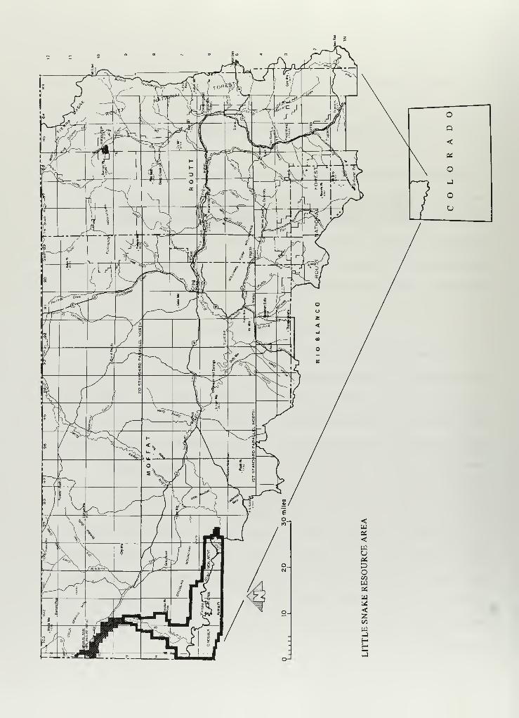
Location of Study Area
Land administered by the Little Snake Resource Area of the Bureau of
Land Management falls within three counties, which make up the northwestern
corner of Colorado: Moffat, Rio Blanco, and Routt (Map 1). The study area
is bounded on the north by Sweetwater and Carbon counties, Wyoming; on the
east by Jackson and Grand counties, Colorado; on the west by Dagget County,
Utah; and to the south by Rio Blanco and Garfield counties, Colorado.
Physiography
The study area covers a region of considerable landform diversity (see
photos 1 through 5). It is included within three recognized physiographic
provinces of the western United States: the Wyoming Basin, the Middle Rocky
Mountains, and the Southern Rocky Mountains. It is roughly centered in the
Wyoming Basin, which is surrounded by the Southern and Middle Rocky Mountain
provinces
.

U200py~-,"*.'•"*. v - . -
""iSfe-" *•'««;
glr-
• M "«, Sfo 4
»
*>..:
Photograph 1
Sagebrush and Pinyon Hills
*i£«s^?c •
:
W
?'<f
Photograph 2
Sagebrush and Rolling Hills

Photograph 3
Pinyon Juniper/Woodland
'*»«** iu >
PU :**
I
'•^^v-ayj *'."»*'' '** 'AfP 13^
Photograph 4
Oakbrush

\
.
?
ja^jPRgL,
*cBP
JWJB"'T j.' -^ «»»
mH&, <jk3^.
1
Photograph 5
Forests
The study area is bounded on the east by the Park Range; on the south by
the Axial Basin, Williams Forks, and Danforth Hills; on the west by the
Uintah Mountains; and on the north by the Washakie Basin.
Regionally, Northwestern Colorado and Southwestern Wyoming form a
topographic corridor connecting the Great Basin and the Great Plains (Mulloy
1954, J. Jennings 1957, and Aikens 1966). This natural corridor may contain
clues to the cultural subsystems influencing the spread of peoples and
cultural characteristics from core areas outward. Northwestern Colorado is
peripheral to, but contained within, the spheres of influence of three major
cultural areas: the Northwest Great Plains, the greater Southwest, and the
Great Basin. This region has been called the "Great Margin" (C. Jennings
1968), and distinct influences from each of these regions are reflected in
the diverse archaeological remains throughout this area.

The southern Rocky Mountain province divides northward into three
anticlinal uplifts at the Laramie, Medicine Bow, and Park ranges. There are
a series of craggy, strongly glaciated ridges, which include Mt. Zirkel
(12,000 ft), just south of the Wyoming border. Precambrian rocks form the
core of the Park Range, which in turn forms the eastern border of the study
area. Mesozoic and Paleozoic formations form hogbacks along the flanks and
dip under tertiary deposits that form a basin to the west of the study
area. North and south of this ridge the crests are accordant, and for the
most part the slopes are moderate.
The Continental Divide follows the crest of the Park Range. Headwaters
of the Yampa River, which flow north between the White River Plateau and the
Park Range and turn west at Steamboat Springs to become the primary drainage
for the LSRA, are located in that range. The Yampa River is fed by a number
of streams, including the Elkhead River and Trout, Fish, Watson, Oak, and
Soda creeks
.
The Wyoming Basin lies between the Middle and Southern Rocky Mountain
provinces and connects with, as well as resembles, the adjoining part of the
Colorado Plateau to the south. (For the purpose of discussion, the White
River arbitrarily marks the boundary between the two provinces.) The basin
also provides a corridor between the Great Plains and the Colorado Plateau.
The floor of this basin is a plateau with a maximum east/west dimension of
250 miles and a north/south dimension of approximately the same milage. The
altitude of the plateau surface, which is bordered by mountain slopes and
studded with isolated mountains, is generally between 6,500 to 7,500 feet.

That portion of the Wyoming Basin within Colorado is usually referred to
as the Sand Wash or Yampa Basin, which is a shallow structural basin
surrounded and confined by a number of minor uplifts. The basin trends
NW/SE and is bounded by the Park Range Uplift to the east, the Uintah
Mountains to the west, and the Williams Fork Mountains/Axial Basin Uplift to
the south. The northern extremity of the basin is broadly defined by the
Baggs Anticline. Drainage is generally westward to the Yampa River, which
is fed by Lay, Fortification, and Milk creeks, and the Williams Fork River.
The Yampa River is joined by the Little Snake River about 35 miles east of
the Utah line.
Sand Wash Basin contains volcanic areas at the west foot of the Park
Range, represented by the Elkhead Mountains. These are flat-topped remnants
of sedimentary rocks that are capped and protected by sheets of basalt.
They range from 2,000 to 3,000 feet, above the plains. Cedar Mountain,
northwest of Craig, is a volcanic remnant formed by a surface accumulation
of extruded lavas. Subsurface fissures filled with volcanic material are
often exposed during degradation (erosional) cycles. These erosional
remnants are locally preserved as dikes; one, Fortification Dike, is located
20 miles north of Craig.
The Sand Wash Basin, which was formed on Cretaceous and Tertiary
sedimentary rocks, displays a rough, deeply dissected surface. Alkali flats
are common in the basin, and eolian deposits or sand dunes of Holocene age
are located throughout the basin. Broad areas of small relief are
interrupted or separated by scarps and dissected cuestas. One such cuesta,
the Williams Fork Mountains, overlooks the anticlinal valley of the Williams
Fork River, which flows northwest from the White River Plateau into the
Yampa River.
9

The Axial Basin Uplift is a physiographic structure connecting the
Uintah Mountains of the Middle Rocky Mountain province with the White River
Plateau of the Southern Rocky Mountain province. It is an anticline with a
deeply eroded axis that forms a continuous and sharply outlined trough. The
Yampa River flows through the western half of the trough, and the eastern
half is crossed by several streams.
Two isolated mountains, Juniper Mountain (Yampa Peak) and Cross
(Junction) Mountain, are located along the floor of the trough. Both are
structurally similar to the Uintah Mountains and the White River Plateau.
The Yampa River cuts canyons through both of these uplifts.
The Danforth Hills, the southern boundary of the LSRA, are located
between the Axial Basin and the White River. These hills are a series of
folds that have been reduced to lowlands through erosion. This district,
which is intermediate in character between the mountain and plateau
provinces, structurally links the Southern Rocky Mountain province and the
Uintah Range (of the Middle Rocky Mountain province).
The Middle Rocky Mountain province, which borders the western portion of
the study area, is represented by the Uintah Range, the largest east-west
range in the United States and perhaps the Western Hemisphere. These
mountains are essentially a flat-topped anticlinal uplift of Precambrian
rocks that separates the Wyoming Basin from the Uintah Basin. The Green
River flows south across the Wyoming Basin to the Uintahs, then turns east
along Brown's Park, a structural valley containing Miocene-Pliocene
sediments. South flowing Vermillion Creek meets the Green River at the
eastern edge of the park. The Green River then enters the Uintah Mountains
and passes through them at Lodore Canyon. The Yampa River enters the Uintah
10

Range at its eastern end and traverses it lengthwise until it joins the
Green River in the midst of the mountains at Echo Park. Other tributaries
to the Green River include Rye Grass and Pot creeks. The Yampa Plateau is a
subordinate uplift to the south of the Uintahs. This uplift, as well as the
Vermillion Bluffs and Cold Springs Mountains (O-WT-YU-KUTS Plateau), are
included in the Uintah Range.
Physiographic changes in this area have been relatively minor over the
past 20,000 years, with the last geologic event involving the glaciation of
the Rocky Mountains and resultant fluvial deposition in the lower mountains
and the basin.
Geologic Stratigraphy
The project area is dominated by sedimentary rocks, ranging in age from
Pre-Cambrian through Tertiary. The oldest rocks exposed are Precambrian,
which can be found in the Uintah Mountains, at Juniper Mountain and Cross
Mountain, and along the Park Range. The stratigraphic sequence for this
area is described in Table 1.
Most of the materials used for the construction of chipped stone tools
are crypto-crystalline varieties of quartz, which are all of secondary
origin and are found occasionally among the primary and metamorphic rocks of
the mountains. Secondary varieties are the product of many profound
geochemical changes and are therefore confined largely to the oldest members
of the sedimentary rock series. They are erratic in their occurrences
within the limestones and sandstones on the flanks of mountain masses where
the sediments have been folded, tilted, and later exposed by erosion. The
entire area of gravels in northwestern Colorado and southern Wyoming are
11

sources of compact boulders of many grades of quartzite. Many of the
sandstone formations of the Rocky Mountain region contain "sheet" zones of
quartzite that could be easily secured by prehistoric peoples for
manufacturing artifacts that did not require refinement. The Lithology
column on Table 1 further describes potential toolstone source areas that
may have been attractive to prehistoric groups.
Volcanic outcrops are found in the Elkhead Mountains and are exposed in
dikes throughout the Sand Wash Basin. The main body of the Wasatch
Formation (early Eocene) , which intertongues to the west and north with the
Green River Formation (early and middle Eocene is exposed in the floor of
the basin) , was formed by sediments that were largely steam deposited in a
sub-tropical lowland environment. In the late-early Eocene, periodic
regional uplift caused local upwarps, blocking stream drainages. From this
event, lake basins were developed in parts of Wyoming and Colorado. One of
these basins, Lake Gosiute, has provided scientists with a sedimentary
record for the Green River Formation. Areas where sediments of the Wasatch
Formation and Green River Formation intertongue reflect alternating
transgressions and regressions of the shoreline of the lake in response to
the prevailing environmental conditions.
A thick pebble and boulder conglomerate is exposed above the Laney Shale
(member of the Green River Formation) west of the Little Snake River. Sears
and Bradley (1924) suggest that this conglomerate is equivalent to that at
the base of the Brown's Park Formation (Miocene). Quaternary deposits are
located in limited areas throughout the Sand Wash Basin, with Holocene
alluvium occurring along the drainage floodplains. As John P. Albanese
(1978) points out, Holocene terraces are of particular interest to
12

oo
cu
octos-
s-
3<_>
. ooo.O CDS- f—CJ X)+> TO
lo o
>>eno'ox:
>- 4->
1— •r-z _J=3Oo1—<u_u_ ono to
s: CDc
a: j*:o o
O
m to
Q.
a:
CO
CO
ooUJCJ3
S- C 00O ••- TO
a;ai cu s-
E > <cre •.-
Z +J »->
TO C$- r- <Ua> <u oE s- to
O O "Ou_ o <
O OO«- O•M CLto cd
o culu. E
to
oSi
CDcd
CD «/> !—CU c oo CD 4J to m to
+-> 1— •.- fmm oO ^: C a. E — 00i- TO TOO J- r— 4-> C7)T3 <T3 E <TJ CJ E(D CL «- .C 0) Q. to to C «J«a C CD *3 CD (O TO CD> E *4- O)^ CO M- r— «»- •t- cu <D E cu ^: >- i- .— CU CD•.- TO CD O -i- to r— o a ^ cu -M CU 1
—
+j +-> C3 t. Cor >- E oo S£Qr-T3 ^ • 1— 3^ D) •»— J- o S- OO +J <c
o >> S- 3 o x: OJ i— r— C sz 3 o M CD to a:CD -to CU r- DXDr o to U LU to *^r «o <D •r— CU Q. CD^ t. r— to c .o i_ CL <T3 c a: cu o s: J*t Q. E CD CD^iu aiT) i— S- O E "O cu CO •^ ^ +-> 4-> to <o rD o s- c s-c > c <o •-> i— •.- c T3 OJ c j^ 3 (O L. cu c oo CD o toCO ••- TO > c to I— to c -> -+J s_ O i«i S- .c CO << ,
—
CuC£ CD <a oo • WS (O -C CL CU •(-> « s ro
CD •> E o >> « « to JT Q. cr> •-> CU •- 00 cu <ui— C S- to x: -m x: .v oo CD<4- (D 00 3 i- CD 1
—
c: j_ oo +J x:-m ai a> O) m c o a» 5 3 c <*- +J OO » O Q' .c c -(-> CD CD i— 14- +j4-> (U > i- s- 3 i— a> to 1— o •f— c o c 1- > CD o -!-> CD > CD •i—
•r- i. •.- -M O O 3 i~ J- to 1
—
1
—
•^ C. +J sz •p— •1
—
1
—
• 1
—
J- -r- s- c_J CD OC OO ZUUUD »— <a o = o s: 4-> q: 3: <T3 _J OaoBTJ ,r"
• »« T3>,-o 1 a>TO CD o +->
i— •-> -o S- 00 ^ s_ cuo U i~ c cu O) <D u o EC O to "O +J c. o • A 00 o >,TO CD 00 oo •r— O) 3 i. |» C oo (O
E r— -C +J CU 3 r—"O O >>-0 c CD X S- > . #v oC OO i— CU 2 o • »— to oo to o0 00
TO CD o O -M +-> M E i— 4-> s_ 1
—
o00 ••> +J "O r— r— c 3 C CD 1- <o c
r— TO <D X> 1- cu to 00 O) CU H3 •r— (O« CD c_ J3 00 S- -^ 3 c E fl i
—
S-+j > a> a cu u o (O O) T3 3 OJ »->
i— TO "O T3 c -o JZ o c to C CD+-> t—••- i. o C ••- c o r— cu <*- J- f0 c T3 •ff—
CO CD E (O 3 TO O XI cnoM- CO fO E oo
i
-oCD TO
+-> S- CUM- S- x:•- 3 ^ CDr— U i
—
cCL O LU o3 O 1
—
o TO1- "O MCD CD +->
> S- x: to•^ CD ••-> TOCU »-> S- CU
4-> oCD TO c A-»-> O 00•— OO to cJC OJ +->
3 oe o s.
JC w uCDM- CD•r- 4- s-i— 3 jD
»->
« UOO "O •>-
fi a cf— i. TO CDTO O O 00O0 r- r— CTO O O CDjO U > -O
00 00
3 r-O —
CO
1
3 a>r— <ju TOc L.•" J-
CD« +JE oo3 2 -u
• »— o • I—
> 1
—
to
3 of— CD Q.t— c CUt •^ a
oo+->
oooa.CD-o
TO
OOV.
to3
OO
OQ 00O
CD Q.O CDTO "Oi-S- r-CD TO
SZ TOCD S-•— Ozc E
TO
o-
-aCD4JTO
>» -oi~ *r—
TO cu ooC "o c +Jt- oo cu •pa
cu c o OO+J o o oTO u r^— CL3 c o CDCD- =) zr. o
CD
aCr
CDCr
-oCD•->
TO-a
oo
oO
CD +J•> > 00
oo •-3 oo •>
O 3 oo
O •- 00
TO 00 00
U CD CDi— 3 J*O <— -r-•> CL-O
i- jD>3J3
CD-a to•r- +->
^~ •r—
to 00
-o oc O.TO CU_l -a
CDCCD<_) OOO »->O
00c oo 00o — ou (!) aC ^- CD
+->
CUlr—

ooi- cuo u
c00 to(O t.CU $-i- 3< ou
Os- cuo f—+> JO3 fOO 4->
o
oo
U-o
*UJIs
,_ oI—
I
ooto
CUco
GO
<a:h-oo
I—
I
oo_loLlJ
4- C 00O '<- «5
cu<u cu s-
E > <2 4-> +J
tO CJ- i— CUcu cu oE J- <o
o o -oLi- O «t
O 10<- o4-> CL<tj cuE QJ- \o cuJ- B
<0
oCLJ3
s >>CO
a;en
J- a><D *-> .c +->
Cn o« oo to P "C +->
c J* j* a; s_ <X3 3•r- S_ • a S <x> n- <D O<4- tO C o > o .^ q:= O. 4-> a: O) • r- J«i
2: •r— cn to i
—
coO CU c <TJ O^UJ s-
_C i- o i- c c <D.* »-> <0 1— c_> ai o . r, x:to o +-> Cn CU s- to +->
a> °>- ai <o ••— s- i. Q. c 3Q- o <_> u <T5 n3 o +-> o
«r— s_ O) c s: toc = * <+- O c a> a; >>O to 0) •i— JC CD fD ^ (->
4-> J* Cn-M 1_ E +j 3 +j on ci— O C s- (O o +-> c c 3<D O (O o cu S_ o <u •r— +J o
i
Cd u. c u_ -r->
1
O-t->
1
CDc
x:
4-
3i
c
s: o
<v
to •r— M (13 ^-r-1 JC jO +J•f— • <4- to 3 o +->
to J* o i
—
jd i- •f—
a> o o « a> N to >, to —1s- o M <u c 4-> S- #. to <v
s. -!-> • t— s- a> -o i. c a;o >> •r- <B <T3 c <u CD szJ- to (O jc i. 3 <D o 00 4->
(O > S- 2 CT> CT C7)T3 a> "OJC (TJ cn a> E <u M-
p— >> E CO •» JD O JO oJ^ »-> j*z 3 Z3 <V to 00U -M j= p— •»— O c to m 4->
(O C C7) «0 "O (U o o oo to to>— <C •f— x: <u o +J S- tO t— a>JO 4J _1 o E <T3 to (_) sz <*- 3
S- C3 Oto ooo. a>X c0) oc to•i- "OjC C4-> (O
00<o oai cu^ i-toc <*-
co o
i
+->
S-o toC 3(O O"
00 "Ocu air- S-
JO *+-
o ou
00en i-c a»•r- T3C i—•f- 3<o oM JD
I
QJTD
>> I
f >» EJ- r— t0Q> •— OJC to <DO O J-O Q.
a> ES- <u oactoto "O
a; a> a>M E >N r-^ ll
-a to
<D CUJQ i—
JOO JO•r- OJO CLNO S-<D <U
<TJ i—O- IT3
I
cn
cus- o .
<o •.-
ooCD i—C CUO <*-
00 T3o CC (OtO00 U
JC oT3 il c CU+-> <D o EC i
—
E CU• *— c <T3 s-
^) o +->
•r- O XCU ST <uJC oO+-> C c
o CL •r—
C7) Oc 00 JC to
o c to cr~ +-> •f— +->
< s: CQ s:
<4- OQ CO -r-
Q. CUS- -t->
O H-E -S4->
CU o«E a-o cuC 1-
I— J»^
O r—O -i-•r- EJ-tO oo>
CU i-+J CU
C • •!- (O 00 00<Q J^ JC E 3 ^'<- U -r-> O OS- O "i- M- CU Ojo J- 5 o c t-
N U+J
«3 CU cu
4->
00 cu o
JO —JO -MO ••> 00
•o O CU "-CU ••-> JC0«8'i-UC N 003 00 4->
O 1- i-o0S- CU <o
13 30)i— r- aci—3 O3 jo O oo
ooCM
oo
I
s-o
i-IOa.
OO Cc oJS -r-
O -MJ- toen E
oa. o.JO J3
Eo—encooa.o cuJC +J00 <a•^ s-
CO cu
cuccu<->
o
00o
cuccuooC31

>>>- en1— oz=> oo xc_> +->
•^1— _l<:Li_
Ll_Os.
ec-^ o 00
-c lJ- oo
CDc-ii
•r^ 2 (_)
ci to
o
CD <t-
•^ co
<a:h-t/>
oi—
i
CDO_1oUJCD
OO
s- cuo o
coo 13
re S-
OJ i-
s- 3< u<_>
Q.OOs_ CDu r—*J XI3 <T3o +->
O
s- x toO •- <T3
aicu a> i.
E > <Z +-> 4->
TO xs- i— a>cu cu uE i- re
O O "C?L_ o <t
o to*- oM CLre CUE D1- \o CU-i- E
«3
ore E
CUcn
c1 oCU -O -r-f S_ X -t-> 4-
to re re ore >>co e x3 ,— = S_ +J c
•— O 3 o •
TJ <0 CO <4- O • 1— cu
o C ore to !-> s-o re O CU s. 3re CO _J O X CU o Mi_ 4-> -t-> X o. "3
o c M cuf— s_ • -o = c. <4-
o CU E CU « «/> CUo +> •^ s. x E +-> 00to to s_ to i_ c: •r—
3: CU re cu re o cu xz 3mi-3t- u 4->
x O
o —X re X OO 10 4->
CU O (0 x-t->
~"
CU "O CO>,X x c••- CO 3s_ «+- xre o x ••-
E 5 •->
•i- -o o xs_ x x oD_ CU -^ U
cuX4->
cO -r-
cu +-> to3 reCOT? X)x cuo »-> re»-> <j x
•r- 4Jx s- rere »-> 3E to re3 cu ••-
j i-i
oOo+J
>» a. to AX 1 CU cu •>- c >>to cu CU re | X CD £= 1— C 1— re O 1
>r— c CU 4-) i
—
-o i •w— re +J c re re re s. +> rec o 4-> »r- • A • •r— OS C i- > E i o _J cu E >>•-> >> cn « u-cu *J •-- x: </> cu o re cu 3 S- 1 o X 4-> X 3 cu c cu a> o_
• CU 08 00 x 3 S- | c cu >, 4-> r— o re 4-> cu 00 a> 4->i c o c « c >> +J 3
to S- -o S >. O) 00 o c * cu cu C u- Ll_ •»— i— i
—
X re u •r— <4- O T3 •^ 4->
x cn cu 3 eg »-> >, to 4-> »f— cu S- c i—
i
o re cu tl- o •P - cu _i X <*-p-o X+J c E i- re O to s- r— cn o x: X <u O 3 o o S- X s- +-> 3 to 3 3«Bs: » o CU to CU i
—
i- -a +-> re 4-> +-> o Dl ••- -o »-> oo CU +> cu cu X» •- EX) 4-> l/l C 1- X o c oo X T3 to • •f— -(-> 00 cn cu -§* X X o $- «u-
re re to 3 o cu u cu re 3 00 c -o CU 3 re o - <-) CD 1— E -t-> o re "O CU <4-
+j s- -o O "•"> >> c i- </> U re c c oo tl- r- 4-> X i
—
•> CU cu cu E c X 3x o 3 a' to re <4- o cu re CU re o 00 re o o to cu X w E « • E cu +J re O 4->
•i—„ E CJ O r— l»- +-> a o
—
i
—
•> to +-> S- ~yi cu cu s- re cu cu cu > re * (->
33 re C 3 in c cu • •— cu oo cu • re i. i- +-> U CU 3 3 CU •*— c c cu to X>>-^ (4- re n- X) cu cu o >> 00 i— <+- cu cn CD c x cu 3 •r- i- •— cn cni— to — 3 .- a 3
CU re c i+- to <4- E > a re 00 re <4- E c i
—
o <J •!-> u o 3 re c c re oo E o re X oX j_ -^ 3 3 O •r- re cu s_ • 1— x: 3 •»— •r— •r— i- c u 1— o x o o X re re i. x: re s-+J O Q. •»-> oO +J 4-> 1
>— XI C3 t(- to jn 1
—
M- 4-> -M re •<- o CL to to |— 4-> to E i— £ w to _Cl
+cor>-co
iO
co
re
ES-oL_ cn
Xcu •—— E-^ ore >>x 3:tore x
+oo
C\JIo
toi-
cuXEcu
rei~cu>cuCO
co
co
re
EJ.o
cucnos-m
£££
cu> X••- ocn •-
*Jx recu Ecu s-5- Ocs Li-
en cn cn
cuxcuoo

<C CJL>
Q.OOi~ CDO i—«-> -O3 (OO -t-)
o
oo
oen^ o
-o U.
*cu1
2
•o crt
,_ o
enoo4->
to(S)
(D£
toi- cdo u
crco re
CO r;**?£ 1. c wi_ CD•^ CO O ••- re
CDi—r-
<U <D J_
E > <C
Q£ 2 4-> 4->I— re cCO s. .— ai
CD <D OO £ i- T31—
I
CDOi
o o xfu_ o <c
oUJCD
O 10r- o-M Q.re CDE Qi- \o a»J- E
ore E^ >>
oo
cuen
Eo 4-i. Ou- ai£ -£= •
C *-> 4J c»t— s- <DCO o o >re •-> c •i—
CD a:CO a;£ <0 cr> re
co -t-> c Q.<T3 C <T3 E3 — cc: re
ZZ> >--o -^C <D S- a;13 SZ (TJ -CCO »-> Q_ -t->
to-l-> <T5
"O W3c cd3 j-oo cM-«B (O
CO>>*->i— 10 c•i- re •-J- CD •
re .g en cE +*•- •r-
•r- j_ re toS- O J- rea. cucq
•r- CDre
og en
cd reco •>
+J toto a>-o »i-
c <_>
re reto M-
to a>3 s-
o oa> x:o to
o+J
0)+J c- 3i— o -oo s- co xi re
eg +J cd4- r-
to o re»-> co x:•- toto .
O CO 4-Q-"0 M-0) a> 3
CO
C CD i—o >> re+j re s-co — cdi— -Ms- i— rere a; r—E re
cn-t->o t— re-r- re CDC V.re ^: encn+->
o 5 o
orei- a>re ^=.c •->
u<u oS-re co
o+j «^c -•->
<L) CO!-> i.X <Da; »->
creE3 CO C-J c 5
<u •— o3 <u re s-cn.c +J £iE I— Co o **-
I— o o
<L> CD
i— <u re o•.- cr+>O O to to
•-> T3• l/l l/l C
a> •— 3i— 4-
i
>>re
i— •> to cu
i oo
UO<r
O.r- <U
<L) CO
3 a>cn"-C V.
o <u
reo to
re re <u<-> >>
CO re E
\— E +J co t>_
>>0 Or- •^r- J3 CO
re re s- "O T3ir re c cdUl Q IB J
"o recu -cS- CO
ooU CD•i- cJ- ore +j> co
otor-»
io
o•r- 4->
.C CO
3 -oc
oo reCO
cz
» >>o rei~ s_
.o en
oo CDC
« oCD +->
•-> COre cdJ- ECD ••-
E r-oi— s-cn oc co ••-
u E
CDr- cre ••-
JCco • •• CD
co c-o -o o
>, C CD 4->
re re ^a to •
en cd r- c s.c re re re
oo o o CO o.
c co ^ c3"or u aiO C 4-> -r- 5s_ re •- .c oCO CO S »-> r-
ooCOC\J
Ioo>
toCOS-
CD£1ECD
rei.CD>CDCO
re
ore
reCOre
CD
Erej- cre o_i ••-
= »->
reM Eco s-o oa. u.
co c••- o
re+j ei- s.
o o
o c» 5 »
CDCCDUOCD
'rea.

toS- <L>
O Ucto re<o i-
o> s-i. 3u
Os- a;u i—M JC
reo -t->
o
oo
<:
o
^ oS>LU
Is4_> LU
,_ ol-H
^^
CDoo
toto
a;cu
ocI—CO
oI—
I
cdo_loUlCD
i- c to
CDa> a> J-
E > <Ct0 -r-Z +J +J
S- i— (Dd; (D (_>
E i. re
E *- 23O O T3u_ o <c
O to<- o-t-> Qlre a>E Qi_ "V.o a>J- E
re
oCL.Qre ES >>
CO
4- toO +-> c
1
—
+-> -4-> enj= <u Z re >, CSJ •I—+J JD i- *<, res- t-> -o S_ re i— t-
o 2 00 <0 <D "O c_>c o 3 <D +-> c -^
i- "-^JC 13 3 a <4-
to i- j*i i
—
O CT> o oai T3 O •— CO -O c j_
,
—
c 4-> UJ •r— JC•— s- CD E E »->
E <T5 T3 O re 4-> o s-
i. +-> a> re >> z. o^ c <t> c -t-> 3 c•r— 2 JC 00 00
E +-> (-> o jc E CDo >> to s- 00 a> P i. r—S- re <TJ O ,
—
JC •r— o •r—
u_ _) a> c re +-> 3 Li- E
c •->
* CD .1-
»-> re i i— cO0 <D jc •>- .« c cre s- -> E -^ ai ••> n-a> re 3 i a> T3 to •t—
o >, a> >. c en>, en to +j s_ re ••-> -C <Dre •- cu ^ s: 4-> i._J <T3 C O) rs c
s- a> 2 j* E -O •r— •
s- c_> T3 (— re re to co Cre >> o S- <D re »->
a> jc re o t*- JC +-> CO s:C DII4Jo5 ^ c3 x: r- (U 1^ re
E O -t-> -M j* +J LU 00 re +JO J- to to s_ s- OJ •f— cj- jc re re re fc. X •r—
u_ »-> a. a> a. C +J CLct =D
D JC(1) 1 to 0) >,
»-> O. E •» — E re •—4- « a. 1 d ai 1 00 en
a> >, re a> •r— > f— to 1 J- 0} cto c: re to T3 •p— JC C <DS-
j- s- <D a> 00 >» O 4-> 00<4- 4-> cn>— re +J E 00 re O Q) u c jc re
00 re • 1— re i. 4J 1— •.- +-> a;0 •> JC « E en re 00 ••- i-00 c <u u 2 a> a> >>J= CJ •- S O0 re c j* c c •% O re to to c 0ai co 00 <_> X) O 4-> S- <u C W'r- s-
.0 +J •r- <u +J +-> CD cn cu C. O i. re>^ 00 (U JC c to 00 C ai c re "- (1) <u 2
c -o 4-> 1— +J •r— 0 0 • 1— *-> j^ •<- +J cn-o 4->
•I- -0 1— re re c c re •r— S- S- r— a> c s_ to.£ 3 •>- jc >, s- re re s- JC re re re i. -^ a> a>1- E 00 00 JO cr> 00 CO C71 35 Q E
+
O «4- > 2
LD CTi
a>>
o 00C 00re re
o1o
5^-^re oj- ••-
enjeMc (1)
2 •->
o •>-
s- JCCQ 2+J00reai
o olo or~. in
1 re00 r—00 cjo os- •--
cC t—re•-> -o00 <L)
•^ T300 X3<u ais- JC
00
<U 00 •!-,— -r- -tJ re
i. re
+-> en
re jc •-
c >> •
•r- JC "O 00+-> C T3
a> ••- re ojc 2 00 ja
»-> -o •fcr1"00 d) a> re-O T3 t—c -o re ure cu JC00 J3 to O0
>re 00 X3o s- a;
<u 1—to jc 1—E -m reC re oo <D<+- 2 ai
i-Q.+-> 33 •- +Jo rei- to a1
en re <4_
1 aii~ +j4)4-JC O+Jre to
I""JC
O JCo 2>>
c eno c
co
re
oLi-
re
re
J- s-
<D O> Li-
Oai
JC a>p tc ^~•— re re2 _l JC
CO-0 en(U c c r—CL-r- a>o. >,-,- a>re re +-> 4->
S >— re CO
+Jre
EJ-
oU-
a>ocre
CL>
^~to <u re1— c JCr- O CO•^- -!->^ 00 00
-O •r—
X c 2re O)
U_ CO _i
CL3OS-
CD
a> T3T3 ais- 0O) •r—
> >re •»—
00 X)OJ c:
S 3
00 >E
00
a>u
s- rea> +->
ai 0. CDen 0. i-<

to
O (_>
cto ro<o i-Q) S-S- 3< <_>
<_>
O-OOJ- CDU .—M J=>
<CO 4->
O
OO
<Li.LuO
OT3CD
toto
a>c
LU
,_ c_>
•^ CO
CO
OOO
i_ C toO •!- (O
CDdJ (U s.
E > <ro .,-
4-> 4->
<o CS- i— Q)(U <1J uI J- <o
lO O TJLu O <
o tor- O+-> Dl<a <uE oi. ^o cuj- E
oCLXlg EEI >>
CO
CDen<
+-> O • .
00 S- to >, to 00c o CD c c i
—
t-> 4- (T3 +-> i
—
s13 i—i to
CJ>
Os: m
4- J>4 Q c ±z j^O
o 4- o s: oto
CU o.* Ll_ O U_ QlLu s.i
—
to >> O ors <s> -ST a> 14- to ,
—
to u-jQ E
ro =5 # 3 3 E oo E<T3
c<T3
to f— E to to Q •— ST. • .— QE 1
—
,
—
o ,
—
+J ,
—
c 1
—
o i
—
CL-O i
—
3 r— oo •1— c • r— X C •r— O • r— cu_ s re HI LU fD 3W3 TO
oE • c oJ- to 5 ro CD 1 to ^TO en CD • -ii T3 -u CD4- c 4- ai to <T3 >> CD CD CD
r0 r— a X X X) 1 JD ^<; S- CDO JC -o <D ro CD X ^ i- 4-> CD CJ> CM t- c c JC X o ra to CD 1—
i
i
—
CD oa> CO o to C • i
—
a O 4-> •T— as S- 2 +->
jc > +-> ,
—
ro c to <D 4-> C 00 o t_> o 00Cn O c to >^ CO o -O •r— o 1— -a3 •f— T3 X3 O o E c >, #> +-> co -o JC c C U 0J E +J CD fO c CD a 3 XI <T3
c c 4-> T3 CO r: O c s. c i
—
c O c CO •
ai <c to to i
—
s_ u a> o en <T3 f0 <T3 i- f0 to•» <0 13 > !-> .c 1— -—
-
5-
ai to cd -i^ •» S. X to •r— 00 +-> c to CD .—
»
CD CDCn o 1
—
<_) to QJ fC to X3 ^ 3 C i- Dl to .os- > CO • i— T3 > -o a> 00 c CT> o a c n3 O f0 Ero <o jc JC 0) CD CD i- ro fD •*— s_ CD +-> CD -M .o CDi— o 00 4-> X to C£ ro s: to i
—
X) "U 00 C —
•
E
1 ^ i O J=«-> 4-> S_ E to to</» i— O fO ra 1— *r—
CD CD Lu CD CD <c s- <4-
? XI i~ 4J i—
i
O^ to ro CO+J oiE . en LU3 C fC CD o,- to c zO ••- •.- cn o en o •
CO T3 i— s_ C i— CO CDC r— ro !-> •r- ro CD S-
T3 CD «i- i— to 5- i— 3fO i- 3 CD Q.-0 • "- J3O 4-> c 5 CO CD c E toS- 1 CT) •— Ji to o CLJD T3 C +-> 4-> O >> $- O.
i. O T3 S- ro a. c 3 •-C Itli- C O o x ro O -Ci—< 3 to ro c: X) CD C_) Lu Q.
to
1 fO .—
.
'—
1
S- +->
+-> +-> to00 c CD03 CD 3CD o —
«^-- ^
—
+o o oo o oo r--. or_ t— CM
D.3Os-OCD-os-
CD><oto
CD
.—
,
i-+-> 4->
to Cro CDCD uO oO r-IT) co
os-CJ3
CD"Os-
CD>roooCD
a.3
j«: os- 4- j_
O O CDLu C CDWOOE — s-ro +J CD••- ro >^ E roi— S- to•r- O CD
3^
4-> CD<0 T3E J-s_ cuo >u_ ro
to00 CD Q.CD ^ 3
O,
—
<+- s_1—
i
O CJ3
CD »->
CZ. "roro S-
E CD>
>, CDro toJ-cn • *
CDJ* I—S- rorO £ZQ to
OOCOLO
OOCM^1-
C <4-
•^ OCD .E
ro J- •rowCO c co ens:s- cro "i- ror- E +•>
r- O C£j?5
CD
ro
CO
to
ou
CDCD
cc -(O+J toc>> CDM XIr— O
CD OC OO .—4->
CO J_"U CDc a.ro O.co 3
S- cCD •.-
4-> JCC +-> >> CO'•- 4-> 3
J= ro OCD 4-> i— $- •
i— -i- CL CD CDro 3 *- cJC 4- .r- OCO -a O f— -M
CD -p- 00>,T3 CO CO CD
E "O -O CO E••- CD CD O"-_l jD JD M-f—
+Ooro
00
O toa> oQ. oCL cro ro
ro
Es-oLu CD
ra roS- JCra COS-X) co o
E

COJ- CDo uc
CO it!
<TJ i-CD l_
S- 3<c o
ooS- CDo —»-> J33 <TJO +JO
oo
<Ll_O
S>LU
l ^jj UJc =
•^ CO
CO
C_)
oLlJ
co
c
5oo
S- C to
o ••- re(Li
CD CD i-
E > <Cre ..-
Z -M -l->
<TJ CV- ,— CDCD <D UE 4- re
o o "5*
l_ <_> <:
o coF- o4-> Q.<TJ CD
E Q1- \O CDJ- E
re
o
cd
<
reCDs-
re
re
coo
to
c4->
<TJ
E
+>re reQ. Oii>- re
CD4- +->
O CO
Q.+Jre re toen C71
J- $- CCD CD • *—
»-> > i.
«J •.- Q.3 Q£ CO
CD
oCD
I
CDco c
•>© 3 OT3 CD O »->
S- CO•r- cd -a(O <4_ Ci- 'I- <TJ
C7>i— toI '—CD to >,
•— c to e_C .,_ o M-I— <+- *4- i—
Oi
LO
01+J I
•r- 3 Ur- n C
CD >> COi— to '•-
re t- T3.c ento to^ i-
CD S_ CDc re .c•r- TJ +Js- reITS O CDS -t-> 5
OOCNJ
oen
>>re •
i- toen 3o
>> CDi- (JCD ••-
> i—
•— 00to
CD "O> i-•i- (TS
+-> 3:
•> CDc co
$ l-O <0S- On oi
-C oto +>
'5 EO 3^ T3CD CD>- E
LO
Io
i
reco >>.o I—S- i—ITS <DO CJO
» r—"OCD «
c co•f- 3ro OS_ CDCT> U
»->
C CDCD Ci— O
#. COo -o•- c•r- CO
N4-> S_s- <o<0 e—3 3cr u
i. CDCD •->
5 «5O 5-•— «o
O.O CDC CO
MJ- COCD !->
a. i-Q. ITS
3 O.
(O 3s- EC7)
I T3.C CDCO 4->
•r- <T3
C CDCD CDCD -S. i-
O) re '
> CD^ £=J- -a o(O c 4->
X3 ITS CO
co
o
enco
ITS
I CD•i- Cs- o(T5 !->
> CO-M
T3 >—CD -^"O COoCD "Oja cdt. $-
CD O4-> f—c oH-l O
COc
ITS
CD
a> <d•i- ct— o
•> COCD T3C CO <T5
+J CO OCO
>, >> CDre re Ei— s- ou cni/i
iMre
co re
CD o+J ••-
re +->
J- cCD CDE .-o>— -oen cdc s-
O CD
Q.O+->
s_re s-r- re3 CDo coC CD
1=4- OO +->
COCO CD-a &CD 1-J2 r—
I
T3creCO
-oCD-o•oCD
J3i.CD
OO00
o
CD
O-!->
to
CD "Cr— cre reJZ COco
rec +->
o oto ^3 re
oC\J
Io
»4-
OCDUcreoc3CO
s-
CDQ.Ol
CTi
CDCo4->
COX3Creco
j-
CD•- i.
C ^3o Ei. CDu_ s:
s.CD
ECD
CD
re
CO
o
oMCO-ocreco
re+Joj^reo
CO3OCDCJ
l. reCD -M3 CDo s-_l o
re
oCO
zJ-o
oE""3
CD O•> U CD
E E E"3 -3 "3
COCOre
5re
4->
i-3O

to
S- CDO <_>
eto ta«o s-CD s-S- 3*c u
uQ.OOS- co<_> .—P X!
tao po
>>>- CD
o1—zzZ=>o
o
o1— —I
<u_Li_OzQ£ (/I_ O to
•a Li- CD<u . .
c= tH ^<=^ <_)
I a,
CDCO
CO
OCDOOLUC3
s_ c coo •- <c
COCO CO s-
E > t.ta ••-
2 4J4Jta c
J- i— COco co oE i- tas- s- •<->
o o -o
O tor- OP Q.ta co
E Qi- >s.
O COj- E
ta
*%
coen<:
c
+-> CO
Ps- s:COQ. <TJ
•i- Pc c-D =3
P T3<o cO 3-Q oE C£
(O <op CO $_c p ta
=3CO
<4-
CO
C o to•r- CD
• JC c •
>) W p •r- tOi— c S- s- cc +-> o Q-4->o s z co s:
CO
«4-
1 <4- CO i
. #\ > O 3 E to E 1 1 1 c Scu •i-r o w P £l 1 O i 2 -* » 3 o o o o 4-> C CO oc •— CO t- 3 1 •!- CO -o 1 CO i- >> 10 •-> o ••- CO c .E ••- > I—o O •— P O CO o — 3 P <+- (O +J 1 Ql 3 P c ta en ta J- 1—+-> C •.- S_ G "O • ••- E S- E ^- »-> >> • >> <T3 •— o •— CO 4J CO CO
•» 00 >, CO C CO •i- CO >> to . CO tJ — r~ en c (O i— r- 4-> CD r— en c *-> >>0) CO I— CD O 4- <4- c ta p C -C ^ CO -r- •f— i- en o to c c o c1— E P S- O »i- •i- c w c 3 O CO u (/) co en en o CO o om u •— T3ta c en 3 i— •> <o en ta co o c •— •» E — 1 c E -M CO i. C-C r— (O <0 ••- co s- .c E s_ < o .c • CO X3 o s- ^: co "o •r— to "O O CO t— (O00 C -Or- W c cn+J co JD tsl P CO c c to O to co c: 1— TD o c re
u ••- c en to O J= >, u to o <o •^ s- <a C CO o o O T3* •f— E ta o P E en,— s_ . CO oo ta +J .- CO $ en CD fO X5 4-» •»-> O CO
<D M O «M- to 3 -i- i— CO o CO — CO JQ to CO CO c O 1 u c 00 CO CO i— S-C •r- "O >> >i o •>- i— ta 3 C .O JC T3 .— C «r- i— CO •.- <w— CO >>T3o r— CO «3 <0 T3 CT3 CJ O -o 0£U CO C A3 o t. .— — -i-> S- •a o « c cn en4-> o S- S- s. c ta co o o co CO p co c _c fO ^ 4-> (O co <o «- ta c S~ S. (O c c00 o o. en en ns CO E P —1 o S_ to a...- »-> CO 00 oo E >- Q. C E <T3 o en w •^- -r-
I
ES-o cM- s-
COClx:E +->
3 i-»-> OCO C
en oc•i- c •
E O J=o ••- ta
3 <a =d
o<r>
i
CMC\J
co •
•.- ••->
+J to<o ta
E coJ- -EO 4->
Ll. S_
oCO cuC CO
-a -pc3 OCO P
OPCOcopco-octa pco to
COco sto .c3 PCO S-S- OD. C
LT>CNJ
r—1oEta*->
c =D(T3
CO C•^-
<4-
O CL3P O
S- t-
(O oQ.
^—r— <D<a T3to M-T3 «3CQ CU
oCM
S- CO3 EO i-
«SO <_)p
T3P CC fOCOi— (D<C T3> ta•r- S_3 Pcr c
oCM
-o
J-pCO
ta<_>
copta
COCJc<o-o
3CO
co
E"-3

i- 3oo
oi- ©O .—+-> jn3 reo -t->
o
oo
<u_o
>>CDOoJC•M
LI LJU
,_
•^ 00
<I—co
oUJCD
00S- ©O (J
cto fOITS S-© S-
toto© «*e
|
s- c 00O «r- «J
©OJ Oi i_
E > <M +J
s- •— ©© © oE i- T3
S- %. -r^O O "OL_ (_) <C
O CO"- o*-> a.ITS ©E ai_ \O O)J- E
OO.J32 E
00
©en
enco<o •
c... o
4-> ITS
2: <_>
ITS jc+j </>
c ••-— s-
enc
ITS
c•
CO >>c c••-> <T3S«s JC*-> 00
•.- $-
• ©to c
1 1 cO £ u X3 4J •»->
+-> en C s 001 •r- >> ITS •-)
• © JC ITS -M to JC r—to c •0 s_ c <o •r—-0 • 1— <!)•». en its cn+J 00© tl-
•r- a>«s "a
c c c 0©ai to E E =>
© CD j_ -0 O O S- 0c c en a> © J- c "O
.0 .0 Q. <4- T- (1)4-> +J E 1 1 JO00 CO 3 J* CO tj- a) si4-> -a 1- O to • *«- c air— c O ••- O TJ •I- +J• f— <o O) JC J- © 1— •-> cto CO E »-> u s- to 1—
1
o
US 00s- a>
© "o(U E 3.— O .—CT5 r— O-C o c
B« o ••>
a» o a>c co >, ©4-> — +J00 r- 00>> «J "Oro U C1— O UJO 1— 00
s- to s_ 00<T5 en <a en© 0 14- c © <4- cc
<T3
•>-
i.C X3
c•^•
>, JZ CL >, <o JC 0.JiJ »-> CO +J CO
c A3 i. "c J>£ s-
© +J <a©
•»->
c <o+-> O -•-> a.e©
CO -"1 sO) 00 :*-§
00 C J- <a 00 c J- to© J= (O © © JZ ITS ©S- <n ,— »-> S- (T3 T— 4-»
a. "XL CJ to a. 3r C_) CO
(1) , © >»> OJ « 1 c s-•i— c >,+j-o 1 »r— <o ©-M •«(d 3TJ © M- -O c JC cU 4-> OJ S- jD <1> E © JC 00 ©C CO 4J Ol S- >, -O 00 «r- •^ c +J
• f— 0 (O * 1
—
VO •^ 4-> — 004-> 3 J- - J OO © © 1— © Q-4-> >>to E a> -0 © ••- © > .O Q. S- J- 00 J?•?—
1 E © t— E S- O 3 •-> r—"CO O © s- — s- O c C 3 C D-i—
c r- © O CO 5 •»— Q. O •p—
M- T3 en-© >,— O JZ O O 00 >,O 1 c © . ^ S- +J • * 4-> JO
OJ © s- -© c j9 © © >,00 c u O C 5 1 »* C C 0 -a c-O — 19 r— O JC 0 O O © c r»<
<D -!-> © ^ s- • 00 © 4-> 4-> i. <a (Oj=i CO 1— <J C «B JD © •r— c 00 to . 00 r—
(-> j3 -^ ai s- 1 c O •r— © © 00 © J-
5 (
—
j3 i- © © J= © <T3 c E -0 r— T3 ©<u •r- a> <T3 i~ > CO +J © S- fO "i- © <c © ><+- CO cl > en M- 00 a: en 00 1— jQ a. s- O
© ©c c4-> +J00 000 ©c c<o <oCO CO
O 4->
JC ©«c en> enITS 3z z
-0cITS
CO
e>>cus
©c c©r— •»->
CJ5 00
enL4->
"-3
O•^0000<ai- S-
3 © O-3 Q- •r—
Q. COS- => CO
© ITS
3 -O •r—
c t.
_J ITS 1—
IT)
I
c co o
ITS A3
E c Efc o Co f- ©U. +J Lu
<o© E S-•r- C ©OOPo E enCl— 3o © jca. -d o
8o
CO
Io
oLU
©
J- »-> S_ 4->
(O 3 IO 3O. O CL O
00 00O O••-> +> O
+-> +->
»-> •Mc © • C © •
© 1— •»-> © 1— ->i— c 00 1— c CO
ITS •- © »o ••- ©> JC 9 > JZ 21- '<-
3 T3 3 •0cru- C 0"<4- cLU © « LU O ITS
©c4-> 0000 en-a cC •!-
ITS S- © cco a. •^ O
CO *—
^
ov---> S- < -M© r- © <ocni— JO O Een © E ©. i-3 CO ©z ^ s: a. u.
CM
O
o00
J- 00© ITS
Q.T-O. S~

toS- CDo o
cCO rara s-CD S-S- 3< cjo
Q.OOS. CDo —3 rt3O +JO
ocj
<:
Li.Oa:
^-~ o-O U.
Is
,_ cj
2: cd^ CO
<I—co
cj•—
t
CDo—JoLlJ
CD
ootocdc-^cj
oosz
s_ c too •.- <o
(Li
cd cd s-
E > <<o •.-
z +-> »->
ra cS- r- <l)
CD CD (JE S- «3
O O "OU- CJ <
4->
o to>r- O-M Q.<T3 a>E Oi- "^o cdLc E
«3
OCL.O
co
CDen<
CD
>, <o
ioen
O -r-c.
SZ Q.4-> CO
c -^ S-
o 03 o +->
CD c (O4-> a. ocd 00 -i£ i00 c S- raCD .cr 03 CDS. n3 i— +->
Q. =C CJ CO
"O #
<D o -oC CD o CD•r- S- c X)"3 1 <T3 oS_ SZ CDCD to C -Q
1 •r— 3CD >> o CDC ns S- >*.— C -O • i—
M- CD to
.rr. ooA A oo «3
CD to •t— EC 3 oo O a . A+-> CD CD 01en O S- r—-o <c Q.c <_) "O S-rt3 •r— c 3CO E IT5 a.
ooIo
oo
c<a
3o
oCD T3s_ c
<aoc CD<o —
rac .cCD to
CDs_ -Oi CDi c
x: oto +->•- to>>-•->ra i—S- -^CD to
OO00
O00
4->
to +->
CD (T3
2 M- +Jx: H- +J4-> O 3i. s: O .
o CC toc
O cc c. s•r— S- >^ CD >>
CD +J ^: -u <T3
>, c c +j c +Ji- 3 3 3 C
c o o O O •i—o u CJ CO CJ rrj
CD , CDC CD £= i
o.,E A O o "D •«
+-> v to +> c cd a>to IO i
—
CD T3 to ^3 S- ,—+-> 3 i
—
CD +J to ra1
—
O *4- <o J3 r^ -a sz• 1— i- O ^: •I— CD c to00 CD
<*- toto CD
Cto E
o -oa •r- -O >, o >, to S cCD to CD T3 -M • ra O «3C CL.O C to >> i- . * i—•f—
C^ C<o X3 CO D1 CD <— CD
T3 to c i. »^ CD CS- • 1— <t! C7) o K3 >> ocn >>-C • »» 00 cr ^: • *->
i .— +J CD CD M <a 00 CD •> toCD +J C r— C sz c >>+JC s- 3 o fO i— KJi •o -o O <a i—
• r— ra CD +J .c xz •r— CD c +J s- «^-
H- Q-<4- to CO +JI
—
en ns to CD to
CDc •
CD O *->
C +J s_
O to CD4-> -o JZto c oCD fOE ui "•- CD— •"+->
CD (Oo -M ^:CD •— CLO E coo o oCD i— SZJZ\ O Q-
i -oC CD— -O E^ c o
co
<C CDCJ >
to >,CCC i—+-> i— (O2 io a— EfO <J f0+J CD >-C Q.•I- 1/1 <t-D !D O
CDC CD•^ I 4J<a jkj •>-
s- u ^cn-r- 3
I SZ<D *-> OC +J
c> "O >,CD <T3
C CD «-o jn ««*-+J I "O 3tO tO (1) oO WDO "O -oS- CD
c<oCO CJ ^3 CO
•-> ^rs- +J(O 3Q. O
10
o4-> O
+J+Jc: cd •
CD — +Jr— c tofO -r- CD> SZ 3•i- CJ3 -ocr4- cUJ o fO
+Jc<D CDr— C7>«0 T3> ••-
•r- i.3 CD •
cr CCD <D o
+-> • .—
>> «3 M,— +J fO+J CO Es. c(O o oQ. 4-> U_
oO o <T>o o CMCO
1
Lf> oo O
co
in
CD a <ai— c Era 13 i.
> O•»— •*— Li_3 a. <acr o >> •^ cCD -^ +J 5- O
c •t— C -r-
>> CD CJ O !->
o x: fa+J 2 J^ Q- Ei. S- CO i-
« o ra sz oQ. +-> a. O- u_
+ooo•"7
ocooS- 4- Cra O os: • f—
+-> -Mo S- ITS
+J ro EQ. s_
+J oc 1. Li_
CD CDr— Q. cns Q. s_
> 3 3•f— +->
3 "O ccr c • 1—
LJJ T3 2:
CNJ
CNJ
ra
oLl_
CD•"3
C••- OO.T-O -M-^ <oc ECD i-
O O
CDcnTO
c •^ c >> c>1 o s- o •M O-o — CO -r- •i— »r™
O -»J 4-> CJ •->
o <o CD ra ra
3 E •-> E ^ Ec s- «3 5- J- s-•f- o M O ro Oo u_ CO U_
Pp
P
TrPcp
F
toCO
CD3o
cra
u'i••- t.10 CDto a.«3•i- t3$- Ct— «3
Es-
CDQ.
CDCo+->
tooc«3CO
s-CD
CD
3D.
3 -
cra
-a •--
c cra ra
>C r—re >,•^ to
E cJ- cCD CDa. a.

00S- CDO (J
cCO 03fO S-
<D i-J- 3«c u
oQ.OOS- CDo r—-l-> J33 <T3O 4->
O
>-
oo
oz^ o
•^ co
co
CDOOLUCD
CDOOsz
0000
c
o
S- c: too -f- to
o>QJ <L S-
E > <(O •.-
2 4-> +J
s_ •— a>CD CD OE S. ffl
i. i. -r-,
O O "OLU O <C
O 00«- O+-> CLto a»E Qj- \o a>-i- E
to
o0-.0.(O E
o>
3oce:
ci.<U >>.c -»->
+-> cO OCO O
ai CO to 4J 4-> o00 »-> S- c en <a c M- 4-> •
to >, to a> 00 tO c c -u> c •i- 3 >» <D CO COo >— sz *-> SZ if- O ^r OJ ^ O r— 00 00 cs- <— -o 5 3 -4-> <U -t-> i^ Cl • cu CLQ£ -O to o 4->o <o <u O *-> to 4-> o •• <o C S- CO ZD .a S- s:
•i- Q. •* O) •— 3 3 C0|— CO +J 4-> CD c: C CO CJl
-o o o C S- J- 3 O O c C C s: o S^ S- CO cj_ +-> S-c o r— 4-> DOO s. az o s_ +J -.- c >> OJ <D o o <o -(-> a>tO Ol d) S > E a> i— to s: is oo •r- c > ^ CL (O Q.
to > •i— • M- c to <v 00 to •^ +J 4-> cu •r—
s- a> a> s. CC SZ •-> •r- s_ c s- c O 00 (J q; 3 «M- +J c ca> "o (1) C0<4- r— a> >> CO i. i- c o >» •f— o 3CL - Q. H3 3 •f— sz (-> ^ Q. CD CJ> s- s- O) CO +-> o E 00 •~3
•r- t0 r— •r- Q- O O to -*-> C QJ •f- -l-> CO cu t-> C CO o •f—
C C i— C E S- O CO 3 3 CD C CO -o > > •r- T3 3 1 r— o o3 (-> OJ 3 fliO O O o t- 3 rtJ c (T3 •1— ^r c O O o (O CTSJ rs >-+>,— «- CO O O r-3 LU to <_) Ol 3 flOM-OS <o
c3 -
o <us- cjQ O
+->o toc: -o<a c
<o3 to
or— *
r— O)0) C^2
•> COO T3a> 3a: E
CD4->
tOS-
E c coO(0"0I— <l)D)E£C 3O to CDO o. cO W+Jc coto CD CD
E E« O f-
0» CO r—COo sz cJ^ 4-> -r-
S- -r- £1
3Os-
CD
I s_
i. (OO r—P 3c -o
00 -r- Oc
a>
o a>4-> s_
•i- 00r— QJ JZ— E •->
CO •!- -t-
C0 r— SO»4- >>-0
4-> CD
>> i" S<TJ <U "O$- -C <DCD O J3
CD <*-
OCO i—M (Oc ^:3 tOoE ctO CD
CJ- d)<4- $- S-3 a> oi.a to
00 T3- CD C
4-> r— toi.CD T3 -O-C C <D
O <T3 S-
>, CO •v
1 CD CD c o <u a>s- c »-> 00 (Q •- c 4->
IT3 o •f— 3 E ••-> o QJ .^-
•« Q; 4-> E O 4-> E NH- CD 4-> CO o s_ to > CO O +->
O 4-> «^ Co- CD f— o <o <u a; CO S-
rtJ N O E o D. sz o E (O00 S- +J o •> 3"O <D C. 00 — • .«-o f— O O"CD E (O -o o J* to a> CO »f—
JZ O 3 CD o c s. 3 i— c -o l-> «r- a-jz- c to (D O r— if— c .^ a>
i- CO <T3 •o c -^ E (O f— r—to C "O <U CD i. t)_ E O tO
,— O c E a> c o (U o CD O JC3 U fl O 4-> o -t-> > CD <4- +J COa CO •r— +J (O 4-> •r— >>*f— o a; E CO +J O •!- Cv. E r—^ CM ••- i— sz o <u j: O to- o ••-> Q)C to to +-> r— E O>"0 r— f— r— S- OJCD O ^ - o •r- C (O r>— o (TJ i._J -^ oo 3 T3 _! i
—
tO O o Q CL O
O oO 00o CM
1o oo B+-> OM to +JC i- o <aai aj E Er— JZt c.
tO CD O o> 3 P LL.•r—
3 -O M Ccr c: c C S_CD to O d) 3
•r- i— +->
>> c +-> «3 Ci— to to > •—+-> CO e= •f— 7^s_ c. S- 3to O O 0-4-a. s: LU LU O
c= cO o
oooIo
toO)i.
o
oo+LOCMCM
<T3
OLU
Ooto
to
ctoo>5-
o
ai oto »->
> <o
3 s_cr o
+J
EJ-
oLU
c:s-3+Jc
1
-oC
T3
O) • CO_J ai c
c oo o •f—+-> +-> +J
00 *o»-> CD Ec E J-a> •r- or— r^ Lu(O> Ol S_ .
•»— r^ a> -c:3 i J= <T3
o- • i— 4-> •->
UJ > o =3
COCM
co4->
CO<u
E
coCO
oto
CL3oi.
CD
a>a>CO-
LLIa
c<a
c:<o>
ccCDCX.
c
CLCL
COCO
COCO
O>CDQ

00
O Oc
00 03«o S-<U i-S- 3< oo
D.OOi. <DO p—M J3_ 03O +JO
oo
o
Isj_j UJ
I—
I
^?It CD•^ go
—II—<cm\-CO
oP-H
COo_loUJCO
CO
O)c\^u
S. C l/l
o •.- 03O)
<U d) s-
E > <:03 •.-
Z 4-> +->
03 ct. — 0)<D <D OE s. mS- S- -r-)
O O T3U_ O <
•4->
C T-O 00r- O+J Q.tO <DE Q$- \O OJJ- E
03
o03 Es >>
CO
<Den
r-> 4->+-> •-> +-> +J cr> l->
M- 3 4- 3 c 14-
•i- O •r- O • !— p—p— o£ — CC J*£ ^ oQ. a. •-> O .„ Ql 00 c -*•
C5 -l-> ZD +-> 4-> O Jsi CD c <o &.1/) 00 3 r— <D +J oo <o
S- 03 s- <o o i. <U i- s oo c: o.Oi <D O) <D q: O) i- a» 00 4->
> JC > JC > o > JC O S OJ•r- 4-> •r- !-> c o •r- <o S- JCd: 3 en 3 S- 00 Q£ +J o s- »->
o >> o >, (U >, <0 c 01<L> 00 4-> a> oo 4-> JC •M C <U •^ - Q. 00 ai4-> c 4-> c +J c tO !-> C3 10 T- E en•p- -o 3 •- "O n Z3 3 Q--r- (U C s_ cJC c o -C c o o O O JC C i. 3 o 033 <0 o 3 tO CJ) WOH3 t—
i
tO "T) LU OH
a; •>T3 m+j >, <D 00 1 01 •» ooo -c 13 03 T3 <v o M ^-> O) >> 00 1
0) a> c s- -o -(-> a> S. 1 «3 c 1 4-> •r- 03T3 -o a; CD tU • »— j=> <o a •> JC o $- — a> •*->
-o • •> T3 E J2 E 3 c OJ 00 p (O ••- c OJen at <v o JC 1 o c cr 03 +J 00 00 O en EJO -M JO r— 00 -4-> 1
—
•r— OO •r- T3 a >> <1) •p-
1 •r— i. CD • p- 03 o JC <D o N C c r- a> ^~ M- •> i-c E <D C C i— •a (-> at M +-> <a (O m E to 03 oo 0)•p- o -!-> o <U S «•- <D T3 <u s- 00 4- O JC 5^ J^ JCJC r— c o r— o -o . #v JC T3 c <a oj to 00 OO O -M 00+-> o • r— «o s- •« c <X) «/> 01 O 3 -t-> o CL o O O J*o Q) X J3 -O <T3 +-> ja l-» cr-^ 0) JC -o c J- oCj- 4- p— d <U (O >, 00 E CL •>+J a> 03 T3 oi— 00 r- jO «T3 <D s- <o >>"o T3 O o. ai — o O) c s-03 3 03 jo >> 0) T3 C OJ V. c C i— o 4-> 5 TS (J > 03JC O JC <d E 4-> O) o E C7» T <T3 to o +j >— <u •r— •f— o
a> Q. •i- jO +-> o 1 <o 00 •a N •> jO +J 00 -t-> •r-
s- u s- 1 r— E 1 00 p> c 1—
i
0) ai 4J O S- •r— 3 00 J=Q> T- ai M O C <u C7> OJ 3 a> c <u M S- — 0) c S- — Q.CLi— 5 to -a r— "r- E c tv CD+J o E •f— f0 00 !-> 03 +-> JC S-CL— o i
—
c O JC o i. a> • r— !-> O JC 3 O c &. c o o=3 00 <4- <0 Q 4J u en Of
+ 1
N 00 00 3
+1
CT^J CO
oo
c03
•r- O0 E
in VO o o ooLO O o o 3i
—
^~ *fr «* OIo
co
03
O+J
03
4->
03
OS_0)00•->
oo
c Mo •r—•r— NM l->
«3 S-
g033
O o-Ll.
JCa> os- +JoT3
03
O 03_J CO
ai+-> C•^ oN •p—
4-> r-»S- 03033 1!o-
JC
ou.
X3u a> a>-M s- E03 o 03
3 T3 c03 O cCO —1 C3
^1-
CVJ
ooUJ
>oai-o
03
Z.
-i03O
uj cnQ. >-
C03p—
i03Oai
Cv

oo
U-o
*— oa Lj-
*UJ
Xj UJ
§i
•^ 00
<00
OCDooU)CD
on(/I
OJc
o
00s- O)O <J
to rere S-
O) S-i- 3<c o
oQ.OOu , 1
+-> JO o 1
3 re +J 1 •»— >>O 4-> 1 O N -O JC ooO a) r— +> ai >> w c <UZ c en t i. 00 o i ai c
•f— C re r— -O •r— e re +* o<*- o 3 -o re -o E -!-> -p- N
u ac .« o a> <v o <D i—-a re a» ••- t. c o E O +*tu "O >> r— Q. o £1 00s- <u — <u re >»j»£ -»-> A c E —C 4-> C X -P t- to T3 di re x-o •r- s. o oo re o a> TJ <D o<LI re re 4-> .^o c a a> S- •> 00
>> -a S- Q. 00 c u re o TJ CO (UCT1 -a CD "O <D >r- to oo <D "O 4-> reO O 1 o c ai +-> t- X) QJ O -r- (J
xi a> •!- re S~ -r- <U . m X) C IM •-O S- to +-> oo O-M JC C J* 00 re +J EX <L> s- re re +-> 2 u 00 &.•t-> 4-> re i- o o E re o '1— o -o re oor— C O <U "i- c a) a; S. x &. qj 3 c_J — u E -»-> re x 2t XI t-> o o: cr re
J- c ooo — re
<ua> a> s-
E > <:re •.-z »-> 4-J
re cJ- i— a><u a> uE s- <oi. i. -oo o -oLi_ O <
O oo«- ore a>E at. ^o a>Li. E
re
oa. .are ES >,
oo
0Jen<
ore re+J ooc to c
•r- 00 +->DOSS-
C <_> i-S- <1J
<U - Q.+J OO •!-
to c cre +J 3uj z: >-3
(U XS- Cf>
<U .^X XS
c r—S- •» r-™
ai oo rep c00 +-> 00
c: re s: e•^ <u i.X re o 00
>»t» +j 4- ^i— i. c rec o •r- +J <DO E =) '- CL
oooft
ooo
inCNJ
o$-
C3
re4->
c
Ni.re3cy
-*:
(U<uS-oaa;
3UJ 3O. >-

archaeologists because archaeological sites are commonly found on terrace
surfaces or within terrace sediments. Attempts have been made to use
terraces for relative dating of archaeological sites, and the identification
and correlation of these terraces have been conducted over parts of Wyoming
(Leopold and Miller 1954) and Colorado (Scott 1965). Based on these
studies, the terraces and their associated sediments have been used as time
equivalents and correlated over large areas. But, much of this early work
was done without the benefit of radiocarbon dates (Albanese 1978). It has
become apparent that in many cases Holocene terraces and associated terrace
alluvium are not time equivalent over large areas or even, in some cases,
within a local drainage base (Albanese 1978) . Many of these Holocene
terrace surfaces may be evolutional surfaces rather than depositional
features, and archaeological sites enclosed in these sediments on a given
terrace may vary considerably in age over short lateral distances. Even
though the terrace sequence and geomorphic appearance seem to be the same,
Holocene terraces in different drainage basins may be of different ages.
Until the Holecene alluvial stratigraphic sequence is further defined and
supported by radiometric data, caution must be employed when using terrace
sequences to date archaeological sites.
Eolian deposits of Holocene age are located throughout the basin in some
areas as sand dunes. Evidence for the use of parabolic sand dunes for bison
traps during the Paleo-Indian period at the Casper site has been presented
by Frison (1978). Sand dunes are common to several areas in the LSRA.
These dunes are stabilized and controlled by vegetation, but they
occasionally demonstrate areas of active sand movement. Short periods
without rain can bring about some sand movement. There probably has been
26

more than one sand movement in the area during the Holocene. Sites in sand
dunes are subjected to deferential erosion and, once exposed, rapid
deterioration of perishable material occurs, leaving the only evidence for
site occupation, stone artifacts, no longer in their original contexts.
Relating cultural levels in areas of deflation is difficult because
stratigraphic layers are seldom maintained during sand movement.
Conversely, sites in sand dunes may also be buried up to great depths and
stand little chance of exposure, except in accidental circumstances—such as
pipeline construction.
Climate
For the most part, the study area is situated in the western Colorado
semiarid steppe. The climate is highland continental, typical of the
mid-latitudes, with winds prevailing from the west. The protective
topography of the Sierra Nevada Mountains to the west and the Rocky
Mountains to the east greatly modifies the climate from those
characteristics that are typical of the mid-latitudes. Because the area is
located thousands of miles away from any major sources of moisture,
precipitation is generally light in the lower elevations because large
amounts of moisture are drawn off the air masses as they cross the Sierra
Nevadas to the west. Moist air from the Gulf of Mexico is blocked by the
Rocky Mountains.
It is difficult to generalize the climate of Routt and Moffat counties
as a whole because of local topographic changes. The rugged topography and
varied elevation of western Colorado causes large variations in climate
within short distances. Precipitation in the region increases as the
27

elevation increases from the western part of Colorado to the eastern
mountain ranges of the Continental Divide. Average precipitation data show
an increase of 7.6 inches from Hayden (elevation 6,375 ft.) to Steamboat
Springs (elevation 6,770 ft.), an elevation increase of 395 ft. over a
distance of only 25 miles. Precipitation within the study area varies from
less than 8 inches in the far western portion to more than 30 inches near
the Continental Divide. Table 2 describes the precipitation pattern based
on historical measurements at several locations in Routt and Moffat
counties. Most precipitaton in the summer comes from cloud bursts, forced
by topographic lifting and thermal convection, rather than from regional
storms. Lower elevations receive somewhat more precipitation in the summer
than in the winter months. The largest portion of precipitation above 8,000
ft. comes in the form of snow during the winter months.
Temperature data throughout the study region exhibit wide variations
from one location to another and with respect to annual and diurnal
extremes. These fluctuations are attributed to topography and to the
TABLE 2
PRECIPITATION PATTERNS FROM WEST TO EAST
Location Annual Summer Winter Snowfall
Maybell (5920') 11"
Craig (6440') 13.7" 7.6" 6.1" 61.2"
Meeker (6240') 15.6" 8.6" 7.0" 69.0"
Hayden (6375') 15.3" 7.8" 7.5" 96.7"
Steamboat (6770') 23.3" 10.2" 13.1" 165.4"Springs
28

predominantly dry air that allows rapid surface heating and cooling.
o oAverage temperatures on mountain tops are often less than C (32 F)
,
and the higher valleys can be extremely cold during the winter months.
Table 3 displays the freeze data at selected sites in the Yampa Valley. The
growing season ranges from 94 days in Craig to 28 days in Steamboat
Springs. There is a possibility of below freezing temperatures occurring in
the Craig area year-round and a chance of greater than 95 F temperature
occurring during the midsummer months of June, July, and August.
TABLE 3
FREEZE DATA AT SELECTED SITES IN NORTHWESTERN COLORADO(Adapted from NW Coal EIS 1976, p. 11-31)
Mean Date Mean Date Mean NumberFreeze Spring Fall Days Between
Location Temperature Occurrence Occurrence Dates
Craig 0.0°C 6/8 9/10 94
Hayden 0.0°C 5/27 8/26 76
Meeker 0.0°C 6/11 9/10 91
Steamboat 0.0°C 6/23 7/21 28Springs
Horticulture
Length of growing season is of particular interest when considering the
feasibility of prehistoric agriculture in northwestern Colorado. Dryland
farming of maize requires enough moisture in the ground to sprout the seed
and keep it growing until the summer storms begin. A good crop depends on
midsummer rains, and the climate today does not regularly supply enough
29

moisture for dryland farming of corn. The growing season is rather short
for corn, which requires approximately 90 days to mature.
The presence of stored maize has been discovered in several locations in
Moffat County (5MF70, 73, 94) and in Dinosaur National Monument in Colorado
(Hell's Midden, Mantle Cave, and Ladder Shelter). The two critical
variables, moisture and temperature, could have been modified to support
small gardening ventures. Plot aspect on south facing slopes in sheltered
locations would extend the growing season, and irrigation or watering could
increase the effective moisture. Early explorer and photographer W.H.
Jackson (1876) noted corn growing without irrigation by the (Weminuche) Ute
in southeastern Utah in 1874. An early harvest time, rather than waiting
for full corn maturation, would also shorten the growing season. Professor
Hayden's exploration party was entertained with a feast of green corn by the
Ute in the LaSal Mountain region (American Naturalist 1877). Among the
Southern Paiutes, horticulture was probably not the major subsistence
activity during Prehistoric times but was apparently practised by all
groups. The absence of this activity among the Ute and Shoshone of western
Utah distinguished them from the horticulturalists (Steward 1938).
Historic Euro-American farming was practiced in the parks on the canyon
floor of Dinosaur National Monument, but was restricted to orchard and
garden crops (Burgh and Scoggin 1948). The growing season normally was May
1 to October 15, a total of 168 days. On the Mantle Ranch in Castle Park,
sweet corn, garden crops, and fruit trees were cultivated under irrigation
with few crop failures (Steward 1938).
30

There are few regions in the study area that are more than 50 miles from
places where corn growing would have been possible on a prehistoric,
marginal scale, probably as a seasonal adjunct to a hunting economy.
Brown's Park, portions of the Little Snake and Yampa River valleys, and
perhaps the Williams Forks river valley may all have provided potential
gardening plots for prehistoric farmers.
This evidence so far points to the possibility that corn may have been
grown on a small scale in northwestern Colorado from the Prehistoric period
well into the Historic period. Perhaps this tradition of casual, ancillary
corn growing survived among certain Ute bands
.
Paleoenvironment
Only one paleoenvironmental study has been conducted within the LSRA.
Pollen analysis of samples collected from a series of excavated sites
southwest of Craig, at Round Bottom, shows no marked changes in floral
communities since the end of the Pleistocene (Arthur, et al. 1985).
Data recovered from surrounding regions indicate that for the past 8,000
to 10,000 years (or since the Pleistocene), environmental fluctuations have
not been particularly severe. Precipitation and temperature pattern changes
probably resulted in shifts in environmental zone boundaries but not in
overall changes in the placement of plant communities.
In the southwestern United States, late Quaternary alluvial chronology
studies suggest a cyclical occurrance of droughts and comparatively moist
times since the end of the Wisconsin glaciation (Antevs 1955; Schoenwetter
1970; Bryson and Wendland 1967; and Haynes 1966).
31

Ernst Antevs (1948, 1955) hypothesized the occurrence of three major
climatic periods: the Anathermal, dated from circa 7000 to 5600 B.C., a
time of climatic conditions similar to the present; the Altithermal, 5500 to
2500 B.C., often referred to as the great drought; and the Medithermal,
which includes the present and is characterized by conditions of increased
moisture, punctuated by a series of droughts.
Later studies have questioned the accurracy of Antevs' scheme and argue
the importance of the effect of Holocene climatic oscillations on
prehistoric populations. Schoenwetter (1970) identifies shorter-termed
climatic oscillations during the past 2000 years; and J. Jennings (1978)
sees only localized, short-term climatic changes within a general warming
and drying trend since the end of the Pleistocene.
Madsen and Currey (1979) present a more specific outline of paleo-
climatic trends. A period of relatively cool weather probably followed the
final retreat of the Pleistocene glacial maxima that persisted until
approximately 6050 B.C. A minor glacial advance and recession brought about
more stabilized conditions from 4050 B.C. until the Christian era, which
were generally more moist than the average Holocene conditions.
The last 2,000 years are characterized by relatively greater
variability, which may be the result of better data for this time period
(Jones and MacKay 1980:9). The first millennia A.D. is characterized by
greater available moisture and more even annual distribution of rainfall,
followed by general dessication in the southwest ca. A.D. 1200.
Cooler temperatures and increased moisture occurred during a period of
renewed glaciation between A.D. 1500 and A.D. 1850. This was followed by a
return to warmer temperatures and dessication in the later 1800s.
32

Recurring periods of alpine glaciation, indicating alternative
warmer-drier and cooler-moister conditions, existed since the Altithermal
(Benedict 1975). Glacial advances, particularly the Triple Lakes (A.D. 3050
to 1050 B.C.), the Audubon (A.D. 100 to 1000 B.C.), and the Arapahoe Peak
(A.D. 650 to 1850 B.C.) have been associated with moderate conditions and
interspersed with somewhat warmer and drier interstades.
Excavations conducted in the Canyon Pintado Historic District at
Dripping Brow Cave revealed alternating dry and moist conditions, starting
with a relatively dry and stable environment before A.D. 700. This period
was followed by a shift to more moist conditions around A.D. 850, and a
return to a drier environment near A.D. 1100. From A.D. 1300 to A.D. 1500,
a renewed, relatively moist period occurred. After A.D. 1500, the area
again experienced a drying trend (Creasman 1981).
Studies at the Brady site revealed a shift in alluvial deposition
occurring around A.D. 800. Before this time, alluvium was deposited by
spring runoff. Post A.D. 800 there was a shift to the present day pattern
of summer thunderstorm deposition, where alluvium is drawn from the side
canyons feeding into Douglas Creek (Creasman 1981) . This shift coincides
with observations of drier conditions for this period during a number of
studies mentioned above.
Until more local data are available, a very general approach is
necessary regarding the application of paleoenvironmental reconstructions
from outside areas to the study area. Although local conditions are in part
influenced by extra-regional events, local factors still exert a heavy
influence. With a generally unchanging vegetative cover overall, present
33

day floral and faunal species have remained relatively much the same since
prehistoric peoples first used the area.
Flora
The vegetational ecology in the study area is a complex mosaic strongly
influenced by soils, climate, aspect, altitude, grazing, and general land-
use history. Moisture is most often the major limiting factor for the
distribution of vegetation on the western slope of the Rocky Mountains
(James and Marr 1966).
Eight primary and two secondary vegetative types are found in the study
area. The primary types are grassland, sagebrush, mountain shrub, conifer,
pinyon-juniper, saltbush, greasewood, and cropland. The secondary types are
aspen and riparian.
Conifer . The conifer type usually occurs in areas of highest
elevation, coolest soils, highest annual precipitation, and in areas with
the most snow accumulation. It grows in the Elkhead Mountains and Park
Range, along the north slope of Douglas Mountain, along Irish Canyon and the
Vermillion Bluffs, and in some areas of the Uintahs near Middle Mountain and
Diamond Peak.
In the eastern part of the LSRA, the dominant conifers are Douglas fir,
Englemann spruce, and sub-alpine fir. Douglas fir, lodgepole pine, and
ponderosa pine dominate the western part of the study area. Understory
vegetation varies with the stand location, density, and stage of
succession. Generally, the understory includes mountain brome, bluegrass,
huckleberry, lupine, current, and aster. Dense stands have little or no
vegetative understudy, but they provide cover for livestock, deer, and elk.
Where openings occur in the conifer type, mountain shrub species occur.
34

Aspen . The aspen type occurs in areas where soils are well developed
and soil moisture conditions are good. This is often a transition zone
between the mountain shrub and conifer types. Aspen occurs as relatively
small, open- to-very dense stands on north or protected slopes at higher
elevations. Aspen reproduces vigorously in cut-over or burned areas within
the conifer type because of the clonal, common root system nature of the
species.
Quaking aspen are the dominant species, with an understory of snowberry,
carex, larkspur, geranium, mountain brome, timothy, wheatgrass, and
bluegrass. Aspen supports many animal species: deer and elk, whose
migration routes and fawning/calving areas often occur in aspen stands;
moose; and raptors, which commonly nest in aspen.
Mountain Shrub . At lower elevations (5,000 to 7,000 ft.) the mountain
shrub type develops where moisture is adequate throughout spring and summer,
and soils are deep and well drained. The mountain shrub type is
characterized by its variability
—
a single species does not dominate the
type in very large areas. The variability is the result of differing soil
moisture conditions and soil depths found on the mountain slopes of the
region. Common species are Utah serviceberry, western serviceberry, and
gambel's oak. Scrub oak stands become dominated by serviceberry on sites
where moisture is somewhat limited.
The absence of coniferous species on many north-facing slopes supports
Brown's premise (1958) of ecological stability in mountain shrub
communities. He further suggests that the density of the scrub oak type has
not changed considerably since the late 1800s. Scrub oak exists in
extensive stands along the Williams Fork Mountains, along the Danforth
35

Hills, at the base of the Elkheads, and along Cedar Springs and Deception
Creek southwest of Maybell.
In the eastern portion of the study area, the mountain shrub type
usually exists as a transition zone between aspen and sagebrush types. In
the western portion of the study area, it occurs on sandy soil where
favorable moisture conditions exist. It is usually surrounded by
sagebrush. (The mountain shrub type is found on slopes and sagebrush is
found on the flatter, deeper, heavier soils.)
Sagebrush . Sagebrush communities become prominant in lower
elevations and drier conditions. This type dominates areas with well
drained soils where moisture limits other vegetation. Just west of Maybell,
on excessively drained, sandy soil, there is a unique community of nearly
pure antelope bitterbrush, approximately 40 square miles in size, that
provides important big game winter range and critical habitat for blue
grouse and songbirds (Department of the Interior 1976).
The sagebrush vegetative type occupies more acreage than any other type
within the study area. It occurs throughout the study area in stands that
range from a few plants to an area approximately 1,500 square miles in
north-central Moffat County. This type can be found adjacent to all other
vegetative types in the area. It is dominated by sagebrush, with a variable
understory of perennial grasses and forbs. Annuals fluctuate year to year,
depending on spring temperatures and moisture conditions. There are various
species of sagebrush in the study area: basin big sage, Wyoming big sage,
low sage, and black sage. Sagebrush provides sage grouse with food, cover,
nesting, brood- rearing areas, and strutting grounds; it is also an important
food source for native ungulates in the region.
36

Pinyon-Juniper . Pinyon -Juniper is located in areas where available
moisture is similar to moisture for sagebrush type, but where the soils are
very shallow or nearly nonexistent. It occurs on outcrops or where bedrock
is close to the surface, because of the inability of this coniferous species
to tolerate the accumulation of fine soil particles around the roots.
Northwestern Colorado is near the northern limit of the pinyon, and
therefore its occurrence in the project area is limited. Other limiting
factors may be historical disturbances such as fire and disease. Juniper is
known to recover from disturbance more readily than pinyon (Woodbury 1947).
Pinyon-juniper occurs throughout most of northwestern Colorado and is
quite extensive in the far western portions. Tree species of this type are
pinyon, Utah juniper, and Rocky Mountain juniper, which is being the most
dominant. Typical understory plants are big sagebrush, rabbitbrush, Indian
ricegrass, western wheatgrass, prickly pear, antelope bitterbrush, and phlox.
The understory ranges from extremely sparse, enclosed stands and
increases, largely as shrubs, when the stands open up. On steep slopes and
rock outcrops, the only perennial vegetative layer present may be the
trees. This type provides food and cover for mule deer, and raptors use the
junipers as nest -sites and perches.
Saltbush/Greaswood . Saltbush and greasewood types are found in areas
with the lowest precipitation and elevation. They are the dominant type on
saline-alkaline soils that are poorly drained and often underdeveloped.
These places include low elevation drainage bottoms, alluvial fans, and
basin floodplains. The greasewood type is primarily composed of fairly
dense stands of medium height shrubs, dominated by greasewood with a sparse
grass-forb understory. Other shrubs that appear in more open stands are
37

rabbitbrush, fourwing saltbush, and big sagebrush. The understory may-
consist of wheatgrass, squirrel tail, Indian ricegrass, bluegrass, carex,
and cheatgrass. Pronghorn antelope, mule deer, and golden eagle may inhabit
this community. Black-footed ferrets may also occur in this habitat.
The saltbush type occurs on soils that are moderately saline-alkaline
and are slightly better drained than those supporting the greasewood type.
Saltbush is found in large, rolling, semi- arid basins, and on lower foothill
slopes along drainage bottoms. This type occurs as mixed stands of
low-growing shrubs dominated by Nuttall saltbush, fourwing saltbush, and
shadscale. Associated species are big sagebrush, black sagebrush,
bottlebrush, squirreltail, spineless horsebrush, spiny hopsage, cheatgrass,
Indian ricegrass, western wheatgrass, and Sandberg bluegrass. The saltbush
type is generally regarded as a valuable winter range for pronghorn antelope
and mule deer, since it occupies lower elevations where large amounts of
snow do not accumulate. The black-footed ferret may also occur here.
Grassland . The grassland type occurs in a wide variety of areas that
range from deep soils in wet mountain meadows to dry, rocky hillsides.
Grassland types in the region have seriously deteriorated, and many areas
converted to sagebrush because of historical overgrazing by cattle. Native
grassland vegetation occurs in scattered small meadows, in numerous small
patches on wind swept ridge tops, and on uppermost south slopes. It is
usually found in the shallow soils of exposed ridges, in deep mesa soils, on
gentle sloping foothill terraces, and on alluvial fans in valley bottoms.
This type of vegetation is composed of perennial bunch-grasses
intermixed with forbs, half shrubs, an occasional shrub species, and annual
grasses. In the eastern part of the study area, grasslands are dominated by
38

needle -and-thread grass, Columbia needlegrass, green needlegrass, brome, and
timothy grass. Western wheatgrass, needle-and-thread grass, June grass,
bluegrass, sedge, and Indian ricegrass are the dominant species in the
central and western portions of this region.
Riparian . The riparian type occurs along main drainages throughout
the LSRA, essentially bordering the entire distance of rivers. It is
usually too small to be differentially classified from the surrounding
vegetation, but can be divided into four subtypes: 1) groves of deciduous
trees, 2) marshlands, 3) open grasslands, and 4) rocky canyons.
Deciduous groves include mostly narrowleaf cottonwood, boxelder, dense
thickets of willow with red-osier dogwood, and hawthorn. Ninety-five
percent of the river bottom trees are cottonwood. Understory species
primarily consist of Sandberg blue grass, inland saltgrass, western
wheatgrass, smooth brome, rushes, and sedges. The marshlands extend from
the river to the adjacent flat lands. Dominant plant species that occur in
this subtype include rushes, cattails, sedges, squirrel tail, cheatgrass,
Junegrass, and needle-and-thread grass.
Open grasslands consist primarily of inland saltgrass, western
wheatgrass, carex, Sandberg bluegrass, and squirrel tail. The vegetation
changes to a shrub type, dominated by greasewood, in areas that are more
saline-alkaline and where the water table is deeper.
The rocky canyon areas are very small and usually contain little
vegetation. Frequently, the only perennial plant species is juniper.
The scarcity and diversity of the riparian type makes this a valuable
habit for many bird and animal species. Songbirds, waterfowl, raptors, and
sagegrouse nest and rear their young in riparian zones. It is also an
39

important habitat for bald eagle, sandhill crane, peregrine falcon, and
whooping crane. Deer, elk, and moose, as well as other wildlife species not
found in other vegetative types such as racoon, mink, and beaver, find food
and cover in this habitat.
Some areas of the riparian type have been converted to croplands, which
consist mainly of irrigated and nonirrigated dryland wheat fields and hay
fields located in natural meadows, in valley bottoms, on adjacent mesas, and
along slopes in the river bottoms. Salt accumulation in low places where
irrigation is plentiful has produced small saline areas unsuitable for plant
growth.
Ethnographic Use of Vegetative Resouces
Although it is not yet feasible to quantify past food resources or
biomass, it is possible to suggest that the common or dominant plants that
characterize these communities today are not much different than those of
the past 3,000 years. Prehistoric populations probably relied on a small
series of plants and animals whose range intersected several environmental
zones rather than relying on a single environmental zone (Flannery 1971).
As hunters and gatherers, prehistoric populations lived entirely within
their environmental means. The area in which they resided provided raw
materials needed for food, tools, utensils, fuel, clothing, and medicine.
Plants often served more than one use: sage was used as fuel, in basketry,
for medicine, for clothing, and for shelter by the historical Ute (Smith
1974). Serviceberry and cottonwood were equally as versatile.
40

Table 4 lists plant material remains recovered by macro-floral and
pollen analyses conducted at excavated sites within or bordering the LSRA.
It also includes the hypothesized ethnographic use for the plant. This
table represents a storage shelter (42UN1103); two dry shelters (Mantles'
Cave, Sheep Shelter); three open-dwelling sites (Whole Place, Fremont
Playhouse, Hell's Midden, all located in Dinosaur National Monument); one
open campsite; three lithic chipping stations (Muddy Creek, located on
Rabbit Ears Pass); and eight open sites, three of which are situated in dune
deposits along the Trailblazer Pipeline in southern Wyoming.
This table represents only a fraction of the floral assemblages, because
of differential preservation of carbonized remains and the general lack of
floral studies at tested and excavated sites in the LSRA. Whole classes of
materials, in particular fibers and reeds, are often not represented because
of their fragile state. Absence or presence of certain groups of plant
material may indicate site function. Storage shelters often lack monocot
fibers and common reeds (Liestman 1984:17). The type of plant parts
recovered may indicate the level of floral processing or storage that
occurred at the site and season in which they were deposited.
The uses ascribed to each species are known from ethnographic accounts
of the Gosiute and other Numic-speaking tribes, and from Steward's (1938),
Chamberlain's (1911), and Smith's (1974) works with the Northern Ute in
northwestern Colorado. Only Indian groups known to have frequented the area
in historic times are represented in the table.
Several of the exploitable plants such as goosefoot, pigweed, sunflower,
ricegrass, and prickly pear grow at different elevations and in various
vegetative communities so that at a given time, a particular species might
41

JZ.Q.
• <TJ
<c J-oc KT>
<s> O—1 C
_C<£> +->
z UJ}—ienUJocaoCO
ooUJ
CO
UJ "
oX
o
00
UJa:
<D_i E< to>—
»
^OTUJ o1— •r—
%<+-
+->
h- c2: CD< • i—
_i <->
O- oo
CO00oo
T34-
ro2cu-t->
oo
T3OO
CUCo-CtooJCoo
<£> oCM oo•
.
^•^ • •
CO r-- COoo co ooo • • CT>"" CO r~
•o CT> -o4- T— 4-re ro
2 to 2cu CO cu+J •—
*
e +J00 CM •^" oo<_• o e •^-»
C\J ec CU ccu «3- "-3 cuM OJ 4->
rO CTi • <ocu "" ""3 cu
to cu CO
"O •r— •o •aCU 2 o cuCU o o cuoo _i u_ 00
CO 00oo ooen Ci1— '
—
-o a4- 4-ro rO3 2cu cu-p +->
oo oo
-o T3o oo oM- M-
cueoJCtooJCoo
cu
toooo
CM
0000
-o4-ro
2cu+Joo
cuprOcu
COT3CUCUOO
4-
a>tOcu «-«
i— <3"
S«£ 00-—en
J*cu c
"O CU roE 4- E(OO 4->
toJ= >j cuCOXIt-S- T3 _l3 3 •—CO S—- OO
"OCU •— i—> 00 i—flsfZO CT> =>
r— CMco <d-
eCU "i— •>
i— DO-—
-
+> Or—E O COrO O OO
4-
cuNo ro
E OO i—<a o jd
0)2i- id3 CMco «d-
cu -—> 00ro «d-O CO
to- cCU -r-
f— CO+> OE Ore Os: oo
COoo "—.— oo
00C OOro i—
I.to -«->
cu o•- o—I 00
oE OOro OJC i—enzJ- =33 CMco «o-
CU *-» **> 00 00<a «* COUfflr-CO E- C (Oa> •--
cn-Mcr> »/>
o cu(J •—oo _J
T3ErO
CD4-
CO
cu —
*
> 00
O Crt
to- ECU t-i— CO-M CDE OrO <JS OO
«* oooo cooo en
*3-
coOO
00oo
^J- oo00 CO<T> C30
OO00cr>
CO00cr>
E 4J<o •->
E O•-> oto oocu «•—
Ij s-«— cu
NOO fOO r-i— J2
=3 <0CM S-
EfO
Btocu
ooo
CM
E+->
to
cu
ooo
CM
E,°
•P Oto OOcu ^Zl s-^- cu
Noo mo i—i— J3
=» fOCM S_^d- I—
+->
oaoo
NfO
fO
4->
MOaoo
cuN
CM
(T3
Eto 33 i-S. OCUo. 3
•f— CLE O3 o"3 00
3ocu
to3E
toCU•o
oECU
E>>
to
too.oN
o
CL10
to3JC-PEfO
CU
cu
Eocu
o
to
E 33 CU
E s_$- cucu oQ. oto E
•w— •f—
s- JCo oo UJ
(T3
o
to3 ro4-> •^(O to
n •r—
o Ea CUs- 4->
ro t-OO <c
J-roT3CUOoCU
QUJI—
cuCL
3Co>>
to oto cu(O to cu to
s- o to 3oo cu J* +->
cu <_> <_) 4-
cu to r- (O ro
a 4-> O CU -as- a. o JC
si a> « CO o to
2 T3 "O O >> 2 3E o CU CU JC CU J_
ro r— CU cu cu j* to J3r« t|- 2 to CD o ro CUo E CU CO -o •»— CU COE 3 CU 3 cu s_ S- rOt—
«
OO CO CO 3T o_ CJO OO

<ccco
C5
ccUJocc:oCD
to
Q.toS-CDOCjc+>UJ
-os- *—
^
<o o3 CO
*""- T3 cu CDo CM S- -M r—t- r-> <*—
*
«3 CO .—
*
«5 >> CT> CM 3 ~— to CO5 cu r— r-» CU J- CMcu i— CD 4-> c -o cu • •
»-> s- C r— CO •r- O CD COco <o o »-^ <o o O CO-^ C_) +-> C r- <4- CC CD
CD o c s- ». - r—c -o c l»—« +-> cu CU 1
«"—
1
cu c •1— o DIP jO +-> o o+-> (O J_ C30 C to e <u •.— CO s-to S_ <D •^ cu fO c 3 CD »oOJ £= <TJ ^~ J- JC o S- f— 5
^~ 31 1- to O JC 4- cuc o -*-- CO <o o —• to to »->
cu jc S- nz cu o C0 i. COcu c C <D •— cu C JC <o cu «—s- cu CU CD to CU CO CDCD J- +-> O c +-> c O c
»— to CC cu 1 tO « cu CC cuT3 CD *.—
«
+J <u -^ +-> >
—
-(->
c •> «"""
»
<T3 cu CD *J rtj
<o CO r^. CO € CU c tO fv. CU e CUC\J CM 0) o CU CO
CO •• • •^ CD CO jc -—
*
•r- • • *—
*
>> cu toT3 CO «3- i~ JC "O to CO i_ 1— CO £? sz T3curovo s- +> CU O CO S- r— CO S- 4-> CUCU CD cd cu O CU jc CD CU CD CD cu o CUCO _
—
CO Q- CO CO 1
—
CO i— 1
—
CO Q_ CO
-o COCU UJ3 (-C t-i.,- CO»->
c oO UJo I—— <>-a- «£oUJ X-J UJCO< s:t- o
CC
cu>oucucc
co+->
<ooo
j*: i- ,—
-
.—
.
^—
.
.—
.
OJ CU I— r— r^ •> r—*—
*
-^™*> *-"^. T3 CU CO N CO CO CO —«-— CO •—CO CO CO C S- O (C CD CD CD «d" CO CD «*CO CO CO <T3 O i— i— r— r— ^ CO CO i— COCD CD CD i— J3 CD CD CD^~ r— r— J= >>Z i— +J 4-> !-> r- r— 4-> r-
CDX3 =3 •- s- i- s- S_4-> +-> +J S- T3 CM tO cu eu ai c+j cu c•-> M 4-> =3 3 sj" i- to CO co to +-> to toO O O cq s: i— cu cu cu E O cu EO O o **-* •» r— ^~ .— •-> o i— 4->
CO CO CO r..—. •> ^ ^ i^ CO CO i£ to,—
^
*-* *~-"
> CO 00 ^d-^-«
*—
'
*,~- ^- cu --^ ^^ cu
s- S- i- (O ^" CD CO CO ^ j^ J* Jj s- JS^ _Jcu cu 01 O CD •— CO cu <u cu ^- CU cu --^N N N i— c CD cu cu CU N cu<o to to CO +j to I— s- s- i- CO fO S- COr— ^ r— - c i- E C_J o O O i— C_> OJ3 J3 X) cu ••- cu +-> +-> i— J3 !—^ r— r— i— oiw w +-> >> >> >,!— ^ >)-
+-> CD CU CU o o T3 a zz ••- o zz(O <o to c o f— -i- o T3 T3 o Z3 to o zz>S- L. S- io uy J CO 3 3 3 CM S_ 3 CM1— J— 1— s: co — «— »— s: 5: s: •* h- 2: -*
CO CO COCD CD CD•— r~
—
+J +-> +JS- s- s-
0) cu toto CO «/)
cu cu cu
j^ J^ ^cu CU cucu cu cus- S- S-C_3 C_3 C_)
>> >> >>-a T3 TD-a XJ -o3 3 3
CO
co
<:i—
i
CC
_l
<v
o
ccu
oCO
OlCO
Q. Eto CU cu 3
»o <o •—to s_ cu -a•r— cu o oCO *4- <o Q.o •^ t. Os- u cu cx> 3 Q. cuE S- >> JZ< C_) o o
Q. a.CO CO
to
E E 33 3 SZr— •i— 4->
C r— Cr~ o <TJ
o «4- S-u •^ t0fO s- E> h- <
A3
cu
to
4->
c
= >»E r—<o •r-4- E +J
to o"O X3 4- ocu S- tl-
cu <T3 CU cus 4-> CD toCD to •o oto 3 CU oCC s: CO C3
>>S-S-0)jQ oCU s- cui«> cu cuJ^ > 5o o CD
to+->
to
JOo.,_
s-4->
to3JZDi
CU uo (T3
<o E<= 3o CO
Ecu JCr— CO
3i- JDo J*!
CJC 3to J^3 CO
-O5 •1
03 JC3 COcr 3CO J3
E(O 3s- CO) cu ou c CDr— cu >>c r— r—o •f— o_l CO Q-
Q.Eto
cu
J*!
a310>>CUco
otOO
T3CUCU
+JOc

<ccto
CJ
UJoccoCO
Q.
S-CDO
T3 CO<U UJ3 I—C t-i— co+JC QO UJO I—
>** <oUJ X_l UJCO<£ 21I— O
c£
CO
UJ
1—1
<_1o_
<1)
coJZ —
>
10 COO COjz CDc/> ,—
«—
«
i-O reCO 5CD <L»
r- 4->
coCO ^^S-CD i—CD reO Cct: •-*— ui— T3re cdC Eo •>
•r- "OT3 Ocd o
cd
o
oCO *—CD O.— CO
CD *-»
</> r— OS- COCD CO CDCD S- i—o a>CC CD to-^ O S-
D£ CDi— -— CD(O Oc jo q;•r- i_ ~—u a»••- jz -o-o +-> oCD o oSI Q. U_
T3 JZ .—
.
"O O to COs_ o o CO<TJ >> 4- JZ CD5 CD l goa» i— a>+-> s- -t-> #> -~»-oCO <TJ 3 -— o s-— o •r— r*. *—» co re
CO r»» o CD 3c -o o CD CO i— CDCD e o f— CD +J+-> re r— to to(0 •* CD *~- i. -^CD E <-« $- CO CO CDo o co S- CD to10 O CO E CD CD o -oE jz CD •—
~
CD CC CDa> c I— CO •r- O ^— CD4-> CD co CD T3 CC toto S_ V. CD — i- ^_^ c
h- CD 1— re CD 1
-a CD .— 2 1— 4->
c •> *—
»
O -a re cd re re cure 00 r^ o; $- c +-> e CD C
C\J C\J ~_^ re •r- CO i— oto .. • • 2 u —• o to JCPCO* o CD 4-> too co to o +-> -a re o o oO CD CD o co CD CD CD O JZct: r— ^~ u_ «—
'
21 -M s: CC oo
cre
T.CD
•irej=o
CD»->
reCD
to•oCDCDCOI
CD+J3 '—
CO r—O CDCD i—
COCD
+->
S-.
CDco
CD
00 CO 00 00 00 COCD CD CD CD CD CD
4-> 4-> +-> M +J 4->
S- S- s- s- s- i~CD re re CD CD CDCO CO CO CO CO COCD CO CD CD CD CD
COCD
COCD
i-
<DCO
CD
+JS~CDCO
CD
CO 00CD CD
+J +->
s- s-CD CDCO CO
CD CD
COCD
S-
CDCOCD
COCOCD
+>OOCO
CDCDS-C_)
$•a
^ J^ j*: J*£ ^ J^CD CD CD CD CD CDCD CD CD CD CD CDi. i. S- S_ J- S_C_> O o o O o>> >> >> >> >> >)o -o T3 T3 T3 -a-o o T3 X3 T3 -a3 3 3 3 3 3
CDCDS-C_J
>>
o3
CDCDi-O>^
o3
-^CDCD&-O>>
T33
CDCDS_o>>-a•o3
CDCDt-
<_>
>>
o3
CDNre
re
3
reCD
co3 3S- +->
<D re •
re 4-> • a.u • +-> Q. CO
Q. 3 CO COre Q. CD COi— CO reCD CO re o ECD E 3 •r— •^ 3
3 r— $- c •r-r— •r— 3 re o co3 t— E c S- s-CT re •^> CD •r—< CJ3 i. _i > o
a.o.CO
reo3are
cocCDorecreoreJZ4->
£=CD
COCO Q.
COre coCDu replB i.
re CDi~ JZCD 4->
re oJZ co. CDCO O
re+->
s-
o
o CDu re
cCO •r—
3 EC re•r- S-Q. C3
re i-•r- CD CDs- 3 oCD o 3-M CD I— ^~ Mre C 3 «4- X ^ JPr= •v— re 1 re CD CD CD
JO S- >> ^~ 5 i— r—+-> E +-> CD «4- "O +->
c j*: 3 CO Jxi -o CD to -ore u ^™ o C re CD •r- ^~
o o CD o o Q. JZ •r-
Q. a C_) CO s: h- CO h- 3
5o
reECDJOO
CDtoOs-
S-Q.
CDCcCD>
CDC'a. ^CD E^~ reO m-a.CD coCD coT3 reO s-
—I CJ3

<CO
C2J
QCCoCD
o<
Q.COS_
CDocjc+->
-o COQJ LJ3 1—C 1—
1
• r- co-•->
c Oo UJO H-—
•
<:
* <:<_>
UJ X_l UJCO< s:i- o
U_
CO
UJcc
a.UJ
_iO-
01
CO
Ol
J3ECOJCoc<u4->
co
O)
CO
-O
JOI
QJ+>
CO i—o cnO r-
COCOcn
T3s-
CO3:at
CO
-ooo
QJcoJZCOoJCCO
COCOcn
+->
ooCO
i.
a»NCO
co
COCOcn
COCOcn
coCOen
•
—
•
—
'
—
4->
-t->
OaCO
+->
OUCO
+->
+->
ooCO—
-
—
'
—i-
NCO
4.
aiNco
Nco
JO jQ J=>'— •"" r—
COJ-
CO COS.
i a> c ca> co •r— r-
i— 3 cn eno - o en cnj= i- x: O O3 cd >, o O
+-> co ^ CO CO" r— f— r—
-—* CD D_ LT> •o T3«d- jc cn c C00 CO +-> i— co cocn ci— o. o S- JC JC
a> E ai cn cnC CD CD -P t. s-CO JC S- 00 3 3E CO u. "- CO CO4-> _l «w* *CO r. *«w»O) CD CD cd a>•- cn > c > >J IB IB O co co—
- r- C_> "O o oi— TD
CO ••- 00 •.- CO COo > - s: - -i— cu CD CDr— CD i— CO ^~ *-^ i— •^~-
Z U »-> i— 4-> CO +-> COZD CO C i— C «3- c «3-
<\J i— CO CD co en co cn<d- o-s: in 2£ r— y ,_
COCO •»—
o C_> TDcn CO t.CO r— CDt-> 3 JCc -l-> Cl.
<T3 S- CDr— o JCD_ Q_ CO
CO
ECOCDM
CO
>>J.s-
CD CD <S)
<z c JZt ZZL•r— CO O UJCO t— i— CJD+> <D CO l-H
<= CO M- I— cCO i. <4- _J s_r— 3 3 CD oo_ Q_ CO CO C_)
co <J\
CO c3 COCD- CDCO CO

be mature at one elevation but not at another. With proximity of resources
at various elevations, human groups merely had to move short distances to
prolong the period of availability. Location of base camps would be shifted
through altitudinal zones in response to resource availability. High
country adaptation models addressing the problems of hunter-gather resource
exploitation have been presented by Wright, Bender, and Reese (1980); their
hypotheses await further support and testing.
Steward (1938) divides Shoshone subsistence activities into four
seasonal periods. In early spring, when stored foods were running low, the
first edible "greens'* growing along streams and lowland marshes and on low
hills were eaten. By early summer the people left their winter villages to
gather seeds and other plants as the resources ripened in the valleys,
hills, and high plateaus. Later, summer brought the maturation of roots and
berries. By early fall the pinyon nuts were ready for harvest, and families
flocked to the nearest locality to gather and store these nuts. Nuts were
cached in groves, or if a grove was near the winter camp, they were carried
back to camp. Winter was spent in villages that were located in canyon
areas or within the pinyon groves where an abundant harvest had occurred.
The high country snows, appearing during the fall, forced both human and
animal populations to lower elevations, where late ripening crops such as
pinyon nuts and juniper berries were harvested and stored.
Grady (1980) reconstructed a similar seasonal round of economic
activities for the Piceance Basin based on climate and the prehistoric
exploitation of floral and faunal resources, especially deer. This model
may be applicable to the LSRA.
46

This pattern of resource exploitation and seasonal movement is thought
to have begun in the Archaic period and survived well into the Historic
period. For hunting and gathering groups following this lifeway, which
stressed intensive utilization of a wide variety of resources and proper
exploitation based on seasonal movement, an extensive knowledge of plants
and their availability, as well as local animal behavior, was required.
A third model devised for the Fremont in southern Utah depicts a
seasonal situation where the harvesting schedule was controlled to a high
degree by the demands of agriculture. This model suggests agriculture as a
dominant concern from May through September, with the collection of autumn
seeds thereafter, and deer hunting during the winter when their range was
limited by deep snowcover and lack of browse in the foothills. Stored foods
were relied upon throughout the winter and into the early spring months
(J. Jennings 1978)
.
The practice of extensive horticulture would have had an effect on the
gathering of certain plants, which would have conflicted with domestic
gardening efforts. A modified seasonal scenario for the Fremont, who may
have occupied the LSRA, might be a shift in focus where gardening in a
somewhat marginal area of the canyonlands was carried out by certain members
of the community, such as the very young and the elderly. The main
emphasis, however, remained on gathering wild, more dependable, and storable
foodstuffs by adults traveling to the uplands and sending parties back to
the villages with harvested foods. In this case, results of the gardening
effort is not the main concern, but rather an ancillary effort augmenting
the wild plant and faunal resources.
47

Exceptions to the general pattern of gathering wild foods have been
described by Julian Steward (1938), based on ethnographic accounts. The
coaxing of native plant species by lowland irrigation was conducted by the
Owens Valley Northern Paiute. Certain wild seeds, especially Chenopodium
and Mentzelia . were broadcast sown by several groups in east-central
Nevada. Horticulture was practiced by Southern Paiute and in post-Contact
times by some Shoshone groups.
The presence of Oryzopsis hymenoides , Indian ricegrass, in four of the
vegetative communities offers an opportunity to study aboriginal use of the
species, especially where it occurs in dune areas. Indian ricegrass seeds
ripen between late spring and early summer, depending on rainfall and
elevation and ordinarily can only be collected during a short two- to three-
week period (Holmer 1979:43). This vital resource bridges the gap between
early spring greens and late summer berries and nut resources. The seed is
also very drought resistant, lying dormant on the ground for up to 7 years
and germinating with the first rainfall. Even with enhanced dune activity,
ricegrass could recover quickly and repopulate a sand dune area.
With these attributes, Indian ricegrass may have been an attractive
resource, which brought prehistoric populations into dune areas in early
summer. This suggestion, made and supported by Holmer (1979), is further
documented by ethnographic data from the Basin-Plateau aboriginal
communities (Steward 1938:230-231), Wheat (1967), and by ethnographic data
from the southern Paiute (King and Casebier 1976). These references
describe the seed- harvesting, sand-dune campsites similar to those found by
Holmer (1979) during the Split Mountain survey and may well apply to sites
located in dune areas of Sandwash and Powderwash in the LSRA.
48

The restricted range and undependability of Pinus edulis , due to its
scarcity and unpredictable seed production, may preclude the use of local
pinyon as a major food resource for aboriginal people in the LSRA.
Ethnographic accounts note the collection of Pinus edulis by Ute and
Shoshone groups. But according to Steward (1938), these groups frequently
travelled to western Utah to obtain Pinus monophylla . In areas where pinyon
was present, the cones were harvested by the Shoshone during a two- to three
week period in the fall. After harvest, the seeds were too heavy to
transport any great distance. Consequently, people wintered near pinyon
caches located in the mountainous forests or, if the harvest was nearer to
their habitual winter camps, they returned to the camp and packed down the
nuts from caches, as needed (Steward 1938:27).
Because of the lack of major producing pinyon groves in the LSRA, there
was an early fall food-gathering period within seasonal rounds, as described
by Steward. For prehistoric and protohistoric groups in the LSRA to follow
Steward's (1938) model, long, early fall journeys outside of the resource
area to producing pinyon groves may have been taken. Conceivably, these
prehistoric groups may not have returned until spring. An alternate model
may be that some other storagable and more prolific food resource may have
been substituted, such as Gambel's oak or perhaps deer. However, ubiquitous
scrub oak was used only sparingly according to Stewart (1973). This is due
to irregular production and possibly the difficulty of preparation for
consumption, which requires a large volume of water to percolate out the
tannic acids. No oak floral remains have been recovered from excavated
sites in the LSRA.
49

Fauna
Although fauna in the LSRA has not been studied in detail, both nearby
and regional studies have shown that a wide variety of wildlife exists in
the area. Mammal distribution studies in Colorado (Armstrong 1972), Utah
(Durrant 1952), and Wyoming (Long 1965) reveal that at least 47 species of
mammals could occur in this resource area. Over 200 bird species have been
recorded (BLM 1978:11-63).
Big game present in the LSRA include mule deer ( Odocoileus hemionus )
.
pronghorn antelope ( Antilocapra americana) , elk ( Cervus elaphus ) , black bear
(Ursus americanus ) , mountain lion (Felis concolor ) , and bighorn sheep (Ovis
canadensis). The mule deer are now "the most conspicuous, numerous, and
economically valuable big game species in northwestern Colorado." A variety
of small game also inhabit the study area.
Mule Deer . Mule deer distribution is throughout Moffat County, with
critical winter ranges located along the lower Yampa and Green rivers and
around Fortification Creek. Winter range for one of the largest migrating
mule deer herds on this continent is located in the Piceance Basin (Bartmann
1968) . Mule deer apparently return to the same seasonal ranges each year
(Stanton 1974), migrating from brief summer ranges at higher elevations to
lower elevations for the winter. Seasonal spring movements coincide with
rising temperatures, retreating snow pack, and greening forage. Summer
ranges that are occupied are usually diverse mixtures of coniferous forests,
meadows, aspen woodland, and alpine tundra. Montane shrub and
pinyon-juniper forests are typical winter ranges.
PronRhorn Antelope . Pronghorn are herbivores and represent a unique
resource because they are endemic only to North America. They occupy two
50

basic habitats, grasslands and shrublands. Moffat County contains the
largest and most widespread herds in northwestern Colorado. Pronghorn
antelope concentration areas are located in the upper reaches of Sand Wash,
between Vermillion and Dry Creeks, along the Little Snake River, and near
Lay Creek. Winter ranges also occur in these areas, although somewhat
expanded, with the additional range along the Green River, where it flows
through Brown's Park, near Deception Creek, and in a small area northwest of
Elk Springs.
As with mule deer (and elk) , pronghorn movement depends largely on snow
conditions and thus may vary sharply from year to year. They have been
called "one type species," because of their tendency to occupy open range
land areas where the expanses are characterized by gently rolling terrain
(Kindschy et al. 1978).
Barriers to pronghorn movement restrict habitat availability and
possible migration paths. Large bodies of water, large rivers, deep
canyons, steep ridges, and extensive stands of thick bushes and trees may
also prohibit movement. Slopes approaching 30 percent are avoided by
pronghorn.
Elk . Historic distribution of elk in northwestern Colorado is
believed to have been extensive. Winter ranges, normally in valley bottoms,
on lower portions of narrow, tributary canyons, and on low hillsides, were
common.
In Colorado, elk movement between summer and winter range is generally
considered only shifts in elevation. Elk summer range is characterized by
large, open parks, surrounded by dense stands of conifer forests. Critical
winter ranges are located along Fortification Creek, within Brown's Park,
and at the lower elevations of the Williams Fork Mountains.
51

Black Bear . Black bear are usually solitary, secretive, and
historically were regarded (along with all bears) as "dangerous, stock
killers, and generally undesirable" (NCWC 1982:31). This led to the
extirpation of the grizzly bear (Ursus arctos horribilis ) and a great
reduction of the black bear population in Colorado. Bear distribution data
for Moffat County is unknown, although bear distribution for Routt is
countywide, with the highest densities in the northern portion. Bear
habitat typically includes nonforested areas, where wet meadows, riparian
areas, avalanche chutes, and sub-alpine ridge tops are found, and in
forested areas, where fruit bearing and seed producing shrubs and trees are
common. Denning habitats are reported in a variety of vegetative
communities. Wind falls, hollow trees, caves in mature forests, and gambel
oak communities have all been used by bear (Jonkel 1978).
Mountain Lion . The Mountain lion is also a large, secretive
carnivore, found generally west of the Little Snake River, in Moffat
County. No specific distribution information is available for Routt
County. Winter ranges are located in the Vermillion, Little Snake, and Sand
Wash drainage basins. Lions require a diverse habitat that must include
cover for general concealment. Lions are associated with pinyon-juniper
stands, ponderosa pine communities, mountain mahogany, and oak brush
(Russell 1978). Since lions must maintain contact with prey populations,
seasonal distribution shifts are in concert with prey distribution,
particularly mule deer.
Bighorn Sheep . Bighorn distribution in northwest Colorado is thought
to have been historically quite extensive. Sheep are known to have ranged
in the rugged country of Routt County and in the Yampa and Green River
52

canyons. Bighorn presently occur along both sides of Ladore Canyon in
Dinosaur National Monument and have been transplanted in Cross Mountain and
along Beaver Creek. Bighorn sheep are highly social, behaviorally
specialized animals that return to the same ranges year after year (Geist
1971) . Seasonal ranges and migration routes are passed from generation to
generation, through learned behavior. Therefore, these animals cannot adapt
easily to habitat change. Most herds show either migration from summer to
winter ranges or seasonal drifts to wintering areas (Wishart 1975).
Small Game and NonRame Mammals Small game mammals include: snowshoe
hare ( Lepus americanus ) , white-tailed jackrabbit ( Lepus townsendii)
,
nuttall's cottontail ( SylvilaRus nuttallii ) , desert cottontail ( SylvilaRus
audubonii ) , and red squirrel ( Tamiasciurus hudsonicus ) . Small game mammals,
considered by Colorado statue as "varmints," occurring in the LSRA are:
porcupine ( Erethizon dorsatum ) , muskrat ( Ondatra zibethicus) , skunk
( SpiloRale putoris and mephitis ) , raccoon ( Procyon lotor ) , two species of
gopher ( Thomomys spp . ) , yellow-bellied marmot (Marmota f laviventris )
,
squirrel ( Spermophilus spp . ) , white -tailed prairie dog ( Cynomys leucurus)
,
and coyote (Canis latrans )
.
Principal furbearers found in this area are beaver ( Castor canadensis )
,
muskrat ( Ondatra zibethicus ) , mink (Mustela vison ) , weasel (Mustela spp . )
,
marten (Martes americana) , badger ( Taxidea taxus) , bobcat (Felis rufus )
,
ringtail (Bassariscus astutus ) , and fox (Vulpus vulpes , Urocyon
cinereoarRenteus )
.
Common nongame mammals in the study area include: pika ( Ochotona
princeps ) . Ord's kangeroo rat ( Dipodomys ordii ) , wolverine (Gulo gulo),
river otter (Lutra canadensis ) , black-footed ferret (Mustela nigripes) , lynx
53

( Felis lynx ) . five species of vole ( Sorex spp . ) , eleven species of mouse
( PeroRnathus spp , , Zapus spp . , Reithrodontomys spp . , Onychomys spp . )
,
chipmunk (Eutamias spp . ) , woodrat (Neotoma spp. ) , shrew ( Sorex spp . ) » and
fourteen species of bat.
Several mammals in the LSRA with threatened or endangered status are
lynx, wolverine, otter, and black footed ferret. Mammals, now locally
extinct but once occurring in the study area, include grizzly bear (Ursus
horribilis ) , gray wolf (Canis lupus ) , and bison ( Bison bison )
.
Birds . Upland gamebirds occurring in this study area include: blue
grouse ( DendraRapus obscurus ) , sage grouse ( Centrocercus urophasianus )
,
sharptail grouse ( Tympanuchus phasianellus ) , and mourning dove ( Zenaidura
macroura ) . Sage grouse is the most common bird found in sagebrush
vegetation, and they return to the same traditional strutting grounds each
year to carry out mating rituals. Mourning dove occur throughout the area
during the spring and summer, migrating out of the area in winter.
Waterfowl . The Green, Yampa, and Little Snake rivers provide good
spring and summer habitat for many migratory species of waterfowl. Over 50
different species of waterfowl and shorebirds have been recorded within the
resource area boundaries. Four species of geese breed and/or migrate
through the study area. All species of dabbling duck are quite common
during spring and winter migrations, although the resource area is not a
major duck breeding area (NCWC 1982:13). The mallard and green-winged teal
are the most common wintering species in the Yampa River Valley (Boeker
1953). The greater sandhill crane, considered an endangered species in
Colorado, often mate and nest in this area.
54

Raptors . Cliffs in this area also provide abundant nesting habitat
for raptors such as the golden eagle ( Aquila chrysaetos ) , bald eagle
(Haliaeetus leucocephalus ) , red-tailed hawk ( Buteo .jamaicensis ) , and falcon
( Falco spp . ) . Numerous other perching and nonperching bird species occupy
the woodlands and shrublands of this region, but most occur only as summer
residents and migrate out of the area during the winter months.
Fish . Only 13 species of native fish exist in the Colorado River
basin. They include mountain white fish ( Prosopiun williamsoni ) , mountain
sucker ( Catostomus p latyrhynchus ) , cut-throat trout ( Salmo clarki ) , sculpin
( Cottus bairdi) , speckled dace ( Rhinichthys spp . ) , round tail chub ( Gila
robusta) , and squaw fish ( Ptychocheilus lucius )
.
The upper Yampa and its tributaries are typically trout waters. The
Yampa characteristically changes from cold water to warm water in an
westward direction, changing from waters dominated by trout, white fish, and
suckers in Routt County to waters dominated by chub, carp, squawfish,
catfish, suckers, and trout at the confluence of the Green and Yampa rivers
in Moffat County.
The Yampa is significant for squawfish, currently on the Federal List of
Threatened Wildlife and Colorado List of Endangered Species. Numerous adult
species are found in the river. They migrate from upstream, above Juniper
Canyon, to just outside of Craig. Occasional specimens of humpback chub and
razorback sucker, also endangered species, have been found in the lower
Yampa up to Cross Mountain Canyon.
55

EthnoRraphic Use of Faunal Resources
Assuming the variety and number of wildlife species located in this area
today was not historically very different, the faunal species would have
been an important factor in the subsistance economy of prehistoric hunting
and gathering groups. Table 5 lists faunal remains from excavated sites
located within, or near, the LSRA and their ethnographic uses by Numic
groups known to have occupied the area. Caution is necessary, however, when
relating present behavior and distributions of animal species to the
prehistoric periods. Habits of most larger game animals have been altered
because of the introduction of domestic animals, control of predators,
fencing, habitat changes, controlled hunting, and other modern factors.
Many of the larger animals, such as elk and bighorn sheep, were large
enough to be considered attractive prey to hunting and gathering groups.
But, in most cases, the small populations of these animals, as compared to
deer and antelope, probably precluded their use as a reliable and stable
food source. Bears were hunted by the Ute groups, but to a lesser extent
than either elk or bighorn, because of their lower numbers and because of
the bear's strength and ferocity.
The presence of bison in the area is of particular interest because of
its importance in the diet of early big game hunters. Bison frequented the
parks and valleys of the Colorado Rockies, even ranging above timberline,
although they were never as numerous as on the plains. The Dominguez-
Escalante expedition of 1776 noted bison near the present-day town of
Rangely (Chavez 1976). E. Willard Smith and others hunted bison along the
Yampa and Little Snake rivers (Hafen and Hafen 1955). The last recorded
56

<u
00<UJen<c
<J3
cuCO
O
Q.roS_
CToc
•i— .* (O
3 «=j-
•* o « CM Eto _i >o- cr i—s- — <x> jc i— oC1J cr +J jc> -o i— •<- O "Oo o E •-- co o >> (/) 5 D
4- CD ^- o s-•1— +-> 1 i— _l 1—o. ro <U i~ CU ^v—•^ CU C ro 3+J E O CJ> r-"D W
JC tno o•» « CO "D O £l
</) s- o c •>4- O-t-> cu jc fa to I S-a> > OO Qj O)^. O E i— C •>
c O «r— -—
»
o o *—r0 "^ o CO fO JZ CO -—r— cu «3- jc oo — to CO <d"
.a O0r~~ T3 cr O CT LOT3 CT C r— "JZ i— CT
cu o i— a» -a oo .—•o 1— i. "O O T3•^ jc h- S- o •>$->>JC -•->+->•- rO 4- «— ro a;
1 fO -F- «sj" 3 i <d- 2 .-cu Q) EM OJ (DS O S-M JOOOl 4-> 4-> CT +J fOID t/» —- i— on Z3 r— OO C_>
n >)*—
*
1 CD»<3- o r—CTCM c S-c cr o re— r— -a sz Ojz c oo•P 0) fO *—
-
o -oO -r- CO JC C.- 5 E CO oo rOU O i— CT
_l o i
—
n E" jc «*—
'
^—O "-T3 -o «* oO «sf C s_ r-~ JC <—
»
o r-» a> rO cr T3 CO4- cr s- 2 r^ C OO
i— i— cu CD C^#* «*—
»
+-> SZ S_ r—i- x 00 4-> 1—a> +J "o •i— — -o> «i- o . .N E S-O E O ^f oo "O fOo i/m- LO ^_- O 2
"— i CT o a;•i- a* i— "O 4- 4->
CL CD C O oo•>- cr O >> o «.
+> ior CD 4- to .«1 TO to r— 1 <1J ^ai s- o S- QJ _Q l»0
4-> O JC «o +-> O CTiD UW o ID $- r-
CMCTl
cu
io
-ooo<4-
I
<DcoJCtoooo
CO -aCO s.CTi fC
—
2cu —«
-o +J «^-
s- OO VOfO CTi
2 • •> t—cu «*+-> <NJ >,oo CTi CU^—
'
r-— r——« i.
to *3- CD <a-»-> r>» ••- or— cr. SCL) r- OT3O. _l C
JC -— fO»> !->o •<- -a eo E O ,—o oo o oM- — 4- JC
1 1 cCU "O <u cuc: O C i.
o o o r—JC 4- JC •*in I co COO <U O OOJC i-> jc cr>oo =5 OO r-
QoCQ
oo
ir^ oo
co oo<I- Q
<c_>X
cu>oocuen
oco
<aoo
00 •> CO .—
•
CO CO CO CO»-. ^ *— ^- «sl-
-—
^
— CO *— <3- — —^ *d- -—
»
«d- *~* —• "d-O •> »Chr- O •> CTi ^ O «3" O "CTi i
— o en — CT T— O CTr- *—>^ i— id r^ ^"** *^^» t— LD r>. *~"— CTi t»~ *-^ i— LD p- '— i— LD r» LD r-^ — i—CTi CM O CT^ CTi CM O CT> CTi CM O r— CTi CM CTi CTi O CTi CTi CT ooi— CO CO <U i— — CO CO cu T— r— CO CO f— CO CU i— i— CO CU i— CU i^ — co cu
CTi CT> i- cr. cr> s- Oi CTi CU CT. S- CT S- S- CT S-x: i— ,— o s- JC r- r— O J- JC r— r— i- JC — o s- JC r- O S- o t- JC •— oO E CU O E cu O O o E cu o E cu E cu o EtO • T3 i— 4-> fO • T3 i— +-> <C • T3 E fO . r- 4-> fO T3 i— +-> 1 !-> (O • i—CU i— O r— «/) CU f— O i— to CU i— O i— CU >— i— </> (1) Or- l/l r— CO CU i— •—_l <o O i- •- _J fO o •<- •F— _J fO O — _J fO -^ •- _j o — •,- •»— •r- _J fO '<-
*— SO 1 -— 3D. _J — 3: r- — a i — SO 1 Q- _] *— Cl.-4—^ — *»—
'
4_> _- .^ ^-^ +-> «— Q. 4_> —.—
-
^— *«—.
-
^—- •~—^ +J —
.
s- cu s- cu S- CU ^' s- cu &. $- cu<U W cu c CU oo CU c CU 00 cu cu c cu co cu c cu c cu cu4-> >, cu > cu l-> >, cu > cu M >> CU CU 4-> >, > CU +-> cu > cu > cu +->>>>i— -o (-> ro -o i— -o ^ fO o i— "O 4-> > r— T3 fO "O i— +-> ro "O fO T3 r-T3 (OCU "O •— C_3 -o CU -O -r- <_} o CU "O -t- re CU "O C_) T3 cu •- c_> -o CJ> o CU "O oJC LJ CO ••- JC UJ oo •r— JC UJ oo O JC UJ »r- JC oo ••- •i— JC UJoo —- w s: oo »— to s: oo —
'
00 — MS OO WZ CO S oo —-too - o - o - - o - - -
<U ID >, CU to cu uo >, cu to CU LD >> CU CU LD CU </> cu >> cu to cu CO CU LD CUcr>o 3: i DIO 2E r- — OiO 3 i— D)0 < ens: i r— - DOO i—3 *£> O -M i— 31D OP r— 3 KO O +-> 3 LO •-> — 3 O -M — +-> ^~ 3 LD -»->
i— U_ ^ C i— i— L_ r- C r— i— U_ i— c i— U_ C i— r— I— C r— c r— <— u_ cCJ2 O fO (U 1>S O « cu (U2 O IB CU S fO cu CU O <T3 cu fO CU CU S fOomuZi a to o s: =c Q LD O 2: omsi Q o S 3: s: n: O LD 51
LD
O
oo
UJ
QJ
EfOzoM-
+jCcuuCO
coto
CQ
coto
CQ
COccu-o
croO
>o
toccu-orocroa
>cuo
CO
toccu-orocroOS-o«->
CO<0O
rOCU ro
S> -oCU »r"
c ex— cuo •—
ro ro
E Eo o+-> +->
o ocu cuz z
ro+->
OEi-
ex.CO
JZQ.OES-
a>Q.oo
cu
Ero
co
oo
coCO•^-
CQ
Q.CUCUJZoo
cJ-oJZen
CO
i-cu>roCUCQ
Mroi.T3OO
4->
OEi~ro
CUS-
s-
3o*oo
oc3oi~
CJ3

a>
co<UJen<c
CJ3
atCO
o
Q.tOS-CnO
eco^_
^
*—*«*
CO C\J•<— enCO r—03x: (DQ. •r—
E s<u o
_lCn *—
-
c•>— en4-> cc •r—
3 sz-C •->
oS- r—o u•r~)
<T3 •\
E »—
•
«d-
CD r>«.
+-> en
<— T35 Co tt «
• *\ _! •—
«
«3- —
•
^3" ECNJ MD r—Cn •o CT> or~ o
o,— sz
eCD 4- >> Ot•r— <D $-
3 1 r» r-o S-_1 <D «o • *
C o <o C\J
Cn.C -o cn£Z CO c r—
•i
—
O eoSZ SZ CD+-> co E •r—
o 21
—
•**© o *—
*
o '—
-
-C _l *fr** c ^^ co
r\ r-» at Cn-a cn S- CJ> r—
>
o r— h- Co •r- >><+- SZ • r\ sz CD
i+-> ^t +-> r—
O) •r— CM o S-+-> E en f— (Ozo co i
—
o o
•a$-
<oS<u4-> *—*CO CO
CO• «> en«* *—C\J
en ot— s-
«oQ) $•r~ 9)2 -l->
o CO_l ~—
COo +Jo ,—o CM4- a.
1
cui
atc co oJC «-» 4=to CO COo co o.c cn szCO i— co
a:UJQCCoCO
on*— CO-o _1CJJ
=3 ZZC M-r-> COC UJO I—CJ M— CO
LO QUJ
UJ I—_J <CCO >•<C <tI- oX
>ooatCC
<+-
o
+->
ao
oCOen
XJoo
COCJJ
+->
CO
o>>
oo
o •>—
en oj coi— co en
en i—SZ r—O i—to . .i-
<u i— cu_J <o z"
-!-> OI- CJJ —co
r— T3 CJJ
CD T3 CJJ
.C UJ 4-CO^OCD CD Ccno o3 CO 4J
cd s:Q LOA3
COsi" -~»
"ffli
—
-— i— LOo enCO CD i—en i.i— o s-
E a»XJ t— -MO i— COo «^ •<-
3d 1
CO CD CCD > CD4-> <o ~a••- o -oCO -r-
co 5:o -
>, CD CO
O +J i—r— C i—O <V CDO S X
CO
o "en i—
en o enr- CO CD i—
en s..J= r— O 4-u E a><TJ "O i— +->
CD O i— co_i o -r- ••-«— -S Q- _J
s.CD CO4J CDr— 4->
<D •.-
CD-o-o
CO 'f-
coo>)
co 2;
CD coCDcr>:3 O -M r-
CD O <0 CDa o s a:
CO
o en
en o— co <uen i-
x: i— oo E«0 "O r-CD O f—_J O ••-
J-
<u co <u»-> CJJ >r— +J <oat •!- o^ coCO CO
o -
CflSr-3 O 4->
i— i— Ca* o <oa o s:
co^. ^- ^^o en i—r-. — t— uden o eni— co a> i—
en i-x: i— o s-u E a><0 T3 r— +->
a> o i— co_j o — —— 3: o. _i
s_at co a> cp at > ati— 4-> «J "Ocd ••- o -a.c co .»-CO W5£
o-a> >> at co013 ^ -
3 O -M i—
at o <o ata <_> s: 3=
co—» *^-
o enr^ '->—en^oi— cm co at
co en s.x: en — oOr- Eto « -o r—at i— o i—_j <o o •!-
s. atat
2$at *ox: ujCO^at locno3 co•— u.at s:
co atat >•r- c_>co
COo -
£^O 4->
r— Co to
orv. -~*
en oi— co
enSI i—oto "Oat o_i o
i.Ot CO+-> ati— 4->
at i-JC coCO
oat >,o>33 Oat oq o
coLO
oen
CO
i—
i
<Ulon
_i<
<
otoo
atEtozu
cat
oco
atCO sz3i_ co3 3r— a>u r—CO p>(T3 oi— oE o<T3 aH o
•r— >r-
•r- *^co.a ^O3 •M-a 4->
3 3»o CCO3CDT3
Z
o •r— CO•f— •f— 3c -o S-i- c 3o at O«4- to 3•r— c atr— 2 i—to oo r-> CO
>>CO CO E3 3 Oo. Q. cat a> >>_j _i o
CO3OSZ-t->
atj=i
Nto
oa>
at
E
oo
ats-
t. S-•l™1 at3 atCT QCO
atT3 i—at 3C£ s:
.a
p
4->
oo
Sito
o<0-3
to
Oto
enoaat
to
a.
Mtoi--*.CO3
to
a-QOco

oo<UJcc<C3
OCCOCO
Q<<
—» ooT3 _JCU
C MM 00C UJO I-O «-H
^oo
_i <CO >.< <xUJ
o
oozI—
I
UJ
_l<
<
Q.
S-
CDOc+->
UJ
CO—»<«*O CDr-«. —CD.— cu
S->> JC oi- O ECU to i—> CU i—o _l f-u »— o.CD *M*CC s_
«d-
«>CDr~
-— >>«* CU **CM >— «3-
CD s- CMi— A3 CD— O **
i
—
«d- cu ^J"«"""»
r-» t- oo r^ ^r cucd 5 cd r>. -r-
.— o E r— cd s_j i— i— or»-o JC _i
4J .c 4-> -C >—•-</> c iri !->
E «-> cu E •>- J2oo i— v. oo E E-— cu t- %w~ oo o
Q.-^ — u(/> 1 {A 1M CU CD *-> JD CUi— C C I— E ca> o ••- CO o oQ..C JC a. O .JC1 to +J i 1 (/)
0) o o CU a; o4-> J= r— +-> 4-> .c=> 00 <J rs =3 OO
COCOcd
oS-fl3
CD+JOO
-ooo4-
I
ooo
>3-
CD
Eoo
4->
f0
cuOl
aoo4-
i
cu•->
ai cu4-> >r— tO<L) C_)
OO «/>
O) CUCDr-=3 +Ji— ccu «3a z
CDr^.
-"-* CDCO 1
—
—»*J- *— ^-~^ ^-^ <^-*.
o cd i— o o cu or^ i— ir> #*** *--» r^ —«-o r^ ^ 1^CD CD CSJ O cr> co c CD E CDi— CU i— CO 00 i— oo «a i— x: r—
s- Ol Ol o> cuJC o u t— ^ J= r- S- .e co JCO E cu u cu u o«—+-> • -o ro • i— (O "O toQJ i— C/» r- O CU i— r- cu c cu
1- ••- w o _i to ••- _J « _l—
• O 1 3 — s: *^^ **—
-
'— ^-> 4-> «— •-> «— s-s. cu s- cu s- cu S-cu cu c (/) cu «/> CU i— cu•M > CU >> cu »->>> cu -—
•
4-> i— 4->
r- to -o -o »-> ^ "O +J Ol r— '*— r—CU O T3 o ••- CU T3 ••- r^ cu 2: cu-C •!- UJ 00 jc uj oo o> x: —
'
JCOO iA ZT %—
'
oo -^ f— oo oo- o o o
CU CU (/) LO >, CU LO >, cu cu >, cuCDi o zs. cno 3 ^ CDS CD3 4-> i— <£> O 3 <JO O c 3 O 3i— C i— u. >— i— U_ i— ^: r~> ^~ r—CU T3 CU s o cu z o cu cu o cuO ST 31 ID C_) Q LO O CO o o o
CM i—00 COCD Oi
• <f— o_to o
_J+J ^^CD
(/)
>> CU-o -P-o —UJ oo
oin >,o 3(J0 ou. —s oin o
co
CD
CM OCO CO CUCD CD l-i— i— O
E. -O r—— O i—
tO O ••-
3 D_+J —^CU
</5 CU
>, CU >o +j «o-O T- OUJ oo—- 10
o -
LO >, CUO 3 »—KO o +->
CM OCO COCD CD
i— oto o+-> . .
cuto
>> cuo 4->
-o f—UJ oo
oLO >>o 3<x> o
CDID
z: oLD O to z: o
ID O
toctoi-*ito
croO
Ui3
E •r—
3 o to4-> 3 •r— (A
<o p— (/) 3to c • C
to S- to cu Q. <ocu o 3 (0 • o to uo. "O r— 4-> Q. to •1—
r— •^ to • to c to i.
3 c CU 3 a. <o 3 cu> o JC J3 to to o O E
N o O 3 to toto •i— o t- CU (O >>cu JC x: 03 3 +-> E to
a. 4J o «o c (T3 c O 3r— CU >) 1— E i- fO i. to3 i- 4-> •^ >, >> S- cu s_> UJ a. C3 _i CD CQ O. 33
C cuO +>E oE >>o oo o
o
-ocu
cu
Q.3Os-o
to
(03a-oo
o-otos-ooo
JOJ=> 33 .C CU^ O «/»O o cu S-
r— o to <TJ
^— #r* C3 3 cu•^ <a o CO«3 +-> «3 s:+-> -o r— -o -*>> «= •p— to L. oC 3 to c cu «3O O c <o cu ^CD CC oo o Q CO

OO<UJcc<c
CCUJQCCoCO
Qz<cc
-— CO"O _lcu3 ZC t-t
+J OOC UJO I—O M—. OO
LO OUJ
UJ h-_J <cCO ><c <I— oX
oCC
OOzI—
I
<UJCC
_l<
<U_
o
o>
<d-*^» p^CO enCO r— .-—
*
cn «*r— JZ r-»
4-> CTl"O •^ p»S- E03 00 JZ2 «—
»
+Jcu •^-
M to E00 5-
CUJZ
oo
cu M T3c <o Oo CD OJZ *4- 4-to 1 1
o 01 Ol
JC M +->
CO COOO CO
-~* en CTi<3- ^ r—r-^
cn "O "O^ i- i.os 03
jz 5 5+-> Ol cu•r— +-> •ME oo oooo —
•
—
•
- -
-o -ooo o os- o oCU 4- «4-
JZ 1 1
J-> a* <L>
05 c eCD o o<4- JZ JZ
| t/> 00cu o o+-> JZ JZ
03
00 oo oo
— o -—
.
•a- JZ «*r^. c r-~Cn CU CTir- i~ ^—
H-jz «-^ JZ4-> l->•i- 00 •(—
E +J EOO i— —
«
oov_ CU «tf- •«—
Q.VOOO 1 CTi to-t-> CD i— +Ji— C ^~(U O >) CUCLJZ cu CLi oo f— 1
Ol o $- CD4-> JZ 03 P=3 OO O ZD
CO CO«d- •*
<"*^ •—
•
en cn*^» -— o -^o -^ *^->* *^^ ^^-^ ^^ *"* t— *"—* *^** ^—CvJ CO CO CM CO O o o o oCO CO Cn co en co CO CO ^~ 00 00 CO CO cu CO CO cuCTi en — cn i— cn CT> en CO en en en en s- en en s-r~
,_r~ ,— "" ,— en l— r~ p— i— o
E,~ i— o
E• • *r— . •- -o <c < <c < -o -o i— •a T3 i—
,— i— cu r— CU O o. O- < Q. a. o O r— o O i—«o «o z «o z o o o Ou o o o o »- o O -r-
- - 3: _J _J o _l _l 3 3: o_ 3 3: Q.4-> •-> o •MO—- —
'
^-^ _1 •"^^ >—-• «^^ »^^ *^ «w >_- ^—<D cu -^ cu «-^ •
10 V) 10 lO w «/) to CU to <o CU>> >>-* >,.* cu cu cu cu cu cu CU CU > CU cu >T3 T3 d) T3 CU 4-> -M +-> •»-> 4-> »-> +J M «3 •-> •-> too -o o> •f— •<- oUJ UJ S- UJ S- 00—
' O oo oo 00 oo 00 00 OOto
oo 00trt
o o o o o o o o - o o -
LO uo c uo c >, >> >> >^ >> >> >> >> a> >> >> cuo o o O O 3 3 3: 3: 3: 3: 3 ^~ 3: ^Z r—<JO tO +-> IO+J o o o o o o "o O 4-> o O -Mu. U_ r— U_ i— r— 1— t— r— r"- ^~ r— i— C r— i— Es: s: re S <o o o o o o o o o <0 o o <oin uo 3: uo 3 o o C_) c_> o o o O S C_3 o s:
co>*cn
^—* r—o00 OJ
cn s_
r— oEo ^~
o r—o •r—3 O-
10 cucu >4-> (0• r— oOO
If)
o -
>> CD3 i—
o +>r— co fOo S
o
cu •r-
E i.fO «oz •r*
^*-
a IfM
P" E4- <o— *-
c•ao
mjQ
u00Zi3CTUJ
03C<T3
(->
si
CUE<T3
<o
a.<ouo
<
tooJZoc>>JZ
>>
to
c
Q.to
00
c
I/)
cu-o
oa3S-
i-
3U<o
•r-
(O
CO
U)3(->
<o-l-> toi— cu> T3<o •r—
S- oo CL<a r—3 <ocr +J
CL(/)
oQJ
3CQ
to
i1
oEo
oo3C <o<a +J+-> f0c co cu
F s-M-
to3 rtj
4-> ^~O cuS- +>o to
• r— 3s: S
oo3+->
CL
oo
CLcu
s_
cuJZ
a
CLOCD
4->
CU
cn i~ uO •r- oQ
cJOcu
CL
o s- 3 -^ c•i— o -a r— c S--»-> JZ cu i~ CQ 3 eu r—to CU cn •1— (O E JZ CU J*cu to c CL r— !-» • ^^ CL +J cu uo CE i- o cn ^_ <o C 2 •r- S- r— 03 3o o S- <a re cu +J 03 JZ o o CU JxiQ z Cv. s s: 1— s: z CJ z 5- 3! OO

oo<cc<CD
cdto
o
CL<T3
S-
oc
Eoo
toi-
cdsz+->
<oCD«4-
CD+>
COOOCT)
T3S-
cd+->
oo
ooo
ai
eosztooJCoo
aa:oCO
oz<c
<^-» 00-o _lCD3 ZC t-H
£ 00C LxJ
O h-U ft—- 00
LO Q
-J <CO >< <X
CD>ooCDCC
Co
to
oo
,_» o o o o o oco CO CO CO CO CO (O
00 CTi <y\ CTi CTi c^o S-^«- CD
•o o o "O o r—T3 o o o O o 1—O o o o O o •r—
O 3 3: 3: 3: 3: 2£3to l/l to t/> IA i/>
CD CD CD CD CD CD <u -^4-> M •M M +-> +J +> C7>
OO OO 00 OO 00 00 OO CTi
o O o o o o O>> >> >* >> >> >> >, CD3: 3 3 zs 3: 3: 3: J*o O o o o o o cr— ^— r— r— r— !^— r— JCo o o o o O O CDo C_> o o o C_3 O CO
CO
oa:
oo
UJcc
<z
CD
E
cCD
OOO
rt3
cu
CO
3
CO 103 oSZ JC O+-> o >CD c toCD >> a.id jc or— i- i—
>> i
—
<tl JC CO
X o en<o
s- J- CO
o jQ 'f
ra
33>oc_>
s-o><o<D
i
—
CD
o
CL</)
fD
oi-c_>
cOl
to3EO+->
to
O+->
03O C-J
CD
E«3
oo
S-CD.*:
CJ3 t-OO CD
JC OCD -!-> 3Jzt 3 CO«3 OC E c
t/1 1/) 10
>> CD CD *aJ CDCD CD ^~ ^~ c J^
j*c r— 3 J* +-> !-> c CDc o> o i- S- +-> CO 3tf— <o i. 3 3 IT3 i-m i
—
s: LU o H- »— Qi u_ CQ

occurrence of bison in Northwestern Colorado was one killed by the Utes at
Cedar Springs west of Craig in 1884 (Armstrong 1972). Bison skulls and
remains have been found by local inhabitants in the Axial Basin, along
Fortification Creek, at Juniper Mountain, and in Douglas Mountain. Stucky
(1974) recovered evidence of butchered bison remains at 5MF625 in the Sand
Wash Basin. A rock art panel south of the town of Hayden depicts a
"lifesize" bison/mammoth pictograph rendered in blue pigment.
Bison were never numerous west of the Rocky Mountains, perhaps because
of the lack of vast grasslands. They were evidently not hunted on a large
scale until after introduction of the horse, when native bands traveled
eastward. Utes from all parts of Utah hunted bison in the Uintah Basin
until the bison became extinct in the 1830s (Smith 1974:53). Trips were
also made into southwestern Wyoming and east of the Rockies onto the plains
(Smith 1974:53).
Communal antelope drives were conducted by Shoshone groups taking
advantage of herding tendencies, excessive curiosity, and poor jumping
abilities of these animals. Large groups of Indians, on foot, spread out
over miles of country would slowly drive the antelope into a corral (Steward
1938). Ute groups built long converging wings of brush and poles, ending in
a V-shape at the edge of a well disguised, but low cliff. Below the cliff
was a corral. Sometimes as many as 200 antelope were driven down the wings,
over the cliff, and into the corral, where they were killed (Smith
1974:55). Mounted Shoshonean groups surrounded a bunch of antelope and,
taking turns, ran them in circles until the animals collapsed from fatigue
and then easily killed them (Wilson and Driggs 1919). Antelope trapping was
apparently so successful in parts of the Great Basin that several years were
62

required to regenerate the populations (Steward 1938). Venison was the
preferred meat of the Ute Indians, and where deer were plentiful it
constituted a major part of their diet (Smith 1974:46). Deer hides were
traded by Shoshone groups (Steward 1938:45).
According to Grady (1980), only the mule deer has the optimum size and
population density to be considered as a staple food and hide resource. An
additional consideration of the possible parasitic relationship between deer
and hunting and gathering groups in the area would be the probablity that
these prehistoric groups followed a seasonal migration pattern similar to
the deer, with summers spent exploiting upland resources and winters spent
in canyon bottoms
.
The importance of fish to the Shoshone as a food resource varied with
the locality and species (Steward 1938:4). Squawfish, suckers, and chubs
(Table 5) were all exploited by various groups and may have even provided an
important winter food resource. Fish were caught and eaten by all Northern
Utes, but only groups living near Utah Lake had enough fish to dry and store
(Smith 1974:49). The Dominguez-Escalante expedition purchased dried fish
from the "Yutas" during their trip through northern Utah, near Utah Lake
(Chavez 1976).
A great quantity of "finely divided dark brown material" was recovered
from a cist pit at Castle Park that was analyzed as adult grasshoppers
(Burgh and Scoggin 1948) . Grasshoppers and Morman crickets were sometimes
of great importance to Basin-Plateau aborginal groups (Steward 1938). Jones
(1948) found J. W. Powell's account of the use of grasshoppers by the Ute
Indians an excellent explanation of the insect cache:
63

During the autumn, grasshoppers are very abundant. When cold weathersets in, these insects are numbed, and can be gathered by the bushel.At such time, they [the Utes] dig a hole in the sand, heat stones in afire near by, put some in the bottom of the hole, put on a layer of
grasshoppers, then a layer of hot stones and continue this until theyput bushels on to roast. They are left until cool, when they are takenout, thoroughly dried and ground into meal. Grasshopper gruel, orgrasshopper cake is a great treat.
64

III.
INVESTIGATION AND RESEARCH BACKGROUND
Evaluation of the Data Base Methodology
A thorough compilation of the known historical and prehistoric site
record data and the identification and evaluation of previous investigations
was undertaken in an effort to summarize the existing cultural resource
information for the LSRA. The site record compilation involved collecting
information about both prehistoric and historical sites within the resource
area from records maintained by the BLM, the Colorado Preservation Office,
the Forest Service, the University of Colorado, Colorado State University,
and many private cultural resource management offices.
During the initial "gathering" stage of the project, it became apparent
that record compilation of this scale would be more efficiently accomplished
by developing a computerized data base system. The prototype proposed by
the Colorado Preservation Office (CPO) was in the design stage and had not
been implemented. Without sufficent time to await the state system, the
LSRA proceeded in the development of a local system, using BLM's data
management system REX. An important consideration of the system was that it
remain highly flexible so that variables could be altered or added without
requiring major program changes. A second consideration in the system
design involved structuring the data to ensure compatibility with
commercially available statistical program packages such as Statistical
Package for Social Sciences. A final consideration was the desire to
include variables that coincided with the CPO system for efficient data base
65

comparison. The resultant data base can be periodically checked and
compared to the CPO system for update and corrective purposes.
Numerous problems were encountered. Early site record forms and maps
were often found to be inaccurate, poorly recorded (and even lacking
altogether), making complete compilation of the data nearly impossible.
Inadequate control in assigning site numbers in the past led to many double
or even triple site numbers. For several years the CPO assigned numbers
according to the Smithsonian Trinominal designations, while the BLM assigned
a second set of "in-house" numbers. Reports and publications dealing with
these sites make no mention of the parallel systems and hence it is often
difficult to determine what site is actually being discussed. The
importance of maintaining one site numbering system cannot be over-
emphasized- -site numbers are often the only way to reference a particular
site, unless a name has been given to it.
A primary goal in examining the site records was to obtain, in
manageable form, as much comparable site attribute data for use as a
resource data base for future work as possible, and as a way to identify
obvious gaps in the data that would allow an estimation of the reliability
of present data. The compilation, in this context, would specifically
identify areas of the region requiring work, and also previous
investigations that may be unreliable and should be redone. Because of the
reconnaissance nature of much of the available data, the information dealing
with cultural/temporal position of sites and their distribution, density,
and environmental placement is of particular importance.
The site records for Moffat, Rio Blanco, and Routt counties were
examined, and a predetermined array of information on each site was
66

collected. Items of data collected included: site number, legal location,
cultural features, artifacts, cultural affiliation, topographic position,
vegetation, elevation, physiographic region, photo information and
collection strategy, recorded date of record, field and official evaluation,
project name, bibliographic reference, and more.
A major problem was that much of this site information had not been
recorded for many of these sites, and there was no cross reference system
for updating the information whenever the site(s) were destroyed, monitored,
or excavated, etc. To deal with this lack of pertinent information, much
effort beyond a simple inventory of records was required. Environmental
information was not recorded for many sites; and in order to complete the
record, the precise location and plotting of each site on USGS topographic
maps was necessary. With the location firmly established, geographical and
environmental information could be inferred from map and aerial photo
position.
Reference to the reports and publications was also required, in an
effort to glean site descriptive data and evaluation. Frequently, site
cultural/temporal affiliation data was only contained in these reports and
not found on the site form. Results of testing program investigations were
encoded and entered into the data bank to cross reference further work at
the site and provide a "case-history" for the site by including type of work
conducted, investigator, bibliographic reference, results, and project
name. An annotated bibliography was compiled to further cross-reference
each site to all known published reports that referenced the site. This
alone required considerable effort, with over 2,300 entries. Tracking down
reports and site forms from various cultural resource management firms,
67

governmental agencies, and academic institutions was time consuming; but it
identified some problems that existed with report filing and circulation at
both the state and BLM levels, which had added to the lack of incomplete
nature of information and to the difficulty in conducting literature
searches in these offices.
Negative survey data has also been included in the data base. Project
name, project size, legal location, and results have been entered into the
data base in an effort to obtain a complete picture of the resource base
from the standpoint of where sites have not occurred. This information,
complimented with positive site project information, can also be used to
track the nature of energy development and to locate the focus of this
development. Future block surveys can be designed in these areas with this
in mind.
Previous Archaeological Work in the Project Area
Virtually no archaeological investigations were conducted in the LSRA
during the late 19th and early 20th centuries when the discovery of cliff
dwellings at Mesa Verde in southwestern Colorado drew explorers,
professional archaeologists, and sightseers to the four-corners area. The
lack of interest is perhaps, in part, a result of the lack of impressive
structures, ceramics, and burials in the LSRA, making the area appear to
have little to offer. As a result, no professional archaeological
investigations were conducted before 1922, and then relatively few until the
late 1940s, when archaeological interest was directed toward the Fremont
occupations in Utah. Following the enactment and enforcement of various
68

historical preservation laws in the 1960s, increased archaeological
investigations have been conducted in response to the considerable
development of energy resources in the LSRA.
The following discussion is divided into two parts: the first will
trace early works and those projects conducted solely as scholarly research;
the second part deals with cultural resource management projects conducted
wholly or partially in response to pertinent historical preservation laws.
Exploration and Definition
W.C. McKern conducted the first formal investigation in the LSRA in
1922. This study of rock art was sponsored by the Smithsonian Institution
and involved sites located throughout western Colorado. The manuscript was
lost for 55 years, but it was recovered and published by the BLM in 1978.
McKern (1978) intensively analyzed several petroglyph panels located along
the Sandrocks, immediately north and just outside the town of Craig,
Colorado. He surmised that the styles of rock art located there did not
correlate with known Fremont petroglyphs in the area, but had a general
similarity to the historic period Ute petroglyphs. Presently, McKern'
s
evaluation of the Craig area petroglyphs have no counterpart in modern
literature.
Summer expeditions were conducted from 1939 to 1941 on the western slope
by Betty H. and Harold A. Huscher for the Colorado Museum of Natural
History. The Huschers, in an effort to define Athabaskan migration routes,
located, recorded, and tested sites containing stone structures in "spot
surveys" rather than by thorough reconnaissance efforts. Numerous stone
69

structures were described by the Huschers (1939), including seven circular
and oval stone rings and one large structure just above the Thornburgh
Battle Ground along Milk Creek in Moffat County (5MF495). Detailed
locational information for the site was destroyed in 1959 by a fire at the
Denver Museum of Natural History, and the site has not been relocated. The
Huschers (1943) attribute these enigmatic stone structures to the
Athabaskans and labeled them as "hogans." Archaeologists today disagree
with their identification and believe the remains may be representative of a
Fremont variant (Gleichman, et al. 1982:442).
Archaeological interest in the Fremont, beginning in the late 1940s and
early 1950s, centered on much investigation by the University of Colorado
and University of Utah in Dinosaur National Monument. Research by Burgh and
Scoggin (1948) and Gunnerson (1957), among others, led to initial
definitions of Fremont Culture. The early 1960s and 1970s brought a flurry
of surveys and excavation at the monument (Breternitz 1970a, and Leach
1970) . These investigations further refined the nature of Fremont
occupation in the area, as well as revealing more questions in relation to
Fremont trait lists, interregional variation and origin, development, and
"demise."
A 3-year archaeological project sponsored by the University of Colorado
and the National Park Service was undertaken in Dinosaur National Monument
in an effort to survey and compile an archaeological base map for the
monument. Four hundred thirteen sites were located, most of which were
affiliated with the Desert Culture; 16 were definitely classified as Fremont
and a few were identified as Ute (Breternitz 1965). Excavation of 24 sites
70

followed, and the results were published in several reports (Breternitz
1970a; Leach 1966, 1970). Eight Fremont sites were excavated. They
provided the foundation for the designation Cub Creek Phase for the Uinta
Fremont. These reports provided important information for the
interpretation of the area's prehistory, but unfortunately a majority of
this material was undated. Deluge Shelter, located in Jones Hole, was an
exception. It is a deep, stratified cave site, with Fremont and Archaic
levels, with an early date of ca. 1850 B.C. (Leach 1970). This is one of
the most important sites excavated near the LSRA, because it provides
artifactual and chronological information pertinent to Little Snake and
surrounding areas. Fifteen separate occupation levels were revealed,
representing a time span from 5000 B.C. to A.D. 1850.
During a paleontological study of the Sand Wash Basin, 1974 to 1975,
numerous archaeological sites were noted; and the following year an
archaeological survey of a portion of the area was conducted by the
University of Colorado. The results of the survey were reported in an M.A.
thesis by Richard Stucky (1974). A total of 23 archaeological sites and 19
isolated finds were found within the survey area during the project. In
addition, three sites were tested. The evidence suggests a discontinuous
occupation of the basin from ca. 6550 B.C. to recent times, composed of
eight separate occupation periods. The Early Prehistoric Period and Early
Altithermal occupations are thought to be associated with the Northwestern
Plains, followed by three Early Middle Prehistoric Period occupations,
associated with the Great Basin Desert Culture, another with the Great
Plains Duncan- McKean Technocomplex, and the last restricted to the
northwestern Colorado region. One Late Middle Prehistoric and one Late
71

Prehistoric Period occupation are suggested, which may be associated with
either the Great Basin or Great Plains cultural areas, or both. The last
period of occupation, Late Prehistoric/Historic, may be associated with the
historical Shoshone groups.
The adaptational structure of the prehistoric peoples during all eight
occupations was quite similar and determined in part by the basic resources
of the basin—locally available toolstone and abundant game animals. This
adaptational structure was reflected in the recovered cultural material,
where a major emphasis on tool manufacture, hunting, and processing of big
game animals was evident; a lesser dependence on seed plants was found.
These occupants were also nomadic and perhaps shifted their adaptational
structure when not living in the basin to one dependent on riverine
ecosystems.
Cultural Resource Management Reports
For the past decade, the archaeological investigation in the area has
been dominated by cultural resource management in response to numerous laws
that are aimed at locating and preserving significant historical and
prehistoric sites threatened by energy exploration and development.
Inventory efforts are confined to those energy development areas such as
coal lease tracts, reservoir projects, and well pads, as opposed to
research -oriented inventories. Appendix A is a brief tabulated summary of
the major cultural resource management projects according to type
(reservoir, coal, energy corridor) conducted in the LSRA. Tested and
excavated sites are listed in Table 6.
72

TABLE 6
TESTED AND EXCAVATED SITES IN LSRA
Site Number Tov/nship Range Tested Excavated
5MF1977 12N 97W X
5MF1522 ION 100W X
5MF1521 ION 100W X
5MF958 UN 100W X X
5MF948 5N 90W X
5MF947 6N 91
W
X
5MF946 6N 91
W
X
5MF660 12N 99W X
5MF647 ION 99W X
5MF646 ION 99W X
5MF645 ION 99W X
5MF644 ION 99W X
5MF643 ION 99W X
5MF642 ION 99W X
5MF641 ION 99W X
5MF636 ION 99W X
5MF635 ION 99W X
5MF633 ION 99W X
5MF632 ION 99W X
5MF631 ION 99W X
5MF630 ION 99W X
5MF629 ION 99W X
5MF628 ION 99W X
5MF627 ION 99W X
5MF626 ION 99W X
5MF625 ION 99W X
5MF605 ION 103W X
5MF476 7N 93W X
5MF309 6N 97W X
5RT142 5N 87W X X
5RT1 39 5N 87W X X
5RB11 6N 84W X
5RB10 6N 84W X
73

Summary of Current Research Directions
Essentially, all current archaeological work in the area is in some way
related to cultural resource management. Most of the data being generated
consists of information on the distribution and number of sites derived from
cultural resource management inventories, and few studies have attempted to
characterize patterns of site distribution.
Most of these inventories have been conducted to meet legal and
permitting requirements associated with energy development. These efforts,
by nature, are concentrated within areas of intensive energy exploration.
There is an absence of archaeological data from major portions of the
resource area and unequal "sampling" of others. Until this disparity is
eliminated, an accurate overview that truly reflects the cultural dynamics
of the region cannot emerge.
A central theme in the interpretation of survey data is the development
of a cultural chronology for the resource area. Although considerable work
has been done, the chronological control is sketchy because of the lack of
objectively dated sites. Since most of the temporally sensitive cultural
material are recovered as surface finds, there are inherent biases in the
sample available for study- -contextual relationships are just not as secure
in open sites as they are in sealed subsurface deposits.
Moreover, without an areal cultural synthesis based on excavated, dated,
and associated material, comparisons with typologies developed for
surrounding regions are often, and quite necessarily, made. Such
comparisons, unfortunately, are at times used to imply that the dates of
point types in other regions are quite similar to the dates of points in the
resource area, and even imply that the cultural groups are the same.
74

Many archaeologists have recognized that northwestern Colorado
constitutes a portion of a geological corridor between the Great Plains and
the Great Basin (Mulloy 1954; Jennings 1957; Aikens 1966 and others). The
area has been referred to as "the Great Margin," influenced by the Western
Great Plains, Southwest, and Great Basin traditions (C. Jennings 1968).
These diverse influences are evident in the wide range of archaeological
material found in the area. No evidence has been presented that supports
the existence of established trade networks or major population movements
between the Great Basin and Great Plains (Zeimens 1976). Before assumptions
are made regarding Great Plains or Great Basin cultural influence or
occupation, one must realize that many projectile point types have broad
geographical distributions, span many cultural groups, and were manufactured
over long periods of time.
With so few studies addressing cultural/temporal sequences of
occupations, settlement patterns, and subsistence strategies, research
questions of a regional nature that can be investigated in the study area
are numerous. These research problems include the development of a
cultural-historical framework for the Little Snake Resource Area (given the
strategic location of the study area between the Plains and Great Basin
culture areas), reconstruction of the actual subsystems and processes within
the subsistence-settlement systems for different groups, reconstruction of
paleoclimatic conditions, and reconstruction of past lifeways that may be
unique to particular areas within the LSRA.
Because so few sites have been excavated in the area, and of those
excavated none were completely investigated, many prehistoric culture
questions remain unanswered. Stratigraphic excavation techniques have been
75

employed at a few sites, but palynology flotation, sediment analysis, etc.,
have not been attempted. As a result, little is known regarding temporal
spans of occupation; even less is known about aboriginal subsistence, and
nothing is known about the paleoenvironment . Excavations of sites during
the summer of 1984 by Western Wyoming College in Sand Wash and Irish Canyon
and by the Colorado Highway Department, north of Craig, may provide
invaluable information concerning prehistoric activities in the LSRA when
they are published; at present, unfortunately, this information is not
available.
76

IV.
QUALITY OF DATA BASE
Since the first studies began in the Dinosaur National Monument in the
1950s, over 580 reports on the cultural resources of the Little Snake
Resource Area have been written. About 98 percent of the reports were
written after 1970, reflecting work conducted primarily as a result of
actions by various federal agencies. Most of this work, with the exception
of Stucky (1977) and Cole (1983), has been project-clearance oriented. This
has been done at the behest of the federal government and follows resource
energy development such as coal, water, oil and gas, and locatable
minerals. Table 7 summarizes the cultural resource activity in the Little
Snake Resource Area since 1970.
These projects form the foundation of known cultural material and
habitation patterns in the Little Snake Resource Area; but because of their
regional and project-specific nature, they remain unintegrated. Over 1,360
sites have been recorded for the Little Snake Resource Area; 88 percent of
them were recorded by cultural resource managers. Without
energy-development in the resource area, little would be known about
prehistoric occupation in this area, with the exception of the Brown's Park
and Dinosaur areas where academic and research interests were pursued by the
University of Colorado and the Colorado Archaeological Society.
Only a very small percentage (less than 3 percent) of the resource area
has been surveyed; this is concentrated in certain areas destined for
development. These areas include Powder Wash and Hiawatha Camp (oil and
gas); Great Divide (locatable minerals); Williams Forks, Danforth Hills, and
77

COCOcm
oCM
2
00
o<
2o
I/)
o> -oo <U!~ o3 S-
o ooo oOJ <vo; CSL
oin <u<ii >>S- <D
o >< s_
S_
o>c .co t->
•1— o4->
<T3
cr> </)
<t— </) »—
<
+-> io —
1
to i— *—
*
<D o>c»—
t
</>
to t—
<
<- <0 »—
»
O o<U> GO<1> (A
o •i—
<1) _i•>->
o ^:s_ _lQ. CO
<*-
O s.<TJ
<U 0)a. C>i •^h- _J
^*uo
u-e o.
o jx:o. c00 =>
cm toO CO00 (0
£ oLf)
c<- s-o n>
<vc szo !->
•r- <M(O n> O)<T3 O-<J >>X h-o> ^4-> c«/> 3ail— CM
LO 00 CM ID 00 CM COco o oo
r— CO 00 CMO >— r>» CM
oCMCM
NONNOi-NN(1CO CO CM CM LO r- * i— O8NN<tWOOlOlB
i— CM
I— CO r- I—
00 LO CO I— i—CM r- r—
CM CO — «d- CO LO LO
CM«3-LOOLOr~CMCMi— r~«fr
CM LO i—
CMOCM
00OOO
oo
LOLO
CM*3-
00
i— •— — CM ^- LO
t— ,— ,— ,— OOi— LO LO LO i—
^ N » * « N NI— i— -— CO ,— r-
CO r— r-r— O r». CM 00 LO 0Oi— CM i— CM f— r—
00CM
i— CM CO CM LO r^
*00<tOWOlr-^•— * 0O «d" LO 0O 0O 0O
«*cmoooooolocoloNIONNOCOlOlO
oco
oooLO
0>— CMOO^-LOtOr»-COCMOf— CMOOi^r^r»r-^r>-r~r-~r».r^r^c0C0c0C0CMCMCMCMCMCMCMCMCMCMCMCMCMCM

Lay (coal); and Juniper-Cross Mountain (water). Map 2 displays by township
and range.
The extant data is inherently biased toward in energy areas and neglects
the total environmental range in the Little Snake Resource Area; therefore,
our knowledge of prehistoric cultural adaptations in the project area is
incomplete. The piece-meal quality of work requires some integration and
reducing of the regional gaps through the survey and investigation of the
upland regions of Douglas, Cross, and Juniper Mountains; the river canyon
areas of Vermillion Creek, Brown's Park, and the Little Snake; and the Sand
Wash Basin. Surveys in these areas are badly unrepresented, but through
continued investigation, our knowledge of the area will be enhanced.
Knowledge of the area is of upmost importance when considering the
evaluation of site significance. All sites contain information—some may
contribute relatively little new data, and others may contribute significant
amounts of new data that are important to the understanding of past uses.
Each site must be evaluated in light of regional research goals and must be
mitigated in terms of its relative value and significance—the relative
value of the site can only be ascertained if the resources have been fully
identified, defined, and evaluated.
Archaeological investigation has been dominated for the past 15 years by
cultural resource management. Most of the work has involved inventoring
cultural resources in very specific areas. Further investigation of these
resources, in terms of excavation and testing, has been very limited, partly
because of a general federal policy of mitigation of adverse effects by
avoiding cultural resources. Occasional testing has taken place, but only
to gain additional information in order to evaluate the resource in terms of
79

sfV H>
tt g
aa
iu
o
« ^ -a
i §«M «o wo

the National Register of Historical Places (NRHP) or to mitigate adverse
effects from previous damage. Table 8 summarizes the tests, monitors, and
mitigative efforts conducted in the Little Snake Resource Area.
Statistical manipulation of the inventory data has recently been
emphasized to identify site settlement patterns and density. Class II
surveys of the Juniper-Cross (Chase 1981; Arthur and Collins 1981), the
Danforth Hills (Gorden et al. 1982; Piontkowski 1981) and the Kemmerer areas
(Piontkowski 1980) have produced data that are, as yet, tentative and
untested.
Sites or districts that are considered significant, unique, important,
and representative of a time period, culture or tradition may be nominated
for placement on the National Register of Historic Places. Nomination of
this nature helps to assure the protection and preservation of sites from
deterioration and vandalism, as well as making the site more visible to the
general public. No formally recognized (i.e., NRHP) prehistoric sites or
historical districts exist within the Little Snake Resource Area. Nine
historical sites are listed on the National Register (see Table 9 for a
description of these sites) . Only 6 percent of prehistoric sites in the
LSRA have been officially reviewed by BLM and the State Historical
Preservation Officer for potential NRHP eligibility.
Field assessment by site recorders of historical and prehistoric
cultural resources fall into four categories: no evaluation (10 percent),
not eligible to the National Register (51 percent), more data required
before final evaluation (27 percent), and eligible to the National Register
(11 percent) . Table 10 describes those sites considered eligible to the
National Register.
81

00
UJ
oo ccz <coI—i UJI— o<C cc> =3<c oO 00X UlUl cc
oo s^\- <CO zUl ooI—
Ul
<: i-o<<5o
_l Ulo reUl h-
a: a:o occ u.<c
ooU_ CCO O
I—>- •-<
a: z^ o
oo
o
oa>
•
—
3crCD
4->
rO>rOOa; i—
toa> •-— s-
o. a'
E )->
rO <T3
to ES. <Da> en
oo
S- i—3 rB
• O Q.s- »-> 3=a> Q£4-> S- Zto cu•r— "O 4-CT) i- oa» occ to
c E^~ •.- J-ro <Li
c >>+*o s-•r— rO c+-> to ••-
ro toz O) 0)
o •*-*
<u a> •--
-C c to+>
JxZ CDo S- -E+J O 4->
2<u cup— S- -MXI a; ro•r— J= 3Cn 4-> i—•^ s- <or— 3 >Ul u. a>
o_3=cczo4->
CU
.a
CD•r—
oc
ES-<L)
+->
<DT3
CU4->
O0
CO 3f- u.
cu o
t0 T3a>
t0 +Jcu <o-»-> ^oroa -o
oCUi-<u4->
GCU
ocrO
cuN
o <oc•r- +J
C-oCDJ-cu>ou<uS-
i.
cul->to
ena>
ro en
ro •!-o to
OO roco
S- ITJ
Ul zS- 0)a* .c-o +->
s- cI- o
CU
a>>ooCDS-
ro+->
roQ
T3CUi-
>oo<uS-
«o•->
reo
coc
J= >>+-> o i.•^ c to S-s >> <e a> 0)
jQ i— jdP a; +jC Q- S- • r— i-ai oo 3 > <uc 4-> •i— Ci.
O Lf) <J +-> •1^
Q-C^i rO u cE w 4- ro 3O + rjj 3 ••"»
U O •- C CD•<- ^" •-> ro O T3+J <d"-r- E C Cl— i— > <D ro3 »l- r— 4->
E O •*-> o to +J4-> O o •i— •^
a> re +-> to J2x> -o J=> JD
<1J J- OJ 3 <eO -M O -o to i-»-> re t-j 3
•o «o r— x: T3T? s: u +j c<L> C c •r- 3c o •t— 3 O•»— »r- • %. •
E +-> "O XI <D ro +JS- ro O a> O c<u exsz +-> c en a>+-> 3 4-> c ro c E(DUO a> c •i— <UO U E CO a> > s_
o CD +-> p— 3<l; «a- s- c o OM 0) r— Q. •f— > o•i- C 1 <D ro a> J-
00 O O S- E s- Ql
ai+->
>i— CDCO T3 OC c
a> re ro S- oc a cu +->
•r- +J to •r— to ME U 4-> t(- M CU >>s- <u C •r— O E 4-> to
a> **- a> c CU o •F> 4->
+-> 4- E en <4- +J ^ Uai qj CD »i— M- CU •^> CUo i~ to cu c JD *4-
ai •r— en •r— «4-
O to 3 0) CU re en CU4-> S- cr +-> to E •t—
a> CU ro s- C r— CUc > i. 3 a> o CU too -o ^~ > +J S-^ ro c ro -o o CU <D4-> o > re s- +J >ro * •p» <U Q. • •r— T3> to -> c o to rOro a> re O o >, a.
U '1- N -»-> •r~ X3 4-> S- CUX S- •r— •-> to o +->
rjj ro r— -a re T3 CU *4- ro-o •r— <D en CU 4-> en
»-> C X3 »-> •r— Q. +J Q. •r-
to 3 re to +J D.-0 to ^ 4->
<U O P CU r* ro c CU Of •^(— J2 to 1— s: ?r re H- Z s
O T3o CUro CS- s.o 3
CU CU r~ JQS- i. o3 3 o -o+-> +-> CUro ro >> toC c -O o
Q.CU CU -a Xc c <D 4-> CU
•I"" •1— +-> cg 1
toCU
CU
Bto
CU CU l-> ^~+J 4-> i~ CUCU CU T3 ro 5o r— a r— C Q.
ro ro <e CU 4- to
o •i— o •^ Q O »->
4-> i- »-> i. "O ccu CU CU >, s. CU
-o »-) •o +-> -a re o cCU ro CU ro S- S +J o4-> E +-> E o -C •f— Q.to to o en c ECU 4- CU 4- CU •^ o OI— O 1— O cc DC ^ o
00
CUoc K*CU r^.
1- enCU
1),
CU toCU en
en
00f-~en^~
r*~00 toen enr— c
•^to cc cCU CU> -3CU
ca oo
roO00en
cuzo
CMCOen
r-«.
cy>
o3MOO
en
o3+->
OO
H- enr-
8 cn
•- CMtO Lf) ••->
<J0 roo u. CUa. 2: S-O Lf> 1—
enCM
|
en r^ LOo CM r^CO <* «*u. u. u_s: g s:LO Lf) Lf)
LOOLO
Lf)
LO 1--. CM OCM CM LO LOLO LO LO LO
LO LO LO LO

00
otoLU £
0J
goI—oo
UJ
00
•P . UJ
o<hCD j
CO *-
UJ O T
^2or ^
oo
00
c co o
•l— •i—P PO <_>
3 3S- S-P -t->
to toc co o(_> u>^ >>.a • jQ •
-o o•o co "O coco +-> ai pi. S- i. s-
CO O co ocn a. O) Q.c a» c co •
<o s- <o S- 00o c o c +->
C 3 c 3 r—CO a; 3
to to toa> -p co +-> CD.o «— jQ r— S-
3 3P to P to coo co O co >c s- c j- 1—
+->
t— -P ,
—
-P (Oi— to r— to en•r- CO l— <D 0)
to-p
3toQJS-
CD>•P<ocn
3O
10-P •
•- Q.oo zO orazco-o cofi— -p<os- o3 -PPi— <L)
3 i—O Xi
co cnO T-<o i—4- CDi~3 Pto O-O c3to a;
4->
O t-Z OO
+->
toCOPtoco•P(O+->
00
EJ-
O
CO-p
oo
p00
co
toCO+->
to
o-oc
J-o
COpoo
cCO(- <*-
o• CO
Q. +->
OT "OzO i—p IoCOi— CO.a c•i- oCn
I
COs-a.
CO
<T3
CO T3CO
X3 i—CO (tJ
COT3
c toO COa s-3
CO -PP A3•r- CO _00 <4- r— .E
toCO+-> •
<o cu oo -Pc <a"- Q.
3Q. (_>
CO Ooo
CO oCM 1-
S-
+ |oLO 4->
LO 00o —
wCO CO•r- 4->
CO »-> tr-p •p— lO•p— > CO <o00 M o
cCO »->p «o
c «4- O * <o -o"r— O «o 3
r— -Pc JC c <4- rd Oo 4-> o •r— > CO•p— Q- •r— c CO i—p CO •«-> o> r—o T3 o •p— o o3 3 00 4-» OS- £. t.4-> O +-> f-> CO +-> "Oto «4- •p— to 4-> to cc in a •I— CO «Jo -o o o to 4->
o CO a. a CO+-> CO CO T3 O
<+- 00 o 14- +-> a co CO o <o (TJ fO
>» +J r— 3 us_ -M eo s. r— S- •!-
o •^ r»- S_ o <TJ o <+-+J C co 3 4-i > 4J •!-•r— •^ > +J •r— CO •r- Cc u o r— c c a»o •^ -C 3 o o o •>-
s: > 00 o s +-> 5: on
wr—CO>CO COr- 4->
T3 fO
CO C _J•r- OS- 'r- CO3 +-> 4->
J3 fO fOOl_J
O 3+-> O CO
a .ecu o »->
3T3 +-> cn
u c
z to
o "5+->
oco 5
cn •
•r- tor— +->
CO •<-
toco o+J Q..- COoo x>
O t-
co«/)
COs- •
Q.-C3CO o
i.CO COc a.ou
T3 fOc x:3 Oo s_<4- <
T3CO
<oCO>COS-
<o4->
I.+J
s_
o
CO(->
3o
Xcczo+J
CO
cn
'co
+->
o
<T3 •f—
CO cS- cnfO
tos-
CO CO4->
M •r-
o wc(0 CO
c<= •r—
,r~ E+-> <Dto PCO CU-(-> oi- oCO 4->
X CO+J CO uS- +-> c3 •r~ <T5
u_ to U
O CO+-> oP *PO S-CO
^4-
3tojQ
co 3to
CO00 i- tos. O -PCO M- .p-
>o o o03 CO Q.
+J COto -o
O COP r—s. (Oo cn i— s-P LO CO 3•r— cn > -pc U. O r—o •s. JC 3ZlL LO oo o
CO
oo00cn
C\J r—
-
COr~. r^ O a cn •
r^. r^ O CO C p— r—cn cn CO cn «3 «or— r— cn r- CJ 3
CO p <o pcn cn O cn +-> CO COs= c c CO r— CO -P
•r— •r— o > SZ CO 4->
T3 T3 o fO X u a. toO O S- s- o i- a. 3O O o <o c 3 T- COCD CD CD CJ ^ co o; or
to<oCOj-CJ
CMT3 COC cn<T3 •—
P «d COlO r— s-3 CO oco cn oor r— zz.
r*^i-cn
oo «3- o VO LO COCO CO r- ^~ LO LO<^3 ^o CO cn Oi cnU. u. u. Li_ u. u_
LO LO LO LO LO LO
cnLOcn
LO
CMCMLO
CMLO
LO

<tUJ
CO orz <co1—4 UJ1— c_>< or> =>< cc_> coX LiJ
UJ CC
•1 UJ
P£cu
4->
C
co zUJ CO
UJ_J _J
»JL. M I—
t
CD _l
CO °•*; uj »—
CO << = £2: o o^ or u.«t
tou. ono o
I—>- >->
or z< o=> QCO z
CO
o»
oc03
•ocu^—03CD> •
CD a>S_ +->
r— to<o •
•r— •o o• S- <u 4->
to CD JOCD +J s- »->
»-> 03 3 O*w— E 4-> CDCO to 4-
a> i— 4-c o -o CDo <o C
4- 3 CU+> s. COo 3 s-
CD 10 to CU4- -O c >4- 3 •r— -o0) to
E<o
o O a* oz z i- z
,— cu"O 3 r>» to ocu o 1 CO T3 cu»-> JC +-> T- •p— • cu T3 •r- r— JC10 4-> C 4- a a_ s_ r— +-> to -Mcu s- cu o C CQ 2: •f- c •r-en <a s- »-> •c— cu • > c r—cn cu CU CO CO J= c o •r- (O3 JC 4- .r- • cu oj 4-> O M +-> M-to 4- JC o >,+^ •I— o u-o .,- cu •r— JO (O CU 4-> >» to 4- o
= 5 "O S- i~ o +|
J3 «0 o03 1— Q- o •o o Q. T >> +Jcu o fj cu «d- CO >» =3 <o s- c CS- 2 CU CO •1— f— t^ to o UJ <c o cu<c • +-> 1— •r— o. 1 1— E O E •- E= +j "O JC 3 o o <o •r- t/> +J
o O T5 cu u M T3 i. to 0J•r— -f-> -r- s_ o cu <o c -a o a. cu cu
• s. S Qu o c to o cu <_> S-CO +J CU O C •t— JC o -Mcu to •»-> >> cu >1 o I-> i- CO • s-S- -r- 03 i— 1— •^ c cu »^- C Q--»->3 X3 o s- -o !« . +J to Q- 1— o <o+-> to o «o CO (O o JO •r- -O cu03 r— >>UJ •r- c Q. Q. ••- X «T3 M C JCcu <o <o s o 3 3 14- CU 4-> fO (O4- •,- E CU to o o *r— r— co a. -a
+-> JC cu <T3 s- o <= Q. cu 3 en ci— c -O 4-> +J cu en o en E o c ITS— cu c 03 to •i- o c <_> .,- •
+J 3 1 -J c cu CO C_J o o -»-> CO too o o to to c ff— c cu ,—CU Q-4- CO cu <o cu o co >, +-> U 3 o tor— -o -C 2 o .— -o <o •«- J= s- • 1
—
<o cu CO o +-> jz co o > fO 3 i-
CU JO CU 'f- cu 10 cu cu o to JC cu o CD> Q. S_ -o +-> o +-> +-> o O i- CO +->
cu o >> cu c •f— -C to •^ 4- X s- cu cu 03or +J i-? o. 03 00 CO U co o UJ < 3 s- E
c
o>
ocus-
o
Co
<c o'•" CO
cutoo.
CO •^»
cu +-> f—•l)^ •r— n~»-> > cu•r— •r— 5> M >,•^ U +-> 4--M «o •f— Ou c
J- (O C •^ CU
o o u o+-> <+- •r— •r— c•I— o +-> > <T3
c <_> i—o S- cu 3 CU i—E o +J J- 4-> •t"M IpM P •v» CUpMM •r- CO CO CO >p« c c i-
0) o 4- o c 3s: O o •— CO
CUS-3»->
toc a.
cu OL+-> Z c•^ oCO o •1—
c 4-> »->
o cu «o•r— c >M •1— >> <TS
to E +J o> s» •r- Xto cu fj^ cuo 4-> •r—
X cu JO cucu •o •i— >
en *t—
cu o •T- *->
en »-> p— to<a CU en> +-> •r—
r— CO a »->
to cu c •^CO 1— (O S
00
CO3 JON COC CO<TJ enS- r— COS4
>>1^.
enCM •a S- r—
•
00 <c cuC> <T3 E Or— o J^
A3 en s-c i— CO »-> «31. o a c CO
o •r— CT> o OCQ 5> r^ s: ^£
JOo r—CO 00en o en~ CO
0*i
•""
r— r« $-•r— cucu •o -^z c o— 03 3o 3: »-
CTl 03CM s-cn y-
i cu
00 00 r— cuCM en «* ^cn cn r~. or^ ^— r— L.u. u. u. CUs: s: JCCf) Ln cn o QC
cn
CT>CO
Q£cn

to OH
I—i UJI— o<C OL> =D<c o(_) COX UJUJ oc
«< |jjoo ^I— <
c UJ 00
UJ
CD
MC —• —
'
. . 1—1 t—1
CJ3 _lTO -JUJUjOIjUJhEo <Zr o o*~ Oi. U_
<:00
U_ QCO OI—
>- m«c o
00 z
>>to i-M <D•i- "OCO cO OQ. Oo> (1)Q (/)
(4-
• OQLDC »->
oc 1—2 =j
to<D O)J= s-M
<DO J3+-> LC O OO
O • r— r—<U -t-> Cf— O.O X3 -r- • • • •
•- CD +-> T3 "OOlC'r- CD <v•r- •- CO • • t. -(->
r- E O XJ O <T3
o> s- a. CD M >01 O) +J •1
—
(O4-> +-> -O CO C U
0)01 CD O Xz -0 i. 1—
coCD4->
UJ
00
•4->
O
00
ai4->
• 1
—
to
a>c•r—
Es-
CD O)+-> a<U cO <o
O •^•M M-
•r—
-M cto CDCD •^-
h- to
to
00
oCOCD
<o
CM"3-

<UJ
<:
oonzz>ocoLU
zco
UJ
coLUO<c_lQ.
m I
—
<^iZ_ •—
•
ccUJI— 4-J
CO c—I cuCJJ EUJ CO01 CO
Ol
_j CO
<c COz <o1—
1
-oI—<c CUz •r—
u_UJ
o CUUJ Q.1— >>CO 1—1—
1
_l cu-t->
CO •r—
UJ CO
CO
CO
CO
s-13O
S- <JD LO «d- <d- CO<U "O r» i^~ coi^rv•4-> fO cd cd OS CD CDc o I— r— I— ^~ r—a; s-O i— S. S- S_ S- i.
r— CU (U CO <u a> a>>> <TJ +-> 4-> C\J +-> +j +->
+-> a: W 10 Ol co to co•^ •r" •»— ^~ •r~ •» •!»
C 4-> cd en CD CD CD3 <D CU cu *-> a; co <u
E •+- on. on — en on onE «•- •i—
o o C E 3 c c co s: O O CO o o o
<x>r--
a> cu cu ,_ CU cu cu cuo u o fO u <_> CJ oc c c <£> c c c ccu cu cu 4-> r^-. cu cu cu cuS- s_ S- CU c. i_ i. t-
a> cu a> c cu cu cu cu<+- <4- M- i. S- H_ ct- 4- M-<u cu cu (T3 <u cu cu CU cuen c£ ct: X
3cuJZ
Q£ a: en a;
o o o fO 4-> o o o oZZZCQ<CZZZZ
o oc o<o JZa: o
coi.
<o cuCO S-
oo -o5 O
,
—
4->
+J o Ot-> c o Q.4-> <U -E r— a><U E O o aJC 3CO ou c jr •
o o c u S-s- s~ o CO Q.o >> i— CO
ro JC e •i
—
^^•f— >> CD ro rt3 »o 4->
o > S- O S- co <os~ <o 13 1— Q O(T3 Q J2 r- J3^BT c <o CO CO E
»-> S- "O •r— c <oCU S- O "- , J= cu-C O J= O , fO »->
h- U. 1— U_ UJ 3C CO
cucucucucucucucucui5J3£IJ2j3J2XlJ2jQCD CD C7^ CD CD CD CD CD CD
UJUJUJUJUJUJUJUJUJ
CO-o<oooooooocxruo
5-C.S.L.S.S.WC.S.OOOOOOi—OO+J+J+J+->+J+Jt-+J+->COCOCOCOCOCOfOCOCO•f- -i- •.- •- .^ T- S- .r- «r-
co r^ co
r-t-r-OCOCTl«*CMrOr— r— i— CJDCDr— rOI^-NU-U-U_U.CQt— l— |_c_
LOLOUOLOLnLOLOLOLO
CO

Because the Little Snake Resource Area encompasses over 3.2 million
acres, the problem of protecting cultural resources from vandalism and
destruction is enormous. Total or partial destruction can include
defacement (rock art), agricultural activities, surface altering from
pinyon-juniper clearing and prescribed burning, construction of roads, and
illegal "pot hunting." Approximately 34 percent (453 sites) have been
subjected to some sort of damage.
For cultural resources in the Little Snake Resource Area, the greatest
threats appear to be from construction of improved trails (34 percent) and
vandalism (20 percent). According to Gleichman (1982) and others, there is
a direct relationship between the amount of access in an area and the amount
of vandalism.
87

00 CO CO CO CO
4->
eat
oo
s-i
—
<o O O. O O OCD o
Ot C s- 4-> 4-> *-• 4-> 4^E c <D -O CO 00 CO CO CO3 3 -M (O
1 r- 1— c o I IIIXI 1
U_ at s-1 >> O i— i ai at ai oj ai i
C «4- •r— Cn Cn Cn Cn Cn1 O M- >> <TJ 1 -O T? T3 T3 "O 1o •r- 3 +> oc •1— »r- »r* •" »r-
0> 1 CO Q i•- i a: a: d; a: a: i
..- O) C c +JQ. CO CD O 3 <0 s- i- s- s. J-3 => Q. O E <*- TJ TJ (^ fD (DO CO CO E M- a -o -o -a -oU C 3 CO o o QJ H (D (D (DO l-H CO «t <_> s: C_3 O <_> O O
+-> S- i— VOa> o o i— t— r»S a •— to cn i—
CD 4-> <U
at cn«3- Q£ r-n |
to c OO O 00C 00 00(0 C i—
CMo
at
r- OIcn i
o u•r- C -I+-> fO CO<T3 C£ 4-> I
O 3•r- jl Q£ I
*4- OI I
•> 01 -4-> 4-> CO oa> -a +-> s. c eno to to O •!— toI2UU.32
•r— CO <oCO o o£ CL O2 c at _iO o Qt-
COa> io a
x: co i at <tj i
CO at •f- s-o to s- i_ i. i
«3- 3 Q. 3 a<X> E 1 CO I— 1
1
S-at
i—
i
O-. »v
lO i— -o c at at,
—
CO 2 s- c ccn cn o o 3 3
—
(— a. o Q Q
COa:ol—<cCD
COUJ
>-CO
CCUJI—CO•—
I
CDUJ
a>
E
at»->
co
•->+->-»->+->+-> O at at cJ- 1- s- s- s- CO Lf) • M E a>
CO o o o o o CO CO s- •i- o a>cn aaaaa 3: h- co co a: i-c at a> at at at a> HH CVJ a> o c C3
at *t— E cc cc cc cc cc a: •>!— c cno 5 ci •-> s- 3 i 1 i o a> o o T3 1 o o a
•r— a. r— * A A A •! > i cn •r- 3: |— CO x:1 CO CO U_ 1 JZ i— 1 o o o o o l >> to zc <o S- c +->
u o c c c c c £ I. CO 00 3 CQr- <U£>*1 -t-> P JZ 1 c o I o o o o o 1 CD «i— O Oi T3 O i— c
to o o to JC fO C_) O O O <_) -o .— o o JZ •-> C -r- >"3 O o1 r— I r— 1 Of u •r- 1 i a< +>••- i i cn C C > 1
u_ 3 CO (J +J +J +J 4-> +J D S- IOII s- at 3 •<- - zc cs_ CD s- i. o a o o u i- fO i- 1 1 3 El-Qt- 1 A3
c at (a a> (T3 CD CO T3 CO CO O Q 1— O O J3 C i— o Eo o. at CO s- ^r C»- C|_ C|_ C]_ C4_ O r— i— C $- >>4-> O r- x:•»-> •r— CO o at E +-> o o J- 0> "4- «0 T3 o oCO c CO o -o a> +-> +J +J +J +J Q£ O 4-> 1 1 o > 4- at c i <oo 3 at 5 O £ &.&-&-&. s- a co to o o jc O 3 i~ to O (VCO •s ra (- -1 I— «C <C <C <C <C OJMSOOh GOOaU CO
I I I
I I I
I I
I I
oo —>
CO UJ
Cdo
o o o o u u o o u ccccc a>oooocjooooooc:c co .^ .^ .,- .^ .^- .^ .^ — .- J $ s j 5 +j i. .^ .,- -^ .^ .^- .^ .,- .P .,. .,- .^ j J 5 uo S-S-S- s.s.s>&.s-&.oooooca.s~s-s-s^&.s_s-s.s-s-s-oo o i-ooo->-ooooooccccco ooooooooooocc-^c<oOt COCOCOi— COCOCOCOCOCO+J+J+J+J+Jaj-MCOCOCOCOCOCOCOCOCOCOCO+J+Jp— +JOQ. !- •!- -I- 3 'I- 'I- »r- •!- -I- •- O O O O O l_ »0 '- •>- '•- -r- 'r- -f- -P- •!-•!- >r- •!- O O 3 O S.
00oo
COl-H
QLJq:ujQi—
i
COzooooUJ»—l-H
CO
oa>
atQ.
a>
CO
o o o •-> o o oS-S-S-o o o+-> 4-> +->
CO CO CO
_l s-o
C 4->
at coQ-.r-o zc
a oo-sz a. Q-jz o.ouoE-MEE-ME
•f— «^ »^ -^ «^ «0 «r- «0 A3 •!— tOS- S- S_ S- S-U_IUO_IUo o o o o+J4J+J+J+JCCCCCCcococococoatatatatatat•- '<- -f- 'f- ••- aaaaaainrnrnzEnioooooo
co-o<ooC£
I
i— CO<o i—
oouuooooS_ S- S_ S- S_ S- S-o o o o o o o
S-iacococococococo3 S- >r- •.- -I- -^ •!- T- •-
I 001—3:113:3:3:3:
oS_
<c
-ou a>r- s-
t- s- a>O O 4->
+-> +J 1—co co at
co
a oJ= J= CL Q.4-> 4-> E E•1- •- to to_J _J o oc c c ca> at at atQ. Q. Q. Q.0000
S-
i
a<
co
r^r^t^rocoLnijDr^.cocosi-Lncor^.coLO^Dr^.cocrii— cococnoc\jco<£>i— kj-loi— cnOr— c\jcoco«d-t\jcNi<\jcOi— i— 1— 1— r-oocncncncnoooor— r— i— Mtnvoioc/ioOOOOOOi— 1— r— c\j^^^^^cjDvovo^voi^r^p>»is-»r-».r--.r>-r>.r^r>~r^r».oo
u_ u_ u. u_
LO

»->
cCD
oo
COcd
CO
UO
i-
<oID CDCD 3:
C •.- TO
Q. CQ. C —— O _Jx: io cd jo
c *oLO 3 i—CM Q CO
03OOs-
n3JZo
cd i
COr- CO
o oO D_
CM •*X O t—O 2 I
<- I- o
4->
c_>
ccd oc o3q a>
c-o oCD JCN CO••- oi— -C•.- COjQ03 CD
co ro
cat-o"O
•> cd cda >>—CDCOO COCLi— COECO— O Q_s- o<D i- <d-Q. 03 i—3 .C I
CO C_> O
03 _Q
CDJ- +->
O S-o «tO I
_1O IM O
03 OH I
CO +J I
cr- O<D EC CD03 i-O- U
C_3+J COC OCD LOC 1^O f—a.E a.O COo ooa» r»»+-> cozo
i «d-co r—•i- i
re o
Cl.
COor-«.
rsi
4-* ocd i- s-S- 03 +->
o_ 3 a>O-Q.
CD
CO _J S_ C_>Q- CD * <Dco +-> jz jz cLO CO (J O OCO Q 5- —O <C -r—i— co •> a> i—
I O i— —^- ** a» x> ei— i— — JO $- C C
I I 03 O CD O O -OOQ.O>>ZZZO
COCD
jQJOo
CD+J•^-
N!->
CD <D CD i-
c <oO 3
.CO I
cCO I
OH
O I
o
+>oO-
I I
I I
COccoI—<:CD
CO
>-CO
COI—
I
CDUI
*-. OH
CD _l3 <C Z— o+-> MC I—o <o z
UIO =C
UI OH_l OCO Uh- UI
—JCOI—
I
CDi—
i
—IUI
QUIa:
CDE03
CD
CO
oo
CDa.
CD
-MI 03 I
UI CO I
I "C I
CDI N I
03
UCDCLco
f— COS- cnjca> O Q--•-> t- >>4-> 4-> ^~CO CD *J>o Cl. OCO cr> i— «3- S-
oo lo lo C 4->
"O CO C?i CTi O CDCD i i i >)D-N o o o C•^ r— r*~ r^ fO >,r— o o o o +>03 1 1 1 't—•t— ID ID LC) J= >O CD O O O co •-CD c 1 1 1 'f- 4->
CO- o OH OC OH i- 03CO z < < < »-i Z
I I I I
I I
I
r>. coi ^j- «vt id co r*«» oo enOOCOLOLnLOLOCO
i i— r^<y><Ti(Ti<yi<Tio,i
i i i i i i i i
I oooooooooooooooo
I I I I I I I I
LftLOLOLnLnLOLOLOooooooooi i i i i i i i
OHOHOHOHOHOHOHOH
ID CM CO *3"
r-» r^ r^CTl CT^ CTl
LO
en
O o o o oO o o oLOo LO LO LOo o o LOoCO31
OH OH OH< <c <
a:<
C C CD2 S S-o o a.c cj^ jm> CDP !-> +JO O 03
c03
C C T3
o o •.-ceozz J^ CD
O O 03z z a.
-£Z JZ JZC CT CD C C C CD CD cccc ccoccccOOCLOOOCCO- o. OOOO OOS-OOOOCC CCCOO 1- 'f-'r-.^CCCC'i-CCOCCCC.^.i^ <D ^ ^ J^ E E CD4-> CD4->+->4->.*J.i<i.*£.*:4->.^.ir£+->.i(:.^.*J.^+->-M4->+->+J-»-> CD CD4->i— +->i— i— r— -M+J+J-Mi— +J+-> C0-M-t-»+J4->OO03OOOS-S-03303333OOOO3OO— OOOOzz_jzzzuli \^.s'5L'SL'£L-z.-z.-z.zz'5L-z.zz.zr.-z.-z.-z.zz.
00
oI—
I
00zooCO
CO
CDCL
CD
CO
Q.EfO
o o o o aQ. Q. Q. Q.
CO 03<_> oc cCD CDQ. Q.o o
03 03O O
CD CDQ. D.O O
O. Q.JZ aa Cl Cl Cl Cl Cl ClEE+JEE+^EE-M-MEEEE03 03 'r- (Q(0L.|Q(QC,L,(Q(0(0(Qoo_icjcj<(oo<:<:cjoooCCCCCj^CC^^CCCCCDCDCDCDCDOCDCDOOCDCDCDCDQ.Q.Q.Q.O-0 Q.Q.O O O.Q.O.O.oooooorooococoooo
COCJ>
j= -a4-> +J CDI- — c.
>,< _J CDV 4->
C i-^ c^CD 03 O CD CDCl 3 O Cl JCo crcn o co
-C Cl_C JC Cl JC JZ+JE4-> U4->E-»-> 4->
•r— 03 •!— •!— •!— 03 ••— 'r-
_IO_J S IO_l_lOCCC4->CCCC
CDCDCDCOCDCDCDCDaaa-- aaaaooonroooo
CDJO
CD+->
CO
i— CO < lO iv 00 LO COCSICMlOOLOLONO^r^^C^^n^LONOOOlLOCOCTiCsJ^OLOOJOOCyiOt-PJlOCOCOCOCOCOCOCOCOi— MCOfOLOLOLOCVJCMPJNMvcnOr- t— CM M CM CO 0O CO COr-t-i-r-r-r-r-r-cocorororonro^'t^-t'd-'t'i-iOLomLOiniOLOLOLOLOUUULl.UUUUUUUUUUUUUUUUUUUUUUUUU.UUUs:ss^s:2:s:s:2:s2:s:ss:ss:2:2:s:s:ss2:s:s2:ss:sss:sLOLOLOLOLOLOLOLOLOLOLOLOLOLOLOLOLOLOLOLOLOLOLOLOLOLOLOLOLOLOLOLO
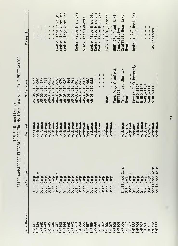
4->
CCD
EEoo
Q Q QM 4-> 4-i
CO CO to
CD CD CDCD CD CD-o -O "O
I CC Q£ Oi
l_ &- S-
fl (O (OOTJ-DCD CD <Do o o
to
Q4->
10
CUCDo
to
4->
«oCD
CDc
to co to
O Q O4-> XJ -M
T3CD
«/>
CD
I CD CD CDCD CD CD
I OLO
I CD
tO
CD
CO
c
CD
i of i -I- i ce. cc cc i
s.
•oCDO
I
A3
CO
S- i- i.<T3 fO fOT3T3T3CD CD CDO O O
<
o
(O CD CDJ- > 2
t/> •>
«» 3 •»-
CO i— !->
1^ CJ •«-
C X-Q. O <*- CDI O H! cCC C s- oZhcsz
4->
i-<-^ooor
COCD
J*ooS-
"OCDCO
I I I I
</>
S-CD4->
"a*x:to
o
CO
oI—<CU
COUJ>
>-CO
Q£UJI-coI—
1
oLlJ
*— cc-oCD _I=3 <Cc z•-- o-•-> l-l
C I—o <u z
LlJ
lu q;_l oCO u_<:
CD
E
CD
CO
I I
lOONi-CMCOCOCnO^-lf>r-«)r*.COC\J I I
N.VON<X)1DVOMVCO^IDCO«>ID(OCOCDCPiCDCDO^CDCDCDCDCDCDCDCDCDCDCD I I
I I I I I I I I I I I I I I I IOOOOOOOOOOOOOOOO I I
ooooooooooooooooI I I I I I I I I I I I I I I I
LOLOLOLOLOLOLOLOLOLOLOLOLOLOLOLOooooooooooooooooI I I I I I I I I I I I I I I I
+J S- CD+J CD OCD M s-
I .* r— 1 -4-> 1
O CD CDI O J= 1 O. 1
s- CO1 o
CD1 -^ 1
o 1^ 00 CD CO CD' >) J* 1 O O O O •— i— 1
> <o(0 lo _Jo c\ CD 1 1 1 1 1
r— J= •-> o o o o oCD 4-> r— l/> CD <T3 ^— r— r— r— i—C i-
!fe
•I— c +> o o o o oo o s. o CD 1 1 1 1 1z u. LO »—
1
z S LO LO LO LO LO
o
o'r—
$-
CDQ-
cccccccccccccc cccoooooooooooooocoooCCCCCCCCCCCCCCOCCC'^+->-t->-t->+->+->-t->4->+J4->4->4->-l->oooooooooooo o
CD +-> +->
c. O O
c co oc c
+J r- +J 4->
O 3 O O
I I
I I
c c c c c c c50S-MSSS0520'<-OCOOO'r-00C<OCOCCC(OCCj* J= j>i E^^^-C^jx4J O +> CD+J-M^ UPPOS-OS-OOOi-OOZ<ZU-ZZZ<CZZ
COI—
t
o
exUJoI—
I
COzooCO
CO
Q. Q.
CDQ.
CD
LO
oQ-JZ CL Q. Q-E 4-> E E E<T3 •^ (T3 <T3 *oO _1 C_> C_> oC c C C c=CU CD CU CU CDex Q. Q. Q- Q.o o o o o
Q.JC CLCLCLQ.CXCLClCLClClQlQ.CLCXE-MEEEEEEEEEEEEEE("0 ,r~ f0 lQ(0(t)'Q(0'D'0'D ^D ^O (T3 t) 'OO-JOOOOOOOOOOOOOOccccccccccccccccCDCDCDCDCDCDCDCDCDCDCDCDCDCDCDCDCLQ.Q.Q.Q.Q.Q.CLQ.CLCLQ.CLCLQ.Q.oooooooooooooooo I I
E E E(0 ro fOto o O O O"O O-JZ Q. Q. cl cljE -a -aCD E -M E E E E +-> CU <D$_ »Q »i- (O (O (T3 <TJ «i- i- S-OJUJUU O O —J CD CD4-> •-> -Mi— c c c c C C C f— i—CD CD CD CD CD CD CD CD CD CDJC Q. Cl Cl Cl CL Cl CL-Q JCCO o o o o O O O CO CO
$-CDJO
CD+->
LO
oioor)ui(ONCocAOcvj(o<*ini^cnOi-oju)Ninin«)roroco«3NCOPJooui.rO^-^-^-^l-«*«*^LOLOLOLOLOLOLO<J3LO^OLO<JOOOOCMCOOOOOOi— r— LO
LOLOlOLOLOLOLOLOir>IOlOLOir>LOLOLOLOLOLOLOLOLO^VOLO^^r^r^r^r--r>-.r*»U.U_U_LL.U_Lj_LL.LL.U-U_U_Li_U_LL.U_U.U-U_U-L^
LOLOLOLOLOLOLOLOLOLOIOLOLOLOLOLOLOLOLOLOLOLOLOLOLOLOLOLOLOLOLOLOLO

+Jc
oo
to co 00+-> CO a; CM o los. <u s. M cr> CTl O LO<c E 3
CO 4->o
IT)a
<Dr" »* r— CTl CTlO r— CO
^i -M <o <_> t. U_ <D r-^ to **- c cu CTi -C i—u a> 3 o CD -t-> CTl O) to 4-> t- to o > r— O >>o OO s- s- i -(-> O i- 1 i— +-> i ai i 1 c +j <Li 1 1 1 +J < i. C-oc <c »-> </> ro co 03 •i— cu t. r— to i— <c -a cu
-o CO 1 •!- 4J CsJ 1 i. Q i +j i i E <C 3 1 1 1 c cu c +jcu <u >> 3: to + ,— ai 'i— •-> -a CO 1
—
r— +J i- 3 Os. -o +-> « i CU LO r— 1 4-> S_ i i— i 1 03 S- O 1 1 1 CNJ f0 O o cu to zu. s- •r— r— o (— LO •- to 3 to a» -r- z +> CT> -M o O Z 03 _J
+-> o > «o i +-> O i^ 1 t- o 1 U 1 1 v_ 03 1 1 3 r— 3 o C 00 s_
c o u •i- o i— r— CX>U- o I— -c >> O O _J •r— >> -m cuO 00 Oi ••-> o o cu c CU _) cu C 1 -t-> 1 —I C S- fl (D
E cl: o s- <D > «d- o a: ^r +J to i. 2 r— 2 r— 03 cu o c<D to i < 03 r— O r— «/> r— o 03 J- 03 O •r— o r— CM jQ E jQ OJ- 03 CU j= <a .c i •- C 1 2 ai o 3 i— 3 r— CT. CM r— r— +> •-la- O uinu o_ CO CO CO O C_) 1- no- CO CO CO i
—
lo <C UJ CO Q_
CO
o»-<CJ3
COUJ
>-CO
CO1—1
CDUJ
*— DCacu _i3 <c z— o+> MC I—o <u z
LU
UJ Of_l ooo u_<
E03
CU
CO
r^CTl«3" +->
Ll. cr
3E cuU") E
1 cu 1 1 1 1 3 1 1 1 1 1M •« cu c1 T- ^J- 1 4-> 1 1 cu 1 o 1 1 1 1 1
CO o •r— +J s CM1 i— 1 CO 1 1
•-1 l 00 t I I I
4-> 1 CO J= 1
1 M- o 1 CU I 1 1 CD 1 O I 1 I 1
CO i— c. cu {. r—i— o (0 i~ 3 oO 1 3 o J3 1
Lf) cu E c LOJ= o cu o cu s_ oCD 1 c <o E o 1
•i- cu o i~ o J= COzn <c z \— CO h- I
,— CU ^»o LO tO CT)J^o LO 3 C COJZ CO O •r—
(J 1— JC CT»T3 4->
1 1 CO OH 4-> C i— C•^ •.- 3
1 1 <3" LO C CO cn 3 T3 3 Oi— i— O t— c o r- CO E
1 1 00 CO >>00 •r- CJ •r- 031 1 C 1 o O 3 _^ +->
1 I o o <o o r— • r-« OO CU i—r» (— O r— •i- o CTl cu <:o o o 3 O f— ^- S- 1
1 1 r^ 1 00 ^- O i—LO LO 03 LO •-> O CU cuo o o o m »-> CU 5 03 to
1 1 •<- 1 C 3 E x -o EC£ CC o cc A3 O 03 03 O 03<<Il<CQOC CJ> SOOQ
-aos.cuo.
c c03 03
-C T- •p—
c C CU C OIT3 O T33 M 5 C O 2 S- c •r- Co COO •-- O CU i-h S_ HHc o c r -r (8 •-- c o •r— o o^t E -* to +j jr +-> j^ cu cu +J +-> a»+-> CU-l-> Or— Oi-P+Jr- 1—
i
to r—o S-OJZ3S-3O0303 3 •r- 03z u_zcos:<:sz_io. s; z o_
o cu c c c c c•- i- 2 2 2 2 2s- a. o o o o oo ••- c c c t- c ct0 +-> r— +J +J 4-> r— 4->4->•r-0330003 OO
o03JCo
c u s-
2 T- <•r- O J-
03 C O >,J= J* 4-> r-O +-> to s_S- O •— 03< Z Z LU
O O O O O Oo
S- i- s- S- s- s-
O o o o o o-t-> 4-> +J +-> 4-> +->
to to to to to to
0\
00r—
I
CU
oUJatUJQt—i
COzooCO
CO
cua.>>
cu
CO
03 03S- J-3 34-> +Jo ocu cup +J o u O o o o•^ •^— •^ #^ •^ •r— »r— •^J= O.JZ Q. Q. J= JC JC O. -C SZ Cl Cl Q.JZ
4->4->oEOEE-M<<<o<coo<:
«-> !-> o •-> <_> E cu +J 4-> E E03 r— 'r- "r" 03 03O 0-_J _l OCJ
E +J03 -t-O _l-J _J S 1 S-
1 o o •r—
JX J£ C c c c c ^ c c +-> c -t-> c +J C C C c C Co o cu cu CU cu cu o 1 <D CU to cu to CU r^ cu cu cu cu cu CUo o ex Q. aaao O. O. r- Q. •r— O. 3 CL d. Q. Q. CL CloiQioooooct: 1 O O z o z o 2: o o oo O O
CL Cl ClE E O E03 03 •*— 03O O i~ o
oc c +J ccu CU to cuo. a.— Q.-OOZOZZZZ
o o u u o os- i. (. i_ s- S-
o o o o o o+-> +-> +-> -t-> 4-> +->
to to to to to to
cu
i
cuMCO
LO00CM«^-LOCM00C0C0CTiCOCMCTl Or— CO **• LO OOLOLO«a-C0LOCT)CM^rLOLOC0C0COLOLOLOLOLOLOLOr^r^CO OOOOCTlCTCTlCTlCTlCTli— r— r— r— i— r— i— r—U_U.U_Li_Li.U.U.U_U_U.U_U.r— I— I— t— t— r— I— I—
LOLOLOLOLOIOLOLOLOU^LOLOLOLOLOLOLOLOLOLO
Or— CM LOLOr^CTlLOCOLOLOOOCTlCTiCMrOrOCO^-LOLOr— r— r— r— r— CMCMCMCMCMCMCM
lolololololololololololo

co
oI—<
COLU
>-CO
C£LUh-cot—t
CDUJ—« Q£o
O _J3 <c z•-- o•-» i-i
C »—o <o z
UJO DC
LU Q£_J OCO U-<
COI—
I
co
QiUJQh-
1
COzooco
Q.
UJ1—
CU4->
oo 00
CO
CO oCO •-> CUCO o MI— r— u
•1— o>l o_ •>->
CU cuC 4-> Q£ 1
i— «o
r: o >> ,—s: jq 4-* C\J
E •^ cr>
>> <o ^~ r—jQ CD •^
i
4-> jQ 4->
+J CO •^" e^ o> CU..- CU •r— M3 .C r— <oCO 1— Ul o_
I I
I— I I
cu "or- +->— 10CD CU 4->
>* co E a»co -P i o o. cuis- oio i.
I CM < </> .E 4->
3 >>00 COI i>^ o cu
CU O -I CP CI 4-> O <S) O <TJ —
«/> oc o cn.c jc mi ••- l c «j i— s:
o> W CO •>- ZCU C +-> "3Oi «p- i— L CM to
cu
enf— ^ co
— CT> <X>
LO
Ion i— o oo •.- o i—
C r— CU Q-CTt rooi00_COCOi— h-i— i—
4-> T3 o LO cuJw! <Ti U) <o 1— CM 1—C O •— CU <Tt LO <T> o<o cr> o +J r— P- C r- (OCO r— 1/) 01 o c
o 1 CU CU i
—
•,- cu er— OV»- E 1 1— +> L •^T3 C L 1 0(0 00 •r- C <T3 <0 o_C T- O 3Z CM CM 1 1
+-> c M 2O 4-> •!-> 1 CO 00 r— c 1—
1
CO T3 A•- E «/> CU 1 1 1 •!- 1 to S- >>4-> •.- •.-
1 ^ O O (O o j*: to «o •->
* S-I trt i— i— 1 l 1 L cu - 3= •r»Z O- CU o o 1— cu <v T3 C_)
o Z 1 1 s L t- >>+-> 4-> i- LO LO to C_) <o -o cuw oa E O O •r— r— C ••- +->
S- i- >» (O 1 1 !-> i— -^ S- E 3 •r>•.- •- Jo* Tsaa t— CU (T3 cu <o u. JCu. o_ =c < < < Ul CO O CO D= > 3
I ILLCU cu
I .S* 4-> +->
O </> toI 3 •.- «^-
r Dicno cu cuoao:oo c c3 O O
a. •->
E o3 i— Q.r-3 O CU
O Q•<- .c^ U LCO CO Q.
CO
CU <« 4->
tr> CU A3i— a. oCU jQ5 to Eo c <oi j: cu
C_3 3= CO
CMON
o o u o u o a uccccoooouo-S » 3 5 •- — «r- — -r- -r- 2LLLLL OOOOLLLLLLOooooO'<-cc:ccooooooCv-.w
tO to «/) to (/» i— 4->+->4->-l-></>tOtO</)tOC/)4-></></>tOI— -r— •(— 'r- 'r— 3 O O O O T" * "r- 'r— *r- •!— O ••— 'I- "r—
L L Lo o o
<aL3
a. PE O
to <B CUT3 O •->
<tJ •r-aaao*o JCo o o (_> o E E E cu cu u o o o u a o
Lo o o
L L L L L o o o v> CU L L L L L L <C L L LO O o O O i— 4-> o o O O o O o O O-t-> +J 4-> 4-> +J C C C '^ i— +-> 4J -M 4-> !-> +J C +-> -M 4->
to I/) to W to cu cu cu <o cu to to to 1/) to to CU to to to•1— • r- •r— •r— •r— •F— Q- •I— •r— •t —
a: JO DC 3C 3COOOI— WII rc X n: nr o nz 31 DC
ON">i-vocr>»0 <o*Ln<*iONCOO<d-LOtOtO^Ol— OCMOO^"s^tO<OtOWOr^COCMOCMCOCMCMCMCMCMO0O0rOCOr00OO000O000CO"!j-LOr^I^i— i— »— \— v— \— y— \— \— \— \— \— \— \— \— \— i— i— i— i—c£C£C£a:ct:c£C{:c£C£c£cx:c£C£c£ct:c£Ct:c£ct:c£LOLOLOLOLOLOLOLOLOLOLOLOLOLOLOLOLOLOLOLO

V.
PROTECTION OF SITES
The Archaeological Resources Protection Act (ARPA) of 1979 should
provide more strict and meaningful penalties against vandals caught
destroying sites on public lands. To most people, however, collecting
artifacts is thought of as a recreational past time and not an illegal act.
The development of public education programs are needed to make people aware
of the damage they are doing to their American heritage by surface
collecting and excavating sites.
Protection of cultural resources can be accomplished in a variety of
ways, ranging from marking a site to fencing a site's perimeter. In the
Little Snake Resource Area, most sites remain unmarked (76 percent) and are
essentially unprotected. Because of their nature, visibility of most of
these resources is low. Most sites are open-lithic scatters with a few
scattered tools and flakes not likely to be noticed by the general public.
One rock art site in Irish Canyon is a designated landmark and has been
developed into a road stop/picnic area, with a platform for viewing the
site. The site is marked with a plaque and an explanation of the prehistory
of the site.
Table 11 is a list of the repositories containing archaeological
collections recovered from the Little Snake Resource Area. Six hundred
thirty sites have been collected and stored at 15 repositories. Cultural
material from five sites are located in private collections, and the
location of 12 sites collected is unaccountable.
93

ocOls.a><+-
<uac
COooocn
cas-a>a>
C3
CMr~-
CMr—
00 CslOi COJZ enu i
—
03
a;>i-a> >,>0 -O0) T3S uj
CC
oUJ
LU
<
os-a.
a.
a>o
Ol u->
en o3 kO<*- u.o> s:a: LO
-^ >s. 0303 oa. X
UJO0c ccJ 3o Zs- Q.co CO
r^pv. r-^ r> r~ l-~.
tO r- r- cn r-. r~r^ CM CM i
—
cn cn cncn r— p— r— r^ r^ o r—"~
00 C cn to OOcn 00
cnooCM
oo cn 03 c cn cn^~ c > •r- c c= OOo> •r- •1— C •r— •t— cn cn OO oo
«* •^ C p— C C c r-» c cn Cr^ c C l-~ at C c cn •f— c •r—en 03 a> 3 13 <D aj i
—
c •p— |M"~ a o
P^CO o *z ra CO
# Ol "o• CO "O TD P~- o c a T3 cn r— o 0) o Ol cu !_
t— o C l*«. c CM c 03 c C ^~ co "3 •-> o UJ 0013 00 03 r-~ 03 i
—
03 <o n3 r~- o ,
—
-o c Qi CMcr> cn M <o oo 4-> c -o oo c Oi Q.
•-> ^~ oo i
—
c C 00 a> 01 oo s- r— O) (T3 c CM (O s_o> cn 03 03 cn 3 e e 01 f0 r— Oi C L.
w— c s_ e € c cn T3 T3 E S_ i- S- t. «- ^* Olto •^ •^ 3 oo •r- •^ •r- •1— ns 3 3 3 n3 Oi 3 Ol cCD o> c JZ 03 <1) C s_ i
—
r— z JZ JC -£= E OO -C d; 03 T3Cn z c 4-> 0) Ol C T3 ^~ pa u +-> +-> +-> O A3 4-> O. L.•r- - 0) S-. s- S- OJ O •^ •r- T3 S- S_ S- 3 JZ 1- o O 03co o *3 < o u. "3 CC 3
0)
3
< <
<
<
< <
<
_1
<
o < z
Oi
c
_l CJ3
r— <t p— (— u-> _1 >> 0) cn JZ 0)r— 0) > <1> OO oo p^ «3 o |W a. CMh- >> o c ^ Q. ai > <T3 ^~ »-> +-> CO CO Oio cc 0> z •p— <U C- S- O) r— _l m =3 CM CM Cu X +->
«d- CO ^ > 2: IT) CC •r- 3 _1 Ol O- _i r— r— UJ •p-
o 4. !-> "* Q. CO 3 i
—
L. O0>, > o 3 •r-
coCO < E i
—
oo 01 r— 00 OO 3 «5 03 z CO c a. UJ 00 «3 o> m Q. •r- OO 00 (D s- Oi3T u ZD s_ Q) O o; O -o C3 •i— S- o O OO 3 o
X +> (1) Ol i
—
_) S- > O •r- a. a V. •- o CO 03t-> UJ o O0 C c M- <1) s- > +J o CJ c S-03 Q. 03 co LU •r- <L> +J 01 O •r- oo r— JZ 1 1
•r— o h-O a> 1 <D cc c c oo o Q T5 01 +J !_ s_ Q >»JO cn >» _J o> oi 1 •^ t—
t
<D UJ 3 L. Ol Ol 1 3 >>E (0 t- r— s. cn r— CC 4-> +->
1 U. o Q. o. oo 1 s-a} > o r— +J .,— •r— 2 JZ 4-> n3 +-> <4- •r- •r- cn o s-<u «— > 03 +j Q. IT3 O "3 >> 3 Oi OO c c C C cn r— 03•4-> <o <a o 'p— e S- ,
—
+-> 03 o $_ Ol +J (13 3 3 <a o 3OO to CO (_> _J UJ o u. =) _J CC O 3 s: Q ^> 'O DO o o-
CM
c<oCO
ooe
0) oS i-03 O
8
<
oUJ<oCC<
oo
>> >>nj a)
J JZ00 cn cn •^ »r-
0) •r— *^ oo oo
O 3: I s. s.00 oi a*
> B u »-> > >i. 0) O c c T" -P-
Q) cn oi a> c cCO Ol S B =3 Z3
r« p» u s_ (. 0) OJ<o o 03 03 ••-> 4Jo o ^ a. ex 2 2•r— Q. oi a>cn 00 Q. o o CO COo •r" <r— 2 o o o oo 0) Ol O T3 -o -oOl _l o ns as 03 «3IO e J. s_ 1- s_
JZ +» 0) o o o oo J-
(. o u o o o o< u. co o o o o
>> >» >> >> >>+J +» 4-> +J 4->
</> oo 00c
00S- S- S- i.Oi a> Ol a* Ol> > > > >
03 03 03 2 034-> •»-> -U 4->
CO CO CO CO CO
O o o o OT3 TJ o T3 T3« 03 03 03 03S- t. i. S. L.
o O o o Oo o o o Oo o o o o
oo
ooo
oo
o>
s. o03 at01 i—>- i—
oo
oCOen
CM CM >* O lO P^r-~ 00 r^ oo t»» r»CM CM CM CM cn cn
CO CM
CM CM
o r—
.
03oo oo aCM CM
s.3O
oo
O 00
03 03
O O
O O0-o03 CMfc.
oO ooo c
oaT -Jj
s- ocn| o aio i—
o •—_l o
<_3
c oo•i- i.4-> Ol03 jei
o Eo 3
oo0)4->
O -r-OO OO03S- <*oo ••
i-
03a. s-
0)
>> 2 T
o03 oo03 Ol$_ -MO •!-
I— 00O<_> CM
CM• CM
M c ..
i- ci— o
Ol O >03 ai •!-
i— i— co oCO o
O OO
03 03
O O
30)oo3s:
yo
S- r-o o
O 00
03 03
o o
s- o0) Ol> ^~c r—Ol oQ o
Ol+->
c •p—
o CO
4-> r—03 03
O +->
O O

<
o00
<
co s:3 OC Q£*- U.4->
£ <"o zo o
i— oI— LU
S 8CO (_>
<oI—
I
8_JoUJ<X
<
<8
od>-t->
s. u<D d)d) r—>- r—
oo
oo ooCM Cfl
dl r-
•— CM CMer> o — oo oo oor^ 00 00 CO ON ONCO ON ON i— — r—
d> dl +->
L O U L L «a, +j +-> o o <dp- ra <o O O s-
N - I- S S h
CO 3 IDr~ 4-> Ccm •f— CT>
3o ECO —
4
oCD o Ect: O 00 i- <o
00 on co-o ON ~— > coc r— •r— e<D <A o: o
cu E S-S_ 0) T3 4->
01 > E (/)
.V ID a> ro E<D > 4-> s_ i-CO ii 00 43 <
CM
CM
co <;e =t»=
<o _JQ. T3 a.x oui o i—
2(/)!-> i—i— t« CMd) 0)3 Te "Ou. ai
< I—
I— T3 ON-o co cm<D LL-
CS >> -r-+J CO IDto S_ r-3 CO <_>
O C CO
<0
o .eO +>d) <ae 2C roCO .,-
I— 3:
to .c
oo
COCO<o
&
3Oo<0o
CM
on
oo
co ci— <o i—«<-$.••-•i- ra its
o_ ai xCO 1- i—t- "O IBID E T-1- CO XO CO <
<CO <(
3 COO UQC <0
s_CO to
S O<tj r-»of— 5-
CO OCO <*-
c2: a
O 0000 00 00 CO
<Tl CM cr>
CM(?) CO 1
—
r~. s- CO CO CO 00 COcr. a> 4-> !-> CTl t->
"~.
34->
3 r~ 3CO f0 ^~ •^ •r— J«: • r—
a> ITJ 4J t-> 1- +->^ <
—
M- 01 to •r— to
^ 00 ••-> c c -i<: cCO to —* 1—
i
J 1—
4
l~~ o 0 CO pH COCTl c c 3 CM s_ s. 00 z CO s-r— fO (T3 CM 00 CO a> CO 00 d>
T3 CO CJo > > r— T3 CT> >c CT C C Ol r— •^ •r— C r— •r-
o o O 00 r— Q£ cc O ID QilO to IO O S- 1.
S- S- s- 10 to t_ T3 0 ID +> ai OdJ d) d) •r- •r- <a C c ^3 ID c Co o -0 > > CO <ts ID ^3 d) •p- IDe cr c IT3 03 co s. i- 3 S- ID i-
< < Q O _i 03 nr 1- ^ CD
< <>, IO ^ <C LO
-O ITJ <c r— •p- <D «t <<D d> 3 iD 3 O c CO OO <(_> 1. 1 O cr O 00 to CO « C
< i-> O c r— O _C Or— ^ < 3 to ID =tfc CO 4-> z:d> X CO =^ a> Q. CM S_
r- LU ^ H3 •0 J= r— X +> O CMa: _l <o U O LU S- CO M-
-l-> d) 1 X co ^~ C Jto c c <+- s- 3 J* J3 4- ID IDCO •r- +-> n3 1^ CS CM d) ^~ •p— O S-
3 2! s: O •^ CM d> * ct: O,
—
"3 c i. O 1 .CCO T3 S- S_ a: CO CO O CO ID d)•«— Q. ITS ID -0 u 4-> •1— •r- c<D s T3 CO >> >> ITS j>: C ID i-
s- TJ d> 3 ID (O s- ID CO S_ IDo >- O OO _j x ^ O s CO
IS)
•->
cCO+>1—3iy>
cCO
>5 »->
c co r— 3<B +J
•^ r— +J •p—
4-> O c +JID CO CO toU ID E c•r> jr c 1—
1
paO. E L. t.Q. < r— CO< > l/l to >
T3 C CO CO •p—
CO C UJ •r— •p— Q£to 10 to O ID 1 i- $_S- i. s- c r— 3 3 Oco CO d) 0) !- CO !-> i-» e3 2 2 •r— Ol ^ c c (D
O O U > <D Ol CO t.O- a. a. 00 O Q_ «_s CJ3
ON
<0 CO+J -C +->
3 ••-> 3u pB (->•p- ID *r—»-> CO *->
to 2 10c C c•—
1
O »—
1
s. | s-CO O d)> to O >•w— CO tr-
s- •_ i. S. ac •p— t-> Otd) 0J d> CO s. s- JZd> oj dl O CO 0 3 co ID Oc c c •-> c c •l-> -Q •p- c
<D ra c p~i S_ ID•t— •r- •p- -Q •p— s- CO pa ID S-a. O. a. < a. C3 21 C3
cr> O r— CM 00 p_r»- CO 00 00 P- 00 00esn <3\ <Tt CJo cjn cr> <T)
00 CJo O CMr^ rs co cocsn cso csS cjn
p_ CO00 00 00eso cso 9\
oID p—i.
oO C
co co
CO oo. o
CO• • •«->
O 00
ID ID
o o
toto to COCO CO •->
4-> O (-> -p-
•r- O •pa 0 to0 </> (/> ro
ns p i- 1—t. P^ C CM uo
O r™pa- •pa OlS • •-> O ••
C O C E EO c O 3 r °
PS pa CO 3 ppa CO +-> -p.
l-> •p* •"3 4-> to c ••->
CO O 3 U 3CO c CO 4-> -O CO z Ip*01 ro Cdl s- paj +J ro a— i. c —r— 3 O to s- O copai a O C C3 O CO _1
»—
1
eCO CO CO4-> s. •-> •pa .. +J
to c •a- CO c •p— Ol C T-•1— 00 > 00 _o 002 •4->
d) +j pai 0. •(-> pai E »-> r-_J ro <o ro ro O ro ro
U 4-> 0 O +->
loO •->
-t-l O O c O O O OS- _J r— ro _l I— E _) r-
t- Ou_ tD _l
d)COd)
IOdl4->
aaj
to
„ -i-
c CM
4-> • •
<J cC3 •»—
"3 +->
uT3 (LI
C r—ro r—S_
C3
d>• • +->
ooo 00

d><_>
c 01<u os- c<D 014- J.(1) 01GET <-
O)ec
<LlJOS<
o
ai z3 o
o sio o
CO o<- 5!
UJ<occ<
<8
ai+->
C0 <D0» r->- I—
oo
oo 00 Olrx. rx. rx. <NI
cti cti cti CO"~ "~ ,— CTl
in c cE o O OxJ 4-ro -o T3 CO i
—
•^ s- S. CTl CTl 13o r« <M ^~ <* o O Px. O rorx. rx. rx. ^ rx. CD CD CTl 4-J oocti cti cti •^- Cti ^ <t • OJ CTl cor— r— r— 3 |-M LT> px. a o O o O r— t— e: r-~ CO oo
CO |x. Px. r». c c CTl CO • 00 CO CO <T3 en CTl coN N N OJ rx. -o a CTl rx. CTl T3 re rx, CTl r— CTl CTl CTl < CO o >, PO co ^~ CTl4-> +-> 4-> px ct> c ^ cti »— cti CTl r— rO r— o r— i— ,
—
JP oo c S- co CTl•^ •^ •r— cti f— ro •^ r— JC c rx. ^ oo co CO 0) oo T3 <D CTl i— WC C C r— c ro en in <o CTl o 4-> H- CTl s_ >l CTl CTl CTl E +-> (/l
i. S- S_ S_ s- s_ ^ >-, c 3 E i
—
C 0) <D l— t— <l) d> f— r— C r— S- O r— a> <Ua> <u <D JC 4) a> <u JC j* •r— fsl a> o > <0 1
—
^ o o cr> J* •r- -C+-> +-> +-> •-> •U +j +-> o o o C r— X o (TJ C O S- <1J T3 S- S_ o X +J 4-> o <U o Srjj 0) <u •i— in i/i ID in 3 o ro cr> o i. t. o> !-> <1> <u ITJ OJ <u t. o </) c na z s. 0Js- S_ s- E <1> <D &. •r- 4-> o 1- c c o rO a; <D *i— sz S- •r- •r- o c A3 o r— . 3 01co co ca to 3: 3C CO _J 00 cd ^ UJ ^ CD o :*£ s r-J 3 co M t~J o i^ Q. s CO o CO Cl
a>
CO
<ooEa>
< ••-> _l <t < <s- 0M JC s_ +-> <c < r— ^t «t i § u <: < < O <_> < < <u _i+J r— r— f0 < px. <D OJ i. s_ i
—
o ^~ o < U3 uc nj <o ^ OO CO ^ r~- c CL i ai i. 0) CM _J rjj D CO >• 3 _j CsJ ro 1 o(0 O o Q. r~~ en en •^ ,
—
•4-> <3J a. -o 1 _1 ro a: CD Cu o r— Osl r— _l^ o o •^ <u >, jc r- Q. =*= r— JC Q. a> i— 1
—
O r— o A a.Cu CT> oi ro S- 3? in i— «f +-> ro u. ro ^~ cc: »^ <u i
—Ovl I X in r—
s- ^ •r- a> i~ o > <o <o O <o <o S- O O ro rjj o -u a) OJ o T3 s- O r—<o <u i- rtJ a: o o s. 3 <u 2 4-> *S- CD 1— JC Q. o O in > CD •r- in 1 1 r— o s_ 4Ja. en o s_ o 3 o cc: h- r— OJ o O O 4J O JC 3 u. OO o a. 3E o u_ o s- oo _l OO c <u 1 O 1- ^~ >1 3 _1 r— 3 O 00 CD <D<o o; o <o «* n Q r— J^ <u 3 »-> en »—
i
i^ I ro l -E i- c •o S_>- i irt o T3 M- o oo !-> s_ p CD ai s- •H
1 >l •r- JC o in c o <o 3</i E <D o <o O >) -o O0 o o <o c Q. <u 3 J* c !-> i. •r- o o <u O
c c <0 in f0 O 3 >> a: t. s_ -o *—* »— c ro >- 00 c S_ O C <U JC CO JC u.Oi s_ •r— O a> i. </l jk: i- <o fO ro ai a. Ul O t at o +-> o OO !-> Q.T3 (O t— a. JZ r^ <1) o o o QJ c c C JC </i E <D •^* <u !-> M- •r— >, ro +-> 0) o>, <u r— o jx: •r— !-> r— 3 o !-> >, >o < ro 3 <o c c 3 3 c C C c CD S- in (1) o(O +-> r— s- ^ ro <0 o +-> o a> -o f0 l-> O JC 3 <u 1 l— <D ro o ro CD ro ro JC S-
I OO 3 Q. UJ C£ CD o OO s ^ s: s UJ ro :e o 00 00 O CO C_) Q s: (_) O s: UJ OO <
oo
CM
o o o
o <— CM
Co en cm
<U ro
u +->
JC JC > JC JC 3m l/> s. in in m3 3 0) 3 3 cN N 00 IM N oC e C C o(0 ro p« ro fOS- S. ro S_ S- r—^ a o ^ L. s_ n i- (O S- J-
a> ai <z> +-> rjj a>T3 o en "O •r— •i— o •r- C •r- •^Cro
cro
o c<0 •V *f
cro ^ E y •V
"o <+- M- <*- C <*- •4-
re c <D C r— i— c r— o t— in r-
o o ro o >0 (0 o (0 s- ro s. ro
T3 -o JC -o U £ u o u •r— O <1J (Ja U L. o 1- •(-> cc 4J s_ !-> > +J 2 4->
=} =5 =} I O O S- o 0) o 01 o QJ c ai O CD
o o o o CD CD < CD s: 3 s: CD s: UJ s D. s:
CT>
»< ur> rxrx.rx.rx.en CTi en
Oooen
,_ CM CO00 CO COCM CTl CTl
uooajroJCos.<
ooJ-01> a>c •!->
a in
>>ro
* •o cro OO •>-
1. !-»
CO oa>o <—o ^
co or— O
01• • +->
C 1-o oo
(O ro
o o
ina>
o ••
o oCO o
a*
O oo
inS. 10 <Ba> o> o o

O00
UJ
<
a* z:3 O
o o
3 8CO (_><1- _J<
88
o<
<8
OJ+>
J- <J<o OJ0) r->- —
oo
coCTl **"" 5 ro en
ooCT)
C CT> 00 00 r—03 ,— CTl CT>
e r— ^~ Ceo C o03 03 c c en
0J E T3 03 exL in E E EO 03 c/> 00 o
OJ m 03 03 -Cr~- o i- 00 0) OJ 1—r-. c o CTl l- S-
CTi CTl 03 ^~ <_> o Dr— r* o <* c
cti o c C o o 00 nsu- r— c 03 03 c c CTl1
—
03 E 03 03 i.03 +> r— +-> in 4)u 03 a> eo 03 o -cj o <4-+J Ol Q. 3 OJ 03 03 03 1)
<D S_ o OJ s- OJ 4) 0) oST 1- o a: o zn IT ni X
*3- < .- <I— « _l <0 C CT)i— c\j a. ••- en •—a) i- i— ns ai •3S-r-a>ojEa.o
o Ea. e o •<- c\j •!-
r- Q.00 CO
(/I 00
0) CTl
O0 CO
ai a>en en
<C •> cooo s. <t- in o=> ai <*- x z
en o UJ•£ •> cT 03 .C ITS
o s-< >> s. -o J= i— i—UO O 0J r- 4-> 3 3n3*->OS»-*n3<T30.CXIT t- <j) CS-JOOCO+->T-0J<T3t-i-ooeoss-e-i-ojoj
CTl CTl en CT> CDC c c B cE E E E EO o o O o>i >> >> >» >>3 3 2 3 3C C C C CS_ i. t_ S- L.aj OJ OJ OJ OJ»-> +J +-> -> 4->
in to en en enOJ OJ <D OJ (V
f- CTl r— CO **r~ r- oo CO 00oi tn tn en CTl
3 IS,CM
en
CTl • •
ai c cCT> oa> il •r—f— Q. +J^ OO uo OJ
>l u .^ r—+-> O i—•r— en O or— c Qi o<_> E aj03 o •->
U_ >> C •i-
3 o OOCo C +-> p.•r— V. 03 03+-> (11 O +->
03 +-> O oS- en _J 1-3 a>O 3


VI.
NATURE AND DISTRIBUTION OF SITES
As of June 1984, there were 1,337 recorded sites within the boundaries
of the Little Snake Resource Area. Approximately 1,085 (81 percent) sites
are prehistoric, 228 (17 percent) sites are historical, and 21 (less than
2 percent) contain both historical and prehistoric remains. There were also
two paleontological sites recorded. The following discussion focuses on the
identification of the nature and distribution of prehistoric cultural
resources in this area.
For the management and analysis of large numbers of sites and site data,
sites must be classified into types. There have been two basic approaches
to the formulation of site typology within the Little Snake Resource Area-- a
descriptive classification and an interpretive classification, both based on
attributes of the sites. There is no one typology for sites, artifacts or
cultures; and a single site classification strategy is needed to integrate
site file information into a concise and useful body of data.
For the purpose of general description of cultural resources in the
Little Snake Resource Area, the site taxonomy developed by C. Jennings
(Creasman et al. 1977; Creasman and C. Jennings 197 7; C. Jennings and
Spitzer 1976) was used. This system classifies site type, based on both
topographic situation and cultural remains at the site. Site types that
only cover historical and paleontological resources will not be discussed
here. The prehistoric site types—open lithic, open camp, sheltered lithic,
open architectural, sheltered architectural, sheltered camp, quarry, rock
art, and isolated finds—are defined below.
98

Traditional types and more recent modeling typologies (procurement
location, field camp) can easily fit into these descriptive categories,
depending on the research design. Also, all sites can be consistently
classified, whether or not site function is apparent from the surface. The
broader categories such as open camp, open lithic and isolated find have
been subdivided into smaller descriptive sub- types. A disadvantage is that
the classification depends on accurate field observation and recording, in
addition to a reasonable level of site preservation. Regardless of the
chances for misclassif ication, the site typology is generally reliable for
describing the prehistoric cultural resources in the Little Snake Resource
Area.
Site Types
Open Lithic . This type of archaeological site is defined by the
presence of lithic material in an unsheltered location. These sites contain
flakes, cores or blanks, and occasionally finished or broken tools. Such
sites represent extractive tasks where specific raw resources were gathered
and processed for subsequent use elsewhere. There is no evidence of
camping, nor does the cultural material represent the full garnet of domestic
activities. These "tool use" sites may be lithic manufacturing sites, kill
sites, seed gathering areas, hunting locations, or other resource
acquisition locations.
The "extractive task" sites might contain a limited or specialized tool
kit used for processing, depending on the type of resource being collected.
They are usually situated on or near the location of the desired resource.
For example, hunting locations might be situated overlooking a game trail.
99

The open-lithic sites, as defined, range in tools and debitage (flakes) from
a few solitary artifacts, to spatially discrete loci of varied dimensions
and material content, to lithic areas extending hundreds of meters.
The lithic site often presents unique problems of recordation, site
delineation and site interpretation because of a lack of discrete, coherent
concentrations within the site and because of the size of the site. The
task of assigning lithic sites into specific functional or chronological
classes is often difficult because of the lack of diagnostic artifacts
within surface remains
.
Three hundred forty-three sites (26 percent of all sites recorded in the
Little Snake Resource Area) fall into this category. One hundred twenty
sites (35 percent) contained only waste flakes, and one site contained only
chipped stone tools. The 120 sites containing only flakes could not be
subdivided because 103 of these sites lacked flake descriptions. Generally,
these sites contained two or more different tool types and flakes. The
finished tool types most frequently found were scrapers and bifaces. These
artifacts, for the most part, are made of a variety of toolstone types,
which give the appearance of being multi-purpose sites and/or reoccupation
sites. This is one reason why site size may be a poor criterion for
defining limited activity areas—size can be a function of group size,
multiple occupation, or both. More specialized or limited activity sites
exist, but the distribution or nature of these sites awaits studies on site
catchment, location strategy, temporal placement, and function.
100

Open-lithic sites appear to occur in all the described environments,
from valley bottom to mountain peak, within a 3,500-foot elevational range
(5,280 feet to 8,730 feet). Most sites are found on ridges (30 percent),
terraces or benches (24 percent), in draws or on slopes (3 percent). These
intermediary topographic locations could reflect a portion of the seasonal
round occupation pattern or proximity to the exploitable resource. Since
most of the current survey data is confined to these areas, a full overview
and relative sample of all features is not yet available. To date, only
sample portions of the Williams Forks and Danforth Hills have been surveyed
for archaeological sites. No systematic survey has been conducted on
Juniper, Cross, Douglas, Diamond, or Cold Spring mountains. This leaves a
substantial portion of the seasonal "upland" unexplored.
Over half of the sites occur in sagebrush communities. This is not
especially surprising since roughly two-thirds of the resource area is
covered by this vegetative community (Denker 1984). Twenty-three percent of
the sites are within the pinyon-juniper community, and 6 percent are within
the shrub/woodland community. The low number of sites located in the rest
of the communities may reflect an equally low number of surveys in those
areas, or the smaller number of acreage per community in the resource area.
However, the occurrence of open-lithic sites in these smaller communities
points to available resources, perhaps exclusively, for exploitation by
prehistoric groups.
Most of the sites are located in sagebrush communities between 5,600 and
7,500 feet. As the elevation increases, these sagebrush communities become
surrounded by pinyon-juniper or shrub woodland communities. In some areas
there are openings within the stands. The high number of sites located in
101

these areas may represent a collecting station where more than one resource
was exploited. The number of sites occurring declines significantly above
7,500 feet and below 5,600 feet. The average site size drops for only those
2sites above 7,500 feet; site area averages 6,800m for sites below 7,500
2feet and 2,280m for sites above 7,500 feet.
All the major drainages in Moffat and Routt counties show open-lithic
site types, with 6 7 percent occurring along intermittent drainages feeding
the permanent waterways. The next highest site occurrence is along
permanent water courses (28 percent) and at fresh water springs (4
percent) . Elevation above and distance to intermittent or permanent water
share similar relationship.
Most open-lithic sites contain few diagnostic artifacts or other datable
elements. They tend to be located in eroded areas (along terraces and on
ridges), and they often have been previously (and repeatedly) visited by
local collectors. Only 82 (24 percent) of the open-lithic sites contained
diagnostic artifacts, of which only 30 could be associated with cultural
periods or traditions. These artifacts represent occupation from the
Paleo-Indian period to the late Prehistoric Period; therefore, this site
type may represent a similar sort of activity shared by all aboriginal
groups through time. Table 12 presents a list of open-lithic sites
containing diagnostic artifacts and their environmental situation.
Sheltered Lithic . The sheltered-lithic sites are classified in the
same manner as open-lithic sites, except they occur in rock shelters,
overhangs, caves, or talus boulders. These natural shelters were frequently
used for protection from the elements and for the security they provided.
Only two sites, 5MF1208 and 5MF760, which are located in pinyon-juniper
102

TABLE 12
OPEN LITHIC SITES
Period Site Number Veftetation Landform
Paleoindian 5MF1003 Riparian Terrace, Bench5MF969 Sagebrush Arroyo5RT139 Shrub Woodland Ridge
Archaic 5MF1447 Sagebrush5MF1449 Sagebrush5MF468 Sagebrush5MF512 Sagebrush Terrace, Bench5MF712 Pinon-Juniper Ridge5MF890 Sagebrush Ridge
Middle Archaic 5MF1298 Pinon-Juniper Terrace, Bench5MF638 Sagebrush Dune, stabilized
Fremont 5MF1317 Mixed Conifer Ridge5MF869 Pinon-Juniper Ridge
Late Prehistoric 5MF1465 Sagebrush5MF1499 Sagebrush Terrace, Bench5MF1800 Pinon-Juniper Hill, SIope
5MF460 Riparian5MF626 Sagebrush Dune, stabilized5RT148 Sagebrush Terrace, Bench5RT287 Sagebrush Ridge
Protohistoric 5MF1293 Sagebrush Dune, Unknown
Multi-Component 5MF1033 Sagebrush Terrace, Bench5MF1461 Sagebrush5MF1765 Sagebrush Ridge
5MF516 Sagebrush Ridge
5MF628 Sagebrush Dune, stabilized
5MF849 Pinon-Juniper Dune, stabilized
5MF946 Shrub Woodland Terrace, Bench5MF986 Sagebrush Dune, Unknown
10 3

vegetative communities, fall into this category. Cultural materials
associated with these sites are scrapers and flakes.
Open Camp . Sites containing evidence of domestic behavior such as
groundstone tools, hearths, ceramics, or other nonportable cultural material
within an open topographic situation are included in this classification.
Campsites are generally associated with chipped stone tools and flakes,
although there are exceptions. These sites were occupied over a longer
period than the open-lithic site types, and they displayed a wider variety
of activities. This site type would be comparable to sites described as
habitation sites or as base camps.
Activities occurring at these sites included the preparation and
consumption of foodstuffs and the manufacture of tools, and they were
possibly a central gathering place from which hunting and collecting parties
departed. Open camps generally possess a more diverse artifact inventory
than the open-lithic sites and often contain features such as fire hearths
or burnt-rock concentrations.
In contrast to open-lithic sites, the location of an open-camp site
might have depended on more factors than the distribution of a single
resource. Decisions regarding campsite location might have involved
proximity to several diverse resources, such as distance to water and fuel
and degree of slope.
Considering the "open" location attribute for this classification, the
exposure of these sites during winter months would require some kind of
habitation structure. Or, these sites might have been only occupied during
the spring, summer or fall seasons. As Reed and Scott (1982:359) have
observed, wickiup villages, considered habitation sites, often have few
104

surface artifacts; and deterioration of the village may result in
classifying these phenomena as open-lithic sites. In this case, it is quite
possible that some sort of structure may have existed at these sites; but,
because of the lack of visible structural remains, they are classified as
open camps.
According to the above definition, there are approximately 290 sites in
the Little Snake Resource Area that fall into the open-camp classification.
They occur at elevational ranges of 5,380 to 9,690 feet above sea level,
with 68 percent of the sites situated between 5,900 and 6,900 feet. Above
and below this range, the site numbers drop sharply. Sixteen percent of
these sites occur above 6,900 feet, and 12 percent occur below 5,900 feet.
Within the 1,000 foot range, between 5,900 to 6,900 feet, 200 open-camp
site types occur. Two-thirds of these sites occur in sagebrush communities
and one-quarter occur in pinyon-juniper. Only 3 percent are found in the
shrub woodland; and the remaining 14 sites are divided among salt desert
shrubland, riparian, and riparian woodland. The presence of such a high
number of sites within the sagebrush community may be the result of the
large acreage of sagebrush in the Little Snake Area rather than selection
for site location within that community. Overall, the open-camp sites
betwwen 5,900 and 6,900 feet occur in the same vegetative communities and in
similar relative proportions as the open camps with no elevational
constraints. Most of the sites are located along ridges or terrace/benches
and within dunes. They are found throughout the resource area in all major
drainage basins. Most are located along an intermittent drainage, with 5
percent located adjacent to springs. Elevation above water and distance to
the water source are similar to elevation and distances to intermittent and
105

permanent water sources. A greater range exists to water for open-lithic
sites than for open-camp sites. This contrast may signal a resource
procurement strategy difference, a site typology misrepresentation, the use
of potable water artifacts, or a site locational difference in contrast to
surrounding areas.
For descriptive purposes, the open-camp-site types were subdivided into
smaller categories, based on artifact and feature content. Since three
attributes—presence of groundstone, nonstructural features, and
ceramics—are the classifying attributes for open-camp sites, permutations
of the three were used to form the subcategories. Table 13 displays the
number of open-camp-site types by subcategory.
As can be seen in the table, only two sites fulfilled all three
requirements for group entry into the open-camp class. The general lack of
ceramics recorded in the resource area is the reason for the few sites in
this category. Twenty-two percent of the sites contained groundstone with
hearths, 30 percent of the sites contained only groundstone, and 43 percent
of the sites contained only hearths. The latter attribute, presence of
fire, was by far the best classifier. Table 14 delineates the cultural
material content on the sites and the range in diversity apparent in this
site type.
106

Table 13
OPEN CAMP SUBTYPES
Subtype Number of Sites Percentage
Hearths, ceramics and groundstone 2 1
Hearths and groundstone 64 22
Hearths and ceramics 5 2
Groundstone and ceramics 3 1
Hearths 126 43
Ceramics 2 1
Groundstone 87 30Non-structural features, other 3 1
292
Nonstructural features other than hearths or burnt stone were a
depression, bedrock mortars and metates, and middens. The depression
feature is a 3-meter diameter pit found in association with groundstone
along a pinyon-juniper covered saddle above Milk Creek. The site (5MF415)
was recorded by Dr. Joe Lischka of the University of Colorado during an
archaeological survey. No further investigation of the site has occurred
since the time of recording, and no other feature such as this is on record
for the resource area.
The presence of groundstone in bedrock situations has been recorded at
three sites in the Little Snake Resource Area. The bedrock mortars (5RT195)
were found in Routt County by the BLM archaeologists during the Kemmerer
PRLA Class II cultural resource survey. No artifactual material was found
in association with these features. Bedrock metates have been recorded at
two sites along the Green River in Brown's Park. Both sites also contained
rock art panels on the same bedrock that the metates were ground into and
10 7

cdento
-OCDo
c c<u atCO 10a> cds_ s-Q. Dl
ceo
10cda.>> +J •!->
+j C Ca) a>
<L) to toj*: CD CDto U_ J- i-r— O- Ql4- •>
to « •>
p_ _v .*:r— • c c
+J +J +-> 4-> +-> +-> 4-> +->
e e cceccc(l) <d ! qi (13 ni tp m <i)
to to to to to to to toCD CD > V 91 V 91 V (Ui-U_ $- W L s. s. s. s. s.a. a. aaaaaa
+->!->»->
CD I I ** tO I I 9* CD O > «l A M •! A Ac i— j^ ^ c .^ ^. j^ .^ j^ j*: f—
w i— - »_ »_ O r— « C -"CO -CCCCCCi—ZQCO<:Q.=)SZtO<Q3Q.t03ZQ=>=>3=> = =><:tO
c c c c cai ai <l> at CDto to to to toa> a> a> CD CDU S- i. J- i-a a a O. CL
0\ #* #* #V n^ ^ j*: J*l .^c c c e c
I—
t
to
u
to
a>o
CDa> i_
3 >>(O
CD S-C CDOto CD CDOT3C.ceoto 3 z
CDS-
sCDco
4-> J=CDCDCDCDCDCDCDCDCDCDCDCDCDCDCDCDCDCDCDCDtoCDCDCDCDCDCD'-'-'-'-'-'-'-CCCCCCCCCCCTSCOECCCCCoooooooooooco.cooooooo o o o o o o ZZZZZZZZZSZtOZZZZZZ
CDco
CDco
CDco
22
Q.o
J- J-CD CDO- Qlto «aJ- J_
o oto to
s-CD CD CD CDCL o o o^ 13 fO (^J_ M_ t|_ M_U 1- i- •—to .Q .Q .O
CD CD CD CDO O O OCO (O (O fOt|_ ti_ t|_ t)_
.O .Q .O J3
S- s_
CD CD <D CDQ. Q. (J OtO tO to toS- i- <4_ t|_
O U •>- ••-
tO 10 .Q _Q
CDCDCDCDCDCDCDCDCDCDCDCDCDCDoooooooooooooo
o toi/ttotototototototototototoO T3 -D-OTJ"DT3 -aT3"OT3-0 -OT)"0
CDCD33333333333333CCOOOOOOOOOOOOOO00$-S-S-i-i-i_j_t.t.s_l.s.t_S-ZZCDOC5C3C3C3tDGCJGGt3C3tS
S- SV.
CD CDQ. O.tO <0I- i-
u oto to
CD CD
o oto to
CO CO
CD CDc co o»-> +->
to too -ac c3 3O Oi- $-C7> C7)
CD CD CD CDc c c co o o o•P+J+J4Jto to to toOT3T3-0c c c c3 3 3 3O O O O&- S- S- i.C7* CD C7> CD
CD CDO O CD<o tO C4- t|_ o•^- -^ +JXI XJ to
s_^ •. CD
CD CD Ec c Eo o to+> 4-> ^to toXJ -O '
C C CD3 3 CO O Oi- S- -4->
CD O tOoCDCDCDCDCDCDCDCD3S-t-t-J-i-i-S-t-Ooooooooos-OUUUUUUU0
S- CDCD O> <C(O t|_
$- -r-
CD CD CDc c co o o4-> •»-> (->
to to toi- s_ s_CD CD CD
to to to
CD CD CDc c co o o4-> +-> -(->
to to tooiD-ac c c3 3 3O O OS- S- S-CD CD CD
CDU
CDcoptos.
CDEE<o
CD
CD<-)
<T3
CDCo»->
toi.
CDEEto
ai
coo
o ol-> J- +J J-
t. to CD to CDCD "O CL-O Q> C ra C totO 3 S- 3 i-S- O (_> O UCD J- to 1_ to
CD CD
toCDi-
3•t-J
<oCD
CDCDCDCDCDCDCDCDCDCDCDCDCDCDCDCDCDCDCDCDCDCDCDCDCDCDCDCDCDCDCD CD
ooooooooooooooooooooooooooooooo oCD

CDenCO+j
XCDQ
<Mac
-acu
oo
55a.o
cdto
<dJ-
M +J +J 4->
C C C CO) <u CD <uto to CO CO<d a> ai cdS- S- $- i.aaaa
+J +J +J 4_>
C C C Ca) a> cd a>co co co coai ai cu <vS- J- s- s_Q. Q. Q. CL
-t-> -t-> +>C C C<u cu cuco co cocu cu cuJ- s- s- :aaa
+J 4-> -t->
C C Ccu cu cuto co toOi CD <DS- S- J-aaa
4-> +J +JC C Xa> a; cum w 1/1
cu cu cu$-. s- t.aaa
C C C ccu cu cu cuCO tO to </>
cu cu cu cu
a aaa
c ccu cuCO tocu cuJ- J-a a
CU •> - •> •> ...... #>t>0 " •> -Li. « •> "U. •> « "00 « - «. » « »>— C ji .^ ^ j^ r- J»£ Jkl J^ J* ^^^ .yjs:^: _*:-•*: ^ .^ r— ^r^j^,— r-j^j^1— OCCCCi— CCCC "CCC •> C C C •> C C C -C.— CCCi— 1— CE<2D333033DDD3DWD33WDD3aD<D3ZI<OD
CU •->
i. c«o5 E
cu<u J-
cuX s-
CUCUCUCUtOCUCUCUCUCUCUCUCUCUCUCUCUCUCUCUCUCUCUCUCUCUCUCUCUCUCUCUCUooooxoo+jooooooooooooo c c c c c00000 c c c c c
o o o o o o o
cu cu s_c a cu
». (O a+-> cu s_ CO00 c CJ s-
s- s- s_ CU to CJcu +-> CD CD O to
E to a a CO t. #v
E i~ CO <o 4- CD CD CD CD •»
CO CD i- s- •f— Ol <_) u CJ CDX EE
Oto to
a COi.
CO4-
CO4-
<o4-
c.. CO •s O !->
cu x i~ s- i- r. " CD to a XI a toc CD CD CD CD CD s- c 5-
A > a a (-> C_> CD * »> * M CU+J CU CO CO CO CO CO > +-> CD CD CD CD Eto c 4- s- $- <+- <4- 10 to c c C C E-O S- cn u CJ • r— •*— s- -0 O O COc +-> s- C. CD to to XI a en c +-> -(-> +-> +-> -C3 to CD CU a r— s_ A a to to to toa > > CO r— CD CD CD O -0 -0 -0 -0 *«
s- c <n (O c. •1— a U O CD CD CD CD CD CD s- c c c c CDCD 3 s- s_ S- CO <o CO c c c C c c en 3 3 3 3 cz
*> en en CO O s_ 4- <+- O•> c. S- u • r— •r— +-> 4-> !-> +J 4-> +-> «N i- 5- 5- S- 4->
S- en cu M S- i. •» A * to jQ XI i. to to to to to to S- cn en en cn to
cu a CU ai CD CD CD CD CD CD CD cu -0 -o -o -O "O -0 CD "CJa •s IO a a O O O O O CJ A ** A Q. c c c a c c a » « » « ca cu s- CO CU CD CO ro CO (O CO CO CO CO CD CD CD CD CD a 3 3 a 3 3 3 a CD CD CD CD Z5
i. u 4- c c S- S- 4- 4- <4- 4- 4- 4- 5- S_ S- $_ i- O O O S- s- s_ s- O.c to • f— O •»— • 1— •r- •»— •r— •1— O O O O .c s- S_ 5- S- S- 5- JZ O 5-
CJ XI z z 00 OO CO CO CQ CQ CQ co O CJCJCJCJCJCDC5C9 CDC3C3UUO CJ C!3
cnO
CU cuc c+-> -Mto to$- i.CU cu
E ECO COx: x: s-
cur. •» a
CD CU CU coS_ i- C J-
O Ouozw
to
4J+J4JPPP-P-P4J j-J+J+J+J+J+J+J+J^ +J+J+J+J+J+J+J+J
a a a a a a acu cu cu cu cu cu cui. s- J- i. S- i- $-
toCDS_
3M CD CD<o c cCD
U. z z
4_ 4_ t+_ t|_ 4_ 4_ i«_
I I I I I I I
x: x: j= x x: x: x:4-> +->+-> +J +J -(-) 4-»
S. S. S- i- i. $- 1.fO co CO CO CO cO coCD CU CU CU CU CU CUXIIIIII
acuaaaaaaaaaaaaaaaaaaaaaaas-
CDCDCUCUCUCUCUCUCUCU<DCUCUCUCUCUCUCDCDCUCUCUCU'«-i.$-i.i-i.s-i.s-i-J-i.s-i.i.s_v.i.s-i.s-i.t-j-4-r- ••- •*- -f- •- •- •- •!- T- -i- -r- •!- -i- -r- •!- -r- T- -i- •!- •!- -t- -F- •!- I
4- 4- 4- 4- 4-
JC X X £1 X+-> +J +> +J !->
s_ i- i- S_ 5_
<o CO co CO COCD CD CD CD CD
i i i i i i i i i i i i i i i i i i +->
x:x:x:j=x:x:x:x:^:x:x:x:x:x:x:x:xx: i~+j+j+j4j+j+j+j+j4j+jp+j+jpp+j+j+j coS-J-S-J-i-t-S-S-J-i-i-S-i-i-S-i-S-l-CDcocococococococococotocococococococo HI(DCUCUCUCUCUCUCUCUCUCUCUCUCUCUCUCUCUa:3:3:n:3:3:3:3:n:a:a:i3:3:3:3:n:3:CM

CDCT>
tO4->
+->
Eai«/>
a>S_O.
+J +J +J +->
E E E Ecd cd cd a;(/)</></)(/)di ai aj <us- s- s- s-aaaa
+j +j +j +je c E c:
<u u ai m idin w in in inaj a) a> cd <u
s-i. s- i. i-Q- CL Q. Q- O-
4->
eCD«/)
CDS-
-»->+-> 4->
E E Eai d) <uin w inCD CD CDS~ S- J-0-0-0.
+->
ea;incds-
+J 4-> +j +Je e e cD D (D <DW in «/» Wcd a> <d <uS- J- S- J-aaa o.
4-> -M +-> +->
c e e Ea> OJ O) CDoo oo in (0cd CD CD CDS- S- S- S-a. a. O- O-
x>OJo
#( 9t •* #» *\ QJ «l «t #i «s «\
C E E E E O i— E E E E E
»i «\ #t #i #\ »* *t * n Qj « #* •» n
E E E E i— E E E E EOr— EEEi— E
10
CJ
COi-
CDo
<Dl->
<T5
o>3S-S-ou4->
CD CDT3 ee o
CD
i.rO
3
i
CO
CD
i-
CD>CDCDCDOOCDCDCD'OCDCDCDCD CDECCOECCOOCCC-C EOOOXOOOCDOOOO o
CD CD CD CD CD CD CD CDE E C E E EECoooo o ooo
I CD CD CD CD CD CD CDI E E E E E E EI O O O O O O Oz z z z z z z
oCD
O -3
oCD^
52
Q.O
Oo
CD CDa. (j«3 COs-o
S-CDo.CO CDs- uo toin 4-
»X1CDo «(O CD
S-o
CD O) CD CDE E E Eoooo-|_> +J 4-> 4->
oo to oo i/)
-O T3 T3 T3E E E E3 3 =3 3OOOOS- S- t- i-
OOCQCQCQC_3CQC3CJ3CDCJ3
CD CDa. oCO <oi- 4-O H-w .Q
Xl X) X)
CDEO+->
inJ- "OCD E> 3«a oJ- S-
D) O) Dl
i.CD CD CDO O O-(O <0 CO4- H- i_•^ ••- O
CDo
S. (V s.CD O CDOl to O-Q.4- Q.O ••- OO O
CDEO+->
oo
E3O
s- s-CD OlOlfO *
i- CDO S-to o
CD CD CDE E EOOO4-> !-> 4->
oo oo oo
•o -o -oE E E3 3 3OOOS- J- S_o> CT> Ol
CD CD CDs_ $- s_OOO
CD EE Ei- O iaCD +-> x:> WCO -O **
$- E CDO) 3 EO O
•> i- i. »->
CD Ol CD fl
u Q.-0(T3 • (0 E4- CD i. 3•r- J_ O OXI o </) i.o O"
i-
<DO.(Oi- •>
U CDtn o•>4-
CD -i-
O X)<o4- «•r- a>X) E
O•>!->
CD «/>
S- J-
O CDo EE
•> to i-L£ OlCD a.O- "tOa. CD S- CD CDO S- O E Ex: o v) o oo o z z
i-
<DQ.(Cs-
o
CD CD CD
o o oto <u <o to4- E 4- 4-.,- O -r- ••-
XI Z X) XI
CD CD CD CD CDE E J- S- i.
O O O O OZ Z O O O
.*: ^<: ^c -V _v ^ ^iO O O CJ o o oo o o o o o os_ s- s_ s- s_ s- s_
00
CDS-
3+->
ITJ
CD
oo oo oo oo oo oo OO OO 00 00 oo 00 00 OO in oo in oo 00 in oo in OO oo-M 4-> +J *J +-> 4J +J M -!-> +-> +-> +-> +-> +-> 4-> M +J -M -»-> +> 4-> -P +-> +->
CL Q. a. Q. ex Q- a. O. o. a. CL a. o. Q- o. Q- Q. a. Q. Q- O. a. o. CD-
CD CD CD CD CD CD CD CD CD CD CD CD CD CD CD CD CD CD CD CD CD CD CD CD5- S- i- S_ i- L. S- S- i. S- S- i- S- 1- (. i- i- s- S- i- 1_ s. S_ t--r— • r— •r— • r— • f— • »— • f— »^- 1
—
• r— • f
—
• r— •r— • r— •r— •i— '9— •r— • t— •t— •r— •^ •r— *r—4- 4- 4- 4- 4- 4- 4- 4- 4- 4- 4- 4- 4- 4- 4- 4- 4- 4- 4- 4- 4- 4- 4- 4-
J= J= J= J= JZ -C J= JC -E J= JC x: jC x: x: x: x: £ x: JZ x: X JC J=+-> -M -M *-> -M !-> +J +J +-> +-> +-> 4-> 4-> -LJ +-> »-> +J +J u 4-> !-> +J +-> -t->
S_ S_ S- 1- i- i- s. S- i. S- J- t- i- 1- j_ $- i. J- S- i. L. S- t. S-
<o T5 fO TO ra ta T3 A3 to T3 10 T3 <o n3 <a *o to rO 13 to <o tO T3 «CD CD CD CD CD CD CD CD <v CD CD CD CD CD CD CD a> CD CD CD CD CD CD CD
X X X X X X jz X X X 3= X -7Z X X X X D= X IE X X X DC
CNJ CNJ OJ CNJ CNJ CNJ CNJ CNJ CNJ CNJ CNJ CNJ CNJ CNJ CNJ CNJ CNJ CNJ CNJ CNJ CNJ CNJ CNJ CNJ
+_> 4_) +-> +J +J ^ 4-1
E E E E E E Ei- S- S- i. S- J_ S_
3 3 3 3 3 3 3XI XI X) X) XI X XI
4-> 4-> +-> 4-> 4J 4-> 4->
o. o. cx Q. o. Q- o.CD cu CD CD CD <D CDs- i- L. i- (. S- s-
I I I I I I I
x: x: x x x x x:4-> +J +-> 4-> +-> 4-> 4->
S- i. S- i- J- t- i.CO ""D (TJ 'O ^O ^O ^Q 0J O (U O (U

O)CDrO4->
X)CDQ
4-> 4-> +J +> P 4-> -l_> 4-> +-> +J p+J+i-P+J -t-> 4->+J 4-> +JC C C C C C c c c c c c c c c c c c c c<U 0> 0> 0) O) d) <D <D O O) CD O O CD O 0) <UO) CD ZZ. CDto 1/1 CO (/) CO co CO CO CO CO CO CO CO CO CO t/> COCO CO COO O CD Oi <D 0) 010)0) O) O) O) O) O) O) O) O) Oi O) » O)L. i. i. s_ z S. {_ j-s-s-co i- i. j_ i. s_ s- i- s-s- 5-u.s-a. a. a. CL Cl CL Cl Q. CL Q. 0- Cl Cl Cl Cl Cl Cl Cl Cl Cl
**•>#! 1 1 K CO n o #\ n *\ CL. CO * 1 1 m at n n A Jg •> 1 1 e «. 1 1 Q) a CO •»^ ^ ^: -^ J* .*: ^ ^ ^ Jti JxC j*: -^ ^. J* .^ i— J* .* c .*: .a*c c c « c « C c ccc •> " C »CCCCC «C «— EC •> o c « c333WU. zz> CL =3 3 3DDDD.DWD3D331L3W03WZ3CL =5
COoii.
o
s-
re3
s-cn
O) 0> O) O O) O)C G C T3 C CO O O C O O
Oi O) O) 010)01010)0)0)01c c c cccccccco o o oooooooo
enLU
oO)cES-O)4->
0)0)"O G Ccoo=> Z Z
0) 0> O)c c co o o
0)0c c co o o
o o oc c co o o
O O Oc c cO O •!-
coCJ
oCD gis
LUQ.O
oo
s-OIQ.fO
s- i_i. O) <_>
CD Cl CO s_
> ro 0)<0 i- » Cls- CD U o> fOcn o co
reo
n <*- - <+- CO0) t- -.- O) •r—
O 0) X) O XI «ro O. <0 <DM- re -M- n O•.- S- 0) •>- o fOXI CJ c xi C M-
CO o o •i—«l +j •> 4-> X)
s- - co oi COO) 0) -o i. T3 •»
Cl CJ O o c: o C o>re re c c 3 O 3 cS- M- o o o O ou ••- +-> +-> J- •> i- +iCO .Q CO CO en s_ co COo o 0) o
«\ «N c c « Cl « cOi o 3 3 0) Cl o 3 <US- s_ o o i~ O i- o co o i. i- o ^: o s. oUUC3CDOO o CD z
$-
oo.«oi-oCO
i-
O)Cl<o
CJCO
i-
0)Cl(O
uco
0) o> <U O)CL Cl o OfO <0 fd QJ fOJ- S- C)_ J. o_O O 1- O i-co co co o ca
J- s- i-CD CD CD CD CDC Q. Cl O Ort3 <o to <o "fl
S- t. J- c>_ cj_
O O O i- -i-
S-O <D <D CDCl O O O O O(Q <D (O (0 C CS_ Ct_ c>_ «4_ © O
.,_.,_ .r- +J +JCO .Q Xl ^ S- CO CO
0) -o -o« - « " Q. C COOOOOQ.33
S-l-i-S-S-OOOOOOOO.CS-i-
<D 0)u ore re
x> .a
CD <U
o o+-> •->
CO COi~ 0) TJ T3 -O -OO) "--"D-CCCC>0>00)OOOCL3333res.L.s-&.s-s.ooooo
vjlj«-»-'-->-S-OOOOOO.CS-J-S- J.Wl/)lOCDaiC3OUOUUUUt9C3l30
0)J* ^* Jit J* ±£ J* Co o u o u o o
CO0)J-
4->
reo>
o o o o O O 4-> c c: C c c C C C C C C C c c C C c c1_ i_ S- J- t. S- COa -o
O) CD >)>>>>O o O O O O o O O o o O O O o o o o
4-> +-> 4-> 4-> 4-> +J C Cl Q. S- S? $- S-. +-> +> +-> (-) +J +-> +-> M 4-> +J 4-> »-> 4J +-> +-> +-> +-> 4->
c c c c C C 3 o Cl c: CL c s- i_ c_ a, re re re re re re re re re re re re re re re re re re1- i- SL J- S_ S- O c •
i— O • r- O re re re x: i_ S- s^ S_ i. i_ s_ t- s_ s- s_ s- s_ s_ i_ s- S- i-
3 3 3 3 3 3 i- o .C ^ 3 3 3 +J 4-> 4-> »-> »-> +J +-> 4-> •-> -M 4-> 4-> +-> 4-> 4-> 4-> +-> +j +j-Q X) X) X) X) XI CO CQ <_> M u +j crcrao C C c C c c C cz C c C c C C C c c c
re re o o o 0) o <v o CD o o CD CD o o o o 0) oit ^ <n r. * M A n A t. 1 J_ r\ n *. #i o a u u (-) u o CJ CJ CJ CJ O u CJ u a o o
+-> +-> •-> -t-> 4-> +-> •-> c +-> c +-> (-> M »-> +J +->+-> +-> c c c c c c c c c c c c c c c c c c>i— .»— •1— *r— •r— *r— *r— o •r>- o •f— C • r- c if •!— >^ *f— O O O O O O O O o o O o O O o o o oQ- Cl Cl Cl CL Cl Cl •r- CL • »— Cl o Cl Oi Cl Cl Cl Cl u o (-> u o u o CJ CJ u o o CJ CJ CJ CJ o oo> O CD OI CD CD CD +-> O 4-> O u o> o 0)0)0i- i- S- l_ S- J- S- re s- re 1- c i- c i. &. t- L. Jxf j«: J>^ j*: j«: .*: Ji<J -^ -^ ^£ j*: s^ -* J«£ ^ ^ ^ ^
• r- >— •1— "I— ••— »f— »F- s- • r— s- *r- o •«— O •IP- •!-" *r- »r- o <_> o o o u CJ CJ CJ u CJ CJ CJ u u u o o<4- <+- <+- 1*- M- t|_ cj_ +-> <+- -»-> 4- (_> <+- u c>_ Cj_ M_ tj_ O O o o O o O o O o O o o O o o o o
| l 1 1 1 1 1 c | c 1 1 1 1 1 1 s- t- i- s- S- i_ i_ i_ s_ i_ i_ 1- l_ s_ s_ i- 1_ V-
SZ £1 ^ ^ -C _C JC O) JZ o JC o J= CD rrr jc+-> +-> +-> 4-> 4-> •-> +-> <_> (-> o +-> c -!-> c +-> -M +J 4-> -•-> +-> +J +J (-> +-> +J «-> +-> 4-> l-> +-> +-> +J 4-> 4-> p +Ji- S- S- s- S- S- i- c s- c i- o S- o i. &. i. s- c c c c c c c: c c c c: c c c c c c cre re re re re re re o re o re +-> re +-) re re re re i_ S- s_ v_ s_ s_ V- 1_ i. i- S- s_ v_ J_ s_ i_ s_ s_
o o CD OI 0) CD CD o CD o o> CO CD CO O O CD CD 3 3 3 3 3 3 3 3 3 3 3 3 3 3 3 3 3 3n: X ^: re XII Z1Z I zr. jz zr zc zr. CO CQ CQ CQ CQ CQ CQ CQ CQ CQ CQ CQ CQ CQ CQ CQ CQ CQ

+-> 4-> +J +J +-> +J
CDo»
r><uo
C C c c c cLt- cd cd a; <u cd ai
«/) co co CO CO COr> a> a) i) a» <d cd
oo s. s- L. i- S- l_a. a. a. aaa
i— j^ -^ ^ i— ^ ^ -^
CO
<D a> aiCO CO coa> a> a>t- j- L.Cl CL CL
n A •s
^ -i* r— 1— ^^c C i— i— c3> =3 < < =3
0) a>co coCD <DS_ 1.
Q. Ol
« OJ CO Q. U.
3ZOlQW<
c cCD cdco coCD CDS_ i-a. Q.
„ „^ J*c C
COoEfOS-
o CDCDCDCDCDCDCDCDCDCDccccccccccoooooooooocdco
CDcoz
CD CDc co o
CD CD CD <D CD CD CD CD CD CDC c c C c c c C c co o o o o o o o o oz Z Z z Z Z Z z z z
CD CD
DCD3
OO
13
O
oo
S-CDCLrei_
uJ- COCDQ. s_ CD CDre CD CD CJ i. Ci~ a. <j re CD Ou re re 4- > •->
CO s- 4- •i— re coCJ •»— jO S_ CD -O
»» to -0 DID Ca CD » re 3o r— u •s ». CD «4- o<T3 f— (0 CD CD cd CD CD "~ S-4- • »— 4- C c c c c .a o>• i— 1_ 1- o o o o o-O a .O +J +-> +-> +-> 4_> n ».
CO to to CO CO CD CDn * »-o o -o o -o $- S-
CD CD CD C c c c cooC C C 3 3 3 3 3 O Oo o O O o o o OM 4-> 4-> S_ i- s- L. S_ w, nCO CO CO o> cn Dioxnt. (c "O "O CD CDc c3 3 3 CD CD CD CD 0) Q. Q.o o O S- S- S- 1- t- O Os- S- S- O o o O O ^ ^C3C5C3U c_> LJ O CJ O C_)
CD
i- nCD CD
n OL C^ re •* M o1— i- o CD +>•^ o c c COk- CO O o V.-o
•> CO COCD
«l a> s- i. ECD u cu i- CD reO re E CD E -Ere «*- E > EM- •r- re re re tl
•f— cd .a jc S. .£= CUJO c
o •> •>
o> CDO
co
•t 4-> CD CD •. CD re 4JCD CO C C CD C s- m- CO S-
S- Ol c T3 O O O O CD •r- -O CD(DUO C »-> 4-> re ••-> Cl J3 C Cla. re +-> 3 CO CO M- CO re 3 rere <+- co O "O -o ••- -a l_ •» o s-s- -^ S- CD J- C C J2 c u CD S- <_>
O JD CD C 0> 3 3 3 CO C CT> COco E o O O > O o
« E +-> « S- i. S. 1- #* l-> •» #\
t. » j- re s- CO S- O^ CD CD CD CD co S- J- CDCD CD CD -C CD -o CD CL u J- CD CD OO- o a. CL c CL ^ •< re •> re CD a Cl rere re a. cd re CD CD CD 3 Cl CD CD S- CD <4- E re ClC>-S- M- O J- S- c c s- O O i- t- o s- •r- E s- O •--
o •t- .c o u o o o s- -C o o CO O -O re O ^ J2CO CQ O C_) to z z O CD O O O o 3= CO C_5
CM
toCDt-
3!->
reCDLi_
C c CT C c c c c •f—
#» r. »• r. o o o o o O o o «\ +-> * Cc c C C C c c c c c C c c c C C re c oo O o O o o o o o o o o o o o
reMre re
l->
re re re re
4->
reo o M
-M +-> ^ +-> +-> +J 4-> +-> +-> 4-> +-> +-> +-> +-> 4-» i. S- t- s- s- s_ s_ i. 4-> C +-> rere re re re re re re re re re re re re re re +J +j +-> +j »-> +-> 4-> t-> re CU re CD s-
S- s- i- i_ s_ i. S- s_ S- S- s_ s- s_ S- j_ c c c c c c C c s- o i- c 4-J
-t-> +-> +-> +-> 4-> +-> »-> -l-> +-> 4-> +j +-> +-> M »-> CD CD CD CD (V CD a> CD »-> c 4-> o cc c c c C c c c c C c c c C c O CJ CJ CJ CJ CJ o CJ c o C +-> CUCD CD CD CD CD CD CD CD CD CD CD CD CD CD CD c c c c c c c c CD u (1) to CJU (_> a U <J U O O o <_> CJ 4-> O -M <_> 4-> CJ o o o o o o o o o O u -a cc c c c C c = c c C c • r- c • r- C .»— c c CJ CJ CJ CJ CJ o o CJ c CD c c oo O o o o o o o o o o Q. o Q. o CL o o o c o 3 CJ<_> <_> o u u u u u CJ u u CD u CD c_> CD u o
CJ a CJ CJ o uo o
-MCJ O
CDjk: J* ^ J»i j*: j«: j«: ^ -^ -V jx: • i— j^ •r— -^ i— -^ -* o o o o o o o o J^ to Jki CD co o o <-> <_> u o o u CJ u 4- CJ <+- CJ 4- CJ o 1_ S- i- J- S- S- s_ i_ o CJ oo o o o o o o o o o o | o 1 O 1 o o o "D o Jxi 4->
S- S- S- S- S- t. S- s- S- i. s- s- s_ i. C- 4-> -MC
4->
c c c--> L. CU
Cls_ UO
to
"O+-> *J +-) +-> +J +J +-> +-> +-> +-> +-> S_ +-> S_ -M S_ +-> 4-> S- s_ S- S- s_ S- i. s- +J Cl+J s_ Cc c c c c c C £= c c c re e re C re c c 3 3 3 3 3 3 3 3 c • r- cr -a 3S- s_ S- s- S- s- J- i- i- t- S- CD s_ CD S- CD s_ J- CO CQ CQ CQ CQ CQ CO CQ s_ £ t. CD o3 3 3 3 3 3 3 3 3 3 3 ^ 3 -C 3 -C 3 3 3 CJ 3 JD S-
oa CQ CQ CQ CQ CQ CQ CO CQ CQ CQ CQ CQ CQ CQ CM CO CO OJ CM CM CM CM CO CO CJ3

+J +-> 4->
aicore+j
jd(Va
tocu5-Ol
E E E c e e e<u a; <d 0) <D <D <D«/) to to (/) W l/l 1/1
<D CD <L> cu cu a> a>s- i- s- &- S- S- $-Q- aa Q. aaan a a A A #i A
J* i— .^ -i* J*: -^ -^ .*:
e p- e e C e e cC3 < => =3 =3 =3 =3 =>
I—
I
tooEres_
CUO a>eo
CU 4) CU 4) <De e e e eo o o o o
ai4->
a> a> a>c -a eo e o
a>
° :z>
i
UJ
o
oo
toO)
recu
a> i.
u 0)<T3
14- i i.•i— re (Djd jc >
<T3
«i A S-
<D ai coC c CU a>o o «n o o»-> +-> a> re reto to u 14- <+-
o T3 n3 •r- •r—
c C <4- .a JD3 3 • i
—
o o XJ #i #»
s_ s- a; d)co
s_CO
S-co o
n CU a ai +-> •4->
(U ex ai Q. to COi. re s. re -o -oo s- o S- c c O) <v <u<_> <_> o o 3 3 c c c
to to o o o o oA A i. s_ •-> +-> M
i- »1 s- c CD cr> to i- to toa> 1
—
a> <u o <u -a aa. ,
—
Q. c A * c CD- c co. •r— Q. O <D O) 3 re ^ a> 3o S- O +-> s- s- o i- o s- oJC o jc to o o s_ o A. O J-t_> o o o CD oo CI3 O CiJ
co c c 1 I
•p- o o "O "C+J • r- •*— c c(O +-> +-> 3 3i. re re o o»-> s- i- s- S- +->
c +-) 4-> cn cn •»—
a> c C Q.n u <v O) ^ J^ a>
c c c o o u u $-
o o o c c o o •p-
•I— •r- o o o s_ s- t»-
+-> -M o <_> -o -o i
<T3 re cu O) ai .£=s- S- c d) cu J3 -O 4->+J 4-> o c c A.c c 4-> o o * A rea> a> CO +J +-> -C -E x: a> cu u V) CO Q. CL Cl ^ oc c a >> > >> •r—
o o a> -o -o r— A COo u Q. CD a> 'ai CD a; 'en <D >> W
a. CL Q. o o c o C i- aiai a; •p- Q. Q. S- s_ o S- o t- s-c c -E • r— •r- (-> M +J +J -•-> re Q.o o O x: JC O) CU to HI to 3 cuCD CQ o c_> D. D- Q. O-Q
cuo Mcu re> 0)o j-
E cna>J- JC
4->
>> CD
r- CUre _i
reJC4->
totocu
oc -M•'" C
CU oto o -pre •»—
S >cu re
cu 3^ c CTre •r— CUr« COU. s-
reB
to
• JCX CU • +Jcu TD to COM re cu cs_ (— •r- COo • JD S- i—o to o
CU T3 CO cu>1-^ ^—> CU JCJ3 re o +-> »->
re-a tjl <u o -acu JC cs- >> 4-> s- recu t. cu> re M- JC •>
o -o O »-> Eo c o s-o C o
>> <J o >»•*:cu •^ j3 +>
4-> to M reA. c o r- •
re s_ CU cu o. CUa. o 4-> c c
CU •r- CO os- r. i~ *4- C Mo to CU ••- to
a> s_ o J«J r>>^^2 o •p- O
re (4- M A. OCU ,
—
O +J »->
S- M- to c to•r- E «4-
4-> >, S_ to -o oc i. o cu cucu re <*- ^ s- CO
E 4-> re re »->
to .A— re •— Q. e•r— s- r* M- cu cu •
a. a v. E cCU i. Q. coso o X O re ore +-> CU •i- O i. cM- A. 4- C «4-^S- o re CU c3 cu Q. +J a; •a 3to t. cu c > cu
s- s_ »—i re •p- toCU <v O. JC <4_ -r-
J* <+- •r—
re a; >> • to T3 CUp«> i. CO cu O Q.t>- i>« c ^ E >,
c re •f- re 1 »->
• r^ cu •i— CLp— C+-> re +-) o re 14- • O -MC CO M- cu JC to C 3CO 4- O CL to cu cu J3to O 00 to J>1 Acu o i cu re i- "A. • cojc r— re ••->
CL <D • C 1— «4_ i— c• S- CO •1— 3 CU
to c o c c JC CO tocu o o •F— c • u CU cuo.-<- c •r- CO 3 S- $->»-^ co c JC c o A- Q.+j re c •r- • »-> -r- +J i—
i
u f— JC JC a. cu CUcu ••- CL-»-> +J >, re a: A.Ji^ tl_ re o S- JC • rere •<- JC >»•-- re to s-r- 4-> to t. 3 -O • cu ton- s- re C r- JC +-> CU
o c E c o re 4-> +-> jj<:
r- o a> •^ re o c o re rer- <1JJ= i- JC cu -r- !-• JC p—< Q 5 a. (-» oo li_ 3 OO Lu
< Q 00 u.

were in association with chipped stone artifacts and manos . The provenience
and rock art at these sites suggest that Fremont affiliated groups utilized
and processed riparian resources here, perhaps cultigens grown on the Green
River floodplain.
Open-camp-site types have been affiliated with all cultural periods
represented in the Little Snake Resource Area. Projectile points and
ceramics have been found on 72 open camps representing the Paleo-Indian,
Archaic, Fremont and Late Prehistoric periods. Seventeen sites contain
components from two or more periods, possibly indicating multiple
occupations by different cultural groups, or collection and use of heirloom
artifacts from other sites and subsequent deposition of the artifact at the
site by later groups.
Sheltered Camp . The sheltered camp classification includes the same
characteristics for open-camp sites, except they are located in natural
shelters. Although the resource area is not a canyon land, appropriate
geological formations for rock shelters can be found in the Williams Fork,
on Juniper and Cross mountains, along the Green River and the Lower Yampa,
and in the far northwest in Vermillion and Irish canyons. Despite the
abundance of these areas, only 22 sheltered camps have been recorded,
reflecting the lack of surveys conducted outside of energy-developed areas.
Numerous types of rock shelters occur in the resource area, but a cultural
selectivity toward overhangs is evident—over half of the rock shelters
occur in overhangs (see photographs 6 and 7).
Accessibility; stability of the shelter; and distance to water and
exposure, generally south, appear to be factors in rockshelter utilization
(Gleichman et al. 1982:469). In the Little Snake Resource Area, 77
114

Photograph 6
Irish Canyon Rock Shelter
Photograph 7
Sheltered Camp Diamond Breaks
115

percent of the sheltered camps were located near perennial water sources in
pinyon-juniper and sagebrush communities, and over half of these were
located within 150 meters of water. Sixty percent have southernly aspects.
Table 15 lists the recorded sheltered camps and the cultural attributes
present at each. As can be seen on the table, of the 22 recorded sheltered
camps in the study area, 10 (45 percent) show evidence of fire and 7 have
associated rock art. No diagnostic artifacts such as projectile points or
ceramics have been found at these sites, but the associated rock art panels
at two of the sites suggest Fremont and Late Prehistoric Period occupation.
The protection from the elements provided by these natural shelters
created a favorable camp spot for aboriginal peoples. It also helped
protect and preserve perishable remnants of their occupation. These
conditions provide a high potential for data retrievalof wood, bone,
vegetable, and basketry material. Investigation of them will add to the
understanding of the culture, environment, and chronology of these
prehistoric peoples.
Three sheltered campsites have been excavated in the Little Snake
Resource Area. During the summer of 1978, the Laboratory of Public
Archaeology conducted investigations at 5MF436, located along the Williams
Fork River just south of its confluence with the Yampa, and 5MF435, located
above Milk Creek. Results of this investigation are being compiled. A
second investigation was conducted at the Irish Canyon Rock Shelter (5MF606)
by Western Wyoming College archaeological field school during the summer of
1984. Pollen and soil samples were collected for paleoenvironmental
reconstruction, along with charcoal samples, for chronological control in an
effort to determine the nature and length of occupation at the site. Since
116

TABLE 15
SHELTERED CAMP ATTRIBUTES
Site Number Features Tools Bone Debitage
5RT1 None None Present None5MF1276 Hearth -firepit None Present None5MF1316 Burnt rock concentration Hammers tone Present Present
Chipped stone concentration5MF1753 Hearth-f irepit Chopper,, core None Present
Pictograph Groundstone5MF1760 Hearth- firepit Groundstone None Present5RT2 None None Present None5MF290 Pictograph
Burnt rockNone None None
5RT3 None None Present None5RT345 Petroglyph
PictographNone None None
5MF409 None None Present None5MF436 Pictograph Graver, core None Present5RT5 None None None Present5MF510 Hearth-f irepit None None Present5RT6 Pictograph
PictographNone None None
5MF606 Hearth-f irepitPetroglyph
None Present Present
5MF624 Hearth-f irepit None None Present5MF657 Hearth-f irepit None Present None5MF692 Petroglyph
FirepitNone None Present
5MF693 Hearth-f irepit None None None5MF694 None Scraper None Present
Groundstone5MF718 Hearth-f irepit Biface Present Present5MF755 Burnt rock concentration Core None Present
117

the site is located along a major transportation canyon corridor and
overlooks a Pleistocene lakebed, information retrieved will help establish
the local chronology of the Little Snake Resource Area.
Open Architectural . Prehistoric architectural sites such as masonry
structures, brush wickiups, pit structures, game drives, hunting blinds,
cairns, and storage cists are considered open- architectural sites. Sixteen
sites with structures have been recorded in the study area; all are made of
stone. These sites are rather uncommon (see photographs 8 and 9).
Six types of stone structures can be distinguished—stone circles,
rectangular structures, hunting blinds, pits, storage features, and cairns.
Stone circles consist of a circular stone enclosure, a single coarse high,
ranging in size from 3 to 6 meters in diameter. These structures are often
referred to as "tipi rings." There is considerable controversy concerning
their function. The prevailing hypothesis is that they are remains of stone
weights used to hold down the flaps on a tipi or wickiup structure (Malouf
1961). Ethnographically, the Cheyenne were observed to use stones to hold
down tipi edges in the winter when the ground was too frozen to use stakes
(Grinnell 1962) . If they are all that remains after the removal or
disintegration of residential structures, other evidence or occupation such
as hearths, ceramics, groundstone, or diverse tool kit should be present.
A second hypothesis is that stone structures represent part of a
ceremonial activity such as a vision quest. Extensive lithic scatters or
habitation activities would not be expected at such sites (Frison 1978).
In the Little Snake Resource Area, five stone-circle sites have been
recorded. All are located on ridge tops and in sagebrush communities, and
all contained chipped stone artifacts. Two are associated with hearths and
118

Photograph 8
Stone Circles
Photograph 9
Wickiups
119

two with groundstone. The occurrence of associated artifactural material
indicates that some of the structures may have been residential in nature.
Clustering of open-architectural types may also provide a clue to the
builders and inhabitants of these structures. Three of these sites
contained over 10 structures. Historical accounts by early explorers and
fur traders in the Brown's Park area mention winter encampments composed
of willow pole lodges built in a circular fashion that were occupied by
several thousand Indians (Dale 1918) . Visitors to Fort Davy Crockett
mentioned that the area was a regular wintering ground for the Snake
Tribe (Farnham 1843). Multiple stone circles may be the remains of
winter campgrounds or areas revisited year after year.
Large numbers of stone circles appeared throughout the Northwestern
Plains during the Middle and Late Plains Archaic and Late Prehistoric
periods (Frison 1978). Only one stone-circle site (5MF845) in the LSRA
contained a diagnostic artifact. A small corner-notched projectile point
affiliated with the Late Prehistoric Period sometime post A.D. 1150 was
located in Brown's Park on a terrace overlooking the Green River.
The second type of stone structure is dry-laid, coursed, rectangular,
or curvilinear structures. The structures were built several courses
high, but most have collapsed. Four sites, containing 16 individual
structures, are classified in this type. The Huschers (1939) reported
the first group of this type on a high cuesta north of the Thornburgh
Battle Ground, attributing their presence to the Athabascan migration and
referring to them as "hogans." They described the structures as "walled
with rounded lava boulders laid up without mortar, some walls still
standing to the heights of three feet" (Huscher and Huscher 1943:16). A
120

series of seven circular and oval ruins were described, along with a
rectangular multiple-room structure just north of the "hogan"
concentration. This structure was also built of lava boulders that were
piled to knee height and measured 50 feet by 20 feet, with cross
partitions. No cultural material was found associated with the site
(5MF495).
Two other sites of this type, 5MF612 and 5MF647, without cultural
material were found. Site 5MF612 is located on a ridgetop overlooking Irish
Canyon and is described as a two- room stone-walled site with walls 12 inches
high that measure 30 by 60 feet. The locational situation and singular
nature of this site suggests a resemblance to Fremont Promontory structures
described by Grady (1984), Creasman (1981) and others. Site 5MF647, on the
other hand, is located along the bottom of a canyon near the Vermillion
Bluffs. It is a square to rectangular structure measuring 1.9 meters by 3.0
meters. The time period and function of these structures is unknown.
The last site in this subtype is located on a ridgetop overlooking the
Yampa River and is composed of six semicircular sandstone slab structures
measuring 2.5 to 3 meters in diameter. Cultural material collected at the
site included two projectile points and artifacts associated with habitation
sites- -groundstone, tools, and debitage. The projectile points, a metal
projectile point and a Pinto Basin point, represent two different
chronological periods; therefore, the cultural affiliation of the site
remains in question. The presence of many historical artifacts—porcelain
beads, buttons, a black powder ball— is evidence of occupation during
postcontact times.
121

Two sites located on top of Cedar Mountain comprise the third type of
stone structure. They have been described by the recorder (Hansen 1977)
as possible "eagle pits" or "hunting blinds." The walls of these
structures are made of basalt and measure .5 meter. Benedict (1975)
reported the presence of stone structures at game drive sites that are
circular in configuration, with stone walls from .3 to .6 meter high that
are built around pits .2 to 1.1 meters deep. These hunting blinds were
found in association with other game drive features.
Smith (1974) describes a pit method of capturing eagles used by the
Northern Ute:
A pit was dug, roofed with willows, with a piece of deer meat placed ontop as bait. The hunter, down in the pit, would reach through a holein the brush covering when the eagle alighted to take the bait, pull it
down by the feet and wring its neck.
The true function and affiliation of this subtype awaits further
investigation.
One rock-lined depression feature is the sole representative for the
fourth subtype. The structure was not measured when recorded. It is
located on a pinyon-juniper covered ridgetop overlooking Elk Springs and is
associated with numerous tools, flakes, and charcoal. No diagnostic
artifacts were recovered and site function remains unknown. This is the
only "pit" structure on record for the resource area.
The fifth type of stone structure is small rectangular sandstone
structures referred to as storage cists or bins. Two sites in the resource
area, 5MF841 and 5MF653, contain these features. 5MF841 consists of four
upright sandstone slabs forming a cist located along the floodplain of the
12 2

Green River and adjacent to a series of bedrock metates and mortars. The
feature measures approximately 30 by 14 by 35 centimeters. Associated
cultural material included groundstone and chipped stone tools, but no
diagnostic artifacts. The open location of the feature and associated
material suggest open-camp-type activities, with a possibility of a buried
habitation structure. The second site, 5MF653, contains two storage bins
partially buried in a stabilized dune. One burned rock was found in
association with the features. The features were made of uncoarsed
sandstone slabs measuring approximately 50 by 50 by 25 centimeters.
The sixth type of stone structure is the cairn. These structures may
be prehistoric or may have been built by historical ranchers, sheepherders
or possibly even early surveyors. A cairn, 5MF604, which is located near a
perennial spring on a mountain peak, may have served as a landmark.
The lack of recorded wickiup structures for the Little Snake Resource
Area is surprising, based on the ethnographic groups known to have
frequented the area. Wickiups are brush shelters, conical in shape, with an
internal pole superstructure over which boughs, bark, and perhaps hides were
secured. Some are free standing, and others incorporate a living tree for
support. Interior fire hearths and juniper bark bedding are common.
Numerous ethnographic and historical accounts of Utes and other Great Basin
aborigines describe this type of structure (Huscher and Huscher 1939:28).
Local informants have indicated that wickiup type structures have been found
along the west side of Cross Mountain, in Sheephead Basin and above Brown's
Park on Cold Spring and Diamond mountains (Levitt, 1984). All of these
sites occur in dense pinyon-juniper areas, which may have provided the
protection needed for their survival. Appraisal of these sites is
123

impossible without adequate location and recording, however, and emphasis
should be made on the discovery and formal recording of this site type to
fill in a rather large gap in the data base.
Sheltered Architectural . This type is the same as open-architectural
sites, except they are situated in naturally sheltered locations (see
photograph 10). There are five sites that fit into this classification,
three of which are dry-laid walls in rock shelters. Like the other types of
stone structures, the function of these walls is uncertain, but three occur
in an area that may be classified as habitation sites. The other two sites
contain storage cists. Only one, 5MF1751, has been adequately recorded. It
consists of adobe, sandstone slab and stick construction, with a groundstone
metate serving as a lid. Corn cob impressions were visible in the support
adobe. An additional three or four cists in various states of disrepair are
within the shelter. Local informants and this author have seen additional
cists, both freestanding and incorporating bedrock, throughout the area.
What was stored in these compartments and by whom awaits future
investigation, but holds much promise for excellent information concerning
the subsistence and settlement patterns of aboriginal groups in the Little
Snake Resource Area.
Rock Art . Sites in this type contain pecked petroglyphs and painted
pictograph images on rock faces. This type is not in association with a
larger complex of cultural material such as campsites.
The rock art in northwestern Colorado was first studied in the 1920s by
McKern for the Smithsonian Institute. McKern noted the rock art on the Sand
Rocks north of Craig and associated their occurrence with Mesa Verde and
Shoshonean affiliations. Since McKern' s study, public and professional
124

Photograph 10Sheltered Architectural Diamond Breaks
interest in rock art in Colorado and Utah has led to a number of
publications (Schaafsma 1963, 1971, 1975; Turner 1963; Buckles 1971; Burton
1971; Grant 1967), despite the lack of substantive knowledge regarding the
phenomena and the difficulty in applying current archaeological techniques
to its investigation.
A total of 33 sites containing rock art, including some panels, have
been located in the Little Snake Resource Area. Many are complex panels and
others are solitary figures. Eight sites are associated with
habitation-type shelters. Both pictographs and petroglyphs exist, sometimes
occurring together and often superimposed.
The Denver Chapter of the Colorado Archaeological Society (CAS) has
taken an active role in recording the rock art along Brown's Park, Irish
Canyon, and Vermillion creeks. Through their efforts, 14 rock art sites
125

were recorded, studied, and interpreted. The Irish Canyon petroglyphs
recorded by CAS are now protected and developed for public education and
recreation. The rest of the rock art sites (19 sites) were discovered and
recorded during archaeological projects supported by energy development in
the resource area.
Recording techniques vary from brief notes of observations and an
occasional photograph or sketch to detailed description, scale maps, and
extensive photography. Unfortunately, most sites are only minimally
recorded, precluding any detailed or meaningful analysis of the motifs,
manufacture techniques, distribution, affiliation, etc.
Assigning a particular rock art style to a specific chronological
period or cultural group can sometimes be done, but only with broad temporal
categories. Relative dating through the study of patination, lichen growth,
superposition of elements, erosion, or mechanical and chemical weathering
can provide empirical evidence on temporal relations, but can be misleading
since the processes of weathering, patination formation, and lichen growth
are not well understood and often vary by location and through time.
Absolute dating of the rock art may be accomplished through the presence of
datable archaeological deposits in association with the rock art. This
method involves numerous assumptions, however, especially if the deposit is
surficial or contains multiple components, or when the panel exhibits
different styles.
Cultural affiliation of the rock art has also been determined by the
presence of diagnostic subject matter, such as the bow and arrow, the
atlatl, the horse, or the presence of distinctive iconography. During the
summer of 1983, Sally Cole conducted an intensive documentation of the rock
126

art of Irish and Vermillion canyons. Through relative dating of the rock
art styles present, Cole (1983) associated the earliest rock art forms with
Late Archaic populations in the Great Basin, as represented in the Great
Basin Abstract and Representational styles. The Fremont-type rock art
present was found to represent two styles- the Classic Vernal and Northern
San Rafael style—suggesting a possibility of two chronological periods, as
represented by the presence of bow and arrow motifs in the San Rafael style
and the lack of such in the Vernal, possibly earlier, style. Cole offers an
alternative theory concerning the possibility that the two styles are from
the same time frame but represent two different functions. The Northern San
Rafael style appears to represent pictures of everyday life such as hunting
scenes, while the Vernal style is more stylistic and representative of
perhaps the organized ceremonial aspect of Fremont lifeways. Cultural
contacts with the Great Basin, the Southwest, Colorado Plateau, and the
Northern San Rafael are evident, with a general lack of Plains-related
motifs.
The Cole analysis was concentrated in the northwestern portion of the
resource area and involved four sites, 5MF353, 492, 756, and 758. Her
contributions to the chronology of the area has provided insight into the
potential interrelationships between different cultural groups in the area
and has offered suggestions regarding future investigations on cultural
affiliations of prehistoric occupants of the resource area (see photographs
11 through 14). There remains, however, 30 recorded and unstudied sites in
the resource area. Future rock art studies on the level of the Cole study
are needed to support or refute the Cole hypotheses and to shed additional
light on the aboriginal artists- -who they were, when they were here, and why
were the panels made.
127

Photograph 11Rock art, Vermillion Creek
Photograph 12
Rock art, Vermillion Creek
128

Photograph 13
Rock Art, Irish Canyon
Photograph 14
Rock Art, Irish Canyon
129

Table 16 describes the rock art sites present in the resource area.
The rock art styles vary considerably in size, configuration, and
arrangement of the motifs. A number of sites contain a variety of
anthropomorphs , painted and pecked, riding horses, carrying shields, and
wearing elaborate headdresses with horns. Others are grouped (dancers?),
large and small, and others are isolated. One panel, 5RT118, contains three
red painted anthropomorphs 4 feet tall with round heads, square shoulders,
and continuous lines forming the bodies. Anthropomorphs at 5MF465 are
compared to the Barrier Canyon Style "carrot men" style but are painted in
only black pigment.
Zoomorphic figures prevail throughout the rock art panels. Nearly
every large indigenous mammal is represented in naturalized or stylized
zoomorphs. Most commonly depicted are deer, mountain sheep, antelope,
horse, and bison. A blue painted and incised mammoth/bison has been
described on a panel south of the town of Hayden. Snakes and bird motifs
are also common.
Abstract motifs composed of curvilinear and rectilinear elements are
present at many sites. Meandering lines, straight lines, spirals,
concentric circles, dots, rows of lines, and other miscellaneous patterns
are the most common. "Awl" grooves are also found at several sites.
Twenty-three rock art sites are located near the confluences of side
canyons, tributaries, and major drainage corridors. Three major river
corridors, the Yampa, Green, and Williams Fork, as well as Vermillion Creek
and Irish Canyon, form natural transportation corridors and are sprinkled
with rock art sites. Whether the rock art found in these areas represent
messages, trail markers, or symbolic ceremony or magic remains is not
130

<v4->
r- Cco o— +J
c eo C«- o
<
ooCO
VO
UJ—ico
at
c_>o0£
oo
(A <C <0 "Oo M- OJr— Ifl <4- J_
0> 3 =3to •i— OJ3 «4-> JC XI Q.c (/) • at<L> •> s_ a»e JC to a; JCat M at 0) CO
•r> to T3aJ 3 </> e
aj •> -i— cto S- to <0 2s- •o J+J+J o0) o o c c c-o ie u. 3 1- ^•r- at s- o <o car a e a ZD
4- 10O i—
<L)
Nfc c<o
o0t
at .,-
cxo_
o— o
0t
CO
at
T3 OC +J cO) (/) oM T3 OJ >>X C a> c c to<U (O c p o O. CO i_
to o c +J o o <Dto 4-> <o to s- oo> Ol Q. to cr T3 o JC 1— Qlc c E -o E c +J to 3 E<o o <o c a> <o =J •r— o <ojc i— o <o s_ to o S- JD ot- <o to 1—
1
<D "O r— en at a» o> <U • a> o <o c c <4- CJ1 O)O i— a. S- at c •r— Ql o o S- S-
•t— o <D +> o o o 4-> <o 01— E j- 4-> «o •w— <o i~ to JC r— +->
o r— f
—
to tl_ u o +J 1—*«a *3- M at o o 4-> c 3 o OJE ^ 3 JC to S- UJ 3 <o o 5 JCCO ,— O CO 1—
1
0) CO O CO s: (— CO
T3 O
<D
O OC E
ttJ
« S-i— to u.jQ to3 OJ >»O S- f—T3 T3 JO
T3 -^JC (O to
tO OJJC >a. os-
oEooM
OO.3
-ac a>to cE S~3 OI£r-
to
toa>s_
toenje•r- o.
»><4_ (^to s_
<o a> oN J* 4->
O) O U•r- ai •-M Q_ Q.
Q.i.oEO !->
a. ao (Oi. s-jc +->
+j to
o a>3 cI- o
a> toi— -t->
>> °CO S-
«4->i— to to(O JC j3
D. fOSLOE toO JCa. a.o t-t- o
>
toto<o +-> O•— c oO (O N
to to
<y +J^<: <jfd <oc i-to +j
to- JD
to <ojc toQ. « J*S- to OO •!-> <0
E c 1-
O •-- -PQ. L.
O Q-i—J- «Jjc -o E»-> o ••-
c o c
toat
i— o^ Eo i- a><o c >a>to ajs- o> s-
o i- o i—JC fO d)CC 3 C <0ooio a a
Q.o
at +j s- o3 ••- at ^
<J3 JC 2 -o jQ
CO
at
s- Eo ou_ +->
•->
10 oE CQ
i— ci— 3•i- O3 a:
toc CTo c>> JC •t— 3C JC o s_ COf«3 O r— a. S-
a •— 3 CO Q3 CD
tt- CD c CO i. o o
at o +-> +Jat to +J to to-o s- to r— r—•i- o fO «o <cCO ^ C_> a: C£.
O c"*s^ — s- •r—
c c C 4-> COo o to o at +>>> >>J= >> Q- cC C Q. c 3<o fl >> 18 ^ OO C_5 i— C_> 4-> s:
cn •r- toJC JC o J= > JC >>to to 1. tO -f- Q. 4-•.- ^r- 4-> •^ -•-> >, M-s- s- at S- CO r-? 31—1 1—1 Q. •-< z en o
at
E=3
enCO
o to >d- r^ CO <d- LOCTi CT> Od CO LO LO COCM OJ ro CO CO CO •**
feLO LO

oo o
re rec Eo Cr- O+-> l*-
i- cO 1-1
o<
OC
OOO
3 ...
o" LtJ
4- to
.~ 3: O i—vo ,_ (1)
z reLU S o_—
1
2>~t-< -a
ooc
0) -r-
Oi 3 recro.
Q T-
LUQcc oo <D ^o 1— <_>
CU
D£ Q-
o*r^
Cl JCE +->
re •r—
o _J
•o -oai <DS- S-cu 0)+J +->
r— ^—a* 0)JC JC00 oo
co
CU
re5
O J*>, a;c a;re s~o o
c CLo E•1— reM areE -ai. a>o s_M- a>c 4->
•r— ^—CU
o jcz 00
Q-Ereo
o.o
c ca* cua> a.3r o+->
cu • *
jo oo&.
o cu
4-> i—O 3J- OO JO
UOs-aa>
CLEre to
u <D+j
c recu 4->
CL CUO E
ore
a>cos-
o
I
cu
»+>c cre >i-
E rea> a.tos- -ao cu3: s-
3 +->
co c:•r- at
co c: ocu re oSi..ct> o a>•r- J-
re recm o i—
CO
JCCLS-oEoO 4->
N C• * re00 CL<u•— j*a os- re
o jo
ooi— JCCU CLre s- s-cl- re ore cu Eoc c o
•r- OC i— Nre -r-OO > *
J- oo~ 3 +->
*-> o oc reOOI LE i- +Jcu >> co
L_ to re
LO
COJCCuS-oEi~
oCL 00O S-i~ a>
R ^•-> reC r—re cl
oc^^
oc
•->
cj-
res-
cux:ucreEoo
oEcus-
co
to co<u JCfc. CL=3 i-CD o•r- +J E
o*t- c o^ #r- Cl— c re ore cl s-- E sz
»-» 3 <U +J0- 31 C7> c— c < coa> • re JCr ui l 4J CLu CU o c J-C 5- o ore 3 « E EE o-o 0) oO "- cu S- oO «- S- Ll. M
ro
LO LO
CUoccu ^ to X33 i. i. O— O cu O4- <4- > 14- CD toC •»— o J*o to S- •a cuu E cu c cu
re re o re i_+J T- a. c ore i— E cu c
^m re 3 S- enCU h- >- P»p o cM 3 M- JC •p-
P o C ^ s-3 <+- c o ,
—
o.CO O re C_) LU oo
cu
JZl
E to LO3 OO LOZZ. **• ^1-
u. U_ai S gj-!-> LT> Lf)
COc jc
j*: o Q.cu •- >,cu i— >—t. ^ coo -^ oE S-
c: s- -•->
o cu cu•- > CL
^ c c••- o oE >, >>i- c c:
cu re re> o o
csj
CTi
c c s_c o o cuo >1 >>-^>> C C i—£? re re cure o O JCo 00
JC JCr— CO CO _^i— •t- -f- o3 i. $- o00 i—i i—i cc
s_ CO CO C C $- CO COre O JC O O re c jcQ. I— CL >> >> o_ ••- CL
=» >> C C •-> »- >>CO O r-^ re re J- CO CLr—* Q. CO o o < - 00 COc O O c o2 •P J- i— r- J^ 5 *» J»
o <4- P ^- i— u O +J •->
s- re cu 3 3 O j- re cuCO Q£ Q- co cq a: cos a
LO
LO LO o LO LO<T> O r— 00 CO^~ LO LO LO LO
U_S u. £ ^LO LO LO LO LO
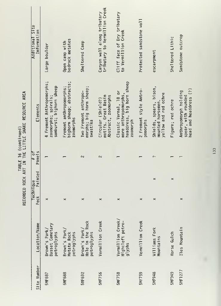
<v4->
i- X00 oI— +Jr0 <DX Eo C»- o4-> t|_
r- CO f—o
oo;
oco
s> to
Mcou
CO
ct:<
OO
QOLU
4- 10O i—
«oQ.
-o<u4->
C0> 1-3 r0O-Q.
Oai ±>r- O
(DO.
oo
a>>> cu >>s- s_ S-rO O ra+j M r—3 c 3 i
—
X) O Xl ro•r— *i— •1
—
2t- i— i.-l-> f— 4-> ^ a>
•i— ai ccn E >> <u o Q.c 1- J- S- p o o
to O 0> Q CO to •r- S-X <D Q. 1— > o X ui- +-> ••-> E ro <+- C c M 4->
<D ..- (O ro o o o ro r- 3o 3 •-> O ,— +-> •r- to _l or— O) !-» a> >— 4->
3 Q. E o ro >> U i— -o C o a;O E <D 5 S- <o •- a* <u CU xX) re ^ S- <o ^ E +-> E S- o
U o <U X -l-> s_ <_> Q. tu M<D O 4-> O 3 <+- <L> O) S- 4-> (/>
CD x S_ r— >>X) 4- > +j ra r— "Ol_ Oj T3 (1) X -r- •r- o u <U XrO Q. 0> X <a i- i— o i. to X fO—
1
O X> 00 o +J <_) •»-> a. ai 00 OO
. « . •. Q.to (/> a>X O. • «4-> • «s a> 9l
a. a> «/» O Q. x: 1 C ^^1- CU x: T3 1 <U i. to O o cn c^-
o x: Q. i- o a> o « 1_ to O) c ~—E •- </> s- -P O.SZ c to to c 4-> •w— s. •>- -oo </> o o O CO ^—
*
• »— X co x i- c X) X T3 <D toO-i— c E .o i- <^> to a. r- ao <c u Q} i— T3 to
o <o s- O <TJ x: c o <T3 j- i_ X » c o s_ O X CUS- S- o Q. -»-> s_ r— CQ o " o O) to ai X X 3 S-.C -f- .E O •" c o <D E i— E en 1— i- E o o o -o4-> Q. CT> i~ a. <o X •f— +-> o ro O •— >, <o a> <u o x s- -oC V> ••- SZ <D X <T3 o C O.X1 p O) to i. o. <a< jQ •-> <u »-> en 00 <U N 1_ o to Q. J- -o S- x tv
• a c x: C »r- V— i- a» s- to o •a a> o +> x:»-> to •« <o t/> t/> O X) C3 m > x: to M X c s_ E —c x: -4-> x: E <o s- 4-> +-> to X X to #. <e o 2 -oO Q. </> 4-> c Q. a; •« j^ <c • U oca; Q. o X to "o • * CL cE s- s- c $- S- J- to •r— ,— to (O •<- m s_ l_ E a. -o <u 2 <D o « to
a> o 3 o o o U_ X M 3 4- s. «/> T3 O a> t- i— 4-> o i- S- S-J- E J3 E x: E Q. to (J • i— +-> to <y -o E S- o <u c r— 3 X ITS -OLU O C a> en o O J- <o s. 4-> to <o s- <o O U- E •r- 3 r^ cn +j a> re
O 3 s- •^> o 5 O s •r— O s i— o a; O o X O a> •r— cam«3" N «/> U- XI Nl 1- E to o E o E x N C\J D. oo E >» Li_ <C to x
cn
j^ jx: .^ 1 j*>> u <L> <u o a)t? o a> tv S- a>
^^ ro ^^ — ai s- i_ -4-> s. j* XJ* 4-> ±t n <_> CJ O) c_> t. •»—
S- <u to s_ ^^ to s. ai to D. o X ro
m E x (T3 U X ro X X c c c u_ O 4->
a. a> q. COO. a. -t-> a. o o +-> o to ^ C<-> >> C£ >, >> •I— •^ <4- •f— to X 3 3
to r- to i— to c •— fmm f— 0J r— E — CD O- +-> cn - <v cn - t- cn 1— ^~ i
—
to r^ ro ro ^C <D O C 4-> o c o •r— •^ O X •w— '•- 4-> a>2 to &. J m s. 2 a) s_ E E X a. E — X to to
o to +J o *-> +J O r— 4-J c j- cn >, S-. i— 3 S- a*S- <o 0) s_ tv tu S- O <U 0) 01 •r— r— ai ••- O o t—CO CO Q. ca s: Q. co n: a. > > X cn > 3 s: zc IH
t^ CO tNJ to 00CO CO cn LO LDto <x> to r«- 1^
cn CO cn r~LO -* «d- <Mr^ cri c^ t—
LO LO LO LO

OO o
to <oc £=
o C- o
o
a:<
oO00LU
a to
C LU
CO
CO
•— a:<
c_>ocz:
aooLU
4- to
O —CD
=*= c<T5
a»4->
cCD H-3 fOCTO_
C_>
— oCDa.
oo
CD
E<DCJ
os_
M"a;
oo
J*oor—S-CD s-
> cdo >
•^<*- CC
Ol 4-e •.- «3<0 i— a.o o E
<TJ
T3 cd >-CD cs- o cdcd <L) •-> c+> > cd l/> •-r— o CD T3 ^CD c_> o C O.E r— CD <T3 Ooo «t _l 00 i—
cdc<o
1.CD>o
CDo
co4->
«/>
T3cto00
Q.PI
.E -OQ. CDS- i~
oE •>O -CQ. Q.o s-s- o-C E»-> oc o< N
cd -oS- CD3 J-CD•i- -o<4- C
CO-oi— c:cd a;•r- cdsz J-00 CD
a.s- a>o s-
E -co uCL ooj- -oXT CO+J I.c<: «
I/)
-o •->
a; oC (OS- i-
o -•->
n: to
co to
+-> cd(j to(O s-s- o(/>
XI(O "—
CO T3to I—CL 0)
t/»
s.« <D
s- c o«CO CO 4->
•i- = Os- E
•> CD •
.Si 10 S- to .(->
U£lL 4J C<T3 O.-— U •-_Q S- (O COo o vt t. ato E -^ +Js. o u) u>-cO O CO J2 CO3: N E to i-
toCD
• A l« S-+> to C7> to »-> 3C4- -O <L) Z3 c TJ CJ)
ta r— O r- CU •i—«3- <D 3 (O to «*- • 4->
J= •> C Q. •r— t/> Cto (/) •!- o O CD •-jz -o J- +-> -o c i— S- COa. c a» c <u r— CO 3 Q.$- 3 o o o: ••- CDo o r- o T3 ^ T- COE s- 3 CL) to 4- 3o O >4- • 4-> ^~Q.JZ E o to C - CD .0O 4J to CO •r» 4-> ^$- -r- +* c to c •.- -a^ X <u to •r— a. «s ^ c•M s- — pa J= 1 toC i— to to >> CD Q.T-<c ^ 3 C -6T 3 <D Cu-O
CO cr o o r*« i— ••- <DCO -M to u x> CO <D 4-> S-
ro
CD **«« CDE to szTJ
CD CC s- oo m•r- c+-» a to<T3 c E CDCJ o E S-
O E o o__l CO (O o
•^ CD oQ CO _1
r- ^£ J»£J- ai CDJ- CD CDCO J. S- c^ O o CD
T3• >> >> >>
+-> J- s- toQ Q zc
s-
CDJ2 coE LO3 t^Z ^—
CD fe+-> Lf)
4^c3Oo4->
3O
CO
a:LO
co
onLO
r-.
C£LO
OCD
LO
CDCDS-C_J
Q
CO
LO
o1
—
E3 T3(SI •r-
^-«
c i
—
o •r—
to 3S-ns 4->
J3 CD
JD CD3 2=n CO
oCNJ
LO

•p•r- CCO oI— +J
£= Eo Eii- o
o
o=>oCOUJQ£
UJ
C UJ
oo
«x>
CO
£fc=«t
ooD£
OUJQQCOO
o
(IJ
S-
CO
- «/>
O i—o>
a.
T3ai
cOJ •--
CD.
O0) -^o
ISi
1 i CD
o o r—Q. S- oO -C 5-
5- +-> •r—
jC c u!-> <DC -o •»
«3 ,_ r— </>
r-» a> 3a> <TJ •i— ocngr s-
i. </> to s-<T3 (Or— CO r>
W »»
CO * -C toto q. a*
n SZ s- i-t. Ol O 13a> S- E ena> o o •r—
Q E O.**-
CO
S-
Q.
c2
S-a>jDE u->
3 «*2: CO
1—cd C£.+-> IT)
CO

known. Site 5MF289 is a pictograph and petroglyph panel located along a
sandstone ridge adjacent to the Williams Fork River. The main themes of the
panel are riders with shields, headdresses, and bows/arrows and are
representative of post-Hispanic contact. Omer Stewart has hypothesized that
the rock art marks the boundary between Ute and Shoshone occupation
(Breternitz 1971). The four sites not located along obvious access
corridors and more inaccessible areas may have been used for different
functions. The isolation of these sites suggest a possible religious
purpose.
The known rock-art sites occur primarily in overhangs, sandstone
cliffs, and isolated boulders, and all but three have a southernly aspect.
Rock art panels associated with habitation attributes, such as 5MF290, 345,
and 692, offer an excellent opportunity to investigate the nature and
affiliation of these phenomena through the dating of archaeological deposits
and cultural materials.
Quarry Sites . Areas where lithic raw material was extracted or mined
for stone tool manufacture are classified as quarries. Despite the numerous
exposed geologic strata containing potential sources for excellent toolstone
and the frequent references to "tiger chert found in the Sand Wash Basin" in
archaeological literature, only four quarry sites have been recorded for the
resource area, none of which mention "tiger chert" as the quarried raw
material, white chert was noted as occurring "everywhere" by Grand River
Institute (1980) during the Oak Creek Survey in Routt County. All recorded
quarries produced various types of crytocrystalline quartzites; no obsidian
sources are known within the LSRA.
136

Stucky (1974) describes three geologic formations within the Sand Wash
Basin that produced the raw lithic material utilized by prehistoric
populations to make chipped stone tools. The Bridger Formation contains
three types of lithic material: a green sedimentary block quartzite,
rounded quartzite and jasper cobbles, and light tan to dark brown surface
flint that occurs in nodular form (commonly called tiger chert). The Green
River Formation produces silicified oolitic limestone that can be found as a
surface deposit. The third formation described was the Wasatch where pink
to orange jasper was found in angular cobble form. More than 88 percent of
chipped stone tools recovered during the Stucky survey were made from these
lithic sources.
Three of the recorded quarry sites, 5MF675, 5MF479, and 5MF899, are
located in the Wasatch and Bridger formations and are described as terraces
and ridges out of which chalcedony and chert nodules were eroding. 5MF6 75
and 5MF899 are located along the southern portion of the Sand Wash Basin and
at elevations within 5 meters of one another, 1,798 meters and 1,804
meters. 5MF479 is located north of the Basin overlooking Shell Creek and
within the Wasatch Formation at an elevation of 2,085 meters. A small
2quarry site (150 m ), 5MF1205 , containing chert nodules, was located on
the slope of Cross Mountain within the Madison Limestone. No pits or other
activities associated with "mining" the resource were observed.
Three open-camp sites are located on or near quarry sources, and
apparently the procurement of the raw lithic material was one of the
activities conducted at the sites. The four quarry sites are located in
four different topographic areas and formations. Iron Mountain is the
location of an open-camp site where basalt, which was acquired from an
137

outcrop on the mountain, was reduced. Chert and quartzite flakes were also
present at the site but not acquired on the mountain. Tiger chert in
nodular form from an erosional terrace in Sand Wash was collected at a dune
open camp, 5MF1628. In the area of Savory Pot Hook, quartzite cobbles from
a Wasatch Formation terrace were collected and used at 5MF522.
Much of the use of native toolstone in the LSRA appears to be more
fortuitous rather than intentional mining and reduction found at quarries
such as the famous "Spanish Diggings" near Lusk, Wyoming. This may be a
reflection of the quality of toolstone found in the surface terrace
deposits, or just another example of an incomplete data base. The presence
of algael, oolithic, pumpkin, and tiger chert at archaeological sites
further south and west suggest some sort of trade network or even seasonal
round where collection of raw material was part of the resource strategy.
The procurement of raw toolstone materials was more than the mere gathering
of surface materials -it required serious, planned systematic efforts and
the expenditure of energy and time. The importance of this aspect of the
prehistoric cultural system cannot be underestimated. The economy of these
peoples often depended on the quality and availability of raw materials for
chipped stone tools. Further systematic studies of prehistoric seasonal
round should include this integral activity.
An exception to the fortuitous use strategy is the quarry open-camp
site recorded by Gardner (1981). The site is located in the cherty
limestones of the Morgan Formation. Nodular and plate cherts were "mined,"
collected and utilized. The site is extensive, and no site boundaries have
been discerned yet. Diagnostic artifacts recovered suggest prehistoric
populations, from Paleo-Indian Clovis times to Late Prehistoric times,
travelled to the quarry to collect raw toolstone material.
138

To determine the difference between the localities in terms of favored
toolstone use, collections could be made from various formations known to
have been used and, through petrographic analysis, evaluation of the quality
of the toolstone could be made. This information would provide significant
data as to trade networks and cultural boundaries, as well as some insight
into a necessary portion of the seasonal round raw-lithic-material
procurement.
Isolated Finds . This category has been used as a catchall since the
advent of archaeological surveys conducted for cultural resource
management. Originally conceived as a description for a solitary artifact,
it has grown to be interpreted in various ways from "a single object of
human origin located more than 100m from any other contemporaneous artifact"
(Creasman 1979: 111-3) to its use for any phenomena that does not fit the
description of an archaeological site. This last description includes
historical trash, isolated fire hearths, localities, and "4 or fewer
artifacts."
Overall, the general use of the category implies a description of some
sort of limited short-term activity area. Studies and observations of the
physical remains left by contemporary hunter and gatherer groups, such as
the !Kung Bushmen, have noted that at some sites only the remains of a few
flakes, scrapers and an occasional fire hearth remain (Yellen 1976). Such
sites would probably either be visible or become candidates for "isolated
finds" after just a few years. Arrows or ataltl points lost by aboriginal
hunters may also be later found and classified as isolated finds. Once
described in this category, unfortunately, the artifacts are not further
studied unless they are projectile points. Therefore, it is possible that a
139

rather large body of data is not being synthesized into the formation of
theories regarding subsistence strategies or locational patterns.
Regardless of the problems in determining the function of isolated
finds, the majority are probably limited activity sites, and most could be
described as open lithic. Isolated finds occur throughout the resource area
at all elevations, within all vegetative types, and in all sorts of
topographic situations. A total of 380 sites in the resource area have been
classified as isolated finds. Thirty-nine projectile points have been found
in isolated circumstances. Table 17 describes the range of cultural remains
recorded in this category. Since many of these sites could represent
systematic behavior such as a limited activity and, therefore, consequently
a neglected aspect in the subsistence and settlement pattern of the
aboriginal populations in the resource area, treatment and definition of
this phenomena should be standarized in the resource area. Perhaps a return
to describing solitary artifacts as isolated finds and all else as sites
under the described categories along with further consideration of what
aspect of prehistoric life the phenomena represents would be advisable.
Multiple-Site Type . The sites in this category contain cultural
material from both historical and prehistoric periods. Twenty-one sites
fall into this type. One -half of the prehistoric types would be classified
as open camps. Nine of these prehistoric sites also contain historical
architecture in the form of homesteads, dugouts, and corrals. Apparently,
historic and prehistoric peoples at times considered similar site location
attributes when selecting a "campsite." Elevation above a water source was
usually less than 24 meters, and distance to the source was less than 150
140

CD
CDQ
4-> •»->
c cCD 0>! h. k. ka W_ k_ i__
CD a> <D CD CD CD CDcdcdcdcdcococdcdcdcocdcdcdcocdcdcdcdcdcocdcdcdcdcocdcdcdcdcocdcdccccajajcccajccccuccccciDCccrcraicccrcaiccOOOOS-S-OOOi-OOOS-OOOOOS-OOOOS-OOOOS-OO2222CLQ.2Z2H222llZZZZ2aZZZZQ.r222D.2?
COo!->
oXUJ
CDCDCDCDCDCDCDCDCDCDCDCDCDCDCDCDCDCDCDCDCDCDCDCDCDCDCDCDCDCDCDCDccccccccccccccccccccccccccccccccooooooooooooooooooooo o o oc c c c coooooooo
CD CD CD CD CD CD CD
O C C C C C i- Co oooooooZ Z Z 2- 2 O 2
CD CD CDc c Co o o4-> -M +J
s- CO s- s- CO CO s-<D s_ CD CD o CD <D "O S- CDo. I
—
CD o O c Q- Q. C CD Q.<D CD «o CD CD CD CD CD CD a> CD CD CD CD r— > <T3 «3 =J CD rt3 fO 3 E Q.C c S- c c c c c c c c c c c •r— <o M- <4- o s_ S- S- O E Oo o a o o o o o o o o o o o s- i- •r- •^ i. o u u t- fO JCz z oo z z z z z z z z z z z o cn CO CO CDUW oo o ac o
ce.oooUJ
UJ
03 ^
o00
co4->
o
(D
OCDi-JOs-Q.
oCDJ=Ot->
O
C <D•<- -aCO ••-
(O 00CO
CO COCD CD
i- i.
CD <DOO 00
CD <TJ
CDCDCDCDCDCDCD+J-MOOCCCCCCCfOCj^J^OOOOOOOOi-i-
aS-o
T3T3 -PC CD CD CO•<- e c — -oCO -r- •!- JZ O<a E E CD oco s_ s- i. 5
C CD CD a. c(O O +-> +-> OO +> CD CD CD -Mc e -U -a j* -m
<o o
c(TJ
T3c
o u *-*
CO •- ••- I
CD <0 to O•r- JC JC CDS- O O i—CD S- 4. «0O0<<Q.WDT3"DCD CD CD CDc c c c'Z E E ECL i- i- i.
OO CD CD CD+J 4-> -l_>
CD CD CD CDCO "O T3 -ao c c c
CDCDCDCDCDCDCDCDCDCDCDcccccccccccoooooooooooZ<:=>UJUJQQ.^=3_JOQ;rD = = ZZZZZZZZZ
coCDi.
CD
4->
o
i— S-<TJ OS- 4->
S- COo •-o z
CDCO
4-CDa:
S-c oJ- •->
•p- co(O •.-
o z
coT><0i.4->
cCD
CD UCO3 O«4- OCDCC J*
uo o•<- cc5-o +->
i-> cCO 1_•r- 3Z CO
C !->
a.CD
i-CDCDCDCDCDCDCDCDCDCDCDCDCDCDCDCD(OCCCCCCCCCCCCCCCCCDOOOOOOOOOOOOOOOOCD CD CD CD CD CD CD CD CDC c c c c c c c co o o o o o o o o

CD
+->
0)Q
IS
1- Li-1
UJ lj
o
00<_)
r— r—4-> a> O) <u — O) 01 <DO c c C <D c c CX o o O JZ o o oUJ z z z to CO z z
01
4-> 4->
C COJ o>
co co a> aj o» </> </>
qj a> c c c a> <us_ i~ o o o s- s_Q_ Cl. Z Z Z 0_ Q.
O)Q.cl qj qj o» o) 0) oo i- s- c c c cJ= o o o o o oO <_) o z z z z
CM
CJ CU CD CD 1) <D CDc c tr c c c co o o o o o o
(U O) d) O) Ol <u <uc c c c c c co o o o o o o

meters in 70 percent of the sites. Terrace and ridge locations were favored
by both peoples. Table 18 further describes this site type.
A basic framework to descriptively classify sites in the Little Snake
Resource Area, based on previous work conducted in Northwest Colorado by the
Laboratory of Public Archaeology (LOPA) and directed by Dr. Calvin Jennings
at Colorado State University, was used. Table 19 summarizes the site
classifications and the percentage of sites per category. Review of the
table reveals that three of the classifications (open-lithic, open-camp,
isolated-find) are larger than the others. Based on previous assumptions
for general site function, there should have been more open-lithic sites
(limited activity) than open-camp sites (campsites). Isolated finds could
be defined as limiated activity sites, however, and by combining the
isolated finds and open lithic sites classifications a more representative
figure is presented in relation to the number of open-camp sites.
Assigning a function for this site typology is actually a bit
premature; little environmental difference can be observed between
open-lithic and open-camp sites on this general level. Subdividing the
resource area into smaller environmentally similar units and then evaluating
environmental differences between site types would be practical.
A far greater range of subtypes also exists within these site types in the
resource area than the automated data base has produced. Amateur
archaeologists and collectors in the area should be consulted on the
location of wickiups, storage cists and room blocks, and their existence
recorded and described in an effort to fill in the data gaps.
143

TABLE 18
MULTIPLE SITE TYPE DESCRIPTION
Site Number Features Projectile Points Tools
5MF1004 Homestead, dugout None Flakes5MF1011 Homestead,
Historic refuseDesert si de-notched Biface
Core5MF1197 Historic refuse None Flakes5MF1216 Hearth-firepit,
Historic foundationUndetermi ned Scraper, chopper,
Groundstone5MF1431 Groundstone concentratori, Archaic Biface, core,
homestead Archaic Groundstone5MF1454 Historic refuse None Biface, scraper, Groundstone5NF1457 Historic refuse Undetermi ned Biface5MF1594 Historic refuse None Flakes5MF269 Homestead,
Historic foundationNone Biface
Groundstone, hammerstone5MF333 Homestead, corral None Biface, groundstone5MF404 Historic refuse, corral None Scraper5MF518 Hearth-firepit,
Historic refuseNone Scraper, core
Groundstone5MF695 Hearth-firepit,
Historic refuseNone Biface
5MF725 Dugout,Historic refuse
Archaic Groundstone
5MF855 Dugout,hearth-firepit
None Groundstone
5MF888 Historic refuse None Biface, groundstone5MF955 Historic refuse None Biface, scraper5MF959 Hearth-firepit,
burnt rockNone Groundstone
5MF991 Historic refuse Late Prehistoric Groundstone5RT1 51 Historic refuse Late Preh istoric Chopper, core, groundstone
144

TABLE 19
SITE TYPE DISTRIBUTION
Number of Sites PercentaRe Per Type
Unknown 1
Open Lithic 347Sheltered Lithic 4
Open Architectural 16
Sheltered Architectural 5
Sheltered Camp 22
Open Camp 295
Quarry 4
Trails-Roads 4
Rock Art 19
Burial (Historic) 5
Historic 227
Isolated Find 385
Multiple 24
Paleontological 3
Total 1,361
.07325.5
.29
1.18
.37
1.6221.7
.29
.29
1.396.38
16.6828.291.763.220
14 5

VII.
CHRONOLOGY AND AFFILIATION
The development of a chronology and regional sequence in the Little Snake
Resource Area is hased on several lines of evidence, including radiocarbon
dating, cross-dating of projectile point types, and the presence of
ceramics. Radiocarbon dating is the primary means of dating and
establishing the chronology of the region. No dendrochronologic samples
have been analyzed for the LSRA.
Relative chronology through cross dating of artifacts and other types of
cultural evidence such as features or structures can also be correlated.
The nonperishable archaeological remains, pottery and projectile points are
sufficiently distinct in their construction and morphology and restricted in
terms of their temporal occurrence and geographical distribution to be used
for archaeological cross-dating of sites in the LSRA.
Maize has been the best diagnostic timemarker of all preserved plant
remains in Northwestern Colorado. On the Colorado Plateau, corn is
generally believed to date after A.D. 1 (Schroedl 1976), although Winter
(1976) reports evidence for corn in late Archaic contexts in the Southwest
before this date. Corn remains have been affiliated with Fremont occupation
in Dinosaur National Monument and the Canyon Pintado Historic District
(Bretemitz 1970a; Creasmann 1981; La Point et al. 1981).
The only evidence, however, for the presence of corn within the LSRA
boundaries outside of Dinosaur National Monument are corn cob impressions
left in the adobe mud walls of a storage cist above Brown's Park.
146

Other cultural phenomena may be used in correlating the prehistoric
sites in the LSRA. Some types of pit features, including hearths, fire
pits, slab and rock lined fire basins, seem to have significant temporal and
possibly geographical dimensions (Wormington and Lister 1956); but no
studies of these site features have been successfully conducted in the
LSRA. Burials and associated artifacts also provide significant temporal
associations, but there are no recorded sites of this nature for the
resource area. Rock art styles have been preliminarily studied by Cole
(1983), but correlation with styles outside her study area are tenuous. For
the most part, cultural features suitable for cross dating and correlation
of sites remain limited.
Projectile Points
Placing prehistoric sites in chronological order depends on the analysis
of projectile point styles. These styles, or types, are used to describe
observable and quantifiable changes in cultural material over time. Frison
et al. (1974) has noted a general decrease in point size from early to late
prehistoric times, reflecting the change from spear to ataltl dart to arrow
point.
As previously mentioned, the LSRA is marginal to two major cultural
areas, the Great Basin/Plateau/Desert Archaic and the Northwestern Plains
cultures. In order to classify remains within the LSRA, typological
comparisons with these areas is necessary because the materials and general
area within the LSRA are relatively unknown and unexplored. There has been
very little excavation of deeply stratified sealed deposits within the
resource area.
147

Researchers and contractors conducting archaeological investigations
within the resource area have relied on cross dating recovered projectile
points with those associated with excavated multiple component sites that
contained sequential developments and extensive time spans. In many cases,
because the area surrounding the LSRA has not been extensively explored
archaeologically, archaeologists have had to reach far afield for
comparisons, thus weakening the local relationships and interpretations.
Until this "marginal" area has been more fully investigated, these
comparisons and correlations will have to be viewed as tentative and only as
general characteristics of broad cultural periods present in the resource
area.
There have been 324 projectile points recovered and curated from the
Little Snake Resource Area. Only 73, however, have been analyzed by the
collectors and compared with surrounding cultural areas. One hundred and
fourteen points have been identified to very broad cultural periods. Three
points have been classified as unidentified Paleo-Indian, 37 points as
unidentified Archaic, and 51 as undefined Late Prehistoric. These
undetermined projectile-point types may be the result of the fragmentary
nature of the point remains or the lack of comparable specimens in the
surrounding areas (Table 20).
Figure 1 displays projectile-point types, approximate dates, and
cultural affiliation for the various chronologies from surrounding areas
that were used to compile the following type descriptions. The descriptions
are organized according to chronological sequence and cultural area. Four
basic time periods described by Willey and Phillips (1958) are used to
subdivide the prehistoric occupation reflected in the projectile-point
148

TABLE 20
TYPED PROJECTILE POINTS FROM LSRA
NumberProjectile Approximate Cultural IdentifiedPoint Type Approximate Date Affiliation LSRA
Clovis 9250-9550 BC Early Paleo-Indian 1
Folsom 7050-9050 BC Paleo-Indian 2
Midland 8750-8450 BC Paleo-Indian 2
Agate Basin 8550-8050 BC Paleo-Indian 2
Scottsbluff-Eden 6850-8250 BC Late Paleo-Indian 2
Hawken 4550-4350 BC Early Plains Archaic 1
McKean 4950-2950 BC Middle Plains Archaic 9
Duncan 4950-2950 BC Middle Plains Archaic 4
Hanna 4950-2950 BC Middle Plains Archaic 1
Mallory 4950-2550 BC Middle Plains Archaic 1
Pinto 6300-4200 BC Middle-Late Archaic 3
Humbolt 5650-4150 BC Archaic 1
Elko Series 5650 BC-Historic? Late Paleo-Indian tohistoric 16
Rose Springs AD 450-AD 1650 Late Archaic 13Cottonwood AD 1000-AD 1650 Late Fremont-Proto-
historic 4
Desert-side Notched AD 900-AD 1200 Numic-Protohistoric 6
Uinta Side Notched AD 800-AD 1720 Late Fremont-Proto-historic 3
Historic AD 1640-AD 1870 Ute-Shoshone 2
UndeterminedPaleo-Indian
Undetermined Archaic
3
37
Undetermined LatePrehistoric 51
149

Projectile Point Sequence Regional Cultural Sequence
c .c<D u x:TJ uUJ
foc o
c- u- CT> <u cC o T? a>
ifl 3 o oro u W o L/1
T? ca a >, u 01 fl *F C i^ C c c t. </) </l cO 01 *-> (1) <tj fD IT3 o O O o 1- «a
\a »-> 4-> -*. fl' U C -*-J o 01 •!-> OJ
tj <T3 a 1 ^ C c c F j*: </> 4-> l/>
o cn <v o 3 m ru 3 o o CD
u. E < i/> X ^ o 3. ^ a. a; LiJ a; <_) o =>
o +->
l. r- raO i—<_> a.
t- o4-> GOtrt cri
— oD- I -tJ Recent
a> u
C E_ O 3a. u. z
>p- O) Mf-(D (_> ai u o
m a, cohs F CT>
01 41~ cri
A3C
i. <T3
o z: ITJ
Transitional
01 O-i
0) >J- *-<J3 CC
01 oI—
I
3 O
150

collection. These are the Paleo-Indian, Archaic, Formative, and
Ethnohistoric periods. The Paleo-Indian will be examined as a time period
that spans all cultural areas.
Paleo-Indian
Clovis . These well made lanceolate projectile points are fluted and
characterize the earliest cultural tradition of the Paleo-Indian horizon
the Llano tradition. This tradition is well documented at mammoth sites
in New Mexico and Arizona and has been radiocarbon dated to 11,200 to
11,500 B.P. (9250 to 9550 B.C.). The closest evidence of Clovis hunters
to the study area is the Union Pacific Mammoth Kill site located near the
Little Snake River by Rawlins, Wyoming. Although some question remains as
to whether the site is a Clovis site, because of the lack of diagnostic
projectile points, a radiocarbon date of 11,280 + 350 B.P. (9330 B.C.) on
tusk material falls within the time span of the Llano tradition. The
Clovis point is considered to be typically a Plains adaptation, but it has
been found on a tundra ridgecrest in Rocky Mountain National Park
(Benedict 1975). There are no reported sites for the Colorado Plateau
(Schroedl 1976).
One Clovis type point has been recorded in the resource area at an
open-camp site on Cross Mountain (Gardner 1981).
Folsom . The Folsom complex is characterized by the smaller, more
finely made fluted Folsom point and, although not directly, follows the
Llano tradition. Associated dates range between 9,000 to 11,000 B.P.
(7050 to 9050 B.C.). Characterised as a High Plains culture like the
151

Llano tradition, the Folsom point has also been found as surface finds on
the Uncompahgre Plateau (Huscher 1939), in the Unitah Basin (Lindsay and
Lund 1976), in the Grand Junction area (Steward 1938), and along the Front
Range (Benedict 1975).
Two Folsom points have been reported within the resource area. The
sites, one an open-camp site and the other an open-lithic site, are
multicomponent , containing diagnostic artifacts from later periods (Chase
1981). Several reports, although unconfirmed, of Folsom finds in the
vicinity of Sunbeam and Maybell have been made by local residents and
members of the Vermillion Creek Chapter of the Colorado Archaeological
Society.
Midland . This variety of point closely resembles the Folsom point
and may in fact be unf luted Folsom points (Frison 1978). At the Hell Gap
site in east-central Wyoming, a separation between Midland and Folsom is
perceived, but with some overlap (Irwin-Williams et al. 1973). At the
Hansen site, the Midland-type projectile points occurred in the same
cultural layer as the Folsom points (Frison 1978). Midland dates are
thought to occur between 10,700 and 10,400 B.P. (8750 and 8450 B.C.). Two
Midland type points have been reported at multicomponent open-camp sites
in the resource area (Stucky 1974; O'Neil et al. 1982).
A number of point types representing a relatively more diverse
archaeological culture are associated with the Piano Period, 9500 to 6500
B.P. (7550 to 4550 B.C.), the last of the Paleo-Indian horizon. These
points are finely pressure flaked, producing shallow, parallel flake
scars, lanceolate shapes, and lenticular cross sections. Point complexes
found in the resource area representing this period are the Agate Basin
and Scottsbluff-Eden point types.
152

Agate Basin . Two Agate Basin type points have been recorded in the
resource area—one as an isolated find (Hansen 1978) and the other at an
open-camp site (Stucky 1974).
The type site for the Agate Basin point is a Paleo-Indian bison trap
and butchering site centered along an arroyo located in extreme eastern
Wyoming (Roberts 1951; Bass 1970; Frison 1978). Recent reinvestigation of
the site yielded charcoal dates of 10,330 + 570 B.P. (8380 B.C.) (Frison
1978). The points associated with this complex represent an "excellence
in stone flaking technology" with straight blade edges, lenticular in
cross-section and ground on all edges (Frison 1978). Agate Basin type has
been dated at the Hell Gap site at between 10,500 and 10,000 B.P. (8550
B.C. and 8050 B.C.) (Irwin-Williams et al. 1973).
Scottsbluff-Eden . This type is associated with the Cody Complex of
the Piano Period. The Cody Complex was defined at the Horner site near
Cody, Wyoming, (Jepsen 1953) and yielded radiocarbon dates, suggesting the
complex lasted from 8800 to 8400 B.P. (6850 B.C. to 8250 B.C.). Points
are often typed as Scottsbluf f and Eden, but, according to Frison (1978)
and others , may not be separate types but rather a continum of variation
with intermediate forms. Two points identified as Cody Complex types have
been recorded for the resource area. One was located in Routt County on
an open-lithic site 5RT139 (Wheeler 1980; Hand 1980). The second was
located in the Hiawatha area by LOPA on an open-camp site with multiple
components (Jones and Jennings 1977). Scottsbluff points have also been
reported from 5MF132 in Brown's Park (Breternitz 1970) and in Dinosaur
National Monument in lower levels of Deluge Shelter (Leach 1970).
153

Archaic
The following point types are represented in the Northwestern Plains
cultural area.
Hawken . This point type, defined by Frison et al. (1976) is
associated with the Early Plains Archaic, radiocarbon dated at the Hawken
site at about 6500 to 6300 B.P. (4550 B.C. to 4350 B.C.). These points
are considered to be the earlist side-notched type known from the
Northwestern Plains associated with a bison kill and might have possibly
been "a local innovation derived from the terminal Paleo Indian" (Frison
1978:199). Frison also qualifies this statement by noting a possible
derivation or relationship with points further east. The Hawken type is
found, in rare instances, in the northern Colorado Plateau, but as yet
unrecorded in the Great Basin (Schroedl 1976). At Sudden Shelter the
point dates approximately 6500 to 4600 B.P. (4550 B.C. to 2650 B.C.),
falling into Schroedl' s Castle Valley Phase. Holmer (1978) suggests that
the presence of the Plains-associated type in the plateau area and not in
the Great Basin may indicate a shift from close association to
diversification between the two areas. One Hawken- type point was recorded
in the resource area by Stevens (1981) during test excavations near Axial.
McKean Complex . The McKean complex is characterized in southern
Wyoming by large, side notched and basically indented points occuring
about 3000 to 1000 B.C. (4950 to 2950 B.P.) This complex signals the
beginning of the Middle Plains Archaic Period defined by Frison (1978).
Diagnostic points include Duncan, Hanna, and Mallory types. Nine points
have been described as McKean for the resource area, all associated with
154

archaeological sites. Duncan and Hanna types are recorded on four sites
and as one isolated find.
The point sequence that occurs in the western Great Basin is, from
earliest to most recent, the Pinto Series, Humboldt Concave Base, Elko
Series, Eastgate Series, Rose Spring Series, Cottonwood Series, and
Desert-Side Notched. The following seven point types are represented in
the Great Basin and Colorado Plateau cultural areas.
Pinto Basin . These points are described by Harrington (1957) as
large, crude, thick and often asymmetrical. They are manufactured by
percussion, with some pressure retouch. These Desert Archaic types are
dated in the Colorado Plateau and Southern Plains around 6350 B.C. and
persist for approximately 2,000 years (Holmer 1978). A firm date for the
Pinto materials has never been established; however, Leach (1970) accepts
a late Alt ithermal- early Medithermal time period, which fits correlated
materials he found at Deluge Shelter. Discrepencies in the dating have
been hypothesized by Holmer (1978) as possibly indicating an introduction
of the Pinto series points into the central and western Great Basin from
the east. Schroedl finds Pinto series characterising the earlier subphase
of the Black Knoll Phase, 6300 B.C. to 4200 B.C. Three Pinto Basin type
points have been recorded from the resource area. One point was located
at an open-architectural site, which also contained beads and a metal
projectile point (Baker and Reed 1978). The second point was found at an
open-camp site near Vermillion Mesa (Hoefer and Thompson 1984). The last
point was an isolated find (Gordon et al. 1982).
Humboldt Series . These points date from approximately 5650 B.C. to
4150 B.C. in the eastern Great Basin, which is similar to that of the
155

Pinto series points (Holmer 1978). On the Colorado Plateau this type
appears during the later subphase of the Castle Valley phase, around 3050
B.C. (Schroedl 1976). Descriptions of the series vary. Aikens (1970)
described the series as having contracting blade edges about one- third
the vertical distance from the base giving the point "shoulders."
According to Heizer and Hester (1978), the points are extremely convex
without shoulders. Heizer and Hester (1978) dated the Humboldt series to
3920 to 1100 B.C. One Humboldt series point has been reported by James
Head of Western Wyoming College at an open-camp site near Hiawatha Camp.
Elko Series . The series includes side-notched, corner-notched and
"eared" varieties and was defined by Heizer and Baumhoff (1961) as large
stemmed, often asymmetrical and produced by the percussion method and
pressure retouch. As Holmer (1978:62) points out, "the Elko series
projectile points are the most plentiful but the least temporally
diagnostic of the point types commonly found in the northern Colorado
Plateau and the far eastern Great Basin." They occurred after 5650 B.C.
and possibly persisted into historic times. Heizer and Hester (1978)
suggested a temporal span of 2000 B.C. to A.D. 1080 and remarked that
certain varieties, such as the Elko corner-notched, might have continued
beyond this time. Sixteen points identified as Elko series type have been
recorded for the resource area from 13 open sites. Three Elko points were
recovered as isolated finds.
15 6


Formative
Rose Springs Series , This series has been defined by Lanning (1963)
and is described as small, stemmed points with straight convex bases and
blade form, ranging from convex sided to concave sided. There are three
defined types within the series: side-notched, corner-notched, and
contracting stem. These small points mark a major shift in technology
from spear to arrow. In his discussion of the types, Clewlow (1967)
states that the corner-notched type appear to have occurred between the
end of the Elko Series (ca. A.D. 600) and the appearance of the Desert
side-notched. Heizer and Hester (1978) suggested that these points first
appeared earlier than 300 B.C. and flourished between A.D. 600 to 1100,
with some varieties continuing into historic times. The Rose Spring
Series has been associated with Fremont occupation in Dinosaur National
Monument, among many places, but recent investigations by Webster (1980)
and others find the series dating as early as 3300 B.P. (1350 BC. The bow
and arrow did not become the dominant weapon until ca. A.D. 250.
According to Webster (1980:65), considering "the full range of
evidence in light of the findings from Dry Creek there can be little doubt
that the bow and arrow was present in the Basin well before Fremont horti-
culturalists came on the scene, and consequently arrowpoints can have
little value as Fremont diagnostics in archaeological deposits." Thirteen
Rose Spring Series points are on record for the resource area for 12 sites
and one isolated find. Five of the sites are considered multicomponent,
including diagnostic artifacts from before and after the Rose Spring
Series dates.
157

Ethnohistoric
Desert-Side Notched . This type is described by Baumhoff and Byrne
(1959) as small, basically triangular with narrow notches removed from the
side near the base, which is either straight, concave, "V" shaped, or
notched. This type is widely distributed in the Great Basin, with similar
forms found in the Western Plains and the southwest as well. Heizer and
Hester (1978) estimate the beginning dates of A.D. 1100 to 1200 for these
points; Leach (1970) and Baumhoff and Byrne (1959) conclude that the type
was used much earlier, A.D. 900. Breternitz (1970a) and Leach (1970) have
suggested that the Desert side-notched type is affiliated with Shoshonean
origin or influence in the Dinosaur National Monument area. In the
resource area, five Desert side-notched points have been recorded, all
associated with prehistoric open-lithic or open-camp site types. The
Uintah side-notched type falls within this type but lacks the basal notch
or concavity. Three Unitah side-notched points have been recorded, all in
the Danforth Hills area.
Cottonwood Series . Lanning (1963) describes this type as pressure
flaked, small and nonstemmed. Two forms occur, triangular and
leaf-shaped. Heizer and Hester (1978) found the type occurring ca. A.D.
1300 and continuing into historic times. Leach (1970) and Breternitz
(1970) recorded this type in association with Fremont occupation in
Dinosaur National Monument, with beginning dates ca. A.D. 1000. Leach
(1970) has suggested that some forms of Cottonwood may be Desert
side-notched preforms, based on the observation of the types co-occurrence
and close association at many sites. Clewlow (196 7) believes that the
158

Cottonwood series might serve as time markers, approximating Desert
side- notched type point dates. Four points in the resource area are typed
as Cottonwood triangular. Two points were found as isolated finds and two
were associated with prehistoric campsites.
Historic . Two sites in the LSRA contained metal projectile points
(Stevens 1981, Baker and Reed 1978). Stevens (1981) recovered a metal
point and Desert side-notched point during the test excavation of 5MF427.
The second metal point was recovered from the surface on an open-
architectural site, along with a Pinto Basin type point (Baker and Reed
1978). The precise date of the occurrence of European trade goods in the
resource area is not documented in the area, but it can be assumed that
this point type is affiliated with ethnohistoric groups (Ute, Shoshone)
just before or after their acquistion of the horse, approximately A.D.
1640.
As mentioned earlier, projectile point classifications are not
particularly valid markers of archaeological time horizons when viewed in
the absence of controlled stratigraphic relationships. The most
diagnostic point types are those associated with Paleo-Indian sites
because of their well defined styles and manufacturing techniques. Wide
variations in projectile-point styles occurred following the demise of the
Paleo-Indian traditions. These later point types are difficult to place
in time and geographic locality, possibly because of the influences of
larger populations and the development of individual styles in response to
the exploitation of more diverse food resources (Schroedl 1976).
General inferences can be drawn from the typed projectile points that,
with the exception of one, were collected from the surface. There appears
15 9

to be evidence for prehistoric occupation in the LSRA from Paleo-Indian
periods continuing into historic times. Plains influences that can be
identified for the area occur during the Paleo-Indian Period, Early and
Middle Plains Archaic (Frison 1978), with the heaviest representation
occurring during the Middle Plains Archaic. A continual Colorado Plateau
and Great Basin contact of some as yet undiscerned nature is evident from
approximately 3050 B.C. to at least post-Fremont times and may be
affiliated with the Desert Archaic. A Fremont occupation of the area may
be apparent if the basis of the argument comes from the presence of Rose
Spring Series type projectile points. Ethnographic groups are well
represented by projectile-point types.
The projectile-point types presented in this section are derived from
recovered points described on site forms and project reports. All were
typed by "intuitive" classification by a variety of individuals from
different academic background, training and regional affiliations. This
research methodology, based on nonquantif ied subjectively defined
attributes and individual bias of the researcher, leads to the questioning
of the validity and strength of the resulting typological system.
Classification procedures need to be standarized for the LSRA to
remove the bias of individual interpretations, training, and regional
affiliation. By quantifying the characteristic attributes of the
projectile points, comparison of the system with surrounding regions can
be made and duplicated by individual researchers. A better understanding
of the temporal and spatial relationships represented by projectile points
would be provided, as well as the evolution of particular styles and the
identif icaiton of true "horizon markers."
160

Two successful classification systems have been developed, one for
Northwestern Colorado by Kim Pinkerton (1979) and the other by Richard
Holmer (1978) for Archaic points from the eastern Great Basin and northern
Colorado Plateau. Both employ multivariate analysis of the morphological
characteristics for projectile points, and resultant mathematical
definitions were subsequently used to classify point collections. The
statistical classifications were then utilized to further refine intuitive
classifications. By employing either or both systems in the LSRA,
objective and uniform classification of recovered projectile points could
be made by a variety of researchers. Measurements could be made in the
field (in case of noncollection policies), and a nonsubjective chronology
based on projectile points could be developed for the resource area.
Ceramics
Pottery has been used most successfully in cross dating and seriation
because pottery designs, motifs, construction techniques, and vessel forms
are relatively sensitive time and spatial markers. Prehistoric ceramics
are quite scarce in the resource area, with less than 50 sherds recorded
to date. Fifteen sites are reported with ceramics, five of which
contained Anazazi ceramics. Four sites contained Shoshone ceramics, and
only one site contained ceramics affiliated with Fremont groups. An
additional five sites have been recorded that have unidentified ceramic
types. The isolated occurrences of this pottery does not necessarily mean
that Anazazi groups occupied the area, but that pottery could have come
into the area as tradeware and was used by either indigenous western
Archaic groups or by Fremont visitors. Table 21 presents the types
identified, site number, and reference.
161

TABLE 21
CERAMICS DOCUMENTED IN THE LSRA
Type Site Number Bibliographic Reference
Fremont, Cisco Variety,(Turner-Gray)
Anazazi
5MF557
Mesa Verde Redware 5MF949,5MF950Mesa Verde Black on White 5MF408Undetermined Corrugated 5MF550
5MF725
Shoshone
Unidentified
5MF3175MF5625MF7085MF847
5MF16855MF2455MF12235MF6965MF928
Jennings and Daniels 1976
Caraveo 1980Lischka 1975Jennings, Daniels 1976Metcalf 1977
Arthur 1977Jennings and Daniels 1976Hansen 1977Grand River Institute 1980
Head and Creasman 1983No ReferenceNo ReferenceNo ReferenceGardner 1981
Radiocarbon Dates
The distribution of radiocarbon dates offers information concerning
cultural and paleo-ecological events since the beginning of the Holocene, as
well as providing a framework needed to develop a regional chronology. Table
22 and Figure 2 present the 59 radiocardon dates from sites located in the
Little Snake Resource Area. These dates range from 4550 B.C. to "modern" and
include Archaic, Formative (Fremont?), Late Prehistoric, and Protohistoric
sites. Considering that the region may have been occupied for at least 10,000
years, the data base is indeed small. This is largely the result of the
dearth of excavation data.
162

TABLE 22
RADIO-CARBON DATES FOR LSRA
C-14 YearBP
Calendar YearBC
Lab Number Reference
3700+550
1085+903740+325
300+85335+65785+95895+75
1010+601030+601045+601055+601065+601240+701425+601955+602045+652110+602175+952365+75
Modern375+90970+65
1055+701090+851330+801370+651545+65
Modern
426041854165415029502590
1750 B.C.
A.D. 8651790 B.C.
A.D. 1650
A.D. 1615A.D. 1165A.D. 1055A.D. 940A.D. 920A.D. 905A.D. 895A.D. 885A.D. 710A.D. 525
5 B.C.
95 B.C.
160 B.C.
225 B.C.415 B.C.
A.D. 1950A.D. 1575A.D. 980A.D. 895A.D. 860A.D. 620A.D. 580A.D. 405
A.D. 1950
2310 B.C.
2235 B.C.2215 B.C.2200 B.C.A.D. 955A.D. 640
UGA-2730UGA-2732UGA-3155UGA-2737UGA-2734UGA-2739UGA-2733UGA-2729UGA-2728
27352727
27262736273127252738
UGA-2741UGA-2734UGA-2744UGA-2746UGA-2745UGA-2740UGA-2742UGA-2747
UGA-2748
Stevens 1981
Stevens 1981
Arthur et al. 1982
Arthur et al. 1982
Arthur et al. 1982
O'Nell 1980
163

TABLE 22 (continued)RADIO-CARBON DATES ?0R LSRA
Site Number C-14 Year Calendar Year Lab Number ReferenceBP ]BC
5MF510 2480 530 B.C. UGA-1354 Jennings andDaniels 1976
2560 610 B.C. UGA-13562595 645 B.C. UGA-1355
5MF566 Modern A.D. 1950 UGA-1353 Jennings andDaniels 1976
5MF660 1440+95 A.D. 410 UGA-2975 Treat 1979
5MF745 675+80 A.D. 1275 UGA-2749 Arthur et al. 1982
945+115 A.D. 1005 UGA-2750
5MF958 1055+230 A.D. 895 UGA-3998 Burchett 19821280+50 A.D. 670 Beta 7013 Reust et al. 1984
1500+90 A.D. 450 Beta 70201790+130 A.D. 160 Beta 7021
Cherokee Trail #1 2470+140 520 :B.C. Kosarko 1978
(unrecorded) 1390+110 A.D. 560
1270+100 A.D. 6801250+100 A.D. 700
5RT11 1730+225 A.D. 220 Die 1390 O'Neil 1980
5RT130 1130+230 A.D. 820 RL1227 Tucker 1981
5RT139 Modern A.D. 1950 RL1430 Tucker 1981tt
A.D. 1950 RL1426tt
A.D. 1950 RL1432tt
A.D. 1950 RL1428Modern A.D. 1950 RL1431
nA.D. 1950 RL1429
5900 3950 B.C. RL14346430 4480 B.C.
1130 820 B.C.
164

A»<.Ik AltonWo,-,< AMonl.c Sub 80 '•ol Allonnc 1—«l Pr.-icKji"
MfOHHtSMAi "^ ^ AllirHERAAAl "^ ^ ANAlMt»MAl b
PERIOD IV PfRIOD III PttlOO II PERIOD 1
G,f*' '
rtKKJO 1 6ASIN
IATE PREMISIORK IAIE PtAINS AKHAIC ImIODIE PLAINS ARCHAIC EARIY PLAINS ARCHAIC PAIEO-IN0IAN N°PIAINS
S'"
a- t<rton lannn and Wtndkvtd 1970
b -Am... K>5S, fMtitw mlXnif. 1971
4-EmOA 197*
A75
T
20.
5 is.
!•i2 s -
j
ffUU>>*
( ) 2000 4000 6000 (000 10000 LP.
NSOAD 2000 4000 6000 tOOOt.C
12-B
9-
NORTHWEST COlOtAOO C-14 DATES
6-
3-
U Bq b Ei ni 1 1 1 1
—
1000
——
1000
—
1900
AO
—
1000
BC
—
7000—6000
—
SOOO
—
4000—3000—2000
Figure 3. A. Radiocarbon dates from southwestern Wyoming (After Mackey,
Sail and Creasman 1982; Mackey et al. 1982). B. Radiocarbon
dates from Moffat, Routt, Garfield, and Rio Blanco Counties,
Colorado.Figure 3
165

Schroedl (1976) observed three major breaks in the radiocarbon date
distribution for Archaic and Fremont sites in the Northern Colorado
Plateau. The first break, or haitus, is a period from which no radio-
carbon dates were reported and correlates with the Paleo- Indian period and
pre-Boreal and Boreal climatic episodes described by Bryson and Wendland
(1974). The lack of dates creating the break is not surprising, because
of the lack of sealed stratified Paleo-Indian sites in the area, although
a number of surface finds have been recovered (Schroedl 1976:24). This
"break" is also evident in the LSRA for much the same reason.
The second break in the Northern Colorado Plateau radiocarbon dates
occurs between 3500 B.C. and 4050 B.C., placing it in the middle of
Antev's Altithermal Period, 2050 B.C. to 5550 B.C. (Antevs 1955). For the
Little Snake Resource Area there is no apparent break, but there is an
early "peak" occurring around 2250 B.C., at the close of the Altithermal.
The last discontinuity falls between 1050 B.C. and 550 B.C., which is
extended by Schroedl from 1050 B.C. to 150 B.C. because of nonconformity
of the data. The haitus corresponds to botanic discontinuites described
by Bryson and Wendland (1974) during the transition from sub-Boreal to
sub-Atlantic episodes and the cultural haitus described by Madsen and
Berry (1975) in the eastern Great Basin. They have shown a possible
temporal gap of 2,000 years between and Archaic Fremont occupations at
Hogup Cave and, based on this break, hypothesize an abandonment of the
eastern Great Basin by Archaic populations. This break is not apparent in
the LSRA radiocarbon dates. In fact, from 650 B.C. to historic times, no
breaks over 200 years are apparent. This data may support the movement of
prehistoric populations east from the Basin into the Plateau areas.
166

Radiocarbon date frequency distributions may reflect the size of
prehistoric populations in the area, with the increase in the number of
radiocarbon dates marking increases in the number of sites and thus
increases in population (Schroedl 1976). Schroedl (1976) notes two peaks
occurring during the Archaic (4550 B.C. and 1950 B.C.) and one during
Fremont occupation (A.D. 950). This last peak corresponds well with the
data for the resource area.
Radiocarbon dates for southwestern Wyoming were compiled by Mackey et
al. (1983), who generated nine observations regarding prehistoric
population changes. These observations indicate a low Paleo-Indian
population, with a 2,000-year gap between the Paleo-Indian and the
earliest dated Archaic occupation. Overall, the Altithermal is marked
also by low population density, with a short-termed increase during the
Middle Altithermal, coinciding with a mesic climatic fluctuation. A
stable population density is observed from 2000 B.C. to A.D. 1000, with a
marked increase beginning around A.D. 100, partly because of a favorable
and stable climatic regime with increased precipitation toward the end of
the period. A marked decrease at A.D. 1300 coincides with an erosional
period resulting from a shift to an xeric climatic regime. A lack of
dates after A.D. 1600 is attributed to restrictions in the applicaion of
radiocarbon dating and European contact.
Comparing these observations with the LSRA dates, there appears to be
a similar increase in dates between approximately A.D. 100 to A.D. 1000.
A 200-year gap, A.D. 1050 and A.D. 1250, is apparent, however, which
precedes the A.D. 1300 drop in radiocarbon dates in southwestern Wyoming.
167

The LSRA dates indicate occupation in the area during the early and late
Altithermal but no corresponding increase during the Middle Altithermal,
as observed in southwestern Wyoming dates. In fact, there is a lack of
dates for this period. Although a bit premature, considering the small
data base, it is conceivable that during periods of xeric climate regimes
in southwestern Wyoming/Plains areas, the generally higher elevations in
the project area and related increase in precipitation may have been an
attractive "refuge" for Plains Altithermal populations (Mackey et al.
1983) . Post-Altithermal occupation in the LSRA corresponds with
observatons of stable populations in the Plains, except they begin later,
around 1350 B.C., and last until around A.D. 200. A marked increase in
dates follows 200 years later, A.D. 400 to 450, and continues into A.D.
900. This corresponds roughly with the increase in southwestern Wyoming
dates for that time. The rapid decrease in dates after A.D. 1000 also
occurs in both areas. The differential slopes of growth rate may
represent levels of efficiency in exploitation of resources underwriting
population increases. Without further cultural material evidence, it is
too early to assign a Fremont appearance and demise to these later peaks.
As C. Jennings (1984) points out, general correlations for dates between
the two regions are expected because of the similar topographic
situations. Local environmental variability probably influenced climatic
trends and, in turn, prehistoric populations, causing variation in area
adaptations that could be reflected in the radiocarbon dates.
168

Since these general comparisons are drawn from a data base of only 58
dates and 14 sites, caution must be taken in interpreting this data. As
the number of chronometric data grows for the area and is associated with
diagnostic cultural material, refinement of the chronological sequence
will be possible.
169


IV.
SYNOPSIS
The cultural history in the LSRA, as well as in surrounding areas of the
Plains/Plateau and Great Basin, is still not completely understood. As a
result, the relationships between the various chronological cultural
divisions utilized in the framework are unknown. Because these interfaces
are unclear, the temporal divisions should be considered more as
chronologically ordered artifactual/economic complexes rather than
developmental phases or stages
.
A generalized cultural sequence for the LSRA can be constructed using
the data from previous archaeological research. Most of the
archaeological remains are a result of activities of hunting and gathering
cultures who survived by collecting plants and pursuing game animals. An
important exception to this may be the Fremont tradition, which featured
both cultivation and storage of domesticated plant foods.
The basic time periods used in this overview are taken from the
chronologies of Willey and Phillips (1958) and divide the prehistoric
occupation into four periods: Paleo- Indian, Archaic, Formative, and
Ethnohistoric. These periods must be seen as frames of reference centered
around basic subsistance patterns and not absolute time markers.
Surrounding cultural areas (Great Basin, Plateau, Plains) chronological
periods will be included under the five generic periods. The Paleo- Indian
will be examined as a time period that spans both cultural areas. The
Plains cultural area will be examined and subdivided from the Archaic
through the Ethnohistoric using Frison's (1978) chronology for the
170

Northwest Plains. Chronologies from J. Jennings (1978) will be used for
the Great Basin culture area and the chronology developed by Schroedl
(1976) and Leach (1970) will be used for the Colorado Plateau and Dinosaur
National Park areas.
The basic chronology is:
Paleo-Indian StageEarlyMiddleLate
Archaic StageColorado Plateau/Great BasinNorthwestern Plains
Early Plains ArchaicMiddle Plain ArchaicLate Plains Archaic
Formative StateFremont
Protohistoric Ute-Shoshone/Late Prehistoric
171

Paleo-Indian
Haynes divides the Lithic stage or Big Game Hunting tradition (Willey
and Phillips 1958) into three chronolgical periods. The Early
Paleo-Indian period is dated before 26,050 B.C. and, as yet, there is no
confirmed evidence of human occupation in North or South America during
this period. The next period, the Middle Paleo-Indian, occurs from 26,050
B.C. to 9500 B.C. and includes a number of dated sites from North and
South America, but none contained diagnostic projectile points (Schroedl
1976).
Within the LSRA there are no reported sites, complexes or associations
that fall into either of these early periods. To the north and west,
however, the problematical Blacks Fork Culture was defined in the late
1930s by E.B. Renaud in the Bridger Basin along the Blacks Fork River in
Wyoming. Cultural material collected there was thought to be
typologically similar to Old World Paleolithic implements and assigned an
estimate age of 30 to 40 thousand years old. This culture was later
disputed by Sharrock (1966) who found, through excavation and survey, the
Blacks Fork assemblage to be composed of tool blanks and preforms from
quarry sites and having no great antiquity.
The Blacks Fork Culture is part of a phenomena commonly referred to as
the pre -projectile point stage in North American prehistory (Kreiger
1964), and although the concept is not widely accepted, documented
evidence continues to accumulate supporting the occupation of the
continent before the development known as Paleo-Indian hunting
traditions. Finds of large, crudely percussion-flaked core tools occur
172

frequently in Basin and Plateau areas (C. Jennings 1968), and artifacts
similar to core tools described by Renaud have been found and referred to
as "choppers" (Breteritz 1965). Perhaps components attributable to this
period may someday be identified in the LSRA.
The Late Paleo-Indian period is known primarily from kill sites on the
Great Plains. Lithic remains of these hunters have been noted, in sparse
quantity, in the study area. The period can be subdivided into three
distinct complexes or traditions- -the Llano or Clovis, the Folsom, and the
Piano- -based on distinctions in terms of projectile-point types, types of
fauna exploited, and temporal position.
All three complexes represent human adaptations to terminal
Pleistocene environments, with an apparent emphasis on big-game
procurement. Each of these three complexes is art ifactually represented
in the LSRA.
The earliest of the three complexes is the Llano culture (9050 B.C. to
8810 B.C.) characterized by the distinctive Clovis projectile points found
in association with now extinct forms of mammoth, horse, tapir, and
camel. A Clovis point was recovered from a multicomponent campsite/quarry
near Cross Mountain (Gardner 1981). Outside of the resource area, Clovis
surface finds have been recorded in the Skull Creek Basin south of
Dinosaur National Monument (Weber et al. 1977) and south of Rangely,
Colorado (Meacham 1980) . The nearest excavated site containing dated
cultural material attributed to Clovis occupation is the Union Pacific
Mammoth site near Rawlins, Wyoming. Although no diagnostic points were
recovered, radiocarbon dates from Mammoth tusk material fell within the
time span of the Llano period, 1950 + 350 B.C.
173

The subsequent Paleo-Indian culture known as the Folsom culture is
better represented. The Folsom, however, is not necessarily a lineal
descendent of the Clovis (Grady 1984), and there appears to be a gap of
several hundred years in which there are no dated intermediate forms
(Frison 1978). This culture (ca. 9050 B.C. to 7550 B.C.) is characterized
by the Folsom projectile point and appears to have emphasized big-game
hunting, which focused on the large, now extinct species of bison ( Bison
antiquis )
.
Two Folsom points have been discovered on multicomponent open sites in
the resource area. During a survey of Brown's Park area in 1977, members
of the Colorado Archaeological Society recorded the Raftopoulos Petroglyph
Site and were informed by local ranchers that a Folsom point had been
collected from the site a few years earlier. The second point was
discovered in a dune area along the Yampa River during the Juniper-Cross
Mountain survey in 1980 (Chase 1981) . Folsom points have also been
discovered in the vicinity of Dinosaur National Monument (Weber et al.
1977).
The presence of Folsom points suggests the penetration of the High
Plains buffalo hunting patterns past the Continental Divide and onto the
west slope of the Rockies (C. Jennings 1968). This suggestion has been
substantiated by Husted's work (1962) in the high-altitude areas of Rocky
Mountain National Park. His evidence indicated heavy use of the park
areas and open passes even during periods of glacial advance (C. Jennings
1968:16).
The recent discovery of partially fossilized Bison antiquis bones by
the BLM (Piontkowski 1981) in an arroyo bank cut near the Danforth Hills
174

south of Axial Basin indicates the presence of species thought to have
been preferred and exploited by the Folsora hunters, and the presence of
deposits of considerable antiquity in the area. The site, named the
Somemore Site, has been nominated to the NRHP. It contained two bones
with possible butcher marks, but no associated cultural material.
Following the Folsom culture is the Piano culture, which lasted until
ca. 8450 B.C. This culture focused on the exploitation of modern species
of bison and is characterized by a wide variety of large, unf luted
lanceolate points representing a relatively more diverse group of
archaeological cultures. This tradition is more widely represented in the
resource area than either of the earlier Llano or Folsom complexes.
The Piano complex has been divided into two distinct point groups:
the plain-form series and the parallel-f laked-form series (Bryan 1962).
The plain-form series is characterized by Clovis- and Folsom-type points
without the fluting and includes Plainview, Midland, Milnesand, and
Meserve forms. Two Midland points have been discovered in the resource
area on multicomponent open sites in the Sand Wash Basin (Stucky 1974).
Scottsbluff, Eden, Hell Gap, and Agate Basin types are considered to
be slightly more recent than the Plainview series. An Agate Basin type
isolated find has been recorded by Hansen (1978) on private land near
Milner along Trout Creek. Scottsbluff and Eden points belonging to the
Cody Complex have been recovered from two sites, 5RT139 and 5MF478
(wheeler 1980; Jones and C. Jennings 1977). A possible Cody Knife has
been recovered at 5RT156 near Trout Creek by Grand River Institute.
175

A Scottsbluff point was recovered from level 15 of Deluge Shelter
(Leach 1970) . Faunal material found in association with the point
included such big game animals as bison, elk, deer, and mountain sheep,
leading Leach to postulate that the level 15 material represented
short-term occupation by large game hunters.
Another site in Dinosaur National Monument, the Baker Cabin Spring
site, contained a Paleo-Indian point (Calabrese 1970). This point was
similar to the Cascade point (ca. 9050 B.C. to 7050 B.C.), but the context
in which the point was found has cast doubt on the antiquity of the level
in which it was located.
Two Piano period Paleo-Indian site components have been investigated
through excavation in the LSRA. In the Sand Wash Basin, Stucky (1974)
test excavated the Cathedral Butte Site, 5MF625, where 13 lanceolate
points (Sand Wash Type I) were recovered from the surface. The points,
considered by Stucky to date ca. 6550 B.C., appear similar to types
recovered from Pine Springs, the Sorenson Site, Bottleneck, and Mummy
Cave. Test excavation revealed two bison butchering units, groundstone,
and numerous bifaces. No stratigraphy was discernable, however, nor were
any diagnostic artifacts recovered in the test excavation. Stucky
suggests the site represents a trash midden or ancient sink hole that had
been filled by cultural debris.
Mitigative excavations at site 5RT139 located southeast of Hayden in
Routt County were conducted to investigate the occurrence of a possible
local manifestation of the Cody Complex (Tucker 1981). Previous
investigation had revealed a resharpened Scottsbluff II point in the
fenceline backdirt, suggesting a possible subsurface origin (Wheeler
176

1980a). Limited testing of the site revealed 11 features, and results
indicated the possibility of multiple occupations, a lengthy period of
area utilization, and a possible presence of Cody Complex cultural
manifestation (Hand 1980). The subsequent mitigative efforts, however,
revealed the presence of two occupations, the earliest of which is
radiocarbon dated at approximately 4050 B.C. This date is too late to
support a temporal assignation of the site to the Paleo-Indian Cody
Complex. Tucker (1981) posits a reuse of the Cody Complex material by the
occupants of the site, and suggests a Middle Archaic McKean Complex
affiliation for the site, based on associated culture material and
radiocarbon date results.
The scant evidence of Llano and Folsom remains in the LSRA and the
relatively greater amount of evidence of late Paleo-Indian Piano presence
has numerous implications for future research, especially concerning the
question of the origins of the Desert and Plains Archaic traditions. As
Schroedl (1976) points out, the abundance of surface finds attributed to
the Paleo-Indian on the Colorado Plateau may eventually indicate the
Archaic was derived from a lithic stage tradition. The possibility
remains, however, that the Archaic may have developed from earlier
non-Paleo -Indian traditions such as those found at Danger Cave, dated at
7550 B.C. (J. Jennings 1957). The apparent contemporaneity of Late
Paleo-Indian remains in the Great Plains and Early Archaic in the Great
Basin has yet to be resolved.
Little is known about the subsistence patterns of the Paleo-Indian
other than that the basic lifeway apparently remained rather stable
despite radical environmental changes within the terminal Pleistocene. As
177

the cool, moist conditions of the Pleistocene Epoch and Wisconsin Age gave
way to warmer, dryer conditions similar to modern conditions, shifts in
vegetative zones and the extinction of certain forms of Pleistocene fauna
resulted. Paleo-Indian hunting methods and types of fauna sought appear
to have changed "with the times." J. Jennings (1968) hypothesizes that
Clovis hunters stalked the mammoth individually or in very small groups.
Bison were pursued by Folsom peoples who used a more organized method of
surrounds and traps. Later Paleo-Indian groups arranged larger group
hunts using topographic features such as cliffs, arroyos and sand dunes to
trap bison. These methods often resulted in hundreds of animals being
slain in a single event (Wheat 1979; Frison 1978).
Groups are thought to have been organized at the band level, and like
ethnographic Plains groups, were relatively dispersed for much of the year
in extended family units (Jones and MacKay 1980) . Larger groups would
then assemble for communal hunts in the summer and fall as the animals
began to congregate into herds.
This mobile, big-game hunting lifestyle is reflected in the material
culture of the Paleo-Indian. Tool kits are generally composed of hunting
and butchering implements, and habitation structures are, as yet,
unknown. The full range of subsistance items is yet undetermined because
of the emphasis in excavation on kill sites (partially a result of their
high visibility) and the few excavated Paleo-Indian campsites. Grinding
slabs and handstones have been found at the Jurgens Site in eastern
Colorado (Wheat 1979), which implies that some sort of vegetal resources
were utilized.
178

Table 23 summarizes the nature of Paleo-Indian sites currently
recorded in the LSRA. Although 13 archaeological sites possibly contain
Paleo-Indian cultural material, over half are considered multiple
component sites. A similar situation has been described by Buckles
(1971). He asserts that later Archaic groups may have collected and
utilized Paleo-Indian artifacts and discarded these "heirloom" artifacts
at their own camp. This hypothesis has been partially substantiated at
5RT139 where Scottsbluff type points had been reworked and deposited over
McKean complex material (Tucker 1981).
TABLE 23PALEO-INDIAN SITES IN LSRA
Site Number Site Type Projectile Point Features
5MF1003 Open Lithic Undet Paleo-Indian None5MF1576 Open Lithic Midland None5MF1868 Open Camp Humboldt 2 Hearth-firepit5MF690 Open Camp Paleo point reported None5MF968 Isolated Find Undet Paleo-Indian None5MF969 Open Lithic None Bison Antiquis5RT139 Open Lithic Scottsbluff-Eden None5RT156 Open Camp Cody knife reported None5RT227 Isolated Find Agate Basin None
Two Paleo-Indian points are isolated finds. None of the sites contained
remains of extinct fauna in association with cultural material, nor were the
deposits dated.
Although some of the Paleo-Indian projectile points may have been reused
by later Archaic peoples, their presence in the LSRA still suggests at least a
sporadic use of the area as early as 9050 B.C. and distribution throughout
much of the area. Five of the sites appear to be single component sites that
179

were found on ridges or terraces overlooking permanent water sources such as
springs and major water courses. Leach (1970) has suggested, based on
observations of the similarities between Paleo-Indian material found at Deluge
Shelter and Cody Complex material from the southwestern portion of Wyoming,
that movement between Dinosaur National Monument and the northwestern Plains
could have occurred through the Wyoming Basin to the Plains, as well as along
the Little Snake River.
The present knowledge of Paleo-Indian occupation of the LSRA is sketchy at
best, but it is certain that the region was utilized by early big-game
hunters. One possibility for the reason so little is known about Paleo-Indian
occupation is that periods of heavy alluviation subsequent to the Big Game
Hunter occupation have buried the sites, and an erosional cycle will be
necessary to expose them in sufficient number to analyze (C. Jennings 1968).
Deep arroyo cuts or excavation by mechanical means (construction, mining)
should be investigated at all opportunities in the event Paleo-Indian cultural
material might be exposed. Although there are scattered surface finds from
all three late Paleo-Indian period complexes, no sealed, stratified dated
deposits in the LSRA have yet produced evidence from this lithic stage. Given
the number of finds and the evidence for Pleistocene fauna in the region,
there is an excellent possibility that a sealed Paleo Indian site will
eventually be located. The extent and nature of Paleo-Indian use of the LSRA
is still a matter to be resolved by future research.
Archaic Stage
The Pleistocene environmental conditions gave way to modern conditions by
approximately 5500 B.C. The Archaic tradition, which follows the Paleo-Indian
180

tradition, is marked by a change in subsistance patterns in partial
response to this changing environment. Big-game hunting changed to a more
generalized hunting-gathering lifestyle, with an emphasis on more and
smaller fauna species and a wide variety of vegetal foodstuffs.
This change is reflected in the diversity of cultural material.
Projectile points include stemmed and indented base types, certain styles
of lanceolate types, and large side and corner-notched types. Basketry,
digging sticks, manos, and metates further reflect the increased emphasis
on the collection and processing of vegetal and faunal resources.
Mountain sheep, antelope, mule deer bones, and more infrequently, bison
bones are found along with rabbit, waterfowl, and rodent bones. Plant
remains include pickleweed, grasses, prickly pear, rabbitbrush, sagebrush,
saltbush, and hackberries (J. Jennings 1978). This subsistence strategy,
based on broad -focus hunting and gathering, was practiced by mobile bands
and is generally thought to span the period from approximately 7050 B.C.
to A.D. 450 (Jones and MacKay 1980).
The post-Pleistocene shift to a more intensive exploitation of the
environment in the western United States was originally termed the Desert
Culture but has been defined more generally as the Western Archaic by
J. Jennings (1974). The original definition of the Desert Culture was
developed in the Great Basin Province of Utah and Nevada where resource
density and variability was more homogenous than western Colorado—the
more general definition considers the variability of environments where
western Archaic sites are found.
The Archaic stage is defined by Willey and Phillips (1958) as "the
stage of migratory hunting and gathering cultures continuing into
181

environmental conditions approximating those of the present." Schroedl
(1976) points out that boundaries and distinctions between the Archaic and
earlier and later stages are not clearcut but grade into each other as
they shift slowly from one subsistence base to another.
The relatively great variety of environmental zones in the LSRA may
have presented an ideal area particularly suited for the seasonal,
intensive exploitation pattern of the western Archaic cultures. In fact,
there are more sites attributed to this tradition in the LSRA than those
of previous traditions. This may, in part, be due to larger populations
and a longer time span. Radiocarbon dates from Danger Cave and Hogup Cave
have indicated occupations associated with the Desert Culture as early as
8320 B.C. (Aikens 1970). If these dates are correct, the Desert Culture
may have had its beginnings as early as during the Folsom tradition. A
terminal date of A.D. 1776 for the tradition in western Colorado is
arbitrarily based on written descriptions of the aboriginal peoples by
Escalante (Lishka 1975). Escalante referred to the aboriginal inhabitants
as "Yutas" or Utes; these groups followed a Western Archaic lifeway until
forced out of the area by white settlers. (Changes in the Western Archaic
pattern had occurred among the Utes prior to A.D. 1776, however, with the
introduction of the horse sometime after A.D. 1640.)
Regional variants of this Desert Culture have been described by Marie
Wormington and Robert Lister (Wormington 1955 ; Wormington and Lister
1956). A close resemblance has been noted between the Uncompahgre complex
stemmed projectile points and those found at Danger Cave in Zone V, dated
from 2000 B.C. to A.D. 20 (J. Jennings 1968). C. Jennings (1968) has
pointed out that, based on geological deposition, the Taylor site in the
182

Uncompahgre may be as recent as A.D. 850, implying an extremely long
duration of the Desert Culture tradition in the area. Buckles (1971)
further maintains a continuity between the Archaic Uncompahgre complex and
the historic Ute, and that these phases and assemblages are united by a
common cultural tradition based on a hunting and gathering lifeway.
Excavated data concerning the Archaic Stage in the LSRA region comes
primarily from one rock shelter, Deluge Shelter (Leach 1970), and
specifically from a few open-camp sites --5RT139, the Lay site, 5MF428, and
5MF429. The sparse nature of the deposits from these sites, with the
exception of Deluge Shelter, preclude a detailed description of local
Archaic prehistory, and interpretation of the evidence from these sites
depends largely on comparison and integration with information from other
regions.
Colorado Plateau/Great Basin
Schroedl (1976) has assembled data from Archaic sites located on the
Colorado Plateau and breaks the Archaic Period into four phases based on
cultural and geological evidence, radiocarbon dates, and artifact cross
dating from two recently excavated Archaic sites, Cowboy Cave and Sudden
Shelter. He defines the Archaic as "a stage of migratory hunting and
gathering cultures following a seasonal pattern of efficient exploitation
of a limited number of selected plant and animal species within a number
of different ecozones" (1976:11). Schroedl maintains that the purported
"broad spectrum" foundation of Archaic adaptation is in error, and
demonstrates that Archaic populations on the Plateau exploited only a
183

handful of plant and animal resources, were at an optimal population size,
and fluctuated in size in relation to the availability of resources.
As Jones and MacKay (1980) pointed out, however, Schroedl's hypotheses
are based on the assumption that the density of regional Archaic
population is directly related to the number of radiocarbon dates and
artifact density from sites for any given time period. They find the
assumptions theoretically unsound, but useful as a framework to be tested
and modified (1980:49-50).
The earliest phase in Schroedl's scheme is the Black Knoll Phase,
dating from 6350 B.C. to 4250 B.C. The phase is further subdivided into
early and late subphases, with corresponding population and artifact
change. The Early Black Knoll Phase is typified by a slowly growing
population and Pinto Series projectile points and lasts until 5250 B.C.
During the Late Black Knoll Phase there appears to be a dramatic increase
in population, along with the appearance of Northern side -notched and Elko
series points.
There is a contrast in subsistence patterns between sites located at
higher elevations with those at lower elevations. Higher elevation sites
appear to focus on the hunting of large artiodactyls, while at lower
elevations subsistence activities were confined to gathering vegetable
resources. Schroedl interprets this difference in two ways: 1) during
this period, resource exploitation was highly specialized by local groups;
or 2) these sites represent stops on an annual round.
This phase corresponds with level 14 at Deluge Shelter (Leach 1970)
where Pinto Basin series points were recovered. Three surface finds typed
as Pinto Basin have been located in the LSRA. A radiocarbon date from
184

site 5RT139 falls within the later phase period, along with 16 Elko series
points from surface collections.
The second period of Schroedl's classif icaion is the Castle Valley
Phase, 4250 B.C. to 2550 B.C., which is also divided into two subphases.
The early subphase is characterized by a decrease in population or
intensity of population and the appearence of the Rocker Base, the Sudden,
and Hawken side-notched points. About 3050 B.C., population size
increased but did not reach earlier numbers; and Humboldt and lanceolate
series points appear to dominate, along with the appearence of slab-lined
firepits. Additional evidence indicated a change to a somewhat dryer
environment than earlier or later periods.
The Castle Valley phase is not indicated in the deposits at Deluge
Shelter (Leach 1970); and only two points, one a possible Hawkin point
fragment and the other a Humboldt type, have been recovered from surface
deposits in the LSRA. One radiocarbon date of 3950 B.C. from a fire
hearth in subsurface deposits at 5RT139 falls within the early subphase of
this period.
The Green River Phase follows the Castle Valley Phase and ranges from
2550 B.C. to 1350 B.C. The phase has two regional (the High Plateau and
the Northeastern Plateau) and an early and late subphase. The early
subphase of the northeastern Plateau variant is typified by relatively
higher population and the appearence of McKean complex artifacts such as
Duncan and Hanna point types. These point types are common to the
Northwestern Plains and possibly indicate a Plains influence. The High
Plateau variant, meanwhile, begins with the introduction of Gypsum points
and San Rafael side-notched points.
185

By the late subphase only the Gypsum points are apparent in the High
Plateau, and the nature and extent of Plains influence in the Northeastern
Plateau variant is unknown.
The Northeastern Plateau varient in the early Green River Phase is
well represented at Deluge Shelter in level 12 where Duncan-Hanna points
were recovered. Further east along Lay Creek, test excavations conducted
by Powers Elevation (O'Neil 1980) at an open camp, 5MF476, revealed a
McKean Lanceolate point in Zone 4 radiocarbon dated at 2310 B.C. and 2215
B.C. Test excavations in Axial Basin of two open camps also revealed
radiocarbon dates coinciding with the early phase of the Green River
period. Site 5MF428 was dated to 1750 B.C., and 5MF429 was dated to
1790 B.C. No diagnostic artifacts were directly associated with the dated
features, but two Mallory points were found during surface collection of
5MF428.
Surface collections from LSRA contain 14 points possibly associated
with this early Green River phase that represent the McKean Complex—nine
McKean points, four Duncan points, and one Hanna point have been described,
The last phase of Schroedl's scheme is the Dirty Devil, lasting from
1350 B.C. to A.D. 450. It is considered the most tenuous of all the
phases because of the lack of radiocarbon dates from 150 B.C. to 1050
B.C. There is a continuity of the Gypsum point from the preceeding Green
River phase through this phase and on into the Formative Period. The
introduction of the bow and arrow during this phase is the only new
addition and it marks the end of this phase. At Deluge Shelter, levels 5
through 3 are placed in this phase, with Elko series points present in all
four levels.
186

The discontinuity in the chronology between 150 B.C. and 1050 B.C.
corresponds with the cultural and botanical irregularities noted by Madsen
and Berry (1975) and Bryson and Wendland (1967). The Madsen and Berry
(1975) hypothesis concerns the Archaic Period in the Great Basin and
Colorado Plateau and states that much of the northeastern Great Basin was
abandoned from around 2500 BP to 1500BP because of increased effective
moisture, which in turn caused the waters of the Great Salt Lake to rise
and destroy the peripheral resources of the lake. Many archaeologists
believe that this destruction upset human exploitation patterns in the
region and forced the subsequent migration of peoples into upland areas of
eastern Utah and the Colorado plateau. The Madsen Berry model further
denies the possibility that the following Fremont (Formative) Culture
developed in situ in the Great Salt Lake region from a native Archaic
base, but suggests an Eastern Utah/Western Colorado locus of origin for
the Fremont.
Within the LSRA, radiocarbon dates taken from excavated levels at five
sites reveal occupation of the area during the hiatus period. The five
sites are located in different parts of the resource area. The Cherokee
trail is located in Powder Wash and reveals multiple occupations beginning
at least as early as 520 B.C. (Kosarko 1978). Along Milk Creek, site
5MF435 contained cultural material and radiocarbon dates indicating a
beginning occupation by 415 B.C. Three dates from 5MF510 located near
Savory-Pothook straddle the beginning dates for the haitus. Occupation
187

along the confluence of the Williams Fork and the Yampa Rivers begins at
5MF436 at the end of the hypothesized haitus. A final date of A.D. 220
comes from 5RTR11 along the foothills of the Rockies.
This data suggest that the environmental events that occurred in the
Great Basin probably did not cause a corresponding abandonment of the LSRA
area and may, in fact, have been a possible refuge for Great Basin Archaic
populations.
188

Northwestern Plains
As Grady (1984) points out, the Northwestern Plains sequence proposed
by Frison (1978) has most often been employed by researchers and
contractors when describing the regional chronology, and this has created
a sense of a Northwestern Plains influence over much of the study area.
The Northwestern Plains sequence was first developed by Mulloy (1958) and
modified by Frison (1978) into four periods, three of which can be
considered Archaic tradition. The first period is the Paleo-Indian
period, which has been examined in the previous section. Projectile-point
styles are heavily depended on for identifying the Early Plains Archaic,
the Middle Plains Archaic, and the Late Plains Archaic in the absence of
absolute dating.
As in the Great Basin, the gathering of plant materials was an
important part of the Archaic subsistence base in the Northwestern Plains,
but the hunting of bison remained an extremely important aspect of the
economy. The Early Plains Period, ca. 5050 to 3050 B.C., corresponds
roughly with the Altithermal, a time of supposedly severe climatic
conditions that was thought to represent a cultural haitus or abandonment
of lower elevations in the West. The lack of sites on the Plains tends to
confirm this view; however, substantial evidence of Early Plains Archaic
groups does exist in foothill-mountain areas (Frison 1978).
Husted (1962) hypothesized that the McKean Complex originated in the
Central and Northern Rocky Mountains and that it evolved from Paleo-Indian
hunting cultures forced from the Plains by arid conditions of the
Altithermal. Investigations along the Colorado Front Range by Benedict
189

and Olson (1978) seem to support this hypothesis with the discovery of
typologically intermediate points between the Paleo-Indian James Allen and
Pryor Stemmed points and McKean lanceolate and Duncan points, radiocarbon
dated at 4050 B.C. They further suggest that the regional climate became
more mesic about 4050 B.C., permitting Altithermal populations to return
to lower Plains elevations previously abandoned (Benedict and Olson
1978:326).
Points associated with the Early Archaic Period tend to be large and
side-notched. Excavation of 5RT139 revealed radiocarbon dates of 4480 and
3950 B.C. falling within this time frame. Tucker (1981:56) maintains that
the site may represent an occupation of the western slope Colorado Rockies
chronologically intermediate or transitional period between the
Paleo-Indian and Middle Archaic, as recognized by Benedict and Olson
(1973) on the eastern slope.
A fragment of a Hawken type point has been identified in the Axial
Basin on the surface of a multicomponent open camp by Stevens (1981).
This type was derived from a communal bison procurement site named the
Hawken Site located in northeastern Wyoming that is considered by Frison
(1978) to be a link between the Late Paleo-Indian bison hunters and those
of the Middle Plains Archaic (Frison 1978:201).
The Middle Plains Archaic, ca. 3050 to 1050 B.C., is marked by the
sudden appearance of the McKean Complex in plains and intermountain areas
previously virtually devoid of cultural evidence. The McKean Complex is
represented by a wide variety of projectile-point types (McKean
lanceolate, Mallory, Duncan, Hanna) , with the McKean lanceolate occurring
at the earlier end of the temporal range, 3050 to 1050 B.C. (Frison
190

1978:49). There appears to be a greater emphasis on plant foods,
evidenced by the occurrence of flat grinding slabs and manos along with
large numbers of roasting pits. It is also during the Middle Archaic
Period that large numbers of stone circles begin to appear.
Middle Plains Archaic sites identified through McKean Complex
projectile-point types seem to be comparatively plentiful in the LSRA.
Fifteen points have been identified and typed to this temporal period.
Radiocarbon dates from the Lay site, 5MF476, in association with McKean
type material, support a Plains occupation or influence during this time.
Sites 5MF428 and 5MF429 also provided radiocarbon dates falling within
this time span.
The Late Archaic period is marked by the appearance of large, corner-
notched points called Pelican Lake points (Frison 1978:56). The Pelican
Lake points, which date between 1050 B.C. to A.D. 450, are considered the
earliest of the corner-notched varieties of the Late Archaic period.
In the LSRA, no Pelican Lake type points have been identified,
although there are 16 radiocarbon dates from five sites that fall into
this period. Grady observed (1984:27) an increase in numbers and sizes of
sites, which suggests an increase in population size.
As can be seen, reliable chronologically controlled data on the
Archaic stage is scant. Few excavated sites indicate Archaic presence
over a long period of time and include what has been interpreted as
influence from both the Great Basin and the Plains. What must be
considered before such influence or occupation is posited is that many
projectile -point types have very broad geographical distribution, cover
many cultural groups, and were manufactured over long periods of time.
191

There are presently several phase and period sequences used by
researchers to subdivide the temporal expanse of the Archaic Stage into
smaller units, but none are without problems. With a portion of the Great
Plains physiographic province located in the LSRA boundaries, Frison's
(1978) chronology is often used. Unfortunately, the period designations
are based more on changes in point typology and too few radiocarbon
dates. Schroedl's sequence is based on numerous radiocarbon dates, but
only one site near the LSRA, Deluge Shelter, is considered in its
definition. More data than presented is needed to apply Shroedl's phases
to new assemblages in the LSRA.
Based on available radiocarbon dates and projectile-point types, there
appears to be an Archaic occupation within the LSRA throughout the
periods. Unfortunately, the dates for the most part are not associated
with diagnostic artifacts. Gaps in radiocarbon records from the northern
Colorado Plateau (Schroedl 1976), the Plains (Frison 1978) and the Central
Rocky Mountains (Benedict 1975) all identify a hiatus spanning from
roughly 4050 to 3050 B.C., coinciding with a portion of Antevs' (1955)
Altithermal Period. Radiocarbon dates in the LSRA do not appear to
support the hiatus.
Hoefer and Thompson (1984:12) describe a return to more mesic
conditions at ca. 3050 B.C. in southwestern Wyoming and a corresponding
human population increase. It is conceivable that the resource area may
have functioned as a haven for peoples driven out of lower elevations by
deteriorating environmental conditions. These populations may have then
returned to the abandoned plains and intermontane basins as conditions
192
improved. The question of continuity of Archaic occupation can only be
addressed through additional excavations, focusing on sites thought to
contain dates from the Altithermal hiatus and areas where radiocarbon data
gaps exist in the LSRA.
Grady (1984) provides a outline of the Archaic Stage lifeways for
northwestern Colorado and describes a seasonal round of environmental
exploitation thought to have been followed by these mobile groups. He
states that drainage basins probably provided the basic annual territory
of exploitation (1984:29). There is a lack of evidence for large
settlements, and it is assumed that Archaic activities were centered at
the band level. Small nuclear or extended family groups may have come
together at certain times of the year for activities requiring larger
groups such as antelope or rabbit hunting, or they may have converged in
localized and seasonally productive areas such as pinyon groves.
In all, 72 points from the LSRA have been attributed to the Archaic
period of occupation in the area. One half of these have been
typologically assigned to sequences from the Northwestern Plains, Plateau,
or Great Basin areas. Generally, influences from the Great Basin appear
to dominate throughout the period from Early Archaic to Late Archaic, with
an intercepting McKean/Plains influence during the Middle Archaic/Green
River phases. This instance is also reflected in Deluge Shelter deposits
and in the Northern Plateau western variant of the Green River phase.
These points are associated with 32 single component and 20
multicomponent sites. Eleven points are recorded as isolated finds.
Sixty-eight percent of the Archaic Period sites occur in present day
sagebrush communities, and 25 percent occur in pinyon juniper
193

communities. For single component Archaic sites, one- fourth are
considered open-lithic sites and the rest are open camps; each type is in
the same relative percentage hy vegetative community.
Twelve of the multicomponent sites are open camp, five are open
lithic, one is open architectural, and the rest contain historical trash
or architecture. Like single component sites, most are located in
sagebrush communities. The open-architectural site contained a Pinto
Basin type point and several rectangular sandstone structures. A metal
projectile point was also recorded at this site.
Currently, there is only a very general outline of the culture history
and lifeway for this period. The presence of Archaic Period occupation is
primarily known through site surveys. Excavations of Archaic period sites
is needed for comparative data.
Formative
Willey and Phillips (1958:146) define the Formative Stage by "the
presence of agriculture, or any other subsistence economy of comparable
effectiveness, and by the successful integration of such an economy into
well-established sedentary village life." In the LSRA this stage is
presently assigned to the Fremont culture.
The Fremont culture may have developed from the Desert Archaic
tradition by A.D. 500 in eastern Utah and some parts of northwestern
Colorado. Abandonment of the region by the Fremont falls at A.D. 1300 or
later. The Fremont culture manufactured pottery and relied to a limited
extent on maize horticulture. Pithouses, masonry houses, granaries, and
pottery reflect a divergence from the Desert Archaic cultural pattern.
194

Common point types, which include the Desert and Uinta side -notched and
Rose Spring corner-notched varieties, are generally small projectile
points considered to be arrow points. A distinctive long, narrow flaked
stone biface has been noted on a number of sites in Dinosaur National
Monument and has been named "Fremont blades" (Breternitz 1970) . Other
traits used to define the Fremont culture are distinctive moccasins,
basketry, a widely recognized style of rock art, clay figurines, the Uinta
metate, and stone balls.
The Fremont culture was originally defined by Morss (1931). This was
based on a number of excavated and surveyed sites located along the
Fremont River and Nine Mile Canyon in the late 1920s that were conducted
in conjunction with the Claf lin-Emerson expeditions into the area. To
Morss these sites seemed very similar in many respects to that of the
Basketmaker III. At Mantles Cave in Dinosaur National Monument, Burgh and
Scoggin (1948) recovered coiled basketry, dent corn, Uinta Gray pottery,
and "Fremont moccasins." They concluded that the archaeological cultures
of Mantles Cave and the Castle Park area were identical to the Fremont
culture identified by Morss. They estimated the date of occupation in the
area between A.D. 400 and A.D. 900. (1500 to 1050 B.P.).
The fairly large amount of internal variation within the Fremont
Tradition has lead to extensive discussion among archaeologists on how to
define the Fremont culture and on how to differentiate the several areal
variants. Marwitt (1970) developed a system of classification that
divided the Fremont into five regional variants, based on artifact and
architectural comparisons. The regional variants are: the Uintah
Fremont, located in the Uinta Basin of northeastern Utah and northwestern
195

Colorado; the Great Salt Lake Fremont of northern Utah; the Sevier Fremont
of west-central Utah; the Parowen Fremont of southwestern Utah; and the
San Rafael Fremont of east-central Utah. Two of Marwitt's defined
variants occur adjacent to the LSRA.
The Uinta Fremont variant is subdivided into two sequential phases,
the Cub Creek Phase, A.D. 600 (?) to A.D. 800 (?) and the later Whiterocks
Phase, A.D. (?) to A.D. 950 (?). The Cub Creek Phase is represented by a
number of sites in Dinosaur National Monument: Boundary Village (Leach
1966); Whole Place Village, Fremont Playhouse, Wagon Run (Breternitz
1970); Deluge Shelter (Leach 1970); and Mantle's Cave (Burgh and Scoggin
1948) . The Cub Creek Phase has been identified as having entirely
calcite -tempered plain Uinta Gray pottery and shallow pit dwellings or
centrally supported surface structures. The sites are limited to three to
five dwellings located on buttes or ridges overlooking floodplains. No
surface granaries are associated with this phase.
The Whiterocks Phase architecture also shows shallow pit dwellings and
circular surface structures, with the addition of wet-laid masonry and one
coursed adobe structures, some of which appear to be dwellings. Others
are described as storage structures. The phase is represented at Caldwell
Village (Ambler 1966) and Whiterocks Village (Sheilds 1967) where the
sites contained over 20 structures located in large valleys.
Ceramics include plain and surface manipulated Uinta Gray ware, with
some Anazazi pottery at Caldwell Village. Schroedl and Hogan (1975)
identified a third phase subsequent to the Whiterocks Phase called the
Book Cliffs Phase, dated A.D. 900-1200 at the Innocents Ridge Site. The
Book Cliffs sites contain oval or circular surface structures located on
high buttes or at canyon heads some distance from arable land.
196

The San Rafael Fremont variant has been identified south of the Uinta
variant. The data is scant, with no evidence for early or late phases.
Wet and dry laid stone masonry is common, along with the occurrence of
slab-lined pit houses similar to Basketmaker style. Ceramics are almost
exclusively Emery Gray and exhibit extensive surface manipulation. The
sites are small and located on high ridges, knolls and buttes above arable
land. Rock shelters were used for habitation and storage. The San Rafael
variants are dated to between A.D. 700 (?) and A.D. 1200, and were first
identified from investigations conducted at Snake Rock (Aikens 1967), Old
Woman (Taylor 1957), and other sites in and near Nine Mile Canyon, Utah.
The validity of Marwitt's Fremont regional variants have been
questioned by a number of researchers, including Madson (1979) who rejects
the trait-list classification in favor of a subsistance and settlement
pattern approach. Madson (1979) divides the Fremont culture into two and
possibly three distinct cultures—the Sevier Culture of the Great Basin,
which focused on the exploitation of marsh or riverine environments and
lacked masonry; the Fremont Culture peoples of the Colorado Plateau who
focused on upland environments, grew corn and lived in masonry structures
located on hills and benches over looking small permanent streams; and an
"unnamed Plains-derived culture" of the Uinta Basin.
These classifications are based on somewhat limited data and on how
well the Formative stage manifestations located in the LSRA depend on the
criteria used to define the Fremont. As Reed (1984) points out:
Early investigators used the trait-list method extensively toillustrate artifactual and architectural differences between theFremont and other cultural groups. After years of investigationcertain items such as stone balls, moccasins, calcite potterytempering, ornate clay figurines, one-rod -and-bundle basketry, certainvessel forms, surface manipulated ceramics and metates with secondarydepressions were recognized as being unique to the culture.
197

Based on the presence of one or more traits listed above, Fremont
cultural affiliation of Formative stage sites in the LSRA is very
questionable. At only one site, 5MF557, is there reported Fremont-type
ceramics. This lack of ceramics is quite surprising, considering the
proximity of the project area to pottery producing areas deeper into
"Fremont Country" and the Anazazi center to the south. Even if the
Fremont or Formative stage culture present in the area did not produce
pottery, and assuming ceramics were desirable items, acquisition of
pottery through trade networks would have been possible. The other
described traits are as yet unreported in the LSRA.
Madsen's (1979) modified trait-list definition of the Fremont
tradition includes a corn horticultural subsistence pattern, which is
supplemented by wild floral and faunal foodstuffs; small settlements
located near or overlooking permanent streams; and masonry surface
structures and stone- lined pit dwellings. Despite the apparent vagueness
of the definition, only one site, 5MF841, may fit this class. The site
contains what was described as a storage cist on a small terrace
overlooking the Green River. This site may be a pit house structure. No
"classic" Fremont architecture, village sites or evidence for Fremont
horticulture have been recorded, however.
Twenty-one sites have been affiliated with Fremont occupation in the
LSRA, nine of which base this affiliation on the recovery of Rose Spring
Series and Uintah side notched points. These sites are scattered
throughout the resource area and are not associated with any of the other
Fremont attributes. The presence of these points could be representative
of Fremont (or Formative) exploitation or "forays" into uplands for
198

outlying resources away from serai -sedentary camp sites. However,
affiliating Fremont sites by surface finds of projectile points with
typologies that range pre- and post-Formative period is risky. This
"marginal activity" theory of land use has been advanced by Gordon (1982)
for areas peripheral to Fremont settlements in Douglas Creek; but without
a "tiraemarker" diagnostic such as pottery, there is no way of knowing who
was actually exploiting the areas, or when.
Fremont pottery identified as Turner-Gray, Cisco Variety was
identified by Jennings and Daniels (1976) in the Savory Pothook area along
the state line between Wyoming and Colorado.
Nine sites in the LSRA are attributed to the Fremont, based on rock-
art styles. Sites exhibiting petrograph motifs believed to represent the
Fremont culture provide the only culturally and temporally diagnostic
indications reported as yet for the LSRA. Eight of the sites are
concentrated in or near Brown's Park, along Irish and Vermillion canyons,
and the Green River. Cole (1983) has identified several of these rock art
sites as containing elements attributed to the Classic Vernal rock-art
styles for the Uinta Fremont. Radiocarbon dates only confirm evidence of
occupation during the Fremont period, but no clear information on the
cultural background of the people inhabiting the area is presently
available.
In Brown's Park, numerous unrecorded storage cists have been reported
that contain corn imprints or cobs, and three of the Fremont affiliated
rock art sites are adjacent to bedrock metates. With the arable
floodplain of the Green River, associated storage cists, and proximity to
the Uinta Fremont groups to the south and west, it is very possible that
199

this area was heavily used during the Formative stage. Rock art along
major corridors such as Irish Canyon and Vermillion Canyon may also
indicate an extention of the influence one way or the other (or both ways)
between the Wyoming Basin Plains and the Uinta areas. This potential
Fremont "hub" in Brown's Park may be the sedentary base from which hunting
forays were launched, penetrating eastward into the LSRA.
In addition to the rock-art sites, open camps, sheltered camps, and
open-lithic sites are attributable to the Formative Period. Fifteen open-
architectural sites are recorded in the LSRA but are not affiliated with
any cultural period. Future investigation of these sites may reveal a
Fremont affiliation. Table 24 summarizes the types of sites affiliated
with this period.
In the Piceance Basin, the Fremont occupation has been associated with
the use of rock shelters as domestic sites throughout the entire
occupational period, as well as the presence of Fremont ceramics and
Fremont-style rock art. Weber et al. (197 7) suggests that the Piceance
Basin was utilized as a hunting and gathering area by the Fremont and that
evidence for year-round occupation of the basin is slight. Grady (1980)
elaborates on this hypothesis and asserts the possibility that Fremont and
Archaic manifestations may only be a differing set of seasonal economic
activities employed by the same people. The seasonal round, in this case,
is modified slightly by adding spring planting of corn to the
lowland/spring quest for food. Next was the highland/ summer deer harvest,
followed by fall pinyon harvest, followed by movement back to the valley
to gather the corn and settle in for the winter. This sequence, of
course, assumes that corn was harvested when ripe and not green, and that
200

to_.
O
<co
coUJ
«d- h-C\J »-h
COUJ_J QCQ O<: —>
o__:
UJc_
COcui.
34->
toCDU_
oc_
Oi
M<_>
CD
oS-Q-
CUCL
CD4->
CO
_.
cu-QE3
CU+->
co
cu
cuS-<o
s-C_J +>
C«-> o
CDCDCDCDCDCDCDEccc-occccuOOOCOOOi-ECUQ)<UQ)CUCUCUCU(1JcuceceeccceS-OOOOOOOOO
cu 01c c
A o oI/) CO p •»->
c C CO COT\ o o _»_ o O 4-»
CO •r— •—
-
o c c •-- cuC •4-> +-> o 3 3 a. co <C <a S_ o o cu o
•f— S- s_ S_ S- s_ 4->
+-> •-> +-> +-> co COv- COT3 c c e CC- ot- cu cu _. __: -_- 1 cC
oc
3 oo
O J=O P 3
oJ_)cu o o $- i. S- S-
u o o •V -o o to coc +-> •-> +-> +-> CU cu cuo •r— cu CD •— •r— CO CO •r- .__ JQ J= ^<_> Q. c c Q. O. JC JC CL o
<n o o CU (U CL CL <u •> A A o__: i. M +-> S- t. JC >> >> S- JC JC JC JC JC JC s-
o •i
—
CO CO •r— •p— a. •- CL CL CL CL CL cltdo 4- 4- 4- >^ o> CO **- >>>>>>>>>>>> cuS_ | "O T3 1 1 r_-_i o o I ^— f— r-" ^~ r^ i— .a
JZ CU cu jc JC en s- s- x: moi co co co co4-> +-> Q. Q.+J M o 4^ 4-> -P o o o o o o Ac i. Q. a. i. cu s- cu s- CU cu i. S_ _. J- s- 1- S- +J cu cui. rO •-- •>— fO c <o c M Q- O. <o +-> +J +-> +J +J t-J CO c c3 CU JC -C CU o cu o CU CU cu cu cu cu cu cu p- o oCQ _c o o 3C __: 31 _Z Q_ CM C\J n: q_ Q- a. a. a_ CL. c_> z z
u
cuT3
CO
CO
cu
z.cuCO
COcz.CL00
cuCOo
C\J
S- s-o « o4-> CO 4->
CO CU CO
a> cu
to CO
JC JCto to4-> +JC C
Q.Eto
occuCLo
uJC4->
ccuClo
JC S- JCcu cu cuJ- ws.CL. Q_
COcu c cuM ••- 4->
_J Cl_1CO
cucucucucucucucucucucucucucuCT3CCCC0-OCCCCCCCocoooocooooooo2C3zzzq:=5zzz3:zz2:
fOS-3
CL •->
E oas cua •->
s~
oCO -Mcu CO'^ •r-
i. JCcu cuCO s_
CL.
CDc cu
•f— 4->
J- <T3
CL_JCO
+•>
cu cuCO "Oo ccc CD
oCSJ
-o -ac c«+I <£
Cl Cl ClE"0 E-04->4->+-> EiCCUfOCUl-J-S-fOO+JO-MfOfOfOO
(TJ toCr— C i— J^ J^ J^ CcuocuoouocuClcOClcoOOOClOi—«ohhq:c;q:o
Cl Cl"0 JC JC ClE-MEcu+J+Ju+JE
4->
CJ* Cr-^^ C C CcuacucuoocucucuCl O ClJC O O Cl Cl Cloaowaaooo
ooCO
LO
PO
iLO
ro O lo cvj
«3"COCX><J3LOCO^I^OOOOLOr~>.<T>LOLOLOr— i— i— i— CMCOCOLOLj_U-U.U-Ll.U-Ll.U-
LOLOLOLOLOLOLOLO
LOI^-OOC\JCOCTli— CTlCNJCOCOCOCTlLOLO^-LOCO<j_>L_>uDcoi^r~-ooc»--U_U_U_U_U-U.U-U.i--__:_rs__:__:__:-E:s-_:LOLOLOLOLOLOLOLOLO
c
S-
cu+>a*o
+jcu

the area supports an attractive pinyon resource. The similarities of
archaeological remains exhibited by various cultural and temporal groups
following a similar nomadic or semi-nomadic Archaic tradition subsistence
strategy— in this case followed perhaps by Fremont populations part of the
year—adds to the ambiguity of differentiating with certainty possible
Fremont sites.
A local variant of the Fremont culture has been identified by Creasman
(1981) in the Douglas Creek Drainage. Subsistence was based on maize
horticulture supplemented by hunting and gathering, and this reliance is
thought to indicate that the variant was never fully sedentary. Garden
plots were grown near the mouths of side canyons and on the margins of
alluvial fans. Architecture varied from one- or two room pit structures
located on low rises overlooking arable land to wet-land masonry
structures located on promotories. Bee -hive -shaped storage granaries and
rock shelters were utilized along with Uinta Grey and Emery Grey ceramics.
Reed (1984), reviewing the question of the Formative Stage in
west-central Colorado, offers an alternative to ascribing Formative
Tradition remains to regional variants or subcultures of the Fremont or
Anazazi cultures. He suggests that the sites represent in situ
development from an Archaic technocomplex where Archaic Tradition peoples
adopted certain Formative stage lifeways, as need for food production
arose. Perhaps cultivated foods only supplemented wild food collection,
and certain items such as pottery were acquired through trade with Anazazi
and Fremont culture areas, which in turn exposed them to various
architectural styles.
202

Problems with defining Formative type sites and Fremont affiliation
can only be resolved through further investigation and expansion of that
data base and local definition. Radiocarbon dates from this period show
the most activity within the LSRA was from this time period than from any
other. Grady (1984) points out that, in general, Formative stage sites
tend to be concentrated in relatively few areas such as Brown's Park,
Douglas Creek, Missouri Creek, Southern Blue Mountain, and Dinosaur
National Monument. Colo-Wyo sites excavated along the Yampa River near
Craig indicate heavy occupation during this time period but cannot be
affiliated conclusively with the Fremont Culture (C. Jennings 1984).
Questions of Fremont affiliation with other prehistoric cultures
remain. Breternitz (1970a) asserts a possible origin of the Fremont from
the Great Basin Desert culture, but Wormington (1955) contends that the
Fremont arose out of a Desert Archaic substrate with some Anazazi
influence. Berry and Berry (1976) propose that Basketmaker II expansion
into the area following a cultural hiatus formed the base from which Uinta
and San Rafael variants derived. A Plains orientation is proposed by
Aikens (1966). He maintains that the Fremont Culture is a result of a
westward expansion of northwestern Plains people around A.D. 500, and that
ca. A.D. 1400 to 1600 the Fremont were pushed out of Utah back into the
Plains by Shoshonean expansion, thus becoming the Dismal River Plains
groups.
The earliest suggestion by Steward (1933) about the origin of the
"Northern Periphery" cultures in western Colorado and extreme eastern Utah
is supported by Schreodl (1976). Schroedl (1976) points out that if
Cowboy Caves and other sites represent the terminal Archaic phase on the
203

northern portion of the Colorado Plateau, the similarities between the
Archaic artifact assemblages and those from Fremont culture "type sites"
(Morss 1931) are too great to be coincidental. In the LSRA there are no
radio carbon date gaps of more than 200 years from 610 B.C. to A.D. 1055,
suggesting an Archaic/ Fremont (?) continuity.
Whatever its origin, Fremont horticultural adaptation and its unique
material culture have been hypothesized to have come to an end in the LSRA
around A.D. 1055. Fremont occupation in Douglas Creek drainage ranged
from A.D. 500 to A.D. 1400 (Creasman 1981); but just west of the creek,
later dates from the Texas Creek Overlook site of A.D. 1520 + 50 years
(Creasman and Gardner 1984) and the Edge Site (La Point et al. 1981) of
A.D. 1430 raise many questions concerning the longevity of Fremont
occupation in the area. Theories concerning a drought around A.D. 1250,
which may have prevented maize horticulture and competition with
Shoshoneans, have been advanced, but to date none has been substantiated.
Grady (1980) suggests that this does not necessarily mean that the Fremont
abandoned northwestern Colorado, but that a shift from semi-sedentary
horticulturalists to year-round hunting and gathering lifeways may have
occurred. This may also help to explain the long duration of the Archaic
period lifestyle in the Piceance Basin (Grady 1980) described by C.
Jennings (1975), shedding new light on the possibility of the transition
from Fremont to prehistoric Numic culture.
With Buckles' (1971) proposal of continuity between Archaic
Uncompahgre complex and Ute historical forage patterns, the interface
between the Uncompahgre and the Fremont cultures and their possible
204

contemporaneity pose further unsolved questions. Gunnerson (1969)
suggests that the Fremont gave rise to the Plateau Shoshonean groups that
were residing in the LSRA at the time of earliest European contact. Data
from Dinosaur National Monument is considered by Breternitz (1970) to be
supportive of a Fremont to Ute or Shoshone transition as well. Berry,
however, states that although the Numic-speaking Ute may have been
contemporaneous with the Fremont, the groups were generally unrelated.
More research is needed to resolve these problems of social
interaction and culture change, as well as questions concerning
environmental adaptation. It is probably time to reassess the situation
and investigate the possibility of contemporaneous or subsequent
occupation by Fremont and various aceramic groups. Pre-Numic may become a
more descriptive term for these prehistoric groups who may not have
participated in what might be described as the Fremont or Formative
episode.
Protohistoric Ute-Shoshone/Late Prehistoric
Based on studies in glottochronology, it is thought that Numic
(Shoshonean) speakers, ancestors of the Shoshone, Paiute, Gosuite, and
Ute, entered the Great Basin from the Southern Sierra Nevadas around A.D.
950 (Wright 1978) and arrived in the eastern Great Basin by A.D. 1150 to
A.D. 1250 (J. Jennings 1978). Unfortunately, there is slight if any
support from other branches of science as yet for these linguistic
hypotheses. Other archaeologists arrived at opposite conclusions, finding
evidence of a long Great Basin occupation (J. Jennings 1978).
205

Ethnographer Anne Cooke Smith, after an exhaustive analysis of Great Basin
folklore, found striking uniformities between the Numic speakers but no
migration myths (Steward 1966).
Nonetheless, the "Numic spread" is widely accepted and the traditional
Numic components, small triangular (Desert side-notched and Cottonwood)
projectile points and crude, coil-scrape pottery, mark the time period
during which the Numic peoples first appeared in the Great Basin (A.D.
1300 to A.D. 1860).
The apparent rapid spread of Numic peoples into the Great Basin at the
expense and subsequent displacement of "Pre-Numic" groups has been
analyzed by Bettinger and Baumhoff (1982). They hypothesize a difference
in subsistence strategies between the two groups, based on the
differential reliance on large game and small seeds and differential
investments in travel and processing times. The Great Basin "traveller"
strategy, attributed to Pre-Numic groups, maximized the procurement of
large game and minimized the procurement of small seeds. The Numic
"processor" strategy maximized both, but with a greater reliance on
seeds. Replacement of the Pre-Numic groups was the direct result of
larger populations sustained by the processor strategy. This replacement
may have been helped along by the introduction of the bow and arrow, which
led to the overexploitation of ungulates around A.D. 600 and perhaps the
decimation of game stocks by the European introduction of epizootics as
early as A.D. 1540 (Grant et al. 1968).
This explanation may have also had a contributing factor to the
hypothesized dislodge of Fremont peoples. Fremont peoples, dependent on
specific large game as well as limited horticulture, would be just as
easily overwhelmed by the successful processor strategy as their Pre-Numic
neighbors.
206

Bettinger and Baumhoff (1982) support their hypotheses with
archaeological evidence from rock-art sites, location of projectile
points, and contrasts in basketry styles. Further research and review of
archaeological evidence is necessary to substantiate or refute these
interpretations. Implications of these interpretations will have a
far-reaching effect on the presently held framework of chronology and
subsistence patterning in the resource area.
Most of what is known about these early Numic speakers is from
historical sources, because few sites from this period have been
investigated and as J. Jennings (1978:235) describes, "The non-perishable
material culture of the Utah Shoshoni speakers—Ute, Southern Paiute,
Gosuite—is so scanty and nondistinctive that almost no archaeological
evidence of the tribes or their lifeway can be gathered except through
ethnographic and linguistic sources."
The presence of two groups of Ute Indians on Colorado's west slope was
recorded by a Spanish exploring party led by Dominguez and Escalante in
1776. The Uncompahgre Plateau was occupied by the Yutas Tabehuaches, and
the Colorado River Valleys were occupied by the Yutas Sabauganus (Bolton
1951; Steward 1974). The extreme northwestern part of Colorado north of
the Yampa River was occupied by the enemy Comanche Yamparica, a Shoshone
group.
The identity of the Comanche Yampanicas in northwestern Colorado is
still in question, however. Stewart (1942), during extensive personal
interviews with living Ute Indians, identified one group, listed as "White
River Utes" living on the Uintah Reservation who call themselves
207

Yampakan. They gave their former home as the area occupied by the
Comanche Yampanicas.
The Shoshone Indian groups' homeland is traditionally north of the
Uintah range. Lowie and Stewart have the general opinion that the term
"Comanche" as used by the Utes simply meant "enemy." Although the Utes
are of Shoshonean stock, it is unlikely that peaceful relations always
existed, and it is probable that Shoshone peoples hunted in the region and
thus the area was a point of contact on some occasions.
Father Escalante called the Green River the "Rio de San Buenaventura,"
noting that this was the accepted boundary between the Ute and Comanche
nations (Chavez 1976). The boundaries separating the Ute from the
Shoshone along the Yampa River and the crest of the Uinta Mountains have
been confirmed by Ute and Shoshone many times since first described by
Fort Bridger Indian Agent John Wilson in 1849 (Stewart 1961). Stewart
interprets rock-art panel 5MF281, located along the Yampa River south of
Craig near Hayden, as possibly marking a boundary between the Shoshone to
the north and the Ute to the South (Breternitz 1971). The panel depicts
five armed riders with shields and spears against a lone rider. This may
indicate possible intercultural strife or limited warfare.
From 1700 to 1750, Ute and the Comanche Shoshone were apparently
allies and were reported to be hunting and raiding together on the High
Plains and trading with the Pueblo Indians and Spanish along the Rio
Grande (Stewart 1974). After 1750, the Ute and Comanche were no longer
aligned, and the Ute, with help from the Spaniards and Pueblo Indians,
forced the Comanches farther south. The Utes by 1850 had pushed the
208

Comanche Shoshone northward into Wyoming (Steward 1974). While the area
north of the Yampa remained a common hunting ground shared by the Ute,
Shoshone, Crow, and Sioux, the Ute dominated the area south of the Yampa
to Gunnison, and from the Green River in Utah east to Middle Park in the
Rocky Mountains (Steward 1974:125).
Historical research conducted by Eddy et al. (1982) for the excavation
of 5MF605 in Brown's Park described numerous references to ethnographic
groups in the area in accounts left by American fur trappers and
explorers. Brown's Park served as a point of contact between native
tribes and Euro-American trappers during the height of the Rocky Mountain
fur trade. Lewis and Clark were told in 1805 by the Lemhi Snakes that the
Green River country was the home of the Southern Shoshone or Snake tribe.
Willaim Ashley noted Shoshone winter camps just above Vermillion Creek
consisting of several thousand Indians in 1825. That the Shoshone used
Brown's Park as a winter camp ground was also confirmed by members of the
Peoria Party in 1939 (Hafen and Hafen 1955).
Other tribes also visited the area, no doubt because of the trading
center in Brown's Park. The Arapaho, Ute and Navaho have all been
mentioned in various memoirs of the area (Inman 1897; Hamilton 1951;
Mattes 1966). E. Willard Smith wrote of a battle between white settlers
and a Sioux war party in 1839 along the Little Snake River (Hafen and
Hafen 1955). The Ute continued to visit the park as late as the 1870s
(Willis 1952).
Late Prehistoric sites in the area are characterized by small
side-notched and corner-notched projectile points and distinctive thick
209

walled "Shoshone" pottery. Later sites have standing wickiups, small
conical brush structures. Caves were also used as shelters. These Late
Prehistoric ancestors to ethnographic Indian groups practiced a nomadic
lifestyle similar to the previous Archaic period. Noting a type of micro-
and macro-banding that was flexible enough to make use of the varied
resources, Steward (1938) describes the ethnographic subsistence pattern
as seasonal movements that exploited combinations of locally available
plants and, to a lesser extent, animal resources.
The acquisition of the horse and European trade goods by Numic groups
some time soon after A.D. 1640 led to a rapid change among these
previously pedestrian hunting and gathering groups. Southern Utes,
enslaved by the Spanards, took large numbers of horses north with them
after the Pueblo Revolt of 1680. This action introduced the use of the
horse into the Northern Plains (Stewart 1966). The most likely route they
would have taken would have been through Colorado (Stewart 1966). An
essential aspect of Stewart's hypothesis is that the Indian cultures
unfamiliar with horses were more likely to eat them than to ride them.
Utes who worked for the Spanish by force or choice, however, learned to
break and ride horses and could rapidly assimilate them as a useful
element of their cultural pattern.
With the horse, hunting ranges expanded to include bison, social
organization changed, and interactions with neighboring groups were not
always peaceful. Winter encampments swelled to several thousand Indians,
as documented for Brown's Park, and included different groups such as the
Shoshone, Ute and Navaho (Hafen and Hafen 1955). New methods of hunting,
210

which yielded greater wealth in foods and hides, enabled people to live in
large and comparatively permanent groups. Winter settlement camps,
previously determined by the location of cached foods, could now be
located in central locations with foods transported there. Use of the
horse as a beast of burden also promoted the use of the tipi. Before the
Utes became equestrian, they killed buffalo from time to time from small
herds in the Rocky Mountains, along the Green River, and in the Great
Basin—but nowhere was the buffalo an important food source. With the
horse, long excursions to the plains across the Rocky Mountains were made
to hunt buffalo at the risk of encounters with enemies along the way
(Smith 1974:54). Late Protohistoric sites often contain trade items such
as glass buttons, beads, and metal projectile points and knives.
The Historic ethnographic populations remained in the area until their
expulsion in the early 1870s following the Meeker Massacre. Although the
later part of this period is well documented in northwest Colorado, many
questions concerning the origins, migrations and intercultural
relationships still exist.
Few late Prehistoric/Protohistoric sites have been recorded for the
LSRA, in spite of historical accounts suggesting a rather intensive
occupation. This may, in part, be due to the difficulty in recognizing
these sites, their reuse of earlier artifacts, or possibly such an abrupt
change in settlement patterns that occurred with the introduction of
horses that base camps were located in areas less determined by proximity
to exploitable resources (Reed 1984:42). Forty-two sites have been
211

affiliated with the Late Prehistoric Period, based on the presence of
undetermined Late Prehistoric points, Cottonwood points, Rose Spring
points, Desert side-notched points, and metal points. Eight sites are
isolated finds, 24 are open camps, and the rest are open architectural
or open lithic. Three radio-carbon dates, A.D 1615 and A.D. 1575 further
support the presence of some protohistoric group in the LSRA, possibly
prior to the acquistion of the horse.
Four sites have been recorded as possessing "Shoshone" pottery.
Shoshonean or Intermountain tradition pottery appeared on the Northwestern
Plains during the Late Prehistoric period, and is thus a valuable time
marker. Thirteen sites contain late prehistoric material as well as
diagnostic points from other time periods.
Only one site, 5MF840, contains structural features and is affiliated
with the Late Prehistoric. The site contains 10 stone circles. One Late
Prehistoric point was found on the surface. Meyer and Riches (1979) refer
to the site, located in Brown's Park, as the Flynn Bottom Site. Nine
other sites contain stone circles or enclosures, but no diagnostic
artifacts have been found associated with them.
Stone "circles" are commonly associated with Plains tipi traditions
and are thought to be all that remains after the removal or disintegration
of various kinds of super structures. Kehoe (1960), based on studies on
the Blackfoot reservation, suggests that the stones were used to hold down
lodge covers. Horizontally laid logs secured by slabs of stone creating a
dome-shaped circular structure has been tentatively affiliated to the
212

Shoshone by Frison (1978:51). Smith (1974:39) describes the construction
of tipis by the Northern Ute but states that all her informants denied the
use of stones for weights.
A stone enclosure found at 5MF856 is associated with two points from
widely separated periods—a Pinto Basin and late Prehistoric points. Also
recovered were historical trade items such as a metal point, beads, and
glass. No wikiup structures are on record for the LSRA.
Numerous rock art panels depicting horses and mounted "warriors" have
been found throughout the resource area. Of the 33 sites containing rock
art recorded in the LSRA, over one-third contained some sort of equestrian
art.
213


IX.
RESEARCH DIRECTIONS AND MANAGEMENT SUGGESTIONS
In the last 10 years, there has been an explosion in commercial
mineral, petrochemical and construction programs in the area and, as a
result, a considerable amount of cultural resource work. Vast quantities
of sites have been recorded, and considerable information has been
gathered, but excavation and problem- oriented investigations have been
few. Even today, with over 1,400 sites recorded, our understanding of the
culture history and traditions of the area is incomplete, and chronometric
control has barely been established.
It can be seen from the previous sections that there are considerable
questions that remain unanswered concerning the culture history and nature
of prehistoric occupation in the LSRA. Prehistoric occupation of the area
has been divided into four stages- -Paleo -Indian, Archaic, Formative, and
Protohistoric. Paleo-Indian points have been found in the resource area
as surface finds in open-camp and open-lithic sites. Despite these finds,
pre-Holecene occupation is poorly understood. Archaic occupation at
different periods is typologically similar to Colorado Plateau cultures,
and the Plains Archaic lifeways appear to be comparable to Desert Archaic
traditions. Haituses described in the Great Basin and Altithermal Plains
are not indicated in the LSRA.
The Formative Period is presently undefined for the resource area,
although there is a definite occupation of the area during this period.
The last period is represented by the presence of Numic-speaking groups
described in historical references but poorly understood in terms of
214

archaeological material. What has become most apparent is the possibility
that archaeological evidence in the LSRA may contribute to the
understanding of surrounding cultural chronologies of the Plateau, Plains
and Great Basin by providing the link to data gaps and hiatuses described
in those areas. Answers or vital information applicable to these "gaps"
might just be found in what is considered previously as "marginal" and
"peripheral" areas, where changes or new adaptations may have had their
invention.
Based on the information accumulated in this Class I overview and
those defined by Grady (1984), there are a myriad of potential research
questions open for investigation and direction of problem-oriented
projects. A set of four research question domains may be presented for
consideration. These domains include the following:
1) Improvements of local chronological framework, better understanding
of early cultural traditions and their transitions. Questions of the
Fremont presence. Hand in hand with this aspect is the acquisition of
chronometric data and the establishment of a well dated projectile-point
typology.
2) Paleodemography, especially during hiatuses described in
surrounding regions.
3) Prehistoric land use as it relates to subsistence and settlement
systems through time and relationships between various subsistence
procurement systems, e.g., horticulture and gathering.
4) Paleoenvironmental conditions, both local and regional.
215

5) External influences and relationships to adjacent areas -e.g. , the
Great Basin, Plains; Fremont and Anazazi evidence; trade relationships,
perhaps traceable through raw toolstone material.
Use of these research questions will greatly aid and facilitate the
evaluation of significance of cultural resources. As pointed out by Raab
and Klinger (1977) and Nickens (1980), cultural resources must be
evaluated for their historical and scientific importance relative to the
required determination of National Register significance. Use of these
regional research questions not only complement large-scale cultural
resource management projects operating under specific research designs,
but provide problem domains with which to examine the numerous small
cultural resource management investigations that may lack well planned
research designs.
These are necessarily very broadly oriented problem domains, but they
can be addressed from a regional perspective by both small and large scale
projects. Every site recorded, singly on a well pad or within a block
survey, may potentially contribute data to these domains at the time of
recording or at a later date as additional comparable information has been
compiled on a regional basis. These problem domains can be further
subdivided into dozens of specific questions that could be answered as the
data base grows. These problems are also meant to be dynamic as new sites
are recorded or excavated, and research directions can be reassessed and
channeled.
The future of archaeological research in the LSRA, an area
experiencing extensive development of energy resources, depends on the
proper and reasonable management of public cultural resource properties.
2U

Every effort should be made to maximize the amount of information
gathered, and the significance of that information be evaluated with
respect to current explicit research designs and future needs (Jones and
Mackay 1980:157). Current research questions must be considered so that
effort spent gathering the information contributes to the understanding of
the prehistory of the area and that the remains of these nonrenewable
resources are used to their fullest extent. By determining the
significance of the resources, protective channels such as NRHP
nominations could be better utilized.
The first step toward this goal in the cultural resource management
process includes the proper identification of the distribution of
resources and evaluation regarding their age, nature, type, and
significance in terms of historical preservation needs. In order to move
in this direction, it is important to ensure that investigators working in
the area gather comparable, relevant data. Information categories
identified for sites in the automated data base in conjunction with the
narrative should be utilized to standardize this data. Site size,
assemblage, and environment are extremely important if the site data is to
be used to test future subsistence, settlement or predictive location
models. For this reason, it is suggested that all researchers are
encouraged to record site environmental situation, size, and location;
carefully map features and artifact concentrations; and describe in detail
artifacts present. With the impending BLM noncollection policy, this last
task becomes critical. Measurements, outlines, and photographs of
diagnostic artifacts should be required. Photographing of rock-art sites
should also be encouraged. Information on environmental situation should
217

also be recorded for negative surveys in an effort to compile data on
where sites do not occur.
This information is currently compiled and updated through the
automated REX data base. Perhaps the most important and useful
contribution of this Class I effort has been the generation of an
extensive, flexible and easily accessible computer file containing
detailed information on the cultural resources of the area. The
organization of this data provides accurate information on the density of
resources and the distribution of site types of varying significance,
information critical to management and planning. Managers need to know
why and where resources are located to determine their scientific and
legal value, as well as protect these finite cultural values.
Human systems are patterned, and these patterns can be determined if
appropriate questions are asked of the data. These questions include
interrelated problems such as location strategy, subsistence systems, and
site catchment. Site location strategy questions also concern site
patterning in terms of spatial distribution of sites. It follows that a
research goal for the BLM could center around the need for additional
Class II and III inventories to further our understanding and to increase
the amount of primary data from which these questions could be approached
and from which possible predictive models of site location may be
generated.
As noted, there are many gaps in our knowledge of prehistoric peoples'
utilization of the LSRA. This is in part because such a small percentage
of the lands comprising the LSRA have been systematically explored for
archaeological resources; and the surveys that have been completed have
218

been concentrated in energy-rich and development areas- -the Williams Fork
Mountains for coal, the Powder Wash area for oil and gas, and Savery
Pothook and Juniper -Cross areas for water projects. Exact data,
therefore, is inherently biased toward the prehistoric exploitation of the
Williams Forks, a portion of the Yampa River corridor, and the oil fields
of Powder Wash and Hiawatha camps. These areas constitute but a small
portion of the total range of environmental possibilities within the
resource area, and our knowledge of prehistoric cultural adaptation to the
LSRA as a whole cannot be considered complete. It is, therefore,
important that future archaeological investigations focus on the
unexplored areas of the resource area such as the upland regions of
Douglas, Cross, and Cold Spring mountains; Diamond Breaks; the Vermillion
and Sand Wash lowlands; and the Great Divide area. Since the resource
area exhibits such environmental diversity, the area should be subdivided
into physiographic areas based on drainage systems and then each studied
in terms of subsistence and settlement patterning. This would not only
make the models more effective but also shed light on resource
exploitation and settlement through time. The most economical and
scientifically meaningful way to accomplish this goal is to implement a
stratified random sample of these areas at a sampling level of at least 10
percent. A stratified random sample of these areas would provide the best
overall picture of the cultural resources of the region and prehistoric
adaptations to the area. This information, taken in concert with the
existing inventory data, would provide the necessary data from which
levels of significance of the resource can be evaluated relative to
219

the proposed research designs. Models accounting for significance level,
resource density and site type could then be constructed.
There is another type of inventory of rather pressing concern to
energy developers, federal land managers, and archaeologists. The
energy-rich regions of Powder Wash and Hiawatha Camp have been subjected
to numerous small well-pad surveys conducted at various levels of
intensity. As a result, questions concerning resource densities, type and
locations have not been approached, while, one by one, the resources are
either avoided or "mitigated." A Class III block survey centered in this
area would provide a valuable overview of the resources in the area and
aid cultural resource managers in designing areal management strategies
before the inevitable destruction of the in situ cultural resource data
base through energy development. In the long run, it would be
economically expedient to both energy developers and managers to know
where the sites are located before development plans, and with both
parties contributing, perhaps energy and funds, promote a sense of
cooperation among all involved, but not at the expense of the resource.
The Brown's Park area is experiencing a similar pressure, but from
another source. Recreation in the park has brought more and more visitors
who are exploring the commonly known archaeological sites and, at times,
damaging these resources. Many of these sites are not formally recorded.
The area is of tremendous archaeological value because of the ideal
environmental circumstance that attracted prehistoric populations and the
probability of locating evidence for Fremont occupation. This is
especially important in view of problems of the origns of "Fremont"
220

culture and the Madsen-Berry hypothesis of an Eastern Utah and Western
Colorado locus of Fremont occupation. This is especially important in
view of problems of the origins of "Fremont" culture and the Madsen-Berry
hypothesis of an Eastern Utah and Western Colorado locus of Fremont
occupation. A. Class III survey of the mountains flanking the park would
provide many answers concerning the prehistoric occupation of the region
and offer greater protection to the resources. Upon the evaluation of the
resources discovered during the survey, interpretation centers could be
designed for the education of the public.
Managers should view cultural resources as a nonrenewable land value
that can illuminate past and present exploitative land-use patterns.
Cultural values that will not be directly affected by land-altering
activities and, therefore, require no formal mitigative measures, should
be preserved for future study. Often cultural resources are located in
areas of special concern for other natural science disciplines such as
botany, range, geology, and wildlife. Protective measures such as
Research Natural Area (RNA) , Outstanding Natural Area (ONA) and Areas of
Critical Environmental Concern (ACEC) designations, which involve a multi-
disciplinary justification, can be further supported by the documentation
of the presence of archaeological resources. As these areas are proposed,
every effort should be made to include cultural resources as a
consideration.
Finally, it is suggested that problem-oriented excavation in the
resource area be encouraged. Since there are a great number of sites
221

being recorded and the interpretation of the surface remains inevitably
done by comparison to excavated, stratigraphically controlled sites, it is
extremely important that comparative excavation data be generated within
the resource area. Very few sites have actually been thoroughly
investigated in the study area and as apparent in previous sections of the
report, comparative data drawn from surrounding areas has been difficult.
Only through excavation can questions such as regional chronology,
transition between traditions, "intrusion," and paleoenvironment be
addressed.
In summary, the LSRA contains a wealth of cultural resources and
considerable room for additional cultural resource inquiry exists.
Efforts should be made to coordinate the cultural resource management
programs of various government agencies and contractors in an effort to
enhance the productivity and comparability of research and protection of
cultural resources in the area. The LSRA has great potential for
contributing to our aesthetic, historic and cultural appreciation of the
past; and as historians, anthropologists, and cultural resource managers,
it is our responsibility to see that we utilize these cultural resources
to their fullest potential.
222


BIBLIOGRAPHY
Aikens, C. Melvin1966 Fremont-Promontory-Plains Relationships, Including a Report of
Excavations at the Injun Creek and Bear River No. 1 Sites, NorthernUtah. University of Utah Anthropological Papers 82.
Aikens, C. Melvin196 7 Excavations at Snake Rock Village and the Bear River No. 2 Site.
University of Utah Anthropological Papers 87
.
Aikens, C. Melvin1970 Hogup Cave. University of Utah Anthropological Papers 93.
Albanese, John P.
1978 Archeogeology of the Northwestern Plains. In Prehistoric Huntersof the High Plains , edited by George C. Frison. Academic Press:New York.
Ambler, J. Richard1966 Caldwell Village. University of Utah AnthropoloRical Papers 84.
American Naturalist1977 Explorations Made in Colorado Under the Direction of Professor
Ferdinand V. Hoyden in 1876. vol. X., No. 2, 1877. pp. 73-86.
Anderson, Jane L.
19 78 Cultural Resource Inventory of the Craig West Buried TelephoneCable Alignment, Moffat County, Colorado. Pioneer ArchaeologicalConsultants, Longmont, Colorado.
Anderson, Jane L. and Joan Bleacher1980 A Cultural Resource Inventory of a Sixteen Foot Right-of-Way
Northwest of Craig, Moffat County, Colorado. Research Reports of
Pioneer Archaeological Consultants No. 2. Pioneer ArchaeologicalConsultants, Longmont, Colorado.
Anderson, Jane L. and Sharon Kyle1979 A Cultural Resources Inventory of the Area Around the Yampa Mine
Extension, Routt County, Colorado. Pioneer ArchaeologicalConsultants, Longmont Colorado.
Antevs , Ernst1948 Climatic Changes and Pre-White Man. In the Great Basin with
Emphasis on Glacial Times and Postglacial Times. Bulletin of theUniversity of Utah 38(20), Biological Series 10(7): 168-191.
Antevs, Ernst1955 Geologic-Climatic Dating in the West. American Antiquity 20:
317-355.
223

Armstrong, D. M.
1972 Distribution of Mammals in Colorado.Kansas. Museum of Natural History 3 .
Monogram of the University of
Armstrong, Harley and Clifton M. Wignall1981 Cultural Resources Inventory Report on a Proposed Coal Drilling
System in the Danforth Hills Area, Moffat and Rio Blanco Counties,Colorado for W.R. Grace and Company. GRI/CRI Project No. 8125 .
Grand River Institute, Grand Junction, Colorado.
Arthur, Christopher, S. and Calvin H. Jennings1979 Report of Examination for Cultural Resources for Mountain Fuel
Supply Lateral in Cottonwood Gulch. Laboratory of PublicArchaeology, Colorado State University, Fort Collins.
Arthur, Christopher, Gregory M. Holmes, Ronald E. Kainer, Kevin T. Jones,and Calvin H. Jennings
1979 Archaeological Reconnaissance of the West-East Natural GasPipeline, Rio Blanco, Moffat, Routt, Grand, and Summit Counties,Colorado. Reports of the Laboratory of Public Archaeology No. 27.
Colorado State University, Fort Collins.
Arthur, Christopher S. and Susan M. Collins1981 The 1981 Archaeological Survey of the Juniper-Cross Mountain
Maximum Reservoir Pool Areas, Moffat County, Colorado. Reports of
the Laboratory of Public Archaeology No. 61. Colorado StateUniversity, Fort Collins.
Arthur, Christopher S.
1978 Archaeological Reconnaissance of Two Proposed Gas Wells near GreatDivide, Moffat County, Colorado. Laboratory of Public Archaeology,Colorado State University, Fort Collins.
Arthur, Christopher S.
1977 Archaeological Reconnaissance of Proposed Coal Lease Areas in
Moffat, Rio Blanco, and Routt Counties, Colorado. Reports of theLaboratory of Public Archaeology No. 1. Laborabory of PublicArchaeology, Colorado State University, Fort Collins.
Arthur, Christopher et al.
1985 Archaeological Investigations Along the Colowyo Coal CompanyRailroad Spur in Moffat County, Colorado. Reports of theLaboratory of Public Archaeology No. 52. Laboratory of PublicArchaeology, Colorado State University, Fort Collins, Colorado.
Athearn, Frederic1982 An Isolated Empire, a History of Northwestern Colorado.
Land Management Cultural Resources Series No. 2.
Bureau of
224

Baker, Steven G. and William G. Reed1978 An Archaeological Reconnaissance of Some Access Road Alignments for
Colorado-Ute^s Craig-Rifle 345 Kv Transmission Line, Phase II,
Moffat, Rio Blanco, and Garfield Counties, Colorado. CenturiesResearch, Inc., Montrose, Colorado.
Bartman, R. M.
1968 Results from an 18-Year Deer Tagging Program in NorthwesternColorado. Proceeding of the Western Association State Game andFish Commission 48.
Bass, William M.
1970 Excavations of a Paleo-Indian Site at Agate Basin, Wyoming.National Geographic Society Research Reports 1961-1962: 21-25.
Baumhoff, M. A. and J. S. Byrne1959 Desert Side Notched Points as a Time Marker in California.
University of California Archaeological Survey Report 48.
Bauxar, Deborah K. , Catherine H. Blee, and Lawrence L. Loondorf1976 An Assessment of Site 5MF605 in Brown's Park National Wildlife
Refuge, Colorado. Denver Service Center, Historic PreservationDivision, National Park Service.
Benedict, James B.
1975 Prehistoric Man and Climates: the View of Timberline. In QuaterlyStudies , edited by T. P. Suggate and N. M. Cresswell. NewZealand: The Royal Society of Wellington.
Benedict, James B. and Byron L. Olson1978 The Mount Albion Complex: A Study of Prehistoric Man and the
Altithermal. Center for Mountain Archaeology, Research ReportNo. 1 . Ward, Colorado.
Berry, M. S. and C. H. Berry1976 An Archaeological Survey of the White River Area, Northeastern
Utah. Antiquities Section Selected Papers 2(4). Salt Lake City.
Bettinger, Robert L. and Martin A. Baumhoff1982 The Numic Spread: Great Basin Cultures in Competition. American
Antiquity. Vol 47:3.
Biggs, Robert W.
1974 Archaeological Investigations of Site 5MF309 on U.S. Highway 40
near Maybell, Colorado. MS on file with the Office of the StateHighway Archaeologist, Denver.
Biggs, Bell, Marcia Truell, and John Gooding1974 Archaeological Survey of Steamboat Springs East and West U.S.
Highway 40. Colorado Department of Highways Salvage Report No. 5.
225

Black, Kevin D.
1983 An Archaeological Block Survey of Marathon Gold Corporation'sPlacer Mining Operation Along Housel Gulch, Moffat County,Colorado. Metcalf-Zier Archaeologists, Inc., Eagle, Colorado.
Black, Kevin D. and Michael D. Metcalf1986 The Castle Valley Archaeological Progect: An Inventory and
Predictive Model of Selected Tracts. Utah Cultural resource Series19, Metcalf Archaeological Consultants, Inc. Eagle, Colorado.
Bolton, H. E.
1951 Pageant in the Wilderness . Utah State Historical Society: SaltLake City.
Born, Philip L.
1982 Letter to Little Snake Resource Area Concerning Monitor of ProposedAmoco 20-9 Well. Archaeological Analysis, Grand Junction, Colorado.
Bradley, John1981 A Cultural Resource Inventory Along a Road Improvement Right-of-Way
for Louisiana Land and Exploration Company on O-Wi-Yu-Kuts Flats,Moffat County, Colorado. Metcalf-Zier Archaeologists, Inc., Eagle,Colorado.
Breternitz, David A.
1965 Archaeological Survey in Dinosaur National Monument, Colorado-Utah ,
1963-1964. MS on file, Midwest Archaeological Center, Lincoln.
Breternitz, David A.
1970a Archaeological Excavations in Dinosaur National Monument,Colorado-Utah, 1964-1965. University of Colorado Studies Series in
Anthropology 17
.
Breternitz, David A.
1970b Archaeological Appraisal of Proposed Hayden and Yampa/Williams Fork
Powerplant Sites. Department of Anthropology, University of
Colorado, Boulder.
Breternitz, David A.
1971 Observations on Prehistoric Land Utilization in Certain Areas of
Routt and Moffat Counties, Colorado. (Department of Anthropology),
University of Colorado, Boulder.
Breternitz, David A.
1972 Archaeological Resources Within Coal Stripping Area, Williams ForkMountains, Moffat County, Colorado, June 10, 1972, Sub-contract No.
R 807B41050. Ms. on file at University of Colorado Museum, Boulder.
226

Breternitz, David A.
1974 Archaeological Reconnaissance of Alternate Road Alignment "B" Gatesof Ladore Access Road, Dinosaur National Monument, Colorado.Department of Anthropology, University of Colorado, Boulder.
Bryson, R. A. and W. M. Wendland196 7 Tentative Climatic Patterns for Some Late Glacial and Postglacial
Episodes in Central North America. In Life, Land, and Water ,
edited by W. J. Mayer-Oaks. University of Manitoba Press.
Buckles, William Gayl1971 The Uncompahgre Complex: Historic Ute Archaeology and Prehistoric
Archaeology on the Uncompahgre Plateau in West Central Colorado.Unpublished Ph.D. dissertation, Department of Anthropology,University of Colorado, Boulder.
Burchett, Tim1983 Cultural Resource Management Report ARCO Oil and Gas #1-6 Sheephead
Prospect, Moffat County, Colorado. Powers Elevation, Denver.
Burchett, Timothy and Bruce E. Rippeteau1982 Surveillance of Construction Activities of South Louisiana
Production Company's Shell Creek #6 Well Pad, Moffat County,Colorado. Powers Elevation report to South Louisiana ProductionCompany and the Bureau of Land Management. Powers Elevation,Denver.
Burgh, Robert F. and Charles R. Scoggin1948 The Archaeology of Castle Park, Dinosaur National Monument.
University of Colorado Studies. Series in Anthropology 2.
Burton, Robert J.
1971 The Pictographs and Petroglyphs of Dinosaur National Monument.Unpublished M.A. thesis, Department of Anthropology, University of
Colorado, Boulder.
Calabrese, F. A.
1970 Baker Cabin Spring Site, 5MF190. In Archaeological Excavations in
Dinosaur National Monument, Colorado-Utah, 1964-1965, assembled byDavid A. Breternitz. University of Colorado Studies. Series in
Anthropology 17.
Caraveo, Carlos F.
1980 The Results of a Class III Cultural Resource Survey of the TrapperMine near Craig, Colorado. Archaeological Services, Laramie,Wyoming.
Chamberlain, R. V.
1911 The Ethno-Botany of the Goisute Indians of Utah. Memoirs of theAmerican Anthropological Association 2.
227

Chase, James E.
1981 The 1980 Archaeological Survey of the Juniper-Cross MountainMaximum Reservoir Pool Areas, Moffat County, Colorado. Reports ofthe Laboratory of Public Archaeology No. 49. Colorado StateUniversity, Fort Collins.
Chavez, Fray Angelico1976 The Dominguez-Escalante Journal . Brigham Young University Press:
Provo, Utah.
Clewlow, C. Williams, Jr.
1967 Time and Space Relations of Some Great Basin Projectile PointTypes . Reports of the University of California ArchaeologicalSurvey , No. 70.
Cole, Sally J.
1983 The Rock Art of Irish and Vermillion Canyons, Moffat County,Colorado. MS on file, Bureau of Land Management, Little SnakeResource Area, Craig, Colorado.
Copeland, James M. and Steven D. Creasman1981 Affidavit of Cultural Resource Inventories for Pipeline Lateral for
Amoco AA USA No. 1, Mountain Fuel Supply Company. Western WyomingCollege, Rock Springs.
Creasman, Steven D.
1981 Archaeological Investigation in the Canyon Pintado HistoricDistrict, Rio Blanco County, Colorado. Phase I Inventory and TestExcavations. Reports of the Laboratory of Public Archaeology No.
34. Colorado State University, Fort Collins.
Creasman, Steven D.
1983 Report of Examination for Cultural Resources for Class III
Inventory of Unauthorized Drill Rig Storage Area for BrinkerhoffSignal in Moffat County. Western Wyoming College, Rock Springs.
Creasman, Steven D. and A.D. Gardner1984 Archaeological Investigations at the Texas Creek Overlook site: A
Preliminary Report. In 1983 End of the Year Report, pp. 58-75.
Archaeological Services-Western Wyoming College, Rock Springs,Wyoming
.
Creasman, Steven D. and Calvin H. Jennings197 7 Archaeological Reconnaissance of the East Douglas Creek Gathering
System, Rio Blanco County, Colorado. Laboratory of PublicArchaeology, Colorado State University, Fort Collins.
Creasman, Steven D. , Calvin H. Jennings, Kevin T. Jones, and JoAnn Christein
1977 Partial Archaeological Reconnaissance of the Canyon PintadoHistoric District, Rio Blanco County, Colorado. Reports of the
Laboratory of Public Archaeology No. 4. Colorado State University,Fort Collins.
228
Dale, Harrison C, editor1918 The Ashley-Smith Explorations and the Discovery of a Central Route
to the Pacific. 1822-1829 . Arthur H. Clark: Cleveland.
Davis , William E.
1982 A Cultural Resource Survey of the Proposed Lay Railroad AcquisitionAlignment, Moffat County, Colorado. Abajo Archaeology, Bluff, Utah.
Davis, William E. and Deborah A. Westfall1982 A Cultural Resource Survey of the Sugarloaf Coal Permit Area,
Moffat County, Colorado. Abajo Archaeology, Bluff, Utah.
Denker, John1984 Personal communication. Bureau of Land Management, Craig, Colorado.
Durant, Stephen D.
1982 Mammals of Utah, Taxonomy and Distribution. University of KansasPublication Vol. 6. Museum of Natural History, Lawrence.
Eddy, Frank W. , compiler1982 The Archaeological Mitigation Program and Excavations at Site
5MF605, Brown's Park National Wildlife Refuge, Moffat County,Colorado. Science Applications, Inc., Boulder, Colorado.
Engleman, Craig A. and E. Kinzie Gordon1979 Proposed Maynard Oil Delta Unit #1-24 Well Location, Moffat County,
Colorado. Cultural Resource Inventory Report Series, Number 79-6.
Gordon and Kranzush, Inc., Boulder, Colorado.
Farnham, Thomas J.
1843 Travels in the Great Western Prairies the Anahuac and RockyMountains, and in the OreRon Territory . Harper and Brothers: NewYork.
Flannery, K. V.
1971 Archaeological Systems and Theory and Early Mesoamerica. InPrehistoric ARriculture , edited by S. Struever. The NaturalHistory Press: Garden City.
Freedman, Mathew S.
1977 Archaeological Reconnaissance of a Proposed Coal Development in
Moffat County, Colorado for Empire Energy Corporation. Reports ofthe Laboratory of Public Archaeology No. 13. Colorado StateUniversity, Fort Collins.
Frison, George C.
1978 Prehistoric Hunters of the Hish Plains . Academic Press: New York.
Frison, George C, Michael Wilson, and Diane J. Wilson1974 The Holocene Stratigraphic Archaeology of Wyoming: an
Introduction. In Applied Geology and Archaeology: The HoloceneHistory of Wyoming, edited by Michael Wilson. The GeoloRicalSurvey of Wyoming, Report of Investigations No. 10.
229

Frison, George C, Michael Wilson, and Diane J. Wilson1976 Fossil Bison and Artifacts from an Early Altithermal Period Arroyo
Trap in Wyoming. American Antiquity 41(1): 28-57.
Gardner, A. Dudley1981 A Survey of a Tradeware Site and a Quarry Site in Northwestern
Colorado. Ms. on file at the Laborabory of Public Archaeology,Colorado State University, Fort Collins.
Geist, V.
1971 Mountain SheepChicago Press:
- a Study of Behavior and Evolution.Chicago.
University of
Gilmore, M. R.
197 7 Uses of Plants by the Indians of the Missouri River Region.(Reprint of 1919 publication) University of Nebraska Press:Lincoln.
Gleichman, Peter J., Susan Eininger, and Douglas D. Scott1982 Archaeological Resources of Southwestern Colorado: San Miguel
Resource Area. Bureau of Land Management Cultural Resource SeriesNo. 13.
Gooding, John1977 Letter Report for Cultural Resource Survey for Moffat County Road
Department Realignment and Borrow Areas of County Rd. 4. StateDepartment of Highways, Denver.
Gordon, Kinzie E.
1979 Cultural Resources Inventory Report Series Number 79-13 . ProposedPanhandle Eastern-Anadarko Gathering System and Well Locations in
Moffat County, Colorado and Sweetwater County, Wyoming. Gordon and
Kranzush, Inc., Boulder, Colorado.
Gordon, E. Kinzie1980 Letter Report Addendum to the Gordon and Kranzush, Inc. Cultural
Resources Inventory Report (Series Number 79-13) for the ProposedAnadarko Gathering System for Panhandle Eastern Pipeline Company.
Gordon and Kranzush, Inc., Boulder, Colorado.
Gordon, E. Kinzie; Kris J. Kranzush; Laura M. Viola; and Donna J. Knox
1982 A class II Cultural Inventory of the Lower White River and Danforth
Hills Known Recoverable Coal Resource Areas (KRCRAs) Moffat and Rio
Blanco Counties, Colorado. Cultural Resources Inventory Report
Series Number 81-5 . Gordon and Kranzush, Inc., Boulder, Colorado.
Grady , James1980 Environmental Factors in Archaeological Locations, Piceance Basin,
Colorado. Bureau of Land Manasement Cultural Resource Series No. 9.
230

Grady , James
1984 Northwest Colorado Prehistoric Context. Office of Archaeology andHistoric Preservation, Colorado Historical Society, Denver.
Grand River Institute1980 Final Cultural Resources Inventory Report of the Little Bear Creek
Project Area for W. R. Grace and Company. GRI/CRI Report No.
7927
.
Grand River Institute, Grand Junction, Colorado.
Grand River Institute1980b Oak Creek Expansion: Cultural Resources Inventory for Pittsburg
and Midway Coal Mining Co. Grand River Institute, Grand Junction,Colorado.
Grand River Institute1981 Cultural Resources Inventory on Three Segments of a Proposed
Underground Telephone Cable Route in Moffat County, Colorado forMountain Bell. GRI/CRI Report No. 8115 . Grand River Institute,Grand Junction, Colorado.
Grand River Institute1983 Report on the Cultural Resources Monitor of the Construction of
Boone Draw #2 Well (original location) in Moffat County, Coloradofor Eastern American Energy. GRI Project No. 8372 . Grand RiverInstitute, Grand Junction, Colorado.
Grant1967 Rock art of the American Indian . Thomas Y. Crowell: New York.
Greer, John W. and Mavis Loscheider1980 An Intensive Cultural Resource Survey of the Wexpro Hiawatha Deep
Unit Well #2 Well Pad and Access Route, Moffat County, Colorado.Archaeological Services, Laramie, Wyoming.
Grinnell, George Bird1962 The Cheyenne Indians: Their History and Ways of Life , Vol. 1.
Cooper Square Publishers: New York.
Gunnerson, James H.
1957 An Archaeological Survey of the Fremont Area. University of UtahAnthropoloRical Papers 28.
Gunnerson, James H.1969 The Fremont Culture: A Study of Cultural Dynamics on the Northern
Anasazi Frontier. Papers of the Peabody Museum of Archeology andEthnology, Vol 59, No. 2. Cambridge.
Hafen, L. R. and A. W. Hafen1955 To the Rockies and Oregon, 1839-1842. In Far West and Rockies
Series , Vol. III. Arthur H. Clark Company. Glendale.
231

Hamilton, W. T.
1951 My Sixty Years on the Plains . Edited by G,
by Long's College Book Co.: Columbus.T. Sieber. Reprinted
Hand, 0. D.
1980 An Archaeological Testing of Sites 5RT139 and 5RT142, Routt County,Colorado. Western Cultural Resources Management, Boulder, Colorado
Hansen, Sheryl197 7 Report of Excavation for Cultural Resources for Cedar Management
Plan. Bureau of Land Management, Little Snake Resource Area,Craig, Colorado.
Hansen, Sheryl1978 Report of Excavation for Cultural Resources Survey for Energy Fuels
Corp. Bid on Three Short-Term Strip Mines C-226 76. Bureau of LandManagement, Little Snake Resource Area, Craig, Colorado.
Harrington, H. D.
1972 Western Edible Wild Plants . University of New Mexico Press:Albuquerque
.
Harrington, M. R.
1957 A Pinto Site at Little Lake, California. Southwest Museum PapersNo. 17.
Haynes, C. V.
1966 Elephant Hunting in North America. In Early Man in America.Scientific American . W. H. Freeman: San Francisco.
Head, James A.
1984 Archaeological Survey of 20.9 km of Seismic Lines in Moffat County,Colorado. Prepared for Aeropulse Exploration/ANR Resources.Western Wyoming College, Rock Springs.
Head, James and Steven D. Creasman1983 Western Wyoming College Affidavit of Cultural Resource Inventories
for Archaeological Survey and Monitor of 58 Proton MagnetometerTest Sites for Emerald Exploration Company Through Woodward-ClydeConsultants. Western Wyoming College, Rock Springs.
Head, James A. and Steven D. Creasman1983 Western Wyoming College Affidavit of Cultural Resource Inventories
for Mountain Fuel Supply Company Gas Pipeline to Serve HiawathaDeep Unit Well No. 3 Right-of-Way No. 21861. Western WyomingCollege, Rock Springs.
Heizer, Robert F. and M. A. Baumhoff1961 The Archaeology of Two Sites at Eastgate, Churchill County,
Nevada. University of California Anthropolosical Records 20(4).
232

Heizer, Robert F. and Thomas R. Hester1978 Great Basin. In Chronologies in New World ArchaeoloRy . Edited by
R. E. Taylor and Clement W. Meighan. Academic Press: New York.
Hester, James J.
1973 Archaeological Survey of the Elk Head Creek Reservoir Site, YampaProject, Northwest of Hayden, Colorado. University of Colorado,Department of Anthropology, Boulder.
Hester, James J. and Burton Williams1973 Archaeological Survey of the Proposed Railroad Construction in
Moffat County South of Craig, Colorado. Department ofAnthropology, University of Colorado, Boulder.
Hoefer, Ted and Kevin W. Thompson1984 Archaeological Survey of 89 Miles of Seismic Lines in Sand Wash
Basin and Adjacent Areas, Moffat County, Colorado. CulturalResource Manasement Report No. 12 . Western Wyoming College, RockSprings.
Holmer, Richard N.
1978 A Mathematical Typology for Archaic Projectile Points of theEastern Great Basin. Ph.D. Dissertation. University of Utah, SaltLake City.
Holmer, Richard N.
1979 Final Report, Split Mountain Cultural Study Tract. ArchaeologicalCenter, Department of Anthropology, University of Utah, Salt LakeCity.
Hubbard, Richard A.
1981 Archaeological Survey of a Proposed Well Pad and Access Road in
Moffat County, Colorado. Centuries Research, Inc., Montrose,Colorado.
Huscher, Betty H. and Harold A. Huscher1939 Field Notes for 1939. Ms on file, Denver Museum of Natural History.
Huscher, Betty H. and Harold A. Huscher1943 The Hogan Builders of Colorado. Southwestern Lore , 9(2): 1-92.
Husted, Wilfred M.
1962 A Proposed Archaeological Chronology for Rocky Mountain NationalPark. Unpublished M.A. thesis, University of Colorado, Boulder.
Inman , Henry1897 The Old Sante Fe Trail . The McMillian Company: New York.
Irwin-Williams, Cynthia; Henry Irwin; George Agogino; and C. VanceHaynes , Jr.
1973 Hell Gap: Paleo-Indian Occupation on the High Plains. PlainsAnthropologist 22(75): 37-49.
233

Jennings, Calvin H.
1968 The Paleo-Indian and Archaic States in Western Colorado.Southwestern Lore 43(1): 11-20.
Jennings, Calvin H.
1975 Report of Examination for Cultural Resources for Water GaugingStation and Access Road. Dept. of Anthropology, Colorado StateUniversity, Fort Collins, Colorado.
Jennings, Calvin H.
1984 Personal Communication. Prof, of Anthropology, Colorado StateUniversity, Fort Collins, Colorado.
Jennings, Calvin H. and Michael G. Spitzer1976 An Inventory of Cultural Resources of the South Douglas Creek
Gathering System. Cultural Resource Management Report No. 3.
Laboratory of Public Archaeology, Colorado State University, FortCollins.
Jennings, Calvin H.
1978 Report on Phase I of Mitigation of Adverse Effects of Developmentof the Sugarloaf Coal Project on the Lay Site. Reports of theLaboratory of Public Archaeology No. 22. Colorado StateUniversity, Fort Collins.
Jennings, Calvin H. and Kathleen Sullivan1977 Archaeological Reconnaissance of the Craig-Rifle 345 Kv Electrical
Transmission Line. Laboratory of Public Archaeology CulturalResource Management Report 9 . Colorado State University, FortCollins.
Jennings, Calvin H. and Donna C. Daniels1976 Preliminary Report on the Archaeological Reconnaissance of the
Savery-Pot Hook project, Colorado and Wyoming. Laboratory of
Public Archaeology, Colorado State University, Fort Collins.
Jennings, Jesse D.
1957 Danger Cave. University of Utah Anthropological Papers 27.
Jennings, Jesse D.
1968 Prehistory of North America . McGraw-Hill: New York.
Jennings, Jesse D.
1974 Prehistory of North America Second Edition. McGraw-Hill, N.Y.
Jennings, Jesse D.
1978 Prehistory of Utah and the Eastern Great Basin. University of Utah
Anthropological Papers No. 98.
Jepsen, Glenn L.
1953 Ancient Buffalo Hunters of Northwestern Wyoming. SouthwesternLore 19: 19-25.
234

Jones, Kevin T. and Kathryn L. Mackay1980 Cultural Resources Existing Data Inventory, Vernal District, Utah.
Reports of Investigations 80-18. University of Utah ArchaeologicalCenter, Salt Lake City.
Jones, Kevin T. and Calvin H. Jennings19 7 7 Archaeological Reconnaissance of a Temporary Natural Gas Pipeline
Right-of-Way, Moffat County, Colorado. Reports of the Laboratoryof Public ArchaeoloRy No. 2. Colorado State University, FortCollins.
Jones, Volney H.
1948 Prehistoric Plant Materials from Castle Park. In The Archaeologyof Castle Park, Dinosaur National Monument. University of ColoradoStudies, Series in AnthropoloRy No. 2.
Jonkel, C. J.
1978 Black, Brown, Grizzly, and Polar Bears. In Bis Game of NorthAmerica . J. L. Schmidt and D. L. Gilbert, editors. StackpoleBooks: Harrisburg, Pennsylvania.
Kainer, Ronald E.
1983 A class III Cultural Resource Inventory of the Utah InternationalInc. Danforth Hills Project Area, Moffat County, Colorado. MariahAssociates, Inc. Laramie, Wyoming.
Keen, Victoria E, Donna J. Knox, and Kris J. Kranzush1979 Cultural Resources Inventory Report, Housel Gulch Federal #1-4 Well
and Access, Moffat County, Colorado. Cultural Resource InventorySeries 80-8. Gordon and Kranzush, Inc., Boulder, Colorado
Kehoe, Thomas F.
1960 Stone Tipi Rings in North-Central Montana and the Adjacent Portionof Alberta, Canada: Their Historical, Ethnological andArchaeological Aspects. Bureau of American EthnoloRy Bulletin No.
173 Anthropological Papers No. 62.
King, Chester and Dennis G. Casebier1976 Background to Historic and Prehistoric Resources of the East Mojave
Desert Region. Bureau of Land Management, U.S. Government PrintingOffice.
Klesert, Anthony L.
1981 Test Excavation in the Muddy Creek Timber Sale on Rabbit Ears Pass,
Routt National Forest, Colorado. Centuries Research, Inc.,Montrose, Colorado.
Kindschy, R. , C. Sundstrom, and J. Yoakum1978 Range/Wildlife Interrelations .. .Pronghorn Antelope. Proceedings
PronRhorn Antelope Workshop B.
235

Knox , Donna1979 Letter Report On Cultural Resource Inventory of Alternate Access
Route to Maynard Oil Delta Unit Well #1-24 in Moffat County,Colorado. Gordon and Kranzush, Inc., Boulder, Colorado.
Knox, Donna J.
1982 Report on Monitor of Devon Corporation Housel Gulch Federal #1-4Well Location and Access Road Segment in Moffat County. Submittedto the Bureau of Land Mangement, Little Snake Resource Area.Gordon and Kranzush, Inc., Boulder, Colorado.
Kosarko, Virginia A.
1978 Surveillance of Construction of Mountain Fuel Supply's CherokeeTrail #1 Well Pad, Moffat County, Colorado. Antiquities Research,Inc., Museum of Western Colorado, Grand Junction.
Kranzush, Kris J. and E Kinzie Gordon1978 Cultural Resource Inventory Report for Northwest Exploration Weaver
#1 Pipeline, Federal #1-19 Sales Meter Station Site, and RainbowResources Federal #24-19 Pipeline, Moffat County, Colorado. Gordonand Kranzush, Inc., Boulder, Colorado.
Kreiger, Alex D.
1964 Early Man in the New World. In Prehistoric Man in the New World ,
J. D. Jennings and E. Norbeck editors. University of ChicagoPress: Chicago.
Kramme , Kenneth1980 Archaeological Reconnaissance of 3 Proposed Bendix Uranium Drill
Locations in Moffat County, Colorado. Centuries Research, Inc.,Montrose, Colorado.
Lanning, E. P.
1963 Archaeology of the Rose Spring site INY-372. University of
California Publications in American Archaeology and Ethnology49(3): 237-336.
La Point, Halcyon, H. M. Davidson, S. D. Creasman, and K. C. Schubert1981 Archaeological Investigations in the Canyon Pintado Historic
District, Rio Blanco County. Reports of the Laboratory of PublicArchaeology No. 53. Colorado State University, Fort Collins.
Leach, Larry L.
1966 The Archaeology of Boundary Village. University of UtahAnthropological Papers 83, Misc. Paper 13: 85-129.
Leach, Larry L.
1970 Archaeological Investigations at Deluge Shelter in DinosaurNational Monument. Unpublished Ph.D. dissertation, AnthropologyDepartment University, of Colorado, Boulder.
236

Legard, Carol, compiler1982 Final Report of the Cultural Resource Inventory of the Hayden Gulch
West Coal Mine Area and Proposed Transportation Corridor, RouttCounty, Colorado. Pioneer Archaeological Consultants, Inc.,Longmont , Co lorado
.
Leopold, Luna B. and John P. Miller1954 A Postglacial Chronology for Some Alluvial Valleys in Wyoming.
U. S. Geological Survey Water Supply Paper No. 1261.
Levitt, Carroll1984 Personal Communication. Bureau of Land Management, Craig, Colorado.
Liestman, Terri L.
1984 Site 42UN1103: A Rock Shelter in Dinosaur National Monument.National Park Service Midwest Archaeological Center, Lincoln,Nebraska.
Lindsay, LaMar W. and Christian K. Lund1976 Excavation at Pint Size Shelter, Emery County, Utah.
Section Selected Papers , Vol 2. No. 1.
Antiquities
Lischka, Joseph J.
1975 Cultural and Paleontological Resource Inventory and Evaluation ofthe Proposed W. R. Grace and Company Railroad Corridors and ColowyoMine Site, Moffat County, Colorado. Unpublished Ms on file,
Department of Anthropology, University of Colorado, Boulder.
Lister, R. H.
1951 Excavations at Hell Midden, Dinosaur National Mounment,of Colorado Studies, Series in Anthropology 3.
University
Lowie, R. H.
1924 Notes on Shoshonean Ethnography, American Museum of NaturalHistory, Anthropological Papers 20(3).
Luoma, Garry M. and Calvin H. Jennings1980 Final Report on the Partial Archaeological Reconnaissance Survey of
Utah-International 1979 Danforth Hills Drilling Project, MoffatCounty, Colorado. Reports of the Laboratory of Public ArchaeologyNo. 39. Colorado State University, Fort Collins.
Mackey, J.C. ; Douglas Kullen; Steven D. Creasman; Jill E. Sail; KathyHarvey; and C. Lawrence Armitage
1983 Paleoenvironmental Reconstruction and Subsistence Change at theDeadman Wash Site in Southwestern Wyoming. Journal ofIntermountain Archaeology Vol 1(1).
Madsen, David B.
1979 The Fremont and the Servier: Defining Prehistoric AgriculturalNorth of the Anazazi. American Antiquity 44: 711-722.
237

Madsen, David B. and Michael S. Berry1975 A Reassessment of Northern Great Basin Prehistory. American
Antiquity 40(4)
.
Madsen, David B. and Donald B. Currey1979 Late Quaternary Glacial and Vegetation Changes, Little Cottonwood
Canyon Area, Wasatch Mountains, Utah. Quaternary Research 12.
Malouf, Carling1961 Tipi Rings of the High Plains. American Antiquity 25(2): 237-46.
Marwitt, J. P.
1970 Median Village and Fremont Cultural Regional Variation. Universityof Utah Anthropologica l Papers 95.
Mattes, Merril J.
1966 Seth E. Ward. In The Mountain Men and the Fur Trade of the FarWest . Edited by LeRoy R. Hafen, Vol. III. Arthur H. ClarkCompany: Glendale.
McKern, W. C.
1978 Western Colorado Petroglyphs. Edited by Douglas D. Scott. Bureauof Land Management Cultural Resources Series No . 8
.
McNamera, Anne P.
1978 Archaeological Reconnaissance for Four Proposed Coal Leases in
Routt County, Colorado. Reports of the Laboratory of PublicArchaeology . No. 15. Fort Collins, Colorado.
Meacham, P.
1980 Personal Communication. Bureau of Land Management, Kremmling,Colorado.
Meyer, J. Steven and Susan M. Riches1979 Cultural Resource Survey, Browns Park National Wildlife Refuge.
Department of Anthropology, Fort Lewis College, Durango, Colorado.
Miller, David and Robert Behnke1979 Analysis of Fish Bones from an Archaeological Site near the
Confluence of Williams Fork and Yampa Rivers, Colorado. Departmentof Fishery and Wildlife Biology, Colorado State University, Fort
Collins.
Montgomery, Keith R.
1983a Cultural Resources Survey of Two Seismic Lines (83-01 and 83-02) in
Moffat County, Colorado. Prepared for CGG Land Seismic.
Archaeological Report No. 8. Environment Consultants, Inc., Ogden,
Utah.
238

Montgomery, Keith R.
1983b Cultural Resources Monitoring and Avoidance of Three PrehistoricSites on Two Seismic Lines in Moffat County, Colorado for CGG LandSeismic. Archaeological Report No. 12. EnvironmentalConsultants, Ogden, Utah.
Moore, Gary L.
1981 Cultural Resources Inventory, Moffat County, Colorado, Davis OilCompany Tenneco Federal #1. Science Applications, Inc., Boulder,Colorado.
Moore, Gary L.
1982 Cultural Resources Inventory, Moffat County, Colorado, Davis OilCompany South Hiawatha Federal //l. Overland Archaeology, Boulder,Colorado.
Morss, Noel M.
1931 The Ancient Culture of the Fremont River in Utah. Papers ofPeabody Museum of American Archaeology and Ethnology. HarvardUniversity 49(1).
Mulloy, William T.
1954 The Mckean Site in Northeastern Wyoming.Anthropology 10(4); 432-460.
Southwestern Journal of
Mulloy, William T.
1958 A Preliminary Historical Outline for the Northwestern Plains.University of Wyoming Publications in Science 22(1).
Nickens, Paul R.
1980 Regional Research Design Development in Cultural ResourceManagement: Problems and Prospects. Southwestern Lore 46(3).
O'Neil, Brian1980a Phase II, Mitigation of Adverse Effects of the Sugarloaf Project at
the Lay Site, 5MF476. Powers Elevation, Denver, Colorado.
O'Neil, Brian1980b Highway Salvage Excavations at Walton Creek (5RT11) Routt County,
Colorado. Southwestern Lore 46.
Paster, Jana and Michael D. Metcalf1982 Cultural Resource Inventory for Colorado Interstate Gas Canyon
Creek F-22 pipeline. Metcalf-Zier, Eagle, Colorado.
Peebles, Anne H.
1983 Report on a Cultural Resource Inventory of Four Arco Well Locationsand Access Routes in Moffat County, Colorado. Metcalf-ZierArchaeologists, Inc., Eagle, Colorado.
239

Pillmore, Richard E.
1948 Identification of Mammal Remains. In The Archaeology of CastlePark, Dinosaur National Monument. University of Colorado Studies.Series in Anthropology No . 2
.
Pinkerton, Kim G.
1979 Multivariate Morphometries Applied to Projectile Points.Unpublished M.A. thesis, Colorado State University, Fort Collins.
Piontkowski, Michael1980 The Utah International PRLA Coal Tract (C-0123475) Class II
Cultural Resource Inventory in Moffat County, Colorado. Bureau ofLand Management, Craig District Office, Colorado.
Piontkowski, Michael R.
1981 The Kemmerer PRLA Coal Tracts (C-3605, C-3606) Class II CulturalResource Inventory in Moffat and Routt Counties, Colorado. Bureauof Land Management, Craig District Office, Colorado.
Raab, L. Mark and Timothy C. Klinger1977 A Critical Appraisal of "Significance" in Contract Archaeology.
American Antiquity 42: 629-633.
Reed, Alan D.
1984 West-Central Colorado Prehistoric Context. Office of Archaeologyand Historic Preservation, Colorado Historical Society, Denver.
Reed, Alan D. and Douglas D. Scott1982 Archaeological Resources of Southwestern Colorado: Uncompahgre and
Gunnison Resource Areas. Bureau of Land Management ( CulturalResources Series Number 13)
.
Reust, Tom; J. C. Mackey; Ricky Laurent; Darryl Newton; Dennis Sheridan;Jill Elizabeth Sail; and Douglas Kullen
1983 Archaeological Investigations at Site 5MF958, Moffat County,
Colorado for Celeron Oil and Gas Company. Western ResearchArchaeology, Rock Springs, Wyoming.
Reust, Tom and Steven D. Creasman1981a Report of Examination for Cultural Resources Construction Monitor
of Hiawatha Deep Well #2 for Wexpro 15. Western Wyoming College,
Rock Springs.
Reust, Tom and Steven D. Creasman1981b Report of Examination for Cultural Resources for Reroute of
Proposed Pipeline Lateral to Serve Voyager Well 28-3, Voyager28-11, and Amoco Imperial Well 21-1 for Mountain Fuel Supply
Company. Western Wyoming College, Rock Springs.
Roberts, Frank H.
1951 The Early Americans. Scientific American 184(2): 15-19.
240

Rodriquez, Herbert W. and Calvin H. Jennings197 7 Archaeological Reconnaissance of a Proposed Flow Line, Moffat
County, Colorado. Reports of the Laboratory of Public ArchaeologyNo. 5. Colorado State University, Fort Collins.
Russell, K. R.
1978 Mountain Lion. In Big game of North America . J. L. Schmidt and D.
L. Gilbert, editors. Stackpole Books: Harrisburg, Pennsylvania.
Rogers, Dilwyn J.
1980 Edible, Medicinal, Useful, and Poisonous Wild Plants of the
Northern Great Plains-South Dakota Region. Biology Department,Augustana College, Sioux Falls, South Dakota.
Schaafsma, Polly1963 Rock Art in the Navaho Reservoir District. Museum of New Mexico
Papers in Anthropology No. 7.
Schaafsma, Polly1971 The Rock Art of Utah. Papers of the Peabody Museum of Archaeology
and Ethnology . Vol 65.
Schaafsma, Polly1975 Rock Art in Cochite Reservoir District. Museum of New Mexico
Papers in Anthropology No. 16.
Schoenwetter, J.
1970 Archaeological Pollen Studies of the Colorado Plateau. AmericanAntiquity 35: 35-48
Schroedl, Alan Robert1976 The Archaic of the Northern Colorado Plateau. Ph.D. dissertation,
Department of Anthropology, University of Utah, Salt Lake City.
Schroedl, Alan R. and Patrick F. Hogan1975 Innocents Ridge and the San Rafael Frement. Antiquities Section
Selected Papers 2. Utah Division of State History, Salt Lake City.
Scott, Glenn1965 Nonglacial Quaternary Geology of the Southern and Middle Rocky
Mountains. In The Quaternary of the United States , edited by H. E.
Wright, Jr. , and David G. Grey. Princeton University Press:Princeton, New Jersey.
Scott, Linda J.
1983 Pollen and Macrofloral Analysis of Eight Sites (48CR40, 48CR2200,48SW4491, 48SW4492, 48SW1900, 48SW5016 , 48SW5019, and 48SW5023)Along the Trailblazer Pipeline in Southern Wyoming. PalynologicalServices, Montrose, Colorado.
241

Sears, J. D. and W. H. Bradley1924 Relations of the Wasatch and Green River Formations in Northwestern
Colorado and southern Wyoming, with Notes in Oil Shale in the GreenRiver Formation: USFA Professional Paper 132-F.
Sharrock, F. W.
1966 Prehistoric Occupation Patterns in Southwest Wyoming and CulturalRelationships with the Great Basin and Plains Culture Areas.University of Utah Anthropological Papers 77.
Sheilds, Wayne F.
196 7 1966 Excavations:Papers 89.
Uinta Basin. University of Utah Anthropological
Smith, Anne M.
1974 Ethnography of the Northern Utes.Papers in Anthropology No. 17.
Museum of New Mexico Press
Smith, Jack E.
1972 Archaeological Appraisal of a Proposed Plant-Site near Craig,Colorado. Department of Anthropology, University of Colorado,Boulder, Colorado.
Stanton, F.
1974 Species Life History and Habitat Requirements - Mule Deer.
of Land Management Manual Technical Supplement 6601-6.Bureau
Stevens, J. Sanderson1980 Archaeological Clearance Survey of the Proposed Axial Rail Loadout
and Spur for Northern Coal Company. Moffat County, Colorado.Centuries Research, Inc., Montrose, Colorado.
Stevens, J. Sanderson1981 Test Excavations at 5MF427-429 for the Proposed Axial Railroad Spur
and Loadout, Moffat County, Colorado for Northern Coal Company.
Centuries Research, Inc., Montrose, Colorado.
Steward, Julian H.
1933 Archaeological Problems of the Northern Periphery of theSouthwest. Museum of Northern Arizona Bulletin , No. 5.
Steward, Julian H.
1938 Basin-Plateau Aboriginal Socio-Political Groups. Bureau of
American Ethnology. Bulletin No. 120. GPO, Washington, D.C.
Steward, Julian H.
1974 Ute Indians I, Aboriginal and Historical Groups of the Ute Indians
of Utah . Garland Publishing, Inc.: New York.
242

Stewart, Omer C.
1942 Culture Element Distributions: XVIII. Ute-Southern Paiute UC-AR,Vol. 6, No. 4, pp. 231-355. Berkeley, California.
Stewart, Omer C.
1966 Ute Indians: Before and After White Contact. Utah HistoricalQuaterly 34: 38-61.
Stewart, Omer C.
1973 Ethnography of the Western Ute. Department of Anthropology,University of Colorado, Boulder.
Stucky, Richard K.
1974 Archaeological Survey of Sand Wash Basin, Northwestern Colorado.Unpublished M.A. thesis. Department of Anthropology, University ofColorado, Boulder.
Tate, Marcia A.
1980 A Cultural Resource Survey for Lellair Westwood, Elk Springs Unit//3 , Well Pad and Access, Moffat County, Colorado. PowersElevation, Denver.
Tate, Marcia1981 A Cultural Resource Survey for Rincon Operating, Amoco Federal 21-1
Pipeline, Moffat County, Colorado. Powers Elevation, Denver.
Taylor, Dee C.
1957 Two Fremont Sites and Their Position in Southwestern Prehistory.University of Utah Anthropological Papers , No. 29.
Treat, Patricia1979 Affidavit of Archaeological Testing of 5MF660 and Monitoring of
Champlin Petroleum Company Shell Creek Well Unit Nos. 2 and 4.
Western Wyoming College, Rock Springs.
Treat, Patricia1982 A Cultural Resource Inventory of Sec 29, TUN, R97W, Moffat County,
Colorado Conducted for Voyager Petroleums, Inc.
Paleo-Environmental Consultants, Wheatridge, Colorado.
Trenholm, V. C. and M. Carley1964 The Shoshonis, Sentinels of the Rockies . University of Oklahoma:
Norman.
Tucker, G. C.
1981 Mitigation Excavations at 5RT139, An Archaic Campsite in RouttCounty, Colorado. Nickens and Associates., Montrose, Colorado.
243

Turner, Christy G. II1963 Petroglyphs of the Glen Canyon Region. Museum of Northern Arizona
Bulletin 38, Glen Canyon Series No. 4.
U. S. Department of the Interior1976 Northwest Coal EIS.
Viola, Laura M. and Kris J. Kranzush1983 Letter Report of Three Separate Cultural Resources Investigations
Conducted Pursuant to Approval of a Proposed NRM PetroleumCorporation Wildcat Well Location and Access Roads. Gordon andKranzush, Inc., Boulder, Colorado.
Weber, David A.; K. T. Jones; H. Rodriquez; G. H. Jennings; and D. J.
Daugherty1977 Archaeological Reconnaissance of Nine in Situ Oil Shale Lease
Tracts, Colorado-Utah. Reports of the Laboratory of PublicArchaeoloRy No. 3. Colorado State University, Fort Collins.
Webster, Gary S.
1980 Recent Data Bearing on the Question of the Origins of the Bow andArrow in the Great Basin. American Antiquity 45(1) 63-66.
Wheat, Joe Ben1972 The Olsen-Chubbuck Site: a Paleo-Indian Bison Kill. Society for
American Archaeology Memoir 26
.
Wheat, Joe Ben1979 The Jurgens Site. Plains Anthropologist 24(84) Memoir 15.
Wheat, Margaret M.
196 7 Survival arts of the Primitive Paiutes . University of NevadaPress: Reno.
Wheeler, Charles W.
1980a A Final Cultural Resources Inventory Report of the Seneca II CoalLease in Routt County, Colorado. Western Cultural ResourcesManagement, Inc., Boulder, Colorado.
Wheeler, Charles W.
1980b The Identification of Sensitive Cultural Resources Within the
One- Mile Buffer Zone of the Seneca II Coal Mine, Routt County,Colorado. Western Cultural Resource Management, Inc., Boulder,Colorado.
Willey, Gordon R. and Phillip Phillips1958 Method and Theory in American Archaeology . University of Chicago
Press: Chicago.
244

Williams, Paul R. and Calvin H. Jennings1977a Archaeological Reconnaissance of the Utah International Craig
Underground Project. Cultural Resource ManaRement Report 10,Laboratory of Public Archaeology, Colorado State University, FortCollins.
Williams, Paul R. and Calvin H. Jennings1977b Archaeological Reconnaissance of the Lay Coal Reserves Project,
Moffat County, Colorado. Cultural Resource ManaRement Report 16.
Colorado State University, Fort Collins.
Willis, Ann Bassett1952 "Queen Ann" of Brown's Park. The Colorado MaRazine 29(2-4).
Wilson, E. N. and Howard R. Driggs1919 The White Indian Bay . Yonkers-on-the-Hudson, World: New York.
Wilson, John1949 Letter from Wilson to Hon. T. Ewing, August 22, 1849. Executive
Documents, 31st Congress, 1st Session, Vol. 3 No. 5, part 2,
serial 570, pp. 1002-1005.
Winter, Joseph C.
1976 Corn from Cowboy Cave. Ms. on file, Department of Anthropology,University of Utah.
Wishart, W.
1975 Report and Recommendations of the Rocky Mountain Bighorn WorkshopGroup. In The Wild Sheep of North America . J. B. Trefethen,editor. Boone and Crockett Club: Winchester Press, New York.
Wood, Caryl E.
1980 Faunal Analysis for 5MF436 , 338, 745, 435, 462, 460, and 340. InInterim Report on the Archaeological Mitigation of the Colowyo minerailroad, Moffat County, Colorado. Laboratory of PublicArchaeology, Colorado State University, Fort Collins.
Woodbury, A. M.
1977 A Distribution of Pigmy Conifers in Utah and Northeastern Arizona.Ecology 28: 113-126.
Wormington, H. M.
1955 A Reappraisal of the Fremont culture. Denver Museum of NaturalHistory ProceedinR 1 .
Wormington, H. M. and Robert H. Lister1956 Archaeological Investigations on the Uncompahgre Plateau. Denver
Museum of Natural History ProceedinR No. 2.
245

Wright, G. A.
1978 The Shoshonean Migration Problem. Plains Anthropologist 23:113-137.
Wright, Gary A., Susan Bender, and Stuart Reese1980 High Country Adaptation. Paper presented at the Plains Conference.
Yellen, John E.
1976 Settlement Patterns of the !Kung: an Archaeological Perspective.In Kalahari Hunters-Gatherers . edited by Richard B. Lee and IrvenDeVore. Harvard University Press: Cambridge.
Zeimens, George M.
1976 Archaeological Assessment of Fossil Butte National Monument. MS.
prepared by the University of Wyoming for the MidwestArchaeological Center.
Zier, Christian J.
1979 An Archaeological Survey of a Coal Mine Expansion (for U.S. CoalLease C-226 7 7 and Associated Areas) for Energy Fuel Corporation inRoutt County, Colorado. Archaeological Division of PowersElevation, Eagle, Colorado.
Zier, Christian J.
1980 Archaeological Reconnaissance of Coal Test Locations for Sun EnergyDevelopment Company's Lay Project in Moffat County, Colorado.Metcalf-Zier Archaeologists, Inc., Eagle, Colorado.
Zier, Christian J.
1981 Archaeological Survey of Centennial Gold Lease Areas on State andFederal Lands in Moffat County, Colorado. Metcalf-ZierArchaeologists, Inc., Eagle, Colorado.
Zier, Christian J.
1981 Report of Examination for Cultural Resources Survey for BlueSky-Love Oil Vermillion Unit #1, Moffat County, Colorado Well Padand Access. Metcalf-Zier Archaeologists Inc., Eagle, Colorado.
Zier, Christian J.; D. P. Fallon; and M. D. Metcalf1983 Final Cultural Resource Technical Report for the Riley Ridge
Environmental Impact Statement. Metcalf-Zier Archaeologist, Inc.,
Eagle, Colorado.
246

Appendix A
Major Cultural Resource Management Projects
Reservoir Projects
1975, 1976Reference : J. Jennings and Daniels 1976
SponsorinR Institution : National Park ServiceGeneral Location : Savery-Pot Hook area along the Little Snake River inColorado and WyomingType and Purpose of Project : Class III, 7100 acres. Archaeologicalinvestigations of lands and canal routes included in a major irrigationproject.
Project Results : 69 archaeological sites were recorded, ranging in antiquityfrom the Early Middle Prehistoric Period to the Late Prehistoric Period, anda single site was attributed to Fremont influence by the presence of TurnerGray, Cisco variety pottery. The historic period was also wellrepresented. The archaeology of the Little Snake region was defined asclosely related to that of the Northern Plains and Dinosaur NationalMonument. This is a preliminary report of the findings - the project wassubsequently cancelled and no final report was submitted.
1980Reference : Chase 1981SponsorinR Institution : Laboratory of Public Archaeology, Colorado RiverWater Conservation DistrictGeneral Location : Juniper-Cross MountainType and Purpose of Project: Class II, 1752 acres. Sample survey of 12% of
the total area conducted to determine cultural resource parameters of twopotential reservoir sites.Project Results : 49 prehistoric, 23 historic, and 4 multi-component siteswere recorded. A scheme of parallel systematically selected 100-meter widetransects, oriented perpendicular to the Yampa River, and extending from theriver to the proposed high water line were used to sample the project areaand test: 1) the general premise that site location was constrained by waterand the majority of known sites were located within 250 m of a waterresource; and 2) the average site size was 13 75 m . The survey testrevealed that the site area was much larger, averaging 7.67 acres or
31,058.3 nr , and average site distance from water was 138.62 m. Projectedsite densities for the Juniper Reservoir area derived from the sample surveyis 317 sites, or from one site per 45 to 6 7.6 acres. Cross Mountainprojected densities were slightly lower with a total of 271 sites and onesite per 27.4 to 41.4 acres indicated.
Twenty-one diagnostic artifacts were described and classified into 17
morphological types. Human occupation from the Paleo-Indian period wasindicated by a problematical unfinished Folsom projectile point and bisonantiquus bone tool. The early Archaic period was unrepresented, the MiddleArchaic was represented by two Duncan-type projectile points, and the LateArchaic to Protohistoric periods were represented by a series of projectilepoints, which were not positively identified.
247

1981Reference : Arthur and Collins 1982SponsorinR Institution : Laboratory of Public Archaeology, Colorado RiverWater Conservation District.General Location : Juniper-Cross Mountain reservoirType and Purpose of Project : Class II, sample survey of 11.5% of poolsareas, 3136 acres. Goal of 1981 work was to provide addtional data thatwould be directly comparable to the previous study (Chase 1981)Pro.ject Results : Transects, 100 meters in width, and of varying lengthcomparable to the 1980 reconnaissance effort, were used by spacing the newtransects on either side and parallel to the previously examined transects.Within the two proposed reservoir sites, 35 open-lithic sites, 25
prehistoric open-camp sites, 3 historic sites, and 4 multi-component siteswere recorded. Diagnostic artifacts were typed morphologically and comparedto dated resources from surrounding areas. The cultural chronology derivedfrom this study indicated prehistoric occupation of the project areacommencing during the Early Plains Archaic represented by a projectile-pointbase reminicent of the Cody Complex from the Plains. Sites attributed tothe Middle Plains Archaic were more heavily represented with projectile-point styles, very similar to the McKean Complex of the Plains, the ApexComplex of the Front Range, and the Desert Culture of the Great Basin. TheLate Plains Archaic was not represented in the diagnostic artifactcollection. The Late Prehistoric period was found lacking in Fremontaffiliated artifacts despite known occurrences in the immediate vicinity of
the project area. Site locations tended to be on terrace edges and
interfluvial ridges at a distance from the floodplain rather than near the
river.
Coal Lease Projects
1975Reference: Lischka 1975
SponsorinR Institution : University of ColoradoGeneral Location : 22 airmiles southwest of Craig and routes along the Yampa,
the Williams Fork River, and along lies Mountain.
Type and Purpose of Project : Class III survey, 2,880 acres. Cultural and
paleontological resources inventory and evaluation of the proposed railroad
corridors and coal mine.Project Result : The cultural resources investigation recorded a total of 10
historic sites, 62 prehistoric sites, and 65 isolated finds. Distinctive
prehistoric occupation patterns, noted by clusters of sites, were located
along the major river systems in areas with extensive bottomlands. The
study area was occupied at least as early as 5000 B.P., and subsequent
occupation appears to have been fairly continuous with all horizons
represented. The relative density of the occupation during any particularhorizon was not determined due to the lack of sufficient cultural material.
All the prehistoric sites recorded were assigned to the generalized Western
Archaic cultural tradition—no evidence was found of Fremont occupation.
248

1975-1976
Reference : Arthur 1977
Sponsoring Institution : Laboratory of Public Archaeology, Bureau of LandManagementGeneral Location : Williams Fork Mountains, Craig-Hayden region south of theYampa River valley.Type and Purpose of Pro.ject : Class II, 124,833 acres. Archaeologicalreconnaissance of proposed Federal coal lease tracts, in order to estimatethe nature and extent of cultural resources in the areaProject Results : Descriptive analysis of the data was undertaken due to thelittle previous work done in the area. Sampling technique was based on theenvironmental characteristics of physiographic conditions (slope and aspect)and the nature and density of local vegetation represented in each 40-acreunit in a tract. Based on the survey data, it was surmised that the YampaRiver Basin and Williams Fork Mountains have been utilized by aboriginalgroups since at least 5000 B.C. The Early Middle and Late MiddlePrehistoric periods are well represented, although no evidence for the EarlyPrehistoric Period or Paleo-Indian occupation was found. Limited evidenceof Fremont occupation was noted. Late Prehistoric and Early HistoricPeriods are thought to be affiliated with Ute and Shoshone groups, whohistorically are known to have utilized the area.
1977Reference : Williams and Jennings 197 7
Sponsoring Institution : Laboratory of Public Archaeology, Bureau of LandManagementGeneral Location : South of the town of Lay, Moffat CountyType and Purpose of Project : Class III, 1,700 acres. Archaeological surveyof coal reserves.Project Results : One historic and one prehistoric site were recorded alongwith 15 isolated finds. The prehistoric site was dated to the LatePrehistoric Period by diagnostic projectile point comparison with similartypes found in Dinosaur National Monument.
1977
Reference : Williams and Jennings 197 7
Sponsoring Institution : Laboratory of Public Archaeology, BLMGeneral Location : Southwest of Craig, ColoradoType and Purpose of Project : Class III, 1,120 acres. A proposed UtahInternational Craig underground project was surveyed for cultural resources.Project Results : One archaeological site and three isolated finds wererecorded. No diagnostic artifacts were recovered.
1979Reference : Grand River Institute 1979Sponsoring Institution : Grand River Institute, Bureau of Land ManagementGeneral Location : Northwest of Craig, ColoradoType and Purpose of Project : Class III, 1,810 acres. Cultural resourcesurvey for proposed strip mineProject Result : Four archaeological sites and 20 isolated finds wereidentified. One site contained a pottery scatter resembling Shoshonepottery from northwestern Colorado.
249

1979Reference : Grand River Institute 1979SponsorinR Institution : Grand River InstituteGeneral Location : North of the town of Hayden, along Fish, Foidel, and Troutcreeks in Routt County.Type and Purpose of Project : Class III. Cultural resource inventory formine expansion.Pro.ject Results : The survey recorded 15 prehistoric sites, one historicsite, historic district, and 101 isolated finds. Prehistoric occupation ofthe project area is associated with the Western Archaic tradition.
1979Reference : Zier 1979Sponsoring Institution : Powers ElevationGeneral Location : Southwest of Steamboat Springs and northwest of thecommunity of Oak CreekType and Purpose of Project : Class III, 1,365 acres. Archaeologicalsurface survey for proposed coal mine.Project Results : Four prehistoric sites and two historic sites were recordedalong with nine isolated finds. Locational patterning of prehistoric siteswas largely confined to areas near or adjacent to sources of water.Preliminary assessment of site function suggests that plant foodexploitation was a major activity with some incidental lithic manufacture.No temporarily diagnostic artifacts were found.
1980Reference : Wheeler 1980Sponsorins Institution : Western Cultural Resource Management, Bureau of LandManagement, Little Snake Resource AreaGeneral Location : South of Mt. Harris and the Yampa River along the westernedge of Twenty Mile Park.
Type and Purpose of Project : Class III, 1,515 acres. Locate and assess the
significance of all cultural resources located within the proposed mineboundary
.
Project Results : Four aboriginal sites, one historic site, and four isolated
finds were recorded. Site typology was developed based on the number of
tasks or activities represented at the site. Evidence of two time periods,Paleo-Indian and Historic, were recorded and represented by Paleo-IndianCody complex, Scottsbluff projectile Point (RT 139), and HistoricEuro-American artifacts.
1980Reference : Caraveo 1980SponsorinR Institution : Archaeological Services, Bureau of Land ManagementGeneral Location : Williams Fork Mountains, south of Craig, ColoradoType and Purpose of Project : Class III, 5,583 acres. Archaeologicalinventory of portions of proposed coal mine.
Project Results : A total of five prehistoric sites, one historic site, and
18 prehistoric isolates were recorded.
250

1982Reference : Davis and Westfall 1982
Sponsoring Institution : Energy Fuels CoalGeneral Location : South of the town of Lay in east-central Moffat County.Type and Purpose of Project : Class III, 1,490 acres. Cultural resourceinvestigation on proposed Sugarloaf Mine property and ancillary facilities.Project Results : The theoretical orientation guiding the investigation wasthe hypothesis that if the occupational sequences described for theSugarloaf-Lay site represents extensive, prolonged use, representative ofbase camp activities, (O'Neil 1980), then some supporting evidence should bereflected in the number of and relationship between the spatial location andfunction of special use localities found during the archaeological survey ofthe area around the base camp. This situational land use model, whenapplied to the locational aspects of the cultural remains found in the area,
revealed a correlation between the types of land forms selected and degreeto which they were utilized, but demonstrated that the base camp sites inthe project area represent instances of short-term episodic use and notlong-term continuous occupation. Isolated finds comprised the special uselocalities and lacked the evidence of superimposed, functionally differentutilization episodes that could operate as ancillary support localesnecessary for the maintenance of long-term occupation at a base camp. Theseconclusions were based upon the analysis of six prehistoric sites and 16
isolated finds recorded during the survey. The discovery of only four LatePrehistoric projectile points precluded any conclusions regarding temporalaffiliations for the sites.
1982Reference : Gordon & Kranzush, Inc.
Sponsoring Institution : Bureau of Land ManagementGeneral Location : Lower White River and Danforth Hills.Type and Purpose of Project : Class II, 8,480 acres. Sample survey resultswere to be used to construct site locational prediction model applicable to
large areas of known coal reserves . Model is to be used by the BLM forplanning purposes.Project Results : Three seperate models, using discriminant analysis and
based on geographic areas, were generated using 40-acre tracts. Theinventory located 47 sites, 40 localities, and 73 isolated finds, whichincreased in frequency from Paleo-Indian to Proto-historic periods.
1982Reference : Legard 1982, compilerSponsoring Institution : Hayden Gulch West Coal CompanyGeneral Location : South of Hayden in the Williams Fork Mountains, RouttCounty
.
Type and Purpose of Project : Class III Survey, 3,000 acres, spot checked2,300. Inventory of cultural resources in the proposed Hayden Gulch Minearea.
Project Results : Altogether 29 sites and 20 isolated finds were recorded.Eight of these sites are "aspen art" sites, the first formally recorded for
Moffat County. Aborginal sites consisted of open-lithic scatters and one
251

stone -circle site. The span of occupation indicated was from as early asthe Middle Archaic Period (3000 BC - 1000 BC) through the Late PrehistoricPeriod (AD 500 - 1700). Based on the topography and climate of the projectarea as well as the archaeological record, the authors believe that theWilliams Fork Mountains were primarily used seasonally by aboriginal groupsfor short periods of time during hunting activities.
1983Reference : Kainer 1983Sponsoring Institution : Utah International Inc.
General Location : Danforth Hills.Type and Purpose of Project : Class III, 2,820 acres. Cultural resourceinventory was conducted for the proposed Utah International, Inc. DanforthHills proposed surface mine.Project Results : Prehistoric occupation of the project area did not appearintensive with the majority of sites recorded as small lithic scatters andisolated finds sparsely distributed throughout the area. This patternsupports earlier observations made in adjacent areas by Piontkowski (1981),Gordon et al. (1982), and Kranzush (1982). The four prehistoric sites, twohistoric sites, and 14 isolated finds newly recorded sites, in addition to
previously recorded sites, brings the resource density to one per 98 acres.
1977
Reference : J. Jennings and Sullivan 1977Sponsoring Institution : Laboratory of Public ArchaeologyGeneral Location : South of Craig to Meeker across the White River and southto Rifle, Colorado.Type and Purpose of Project : Class III, 1,600 acres. Archaeological surveyfor proposed transmission line.
Project Results : Twenty-two archaeological sites were located, 21 are
prehistoric and one is of historic vintage. Sixteen isolated finds werealso located during the survey. The line was divided into threegeographical sections, based upon drainage systems and sites associated bybasin are discussed. Generally, the sites recorded were small in size and
contained limited art ifactual assemblages dominated by groundstone. Theapparent span of occupation in the survey area, based upon projectile pointtypology and comparison, covers at least 4,000 years from perhaps as earlyas 2000 BC to early 20th century
1982Reference : Newkirk and Treat 1982
Sponsorina Institution : Gilbert/CommonwealthGeneral Location : North to south from Craig to Rifle, Colorado.
Type and Purpose of Project : Class III, 2,513 acres. Cultural resources
survey of transmission line upgrade.Project Results : Forty -two new and previously recorded cultural resources
were located. Four site types were designed which represented a variation
in activities and occupation length, as defined by tool type and rawmaterial content. Analysis of the inventory data involved comparisons with
a predictive model developed in the Piceance by Grady (1980).
252

1984Reference ; Hoefer and Thompson 1984SponsorinR Institution : Western Wyoming CollegeGeneral Location : Sand Wash Basin, portions of Brown's Park, Cold SpringMountain, Irish Canyon, Vermillion Mesa, and Peck Mesa.
Type and Purpose of Project : Class III, 2,144 acres. Cultural resourcesurvey for seismic exploration lines.
Project Results : A total of 61 newly recorded sites, two previously recordedsites, and 33 isolated finds were located. The prehistoric sites wereclassified hy material assemblages into four types- -open camps, procurementlithic scatters, specialized lithic scatters, and generalized lithicscatters—and locational data supports the typology in that topographic andenvironmental zones appear to reflect the basic function of each site type.
Material assemblages are heavily influenced by the presence of local
toolstone sources. Sites within the Sand Wash Basin are primarily toolstoneprocurement localities while sites outside the basin appear to represent a
segment of sites utilized on seasonal rounds practiced by hunters-gatherers,focussing on the exploitation of resources other than toolstoneprocurement. Few temporal diagnostic artifacts were found, althoughindications are that the area was occupied from the post-Altithermal throughthe Late Prehistoric period.
Excavations
1974Reference : Biggs 1974SponsorinR Institution : Office of the State ArchaeologistGeneral Location: Road out west of Maybell, Colorado.Type and Purpose of Project : Test excavation of 5MF309. The investigationwas conducted in an effort to determine: 1) whether the site had undergoneany further destruction since recording, 2) the horizontal and verticaldimensions of the site, 3) cultural affinities, and 4) the necessary stepsto protect and stabilize the site.
Project Results : The site was tested in each of three localities. It was
determined that the site was a campsite occupied discontinuously over a
period of time. Although no temporally sensitive artifacts were foundinside, the site appears to be affiliated with Late Archaic cultures.
Recommendations were to excavate material exposed in the road cut and takesteps to protect the site from further erosion.
1978Reference: J. Jennings 1978SponsorinR Institution : Laboratory of Public ArchaeologyGeneral Location: South of the town of Lay, Colorado.Type and Purpose of Project : Test excavation: Recovery of significantarchaeological data from the Lay site. Investigation designed to retrieveinformation on site complexity, cultural affiliation, and time depth.
Project Results : Four cultural loci were distinguished by diffentialdistribution of surface fire heaths and artifact concentrations.Protonmagnetometer survey registered the presence of buried culturalfeatures. Occupation of the site was determined to be during the Late
Prehistoric Period, 600-1800 A.D. and possibly as early as 500 B.C.
253
1978Reference : O'Neil 1980
Sponsoring; Institution: Colorado Highway DepartmentGeneral Location : Confluence of the Yampa River and Walton Creek nearSteamboat Springs, Colorado.Type and Purpose of Pro.ject : Salvage excavation of 5RTII. Site isthreatened by proposed construction of Alternate 1 of U.S. Highway 40.
Archaeological material was analyzed to aid in the determination of culturalaffiliations and on-site activities.Pro.ject Results : One cultural occupation zone was identified and associatedwith an oval basin-shaped hearth, Feature 1, C-14 dated to 1730+ 225 B.P.Ten classifiable projectile points were recovered from four stratigraphiclevels. The artifact assemblage was described as the Mountain Tradition ofthe Late Prehistoric period and indicated an open, seasonally reoccupiedquarry and hunting camp occupied by Shoshonean groups exploiting the LowerMontane environment during the Late Prehistoric Period.
1979Reference : Treat 1979Sponsorins Institution : Western Wyoming CollgeGeneral Location : Upland area 5 miles west of Vermillion Bluffs.Type and Purpose of Pro.ject : Archaeological testing and monitoring. Monitorreclamation and recontouring activities adjacent to site 5MF660 and testexcavate Feature 9 to determine its nature and function.Pro.ject Results : During reclamation of a reserve pit, a buried component of
site 5MF660 was exposed. Nine hearth features were recorded with one
feature C-14 sample yielding a date of 1440 - 95 B.P., 510 A.D.(UGa-297s), placing the site in the late Archaic or Early Late Prehistoriccultural time frame. No diagnostic tools were recovered. The site is
believed to have been reoccupied due to the large site area and dispersal of
materials. Major activities evident at the site included tool maufactureand maintenance, and rabbit and juniper berry procurement. The site is
largely disturbed and may be buried under approximately one meter of sand.
1978-1979Reference : O'Neil 1980Sponsoring Institution : Powers Elevation Co.
General Location : South of Lay, Colorado.Type and Purpose of Pro.ject : Test excavation of 5MF476. Refine eligibilitycriteria for nomination of the site to the NRHP through the verification of
preliminary observations on the site's age, cultural affiliation, and
occupational history.Pro.ject Results : The site was determined to be a base camp with six
localities containing cultural features and material which indicate an
occupational history ranging from the Middle Archaic Period (ca. 2300 B.C.)
through the Late Prehistoric Period (ca. 600 - 1800 A.D.). A possible
terminal Altithermal occupation (ca. 5000 B.P.) may also exist but remains
tentative until the natural and cultural stratigraphic relationships are
investigated. The site is considered eligible for nomination to the NRHP.
254

1980
Reference : Hand 1980SponsorinR Institution : Western Cultural Resource ManagementGeneral Location : Southeast of the town of Hayden, Colorado.Type and Purpose of Pro.ject : Test excavation of 5RT139 and 5RT142.Multimethod testing program involving test pits, stratigraphic columns, andbackhoe trenches employed to evaluate site significance.Pro.ject Results : Location of significant subsurface deposits at 5RT139 were
restricted to an area of 7200 m2 and the exposure of subsurface culturalfeatures in approximate association with diagnostic artifactual materialindicated at least two cultural components, a Middle Archaic McKean Complexassociation above the in-site features assigned to the Paleo-Indian period(Cody Complex) . The nature of the occupation/utilization of the site wasundetermined and extensive mitigation procedures were recommended.Testing procedures at 5RT142 indicated secondary deposition—the presence ofarticulated domestic sheep remains was located below all diagnosticprehistoric material.
1981Reference : Tucker 1981
SponsorinR Institution : Nickens and AssociatesType and Purpose of Pro.ject : Mitigative excavation and monitoring at5RT139. Goal of the project was to determine the form and function of thefeatures on the site; ascertain the absolute age of the features throughradiometric methods; clarify site stratigraphy; and determine theinterrelationships of artifacts, features, and activities at the site.
Pro.ject Results : Activities resulted in the exposure of 21 firehearths and a
small lithic assemblage dominated by debitage. Out of nine charcoalsamples, three prehistoric dates were obtained: 6430B.P., 5900 B.P., and1130 B.P. Based on these dates, the previous temporal assignation to thePaleo-Indian Cody Complex, 9000 B.P., (based on surface recovery ofScottsbluff II projectile points) was not supported but rather an occupationof the site intermediary between the Paleo-Indian Cody Complex and theMcKean Complex (3000-5000 B.P.). This period is variously referred to as
the Early Plains Archaic or the Altithermal Period. The presence of theScottbluff points was hypothesized to be heirloom artifacts collected andreused by later populations. The site is believed to be a seasonallyoccupied campsite established for the purpose of procuring large gameanimals.
1982
Reference : Eddy et al. 1982Sponsoring Institution : Science Applications, Inc., National Park Service.General Location : Brown's Park, Colorado.Type and Purpose of Pro.ject : Mitigation and excavation of site 5MF605. Datarecovery program was centered on the river bank section to be impacted byproposed grading operation planned by the U.S. Fish and Wildlife (USFWS) to
halt erosion of the site.Pro.ject Results: The site contained a single cultural level dating to thefur trade era, and faunal analysis revealed the use of native big gameanimals. The site may be remains of Fort Dave Crockett, or some other fur
255

trade operation contemporaneous with it. No structures were found duringthe investigation, but the presence of a structure in a nearby location is
postulated based upon the discovery of architectural material includingnails, window glass, and adobe chinking. An intensive historical literaturesearch complimented the historic site archaeology providing a model for thestudy of historic fur trade forts.
1983Reference ; Reust et al. 1984Sponsoring Institution : Western Research Archaeology, Bureau of LandManagement
.
General Location : Shell Creek near Hiawatha Camp, Colorado.Type and Purpose of Pro.ject : Archaeological investigation in the form of
excavation conducted in order to mitigate the adverse effect to the site bydry exploration well reclamation activities.Pro.ject Results : Two temporally distinct periods were encountered and dated
to the Late Prehistoric (1280 ±50, 1500 ±90 B.P.) and Late Late Archaic(1790 +130B.P.) periods. No diagnostic artifacts were found, althoughnine features were recorded. All nine features were either hearths or ash
stains and were not distinguishable by morphology from either componentexcept by date. Some sort of wild plant processing appears to have been the
main emphasis at the site, which was briefly revisited by small-sized groupsof hunters and gatherers.
"'"U.S. GOVERNMENT PRINTING OFFICE: 1987 775-943/65185
256

«!eft
D u
WUi Z t,
H05u
<D c *
QHu •a
05
sc
U 5u ~
u.
CD o
-P
°2i
^ >5oo (U +jCT.-H ^
E 78 .C6 L366 1987A Class I overview of theprehistoric cultural