Cultural Heritage Resources of the Neelum Valley - Pakistan ...
262
i | Page Cultural Heritage Resources of the Neelum Valley: Challenges and Opportunities by Rukhsana Said Muhammad Registration No.03251413002 Taxila Institute of Asian Civilizations Quaid – i-Azam University, Islamabad 2019
-
Upload
khangminh22 -
Category
Documents
-
view
3 -
download
0
Transcript of Cultural Heritage Resources of the Neelum Valley - Pakistan ...

i | P a g e
Cultural Heritage Resources of the Neelum Valley:
Challenges and Opportunities
by
Rukhsana Said Muhammad
Registration No.03251413002
Taxila Institute of Asian Civilizations
Quaid–i-Azam University, Islamabad
2019

ii | P a g e
ABSTRACT
The aim of this study is to document the tangible and intangible cultural heritage of Neelum
Valley. Furthermore, it intends to examine the impending threats to these cultural resources
and also explores the potential means to utilize them for social development of this conflict-
ridden area of Neelum Valley.
The study confirms the antiquity of the area and determines chronological order through
archaeological discoveries, which is noted to have begun from Pre- historic period 4th
Millennium BCE, up to 18th CE. Archaeological sites, epigraphic records, ethno
archaeology and cultural material reveal that the valley was inhabited by a civilization which
had rich forms of cultural wealth. The intangible cultural heritage has been examined as
reflected in crafts, cuisines, dresses, languages, traditional skills, wooden architectures,
cultural spaces and continuity of traditions.
The study further underscores that these heritage resources are fading out due to the human
vandalism in the form of unregulated tourism, cross border firing, war and excessive
commercialization in the Neelum Valley. In addition to this, the natural causes of threats
range from natural disasters such as earthquakes, floods, typhoons to effects of climatic
changes. Ignorance about the heritage value and inappropriate protection measures can
have a devastating impact on theses cultural heritage resources. Effective protection and
preservation of the cultural heritage resources will help promoting heritage tourism which
will in turn, generate economic activities in the region. The practical implication of the study
is the proposed options of heritage tourism across divide, to bring social development in the
area.

iii | P a g e
QUAID-I-AZAM UNIVERSITY
TAXILA INSTITUTE OF ASIAN CIVILIZATIONS
Dated: ____________
FINAL APPROVAL
This is to certify that we have read the thesis submitted by Ms. Rukhsana Said Muhammad
and it is our judgment that this thesis is of sufficient standard to warrant its acceptance by the
Quaid-i-Azam University, Islamabad, for the award of degree of Doctor of Philosophy in
Asian Studies.
Supervisor: ______________
Examiner: ______________
Chairman: ______________

iv | P a g e
DECLARATION
I hereby declare that this thesis is the result of my individual research, and that it has not been
submitted concurrently to any other university for any other degree.
__________________
Rukhsana Said Muhammad
Registration No.03251413002
v | P a g e
QUAID- I-AZAM UNIVERSITY
TAXILA INSTITUTE OF ASIAN CIVILIZATIONS
I hereby recommend that the dissertation prepared under my supervision by Rukhsana Said
Muhammad titled: Cultural Heritage Resources of the Neelum Valley: Challenges and
Opportunities be accepted in partial fulfillment of the requirement for the degree of Doctor
of Philosophy in Asian studies.
______________________
Supervisor:
Prof. Dr. Muhammad Ashraf Khan

vi | P a g e
Contents
Acknowledgements x
Abbreviations xii
List of Maps xiv
List of Plates xv
INTRODUCTION 1
Statements of the problem 3
Research Methodology 4
Review of Literature 5
Research Objectives 11
Scope of the Study 11
Significance of research 12
Limitation of the Study 13
Case Studies 13
Focus group Discussions 13
General Discussions 13
Chapter 14
CHAPTER: 01
History and Physical Features of the Neelum Valley
1.1. Azad Jammu and Kashmir 15
1.2. The Neelum Valley 15
1.3. Historical Background of Neelum Valley 18
1.4. Ancient Names of the Neelum Valley 18
1.5. Pre-history of Neelum Valley 20
1.6. Political Profile of the area 25
1.6.1. Maurya Empire and Kushana Dynasties in Kashmir 25
1.6.2. White Huns 26
1.6.3. Hindu Rule 26
1.6.4. Muslim Rule: Sultan’ Mughals and Afghan 27
1.6.5. Sikh and Dogra rules in Kashmir 28

vii | P a g e
1.7. Physical Features of Neelum Valley 29
1.7.1. Ancient Routes 29
1.7.2. Habitation 31
1.7.3. Topography and Climate 31
1.7.4. River Neelum 32
1.7.5. Mountain and Passes 34
1.7.6.. Watch Stations 34
1.7.7. Flora and Fauna 35
CHAPTER: 02
The Tangible Cultural Heritage Resources of Neelum Valley
2.1. Understanding of Tangible Cultural Heritage 38
2.2. Previous Research 42
2.3. Present Research 45
2.4. Documentation of Archaeological Sites in Neelum Valley 46
2.4.1. Site No 1.Tehjian Lower 46
Location 48
Description 48
Finds 48
2.4.2. Site No 2.Danna Tehjian 50
Location 50
Finds 50
Description 51
2.4.2.1 Comparative Study 51
2.4.3. Site No 3. Khel Patt Tehjian 53
Location 53
Description 53
2.4.3.1. Sacred Symbols 53
2.4.4. Site No 4. Nagdar 55
Location 55
Description 56

viii | P a g e
2.4.4.1. Reverence of Ancient Script in the Neelum Valley 59
Finds 61
Description 62
2.4.5. Site No.5 Sharda Temple 63
Location 63
Description 64
2.4.5.1. Comparative study 66
2.4.5.2 . Outer Gateway of Sharda Temple 67
2.4.5.3 . Seri Chakra Slab of Sharda Temple 67
2.4.5.4. Finds 68
2.4.6. Site No. 6 Sericella Fort 70
Location 70
Description 70
Historical & Religious Significance of fort 71
2.4.7. Site No.7 Ganesh Ghati 73
2.4.7.1. Guffa Rock Cut Cave 74
2.4.8. Site No 8. Yam-har 75
2.4.9. Site No 9. Rainsah walli 76
2.4.10. Site No.10. Dogra Fort Sharda 77
2.4.11. Site No 11. Nagdar Kunari 78
2.4.12. Site No 12. Kosab Pura Mosque 82
4.12.1. Material 83
2.4.12.2. Ornamentation of the Mosque 83
2.4.12.3. Origins and Continuity of Design 84
2.4.13. Wooden Architecture of Neelum Valley 86
2.4.13.1. Main architectural features 87
2.4.13.2. Plinth 88
2.4.13.3. Ground Floor 88
2.4.13.4. Second story 89
2.4.13.5. Upper Story (Attic) 89
2.4.13.6. Kitchen 90
2.4.13.7. Washroom 91
2.4.13.8. Construction Techniques 91
ix | P a g e
2.4.13.9. Material 93
2.4.13.10. Origin 93
2.4.13.11. Aesthetic 93
2.4.13.12 Environmental Friendliness 94
2.5. Private Collection of Artifacts from Neelum Valley 95
2.6. Recommendations for Further Research 96
CHAPTER: 03
The Intangible Cultural Heritage of Neelum Valley
3. Intangible Cultural Heritage 98
3.1. Celebration of Events and Festivals 99
3.2. Traditional Cuisines 100
3.3. Folk Music 102
3.4. Ethnology of the Neelum Valley 102
3.4.1. Costume Making Techniques 103
3.4.2. Jewelry Making Techniques 105
3.4.3. Textiles: Namda, Gabba and Chadder 106
3.4.4. Crafts Making; Basketry and other crafts 108
3.4.4.1. Kangri Making 109
3.4.5. Wood work 110
3.4.6. Brass Utensil 110
3.5. Anthropological and Ethnographic Studies 111
3.6. Folk Stories 114
3.7. Sacred Lakes 114
3.7.1. Stories related to Hari Parbat Lake and Mountain 119
3.7.2. Stories related to springs and Bawolies 120
3.7.3. Sharda Pilgrimages Rituals 121
CHAPTER: 04
Challenges and Opportunities to Cultural Heritage Resources of Neelum Valley
4.1. Introduction 124
4.2. Challenges 125
x | P a g e
4.2.1. Natural Disasters 125
4.2.2. Unregulated Tourism 127
4.2.3. Lacking the Capacity 128
4.2.4. Mine Blasting near Heritage sites 129
4.2.5. Case Studies 130
4.2.5.1. Illicit Trafficking of Artifacts from Neelum Valley: Case study: 01 130
4.2.5.2. Illegal Digging at Rawota village: Case Study: 02 131
4.2.5.3. Encroachments near Archaeological Sites Case study 03 132
4.2.5.4. Responsibility Shift of Stakeholders: Case Study 04 134
4.2.6. Conflict 135
4.2.6.1 Impact of Conflict on Intangible Heritage 137
4.2.6.2 Sense of Insecurity 138
4.3. Introduction to Opportunity 139
4.4. Understanding of Heritage Tourism 140
4.5. Opening of Tourism in Neelum Valley 141
4.6. Benefits of Heritage Tourism in Neelum Valley 142
4.7. Potential Aspect of Heritage Tourism in Neelum Valley 145
4.7.1 Use of Natural Resources ______146
4.7.1.1. Archaeological Route 146
4.7.1.2. Natural-based Route 147
4.7.1.3. Cultural Route 147
4.7.1.4 Agricultural Route 148
4.7.2. Reviving composite Heritage (Visit Religious Sites) 148
4.7.3. Historical Connectivity 150
4.7.4 Bridging Linguistic across Divide 151
4.7.5 Celebrating Nowruz Together 151
4.7.6. Opportunity for Researcher 152
4.8. Community Participation in Protecting of Heritage ______152
4.9. Way forward to Utilize Opportunity of Heritage Tourism 153
Conclusion_______________ 155
Recommendations___________________________________________ 167
Bibliography 170
Acknowledgment 179
Plates_______________________________________________________ 180

xi | P a g e
Acknowledgements
First in the sequence of acknowledgements I would like to acknowledge and thanks my
research supervisor Prof. Dr. Muhammad Ashraf Khan who encouraged me to take up the
study about the cultural heritage in Neelum Valley Azad Jammu & Kashmir. His work and
guidelines will remain an everlasting beacon of light. Without his supervision and constant
guidance this dissertation would not have been possible.
I would like to use this opportunity to show my appreciation and heartfelt thanks to all those
who contributed and supported me in the completion of this dissertation. During the course
work I had the honors and privilege to benefit from scholarly guidance of Dr. Ghani-ur-
Rehman, Prof. Dr. Mamoona Khan, Prof. Dr. Razia Sultana, Prof. Dr. Sky Hawk, Prof. Dr
Khawaja Rehman and other faculty members. I would like to thank Prof. Dr Jonathan Mark
Kenoyer, who guided me in the comparative study of pre-historical artifact. My special
thanks to Director, Taxila Institute Dr. Ghan-ur-Rehman for his cooperation during course of
my research work. My appreciation goes to Prof. K. Rehman his valuable advice and
discussions guided me to the end-result of this study.
For the numismatic verification Dr. Gul Rahim of Peshawar University gave his expertise on
the study of coins found at Sharda Neelum Valley during survey. His professional assessment
of the artifact helped determine the chronology.
This dissertation would not have been possible without the immense help from Mr. Khawaja
Abdul Ghani, Head Master Dosut High school Sharda. His knowledge about the area and
places of historical importance was instrumental in exploration of several archaeological
assets in the Neelum Valley. It is pertinent to mention about the instinctive awareness of a
blind young man Jabir Mir resident of Tehjian, who gave me the most important artifacts
belonging to Prehistory of Kashmir.

xii | P a g e
I would also like to thanks Dr. Mohsin Shakeel for sharing the books and valuable literature
of the history of Kashmir. I am also thankful to Associate Prof. Shaheen Akhtar: National
Defence University Islamabad she gave me guidelines especially in the study of heritage
tourism in conflict area. I offer my gratitude to civil society member’s, historian, and heritage
planner across divided Kashmir guided me to explore some hidden aspect of heritage of the
region.
I would like to thanks Department of Tourism & Archaeology, Home department AJ& K,
Civil and Military officials who facilitated the researcher during the Archaeological survey
along the line of control in Kashmir.
Last but not least, I would like to thank authorities of university of AJK, for giving me the
opportunity for my study. Also special thanks to my colleagues, friends and fellows for being
understanding and giving me support.
Finally my family members who have been the strength behind everything I do, specially my
husband Raiz Khan and daughter Ayesha Khan who showed patience and remained
supportive while, I was away from home in the flied for research work.
Rukhsana Said Muhammad

xiii | P a g e
Abbreviations
AJ&K Azad Jammu & Kashmir
BCE Before Common Era
ACE After Common Era
Ca. Circa
KPK Khyber Pakhtoon Khawa
IsIAO Istituto Italiano per l'Africa e l'Oriente (Rome, Italy)
INTACH Indian National Trust for Art and Cultural Heritage Trust
ICOMOS International council of Monuments and Sites
UNWTO United Nation World Tourism Organization
WTO World tourism organization
SEAMEO Southeast Asian Ministers of Education Organization)
SPAFA Regional Centre for Archaeology and Fine Arts
PD Planning & Development
CPEC China Pakistan Economic Corridor
IHK Indian held Kashmir
CBMs, Confidence Building Measures
SAARC South Asian Association for regional cooperation
LOC Line of control
GB Gilgit Baltistan
FIR First Information Report
ASI Archaeological Survey of India
CPDR Centre of Peace Development & Reconciliation

xiv | P a g e
INV Inventory
MANU TECH Manufacturing Technique
THK Thickness
L Length
W Width
IRD Internal Rim Diameter
ERD External Rim Diameter
ID Internal Diameter
Surf Surface
Descrip Description
T/C Terracotta
Ref Reference

xv | P a g e
LIST OF MAPS
1. Map of Azad Jammu & Kashmir 16
2. Map of Neelum Valley 17
3. Map of Routes from Kashmir 24
4. Map of Neelum and Jhelum Rivers 33
5. Map of Archaeological Sites in Sharda along river in Neelum Valley__________40
6. Map of Archaeological Sites in Sharda, Neelum Valley 41
7. Map of Archaeological Sites in Tehjian, Neelum Valley 47
8. Map of Archaeological Sites in Nagdar, Neelum Valley 72
9. Map of Saraswati Lake, Narda Mountain in Neelum Valley 118

xvi | P a g e
LIST OF PLATES
(Photography by the researcher)
Plate No I. 181
Figure No 1. Burzahom Prehistoric artifacts, Srinagar
Figure No 2. Prehistoric artifact from Tibet
Figure No 3. Terracotta bead Tehjian Neelum Valley
Figure No 4. Neolithic stone sickle from Tehjian Neelum Valley
Plate No 2. 182
Figure No 5. Megalith graves and cup marks, Sharda, Neelum Valley
Figure No 6. Rock inscriptions and cup mark Chaterpari, Mirpur, AJK
Figure No 7. Dancing demon on rock, Chaterpari, Mirpur, AJK
Figure No 8. Cup marks and animal figures on stone ,Chaterpari, Mirpur
Plate No 3 183
Figure No 9. River Neelum at Sharda, Neelum Valley
Figure No 10. View of Saraswati lake at Narda Neelum Valley
Figure No 11. Surgan Nullah, Neelum Valley
Figure No 12. Sharda town along river Neelum
Plate No. 4 184
Figure No 13. Sharda ; A general view of eastern mountain
Figure No 14. Athmaqam general view of mountains
Figure No 15. A general view of Nangi Mali Mountain
Figure No 16. A general view of Shamsaberi Range

xvii | P a g e
Plate No.5 185
Figure No 17. Approach towards Sericella site Neelum Valley
Figure No 18. A birch bark, Neelum Valley
Figure No 19. A general view of Mukhtaseri village, Neelum Valley
Figure No 20. Fruit trees at Rawota village, Neelum Valley
Plate No.6 186
Figure No 21. Wild Herbal tea at Narda Peak, Neelum Valley
Figure No 22. Benifsha a wild herb Sharda, Neelum Valley
Figure No 23. Figs trees at Sharda, Neelum Valley
Figure No 24. A woman collecting fruits at Surgun Valley
Plate No.7 187
Figure No 25. Sacred mound at Tehjian, Neelum Valley
Figure No 26. Minch tree along colorful flags, Tehjian, Neelum Valley
Figure No 27. A general view of Tehjivan site Neelum Valley
Figure No 28. Stone tools from Tehjian, Neelum Valley
Plate No.8 188
Figure No 29. Wine presses Kundas from Tehjian, Neelum Valley
Plate No 9 189
Figure No 30. Wooden Kundas from Nagdar, Neelum Valley
Figure No 31. Carved Kundas for bathing, Sharda, Neelum Valley
Figure No 32. A wooden water storage tank Neelum Valley
Figure No 33. Series of stone cut Kundas Nagdar, Neelum Valley
Plate No 10 190
Figure No. 34: Sketch of sacred rock cave by the researcher, Neelum Valley
Plate No. 11 191
Figure No. 35: Sketch of Shashpari rock by the researcher, Neelum Valley
xviii | P a g e
Plate No. 12 192
Figure No.36: Rock inscription at Nagdar, Neelum Valley
Figure No 37. Rock inscription at Nagdar, Neelum Valley
Plate No .13 193
Figure No 38. Lotus flower symbol at Nagdar
Figure No 39. Trisula symbol at Nagdar
Figure No 40. Researcher during Documentation of inscription, Nagdar
Figure No 41. Documentation of symbols on rock boulder
Plate No.14 194
Figure No. 42(a) Commemorative stone pillar, Badan Pura, Neelum Valley
Figure No. 42 (b) Drawing of Commemorative stone pillar, Badan Pura,
Neelum Valley (by the researcher)
Figure No 43 (a) Commemorative stone with figure holding shield Badan Pura
Nagdar, Neelum Valley
Figure 43 (b) Drawing of Commemorative stone with figure holding shield
Badan Pura Nagdar, Neelum Valley (by the researcher)
Plate No.15 195
Figure No 44. Front view of Sharda Temple, Neelum Valley
Figure No 45. Side view of Sharda Temple, Neelum Valley
Figure No 46. Oldest photo of Sharda Temple steps (Neelum Valley)
Figure No 47. Oldest photo of Sharda Temple with roof top( Neelum Valley)
Plate No.16 196
Figure No 48. East elevation drawing of Sharda Temple, Neelum Valley
(Drawing by Zoona Jerral and Sabuhi Essa)
Plate No.17 197
Figure No 49. Plan of Sharda Temple, Neelum Valley
(Drawing by Zoona Jerral and Sabuhi Essa)

xix | P a g e
Plate No.18 198
Figure No 50. Western elevation of Sharda Temple, Neelum Valley
(Drawing by Zoona Jerral and Sabuhi Essa)
Figure No 51. Southern elevation of Sharda Temple, Neelum Valley
(Drawing by Zoona Jerral and Sabuhi Essa)
Plate No.19 199
Figure No 52. Reconstruction of temple, Neelum Valley (sketch by the researcher)
Plate No.20 200
Figure No 53. Sharda Temple entrance, Neelum Valley (sketch by the researcher)
Plate No.21 201
Figure No 54. Main stairs of Sharda Temple, Neelum Valley
Figure No 55. Northern outer wall of Temple, Neelum Valley
Figure No 56. Outer entrance structure of Temple, Neelum Valley
Plate No.22 202
Figure No. 57 (a). A head of Ganeh from Neelum Valley
Figure No. 57 (b). Sketch of Ganeh head from Neelum Valley (Drawing by
researcher)
Plate No.23 203
Figure No 58. Copper coins, surface collection from Sharda Temple, Neelum
Valley
Plate No.24 204
Figure No 59. Stairs of Sericella fort, Neelum Valley sketch by the researcher
Plate No.25 205
Figure No 60. Around Sericella fort, Neelum Valley (sketch by the researcher)
Plate No.26 206
Figure No 61. A view of carved head of Ganeh, Neelum Valley
Figure No 62. Ganesh head sketch by the researcher

xx | P a g e
Plate No. 27 207
Figure No 63. Inscribed symbols on boulder, Ghuffa, Neelum Valley
Figure No 64. . 64: Rock cut cave of Ghuffa, Neelum Valley
Figure No 65. A woman wearing serpent style cap, Neelum Valley
Figure No 66. Cup marks boulder in Ransawali village
Plate No.28 208
Fig. 67: A general view of Dogra fort Sharda, Neelum Valley
Fig. 68: Western Bastion Dogra fort, Sharda, Neelum Valley
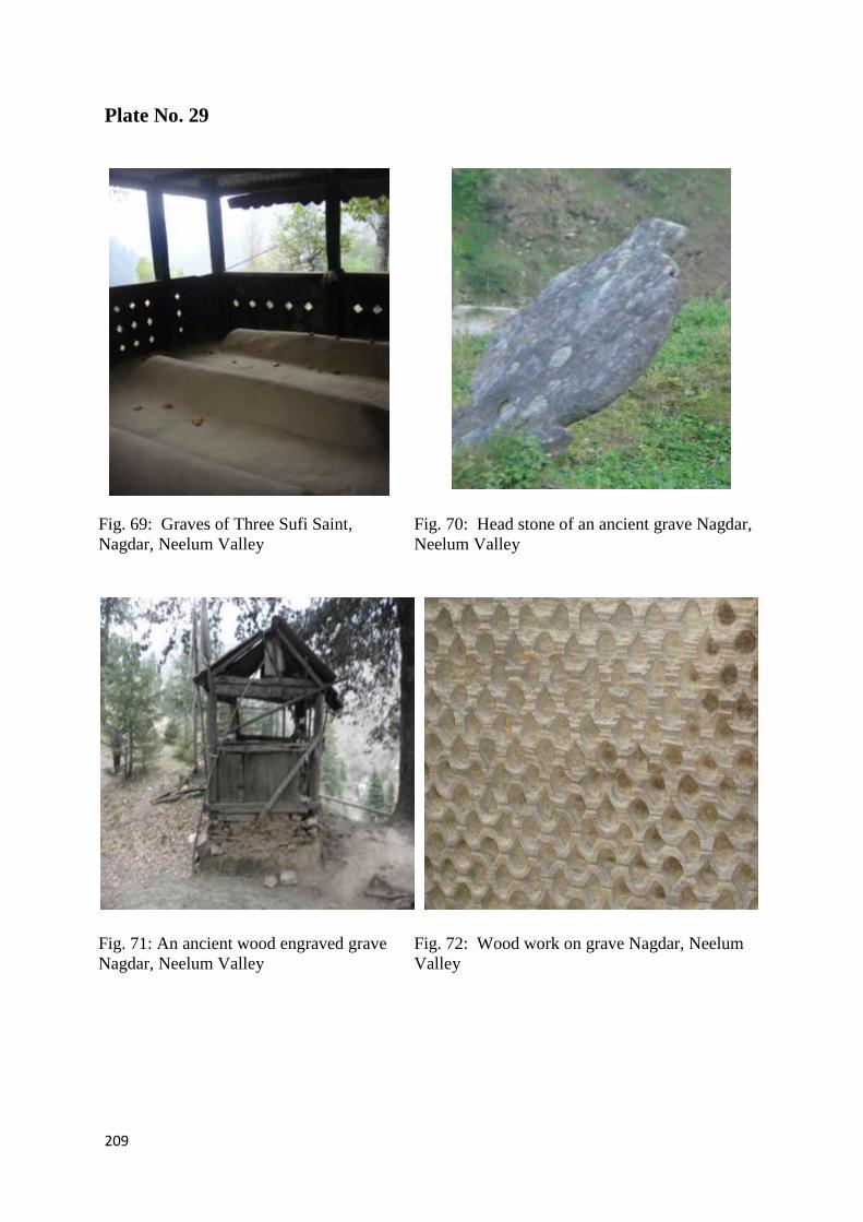
Plate No.29 209
Figure No 69. Graves of Three Sufi Saint Nagdar Neelum Valley
Figure No 70. Head stone of an ancient grave Neelum Valley
Figure No 71. An ancient wood engraved grave, Nagdar, Neelum Valley
Figure No 72. Wood work on grave, Nagdar, Neelum Valley
Plate No.30 210
Figure No 73. Mahrab of ancient wooden Mosque at Kosab pura, Neelum
Figure No 74. Another view of Mosque at Kosab pura Neelum Valley
Figure No 75. Front view of wooden Mosque at Kosab pura Neelum Valley
Figure No 76. Variety of engraved motifs on wooden Mosque Neelum Valley
Plate No.31 211
Figure No 77. An old house in Sharda, Neelum Valley
Figure No 78. Traditional wooden house in Kel, Neelum Valley
Figure No 79. A wooden house at Nagdar, Neelum Valley
Figure No 80. An ancient house Kern Neelum Valley
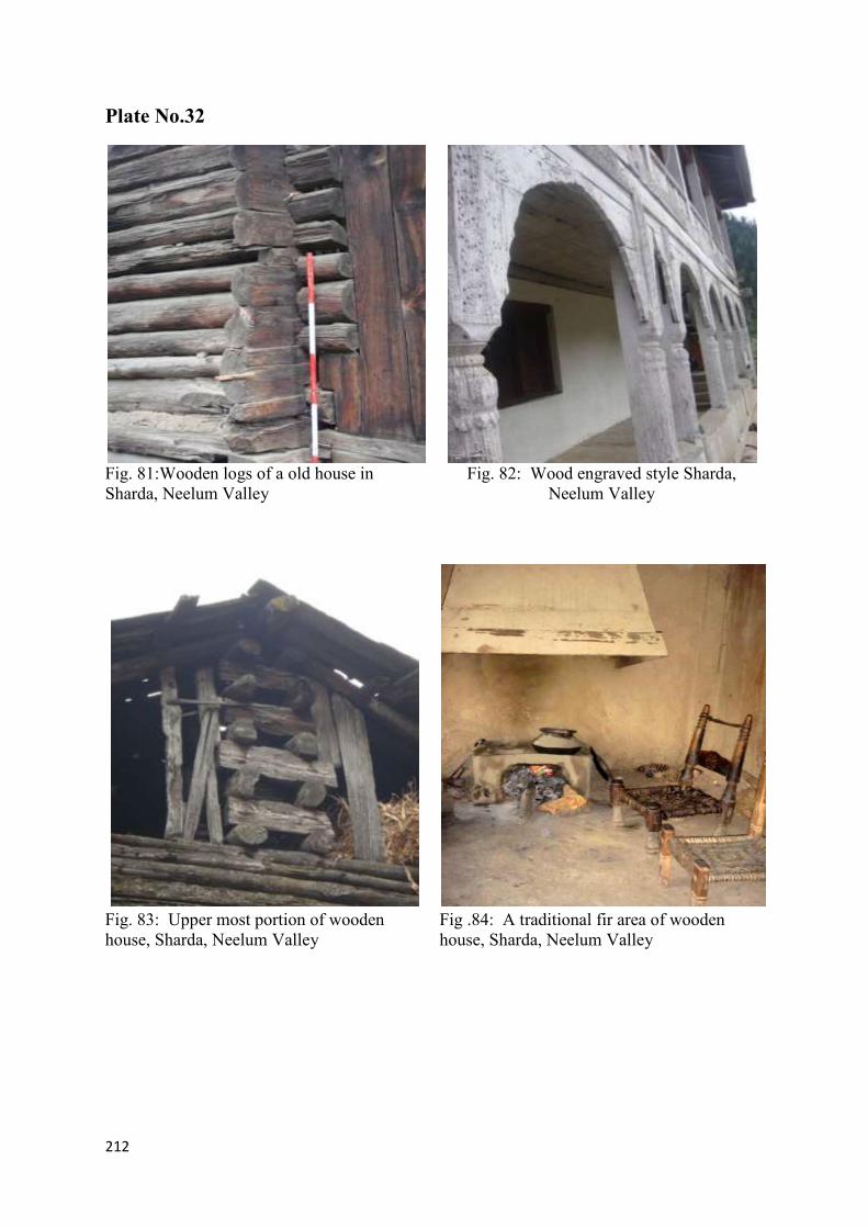
Plate No. 32 212
Figure No. 81. Wooden logs of an old house in Sharda
Figure No. 82. Wood engraved style, Neelum Valley
Figure No. 83. Upper most portion of wooden house, Neelum Valley

xxi | P a g e
Figure No. 84. A traditional fir area of wooden house, Neelum Valley
Plate No. 33 213
Figure No. 85. Yurt, Mongolian tent, similar in construction to wooden
houses of Neelum Valley (Drawing by Zawhar Babri)
Figure No. 86. Construction of Gables of roofs of wooden houses,
Neelum Valley (Drawing by Zawhar Babri)
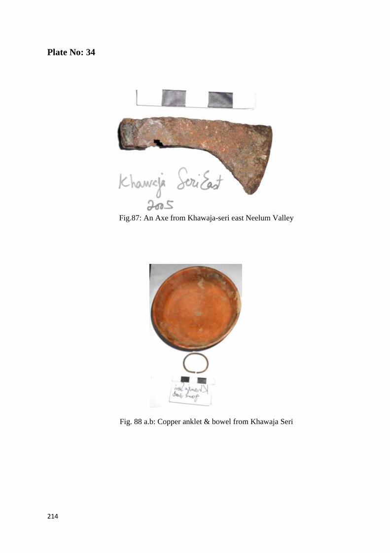
Plate No.34 214
Figure No. 87. Fig.87: An Axe from Khawaja-seri east Neelum Valley
Figure. 88 (a.b): Copper anklet & bowel from Khawaja Seri
Plate No.35 215
Figure.89. Red ware Pitcher from Mundkaro,Yamheri ,Neelum Valley
Figure. 90: Miniature vessels from Dosout village
Plate No.36 216
Figure No. 91: Fragments of pottery from Sharda Neelum Valley
Plate No.37 217
Figure .No. 92: Pottery rims drawing from Sharda, Neelum Valley
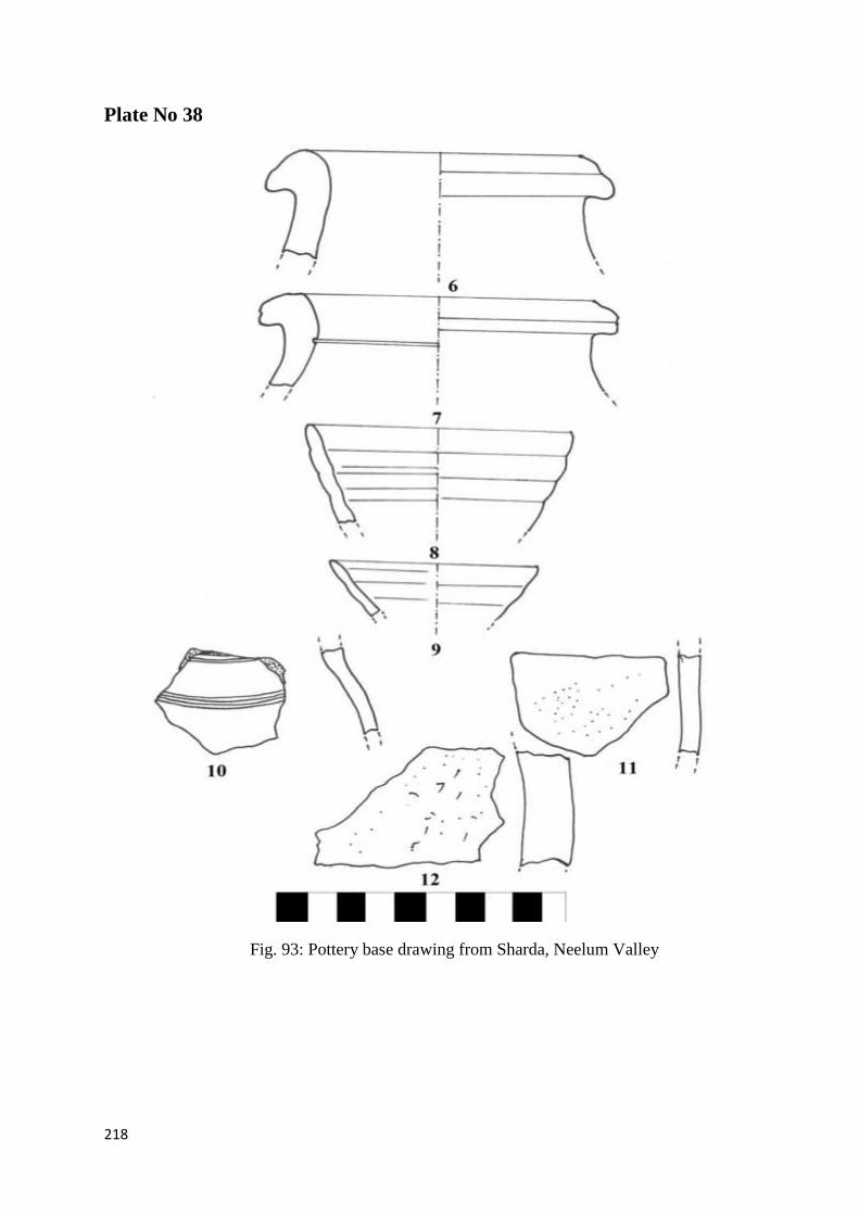
Plate No.38 218
Figure No 93. Pottery base drawing from Sharda, Neelum Valley
Plate No.39 219
Figure No: 94. Pottery base drawing Sharda, Neelum Valley
Plate No.40 220
Figure No: 95: Terracotta tiles & Pipes drawing from Neelum Valley
Plate No.41 221
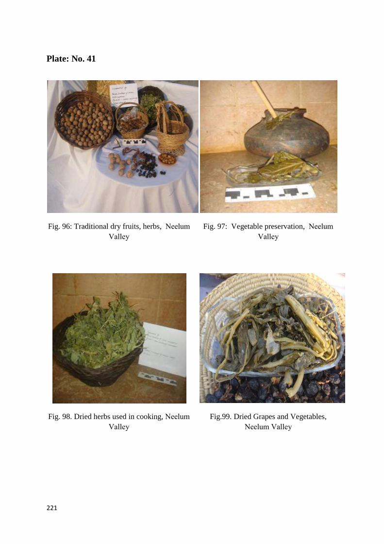
Figure .No 96. Traditional dry fruits, herbs Sharda, Neelum Valley
Figure. No 97. Vegetable preservation from Sharda, Neelum Valley
Figure. No 98. Dried herbs used in cooking from Sharda, Neelum Valley
Figure. No 99. Dried Grapes and Vegetables from Sharda, Neelum Valley

xxii | P a g e
Plate. No 42. 222
Figure. No 100. A lady in traditional embroider dress Neelum Valley
Figure. No 101. Women folk in Phern (loose shirt) Neelum Valley
Figure. No 102. Typical geometrical designs,Neelum Valley
Figure. No 103. Phulkari motives common in use, Neelum Valley
Plate No.43 223
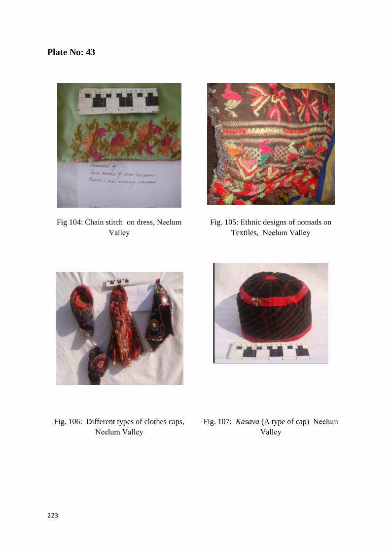
Figure. No.104. Chain stitch on dress from Sharda, Neelum Valley
Figure .No 105. Ethnic designs of Nomads on Textiles, Neelum Valley
Figure. No 106. Different types of clothes caps Sharda, Neelum Valley
Figure .No 107. Kasava (A type of cap) Sharda, Neelum Valley
Plate No.44 224
Figure No 108. Woman wearing traditional cap, Neelum Valley
Figure No 109. Researcher in typical cap Neelum Valley
Figure No 110. Silver jewelry with engraved designs Neelum Valley
Figure No 111. A silver coin locket, Neelum Valley
Plate No.45 225
Figure No 112. Silver pattern ear rings .Neelum Valley
Figure No 113. A silver engraved amulet, Neelum Valley
Figure No 114. Researcher in typical Kashmiri dress, Neelum Valley
Figure No 115 A woman wearing traditional jewelry, Neelum Valley
Plate No.46 226
Figure No 116. A woolen blanket Sharda, Neelum Valley
Figure No 117. Design of woolen blanket (Looi) Sharda, Neelum Valley

xxiii | P a g e
Figure No 118. A man preparing wool for blankets at Neelum Valley
Figure No 119. Spin wool in every house of Sharda Neelum Valley
Plate No.47 227
Figure No 120. Hide used for making different article , Neelum Valley
Figure No 121. Indigenous rope from Sharda , Neelum Valley
Figure No 122. Handmade items for daily use, Neelum Valley
Figure No 123. Animal skin made article, Neelum Valley
Plate No.48 228
Figure No 124. Kangri ( A fire pot) in Neelum Valley
Figure No 125. A wild plant basket in Neelum Valley
Figure No 126. Engraved design on wood at Sharda
Figure No 127. Wood interior of house in Neelum Valley
Plate No.49 229
Figure No 128. Wooden high bowl from Neelum Valley
Figure No 129. A wooden shoe , Neelum Valley
Figure No 130. Brass utensils , Neelum Valley
Figure No 131. Engraved brass utensil, Neelum Valley
Plate No.50 230
Figure No 132. An aged Gujjar. Neelum Valley
Figure No 133. A girl carrying basket on Khawaja Seri
Figure No 134. A hindko woman with infant, Neelum Valley
Figure No 135. Children from different ethnic groups Neelum Valley

xxiv | P a g e
Plate No.51 231
Figure . No 136. A nomad girl on horse in Valley
Figure No 137. A hindko girl, Neelum Valley
Figure No 138. A Kashmiri speaker lady
Figure No 139. Lady from Dard tribe, Neelum Valley
Plate No.52 232
Figure No 140. A general view of Narda Mountain in Neelum Valley
Figure No 141. Researcher near Saraswati , Neelum Valley
Figure No 142. Hari-Parbat Peak, Kel Neelum Valley
Figure No 143. Tourist influx near natural sites in Neelum Valley
Plate No.53 233
Figure No 144. Common use of horses in Neelum Valley
Figure No 145. Tourist influx near natural sites in Neelum Valley
Figure No 146. Water mills along river in valley Neelum Valley
Figure No 147. Water preservation in Rawota village
Plate No.54 234
Figure No 148. Researcher examined Illegal digging site at Rawota
Figure No 149. Fragments of artifacts, Neelum Valley
Figure No 150. A stucco sculpture looted from Valley
Figure No 151. Unearthed antique container, Neelum Valley


181
Plate No: 1
Fig. 1: Burzahom Prehistoric artifacts, Srinagar
(Stacul:1989-91,88-90)
Fig. 2: Prehistoric artifact from Tibet
(Stacul:1989-91,88-90)
Fig. 3: Terracotta bead from Tehjian
NeelumValley,
Fig 4: Neolithic Stone Sickle from
Tehjian Neelum Valley

182
Plate No: 2
Fig. 5: Megalith graves and cup
marks, Sharda ,Neelum Valley
Fig. 6: Rock inscriptions and cup mark
Chaterpari, Mirpur,AJK
Fig. 7: Dancing demon on rock,
Chaterpari, Mirpur ,Azad Jammu &
Kashmir
Fig 8: Cup marks and animal figures on stone
Chaterpari, Mirpur , ,Azad Jammu &
Kashmir

183
Plate No: 3
Fig.9: River Neelum at Sharda, Neelum
Valley
Fig.10: View of Saraswati lake at Narda
Neelum Valley
Fig.11: Surgan Nullah, Neelum Valley Fig.12: Sharda town along river Neelum ,
Neelum Valley

184
Plate No: 4
Fig.13: Sharda ;A general view of eastern
mountain ,Neelum Valley
Fig.14 :Athmaqam ;A general view of
mountains, Neelum Valley
Fig.15: A general view of Nangi Mali ,
Neelum Valley
Fig. 16 :A general view of Shamsaberi Range ,
Neelum Valley

185
Plate No: 5
Fig.17:Approach towards Sericella site,
Neelum Valley
Fig.18: A birch bark, Neelum Valley
Fig.19:A general view of Mukhtaseri
village, Neelum Valley
Fig.20: Fruit trees at Rawota village
,Neelum Valley

186
Plate No: 6
Fig. 21: Wild Herbal tea at Narda Peak,
Neelum Valley
Fig.22: Benifsha a wild herb Sharda,
Neelum Valley
Fig.23: Figs trees at Sharda ,Neelum
Valley
Fig. 24: A woman collecting fruits at
Surgun Valley

187
Plate No: 7
Fig. 25: Sacred mound at Tehjian site,
Neelum Valley
Fig. 26: Minch tree along colorful flags at
Tehjian site, Neelum Valley
Fig. 27: A general view of Tehjivan site
Neelum Valley
Fig. 28: Stone tools from Tehjian , Neelum
Valley
188
Plate No: 8
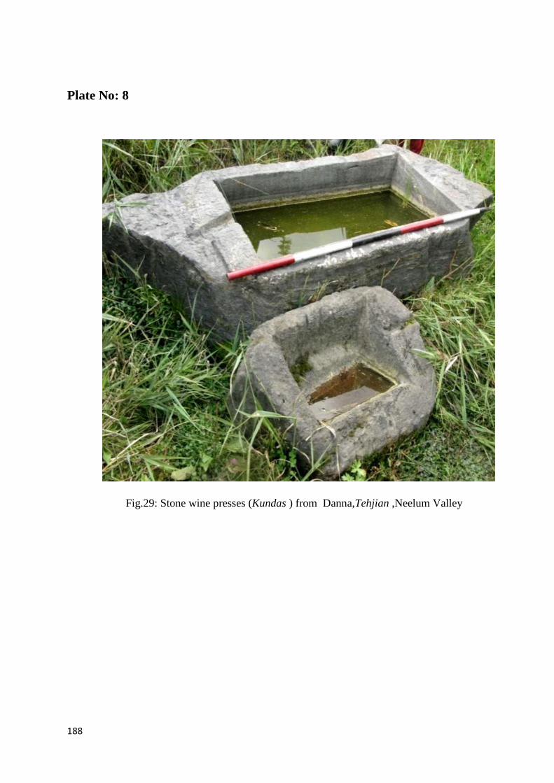
Fig.29: Stone wine presses (Kundas ) from Danna,Tehjian ,Neelum Valley

189
Plate No: 9
Fig.30: Wooden Kundas from Nagdar ,
Neelum Valley
Fig.31: Carved Kundas for bathing ,Sharda
Neelum Valley
Fig.32: A wooden water storage tank
Nagdar, Neelum Valley Fig.33: Series of stone cut Kundas Nagdar,
Neelum Valley

190
Plate No: 10
Fig. 34: Sketch of sacred rock cave by the researcher, Neelum Valley
191
Plate No 11
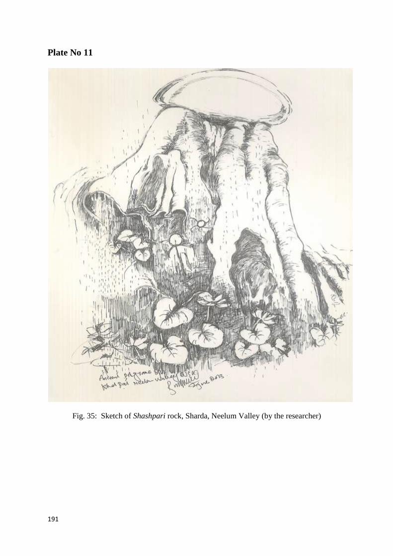
Fig. 35: Sketch of Shashpari rock, Sharda, Neelum Valley (by the researcher)

192
Plate No 12
Fig. 36: Rock inscription at Nagdar, Neelum Valley
Fig. 37: Rock inscription at Nagdar, Neelum Valley

193
Plate No: 13
Fig.38: Lotus flower symbol at Nagdar,
Neelum Valley
Fig.39: Trisula symbol at Nagdar, Neelum
Valley
Fig.40: Researcher during Documentation
of the inscription ,Nagdar, Neelum Valley
Fig.41: Documentation of symbols on rock
boulder, Nagdar ,Neelum Valley

194
Plate No: 14
Fig. 42(a) Commemorative stone pillar, Badan
Pura Nagdar, Neelum Valley Fig. 42 (b) Drawing of Commemorative stone
pillar, Badan Pura Nagdar, Neelum Valley( by
the researcher )
Fig. 43(a): Commemorative stone with figure
holding shield Badan Pura Nagdar, Neelum
Valley
Fig. 43(b):Drawing of Commemorative stone
with figure holding shield Badan Pura
Nagdar, Neelum Valley (by the researcher)

195
Plate No: 15
Fig. 44: Front view of Sharda temple,
Neelum Valley Fig. 45: Side view of Sharda temple, Neelum
Valley
Fig. 46: Oldest photo of Sharda Temple steps
(Neelum Valley) Fig. 47: Oldest photo of Sharda Temple with
roof top (Neelum Valley)

196
Plate No: 16
Plate 17
Fig. 48: East elevation drawing of Sharda Temple, Sharda, Neelum Valley
(Drawing by Zoona Jerral and Sabuhi Essa)

197
Plate No: 17
Fig. 49: Plan of Sharda Temple, Sharda, Neelum Valley
(Drawing by Zoona Jerral and Sabuhi Essa)

198
Plate No: 18
Fig. 50: Western elevation of Sharda Temple, Neelum Valley
(Drawing by Zoona Jerral and Sabuhi Essa)
Fig 51: Southern elevation of Sharda Temple, Neelum Valley
(Drawing by Zoona Jerral and Sabuhi Essa)

199
Plate No: 19
Fig. 52: Reconstruction of temple, Neelum Valley (sketch by the researcher)
200
Plate No :20
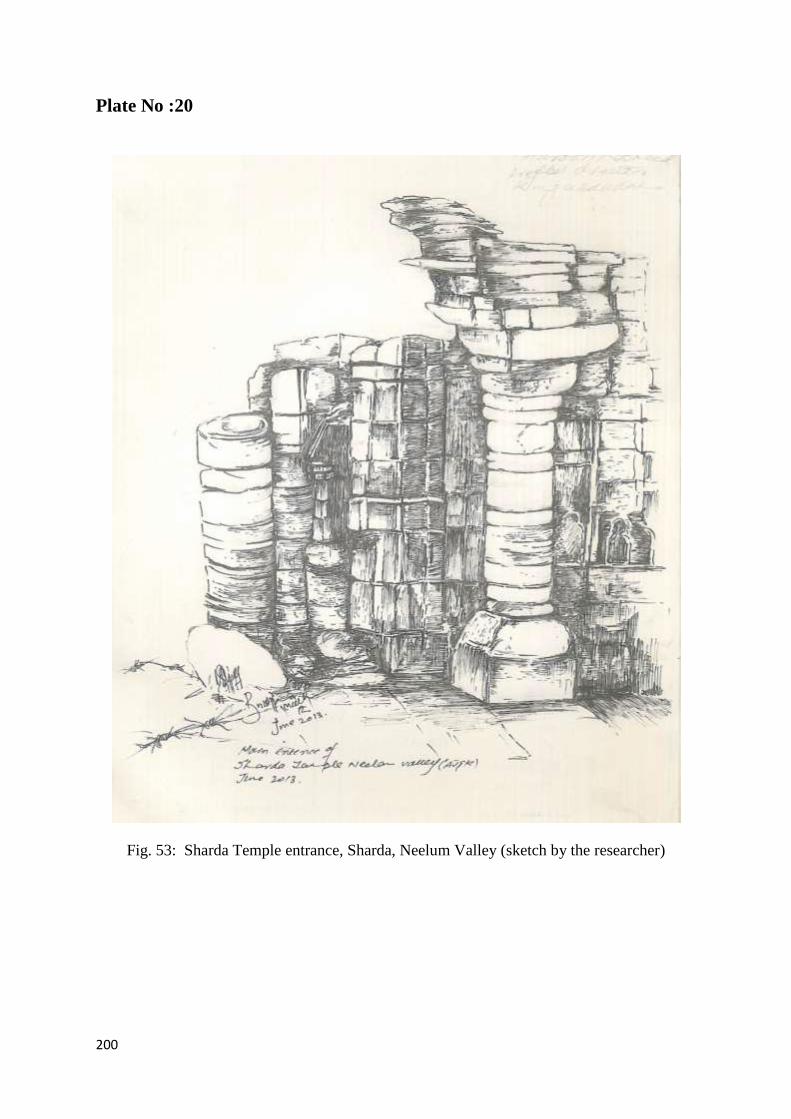
Fig. 53: Sharda Temple entrance, Sharda, Neelum Valley (sketch by the researcher)

201
Plate No: 21
Fig. 54: Main stairs of Sharda Temple, Neelum Valley
Fig. 55 Northern outer wall of temple, Fig. 56 Outer entrance structure of temple,
Neelum Valley

202
Plate No: 22
Fig. 57(a). A head of Ganeh from Neelum Valley
Fig .57 (b). Sketch of Ganeh head from Neelum Valley (Drawing by researcher)

203
Plate No 23
S.No Coin Obverse Reverse
1
Coin no. 1: Ardoxsho
Material: Copper
Weight: 10.1 gm
Dia:2 cm
Period: 10th
-11th
century CE
Description.
Obverse: Enthroned Ardoxsho of
Kushana style, Sharda legend Sri Ja….
Reverse: Standing figure of Kushana
style
2
Coin 2: Muhammad
Material: Copper
Weight: 6.4220 gm
Period: 8th Century CE
Description
Obverse. Arabic legend …..
Muhammad…..
Reverse. Fisanah,
date probably 8th
-11th
CE
3
Coin 3: Defaced Coin
Material: Copper
Weight: 5.3703 gm
Period:14th
Century CE (Islamic Period)
Description Both sides of the coin are defaced and
unclear
4
Coin 4: Islamic Period (Shah)
Material: Copper
Weight: 0.6281 gm
Period:14th
Century CE (Islamic Period)
Description
Obverse. Arabic legend Shah……..
Reverse. Defaced
Figure No 58.Copper coins (surface collection from Sharda temple),
Neelum Valley

204
Plate No 24
Fig. 59 : Stairs of Sericella fort, Neelum Valley( sketch by the researcher)

205
Plate No 25
Fig. 60: Around Sericella fort (sketch by the researcher)

206
Plate No 26
Fig: 61 Figs: 62
A view of carved head of Ganesh, Ganesh head (Sketch by the researcher)
Neelum valley

207
Plate No: 27
Fig. 63: Inscribed symbols on boulder,
Ghuffa Neelum Valley
Fig. 64: Rock cut cave of Ghuffa, Neelum
Valley
Fig. 65: A woman wearing serpent style
cap, Neelum Valley
Fig. 66: Cup marks boulder in Ransawali

208
Plate No: 28
Fig. 67: A general view of Dogra fort Sharda, Neelum Valley
Fig. 68: Western Bastion of Dogra fort, Sharda, Neelum Valley
209
Plate No. 29
Fig. 69: Graves of Three Sufi Saint,
Nagdar, Neelum Valley
Fig. 70: Head stone of an ancient grave Nagdar,
Neelum Valley
Fig. 71: An ancient wood engraved grave
Nagdar, Neelum Valley Fig. 72: Wood work on grave Nagdar, Neelum
Valley

210
Plate No.30
Fig. 73: Mahrab of ancient wooden Mosque
at Kosab pura, Nagdar Neelum Valley
Fig. 74: Another view of Mosque at
Kosab pura, Nagdar Neelum Valley
Fig. 75: Front view of wooden Mosque at
Kosab pura, Nagdar Neelum Valley Fig. 76: Variety of engraved motifs on
wooden Mosque at Kosab pura, Nagdar
Neelum Valley

211
Plate No.31
Fig. 77:An old house in Sharda, Neelum
Valley
Fig. 78: Traditional wooden house in Kel,
Neelum Valley
Fig. 79: A wooden house at Nagdar,
Neelum Valley
Fig 80: A ancient house at Kern, Neelum
Valley
212
Plate No.32
Fig. 81:Wooden logs of a old house in
Sharda, Neelum Valley
Fig. 82: Wood engraved style Sharda,
Neelum Valley
Fig. 83: Upper most portion of wooden
house, Sharda, Neelum Valley
Fig .84: A traditional fir area of wooden
house, Sharda, Neelum Valley

213
Plate No: 33
Fig. 85 Yurt, Mongolian tent, similar in construction to wooden houses of Neelum Valley,
(Drawing by Zawhar Babri)
Fig. 86: Construction of Gables of roofs of wooden houses, Neelum Valley, (Drawing by Z.Babri)
214
Plate No: 34
Fig.87: An Axe from Khawaja-seri east Neelum Valley
Fig. 88 a.b: Copper anklet & bowel from Khawaja Seri

215
Plate No: 35
Fig.89. Red ware Pitcher from Mundkaro,Yamheri ,Neelum Valley
Fig. 90: Miniature vessels from Dosout village

216
Plate No 36
Fig. 91: Fragments of pottery from Sharda Neelum Valley

217
Plate No 37
Fig. 92: Pottery rims drawing from Sharda, Neelum Valley
218
Plate No 38
Fig. 93: Pottery base drawing from Sharda, Neelum Valley

219
Plate No: 39
Fig. : 94 Pottery base drawing

220
Plate No: 40
Fig. 95: Terracotta tiles & Pipes drawing from Neelum Valley
221
Plate: No. 41
Fig. 96: Traditional dry fruits, herbs, Neelum
Valley
Fig. 97: Vegetable preservation, Neelum
Valley
Fig. 98. Dried herbs used in cooking, Neelum
Valley
Fig.99. Dried Grapes and Vegetables,
Neelum Valley

222
Plate No: 42
Fig. 100: A lady in traditional embroider
dress, Neelum Valley
Fig. 101: Women folk in Phern (loose shirt),
Neelum Valley
Fig. 102: Typical geometrical designs Fig.103: Phulkari motives common in use
223
Plate No: 43
Fig 104: Chain stitch on dress, Neelum
Valley
Fig. 105: Ethnic designs of nomads on
Textiles, Neelum Valley
Fig. 106: Different types of clothes caps,
Neelum Valley
Fig. 107: Kasava (A type of cap) Neelum
Valley

224
Plate No: 44
Fig. 108: woman wearing traditional cap,
Neelum Valley
Fig. 109: Researcher in typical cap, Neelum
Valley
Fig. 110: Silver jewelry with engraved designs,
Neelum Valley
Fig. 111: A silver coin locket , Neelum Valley

225
Plate No: 45
Fig. 112: Silver pattern ear rings,
Neelum Valley
Fig. 113: A silver engraved amulet, Neelum Valley
Fig. 114: Researcher in typical Kashmiri
dress, Neelum Valley
Fig. 115: A woman wearing traditional jewelry,
Neelum Valley

226
Plate No: 46
Fig. 116: A woolen blanket, Neelum
Valley Neelum Valley
Fig. 117: Design of woolen blanket
(Looi) Neelum Valley
Fig. 118: A man preparing wool for
blankets
Fig. 119: Spin wool in every house of
Sharda Neelum Valley

227
Plate No: 47
Fig. 120: Hide used for making different articles,
Neelum Valley
Fig.121: Indigenous rope from Sharda
Fig. 122: Handmade items for daily use,
Neelum Valley
Fig.123: Animal skin made article,
Neelum Valley

228
Plate No:48
Fig. 124 : Kangri (Fire pot) Neelum Valley
Fig. 125: : A wild plant basket Neelum
Valley
Fig. 126: Engraved design on wood, Neelum
Valley
Fig.127. Wooden in interior of house,
Neelum Valley

229
Plate No: 49
Fig. 128: Wooden high bowl Neelum
Valley
Fig. 129: A wooden shoe from
Neelum Valley
Figure no 130: Brass utensils, Neelum
Valley
Figure no 131: Engraved brass utensil,
Neelum Valley

230
Plate: No. 50
Fig.132: An aged Gujjar Neelum Valley Fig.133: A girl carrying basket on Khawaja
Seri , Neelum Valley
Fig.134: A hindko woman with infant from
Neelum Valley
Fig.135: Children from different ethnic
groups, Neelum Valley

231
Plate No: 51
Fig.136: A nomad girl on horse in Valley Fig.137: A hindko girl, Neelum Valley
Fig.138: A Kashmiri speaker lady,
Neelum Valley Fig.139: Lady from Dard tribe, Neelum
Valley

232
Plate No. 52
Fig.140: A general view of Narda mountain
Neelum Valley Fig.141: Researcher near Saraswati Neelum
Valley
Fig.142: Hari-Parbat Peak, Kel Neelum Valley
Fig.143: Hari-Parbat Lake in Kel ,Neelum
Valley

233
Plate No. 53
Fig. 144: Common use of horses in Neelum
Valley
Fig. 145: Tourist influx near natural
sites Neelum Valley
Fig. 146 : Water mills along river in valley Fig. 147: Water preservation Rawota
village

234
Plate No. 54
Fig. 148: Researcher examined Illegal digging
site at Rawota
Fig. 149: Fragments of artifacts unearthed
from Rawota, Neelum Valley
Fig. 150: A stucco sculpture looted from
Neelum Valley
Fig 151: Unearthed antique container
Neelum Valley

1
INTRODUCTION
Cultural heritage is the legacy of physical artefacts and the intangible attributes of a group or
society that are inherited from past generations, maintained in the present and bestowed for
the benefit of the future generations. Heritage is not only manifested through tangible forms
such as artefacts, buildings or landscape, but also through intangible forms. Intangible
heritage includes voices, traditions and oral history. Popularly, it is perceived that cuisine,
clothing, shelter, traditions, skills, religious ceremonies, and performing arts (UNESCO
2003:2 & Feather: 2006).
While dealing with the cultural heritage of any nation, community or people, it is always
difficult to detach intangible heritage from the tangible heritage, as both find close relevance
to each other. In this context Neelum Valley of Azad Jammu and Kashmir (AJK) is also no
exception and its culture is the combination of both tangible and intangible heritage. The
archaeological sites, historical monuments, rock cut caves and natural sites partly built by
humans constitute the tangible heritage of Neelum Valley. Similarly, the oral traditions,
languages, social practices, rituals, festive events, indigenous knowledge and craftsmanship
of the Neelum Valley fall under the category of intangible cultural heritage. The distinction
between tangible and intangible heritage is useful for the general understanding of cultural
heritage (Walter, Jamieson: 2000). However, the two forms of heritage are often closely
associated and are almost inseparable. For example, in Neelum Valley, the prominent Sharda
Temple site is a tangible heritage. The rituals associated with this place, and temple
construction techniques, which directly rely on the local knowledge of the people is the
intangible heritage of Neelum Valley.
Heritage means things of great value including places, sites along with their immediate
surroundings and environment, cultural material and artifacts that a community has inherited

2
and has had opportunity to manage for the benefit of present and future generations
(UNESCO 1982:41). Moreover, heritage can be defined as anything that has been translated
from the past or handed down by traditions. The evidence of the past, such as the historical
and archaeological sites, and their unspoiled natural environment, are considered as the
inheritance of present day society. In the case of Neelum Valley, research has found that the
area has immense cultural wealth which acts as a source of identity and pride for the
inhabitants of the valley. Subsequently, it has tremendous economic, social and cultural value
as it provides an extensive opportunity for the promotion and organization of heritage tourism
in the area.
Additionally, heritage can mean something that has been received by the present generation
and therefore, cannot be recreated. For the same reason, present generations are obligated to
take care of the heritage and pass it on to the future generations without decreasing its value
and essence (United Nations 2007:6). In the process of exploration and documentation, it is
very important to know about the current state of preservation of the heritage sites in Neelum
Valley and identify the problems associated with them. Moreover, preservation and
development opportunities in the conflict area can be explored, identified, chosen and
implemented to help safeguard the precious heritage for the future generations.
Culture is a common word in many languages and is often used to convey some generally
accepted meanings. It is an abstract and difficult concept. This is why „culture‟ is an elusive
term when we want to understand its exact meaning and scope. Different people define
culture in a way that suits themselves and their understanding of its concept. UNESCO, an
important organisation has defined the word „culture‟ as the whole complex of distinctive,
spiritual, material and intellectual and emotional set of features that characterize a society or
a social group. It includes not only arts and letters, but also models of life, the fundamental
rights of the human being, value system, traditions and belief (UNESCO 1982: 41-42).

3
According to the meaning and types of heritage defined by UNESCO, it can be concluded
that culture is a valuable heritage which defines and shows the prosperous civilizations of any
communities or societies. This heritage has been passed down from generation to generation
for a long period of time. Therefore, cultural heritage of Neelum Valley is worth being
preserved for not only the future generations, but also as a tool of peace and social
development in a conflict torn area.
In the context of Neelum Valley, cultural heritage sites have played an important role in the
reconstruction of the unrevealed history of the region. The research adopted principle
methods of survey documentation and salvage excavation. These were utilized to increase our
knowledge of earlier human activities and to understand the cultural heritage of Neelum
Valley. The study further explores the state of preservation, threats to heritage and the
stakeholders‟ role in the safeguarding of theses cultural heritage resources. The qualitative
research was adopted to understand challenges and to devise opportunity of heritage tourism
across the divided Kashmir. This study ultimately helps to bring social development in the
region.
Statement of the Problem
The preliminary study shows that the cultural heritage in Neelum Valley has not been fully
documented and exploited for socio-economic development in this conflict ridden zone.
Therefore, detailed study is required to develop a cultural profile of the area and identify
challenges and threats to the heritage. Furthermore, there is a need to explore options for the
utilization of these resources in order to establish sustainable peace and socio-economic
development in the region.
The Neelum Valley maintains a multilayered treasure of rich cultural heritage both tangible
and intangible. The traces of the existing cultural material from pre-history to present day
have not been catalogued completely. The evidence of the ancient history of Neelum Valley

4
is entwined in natural tangible forms such as lakes, mountains, peaks, passes and
archaeological remains. This fact is also corroborated by ancient texts, coins and rock
inscriptions. These evidences indicate that this place was a center of attraction for pilgrims
and travellers from distant places. There is a need to discover the linkages of the past traces
through comparative study with other contemporary cultures in the adjoining areas of Neelum
Valley.
Cultural heritage is also a fundamental source in tourism development for underdeveloped
areas such as Neelum Valley where heritage remains neglected. These heritage resources can
provide enormous opportunities for socio-economic uplift in the area and also offer the
prospect of peace and stability. However, this option has neither been explored nor given
priority. As we maintain that heritage tourism is important for economic development in the
conflict zone of Neelum Valley. Therefore, we need to identify various threats to this heritage
and explore options suitable for protecting and promoting theses resources.
In addition, there are contradictions and conflicts among stakeholders about prioritization and
preservation of the heritage. This conflict of ownership and interest negatively affects the
management and interpretation of heritage resources. Therefore, the research intends to
explore the possibility of heritage tourism as an opportunity that is urgently required for
peace and development in the area.
Research Methodology
For this research, this researcher has primarily opted for primary research by going to the
field, recording each and every possible aspect of both tangible and intangible cultural
heritage in the Neelum Valley of the AJK, and salvage excavations where possible. Efforts
were also made to interview as many learned, educated and culture loving people of the
valley with knowledge of the past history of the valley as part of the primary research. These
tools were effectively utilized to increase our knowledge of earlier human activities and to

5
understand the cultural heritage of Valley. In order to reinforce efforts to go through the
recorded information about the past events relating to the valley and the adjoining areas, all
available and reachable literature was consulted and reviewed as part of secondary research.
The research also included both qualitative and quantative aspects of the research
methodology. Efforts were made to record as many of the surviving signs of the past as
possible and thus a large quantity of the data was collected, while it was ensured that the
quality of the research does not suffer at the cost of quantity. This researcher also did not lose
sight of the importance of the comparative study and made every effort to make serious and
realistic comparison of the recorded heritage and cultural objects retrieved during survey and
salvage excavations with already recorded and retrieved objects in the adjoining areas of
Khyber Pukhtunkhawa, Gilgit-Baltistan, whole of the Kashmir including the sites across the
line of control in the Indian held Kashmir.
Review of Literature
The available materials of the research consist of Ariel Stein (1900), Charles Ellison Bates
(1873) Malcolm John McEwen (2005) who wrote about the Valley of Kishenganga (present
Neelum Valley) in Azad Jammu & Kashmir.
In 1882 when Ariel Stein started work on „Chronicle of Kings of Kashmir‟ he was attracted
by ancient remains and the traditions of the valley. He reviewed Kalhana‟s Rajatarangini of
11th
CE, which has authentic information about few archaeological sites in Neelum Valley.
Being an archaeologist Stein described the structure ruins, constructional significance and the
condition of Sharda Temple. He also cited the routes and sacred places where pilgrims stayed
and performed the rites before reaching the Sharda Temple for final rituals. M.A Stein points
out the records of Kalhana which describe the connecting routes of the area in the association
of its narratives about historic Sirahsila fort. The ruins of Sericella fort are mentioned in the
Rajatarangini in the context of King Jayasimha‟s expeditions (10th CE), from where many

6
battles were fought among princes to maintain their supremacy in Kashmir. He wrote about
religious significance of Ganesh Ghati and its association with Goddess Sharda. Stein never
visited the Sirahsila fort and Ganesh Ghati: he only viewed these sites from the village of
Karigam. The Karigam village is located opposite to Sirahsila fort on the right bank across
the river Neelum. Saraswati Lake another important archaeological site, which remained a
central part of the Sharda civilization, was not discussed in the Stein‟s commentary. The
reason could be that the Saraswati Lake was at a very higher altitude and difficult to access.
However by following the indication provided in the text of Kalhana Rajatarangini this
researcher explored Saraswati Lake which is situated on Narda peak in Neelum Valley.
During 1869-73 while compiling “The Gazetteer of Kashmir” Charles Ellison Bates visited
the Valley of Kishanganga (Neelum) and pointed out some of the ancient sites of this area.
The study commissioned for official purpose was meant to record geographical features such
as villages, routes, passes, mountains and rivers and particulars of the inhabitants in
Kishenganga. It also subtly touches upon architectural features of earlier archaeological
remains of Sharda Temple. The Gazetteer also mentioned other historical monuments: watch
stations, graves of Sufi saints and ancient Mosques in Neelum Valley. He gave descriptions
of village Sharda, location of temple and fort situated on the left bank of Madhumati stream.
The references in Bates (1873) and other preliminary reports in the field made it possible for
the researcher to trace the unknown historical sites and structures with accuracy.
Moreover “The Ancient Geography of Kashmir” by Cunningham and imperial Gazetteer of
India about Kashmir and Jammu was another source to improve the study of terrestrial
features of valley of Kashmir. There was a detailed picture of ancient routes and passes of the
valley and adjoining areas, which had remained a cultural backwater of humanity for
millennia.

7
„The Gardens of Gaia‟ was written by Malcolm John McEwen who visited the Neelum
Valley in 2005. McEwen mentioned about Ganesh Ghati site, Sharda Temple and Seri
Chakra philosophy associated with Goddess Sharda. He states that diagram inscribed on
stone slab is a depiction of the creation of the universe and remained sacred in various beliefs
including Hinduism. Moreover nothing is descriptive regarding architecture of Sharda and
other sacred sites in his commentary. The only focus of McEwen study was to explore the
stone diagram of Seri Chakra.
A book “Sharda” (2005) was written by Abdul Ghani an educationist and historian who gave
valuable information about various heritage sites in Neelum Valley. The contents of the book
were limited to historical perspective of Sharda Temple and its affiliated sites. The author
was not in a position to discuss archaeological significance of these sites.
K. Rehman unpublished Phd thesis (2012) Language Shift in Neelum Valley: A Case Study of
the Kundal Shai Language, is a valuable piece of study of the dying languages in the area.
The study gives an insight into the ethnic origins and diversity of languages in the area and
contributed in exploring the intangible heritage of the Valley.
Historian Khurram Ghulam Qadir visited Sharda Valley in 1993 and wrote a paper Sharda:
An Ancient Monument, published in Lahore Museum Bulletin. It was about the historical
background and architecture of Sharda Temple. Furthermore this research was limited only to
Sharda Temple and the author did not mention the associated sites of Sharda Temple.The
Paper Sarda Temple:A Legacy of the Stone Temples of Kashmir (Samad and Ahmad 2015) is
gone through
Many specific events are present in the ancient literature of Kashmir which help to sketch out
earlier life of people in area. The ancient Sanskrit text Nilamata Puranas of 7th
century CE
was translated by Wed Kumari in 1969. The writer mentioned about ancient locations of
Neelum Valley in the context of cultural heritage of Kashmir. The book deals with sacred

8
places, festivals customs, cuisines and rituals of the Kashmir which help to understand the
historical back ground of intangible heritage of Valley.
Ahmad Hassan Dani mentioned in “History of Pakistan through Ages “about the origin of
civilizations in the Himalayan region and adjoining areas. There is depiction of some ethnic
groups which indicates the sources of early inhabitant of Neelum Valley. The book “Human
Records on Karakorum Highway” (Dani 1995) helps to understand terrestrial features of
connecting routes of Northern area of Pakistan and Silk Road which also has some link with
Sharda Neelum Valley.Von Hugel the author of book titled „Travel through Kashmir and
Punjab‟ adopted the route which was used by Chinese Pilgrims (Stein 1900). Furthermore,
these available materials about social and cultural history of Kashmir help in the comparison
of documented cultural material from Neelum Valley.
The book “Korean Buddhist: cultural accounts” (2012) translated by Wegehaupt &
Vermeersch describes a famous Korean monk Hycho‟s records about the Kashmir Valley.
During his journey he took route from Neelum Valley towards Gilgit Baltistan for his native
land. That book is is a valuable source to understand the free movement of travelers, monks
and traders on the ancient routes, and cultural linkages of the valley with rest of the region,
through connecting routes of the Silk Road.
The “Rise of Civilization in India and Pakistan” 1982 by Bridget and Allchin helped to
make comparative study of Neolithic cultural material of Neelum Valley. The Excavation
Report of Kalako-deray, 1989-1991 by Giorgio Stacul was another source to understand
discoveries of Neolithic Cultural tools. This study by this researcher helped to establish
relation between Gandhara (Khyber Pukhtoon khawa) Burzahom, Srinagar, and Tibet and
documented prehistoric harvesting tools in Neelum Valley. Moreover the source of study
included articles published in different Journals especially‟ East and West‟.

9
Another valuable source of my research was Sunil Chandra Ray‟s Book “Early History and
Culture of Kashmir”. The book deals with different topics from prehistoric to historical
period. He also dealt with political, social, cultural and economic developments that took
place in Kashmir. “The Culture of Kashmir” by S.M .Iqbal (1991) and „Kashmir social and
cultural history‟ by G.M .Ratban (1968) presented a profound picture of cultural heritage of
the region.
The book “Kashmir and Central Asia (1988) edited by Kaul Deambi is a collection of
research papers which were discussed in the seminar on Kashmir and Central Asia-Cultural
Contacts. The deliberations cover various aspects of cultural relationship between Central
Asia and Kashmir. These papers help to understand the close cultural ties between Kashmir
and the countries of the Central Asia existing from prehistoric times. The book Central Asia
and Kashmir: A study in the context of Anglo-Russian Rivalry by K.Warikoo (1989) gives a
detail description of Kashmir and its geographical proximity to Central Asia and the
existence of overland caravan‟s routes linking the two regions. Kashmir played an important
role in the process of Central Asia‟s intercourse with India in the political, commercial and
cultural domains both in the ancient and medieval time.
Moreover, Kaul, Lal‟s (2009) book “A historical survey of Kashmir: Through the ages (5000
B.C. To 1960 ACE)” describes general social condition of the people, the custom they
followed and various stages of the history of Kashmir Valley. In the same book a chapter on
„Cultural and Economic Heritage‟ helps to understand that how the natural resources were
utilized for the uplift and economic empowerment of the common people in the region.
According to this study Kashmir has developed very intimate cultural contacts with neighbors
like Gandhara, Afghanistan, Iran, Western Turkistan or Soviet Central Asia, Eastern
Turkistan or Sinkiang and Tibet even from prehistoric times. Arts And crafts of Jammu &
Kashmir: land people culture (D. N. Saraf 1987) facilitates in the comparative study of

10
ethnology of the Neelum Valley and adjacent areas. Although all above mentioned books
lack the direct study of heritage resources both tangible and intangible in Neelum Valley,
they somehow help in understanding these aspects and facilitate us to reach some conclusion.
The papers presented by scholars in seminars and conferences on tourism and cultural
heritage at various forums provided valuable input to understand option for heritage tourism.
The various studies conducted by Regional Centre for Archaeology and Finance (SPAFA
1995), Asian Institute of Technology Bangkok, Thailand and the Vannarith Chheang (2013).
Most important are the papers titled Tourism and regional integration in South Asia, the
paper by Walter Jamieson “The Challenges of Sustainable community, Cultural Heritage
Tourism” and “Tourism and Cultural heritage in South Asia”. These papers contributed in
understanding the challenges in the preservation of heritage and integration of these resources
as sustainable tourist destination.
Moreover, the Paper “Tourism and Cultural heritage in South Asia” and Preserving and
restoring monuments and historic buildings (1972) published by UNESCO, provided
valuable insight into options for preservation of Architectural heritage resources in conflict
area.
The research also covers the policy papers developed by different academicians and analysts
in the context of confidence building measures between India and Pakistan. The Special
report on Tourism and Peace building in Jammu & Kashmir by Shaheen Akhtar and P.R
Chari (2011) for United States Institute of Peace, underscores the viability of heritage tourism
in peace building. Hasan Askari Rizvi (2008) & et.al Making border irrelevant in Kashmir
also gave some strength to the concept of religious tourism across divide.
These papers and publications provide a general overview of the concept of heritage tourism
in conflict area. However, the papers on the subject have inherent limitations, since the

11
Neelum Valley remained inaccessible to researchers owing to which the full potential of the
heritage in terms of both the tangible and intangible, archaeological sites and natural
resources was not available to these authors. Moreover, these resources were only recently
surveyed and documented by this researcher under the Umbrella of Asian Civilizations. This
researcher had greater access and opportunities of interaction with local communities,
stakeholders, and diverse groups across Line of Control (LoC). The direct access to potential
heritage sites, the stake holders involved and opportunities of broader interaction across
divide enables this researcher to study the unexplored dimensions of heritage tourism across
LoC in Kashmir.
Research Objectives
The present study aims at exploring and identifying:
Cultural heritage: tangible and intangible of the Neelum Valley
To develop cultural profile of the area
The challenges : man-made, natural for the safeguarding of heritage resources
Heritage tourism as an opportunity for peace and sustainable development
To gauge the acceptability of cultural heritage tourism in Neelum Valley
Scope of the Study
The scope of the present research is to explore the cultural heritage resources of District
Neelum Valley with special focus on Sharda Village and its adjacent localities. Sharda has
remained an important center of knowledge and cultural heritage since antiquity. The study
will focus on exploring the archaeological evidence from the locations already mentioned in
the ancient text of Rajatarangini (Stein 1900).
The findings will be analysed, examined and organized to develop a chronological order of
ancient history in the region. The study will also explore the ancient connecting routes of the

12
area i.e. Gilgit-Baltistan, Jammu & Kashmir and Khyber Pukhtunkhawa. Ancient coins, rock
inscriptions and artifacts discovered in various locations around Sharda will be scrutinized.
Moreover, these findings will be compared with the discoveries of the adjacent regions to
trace historical and cultural links of the area. The study will also explore the prevailing
cultural heritage in the area showing a continuity of traditions, cross-cultural links in the form
of linguistic diversity, traditional cuisines, art crafts, wooden architectures, costumes and
jewellery.
The research will be an on-site study of the wooden houses in Sharda, locally called Larri.
These houses will be photographed in detail to make a thorough in-depth analysis of how
wood is used for every need and protected from termite and other vagaries. Thus, an analysis
of structural and functional values of the wooden houses will be presented and appropriate
recommendations made.
Moreover, the research will explore the connection of cultural heritage with the natural
resources such as sacred lakes, ponds, springs, rocks, caves, and mountain peaks. Finally, the
study will examine the state of preservation of the above mentioned cultural heritage
resources and identify the threats and challenges to these resources. The study outlines
available opportunities to exploit these resources for the sustainable cultural heritage tourism
in the area.
Significance of Research
The research undertaken by this researcher will help promote heritage tourism which will
also generate economic activity to benefit the local community. The research will explore the
various challenges to the cultural heritage, which will help develop proper mechanisms for
safeguarding of cultural heritage resources in area. The opportunity of cultural heritage
tourism will help to attract international tourists and bring peace, as well as benefits the local
community and their livelihood. Based on the research findings, an idea for the protection

13
and safeguarding of the heritage resources will be convenient to be developed. The case
studies regarding the challenges to heritage will help chalk out an effective way forward
programme which will ultimately help in the restoration and conservation of heritage
properties in Neelum Valley.
Limitation of the Study
The researcher intended to carry out a comparative study of cultural heritage on other side of
Kashmir IAK, which could not materialise due to visa restriction. The researcher applied for
visa few times but it was denied. The visit would have helped better understanding and
evaluation of heritage resources on other side of LoC. Despite these barriers, the researcher
was able to use social media to interact with the scholars across the line of control and
explore commonalities in term of heritage and artefacts.
Case Studies
Case studies will also be part of the research and some important cases will be included in the
thesis as an integral part of the primary and secondary research.
Focus group discussions at National and International Level
The research will also include focus group discussions making an integral part of this
research. The outcome of these discussions will also help in focussing on otherwise missed
part of the research, identification of actual problems relating to the heritage and suggesting
best possible solutions and remedies.
General discussions, interaction and use of modern technology
This researcher took advantage of the social media (Fb, Skype, WhatsApp,Twitter,etc) for
getting as much information from concerned people as possible. Further, discussions were
also held with the gender groups such as women and informal conversation with the

14
community members in connection with this research and their overall views are also
reflected in this research.
Chapters
To furnish a more detailed picture, the whole work has been divided in to four
chapters.Chapter-1 covers the historic and political profile and physical features of the area
called Neelum Valley, Azad Jammu and Kashmir (AJK).
The Chapter-II deals with the tangible cultural heritage of the Neelum Valley and focuses on
archaeological sites and discoveries from various locations in the area. Additionally, the
author has conducted a comparative study with already documented archeological discoveries
in the region. These already discovered areas include Srinagar, in Indian held Kashmir (IHK)
, Gilgit-Baltistan (GB), Khyber Pukhtunkhawa (KPK) and southern parts of AJK.
The Chapter-III explores intangible heritage in Neelum Valley which comprises of traditional
outfits, jewellery, textiles, crafts making, celebrations, rituals, ethnic groups, languages and
the stories and rituals associated with cultural area.
Chapter-IV covers the challenges in safeguarding the sources of cultural heritage and the
possibilities for heritage tourism in the Neelum Valley for creating socio-economic
development opportunities. This study is based on author‟s field research and case studies
during year 2013-16 in Neelum Valley.
Conclusion and Recommendation is the last part of thesis.

15
CHAPTER I
HISTORICAL, POLITICAL PROFILE AND PHYSICAL FEATURES
OF NEELUM VALLEY, AZAD JAMMU AND KASHMIR
1.1 Azad Jammu and Kashmir
Azad Jammu and Kashmir is geographically carved as a crescent shaped feature in the
western part of former State of Jammu and Kashmir. The lower Himalayan range extends to
north and north western of Azad Kashmir (AJK). River Tawi and River Poonch in the east,
separate it from Indian held Kashmir. In the south River Jhelum runs between Azad Kashmir,
Pakistani provinces of Khyber Pukhtunkhawa and Punjab. Gilgit Baltistan is in the north of
Azad Kashmir. The Line of Control, earlier known as Cease Fire Line, divides AJK from
Indian held Kashmir in the east and north east (Map No. 01).
1.2 The Neelum Valley
The Neelum Valley 34.5891°N and 73.9106°E, with an area of 3,621 sq. kilometers,
physically occupies the south western corner of Azad Jammu and Kashmir. It stands as the
largest District of AJK which covers almost 40 percent land mass of the state. The Neelum
Valley is spread on either side of the Neelum River situated in the north east of capital city
Muzaffarabad. At some places, the valley is politically divided by line of control along
Neelum River (Kishen Ganga), in the east from Indian held Kashmir, District Kupwara. In
the west, Nangi Mali mountain ranges separate the Neelum Valley from Kaghan Valley and
the Babusar Pass joins it, with Gilgit Baltistan in the North (http://www.ajk.gov.pk, State
Profile, accessed 15-8 -2016) (Map No. 02).

16
Map: No. 1 Map of Azad Jammu & Kashmir
Website: http://wwww.era.govt.pk (State Profile, accessed on-12-9-16).

17
Map: No. 2. Neelum Valley Azad Jammu & Kashmir (Source: Google Earth Pro)

18
1.3 Historical Background of Neelum Valley
The political map of the State of Jammu and Kashmir changed after the division of the
Subcontinent in 1947. The turmoil caused division of the former State of Jammu and
Kashmir in two parts, Azad Jammu and Kashmir (AJK) and Indian held Kashmir (IHK). The
Neelum Valley was part of District Muzaffarabad at the time of partition but later it was
made a separate district in 2005 (ibid). Before the political division of the state of Jammu and
Kashmir, the Kishanganga Valley (present Neelum Valley) was part of the Kashmir Valley
while Kishtwar, Badrawar, Jammu, Naoshera, Poonch were part of the Jammu region
(Bates1873:1). The Line of control (LoC) between two parts of Kashmir changed the
demographic dispensation which diminished the role and importance of diverse cultural
heritage and legacies of this area. Ancient chronicles, traveling accounts of pilgrimage,
historical references and archaeological remains underscore the cultural and social legacies of
this region (Stein 1900 & Bates 1873).In this study researcher uses both the post partition
name; Neelum Valley and its ancient name Kishanganga Valley according to context.
1.4 Ancient Names of Neelum Valley
The ancient name of the Neelum Valley was the Valley of Kishanganga, which is derived
from the Krishna, Sindhu, Mahganga, Kishanganga and the River of Gold. The dwellers of
the valley attributed these various terms to the river according to their beliefs. Nilamata, M-
ahabharata and various Puranas narrate the story of Krishna which is further elaborated by
different authors; like Krishna was a tribal god, ethnic god of Rajput clans, vegetation deity
and sun god. The Ganga means Goddess of the holy river respectfully, referred mother Ganga
and also a deity in Hinduism (Kumari 1968: 150).
Nilamata Puranas (ancient literature) mention that Sarasvati and Madhumati streams merge
with river Krishna near Sharda Temple in the Valley of Kishanganga. This tells us that

19
ancient name of the river was river of Krishna or Kishanganga (Ibid: 32-150). Kalhanna
Rajatarangini mentioned Neelum River as Sindhu, krsnaganga, river Krishna, in various
contexts while unfolding the socio-cultural history of Kashmir (Stein 1900: 194-267). The
term Kishanganga persisted over several centuries with slight variations which may be
ascribed due to phonological transformations (Ibid). The tract of Neelum Kishanganga Valley
is also known as Karnau, which is the old name of KARNAHA, presently Leepa Valley
(Cunningham 1870:156). In 1892 when M.A Stein visited to explore the area of the Neelum
Valley he also mentioned valley as Kishen Ganga (Ibid 280). In 1870 British Government
published Gazetteer for the administrative socio-political orientations of Kashmir in which
present Neelum Valley is cited as Valley of Kishen Ganga (Bates 1870:1).The river
Kishanganga was named as „Neelum‟ much later; around mid-20th
century (Rehman
2014:5).A precious gem stone, the blue sapphire is found in North West mountain range of
Neelum Valley. This blue sapphire is locally known as „Neelum stone‟, which could be the
reason of naming Kishanganga as „Neelum‟. Since the name of the valley was changed after
the division in 1947 (Revenue record accessed on-15-6-15).The possible reason is that old
name Kishanganga was affiliated with Hindu religious mythology. The old name Valley of
Kishenganga was unacceptable in new political scenario and so eventually was changed to
Neelum (Khan 2014:15). Sarasvati (lake) is the identical names of Hindu Goddess and sacred
stream Madumati (Stein 1900: 281-82). Such names in the valley which had similar religious
identity like Madumati, and Sarasvati remains unchanged, as these places are physically away
from main habitation and daily references.

20
1.5 Pre-history of Neelum Valley
The Prehistory of Neelum Valley has not been discovered so far. However, considerable
research has been under taken in parts of the Indian held Kashmir. Historically, Neelum
Valley has been included in the Valley of Kashmir (Bates 1873:1). The Prehistory of Indian
held Kashmir is based on the archaeological finds at Srinagar Districts of Burzahom and
Gofkral (Ray 1969:212). The first salvage excavation was made in 1959 by the Yale
University, Cambridge and Archaeological Survey of India (ASI) in Srinagar, Kashmir. The
tools characterized as harvester in the Neolithic collection of Burzahom are also common in
other Neolithic sites of Central Asia. The third phase of Burzahom culture is linked with the
construction of massive megalithic circle, red, grey, black burnish pottery and stone axes.
The adjacent area along the river has exposed more than nine other sites of the Burzahom
cultural period (Bridget, Allchin 1982:111). There were evidences of emerging contemporary
developments Leobanr and Aligrama in the Swat Valley of Pakistan; Shango cave Mardan,
Sarai Khola near Taxila. Discoveries from Swat and other sites testify that history of Kashmir
can be traced from the Neolithic period (Sholi, L.S 1989:42 & Bridget, Allchin 1982:114,
Allchin 1976:6-7).
In 1989-1991, the Italian Archaeological Mission discovered stone-hole sickles and
terracotta beads beside other cultural materials in Kalako-deray Swat Khyber Pukhtunkhawa
province of Pakistan which share resemblance with the harvesting tools discovered from
Srinagar, Neelum Valley and Tibet (Pl No. 1.Fig.1-2). According to Stacul:
Dwelling-pits, notched and holed sickles, holed axes, Jade beads etc. from Swat sites of
period IV, suggest links with ‟Inner Asian‟ or „Northern Neolithic‟ traditions, as was
remarked by W. Fairservis (1975:316-17-345), after the discovery of the Neolithic settlement
of Burzahom in Kashmir.‟ In Burzahom it has been observed that a movement out of the
Central Asia towards and into the subcontinents‟ (Fairsevis1975: 317). Such‟ northern‟
21
connections have been only been attributed to long-distance trading or infiltrations of
peoples, but also to a self-supporting cultural area around the great mountain chain (Stacul:
1987:124).The findings of Stacul from Kalako-deray Swat belong to the Neolithic period
(Allchin and Bridget 1982:116). The variety of harvesting artifacts which were used for
cultivation had been unearthed from Burzahom and Tibet. On the east, Sharda Neelum Valley
AJK connects with Srinagar in IHK (Singh 2002:131). Similar artifacts; stone sickles,
terracotta beads and pottery fragments; have been also recorded in village Tehjian, Neelum
Valley AJK during a field survey in 2014 (Pl.No.1 Fig 3- 4). As comparative study of these
findings done by Prof. Dr. Jonathan Mark Kenoyer Neelum Valley tools are dated to
Neolithic period back to 3500 BCE, (Kenoyer, Mark, personal communication, 2014).
The documented ancient archaeological sites in the southern part of Azad Jammu & Kashmir
broaden the scope of the research. In District Mirpur, Chaterpari AJK, a boulder is located
that faces towards the east with cup marks along with variety of engravings on it. The
inscribed details include horses with riders, dancing demons and zoomorphic signs. On the
same place as the cup marks, boulders along rock cut basin show that site remained as a
centre of rituals (Khan 2015:14) (Pl. No. 2.Fig.5-6).
There is ancient evidence of Pir Chinasi, a place situated on the water shed of Neelum River
(Kishanganga) and Jhelum (Vitasta), Muzaffarabad, capital city of Azad Jammu & Kashmir.
The boulder has thirteen palm impressions in different directions engraved with hand axe.
The same types of palm impressions on boulders have been documented by Ahmad Hassan
Dani and the German Archaeological Mission in Chilas. These prehistoric engravings of
palm impressions are present on the both sides of river Indus (Dani 1983: 134). The above
two sites Chaterpari and Pir Chinasi are considered as the earliest evidences of human life in
Azad Jammu & Kashmir.

22
The megalith grave is ancient evidence documented opposite the Sharda Temple complex
near the left bank or Madumati stream in Sharda village. It is a standing stone grave, circular
in shape, measuring 6ft. and has seven stones in a circular arrangement. There are many other
sites in Neelum Valley which exposed megalith graves along variety of cup mark boulders.
There is a boulder with inscribed cup marks which are fourteen in number, and form a cross
sign on it near the grave in Sharda village. A similar cup mark boulder is located in the east
of Sharda Temple archaeological site and also on the rock boulder near Ganesh Ghati
Sericella fort in Neelum Valley. Similar type of megalith graves have been documented by
the German archaeological Mission and Ahmad Hassan Dani in Chilas and Yasin, (Gilgit-
Baltistan) and Asota in District Swabi of Khyber Pukhtunkhawa which belong to 4th
millennium BCE (Dani 1983: 209-210). Some experts are of the opinion that these cup marks
are ancient proto-writing codes. There is noteworthy similarity between these cup mark
boulders and those found in Europe. At both places these occupy or appeared on megalithic
slabs and boulders surrounding pre-historic mounds and burrows (Vidale & Olivieri
1993:146). A site with 498 cup marks which was reported at Dara Ki Chattan in the
Chambal Valley (India) dated to Paleolithic Period (Kumar 1996:162).Besides Sharda, cup
mark boulders have also been found at Pirchansi, Chaterpari and Bhurand, revealing the
most primitive evidence of human existence in Kashmir (Pl No.2. Fig.7-8).The cup-mark
boulders in Kashmir are similar to the rock carvings of Kandak Valley and its surrounding
areas in Swat.
The Cup-mark complexes are found in Central Asia, in Oceania and even in the North
Americas; the cup-marks are common in the Arabian Peninsula, in the Near East, Central and
northern regions of the African Continent, apparently this form of cup-marks expression
belong to cultures of „evolved hunter‟ and societies with mixed economies up to late proto
historic times. In the Indo-Pakistani Subcontinent, cup-marks have been observed at the foot

23
hills and in the major valleys of the Hindokush and Himalayan belt (Olivieri&Vidale 2004:
163).
The Neelum Kishanganga Valley is in the shadows of Himalayan Range (Map No.03).These
discoveries, such as pre-historic tools, cup-mark boulders along megalith, connect this area
with rest of Kashmir and surroundings (Kenoyer, Mark, personal communication,
2014).
On the basis of ancient human settlements, and the comparative study of artefacts with other
similar sites in the area, it is determined that lower Tehjian could be dated to Neolithic era.

24
Map No.3. Topographic map showing ancient routes (source: Google earth Pro).
25
1.6 Political Profile of the Area
The historical, socio-cultural legacy of the former State of Jammu and Kashmir is prevailing
in ancient texts, travelers‟ accounts and historical archives. In these historical documents
Neelum Kishanganga Valley is not mentioned as a separate entity, but it is described in the
overall geographical context of the Kashmir (Bates 1873:2-7, Neve1945:152-153). The
earliest history of the Neelum Kishanganga Valley can be traced back to the reign of
Suryavanci (solar) dynasty. Gonanda-I was the first to have established the rule in
Kashmir.Mahabharata war occurred after twenty years into its first ruler‟s reign. During the
reign of King Zain-ui-Abidin twenty-five kings of the Pandu dynasty were discovered written
on a birch bark (Stein 1900:61, Sufi 1940:20, Parmu 1969:35).
1.6.1 Maurya Empire and Kushana Dynasties in Kashmir
Maurya dynasty rule is considered to be the earliest prominent landmark in the history of
Kashmir; King Asoka (272 -231 BCE) ruled from Taxila, presently in the province of Punjab.
Asoka was a Buddhist and he is accredited with the building of a number of monasteries and
stupas; he introduced stone architecture and sculpture in Kashmir (Stein1900:336, Smith
1914:164 & Sufi 1940:22)
Kushana Dynasty overthrew the Greek Kingdom of Bactria and established its rule in the
Valley of Kashmir in the second century of the Christian era (Bano & Ahmad 1984:54,
Parmu 1967:54-55). In 78 CE, Khadaphises-II was replaced by Kanishka who made
Gandhara his capital, presently Peshawar, Khyber Pukhtunkhawa, Pakistan. He was a
follower of Buddhism and constructed several Buddhist memorials in the Valley of Kashmir
and patronized Buddhism. During King Kanishka reign the historic third council of
Buddhism was held in Kashmir. Kanishka also laid the city of Kanishkapuara the modern
Kanispor in the Valley of Kashmir. He was also the founder of Mahayana Buddhism and

26
instituted sculptures and Jatakas in monasteries. Death of King Jushka in 178 CE marked the
end of Kushana rule in Kashmir giving way to Gonanda Dynasty. Gonanda III brought back
Hinduism and destroyed thousands of monasteries in Kashmir and its adjacent valleys (Koul
1990: 23-25 Ray 1969: 36).
1.6.2 White Huns
In 528 CE, the White Huns seized the throne of Kashmir which resulted in a steady decline of
Buddhism in Kashmir. King of White Huns Mihirakula is known in the history of Kashmir as
the cruelest ruler who conquered the Gandhara and murdered thousands of people in a single
day. The king pushed one hundred elephants over the cliff of Pir-Panjal mountain range near
Aliabad Sarai, Jammu to amuse himself by the cries of these elephants (Bano and Ahmad
1984:55, Sufi: 1940:26).
1.6.3 Hindu Rule
In 580 CE, Kashmir was conquered by Pravarasena-II, who founded the city of Pravarapura,
the present day Srinagar. Karkota Dynasty is a relatively authenticated history of Kashmir
because during the reign of Karkota Dynasty, (627-663 CE) Chinese pilgrim Huien Tsang
visited Kashmir (Ray 1969:42-44, Stein 1900:210). On the way back to his native country
Huien Tsang took an ancient route which passed through a connecting route present in the
Neelum Valley. During this period Kashmir was prosperous and relatively peaceful (Sufi
1940: 31, Ray 1969: 45). In 721 CE, King Lilitaditya Muktapida defeated Bhauttas of
Baltistan on the bank of the Indus. He is known as the hero of conquests in the history of
Kashmir. He is the most noticeable figure in Kashmir history who raised his kingdom to a
pitch of grandeur it had never reached before. The Martand Temple ruins in Kashmir Valley,
Parihashpura city in Srinagar and Sharda Temple in Neelum Valley stand as powerful
evidence to his fame (Ray 1969:46-48).

27
A significant chapter in history of Kashmir is of Queen Didda who led the Lohara Dynasty
(950-1003 CE). Queen Didda was a strong-willed woman and became the first female ruler
of the Kashmir (Ray 1969:86-89).Kalhana narrates the reign of King Jayasimha who faced
revolts of feudal lords and successions of rebellions. His confrontation with prince Bhoja
from Sericella fort in Neelum Kishanganga Valley is an interesting narrative of the history of
Kashmir (Pandit 1934: 692). After the death of King Rinchina Shah in 1324, his Queen Kota
Rani assumed power for a few months. Kota Devi was the last Hindu sovereign of Kashmir
as Minister Shah Mir deposed the Kota Rani and ascended the kingship of Kashmir is first
Muslim ruler with the title of Shams-u-Din in 1341 CE, (Bates 1878:105, Stein 1900:210).
1.6.4 Muslim Rule: Sultan, Mughals and Afghans
Fights between the Brahmin Rajas and Buddhists coupled with mismanagement caused the
decline of Hindu rule in Kashmir. The sovereign rule of Sultan Shammas-ud-Din and his
descendants continued over Kashmir from 1324 CE, for two centuries until Mughal took over
the valley of Kashmir (Rabbani 1986: 02). Few prominent rulers of Sultan Shams-ud-din
names were Sultan Shahab-u-Din, Sultan Qutab-u-Din, Sultan Skinandar, and sultan Zain-ul
Abidin. During the reign of Shahab-u-din the famous Sufi Saint Syed Ali Hamdani arrived in
Kashmir Valley along with his disciples.. Sultan Zain-ul-Abidin (1422-1474), reign,
encompassing over 52 years, attained unparalleled personality among all the rulers of
Kashmir. His sovereign rule was acknowledged with admiration and respect by all
communities including Buddhist, Hindus, followers of Shivaism and Muslims. He introduced
many crafts such as paper mashie, book binding, paper making, weaving and wood work. He
also invited many artisans from Central Asia to train locals (Bates 1878:105, Ray1969:92-
94). The King Zain-ul–Abidin visited and ordered to have the Sharda Temple repaired in the
Neelum Valley.
28
Kashmir was ruled by Chak family (1553-1586 CE) Yousaf Chak was most prominent King
of the dynasty. He was defeated by Mirza Qasim and thus Kashmir became a province of
Mughal empire of subcontinent. Mughals ruled Kashmir for over hundred years and
introduced the unique Mughal Architectural styles in Kashmir (Koul 1960:51, Bates
1878:106). The Mughal Architecture is reflected in forts, Gardens, private buildings, Sarai‟s
(resting places) and stepped wells (Bawolie). It was customary for the rulers to leave the
valley during winter and visit it during summer (Ibid). Ali Mardan Khan who was governor
of Lahore and Kashmir for his convenience in travelling he built many resting places along
the routes leading towards Kashmir (Bano & Ahmad 1984: 12 -13). In 1747 due to the
lawlessness and contest between the last representatives of Mughals successors, Kashmir was
passed on to Afghans in 1752 CE, and was ruled by various representatives till 1819.
1.6.5 Sikh and Dogra rules in Kashmir
In 1814, Ranjit Singh attacked Kashmir and this marked the end of the Muslim rule which
started in 1324 (Koul 1960:63). Raja Ranjit remained as a ruler of State of Jammu and
Kashmir till the middle of 19th
century. The war of 1845 broke out between the British and
the Sikhs. Kashmir was passed to the new sovereign. Gulab Singh who was the founder ruler
of Dogra dynasty in State of Jammu & Kashmir, and signed the treaty of Amritsar which is
commonly known as “Sale of Kashmir” with British Government in March 1846.
Hari Singh from Dogra regime ascended the throne of Kashmir in 1925. He was the reigning
monarch in 1947 when British were winding up from Indian subcontinent leaving the two
countries Pakistan and India. In August, Maharaja‟s forces fired upon demonstrators who
wanted Maharaja to accede to Pakistan, the armed intervention from tribals fuelled the
turmoil. The rebels in Poonch declared an independent Government on October 24, 1948 and
called it Azad (Free) Jammu and Kashmir (AJK). On October 27th
Indian forces entered

29
Jammu, Valley Kashmir on invitation of Maharaja Hari Singh thus dividing Jammu and
Kashmir into two parts Azad Jammu & Kashmir and Jammu Kashmir.
1.7 Physical Features of Neelum Valley
Every region has its own topography and geography which significantly affects its
inhabitants‟ ways of life. Historically, the Valley is naturally placed at the juncture of
regional connectivity. Therefore, socio-cultural influences from the surrounding regions can
still be seen in this area in various forms of diverse cultural heritage. The primary nature of
the Neelum Valley is its formation of land, environment, and climate. The second nature is
the features that came into existence due to the necessity of inhabitants in the past such as
ancient routes, passes in mountains, and sacred places. The third nature is its socio-cultural
context that could be replaced by new settlers, who travelled on these routes and left their
imprints.
The following study deals with the Physical features such as ancient routes, mountains,
passes, rivers etc. of Neelum Valley.
1.7.1 Ancient Routes
There were three main routes guarded by gates for entry into Kashmir in the olden times.
Diversion of these routes in a specified direction remained line of communication among
Valley of Kashmir with rest of the region. The routes which were in the direction of east lead
over Zoji-la Pass to Ladakh and Tibet. The northern route by present Karakorum highway
(Gilgit Road) was used to access Baltistan which lead into the upper Kishenganga Valley;
this route connected Neelum Valley with Skardu or Astor in the Indus. (Bates 1873:470-473,
Stein 1900: 358).
The Jhelum Valley route was taken by Huien Tsang, a Chinese pilgrim, who first visited
sacred places in Gandhara and Valley of Kashmir. Kashmir remained as a transit zone from

30
where he took northern route of upper Kishanganga Valley to Gilgit Baltistan on his return to
his native place (et al.). In 759, and later, this route was followed by other Chinese and
Korean monks who left their traveling marks in the form of rock inscriptions on the
Karakorum Highway (Dani 1996: 70-81). The western route was preferred by pilgrims to
visit sacred sites in Gandhara and Kashmir. This route originates from Hazara and crosses
over river Kunhar at Garhi Habibullah, Khyber Pukhtunkhawa and entered Muzaffarabad via
Shaheed Gali. From where it carved up into two routes; one along Kishenganga river to
Sharda crossed over into Gurez, while the other route followed river Jhelum to Uri and
Srinagar (Bates 1873: 409-410, Stein 1900:361).
The routes from Baramulla, Indian held Kashmir in the east and south east enter into Neelum
Valley crossed over the mountain ranges of Sham Sabari and Kafar Khan range. This course
connecting Neelum Kishenganga Valley with rest of Kashmir from south east along the
Kazinag Nullah was also adopted by the travellers to the Sharda in Neelum Valley.
Silvan Bahik and Kroras Valley routes approaching from Kashmir Valley to Neelum Valley,
descends directly to the Sharda along the Madhumati stream. This route was also used by the
King of Kashmir Zain-ul-Abidin in 14th
century, to visit Sharda Temple (Stein 1900: 405).
In the ancient times land routes connected Neelum Valley with Kaghan, Chilas through Nori
Nar and Babussar Pass. Neelum Valley is in the south east of Chilas which is situated along
River Indus. Mini-merag, a town, is the gateway into Dard region if approached from Taobat
and Kamri Passes of the valley in the north east (Cunningham 1870:156).
Another important route linking Kishanganga Valley in west had religious significance for
pilgrims. It originated a kilometer in the north of the Sharda Temple, on right bank of river
Neelum Kishanganga, and runs along Kankotri (Sarswati) river (Cunningham 1870:156,
Neve 1945:152-153).

31
1.7. 2. Habitation
The population of District Neelum Valley is 106, 778, (according to the census report of
1998) and it consists of two tehsils Athmaqam and Sharda. There are several small bazaars
feeding the peripheries of the district at intervals along the road while traveling from
Muzaffarabad to the Neelum Valley. Jura, Kutton, Kundal Shahi, Jargran, Athumaqam,
Salkhala, Kern, Nagdar, Dawarian, Dudnial, Tehjian, Sharda, Surgun Valley, Kel, Halmet,
Tao-Bat and Gurez are the main places of the area.
Traditionally, the profession of Neelum Valley are subsistence farmers, combining animal
farming and agriculture. The main crops are maize, wheat, lentils etc. In the winter, cattle are
kept in the villages whereas in the summer, the folks take their cattle to the pastures and stay
there for a period of two months. Additional income is earned from employment in
government jobs; a few people run shops and carry out trading in local town bazaars
(Rehman & Baart: 2005). A considerable number of men migrate to major cities of Pakistan
and gulf region to find employment.
1.7.3 Topography and Climate
Neelum Valley is blessed with a varied topography that is a usual mix of rugged mountain,
green hills, caves, rocky deep water fords and high relief around the valley. It is said to be a
treasure house of geological information due to the diversity of its geographical features.
(Ghazanfar & Baig ; 1983). The climate is mountainous and sub-humid with most of the
precipitation taking place during the winters. The reaches receive heavy snowfall. An area of
more than three hundred and eighty five square km between Titwal to Kel on the right bank
of River Kishenganga showed a tremendous range of rock units including Garnet, ferrous
Chlorite schist and marble (ibid). Pegmatites near the village of Phulawai include a bluish
green tourmaline and gem garnet (Jan, et.al, 1985:9-14). The area hosts one of the world‟s
32
most famous sapphires and also houses huge Ruby deposits located on Nangi Mali, Shounter
Valley, and Kel. These also form a great source of state economy.
1.7.4 River Neelum
The river Neelum played a vital role in the evolvement of the communities in the Neelum
Valley and provided resources for a self-sustaining culture for the people living on both sides
of the river. The watersheds of the Himalayan offshoots in the north contribute waters into
river Neelum. Deosai plain is among the greatest water sources of the river Kishanganga,
which flows in North West of Kashmir (Bates 1873:02-09). The river is fed by ice water,
streams and springs of the northern mountain ranges of Karnah, Sharda, and lolab Valley
which collectively make it a furious river (Bano & Ahmad 1984:89) (Pl.No.3 Fig 9-10).
The Neelum River enters in to Taobat from Gurez Valley of Indian held Kashmir. The river
curves along more than 200 kilometers of the Valley, sprawling along the Line of Control
(LoC) and finally, at Muzaffarabad joins the River Jhelum (Vitasta) river. The Neelum River
is about 245 kilometers long, which covers approximately 50 kilometers in the Indian held
Kashmir and 195 kilometers in the Pakistan administered Kashmir. Year round the rains on
higher altitude, slowly melting glaciers, streams and tributaries provide constant flow of
water into river (Pl.No.3 Fig 11-12).
A number of foot bridges connected the population of Gurez Valley, Sharda, Dasut, Dudnial,
Karen, Buguna, Mirpura and Baran on both the sides of river Neelum (Map No.04).

33
Map No. 04. Neelum and Jhelum Rivers (Source: Google earth Pro).
34
1.7.5. Mountain and Passes
The Neelum Valley is situated under the shadow of mountain ranges in the east, west and the
northwest. Sarawali is the highest peak of the state and forms the north east corner of the
Nanga Parbat. Southern lands are connected to Pir Panjal, which forms geographic zone of
the great Himalayan range (Bart 1909:1-2 & Bates 1873: 435). Neelum Valley is connected
to other areas through mountain passes. This makes the Valley a cross road in the region
(Ibid). Rajatarangini mentions the mountain ranges of Kashmir as unconquerable barriers for
invaders. The watch stations located on these major passes have been cited by Chinese and
Korean travellers (Ibid).
To understand the geography of Neelum Valley and its adjacent areas it is important to know
about the mountains of Kashmir which are divided into three main ranges (Bates 1873: 435,
Stein 1900: 393, Cunningham 1880: 70). Pir-pantsal (Pir Panjal) mountain range forms the
south and south west boundary of Kashmir and Banahal Pass forms the lowest depression in
the chain of the mountains, which starts from southern most part of the valley. Jhelum Valley
(Vitasta Valley) is another important adjacent valley in the south east of the Neelum
Kishanganga which comprises of eastern mountain ranges (Bates 1873: 447-451, et.al)
(Pl.No.4 Fig 13-14).
Between Sham Sabari and the Kafir Khan Ranges, lays the Leepa Karnah Valley, which
open on left bank of Neelum River at Titwal. Shams Bari range opens many linking routes
towards the Neelum Valley (Pl. No.4 Fig 15-16). Historically the western pass and
northwestern routes connected the valley with Central Asia and other connecting routes of the
Silk Road (Cunningham 1880: 105-107, Stein 1900:401-402).
1.7.6. Watch Stations
The mountain routes were watch stations, which is cited by Kalhana and his heirs as fortified
walls and gateways. There were small forts on each of these watch stations and designated as

35
Davara or door which served the purpose of defense, customs and police administration
(Cunningham 1880:71). The northern mountain routes were guarded through the hill fort of
Dugdhaghata, which lead in to the adjoining territories in the north, Gurez, Neelum Valley.
This fort of Dugdhaghata and its gate was mentioned as a northern gate by Ou- K‟ong from
where roads lead toward Gilgit Baltistan. This historical route was adopted by Prince
Rinchina to enter into Kashmir through Ladakh (Rabani1985:122, Cunningham 1880:100).
In the extreme north east and in Kupwara District, the old village of Drang, with its ancient
name of Huyasrama, has a site of a frontier watch station towards Kishanganga where
pilgrims would leave for Sharda in ancient times. This watch tower facilitated pilgrims and
travelers from the north in crossing over mountain ranges from Kapwara to Kishanganga
(Rabbani 1880:121).
1.7.7. Flora and Fauna
The Neelum Valley is gifted with diverse and vast natural habitat which includes forests,
pastures, rare herbs, shrubs and precious medicinal plants. The mountain slopes are covered
with thick forests of Blue Pines, Cedars, Himalayan Deodar, fir, ash, maple, poplar, oak and
birch bark, along with a variety of wild herbs .The walnuts, cherries, apples, apricots, peers,
amluk, harri, figs, and all types of grapes are the novelty fruits of the valley (Pl.No.5 Fig 17-
20).
The Jargran, keran, Laswa, Nagdar, Sharda, Khel and Arangkhel are the vast forests which
house the diverse flora and fauna. Shaunter Valley, Baboon Bheik, Nangi Maali upper
Taobatt are inhabitant by ibex, snow leopards, musk deer‟s, jackal fox, bears and leopards. In
the lower valleys, cattle such as cows, oxen, sheep, goats, horses are domesticated animals.
The valley and its higher pasture lands are frequented by the Gujjar nomads during summers
with their livelihood, the herds of goats and sheep along with horses, mules and dogs. These

36
nomads collect precious herbs from the area. The famous herbs of the area are musk bala,
Kutth, Gucchi, Gaozaban, Kanees, patrees etc. (Qamar et.al 2010:25-30) (Pl.No.6 Fig 21-24).
A great variety of mushrooms such as black Gucchhi and its various forms are also found.
Baron Charles Von Hugel, an Austrian horticulturist who travelled to Kashmir, described the
precious flora of the area. In his book “Travels in Kashmir and Punjab”, he talks about
vegetation on the bank of Jhelum River (Hugel 1870: 181).
In 870 CE, there was a famous Kashmiri monk Chudda, He practiced in medicinal herbs for
fifteen years in the town of Dunhuang on the Silk Road. The medicines brought on sale in
Dunhuang came from Greece, India, Arabia, Persia, Tibet and China. Chudda had joined the
Buddhist monastery of Himalayan territory of Kashmir when he was child. He travelled along
the Silk Road, Srinagar, Muzaffarabad including the Gandhara and northern areas, crossing
near mountains of the Neelum Valley and also used to collect herbs (Murray1999:113-115).
Some rare herbs from valley are Kutth, a Kashmiri cactus.
The paper Birch is one of the most important trees to the natives. The bark is employed for
various purposes such as insulating the roofs of houses, writing paper, and packing paper;
many of the Ancient manuscripts are written on birch bark. There are plants that are useful
for hair-washes, and herbs with medicinal properties are almost innumerable. The most
important of the aromatic plants is the Saussurea Lappaait which was largely exported to
China and is used as incense in the Joss houses (Lawrence & Bart 1909:17).
The birch bark manuscript was also discovered from the Central Asia, which shows the close
cultural relations between Kashmir and Turkistan (Pandit 1991:731). In Neelum Valley, the
birch bark is still used in the ceilings of roofs and food items are packed in the bark to
preserve it. Amulets are written on the birch bark by using saffron ink. The research
highlights the importance of the valley for producing the most precious herbs from ancient
times.

37
Geography played an important role in the evolution of a culture in a region. Neelum Valley
is surrounded by high mountain ranges, passes and is linked with the surrounding area
through the connecting route of the Silk Road. The earliest human evidences such as cup-
mark, megaliths, inscriptions and other cultural material from Neelum Valley determines the
Pre- history of the erstwhile State of Jammu & Kashmir.

38
CHAPTER 2
THE TANGIBLE CULTURAL HERITAGE RESOURCES OF NEELUM
VALLEY
2.1 Understanding of Tangible Cultural Heritage
Cultural heritage is normally used to describe the things that contribute to the sense of
identity of a particular population or community of people. It is considered as one of the most
valuable heritages resources for socio-economic development of any region.
Tangible cultural heritage is the physical manifestation or existence of cultural expressions.
Moreover, culture can be tangible in the form of buildings or artefacts, and intangible in
terms of peoples‟ values and the ways of life. Monuments, traditional buildings,
archaeological sites, Temples, historical cities etc., are examples of tangible heritage (United
Nation: 2001).
For the tangible cultural heritage, the convention concerning the protection of the world‟s
cultural and Natural heritage was adopted by UNESCO in 1972. For the purpose of this
convention, the following shall be considered as tangible cultural heritage: monuments,
architectural works and works of monumental sculptures, paintings, elements of structures of
archaeology, nature sites, inscriptions and cave dwellings. The works of man or the combined
work of both nature and man and the area including archaeological sites are of outstanding
universal value from the history aesthetic, ethnological or anthropological point of view
(Ibid).
According to this definition of the United Nations Educational, Scientific and Cultural
Organization (UNESCO), Neelum Valley has a rich cultural heritage which can be divided
into two wider categories, one is tangible and the other is intangible (UNESCO 1982:41-42).

39
These heritage resources are present in the form of historical monuments, archaeological
sites, natural landscapes, lakes, traditional houses, languages, arts and crafts.
In terms of tangible heritage, it can be further classified as either immoveable or moveable
heritage. Archaeological sites including Sharda Temple, rock cut caves, forts and shrines in
the Neelum Valley are classified as immovable heritage. The moveable heritage includes
those objects which can be moved or shifted from one place to another, like the artifacts
unearthed from trial excavation such as copper coins, pottery, terracotta pipes, documented
wine presses and hero stone slabs in Sharda, Neelum Valley. Before coming to the topic, it
would be helpful to take a glance of the archaeological sites along the river and in the Sharda
valley (Maps No.5 & 6).

40
Map No.5: Archaeological Sites in Sharda along river in Neelum (source: Google Earth Pro)

41
Map No. 6: Archaeological Sites in Sharda, Neelum Valley (source: Google Earth Pro)

42
2.2 Previous Research on the Cultural Heritage of Neelum Valley
The Cultural heritage resources of Neelum Valley in general remained undocumented due to
the difficult terrain and it being in the conflict zone. The previously documented
archaeological work doesn‟t contain any substantial material on the cultural heritage of the
Neelum Valley. However, significant research has been carried out in the Indian held
Kashmir on the east of the LoC, Kaghan Valley, Khyber Pukhtunkhawa and Gilgit Baltistan.
Enormous work has been done by Sir Aurel Stein, German Pakistani Expeditions 1979-89,
Prof. Karl Jettmar ( University of Heidelberg), Volker Thewalt and A. H Dani in Gilgit
Baltistan. Many European scholars discovered lost languages and literatures in their studies
which are still ongoing (Zabern 1989: 9-10, Dani 1985: 29 -34). However, neither the
German team, nor the Pakistani researchers were given permission to excavate these sites;
they only recorded the findings above the ground. The documented rock carvings, wooden
architectures, ancient scripts and ethnology helped to develop a chronological order and
interpretations of the socio-cultural links of the Gilgit Baltistan with rest of the region
including Neelum Valley.
There is extended history of researches on the heritage of Gandhara which began from the
colonial period in the 19th century. Various Archaeological missions, of both national and
international organizations have concentrated on different aspects of cultural heritage which
is spread over the vast regions of Khyber Pukhtunkhawa and northern Punjab, Pakistan
(Rehman 2011: 5).
Since 1955, research and excavations have been carried out by the Italian Archaeological
Missions (IsMEO) in collaboration with the Department of Archaeology and Museums
Pakistan in Swat Valley. Apart from the occupational layer dating from historical times, the
study also involves the proto historic periods III, IV, VII and VIII during 1989-91 which
developed chronology of the area (Stacul 1993: 69). The findings of the Gandhara

43
archaeological sites helped interpret the artefacts; prehistoric tools, winepresses, cup marks
and inscriptions which have been documented from the Neelum Valley.
In 1935, the Pre-historical archaeological site of Burzahom Srinagar was discovered by H De
Terra and TT Peterson of a Yale-Cambridge expedition team. The various excavations during
1960-71 were conducted by TN Khazanchi at the Burzahom site. The archaeologist unearthed
a variety of cultural material and provided an insight into the ancient era. R. S. Fonia had
served as the superintending archaeologist in Jammu & Kashmir from 1985 to 1997 and his
drafted final report was published by Archaeological Survey of India (ASI) in 2017. This
report has brought to fore different stages of evolution in Kashmir from 3000 BC to 1000 BC
(Mirani 2017:15). The findings of the report link the Neolithic (New stone age) Burzahom
site, to its contemporary Indus Valley civilization. This research also establishes its regular
links with the surrounding regions including Kishenganga Valley through connecting routes
of the Silk Road (Allchin, Bridget 1982:111-112).
However, before discussing the explored and documented sites of Neelum Valley, it would
be appropriate to glance upon the earlier contributions in identifying heritage resources of
former State of Jammu & Kashmir, now split into Azad Jammu & Kashmir and Indian held
Kashmir.
Archaeological Survey of India (ASI) under General Cunningham initiated folding maps,
plans of the archaeological sites in 1848, in former State of Jammu & Kashmir; most of these
explored sites later came under Indian held Kashmir.
In 1868 a group headed by Liteutent R. E. Cole, was sent to the Kashmir Valley for
exploration of Kashmiri Temples. The group added valuable contribution by publishing the
architectural details, plans, drawings and photographs of these archaeological sites, but
Sharda Temple was missed by them due to inaccessibility owing to the difficult terrain,

44
climate conditions and socio-political instability of the area as Stein had mentioned in his
commentary (Stein 1900).
“The Gazetteer of Kashmir” compiled during 1869-73 by Charles Ellison Bates was meant
to record geographical features such as villages, routes, passes, mountains and rivers in the
Neelum Kishenganga and particulars of the inhabitants. It also subtly touches upon
architectural features of the earlier archaeological remains of the Sharda Temple and other
historical monuments; watch stations, graves of Sufi saints and ancient Mosques in the
Neelum Valley. Aurel Stein published his monumental work in two volumes i.e the
translation of Kalhan‟s Rajatarangini and reviewed it with detailed notes, identifications of
sites, places with geographical and historical background. Writing about Kalhana‟s work,
Stein stated;
This was earliest and most important of the Sanskrit chronicles of Kashmir and an exact identification of
the very numerous old localities mentioned in it and it was indispensable for a correct understanding of
the narrative.
In September 1892, Sir Aurel Stein explored the land of the Neelum Valley during his
journey to the northern part of Kashmir. He took an old pilgrimage route from north of
Kamraz to Sitalvan pass and entered area opposite to Dudnial, a village in the Neelum
Valley. He gave details about the routes and sacred places where pilgrims stayed and
performed the rituals before reaching the Sharda Temple. He described in details the structure
remains, constructional significance and state of preservation of the Sharda Temple and
referred to the records of Kalhana which mentions the connecting routes of the Valley in the
connection of its narratives about the siege of Sirahsila fort. The ruins of historic Sericella
fort which are mentioned in the Rajatarangini in the context of King Jayasimha‟s expeditions
(10th CE), and described Sericella fort from where many battles were fought among princes
of Kashmir to maintain their supremacy. He wrote about religious significance of Ganesh
Ghati and its association with Goddess Sharda. Besides reviewing the accounts of Kalhana

45
Rajatarangini, Stein also mentioned the work of other scholars; Buhler, Alberuni, Abu-i-
Fazal, Peterson and revised their connotations about Sharda Devi as the Goddess of learning
and fine Arts as well as its mythical connection with the Saraswati Lake. Stein‟s work serves
as a great reference point for the scholars to reconnect with the ancient history of the region.
The river Kishenganga was crossed by Stein on a make-shift wooden raft in October, 1892
and it was at same point and on a similar type of wooden plank raft that the team of Taxila
Institute of Asian Civilizations led by Prof. Dr. M. Ashraf Khan crossed the river after about
120 years later for Archaeological survey of the Neelum Valley in October 2013.
Stein had never visited the Sirahsila fort and Ganesh Ghati and had only viewed them from
the village of Karigam located opposite to these sites (Stein1900:281). He also did not
discuss Saraswati Lake, another important archaeological site, which remained a central part
of the Sharda civilization. In October 2014, this researcher explored Saraswati Lake situated
on the Narda Mountain by following the indication provided in the text of Kalhana
Rajatarangini.
The extensive visits and research in the Neelum Valley conclusively helped in documenting
the broader heritage resources which were not recorded earlier, thus filling the gaps and
bringing out important conclusions in developing the chronology of the area on the basis of
material evidence.
2.3 Present Research
This first ever planned archaeological exploration was mostly carried out in Tehsil Sharda
Neelum Valley where more than a hundred archaeological sites have been documeted. The
documented archaeological sites include Sharda Temple, ruins of Sericella Castle, Ganesh
Ghati, rock inscriptions, rock cut caves with inscribed symbols, Dogra fort, old Mosques,
round graves, and cup-mark boulders. The findings of explored sites contain: wine presses,

46
copper coins, commemorative stones, Ganesh sculpture, harvesting tools, pottery fragments,
terracotta pipes, metal anklets, and miniature vessels.
The documented built heritage consists of vernacular architecture, Mosques, wooden houses
and Shrines. The study explores the missing links of the history in context of the
archaeological discoveries which helped develop the chronology of Azad Jammu and
Kashmir.
2.4 Documentation of Archaeological Sites in Neelum Valley
During the archaeological survey of 2012-16, the researcher has explored a number of
Archaeological sites: rock cut caves, carved head of Ganesh, temple, rock inscription, ruins
of ancient settlements and old graves. These sites and the artefacts discovered from these
locations have a great potential to identify the heritage and develop chronology of the area.
The comparative study of these documented sites with already discovered sites in the
adjacent areas help to understand the geographic and cultural links of the Valley with the rest
of the region. The following are details of these heritage sites and also the artefacts
discovered from various sites in Neelum (Map no.7).
2.4.1. Site No 1. Tehjian Lower
Location
The village Tehjian is located on the both sides of river Neelum at a distance of about 20
Kilometers from district headquarter Athmaqam. The site lies at 34˚43‟.19.36 .48” N and
74˚08 1825” L, elevation 1825m above sea level. It is a mountainous area, with a small
hamlet with few fields, which are used for the cultivation of seasonal crops. The buildings are
constructed in wooden and mud. The people with fair complexion belong to the Kosher
ethnic group. The word of Tehjian is cited as “Tejvana” in ancient literature of Rajatarangini
(Stein 1900: 281)

47
Map No.7: Archaeological Sites in Tehjian, Sharda, Neelum Valley
(Source: Google Earth Pro)

48
Measurements
Area of the mound: W: 1.9 m, H: 2 m
Northern wall of chamber: W.4.8 m, H: 0.35 m
Southern wall of chamber: W: 6.6 m, H: 1.32 m
Eastern wall of chamber: W: 4.23 m, H: 1.14 m
Western wall of chamber: W: 4.8 m, H: 1.14 m
Period: Neolithic period
Description
This mound is located in the centre of the village on the left bank of river Neelum some 500
meters far in the north. Tehjian has been mentioned in the ancient text of Rajatarangini as a
siege of Gautama (Stein 1900: 281). The rectangular irregular mound housed a few ancient
graves under the shadow the cluster of tress locally, known as birm minch in Kashmiri
language. These indigenous birm minch trees are considered as sacred and colorful flags are
hoisted by the local inhabitants for granting wishes (Pl. No.7 Fig: 25-26). The oral history of
the area describes that these burials belong to followers of Mir Sayyid Ali Hamdani, the most
revered preacher and saint of Kashmir. The ritual of hoisting colorful flags is the continuity
of ancient beliefs and common practice in other religions such as Buddhism, Jainism and
Hinduism (Khan 2014:45-46). Tehjian lower is a Neolithic settlement from where pre-
historic cultural material like terracotta beads and stone sickles have been collected by the
researcher during a field study (Pl. No.7 Fig :27-28).
Finds
Terracotta bead
The bead is in red ware and texture is rough with grey and white inclusions. The edges are
somewhat damaged but the bead is in a good state of preservation. The bead is in a bi-conical
shape with a hole of uniform diameter. The diameter of the bead is 5.5 cm, while the diameter

49
of hole is 1.5 cm and height is 4 cm. The bead is comparable with artifacts un-earthed from
Kalako-dheray, Swat, by Italian Archaeological Mission (Stacul: 1989-91).
Sickle
The length of the artifact is 10.6 cm, width is 5 cm, and thickness is 0.4cm, the diameter of
the hole is 0.5 cm. The uniformity and shape of the sickle suggests that it might have been
drilled by a mechanical tool. The stone sickle is a Neolithic harvesting tool, comparable with
the stone artifacts discovered in the Neolithic sites of Burzahom (Allchin and Allchin
1982:115) Gandhara, Tibet, Korea and Swat (Stacul 1989-91:88-90).
The discoveries of rectangular stone Knives, Jade blades, pit dwellers, burial of dogs in
graves alongside their owners is also found in the Neolithic culture of North China. The
Burzahom Neolithic and the Neelum seems as an indigenous adaption because of
environment of the mountain Valleys. The variety of harvesting tools shows that the
communities depended upon sources of agriculture and hunting for their livelihood. The
similarity of trade tools from this region of Kashmir shows profound contacts with Tibet and
Chinese world (Bridget, Allchin 1982: 116).
The half-moon and stone Knife (axes) tools were used for the reaping of grains. The majority
stone knives are half-moon shaped, but square and triangular stone knives are also found
there. Wheel tooth axes or spindle wheels help in the rotation of the spindle to convert cotton
or wool into a thread (Allchin, Allchin 1982:116). Comparative study of these artefacts with
other sites suggests that lower Tehjian could belong to Neolithic era which goes back to 3500
BCE. The cultural material suggests that the site was a significant agriculture area and was
urbanized similar to other developed centers in the region.

50
2.4.2. Site No 2. Danna Tehjian
Location
The site Danna Tehjian lies at 34˚43‟.19.36 .48” N and 74˚08.1825” L, elevation 1825 m
above sea level, located in the Neelum Valley, north-west of Muzaffarabad. The site Tehjian
is situated on both sides of River Neelum and is also known by another name Dhana
Mandkaro.
The village Tehjian is also associated with the story of the mystical muni Shandilya who
practiced the ritual to sight Hindu Goddess Sharda. Muni Shandilya succeeded to attain his
desire of sighting Goddess Sharda. Shandilya was pleased by being invited to Sericella by the
Goddess herself to her place of abode. Sharda Mahatma, an ancient religious text mentions
that muni Shandilya started his travels from the forests of Rangavati, Drang to the place of
siege of Gautama at Tehjian and then further moved on the right side of river for Sericella
complex (Stein 1900: 280). This religious tradition was adapted by pilgrims as Tehjian
remained one of the prominent pilgrimage routes during visit to Sharda Temple. The pilgrims
took the ritualistic bath as part of cleansing in sanctified stream on the confluence of river
Neelum. As per lore in the sacred pond of village Tehjian the sage Shandilya is said to have
undertaken the holy bath mentioned as “Tejvana” in ancient literature of Rajatarangini (Stein
1900: 281). It is also established that the site is the same as mentioned in ancient text of
Kalhana Rajatarangini and the sacred place Tejavana as a sage of Gautama.
Finds
Stone wine presses (Kunda)
Material: Lime stone
Measurements
Kunda No.1: L: 2. 5m, W: 0.8m, D: 0.45m, H: 0.35m
Kunda No.2: L: 0.9m, W: 0.6m, D: 0.3m, H: 0.45m

51
Period
Ca.Ist-4th century CE
Condition: Good
Description
One of the field terraces exposed a series of wine presses during cultivation as reported by
owner of the site. These stone presses looked like a basin or water tank and are called Kundas
in local language. On one side of the Kunda (presses) is a three inch wide outlet for the flow
of liquid from one press to another during the processing (Pl. No.8 Fig.:29). The Kundas are
well carved; by a sharp tool. They have rectangular shape, with rough exterior surface and
smooth interior chambers.
2.4.2.1 Comparative Study
These discovered presses or Kundas from Tehjian Danna are comparable to stone basins
which have been recorded by the Italian archaeological missions in Swat. More than twenty
basins or presses were recorded from Jabba, Kalaka \Dheri, Kandak, Kotah, Jambil, Rani gat
and Asota, (Olivier 2011:136). These artefacts were found near the Buddhist Monasteries,
and were used to manufacture liquor/wine for the monks. Many features recommend a close
connection between Buddhism and the customary consumption of wine or grape juice in the
Swat and adjacent area. The tank basins or wine presses were established near most sacred
Buddhist sites but never inside their premises. Complexes of these rocks cut basins were also
found near the Buddhist monasteries of Butkara 1 and Saidu Sharif, Khyber Pukhtun khawa,
Pakistan, which were used for wine making. The non-alcoholic boiled grape juice remained
in use, during the Buddhism period in various parts of adjoining areas. In Swat many areas
near old springs or sacred sites are also interpreted as wine presses (Olivier 2011: 135-
136,159- 162).

52
The presses from the Neelum Valley may be dated to 1st -2
nd century CE, when Swat was a
prosperous center of Buddhism and Kashmir was under the rule of King Huvishka. The
Huvishkapura present-day Baramulla, was a thriving town, located on the main trade road
between Kashmir and Central Asia. The route from Baramulla leads toward District Kupwara
and was linked with Tehjian, which remained famous for its variety of grapes and center of
socio-economic activities (Stein 1900:429). The wine making could be a trade because there
is evidence of traditional migrations of nomads (Gujjars) from ancient time till today. They
had been carrying the services of sale of herbs, honey, and lamb wool. These presses were
also recorded in different locations of Neelum Valley including Rawota Athmaqam, Khel,
Nagdar and Gurez Valley. In Khel theses artefacts occupied higher altitude near stream or
springs and also in the foot hills of Hari Parbat peak in Khel.
Traditionally, in Hinduism, these type of rock cut basins and presses were also used to store
rain or springs water. Mostly these rock artefacts were reported from areas where devotes
climb on mountains to visit their sacred sites to take ritualistic baths. There is a possibility
that these small reservoirs were also used for ritualistic purposes in later Hindu periods.
These sorts of wine making presses were common in Greek and Roman world and were even
used in Palestine during Hellenistic and Byzantine periods (Leviy 1995:458). In Korea during
eighteenth century BCE, to 668 CE, this type of stone and wooden presses remained in the
use of upper class residences and royal palaces. The rock was dug out to form a water tank
which was placed in temples to store water for the people attending religious ceremonies
(Seok-2002: 79- 200). There are evidences of rock basins within the vicinity of Hindu
Temples in Srinagar, which are used for religious rites. In the Neelum Valley, people still
use wooden tanks and basins for different purposes; washing clothes, processing wool for
traditional textile and storage of grains which is continuity of indigenous traditions (Pl. No.9
Fig 30-33).

53
2.4.3. Site No 3. Khel Patt (Tehjian)
Location
This site lies at , 34˚43‟.19.36 .48” N and 74˚08.1825” L, elevation 1825 m above sea level,
and located 30 km west of Tehsil Sharda and 20 km south west of Athmaqam The village of
Tehjian is located 4.5 km north-west of the Khel Patt site, and consists of thick forest and is
far away from the main population of Sharda.
Measurements
Area of the rock: W: 12 m, H: 18 m
Large cave: W: 2.1 m, 2 m
Small cave: W: 1 m, H: 1.9 m
Period
Ca. 4th
-8th
century CE
Description
The significant discovery of the Khel Patt site in Tehjian village are the rock cut caves. The
place is also known as Shish pheri, an indigenous Kashmiri word which means running
water. The Khel patt is a disproportionate rock having caves partly man-made with a variety
of inscribed signs. The main compartment is in the center of the rock boulder at a height of
3m from the ground level and the size of this sacred chamber is approximately 4 x 5 meters
(Pl.No.10 Fig :34).
2.4.3.1 Sacred Symbols
The rock boulder itself looks like yoni and there are also inscribed signs of yoni on the
façade of boulder which is a strong symbolism of Hindu mythology. That sign of yuni
represents the Hindu Goddess of Shakti, which symbolizes the creativity of female energy.
The union of lingam and yoni represents the indivisible two-in-oneness of male and female,
the passive and active time from which all life originates. The façade of the rock cut cave is

54
also engraved with partially damaged and vague zoomorphic figures. There are other
inscribed signs on the boulder that are in the form of wheel of law (teaching of Buddha). The
engraved symbols of the wheel of law have also been reported from the Buddhist sites in
Gandhara and India. Similar signs on the rock cut caves have been recorded from Shatial,
Gilgit Baltistan. The tradition of this type of rock sanctuaries and inscribed wheels of law
(Dharma, Chakra) for sacred places had been dominated from Ajanta Alora Caves (Dani
1985:34).
There is a possibility that this culture spread out via Gandhara to Neelum Kishenganga
Valley in later periods through connecting routes. Liddervina is a revered place on other side
of divide in Indian held Kashmir, where pilgrims used to stay and then come to Khel patt
Tehjian village. First, the pilgrims used to visit the rock cut caves and perform a customary
rite of cleanings known as Tejavana. Stein cited this abode near the confluences of hill
tributary which emerges from the south-east and falls in to Kishenganga. The route along the
Nullah was adopted by people of Sharda from the various parts of Kashmir and the
surrounding areas (Stein 1900: 282). The area mostly consists of thick forests and is far away
from population.
It is believed that the water from Khel patt rock cut cave boulder flows in the form of drops
in all seasons with same amount and has never dried. The locals use it to bathe under the
spring of the rock cut cave which remedies curable skin diseases. All the area in the front of
the rock is covered with white lotus which is also significant (Pl. No.11 Fig: 35). Nomads
used to take shelter in the rock cut caves during harsh weather in the Neelum Valley, Gilgit
Baltistan and adjacent Valleys and have left their marks on theses boulders which are
continuity of ancient ways.

55
2.4.4. Site No 4. Nagdar
Location
The site of Khazana Mati, locally known as Nagdar, lies at 34˚40‟.47.53” N and 73˚53'.
46.28” L , elevation 2225 m above the sea level. The Nagdar village is situated at the
distance of 8 km in the north-west of village Neelum, Tehsil Athmaqam where an ancient
script has been documented during the field survey of 2012-14. The Nagdar is linked in the
south-west by the towns of jatri, jhart, and phat. The kalowala dera village is situated in the
west, and karka village is in the north-west of the site and further towards north is the Baboon
Bhik. Kaghan Valley is located at four-hour walking distance from the Baboon Bhik. In the
north-west, there is Chilas and the Babussar Pass, which was centre of connecting routes in
ancient times. The writings are inscribed on a rocky hill in the north-western edge of a Nullah
known as Nagdar (Pl. No.12 Fig: 36-37).
Measurements
Rock boulders (complex): W: 3.6 m, H: 5 m
Total number of alphabets in first group: 20
Size of each alphabet: W: 8.8 m, H: 16.5 m
Size of second group/ boulder: W: 6.7, H: 5.5 m
Inscribed covered area: 0.45m.
Diameter of lotus flower: 10 cm.
Third group/rock boulder; inscription: l: 0. 82 m.
Trisula: l: 26 cm.
Diameter of Trisula: 11.5 cm
Period
Ca.4th
century CE,

56
Description
There are three different groups of inscriptions on the same boulders. The surface of the rock,
bearing the inscriptions, has turned rusty in colour due to oxidation. These inscribed words
are apparently deep; it looks as if they have been engraved with sharp tools. Some words are
complete and few partially damaged. The writing apparently resembles with the rock
inscriptions found in Gandhara, Chilas, Gilgit-Baltistan .
According to Ahmad Hassan Dani:
The rock inscriptions of Chilas are late Brahmi script 3rd to 4th
century CE. These writings
were engraved by pilgrims, monks and missionaries who are closely related the script used in
middle India, rather than proto Sharda script (Dani 1983: 230).
In Shatial, Gilgit Baltistan, Dani reported rocks bearing inscriptions in late Brahmi which
gave the names of the Buddhist monks and other missionaries who moved about for the
propagation of their religions. Most rock carvings belong to Buddhist period on the routes
from Gandhara to Kashmir, Chilas and its adjoining areas (Dani 1983: 6).
The Brahmi inscriptions of 4th
century CE has been discovered near the locality of Harwan
Buddhist stupa in Srinagar, Kashmir (Ray 1969:216). In the east of Sharda Village there are
evidences of ancient routes which connect the Sharda archaeological site and the ancient
centre of Kushana in Srinagar. On the western side of Neelum Valley is situated Kaghan
Valley which further connects to Swat Valley. In Neelum Valley the area from where rock
inscription were documented is adjacent to Chilas and further links to Babussar pass which
remained junction of Gandhara, Kashmir and Chilas since centuries.
A late Sharda inscription (9th
-12th
CE) documented from Kashmir Smasth and which was
engraved on schist stone and the copper scroll bearing Kharosthi inscription belonged to the
late Kushana period. . The birch bark scripts preserved between two stones layered in mud
and Brahmi inscription of 4th and 6th
century CE, engraved on schist slabs were also

57
reported from same place (Nasim 2002:04). In Attock a variety of Kharosthi writings
engraved on slabs were found, which belonged to Kanishka period (Dani 1981:37). The
Kharosthi inscriptions recorded from ancient Gandhara have characteristics of the later
Kushana period. These inscriptions were concluded as later period of Kharosthi script before
the Brahmi were replaced in Gandhara (Khan Nasim et.al 1999-2000:03). The bulk of the
epigraph scripts in Brahmi, Kharosthi, Proto Sharda, Nagari, and Persian were also recorded
by the Italian archaeological missions (IsIAO) in Swat Valley, Pakistan.
Gilgit-Baltistan has rich archaeological remains including rock carvings. In the past, the area
was visited by travelers, missionaries and traders who left their mark in the form of
engravings. There are many documented rock inscriptions which have been deciphered as the
names of the monks and traders. These travelers who had come from far off places and
passed through this route inscribed their names and drew religious symbols on these boulders
(Dani 1985: 29 -34). In Chilas the first recorded inscription was engraved in Kharosthi script
and belonged to first century CE. They have names of the persons who came here from
Samarkand on their way to China. There is a poorly drawn Chinese inscription on an isolated
rock. Brahmi inscriptions of fifth century CE have also been recorded by A. H. Dani from
same place (ibid).
According to Prof. Omkar Koul, the experts analyzing had concluded the documented rock
inscription of Sharda Neelum Valley as following
One letter for the sound [b] is same as in Sharda; two letters representing the sounds [s] and
[r] are also similar to the Sharda script, while other letters are proto-forms. Another thing
revealed that each letter in the line represents a biij mantra which is very common in all the
earlier scripts. In the third row at the end, the symbol like a flower represent d l (having
eight leaves), followed by the symbol for Trishaku Bhairav. In the Second row, the last
symbol represents a motif. Sharda script was developed around 8th century. The rock
inscriptions appear to be proto-forms of the Sharda script. At least two letters are same and
others have changed shapes. The shapes of the letters are somewhere between the Kharosthi
and the Sharda script. It is difficult to find out the exact period when the script was developed
(Koul. Omkar, email, personal, September, 2015).

58
It is significant to cite here another plaque which has been documented during the
archaeological survey of 2012-14 from, District Kotli southern part of Azad Jammu and
Kashmir. There inscribed are a variety of ritualistic scenes and symbols on the dressed slabs
of pond locally known as Bawolie. The documented plaque has fragments of sacred water
pond unearthed during mining in barren area. It is concluded that site might have been
intentionally hidden due to some reasons; possibly some socio-religious change in the region.
The inscription was forwarded to experts for opinion and Dr. Michael Wcitzel, Prof. Sanskrit
department; Harvard University concluded it as following:
The inscription starts with an auspicious mark followed by svasti; the usual start of
inscription or even in alphabet. A few words can be read, but they don‟t make sense yet. At
the end we may have adate Pa (m) cama s‟odi=5th
day of the bright half of the month,-but the
year is missing, unless it is hidden in ..dhati. However, the inscription can be roughly dated: it
uses the old prsthmatra vowels for-e-and –o-but also the later „swallow‟ type –o-.The older
vowels went out of fashion around 1400 CE, so I guess the inscription is quite old from
1400CE (Wcitzel. Michael, email, personal, December 15, 2015).
Besides ancient script, there have been inscribed symbols on the rock boulders along the
Nullah Nagdar in Neelum Valley. These various documented ciphers have great connotation
in the proof of various cults, which existed in the region since centuries. The various groups
of Trisulas and lotus pattern have been recorded on the surface of the boulders. One of the
groups comprised of Trisulas of different sizes, eight petals lotus flower and cross signs. The
third group on same boulder consists of two Trisulas with faded inscriptions and smashed
ciphers not easy to recognize (Pl. No.13 Fig: 38-39).
The lotus pattern is an important emblem in Buddhist and Hindu religious beliefs. In
Gandhara, the Trisulas Pattern has been engraved on the pedestal of Buddha stone sculptures.
These types of lotus, chakra and Trisulas have been documented in northern area, Chilas,
along Silk Route which also represents the prevailed venerations of Vishnu and Shiva sects
side by side in the area. Trisulas is also a depiction of Buddha, law and community, and also
signified monastery, teachers and people (Dani1983:220) (Pl. No.13 Fig: 40-41).

59
The Ganesh Ghati boulder in Neelum Valley exposed Swastika and cross signs besides few
faded symbols near a rock cut cave which are comparable with the Chilas rock inscriptions.
In the later period new symbols; Nestorian Christian cross symbol of Swastika along,
Kharosthi inscription inscribed on the rock boulders of Gilgit, Hunza were also recorded.
According to Dani, it seems that site was used for Hindu cremation (Dani 1996: 70-81, 34-
149). Based on the conclusion of Prof. Dani, this researcher opines that Ganesh Ghati might
have been reserved for cremation of the Hindus.
Language is one of the basic segments of human progress. Recent discovery of the rock
inscription in the higher mountains of the Neelum Valley (Kishenganga) confirm the
existence of a developed ancient script linking this area with rest of the region. The
inscriptions also reinforce the cultural connections amongst civilizations in the Trans-
Himalayan region.
2.4.4.1 Reverence of Ancient Script in the Neelum Valley
Sharda script originated in Kashmir between 7th
to 8th
centuries CE and was extensively used
in upper South Asia. This script was documented in Jammu and Kashmir, Gilgit-Baltistan
and Swat Valley. The Sharda, Neelum Valley was recognized as Sharda Peeth, a center of
learning and the Sharda script is strongly associated with this place. Chinese monk Huein
Tsang writes that Kashmir is a place of learning where Buddhist literature is produced in
Sharda Brahmi, Sanskrit and Kharosthi. These manuscripts and inscriptions have also been
preserved in Tibetan and Chinese translations (VN Drabu1989: 27). In 11th
CE, a monk from
western Tibet Rinchen Bzang settled in Kashmir for thirteen years to acquire religious and
other knowledge. He also mentioned that Kashmir was given the name of Sharda Pith or the
seat of learning. This statement confirms that Kashmir had not lost its position as the place of
Buddhist learning even in Hindu rule (ibid, 27-28).

60
T. N. Ganjoo who was over 95 years of age and has retired from University of Kashmir,
Srinagar is considered to be an authority on Sharda script. In 1946, T. N. Ganjoo
accompanied by Swami Vidhaya of Srinagar, visited the Sharda Temple in Neelum Valley.
He mentioned that there was no other script in Kashmir except Sharda script because epitaphs
in graveyards are inscribed in Sharda language According to T. N. Ganjoo:
In 10th
century CE, Alburueni, the author of book Al-Hind arrived in Kashmir and mentions
that thousands of books were written in Sharda script. The chronological history of Kashmir
was written by Kalhana in 11th
century CE. Before starting work on Rajatarangini, he
travelled throughout Kashmir for many years to gather information and related the text of
ancient scriptures with the original places. In 13th
century CE there was no other script in
Kashmir except Sharda script because inscriptions on epitaphs in graveyards are written in
Sharda language. Jain Rajatarangini narrates in 14th century CE, that when conversion started
in Kashmir, Sikandar Sultan of Kashmir destroyed books and libraries of Sharda language.
Another great historian Sharmendra wrote in his book Lakprakash that there is drastic
change during Mughal rule when Persian was adopted which completely uprooted the
Sharda script.
The epigraphical findings such as rock engravings, rock inscriptions and numismatics have
been recorded during field survey 2012-15 in Neelum Valley. Both engravings and paintings
are occupying the standing rocks at different locations in the valley. Painted engravings on
the rock cut cave near Sericella fort and inscribed symbols on Kel paɽ rock Tehjian have been
recorded. The category of movable epigraphy has also been recorded in area. These scripts
were found on the birch bark, preserved in a stone box and unearthed from Mitawali Seri.
The Mitawali Seri of Surgun village has also uncovered a statuette of a portable panda which
remained as a ritualistic object in Chinese Buddhism. Writings on the birch bark are
considered as a specialized form of expression, which mostly belonged to the Buddhist era.
The Taxila Archaeological Museum, housed birch bark depicts Kharosthi inscriptions from
the Jaulian Buddhist Monastery, which is not local specie (Marshal 1931:233). There is great
likelihood that these birch barks were brought from the Neelum Valley to Taxila during the
Buddhist period.

61
Epitaphs on a number of houses and shops in Sharda script were reported in the old city of
Muzaffarabad, which were mostly either destroyed or removed during the renovations and
reconstruction after the earthquake of 2005 (Rehman, Khawaja, personal communication,
October 20, 2015). In Neelum Valley and Srinagar epitaphs on graves are found written in
both the Sanskrit and Sharda characters.
Some other rock inscriptions and scripts have been reported in Neelum Valley.
Finds
Commemorative Stone Slab No. 1 (Badan Pura, Nagdar)
Two Commemorative stone pillars which were discovered from the Badan pura, Nagdar are
vital discoveries and revealed interesting details of the remote past. The site Badan pura is
located 3 kilometers west of the Nagdar Nullah. The stone pillars were found during the
illegal digging by a local farmer.
Measurements: Stone Pillar No. 1: L: 15 m; Th: 7.6 cm.
Upper most compartments: W: 0.25m.
Lower part: W: 23cm.
Period: Ca.4th
to 8th
century CE
Material: schist
Condition: Good
Description
This stone pillar depicting a standing figure under an arch, with her right hand on her waist
and left hand rose in a gesture of singing/dancing. The pointed arch appears to be the
trademark at Sharda temple followed all over Neelam Valley during the Ca.4th
to 8th
century
CE. Two Corinthian pillars on both sides with the detail of capital, shaft and base. The round
protection shield held by the figure is 8 inches in dia and contains six petals and rosettes of
geometric design. The lower most part of the slab has a small undiniahws niche. The figure

62
had bangles in arms, ear rings, and necklace. The stone pillar has an inscribed design of a
lotus flower at the upper part of the shaft with prominent and sharp cuts. The lower part of
pillar was obviously fixed in the ground. There is a possibility that the stone pillar was fixed
at some prominent place to commemorate heroes (Pl.No.14 Fig 42-a, b).
Commemorative Stone No. 02
Measurements: Stone Pillar No.2: L: 1.03 m; W: 0.42 m; Th: 0.12m.
Period: Ca.4th
to 8th
century CE
Materials: Grey Schist
Condition: Good
Description
This commemorative pillar has an engraved standing male figure – probably a warrior, along
with other details of motifs and belongs to Ca.4th
to 8th
century CE. In the upper most section,
a figure is standing under the architectural setting of pointed arch, holding sword in the right
hand and a shield in the left hand, wearing typical halemt of the Persian soldiers and typical
Kushan dress. The low relief carving of the circular design is skillfully treated with piercing
of iron tools. The figure appears to be a warrior wearing the Kushana dress as a loose
elaborated attire; fitted trouser and robe. There is an ornamental embroidered tapering cap on
the head of figure. Chinese pilgrim Huein Tsang during his journey of Kashmir in the middle
of seventh century noted that people wore a loose and short garment. (Pathak 2008:17). The
sculptures and brick tiles of the 3rd
century BCE, were unearthed from Harwan Srinagar the
figures on these tiles are dressed in close-fitting trousers or pajama and Turkoman cap (Ray
1969: 256). This type of cap and dress is still used by the inhabitants of the Neelum Valley
with slight variations in design. This study strengthens the hypothesis that the Neelum
Valley had historical cultural links with Central Asia through connecting Silk Routes. Nagdar

63
village was an important gateway towards the west and was the first to receive this influence
which is reflected in various forms even today (Pl.No.14 Fig 43-a, b).
2.4.5 Site No. 5. Sharda Temple
District: Neelum Valley
Tehsil: Sharda
Nature of the Site/Area: Mountainous
Coordinates: 34˚47‟.13. 55 ” N and 74˚11‟ 24.36” L , elevation 1889m
Location:
The Sharda Temple is located in Tehsil Sharda on the left bank of the river at a confluence of
the Madhumati stream and river Neelum. Kankotri or Surgun stream, which brings water of
Saraswati Lake, join the river on the right side, a few kilometers far from the place known as
Sharda Sangam. The Sharda Temple located on a high land facing south west from where one
can view the whole of Sharda town including Narda Mountain in the north, cliff of Sericella
and Ganesh Ghati in the south west. In the north the Neelum Valley road joined Sharda
village towards Khel, Jaunvi, Phalvi, Helmet, Taobat and the Gurez Valley. In the south on
the left bank of river this road linked Dudnial, Dawarian, Lawat, Nagdar, Kern and
Athmaqam follows towards Muzaffarabad, the capital of Azad Jammu & Kashmir .
Measurements
Plinth of main temple: W: 7.3m, H: 7.3 m
Projection wall thickness: 0.67m.
Entrance stairs of temple: 2.5 meters wide.
Outer boundary western wall fortification: L: 8m, H: 4m
Eastern wall door: H: 2.1 m; W: 1.6; Th: 0.9cm
Period
7th
century CE,

64
Description
The construction of Sharda Temple is unique due to its material and architectural style which
is comparable to other stone edifices of Kashmir Valley. The Sharda Temple architectural
plan is a square room erect on a platform with one door on west. The two columns on each
side of the entrance door resembles with Doric style of Greek Architecture. The three sided
walls of temple mirrored Pyramidal Shikara of Kashmiri style of architecture. This kind of
construction raised on high platform was extensively used in many parts of Kashmir and
northern India (Brown Percy 1942: 189-192). The southern, eastern and northern walls of
temple have a three-cornered design with extended details forming a pattern of a blind arch.
The four corner pillars along two blind niches not only support and maintain stability but also
keep the majesty of the huge edifice. These trefoil recess arches with giant three-cornered
pediments are also known as tribeated style of architecture (Neve 1947:80-81) (Pl.No.15 Fig:
44-45).
Sharda Temple was without any roof structure since 1870, when Charles Bates visited the site
as he mentioned that top of the temple has covered with the temporary material for its
protection (Bates 1870:338). The oldest photograph of the Sharda temple indicates a wooden
plank that had been placed on the top of the temple. This photo was taken by Ariel stein in
1892 during his visit to Neelum Valley, which was published by Borden library, United
Kingdom, (Pl.No.15 Fig: 46-47).
The façade of Sharda Temple carried the lintel style in which two vertical stone slabs were
placed on one horizontal stone. The remaining stone slabs on the upper most rows of the
walls are alleviated in position and the lintel stone indicates that Sharda Temple had a plane
or pediment top (Pl.No.16 Fig: 48). From the 2nd
century CE onward, the lintel style, wedge-
shaped pediments roof and wooden structures replaced the stone construction. Tribeated
method of architecture has followed wedge shaped roofing instead of round or oval and was

65
extensively used in India before the Muslim era in subcontinent (Croix 1926: 142) (Pl.No.17
Fig: 49).
The construction materials of the Sharda Temple are heavy dressed stone slabs, lime mortar
and river pebbles. Plaster filling and cement patches indicate that the renovation of temple
had taken place in the later period‟s .The earliest construction material of Sharda Temple is
the schist stone boulder which was rare in the Valley. Later outer walls of temple were
altered for the display of ritualistic cult statues during the period of Jainism (Stein 1900:287,
Bates 1873:383).
The double grand pillars of the Sharda Temple at the entrance are a combination of
rectangular and square chiseled stone structures and the top stone attached with the roof is
slightly irregularly round. The south eastern door pillars of the structure are misplaced which
is also mentioned by the Stein and Bates. According to former researchers the two stone
square pillars of single stone capital were present in the northern side but were lost in the
southern side (ibid: 283&339). It was probably lost with demolition of the outer boundary
wall the temple (Pl.No.18 Fig 50-51).
There is a trefoil arch chamber or cell which has a base shaft in the middle of the northern
outer boundary wall. The chamber housed two lingams of moderate size which 6indicate that
the site was used by the believers of Vishnu and Shiva cults in different periods (ibid & Khan
2014: 59). There is a gateway in the eastern fortified wall of the Sharda Temple, which was
sealed permanently in later period with stones and river pebbles. That eastern doorway
remained in the used of pilgrims during the performance of religious rites in the old days
2.4.5.1. Comparative Study
The architectural characteristics of Sharda Temple are comparable to Martand Temple in
Srinagarwhich was constructed during the reign of King Lalitaditya in 7th
century CE. The
King Laliditaya (724-760 CE) period was revolutionary in terms of the architecture of

66
Kashmir. He introduced both Brahmanism and Buddhism related religious buildings (Brown
1942: 189-192). It can reasonably be inferred that Martand Temple followed the architectural
traditions of the Sharda temple. The Hindu Temple was of common style which adapted from
5th
to 10th
century CE. The basic projected square plan of Temple consisted of an entrance
framed with elaborate door way and a circular path closely connected to Nagara style of
Architecture (Meister: 1979:204). The Nagara style of architecture was applied for the
construction of Hindu Temples in north India and Kashmir area. Buddhism was largely
replaced by Hinduism during 4th
-5th
century CE and subsequently, Buddhist shrines
converted in to Hindu Temples (Meister 1979:204, Ray 2004:45). Another popular style of
architecture in Kashmir was Vesara, which was also employed for the construction of
temples in the salt range, Punjab (Brown 1942:185-188).
Sharda Temple is comparable with Mandhol Temple in District Poonch. It is a quanrangle
shrine, with an eastern opening door and Shikara designs on the other three walls. Besides
Kashmiri Shikara design, the temple reflected later Gandhara style along with some Greek
elements. These grand columns and pillars are ornamented in Corinthian style with elaborate
design of acanthus leaves. This highly decorated style was developed around the 5th century
BCE, which is also considered as a supportive element for the façade and roof (Neve
1945:81-82). The Burand Temple complex ruins in Kotli and Deera Temple, Rawalakot are a
continuity of the Sharda Temple architecture style in Neelum Valley.
2.4.5.2 Outer Gateway of Sharda Temple
The Sharda Temple is approached by a 63 stone slabs stairway, which leads towards the
ancient-most entrance structure: the gateway of Sharda Temple site .This gateway structure
has Greek influence, which is reflected in the outer, blustered double grand pillar and a base
shaft. The construction technique of this grand gateway structure is different from that of the

67
main Sharda Temple which is a combination of round, quadrangular stones (Bates 1870:339)
(Pl.No.19 Fig: 52).
In the gateway structure there are two trefoil niches which are used for placing oil lamps,
figures or other objects of rites. The stones pillars are firmly fixed with each other from top to
bottom. Close examination shows that the two niches are made of two different stones and
joined with each other through joinery – a technique widely used in Greek Temples. The
joinery construction technique provides strength to the structure to survive over the centuries
(Pl.No.20 Fig: 53). During the 8th century CE, this building style was extensively used in
Kashmir and Himachal Perdesh. Its use still continues in various parts of Jammu Kashmir
with little change (Croix 1926:141-142). It is clear that this outer gateway ruin is not a
portion of Sharda Temple but its earliest edifice which might have been destroyed due to
human vandalism or natural damage (Pl.No.21 Fig: 54-56).
2.4.5.3 Seri Chakra Slab of Sharda Temple
The interior of the Sharda Temple is presently without any ritual cult statues or sculptures.
There was a stone slab in Sharda Temple during the visit of Charles Bates in 1872. He
mentioned about an unpolished stone slab that lies in the middle of the temple floor and was
believed to be associated with Seri-chakra philosophy of Sharda civilization (Bates 1873:
339). This stone slab is known as Sharda Khund, associated with the Goddess Sharda
(Sharika) in the narratives of legends across the divide. Traditionally, Kashmiri Pundits
worshipped the deity in their natural forms like boulders, lakes and springs. It is believed that
Goddess Sharika is inscribed naturally on boulders as a Seri chakra smeared in vermilion
(Pandita, Ravinder, Communication, Skype, October 10, 2015).
In 2005, a scholar Malcolm McEwen visited the Sharda, Neelum Valley to explore Seri
chakra philosophy of the Goddess Sharda. Researcher McEwen states that the design
inscribed on stone slab is a depiction of the creation of the universe and remained sacred in

68
various beliefs including Hinduism (McEwen 2009:17-37). During the visit of Ariel Stein in
1892 the stone slab (Seri Chakra) was missing from the Sharda Temple. It is widely reported
that Seri Chakra of Sharda Temple is in fact the Sri Yatra, means „Place to visit‟. It has a
great religious significance for Kashmiri pundits, who visited the Temple prior the divide
(ibid). This archaeological evidence corroborates the historical records and myths related to
Sharda cultural heritage.
The field survey and salvage excavation of the adjacent areas of the Sharda Temple, revealed
that a grand structure existed there. The unearthed cultural material of terracotta pipes, bricks,
coins, pottery fragments confirmed that the area was inhabited by distinct populations in
different periods of time. There is need of further exploration and excavation in the adjacent
parts of Temple to un-earth new discoveries and further understand the different settlements
that had existed in the area.
2.4.5.4 Finds from Sharda Temple
Object: Ganesh
Material: Grey Schist
Size: L: 30.5 cm, W: 30.5 cm, Th: 15.2 cm
Condition: It is in fragmental form and the preserved portion of sculpture is in good
condition.
Description
It is in fragmental form and it seems from viewing the ventral side of sculpture that it might
have been detached from some sort of panel. Most probably the head looks detached from the
pillar, as a capital. The trunk of the elephant rises towards the upper side and the figure
appears to be decorated with ornaments. The carving reflects the use of ample craftsmanship.

69
The skillfulness and innovation is visible from the treatment of various parts. The minor
details of the eyes and trunk were expertly done (Pl.No.22 Fig 57 a, b).
Coins
Four copper coins were discovered from the surface of the temple during the survey. Three
of the coins were found on the north-western wall of the temple, while the fourth coin was
discovered near the south-eastern wall of the Temple. One of the coins belongs to Ardoxsho
of Kushana styla of the second century CE (precisely 140 – 180 CE) with Sharda legend Sri
on the obverse and a standing figure of Kuishana style on the reverse (Pl.No.23 Fig: 58). The
remaining three coins belong to the Muslim period i.e. one to the period of Muhammad (8th
century CE) with Arabic legend Muhammad, the other belongs to Shah Period (14th
century
CE) with Persian legend Shah. The fourth coin is badly defaced and the legend thereon is not
legible.
Pottery
A good number of red ware potsherds, plain and simple form of various shapes and sizes
have been collected from the surface and slopes near Sharda Temple.
Terracotta Bricks
A large number of terracotta bricks in fragmental and deteriorated condition have been
collected from the surface of the site and the nearby areas of Sharda Temple. The bricks
probably belonged to the the earlier building at this site that might have belonged to the the
Buddhists e.g. monastery, etc.
Terracotta Pipe
Size: L: 25, W: 9 cm, Th: 2cm
Condition: It is in fragment form and the preserved portion is in good state.
Description

70
A terracotta pipe with rope designs on the exterior and interior surfaces, red and slightly
sandy in texture.
2.4.6 Site no 6. Sirahsila Fort
Location
The Sirahsila fort lies at 34˚47‟.20.23 ” N and 74˚10‟ 38.73” L and 2096 m above the sea
level is located about three kilometers north east of the Sharda Temple in Tehsil Sharda
Neelum Valley. The structure of fort is located on the mound in the east of the village
Yumheri near the right bank of river Neelum. The village of Khawaja Seri is 3 kilometres
towards south east and the Kishen Ghati village is situated in the north east of Sirahsila fort.
Measurements
North-south: L: 67m; East-west: W: 12.80m; Wall structure: Th: 0.18m
Stairs: W: 0.90m, H: 0.30m; Ghati rock: H: 1.52m, W: 3.04m..
Female bust relief: W: 1.21m, H: 2.1m
Period
Ca.8th -
10th
century CE,
Description
The literal meaning of Seri-cella is „The rock head‟ which was mentioned by Kalhana
Rajatarangini, owing the shape of the rock jetting out elephant head like structure (Stein
1900:282). The fort is rectangular in plan, built in the stone masonry of schist and river
pebbles: both types of the material are available in the surrounding area of the river and hill.
The structural stones of the fort are scattered everywhere on the site which can be approached
by a series of steps from the river bank. The adjacent sites of the fort are the ruins of yum-
temple which occupies the top of the mountain and is surrounded by thick forest (Pl.No.24
Fig: 59).
71
Historical & Religious Significance of fort
The Seri-cella site has a historical importance and was a centre of happenings from where
many battles were fought for the supremacy of Kashmir (Stein 1900:209). The most known
historical event was associated with the Prince Bhoja rebellions against the army of King
Jayasimha‟s (Stein 1900:209, Bates 1890:340-342). The Kalhana Rajatarangini described
the story of three princesses of Kashmir Bhoja, Lothian and vagra Raj. The prince Bhoja was
a strong descendant of the throne and was supported by the other tribes‟ chiefs. He remained
in the Sericella fort and resisted King Jayasimha‟s army which camped along the side of
Madhumati stream in south side of the Sharda Temple (ibid: 212-284) (Pl. No.25 Fig: 60). On
the left bank of Madhumati stream there was a huge complex of buildings which had been
erected to control the movement of prince Bhoja on the order of King Jayasimha‟s in 11th
century CE, (Stein 1900:209).Prince Bhoja was confined in the Sericella fort for a long time,
and eventually escaped from the fort to seek help from the Dards in the Northern area
mountains, presently, upper Gurez Valley (Map No.8).

72
Map No.8: Archaeological Sites in Nagdar, Sharda, Neelum Valley (source: Google Earth Pro)

73
2.4.7 Site no 7. Ganesh Ghati (Neelam Valley)
Period: Ca.8th -
10th
century CE
Location
The Ganesh Ghati archaeological site is 34˚47‟.20.23 ” N and 74˚10‟ 38.73” L and is 2096
m above the sea level, situated at the distance of six kilometers from the village Khawaja Seri
on the left bank of river Neelum near the mound of Sericella fort.
Description
Ganesh Ghati is famous due to its naturally carved head of an elephant on rock which
occupied a steep high mound, five kilometers far from the Sharda archaeological site. The
rock cut caves and cup-mark boulders are also present in the surroundings of Ganesh Ghati.
A partly damaged female statue and Ganesh head was carved out from rock (Pl. No.26 Fig
61-62). The symbol of Swastika is inscribed on the façade of the same boulder. This site has
been mentioned as a memorable siege and a place of worship known as a Syayambhu ridge
resembled with an elephant head (Cunningham 1892:264). The sacredness of the elephant
Ganesh-head had remained vital in the various religious cults of Buddhism, Jainism, and
Hinduism in Kashmir. According to Alice Getty:
The most celebrated murtis of Ganesha are found in Kashmir, where there are three famous
and most powerful formless stones which from ancient times have drawn pilgrims to their
shrines. One of these, which is near the village of Ganesh-bal, is in the river Lidar near its
right bank, and is still an important place of pilgrimage. Another rock in Kashmir which has
been worshiped from most ancient times as a symbol of Ganesha under the name of
Bhimasvamin is at the foot of the hill Hari-par bat near Srinagar. The most remarkable of
these svayambhumurti in Kashmir is the one on a cliff along the Kishenganga Known as
Ganesh- Gati” (Gettyok 1971: 22-23).
Ganesh images have been reported from the ritual water tank of Behal Bawolie village
Kohirutta, Kotli district of Azad Jammu and Kashmir. Another form of Ganesh worship in
the rural areas of Kashmir that remained popular was that in the beginning of harvesting or
before cultivation of the new season, the pastoral societies sought blessings of the deity. This

74
type of Ganesh images were usually found on dangerous places, mountain slopes, on crossing
of rivers, as the location of Ganesh Ghati in Neelum Valley (Ibid).
2.4.7.1 Ghuffa Rock Cut Cave
There is located a rock cut cave on the left side of the Ganesh head boulder, locally known as
Ghuffa, meaning cave in Hindi. It exists on the top most portion of the boulder and is covered
with bushes. It is not visible from distance. The site was used by the ascetic for meditations
and pilgrims during their visit to the Sharda Temple (Stein 1900:341) (Pl.No.27 Fig 63-64).
In 2005, when Malcolm John McEwen visited the Neelum Valley to explore the Seri chakra
inscribed stone slab, he also visited the Ganesh Ghati site and later shares his experience as
below:
The most interesting place was Ganesh Ghati (cliff of Ganesh) certainly a natural extrusion
but to some extent the feature may have been carved. I have visited inside the rock cut cave
above the cliff. The back wall of this cave was blocked off by the effects of climate change
over the last 68 years making it difficult to observe correctly. The water seepage contained
limestone which over the years had been deposited (McEwen 2009:17-37).
The rock cave exposed Swastika and cross signs besides a few faded symbols. In Brahmin
lore Swastika is an auspicious symbol and represents the wheel of the world which protects
people from bad and evil. These inscribed symbols are comparable with rock engravings of
Gilgit, Chilas and Hunza documented by A. H. Dani (Dani 1996: 70-81). There are also
symbols of Swastika and Nestorian Christian cross. It seems that the site was used for Hindu
cremation (ibid: 88-34-149). The sign of Swastika has been widely used in the Indus valley
civilization which represented specific ritual symbols (Kenoyer 1998:18). Swastika is an old
symbol of nature and remained in many cultures and civilizations across the boundaries.

75
2.4.8 Site No 8. Yam-har
Period: Ca.8th -
10th
century CE
Location
The Yum-har ruins, 34˚47‟.20. 23 ” N and 74˚10‟ 38.73” is traced in the village Yum-hari
Sharda, Neelum Valley. The Yum-hari village is written as Kassian village in local revenue
record. The Sericella fort, Ganesh Ghati and Yam-har pond all are located in the vicinity of
Yum hari village on a mound, covering an area of approximately 100 meters. The nearest
place is known as Ganesh Ghati which consists of more than a dozen houses of Kashmiri
speakers.
Description
The Yum har temple was reported by Khawaja Abdul Ghani, a school principal and local
resident of the village in Neelum Valley. The remains of the temple were uncovered in 2016
by the locals while digging near the Ganesh Ghati. The construction material of the Yum har
temple is dressed schist stone slabs. Only main steps of the temple have been exposed while
the remaining structure is still under debris.
This place was mentioned in Rajatarangini as Stein wrote: “Few kilometers far from Ganesh
Ghati there was a sculpture in a temple which was dedicated to Yuma God” (Rajatarangini
Ashlok 1164 -78). Yum is a word of ancient Kashmiri Yum Har means: „Death Giver‟.
Approximately, 1500 yards far from Yum temple site, there is a water pond known as
Mukhtaseri Bawolie (pond). Mukhtaseri is a Kashmiri word meaning golden pond.
Rajatarangini also referred to this as a sacred pond (ibid).
According to Khawaja Abdul Ghani “There is a ritual related to this Mukhtaseri Bawolie that
folks used to bring their weak animals for drinking water to get better health”. Ganesh Ghati,
Mukhtaseri has also remained an alternate pilgrimage site, as devotees used to take bath in
the water of Mukhtaseri Bawolie (Yum-hari pond) for abolutions, before entering into the

76
Yum har temple. Stein mentioned that devotees took sacred baths on Mukhtaseri which is
situated between Madhumati and Sericella fort (Rajatarangini, Ashlok 1164- 1174 -78).
This Yumari village and the adjacent mound exposed a variety of cultural material including
utensils with delicate designs, mud bowls, and melted iron items. It seems that the Yum-har
temple, Ganesh Ghati, Sericella fort and other archaeological ruins adjacent to the mound
were part of a single complexe in the ancient time which needs to be studied further through
excavation.
2.4.9 Site No 9. Rainsah walli
Period; Ca.8th -
10th
century CE
Location
The Rainsah walli site 34˚47‟.20.23 ” N and 74˚10‟ 38.73” L and 2096 m above the sea
level is 3 Kilometers far from Sericella fort complex. The place is locally known as Rainsah
walli Nullah which is flowing down from Rainsah walli village.
Description
There is a troika of cup-marks inscribed on a boulder near the Rainsah walli Nullah. This
water spring is approximately 12 metres high facing towards the west.Three angles or troika
has significance in the Sharda Civilization such as three lake ideas associated with Sharda
Temple and the troika of inscribed stone slab Seri-chakra. In the hill of Bhimbetka District
Raisen, Madhya Pradesh there is older painted rock-shelter belonging to the Nanga cult. The
contemporary inhabitants of the area ritually poured milk on the cup-marks and regarded this
as fertility symbol (Jacrrbson 1980:65, 82). There is a natural cavity along the cup marks in
Pernem village where an oblong stone venerated as a divine image is located and is marked
with red pigmented stone which is considered as a manifestation of the Goddess Bolhai; a
local expression of the mother Goddess (Kosambi 1987:48-49). The inhabitants of the
Rainsah walli village in Neelum Valley belong to the Naga (serpents) clans. Kashmir has rich
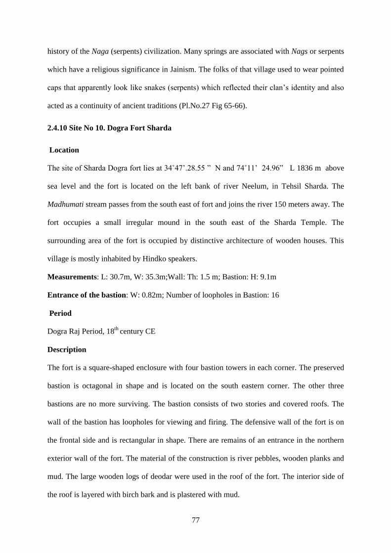
77
history of the Naga (serpents) civilization. Many springs are associated with Nags or serpents
which have a religious significance in Jainism. The folks of that village used to wear pointed
caps that apparently look like snakes (serpents) which reflected their clan‟s identity and also
acted as a continuity of ancient traditions (Pl.No.27 Fig 65-66).
2.4.10 Site No 10. Dogra Fort Sharda
Location
The site of Sharda Dogra fort lies at 34˚47‟.28.55 ” N and 74˚11‟ 24.96” L 1836 m above
sea level and the fort is located on the left bank of river Neelum, in Tehsil Sharda. The
Madhumati stream passes from the south east of fort and joins the river 150 meters away. The
fort occupies a small irregular mound in the south east of the Sharda Temple. The
surrounding area of the fort is occupied by distinctive architecture of wooden houses. This
village is mostly inhabited by Hindko speakers.
Measurements: L: 30.7m, W: 35.3m;Wall: Th: 1.5 m; Bastion: H: 9.1m
Entrance of the bastion: W: 0.82m; Number of loopholes in Bastion: 16
Period
Dogra Raj Period, 18th
century CE
Description
The fort is a square-shaped enclosure with four bastion towers in each corner. The preserved
bastion is octagonal in shape and is located on the south eastern corner. The other three
bastions are no more surviving. The bastion consists of two stories and covered roofs. The
wall of the bastion has loopholes for viewing and firing. The defensive wall of the fort is on
the frontal side and is rectangular in shape. There are remains of an entrance in the northern
exterior wall of the fort. The material of the construction is river pebbles, wooden planks and
mud. The large wooden logs of deodar were used in the roof of the fort. The interior side of
the roof is layered with birch bark and is plastered with mud.

78
The fort along with the watch bastion was built on strategically important locations as a track
originates from Kashmir to Chilas (Bates 1873: 338). There is also a direct route from the
right bank of Neelum River on the opposite site of fort along the Surgun Nullah which leads
to Gilgit Baltistan. In the past, the fort was a complex of barracks and small garrisons
consisting about over few dozen soldiers with an officer were deployed here (ibid: 339).
During the Afghan period, wooden barracks were situated near the Dogra fort on the left side
of Madhumati stream to control the movement of people (Stein 1900:341). The ruined
structure of the Dogra Fort belongs to the 1830‟s (Pl.No.28 Fig 67-68). According to Stein:
A square rubble-built structure which stands almost opposite to the temple, on the left bank of
the Madhumati, was erected in Maharaja Gulab Singh‟s time, to guard the valley against the
inroads of marauding Cilasis who, in the Surgun valley, had a convenient route to descend
by. I found there a small garrison of Dogra and Sikhs, some forty men, belonging to irregular
Khaildar troops (ibid: 284).
2.4.11 Site Nagdar Kunari
Location
The Nagdar village lies at 34o 40'. 59- 25.6'' N and 073o 54'.11.4''' E and, 2096 m above the
sea level. Baboon Ka Kutta stream is on the north of this place which connects with Kaghan
Valley (Bates 1890:618). Nagdar has a number of hamlets at various altitudes interconnecting
with each other with narrow pathways in the alpine layout. Kunari is one of small habitats
situated about a kilometer away in the north from main Neelum road, on the right side of the
river. A number of Islamic sites: Shrines, Mosques and graves were documented by this
researcher from Nagdar village during field survey of 2015-16.
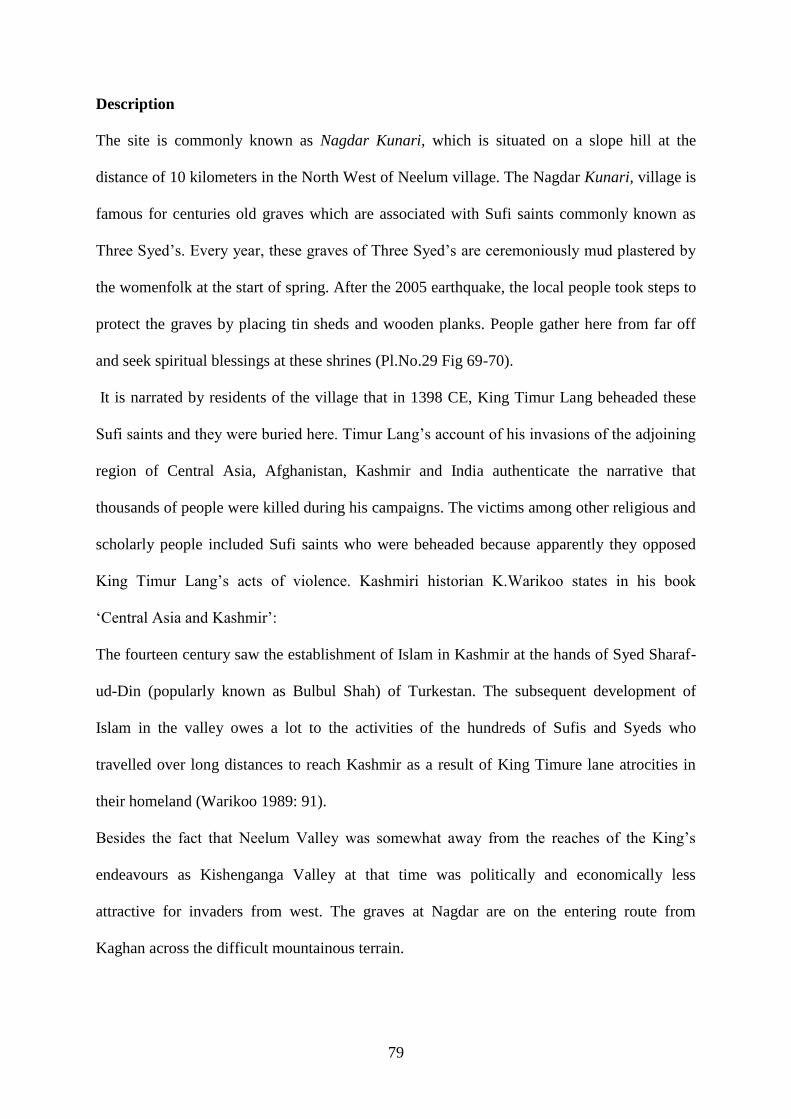
79
Description
The site is commonly known as Nagdar Kunari, which is situated on a slope hill at the
distance of 10 kilometers in the North West of Neelum village. The Nagdar Kunari, village is
famous for centuries old graves which are associated with Sufi saints commonly known as
Three Syed‟s. Every year, these graves of Three Syed‟s are ceremoniously mud plastered by
the womenfolk at the start of spring. After the 2005 earthquake, the local people took steps to
protect the graves by placing tin sheds and wooden planks. People gather here from far off
and seek spiritual blessings at these shrines (Pl.No.29 Fig 69-70).
It is narrated by residents of the village that in 1398 CE, King Timur Lang beheaded these
Sufi saints and they were buried here. Timur Lang‟s account of his invasions of the adjoining
region of Central Asia, Afghanistan, Kashmir and India authenticate the narrative that
thousands of people were killed during his campaigns. The victims among other religious and
scholarly people included Sufi saints who were beheaded because apparently they opposed
King Timur Lang‟s acts of violence. Kashmiri historian K.Warikoo states in his book
„Central Asia and Kashmir‟:
The fourteen century saw the establishment of Islam in Kashmir at the hands of Syed Sharaf-
ud-Din (popularly known as Bulbul Shah) of Turkestan. The subsequent development of
Islam in the valley owes a lot to the activities of the hundreds of Sufis and Syeds who
travelled over long distances to reach Kashmir as a result of King Timure lane atrocities in
their homeland (Warikoo 1989: 91).
Besides the fact that Neelum Valley was somewhat away from the reaches of the King‟s
endeavours as Kishenganga Valley at that time was politically and economically less
attractive for invaders from west. The graves at Nagdar are on the entering route from
Kaghan across the difficult mountainous terrain.

80
A few kilometers away from the shrine of Three Syed‟s there is another shrine complex that
exists on the eastern slopes of the Nagdar Mountain and is known as Chaebani Ziarat or a
Ziarat Gali. This shrine of Chaebani in Nagdar Kunari is also associated with the Dargah of
another reverent Sufi saint known as Qalandar Baba. This shrine was revered on both sides
of the LoC, in Kashmir and surrounding areas prior to division. People from all communities
visited this shrine but after division another Ziarat of Qalandar Baba was built on east of
LoC in a village known as Boore in the Indian administered Kashmir. During the war of 1972
some land of Boore village was occupied by Indian forces and the population is shifted to
village Booroebala in Pakistan administered Kashmir. The two villages Boore and Booroe
bala are separated via Nullah Boore between the administered parts of two countries.
The ziarats or Mazars as they have become places of veneration and hence are most
frequently visited. This is reflective of the highly respectful position that the buried person
holds for the people. These graves are simple mud structures without any head stones and the
area around these shrines is covered with a thick forest of pine, with colourful flags hoisted
on top of the trees. In the Manikyal town of Gilgit Baltistan similar types of graves of the five
Shuhadas (Martyrs) have been documented by A.H Dani. These old graves have decorated
coffins and wooden head posts (Dani 1995: 32-104).
There is another old elaborated ornamental wooden grave which exists in Nagdar, associated
with an unidentified Sufi saint. The grave is occupying an ancient mound on the right bank of
Nullah Nagdar five kilometres far from Neelum village. Although the foundation of grave is
that of river pebbles, mud and stone blocks, the upper structure consists of wood planks and
logs. There is a variety of designs including lotus and Diya (small oil lamps of clay) patterns
which are engraved which is the continuity of the traditional style of the area. Local
inhabitants inform that the wooden structures have been renovated using exactly the same
engraved patterns over the known periods (Pl.No.29 Fig 71-72).

81
Similar type of ancient simple mud graves with head stones are in Hunza, Tangir, Darel and
Gilgit (Dani 1989: 56). In Swat, Kohistan and Gilgit wooden graves may also be found
known as coffins. There are elaborate ornamental carvings on them beside geometrical and
floral motifs which are common in Muslim monuments. There are also carved wooden
mosques and ziarats (graves of holy people as places of reverence) at Dassu and the
adjoining areas which were introduced here from Kashmir Valley. Although, these structures
are built in the recent years yet they are the carriers of the older traditions. Kohistan is the
region which makes a real divide between the Himalaya, Hindukush and Karakorum (Dani
1995: 32).
In Neelum Valley, at the south of Sharda Temple and the left bank of Madhumati stream at a
distance of about two Kilometers, there is an ancient graveyard (that mostly consists of
standing burials). Amongst these there is a grave in Islamic tradition shadowed by an ancient
Chinar tree. According to the oral history of the valley, this tree was planted by Syed Jamal-
ul-Din, one of the disciples of Syed Ali Hamdani, who was later buried in Sharda (Stein
1900: 284). The tradition of plantation of trees on a child‟s birth still exists in Central Asian
regions of Turkmenistan, Uzbekistan and in Neelum Valley of Kashmir. In the beginning of
the fifteenth century the Sufi saints of Reshi orders arrived in Kashmir from Persia, Central
Asia and north and inhabited in the area which had already infused with the traditions of the
Hindu ascetic and Buddhist renunciation (Warikoo 1989:92).
It is most likely that Sufis, Muslim scholars and the Syed saints migrated from Central Asia
and settled in the various parts of Kashmir. Since Neelum Valley is nearer to the Central
Asian approach towards Indian subcontinent, and it also shared similar environment to that of
Central Asia, these people made this region their abode. Several Syed families that still live
in the area are highly revered. For centuries these clans of Sufi Syed‟s spread knowledge in

82
the area, both religious as well as basic education, and had a very important impact on the
socio-cultural life of the valley which still exists in various forms of cultural heritage.
Site no. 2.4.12 Kosab Pura Mosque at Nagdar
Location
The Kosab Pura site in Nagdar village is situated at a distance of 2 kilometers form Nagdar
bazaar on the right side of the river Neelum. Nearest is the village Budanpura from where,
the researcher documented commemorative stone and rock inscriptions.
Description
In the Kosab Pura there is a wooden Mosque that stands prominent on the right side of the
Nagdar Nullah, at the distance of 5 kilometers from Nagdar bazaar. This ancient Mosque is
also mentioned in the Gazetteer of Kashmir and Ladakh 1890 (Bates 1870:285). Besides
having traditional architectural features of the adjoining places the mosque has rich engraved
designs and decorations with Central Asian influence. This type of Mosque is the
continuation of the mosque architectural structures existing in Gilgit Baltistan, Srinagar and
other parts of Kashmir.
The Kosab Pura mosque is built on a high plinth. It consists of a central main prayer hall,
small hojjra (small open room attached to the hall), with a decorated arch and L shaped
verandah on its eastern and northern sides. The western side of the mosque enclosure is
occupied by the prayer chamber which is rectangular in plan. The flowing water stream is the
main source of water supply near the Mosque. The eastern side of the verandah is closed by
blind wooden arch screens and entrance has a wooden door, while the southern side is open.
The trefoil pointed arches are typically of Central Asian type. There are three blind arches
with decorative geometrical patterns on the west and five on the northern side. The partitions
of veranda have different geometrical and floral carvings on each side. The base shaft, capital
pillars of the central hall are beautifully decorated in Corinthian style along acanthus pattern.
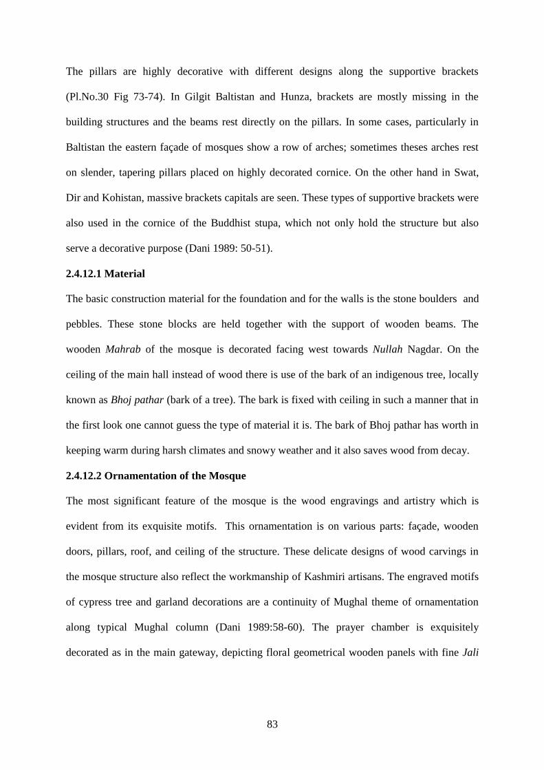
83
The pillars are highly decorative with different designs along the supportive brackets
(Pl.No.30 Fig 73-74). In Gilgit Baltistan and Hunza, brackets are mostly missing in the
building structures and the beams rest directly on the pillars. In some cases, particularly in
Baltistan the eastern façade of mosques show a row of arches; sometimes theses arches rest
on slender, tapering pillars placed on highly decorated cornice. On the other hand in Swat,
Dir and Kohistan, massive brackets capitals are seen. These types of supportive brackets were
also used in the cornice of the Buddhist stupa, which not only hold the structure but also
serve a decorative purpose (Dani 1989: 50-51).
2.4.12.1 Material
The basic construction material for the foundation and for the walls is the stone boulders and
pebbles. These stone blocks are held together with the support of wooden beams. The
wooden Mahrab of the mosque is decorated facing west towards Nullah Nagdar. On the
ceiling of the main hall instead of wood there is use of the bark of an indigenous tree, locally
known as Bhoj pathar (bark of a tree). The bark is fixed with ceiling in such a manner that in
the first look one cannot guess the type of material it is. The bark of Bhoj pathar has worth in
keeping warm during harsh climates and snowy weather and it also saves wood from decay.
2.4.12.2 Ornamentation of the Mosque
The most significant feature of the mosque is the wood engravings and artistry which is
evident from its exquisite motifs. This ornamentation is on various parts: façade, wooden
doors, pillars, roof, and ceiling of the structure. These delicate designs of wood carvings in
the mosque structure also reflect the workmanship of Kashmiri artisans. The engraved motifs
of cypress tree and garland decorations are a continuity of Mughal theme of ornamentation
along typical Mughal column (Dani 1989:58-60). The prayer chamber is exquisitely
decorated as in the main gateway, depicting floral geometrical wooden panels with fine Jali

84
(openwork carving). This ornamentation is applied on the walls, ceilings, and soffits of arches
(Pl.No.30 Fig 75-76).
There is a variety of wooden panels bearing composite flowering plants, geometrical patterns,
on plain wooden background. The star like patterns filled with miniature decoration spread
out on the ceiling of the veranda in the form of encircling motifs. There are plenty of inverted
lotus string cases in engraved wooden panels of the mosque structure. Similar types of lotus
patterns were frequently used in the Buddhist art of Gandhara. Identical decorative
vocabulary was utilized in the building architecture of Gilgit Baltistan, directly derived from
the Kashmiri monuments of Shah Hamdan. The art of wood carvings, Panjira and Khatam
Banda were originally brought to Kashmir and Gilgit Baltistan and adjoining regions by Shah
Hamdan (Warlkoo 1989: 91-93 & Dani 1989:48-60).
The carved door frame of the prayer chamber shows circular creepers, embossed patterns,
interconnecting squares, rectangular and bracket motifs in old style. The upper part of the
door frame has geometric motifs within the broad pointed arch of the old style. Few engraved
designs, lotus, acanthus leaves and chain motif of this mosque are found similar to the
wooden engraved graves (coffin) in Nagdar village a few kilometers far from this place.
2.4.12.3 Origins and Continuity of Design
Originally the Kosab pura Mosque had a towering spire which has been completely
demolished during the renovation that took place in 2015 and an additional tin roof tower was
added. In the Kosab pura Mosque, placement of the main pillar below the roof holds the
whole upper structure of the Mosque, which consists of wooden logs and stones. The round
stone of different sizes were placed one by one in a way to create a huge spire over the roof
of the Mosque. This technique of making spire is similar to the finical umbrella of Buddhist
stupa structure. In the 2nd
-3rd
CE, this method had been used in the construction of harmica
Chattra of the Buddhist stupas in Gandhara which is a representation of the Buddha sacred

85
tree. The Chattra spire, railing harmica of the stupa had greatly influenced the later
architectural designs (Dani 1989:51). There are a number of tombs and Mosques in Gilgit
Baltistan, Kashmir Valley and the adjoining areas of Neelum with this type of towering spire.
This towering spire construction is also known as eastern style where the roof has in its
centre, a towering pyramidal spire, mostly seen in Gilgit, Hunza and Baltistan. In Swat, Dir
and Kohistan all the mosques have flat roofs, which are of a western style of architecture.
According to Ahmed Hussain Dani:
This type of spire in the area is a copy of the Buddhist relic‟s chamber, if this is correct then
the tall spire is a stylised form of the receding umbrella that one sees on the top of the stupa.
The popularity of such spires in this region also emphasises the survival of local Buddhist
element in the architectural style (Dani 1989:51).
This tower like tapering spire is obviously derived from Kashmir, where from the first time; it
is seen in the building associated with the name of Shah -Hamdan. This famous Sufi saint of
14th
- 15th
century CE was responsible for the spread of Islam in the Valley of Kashmir, Gilgit
Baltistan and Neelum Valley. The hundreds of followers of Shah-i-Hamdan settled in various
parts of Kashmir. Apart from the services to religion and spreading Islam, they established
academic institutions, along with arts & craft centres (Warlkoo 1989: 91).
The ruins of the earliest Mosque of Neelum Valley have been identified in village Salkhala
which was built by Baba Abdullah around 1500 CE. People of the area have strong
confidence that Baba Abdullah was also a Sufi saint of the Reshi order from Center Asia who
played an important role to spread the message of Islam and to initiate the construction of the
first mosque in the area. Though it is difficult to date the original construction of the Salkhala
Mosque, the material structure of this mosque is stone, mud plaster and wood. The 16th
century Kashmiri mosques were built by mud and wooden structure derived from the
conventional architecture of adjoining region. Similar types of Mosques are in Gilgit

86
Baltistan near Sher Qila fort and Shakyal Mosque near the old fort which is the combination
of mud logs and engraved wooden structure (Ray, Sunil Chandra, Dani 1989:55).
At first glance, the Kosab pura, Nagdar Mosque bears resemblance to a traditional Kashmiri
Mosque; however, close inspection reveals that its features have been shaped by years of
architectural history in the region. The wooden engravings, motifs and architectural features
of Kosab pura Mosque are a continuity of earliest designs of the region. These elements are
present in the form of a huge spire of roof, brackets of stupa harmica, trefoil Mughal arches;
use of indigenous materials such as birch bark and of Central Asian designs. The architectural
motifs, wood carvings, arts and crafts which are still in fashion, strengthen the notion of the
Central Asian influence on the ways of life of this land.
2.4.13 Wooden Houses of Neelum Valley
The Larri or Nanaz is a Kashmiri word used for these wooden houses which are apparently
very simple structures but fulfill almost all the requisites, necessary for human dwellings. The
documented wooden houses in Neelum Valley are over hundred years old. The architectural
details of one of the houses are given here.
The two story house is situated in the village Sharda facing west, and has large opening on
upper half of northern and southern wooden walls. The ground floor has a big hall with
adjacent rooms. It is used for cattle and storage of wood and grass. The height of the ground
floor structure is 1.90 meters and the length is 8.75 meters. The side wall width is 7.70
meters. There are small holes of 20 by 20 centimeters for ventilation in western wall. The
stairs, of eight steps lead to the second floor. Each stair is one metrer in length and 28
centimeters in width, along with a wooden railing. The second floor is used for living
purposes with verandas in the western and southern walls, rooms and separate Kitchens for
summers and winters (Pl.No.31 Fig:77-78). The western veranda facing towards river
Neelum comprises summer fire area, a grainery and extended washroom. The veranda has

87
five pillars made of the wood used in raw form or without finishing. The Width of the
veranda is 1.7 meters and its length is 6.8 meters. The height of the second floor wall is 2.60
meters. The door is 2 meters in height and one meter in width. The floor of the house, walls
and doors all are made up of raw wood. These big wooden jars are used for storage of corn
and lentils. The diameter of the wooden grain jar is 2.7 meters and height is 2 meters.The
washroom, measuring 1.5 x 1.5 meters. The veranda has a single door which opens into a
gallery. The gallery leads into other rooms and the winter fire area, which is mud plastered
and has a chimney. There are two rooms on both the sides of fire area. In one wall of each of
the rooms, a small hole of about 20 x 20 centimeters for ventilation is present. There are no
windows in this area owing to the extremely cold weather during winter season.
The fire area is rather warm and is used to sleep during winter season. The upper most floors
have a single hall without any partition and are opened on two sides under a triangular shaped
slanting roof for the crossing of air. This is designed purposely so that the air passes through
the storage of dry vegetables, summer fruits, apples, walnuts and other herbs which are stored
for consumption in winter.
2.4.13.1 Main architectural features and the function of the wooden houses
Most of the houses in Neelum Valley consist of double or triple stories; the ground floor is
used for cattle, the second floor for living area, and the third floor for the storage of winter
edibles. The main material used in the construction of the houses is simple, undressed
wooden logs or planks. All the houses have a veranda or balcony and windows for light and
air. Furthermore, the wooden dwellings skillfully maintain kitchens and washrooms, though
wood is vulnerable to fire and water. Fire also burns in the kitchen of each house which is in
its inner most quarters (Pl.No.31 Fig 79-80).
The main architecture features of their structure functionality along with aesthetics of its
dwellers are as following:

88
2.4.13.2 Plinth
Selection of land to build a house is important for stability of the house. Structure of every
house is raised on a plinth of stones, essential for its stability and also to save it from
moisture and termites. Stone plinth, in this context also strengthens the foundation of the
structure, because in the entire valley the foundations of a house are not laid on soil. Instead,
strong stone bases are provided to construct an edifice.
2.4.13.3 Ground Floor
The wooden houses are multi-storied structures and each section serves some purpose of
utility. The lower most (that is, the ground floor) is reserved for animals that satisfy most of
their basic needs. Ground floor consists of two chambers with a small hall. It is enclosed
from all sides, except small windows for light and ventilation, and also to keep the cattle
warm in winter and safe from the extremities of the cold weather. Provision of fodder and the
process of milking is also done there.
Ground floor is designed to provide hygienic atmosphere to the livestock, for which a
ventilator in the form of a window is provided, whether it be first floor or basement. It lets
fresh air and light, otherwise, there is no source either of the two. But usually, there is only
one window, and its size is kept very small, to keep the cattle flock warm in extreme colds,
because in winter they are kept there while in summer the space is only used at night. Every
facility is maintained in this floor to provide fodder, so wooden mangers are almost fixed in
an organized way, even if the livestock is larger in number. Mostly six or seven cows along
with goats are kept by each owner, so Bara is spacious enough to accommodate the animals
easily and maintain cleanliness of the area as well.
This floor is divided into two portions; dwellings of cattle and the area to keep fire wood
along with fodder that may be grass or herbage.

89
2.4.13.4 Second Storey
Purpose of keeping residential areas in the second story is to live separate from animals
while not getting completely apart from them. Inner part of this story is a compact unit ,
enclosed from all four sides, but pierced with small windows for ventilation and light. This
arrangement keeps a house warm with presence of only one furnace in the kitchen, almost in
the center of the house.
The gallery or veranda on three or four sides of the house is very beneficial, both in the
winters and summers. It keeps the inner structure away from direct link from extremities of
the weather and is also useful for other purposes, like drying of wet cloths, facilitating fresh
air and sunlight that is essentially required for healthy living. All these benefits are provided
by the verandas, because they have no open courtyards. The summer kitchen is also
maintained on one side of the corridor. In a corner of the gallery, another hearth is built in the
manner of the inner kitchen, with mud plaster covering. Thus the family can enjoy the
summer breeze along with food.
2.4.13.5 Upper Story (Attic)
The upper most story which is the attic, was created by the gable of the roof is also most
valuable because it serves the function of preserving food for rainy days and also acts as an
insulation barrier between the house and the surrounding cold winds. The attic too, is
extremely useful and technically constructed for reservation and storage of meat, fruits and
vegetables, along with cheese, to save these for snowy days of the winter, while preserving
their nutrient value as well. The attic is open from both sides to let fresh air cross the floor to
accelerate the drying power of the food, set therefore preservation. So, each story has a
distinct value and is constructed for a different purpose (Pl.No.32 Fig 81-82).

90
2.4.13. 6 Kitchen
Among the rooms surrounding the gallery, a central room is allocated for the kitchen. It is
usually most spacious, having a fire place for cooking food and an open cupboard, where
utensils are arranged in rows of compartments. The oven or furnace is surmounted by a
projected mantle on which cooking items are kept. A slanting projection slopes down from its
cornice that provides shelter too because a chimney is placed in its inside that opens out by
piercing through the gable of the roof. It is a perfect outlet for smoke (Pl.No.32 Fig 83-84).
The fire place is surrounded by low heighted wooden chairs to sit and enjoy the warmth in
cold weather. The kitchen serves multifarious purposes: beside being a place for cooking
food, serving and eating, it functions as a seating room in winter, especially for the
womenfolk. After cooking food, other daily toils like embroidery, spinning wool, basketry,
etc. are also performed there because it is the coziest section of the house. They use Namda
or felt carpet for floor sitting; animal skin is also used for the purpose because in winter,
kitchen also serves the function of a sleeping room, for being warmer than the entire house.
Sometimes a Charpai (A type of bed) is placed as the kitchen is also a multipurpose central
place. It is surrounded by bedrooms that may be four or six, according to size of the house.
One room, which is longer, serves the function of a pantry, reserved for storage of kitchen
accessories and keeps a small amount of fire wood for daily use only. Otherwise, fire wood is
placed in a separate room on the ground floor, where the cattle are kept. Grains, rice and
pulses are kept within wooden containers, formed by hollowed wooden trunks. Herbs and
dried vegetables are placed within home-made baskets, and oil prepared from butter is also
kept there.
The most amazing part about kitchen is that the whole structure is wooden. Wood ignites fire
in the cooking oven but the house is not set a blaze. To overcome the threat of blazing, a
thick layer of mud plaster is applied at the fireplace and in its vicinity for the safety of the

91
entire wooden structure. It is very well said that necessity is the mother of invention; hence
that very plaster is also thickly applied on mantle, as a safety measure. To strengthen it, herbs
and wild plants are chopped and mixed into mud, enhancing its binding power.
2.4.13.7 Washroom
The washroom is an essential part of each house, and is located in the veranda, projected
outside, built on the cantilever principle. It is usually a small square room keeping a bucket of
water and a small seat to sit and take bath or perform ablution. It is suspended outwards, not
placed inside the house to avoid spreading of moisture in the structure.
Moreover, in olden houses, where pipe system was not introduced, channels of wooden
planks were used to throw away liquid waste. But after the mighty earthquake of 2005, many
modern elements were introduced in the remote areas, thus plastic pipes are now used for the
purpose.
2.4.13.8. Construction Techniques
Construction techniques of the houses are actually based on the age old system of building
bridges on Cantilever principle. The entire structure is laid on massive piers, erected on
layers of logs to make these strong enough to withstand weight of the edifice. For ordinary
pillars simple tree trunks are used. The strong vertical posts or piers are surmounted by a
horizontal, laid crosswise like headers and stretchers. Similar system was applied for building
walls as well as superstructures (Brown 1988:85). This style of construction is columnar and
tribeated, not arcade, as vertical posts are covered with horizontal beams. Either planks of
wood are used or logs attached firmly with mortise and Tenon method, using dovetail joints.
Usually logs of wood are split apart with the help of a saw, forming planks or vertical posts
called thum, chiseled at the upper ends and fitted into horizontal beams, called batta, making
a T-shape construction.

92
The entire structure is built around that T-shape, fitted so tightly that it interlocks the two
pieces. It is locally called Chul system. It is further crisscrossed with smaller beams, covering
the entire ceiling. The T-shaped vertical and horizontal columns and beams are the base on
which the whole structure of the house is built. To provide greater solidity and to protect the
thum from termites, it is fixed within a stone base called Chukka. The stone block is hollowed
from the inside and upright wooden posts are fixed within it, not directly pressed into the
ground.
Moreover, the structures are built on higher up plinths. These are multi-storied structures with
their truncated apex and gabled roofs ascending in tiers of pyramidal form, with overhanging
eaves to protect lower sections from rain water or snow. Rafters of the gable and over
changing eaves are covered with planks of wood and then further provided water proof
surfaces, as Brown observes multi layers of birch-bark locally called Bhoj Patter (Bates
1870:370). It is placed in three, four or five layers, covering the entire space of the gables,
forming ridges and recesses.
Slopes of the gables and their understanding plains serve as snow and water conductors
because snow does not rest for long on the slanting spaces and it will fall gradually, not
abruptly, and these can also be easily replaced when damaged. At some places, needles of
pine are sometimes mixed with mud mortar and placed like frills at edges of the gables; it
also works as a water conductor that allows water to fall drop by drop and protects the inner
side from seepage and decay.
For refined houses, logs are square shaped and their interstices are filled with either bricks or
tile work, or developed into niches. Dovetail joints are occasionally used while simple stouter
wooden pins are usually applied to join logs (Brown 1988: 85). Some of the houses contain
arches which are false for not having load bearing capacity. Their usage is decorative, only
forming fence of veranda. It adds an element of beauty to the simple structures.

93
2.4.13.9. Material
In Neelum Valley wood was easily available and so was used for the construction of houses.
The houses are based on simple undressed wooden logs or dressed planks. The woods used
are Fig, Pine, Shisham, Kail which is locally available, but most frequent is that of Cedar
(Deodar).
2.4.13.10. Origin
The history of refined wooden houses construction goes back to the period of King Zain-ul-
Abidin, which is considered the Golden age of wooden art, craft and architecture in Kashmir
(Gosh 2009: 32). Tracing the origin of the structure, one finds that it is based on Yurt, which
is a form of Mongolian tent constructed on the same vertical post and horizontal beam
system, with a circular ring at the top providing some covering. This is an influence of
Central Asia, also known as Pamiri style of construction. Many features of Central Asian
culture are also adopted here.
The influence of Kashmiri style architecture spread in many surrounding areas; the lantern
roof of the wooden architecture is visible even in the decorative elements used to adorn rock
carved chambers in Bamiyan Valley in Afghanistan (Mumtaz 1989: 30). It is recorded
historically that Shah Hamdan moved to Kashgar from Kashmir by passing through Gilgit
Baltistan, a introduced the Kashmiri style architecture there (Dani 1995; 41). The houses of
Kashmiri speakers are well designed and well planned as compared to the other inhabitants of
the valley. This also reflects their unique cultural link with the Central Asian traditions.
2.4.13.11 Aesthetics
From an aesthetic point of view, these houses are generally devoid of ornamentation; their
plain wooden planks have a rather simplest structure and provide beautiful contrasts of light
and shade. Overhanging eaves truncated, superimposed structures, un dulating the surface of
birch-bark on the roof-gables of the houses, break monotony or rigid formality of the

94
structures and create attractive passages of light and shadow. Similarly, the veranda is further
bedecked with perforated grills of parapets formed by small wooden strips, arranged into a
variety of patterns, while the parapets along with their upper fringes are shaped into patterns
by placing of wooden strips in vertical and horizontal arrangements. Some houses have
wooden engravings on the doors and windows with geometrical designs, and a variety floral
and leaf patterns (Khan 2014:24). The interesting part about these structures is that their
utilitarian objects are mostly wooden and shoe-stands are placed in their corridors and they
are also wooden (Pl.No.33 Fig: 85-86).
2.4.13.12 Environmental Friendliness
Most amazing is that the wooden houses of Neelum Valley are environment friendly. These
can withstand earthquakes of Richter scale 8.7 that cannot be guaranteed by even stone
structures. The reason behind this is scientific engineering. A stone or brick structure can
fully collapse with jolts because it has no elasticity, whereas, the way beams a placed, these
go on rotating, causing less damage. This was proved in the mighty earthquake of 2005.
Excessive destruction was caused by concrete and stone structures, and very less by the
wooden. Here, the architect is nature‟s child whose culture is molded by centuries of
experience.
These houses are also saved from insects not by any auxiliary help of insecticides but by their
daily toils. Smoke emitted from kitchen along with evaporated oil serve the function of
insecticides because they provide a bitter covering to the surface of wood and an insect dares
not bite it. The wooden architecture helps us in the understanding of human life in the past
and provides evidence of indigenous human skill required to utilize these resources. There is
a need to explore and preserve intangibles heritage which is fading out due to human
vandalism and in the wake of commercialization in the area.

95
In conclusion we must say that uifurther researches in term of archaeological explorations
and excavations are more than a necessity here, so that the true cultural profile of the valley
could be developed, which would definitely provide a sound base for determining
chronological events that took place between the Neolothic Period and the Early Medieval
Period here.
2.5. Private Collection of Artifacts from Neelum Valley
An Axe (Pl. No. 34 Fig.87)
Location: Khawaja Seri East
Material: Iron
Size: L: 6.5cm, W: 1cm, Th: 2.54cm.
Description
It is an iron axe, with an elongated body as well as an expanded and squeezed head. It seems
that, judging from its present state, it is made up of crude iron. It is provided with a hovel for
wooden shaft. It is presently in the private collection.
An Anklet: (Pl. No.34 Fig.88 a.)
Location: Khawaja Seri East
Material: Copper
Diameter: 7.6 cm.
Description
The anklet has linear engraved design. It has been reported from a grave worn by a dead
person. This clearly shows Gandhara grave culture.
Dish (Pl. No 34 Fig.88.b)
Location: Dosout
Material: Terracotta
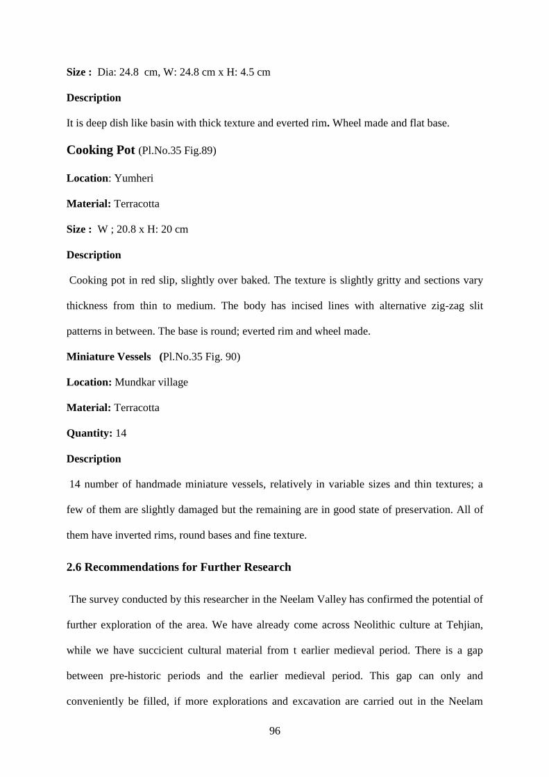
96
Size : Dia: 24.8 cm, W: 24.8 cm x H: 4.5 cm
Description
It is deep dish like basin with thick texture and everted rim. Wheel made and flat base.
Cooking Pot (Pl.No.35 Fig.89)
Location: Yumheri
Material: Terracotta
Size : W ; 20.8 x H: 20 cm
Description
Cooking pot in red slip, slightly over baked. The texture is slightly gritty and sections vary
thickness from thin to medium. The body has incised lines with alternative zig-zag slit
patterns in between. The base is round; everted rim and wheel made.
Miniature Vessels (Pl.No.35 Fig. 90)
Location: Mundkar village
Material: Terracotta
Quantity: 14
Description
14 number of handmade miniature vessels, relatively in variable sizes and thin textures; a
few of them are slightly damaged but the remaining are in good state of preservation. All of
them have inverted rims, round bases and fine texture.
2.6 Recommendations for Further Research
The survey conducted by this researcher in the Neelam Valley has confirmed the potential of
further exploration of the area. We have already come across Neolithic culture at Tehjian,
while we have succicient cultural material from t earlier medieval period. There is a gap
between pre-historic periods and the earlier medieval period. This gap can only and
conveniently be filled, if more explorations and excavation are carried out in the Neelam

97
Valley in general and the Tehjian in particular. At Reshna, Dudnial there is an ancient mound
where old Jars had been dug out by the locals. They are similar in concept as the Gandhara
graves (Dani 1995: 33). During the salvage excavation 2012-14 adjacent to the Sharda
Temple in Neelum Valley, this researcher also documented a variety of cultural material
including terracotta pipes and bricks (Pl.No.36-38 Fig. 91-93). The discovery of these pipes
and bricks is very significant, as it means that the area was an urban settlement. These
terracotta pipes belonged to first century CE, which could have been used for drainage or
carrying water, but this notion is yet to be determined and confirmed (Pl.No.39-40 Fig. 94-
95) . It is important to mention that the kinds of Terracotta pipes and bricks were also
unearthed in various locations in Gurez Valley: along Shounter Nullah, Kel also discovered
from Gander-bal and Bandipora in Indian Held Kashmir (Rising Kashmir: 2017). These sites
are located on an itinerary which remained an ancient route from Kashmir to Central Asia.
98
CHAPTER: 3
THE INTANGIBLE CULTURAL HERITAGE OF NEELUM VALLEY
3. Intangible Cultural Heritage
The concept of cultural heritage has gradually converged into two major categories:
intangible and tangible heritage. UNESCO had produced a working definition of intangible
cultural heritage in its October, 2003 convention which calls for the need of consideration
towards the intangible form of cultural heritage. The definition of intangible cultural heritage
in the UNESCO convention of October, 2003 highlight: Intangible cultural heritage can mean
the practices, representations, expressions, human knowledge, indigenous ways, local skill as
well as artifacts and objects. Intangible heritage also depicts cultural spaces associated with
communities, groups in some cases individual activities as a part of their cultural heritage.
This intangible cultural heritage is transmitted from generation to generation. It is constantly
recreated by communities and groups in response to their environment, their interaction with
nature and their history. Intangible cultural heritage has provided them with a sense of
identity and continuity and this enables them to have strong cultural diversity and human
creativity (UNESCO 2003:2).
This definition refers to numerous forms of intangible cultural heritage, such as oral
traditions, expressions, languages, crafts, rituals, practices, festivals, knowledge and
traditional skills. According to this definition the various forms of intangible cultural heritage
are present in the existing communities of Neelum Valley. The intangible cultural heritage
has been reflected in crafts, cuisines, dresses, languages, and cultural spaces. Peoples‟ ways
of life have been closely connected to natural resources such as herbs and water. These
expressions of intangible heritage are sources of human wisdom, social cultural and
economic conditions. Intangible heritage has provided the inhabitants in Neelum Valley with

99
cultural identity. Many rituals are associated with the cultural and natural places that have
been important for the communities or groups since the past. Many specific events are
present in the ancient literature of Kashmir which helps to sketch out the earlier lives of
people in the area. In this study, the researcher has explored the intangible heritage, such as
traditional outfits and jewellery, crafts, textiles, cuisines, festivals, rituals; stories associated
cultural spaces, languages and ethnic groups of Neelum Valley.
3.1. Celebration of Events and Festivals
The physical features of Kashmir and its adjoining area had had great influences on the
society, culture and history of the area. Nilamata Puranas ancient Sanskrit text mentions
customs and rituals of Kashmir to welcome and commemorate spring; snow falls, harvesting
of fruits and new crops. These celebrations are a portrayal of a cheerful and peaceful
environment of the Valley. There was a custom of drinking wine on the new snow fall day
which is unknown for the inhabitants of the plain areas (Kumari 1969:44-45). Neelum Valley
has been carrying forward the legacy of these cultural celebrations. People welcome the
spring cultivation season and melting time of snow when flowers start blooming. They visit
their relatives‟ places, exchange traditional cuisines, offerings on shrines for the land fertility
and new crops.
The Rajatarangini mentioned that the inhabitants celebrate festivals when crops had ripened
in the fields. They prepared a variety of traditional foods as a ritual for more prosperity (Ray
1969:249- 250 Koul 1960: l80-184). Nilamata Puranas mentioned about the famous
celebrations of the sowing of barley seeds, locally known as Bofau, which are held in Hunza,
a place in the vicinity of Kashmir (Kumari 1969:109). The historical pass of Shimshal was
the route of Hunza, Gilgit Baltistan, which remained an ancient route of the Silk Road
between China, Kashmir Valley and Neelum Valley.

100
Nowruz is a festival celebrated since centuries and Baisakhi, a Hindu festival, which becomes
synonymous with Nowruz, also remained as an important event in Jammu & Kashmir (Saraf
1987: 40). In Neelum Valley and Gilgit Baltistan, on the occasion of Nowruz, different food
items are prepared with a combination of rice, milk and ghee as offerings to the Sufi saint
shrines for seeking blessings .These traditions are a continuity of ancient beliefs in the region.
In the remote past, special foods were prepared with combining butter, barley and pulses as
festive dishes and offerings to deities (Koul 1960:121). Historically the festival Nowruz had
more significance in the fertile mountains, river valleys and regions of present day northern
Iran and Central Asia where this festival is celebrated on the arrival of spring after cold bleak
winter. This festival is celebrated as a secular or cultural festival by the people of Tajikistan,
Uzbekistan, Kyrgyzstan, Kazakhstan, Turkey, Afghanistan, Iran, and Gilgit Baltistan and
Srinagar.
3.2. Traditional Cuisines
The inhabitants of Neelum Valley enjoy a variety of traditional foods which are indigenous
with respect to ingredients and preparation. Noticeable dishes are prepared with a
combination of different vegetables such as karam, kuri, tomato, saag and paneer (Pl.No.41:
Fig 96-97).The paneer is type of condensed milk locally known as Kurn in which milk and
yogurt are boiled on low heat and placed under the sun to dry. Dairy products such as cheese,
ghee and butter are abundantly used in the preparation of food. Sheera is one of the winter
cuisines prepared by the combination of the herb Ratan Jo along with honey, corn flour, milk,
butter. Kehwa is an excessively used drink besides the herbal salty pink tea known as
Masloon in the local language.
The famous Chinese pilgrim Huien Tsang wrote that the area was abundantly rich in fruits
including grapes, apricots, peers, apples, plums and dry fruits. He further elaborated that
vegetables including rare herbs are an essential food item and are considered as healthy food

101
during winters. Condensed milk, curd honey and dried meat are also used by inhabitants in
Kashmir. A variety of wild herbs on the mountain slopes and meadows of the Kashmir Valley
are used as medicinal plants (Koul 1960: l80-184). In Neelum Valley one of the indigenous
Kashmiri vegetables is shilhwakh which grows three thousand and fifty meters above sea
level, immediately after the melting of snow on the hills in early spring. Wild vegetables such
as konji, longro, karam, bathova, khahoo, kalatri, malairooti and kuth are common. These are
plucked by folks during summer (Pl.No.41 Fig 98-99).
The inhabitants also preserved pumpkins, chillies and tomatoes for winter; they are left
hanging on the upper decks of houses, where cross ventilation is available for drying. Usually
the uppermost portion of house is planned such that it is open from both sides for passing air.
The home-made pickles are prepared with the use of indigenous parsleys which work as anti-
bacterial ingredients instead of vinegar.
Moorcroft writes in the Gazetteer of Kashmir and Ladakh that there are more than twenty
varieties of grapes in Kashmir. In the month of October, people had preserved grapes in
shallow earthen vessels for the winter. In the spring, they are used in the manufacture of
wine, vinegar and brandy (Moorcroft 187:51). Marco-polo in the thirteenth century
mentioned grape wine as a popular drink in Kashmir besides rice, fish, and pulses (Ray
1969:251-253). Neelum Valley is also famous for different types of grapes. Rawat village
unearthed a number of mud containers and stone pressers and therefore, it is possible that
people use to concealed eatables underground for preservation. In Poonch areas till 1970‟s
people used the same method for preservation of corn and vegetables for hard weather.
A variety of rice was cultivated in Neelum Valley since long and it still forms the main
constituent of daily diet in the homes of Kashmiri speakers. The Rajatarangini also mentioned
that rice was an essential food of the people in Kashmir, beside barley lentils and shrubbery
(Ray 1969:249).

102
In Neelum Valley the continuation of the traditional living style has preserved the cultural
identity of the inhabitants as well as maintained the balance between natural resources and
need-based usage of the same. It was due to less commercial influence that this was possible.
This also brings forth an aspect of a sustainable socio-economic existence in the Valley.
3. 3. Folk Music
The Sufuina Kalam (devotional music of the Muslim mystics known as Sufis) and classical
music were patronized by the Muslim Sultans of Kashmir. In Neelum Valley Sufuina Kalam
is sung by individuals or in groups on special occasions: Eids, Urs and marriages. The Kalam
of Mhajoor, Sheikh Noor Din wali, Lala Ded and Hubba Khtooon remain popular and have
been handed over from one generation to the next. The Kalam is transmitted by the locals
who frequently visited the annual festival or Urs in Kashmir Valley. Hoor is a typical
Kashmiri song of marriages sung by females in the form of couplets, mostly based on the
famous Kashmiri poetess Hubba Khutoon‟s poems. Womenfolk sing while working in paddy
fields or during other household activates. One of the themes of the women‟s expressions or
poetry is about conflict in the area. These songs are a reflection of pain and suffering, mostly
in the memories of divided families. The folk songs of the area are steeped in antiquity,
traditions and identity of the people in Jammu and Kashmir, and these traditions need to be
preserved.
3.4. Ethnology of the Neelum Valley
The different ethnic groups in Neelum Valley exclusively maintained the uniqueness of their
attires, skills, crafts and living styles which shows multi customs in the inhabitants of the
region. The textures of these textiles might have changed from hand-woven to machine-made
but the layouts and stitching is still unique as compared to the traditions in the other parts of
AJK. The areas nearest to Muzaffarabad in the south of valley have contemporary trends in

103
dress style. In remote areas such as Kel, Helmet, Tao butt and Gurez, the attire, crafts reflects
more ethnic look.In Neelum Valley people produced several other articles by using locally
available natural resources for domestic usage. This reflects self-sustainable environment of
the area.
3.4.1. Costume Making Techniques
Traditionally, in Neelum Valley the women folk used to make their clothing items themselves
which includes: pheran (Persian word means: clothes), caps and beaded jewellery. The
embroidery on clothes and caps is combination of red, yellow, orange and blue threads and
has patch work of geometrical and floral designs (Pl.No.42: Fig 100-101).
The most fascinating outfit is pheran: a loose embroidered garment mostly available in black,
for all inhabitants. This traditionally styled attire is unique in design, color schemes and
motifs. The embroidery around the neck, sleeves, cuffs, and border of pheran (only for
female) consists of floral patterns of multicolor threads. The dress code of the Kashmiri
speakers is a little different from that of the Hindko ethnic group such that they used to wear
simple black pheran. Besides pheran, the women folk used factory made garments, only in
black, with a combination of colorful floral patterns (Pl.No.42: Fig 102--103).
The headdress is another fascinating wear of the areas as a variety of embroidered caps are
worn by men, women and children. The make and type of theses caps are varied according to
age, status, occasion and season. The famous headdress of females is called „Ksava‟ in local
language. This clothing accessory is extremely regarded and is worn by the elder ladies of the
households. The „Ksava‟ is also stitched and prepared for brides in colorful patterns
(Pl.No.43: Fig 104-107). There is another cap with a long flap and is used by the Kashmiri
speakers on special occasions. This is termed as „lachka‟. It is a combination of threads and
beads. Similarly, in remote areas of this region colorful, casual and simple style caps made

104
from a combination of cloth, beads and threads are used by the middle aged women
(Pl.No.44: Fig 108-109).
The Kashmiri dresses of the earliest times have been mentioned in the ancient text of
Nilamata Puranas, Rajatarangini and in the accounts of the Chinese travelers. The cultural
material unearthed during the excavation at various places also added significant aspects of
earlier attires in the region. From Harwan, Srinagar, the sculptures and brick tiles of the 3rd
century BCE, have exposed the presence of ornamentation on attires. The female figures are
portrayed in loose robes with unique jewelry items. On the other hand, the male figures are
shown in fitted Pajamas or trousers and embroidered Turkoman caps, which reflects the
influences of the Central Asian culture on Kashmir (Ray 1969: 256, Dani 1996: 70).
The well-known Chinese traveler Hiuen Tsang admired the wears of inhabitants during the
mid of 7th
century CE. He mentioned that people carried a loose and short garment which was
eye-catching in design, layout and pattern (Pathak 2008:17). He matched the style of the
loose garments with the Chinese attire, which is dropped till the ankles whereas the length of
the Phern is just beneath the knees. That word „Phern‟ which is derived from Persian word
Pairahan means clothes that are worn by both the male and female inhabitants of Kashmir
Valley (ibid).
The documented cultural material and the inscribed figures on the commemorative stone
pillars from Nagdar Neelum Valley are important to mention here. The low relief stone pillar
depicting a standing figure shows an outfit consisting of a close-fitting trouser, a robe and a
Turkoman cap. The particular Kushan costume of the engraved figure is fitted with body
above the waist and is flung in lower part of the body. The discovered artifact is an obvious
indication of the cross cultural links of Neelum Valley with Central Asia. The influences of
Central Asia remained in the socio-cultural life of Kashmir and its adjacent valleys for a long
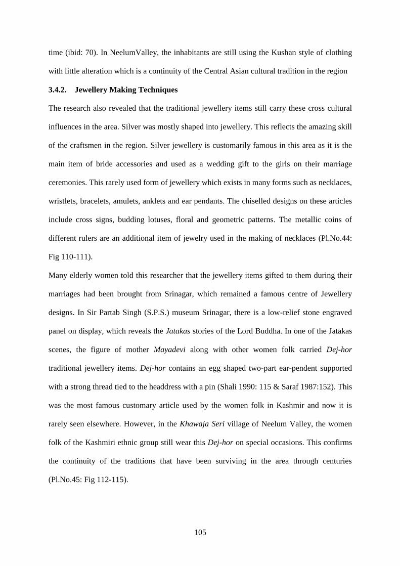
105
time (ibid: 70). In NeelumValley, the inhabitants are still using the Kushan style of clothing
with little alteration which is a continuity of the Central Asian cultural tradition in the region
3.4.2. Jewellery Making Techniques
The research also revealed that the traditional jewellery items still carry these cross cultural
influences in the area. Silver was mostly shaped into jewellery. This reflects the amazing skill
of the craftsmen in the region. Silver jewellery is customarily famous in this area as it is the
main item of bride accessories and used as a wedding gift to the girls on their marriage
ceremonies. This rarely used form of jewellery which exists in many forms such as necklaces,
wristlets, bracelets, amulets, anklets and ear pendants. The chiselled designs on these articles
include cross signs, budding lotuses, floral and geometric patterns. The metallic coins of
different rulers are an additional item of jewelry used in the making of necklaces (Pl.No.44:
Fig 110-111).
Many elderly women told this researcher that the jewellery items gifted to them during their
marriages had been brought from Srinagar, which remained a famous centre of Jewellery
designs. In Sir Partab Singh (S.P.S.) museum Srinagar, there is a low-relief stone engraved
panel on display, which reveals the Jatakas stories of the Lord Buddha. In one of the Jatakas
scenes, the figure of mother Mayadevi along with other women folk carried Dej-hor
traditional jewellery items. Dej-hor contains an egg shaped two-part ear-pendent supported
with a strong thread tied to the headdress with a pin (Shali 1990: 115 & Saraf 1987:152). This
was the most famous customary article used by the women folk in Kashmir and now it is
rarely seen elsewhere. However, in the Khawaja Seri village of Neelum Valley, the women
folk of the Kashmiri ethnic group still wear this Dej-hor on special occasions. This confirms
the continuity of the traditions that have been surviving in the area through centuries
(Pl.No.45: Fig 112-115).

106
In Neelum Valley, the women folk commonly used to wear a necklace which is known as
Duldo and is a combination of colorful beads. That is a form of causal indigenous items of
jewelry which were made by nomads and the locals with the blend of colorful patterns. The
trend of making numerous tiny ornamented braids with seasonal flowers or beads is famous
among the women in Neelum Valley. Rajatarangini mentioned an event of the 11th century,
relating to the rebellious prince Lothian, when brought in to court of King Jaysimbhia. It is
narrated that the prince‟s braided hairs were without any ornamentation; this indicates the
remote style of self-beautification in Kashmir.
The first Queen of Kashmir, Didda Rani introduced a variety of designs in bronze Jewellery
(Sahar, Jaitl 1990: 203-210). The Kalhana‟s Rajatarangini often refers to the wristlet with the
following names: kankana, anklet, earrings and armlet. The large beaded necklace and
anklets were popular among the inhabitants during the 7th century; (Stein 1900:207). In the
10th
century King Harsha introduced more ornamental methods in garment making and
jewellery (Saraf 1987:39). The archaeological findings from Sharda confirm the fashion of
the anklet as uncovered from one of the graves during illegal digging. Since immemorial
times, the people of Kashmir have adorned themselves with precious stones and ornaments
and the inhabitants of Neelum Valley have followed these traditions.
3.4.3. Textiles: Namda, Gabba and Chadder
Literary and archaeological evidence depicts olden wears of the inhabitants in Kashmir. In
632-635, Kashmiri seasonal attires including woolen blankets and embroidered Shawls
(cloaks) were described by Hiuen Tasng during his visit to the Valley (Ray 1969:251-
253).The craftsmanship in the land of Kashmir was introduced during the rule of King Zain-
ul-Abidin in the 14th
century; he invited many artisans of indigenous arts and crafts from
Central Asia. These artisans trained the locals in many crafts such as shawl making,

107
embroidery and weaving besides other creative skills (Kaumandi 2005: 241) (Pl.No.46: Fig
116-117).
The traditional textiles of Neelum Valley are rich, consisting of a variety of embroideries on
Gabba and Namda (types of rugs). Carpet making, wood work, Chadder, Lois and pattu
making are major crafts which are mostly found at Dawarian, Sumgum, Kel and Halmet,
Neelum Valley. The fibre making is a domestic activity of the women folk during winters
since ancient times. Lamb wool is the raw material which is used to make woolen threads on
spin wheel and men folk weave on looms. They have been producing fine kinds of Lois,
pattu, blanket, chadder and stuff for the traditional robe (Pl.No.46: Fig 118-119).
Originally, the plain Namda came from Yarkand (Central Asia) and was then embroidered in
Kashmir (Sahar, 1990: 73&Saraf 1987:96). Later, the people of the region learned and
developed this technique which is still vogue in Neelum Valley. Namda is a piece of felt
made of both wool and cotton. The wool or cotton is evenly spread over a mat before being
rolled and pressed underfoot for felting. After that, the felted piece is milled, washed and
dried. Namda are made in different shapes including round, rectangular or even oval and then
are embroidered with woollen yarns with the help of a hooked needle.
The Gabba‟s (a sort of woollen blanket) are dyed in different colours, stitched and patched
together in long chain stitches to form symmetries of patterns and designs on them (Saraf
1987:95). In Neelum Valley, initially Gabba-making was a household craft in which women
helped their male embroiderers in stitching together pieces of used lois. Later the women also
made cushions and bed covers with needle work in stem stain chain stitches for common use.
Chadder and Lois making is also a craft activity .These were shaped on looms in various
designs by the locals. The common designs of chadder are stripes and quadrangles with
mixture of black, brown, grey and white color. The technique used is twilling or plain

108
weaving against the border which is dyed in red, yellow, green and other bright colors.
Phulkari is one of the crafts applied on the borders in the dark and white geometric patterns.
Nomads locally known as Gujjars Bakarwal (goat carriers) set out from summer pastures to
the lower plains. They carry a variety of crafts including: small sailing cloth tents, Lois,
blankets, sacks which are prepared by these Gujjars folks, and are very rich in design and
colors. They provided yarns and goat hair to the weavers to make blankets, shawls and other
textiles. This is also a sources of livelihood based on the indigenous resources.
3.4.4. Crafts Making; Basketry and other Crafts
Kashmir is unique in the sense that the inhabitants have a great aesthetic understanding
which is visible in the form of crafts such as straw work, basketry and other minor crafts
(Saraf 1987:160). The straw made mats are common in all mountainous Valleys of Kashmir
including Neelum Valley. Traditionally, Kashmiris used to decorate the floors by the tree
leaves or by simple mud plasters and later it was developed into mat making. These mats
were made of straw taken from the dry grass of rice (ibid). Mat making is a domestic art of
Neelum Valley, mostly produced during the winter season and the usage of these mats is
limited to the houses. In the 16th century, Mirza Haider Daughlat introduced another art of
matting known as Phandhi in which dry grass was used to weave (Iqbal 2005: 122-123). This
craft, Phandhi making is also common in Neelum Valley, Jammu and other parts of AJK
(Pl.No.47: Fig 120-121).
In Indus Valley civilization from Mohenjo-Daro site (3000 BCE) archaeologists discovered a
pot which has an impression of a weave mat on it. Similarly, in Burzahom impressions of a
weed mat have been noted on the excavated pottery which reflects that mat making is an
ancient practice of the region (Sahar, Jaitl 1990: 155).
In Neelum Valley, interiors of houses usually have floorings, which are decorated with hand-
woven rugs, headrests and quilts. The other articles are wooden low seats locally known as

109
Peeras which are weaved in thin leather pieces. The inhabitants also utilize leather of goats
for making other household items including weaving of chairs, beds and other objects of
daily use (Pl.No.47: Fig 122-123).
Women in Neelum Valley use basketry for different purposes according to their needs during
work in field or plucking of vegetables and fruits. Women also made different durable
caskets like toakaras in indigenous plants changaries to keep breads in wheat and rice straw.
Traditionally, the goat and cow hide was recycled to make bags and flasks which were used
to carry flour, lentils, rice and milk. Terracotta pot is used to process, yogurt to extract butter
and lasi a local drink. The grass sandal was common in different cultures especially as it was
used by Buddhist monks in the area (Sahar 1990:157-158). In Neelum Valley, people crafted
sandals out of indigenous plant stuffs: dried grass, wild plants and rice straws. Various
methods are involved in the making of these sandals which is commonly known as pullan.
The straw sandal is still crafted in the remote areas of Jhelum Valley, Poonch, southern part
of AJK and Gilgit Baltistan. Animal skin shoes were also common in the valley besides
wooden and grass sandals.
3.4.4.1. Kangri Making
The kangri making is another indigenous craft activity of the folks in the area which is
particularly in use among Kashmiri speakers. It is a traditional fire pot combination of straw
work, willow branches and mud pot known as kanger in local culture. In winter people filled
kangri with hot charcoals to carry inside their loose garments or in blankets to keep
themselves warm. People used to carry it everywhere and were popular as an indigenous
heating arrangement other than wild herb baskets (Pl.No.48: Fig 124-125).
Kangri is also used in other colder parts such as Jhelum Valley, Leepa, and Gilgit Baltistan.
In 1980‟s the Kangri fire pot was common among Kashmiri speakers in Muzaffarabad,
Kashmir Valley and the inhabitants of the surrounding mountainous Valleys. Kangri is also

110
an intra Kashmir trade item imported from the Indian held Kashmir where kangri making is a
flourishing industry.
3.4.5. Wood work
Kashmir is a land of forests; walnut trees grow abundantly in the areas which are commonly
used in the making of wooden items. Woodwork is an ancient craft of Kashmir in which
floral and geometrical designs are made on wood from carving (Saraf 1987:106-107). Wood
engraving and designing has been also taken place in Neelum Valley. The khatambandi and
pinjira (lattice work) is used in the decoration of frames of windows and door. In these, small
pieces of wood fitted in to frames in geometrical designs (Pl.No.48: Fig 126-127).
The wooden utensils prepared by local artisans are still used in many parts of valley including
Khawaja Seri, Lawat, Kel, and Gurez Valley. There are two types of wooden serving dishes
which are mostly used by the Kashmiri ethnic group. One type of dish is known as „shanikh‟
which is slightly high with a stand and looks more or less like a dish on stand. The other type
of wooden dish is a flat timber platter. The woody servings dollops are crafted in different
sizes are still made by local artisans. This is an indigenous craft and also an economic
activity. The inhabitants of Neelum Valley and Kashmir Valley also used to wear wooden
shoes similar to the Chinese foot wear which is a continuity of remote traditions(Pl.No.49:
Fig 128-129).
Arts and culture are the main tools against stagnation of the society and it connects the
divided communities of Neelum Valley and the Valley of Kashmir. Thus, this cultural
identity of the people of Jammu and Kashmir needs to be preserved.
3.4.6. Brass Utensil
Brass utensils also remained in the use of the inhabitants since centuries, however in present
times their use is quite limited. The researcher documented specimens with engraved

111
calligraphic patterns with the combination of flora and intricate peacock designs from Sharda,
Neelum Valley (Pl.No.49 Fig 130-131).
3.5 Anthropological and Ethnographic Studies
Different clans inhabit in the lengths and breadths of Neelum Valley. These clans and sub-
tribes are locally referred to as qoom, kabila, bradari and zaat. Each of these ethnic groups
residing in Neelum Valley belongs to one of the following: Hindko, Kashmiri, Shina,
Bakarwal and Settler Gujjars (Pl. No.50: Fig 132-133). Khawaja Seri, Malik Seri, Tehjian,
Halmet and Sardari, Shund Das are villages of Kashmiri speakers (the revenue record
approached June 25, 2015). Bates states that the clans of Neelum Valley comprised of Dar,
Butt, Gujjars, Wani, Malyar, Awan, Sufi, Kulgan (Bates 1873:141). These clans are further
divided into Lone, Mir, Syed, Malik, Sheikh, Konshi, Pukhtoon, Khawaja, Raja, Qureshi etc.
(Rehman 2012:05). The spoken languages of Neelum Valley are Hindko, Kashmiri, Gojri,
settled Gojars, the Bakarwal, Shina and Gurezi Shina (Pl. No.50: Fig 134-135).
Hindko is a major spoken language in Neelum Valley, locally known as Parmi by the
dwellers other than the Kashmiri. However, the use of Hindko has not been documented in
any part of Kashmir. In traditional literature, the Hindko language in Neelum Valley, is
referred to as Pahari (Bates 1873: 15). According to Khawaja Rehman, a renowned linguist:
“The Hindko dialect spoken in Neelum Valley is more closely related to the dialect of Hindko
spoken in the Kaghan Valley, Mansehra (KPK)”. This shows the historical, cultural and
linguistic links of Neelum Valley with the adjacent areas.
Kashmiri is the second largest language and is spoken by the majority of ethnic Kashmir‟s.
The large villages where Kashmiri is the mother tongue include Halmat, Sardari, Shund Das,
Tehjian, Malik Seri and Khawaja Seri. In the upper Neelum Valley near Nekro, Kashmiri
speakers are in majority with few families of Shina speakers. Almost all the residents‟ of the
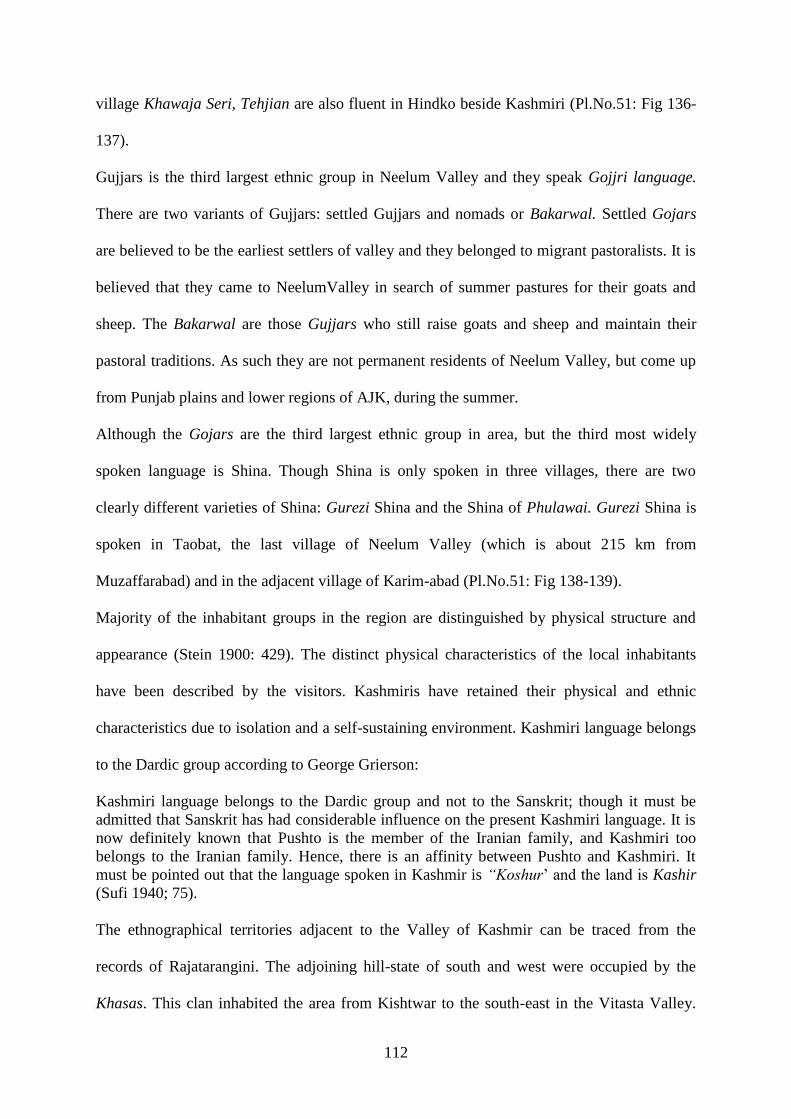
112
village Khawaja Seri, Tehjian are also fluent in Hindko beside Kashmiri (Pl.No.51: Fig 136-
137).
Gujjars is the third largest ethnic group in Neelum Valley and they speak Gojjri language.
There are two variants of Gujjars: settled Gujjars and nomads or Bakarwal. Settled Gojars
are believed to be the earliest settlers of valley and they belonged to migrant pastoralists. It is
believed that they came to NeelumValley in search of summer pastures for their goats and
sheep. The Bakarwal are those Gujjars who still raise goats and sheep and maintain their
pastoral traditions. As such they are not permanent residents of Neelum Valley, but come up
from Punjab plains and lower regions of AJK, during the summer.
Although the Gojars are the third largest ethnic group in area, but the third most widely
spoken language is Shina. Though Shina is only spoken in three villages, there are two
clearly different varieties of Shina: Gurezi Shina and the Shina of Phulawai. Gurezi Shina is
spoken in Taobat, the last village of Neelum Valley (which is about 215 km from
Muzaffarabad) and in the adjacent village of Karim-abad (Pl.No.51: Fig 138-139).
Majority of the inhabitant groups in the region are distinguished by physical structure and
appearance (Stein 1900: 429). The distinct physical characteristics of the local inhabitants
have been described by the visitors. Kashmiris have retained their physical and ethnic
characteristics due to isolation and a self-sustaining environment. Kashmiri language belongs
to the Dardic group according to George Grierson:
Kashmiri language belongs to the Dardic group and not to the Sanskrit; though it must be
admitted that Sanskrit has had considerable influence on the present Kashmiri language. It is
now definitely known that Pushto is the member of the Iranian family, and Kashmiri too
belongs to the Iranian family. Hence, there is an affinity between Pushto and Kashmiri. It
must be pointed out that the language spoken in Kashmir is “Koshur‟ and the land is Kashir
(Sufi 1940; 75).
The ethnographical territories adjacent to the Valley of Kashmir can be traced from the
records of Rajatarangini. The adjoining hill-state of south and west were occupied by the
Khasas. This clan inhabited the area from Kishtwar to the south-east in the Vitasta Valley.

113
Bombas who were in the north of Vitasta and Kishenganga Valley (Neelum Valley) remained
neighbors of Khasas or Khakhas (Stein 1900: 430). In Gilgit Baltistan, an inscription gave the
names of Khasa tribe kings in Brahmi inscription which confirmed the Khasa rule from fifth
century CE in the vicinity of Neelum Valley (Dani 1985:29).
According to Kalhana, the upper Kishenganga Valley (the present Neelum Valley) above
Sharda was occupied by Dards. These were then seen as neighbors of Kashmir. The Dards
reign extended up to Chitral in the northwest, Yasin, Gilgit, and the regions closer to Kashmir
in the south east. The Bhauttas were settled in the north east and east of Kashmir. These were
the descendent of Tibetan race. Presently they are called Butt who live in Drass, Ladakh and
adjacent areas (Stein 1900:431). The term Drass was used by Herodotus who described it as a
land of Dardikae in the Gurez Valley of Hindukush. During the rule of King Lalitaditya,
Kashmir opened up to outside influences from across its borders. The development of various
dialects in Ladakh, Baltistan, Gilgit and Kashmir Valley show a close alliance with the
Tibetan and Dardic languages. Therefore, it was the outcome of close political and cultural
contacts with those areas (Drabu1989:29-26).
In the Gurez affinity areas of NeelumValley, the inhabitants are of the Dard descent: an Indo-
Aryan race believed to have originally migrated from Central Asia to Ladakh and the
adjoining Valleys of the Himalayas. They speak Shina: an indo Aryan Language, which is
also major language of Gilgit Baltistan. Gurez Valley is divided by Line of Control (LoC),
and major part of which is on the other side of LoC. One of the union councils comprising of
over fifteen villages is on the Pakistani side with Minimerg larger of these villages. The
villages falling in Neelum Valley from ancient Gurez region are Pulavahi, Junahavi, and yam
ghar, Dhaki (Pushto speaker), Tanghdar, Marnath, Sahanhnahar, Sardari, Shundass,
Halmet, Suthi (Naseer abad), Nukroha Taobat and Machhil. Khawaja-Seri, Dudhanyal, Kern,
and Tanghdar are large villages of Kashmiri speakers.

114
The diverse languages in the Neelum Valley represent a multi colored cultural landscape as
each of the languages are spoken by an ethnic group with a unique cultural identity and way
of life. No single clans among these have a clear dominant majority. Due to the separation
from the southern part by the line of control, most of the clans are culturally and genetically
isolated.
3.6 Folk Stories
Almost every culture assigns great importance to the water and for certain cultures, a
particular water source is considered holier. In the context of Neelum Valley where diverse
communities had lived side by side, the waters resources became syncretistic over the
centuries. There are a number of such cultural places such as lakes, Bawolie and springs
which are associated with particular communities and groups. The human activity on these
places as individuals or in groups is the segment of cultural heritage: intangible or tangible,
which existed in area since centuries and has passed on from one generation to the other.
These cultural places have significance in a historical and religious context for the Kashmiri
Pundits living in NeelumValley before partition.
3.7 Sacred Lakes
Historically, the lakes in Kashmir are known in two categorized and termed as Dal and Sar.
The lakes situated in the plains or lower grounds are called Dal such as Wular and Manasbal
lakes. Whereas, lakes or spring originating on higher altitudes or mountain tops are termed as
Sar: Konsanag, Shishnag and Verinag, which relate to Nag or serpents. These mountain lakes
were believed to be abodes of divinities or sacred deities (Bates 1873:12). Ancient chronicles
refer to several sacred streams, springs and lakes. Legends added that originally land of
Kashmir was a lake known as satisaras or the lake of Goddess Durga (Pundit 1934:11). In
Neelum Valley there are three lakes which were believed to be sacred: Narda or Sharda,

115
Saraswati (Chitian) and Vagedevi (Nareal). They are directly associated with cultural
heritage legacies of Sharda civilization.
The Saraswati Lake is situated in the foothills of Narda Peak approximately 4267.2 meters
above the sea level among the higher northern mountain ranges in area. The Narda Peak
remains covered in snow almost around the year, only the lower mountain range becomes
visible from mid-August to September.
This lake was visited by the researcher in September, 2015 and subsequently confirms the
three lake idea of holy trinity associated to Sharda Temple. Saraswati is the most difficult to
reach as the lake is not visible due to the circle of the mountain peaks all around the site. It
exists in a bowl shape and the surrounding edge of the mountain is covered with huge
boulders of gypsum. Water gushing beneath these boulders and snow crevasses make the
access rather impassable. The lake has only one outlet in the west which carries the water in
the Surgun Nullah and finally joins the river Neelum on the right side, a few kilometers far
from Sharda Temple. It is mentioned in the ancient text of Rajatarangini that water from the
Saraswati lakes is drained towards western falls in Nullah Sumgum (Stein 1900:282). The
place where Saraswati water merges in to river Neelum along water of Madhumati is
considered a sacred place for the Sharda pilgrimage (Pl.No.52: Fig 140-141).
Kalhana Rajatarangini mentions Saraswati Lake as a sacred abode of the Goddess Sharda,
according to R.S Pundit: “Where the goddess Saraswati herself may be seen in the form of a
swan in a lake on the peak of the Bheda Mountain which is hallowed by the rise of the
Ganga.” (Pundit 1934:11).
Nilamata Puranas refers to two sacred Saraswati rivers in Kashmir, one which joins the river
Kishenganga (Neelum) near the bank of the Sharda archaeological site. The other is
Madhumati river identified as Bandipora Nullah which finally joins river Vitasta (Jhelum) in
Indian Held Kashmir. The place Sandal is mentioned by Nilamata Puranas river which flows

116
near the Temple of Goddess Durga on the bank of Madhumati which is unidentified (Kumari
1969:35. Madhumati stream is found in the south of Sharda Temple. Presently there is no
place named Sandal in the near vicinity of the Temple site.
During a visit to Saraswati Lake on the Narda Mountain in Neelum Valley, the researcher
observed that the main water source of the Lake appears to be the melting snow which
covered its eastern and northern rims throughout the year. The water gushing into the lake on
its eastern bank, beneath the rock appears rusty. The elderly locals narrate that according to
their ancestors, “Miraculous water of Saraswati Lake appears dusty as it comes out beneath
the rock of Narda Mountain and slowly turns blue” (Mir. Farooq, personal communication,
September 15, 2015).
The Nilamata Puranas mention that Saraswati and Madhumati merge with river Krishna in
the Valley of Kishenganga, which reflects that the ancient name of the river (Neelum Valley)
was river of Krishna or Kishen Ganga. In Hinduism Krishna was known as dominant deity of
sun, flora, rain and storm and Ganga denotes the Goddess of holy rivers and mother Ganga
(Kumari 1968: 150). This water course of the Madhumati stream on the left bank of Neelum
Valley still exists as tributary to Neelum River (Stein 1900:282). The historical record
confirms that earliest name of river was Kishenganga which is derived from the Krishna.
In the Srinagar; there is a place called the Amaranth cave which is sacred in Hindu
mythology. The nearest stream of Amaranth cave is known as Panchtamri (five rivulets). At
that location Amravati stream also joins the water of Panchtamri and place is known as
Sangam. On the confluences of Panchtamri, pilgrims used to take a ritualistic bath before
sighting the Amaranth cave (Pandita. Ravinder, personal, telephone June 12, 2016). That
place Panchtamri and Amaranth is comparable to the Sharda Sangum. In ancient times, the
Sharda pilgrims took a ritualistic bath at the Sharda Sangum place, situated near the
confluences of Surgun Stream, Madhumati and River Neelum in Neelum Valley.

117
There are two other lakes in the vicinity of Saraswati which are vagedevi and Narda lakes
which occupy a cluster of mountain peaks which form a troika and compliment the idea of
trinity associated with the Sharda cultural heritage. Abdul Ghani accompanied with a group
of civil society members visited Narda Lake situated on Narda Mountain in 2004. He
mentions in his book Sharda that: “There appears to be a staircase leading into Narda lake
which is constructed with dressed chiseled slab stones which are similar to the stones used in
the construction of Sharda Temple”(Ghani 2006:33).
The similarity between the stones used in construction of lake and those used in Sharda
Temple strengthens the idea that Saraswati Lake and Sharda temple could be of the same
period. The revered sites of Saraswati and vagedevi lakes are located at long distances but are
still sacred for the community of Kashmiri Pundits on the other side of LoC, who want to
visit these areas. The local community has respect for these waters, due to which the names
of these water bodies have remained unchanged since centuries.

118
Map no.9: Saraswati Lake, Narda Mountain in Neelum Valley

119
3.7.1 Stories related to Hari Parbat Lake and Mountain
Hari Parbat is highest mountain range in the in the AJK, positioned at a distance of about
sixty Kilometers from Tehsil Sharda in the Shounter Valley of Kel. Hari Parbat is a
prominent peak of this higher mountain range in the north east of Narda Peak. It has huge
religious significance and is associated with lord Shiva in the Hindu mythology. The peak
which is visible from far off is referred to as Chatta Kattha which means white cliff.
According to Hindu mythology these snowy lofty mountains are the abode of lord Shiva
(Ghani 2006:38).
There is a lake at Hari Parbat that locals identify as Chatta Kattha Lake. The ancient name
of the lake is „Har Lake‟, which is also known by devotees as „Chatta Sar‟, referring to white
for fair complexion of lord Shiva (Bates 1873:12). Madhumati and Doodganga reveal two
different aspects of river Kishenganga in Hindu mythology. Madhumati signifies the stream
of divine nectar and Doodganga is a white color rivulet. In the vicinity of Srinagar city there
is a stream pronounced as Chattbal which owes its name to the nearest stream Doodganga.
This also strengthens the notion that the local name Chita Kattha which was given to Hari
Parbat means: white cliff as Chita refers to whiteness of snow or milk (Ahmad & Bano
1984:30-31).
There is another Hari Parbat hill which is located in the middle of Srinagar but it is not as
high as Chatta Kattha at Shounter, Neelum Valley. Hari Parbat hill of Srinagar has number
of historical and religious sites. A fort built by the Mughal which was reconstructed in 1808
CE, by the Afghan ruler. The shrine of the native Muslim saint Makhdoom sahib and
Gurdwara Chhti Padshai are also located on the same mountain (Saraf 1987:28). A Hari
Parbat hill is very low compared to the Hari Parbat Chatta Kattha at Shounter, Neelum
Valley. The people on both sides of the divide claim, that the, Hari Parbat hills in their
respective parts of Kashmir, are revered or have greater religious significance. These offers

120
as subject of further research for scholars to establish a cultural link of Hindu period
(Pl.No.52: Fig 142-143).
Hari Parbat hills, Hari Parbat and Saraswati Lakes are to be seen in the connotation of
veneration and adoration, which was relished then. In the hoary past, the pilgrims used to
make a reverential bow both towards the Narda mountain range, which housed Saraswati
Lake and the Hari Parbat Mountain where Hari Parbat Lake is located in the Shounter
valley.
3.7.2 Stories related to springs and Bawolies
The geographical history of Kashmir was closely interwoven with the mythology and the
religious belief of its inhabitants. This is evident from the ancient worship of the Naga‟s, who
was believed to have their abodes in the inumerable springs (Ahmad & Bano 1984:32). In
Neelum Valley there are number of water ponds which are considered to have healing
powers. Mukhtaseri Bawolie, Nagdar Bawolie Surgun water spring and Sharda Sangum
spring are popular among the local folks. It is believed that the waters of these ponds cure
some diseases. In the Surgun Valley there is a Bawolie which has two springs; one of these
waters has a whitish appearance and the other is muddy. The whitish water is sweet in taste
and is considered very digestive and pleasant. The muddy water appears to have sulphur
content and is useful for skin problems. Therefore, these water sources are revered and well
managed. Another tradition is the use of spring to make good quality yogurt. The locals of
Neelum Valley put milk in earthen vessels and place it over night in the oozing waters of
spring. The yogurt turns out extremely delicious.
Most of these springs are said to have a snake or serpent living near by the spring. According
to local myths it is the guardian serpent of the spring and people do not harm the serpents
even if seen. This is the continuity of ancient traditions of the adoration of serpents in
Kashmir.

121
The Sharda Sangum Bawolie water is located on the right bank of River Neelum near the
Sharda Junction. The significance of Sharda Sangum Bawolie is due to its location at the
confluences of Neelum River and Surgun Nullah. The Bawolie is made of dressed stone and
contains sulphur which makes it a hot water pond. This site is a sacred spot for the Kashmiri
pundits who considered it more blessed than all the Bawolies of the area. In older times,
pilgrims visited this point and performed the Shraddha ritual. The Bawolie is only visible
when the water subsides in the winter season. The locals take the water from this pond as a
remedy for skin diseases and this is the continuity of ancient beliefs.
3.7.3 Sharda Pilgrimages Rituals
During Sharda pilgrimage the pilgrims took ritualistic baths: first on the confluences of river
Neelum and Nullah Tehjian which carried water of shish-pari known as Tajavana, and a
second bath near Ganesh Ghati. Devotees prayed in the temple and took a third bath on the
confluences of river Neelum and Madhumati stream site locally known as Sharda Sangam.
Moreover same day late night they took their last bath of Ashtami on the junction where
Surgun meet with river Ganga (Ghani. Abdul, personal communication, September 17, 2015).
Tehjian which exists as a large village today had remained a prominent pilgrimage venue and
had a religious significance in the context of Sharda cultural heritage.
This researcher conversed with the author who collected fables of Kashmiri Pundits, who had
resided in Sharda Neelum Valley prior to divide of 1947. According to this lore:
There was a sanctified pond at the Tehjian route where devotees would take a bath as part of
the physical purification ritual. This ritual is associated with ascetic sage Shandilya who
stayed here and bathed in this pond which according to myth, is invested with divine
qualities. At the end of the pilgrimage an important ritualistic bath was taken at lower land of
Neelum Valley known as Sharda Trivani Sangam. It was the holy unifications of three
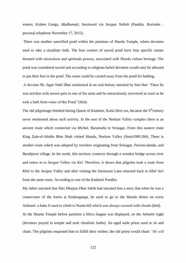
122
waters; Kishen Ganga, Madhumati, Saraswati via Surgun Nullah (Pandita. Ravinder ,
personal telephone November 17, 2015).
There was another sanctified pond within the premises of Sharda Temple, where devotees
used to take a ritualistic bath. The four corners of sacred pond have four specific names
donated with miraculous and spirituals powers, associated with Sharda culture heritage. The
pond was considered sacred and according to religious belief devotees would only be allowed
to put their feet in the pond. The water could be carried away from the pond for bathing.
A devotee Sh. Jagar Nath Dhar mentioned in an oral history narrated by him that: “Once he
was stricken with severe pain in one of his arms and he miraculously recovered as soon as he
took a bath from water of this Pond ”(ibid).
The old pilgrimage finished during Queen of Kashmir, Kotla Devi era, because the 9th
century
never mentioned about such activity. In the east of the Neelum Valley complex there is an
ancient route which connected via Michal, Baramulla to Srinagar. From this eastern route
King Zain-ul-Abidin Bhat Shah visited Sharda, Neelum Valley (Stein1900:284). There is
another route which was adopted by travelers originating from Srinagar, Purana-danda, and
Bandipora village. In the north, this territory connects through a wooden bridge across river
and enters in to Surgun Valley via Kel. Therefore, it shows that pilgrims took a route from
Khel to the Surgun Valley and after visiting the Saraswati Lake returned back to Khel Seri
from the same route. According to one of the Kashmir Pundits:
My father narrated that Shri Dharjoo Dhar Sahib had narrated him a story that when he was a
conservator of the forest at Kishenganga, he used to go to the Sharda shrine on every
Ashtami: a baba Ji used to climb to Narda hill which was always covered with clouds (ibid).
At the Sharda Temple before partition a Shiva lingam was displayed, on the Ashtami night
(devotees prayed in temple and took ritualistic baths). An aged nude priest used to sit and
chant. The pilgrims requested him to fulfill their wishes; the old priest would chant “He will

123
give who is giver”. It is said that when Muslim women visited him for blessings he would
cover his body and these woman also presented offerings in the form of fruits, wheat etc.
(Lone, Aziz, personal communication, June 22, 2015). Even today the Bakarwal (Nomads)
give offerings of wool in the sacred lakes as they believe it increases the production of flock
and wool. Thus it has become a syncretism practice and also continuity of ancient traditions.
River Kishenganga, lakes, streams, ponds and springs were revered waters of Neelum Valley.
The waters of some lakes, springs and streams were considered holy and effort was made to
keep these water sources clean and pollution-free by the local population.
In conclusion, we can say that Neelum Valley has rich forms of intangible heritage which
includes art, crafts, festivals, celebrations and stories rituals associated with some of the
cultural places. In broader tourism, planning these heritage assets can allow for their
utilization in the branding and promoting of cultural tourism in Neelum Valley.

124
CHAPTER 4
CHALLENGES AND OPPORTUNITIES TO CULTURAL HERITAGE
RESOURCES OF NEELUM VALLEY
4.1. Introduction
Cultural heritage resources of a neglected and underdeveloped area can become the chariot
for development and change. Neelum Valley being in the conflict zone has remained
underdeveloped despite its potential to become a tourist destination. There are different
elements threatening the resources of the valley there by depriving it from utilizing the same
for economic development of the valley and benefit of the people. These real threats need to
be addressed. Further, the overlaying claims by various stakeholders over natural and cultural
sites pose challenges in implementation of workable solutions to the problems arising out of a
host of threats such as climate changes, human vandalism, encroachment and environmental
decays.
Cultural heritage of Neelum Valley has a potential to attract a large number of people across
the Line of Control (LoC). Many advanced and emerging countries of the world have used
culture heritage or tourism as a pillar of economic development and change (SEAMEO-
SPAFA: 1997). United Nations World Tourism Organization (UNWTO) underlines the
significance of heritage tourism. Heritage tourism becomes pivot in supporting communities
in their quest for peace and sustainable development (Wells, Lyony 2012: 44-56). It is
important to ensure that heritage tourism sustains and benefits local community culturally,
socially and economically (Tatsufumi 2009, Cheatham 2013:42). Scope of Tourism in
Neelum Valley at this stage lacks the diversity and branding of its full scope and potential.

125
Cross LoC heritage tourism is the viable option which can strengthen the peace process in the
entire region.
4.2. Challenges
In the Neelum Valley, there is lack of realization on the part of stakeholders about the
importance of natural and cultural resources as potential tools for development and
prosperity. Their inaction in the safeguarding of these resources is multiplying the existing
threats and challenges to the heritage. The multitude of other threats to the resources, its
management and resultant challenges stem from the isolation of the area due to the conflict
situation. The major threats and challenges include: natural disasters, unregulated tourism,
mine-blasting near heritage sites, lack of capacity of the concerned responsible institutions,
illicit trafficking, illegal diggings, encroachments, and responsibility shift of the stakeholders,
armed conflict and above all absence of sense of ownership for these heritage sites by the
local people and the government alike.
4.2.1. Natural Disasters
Lower Valleys, between major watersheds, have faced floods and landslides since centuries
but subsequently, the climate change has accelerated for the past couple of decades, so did
the frequency and severity of floods and landslides in the Valleys (Ahmad 2015: 5). Due to
the climate change, caused by the melting of glaciers and unusual cloud bursts, the danger of
severe flooding is growing in the lower Himalayan Valleys of Kashmir (Shakeel, Mohsin
2015:15-16). Sometimes floods help in the formation of new fertile lands for agriculture, but
at the same time they have the potential to cause severe damage to the population in
mountainous valleys or settlements along rivers sides and even the cultivated lands.
The historic records revealed that Jammu & Kashmir faced the earthquake of 1885 CE, which
was followed by floods of 1909 CE and 1957 CE. During the earthquake of 1515 CE, the
water of the river Jhelum (Vitasta) changed its course, activated a huge landslide which

126
caused unlimited damage to the dwellers of the area (Dawn 2014:12, Ahmad 2015: 5). The
history of the valley provides us with ample information about the natural disasters in the past
and particularticularly during the 9th -11th
century CE. Citing Stein (1898), Roger Bilham
(2013:6) mentioned natural calamities, floods and landslides which caused destruction in
Kashmir and its adjoining Valleys along river Neelum and Jhelum.
In October 2015, terrible floods engulfed the regions including Srinagar, Neelum & Jhelum
Valleys, Azad Jammu and Kashmir. According to Saleem Beg (2015), more than two
hundred historical monuments and archaeological sites were damaged, along with the human
loss in Jammu Kashmir and adjoined valleys of river Jhelum. Similarly, the flood of
September, 1992 had devastating effects on natural heritage of the region. It destroyed
vernacular architecture; houses, temples, old bridges, historic monuments on the both sides of
the divided Kashmir (Khan 2014, ibid). The devastations caused by floods in 2010 also
altered the course of Madhumati and Surgun Nullah and destroyed the landscape setting
along the banks of these streams. The water levels rose to over fifty feet along the river
banks. Deforestation, shelling across the LoC and the devastating avalanches during winter of
2015-16 increased the frequency of these avalanches in the region and caused heavy damages
in the villages of Lawat, Khawaja Seri, Kel and the Gurez Valley.
The earthquake of 2005 also caused irreparable loss to the cultural heritage resources on
either side of the LoC. While from the loss caused by the earthquake, human vandalism
added to this loss. Precious archives related to the Kashmir history housed in Khurshid
Hassan Khurshid (KHK) Library in Muzaffarabad were robbed and destroyed. Muzaffarabad
Red Fort Museum which housed great number of artifacts including coins, statues and stone
tools, mostly discovered from the Neelum Valley were also looted by raiders, thieves and
dealers (G. Zahoor , personal communication, June 18, 2015).

127
4.2.2 Unregulated Tourism
In November 2002, India and Pakistan got engaged in peace initiatives. The most important
outcome of these initiatives was the cease fire along the LoC, including the Neelum Valley
which was directly affected by the hostilities. Subsequently, the peace enabled government to
allow domestic tourism in the Neelum Valley and a large number of tourists flocked to the
Valley from all over Pakistan (Chari, et.al 2011:4-16). Though this new tourism flow, based
on economic activity, created considerable opportunities for the locals in the Valley but at the
same time it turned out to be the foremost challenge in terms of its impact on environment
and natural & cultural heritage resources of the Neelum Valley (Shakeel, Mohsin 2015:15-
16). The negative impact of the unregulated tourism was soon to be seen as hundreds of
vehicles entered the Valley carrying unprecedented numbers of tourists. This tourist flow
caused serious threat to self-sustaining indigenous culture and ecology.
After the implementation of cease fire, guest houses are rapidly being constructed to replace
the old cultural wooden houses. (Khan 2015: 5-12).
The commercialization is also harming the indigenous agriculture and production of local
species of rice and other edible crops. Prior to the onslaught of tourists in the Neelum Valley,
horses and mules were used on link routes in recent past. Water mills were found every two
miles along the river and Nullah. The water mills are being replaced by carbon emitting
engines. The streams and springs are being polluted with detergents and septic tanks and thus
polluting the rich soil and water resources. It has also been observed that due to
environmental degradation, some rare birds have vanished from the area and trout fish is also
vanishing which was abundant in the river (Pl. No.53: Fig 144-147).

128
4.2.3 Lacking the Capacity
The planning for socio-economic development is initiated by the government. The
functionaries responsible to carry out the projects lack the capacity to undertake the execution
of the projects due to incompetence and lack of professionalism.
The first ever survey and documentation of archaeological sites in Azad Kashmir and
subsequent presentations by this researcher to different forums on importance and
safeguarding of the heritage created some realization amongst public representatives. Civil
society offered the support to the voices for protection and promotion of heritage resources.
Media also highlighted issues pertaining to encroachment of archaeological sites in the
Neelum Valley. It was for the first time that Ministry of Finance allocated funds during 2015-
16 for safeguarding of some of the important heritage sites. However, the Department of
Tourism and Archaeology failed to submit any project for the safeguarding of heritage sites
within the given time frame, which caused the lapse of allocated funds (Akbar. Latif,
personal communication, May 14, 2016). It reflects the mismanagement and lack of capacity
on part of the officials responsible for the protection of these heritage sites.
Neelum Valley is also gifted with diverse and vast natural habitat which includes forests,
pastures, rare herbs, shrubs and precious medicinal plants (Qamar 2010:25-30). Nomads
migrate seasonally and extract rare herbs in great quantity and smuggle these out of the
Valleys without leaving enough plants for re-growth and regeneration. This causes extinction
of certain species of rare herbs. No effort has ever been made to stop these unlawful activities
even though considerable number of staff from Forest Department and other law enforcement
agencies are given authority to prevent the illegal extraction of herbs and other endangered
species.
The UNESCO is keenly contributing in aid to states affected by the calamities (ICOM: 2002).
After the earthquake 2005 and floods of 2014, many surveys have been carried out in Indian

129
held Kashmir (IHK) to assist the loss of heritage sites, but no such action was taken in the
(AJK) including Neelum Valley. Former Director General of Tourism and Archaeology,
Indian held Kashmir, told this researcher during his visit to Islamabad, Pakistan that:
In the aftermath of 2014 floods in Kashmir, with the technical support of ICOMOS
(International council of Monuments and Sites) and Prince Clause Fund, Belgium, the
INTACH chapter Jammu and Kashmir undertook detailed documentation and condition
assessment of archaeological sites and historical buildings. Experts came out with
recommendations for preservation and for appropriate interventions (Beg. Saleem , personal
communication, March 2 2017).
After the earthquake of 2005, it was a great opportunity for Tourism and Archaeology
department, Govt. Azad Jammu and Kashmir to seek help of international donors‟ agencies
for safeguarding and restoration of archaeological sites. Due to lack of capacity and non-
professionalism the concerned people could not present their projects for the safeguarding
and restoration of Archaeological sites and historic monuments in AJK.
4.2.4. Mine Blasting near Heritage Sites
Mine blasting without following the standard guidelines has devastating impact upon the
natural and cultural heritage resources. Mines are used to construct roads, buildings and
extract precious stones in the Neelum Valley. The impacts of mine blasting also cause
vibration in the built heritage and at time the standing structures crumble. Recently, many
case studies have been conducted by the researcher which shows that this activity of precious
stones extraction has been applied near the natural sites like lakes and water springs.
Mine blasting for construction of unplanned link roads to the hamlets and extraction of
valuable cultural material from the earth near the archaeological sites has also significant
consequences. These activities cause damages that include the loss of vegetation, pollution
especially near water resources, erosion of the lands and disturbed natural settings of the
lands.

130
4.2.5 Case Studies
Due to non-implementation of the Antiquities Act, 1986 of the Government of Azad Jummu
and Kashmir, no effective measures could be taken to curb the menace of illegal diggings of
the archaeological sites and illicit trade in antiquities and these illegal activities are going on
unchecked. Illicit trafficking of the artifacts from the Neelum Valley is one of the greatest
threats to the cultural heritage resources. Frequent instances of artifact smuggling have been
reported in the area. The antique dealers collect precious artifacts from local population or
dig out from the valley for financial benefits. This research documented very interesting case
studies of illicit-trafficking of artifacts from the Valley. The following case studies are
enough to assess the damage caused by the illicit-trafficking from the heritage resources of
the Neelum Valley.
4.2.5.1 Illicit Trafficking of Artefacts from Neelum Valley: Case study 01
In 2012, the researcher initiated archaeological explorations of the Sharda Temple and its
associated sites under the umbrella of Taxila Institute of Asian Civilizations, QAU. The civil
society of the Neelum Valley welcomed the research program and facilitated the researcher.
After the documentation of cultural heritage by the research team, an attempt was made by
antique smugglers to move precious artifact (Wine presses) out of the Neelum Valley. This
theft and smuggling attempt was done on behalf of an influential functionary. The artifacts
were shifted from Danna Tehjian village by the staff of Qamar Zaman the then minister for
health and AKMIDC, in full knowledge of local administration. The artifacts were
transported to Muzaffarabad city about 150 kilometers away from the Neelum Valley. The
civil society of Neelum Valley took up the matter and resisted the smuggling of the artifacts.
The media highlighted the issue forcing the influential functionary to back track. The superior
court intervened and took notice under Antiquities Act 1986. Later, the superior court
directed Archaeology and Tourism Department officials to register the case under Antiquity

131
Act against the alleged persons. The case is still pending in superior court because the
Archaeology Department is not pursuing the case properly. The artifacts are still lying in the
premises of guest house of the Department of Health, Muzaffarabad.
Sub-Section 25(vii) of the Antiquities Act 1975/76 of AJK does not permit selling, smuggling
or gifting the historical objects to any one since it is state property (Act 1975, 2002:4-7). A
large number of artifacts theft by smugglers and illegal diggers and were smuggled out of the
state. This was the first time in Azad Jammu and Kashmir that the issue of preservation of
cultural heritage came into light.
After the survey and documentation of archaeological sites the public awareness rose to a
large level which enabled civil society to resist illegal excavations and theft of artifacts. Civil
society of the Neelum Valley formed Sharda Save Committee for protection of heritage sites.
Sharda Save Committee approached the local administration to enforce the antiquity act and
stop theft of artifacts by government officials. The local administration officials were found
unaware of the implementation of Antiquity Act. This case is still under process. The
researcher has come to know that case was not pursued by Department of Tourism and
Archaeology. The apparent cooperation of Archaeology Department officials with smugglers
(influential minister) and their inability to play their due role in protection of cultural
resources is a core challenge to the preservation and protection of the archaeological sites.
4.2.5.2 Illegal Digging at Rawota village: Case Study: 02
During this research, a number of cases involving illegal digging by antique dealers using the
metal detectors came to light. One of the cases was reported from an archaeological site in
Neelum Valley in March 2015, when an antique gold statue was stolen through illegal
digging from an archaeological site of the village Rawota located on left bank of the river
Neelum; five kilometres away from Athmaqam, the district head quarter of Neelum
Valley.The picture of stolen statue appeared on social media. A local activist shared photo

132
with the researcher and reported the matter of illegal digging and theft of the gold statue to
the local police. Police apprehended six villagers along with the antique pitcher which
contained the unearthed material but later freed them. As usual Archaeology and Tourism
Department showed no concern about the issue of illegal digging near archaeological site.
The researcher visited the said site and collected the evidence: antique pitcher fragments and
lid of a container from the place where illegal digging had taken place. From the site of
digging, fragments of a pitcher were found which contained statue that has been allegedly
stolen. The broken unearthed pitcher was tightly closed with a seal of stone buried in ground.
(Pl.No.54: Fig 148-151).
This researcher informed the police officials of the district about the illegal diggings, who
were reluctant to lodge FIR against the culprits without official complaint from the Tourism
and Archaeology Department. The Director General Archaeology and Tourism has already
admitted in the media that the Department of Archaeology is working without relevant
expertise and department has no Archaeologist to deal with this matter and they rely on
outside expertise such as TIAC for technical advice (Dawn, April 14,2015).
4.2.5.3 Encroachments near Archaeological Sites Case study 03
During recent years, opening of Neelum Valley to the domestic tourism has posed new
challenges to protection of important tourist destination sites such as the Sharda Temple and
its associated archaeological sites. Some natural and heritage sites in Sharda are threatened
due to encroachments and constructions of hotels and guest-houses in close proximity of
these important ancient sites. During the present research, the researcher recorded case study
of an illegal encroachment of Sharda Sangam archaeological site.

133
In January 2016, an illegal construction started on Sharda Sangam, an important
archaeological site associated with the Sharda Temple. This site was encroached upon by a
government official. Heavy machinery was deployed for this illegal digging and construction.
Media highlighted the issue but again no action was taken by the Archaeology and Tourism
Department. The researcher submitted an application to the Chief Secretary Government of
Azad Jammu and Kashmir (AJK) and also to the area commander of the army. The
researcher, in her application, requested the authorities to intervene and stop the
encroachment and illegal construction near archaeological site. The researcher asserted that
the Surgun Nullah Junction is an ancient site where Pundits from all over Kashmir performed
final ritual bath during their visit to the Sharda Temple and that the Surgun Nullah carries the
water from Saraswati Lake. In the opening of Neelum Valley for cross LoC tourism, the
destruction of cultural heritage sites will have a negative effect on the image of the country
and its institutions. In response to these applications, the action was taken by local
administration and section 144 was imposed to stop new construction along the river banks in
the Neelum Valley (ibid).
It is important to note that a total of 72 Kanal and 16 Marla land belongs to the Sharda
Temple archaeological site, which was allotted to the Temple in 1947 after the division of the
state of Jammu & Kashmir. Out of this land 8 Marla land comprising the main stairs area and
outer boundary walls of the Sharda Temple has been allotted to the Department of Tourism
and Archaeology (G. Syed, personal communication, October 23, 2016). The surrounding
area of the Sharda Temple has already been encroached on the southern and western sides of
the temple. A Mosque and various shops have been constructed on the land of Sharda
Archaeological Complex. Several houses and hotels have also been built on the encroached
land on the left side of bridge near main bazaar Sharda. The outlets of these hotels and the

134
washrooms of adjacent houses are already polluting the water of Madhumati stream and river
Neelum at various locations in the area.
Apart from the Antiquities Act, the Land Revenue Act of 1974 also does not allow to use any
archaeological site. The state government can cancel any allotment of land any time. Keeping
in view the importance of the Sharda Temple as cultural heritage and its associated sites (i.e
Sharda Sangam, Madhumati stream & hot spring water area), the government could exercise
this legal provision to take the archaeological sites back from encroachers. A contingent of
army is present in the close proximity of the main Sharda Archaeological site .It has helped
protect the site from vandalism to some extent. But it is the duty of the Tourism and
Archaeology Department to protect the site from further encroachments. Several
archaeological sites of Neelum Valley are being vandalized through encroachment by
influential persons.
4.2.5.4 Responsibility Shift of Stakeholders: Case Study 4
The overlaying interests of the stakeholders create friction and conflict of interests while
identifying, planning and addressing the issues pertaining to resource management in Neelum
Valley. This situation has created an atmosphere of neglect and shrugging off the
responsibility designated to each of many stakeholders.
The stake holders which are directly responsible for heritage resource management including
archaeology & tourism department, forest officials, local administration and law enforcement
agencies lack the very basic understanding of their own jurisdiction regarding safeguarding
and protection of cultural heritage. The hierarchy of these departments is incapacitated by
nonprofessional attitude.
No serious efforts have been made to safeguard heritage resources of the valley by these
concerned departments. Evidence indicates severe negligence and avoidance of professional
duties regarding this issue. The case study exposes the contradiction or conflict among

135
various stakeholders regarding safeguarding of the heritage sites. This case study also
underlines the proactive role of civil society regarding the potential threat to an important
archaeological site of the Sharda Temple.
In 2004 a resident of the area namely Abdul Ghani had submitted an application to
Ombudsman Office Muzaffarabad. He highlighted the importance of the site and requested
the Ombudsman to intervene and direct the Department of Archaeology and Tourism to stop
all illegal diggigings and encroachments on and around the heritage sites. Both Archaeology
and Forest departments instead of taking concrete steps tried to forward different excuses
including lack of professional expertise by these departments and firing from across the line
of control, etc. Despite directives from the Ombudsman to the Archaeology & Tourism
Department for protection of the heritage sites, no action has so far been taken on the
directives. However, action by the local administration on an application of the researcher,
section 144 was implemented which also proved very helpful. The action by the local
administration also proves that they have the capacity and authority to take effective steps
and also override the directives of other departments for the safeguarding of the heritage
sites.
4.2.6. Conflict
Conflict and frequent skirmishes along the LoC in Neelum Valley restrain the activities for
safeguarding or protecting the heritage resources. Threats and intermittent firing from across
the line of control have also adversely affected the area, its people and all other activities.
While the inaction and lethargic approach of the concerned governmental organizations could
largely be attributed to the lack of interest on their part, they also the firing along LoC gave
the government institutions the pretext to ignore these heritage sites and taking shelter behind
the firing. The destruction of heritage during war in the Neelum Valley dates back to division
of state and in some cases even prior to the division. The famous Sharda Temple was almost

136
destroyed during the Sikh invasions when the Rajas of Karnah ruled as an independent chief
in the Neelum Valley. Under one of these rules, Sharda Temple was said to have been used
for the storage of gun powder, the explosion of which blew off the original roof of the
Temple monument (Stein, 1900:284).
There have been considerable intervals of peace in the Neelum valley such as one from 1972
to 1988 and again from 2002 to 2014. The occasional firing and small skirmishes along LoC
did occur prior to 1990, but it did not affect the socio-economic conditions of the people as
much as it did after the eruption of heavy fighting along LoC during 1990 insurgency in
Indian Held Kashmir.The cross LoC firing on the villages along LoC forced local community
to leave their homes and shift to safer areas. The indigenous Kashmiri wooden architecture in
Bugna and Nagdar village was destroyed due to firing. Athmaqam bazaar is under the
shadow of dominant Indian army posts located on high mountain tops on left bank of river.
The area, being the center and trading hub of the valley, attracted heaviest fire disrupting
trade, shops, beside health unit, colleges, and administrative offices (Urfi Arif, personal
communication, December 2, 2015). This bazaar had craft market which housed considerable
number of traditional wood engraving and other crafts. These shops were hit by the firing
directly from across LoC.
This firing continued for several years near the market in Athmaqam, Keran and Kel forcing
many skilled workers to migrate from the area and quit traditional businesses. Government
did not compensate the artisans nor gave them any incentives to continue their traditional
craftsmanship.
The most fertile land clustered by rich forests and paddy fields starting from village Marble
to Tehjian on the right bank of river was directly under heavy small arms and artillery fire.
This left bank of the river includes the territories of Barian, Jura, Kundal Shahi, Athmaqam,
Karen, Nagdar, Lawat Dawarian, Changhan and Dudhanyal (Mughal. Jalal, personal

137
communication, February 16, 2015). Prior to eruption of hostilities, about 80-100 tons of
walnut were produced and sold from the valley which provided livelihood for many farmers.
Apart from cattle and sheep farming; paddy fields, wheat, corn and lentils were produced in
the valley. The wool produced was either sold or used to make Namda and Gabba,
indigenous woollen textiles. These woollen items provided sustainable livelihood and had a
domino effect on socio-economic evolution of society.
There was a sharp decline of indigenous crafts during the time of skirmishes in the area as
people stopped ornamentation of wooden houses and women folk ceased to wear colorful
traditional dresses. During prolonged periods of relative peace, large quantities of sheep wool
were produced which were uses in the making of blanket, Lois and Chadder.
4.2.6.1 Impact of Conflict on Intangible Heritage
Traditions and celebrations of the people in the Valley were gravely affected by the hostilities
on LoC. Marriage celebrations and famous festivities such as Nowruz and Dhamal on annual
gatherings at Shrines were discontinued. Languages also became victim of conflict since the
movement across LoC or within Valley during peaceful times promulgated folk songs and
linguistic heritage. During the clashes on LoC, the weddings and events of celebrations lost
the colors and velour which affected the language and traditions necessary for the progress of
a language. Recently a combined study conducted by Azad Jammu & Kashmir (AJK)
University and University of Kashmir, Srinagar in (IAK) concluded that this division affected
languages of the region. Kosher is second major spoken language and a linguistic bond
between two sides of Kashmir (Rehman Khawaja, personal communication, August 16,
2016).
According to Professor Khawaja Rehman:
The Line of Control (LoC) has adversely affected the minority languages of Azad Kashmir
and the Neelum Kishen Ganga valley in particular. Moreover, people living on the either side
of LoC have developed linguistic differences. These differences have evolved to such an

138
extent that they are now speaking different varieties with difficulty in understanding each
other. As a result of this division, members of some divided families have adopted different
languages as their mother tongues. They lost their ancestral language and as a result became
alien for their relatives in J&K.
Most of the communities are multi- lingual and no single clan in the Neelum valley is in clear
majority because of the separation by the line of control therefore, the languages are also split
evenly over the ethnic divides but these are overlapped by a common language which is
Hindko.
4.2.6.2 Sense of Insecurity
The self-sustaining socio-economic ways of life were shattered during the fourteen years of
continuous firing along LoC in the valley. The area beyond Nauseri was cut off from the state
capital and the road travel was not possible. Movement of vehicles was also not possible.
People had to walk hundred or more kilometers carrying utilities and consumables on their
back mostly moving in dark night to avoid casualties (Ibid). Long walls were erected along
the road to make the vehicle and on-foot movement safe from fire. This also created a sense
of insecurity and trauma amongst the local population. The hopelessness and bleak future
prompted local population to align their hopes and sympathies with outcome of the ongoing
insurgency across LoC. People were unable to work in the fields to sow and harvest. In
Nagdar and Neelum villages, considerable number of farmers died and got severely injured
every year during this period (Javad. Mir , personal communication, October 5, 2017. The
women were the major victims because they had to tend the cattle and cut the grass and
harvest and thus becoming target of the firing. Even gatherings at marriages and funeral
attracted fire and resulted in loss of human lives. During peak periods of firing, people
dwelled in the shelters which every house had constructed nearby. In some cases, children
were born in these caves and shelters. This period divested the ways of life and socio-
economic existence.

139
Cultural heritage resources in Neelum Valley face challenges from natural and manmade
vandalism in the safeguarding and preservation of heritage. Natural disasters include flood,
earth quake and avalanches. Illegal-digging, encroachment, mining, looting, lacks of
awareness, mismanagement and arm conflict cause severe threat to the survival of cultural
heritage resources. The research indicates that some threats have emerged recently, while
others have been there since ages. The threat to the heritage resources has been causing
irreparable lose to rich cultural heritage resources of the area. Damage to the heritage and
heritage sites is adversely affecting the socio-economic development of the area generally
and state of Jammu and Kashmir particularly. Protection and preservation of the cultural
heritage resources will help promoting heritage tourism which will in term generate economic
activities in the region.
OPPORTUNITIES IN NEELUM VALLEY
4.3. Introduction to Opportunity
The Neelum Valley is the largest district of Azad Jammu and Kashmir in terms of area. It is
rich in both natural and cultural heritage resources. It is located at the juncture of north south
corridor linking Gilgit Baltistan with rest of Pakistan and divided by the Line of Control in
the east from the volatile valley of Indian administered Kashmir. The Neelum Valley has
great potential to utilize its heritage resources for socio-economic development. The
insecurity due to conflict in the Neelum Valley and Cross LoC firing for the last three
decades caused socio-economic deprivation and stagnation which needs to be addressed
through a conscious effort.
In the last few years, the Governments of Pakistan and India have showed interest in starting
heritage tourism across the Line of Control. Travel and trade initiative that began in 2005 and
2008 respectively is an example of agreement on both sides to devise mechanism to bring
peace in this conflict torn area (Chari, et.al 2011). The opportunity to explore heritage

140
tourism as a tool to bring peace and harmony in the region is a viable option. The cultural
heritage tourism initiative across divide will have a domino effect on safeguarding heritage
sites and devising conservation strategies to protect natural resources including forests,
biodiversity and ecology in the Neelum Valley, Azad Jammu and Kashmir.
4.4. Understanding of Heritage Tourism
Heritage encompasses landscape; environment, monuments and artifacts passed from one
generation to the other and have the potential to be used as a tool to improve social and
economic conditions. The cultural heritage particularly archaeological sites, historical
buildings, vernacular architecture and artistic expressions are portrayed as tourism products
(UNESCO, 1972; Chheang, 2013:12-14). The Neelum Valley possess vast natural resources
and cultural heritage sites which have never been identified and utilized for developing a
vibrant and eco-friendly tourism industry in the area. This realization provides great
opportunity to use these cultural heritage resources for socio-economic uplift of this area
which remained underdeveloped for decades due to natural and manmade disasters. United
Nation World Tourism Organization (UNWTO) underlines the significance of heritage
tourism as follows:
Tourism involves movement of people among various cultures and civilizations often
countries or places outside their usual environment. The movement of people across cultural
and social spectrum fashions tolerance, social and economic improvement. The tourism
industry is one of the most dynamic and fast growing economic sector in to world (UNWTO:
2016).
Heritage tourism becomes pivotal in supporting communities in their quest for peace and
sustainable development (Wells, Lyony, 2012: 44-56). It is important to ensure that heritage
tourism sustains and benefits local community culturally, socially and economically
(Tatsufumi 2009: Cheatham, 2013: 42).

141
According to the World Travel and Tourism Council and World Tourism Organization
(WTO), “Heritage tourism has the potential to bring people together and create opportunities
for individuals to learn and understand each other, fostering mutual respect and tolerance”
(WTO: 2014). Heritage tourism plays an important role in cross cultural exchange bringing
people closer from different cultures. It helps to learn about different languages, life style and
traditions (SEAMEO-SPAFA, 1995).
Many areas on both sides of LoC in the Kashmir remain isolated for extended period of time
every year due to inaccessibility in extreme weather and difficult terrain conditions. These
areas are more prone to disasters and have limited access and underdeveloped infrastructure.
Most of the families and tribes living along LoC in these isolated areas are divided.
Traditions and mutual celebrations such as Eid, annual gatherings at shrines, marriage
gatherings and other occasions of mutual festivities have been affected due to the divided
social groups across LoC. Heritage tourism can revive and boost the cultural and traditional
ways of life of people across divide in Kashmir.
4.5. Opening of Tourism in Neelum Valley
In January 2004, South Asian Association for Regional Cooperation (SAARC) conference
was held at Islamabad. In this meeting, a number of confidence building measures CBMs
were initiated between two parts of Kashmir to normalize the situation, create friendly
relations and encourage the peace process. These dialogues (Vajpayee- Musharraf) include
the cease fire on borders, opening of natural routes across the LoC via Rawalakot, Poonch
and Muzaffarabad Uri-Srinagar, meeting of divided families and starting of trade and tourism
ventures (Akhtar, 2011:4-16).
After the implementation of theses CBMs and the cease fire, socio-economic condition
started improving in the area. Neelum Valley was given the status of a district with the
administration infrastructure placed at Athmaqam where educational and health units were

142
built. Communication infrastructure took place and Muzaffarabad to Taobat road was
reconstructed. Hundreds of locals got jobs in construction projects. Travel time from
Muzaffarabad to Athmaqam and Taobat shortened, and now travellers could take personal
vehicles up to Taobat. After earthquake (2005), foreign NGOs and foreign experts were
allowed in the valley for a short period for rehabilitation of projects which infused new hope
among people.
In December 2005, the then Prime Minister of Pakistan, Shaukat Aziz, while visiting Poonch,
announced that AJ&K would be opened for tourism to exploit the area‟s full potential and to
help generate economic opportunities for the people (Daily Nation: 2005). The Neelum
Valley was embracing the benefits of peace and normalcy and in a short span of time several
government and private tourist resorts were established in the area to accommodate the
tourists. New construction of road and communication infrastructure in Neelum Valley
brought the influx of tourism. The most affected areas of Karen and Neelum village were
ideal for developing tourist resorts owing to the scenic beauty, site seeing and trekking
opportunities.
4.6. Benefits of Heritage Tourism in Neelum Valley
Neelum Valley in Azad Kashmir had remained a significant hub of regional connectivity in
the past. Due to conflict, this area became delinked from rest of the region. Cross LoC
heritage tourism will provide an opportunity for the Neelum Valley to materialize its
potential in regional connectivity. Intra-regional cooperation can promote land connectivity
for tourist destinations coupled with complementary location for tourists as it can attract more
tourist arrivals to such connected and diverse destinations (Grunely, war and Perry, 2001
Timthy, 2000). It will contribute to build trust and confidence among the regional countries in
promoting other fields of cooperation. Azad Kashmir, especially the Neelum Valley, offers
great trans-regional complementary tourist destinations as it sits along major connecting

143
routes linking north south and east west. More importantly, in the wake of revival of Silk
Route, it could become a resourceful tourist destination.
The cross LoC heritage tourism will further promote the already flourishing tourist industry
and help to manage the heritage assets of the area. The heritage tourism across divide not
only can help to protect and safeguard theses resources but also help to establish sustainable
peace in a conflict zone.
Heritage tourism is a form of alternative tourism which has potential to bring sustainable and
positive peace (Sarkar, George 27-41: 2010). The heritage tourism across divide in Kashmir
can effectively address several other aspects in this conflict area. Tourism in the Kashmir
across divide will ultimately support local communities (Chari, Chandran, et.al. 2011).
Integration of natural and cultural resources to achieve peace through cross LoC tourism will
pronounce an opportunity for sustainable development on both sides of LoC filling the voids
and denying space to uncertainty and violence. It will also empower the stakeholders and
broaden the range of options.
The option of cross LoC tourism in the Valley will give hope to the local population across
divide and help reduce tensions in the region. The peaceful environment and normalcy would
encourage people to adapt normal lives and continue their traditional ways of life based on
agricultural farming and traditional craftsmanship which would revive, strengthen and
promote local economy. It would also help reforestation and conservation since local
community will find it beneficial to protect its natural resources.
The Line of control divided and isolated many remotes areas on both sides. Number of
hamlets and villages along Neelum Valley remain inaccessible due to extreme weather
condition or difficult terrain over a quarter of the year. These areas are more prone to
disasters, have limited access and lack of communication infrastructure. Furthermore, many
of the families living along LoC are divided. This opportunity of cross LoC will not only help

144
to reconnect the divided families but also promote the dividing shared traditions including
linguistic links. These people have been sharing the same heritage, cultural and historical
legacies for centuries.
In the absence of any industrial development and declining agricultural productivity, the
mainstay of the AJK economy, the tourism industry, can play an important role in
expanding livelihood opportunities especially in remote areas of the Neelum Valley.
Unique historical, geographic importance and rich heritage give the Neelum Valley for
opening it for cultural heritage tourism. People of the Neelum Valley have suffered
immensely due to conflict in the past. Cross LoC cultural and heritage tourism in the
Neelum Valley will revive cultural connectivity and will open socio-economic development
opportunities in this conflict affected area. It will also contribute in developing a counter
narrative for promoting peace in the region.
On May 18, 2017, Abdul Basit, Pakistan high commissioner to India, while answering
questions on opening of Sharda heritage site for the state subjects of Jammu & Kashmir
replied, “Government of Pakistan is developing an infrastructure in the area and planning to
restore the heritage sites for the tourism across divide”. Cross-LoC cultural heritage tourism
in Neelum valley will open avenues for political, social and economic boom to entire
population of the valley. Measure to assimilate and brand cultural heritage sites promote
diverse tourist destinations in the Valley. It is likely to give a boost to economic activities
on either side and provide local population with economic incentive to establish services,
auxiliary industries and revive the local art & crafts.
The economic benefits of cross LoC tourism will positively influence political impasse. The
tangible results cross LoC for tourism will broaden the scope of peace initiatives and
improve people-to-people contact between the two sides. Trade and travel initiative across
LoC which began in 2005 and continues despite set back to the relations between Pakistan

145
and India is a visible example of workable solutions through such initiatives. Tourism, as
an industry, with its several ancillary branches, will be a major boom for the region. In long
term, it will address the important problem of unemployment and prevent the youth from
radical path.
A number of emerging prospects in the region also call for exploring viable solutions to
issues effecting socio-economic conditions in these conflict areas. Neelum Valley, which
lies along Logistic auxiliaries of China Pakistan Economic Corridor (CPEC), has
tremendous potential for peace and socio-economic uplift by opening up for trans-regional
heritage tourism. Neelum Valley remained gateway to the ancient Silk Road which can be
incorporated again as a tourist destination along the new Silk Route.
The field study conducted by the researcher during 2012-16 reveals that the community
played a pro-active role toward safeguarding its heritage. This fact strengthens the aspect of
acceptability of tourism among local community and adaptation of archaeological and
ancient heritage sites for branding the cross LoC tourism destinations.
4.7. Potential Aspects of Heritage Tourism in Neelum Valley
The scope of the heritage tourism is multi-dimensional which offers rich and diverse
cultural heritage resources in both tangible and intangible forms. Traces of this broad
cultural material from pre-history to present day have been catalogued. This narrative of
remarkable cultural wealth is multi layered as various civilizations and religions lived
through various phases of history and left their marks. Ancient written records confirm the
legacies from the layered history of this area which are entwined in natural tangible forms
such as mountains, peaks, passes, ancient routes, lakes and archaeological remains. Ancient
texts prove that the valley remained an important center of attraction for people of diverse
religions, scholars, sages, mentors and cultural backgrounds. The valley was located on the
crossroads of connecting routes converging on the Silk Route from the east, south and

146
southeast. Monks, pilgrims, travelers and traders from far and wide visited or passed
through this valley.
In the backdrop of modern understanding that heritage can significantly contribute towards
socio-economic development and to create opportunities in conflict affected areas the
potential aspect of natural and cultural resources in Neelum Valley are described below.
4 .7 .1 Use of Natural Resources
The natural resources which could be attractive for tourist are divided into four categories.
The potential natural resources which can be exploited to promote cultural heritage tourism
across the divide can be categorized as archaeological route, natural-based route, cultural
route and agriculture route.
4.7 .1.1 Archaeological Route
These routes connect Neelum Valley with Kashmir Valley from Kupwara, Indian
administered Kashmir. Aurel Stein adopted this route when he visited the Neelum Valley in
1892 for documentation of Sharda Temple. There are significant archaeological ruins on
these routes beside remnants of Pre-historic era. Nearly six kilometer descends from Saran
mountain top, there is a village Reshna, situated on the left bank of the river Neelum. An
ancient mound occupied with round standing burial and variety of pottery fragments scattered
everywhere. Next is Dudnial, another well-known village that is situated on both sides of
river. Aurel stein crossed the river Neelum from village Dudnial and camped at Nagdar
village which is gateway to northwest regions. This route can be declared as archaeological
route on either side of LoC and should be opened for the scholars, researchers and
archaeologists to explore ancient history of the region.
4.7.1.2. Natural-based Route
The natural routes connecting Neelum Valley with rest of regions have remained in use for
centuries. These natural land routes were used by trade caravans, monks and travelers. The

147
passes in the high mountain ranges such as Shounter, Burzal, Babusar, Tanghdar, Tootmar
and Drass-Kargil facilitated the movement across the high mountain ranges. These passes are
as important as the archaeological ruins and have been in use since the settlements began. In
Rawota village where Kishenganga Valley is connected with Valley of Kashmir, the ruins of
ancient watch tower on mountain pass along with several winepresses lying in filed terraces.
This shows the significance of the natural routes. These places provide attractive branding
material for these tourist destinations. Similar routes and sites provide an opportunity to be
integrated in overall tourism destinations map of the valley so that every nook and corner of
the area can benefit from diversifying tourist destinations.
4.7.1.3. Cultural Route
Mukhtaseri Hyhom is mentioned as a sacred site where pilgrimages performed rituals before
starting their visit for Sharda Temple from different parts of Kashmir (Stein, 1900: 344). In
the Neelum Valley, this site is now identified as saran mountain range known as Ladie top.
Mukhtaseri Bheik is woodland with vast stretches of grassy lands and a rock allied with lord
Ganesh. On the other side of this mountain peak is situated Kupwara District of Indian held
Kashmir, which was once known as Baramulla trade route. This place is known as Band
Hook by native Muslims and Ganesh Pal by Kashmiri pundits (Pundit, Omkar, personal
communication, March 2, 2015). During annual pilgrimage to Sharda Temple, the devotees
stayed over there for night and perform ritual Pooja. One of the most famous rituals is to
prepare sweetened fried bread and offer to Ganesh god. In the legendary work,
archaeological site is important for devotees as Sharda Mahatmya mentioned that the place is
associated where Goddess Sharda danced for an austere Muni sandilya who practiced hard to
get sight of goddess (Ibid). In summer, nomads stayed with their live stocks and performed
rituals by tying animal hair on the trees surrounding to the Ganesh rock boulder. They
believed that this practice enriched animals stocks. Ganesh Pal is situated on pilgrimage trek

148
which started from Laderwan to Sharda Temple which was at the distance of one day trek
(Stein, 1900:280-282). This cultural route has great potential for reviving the traditional,
pilgrimage route for the devotees of goddess Sharda. Moreover, it can have significant
attraction for the general tourist across the divide.
4.7.1.4 Agricultural Route
The Agricultural routes include the places which were used for rice cultivation and fruit
plantation. One of the relatively unknown areas of Neelum valley with vast tourism potential
is the Surgun Valley. The Surgun is at an altitude of 9,000 ft. above sea level and lies on the
northern border of Gilgit Baltistan. It has houses, unique flora and medicinal herbs on the
mountain top. In the south, the rugged areas Chowkibal, Karnah Gali and Leepa Valley,
which are the best red rice producing areas, can be linked with surroundings areas. Similarly,
a number of small hamlets in the valley grow rare vegetables and wild eatables. Knowledge
from the locals can be shared across the areas divided by the LoC. This may also help
4.7.2. Reviving Composite Heritage (Visit Religious Sites)
A number of heritage sites on both sides of LoC are revered by people across the divide. In
Neelum Kishenganga Valley ,Sharda Peeth and its associated sites have great reverence
.Sharda attracted not only Kashmiri pundits: Acharya, Gurus and Gautama‟s but also some
renowned Muslim Sufi saints such as Syed Jamal-ud-Din and Baba Abdullah who came to
the Valley to visit this site. A disciple of Syed Ali Hamdani by the name Syed Jamal-ul-Din
came to the Neelum Kishenganga Valley in 1430 during the rule of King Zain-ul-Abidin
Buddha Shah. He remained in this Valley till his death. His grave is on the left bank of
Madhumati stream few kilometers south east of Sharda Temple (Stein, 1900:282-84).
Sultan Zain-ul-Abidin Bud Shah (1420-1470 AD), a revered king, visited Sharda Temple and
also visited Syed Jamal-ul-Din‟s shrine. It is narrated that until late the pilgrims who visited
Sharda also visited the tomb of Syed Jamal-ul-Din (ibid). The centuries old Banyan tree

149
overshadowing the shrine of this Sufi saint is the only plant of its kind in the Neelum
Kishenganga Valley. It is said that this plant was brought from saint‟s native place,
Uzbekistan. During Sharda Ashtami night (a ritualistic bath in Hindu religion) the visiting
devotees and Sadhus used to visit Syed Jamal-ul-Din‟s tomb to seek blessings. Similarly,
Muslims used to visit Sharda Mai‟s shrine. This was a tradition which ensured syncretism
and tolerance in a diverse religious and cultural environment.
There are saintly abodes which were visited by Muslim pilgrims from valley prior to divide
until mid-80s. Visitors from Indian side of Kernah Valley were allowed to visit Tharah
Sharif shrine located in AJK along LoC in Leepa Valley.
Hindus are required to undertake pilgrimages once during their life time. It is believed that
Chard-ham or four holy pilgrimage destinations (Badrinath, Kedarnath, Ganotri and
Yamunotri) lead to moksha, the lead from samsara (cycle of rebirth) (Cheatham, Elliot: 2013,
59). So Pundits living in Indian held Kashmir hope to visit these sites once in their lifetime to
perform their religious duties. Mir Tariq, Journalist Daily newspaper in Indian held Kashmir,
told the researcher during his visit to Islamabad, Pakistan that:
Kashmiri pundits and other civil society organizations of state of Jammu & Kashmir demand
the opening of Sharda shrine in Neelum Valley for religious tourism so they could have
Darshan of this old temple. In this way, the annual yatras of the shrine could be revived.
Sharda Temple and its associated sites received pilgrims from all over Kashmir. The annual
visit or yatra was conducted before partition during the months of August and September.
This place is still revered by locals as shrine of Sharda Maiee (elderly lady). Similarly,
People of Neelum Valley have great reverence for shrine of Hazrat Bal in IHK. Even today,
the people from west of LoC send offerings to Hazrat Bal through the relatives who visit
other side of LoC via bus service.
There are several such sites which are revered on both sides of LoC and through cultural
heritage and religious tourism the people can get an opportunity to visit these religious

150
places. It would help bringing peace and understanding across LoC. It would benefit local
economy as well.
4.7.3. Historical Connectivity
There exist rich historical linkages between Neelum Valley and Kashmir Valley on the one
hand and Central Asia on the other which can attract tourists from both sides. Major routes
from Kashmir and Central Asia converged at Neelum Valley. The trade and transit movement
created regional linkages through the Valley. Muslims undergo ziyarat which is a pilgrimage
to sites associated with Sufi saints. Local pilgrimage traditions, under taken as a visit to local
graves of Sufis, are also found throughout Muslim countries including Kashmir (Cheatham,
Elliot: 2013: 60). Nagdar is the largest villages of Neelum Valley. Recently, a number of
archaeological sites were documented from this village. One of the several old sites is the
shrine of Three Sufi Syeds that occupies the eastern slopes facing the LoC across the river. It
is narrated that in 1398 CE, these Sufi Syeds were beheaded by King Timur Lane. People
flock here and seek blessings. Couple of kilometers away, there exists grave of another saint
Qalandar Baba. This shrine is revered on both sides of LoC by all communities. Prior to
division, people from all communities from Kashmir visited this shrine but after divide a
similar shrine of Qalandar Baba was built on east of LoC which is also visible from Nagdar
village.
The most significant connection, the Kashmiris have with this side of the world is Tajikistan
where the most revered preacher and saint Mir Sayyid Ali Hamdani is buried in Kolab
(Bukhari , 2015:4 ). Kashmiris have unflinching loyalty with him and a route like this, if
opened, would connect them with a great civilization where their most admired saint is
buried. He is also known as Ameer-e-Kabir. He travelled to Kashmir and converted majority
of people to Islam. The Muslims across the divide can also visit these graves and holy shrines

151
such as there are groups in divided Kashmir who are traditionally associated with Sufi shrines
in Centre Asia.
4.7.4. Bridging Linguistic Across Divide
Being an important component of intangible cultural heritage, language strengthens social
cohesion and peace through its folklores, poetry and stories. The division of state of Jammu
& Kashmir has affected the languages of the region. Professor Khawaja Rehman has
elaborately dealt with this topic. Kashmiri is spoken amongst majority of Neelum Valley
population and it is the second major language in this area which would connect with
Kashmiri speaking tourists from across LoC. It has a potential to revive the linguistic bonds
between two sides of Kashmir. Researchers on both sides of LoC are working on dying
languages in this area. Access to this area to linguists and researchers would benefit the
academia as well as documentation of intangible heritage. Tourism across LoC can revive
linguistic connectivity between Neelum Valley and Kashmir Valley.
4.7.5. Celebrating Nowruz Together
Neelum Valley has a legacy of being a cultural melting pot. An important festival Nowruz is
celebrated since centuries. Baisakhi, a Hindu festival, has become synonymous with Nowruz
in this region. It is celebrated to welcome the start of spring and cultivation season when
snow melts and the flowers bloom. Nilamata Puranas mention customs and rituals of
Kashmir along-with other sacrosanct places along the archaeological ruins of Sharda in
Neelum Kishenganga Valley.
In March 2015 Pakistan along-with eleven other countries (Afghanistan, India, Iran, Iraq,
Kazakhstan, Tajikistan, Turkey, Uzbekistan, Azerbaijan, Kyrgyzstan and Turkmenistan) has
signed the multi-national nomination file of UNESCO‟s representative list of intangible
cultural heritage (ICH) „Nowruz‟ (Dawn: 2015). This would bridge cultural diversity beyond
borders. India and Pakistan should consider relaxing travel restrictions so that members of

152
theses divided cultures could organize and join regional festivals and border meals
(gatherings) along LoC. Mutual festivals like Nowruz can play an important role across
divide in J&K and Gilgit Baltistan, northern areas of Pakistan.
4.7.6. Opportunity for Researchers
Impact of 2012-15, documentation will be significant and would definitely provide a solid
base for creating interest in further researches in the area. The value and importance of the
sites improve and enhance after its documentation and scientific study. However, the present
research can be said to be the initial efforts and it can best be treated at the primary stage but
again it would spark great interest for scholars and researchers across LoC and beyond. The
salvage excavation, carried out in 2014 near Sharda Temple site, suggests that evidence of
layered remains of various periods exist. These initial discoveries need further advanced and
carried on till the entire cultural wealth of the valley has been properly and scientifically
recorded.
4.8. Community Participation in Protecting of Heritage
Local community in Neelum Kishenganga Valley is playing a proactive role in protecting its
cultural heritage. In order to encourage and promote active participation of the local people in
the protection and promotion of their heritage and to create awareness in them about the
heritage, we not only kept on maintaining close contacts with the local people, but paid
special attention to the members of the civil society organizations and the government
institutions. Civil society from the Valley welcomed the initiative and enthusiastically
participated in identifying and documenting the cultural heritage. The local community owns
and takes pride in its heritage. Sharda Save Committee has been formed to protect and
safeguard its heritage. The local community is quite supportive of the idea of cross LoC
cultural heritage tourism.

153
4.9. Way forward to Utilize Opportunity of Heritage Tourism
The religious places in the Valley such as Sharda archaeological sites & shrines and historical
monuments and other sites of cultural significance revered on both sides by all communities
have been surveyed and documented. As a first step, these archaeological and cultural places
must be preserved and restored so that they can attract tourists.
Initially, persons from pre-divide era who are still alive and desire to visit their birthplaces,
ancestral places and ancient temple, shrines and natural sites can be given opportunity to
fulfil their lifelong desire on humanitarian grounds. This would pave the way for expanding
the religious tourism. A recent research conducted by University of Azad Jammu & Kashmir
and University of Srinagar; Indian administered Kashmir shows that the frequent travel
across LoC has facilitated communication and helped to maintain the endangered languages
spoken in AJK.
Researchers and scholars from both sides can play an important role in conservation and
safeguarding of shared history. They can also address the issues of climate change and its
effect on cultural heritage, ways of life of people and the region including safeguarding the
endangered biodiversity.
To convert the conflict sites into peace tourism, some villages and small towns that have been
totally destroyed during conflict in 1990s can be converted into museums or peace parks .In
order to initiate the process, some important routes should be opened for local divided
families and religious tourists to visit the shrines and places of worship across LoC for short
durations. These routes may be opened on special occasions such as Eid, Nowruz, Urs
(anniversaries at shrine). This can be facilitated through local arrangements without any help
of the state or central governments.

154
Opening Neelum Kishenganga Valley for cultural heritage tourism in the wake of revival of
Silk Route is imperative of time. By opening these areas for tourism, the adjacent belts of the
Silk Route will be integrated in the border peace and development initiatives which will
strengthen the discourse of regional peace and harmony. In the absence of sustainable
economic opportunities, utilization of indigenous cultural heritage resources is important for
peace and development in the Kashmir region. The above mentioned steps, if taken seriously,
will transform the region into a model peace zone and it may become an excellent model for
converting a conflict zone into a peace zone. The area may also attract international peace
activists and encourage the international community to replicate the model in conflict ridden
areas.

155
CONCLUSION
This study was conducted during 2012-16, and involved the survey and documentation of
cultural heritage in Neelum Valley. The study provides significant material evidence for
establishing the chronological order of the unrevealed history of the region. Over 100
heritage sites belonging to prehistory, history, middle and modern periods have been explored
by the author from Neelum Valley. These cultural heritage and archaeological discoveries
indicate the earlier settlements in the area, beginning from around the 4th
Millennium BCE, to
the 18th
CE. The study revealed that human vandalism and natural degradation poses a great
threat to these cultural heritage resources. Therefore, serious measures are required by the
stakeholders for the safeguarding and protection of these resources. The study concludes that
the utilization of these resources as a tool for socio-economic development through cross
heritage tourism is the way forward. It offers opportunities for protection of these heritage
resources. Moreover, cross LoC heritage tourism will become a major confidence-building
measure and help bring peace and development in a conflict torn area of Neelum Valley.
The Kalhana Rajatarangini, an ancient written record of the Kashmiri history, reviewed by
Aurel Stein (1892), sheds light on the geography, physical features and some of
archaeological sites in the valley. The heritage of Neelum Valley comprises of both natural
and cultural inheritances which is the physical evidence of evolution of the civilization and
cultural history of the area. Geography influenced the evolvement of a unique cultural map
in Neelum Valley, as most of the archaeological sites are located at higher mountain slopes or
terraces, connecting routes, near ancient lakes and isolated hamlets. Historically, Neelum
Valley was laid at the juncture of important routes connecting it to rest of the region. These
connecting routes leading into the valley facilitated pilgrims, monks and travelers from as far
off as Korea in the east, Bengal in the south east , Tibet and Central Asia in the northwest.

156
The diverse cultural traits are visible in both the tangible and intangible forms such as
archaeological sites, documented artifacts, wooden architectures, shrines, art crafts, dress
patterns, cuisines, and languages in the Valley. Only a few dozen sites out of over one
hundred sites have been fully documented. Most of the remnants, artefacts and other material
have been generally met out from the surface. These findings reveal that in various periods of
history Aryans, Shivaism and Naga‟s preachers lived and left their marks on cultural map of
the area. Likewise, Sharda Temple, sacred lakes, Hari Parbat Peak, water springs, Ganesh
head, ruins of Har temple which are also mentioned in the ancient Sanskrit texts, authenticate
the existence of Hindu religious and cultural practices in the Valley. Ancient shrines, graves
and continuity of some unique traditions among various ethnic groups show that the valley
hosted Sufi saints and traders from Central Asia through connecting routes of the Silk Road.
Documented materials such as rock inscriptions, copper coins, standing burials, rock-cut
caves, wine presses, and portable ritual objects, watch towers adjacent to ancient passes, all
strengthen the notion that this area was home to diverse cultures. Moreover, it had a
significant role in the evolution of the socio-cultural life of the valley. Middle history gives
sufficient information on Afghan, Mughal and the later Dogra rule in Neelum Valley.
The Valley has a conspicuous treasure of springs, lakes, streams, Nullahs and other tributaries
along with the eastern slopes, Gurez Valley in north east, northern lower Himalayan range
and Shamsabari mountain range watershed. These provide the major water sources in the
Valley. Beside these the Neelum River plays an important role in social, economic and
spiritual lives of the people of the area since centuries. Inhabitants attributed various names to
this river, including, Kishanganga, Mahganga and „The River of Gold‟ according to their
beliefs. Certain streams and springs which are considered sacred and had spiritual
significance join the river at various locations. This water flow was used to carry religious
offerings, transport wood and it also acted as barrier against invaders.

157
The archaeological remains in Neelum Valley are present in the form of Hindu temples,
sacred religious mounds, and ruins of fortresses; rock cut caves, watch towers, Dogra fort and
shrines. These structures not only reveal a few distinctive features but are important to study
the socio-cultural and religious activities of the remote past. The archaeological site Sharda
Temple and its associated sites including siege of Gautama Tehjian, Khel Patt are considered
a sacred place. Ganesh Ghati, Saraswati lake and Sericella fort were mentioned in the ancient
text of Kalhana Rajatarangini (11th
CE).
The Sharda Temple is located on the confluences of an ancient river Madhumati, River
Neelum and Surgun. The oral history of Kashmir recognizes this site to be a Buddhist center
of learning. However, the construction features of Sharda temple are similar to the Martand
Temple (8th CE), which was built in Srinagar during the reign of King Lilitaditya. The
architecture of Sharda Temple has pyramidal Shikara, trefoil recess arches, raised on high
platform is continuity of traditional style of the Kashmiri architecture.
Besides the Sharda Temple, there are ruins of a gateway, which appears relatively older than
the Sharda Temple itself. This structure has a Greek influence which is reflected in the outer
blustered double grand pillar and a base shaft. No signs of renovation have been observed on
this outer most structure.
There is another archaeological site called Ganesh Ghati, 5 kilometers away from the temple,
where the head of an elephant is naturally carved out on a rock cliff. The elephant god has
great reverence in Hindu mythology which has made this natural place prominent since
centuries.
Another important historically known place mentioned in ancient text is village Tehjian. This
village is spread on both the sides of river Neelum. Exploration carried out in the village
revealed Pre-historic stone implements, fragments of terracotta pipes and ancient coins,
which prove existence of primitive human society subsisting on stone culture in the region.

158
The most significant Pre-historic tools which helped determine the chronological order of
Azad Kashmir were also discovered from Tehjian Village. The presence of beads, stone
sickles and other cultural materials, suggest that the site was an agricultural area and craft
manufacturing center since ancient times. The documented Pre-historic tools such as sickles,
terracotta beads from Tehjian, Neelum Valley are similar to those found in Gandhara,
Burzahom, Kashmir and Tibet. This evidence strengthens the view that the region had greater
linkages in adjacent areas. Moreover Tehjian was at the same agricultural and industrial level
as the other important places on the archaeological map of same era.
The Khel Patt cave was considered sacred by Jain and Hindu followers. Variety of inscribed
signs on rock cut caves, associated sites of Shiva and Hinduism prove that both cults remain
pivotal in socio-culture sphere of the valley.
In Sharda village, the researcher documented a variety of cup-mark boulders, which is
concluded as the earliest human evidence, belonging to the 4th
Millennium BCE. These are
similar to the rock carvings of the Kandak Valley and its surrounding areas in Swat, Pakistan.
The megalith grave documented in Neelum Valley opposite the Sharda Temple is even earlier
evidence than the temple itself. Same type of megalith graves are documented by the German
Archaeological Mission of Heidelberg, University led by Karl Jettmar, Herald Hauptman and
Ahmad Hassan Dani in Chilas and Yasin located in the Gilgit Baltistan and Asota in District
Swabi of Khyber Pukhtoonkhawa belonging to the 4th
Millennium BCE.
The researcher also recorded the grave culture comprising of copper anklets, axes and other
accessories. Similar artifacts i.e copper anklets and iron axes have also been reported from
Gandhara grave sites, located in KPK (Timergarha, District Dir, Zarifkaurona, District
Peshawar, Chitral, Katalei in Swat Valley) and also in Gilgit-Baltistan.
The discovery of stone presses (Kunda) from Tehjian also shows linkages with adjacent
regions. These wine presses (Kundas) belong to the 1st and 2
nd CE. Similar artifacts were

159
discovered from Kandak Valley, District Swat and Buner Valley respectively by the Italian
Archaeological Mission and the Nara Women University, Japan. In Gandhara these Kunda‟s
were used to prepare wine for the Buddhist monasteries.
An important ancient rock inscription was documented by the author which belonged to
Sharda Brahmi script of the 4th
century CE, along with symbols of Trisula and the lotus
flower on rock cliffs at Nagdar Nullah, Neelum Valley. Similar types of inscriptions and
symbols were also documented by Ahmad Hasan Dani and the German Archeological
Mission in Gilgit Baltistan. The rock inscription of Neelum Valley is located on the
pilgrimage route which connects Chilas, Babussar pass and Silk Road. The rock inscriptions
in Gilgit Baltistan were inscribed by the monks and travelers. The free movement of pilgrims
and travelers on ancient routes in the area is proven by these rock inscriptions. These rock
inscriptions indicate that Nagdar village could have been the travelling route of the pilgrims
for northern areas and finally, to Central Asia. Apparently, rocky slopes under the flowing
waters of streams were selected for rock inscriptions and writings because these inscriptions
must have been considered sacred. Even today these inscriptions were copied on birch barks
from the rocks and are used as a remedy against disease by local people. It shows the
continuity of some ancient beliefs still prevailing in the area.
The finding of Nagdar village hero stone slab or commemorative stones along engraved
figures and documented rock inscription have some connection. The dresses worn by the hero
stone figure found in Nagdar Neelum Valley prove the existence of cultural links of this area
with Central Asia. These stone slabs belong to the 4th
to 7th
centuries CE.
Sericella fort which belonged to the 9th
-10th
centuries CE, is built on the mound near the rock
cliff which houses the head of Ganesh god. This fort had social, political, religious and
military significance in ancient times. According to Kalhan‟s Rajatarangini, many battles
were fought at this place between King Jayasimha and Prince Bhoja for the supremacy of

160
Kashmir. On the façade of a boulder near Sericella fort, Swastika marks and a partially
damaged engraved female bust is also found. In the same surroundings, Dogra fort at Sharda
belonging to the 18th
century CE, has also been documented by the researcher.
In the fifteen century, Persian cultural influence brought new traits to Kashmir. It is evident
in both the tangible and intangible forms of heritage such as wooden architecture, art craft,
languages, celebration, dress patterns and cuisines of the area. The mosque architecture style
of valley is the continuation of building construction which was also used in Gilgit Baltistan,
Swat, Dir and the adjoining areas. Artisans continued with the decorative elements and
techniques which were popular in the region even prior to the arrival of Islamic traditions.
The researcher documented intangible heritage to study cultural links which include dresses,
jewelry, textiles, and crafts. The people of Neelum valley live in a traditional and rich cultural
environment which can be seen through their ornamentation, foodstuff, textiles and crafts.
The dress and ornamentation is considered as one of the important ethno-archaeological
features of a civilization. Inhabitants of Neelam Valley have retained some of the dress codes
and ornamentation. During this study it was observed that some features of the above
mentioned dresses such as Kasava and pheran are similar to the costumes of hero stone
figures documented from Nagdar village. The jewelry used by the womenfolk of the area is
also rich in design and shows a continuity of designs from centuries. This study proves the
hypothesis that Neelum Valley has had historical cultural links with Central Asia through
connecting routes of the Silk Road.
Central Asian cultural influence is evident on the dresses and accessories used in Neelum
Valley. Research documented certain type of dresses, headdresses and accessories used by
the inhabitants with little alteration or change in style which is the continuity of central Asian
cultural heritage tradition. Spoken languages in Neelum Valley are diverse and include;
Hindko, Kashmiri, Shina, Pushto. These languages are used by different tribes such as Dards,

161
Kakas, settler Gujjars, Bakarwals and Pushtoons. The minor ethnic groups amalgamated with
the Kashmiri speakers and led to the evolvement of rich cultural heritage of Neelum Valley.
On assessing the languages, the study indicates that Kashmiri is still the second most
common speaking language of the area other than Hindko. Kashmiri speakers of the area
were considerably influenced by mutual relation with Central Asia and the valley of Kashmir.
Due to being disconnected from the east of the LoC from the similar ethnic groups the
languages and rich cultural identities are dying. The use of some of the spoken languages
which connected this area with rest of Kashmir is very marginal in educational institutions
and on media. Urdu is replacing the local languages and these local dialects and languages
are under threat unless cross LoC interaction allows the local community to interact in local
common languages.
Traditional festivals like Nowruz and Eid are all celebrated with great enthusiasm in Neelum
Valley. These traditional festivals have the same resonance among the inhabitants in
contemporary times as it was in the past. There are many shrines of saints along the LoC in
Neelum Valley. Large numbers of people follow the tradition of visiting of shrines and
presenting offerings to the saints or sacred sites in area. Local people also seek blessings on
shrines from Sufi saints as they are considered closer to God because of their piety. People
send their offerings to certain Sufis and shrines of saints on the other side of LoC to their
relatives. The water bodies and natural sites including Saraswati Lake, Surgun Nullah,
Madhumati River (Bawolie & spring Mukhtaseri) are an essential part of Sharda cultural
heritage. These sites still attract people from within the valley and from outside the Valley.
These sites have religious significance for Kashmiri Pundits across the divide, who visited
these places from all over Kashmir before partition.
The wooden houses of the valley are an important cultural heritage; most of these houses are
over one hundred years old. The fact that the wooden houses of Neelum Valley are

162
environmentally friendly and have survived and are still in practice since ages is amazing. In
the wooden houses of Neelum Valley the family occupies the upper story whereas, the
ground floor usually is used for cattle or as storage. Similarly all the mosques in the area have
carvings on wooden walls and the outer structure. Although, some of these structures are built
in recent years, yet they carry the hallmark of old wood carving traditions.
Thorough Study underlines that climate change, human vandalism, encroachment and
environmental damages are major external threats which pose greater challenges against the
protection and safeguarding of these heritage resources. Another major challenge to the
heritage is the lack of realization by the stakeholders about the significance of these natural
and cultural resources and its role as a developmental tool. Case studies (1-4) show that the
rich cultural heritage is under threat due to inability of stakeholders to act, human vandalism
and natural causes. Human vandalism takes place despite presence of forest officials in
Neelum Valley. Historical cultural sites are encroached and artifacts dug out and looted. The
most important and magnificent archaeological monuments such as Sharda Temple is
affected by erosion and threatened by encroachments from private citizens and government
departments. Some heritage sites are occupied by security personals, who are also either
directly or indirectly responsible for the destruction of cultural and natural sites. Moreover
their locations near archaeological sites cause hindrance in protection of these sites due to
their illegal occupation.
The research finds that government functionaries are in cahoots with the timber mafia and
smugglers of precious herbs, gemstones and artifacts. Vast forests of centuries old cider, pine
and birch bark trees are cut down on the pretext of destruction of these trees by firing even
though these forests are in the areas which are not effected by cross border shelling and
firing.

163
Furthermore, relevant departments lack the capacity to manage and maintain these resources
and lack of coordination among stakeholders also impedes the implementation of workable
solutions.
The overlapping claims and interests by various stakeholders over the natural and cultural
sites pose challenges to the implementation of practical solutions to the issues pertaining to
the safeguarding of these sites. Cross firing has been the cause of great loss to biodiversity
and environment but more recently unregulated tourism and unplanned urbanization pose
threat to biodiversity and environment. Onslaught of commercialization has effected the local
organic production of crops and vegetables. The only option to preserve the biodiversity and
protect the environment is by adapting an ethical tourism approach, as modern day tourism, if
unregulated, will destroy the environment and nature.
Cross border firing severely hampers long term planning for utilization of indigenous cultural
and natural resources. In November, 2016 firing and shelling from across the LoC, caused
extensive loss to nature and wildlife, vast areas of forests were deliberately hit to cause fear.
At some places vernacular wooden structures were partially damaged by heavy shelling and
bombing from across the LoC. Therefore, there is a need to devise a mechanism to stop such
incidents across the LoC to save the architectures and traditions of the area.
Study reveals that there is a steady change in traditional motifs and design patterns of wooden
houses from the past few decades. Mud plaster and extensive use of wood is now being
replaced by stone or cement blocks and tin roof, because modern construction materials are
easier to manage. Construction of cemented and tin roof houses and motels is taking place to
accommodate the tourists. There is need to preserve theses traditional wooden houses. If
careful measures are taken and the local population is provided with the capacity and the
building resources, the wooden houses can be maintained properly.

164
The study also revealed that the traditional art of wood carving, Kashmiri straw making,
basketry, embroideries on textiles and metal work are declining. This decline in traditional art
and craft is attributed to lack of planning by government and its failure to provide incentives
to the artisans. Moreover cross firing along LoC also affected the indigenous ways of
livelihood forcing artisans to abandon their professions and creative skills.
Lack of planning initiatives are contributes in destruction of environment and cultural
heritage in valley. The case study reveals that the community in Neelum Valley has the
propensity to own their cultural heritage and it is willing to cooperate in protection of these
heritage sites. Jalal-ul-din Mughal, a local journalist told the researcher: “We care for the
historical sites; these are our heritage, our identity. Heritage sites are just as important as
other assets, and once these are gone, then our history and identity has gone too”.
Landscape, natural environment and cultural wealth are the building bricks for achieving
sustainable socio-economic development in conflict ridden areas. Furnished with diverse
cultural and natural heritage, ancient monuments, sacred sites, Neelum Valley offers great
potential for a wide range of tourism opportunities. Harnessing this potential for sustainable
development can only be achieved through an adequate idea of an alternate form of cultural
heritage tourism across divide in Kashmir.
Throughout, world it is accepted by developed and underdeveloped countries alike that
tourism is a source of social and economic benefit for the people. The Neelum Valley cultural
resources possess not only the potential to create wealth for the local community, but at the
same time this heritage can be used as a tool of peace and harmony in the conflict areas of
Kashmir.
The study underlines that the scope of heritage tourism in Neelum Valley is multi-
dimensional and it offers rich and diverse cultural heritage resources in both tangible and
intangible forms. Traces of this broad cultural material from pre-history to present day have

165
been catalogued. The potential heritage resources which can be exploited to promote cultural
heritage tourism across the divide are classified to various categories: archaeological sites,
natural-based route, cultural places, mutual celebrations and festivals.
The number of cultural places which are associated with diverse communities and groups
living on both sides of the divide in Kashmir, provides an opportunity to utilize it as a tool
through heritage tourism for social and economic development in the region. Sharda heritage
and its affiliated natural and cultural sites are revered by all communities. The Sharda Temple
can play an important role in extending the cross cultural harmony through religious tourism.
Likewise ancient mosques and commonly revered saint‟s shrines can become part of the
heritage and religious tourism. A revival of traditional routes and cross LoC cultural tourism
will help to create environment for preservation and integration of these cultural assets. This
initiative will further help the socio-economic development and bring peace in the region.
The heritage tourism across the divide will strengthen the existing peace process between
India & Pakistan. This initiative will further create an environment for sustainable peace and
help to reduce hostilities along the LoC in Kashmir, especially Neelum Valley which has
been effected by cross firing in the past. People who visit after cumbersome process of
acquiring travel permits which takes over a year and still very few fortunate people get the
permission. This process of heritage tourism will help to ease the suffering of divided
families in Kashmir.
The study explores the benefits of cross LoC heritage tourism as this initiative will help to
achieve capacity building. Moreover it will bring structural improvements in tourism-related
private and government institutions and departments. The initiative will provide opportunity
to review the present status of the heritage sites and pave the way for the implementation of
rules regulations to protect and renovate the damaged sites. Study also underlines that this

166
initiative will help instill awareness and underscore the importance among the local
population about their heritage, preservation of environment and ecology.
The revival of the traditional routes and cross LoC cultural tourism provide excellent
opportunity for creating environment for preservation and integration of these cultural assets
for socio-economic development and bringing peace in the region. Domestic cultural heritage
tourism might help stimulate national pride and help local economies. Intra-Kashmir cultural
heritage tourism stimulates an understanding of the divided cultures which may help to create
a basis for better environment in the area and the region.
Neelum Valley with immensely rich heritage resources and its location along the ancient Silk
Route (land connections with Central Asia) offers a unique opportunity for reviving cultural
connectivity, bridging the trust deficits and gaps across divide. Opening Neelum Valley for
heritage tourism would open trans-regional tourism opportunities in the wake of the revival
of Silk Route in the shape of Pak-China Economic Corridor.
Unemployment and economic deprivation gives space to extremism and violence, causes
breakup of the social fabric and threatens peace. Conflict zones are vulnerable to extremist
ideas because of lack of opportunities. Cross LoC heritage tourism will create opportunities
in all ranges of social and economic life for the communities which will fill the socio-
economic voids and bring about a progressive change in the society.
Beside the benefits of heritage tourism, the study provides ways forward to utilize the
opportunity of heritage tourism across divide. Therefore, it is suggested that some important
routes should be opened for local divided communities and religious tourists to visit across
LoC, to shrines and places of worship for short durations. Moreover, researchers and scholars
from both sides should be allowed to work on common cultural heritage of the region.

167
RECOMENDATIONS
To protect archaeological and natural heritage sites from encroachment, these must be
brought under Antiquity Act. Local community, departments and individuals directly
concerned with management of these sites should be trained and their capacity
building should be developed. A comprehensive cultural heritage development plan is
needed to integrate all resources and create sustainable economic opportunities at
various levels. The management should also follow the guidelines of the sustainable
tourism model.The revered archaeological and historical sites including Sharda
Temple and associated places, Sericella complex and unexcavated sites need to be
brought under ntiquity ct forthwith.
Sharda Temple, Dogra fort, vernacular buildings have survived earthquakes and
appear undamaged, but it may also have been severely weakened and might be unable
to withstand further shocks. Thus, the restoration of these sites is necessary.
Neelum Valley Azad Jammu & Kashmir lacks an effective cultural heritage
management policy for protection and promotion of rich cultural heritage. There is an
urgent need for intervention from governments to regulate tourism and provide
capacity building and consultancy to the local population. Training is needed to
integrate and utilize the existing infrastructure to facilitate the tourists‟ lodging and
entertainment instead of importing the alien commercial trends.
Existing indigenous wooden and other houses can accommodate any number of
tourists, if the local community is provided with capacity building opportunities.
Government must intervene and plan to identify such traditional houses and help to
develop a system within the community to adapt the approach of utilizing these assets.
Cultural sanctuaries and nature protection areas must be earmarked, cultural resource
centers for preservation of natural and cultural resources can be an important step

168
towards safeguarding these assets. Awareness campaigns among local communities,
in the educational institutions and capacity building of stakeholders in tourism and
hospitality will help overcome deficiencies in the management of heritage resources.
The conflicts among the stakeholders regarding safeguarding of heritage could be
addressed if all the stakeholders are brought on board and are given uniform policy
guidelines for the execution of their responsibilities.
Armed conflicts such as firing and shelling create insecurity which hampers the
safeguarding of these heritage resources. Out of the box solutions are needed to
overcome these challenges.
A uniform regulatory mechanism, capacity building of local communities, sense of
ownership by locals for their cultures and natural assets can help preserve the
heritage.
Traditional and indigenous crops and herbs are essential for a vast variety of cuisines
and medicines. These should be saved from extinction. The indigenous agricultural
products should be promoted and incentives given to producers.
A regulatory framework and incentives for local artisans such as pottery makers,
horse keepers, water mill owners, and indigenous crop growers could help maintain
the sustainability and preservation of cultural heritage.Human traffic and vehicles
poses a serious danger to the integrity of natural and archaeological structure. It is
recommended that pedestrian routes from bridge to the Sharda archeological sites
should be built and vehicle traffic should be restricted to areas away from endangered
sites.
Information technology can be used to develop visual programs and on site theaters to
narrate ancient history through animation. A virtual site can protect historically
important archaeological remains from destruction, due to excessive visitation. In

169
future virtual models may be the means by which the public can experience contained
historical sites, where human traffic poses a serious danger to the integrity of the
structure. The computer model of the temple could be used to produce virtual tones of
the sites. An opportunity for Cross LoC collaboration for religious tourism can bridge
the gaps in management and safeguarding of such sites. Free movement of scholars
and researchers across the divide in Kashmir is essential for sharing the experiences
within the region with, similar issues relating to preservation and safeguarding of the
cultural heritage.
Foreign expertise in conservation and heritage management must be sought in
Neelum Valley.
The regulatory bodies and economic planners must formulate strategies which should
prepare the communities to maintain equilibrium between exploiting economic
opportunities and sustainability without compromising the essence of cultural wealth
and ecology. Subjects relevant to socio-geographical contexts of the valley (especially
in Neelum campus of AJK University) may be introduced. Local campuses can also
introduce subjects in tourism management and hospitality, similar to the courses
offered by Srinagar and Jammu universities.

170
Bibliography
Allchin, Raymond, Bridget Allchin. (1982) The Rise of Civilization in India and Pakistan.
London: Cambridge University Press.
Ahamed, S Maqbul, Raja Bano. (1984) Historical Geography of Kashmir. New Delhi:
Ariana Publishing House.
Biddulph, Jhon. (1986) Tribes of Hindoo Koosh. Lahore: Ali Kamran Publishers.
Bates, Charles Ellison. (1973) A Gazetteer of Kashmir. New Delhi: Light & Life Publishers.
Brown, Percy. (1940) Indian Architeuicture: Buddhist and Hindu Periods. Bombay: DB
Taraporevala Sons & Co. Ltd.
Behrendt, Kurt A. (2007) The Art of Gandhara: In the Metropolitan Museum of Art. London:
Yale University Press.
Cunningham, A. (1992). The Ancient Geography of Kashmir. Lahore: Gagan & 4Amar Pak
Kashmir Publications.
Corix, Horst De La, Richard G. Tansey and Diane Kirkpatrick. (1991) Gardner‟s Art
through Ages. New York: Harcourt Brace and Company Publishers.
Dani, A.H. (2008) History of Pakistan: Pakistan through Ages. Lahore: Sang-e-meel
Publications.
Dani, A.H. (1989) Islamic Architecture: The Wooden Style of Northern Pakistan. Islamabad:
National Hijira Council.
Dani, A.H. (1983) Chilas: The City of Nanga Parvat (Dayanmer). Islamabad: Center for the
Study of the Civilisations of Central Asia (Present Taxila Institute of Asian Civilizations).
Dani, A.H. (1982) Focus on Pakistan, Pakistan Tourism Development. Vol V. Islamabad.
Deambi, B.K. Kaul. (1989) (ed.) Kashmir and Central Asia. Srinagar: Mehboob Publishers.
Foucher, A. (2005) Notes on Ancient Geography of Gandhara: A Commentary on a Chapter
of Huan Tsang. trans. H. Hargreaves. New Delhi: Published by Gautama Jetley.

171
Gupta, Parmeshwari Lal. (1969) Coins. New Delhi: National Book Trust.
Hugel, Baron Charles Von. (1845[repr.2003]) Travels in Kashmir and the Punjab. New
York: Oxford University Press.
Iqbal, S.M. (1991) The Culture of Kashmir. Karachi: Wahid Publications.
Kumari, Ved. (1968) The Nilmata Purana: A Cultural & Literary Study of a Kashmiri
Purana. Vol I. Srinagar: J&K Academy of Art, Culture and Languages.
Kaul, Lal. (1960 [repr.2009]) A historical survey of Kashmir: Through the ages 5000 B.C. To
1960 A.D. Srinagar: Gulshan Books Publications.
Marshall, John. (1960[repr.2008]) Buddhist Art of Gandhara. Karachi: Royal book Company.
McEwen, Malcom John. (2006) The Gardens of Gaia: Connectivity: New York: Design &
Patents.
Neve, F. Ernest. (1993) Things Seen in Kashmir. New Dehli: Anmol Publications.
Possehl, G. L. (1997) The Indus Civilization: A Contemporary Perspective. London. Oxford
Press.
Pandit, R. S. (1991) (trans.) Saga of the Kings of Kashmir or Kalhana‟s Rajatarangini.
Lahore: Vanguard Books Ltd.
Parmu, R.K. (1969) A History of Muslim Rule in Kashmir 1320-1819. New Delhi: People
Publishing House.
Pathak , Anamika. (2008) Pashmina. New Delhi: Roil Books.
Pundit,Amin. (2011) Festivals of Kashmir. Srinagr, Kashmir: Gulshan Books Publications.
Rabbani, G.M. (1986[repr.1991]) Kashmir: Social and Cultural History. Delhi: Anmol
Publications.
Rabbani, G.M. (1981) Ancient Kashmir :A historical perspective. Srinagar : Gulshan Books
Publishers.
172
Ray, Sunil Chandra. (1969) Early history and Culture of Kashmir. New Delhi: Munshiram
Manoharlal Publishers.
Saraf, D N. (1987) Arts And crafts Jammu & Kashmir;land people culture. New Delhi:
ABHINAV Publications.
Rene , Teijgeler (2006) Preserving Cultural heritage in times of conflict. London: Facet
Publishing.
Rehman, Abdul. (2012) Language Shift in the Neelum Valley: A Case Study of the Kundal
Shai Language. Unpublished Phd thesis Quaid-i-Azam University, Islamabad.
Stein, M.A. (1900) Kalhana‟s Rajatarangini: A Chronicle of the Kings of Kasmir. Vol II.
Dehli: Motilal Banarsidass Indological Publishers.
Warikoo , K. (1989) Central Asia and Kashmir. Delhi: Gain Publishing House.
Zabern, Rhein. (1987) Between Gandhara and the Silk Roads: Rock Carvings along the
Karakorum Highway. Germany: university Publishers.
Bilham and Bali. (2013) A ninth century earthquake –induced Landslide and flood in the
Kashmir valley, and earthquake damage to Kashmir‟s Medieval temples” Bulletin of
earthquake. New Delhi.
Ghazal, Massarrat. (2012) Tourist satisfaction towards Tourism products and market: A case
study of uttarchal, Int.JBusi.inf. Tech. 23 vol-2 No.1, Luknow, India.
Ghani, Mir. (2013). A study on challenges and opportunities of tourism Industry in Jammu
& Kashmir 4 D International Journal of IT and commerce ISSN-2319-104X volume 3, Issue
2-2013 ( 1 to 9) Kashmir, India.
Ghani, Showket Mir. (2013) A study on challenges and opportunities of tourism Industry in
Jammu & Kashmir. 4 D International Journal of IT and commerce ISSN-2319-104X volume
3, Issue 2-2013 ( 1 to 9), Jammu Kashmir ,India.

173
Hassan, Dhar Tara. (2012) Kashmir: Rediscovering Its Ancient Heritage, Miraas. No II, Vol
V: 5-20. Srinager, Kashmir.
Jan, et.al. (1985) Gem garnet in Pegmatites from Neelum Valley Azad Jammu & Kashmir,
Geological Bulletin University of Peshawar. Vol.28, 9-14.Pakistan
Khan, S. M. et al. (1994) Petrology of the Nauseri Granite Gneiss in lower Neelum Valley
State of Azad Jammu and Kashmir, Kashmir Journal of Geology. Vol 11-12:29-104.Lahore,
Pakistan
Olivieri, L.M. (2011) Behind the Buddhist Communities: Subalternity and Dominancy in
Ancient Swat, Journal of Asian Civilizations. No.I, Vol XXXIV: 123-150. , Pakistan.
Olievieri, L.M, M. Vidale. (2004) Beyond Gogdara I: New Evidence of Rock Carvings and
Rock Artifacts from the Kandak Valley and Adjacent Areas (Swat, Pakistan), East and West.
No. ¼, Vol LIV:121-180.
Qadir, Khurram. (1993) Sharda: An Ancient Monument, Lahore Museum Bulletin. No1& 2
.Vol VI :16-27.Pakistan.
Qammer et al. (2010) Ethno-Botanical Study of Wild Medicinal Plants of Neelum Valley,
AJK. Pakistan J.Wildl.vol.1:25-30, Pakistan.
Rehman, K. (2011) Proceedings of International workshop on Gandhara Cultural Heritage
(1-3 December 2010 Islamabad, Pakistan.Volume I, Journal of Asian Civilizations.
Roger , Bali. (2016) A ninth century earthquake –induced landslide flood in the Kashmir
Valley, and earthquake damage to Kashmir‟s Medieval temples: Bulletin of Journal of
Geological Sciences, University of Colorado and Geology and Geophysics, University of
Kashmir, Jammu and Kashmir, India.
Stacul, G. (1993) Kalako-deray, Swat: 1991 Excavation Report. East and West. Nos.1-4, Vol.
XLIII: 69-85.

174
Sarkar , George. (2010). Peace through alternative Tourism: Case studies from Bengal ,India
The journal of Tourism and Peace Research,1(1).27-41,India.
Samad, Ahmad (2015).Sarda Temple:A legacy of the stone Temples of Kashmir, Journal of
Archaeology.Vol.8, ISSN 2073-64IX :93-108. Hazara Pakistan
Teijgeler. (2006). Preserving Cultural heritage in times of conflict: Preservation
management for libraries, Archives and Museums”(133-165). Edited by G.E.Gorman and
Sydney J. Shep 2006 , London: Facet Publishing. [Website accessed on November 2016]
Yahaya, Ahmad. (2006) The scope and definition of heritage; from Tangible to intangible,
292-300 original article Published on line 22, August 2006. Accessed on October, 2016
Download citation, http://dx.doi.org/10.1080/13527250600604639
Engineering official publication of the European Association for earthquake Engineering (1-
37). [Published on line on August 2013].
MEA. (2008) Joint-Statement of Third Meeting of India-Pakistan on Joint Anti-Terrorism
Mechanism June 24, 2008, Ministry of External Affairs, Government of , Islamabad accessed
on June 2016,Pakistan.
Antiquities, Act, (1975).Published by Department of Archaeology & Museums Ministry of
Minorities, Culture, sports, Tourism & Youth Affairs [2002] Printing Corporation of Pakistan
Press. Karachi.
ICOM (2002). Protection of Cultural Heritage in South Asia , Workshop Proceedings ,Hanoi
A workshop organized by Asia Pacific Organization of the International Council of the
Museums in partnership with the Vietnam Ministry of Culture & Information. Galla Digital
version 2010. available on Web:www.pacificasiaobservatory.org. Paris.
SEAMEO- SPAFA. (1995) Tourism and Cultural heritage in South Asia “ paper presented
at seminars and conferences on tourism and cultural heritage, printed by Amarin Printing
and publication Co. Ltd. Published by SEAMEO( Southeast Asian Ministers of Education

175
Organization) -SPAFA (Regional Centre for Archaeology and Fine Arts) Thewet, Bangkok ,
Thailand.
UNESCO. (1972) Convention concerning the protection of the world Cultural and Natural
Heritage sites Adopted by the General Conference at its seventeenth session, Paris.
UNESCO. (2007) World heritage Challenges for the Millennium ,Place de Fontenory 75352
Paris: 175 07 SP, France) World heritage convention (WHC 2007) Directed by Francessco
BANDARIN Published in January 2007 by UNESCO world heritage centre 7 place de
Fontenoy 75352 Paris 07 SP, France ( 166 to 174)( heritage sites Asia pacific 152-55),
France.
UNESCO. (1972) United nations Educational, Scientific And cultural Organization
(UNESCO) convention concerning the protection of the world Cultural and Natural Heritage
sites Adopted by the General Conference at its seventeenth session Paris.
Khan, et.ail. (2017) Report on Archaeological Survey and Documentation of Azad Jammu &
Kashmir, 2013-14, Phase II by Taxila Institute of Asian Civilizations, Quaid-i- Azam
University, Islamabad.
Lawrence, Walter, E. I. C. G. Bart. (1909) Imperial Gazetteer of India Provincial Series
Kashmir and Jammu. Lahore: Nawa-e-Waqat Printers., Pakistan.
Neve, Arthur. (1945) The Legacy of Kashmir Ladakh & Skardu: The Civil and Military
Gazetteer. Lahore.
District Census Report of Muzaffarabad 2006, Planning and Development, Government of
Azad Jammu & Kashmir http://www.era.govt.pk.accessed, 11-12-2015,Pakistan.
Promise of Pakistan: We will bring out the ʻMoghulʼ in you. Pakistan Tourism Development
Corporation. 1982,Pakistan.
P.R Chari, Suba Chandran, Shaheen, Akhtar (2011). Tourism and Peace building in Jammu
and Kashmir, special report no. 281(Washington, D.C. United States Institute of peace, 1200

176
17th
street NW. July 2011; 1-16, Washington,DC.
P.charoenwongsa. (2000)‟Paper presented at the expert meeting on training programme for
cultural heritage protection in Asia and the pacific, Nara: Japan.
Rizvi ,(2008) P.R Chari, Hasan Askari Rizvi (2008) “ Making Border Irrelevant in Kashmir”
by the united states Institute of Peace , 1200 17th
street NW. Washington, DC.
Rehman, Khawaja. (2015) Proceedings of International workshop on Gandhara Cultural
Heritage (1-3 December 2010 Islamabad, Pakistan.Volume I, Journal of Asian Civilizations,
Shafat, Ahmad. (2015) Bridging divide: towards effective disaster preparedness and response
in Kashmir Conciliation Resources Burghley Yard,106 Burghley Road London NW5 IAL
United Kingdom.
Sohail, Ayesha. (2017) Project titled “language divergence caused by LoC; A case study of
District Kupwara (JK) and District Neelum (AJK) publish in upcoming Journal “Kashmir
Journal of language Research Department of English, UAJK,Pakistan.
Tourism Ministry (2010) Final report of 20 year perspective plan for sustainable
Development of Tourism in Jammu and Kashmir prepared by Ministry of tourism
Government of Kashmir, Santek Consultants Private Limited Delhi.
EENC. ( 2013) Challenges and Priorities for cultural heritage in Europe: Results of an
Expert Consultation (EENC) European Expert Network on culture research paper, www
.eenc.eu, London.
EERI (2005). Learning from Earthquakes: First report of the Kashmir Earthquake of
October 8, 2005. on Oakland, United States Geological Survey record of the earthquake at
http://earthquake.usgs.gov/earthquakes, United States.
Chheang, Vannarith. (2013) Tourism and regional integration in south Asia : Institute of
developing Economies and External Trade organization, Japan. Research project conducted

177
by (IDEJETRO) from July 2012-2013 (ASEAN emerging global tourism destination.( 23-43)
Regional tourism corporation, Brunei, Cambodia.
Ismail, Masron, Tarmiji et.ail. (2014) A Paper presented in conference SHS web conference
12, 01059 (2014) Department of geology, school of Humanities university Sain
Malaysia,11800 Penang ,Malaysia. http://dx.doi.org/10.1051/shsconf/20141201059
(Khan, Rustum. (2005) Geological survey of district Neelum Valley” An interactive talk
presenting in First International Conference “Biodiversity of lower Himalayan range:
Challenges and opportunities held on November 25,2015 at AJK, Muzaffarabad.
Khan, Rukhsana. (2015) Workshop updating and Harmonizing the National Tentative List of
Cultural, Natural and mixed Heritage sites in Pakistan Suitable for Inscription on world
Heritage list of UNESCO 3-5 December ,2015 Islamabad , Pakistan organized by
Department of archaeology and Museum , Ministry of information broadcasting and natural
heritage, Government of Pakistan, Islamabad & Pakistan National Commission for
UNESCO office Islamabad,Pakistan.
Mohsin, Shakil.( 2015-16). Himalayan Resources: Opportunities & challenges: A Preliminary
study of Resources Usage & Expected Environmental Impact in Neelum Valley Paper
presented at UMST, Kotli in first international Conference Indigenous Resources
Management: Challenges and opportunities,Azad Jammu & Kashmr,Pakistan.
Walter, Jamieson. (2000) The Challenges of Sustainable community Cultural Heritage
Tourism Asian Institute of Technology, Bangkok, Thailand. Paper delivered as the keynote
speech at the UNESCO workshop on Culture, Heritage Management and Tourism in
Bhaktapur, Nepal.
Yamagata, Tatsufumi. (2009) Industrialization Cum Poverty reduction: The case of
Bangladesh and Combodia, in Takashi Tatsumfumi Yamagata and Shaid yusuf (eds, 111)

178
Project of poverty reduction and beyond development strategies for low income countries
IDE-JETRO, Combodia.
DNA (2017). Soil to Kashmiri Pundits, JKCCS. Ishfaq-ul-Hassan, Published in daily DNA
Delhi, India.
Haroon Mirani. (2017) Amarnath Yatra: A Militarized Pilgrimage, Greater Kashmir News,
published, Srinagar.

179
Acknowledgment
Civil administration District Neelum Valley, Government. of AJK
Ombudsmen Secretaries, Government, Azad Jammu and Kashmir
Tourism &and Archaeology Department Govt. Azad Jammu and Kashmir
Save Sharda committee, local NGO, Neelum Valley
Minister of Tourism, Govt. of Azad Jammu and Kashmir
Secretary Tourism and Archaeology Government of AJK
Secretary Home Department Govt.AJK
Latif Akbar. Minister for Finance Govt.AJK
Ershad Mhumad Director Centre of Peace Development and Reforms
Tariq Naqash Reporter Daily Dawn and President capital journalist forum AJK
Arif Urfi Reporter Geo TV, Muzaffarabad
Syed Zahoor Gillian Assistant Commissioner Neelum
Forest Department Sharda Neelum Valley
Jalal-ul Din Mughal Journalist and Civil society Representative Sharda
Prof. Dr. M. Rustum Khan Department of Geology Govt.AJK
Saleem beg Former Director Tourism and Archaeology Govt. JK
Editor Chief Daily News Rising Kashmir, Srinagar ,IAK
Altaf Rao Journalist, Daily Nation (English) Mirpur, AJK
Hassan Khawaja, Head Tourism operator and Hotel Management Neelum Valley
Headmaster Govt. High School Dasot ,Sharda Neelum Valley
Ravinder Pandita Head All Pundit Migrant committee Srinagar, Kashmir

180
Plates