Heritage conservation project
20
“Heritage conservation approaches are concerned with adaptations and re-use Of the heritage sites to the satisfaction of the present day needs”. Tower Hill Area Conservation Project – Hambantota Heritage and Culture in planning Master of Spatial planning Management and Design Department of Town and Country Planning University of Moratuwa Sri Lanka Y.G.I.Saman Kumara.
Transcript of Heritage conservation project

“Heritage conservation approaches are concerned with adaptations and re-use
Of the heritage sites to the satisfaction of the present day needs”.
Tower Hill Area Conservation Project – Hambantota
Heritage and Culture in planning
Master of Spatial planning Management and Design
Department of Town and Country Planning
University of Moratuwa
Sri Lanka
Y.G.I.Saman Kumara.
1. Background of the study
Since the period of Portuguese, Hambantota was developed as an administrative
centre of district. Not only that, Portuguese, Dutch and English were used as
economic center to export import activates and connecting transport activities with
Galle, Trincomale and Colombo by the sea transportation. Settlements arise in the
Hambantota Town around the fishing port which was established during Portuguese
occupation of the coastal belt. During British rule, much development had taken place
in the township. Hambantota developed as an urban settlement complete with a Police
Station, Court, Hospital and Kachcheri etc.
Existing settlement pattern of Hambantota planed as street settlement and roads
network became as grid system because of the origin by of the colonial period. Tower
hill in particular retains its character as an administrative settlement from this period
with a range of buildings from the early part of the 20th century and exhibits some
fine examples of colonial architecture.
2. Overview
Hambantota area has a long historical background. There are many legendaries of
how Hambantota name originate, out of which one says that it derived its name from a
craft named “Sampan” (a typed of sea boat in the orient) and “Tota” (anchor casting
and mooring point)
There has been evidence to the effect that, during the region of Great Emperor
Alexander in the third century (B.C), Greek Sailors who sailed eastward had touched
this port. The writing of Greek scientist Ptolemys too contained an account of the port
Hambantota. The map indicates the port of Hambantota was indicated as
“DIONIYIT”. It became a prominent port in the Indian Ocean for various nations,
from east and west countries. However there were many international linkages with
Hambantota in goods transportation and the best example for it is the, ancient silk rote
was passing through the Hambantota.
In the ancient period Hambantota area was called as Ruhuna became as part of three
kingdom of Ruhunu, pihity and Maya. (Rohana kingdom) The golden era of the
Rohana kingdom which has a long historical background since pre- historical period
was during the region of king Dutugamunu. The country was unified by him under

one canopy in the 2nd
century B.C. Rohana Kingdom was a fortress of Sinhalese kings
and a food store of the area up to the 12th
century A.D. Thissamaharama area was the
head quarters of the ancient Ruhunu Kingdom. Subsequently it declined in the British
period.
However, Hambantota established itself as an important port during the British
period. Human settlements began to come up around the port of Hambantota.
Accordingly Hambantota developed further not only as a port but as an urban
settlement during that period (until 1928) and Hambantota port developed as a naval
base centre. As a historical evidence that a stone inscription at „Godawaya‟ states that
the Buddhist temple had been granted the right to the income from the harbor. Parts of
a jetty that still exist, and a Customs House, a light house, and other constructions
associated with a port that is seen in the charts of British Admiralty are some of the
evidence.
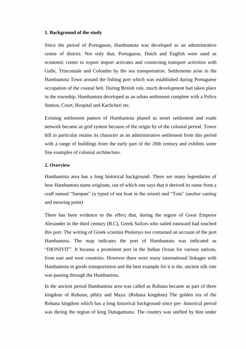
3. Geographical Location
Hambantota has situated southern part of Sri Lanka and it considered as an
administration city of the entire district. (See figure 1.1) This figure has taken to
identify, the situation and location of study area is in the island. Hambantota district
has bounded, Rathnapure and Monaragala in north, Ampara District in East, the
coastal belt in south and Mathara District from west.
Ambalanbtota is the very closer town of Hambantota and it branded as an agricultural
town. Sooriyawewa is the very important agriculture base town developed by
mahaweli aouthority under the Walawa left bank development project.
Tissamaharama is coming under historical town which is developing rapidly as a
residential area and economic base is coming under agriculture, tourism and fishery
activities. Apart of that, Lunugamwehera area is developing as an air port city in
future parallel to that Mattale and Badegiriya too developing as small cities.
Meegahajandura area is getting ready as a sport city.
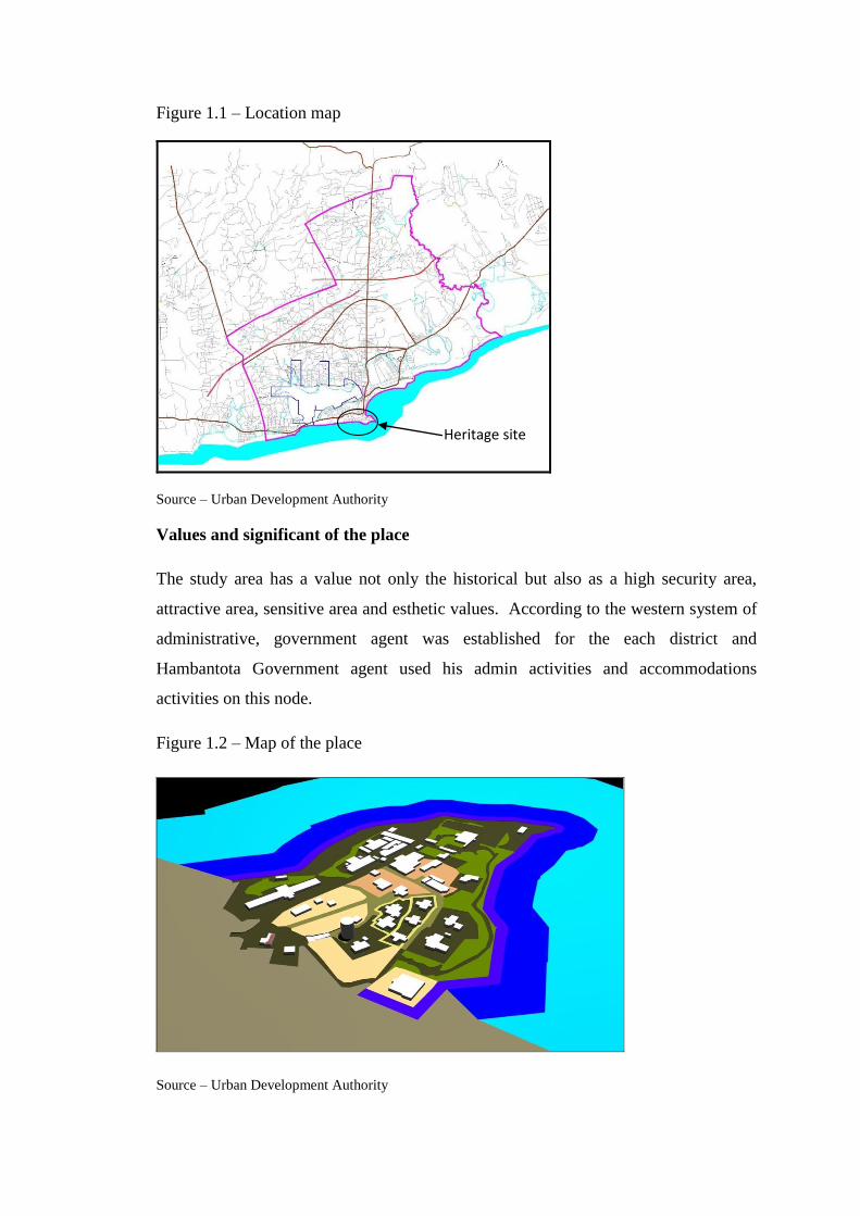
Figure 1.1 – Location map
Source – Urban Development Authority
Values and significant of the place
The study area has a value not only the historical but also as a high security area,
attractive area, sensitive area and esthetic values. According to the western system of
administrative, government agent was established for the each district and
Hambantota Government agent used his admin activities and accommodations
activities on this node.
Figure 1.2 – Map of the place
Source – Urban Development Authority
Heritage site

Figure 1.3 – Existing uses of the place
Source – Urban Development Authority
Total land extend of the site is 16 Acre and having terrain of zero meters to 15 meters
height deference of the whole area. It is a good view point and three directions can
observe from the one standing point.
Identification and evaluation of the places
There are thirteen number of archeological and heritage monuments, buildings and
site in tower hill areas which are belonging to the Portuguese, Dutch and British as
follow.
Martello Tower
Martello Towers are considering as small fort which are e constructed purpose of
defense was constructed during the British Empire in 19th
century. They stand up to
40 feet high and typically facilitating for one officer and 15 to 20 other men. Martello
tower is the most valuable monument in tower hill site and there are around 140 of
towers constructed in the world. Only one tower located in Sri Lanka and it is in
Hambantota. The states Martello towers situated in the world is showing in figure no
–1.4

Figure - 1.4 – Map of the Locations of Martello towers
Source – Wikipedia 18/10/2013
Hambantota Martello tower
Sri Lankan Martello tower is situated south coast of the Sri Lanka in Hambantota
constructed by British engineers in 19th
centuries. It has renovated by the government
of Sri Lanka in 1999 to use as a museum of fisheries. After that renovation, lack of
good maintenance some part has been damaged (see figure - 1.5).
Figure - 1.5 – Hambantota Martello Tower
Source – Urban Development Authority

Following buildings and monuments have identified to conserve and rearrange to
change the use for compatible for the conservation and maintenance.
District secretariat office
The British established the administrative centre of the District at Hambantota,
situated the Kachcheri, the court house, the Police station and other Government
establishments in the town. A Customs post was also established. The Green Line, a
round island ship service during colonial times, called at the Hambantota pier. In 1908
the popular writer and assistant government agent was established and engaged his
duties with this building (see figure 1.6).
Figure - 1.6 – Hambantota District Secretariat building
Source – Urban Development Authority
District secretariat bungalow
This is the accommodation place of government agent and Mr. Lenald woulf had used
this as his residence place in his duty period (see figure 1.7).
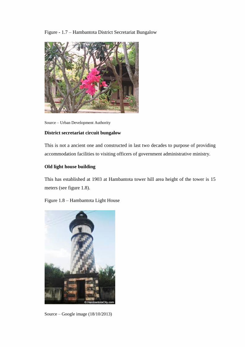
Figure - 1.7 – Hambantota District Secretariat Bungalow
Source – Urban Development Authority
District secretariat circuit bungalow
This is not a ancient one and constructed in last two decades to purpose of providing
accommodation facilities to visiting officers of government administrative ministry.
Old light house building
This has established at 1903 at Hambantota tower hill area height of the tower is 15
meters (see figure 1.8).
Figure 1.8 – Hambantota Light House
Source – Google image (18/10/2013)

Old court complex
The court complex is coming from the British period that is relating to the
administration duty of the government agent. Well established building is there (see
figure 1.9).
Figure 1.9 – Old Court complex
Source – Urban Development Authority
Old judger’s bungalow
There are two bungalow should be preserve with historical values.
Rest house complex
Part of the rest house building is coming from the English period and that part has to
conserve and open to functions (Figure 1.10).
Figure 1.10 – Rest house
Source – Urban Development Authority

Apart of that Existing election department office, Old Ellum gaha (Figure 1.11), Old
horse parking building and two cemetery monuments are have to conserve in a formal
way. The existing use and type of the buildings are showing Table no 1.1, Table no
1.2, Table no 1.3.
Figure 1.11 – Ellum Gaha
Source – Google image (18/10/2013)
Existing use and the condition survey
As a preliminary investigation, have identified, listed, taken conditions and have to
take photo graph for each property as follow.

Table no 1.1 – Existing use of the building (before relocate)
In No
Lot No
Institute name Condition Picture
No Present Situation
1 A1 Sothern Development Authority Normal A1-
1,A1-2
2 A2 Rural Economic Advancement Project Normal A2 SLRDC Occupy
3 A3 Port Authority Project Office Normal A3
4 A4 Security Hut Normal A4 10x10ft Newly constructed
5 B Vacant Land B To be vest UC
6 C1 Old Court Building Normal C1
7 C2 Handloom / Small industries Decrepit C2
8 C3 Election Office Decrepit C3
9 C4 Samurdhi Building Normal C4-
1,C4-2
10 C5 Planning Office Normal C5-
1,C5-2
11 C6 Canteen Decrepit C6-
1,C6-2
12 D Existing Well D UC
13 E Vacant Land E
14 F Hambantota Rest House Normal F-1,F-2 Rest House Occupy
15 G Hambantota Rest House Quarters Normal G Rest House Quarters Occupy
16 H Weather Science Department Quarters Normal H Occupy
17 I Mahanaga Building Normal I
18 J Vacant Land for vehicle park J
19
K1 Peoples Bank Normal K1-
1,K1-2 To be shift 30 officers Peoples Bank regional office Manager Quarters
20 K2 Security Room Normal K2 15x13 ft Newly constructed
21 K3 Vehicle Garrage Normal K3 28x32 ft Newly constructed
22 L Fishery Mucium ( small building ) Decrepit L District Musium
23 M Provincial Revenue Office Normal M
24 N Magistrate Quarters Normal N Occupy
25 O Water Tower Normal O Functioning
26 P1 Government Quarters Normal P1 Engineering Build Dep. Engineer
27 P2 Garrage Normal P2
28 P3 National child Protection Authority
Decrepit P3
29 P4
Co-ordinating Office of the chief Ministre
Normal P4
30 P5 Auditing Sub Office Decrepit P5
Source – Urban Development Authority
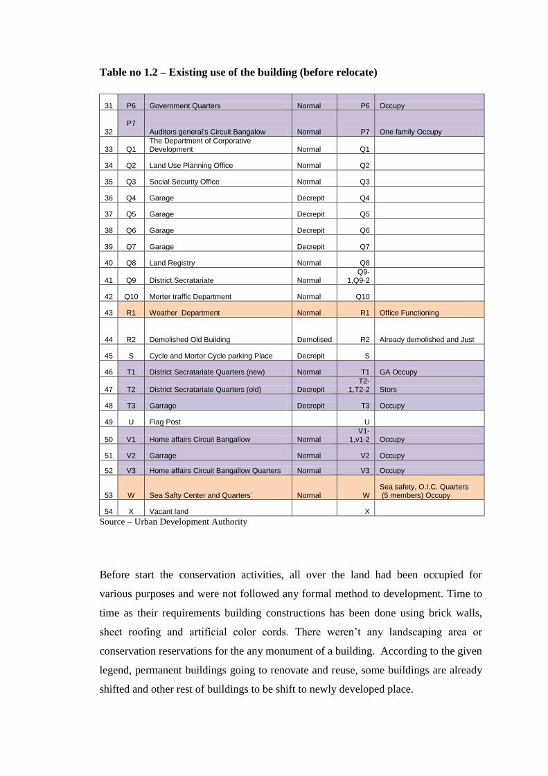
Table no 1.2 – Existing use of the building (before relocate)
31 P6 Government Quarters Normal P6 Occupy
32 P7
Auditors general's Circuit Bangalow Normal P7 One family Occupy
33 Q1 The Department of Corporative Development Normal Q1
34 Q2 Land Use Planning Office Normal Q2
35 Q3 Social Security Office Normal Q3
36 Q4 Garage Decrepit Q4
37 Q5 Garage Decrepit Q5
38 Q6 Garage Decrepit Q6
39 Q7 Garage Decrepit Q7
40 Q8 Land Registry Normal Q8
41 Q9 District Secratariate Normal Q9-
1,Q9-2
42 Q10 Morter traffic Department Normal Q10
43 R1 Weather Department Normal R1 Office Functioning
44 R2 Demolished Old Building Demolised R2 Already demolished and Just
45 S Cycle and Mortor Cycle parking Place Decrepit S
46 T1 District Secratariate Quarters (new) Normal T1 GA Occupy
47 T2 District Secratariate Quarters (old) Decrepit T2-
1,T2-2 Stors
48 T3 Garrage Decrepit T3 Occupy
49 U Flag Post U
50 V1 Home affairs Circuit Bangallow Normal V1-
1,v1-2 Occupy
51 V2 Garrage Normal V2 Occupy
52 V3 Home affairs Circuit Bangallow Quarters Normal V3 Occupy
53 W Sea Safty Center and Quarters` Normal W Sea safety, O.I.C. Quarters (5 members) Occupy
54 X Vacant land X
Source – Urban Development Authority
Before start the conservation activities, all over the land had been occupied for
various purposes and were not followed any formal method to development. Time to
time as their requirements building constructions has been done using brick walls,
sheet roofing and artificial color cords. There weren‟t any landscaping area or
conservation reservations for the any monument of a building. According to the given
legend, permanent buildings going to renovate and reuse, some buildings are already
shifted and other rest of buildings to be shift to newly developed place.

Table no 1.3 – Existing use of the building (before relocate)
55 Y District Judge Quarters Normal Y-1,Y-2 Occupy
56 Z1 Additional Secratory Quarters Normal Z1 Assistan G.A. Occupy
57 Z2 Garrage Normal Z2 Occupy
58 AA Assistant Election Commissioner Quarters Normal AA Occupy
59 AB1 Martellow Tower Decrepit AB1
60 AB2 Light House Decrepit AB2
61 AC Water Bord Quarters (NWSDB) Normal AC-1,AC-
2 Vacant
62 AD Nursers Quarters Decrepit AD
Nurses Quarters-Should be re-locate
63
OP4-1
District Engineering Department office. 40 Staff, (New office alredy given)
Sothern Provincial Office Circuit Bangallow Normal OP1 Occupy
District Engineering Department Office Quarters Normal OP2 Occupy
District Irrigation Engineer's Office Building 1
Decrepit
OP3-1,OP3-2
65x16 ft
District Irrigation Engineer's Office Building 2 Normal OP3-3 50x28 ft
District Irrigation Engineer's Office Building 3
Decrepit OP3-4 52x20 ft Vacant
District Irrigation Engineer's Office Garage 4
Decrepit OP3-5 15x15 ft
District Irrigation Engineer's Office Garage 5
Decrepit OP3-6 45x28 ft
District Engineering Service Department Normal OP4-1 120x30 ft Occupy
District Engineering Service Department Decrepit OP4-2 62x21 ft Occupy
Source – Urban Development Authority
Legend
Permanent
Already shifted
To be shifted
Conservation strategy
Proposed site is well functioned area in Hambantota due to more than 200 years it was
the District administrative complex and the entire district offices were there.
Unlimited population commuted to the location daily due to that surrounding area
developed based on that. Hambantota old town was established because of the daily
movement populations and residence government officers.
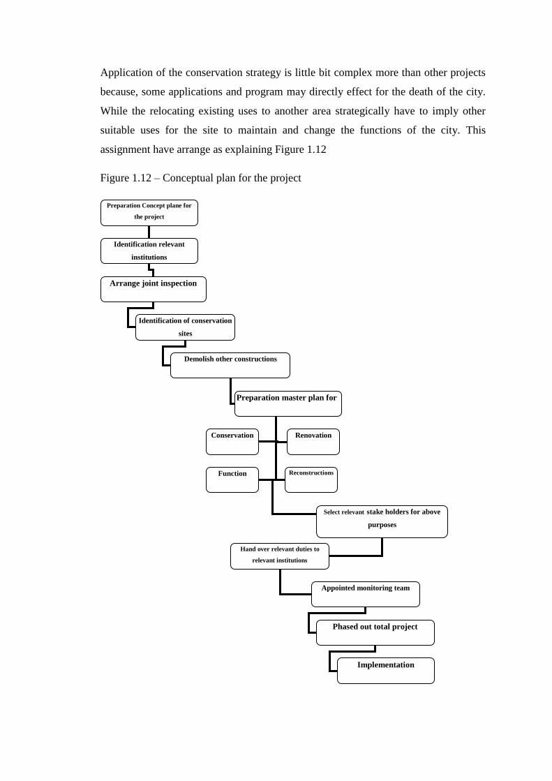
Application of the conservation strategy is little bit complex more than other projects
because, some applications and program may directly effect for the death of the city.
While the relocating existing uses to another area strategically have to imply other
suitable uses for the site to maintain and change the functions of the city. This
assignment have arrange as explaining Figure 1.12
Figure 1.12 – Conceptual plan for the project
Preparation Concept plane for
the project
Identification relevant
institutions
Arrange joint inspection
Identification of conservation
sites
Demolish other constructions
Preparation master plan for
Select relevant stake holders for above
purposes
Conservation
Renovation
Function
Reconstructions
Hand over relevant duties to
relevant institutions
Appointed monitoring team
Phased out total project
Implementation

Preparation concept plan for the overall project by the relevant institution is the first
important task for the handle successful project. In this situation as an organizing
agency urban development authority has involved to preparation conceptual plan for
the overall site area. In accordance to the relevancy, relevant institutions have to
identify for the individual involvement for relevant part. Arrange the join inspection
to identification of the historic, heritage and archeologically valued monuments,
buildings and sites of the area with following government institutions.
There are three types of ruins at their according to the collected data by the
preliminary survey.
01. Historical buildings
02. Historical sites
03. Historical monuments
All investigated ruins are included to above three categories and master plan have to
arrange according to the type of the ruins as follow.
01. Renovation and change of use
02. Renovation and keep as it is to exhibition purpose
03. Keep as it is without renovation and provide access to visitors
At the same time the team has to identify, the real situation of the buildings and ruins
as follow.
01. Real basic historical buildings
02. Not basic building but renovated added some parts to the basic building
03. No having any historical value and constructed recently
As a first part, empirically have to identify and demarcate which are the buildings
belongs to above categories. Following institutions should be included to the
committee or a team for the conservation.

Urban development Authority
Museum department
Archeology department
District secretariat office
Municipal council
Divisional secretariat office
Road development authority
According to the given instructions by relevant institutions and relevant professions,
UDA can preparation a master plan for the whole site. As a master plan provider
UDA have to manage and monitoring total product and other institutions have to do
related duties as follow (table No 1.4).
Table No 1.4 – work diversification and implementation plan
Institute duty
Urban development Authority Design, planning, Monitoring,
arrangements and finding funds
Museum department Consulting, Establish and promoting a
museum
Archeology department Consulting, conservation and maintain
District secretariat office Coordinating, arranging and help to
funding
Municipal council Coordinating, arranging, infrastructure
and help to funding
Divisional secretariat office Coordinating, arranging and help to
funding
Road development authority Estimating, consulting and Constructions

Project implementation
After this type of proper arrangement, constructions, renovations and demolition can
be arrange and table no 1.5 showing the allocated usages for each building.
In
No Institute name Activity Proposed use
1 Old Court Building Renovation gem & jewelry museum
2 Election Office Renovation gem & jewelry museum
3 Existing Well Renovation Public use
4 Hambantota Rest House Renovation tourism
5 Hambantota Rest House Quarters Renovation quarters
6 Meteorology quarters Renovation quarters
7 Fishery Museum ( small building ) Renovation Archeology office
8 Magistrate Quarters Renovation tourism
9 Water Tower Repair same
10 Government Quarters Renovation tourism
11 Government Quarters Renovation tourism
12 District Secretariat Renovation Museum
13 meteorology Department Repair same
14 District Secretariat Quarters (new) Renovation VIP tourism
15 District Secretariat Quarters (old) Renovation VIP tourism
16 Garage Renovation same
17 District Judge Quarters Renovation tourism
18 Additional Secretary Quarters Renovation tourism
19 Garage Renovation same
20 Martello Tower Renovation same
21 Light House Renovation same
22 Water Board Quarters (NWSDB) Renovation same
23 Nurses Quarters Renovation tourism
24 District Irrigation Office Renovation C.C.D museum
According to the table, reserved buildings are showing in figure 1.13 and identified
activities are going to implement to tourism attraction. After constructed Hambantota
administrative complex, all the government offices have shifted to the new town area
and old administrative complex has been renovated to conservation purposes in 2009.
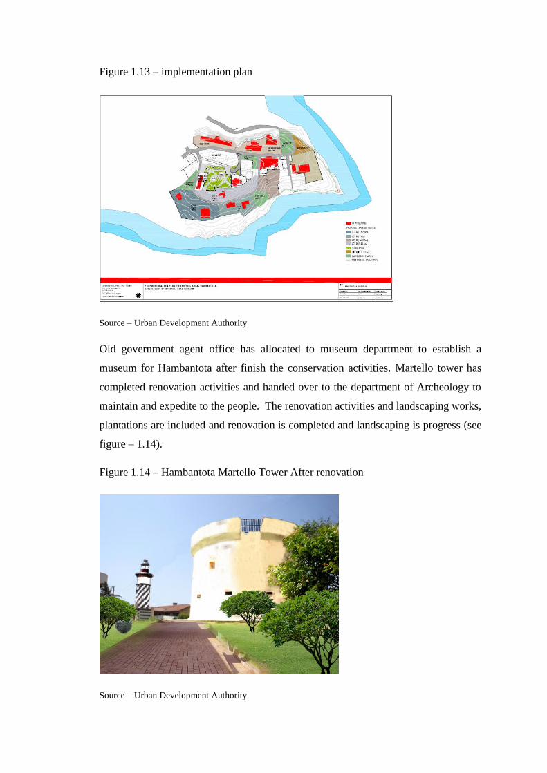
Figure 1.13 – implementation plan
Source – Urban Development Authority
Old government agent office has allocated to museum department to establish a
museum for Hambantota after finish the conservation activities. Martello tower has
completed renovation activities and handed over to the department of Archeology to
maintain and expedite to the people. The renovation activities and landscaping works,
plantations are included and renovation is completed and landscaping is progress (see
figure – 1.14).
Figure 1.14 – Hambantota Martello Tower After renovation
Source – Urban Development Authority
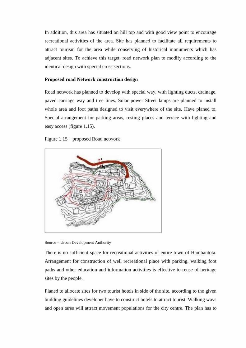
In addition, this area has situated on hill top and with good view point to encourage
recreational activities of the area. Site has planned to facilitate all requirements to
attract tourism for the area while conserving of historical monuments which has
adjacent sites. To achieve this target, road network plan to modify according to the
identical design with special cross sections.
Proposed road Network construction design
Road network has planned to develop with special way, with lighting ducts, drainage,
paved carriage way and tree lines. Solar power Street lamps are planned to install
whole area and foot paths designed to visit everywhere of the site. Have planed to,
Special arrangement for parking areas, resting places and terrace with lighting and
easy access (figure 1.15).
Figure 1.15 – proposed Road network
Source – Urban Development Authority
There is no sufficient space for recreational activities of entire town of Hambantota.
Arrangement for construction of well recreational place with parking, walking foot
paths and other education and information activities is effective to reuse of heritage
sites by the people.
Planed to allocate sites for two tourist hotels in side of the site, according to the given
building guidelines developer have to construct hotels to attract tourist. Walking ways
and open tares will attract movement populations for the city centre. The plan has to
target to change the function of the buildings and monuments to attract population
avoid the isolating heritage area.
All these developments are making economic value for the area. Local and
international commuters will attract this development. Educational institutes, tourism
arrangers will target this place as a visiting place for the tour arrangement. Gem and
jewelries museum will attract business catchment for the site. There may be
exhibitions of the site. Every thing will make proper place for the all type of visitors
and will make better place for both team of visitors and residence of the area.
Bibliography
Development plan- 2008, urban development Authority, Hambantota
Culture and heritage integrated management plan, Nils Scheffler, 2009, thematic
report 4,
Leask, Anna / Fyall, Alan (2006): Managing World Heritage Sites. First Edition.
Oxford, Elevier Ltd
Hall, Michael C. / McArthur, Simon (1997): Integrated Heritage Management.
Principles and Practice.