CREATING MEMORY MAPS - Plural Heritages of Istanbul
12
CREATING MEMORY MAPS 1 CREATING MEMORY MAPS T O O L K I T - T H R E E
-
Upload
khangminh22 -
Category
Documents
-
view
7 -
download
0
Transcript of CREATING MEMORY MAPS - Plural Heritages of Istanbul

C r e a t i n g m e m o r y m a p s 1
CREATING MEMORY MAPS
T O O L K I T - T H R E E
2

C r e a t i n g m e m o r y m a p s 3
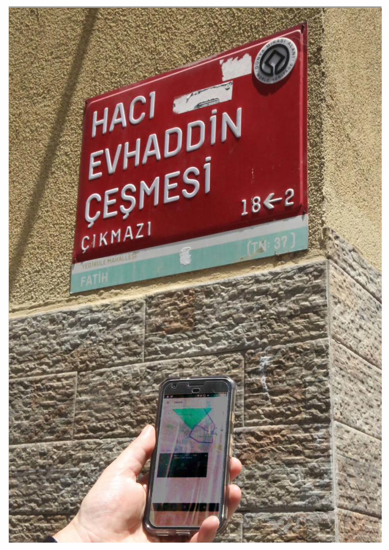
(Previous page)Mobile app being used to explore the UNESCO World Heritage Site of the Istanbul Land Walls.
(Previous spread)Participant explaining map
• Heritage professionals • Municipalities• ngos interested in heritage, historic environment,
communitiesandurbandevelopment• Civilsocietystakeholders(neighbourhoodandresidents)• Developers working with mapping technology
This is one of six toolkits to help you to develop innovative ways of:
• Valorising the past in the present• Engaging and working with communities• Recognising the different meanings of heritage and narratives
of about places and their pasts• Presenting heritage to local and non-local audiences• Building social cohesion, peaceful communities and heritage
tourism
Who is this toolkit for?
Heritage is not just something we find. It is constantly made and remade through the ways in which the past circulates in the present, for example in museum displays, in the use of historical symbols in public space (e.g. statues and memorials), in stories we tell, in collective acts of remembering, and increasingly in new, creative or digital forms. To engage with new ways of representing heritage is also to recognise that new ways of telling people about the past actively create new senses of it. People understand these new forms in different ways and that in turn will affect their understanding and experience of heritage.
Taking advantage of new technology can also help us reach new audiences. Some representations of heritage in sites or museums can focus on particular versions of the past, or certain narratives and not others. For some communities, the focus on one narrative over another may be perceived as exclusionary. There is no straightforward answer to this problem, but memory apps can offer the opportunity to support diverse or even conflicting narratives which are able to speak to different people in different ways.
‘‘...all heritage is someone’s heritage and therefore logically not someone else’s ...[so]any creation of heritage from the past disinherits someone completely or partially.’’ (Tunbridge and Ashworth, 1996)
The use of new technology can help us to show that there is not one heritage. Rather, there are plural heritages, as explained in toolkit 1.
Finally, the use of commonly available technologies such as mobile phone maps and websites can improve both engagement and access to heritage for different demographic groups. Younger people may be motivated to engage with heritage sites through media familiar to them, while people with some forms of disability may be enabled to engage with work designed correctly for accessibility.
Why is this important?
J.E. Tunbridge and G.J. Ashworth, (1996) Dissonant Heritage: the ma-nagement of the past as a resource in conflict, p. 20.

4
Another reason for using new technology in this way is because it is very well suited to capturing and representing the ways in which communities use and relate to the places and spaces of their lives, and how these become valorized as collective memory. Mapping techniques, in particular, can make a link between physical space, for example of a city, and people’s stories, memories and feelings and even creative works about that space.
Through this we are able to make new digital interventions in urban space that enable plural heritages to be put on display. These potentialize new heritage tourism experiences such as urban walks, where visitors to a site can follow routes of importance to community members, while listening to their memories, watching films, viewing photographs and discovering new histories along the way. This also enables us to make strong connections between the tangible and intangible dimensions of heritage*.
Memory maps are representations of places which in some way hold or feature within the memories of communities. Such memories can be expressed many forms: as written stories, sound or video recordings, photo essays or even creative responses which explore people’s memory of the past in poetic as well as documentary ways. Memory maps are a way of plotting all of these expressions within public space – literally ‘putting memory on the map’, showing where things happened and enabling others to find and experience sites of significance to people and communities. Simple digital mapping techniques allow us to create maps that embed such memories, and through which other media, such as short films, can be accessed. Imagine a map that you can follow – either from your home, or to take a walk around a historic neighbourhood. Now imagine being able click on an icon to access an audio recording of someone’s story of life in a historic neighbourhood, or a film about community memories.
A key reason for tying people’s memories to maps is the idea that we remember in deeply spatialised and sensory ways. Our recollections of the past are full of sights, sounds, smells and visual cues which often strongly locate them in particular places at particular times. Such considerations go beyond an idea of ‘spaces,’ or map locations defined only by their geography and architecture but more of ‘places’ – living, breathing environments populated by people embedded in social relationships and acting upon the world around them. This distinction is a fundamental one in thinking about how heritage is embedded in environments and the people who populate them. Both tangible heritages (sites, buildings, artefacts) and intangible ones (knowledge, traditional cultural forms, practices and skills) combine to create the mix that we call 'place'. This is critical both for avoiding a singular authorized view on the value of heritage sites and for avoiding the tendency of heritage management processes to ‘freeze’ sites, instead of representing them as constantly evolving in their meanings and histories. These are key concerns within heritage management instruments including the Faro Convention and the UNESCO Kit for Safeguarding Intangible Cultural Heritage. A comparable way of thinking is to see places and sites as ‘events’ and always in processes of change. While it is a challenge for heritage practice to reflect this, it is critically important for valorizing the different histories and meanings of sites, capturing the vibrancy of places and making heritage relevant for the present and the future..
What is a memory map? Place vs space
*http://www.unesco.org/new/en/cairo/culture/tangible-cultural-he-ritage/
1) https://ich.unesco.org/en/safe-guarding-00012

C r e a t i n g m e m o r y m a p s 5
Memory maps may take different forms. They may exist as smartphone applications, museum displays, websites or other more experimental forms. Whatever their eventual home, the making of them is likely to involve the consideration of a number of common factors.
There is no one answer to who should or should not be included in a memory map but the inclusion of one group over another will be a defining factor in the view of heritage expressed in a memory map. Among the possible techniques for identifying and approaching communities are:
• Chance encounters (where potential participants are approached randomly, for instance on the street)
• Snowballing (where one connection leads to another, for instance through word of mouth or direct introductions)
• Targeting gatekeeper institutions (where community leaders facilitate contact with community members e.g. through a local religious or civic organisation)
For more information on this, see toolkit 2 in this series: Working With Communities
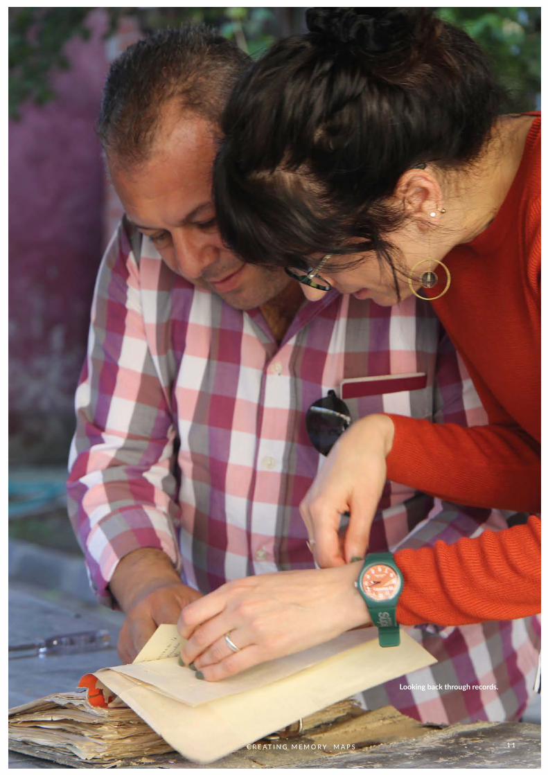
In our case study project, Plural Heritages of Istanbul: the case of the Land Walls, we sought to access community perspectives on a particular site, the Theodosian Land Walls, through a set of novel methods conducted over a year-long engagement process. Among those methods were are a set of walking interviews in which we spoke to different communities while walking together with individuals and small groups. By walking with people and focussing their memories on the places that were familiar and interesting to them, we hoped to gain insight into the values they placed on their own heritages and to foreground this in new presentations of the past.
In walking interviews, participants set the agenda. In our case study project, we asked them questions like this:
• What are your personal connections and memories of the area?• Are there locations are important to you, because they are of personal
significance or interest?• Are there areas that you pass through often?• Do you know other people with stories and memories of the area? What are they?• Can you take us on a walk to see some of these places and talk about them
as we go along?
Making memory maps
One way of building memory maps: walking interviews
Who to work with

This is a good framework for planning a walk: it is a good idea to ask these questions in advance, so that people can decide where they want to go. During the walk itself you can ask further questions based on what people say. In our walks, we recorded what participants said and took photographs of the places that people pointed to. While we were walking we used a mobile phone with GPS to record our route, and this was synchronized with the audio recording. We then used this data to build a research tool which would allow us to replay interview audio and see the location it was recorded at on a map interface.
Walking interviews have a number of benefits. People feel at home in their own environment. They are in charge of the route and usually feel more confident than in an ordinary interview. They are less anxious about giving ‘the right answer’ and find it easier to talk, because they often have deep knowledge of and everyday familiarity with the surroundings. The physical and visual nature of places also gives people prompts to talk about; it also means that we hear a lot about the change and transformation of places in people’s living memory.
There are limitations to this method. Sometimes the route can be very long and it is not possible to capture the whole route. In some cases, people took us outside of the boundaries of the heritage site; but this showed us that such boundaries do not always reflect the way in which people use places or think about their histories.
In the case of diaspora communities who no longer live in or around the site, we asked them to think back to the time when they did, and to tell us where they would go and what places were significant for them. This also produced rich information, and we came to call this ‘memory walking’. People often vividly recall places in connection with their lives, with community memory and the historical stories of importance to them. Sometimes people prefer to draw the places that are significant to them. This too can be used as material for memory maps.
This method also proved useful for people with reduced physical mobility who find it difficult or impossible to walk, for it is important to develop alternative approaches to ensure their inclusion.
6
[Figure 3] Participants drawing maps
One idea about place is that it is made not just by urban and architectural developments but by people’s everyday practices and uses of space. Understanding these ‘place-making processes’ can lead us to a way of understanding the multilayered nature of how places are constituted and the conflicting but entangled perspectives from which places might be understood and experienced.
Sarah Pink (2008) 'Mobilising Visual Ethnography: making routes, making place and making images' Forum: Qualitative Social Research 9, 3.

C r e a t i n g m e m o r y m a p s 7
Working directly with communities in public or private spaces outside the museum has the potential to expose heritage professionals to risk. An inclusive approach to community engagement may mean being in unfamiliar areas and talking to people about emotive issues. It is important that staff are supported in assessing these risks, establishing safe limits to the activity and putting in place procedures to minimise risks to an acceptable level. For instance, in our case study project we ensured that researchers were always working in pairs or small groups, that they were contactable and that their schedules were known to the broader team.
Not all participants in a memory map project will be able to contribute in the same way or to the same extent. The design of the project must recognise that people may be constrained in their participation by issues of time and commitment (for instance family or work responsibilities), of physical ability or disability and by their interest and motivation to contribute. It is vital to be sensitive to these concerns, to recognise and respond to people’s own motivation for participation and to be flexible enough in approach to be inclusive.
Memory maps often involve the use of common technologies, some of which are easily accessible to heritage institutions and some of which may involve working with technical developers. Later, we describe how our case study project involved first gathering contributions and later embedding them in a smartphone app, which our researchers developed within a university. It is important to note though that this route, which is expensive in time and money, is not the only one possible. The essence of memory maps is in their capacity to embed community memories in representations accessible to audiences. As such, lower-tech forms are possible, including static museum displays incorporating audio or video, print media featuring text or images and indeed many others. Below we offer some basic technical recommendations for gathering data.
Recording outdoors and in situ is demanding because of the presence of ambient noise and the dynamic nature of busy environments. Simple dictaphones are often unsuitable for this situation and it is advisable to use either lapel microphones or good directional microphones (so-called ‘shotgun’ microphones) and suitable wind protectors to eliminate or reduce unwanted noise. Unwanted handling noise (of recorders or cameras) can also be reduced by using specialist grips with embedded shock absorbers (see figure 3). Audio and (particularly) video recording are improved by good equipment, which is not always available because of budgetary constraints. However, it is just as important is to learn to maximise the quality of the equipment available by learning to adjust the settings (for instance to record high quality .wav audio, raw .cr2 format images or HD or 4K video) and by giving time and training to staff to get familiar with what is available.
Health and safety
Technology and memory maps
Audio and video recording
Respecting the limits of participants
[Figure 4] specialist grips with embedded shock absorbers.

There are many ways of associating recordings with particular places. At the most straightforward, a notebook recording start and end times and file names taken from recording equipment may be sufficient to tie places and recordings together. For a more accurate trace though it may be advisable to take a GPS (Global Positioning System) recording alongside audio and video. Specialist GPS recording devices are expensive, but a number of free smartphone apps also perform this function. By associating the start and end times of GPS and audio/video recordings it is possible to accurately represent when and where particular shots or clips were taken and to use this data later in representations.
Geographical Information Systems (GIS) are spatial databases, which enable the researchers to analyse and evaluate textual, visual and locational information in relation to each other. Interactive maps based on GIS databases are efficient milieus to present the relationships between place and narratives. As a result, various applications realized by GIS can be used to analyse, evaluate; as well as to present both the tangible and the intangible characteristics of place.
GIS provides us with a multi-layered information database. To represent this we first need to design a proper system of map layers to hold the information we want to present. Taking into consideration the tangible and intangible values of place, the layers may include physical aspects as well as historic or cultural qualities. Once the layer-system is determined, relevant data can be represented under the appropriate layers.
There are many websites in the scope of which various qualities of heritage sites are presented through a GIS-based interactive map.
The advantages of GIS-based web maps in the presentation of heritage sites are:
• users of the map may gain a better idea of the place and its urban/rural context before visiting the site,
• thematic routes may be presented and proposed to the user,• maps may be informed by crowdsourcing where visitors to a site may
contribute to the database (for further information, please see the literature on participatory GIS),
• it is possible to integrate videos, sound recordings or texts into the interactive map, which enables users to discover the visual/textual narratives related to the site,
• the plurality of the meanings associated to the site can be presented.
In order to improve the user’s experience of the GIS database, creating presentations comprised of images, text, audio or video of thematic routes or stories that make use of the information stored in the database may be a good way to extend the value of this work. In our study, we created a GIS data-base including the tangible and intangible qualities of the Istanbul Land Walls World Heritage Site. We utilised this database for the analysis of the relationships between tangible and the intangible forms of heritage, and finally, we presented only some parts of the database in the form of story maps embedded to the web-site to better engage users with our findings.
8
GPS
GIS
For an example see: Hrant Dink Vakfı Türkiye Kültür Varlıkları Haritası
turkiyekulturvarliklari.hrantdink.org
For a more in-depth analysis of tangible and intangible characteris-tics of place by GIS modelling, see toolkit 5 in this series on Unders-tanding and Documenting Intangible Cultural Qualities of Urban Heritage
C r e a t i n g m e m o r y m a p s 9
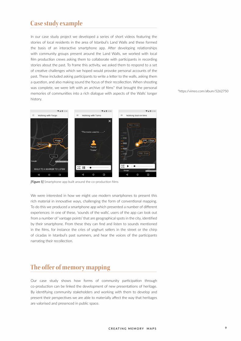
In our case study project we developed a series of short videos featuring the stories of local residents in the area of Istanbul’s Land Walls and these formed the basis of an interactive smartphone app. After developing relationships with community groups present around the Land Walls, we worked with local film production crews asking them to collaborate with participants in recording stories about the past. To frame this activity, we asked them to respond to a set of creative challenges which we hoped would provoke personal accounts of the past. These included asking participants to write a letter to the walls, asking them a question, and also making sound the focus of their recollection. When shooting was complete, we were left with an archive of films* that brought the personal memories of communities into a rich dialogue with aspects of the Walls’ longer history.
We were interested in how we might use modern smartphones to present this rich material in innovative ways, challenging the form of conventional mapping. To do this we produced a smartphone app which presented a number of different experiences: in one of these, ‘sounds of the walls’, users of the app can look out from a number of ‘vantage points’ that are geographical spots in the city, identified by their smartphone. From these they can find and listen to sounds mentioned in the films, for instance the cries of yoghurt sellers in the street or the chirp of cicadas in Istanbul’s past summers, and hear the voices of the participants narrating their recollection.
Our case study shows how forms of community participation through co-production can be linked the development of new presentations of heritage. By identifying community stakeholders and working with them to develop and present their perspectives we are able to materially affect the way that heritages are valorised and presenced in public space.
Case study example
The offer of memory mapping
[Figure 5] Smartphone app built around the co-production films
*https://vimeo.com/album/5262750
1 0
• Memory maps are representations of places which in some way embed or feature the memories of communities
• They can take many forms from simple exhibition displays to more complex uses of new technologies
• They represent a commitment to working sensitively with communities and require careful planning for health, safety, collaboration and technical elements
• Memory maps highlight the differences between space and place and recognise how local tangible and intangible elements combine to constitute understandings of heritage
The key messages from this toolkit are:
C r e a t i n g m e m o r y m a p s 1 1
Looking back through records.
This series of toolkits was produced by an international team of researchers based in Newcastle University, UK, and Istanbul Bilgi University and Bursa Uludağ University, Turkey. They are for general use by people who are involved in engaging with heritage and communities.
The toolkits are based on our ‘Plural Heritages of Istanbul – The Case of the Land Walls’ research project and the aim of the toolkits is to share what we learned from our experience. We asked how communities give meaning to major heritage sites and what happens when such meanings are intertwined with marginalisation, or are not recognised in official heritage interpretations. Our project explored the ‘plural heritages’ of the Istanbul Land (‘Theodosian’) Walls and their environs. This 5th century UNESCO World Heritage site stretches over six kilometres setting a boundary to the Historic Peninsula of Istanbul. In this context we asked how ethnographic studies, community co-production and dialogue with heritage agencies could contribute to a more ‘plural’ account of the site’s heritage.
www.pluralheritages.ncl.ac.uk
This research was funded by the Katip Çelebi – Newton joint Programme of the Arts and Humanities Research Council UK and TÜBİTAK TR
(grant numbers AH/P005810/1 and 116K830).
This work is licensed under a Creative Commons Attribution 4.0 International License.
CC 2018 Newcastle University, UK and Istanbul Bilgi University, TR
BURSA ULUDAĞ ÜNİVERSİTESİ
BU
RS
A U
LU D AĞ Ü NİVERSİT
ESİ
Toolkit 1: Different Experiences of Places and PastsChristopher Whitehead
Toolkit 2: Working with Communities to Revalorise HeritageChristopher WhiteheadGönül Bozoğlu
Toolkit 3: Creating Memory Maps Tom SchofieldGönül BozoğluFigen Kıvılcım Çorakbaş
Toolkit 4: Community Co-productionTom SchofieldChristopher Whitehead
Toolkit 5: Understanding and Documenting Intangible Cultural Qualities of Urban Heritage Figen Kıvılcım Çorakbaş Zeynep Kunt Elif Acar Bilgin
Toolkit 6: Rethinking ‘Outstanding Universal Value’ at Urban World Heritage SitesAyşegül YılmazAsu Aksoy Christopher Whitehead
Editing of Turkish TextsAyşegül YılmazSaadet Gündoğdu
Tookit DesignDaniel Foster Smith
UK team:Christopher Whitehead, Tom Schofield, Gönül Bozoğlu, Daniel Foster-SmithTurkish team: Asu Aksoy, Ayşegül Yılmaz, Zeynep Kunt, Figen Kıvılcım Çorakbaş, Serhat Sarı, Saadet Gündoğdu, Elif Acar Bilgin


![Colec]ia PLURAL](https://static.fdokumen.com/doc/165x107/63165d23c32ab5e46f0dbd8a/colecia-plural.jpg)