
COUNTY OF SAN MATEO PLANNING AND BUILDING ...
197
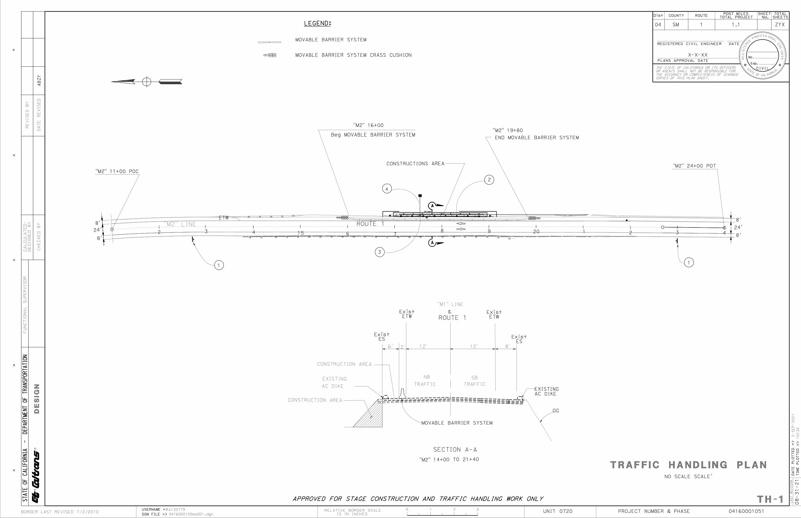
COUNTY OF SAN MATEO PLANNING AND BUILDING DEPARTMENT DATE: June 22, 2022 TO: Planning Commission FROM: Planning Staff SUBJECT: EXECUTIVE SUMMARY: Consideration of a Coastal Development Permit to repair a section of eroding road embankment located at Postmile 1.12 (Cold Dip Creek) on Highway 1, just north of the Santa Cruz County line, in the unincorporated Pescadero area of San Mateo County. This project is appealable to the California Coastal Commission. County File Number: PLN 2021-00383 (CalTrans) PROPOSAL The California Department of Transportation (CalTrans) proposes to repair a section of eroding road embankment which is located just south of the entrance to Año Nuevo State Park on the east side of Highway 1, at Postmile 1.12. In 2015, the applicant discovered the slope washout which appears to be due to excessive stormwater runoff. To repair the damage, the applicant is proposing the following: Vegetation Removal: CalTrans will clear an area approximately 0.014 acre in size, located just outside the current edge of pavement. The vegetation will be removed using hand tools followed by heavy equipment. Trees smaller than 12 inches in diameter at breast height (dbh) will be removed. Native vegetation that is removed will be reused at the end of the project within the work area. Excavation and Slope Stabilization: After removing vegetation and loose debris along the edge of the shoulder, a sheet pile wall will be constructed in front of the eroded slope, just off the traveled way. The proposed wall will be approximately 200 feet in length, with a height of approximately 6 feet, and subsurface depth of approximately 20 feet. The wall will be offset from the existing slope face and will utilize backfill to extend the shoulder 3 feet behind the guardrail. The backfill will be composed of approximately 50 cubic yards of soil. Upon completion of construction, exposed earthen areas will be
-
Upload
khangminh22 -
Category
Documents
-
view
1 -
download
0
Transcript of COUNTY OF SAN MATEO PLANNING AND BUILDING ...

COUNTY OF SAN MATEO PLANNING AND BUILDING DEPARTMENT
DATE: June 22, 2022 TO: Planning Commission FROM: Planning Staff SUBJECT: EXECUTIVE SUMMARY: Consideration of a Coastal Development
Permit to repair a section of eroding road embankment located at Postmile 1.12 (Cold Dip Creek) on Highway 1, just north of the Santa Cruz County line, in the unincorporated Pescadero area of San Mateo County. This project is appealable to the California Coastal Commission.
County File Number: PLN 2021-00383 (CalTrans) PROPOSAL The California Department of Transportation (CalTrans) proposes to repair a section of eroding road embankment which is located just south of the entrance to Año Nuevo State Park on the east side of Highway 1, at Postmile 1.12. In 2015, the applicant discovered the slope washout which appears to be due to excessive stormwater runoff. To repair the damage, the applicant is proposing the following: Vegetation Removal: CalTrans will clear an area approximately 0.014 acre in size, located just outside the current edge of pavement. The vegetation will be removed using hand tools followed by heavy equipment. Trees smaller than 12 inches in diameter at breast height (dbh) will be removed. Native vegetation that is removed will be reused at the end of the project within the work area. Excavation and Slope Stabilization: After removing vegetation and loose debris along the edge of the shoulder, a sheet pile wall will be constructed in front of the eroded slope, just off the traveled way. The proposed wall will be approximately 200 feet in length, with a height of approximately 6 feet, and subsurface depth of approximately 20 feet. The wall will be offset from the existing slope face and will utilize backfill to extend the shoulder 3 feet behind the guardrail. The backfill will be composed of approximately 50 cubic yards of soil. Upon completion of construction, exposed earthen areas will be

2
hydroseeded with a native plant seed mix suitable for the San Mateo coastal zone. The hydroseeded areas will then be covered with netting and compost. Drainage and Roadway Upgrades: Roadway drainage work will consist of constructing at least two drain inlets in the shoulder. The project will remove an existing 18-inch Corrugated Metal Pipe (CMP) which, due to the slope washout, has been exposed to a length of 40 feet. The existing pipe will be replaced with a new 50 foot long, 18-inch CMP down drain with anchor assembly and tee dissipater. Additionally, an unlined drainage ditch, immediately adjacent to the outside shoulder, will be cleared of vegetation and debris and 60 sq. ft. of riprap (rock slope protection) will be placed in its void. The existing guard rails will be replaced and a new asphalt concrete (AC) dike will be placed underneath the entire length of the new roadway barrier. Lane Closure: Temporary lane closures will be established to create necessary workspace for construction and will require installing a temporary signal system for one-lane, two-way traffic control. Additional traffic control measures will include construction area signs, flashing beacons, traffic cones, portable changeable message signs, and flaggers. The northbound lane within the project work area will be closed for the duration of construction activities. Temporary K railing will be used for construction safety and will remain in place as long as necessary. It is anticipated that the project will take approximately 50 working days to complete. RECOMMENDATION That the Planning Commission approve the Coastal Development Permit, County File Number PLN 2021-00383, by making the findings identified in Attachment A of the staff report. SUMMARY Staff has completed a review of the project and all submitted documents and reports in order to determine the project’s conformity to applicable LCP policies and Zoning regulations. Potential impacts to biological resources were identified during this review, and conditions of approval were included to reduce these potential impacts to a less than significant level. The applicant wishes to conduct the proposed work to correct existing storm damage, prevent future erosion, maintain the integrity of the roadway, and enhance driver safety. The work proposed under this permit will be minor in scope and, as conditioned, will not create a significant impact upon the area’s biotic resources.

COUNTY OF SAN MATEO PLANNING AND BUILDING DEPARTMENT
DATE: June 22, 2022 TO: Planning Commission FROM: Planning Staff SUBJECT: Consideration of a Coastal Development Permit, pursuant to Section
6328.4 of the County Zoning Regulations, to repair a section of eroding road embankment located at Postmile 1.12 (Cold Dip Creek) on Highway 1, just north of the Santa Cruz County line, in the unincorporated Pescadero area of San Mateo County. This project is appealable to the California Coastal Commission.
County File Number: PLN 2021-00383 (CalTrans) PROPOSAL The California Department of Transportation (CalTrans) proposes to repair a section of eroding road embankment which is located just south of the entrance to Año Nuevo State Park on the east side of Highway 1, at Postmile 1.12. In 2015, the applicant discovered the slope washout which appears to be due to excessive stormwater runoff. To repair the damage, the applicant is proposing the following: Vegetation Removal: CalTrans will clear an area approximately 0.014 acre in size, located just outside the current edge of pavement. The vegetation will be removed using hand tools followed by heavy equipment. Trees smaller than 12 inches in diameter at breast height (dbh) will be removed. Native vegetation that is removed will be reused at the end of the project within the work area. Excavation and Slope Stabilization: After removing vegetation and loose debris along the edge of the shoulder, a sheet pile wall will be constructed in front of the eroded slope, just off the traveled way. The proposed wall will be approximately 200 feet in length, with a height of approximately 6 feet, and subsurface depth of approximately 20 feet. The wall will be offset from the existing slope face and will utilize backfill to extend

2
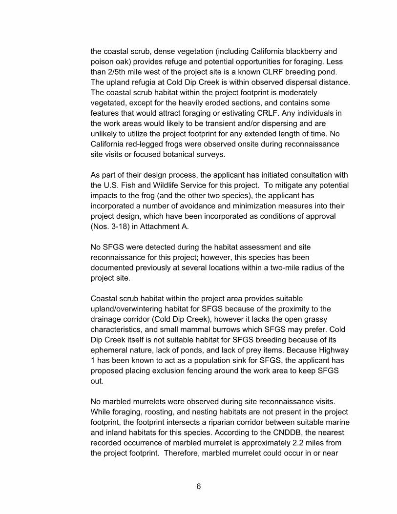
the shoulder 3 feet behind the guardrail. The backfill will be composed of approximately 50 cubic yards of soil. Upon completion of construction, exposed earthen areas will be hydroseeded with a native plant seed mix suitable for the San Mateo coastal zone. The hydroseeded areas will then be covered with netting and compost. Drainage: Roadway drainage work will consist of constructing at least two drain inlets in the shoulder. The project will remove an existing 18-inch Corrugated Metal Pipe (CMP) which, due to the slope washout, has been exposed to a length of 40 feet. The existing pipe will be replaced with a new 50 foot long, 18-inch CMP down drain with anchor assembly and tee dissipater. Additionally, an unlined drainage ditch, immediately adjacent to the outside shoulder, will be cleared of vegetation and debris and 60 sq. ft. of riprap (rock slope protection) will be placed in its void. Roadway Upgrades: The existing guard rails will be replaced and a new asphalt concrete (AC) dike will be placed underneath the entire length of the new roadway barrier. Lane Closure: Temporary lane closures will be established to create necessary workspace for construction and will require installing a temporary signal system for one-lane, two-way traffic control. Additional traffic control measures will include construction area signs, flashing beacons, traffic cones, portable changeable message signs, and flaggers. The northbound lane within the project work area will be closed for the duration of construction activities. Temporary K railing will be used for construction safety and will remain in place as long as necessary. It is anticipated that the project will take approximately 50 working days to complete. RECOMMENDATION Approve the Coastal Development Permit, County File Number PLN 2021-00383, by adopting the required findings and conditions of approval contained in Attachment A. BACKGROUND Report Prepared By: Michael Schaller, Senior Planner Applicant: CalTrans (Tanvi Gupta) Owner: State of California (State Highway Right of Way)

3
Location: State Route 1 at Postmile 1.12 (approx. 2,000 feet south of the entrance to Año Nuevo State Park, Pescadero). APN: Pubic Right of Way (adjacent to 089-230-420) Existing Zoning: Planned Agricultural District (PAD) General Plan Designation: Agriculture - Rural Existing Land Use: State Highway and adjacent agricultural and open space areas. Flood Zone: Zone X (Areas of Minimal Flood Hazard), FEMA Community Panel 06081C-0506F, Effective Date: October 16, 2012. Environmental Evaluation: CalTrans, as lead agency, has filed a Categorical Exemption under Section 15301(d) of the California Environmental Quality Act Guidelines (see Attachment E). Setting: The project site includes the currently active highway road prism, developed bare ground, and Monterey pine/riparian vegetation. Active farm fields lie to the east of the project site, and Año Nuevo State Park is west of the project site, on the other side of Highway 1. Cold Dip Creek passes underneath the Highway via a culvert approximately 50 feet below the road surface. The project site is primarily composed of coastal scrub habitat, pines, and paved, barren, or ruderal areas. Species include invasive non-natives such as iceplant, Italian thistle, and blowfly grass. Cold Dip Creek runs through the site, where riparian vegetation consists predominantly of low-growing riparian plants such as poison oak and California blackberry, while the majority of surrounding vegetation is coastal scrub, Monterey pine forest, and ruderal non-native plants. DISCUSSION A. KEY ISSUES 1. Conformance with the County General Plan
The County’s Local Coastal Program (LCP) is a subset of the County General Plan, and the two documents are internally consistent. The following analysis of the project’s consistency with the LCP, which is more specific than the General Plan with regard to issues raised by this project, therefore also

4
addresses, by extension, the project’s consistency with the County’s General Plan.
2. Conformance with the Local Coastal Program
A Coastal Development Permit is required pursuant to San Mateo County Local Coastal Program Policy 2.1, which mandates compliance with the California Coastal Act for any government agency wishing to undertake development in the Coastal Zone. While the work proposed for this Coastal Development Permit is relatively minor in scope, it does meet the definition of development contained in Policy 1.2 (Definition of Development - “construction, reconstruction, demolition, or alteration of the size of any structure, including any facility of any private, public, or municipal utility”). Section 6328.5 of the County Zoning Regulations outlines the allowed exemptions to the requirements for a Coastal Development Permit. Public Works projects (which includes CalTrans projects), regardless of their size, are not included within the listed exemptions. Thus, a Coastal Development Permit (CDP) is required for this project. Summarized below are the LCP policies that are relevant to this project:
a. Public Works Component
Policy 2.42 (Capacity Limits). This policy limits the expansion of roadway capacity to that which is needed to accommodate peak period traffic and requires that Highway 1 be maintained as a scenic two-lane road outside of the Urban Midcoast area. The proposed project will occur outside of the existing travel lanes on Highway 1 and will not increase the number of lanes on the Highway. The purpose of the proposed work is to maintain the integrity of the roadway, and improve driver safety. These improvements will not increase the traffic capacity of Highway 1 in this location or in the Pescadero area of the County. The project is not growth-inducing and is not anticipated to result in an increase in vehicular traffic. One-lane, two-way traffic control will be necessary for the construction of the project. Any construction related impacts will be temporary and will only last during the 50 days proposed for construction of the project.
b. Sensitive Habitats Component

5
As outlined above in the setting section, the project site could support sensitive habitat as defined under Policy 7.1 (Definition of Sensitive Habitats). Sensitive habitat areas include all perennial and intermittent streams and their tributaries. As discussed above under the project proposal section, the project site requires work within the limits of the riparian corridor associated with Cold Dip Creek. In addition, the work site has the potential to support special status wildlife species (California Red-Legged Frog (CRLF), San Francisco Garter Snake (SFGS), Marbled Murrelet (MAMU) and San Francisco Dusky Footed Woodrat (SFDFW)). Policy 7.3 (Protection of Sensitive Habitats). This policy prohibits any land use or development which would have a significant adverse impact on sensitive habitat areas. Additionally, development in areas adjacent to sensitive habitats shall be sited and designed to prevent impacts that could significantly degrade the sensitive habitats. All uses shall be compatible with the maintenance of biologic productivity of the habitats. Also, Policy 7.5 (Permit Conditions), requires, as part of the development review process, that the applicant demonstrate that there will be no significant impact on sensitive habitats or species. This is achieved by submission of a biological report outlining what resources exist at the project location and how the project may impact those resources. As discussed above, the applicant has submitted a “Natural Environment Study” as part of their application, portions of which are summarized below. The potential for the federally listed CRLF, SFGS, MAMU and SFDFW to occur at the project site, potential effects of the proposed project on these species, and avoidance and minimization measures for each species are discussed below. The biological assessment submitted by the applicant demonstrates that the proposed project will likely have no effect on these three species nor on any other listed wildlife species that could potentially be in the area. The project site is within the final designated Critical Habitat for the California red-legged frog (CRLF). A riparian corridor running perpendicular to SR 1 may provide upland habitat for CRLF, and it is within the central coast recovery unit for the species. Cold Dip Creek itself runs more than 30 feet underneath Highway 1 in a culvert, making the associated riparian area atypical in vegetation makeup. The coastal scrub habitat within the project footprint may provide upland dispersal habitat for CRLF. While small mammal burrows that may attract CRLF appear to be lacking within
6
the coastal scrub, dense vegetation (including California blackberry and poison oak) provides refuge and potential opportunities for foraging. Less than 2/5th mile west of the project site is a known CLRF breeding pond. The upland refugia at Cold Dip Creek is within observed dispersal distance. The coastal scrub habitat within the project footprint is moderately vegetated, except for the heavily eroded sections, and contains some features that would attract foraging or estivating CRLF. Any individuals in the work areas would likely to be transient and/or dispersing and are unlikely to utilize the project footprint for any extended length of time. No California red-legged frogs were observed onsite during reconnaissance site visits or focused botanical surveys. As part of their design process, the applicant has initiated consultation with the U.S. Fish and Wildlife Service for this project. To mitigate any potential impacts to the frog (and the other two species), the applicant has incorporated a number of avoidance and minimization measures into their project design, which have been incorporated as conditions of approval (Nos. 3-18) in Attachment A. No SFGS were detected during the habitat assessment and site reconnaissance for this project; however, this species has been documented previously at several locations within a two-mile radius of the project site. Coastal scrub habitat within the project area provides suitable upland/overwintering habitat for SFGS because of the proximity to the drainage corridor (Cold Dip Creek), however it lacks the open grassy characteristics, and small mammal burrows which SFGS may prefer. Cold Dip Creek itself is not suitable habitat for SFGS breeding because of its ephemeral nature, lack of ponds, and lack of prey items. Because Highway 1 has been known to act as a population sink for SFGS, the applicant has proposed placing exclusion fencing around the work area to keep SFGS out. No marbled murrelets were observed during site reconnaissance visits. While foraging, roosting, and nesting habitats are not present in the project footprint, the footprint intersects a riparian corridor between suitable marine and inland habitats for this species. According to the CNDDB, the nearest recorded occurrence of marbled murrelet is approximately 2.2 miles from the project footprint. Therefore, marbled murrelet could occur in or near

7
the action area during flights to and from marine and inland habitats. The project site is not within federally designated critical habitat for marbled murrelet. By implementing the conservation measures included in Attachment A, no take is anticipated, and no adverse effects (harm, harassment) are expected.
Several San Francisco dusky-footed woodrats and dens were identified in the project area by the applicant’s biologist during site reconnaissance for the habitat assessment. The coastal scrub and Monterey pine forest habitat within the project area provides suitable habitat for this species; furthermore, other niche components such as dense understory forest habitat is present within the project footprint. To avoid and minimize impacts to the woodrat, CalTrans is proposing to implement pre-construction surveys and potential trapping and relocation. These measures are included as conditions of approval 26 and 27 in Attachment A. Policy 7.8 (Designation of Riparian Corridors). This policy establishes riparian corridors for all perennial and intermittent streams. Cold Dip Creek is an intermittent stream. Vegetation around the stream consists predominantly of low-growing riparian plants such as poison oak and California blackberry, while the majority of surrounding vegetation is coastal scrub, Monterey pine forest, and ruderal non-native plants. No wetlands were found within the Project footprint during surveys. One culverted water feature was identified in the Project footprint that is classified as waters of the United States: Cold Dip Creek (80 linear feet), which is a tributary to Año Nuevo Creek. This section of Cold Dip Creek is culverted and will be avoided; all work will be done above the banks of the Creek.
Policy 7.11 - Establishment of Buffer Zones (for Riparian Corridors). This policy establishes a buffer zone of 30 ft. as measured from the limit of riparian vegetation for all intermittent streams. Cold Dip Creek passes under and through the project footprint via an existing culvert that emerges out of the road embankment approximately 10 feet below the foot of the proposed RSP. Portions of the proposed project will occur within this buffer zone.
Permitted uses within the buffer zone (Policy 7.12) include repair or maintenance of roadways or road crossings. The purpose of this project is

8
to address localized erosion and land sliding of the road embankment in order to prevent loss of the roadway, and therefore the project is consistent with this policy. Policy 7.13 – Performance Standards in Buffer Zones (for Riparian Corridors). This policy requires development permitted in buffer zones to minimize removal of vegetation; and use only adapted native or non-invasive exotic plant species when replanting. No work is proposed within or immediately adjacent to the riparian corridor which is completely contained within the culvert as it passes through the embankment and exits below the area of work. The vegetation removal that will occur is limited to the immediate area of work, approximately 650 sq. ft. in area. The applicant has proposed re-vegetating all disturbed areas with native grass and shrub species.
c. Visual Resources Component
Policy 8.5 – Location of Development. This policy requires that development be located on a portion of a parcel where it is least visible from State and County Scenic Roads. This stretch of Highway 1 is designated as a State Scenic Road/Corridor. The embankment repair will be below road level and once the revegetation is established, will not be visible to motorists traveling on Highway 1. Construction related visual impacts will be temporary and limited to the duration of construction (approximately 50 days).
3. Compliance with PAD Zoning Regulations
The Coastal Act of 1976 requires that the County’s Local Coastal Program (LCP) include zoning ordinances, zoning district maps and any other actions necessary to implement the requirements of the Coastal Act in San Mateo County. To that end, all projects, including government projects, must show compliance with not only the LCP Policies, but with the applicable zoning regulations of the district in which the project is located.
Section 6352 - Uses Permitted. The U.S. Department of Agriculture’s Natural Resource Conservation Service (NRCS) has identified the soils within the project footprint as Santa Lucia Loam (highly erodible, steep slopes). This soil class is considered non-prime. Any potential agricultural use (within the

9
project footprint) was previously extinguished by the construction of Highway 1 during the 1950’s. Existing public infrastructure, such as Highway 1, is not listed as a permitted use on PAD zoned lands. However, nonresidential development customarily considered accessory to agricultural uses are permitted within the PAD. Highway 1 is the primary north-south transportation artery for the San Mateo Coastside. Without this road, access to numerous agricultural parcels would not be possible. The proposed repair work is necessary to ensure continued access to these parcels.
4. Compliance with the County Grading Ordinance To repair the eroded road embankment, the applicant is proposing to place approximately 50 cubic yards of backfill behind the sheet pile wall, thus extending the edge of the embankment approximately 3 feet beyond the new guardrail. Additionally, 60 sq. ft. of rock slope protection will be placed around the outfall for the new drainpipe to prevent erosion onto the slopes above Cold Dip Creek. Because the applicant is the State, issuance of a grading permit is not required. However, the project must be consistent with the County’s Grading Ordinance per the requirements of the Coastal Act. The findings required for a grading permit are discussed below: a. That the project will not have a significant adverse effect on the
environment.
The proposed grading is necessary to implement the project. Erosion control measures will be implemented during construction to reduce potential off site sedimentation and water quality impacts. The bank reconstruction has been designed to minimize long-term impacts to drainage and adjacent areas. Measures to protect potential biotic resources within the footprint of the project have also been included as conditions of approval. Therefore, staff has determined that the project, as proposed and conditioned, will not have a significant adverse impact on the environment.

10
b. That the project conforms to the criteria of Chapter 8, Division VII, San Mateo County Ordinance Code, including the standards referenced in Section 8605.
The project, as proposed and conditioned, conforms to standards in the Grading Ordinance, including those relative to erosion and sediment control, and the timing of grading activity. Conditions of approval have been included in Attachment A to ensure compliance with the County’s Grading Ordinance.
c. That the project is consistent with the General Plan.
The General Plan land use designation for the project site is Agriculture - Rural. As proposed and conditioned, the project complies with applicable General Plan and Local Coastal Plan policies, as discussed in Section A.1 of this report.
B. ENVIRONMENTAL REVIEW
CalTrans has assumed the role of lead agency. As such, they have filed a Categorical Exemption under Section 15301 (Repair or minor alteration of existing public or private structures, facilities, or topographical features, involving negligible or no expansion of use) of the California Environmental Quality Act.
D. REVIEWING AGENCIES Pescadero Municipal Advisory Council – No comments submitted. California Coastal Commission – The Coastal Commission had the following
questions, which the applicant has responded to:
1. What is the exact area of impact? On Table A-1, it states that the area of impact is 0.014 acres, but in Figure 8 it states that it is 0.13 acres. Please clarify what the area of impact is.
CalTrans response: We have confirmed with the [Project] biologist that the area of impact is 0.14 acres.

11
2. Additionally, the 2019 memorandum indicates there will be 11,000 square feet of vegetation removal, which amounts to .25 acres, which is more than the amounts identified above and not insignificant.
CalTrans response: The memorandum referred to is outdated. The project scope and footprint were drastically reduced since that 2019 memorandum. There will be only 0.14 acres of vegetation removal. Please refer to the Natural Environmental Study for an accurate project description.
3. The Natural Environmental Study indicates that restoration for temporary and
permanent impacts will be accomplished onsite through revegetation, but it’s not clear how permanent impacts will be mitigated for through revegetation. Please elaborate how mitigation through revegetation will be determined (i.e. we typically require a 3:1 mitigation ratio).
CalTrans response: Based on project cost, scope, and the temporary and permanent impacts- CalTrans proposes a 1.5:1 replacement of all native trees >2” DBH for a total of 24 new trees and shrubs replanted matching the current assemblage of species being removed (coast live oaks, toyon, coffeeberry, etc.). The plant establishment work will be from 3-5 years which should significantly increase the survival rate of the 24 trees and shrubs planted. Staff Response: County staff received comments from the Coastal Commission on June 8, 2022 which stated that a 3:1 replacement ratio is their standard mitigation rate for remove trees and that the Commission found no reason to differ from that standard, particularly since much of the tree removal will occur within ESHA areas. Consistent with the Commission’s guidance and to avoid the potential for an appeal, County staff is adding condition of approval No. 28, which will require CalTrans to amend their revegetation plan to include a 3:1 replacement ratio for all removed trees.
4. Were any alternatives considered other than the 6-foot tall, 200-foot long sheet
pile wall? The analysis states that issues in the project area occurred as a result of a malfunctioning reservoir. Have any actions been taken to correct the reservoir? This could help address the underlying issues and reduce recurring issues.
CalTrans response: Three viable alternatives were considered for the project: two Build Alternatives and the No-Build Alternative. The Preferred Alternative for the project is Alternative 2, which proposes to construct a sheet pile wall to

12
stop the erosion of the storm-damaged slope on SR 1. Alternative 1 proposed to repair the slope washout by installing RSP in layers into an excavated area over RSP fabric until a finished slope of 1.5:1 (H:V) is achieved. This alternative would have required numerous environmental permits and would have a greater environmental impact, which would be costly and time consuming to obtain. Therefore, Alternative 1 was rejected. Alternative 3, the No-Build Alternative, would not make any improvements to the damaged pavement, slope, or drainage at the project location and could lead to the failure of roadway structural sections. Therefore, the No-Build Alternative was rejected.
5. Additionally, given the location is along Highway one, please keep in mind that
we expect all culvert and related materials to have the visual impacts minimized as much as feasible.
CalTrans response: We have environmental commitments, as mentioned in the VIA, to minimize all visual impacts.
6. The study determines that there are no jurisdictional wetlands present, but the
photos suggest that wetlands could be possible here. I see that a biological reconnaissance survey and a wetland, waters and species identification survey were conducted in June and July of 2020. Was this determination based on a one parameter delineation or three-parameter? Please note that the Commission uses a one-parameter delineation to determine if a wetland is present.
CalTrans response: The photos in the 2019 memorandum are no longer part of the project footprint. This determination was based on a one-parameter delineation to determine if a wetland is present.
ATTACHMENTS A) Recommended Findings and Conditions of Approval B) Location Map C) Project Plans D) Natural Environment Study – SR1 Erosion Control Project (prepared by CalTrans) E) CalTrans’ adopted Categorical Exemption F) Scenic Resource Evaluation and Visual Impact Assessment (prepared by
CalTrans)

13
Attachment A
County of San Mateo Planning and Building Department
RECOMMENDED FINDINGS AND CONDITIONS OF APPROVAL
Permit or Project File Number: PLN 2021-00383 Hearing Date: June 22, 2022 Prepared By: Michael Schaller For Adoption By: Planning Commission Senior Planner RECOMMENDED FINDINGS Regarding the Environmental Review, Find: 1. That this project is categorically exempt pursuant to Section 15301 of the
California Environmental Quality Act Guidelines, relating to the repair or minor alteration of existing public or private structures, facilities, or topographical features, involving negligible or no expansion of use.
Regarding the Coastal Development Permit, Find: 2. That the project, as described in the application and accompanying materials
required by Zoning Regulations Section 6328.7 and as conditioned in accordance with Section 6328.14, conforms with the plans, policies, requirements and standards of the San Mateo County Local Coastal Program with regards to the protection of biotic and visual resources.
3. That the project conforms to the specific findings required by policies of the San
Mateo County Local Coastal Program as discussed in Section A(2) of this Staff Report. Protection measures will be implemented to prevent any impact to biological resources, including San Francisco garter snake, California red-legged frog, and San Francisco dusky-footed woodrat.
4. That where the project is located between the nearest public road and the sea, or
the shoreline of Pescadero Marsh, the project is in conformity with the public access and public recreation policies of Chapter 3 of the Coastal Act of 1976 (commencing with Section 30200 of the Public Resources Code). The project site

14
is located on the eastern side of SR-1 and not subject to the public access requirements of the Coastal Act.
RECOMMENDED CONDITIONS OF APPROVAL Current Planning Section 1. This approval applies only to the proposal as described in this report and materials
submitted for review and approval by the Planning Commission on June 22, 2022. The Community Development Director may approve minor revisions or modifications to the project if they are found to be consistent with the intent of and in substantial conformance with this approval.
CalTrans General Avoidance and Minimization Measures 2. Seasonal Avoidance. To the extent practicable, construction will not occur during
the wet season. Except for limited vegetation clearing (necessary to minimize impacts to nesting birds), work will be limited to the period from April 15th to October 31st to avoid the period when SFGS may be overwintering in uplands and CRLF are most active. Marbled murrelets are more active during this time but less likely to be affected by the proposed Project. Surveys for the marbled murrelet will be conducted in accordance with the Migratory Bird Treaty Act.
3. USFWS-Approved Biological Monitor. The names and qualifications of proposed
biological monitor(s) will be submitted to the USFWS for approval prior to the start of construction. The USFWS-Approved biological monitor(s) will keep a copy of this biological opinion in their possession when onsite. Through communication with the resident engineer, the USFWS-approved biological monitor will be onsite during all work that could reasonably result in take of CRLF, SFGS, or marbled murrelet. The USFWS-approved biological monitor will have the authority to stop work that may result in the unauthorized take of special-status species. If the USFWS-Approved Biological Monitor exercises this authority, the USFWS will be notified by telephone and e-mail message within one (1) working day of said action.
4. Worker Environmental Awareness Training. Construction personnel will attend
a mandatory environmental education program delivered by the USFWS-Approved Biological Monitor prior to taking part in site construction, including vegetation clearing. The program will focus on the conservation measures that are relevant to

15
an employee’s personal responsibility and will include an explanation as how to best avoid take of California red-legged frog, San Francisco garter snake, and marbled murrelet. At a minimum, the training will include a description of species; how they might be encountered within the project area; their status and protection; and the relevant Conservation Measures, and Terms and Conditions of the BO. A fact sheet conveying this information will be prepared and distributed to all construction and project personnel. Distributed materials will include cards with distinctive photographs of California red-legged frog, San Francisco garter snake, marbled murrelet, as well as compliance reminders and relevant contact information. Documentation of the training, including sign-in sheets, will be kept on file and made available to the USFWS upon request.
5. Migratory Bird Treaty Act Protection. To minimize and avoid take of migratory
birds, their nests, and their young, CalTrans will conduct vegetation and tree trimming between September 30 and January 30 before Project construction. This work will be limited to vegetation and trees that are within the Project footprint. No grubbing or other ground-disturbing actions will occur during that period. Upon completion of vegetation and tree trimming, CalTrans will install stormwater and erosion control BMPs. A biological monitor with appropriate construction and species experience will conduct nest and bird surveys and other wildlife surveys before and during tree cutting. All work will be conducted under a Regional Water Board-approved Water Pollution Control Plan or Stormwater Pollution Prevention Plan (SWPPP). Vegetation will be cleared only where necessary and will be cut above soil level. This will allow plants that reproduce vegetatively to re-sprout after construction. During the nesting season, pre-construction surveys for nesting birds, including the marbled murrelet, will be conducted by a qualified biologist no more than 72 hours prior to the start of construction activities. If work is to occur within 300 feet of active raptor nests or 50 feet of active passerine nests, a non-disturbance buffer will be established at a distance sufficient to minimize disturbance based on the nest location, topography, cover, the species’ sensitivity to disturbance, and the intensity/type of potential disturbance. All clearing and grubbing of woody vegetation will be performed by hand or using light construction equipment, such as backhoes and excavators.
6. Discovery of Listed Species. The USFWS-Approved Biological Monitor will be
present during all activities that could reasonably result in take of the California red-legged frog, San Francisco garter snake, and marbled murrelet. If at any point a listed species is discovered during these activities, the USFWS-Approved Biological Monitor through the Resident Engineer or their designee, will halt all

16
work within 50 feet of the animal until the listed species has either been captured and moved or has moved sufficiently from harm’s way on its own volition.
7. Protocol for Species Observation. The USFWS-Approved Biological Monitor(s)
will have the authority to halt work through coordination with the Resident Engineer in the event that a listed species is observed in the action area. The Resident Engineer will keep construction activities suspended in any construction area where the biologist has determined that a potential take of the species could occur. Work will resume after observed listed individuals leave the site voluntarily, the biologist determines that no wildlife is being harassed or harmed by construction activities, or the wildlife is removed by the biologist to a release site using USFWS-approved handling techniques.
8. Handling of Listed Species. If a listed species is discovered, the Resident
Engineer and USFWS-Approved Biological Monitor will be immediately informed.
a) If a California red-legged frog, San Francisco garter snake, or marbled murrelet gains access to a construction zone, work will be halted immediately within 50 feet until the animal leaves the site or is captured and relocated by the USFWS-Approved Biological Monitor.
b) The USFWS will be notified within one (1) working day if a California red-
legged frog, San Francisco garter snake, or marbled murrelet is discovered within the construction site.
c) The captured California red-legged frog, San Francisco garter snake, or
marbled murrelet will be released within appropriate habitat outside of the construction area but nearby the capture location. The release habitat will be determined by the USFWS-Approved Biological Monitor.
d) The USFWS-Approved Biological Monitor will take precautions to prevent
introduction of amphibian diseases in accordance with the Revised Guidance on Site Assessments and Field Surveys for the California Red-legged Frog (USFWS 2005).
9. Injured Animals. Injured California red-legged frogs, San Francisco garter snakes,
and marbled murrelets will be cared for by a USFWS-Approved Biological Monitor(s) or a licensed veterinarian, if necessary. Any deceased California red-legged frogs, San Francisco garter snakes, or marbled murrelets will be preserved according to standard museum techniques and will be held in a secure location.

17
The USFWS and the CDFW will be notified within 1 working day of the discovery of a death or an injury to any listed species resulting from project-related activities or if a listed species is observed at a construction site. Notification will include the date, time, and location of the incident or the finding of a deceased or injured animal, clearly indicated on a USGS 7.5-minute quadrangle and other maps at a finer scale, as requested by the USFWS or CDFW, and any other pertinent information.
10. Inclement Weather Restriction. No work will occur during or within 24 hours
following a rain event exceeding 0.2-inch as measured by the National Oceanic and Atmospheric Association National Weather Service for the Soquel, CA (SOQC1) base station. The USFWS and California Department of Fish and Wildlife (CDFW) approval to continue work during or within 24 hours of a rain event will be considered on a case-by-case basis.
11. Construction Boundary Fencing. Before the start of construction, the project
footprint boundary will be clearly delineated using high-visibility orange fencing as necessary. Construction work areas will include the active construction site and all areas providing support for the project, including areas used for vehicle parking, equipment and material storage and staging, and access roads. The fencing will remain in place throughout the duration of construction activities and will be inspected regularly and fully maintained at all times. The final project plans will show all locations where boundary fencing will be installed and will provide installation specifications. The bid solicitation package special provisions will clearly describe acceptable fencing material and prohibited construction-related activities, including vehicle operation, material and equipment storage, access roads and other surface-disturbing activities.
12. Wildlife Exclusion Fencing. Silt fencing or other wildlife exclusion fencing will be
installed in conjunction with the construction boundary fencing around the perimeter of the project footprint to allow CRLF and SFGS to leave but not re-enter the work area. This fence will be installed prior to any work within the project footprint. Exclusion fencing will be at least 3 feet high with the lower 6 inches of the fence buried in the ground. The fence will be pulled taut at each support to prevent folds or snags. Fencing will be installed and maintained in good working condition until completion of the project.
13. Vegetation Removal. Vegetation removal will be limited to the designated work
areas needed for access and workspace. Where possible, vegetation removal in

18
temporary work areas will be cut above soil level to promote re-vegetative growth of established plants following construction.
14. Staging. Construction access, staging, storage, and parking areas will be located
within CalTrans right of way on paved surfaces and compacted roadside fill. 15. Night Lighting. During any potential night work, which is not anticipated, all
lighting will be directed downwards, towards active construction and away from sensitive resources or habitats.
16. Vehicle and Equipment Checks. Before moving construction equipment or
vehicles into the project site, operators will check underneath those that have been parked onsite for more than 30 minutes and will notify the USFWS-Approved Biological Monitor if any reptile or amphibian is observed.
17. Proper Use of Erosion Control Devices. To avoid California red-legged frogs
and San Francisco garter snakes from becoming entangled, trapped, or injured, erosion control materials that use plastic or synthetic mono-filament netting will not be used within the action area.
18. Avoidance of Entrapment. To prevent inadvertent entrapment of animals during
construction, all excavated, steep-walled holes or trenches more than 1 foot deep will be covered at the close of each working day by plywood or similar materials. Before such holes or trenches are filled, they must be thoroughly inspected for trapped animals. All replacement pipes, culverts, or similar structures stored in the project area overnight will be inspected before they are subsequently moved, capped and/or buried.
19. Poison Control. Pesticides and herbicides will not be used. 20. Invasive Species Management. To reduce the spread of invasive non-native
plant species and minimize the potential decrease of palatable vegetation for wildlife species, CalTrans will comply with Executive Order 13112. The purpose of this order is to prevent the introduction of invasive species and provide for their control to minimize economic, ecological, and human health impacts. In the event that high- or medium-priority noxious weeds, as defined by the California Department of Food and Agriculture or the California Invasive Plant Council, are disturbed or removed during construction-related activities, the contractor will contain the plant material associated with these noxious weeds and will dispose of it in a manner that will not promote the spread of the species. The contractor will

19
be responsible for obtaining all permits, licenses, and environmental clearances for properly disposing materials. Areas subject to noxious weed removal or disturbance will be replanted with fast-growing native grasses or a native erosion control seed mixture. If seeding is not possible, the area will be covered to the extent practicable with heavy black plastic solarization material until completion of construction. All earthmoving equipment, as well as seeding equipment to be used during project construction would be thoroughly cleaned before arriving on the project site.
21. Construction Site BMP’s. The following site restrictions will be implemented to
avoid or minimize impacts on special-status species and their habitats:
a) Construction staging, storage, and parking areas will be located within the CalTrans ROW as described in the August 2020 BA. The number and size of staging and work areas will be limited to the minimum necessary to construct the project and will be limited to existing paved surfaces.
b) Routes and boundaries of roadwork will be clearly marked before the start of
construction or grading. c) To the maximum extent practicable, any borrow material will be certified to be
nontoxic and weed free. d) All food and food-related trash items will be enclosed in sealed trash
containers and will be properly disposed off-site. e) No pets belonging to project personnel will be allowed anywhere in the action
area during construction. f) No firearms will be allowed in the project footprint except for those carried by
authorized security personnel, or local, state, or Federal law enforcement officials.
g) A Spill Response Plan will be prepared. Hazardous materials (e.g., fuels, oils,
solvents) will be stored in sealable containers in a designated location that is at least 100 feet from any hydrologic features.
h) All equipment will be properly maintained and free of leaks. Servicing of
vehicles and construction equipment, including fueling, cleaning, and

20
maintenance, will occur at least 100 feet from any hydrologic features unless it is an existing gas station.
22. Implementation of Water Quality/Erosion Control BMPs. Erosion control BMPs
will be developed and implemented to minimize any wind or water-related erosion, in compliance with the requirements of the Regional Water Quality Control Board. Protective measures will include, at a minimum:
a) No discharge of pollutants from vehicle and equipment cleaning will be
allowed into any storm drains or watercourses. b) Vehicle and equipment fueling, and maintenance operations will be kept at
least 50 feet away from watercourses, except at established commercial gas stations or established vehicle maintenance facilities.
c) Concrete wastes will be collected in washouts, and water from curing
operations will be collected and disposed. Neither will be allowed into watercourses.
d) Spill containment kits will be maintained on-site at all times during
construction operations and/ or staging or fueling of equipment. e) Dust control measures will include use of water trucks and dust palliatives to
control dust in excavation-and-fill areas, covering temporary access road entrances and exits with rock (rocking), and covering temporary stockpiles when weather conditions require.
f) Coir rolls or straw wattles that do not contain plastic or synthetic monofilament
netting will be installed along or at the base of slopes during construction, to capture sediment.
g) Graded areas will be protected from erosion using a combination of silt fences
and fiber rolls along toes of slopes or along edges of designated staging areas, and erosion control netting (e.g., jute or coir) will be used as appropriate on sloped areas. Erosion control materials that use plastic or synthetic monofilament netting will not be used within the BSA. This will include products that use photodegradable or biodegradable synthetic netting, which can take several months to decompose. Acceptable materials will include natural fibers, such as jute, coconut, twine or other similar fibers.

21
23. Replant, Reseed, and Restore Disturbed Areas. In areas of soil disturbance, any native topsoil will be removed and stored in a suitable location until project completion. CalTrans will restore temporarily disturbed areas to the preconstruction function and values to the maximum extent practicable. Exposed slopes and bare ground will be reseeded with native grasses and shrubs (using a hydro-seed mix) to stabilize and prevent erosion.
24. Service Access. If requested, before, during, or upon completion of
groundbreaking and construction activities, CalTrans will allow access by USFWS personnel into the project footprint to inspect the project and its activities.
25. Reporting. CalTrans will submit post-construction compliance reports prepared by
the USFWS Approved Biological Monitor to the USFWS within 60 calendar days following completion of project activities or within 60 calendar days of any break in construction activity lasting more than 60 calendar days. This report will detail (1) dates that relevant project activities occurred; (2) pertinent information concerning the success of the project in implementing avoidance and minimization measures for listed species; (3) an explanation of failure to meet such measures, if any; (4) known project effects on listed species, if any; (5) occurrences of incidental take of any listed species; (6) documentation of employee environmental education; and (7) other pertinent information.
San Francisco Dusky-Footed Woodrat specific conditions The following additional species-specific measures will be implemented to minimize potential adverse impacts on the San Francisco dusky-footed woodrat: 26. Pre-construction Surveys for San Francisco Dusky-Footed Woodrat. Before
the start of construction, a qualified biologist will conduct a survey of the Project footprint and a 30-foot buffer beyond the Project footprint boundaries to determine the location of active and inactive woodrat dens. Any dens detected during the surveys will be recorded and mapped in relation to the construction disturbance footprint. In addition, the biologist will evaluate any signs of current woodrat activity, including the presence of fresh scat, freshly chewed vegetation, and the presence of cobwebs covering nest entrances. A 30-foot equipment exclusion buffer will be established around active and inactive dens that can be avoided; within such buffers, all vegetation will be retained, and nests will remain undisturbed.

22
27. Potential Trapping and Relocation. If the Project cannot avoid impacts on an active den(s), then a trapping and relocation effort will be implemented. Relocation of trapped woodrats will occur as close as possible to the original den site. If suitable habitat is not available for relocation of woodrats in the Project vicinity, offsite locations will be identified. Trapping of woodrats will be conducted by a qualified biologist who has a current CDFW collection permit to trap and relocate the species. Such trapping will occur outside the breeding season, between September and December. Specific methods for trapping woodrats and relocation of individuals and their nest sites, including identification of suitable sites for relocation, will be developed in collaboration with CDFW, but likely will be similar to methods employed for other projects in the region, such as those used for the SR 152 Hecker Pass Safety Improvements Project (CDFW 2013) or State Route 9 Storm Damage Project.
28. Revegetation Plan. Consistent with the guidance from the California Coastal
Commission, the applicant shall amend their revegetation plans to include a 3:1 replacement ratio for all removed trees (greater than 12 inches in diameter).

County of San Mateo - Planning and Building Department
ATTACHMENT B

Owner/Applicant: Attachment:
File Numbers:
San Mateo County Planning Commission Meeting

County of San Mateo - Planning and Building Department
ATTACHMENT C

SM04 1 1.1 1 A
HU
NG
DO
JA
VIE
R
ME
DI
VIL
IN SAN MATEO COUNTY NEAR PESCADERO
AT XX MILE SOUTH OF ANO NUEVO STATE PARK ROAD
82453
9-30-22
Sandoval
Carlos M.
WADDELL BLUFFS
ANO NUEVO BAY
SANTA CRUZ COUNTY
STATE PARK
ANO NUEVO
To Santa Cruz
WAY
OAKS
GREEN
Waddell C
reekA
no
Nuevo
Oaks
Green
PACIFIC OCEAN
CANYON Rd
~
STATE PARK Rd
ANO NUEVO
~
~
~
ke
er
C
ed
ac
sa
C
CANYON Rd
WHITEHOUSE
PM 1.1
LOCATION
Creek
Finney
Elliot
Creek
Creek
Creek
Whit
ehouse
ROSSI Rd
To Half Moon Bay
COMPLETENESS OF SCANNED COPIES OF THIS PLAN SHEET.
RESPONSIBLE FOR THE ACCURACY OR
OFFICERS OR AGENTS SHALL NOT BE
THE STATE OF CALIFORNIA OR ITS
x
x
x
x
x
LA
ST
RE
VISI
ON
STATE OF CALIFORNIA
DEPARTMENT OF TRANSPORTATION
PROJECT PLANS FOR CONSTRUCTION ON
STATE HIGHWAY
PR
OJ
EC
T
MA
NA
GE
R
SHEET
DEL NORTESISKIYOU MODOC
HUMBOLDT
TRINITY SHASTA LASSEN
TEHAMA
MENDOCINOGLENN BUTTE
PLUMAS
SIERRA
NEVADA
PLACER
YUB
A
COLUSA
LAKE
YOLO
NAPASONOMA
EL DORADO
MARIN
AMADORALPINE
CAL
AVER
AS
CONTRACOSTA
TUOLUMNEMONO
SANTACLARA
SANTA CRUZ
ST
ANIS
LA
US
MARIPOSA
MERCED
MA
DER
A
FRESNO
MONTEREY
INYO
TULARE
KINGS
OBISPO KERN
SANTA
BARBARA
VENTURA
LOS ANGELES
SAN BERNARDINO
RIVERSIDE
IMPERIALSAN DIEGO
ORANGE
SOLANO
ALAMEDA
ME
NT
O
SA
CR
A-
JO
AQ
UINS
AN
SAN
BENITO
SAN
LUIS
SU
TT
ER
SAN FRANCISCO
SAN MATEO
Dist COUNTY ROUTETOTAL
SHEETSTOTAL PROJECT
LOCATION MAP
DA
TE
PL
OT
TE
D
=>
13:43
3-
SE
P-2021
POST MILESNo.
OF LICENSE AS SPECIFIED IN THE "NOTICE TO BIDDERS."
INDEX OF PLANS
TI
ME
PL
OT
TE
D
=>
R
R
08-03-21
THE CONTRACTOR SHALL POSSESS THE CLASS (OR CLASSES)
PLANS APPROVAL DATE
RE
GIS
TE
RE
DP
ROFESSIONAL
EN
GI
NE
ER
S
TATE
OF CALIFORN
IA
No.
Exp.
CIVIL
PROJECT ENGINEER
REGISTERED CIVIL ENGINEER
DATE
CONTRACT No.
PROJECT ID
PROJECT NUMBER & PHASE
0416000105
04-0K5704
UNIT0416000105ab001.dgn
s135779USERNAME =>
DGN FILE =>
RELATIVE BORDER SCALE
IS IN INCHES
0 2 31CALTRANS WEB SITE IS: HTTP//WWW.DOT.CA.GOV/ 0720 04160001051
TO BE SUPPLEMENTED BY STANDARD PLANS DATED 2018
DE
SI
GN
MA
NA
GE
R
BORDER LAST REVISED 8/1/2016
ROUTE 1
SAN MATEO COUNTY

04 SM 1 1.1 ZYX
X-X-XX
A
AB
ZY
CA
RL
OS
SA
ND
OV
AL
H.
DO
DA
BA
KH
SH
HU
NG
DO
DE
SIG
N
82453
9-30-22
Sandoval
Carlos M.
TYPICAL CROSS SECTIONSNO SCALE
X-1
x
x
x
x
x
Dist COUNTY ROUTEPOST MILES
TOTAL PROJECT
SHEET
No.
TOTAL
SHEETS
LA
ST
RE
VISI
ON
ST
AT
E
OF
CA
LIF
OR
NI
A -
DE
PA
RT
ME
NT
OF
TR
AN
SP
OR
TA
TI
ON
No.
Exp.
CIVIL
RE
GI
ST
ER
E
DP
ROFESSIONAL
EN
GI
NE
ER
S
TATE
OF CALIFORN
IA
REGISTERED CIVIL ENGINEER
TI
ME
PL
OT
TE
D
=>
DA
TE
PL
OT
TE
D
=>
13:43
3-
SE
P-2021
CH
EC
KE
D
BY
RE
VIS
ED
BY
DA
TE
RE
VIS
ED
PLANS APPROVAL DATE
DATE
FU
NC
TI
ON
AL
SU
PE
RVIS
OR
R
COPIES OF THIS PLAN SHEET.
THE ACCURACY OR COMPLETENESS OF SCANNED
OR AGENTS SHALL NOT BE RESPONSIBLE FOR
THE STATE OF CALIFORNIA OR ITS OFFICERS
R
06-09-21
USERNAME => s135779
DGN FILE => 0416000105ca001.dgn
RELATIVE BORDER SCALE
IS IN INCHES
0 1 2 3UNIT 0720 PROJECT NUMBER & PHASE 04160001051BORDER LAST REVISED 7/2/2010
DE
SI
GN
ED
BY
CA
LC
UL
AT
ED-
12'8' 12'
PMS PLANT-MIXED SURFACING
CTB CEMENT TREAT BASE
ISM IMPORTED SUBBASE MATERIAL
OG
OG
ETW ES
AC DIKE
ES ETW
NORTHBOUND SOUTHBOUND
4.0' MIN
"M2" LINE
ABBREVIATIONS:
MGS
VEGETATION CONTROL
Exist
(TYPE A)HMA DIKE
"SP" LINE
ROUTE 1
STATION XX-XX
EP
11'
ESA
Exist
MBGR
SHEET PILE WALL
8' 2'
0.17' PMS
0.5' CTB
0.5' ISM
Exist
CL

04 SM 1 1.1 ZYX
X-X-XX
A
AB
ZY
DE
SIG
N
82453
9-30-22
Sandoval
Carlos M.
FOR NOTES, ABBREVIATIONS
LAYOUTSCALE: 1" = 50'
L-1
x
x
x
x
x
Dist COUNTY ROUTEPOST MILES
TOTAL PROJECT
SHEET
No.
TOTAL
SHEETS
LA
ST
RE
VISI
ON
ST
AT
E
OF
CA
LIF
OR
NI
A -
DE
PA
RT
ME
NT
OF
TR
AN
SP
OR
TA
TI
ON
No.
Exp.
CIVIL
RE
GI
ST
ER
E
DP
ROFESSIONAL
EN
GI
NE
ER
S
TATE
OF CALIFORN
IA
REGISTERED CIVIL ENGINEER
TI
ME
PL
OT
TE
D
=>
DA
TE
PL
OT
TE
D
=>
13:43
3-
SE
P-2021
CH
EC
KE
D
BY
RE
VIS
ED
BY
DA
TE
RE
VIS
ED
PLANS APPROVAL DATE
DATE
FU
NC
TI
ON
AL
SU
PE
RVIS
OR
R
COPIES OF THIS PLAN SHEET.
THE ACCURACY OR COMPLETENESS OF SCANNED
OR AGENTS SHALL NOT BE RESPONSIBLE FOR
THE STATE OF CALIFORNIA OR ITS OFFICERS
R
08-27-21
USERNAME => s135779
DGN FILE => 0416000105ea001.dgn
RELATIVE BORDER SCALE
IS IN INCHES
0 1 2 3UNIT 0720 PROJECT NUMBER & PHASE 04160001051BORDER LAST REVISED 7/2/2010
DE
SI
GN
ED
BY
CA
LC
UL
AT
ED-
60
70
80
90
52
52
54
56
80
90
90
56
58
72
74
76
78
82
84
86
88
92
949696
9696
96
3 4
FL
POI
NT
FE
AT
UR
E63.10
FL
POI
NT
FE
AT
UR
E2
62.99
FL
POI
NT
FE
AT
UR
E3
50.79
FL5250
50.79
FL5265
62.99
FL5268
63.10
TR
EE
POI
NT
FE
AT
UR
E96.02
TR
EE
POI
NT
FE
AT
UR
E2
105.40
TR
EE
POI
NT
FE
AT
UR
E3
55.76
TR
EE
POI
NT
FE
AT
UR
E4
96.11
TR
EE
POI
NT
FE
AT
UR
E5
106.40
TR
EE
POI
NT
FE
AT
UR
E6
106.40
TR
EE
POI
NT
FE
AT
UR
E7
68.55
TR
EE
POI
NT
FE
AT
UR
E8
72.69
TR
EE
POI
NT
FE
AT
UR
E9
96.04
TR
EE5185
96.04
TR
EE5204
72.69
TR
EE5205
68.55
TR
EE5225
106.40
TR
EE5226
106.40
TR
EE5231
96.11
TR
EE5246
55.76
TR
EE5277
105.40
TR
EE5350
96.02
TR
EE5440
102.51
TR
EE5441
101.12
TR
EE5442
100.76
TR
EE5447
102.03
TR
EE5448
102.02
154 6 2 3 4
909080
60
70
70
80
Beg REMOVE DIKE
Beg REMOVE MBGR
25.75' Lt "M2" 18+89.58=
90
20987
"SP" 100+00
"SP" 101+80.46
"M2" 21+02.67 BC
END REMOVE MBGR
END REMOVE DIKE
"M2" 21+27.77 EC
1 24'
8'
END SHEET PILE WALL
Beg SHEET PILE WALL
SHEET PILE WALL
"M2" 11+00 POC
"M2" 12+98.45 EC
S 21° 12' 59.10" E S 20° 44' 13.29" E
356.77'
2
804.22'
No. # R T
CURVE DATA
L N E
1 3000' 03° 47' 25" 99.26' 198.45' 1870497.86 6032379.90
2 3000' 00° 28' 46" 12.55' 25.10' 1869748.16 6032670.94
2 3
1
24'
8'
8' 8'
ROUTE 1
R/W
R/W
R/W
R/W
22.32' Lt "M2" 16+78.19
Beg HMA DIKE (TYPE A)
END HMA DIKE (TYPE A)
CA
RL
OS
SA
ND
OV
AL
HO
SS
EI
N
KH
OD
AB
AK
HS
HH
OS
SEI
N
KH
OD
AB
AK
HS
H
"M2" LINE
TERMINAL SYSTEM
W/ALTERNATIVE IN-LINE
END MGS
TERMINAL SYSTEM
W/ALTERNATIVE IN-LINE
Beg MGS
21.72' Lt "M2" 19+10.6921.72' Lt "M2" 19+10.69
24.91' Lt "M2" 16+91.79
25.83' Lt "M2" 17+09.12=
06-11-21
"M2" 24+00
THVF/TRSFTHVF/TRSF
12'+75
+16
12'
FOR ACCURATE RIGHT OF WAY DATA, CONTACT
RIGHT OF WAY ENGINEERING AT THE DISTRICT OFFICE.
NOTE:
1
"SP" LINE
21100

04 SM 1 1.1 ZYX
X-X-XX
A
AB
ZY
CA
RL
OS
SA
ND
OV
AL
HO
SS
EI
N
KH
OD
AB
AK
HS
HH
OS
SEI
N
KH
OD
AB
AK
HS
H
APPROVED FOR DRAINAGE WORK ONLY
DRAINAGE PLAN
D-1
SCALE: 1" = 50'
R/W
R/W
R/W
R/W
(See DD-1)1c- RSP
G3 DI w/ 24 x 12X GRATE
REMOVE DD
1 2 3
154 6 20987
ROUTE 1 "M2" LINE
1
a
d
b
c
AND ANCHOR ASSEMBLY
W/ T-DISSIPATOR
18" CSP DD
CLEAN EXISTING DRAINAGE
UNLINED DITCH (50FT)
INSTALL RIPRAP (RSP) AT EXISTING
UNLINED DITCH (20FT)
22.21' Lt "M2" 19+13.43
82453
9-30-22
Sandoval
Carlos M.
x
x
x
x
x
Dist COUNTY ROUTEPOST MILES
TOTAL PROJECT
SHEET
No.
TOTAL
SHEETS
LA
ST
RE
VISI
ON
ST
AT
E
OF
CA
LIF
OR
NI
A -
DE
PA
RT
ME
NT
OF
TR
AN
SP
OR
TA
TI
ON
No.
Exp.
CIVIL
RE
GI
ST
ER
E
DP
ROFESSIONAL
EN
GI
NE
ER
S
TATE
OF CALIFORN
IA
REGISTERED CIVIL ENGINEER
TI
ME
PL
OT
TE
D
=>
DA
TE
PL
OT
TE
D
=>
14:00
3-
SE
P-2021
CH
EC
KE
D
BY
RE
VIS
ED
BY
DA
TE
RE
VIS
ED
PLANS APPROVAL DATE
DATE
FU
NC
TI
ON
AL
SU
PE
RVIS
OR
R
COPIES OF THIS PLAN SHEET.
THE ACCURACY OR COMPLETENESS OF SCANNED
OR AGENTS SHALL NOT BE RESPONSIBLE FOR
THE STATE OF CALIFORNIA OR ITS OFFICERS
R
08-27-21
USERNAME => s135779
DGN FILE => 0416000105ia001.dgn
RELATIVE BORDER SCALE
IS IN INCHES
0 1 2 3UNIT 0720 PROJECT NUMBER & PHASE 04160001051BORDER LAST REVISED 7/2/2010
DE
SI
GN
ED
BY
CA
LC
UL
AT
ED-
60
70
80
90
52
52
54
56
80
90
90
56
58
72
74
76
78
82
84
86
88
92
949696
9696
96
FL
POI
NT
FE
AT
UR
E63.10
FL
POI
NT
FE
AT
UR
E2
62.99
FL
POI
NT
FE
AT
UR
E3
50.79
FL5250
50.79
FL5265
62.99
FL5268
63.10
TR
EE
POI
NT
FE
AT
UR
E96.02
TR
EE
POI
NT
FE
AT
UR
E2
105.40
TR
EE
POI
NT
FE
AT
UR
E3
55.76
TR
EE
POI
NT
FE
AT
UR
E4
96.11
TR
EE
POI
NT
FE
AT
UR
E5
106.40
TR
EE
POI
NT
FE
AT
UR
E6
106.40
TR
EE
POI
NT
FE
AT
UR
E7
68.55
TR
EE
POI
NT
FE
AT
UR
E8
72.69
TR
EE
POI
NT
FE
AT
UR
E9
96.04
TR
EE5185
96.04
TR
EE5204
72.69
TR
EE5205
68.55
TR
EE5225
106.40
TR
EE5226
106.40
TR
EE5231
96.11
TR
EE5246
55.76
TR
EE5277
105.40
TR
EE5350
96.02
TR
EE5440
102.51
TR
EE5441
101.12
TR
EE5442
100.76
TR
EE5447
102.03
TR
EE5448
102.02
909080
60
70
70
80
90
06-11-21
FOR ACCURATE RIGHT OF WAY DATA, CONTACT
RIGHT OF WAY ENGINEERING AT THE DISTRICT OFFICE.
NOTE:

x
x
x
x
x
Dist COUNTY ROUTEPOST MILES
TOTAL PROJECT
SHEET
No.
TOTAL
SHEETS
LA
ST
RE
VISI
ON
ST
AT
E
OF
CA
LIF
OR
NI
A -
DE
PA
RT
ME
NT
OF
TR
AN
SP
OR
TA
TI
ON
No.
Exp.
CIVIL
RE
GI
ST
ER
E
D P
ROFESSIONAL
E
NGI
NE
ER
S
TATE OF CALIF
ORNIA
REGISTERED CIVIL ENGINEER
TI
ME
PL
OT
TE
D
=>
DA
TE
PL
OT
TE
D
=>
10:32
2-
SE
P-2021
CH
EC
KE
D
BY
DE
SI
GN
ED
BY
CA
LC
UL
AT
ED-
RE
VIS
ED
BY
DA
TE
RE
VIS
ED
PLANS APPROVAL DATE
DATE
FU
NC
TI
ON
AL
SU
PE
RVIS
OR
R
COPIES OF THIS PLAN SHEET.
THE ACCURACY OR COMPLETENESS OF SCANNED
OR AGENTS SHALL NOT BE RESPONSIBLE FOR
THE STATE OF CALIFORNIA OR ITS OFFICERS
R
08-27-21
04
USERNAME => s135779
DGN FILE => 0416000105ib001.dgn
RELATIVE BORDER SCALE
IS IN INCHES
0 1 2 3UNIT 0720 PROJECT NUMBER & PHASE 04160001051BORDER LAST REVISED 7/2/2010
HY
DR
AU
LIC
S
DRAINAGE PROFILES
SCALE:Vert
Horiz 1" = 5'
1" = 5'
DP-1
A
A A
A
AB
ZY
-80 -70 -60 -50 -40 -30 -20 -10 0 10 20 30 40
57.20' Lt "M2" 17+68.21
18" FL 70' (END)
18" FL 89.78'
20' Lt "M2" 17+68.21
TG 95.78
FG
c
OG
SHET PILE WALL
(SEE SHEET DD-1)
1c - RSP
1a- G3 DI W/ 24' x 12X GRATEa
AND ANCHOR ASSEMBLY
W/ T-DISSIPATOR
1b-37.3' x 18" CSP DD
b
Elev 88.46
1%
18" FL 89.63'
33' Lt' "M2" 17+68.21
76.28%
SM 1 1.1
45
50
55
60
65
70
75
80
85
90
95
100
105
110
45
50
55
60
65
70
75
80
85
90
95
100
105
110

04 SM 1 1.1 ZYX
X-X-XX
A
AB
ZY
CA
RL
OS
SA
ND
OV
AL
H.
DO
DA
BA
KH
SH
HU
NG
DO
DE
SIG
N
82453
9-30-22
Sandoval
Carlos M.
x
x
x
x
x
Dist COUNTY ROUTEPOST MILES
TOTAL PROJECT
SHEET
No.
TOTAL
SHEETS
LA
ST
RE
VISI
ON
ST
AT
E
OF
CA
LIF
OR
NI
A -
DE
PA
RT
ME
NT
OF
TR
AN
SP
OR
TA
TI
ON
No.
Exp.
CIVIL
RE
GI
ST
ER
E
DP
ROFESSIONAL
EN
GI
NE
ER
S
TATE
OF CALIFORN
IA
REGISTERED CIVIL ENGINEER
TI
ME
PL
OT
TE
D
=>
DA
TE
PL
OT
TE
D
=>
10:32
2-
SE
P-2021
CH
EC
KE
D
BY
RE
VIS
ED
BY
DA
TE
RE
VIS
ED
PLANS APPROVAL DATE
DATE
FU
NC
TI
ON
AL
SU
PE
RVIS
OR
R
COPIES OF THIS PLAN SHEET.
THE ACCURACY OR COMPLETENESS OF SCANNED
OR AGENTS SHALL NOT BE RESPONSIBLE FOR
THE STATE OF CALIFORNIA OR ITS OFFICERS
R
08-24-21
USERNAME => s135779
DGN FILE => 0416000105ic001.dgn
RELATIVE BORDER SCALE
IS IN INCHES
0 1 2 3UNIT 0720 PROJECT NUMBER & PHASE 04160001051BORDER LAST REVISED 7/2/2010
DE
SI
GN
ED
BY
CA
LC
UL
AT
ED-
DRAINAGE DETAILSNO SCALE
DD-1
AC DIKE
TG
Std. PLAN D72B THRU D74 SHEETS.
1. FOR INFORMATION NOT SHOWN, SEE
OFFSET TO
STATION LINE
FLOW FACE
DRAINAGE PROFILE
STATION PER
NOTE:
COVER ENDS
B
5% Min SLOPE
(CLASS 8)
RSP FABRIC
SECTION B-B
18" CSP DD
TEE SECTION
2' Min
ELBOW at sys 1b
6'
PLAN
AND ROCK SLOPE PROTECTIONPIPE WITH TEE DISSIPATOR
1 c
METHOD B)
RSP (60 LB, CLASS II,
B
2'
6'
PLAN
(ALL SIDE)
RSP FABRIC
(20LB, CLASS I, METHOD B
RSP
2'
Exist DITCH WIDTH
20'
SECTION B-B
(20LB, CLASS I, METHOD B)
RSP
Exist MBGR
Exist MBGR
UNLINED ROCK DITCH DETAIL
1'
Min
FL
2 a
TO HMA DIKEINLET ADJACENT
SECTION C-C
PLAN
BB
C C
Exist DITCH WIDTH

04 SM 1 1.1 ZYX
X-X-XX
AB
ZY
DE
SIG
N
2 3 3 4
CONSTRUCTIONS AREA
A
"M2" 16+00
AA
AAAA
CONSTRUCTION AREA
8'
EXISTING
AC DIKE
OG
AC DIKE
EXISTING
"M1" LINE
24'
8'
Beg MOVABLE BARRIER SYSTEM"M2" 19+80
24'
8'
8'
"M2" 24+00 POT
8'
TH-1
FOR NOTES, ABBREVIATIONS
AND LEGEND, SEE SHEET SC-1
x
x
x
x
x
Dist COUNTY ROUTEPOST MILES
TOTAL PROJECT
SHEET
No.
TOTAL
SHEETS
LA
ST
RE
VISI
ON
ST
AT
E
OF
CA
LIF
OR
NI
A -
DE
PA
RT
ME
NT
OF
TR
AN
SP
OR
TA
TI
ON
No.
Exp.
CIVIL
RE
GI
ST
ER
E
DP
ROFESSIONAL
EN
GI
NE
ER
S
TATE
OF CALIFORN
IA
REGISTERED CIVIL ENGINEER
TI
ME
PL
OT
TE
D
=>
DA
TE
PL
OT
TE
D
=>
13:44
3-
SE
P-2021
CH
EC
KE
D
BY
RE
VIS
ED
BY
DA
TE
RE
VIS
ED
PLANS APPROVAL DATE
DATE
FU
NC
TI
ON
AL
SU
PE
RVIS
OR
R
COPIES OF THIS PLAN SHEET.
THE ACCURACY OR COMPLETENESS OF SCANNED
OR AGENTS SHALL NOT BE RESPONSIBLE FOR
THE STATE OF CALIFORNIA OR ITS OFFICERS
R
08-31-21
USERNAME => s135779
DGN FILE => 0416000105ma001.dgn
RELATIVE BORDER SCALE
IS IN INCHES
0 1 2 3UNIT 0720 PROJECT NUMBER & PHASE 04160001051BORDER LAST REVISED 7/2/2010
DE
SI
GN
ED
BY
CA
LC
UL
AT
ED-
15 204 6 78 9 1 2
04-00-21
"M2" LINE ROUTE 1
"M2" 11+00 POC
TRAFFIC
ETWExist
ESExist
CL
12'
LEGEND:
SB
ETWExist
CONSTRUCTION AREA
12'2'6'
MOVABLE BARRIER SYSTEM
MOVABLE BARRIER SYSTEM CUSHION
END MOVABLE BARRIER SYSTEM
TRAFFIC
NB
MOVABLE BARRIER SYSTEM
ESExist
ETW
ROUTE 1
APPROVED FOR TRAFFIC HANDLING WORK ONLY
TRAFFIC HANDLING PLANNO SCALE
TH-1
SECTION A-A
"M2" 14+00 TO 21+40
04 SM 1 1.1 ZYX
X-X-XX
AB
ZY
DE
SIG
N
2 3 3 4
CONSTRUCTIONS AREA
A
"M2" 16+00
AA
AAAA
CONSTRUCTION AREA
8'
SECTION A-A
EXISTING
AC DIKE
OG
AC DIKE
EXISTING
"M1" LINE
24'
8'
Beg MOVABLE BARRIER SYSTEM"M2" 19+80
24'
8'
8'
"M2" 24+00 POT
8'
"M2" 14+00 TO 21+40
APPROVED FOR STAGE CONSTRUCTION AND TRAFFIC HANDLING WORK ONLY TH-1
NO SCALE SCALE'
TRAFFIC HANDLING PLAN
FOR NOTES, ABBREVIATIONS
AND LEGEND, SEE SHEET SC-1
x
x
x
x
x
Dist COUNTY ROUTEPOST MILES
TOTAL PROJECT
SHEET
No.
TOTAL
SHEETS
LA
ST
RE
VISI
ON
ST
AT
E
OF
CA
LIF
OR
NI
A -
DE
PA
RT
ME
NT
OF
TR
AN
SP
OR
TA
TI
ON
No.
Exp.
CIVIL
RE
GI
ST
ER
E
DP
ROFESSIONAL
EN
GI
NE
ER
S
TATE
OF CALIFORN
IA
REGISTERED CIVIL ENGINEER
TI
ME
PL
OT
TE
D
=>
DA
TE
PL
OT
TE
D
=>
10:32
2-
SE
P-2021
CH
EC
KE
D
BY
RE
VIS
ED
BY
DA
TE
RE
VIS
ED
PLANS APPROVAL DATE
DATE
FU
NC
TI
ON
AL
SU
PE
RVIS
OR
R
COPIES OF THIS PLAN SHEET.
THE ACCURACY OR COMPLETENESS OF SCANNED
OR AGENTS SHALL NOT BE RESPONSIBLE FOR
THE STATE OF CALIFORNIA OR ITS OFFICERS
R
08-31-21
USERNAME => s135779
DGN FILE => 0416000105ma001.dgn
RELATIVE BORDER SCALE
IS IN INCHES
0 1 2 3UNIT 0720 PROJECT NUMBER & PHASE 04160001051BORDER LAST REVISED 7/2/2010
DE
SI
GN
ED
BY
CA
LC
UL
AT
ED-
15 204 6 78 9 1 2
04-00-21
3
"M2" LINE ROUTE 1
"M2" 11+00 POC
TRAFFIC
ETWExist
ESExist
CL
12'
11
2
LEGEND:
4
SB
ETWExist
CONSTRUCTION AREA
12'2'6'
MOVABLE BARRIER SYSTEM
MOVABLE BARRIER SYSTEM CRASS CUSHION
END MOVABLE BARRIER SYSTEM
TRAFFIC
NB
MOVABLE BARRIER SYSTEM
ESExist
ETW
ROUTE 1

FOR NOTES, ABBREVIATIONS
04 SM 1 1.1 ZYX
X-X-XX
x
x
x
x
x
Dist COUNTY ROUTEPOST MILES
TOTAL PROJECT
SHEET
No.
TOTAL
SHEETS
LA
ST
RE
VISI
ON
ST
AT
E
OF
CA
LIF
OR
NI
A -
DE
PA
RT
ME
NT
OF
TR
AN
SP
OR
TA
TI
ON
TI
ME
PL
OT
TE
D
=>
DA
TE
PL
OT
TE
D
=>
10:32
2-
SE
P-2021
CH
EC
KE
D
BY
RE
VIS
ED
BY
DA
TE
RE
VIS
ED
PLANS APPROVAL DATE
FU
NC
TI
ON
AL
SU
PE
RVIS
OR
R
COPIES OF THIS PLAN SHEET.
THE ACCURACY OR COMPLETENESS OF SCANNED
OR AGENTS SHALL NOT BE RESPONSIBLE FOR
THE STATE OF CALIFORNIA OR ITS OFFICERS
R
8-17-21
USERNAME => s135779
DGN FILE => 0416000105ta001.dgn
RELATIVE BORDER SCALE
IS IN INCHES
0 1 2 3UNIT 0720 PROJECT NUMBER & PHASE 04160001051BORDER LAST REVISED 7/2/2010
DE
SI
GN
ED
BY
CA
LC
UL
AT
ED-
60
70
80
90
52
52
54
56
96
96
80
90
90
56
58
72
74
76
78
82
84
86
88
92
949696
9696
96
9696
1 2 3 4
FL
POI
NT
FE
AT
UR
E63.10
FL
POI
NT
FE
AT
UR
E2
62.99
FL
POI
NT
FE
AT
UR
E3
50.79
FL5250
50.79
FL5265
62.99
FL5268
63.10
TR
EE
POI
NT
FE
AT
UR
E96.02
TR
EE
POI
NT
FE
AT
UR
E2
105.40
TR
EE
POI
NT
FE
AT
UR
E3
55.76
TR
EE
POI
NT
FE
AT
UR
E4
96.11
TR
EE
POI
NT
FE
AT
UR
E5
106.40
TR
EE
POI
NT
FE
AT
UR
E6
106.40
TR
EE
POI
NT
FE
AT
UR
E7
68.55
TR
EE
POI
NT
FE
AT
UR
E8
72.69
TR
EE
POI
NT
FE
AT
UR
E9
96.04
TR
EE5185
96.04
TR
EE5204
72.69
TR
EE5205
68.55
TR
EE5225
106.40
TR
EE5226
106.40
TR
EE5231
96.11
TR
EE5246
55.76
TR
EE5277
105.40
TR
EE5350
96.02
TR
EE5440
102.51
TR
EE5441
101.12
TR
EE5442
100.76
TR
EE5447
102.03
TR
EE5448
102.02
154 6 2 3 4
909080
60
70
70
80
90
20987 12 3
ROUTE 1
R/W
R/W
R/W
R/W
"M2" LINE
06-11-21EROSION CONTROL PLAN
SCALE: 1" = 50'
APPROVED FOR EROSION CONTROL WORK ONLY EC-1
SB
LA
ND
SC
AP
E
AR
CH.
KI
MB
ER
LY
WHIT
E
SC
OT
T
BO
TT
ARI
FOR ACCURATE RIGHT OF WAY DATA, CONTACT
RIGHT OF WAY ENGINEERING AT THE DISTRICT OFFICE.
NOTE:
LICENSED LANDSCAPE ARCHITECT
APEARCH
IT
No. 4
513
i
4-30-23
Signature
ECT
Renewal Date
Date
8-10-21
ENSE
DLANDSC
ttar
tt
o
Sc
LIC
LEGEND:
EROSION CONTROL
FIBER ROLLSFR
5,085 SQFT
EROSION CONTROL
343 LF
FIBER ROLLS

FOR NOTES, ABBREVIATIONS
SEQUENCE ITEMTYPE
MATERIAL
STEP 1
TACKIFIER
SEED
HYDROSEED
REMARK
SEED MIX
FERTILIZER ORGANIC
PSYLLIUM
EROSION CONTROL
STEP 2 HYDROMULCH SEE EC PLANS
NETTINGSTEP 3
COMPOSTSTEP 4
(COMMON NAME)
BOTANICAL NAME
(MINIMUM)
GERMINATION
PERCENT
(SLOPE MEASUREMENT)
SEED PER ACRE
POUNDS PURE LIVE
335
(CALIFORNIA POPPY)
ESCHSCHOLZIA CALIFORNICA335
645
435(BUSH MONKEY FLOWER)
MIMULUS AURANTIACUS
(COAST RANGE ONION GRASS)
MELICA IMPERFECTA
745(PURPLE NEEDLEGRASS)
STIPA PULCHRA
445
SEED MIX
740
330(CALIFORNIA SAGEBRUSH)
ARTEMISIA CALIFORNICA
45 5(SUMMER LUPINE)
LUPINUS FORMOSUS
(COYOTE BRUSH)
BACCHARIS PILULARIS20 4
(COAST BUCKWHEAT)
ERIOGUNUM LATIFOLIUM
(LEYMUS TRITICOIDES)
ELYMUS TRITICOIDES
(FOOTHILL NEEDLEGRASS)
STIPA LEPIDA
430(CALIFORNIA PHACELIA)
PHACELIA CALIFORNICA
MATERIAL
SEE EC PLANS
SEE EC PLANS
SEE EC PLANS
x
ST
AT
E
OF
CA
LIF
OR
NI
A -
DE
PA
RT
ME
NT
OF
TR
AN
SP
OR
TA
TI
ON
R
BORDER LAST REVISED 7/2/2010USERNAME => s135779
DGN FILE => 0416000105tc001.dgn
RELATIVE BORDER SCALE
IS IN INCHES
0 1 2 3
APPROVED FOR EROSION CONTROL WORK ONLY
UNIT 0720 PROJECT NUMBER & PHASE
LEGEND
LA
ST
RE
VISI
ON
TI
ME
PL
OT
TE
D
=>
DA
TE
PL
OT
TE
D
=>
10:32
2-
SE
P-2021
8-18-21
04160001051
06-11-21
ECL-1
04 SM 1 1.1 ZYX
X-X-XX
Dist COUNTY ROUTEPOST MILES
TOTAL PROJECT
SHEET
No.
TOTAL
SHEETS
PLANS APPROVAL DATE
COPIES OF THIS PLAN SHEET.
THE ACCURACY OR COMPLETENESS OF SCANNED
OR AGENTS SHALL NOT BE RESPONSIBLE FOR
THE STATE OF CALIFORNIA OR ITS OFFICERS
LICENSED LANDSCAPE ARCHITECT
APEARCH
IT
No. 4
513
i
4-30-23
Signature
ECT
Renewal Date
Date
8-10-21
ENSE
DLANDSC
ttar
tt
o
Sc
LIC
x
FU
NC
TI
ON
AL
SU
PE
RVIS
OR
R
x
CH
EC
KE
D
BY
DE
SI
GN
ED
BY
CA
LC
UL
AT
ED-
KI
MB
ER
LY
WHIT
E
x
RE
VIS
ED
BY
DA
TE
RE
VIS
ED
SC
OT
T
BO
TT
ARI
x
SB
EROSION CONTROL
LA
ND
SC
AP
E
AR
CHIT
EC
TU
RE
8-18-21

ES
A
LI
NE
10
15 20
89
12 3 4 6 7 8 9 1 2
1 2 3 4
WORK AREA
SHEET PILE WALL
"M2" LINE
ESA AREA
25 303 4 6 7 8 9
"M2" 22
+00
"M2" 22
+00
ESA LINE
ESA LINE
ESA LINE
ES
A
LI
NE
ESA LINE
ESA LINE
ESA LINE
EP LINE
"M2" LINE "M3" LINE
"M2" 21
+02.67
BC
PROPOSED STAGING LOCATION
35
12
3
4
6
**"M3" 30+00.08 Beg
S21° 19' 50.40" E
S 20° 44' 13.29" E S 21° 19' 50.40" E
"M2" 30+00.08 POT =
"SP" 101+80.46
END SHEET PILE WALL
25.75' Lt "M2" 18+89.58=
40.12'
356.77' 484.46'
R/W
R/W
R/W
R/W
R/W
R/W
R/W
R/W
CMP-1
CONCEPTUAL MITIGATION PLANTING
(STAGING AREA AND ESA AREA)
PROPOSED MITIGATION PLANTING
(24) TREES AND SHRUBS
1-21-21
SC
OT
T
BO
TT
ARI
KI
MB
ER
LY
WHIT
EKI
MB
ER
LY
WHIT
E
04 SM 1 1.1 ZYX
X-X-XX
AB
ZY
DE
SIG
N
82453
9-30-22
Sandoval
Carlos M.
08-30-21
"M2" 24+84.54 BC "M2" 25+15.63 EC
S 33°
17' 03.
47" E
121.98'
"M3" 35+72.06 EC"M3" 34+70.05 BC
"M3" 33+48.07 EC"M3" 32+00.25 PCC"M3" 30+40.20 BC
"M2" 21+02.67 BC
"M2" 21+27.77 EC
"SP" 104+02.95 END
"SP" 100+00 Beg
Beg SHEET PILE WALL
"M2" 10+37.24 BC "M2" 12+98.45 EC
0
2
"M2" 8+00 Beg
"M3" 36+00 END
MA
TC
H
LI
NE
MA
TC
H
LI
NE
THVF THVF
TH
VF
16'
16'
ETW LINE
EP LINE ETW LINE
EP LINE ETW LINE
EP LINEETW LINE
"SP" LINE
ROUTE 1
ROUTE 1
82453
9-30-22
Sandoval
Carlos M.
04 SM 1 1.1 ZYX
X-X-XX
AB
ZY
DE
SIG
N
x
x
x
x
x
Dist COUNTY ROUTEPOST MILES
TOTAL PROJECT
SHEET
No.
TOTAL
SHEETS
LA
ST
RE
VISI
ON
ST
AT
E
OF
CA
LIF
OR
NI
A -
DE
PA
RT
ME
NT
OF
TR
AN
SP
OR
TA
TI
ON
No.
Exp.
CIVIL
RE
GI
ST
ER
E
DP
ROFESSIONAL
EN
GI
NE
ER
S
TATE
OF CALIFORN
IA
REGISTERED CIVIL ENGINEER
TI
ME
PL
OT
TE
D
=>
DA
TE
PL
OT
TE
D
=>
10:33
2-
SE
P-2021
CH
EC
KE
D
BY
RE
VIS
ED
BY
DA
TE
RE
VIS
ED
PLANS APPROVAL DATE
DATE
FU
NC
TI
ON
AL
SU
PE
RVIS
OR
R
COPIES OF THIS PLAN SHEET.
THE ACCURACY OR COMPLETENESS OF SCANNED
OR AGENTS SHALL NOT BE RESPONSIBLE FOR
THE STATE OF CALIFORNIA OR ITS OFFICERS
R
USERNAME => s135779
DGN FILE => 0416000105th001.dgn
RELATIVE BORDER SCALE
IS IN INCHES
0 1 2 3UNIT 0720 PROJECT NUMBER & PHASE 04160001051BORDER LAST REVISED 7/2/2010
DE
SI
GN
ED
BY
CA
LC
UL
AT
ED-

BRIDGE DESIGN
DIVISION OF ENGINEERING SERVICES
RETAINING WALL @ PM 1.12
3
COMPLETENESS OF SCANNED COPIES OF THIS PLAN SHEET.
SHALL NOT BE RESPONSIBLE FOR THE ACCURACY OR
THE STATE OF CALIFORNIA OR ITS OFFICERS OR AGENTS
X
S
TATE
OF CALIFOR
IAN
RE
EN
IG
NE
LANOSS IEFOR
P
E
D
RE
TS
IG
ER
No.
Exp.
CIVIL
BY
BY
BY
0 1 2 3
BRANCH
SHEET OF
STATE OF
CALIFORNIADEPARTMENT OF TRANSPORTATION
X
Shadi Motalebi
Mufeed Khalaf Jackie Koyama
Jackie Koyama
X
04-0K5704 8-17-21 5
GENERAL PLANMufeed Khalaf
X
X
BY
BYJoseph E Downing
DATE PLOTTED =>
USERNAME =>FILE =>
22:26TIME PLOTTED =>17-AUG-2021
s13654035e0090-a-gp.dgn
X
PLANS AND SPECS COMPARED
LIVE LOADING
Uniform Surcharge Loading
BRIDGE No.
POST MILE
CONTRACT No.:PROJECT NUMBER & PHASE:EARLIER REVISION DATES
DISREGARD PRINTS BEARINGREVISION DATES
UNIT:
CHECKED
LAYOUT
SPECIFICATIONS
FACTOR DESIGN
LOAD & RESISTANCE
REDUCED PLANS
IN INCHES FOR
ORIGINAL SCALE
CHECKED
CHECKED
CHECKED
DESIGN
DETAILS
QUANTITIES
REGISTERED CIVIL ENGINEER DATE
PLANS APPROVAL DATE
BRANCH CHIEF
3578
04160001051
35E0090
1.12
(ENGLISH) (REVISION 3/10/2021)
STRUCTURES DESIGN GENERAL PLAN SHEET
COUNTY ROUTETOTAL PROJECT
POST MILESNo.
SHEETSHEETSTOTAL
Dist
COUNTY/ROUTE: SM/1
Mufeed Khalaf
54260
12-31-21
14-20-20
MIRRORED ELEVATION1" = 10'
DATUM Elev = 60.00
APPROX OG WALL
TOP OF
Elev 95.76
BEGIN WALL Sta 100+00.00
Elev 96.29
END WALL Sta 101+80.50
PLAN1" = 10'
"M2" LINE
25.75' Lt "M2" LINE 18+89.58
18+00 +20 +40 +60 +80+80+60+40+20
BC 21+02.67 "M2" LINE
EC 12+98.45 "M2" LINE
BE REMOVE BY DISTRICT
EXISTING 18" Ø CMP TO END WALL "SP" LINE 101+80.50
BEGIN WALL "SP" LINE 100+00.00
25.83' Lt "M2" LINE 17+09.12
BC 10+37.24 "M2" LINE
EC 21+27.77 "M2" LINE
TYPICAL SECTION¼" = 1'-0"
ROADWAY PLANS
NEW MGS, SEE
"SP" LINE
RWLOL =
OG
APPROX
25'-9"± LINE
"M2"
PILE
STEEL SHEET PLANS
SEE ROADWAY
(TYPE K),
RAILING
TEMPORARY ROADWAY PLANS
FG, SEE
S21°11'25"E
"SP" LINE
S21°12'59"E
180'-6" MEASURED ALONG "SP" LINE
101+00100+00
8'-0" 12'-0"
ROADWAY PLANS
TYPE G3, SEE
DRAINAGE INLET
ROADWAY PLANS
TYPE A, SEE
HMA DIKE
ROADWAY PLANS
CMP, SEE Ø18"
18" Ø CMP, SEE ROADWAY PLANS
DRAINAGE INLET TYPE G3 AND
"M2" LINE 17+68.25
INVERT Elev 89.44
18" Ø CMP
17-AUG-2021DATE:
PRINTED
FOR DESIGN STUDY
INCOMPLETE PLAN
Structure Design
Office of
STATE OF CALIFORNIA
35'-0"
PLATE
STEEL CHECKED DETAILS
TO SAN GREGORIO
TO SANTA CRUZ
LEGEND:
Existing Structure
Drop inlet drainage
ROADWAY PLANSTYPE A, SEE HMA DIKE
ROADWAY PLANS
NEW MGS, SEE
12'-0"
8'-0"
LINE
ES
TOP OF WALL PG

RETAINING WALL @ PM 1.12
X
S
TATE
OF CALIFOR
IAN
RE
EN
IG
NE
LANOSS IEFOR
P
E
D
RE
TS
IG
ER
No.
Exp.
CIVIL
0 1 2 3
SHEET OF
STATE OF
CALIFORNIADEPARTMENT OF TRANSPORTATION
X
Shadi Motalebi
Mufeed Khalaf Jackie Koyama
Jackie Koyama
X
5
DATE PLOTTED => 17-AUG-2021
FILE => 35e0090-c-sp.dgn
TIME PLOTTED => 22:26
s136540USERNAME =>
POST MILE
EARLIER REVISION DATES
DISREGARD PRINTS BEARINGREVISION DATES
PROJECT NUMBER & PHASE:
UNIT:
REDUCED PLANS
IN INCHES FOR
ORIGINAL SCALE
CHECKED
CHECKED
CHECKED
DESIGN
BY
BY
BY
QUANTITIES
DETAILS
REGISTERED CIVIL ENGINEER DATE
PLANS APPROVAL DATE
COMPLETENESS OF SCANNED COPIES OF THIS PLAN SHEET.
SHALL NOT BE RESPONSIBLE FOR THE ACCURACY OR
THE STATE OF CALIFORNIA OR ITS OFFICERS OR AGENTS
35E0090
1.12
04160001051
3578(ENGLISH) (REVISION 3/10/2021)
STRUCTURES DESIGN DETAIL SHEET
COUNTY ROUTETOTAL PROJECT
POST MILESNo.
SHEETSHEETSTOTAL
Dist
BRIDGE DESIGN
DIVISION OF ENGINEERING SERVICES
BRANCH
BRIDGE No.
COUNTY/ROUTE: SM/1
CONTRACT No.: 04-0K5704
3
17-AUG-2021DATE:
PRINTED
FOR DESIGN STUDY
INCOMPLETE PLAN
Structure Design
Office of
STATE OF CALIFORNIA
Mufeed Khalaf
54260
12-31-21
8-17-21
STRUCTURE PLAN
36-28-21
100+00 101+00
MIRRORED ELEVATION?" = 1'-0"
180'-6"SHEET
SEE "WALL DETAILS"
"M2" LINE 17+68.25,
DATUM Elev = 60.00
"SP" LINE 100+00.00
BEGIN WALL
"SP" LINE 101+80.50
END WALL
APPROX OG
+20 +40 +60 +80
S21°12'59"E
18+00 +20
"M2" LINE
+40 +60 +80 19+0017+00
PLAN?" = 1'-0"
"SP" LINE
18" Ø CMP, SEE ROADWAY PLANS
DRAINAGE INLET TYPE G3 AND
"M2" LINE 17+68.25
S21°11'25"E
BE REMOVE BY DISTRICT
EXISTING 18" Ø CMP TO
BEGIN WALL "SP" LINE 100+00.00
25.83' Lt "M2" LINE 17+09.1225.75' Lt "M2" LINE 18+89.58
END WALL "SP" LINE 101+80.50
Elev 96.15
Sta 101+60.89
Elev 96.00
Sta 101+40.89
Elev 95.84
Sta 101+20.89
Elev 95.68
Sta 101+00.89
Elev 95.52
Sta 100+80.89 Elev 95.50
Sta 100+60.89 Elev 95.48
Sta 100+40.89
Elev 95.60
Sta 100+20.89
TO SAN GREGORIO
TO SANTA CRUZ
12'-0"
8'-0"

County of San Mateo - Planning and Building Department
ATTACHMENT D

Caltrans District 04
San Mateo County, California SM 1 – PM 1.12
EA 04-0K570
November 2020
Natural Environment Study
SR-1 Erosion Control Project

For individuals with sensory disabilities, this document can be made available in Braille, large print, on audiocassette, or computer disk. To obtain a copy in one of these alternate formats, please call or write to Caltrans, Attn: Gregory Pera, District 4, 111 Grand Avenue, Oakland CA 94612; (510) 286-5376 Voice, or use the California Relay Service TTY number, (800) 711-2929.

Natural Environment Study SR-1 Erosion Control Project
Caltrans District 04
San Mateo County, California SM 01 – PM 1.12
EA 04-0K570
November 2020
STATE OF CALIFORNIA
Department of Transportation, District 04
Prepared By: Date: Grant Samaniego, Associate Biologist (510) 704-3494 Office of Biological Sciences and Permits District 04 111 Grand Avenue Oakland, CA 94612
Reviewed By: Date: Fadwa Bouhedda, Associate Biologist (510) 286-5687 Office of Biological Sciences and Permits District 04 111 Grand Avenue Oakland, CA 94612
Approved By: Date: Greg Pera, Branch Chief (510) 459-1783 Office of Biological Sciences and Permits District 04 111 Grand Avenue Oakland, CA 94612
11/23/2020
11/24/2020
11/25/2020

This page intentionally left blank

Summary
i SR-1 Erosion Control Project Natural Environment Study
Summary The California Department of Transportation (Caltrans) is proposing the State Route (SR-) 1 Erosion Control Project (Project), to occur at a single location on the northbound (NB) side of SR-1, PostMile (PM) 1.12, near Cold Dip Creek in San Mateo County, California (Figure 1). The eroded embankment has been attributed to excess run-off from a malfunctioning reservoir as well as stormwater runoff.
The purpose of the Project is to install a Sheet pile wall which will alleviate future erosion currently occurring adjacent to the roadway. Other minor work includes improving the highway drainage facilities, repairing embankment slope, and upgrading safety barriers, along this stretch of NB SR-1. It is needed because of a slope washout that is currently eroding the eastern side of SR-1. One section of the drainage facility along SR-1 has lost serviceability due to age, wear, and degradation. The Project will maintain the integrity of the roadway and adjacent slopes and improve driver safety.
The proposed Project will accomplish the following objectives (Figure 2):
1) Install sheet pile wall 2) Install Midwest Guardrail System safety barriers (MGS) 3) Extend paved shoulder width 4) Install new inlets 5) Replace CSP downdrain 6) Replace AC dike
The 45.54-acre biological study area (BSA) encompasses the entire Project footprint and survey areas.
The BSA consists of the currently active highway road prism, developed bare ground, Monterey pine/riparian, pasture/grazing land, coastal bluff scrub, non-native/disturbed areas, agricultural areas, and coastal beach. The BSA is in the Santa Cruz Mountains subsection of the Central California Coast ecological subregion. The land cover in and around the Project consists primarily of developed bare ground and ruderal areas as well as intact assemblages of native vegetation. Cold Dip Creek passes beneath SR-1 from east to west and is culverted approximately 50 feet below the roadway.
Preliminary biological technical studies were conducted for the Project, and include the following:
• General species reconnaissance survey
• A special-status plant survey
• A tree inventory
• Survey for wetlands and waters

Summary
ii SR-1 Erosion Control Project Natural Environment Study
Resource Impact Summary
The Project would potentially result in impacts to the following resources:
• Federally threatened California red-legged frog (Rana draytonii) (CRLF) and its associated habitat and critical habitat
• Federally threatened San Francisco garter snake (Thamnophis sirtalis tetrataenia) (SFGS) and its assocated habitat
• Federally threatened marbled murrelet (Brachyramphus marmoratus) (MAMU) and its associated habitat
• California species of special concern San Francisco dusky-footed woodrat (Neotoma fuscipes annectens) and its associated habitat (SF DFWR)
Table A-1 summarizes anticipated impacts to these resources.
Biological Resource Temporary Impacts (acres) Permanent Impacts (acres) California red-legged frog – upland dispersal/ critical habitat
0 0.014
San Francisco garter snake upland dispersal habitat
0 0.014
Marbled murrelet habitat No impact anticipated No impact anticipated San Francisco dusky-footed woodrat habitat
0 0.014
Vegetation within the Project limits would be cleared and grubbed to the minimum extent necessary. The Project would temporarily and permanently impact 0.014 acre of coastal bluff scrub (which is also CRLF potential dispersal/critical habitat, SFGS potential upland dispersal habitat, and SF DFWR (woodrat habitat) within the Project footprint through completion of Project objectives listed.
Attempts to minimize tree removal would include trimming rather than cutting wherever possible. The Monterey pine trees adjacent to the Project footprint are not anticipated to be impacted. Trees within the state right-of-way that are within the Project limits and conflict with Project construction would be cut down to the stumps and removed towards late winter (early 2021), ahead of the scheduled start of construction. Clearing and grubbing would occur just prior to or during Project construction. Caltrans is inferring presence of the CRLF, SFGS, and SF DFWR in the Project area based on results of a database search conducted for the Project, captured photographic evidence, technical assistance from the U.S. Fish and Wildlife Service (USFWS), and suitable habitat identified within the Project footprint.
Final designated critical habitat for CRLF encompasses the Project footprint. The Project footprint falls inside federally designated critical habitat for CRLF but outside federally designated critical habitat for the MAMU; no critical habitat has

Summary
iii SR-1 Erosion Control Project Natural Environment Study
been designated for SFGS. Because the impacts of the proposed project would be localized, Caltrans has concluded that the proposed project would not adversely modify critical habitat for the California red-legged frog.
Caltrans has determined that the proposed Project:
• May affect, and is likely to adversely affect, but not jeopardize the continued existence to CRLF
• May affect, and is likely to adversely affect but not jeopardize the continued existence to SFGS
• May affect, but is not likely to adversely affect, marbled murrelet
• Would not adversely modify designated critical habitat for CRLF, or any other listed species
• Will have no effect on western snowy plover
The Project would provide a net benefit to CRLF, SFGS, and SF DFWR by discouraging dispersal onto SR-1 in favor of a culvert; it will also enhance the local habitat by planting native trees in the vicinity of the Project area.
Caltrans has determined that there would be no effect to all other federal and state listed species that may occur in the Project area (refer to Table 5).
Avoidance and Minimization Measures
General and species-specific avoidance and minimization efforts will be implemented to reduce potential effects on jurisdictional features and special-status species. These measures will include minimizing the area of impact, implementing a ground disturbance work window, implementing an environmental education program for construction personnel, conducting preconstruction surveys for special-status species and nesting birds, delineating the work area and environmentally sensitive areas with fencing, maintaining presence of an onsite biological monitor during designated periods, and employing other construction-site best management practices.
Regulatory Setting
The following permits and agreements from regulatory agencies are anticipated for this Project:
• Biological Opinion for CRLF, SFGS, and MAMU from the USFWS projected to be received spring 2021
• Coastal Development Permit from California Coastal Commission
• 404 Nationwide Permit from United States Army Corps of Engineers

Summary
iv SR-1 Erosion Control Project Natural Environment Study
Mitigation
General and species-specific avoidance and minimization efforts will be implemented to reduce potential effects on jurisdictional features and special-status species. These measures will include minimizing the area of impact, implementing a ground disturbance work window, implementing an environmental education program for construction personnel, conducting preconstruction surveys for special-status species and nesting birds, delineating the work area and environmentally sensitive areas with fencing, maintaining presence of an onsite biological monitor during designated periods, and employing other construction-site best management practices.
Restoration for temporary and permanent impacts will be accomplished through onsite revegetation. No compensatory mitigation is proposed because impacts to special-status species are minimal and considered discountable.

Table of Contents
v SR-1 Erosion Control Project Natural Environment Study
Table of Contents
Chapter 1. Introduction .......................................................................................................... 11
1.1 Project Purpose and Need ....................................................................................................... 11
1.2 Project Description .................................................................................................................. 11
1.2.1 Sequence of Construction Activities ................................................................................... 11
1.2.2 Construction Best Management Practices ......................................................................... 14
1.2.3 Construction Equipment ................................................................................................... 14
1.2.4 Construction Schedule ...................................................................................................... 14
Figure 1- Project Location Map ......................................................................................................... 16
Figure 2- Project Components Map ................................................................................................... 17
1.5.1 Interrelated and Interdependent Actions .......................................................................... 21
Chapter 2. Study Methods ..................................................................................................... 22
2.1 Regulatory Requirements ........................................................................................................ 22
2.2 Database and Literature Review ............................................................................................. 23
2.3 Technical Studies .................................................................................................................... 23
2.4 Site Reconnaissance and Personnel ......................................................................................... 23
2.5 Agency Coordination and Professional Contacts ...................................................................... 24
2.6 Limitations and Assumptions that may Influence Results ......................................................... 25
Chapter 3. Environmental Setting ....................................................................................... 26
3.1 Biological Study Area .............................................................................................................. 26
3.2 Physical and Biological Conditions in the Biological Study Area ................................................ 26
3.3 Climate and Topography ......................................................................................................... 26
3.3.1 Wetlands and Water Features .......................................................................................... 27
3.3.2 Soils ................................................................................................................................. 27
Figure 3- Soils Map ........................................................................................................................... 28
Figure 4- Vegetation Map ................................................................................................................ 29
3.3.3 Vegetation ....................................................................................................................... 30
3.3.4 Wildlife Use and Habitat Connectivity ............................................................................... 30
3.4 Listed and Proposed Species Potentially in the Action Area ...................................................... 30
Special-Status Plant Species Habitat Assessment Table ..................................................................... 32
Special-Status Species Habitat Assessment Table .............................................................................. 40
Chapter 4. Biological Resources and Discussion of Effects ........................................... 50

Table of Contents
vi SR-1 Erosion Control Project Natural Environment Study
4.1 General Avoidance and Minimization Measures ...................................................................... 50
4.2 Natural Communities of Special Concern ................................................................................. 57
4.2.1 Wetlands and Other Waters of the United States .............................................................. 57
4.3 Special-Status Plant Species .................................................................................................... 58
4.3.1 Monterey Pine (Pinus radiata) .......................................................................................... 58
4.4 Special Status Wildlife Species ................................................................................................. 60
Figure 5- Federally Listed Species Occurrences .................................................................................. 61
Figure 6- CRLF, SFGS, and MAMU Occurrences .................................................................................. 62
Figure 7- State Listed Species Occurrences ........................................................................................ 63
4.4.1 California Red-legged Frog ............................................................................................... 64
4.4.2 San Francisco Garter Snake ............................................................................................... 69
4.4.3 Marbled Murrelet............................................................................................................. 73
4.4.4 San Francisco dusky-footed woodrat ................................................................................. 76
Figure 8- Project Impacts Map .......................................................................................................... 79
Chapter 5. Permits, Laws, Regulations, and Conclusions ............................................. 83
5.1 Regulatory Requirements ........................................................................................................ 83
5.2 Federal Endangered Species Act Consultation Summary ........................................................... 83
5.3 Wetlands and Other Waters Coordination Summary ................................................................ 83
5.4 Migratory Bird Treaty Act ....................................................................................................... 84
Chapter 6. References ............................................................................................................. 85

Table of Contents
vii SR-1 Erosion Control Project Natural Environment Study
List of Figures
Figure 1: Project Location………………………………………………………………………………16
Figure 2: Project Components………………………………………………………………………..17
Figure 3: Soil Map………………………………………………………………………………………….28
Figure 4: Vegetation Map………………………………………………………………………………29
Table 1: Special-Status Plant Species Habitat Assessment Table…………………....32
Table 2: Special-Status Wildlife Species Habitat Assessment Table…………….…..40
Figure 5: Federal Species Occurrences…………………………………………………………...61
Figure 6: CRLF SFGS MAMU Occurrences………………………………………………………..62
Figure 7: State Species Occurrences………………………………………………………………..63
Figure 8: Project Impacts Map…………………………………………………………………….…..79
Appendices Appendix A: Preliminary Design Plans………………………………………………………..89-96
Appendix B: Official Species List……………………………………………………………....97-113
Appendix C: Plant List……………………………………………………………………………..114-115
Appendix D: Representative Photographs……………………………………………….116-124

Table of Contents
viii SR-1 Erosion Control Project Natural Environment Study
List of Abbreviated Terms
°F degrees Fahrenheit
AA action area
AC asphalt concrete
BA biological assessment
BMP best management practice
BSA biological study area
Caltrans California Department of Transportation
CDFW California Department of Fish and Wildlife
CEQA California Environmental Quality Act
CESA California Endangered Species Act
CFGC California Fish and Game Code
CFR Code of Federal Regulations
CNDDB California Natural Diversity Database
CNPS California Native Plant Society
CRLF California red-legged frog
CSP corrugated steel pipe
ESA Environmentally Sensitive Area
FESA Federal Endangered Species Act
FHWA Federal Highways Administration
FP fully protected
IPaC Information for Planning and Conservation
MAP-21 Moving Ahead for Progress in the 21st Century Act
MAMU marbled murrelet
MBTA Migratory Bird Treaty Act
NEPA National Environmental Policy Act
NRCS Natural Resources Conservation Service

Table of Contents
ix SR-1 Erosion Control Project Natural Environment Study
NMFS National Marine Fisheries Service
NWI National Wetland Inventory
NOAA National Oceanic and Atmospheric Association
PBF physical and biological factors
PM Post Mile
PTF pacific tree frog
Action SR-1 Erosion Control Project
ROW right-of-way
RSP rock slope protection
SFGS San Francisco garter snake
SR State Route
SSC species of special concern
USFWS United States Fish and Wildlife Service
USGS United States Geological Survey

x SR-1 Erosion Control Project Natural Environment Study
This page intentionally left blank

Chapter 1. Introduction
11 SR-1 Erosion Control Project Natural Environment Study
Chapter 1. Introduction
The California Department of Transportation (Caltrans) proposes the SR-1 Erosion Control Project on State Route (SR) 1 at PostMile (PM) 1.12 in San Mateo County, just north of the Santa Cruz County line (Figure 1). The eroded embankment was caused by a leaking reservoir and stormwater runoff. Additionally, the roadway barrier will be upgraded to Midwest Guardrail Systems (MGS) which meets current Caltrans safety standards and will improve motorist safety. This section of highway is a two-lane highway (one lane in each direction).
The Project is in the Santa Cruz Mountains subsection of the Central California Coast ecological subregion. The land cover in and around the Project footprint consists primarily of developed bare ground and ruderal areas, as well as brush and timber native vegetation. Cold Dip Creek passes beneath SR 1 from east to west and is culverted approximately 50 feet below the roadway.
This Natural Environment Study (NES) provides technical information to determine the extent to which the Project may affect plants, animals, and natural communities occurring in the biological study area (BSA), including special-status species, potentially jurisdictional wetlands and waters, and protected natural plant communities. This NES provides technical information that will supplement future Project impact decisions.
1.1 Project Purpose and Need The California Department of Transportation (Caltrans) proposes to repair a slope washout on the northbound side of SR-1 near Cold Dip Creek in San Mateo County, California which was caused by storm water runoff. It is needed to repair a section of eroded slope, maintain the integrity of the roadway, and improve driver safety. 1.2 Project Description The project was initiated by a Damage Assessment Form (DAF) on June 10, 2015, regarding a slope washout that occurred to due to inadequate drainage facilities. The project is located at PostMile (PM) 1.12 on the northbound side of SR-1 in San Mateo County at Cold Dip Creek. This section of highway is a two-lane highway (one lane in each direction). The purpose of the project is to correct existing storm damage, prevent future erosion, maintain the integrity of the roadway, and enhance driver safety. Major project components include: 1) Install 200 feet (ft.) of sheet pile wall; 2) upgrade guardrail to MGS; 3) Replace Corrugated Steel Pipe (CSP) down drain; 4) install drain inlets; 5) replace AC dike; 6) place RSP at the current unlined ditch. 1.2.1 Sequence of Construction Activities
Construction work would occur in the general order discussed below.

Chapter 1. Introduction
12 SR-1 Erosion Control Project Natural Environment Study
1.2.1.1 SITE PREPARATION
A U.S. Fish and Wildlife Service (USFWS)/ California Department of Fish and Wildlife (CDFW)-approved biological monitor would be present during site preparation activities before starting construction, including:
• Vegetation trimming outside the nesting season for migratory birds
• Installation of environmentally sensitive area (ESA) fencing
• Installation of wildlife exclusion fencing (WEF)
The ESA fencing and WEF would line the Project footprint, or as the USFWS deems appropriate during consultation. ESA fencing would be maintained throughout construction and removed at the end of construction activities. The final Project plans will show where and how the ESA and WEF are to be installed. The bid solicitation package special provisions will provide further instructions to the contractor about acceptable fencing material.
Tree trimming and removal would be required to meet project goals of installing a sheet pile wall. Non-invasive/native trees that interfere with Project construction would be cut to allow sprouting from the trunk. Invasive trees would be removed to reduce the chance of regrowth. Temporarily affected areas would be regraded to preconstruction contours or to match surrounding topography, to the extent practicable and where feasible. After completing the RSP, permanent erosion control measures would be applied to all disturbed soil areas.
Trimming and limbing would be scheduled to occur outside the February 1 to September 30 bird-nesting season. If for any reason this schedule cannot be met, surveys for nesting migratory birds would be conducted before clearing begins. Nest avoidance requirements of the Migratory Bird Treaty Act (MBTA) and California Fish and Game Code (F.G.C.) would be observed. A biological monitor would survey the Project area before clearing starts and would be present onsite during vegetation removal to inspect for federally listed species and migratory birds, and to verify that clearing is done according to the contract special provisions and permits.
1.2.1.2 STAGING AREAS
Construction equipment and excavated material would be stored onsite in the staging area approximately 1100 feet south of the work area. The staging area measures approximately 0.696 acre and consists of barren, compacted soils.
1.2.1.3 UTILITIES RELOCATION
Existing utilities would not be impacted or relocated.
1.2.1.4 PROPOSED CONSTRUCTION
Vegetation Removal:

Chapter 1. Introduction
13 SR-1 Erosion Control Project Natural Environment Study
The project proposes to clear an area measuring 0.014 acre located just outside the current edge of pavement on the east side of SR-1. The vegetation will be removed using hand tools followed by heavy equipment. Trees smaller than 12 inches in diameter at breast height (dbh) will be removed. Native vegetation that is removed will be reused at the end of the project within the work area. Excavation and Slope stabilization: After removing vegetation and loose erosion debris along the edge of the shoulder, the sheet pile wall will be installed in front of the eroded slope, just off the traveled way. The length of the proposed wall be approximately 200 ft. The height of the wall will be approximately 6 ft. with an embedded depth of approximately 20 ft. The wall is slated to be offset from the existing slope face and will utilize backfill to extend the shoulder 3 ft. behind the guardrail. The backfill will be composed of approximately 50 cubic yards (yd.3) of soil and the material shall be placed and compacted in accordance to section 19-3.03E of Caltrans Standard Specifications (2018) and RSS A10-19-2018. Drainage: Roadway drainage will consist of constructing at least two drain inlets in the shoulder. The drainage inlet will be type G3 with a type 24-12X grate. The project will remove an existing 18in. Corrugated Metal Pipe (CMP) which, due to the slope washout, has been exposed to a length of 40ft.; this will be replaced with a new 50 ft., 18-inch Corrugated Metal down drain with anchor assembly and tee dissipater. Additionally, an unlined drainage ditch, immediately adjacent to the outside shoulder, will be cleared of vegetation/ debris and 0.001 acre (60 ft.2) of riprap (rock slope protection) will be placed in its void. Roadway Upgrades: Caltrans proposes upgrading the existing roadway barriers (MBGR) with the upgraded standard Midwest Guardrail Systems (MGS); the length of the MGS will match the current length of 200 ft. of existing roadway barrier. Furthermore, a new asphalt concrete (AC) dike will be placed underneath the entire length of the new roadway barrier. Lane Closure: Temporary lane closures will be established to create necessary workspace for construction and will require installing a temporary signal system for one-lane, two-way traffic control. Additional traffic control measures will include construction area signs, flashing beacons, traffic cones, portable changeable message signs, and flaggers. One lane will be closed for the duration of construction activities. Temporary railing (Type K) will be used for construction safety and will remain in place as long as necessary. Project consists of a total of 50 working days (ten weeks). Miscellaneous Work Details: All construction-related materials will be removed after completion of construction activities. Disturbed areas between the new sheet pile wall and edge of pavement will be covered in minor concrete as a means of vegetation control. Any remaining excavated soil, if any, will be disposed of at an approved disposal site or upland location. Construction is expected to begin in July 2021. No night work is expected. A traffic management plan would be prepared prior to construction. All construction-related activities will take place within Caltrans' right-of-way.

Chapter 1. Introduction
14 SR-1 Erosion Control Project Natural Environment Study
1.2.1.5 SITE CLEANUP AND RESTORATION
Construction-related materials including the WEF and ESA fencing would be removed after construction activities have been completed.
The temporarily disturbed area, between the new sheet pile wall and MGS would be lined with minor concrete to inhibit future vegetation growth; hence, to compensate for biomass losses new tree plantings are proposed in the immediate vicinity within Caltrans ROW. These plantings would occur as a separate revegetation project after this roadway construction project is completed. Trees removed would be replaced at the following ratios: 3:1 for native riparian trees that have a diameter at breast height greater than 4 inches and 1:1 for non-native trees.
1.2.2 Construction Best Management Practices
Temporary and permanent erosion control measures would be implemented per Caltrans Construction Standard best management practices (BMPs). Silt fencing or other erosion control measures would be installed to prevent sediment and pollutant discharges to state and federal waters. BMPs include:
• Perimeter control methods (fiber rolls and silt fences) would be placed along the downhill side of haul roads
• Temporary stockpiling on the embankment would be avoided
1.2.3 Construction Equipment The following equipment with a description of their purpose will be utilized to meet project goals:
• Excavator/backhoe - dirt removal and handling, roadside clearing, drainage installation • Dump Trucks - hauling in/out of dirt or HMA • Flatbed Trucks - material delivery • Compactors - compaction of dirt backfill or HMA • Crane or Drill Rig - Drilling hole for soldier piles and guardrail posts • HMA Paver - Installation of HMA Pavement/Shoulder • Concrete Trucks - Ready Mix Concrete delivery • Light Towers - If work is allowed at night • Utility Trucks/Pickups - Contractor personnel use
1.2.4 Construction Schedule
Trees would be cut and removed prior to construction to minimize effects on nesting birds. No grubbing would occur during this period.
Work would be restricted to the dry season work window of June 1 to October 31. This window is designed to avoid the time of year when some protected wildlife is most active.
Construction is expected to begin in July 2020. No night work is expected. A traffic management plan would be prepared prior to construction. All construction-related activities would take place within Caltrans' right-of-way.

Chapter 1. Introduction
15 SR-1 Erosion Control Project Natural Environment Study
The Project would require a total of 50 working days, allowing it to be completed within a single construction season.

Chapter 1. Introduction
16 SR-1 Erosion Control Project Natural Environment Study
Figure 1- Project Location Map
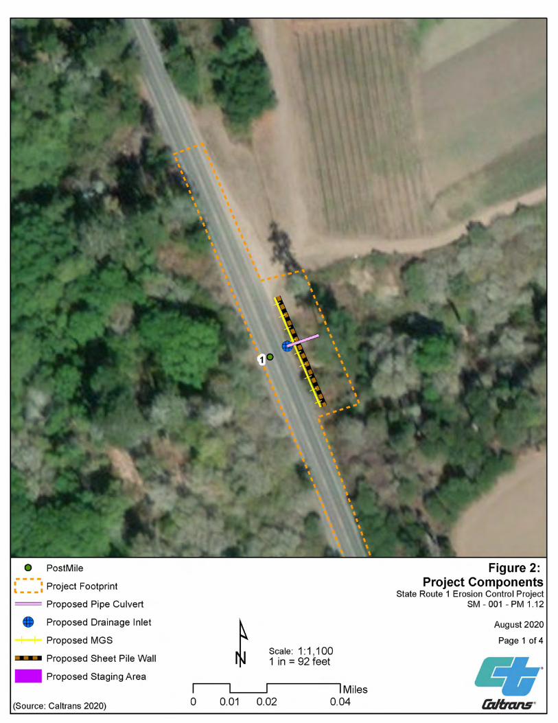
Chapter 1. Introduction
17 SR-1 Erosion Control Project Natural Environment Study
Figure 2- Project Components Map
Chapter 1. Introduction
18 SR-1 Erosion Control Project Natural Environment Study

Chapter 1. Introduction
19 SR-1 Erosion Control Project Natural Environment Study

Chapter 1. Introduction
20 SR-1 Erosion Control Project Natural Environment Study

Chapter 1. Introduction
21 SR-1 Erosion Control Project Natural Environment Study
1.5.1 Interrelated and Interdependent Actions The proposed project is not a part of any larger federal actions, and no other projects have been identified in the project vicinity that would be dependent upon completion of the proposed project for their implementation. The proposed project is not a growth-inducing action, and it is not anticipated to result in an increase in vehicular traffic or any new development. Therefore, no interrelated or interdependent actions need to be analyzed to delineate the extent of the action area or as part of the proposed project. Interdependent actions have no independent utility apart from the project (50 CFR Section 402.02).

Chapter 2. Study Methods
22 SR-1 Erosion Control Project Natural Environment Study
Chapter 2. Study Methods
To prepare this NES, Caltrans and consultant biologists reviewed various databases, historical records, and other scientific literature to develop the environmental baseline for the area of the proposed Project. Technical assistance also was requested from federal resource agencies. A BSA was determined prior to conducting field studies. The BSA includes the area within the Project footprint plus the additional survey area necessary to assess existing natural resources and identify the following:
• Plant community and habitat types
• Potential wetlands
• Potential presence of special-status species
• Need for more extensive or protocol-level surveys
2.1 Regulatory Requirements
Project implementation would affect assets and/or natural resources under the jurisdiction of the following regulatory agencies:
• USFWS (Sacramento and Ventura District Offices)
• California Coastal Commission
Federal regulatory requirements and laws that apply to the proposed Project include the following:
• National Environmental Policy Act (42 U.S. Code [U.S.C.] § 4321)
• Federal Endangered Species Act (FESA) (16 U.S.C. § 1531)
• Clean Water Act, Sections 401 (33 U.S.C. 1341) and 404 (33 U.S.C § 1344)
• Migratory Bird Treaty Act (16 U.S.C. § 703-712)
• Magnuson-Stevens Act (16 U.S.C. § 1801-1884)
• Bald and Golden Eagle Protection Act (16 U.S.C. § 668 et seq.)
• Executive Order 11990 (Protection of Wetlands) (42 Code of Federal Regulations [CFR] 26921)
• Executive Order 13112 (Invasive Species) (64 CFR 6183)
State regulatory requirements and laws that apply to the proposed Project include the following:
• California Environmental Quality Act (CEQA) (Public Resources Code § 21000 et seq.)
• California Endangered Species Act of 1984 (CESA) (F.G.C. § 2050 et seq.)
• Native Plant Protection Act of 1977 (F.G.C. §§ 1900-1913)
• Lake and Streambed Alteration Agreement (F.G.C. §§ 1600-1616)
• Protection of Migratory Birds (F.G.C. § 3503, 3515, and 3800)
• State Senate Bill 857 (fish passage) (F.G.C. § 5901)

Chapter 2. Study Methods
23 SR-1 Erosion Control Project Natural Environment Study
2.2 Database and Literature Review
Project biologists conducted a query of the 7.5-minute USGS topographic quadrangle in which the action area occurs (Point Año Nuevo) and the five surrounding quadrangles (six-quad search). The standard nine-quad search was shortened to six because three of the quads are in the Pacific Ocean. The six quads include: Pigeon Point (37122-B4), Franklin Point (37122-B3), Big Basin (37122-B2), Año Nuevo (37122-A3), Davenport (37122-A2), and Santa Cruz OE W (36122-H2). Project biologists also conducted a literature review to consider the potential presence of various listed species and their habitats in the action area, including sources to determine the species range, habitat, and life history; and to assess the potential for each species to occur in the action area. These investigations identified all listed species either known or with potential to occur in and around the action area. The following sources were used:
• The official species list from the Sacramento and Ventura Offices’ of the United States Fish and Wildlife Service generated using their Information, Planning and Conservation System (IPaC) (USFWS 2020; Appendix B-1).
• The official species list obtained from the National Marine Fisheries Service (NMFS) for the six aforementioned USGS quads (Appendix B-2).
• The California Natural Diversity Database (CNDDB) RareFind 5 State Listed occurrence records within two miles of the action area (CDFW 2020) (Figure 7); Special-Status species (CRPR or Fed./State Listed) for the six aforementioned USGS quads (Appendix B-3).
• USFWS designated critical habitat mapper (USFWS 2020a) (Figure 6).
In addition, the literature search included a review of National Wetland Inventory (NWI) (USFWS 2020b), and Natural Resources Conservation Service (NRCS) Soil Survey (Soil Survey Staff 2020) maps. Ground-based photographs, aerial imagery, and existing commercial and regulatory agency resources such as the California Fish Passage Assessment Database (CDFW 2020), CDFW Wildlife Habitat Relationships System, and the Federal Register and recovery plans for selected species) were utilized to assess the potential for species to occur in the BSA.
2.3 Technical Studies
Various studies were conducted in the preparation of this NES. Studies included surveys of protected resources and special-status species; these are described in the following subsections.
2.4 Site Reconnaissance and Personnel Caltrans biologists Grant Samaniego and Jeff Lemire conducted site reconnaissance on June 12, 2020. Subsequent field surveys were conducted by Grant Samaniego, Jeff Lemire, Elizabeth Leyvas, and Sara Moss on multiple dates in July and September 2020 (Table A-2). The surveys were conducted to assess potential for rare plants and to determine presence of jurisdictional wetlands. It was determined that

Chapter 2. Study Methods
24 SR-1 Erosion Control Project Natural Environment Study
hydrophytic vegetation, hydric soils, and wetland hydrology was not present within the Project footprint, and Cold Dip Creek is the only jurisdictional water within the BSA.
All plant species encountered during the botanical survey were identified to the extent necessary to determine if they met the criteria as a federal- or state-listed rare, threatened, or endangered species per FESA, CESA, or CNPS. The survey report, which includes the pertinent plant list, is included in Appendix C.
Table A-2 Survey Dates and Personnel Survey Type Date(s) Objective Personnel Biological Reconnaissance Survey
June 12, 2020 Initial site assessment, wetlands, waters, and rare plant assessment (RPS)
Grant Samaniego, Kara Gonzalez, Fadwa Bouhedda, and Jeff Lemire (Caltrans)
Tree Survey and Rare Plant Survey
July 2, 2020 Wetlands, waters, and RPS
Grant Samaniego Jeff Lemire (Caltrans)
Wetlands, Waters, and Species Identification
July 22, 2020 Additional site assessment for wetlands, and ID for extant fauna
Grant Samaniego and Elizabeth Leyvas (Caltrans)
USFWS Personnel Site Meeting
July 29, 2020 Project features discussion and tadpole ID
Grant Samaniego and Sara Moss (Caltrans) Meghan Bishop (USFWS)
Habitat Assessment and Species Idenitification
September 24, 2020 Outer BSA habitat assessment and RPS for later stage blooming species
Grant Samaniego and Sara Moss (Caltrans)
2.5 Agency Coordination and Professional Contacts
• Grant Samaniego, Caltrans biologist, initiated an informal consultation with Ziad Bawarshi and Joanne Kerbavaz, State Park Rangers, from California Department of Parks and Recreation (CDPR)
• Grant Samaniego, Caltrans biologist, initiated technical assistance from Meghan Bishop from USFWS in June 2020
• Biological Assessment (BA) was submitted to Meghan Bishop on 10/21/2020
• Due to workload leveling the Section 7 consultation was being transferred to John Cleckler from USFWS on 10/28/2020
• Was informed on 10/30/2020 that to date no questions regarding the BA were requested and that the Biological Opinion (BO) was being drafted
• Grant Samaniego, consultation to be initiated with USACE as PS&E approaches.

Chapter 2. Study Methods
25 SR-1 Erosion Control Project Natural Environment Study
2.6 Limitations and Assumptions that may Influence Results Due to steep slopes and dangerous conditions, some areas were inaccessible during the surveys. In these areas, binoculars, online databases, and aerial imagery were used for analyses. No protocol-level surveys for special status species were conducted. Presence of California red-legged frogs and San Francisco garter snakes was inferred due to: the proximity of water bodies, suitable dispersal habitat, critical habitat, and CNDDB occurrences.

Chapter 3. Environmental Setting
26 SR-1 Erosion Control Project Natural Environment Study
Chapter 3. Environmental Setting
This chapter provides a description of the BSA and its physical and biological conditions.
3.1 Biological Study Area The Project is in San Mateo County, California, located at PM 1.12 on a highway embankment off SR-1 overlooking the Año Nuevo State Park (Figure 1), 1.1 mile north of the Santa Cruz County line. The Project is located within the Caltrans right-of-way and within the Año Nuevo USGS 7.5-minute topographic quadrangle.
The project footprint is located 1.1 miles north of the Santa Cruz County line over the culverted Cold Dip Creek.
The following terms have been used to describe the Project:
• Project area/Project footprint: The Project limits, also referred to as the Project area or the Project footprint, is defined as the entire area of direct and indirect impacts from the Project, including the areas within the Caltrans right-of-way. Indirect impacts, such as siltation downstream from construction disturbance, can sometimes occur, but as discussed in Section 4.4.1.3, Project Impacts, potential indirect impacts would be avoided through the use of BMPs.
• Biological Study Area: The BSA established for the Project encompasses the Project limits with a 350-foot buffer.
The BSA includes the currently active highway road prism, developed bare ground, Monterey pine/riparian, pasture/grazing land, coastal bluff scrub, non-native/ disturbed areas, agricultural areas, and coastal beach (Figure 3). The BSA is in the Santa Cruz Mountains subsection of the Central California Coast ecological subregion (Miles and Goudey 1997).
3.2 Physical and Biological Conditions in the Biological Study Area
The project footprint is 2.62 acres and the action area is 45.4 acres located on the highway embankment of SR-1 overlooking Año Nuevo State Park. The project falls within the Año Nuevo USGS 7.5-minute topographic quadrangle (quad) at 37° 7'11.08"N and 122°18'18.90"W per the World Geodetic System 1984 geodetic datum (WGS84). The township and range is 9S and 4W, section 28 of the Mount Diablo meridian. The accessor parcel number (APN) east and west are 089230420 and 089230470 and are owned by Coastways Ranch Inc. and State of California, respectively.
3.3 Climate and Topography The region has a coastal Mediterranean climate with dry, mild summers and cool moist winters with an average of 3.9 inches of rain in the winter. The area experiences an average high of 78 degrees Fahrenheit (°F) in the hottest month and an average low of 45 °F on the coldest month. About 80 percent of annual rainfall is from October to April, ranging from 1 inch to 4.3 inches. Amounts less than one inch occur from May to September (Meteoblue 2020).

Chapter 3. Environmental Setting
27 SR-1 Erosion Control Project Natural Environment Study
The action area ranges from a height of approximately 105 feet at the highest point on the road down to about 69 feet at the creek bed of Cold Dip Creep. The work will take place from about 105 feet down to roughly 85 feet situated on the washout east of the highway. Cold Dip Creek runs east to west and is culverted approximately 50 feet below the roadway. The culvert opens to Cold Dip Creek about 80 feet from the edge of pavement on the west side of SR-1. The staging area consists of a partial-pavement and partial-soil vehicle pull-out area surrounded by a mixture of ruderal grasses and non-native ice plant, as well as some native plant species such as: Monterey pine and coyote brush.
3.3.1 Wetlands and Water Features Cold Dip Creek is the only water feature present within the action area. There is an existing down drain within the proposed footprint. With the implementation of Caltrans Standard BMP’s, no impacts to jurisdictional wetlands, waters, or riparian areas will occur as a result of the proposed action.
3.3.2 Soils Soil types in the AA were identified based on information received from the United States Department of Agriculture’s Natural Resource Conservation Service (NRCS) Web Soil Survey. Soild types that occur within the AA in the order of descending area are: Lockwood loam, Watsonville loam, Santa Lucia loam, Walker, Terrace escarpments, Colma loam, and Coastal beaches. The soil types found directly in the project footprint are: Watsonville loam (45%), Lockwood loam (29%), Santa Lucia loam (26%), these classifications all have varying sloping properties at 6-16%, 45-75%, and 2-5%, respectively (Figure 3). Watsonville loam is typically associated with terrace landforms and contains loam from 0 to 15 inches, clay from 15 to 40 inches, and sandy clay loam from 40 to 60 inches from the surface. This soil classification is known to occur from 50 to 140 feet elevation above sea level (NRCS 2020).
Lockwood loam is made from alluvial sediments and typically contains loam at depths from 0 to 20 inches and clay loam from 20 to 60 inches from the surface (NRCS 2020). It is a well-drained soil with low to high runoff and moderately slow permeability. Associated vegetation includes annual grasses, forbs, scattered oak, and brush (USDA 2020).
Santa Lucia loam is associated with very steep and eroded lands. Bedrock is only 24 to 28 inches deep in this soil type (USDA 2020). There will be no digging in areas of Santa Lucia loam.

Chapter 3. Environmental Setting
28 SR-1 Erosion Control Project Natural Environment Study
Figure 3- Soils Map

Chapter 3. Environmental Setting
29 SR-1 Erosion Control Project Natural Environment Study
Figure 4- Vegetation Map

Chapter 3. Environmental Setting
30 SR-1 Erosion Control Project Natural Environment Study
3.3.3 Vegetation The project footprint is primarily composed of coastal scrub habitat, pines, and paved, barren, or ruderal areas (Figure 4). Species include invasive non-natives such as highway iceplant (Carpobrotus edulis), Italian thistle (Carduus pycnocephalus), and blowfly grass (Briza maxima). Despite the fact that Cold Dip Creek runs through the site, riparian vegetation consists predominantly of low-growing riparian plants such as poison oak (Toxicodendron diversilobum) and California blackberry (Rubis ursinus), while the majority of surrounding vegetation is coastal scrub, Monterey pine forest, and ruderal non-native plants.
3.3.4 Wildlife Use and Habitat Connectivity Critical habitat for the CRLF completely encompasses the Project footprint.
Common wildlife species that have been documented via wildlife camera traps or physical sightings using the coastal scrub, Monterey pine, and ruderal vegetation in the BSA include relatively disturbance-tolerant species, such as the North American raccoon (Procyon lotor), Stellar’s jay (Cyanocitta stellari), woodrats (Neotoma sp.), bumblebees (Bombus sp.), and turkey vultures (Cathartes aura). An array of other animals may use the area commonly but have not been documented in this specific location.
Despite lacking concrete barriers, the existing roadway on SR-1 acts as a barrier to species dispersal either directly through vehicular mortality or indirectly through population fragmentation or isolation. However, the proposed project will not further exacerbate or otherwise impact connectivity or wildlife movement.
3.4 Listed and Proposed Species Potentially in the Action Area
Tables 1 and 2 identify the special-status plant and wildlife species, respectively, included on the CNDDB, USFWS, and CNPS lists that have the potential to occur in the BSA based on the USGS 7.5-minute quadrangle map that encompasses the BSA (Ano Nuevo) and the five adjacent quadrangles (Pigeon Point, Franklin Point, Big Basin, Davenport, and Santa Cruz). See Figures 5 and 7 for locations of CNDDB occurrences of these species within a 2-mile radius of the BSA. A complete list of species from the database searches is provided in Appendix C.
Special-status plant species identified in Table 1 were evaluated for their potential to occur within the BSA. These plant species either were eliminated from further consideration based on the absence of suitable habitat characteristics within the Project footprint and/or were not found during plant surveys. As mentioned in the Wetland Plant Memo (see Appendix D), no federally listed or rare plants were identified within the BSA.
Special-status wildlife species listed in Table 2 were evaluated for their potential to occur within the BSA and Project footprint. A species was determined absent from the Project footprint if: (1) no suitable habitat was identified in the Project footprint; and (2) the Project footprint was found to be outside of the species’ range.

Chapter 3. Environmental Setting
31 SR-1 Erosion Control Project Natural Environment Study
Special-status species that have the potential or are known to occur in the BSA, based on the field surveys and database reviews, are given further consideration in Chapter 4. These include the following individual species:
• California red-legged frog (CRLF) (Rana draytonii), FT
• San Francisco garter snake (SFGS) (Thamnophis sirtalis tetrataenia), FE
• Marbled murrelet (Brachyramphus marmoratus), FT
• San Francisco dusky-footed woodrat (Neotoma fuscipes annectens), California species of special concern
• Western snowy plover (Charadrius nivosus nivosus), FT
• Monterey pine (Pinus radiata), 1B.1

Chapter 3. Environmental Setting
32 SR-1 Erosion Control Project Natural Environment Study
Table 1: Special-Status Plant Species Habitat Assessment Table
Floral Resources
Common Name, Scientific Name
Order/ Family
Conservation Status
Habitat
Bloom Period Habitat
Present? Potential to Occur FESA CESA CNPS
White-rayed Pentachaeta, Pentachaeta bellidiflora
Asterales/ Asteraceae FE SE 1B.1
Cismontane woodland, valley and foothill grassland (often serpentinite). 114-2034 feet
elevation. According to USFWS (2010) the only extant population is in San Mateo County.
Mar-May
N
No potential to occur. Incompatible elevational
profile in BSA.
Santa Cruz Tarplant, Holocarpha macradenia
Asterales/ Asteraceae FT SE 1B.1
Often clay/ sandy. Coastal prairie, Coastal scrub, Valley and Foothill grassland. 30-720 feet.
Jun-Oct
Y
Potential to occur. Compatible habitat and substrate in BSA. Rare
plant surveys will ensure no effects from project
activities.
Santa Cruz microseris,
Stebbinsoseris decipiens
Asterales/ Asteraceae - - 1B.2
In open areas, on sandy, shaly, or serpentine substrates. Found within a variety of plant communities, including
Closed-cone coniferous forest, broad-leafed upland forest, chaparral, coastal scrub, coastal prairie, and
foothill grassland. 32-1640 feet elevation.
Apr-May
Y
Potential to occur within BSA but incompatible
substrate within Footprint. No impacts.
Short-leaved evax, Hesperevax
sparsiflora var. brevifolia
Asterales/ Asteraceae - - 1B.2
bluff scrub (sandy), dune, and prairies in coastal settings. < 705 feet elevation. Presumed extirpated in
SF County.
Mar-Jun
N
No potential to occur. Incompatible substrate
in BSA.
Chaparral ragwort (=California
Asterales/ Asteraceae - - 2B.2
Foothill woodland, northern coastal scrub, coastal sage scrub, chaparral. 49-2625 feet elevation.
Jan-Apr (May)
Y
Potential to occur. Compatible habitat in
BSA. Rare plant surveys

Chapter 3. Environmental Setting
33 SR-1 Erosion Control Project Natural Environment Study
groundsel), Senecio aphanactis
will ensure no effects from project activities.
Franciscan Thistle, Cirsium andrewsii
Asterales/ Asteraceae - - 1B.2
Broad-leafed upland forest, coastal bluff scrub, coastal prairie, coastal scrub. Often in mesic, sometimes
serpentinite conditions. < 492 feet.
Mar-Jul
Y
Potential to occur. Compatible habitat in
BSA. Rare plant surveys will ensure no effects
from project activities.
Marsh microseris (Marsh silverpuffs), Microseris paludosa
Asterales/ Asteraceae - - 1B.2
Grassy, often moist to wet, areas, usually on slopes; also, in wooded, often open wood, areas and on the edge of brush. Rarely found in vernal pool or dune
areas. Found within northern coastal scrub, closed-cone pine forest, valley and foothill grassland, and
cismontane woodland communities. 0-984 feet.
Apr-Jun(Jul)
Y
Potential to occur. Compatible habitat in
BSA. Rare plant surveys will ensure no effects
from project activities.
Perennial goldfields, Lasthenia californica
(=macrantha) ssp. macrantha
Asterales/ Asteraceae - - 1B.2
Coastal bluff scrub, coastal dunes, coastal scrub. < 1640 feet.
Jan-Nov
Y
Potential to occur. Compatible habitat in
BSA. Rare plant surveys will ensure no effects
from project activities.
Woodland woollythreads
(Woodland monolopia),
Monolopia gracilens Asterales/ Asteraceae - - 1B.2
Often grows in serpentine soils within, grasslands, chaparral, woodland and other similar ecosystems.
(Feb) Mar-Jul
Y
Potential to occur. Compatible habitat in
BSA. Rare plant surveys will ensure no effects
from project activities.
San Francisco popcornflower, Plagiobothrys
diffusus Boraginales/ Boraginaceae - SE 1B.1
Coastal prairie, valley and foothill grassland. 98-1181 feet elevation. Presumed extirpated in SF County.
Mar-Jun
N
No potential to occur. Incompatible habitat in
BSA.
Sand-loving wallflower, Erysimum
ammophilum Brassicales/ Brassicaceae - - 1B.2
Chaparral, coastal dunes, and coastal scrub; on sandy substrates in open areas.
Feb-Jun
N
No potential to occur. Incompatible substrate
in BSA.

Chapter 3. Environmental Setting
34 SR-1 Erosion Control Project Natural Environment Study
Santa Cruz wallflower, Erysimum
teretifolium Brassicales FE SE 1B.1
Inland marine sand, chaparral, and lower montane coniferous forest. Restricted to pockets of sandstone-derived coarse sandy soils. Uplifted ancient marine terraces persisting in a mountain range of volcanic
origin.
Mar-Jul
N
No potential to occur. Incompatible substrate
in BSA.
Ben Lomond Spineflower,
Chorizanthe pungens var. hartwegiana Caryophyllales FE - 1B.1
Forest/ woodlands. Conifer forests. Restricted to pockets of sandstone-derived coarse sandy soils. Uplifted ancient marine terraces persisting in a
mountain range of volcanic origin.
-
N
No potential to occur. Incompatible substrate
in BSA.
Marsh Sandwort, Arenaria paludicola
Caryophyllales/ Caryophyllaceae FE SE 1B.1
Marshes, swamps, and areas with perpetual water. Commonly found alongside reeds, cattails, rushes, and
bulrushes. 10-558 feet elevation.
May-Aug
Potential to occur. Compatible habitat is present in BSA; rare
plant surveys will ensure no effects from project activities. No CNDDB
occurrences within BSA.
robust spineflower, Chorizanthe robusta
var. robusta Caryophyllales/ Polygonaceae FE - 1B.1
Any chaparral (maritime), cismontane woodland (openings), coastal dune/ scrub with sandy soils along
coastal California. 10-984 feet elevation.
Apr-Sep
N
No potential to occur. Incompatible substrate
in BSA.
Santa Cruz Mountains pussypaws,
Calyptridium parryi var. hesseae
Caryophyllales/ Montiaceae - - 1B.1
Sandy soils in chaparral, oak woodland, conifer forest; 2,132-3,444 feet elevation.
May-Aug
N
No potential to occur. Incompatible substrate
in BSA.
San Francisco campion, Silene verecunda ssp.
verecunda Caryophyllales
Caryophyllaceae - - 1B.2
Coastal bluff scrub, chaparral, coastal prairie, coastal scrub, valley and foothill grassland. Most commonly in
sandy substrate. 98-2116 feet.
(Feb)Mar-Jun(Aug)
N
No potential to occur. Incompatible elevational
profile in BSA.
Scouler's catchfly, Silene scouleri ssp.
scouleri Caryophyllales/ Caryophyllaceae - - 2B.2
Coastal bluff scrub, coastal prairie, valley and foothill grassland. < 1969 feet.
(Mar-May)Jun-Aug(Sep) Y
Potential to occur. Compatible habitat in
BSA. Rare plant surveys

Chapter 3. Environmental Setting
35 SR-1 Erosion Control Project Natural Environment Study
will ensure no effects from project activities.
Anderson's (=Santa Cruz)
manzanita, Arctostaphylos
andersonii Ericales/ Ericaceae - - 1B.2
Mixed and conifer forests as well as shrubland/ chaparral.
Nov-May
Y
Potential to occur. Compatible habitat in
BSA. Rare plant surveys will ensure no effects
from project activities.
Kings Mountain Manzanita,
Arctostaphylos regismontana
Ericales/ Ericaceae - - 1B.2
Broad-leafed upland forest, chaparral, north coast coniferous forest; granitic or sandstone substrates.
Dec-Apr
N
No potential to occur. Incompatible elevational
profile in BSA.
Bonny Doon manzanita,
Arctostaphylos silvicola
Ericales/ Ericaceae -` - 1B.2
Forest/ woodland, shrubland/ chaparral, conifer woodland. Inland marine sands in chaparral and
ponderosa pine woodlands; sandy substrate.
Jan-Mar
N
No potential to occur. Incompatible substrate within Footprint. No
impacts.
Ohlone manzanita, Arctostaphylos
ohloneana Ericales/ Ericaceae - - 1B.1
Closed-cone coniferous forest, and coastal scrub; siliceous shale substrate.
Feb-Mar
N
No potential to occur. Incompatible elevational
profile within BSA.
Coastal marsh milkvetch, Astragalus
pycnostachyus var. pycnostachyus Fabales - - 1B.2
Coastal dunes (mesic), coastal scrub, marshes and swamps (coastal salt, streamsides)
(Apr)Jun-Oct
Y
Potential to occur. Compatible habitat in
BSA. Rare plant surveys will ensure no effects
from project activities.
Pacific Grove clover, Trifolium polyodon Fabales/ Fabaceae - SR 1B.1
Closed-cone coniferous forest, coastal prairie, meadows and seeps, valley and foothill grassland; mesic
environments occasionally on granitic substrates.
Apr-Jun(Jul)
Y
Potential to occur within BSA but habitat lacking
within Footprint.
Santa Cruz clover, Trifolium
buckwestiorum Fabales/ Fabaceae - - 1B.1
Broad-leafed upland forest, cismontane woodland, coastal prairie. Most occurrences in grassy areas; often in damp places such as wet drainages near roads and
shallow depressions.
Apr-Oct
Y
Potential to occur. Compatible habitat in
BSA. Rare plant surveys

Chapter 3. Environmental Setting
36 SR-1 Erosion Control Project Natural Environment Study
will ensure no effects from project activities.
Toren’s grimmia, Grimmia torenii Grimmiaceae - - 1B.3
Chaparral, cismontane woodland, and lower montane coniferous forest; in openings with rocky, boulder and
rockwalls.
N/A
N
No potential to occur. Incompatible habitat in
BSA.
Vaginulate grimmia, Grimmia vaginulata Grimmiaceae - - 1B.1 Chaparral; rocky, boulder and rock walls.
N/A
N
No potential to occur. Incompatible habitat features within BSA.
Point Reyes meadowfoam,
Limnanthes douglasii ssp. sulphurea Limnanthaceae - SE 1B.2
Coastal prairie, meadows and seeps (mesic), marshes and swamps (freshwater), vernal
pools
Mar-May
N
No potential to occur. Incompatible habitat in
BSA.
Tear drop moss, Dacryophyllum
falcifolium Hypnales - - 1B.3 Known from "vertical surfaces of shaded, calcareous
rock cliffs and rock outcrops in redwood forests
N/A
N
No potential to occur. Incompatible habitat
within BSA.
Choris' popcornflower, Plagiobothrys
chorisianus var. chorisianus
Lamiales (poss. Δ Boraginales)/ Boraginaceae - - 1B.2
Grassy, mesic environments, ephemeral drainages, coastal scrub, chaparral; elevation < 2132 feet.
Mar-Jun
Y
Potential to occur. Compatible habitat in
BSA. Rare plant surveys will ensure no effects
from project activities.
bent-flowered fiddleneck,
Amsinckia lunaris Lamiales/
Boraginaceae - - 1B.2
Open, sometimes moist, wooded slopes within foothill/ cismontane woodland and valley grassland
communities. 10-1,650 feet elevation.
Mar-Jun
Y
Potential to occur. Compatible habitat in
BSA. Rare plant surveys will ensure no effects
from project activities.
San Francisco collinsia, Collinsia
multicolor Lamiales/
Plantaginaceae - - 1B.2
northern coastal scrub, closed-cone pine forest. Occasionally occurs on serpentine soils. 98-820 feet
elevation.
(Feb) Mar-May
Y
Potential to occur within BSA but incompatible
elevational profile within Footprint. No
impacts.

Chapter 3. Environmental Setting
37 SR-1 Erosion Control Project Natural Environment Study
Fragrant fritillary, Fritillaria liliacea Liliales/ Liliaceae - - 1B.2
Open grassy hills and fields near the coast, often in heavy clay soil, sometimes on serpentine substrates.
Sometimes occurs in/ near claypan vernal pools. Found within coastal prairie, valley grassland, northern coastal scrub, and cismontane woodland communities. 0- 656
feet elevation.
Feb-Apr
Y
Potential to occur. Compatible habitat in
BSA. Rare plant surveys will ensure no effects
from project activities.
Arcuate bush-mallow,
Malacothamnus arcuatus
Malvales/ Malvaceae - - 1B.2
Chaparral and Cismontane woodlands. 49-1164 feet elevation.
Apr-Sep
Y
Potential to occur. Compatible habitat in
BSA. Rare plants surveys will ensure no
effects from project activities.
Slender-leaved pondweed, Stuckenia filiformis ssp. alpina
Najadales/ Potamogetonacea
e - - 2B.2 Marshes and swamps (assorted shallow freshwater)
May-Jul
Y
Potential to occur within BSA but habitat lacking in Footprint. No impacts.
White-flowered rein orchid (White
piperia), Piperia candida Orchidales - - 1B.2
Broadleafed upland forest, lower montane coniferous forest, and North Coast coniferous forest; sometimes on
serpentinite substrates.
(Mar) May-Sep
Y
Potential to occur. Compatible habitat in
BSA. Rare plant surveys will ensure no effects
from project activities.
Kellman’s bristle moss, Orthotrichum
kellmanii Orthotrichaceae - - 1B.2 Chaparral and cismontane woodland on sandstone and
carbonate substrates.
Jan-Feb
N
No potential to occur. Incompatible substrate
in BSA.
Monterey pine, Pinus radiata Pinales/ Pinaceae - - 1B.1
Closed-cone coniferous forest and cismontane woodlands.
N/A
Y
Occurs within BSA but not within Footprint.
Will not be impacted by project activities.
Santa Cruz Cypress, Hesperocyparis abramsiana var.
abramsiana Pinales FT SE 1B.2
Sandstone or granitic. Closed-cone coniferous forest, chaparral, and lower montane coniferous forest. 1000-
2500 feet elevation.
N/A
N
No potential to occur. Incompatible elevational
profile in BSA.

Chapter 3. Environmental Setting
38 SR-1 Erosion Control Project Natural Environment Study
Butano Ridge cypress
Hersperocyparis ambramsiana var.
butanoensis FT SE 1B.2
Closed-cone coniferous forest, Chaparral, and lower montane coniferous forest. Occurs on
sandstone.
Oct
N
No potential to occur. Incompatible substrate
in BSA.
Blasdale's bent grass (cliff bentgrass),
Agrostris blasdalei Poales
(Cyperales) - - 1B.2 Coastal bluff, coastal dune, and coastal prairie habitats.
May-Jul
Y
Potential to occur. Compatible habitat within BSA but not
Footprint. No Impacts.
Ben Lomond's buckwheat,
Eriogonum nudum var. decurrens Polygonales - - 1B.1
Found in plant communities including, chaparral, foothill woodland, and yellow pine forests, all within
coastal settings; sandy substrates.
Jun-Oct
N
No potential to occur. Incompatible substrate
within BSA.
Kellogg's horkelia, Horkelia cuneata
var. sericea Rosales/ Rosaceae - - 1B.1
Closed-cone coniferous forest, chaparral (maritime), coastal scrub, sandy or gravely soil, openings. Old
dunes, coastal sandhills: Elevation generally < 656 feet elevation.
Apr-Sep
Y
Potential to occur. Compatible habitat in
BSA. Rare plant surveys will ensure no effects
from project activities.
Point Reyes horkelia, Horkelia marinensis
Rosales/ Rosaceae - - 1B.2
Sandy coastal flats and dunes, within coastal strand, coastal prairie, and northern coastal scrub communities.
16-1148 feet elevation.
May-Sep
Y
Potential to occur. Compatible habitat in
BSA. Rare plant surveys will ensure no effects
from project activities.
Pine rose, Rosa pinetorum
Rosales/ Rosaceae - - 1B.2
Closed-cone coniferous forest, and cismontane woodlands.
May, Jul
Y
Potential to occur within BSA but habitat lacking
within Footprint. No impacts.
Dudley’s lousewort, Pedicularis dudleyi
Lamiales/ Orobanchaceae - SR 1B.2
Chaparral (maritime), cismontane woodland, north Coast coniferous forest, valley and
foothill grassland.
Apr-Jun
Y
Potential to occur. Compatible habitat in
BSA. Rare plant surveys

Chapter 3. Environmental Setting
39 SR-1 Erosion Control Project Natural Environment Study
will ensure no effects from project activities.
Santa Cruz Mountains
beardtongue, Penstemon rattanii
var. kleei Scrophulariales/ Plantaginaceae - - 1B.2
Redwood, hardwood forests, Open woodland and chaparral, disturbed field near roadside. 1312-1968 feet
elevation.
May-June
N
No potential to occur. Incompatible elevational profile
within BSA.
Rose leptosiphon, Linanthus rosaceus
Solanales/ Polemoniaceae - - 1B.1
Coastal bluff scrub. < 328 feet elevation. Presumed extirpated in SF County.
Apr-Jul
Y
Potential to occur. Compatible habitat in
BSA. Rare plant surveys will ensure no effects
from project activities. California Native Plant Society (CNPS) California Rare Plant Rank: (1A) Presumed extinct in California, (1B) Rare, threatened, or endangered in California and elsewhere; (2) Rare, threatened, or endangered in California, but more common elsewhere; (3) More information is needed; (4) Limited distribution, watch list Threat Rank: 0.1 Seriously threatened in California (more than 80% of occurrences threatened / high degree of immediacy of threat) 0.2 Fairly threatened in California (20% to 80% occurrences threatened / moderate degree of immediacy of threat) 0.3 Not very threatened in California (less than 20% of occurrences threatened / low degree and immediacy of threat or no current threats known) California Department of Fish and Wildlife (CDFW) Listed Plant Designations: (SE) State Listed - Endangered, (ST) State Listed - Threatened, (SR) State Listed - Rare, (SC) State Candidate for Listing United States Fish and Wildlife Service (USFWS) Listed Plant Designations: (FE) Federally Listed - Endangered, (FT) Federally Listed - Threatened, (FPE) Federally Proposed - Endangered, (FPT) Federally Proposed - Threatened, (FC) Federal Candidate for Listing

Chapter 3. Environmental Setting
40 SR-1 Erosion Control Project Natural Environment Study
Table 2: Special-Status Species Habitat Assessment Table
Faunal Resources Scientific
Name Common
Name USFWSa/CDFW
b General Habitat Micro-Habitat Potential to Occur
Potential Effects to
Listed Species
Fishes
Acipenser medirostris
green sturgeon [sDPS]
FT Majority of life spent in marine waters, estuaries, , and large rivers. Reproductive strategy is anadromous, but specifics are poorly understood by modern science.
Lower reaches of large rivers. None. No suitable habitat within BSA.
No Effect.
Eucyclogobius newberryi
tidewater goby
FE Lagoons, estuaries, backwater marshes, and freshwater tributaries to estuarine environments that closely correspond to major stream drainages.
They generally select habitat in the upper estuary, usually within the freshwater-saltwater interface. Typically found in salinities of less than 12 parts per thousand such as in the upper edge of tidal bays or in coastal lagoons formed at the mouths of coastal rivers.
None. No potential to occur in action area. Cold Dip Creek is markedly ephemeral and is dry except immediately following pronounced rain events.
No Effect
Hypomesus transpacificus
Delta smelt FT Delta smelt require specific environmental conditions (freshwater flow, water quality) and habitat types (shallow open waters) within estuary for migration, spawning, egg incubation, rearing, and larval and juvenile transport from spawning to rearing habitats.
They can tolerate a wide range of salinities but are rarely found in water with more than 10 to 12 parts per thousand salinity.
None. Suitable habitat is not present within the BSA.
No Effect

Chapter 3. Environmental Setting
41 SR-1 Erosion Control Project Natural Environment Study
Oncorhynchus kisutch
Coho salmon-Central California Coast ESU/critical habitat
FE/SE Constructs nests in cobble substrates of cool streams that reach the ocean and contain shallow, partly shaded pools, riffles, and runs.
Optimal growth occurs at 12 to 14°C and Coho salmon fail to survive in streams where the temperature exceeds 22 to 25°C for extended periods of time. Juvenile Coho salmon prefer pools and usually begin to favor higher stream velocities as they get older, occupying the midstream and stream margin areas.
None. Suitable habitat is not present within the BSA. The closest known occurrence is over 2.2 miles south of BSA in Waddell Creek, which does have suitable habitat (CDFW 2020). There is no connectivity to Cold Dip Creek east of SR-1 due to obstructions associated with cross-highway culvert. Final Designated Critical Habitat exists at Año Nuevo Creek but fish passage barriers exist at SR-1 precluding entry onto eastern portion of Cold Dip Creek.
No Effect. No Impact.
Oncorhynchus mykiss irideus [pop. 8]
Steelhead – Central California Coast DPS
FT From Russian River, south to Soquel Creek and to, but not including, Pajaro River.
Also San Francisco and San Pablo Bay basins.
None. Four CNDDB-documented occurrences within a 5-mile radius. Closest one is 2.2 miles south in Waddell Creek (CDFW 2020). Habitat absent within project footprint. There is no connectivity to Cold Dip Creek east of SR-1 due to obstructions associated with cross-highway culvert. Final Designated Critical Habitat exists at Año Nuevo Creek but fish passage barriers exist at SR-1 precluding entry onto eastern portion of Cold Dip Creek.
No Effect
Spirinchus thaleichthys
longfin smelt
C/ ST Longfin smelt are pelagic, estuarine anadromous species that can tolerate a wide range of salinities.
Most of their lifecycle is completed in brackish to marine waters, with most post-larval fish in the San Francisco Bay-Delta DPS found in salinities from 15 to 30 psu.
None. Suitable habitat is not present within the BSA. The closest known occurrence is 2.2 miles south of BSA in Waddell Creek, which does have suitable habitat (CDFW 2020).
No Effect. No Impact.
Amphibians

Chapter 3. Environmental Setting
42 SR-1 Erosion Control Project Natural Environment Study
Ambystoma californiense
California tiger salamander
FE/ST Uses ground-squirrel burrows and vernal pools or other seasonal water sources for breeding.
Populations in Sonoma County, needs underground refugia.
Low. No breeding or estivation habitat present in the BSA.
No Effect. No Impact.
Aneides niger Santa Cruz black salamander
SSC Occurs in mixed deciduous woodland, coniferous forests, and coastal grasslands.
Often found under rocks near streams, in talus, under damp logs and other objects.
Low. No breeding or estivation habitat present in the BSA.
No Impact.
Dicamptodon ensatus
California giant salamander
SSC Adults are found in humid forests under rocks and logs. Larvae usually inhabit clear, cold streams, but are also found in mountain lakes and ponds
Prefer fast- to slow-moving water and cover for brooding eggs.
Low. No breeding or estivation habitat present in the BSA.
No Impact
Rana boylii Foothill yellow-legged frog
SE/ SSC Inhabits partially shaded, rocky streams at low to moderate elevations, in areas of chaparral, open woodland, and forest.
In northern California, eggs were attached to cobbles and boulders at lower than ambient flow velocities, near confluences of drainages in wide shallow reaches; most breeding sites were used repeatedly.
None. Suitable habitat is not present within the Footprint. No occurrences exist within the Año Nuevo USGS topographic quad where Footprint lies (CDFW 2020).
No Impact.
Rana draytonii California red-legged frog
FT/SSC Lowlands and foothills in or near permanent sources of deep water with dense, shrubby or emergent riparian vegetation.
Requires 11 to 20 weeks of permanent water for larval development, and must have access to estivation habitat.
Moderate. Appropriate aquatic and upland habitat are present within the BSA. Appropriate upland dispersal habitat is present within the Footprint and within dispersal distance of known occurrences. Several occurrences documented within BSA that are depicted on Figure 7.
May affect, and is likely to adversely affect.
Reptiles
Chelonia mydas green sea turtle
FT Green turtles are highly migratory and use a wide range of separated localities and habitats.
Common in shallow tropical and subtropical waters, oceanic zones, and neritic zones including sea grass beds and coastline beaches
None. Suitable habitat is not present in the BSA.
No Effect

Chapter 3. Environmental Setting
43 SR-1 Erosion Control Project Natural Environment Study
Dermochelys coriacea
Leatherback sea turtle
FE/ - Marine; open ocean, often near edge of continental shelf; also seas, gulfs, bays, and estuaries. Mainly, pelagic, seldom approaching land except for nesting.
- None. Suitable habitat is not present in the BSA.
No Effect
Caretta caretta Loggerhead sea turtle [North Pacific DPS]
FE/ - Near shore and pelagic marine environments. Known to migrate > 500 miles from shore, mostly over continental shelf, and in bay, estuaries, lagoons, creeks, and mouths of rivers.
- None. Suitable habitat is not present in the BSA.
No Effect
Lepidochelys olivacea
Olive (=Pacific) ridley sea turtle
FT/ - Both near shore and pelagic marine environments. Habitat includes tropical and subtropical waters, ranging from protected, shallow marine and estuarine waters, including bays and lagoons, to offshore areas well beyond continental shelf.
- None. Suitable habitat is not present in the BSA.
No Effect
Emys marmorata
western pond turtle
SSC A thoroughly aquatic turtle of ponds, marshes, rivers, streams, and irrigation ditches, usually with aquatic vegetation, below 6,000 feet elevation.
Need basking sites and suitable (sandy banks or grassy open fields) upland habitat up to 0.3 mile from water for egg laying.
Low. Water flow is seasonal and no basking or suitable upland habitat is present within the BSA.
No Impact.
Thamnophis sirtalis tetrataenia
San Francisco gartersnake
FE/SE Found in the vicinity of freshwater marshes, ponds, and slow-moving streams in San Mateo County and Santa Cruz County. Prefers dense cover and water depths of at least 1 foot.
May overwinter in upland areas away from water.
Moderate. Potential to occur onsite. Upland habitat is present onsite; closest documented occurrence is only 0.1 miles south of site at privately owned reservoir. Most recent documentation (2015) of occurrence in pond just 0.4 miles west of site at Año Nuevo SP pond. (CDFW 2020). All
May affect, and is likely to adversely affect.

Chapter 3. Environmental Setting
44 SR-1 Erosion Control Project Natural Environment Study
occurrences within 2-miles that are documented in CNDDB are depicted on Figure 7.
Birds
Agelaius tricolor tricolored blackbird
ST Freshwater marsh and wetlands. Highly colonial species, most numerous in Central Valley and vicinity. Largely endemic to California.
Requires open water, protected nesting substrate, and foraging area with insect prey within a few kilometers of the colony.
Low. Marginal habitat present within the BSA and Agelaius sp. Have been observed occupying Swanton Berry Farm just north of Footprint. Most likely will occur as a fly-over en route to high-quality foraging habitat south of Footprint at private reservoir/ freshwater pond.
No Impact.
Athene cunicularia
burrowing owl
SSC Open, dry annual or perennial grasslands, deserts, and scrublands characterized by low-growing vegetation.
Subterranean nester, dependent upon burrowing mammals, most notably, the California ground squirrel.
None. Suitable habitat no present within BSA.
No Impact.
Brachyramphus marmoratus
marbled murrelet
FT/ SE Breeds in coniferous forests near coasts, nesting on large horizontal branches high up in trees. Winters at sea.
Dense stands of tall conifers May occur as a fly-over en route to nesting sites as there is no suitable nesting habitat within the action area. Only one occurrence within 2 miles of Footprint and depicted in Figure 7.
May affect, and is not likely to adversely affect.
Charadrius alexandrinus nivosus
western snowy plover
FT/SSC Sandy beaches, salt pond levees, and shores of large alkali lakes.
Needs sandy, gravelly or friable soils for nesting.
Low. Habitat is not present within the AA, but species may occur as a fly-over en route to nesting or feeding sites.
No Effect. No Impact.

Chapter 3. Environmental Setting
45 SR-1 Erosion Control Project Natural Environment Study
Coturnicops noveboracensis
yellow rail SSC Emergent wetlands, grass or sedge marshes and wet meadows in freshwater situations. Choose shallow water habitats over deep marsh zones.
Average depth used for nesting is 8 to 15 cm. Marshes used for nesting typically contains mixed sedge and bulrush, with cattails in deeper areas.
None. Suitable habitat is not present within Footprint.
No Impact.
Cypseloides niger
black swift SCC Black swifts are a near arctic-neotropical migrant bird species, breeding from Alaska to California, and Montana to Colorado.
Prefers forests with rivers and has been known to nest behind waterfalls, on wet cliffs, and in limestone caves.
None. No suitable habitat within BSA.
No Impact.
Empidonax traillii extimus
southwestern willow flycatcher
FE Found in relatively dense riparian tree and shrub communities associated with rivers, swamps, and other wetlands.
Usually occurs within the first 10 to 13 feet above ground and require at least 0.25 acre.
Low. No suitable habitat within Footprint.
No Effect
Geothlypis trichas sinuosa
saltmarsh common yellowthroat
SSC Woody swamps, brackish marshes, and freshwater marshes along the coast or San Francisco Bay region.
Prefer to occupy ecotones between moist and upland situations and can be found near seeps and swales.
Low. No suitable habitat within Footprint.
No Impact.
Laterallus jamaicensis coturniculus
California black rail
ST/ FP Found in tidal salt marshes of the northern San Francisco Bay region, primarily in San Pablo and Suisun Bays.
Occupies marshes with shallower water than other rallids and requires some tall vegetation to escape into.
Low. No suitable habitat within Footprint.
No Impact
Phoebastria albatrus
short-tailed albatross
FE Breeds on rocky coastal offshore Pacific Rim islands.
Nests in sandy areas on islands. Spends nonbreeding season on open ocean.
None. No suitable habitat in BSA or in vicinity of the Project footprint.
No Effect
Riparia riparia bank swallow ST Found along soft banks or bluffs along rivers, streams, and coastal areas. They prefer eroding banks of low-gradient, meandering rivers and streams.
Known to forage near wetlands, grasslands, large bodies of water, agricultural areas, and open woodlands.
None. No suitable habitat within BSA.
No Impact.
Sterna antillarum browni
California least tern
FE/SE Migratory in California; seacoasts, beaches, bays, estuaries, lagoons, lakes, and rivers.
Breeding on sandy or gravelly beaches and banks of rivers or lakes.
Low. Suitable habitat within the BSA but not within the Project footprint.
No Effect. No Impact.

Chapter 3. Environmental Setting
46 SR-1 Erosion Control Project Natural Environment Study
Vireo bellii pusillus
least Bell’s vireo
FE Found in riparian areas with dense tree or shrub vegetation.
Most commonly found in willow riparian understory.
Low. No suitable habitat within Footprint.
No Effect
Mammals
Artocephalus townsendi
Guadalupe fur seal
FT/ ST Near shore and pelagic marine environments. Occurs on island shores with solid rock and large lava blocks, usually at the base of tall cliffs. Young are born on rocky shore or in coastal caves. Shelter from direct sunlight and access to water for cooling may be important factors in selection of breeding/ birthing sites.
- None. No suitable habitat within BSA.
No Effect
Enhydra lutris nereis
southern sea otter
FT Found in nearshore marine environments
Associated with rocky substrates supporting kelp beds.
None. No suitable habitat present in the BSA.
No Effect
Corynorhinus townsendii
Townsend’s big-eared bat
CT/SSC Most common in mesic sites. Forages in edge habitats along streams and in a variety of wooded habitats; will travel long distances while foraging.
Roosts in the open, hanging from walls and ceilings of caves, mines, buildings, tunnels, or other humanmade structures, but may use hollow trees as roost sites. Roosting sites are limiting.
Low. Suitable roosting and foraging habitat not present in the Footprint.
-
Neotoma fuscipes annectens
San Francisco dusky-footed woodrat
SSC Highly arboreal grasslands, scrub, and wooded areas of the San Francisco Bay area. Evergreen or live-oaks or other thickleaved trees and shrubs are important habitat component.
Native to San Francisco and Santa Cruz Mountains and foothills.
High. Suitable dense riparian habitat is present, and multiple woodrat mittens present within 10-15 feet of Footprint. Numerous individual woodrats were captured on wildlife camera traps within BSA. No documented occurrences within 2 miles of BSA on the CNDDB.
WEF will be installed to protect mittens from any project related impacts. Only impacts would be sound pressure related temporary impacts.
Taxidea taxus American badger
SSC Most abundant in drier open stages of most shrub, forest, and herbaceous habitats, with friable soils.
Needs sufficient food, friable soils and open, uncultivated ground. Preys on burrowing rodents. Digs burrows.
None. No suitable habitat present in the BSA.
No Impact.

Chapter 3. Environmental Setting
47 SR-1 Erosion Control Project Natural Environment Study
Balaenoptera musculus
Blue whale FE Mainly pelagic - None. No suitable habitat in BSA.
No Effect
Balaenoptera physalus
Fin whale FE/ - Pelagic; usually found in largest numbers > 25 miles from shore.
- None. No suitable habitat in BSA.
No Effect
Megaptera novaeangliae
Humpback whale
FE/ - Near shore and pelagic marine ecosystems. Summer distribution is in temperate and subpolar waters. In winter, most humpbacks are in tropical/ subtropical waters near islands or coasts.
- None. No suitable habitat in BSA.
No Effect
Orcinus orca Killer whale [Southern Resident DPS]
FE/ - Mainly in coastal waters, but may occur anywhere in all oceans and major seas at any time of year.
- None. No suitable habitat in BSA.
No Effect
Eubalaena japonica
North Pacific right whale
FE/ - Near shore and pelagic marine environments.
- None. No suitable habitat in BSA.
No Effect
Balaenoptera borealis
Sei whale FE/ - Pelagic. Generally in deep water, along edge of continental shelf and in open ocean. Migrates between lower-latitude wintering grounds and higher-latitude feeding grounds.
- None. No suitable habitat in BSA.
No Effect
Physeter catodon
Sperm whale FE/ - Abyssal and Pelagic marine environments. Prefers deep water, sometimes around islands or in shallow shelf waters. Ten to occur in highest densities near productive waters, and often near steep drop-offs or strong oceanographic features, e.g. edges of continental
- None. No suitable habitat in BSA.
No Effect

Chapter 3. Environmental Setting
48 SR-1 Erosion Control Project Natural Environment Study
shelves, large islands and submarine trenches and canyons.
Invertebrates
Bombus occidentalis
Western bumble bee
CE Rangewide, habitats include coniferous, deciduous and mixed-wood forest, wet and dry meadows, montane meadows and prairie grasslands, meadows bordering riparian zones and along roadside in taiga adjacent to wooded areas, urban parks, gardens and agricultural areas, subalpine habitats and more isolated natural areas.
Historically found throughout large portion of California. Main food plants include: Ceanothus, Centaurea, Chrysothamnus, Cirsium, Geranium, Grindellia, Lupinus, Melilotus, Monardella, Rubus, Solidago, and Trifolium spp.
Moderate. The only main food plant found within vicinity of Footprint is Ceanothus sp. and was not present within Footprint.
Sheet pile wall will provide increased buffer between highway and flowering plants. This has potential to decrease vehicular strikes and confer net benefit to species.
Callophrys mossii bayensis
San Bruno elfin butterfly
FE Inhabits rocky outcrops and cliffs in coastal scrub.
On the San Francisco Peninsula, endemic to this habitat in California.
None. No suitable habitat in BSA or in vicinity of the Project footprint.
No Effect
Haliotis cracherodii
Black abalone
FE Benthic and near shore marine environments. Specifically, from the high intertidal to 6 m depth, can withstand extreme environmental stochasticity. Known to occupy a variety of rock/ surface types.
- None. No suitable habitat within BSA.
No Effect
Speyeria zerene myrtleae
Myrtle’s silverspot butterfly
FE Restricted to areas immediately adjacent to the coast: dunes, scrub, and grasslands.
Is now only known from a few sites in northern Marin County. The eggs are laid only on species of Viola, possibly only Viola adunca.
None. No suitable habitat in BSA; outside of species range.
No Effect
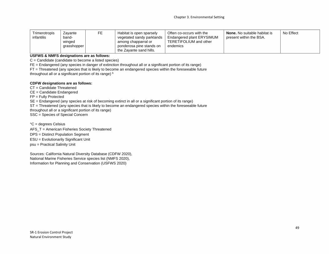
Chapter 3. Environmental Setting
49 SR-1 Erosion Control Project Natural Environment Study
Trimerotropis infantilis
Zayante band-winged grasshopper
FE Habitat is open sparsely vegetated sandy parklands among chapparral or ponderosa pine stands on the Zayante sand hills.
Often co-occurs with the Endangered plant ERYSIMUM TERETIFOLIUM and other endemics
None. No suitable habitat is present within the BSA.
No Effect
USFWS & NMFS designations are as follows: C = Candidate (candidate to become a listed species) FE = Endangered (any species in danger of extinction throughout all or a significant portion of its range) FT = Threatened (any species that is likely to become an endangered species within the foreseeable future throughout all or a significant portion of its range) b
CDFW designations are as follows: CT = Candidate Threatened CE = Candidate Endangered FP = Fully Protected SE = Endangered (any species at risk of becoming extinct in all or a significant portion of its range) ST = Threatened (any species that is likely to become an endangered species within the foreseeable future throughout all or a significant portion of its range) SSC = Species of Special Concern
°C = degrees Celsius AFS_T = American Fisheries Society Threatened DPS = Distinct Population Segment ESU = Evolutionarily Significant Unit psu = Practical Salinity Unit
Sources: California Natural Diversity Database (CDFW 2020), National Marine Fisheries Service species list (NMFS 2020), Information for Planning and Conservation (USFWS 2020)

Chapter 4. Biological Resources and Discussion of Effects
50 SR-1 Erosion Control Project Natural Environment Study
Chapter 4. Biological Resources and Discussion of Effects
This chapter identifies Project-specific general avoidance and minimization measures (AMMs) and direct and indirect impacts to natural communities of special concern and special-status species that would be affected as a result of implementing the Project based on literature reviews and field evaluations. Direct impacts are Project impacts that are caused by or result from the proposed action and occur simultaneous spatially and temporally. Indirect impacts are Project impacts that are caused by or would result from the proposed action and that occur later in time or outside the Project limits but are still reasonably certain to occur. A description of the proposed general AMMs and a discussion of potential Project impacts and proposed mitigation follow.
4.1 General Avoidance and Minimization Measures
General and species-specific avoidance and minimization measures will be implemented to reduce and avoid potential effects to sensitive biological resources. These measures are presented below and will be communicated to the contractor through special provisions included in the contract bid solicitation package. Caltrans proposes to reduce adverse effects to the California red-legged frog, San Francisco garter snake, and marbled murrelet by implementing the following measures:
1. A Service-Approved Biological Monitor. The names and qualifications of proposed biological monitor(s) will be submitted to the Service for approval prior to the start of construction. The Service-Approved Biological Monitors will keep a copy of this biological opinion in their possession when onsite. Through communication with the Resident Engineer, the Service-Approved Biological Monitor will be onsite during all work that could reasonably result in take of California red-legged frog, San Francisco garter snake, or marbled murrelet. The Service-Approved Biological Monitor will have the authority to stop work that may result in the unauthorized take of special-status species. If the Service-Approved Biological Monitor exercises this authority, the Service will be notified by telephone and e-mail message within one (1) working day.
2. Worker Environmental Awareness Training. Construction personnel will attend a mandatory environmental education program delivered by the Service-Approved Biological Monitor prior to taking part in site construction, including vegetation clearing. The program will focus on the conservation measures that are relevant to an employee’s personal responsibility and will include an explanation as how to best avoid take of California red-legged frog, San Francisco garter snake, and marbled murrelet. At a minimum, the training will include a description of species; how they might be encountered within the project area; their status and protection; and the relevant Conservation Measures, and Terms and Conditions of the BO. A fact sheet conveying this information will be prepared and distributed to all construction and project personnel. Distributed materials will include cards with distinctive photographs of Californa red-legged frog, San Francisco garter snake, marbled murrelet, as well as compliance reminders and

Chapter 4. Biological Resources and Discussion of Effects
51 SR-1 Erosion Control Project Natural Environment Study
relevant contact information. Documentation of the training, including sign-in sheets, will be kept on file and made available to the Service upon request.
3. Pre-Construction Surveys. Pre-construction surveys for the California red-legged frog, San Francisco garter snake, and marbled murrelet will be conducted by the Service-Approved Biological Monitor no more than 20 calendar days prior to any initial ground disturbance and immediately prior to ground-disturbing activities (including vegetation removal) within upland habitat identified for the California red-legged frog in the August 2020 BA. These efforts will consist of walking surveys of the project limits and, if possible, accessible adjacent areas within at least 50 feet of the project limits. The Service-Approved Biological Monitor will investigate potential cover sites when it is feasible and safe to do so. This includes thorough investigation of mammal burrows, rocky outcrops, appropriately sized soil cracks, tree cavities, and debris. Native vertebrates found in the cover sites within the project limits will be documented and relocated to an adequate cover site in the vicinity. Safety permitting, the Service-Approved Biological Monitor will investigate areas of disturbed soil for signs of California red-legged frogs and San Francisco garter snakes within 30 minutes following initial disturbance of the given area.
4. Discovery of Listed Species. The Service-Approved Biological Monitor will be present during all activities that could reasonably result in take of the California red-legged frog, San Francisco garter snake, and marbled murrelet. If at any point a listed species is discovered during these activities, the Service-Approved Biological Monitor through the Resident Engineer or their designee, will halt all work within 50 feet of the animal until the listed species has either been captured and moved or has moved sufficiently from harm’s way on its own volition.
5. Protocol for Species Observation: The Service-Approved Biological Monitor (s) will have the authority to halt work through coordination with the Resident Engineer in the event that a listed species is observed in the action area. The Resident Engineer will keep construction activities suspended in any construction area where the biologist has determined that a potential take of the species could occur. Work will resume after observed listed individuals leave the site voluntarily, the biologist determines that no wildlife is being harassed or harmed by construction activities, or the wildlife is removed by the biologist to a release site using Service-approved handling techniques.
6. Handling of Listed Species. If a listed species is discovered, the Resident Engineer and Service-Approved Biological Monitor will be immediately informed.
a. If a California red-legged frog, San Francisco garter snake, or marbled murrelet gains access to a construction zone, work will be halted immediately within 50 feet until the animal leaves the site or is captured and relocated by the Service-Approved Biological Monitor.

Chapter 4. Biological Resources and Discussion of Effects
52 SR-1 Erosion Control Project Natural Environment Study
b. The Service will be notified within one (1) working day if a California red-legged frog, San
Francisco garter snake, or marbled murrelet is discovered within the construction site.
c. The captured California red-legged frog, San Francisco garter snake, or marbled murrelet will be released within appropriate habitat outside of the construction area but nearby the capture location. The release habitat will be determined by the Service-Approved Biological Monitor.
d. The Service-Approved Biological Monitor will take precautions to prevent introduction of
amphibian diseases in accordance with the Revised Guidance on Site Assessments and Field Surveys for the California Red-legged Frog (Service 2005).
7. Injured Animals. Injured California red-legged frogs, San Francisco garter snakes, and marbled murrelets will be cared for by a Service-Approved Biological Monitor(s) or a licensed veterinarian, if necessary. Any deceased California red-legged frogs, San Francisco garter snakes, or marbled murrelets will be preserved according to standard museum techniques and will be held in a secure location. The Service and the CDFW will be notified within 1 working day of the discovery of a death or an injury to any listed species resulting from project-related activities or if a listed species is observed at a construction site. Notification will include the date, time, and location of the incident or the finding of a deceased or injured animal, clearly indicated on a USGS 7.5-minute quadrangle and other maps at a finer scale, as requested by the Service or CDFW, and any other pertinent information.
8. Seasonal Avoidance. Construction actions will be scheduled to minimize effects on listed species and habitats. Except for vegetation clearing necessary to minimize effects on nesting birds, all construction-related activities will be conducted between April 15th and October 31st to avoid the period when the San Francisco garter snake may be overwintering in uplands and California red-legged frog are most active. Marbled murrelets are more active during this time but less likely to be affected by the proposed project. Surveys for the marbled murrelet will be conducted in accordance with the Migratory Bird Treaty Act (MBTA) and is discussed in bullet number 18.
9. Inclement Weather Restriction. No work will occur during or within 24 hours following a rain event exceeding 0.2-inch as measured by the National Oceanic and Atmospheric Association National Weather Service for the Soquel, CA (SOQC1) base station available at: http://www.wrh.noaa.gov/mtr/versprod.php?pil=RR5&sid=RSA. The Service and California Department of Fish and Wildlife (CDFW) approval to continue work during or within 24 hours of a rain event will be considered on a case-by-case basis.
10. Construction Boundary Fencing. Before the start of construction. The project footprint boundary will be clearly delineated using high-visibility orange fencing as necessary. Construction work

Chapter 4. Biological Resources and Discussion of Effects
53 SR-1 Erosion Control Project Natural Environment Study
areas will include the active construction site and all areas providing support for the project, including areas used for vehicle parking, equipment and material storage and staging, and access roads. The fencing will remain in place throughout the duration of construction activities, and will be inspected regularly and fully maintained at all times. The final project plans will show all locations where boundary fencing will be installed and will provide installation specifications. The bid solicitation package special provisions will clearly describe acceptable fencing material and prohibited construction-related activities, including vehicle operation, material and equipment storage, access roads and other surface-disturbing activities.
11. Wildlife Exclusion Fencing. Silt fencing or other wildlife exclusion fencing will be installed in conjunction with the construction boundary fencing around the perimeter of the project footprint to allow CRLF and SFGS to leave but not re-enter the work area. This fence will be installed prior to any work within the project footprint. Exclusion fencing will be at least 3 feet high with the lower 6 inches of the fence buried in the ground. The fence will be pulled taut at each support to prevent folds or snags. Fencing will be installed and maintained in good working condition until completion of the project.
12. Vegetation Removal. Vegetation removal will be limited to the designated work areas needed for access and workspace. Where possible, vegetation removal in temporary work areas will be cut above soil level to promote revegetative growth of established plants following construction.
13. Staging. Construction access, staging, storage, and parking areas will be located within Caltrans right of way on paved surfaces and compacted roadside fill.
14. Night Lighting. During any potential night work, which is not anticipated, all lighting will be directed downwards, towards active construction and away from sensitive resources or habitats.
15. Vehicle and Equipment Checks. Before moving construction equipment or vehicles into the project site, operators will check underneath those that have been parked onsite for more than 30 minutes and will notify the Agency-Authorized Biological Monitor if any reptile or amphibian is observed.
16. Proper Use of Erosion Control Devices. To avoid California red-legged frogs and San Francisco garter snakes from becoming entangled, trapped or injured, erosion control materials that use plastic or synthetic mono-filament netting will not be used within the action area.
17. Avoidance of Entrapment. To prevent inadvertent entrapment of animals during construction, all excavated, steep-walled holes or trenches more than 1 foot deep will be covered at the close of each working day by plywood or similar materials. Before such holes or trenches are filled they must be thoroughly inspected for trapped animals. All replacement pipes, culverts, or similar structures stored in the project area overnight will be inspected before they are subsequently moved, capped and/or buried.

Chapter 4. Biological Resources and Discussion of Effects
54 SR-1 Erosion Control Project Natural Environment Study
18. Migratory Bird Treaty Act. To minimize and avoid take of migratory birds, their nests, and their young, Caltrans will conduct vegetation and tree trimming between September 30 and January 30 before project construction. This work will be limited to vegetation and trees that are within the project footprint. No grubbing or other ground disturbing actions will occur at this time. Upon completion of vegetation and tree trimming, Caltrans will install storm water and erosion control BMPs. A Service-Approved Biological Monitor with appropriate construction and species experience will conduct nest and bird surveys and other wildlife surveys before and during tree cutting. All work will be conducted under a Regional Water Board approved Water Pollution Control Plan or SWPPP. Vegetation will be cleared only where necessary and will be cut above soil level. This will allow plants that reproduce vegetatively to resprout after construction. During the nesting season, pre-construction surveys for nesting birds, including the marbled murrelet, will be conducted by a qualified biologist no more than 72 hours prior to the start of construction activities. If work is to occur within 300 feet of active raptor nests or 50 feet of active passerine nests, a non-disturbance buffer will be established at a distance sufficient to minimize disturbance based on the nest location, topography, cover, the species’ sensitivity to disturbance, and the intensity/type of potential disturbance. All clearing and grubbing of woody vegetation will be performed by hand or using light construction equipment, such as backhoes and excavators.
19. Poison Control. Pesticides and herbicides will not be used.
20. Invasive Species Management. To reduce the spread of invasive non-native plant species and minimize the potential decrease of palatable vegetation for wildlife species, Caltrans will comply with Executive Order 13112. The purpose of this order is to prevent the introduction of invasive species and provide for their control to minimize economic, ecological, and human health impacts. In the event that high- or medium-priority noxious weeds, as defined by the California Department of Food and Agriculture or the California Invasive Plant Council, are disturbed or removed during construction-related activities, the contractor will contain the plant material associated with these noxious weeds and will dispose of it in a manner that will not promote the spread of the species. The contractor will be responsible for obtaining all permits, licenses, and environmental clearances for properly disposing materials. Areas subject to noxious weed removal or disturbance will be replanted with fast-growing native grasses or a native erosion control seed mixture. If seeding is not possible, the area will be covered to the extent practicable with heavy black plastic solarization material until completion of construction. All earthmoving equipment, as well as seeding equipment to be used during project construction would be thoroughly cleaned before arriving on the project site.
21. Construction Site BMP’s. The following site restrictions will be implemented to avoid or minimize impacts on special-status species and their habitats:

Chapter 4. Biological Resources and Discussion of Effects
55 SR-1 Erosion Control Project Natural Environment Study
a. Construction staging, storage, and parking areas will be located within the Caltrans ROW as
described in the August 2020 BA. The number and size of staging and work areas will be limited to the minimum necessary to construct the project and will be limited to existing paved surfaces.
b. Routes and boundaries of roadwork will be clearly marked before the start of construction or
grading. c. To the maximum extent practicable, any borrow material will be certified to be nontoxic and
weed free. d. All food and food-related trash items will be enclosed in sealed trash containers and will be
properly disposed off-site. e. No pets belonging to project personnel will be allowed anywhere in the action area during
construction. f. No firearms will be allowed in the project footprint except for those carried by authorized
security personnel, or local, state or Federal law enforcement officials. g. A Spill Response Plan will be prepared. Hazardous materials (e.g., fuels, oils, solvents) will be
stored in sealable containers in a designated location that is at least 100 feet from any hydrologic features.
h. All equipment will be properly maintained and free of leaks. Servicing of vehicles and
construction equipment, including fueling, cleaning, and maintenance, will occur at least 100 feet from any hydrologic features unless it is an existing gas station.
22. Implementation of Water Quality/Erosion Control BMP’s. Erosion control BMPs will be developed
and implemented to minimize any wind or water-related erosion, in compliance with the requirements of the Regional Water Quality Control Board. Protective measures will include, at a minimum:
a. No discharge of pollutants from vehicle and equipment cleaning will be allowed into any storm drains or watercourses.
b. Vehicle and equipment fueling and maintenance operations will be kept at least 50 feet away from watercourses, except at established commercial gas stations or established vehicle

Chapter 4. Biological Resources and Discussion of Effects
56 SR-1 Erosion Control Project Natural Environment Study
maintenance facilities.
c. Concrete wastes will be collected in washouts, and water from curing operations will be collected and disposed. Neither will be allowed into watercourses.
d. Spill containment kits will be maintained on-site at all times during construction operations and/ or staging or fueling of equipment.
e. Dust control measures will include use of water trucks and dust palliatives to control dust in excavation-and-fill areas, covering temporary access road entrances and exits with rock (rocking), and covering temporary stockpiles when weather conditions require.
f. Coir rolls or straw wattles that do not contain plastic or synthetic monofilament netting will be installed along or at the base of slopes during construction, to capture sediment.
g. Graded areas will be protected from erosion using a combination of silt fences and fiber rolls along toes of slopes or along edges of designated staging areas, and erosion control netting (e.g., jute or coir) will be used as appropriate on sloped areas. Erosion control materials that use plastic or synthetic monofilament netting will not be used within the BSA. This will include products that use photodegradable or biodegradable synthetic netting, which can take several months to decompose. Acceptable materials will include natural fibers, such as jute, coconut, twine or other similar fibers.
23. Replant, Reseed, and Restore Disturbed Areas. In areas of soil disturbance, any native topsoil will be removed and stored in a suitable location until project completion. Caltrans will restore temporarily disturbed areas to the preconstruction function and values to the maximum extent practicable. Exposed slopes and bare ground will be reseeded with native grasses and shrubs (using a hydro-seed mix) to stabilize and prevent erosion.
24. Service Access. If requested, before, during, or upon completion of groundbreaking and construction activities, Caltrans will allow access by Service personnel into the project footprint to inspect the project and its activities.
25. Reporting. Caltrans will submit post-construction compliance reports prepared by the Service-Approved Biological Monitor to the Service within 60 calendar days following completion of project activities or within 60 calendar days of any break in construction activity lasting more than 60 calendar days. This report will detail (1) dates that relevant project activities occurred; (2) pertinent information concerning the success of the project in implementing avoidance and minimization measures for listed species; (3) an explanation of failure to meet such measures, if
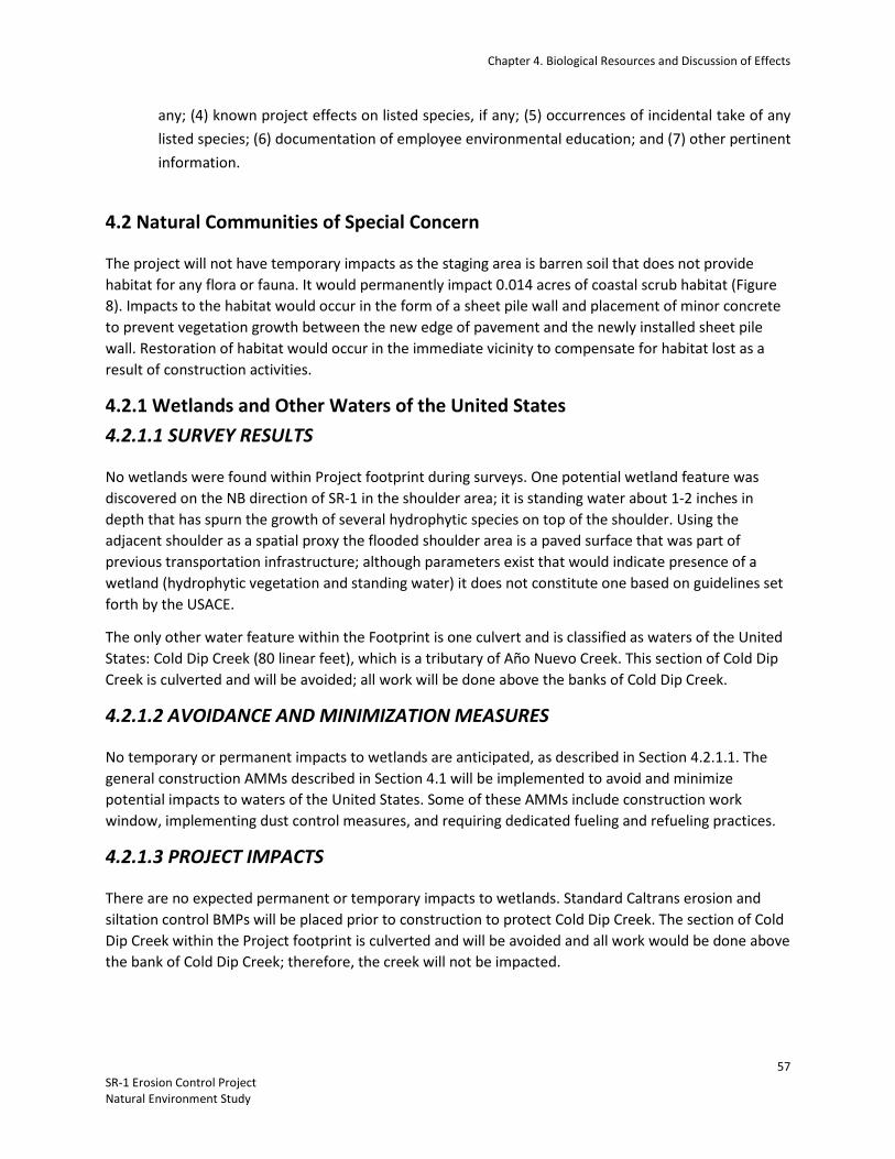
Chapter 4. Biological Resources and Discussion of Effects
57 SR-1 Erosion Control Project Natural Environment Study
any; (4) known project effects on listed species, if any; (5) occurrences of incidental take of any listed species; (6) documentation of employee environmental education; and (7) other pertinent information.
4.2 Natural Communities of Special Concern
The project will not have temporary impacts as the staging area is barren soil that does not provide habitat for any flora or fauna. It would permanently impact 0.014 acres of coastal scrub habitat (Figure 8). Impacts to the habitat would occur in the form of a sheet pile wall and placement of minor concrete to prevent vegetation growth between the new edge of pavement and the newly installed sheet pile wall. Restoration of habitat would occur in the immediate vicinity to compensate for habitat lost as a result of construction activities.
4.2.1 Wetlands and Other Waters of the United States 4.2.1.1 SURVEY RESULTS
No wetlands were found within Project footprint during surveys. One potential wetland feature was discovered on the NB direction of SR-1 in the shoulder area; it is standing water about 1-2 inches in depth that has spurn the growth of several hydrophytic species on top of the shoulder. Using the adjacent shoulder as a spatial proxy the flooded shoulder area is a paved surface that was part of previous transportation infrastructure; although parameters exist that would indicate presence of a wetland (hydrophytic vegetation and standing water) it does not constitute one based on guidelines set forth by the USACE.
The only other water feature within the Footprint is one culvert and is classified as waters of the United States: Cold Dip Creek (80 linear feet), which is a tributary of Año Nuevo Creek. This section of Cold Dip Creek is culverted and will be avoided; all work will be done above the banks of Cold Dip Creek.
4.2.1.2 AVOIDANCE AND MINIMIZATION MEASURES
No temporary or permanent impacts to wetlands are anticipated, as described in Section 4.2.1.1. The general construction AMMs described in Section 4.1 will be implemented to avoid and minimize potential impacts to waters of the United States. Some of these AMMs include construction work window, implementing dust control measures, and requiring dedicated fueling and refueling practices.
4.2.1.3 PROJECT IMPACTS
There are no expected permanent or temporary impacts to wetlands. Standard Caltrans erosion and siltation control BMPs will be placed prior to construction to protect Cold Dip Creek. The section of Cold Dip Creek within the Project footprint is culverted and will be avoided and all work would be done above the bank of Cold Dip Creek; therefore, the creek will not be impacted.
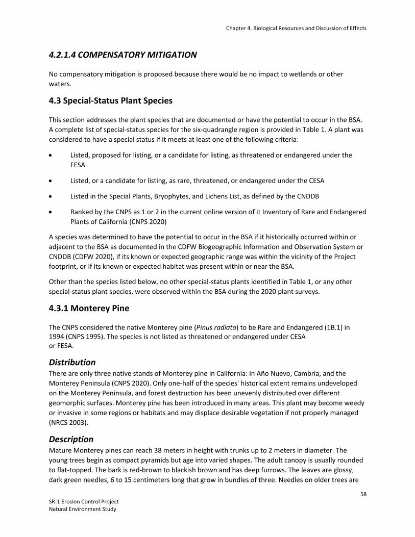
Chapter 4. Biological Resources and Discussion of Effects
58 SR-1 Erosion Control Project Natural Environment Study
4.2.1.4 COMPENSATORY MITIGATION
No compensatory mitigation is proposed because there would be no impact to wetlands or other waters.
4.3 Special-Status Plant Species
This section addresses the plant species that are documented or have the potential to occur in the BSA. A complete list of special-status species for the six-quadrangle region is provided in Table 1. A plant was considered to have a special status if it meets at least one of the following criteria:
• Listed, proposed for listing, or a candidate for listing, as threatened or endangered under the FESA
• Listed, or a candidate for listing, as rare, threatened, or endangered under the CESA
• Listed in the Special Plants, Bryophytes, and Lichens List, as defined by the CNDDB
• Ranked by the CNPS as 1 or 2 in the current online version of it Inventory of Rare and Endangered Plants of California (CNPS 2020)
A species was determined to have the potential to occur in the BSA if it historically occurred within or adjacent to the BSA as documented in the CDFW Biogeographic Information and Observation System or CNDDB (CDFW 2020), if its known or expected geographic range was within the vicinity of the Project footprint, or if its known or expected habitat was present within or near the BSA.
Other than the species listed below, no other special-status plants identified in Table 1, or any other special-status plant species, were observed within the BSA during the 2020 plant surveys.
4.3.1 Monterey Pine
The CNPS considered the native Monterey pine (Pinus radiata) to be Rare and Endangered (1B.1) in 1994 (CNPS 1995). The species is not listed as threatened or endangered under CESA or FESA.
Distribution There are only three native stands of Monterey pine in California: in Año Nuevo, Cambria, and the Monterey Peninsula (CNPS 2020). Only one-half of the species' historical extent remains undeveloped on the Monterey Peninsula, and forest destruction has been unevenly distributed over different geomorphic surfaces. Monterey pine has been introduced in many areas. This plant may become weedy or invasive in some regions or habitats and may displace desirable vegetation if not properly managed (NRCS 2003).
Description Mature Monterey pines can reach 38 meters in height with trunks up to 2 meters in diameter. The young trees begin as compact pyramids but age into varied shapes. The adult canopy is usually rounded to flat-topped. The bark is red-brown to blackish brown and has deep furrows. The leaves are glossy, dark green needles, 6 to 15 centimeters long that grow in bundles of three. Needles on older trees are

Chapter 4. Biological Resources and Discussion of Effects
59 SR-1 Erosion Control Project Natural Environment Study
sometimes a bluish green. Flowers appear in late winter or early spring. The trees are monoecious, having both male and female flowers (USDA 2003). The species is one of the 18 California species of pines and cypresses that bear closed cones.
This species is the most widely cultivated pine in the world (USDA 2003). Monterey pines are also the most widely planted trees for choose-and-cut Christmas tree farms in California. They are excellent shade trees, act as effective wind and sound barriers, and have been used for erosion control.
Habitat Requirements
Monterey pines grow below 1,200 meters in closed cone pine forests and oak woodlands. Monterey pines are adapted to soils of medium to heavy texture. Monterey pines have serotinous cones that do not release seeds unless subjected to high temperatures. Superheating may occur on very hot days or during fire events. Because hot days do not often occur in the Central Coast region of California, replenishment of the seed bank is highly dependent on fire (Hillyard 1997).
Population Threats
The remaining stands of Monterey pine are threatened by numerous factors, including urbanization, genetic contamination, recreational development, fire suppression, pests, and diseases (USDA 2003 and CNPS 2020).
4.3.1.1 SURVEY RESULTS
On June 12, 2020, Caltrans Biologist Grant Samaniego, Jeff Lemire, and Kara Gonzalez documented the location of and identified all mature trees ( >10ft. height) in the vicinity of the Footprint. The nearest Monterey Pine occurs over 100 ft. from the Footprint. The special-status designation of 1B.1 only applies to the natural native stands of Monterey pine. All Monterey Pines within the BSA appear to fall within the mapped location of the species natural native stand within the Año Nuevo parcel.
4.3.1.2 AVOIDANCE AND MINIMIZATION MEASURES
Grant Samaniego (Caltrans) coordinated with the Caltrans design team to minimize tree removal and determine which trees the Project would be impacted. It was determined that the Monterey pine trees adjacent to the Project work area would be avoided.
4.3.1.3 PROJECT IMPACTS
With implementation of the AMMs described above, Caltrans does not anticipate permanent impact to Monterey pine.
4.3.1.4 COMPENSATORY MITIGATION
There are no anticipated permanent impacts to Monterey Pine; therefore, no compensatory mitigation is proposed.

Chapter 4. Biological Resources and Discussion of Effects
60 SR-1 Erosion Control Project Natural Environment Study
4.3.1.5 CUMULATIVE IMPACTS
With implementation of the AMMs described above, the Project would make no measurable contribution to cumulative impacts on Monterey Pine.
4.4 Special Status Wildlife Species
This section addresses the special-status wildlife species that have the potential or are known to occur in the BSA. A complete list of special-status species for the six-quadrangle region is provided in Appendix C.

Chapter 4. Biological Resources and Discussion of Effects
61 SR-1 Erosion Control Project Natural Environment Study
Figure 5- Federally Listed Species Occurrences

Chapter 4. Biological Resources and Discussion of Effects
62 SR-1 Erosion Control Project Natural Environment Study
Figure 6- CRLF, SFGS, and MAMU Occurrences

Chapter 4. Biological Resources and Discussion of Effects
63 SR-1 Erosion Control Project Natural Environment Study
Figure 7- State Listed Species Occurrences

Chapter 4. Biological Resources and Discussion of Effects
64 SR-1 Erosion Control Project Natural Environment Study
4.4.1 California Red-legged Frog The California red-legged frog (CRLF; Rana draytonii) was listed as a threatened species under the Federal Endangered Species Act on May 23, 1996 (61 FR 25813). The CRLF is also designated as a CDFW species of special concern. The Recovery Plan for the California Red-legged Frog was published on May 28, 2002 (USFWS 2002). Critical habitat was designated for this species on April 13, 2006 (Service 2006), and a final revision was published on March 17, 2010 (Service 2010). Critical habitat for CRLF lies within the action area. The action area occurs within the Central Coast recovery unit for this species (Service 2002).
The CRLF has sustained a 70% reduction in its historical geographic range in California (USFWS 2002). It is distributed throughout 26 counties, but is most abundant in the San Francisco Bay Area. Populations have become isolated in the Sierra Nevada, northern Coast, and northern and southern Transverse and Peninsular Ranges. The species is known from sea level up to approximately 5,000 feet, but the majority of the known occurrences are below 3,500 feet (Jennings and Hayes 1994; Bulger et al. 2003; Stebbins 2003).
CRLF needs a distinct habitat, consisting of both aquatic and riparian components. Such habitat generally includes marshes, streams, ponds, and other permanent sources of water where dense riparian scrubby vegetation (such as willows, cattails, and bulrushes) dominate, and where water quality is good. Adult frogs require still or slow-moving water that is relatively deep (more than 2.3 feet), with shrubby or emergent riparian vegetation. CRLF breeds in standing or slow-moving water (at least 2.5 feet deep) with emergent vegetation, such as cattails (Typha spp.), tules (Scirpus spp.), or overhanging willows (Salix spp.) (Hayes and Jennings 1988). Upland dispersal habitats with dense vegetation may be important sheltering habitat during winter. During the dry season, the frogs may live in small mammal burrows and moist leaf litter (Jennings and Hayes 1994). The species has been found up to 100 feet from water in adjacent riparian vegetation.
The season of activity for CRLF seems to vary with the local climate (Storer 1925); individuals from coastal populations, which rarely experience low temperature extremes because of the moderating maritime effect, are rarely inactive. Adult frogs that have access to permanent water generally remain active throughout the summer. In cooler areas, they may be inactive for long intervals (USFWS 2002). Adult frogs stress when exposed to water temperatures at or above 84ºF and can die if the exposure is chronic. Additionally, salinity greater than 4.5 percent causes 100 percent mortality of pre-hatching embryos (Jennings and Hayes 1994).
Breeding takes place between November and March, depending on winter rains, although the more southerly the frog, the earlier the breeding (Hayes and Jennings 1988). CRLF breeds in small temporary ponds, lakes, potholes, overflow from rivers and lakes, or slow-moving rivers that contain water long enough (11 to 20 weeks) for breeding purposes and larval development (CDFW 2016). Males arrive at the breeding sites first (2 to 4 weeks before the females), calling the females to them. This timing of breeding activities has probably evolved to ensure that the water is cool enough for embryonic survival and sufficient water exists for larval growth to metamorphosis (Jennings and Hayes 1994).

Chapter 4. Biological Resources and Discussion of Effects
65 SR-1 Erosion Control Project Natural Environment Study
CRLFs are relatively prolific breeders, usually laying egg masses during or shortly after heavy rainfall in late winter or early spring. Females can lay between 1,000 and 6,000 (often 500 to 1,000) eggs in a single mass (Stebbins 2003). The eggs are the largest known of any North American frog. The average egg mass is between 3 and 12 inches in diameter and typically is attached to emergent vegetation (e.g., bulrushes, cattails) with a vertical orientation at or near the surface of the water (Stebbins 2003).
Eggs hatch in 6 to 14 days, and approximately 3.5 to 7 months later (July to September), the tadpoles develop into frogs (Storer 1925; Jennings and Hayes 1994). Tadpoles are between 0.5 and 3.2 inches in length, usually dark brown or yellowish with small metallic-like flecks above and pinkish iridescence below (Stebbins 2003). CRLF must have 11 to 20 weeks of permanent water for larval development, as well as appropriate refugia for aestivation periods. Appropriate refugia for CRLF include small mammal burrows, downed logs or vegetation, or a dense vegetation/litter layer.
During dry periods, CRLF seldom is found far from water. However, during wet weather, individuals may make overland excursions through upland dispersal habitats over distances up to 2 miles. These dispersal movements generally are straight-line, point-to-point migrations rather than along specific habitat corridors. Dispersal distances are believed to depend on the availability of suitable habitat and prevailing environmental conditions.
Bulger et al. (2003) categorized terrestrial use as migratory and non-migratory in a study of CRLF terrestrial activity in the Santa Cruz Mountains. Non-migratory activity occurred over one to several days and was associated with precipitation events. Migratory movements were characterized as the movement between aquatic sites and most often were associated with breeding activities. Bulger et al. (2003) reported that non-migrating frogs typically stayed within 200 feet of aquatic habitat 90 percent of the time and most often were associated with dense vegetative cover (i.e., California blackberry, poison oak, and coyote brush).
The food that CRLF preys on differs with the age and size of the frog. Tadpoles or larvae probably feed on algae, while young frogs depend mainly on invertebrates (insects and mollusks) as a food source. The diet of adult frogs includes Pacific tree frogs (Hyla regilla), California mice (Peromyscus californicus), insects, arachnids, and mollusks. Adult frogs are mostly nocturnal, whereas juvenile frogs are both diurnally and nocturnally active (USFWS 2002).
Wading birds, particularly bitterns (Botaurus lentiginosus) and black-crowned night herons (Nycticorax nycticorax), are likely to be major predators on adult CRLF. Juveniles that tend to be more active during the day than adults, are preyed on by garter snakes (Thamnophis spp.). Non-native predatory fish likely prey on larva and adults (Jennings and Hayes 1994).
The continuing population decline of this species is attributed to the continuing loss of freshwater habitat and the introduction of non-native predatory fish species and bullfrogs. Much evidence indicates that the introduced bullfrog may prey on and displace CRLF through competition for resources. In addition, loss of

Chapter 4. Biological Resources and Discussion of Effects
66 SR-1 Erosion Control Project Natural Environment Study
riparian and emergent vegetation increases water temperature, which favors bullfrog reproduction. Bullfrogs not only prey on the larval stages of CRLF, but also are more suited to survive in human disturbed areas (USFWS 2002).
The chytrid fungus (Batrachochytrium dendrobatidis) has been suggested to be a key cause of decline in amphibian populations worldwide (USFWS 2002). Although reports of CRLFs with the chytrid fungus exist, the effect of the fungus on the species’ population is unclear.
4.4.1.1 SURVEY RESULTS
No protocol-level CRLF surveys were conducted as part of the background information collected for the project. However, Caltrans relied on the best available scientific and commercial data, including a literature search and visual assessment, to evaluate the potential for this species to occur in the BSA and to infer presence. A riparian corridor running perpendicular to SR-1 may provide upland habitat for CRLF, and it is within the central coast recovery unit for the species. Cold Dip Creek itself runs more than 30 feet underneath SR-1 in a culvert, thereby making the associated riparian area atypical in vegetation makeup. The coastal scrub habitat within the action area may provide upland or upland dispersal habitat for CRLF. While small mammal burrows that may attract CRLF appear to be lacking within the coastal scrub, dense vegetation (including California blackberry and poison oak) provides refugia and potential opportunities for foraging. Less than 2/5th mile west of the project site is a known CLRF breeding pond. The upland refugia at Cold Dip Creek is within observed dispersal distance. The coastal scrub habitat within the project footprint is moderately vegetated, except for the heavily eroded sections, and contains some features that would attract foraging or estivating CRLF. Any individuals in the work areas would likely to be transient and/or dispersing and are unlikely to utilize the project footprint for any extended length of time. No California red-legged frogs were observed onsite during reconnaissance site visits or focused botanical surveys.
A review of CNDDB reveals four occurrences of CRLF within two miles of the project footprint (Figure 6). The closest occurrence was in the year 2000 in the Año Nuevo State Reserve (occurrence #573). Habitat at this site consists of a freshwater pond with tules and willows, and surrounding uplands are coastal scrub. Only adults were seen at this pond and the only CNDDB-documented observations were during October. The second nearest occurrence (occurrence #313) was in July 1999 about 1.2 miles north of the site, and only two individual frogs were documented. The location was a large sag pond surrounded by bulrushes and willows just east of SR-1. The third nearest occurrence (occurrence #417) was found in 2000 in Green Oaks Creek about 0.5 miles east of SR-1. At least one frog was observed and others were heard in the ponds. The ponds were man-made in the 1970’s and, in 2000, were found to be lined with sedges, oak, aloea, and redwoods. The furthest occurrence was in 2001 and was located 2.3 miles south of the site in ephemeral and permanent ponds near the mouth of a lagoon at Waddell Creek (occurrence #471). The area is a coastal stream with marine influence and is surrounded by redwood forest. Vegetation in pond consists of cattails and tules.

Chapter 4. Biological Resources and Discussion of Effects
67 SR-1 Erosion Control Project Natural Environment Study
4.4.1.2 CRITICAL HABITAT
On March 17, 2010, USFWS issued the final designation of critical habitat for CRLF (75 Federal Register 12816–12959). The area that USFWS has designated as critical habitat for CRLF includes 1,681,938 acres in 27 California counties, in 48 units.
During field surveys, Caltrans biologists observed that the coastal scrub vegetation within the AA contains the physical and biological factors (PBFs) of upland habitat for CRLF including California blackberry (Rubus ursinus), poison oak (toxicodendron diversilobum) grasses and other upland species that may serve as foraging habitat or provide shelter from predatory species (USFWS 2002 pp12-14). Proximity to riparian areas and ponds indicates that the coastal scrub habitat within the AA may form part of a dispersal corridor for the species. SR-1 may act as an existing barrier to CRLF dispersal either directly through vehicular mortality or indirectly through population fragmentation or isolation. The ruderal and paved areas within the AA do not contain the PBF's of CRLF critical habitat and lack characteristics that would attract CRLF. If frogs occur in this area, they are likely transient.
4.4.1.3 PROJECT EFFECTS
By implementing the avoidance and minimization measures presented in Section 1.5, Caltrans anticipates minimal adverse direct and indirect impacts to CRLF. However, even with such measures, take, in the form of harassment, harm, injury, or death of an individual CRLF may occur.
Direct Effects: Adverse direct effects to individual CRLF may result from the use of heavy equipment, night lighting, removal of vegetation, removal of soil, distribution of RSP, redistribution of soils, grading, dust, vibration and noise. These stressors are likely to affect juvenile or adult CRLF that are feeding, sheltering, or dispersing in uplands. In the event of a summer rainstorm during the construction period, adult CRLF could initiate movements and disperse throughout the BSA, including along the roadway used for construction staging and within ruderal/bare road shoulders. Individuals moving into the BSA after rainfall events could be inadvertently injured or killed by construction activities. CRLF would likely be highly conspicuous under such circumstances and will be avoided with the use of biological monitors as described in the avoidance and minimization measures presented in Section 1.5.
The proposed action will also result in 0.014 acre of permanent impacts to upland critical habitat for CRLF as a result of excavation, CSP down drain removal, vegetation removal, and RSP placement (Figure 7). Stressors to critical habitat as a result of the proposed action include the removal of soil, distribution of RSP, redistribution of soils, and altered contours. However, the impacted critical habitat area is already highly disturbed by erosional forces, is dominated by annual and low-growing vegetation, and provides only marginal quality for CRLF. The quantity of impacted habitat (0.014 acre) represents an insignificant effect when compared to the quantity of suitable upland and aquatic habitat in the areas surrounding the project footprint. Following construction activities, the slope will be re-contoured to match conditions present prior to major erosional events, and any native large, woody, non-toxic plant material will be re-

Chapter 4. Biological Resources and Discussion of Effects
68 SR-1 Erosion Control Project Natural Environment Study
inserted into the habitat. This will provide upland habitat for CRLF that is comparable, if not improved upon than, the baseline.
The project will create a new barrier to its dispersal towards SR-1. SR-1 may act as a pre-existing barrier to species movement, yet its access to it will be hindered with the installation of a sheet pile wall and will likely dissuade their dispersal towards SR-1.
Indirect Effects: Project related indirect effects could include increased erosion, sedimentation, or changes in hydrology, any of which could occur either during construction or post-construction. The disturbance of upland areas and removal of vegetation could lead to an increased potential for erosion and sedimentation of soils, affecting CRLF habitats outside the project footprint. For example, construction could result in indirect effects on CRLF foraging habitat from increased sediment loads, turbidity, and siltation if soils enter the outfall of Cold Dip Creek. In addition, construction activities could result in the introduction of chemical contaminants to a work site or staging area, such as oil or toxic chemicals leaking from construction equipment. Construction activities could also spread invasive species present in the BSA, to other sites that support CRLF. These indirect effects will all be avoided through implementation of the avoidance and minimization measures for protection of water quality, erosion control, and species-specific protection measures.
4.4.1.4 MODIFICATIONS TO THE PROJECT TO MITIGATE EFFECTS
Due to the fact that the project is located in CRLF critical habitat, steps will be taken to reduce take to the CRLF. These include the addition of exclusion fencing combined with ESA fencing as discussed in the standard avoidance and minimization measures in section 4.1, and hand removal of vegetation with a bio monitor onsite. Other steps will be taken will be to restore the habitat post-construction. These include replanting of native trees to compensate for those lost as a result of vegetation removal. Native, non-toxic woody vegetation that will be removed prior to RSP placement will also be replaced within the BSA post-construction to act as cover.
4.4.1.5 AVOIDANCE AND MINIMIZATION EFFORTS
As required under the FESA, Caltrans will implement reasonable and prudent measures to minimize and avoid potential take of CRLF. The avoidance and minimization measures for this project are presented in Section 4.1.
4.4.1.6 COMPENSATORY MITIGATION
Caltrans will implement all reasonable and prudent measures to avoid and minimize potential for take and other adverse effects on CRLF during project activities. The 0.014 acre of upland habitat that will be permanently impacted will prevent CRLF from entering the roadway and funnel them towards the existing cross culvert below the roadway. This will function to decrease the number

Chapter 4. Biological Resources and Discussion of Effects
69 SR-1 Erosion Control Project Natural Environment Study
of vehicular strikes to the species and may provide a net benefit to the species’ local population; therefore, no compensatory mitigation is proposed.
4.4.1.7 CUMULATIVE IMPACTS
Section 7 regulations require the federal action agency to provide an analysis of cumulative effects, along with other information, when requesting initiation of formal consultation. Cumulative effects include those of future state, tribal, local, or private actions that are reasonably certain to occur in the action area. Future federal actions that are unrelated to the proposed action are not considered in this section because they require separate consultation (unrelated to the proposed action) pursuant to Section 7 of the Endangered Species Act.
There are no planned future state, tribal, local, or private project actions that have been identified within the vicinity of the proposed project.
4.4.2 San Francisco Garter Snake
The San Francisco garter snake (Thamnophis sirtalis tetrataenia; SFGS) was federally listed as endangered on March 11, 1967 (32 Federal Register 4001). The species is also state listed as endangered and is a California fully protected species. The SFGS is limited in distribution to portions of San Mateo and Santa Cruz counties. Remnant populations have been identified throughout the species’ historic range. These include the West of Bayshore population (near SFO), the Laguna Salada population (near Mori Point), the San Francisco State Fish and Game Refuge population (near Crystal Springs and San Andreas reservoirs), the Pescadero Marsh population, the Año Nuevo State Reserve population, and the Cascade Ranch population (USFWS 2006).
In a 5-year review of the status of the SFGS, the USFWS identified several primary habitat elements essential to support SFGS breeding (USFWS 2006). These elements include open grassy uplands with a flora composition consisting of such species as coyote bush (Bacharis pillularis), wild oat (Avena fatua), wild barley (Hordeum spp.), and various brome species (Bromus spp.); a grassland/shrub matrix within these uplands with brush densities ranging from 1 average plant per 98 square feet (ft2) to 1 large plant per 66 ft2 to allow sufficient cover from predators; upland estivation habitat in the way of small mammal burrows; freshwater habitat containing emergent vegetation such as cattails (Typha spp.), spike rush (Eleocharis spp.), water plantain (Alisma spp.), willow (Salix spp.), and Rubus species; open water and shallow water components to the wetlands; a breeding prey base of CRLF and Pacific tree frogs (Hyla regilla); and a potential preference toward slopes with southern or western facing exposures. According to USFWS’s review of dispersal data, SFGS have been known to move on average between 328 feet and 656 feet from pond foraging habitat to upland wintering sites, and some individuals have been observed to move over 2,200 feet (USFWS 2006). Typically, SFGS do not appear to move distances of more than 0.60 mi, although longer SFGS movements may occur in pursuit of prey (USFWS 2006). SFGS are not known to exhibit the wide-ranging movements associated with CRLF (McGinnis 1987).

Chapter 4. Biological Resources and Discussion of Effects
70 SR-1 Erosion Control Project Natural Environment Study
Unlike other garter snakes in the Bay Area, the SFGS does not appear to undergo true hibernation during the winter months, and instead emerges periodically from hibernacula during the winter to bask. SFGS are most active between the spring and fall. Peak activity is observed between March and July, when adults emerge from hibernacula and concentrate around aquatic habitats to mate and forage for food (USFWS 2006).
The presence of habitat conditions that encourage viable breeding populations of Pacific tree frogs and CRLF is crucial to the survival of SFGS. Breeding populations of SFGS are unknown in locations where amphibian prey is absent (USFWS 2006). SFGS avoid brackish marsh areas because their preferred prey base (Pacific tree frogs and CRLF) cannot survive in saline water. Therefore, increased levels of salinity in freshwater corridors are also a threat to SFGS (USFWS 2006). Roads and highways affect the dispersal and movement of SFGS. In addition to direct mortality of the SFGS, highways affect dispersal and movement of the species’ amphibian prey. Roads with a vehicle frequency above 30 cars per hour between 10 PM and 4 AM may serve as effective barriers to SFGS dispersal because of the nocturnal habits of many amphibians and the associated fatalities from vehicular strikes (USFWS 2006).
4.4.2.1 SURVEY RESULTS
No protocol-level SFGS surveys were conducted as part of the background information collected for the project. However, Caltrans relied on the best available scientific and commercial data, including a literature search and a visual assessment, to evaluate the potential for the occurrence of this species in the BSA and to infer presence.
A review of CNDDB reveals six SFGS occurrences within two miles of the project site (Figure 6). The occurrence nearest the project site (occurrence #73) is 0.1 mile south on the property owned by Coastways Ranch, Inc. The CNDDB record was first observed in 1983, and notes that aerials taken from 2005-2014 show ponds with conditions favorable to SFGS, however, the pond is surrounded by agriculture the north, south, and east, and borders SR 1 about 0.1km to the west.
The next nearest occurrence (occurrence #72) is 0.2 miles north of the project site. An individual SFGS was found and collected at the entrance to Año Nuevo State Reserve just west of SR-1. Two individuals were collected in different years and listed as the same occurrence. The first was collected on April 4, 1993 and another was collected on July 3, 1995. The California Academy of Science collected the specimens and stated that they were most likely heading east toward Año Nuevo Creek when they were struck by vehicles on SR-1.
The next nearest occurrence (occurrence #14) is 0.35 miles west of the project site, west of SR-1, and near the coast. Occurrence #14 was found in the main pond, or “headquarters pond,” of Año Nuevo State Reserve on multiple dates as far back as 1971 and as recent as October 16, 2015 with a steady decrease in numbers of individuals (i.e. 34 adults and 19 juveniles were seen in 1971 and only 4 adults were seen in 2015). Bullfrog (Rana catesbiana), Pacific tree frog (Pseudacris regilla), and CRLF are all found within this pond.

Chapter 4. Biological Resources and Discussion of Effects
71 SR-1 Erosion Control Project Natural Environment Study
The next nearest occurrence (occurrence #71) is 1.45 miles west of the project site. The first occurrence at this site was in 1971 and was found in a pond in the sand dunes at Año Nuevo State Reserve. One specimen was collected on July 30, 1992.
The next nearest occurrence (occurrence #15) is 1.26 miles west of the project site. Individuals were seen in a pond at the north end of Año Nuevo beach area along Green Oaks Creek (just north of Año Nuevo Creek and east of SR 1).
The furthest occurrence (occurrence #17) is 2.05 miles north of the project site. Individuals were observed in a small irrigation pond about 100 meters west of SR-1. The observer noted the presence of prey species and adequate vegetation cover to attract SFGS.
Strips of vegetation to the west of SR-1 may act as corridors for SFGS from breeding ponds north and south of the project site to uplands within the site. The majority of land use surrounding the project site are agricultural fields with some ruderal vegetation and Monterey pine lining the highway. Immediately east of the site vegetation consists of coastal bluff scrub and ruderal plants. To the west of the project site is Año Nuevo SP where expansive suitable habitat exists.
Coastal scrub habitat within the AA provides suitable upland/overwintering habitat for SFGS because of the proximity to the drainage corridor (Cold Dip Creek), however it lacks the open grassy characteristics, and small mammal burrows which SFGS may prefer. Cold Dip Creek itself is not suitable habitat for SFGS breeding because of its ephemeral nature, lack of ponds, and lack of prey items. Because SR-1 has been known to act as a population sink for SFGS, proper fencing will be put into place (see section 1.4 Conservation measures) to keep SFGS out of the work area.
4.4.2.2 CRITICAL HABITAT No critical habitat has been federally designated for this species.
4.4.2.3 PROJECT EFFECTS
By implementing the conservation measures presented in Section 4.1, no take, as defined in Section 86 of the California Fish and Game Code (CFGC), is anticipated. However, not all adverse effects (harm, harassment) can be eliminated because the disturbance of potentially suitable upland habitat is essential for the implementation of the project.
Direct Effects:
The proposed action will create stressors to individual SFGS including the use of heavy equipment, use of night lighting, removal of vegetation, removal of soil, distribution of RSP, redistribution of soils, sheet pile driving, grading, dust, and noise. These stressors are likely to affect adult or juvenile SFGS that are feeding or overwintering in uplands. If present during construction, SFGS could be displaced temporarily from the project footprint as a result of construction noise or

Chapter 4. Biological Resources and Discussion of Effects
72 SR-1 Erosion Control Project Natural Environment Study
vibrations. Due to the short construction duration (approximately 40 days) and the abundant and more suitable upland habitat that is available outside the AA, this effect is unlikely to disrupt essential SFGS life history functions. Construction activities will take place between July 2020 and October 31st when SFGS is unlikely to be overwintering in uplands, as specified in Section 4.1.
SFGS could use portions of the AA on or adjacent to the roadway for basking and could be inadvertently crushed by construction equipment; however, SFGS would likely be highly conspicuous under such circumstances and will be avoided with the use of biological monitors as described in the avoidance and minimization measures for this species below.
The proposed action will also result in 0.014 acres of permanent impacts to San Francisco garter snake upland habitat as a result of excavation, sheet pile installation, and minor concrete placement. (Figures 6 and 7). The impacted area is already highly disturbed by erosional forces, is partially un-vegetated, and only provides marginal habitat. Following construction activities, the slope will be lined with minor concrete, and will provide an anthropogenic dispersal barrier to SR-1 which has been documented as a population sink for the species.
Indirect Effects:
Project-related indirect effects could include an increased potential for erosion and sedimentation of soils within SFGS habitat in the AA. Construction may result in indirect effects on SFGS aquatic habitat from increased sediment loads, turbidity, and siltation if soils entered nearby water features, thereby adversely affecting SFGS as well as potential prey for SFGS. In addition, construction activities could result in the introduction of chemical contaminants to a work site or staging area, such as oil or toxic chemicals leaking from construction equipment. Construction activities could also spread invasive species present in the AA to other sites that support SFGS. All indirect effects would be avoided through implementation of avoidance and minimization measures for protection of water quality, erosion control, and species-specific protection measures.
4.4.2.4 AVOIDANCE AND MINIMIZATION EFFORTS As required under the FESA, Caltrans will implement reasonable and prudent measures to minimize and avoid potential take of SFGS. The avoidance and minimization measures for this project are presented in Section 4.1.
4.4.2.5 COMPENSATORY MITIGATION
Caltrans will implement all reasonable and prudent measures to avoid and minimize potential for take and other adverse effects on SFGS during project activities. The 0.014 acre of upland habitat that will be permanently impacted will prevent SFGS from entering the roadway and funnel them

Chapter 4. Biological Resources and Discussion of Effects
73 SR-1 Erosion Control Project Natural Environment Study
towards the existing cross culvert below the roadway. This will function to decrease the number of vehicular strikes to the species and may provide a net benefit to the species’ local population; therefore, no compensatory mitigation is proposed.
4.4.2.6 CUMULATIVE IMPACTS
Section 7 regulations require the federal action agency to provide an analysis of cumulative effects, along with other information, when requesting initiation of formal consultation. Cumulative effects include those of future state, tribal, local, or private actions that are reasonably certain to occur in the action area. Future federal actions that are unrelated to the proposed action are not considered in this section because they require separate consultation (unrelated to the proposed action) pursuant to Section 7 of the Endangered Species Act.
There are no planned future state, tribal, local, or private project that has been identified within the vicinity of the proposed action.
4.4.3 Marbled Murrelet
The marbled murrelet was federally listed as a threatened species on September 28, 1992 (Service 1992). A recovery plan was published for this species on September 24, 1997 (Service 1997). Critical habitat was designated (final rule) on May 24, 1996 (Service 1996), and a final revision was published on October 4, 2011 (Service 2011b). There is no critical habitat for marbled murrelet within the action area; the closest critical habitat unit for this species is 0.72 mile east of the project footprint. Critical habitat unit CA-14-b encompasses approximately 20,482 acres (less than 0.1% of total CH) (Service 1996) near the southernmost extent of the total 3,698,100 acres of critical habitat that has been designated for this species. A total of 597,713 acres of critical habitat for marbled murrelet are located in California (Service 2011b).
The marbled murrelet is a relatively small, stout seabird. The breeding range for this species occurs in six geographic zones along the Pacific Coast from Alaska south coastally through British Columbia, Washington, Oregon, to northern Monterey Bay in central California (Service 1997). These geographic zones of occurrence are generally associated with large tracts of old growth forest in proximity to the coast, three of which are located in California (Siskiyou Coast Range, Mendocino, and Santa Cruz Mountains). Birds winter throughout the breeding range and also in small numbers off the southern California coast (Service 1997). The southernmost Santa Cruz Mountains breeding population, located nearest the action area, is separated by nearly 300 miles from the neighboring population to the north (Service 1997). Population estimates from the late 1990’s suggest several thousand up to 6,000 individuals may occur in California, compared to estimates of 60,000 that may have occurred historically (Service 1997).

Chapter 4. Biological Resources and Discussion of Effects
74 SR-1 Erosion Control Project Natural Environment Study
The MAMU has a unique life history compared to most seabirds; they forage in nearshore marine waters, but fly inland (up to 50 miles) to nest on large limbs of mature conifers (Service 1997). Individuals have been detected at inland sites during any time of year, however, detections at inland sites are more frequent during the breeding season (late March through late September). During the nesting season, adults take turns incubating nests and feeding young between foraging bouts to the ocean that can occur up to eight times a day; flights between foraging and nesting sites occur at all times during the day, but most often occur at dawn and dusk (Service 1997).
Marbled murrelets utilize forest stands with old-growth characteristics generally within 50 miles of the coast (Service 1997). For nesting, they require old-growth or mature trees (more than 30-inch dbh) with large branches or deformities for nest platforms, or platforms created by mistletoe infestations (Service 1997). Nests in California have been located in stands containing old-growth redwood and Douglas fir (Service 1997).
Primary threats to this species include: loss of nesting habitat, poor reproductive success and predation, marine pollution, and possibly changes in prey abundance and distribution (Service 1997).
4.4.3.1 SURVEY RESULTS
No protocol-level surveys for MAMU have been conducted in the action area. The species is generally difficult to observe, even during focused surveys, and negative results may not preclude the need for consultation. Reconnaissance surveys were conducted on June 12, 2020 and July 22, 2020 to determine whether the habitat for this species is present in the action area. No marbled murrelets were observed during these site reconnaissance visits. While foraging, roosting, and nesting habitats are not present in the project footprint, the footprint intersects a riparian corridor between suitable marine and inland habitats for this species. According to the CNDDB, the nearest recorded occurrence of marbled murrelet is approximately 2.2 miles from the project footprint. Therefore, marbled murrelet could occur in or near the action area during flights to and from marine and inland habitats.
Other occurrences in the area are in excess of 2 miles from the project site. The two nearest (occurrence numbers 28 and 29) were that of several adult birds displaying “occupied habitat” behavior, recorded in 1988 to 1993. The farthest occurrence (occurrence number 6) documented 11 adults displaying occupied habitat, and one dead nestling that was presumed to be killed by predation. Each of these occurrences were in riparian corridors with streams larger than that of Cold Dip Creek.
4.4.3.2 CRITICAL HABITAT
The action area is not within federally designated critical habitat for marbled murrelet

Chapter 4. Biological Resources and Discussion of Effects
75 SR-1 Erosion Control Project Natural Environment Study
(Service 2011b). The closest critical habitat unit is approximately 0.75 mile east of the project footprint (Unit CA-14-b). Caltrans has determined that the proposed project will not adversely affect marbled murrelet critical habitat because the proposed project will not occur in critical habitat for this species.
4.4.3.3 PROJECT EFFECTS
By implementing the conservation measures presented in Section 4.1, no take, as defined in Section 86 of the California Fish and Game Code (CFGC), is anticipated, and no adverse effects (harm, harassment) are expected. However, some other effects may occur.
Direct effects
No suitable foraging, nesting, or roosting habitat is present in the action area. Individuals may occur above the action area during flights between marine and inland habitats in the region, and could therefore be subject to noise and visual disturbances from construction of the proposed project; however, inland flights primarily occur at dawn and dusk when construction activities would be just beginning or ending (see Section 1.2.1 Project Description and Components). Noise from construction is estimated to emanate distances of 350 feet away from the source (Section 1.4 Action Area) before attenuating down to the level of traffic. Hence, the AA accounts for the noise attenuation that could affect MAMU behavior (Figures 3 and 4). The potential for exposure of MAMU to construction disturbance would be low, and duration brief because individuals would only be present near the action area for very short periods when flying over the project site. Furthermore, construction disturbance would occur over a relatively short time period (two month construction period relative to the six-month breeding season) and over a minimal area relative to the distance they are accustomed to traveling between marine and inland sites. The project would also occur in the context of existing roadway disturbance along SR-1. Therefore, potential effects of the proposed project on MAMU are considered insignificant and discountable and are unlikely to rise to the level of take.
Indirect effects
No indirect effects to the MAMU are anticipated.
4.4.3.4 CONSERVATION MEASURES
Caltrans will implement standard construction best management practices during project construction, including pre-construction surveys for nesting birds, as described in Section 4.1 Conservation Measures, to minimize the potential for disturbance to sensitive species and habitats. The marbled murrelet has the potential to utilize the action area for foraging; therefore, most of the conservation measures specified in Section 4.1 apply to this species, and no extra species-specific measures will be necessary to avoid take of this species.

Chapter 4. Biological Resources and Discussion of Effects
76 SR-1 Erosion Control Project Natural Environment Study
4.4.3.5 COMPENSATORY MITIGATION
Caltrans will implement all reasonable and prudent measures to avoid and minimize potential for take and other adverse effects on MAMU during project activities. The 0.014 acre of upland habitat that will be permanently impacted is only anticipated to utilized by the species as fly-over habitat on foraging expeditions to the sea; therefore, no compensatory mitigation is proposed.
4.4.3.6 CUMULATIVE IMPACTS
Section 7 regulations require the federal action agency to provide an analysis of cumulative effects, along with other information, when requesting initiation of formal consultation. Cumulative effects include those of future state, tribal, local, or private actions that are reasonably certain to occur in the action area. Future federal actions that are unrelated to the proposed action are not considered in this section because they require separate consultation (unrelated to the proposed action) pursuant to Section 7 of the Endangered Species Act.
There are no planned future state, tribal, local, or private project that has been identified within the vicinity of the proposed action.
4.4.4 San Francisco dusky-footed woodrat
The San Francisco dusky-footed woodrat is listed as a California species of special concern. This species is found throughout the San Francisco Bay area and south to Monterey (Hall 1981, as cited in California State University, Stanislaus 2014; Carraway and Verts 1991), generally in forested habitats with moderate canopy, year-round greenery, a brushy understory, and a sufficient supply of suitable nest building materials (see below) (California Department of Fish and Game [CDFG] 2008). Evergreen or live oaks or other thick-leaved trees and shrubs are important habitat elements for this species (Kelly 1990 and Williams et al. 1992; as cited in California State University, Stanislaus 2014).
The San Francisco dusky-footed woodrat is highly arboreal (Kelly 1990). The species is a generalist herbivore, and individuals forage on the ground and in bushes and trees, primarily on woody plants such as live oak, maple, alder, coffeeberry, and elderberry; they also consume fungi, flowers, grasses, and acorns (CDFG 2008). Dusky-footed woodrat is nocturnal and active all year long. The breeding season spans from December to September, with a peak in mid-spring (CDFG 2008).
San Francisco dusky-footed woodrat builds mounded stick nests that can measure 3 to 8 feet across and as much as 6 feet tall (Santa Cruz Mountains Bioregional Council 2004). Nests typically are placed on the ground in areas of dense brush, against or straddling a log or roots of an adjacent tree. They may also be constructed in crotches or cavities of trees or logs, or occasionally higher up in trees, primarily evergreen oaks (California State University, Stanislaus 2014). A well-developed understory at the base of a single evergreen may be suitable for a single individual (CDFG 2008).

Chapter 4. Biological Resources and Discussion of Effects
77 SR-1 Erosion Control Project Natural Environment Study
4.4.4.1 SURVEY RESULTS
Several San Francisco dusky-footed woodrats and dens have been documented in the BSA, despite no CNDDB records for this species occur within 2 miles of the BSA (CDFW 2020). Coastal scrub and Monterey pine forest within the BSA provides suitable habitat for this species; furthermore, other niche components such as dense understory forest habitat is present within the Footprint.
4.4.4.2 AVOIDANCE AND MINIMIZATION EFFORTS
Caltrans will implement standard construction BMPs during Project construction, including pre-construction surveys, as described in Section 4.1, to minimize the potential for disturbance to sensitive species and habitats. The following additional species-specific measures will be implemented to minimize potential adverse impacts on the San Francisco dusky-footed woodrat:
1. Pre-construction Surveys for San Francisco Dusky-Footed Woodrat. Before the start of construction, a qualified biologist will conduct a survey of the Project footprint and a 30-foot buffer beyond the Project footprint boundaries to determine the location of active and inactive woodrat dens. Any dens detected during the surveys will be recorded and mapped in relation to the construction disturbance footprint. In addition, the biologist will evaluate any signs of current woodrat activity, including the presence of fresh scat, freshly chewed vegetation, and the presence of cobwebs covering nest entrances. A 30-foot equipment exclusion buffer will be established around active and inactive dens that can be avoided; within such buffers, all vegetation will be retained and nests will remain undisturbed.
2. Potential Trapping and Relocation. If the Project cannot avoid impacts on an active den(s), then a trapping and relocation effort will be implemented. Relocation of trapped woodrats will occur as close as possible to the original den site. If suitable habitat is not available for relocation of woodrats in the Project vicinity, offsite locations will be identified. Trapping of woodrats will be conducted by a qualified biologist who has a current CDFW collection permit to trap and relocate the species. Such trapping will occur outside the breeding season, between September and December. Specific methods for trapping woodrats and relocation of individuals and their nest sites, including identification of suitable sites for relocation, will be developed in collaboration with CDFW, but likely will be similar to methods employed for other projects in the region, such as those used for the SR 152 Hecker Pass Safety Improvements Project (CDFW 2013) or State Route 9 Storm Damage Project.
4.4.4.3 PROJECT IMPACTS
The removal of the vegetation within approximately 0.014 acre of coastal bluff scrub for the installation of the sheet pile wall would constitute a minor loss of potential habitat for San Francisco dusky-footed woodrat. Because understory vegetation removal would occur along or adjacent to a steep roadway embankment that is subject to regular disturbance from a highly traveled roadway (SR 1), the loss of this potential habitat is not likely to adversely affect the local population.
Ground-disturbing activities could destroy woodrat dens or injure or kill woodrats inhabiting dens, if they occur within the Footprint. Woodrats are nocturnal and might reside within dens during daytime

Chapter 4. Biological Resources and Discussion of Effects
78 SR-1 Erosion Control Project Natural Environment Study
construction activities. The Project also could disturb or displace woodrats from nearby dens if they occur in proximity to construction activities.
4.4.4.4 COMPENSATORY MITIGATION
Caltrans will not implement compensatory mitigation for impacts on San Francisco dusky-footed woodrat because only a relatively small area (0.014 acre) of habitat for this species along an existing roadway would be affected by the Project. In addition, AMMs will be implemented to avoid and minimize adverse impacts on this species. For these reasons, no compensatory mitigation is proposed for the anticipated minor project impacts on San Francisco dusky-footed woodrat.
4.4.4.5 CUMULATVE IMPACTS
Cumulative impacts on San Francisco dusky-footed woodrat result from past, current, and reasonably foreseeable future projects in the region, including periodic maintenance and replacement of bridges and culverts throughout San Mateo County and storm damage projects throughout the region. These projects will all undergo (or have undergone) separate environmental review and will require separate environmental permitting from regulatory agencies. Although these and similar projects could result in impacts on San Francisco dusky-footed woodrat, most current and future projects that would impact this species and its habitats are expected to be required to mitigate these impacts through the CEQA, Section 1600 of the F.G.C., permitting processes. As a result, most projects in the region will mitigate their impacts to San Francisco dusky-footed woodrat, minimizing cumulative impacts to this species. With implementation of AMMs, this Project would not make a considerable contribution to cumulative impacts on the San Francisco dusky-footed woodrat.

Chapter 4. Biological Resources and Discussion of Effects
79 SR-1 Erosion Control Project Natural Environment Study
Figure 8- Project Impacts Map

Chapter 4. Biological Resources and Discussion of Effects
80 SR-1 Erosion Control Project Natural Environment Study

Chapter 4. Biological Resources and Discussion of Effects
81 SR-1 Erosion Control Project Natural Environment Study

Chapter 4. Biological Resources and Discussion of Effects
82 SR-1 Erosion Control Project Natural Environment Study

Chapter 5. Conclusions and Determinations
83 SR-1 Erosion Control Project Natural Environment Study
Chapter 5. Permits, Laws, Regulations, and Conclusions
5.1 Regulatory Requirements
Caltrans would obtain the following permits to complete construction of this Project:
• Section 7 Biological Opinion from USFWS (Section 7(a)(2) of FESA), received September 20, 2017
• Coastal Development Permit from California Coastal Commission
• 404 Nationwide Permit from USACE
5.2 Federal Endangered Species Act Consultation Summary
• On October 21, 2020, Caltrans sent the USFWS a letter and a Biological Assessment for CRLF, SFGS, and marbled murrelet, requesting concurrence with the following determinations: The Project may affect and is likely to adversely affect CRLF and SFGS, and it is not likely to adversely affect marbled murrelet.
• On October 30, 2020, Caltrans received an email from John Cleckler of USFWS stating that the initial review of the BA was completed and no questions or comments about the Project were needed to date; although several correspondences between John Clecker and Grant Samaniego were traded in November 2020 regarding specific details of various project elements.
• On X, Caltrans received the Biological Opinion for the SR-1 Erosion Control Project, Caltrans EA 04-0K570, from USFWS.
Based on the analysis presented in the Biological Assessment, Caltrans determined that the SR-1 Erosion Control Project:
• May affect, and is likely to adversely affect, the CRLF
• May affect, and is likely to adversely affect, the SFGS
• May affect, but is not likely to adversely affect, the MAMU
• Will not adversely modify critical habitat for the CRLF
5.3 Wetlands and Other Waters Coordination Summary
A wetland and plant survey were completed on June, 12 2020, July 2, 2020, and July 22, 2020. No wetlands were found within Project footprint during surveys. One culverted water feature was identified in the Project footprint that is classified as waters of the U.S.: Cold Dip Creek (80 linear feet), which is a tributary to Año Nuevo Creek. This section of Cold Dip Creek is culverted and will be avoided; all work will be done above the bank of Cold Dip Creek.

Chapter 5. Conclusions and Determinations
84 SR-1 Erosion Control Project Natural Environment Study
5.4 Migratory Bird Treaty Act
MBTA implements international treaties between the United States and other nations devised to protect migratory birds and any of their parts, eggs, and nests from activities such as hunting, pursuing, capturing, killing, selling, and shipping, unless expressly authorized in the regulations or by permit. As authorized by the MBTA, USFWS issues permits to qualified applicants for the following types of activities: falconry, raptor propagation, scientific collecting, special purposes (such as rehabilitation, education, migratory game bird propagation, and salvage), take of depredating birds, taxidermy, and waterfowl sale and disposal. Regulations governing migratory bird permits can be found in 50 CFR, Part 13 General Permit Procedures, and 50 CFR, Part 21 Migratory Bird Permits. While no permits are issued for species protected under codes, coordination with USFWS is required.
5.5 Invasive Species
Executive Order 13112 was signed by President Clinton on February 3, 1999 (Federal Register 1999). This executive order directs federal agencies to work to prevent and control the introduction and spread of invasive species, particularly species that are likely to harm the environment, human health, or the economy. The U.S. Department of Transportation (USDOT) plays a large role in the government's fight against invasive species because transportation systems can facilitate the spread of plant and animal species outside their natural range, both domestically and internationally. On April 22, 1999, Secretary of Transportation Rodney E. Slater issued a “Policy Statement on Invasive Alien Species,” which directed USDOT’s operating administrations to proactively implement Executive Order 13112.
The Federal Highway Administration is active in the effort to control and prevent the spread of invasive species because highway corridors provide opportunities for the movement of invasive species through the landscape. Invasive plant or animal species can move on vehicles and in the loads they carry. Invasive plants can be moved from site to site during spraying and mowing operations. Weed seed can be inadvertently introduced into the corridor during construction on equipment and through the use of mulch, imported soil or gravel, or sod. Some invasive plant species might be deliberately planted in erosion control, landscape, or wildflower projects (USDOT 1999).
In the event that high- or medium-priority noxious weeds, as defined by the California Department of Food and Agriculture or the California Invasive Plant Council, are disturbed or removed during construction-related activities, the contractor will contain the plant material associated with these noxious weeds and dispose of it in a manner that does not promote the spread of the species. The contractor will be responsible for obtaining all permits, licenses, and environmental clearances for properly disposing of materials. Areas subject to noxious weed removal or disturbance will be replanted with fast-growing native grasses or a native erosion control seed mixture. If seeding is not possible, the area should be covered to the extent practicable with heavy black plastic solarization material until the end of the Project.

Chapter 6. References
85 SR-1 Erosion Control Project Natural Environment Study
Chapter 6. References
Alvarez, J.A. 2004. Rana aurora draytonii (California red-legged frog). Microhabitat. Herpetological Review 35:162–162.
Attewell, P.B. and I.W. Farmer. 1973. Attenuation of ground vibrations from piles. Ground Engineering 6(4):26–29.
Barry, S. 1992. Letter to Marvin L. Plenert, Regional Director, United States Fish and Wildlife Service, Portland, Oregon, regarding proposed listing.
Barry, S.J. and G.M. Fellers. 2013. History and status of the California red-legged frog (Rana draytonii) in the Sierra Nevada, California, USA. Herpetological Conservation and Biology 8(2):456–502.
Bulger, J.B., N. J. Scott Jr., and R.B. Seymour. 2003. Terrestrial activity and conservation of adult California red-legged frogs (Rana aurora draytonii) in coastal forests and grasslands. Biological Conservation 110:85–95.
California Department of Fish and Game (CDFG). 2008 (January). Dusky-Footed Woodrat (Neotoma fuscipes). Life History Account M127. California Interagency Wildlife Task Group, California Wildlife Habitat Relationships System. Available: www.wildlife.ca.gov/Data/CWHR/Life-History-and-Range. Accessed October 29, 2020.
California Department of Fish and Wildlife (CDFW). 2020. Monthly California Natural Diversity Database (CNDDB) data download. Available: www.wildlife.ca.gov/Data/CNDDB/Data-Updates. Accessed July 2020.
———. 2020. California Fish Passage Assessment Database. Fisheries Branch. Available: www.nrm.dfg.ca.gov/pad/. Accessed August 25, 2020.
California Department of Transportation (Caltrans). 2004. Transportation- and Construction-Induced Vibration Guidance Manual. California Department of Transportation Environmental Program, Environmental Engineering, Noise, Vibration, and Hazardous Waste Management Office. Prepared by Jones & Stokes, Sacramento, CA.
———. 2017 (August). Final BA Elliot Creek Storm Damage Project. Prepared by Caltrans, Oakland, CA.
———. 2020 (January). Final BA Interstate 280 Culvert Rehab Project. Prepared by Caltrans, Oakland, CA.
———.2017 (October). Final NES Elliot Creek Storm Damage Project. Prepared by CH2M HILL, Inc., Oakland, CA.
California Native Plant Society (CNPS). 2020. Inventory of Rare and Endangered Plants (online edition, v8-02). California Native Plant Society. Sacramento, CA. On the internet at: http://www.rareplants.cnps.org. Accessed on July 12, 2020.
California State University, Stanislaus. 2014. San Francisco Dusky Footed Woodrat (Neotoma fuscipes annectens). In Endangered, Threatened, and Candidate Species Manual. Available: www.esrp.csustan.edu/projects/lsm2/. Accessed October 29, 2020.

Chapter 6. References
86 SR-1 Erosion Control Project Natural Environment Study
Fellers, G.M. 2005. Rana draytonii: Baird and Girard, 1852b California red-legged frog. Pages 552-554 in M. Lannoo (editor). Amphibian Declines: the Conservation Status of United States Species. University of California Press. Berkeley.
Fellers, G.M. and P.M. Kleeman. 2007. California red-legged frog (Rana draytonii) movement and habitat use: implications for conservation. Journal of Herpetology 41(2):271–281.
Fisher, R.N. and H.B. Schaffer. 1996. The decline of amphibians in California's Great Central Valley. Conservation Biology 10(5):1387–1397.
Hayes, M.P., and M.R. Jennings. 1988. Habitat correlates of distribution of the California red-legged frog (Rana aurora draytonii) and the foothill yellowlegged frog (Rana boylii): implications for management. In Proceedings of the Symposium on the Management of Amphibians, Reptiles, and Small Mammals in North America, R. Sarzo, K. E. Severson, and D. R. Patton, technical coordinators, pages 144–158. United States Department of Agriculture, Forest Service, Rocky Mountain Range and Experiment Station, Fort Collins, CO. General Technical Report (RM-166):1–458.
Hayes, M.P. and M.R. Tennant. 1985. Diet and feeding behavior of the California red-legged frog, Rana aurora draytonii (Ranidae). The Southwestern Naturalist 30(4):601–605.
Jennings, M.R. 1988. Natural history and decline of native ranids in California. Proceedings of the Conference on California Herpetology, October 10–11, 1987, H. F. DeLisle, P. R. Brown, B. Kaufman, and B. M. McGurty, editors, pages 61–72. Van Nuys, CA. Southwestern Herpetologists Society Special Publication 4, Sunlight, Lakeside, CA.
Jennings, M.R. and M.P. Hayes. 1990. Final report of the status of the California red-legged frog (Rana aurora draytonii) in the Pescadero Marsh Natural Preserve. Final report prepared for the California Department of Parks and Recreation, Sacramento, CA, through Agreement (4-8239018). Department of Herpetology, California Academy of Sciences, Golden Gate Park, San Francisco.
———. 1994. Amphibian and reptile species of special concern in California. Final report to the California Department of Fish and Game, Inland Fisheries Division, Rancho Cordova.
Jennings, M.R., M.P. Hayes, and D.C. Holland. 1992. A petition to the United States Fish and Wildlife Service to place the California red-legged frog (Rana aurora draytonii) and the western pond turtle (Clemmys inamorata) on the List of Endangered and Threatened Wildlife and Plants.
Kelly, P. A. 1990. Population Ecology and Social Organization of Dusky-Footed Woodrats, Neotoma fuscipes. PhD dissertation, University of California, Berkeley.
McGinnis, S.M., P. Keel, and E. Burko. 1987. The use of upland habitats by snake species at Año Nuevo State Reserve. Prepared for the Department of Parks and Recreation State of California.
Meteoblue weather. 2020. Available: https://www.meteoblue.com/en/weather/forecast/modelclimate/a%C3%B1o-nuevo-state-park_united-states-of-america_5324085. Accessed on July 15, 2020.

Chapter 6. References
87 SR-1 Erosion Control Project Natural Environment Study
Miles, Scott and Charles Goudey. 1997. Ecological Subregions of California. United States Department of Agriculture, Forest Service. Pacific Southwest Division. R5-EM-TP-005-Net. San Francisco, California.
Nafis, G. (2000-2020) California Herps - A Guide to the Amphibians and Reptiles of California. Available at: http://www.californiaherps.com/ (accessed 06 May 2020).
National Oceanic and Atmospheric Administraion (NOAA). 2020. Soquel, CA (SOQC1) base station available at: http://www.wrh.noaa.gov/mtr/versprod.php?pil=RR5&sid=RSA. Accessed on July 19, 2020.
Natural Resources Conservation Service. 2020. Soil Survey Geographic (SSURGO) database for the San Mateo Area, California. 2020. Available: http://websoilsurvey.nrcs.usda.gov. Accessed June 31, 2020.
Stebbins, R.C. 2003. A Field Guide to Western Reptiles and Amphibians. Houghton Mifflin Company, Boston, MA.
Storer, T.I. 1925. A synopsis of the amphibia of California. University of California Publications in Zoology 27:1–342.
United States Climate Data (U.S. Climate Data). 2020. Climate Data for Half Moon Bay. Available: http://www.usclimatedata.com/climate/half-moonbay/california/united-states/usca0459. Accessed July 2, 2020.
United States Fish and Wildlife Service (Service). 1967 (March 11). Office of the Secretary Native Fish and Wildlife Endangered Species. Federal Register 32:4001. Available: http://ecos.fws.gov/docs/federal_register/fr18.pdf. Accessed August 2, 2020.
———.1985. Recovery plan for the San Francisco garter snake (Thamnophis sirtalis tetrataenia). Portland, OR.
———. 1992 (September 28). Endangered and Threatened Wildlife and Plants: Determination of threatened status for the Washington, Oregon, and California populations of the marbled murrelet. Federal Register 57:45328.
———. 1996 (May 24). Endangered and Threatened Wildlife and Plants: Final designation of critical habitat for the marbled murrelet. Federal Register 61:26256.
———. 1997. Recovery plan for the marbled murrelet (Washington, Oregon, and California populations). Portland, Oregon.
———. 2002. Recovery plan for the California red-legged frog (Rana aurora draytonii). Portland, OR.
———. 2005a (August). Revised guidance on site assessments and field surveys for the California red-legged frog. Sacramento, CA.
———. 2006 (September). San Francisco garter snake (Thamnophis sirtalis tetrataenia) 5-Year Review: Summary and Evaluation. Sacramento Field Office, Sacramento, CA.

Chapter 6. References
88 SR-1 Erosion Control Project Natural Environment Study
———.2010 (March 17). Endangered and Threatened Wildlife and Plants: Revised designation of critical habitat for the California red-legged frog. Federal Register 75:12816.
———. 2011b (October 11). Endangered and Threatened Wildlife and Plants: Revised critical habitat for the marbled murrelet. Federal Register 61:26256.
———. 2012. Critical Habitat Portal. Available: http://ecos.fws.gov/crithab/. Accessed July 13, 2020.
———. 2014. National Wetland Inventory. Available: http://www.fws.gov/wetlands/Data/Data-Download.html. 2020. Accessed July 22, 2020.
White, John. Noise and Impact Hammers. Made for the Pile Driving Unions. Available: www.americanpiledriving.com/pdfs/training/Noise%20and%20hammers.pdf. Accessed on November 4, 2020.

Appendices
89 SR-1 Erosion Control Project Natural Environment Study
Appendix A. Preliminary Design
Plans


Appendices
97 SR-1 Erosion Control Project Natural Environment Study
Appendix B-1: USFWS Official Species Lists

September 09, 2020
United States Department of the InteriorFISH AND WILDLIFE SERVICE
Sacramento Fish And Wildlife OfficeFederal Building
2800 Cottage Way, Room W-2605Sacramento, CA 95825-1846
Phone: (916) 414-6600 Fax: (916) 414-6713
In Reply Refer To: Consultation Code: 08ESMF00-2020-SLI-2219 Event Code: 08ESMF00-2020-E-08752 Project Name: 04-0K570 Erosion Control Project Subject: Updated list of threatened and endangered species that may occur in your proposed
project location, and/or may be affected by your proposed project
To Whom It May Concern:
The enclosed species list identifies threatened, endangered, proposed and candidate species, as well as proposed and final designated critical habitat, under the jurisdiction of the U.S. Fish and Wildlife Service (Service) that may occur within the boundary of your proposed project and/or may be affected by your proposed project. The species list fulfills the requirements of the Service under section 7(c) of the Endangered Species Act (Act) of 1973, as amended (16 U.S.C. 1531 et seq.).
Please follow the link below to see if your proposed project has the potential to affect other species or their habitats under the jurisdiction of the National Marine Fisheries Service:
http://www.nwr.noaa.gov/protected_species/species_list/species_lists.html
New information based on updated surveys, changes in the abundance and distribution of species, changed habitat conditions, or other factors could change this list. Please feel free to contact us if you need more current information or assistance regarding the potential impacts to federally proposed, listed, and candidate species and federally designated and proposed critical habitat. Please note that under 50 CFR 402.12(e) of the regulations implementing section 7 of the Act, the accuracy of this species list should be verified after 90 days. This verification can be completed formally or informally as desired. The Service recommends that verification be completed by visiting the ECOS-IPaC website at regular intervals during project planning and implementation for updates to species lists and information. An updated list may be requested through the ECOS-IPaC system by completing the same process used to receive the enclosed list.

09/09/2020 Event Code: 08ESMF00-2020-E-08752 2
The purpose of the Act is to provide a means whereby threatened and endangered species and the ecosystems upon which they depend may be conserved. Under sections 7(a)(1) and 7(a)(2) of the Act and its implementing regulations (50 CFR 402 et seq.), Federal agencies are required to utilize their authorities to carry out programs for the conservation of threatened and endangered species and to determine whether projects may affect threatened and endangered species and/or designated critical habitat.
A Biological Assessment is required for construction projects (or other undertakings having similar physical impacts) that are major Federal actions significantly affecting the quality of the human environment as defined in the National Environmental Policy Act (42 U.S.C. 4332(2) (c)). For projects other than major construction activities, the Service suggests that a biological evaluation similar to a Biological Assessment be prepared to determine whether the project may affect listed or proposed species and/or designated or proposed critical habitat. Recommended contents of a Biological Assessment are described at 50 CFR 402.12.
If a Federal agency determines, based on the Biological Assessment or biological evaluation, that listed species and/or designated critical habitat may be affected by the proposed project, the agency is required to consult with the Service pursuant to 50 CFR 402. In addition, the Service recommends that candidate species, proposed species and proposed critical habitat be addressed within the consultation. More information on the regulations and procedures for section 7 consultation, including the role of permit or license applicants, can be found in the "Endangered Species Consultation Handbook" at:
http://www.fws.gov/endangered/esa-library/pdf/TOC-GLOS.PDF
Please be aware that bald and golden eagles are protected under the Bald and Golden Eagle Protection Act (16 U.S.C. 668 et seq.), and projects affecting these species may require development of an eagle conservation plan (http://www.fws.gov/windenergy/ eagle_guidance.html). Additionally, wind energy projects should follow the wind energy guidelines (http://www.fws.gov/windenergy/) for minimizing impacts to migratory birds and bats.
Guidance for minimizing impacts to migratory birds for projects including communications towers (e.g., cellular, digital television, radio, and emergency broadcast) can be found at: http:// www.fws.gov/migratorybirds/CurrentBirdIssues/Hazards/towers/towers.htm; http:// www.towerkill.com; and http://www.fws.gov/migratorybirds/CurrentBirdIssues/Hazards/towers/ comtow.html.
We appreciate your concern for threatened and endangered species. The Service encourages Federal agencies to include conservation of threatened and endangered species into their project planning to further the purposes of the Act. Please include the Consultation Tracking Number in the header of this letter with any request for consultation or correspondence about your project that you submit to our office.

09/09/2020 Event Code: 08ESMF00-2020-E-08752 3
▪
Attachment(s):
Official Species List

09/09/2020 Event Code: 08ESMF00-2020-E-08752 1
Official Species ListThis list is provided pursuant to Section 7 of the Endangered Species Act, and fulfills the requirement for Federal agencies to "request of the Secretary of the Interior information whether any species which is listed or proposed to be listed may be present in the area of a proposed action".
This species list is provided by:
Sacramento Fish And Wildlife OfficeFederal Building2800 Cottage Way, Room W-2605Sacramento, CA 95825-1846(916) 414-6600
This project's location is within the jurisdiction of multiple offices. Expect additional species list documents from the following office, and expect that the species and critical habitats in each document reflect only those that fall in the office's jurisdiction:
Ventura Fish And Wildlife Office2493 Portola Road, Suite BVentura, CA 93003-7726(805) 644-1766

09/09/2020 Event Code: 08ESMF00-2020-E-08752 2
Project SummaryConsultation Code: 08ESMF00-2020-SLI-2219
Event Code: 08ESMF00-2020-E-08752
Project Name: 04-0K570 Erosion Control Project
Project Type: TRANSPORTATION
Project Description: Sheet Pile Wall Installation and Safety Barrier Upgrade
Project Location:Approximate location of the project can be viewed in Google Maps: https:// www.google.com/maps/place/37.11958035596349N122.3051691055298W
Counties: San Mateo, CA | Santa Cruz, CA

09/09/2020 Event Code: 08ESMF00-2020-E-08752 3
1.
Endangered Species Act SpeciesThere is a total of 12 threatened, endangered, or candidate species on this species list.
Species on this list should be considered in an effects analysis for your project and could include species that exist in another geographic area. For example, certain fish may appear on the species list because a project could affect downstream species.
IPaC does not display listed species or critical habitats under the sole jurisdiction of NOAA Fisheries , as USFWS does not have the authority to speak on behalf of NOAA and the Department of Commerce.
See the "Critical habitats" section below for those critical habitats that lie wholly or partially within your project area under this office's jurisdiction. Please contact the designated FWS office if you have questions.
NOAA Fisheries, also known as the National Marine Fisheries Service (NMFS), is an office of the National Oceanic and Atmospheric Administration within the Department of Commerce.
MammalsNAME STATUS
Southern Sea Otter Enhydra lutris nereisNo critical habitat has been designated for this species.This species is also protected by the Marine Mammal Protection Act, and may have additional consultation requirements.Species profile: https://ecos.fws.gov/ecp/species/8560
Threatened
1

09/09/2020 Event Code: 08ESMF00-2020-E-08752 4
BirdsNAME STATUS
California Least Tern Sterna antillarum browniNo critical habitat has been designated for this species.Species profile: https://ecos.fws.gov/ecp/species/8104
Endangered
Marbled Murrelet Brachyramphus marmoratusPopulation: U.S.A. (CA, OR, WA)There is final critical habitat for this species. Your location overlaps the critical habitat.Species profile: https://ecos.fws.gov/ecp/species/4467
Threatened
Short-tailed Albatross Phoebastria (=Diomedea) albatrusNo critical habitat has been designated for this species.Species profile: https://ecos.fws.gov/ecp/species/433
Endangered
Western Snowy Plover Charadrius nivosus nivosusPopulation: Pacific Coast population DPS-U.S.A. (CA, OR, WA), Mexico (within 50 miles of Pacific coast)There is final critical habitat for this species. Your location overlaps the critical habitat.Species profile: https://ecos.fws.gov/ecp/species/8035
Threatened
ReptilesNAME STATUS
Green Sea Turtle Chelonia mydasPopulation: East Pacific DPSNo critical habitat has been designated for this species.Species profile: https://ecos.fws.gov/ecp/species/6199
Threatened
San Francisco Garter Snake Thamnophis sirtalis tetrataeniaNo critical habitat has been designated for this species.Species profile: https://ecos.fws.gov/ecp/species/5956
Endangered
AmphibiansNAME STATUS
California Red-legged Frog Rana draytoniiThere is final critical habitat for this species. Your location overlaps the critical habitat.Species profile: https://ecos.fws.gov/ecp/species/2891Species survey guidelines:
https://ecos.fws.gov/ipac/guideline/survey/population/205/office/11420.pdf
Threatened

09/09/2020 Event Code: 08ESMF00-2020-E-08752 5
FishesNAME STATUS
Delta Smelt Hypomesus transpacificusThere is final critical habitat for this species. Your location is outside the critical habitat.Species profile: https://ecos.fws.gov/ecp/species/321
Threatened
Tidewater Goby Eucyclogobius newberryiThere is final critical habitat for this species. Your location overlaps the critical habitat.Species profile: https://ecos.fws.gov/ecp/species/57
Endangered
InsectsNAME STATUS
San Bruno Elfin Butterfly Callophrys mossii bayensisThere is proposed critical habitat for this species. The location of the critical habitat is not available.Species profile: https://ecos.fws.gov/ecp/species/3394
Endangered
Conifers and CycadsNAME STATUS
Santa Cruz Cypress Cupressus abramsianaNo critical habitat has been designated for this species.Species profile: https://ecos.fws.gov/ecp/species/1678
Threatened
Critical habitatsThere are 2 critical habitats wholly or partially within your project area under this office's jurisdiction.
NAME STATUS
California Red-legged Frog Rana draytoniihttps://ecos.fws.gov/ecp/species/2891#crithab
Final
Marbled Murrelet Brachyramphus marmoratushttps://ecos.fws.gov/ecp/species/4467#crithab
Final

September 09, 2020
United States Department of the InteriorFISH AND WILDLIFE SERVICE
Ventura Fish And Wildlife Office2493 Portola Road, Suite BVentura, CA 93003-7726
Phone: (805) 644-1766 Fax: (805) 644-3958
In Reply Refer To: Consultation Code: 08EVEN00-2020-SLI-0490 Event Code: 08EVEN00-2020-E-01331 Project Name: 04-0K570 Erosion Control Project Subject: Updated list of threatened and endangered species that may occur in your proposed
project location, and/or may be affected by your proposed project
To Whom It May Concern:
The enclosed list identifies species listed as threatened and endangered, species proposed for listing as threatened or endangered, designated and proposed critical habitat, and species that are candidates for listing that may occur within the boundary of the area you have indicated using the U.S. Fish and Wildlife Service's (Service) Information Planning and Conservation System (IPaC). The species list fulfills the requirements under section 7(c) of the Endangered Species Act (Act) of 1973, as amended (16 U.S.C. 1531 et seq.). Please note that under 50 CFR 402.12(e) of the regulations implementing section 7 of the Act, the species list should be verified after 90 days. We recommend that verification be completed by visiting the IPaC website at regular intervals during project planning and implementation for updates to species lists following the same process you used to receive the enclosed list. Please include the Consultation Tracking Number in the header of this letter with any correspondence about the species list.
Due to staff shortages and excessive workload, we are unable to provide an official list more specific to your area. Numerous other sources of information are available for you to narrow the list to the habitats and conditions of the site in which you are interested. For example, we recommend conducting a biological site assessment or surveys for plants and animals that could help refine the list.
If a Federal agency is involved in the project, that agency has the responsibility to review its proposed activities and determine whether any listed species may be affected. If the project is a major construction project*, the Federal agency has the responsibility to prepare a biological assessment to make a determination of the effects of the action on the listed species or critical habitat. If the Federal agency determines that a listed species or critical habitat is likely to be adversely affected, it should request, in writing through our office, formal consultation pursuant to section 7 of the Act. Informal consultation may be used to exchange information and resolve conflicts with respect to threatened or endangered species or their critical habitat prior to a

09/09/2020 Event Code: 08EVEN00-2020-E-01331 2
written request for formal consultation. During this review process, the Federal agency may engage in planning efforts but may not make any irreversible commitment of resources. Such a commitment could constitute a violation of section 7(d) of the Act.
Federal agencies are required to confer with the Service, pursuant to section 7(a)(4) of the Act, when an agency action is likely to jeopardize the continued existence of any proposed species or result in the destruction or adverse modification of proposed critical habitat (50 CFR 402.10(a)). A request for formal conference must be in writing and should include the same information that would be provided for a request for formal consultation. Conferences can also include discussions between the Service and the Federal agency to identify and resolve potential conflicts between an action and proposed species or proposed critical habitat early in the decision-making process. The Service recommends ways to minimize or avoid adverse effects of the action. These recommendations are advisory because the jeopardy prohibition of section 7(a)(2) of the Act does not apply until the species is listed or the proposed critical habitat is designated. The conference process fulfills the need to inform Federal agencies of possible steps that an agency might take at an early stage to adjust its actions to avoid jeopardizing a proposed species.
When a proposed species or proposed critical habitat may be affected by an action, the lead Federal agency may elect to enter into formal conference with the Service even if the action is not likely to jeopardize or result in the destruction or adverse modification of proposed critical habitat. If the proposed species is listed or the proposed critical habitat is designated after completion of the conference, the Federal agency may ask the Service, in writing, to confirm the conference as a formal consultation. If the Service reviews the proposed action and finds that no significant changes in the action as planned or in the information used during the conference have occurred, the Service will confirm the conference as a formal consultation on the project and no further section 7 consultation will be necessary. Use of the formal conference process in this manner can prevent delays in the event the proposed species is listed or the proposed critical habitat is designated during project development or implementation.
Candidate species are those species presently under review by the Service for consideration for Federal listing. Candidate species should be considered in the planning process because they may become listed or proposed for listing prior to project completion. Preparation of a biological assessment, as described in section 7(c) of the Act, is not required for candidate species. If early evaluation of your project indicates that it is likely to affect a candidate species, you may wish to request technical assistance from this office.
Only listed species receive protection under the Act. However, sensitive species should be considered in the planning process in the event they become listed or proposed for listing prior to project completion. We recommend that you review information in the California Department of Fish and Wildlife's Natural Diversity Data Base. You can contact the California Department of Fish and Wildlife at (916) 324-3812 for information on other sensitive species that may occur in this area.

09/09/2020 Event Code: 08EVEN00-2020-E-01331 3
▪
[*A Biological Assessment is required for construction projects (or other undertakings having similar physical impacts) that are major Federal actions significantly affecting the quality of the human environment as defined in the National Environmental Policy Act (42 U.S.C. 4332(2) (c)). For projects other than major construction activities, the Service suggests that a biological evaluation similar to a Biological Assessment be prepared to determine whether the project may affect listed or proposed species and/or designated or proposed critical habitat. Recommended contents of a Biological Assessment are described at 50 CFR 402.12.]
Attachment(s):
Official Species List

09/09/2020 Event Code: 08EVEN00-2020-E-01331 1
Official Species ListThis list is provided pursuant to Section 7 of the Endangered Species Act, and fulfills the requirement for Federal agencies to "request of the Secretary of the Interior information whether any species which is listed or proposed to be listed may be present in the area of a proposed action".
This species list is provided by:
Ventura Fish And Wildlife Office2493 Portola Road, Suite BVentura, CA 93003-7726(805) 644-1766
This project's location is within the jurisdiction of multiple offices. Expect additional species list documents from the following office, and expect that the species and critical habitats in each document reflect only those that fall in the office's jurisdiction:
Sacramento Fish And Wildlife OfficeFederal Building2800 Cottage Way, Room W-2605Sacramento, CA 95825-1846(916) 414-6600

09/09/2020 Event Code: 08EVEN00-2020-E-01331 2
Project SummaryConsultation Code: 08EVEN00-2020-SLI-0490
Event Code: 08EVEN00-2020-E-01331
Project Name: 04-0K570 Erosion Control Project
Project Type: TRANSPORTATION
Project Description: Sheet Pile Wall Installation and Safety Barrier Upgrade
Project Location:Approximate location of the project can be viewed in Google Maps: https:// www.google.com/maps/place/37.11958035596349N122.3051691055298W
Counties: San Mateo, CA | Santa Cruz, CA

09/09/2020 Event Code: 08EVEN00-2020-E-01331 3
1.
Endangered Species Act SpeciesThere is a total of 12 threatened, endangered, or candidate species on this species list.
Species on this list should be considered in an effects analysis for your project and could include species that exist in another geographic area. For example, certain fish may appear on the species list because a project could affect downstream species.
IPaC does not display listed species or critical habitats under the sole jurisdiction of NOAA Fisheries , as USFWS does not have the authority to speak on behalf of NOAA and the Department of Commerce.
See the "Critical habitats" section below for those critical habitats that lie wholly or partially within your project area under this office's jurisdiction. Please contact the designated FWS office if you have questions.
NOAA Fisheries, also known as the National Marine Fisheries Service (NMFS), is an office of the National Oceanic and Atmospheric Administration within the Department of Commerce.
MammalsNAME STATUS
Southern Sea Otter Enhydra lutris nereisNo critical habitat has been designated for this species.This species is also protected by the Marine Mammal Protection Act, and may have additional consultation requirements.Species profile: https://ecos.fws.gov/ecp/species/8560
Threatened
1

09/09/2020 Event Code: 08EVEN00-2020-E-01331 4
BirdsNAME STATUS
California Least Tern Sterna antillarum browniNo critical habitat has been designated for this species.Species profile: https://ecos.fws.gov/ecp/species/8104
Endangered
Least Bell's Vireo Vireo bellii pusillusThere is final critical habitat for this species. Your location is outside the critical habitat.Species profile: https://ecos.fws.gov/ecp/species/5945
Endangered
Marbled Murrelet Brachyramphus marmoratusPopulation: U.S.A. (CA, OR, WA)There is final critical habitat for this species. Your location overlaps the critical habitat.Species profile: https://ecos.fws.gov/ecp/species/4467
Threatened
Southwestern Willow Flycatcher Empidonax traillii extimusThere is final critical habitat for this species. Your location is outside the critical habitat.Species profile: https://ecos.fws.gov/ecp/species/6749
Endangered
Western Snowy Plover Charadrius nivosus nivosusPopulation: Pacific Coast population DPS-U.S.A. (CA, OR, WA), Mexico (within 50 miles of Pacific coast)There is final critical habitat for this species. Your location overlaps the critical habitat.Species profile: https://ecos.fws.gov/ecp/species/8035
Threatened
ReptilesNAME STATUS
San Francisco Garter Snake Thamnophis sirtalis tetrataeniaNo critical habitat has been designated for this species.Species profile: https://ecos.fws.gov/ecp/species/5956
Endangered
AmphibiansNAME STATUS
California Red-legged Frog Rana draytoniiThere is final critical habitat for this species. Your location overlaps the critical habitat.Species profile: https://ecos.fws.gov/ecp/species/2891
Threatened
California Tiger Salamander Ambystoma californiensePopulation: U.S.A. (Central CA DPS)There is final critical habitat for this species. Your location is outside the critical habitat.Species profile: https://ecos.fws.gov/ecp/species/2076
Threatened

09/09/2020 Event Code: 08EVEN00-2020-E-01331 5
FishesNAME STATUS
Tidewater Goby Eucyclogobius newberryiThere is final critical habitat for this species. Your location overlaps the critical habitat.Species profile: https://ecos.fws.gov/ecp/species/57
Endangered
Flowering PlantsNAME STATUS
Marsh Sandwort Arenaria paludicolaNo critical habitat has been designated for this species.Species profile: https://ecos.fws.gov/ecp/species/2229
Endangered
Conifers and CycadsNAME STATUS
Santa Cruz Cypress Cupressus abramsianaNo critical habitat has been designated for this species.Species profile: https://ecos.fws.gov/ecp/species/1678
Threatened
Critical habitatsThere are 4 critical habitats wholly or partially within your project area under this office's jurisdiction.
NAME STATUS
California Red-legged Frog Rana draytoniihttps://ecos.fws.gov/ecp/species/2891#crithab
Final
Marbled Murrelet Brachyramphus marmoratushttps://ecos.fws.gov/ecp/species/4467#crithab
Final
Tidewater Goby Eucyclogobius newberryihttps://ecos.fws.gov/ecp/species/57#crithab
Final
Western Snowy Plover Charadrius nivosus nivosushttps://ecos.fws.gov/ecp/species/8035#crithab
Final

Appendices
114 SR-1 Erosion Control Project Natural Environment Study
Appendix B-2: NMFS Official Species List

Quad Name Ano Nuevo * Quad Number 37122-A3
ESA Anadromous Fish
SONCC Coho ESU (T) - CCC Coho ESU (E) - X CC Chinook Salmon ESU (T) - CVSR Chinook Salmon ESU (T) - SRWR Chinook Salmon ESU (E) - NC Steelhead DPS (T) - CCC Steelhead DPS (T) - X SCCC Steelhead DPS (T) - SC Steelhead DPS (E) - CCV Steelhead DPS (T) - Eulachon (T) - sDPS Green Sturgeon (T) - X
ESA Anadromous Fish Critical Habitat
SONCC Coho Critical Habitat - CCC Coho Critical Habitat - X CC Chinook Salmon Critical Habitat - CVSR Chinook Salmon Critical Habitat - SRWR Chinook Salmon Critical Habitat - NC Steelhead Critical Habitat - CCC Steelhead Critical Habitat - X SCCC Steelhead Critical Habitat - SC Steelhead Critical Habitat - CCV Steelhead Critical Habitat - Eulachon Critical Habitat - sDPS Green Sturgeon Critical Habitat - X
ESA Marine Invertebrates
Range Black Abalone (E) - X Range White Abalone (E) -
ESA Marine Invertebrates Critical Habitat

Black Abalone Critical Habitat - X
ESA Sea Turtles
East Pacific Green Sea Turtle (T) - X Olive Ridley Sea Turtle (T/E) - X Leatherback Sea Turtle (E) - X North Pacific Loggerhead Sea Turtle (E) - X
ESA Whales
Blue Whale (E) - X Fin Whale (E) - X Humpback Whale (E) - X Southern Resident Killer Whale (E) - X North Pacific Right Whale (E) - X Sei Whale (E) - X Sperm Whale (E) - X
ESA Pinnipeds
Guadalupe Fur Seal (T) - X Steller Sea Lion Critical Habitat - X
Essential Fish Habitat
Coho EFH - X Chinook Salmon EFH - Groundfish EFH - X Coastal Pelagics EFH - X Highly Migratory Species EFH - X
MMPA Species (See list at left)
ESA and MMPA Cetaceans/Pinnipeds See list at left and consult the NMFS Long Beach office 562-980-4000

MMPA Cetaceans - X MMPA Pinnipeds - X Grant Samaniego Associate Biologist Office of Biological Sciences and Permits Caltrans D4 (510) 704-3494

EXTERNAL EMAIL. Links/attachments may not be safe.
Receipt of this message confirms that NMFS has received your email to [email protected]. If you are a federal agency (or representative) and have followed the steps outlined on the California Species List Tools web page (http://www.westcoast.fisheries.noaa.gov/maps_data/california_species_list_tools.html), you have generated an official Endangered Species Act species list.
Messages sent to this email address are not responded to directly. For project specific questions, please contact your local NMFS office.
Northern California/Klamath (Arcata) 707-822-7201
North-Central Coast (Santa Rosa) 707-387-0737
Southern California (Long Beach) 562-980-4000
California Central Valley (Sacramento) 916-930-3600

Appendices
117 SR-1 Erosion Control Project Natural Environment Study
Appendix B-3: CDFW Species Lists

Species Element Code Federal Status State Status Global Rank State Rank
Rare Plant Rank/CDFW SSC or FP
Anderson's manzanita
Arctostaphylos andersonii
PDERI04030 None None G2 S2 1B.2
arcuate bush-mallow
Malacothamnus arcuatus
PDMAL0Q0E0 None None G2Q S2 1B.2
Ben Lomond buckwheat
Eriogonum nudum var. decurrens
PDPGN08492 None None G5T1 S1 1B.1
Ben Lomond spineflower
Chorizanthe pungens var. hartwegiana
PDPGN040M1 Endangered None G2T1 S1 1B.1
bent-flowered fiddleneck
Amsinckia lunaris
PDBOR01070 None None G3 S3 1B.2
Blasdale's bent grass
Agrostis blasdalei
PMPOA04060 None None G2 S2 1B.2
Bonny Doon manzanita
Arctostaphylos silvicola
PDERI041F0 None None G1 S1 1B.2
Butano Ridge cypress
Hesperocyparis abramsiana var. butanoensis
PGCUP04082 Threatened Endangered G1T1 S1 1B.2
chaparral ragwort
Senecio aphanactis
PDAST8H060 None None G3 S2 2B.2
Choris' popcornflower
Plagiobothrys chorisianus var. chorisianus
PDBOR0V061 None None G3T1Q S1 1B.2
coastal marsh milk-vetch
Astragalus pycnostachyus var. pycnostachyus
PDFAB0F7B2 None None G2T2 S2 1B.2
Dudley's lousewort
Pedicularis dudleyi
PDSCR1K0D0 None Rare G2 S2 1B.2
fragrant fritillary
Fritillaria liliacea
PMLIL0V0C0 None None G2 S2 1B.2
Franciscan thistle
Cirsium andrewsii
PDAST2E050 None None G3 S3 1B.2
Kellman's bristle moss
Orthotrichum kellmanii
NBMUS56190 None None G1 S1 1B.2
Kellogg's horkelia
Horkelia cuneata var. sericea
PDROS0W043 None None G4T1? S1? 1B.1
Kings Mountain manzanita
Arctostaphylos regismontana
PDERI041C0 None None G2 S2 1B.2
marsh microseris
Microseris paludosa
PDAST6E0D0 None None G2 S2 1B.2
Query Criteria: Quad<span style='color:Red'> IS </span>(Pigeon Point (3712224)<span style='color:Red'> OR </span>Franklin Point (3712223)<span style='color:Red'> OR </span>Ano Nuevo (3712213)<span style='color:Red'> OR </span>Davenport (3712212)<span style='color:Red'> OR </span>Santa Cruz (3612281)<span style='color:Red'> OR </span>Big Basin (3712222))<br /><span style='color:Red'> AND </span>CNPS List<span style='color:Red'> IS </span>(1A<span style='color:Red'> OR </span>1B<span style='color:Red'> OR </span>1B.1<span style='color:Red'> OR </span>1B.2<span style='color:Red'> OR </span>1B.3<span style='color:Red'> OR </span>2A<span style='color:Red'> OR </span>2B<span style='color:Red'> OR </span>2B.1<span style='color:Red'> OR </span>2B.2<span style='color:Red'> OR </span>2B.3)
Report Printed on Tuesday, October 13, 2020
Page 1 of 3Government Version -- Dated October, 2 2020 -- Biogeographic Data Branch
Information Expires 4/2/2021
Selected Elements by Common NameCalifornia Department of Fish and Wildlife
California Natural Diversity Database

Species Element Code Federal Status State Status Global Rank State Rank
Rare Plant Rank/CDFW SSC or FP
marsh sandwort
Arenaria paludicola
PDCAR040L0 Endangered Endangered G1 S1 1B.1
minute pocket moss
Fissidens pauperculus
NBMUS2W0U0 None None G3? S2 1B.2
Monterey pine
Pinus radiata
PGPIN040V0 None None G1 S1 1B.1
Ohlone manzanita
Arctostaphylos ohloneana
PDERI042Y0 None None G1 S1 1B.1
Pacific Grove clover
Trifolium polyodon
PDFAB402H0 None Rare G1 S1 1B.1
perennial goldfields
Lasthenia californica ssp. macrantha
PDAST5L0C5 None None G3T2 S2 1B.2
pine rose
Rosa pinetorum
PDROS1J0W0 None None G2 S2 1B.2
Point Reyes horkelia
Horkelia marinensis
PDROS0W0B0 None None G2 S2 1B.2
Point Reyes meadowfoam
Limnanthes douglasii ssp. sulphurea
PDLIM02038 None Endangered G4T1 S1 1B.2
robust spineflower
Chorizanthe robusta var. robusta
PDPGN040Q2 Endangered None G2T1 S1 1B.1
rose leptosiphon
Leptosiphon rosaceus
PDPLM09180 None None G1 S1 1B.1
San Francisco campion
Silene verecunda ssp. verecunda
PDCAR0U213 None None G5T1 S1 1B.2
San Francisco collinsia
Collinsia multicolor
PDSCR0H0B0 None None G2 S2 1B.2
San Francisco popcornflower
Plagiobothrys diffusus
PDBOR0V080 None Endangered G1Q S1 1B.1
sand-loving wallflower
Erysimum ammophilum
PDBRA16010 None None G2 S2 1B.2
Santa Cruz clover
Trifolium buckwestiorum
PDFAB402W0 None None G2 S2 1B.1
Santa Cruz cypress
Hesperocyparis abramsiana var. abramsiana
PGCUP04081 Threatened Endangered G1T1 S1 1B.2
Santa Cruz microseris
Stebbinsoseris decipiens
PDAST6E050 None None G2 S2 1B.2
Santa Cruz Mountains beardtongue
Penstemon rattanii var. kleei
PDSCR1L5B1 None None G4T2 S2 1B.2
Santa Cruz Mountains pussypaws
Calyptridium parryi var. hesseae
PDPOR09052 None None G3G4T2 S2 1B.1
Santa Cruz tarplant
Holocarpha macradenia
PDAST4X020 Threatened Endangered G1 S1 1B.1
Report Printed on Tuesday, October 13, 2020
Page 2 of 3Government Version -- Dated October, 2 2020 -- Biogeographic Data Branch
Information Expires 4/2/2021
Selected Elements by Common NameCalifornia Department of Fish and Wildlife
California Natural Diversity Database

Species Element Code Federal Status State Status Global Rank State Rank
Rare Plant Rank/CDFW SSC or FP
Santa Cruz wallflower
Erysimum teretifolium
PDBRA160N0 Endangered Endangered G1 S1 1B.1
Schreiber's manzanita
Arctostaphylos glutinosa
PDERI040G0 None None G1 S1 1B.2
Scouler's catchfly
Silene scouleri ssp. scouleri
PDCAR0U1MC None None G5T4T5 S2S3 2B.2
short-leaved evax
Hesperevax sparsiflora var. brevifolia
PDASTE5011 None None G4T3 S3 1B.2
slender-leaved pondweed
Stuckenia filiformis ssp. alpina
PMPOT03091 None None G5T5 S2S3 2B.2
tear drop moss
Dacryophyllum falcifolium
NBMUS8Z010 None None G2 S2 1B.3
Toren's grimmia
Grimmia torenii
NBMUS32330 None None G2 S2 1B.3
vaginulate grimmia
Grimmia vaginulata
NBMUS32340 None None G3 S1 1B.1
white-flowered rein orchid
Piperia candida
PMORC1X050 None None G3 S3 1B.2
white-rayed pentachaeta
Pentachaeta bellidiflora
PDAST6X030 Endangered Endangered G1 S1 1B.1
woodland woollythreads
Monolopia gracilens
PDAST6G010 None None G3 S3 1B.2
Record Count: 50
Report Printed on Tuesday, October 13, 2020
Page 3 of 3Government Version -- Dated October, 2 2020 -- Biogeographic Data Branch
Information Expires 4/2/2021
Selected Elements by Common NameCalifornia Department of Fish and Wildlife
California Natural Diversity Database
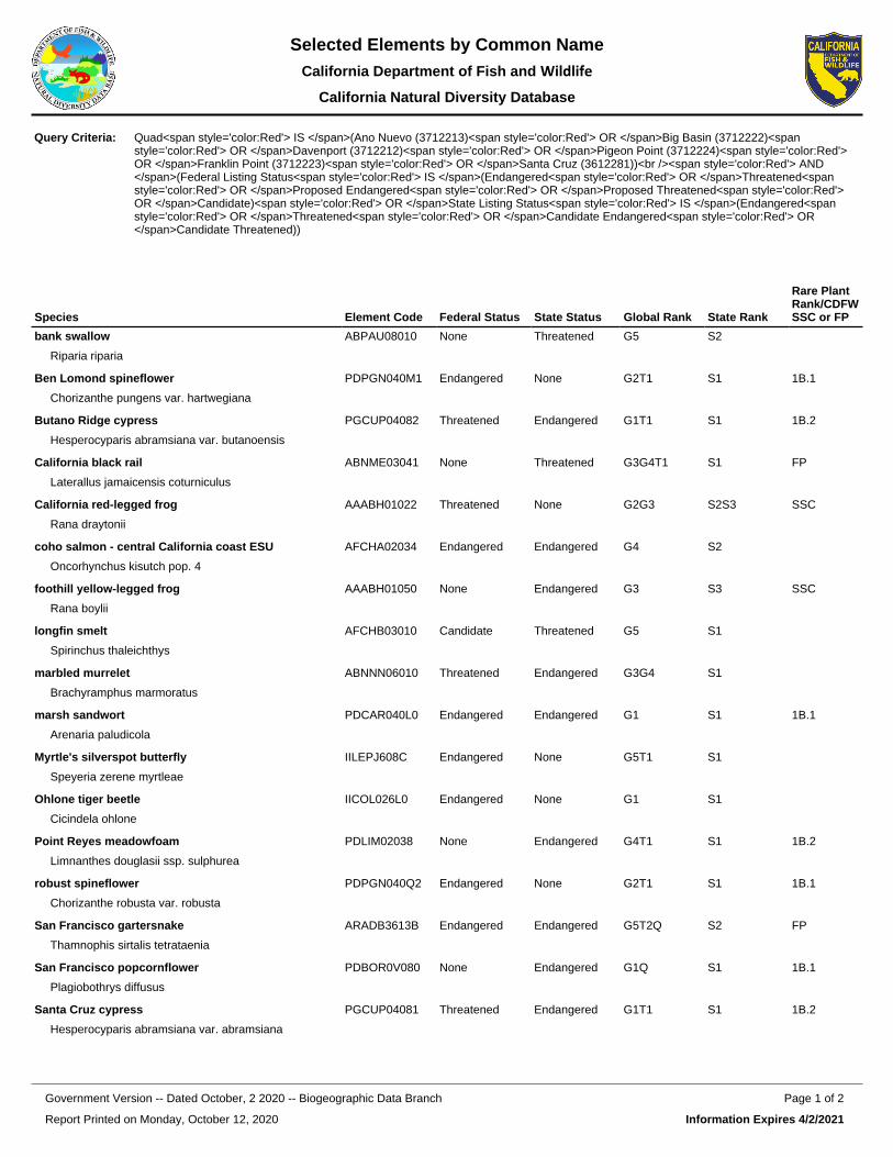
Species Element Code Federal Status State Status Global Rank State Rank
Rare Plant Rank/CDFW SSC or FP
bank swallow
Riparia riparia
ABPAU08010 None Threatened G5 S2
Ben Lomond spineflower
Chorizanthe pungens var. hartwegiana
PDPGN040M1 Endangered None G2T1 S1 1B.1
Butano Ridge cypress
Hesperocyparis abramsiana var. butanoensis
PGCUP04082 Threatened Endangered G1T1 S1 1B.2
California black rail
Laterallus jamaicensis coturniculus
ABNME03041 None Threatened G3G4T1 S1 FP
California red-legged frog
Rana draytonii
AAABH01022 Threatened None G2G3 S2S3 SSC
coho salmon - central California coast ESU
Oncorhynchus kisutch pop. 4
AFCHA02034 Endangered Endangered G4 S2
foothill yellow-legged frog
Rana boylii
AAABH01050 None Endangered G3 S3 SSC
longfin smelt
Spirinchus thaleichthys
AFCHB03010 Candidate Threatened G5 S1
marbled murrelet
Brachyramphus marmoratus
ABNNN06010 Threatened Endangered G3G4 S1
marsh sandwort
Arenaria paludicola
PDCAR040L0 Endangered Endangered G1 S1 1B.1
Myrtle's silverspot butterfly
Speyeria zerene myrtleae
IILEPJ608C Endangered None G5T1 S1
Ohlone tiger beetle
Cicindela ohlone
IICOL026L0 Endangered None G1 S1
Point Reyes meadowfoam
Limnanthes douglasii ssp. sulphurea
PDLIM02038 None Endangered G4T1 S1 1B.2
robust spineflower
Chorizanthe robusta var. robusta
PDPGN040Q2 Endangered None G2T1 S1 1B.1
San Francisco gartersnake
Thamnophis sirtalis tetrataenia
ARADB3613B Endangered Endangered G5T2Q S2 FP
San Francisco popcornflower
Plagiobothrys diffusus
PDBOR0V080 None Endangered G1Q S1 1B.1
Santa Cruz cypress
Hesperocyparis abramsiana var. abramsiana
PGCUP04081 Threatened Endangered G1T1 S1 1B.2
Query Criteria: Quad<span style='color:Red'> IS </span>(Ano Nuevo (3712213)<span style='color:Red'> OR </span>Big Basin (3712222)<span style='color:Red'> OR </span>Davenport (3712212)<span style='color:Red'> OR </span>Pigeon Point (3712224)<span style='color:Red'> OR </span>Franklin Point (3712223)<span style='color:Red'> OR </span>Santa Cruz (3612281))<br /><span style='color:Red'> AND </span>(Federal Listing Status<span style='color:Red'> IS </span>(Endangered<span style='color:Red'> OR </span>Threatened<span style='color:Red'> OR </span>Proposed Endangered<span style='color:Red'> OR </span>Proposed Threatened<span style='color:Red'> OR </span>Candidate)<span style='color:Red'> OR </span>State Listing Status<span style='color:Red'> IS </span>(Endangered<span style='color:Red'> OR </span>Threatened<span style='color:Red'> OR </span>Candidate Endangered<span style='color:Red'> OR </span>Candidate Threatened))
Report Printed on Monday, October 12, 2020
Page 1 of 2Government Version -- Dated October, 2 2020 -- Biogeographic Data Branch
Information Expires 4/2/2021
Selected Elements by Common NameCalifornia Department of Fish and Wildlife
California Natural Diversity Database

Species Element Code Federal Status State Status Global Rank State Rank
Rare Plant Rank/CDFW SSC or FP
Santa Cruz tarplant
Holocarpha macradenia
PDAST4X020 Threatened Endangered G1 S1 1B.1
Santa Cruz wallflower
Erysimum teretifolium
PDBRA160N0 Endangered Endangered G1 S1 1B.1
steelhead - central California coast DPS
Oncorhynchus mykiss irideus pop. 8
AFCHA0209G Threatened None G5T2T3Q S2S3
tidewater goby
Eucyclogobius newberryi
AFCQN04010 Endangered None G3 S3
tricolored blackbird
Agelaius tricolor
ABPBXB0020 None Threatened G2G3 S1S2 SSC
western bumble bee
Bombus occidentalis
IIHYM24250 None Candidate Endangered
G2G3 S1
western snowy plover
Charadrius alexandrinus nivosus
ABNNB03031 Threatened None G3T3 S2S3 SSC
white-rayed pentachaeta
Pentachaeta bellidiflora
PDAST6X030 Endangered Endangered G1 S1 1B.1
Zayante band-winged grasshopper
Trimerotropis infantilis
IIORT36030 Endangered None G1 S1
Record Count: 26
Report Printed on Monday, October 12, 2020
Page 2 of 2Government Version -- Dated October, 2 2020 -- Biogeographic Data Branch
Information Expires 4/2/2021
Selected Elements by Common NameCalifornia Department of Fish and Wildlife
California Natural Diversity Database

Species Element Code Federal Status State Status Global Rank State Rank
Rare Plant Rank/CDFW SSC or FP
American badger
Taxidea taxus
AMAJF04010 None None G5 S3 SSC
black swift
Cypseloides niger
ABNUA01010 None None G4 S2 SSC
burrowing owl
Athene cunicularia
ABNSB10010 None None G4 S3 SSC
California black rail
Laterallus jamaicensis coturniculus
ABNME03041 None Threatened G3G4T1 S1 FP
California giant salamander
Dicamptodon ensatus
AAAAH01020 None None G3 S2S3 SSC
California red-legged frog
Rana draytonii
AAABH01022 Threatened None G2G3 S2S3 SSC
foothill yellow-legged frog
Rana boylii
AAABH01050 None Endangered G3 S3 SSC
saltmarsh common yellowthroat
Geothlypis trichas sinuosa
ABPBX1201A None None G5T3 S3 SSC
San Francisco dusky-footed woodrat
Neotoma fuscipes annectens
AMAFF08082 None None G5T2T3 S2S3 SSC
San Francisco gartersnake
Thamnophis sirtalis tetrataenia
ARADB3613B Endangered Endangered G5T2Q S2 FP
Santa Cruz black salamander
Aneides niger
AAAAD01070 None None G3 S3 SSC
Townsend's big-eared bat
Corynorhinus townsendii
AMACC08010 None None G3G4 S2 SSC
tricolored blackbird
Agelaius tricolor
ABPBXB0020 None Threatened G2G3 S1S2 SSC
western pond turtle
Emys marmorata
ARAAD02030 None None G3G4 S3 SSC
western snowy plover
Charadrius alexandrinus nivosus
ABNNB03031 Threatened None G3T3 S2S3 SSC
yellow rail
Coturnicops noveboracensis
ABNME01010 None None G4 S1S2 SSC
Record Count: 16
Query Criteria: Quad<span style='color:Red'> IS </span>(Ano Nuevo (3712213)<span style='color:Red'> OR </span>Big Basin (3712222)<span style='color:Red'> OR </span>Davenport (3712212)<span style='color:Red'> OR </span>Santa Cruz (3612281)<span style='color:Red'> OR </span>Pigeon Point (3712224)<span style='color:Red'> OR </span>Franklin Point (3712223))<br /><span style='color:Red'> AND </span>Other Status Contains (CDFW_FP-Fully Protected<span style='color:Red'> OR </span>CDFW_SSC-Species of Special Concern)
Report Printed on Thursday, October 22, 2020
Page 1 of 1Government Version -- Dated October, 2 2020 -- Biogeographic Data Branch
Information Expires 4/2/2021
Selected Elements by Common NameCalifornia Department of Fish and Wildlife
California Natural Diversity Database

Appendices
122 SR-1 Erosion Control Project Natural Environment Study
Appendix C: Plant List

Appendices
123 SR-1 Erosion Control Project Natural Environment Study
State of California California State Transportation Agency DEPARTMENT OF TRANSPORTATION References: California Natural Diversity Database (CNDDB) Rare Find 5. 2020. California Department of Fish and Wildlife. 2020. Available: www.wildlife.ca.gov/Data/CNDDB/Maps-and-Data. Calflora: Information on California plants for education, research and conservation. [web application]. 2020. Berkeley, California: The Calflora Database [a non-profit organization]. Available: www.calflora.org/ (Accessed: October 2020).
University of California Agriculture & Natural Resources. UC IPM- Statewide Integrated Pest Management Program. 2020. Available: www.ipm.ucanr.edu/PMG/weeds_intro.html (Accessed: October 2020)
Briza maxima blowfly grass Non-native Equisetum telmateia great horsetail Non-native Urtica dioica stinging nettle Non-native Stachys bullata California hedgenettle Native Rubus ursinus California blackberry Native Scrophularia californica California figwort Native Typha latifolia Common cattail Native Carduus pycnocephalus Italian thistle Non-native Aesculus californica California buckeye Native Quercus agrifolia coast live oak Native Heteromeles arbutifola Toyon Native Marah fabacean wild cucumber Native Toxicodendron diversilobum poison oak Native Conium maculatum poison hemlock Non-native Helminthotheca echioides bristly ox-tongue Non-native Vicia sp. milk-vetch - Avena barbata slender oat Non-native Frangula californica coffeeberry Native Lolium multiflorum italian ryegrass Non-native Solanum douglasii greenspot nightshade Native Rumex crispus curly dock Non-native Cyperus sp. sedge - Persicaria punctata dotted knotweed Non-native Hydrocotyle sp. pennywort - Ceanothus thyrsiflorus blueblossom ceanothus Native Epilobium ciliatum fringed willow-herb Native Baccharis glutinosa marsh baccharis Native
“Provide a safe, sustainable, integrated and efficient transportation system to enhance California’s economy and livability”

Appendices
124 SR-1 Erosion Control Project Natural Environment Study
Appendix D: Representative
Photographs

Appendices
125 SR-1 Erosion Control Project Natural Environment Study
Photograph 1: Año Nuevo SP, SR-1, facing south from Swanton Berry Farm Driveway; shows vegetation prior to CZU Lightning Complex Fire [07/02/2020]

Appendices
126 SR-1 Erosion Control Project Natural Environment Study
Photograph 2: Ano Nuevo SP, SR-1, Facing west from east side SR-1 embankment; shows disconnected CSP down drain #2 [07/22/2020]

Appendices
127 SR-1 Erosion Control Project Natural Environment Study
Photograph 3: Ano Nuevo SP, SR-1, facing west from the east side of SR-1 embankment; shows gully created by decommissioned CSP down drain #2 [07/22/2020]

Appendices
128 SR-1 Erosion Control Project Natural Environment Study
Photograph 4: Ano Nuevo SP, SR-1, facing north from SR-1 shoulder; shows PTF tadpole rearing habitat [07/22/2020]

Appendices
129 SR-1 Erosion Control Project Natural Environment Study
Photograph 5: Ano Nuevo SP, SR-1, facing east from NB shoulder of SR-1; shows PTF tadpoles in standing water on shoulder [07/22/2020]

Appendices
130 SR-1 Erosion Control Project Natural Environment Study
Photograph 6: Año Nuevo SP, SR-1, camera-trap placed in dense vegetation near entrance of Swanton Berry Farm Driveway; shows active woodrat nest with nocturnal foraging activity [07/23/2020]

Appendices
131 SR-1 Erosion Control Project Natural Environment Study
Photograph 7: Año Nuevo SP, SR-1, camera-trap placed in dense vegetation near entrance of Swanton Berry Farm Driveway; shows active woodrat nest with nocturnal foraging activity [07/23/2020]

Appendices
132 SR-1 Erosion Control Project Natural Environment Study
Photograph 8: Ano Nuevo SP, SR-1, facing east from NB shoulder of SR-1; shows CSP down drain #1 to be removed during construction [07/29/2020]

Appendices
133 SR-1 Erosion Control Project Natural Environment Study
Photograph 9: Ano Nuevo SP, SR-1, facing east from NB shoulder of SR-1; shows CZU Lightning Complex fire damage on hillside immediately adjacent to project footprint [09/24/2020]

County of San Mateo - Planning and Building Department
ATTACHMENT E

Page 1 of 3
CEQA EXEMPTION / NEPA CATEGORICAL EXCLUSION DETERMINATION FORM (rev. 11/2020)
Project Information Project Name (if applicable): Sheet Pile Wall Project DIST-CO-RTE: 04-SM-1 PM/PM: 1.1 EA: 0K570 Federal-Aid Project Number: 0416000105 Project Description Caltrans proposes to correct and prevent further wash-out damage due to storms by installing a sheet pile wall on northbound State Route 1 (SR 1), at PM 1.1 in San Mateo County. The purpose of this project is to maintain the integrity of the roadway and to improve driver safety. The project is needed because a Damage Assessment Form (DAF) was initiated on June 10, 2015 and stated that a slope washout on the northbound side of SR 1 near Cold Dip Creek in San Mateo County was caused by storm water runoff due to inadequate drainage facilities.
Please see continuation sheet.
Caltrans CEQA Determination (Check one)
☐ Not Applicable – Caltrans is not the CEQA Lead Agency ☐ Not Applicable – Caltrans has prepared an IS or EIR under CEQA
Based on an examination of this proposal and supporting information, the project is: ☐ Exempt by Statute. (PRC 21080[b]; 14 CCR 15260 et seq.) ☒ Categorically Exempt. Class 1d. (PRC 21084; 14 CCR 15300 et seq.)
☐ No exceptions apply that would bar the use of a categorical exemption (PRC 21084 and 14 CCR 15300.2). See the SER Chapter 34 for exceptions.
☐ Covered by the Common Sense Exemption. This project does not fall within an exempt class, but it can be seen with certainty that there is no possibility that the activity may have a significant effect on the environment (14 CCR 15061[b][3].)
Senior Environmental Planner or Environmental Branch Chief
Zachary Gifford Print Name Signature Date
Project Manager
Al B. Lee Print Name Signature Date
1/08/2021
1-21-21
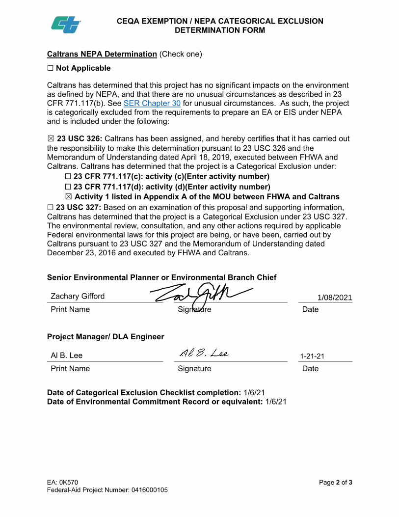
CEQA EXEMPTION / NEPA CATEGORICAL EXCLUSION
DETERMINATION FORM
EA: 0K570 Page 2 of 3 Federal-Aid Project Number: 0416000105
Caltrans NEPA Determination (Check one)
☐ Not Applicable
Caltrans has determined that this project has no significant impacts on the environment as defined by NEPA, and that there are no unusual circumstances as described in 23 CFR 771.117(b). See SER Chapter 30 for unusual circumstances. As such, the project is categorically excluded from the requirements to prepare an EA or EIS under NEPA and is included under the following:
☒ 23 USC 326: Caltrans has been assigned, and hereby certifies that it has carried out the responsibility to make this determination pursuant to 23 USC 326 and the Memorandum of Understanding dated April 18, 2019, executed between FHWA and Caltrans. Caltrans has determined that the project is a Categorical Exclusion under:
☐ 23 CFR 771.117(c): activity (c)(Enter activity number) ☐ 23 CFR 771.117(d): activity (d)(Enter activity number) ☒ Activity 1 listed in Appendix A of the MOU between FHWA and Caltrans
☐ 23 USC 327: Based on an examination of this proposal and supporting information, Caltrans has determined that the project is a Categorical Exclusion under 23 USC 327. The environmental review, consultation, and any other actions required by applicable Federal environmental laws for this project are being, or have been, carried out by Caltrans pursuant to 23 USC 327 and the Memorandum of Understanding dated December 23, 2016 and executed by FHWA and Caltrans.
Senior Environmental Planner or Environmental Branch Chief
Zachary Gifford Print Name Signature Date
Project Manager/ DLA Engineer
Al B. Lee Print Name Signature Date
Date of Categorical Exclusion Checklist completion: 1/6/21 Date of Environmental Commitment Record or equivalent: 1/6/21
1/08/2021
1-21-21

CEQA EXEMPTION / NEPA CATEGORICAL EXCLUSION
DETERMINATION FORM
EA: 0K570 Page 3 of 3 Federal-Aid Project Number: 0416000105
Continuation sheet: The sheet pile wall will be approximately 150 feet in length and 6 feet in height above ground. About 200 feet of existing guardrail would be replaced and upgraded to the Midwest Guardrail System. A 4-foot area around the newly installed guardrail will be covered with minor concrete for vegetation control. In addition to the sheet pile wall and guardrail, the existing drainage system will be upgraded by installing one new inlet as well as a new 18-inch Corrugated Metal Pipe down drain with anchor assembly. Construction limits, including traffic control and staging, reach from PM 0.8 to PM 1.55. All construction is anticipated to remain within the right-of-way (ROW), and no temporary construction easements will be needed. Staging will be at a dirt pullout along the southbound side of the highway, about 1,300 feet from the construction location at PM 0.9.
Please see attached Environmental Commitments Record (ECR) for Avoidance, Minimization, and Mitigation measures (AMMs).

Environmental Commitments Record (ECR)
Environmental Planner: Tanvi Gupta Phone: 510-286-6450Construction Liaison: Fadwa Bouhedda Phone: 510-506-9707Resident Engineer: Phone:
DIST-CO-RTE: 04 - SM - 001 PM/PM: 1.100/1.100 EA/Project ID: 04-0K570_ / 0416000105Project Description: RECONSTRUCT WASHOUT SLOPE.Date (Last modification):
Permit ApplicationSubmitted
PermitReceivedAgency
PermitRequirementsCompleted by
PermitExpiration Comments
PermitRequirementsCompleted on
California Department of Fish & Wildlife
Regional Water Quality Control Board401
US Army Corps of Engineers404 Non-Reporting
1/29/2110/21/20US Fish and WildlifeBO (FWS)
Coastal CommissionCoastal Development Permit
PERMITS
ENVIRONMENTAL COMMITMENTS
Page 1

Environmental Commitments Record for Sheet Pile Wall
Category SourceIncluded inPS&EPackage
Task and Brief Description Action to ComplyResponsibleBranch/Staff RemarksDue Date Task
Completed byTaskCompletedon
Mitigation forsignificantimpacts underCEQA
PRE-CONSTRUCTION
Category SourceIncluded inPS&EPackage
Task and Brief Description Action to ComplyResponsibleBranch/Staff RemarksDue Date Task
Completed byTaskCompletedon
Mitigation forsignificantimpacts underCEQA
Install Construction Boundary and Wildlife ExclusionFencing. Before the start of construction. The projectfootprint boundary will be clearly delineated usinghigh-visibility orange fencing as necessary. Constructionwork areas will include the active construction site and allareas providing support for the project, including areasused for vehicle parking, equipment and material storageand staging, and access roads. The fencing will remain inplace throughout the duration of construction activities andwill be inspected regularly and fully maintained at all times.
Env Doc SSP RE/Biology The final project planswill show all locationswhere boundaryfencing will be installedand will provideinstallationspecifications. The bidsolicitation packagespecial provisions willclearly describeacceptable fencingmaterial and prohibitedconstruction-relatedactivities, includingvehicle operation,material andequipment storage,access roads andothersurface-disturbingactivities. Silt fencingor other wildlifeexclusion fencing willbe installed inconjunction with theconstruction boundaryfencing around theperimeter of the projectfootprint to allowspecial-status speciesto leave but notre-enter the work area.This fence will beinstalled prior to anywork within the projectfootprint. Exclusionfencing will be at least3 feet high with thelower 6 inches of thefence buried in theground. The fence willbe pulled taut at eachsupport to prevent
Biology
Page 2

Environmental Commitments Record for Sheet Pile Wall
Category SourceIncluded inPS&EPackage
Task and Brief Description Action to ComplyResponsibleBranch/Staff RemarksDue Date Task
Completed byTaskCompletedon
Mitigation forsignificantimpacts underCEQA
folds or snags.Fencing will be
Preconstruction California Red Legged Frog, San FranciscoGarter Snake, and Marbled Murrelet Survey.Pre-construction surveys for the CRLF, SFGS, and MAMUwill be conducted by the qualified biologist no more than 20calendar days prior to any initial ground disturbance andimmediately prior to ground-disturbing activities (includingvegetation removal) within upland habitat identified for theCRLF.
Env Doc SSP RE/Biology These efforts willconsist of walkingsurveys of the projectlimits and, if possible,accessible adjacentareas within at least 50feet of the projectlimits. The qualifiedbiologist willinvestigate potentialcover sites when it isfeasible and safe to doso. This includesthorough investigationof mammal burrows,rocky outcrops,appropriately sized soilcracks, tree cavities,and debris. Nativevertebrates found inthe cover sites withinthe project limits will bedocumented andrelocated to anadequate cover site inthe vicinity. Safetypermitting, thequalified biologist willinvestigate areas ofdisturbed soil for signsof CRLF and SFGS,within 30 minutesfollowing initialdisturbance of thegiven area.
Biology
Preconstruction San Francisco Dusky Footed Wood RatSurveys. Before the start of construction, an approvedbiologist(s) will conduct a survey of the project footprint anda 30 foot buffer beyond the project footprint boundaries todetermine the location of active and inactive woodratmiddens. Any nests/middens detected during the surveyswill be recorded and mapped in relation to the constructiondisturbance footprint. In addition, the biologist will evaluateany signs of current woodrat activity, including the presenceof fresh scat, freshly chewed vegetation, and cobwebscovering nest entrances.
Env Doc SSP RE/Biology A 10 foot equipmentexclusion buffer will beestablished aroundactive and inactivenests/middens that canbe avoided; withinsuch buffers, allvegetation will beretained and nests willremain undisturbed.
Biology
Page 3

Environmental Commitments Record for Sheet Pile Wall
Category SourceIncluded inPS&EPackage
Task and Brief Description Action to ComplyResponsibleBranch/Staff RemarksDue Date Task
Completed byTaskCompletedon
Mitigation forsignificantimpacts underCEQA
Water Pollution Control Program (WPCP). A WPCP isrequired for the project. The WPCP will address potentialtemporary impacts via implementation of appropriate bestmanagement practices (BMPs) to the Maximum ExtentPracticable. Further, sampling and monitoring ofconstruction site discharge point(s) may be recommendedby the San Francisco Bay RWQCB as part of the WPCP.
Env Doc Std. Spec RE/WaterQuality
Water Quality
CONSTRUCTION
Category SourceIncluded inPS&EPackage
Task and Brief Description Action to ComplyResponsibleBranch/Staff RemarksDue Date Task
Completed byTaskCompletedon
Mitigation forsignificantimpacts underCEQA
Agency Approved Biologist. An approved biologist(s) will bepresent during all activities that could reasonably result intake of the CRLF, SFGS, and MAMU
Env Doc Std. Spec RE/Biology If special-statusspecies arediscovered, work willbe stoppedimmediately, and thebiologist will:·Contact CDFW andUSFWS within 1working day;The biologist, inconsultation withCDFW and USFWS,will use adaptivemanagement to modifyas necessary projectactivities to avoid orminimize effects tolisted species.
Biology
Construction Work, Access, and Staging Areas. Allproposed construction will be limited to the existing andproposed ROWs. Vegetation removal will be limited to thedesignated work areas needed for access and workspace.Where possible, vegetation removal in temporary workareas will be cut above soil level to promote re-vegetativegrowth of established plants following construction.Construction access, staging, storage, and parking areaswill be located within Caltrans right of way on pavedsurfaces and compacted roadside fill.
Env Doc Std. Spec RE/Biology Before movingconstructionequipment or vehiclesinto the project site,operators will checkunderneath those thathave been parkedonsite for more than 30minutes and will notifythe qualified biologist ifany reptile oramphibian is observed.To avoid special-statusspecies from becomingentangled, trapped orinjured, erosion controlmaterials that use
Biology
Page 4

Environmental Commitments Record for Sheet Pile Wall
Category SourceIncluded inPS&EPackage
Task and Brief Description Action to ComplyResponsibleBranch/Staff RemarksDue Date Task
Completed byTaskCompletedon
Mitigation forsignificantimpacts underCEQA
plastic or syntheticmono-filament nettingwill not be used withinthe action area. Toprevent inadvertententrapment of animalsduring construction, allexcavated,steep-walled holes ortrenches more than 1foot deep will becovered at the close ofeach working day byplywood or similarmaterials. Before suchholes or trenches arefilled, they must bethoroughly inspectedfor trapped animals. Allreplacement pipes,culverts, or similarstructures stored in theproject area overnightwill be inspectedbefore they aresubsequently moved,capped and/or buried.
Invasive Species Management. To reduce the spread ofinvasive non-native plant species and minimize thepotential decrease of palatable vegetation for wildlifespecies, Caltrans will comply with Executive Order 13112.The purpose of this order is to prevent the introduction ofinvasive species and provide for their control to minimizeeconomic, ecological, and human health impacts. In theevent that high- or medium-priority noxious weeds, asdefined by the California Department of Food andAgriculture or the California Invasive Plant Council, aredisturbed or removed during construction-related activities,the contractor will contain the plant material associated withthese noxious weeds and will dispose of it in a manner thatwill not promote the spread of the species.
Env Doc Std. Spec RE/Biology The contractor will beresponsible forobtaining all permits,licenses, andenvironmentalclearances for properlydisposing materials.Areas subject tonoxious weed removalor disturbance will bereplanted withfast-growing nativegrasses or a nativeerosion control seedmixture. If seeding isnot possible, the areawill be covered to theextent practicable withheavy black plasticsolarization materialuntil completion of
Biology
Page 5

Environmental Commitments Record for Sheet Pile Wall
Category SourceIncluded inPS&EPackage
Task and Brief Description Action to ComplyResponsibleBranch/Staff RemarksDue Date Task
Completed byTaskCompletedon
Mitigation forsignificantimpacts underCEQA
construction. Allearthmovingequipment, as well asseeding equipment tobe used during projectconstruction would bethoroughly cleanedbefore arriving on theproject site.
Potential San Francisco Dusky-Footed Wood Rat Trappingand Relocation. For any woodrat middens/nests that cannotbe avoided with a 10 foot buffer due to their presence in awork area, a woodrat trapping and relocation plan will bedeveloped.
Env Doc SSP RE/Biology The plan will outlinespecific methods fortrapping woodrats andrelocation ofindividuals and theirmiddens/nests to asuitable nearbyundisturbed location.Existing woodratmiddens/nests will bedismantled, collected,and relocated to theirnew location. Thewoodrat relocationwork would occur priorto any constructionactivities and outsideof the breeding period(September toDecember), if possible.
Biology
Stop Work Authority. If a protected species is observed inthe project footprint, work at that location will be temporarilyhalted while the animal leaves the work site on its ownaccord
Env Doc Std. Spec RE/BiologyBiology
Work Windows. All construction-related activities will berestricted to April 15 to October 31 to avoid or reduceimpacts to special-status species and their habitat.No work will occur during or within 24 hours following a rainevent exceeding 0.2-inch as measured by the NationalOceanic and Atmospheric Association National WeatherService for the Soquel, CA (SOQC1) base station availableat:http://www.wrh.noaa.gov/mtr/versprod.php?pil=RR5&sid=RSA. The Service and CDFW approval to continue workduring or within 24 hours of a rain event will be consideredon a case-by-case basis.
Env Doc Std. Spec RE/BiologyBiology
Temporary High-Visibility Fence (THVF) will be installed Section 106 SSP K. MontgomeryCultural
Page 6

Environmental Commitments Record for Sheet Pile Wall
Category SourceIncluded inPS&EPackage
Task and Brief Description Action to ComplyResponsibleBranch/Staff RemarksDue Date Task
Completed byTaskCompletedon
Mitigation forsignificantimpacts underCEQA
along Northbound SR 1, PM 1.2, approximately 16 feetfrom edge of pavement and will extend for 200 feetnorth-south. The fence will stop at the unpaved drive andconnect to the ROW fence, approximately 25 feet east.
The Contractor is responsible for notifying the ResidentEngineer two weeks prior to the start of construction whowill then contact District 4 Project Archaeologist(510-847-1499). Caltrans staff archaeologists will delineatethe ESA boundaries in the field and fencing will be installedby the contractor.
No project related activities can occur within the ESA.
Resources
Unidentified Resources. If previously unidentified culturalresources are unearthed during construction, work shall behalted in that area until a qualified archaeologist can assessthe significance of the discovery.
Env Doc Std. Spec RE/CulturalCulturalResources
Maintain the visual integrity of the area. Env Doc Std. Spec RE/Visual ·All disturbed soils,from trenching andconstruction activities,shall be covered withappropriate erosioncontrol measures andorganic mulch.· Areas ofremoved existingtrees/vegetation shallbe considered forreplacement planting,in coordination withproject biologicalrecommendations andrequirements.·Concrete stain(brown) shall beapplied on any newconcrete paving orstructural elements, asappropriate.·Metal stain (brown)should be consideredon metal galvanizedsurfaces, to reduceglare and support theexisting rural aestheticand scenic highway.·Construction stagingand activities should
Landscape
Page 7

Environmental Commitments Record for Sheet Pile Wall
Category SourceIncluded inPS&EPackage
Task and Brief Description Action to ComplyResponsibleBranch/Staff RemarksDue Date Task
Completed byTaskCompletedon
Mitigation forsignificantimpacts underCEQA
avoid/minimizedamage to any existingroadside elementsincluding: landscapeplants, paving, fencing,structures, signage,utilities, and drainage.Any existing roadsideirrigation equipment,above and belowgrade, that is damagedor removed shall beevaluated forreplacement and/or
Construction Discharges. No debris, soil, silt, sand, bark,slash, sawdust, cement, concrete, washings, petroleumproducts, or other organic or earthen material shall beallowed to enter into, or be placed where it may be washedby rainfall or runoff into, waters of the United States ordrainages. No discharges of excessively turbid water will beallowed, and all equipment will be well-maintained and freeof leaks.
Env Doc Std. Spec RE/WaterQuality
Water Quality
Erosion Control. Temporary erosion control and slopestabilization BMPs will be installed before the start of thewet season (generally October 15 through April 15).Erosion control measures may include silt fencing, strawwattles, straw bales, coir blankets, sediment traps, andother protective measures to minimize the potential forerosion of sediment beyond the work area, or degradationof water quality in adjacent aquatic habitats.
Env Doc Std. Spec RE/WaterQuality
Water Quality
POST-CONSTRUCTION
Category SourceIncluded inPS&EPackage
Task and Brief Description Action to ComplyResponsibleBranch/Staff RemarksDue Date Task
Completed byTaskCompletedon
Mitigation forsignificantimpacts underCEQA
Restoration/Revegetation. In areas of soil disturbance, anynative topsoil will be removed and stored in a suitablelocation until project completion. Caltrans will restoretemporarily disturbed areas to the preconstruction functionand values to the maximum extent practicable.
Env Doc Std. Spec RE/Biology Exposed slopes andbare ground will bereseeded with nativegrasses and shrubs(using a hydro-seedmix) to stabilize andprevent erosion.
Biology
Page 8

County of San Mateo - Planning and Building Department
ATTACHMENT F

State of California California State Transportation Agency DEPARTMENT OF TRANSPORTATION
“Provide a safe, sustainable, integrated and efficient transportation system to enhance California’s economy and livability”
M e m o r a n d u m Serious drought. Help save water!
The purpose of this Scenic Resource Evaluation and Visual Impact Assessment is to review the proposed project for potential impacts to visual resources and to document any potential impacts.
This slope repair project is proposed within San Mateo County on state route (SR) 1, post miles 1.0 to 1.12, in response to past storm water washout damage. Severe erosion has occurred on the east facing slope, at approximately 110 feet in length. The project's purpose is to preserve the existing roadway, by constructing a new retaining wall--110 feet long, and improving the related drainage system. Other related work items include: pavement delineation, shoulder backing, replacement metal beam guard railing, earthwork, and existing vegetation removal.
SR-1, in San Mateo County, is a two-lane undivided highway with metal beam guard rails at various locations, traversing in a northwest-to-southeast orientation. The SR-1 corridor is mostly rural in land use and visual character and quality. Its views from the highway are of: coastal roadside grasslands and hills, scattered woodlands and forests, farmlands and some residences, with many vista views of the coastline and Pacific Ocean. Land uses include agricultural, open space, and some residential.
SR-1 (PM 0.0 to 26.0) is designated as an official State Scenic Highway, by California State and San Mateo County. There are many scenic resources along highway SR-1 including: unique or outstanding trees or forests, rolling grass covered hills, rock outcroppings, and some historic buildings or structures.
The proposed project will be compatible with the existing visual resources of the SR-1 highway corridor, and will not substantially alter the visual resources (visual quality and character) of the site. This proposed design retaining wall/slope repair project includes primarily a new retaining wall--soldier pile type (110 feet length), drainage culvert systems improvements, earthwork, metal beam guardrail replacement (galvanized), and 11,000 square feet of vegetation removal. The visual resource change is expected to be minimal, as most of the work faces away from the highway, and won't be visible from the highway; and replacement planting will fill in for the removed vegetation areas. Architectural treatments--such as concrete stain, will help to reduce
To: TANVI GUPTA Associate Environmental Planner Office of Environmental Planning
Date:
File:
September 10, 2019
SM-1 PM 1.0-1.12 EA 04-0K570 Slope Repair
From: SCOTT BOTTARI Landscape Associate Office of Landscape Architecture
Subject: SCENIC RESOURCE EVLAUATION AND VISUAL IMPACT ASSESSMENT

Page 2 of 2
“Provide a safe, sustainable, integrated and efficient transportation system to enhance California’s economy and livability”
any new roadside glare from new concrete paving and structural elements, and support the rural aesthetic and scenic highway. The existing roadside trees/vegetation proposed for removal may be designated for replacement, in coordination with biological requirements. The removed vegetation won't alter any existing vegetated visual screens, or substantially affect existing visual resources.
Visually, highway users, and some residences and businesses adjacent to the highway, will not be affected by the project. The primary viewers are highway motorists. They may notice some minor visual change of new pavement, and some trees removal; however, they are not expected to be sensitive to these minor changes. Thus, viewer response is anticipated to be low.
Given the low level of visual resource change and viewer response, the project is expected to have minimal visual impacts. With the following design minimization measures, the proposed project will maintain the existing visual character/quality and scenic highway status of the corridor.
• Concrete stain (brown) shall be applied on any new concrete paving or structural elements,as appropriate.
• Metal stain (brown) should be considered on metal galvanized surfaces, to reduce glareand support the existing rural aesthetic and scenic highway.
• Construction staging and activities should avoid/minimize damage to any existingroadside elements including: landscape plants, paving, fencing, structures, signage,utilities, and drainage.
• Any existing roadside irrigation equipment--above and below grade, that is damaged orremoved shall be evaluated for replacement and/or repair.
• All disturbed soils--from trenching and construction activities, shall be covered withappropriate erosion control measures and organic mulch.
• Areas of removed existing trees/vegetation should be considered for replacement planting,in coordination with project biological recommendations and requirements.
In conclusion, review of the project site and proposed plans/report indicate that the project design would not result in substantial adverse impacts to the visual environment. The proposed design work--retaining wall, drainage improvements, and earthwork, will not affect the appearance and visual resources of the existing highway corridor, and will be visually consistent with the character of the surrounding area. There are no scenic resources, such as unique or outstanding trees, rock outcroppings, historic buildings or other structures that would be adversely affected by the project.
c: Kimberly White, Branch Chief, Caltrans D04, Office of Landscape Architecture Nandini Shridar, Project Manager, Caltrans D04, Project Management Maria Lerma, Project Engineer, Caltrans D04, Design