Cosmogenic 36Cl and 10Be ages of Quaternary glacial and fluvial deposits of the Wind River Range,...
12
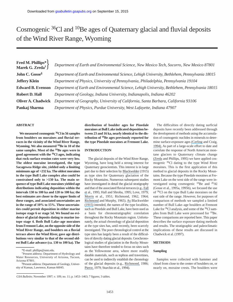
ABSTRACT We measured cosmogenic 36 Cl in 56 samples from boulders on moraines and fluvial ter- races in the vicinity of the Wind River Range, Wyoming. We also measured 10 Be in 10 of the same samples. Most of the 10 Be ages were in good agreement with the 36 Cl ages, indicating that rock-surface erosion rates were very low. The oldest moraine investigated, the type Sacagewea Ridge site, yielded only a limiting minimum age of >232 ka. The oldest moraines in the type Bull Lake complex also could be constrained only to >130 ka. The main se- quence of type Bull Lake moraines yielded age distributions indicating deposition within the intervals 130 to 100 ka and 120 to 100 ka; the best estimates are closer to the upper limits of these ranges, and associated uncertainties are in the range of 10% to 15%. These uncertain- ties could permit deposition in either marine isotope stage 6 or stage 5d. We found no evi- dence of glacial deposits dating to marine iso- tope stage 4. Both Bull Lake–age moraines from Fremont Lake, on the opposite side of the Wind River Range, and boulders on a fluvial terrace above the Wind River, gave age distri- butions very similar to that of the second old- est Bull Lake advance (ca. 130 to 100 ka). The distribution of boulder ages for Pinedale moraines at Bull Lake indicated deposition be- tween 23 and 16 ka, nearly identical to the dis- tribution of 10 Be ages previously reported for the type Pinedale moraines at Fremont Lake. INTRODUCTION The glacial deposits of the Wind River Range, Wyoming, have long held a strong interest for Quaternary geoscientists. This interest is in large part due to their selection by Blackwelder (1915) as type sites for Quaternary glaciation of the Rocky Mountains. Numerous subsequent studies have investigated in detail the glacial stratigraphy and that of the associated fluvial terraces (e.g., Fall et al., 1995; Hall and Shroba, 1995; Love, 1979; Morris et al., 1951; Richmond, 1962, 1964; Richmond and Murphy, 1965). As Blackwelder (1915) intended, the names of the type localities, such as Pinedale and Bull Lake, have been used as a basis for chronostratigraphic correlation throughout the Rocky Mountain region. Unfortu- nately, the actual chronology of glacial deposition at the type sites has, until recently, been scarcely investigated. The poor chronological control at the type sites has largely been a result of the difficul- ties of directly dating glacial deposits. Geochrono- logical studies of glaciation in the Rocky Moun- tains have therefore tended to focus on sites such as the Yellowstone area, where more readily datable materials, such as tephras and travertines, can be used to indirectly establish the chronology of the glacial deposits (e.g., Richmond, 1986; Pierce, 1979; Sturchio et al., 1994). The difficulties of directly dating surficial deposits have recently been addressed through the development of methods using the accumula- tion of cosmogenic nuclides in minerals to deter- mine surface-exposure ages (Cerling and Craig, 1994). As part of a large-scale effort to date and correlate the response of North American mon- tane glaciers to Quaternary climate change (Zreda and Phillips, 1995) we have applied cos- mogenic 36 Cl dating to the type Wind River moraines. This is the first application of this method to glacial deposits in the Rocky Moun- tains. Because the type Pinedale moraines at Fre- mont Lake on the west side of the range were in- vestigated using cosmogenic 10 Be and 26 Al (Gosse et al., 1995a, 1995b), we focused the use of 36 Cl on the type Bull Lake moraines on the east side of the range. However, for purposes of comparison of methods we sampled a limited number of Bull Lake–age boulders at Fremont Lake for 36 Cl analysis, and some of the 36 Cl sam- ples from Bull Lake were processed for 10 Be. These comparisons are reported here. This paper describes the surface exposure dating methods and results. The stratigraphic and paleoclimatic implications of these results are discussed in Chadwick et al. (1997). METHODS Sampling Samples were collected with hammer and chisel from close to the center of boulders on, or nearly on, moraine crests. The boulders were 1453 Cosmogenic 36 Cl and 10 Be ages of Quaternary glacial and fluvial deposits of the Wind River Range, Wyoming Fred M. Phillips* Department of Earth and Environmental Science, New Mexico Tech, Socorro, New Mexico 87801 Marek G. Zreda †} John C. Gosse § Department of Earth and Environmental Science, Lehigh University, Bethlehem, Pennsylvania 18015 Jeffery Klein Department of Physics, University of Pennsylvania, Philadelphia, Pennsylvania 19104 Edward B. Evenson Department of Earth and Environmental Science, Lehigh University, Bethlehem, Pennsylvania 18015 Robert D. Hall Department of Geology, Indiana University, Indianapolis, Indiana 46202 Oliver A. Chadwick Department of Geography, University of California, Santa Barbara, California 93106 Pankaj Sharma Department of Physics, Purdue University, West Lafayette, Indiana 47907 GSA Bulletin; November 1997; v. 109; no. 11; p. 1453–1463; 7 figures; 3 tables. *E-mail: [email protected]. † Present address: Department of Hydrology and Water Resources, University of Arizona, Tucson, Arizona 87801. § Present address: Department of Geology, Univer- sity of Kansas, Lawrence, Kansas 66045. on September 15, 2015 gsabulletin.gsapubs.org Downloaded from
-
Upload
independent -
Category
Documents
-
view
5 -
download
0
Transcript of Cosmogenic 36Cl and 10Be ages of Quaternary glacial and fluvial deposits of the Wind River Range,...
ABSTRACT
We measured cosmogenic 36Cl in 56 samplesfrom boulders on moraines and fluvial ter-races in the vicinity of the Wind River Range,Wyoming. We also measured 10Be in 10 of thesame samples. Most of the 10Be ages were ingood agreement with the 36Cl ages, indicatingthat rock-surface erosion rates were very low.The oldest moraine investigated, the typeSacagewea Ridge site, yielded only a limitingminimum age of >232 ka. The oldest morainesin the type Bull Lake complex also could beconstrained only to >130 ka. The main se-quence of type Bull Lake moraines yielded agedistributions indicating deposition within theintervals 130 to 100 ka and 120 to 100 ka; thebest estimates are closer to the upper limits ofthese ranges, and associated uncertainties arein the range of 10% to 15%. These uncertain-ties could permit deposition in either marineisotope stage 6 or stage 5d. We found no evi-dence of glacial deposits dating to marine iso-tope stage 4. Both Bull Lake–age morainesfrom Fremont Lake, on the opposite side of theWind River Range, and boulders on a fluvialterrace above the Wind River, gave age distri-butions very similar to that of the second old-est Bull Lake advance (ca. 130 to 100 ka). The
distribution of boulder ages for Pinedalemoraines at Bull Lake indicated deposition be-tween 23 and 16 ka, nearly identical to the dis-tribution of 10Be ages previously reported forthe type Pinedale moraines at Fremont Lake.
INTRODUCTION
The glacial deposits of the Wind River Range,Wyoming, have long held a strong interest forQuaternary geoscientists. This interest is in largepart due to their selection by Blackwelder (1915)as type sites for Quaternary glaciation of theRocky Mountains. Numerous subsequent studieshave investigated in detail the glacial stratigraphyand that of the associated fluvial terraces (e.g., Fallet al., 1995; Hall and Shroba, 1995; Love, 1979;Morris et al., 1951; Richmond, 1962, 1964;Richmond and Murphy, 1965). As Blackwelder(1915) intended, the names of the type localities,such as Pinedale and Bull Lake, have been used asa basis for chronostratigraphic correlationthroughout the Rocky Mountain region. Unfortu-nately, the actual chronology of glacial depositionat the type sites has, until recently, been scarcelyinvestigated. The poor chronological control at thetype sites has largely been a result of the difficul-ties of directly dating glacial deposits. Geochrono-logical studies of glaciation in the Rocky Moun-tains have therefore tended to focus on sites suchas the Yellowstone area, where more readilydatable materials, such as tephras and travertines,can be used to indirectly establish the chronologyof the glacial deposits (e.g., Richmond, 1986;Pierce, 1979; Sturchio et al., 1994).
The difficulties of directly dating surficialdeposits have recently been addressed throughthe development of methods using the accumula-tion of cosmogenic nuclides in minerals to deter-mine surface-exposure ages (Cerling and Craig,1994). As part of a large-scale effort to date andcorrelate the response of North American mon-tane glaciers to Quaternary climate change(Zreda and Phillips, 1995) we have applied cos-mogenic 36Cl dating to the type Wind Rivermoraines. This is the first application of thismethod to glacial deposits in the Rocky Moun-tains. Because the type Pinedale moraines at Fre-mont Lake on the west side of the range were in-vestigated using cosmogenic 10Be and 26Al(Gosse et al., 1995a, 1995b), we focused the useof 36Cl on the type Bull Lake moraines on theeast side of the range. However, for purposes ofcomparison of methods we sampled a limitednumber of Bull Lake–age boulders at FremontLake for 36Cl analysis, and some of the 36Cl sam-ples from Bull Lake were processed for 10Be.These comparisons are reported here. This paperdescribes the surface exposure dating methodsand results. The stratigraphic and paleoclimaticimplications of these results are discussed inChadwick et al. (1997).
METHODS
Sampling
Samples were collected with hammer andchisel from close to the center of boulders on, ornearly on, moraine crests. The boulders were
1453
Cosmogenic 36Cl and 10Be ages of Quaternary glacial and fluvial depositsof the Wind River Range, Wyoming
Fred M. Phillips* Department of Earth and Environmental Science, New Mexico Tech, Socorro, New Mexico 87801Marek G. Zreda†}John C. Gosse§ Department of Earth and Environmental Science, Lehigh University, Bethlehem, Pennsylvania 18015
Jeffery Klein Department of Physics, University of Pennsylvania, Philadelphia, Pennsylvania 19104
Edward B. Evenson Department of Earth and Environmental Science, Lehigh University, Bethlehem, Pennsylvania 18015
Robert D. Hall Department of Geology, Indiana University, Indianapolis, Indiana 46202
Oliver A. Chadwick Department of Geography, University of California, Santa Barbara, California 93106
Pankaj Sharma Department of Physics, Purdue University, West Lafayette, Indiana 47907
GSA Bulletin;November 1997; v. 109; no. 11; p. 1453–1463; 7 figures; 3 tables.
*E-mail: [email protected]. †Present address: Department of Hydrology and
Water Resources, University of Arizona, Tucson,Arizona 87801.
§Present address: Department of Geology, Univer-sity of Kansas, Lawrence, Kansas 66045.
on September 15, 2015gsabulletin.gsapubs.orgDownloaded from
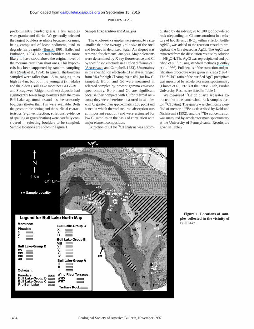
predominantly banded gneiss; a few sampleswere granite and diorite. We generally selectedthe largest boulders available because moraines,being composed of loose sediment, tend todegrade fairly rapidly (Bursik, 1991; Hallet andPutkonen, 1994), and tall boulders are morelikely to have stood above the original level ofthe moraine crest than short ones. This hypoth-esis has been supported by random-samplingdata (Zreda et al., 1994). In general, the boulderssampled were taller than 1.5 m, ranging to ashigh as 4 m, but both the youngest (Pinedale)and the oldest (Bull Lake moraines BLIV–BLIIand Sacagewea Ridge moraines) deposits hadsignificantly fewer large boulders than the mainBull Lake–age moraines and in some cases onlyboulders shorter than 1 m were available. Boththe geomorphic setting and the surficial charac-teristics (e.g., ventifaction, striations, evidenceof spalling or grussification) were carefully con-sidered in selecting boulders to be sampled.Sample locations are shown in Figure 1.
Sample Preparation and Analysis
The whole-rock samples were ground to a sizesmaller than the average grain size of the rockand leached in deionized water. An aliquot wasremoved for elemental analysis. Major elementswere determined by X-ray fluorescence and Clby specific ion electrode in a Teflon diffusion cell(Aruscavage and Campbell, 1983). Uncertaintyin the specific ion electrode Cl analyses rangedfrom 3% (for high Cl samples) to 6% (for low Clsamples). Boron and Gd were measured inselected samples by prompt gamma emissionspectrometry. Boron and Gd are significantbecause they compete with Cl for thermal neu-trons; they were therefore measured in sampleswith Cl greater than approximately 100 ppm (andhence in which thermal neutron absorption wasan important reaction) and were estimated forlow Cl samples on the basis of correlation withmajor element composition.
Extraction of Cl for 36Cl analysis was accom-
plished by dissolving 20 to 100 g of powderedrock (depending on Cl concentration) in a mix-ture of hot HF and HNO3 within a Teflon bottle.AgNO3 was added to the reaction vessel to pre-cipitate the Cl released as AgCl. The AgCl wasextracted from the dissolution residue by solutionin NH4OH. The AgCl was reprecipitated and pu-rified of sulfur using standard methods (Bentleyet al., 1986). Full details of the extraction and pu-rification procedure were given in Zreda (1994).The 36Cl/Cl ratio of the purified AgCl precipitatewas measured by accelerator mass spectrometry(Elmore et al., 1979) at the PRIME Lab, PurdueUniversity. Results are listed in Table 1.
We measured 10Be on quartz separates ex-tracted from the same whole-rock samples usedfor 36Cl dating. The quartz was chemically puri-fied of meteoric 10Be as described by Kohl andNishiizumi (1992), and the 10Be concentrationwas measured by accelerator mass spectrometryat the University of Pennsylvania. Results aregiven in Table 2.
PHILLIPS ET AL.
1454 Geological Society of America Bulletin, November1997
Figure 1. Locations of sam-ples collected in the vicinity ofBull Lake.
on September 15, 2015gsabulletin.gsapubs.orgDownloaded from
Geological Society of America Bulletin, November1997 1455
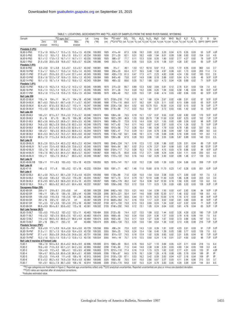
TABLE 1. LOCATIONS, GEOCHEMISTRY AND 36CL AGES OF SAMPLES FROM THE WIND RIVER RANGE, WYOMING
Sample 36Cl ages (ka)* Lat. Long. Elev. 36Cl ratio† SiO2 TiO2 Al2O3 Fe2O3 MgO CaO MnO Na2O K2O P2O5Zero 0.6 Min. Max. (°N) (°W) (m) (36Cl/1015Cl) (wt. %) (wt. %) (wt. %) (wt. %) (wt. %) (wt. %) (wt. %) (wt. %) (wt. %) (wt. %)
erosion mm/k.y. erosion
Pinedale 3 (P3)BL92-2-PN3 17.2 ± 1.8 16.9 ± 1.7 15.5 ± 1.5 15.5 ± 1.5 43.236 109.083 1925 474 ± 44 67.3 0.56 19.2 0.93 0.32 5.20 0.04 6.15 0.35 0.03BL92-5-PN3 10.0 ± 1.2 9.8 ± 1.2 8.9 ± 1.0 8.9 ± 1.1 43.234 109.083 1930 211 ± 20 62.1 0.51 18.2 4.69 1.94 6.01 0.09 5.06 0.93 0.02BL92-6-PN3 18.1 ± 1.2 17.8 ± 1.2 16.7 ± 1.1 16.7 ± 1.1 43.235 109.085 1925 586 ± 37 77.7 0.11 12.3 0.50 0.20 1.80 0.02 2.77 4.27 0.02BL92-7-PN3 21.0 ± 0.8 20.6 ± 0.8 18.8 ± 0.7 18.8 ± 0.7 43.236 109.086 1940 553 ± 19 77.3 0.05 13.0 0.25 0.16 1.08 0.01 4.28 3.87 0.04Pinedale 2 (P2)BL92-8-PN2 6.2 ± 0.8 6.1 ± 0.8 5.5 ± 0.7 5.5 ± 0.7 43.242 109.081 1895 70 ± 7 49.1 1.53 12.7 16.10 6.97 11.2 0.23 1.72 0.25 0.03BL92-10-PN2 17.3 ± 1.7 16.8 ± 1.7 15.0 ± 1.4 15.0 ± 1.4 43.243 109.083 1900 256 ± 23 63.4 0.77 16.5 5.48 1.58 4.97 0.08 4.51 1.73 0.03BL92-11-PN2 27.0 ± 6.1 25.9 ± 5.5 22.1 ± 4.4 22.1 ± 4.4 43.243 109.083 1900 428 ± 113 61.3 0.47 17.3 4.71 2.23 4.82 0.08 4.24 1.50 0.02BL92-12-PN2 22.8 ± 1.6 “22.2 ± 1.5” 19.9 ± 1.3 19.9 ± 1.3 43.243 109.084 1905 640 ± 40 73.8 0.07 14.9 0.96 0.18 3.88 0.02 5.04 0.74 0.05BL92-14-PN2 19.1 ± 1.5 18.7 ± 1.4 16.6 ± 1.2 16.6 ± 1.2 43.243 109.084 1905 468 ± 32 69.6 0.35 15.7 1.66 0.51 4.73 0.04 4.28 0.69 0.02Pinedale 1 (P1)BL92-15-PN1 16.6 ± 1.5 16.2 ± 1.4 14.2 ± 1.2 14.2 ± 1.2 43.245 109.085 1870 275 ± 22 65.7 0.80 12.3 6.82 3.84 5.61 0.12 2.76 0.31 0.03BL92-16-PN1 14.6 ± 1.4 14.2 ± 1.4 12.6 ± 1.1 12.6 ± 1.1 43.245 109.085 1870 311 ± 26 74.4 0.20 14.2 0.85 0.25 1.94 0.02 5.58 1.46 0.04BL92-17-PN1 18.0 ± 1.8 17.5 ± 1.8 15.6 ± 1.5 15.6 ± 1.5 43.244 109.085 1870 438 ± 40 70.2 0.20 15.5 1.91 0.46 4.14 0.03 4.82 0.56 0.03Bull Lake XIIIBL92-22-BLVI 119 ± 14 104 ± 11 94 ± 11 104 ± 18 43.248 109.081 1875 2159 ± 218 71.8 0.18 14.7 1.66 0.24 2.67 0.02 4.86 2.01 0.02BL92-24-BLVI 88.7 ± 6.3 79.8 ± 5.1 69.7 ± 4.8 71.1 ± 5.7 43.247 109.080 1890 1778 ± 110 69.8 0.17 16.2 0.91 0.33 3.11 0.02 6.13 0.89 0.03BL92-25-BLVI 92.4 ± 6.1 87.6 ± 5.5 85.3 ± 5.7 112 ± 11 43.247 109.080 1890 2235 ± 130 50.4 0.52 6.6 13.70 15.5 10.30 0.20 0.32 0.15 0.02BL92-26-BLVI 112 ± 4.0 102 ± 3.5 96.4 ± 3.5 112 ± 5.3 43.246 109.079 1885 2776 ± 86 71.2 0.22 15.0 1.61 0.47 3.72 0.03 4.65 1.42 0.02Bull Lake XIIBL92-29-BLV 105 ± 5.1 87.5 ± 3.7 70.4 ± 3.3 71.0 ± 3.7 43.246 109.074 1865 1384 ± 58 73.5 0.19 15.1 1.57 0.37 3.55 0.02 5.02 0.82 0.02BL92-30-BLV 91 ± 16 87 ± 15 86 ± 15 109 ± 36 43.246 109.074 1865 1822 ± 281 46.9 1.33 10.8 20.70 7.36 11.50 0.30 0.97 0.23 0.02BL92-31-BLV 69.2 ± 3.6 64.6 ± 3.2 58.8 ± 3.1 59.9 ± 3.5 43.246 109.074 1865 1488 ± 70 72.9 0.10 14.4 0.59 0.21 1.55 0.02 4.89 3.39 0.02BL92-32-BLV 74.6 ± 3.5 68.2 ± 2.9 59.6 ± 2.8 60.2 ± 3.0 43.248 109.075 1865 1477 ± 62 74.4 0.11 14.5 0.87 0.40 2.97 0.03 4.74 1.26 0.02BL92-34-BLV 99.5 ± 6.5 81.2 ± 4.5 62.8 ± 3.9 62.9 ± 4.1 43.244 109.074 1880 1010 ± 56 71.2 0.26 15.4 1.66 0.39 1.79 0.03 6.78 1.85 0.02BL92-35-BLV 126 ± 5.1 102 ± 3.5 84.9 ± 3.3 88.8 ± 4.3 43.244 109.074 1880 1392 ± 47 71.0 0.29 14.1 2.44 0.78 2.36 0.04 4.82 1.52 0.02BL92-36-BLV 93.0 ± 6.3 84.2 ± 5.2 76.2 ± 5.1 80.6 ± 6.8 43.242 109.075 1895 1736 ± 102 64.1 0.46 18.1 3.74 1.28 5.68 0.06 5.16 0.99 0.03BL92-37-BLV 88.9 ± 7.0 77.5 ± 5.4 64.9 ± 5.0 65.6 ± 5.6 43.241 109.076 1905 1260 ± 86 67.9 0.28 16.5 3.06 1.00 3.55 0.06 5.87 0.99 0.03Bull Lake IXBL92-39-BLIV 56.3 ± 2.6 53.3 ± 2.4 48.3 ± 2.2 48.5 ± 2.3 43.244 109.070 1865 2046 ± 224 74.7 0.16 12.5 1.12 0.36 1.86 0.02 3.20 3.51 0.04BL92-40-BLIV 76.7 ± 4.4 72.4 ± 4.0 68.8 ± 3.9 73.6 ± 5.3 43.245 109.070 1860 1644 ± 84 56.7 0.52 21.5 4.79 2.27 5.91 0.08 5.03 1.92 0.02BL92-42-BLIV 122 ± 7.8 107 ± 6.1 95.4 ± 5.7 105 ± 9.3 43.245 109.069 1850 2184 ± 117 71.2 0.26 15.3 1.76 0.40 4.15 0.03 4.79 0.96 0.02BL92-44-BLIV 119 ± 7.6 99.2 ± 5.5 84.4 ± 5.1 88.8 ± 5.7 43.247 109.067 1830 1403 ± 75 65.8 0.35 17.2 2.71 0.89 4.24 0.04 5.54 1.11 0.04BL92-46-BLIV 124 ± 11 103 ± 7.5 85.8 ± 7 89.3 ± 9.2 43.249 109.067 1825 1723 ± 122 74.0 0.16 14.0 1.62 0.29 2.40 0.02 4.99 1.46 0.17Bull Lake IVBL92-49-BLIVB 126 ± 11 111 ± 8.5 103 ± 8.5 123 ± 18 43.235 109.055 1825 1976 ± 141 70.7 0.32 15.2 2.39 0.65 1.39 0.03 3.34 5.66 0.03Bull Lake IIIBL92-47-III 146 ± 12 117 ± 8 105 ± 8.2 127 ± 18 43.232 109.054 1835 1091 ± 71 48.7 1.46 11.0 15.60 8.19 11.70 0.23 1.47 0.28 0.05Bull Lake IIBL92-53-BLII 83.1 ± 4.8 76.3 ± 4.1 69.1 ± 3.9 71.6 ± 4.8 43.224 109.056 1900 1739 ± 88 71.6 0.20 15.0 1.54 0.54 2.08 0.03 4.71 3.00 0.02BL92-54-BLII 152 ± 6.8 130 ± 5.2 123 ± 5.3 179 ± 20 43.224 109.057 1900 1977 ± 73 51.4 0.79 13.7 12.10 6.88 11.30 0.20 1.86 0.28 0.03BL92-56-BLII 67.0 ± 9.5 63.2 ± 8.3 58.9 ± 8.3 61.0 ± 10 43.223 109.057 1905 1385 ± 179 49.2 0.47 15.4 9.36 9.47 12.30 0.16 1.50 0.33 0.02BL92-57-BLII 74.6 ± 11 68.0 ± 9.2 60.2 ± 8.1 60.4 ± 9.8 43.222 109.057 1905 1358 ± 240 75.0 0.12 13.8 1.11 0.23 1.29 0.03 4.85 3.33 0.03Sacagawea Ridge (SR)BL92-60-SR 259 ± 11 219 ± 8.1 215 ± 8.8 inf 43.388 109.328 2090 5462 ± 163 73.5 0.21 14.0 1.54 0.39 1.93 0.03 4.47 2.92 0.06BL92-62-SR 149 ± 11 138 ± 10 136 ± 10 326 ± inf 43.388 109.328 2095 3670 ± 221 50.4 0.41 14.6 9.66 8.90 12.30 0.17 1.46 0.52 0.02BL92-63-SR 126 ± 6.0 119 ± 5.5 118 ± 5.6 191 ± 28 43.386 109.328 2110 3479 ± 141 50.8 0.44 13.1 10.70 9.23 13.00 0.19 1.16 0.12 0.03BL92-64-SR 261 ± 16 232 ± 12 232 ± 12 inf 43.387 109.329 2110 6609 ± 264 74.7 0.16 12.8 1.17 0.22 0.52 0.02 3.61 4.60 0.03BL92-67-SR 151 ± 3.5 137 ± 3.0 132 ± 3.0 213 ± 16 43.382 109.332 2150 4277 ± 133 73.9 0.13 13.3 0.93 0.24 1.34 0.02 4.37 3.32 0.04BL92-68-SR 99.9 ± 8.9 95.4 ± 8.1 93.6 ± 8.2 115 ± 18 43.381 109.332 2155 3746 ± 292 74.8 0.12 13.1 1.05 0.24 0.64 0.02 3.61 4.76 0.04Bull Lake Terrace (BLT)BL92-70-BLT 125 ± 6.5 110 ± 5.2 102 ± 5.2 123 ± 11 43.463 109.484 2035 2133 ± 95 74.4 0.27 13.5 1.99 0.52 1.44 0.02 3.26 4.29 0.20BL92-71-BLT 116 ± 3.2 102 ± 2.5 93.6 ± 2.5 107 ± 4.2 43.463 109.474 2035 1908 ± 45 74.0 0.24 13.6 2.01 0.36 1.37 0.03 3.79 4.18 0.09BL92-72-BLT 115 ± 4.2 99.8 ± 3.2 89.6 ± 3.1 98.6 ± 4.9 43.464 109.474 2035 1832 ± 58 73.4 0.17 13.9 1.27 0.39 1.67 0.02 3.73 3.66 0.05BL92-73-BLT 331 ± 16 256 ± 11 255 ± 12 inf 43.466 109.474 2035 4265 ± 134 73.3 0.24 13.6 1.84 0.54 1.36 0.02 3.13 4.59 0.08Pinedale Terrace (PNT)BL92-75—PNT 18.8 ± 0.9 17.7 ± 0.9 16.4 ± 0.8 16.4 ± 0.8 43.729 109.556 2055 496 ± 24 72.0 0.22 14.3 1.33 0.39 1.81 0.02 4.23 3.51 0.03BL92-76-PNT 21.3 ± 1.1 20.7 ± 1.0 18.4 ± 0.9 18.4 ± 0.9 43.730 109.555 2055 504 ± 25 74.9 0.24 13.4 1.56 0.40 1.39 0.03 3.80 3.77 0.03BL92-78-PNT 27.1 ± 4.1 26.6 ± 3.9 24.6 ± 3.6 24.6 ± 3.6 43.731 109.556 2055 874 ± 127 74.5 0.18 12.9 1.02 0.28 0.93 0.02 3.31 5.05 0.04BL92-79-PNT 15.2 ± 1.6 15.0 ± 1.5 13.8 ± 1.3 13.8 ± 1.3 43.730 109.554 2055 444 ± 44 75.7 0.10 12.5 0.60 0.24 1.16 0.01 3.27 4.05 0.02Bull Lake V moraine at Fremont LakeFL92-1 106 ± 7.8 93.5 ± 6.3 85.4 ± 6.2 94.8 ± 9.9 42.896 109.800 2315 1960 ± 90 65.0 0.76 16.6 5.27 1.10 3.84 0.05 4.31 3.11 0.04FL92-2 79.6 ± 4.0 71.9 ± 3.3 63.1 ± 3.1 64.2 ± 3.6 42.893 109.802 2290 1740 ± 80 71.5 0.44 14.8 2.38 0.39 3.20 0.03 4.93 1.54 0.03FL92-3 124 ± 4.9 112 ± 4.2 106 ± 4.1 133 ± 9.5 42.890 109.803 2270 3210 ± 110 77.4 0.16 11.9 1.15 0.23 1.62 0.02 2.77 4.31 0.03FL92-4 104 ± 4.7 92.9 ± 3.8 85.6 ± 3.8 96.4 ± 6.1 42.909 109.849 2285 1760 ± 67 64.5 0.76 16.1 5.59 1.28 4.18 0.08 4.85 2.19 0.04FL92-5 123 ± 5.5 114 ± 4.8 111 ± 4.8 158 ± 16 42.913 109.845 2310 3150 ± 120 67.1 0.53 16.2 3.42 0.59 3.63 0.04 4.57 3.18 0.04FL92-6 97.5 ± 5.2 85.2 ± 4.0 74.0 ± 3.9 76.6 ± 4.8 42.964 109.846 2325 1900 ± 90 70.5 0.41 15.0 2.80 0.57 3.27 0.03 4.11 2.94 0.06FL92-7 101 ± 9.1 93.5 ± 7.9 89.7 ± 8.0 108 ± 16 42.914 109.848 2300 2150 ± 170 64.8 0.97 15.5 6.24 0.79 3.83 0.05 4.29 3.09 0.04
*36Cl age categories are illustrated in Figure 2. Reported age uncertainties reflect only 36Cl/Cl analytical uncertainties. Reported uncertainties are plus or minus one standard deviation.†36Cl/Cl ratios are reported after all analytical corrections.§Indicates estimated value.
53 5.0§ 4.9§
154 5.0 4.978 5.6§ 2.7§
93 5.0§ 5.0§
862 5.6 2.7203 11.4 7.4183 12.0 2.048 9.5§ 0.5§
71 9.5§ 0.5§
124 7.0 4.085 9.5§ 0.5§
60 9.5§ 0.5§
97 9.5§ 0.5§
65 9.5§ 0.5§
78 5.6§ 2.7§
55 9.5§ 0.5§
170 9.5§ 0.5§
102 7.0§ 3.5§
98 9.0§ 2.0§
73 9.0§ 2.0§
537 9.5 0.5260 9.0 3.0101 8.0 1.5143 12.0 0.5
89 7.0§ 0.5§
96 12.0§ 2.0§
84 9.5§ 0.5§
220 6.0 4.0139 6.5 0.5
209 7.0§ 0.5§
831 6.0§ 3.0§
101 7.5 1.0223 5.0 3.0133 6.0 3.0128 9.0§ 1.0§
84 9.0§ 1.0§
108 9.0 4.094 9.0§ 4.0§
82 9.0§ 1.0§
71 9.0§ 1.0§
65 9.0§ 1.0§
180 7.0§ 5.0§
191 7.0 5.0197 5.0 5.0216 7.0§ 5.0§
91 7.0§ 5.0§
126 7.0 0.592 7.0§ 0.5§
96 7.0§ 0.5§
218 1.5 6.4109 3.0 4.8120 3§ 4.8§
189 8§ 8§
109 8§ 8§
213 0.5 3.7144 8.4 8.5
Cl B Gd(ppm) (ppm) (ppm)
on September 15, 2015gsabulletin.gsapubs.orgDownloaded from
Calculation of Surface-Exposure Ages
The principles of 36Cl buildup dating, and ofcosmogenic nuclide dating of surface exposuresin general, were described by Phillips et al.(1986), Cerling and Craig (1994), and Lal(1991). The calculated rate of cosmogenic nu-clide production depends on the elevation and lat-itude of the sample, the extent of shielding of thesample by surrounding topography from expo-sure to cosmic rays, and the concentrations of thetarget elements and assumed elemental produc-tion rates. The elevation and latitude dependenceof the 36Cl production was calculated using thecoefficients given in Table 2 of Lal (1991). Thepiedmont settings of the moraines we sampledare flat, and no topographic shielding correctionswere necessary. For the 36Cl production param-eters we used the values (scaled to high latitudeand sea level) determined by Phillips et al.(1996a): 73.3 ± 4.9 atoms 36Cl (g Ca)–1 yr–1, 154± 10 atoms 36Cl (g K)–1 yr–1, and 586 ± 40 fastneutrons (g air)–1 yr–1.
Thermal neutron absorption by 35Cl was cal-culated as a function of depth according to theformulation of Liu et al. (1994) and productionby epithermal neutron absorption was calculatedin an analogous fashion, as implemented in thecomputer program CHLOE (Chlorine-36 expo-sure) (Phillips and Plummer, 1996). Backgroundproduction of 36Cl by thermal neutrons resultingfrom U and Th decay-series nuclear reactionswas calculated according to the method given byFabryka-Martin (1988). Uranium and Th con-centrations of 2.8 and 11 ppm, respectively, wereassumed, as was a 3 cm sample thickness. Avolumetric water content of 0.5% was assumedfor all samples. For the calculation of 10Be agesthe elevation and latitude coefficients in Table 1of Lal (1991) were applied. A 10Be productionrate (scaled to high latitude and sea level) of 5.60atoms 10Be (g quartz)–1 yr–1 was used.
Typical analytical uncertainties for the 36Cl/Clmeasurements are in the range of 3% to 8%, ex-cept for low 36Cl samples. Uncertainty in theother geochemical parameters typically adds
another 3% to 5% uncertainty. Systematic uncer-tainty, however, is also important. For both 36Cland 10Be (as for other cosmogenic nuclides) thelargest systematic source of uncertainty in sur-face exposure ages is the production rate esti-mate. The 36Cl production coefficients deter-mined by Phillips et al. (1996a) for spallationreactions on Ca and K are within 15% of thosetheoretically calculated by Masarik and Reedy(1995) and are about 30% higher and 15% lower,respectively, than those obtained by Stone et al.(1996) and Evans et al. (1996). In contrast, thecoefficients determined by Swanson (1996) areabout 20% higher for spallation of Ca and 30%higher for spallation of K. The reasons for thesediscrepancies are not clear, but may relate to thenature of the sample suites used for calibration inthe various studies. Stone et al. (1996) and Evanset al. (1996) used essentially single sample sitesfor calibration of production. Swanson (1996)used a large number of samples of varying lithol-ogy, but all were from a single locality (Whidbyand Fidalgo Islands, Washington). In contrast,Phillips et al. (1996a) used 33 samples of widelyvarying ages from 15 separate localities. Theapproach employed in the first two studies mayresult in biased estimates if locality-specific fac-tors introduce significant error, and the lastapproach may result in imprecision or compen-sating errors from the averaging of scaling factorsand geochronological controls over wide geo-graphical and temporal ranges. However, the in-ternal statistics of the large number of samplesmeasured by Phillips et al. (1996a) provide somemeans of testing this calibration. The average ofthe absolute deviations of the 36Cl ages from theindependent ages for all 33 samples was 10.7%,and that for the means of groups of replicate sam-ples (2 to 5 replicates at 9 sites) was 4.6%. Thesestatistics provide an empirical basis for estimat-ing that the error in 36Cl exposure ages due toboth random (mainly analytical uncertainties inboth the 36Cl/Cl ratios and the elemental analy-ses) and systematic (mainly production co-efficients, latitude and elevation scaling, and sec-ular variation in production rates) sources
probably does not exceed 15% for studies inwhich multiple samples are analyzed. Phillips etal. (1996a) did not find that incorporation of cor-rections for secular variation of production ratesdue to changes in geomagnetic field intensityimproved the fit of the 36Cl exposure ages to theindependent ages. This result does not necessar-ily imply that such temporal variations are notsignificant, but it also does not provide any justi-fication for corrections based on them, within thecontext of this set of production parameters, andwe have therefore not corrected the ages in thisstudy for varying production.
Estimates of 10Be production yield about thesame degree of variation. On the basis of meas-ured 10Be accumulation in glacially polishedSierra Nevada samples (Nishiizumi et al., 1989),the production rate in quartz (normalized to highlatitude and sea level) was estimated to be 6.0atoms 10Be (g quartz)–1 yr–1. On the basis of arevised chronology for Sierra Nevada glaciation,as well as additional data from other areas, Clarket al. (1995) proposed a production rate in therange 4.75 to 5.10 atoms (g quartz)–1yr–1. Brownet al. (1991) obtained a production rate of 6.4atoms (g quartz)–1 yr–1 for samples from Antarc-tica. For this study, the production rate wasestimated using the modern production rate of5.32 atoms (g quartz)–1yr–1experimentally mea-sured by Nishiizumi et al. (1996) as a startingpoint. This production rate was corrected formodulation by fluctuations in the dipole geomag-netic field intensity using the intensity recon-structions of McElhinny and Senanayake (1982),Meynadier et al. (1992) and Valet and Meynadier(1993). Following the approach of Nishiizumi etal. (1989), the production rate at the latitude andaltitude of the Wind River Range was integratedthrough the magnetic field variations of the past300 k.y. For the period from 300 to 25 ka, theeffective integrated production rate varied from5.50 to 5.67 atoms (g quartz)–1yr–1. The value of5.60 atoms (g quartz)–1yr–1was selected becausemost of the samples analyzed for 10Be weretoward the older end of the age range. In order tobe consistent with the 36Cl calculations a constant
PHILLIPS ET AL.
1456 Geological Society of America Bulletin, November1997
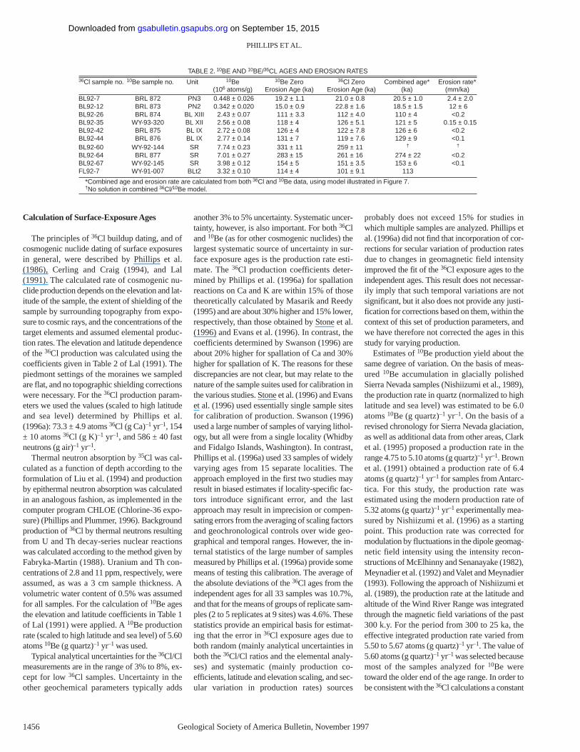
TABLE 2. 10BE AND 10BE/36CL AGES AND EROSION RATES36Cl sample no. 10Be sample no. Unit 10Be 10Be Zero 36Cl Zero Combined age* Erosion rate*
(106 atoms/g) Erosion Age (ka) Erosion Age (ka) (ka) (mm/ka)BL92-7 BRL 872 PN3 0.448 ± 0.026 19.2 ± 1.1 21.0 ± 0.8 20.5 ± 1.0 2.4 ± 2.0BL92-12 BRL 873 PN2 0.342 ± 0.020 15.0 ± 0.9 22.8 ± 1.6 18.5 ± 1.5 12 ± 6BL92-26 BRL 874 BL XIII 2.43 ± 0.07 111 ± 3.3 112 ± 4.0 110 ± 4 <0.2BL92-35 WY-93-320 BL XII 2.56 ± 0.08 118 ± 4 126 ± 5.1 121 ± 5 0.15 ± 0.15BL92-42 BRL 875 BL IX 2.72 ± 0.08 126 ± 4 122 ± 7.8 126 ± 6 <0.2BL92-44 BRL 876 BL IX 2.77 ± 0.14 131 ± 7 119 ± 7.6 129 ± 9 <0.1BL92-60 WY-92-144 SR 7.74 ± 0.23 331 ± 11 259 ± 11 † †
BL92-64 BRL 877 SR 7.01 ± 0.27 283 ± 15 261 ± 16 274 ± 22 <0.2BL92-67 WY-92-145 SR 3.98 ± 0.12 154 ± 5 151 ± 3.5 153 ± 6 <0.1FL92-7 WY-91-007 BLt2 3.32 ± 0.10 114 ± 4 101 ± 9.1 113
*Combined age and erosion rate are calculated from both 36Cl and 10Be data, using model illustrated in Figure 7.†No solution in combined 36Cl/10Be model.
on September 15, 2015gsabulletin.gsapubs.orgDownloaded from
production rate was employed.Internal consistency between the 36Cl and 10Be
production rates is probably more important forthe purposes of this study than is the absoluteaccuracy of either one. This consistency can bechecked using data from a granite boulder in theSierra Nevada that was cored and analyzed forboth nuclides by Dep (1995). The 36Cl content ofthe boulder gives an exposure age of 97 ka whenthe exposure-age calculation methodologydescribed herein is applied to Dep’s (1995) data.This age is comparable to that of the BullLake–age boulders we investigated. Analysis ofthe 36Cl profile, which is very sensitive to ero-sion, showed that the rate of rock erosion wasnegligible (Dep, 1995). The relative 36Cl and10Be concentrations should therefore reflect onlythe ratio of the production rates. Using the nu-clide concentration data reported by Dep (1995)and the 36Cl production rates of Phillips et al.(1996a), the 36Cl-consistent 10Be production rateis back calculated to be 5.4 ± 0.3 atoms 10Be(g quartz)–1yr–1. This rate agrees, within analyti-cal uncertainty, with the value of 5.60 adopted inthis study.
Several issues related to the systematics of cos-mogenic nuclide production remain unresolved.These include the refinement of production-rateparameters, the quantification of nuclide produc-tion by muons, the role of muon production inelevation and latitude scaling, and the correctionof production rates for fluctuations in geomag-netic field intensity. After these issues have beenresolved, cosmogenic ages calculated on the basisof our present understanding will need to berevised. On the basis of the empirical evidencediscussed previously, we do not anticipate that themagnitude of these corrections will exceed 15%.
INTERPRETATION OF 36Cl AGES
Stated in the most general way, the accumula-tion of a cosmogenic nuclide in an eroding land-form such as a moraine is a function of the timeof exposure and the erosion rate (here we use ero-sionsimply to denote the progressive removal ofmass from the surface with time; no mechanismis implied). In reality, the process of erosion canlead to complex results. Erosion rates cannot beexpected to be uniform, either temporally or spa-tially. Furthermore, the response to erosion canbe complex. For a purely spallogenic nuclide(such as 10Be), the buildup is only a function ofthe erosion rate and not of the rock composition,because production follows a simple exponentialdependence on depth. However, the depth profileof 36Cl production depends both on the propor-tion of production by spallation versus that bythermal and epithermal neutron absorption(which in turn depends on the concentrations of
AGES OF QUATERARY GLACIAL AND FLUVIAL DEPOSITS, WYOMING
Geological Society of America Bulletin, November1997 1457
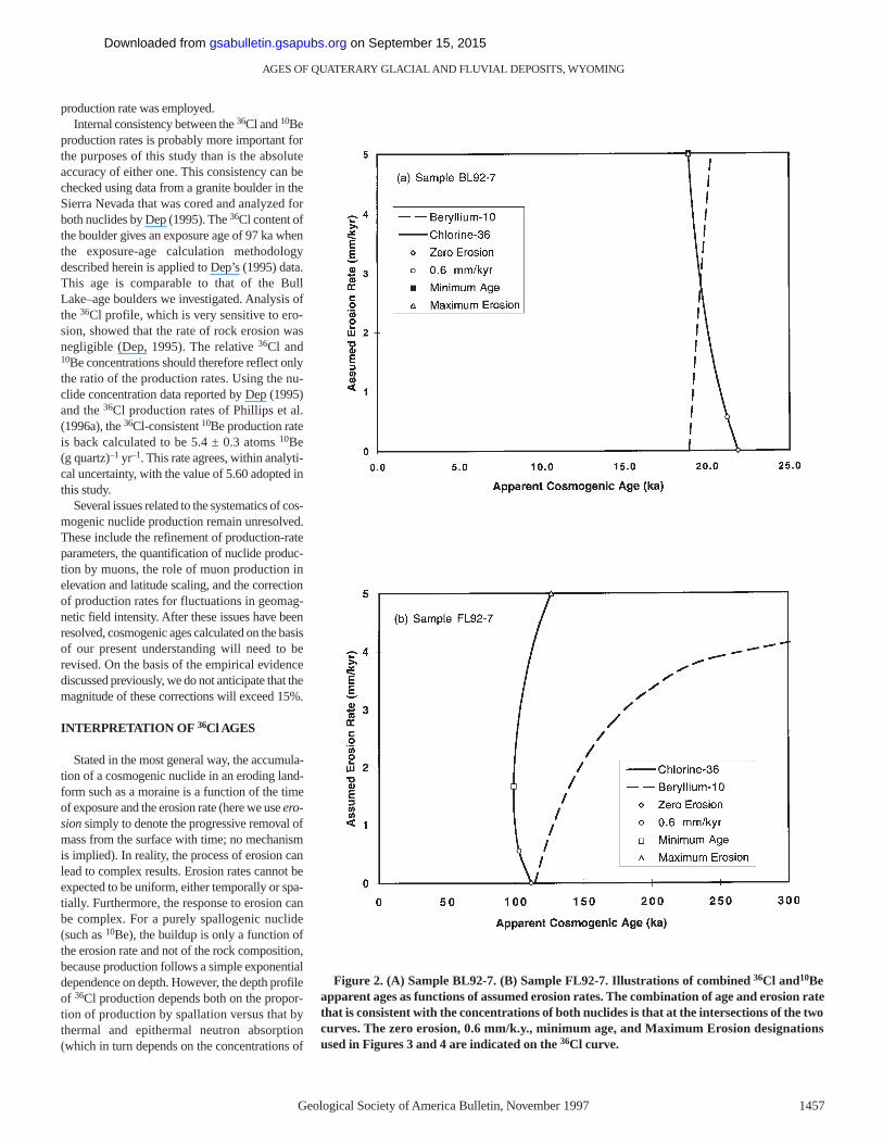
Figure 2. (A) Sample BL92-7. (B) Sample FL92-7. Illustrations of combined 36Cl and10Beapparent ages as functions of assumed erosion rates. The combination of age and erosion ratethat is consistent with the concentrations of both nuclides is that at the intersections of the twocurves. The zero erosion, 0.6 mm/k.y., minimum age, and Maximum Erosion designationsused in Figures 3 and 4 are indicated on the 36Cl curve.
on September 15, 2015gsabulletin.gsapubs.orgDownloaded from
Ca, K, and Cl) and on the bulk composition of therock (which governs the depth distribution of thethermal neutron flux). The apparent age can becalculated as a function of assumed erosion ratefor any sample, but this relationship will varywidely for samples of differing composition (Fig.2). In Table 1 and Figures 3 and 4 we have calcu-lated apparent exposure ages for four differentassumed erosion rates: zero erosion (i.e., a stablesurface); 0.6 mm/k.y. (which our data, discussedbelow, indicate to be a typical erosion rate); theminimum apparent age calculated over the entirerange of 0 to 5 mm/k.y. (designated minimumage in Table 1); and the apparent age calculatedassuming an erosion rate of 5 mm/k.y. (desig-nated maximum erosion because it represents anupper limit to the erosion rate).
In spite of this complexity of response, a simplesolution for the exposure age can be obtained ifsome assumptions can be justified. If all sampleshave eroded at a temporally uniform rate, and ifthe erosion rates can be bounded, when the range
of possible age solutions is plotted as in Figure 3,the actual age of the surface should correspond tothe time interval for which all of the sample agesoverlap. Unfortunately, this simple approach is notdirectly applicable to boulders on moraines. Therate of erosion of the till matrix is high (typically≥ 1 cm/k.y.), whereas that of boulder surfaces islow (about 1 mm/k.y.). As a result, many bouldersthat are sampled on older moraines are likely tohave undergone rapid erosion of overlying tillwhile they were buried within the moraine, thenslow erosion of the rock surface subsequent toexhumation. This type of erosion history wasmodeled and experimentally investigated by Zredaet al. (1994). They showed that soil erosion pro-duces a distribution of apparent ages between theactual moraine age and some younger age limit,the width of the distribution being proportional tothe moraine age and the actual age being close tothe maximum of the distribution. We have usedthese results as a guide in interpreting the age dis-tributions observed on the Bull Lake moraines.
We estimate age ranges for individualmoraines, rather than specify single values, dueto the range in age that is produced by consider-ing the effects of erosion. The estimated ageranges are based on inspection of the boulder agedistributions plotted in Figure 3. We define theupper limit of the range on the basis of closelygrouped maximum ages, inasmuch as the model-ing results of Zreda et al. (1994) showed a clus-tering of apparent ages close to maximum limitprovided by the actual moraine age. The lowerlimit is less easily defined, but is usually selectedto include at least the maximum ages of some ofthe younger boulders, as well as the apparent agecalculated for the older boulders using a rock-erosion rate of 0.6 mm/k.y. This value was cho-sen on the basis of a conservative interpretationof the results of the combined 36Cl/10Be analyses,described in the following. In some cases, such asBull Lake moraines BLIV–BLII and SacageweaRidge moraines, there was no well-defined upperlimit and we assigned only a minimum age, using
PHILLIPS ET AL.
1458 Geological Society of America Bulletin, November1997
350
300
250
200
150
100
50
0
BL9
2-2
BL9
2-7
BL9
2-22
BL9
2-15
BL9
2-11
BL9
2-26
BL9
2-44
BL9
2-39
BL9
2-35
BL9
2-31
BL9
2-71
BL9
2-67
BL9
2-62
BL9
2-56
BL9
2-47
FL9
2-6
FL9
2-3
BL9
2-79
BL9
2-75
Sample Numbers
36C
l Ag
e (k
a)
Pin
edal
e
Bul
l Lak
e X
III
Bul
l Lak
e IX
Bul
l Lak
e IV
-II
Bul
l Lak
e X
II
Sac
agaw
ea R
idge
Bul
l Lak
e Te
rrac
e
Bul
l Lk
mor
aine
at
Pin
edal
e
Pin
edal
e Te
rrac
e
Zero Erosion
Minimum Age
Maximum Erosion0.6 mm/yr36Cl/10Be Age
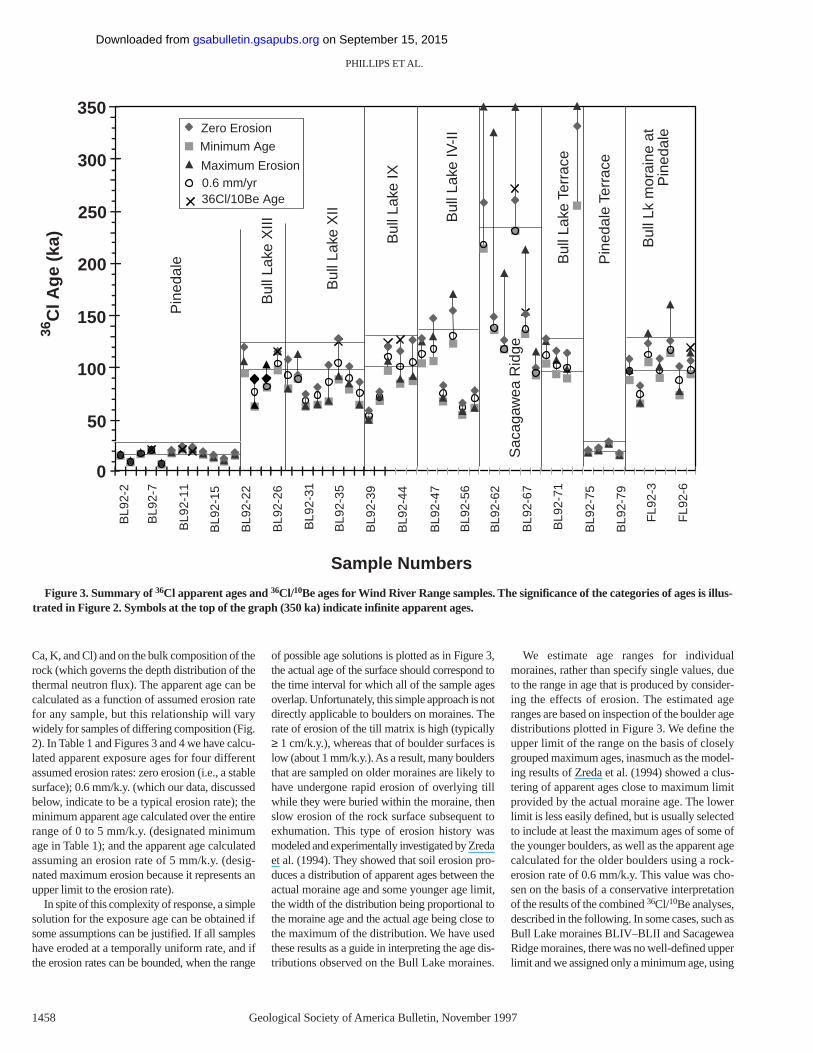
Figure 3. Summary of 36Cl apparent ages and 36Cl/10Be ages for Wind River Range samples. The significance of the categories of ages is illus-trated in Figure 2. Symbols at the top of the graph (350 ka) indicate infinite apparent ages.
on September 15, 2015gsabulletin.gsapubs.orgDownloaded from

the minimum erosion-dependent apparent agefrom the boulder giving the oldest minimum age.The age ranges selected for each moraine are in-dicated by the dotted horizontal lines in Figures3, 4, and 5. The age range estimates do not in-clude analytical and systematic uncertainties,which total in the range of 10% to 15%.
In addition to the effects of erosion, the pos-sibility that a sample was exposed to cosmicradiation prior to deposition on a moraine (orother landform) must also be considered.Although in a few cases such inheritance is ob-vious (e.g., sample BL92-73), it does not appearto be a common problem for glacial deposits, asevidenced by the numerous tightly groupedages of the type Pinedale moraines obtained byGosse et al. (1995b).
Sacagewea Ridge Moraine
The Sacagewea Ridge moraine (Richmondand Murphy, 1989) at Dinwoody Lakes is pre-
served as a broad, low ridge, clearly a much-degraded remnant of the original morainal topog-raphy. Few large boulders remain on the surface;only seven boulders higher than 1 m could be lo-cated on the entire moraine, and only one washigher than 2 m. The boulders are rounded, andmost are extensively weathered. The maximumage limit is undefined. For erosion rates greaterthan 3 to 4 mm/k.y., samples BL92-60, BL-62,and BL-64 gave infinite ages. The minimum agefor the oldest sample (BL92-64) was selected asdefining a limiting minimum age of 232 ka forthe moraine.
On the basis of correlation of the outwash ter-race below the moraine with a fluvial terrace onthe opposite (west) side of Dinwoody Lake thatcontains the Lava Creek B tephra, the SacageweaRidge glaciation has been dated as 660 ± 20 ka(Chadwick et al., 1997). Our 36Cl ages are con-sistent with this assignment, although they couldalso be consistent with an age assignment asyoung as about 250 ka.
Bull Lake Moraines
The 36Cl age distribution for the BullLake–age moraines is illustrated in Figures 3 and4. In general, the Bull Lake moraines BLXIIthrough BLIX have similar boulder frequenciesand amounts of apparent rock weathering.Morainal forms are distinct. Numerous bouldersfrom 1.5 to 2.5 m high are available for sampling.On the basis of surface texture and angularity, webelieve that many of the surfaces of boulderssampled underwent negligible rock erosion afterdeposition. In contrast, boulders are uncommonon the surfaces of the Bull Lake moraines BLIVthrough BLI. Morainal topography is subdued.The largest boulders observed were ~1.5 m highand some boulders less than 1.0 m high weresampled due to the lack of anything larger. Boul-der surfaces were generally much more roundedthan on moraines BLXII through BLIX, andmany showed clear indications of granular disin-tegration or spalling.
AGES OF QUATERARY GLACIAL AND FLUVIAL DEPOSITS, WYOMING
Geological Society of America Bulletin, November1997 1459
200
180
160
140
120
100
80
60
BL9
2-22
BL9
2-25
BL9
2-34
BL9
2-31
BL9
2-29
BL9
2-36
BL9
2-47
BL9
2-46
BL9
2-42
BL9
2-39
FL9
2-2
BL9
2-73
BL9
2-71
BL9
2-57
BL9
2-54
FL9
2-6
FL9
2-4
36C
l Ag
e (k
a)
Bull40
0
20
Bull Lake Bull Lake-ageBull Lake
Bull Lake IXBull Lake XIILake XIII
IV-IITerrace
Fremont Lakemoraine at
Zero Erosion
Minimum Age
Maximum Erosion0.6 mm/kyr Erosion
36Cl/10Be Age
Figure 4. Summary of 36Cl apparent ages and 36Cl/10Be ages for the Bull Lake–age moraines at Bull Lake and Fremont Lake and the “BullLake terrace” (WR3). Error bars illustrating age uncertainties arising from analytical uncertainty in the 36Cl/Cl ratios are shown for the zeroerosion and minimum age points.
on September 15, 2015gsabulletin.gsapubs.orgDownloaded from
Bull Lake moraines BLXIII and BLXII exhibitsuch similar distributions of 36Cl ages that theycannot be easily distinguished. Maximum ages inboth distributions have a poorly defined upperlimit close to 115 ka; there is one slightly olderoutlier (BL92-35, 126 ka). Bull Lake moraineBLIX has an upper limit close to 125 ka, asdefined by three out of five samples. The BullLake BLIV through BLII moraine group shows amuch wider scatter than the younger moraines,and there is no clearly defined maximum. Giventhis distribution and the field observations re-garding the absence of well-preserved large boul-ders, the data are best interpreted as providingonly a limiting minimum age of about 130 ka.Minimum limits were estimated as previouslydescribed (Table 2).
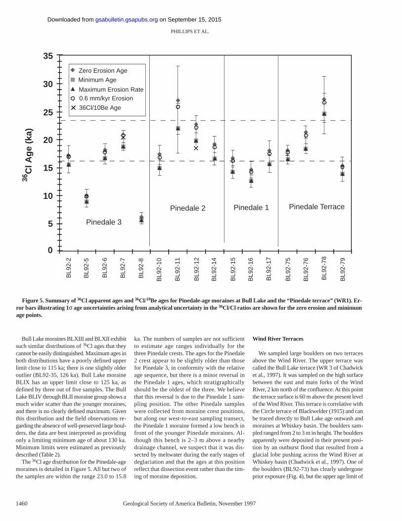
The 36Cl age distribution for the Pinedale-agemoraines is detailed in Figure 5. All but two ofthe samples are within the range 23.0 to 15.8
ka. The numbers of samples are not sufficientto estimate age ranges individually for thethree Pinedale crests. The ages for the Pinedale2 crest appear to be slightly older than thosefor Pinedale 3, in conformity with the relativeage sequence, but there is a minor reversal inthe Pinedale 1 ages, which stratigraphicallyshould be the oldest of the three. We believethat this reversal is due to the Pinedale 1 sam-pling position. The other Pinedale sampleswere collected from moraine crest positions,but along our west-to-east sampling transect,the Pinedale 1 moraine formed a low bench infront of the younger Pinedale moraines. Al-though this bench is 2–3 m above a nearbydrainage channel, we suspect that it was dis-sected by meltwater during the early stages ofdeglaciation and that the ages at this positionreflect that dissection event rather than the tim-ing of moraine deposition.
Wind River Terraces
We sampled large boulders on two terracesabove the Wind River. The upper terrace wascalled the Bull Lake terrace (WR 3 of Chadwicket al., 1997). It was sampled on the high surfacebetween the east and main forks of the WindRiver, 2 km north of the confluence. At this pointthe terrace surface is 60 m above the present levelof the Wind River. This terrace is correlative withthe Circle terrace of Blackwelder (1915) and canbe traced directly to Bull Lake age outwash andmoraines at Whiskey basin. The boulders sam-pled ranged from 2 to 3 m in height. The bouldersapparently were deposited in their present posi-tion by an outburst flood that resulted from aglacial lobe pushing across the Wind River atWhiskey basin (Chadwick et al., 1997). One ofthe boulders (BL92-73) has clearly undergoneprior exposure (Fig. 4), but the upper age limit of
PHILLIPS ET AL.
1460 Geological Society of America Bulletin, November1997
35
30
25
20
15
10
5
0
BL9
2-2
BL9
2-5
BL9
2-8
BL9
2-7
BL9
2-6
BL9
2-10
BL9
2-15
BL9
2-14
BL9
2-12
BL9
2-11
BL9
2-78
BL9
2-76
BL9
2-75
BL9
2-17
BL9
2-16
BL9
2-79
36C
l Ag
e (k
a)
Pinedale 3
Pinedale TerracePinedale 1Pinedale 2
Zero Erosion Age
Minimum Age
Maximum Erosion Rate0.6 mm/kyr Erosion
36Cl/10Be Age
Figure 5. Summary of 36Cl apparent ages and 36Cl/10Be ages for Pinedale-age moraines at Bull Lake and the “Pinedale terrace” (WR1). Er-ror bars illustrating 1σ age uncertainties arising from analytical uncertainty in the 36Cl/Cl ratios are shown for the zero erosion and minimumage points.
on September 15, 2015gsabulletin.gsapubs.orgDownloaded from
the other boulders from this terrace (ca. 125 ka)is similar to that for Bull Lake moraine BLIX andstrongly suggests that the boulders weredeposited on the WR 3 surface during this phaseof the Bull Lake glaciation.
The lower terrace, called the Pinedale terrace(WR 1 of Chadwick et al., 1997) was sampled be-tween Jakeys Fork and Torrey Creek, on the south-west side of the Wind River. The terrace is about3 m above the present level of the Wind River. Theboulders sampled ranged from 2 to 4 m in heightand were probably deposited due to a later outburstflood from an ice lobe in the same position as thelobe that which produced the Bull Lake terraceboulders. The zero erosion ages vary between 27and 15 ka (Fig. 5), very similar to the distributionof ages for the Pinedale moraines at Bull Lake.
Bull Lake–Age Moraine at Fremont Lake
For purposes of comparison with the 10Be and26Al dating being conducted at Fremont Lake(Gosse et al., 1995b), and to test for possible earlyWisconsin (isotope stage 4) glaciation, we col-lected seven samples from the innermost BullLake–age moraine (BL V of Richmond, 1987)near the southwestern end of Fremont Lake.(Note that the numbering schemes of Richmondat Fremont Lake and that of Chadwick et al.[1997] at Bull Lake are not intended to be correl-ative.) The boulders were 2 to 4 m in height. Thedistribution of 36Cl ages, shown in Figure 4, wasquite similar to that for the Bull Lake moraineBLIX at Bull Lake, giving limits of 120 to 100 ka.
Correlation of the Bull Lake V moraine atFremont Lake with the Bull Lake moraine BLIXat Bull Lake, as suggested by the 36Cl age distri-butions, appears to be anomalous, inasmuch asthe BLIX moraine is nearly the outermost BullLake moraine loop at Bull Lake and the Vmoraine is the innermost Bull Lake moraine atFremont Lake. However, relative positions maybe misleading, given the geomorphic settings atthe two localities. At Fremont Lake the Bull Lakemoraines form a relatively compact band (typi-cally 0.8 to 1.0 km wide) of contiguous ridgesthat in most places lie immediately outward fromthe Pinedale moraine band (Richmond, 1987). Incontrast, the glacier at Bull Lake had two lobesthat had different characteristics. The northernlobe was formed by ice that overflowed the maintrough and advanced over a relatively flat topog-raphy sloping gently toward Bull Lake. The typeBull Lake–age moraines at this site form a broadband (typically 1.5 to 2.0 km wide); many of theindividual ridges are often separated by outwash-filled depressions. It was probably this distinct-ness and separation of the moraines that causedBlackwelder (1915) to designate it as the typelocality. In contrast, the eastern lobe was formed
by ice flowing down the deep trough that is nowpartially filled by Bull Lake. There are no BullLake–age moraines preserved for this lobe; thePinedale glacier advanced completely over what-ever Bull Lake moraines were originally present.This anomalous relationship (relative to the moretypical situation at Fremont Lake) is possiblyexplained by progressive downcutting of the BullLake trough in response to the gradual loweringof the Wind River base level (Chadwick et al.,1997). This downcutting would increase both thecross-sectional area and the gradient of the main(eastern) glacial lobe with time, causing anincrease in the ice discharge of this lobe thatwould result in younger advances overriding thedeposits of earlier glaciations. This diversion ofsome of the ice discharge to the eastern lobewould progressively starve the northern lobe,causing successive advances to be less extensive.As a result of this long-term instability it is possi-ble that in the Bull Lake north lobe certainmoraines of less extensive advances were pre-served, whereas at most valleys they were latercovered by Pinedale deposits. In summary, theinnermost Bull Lake–age moraines at FremontLake may not necessarily correlate with theinnermost Bull Lake–age moraines at Bull Lake,but rather with some other moraine toward theoutside of the complex.
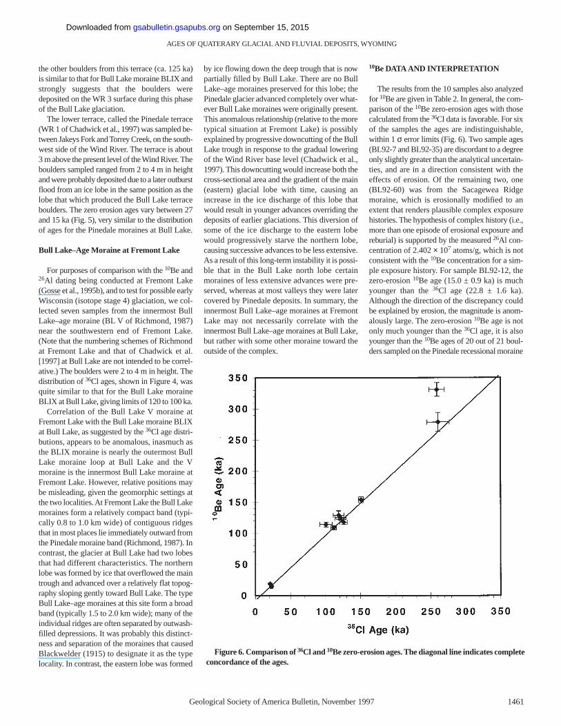
10Be DATA AND INTERPRETATION
The results from the 10 samples also analyzedfor 10Be are given in Table 2. In general, the com-parison of the 10Be zero-erosion ages with thosecalculated from the 36Cl data is favorable. For sixof the samples the ages are indistinguishable,within 1 σerror limits (Fig. 6). Two sample ages(BL92-7 and BL92-35) are discordant to a degreeonly slightly greater than the analytical uncertain-ties, and are in a direction consistent with theeffects of erosion. Of the remaining two, one(BL92-60) was from the Sacagewea Ridgemoraine, which is erosionally modified to anextent that renders plausible complex exposurehistories. The hypothesis of complex history (i.e.,more than one episode of erosional exposure andreburial) is supported by the measured 26Al con-centration of 2.402 × 10⁷ atoms/g, which is notconsistent with the 10Be concentration for a sim-ple exposure history. For sample BL92-12, thezero-erosion 10Be age (15.0 ± 0.9 ka) is muchyounger than the 36Cl age (22.8 ± 1.6 ka).Although the direction of the discrepancy couldbe explained by erosion, the magnitude is anom-alously large. The zero-erosion 10Be age is notonly much younger than the 36Cl age, it is alsoyounger than the 10Be ages of 20 out of 21 boul-ders sampled on the Pinedale recessional moraine
AGES OF QUATERARY GLACIAL AND FLUVIAL DEPOSITS, WYOMING
Geological Society of America Bulletin, November1997 1461
Figure 6. Comparison of 36Cl and 10Be zero-erosion ages. The diagonal line indicates completeconcordance of the ages.
on September 15, 2015gsabulletin.gsapubs.orgDownloaded from
at Fremont Lake by Gosse et al. (1995b). Fieldnotes did not give any indication of spalling orunusually rapid rock erosion on this boulder. Wetherefore suspect that this discrepancy may be ananalytical artifact, although there is no direct evi-dence to indicate an analytical problem.
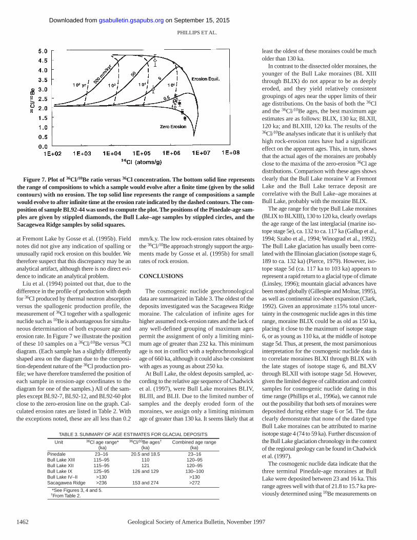
Liu et al. (1994) pointed out that, due to thedifference in the profile of production with depthfor 36Cl produced by thermal neutron absorptionversus the spallogenic production profile, themeasurement of 36Cl together with a spallogenicnuclide such as 10Be is advantageous for simulta-neous determination of both exposure age anderosion rate. In Figure 7 we illustrate the positionof these 10 samples on a 36Cl/10Be versus 36Cldiagram. (Each sample has a slightly differentlyshaped area on the diagram due to the composi-tion-dependent nature of the 36Cl production pro-file; we have therefore transferred the position ofeach sample in erosion-age coordinates to thediagram for one of the samples.) All of the sam-ples except BL92-7, BL92-12, and BL92-60 plotclose to the zero-erosion line on the graph. Cal-culated erosion rates are listed in Table 2. Withthe exceptions noted, these are all less than 0.2
mm/k.y. The low rock-erosion rates obtained bythe 36Cl/10Be approach strongly support the argu-ments made by Gosse et al. (1995b) for smallrates of rock erosion.
CONCLUSIONS
The cosmogenic nuclide geochronologicaldata are summarized in Table 3. The oldest of thedeposits investigated was the Sacagewea Ridgemoraine. The calculation of infinite ages forhigher assumed rock-erosion rates and the lack ofany well-defined grouping of maximum agespermit the assignment of only a limiting mini-mum age of greater than 232 ka. This minimumage is not in conflict with a tephrochronologicalage of 660 ka, although it could also be consistentwith ages as young as about 250 ka.
At Bull Lake, the oldest deposits sampled, ac-cording to the relative age sequence of Chadwicket al. (1997), were Bull Lake moraines BLIV,BLIII, and BLII. Due to the limited number ofsamples and the deeply eroded form of themoraines, we assign only a limiting minimumage of greater than 130 ka. It seems likely that at
least the oldest of these moraines could be mucholder than 130 ka.
In contrast to the dissected older moraines, theyounger of the Bull Lake moraines (BL XIIIthrough BLIX) do not appear to be as deeplyeroded, and they yield relatively consistentgroupings of ages near the upper limits of theirage distributions. On the basis of both the 36Cland the 36Cl/10Be ages, the best maximum ageestimates are as follows: BLIX, 130 ka; BLXII,120 ka; and BLXIII, 120 ka. The results of the36Cl/10Be analyses indicate that it is unlikely thathigh rock-erosion rates have had a significanteffect on the apparent ages. This, in turn, showsthat the actual ages of the moraines are probablyclose to the maxima of the zero-erosion 36Cl agedistributions. Comparison with these ages showsclearly that the Bull Lake moraine V at FremontLake and the Bull Lake terrace deposit arecorrelative with the Bull Lake–age moraines atBull Lake, probably with the moraine BLIX.
The age range for the type Bull Lake moraines(BLIX to BLXIII), 130 to 120 ka, clearly overlapsthe age range of the last interglacial (marine iso-tope stage 5e), ca. 132 to ca. 117 ka (Gallup et al.,1994; Szabo et al., 1994; Winograd et al., 1992).The Bull Lake glaciation has usually been corre-lated with the Illinoian glaciation (isotope stage 6,189 to ca. 132 ka) (Pierce, 1979). However, iso-tope stage 5d (ca. 117 ka to 103 ka) appears torepresent a rapid return to a glacial type of climate(Linsley, 1996); mountain glacial advances havebeen noted globally (Gillespie and Molnar, 1995),as well as continental ice-sheet expansion (Clark,1992). Given an approximate ±15% total uncer-tainty in the cosmogenic nuclide ages in this timerange, moraine BLIX could be as old as 150 ka,placing it close to the maximum of isotope stage6, or as young as 110 ka, at the middle of isotopestage 5d. Thus, at present, the most parsimoniousinterpretation for the cosmogenic nuclide data isto correlate moraines BLXI through BLIX withthe late stages of isotope stage 6, and BLXVthrough BLXII with isotope stage 5d. However,given the limited degree of calibration and controlsamples for cosmogenic nuclide dating in thistime range (Phillips et al., 1996a), we cannot ruleout the possibility that both sets of moraines weredeposited during either stage 6 or 5d. The dataclearly demonstrate that none of the dated typeBull Lake moraines can be attributed to marineisotope stage 4 (74 to 59 ka). Further discussion ofthe Bull Lake glaciation chronology in the contextof the regional geology can be found in Chadwicket al. (1997).
The cosmogenic nuclide data indicate that thethree terminal Pinedale-age moraines at BullLake were deposited between 23 and 16 ka. Thisrange agrees well with that of 21.8 to 15.7 ka pre-viously determined using 10Be measurements on
PHILLIPS ET AL.
1462 Geological Society of America Bulletin, November1997
Figure 7. Plot of 36Cl/10Be ratio versus 36Cl concentration. The bottom solid line representsthe range of compositions to which a sample would evolve after a finite time (given by the solidcontours) with no erosion. The top solid line represents the range of compositions a samplewould evolve to after infinite time at the erosion rate indicated by the dashed contours. The com-position of sample BL92-44 was used to compute the plot. The positions of the Pinedale-age sam-ples are given by stippled diamonds, the Bull Lake–age samples by stippled circles, and theSacagewea Ridge samples by solid squares.
TABLE 3. SUMMARY OF AGE ESTIMATES FOR GLACIAL DEPOSITS
Unit 36Cl age range* 36Cl/10Be ages† Combined age range(ka) (ka) (ka)
Pinedale 23–16 20.5 and 18.5 23–16Bull Lake XIII 115–95 110 120–95Bull Lake XII 115–95 121 120–95Bull Lake IX 125–95 126 and 129 130–100Bull Lake IV–II >130 >130Sacagawea Ridge >236 153 and 274 >272
*See Figures 3, 4 and 5.†From Table 2.
on September 15, 2015gsabulletin.gsapubs.orgDownloaded from
the Pinedale moraines at Fremont Lake by Gosseet al. (1995b). Our data, like theirs, appear to sup-port a relatively stable terminal position (see Fig.1) over that interval, although the morphologicalevidence for oscillations back and forth from theterminal limit may be somewhat stronger at BullLake. These ages also coincide with the range of23 to 16 ka obtained for the most prominentTioga glacial advances in the Sierra Nevada using36Cl (Phillips et al., 1996b), indicating nearlysimultaneous climatic forcing over the westernUnited States.
Comparison of 36Cl and 10Be ages shows gen-erally excellent agreement. This agreement indi-cates low rock-erosion rates. Most of the calcu-lated erosion rates were less than 0.2 mm/k.y.Erosion rates this low have only a minor effect oncosmogenic surface-exposure dating of samplesyounger than a few hundred thousand years.
ACKNOWLEDGMENTS
This research was supported by National Sci-ence Foundation grants ATM-9117566, EAR-9206451, and EAR-9208994, Sigma Xi grants inaid of research 9201 and 8056, and GeologicalSociety of America grant 4932-92. We thankJ. Stone,A. Gillespie, and P. Bierman for reviewsof the manuscript and M. Plummer for aid incomputations. We thank the Shoshone and Arap-ahoe Indian Tribes for permission to sample onthe Wind River Reservation.
REFERENCES
Aruscavage, P. J., and Campbell, E. Y., 1983, An ion-selectiveelectrode method for determination of chlorine in geo-logic materials: Talanta, v. 30, p. 745–749.
Bentley, H. W., Phillips, F. M., Davis, S. N., Airey, P. L., Calf,G. E., Elmore, D., Habermehl, M. A., and Torgersen, T.,1986, Chlorine-36 dating of very old ground water: I. TheGreat Artesian Basin, Australia: Water Resources Re-search, v. 22, p. 1991–2002.
Blackwelder, E., 1915, Cenozoic history of the mountains ofcentral Wyoming: Journal of Geology, v. 23, p. 97–117,193–217, 307–340.
Brown, E. T., Edmond, J. M., Raisbeck, G. M.,Yiou, F., Kurz,M. D., and Brook, E. J., 1991, Examination of surface ex-posure ages of Antarctic moraines using in situ produced10Be and 26Al: Geochimica et Cosmochimica Acta, v. 55,p. 2269–2284.
Bursik, M. I., 1991, Relative dating of moraines based on land-form degradation, Lee Vining Canyon, California: Qua-ternary Research, v. 35, p. 451–455.
Cerling, T. E., and Craig, H., 1994, Geomorphology and in situcosmogenic isotopes:Annual Review of Earth and Plane-tary Sciences, v. 22, p. 273–317.
Chadwick, O. A., Hall, R. D., and Phillips, F. M., 1997, Pleis-tocene glaciations in the Rocky Mountains: Bull Lake re-visited: Geological Society of America Bulletin, v. 109,p. XX–XXX.
Clark, D. H., Bierman, P. R., and Larsen, P., 1995, Improving insitu cosmogenic chronometers: Quaternary Research,v. 44, p. 367–377.
Clark, P. U., 1992, The last interglacial-glacial transition inNorth America: Intorduction,in Clark, P. U., and Lea,P. D., eds., The last interglacial–glacial transition in NorthAmerica: Geological Society of America Special Paper270, p. 1–11.
Dep, W. H. L., 1995, Cosmogenic radionuclide production interrestrial rocks:Accelerator mass spectrometry measure-ments and Monte Carlo simulations [Ph.D. dissert.]: WestLafayette, Indiana, Purdue University, 155 p.
Elmore, D., Fulton, B. R., Clover, M. R., Marsden, J. R., Gove,H. E., Naylor, H., Purser, K. H., Kilius, L. R., Beukens,R. P., and Litherland, A. E., 1979, Analysis of 36Cl in en-vironmental water samples using an electrostatic acceler-ator: Nature, v. 277, p. 22–25.
Evans, J. M., Stone, J. O. H., Fifield, L. K., and Cresswell,R. G., 1996, Cosmogenic chlorine-36 production ratesfrom potassium [abs]: Radiocarbon, v. 38, p. 29.
Fabryka-Martin, J. T., 1988, Production of radionuclides in theearth and their hydrogeologic significance, with emphasison chlorine-36 and iodine-129 [Ph. D. dissert.]: Tucson,University of Arizona, 400 p.
Fall, P. L., Davis, P. T., and Zielinski, G. A., 1995, Late Quater-nary vegetation and climate of the Wind River Range,Wyoming: Quaternary Research, v. 43, p. 393–404.
Gallup, C. D., Edwards, R. L., and Johnson, R. G., 1994, Thetiming of high sea levels over the past 200,000 years: Sci-ence, v. 263, p. 796–800.
Gillespie, A., and Molnar, P., 1995, Asynchronous maximumadvances of mountain and continental glaciers: Reviewsof Geophysics, v. 33, p. 311–364.
Gosse, J. C., Evenson, E. B., Klein, J., Lawn, B., and Middle-ton, R., 1995a, Precise cosmogenic 10Be measurementsin western North America: Support for a global YoungerDryas cooling event: Geology, v. 23, p. 877–880.
Gosse, J. C., Klein, J., Evenson, E. B., Lawn, B., and Middle-ton, R., 1995b, Beryllium-10 dating of the duration andretreat of the last Pinedale glacial sequence: Science, v.268, p. 1329–1333.
Hall, R. D., and Shroba, R. R., 1995, Soil evidence for a glacia-tion intermediate between the Bull Lake and Pinedaleglaciations at Fremont Lake, Wind River Range,Wyoming, USA: Arctic and Alpine Research, v. 27,p. 89–98.
Hallet, B., and Putkonen, J., 1994, Surface dating of dynamiclandforms: Young boulders on aging moraines: Science,v. 265, p. 937–940.
Kohl, C. P., and Nishiizumi, K., 1992, Chemical isolation ofquartz for measurement of in situ produced cosmogenicnuclides: Geochimica et Cosmochimica Acta, v. 56,p. 3583–3588.
Lal, D., 1991, Cosmic-ray labeling of erosion surfaces: In situproduction rates and erosion models: Earth and PlanetaryScience Letters, v. 104, p. 424–439.
Linsley, B. K., 1996, Oxygen-isotope record of sea level andclimate variations in the Sulu Sea over the past 150,000years: Nature, v. 380, p. 234–237.
Liu, B., Phillips, F. M., Fabryka-Martin, J. T., Fowler, M. M.,and Stone,W. D., 1994, Cosmogenic 36Cl accumulation inunstable landforms, 1. Effects of the thermal neutron dis-tribution:Water Resources Research, v. 30, p. 3115–3125.
Love, J. D., 1979, Summary of late Cenozoic history of theWind River Basin and adjacent uplands in Wyoming:U.S. Geological Survey Professional Paper 1150, 75 p.
Masarik, J., and Reedy, R. C., 1995, Terrestrial cosmogenic-nuclide production systematics calculated from numericalsimulations: Earth and Planetary Science Letters, v. 136,p. 381–395.
McElhinny, M. W., and Senanayake, W. E., 1982, Variations inthe geomagnetic dipole 1: The past 50,000 years: Journalof Geomagnetism and Geoelectricity, v. 34, p. 39–51.
Meynadier, L., Valet, J.-P., Weeks, R., Shackleton, N. J., andLee Hagee, V., 1992, Relative geomagnetic intensity ofthe field during the last 140 ka: Earth and Planetary Sci-ence Letters, v. 114, p. 39–57.
Morris, D. A., Hackett, O. M., Vanlier, K. E., and Moulder,E. A., 1951, Ground-water resources of Riverton Irriga-tion Project, Wyoming: U.S. Geological Survey Water-Supply Paper 1375, 205 p.
Nishiizumi, K., Winterer, E. L., Kohl, C. P., Lal, D., Arnold,J. R., Klein, J., and Middleton, R., 1989, Cosmic ray pro-duction rates of 10Be and 26Al in quartz from glaciallypolished rocks: Journal of Geophysical Research, v. 94,p. 17907–17915.
Nishiizumi, K., Finkel, R. C., Klein, J., and Kohl, C. P., 1996,Cosmogenic production of 10Be in water targets: Journalof Geophysical Research, v. 101, p. 22225–22232.
Phillips, F. M., and Plummer, M. A., 1996, CHLOE:A program
for interpreting in-situcosmogenic nuclide data for sur-face exposure dating and erosion studies [abs]: Radiocar-bon, v. 38, p. 98.
Phillips, F. M., Leavy, B. D., Jannik, N. O., Elmore, D., andKubik, P. W., 1986, The accumulation of cosmogenicchlorine-36 in rocks: A method for surface exposure dat-ing: Science, v. 231, p. 41–43.
Phillips, F. M., Zreda, M. G., Flinsch, M. R., Elmore, D., andSharma, P., 1996a, A reevaluation of cosmogenic 36Clproduction rates in terrestrial rocks: Geophysical Re-search Letters, v. 23, p. 949–952.
Phillips, F. M., Zreda, M. G., Benson, L. V., Plummer, M. A.,Elmore, D., and Sharma, P., 1996b, Chronology for fluc-tuations in late Pleistocene Sierra Nevada glaciers andlakes: Science, v. 274, p. 749–751.
Pierce, K. L., 1979, History and dynamics of glaciation in thenorthern Yellowstone National Park area: U. S. Geologi-cal Survey, 729-F.
Richmond, G. M., 1962, Three pre–Bull Lake tills in the WindRiver Mountains, Wyoming: U.S. Geological Survey Pro-fessional Paper 450-D, p. D132–D136.
Richmond, G. M., 1964, Three pre–Bull Lake tills in the WindRiver Mountains, Wyoming:A reinterpretation: U.S. Geo-logical Survey Professional Paper 501-D, p. D140–D109.
Richmond, G. M., 1986, Stratigraphy and correlation of glacialdeposits in Yellowstone National Park,in Sibrava, V.,Bowen, D. Q, and Richmond, G. M., eds., Quaternaryglaciation of the Northern Hemisphere: Oxford, UnitedKingdom, Pergamon Press, p. 201–204.
Richmond, G. M., 1987, Type Pinedale Till in the FremontLake area, Wind River Range, Wyoming,in Beys, S. S.,Rocky Mountain section: Boulder, Colorado, GeologicalSociety of America, Centennial Field Guide v. 2,p. 201–204.
Richmond, G. M., and Murphy, J. F., 1965, Geologic map ofthe Bull Lake East quadrangle, Fremont County,Wyoming: U.S. Geological Survey Geological Quadran-gle Map GQ-431.
Richmond, G. M., and Murphy, J. F., 1989, Preliminary Qua-ternary geologic map of the Dinwoody Lake area, Fre-mont County, Wyoming: U.S. Geological Survey Open-File Report 89-435.
Stone, J. O., Allan, G. L., Fifield, L. K., and Cresswell, R. G.,1996, Cosmogenic chlorine-36 from calcium spallation:Geochimica et Cosmochimica Acta, v. 60, p. 679–692.
Sturchio, N. C., Pierce, K. L., Murrell, M. T., and Sorey, M. L.,1994, Uranium-series ages of travertines and timing of thelast glaciation in the northern Yellowstone area,Wyoming-Montana, U.S.A.: Quaternary Research, v. 41,no. 265–277.
Swanson, T., 1996, Determination of 36Cl production ratesfrom the deglaciation history of Whidbey and FidalgoIslands, Washington [abs]: Radiocarbon, v. 38, p. 172.
Szabo, B. J., Ludwig, K. R., Muhs, D. R., and Simmons, K. R.,1994, Thorium-230 ages of corals and duration of the lastinterglacial sea-level high stand on Oahu, Hawaii: Sci-ence, v. 266, p. 93–96.
Valet, J.-P., and Meynadier, L., 1993, Geomagnetic field inten-sity and reversals during the past four million years: Na-ture, v. 336 p. 234–238.
Winograd, I. J., Coplen, T. B., Landwehr, J. M., Riggs, A. C.,Ludwig, K. R., Szabo, B. J., Kolesar, P. T., and Revesz,K., 1992, Continuous 500,000-year climate record fromvein calcite in Devils Hole, Nevada: Science, v. 258,p. 255–260.
Zreda, M. G., 1994, Development and calibration of the cos-mogenic 36Cl surface exposure dating method and its ap-plication to the chronology of late Quaternary glaciations[Ph.D. dissert.]: Socorro, New Mexico Institute of Miningand Technology, 318 p.
Zreda, M. G., and Phillips, F. M., 1995, Insights into alpinemoraine development from cosmogenic 36Cl buildup dat-ing: Geomorphology, v. 14, p. 149–156.
Zreda, M. G., Phillips, F. M., and Elmore, D., 1994, Cosmo-genic 36Cl accumulation in unstable landforms, 2. Simu-lations and measurements on eroding moraines: WaterResources Research, v. 30, p. 3127–3136.
MANUSCRIPTRECEIVED BY THESOCIETY SEPTEMBER20, 1996REVISEDMANUSCRIPTRECEIVEDJULY 21, 1997MANUSCRIPTACCEPTEDAUGUST18, 1997
AGES OF QUATERARY GLACIAL AND FLUVIAL DEPOSITS, WYOMING
Geological Society of America Bulletin, November1997 1463
on September 15, 2015gsabulletin.gsapubs.orgDownloaded from

Geological Society of America Bulletin
doi: 10.1130/0016-7606(1997)109<1453:CCABAO>2.3.CO;2 1997;109, no. 11;1453-1463Geological Society of America Bulletin
Oliver A. Chadwick and Pankaj SharmaFred M. Phillips, Marek G. Zreda, John C. Gosse, Jeffrey Klein, Edward B. Evenson, Robert D. Hall, Wind River Range, Wyoming
Be ages of Quaternary glacial and fluvial deposits of the10Cl and 36Cosmogenic
Email alerting servicescite this article
to receive free e-mail alerts when new articleswww.gsapubs.org/cgi/alertsclick
SubscribeAmerica Bulletin
to subscribe to Geological Society ofwww.gsapubs.org/subscriptions/click
Permission request to contact GSAhttp://www.geosociety.org/pubs/copyrt.htm#gsaclick
viewpoint. Opinions presented in this publication do not reflect official positions of the Society.positions by scientists worldwide, regardless of their race, citizenship, gender, religion, or politicalarticle's full citation. GSA provides this and other forums for the presentation of diverse opinions and articles on their own or their organization's Web site providing the posting includes a reference to thescience. This file may not be posted to any Web site, but authors may post the abstracts only of their unlimited copies of items in GSA's journals for noncommercial use in classrooms to further education andto use a single figure, a single table, and/or a brief paragraph of text in subsequent works and to make
GSA,employment. Individual scientists are hereby granted permission, without fees or further requests to Copyright not claimed on content prepared wholly by U.S. government employees within scope of their
Notes
Geological Society of America
on September 15, 2015gsabulletin.gsapubs.orgDownloaded from