10Be inventories in Alpine soils and their potential for dating land surfaces
13
This article appeared in a journal published by Elsevier. The attached copy is furnished to the author for internal non-commercial research and education use, including for instruction at the authors institution and sharing with colleagues. Other uses, including reproduction and distribution, or selling or licensing copies, or posting to personal, institutional or third party websites are prohibited. In most cases authors are permitted to post their version of the article (e.g. in Word or Tex form) to their personal website or institutional repository. Authors requiring further information regarding Elsevier’s archiving and manuscript policies are encouraged to visit: http://www.elsevier.com/copyright
-
Upload
independent -
Category
Documents
-
view
3 -
download
0
Transcript of 10Be inventories in Alpine soils and their potential for dating land surfaces

This article appeared in a journal published by Elsevier. The attachedcopy is furnished to the author for internal non-commercial researchand education use, including for instruction at the authors institution
and sharing with colleagues.
Other uses, including reproduction and distribution, or selling orlicensing copies, or posting to personal, institutional or third party
websites are prohibited.
In most cases authors are permitted to post their version of thearticle (e.g. in Word or Tex form) to their personal website orinstitutional repository. Authors requiring further information
regarding Elsevier’s archiving and manuscript policies areencouraged to visit:
http://www.elsevier.com/copyright

Author's personal copy
10Be inventories in Alpine soils and their potential for dating land surfaces
Markus Egli a,⁎, Dagmar Brandová a, Ralph Böhlert a, Filippo Favilli a, Peter W. Kubik b
a Department of Geography, University of Zurich, CH-8057 Zurich, Switzerlandb Institute of Ion Beam Physics, ETH Zurich, CH-8093 Zurich, Switzerland
a b s t r a c ta r t i c l e i n f o
Article history:Received 12 November 2009Received in revised form 18 February 2010Accepted 21 February 2010Available online 1 March 2010
Keywords:Meteoric 10BeDatingAlpine soilsWeatheringErosion
To exploit natural sedimentary archives and geomorphic landforms it is necessary to date them first.Landscape evolution of Alpine areas is often strongly related to the activities of glaciers in the Pleistocene andHolocene. At sites where no organic matter for radiocarbon dating exists and where suitable boulders forsurface exposure dating (using in situ produced cosmogenic nuclides) are absent, dating of soils could giveinformation about the timing of landscape evolution. This paper explores the applicability of soil dating usingthe inventory of meteoric 10Be in Alpine soils. For this purpose, a set of 6 soil profiles in the Swiss and ItalianAlps was investigated. The surface at these sites had already been dated (using the radiocarbon technique orthe surface exposure determination using in situ produced 10Be). Consequently, a direct comparison of theages of the soils using meteoric 10Be and other dating techniques was made possible. The estimation of 10Bedeposition rates is subject to severe limitations and strongly influences the obtained results. We tested threescenarios using a) the meteoric 10Be deposition rates as a function of the annual precipitation rate, b) aconstant 10Be input for the Central Alps, and c) as b) but assuming a pre-exposure of the parent material. Theobtained ages that are based on the 10Be inventory in soils and on scenario a) for the 10Be input agreedreasonably well with the age using surface exposure or radiocarbon dating. The ages obtained from soilsusing scenario b) produced ages that were mostly too old whereas the approach using scenario c) seemed toyield better results than scenario b). Erosion calculations can, in theory, be performed using the 10Beinventory and 10Be deposition rates. An erosion estimation was possible using scenario a) and c), but notusing b). The calculated erosion rates using these scenarios seemed to be plausible with values in the rangeof 0–57 mm/ky. The dating of soils using 10Be has several potential error sources. Analytical errors as well aserrors from other parameters such as bulk soil density and soil skeleton content have to be taken intoaccount. The error range was from 8 up to 21%. Furthermore, uncertainties in estimating 10Be depositionrates substantially influence the calculated ages. Relative age estimates and, under optimal conditions,absolute dating can be carried out. Age determination of Alpine soils using 10Be gives another possibility todate surfaces when other methods fail or are not possible at all. It is, however, not straightforward, quitelaborious and may consequently have some distinct limitations.
© 2010 Elsevier B.V. All rights reserved.
1. Introduction
The analysis and dating of climate-related natural archives allowsthe estimation of past climate conditions and the rates of geomor-phologic and other processes, which in turn also serve as a basis formodelling approaches and predictions.
Natural terrestrial sediment and soil archives or geomorphic featuresand landforms in the Alps, such as moraines, roches moutonnées, peatbogs etc., are often bound to glacial activity and may bear long-termpaleoclimatic information. Glaciers have shaped the alpine landscapewhich, in many respects, is directly related to ice retreat and re-advancephases that occurred in the Pleistocene and Holocene. Since the initialwork of Penck and Brückner (1909) on Alpine glaciations and the
structure of glacier retreat, numerous authors have worked on ice-agestratigraphy (e.g. Keller and Krayss, 1993; Florineth, 1998; Schlüchter,2004; van Husen, 2004; Ivy-Ochs et al., 2006a,b, 2007), the Lateglacialperiod of ice decay (e.g. Maisch, 1981; Schoeneich, 1999; Kerschner et al.,1999; Ivy-Ochs et al., 2004, 2008, 2009) and also in detail on Holoceneglacier fluctuations in the Alps (Holzhauser, 1984). Dating of geomorphicfeatures (moraines, peat bogs etc.) has often been performed using theradiocarbon technique. The main problem in 14C dating of alpine soils isthe lack of datable organic material or imprecise estimates of the ageobtained due to the fact that the soils have been reworked. With theimprovements in the dating technique using in situ produced cosmogenicisotopes in rock surfaces (surface exposure dating SED; Lal, 1988) thedirect determination of moraine ages (Gosse et al., 1995; Ivy-Ochs et al.,1996) became possible, also at sites not having datable organic material.Since then, a great numberof studieshavebeenperformedwith theaimofdating moraines and associated glacier fluctuations using cosmogenicnuclides (compilation in Reuther et al., 2006), especially 10Be. Ivy-Ochs et
Geomorphology 119 (2010) 62–73
⁎ Corresponding author.E-mail address: [email protected] (M. Egli).
0169-555X/$ – see front matter © 2010 Elsevier B.V. All rights reserved.doi:10.1016/j.geomorph.2010.02.019
Contents lists available at ScienceDirect
Geomorphology
j ourna l homepage: www.e lsev ie r.com/ locate /geomorph
Author's personal copy
al. (2006a) provided a summary of exposure-derived ages (using 10Be,26Al, 36C and 21Ne) for the Lateglacial with a focus on the European Alps.However, critically reviewed, the absolute chronology is still poorlyestablished. It must be taken into consideration that several limitationssometimes render dating of rock boulders, and consequently landsurfaces, difficult. According to Ivy-Ochs and Kober (2008) and Gosseand Phillips (2001), the sampled object (boulder, clasts or bedrock)surface must have i) undergone single-stage exposure (negligible pre-exposure/inheritance), ii) beencontinuouslyexposed in the sameposition(not shifted), iii) never been significantly covered with sediment, and iv)undergone onlyminimal surfaceweathering or erosion (not spalled). Theinfluenceof snowontheboulderagemaybe, furthermore, very significantand clearly exceeds the influence of surface erosion (Böhlert et al.,submitted for publication).
Another techniquewas developed by Schaller et al. (2009a)whowereable to derive age constraints from depth profiles dating (soils) of the insitu produced cosmogenic nuclides 10Be in quartz from 0.5 to 1.0 mmfraction. According to these authors, exposure age constraints fromboulders are, however, more straightforward for moraines than agesbased on depth profile dating. Moraine soils may significantly erode andmay be mixed, suggesting that previous weathering and dust accumu-lation on moraines provide minimum estimates for these processes.
An additional technique is based on the ‘meteoric’ 10Be inventories insoils. In this case, 10Be is produced via interactions of high-energy cosmicradiation with target nuclei in the atmosphere. Rainfall scavengesmeteoric cosmogenic 10Be from the atmosphere. Once on earth, itaccumulates in surface deposits over time. Several authors (Monaghanet al., 1983; Pavich et al., 1984; Maejima et al., 2004, 2005) have shownthat minimum absolute ages can be derived from the inventory ofmeteoric 10Be in soil profiles. Using this technique, a variety of soils havingages from about 8 ky to 136 ky could be dated. At sites where suitableorganic matter for radiocarbon dating does not exist and whereappropriate boulders are absent, dating of soils is essential to giveinformation about the timing of landscape evolution.
This paper explores the potentiality of 10Be inventories (meteoric10Be) for dating soils in alpine environments. The obtained ages usingthis methodology could be directly compared with those derivedeither from surface exposure or from radiocarbon analyses ofgeomorphic land surfaces. Consequently, it was possible to performa calibration study.
2. Study sites
Six soil profiles in the Swiss and Italian Alps were selected (Table 1;Figs. 1 and 2). The sites have previously-published datasets (soilchemical and physical aspects as well as dating; see Tables 2–4). The
landscape near the investigation areas has been strongly influenced byformer glaciers (Fig. 1) and all the soils (Fig. 2) developed on lateral,recessional or ground moraines consisting of silicatic material (graniteor gneiss). Several distinct morainic complexes characterise the read-vance phases in the Lateglacial and the Holocene. The timing ofdeglaciation is known for these sites. The sites became ice-free or wereformed in the Holocene and Late Pleistocene (about 3–19 ky BP; seeTable 4).
The sites encompass different climate (frommoderate to alpine) andvegetation zones (mixed forest to alpine grassland). Cambisols orPodzols (IUSS working group WRB, 2006) are the main soil types.
A number of studies have already been performed in and around theinvestigated regions (Fitze, 1982; Wipf, 2001; Egli and Mirabella, 2001;Zanelli, 2002; Egli et al., 2002, 2003;Maischet al., 2005; Favilli et al., 2009,2010; Böhlert et al., submitted for publication). At the investigation areas,Val Mulix (Switzerland), Val di Rabbi (Trentino, Italy) and Schmadri(Switzerland), a wide range of relative and numerical techniques havebeen applied to date the surfaces (Egli and Mirabella, 2001; Favilli et al.,2009; Böhlert et al., submitted for publication). Radiocarbon dating ofpeat bogs, buried soils, charcoal fragments andorganic residues in soils or10Be dating of large boulders having prominent quartz veins wasperformed. Geomorphologic mapping was carried out by Maisch(1981) in the Val Mulix and Albula regions and by Wipf (2001) in theSchmadri region, based on moraine morphology, their morphostrati-graphic position and ELA (equilibrium line altitude) depression values.Moraines and roches moutonnées were dated by SED using 10Be (theboulders were chosen in the closest vicinity of the investigated soils;Favilli et al., 2009; Böhlert et al., submitted for publication).
3. Materials and methods
3.1. Soil sampling
As soil horizons can be considered to be compartments havingtypical chemical and mineralogical processes, sampling was bound tothemorphology of the soils. Around 2 to 4 kg of soil material (Hitz et al.,2002) were collected per soil horizon from 6 soil pits. Soil bulk densitywas determined by a soil core sampler (or by excavated holes having avolume of about 500–2000 ml that were backfilled with a measurablevolume of quartz sand). Undisturbed soil samples were taken down tothe BC or C horizon.
3.2. Soil chemistry and physics
The soil samples were air-dried: large aggregates being gentlybroken by hand and sieved to b2 mm. Total C and N contents of the
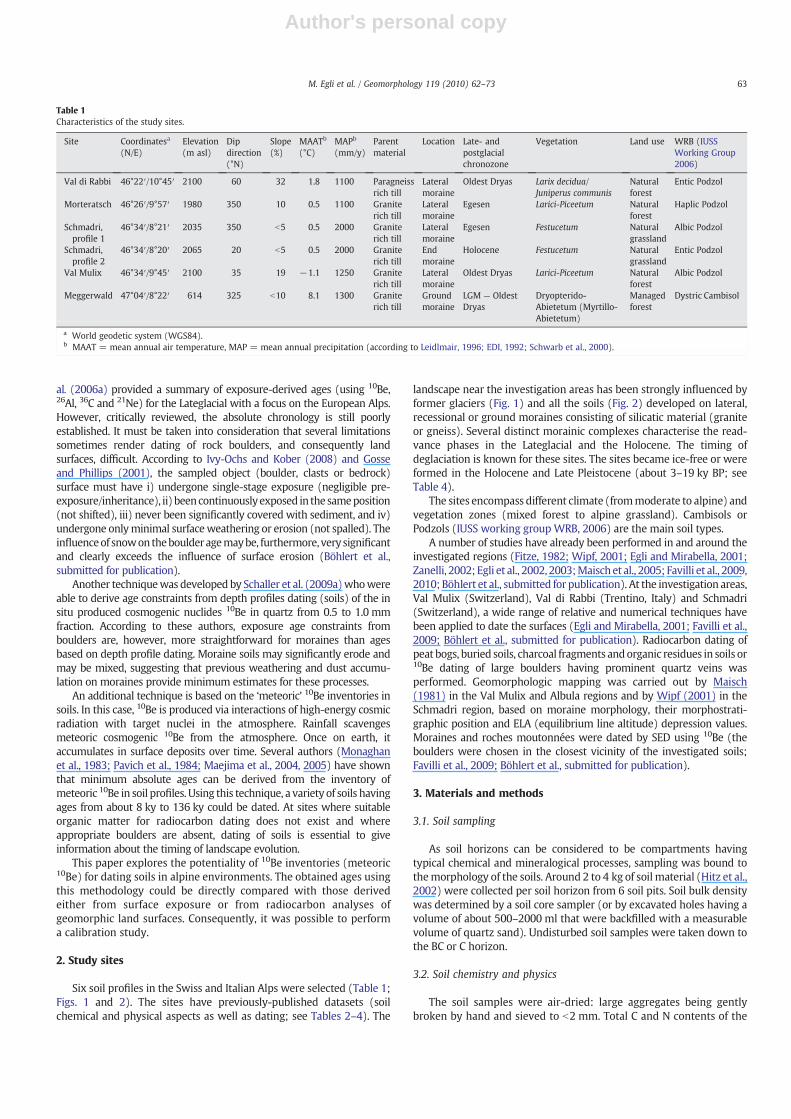
Table 1Characteristics of the study sites.
Site Coordinatesa
(N/E)Elevation(m asl)
Dipdirection(°N)
Slope(%)
MAATb
(°C)MAPb
(mm/y)Parentmaterial
Location Late- andpostglacialchronozone
Vegetation Land use WRB (IUSSWorking Group2006)
Val di Rabbi 46°22′/10°45′ 2100 60 32 1.8 1100 Paragneissrich till
Lateralmoraine
Oldest Dryas Larix decidua/Juniperus communis
Naturalforest
Entic Podzol
Morteratsch 46°26′/9°57′ 1980 350 10 0.5 1100 Graniterich till
Lateralmoraine
Egesen Larici-Piceetum Naturalforest
Haplic Podzol
Schmadri,profile 1
46°34′/8°21′ 2035 350 b5 0.5 2000 Graniterich till
Lateralmoraine
Egesen Festucetum Naturalgrassland
Albic Podzol
Schmadri,profile 2
46°34′/8°20′ 2065 20 b5 0.5 2000 Graniterich till
Endmoraine
Holocene Festucetum Naturalgrassland
Entic Podzol
Val Mulix 46°34′/9°45′ 2100 35 19 −1.1 1250 Graniterich till
Lateralmoraine
Oldest Dryas Larici-Piceetum Naturalforest
Albic Podzol
Meggerwald 47°04′/8°22′ 614 325 b10 8.1 1300 Graniterich till
Groundmoraine
LGM — OldestDryas
Dryopterido-Abietetum (Myrtillo-Abietetum)
Managedforest
Dystric Cambisol
a World geodetic system (WGS84).b MAAT = mean annual air temperature, MAP = mean annual precipitation (according to Leidlmair, 1996; EDI, 1992; Schwarb et al., 2000).
63M. Egli et al. / Geomorphology 119 (2010) 62–73

Author's personal copy
Fig. 1. Impression of the investigation sites with the main geomorphic features (moraines) and sampling sites. LGM= Lateglacial maximum; 1850 and 1857moraines correspond tothe Little Ice Age. A: Val di Rabbi; B: Morteratsch (air photo from C. Rothenbühler), C: Schmadri with C1 with a detailed picture of the Holocene-aged and 1850 moraines (Wipf,2001). The Younger Dryasmoraine is curtly outside the photo; C2: Overview Schmadri and glacier stages (Google Earth), D: Val Mulix, E: Meggerwald (photo taken fromwandersite;http://www.wandersite.ch; Ursula Brem).
64 M. Egli et al. / Geomorphology 119 (2010) 62–73

Author's personal copy
soil weremeasured by C/H/N analyser (Elementar Vario EL, ElementarAnalysensysteme GmbH) using oven-dried and ball-milled fine earth.Total C corresponds in our case to organic C due to the absence of anycarbonates in the soil. Soil pH (in 0.01 M CaCl2) was determined onair-dried samples of the fine earth fraction using a soil solution ratio of1:2.5. The oxalate-extractable iron and aluminium fractions (Feo andAlo) were determined according to McKeague et al. (1971) andanalysed by AAS (Atomic Absorption Spectrometry — AAnalyst 700,Perkin Elmer, USA). After a pre-treatment of the samples with H2O2
(3%), particle size distribution of the soils was measured using acombined method consisting of sieving coarser particles (2000–32 µm) and measurement of the finer particles (b32 µm) by means ofan X-ray sedimentometer (SediGraph 5100, Micromeretics, Norcross,GA, USA).
3.3. Age determination of soils using meteoric 10Be
The inventory of meteoric 10Be in a soil can be directly related tothe soil age (Maejima et al., 2005; Tsai et al., 2008). The 10Beabundance in a soil profile was estimated assuming that theoverwhelming part of 10Be is adsorbed in the fine earth fraction.The amount is consequently calculated according to:
N = ∑n
a=1zwρwCwfwð Þ ð1Þ
where N corresponds to the abundance of 10Be (inventory), zw to thethickness of the corresponding soil horizon, ρw being the bulk density,Cw to the concentration (fine earth) in the corresponding horizon andfw to the relative fraction (% by weight) of fine earth.
If the 10Be inventory since the initiation of soil formation is known,then the time soils were exposed to meteoric 10Be flux can bedetermined using the following equation:
dNdt
= q−λNwithN = 0at t = 0 ð2Þ
t = − 1λln 1−λ
Nq
� �ð3Þ
where t is the age of soil, λ is the decay constant of 10Be (4.62×10⁻⁷/y),N is the inventory of 10Be in time t (atoms/cm2) and q is the annualdeposition rate of 10Be (atoms/cm2/y). Themeasured inventory N is theintegral of concentration multiplied by soil density at the depth theprofile was sampled (Pavic and Vidic, 1993; Maejima et al., 2004).
3.4. 10Be measurement of soil samples
To measure the abundance of 10Be in the six profiles, theindividual soil horizons (see Table 2) were analysed for their 10Beconcentration in the fine earth (fraction b2 mm). 10Be was extractedfrom the soil samples using a modified method from Horiuchi et al.(1999). 0.4 mg of 9Be(NO3)2 (carrier) was added to 1–5 g of soil(b2 mm fraction). This mixture of carrier and sample was thenheated for 3 h at 550 °C to remove organic matter. After cooling itwas put in a shaker and leached with 8 ml HCl (16% v/v) overnight.The solid part was separated by centrifuge and leached again: theliquid was collected. After a second leaching, the soil residue wasdisposed of and the obtained solutions mixed together and heated at80 °C until the volume reduced to c. 1 ml. To this sample, 1 ml HNO3
Fig. 2. Profile photos of the investigated soils. A) Val di Rabbi; B) Morteratsch (photo: P. Fitze); C) Schmadri, profile 1; D) Schmadri profile 2; E) Val Mulix; F) Meggerwald (Photo:M. Achermann).
65M. Egli et al. / Geomorphology 119 (2010) 62–73

Author's personal copy
(65% v/v) and 1 ml HCl (32% v/v) were added and any fine particlesremoved by centrifugation. NaOH (16% v/v) was added to thesample until it reached a pH value of 2, when 1 ml of conc. EDTA wasadded. The EDTA solution removesmetals (Fe andMn) in the form ofEDTA complexes. NH4OH was added until a pH value of 8 wasobtained and the resulting gel containing Be(OH)2, Al(OH)3 andsome Fe(OH)2 and Mn(OH)2 was precipitated. NaOH solution wasadded to the gel until the pH value reached 14. The Be(OH)2 and Al(OH)3 re-dissolved and the solution containing Be and Al wasseparated by centrifugation. This procedure was repeated a secondtime to recover any remaining Be. Once again conc. HCl (32% v/v)was added to the liquid (containing Be) to reach a pH value of 2 and1 ml of 10% EDTA was added to remove the last traces of Fe and Mn.The Be(OH)2 and Al(OH)3 were precipitated with NH4OH andsubsequently centrifuged. If Fe was still present, the gel would havebeen coloured yellow. HCl (32% v/v) was added until the gel re-dissolved. It was then heated to reduce the volume to c. 1 ml. Any Fewas removed using the anion exchange column; the cleanedsolution was heated to near dryness. The Be and Al were separatedusing two different cation exchange columns. In the first stage theprecipitated gel was dissolved in HCl and passed through the firstcation exchange column where most of the Al was adsorbed. Afterevaporation and precipitation the Be(OH)2 was dissolved in oxalicacid (stage two) and passed through the second cation exchangecolumn which adsorbed the last traces of Al. This second procedureis based on the formation of Al complexes with oxalic acid, and Al isalso adsorbed in the column. Pure Be(OH)2 was precipitated withNH4OH and subsequently dried at 70 °C. It was calcinated in an ovenfor 2 h at 850 °C to obtain pure BeO. This BeO was then mixed withCu powder and pressed into a mass spectrometer target.
The 10Be/9Be ratios were measured at the ETH Zurich TandemAccelerator Mass Spectrometry (AMS) facility (Kubik and Christl,2009) using ETH AMS standards S555 (10Be/9Be=95.5×10−12
nominal) and S2007 (10Be/9Be=30.8×10−12 nominal), both associ-ated with a 10Be half-life of 1.51 My.
3.5. Statistics
As the data did not always show a normal distribution, correlationanalysis was performed using Pearson's correlation coefficient fornormally distributed data and the Spearman's rank correlationcoefficient for non-normally distributed ones (Sachs, 1992). A log-transformation of the data was necessary for the multiple regressionanalysis.
4. Results
4.1. Physical and chemical soil properties
The soils showed an undisturbed evolution (according to theirmacromorphology as well as their chemical and physical properties)with no signs of erosion or burial. All soils in the study area have aloam or sandy-loam in the topsoil and a loamy-sand texture in thesubsoil (Table 2). The acidification of the soils is pronounced with pH-values in the topsoil generally between 3.0 and 4.0 (Table 3). Some ofthe soils showed clear podzolisation features (Tables 2, 3) with aneluviation and illuviation of Fe, Al and sometimes soil organic matter(SOM). All soils have a distinct amount of soil skeleton (material witha diameter N2 mm) that usually increases with increasing soil depth
Table 2Physical and morphological characteristics of the soils (Favilli et al., 2009; Egli et al., 2009; Egli and Mirabella, 2001; Egli et al., 2003; Böhlert et al., submitted for publication).
Site/profile Soilhorizon
Depth Munsell colour Skeleton Bulk density Sand Silt Clay
cm (moist) w.-% g/cm3 % % %
Val di Rabbi AE 0–4 10YR 3/3 5 0.91 46 28 26BE 4–8 5YR 4/4 11 0.91 52 28 20Bs1 8–20 7.5YR 4/4 51 0.74 58 29 14Bs2 20–45 10YR 4/4 45 1.16 67 28 5BC 45–60 10YR 5/4 34 1.41 n.d. n.d. n.d.
Morteratsch O 0–5 7.5YR 3/1 14 0.80 n.d. n.d. n.d.E 5–15 7.5YR 4/3 30 1.34 54 38 8Bs1 15–25 7.5YR 4/4 55 1.54 79 18 3Bs2 25–65 10YR 4/6 57 1.67 n.d. n.d. n.d.BC 65–105 10YR 6/4 53 1.71 78 19 3C 105–130 10YR 6/3 67 1.74 78 19 3
SchmadriProfile 1
O 0–10 10YR 2/1 0 0.39 n.d. n.d. n.d.E 10–16 7.5YR 4/2 7 1.09 54 33 13Bhs 16–24 7.5YR 2/2 23 1.01 49 31 19Bs 24–55 7.5YR 3/4 25 0.94 n.d. n.d. n.d.BC 55–105 10YR 5/4 26 1.54 74 21 5C 105–120 10YR 6/4 42 1.70 82 13 5
SchmadriProfile 2
O 0–8 10YR 3/1 5 0.57 n.d. n.d. n.d.E 8–15 10YR 4/1 25 0.77 54 30 16Bhs 15–22 10YR 2/2 27 1.36 51 32 17Bs 22–50 10YR4/4 73 1.76 n.d. n.d. n.d.C 50–85 10YR 7/4 80 1.89 78 17 5
Val Mulix O 0–13 5YR 1.7/1 3 0.37 50 39 11E 13–20 7.5YR 1.7/1 29 0.88 49 38 13Bhs 20–23 5YR 2/2 21 0.90 n.d. n.d. n.d.Bsm 23–50 5YR 3/4 61 1.75 82 15 3BC 50–70 10YR 5/4 54 1.68 n.d. n.d. n.d.C 70–100 10YR 6/3 61 1.75 81 16 3
Meggerwald A 0–20 7.5YR 2/3 13 0.87 48 35 17Bw1 20–40 10YR 4/4 20 1.11 46 39 15Bw2 40–80 10YR 4/4 26 1.42 49 38 14BC 80–130 10YR 5/4 9 1.59 n.d. n.d. n.d.2C N130 10YR 6/4 0 1.59 63 28 10
n.d. = not determined.
66 M. Egli et al. / Geomorphology 119 (2010) 62–73

Author's personal copy
(except for the Meggerwald site) and can be up to almost 70% byweight. These values are typical for moraines in Alpine areas.
4.2. 10Be in the soil profiles
Meteoric 10Be infiltrates into soils and is adsorbed along theprofile. Highest 10Be concentrations in the fine earth (up toN10×108 atoms/g) were measured in the surface horizons. Usually,the 10Be concentrations decreased with increasing soil depth (Fig. 3).At several sites an increase of the 10Be concentration in the Bs or Bhshorizon was detected, which indicated an active translocation of 10Bewithin the soil profile. This translocation is due to podzolisationprocesses where 10Be migrates together with Fe, Al and/or SOM togreater soil depths.
4.3. 10Be deposition rates
To calculate the soil age, the deposition rate of 10Bemust be known(see Eqs. (2) and (3)). Because the 10Be deposition rates are unknownfor the investigated sites, they had to be estimated. Two differentconcepts in estimating the 10Be deposition rates exist.
1) Maejima et al. (2005) showed that the deposition rate of 10Be isprimarily a function of the amount of precipitation. Averageconcentrations of 10Be in rainfall are near 1–1.5×10⁴ atoms/cm3
(Monaghan et al., 1985/1986; Brown et al., 1989; Maejima et al.,2005). Annual mean 10Be concentrations in New Zealand rainranged from 2.1 to 2.9×10⁴ atoms/cm3 (Graham et al., 2003) andin France from about 1.5–4.4×10⁴ atoms/cm3 (Raisbeck et al.,1979). The annual deposition rate for the past thousands of years ismostly unknown. Heikkilä et al. (2008a) considered existing 10Berecords from Greenland and Antarctica and were able to show thatslightly increased concentrations were recorded during theMaunder Minimum (MM) period, 1645–1715, when solar activitywas very low and the climate colder (Little Ice Age). 10Bedeposition rates were seemingly subject to some variations inthe past. Vonmoos et al. (2006) showed that the measured 10Befluxes (derived from the GRIP ice core) have some variation, butthat the integrated average smoothes the observed variation dueto changes in solar activity to a quasi-permanent long-termaverage value (over the last 10 ky). 10Be concentrations during theMM period were about 1.5–1.7×10⁴ atoms/cm3 (in Greenland)and 3.9×10⁴ atoms/cm3 (in Antarctica). The values given byMonaghan et al. (1985/1986) are, therefore, reasonable and weretaken for this investigation.
2) Willenbring and von Blanckenburg (2009) argue, however, that incoastal and island settings where the atmospheric transport timeis fast and 10Be and 7Be concentrations in rain are significantlycorrelated with precipitation rate, the yearly flux of meteoric 10Beis independent of the rain rate. This is, consequently, not inagreement with measurements of Graham et al. (2003) andMaejima et al. (2005). The geometry of the Earth's magnetic fieldproduces a predictable latitudinal variation. The combination ofincreased flux toward the poles and the increasing thickness of theatmosphere for low latitudes and the low pressures at the polesresults in a maximum at mid-latitudes (Willenbring and vonBlanckenburg, 2009).
To see the effect of the 10Be deposition rates on the measurementof soil age, the age estimation using 10Be in soils was done using bothapproaches:
– 10Be deposition fluxes derived from the amount of precipitationand
– 10Be deposition fluxes derived from a modelling approach usingconstant fluxes for the Central Alps (Willenbring and vonBlanckenburg, 2009). This modelling approach for the Central
Table 4Surface ages of the investigation sites.
Soil profile y BP (14C) y calBP (OxCal)a 10Be age (y) Dated feature References
Val di Rabbi 14,410±110 16,782–17,839 Stable OM of a lateral moraine (Oldest Dryas) Favilli et al. (2009)Morteratsch 12,460±1280 Boulder on a lateral Egesen moraine Maisch et al. (2005)Schmadri,profile 1
10,390±150 11,751–12,788 Intramorainal peat bog basis Wipf (2001)
Schmadri,profile 2
3330±85 3381–3730 Frontal moraine above a fossile soil Wipf (2001)
Val Mulix 14,690±1790 Boulder on a lateral Daun moraine Böhlert et al. (submitted for publication)Meggerwald 18,000–19,500 Lateral and end moraines, glacial (retreat stadials
at the end of the LGMb: Hurden/Zürich stadial)Hantke (1983), Keller (1988), Keller and Krayss (2005),Maisch (2000), Zwahlen (2008)
a OxCal 4.1 calibration program (Bronk Ramsey, 2001) based on the IntCal 04 calibration curve (Reimer et al., 2004).b LGM = Lateglacial maximum.
Table 3Chemical characteristics of the soils (Favilli et al., 2009; Egli et al., 2009; Egli andMirabella, 2001; Egli et al., 2003; Böhlert et al., submitted for publication).
Site/profile Soilhorizon
pH(CaCl2)
Org. C Feda Alda Feob Alob
g/kg g/kg g/kg g/kg g/kg
Val di Rabbi AE 3.7 103.7 15.90 2.50 5.57 1.73BE 3.6 61.0 20.50 2.80 6.06 1.91Bs1 4.1 39.4 44.10 14.70 19.62 10.27Bs2 4.4 17.0 21.40 7.30 9.37 5.84BC 4.5 7.5 6.90 5.60 1.67 4.04
Morteratsch O 3.3 176.4 3.47 0.76 0.69 0.56E 3.3 16.4 3.87 0.75 0.27 0.56Bs1 4.4 8.9 5.01 3.56 1.40 5.47Bs2 4.7 1.7 3.78 1.44 0.82 1.80BC 4.9 0 3.47 1.11 0.40 1.16C 4.9 0 3.28 0.83 0.33 0.90
Schmadri Profile 1 O 3.9 383.3 4.59 2.71 3.26 2.10E 3.7 22.3 1.83 0.77 0.45 0.84Bhs 3.8 113.1 46.23 10.91 29.65 10.21Bs 4.1 42.6 18.3 23.62 11.43 19.5BC 4.5 9.5 7.83 4.37 2.67 4.48C 4.7 2.2 4.84 1.65 1.23 1.48
Schmadri Profile 2 O 3.5 142.8 3.58 1.66 1.67 1.90E 3.7 69.1 9.81 3.54 4.14 3.36Bhs 3.8 112.6 13.08 7.74 7.28 7.61Bs 4.3 45.5 20.78 12.92 11.72 13.38C 4.7 6.0 2.79 2.41 1.41 2.32
Val Mulix O 2.7 202.8 n.d. n.d. n.d. n.d.E 3.2 45.9 5.32 3.31 2.36 2.92Bhs 3.5 50.5 17.91 8.48 10.30 7.03Bsm 4.4 28.3 15.07 15.93 6.29 20.05BC 4.4 3.9 2.84 2.54 1.20 3.25C 4.6 2.3 1.69 1.66 0.79 2.04
Meggerwald A 3.8 35.0 10.91 5.78 5.51 4.75Bw1 4.1 11.0 11.13 4.10 3.89 3.41Bw2 4.3 6.0 10.35 4.60 3.01 3.71BC 4.0 2.0 8.91 2.59 2.27 1.962C 4.4 0 4.78 1.21 0.83 0.91
n.d. = not determined.a Dithionite-extractable content.b Oxalate-extractable content.
67M. Egli et al. / Geomorphology 119 (2010) 62–73

Author's personal copy
Alps yields a deposition rate of about 10×105 atoms/cm2/y (seealso Fig. 4).
Using the first approach, the deposition rates of 10Be in our studysites range from 1.2×10⁶ atoms/cm2/y (1000 mm/y rainfall) to2.4×106 atoms/cm2/y (2000 mm/y rainfall). The second approachgives for all sites the same deposition rate of 1.0×10⁶ atoms/cm2/y(Table 5).
4.4. Age determination using meteoric 10Be
In the soils, 120–300×108 10Be atoms/cm2 are accumulated(Table 5). Errors in the quantification of the 10Be abundance are dueto analytical errors (AMS) of 10Be determination and due to densityand soil skeleton measurements (Table 5). An estimate of the error
range was performed by means of the maximum error. The range oferror Δf can be estimated by the mean analytical error (10Be) and theerror Δy introduced due to soil analyses (density, soil skeleton).
Δf = Δx + Δy ð4Þ
The ratio Δf/fx,y (with fx,y as the measured value) gives the relativeerror that equals the sum of the individual mean errors. The error forthe density and the soil skeleton determinations was estimated to be5% (for each parameter). In soil horizons having no soil skeleton thecorresponding error was considered to be negligible. These assump-tions are very conservative (Desaules and Dahinden, 2000). Accord-ingly, the estimated errors of the 10Be inventory and, subsequently,the derived surface ages vary from 8 to c. 21%.
Fig. 3. Depth profiles (with horizon depth and designation) showing the accumulated meteoric 10Be in the soils.
68 M. Egli et al. / Geomorphology 119 (2010) 62–73

Author's personal copy
An additional variability is introduced by the selection of the 10Bedeposition rates scenarios (see above). If a 10Be deposition rate whichdepends on the annual amount of precipitation is used, then thecalculated ages vary between 6.0 and 19.2 ky (= scenario (a)). Olderages (= scenario (b)) are obtained (12.6–30.3 ky) using a constantmeteoric 10Be flux for the Central Alps (Table 5). According to Table 4,the soils have a decreasing age with MeggerwaldNVal di RabbiNValMulixNSchmadri profile 1=MorteratschNSchmadri profile 2. Using aprecipitation-dependent meteoric 10Be flux (scenario (a)), thefollowing sequence is derived: MeggerwaldNVal MulixNVal diRabbiNSchmadri profile 1NMorteratschNSchmadri profile 2. Thissequence is quite similar to the expected one (see Table 4). Assuminga constant 10Be flux for the Central Alps (scenario (b)) the agedecrease is MeggerwaldNSchmadri profile 1NVal MulixNVal diRabbiNSchmadri profile 2NMorteratsch. This last sequence differssubstantially from the expected one. In theory, it might be that theglacial till (morainicmaterial) was already exposed to the atmosphereor mixed withmaterial that was exposed. Consequently, an additionalapproach (= scenario (c)) that assumed a pre-exposure was applied.The 10Be concentration in the parentmaterial was assumed to accountfor this pre-exposure and was consequently subtracted from themeasured concentrations in the other soil horizons. The 10Beinventory was then calculated on this basis. As in scenario (b), aconstant 10Be deposition rate was assumed. Using scenario (c) thefollowing age sequence is derived: MeggerwaldNVal MulixNSchma-dri profile 1NVal di RabbiNSchmadri profile 2NMorteratsch. This
scenario fits slightly better to the expected one than scenario (b), butmajor discrepancies still exist.
5. Discussion
5.1. 10Be in the soils
Maejima et al. (2004, 2005) observed a positive correlation betweenthe clay content and the 10Be concentration in the soils. The distributionpattern of 10Be along the soil profile could be mainly attributed to theamount of clays. At our sites, such a correlation was not detected (R=−0.18; pN0.1). Thismight be due to the rather low amount of clays andto the stony character of most of the sites. However, a significantcorrelation between 10Be and the oxalate-extractable fractions of Fe(RSpearman=0.35, p=0.039) and Al (RSpearman=0.37, p=0.030) couldbe found. Furthermore, soil organic matter was significantly correlatedwith 10Be (RSpearman=0.46, p=0.007). The pH-value was correlatedonly at the 10% significance level. A log transformation of the datasetsmade a multiple regression possible. 10Be can be described as:
log 10Beh i
= 8:2572–0:239 log Feo½ � + 0:2809 log Alo½ � + 0:3146 log org:C½ �ð5Þ
with R=0.50 and p=0.04The distribution pattern andmobility of 10Be within the soil profile
are thus controlled to a certain extent by SOM and weakly crystallineoxides and hydroxides.
The great variability of the 10Be depth profiles can be explained bycomplex geochemical and transport mechanisms (Morris, 1991; Tsaiet al., 2008). Eluvial and illuvial transport mechanisms seem to becrucial — in Podzols as well as in Luvisols (where a clay-mediatedtransport takes place; Pavich et al., 1984; Tsai et al., 2008). Leaching of10Be from the soil column may lead to an underestimation of the age.Kaolinite and dioctahedral vermiculite, however, seem to be a veryefficient trap for 10Be (Pavich et al., 1985). In the investigated soils,smectite, vermiculite, chlorite, mica, kaolinite, HIV (hydroxy-inter-layered vermiculites), HIS (hydroxy-interlayered smectites) andinterstratified minerals prevail in the clay fraction (Egli andMirabella,2001; Egli et al., 2002, 2003; Favilli et al., 2009). Due to the givendistribution of 10Be in the soil profiles, a major loss of 10Be with theacidic percolate can be excluded due to the sharp decrease of 10Bewith soil depth. A physical movement down-profile of clay particlescontaining adsorbed 10Be is also rather improbable due to the acidicsoil conditions (which usually inhibit clay transport). Furthermore, inall soils the clay content is low and no increase with soil depth couldbemeasured. The highest amount of 10Be is found in the topsoil and Bs(or Bhs) horizon and seems to be bound to SOM, Fe- and Al-oxyhydroxides.
Fig. 4. Correlation between measured 10Be deposition rates (data from Brown et al.,1992; Graham et al., 2003;Maejima et al., 2005; Vonmoos et al., 2006; Ljung et al., 2007;Zhou et al., 2007; Belmaker et al., 2008; Heikkilä et al., 2008b) and modelled fluxes(according to Field et al., 2006; Heikkilä, 2007; Willenbring and von Blanckenburg,2009).
Table 5Cosmogenic nuclide inventories, estimated errors related to the estimation of the inventory and calculated age (including error range) using 10Be deposition rates as a function of theamount of precipitation (Maejima et al., 2005).
Site 10Beinventory(1E+8; atoms/cm2)
Estimated errors (1E+8; atoms/cm2) Total error(1E+8; atoms/cm2)
aAnnual 10Bedeposition rate(atoms/cm2; 1E+6)
aCalculatedage (ky)
bAnnual 10Bedeposition rate(atoms/cm2; 1E+6)
bCalculatedage (ky)
Measurement Density Soilskeleton
Val di Rabbi 158.0 5.1 6.7 5.0 16.8 1.21 13.1±1.4 1.00 15.9±1.7Morteratsch 125.8 7.7 6.3 5.8 19.8 1.33 9.5±1.5 1.00 12.6±2.0Schmadri, profile1
283.8 12.7 14.2 4.1 31.0 2.43 11.7±1.3 1.00 28.5±3.0
Schmadri, profile2
147.3 5.5 7.4 19.1 32.0 2.43 6.0±1.3 1.00 14.7±3.2
Val Mulix 214.5 9.4 10.7 14.7 34.8 1.51 14.3±2.3 1.00 21.6±3.5Meggerwald 301.0 17.2 9.0 3.7 29.9 1.57 19.2±1.7 1.00 30.3±2.7
a Shows the age using 10Be deposition rates as a function of the amount of precipitation.b Shows the calculated ages using a constant 10Be deposition rate (Willenbring and von Blanckenburg, 2009).
69M. Egli et al. / Geomorphology 119 (2010) 62–73

Author's personal copy
5.2. 10Be deposition rates
Probably the most difficult and challenging issue in dating soilsusing 10Be is the estimation of 10Be deposition rates for a specific site.There is, unfortunately, no consensus to be obtained from theliterature of the exact effect of precipitation on the 10Be flux in anarea. The variability in the 10Be concentration from precipitationmeasurements reflects short-term fluctuations in precipitation rate,stratosphere/troposphere exchange, magnetic field strength, etc.(Monaghan et al., 1985/86; Graham et al., 2003, Willenbring andvon Blanckenburg, 2009). Several modelling attempts were made topredict 10Be deposition rates on a global scale. Field et al. (2006) usedthe Goddard Institute for Space Studies ModelE (GISS) generalcirculation model (GCM) and Heikkilä (2007) used the EuropeanCentre Hamburg Model (ECHAM5) GCM in combination with Masarikand Beer's (1999) production functions. Willenbring and vonBlanckenburg (2009) listed the measured 10Be deposition rates andmodelled values for a few sites (see Fig. 4). In some cases, the modelpredictions match the measured deposition rates quite well, but insome cases not. It seems that the modelling approach tends to slightlyunderestimate the deposition rates at high 10Be influxes.
5.3. Validity of the 10Be ages
The calculated ages using 10Be in soils could be compared toavailable ages of the same geomorphic features (Table 4). Thecorrelation between the ages derived from 10Be measurements andthe expected age is given in Fig. 5. The calculated ages using a 10Bedeposition rate based on the amount of precipitation (scenario (a))agree quite well with the expected age of the landform (Fig. 5a). Somediscrepancies exist at the site Val di Rabbi where a major differencebetween the expected age and the 10Be-age of the soil was detectedand at the site Schmadri (profile 2) where instead of 3.6 ky an age of6.0 ky was calculated. Erosion, leaching and accumulation processesin soils affect the calculated 10Be-age (Lal, 2001; Maejima et al., 2005;Tsai et al., 2008). Erosion eliminates accumulated 10Be. In addition, thesoil components interact with percolating acidic solutions and, as aconsequence, adsorbed 10Be may move out of the considered system(Tsai et al., 2008). Both processes lead to an underestimation of theage. In contrast, accumulation of soil material imports 10Be.Furthermore, soil material may have been pre-exposed and conse-quently a too high amount of meteoric 10Be may have accumulated.This last process has most probably occurred at the Schmadri profile 2site. The moraine here was formed due to a small re-advance of theglacier (Wipf, 2001) 3600 y BP. After the Egesen glacial state (YoungerDryas; ∼11 ky BP), the glacier retreated rapidly to the present-daysituation. As the re-advance occurred around 3600 y BP, wehypothesise that pre-exposed material (having an age of about11 ky) was probably mixed with fresh, un-weathered material.
The ages calculated assuming a constant meteoric 10Be flux(scenario (b)) agreed in only two cases with the age obtained fromSED or radiocarbon dating (sites Morteratsch and Val di Rabbi;Fig. 5b). For all other sites, the estimated ages of the soils weredefinitely too old. An almost similar age for Meggerwald (which isdefinitely the oldest soil) and Schmadri profile 1 (which correspondsto the Egesen glacial stage;Wipf, 2001) was derived. In our case, usingthe approach with a constant meteoric 10Be influx, the resultsobtained were not reasonable. The results based on scenario (c) fitbetter with the expected ages (Fig. 5c). However, the best results wereobtained using the first scenario (a), i.e. with meteoric 10Be depositionrates dependent on the amount of precipitation.
Consequently, the deposition rates of 10Be substantially influencethe calculated age of the soils. The relation between the error of 10Bedeposition rates and the derived age is non-linear (Fig. 6). Relativelysmall errors have a substantial effect on the age calculations.
5.4. Soil erosion rates
Soil macromorphology as well as soil chemistry (see Tables 2 and3) did not give any evidence that the soils were subjected to erosion.Some erosion, however, might have occurred which is only detectableusing a “tracer” such as 10Be. Over the past few years, the technique ofcosmogenic nuclides has been extended to determine long-term
Fig. 5. Correlation between 10Be ages (and uncertainty range) derived from soilanalyses and expected surface age (reference surface age; derived either from surfaceexposure dating or from radiocarbon analyses; see also Table 4); A) using 10Bedeposition rates as a function of the annual amount of precipitation, B) constant 10Bedeposition fluxes for the Central Alps, C) like B) and assuming a background 10Be levelin the parent material.
70 M. Egli et al. / Geomorphology 119 (2010) 62–73

Author's personal copy
erosion rates on a catchment scale or on single soil profiles. For arecent summary of the technique and new applications see vonBlanckenburg (2006) and Schaller et al. (2009a). The nuclideconcentration is inversely proportional to the catchment area erosionrate and the soil erosion rate. The assumption of a steady state is oftenan essential prerequisite of this technique (Schaller and Ehlers, 2006).In addition, short-term erosion rates can be estimated, for example,using 137Cs (Collins et al., 2001). Knowing the age of a landform andhaving the calculated 10Be age derived from soils, soil erosion can beestimated by comparing the effective abundance of 10Be measured inthe soil with the theoretically necessary abundance for the expectedage. To evaluate a possible erosion of the soils, we assume that thematerial is eroded from the surface at a constant rate E (Maejima et al.,2005). Eq. (3) can be extended to:
tcorr = − 1λ
1−λN
q−ρEm
� �ð6Þ
where m is the measured concentration of 10Be in the top erodinghorizons (atoms/g), ρ is the bulk density (g/cm3) of the top horizonsand tcorr the correct (expected) age. Erosion rates are obtained fromthe differenceΔt= tcorr− t (Eqs. (3) and (6)) where the parametersΔtand t are known.
Using the approach with meteoric 10Be deposition rates thatdepend on the precipitation amount (scenario a), the calculatederosion ranges lie within b1–18.4 mm/ky (Table 6). These values arelow but possible. Schaller et al. (2009b) determined erosion ratesfrom moraine ridges in the order of 8–23 mm/ky. Although acomparison between moraine and catchment-wide erosion is diffi-cult, it can give at least an indication about a possible range. Ourcalculated erosion rates are similar to the results of Granger et al.(2001), where catchment erosion rates at Adams Peak and AntelopeLake (north-eastern Sierra Nevada, CA, USA) were in the rangebetween 15 and 60 mm/ky. Schaller et al. (2001) measured 20–100 mm/ky erosion rates for middle European river catchments. Inthese studies, an averaged erosion rate is obtained over a larger area.The investigated alpine soils, however, developed on stable surfacesand partially at almost flat positions. Vegetation as well as the stonycharacter of the sites render them much less susceptible to erosion.Boulders also shield the underlying soil from erosion (Granger et al.,2001). A high soil skeleton content as well as vegetation cover androots prevent soils from erosion (Richter, 1998). No erosion rates canbe derived using the approach with a constant meteoric 10Be influx
(the 10Be inventory in soils is in this caseNexpected inventory).Assuming a pre-exposure of the parent material and a constant10Beinflux, the calculated erosion rates lie between 1 and 57 mm/ky(Table 6). Although themaximum rates are rather high, the results arein a plausible range.
An additional approach to calculate erosion rates is the oneproposed by Lal (2001) using:
E = z0KE ð7Þ
and:
KE =ND
NS
Q + qaND
� �−λ ð8Þ
where E=erosion rate, z0=thickness of topsoil horizons (comprisingOandAhorizon),KE=first order rate constant for removal of soil fromthetopsoil layer,ND=10Be inventory in theD layer (=remainderof the soilprofile comprisingB andChorizons; atoms/cm2),NS=10Be inventory intopsoil horizons (atoms/cm2), Q = flux of atmospheric 10Be into thetopsoil (atoms/cm2/y), qa = flux of accreted aeolian 10Be (atoms/cm2/y).
To treat the limited data available for 10Be, the aeolian addition of10Be with dust is neglected although it might be appreciable in somecases (Lal, 2001). Using the approach of Lal (2001), high erosion rateswere calculated that seem to be rather unrealistic. For the investigatedsoils, the erosion rates would be 100 mm/ky for Val di Rabbi, 45 mm/ky for Schmadri profile 1, 82 mm/ky for Schmadri profile 2, 180 mm/ky for Val Mulix, 95 mm/ky for Meggerwald and 36 mm/ky forMorteratsch. Tsai et al. (2008) calculated an erosion rate in the orderof 7–17 mm/ky for soils of a terrace sequence with an age of about100–400 ky — values that correspond fairly well to our investigatedsoils. Using the calculated erosion rates according to Lal (2001),
unrealistic soil ages were also obtained (using Eq. (6)): 66 ky for the
Schmadri profile 1. For all other soils the termN
q−ρEm
� �in Eq. (6)
became negative and no age could be calculated.A basic assumption of Lal (2001) is that the soils are in a steady-
state condition — the B horizon, for instance, should not change its
Fig. 6. Effect of errors of 10Be deposition rates estimation (error propagation) on thecalculated surface age.
Table 6Estimated erosion rates using (a) 10Be deposition rates as a function of precipitation and(b) 10Be deposition rates as constant flux (according to Field et al., 2006; Heikkilä, 2007;Willenbring and von Blanckenburg, 2009) and acting on the assumption of a 10Bebackground-value (pre-exposure).
Site Measured inventory(10Be atoms×1E+8)
Expected inventory(10Be atoms×1E+8)
Erosion rate(mm/ky)
a)Val di Rabbi 158.0 206.5 13.8–14.9Morteratsch 125.8 165.4 5.0–18.4Schmadri,profile 1
283.8 290.7 1.3–2.1
Schmadri,profile 2
147.3 82.0 –
Val Mulix 214.5 221.2 4.3–6.2Meggerwald 301.0 300.0 b1
b)a
Val di Rabbi 83.1 172.3 26.7–30.5Morteratsch 74.9 124.5 6.5–31.7Schmadri,profile 1
108.4 122.5 2.7–4.1
Schmadri,profile 2
91.8 36 –
Val Mulix 115.9 144.5 5.5–57.1Meggerwald 171.7 184.3 6.9–15.1
a The 10Be concentration in the lowest soil horizon is assumed to reflect the pre-exposure. The inventory is calculated using the concentrations of the individual soilhorizons minus the value measured in the lowest horizon.
71M. Egli et al. / Geomorphology 119 (2010) 62–73

Author's personal copy
thickness—which is not valid for the rather young, alpine soils. Alpinesoils have evolved over the last 20 ky and soil thickness is stillchanging. Furthermore, the Lal-approach considers only an averagesoil density (using the same density for the topsoils as well as for thesubsoil), which is also an excessively simplified approach.
In contrast to the “open system” assumptions used here, Lal et al.(1991) proposed a “closed system” model for soil age determination,in which the 10Be/9Be ratio in authigenic soil minerals lock at the timeof formation. Age calculations assume a closed systemwith a decreaseof the 10Be/9Be ratio from the C- to the B-horizon. Barg et al. (1997)suggested that the 10Be/9Be ratios in authigenic phases can be used toobtain useful age models for soils younger than 10–15 My. 10Be/9Beratio for soil mineral phases are, however, not available for ourstudied soils.
6. Conclusions
In this study we tried to derive surface ages using 10Be in soils. Wewere able to compare the obtained ages with existing age determina-tions (radiocarbon, surface exposure dating). We obtained thefollowing main findings:
– Meteoric 10Be has been involved in soil processes such aseluviation and illuviation (due to podzolisation).
– Mass changes of 10Be in the investigated soil profile (erosion,leaching and accumulation processes) may affect the determinedage.
– The uncertainties using the 10Be inventory in soils were substantialand varied in the range of 8–21%, because analytical errors as wellas errors from other parameters such as bulk soil density and soilskeleton content have to be taken into account.
– A main problem in age determination of soils using 10Be is thedifficulty of acquiring an appropriate estimation of meteoric 10Bedeposition rates. Uncertainties in the estimate of the 10Bedeposition rates substantially influence the derived age.
– The scenario in which meteoric 10Be inputs to soils were used onthe basis of annual precipitation rates and were compared to the10Be inventory in the soils produced a reasonably good fit with theages obtained from SED or radiocarbon dating. The scenario havinga constant atmospheric 10Be flux failed to adequately predict thesoil age and erosion rates. Assuming a pre-exposure of the soils tometeoric 10Be flux provided better results compared with thescenario having only a constant meteoric 10Be input.
– Similarly to surface exposure dating using 10Be, the problem ofpre-exposure exists. At one of our investigated sites, a pre-exposure tometeoric 10Be fluxwasmost probably the cause for thetoo-high age measured.
– A relative age estimate and under optimal conditions a numericaldating using 10Be in soils can be, nonetheless, carried out.
– 10Be is a useful tracer for determining soil formation rates anderosion. A steady-state approach for young, alpine soils (b25 ky)is, however, not suitable to estimate erosion rates. The whole soilsystem is not yet close to or not long enough close to a quasi-steady state.
– The atmospheric 10Be approach gives another possibility for datingsurfaces when other methods fail or are not possible at all. Thedating of surfaces using 10Be is, however, laborious and has stronglimitations. Our results are based on 6 soil profiles. Moreinvestigations would be necessary to underpin our findings.
Acknowledgements
We would like to express our appreciation to B. Kägi for hisassistance in the laboratory. This study was supported by the SwissNational Science Foundation grant number 20-109565/1 and the“Stiftung für wissenschaftliche Forschung an der Universität Zürich”.
We are, furthermore, indebted to three unknown reviewers and theeditor Andrew Plater for their helpful comments on an earlier versionof the manuscript.
References
Barg, E., Lal, D., Pavich, M.J., Caffee, M.W., Southon, J.R., 1997. Beryllium geochemistry insoils: evaluation of 10Be/9Be ratios in authigenic minerals as a bais for age models.Chemical Geology 140, 237–258.
Belmaker,R., Lazar,B., Tepelyakov,N., Stein,M.,Beer, J., 2008. 10Be inLake Lisan sediments—a proxy for production or climate? Earth Planetary Science Letters 269, 447–456.
Böhlert, R., Egli, M., Maisch, M. Brandová, D., Ivy-Ochs, S., Kubik, P.W., Haeberli, W.,submitted for publication. Application of a combination of dating techniques toreconstruct the Lateglacial and early Holocene landscape history of the Albula region(eastern Switzerland).
Bronk Ramsey, C., 2001. Development of the radiocarbon calibration program OxCal.Radiocarbon 43, 355–363.
Brown, L., Stensland, G.J., Klein, J., Middleton, R., 1989. Atmospheric deposition of 7Beand 10Be. Geochimica et Cosmochimica Acta 53, 135–142.
Brown, E.T., Edmond, J.M., Raisbeck, G.M., Bourlès, D., Yiou, F., Measures, C., 1992.Beryllium isotope geochemistry in tropical river basins. Geochimica CosmochimicaActa 56, 1607–1624.
Collins,A.L.,Walling,D.E., Sichingabula,H.M., Leeks,G.J.L., 2001.Using 137Csmeasurementsto quantify soil erosion and redistribution rates for areas under different land use inthe Upper Kaleya River basin, southern Zambia. Geoderma 104, 299–323.
Desaules, A., Dahinden, R., 2000. Nationales Bodenbeobachtungsnetz. Veränderungen vonSchadstoffgehalten nach 5 und 10 Jahren. Bundesamt für Umwelt, Wald undLandschaft (BUWAL), Schriftenreihe Umwelt Nr. 320, Bern.
EDI (Eidgenössisches Departement des Innern), 1992. Hydrologischer Atlas derSchweiz. Landeshydrologie und -geologie, Bern, Switzerland.
Egli, M., Sartori, G., Mirabella, A., Favilli, F., 2009. Effect of north and south exposure onorganic matter in high Alpine soils. Geoderma 149, 124–136.
Egli, M., Mirabella, A., Fitze, P., 2003. Formation rates of smectites derived from twoHolocene chronosequences in the Swiss Alps. Geoderma 117, 81–98.
Egli, M., Zanelli, R., Kahr, G., Mirabella, A., Fitze, P., 2002. Soil evolution and development ofthe claymineral assemblage of a Podzol andCambisol in “Meggerwald” (Switzerland).Clay Minerals 37, 351–366.
Egli, M., Mirabella, A., 2001. Bodenkundliche Untersuchungen im spät- und postglazialenBereich des Hinteren Lauterbrunnentals (Berner Oberland, Schweiz): Bodenche-mischer und -mineralogischer Vergleich zweier Podsole auf unterschiedlich altenMoränen. Geographica Helvetica 56, 117–132.
Favilli, F., Egli, M., Brandová, D., Ivy-Ochs, S., Kubik, P.W., Cherubini, P., Mirabella, A.,Sartori, G., Giaccai, D., Haeberli, W., 2009. Combined use of relative and absolutedating techniques for detecting signals of Alpine landscape evolution during thelate Pleistocene and early Holocene. Geomorphology 112, 48–66.
Favilli, F., Cherubini, P., Collenberg, M., Egli, M., Sartori, G., Schoch, W., Haeberli, W.,2010. Charcoal fragments of Alpine soils as an indicator of landscape evolutionduring the Holocene in Val di Sole (Trentino, Italy). The Holocene 20, 1–13.
Field, C.V., Schmidt, G.A., Koch, D., Salyk, C., 2006. Modeling production andclimaterelated impacts on 10Be concentration in ice cores. Journal of GeophysicalResearch 111, D15107. doi:10.1029/2005JD006410.
Fitze, P.F., 1982. Zur Relativdatierung vonMoränen aus der Sicht der Bodenentwicklungin den kristallinen Zentralalpen. Catena 9, 265–306.
Florineth, D., 1998. Surface geometry of the Last Glacial Maximum (LGM) in thesoutheastern Swiss Alps (Graubünden) and its paleoclimatological significance.Eiszeitalter und Gegenwart 48, 23–37.
Gosse, J.C., Phillips, F.M., 2001. Terrestrial in situ produced cosmogenic nuclides: theoryand application. Quaternary Science Reviews 20, 1475–1560.
Gosse, J.C., Klein, J., Evenson, E.B., Lawn, B., Middleton, R., 1995. Beryllium-10 dating ofthe duration and retreat of the last Pinedale glacial sequence. Science 268,1329–1333.
Graham, I., Ditchburn, R., Barry, B., 2003. Atmospheric deposition of 7Be and 10Be inNew Zealand rain (1996–98). Geochimica et Cosmochimica Acta 67, 361–373.
Granger, D.E., Clifford, S.R., Kirchner, J.W., Finkel, R.C., 2001. Modulation of erosion onsteep granitic slopes by boulder armouring, as revealed by cosmogenic 26Al and10Be. Earth and Planetary Science Letters 186, 269–281.
Hantke, R., 1983. Eiszeitalter 3: Die jüngste Erdgeschichte der Schweiz und ihrerNachbargebiete. Westliche Ostalpen mit ihrem bayerischen Vorland bis zum Inn-Durchbruch und Südalpen zwischen Dolomiten und Mont-Blanc. Ott Verlag, Thun,Switzerland.
Heikkilä, U., Beer, J., Feichter, J., 2008a. Modeling cosmogenic radionuclides 10Be and7Be during the Maunder Minimum using the ECHAM5-HAM general circulationmodel. Atmospheric Chemistry and Physics 8, 2797–2809.
Heikkilä, U., Beer, J., Alfimov, V., 2008b. Beryllium-10 and beryllium-7 in precipitationin Dübendorf (440 m) and at Jungfraujoch (3580 m), Switzerland (1998–2005).Journal of Geophysical Research 113, D11104. doi:10.1029/2007JD009160.
Heikkilä, U. 2007. Modeling of the atmospheric transport of the cosmogenicradionuclides 10Be and 7Be using the ECHAM5-HAM General Circulation Model.Ph.D. thesis. ETHZurich. 148 pp.
Hitz, C., Egli, M., Fitze, P., 2002. Determination of the sampling volume forrepresentative analysis of alpine soils. Zeitschrift für Pflanzenernährung undBodenkunde 165, 326–331.
Holzhauser, H. 1984. Zur Geschichte der Aletschgletscher und des Fieschhergletschers.PhD thesis, University of Zürich, Switzerland.
72 M. Egli et al. / Geomorphology 119 (2010) 62–73

Author's personal copy
Horiuchi, K., Minoura, K., Kobayashi, K., Nakamura, T., Hatori, S., Matsuzaki, H., Kawai, T.,1999. Last-glacial to post-glacial 10Be fluctuations in a sediment core from theAcademician Ridge, Lake Baikal. Geophysical Research Letters 26, 1047–1050.
IUSS Working Group WRB. World Reference Base for Soil Resources 2006, 2nd edition,World Soil Resources Reports No. 103, FAO (Food and Agriculture Organisation ofthe United Nations), Rome, 2006.
Ivy-Ochs, S., Kerschner, H., Maisch, M., Christl, M., Kubik, P.W., Schlüchter, C., 2009.Latest Pleistocene and Holocene glacier variations in the European Alps.Quaternary Science Reviews. doi:10.1016/j.quascirev.2009.03.009.
Ivy-Ochs, S., Kerschner, H., Reuther, A., Preusser, F., Heine, K., Maisch, M., Kubik, P.W.,Schlüchter, C., 2008. Chronology of the last glacial cycle in the European Alps.Journal of Quaternary Science 23, 559–573.
Ivy-Ochs, S., Kerschner, H., Schlüchter, C., 2007. Cosmogenic nuclides and the dating ofLateglacial and Early Holocene glacier variations: the Alpine perspective.Quaternary international 164–165, 53–63.
Ivy-Ochs, S., Kerschner, H., Reuther, A., Maisch, M., Sailer, R., Schaefer, J., Kubik, P.W.,Synal, H.A., Schlüchter, C., 2006a. The timing of glacier advances in the northernEuropean Alps based on surface exposure dating with cosmogenic 10Be, 26Al, 36Cand 21Ne. In: Siame, L.L., Bourlès, D.L., Brown, T.T. (Eds.), In Situ-ProducedCosmogenic Nuclides and Quantification of Gelogical Processes: Geological Societyof America; Geological Society of America Special Paper, 415, pp. 43–60.
Ivy-Ochs, S., Kerschner, H., Kubik, P.W., Schlüchter, C., 2006b. Glacier response in theEuropean Alps to Heinrich Event 1 cooling: the Gschnitz stadial. Journal ofQuaternary Science 21, 115–130.
Ivy-Ochs, S., Schäfer, J., Kubik, P.W., Synal, H.A., Schlüchter, C., 2004. The timing ofdeglaciation on the northern Alpine foreland (Switzerland). Eclogae GeologicaeHelvetiae 97, 47–55.
Ivy-Ochs, S., Schlüchter, C., Kubik, P.W., Synal, H.-A., Beer, J., Kerschner, H., 1996. Theexposure age of an Egesen moraine at Julier Pass measured with 10Be, 26Al and 36Cl.Eclogae Geologicae Helvetiae 89, 1049–1063.
Ivy-Ochs, S., Kober, F., 2008. Surface exposure dating with cosmogenic nuclides.Eiszeitalter und Gegenwart 57, 157–189.
Keller, O., 1988. Ältere spätwürmzeitliche Gletschervorstösse und Zerfall desEisstromnetzes in den nördlichen Rhein-Alpen (Weissbad-Stadium/Bähl-Stadi-um). Physische Geographie 27, Zürich.
Keller, O., Krayss, E., 2005. Der Rhein-Linth -Gletscher im Hochglazial. 1. Teil:Einleitung; Aufbau und Abschmelzen des Rhein-Linth-Gletscher im OberenWürm. Vierteljahresschrift der Naturforschenden Gesellschaft Zürich 150, 19–32.
Keller, O., Krayss, E., 1993. The Rhine-Linth Glacier in the upper Würm: a model of thelast Alpine glaciation. Quaternary International 18, 15–27.
Kerschner, H., Ivy-Ochs, S., Schlüchter, C., 1999. Paleoclimatic interpretation of the earlylate-glacial glacier in the Gschnitz valley, central Alps, Austria. Annals of Glaciology28, 135–140.
Kubik, P.W., Christl, C., 2009. 10Be and 26Al measurements at the Zurich 6 MV TandemAMS facility. Nuclear Instruments and Methods B. doi:10.1016/j.nimb.2009.10.054.
Lal, D., 2001. New nuclear methods for studies of soil dynamics utilizing cosmic rayproduced for raionuclides. In: Stott, D.E., Mohtar, R.H., Steinhardt, G.C. (Eds.),Sustaining the Global Farm. 10th International Soil Conservation OrganizationMeeting, Purdue University and USDA-ARS National Soil Erosion ResearchLaboratory, pp. 1044–1052.
Lal, D., 1988. In situ-produced cosmogenic isotopes in terrestrial rocks. Annual Reviewof Earth and Planetary Sciences 16, 355–388.
Lal, D., Barg, E., Pavich, M., 1991. Development of cosmogenic nuclear methods fort hestudy of soil erosion and formation rates. Current Science 61, 636–639.
Leidlmair, A., 1996. Tirol-Atlas. Eine Landeskunde in Karten,Tiroler Landesregierung —Kulturreferat, Alpina Offset, Innsbruck.
Ljung, K., Björck, S., Muscheler, R., Beer, J., Kubik, P.W., 2007. Variable 10Be fluxes inlacustrine sediments from Tristan de Cunha, South Atlantic: a solar record?Quaternary Science Reviews 26, 829–835.
Maejima, Y., Matsuzaki, H., Higashi, T., 2005. Application of cosmogenic 10Be to datingsoils on the raised coral reef terraces of Kikai Island, southwest Japan. Geoderma126, 389–399.
Maejima, Y., Matsuzaki, H., Nakano, C., 2004. 10Be concentrations of red soils inSouthwest Japan and its possibility of dating. Nuclear Instruments and Methods inPhysics Research B 223–224, 596–600.
Maisch, M., 2000. The longterm signal of climate change in the Swiss Alps: glacierretreat since the end of the little ice age and future decay scenarios. Geografia Fisicae Dinamica Quaternaria 23, 139–151.
Maisch M. 1981. Glazialmorphologische und gletschergeschichtliche Untersuchungenim Gebiet zwischen Landwasser- und Albulatal (Kt. Graubünden, Schweiz). PhDthesis, University of Zurich, Switzerland.
Maisch, M., Brandova, D., Ivy-Ochs, S., Kubik, P.W., 2005. Exposure dating on morainesof the Morteratsch glacier (Bernina region, Upper Engadine, GR). In: Haeberli,W., Giardini, D. (Eds.), Proceedings of the 3rd Swiss Geoscience Meeting, Zürich,pp. 181–182.
Masarik, J., Beer, J., 1999. Simulation of particle fluxes and cosmogenic nuclideproduction in the Earth's atmosphere. Journal of Geophysical Research 104,12099–12111.
McKeague, J.A., Brydon, J.E., Miles, N.M., 1971. Differentiation of forms of extractableiron and aluminium in soils. Soil Science Society of America Proceeding 35, 33–38.
Monaghan, M.C., Krishnaswami, S., Turekian, K.K., 1985/1986. The global averageproduction of 10Be. Earth Planetary Science Letters 76, 279–287.
Monaghan, M.C., Krishnaswami, S., Thomas, J.H., 1983. 10Be concentrations and thelong-term fate of particle-reactive nuclides in five soil profiles from California.Earth and Planetary Science Letters 65, 51–60.
Morris, J.D., 1991. Applications of cosmogenic 10Be to problems in earth sciences.Annual Reviews of Earth Science 19, 113–150.
Pavich, M.J., Brown, L., Valette-Silver, J.N., Klein, J., Middleton, R., 1985. 10Be analysis of aQuaternary weathering profile in the Virginia Piedmont. Geology 13, 39–41.
Pavich, M.J., Brown, L., Klein, J., Middleton, R., 1984. 10Be accumulation in a soilchronosequence. Earth and Planetary Science Letters 68, 198–204.
Pavich, J.M., Vidic, N., 1993. Application of paleomagnetic and 10Be analyses tochronostratigraphy of Alpine glaciofluvial terraces, Sava River Valley, Slovenia. In:Swart, P. (Ed.), Climate Change in Continental Isotopic Records: GeophysicalMonographs, 78, pp. 263–275.
Penck, A., Brückner, E., 1909. Die Alpen im Eiszeitalter. 3 volumes, Leipzig, Tauchnitz.Raisbeck, E., Yiou, F., Fruneau, M., Loiseaux, J.M., Lieuvin, M., Ravel, J.C., 1979. Deposition
rate and seasonal variations in precipitation of cosmogenic 10Be. Nature 282,279–280.
Reimer, P.J., Baillie, M.G.L., Bard, E., Bayliss, A., Beck, J.W., Bertrand, C.J.H., Blackwell, P.G.,Buck, C.E., Burr, G.S., Cutler, K.B., Damon, P.E., Edwards, R.L., Fairbanks, R.G.,Friedrich, M., Guilderson, T.P., Hogg, A.G., Hughen, K.A., Kromer, B., McCormac, G.,Manning, S., Bronk, Ramsey C., Reimer, R.W., Remmele, S., Southon, J.R., Stuiver, M.,Talamo, S., Taylor, F.W., van der Plicht, J., Weyhenmeyer, C.E., 2004. IntCal04terrestrial radiocarbon age calibration, 0–26 cal kyr BP. Radiocarbon 46,1029–1058.
Reuther, A.U., Ivy-Ochs, S., Heine, K., 2006. Application of surface exposure dating inglacial geomorphology and the interpretation of moraine ages. Annals ofGeomorphology 142, 335–359.
Bodenerosion. In: Richter, G. (Ed.), Analyse und Bilanz eines Umweltproblems.Wissenschaftliche Buchgesellschaft, Darmstadt.
Sachs, L., 1992. Angewandte Statistik. Anwendung statistischer Methoden. SiebteAuflage. Springer-Verlag, Berlin.
Schaller, M., Ehlers, T.A., 2006. Limits to quantifying climate driven changes indenudation rates with cosmogenic radionuclides. Earth and Planetary ScienceLetters 248, 138–152.
Schaller, M.T., Ehlers, A., Blum, J.D., Kallenberg, M.A., 2009a. Quantifying glacial moraineage, denudation, and soil mixing with cosmogenic nuclide depth profiles. Journal ofGeophysical Research 114, F01012. doi:10.1029/2007JF000921.
Schaller, M., Blum, J.D.T., Ehlers, A., 2009b. Combining cosmogenic nuclides and majorelements from moraine soil profiles to improve weathering rate estimates.Geomorphology 106, 198–205.
Schaller, M., von Blanckenburg, F., Hovius, N., Kubik, P.W., 2001. Large-scale erosionrates from in situ-produced cosmogenic nuclides in European river sediments.Earth and Planetary Science Letters 188, 441–458.
Schlüchter, C., 2004. The Swiss glacial record — a schematic summary. In: Ehlers, J.,Gibbard, P.L. (Eds.), Quaternary Glaciations— Extent and chronology, Part I: Europe.Elsevier, London, pp. 413–418.
Schoeneich, P., 1999. Le retrait glaciaire dans les vallées des Ormonts, de l'Hongrin et del'Etivaz (Préalpes vaudoises). Thèse de la Faculté des lettres de l'Université deLausanne, Travaux et recherche, vol. 1 & 2, p. 14.
Schwarb, M., Daly, C., Frei, C., Schär, C., 2000. Mittlere jährliche Niederschlagshöhe imeuropäischen Alpenraum 1971–1990. Hydrologischer Atlas der Schweiz, Blatt 2.6.,Bern.
Tsai, H., Maejima, Y., Hseu, Z.-Y., 2008. Meteoric 10Be dating of highly weathered soilsfrom fluvial terraces in Taiwan. Quaternary International 188, 185–196.
van Husen, D., 2004. Quaternary glaciations in Austria. In: Ehlers, J., Gibbard, P.L. (Eds.),Quaternary Glaciations— Extent and Chronology, Part I: Europe. Elsevier, London,pp. 1–13.
von Blanckenburg, F., 2006. The control mechanisms of erosion andweathering at basinscale from cosmogenic nuclides in river sediment. Earth and Planetary ScienceLetters 242, 224–239.
Vonmoos, M., Beer, J., Muscheler, R., 2006. Large variations in Holocene solar activity:constraints from 10Be in the Greenland Ice Core Project ice core. Journal ofGeophysical Research 111, A10105. doi:10.1029/2005JA011500.
Willenbring, J.K., von Blanckenburg, F., 2009. Meteoric cosmogenic Beryllium-10adsorbed to river sediment and soil: applications for Earth-surface dynamics. EarthScience Reviews. doi:10.1016/j.earscirev.2009.10.008.
Wipf, A., 2001. Gletschergeschichtliche Untersuchungen im spät- und postglazialenBereich des Hinteren Lauterbrunnentals (Berner Oberland, Schweiz). GeographicaHelvetica 56, 133–144.
Zanelli, R., 2002. Podsolverbreitung im Meggerwald: geochemische und tonminer-alogische Untersuchungen. Diploma thesis, Department of Geography, Universityof Zürich, Switzerland.
Zhou, W., Priller, A., Beck, J.W., Zhengkun, W., Maobai, C., Zhisheng, A., Kutschera, W.,Feng, X., Huagui, Y., Lin, L., 2007. Disentangling geomagnetic and precipitationsignals in an 80-kyr Chinese loess record of 10Be. Radiocarbon 49, 139–160.
Zwahlen, P., 2008. Geologische Karte des Quartärs im Prättigau (Graubünden, Schweiz).Geographica Helvetica 63, 193–205.
73M. Egli et al. / Geomorphology 119 (2010) 62–73