Formal negativities, breakthroughs, ruptures and continuities in the music of Modest Mouse
2006) 255–276www.elsevier.com/locate/tecto
Tectonophysics 418 (
The recent fault scarps of the Western Alps (France): Tectonic surfaceruptures or gravitational sackung scarps? A combined mapping,
geomorphic, levelling, and 10Be dating approach
Jean-Claude Hippolyte a,⁎, Gilles Brocard b, Marc Tardy a, Gérard Nicoud c,Didier Bourlès d, Régis Braucher d, Gilles Ménard a, Blaise Souffaché e
a Laboratoire de Géodynamique des Chaînes Alpines (LGCA) UMR CNRS 5025, Université de Savoie—Campus Scientifique Technolac,73376 Le Bourget du Lac Cedex, France
b Department of Geology and Geophysics, University of Minnesota, 310 Pillsbury Drive SE, Minneapolis, MN 55455-0129, USAc Laboratoire Environnements, Dynamiques et Territoires de la Montagne (EDYTEM) UMR CNRS 5204,
Université de Savoie—73376 Le Bourget du Lac Cedex, Franced Centre Européen de Recherche et d'Enseignement des Géosciences de l'Environnement (CEREGE) UMR CNRS 6635,
Université Aix-Marseille 3, 13545 Aix en Provence, Francee Sisyphe, UMR CNRS 7619, Université Paris 6, 4 place Jussieu, 75252 PARIS CEDEX 05, France
Received 30 June 2005; received in revised form 17 February 2006; accepted 24 February 2006Available online 19 April 2006
Abstract
In the Western Alps, some recent scarps were previously interpreted as surface ruptures of tectonic reverse and normal faults thatagree with microseismicity and GPS measurements. Our analysis shows that in fact there are hundreds of recent scarps, up to 30 mhigh and 2.1 km long, with only pure normal motions. They share the same characteristics as typical sackung scarps. The scarps aremainly uphill facing, parallel to the ridge crests and the contour lines. They are relatively short (less than 2.1 km) with respect totectonic fault ruptures, and organized in swarms. They cut screes and relict rock glaciers with a slow (commonly 1 mm/year) averageslip rate. In the Aiguilles Grives massif these sackung scarps clearly express the gravitational toppling of sub-vertical bedding planesin hard rocks. In contrast, the Belledonne Outer Crystalline Massif exhibits scarps that stem from the gravitational reactivation ofconjugate tectonic faults. The recent faults extend to about 1600 m beneath the Rognier ridge crest, but are always above the valleyfloor. The main scarp swarm is 9.2 km long and constitutes the largest sackung ever described in the Western Alps.10Be dating of ascarp and offset surfaces shows that >4 m slip may have occurred rapidly (in less than 3800 years) sometimes between the end of theglaciation and 8800±1900 years ago. This dating, together with the location of some faults far from the deep glacial valleys, suggeststhat sagging might have been triggered by strong earthquakes during a post-glacial period of probably enhanced seismicity. TheBelledonne and Synclinal Median faults (just beneath the Rognier sackung) could have been the sources of this seismicity.© 2006 Elsevier B.V. All rights reserved.
Keywords:Western Alps; Quaternary fault scarps; Active tectonics; Gravitational movements; Sackung; Geomorphology; Deep-seated gravitationaldeformation
⁎ Corresponding author. Tel.: +33 4 79 75 87 15; fax: +33 4 79 75 87 77.E-mail addresses: [email protected] (J.-C. Hippolyte), [email protected] (G. Brocard), [email protected]
(M. Tardy), [email protected] (G. Nicoud), [email protected] (D. Bourlès), [email protected] (R. Braucher), [email protected](G. Ménard), [email protected] (B. Souffaché).
0040-1951/$ - see front matter © 2006 Elsevier B.V. All rights reserved.doi:10.1016/j.tecto.2006.02.009
256 J.-C. Hippolyte et al. / Tectonophysics 418 (2006) 255–276
1. Introduction
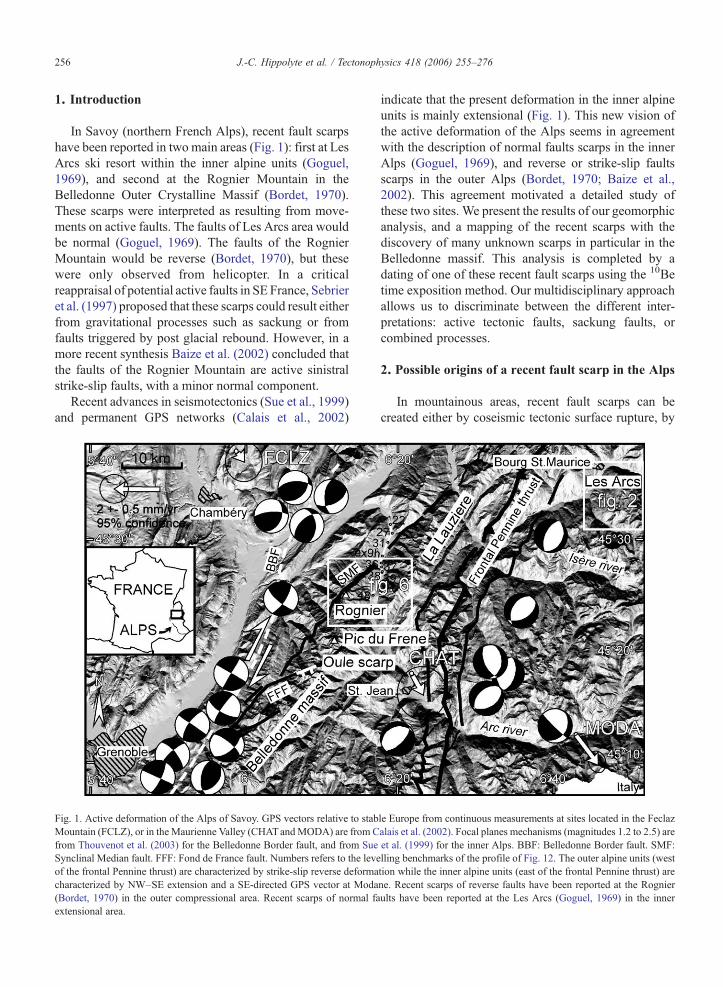
In Savoy (northern French Alps), recent fault scarpshave been reported in two main areas (Fig. 1): first at LesArcs ski resort within the inner alpine units (Goguel,1969), and second at the Rognier Mountain in theBelledonne Outer Crystalline Massif (Bordet, 1970).These scarps were interpreted as resulting from move-ments on active faults. The faults of Les Arcs area wouldbe normal (Goguel, 1969). The faults of the RognierMountain would be reverse (Bordet, 1970), but thesewere only observed from helicopter. In a criticalreappraisal of potential active faults in SE France, Sebrieret al. (1997) proposed that these scarps could result eitherfrom gravitational processes such as sackung or fromfaults triggered by post glacial rebound. However, in amore recent synthesis Baize et al. (2002) concluded thatthe faults of the Rognier Mountain are active sinistralstrike-slip faults, with a minor normal component.
Recent advances in seismotectonics (Sue et al., 1999)and permanent GPS networks (Calais et al., 2002)
Fig. 1. Active deformation of the Alps of Savoy. GPS vectors relative to stabMountain (FCLZ), or in the Maurienne Valley (CHATandMODA) are from Cfrom Thouvenot et al. (2003) for the Belledonne Border fault, and from SueSynclinal Median fault. FFF: Fond de France fault. Numbers refers to the leveof the frontal Pennine thrust) are characterized by strike-slip reverse deformacharacterized by NW–SE extension and a SE-directed GPS vector at Moda(Bordet, 1970) in the outer compressional area. Recent scarps of normal faextensional area.
indicate that the present deformation in the inner alpineunits is mainly extensional (Fig. 1). This new vision ofthe active deformation of the Alps seems in agreementwith the description of normal faults scarps in the innerAlps (Goguel, 1969), and reverse or strike-slip faultsscarps in the outer Alps (Bordet, 1970; Baize et al.,2002). This agreement motivated a detailed study ofthese two sites. We present the results of our geomorphicanalysis, and a mapping of the recent scarps with thediscovery of many unknown scarps in particular in theBelledonne massif. This analysis is completed by adating of one of these recent fault scarps using the 10Betime exposition method. Our multidisciplinary approachallows us to discriminate between the different inter-pretations: active tectonic faults, sackung faults, orcombined processes.
2. Possible origins of a recent fault scarp in the Alps
In mountainous areas, recent fault scarps can becreated either by coseismic tectonic surface rupture, by
le Europe from continuous measurements at sites located in the Feclazalais et al. (2002). Focal planes mechanisms (magnitudes 1.2 to 2.5) areet al. (1999) for the inner Alps. BBF: Belledonne Border fault. SMF:lling benchmarks of the profile of Fig. 12. The outer alpine units (westtion while the inner alpine units (east of the frontal Pennine thrust) arene. Recent scarps of reverse faults have been reported at the Rognierults have been reported at the Les Arcs (Goguel, 1969) in the inner
257J.-C. Hippolyte et al. / Tectonophysics 418 (2006) 255–276
post-glacial isostatic rebound, or by deep-seated grav-itational spreading (sackung). The latter scarps are oftenlarge gravitational faults that can be mistaken withtectonic faults (cf. McCalpin, 2003). It is even possiblethat fault scarps result from a combination of thesetectonic and gravitational forces. If a recent fault-scarpresults only from tectonics, its kinematics must beconsistent with the present regional crustal deformation.
2.1. Current tectonic deformation of the Western Alps
The present deformation of the Western Alps wasoften considered as the continuation of Miocene to earlyPliocene crustal shortening. More recent analyses haverevealed widespread extension in the inner part of theWestern Alps. Effectively, focal plane mechanismsshow the coexistence of radial extension characterizingthe inner zones, and transpression characterizing thefront of the belt and the innermost area (Fig. 1) (Frechetand Pavoni, 1979; Pavoni, 1980; Eva et al., 1997; Sue etal., 1999). Continuous GPS measurements over 2.5 to 5years agree with the seismotectonic analyses and showclear southeast-directed velocities (1.7±0.4 mm/year) atModane (inner Alps, Fig. 1) relative to stable Europeand to the GPS station of Saint Jean des Vignes in theAlpine foreland (Calais et al., 2002).
Interpretation of fission tracks ages (Seward andMancktelow, 1994) and fault plane striations (Sue andTricart, 2002) suggest that extension mainly occurs asthe normal reactivation of the Frontal Pennine thrust(Fig. 1), the external boundary of the inner Alps.However, no clear geomorphologic observations alongthe trace of this fault or of neighboring faults have beenfound to confirm its activity.
The recent fault scarps reported by Goguel (1969)and Bordet (1970) are located successively just east andwest of the Frontal Pennine thrust (Fig. 1). Thefore theycould represent a surface expression of the activetectonic deformation. But, in this area of high reliefthey could also represent large-scale slow gravitationaldeformation known in the geological literature as“sackung” (Zischinsky, 1966, 1969; Radbruch-Hall etal., 1976; Savage and Varnes, 1987; McCalpin andIrvine, 1995).
2.2. “Sackung” deep-seated gravitational deformation
The term “sackung”, from the German word forsagging, was first proposed for the surface manifestationof deep-seated rock creep in foliated bedrocks of theAlps (Zischinsky, 1966, 1969). In the definition exam-ple, deep-seated rock creep had produced a ridge-top
trench by gradual settlement of a slablike mass into anadjacent valley (Zischinsky, 1969).
This term is now used to refer to the process of deep-seated sagging (e.g. Savage and Varnes, 1987).Following McCalpin and Irvine (1995), the term“sackung” denotes slope sagging, gravitational spread-ing of bedrock ridges or deep-seated gravitational slopedeformation revealed by linear features in mountainouslandscapes; the plurial forms “sackungs” or “sackun-gen” refer to the surface forms created by that process.Thus, “sackungen” is a collection of linear geomorphicfeatures of gravitational spreading origin including:anomalous ridge-top troughs, double-crested ridges(Paschinger, 1928), uphill-facing scarps (also termedantislope scarps, Radbruch-Hall et al., 1977), downhill-facing scarps, tension fissures, closed depressions, andlinear troughs.
The main difference between sackung and a classicallandslide is the long term slowness of the process(average spreading rates across multiple sackung scarpsof 0.4–5 mm/year, Varnes et al., 1990) together with thelarge size of the structure in movement, the often deep-seated character of the failure, the absence of well-defined boundaries, and the typical absence of com-pressional morphology at the toe (McCalpin and Irvine,1995).
“Sackugen” are found dominantly along ridge crestsin massive competent rocks (granite, quartzites, volca-nic rocks, etc.). They trend roughly parallel to slopecontours and to the strike of bedding, foliation, joints orfaults. They can create giant steps in the landscape.Typical sackung scarps range in length from 15 to 500 mand in height from 1 to 10 m (Bovis, 1982; Bovis andEvans, 1995; McCalpin and Irvine, 1995; Jarman andBallantyne, 2002; Schwab and Kirk, 2002).
While sackung faults have long been recognized inmost of the Alps and in the Carpathians (Jahn, 1964;Zischinsky, 1966; Nemcok, 1972; Mahr, 1977; Forcella,1984; Onida et al., 2001), in the French Alps only a fewcases of slow slope deformations are studied. The mostfamous are the Séchilienne “landslides” near Grenoble(Fig. 1; Vengeon, 1998), and La Clapière “landslide” tothe north of Nice (Follacci, 1987; Vibert, 1987;Guglielmi et al., 2000; Bigot-Cormier et al., 2005)with little linear features in the same valley interpretedas “sackungen” (Flageollet, 1989).
2.3. Post glacial rebound deformation
In former glaciated regions, recent fault scarps canalso be created by crustal movements occurring duringdeglaciation in response to crustal unloading. Holocene
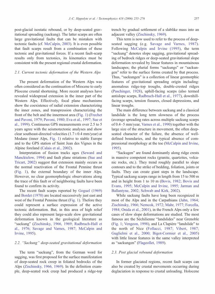
Fig. 2. The recent scarps of Les Arcs ski area (Aiguille Grive massif) and their relationships with the elevation contour lines and the geology. Most ofthe scarps are dipping uphill (cf. the detailed mapping of Fig. 4).
258 J.-C. Hippolyte et al. / Tectonophysics 418 (2006) 255–276
shoreline dislocations or post-glacial fault scarpsinterpreted as resulting from post-glacial isostaticrebound have been reported in particular in Sweden(e.g. the Parvie fault with a vertical displacement of 10m and a rupture length of 150 km, Muir-Wood, 1989),in Ireland (Mohr, 1986; Knight, 1999) and in theScottish Highlands (Fenton, 1991; Firth and Stewart,2000; Stewart et al., 2000; Jarman and Ballantyne,2002). In compressional settings, deglaciation inducesa rapid decrease in the vertical stress and facilitatesreactivation of palaeotectonic faults (Muir-Wood,1989). When fault scarps are parallel to the majorglaciated valleys and their kinematics indicates that thevalley is uplifted with respect to the surroundingmountains ranges, the scarps were supposed to form bydifferential glacial isostatic rebound between the valleysides and its floor that supported a larger thickness ofice sheet (Mollard, 1977; Ego et al., 1996; Sébrier etal., 1997). Finally, it is probable that owing to changesin stress, earthquake activity was increased during the
post-glacial rebound (Gregersen and Basham, 1989;Stewart et al., 2000).
3. Recent scarps in the Aiguille Grive massif
3.1. Previous works
In 1969, Goguel discovered recent fault scarpsoffsetting mountain slopes in the Aiguille Grive massif,which is now also the domain of Les Arcs ski resort,near Bourg St Maurice (Figs. 1 and 2). The AiguilleGrive massif is situated in the inner (Briançonnais)Alpine units, close to the Frontal Pennine thrust (Fig. 1).It is composed of sub-vertical N–20–E trendingformations including from west to east (Fig. 2): athick sequence of Late Carboniferous “houiller” siltsand sandstones, a thrust contact dipping to the East, alocal thin gneiss slice, thick white Permo-Triassicquartzites that form the crest of the ridge and whichare overthrusted on the east-facing slope by Triassic
259J.-C. Hippolyte et al. / Tectonophysics 418 (2006) 255–276
cellular dolomites, gypsum and micaschists (Antoine etal., 1993).
Goguel (1969) observed and mapped several linearscarp morphologies in the Carboniferous and Permo-Triassic formations in a 700 m wide and 3.5 km long
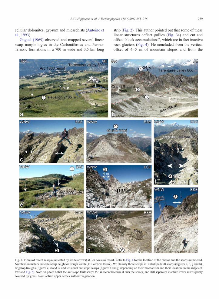
Fig. 3. Views of recent scarps (indicated by white arrows) at Les Arcs ski resorNumbers in meters indicate scarp height or trough width (Vt =vertical throw).ridgetop troughs (figures c, d and i), and tensional antislope scarps (figures f atext and Fig. 5). Note on photo b that the antislope fault scarps # 6 is recent bcovered by grass, from active upper screes without vegetation.
strip (Fig. 2). This author pointed out that some of theselinear structures deflect gullies (Fig. 3a) and cut andoffset “block accumulations”, which are in fact inactiverock glaciers (Fig. 4). He concluded from the verticaloffset of 4–5 m of mountain slopes and from the
t. Refer to Fig. 4 for the location of the photos and the scarps numbered.We classify these scarps in: antislope fault scarps (figures a, e, g and h),nd j) depending on their mechanism and their location on the ridge (cf.ecause it cuts the screes, and still separates inactive lower screes partly

Fig. 4. Map of the recent scarps and rock glaciers of Les Arcs ski resort on orthorectified aerial photos.
260 J.-C. Hippolyte et al. / Tectonophysics 418 (2006) 255–276
apparent east-dip of the lower fault scarp (Fig. 3a) thatthese morphologies denote the activity of recent,possibly seismic, extensional faults. Note that if theywere active faults, their NNE-trend would agree with thepresent SE-extension of the inner Alps.
3.2. Morphology and origin of the scarps
To check Goguel's conclusions, we have mapped thelinear recent morphological scarps of the Aiguille Grivemassif, on orthorectified aerial photos (Fig. 4). Wefound about 80 recent scarp for 5.3 km along the ridge
crest (Figs. 2 and 4). Moreover, we made geomorpho-logic observations that suggest a new interpretation forthe origin of these scarps.
We could distinguish two main types of scarpmorphologies: (1) uphill-facing fault scarps, thatapparently offset the mountain slopes in a normalsense (Fig. 3a, b, e, g); and (2) open cracks or troughs(Fig. 3c, i, j).
The uphill facing scarps are present on the two slopesof the range (Fig. 4). They trend and dip parallel to thebedding planes of the Carboniferous sandstone and thePermo-Triassic quartzites (Figs. 2 and 4) suggesting that
261J.-C. Hippolyte et al. / Tectonophysics 418 (2006) 255–276
they could represent bedding plane faults. Theirmovement is always pure dip-slip. Except a fewdownhill facing scarps in the southern extremity of themassif (Fig. 4) the recent scarps are always facing uphill.This geometry and the symmetry with the crest of theridge suggest a gravitational control. This hypothesis isconfirmed by the observation that their trend follows thetrend of the crest and turns with it, varying in orientationfrom NNE–SSW to E–W (Fig. 4).
We found the open cracks in the Triassic quartzites(Figs. 2 and 3c, i). The voids have opened along thebedding planes (Fig. 3c). The main open cracks arefound on the top of the ridge (Fig. 4). Where they arepresent, the top of the ridge is singularly characterized bya double crest (Fig. 3d) with an intervening depressionfilled with blocks (Fig. 3i). The excavations made for theski area allow the observation that one open crack doesnot extend in depth at more than 30 m (Fig. 3j)suggesting that these structures are relatively superficial.As for the uphill facing scarps, the trend of the opentroughs follows the ridge crest varying in orientationfrom NNE–SSW to E–W (Fig. 4) thus suggesting agravitational control. These voids along the crest denoteridge lateral spreading. Moreover, the double-crest is aclassical sackung landform. These observations supportthe model of gravitational origin for these structures.
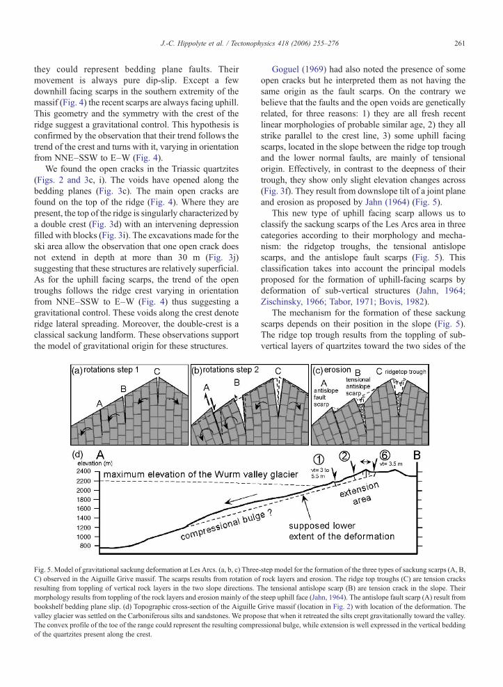
Fig. 5. Model of gravitational sackung deformation at Les Arcs. (a, b, c) ThreeC) observed in the Aiguille Grive massif. The scarps results from rotation ofresulting from toppling of vertical rock layers in the two slope directions. Tmorphology results from toppling of the rock layers and erosion mainly of thebookshelf bedding plane slip. (d) Topographic cross-section of the Aiguille Gvalley glacier was settled on the Carboniferous silts and sandstones. We propoThe convex profile of the toe of the range could represent the resulting compreof the quartzites present along the crest.
Goguel (1969) had also noted the presence of someopen cracks but he interpreted them as not having thesame origin as the fault scarps. On the contrary webelieve that the faults and the open voids are geneticallyrelated, for three reasons: 1) they are all fresh recentlinear morphologies of probable similar age, 2) they allstrike parallel to the crest line, 3) some uphill facingscarps, located in the slope between the ridge top troughand the lower normal faults, are mainly of tensionalorigin. Effectively, in contrast to the deepness of theirtrough, they show only slight elevation changes across(Fig. 3f). They result from downslope tilt of a joint planeand erosion as proposed by Jahn (1964) (Fig. 5).
This new type of uphill facing scarp allows us toclassify the sackung scarps of the Les Arcs area in threecategories according to their morphology and mecha-nism: the ridgetop troughs, the tensional antislopescarps, and the antislope fault scarps (Fig. 5). Thisclassification takes into account the principal modelsproposed for the formation of uphill-facing scarps bydeformation of sub-vertical structures (Jahn, 1964;Zischinsky, 1966; Tabor, 1971; Bovis, 1982).
The mechanism for the formation of these sackungscarps depends on their position in the slope (Fig. 5).The ridge top trough results from the toppling of sub-vertical layers of quartzites toward the two sides of the
-step model for the formation of the three types of sackung scarps (A, B,rock layers and erosion. The ridge top troughs (C) are tension crackshe tensional antislope scarp (B) are tension crack in the slope. Theirsteep uphill face (Jahn, 1964). The antislope fault scarp (A) result fromrive massif (location in Fig. 2) with location of the deformation. These that when it retreated the silts crept gravitationally toward the valley.ssional bulge, while extension is well expressed in the vertical bedding
262 J.-C. Hippolyte et al. / Tectonophysics 418 (2006) 255–276
range. Note that in this case, rocks have fallen from thetwo walls to partially fill the trough and its present width(more than 8 m at site 4, Figs. 4 and 3i) is notrepresentative only of its opening but depends also onthe bulk of fallen rocks and on the deepness of the voids.
The tensional antislope scarps (Fig. 5) are alsotension voids but located in the slope, and thereforeresult from only one direction of bedding planetoppling. As noted by Jahn (1964), their apparentvertical offset results from the tilt of the bedding planesand erosion of the uphill face. The antislope fault scarpsare the lowermost sackung structures of Les Arcs, anddo not show any opening (Fig. 3a, g). Considering thatthese scarps follow the bedding planes (Fig. 4) wepropose that they result from downslope flexuring of therock layers with bookshelf-type rotations (“flexuraltoppling” of Goodman and Bray, 1976; model A in Fig.5). In contrast to the other scarps, the rotation of thefootwall block is equal with those of the hanging-wallblock.
Note that the open cracks are restricted to the upperpart of the ridge which is made of thick quartzite layersand characterized by steep-slopes, while the fault scarpsare located in a lower-dipping slope made of sandstoneswith silt interlayers that facilitate layer flexuring. Weconclude from this distribution and mechanism, that therecent scarps observed in Les Arcs area clearly resultfrom slope gravitational deformation.
3.3. Hypotheses on the age of the scarps
The morphology of the scarps suggests that they arevery recent. That the troughs are not yet filled shows thatdeformation was more rapid than sedimentation (Fig. 3band e). In Fig. 4 we can see on the western side of theridge, boulder accumulations with a lobate structure.They are talus-derived rock glaciers resulting from thecryogenic movement of the screes during a Lateglacialcold period. In Fig. 4 we can distinguish two types ofglacier deposits corresponding to two successive coldevents. The rock glaciers poorly vegetated are the mostrecent. In the western Alps, recent rock glaciers aregenerally attributed to the Dryas or subboreal episodes(e.g. Kaiser, 1987). In dark in Fig. 4, we can seevegetated rock glaciers that extend farther downslope.They lie at places that were covered by ice at Würm(Antoine et al., 1993), and they are locally overlain orremobilized by the recent rock glaciers. These olderrock glaciers have a possible Oldest Dryas age.
The westernmost fault scarp (#1 in Figs. 3a and 4)downdrops the uphill side of the slope and an old rockglacier by 3 to 5.5 m. On its northern tip this scarp has
stopped a recent rock glacier (white in Fig. 4). Itsuggests that the fault moved after the Oldest Dryas, andbefore or during the Younger Dryas.
To the south another scarp (#2 in Fig. 4) cuts both oldand recent rock glaciers. This fault downthrows theuphill side of the vegetated rock glacier by 5 m (Fig. 3g).Locally, this older rock glacier is overlain by a tongue-shaped recent rock glacier (north of #2 in Fig. 4). Thefault downthrows its surface by only 2 m (Fig. 3g).These relationships reveal the progressive movementsof fault #2: 3 m between the end of activity of the oldrock glacier and the end of activity of the recent rockglacier (about 3.7 ky if both of Dryassic age); 2 m sincethe end of activity of the recent rock glacier (about11.5 ky). This evolution suggests a deceleration of thefault activity with time.
A similar pattern of high initial rates of deformationfollowed by slower rates was evidenced in Colorado bytrench studies of a sackung trough, and 14C dating(McCalpin and Irvine, 1995). This pattern is consistentwith a gravitational deformation starting rapidly afterthe removal of lateral support from the sides duringdeglaciation, and slowing down with time.
3.4. Proposed model
We conclude that the recent deformation at Les Arcsis not of tectonic origin because it is not located on amain fault but is controlled by the morphology and trendof the ridge. Moreover the structures observed aretypical of sackung deformation which is generally wellexpressed in hard brittle rocks. To explain the formationof superficial scarps we propose a mechanism that hasalready been proposed for sackung in vertical bedding:the flexural toppling mode (Goodman and Bray, 1976;Bovis, 1982). Downslope tilt of the vertical stratigraphiclayers (toppling) together with erosion of the uphill faceof a tension crack, contribute to antislope scarpdevelopments (Fig. 5a, b, c). As observed at Les Arcs,this model implies opposite senses on the two slopes ofthe ridge, and that opening component increases towardthe top which results in ridgetop splitting. The rotationof blocks leads to the deceleration of the movement withtime. Two favorable conditions existed at Les Arcs forthis ridge spreading: a high relative relief since theretreat of the valley glacier, and sub-vertical beddingplanes parallel to the valley.
Gravitational downslope flexuring of subverticallayers was already proposed for the deformation ofsteeply dipping valley sides that have undergone glacialdebuttressing (e.g. Bovis, 1982). In apparent contradic-tion with this model the sackung scarps of Les Arcs are

263J.-C. Hippolyte et al. / Tectonophysics 418 (2006) 255–276
confined to the upper 300 m of the range. However, ascould be observed in other sackungen (e.g. Radbruch-Hall et al., 1976) the 1400 m of lower debuttressedslope, made of carboniferous silts which deform moreplastically, shows a large bulging (Fig. 5d). We proposethat this bulging of the valley flank has accommodatedthe uphill extensional deformation. Following glacialdebuttressing the mountain slope is creeping, withdiffuse extensional and compressional deformation inthe carboniferous silts and sandstones, and brittleextensional deformation (sackungen) in the morecompetent rocks of the crest.
4. Recent scarps in the Belledonne massif
4.1. Previous works
In 1970, Bordet published photos taken from ahelicopter showing four recent fault scarps located onthe eastern flank of the Pointe de Rognier Mountain in
Fig. 6. The recent scarps of the Rognier area (Belledonne massif, Fig. 1) anmeters) and the geology. All the scarps dip uphill. Numbers 36–39, 48, refer tothe Rognier scarps do not cross the floor of the Arc Valley along the Synclinalthe Synclinal Median Fault, but in front of the Rognier slope along the Lauzièrscarps.
the north of the Belledonne external crystalline massif(Figs. 6, 7 and 8). Bordet interpreted the fault scarps asactive reverse faults that cannot result from gravitationalmovements. But these faults scarps were only inter-preted from aerial views. In 1995, Ghafiri mentionedseven fault scarps in the granite massif on both sides ofthe mountain crest. In 2002, Baize et al. describedBordet's faults as rectilinear scarps trending NE–SWwith only decimetric vertical offsets. They interpretedthem, and two other faults in the Combe de Lachat area(Fig. 7), as active sinistral strike-slip faults. Thisdiscrepancy in the observations motivated field studiesand a detailed mapping of the recent fault scarps ofnorthern Belledonne.
4.2. Morphology of the scarps
In 2002 we examined the fault scarps photographedby Bordet (1970) (Fig. 8). The most visible fault scarpon Bordet's photos (#2 in Fig. 7) lies in the middle of the
d their relationships with the topographic contours lines (elevation inthe levelling benchmarks of the profile of Fig. 12. Note that apparentlyMedian Fault. East of the Arc River, recent scarps are present, not alonge crest line, supporting a glacial debuttressing gravitational origin of the
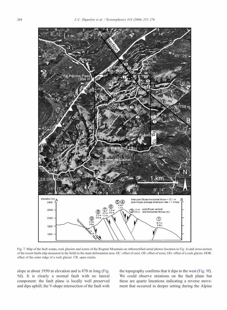
Fig. 7. Map of the fault scarps, rock glaciers and screes of the Rognier Mountain on orthorectified aerial photos (location in Fig. 6) and cross-sectionof the recent faults (dip measured in the field) in the main deformation area. OC: offset of crest. OS: offset of scree; OG: offset of a rock glacier. OOR:offset of the outer ridge of a rock glacier. CR: open cracks.
264 J.-C. Hippolyte et al. / Tectonophysics 418 (2006) 255–276
slope at about 1950 m elevation and is 870 m long (Fig.9d). It is clearly a normal fault with no lateralcomponent: the fault plane is locally well preservedand dips uphill; the V-shape intersection of the fault with
the topography confirms that it dips to the west (Fig. 9f).We could observe striations on the fault plane butthese are quartz lineations indicating a reverse move-ment that occurred in deeper setting during the Alpine
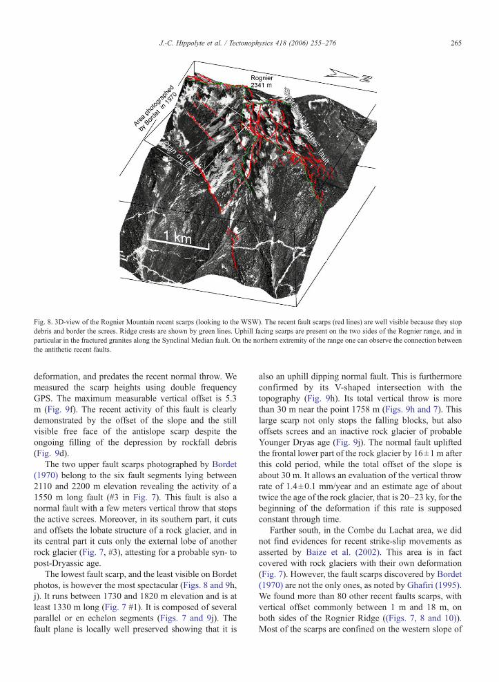
Fig. 8. 3D-view of the Rognier Mountain recent scarps (looking to the WSW). The recent fault scarps (red lines) are well visible because they stopdebris and border the screes. Ridge crests are shown by green lines. Uphill facing scarps are present on the two sides of the Rognier range, and inparticular in the fractured granites along the Synclinal Median fault. On the northern extremity of the range one can observe the connection betweenthe antithetic recent faults.
265J.-C. Hippolyte et al. / Tectonophysics 418 (2006) 255–276
deformation, and predates the recent normal throw. Wemeasured the scarp heights using double frequencyGPS. The maximum measurable vertical offset is 5.3m (Fig. 9f). The recent activity of this fault is clearlydemonstrated by the offset of the slope and the stillvisible free face of the antislope scarp despite theongoing filling of the depression by rockfall debris(Fig. 9d).
The two upper fault scarps photographed by Bordet(1970) belong to the six fault segments lying between2110 and 2200 m elevation revealing the activity of a1550 m long fault (#3 in Fig. 7). This fault is also anormal fault with a few meters vertical throw that stopsthe active screes. Moreover, in its southern part, it cutsand offsets the lobate structure of a rock glacier, and inits central part it cuts only the external lobe of anotherrock glacier (Fig. 7, #3), attesting for a probable syn- topost-Dryassic age.
The lowest fault scarp, and the least visible on Bordetphotos, is however the most spectacular (Figs. 8 and 9h,j). It runs between 1730 and 1820 m elevation and is atleast 1330 m long (Fig. 7 #1). It is composed of severalparallel or en echelon segments (Figs. 7 and 9j). Thefault plane is locally well preserved showing that it is
also an uphill dipping normal fault. This is furthermoreconfirmed by its V-shaped intersection with thetopography (Fig. 9h). Its total vertical throw is morethan 30 m near the point 1758 m (Figs. 9h and 7). Thislarge scarp not only stops the falling blocks, but alsooffsets screes and an inactive rock glacier of probableYounger Dryas age (Fig. 9j). The normal fault upliftedthe frontal lower part of the rock glacier by 16±1 m afterthis cold period, while the total offset of the slope isabout 30 m. It allows an evaluation of the vertical throwrate of 1.4±0.1 mm/year and an estimate age of abouttwice the age of the rock glacier, that is 20–23 ky, for thebeginning of the deformation if this rate is supposedconstant through time.
Farther south, in the Combe du Lachat area, we didnot find evidences for recent strike-slip movements asasserted by Baize et al. (2002). This area is in factcovered with rock glaciers with their own deformation(Fig. 7). However, the fault scarps discovered by Bordet(1970) are not the only ones, as noted by Ghafiri (1995).We found more than 80 other recent faults scarps, withvertical offset commonly between 1 m and 18 m, onboth sides of the Rognier Ridge ((Figs. 7, 8 and 10)).Most of the scarps are confined on the western slope of
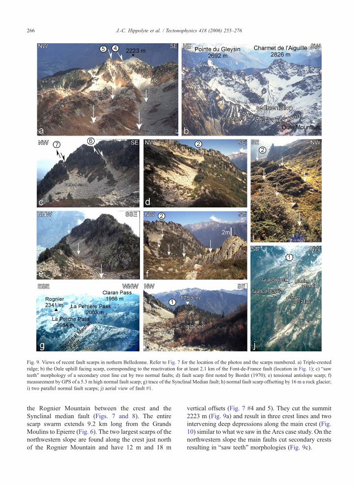
Fig. 9. Views of recent fault scarps in nothern Belledonne. Refer to Fig. 7 for the location of the photos and the scarps numbered. a) Triple-crestedridge; b) the Oule uphill facing scarp, corresponding to the reactivation for at least 2.1 km of the Font-de-France fault (location in Fig. 1); c) “sawteeth” morphology of a secondary crest line cut by two normal faults; d) fault scarp first noted by Bordet (1970); e) tensional antislope scarp; f)measurement by GPS of a 5.3 m high normal fault scarp; g) trace of the Synclinal Median fault; h) normal fault scarp offsetting by 16 m a rock glacier;i) two parallel normal fault scarps; j) aerial view of fault #1.
266 J.-C. Hippolyte et al. / Tectonophysics 418 (2006) 255–276
the Rognier Mountain between the crest and theSynclinal median fault (Figs. 7 and 8). The entirescarp swarm extends 9.2 km long from the GrandsMoulins to Epierre (Fig. 6). The two largest scarps of thenorthwestern slope are found along the crest just northof the Rognier Mountain and have 12 m and 18 m
vertical offsets (Fig. 7 #4 and 5). They cut the summit2223 m (Fig. 9a) and result in three crest lines and twointervening deep depressions along the main crest (Fig.10) similar to what we saw in the Arcs case study. On thenorthwestern slope the main faults cut secondary crestsresulting in “saw teeth” morphologies (Fig. 9c).
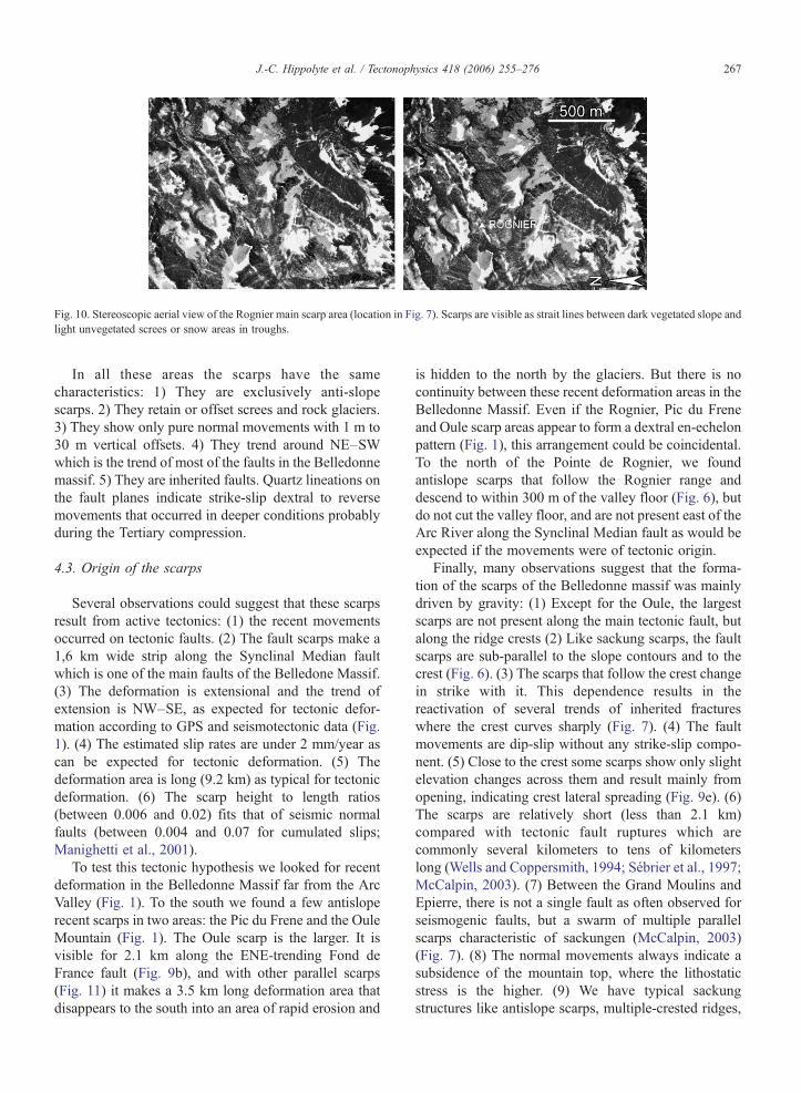
Fig. 10. Stereoscopic aerial view of the Rognier main scarp area (location in Fig. 7). Scarps are visible as strait lines between dark vegetated slope andlight unvegetated screes or snow areas in troughs.
267J.-C. Hippolyte et al. / Tectonophysics 418 (2006) 255–276
In all these areas the scarps have the samecharacteristics: 1) They are exclusively anti-slopescarps. 2) They retain or offset screes and rock glaciers.3) They show only pure normal movements with 1 m to30 m vertical offsets. 4) They trend around NE–SWwhich is the trend of most of the faults in the Belledonnemassif. 5) They are inherited faults. Quartz lineations onthe fault planes indicate strike-slip dextral to reversemovements that occurred in deeper conditions probablyduring the Tertiary compression.
4.3. Origin of the scarps
Several observations could suggest that these scarpsresult from active tectonics: (1) the recent movementsoccurred on tectonic faults. (2) The fault scarps make a1,6 km wide strip along the Synclinal Median faultwhich is one of the main faults of the Belledone Massif.(3) The deformation is extensional and the trend ofextension is NW–SE, as expected for tectonic defor-mation according to GPS and seismotectonic data (Fig.1). (4) The estimated slip rates are under 2 mm/year ascan be expected for tectonic deformation. (5) Thedeformation area is long (9.2 km) as typical for tectonicdeformation. (6) The scarp height to length ratios(between 0.006 and 0.02) fits that of seismic normalfaults (between 0.004 and 0.07 for cumulated slips;Manighetti et al., 2001).
To test this tectonic hypothesis we looked for recentdeformation in the Belledonne Massif far from the ArcValley (Fig. 1). To the south we found a few antisloperecent scarps in two areas: the Pic du Frene and the OuleMountain (Fig. 1). The Oule scarp is the larger. It isvisible for 2.1 km along the ENE-trending Fond deFrance fault (Fig. 9b), and with other parallel scarps(Fig. 11) it makes a 3.5 km long deformation area thatdisappears to the south into an area of rapid erosion and
is hidden to the north by the glaciers. But there is nocontinuity between these recent deformation areas in theBelledonne Massif. Even if the Rognier, Pic du Freneand Oule scarp areas appear to form a dextral en-echelonpattern (Fig. 1), this arrangement could be coincidental.To the north of the Pointe de Rognier, we foundantislope scarps that follow the Rognier range anddescend to within 300 m of the valley floor (Fig. 6), butdo not cut the valley floor, and are not present east of theArc River along the Synclinal Median fault as would beexpected if the movements were of tectonic origin.
Finally, many observations suggest that the forma-tion of the scarps of the Belledonne massif was mainlydriven by gravity: (1) Except for the Oule, the largestscarps are not present along the main tectonic fault, butalong the ridge crests (2) Like sackung scarps, the faultscarps are sub-parallel to the slope contours and to thecrest (Fig. 6). (3) The scarps that follow the crest changein strike with it. This dependence results in thereactivation of several trends of inherited fractureswhere the crest curves sharply (Fig. 7). (4) The faultmovements are dip-slip without any strike-slip compo-nent. (5) Close to the crest some scarps show only slightelevation changes across them and result mainly fromopening, indicating crest lateral spreading (Fig. 9e). (6)The scarps are relatively short (less than 2.1 km)compared with tectonic fault ruptures which arecommonly several kilometers to tens of kilometerslong (Wells and Coppersmith, 1994; Sébrier et al., 1997;McCalpin, 2003). (7) Between the Grand Moulins andEpierre, there is not a single fault as often observed forseismogenic faults, but a swarm of multiple parallelscarps characteristic of sackungen (McCalpin, 2003)(Fig. 7). (8) The normal movements always indicate asubsidence of the mountain top, where the lithostaticstress is the higher. (9) We have typical sackungstructures like antislope scarps, multiple-crested ridges,
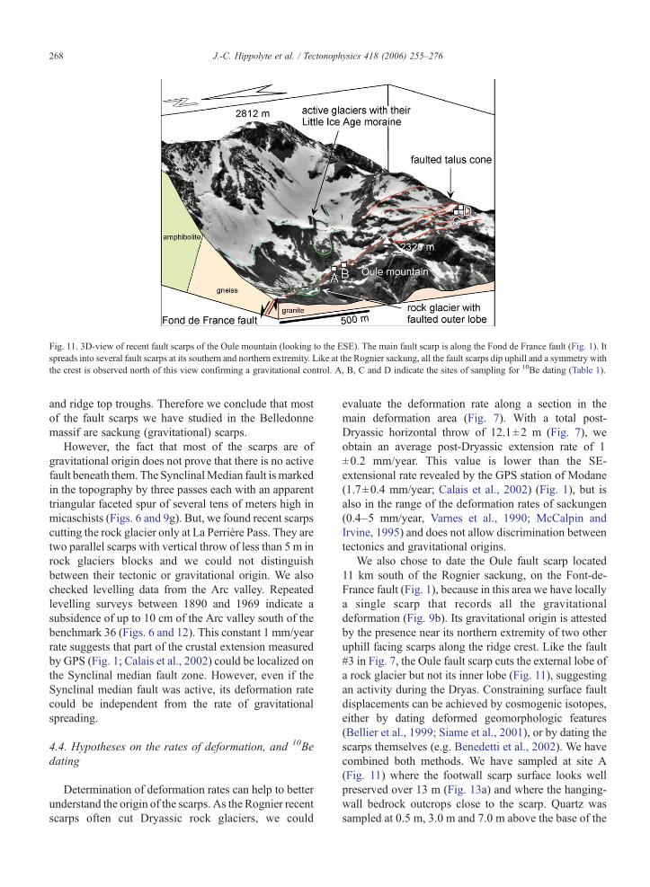
Fig. 11. 3D-view of recent fault scarps of the Oule mountain (looking to the ESE). The main fault scarp is along the Fond de France fault (Fig. 1). Itspreads into several fault scarps at its southern and northern extremity. Like at the Rognier sackung, all the fault scarps dip uphill and a symmetry withthe crest is observed north of this view confirming a gravitational control. A, B, C and D indicate the sites of sampling for 10Be dating (Table 1).
268 J.-C. Hippolyte et al. / Tectonophysics 418 (2006) 255–276
and ridge top troughs. Therefore we conclude that mostof the fault scarps we have studied in the Belledonnemassif are sackung (gravitational) scarps.
However, the fact that most of the scarps are ofgravitational origin does not prove that there is no activefault beneath them. The SynclinalMedian fault ismarkedin the topography by three passes each with an apparenttriangular faceted spur of several tens of meters high inmicaschists (Figs. 6 and 9g). But, we found recent scarpscutting the rock glacier only at La Perrière Pass. They aretwo parallel scarps with vertical throw of less than 5 m inrock glaciers blocks and we could not distinguishbetween their tectonic or gravitational origin. We alsochecked levelling data from the Arc valley. Repeatedlevelling surveys between 1890 and 1969 indicate asubsidence of up to 10 cm of the Arc valley south of thebenchmark 36 (Figs. 6 and 12). This constant 1 mm/yearrate suggests that part of the crustal extension measuredby GPS (Fig. 1; Calais et al., 2002) could be localized onthe Synclinal median fault zone. However, even if theSynclinal median fault was active, its deformation ratecould be independent from the rate of gravitationalspreading.
4.4. Hypotheses on the rates of deformation, and 10Bedating
Determination of deformation rates can help to betterunderstand the origin of the scarps. As the Rognier recentscarps often cut Dryassic rock glaciers, we could
evaluate the deformation rate along a section in themain deformation area (Fig. 7). With a total post-Dryassic horizontal throw of 12.1±2 m (Fig. 7), weobtain an average post-Dryassic extension rate of 1±0.2 mm/year. This value is lower than the SE-extensional rate revealed by the GPS station of Modane(1.7±0.4 mm/year; Calais et al., 2002) (Fig. 1), but isalso in the range of the deformation rates of sackungen(0.4–5 mm/year, Varnes et al., 1990; McCalpin andIrvine, 1995) and does not allow discrimination betweentectonics and gravitational origins.
We also chose to date the Oule fault scarp located11 km south of the Rognier sackung, on the Font-de-France fault (Fig. 1), because in this area we have locallya single scarp that records all the gravitationaldeformation (Fig. 9b). Its gravitational origin is attestedby the presence near its northern extremity of two otheruphill facing scarps along the ridge crest. Like the fault#3 in Fig. 7, the Oule fault scarp cuts the external lobe ofa rock glacier but not its inner lobe (Fig. 11), suggestingan activity during the Dryas. Constraining surface faultdisplacements can be achieved by cosmogenic isotopes,either by dating deformed geomorphologic features(Bellier et al., 1999; Siame et al., 2001), or by dating thescarps themselves (e.g. Benedetti et al., 2002). We havecombined both methods. We have sampled at site A(Fig. 11) where the footwall scarp surface looks wellpreserved over 13 m (Fig. 13a) and where the hanging-wall bedrock outcrops close to the scarp. Quartz wassampled at 0.5 m, 3.0 m and 7.0 m above the base of the
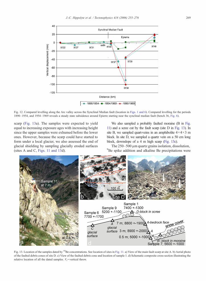
Fig. 12. Compared levelling along the Arc valley across the Synclinal Median fault (location in Figs. 1 and 6). Compared levelling for the periods1890–1954, and 1954–1969 reveals a steady state subsidence around Epierre starting near the synclinal median fault (bench 36, Fig. 6).
269J.-C. Hippolyte et al. / Tectonophysics 418 (2006) 255–276
scarp (Fig. 13a). The samples were expected to yieldequal to increasing exposure ages with increasing heightsince the upper samples were exhumed before the lowerones. However, because the scarp could have started toform under a local glacier, we also assessed the end ofglacial shielding by sampling glacially eroded surfaces(sites A and C, Figs. 11 and 13d).
Fig. 13. Location of the samples dated by 10Be concentrations. See location ofof the faulted debris cones of site D. c) View of the faulted debris cone and locrelative location of all the dated samples. Vt =vertical throw.
We also sampled a probably faulted moraine (B in Fig.11) and a scree cut by the fault scarp (site D in Fig. 13). Insite B, we sampled quart-veins in an amphibolite 4×4×3 mblock. In site D, we sampled a quartz vein on a 50 cm longblock, downslope of a 4 m high scarp (Fig. 13c).
The 250–500 μm quartz grains isolation, dissolution,9Be spike addition and alkaline Be precipitations were
sites in Fig. 11. a) View of the main fault scarp at site A. b) Aerial photoation of sample 1. d) Schematic composite cross-section illustrating the
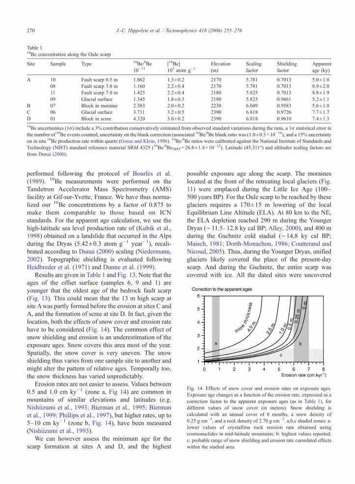
Table 110Be concentration along the Oule scarp
Site Sample Type 10Be/9Be10−13
[10Be]105 atom g−1
Elevation(m)
Scalingfactor
Shieldingfactor
Apparentage (ky)
A 10 Fault scarp 0.5 m 1.862 1.3±0.2 2170 5.781 0.7013 5.0±1.008 Fault scarp 3.0 m 1.160 2.2±0.4 2170 5.781 0.7013 8.9±2.011 Fault scarp 7.0 m 1.425 2.2±0.4 2180 5.825 0.7013 8.8±1.909 Glacial surface 1.345 1.8±0.3 2180 5.825 0.9661 5.2±1.1
B 07 Block in moraine 2.383 2.0±0.2 2230 6.049 0.9583 5.6±1.0C 06 Glacial surface 3.711 3.2±0.5 2390 6.818 0.9726 7.7±1.7D 01 Block in scree 4.320 3.0±0.2 2390 6.818 0.9610 7.4±1.310Be uncertainties (1σ) include a 3% contribution conservatively estimated from observed standard variations during the runs, a 1σ statistical error inthe number of 10Be events counted, uncertainty on the blank correction (associated 10Be/9Be blank ratio was (1.0±0.3×10⁻¹⁴), and a 15% uncertaintyon in situ 10Be production rate within quartz (Gosse and Klein, 1996). 10Be/9Be ratios were calibrated against the National Institute of Standards andTechnology (NIST) standard reference material SRM 4325 (10Be/9BeNIST=26.8±1.4×10
−12). Latitude (45,311°) and altitudes scaling factors arefrom Dunai (2000).
Fig. 14. Effects of snow cover and erosion rates on exposure ages.Exposure age changes as a function of the erosion rate, expressed as acorrection factor to the apparent exposure ages (as in Table 1), fordifferent values of snow cover (in meters). Snow shielding iscalculated with an annual cover of 8 months, a snow density of0.25 g cm−3, and a rock density of 2.70 g cm−3. a,b,c shaded zones: a:lower values of crystalline rock erosion rate obtained usingcosmonuclides in mid-latitude mountains; b: highest values reported;c: probable range of snow shielding and erosion rate cumulated effectswithin the studied area.
270 J.-C. Hippolyte et al. / Tectonophysics 418 (2006) 255–276
performed following the protocol of Bourlès et al.(1989). 10Be measurements were performed on theTandetron Accelerator Mass Spectrometry (AMS)facility at Gif-sur-Yvette, France. We have thus norma-lized our 10Be concentrations by a factor of 0.875 tomake them comparable to those based on ICNstandards. For the apparent age calculation, we use thehigh-latitude sea level production rate of (Kubik et al.,1998) obtained on a landslide that occurred in the Alpsduring the Dryas (5.42±0.3 atom g−1 year−1), recali-brated according to Dunai (2000) scaling (Niedermann,2002). Topographic shielding is evaluated followingHeidbreder et al. (1971) and Dunne et al. (1999).
Results are given in Table 1 and Fig. 13. Note that theages of the offset surface (samples 6, 9 and 1) areyounger that the oldest age of the bedrock fault scarp(Fig. 13). This could mean that the 13 m high scarp atsite Awas partly formed before the erosion at sites C andA, and the formation of scree at site D. In fact, given thelocation, both the effects of snow cover and erosion ratehave to be considered (Fig. 14). The common effect ofsnow shielding and erosion is an underestimation of theexposure ages. Snow covers this area most of the year.Spatially, the snow cover is very uneven. The snowshielding thus varies from one sample site to another andmight alter the pattern of relative ages. Temporally too,the snow thickness has varied unpredictably.
Erosion rates are not easier to assess. Values between0.5 and 1.0 cm ky−1 (zone a, Fig 14) are common inmountains of similar elevations and latitudes (e.g.Nishiizumi et al., 1993; Bierman et al., 1995; Biermanet al., 1999; Phillips et al., 1997), but higher rates, up to5–10 cm ky−1 (zone b, Fig. 14), have been measured(Nishiizumi et al., 1993).
We can however assess the minimum age for thescarp formation at sites A and D, and the highest
possible exposure age along the scarp. The moraineslocated at the front of the retreating local glaciers (Fig.11) were emplaced during the Little Ice Age (100–500 years BP). For the Oule scarp to be reached by theseglaciers requires a 170±15 m lowering of the localEquilibrium Line Altitude (ELA). At 80 km to the NE,the ELA depletion reached 290 m during the YoungerDryas (∼11.5–12.8 ky cal BP; Alley, 2000), and 400 mduring the Gschnitz cold stadial (∼14,8 ky cal BP;Maisch, 1981; Dorth-Monachon, 1986; Coutterand andNicoud, 2005). Thus, during the Younger Dryas, unifiedglaciers likely covered the place of the present-dayscarp. And during the Gschnitz, the entire scarp wascovered with ice. All the dated sites were uncovered
271J.-C. Hippolyte et al. / Tectonophysics 418 (2006) 255–276
between the Gschnitz and the end of the Younger Dryas,that is, between 15 and 12 ky. The absolute ages of thelate activity are thus bracketed by the apparent ages (5–10 ky) and the deglaciation ages (12–15 ky). Inaddition, the exposure ages of the glacial surface (siteC) and offset scree (site D) are undistinguishable. Theyindicate that part of this late scarp formation was coevalto the retreat of the local glaciers or closely followed it.Despite large correction factors, the dating of the Oulethus confirms the recent age of the deformation.
The relative pattern of apparent ages can give anupper value for the rate of tectonic denudation of thescarp if we admit that the entire scarp at site A post-dates the local glaciers (Fig. 13). Indeed, although theglacial surfaces yield ages undistinguishable from theupper scarp ages, no glacial striae are discernable onthe scarp at this location. If post-glacial, the agessuggest a rapid (0 year±1900) fault slip from point7 m to point 3 m; a slower movement from point 3 mto point 0.5 m, and a much slower movement frompoint 0.5 to the base of the scarp (if we suppose thatthe movement has not stopped). We conclude thatmuch of the movement occurred beginning Holocene,and has slowed down.
4.5. Proposed model
The distribution of the recent scarps of the Belle-donne massif and the probable rapid denudation of theOule scarp support the gravitational interpretation. Themost debated feature of a sackung is its extent at depth.In the case of the Rognier sackung, a view from thenorth (Fig. 8) shows how the antithetic faults connect oneach other for constructing the section at depth (Fig. 15).We conclude that deformation may extend down to 600m elevation, 1600 m beneath the Rognier crest. Butconversely we observe that no fault was reactivated tothe east of fault #1, with a connection deeper than thevalley floor (Fig. 15), thus supporting again agravitational model.
The most frequently proposed triggering mechanismfor a sackung is the glacial debuttressing (e.g.Radbruch-Hall, 1978; Agliardi et al., 2001; Onida etal., 2001). We propose also as main mechanism for theRognier sackung, glacial erosion followed by the retreatof the Würm valley glacier and the debuttressing of thevalley slopes. During the Würm, the Arc glacier incisedthe valley but maintained a pressure on the valley sides(Fig. 15a). When the glacier has withdrawn, the valleyflanks decompressed and deformed (Fig. 15b). Thishorizontal movement inducing a probable steepening ofthe ridge slope was accommodated by the sagging of the
Rognier crest along the pre-existing Synclinal Medianfault zone.
Note in Figs. 1 and 6 that the sackung occurred in aportion of the Synclinal Median fracture zone where thecrest is close to the main fault and trends parallel to it.Moreover, sagging occurred only along the crestsegment close to the deep glacier valley (Fig. 6), inagreement with a debuttressing model. The Rognier“sackungen” disappear toward the south, where theglacial valley gets away from and perpendicular to thefault zone. This model implies decompression of the twovalley sides and formation of sackung scarps where acrest is parallel to the faults and to the glacial valley. Weeffectively found sackung scarps on the eastern side ofthe Arc River along the crest of the Lauziere massif (Fig.6). As in the Rognier Mountain, the sackung scarps, thatin places offset rock glaciers, follow the crest parallel tothe valley and change of strike with it.
Finally, the huge Rognier sackung is the consequenceof several favorable conditions: (1) presence of thefracture zone of a large alpine fault, (2) presence of adeeply incised glacier valley, (3) the crest line and thevalley trend subparallel to the fractures.
5. Discussion
That, for these two sites, we found scarp swarms thatdo not cross the valley but follow the ridge crest, clearlyshows that the deformation is related to the topographyand according to our cross section is superficial (abovethe valley floor). Therefore, for these examples, we canrule out as main mechanism crustal deformation, likepost-glacial rebound or plate tectonics, and conclude fora gravitational origin (sackung). Glacio-isotasy mayhave formed recent scarps in the Alps, like it has done inthe northern Europe. Such origin was proposed for thepost glacial scarps found on 88 km along the Rhine–Rhone line in the Swiss Alps (Eckardt et al., 1983;Geiger et al., 1986). But this origin is improbable for thescarps swarms we have mapped, which are less than 10km long and are strictly linked to a single ridge.
Furthermore, that deformation at the Rognier site isrelated to glacial debuttressing is supported by thepresence of another sackung in the Lauzière range on theopposite side of the valley (Fig. 6). But from theconclusion that these valley slopes deform undergravity, arise the question of the stability of the GPSsites. In fact, the GPS sites CHAT and MODA arelocated on the valley floor (Fig. 1) and we conclude thatthe similarity in trend between the gravitationalspreading of the range and the crustal extension deducedfrom geophysics (Fig. 1) is coincidental and mainly
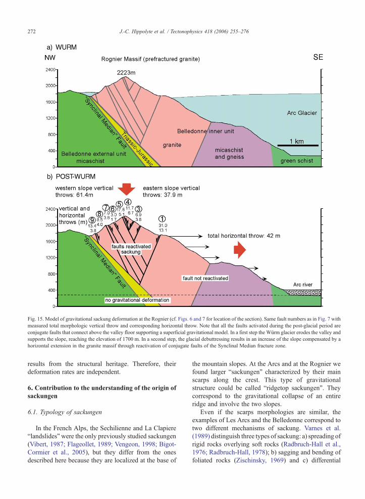
Fig. 15. Model of gravitational sackung deformation at the Rognier (cf. Figs. 6 and 7 for location of the section). Same fault numbers as in Fig. 7 withmeasured total morphologic vertical throw and corresponding horizontal throw. Note that all the faults activated during the post-glacial period areconjugate faults that connect above the valley floor supporting a superficial gravitational model. In a first step the Würm glacier erodes the valley andsupports the slope, reaching the elevation of 1700 m. In a second step, the glacial debuttressing results in an increase of the slope compensated by ahorizontal extension in the granite massif through reactivation of conjugate faults of the Synclinal Median fracture zone.
272 J.-C. Hippolyte et al. / Tectonophysics 418 (2006) 255–276
results from the structural heritage. Therefore, theirdeformation rates are independent.
6. Contribution to the understanding of the origin ofsackungen
6.1. Typology of sackungen
In the French Alps, the Sechilienne and La Clapiere“landslides”were the only previously studied sackungen(Vibert, 1987; Flageollet, 1989; Vengeon, 1998; Bigot-Cormier et al., 2005), but they differ from the onesdescribed here because they are localized at the base of
the mountain slopes. At the Arcs and at the Rognier wefound larger “sackungen” characterized by their mainscarps along the crest. This type of gravitationalstructure could be called “ridgetop sackungen”. Theycorrespond to the gravitational collapse of an entireridge and involve the two slopes.
Even if the scarps morphologies are similar, theexamples of Les Arcs and the Belledonne correspond totwo different mechanisms of sackung. Varnes et al.(1989) distinguish three types of sackung: a) spreading ofrigid rocks overlying soft rocks (Radbruch-Hall et al.,1976; Radbruch-Hall, 1978); b) sagging and bending offoliated rocks (Zischinsky, 1969) and c) differential
273J.-C. Hippolyte et al. / Tectonophysics 418 (2006) 255–276
displacement in hard but fractured crystalline igneousrocks. The example of Les Arcs corresponds to thesecond category, and theRognier to the third. At theArcs,vertical bedding planes topple under gravity generatingfrequent open voids. In the Belledonne faulted granites,deformation mainly consists of fault slips.
6.2. Subsurface geometry
The subsurface geometry of the sackungen is oftendebated. One hypothesis is that a “sackungen” is theshallow surface manifestation of toppling and flexuralslip along discontinuities (flexural toppling of Bovis,1982) that do not penetrate into a mountain mass to anygreat depth (Jahn, 1964). This model is in agreementwith our observations at Les Arcs. But note that at theSechilienne sackung, which results from toppling offractured micaschists, repeated levelling in a 240 mlong gallery shows that flexural toppling can occur atmore than 100 m depth (Vengeon, 1998). Anotherhypothesis is that the scarps may pass downward, atdepth of several hundred meters, into a zone of rockcreep (Zischinsky, 1969; Mahr, 1977; Radbruch-Hall,1978; Morton and Sadler, 1989; Jarman and Ballan-tyne, 2002). In the Rognier sackung the extremity ofthe range allows the exceptional observation of faultconnections supporting the idea that fault movementsmay occur at several hundred meter depth. It allowsus to propose a new mechanism for the deep saggingin hard crystalline rocks: antithetic fault movements(Fig. 15).
6.3. Origin of sagging
Sackung can result from three different factors thatare usually combined and can be influenced by otherfactors like groundwater fluctuations: a) gravity forcesthat produce slow deformation in a rock mass. Thesegravity forces act especially where valley-side slopeshave been steepened by glacial erosion (Tabor, 1971;Radbruch-Hall, 1978; Bovis, 1990). b) Stress releasedue to glacial debuttressing resulting in progressivedevelopment of joints (e.g. Jarman and Ballantyne,2002). Strain recovery against late Pleistocene glacialloading is suggested by slowing deformation ratesdeduced from trench observations along a scarp inColorado (McCalpin and Irvine, 1995); c) earthquakeshaking that induces lateral spreading and differentialsettlement of rock masses (Beck, 1968; Radbruch-Hallet al., 1976; Mahr, 1977; Solonenko, 1977; Dramis andSorriso-Valvo, 1983; Morton et al., 1989; Ponti andWells, 1991; McCalpin and Hart, 2003).
It is clear that in the Arc and Rognier cases, theglacial erosion and debuttressing are the main factor forthe slope instability. Whether slip on sackung faultsresult from slow creep or sudden vertical displacementis often a matter of debate (McCalpin, 1997; Onida etal., 2001; McCalpin, 2003). At Les Arcs, the flexuralslip mechanism suggests that deformation occurred bycreeping, but at the Rognier, where movements occurredon conjugate fault planes submitted to large lithostaticstresses, fault slip can have been triggered by strongearthquake shaking.
Ridge crest collapses were observed after severalsevere earthquake shaking in California (Hart et al.,1990; Ponti and Wells, 1991; Harp and Jibson, 1996)and in Alaska near Gillet Pass, where a sackungcurvilinear uphill-facing scarp formed during the 3Nov. 2000 M 7.9 Denali earthquake (cf. McCalpin'sweb site, http://www.geohaz.com). Along the SanAndreas fault, McCalpin and Hart (2001) trenchedseveral sackung ridgetop depressions and showed thatthey recorded repeated ground ruptures of 1m or more ofvertical displacement probably generated during largeearthquake shaking.
The Oule scarp is probably a sackung activated byearthquake shaking. Effectively it is unlikely to resultfrom gravity alone because it is located far from the deepglacier valleys (Fig. 1). Moreover the main failure planedips toward the mountain range which does not permit asimple gravitational sliding. Furthermore, our cosmic-ray exposure dating shows that fault slip may have beenrapid (Fig. 13). In agreement with this earthquakeshaking hypothesis, seismic lines of the Bourget Lake atChambéry (Fig. 1) revealed a large sublacustrinelandslide that may have been also triggered byearthquake shaking around 11 ky ago (Chapron et al.,1996; Van Rensbergen et al., 1999).
Therefore, even if the Rognier sackung was clearlyfavored by glacial debuttressing, it is possible that thefault movements were triggered by similar postglacialearthquake shakings. Earthquakes may have beengenerated on the Belledonne fault (Thouvenot et al.,2003), the Frontal Pennine fault, or the Synclinal-Median fault, just beneath the sackung.
7. Conclusions
The recent fault scarps Les Arcs and Rognier resultprimarily from gravitational deformation. All themapped scarps show similar morphologies typical ofgravitational sackungen, with the development ofmultiple-crested ridges, ridge-top troughs, closeddepressions, and tension cracks along the crest, while
274 J.-C. Hippolyte et al. / Tectonophysics 418 (2006) 255–276
dominantly uphill-facing scarps with pure dip-slipmovements are produced on the slopes. The latter trendparallel to slope contour lines, bedding planes and faultstrikes. Like most sackungen described in the literature,they develop in massive competent rocks, wheredeformation is brittle and well visible. They belong tothe “ridge-top sackungen” type, with scarp swarmsoccurring close to the ridge crests. The gravity control isfurther evidenced on both sites by the symmetry of thefault movements across the crest (opposite senses ofmovement on opposite slopes). Sackung scarps at LesArcs and the Oule exhibit a deceleration of the move-ments with time. The two studied sites differ by the depthand mechanism of the deformation. The Aiguille Grive“sackungen” results from shallow (a few tens of meters)flexural toppling of sub-vertical stratigraphic layers. TheRognier “sackungen” results from reactivation ofconjugate faults in granite possibly down to a depth of1600 m beneath the summit, but still above the valleyfloor. This limit in depth of deformation, rule out adifferential glacial isostatic rebound interpretation, butsupport a gravitational interpretation. The 10Be dating ofa fault scarp confirms its recent age, and suggests that itsmovement was triggered by large earthquakes. Ourdating and those of a sublacustrine landslide (Chapron etal., 1996) tend to support the idea that post-glacialrebound was a period of enhanced seismicity. Otherfactors such as granite pre-fracturing, glacier incision,lowering of friction due to either water pore pressure orice within faults, and glacial debuttressing, can havecontributed to form at the Rognier the largest sackungever described in the western Alps.
Acknowledgements
This work was supported by the University of Savoyand the “Conseil Général de l'Isère” through the “PôleGrenoblois d'Etudes et de Recherche pour la Preventiondes Risques Naturels”. We are grateful to C. Crouzet, M.Meghraoui and J. McCalpin for constructive discussionsduring this work.
References
Agliardi, F., Crosta, G., Zanchi, A., 2001. Structural constraints ondeep-seated slope deformation kinematics. Engineering Geology59, 83–102.
Alley, R.B., 2000. The Younger Dryas cold interval as viewed fromcentral Greenland. Quaternary Science Reviews 19, 213–226.
Antoine, P., Barféty, J.C., Vivier, G., Gros, Y., Fudral, S., Landry, P.,Fabre, J., 1993. Carte géol. France (1/50 000), feuille Bourg-Saint-Maurice (727)—Orléans: BRGM. Notice explicative par P.Antoine et al. (1992), 110 p.
Baize, S., Cushing, M., Lemeille, F, Granier, T, Grellet, B., Carbon, D.,Combes, P., Hibsch, C., 2002. Inventaire des indices de ruptureaffectant le Quaternaire en relation avec les grandes structuresconnues en France métropolitaine et dans les régions limitrophes.Mémoire de la société géologique de France, Mémoire H.S., no175, 142p, 1pl. H.T.
Beck, A.C., 1968. Gravity faulting as a mechanism of topographicadjustment. New Zealand Journal of Geology and Geophysics 11(1), 191–199.
Bellier, O., Bourlès, D.L., Beaudouin, T., Braucher, R., 1999. Cosmicray exposure (CRE) dating in wet tropical domain: late Quaternaryfan emplacements in central Sulawesi (Indonesia). Terra Nova 11,174–180.
Benedetti, L., Finkel, R., Papanastassiou, D., King, G.C.P., Armijo, R.,Ryerson, F., Farber, D., Flerit, F., 2002. Post-glacial slip history ofthe Sparta fault (Greece) determined by 36Cl cosmogenic dating:evidence for non-periodic earthquakes. Geophysical ResearchLetters 29 (8–10), doi:10.1029/2001GL014510.
Bierman, P., Gillespie, A., Caffee, M., Elmore, D., 1995. Estimatingerosion rates and exposure ages with 36Cl produced by neutronactivation. Geochimica et Cosmochimica Acta 59 (18), 3779–3798.
Bierman, P.R., Marsella, K.A., Patterson, C., Davis, P.T., Caffe, M.,1999. Mid-Pleistocene cosmogenic minimum-age limits for pre-Wisconsinan glacial surfaces in southwestern Minnesota andsouthern Baffin Island: a multiple nuclide approach. Geomorphol-ogy 27, 25–39.
Bigot-Cormier, F., Braucher, R., Bourlès, D.L., Guglielmi, Y., Dubar,M., Stéphan, J.-F., 2005. Chronological constraints on processesleading to large active landslides. Earth and Planetary ScienceLetters 235, 141–150.
Bordet, P., 1970. Les failles vivantes du massif des Grands Moulins(Massif cristallin externe de Belledonne). Géologie Alpine 46,43–47.
Bourlès, D., Raisbeck, G.M., Yiou, F., 1989. 10Be and 9Be in marinesediments and their potential for dating. Geochimica et Cosmo-chimica Acta 53, 443–452.
Bovis, M.J., 1982. Uphill-facing (antislope) scarps in the CoastMountains, southwest British Columbia. Geological Society ofAmerica Bulletin 93, 804–812.
Bovis, M., 1990. Rock-slope deformation at Affliction Creek, southernCoast Mountains, British Columbia. Canadian Journal of EarthSciences 27, 243–254.
Bovis, M.J., Evans, S.G., 1995. Rock slope movements along theMount Currie “fault scarp”, southern Coast Mountains, BritishColumbia. Canadian Journal of Earth Sciences 32, 2015–2020.
Calais, E., Nocquet, J.M., Jouanne, F., Tardy, M., 2002. Current strainregime in the Western Alps from continuous Global PositioningSystem measurements, 1996–2001. Geology 30 (7), 651–654.
Chapron, E., Van Rensbergen, P., Beck, C., De Batist, M., Paillet, A.,1996. Lacustrine sedimentary records of brutal events in Lake LeBourget (northwestern Alps–southern Jura). Quaternaire 7,155–168.
Coutterand, S., Nicoud, G., 2005. The Arve glacier retreat stagesbetween Cluses bolt and Chamonix ombilic during the Tardigla-ciaire (Arve valley Haute Savoie). Quaternaire 16 (2), 85–94.
Dorth-Monachon, C. 1986. Contribution à l'étude de la morphologieglaciaire de la vallée de l'Arve (Haute-Savoie, France). Essai dereconstitution paléogéographique, Unpublished PhD University ofLausanne.
Dramis, F., Sorriso-Valvo, M., 1983. Two cases of earthquake-triggered gravitational spreading in Algeria and Italy. Rendicontidella Società Geologica Italiana 6, 7–10.

275J.-C. Hippolyte et al. / Tectonophysics 418 (2006) 255–276
Dunai, T.J., 2000. Scaling factors for production rates of in situproduced cosmogenic nuclides: a critical reevaluation. Earth andPlanetary Science Letters 176, 157–169.
Dunne, J., Elmore, D., Muzikar, P., 1999. Scaling factors for therates of production of cosmogenic nuclides for geometric shieldingand attenuation at depth on sloped surfaces. Geomorphology 27,3–11.
Eckardt, P., Funk, H., Labhart, T., 1983. Postglaziale Krustenbewe-gungena an der Rhein–Rhone–Linie. Vermessung, Photogramme-trie, Kulturtechnik 2, 43–56.
Ego, F., Sébrier, M., Carey-Gailhardis, E., Beate, B., 1996. Do theBilllecocha normal faults (Ecuador) reveal extension due tolithospheric body forces in the northern Andes? Tectonophysics265, 255–273.
Eva, E., Solarino, S., Eva, C., Neri, G., 1997. Stress tensor orientationderived from fault plane solution in the southwestern Alps. Journalof Geophysical Research 102, 8171–8185.
Fenton, C.H. 1991. Neotectonics and palaeoseismicity in NorthWest Scotland. Unpublished PhD Thesis, University of Glasgow,403 pp.
Firth, C.R., Stewart, I., 2000. Postglacial tectonics of the Scottishglacio-isostatic uplift centre. Quaternary Science Reviews 19,1469–1493.
Flageollet, J.C., 1989. Les Mouvements de Terrain et leur Prévention.Masson, Paris. 221 pp.
Follacci, J.P., 1987. Les mouvements du versant de la Clapière à SaintEtienne de Tinée (Alpes Maritimes). Bulletin de Liaison des Pontset Chaussées 150/151, 39–54.
Forcella, F., 1984. Brevi note sulla tettonica gravitativa di versantenelle Alpi centrali. Bollettino della Societa Geologica Italiana 103,689–696.
Fréchet, J., Pavoni, N., 1979. Etude de la sismicité de la zonebriançonnaise entre Pelvoux et Argentera (Alpes occidentales) àl'aide d'un réseau de stations portables. Eclogae GeologicaeHelveticae 72, 763–779.
Geiger, A., Kahle, H.G., Gubler, E., 1986. Recent crustal movementsin the Alpine–Mediterranean region analysed in the Swiss Alps.Tectonophysics 130, 289–298.
Ghafiri, A.1995. Paléosismicité de failles actives en contexte desismicité modérée: application à l'évaluation de l'aléa sismiquedans le Sud-Est de la France. Unpublished PhD Thesis, UniversityParis-Sud Orsay, France.
Goguel, J., 1969. Des failles d'âge quaternaire à Peisey (Savoie).Bulletin de la Société Géologique de France 7 (XI), 35–39.
Goodman, R.E., Bray, J.W., 1976. Toppling of rock slopes. Proc.Special Conf. on Rock Engineering and Foundations and Slopes,vol. 2. ASCE, Boulder, Colorado, pp. 201–234.
Gosse, J.C, Klein, J., 1996. Production rate of in situ cosmogenic 10Bein quartz at high altitude and mid-latitude. Radiocarbon 38 (1),154–155.
Gregersen, S., Basham, P.W., 1989. Summary, conclusions andrecommendations. In: Gregersen, S., Basham, P.W. (Eds.), Earth-quakes at North Atlantic Passive Margins: Neotectonics andPostglacial Rebound. Kluwer, Dordrecht, pp. 1–6.
Guglielmi, C., Bertrand, F., Compagon, J.P., Follacci, J., Mudry, 2000.Acquisition of water chemistry in a mobile fissured basementmassif: its role in the hydrogeological knowledge of the LaClapiere landslide (Mercantour massif Southern Alps, France).Journal of Hydrology 229, 138–148.
Harp, E.L., Jibson, R.W., 1994. Landslides triggered by the 1994Northridge California earthquake. Bulletin of the SeismologicalSociety of America 86, S319–S332.
Hart, E.L., Bryant, W.A., Wills, C.J., Treiman, J.A., 1990. The searchfor fault rupture and significance of ridgetop fissures, Santa CruzMountains, California. In: McNutt, S.R., Sydnor, R.H. (Eds.), TheLoma Prieta earthquake of 17 October 1989. California Division ofMines and Geology Special Publication, vol. 104, pp. 83–94.
Heidbreder, E., Pinkau, K., Reppin, C., Schöenfelder, V., 1971.Measurement of the distribution in energy and angle of high-energy neutrons in the lower atmosphere. Journal of GeophysicalResearch 76, 2905–2916.
Jahn, A., 1964. Slope morphological features resulting fromgravitation. Zeitschrift für Geomorphologie. Supplement 5, 59–72.
Jarman, D., Ballantyne, C., 2002. Beinn Fhada, Kintail: An examplesof large-scale paraglacial rock slope deformation. ScottishGeographical Journal 118, 59–68.
Kaiser, B., 1987. Les versants de vanoise: enjeux traditionnels defonctionnement morphoclimatique. Unpublished PhD Thesis,University Paris 7, 2 vol., 1088 p.
Knight, J., 1999. Geological evidence for neotectonic activity duringdeglaciation of the southern Sperrin Mountains, Northern Ireland.Journal of Quaternary Science 14, 45–57.
Kubik, P.W., Ivy-Ochs, S., Masarik, J., Frank, M., Schlüchter, C.,1998. 10Be and 26Al production rates deduced from an instanta-neous event within the dendro-calibration curve, the landslide ofKöfels, Ötz Valley, Austria. Earth and Planetary Science Letters161, 231–241.
Mahr, T., 1977. Deep-reaching gravitational deformations of highmountain slopes. Bulletin of the International Association ofEngineering Geology 16, 121–127.
Maisch, M., 1981. Glazialmorphologische und GletschergeschichteUntersuchungen im Gebiet zwischen Landwasser-und Albulatal.Physische Geographie 3 (Zürich).
Manighetti, I., King, G.C.P., Gaudemer, Y., 2001. Slip accumulationand lateral propagation of active normal faults in Afar. Journal ofGeophysical Research 106, 13667–13696.
McCalpin, J.P., 1997. Ridgetop splitting and spreading: nonseismicsackungen or earthquake-induced secondary deformation? Assoc.of Engineering Geologists, Program with Abstracts, 40th AnnualMeeting, Sept. 30–Oct. 4, 1997, Portland, OR, pp. 126–127.
McCalpin, J.P., 2003. Criteria for determining the seismic significanceof sackungen and other scarplike landforms in mountainousregions. In: Hart, E.W. (Ed.), Ridge-Top Spreading in California:California Geological Survey, Open-File Report, 1CD-ROM.
McCalpin, J.P., Irvine, J.R., 1995. Sackungen at Aspen Highlands SkiArea, Pitkin County, Colorado. Environmental and EngineeringGeoscience 1, 277–290.
McCalpin, J.P., Hart, E.W., 2001. Holocene displacement history ofridgetop depressions (sackungen) in the San Gabriel Mountains,southern California. Geological Society of America, Abstract withPrograms 33 (3), A30.
McCalpin, J.P., Hart, E.W., 2003. Ridge-top spreading features andrelationship to earthquakes, San Gabriel Mountains Region,Southern California: Part A. Distribution and description ofridge-top depressions (sackungen): Part B. Paleoseismic investiga-tions of ridge-top depressions. In: Hart, E.W. (Ed.), Ridge-TopSpreading in California: California Geological Survey, Open-FileReport, 1 CD-ROM.
Mohr, P., 1986. Possible Late Pleistocene faulting in Iar (West)Connacht Ireland. Geological Magazine 123, 545–552.
Mollard, J.D., 1977. Regional landslide types in Canada. GeologicalSociety of America, Reviews in Engineering Geology 3, 29–56.
Morton, D.M., Sadler, P.M., 1989. The failings of the Pelona Schist;landslides and sackungen in the Lone Pine Canyon and

276 J.-C. Hippolyte et al. / Tectonophysics 418 (2006) 255–276
Wrightwood areas of the eastern San Gabriel Mountains, southernCalifornia. In: Sadler, P.M., Morton, D.M. (Eds.), Landslides in aSemi-arid Environment, with Emphasis on the inland Valleys ofSouthern California. Inland Geological Society, Publication, vol. 2,pp. 301–322.
Morton, D.M., Campbell, R.H., Jibson, R.W., Wesson, R.L.,Nicholson, C., 1989. Ground fractures and landslides producedby the North Palm Springs, California, earthquake of July 8, 1986.In: Sadler, P.M., Morton, D.M. (Eds.), Landslides in a Semi-aridEnvironment, with Emphasis on the inland Valleys ofSouthern California. Inland Geological Society, Publication,vol. 2, pp. 183–196.
Muir-Wood, R., 1989. Extraordinary deglaciation reverse faulting innorthern Fennoscandia. In: Gregersen, S., Basham, P. (Eds.),Earthquakes at North-Atlantic Passive Margins: Neotectonics andPost-glacial Rebound. Kluwer Academic Publishers, Dordrecht,pp. 141–173.
Nemcok, A., 1972. Gravitational slope deformation in high mountains.Proc. 24th Int. Geol. Cong., Montréal, Sect., vol. 13, pp. 132–141.
Niedermann, S., 2002. Cosmic-ray-produced noble gases in terrestrialrocks: Dating tools for surface processes. In: Porcelli, D.,Ballentine, C.J., Wieler, R. (Eds.), Noble Gases in Geochemistryand Cosmochemistry. Reviews in Mineralogy and Geochemistry,vol. 47, pp. 731–784.
Nishiizumi, K., Kohl, C.P., Arnold, J.R., Klein, J., Fink, D.,Middleton, R., Lal, D., 1993. Role of in situ cosmogenic nuclides10Be and 26Al in the study of diverse geomorphic processes. EarthSurface Processes and Landforms 18, 407–425.
Onida, M., Galadini, F., Forcella, F., 2001. Application of paleoseis-mological techniques to the study of Late Pleistocene–Holocenedeep-seated gravitational movements at the Mortirolo Pass (centralAlps Italy). Geologie en Mijnbouw 80, 209–227.
Paschinger, V., 1928. Untersuchungen uber Doppelgrate. Z. Geo-morph. N.F., vol. 3, pp. 204–236.
Pavoni, N., 1980. Comparison of focal mechanisms of earthquakes andfaulting in the Helvetic zone of central Valais (Swiss Alps).Eclogae Geologicae Helvetiae 73, 551–558.
Phillips, F.M., Zreda, M.G., Gosse, J.C., Klein, J., Evenson, E.B., Hall,R.D., Chadwick, O.A., Sharma, P., 1997. Cosmogenic 36Cl and10Be ages of Quaternary glacial and fluvial deposits of the WindRiver Range, Wyoming. Geological Society of America Bulletin109 (1), 1462–1463.
Ponti, D.J., Wells, R.E., 1991. Off-fault ground ruptures in the SantaCruz Mountains, California—ridge-top spreading versus tectonicextension during the 1989 Loma Prieta earthquake. Bulletin of theSeismological Society of America 81, 1480–1510.
Radbruch-Hall, D., 1978. Gravitational creep of rock masses onslopes. Chap. 17. In: Voight, B. (Ed.), Rockslides and AvalanchesNatural Phenomenal. Developement in Geotechnical Engineering,vol. 14. Elsevier Sc. Publ. Co, Amsterdam, pp. 608–657.
Radbruch-Hall, D., Varnes, D.J., Savage, W.Z., 1976. Gravitationalspreading of steep-sided ridges (“Sackung”) in Western UnitedStates. Bulletin of the International Association of EngineeringGeology 14, 23–35.
Radbruch-Hall, D., Varnes, D.J., Colton, R.B., 1977. Gravitationalspreading of steep-sided ridges (“Sackung”) in Colorado. Journalof Research of the U.S. Geological Survey 5 (3), 359–363.
Savage, W.Z., Varnes, D.J., 1987. Mechanics of gravitationalspreading of steep-sided ridges (Sackung). Bulletin of theInternational Association of Engineering Geology 35, 31–36.
Schwab, J.W., Kirk, W. 2002. Sackungen on a Forested Slope,Kitnayakwa River. In: Forest Sciences, Extension Note # 47,British Columbia Ministry of Forest Prince Ruper Forest Region(ed). www.for.gov.bc.ca/prupert/Research 1–6.
Sébrier, S., Ghafiri, A., Bles, J.L., 1997. Paleoseismicity in France:fault trench studies in a region of moderate seismicity. Journal ofGeodynamics 24 (1–4), 207–217.
Seward, D., Mancktelow, N.S., 1994. Neogene kinematics of thecentral and western Alps: Evidence from fission-track dating.Geology 22, 803–806.
Siame, L., Braucher, R., Bourlès, D.L., Bellier, O., Sébrier, M., 2001.Datation des surfaces géomorphologiques repères par le 10Beproduits In-Situ: implications tectoniques et climatiques. Bulletinde la Société Géologique de France 172 (2), 223–236.
Solonenko, V.P., 1977. Landslides and collapses in seismic zones andtheir prediction. Bulletin of the International Association ofEngineering Geology 15, 4–8.
Stewart, I.S., Sauber, J., Rose, J., 2000. Glacio-seismotectonics: icesheets, crustal deformation and seismicity. Quaternary ScienceReviews 19, 1367–1389.
Sue, C., Tricart, P., 2002. Late-Alpine syncollisional extension in thecore of the Western Alps inferred from faulting analysis. Journal ofthe Geological Society (London) 159, 61–70.
Sue, C., Thouvenot, F., Fréchet, J., Tricart, P., 1999. Earthquakeanalysis reveals widespread extension in the core of the WesternAlps. Journal of Geophysical Research 104, 25611–25622.
Tabor, R.W., 1971. Origin of ridge-top depressions by large scale creepin the Olimpic Mountains. Geological Society of America Bulletin82, 1811–1822.
Thouvenot, F., Fréchet, J., Jenatton, L., Gamond, J.F., 2003. TheBelledonne Border Fault: identification of an active seismic strike-slip fault in the western Alps. Geophysical Journal International155, 174–192.
Van Rensbergen, P., De Batist, M., Beck, Ch., Chapron, E., 1999.High-resolution seismic stratigraphy of glacial to interglacial fill ofa deep glacigenic lake: Lake Le Bourget Northwestern Alps,France. Sedimentary Geology 128, 99–129.
Varnes, D.J., Radbruch-Hall, D., Savage, W.Z., 1989. Topographic andstructural conditions in area of gravitational spreadig of ridges inthe western united states. U.S. Geol. Surv. Prof. Paper, vol. 1496,pp. 1–28. Washington.
Varnes, D.J., Radbruch-Hall, D.H., Varnes, K.L., Smith, W.K.,Savage, W.Z., 1990. Measurement of ridge-spreading move-ments (sackungen) at Bald Eagle Mountain, Lake County,Colorado, 1975–1989. U.S. Geological Survey Open-File Report90-543, p. 13.
Vengeon, J.M. 1998. Déformation et rupture des versants en terrainmétamorphique anisotrope. Apport de l'étude des Ruines deSéchilienne. Unpublished PhD Thesis, Joseph Fourier University,Grenoble 1, 186 p.
Vibert, C. 1987. Les glissements de Lax le Roustit et Saint Etiennede Tinée. Unpublished PhD Thesis, Ecole des Mines de Paris,206 pp.
Wells, D.L., Coppersmith, K.J., 1994. New empirical relationshipsamong magnitude, rupture length, rupture width, rupture area, andsurface displacement. Bulletin of the Seismological Society ofAmerica 84, 974–1002.
Zischinsky, U., 1966. On the deformation of high slopes. Proc. 1stConf. Int. Soc. Rock Mech., Lisbon, Sect., vol. 2, pp. 179–185.
Zischinsky, U., 1969. Über Sackungen. Rock Mechanics 1, 30–52.
Copyright © 2022 FDOKUMEN