Jujol versionat? Els graffitis d'Enric Miralles al Cementiri d'Igualada
Upload
independentCategory
view
1download
0
1
Elementary Land Surveying ELS_Levelling05_06: 1
Levelling
Principleoperation required in the determination of heights of points on the surface of the Earth
Elementary Land Surveying ELS_Levelling05_06: 2
Equipment
1. Level with tripod (device to gives a truly horizontal line)
2. Levelling staff (a suitably graduated staff for reading vertical heights)
3. Chain/Tape (to enable the points leveled to be located relative to each other on a map)
4. Change plate (staff base plate)
5. Staff bubble

2
Elementary Land Surveying ELS_Levelling05_06: 3
Elements of Surveyor’s Level
1. TelescopeDiaphragm – plane glass on which a series of line is etched (cross-hairs)Parallax – in focusing the real image formed by the objective lens is made to lie in the same plane as diaphragm
Procedure of focusing:a) Adjusting eyepiece to bring
diaphragm into sharp focusb) Adjust focusing screw until no
parallax
Elementary Land Surveying ELS_Levelling05_06: 4
Elements of Surveyor’s Level
2. Compensating Device in Automatic LevelThe telescope need only be approximately levelled and then a compensating device corrects for the residual mislevelment

3
Elementary Land Surveying ELS_Levelling05_06: 5
Levelling Staff
1. Sectional and assembled by slotting onto one another vertically
2. Made of aluminium alloy3. E-shaped graduation
(reading to 1mm for ordinary levelling)
Elementary Land Surveying ELS_Levelling05_06: 6
Precision Levelling Staff
1. Used for more accurate work (accuracy to 0.1mm in use with precise level)
2. Spring-mounted at the top
3. Made of invar alloy (iron + nickel) which has a lower coefficient of expansion –unaffected by temperature effects

4
Elementary Land Surveying ELS_Levelling05_06: 7
Levelling Terminology
1. Level line is a surface which is at a constant height relative to Mean Sea Level (MSL) and is a curved line
2. Horizontal line is tangential to the level line at any particular point and is perpendicular to the direction of gravity.
Over short distance, the 2 lines are taken to coincide
Elementary Land Surveying ELS_Levelling05_06: 8
Levelling Terminology (con’t)
3. DatumA level line is chosen in which the elevation of all points is referred
a) Mean Sea Level (MSL) is the mean of tidal height over a period of time (> 19 years)
b) Principal Datum Hong Kong (PDHK) – most of the works in HK refer to this. It is 1.230m below MSL (revised in June 1984)
c) Chart Datum (CD) is a tidal datum for marine works and navigation

5
Elementary Land Surveying ELS_Levelling05_06: 9
Relationship among different datums(Source: Lands Department, No Date)
Elementary Land Surveying ELS_Levelling05_06: 10
Levelling Terminology (con’t)
4) Bench MarksPoints of known elevation above PDHK
a) Bench Mark (BM) –established on vertical surfaces such as walls of buildings or substantial structures

6
Elementary Land Surveying ELS_Levelling05_06: 11
Levelling Terminology (con’t)
4. Bench Marks (con’t)b) Temporary Bench Marks
(TBM) – constructed at locations on site or off site, where the level of the mark is calculated from PDHK
5. Reduced Level (RL) –the height of a point relative to PDHK
6. Height of Collimation is the height of collimation above PDHK
+5.00
TBM+10.00
Elementary Land Surveying ELS_Levelling05_06: 12
Levelling Terminology (con’t)
7. Backsight (BS) – 1st sight taken after the level has been set up. It is also a sight taken to a point whose height above HKPD is known
8. Foresight (FS) – last sight taken before moving the level. It is also a sight taken to a point whose height is required to carry on the line of levels
9. Intermediate Sight (IS) – other staff readings taken between BS and FS
10. Change Point (CP) – the staff position at which a FS and then a BS readings are taken
BS FS IS
CP

7
Elementary Land Surveying ELS_Levelling05_06: 13
Levelling Terminology (con’t)
BS
BSFS
FS
ISIS
Elementary Land Surveying ELS_Levelling05_06: 14
Field Procedure
1. The level is set up at P where BM may be observed and readings taken at points A, B, C and Da) The 1st reading (BS) made with the staff on a point of known
RLb) The staff is now held at points A, B and C (ISs) in turn, and
record the readingsc) A change point (CP) is chosen at D, owing to the nature of the
ground and take the reading (FS)

8
Elementary Land Surveying ELS_Levelling05_06: 15
Field Procedure (con’t)
2. The staff remains at point D. The level is moved to Q, set up and levelleda) Taking the reading on the staff at the change point D (BS)b) Followed by IS with the staff on E, F and G until a further change
becomes necessary3. This procedure is repeated until all the required levels have been
obtained4. The final staff position is at a point of known RL
Elementary Land Surveying ELS_Levelling05_06: 16
Procedure in Levelling
1. Height of Collimation Method1st find the height of the line of collimation above the datum
Height of collimation (HC) = 128.480 + 3.222 = 131.702m PDa) level at B (rise from A to B)
= height of collimation – reading at B = 131.702 – 1.414= 130.288m PD
b) level at B (rise from A to B)= height of collimation – reading at B = 131.702 – 3.484= 128.218m PD

9
Elementary Land Surveying ELS_Levelling05_06: 17
Procedure in Levelling
2. Rise and Fall MethodRise – 2nd reading < 1st readingFall - 2nd reading > 1st reading
a) from A to B1st reading – 2nd reading= 3.222 – 1.414 = 1.808 (rise)level at B (rise from A to B)= level at A + rise = 128.480 + 1.808 = 130.288mPD
b) from A to B1st reading – 2nd reading= 3.222 – 3.484 = -0.262 (fall)level at B (fall from A to B)= level at A - fall = 128.480 + 0.262 = 128.218mPD
Elementary Land Surveying ELS_Levelling05_06: 18
Booking and Calculation
1.2191.2191.21998.7601.8602.23199.9791.8603.0792.2313.450
G99.9790.5720.646F99.4071.0521.218E98.3550.5172.270
D (CP)97.8380.4321.5852.787C98.2700.1451.153B98.4150.9381.008A97.4771.2831.946
BM98.7600.663RemarksRLFallRiseFSISBS
1) Rise and Fall Method – each reading is entered on a different line in the appropriate column, except at a change point, where a FS and BS occupy the same line. To check, ΣBS - ΣFS = ΣRise - ΣFall = Last RL – First RL

10
Elementary Land Surveying ELS_Levelling05_06: 19
Booking and Calculation (con’t)2) Height of Collimation Method – the collimation height is obtained by adding the staff reading, which must be a BS, to the known RL of the point on which the staff stands. To check, ΣBS - ΣFS = Last RL – First RL
1.2191.21998.7602.23199.9792.2313.450
G99.9790.646F99.4071.218E98.3552.270
D (CP)97.838100.6251.5852.787C98.2701.153B98.4151.008A97.4771.946
BM98.76099.4230.663RemarksRLCollimationFSISBS
Elementary Land Surveying ELS_Levelling05_06: 20
Comparison
Rise and Fall MethodMore accurateMore calculationIntermediate RLs are known
Height of Collimation MethodQuickerGood for a lot of ISs

11
Elementary Land Surveying ELS_Levelling05_06: 21
Accuracy in Levelling
For normal engineering works and site surveysAllowable misclosure = ± 5 √ n mmwhere n = no. of instrument positions
ORAllowable misclosure = ± 12 √ k mmwhere k = length of levelling circuit in kmIf actual misclosure > allowable misclosure, levelling should be repeatedIf actual misclosure < allowable misclosure, misclosure should be equally distributed equally between the instrument positions
Elementary Land Surveying ELS_Levelling05_06: 22
Summary of Levelling Fieldwork
For levelling fieldwork, the following practice should be adhered to in order to improve the accuracy of the levelling works.
1. Levelling should always start and finish at points of known RL so that misclosure can be detected
2. Where possible, all sight lengths should be below 60 m3. The staff must be held vertically by suitable use of a
bracket bubble4. BS ≅ FS Lengths5. Reading should be booked immediately after they
are observed. Important readings, particularly readings at change points, should be checked
6. The rise and fall method of reduction should be used if possible, especially for control works
12
Elementary Land Surveying ELS_Levelling05_06: 23
Collimation Error
if level is set up, levelled and the line of sight or collimation is not truly horizontal, it will sweep out a cone as it is rotated.this cone will be either above or below the horizontal plane
Level
Staff
Horizontal Line
Line of Sight
Elementary Land Surveying ELS_Levelling05_06: 24
Permanent Adjustment – Two Peg Test
1. On fairly level ground, set 2 points A and B, a maximum of 60m apart. Let this distance be L metres
2. Set up the level exactly midway between the points at point C and level carefully
3. Place a levelling staff at each peg in turn and obtain readings S1 and S2S1 – S2 = (S1’ + x ) – (S2’ + x) = S1’ – S2’
= true difference on height between A and BX is the error due to collimation error (inclination of the collimation line by
angle α

13
Elementary Land Surveying ELS_Levelling05_06: 25
Permanent Adjustment – Two Peg Test
4. Move the level so that it is L/10 metres from point B at D. Take readings S3 and S4Apparent difference in height between A and B = S3 – S4If there is any difference between the apparent and true value,e = (S1 – S2) – (S3 – S4) m per L metres(e should be less than ±0.5mm per 10 m for average precision)
Elementary Land Surveying ELS_Levelling05_06: 26
Permanent Adjustment – Two Peg Test
5. Any error e of the level should be adjusted using the adjusting screw with the collimation line altered to the correct staff readingFor example, to adjust the level with instrument at D and staff at A,
S4’ = S4 – e(L/10 + L) / L6. The test should be repeated to ensure that the
adjustment has been successful
14
Elementary Land Surveying ELS_Levelling05_06: 27
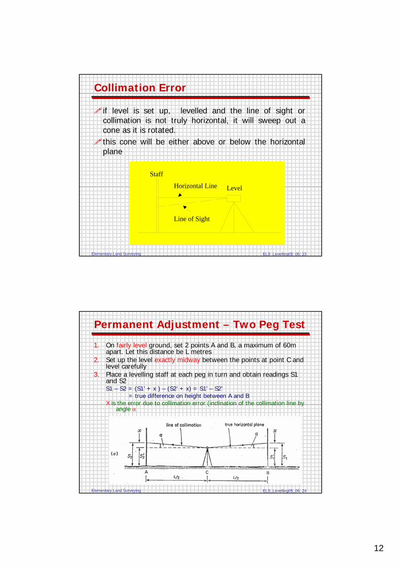
Two Peg Test - Example
The reading obtained from a two-peg test carried out on an automatic level with a single levelling staff set up alternately at 2 pegs A and B placed 60m apart are as follows:
1. With the level midway between A and BStaff reading at A = 1.283mStaff reading at B = 0.860m
2. With the level positioned 5 m from peg B on the line produced from AB
Staff reading at A = 1.612mStaff reading at B = 1.219m
Find the collimation error (e) and corrected staff reading (S4’)?
Elementary Land Surveying ELS_Levelling05_06: 28
Errors in Levelling
Errors in Equipment1. Collimation Error
Keep sight distance roughly equalCheck by two peg test regularly
2. Parallax ErrorMove eye with respect to eyepiece, see if any relative movement between target & cross-hairs, if so adjust eyepiece
3. Defects of StaffZero error, check by tape, does not affect height difference if one staff is used3-section staff should be properly extended
4. TripodRobust, properly tightenedOn soft ground, force it firmly into the ground

15
Elementary Land Surveying ELS_Levelling05_06: 29
Errors in Levelling (con’t)
Field Errors1. Staff not vertical
Staff is held vertical with aid of a bracket bubble
2. Unstable groundA change plate should be used
3. Instrument not levelEnsure that the circular bubble is centered before and after a reading is taken
4. Weather conditionAvoid windy conditionAvoid line of collimation close to the ground in hot weather
5. CheckingStart and finish at points of known heightRun a loop
Elementary Land Surveying ELS_Levelling05_06: 30
Errors in Levelling (con’t)
Reading and Booking Errors1. Misreading of the staff graduation
Keep sight distance < 60 m, otherwise it becomes impossible to take accurate readings
2. Erroneous BookingCarefully entered the reading into the fieldbookalways read the staff, book the observation and then check that the recorded entry agrees with a second reading through the telescope.

16
Elementary Land Surveying ELS_Levelling05_06: 31
Error adjustments in levelling calculations
Elementary Land Surveying ELS_Levelling05_06: 32
Error adjustments in levelling calculations
-0.008-0.008-0.008
32.6402.1314.433
32.6322.1312.1234.4334.425
BM32.6400.00832.6321.2980.816
CH10031.3390.00531.3340.5720.7752.114
CH8030.7670.00530.7620.1241.347
CH6030.8910.00530.8860.8561.223
CH4031.7450.00331.7420.8332.8420.367
CH2032.5780.00332.5750.3182.009
CH032.8960.00332.8930.2531.691
BM32.640-32.6401.944
RemarksCorrected
RLCorrectionProvisional
RLFallRiseFSISBS
1. Rise and Fall Method

17
Elementary Land Surveying ELS_Levelling05_06: 33
Error adjustments in levelling calculations
-0.008-0.008
32.6404.433
32.6324.4334.425
BM32.6400.00832.6320.816
CH10031.3390.00531.33433.4480.7752.114
CH8030.7670.00530.7621.347
CH6030.8910.00530.8861.223
CH4031.7450.00331.74232.1092.8420.367
CH2032.5780.00332.5752.009
CH032.8960.00332.8931.691
BM32.640-32.64034.5841.944
RemarksCorrected
RLCorrectionProvisional RLCollimationFSISBS
2. Height of Collimation Method
Elementary Land Surveying ELS_Levelling05_06: 34
Error adjustments in levelling calculations
Note:Misclosures = -0.008mNo. of instrument station = 3Correction is +0.0027m and is added to the RL found from each instrument stationNo adjustment is applied to the initial BM, since this level cannot be altered.
18
Elementary Land Surveying ELS_Levelling05_06: 35
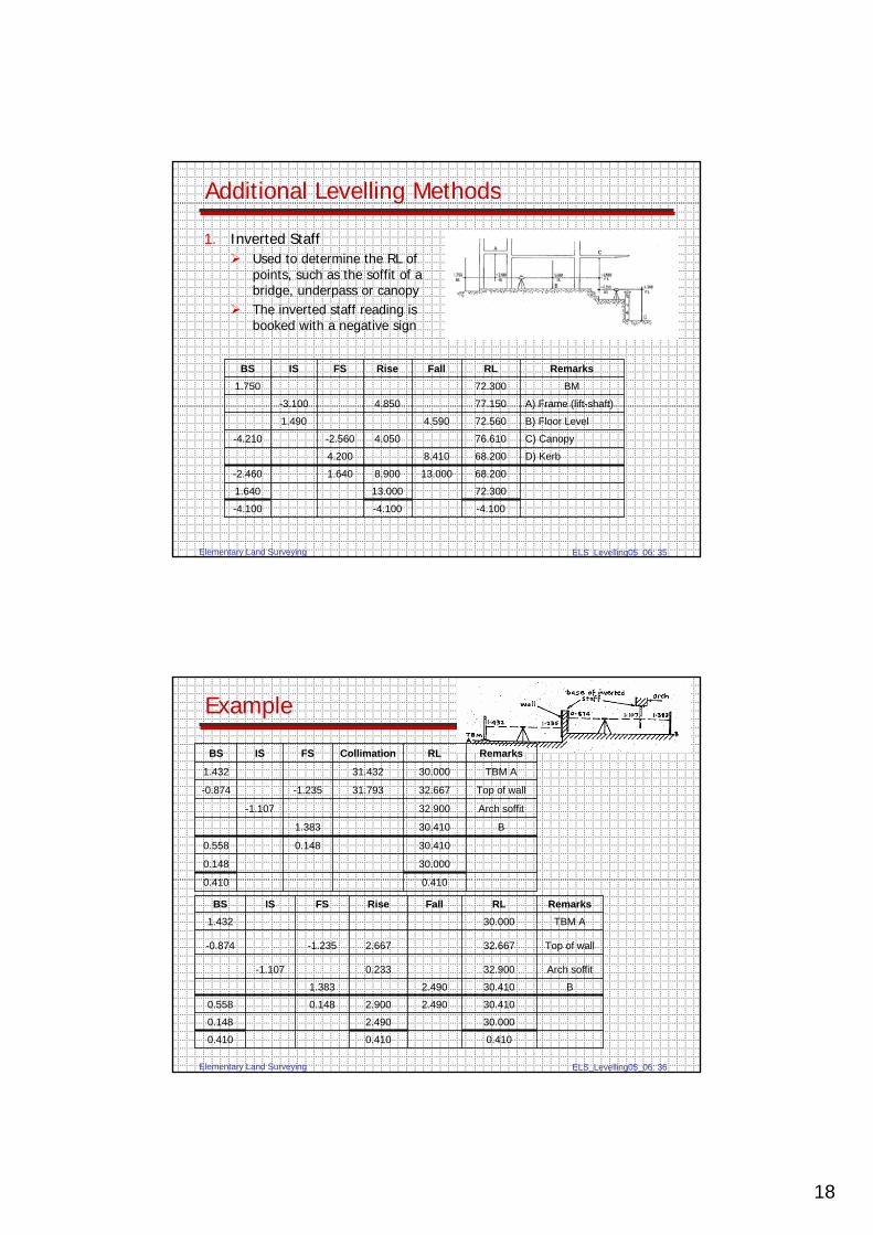
Additional Levelling Methods
1. Inverted StaffUsed to determine the RL of points, such as the soffit of a bridge, underpass or canopyThe inverted staff reading is booked with a negative sign
-4.100-4.100-4.100
72.30013.0001.640
68.20013.0008.9001.640-2.460
D) Kerb68.2008.4104.200
C) Canopy76.6104.050-2.560-4.210
B) Floor Level72.5604.5901.490
A) Frame (lift-shaft)77.1504.850-3.100
BM72.3001.750
RemarksRLFallRiseFSISBS
Elementary Land Surveying ELS_Levelling05_06: 36
Example
0.4100.4100.410
30.0002.4900.148
30.4102.4902.9000.1480.558
B30.4102.4901.383
Arch soffit32.9000.233-1.107
Top of wall32.6672.667-1.235-0.874
TBM A30.0001.432
RemarksRLFallRiseFSISBS
0.4100.410
30.0000.148
30.4100.1480.558
B30.4101.383
Arch soffit32.900-1.107
Top of wall32.66731.793-1.235-0.874
TBM A30.00031.4321.432
RemarksRLCollimationFSISBS

19
Elementary Land Surveying ELS_Levelling05_06: 37
Additional Levelling Methods
2. Reciprocal LevellingBy means of reciprocal levelling, the need for applying curvature and refraction corrections may be avoided2 similar instruments in correct adjustment are requiredH = ((a1 – b1) + (a2 – b2)) / 2
Elementary Land Surveying ELS_Levelling05_06: 38
Example
In levelling across a river, reciprocal levellingobservations gave the following results for staffs held vertically at X and Y from level stations A and B on each bank respectively:
Staff reading of X from A = 1.753mStaff reading of X from B = 2.080mStaff reading of Y from A = 2.550mStaff reading of Y from B = 2.895m
If the RL of X is 90.370m PD, calculate the RL of station Y.(note: Y is lower than X)

20
Elementary Land Surveying ELS_Levelling05_06: 39
Effects of Earth’s Curvature and Atmospheric Refraction
A. Earth’s CurvatureIn Δ,
L2 + R2 = (R + c)2
L2 = (R + c)2 - R2
L2 = 2cR + c2
L2 ≅ 2cRc ≅ L2 / 2R (km)
= 0.0785 L2 (m)where radius of the Earth,
R ≅ 6370 km and L in km
Elementary Land Surveying ELS_Levelling05_06: 40
Effects of Earth’s Curvature and Atmospheric Refraction
RefractionLine of sight is not really horizontal and bent downwards towards the EarthValue not constant, affected by pressure, temperature, latitude, humidity etc.Usually taken as 1/7 and opposite of the correction of curvature
Combined correction= 0.0785 L2 * (6/7) = 0.0673 L2 (m)
where L in kmIf L = 120m, c = -0.00097m ≅ 0.001m ≅ 1mmThe effect is negligible for ordinary levelling

21
Elementary Land Surveying ELS_Levelling05_06: 41
Example
A staff is held at a distance of 200m from a level and a reading of 2.758m obtained. Calculate the reading corrected for curvature and refraction.
Copyright © 2022 FDOKUMEN