The development of iron crust lateritic systems in Burkina Faso, West Africa examined with...
15
ELSEVIER EPSL Earth and Planetary Science Letters 124(1994)19-33 The development of iron crust lateritic systems in Burkina Faso, West Africa examined with Ivl-situ-produced cosmogenic nuclides Erik Thorson Brown a, Didier L. Bourl?s a, Fabrice Colin b, Zakaria Sanfo b, Grant M. Raisbeck a, Fraqoise Yiou a a Centre de Spectron&ie NucKaire et de Spectromkirie de Masse CNRS-IN, Ps, B&iment 108, F-91405 Campus Orsay, France b ORSTOM, UM GECO, Laboratoire de G6osciences de I’Environnement, Universite’ Air-Marseille III, F-13397 Marseille Ceder 13, France Received January14,1994; revision accepted April 15, 1994 Abstract We have investigated the development of iron crust laterites on the stable West African Craton in northern Burkina Faso using cosmogenic radionuclides produced in situ in quartz veins and pebbles. Lateritic soils develop in tectonically stable; slowly eroding, tropical environments and are a major component of the Earth’s surface. To examine processes affecting laterite formation, we determined “Be and ‘6Al in samples of quartz from three sites representing two sequential and connected iron crust laterite systems. Results from outcropping quartz veins suggest that the mean erosion rate in this region is about 3-8 m Myr- ‘. In addition, data from quartz cobbles and pebbles incorporated in iron crusts demonstrate that depth-dependent distributions of these nuclides may be used to distinguish surfaces undergoing burial from those undergoing erosive loss. Results from sections of the lowland lateritic system are consistent with mean accumulation rates of a few metres per million years. Quartz cobbles, presently at depths 6f a few metres in a paleochannel filled with rapidly deposited fluvial-colluvial material, have “Be distributions that suggest that the lowland lateritic surface may have formed during an erosive episode, presumably associated with a wetter climate, roughly 300 kyr BP. These results illustrate the practicality and the potential of the use of ilz-situ-produced cosmogenic nuclides for understanding the history of formation of laterites and for differentiating between systemsformed through in-situ chemical weathering and mechanical transport. 1. Introduction equatorial forests atid play a major role in local 1.1. Formation of laterites: Chemical vs. physical processes and global hydrological balances [l-3]. They have developed, essentially under tropical and subtrop- ical climates, from long-term exposu~~~of cratonic Lateritic terrains cover over one third of the continents. Ecologically and pedologically sensi- tive environments, they are the substrate for [MKI rocks to the atmosphere and hydrospdere. Baux- itic/ferralitic lateritic formations are present, with thicknesses up to 100 m, in what may be considered a transcontinental tropical belt of tec- tonically stable regions with low physical erosion rates. 0012-821X/94/$07,00 0 1994 Elsevier Science B.V. All rights reserved SSDZ 0012-821X(94)00087-F
Transcript of The development of iron crust lateritic systems in Burkina Faso, West Africa examined with...

ELSEVIER
EPSL Earth and Planetary Science Letters 124 (1994) 19-33
The development of iron crust lateritic systems in Burkina Faso, West Africa examined with Ivl-situ-produced cosmogenic nuclides
Erik Thorson Brown a, Didier L. Bourl?s a, Fabrice Colin b, Zakaria Sanfo b, Grant M. Raisbeck a, Fraqoise Yiou a
a Centre de Spectron&ie NucKaire et de Spectromkirie de Masse CNRS-IN, Ps, B&iment 108, F-91405 Campus Orsay, France b ORSTOM, UM GECO, Laboratoire de G6osciences de I’Environnement, Universite’ Air-Marseille III,
F-13397 Marseille Ceder 13, France
Received January 14,1994; revision accepted April 15, 1994
Abstract
We have investigated the development of iron crust laterites on the stable West African Craton in northern Burkina Faso using cosmogenic radionuclides produced in situ in quartz veins and pebbles. Lateritic soils develop in tectonically stable; slowly eroding, tropical environments and are a major component of the Earth’s surface. To examine processes affecting laterite formation, we determined “Be and ‘6Al in samples of quartz from three sites representing two sequential and connected iron crust laterite systems. Results from outcropping quartz veins suggest that the mean erosion rate in this region is about 3-8 m Myr- ‘. In addition, data from quartz cobbles and pebbles incorporated in iron crusts demonstrate that depth-dependent distributions of these nuclides may be used to distinguish surfaces undergoing burial from those undergoing erosive loss. Results from sections of the lowland lateritic system are consistent with mean accumulation rates of a few metres per million years. Quartz cobbles, presently at depths 6f a few metres in a paleochannel filled with rapidly deposited fluvial-colluvial material, have “Be distributions that suggest that the lowland lateritic surface may have formed during an erosive episode, presumably associated with a wetter climate, roughly 300 kyr BP. These results illustrate the practicality and the potential of the use of ilz-situ-produced cosmogenic nuclides for understanding the history of formation of laterites and for differentiating between systems formed through in-situ chemical weathering and mechanical transport.
1. Introduction equatorial forests atid play a major role in local
1.1. Formation of laterites: Chemical vs. physical processes
and global hydrological balances [l-3]. They have developed, essentially under tropical and subtrop- ical climates, from long-term exposu~~~of cratonic
Lateritic terrains cover over one third of the continents. Ecologically and pedologically sensi- tive environments, they are the substrate for
[MKI
rocks to the atmosphere and hydrospdere. Baux- itic/ferralitic lateritic formations are present, with thicknesses up to 100 m, in what may be considered a transcontinental tropical belt of tec- tonically stable regions with low physical erosion rates.
0012-821X/94/$07,00 0 1994 Elsevier Science B.V. All rights reserved SSDZ 0012-821X(94)00087-F
_.- ponds Documentaira ORSTOM
’ 010009166
Fonds Documentaire ORSTOM
tote: B&46 Ex: 4

~ ~- _ _ ~
20 E. T. B r o w et al. /Earth arid Plarietary Science Letters 124 (1994) 19-33
Most present-day laterites are polygenic, re- sulting from both physical and chemical transfor- mations. These transformations, induced by changes in climate, occur laterally on the land- scape scale and/or vertically on the scale of the relief of the initial weathered rocks. Understand- ing the formation of laterites requires considera- tion of iiz-situ biogeochemical and chemical weathering, and of transport of dissolved and supergene/ residual (particles and pebbles) mate- rial, as functions of time. The issue of differenti- ating between in-situ and para-autochthonous/ allochthonous processes has only recently been addressed [2,4] and poses challenges for future research.
The formation of successive aluminium/ iron crust systems is believed to depend on climatic conditions: humid tropical for bauxites and hu- mid tropical with contrasting seasons for iron crusts [51. It has been proposed that the develop- ment of indurated iron crusts results from a pro- gression of climatic conditions [3,5-71. Iron crusts develop at depth in soil profiles during warm humid periods as iron is leached from the overly- ing soils and incorporated into secondary miner- als at depth. This material is then indurated, becoming highly resistant to erosion, during ensu- ing dry periods. When such iron crusts are brought to the surface by erosion (probably associated with episodes of enhanced precipitation) they tend to persist as flat topographic highs as the surrounding landscape is degraded.
Direct dating of lateritic deposits and lateriti- zation events has remained elusive. Relative ages can be obtained from geomorphological study of lateritic chronosequences as a function of cli- matic changes [&lo], from stratigraphic data on neighbouring sedimentary rock, and from dates on nearby volcanic rocks [ll]. Paleoclimatic pa- rameters can be investigated through oxygen iso- tope distributions in supergene phases such as kaolinite [12-151. Recently, the 40K: 40Ar and "Ar: 39Ar ages of K-rich manganese oxides in Brazilian laterites were used to quantify oxidation front progression during weathering [161. Never- theless, isotopic studies of supergene clay and oxide minerals are difficult because of fine parti- cle sizes, and their interpretation is delicate be-
cause of the rapid and continual physical and chemical changes within lateritic systems.
Some constraints have been placed on the 'timing of development of laterite surfaces in West Africa. It has been proposed that high CO, lev- els, which are generally ascribed to intense vol- canic activity, during the Siluro-Devonian and mid-Cretaceous-early Tertiary [17,18] resulted in warm and humid climates [19] that probably led to intensified weathering and development of bauxitic laterite formations. Assuming that the crust sysiems were formed by in-situ chemical processes, calculations based on differences in present-day mean elevations of the high-elevation bauxitic surface and the lowland iron crust lat- eritic system in Guinea, Mali and Senegal suggest that formation of these systems was initiated be- tween 65 and 120 Myr BP and continued until approximately 1 Myr BP [31.
1.2. The use of in-situ-produced cosmogenic nu- clides in examining exposure and buiial processes
It may be possible to distinguish between the iiz-situ chemical and allochthonous physical pro- cesses involved in laterite formation, to constrain physical denudation rates, and to date lateritiza- tion events through examination of distributions of cosmogenic nuclides produced in situ. in ex- posed surficial rocks. Recent interest in these nuclides (which include 3He, "Be, 14C, 'lNe, 26Al and 36Cl) has focused primarily on their use in quantification of surface exposure ages. The fol- lowing section will briefly outline the systematics of the production of cosmogenic nuclides in sys- tems undergoing erosion and burial. A more de- tailed treatment of the temporal and spatial vari- ability of cosmogenic nuclides in eroding and accumulating surfaces will be presented with the discussion of our results.
The rate of in-situ production of cosmogenic nuclides decreases exponentially with subsurface depth, and the production of these nuclides is limited to the upper few metres of Earth's crust. Therefore, as recently reviewed [20,21], exposure histories of surficial rocks are directly linked to the concentrations of these nuclides. In general, the concentration of a cosmogenic nuclide in rock

E.T. Brow1 el al. /Earth arid Plarierary Scierice Letters 124 (1994) 19-33 21
exposed at depth x (g cm-2) below a surface undergoing erosion at a rate of E (g cm-' yr-l) may be represented as a function of time t (yr):
where P is the production rate (g-' yr-') at the altitude and latitude of the exposed surface, L is the effective attenuation length of cosmic rays (values of - 150 g cm-' and - 170 g cm-' have been reported for solids at high and low latitudes, respectively [22-24]), and A is the ra- dioactive decay constant (yr-l). Depths are ex- pressed in terms of overlying mass per unit area to eliminate dependence on rock and soil density. With the assumptions of negligible erosional loss and a single surface exposure episode, Eq. 1 may be used to calculate exposure ages.
In contrast, when surfaces are independently dated, cosmogenic nuclides may be used to con- strain physical erosion rates. After a long period of exposure the concentration in the eroding sur- face approaches a steady-state value dependent only on the erosion rate. In this case (t-+ 00,
x = O) Eq. 1 may be rearranged to yield
This relationship between steady-state concen: trations of long-lived cosmogenic radionuclides and denudation rates can, in principle, constrain erosion rates varying from less than 1 m Mur-' to as much as 1000 m Myr-l.
In an accumulating surface, the systematics of in-situ production differ from that in an eroding surface. If, because of environmental or climatic change, material from an exposed surface begins to be buried rather than eroded, the evolution of the cosmogenic nuclide concentrations takes a different form (comparable to that used by La1 et al. [25] to describe accumulation of in-situ-pro- duced I4C in ice sheets):
In this equation, B is a constant burial rate (g cm-' yr-'), t , is the time since initiation of burial, and No is the concentration at t,=0. In contrast to the models describing eroding sur- faces, which examine rocks with reference to the surface (which at any given time represents a different piece of rock), this expression follows a given rock as it is deposited and buried. The present depth of that rock is equal to the product of the burial rate and the time since initiation of burial (x = t,B). In an accumulating surface ero- sional loss no longer occurs, so cosmogenic nu- clide concentrations can increase above the steady-state levels observed in regions undergoing erosion.
Additional information regarding exposure and burial of surficial rocks may be obtained from a ratio of cosmogenic radionuclides with differing halflives (26Al: l'Be, with tll2 of 0.7 and 1.5 Myr, for example). Absolute concentrations are func- tions of both exposure time and subsurface depth, but ratios are essentially functions of only time, and their measurement may provide criteria for determining whether a sample has undergone extensive periods of burial [21,26].
Cosmogenic nuclides thus have the potential to act as tools for (1) estimates of exposure ages, (2) determination of physical denudation rates, (3) distinguishing surfaces undergoing erosion from those undergoing accumulation, and (4) quantification of burial rates of previously ex- posed material. Processes of exposure, erosion and burial play significant roles in the formation of laterites, so the distributions of cosmogenic nuclides in lateritic soil profiles should provide constraints on the timing and processes of their formation. To evaluate these methods we have determined "Be and 26Al in a suite of quartz veins and cobbles associated with lateritic profiles from Burkina Faso, West Africa.
2. Site description
The investigated lateritic system has developed on the West African Craton in northern Burkina Faso at Belhouro (Fig. 1). Typical of most of the

- _ -. .
. -
I
22 E.T. Broasl er al. /Earth ajid Plaiietary Scietice Leiters 124 (1994) 19-33
Fig. 1. Geomorphological and geological map of Belhouro. 1 = Sites included in this study; 2 = lowland lateritic system; 3 = regional river drainage; 4 = midland lateritic system; 5 = hills overlooking lowland and midland lateritic systems; 6 = highland lateritic system or older iron crust; 7 = quartz veins; 8 = roads; 9 = zones of high elevation with gentle slopes; 10 = upper Birrimian tuffaceous schist; 11 = lower Birrimian calc-alkaline granite; * = site of ancient gold exploitation; A = site of present-day gold exploitation.

E.T. Brow et al./Eartli mid Plaiietnty Scieiice Letters 124 (1991) 19-33 23
West African lateritic landscape [27,28], it is a complex iron crust system consisting of sequential surfaces that are laterally and geomorphologically connected. A series of stepped surfaces-the lowland, midland and highland lateritic systems -overlooked by elevated hills with gentle slopes has been defined throughout the region. It repre- sents systems ranging in origin from present-day riverbeds to relicts of the African bauxitic pene- plain (Fig. 1). .
At Belhouro, the laterites have developed from weathering of Upper Birrimian tuffaceous schist and Lower Birrimian calc-alkaline granite. The present climate is Sahelo-Sudanese, with a mean annual rainfall of 55 cm. The vegetation is pri- marily Sahelian steppe with rolling forest, and occasionally grassy savanna, developing along river drainage axes. The iron crust system, which developed from schist with a NNW-SSE folia- tion, is crosscut by a roughly N-S oriented aurif- erous quartz vein field [29,301 (Fig. 1). These veins, which are a few metres thick and blue-grey and milky white in colour, have gold contents ranging from a few ppb to 50 ppm and potentially represent an economically viable deposit. Within the lowland, midland and highland laterites peb- bles and cobbles of auriferous quartz have been found. These may be used to trace surface expo- sure history and to understand the genesis of these laterites.
3. Sampling and analyses
3.1. Sample collection
Three areas are included in the present study: BEF (Fig. 2a), BSF (Fig. 2b), and Mormossol (Fig. 2c). At Sites BEF and Mormossol, the quartz veins outcrop from the surface of the midland laterite system and define its border 'with the lowland system, in which quartz cobbles are scat- tered and. buried. At BSF both the quartz veins and cobbles are present within the midland sur- face.
Material collected at Site BEF consists of three samples from outcropping quartz veins (two at
the surface and one at depth) within the midland laterite and four large pebbles/ small cobbles taken from the sandy clayey surface layer of the lowland lateritic system (Fig. 2a).
At Site BSF, an outcropping quartz vein was sampled at the surface and at depth and two samples, one from the sandy clayey layer and the other from the nodular layer, were taken from within the midland laterite (Fig. 2b).
At Mormossol one sample was taken at depth from a quartz vein located within the midland lateritic system, and in the lowland system three quartz pebbles were collected at various depths in a paleochannel cutting through the nodular layer and overlying the saprolite (Fig. 2c).
3.2. Analytical procedures
Crushed and sieved (500-1000 ,um) quartz samples were prepared for analysis of cosmogenic nuclides. To eliminate the possibility of contami- nation by "Be produced in the atmosphere, the samples were cleaned using sequential HF disso- lutions [20]. After four HF steps, the cleaned quartz was completely dissolved in HF. The re- sulting solution was spiked with 'Be and (after determination of the natural level of 27Al by standard addition atomic absorption spectropho- tometry) 27Ál carriers. After separation of Be and Al by solvent extractions, B e 0 and A120, were purified by extraction and precipitation [22,31]. All "Be and 26Al measurements were performed by accelerator mass spectrometry at the Tande- tron AMs Facility, Gif-sur-Yvette, France [32]. Analytical uncertainties (reported throughout as la) are based on counting statistics and conser- vative assumptions of 5% variability in machine response and a 30% uncertainty in the blank correction.
All calculations use production rates of 5.2 at g-' yr-' for "Be and 31 at g-' yr-I for 26Al, based on the altitude- and latitude-dependent polynomials of La1 [21]. As discussed elsewhere [33], there may be uncertainties as large as 20% associated with these production rates. Such un- certainties have little effect on our conclusions.

.-
E.T. B r o w et al. /Earth arid Plaiieiary Science Leiters 124 (1994) 19-33
2 3. Site BEF I c- LOWLAND LATERITIC SYSTEM -c- MIDLAND LATERITIC SYSTEM -
I
- - - 310m
150 m
2 b. Site BSF
a MIDLAND LATERITIC SYSTEM L
- 298 m
+i++++++++ ++++++++++ ++++++++++
50 m
N 250 c-
2 c. Site MORMOSSOL
- LOWLAND LATERITIC SYSTEM - I c MIDLAND LATERITIC- SYSTEM I
I"
sample mass (9)
4.80 10.53 9.1 7 6.1 8 5.90 7.43 5.49 8.20 16.78 9.07 16.05 17.09 19.23 16.67 13.54
E.T. Brow1 et al. /Earth and Plaiietaiy Scierice Letters I24 (1994) 19-33 25
7 O& (7 O6atg-1) 1.0350.09 1.8450.1 3 1.73f0.12 0.38f0.05
0.070f0.029 0.53f0.06 0.27f0.04
0.095f0.021 0.39f0.03 0.61f0.04
0.046f0.007 1.4850.08 1.65f0.1 O 1.68f0.22 0.75f0.05
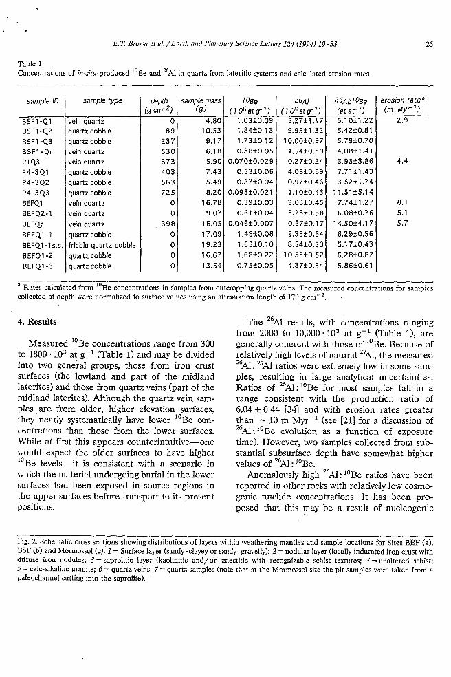
Table 1 Concentrations of iir-situ-produced "Be and 26Al in quartz from lateritic systems and calculated erosion rates
26AI (7 06atg-1) 5.2751 .I 7 9.95f1.32 10.00f0.97 1.54k0.50 0.27f0.24 4.06f0.59 0.9720.46 1.1 Of0.43 3,05+0.45 3.73k0.38 b.67f0.17 9.3 3 50. 64 8.5450.50 10.55f0.52 4.37f0.34
sample ID
BSF1 -Q1 BSF1-42 BSF1-43 BSF1 -Qr P1Q3 P4-3Q1 P4-342 P4-343 BEFQl
BEFQr 8 EF 42.- 1
8EFQ1-1 BEFQ1-1 S.S. BEFQ1-2 BEFQ1-3
26Af: 1 OBe (at a r 1) 5 -1 Ofl.22 5.42f0.81 5.79f0.70 4.08fl.41 3.951t3.86 7.71 rtl.43 3.52f1.74
1 1.51 f5.14 7.74f1.27 6.0840.76 14.50f4,17 6.2 9fO.S 6 5.17k0.43 6,2840.87 5.8640.61
sample type
vein quartz quartz cobble quartz cobble vein quartz vein quartz quartz cobble quartz cobble quartz cobble vein quartz vein quartz vein quartz quartz cobble friable quartz cobble quartz cobble quartz cobble
depth (g cm-2)
O 89 237 530 373 403 563 725
O O
, 398 O O O O
erosion rate*
2.9 (m Myrl)
4.4
8.1 5.1 5.7
a Rates calculated from "Be concentrations in samples from outcropping quartz veins. The measured concentrations for samples collected at depth were normalized to surface values using an attenuation length of 170 g
4. Results
Measured "Be concentrations range from 300 to 1800 * lo3 at g-' (Table 1) and may be divided into two general groups, those from iron crust surfaces (the lowland and part of the midland laterites) and those from quartz veins (part of the midland laterites). Although the quartz vein sam- ples ,are from older, higher elevation surfaces, they nearly systematically have lower Be con- centrations than those from the lower surfaces. While at first this appears counterintuitive-one would expect the older surfaces to have higher "Be levels-it is consistent with a scenario in which the material undergoing burial in the lower surfaces had been exposed in source regions in the upper surfaces before transport to its present positions.
10
The "Al results, with concentrations ranging from 2000 to 10,000.103 at 8-l (Table 11, are generally coherent with those of "Be. Because of relatively high levels of natural 27Al, the measured 2 6 ~ : 2 7 ~ ratios were extremely IOW in some sam- ples, resulting in large analytical uncertainties. Ratios of '6Al: "Be for most samples fall in a range consistent with the production ratio of 6.04+ 0.44 [34] and with erosion rates greater than - 10 m Myr-' (see [211 for a discussion of 26Al: "Be evolution as a function of exposure time). However, two samples collected from sub- stantial subsurface depth have somewhat higher values of 26AI : "Be.
Anomalously high 26Al : "Be ratios have been reported in other rocks with relatively low cosmo- genic nuclide concentrations. It has been pro- posed that this may be a result of nucleogenic
Fig. 2. Schematic cross sections showing distributions of layers within weathering mantles and sample locations for Sites BEF (a), BSF (b) and Mormossol (c). 1 = Surface layer (sandy-clayey or sandy-gravelly); 2 = nodular layer (locally indurated iron crust with diffuse iron nodules; 3 = saprolitic layer (kaolinitic and/or smectitic with recognizable schist textures; 4 = unaltered schist; 5 = calc-alkaline granite; 6 = quartz veins; 7 = quartz samples (note that at the Mormossol site the pit samples were taken from a paleochannel cutting into the saprolite).

reactions induced by radioactive decay of ura- nium and thorium and their daughter products [20,35]. Both ''Be and '6Al can be produced through the alpha-capture reactions 7Li(a,p)'oBe and Na(a,n)26AJ, and "Be can result from the reactions 'Be(n,y)"Be, "B(iz,p)"Be and
C(n,a)"Be in which the neutrons are induced by (a,iz) reactions. Measurements of "Be and 26Al in various uranium and thorium ores indicate that production rates of "Be are vanishingly small (because of the low concentrations of target nu- clei) but that significant quantities of 26Al may result from these reactions [36]. Assuming uni- form distributions of elements, Sharma and Mid- dleton [36] calculated that 60 * lo3 at g-' of "Al would be supported by radiogenic production in average quartz sandstone. However, because these reactions are spatially limited by the alpha- recoil distance in quartz, production of "Al is likely to be dependent on the microscopic distri- butions of U and Th relative to Na, the major target element. In samples such as ours, these elements are likely to be concentrated in acces- sory minerals, inclusions, and iron oxide coatings. We are initiating a quantitative study of this phenomenon.
The concentrations of 26Al in the samples with anomalous ratios are among the lowest in the dataset. Comparison of "Be and "Al results for these samples indicates that the concentration of 26Al in excess of that produced by cosmic ray neutron induced spallation is less than 400 * lo3 at g-l, suggesting that the contribution of nucle- ogenic 26Al is minor in the other samples.
23
13
5. Discussion
5.1. Eroding surfaces
Interpretation of the results from the outcrop- ping quartz veins (from parts of the midland lateritic surface) is relatively straightforward. If the exposure ages of these surfaces are suffi- ciently long for "Be and 26Al to have reached a steady-state balance between production and loss due to radioactive decay and to erosion, the con- centrations of these nuclides may be used to
estimate physical denudation rates (see Eq. 2). Based on geomorphological and petrological studies of similar lateritic systems in the Ivory Coast, Delvigne and Grandin [9] and Boulangé et al. [lo] concluded that the African bauxitic sur- face was formed during the humid period of the upper Cretaceous to Eocene. Further calcula- tions based on comparison of present-day eleva- tions of relicts of the bauxitic surface with those of lower indurated iron crusts suggest that the African bauxites developed between 65 and 120 Myr B.P. and that the midland lateritic system began to form about 5 Myr ago [31. Although these chronologies are based on qualitative stud- ies, the resulting ages justify our steady-state as- sumption.
Samples of outcropping quartz veins (either from the surface or from depth, corrected to surface concentrations assuming an attenuation length of 170 g cm-2) yield erosion rates ranging from 3 to 8 m Myr-' (Table 1). These imply very slow denudation, consistent with the relative tec- tonic quiescence of the West African Craton. These vaIues are comparable to a rate of 8.3 m Myr-' estimated from watershed mass balance of the Lake Chad drainage basin [37]. Our results are also consistent with values ranging from 6 to 12 m Myr-' calculated from the relative eleva- tions on the regional scale of these lateritic sys- tems [3]. Similarly low rates of physical erosion have been reported for other cratons. Brown et al. [38] reported a rate of N 1 m Myr-' for the summit of Mount Roraima, Venezuela, a site which has been interpreted as a relict of the Gondwanaland Surface [39]. Rates of 1-2 m Mur-' have been suggested for the Yilgarn Block in southwestern Australia [40,41] and for other Australian bedrock surfaces [42,43].
5.2. Accumula tìng surfaces
In contrast, the iron crust surfaces (parts of the midland surface and the lowland surface) show evidence of active accumulation. The fol- lowing section will describe how the distribution of "Be in surface deposits (BEF) and profiles (Mormosol and BSF) in such regions can yield constraints on the history of their formation. In

E.T. Brown et al./Eartk arid Plarietaiy Scierice Letters 124 (1994) 19-33 27
addition, it will describe the added information obtained in these systems through examination of '6Al : "Be ratios.
Recent deposition on accuinulating surfaces Site BEF encompasses both the midland and
lowland lateritic systems (Fig. 2a). As described above, the samples of the outcropping quartz veins in the midland system are believed to have steady-state "Be concentrations with respect to physical erosional loss. Field evidence (similar coloration of qu'artz at both locations and the general scarcity of vein quartz in the region) indicates that such outcrops are likely to be the source rock for the lowland samples. Samples from the lowland laterite have ''Be concentra- tions that are nearly consistently higher than those from the assumed source region, in accordance with the assumption that erosional loss does not affect material . undergoing slow burial. Fig. 3 shows a model of the accumulation of "Be as a function of time in a bedrock surface eroding at 5 m Myr-' and in cobbles (which had the steady- state concentration of the eroding surface as their initial concentration) undergoing burial at rates of 2, 4 and 6 m Myr-l. The cosmogenic nuclide
concentrations of rock undergoing slow burial exceed the steady-state concentration in the erod- ing source rock. Measured "Be concentrations from outcropping quartz veins and from quartz pebbles incorporated within the lateritic soils are plotted-with arbitrary positions on the time axis -over the model curves. The results from from the outcropping veins are consistent with steady- state erosion rates of several metres per million years (Table 1). Data from the lateritic soils sug- gest that burial may be occurring at a comparable rate (Fig. 3). Assuming that the ''Be measured in the midland system quartz veins is representative of the concentrations of the lowland samples at the time of their deposition, the difference in concentration between the lowland and midland samples (up to - lo6 at g-') suggests that the lowland system has been active for at least sev- eral hundred thousand years.
Earlier deposition on accumulating surfaces Because samples from Site BSF (within the
midland laterite system, Fig. 2b) are presently at substantial depth, it is necessary to consider the systematics of cosmogenic nuclide accumulation as a function of depth in surfaces undergoing
2.0.1 o6
1.5.1 O6
5.0.1 O5
O O 1 .o.106 2.0.106 3.0.106 4.0*106
time (yr)
Fig. 3. Model of "Be as a function of time in rock undergoing erosion followed by burial: comparison with data from quartz veins and lateritic surfaces. The calculations are based on a rock eroding at a rate of 5 m Myr-l (continuous line), reaching steady-state concentration, and being deposited onto and buried at rates of 2 (short dashes), 4 (medium dashes) and 6 (long dashes) m M y Ï ' in an accumulating surface. Data from outcropping quartz veins (+) and from lateritic surfaces (0) are overlain on the model cumes, with arbitrary positions on the horizontal axis. The samples from eroding veins (subsurface samples have values normalized to the surface assuming an exponential attenuation length of 170 g cm-') have concentrations that are nearly systematically lower than those from presumably accumulating surfaces.

--. ._
28 E.T. Broww et aL/Earth arid Plarwtaoj Science Letters 124 (1994) 19-33
loge (at g-1) 1 o4 i o5 1 OE 107
* I
1 1 i
h 100 +
150 i 8. i 2 c q 250 t
1
Fig. 4. Comparison of theoretical and measured distributions of "Be as a function of subsurface depth in regions undergo- ing erosion and burial. On eroding surfaces, "Be concentra- tions should decrease with depth with an exponential attenua- tion length of 170 g cm-' (continuous line). Measured "Be concentrations in a quartz vein from the midland surface at Site BEF (O) show such behaviour. A family of curves is shown for depth distributions of "Be in accumulating soils with burial rates of 2 (short dashes), 4 (medium dashes) and 6 (long dashes) m Myr-l, and an initial surface concentrations of - lo6 at g-'. Measured "Be in cobbles (A) in a lateritic soil at Site BSF profile show clear evidence of burial and, assuming that "Be in the surface sample represents samples at initiation of their burial, are consistent with a burial rate of -3 m Myr-'. Samples from the paleochannel within the lowland surface at Mormossol (O, plotted as a function of depth below the surficial sandy-clayey layer) fall on an expo- nential decay line. This indicates that they have had the same relative positions for their entire exposure history.
I II 300 1
burial and erosion. Thise is illustrated by the theoretical curves in Fig. 4. For eroding surfaces, Eq. 1 predicts exponential decreases with subsur- face depth, which is is a direct consequence of lower production rates at depth due to the atten- uation of cosmic ray neutrons. The erosion rate determines the surface concentration but has no influence on the slope (see Eqs. 1 and 2). The depth dependence of production rates influences material undergoing burial as well, and results in cosmogenic nuclide distributions in soil profiles in regions of accumulation which are very differ- ent from those in regions undergoing erosion. In a rock undergoing burial, the concentration in- creases with time until the rate of radioactive decay becomes greater than that of production.
Calculations based on Eq. 3 show that subsurface maxima can be expected for the case of burial.
When overlain on Fig. 4, the data from Site BSF show clear evidence of burial, strongly con- trasting with the exponential decrease in Be observed for the eroding vein quartz. The two samples at depth in the lateritic crust (BSFl-Q2 and BSFl-Q3) have "Be concentrations that are 1.5 X to 2 X higher than those at the surface. As- suming that the sample from the outcropping vein (BSF1-Q1) represents the average source rock, the ''Be distributions in these samples are consistent with a burial rate of approximately 3 m Mur-'. However, the sample (BSF1-Qr) taken from within the vein at the - 2 m depth does not at first appear to be consistent with either sce- nario. It has a concentration that is approxi- mately 30 X higher than would be expected from a simple exponential decrease from the surface concentration, but considerably lower than that implied by the range of burial rates suggested by the other samples.
It is difficult to develop a quantitative history of the development of a lateritic profile with a small preliminary database. Nevertheless, these results are consistent with a model that assumes that the local topography was initially analogous to that observed presently at Site BEF and that the lower surface was then gradually buried. In this scenario, the west side of the quartz vein would have been a lower elevation surface under- going accumulation and separated from an upper surface by an escarpment defined by the quartz vein. Sample BSF1-Qr would have been approxi- mately 30 cm into this vertical face and would have undergone cosmic ray bombardment from the side. The angular distribution of cosmic ray particles has been approximated by a sin2.30 de- pendence on the angle relative to the horizontal [44,45]. A rock exposed on a vertical cliff thus will have a production rate 50% lower than that of a horizontal surface at the same location. As mate- rial (including samples BSFl-Q2 and BSFl-Q3) accumulated on the lower plain, the cliff would have been buried and the production rate for sample BSF1-Qr would have decreased. Assum- ing that the vertical face was exposed for suffi- cient time to reach a steady-state concentration
10

P
E.T. Brown et al./Earrh and Plaiietary Scietice Letters 124 (1994) 19-33 29
(50% of that observed for BSF1-Q1 at the pre- sent outcropping vein surface), that the sample was at a horizontal depth of 30 cm from the vertical face, and that it was then buried at a rate of 3 m Myr-' (as implied by BSFl-Q2 and BSF1- Q3) a model of "Be accumulation yields a con- centration of - 400 * lo3 at g-l, consistent with the measured value of BSFl-Qr.
Rapid deposition followed by accumulation At the third site (Mormosol, Fig. 2c) the tex-
ture of the soils within the profiles indicates that accumulation occurred in two distinct episodes, a period of high-energy rapid deposition (demon- strated by heterogeneity in soil texture) within a confined paleochannel followed by a period of slow gradual deposition (indicated by fine, well- sorted soil) across the fan surface. The samples, which come from three depths in the paleochan- nel, show an exponential decrease in "Be with depth (overlay on Fig. 4). The attenuation length calculated for this profile (- 185 g cmF2 yr-') is a reasonable value for attenuation of cosmic ray neutrons at low geomagnetic latitude [23,241. This implies that virtually all the "Be found in these samples was produced while they had the same relative positions, and requires either that the samples have always been in place or that they were exhumed from depth and rapidly deposited into their present relative positions. As noted above, field evidence suggests rapid deposition.
It is possible to constrain the timing of this deposition event using the "Be concentration of the sample at the interface between the soil lay- ers. However, the calculated age is strongly de- pendent on the assumed deposition history of the surface layer. An exposure age of - 2 Myr can be calculated under the assumption that (contrary to field evidence based on grain size and soil tex- ture) deposition of the upper layer occurred rapidly soon after that of the lower layer. A more realistic model (see Eq. 3) assumes constant slow burial after the initial rapid deposition of the lower layer, consistent with the observed soil tex- tures, and yields an age of - 300 kyr and a mean burial rate of - 5 m Myr-l, comparable with the rate of burial calculated for Site BSF. The as- sumptions that the overlying soil was deposited
recently and rapidly and that the lower surface had suffered no erosional loss place a lower limit of - 100 kyr on the deposition age.
The second hypothesis is the most consistent with the granulometry of the lower (colluvial-like) and surficial (alluvial-like) layers and with the morphology of gold grains [461. A 300 kyr age could correspond to the formation of the lowland lateritic system; this would have been coeval with the chemical and physical degradation (poten- tially associated with successive episodes of hu- mid and dry climate) of the midland iron crust. The mean burial rate of -5 m Mur-' would then represent the rate of subsequent (subrecent to present-day) erosional surface washing of the midland iron crust relict.
5.3. Use of the ratio 26AI:10Be in examining expo- sure / burial histories
The use of a pair of cosmogenic nuclides with different halflives can provide fufther informa- tion regarding exposure histories. Because of the shorter halflife of 26Al the value of "Al : "Be in a surficial rock decreases with exposure time, from the production ratio of 6.04 i- 0.44 to a steady- state ratio as low as 2.8 depending on the erosion rate [Zl]. Upon burial at sufficient depth for production to become negligible, 26Al : "Be de- creases with an effective halflife of 1.3 Myr. Therefore, the position of a sample in "Be- 26Al: "Be space may be used to differentiate between simple and complex exposure scenarios. Time-dependent trajectories associated with a range of erosion rates (from vanishingly small to infinitely large) define a region of simple surface exposure [see 211. If samples fall below and to the left of this region, the indication is that they have had significant periods of shielding from cosmic rays. Conversely, samples falling to the right of the simple exposure zone have, in the past, been subject to higher production rates than those associated with their current positions. For sam- ples collected at depth in a soil profile this sug- gests prior exposure at (or nearer to) the surface.
Surface samples Measured values of 26Al:10Be from surface
samples are generally consistent with surface ex-
i j
1 , I
! I
I
I
,

30 ET Brown et al./Eartli and Planetary Science Letters 124 (1994) 19-33
posure and slow erosion rates (Table 1). How- ever, one sample (BEF1-1SS) has a ratio signifi- cantly lower than would be expected for simple exposure at the surface. This value is lower than those of other samples from the same site, no- tably that of BEF1-1 which was collected from exactly the same location. Sample BEF1-1SS dif- fers from the other samples from this site, being altered and friable rather than massive vein quartz. The fact that it is heavily altered is consis- tent with the notion that it has had a complex exposure history.
Samples at depth in a profile Theoretical curves for the evolution of
'6Al : "Be ratios and "Be concentrations were calculated for the present depths of the samples from Site BSF (Fig. 5). The rate of increase in "Be concentration is dependent on the produc- tion rate-and thus on the depth of a sample within a soil profile. The measured values of 26Al:10Be and "Be fall to the right of the curves calculated for their respective depths. This sug- gests that these samples have had complex histo- ries involving prior surface exposure, consistent
with the theory that they were mechanically transported by colluvial-like processes from nearby quartz veins. It should be noted that the model curves were calculated assuming no ero- sional loss; inclusion of erosion compresses the curves and moves them down and to the left, increasing their distances from the measured val- ues. On the other hand, corrections for nucle- ogenic 26Al would decrease these distances. How- ever, as noted in the preceding section, this com- ponent is likely to be small (< 400 * lo3 at g-') and would not affect our conclusions. In spite of the relatively large propagated analytical uncer- tainties of the ratios, the coherence of the data and the fact that one sample (BSFl-Q3) is signifi- cantly different (> 2a) from the production curve for its present depth provide further evidence for surface exposure in the past.
6. Summary
A series of stepped lateritic surfaces has been defined on a regional basis in West Africa. An
7.0
6.0
E .c. 5.0 m Y
3.0
2.0
I 1 I I I
135 cm
I I I I 4 4
I o4 1 o5 1 o6 I o7 1 o* loge (at g-l)
Fig. 5. 'oBe-26A1:'oBe curves for the depths at Site BSF. The four growth trajectories correspond to the production rates associated with the present depths of the four samples, and are contoured for exposure time. Samples falling to the right of the trajectory associated with their present depths were subject to higher cosmic ray fluxes at some time during the past, indicating exposure closer to or at the surface.

E.T. Brotvu ei al./Enrtlt nnd Planetnry Science Letters 124 (1994) 19-33
understanding of the history of the development of these surfaces can be used to define periods with climatic conditions favourable for their for- mation and subsequent abandonment. The Eocene bauxite consists mainly of gibbsite, which is thermodynamically stable under humid tropi- cal/subtropical conditions with over N 1700 mm of mean annual rainfall. It has been suggested that at the end of the Eocene a change of climate to drier tropical [47,481 induced chemical/ physi- cal degradation of the bauxitic surface and initi- ated the formation of iron crust systems. The highland, midland and lowland laterites-pre- sumably formed successively since the Miocene- are believed to have developed under humid tropical climates with contrasting seasons and stabilized under drier conditions.
A preliminary study of distributions of "Be and 26Al in iron crust lateritic surfaces in north- ern Burkina Faso has demonstrated the utility of in-situ-produced cosmogenic nuclides in discern- ing histories of exposure and erosion. More specifically, we have: (1) calculated denudation rates of 3-8 m Myr-l
for quartz veins outcropping in the midland lateritic system (comparable to values calcu- lated for the Yilgarn Block Tertiary laterites in Western Australia, which are similarly sta- bilized by the present-day dry climate) and estimated burial rates of -5 m Ma-' for lateritic soil profiles;
(2) shown that, consistent with theory, cobbles from actively accumulating surfaces have higher "Be concentrations than outcropping quartz veins in their source regions;
(3) demonstrated that soil profile cosmogenic nu- clide distributions can be used for quantita- tively distinguishing material with prior sur- face exposure (implying allochthonous forma- tion) from material in place for long periods (implying autochthonous formation);
(4) estimated that an erosional/ depositional event-potentially associated with the forma- tion of the lowland system and hence with the last period of humid tropical conditions before initiation of drier climates leading to present-day subsahelian conditions-oc- curred approximately 300 kyr BP.
31
Acknowledgements
Discussion with Bruno Boulangé, Georges Grandin and Ed Brook and reviews by James Arnold, George Brimhall and Robert Stallard greatly improved the quality of this work. We thank Jacques Lestringuez and Dominique De- boffle for their continuing expertise in AMs mea- surements and Professor Bernard Platevoët for providing access to sample preparation facilities. This work was supported by INSU through the DBT Programme (DBTF 1/01]. Tandetron oper- ation is supported by the CNRS, CEA and IN,P,. Logistic support was from the ORSTOM Centre, Ouagadougou, Burkina Faso.
References
[l] R.F. Stallard, Weathering and erosion in the humid tropics, in: Physical and Chemical ?thering in Geo- chemical Cycles, A. Lerman and M. Meybeck, eds., pp. 225-246, Kluwer, Dordrecht, 1988.
[2] F. Colin, G. Brimhall, D. Nahon, C.J. Lewis, A. Baronnet and K. Danti, Equatorial rainforest lateritic soils: A geomembrane filter, Geology 20, 523-526, 1992.
[3] Y. Tardy, Pétrologie des Latérites et des Sols Tropicaux, 461 pp., Masson, Paris, 1993.
[4] G.H. Brimhall, C.J. Lewis, C. Ford, J. Bratt, G. Taylor and O. Warin, Quantitative geochemical approach to pedogenesis: importance of parent material, regolith re- duction, volumetric expansion and eolian influx in lateri- tization, Geoderma 51, 51-91, 1991.
[5] D. Nahon, Introduction to the Petrology of Soils and Chemical Weathering, 313 pp., Wiley, New York, 1991.
[6] D. Nahon, Evolution of iron crusts in tropical landscapes, in: Rates of Chemical Weathering of Rocks and Miner- als, S.M. Colman and D.P. Dethier, eds., pp. 169-191, Academic Press, Orlando, 1986.
[7] J.P. Ambrosi, Modélisation thermodynamique de I'altéra- tion latéritique dans le système Fe,O,-SiO,-H,O, Ph.D. Thesis, Univ. Aix-Marseille III, 1990.
[SI P. Michel, Les bassins des fleuves Sénégal et Gambie, Mém. ORSTOM 3, 752, 1970.
[9] J. Delvigne and G. Grandin, Etude des cycles morpho- génétiques et tentative de chronologie paléoclimatique dans la région de Tormodi, en Côte d'Ivoire, C.R. Acad. Sci. Paris 15, 1372-1375, 1969.
[lo] B. Boulangé, J. Delvigne and V. Eschenbrenner, De- scriptions morphoscopiques, géochimiques et minéralo- giques des faciès cuirassés des principaux niveaux géomorphologiques de Côte d'Ivoire, Cah. ORSTOM, Sér. Gkol. 1,59-81, 1973.

32 E.T. Brown et al./Eartk arid Planetary Science Letters 124 (1994) 19-33
[ll] D. Nahon and J.R. Lappartient, Time factor and geo- chemistry in iron crust genesis, Catena 4, 249-254, 1977.
[12] G. Bocquier, C. Bernard and A.P. Boulad, Utilisation des isotopes stables et radioactifs pour la détermination des conditions anciennes et des vitesses de l'altération, Bull. Assoc. Fr. Etud. Sols 2-3, 137-147, 1976.
[13] M.M. Bernard, G. Bocquier and M. Javoy, Dktermina- tion des rapports isotopiques 180/'60 de la gibbsite et de la boehmite dans différentes bauxites, C.R. Acad. Sci. Paris 282D, 1089-1092, 1979.
[14] M.I. Bird and A.R. Chivas, Oxygen isotope dating of the Australian regolith, Nature 331, 513-516, 1988.
[15] S. Giral, D. Nahon, J.P. Girard and S.M. Savin, Variation in 180/'60 ratios of kaolinites within a lateritic profile: their significance for laterite genesis and isotope paleocli- matology, Geol. Soc. Am. Abstr. Programs 24, A70, 1992,
[16] P.M. Vasconselos, T. Becker, P.R. Renne and G.H. Brimhall, Age and duration of weathering by 40K:40Ar analysis of potassium-manganese oxides, Science 258,
[17] G. Bárdossy, Karst Bauxite, 441 pp., Elsevier, Amster- dam, 1982.
[18] R.A. Berner, A.C. Lasaga and R.M. Garrels, The car- bonate-silicate geochemical cycle and its effect on atmo- spheric carbon dioxide over the past 100 million years, Am. J. Sci. 283, 641-643, 1983.
[19] L.A. Frakes, Climates Throughout Geologic Times, 310 pp., Elsevier, Amsterdam, 1976.
[20] E.T. Brown, J.M. Edmond, G.M. Raisbeck, F. Yiou, M.D. Kurz and E.J. Brook, Examination of surface expo- sure ages of moraines in Arena Valley, Antarctica using in situ produced "Be and 26Al, Geochim. Cosmochim. Acta 55, 2269-2283, 1991.
[21] D. Lal, Cosmic ray labeling of erosion surfaces: in situ nuclide production rates and erosion models, Earth Planet. Sci. Lett. 104, 424-439, 1991.
[22] E.T. Brown, E.J. Brook, G.M. Raisbeck, F. Yiou and M.D. Kurz, Effective attenuation lengths of cosmic rays producing "Be and 26Al in quartz: Implications for expo- sure age dating, Geophys. Res. Lett. 19, 369-372, 1992.
[23] M.D. Kurz, In situ production of terrestrial cosmogenic helium and some applications to geochronology, Geochim. Cosmochim. Acta 50, 2855-2862,1986.
[24] P. Sarda, T. Staudacher, C. Allègre and A. Lecomte, Cosmogenic neon and helium at Réunion: measurement of erosion rate, Earth Planet. Sci. Lett. 119, 405-417, 1993.
I251 D. Lal, K. Nishiizumi and J. Arnold, In situ cosmogenic 3H, I4C and "Be for determining the net accumulation and ablation rates of ice sheets, J. Geophys. Res. 92,
[26] J. Klein, R. Giegengack, R. Middleton, J.R. Underwood, Jr. and R.A. Weeks, Revealing histories of exposure using in situ:produced 26N and "Be in Libyan Desert Glass, Radiocarbon 28, 547-555, 1986.
451-455, 1992.
4947-4952,1987.
[27] B. Boulangé, Les formations bauxitiques latéritiques de Côte d'Ivoire, Mim. ORSTOM 175, 341, 1984.
[28] G. Grandin, Aplanissements cuirassés et enrichissement des gisements de manganèse dans quelques régions d'Afrique de l'Ouest, Mim. ORSTOM 82, 1-275, 1973.
[29] J.P. Milesi, Les minéralisations aurifères de l'Afrique de l'Ouest. Leurs relations avec I'évolution lithostructurale au Protérozoïque inférieur, Chron. Mines Rech. Miniere
[30] S. Nikiema, Le Birrimien du nord du Burkina Faso, Ph.D. Thesis, Univ. Cheik Anta Diop, Dakar, 1992.
[31] D.L. Bourlès, Etude de la géochimie de l'isotope cos- mogknique "Be et de son isotope stable 'Be en milieu océanique: Application ?i la datation des sédiments marins, Ph.D. Thesis, Univ. Paris XI, 1988.
[32] G.M. Raisbeck, F. Yiou, D. Bourlès, J. Lestringuez and D. Deboffle, Measurements of "Be and 26Al with a Tandetron AMs facility, Nucl. Instrum. Methods B29,
[33] E.J. Brook and M.D. Kurz, Surface-exposure chronology using in situ cosmogenic 3He in Antarctic quartz sand- stone boulders, Quat. Res. 39, 1-10, 1993.
[34] K. Nishiizumi, E.L. Winterer, C.P. Kohl, J. Klein, R. Middleton, D. La1 and J.R. Arnold, Cosmic ray produc- tion rates of ,"Be and 26Al in quartz from glacially polished rocks, J. Geophys. Res. 94, 17907-17915, 1989.
[35] E.J. Brook et al., Cosmogenic nuclide exposure ages and glacial history of late Quaternary Ross Sea Drift in McMurdo Sound, Antarctica, Boreas,- in prep., 1994.
[36] P. Sharma and R. Middleton, Radiogenic production of "Be and 26N in uranium and thorium ores: Implications for studying terrestrial samples containing low levels of "Be and 26A1, Geochim. Cosmochim. Acta 53, 709-716, 1989.
1371 J.Y. Gac, Géochimie du bassin du Lac Tchad. Bilan de l'altération, de I'érosion et de la sédimentation, Trav.
[38] E.T. Brown, R.F. Stallard, G.M. Raisbeck and F. Yiou, Determination of the denudation rate of Mount Ro- raima, Venezuela using cosmogenic "Be and 26Al, EOS 73, 170, 1992.
[39] L.C. King, A geological comparison between Eastern Brazil and Africa (Central and Southern), Q.J. Geol. Soc. London 112,445-474, 1956.
[40] R.W. Fairbridge and C.W. Finkl, Geomorphic analysis of the rift cratonic margins of Western Australia, Z. Geo- morph. 22, 369-389, 1978.
[41] R.W. Fairbridge and C.W. Finkl, Cratonic erosion un- conformities and peneplains, J. Geol. 88, 69-86, 1980.
1421 E.M. Shoemaker, C.S. Shoemaker, K. Nishiizumi, C.P. Kohl, J.R. Arnold, J. Klein, D. Fink, R. Middleton, P.W. Kubik and P. Sharma, Ages of Australian meteorite craters-a preliminary report, Meteoritics 25, 409, 1990.
1431 K. Nishiizumi, C.P. Kohl, J.R. Arnold, M.W. Caffee, R.C. Finkel, J. Southon, E.M. Shoemaker and C.S. Shoe-
497,3-98, 1989.
22-26, 1987.
DOC. ORSTOM 123, 1-251, 1980.
..

E.T. B r o w et al. /Earth arid Plnnetary Scierice Letters 124 (1994) 19-33 33
maker, Exposure histories of desert sands using in situ produced cosmogenic nuclides, EOS 73, 185, 1992.
[44] M. Conversi and P. Rothwell, Angular distributions in cosmic ray stars at 3500 m, Nuovo Cimento 12, 191-211, 1954.
[45] D. Lal, Investigations of nuclear interactions produced by cosmic rays, Ph.D. Thesis, Tata Inst. Fundam. Res., Bombay, 1958.
I461 F. Colin, Z. Sanfo, E.T. Brown and D.L. Bourlès, Gold: a physical and chemical tracer in laterites, in prep., 1994.
[471 J.T. Parrish, A.M. Zirgler and C.R. Scotese, Rainfall patterns and the distribution of coals and evaporites of the Mesozoic and Cenozoic, Palaeogr., Palaeoclimatol., Palaeoecol. 40, 67-101, 1952.
[45] B. Kobilsec, Géochimie et pétrographie des bauxites latéritiques d’Amazonie Brésilienne. Comparaison avec l’Afrique, l’Inde et l’Australie, Ph.D. Thesis, Univ. Louis Pasteur, Strasbourg, 1990.