The Hydrogeochemistry of the Karst Aquifer System of the Northern Yucatan Peninsula, Mexico
Upload
independentCategory
view
3download
0
1
Contributions of boron isotopes to understanding the hydrogeochemistry of coastal detritic aquifer of Castellón Plain, Spain. Hydrogeology Journal 16, 547-557. 2008
Contributions of boron isotopes to understanding the
hydrogeochemistry of the coastal detritic aquifer of Castellón
Plain, Spain
Elena Giménez Forcada . Ignacio Morell Evangelista
E. Giménez Forcada Technological Departmental Area Catholic University of Avila, 05005 Avila, Spain e-mail: [email protected] Phone: +34920251020 Fax: +34920251030 I. Morell Evangelista School of Technology and Experimental Sciences
Jaume I University, 12071 Castellon, Spain e-mail: [email protected]
ABSTRACT
The Castellon Plain alluvial aquifer, Spain, is intensively exploited to meet the demand
for agricultural irrigation and industrial water supply. The geochemistry of its
groundwater shows complex salinization in the northern and southern parts of the
aquifer, with significant pollution from human origin in the central portion. Boron
content and B isotope geochemistry are useful for distinguishing between various
sources of pollution and their relative importance in different parts of this aquifer.
Boron concentrations in the groundwater vary between 0.01 mgL-1 and 0.85 mgL-1. In
2
the more saline groundwaters, found at the northern and southern ends of the study
area, the presence of B is linked to inputs from seawater and water with a calcium-
magnesium sulphate facies, which feed the aquifer and clearly influence the chemistry
of its waters. Evidence of B adsorption processes in some samples is shown by the low
B/Cl ratios and the high values of 11B. In the central portion of the aquifer, the high
B/Cl ratios and the strongly-negative 11B are related to pollution of human origin.
Keywords: Spain, Hydrochemistry, coastal aquifers, salinization, B isotopes.
INTRODUCTION
The overlap between groundwater polluting processes can frequently mask the
contribution of any one of these to the degradation of the aquifer, especially when
pollutants from the various sources coincide. Probably, the best example of this
situation is the salinization of several Mediterranean coastal aquifers, where seawater
intrusion, mobilization of connate water, discharge of regional flows, presence of
evaporite deposits, urban and industrial wastewater discharges all converge. The
aquifer of the Castellon Plain, on the Spanish Mediterranean coast, is a unique
example that exhibits all of the above-mentioned processes.
A conventional hydrogeochemical study of the chemical reactions affecting the
major ions is effective to make an initial identification of the polluting processes
involved in these situations but the inclusion of both minor ions and isotope
hydrogeochemistry is needed when the knowledge of the precise contribution of each
of them is required. Strontium, Li, iI, Br and B are the most commonly-used minor ions

3
to differentiate salinization sources (Fidelibus et al., 1993; Giménez and Morell, 1991,
1992; Giménez, 1994; Morell et al., 1996).
Boron is normally found in groundwaters at low concentrations, so it can be
considered as a minor element. In certain environments, its concentration can be
abnormally elevated. In many Mediterranean regions, B in groundwater can have a
geogenic origin and be linked to salinization processes, such as seawater intrusion,
saline thermal or evaporitic environments. Its origin can also be anthropogenic
because it is found in many commonly-used products, such as ceramics, glass,
fertilizers and detergents, and so is present in domestic wastewater discharges and
industrial effluents that release high concentrations of B to the environment (Pennisi
et al., 2006).
The study of ion ratios between B and other ions, such as the B/Cl ratio, offers
the possibility of identifying and distinguishing between different types of pollution
and/or salinization. Moreover, in recent years the B isotopes have been found to be
excellent tracers of various sources of pollution, which has led to its becoming one of
the most useful, modern hydrogeochemical tools. It is also relevant that the use of B
isotope geochemistry has increased due to the improvement of associated analytical
techniques.
A growing number of studies have demonstrated the potential use of B-isotope
geochemistry as a tracer of geochemical processes in various geological environments
(Kakihana et al., 1977; Kakihana and Kotaka, 1977; Kakihana et al., 1987; Musashi et
al., 1988; Xiao et al., 1992; Vengosh et al., 1994, 2005; Eisenhut and Heumann, 1997;
Vengosh, 1998; Barth, 1997, 2000; Rose et al., 2000; Pennisi et al., 2006a, 2006b,
4
amongst others), and these studies have commented specifically on the usefulness of
the behaviour of B isotopes for the characterization of groundwater pollution.
The main aim of the present report is to demonstrate the usefulness of B and its
isotopes in identifying the processes taking place in the coastal aquifer of Castellon
Plain, which is affected by seawater intrusion and other pollution processes, and to
demonstrate how B isotope geochemistry can be applied as a useful tool for
discriminating between different polluting sources within the same aquifer.
GEOLOGICAL AND HYDROGEOLOGICAL SETTING
The Castellon Plain, located in the Castellon Province (Community of Valencia, Spain)
extends over 460 km2 (Figure 1). It is limited to the west by Mesozoic reliefs, and to
the east by the Mediterranean Sea.
It is a well-delimited aquifer subsystem, which has been overexploited for urban
and industrial supply. A significant proportion of the agricultural water demand is
satisfied from groundwater pumped from more than 500 existing wells. The central
zone is an exception, where agricultural demand is satisfied with water taken from the
River Mijares.
The limits of the coastal plain coincide with fault lines of significant throw. These
fractures establish the contact between the Plioquaternary sediments of the Plain and
the surrounding Mesozoic relief (Figure 1). The most important outcrops in the Sierra
of Espadán (to the south) are the Triassic deposits. These are characterized by
Germanic facies that can be subdivided into the continental siliciclastic Buntsandstein,
Muschelkalk carbonates and the continental Keuper evaporites and redbeds. To the
north, Jurassic and Cretaceous carbonate rocks predominate. In the western-most

5
corner the Plioquaternary formation is limited by the Tertiary deposits of the
Ribesalbes-Onda basin (“Cubeta of Ribesalbes-Onda”). Borehole logs indicate that this
fault continues beneath the Plioquaternary fill, so that the basement of the southern
lip corresponds to Triassic and Jurassic deposits, whereas to the north, Cretaceous
deposits are recognized.
The Castellon Plain is filled mostly by Plioquaternary deposits of various origins.
Since its origin in the Miocene, the plain represents a depositional environment fringed
by pediment deposits. Almost all the deposits infilling the plain are of continental
origin, although mixed and even marine deposits also exist.
Hydrogeologically, the Plioquaternary deposits of the Castellon Plain comprise an
important unconfined, detritic aquifer with inter-granular porosity. The aquifer
consists of intercalated layers and lenticular beds of conglomerates, sands and gravels,
embedded in a silt-clay matrix, making up a single aquifer-unit.
The wide heterogeneity of deposits that make up the Castellon Plain aquifer
means that lithological continuity is not easily established, though hydraulic
connection between the different layers allows the system to be considered as a
single, high-permeability aquifer unit.
Several technical reports on the aquifer agree that the hydrodynamics of the
aquifer are extraordinarily variable (IGME, 1984; IGME, 1986; IGME, 1988; ITGE, 1989-
90). The transmissivity values of the Plioquaternary aquifer range from less than 500 to
more than 6000 m2/day. The distribution of the storage coefficient is between 5 and
15 %, which is characteristic of an unconfined, detritic aquifer. The highest values are
recorded from the region of the River Mijares (Giménez, 1994).
6
Piezometric levels drop progressively from the west towards the
Mediterranean Sea in the east (see Figure 1). Near the coastline, piezometric levels
tend to fluctuate between 10 and 0 m a.s.l. (meters above sea level), whereas inland,
they are significantly higher (normally up to 60 m a.s.l.). Annual fluctuations in
piezometric level are between 5 and 10 m in the western part of the plain and about 1
m along the coastline. Accordingly, the main flow direction of groundwater in the
Castellon Plain is from west to east.
Aquifer recharge comes from rainwater infiltration (85 x 106 m3/year), irrigation
return water (45 x 106 m3/year) and transfers from neighbouring units (90 x 106
m3/year), making a total of 220 x 106 m3/year. Outflows consist of pumped
abstractions (165 x 106 m3/year), coastal springs and wetlands (16 x 106 m3/year), as
well as submarine discharges (39 x 106 m3/year). The equilibrium of the system is
based on surpluses in the central sector. The absence of surface water has led to
intensive exploitation of the aquifer, particularly during the increasing-frequent dry
years, and this has led to overexploitation in the northern and southern sectors. The
result is a decline in piezometric levels of down to 4 metres below sea level, and this
favours the advance inland of the fresh water-saltwater interface. This process is
especially severe in the southern sector (Vall d’Uixó – Moncófar). Figure 2 gives a
general hydrogeological cross section of the aquifer, as well as a general water
balance.
Whilst the Castellon Plain aquifer used to be in surplus, nowadays its shows an
equilibrium in terms of water flow in and out of the aquifer. Despite this general
equilibrium, some sectors, Vall d’Uixó - Moncófar (in the south) and Benicasim (to the
north), show a deficit reflected by the salinization of the groundwater.

7
SAMPLING AND ANALYSIS
Hydrogeochemical information was obtained from a sampling survey carried out in July
2003. Most samples were taken from the wells that supply most of the agricultural
water used on the Castellon Plain.
For this study, a representative set of groundwater samples was obtained from
33 active wells selected on the basis of salinity distribution. Most of the wells are used
for irrigation purposes and are about 20–100 m deep. One well was used to
characterise the fresh water (FW in Table 2). Samples were taken at the sites shown in
figure 1. As this figure shows, more samples were taken in the southern part of the
plain (around Moncófar) where high salinity is already known to exist. In addition,
samples of surface water were taken from the River Mijares (RM) and from the
reservoirs of María Cristina and Sichar (MC: Maria Cristina reservoir; Si: Sichar
reservoir).
Electrical conductivity, pH and temperature were recorded in the field. The
chemical composition of the water samples was analyzed in the laboratory. The
analytical techniques used to determine the chemical and physical parameters were
taken from Standard Methods for the Examination of Water and Wastewater (APHA,
AWWA, 1989). Chloride, sulphate and nitrate ions were determined with an
Autoanalyzer ALKEMP 501. The bicarbonate ion was analysed volumetrically using a
methyl orange indicator. Sodium, potassium, magnesium, calcium, strontium and
lithium were analysed using atomic absorption spectrometry; iodide and bromide ions,
by mass-ICP. Finally, total B was determined by colorimetry using the Azomethine-H

8
method (Bencini, 1985; López et al., 1993). Table 1 summarises the analytical
techniques employed and their precision. Table 2 displays the results of the analyses.
Boron isotope ratios were determined by mass spectrometry using an ICP-MS
(Inductively Coupled Plasma Mass Spectrometry) HP 4500 instrument. The samples
(which had different and generally very high salinities) were treated using Amberlite
IRA 743. The instrument parameters were optimised to give the greatest signal for B
and the best precision in the measurement of the 10B/11B ratio. The resolution of the
quadrupole was set to 0.5 amu (atomic mass unit (10% of the peak height) in order to
eliminate the overlap of the tail of the 12C isotope. Instrumental mass discrimination
was corrected using a NIST SRM 951 B standard certified for isotopic ratio. To
eliminate the mass discrimination produced by the excess HCl used during treatment
of the resin, the standard was also prepared in this medium. All samples with
concentrations greater than that of the standard were diluted. Isotope measurements
were made on quintuplicate samples, with an integration time of 8 seconds for 10B and
5 for 11B, with the aim of equalizing the count-rate precision. The precision obtained
was in the order of 0.2 % of the RSD (Relative Standard Deviation).
GENERAL GROUNDWATER CHEMISTRY
Groundwater salinization in the Castellon Plain has been documented since the early
1960s. The first hydrogeochemical studies were aimed at finding out and
differentiating the possible sources of salinization.
Results of these studies revealed that salinization in this aquifer is very complex:
as a general rule, regional groundwater flow, rich in sulphate, calcium and magnesium
competes with marine intrusion for salinization of the groundwaters.
9
Hydrogeochemical studies have been aimed at determining and differentiating these
potential sources of salinization. Research by Giménez (1994), who made a
hydrogeochemical characterization of salinization in the Castellon Plain aquifer based
on the behaviour of major and minor ions (Sr, Br, I, Li and B), and revealed that the
hydrochemistry of this aquifer is the result of interplay between various natural and
anthropogenic processes. The application of multivariate statistics (Morell et al., 1996)
confirmed the proposed model. Morell and Tuñón (2002) demonstrated the influence
of tectonics of the basement rocks on the local geochemistry. They determined that
aquifer recharge is strongly controlled by tectonic and structural features.
The physico-chemical characteristics of the groundwater of the Castellon Plain
generally reflect a situation of salinization that is associated principally with marine
intrusion. This can be appreciated from the Piper diagram in figure 3; nevertheless,
some deviations from this simple scheme occur. These deviations can be significant
and reveal some interesting hydrogeochemical and hydrodynamic aspects.
In an initial approximation, three sectors can be distinguished in the aquifer: the
northern sector (Benicasim), which has a predominance of Na-Cl facies, chloride
concentrations of between 10 and 20 meq/L and electrical conductivity of around 2000
S/cm; the central sector, which shows Ca-SO4,Cl facies, with chloride concentrations
of less than 10 meq/L and electrical conductivity of between 700 and 1300 S/cm; and
the southern sector (Moncófar), which shows electrical conductivity ranges of between
1400 and 3400 S/cm, chloride concentrations of between 10 and 30 meq/L, and very
varied facies, ranging from Ca,Na-Cl and Ca-Cl,SO4 to Ca,Mg-Cl,SO4 facies.
The chloride and sulphate ions are clearly the dominant anions and so there are
practically no bicarbonate waters, as might be expected from the chemistry of the

10
lateral groundwater recharge, at least in the northern half of the aquifer. In the
southern sector, the Triassic aquifers laterally feed the Plain, exerting a decisive
influence on its hydrochemistry. The Muschelkalk aquifer merits special importance in
this context because it determines the chemistry of the Plioquaternary aquifer in a
particular way. In general, the water of this aquifer is of calcium-magnesium
bicarbonate type, though the influence of evaporite deposits (Keuper or the
intermediate Muschelkalk beds) can substantially increase the saline content and the
percentage of sulphate in the water. When this occurs, the calcium bicarbonate facies
gives way to a calcium-magnesium sulphate facies.
Given the influence of these feed waters in the aquifer, the groundwater
generally gives a SO4/Cl (in meq/L) ratio that is higher than that corresponding to
seawater (0.10 in seawater and an average of 0.71 in the sampled waters). This
reveals that only a part of the sulphate content can be attributed to seawater and that
a significant proportion must come from other saline contributions that differentially
enrich the water with the sulphate ion. This sulphate enrichment is accompanied by
increases in calcium and magnesium, and this suggests a common, non-marine origin
for these ions.
Since this is a coastal detritic aquifer subject to marine intrusion, the ion
exchange process assumes great significance in the salinized zones and is a very
important factor regulating ion concentrations in the groundwater (Appelo and
Postma, 2006).
The classic bibliography on ion exchange processes in coastal aquifers (Howard
and Lloyd, 1983; Tellam and Lloyd, 1986; Lloyd and Tellam, 1988; Ikeda, 1989; Appelo
and Postma, 2006) all state that the appearance of Ca-Cl facies in a coastal aquifer

11
reflects the operation of inverse ion exchange, whereas the Na-HCO3 facies can
indicate direct exchange, and the predominance of Ca-Cl or Ca-Cl,SO4 facies over much
of the aquifer clearly indicates the existence of inverse ion exchange.
In the aquifer under study, the most saline waters (Cl- > 10 meq/L) show close
negative correlation between (Mg2++Ca2+)/Cl- and (Na+ + K+)/Cl- (r2 = 0.8234), and this
corroborates the hypothesis of ion exchange, according to the basic reaction:
2Na+ + X-Ca Ca2+ + X-Na
The scale of the exchange reactions in the most saline water can be judged by
comparing the difference between the measured concentration with that expected
from mixing with seawater, which is calculated by taking the concentration of the
chloride ion in the sample and assuming the conservative behaviour of this ion (Appelo
and Postma, 2006; Giménez Forcada et al., 2001; Vengosh et al., 2002; Pennisi et al.,
2006b).
Loss or gain can be expressed in terms of -ion, where -ion is the meq of all
ions involved in the reaction as a result of the freshwater-salt water mixing (Tellam and
Lloyd, 1986 [1 ]; Appelo and Postma, 2006 [2]):
-ion = [ion]R – [ion]T [1]
m i,react = m i,sample – m i,mix [2]
where -ion or m i,react represent any change in the ion concentration due to reactions,
[ion]R or m i,sample are the measured concentration in the sample and [ion]T or m i,mix
indicate the concentration of a conservative seawater-freshwater mixture, given the
chloride concentration in the sample.
Using this method, the -ions (or m i,react) of the samples were calculated for the
three hydrochemically-differentiated sectors of the aquifer. Table 2 summarizes the
12
analytical data in mg/L of the water samples, as well as that of seawater and the fresh
water sample (FW) taken to be representative of the freshwater in the aquifer (see
location in figure 1).
Figure 4 shows the evolution of the -ions values. The samples have been ranked
by increasing chloride concentrations for each sector. The figure shows that ion
exchange becomes more evident and more intense as salinity increases. This is
expressed in the figure by chloride concentration, giving rise to clearly Ca-Cl waters in
the southern sector of the aquifer.
In the less saline waters in the central portion of the aquifer, these processes are
not significant and may even be absent, since it is unaffected by marine intrusion.
On the basis of this approximation of the major ions, the B isotope ratio was then
employed to confirm hypotheses concerning the processes involved in salinization of
this coastal aquifer and improve the description of the various types of pollution it
suffers.
APPLICATION OF GEOCHEMISTRY AND ISOTOPES OF BORON
Boron concentrations in the environment vary over a wide range. Uncontaminated
rainwater usually gives concentrations of a few ppb, while certain hydrothermal fluids
contain several gL-1 (Dotsika et al., 2006).
In general, the presence of B in groundwaters depends on its salinity and the B
content of the aquifer rocks (Harder, 1970). Arad and Bein (1986) and Arad (1988)
studied groundwaters in Israel and established that the B content is usually related to
the salinity of the solution, such that it generally increases as salinity increases.

13
In coastal aquifers, direct marine intrusion can supply B to water, leading to an
estimated mean concentration of B of 4.6 mg/l. The relatively high concentration in
seawater, compared to the low content of the majority of fresh groundwaters,
suggests it could be of use as an indicator of marine intrusion in coastal aquifers where
no other inputs exist. In general, a good correlation is found between the content of B
and Cl (Schmassmann and Kullin, 1990; Travi and Faye, 1990), and from this comes the
interest to use B as an indicator of marine intrusion. In terms of applying B isotopes in
coastal aquifers, a few studies have used variations in the B isotope ratio to investigate
marine intrusion (Negret et al., 2002; Morell et al., 2005; Tonarini et al., 2004; Aiuppa
et al., 2006; Leeman et al., 2005) In such environments, the B/Cl ion ratio could prove
to be of great use, and its variation with respect to the seawater ratio could be
significant (Giménez, 1994, 2005).
The excess compared to seawater can be explained by the influence of other
kinds of salinization such as deep circulating flows (Giménez and Morell 1991, 1992;
Giménez, 1994; Vengosh et al., 1994; Ravenscroft and McArthur, 2004) and
anthropogenic pollution (Mirecki and Parks 1994; Vengosh et al., 1994; Sánchez-
Martos and Pulido-Bosch, 1999), while values below seawater may indicate the
influence of water-rock interactions.
However, in high-transmissivity aquifers B can be considered as a conservative
tracer (Davidson and Basset, 1993). Boron exhibits hydrogeochemical retardation in
groundwater environments containing a high clay fraction. The hydraulic conductivity
of the groundwater is not the only factor that determines B mobility in the
groundwater system; there are other crucial factors, such as salinity, type of clay, pH,
14
temperature, ionic strength of the solution, etc. (Keren and Mezuman, 1981; Vengosh
et al., 1991).
In fact, depletion could be related to adsorption, since B can be adsorbed into
the clay minerals and incorporated in secondary minerals (Dotsika et al., 2006). In
general, processes of adsorption and desorption of B play an important role in
determining the B content of the water in contact with clayey sediments (Spivack et
al., 1987; Macpherson and Land, 1989; Goldberg, 1993; Goldberg et al., 1993). They
can be linked to the ion exchange reactions that usually accompany salinization of
coastal detritic aquifers (Faye et al., 2005; Ravenscroft and McArthur, 2004 ). In any
event, the effect of these processes on the B/Cl ion ratio can be significant.
Beneath the Castellon Plain, potential sources of B in the aquifer are varied.
They range from seawater or saline waters derived from regional flows, to domestic
and industrial sewage. Earlier hydrochemical studies in the area indicate that B in
groundwater is principally geogenic and appears to derive mainly from seawater
and/or the saline sulphate waters (Giménez, 1994). As a general rule, the values of
B/Cl ratio close to that of seawater are found in the Benicasim and Vall d’Uixó-
Moncófar sectors (in northern and southern sectors), where the most saline waters
occur (Figure 5).
In the northern sector marine intrusion is evident because Ca-Cl and Na-Cl facies
are dominant. Samples give B concentrations close to or slightly below the value
corresponding to mixing. In the Vall d‘Uixó-Moncófar sector (Southern sector), the B/Cl
ratio is of the same order as seawater (without dismissing the influence of the sulphate
waters and adsorption processes). This reflects the fact that the contribution of B in
this sector comes mainly from salinization: seawater and sulphate water are linked to

15
Triassic aquifers. Most saline waters suggest a clear correspondence exists between
the excess sulphate and B compared to the theoretical contribution from seawater
(Giménez, 1994). The participation of adsorption/desorption in the clay fraction cannot
be rejected; this would compete with inputs of B from the sulphate waters, but it is
difficult to prove this since the processes give rise to reciprocal effects.
The maximum values encountered in the aquifer came from samples in the
central sector of the aquifer, where electrical conductivity is less than 1300 S/cm. It is
concluded that in the more saline parts of the aquifer, the B is geogenic and the
principal contribution is from seawater, with lesser contributions from regional flows
(Ca,Mg-SO4 water). In the less salinized sector (central sector) the high B
concentrations encountered can not be associated with the salinity, and so must be
primarily associated with other sources of pollution, possibly anthropogenic).
Recent hydrogeological research has successfully used the B isotope ratio for
discriminating between natural and anthropogenic sources of pollution. Research by
Davidson and Bassett (1993), Vengosh et al. (1994), Bassett et al. (1995), Eisenhut et
al., (1996), Eisenhut and Heumann (1997), Barth (2000), Hogan and Blum (2003) and
Gonfiantini (2006a, 2006b) are examples of its application.
Bearing these studies in mind, the application that has been made of the B
isotopes as tracers of pollution derive from a number of general considerations about
the two stable B isotopes found in nature, namely 11B and 10B. , whose approximate
abundances are 20 and 80% respectively in natural B. The isotopic variations of B are
expressed in parts per thousand relative to a standard, as 11B (Barth, 1997, 1998;
Vengosh, 1998):
11B = {[(11B/10B) sample / (11B/10B) standard] -1} 1000

16
Because of the relatively large difference in mass between the two isotopes and
the high geochemical reactivity of B, significant isotopic fractionation produces large
variations in the 11B/10B ratio in natural waters from different geological environments.
The most extreme values recorded are +59 ‰ in the brines of salt lakes of Australia
and the Dead Sea (Israel) (Barth, 1993), and –14 ‰ in some geothermal fluids (in
Bassett et al., 1995).
Speciation of dissolved B and, thus, the fractionation of B isotopes in an
aqueous-solid system are, in turn, dependent on the pH of the aqueous phase. The
isotope-exchange reaction between the two dominant B species is given by the
chemical equation:
10B(OH)3 + 11B(OH)4- 11B(OH)3 + 10B(OH)4
-
Isotopic fractionation of B results from the differential uptake of the two species
during interaction of the dissolved B with the solid phase. This consists basically of B
adsorption by clay minerals. The borate anion, B(OH)4- is preferentially adsorbed by
clay minerals. Consequently, the aqueous phase is depleted in B(OH)4- and, since 10B is
preferentially incorporated as B(OH)4-, the aqueous phase is depleted in 10B as well. In
such cases, a higher 11B value for water might be expected. Large B isotope variations
(~90‰) have been recognized in natural reservoirs and this variability makes the B
isotope ratio a candidate for tracing the origin of dissolved salts in groundwaters.
In general, the conservative behaviour of the two B isotopes (11B and 10B) can be
used to differentiate mixing processes between groundwater, wastewater and
agricultural return flow, although the preferential adsorption of 10B by clays has also to
be considered (Barth, 1998; Leenhouts et al., 1998; Vengosh, 1998).

17
In addition, the B isotope composition of contaminated groundwater can reveal
the sources of pollution, since different sources are characterized by distinct isotope
ratios.
The B isotope composition 11B of synthetic B compounds (anthropogenic B)
seems to be determined by the 11B values of their parent raw materials and the
isotope composition of anthropogenic B contained in wastewaters is normally
different from natural B in groundwater, particularly in coastal aquifers. The low B-
isotope ratio ( 11B) of urban wastewaters relative to groundwater has led to B being
used as a tracer of both direct urban pollution (Vengosh et al., 1994, 1998, 1999;
Bassett et al., 1995) and leaching from solid urban waste (Hoehn, 1999; Barth, 1998,
2000).
In open sea environments in the present-day, the 11B value is notoriously
constant at +40‰ (relative to average continental material). The considerable
enrichment of 11B in seawater is mainly attributed to B-isotope fractionation linked to
B adsorption onto the clay minerals present in the oceans.
In salinized aquifers, B isotope variations have also been used to identify the
origin of salinity. In terms of the application of B and its isotopes to coastal aquifers,
few studies have used B isotope variations to investigate marine intrusion processes.
Vengosh et al., (1992, 1994, 1998) undertook systematic studies in different
environments and found a link between ancient saline waters and salinization due to
marine intrusion in diverse coastal aquifers.
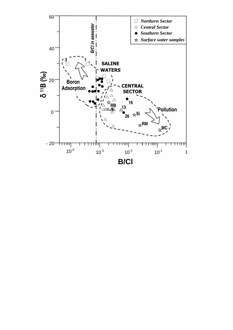
In Figure 6 it is possible to observe differences between samples collected from
different sectors of the study area. Water from the central part of the aquifer
yielded B/Cl ratios of between 1.3 x 10⁻³ and 4.6 x 10⁻³ (0.63 x 10⁻³ in seawater and

18
0.48 x 10⁻³ in freshwater), and values of 11B of between +13 and -9‰, with a clear
trend towards the values measured in the waters of the River Mijares, which is used
for irrigation abstractions in this area. Water from the River Mijares is clearly affected
by point discharges into the Maria Cristina reservoir (B = 4.8 mg/L; 11B = -12 ‰) and,
to a lesser extent, into the Sichar reservoir. The water of the River Mijares (B = 0.23
mg/L; 11B = -8.9 ‰) has to be the principal source of B in this sector, though point
discharges can not be dismissed (since these must have isotope ratios in the same
range). Such point discharges could affect sectors that are not irrigated with water
from the River Mijares, which come from areas around an important industrial
nucleus.
In this central sector the existence of heavy metals (Hg and Cr from discharges
from tanning factories), pesticides and nitrate residues (derived from agricultural
activity), and other pollutants (such as B from ceramic industry effluents) suggest that
the anthropogenic input is significant (Morell and Hernández, 2001).
In terms of the most saline waters, one can observe that samples from the
northern and southern sectors tend to have the highest values of 11B, in the range
+10 and +20 ‰, with a B/Cl ratio more or less similar to seawater, though some
samples yielded lower values, perhaps due to adsorption of B in the sediments.
Under this general scheme, however, some samples from the southern sector
give very high B/Cl ratios (samples 16 and 26). These samples register relatively low
and negative values for 11B (+7.74 ‰ in sample 16 and -0.86 ‰ in the sample 26). The
ceramics industry is not present in this area, nor is there any influence of sulphate
waters that could explain the elevated B/Cl ratio in some of the samples; therefore,
other anthropogenic contributions of B must exist, that are non-marine in origin. This

19
pollution is independent of salinity of the water and may be linked to infiltration of
water containing high B concentrations, with especially intense and localized inputs
coming from industrial wastewater introduced directly into the aquifer. The water
samples were taken from between the towns of Vall d’Uixó and Moncófar, in the
vicinity of the River Belcaire. With the exception of certain days in the year following
strong rains, the flow of this river is almost exclusively derived from wastewater from
Vall d’Uixó (30,000 inhabitants) and disperse discharges from tanning factories. Thus,
highly saline waters are recorded that, in many cases, have an elevated heavy metal
(Hg, Cr, Zn, Cd) and B content. In the area between the towns of Vall d‘Uixó and
Moncófar, where these wells are found, part of the river flow infiltrates the aquifer,
giving rise to intense local pollution (Morell, 1999).
The average B concentration of water in the River Belcaire is 1 to 1.5 mg/L and
the 11B is -3.1 ‰, though it can change depending on the season and type of the
discharge. Judging by the hydrogeochemistry, it is possible to conclude that some parts
of the southern sector of the aquifer are affected by wastewater infiltration from the
River Belcaire, which has a low B isotope ratio that is far below that corresponding to
salinization due to marine intrusion or sulphate water recharge.
Samples 1 and 3 correspond to saline waters from the northern part of the
aquifer and give a 11B of +29 ‰. This is clearly due to the influence of seawater,
though the lower B/Cl ratio suggests the possibility that B adsorption does occur and
that it tends to increase the 11B/10B ratio.
In this context, there may also be participation from adsorption-desorption of B
accompanying the ion exchange linked to the dynamics of the marine intrusion and
other processes of salinization. Nevertheless, the hydrochemical analysis reveals,

20
above all, the importance of the geogenic and anthropogenic pollution and their
relative influence in different parts of the aquifer.
CONCLUSIONS
The general hydrogeochemical study of the aquifer provides good support to
enable the application of the behaviour of some of the minor ions, especially B and its
isotopes, and so helps to discriminate between the different sources of pollution and
the relative importance in each of the three sectors of the aquifer under study.
The B seems to arise from multiple origins, and the study of the behaviour of the
B isotopes has enabled a reliable diagnosis of various types of pollution. In other
words, this element and its isotopes can be considered to be good tracers of the
polluting processes. The B/Cl ion ratio is very useful, as is the 11B/10B isotope ratio,
whose usefulness basically derives from the large differences encountered between
the different water types contributing to the aquifer pollution. The anthropogenic B
content of wastewaters is isotopically very different to naturally-arising B, particularly
in coastal aquifers.
The study undertaken has allowed corroboration of earlier hypotheses based on
the behaviour of major ions, and confirmed the efficacy of using B isotopes to diagnose
complex pollution problems. It has also been confirmed that the three sectors of the
aquifer correspond to areas with different pollution problems. The southern sector
contains the most saline water as a result of saline intrusion and sulphate waters, but
significant pollution also comes from infiltration of water from the River Belcaire, as
identified by a low 11B/10B ion ratio that corresponds to industrial discharges directly
into the watercourse. In the northernmost sector of the aquifer, the groundwater

21
chemistry could be principally associated with marine intrusion, as indicated by the
11B values. Moreover, the participation of B adsorption cannot be dismissed, as is
deduced from the increase in the 11B/10B ratio.
In the central sector – the least-salinized sector of the aquifer – the influence of
the River Mijares is decisive. The river is used for irrigating citrus crops and this is the
cause of high B/Cl ion ratios in borehole water from this sector. The anomaly is also
related to the discharge of untreated industrial wastewater into the watercourse. In
addition, some sampling points, situated away from the area irrigated using river
water, also exhibit elevated B concentrations. In these cases, it seems that the
proximity of the sampling points to significant industrial centres needs to be taken into
account.
In conclusion then, the usefulness of B and its isotopes has been demonstrated
by means of the 11B/10B ratio, in identifying the various pollution sources implicated in
the pollution of this aquifer. It is also concluded that this phenomenon can be
extrapolated to similar situations, where B could be used as a tracer of sources of
pollution.
Acknowledgements. This article was financed by the CICYT (Comisión Interministerial
de Ciencia y Tecnología, Interministerial Commission of Science and Technology)
within the framework of project HID1999-0597-C01-02. The authors are also grateful
to Eduard Hoehn and an anonymous reviewer, for their comments and suggestions on
the manuscript.
REFERENCES
22
AIUPPA A, AVINO R, BRUSCA L, CHIODINI G, D'ALESSANDRO W, FAVARA R, FEDERICO C,
GINEBRA W, INGUAGGIATO S, LONGO N, PECORAINO G, VALENZA M (2006) Mineral
control of arsenic content in thermal waters from volcano-hosted hydrothermal
systems: Insight from island of Ischia and Phlegrean Fields (Campanian Volcanic
Province, Italy) Chemical Geology 229:313-330.
APHA (American Public Health Association), AWWA (American Water Works
Association), WPCF (Water Pollution Control Federation ) (1989) Standard methods
for the examination of Water and Wastewater. American Public Health Association.
Washington.
APPELO CAJ, POSTMA D (2006) Geochemistry, Groundwater and Pollution. AA
Balkema, Rotterdam. 2nd edition.
ARAD A (1988) B, F and Sr as tracers in carbonate aquifers and in karstic geothermal
systems in Israel. IAH (International Association of Hydrogeologists) 21st Congress.
Karst Hydrogeology and Karst Environment Protection. Guilin (China), 1988.
ARAD A, BEIN A (1986) Saline-versus freshwater contribution to the thermal waters of
the northern Jordan Rift Valley, Israel. Journal of Hydrology 83: 49-66.
BARTH S (1993) Boron isotope variations in nature: a synthesis. Int. J. Earth. Sci. 82 (4):
640-651
BARTH S (1997) Boron isotopic analysis of natural fresh and saline waters by negative
thermal ionization mass spectrometry. Chem. Geol. (Isot. Geosci. Sect.) 143: 255-
261.
BARTH S (1998) Application of boron isotopes for tracing sources of anthropogenic
contamination in groundwater. Wat. Res. 32(3): 685-690.
23
BARTH S (2000) Boron isotopic composition of near-surface fluids: a tracer for
identification of natural and anthropogenic contaminant sources. Water, Air and
Soil Pollution 124: 49-60.
BASSETT RL, BUSZKA PM, DAVIDSON GR, CHONGDIAZ D (1995) Identification of
Groundwater Solute Sources Using Boron Isotopic Composition. Environ. Sci.
Technol. 29 (12): 2915-2922.
BENCINI A (1985) Applicabilità del metodo dell’Azometina-H alla determinazione del
boro nelle acque naturali (Application of Azomethine-H method to the
determination of boron in natural waters). Rend. Soc. It. Min. Petr. 40: 311–316.
DAVIDSON GR, BASSET RL (1993) Application of boron isotopes for identifying
contaminants such as fly ash leachate in groundwater. Environ. Sci. Technol. 29(12):
2915-2922.
DOTSIKA E, POUTOUKIS D, MICHELOT JL, KLOPPMANN W (2006) Stable isotope and
chloride, boron study for tracing sources of boron contamination in groundwater:
boron contents in fresh and thermal water in different areas in Greece. Water, air,
and soil pollution 174: 19–32
EISENHUT S, HEUMANN KG (1997) Identification of ground water contamination by
landfills using precise boron isotope ratio measurements with negative thermal
ionization mass spectrometry. Fres. J. Anal. Chem. 359: 375–377.
EISENHUT S, HEUMANN KG, VENGOSH A (1996) Determination of boron isotopic
variations in aquatic systems with negative thermal ionization mass spectrometry as
a tracer of anthropogenic influences. Fres. J. Anal. Chem. 354: 903–909.
24
FAYE S, MALOSZEWSKI P, STICHLER W, TRIMBORN P, FAYE SC, GAYE CB (2005)
Groundwater salinization in the Saloum (Senegal) delta aquifer: minor elements and
isotopic indicators. Science of the Total Environment 343 (2005) 243– 259.
FIDELIBUS MD, GIMÉNEZ E, MORELL I, TULIPANO L (1993) Salinization processes in the
Castellon plain aquifer. In: Custodio, E.; Galofré, A. (Eds.). Study and Modelling of
Salt Water Intrusion into Aquifers. Proc. 12th Saltwater Intrusion Meeting.
Barcelona, 1992: 267-283.
GIMÉNEZ E (1994) Caracterización hidrogeoquímica de los procesos salinización en el
acuífero detrítico costero de la Plana de Castellón. “Hydrogeochemical
characterization of the salinization processes in coastal aquifer of Castellón Plain”.
PhD, University of Granada.
GIMÉNEZ E (2005) Consideraciones sobre la utilidad del boro como trazador
hidrogeoquímico en procesos de salinización (Considerations on the utility of boron
like hydrogeochemical tracer in salinization proceses). Abula 7: 7-20. Universidad
Católica de Ávila.
GIMÉNEZ E, MORELL I (1991) Consideraciones sobre la utilización de iones
minoritarios en la caracterización de la intrusión marina. “Reflections about
utilization of minor ions in the characterization of marine intrusion”. El Agua en
Andalucía, I. Córdoba, 1991: 401-412.
GIMENEZ E, BENCINI A, PRANZINI G (2001) Salinization in coastal plain of Grosseto:
hydrochemical study. Water-Rock Interaction (WRI-2001): 517-520. Balkema,
Rotterdam.
25
GIMÉNEZ E, MORELL I (1992) El boro como indicador de contaminación en la Plana de
Castellón. “Boron as tracer of contamination in Castellón Plain aquifer”.
Hidrogeología y Recursos Hidráulicos XVI: 285-292.
GOLDBERG S (1993) Chemistry and Mineralogy of Boron in Soils. In: Gupta, U.C. (Ed.),
Boron and its Role in Crop Production. CRC Press, Boca Raton, FL: 3–44.
GOLDBERG S, FORSTER HS, HEICK EL (1993) Boron adsorption mechanisms on metal
oxides, clay-minerals, and soils inferred from ionic-strength effects. Soil Sci. Soc.
Am. 57: 704–708.
GONFIANTINI R, PENNISI M (2006) The behaviour of boron isotopes in natural waters
and in water–rock interaction. J. Geochem. Explor. 88: 114–117.
HARDER H (1970) Boron. In: Wedepol K.H. (eds). Handbook of Geochemistry. Chap. 5.
Springer-Verlag.
HOEHN E (1999) Preliminary analysis of boron isotope ratios in leachate-contaminated
groundwater. Integrated Methods in Catchment Hydrology- Tracer, Remote Sensing
and New Hydrometric Techniques. IAHS Publ. Nº 258.
HOGAN JF, BLUM JD (2003) Boron and lithium isotopes as groundwater tracers: a study
at the Fresh Kills Landfill, Staten Island, New York, USA. Appl. Geochem. 18: 615–
627.
HOWARD KWF, LLOYD JW (1983) Major ions characterization of coastal saline ground
waters. Ground Water 21(4): 429-437.
IGME (1984). Actualización de los recursos hidráulicos subterráneos existentes en la
comarca de Sagunto. Comunidad Valenciana. I-II. IGME (Instituto Geológico y
Minero de España, Spanish Geological Survey).

26
IGME (1986). Las aguas en la Comunidad Valenciana. Uso calidad y perspectivas de
utilización (The waters in the Valencian Community. Use, quality and perspectives
of utilization). IGME (Instituto Geológico y Minero de España, Spanish Geological
Survey). Mº Industria y Energía. Colección Informe.
IKEDA K (1989) Chemical evolution of groundwater quality in the southern foot of
Mount Fuji. Bulletin of Geological Survey Japan 40 (7): 331-404.
ITGE (1989-90). Planas de Castellón y Sagunto. Serie Manuales de Utilización de
acuíferos. Dirección de Aguas Subterráneas. ITGE (Instituto Tecnológico y
Geominero de España, Spanish Geological Survey).
KAKIHANA H, KOTAKA M (1977) Equilibrium constants for boron isotope-exchange
reactions. Bull. Res. Laborat. Nucl. React. 2: 1–12.
KAKIHANA H, KOTAKA M, SATOH S, NOMURA M, OKAMOTO M (1977) Fundamental
studies on the ion-exchange separation of boron isotopes. Bull. Chem. Soc. Japan
50: 158–163.
KAKIHANA H, OSSAKA T, OI T, MUSASHI M, OKAMOTO M, NOMURA M, (1987) Boron
isotopic ratios of some hot spring waters in the Kusatsu-Shirane area, Japan.
Geochem. J. 21: 133–137.
KEREN R, MEZUMAN U (1981) Boron adsorption by clay minerals using a
phenomenological equation. Clays and Clay Minerals 29 (3): 198-204.
LEEMAN WP, TONARINI S, PENNISI M, FERRARA G (2005) Boron isotopic variations in
fumarolic condensates and thermal waters from Vulcano Island, Italy: Implications
for evolution of volcanic fluids. Geoch. et Cosmoch. Acta 69(1): 143-163.
27
LEENHOUTS JM, BASSETT RL, MADDOCK T (1998) Utilization of intrinsic boron
Isotopes as Co-Migrating Tracers for Identifying Potential Nitrate Contamination.
Ground Water 36 (2): 240-250.
LLOYD JW, TELLAM JH (1988) Caracterización hidroquímica de las aguas subterráneas
en áreas costeras. “Hydrochemical characterization of groundwater in coastal
areas”. Tecn. Int. Sal. en Acuif. Cost. (TIAC) 1:1-18. Almuñecar (España).
LÓPEZ FJ, GIMÉNEZ E, HERNÁNDEZ F (1993) Analytical study on the determination of
boron in environmental water samples. Fresenius J. Anal. Chem., 346: 984-987
MACPHERSON GL, LAND LS (1989) Boron in saline brines, Gulf of Mexico sedimentary
basin, USA. In: Miles (Ed.). Water-Rock Interaction (WRI-86): 457-460 Balkema,
Rotterdam.
MIRECKI JE, PARKS WS (1994) Leachate Geochemistry at a Municipal Landfill,
Memphis, Tennessee Ground Water 32 (3): 390-398.
MORELL I, PULIDO-BOSCH A, VIRGILIO J, DANIELE L (2005). Geoquímica isotópica del
boro en áreas termales asociadas a vulcanismo activo. Casos de las islas de Ischia
(Italia) y San Miguel (Portugal) (Isotopic geochemistry of boron in thermal areas
associated with the active vulcanism. Cases of Ischia Island (Italy) and San Miguel
(Azores, Portugal). In: Agua, minería y medio ambiente. Ed. IGME (Instituto
Geológico y Minero de España, Spanish Geological Survey). pp:319-341
MORELL I, GIMENEZ E, ESTELLER, MV (1996) Application of the Principal Components
Analysis to the study of salinization n of the Castellón Plain (Spain). The Science of the
Total Environment 177: 161-171.
MORELL I, HERNÁNDEZ F (2001) El agua en Castellón. Un reto para el siglo XXI. “The
water in Castellón. A challenge for the XXIst century”. Jaume I University.

28
MORELL I, TUÑÓN J (2002) Contribución de las actividades agrícolas a la presencia de
sulfatos en los acuíferos costeros. El caso de la Plana de Castellón. En: Los acuíferos
costeros y las desaladoras. “Contribution of the agricultural activities to the
presence of sulfates in the coastal aquifers. The case of Castellón Plain. In: The
coastal aquifers and desalination plants”. Pulido-Bosch, Vallejos & Pulido-Leboeuf
(eds).
MORELL I. (1999). Presencia de metales en el sector meridional del acuífero de la Plana
de Castellón. “Metal presence in the southern sector of Castellón Plain aquifer”.
Technical report. Jaume I University.
MUSASHI M, NOMURA M, OKAMOTO M, OSSAKA T, OI T, KAKIHANA H (1988) Regional
variation in the boron isotopic composition of hot spring waters from central Japan.
Geochem. J. 22: 205–214.
NEGREL P, PETELET-GIRAUD E, KLOPPMANN W, CASANOVA J (2002) Boron isotope
signatures in the coastal groundwaters of French Guiana. Water Resour. Res. 38
(11): 1262
PENNISI M, LEEMAN WP, TONARINI S, PENNISI, A, NABELEK P (2000) Boron, Sr, O, and
H isotope geochemistry of groundwaters from Mt. Etna (Sicily) - Hydrologic
implications. Geoch. Cosmoch. Acta 64 (6): 961–974.
PENNISI M, BIANCHINI G, MUTI A, KLOPPMANN W, GONFIANTINI R (2006). Behaviour
of boron and strontium isotopes in groundwater–aquifer interactions in the Cornia
Plain (Tuscany, Italy). Applied Geochemistry 21:1169–1183.
PENNISI M, GONFIANTINI R, GRASSI S, SQUARCI P (2006a). The utilization of boron and
strontium isotopes for the assessment of boron contamination of the Cecina River
alluvial aquifer (central-western Tuscany, Italy). Applied Geochemistry 21: 643–655
29
RAVENSCROFT P, MCARTHUR JM (2004) Mechanism of regional enrichment of
groundwater by boron: the examples of Bangladesh and Michigan, USA. Applied
Geochemistry 19: 1413–1430.
RAYMOND K, BUTTERWICK L (1992) Perborate. In: de Oude NT (ed.) The Handbook of
Environmental Chemistry, vol 3, part F. Anthropogenic compounds. Springer, Berlin
Heidelberg New York: 288-318
ROSE EP, CHAUSSIDON M, FRANCE-LANORD C (2000) Fractionation of boron isotopes
during erosion processes: The example of Himalayan rivers. Geochim. Cosmochim.
Acta 64: 397–408.
SÁNCHEZ-MARTOS F, PULIDO-BOSCH A (1999) Boron and the origin of salinization in an
aquifer in southeast Spain. C.R. Acad.Sci. Paris. Earth and Planetary Sci. 328: 751-
757.
SCHMASSMANN H, KULLIN M (1990) Halide/Chloride and Boron/Chloride ratios in
deep groundwaters of Northern Switzerland. Memor. of 22nd Congress of IAH, XXII,
Lausanne, 1990: 296-303.
SPIVACK AJ, PALMER MR, EDMONDS JM (1987) The sedimentary cycle of boron
isotopes. Geochim. Cosmochim. Acta 51: 1939-1949.
TELLAM JH, LLOYD JW (1986) Problems in the recognition of seawater intrusion by
chemical means: An example of apparent chemical equivalence. Quarterly Journal
of Engineering Geology 19: 389-398.
TONARINI S, LEEMAN WP, CIVETTA L, D’ANTONIO M, FERRARA G, NECCO A (2004)
B/Nb and 11B systematics in the Phlegrean Volcanic District, Italy. J. of Volcanology
and Geothermal Res. 133: 123-129.

30
TRAVI Y, FAYE A (1990) Concentrations en bore de la "nappe maestrichtienne" du
Sénegal: leur influence sur l'aptitude des eaux a l'irrigation (Concentrations of boron
in the Maestrichtian aquifer of Senegal: its influence in the quality of irrigation
waters). Journal of African Earth Science 11 (3/4): 253-259.
UHLMANN K (1991) The geochemistry of boron in a landfill monitoring program.
Groundwat. Monitoring and Remediation, fall, p.139.
VENGOSH A (1998) The isotopic composition of anthropogenic boron and its potential
impact on the environment: Biological Trace Element Research 66: 145-151.
VENGOSH A, DE LANGE GJ, STARINSHY A (1998) Boron isotope and geochemical
evidence of Urania and Bannock brines in the eastern Mediterranean: effect of
water-rock interactions. Geoch. Cosmoch. Acta 62: 3221-3228.
VENGOSH A, GILL J, DAVIDSON ML, HUDSON GB (2002) A multi-isotope (B, Sr, O, H,
and C) and age dating (3H-3He and 14C) study of groundwater from Salinas Valley,
California: hydrochemistry, dynamics, and contamination processes. Water Resour.
Res. 38: 1–17.
VENGOSH A, KLOPPMANN W, MAREI A, LIVSHITZ Y, GUTIERREZ A, BANNA M, GUERROT
C, PANKRATOV I, RAANAN H (2005) Sources of salinity and boron in the Gaza strip:
natural contamination flow in the southern Mediterranean coastal aquifer. Water
Resour. Res. 41, W01013.
VENGOSH A, SPIVACK AJ, ARTZI Y, AYALON A (1999) Geochemical and boron,
strontium, and oxygen isotopic constraints on the origin of the salinity in
groundwater from the Mediterranean coast of Israel. Water Resour. Res. 35(6):
1877-1894VENGOSH A, STARINSKY A, KOLODNY Y, CHIVAS AR, RAAB M (1992)
31
Boron Isotope Variations During Fractional Evaporation of Sea-Water - New
Constraints on the Marine vs Nonmarine Debate. Geology, 20 (9): 799-802.
VENGOSH A, STARINSKY A, CHIVAS AR (1994) Boron isotopes in Heletz-Kokhav oilfield
brines, the Coastal Plain, Israel. Isr. J. Earth Sci., 43: 231-237.
VENGOSH A, KOLODNY Y, STARINSKY A, CHIVAS AR, McCULLOCH MT (1991).
Coprecipitation and isotopic fractionation of boron in modern biogenic carbonates.
Geochimica et Cosmochimica Acta 55: 2901-2910.
WAGGOTT A (1969) An investigation of the potential problem of increasing boron
concentrations in rivers and water courses. Water Research, 3: 749-765.
XIAO YK, ZHANG CG (1992) High precision isotopic measurement of chlorine by
thermal ionization mass spectrometry of the Cs2Cl+ ion. Int. J. Mass Spectrom. Ion
Process. 116: 183-192.
32
FIGURE CAPTIONS/TITLES
Figure 1. Location of the study area and geological map of the Castellón Plain and its
surroundings (Morell et al., 1998). Legend: 1: Plioquaternary; 2: Tertiary; 3:
Cretaceous; 4: Jurassic; 5: Triassic:. One can see the spatial distribution of
samples taken from the aquifer (Northern, Central and Southern sectors). RB:
River Belcaire; RM: River Mijares; MC: Maria Cristina reservoir; Si: Sichar
reservoir. The piezometric surface for 1998 is also shown, along with the main
flow paths (white arrows).
Figure 2. General hydrogeological cross section. Tb - Triassic Buntsandstein Facies; Tm
– Triassic Muschelkalk Facies; PQ – Plioquaternary; M - Miocene. The water
balance components are also represented: rainwater infiltration (85x 106
m3/year ), irrigation return water (45 x 106 m3/year), transfers from neighbouring
units (90 x 106 m3/year), pumped abstractions (165 x 106 m3/year), coastal
springs and wetlands (16 x 106 m3/year) and submarine discharges (39 x 106
m3/year).
Figure 3. Piper diagram showing fractional ion concentrations of the groundwater
sampled in different areas.
Figure 4. Trends of Na+ K deficits and Ca excesses related to the groundwaters of
the Castellón Plain. For each sector, data are ranked according to increasing
chloride concentrations. -ions in meq/L.
Figure 5. Relationship between electrical conductivity ( S.cm-1) and B/Cl ratio (in
mmolL-1) . The dashed line represent sea water-fresh water mixing.

33
Figure 6. Relationship between 11B (‰) and B/Cl ratio (in mmolL-1). RB: River
Belcaire; RM: River Mijares; MC: Maria Cristina reservoir; Si: Sichar reservoir.
34
Table 1. Analytical techniques used for determining the physico-chemical parameters and precision of the methods.
Ion Analytical Technique Method precision
Chloride (Cl-) Spectrophotometry (480 nm) 0.65% RSD
Alkalinity (HCO3- + CO32-
) Volumetry
Sulphate (SO42-
) Spectrophotometry (460 nm) 0.75% RSD
Nitrate (NO3-) Spectrophotometry (540 nm) 0.3% RSD
Ca2+
, Mg2+
, Na+, Sr
2+ Atomic Absorption Spectrometry < 1% RSD
K+ Flame Photometry (Emission) < 1% RSD
B3+
Spectrophotometry (410 nm) - Azomethine H < 2% RSD
Electrical Conductivity Conductimetry
pH Potentiometry
RSD: Relative Standard Deviation

35
Table 2. Analyses data
Sample location
Electrical Conductivity
Cl-
SO42-
NO3-
HCO3-
Na+ K
+ Ca
2+ Mg
2+ B
3+
11B
(n) S.cm-1
mgL-1
mgL-1
mgL-1
mgL-1
mgL-1
mgL-1
mgL-1
mgL-1
mgL-1
(‰)
SW 53000 21333.02 2921.76 0.00 132.37 11754.61 454.74 447.80 1736.37 4.60 40.00
FW 662 68.64 127.20 0.44 81.55 23.23 3.51 51.40 25.01 0.01 12.00
MC 1023 128.46 255.96 87.52 121.01 196.00 12.70 77.00 47.33 4.78 -11.99
Si 510 60.63 276.52 80.23 108.71 21.00 2.40 101.79 54.16 0.30 -2.43
RM 790 30.30 230.32 96.16 114.01 30.00 1.90 106.54 51.93 0.23 -8.90
1 2190 661.72 201.71 27.05 199.01 268.08 6.38 176.91 74.75 0.08 29.59
3 1890 508.36 97.05 13.77 148.82 239.29 5.54 86.51 61.28 0.01 29.78
5 1122 224.41 206.87 10.93 130.00 94.56 3.83 86.87 50.74 0.10 21.99
6 1412 353.85 197.71 8.74 186.46 160.13 5.06 121.77 51.77 0.09 20.64
7 1828 452.98 420.09 1.39 199.01 281.94 10.46 122.71 62.39 0.28 18.79
8 1008 122.35 152.20 30.55 307.49 58.48 6.88 123.50 39.82 0.12 7.35
9 937 95.48 177.00 2.03 233.63 36.22 2.30 104.66 36.90 0.08 -0.43
11 1284 170.33 289.03 31.09 267.79 60.76 3.30 150.69 71.14 0.09 9.08
12 776 80.00 114.96 5.15 225.94 34.94 2.52 83.84 33.72 0.06 13.46
13 870 116.93 179.41 2.21 240.11 48.50 7.57 109.62 35.73 0.20 0.86
14 760 73.90 163.43 0.64 175.75 36.19 2.57 91.74 31.41 0.04 -5.12
15 733 108.14 172.43 0.42 175.75 44.89 2.53 91.22 34.52 0.04 3.86
16 1412 312.43 222.67 3.99 217.83 156.14 8.18 120.30 49.08 0.85 7.74
30 1388 152.38 348.44 24.72 232.21 44.75 2.23 157.79 78.22 0.12 10.01
31 1363 174.77 302.18 29.89 242.78 40.67 4.04 155.31 85.65 0.11 1.28
32 720 78.68 152.32 1.02 167.75 31.50 2.49 86.34 24.81 0.07 -9.29
17 1765 362.75 433.68 30.89 205.28 85.84 5.49 185.71 136.90 0.10 12.60
18 2310 632.45 586.58 30.98 186.46 114.46 2.90 318.14 164.35 0.13 12.60
19 1990 552.95 419.52 30.64 236.65 109.77 6.98 276.65 116.96 0.15 7.28
20 1827 490.92 298.09 30.51 155.10 115.72 4.26 173.43 116.74 0.18 20.40
21 2400 697.93 438.90 30.70 142.55 140.55 9.59 298.02 125.81 0.21 20.46
22 3120 929.39 796.90 29.57 224.10 273.12 13.44 416.65 147.68 0.35 15.60
23 1707 436.68 244.06 29.71 155.10 75.63 4.48 181.99 104.28 0.13 16.44
24 1399 325.42 223.17 29.99 148.82 72.00 2.76 147.86 89.29 0.12 18.65
25 2090 631.07 283.80 30.44 161.37 176.35 5.22 223.83 110.95 0.17 19.64
26 1598 380.92 125.07 19.90 136.28 191.12 20.96 54.43 47.06 0.79 -0.86
27 3060 1012.82 377.95 30.58 98.64 266.40 7.34 318.14 187.28 0.18 6.04
28 2710 813.66 252.04 20.16 142.55 104.48 3.25 366.77 159.01 0.11 12.59
29 2420 757.60 303.54 30.71 167.64 89.46 2.60 304.94 164.80 0.13 15.38
33 2450 690.81 211.20 244.90 257.20 140.31 5.43 314.52 119.13 0.12 12.40
34 2500 635.05 291.99 303.04 318.20 122.26 5.09 340.10 134.13 0.13 4.90
35 3350 1064.00 574.13 257.70 355.84 311.99 6.60 398.41 207.72 0.15 6.20
SW: seawater; FW: freshwater; MC: Maria Cristina reservoir; Si: Sichar reservoir; RM: River Mijares; n: sample number.
No
rth
ern
S
ecto
r C
en
tra
l
Se
cto
r S
ou
the
rn
Se
cto
r
7
MEDITERRANEAN SEA
3
8
11
12
13
14 28
35 27
23
BENICASIM
VALL D'UIXÒ
River Belcaire (RB)
50
10
20
32 31
17
30 16
22
26
24
VALL D’UIXÓ
ESPADÁN RANGE
RIBESALBES-ONDA BASIN
DESERT OF LAS PALMAS
1
3 4
5
2
Fault
MEDITERRANEAN
SEA
Castellón
Plain
SPAIN
FRANCE
PO
RTU
GA
L
Madrid
9
29
15
21 20
33 -2
MONCÓFAR 25
River Mijares (RM)
MC
RB
4 km 2 0
19
Central Sector
Northern Sector
Southern Sector
Maria Cristina reservoir (MC)
Si
Sichar reservoir
(Si)
Groundwater samples Northern Area
Groundwater samples Central Area
Groundwater samples Southern Area
Surface water samples
1BENICASIM
34
18
5
6
RM
6 2
4(FW)
CASTELLÓN

MEDITERRANEAN
SEA 0 5 km
Tb
Tm
M
0
100
200 m
Seawater
intrusion
90 x106 m3/year
85 x106 m3/year 165 x106 m3/year
16 x106 m3/year
39 x106 m3/year Aquitard
PQ
45 x106 m3/year
Sea level
Piezometric surface of water table
←
Ca 2+ Cl - + NO 3 - →
Northern Sector
Central Sector
Southern Sector

- 20
- 10
0
10
20
30
Cen
tral
Sec
tor
Sout
hern
Sec
tor
(c)
(a)
(a)
(a)
(c)
(c)
(b) (b)
(b)
(a) Cl - (in meq/L)
(b) ∆∆∆∆ Ca 2+ (in meq/L)
(c) ∆∆∆∆ Na + + ∆∆∆∆ K + (in meq/L)
Nor
ther
n Se
ctor
[Cl] [Cl] [Cl]

0 2000 4000 6000
0
2.10-3
4.10-3
6.10-3
8.10-3
10-2
16
26
Electrical Conductivity µµµµ S cm-1
B/C
l
Northern Sector
Central Sector
Southern Sector
seawater
13
SALINE
WATERS
CENTRAL
SECTOR
- 20
10-4 10-3 10-2 10-1 1
0
20
40
60
δ δ δ δ 11
B (
‰)
9
MC RM
Si
RB
B/Cl
Northern Sector Central Sector Southern Sector
26
16 13
B/C
l in
seaw
ate
r
1 3
Boron
SALINE WATERS
SECTOR CENTRAL
Pollution
Surface water samples
Adsorption
Copyright © 2022 FDOKUMEN