CONTINUOUSLY AVAILABLE BATTLEFIELD SURVEILLANCE
113
CONTINUOUSLY AVAILABLE BATTLEFIELD SURVEILLANCE Major James P. Lake. Ph.D., USAF April 2007 Blue Horizons Paper Center for Strategy and Technology Air War College
-
Upload
khangminh22 -
Category
Documents
-
view
1 -
download
0
Transcript of CONTINUOUSLY AVAILABLE BATTLEFIELD SURVEILLANCE
CONTINUOUSLY AVAILABLE BATTLEFIELD SURVEILLANCE
Major James P. Lake. Ph.D., USAF April 2007
Blue Horizons Paper Center for Strategy and Technology Air War College
Report Documentation Page Form ApprovedOMB No. 0704-0188
Public reporting burden for the collection of information is estimated to average 1 hour per response, including the time for reviewing instructions, searching existing data sources, gathering andmaintaining the data needed, and completing and reviewing the collection of information. Send comments regarding this burden estimate or any other aspect of this collection of information,including suggestions for reducing this burden, to Washington Headquarters Services, Directorate for Information Operations and Reports, 1215 Jefferson Davis Highway, Suite 1204, ArlingtonVA 22202-4302. Respondents should be aware that notwithstanding any other provision of law, no person shall be subject to a penalty for failing to comply with a collection of information if itdoes not display a currently valid OMB control number.
1. REPORT DATE APR 2007 2. REPORT TYPE
3. DATES COVERED 00-00-2007 to 00-00-2007
4. TITLE AND SUBTITLE Continuously Available Battlefield Surveillance
5a. CONTRACT NUMBER
5b. GRANT NUMBER
5c. PROGRAM ELEMENT NUMBER
6. AUTHOR(S) 5d. PROJECT NUMBER
5e. TASK NUMBER
5f. WORK UNIT NUMBER
7. PERFORMING ORGANIZATION NAME(S) AND ADDRESS(ES) Air University,Air War College,Center for Strategy andTechnology,Maxwell AFB,AL,36112
8. PERFORMING ORGANIZATIONREPORT NUMBER
9. SPONSORING/MONITORING AGENCY NAME(S) AND ADDRESS(ES) 10. SPONSOR/MONITOR’S ACRONYM(S)
11. SPONSOR/MONITOR’S REPORT NUMBER(S)
12. DISTRIBUTION/AVAILABILITY STATEMENT Approved for public release; distribution unlimited
13. SUPPLEMENTARY NOTES
14. ABSTRACT see report
15. SUBJECT TERMS
16. SECURITY CLASSIFICATION OF: 17. LIMITATION OF ABSTRACT Same as
Report (SAR)
18. NUMBEROF PAGES
112
19a. NAME OFRESPONSIBLE PERSON
a. REPORT unclassified
b. ABSTRACT unclassified
c. THIS PAGE unclassified
Standard Form 298 (Rev. 8-98) Prescribed by ANSI Std Z39-18

- ii -
Disclaimer
The views expressed in this academic research paper are those of the author(s) and do not
reflect the official policy or position of the US government or the Department of Defense. In
accordance with Air Force Instruction 51-303, it is not copyrighted, but is the property of the
United States government. All illustrations are the work of the author.
- iii -
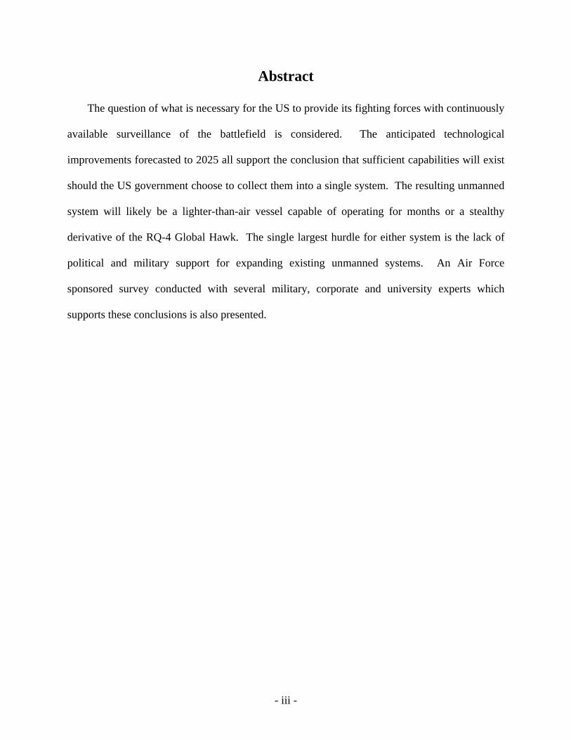
Abstract
The question of what is necessary for the US to provide its fighting forces with continuously
available surveillance of the battlefield is considered. The anticipated technological
improvements forecasted to 2025 all support the conclusion that sufficient capabilities will exist
should the US government choose to collect them into a single system. The resulting unmanned
system will likely be a lighter-than-air vessel capable of operating for months or a stealthy
derivative of the RQ-4 Global Hawk. The single largest hurdle for either system is the lack of
political and military support for expanding existing unmanned systems. An Air Force
sponsored survey conducted with several military, corporate and university experts which
supports these conclusions is also presented.
- iv -
Table of Contents: Disclaimer ....................................................................................................................................... ii Abstract .......................................................................................................................................... iii List of Figures ............................................................................................................................... vi List of Tables ............................................................................................................................... vii Acronyms .................................................................................................................................... viii CONTINUOUSLY AVAILABLE BATTLEFIELD SURVEILLANCE ...................................... 1
The Thesis of this Report: ........................................................................................................... 1 The Future of Intelligence, Surveillance and Reconnaissance ....................................................... 3
Introduction ................................................................................................................................. 3 Specific Operational Priorities for ISR and Communications .................................................... 3 The Advantage of Near Space .................................................................................................... 6 Technological Advances in Aircraft Design: Lighter-Than-Air Ships ....................................... 8 Technological Advances in Aircraft Design: High Altitude UAVs ......................................... 15 Technological Advances in Aircraft Design: Morphing Wings ............................................... 20 Employment of Weapons in to a Continuous Surveillance Asset ............................................ 20 Technological Advances in Solar Cell Technology .................................................................. 21 Technological Advances in Fuel Cell Technology ................................................................... 23 Technological Advances in ISR and Communications: Traditional Radar Systems ................ 23 Technological Advances in ISR and Communications: Conformal Sensors............................ 25 Summary of Future Developments to be Exploited: ................................................................. 27
Conclusions ................................................................................................................................... 29 APPENDIX A: SURVEY RESPONSES ..................................................................................... 32
SURVEY: Top 3 Enabling Technologies ................................................................................. 32 SURVEY: Level of Autonomy ................................................................................................. 33 SURVEY: Likely Targets ......................................................................................................... 34 SURVEY: Reason to Invest in UAVs ...................................................................................... 35 SURVEY: UAV Roles .............................................................................................................. 36 SURVEY: UAV Missions ........................................................................................................ 37 SURVEY: Supporting UAV Development .............................................................................. 38 SURVEY: Government Policy ................................................................................................. 39
APPENDIX B: THE PAST .......................................................................................................... 41 Surface-To-Air Missile Systems ............................................................................................... 41 Survivability in the SAM Environment .................................................................................... 44 Survivability and Surveillance Aircraft Design ........................................................................ 47 Unmanned Surveillance Aircraft Used in Recent US Conflicts ............................................... 48 Shortcomings of Unmanned Surveillance in Recent US Conflicts .......................................... 51 Summary of Past Lessons Learned: .......................................................................................... 53
APPENDIX C: THE PRESENT ................................................................................................... 54 Proliferation of the SAM Threat ............................................................................................... 54 Current Surveillance Aircraft .................................................................................................... 55 The Usefulness of ISR in the War on Terror ............................................................................ 58 High Demand, Low Density Assets .......................................................................................... 59 The Inefficiency of Space ......................................................................................................... 60 Summary of Present Lessons Learned: ..................................................................................... 62
APPENDIX D: LIMITATIONS AND SURVIVABILITY OF LTA’S ....................................... 63
- v -
Technological Advances in Aircraft Design: Balloons ............................................................ 63 LTA Limitations ....................................................................................................................... 64 LTA Survivability ..................................................................................................................... 64
APPENDIX E: ENABLING NET-CENTRIC OPERATIONS .................................................... 66 Technological Advances in ISR and Communications: Radio Relay ...................................... 66 Technological Advances in Data Integration and Management ............................................... 66 Technological Advances in ISR and Communications: Data Links ......................................... 69
APPENDIX F: GEOGRAPHIC USES FOR CONTINUOUS SURVEILLANCE ...................... 73 Geographic Uses for Continuous Surveillance ......................................................................... 73 Geographic Uses for Continuous Surveillance: Afghanistan ................................................... 76 Geographic Uses for Continuous Surveillance: Iran ................................................................ 77 Geographic Uses for Continuous Surveillance: Iraq ................................................................ 79 Geographic Uses for Continuous Surveillance: People’s Republic of China ........................... 80 Geographic Uses for Continuous Surveillance: Democratic People’s Republic of Korea ....... 82 Geographic Uses for Continuous Surveillance: Triborder Area of South America ................. 84
NOTES: ........................................................................................................................................ 94
- vi -
List of Figures
Figure 1. The Expanding Challenges for the US Military (adapted from the QDR Report) .......... 5 Figure 2. Comparison of Proposed Low and High Altitude Airships........................................... 11 Figure 3. Comparison of Cost and Endurance for LTA Designs .................................................. 13 Figure 4. Endurance Trends for Manned and Unmanned Aircraft ............................................... 15 Figure 5. Solar Cell Trends for Past 30 Years and Extrapolation to 2020 .................................... 22 Figure 6. Evolutionary Forecast of Radar Technology ................................................................. 26 Figure 7. Survey Response for Top 3 Enabling Technologies for UAVs in 2025 ....................... 32 Figure 8. The level of Autonomy Expected for UAVs in 2025 .................................................... 33 Figure 9. Most Likely Targets for UAVs to Monitor or Neutralize in the Year 2025 ................. 34 Figure 10. Best Reason to Invest in UAVs Instead of Manned Aircraft ...................................... 36 Figure 11. The Role UAVs Will be Best Suited for in 2025 ........................................................ 37 Figure 12. UAV Mission Most in Demand From Government Users in 2025 ............................. 38 Figure 13. The Best Method for the US Government to Sponsor Future UAV Technologies ..... 39 Figure 14. Surface-to-Air Missile System Capabilities ................................................................ 43 Figure 15. Maximum Aircraft Altitude Compared to Russian SAM capabilities ........................ 44 Figure 16. The Adversarial Kill Chain ......................................................................................... 45 Figure 17. Comparison of Endurance and Cost for Surveillance Aircraft (U-2 cost classified) .. 57 Figure 18. Moore's Law: The Exponential Growth of Computing (adapted from Kurzweil) ...... 70 Figure 19. Computer and Communications Technology will Shorten OODA Loop ................... 71 Figure 20. Different Priorities for Future of AF Support of War on Terror ................................. 74 Figure 21. Coverage of Afghanistan from a Single Near Space Location .................................... 76 Figure 22. Coverage of Iran from Four Different Near Space Locations ..................................... 78 Figure 23. Coverage of Iraq by a Near Space Asset ..................................................................... 79 Figure 24. Coverage of the People’s Republic of China from Four Near Space Locations ......... 81 Figure 25. Coverage of North Korea by a Near Space Asset ....................................................... 83 Figure 26. Coverage of South-American Triborder Area by Near Space Asset ........................... 84
- vii -
List of Tables
Table 1. Advantages and Limitations of Near Space LTA Operations .......................................... 7 Table 2. Critical Technology Advancements for LTAs for 2010-2020 ........................................ 10 Table 3. Military High Altitude Airship Issues (adapted from Rand Study #TR-234) ................ 14 Table 4. Two Possible Design Paths for Long Endurance UAVs and UCAVs ............................ 17 Table 5. Low Observable UCAVs Currently In Development (3 are European Designs) ........... 18 Table 6. Listing of Potentially Beneficial Technologies .............................................................. 19 Table 7. Summary of Russian Surface-To-Air Missile Systems (SAMs) .................................... 42 Table 8. US Aircraft Design Features to Defeat Kill Chain ......................................................... 46 Table 9. Proliferation of Russian SAM Systems as of 1989......................................................... 54 Table 10. Unmanned ISR System Capabilities ............................................................................. 55 Table 11. Manned ISR System Capabilities ................................................................................. 56 Table 12. Enablers for Persistent Connectivity and Surveillance in 2020 .................................... 68 Table 13. The Shift from Reconnaissance to Persistence (Pendall, US Army) ............................ 73

- viii -
Acronyms Above Ground Level (AGL) Active Electronically Scanned Array (AESA) Advanced Concept Technology Demonstration (ACTD) Advanced Synthetic Aperture Radar Type 23 (ASARS-23) Air Force Research Laboratory (AFRL) Air Force Space Command (AFSPC) Area of Operations (AO) Area of Responsibility (AOR) Artificial Intelligence (AI) Battle Damage Assessment (BDA) Close Air Support (CAS) Combatant Commander (CCDR) Combined Air Operations Center (CAOC) Command, Control, Communication, Computers, Intelligence, Surveillance and Reconnaissance (C4ISR) Common Data Link (CDL) Common Operational Picture (COP) Communications Intelligence (COMINT) Concept of Operations (CONOPS) Counter-insurgency (COIN) Defense Advance Research Projects Agency (DARPA) Demilitarized Zone (DMZ) Democratic People’s Republic of Korea (DPRK) Department of Homeland Security (DHS) Effects Based Operations (EBO) Electronic Attack (EA) Electronic Intelligence (ELINT) Electronic Warfare (EW) Electro-Optical/Infrared (EO/IR) European Aeronautic Defence and Space Company (EADS) European Space Agency (ESA) Federal Aviation Administration (FAA) Focus Long-Term Challenges (FLTCs) Foreign Internal Defense (FID) Forward Air Controller (Airborne) (FAC[A]) Full motion video (FMV) Global Information Grid (GIG) Global Persistent Attack (GPA) Global Positioning System (GPS) Ground Moving Target Indicator (GMTI) High Altitude, Long Loiter (HALL) High Altitude Airship (HAA) Information Technology (IT) Infrared (IR) Integrated Air Defense System (IADS)
- ix -
Integrated Defense Electronic Countermeasures (IDECM) Integrated Sensor is Structure (ISIS) Intelligence, Surveillance and Reconnaissance (ISR) Integrated High Performance Turbine Engine Technologies (IHPTET) International Atomic Energy Agency (IAEA) International Civil Aviation Organization (ICAO) Joint Broadcasting System (JBS) Joint Surveillance and Target Attack Radar System (J-STARS) Joint Warfighting Space (JWS) Laser Infrared Counter Measure (LAIRCM) Lighter Than Air ships (LTAs) Live Fire Test and Evaluation (LFT&E) Liaison Optique Laser Aéroportée (LOLA) Low-Earth Orbiting (LEO) Man portable air defense systems (MANPADS) Missile Defense Agency (MDA) Moving target indicator (MTI) Multi-Mission Aircraft (MMA) Multi-Platform Radar Technology Insertion Program (MP-RTIP) Network-Centric Collaborative Targeting (NCCT) Object-Orient-Decision-Action (OODA) Operation Allied Force (OAF) Operation Enduring Freedom (OEF) Operation Iraqi Freedom (OIF) Operational Test and Evaluation (OT&E) People’s Liberation Army (PLA) Persistent Surveillance and Dissemination System of Systems (PSDS2) Persistent Unmanned Maritime Airborne Surveillance (PUMAS) Personal Digital Assistants (PDAs) Quadrennial Defense Review Report (QDR) Radar cross section (RCS) Radio Frequency Countermeasure (RFCM) Remotely Operated Video Enhanced Receiver (ROVER) Semi Active Homing Radar (SAHR) Semiconductor Intersatellite Link Experiment (SILEX) Short Range Ballistic Missile (SRBM) Small Diameter Bomb (SDB) Space Based Radar (SBR) Surface-to-Air Missile (SAM) Suppression of Enemy Air Defense (SEAD) Synthetic Aperture Radar (SAR) Technology Readiness Level (TRL) Time-sensitive-targets (TSTs) Thrust Specific Fuel Consumption (TSFC) Transformational Satellite Communications System (TSAT) Unmanned Aerial System (UAS)

- x -
Unmanned Aerial Vehicle (UAV) Unmanned Combat Aerial Vehicles (UCAV) US Joint Forces Command (USJFCOM) US Strategic Command (USSTRATCOM) Versatile Affordable Advanced Technology Engines (VAATE) Weapons of Mass Destruction (WMD)
p. 1
CONTINUOUSLY AVAILABLE BATTLEFIELD
SURVEILLANCE
“As commanders rely on more sophisticated and integrated ISR support, the [Strategic] command must supply unprecedented situational awareness for
battlefield dominance.” – James O. Ellis, Jr. Admiral, USN (Ret.)1
The Thesis of this Report:
What obstacles must be overcome to develop and field an Unmanned Aerial Vehicle
(UAV) / Unmanned Aerial System (UAS) with multi-day endurance and all-weather sensors and
weapons that can be controlled at the tactical level of combat? The first hurdle in the acquisition
of any new system is justification. Why do we need it? This question is answered in Appendix
B (The Past) of this document which provides evidence of surveillance aircraft successes and
limitations. Current defense systems and aircraft attributes that increase their survivability are
also discussed. The second hurdle for developing a new system is the mission. Can’t what we
already have do that? Examination of present US surveillance assets and the growing demand
for their capabilities reveals an expanding battlefield surveillance deficit. This problem along
with the inefficiency of space surveillance is discussed in Appendix C (The Present). The last
hurdle is the uncertainty of the future. Will the technology provide an advantage worthy of its
cost? This paper discusses the current and developing technologies that can be integrated into a
survivable and enduring surveillance and strike asset. Technological advances before 2020 are
emphasized due to the already long government procurement process which can take decades to
evolve a new system from concept to fully operational. Further evidence supporting the rising
need for these systems is given with examples of geographic coverage of specific nations. In

p. 2
summary, an aerial surveillance and strike asset capable of multi-day persistence is required to
enhance current and future warfighter effectiveness.
p. 3
The Future of Intelligence, Surveillance and Reconnaissance
“Timely and accurate information has become a decisive advantage in the shadowy global war on terrorism” – Admiral James. O. Ellis, Jr. USN (First
Commander of U.S. Strategic Command) Introduction
This paper provides a review of progressing technology which will support future
military reconnaissance operations. In particular, near space aircraft and lighter than air vehicles
are discussed. The reader is encouraged to first read Appendix B (page 41) which details the
past operating environment and threats to surveillance aircraft. Appendix C (page 54) is also
valuable in that present surveillance conditions are detailed which impact future designs. This
paper will draw upon the conclusions presented in Appendices B and C.
Specific Operational Priorities for ISR and Communications
The 2006 QDR states: “The ability of the future force to establish an unblinking eye over
the battle-space through persistent surveillance will be key to conducting effective joint
operations.”2 The QDR goes on to state that this new capability will be integrated with
operations all the way down to the tactical level of war.3 These new systems must allow the
warfighter to compete in the four defined priority areas of “defeating terrorist networks,
defending the homeland in depth, shaping the choices of countries at strategic crossroads, and
preventing hostile states and non-state actors from acquiring or using WMD.”4 As casualties
mounted in Iraq of Oct 2006, the Pentagon re-emphasized the need for relevant research and
development into new systems which could provide battlespace awareness and the ability to spot
threats to ground forces early.5
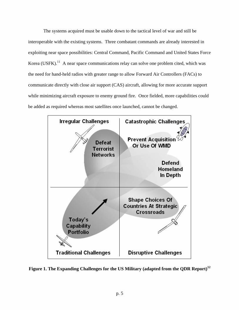
To accomplish these goals, the QDR expands the challenges of US military forces from
traditional warfare to now include irregular, catastrophic and disruptive challenges. As seen in
p. 4
Figure 1, these new challenges enlarge upon the current mindset of military operations. The
irregular challenge of defeating terrorist networks may be supported with current RQ-4 Global
Hawk and RC-135 Rivet Joint aircraft. The catastrophic challenge of preventing acquisition or
spread of Weapons of Mass Destruction (WMDs) and defending the homeland in depth requires
much longer persistence so an unmanned near space airship is an ideal choice. The disruptive
challenge of shaping choices of possible hostile countries requires persistence, stealth and
possibly weapons so a low-observable, long-endurance UAV is required.
The agency responsible for developing the use of the near space environment is Air Force
Space Command (AFSPC).6 Since the near space regime is defined as altitudes between 65,000
and 325,000 feet, AFSPC was the logical choice. Interest in taking advantage of these extreme
altitudes arose after combatant commanders (CCDRs) gave feedback that capabilities associated
with space need to be more responsive and tailorable to the needs of the warfighter.7 Once
developed, the responsibility for coordinating these capabilities for the regional CCDRs would
fall on US Strategic Command (USSTRATCOM).8 USSTRATCOM also is the chief advocate
for net-centricity, which requires an asset capable of providing high-bandwidth communications
across the battlefield.
The battlefield communications requirement of high-bandwidth networks will continue to
grow. This is a catalytic result of the transformation of older forces and systems into the new
net-centric force envisioned by the Secretary of Defense.9 The demand for secure
communications is currently being met by government and civilian satellites, but as demand
grows not even these systems will be able to keep up. One study has shown that airborne
communication resources can reduce satellite communications by more than one third, making
near space systems worth investigating.10
p. 5
The systems acquired must be usable down to the tactical level of war and still be
interoperable with the existing systems. Three combatant commands are already interested in
exploiting near space possibilities: Central Command, Pacific Command and United States Force
Korea (USFK).11 A near space communications relay can solve one problem cited, which was
the need for hand-held radios with greater range to allow Forward Air Controllers (FACs) to
communicate directly with close air support (CAS) aircraft, allowing for more accurate support
while minimizing aircraft exposure to enemy ground fire. Once fielded, more capabilities could
be added as required whereas most satellites once launched, cannot be changed.
Figure 1. The Expanding Challenges for the US Military (adapted from the QDR Report)12
p. 6
To determine which potential technologies are best suited for development for the
warfighter, U.S. Joint Forces Command (USJFCOM) created Project Alpha. Part of the Joint
Experimentation Directorate (J9), Project Alpha is examining balloons, high altitude UAVs and
hybrid lighter than air (LTA) systems. With long sortie times in support of the QDR’s
transformation program, all of these systems are being grouped together under the High Altitude,
Long Loiter (HALL) program. The goal of HALL is to provide “stay and stare” capabilities over
the battlefield with continuous ISR support.13
The Advantage of Near Space
“We must determine what capabilities we can use in near space to improve the situational awareness of joint force commanders and leverage space power for all commanders in the field.” – Gen. John Jumper, USAF Chief of Staff, 5 Oct 200414
By definition effects-based-operations (EBO) are focused on achieving desired effects
instead of using specific systems or forces. This concept is also applicable to the sources that
warfighters can draw on to achieve those effects – ask not for a system, but for a system that can
achieve your mission. Placing assets in near space (65,000 to 325,000 ft) for extended durations
can provide warfighters at the tactical level of combat with round-the-clock capabilities.
Another positive attribute of this altitude band is the lack of other aircraft. FAA Order 7610.4
requires UAVs operating in the vicinity of other aircraft to provide “an equivalent level of safety,
comparable to see-and-avoid requirements for manned aircraft.”15 Flight operations at high
altitude will minimize the time where see-and-avoid concerns are a concern to other manned
aircraft. The great coverage while operating at these extreme altitudes is detailed for specific
locations in Appendix F (page 73).
p. 7
Achieving continuously available surveillance is the goal of the recently formed Joint
Warfighting Space (JWS) initiative.16 The JWS budget for 2006 is $10.4M, much of which may
go to near space programs.17 One potential candidate capability is near space ISR imaging,
which will provide much better images than satellites since they will be 20 times closer to the
battlefield.18 Communications payloads will allow information to reach pilots earlier in the kill
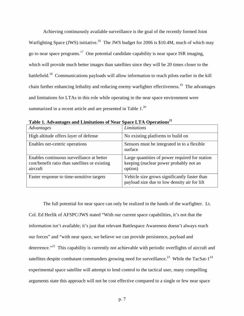
chain further enhancing lethality and reducing enemy warfighter effectiveness.19 The advantages
and limitations for LTAs in this role while operating in the near space environment were
summarized in a recent article and are presented in Table 1.20
Table 1. Advantages and Limitations of Near Space LTA Operations21 Advantages Limitations
High altitude offers layer of defense No existing platforms to build on
Enables net-centric operations Sensors must be integrated in to a flexible surface
Enables continuous surveillance at better cost/benefit ratio than satellites or existing aircraft
Large quantities of power required for station keeping (nuclear power probably not an option)
Faster response to time-sensitive targets Vehicle size grows significantly faster than payload size due to low density air for lift
The full potential for near space can only be realized in the hands of the warfighter. Lt.
Col. Ed Herlik of AFSPC/JWS stated “With our current space capabilities, it’s not that the
information isn’t available; it’s just that relevant Battlespace Awareness doesn’t always reach
our forces” and “with near space, we believe we can provide persistence, payload and
deterrence.”22 This capability is currently not achievable with periodic overflights of aircraft and
satellites despite combatant commanders growing need for surveillance.23 While the TacSat-124
experimental space satellite will attempt to lend control to the tactical user, many compelling
arguments state this approach will not be cost effective compared to a single or few near space
p. 8
assets.25 Former USAF Chief of Staff Gen. John Jumper wants to change the military focus to
exploit near space, but recognizes it will be an uphill battle: “You never go to an air show to
watch a balloon performance. They don’t put on a very good show and it’s just not very cool.”26
To effect this change, a significant rethinking of military operations and doctrine is necessary.
Technological Advances in Aircraft Design: Lighter-Than-Air Ships
“With near space, we believe we can provide persistence, payload and deterrence” – Lt. Col. Ed Herlik, AFSPC Joint Warfighter Space Division27
Perhaps the most promising technology for meeting QDR goals of catastrophic
challenges (Homeland Defense, Proliferation of WMD) is the Lighter-than-Air ship (LTA).
Airships can be manned or unmanned, with reconnaissance or payload hauling their primary
missions. US government interest is growing in these systems with a few planned for the
prototype stage.28 For this research, the primary benefit from this technology is the unique
capability to place an ISR and strike payload over an area of interest for weeks or months at a
time. The payload has the distinct advantage over space-based systems in that communications
distances are shorter, sensors are closer to the action and power levels required for interaction
with ground troops is reduced.29 LTAs offer the advantage of continuous presence while
operating above the Federal Aviation Administration / International Civil Aviation Organization
(FAA / ICAO) controlled airspace (above 60,000 ft).30
The environmental conditions higher than 65,000 ft (above the jet stream and below the
upper layers of the stratosphere) are relatively benign. Typical wind speeds between 65,000 and
85,000 ft are only 10 – 30 knots.31 This condition is maintained throughout the year for many
potential areas around the globe where an LTA might be used. Despite the mild conditions at
altitude, the vehicle must still traverse the more turbulent weather below during launch and
p. 9
recovery. The time required for descent is estimated to be five hours with ascent estimated to be
only one hour.32 The difference between these is that descent requires far greater control to
ensure landing at the correct location. Accounting for these extended periods of exposure to
rough weather, planners may have to allow up to several days for the right environmental
conditions.
Long endurance LTA designs must be capable of providing power for the entire duration
of the mission. The long times involved (days or months) preclude the use of fossil fuels leaving
only nuclear or solar power as options. Since nuclear power has many political and
environmental restrictions, solar power is the only option currently under investigation. Sizing
the solar panel area must take into account the power required for station keeping, battery
charging for nighttime operations and the mission payload. Considering these criteria, an
extensive analysis for different latitudes and seasons for a hypothetical design (10 kW payload
power required, 22,000 pound payload at 70,500 ft) is presented by Coloza in NASA/CR-2003-
212724.33 Coloza’s results showed that for US coastal observation all points along both east and
west coasts were acceptable for this hypothetical LTA design except for one spot on the east
coast between 40° and 44° latitude. The higher winds at altitude here would require a
significantly larger power supply (1.8 MW) to perform the same mission.34
The results from this study also point to areas where improvement can provide the
greatest advantages to LTA design. As shown in Table 2, specific advances in these areas can
have a big impact. In designing an LTA, the energy balance for the entire system is the first
critical step. The vehicle must be able to supply the power necessary to keep the ship on station
while performing the mission even during periods of darkness.35 Accounting for winds and sun
angle at the intended station of use, the total power required can be estimated. The power
p. 10
required determines the fuel cell and motor size. With appropriate assumptions as to component
mass and efficiency, a baseline design can be completed.
Table 2. Critical Technology Advancements for LTAs for 2010-202036 Component Future Advancement Lessons Learned Solar Cells Increase efficiency by 50
percent and incorporate into outer skin structure
Engines may be largest consumer of power and they operate day and night
Drive Train (motor, prop) Decrease weight by 25 percent Induction motors don’t require permanent magnet therefore lighter, induction motors can share common shaft, AC induction motors now heavily researched as part of auto industry, dual prop design with one for station keeping and a larger one for gusts,
Fuel Cell / Electrolyzer Specific Energy
Increase by 160 percent Works best when kept cold, but lack of atmosphere may require liquid coolent, fuel cell design incorporating Hydrogen/Oxygen electrolyzer instead of atmospheric compressor wins in design trade off based on mass and energy required, fuel cell design using oxygen instead of air needs maturity
Fuel Cell Efficiency Increase by 30 percent Existing designs still capable of significant maturity
Electrolyzer Efficiency Increase by 30 percent Existing designs still capable of significant maturity
Lifting Gas Switch from Helium to Hydrogen
Would allow for interoperability between fuel cell and lifting bag, air bag could be repressurized on station
Walrus, a maneuverable airship program initially funded by the Defense Advance
Research Projects Agency (DARPA), was intended for the heavy transport role.37 Designed for
transfer of 500 to 1,000 tons (1-2 million pounds) up to 12,000 nautical miles, the system would
p. 11
have allowed for military forces to directly enter an AOR in less than seven days.38 A civilian
derivative (SkyCat-220) was also planned.39 Despite growing US Army interest, Congress
cancelled FY06 funding for the Walrus program.40 Had the Walrus program continued,
technology derived from it such as materials and controls could have been used as a baseline for
continuous surveillance applications.
Figure 2. Comparison of Proposed Low and High Altitude Airships41
The most promising commercial attempts at producing a new LTA are the SkyCat 220
and Stratellite. The SkyCat-220 was envisioned as a broadband and mobile wireless provider.
Operating at 10,000 ft and providing up to 1,600 cells (equivalent to 400 cell towers) the SkyCat
220 would have an endurance measured in days.42 The portability of the system would have
p. 12
allowed its deployment for military use in AORs. The cancellation of its government
predecessor however makes this program unlikely to see further development.
The hopes for an aerial based broadband communication system are not yet dead. The
Stratellite is being developed by Sanswire Networks of Atlanta, GA for wireless broadband
service. The vehicle is designed to operate at 65,000 ft with a 2,800 pound payload.43 The
military utility of such a design is appealing to many agencies, including the Missile Defense
Agency (MDA) and the Department of Homeland Security (DHS). A single Stratellite is
estimated to provide network coverage to 300,000 square miles at a cost of $25 - $30M per
vehicle.44 A military version would be capable of providing the required continuous EO/IR/SAR
surveillance that CCDRs are requesting with negligible latency compared to the 0.25 second
delay for signals traveling between the battlefield and geosynchronous orbiting satellites.45
The high altitude airship (HAA) prototype under development by Lockheed Martin for a
$149M MDA contract is designed exclusively for homeland defense.46 The prototype is part of
the Advanced Concept Technology Demonstration (ACTD) program. The ACTD test article
will operate initially for one month, with subsequent tests expanding this to one year. Internal
payload capacity will be 4,000 lbs with a 10 kW power supply.47 Envisioned as just one of ten
eventual airships (production cost estimated at $50M each), the Lockheed Martin HAA will
provide radar surveillance for detection of ballistic and low-flying cruise missiles. This network
will operate continuously around the clock in a manner originally conceived by Gen. Billy
Mitchell for homeland defense.48 The detection diameter for the system is predicted to be 750
miles.
p. 13
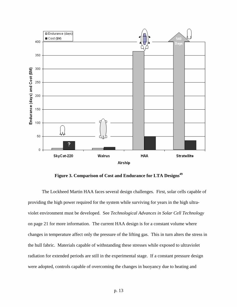
Figure 3. Comparison of Cost and Endurance for LTA Designs49
The Lockheed Martin HAA faces several design challenges. First, solar cells capable of
providing the high power required for the system while surviving for years in the high ultra-
violet environment must be developed. See Technological Advances in Solar Cell Technology
on page 21 for more information. The current HAA design is for a constant volume where
changes in temperature affect only the pressure of the lifting gas. This in turn alters the stress in
the hull fabric. Materials capable of withstanding these stresses while exposed to ultraviolet
radiation for extended periods are still in the experimental stage. If a constant pressure design
were adopted, controls capable of overcoming the changes in buoyancy due to heating and
p. 14
cooling of the helium would have to be developed. The radar design must also be applicable to a
flexible fabric-like skin. See page 25 for further information.
The MDA HAA project is scheduled for testing from 2007 to 2010. If successful, the
design could serve as a baseline for future warfighter development. Should a combat version be
procured, several risks requiring further study (see Table 3) were identified. In particular,
lessons learned from past LTA programs recommended that immediately disposable ballast to
recover from mishaps during ground handling be included. Also, the ability to drive the engines
to much higher speeds is required when poor weather demands quick action.50
Table 3. Military High Altitude Airship Issues (adapted from Rand Study #TR-234)51 Issues Risk Management Approach
Envelope material (strength and weight) Restrict ascent / descent conditions Thermal control (superheat) Incorporate reflective material Helium leakage Limit endurance; use hydrogen from fuel cells Photovoltaic cells Limit endurance; operate in latitudes less than
38° for adequate solar power Fuel cells Use Li-polymer batteries as fallback Weatherability Restrict ascent / descent conditions; improve
weather prediction; provide emergency ballast dump; add sprint engine(s)
Survivability Operate within own air defense envelope; employ ALQ-214 IDECM RFCM suite to counter RF/IR/EO missiles
Figure 3 presents a comparison of the costs and endurance of the cargo and surveillance
LTA designs. The cost and endurance for each system is speculative, as none are complete. Of
special note, the high HAA cost includes the system payload, which the others do not.
Breakdown of a separate HAA vehicle cost was not available. The important theme of Figure 3
is that when comparing system cost to endurance, the LTA designs offer one significant
advantage over existing ISR aircraft (contrast with Figure 17 on page 57) – endurance. The
endurance numbers on Figure 3 are days not hours representing more than an order of magnitude
p. 15
increase in mission presence. This capability is potentially the same cost as existing systems.
Also, the risk of accident during take-off and landings is reduced for LTAs due to their long
endurance. Additional information regarding limitations and survivability of LTAs is presented
in Appendix D (page 63).
Technological Advances in Aircraft Design: High Altitude UAVs
The existing Helios UAV is solar powered, capable of flights up to 96,000 ft and can stay
aloft for days.52 While this may sound like a probable candidate for continuous battlefield
surveillance, it has one great limitation – payload. The Helios is only capable of a 551 pound
payload which must be distributed along its wingspan.53 This design does not allow for the more
substantial radars and weapons a battlefield asset requires. While future technological
improvements will result in lower weight payloads, the Helios design limitations will not change.
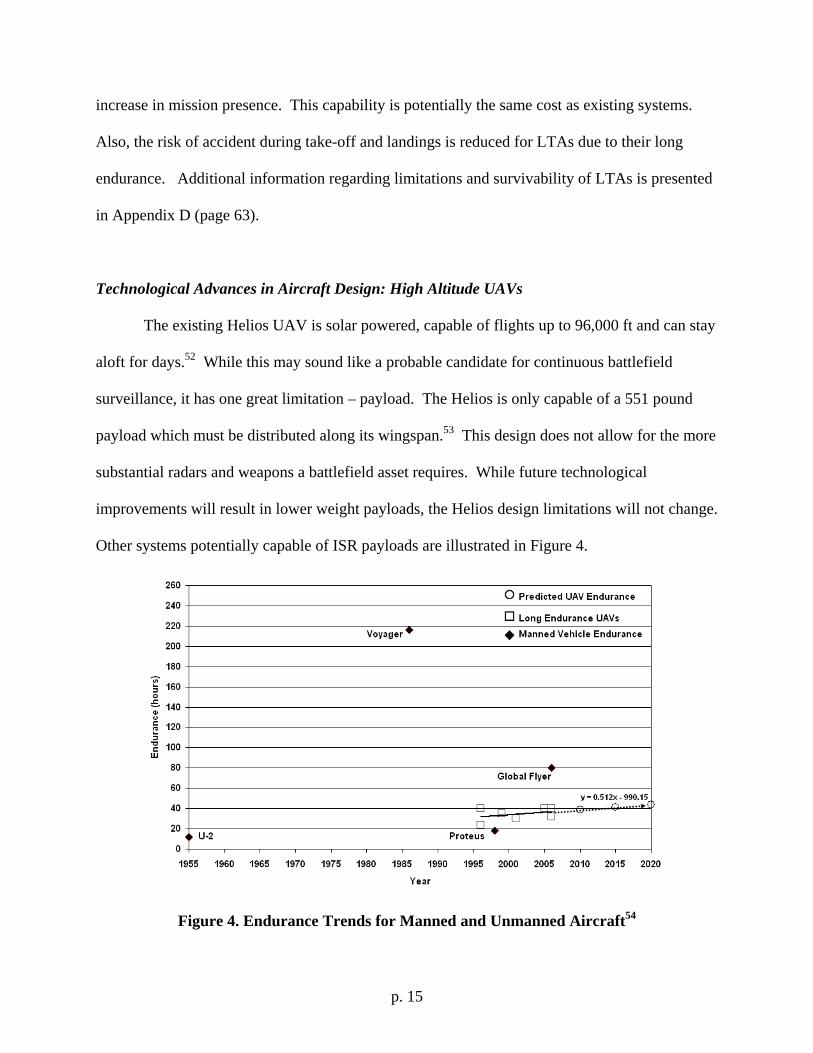
Other systems potentially capable of ISR payloads are illustrated in Figure 4.
Figure 4. Endurance Trends for Manned and Unmanned Aircraft54
p. 16
Figure 4 shows recent UAVs capable of transporting useful payloads (A-160
Hummingbird, RQ-1 Predator, RQ-4 Global Hawk, MQ-9 Reaper, Heron, Theseus, P-175
Polecat) over long distances.55 Connecting these systems with an endurance trend line forecasts
limited growth in average endurance until 2020. One reason for this is engine technology.
Advances in engine technology, particularly increased thrust specific fuel consumption (TSFC) -
which can be thought of as an equivalent to miles-per-gallon, is scheduled to be very limited.
The AFRL Integrated High Performance Turbine Engine Technologies (IHPTET) program
resulted in several advancements allowing a 2x increase in thrust to weight ratio. Long
endurance aircraft however need improvements in fuel efficiency, not thrust. The current AFRL
program – Versatile Affordable Advanced Technology Engines (VAATE) offered some hope in
this area but funding has been cut by 50 percent.56 Even if the VAATE program is cut, naturally
evolving engine technologies will be sufficient for a 40+ hour endurance even when installed
into a stealthy aircraft. Despite the uncertain results of VAATE, other research may result in
higher engine efficiencies, including the use of dimples engraved into the surface of the low
pressure turbine blades.57
The manned systems do not yield any statistical trend due to the one-of-a-kind nature of
their designs. Also, the two manned systems with the greatest endurance, Voyager and Global
Flyer, were designed for a payload of only one or two people requiring minimal electrical power
and no redundant systems. A variant of these craft for ISR purposes would require significant
rework and would result in significantly reduced endurance times. Endurance extension can be
achieved through aerial refueling, which is currently under study for UAVs by both
government58 and contractor teams.59
p. 17
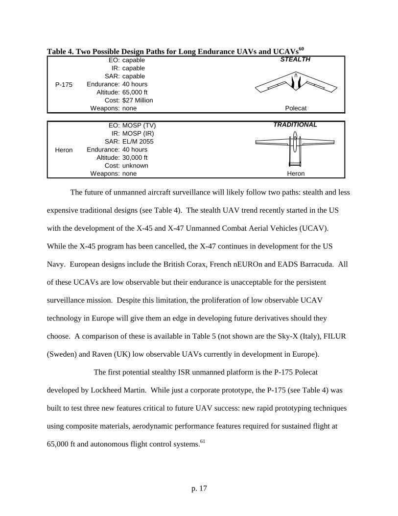
Table 4. Two Possible Design Paths for Long Endurance UAVs and UCAVs60 EO: capableIR: capable
SAR: capableEndurance: 40 hours
Altitude: 65,000 ftCost: $27 Million
Weapons: none
EO: MOSP (TV)IR: MOSP (IR)
SAR: EL/M 2055Endurance: 40 hours
Altitude: 30,000 ftCost: unknown
Weapons: none
P-175
STEALTH
Polecat
Heron
TRADITIONAL
Heron
The future of unmanned aircraft surveillance will likely follow two paths: stealth and less
expensive traditional designs (see Table 4). The stealth UAV trend recently started in the US
with the development of the X-45 and X-47 Unmanned Combat Aerial Vehicles (UCAV).
While the X-45 program has been cancelled, the X-47 continues in development for the US
Navy. European designs include the British Corax, French nEUROn and EADS Barracuda. All
of these UCAVs are low observable but their endurance is unacceptable for the persistent
surveillance mission. Despite this limitation, the proliferation of low observable UCAV
technology in Europe will give them an edge in developing future derivatives should they
choose. A comparison of these is available in Table 5 (not shown are the Sky-X (Italy), FILUR
(Sweden) and Raven (UK) low observable UAVs currently in development in Europe).
The first potential stealthy ISR unmanned platform is the P-175 Polecat
developed by Lockheed Martin. While just a corporate prototype, the P-175 (see Table 4) was
built to test three new features critical to future UAV success: new rapid prototyping techniques
using composite materials, aerodynamic performance features required for sustained flight at
65,000 ft and autonomous flight control systems.61
p. 18
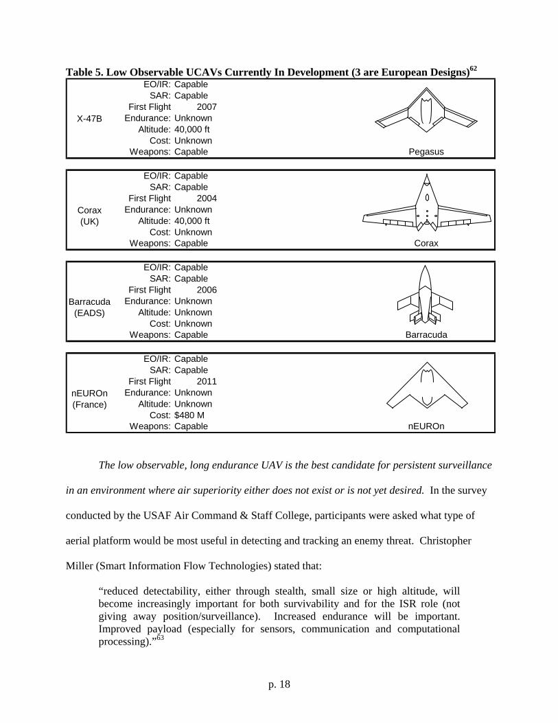
Table 5. Low Observable UCAVs Currently In Development (3 are European Designs)62 EO/IR: Capable
SAR: CapableFirst Flight 2007
Endurance: UnknownAltitude: 40,000 ft
Cost: UnknownWeapons: Capable
EO/IR: CapableSAR: Capable
First Flight 2004Endurance: Unknown
Altitude: 40,000 ftCost: Unknown
Weapons: Capable
EO/IR: CapableSAR: Capable
First Flight 2006Endurance: Unknown
Altitude: UnknownCost: Unknown
Weapons: Capable
EO/IR: CapableSAR: Capable
First Flight 2011Endurance: Unknown
Altitude: UnknownCost: $480 M
Weapons: Capable
Barracuda(EADS)
Barracuda
nEUROn(France)
nEUROn
X-47B
Pegasus
Corax(UK)
Corax
The low observable, long endurance UAV is the best candidate for persistent surveillance
in an environment where air superiority either does not exist or is not yet desired. In the survey
conducted by the USAF Air Command & Staff College, participants were asked what type of
aerial platform would be most useful in detecting and tracking an enemy threat. Christopher
Miller (Smart Information Flow Technologies) stated that:
“reduced detectability, either through stealth, small size or high altitude, will become increasingly important for both survivability and for the ISR role (not giving away position/surveillance). Increased endurance will be important. Improved payload (especially for sensors, communication and computational processing).”63
p. 19
The need for a long endurance, low observable platform was echoed by other survey
responders including RADM Thomas J. Cassidy Jr. USN {Ret} (President/CEO, General
Atomics Aeronautical Systems) and Bruce Carmichael (VP, L-3 Communications).
Additional survey results are presented in Appendix A on page 32.
The traditional path to UAV development is typified by the Heron UAV. While not
capable of operation at higher altitudes required for moderate survivability against man-made
and environmental threats, the Heron is still a capable aircraft with a payload of 550 pounds
featuring EO/IR/SAR payloads as well as additional space for mission specific sensors.64 The
configuration is a twin boom propeller driven design, allowing for easy configuration changes.
Future UAV developments will likely fall into one of these two categories with less expensive
systems developing on the RQ-1 and MQ-9 designs and the most expensive and survivable
systems following the RQ-4 and P-175 designs.
Table 6. Listing of Potentially Beneficial Technologies Section: Useful For: Page No. Morphing Wings UAVs 20 Weapon Systems UAVs and HAAs 20 Solar Cells HAAs 21 Fuel Cells HAAs 23 Radio Relays UAVs and HAAs 66 Data Integration and Management UAVs and HAAs 66 Data Links UAVs and HAAs 69 Traditional Radar Systems UAVs and HAAs 23 Conformal Sensors UAVs and HAAs 25
Another unique design still on the drawing board is the Pegasus. A European project,
Pegasus will use solar or fuel cells on a traditional UAV design instead of fuel. The designer’s
goal is for sustained flight at 65,000 ft for several months.65 The payload will initially consist of
only 4.5 pounds of EO and IR sensors using 1 kW of electrical power. Scaling up the payload is
p. 20
difficult due to the electrical power requirements and volume constraint of the design. Specific
technologies that may benefit UAV or HAA designs are discussed in the following sections. An
overview is presented in Table 6.
Technological Advances in Aircraft Design: Morphing Wings
The concept of wing morphing refers to changes in the wing chord or aspect ratio while
in flight. Also known as “adaptive compliant” structures, the shape of the wing can be changed
without external hinge lines or structures which can disrupt airflow over the wing. Range or
endurance can be improved by five to fifteen percent using this technology.66 This is
accomplished through micro-electromechanical mechanisms embedded inside the wing which
change several times per second to achieve optimal flight performance. The first example flew 1
Aug 2006 in which a 100 pound UAV changed its wing area, chord, sweep and aspect ratio
during flight.67 Additional tests with a 200 pound UAV are planned for 2007. Another study
using the US Marine Corps Dragon Eye UAV as a baseline (with multiple active winglets added)
demonstrated a 30 percent increase in payload or a 40 percent increase in endurance can be
achieved.68 Morphing wing technology also provides an enhancement to survivability with the
reduction or elimination of control surface gaps, allowing greater stealth.69 Refinement of this
technology will play a critical role for the designers of long endurance surveillance aircraft
operating in the 2020 – 2030 timeframe.
Employment of Weapons in to a Continuous Surveillance Asset
The extremely high altitude of near space restricts the use of the AGM-114 Hellfire
missile as previously proven on the MQ-1 Predator. Instead, the Small Diameter Bomb (SDB)
p. 21
may be used with its Global Positioning System (GPS) enhanced guidance system.70 Another
potential candidate system is the Top Cover missile. As designed, Top Cover can incorporate
both munitions and surveillance payloads into the same missile. The missile’s estimated cost is
$200K and is capable of carrying a 44 pound payload for over 24 hours.71
Existing weapons which may be compatible include the selection of gravity and glide
weapons. The range of gravity weapons such as the Guided Bomb Unit – 28 (GBU-28) and
glide weapons such as the SDB is considerably enhanced when launched from a near space
altitude. Powered weapons such as the Joint Air-to-Surface Standoff Missile (JASSM) will also
benefit from the high altitude launch platform. The communications and computing capability of
the near space system will provide any GPS or data link updates necessary for proper weapons
function.
Technological Advances in Solar Cell Technology
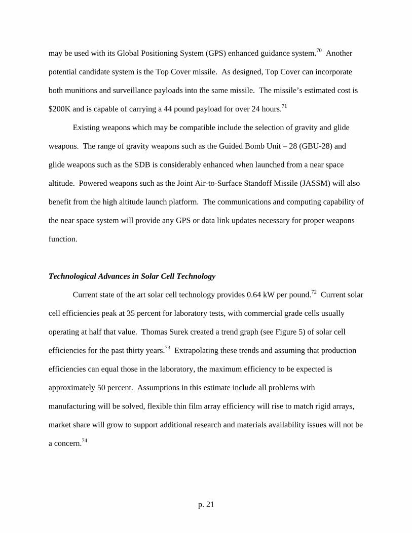
Current state of the art solar cell technology provides 0.64 kW per pound.72 Current solar
cell efficiencies peak at 35 percent for laboratory tests, with commercial grade cells usually
operating at half that value. Thomas Surek created a trend graph (see Figure 5) of solar cell
efficiencies for the past thirty years.73 Extrapolating these trends and assuming that production
efficiencies can equal those in the laboratory, the maximum efficiency to be expected is
approximately 50 percent. Assumptions in this estimate include all problems with
manufacturing will be solved, flexible thin film array efficiency will rise to match rigid arrays,
market share will grow to support additional research and materials availability issues will not be
a concern.74
p. 22
Figure 5. Solar Cell Trends for Past 30 Years and Extrapolation to 202075
Despite the slow growth depicted in Figure 5, a leap in solar cell capability may be
available in the next 10 years. Researchers at the University of New South Wales in Sydney,
Australia, are working to double current solar cell efficiencies to 60 percent or higher. A new
technique they are inventing involves using multiple layers of silicon to convert several
wavelengths of light simultaneously. Before their research, this was only possible using
different materials consisting of gallium, indium, phosphorous and arsenic which cost much
more than silicon.76 While a prototype will take at least two years to build, the potential increase
in efficiency and reduction in cost make it a potential candidate for use on LTAs or UAVs
operating for long durations.
p. 23
Technological Advances in Fuel Cell Technology
The use of fuel cell technology in aviation is still in its infancy. Despite this, the
potential for their use as a replacement for batteries in LTAs or power sources on standard
aircraft is great. Fuel cells may also be an ideal method for powering LTAs during nighttime
operations while solar cells recharge them during the day. Preliminary cost benefit ratios favor
the use of fuel cells in long duration sortie aircraft. The current state-of-the-art automotive
research into fuel cells has created compact, high power and durable designs.77 However, these
designs lack the energy to weight ratio required for optimum aviation use.
Miniaturization of fuel cells is also possible. EoPlex Technologies is creating a printing
technique similar to that of electronic circuit boards. Their goal is to build a micro-reformer for
fuel cells. The small size (approximately two dominoes) of the unit is capable of recharging the
battery in a 20 watt radio.78 Another approach is using the fuel cell to power a propulsion
system. The 100 watt fuel cell built by Protonex Technology Corporation weighs less than 10
pounds and has already powered a small UAV for more than three hours.79 While this endurance
is not as good as a similar sized UAV using traditional liquid fuels, it is a considerable
technological achievement. Future fuel cell development may provide sufficient power for
greater endurance and altitudes enabling UAVs to operate for weeks instead of days at a time. A
list of recommended fuel cell advancements is included in Table 2 on page 10.
Technological Advances in ISR and Communications: Traditional Radar Systems
Active Electronically Scanned Arrays (AESA) systems are currently in use in several
aircraft, including the F-15C, F-16F, F/A-18G, F-22A and will be in the F-35. The F-15C’s
APG-63 radar is an X-band pulse-doppler system which features improved reliability over its
p. 24
predecessors.80 This is achievable through its fixed antenna, which uses a 2-D array of transmit
and receive modules eliminating the need for mechanical steering mechanisms.81 After decades
of development, the resulting system weighs less, has increased reliability and allows for
performing multiple functions (air-to-air, air-to-ground) simultaneously.82 For example, the F-
15C can track multiple air-to-air targets while simultaneously creating a hi-resolution image of a
ground moving target allowing for full 3-D situational awareness.83 These existing systems may
offer electronic warfare (EW) modes with only software changes.84 Research into using small
UAVs with electronic attack (EA) payloads operating at close distances to ground threat radars
have shown positive results even at low power (100 W) outputs.85 A high-altitude UAV could
reserve some of its AESA capability for this jamming effect.
The Multi-Platform Radar Technology Insertion Program (MP-RTIP) was originally
intended as an upgrade for the E-8 Joint-STARS system, but evolved into an aircraft system of
its own – the E-10A Multisensor Command and Control Aircraft (MC2A). The MP-RTIP radar
consists of an X-band AESA capable of tracking low-flying, stealthy cruise missiles at ranges of
hundreds of miles in addition to the traditional role of low-speed ground targets.86 The recently
flight tested radar is 30 ft long and weighs 3,000 pounds.87 Despite the cancelling of the E-10A
MC2A, the MP-RTIP radar will continue in a smaller form as a radar upgrade to the RQ-4
Global Hawk.88 The $2B MP-RTIP system or its derivatives would be a likely candidate for a
new all-weather continuous battlefield surveillance asset.
Another airborne radar system is the Advanced Synthetic Aperture Radar Type 23
(ASARS-23) which has evolved from use on the U-2 to a modified British Bombardier Global
Express business jet. The combination of aircraft and radar is now called the Airborne Stand Off
Radar (ASTOR). ASTOR is being developed under a $1.3B contract to Raytheon, for use by the
p. 25
British government.89 The ASTOR system is a dual mode radar with an embedded moving
target indicator (MTI).90 Once operational, the system will use five aircraft to provide 24 hour
surveillance linked to ground stations used at the tactical and operational level of war.91
Miniaturization of ground support equipment and lessons learned from this system could be
integrated into a higher endurance system capable of communicating the data directly to the
warfigher.
Technological Advances in ISR and Communications: Conformal Sensors
One proposed method for increasing the situational awareness of the battlespace is the
integration of an AESA radar onto a curved surface. Current AESAs are mounted to a flat panel
behind a protective radome on the front of the aircraft. Creation of a conformal array would
allow for direct mounting of the radar to the outer skin of the aircraft, potentially allowing much
greater aperture sizes for better performance. The design must also be low observable to provide
greater aircraft survivability.92 Additional features enhancing this aspect is the growth of
frequency-selective coverings designed to only let signals pass through that are in the same
frequency as the radar and electronically agile arrays that can change frequency.93
Single curve dimensional arrays are currently under test by European Aeronautic Defence
And Space Company (EADS) and Raytheon. This development will allow the AESA to be
mounted to a simply curved surface by 2011. Two examples are an underside of a wing or the
side of a fuselage.94 These systems will be able to simultaneously track targets, create SAR
images and act as high-bandwidth communications platforms.95 While the first use of this
technology is forecasted for the British Corax (see Table 5 on page 18), RQ-4 Global Hawk,
MQ-9 Reaper and manned systems will eventually integrate this technology as well.96
p. 26
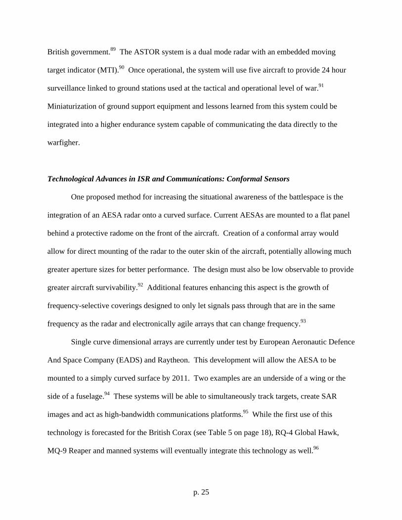
Figure 6. Evolutionary Forecast of Radar Technology97 The two-dimensional curved array is forecasted to be operational by 2015 (see Figure 6)
and will allow for mounting to a fully curved surface, like the underside of a LTA. EADS
researchers are currently considering use of gallium nitride (GaN) instead of the traditional
gallium arsenide (GaAs) for their curved AESA project since it may enable the array to operate
in different radio bands. For example, the array could use L-Band for long-range surveillance
and X-Band for air-to-air surveillance while simultaneously operating in a third band for
communications.98 The merging of both surveillance and communications into the same antenna
where the signal-to-noise ratios are so drastically different is one of the most significant
challenges to the design and is currently being worked by several companies.99
The DARPA initiative to combine a two-dimensionally curved AESA system with the
outer hull of an aircraft is called Integrated Sensor is Structure (ISIS).100 Described by DARPA
as the “ultimate persistent airborne platform for all radar missions,” the effort is under
development by Northrop Grumman for use by HAAs.101 The final ISIS system, if completed,
p. 27
will be capable of dual air-to-air and air-to-ground surveillance simultaneously while possibly
providing communications and large bandwidth options as well.102 This dual-mode capability
will greatly enhance net-centric operations which are detailed in Appendix E (page 66). It is
ultimately hoped by the Air Force Research Laboratory (AFRL) that these technologies can be
used to meet some Focus Long-Term Challenges (FLTCs). FLTC 2.2.1 is to have a survivable,
high-altitude, long endurance UAV capable of multi-intelligence sensing for battlefield
commanders in a medium threat environment.103 Desired to demonstrate this capability by 2013,
the system is also expected to use morphing wings in a low-observable structure similar to the P-
175 Polecat (see page 17).
Summary of Future Developments to be Exploited:
1. Effects-based-operations (EBO) are focused on achieving desired effects instead of
planning for specific systems or forces.
2. The tethered balloon approach is not recommended due to vibration and scaling
limitations.
3. Lighter than air ships have little political support. To change this, a significant
rethinking of military operations and doctrine is necessary.
4. LTA designs offer one significant advantage over existing ISR aircraft – endurance.
5. The risk to LTAs by SAMs is reduced by the extreme altitude (65,000 ft), low radar
cross section and negligible velocity.
6. The low observable, long endurance UAV is the best candidate for persistent
surveillance in an environment where air superiority either does not exist or is not yet
desired.
p. 28
7. Wing morphing or “adaptive compliant” structures, can improve range or endurance
by five to fifteen percent for traditional winged aircraft designs.
8. ROVER technology is an important baseline for the future of continuously available
surveillance.
9. A new technique may soon double current solar cell efficiencies to 60 percent or
higher.
10. While commanders are forced to operate with fewer forces available to them,
additional situational awareness will be critical for efficient mission accomplishment.
11. The TSAT laser communications system could allow high-resolution images and
video to be transmitted directly from aircraft operating at high altitudes over the
battlefield to the tactical level of war.
12. The MP-RTIP radar upgrade to the RQ-4 Global Hawk and its derivatives would be a
good candidate for a new all-weather continuous battlefield surveillance asset.
p. 29
Conclusions
“…clinging to the past will teach us nothing useful for the future, for that future will be radically different from anything that has gone before. The future must be approached
from a new angle…” – General Giulio Douhet, The Command of the Air104
The need for continuously available surveillance for homeland defense, disaster relief and
military operations is ever present and will not be going away. Just as GPS revolutionized
existing military operations, continuous ISR will allow commanders greater assurance on enemy
capabilities while allowing enhanced efficiency for friendly force allocations. Forces operating
at the tactical level of war will be able to task a sensor in a Google-Earth fashion to discover
what is over the next hill without requiring additional aircraft, pilots or personnel. The
information they receive will simultaneously be viewable by everyone involved in their
operation all the way up to the highest levels of government. The OODA and sensor-to-shooter
loops will contract to a time span of seconds.
The system making this future possible is the continuously available surveillance system,
consisting of lighter-than-air (LTA) or stealthy long-duration aircraft flying at near space
altitudes of 65,000 ft. The stealthy ISR aircraft will provide information while operating over
heavily defended regions where air superiority has yet to be achieved. Laser communications
will allow unrestricted operations while not compromising stealth. When air superiority does
occur, the LTA will provide continuous coverage for weeks or months at a time as the eye in the
sky. These systems will not provide persistent coverage requiring terabytes of video and data to
be continuously downloaded. Instead, their sensors will always be continuously available for the
troops on the battlefield. As demand rises and falls, so will the output of the sensors.
The company and platoon commander will use a simple laptop-like device to point and
click at a desired location on a map and choose the type of information desired: EO, IR or SAR
p. 30
and a tasking order will enter the Global Information Grid (GIG). This order will immediately
enter the regional command office for uplink to the near space asset and one of the available
sensors will immediately downlink, in real time, the requested information. The net-centric
computers of the future battlefield will disperse the data to whomever is interested. Laser
communications will negate any restrictions on radio frequency bandwidth.
The scenario described here will be capable of deployment between 2020 and 2030.
Most of the technology required to make it happen exists already in commercial industry or in
laboratory prototypes. Specific areas requiring additional research and development include
solar array efficiencies, integration of sensors with curved external surfaces and fuel cells.
Current industry growth in solar arrays will likely yield usable components by 2020. The
integration of sensors into external surfaces will require continued government research support.
The fuel cell technology will advance in industry, but government support will be required to
yield a device applicable to the high altitude, low oxygen environment of near space.
For more information on the application of near space assets, the reader should see Dr.
Ed Tomme’s “The Paradigm Shift to Effects-Based Space: Near-Space as a Combat Space
Effects Enabler”105 and Anthony Colozza’s “Initial Feasibility Assessment of a High Altitude
Long Endurance Airship.”106 Each work provides background, detail and a sound report on the
capabilities and limitations of the usefulness of near space systems. The important ideas
captured in these two reports will not be contained by them. A third report authored by a panel
of thirteen exports is “Future Air Force Needs for Survivability” which details the current and
future technology base.107 This report includes several recommendations for leaders and
researchers in how to improve technology to meet the needs of the operational environment of
2020. One key element of this report is the statement that given past trends, current experimental
p. 31
technology must be at a Technology Readiness Level (TRL) of 6 by 2009 for it to be mature
enough for operational use by 2018. The key obstacle in producing any of these systems may be
the slow approval process of the FAA for approval of UAV flights in national airspace (see
Appendix A, page 39). The inherent usefulness and exploitation of near space will come to mind
for many people in the next ten years (it has already begun for the MDA and private industry)
and the government will gradually embrace the technology that will eventually be indispensable
to future military operations.
p. 32
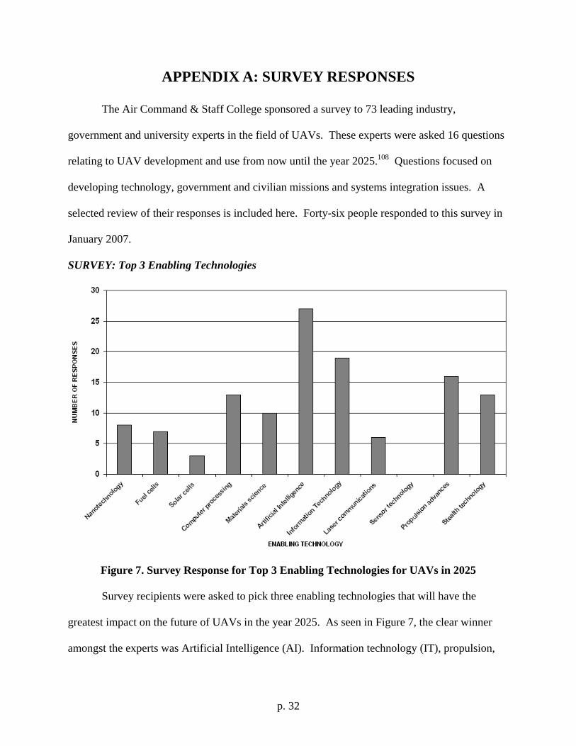
APPENDIX A: SURVEY RESPONSES
The Air Command & Staff College sponsored a survey to 73 leading industry,
government and university experts in the field of UAVs. These experts were asked 16 questions
relating to UAV development and use from now until the year 2025.108 Questions focused on
developing technology, government and civilian missions and systems integration issues. A
selected review of their responses is included here. Forty-six people responded to this survey in
January 2007.
SURVEY: Top 3 Enabling Technologies
Figure 7. Survey Response for Top 3 Enabling Technologies for UAVs in 2025
Survey recipients were asked to pick three enabling technologies that will have the
greatest impact on the future of UAVs in the year 2025. As seen in Figure 7, the clear winner
amongst the experts was Artificial Intelligence (AI). Information technology (IT), propulsion,
p. 33
stealth and computer processing follow. This response clearly indicates how dependent aircraft
operations will be on computer processing capabilities and speed. The current military and
civilian reliance on net-centric operations supports this prediction, with perceived military
capabilities evolving to capitalize on commercial technological developments. One critical
obstacle this technology must solve is the ability for UAVs to sense and avoid other aircraft. Mr.
Dyke Weatherington, Deputy of the OSD UAV Planning Task Force noted that solving this
“challenge is one of the most pressing current challenges which will require sensors” in the near
future.109
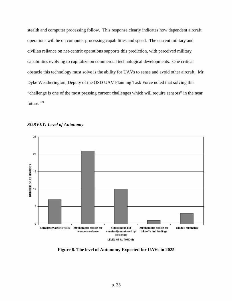
SURVEY: Level of Autonomy
Figure 8. The level of Autonomy Expected for UAVs in 2025
p. 34
Survey responders predicted the level of autonomy expected for UAVs operating in 2025.
As UAV capabilities increase, their autonomy is expected to grow in accordance with it. The
greatest anticipated exception to this is the release of weapons, which is still expected to require
interaction from human operators or observers (see Figure 8). A special case was noted by Dr.
Steven Rasmussen of General Dynamics Advanced Information Systems who stated that “for
missions that do not require lethal force, the UAVs could be completely autonomous.”110
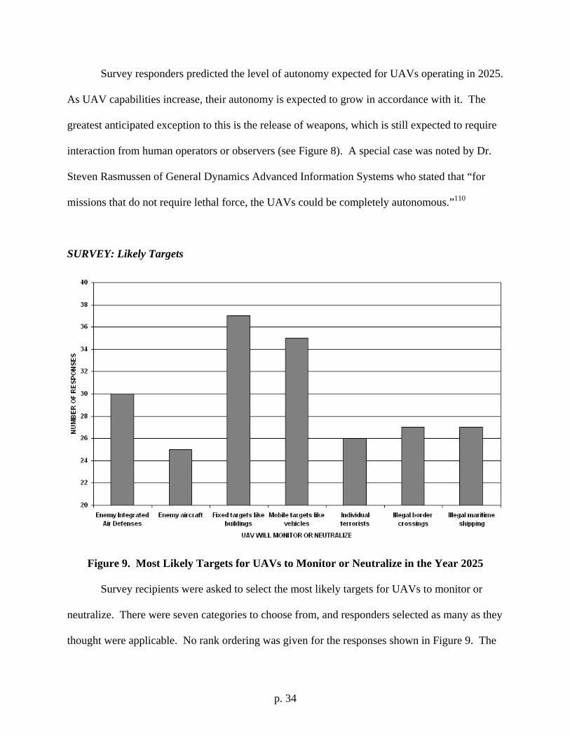
SURVEY: Likely Targets
Figure 9. Most Likely Targets for UAVs to Monitor or Neutralize in the Year 2025 Survey recipients were asked to select the most likely targets for UAVs to monitor or
neutralize. There were seven categories to choose from, and responders selected as many as they
thought were applicable. No rank ordering was given for the responses shown in Figure 9. The
p. 35
top two choices were fixed and mobile targets like buildings and vehicles, respectively. Current
hopes for UAV technology such as tracking and identifying individual terrorists or criminals are
predicted to be less likely. Dr. Michael Francis, former J-UCAS Director of DARPA, stated that
these “answers depend on countermeasures developed and the airborne threat environment”
since “ISEAD is the most difficult mission.” Francis also noted that “cancellation of J-UCAS
limits time to mature this most technologically complex capability” placing doubts on the ability
of future UAVs to survive in complex threat environments.111
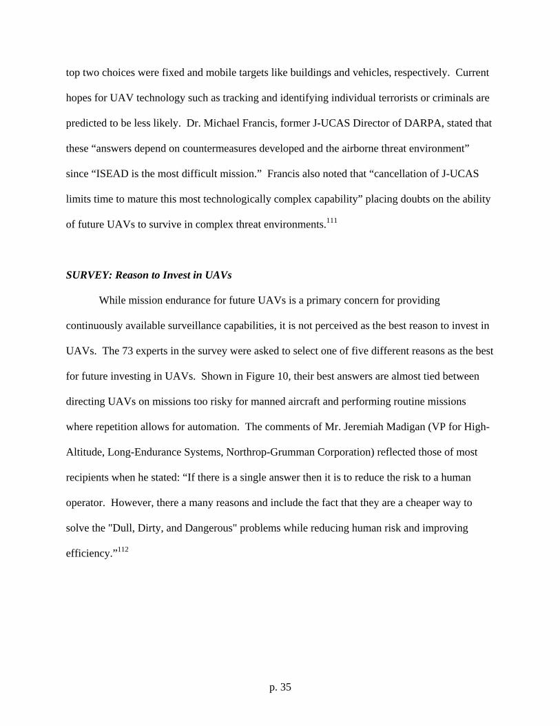
SURVEY: Reason to Invest in UAVs
While mission endurance for future UAVs is a primary concern for providing
continuously available surveillance capabilities, it is not perceived as the best reason to invest in
UAVs. The 73 experts in the survey were asked to select one of five different reasons as the best
for future investing in UAVs. Shown in Figure 10, their best answers are almost tied between
directing UAVs on missions too risky for manned aircraft and performing routine missions
where repetition allows for automation. The comments of Mr. Jeremiah Madigan (VP for High-
Altitude, Long-Endurance Systems, Northrop-Grumman Corporation) reflected those of most
recipients when he stated: “If there is a single answer then it is to reduce the risk to a human
operator. However, there a many reasons and include the fact that they are a cheaper way to
solve the "Dull, Dirty, and Dangerous" problems while reducing human risk and improving
efficiency.”112
p. 36
Figure 10. Best Reason to Invest in UAVs Instead of Manned Aircraft
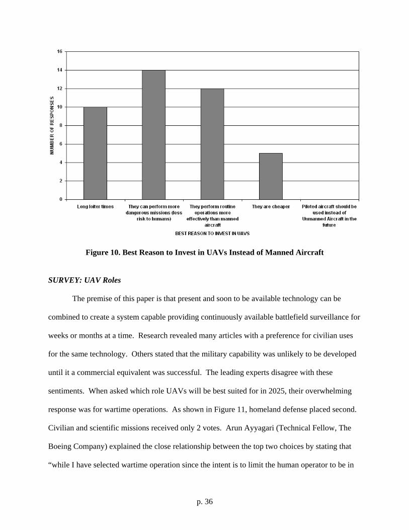
SURVEY: UAV Roles
The premise of this paper is that present and soon to be available technology can be
combined to create a system capable providing continuously available battlefield surveillance for
weeks or months at a time. Research revealed many articles with a preference for civilian uses
for the same technology. Others stated that the military capability was unlikely to be developed
until it a commercial equivalent was successful. The leading experts disagree with these
sentiments. When asked which role UAVs will be best suited for in 2025, their overwhelming
response was for wartime operations. As shown in Figure 11, homeland defense placed second.
Civilian and scientific missions received only 2 votes. Arun Ayyagari (Technical Fellow, The
Boeing Company) explained the close relationship between the top two choices by stating that
“while I have selected wartime operation since the intent is to limit the human operator to be in
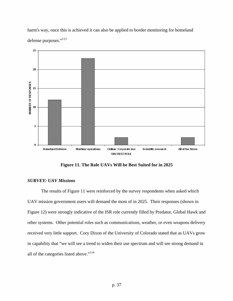
p. 37
harm's way, once this is achieved it can also be applied to border monitoring for homeland
defense purposes.”113
Figure 11. The Role UAVs Will be Best Suited for in 2025
SURVEY: UAV Missions
The results of Figure 11 were reinforced by the survey respondents when asked which
UAV mission government users will demand the most of in 2025. Their responses (shown in
Figure 12) were strongly indicative of the ISR role currently filled by Predator, Global Hawk and
other systems. Other potential roles such as communications, weather, or even weapons delivery
received very little support. Cory Dixon of the University of Colorado stated that as UAVs grow
in capability that “we will see a trend to widen their use spectrum and will see strong demand in
all of the categories listed above.”114
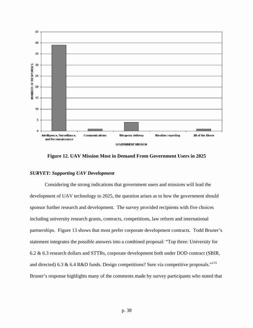
p. 38
Figure 12. UAV Mission Most in Demand From Government Users in 2025
SURVEY: Supporting UAV Development
Considering the strong indications that government users and missions will lead the
development of UAV technology to 2025, the question arises as to how the government should
sponsor further research and development. The survey provided recipients with five choices
including university research grants, contracts, competitions, law reform and international
partnerships. Figure 13 shows that most prefer corporate development contracts. Todd Bruner’s
statement integrates the possible answers into a combined proposal: “Top three: University for
6.2 & 6.3 research dollars and STTRs, corporate development both under DOD contract (SBIR,
and directed) 6.3 & 6.4 R&D funds. Design competitions? Sure via competitive proposals.”115
Bruner’s response highlights many of the comments made by survey participants who stated that
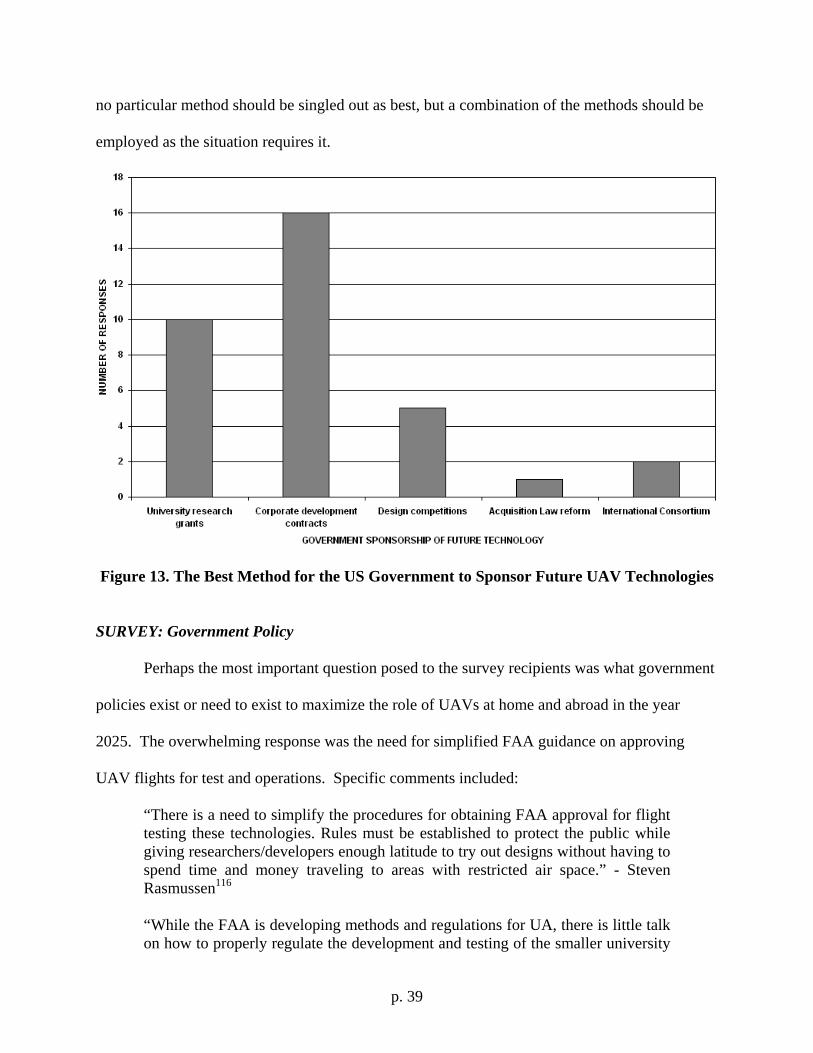
p. 39
no particular method should be singled out as best, but a combination of the methods should be
employed as the situation requires it.
Figure 13. The Best Method for the US Government to Sponsor Future UAV Technologies
SURVEY: Government Policy
Perhaps the most important question posed to the survey recipients was what government
policies exist or need to exist to maximize the role of UAVs at home and abroad in the year
2025. The overwhelming response was the need for simplified FAA guidance on approving
UAV flights for test and operations. Specific comments included:
“There is a need to simplify the procedures for obtaining FAA approval for flight testing these technologies. Rules must be established to protect the public while giving researchers/developers enough latitude to try out designs without having to spend time and money traveling to areas with restricted air space.” - Steven Rasmussen116
“While the FAA is developing methods and regulations for UA, there is little talk on how to properly regulate the development and testing of the smaller university
p. 40
sized vehicles while still allowing them to fly under a COA. Restated, once a COA is certified for an aircraft any modification to the system hardware or software a new COA will need to be filed for. At the university level a single aircraft will have many modifications to hardware and especially software for testing different theories/algorithms which happens on the order of days to weeks, not months. Thus the FAA will need a way to certify a UA system and not the aircraft itself.” – Cory Dixon117 “First and foremost is a rational way to integrate them into the national airspace structure. Current limitations on UAV flights in the US are seriously stifling development of hardware and conops.” – Dr. Ed "Mel" Tomme, LtCol, USAF (ret) 118
“Acceptance of UAVs as a normal part of civilian (US and international) airspace operations through more automated air traffic control concepts and specific UAV "see and avoid" technologies. Development in the military of UAV-only pilots and support crews (to develop internal constituencies for follow-on systems)” - Tom Ehrhard, Ph.D., Colonel, USAF (ret.)119
These comments all illustrate the red tape confronting anyone attempting to perform research
and development in support of UAVs. A more well-defined, simple and most of all fast system
for coordinating UAV flights over US airspace must be developed. Current flight operations
suffer under the current system, which also acts as a barrier to potentially additional participants.
Most corporations and universities simply don’t want to be involved in a program with so many
government hassles. Perhaps solving this problem is of greater importance than overcoming any
technological obstacle for the future development of UAVs.
p. 41
APPENDIX B: THE PAST
Surface-To-Air Missile Systems
Throughout history accurate and timely information on enemy location, strength and
capability has proved crucial to battlefield success at all levels of conflict. At the strategic level,
U-2 spyplanes flew missions over the former Soviet Union during the Cold War until the famous
shoot down of Francis Gary Powers by an SA-2 Guideline missile.120 At the operational level,
the RQ-4 Global Hawk provides the Central Command staff with near real time information on
possible insurgent activity in the Middle East.121 At the tactical level, the RQ-1 Predator
provides laser designation of targets for other manned aircraft with bombs.122
All of these aircraft are very similar in appearance. Each aircraft has a high-aspect ratio
wing (long wingspan but a short chord length) for long endurance missions and a single engine
to maximize fuel economy. The U-2123 and Global Hawk124 were designed to overfly possibly
hostile environments so each is capable of operating at altitudes of greater than 65,000 feet. This
extreme altitude requirement provides a margin of survivability against most Surface-to-Air
Missile (SAM) systems.
Russian SAM systems have proliferated throughout the world. These systems now
account for the majority of aircraft losses in modern conflicts, with the former Soviet Union
producing roughly three-quarters of the world’s supply.125 The willingness of the Russian
government to sell older but refurbished systems to the smallest of third-world governments
creates a potentially deadly predicament for mission planners. The SAM systems track their
targets through radar or optical means (visual or infrared). National control of the systems is
maintained through an Integrated Air Defense System (IADS) which allows for a centralized
command and control authority. Therefore, detailed knowledge of the SAMs is required to
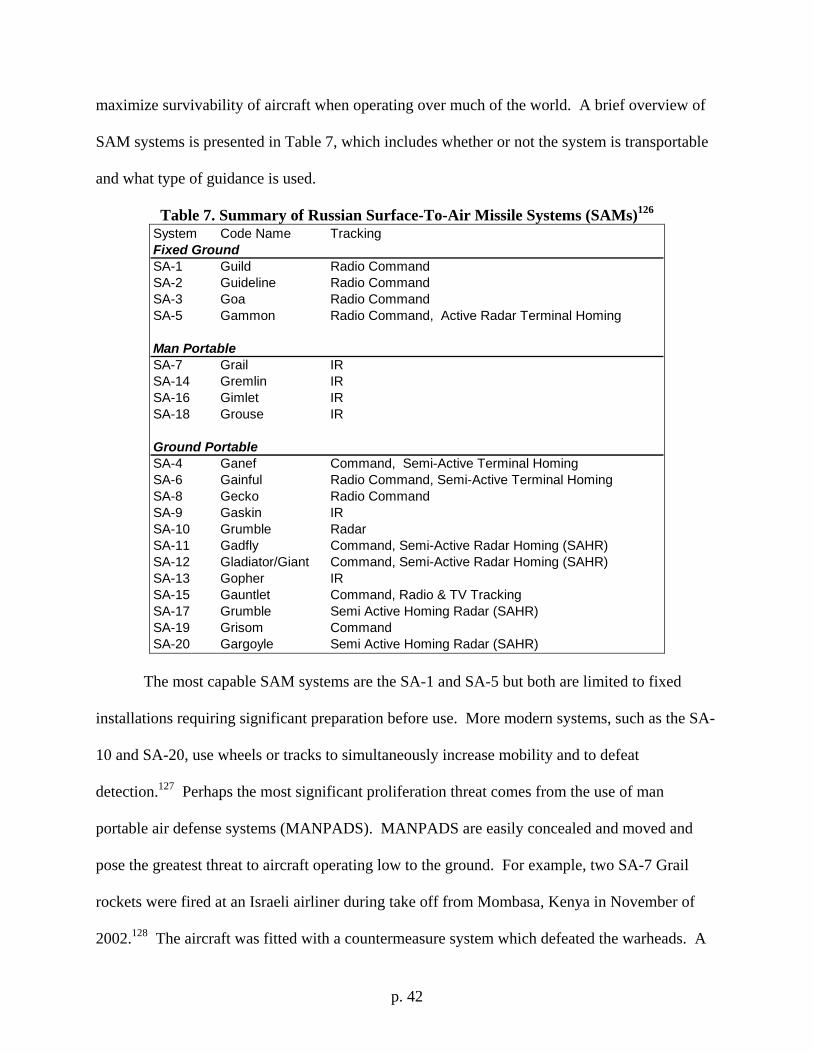
p. 42
maximize survivability of aircraft when operating over much of the world. A brief overview of
SAM systems is presented in Table 7, which includes whether or not the system is transportable
and what type of guidance is used.
Table 7. Summary of Russian Surface-To-Air Missile Systems (SAMs)126 System Code Name TrackingFixed GroundSA-1 Guild Radio Command SA-2 Guideline Radio Command SA-3 Goa Radio Command SA-5 Gammon Radio Command, Active Radar Terminal Homing
Man PortableSA-7 Grail IRSA-14 Gremlin IRSA-16 Gimlet IRSA-18 Grouse IR
Ground PortableSA-4 Ganef Command, Semi-Active Terminal HomingSA-6 Gainful Radio Command, Semi-Active Terminal HomingSA-8 Gecko Radio Command SA-9 Gaskin IRSA-10 Grumble RadarSA-11 Gadfly Command, Semi-Active Radar Homing (SAHR)SA-12 Gladiator/Giant Command, Semi-Active Radar Homing (SAHR)SA-13 Gopher IRSA-15 Gauntlet Command, Radio & TV TrackingSA-17 Grumble Semi Active Homing Radar (SAHR)SA-19 Grisom CommandSA-20 Gargoyle Semi Active Homing Radar (SAHR)
The most capable SAM systems are the SA-1 and SA-5 but both are limited to fixed
installations requiring significant preparation before use. More modern systems, such as the SA-
10 and SA-20, use wheels or tracks to simultaneously increase mobility and to defeat
detection.127 Perhaps the most significant proliferation threat comes from the use of man
portable air defense systems (MANPADS). MANPADS are easily concealed and moved and
pose the greatest threat to aircraft operating low to the ground. For example, two SA-7 Grail
rockets were fired at an Israeli airliner during take off from Mombasa, Kenya in November of
2002.128 The aircraft was fitted with a countermeasure system which defeated the warheads. A
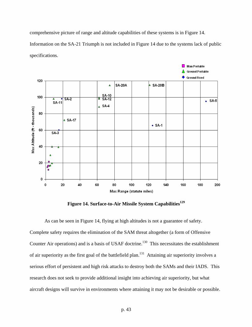
p. 43
comprehensive picture of range and altitude capabilities of these systems is in Figure 14.
Information on the SA-21 Triumph is not included in Figure 14 due to the systems lack of public
specifications.
Figure 14. Surface-to-Air Missile System Capabilities129
As can be seen in Figure 14, flying at high altitudes is not a guarantee of safety.
Complete safety requires the elimination of the SAM threat altogether (a form of Offensive
Counter Air operations) and is a basis of USAF doctrine.130 This necessitates the establishment
of air superiority as the first goal of the battlefield plan.131 Attaining air superiority involves a
serious effort of persistent and high risk attacks to destroy both the SAMs and their IADS. This
research does not seek to provide additional insight into achieving air superiority, but what
aircraft designs will survive in environments where attaining it may not be desirable or possible.
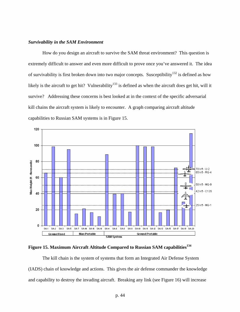
p. 44
Survivability in the SAM Environment
How do you design an aircraft to survive the SAM threat environment? This question is
extremely difficult to answer and even more difficult to prove once you’ve answered it. The idea
of survivability is first broken down into two major concepts. Susceptibility132 is defined as how
likely is the aircraft to get hit? Vulnerability133 is defined as when the aircraft does get hit, will it
survive? Addressing these concerns is best looked at in the context of the specific adversarial
kill chains the aircraft system is likely to encounter. A graph comparing aircraft altitude
capabilities to Russian SAM systems is in Figure 15.
Figure 15. Maximum Aircraft Altitude Compared to Russian SAM capabilities134
The kill chain is the system of systems that form an Integrated Air Defense System
(IADS) chain of knowledge and actions. This gives the air defense commander the knowledge
and capability to destroy the invading aircraft. Breaking any link (see Figure 16) will increase
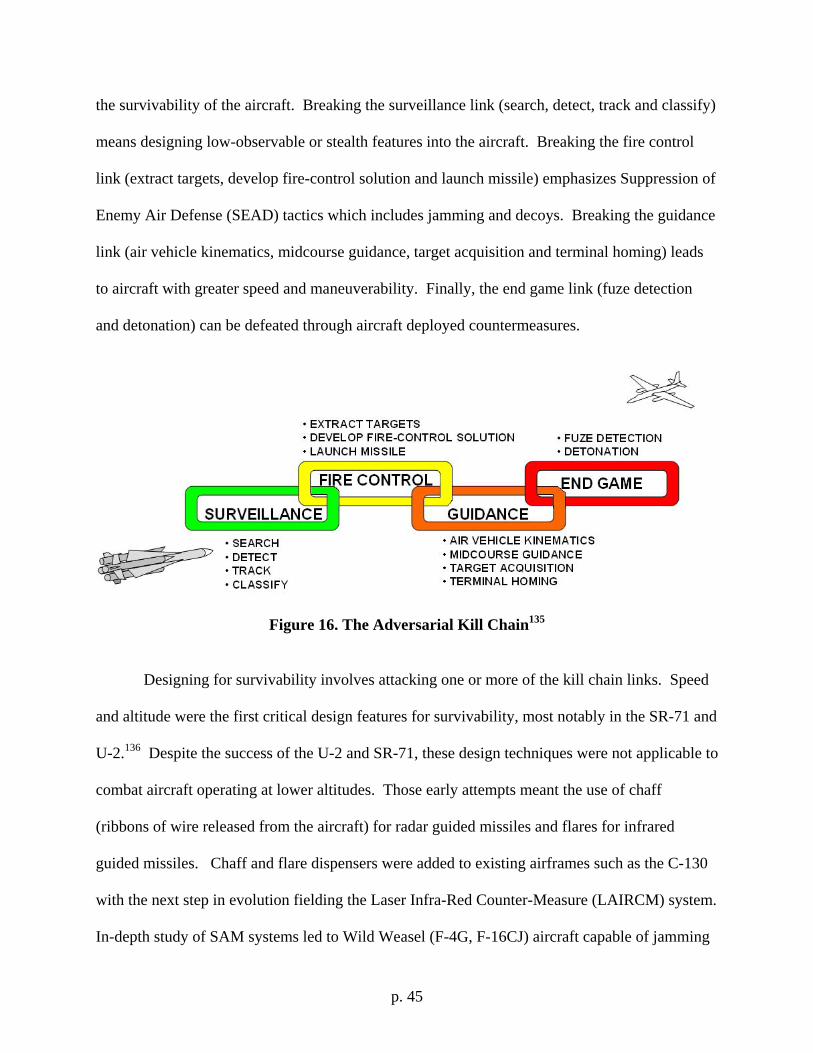
p. 45
the survivability of the aircraft. Breaking the surveillance link (search, detect, track and classify)
means designing low-observable or stealth features into the aircraft. Breaking the fire control
link (extract targets, develop fire-control solution and launch missile) emphasizes Suppression of
Enemy Air Defense (SEAD) tactics which includes jamming and decoys. Breaking the guidance
link (air vehicle kinematics, midcourse guidance, target acquisition and terminal homing) leads
to aircraft with greater speed and maneuverability. Finally, the end game link (fuze detection
and detonation) can be defeated through aircraft deployed countermeasures.
Figure 16. The Adversarial Kill Chain135
Designing for survivability involves attacking one or more of the kill chain links. Speed
and altitude were the first critical design features for survivability, most notably in the SR-71 and
U-2.136 Despite the success of the U-2 and SR-71, these design techniques were not applicable to
combat aircraft operating at lower altitudes. Those early attempts meant the use of chaff
(ribbons of wire released from the aircraft) for radar guided missiles and flares for infrared
guided missiles. Chaff and flare dispensers were added to existing airframes such as the C-130
with the next step in evolution fielding the Laser Infra-Red Counter-Measure (LAIRCM) system.
In-depth study of SAM systems led to Wild Weasel (F-4G, F-16CJ) aircraft capable of jamming
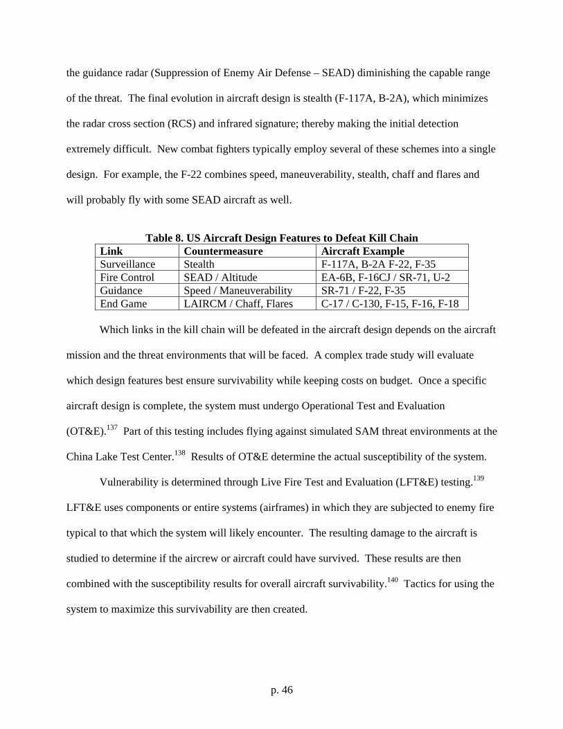
p. 46
the guidance radar (Suppression of Enemy Air Defense – SEAD) diminishing the capable range
of the threat. The final evolution in aircraft design is stealth (F-117A, B-2A), which minimizes
the radar cross section (RCS) and infrared signature; thereby making the initial detection
extremely difficult. New combat fighters typically employ several of these schemes into a single
design. For example, the F-22 combines speed, maneuverability, stealth, chaff and flares and
will probably fly with some SEAD aircraft as well.
Table 8. US Aircraft Design Features to Defeat Kill Chain
Link Countermeasure Aircraft Example Surveillance Stealth F-117A, B-2A F-22, F-35 Fire Control SEAD / Altitude EA-6B, F-16CJ / SR-71, U-2 Guidance Speed / Maneuverability SR-71 / F-22, F-35 End Game LAIRCM / Chaff, Flares C-17 / C-130, F-15, F-16, F-18
Which links in the kill chain will be defeated in the aircraft design depends on the aircraft
mission and the threat environments that will be faced. A complex trade study will evaluate
which design features best ensure survivability while keeping costs on budget. Once a specific
aircraft design is complete, the system must undergo Operational Test and Evaluation
(OT&E).137 Part of this testing includes flying against simulated SAM threat environments at the
China Lake Test Center.138 Results of OT&E determine the actual susceptibility of the system.
Vulnerability is determined through Live Fire Test and Evaluation (LFT&E) testing.139
LFT&E uses components or entire systems (airframes) in which they are subjected to enemy fire
typical to that which the system will likely encounter. The resulting damage to the aircraft is
studied to determine if the aircrew or aircraft could have survived. These results are then
combined with the susceptibility results for overall aircraft survivability.140 Tactics for using the
system to maximize this survivability are then created.
p. 47
Survivability and Surveillance Aircraft Design
Surveillance aircraft missions are defined by their persistence. The longer the aircraft can
perform the mission, the more useful it is to the warfighter. This simple fact dictates that the
aircraft will be exposed to enemy air defenses for an extended period of time which means
greater risk. Speed, maneuverability, chaff and flares will not be able to protect the aircraft for
multi-day missions of continuous susceptibility.141 Instead; stealth, altitude, SEAD and laser
infrared countermeasures (LAIRCM) are the best options for aircraft designers. Specific
examples have focused on either altitude (U-2,142 RQ-4143) or stealth (P-175144) to provide a
measure of survivability. As with manned systems, the more means designed into the aircraft
system to defeat the kill chain, the more survivable the system will be.
Thirteen experts addressed future reconnaissance and strike aircraft survivability and
design in a study looking at the world environment of 2018 and beyond.145 The first finding of
the report was that the Global Strike Concept of Operations (CONOPS) for Global Persistent
Attack (GPA) requires round-the-clock reconnaissance of areas with significant SAM capability.
This will include areas where major combat operations have not yet started so the adversaries
SAMs and IADS will still be intact. The Intelligence, Surveillance and Reconnaissance (ISR)
CONOPS stress range, endurance and persistence, requiring the aircraft to operate for days or
longer. This finding is consistent with the latest Quadrennial Defense Review (QDR)146
guidance for persistent surveillance. Considering risk, survivability and the need for aircrew
rest, an unmanned system provides the best solution for persistent surveillance. This enables the
US to develop global situational awareness to support the Combatant Commanders (CCDRs)
decision making within the adversaries Object-Orient-Decision-Action (OODA) loop cycle.
p. 48
The last recommendation from the report is to not rely on countermeasures for
survivability, but instead focus on an inherently survivable design.147 Countermeasures are to be
used in contingencies only, which leaves only stealth and altitude as the primary design
considerations for persistent ISR aircraft survivability. To summarize, an unmanned, stealthy,
high-altitude aircraft is the best choice for providing ISR capabilities to the warfighter while
surviving in a hostile threat environment. The success and limitations of these ISR aircraft are
now examined.
Unmanned Surveillance Aircraft Used in Recent US Conflicts
“The big thing we’re finding out in Afghanistan is that ISR is all about targeting.” – Kevin Meiners, ISR Director, Pentagon148
Airpower used in Operation Allied Force (OAF) were deconflicted using a 15,000 Above
Ground Level (AGL) flight restriction. Manned aircraft were to stay above this line for better
protection from SAMs while unmanned systems flew below it. The Unmanned Aerial Vehicles /
Unmanned Aerial Systems (UAVs/UASs) were controlled from the Combined Air Operations
Center (CAOC) in Italy, and were tasked target verification, battle damage assessment (BDA)
and time-critical targeting. The RQ-1 Predator and RQ-5 Hunter UAVs provided this
information without the need for ground troops in the vicinity of the enemy. This capability was
provided below the cloud formations which prevented the use of higher altitude aircraft and
satellites. The most significant impact made by the UAVs was the real-time video feed into the
CAOC made possible by using the Joint Broadcasting System (JBS) and Ku-band satellite
communications which also made the video available to other users, including the Pentagon.149
The role of unmanned systems expanded from OAF to Operation Enduring Freedom
(OEF). The RQ-1 Predator was fitted with a laser-designator for target acquisition by other
p. 49
weapon systems. Joining the Predator for its first time use was the RQ-4 Global Hawk which
provided all-weather Electro-Optical/Infrared (EO/IR) and Synthetic Aperture Radar (SAR)
capabilities. The combination of Global Hawk, Predator, U-2 and other manned system
operations provided for nearly continuous coverage of the battlespace.150 The combined sensor
inputs from these systems fed into the Common Operating Picture (COP). This capability is
being further expanded upon by the Network-Centric Collaborative Targeting (NCCT) program,
which will build networks linking surveillance to shooter systems to minimize the sensor to
shooter timeline.
Operators of the MQ-1 Predator along with its AGM-114 Hellfire missiles combined for
the first time persistent surveillance and strike capabilities. The on station endurance enabled
operators to view targets from a standoff distance until the optimum moment to strike. The
Hellfire missiles allowed for the capturing of that moment. The sensor to shooter decision cycle
was now reduced to a matter of minutes.151 This capability continues to grow in US Iraqi
operations.
Operation Iraqi Freedom (OIF) is the largest example of ISR sorties to date. According
to a USAF general officer tasked with supporting ISR requirements for US Central Command,
during one twelve month period from October 2005 to September 2006, OIF forces called upon
8,100 ISR sorties. These missions consisted of both manned and unmanned systems. In
comparison, OEF forces in Afghanistan used 3,589 ISR sorties during the same time period.
While the importance of these sorties is likely to grow as force strength is reduced, a more
persistent system could provide the same effectiveness at less cost with fewer sorties.
The Marine Corps in OIF used the RQ-2 Pioneer UAV. USMC operators credit the
Pioneer’s EO and IR sensors with making the difference between tactical success and failure.152
p. 50
The Pioneer flew more than 4,500 flight hours during the initial phase of OIF. These sorties
supported troops on the ground which used the sensors to visually observe their combat areas
before starting out. Once on the move, the Pioneer’s imaging continued to be downlinked to the
unit during the conflict.
After the end of major combat operations, counter-insurgency (COIN) or Phase IV
Stability Operations efforts began. Urban warfare in the Iraqi town of Fallujah consisted of
house-to-house fighting. The first round of effort in Fallujah (March through November 2004)
consisted mostly of USMC ground troops drawing out insurgents with little coordinated air
support. This changed with the use of persistent surveillance to map out the city for both visual
targets and electronic signals.153 Constant round-the-clock collection was required for accuracy.
The resulting information was used to create a list of pre-planned targets for the second round.
Starting on November 7th 2004, the second round lasted eight days resulting in a Fallujah which
was passable by US and coalition forces.154 The big lesson taken from this is that preplanning
shortens the kill chain, allowing immediate and accurate response from air support. Target
accuracy was ensured by ground troops using laptops with links to the same downloaded
Predator video footage the CCDR was seeing. The Fallujah model allows for the accurate
destruction of ground troop selected targets through persistent surveillance combined with strike
capabilities.155
The MQ-1 Predator performed so well in the close air support (CAS) role during OEF
and OIF that it is now also being considered for future use as a Forward Air Controller
(Airborne) asset. With an endurance of 20 hours, the Predator FAC(A) would allow for fewer
transfers of authority between air controllers, which can cause severe reductions in situational
awareness.156 With higher situational awareness, the capability to exploit time-sensitive-targets
p. 51
(TSTs) and overall tactical efficiency is increased. The growth of UAVs in supporting the
warfighter continues to grow, albeit at a limited pace.
Shortcomings of Unmanned Surveillance in Recent US Conflicts
Even with all these success stories, several examples of surveillance deficiencies can be
drawn from OAF, OEF and OIF. During OAF, there were times that more than 300 allied
aircraft were in the air, but the four UAVs flying could not provide enough reconnaissance to
support the planned strike missions.157 The slow speed of the RQ-1 Predator and RQ-5 Hunter
also allowed for several potential targets to escape before it could reach viewing range.
In addition to these problems, the RQ-5 Hunter UAV had a maximum altitude of 15,000
ft. This limitation and the direction to fly below 15,000 ft AGL forced the aircraft into poor
weather and made it vulnerable to enemy ground and helicopter fire. Eight Hunter UAVs were
lost, five of them from enemy fire.158 Two additional Predators were also shot down. The poor
survivability of the UAVs was exacerbated by the requirement for them to operate over hostile
areas for prolonged periods. The mountainous terrain further complicated matters requiring
additional UAVs to act as communication relays and limited ingress and egress routes over
targets. Time to travel to the target was extremely slow for the UAVs with icing conditions
preventing some taskings from being accomplished altogether.
Predators again suffered from bad weather problems in OEF. The high altitudes of the
Afghanistan mountains led to three RQ-1 Predator crashes from winds and icing.159 At least one
of the two RQ-4 Global Hawks lost in OEF was due to icing. Several more UAVs were lost to
anti-aircraft artillery and SAMs. UAV use in Iraq revealed different problems.
p. 52
During the opening days of OIF and before the land attack started, a former Iraqi colonel
informed coalition forces that as many as 180 T-72 tanks had been shipped south to defend the
Iraqi border.160 Although all previous intelligence contradicted this claim, commanders still had
to consider it. Poor weather made verification difficult, and a Harrier equipped with a
LITENING targeting pod revealed nothing. Deciding to use caution, the commanders chose to
completely change their attack strategy with only hours left before they were to depart. The
report of T-72 tanks turned out to be wrong. Available ISR support was still insufficient.
On 23 March 2002, AH-64 Apache helicopters from the 11th Attack Helicopter Regiment
launched to attack Iraqi T-72 tanks of the Medina Division. The attack was initiated without
any reconnaissance of the flight routes or target sites.161 The result was damage from enemy fire
to almost all the helicopters, several wounded crewmembers, two taken prisoner and minimal
mission accomplishment. In retrospect, the aircrews realized that the Iraqi forces had practiced
for this type of attack with asymmetric warfare (using small arms fire directed by spotters with
cell-phones). Aerial reconnaissance may have alerted the mission planners to the concentration
of Iraqi ground forces along the intended flight routes, resulting in different strategies for
success.
Despite the success of the Dragon Eye and Predator drones used in OIF, commanders still
lamented over the lack of situational awareness. During the drive north to Hantush by the 3rd
Battalion, 5th Marines on March 24th, the Fedayeen surrounded the troops on Highway 1. While
commanders had information on the Marines movements via Blue Force Tracker, the unexpected
fight with the Fedayeen led to the question “When do we get Red Force Trackers?”162
The lack of a Joint persistent surveillance was again highlighted when the Marines
reached Diwaniyah on March 27th. A captured Iraqi officer indicated that a building in town was
p. 53
being used as a staging area. The Marines flew an RQ-2 Pioneer drone over the area and verified
the intelligence. However, the Army V Corps would not authorize an air strike until one of their
own Hunter UAVs separately verified the information.163 Even though the building was
eventually destroyed by Air Force A-10s, CENTCOM commanders had trouble verifying any
mission success due to untimely and inaccurate BDA.164
These examples all point to the need for more capable and persistent battlefield
surveillance. Lessons learned from OIF indicate the need for greater Joint interoperability and
persistence. The capability to strike targets as they are observed is also desirable. But, the most
important capability battlefield surveillance must have is round-the-clock availability.
Summary of Past Lessons Learned:
1. Aircraft operating above 65,000 ft will be immune from IR seeking and some
simpler SAM systems, but stealth is still required for direct overflight of
adversarial locations.
2. Considering the need for aircrew rest, an unmanned system provides the best
solution for persistent surveillance.
3. Countermeasures are to be used in contingencies only, which leaves only stealth
and altitude as the primary design considerations for persistent ISR aircraft
survivability.
4. The Fallujah model allows for the accurate destruction of ground troop selected
targets through persistent surveillance combined with strike capabilities.
5. The most important capability battlefield surveillance must have is round-the-
clock availability.
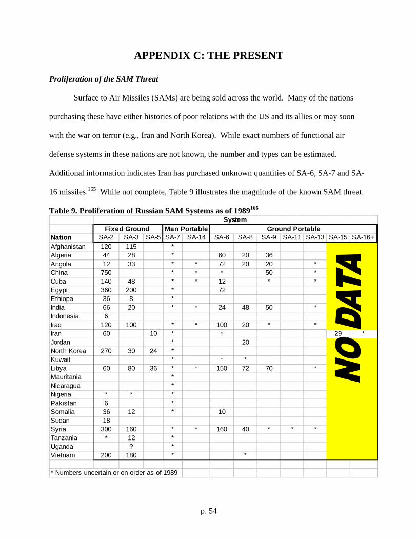
p. 54
APPENDIX C: THE PRESENT
Proliferation of the SAM Threat
Surface to Air Missiles (SAMs) are being sold across the world. Many of the nations
purchasing these have either histories of poor relations with the US and its allies or may soon
with the war on terror (e.g., Iran and North Korea). While exact numbers of functional air
defense systems in these nations are not known, the number and types can be estimated.
Additional information indicates Iran has purchased unknown quantities of SA-6, SA-7 and SA-
16 missiles.165 While not complete, Table 9 illustrates the magnitude of the known SAM threat.
Table 9. Proliferation of Russian SAM Systems as of 1989166
Nation SA-2 SA-3 SA-5 SA-7 SA-14 SA-6 SA-8 SA-9 SA-11 SA-13 SA-15 SA-16+Afghanistan 120 115 *Algeria 44 28 * 60 20 36Angola 12 33 * * 72 20 20 *China 750 * * * 50 *Cuba 140 48 * * 12 * *Egypt 360 200 * 72Ethiopa 36 8 *India 66 20 * * 24 48 50 *Indonesia 6Iraq 120 100 * * 100 20 * *Iran 60 10 * * 29 *Jordan * 20North Korea 270 30 24 *Kuwait * * *Libya 60 80 36 * * 150 72 70 *Mauritania *Nicaragua *Nigeria * * *Pakistan 6 *Somalia 36 12 * 10Sudan 18Syria 300 160 * * 160 40 * * *Tanzania * 12 *Uganda ? *Vietnam 200 180 * *
* Numbers uncertain or on order as of 1989
SystemFixed Ground Man Portable Ground Portable
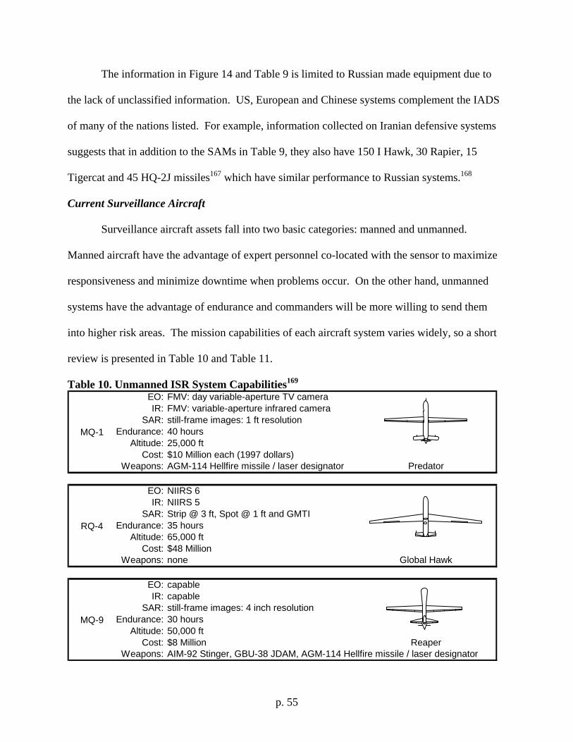
p. 55
The information in Figure 14 and Table 9 is limited to Russian made equipment due to
the lack of unclassified information. US, European and Chinese systems complement the IADS
of many of the nations listed. For example, information collected on Iranian defensive systems
suggests that in addition to the SAMs in Table 9, they also have 150 I Hawk, 30 Rapier, 15
Tigercat and 45 HQ-2J missiles167 which have similar performance to Russian systems.168
Current Surveillance Aircraft
Surveillance aircraft assets fall into two basic categories: manned and unmanned.
Manned aircraft have the advantage of expert personnel co-located with the sensor to maximize
responsiveness and minimize downtime when problems occur. On the other hand, unmanned
systems have the advantage of endurance and commanders will be more willing to send them
into higher risk areas. The mission capabilities of each aircraft system varies widely, so a short
review is presented in Table 10 and Table 11.
Table 10. Unmanned ISR System Capabilities169 EO: FMV: day variable-aperture TV cameraIR: FMV: variable-aperture infrared camera
SAR: still-frame images: 1 ft resolutionEndurance: 40 hours
Altitude: 25,000 ftCost: $10 Million each (1997 dollars)
Weapons: AGM-114 Hellfire missile / laser designator
EO: NIIRS 6IR: NIIRS 5
SAR: Strip @ 3 ft, Spot @ 1 ft and GMTIEndurance: 35 hours
Altitude: 65,000 ftCost: $48 Million
Weapons: none
EO: capableIR: capable
SAR: still-frame images: 4 inch resolutionEndurance: 30 hours
Altitude: 50,000 ftCost: $8 Million
Weapons: AIM-92 Stinger, GBU-38 JDAM, AGM-114 Hellfire missile / laser designator
MQ-9
Reaper
MQ-1
Predator
RQ-4
Global Hawk
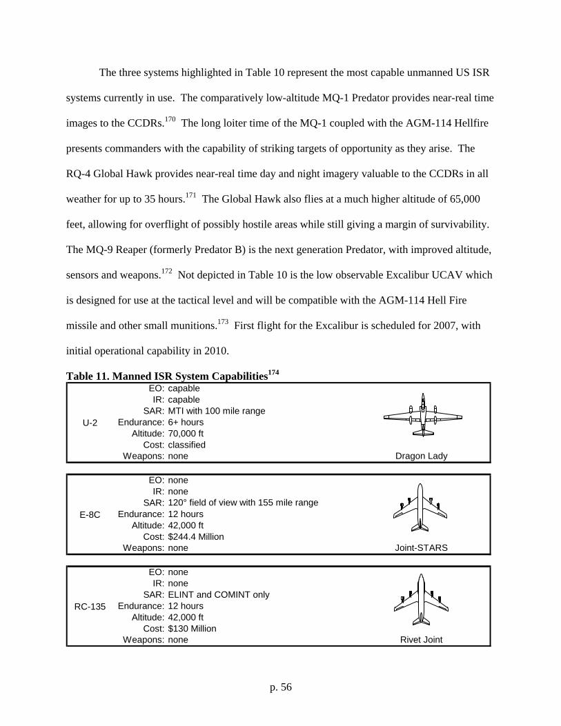
p. 56
The three systems highlighted in Table 10 represent the most capable unmanned US ISR
systems currently in use. The comparatively low-altitude MQ-1 Predator provides near-real time
images to the CCDRs.170 The long loiter time of the MQ-1 coupled with the AGM-114 Hellfire
presents commanders with the capability of striking targets of opportunity as they arise. The
RQ-4 Global Hawk provides near-real time day and night imagery valuable to the CCDRs in all
weather for up to 35 hours.171 The Global Hawk also flies at a much higher altitude of 65,000
feet, allowing for overflight of possibly hostile areas while still giving a margin of survivability.
The MQ-9 Reaper (formerly Predator B) is the next generation Predator, with improved altitude,
sensors and weapons.172 Not depicted in Table 10 is the low observable Excalibur UCAV which
is designed for use at the tactical level and will be compatible with the AGM-114 Hell Fire
missile and other small munitions.173 First flight for the Excalibur is scheduled for 2007, with
initial operational capability in 2010.
Table 11. Manned ISR System Capabilities174 EO: capableIR: capable
SAR: MTI with 100 mile rangeEndurance: 6+ hours
Altitude: 70,000 ftCost: classified
Weapons: none
EO: noneIR: none
SAR: 120° field of view with 155 mile rangeEndurance: 12 hours
Altitude: 42,000 ftCost: $244.4 Million
Weapons: none
EO: noneIR: none
SAR: ELINT and COMINT onlyEndurance: 12 hours
Altitude: 42,000 ftCost: $130 Million
Weapons: none
RC-135
Rivet Joint
U-2
Dragon Lady
E-8C
Joint-STARS
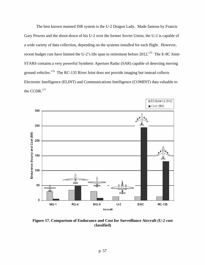
p. 57
The best known manned ISR system is the U-2 Dragon Lady. Made famous by Francis
Gary Powers and the shoot-down of his U-2 over the former Soviet Union, the U-2 is capable of
a wide variety of data collection, depending on the systems installed for each flight. However,
recent budget cuts have limited the U-2’s life span to retirement before 2012.175 The E-8C Joint-
STARS contains a very powerful Synthetic Aperture Radar (SAR) capable of detecting moving
ground vehicles.176 The RC-135 Rivet Joint does not provide imaging but instead collects
Electronic Intelligence (ELINT) and Communications Intelligence (COMINT) data valuable to
the CCDR.177
Figure 17. Comparison of Endurance and Cost for Surveillance Aircraft (U-2 cost classified)
p. 58
While all surveillance aircraft provide a view of the battlefield, not all systems are
created equally. As seen in Figure 17, the cost for a long-endurance system can vary wildly.
The key factor to gain from Figure 17 is that manned systems cost much more than the
unmanned systems, while unmanned systems are not restricted to 12 hour missions because of
crew rest obligations. For continuous battlefield surveillance availability, the preferred design
choice is an unmanned system. An unmanned system also provides the CCDR with the
additional capability of sending the system into higher risk environments. The need for
persistent ISR is known in the highest levels of the US military. The 2006 QDR captures this
need, stating a requirement for “persistent surveillance, including systems that can penetrate and
loiter in denied or contested areas.”178
The Usefulness of ISR in the War on Terror
“If you take your eye off the target for a minute, you might miss something.” – Lt. Gen. Michael Wooley, AFSOC Commander179
Two basic strategies exist for using ISR on the war on terror. First, the surveillance
assets are tasked by and for US forces in roles targeting other states (see page 73). Second, the
assets are supplied as part of a greater strategy for foreign internal defense (FID) improvements
to a weaker state.180 The second strategy benefits both the host nation and the US by
strengthening indigenous forces while simultaneously minimizing US military presence. The use
of airborne collection systems enables the FID strategy with a minimal additional burden to
space assets.
These techniques prove useful in the daily war on terror operations. In 2002, an MQ-1
Predator drone equipped with AGM-114 Hellfire missiles tracked and destroyed a vehicle in
p. 59
Yemen containing six suspected Al Qaeda members wanted for the bombing of the USS Cole.
Among those killed in the attack was Qaed Senyan al-Harthi (also known as Abu Ali).181 In
Pakistan in 2005, another Al Qaeda operative was killed while traveling in a car. Haitham al-
Yemeni was with a local warlord, Samiullah Khan, who was also killed.182 In 2006, an MQ-1
Predator operating in Iraq directed two F-16 fighters to bomb a house containing Abu Musab al-
Zarqawi, a suspected Al Qaeda leader.183 These strikes would not have been possible were it not
for the four unique capabilities of persistent surveillance and strike aircraft: long loiter times,
immediate strike capability, instant battle damage assessment and feeding real-time video to
ground forces.184
High Demand, Low Density Assets
Access to the information from Predator and Global Hawk is demanded by every US
Army battalion commander, USAF targeting cell and special operations team around the
clock.185 The demand for data from airborne ISR assets far outweighs current US capability. A
Joint Force Component Commander recently stated that ISR planners can only meet 50 percent
of the requests for visual and synthetic aperture radar images. The capability to meet the needs
of moving target indicator (MTI) and full motion video (FMV) requirements is even less. With
user demands increasing exponentially, the already saturated ISR capability requires immediate
enhancement. Both space and atmospheric based ISR programs are continually being upgraded
by the US Government. But which offers the greatest potential?
p. 60
The Inefficiency of Space
The great advantage to space satellite reconnaissance is that international treaties allow
for the unmolested use of space assets for ISR data collection. However, several disadvantages
in using the space-based systems still exist for the Combatant Commander. First, space-based
ISR systems require years of development and billions of dollars. Even with that significant
investment, Low-Earth Orbiting (LEO) satellites provide only a stroboscopic view of the
battlefield. The relatively low satellite altitude (100-150 miles) is required to maximize the
performance of the sensor package. This low orbit dictates a fast pass over the ground. Placing
the satellite in a higher orbit will result in longer pass times (the longest being for satellites in
geostationary orbit where the satellite is fixed over a specific ground location) but results in
greatly degraded performance, with imaging sensors almost useless for CCDRs. Therefore,
dwell time over a specific Area of Operational Responsibility (AOR) is measured in minutes (33
seconds to 4 minutes, 29 seconds depending on the mission) requiring several satellites just for
daily coverage.186 During the limited pass time over the target area, the fixed capabilities of the
aging satellite systems may not be able to keep up with advances in enemy strategy. For
example, the use of distributed systems and seldom-used cloned phones.187 The products of
imaging satellites are still subject to poor weather conditions which may obscure the desired area
altogether resulting in a useless image.188 A third disadvantage is the inherently strategic nature
of the satellite which delays delivery of the data to the warfighter and makes it almost impossible
for the end-user to control them. Diminishing budgets for space-based surveillance continues to
delay providing space-based capabilities like Space Based Radar (SBR) which could be
performed by a near space asset and at a higher relative resolution due to its decreased distance
to the battlefield.189 To overcome the limitations of satellites, many capabilities traditionally
p. 61
associated with space could be relocated to airborne assets. The direct tasking of these systems
from the battlefield provides a great capability worth considering.
Perhaps the greatest risk is the US dependence on its satellite systems. Should these
systems become disabled or destroyed in any way, current CONOPS will be difficult to cope.
Predicted threats for the 2010 to 2025 timeframe consist of high-altitude nuclear bursts, anti-
satellite kinetic vehicles and lasers (see page 80).190 The high-altitude nuclear burst would create
an electromagnetic pulse disabling or disrupting satellites for a radius of thousands of miles. Re-
creating the current on-orbit capability would take several years and trillions of dollars. An
alternative would be fielding these same capabilities on a near space asset for a fraction of the
cost with no space launch risks.
Dr. Ed Tomme (retired USAF Lt. Col., Sci-Ops Consulting, Inc) summarized this
argument in a 2007 USAF Air Command & Staff College survey when he stated that:
“The layered approach is the one that will work. Space, the strategic layer, has the advantages of freedom of global overflight and, for the time being, relative immunity to threats. The drawbacks are distance (limits resolution and/or requires high power for communications). Complementing space, near-space gives persistence, lower cost, and responsiveness over theater- to region-sized AORs. Its limitations are lack of speed and perhaps lack of resolution. The tactical layer, air breathing UAVs, need to have speed and resolution (and weapons in some cases) to respond to cues received from space and near-space. This layered approach makes the air-breathers much more effective since they don't spend time searching through a soda straw, only responding to potential threats already tagged by the wider area searches performed by space and near-space assets. This set-up is much like what is used by surface to air missiles, where a target tracking radar with a large beamwidth and rapid scan finds the target and hands them off to a very narrow beamwidth target tracking radar.”191
Tomme’s comments were supported by Bruce Carmichael (VP, L-3 Communications),
Cory Dixon (University of Colorado) and Dr. Brent Marley (USAF Air War College).
Additional survey results are presented in Appendix A starting on page 32.
p. 62
The shortcomings of current US surveillance are explicitly mentioned in the 2006
Quadrennial Defense Review Report (QDR). The QDR is the key document which
discusses the current and future focus of the US military, including: shortcomings,
capabilities, missions and probable future threats it will face. Repeated throughout the
QDR is the transformational requirement that new systems must provide “better fusion of
intelligence and operations to produce action plans that can be executed in real time.”192
A stated key component of this capability is the doubling of current unmanned airborne
surveillance systems, allowing more continuous coverage.193 These new systems will
provide the US with the QDR required capability of “long-term, low-visibility presence
in many areas of the world where US forces do not traditionally operate.”194
Summary of Present Lessons Learned:
1. For continuous battlefield surveillance availability, the preferred design choice is an
unmanned system.
2. The 2006 QDR states a requirement for “persistent surveillance, including systems
that can penetrate and loiter in denied or contested areas.”
3. Strikes against time-sensitive-targets would not have been possible were it not for the
four unique capabilities of persistent surveillance and strike aircraft: long loiter
times, immediate strike capability, instant battle damage assessment and feeding real-
time video to ground forces.
4. Satellites are limited because of their short pass time over target areas, high cost,
fixed capabilities and their inherently strategic nature which makes initial tasking
and final data delivery to CCDRs very difficult.
p. 63
APPENDIX D: LIMITATIONS AND SURVIVABILITY OF LTA’S
Technological Advances in Aircraft Design: Balloons
The simple balloon concept is well understood and may still provide tactical and
operational advantages. Called free-floaters due to their lack of station-keeping ability, the
potential for communications and surveillance support is still substantial.195 Released upwind,
the balloons provide coverage while over the AOR and then are commanded to release the
payload using a parachute or gliding wings for terrestrial recovery. Collection over friendly
territory is a must. The incorporation of a glider into the system payload can allow for easier
recovery of the more expensive components.196 The one clear advantage to this method is that
space qualified hardware is not required which minimizes costs.197 The disadvantage is the
periodic replenishment needed as the balloons drift out of range.
Connecting a cable from the balloon to the ground fixing it in place changes the name to
aerostat. Current use of aerostats includes Homeland Defense and support for personnel in
Baghdad, Iraq.198 The Baghdad aerostats carry a 300 pound payload at altitudes up to 56,000 ft.
The aerostats alert ground forces to shoulder-fired missile launches.199 The US Army chose this
system deliberately for its low cost and minimal logistical requirements.200 Despite this
successful use, scaling up is not possible with current balloon designs to larger payloads at
higher altitudes. The weight of the cable and stresses placed upon it are too great. However,
breakthroughs in carbon nano-tube wires may again make this a viable alternative.201 Other
limitations include the requirement for a ground tower or naval vessel for attachment of the
tether and the camera shake caused by the vibration of the balloon-tether system. Because of
these limitations the tethered balloon approach is not recommended.
p. 64
LTA Limitations
Perhaps the greatest limitation to LTAs is the weather. Transiting the troposphere for raising or
lowering operations places the system at risk to the jet stream, lightning and windstorms.
Detailed weather forecasts will be required since jet stream velocities of up to 250 knots would
easily overpower the station-keeping propulsion system of the proposed LTA designs.202 While
current meteorological forecasting methods may be sufficient for the lower altitudes of LTA
transits, the near space weather environment is not as well defined. To predict weather at the
operational altitudes of these systems, Air Force Space Command (AFSPC) is developing a new
software package called Talon SHU.203 This program is scheduled to be available to the
operators of the near space assets.
LTA Survivability
The survivability of LTAs in a foreign threat environment must be considered before
deployment. At first glance, the risk to LTAs by SAMs (SA-2, 4, 5, 10, 11, 12, 17 from Figure
14 on page 43) seems credible. However, the extreme altitude (65,000 ft), low radar cross
section and negligible velocity all make targeting an LTA extremely difficult task.204 Considering
all the systems with enough reach, of these only the SA-2 and SA-5 have been exported in any
great number.205 Should an attack occur, the LTAs inherent ability to endure several small
punctures from an exploding SAM warhead will allow for a gradual and controlled descent.
Specific survivability will be dependent on the final design and its systems. Incorporation of an
AN/ALQ-214 Integrated Defense Electronic Countermeasures (IDECM) or similar system
would also greatly enhance survivability.206 Despite these means to increase survivability, air
superiority is the preferred means for survivability.
p. 65
A USAF Air Command & Staff College survey submitted to 73 leading industry,
government and university experts in the field of UAVs considered which type of aerial platform
would be the most useful in detecting and tracking an enemy threat. Dr. John Baker (Professor,
Mechanical Engineering, University of Alabama) stated that:
“I believe near space systems will be the most useful in detecting and tracking enemy threats because such systems would typically be out of the range of enemy fire. They will be more responsive and have superior imaging capabilities relative to satellites. Near space systems will also have superior loitering capabilities compared to UAVs.”207
Dr. Brent Marley and Dr. Ed Tomme responded with similar comments. Mr. Dyke
Weatherington (Deputy, UAV Planning Task Force, Office of the Under Secretary of Defense)
added that it:
“Depends on the threat, large airships will have advantages for large area surveillance from static locations (Missile defense, Homeland defense, Maritime defense awareness) for individual human targets, a combination of large and small technologies will likely provide the most robust capability.”208
Further survey results are presented in Appendix A on page 32.
p. 66
APPENDIX E: ENABLING NET-CENTRIC OPERATIONS
Technological Advances in ISR and Communications: Radio Relay
Communications across the battlefield require immediate improvement for current and
future operations. Present methods of passing CAS information from one to operator to the next
increases the odds of getting poor support or creating a fratricide event. A high-altitude repeater
for existing radios can expand the troops on the ground radios from 10 to 400 miles allowing
direct contact with CAS pilots preventing possible fratricide.209 The AF Space Battlelab
demonstrated a prototype system, Combat SkySat, using PRC-148 two-way radios in March
2005.210 Upon the successful conclusion of the test, the USAF awarded a $49M contract to
Space Data Corporation to build more of them for use in Iraq, each of which will provide
approximately eight hours of coverage before the payload will have to be recovered.211
An LTA or UAV can also be used as a GPS pseudo satellite. The proliferation of
Russian made GPS jammers provide their users with the capability to potentially prevent satellite
guided bombs from impacting their targets and increasing the risk of collateral damage to
civilians.212 A near space asset provides the perfect platform for broadcasting an additional GPS
signal, either as a differential signal for improved accuracy or as an additional pseudo-satellite.213
Technological Advances in Data Integration and Management
The Common Operational Picture (COP) is a new system for providing Joint
commanders with mission data and near real-time ISR updates.214 These updates increase or
create situational awareness across the battlefield, allowing commanders to bring together the
various elements of the Joint force in the most powerful way possible. The COP consists of “a
single identical display of relevant information shared by more than one command.”215
However, studies of the new system have revealed a shortcoming. The user is not able to tailor
p. 67
the system for their specific needs, thus limiting effects-based sequencing of operations across
the battlespace. Despite this, at the tactical level in the field a new system is spreading
situational awareness in near real time. The Remotely Operated Video Enhanced Receiver
(ROVER) is a 15 pound laptop and radio receiver carried by units in Iraq to observe video
footage collected by other ISR collectors. ROVER is capable of receiving video from more than
100 different sources including Predator UAVs.216 The principle shortcoming of ROVER is that
it is currently a one-way system. The units receiving the data can not control the sensor sending
them the video. Air Combat Command is planning on adding a simple uplink capability to allow
ground users to highlight targets on the video footage to indicate preferred targets to the Predator
operators. ROVER technology is an important baseline for the future of continuously available
surveillance.
Just deployed for the US Army is the Persistent Surveillance and Dissemination System
of Systems (PSDS2).217 PSDS2 integrates video, radio and acoustic sensors into a three-
dimensional map for continuous surveillance of a specific area. The data can come from UAVs,
LTAs, ground vehicles, buildings or individuals. PSDS2 users can set alerts to changes in
activity to focus their attention on specific events. The system can also record all information for
the past 20 days, allowing users to “rewind” and observe actions leading up to an event.218 An
even greater feature is the ability to transmit the data to hand-held Personal Digital Assistants
(PDAs) which are being distributed to commanders and combat patrols in the field. This system
can be expanded on as technology continues to improve to the point where the field users are
tasking the sensors directly.
A similar system is under development for the US Navy, called Persistent Unmanned
Maritime Airborne Surveillance (PUMAS).219 PUMAS will integrate manned and unmanned
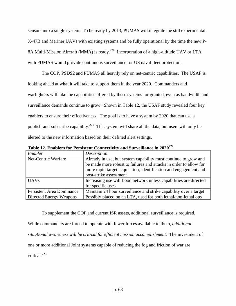
p. 68
sensors into a single system. To be ready by 2013, PUMAS will integrate the still experimental
X-47B and Mariner UAVs with existing systems and be fully operational by the time the new P-
8A Multi-Mission Aircraft (MMA) is ready.220 Incorporation of a high-altitude UAV or LTA
with PUMAS would provide continuous surveillance for US naval fleet protection.
The COP, PSDS2 and PUMAS all heavily rely on net-centric capabilities. The USAF is
looking ahead at what it will take to support them in the year 2020. Commanders and
warfighters will take the capabilities offered by these systems for granted, even as bandwidth and
surveillance demands continue to grow. Shown in Table 12, the USAF study revealed four key
enablers to ensure their effectiveness. The goal is to have a system by 2020 that can use a
publish-and-subscribe capability.221 This system will share all the data, but users will only be
alerted to the new information based on their defined alert settings.
Table 12. Enablers for Persistent Connectivity and Surveillance in 2020222 Enabler Description Net-Centric Warfare Already in use, but system capability must continue to grow and
be made more robust to failures and attacks in order to allow for more rapid target acquisition, identification and engagement and post-strike assessment
UAVs Increasing use will flood network unless capabilities are directed for specific uses
Persistent Area Dominance Maintain 24 hour surveillance and strike capability over a target Directed Energy Weapons Possibly placed on an LTA, used for both lethal/non-lethal ops
To supplement the COP and current ISR assets, additional surveillance is required.
While commanders are forced to operate with fewer forces available to them, additional
situational awareness will be critical for efficient mission accomplishment. The investment of
one or more additional Joint systems capable of reducing the fog and friction of war are
critical.223
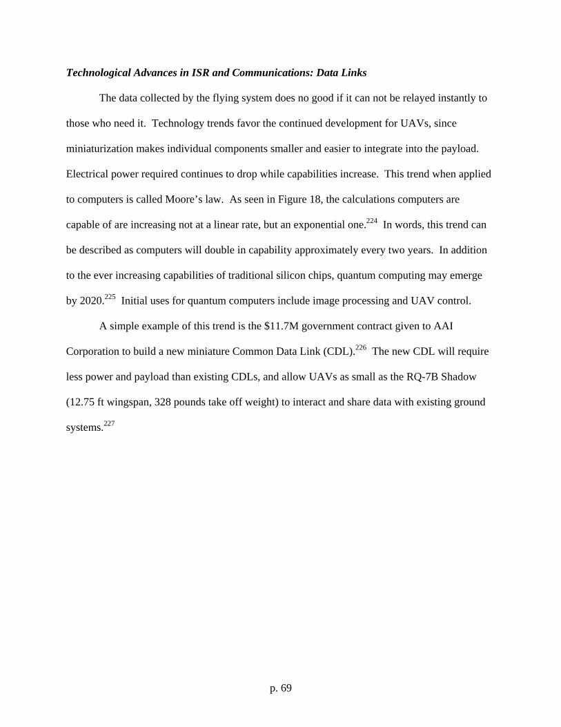
p. 69
Technological Advances in ISR and Communications: Data Links
The data collected by the flying system does no good if it can not be relayed instantly to
those who need it. Technology trends favor the continued development for UAVs, since
miniaturization makes individual components smaller and easier to integrate into the payload.
Electrical power required continues to drop while capabilities increase. This trend when applied
to computers is called Moore’s law. As seen in Figure 18, the calculations computers are
capable of are increasing not at a linear rate, but an exponential one.224 In words, this trend can
be described as computers will double in capability approximately every two years. In addition
to the ever increasing capabilities of traditional silicon chips, quantum computing may emerge
by 2020.225 Initial uses for quantum computers include image processing and UAV control.
A simple example of this trend is the $11.7M government contract given to AAI
Corporation to build a new miniature Common Data Link (CDL).226 The new CDL will require
less power and payload than existing CDLs, and allow UAVs as small as the RQ-7B Shadow
(12.75 ft wingspan, 328 pounds take off weight) to interact and share data with existing ground
systems.227
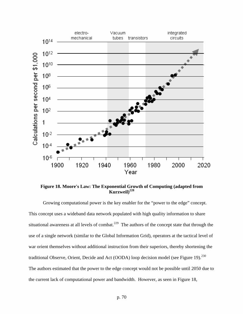
p. 70
Figure 18. Moore's Law: The Exponential Growth of Computing (adapted from Kurzweil)228
Growing computational power is the key enabler for the “power to the edge” concept.
This concept uses a wideband data network populated with high quality information to share
situational awareness at all levels of combat.229 The authors of the concept state that through the
use of a single network (similar to the Global Information Grid), operators at the tactical level of
war orient themselves without additional instruction from their superiors, thereby shortening the
traditional Observe, Orient, Decide and Act (OODA) loop decision model (see Figure 19).230
The authors estimated that the power to the edge concept would not be possible until 2050 due to
the current lack of computational power and bandwidth. However, as seen in Figure 18,
p. 71
computational power is increasing at an exponential rate. The rise in computer capability
coupled with laser communications (see below) indicate this capability may be possible much
sooner.
Figure 19. Computer and Communications Technology will Shorten OODA Loop231
Secure and high-bandwidth communications can be achieved through the use of lasers.
Laser communication offers the possibility of bandwidth as high as fiber optic lines, but without
the physical medium connecting the transmitter and receiver. Currently under development for
the new USAF Transformational Satellite Communications System (TSAT), a satellite based
laser communication system could be fielded as soon as 2013.232 Data transfer rate for this
system is specified at 40 Gbps, or the equivalent of sending the entire Encyclopedia Britannica
(including all graphics) 40 times per second.233 This system is being considered for integration
into existing ISR platforms such as the RQ-4 Global Hawk. The designers of the TSAT laser
communications system have suggested that sensor to shooter links using this technology are
p. 72
possible, allowing high-resolution images and video to be transmitted directly to the tactical level
of war.234 This system could easily be integrated into an airship or aircraft operating at high
altitudes over the battlefield. Another benefit of using lasers is the independence from the radio
spectrum, allowing frequencies to be assigned to other projects.235 But the US has already lost
the edge in this race.
The US must develop this technology immediately. The European Space Agency (ESA)
satellite Artemis successfully tested laser communications between an aircraft and space in
December 2006. A French Mystère 20 aircraft using the LOLA (Liaison Optique Laser
Aéroportée) airborne laser optical link established six two-way communication links with the
SILEX (Semiconductor Intersatellite Link Experiment) payload on the Artemis satellite.236 The
altitude difference between these two crafts is substantial – 22,370 miles for Artemis, 20,000 ft
for the Mystère 20 aircraft. The SILEX payload is capable of transmitting data only at 50 Mbs,
significantly less than the still experimental TSAT system currently under development in the
US but it still clearly demonstrates the feasibility of the system.237
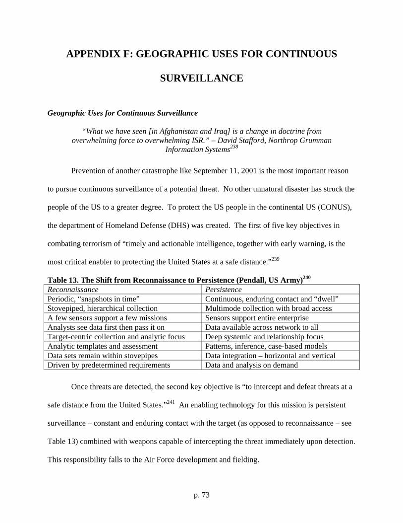
p. 73
APPENDIX F: GEOGRAPHIC USES FOR CONTINUOUS
SURVEILLANCE
Geographic Uses for Continuous Surveillance
“What we have seen [in Afghanistan and Iraq] is a change in doctrine from overwhelming force to overwhelming ISR.” – David Stafford, Northrop Grumman
Information Systems238
Prevention of another catastrophe like September 11, 2001 is the most important reason
to pursue continuous surveillance of a potential threat. No other unnatural disaster has struck the
people of the US to a greater degree. To protect the US people in the continental US (CONUS),
the department of Homeland Defense (DHS) was created. The first of five key objectives in
combating terrorism of “timely and actionable intelligence, together with early warning, is the
most critical enabler to protecting the United States at a safe distance.”239
Table 13. The Shift from Reconnaissance to Persistence (Pendall, US Army)240 Reconnaissance Persistence Periodic, “snapshots in time” Continuous, enduring contact and “dwell” Stovepiped, hierarchical collection Multimode collection with broad access A few sensors support a few missions Sensors support entire enterprise Analysts see data first then pass it on Data available across network to all Target-centric collection and analytic focus Deep systemic and relationship focus Analytic templates and assessment Patterns, inference, case-based models Data sets remain within stovepipes Data integration – horizontal and vertical Driven by predetermined requirements Data and analysis on demand
Once threats are detected, the second key objective is “to intercept and defeat threats at a
safe distance from the United States.”241 An enabling technology for this mission is persistent
surveillance – constant and enduring contact with the target (as opposed to reconnaissance – see
Table 13) combined with weapons capable of intercepting the threat immediately upon detection.
This responsibility falls to the Air Force development and fielding.
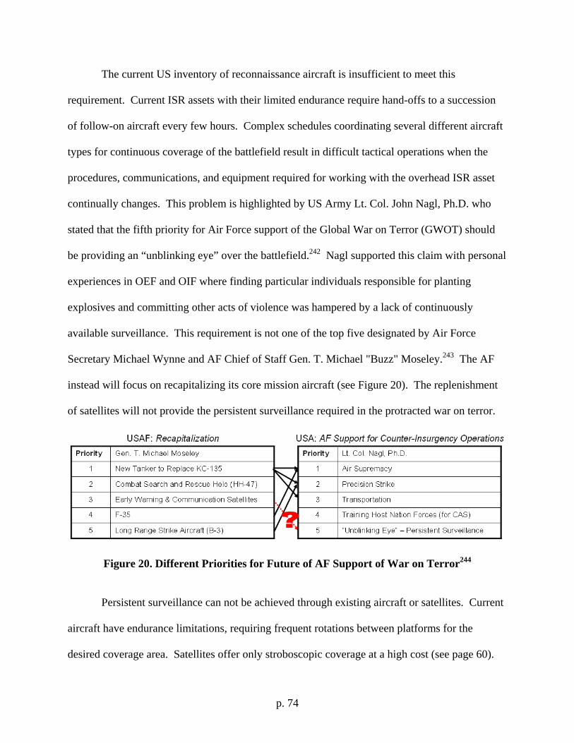
p. 74
The current US inventory of reconnaissance aircraft is insufficient to meet this
requirement. Current ISR assets with their limited endurance require hand-offs to a succession
of follow-on aircraft every few hours. Complex schedules coordinating several different aircraft
types for continuous coverage of the battlefield result in difficult tactical operations when the
procedures, communications, and equipment required for working with the overhead ISR asset
continually changes. This problem is highlighted by US Army Lt. Col. John Nagl, Ph.D. who
stated that the fifth priority for Air Force support of the Global War on Terror (GWOT) should
be providing an “unblinking eye” over the battlefield.242 Nagl supported this claim with personal
experiences in OEF and OIF where finding particular individuals responsible for planting
explosives and committing other acts of violence was hampered by a lack of continuously
available surveillance. This requirement is not one of the top five designated by Air Force
Secretary Michael Wynne and AF Chief of Staff Gen. T. Michael "Buzz" Moseley.243 The AF
instead will focus on recapitalizing its core mission aircraft (see Figure 20). The replenishment
of satellites will not provide the persistent surveillance required in the protracted war on terror.
Figure 20. Different Priorities for Future of AF Support of War on Terror244
Persistent surveillance can not be achieved through existing aircraft or satellites. Current
aircraft have endurance limitations, requiring frequent rotations between platforms for the
desired coverage area. Satellites offer only stroboscopic coverage at a high cost (see page 60).
p. 75
A near space system could offer the advantage of a high cost, orbital unblinking eye for the cost
of an aircraft. Placement of a high-altitude airship or UAV at 65,000 ft provides ISR coverage
for a radius of 310 miles (see equation 1 where r is the radius of the Earth and h is the airship
altitude).245
[1]
This is a total of 305,000 square miles, roughly the same size as Texas. A higher altitude of
120,000 ft gives a radius of 420 miles. The range of this capability allows stationing of a high
altitude asset outside international borders of the target nation while still providing significant
ISR data. But where should the government focus this technology?
Five nations have been identified as the largest state-sponsors of terrorism: Iran, Syria,
Sudan, North Korea and Cuba.246 Monitoring of the activities of these states is critical.
Weapons of Mass Destruction (WMD) development, technology transfers, training and other
forms of support may be monitored to provide US leaders with a real-time assessment of threat
growth. Compliance with possible UN sanctions or other agreements can also be accomplished.
Regardless of the source of the mission, the capability is enabling.
Another key use of persistent surveillance is supporting existing operations. US forces
operating in Iraq (see page 51) already need this capability. The utility is apparent for operations
in Afghanistan as well.
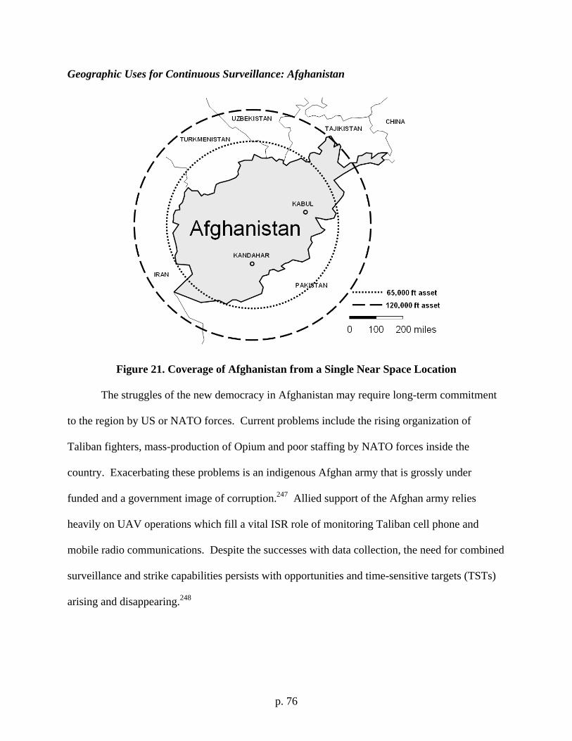
p. 76
Geographic Uses for Continuous Surveillance: Afghanistan
Figure 21. Coverage of Afghanistan from a Single Near Space Location The struggles of the new democracy in Afghanistan may require long-term commitment
to the region by US or NATO forces. Current problems include the rising organization of
Taliban fighters, mass-production of Opium and poor staffing by NATO forces inside the
country. Exacerbating these problems is an indigenous Afghan army that is grossly under
funded and a government image of corruption.247 Allied support of the Afghan army relies
heavily on UAV operations which fill a vital ISR role of monitoring Taliban cell phone and
mobile radio communications. Despite the successes with data collection, the need for combined
surveillance and strike capabilities persists with opportunities and time-sensitive targets (TSTs)
arising and disappearing.248
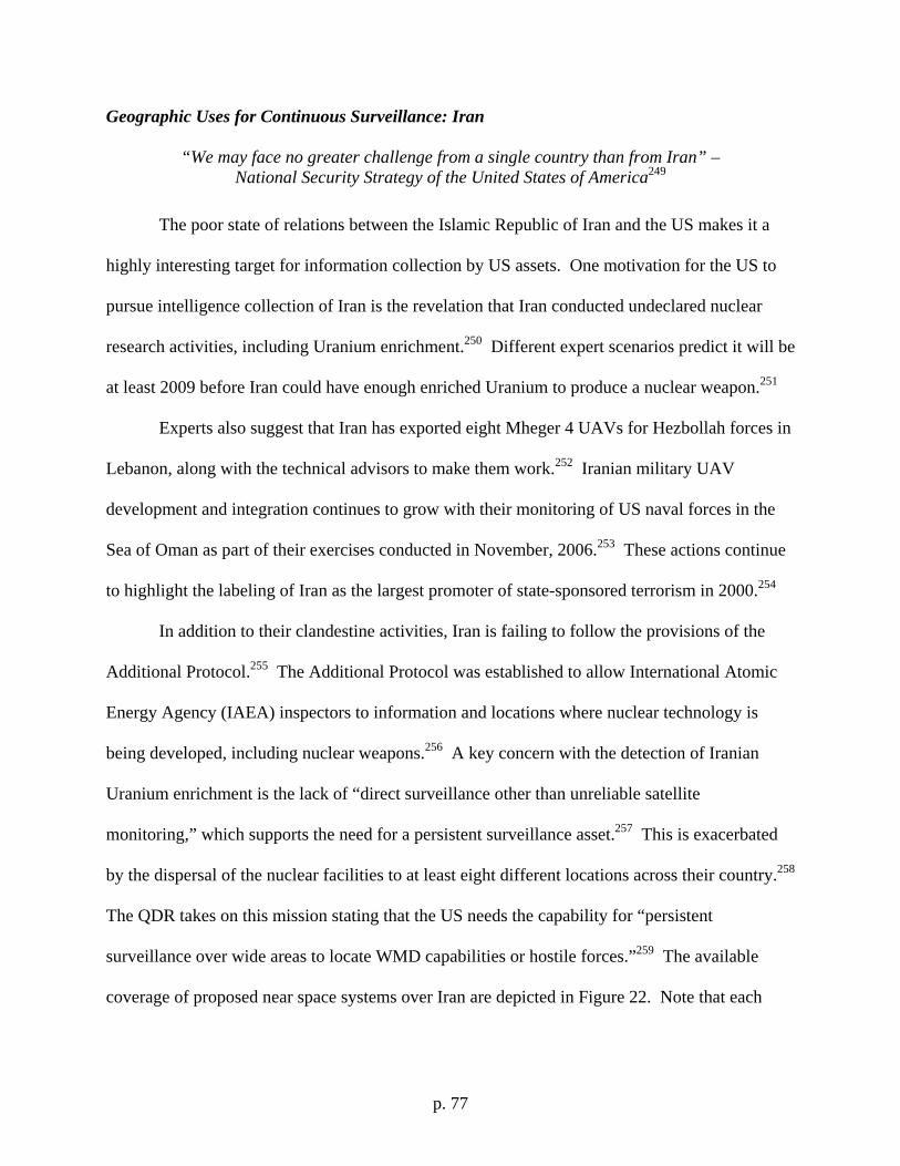
p. 77
Geographic Uses for Continuous Surveillance: Iran
“We may face no greater challenge from a single country than from Iran” – National Security Strategy of the United States of America249
The poor state of relations between the Islamic Republic of Iran and the US makes it a
highly interesting target for information collection by US assets. One motivation for the US to
pursue intelligence collection of Iran is the revelation that Iran conducted undeclared nuclear
research activities, including Uranium enrichment.250 Different expert scenarios predict it will be
at least 2009 before Iran could have enough enriched Uranium to produce a nuclear weapon.251
Experts also suggest that Iran has exported eight Mheger 4 UAVs for Hezbollah forces in
Lebanon, along with the technical advisors to make them work.252 Iranian military UAV
development and integration continues to grow with their monitoring of US naval forces in the
Sea of Oman as part of their exercises conducted in November, 2006.253 These actions continue
to highlight the labeling of Iran as the largest promoter of state-sponsored terrorism in 2000.254
In addition to their clandestine activities, Iran is failing to follow the provisions of the
Additional Protocol.255 The Additional Protocol was established to allow International Atomic
Energy Agency (IAEA) inspectors to information and locations where nuclear technology is
being developed, including nuclear weapons.256 A key concern with the detection of Iranian
Uranium enrichment is the lack of “direct surveillance other than unreliable satellite
monitoring,” which supports the need for a persistent surveillance asset.257 This is exacerbated
by the dispersal of the nuclear facilities to at least eight different locations across their country.258
The QDR takes on this mission stating that the US needs the capability for “persistent
surveillance over wide areas to locate WMD capabilities or hostile forces.”259 The available
coverage of proposed near space systems over Iran are depicted in Figure 22. Note that each
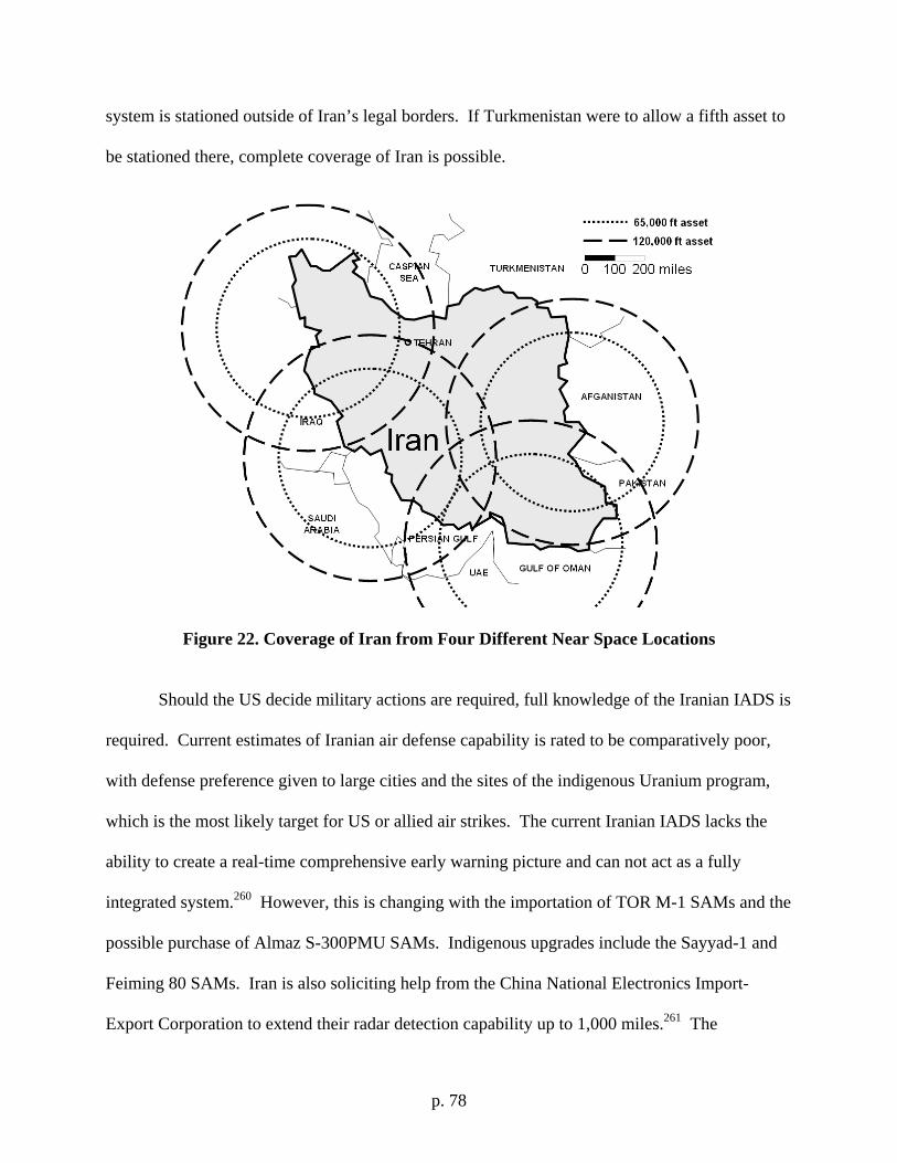
p. 78
system is stationed outside of Iran’s legal borders. If Turkmenistan were to allow a fifth asset to
be stationed there, complete coverage of Iran is possible.
Figure 22. Coverage of Iran from Four Different Near Space Locations
Should the US decide military actions are required, full knowledge of the Iranian IADS is
required. Current estimates of Iranian air defense capability is rated to be comparatively poor,
with defense preference given to large cities and the sites of the indigenous Uranium program,
which is the most likely target for US or allied air strikes. The current Iranian IADS lacks the
ability to create a real-time comprehensive early warning picture and can not act as a fully
integrated system.260 However, this is changing with the importation of TOR M-1 SAMs and the
possible purchase of Almaz S-300PMU SAMs. Indigenous upgrades include the Sayyad-1 and
Feiming 80 SAMs. Iran is also soliciting help from the China National Electronics Import-
Export Corporation to extend their radar detection capability up to 1,000 miles.261 The
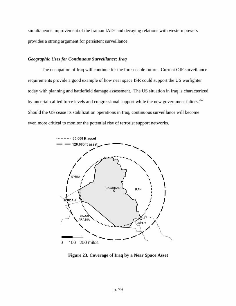
p. 79
simultaneous improvement of the Iranian IADs and decaying relations with western powers
provides a strong argument for persistent surveillance.
Geographic Uses for Continuous Surveillance: Iraq
The occupation of Iraq will continue for the foreseeable future. Current OIF surveillance
requirements provide a good example of how near space ISR could support the US warfighter
today with planning and battlefield damage assessment. The US situation in Iraq is characterized
by uncertain allied force levels and congressional support while the new government falters.262
Should the US cease its stabilization operations in Iraq, continuous surveillance will become
even more critical to monitor the potential rise of terrorist support networks.
Figure 23. Coverage of Iraq by a Near Space Asset
p. 80
Geographic Uses for Continuous Surveillance: People’s Republic of China
“There is a great tradition that The Inferior Defeats the Superior. We need some Assassin’s Mace weapons that the enemy will fear.” – General Liu Jingsong,
PLA263
China observed the defeat of Iraqi forces during Desert Storm and Operation Iraqi
Freedom, taking many lessons learned from the conflicts. Due to the commonality of many
People’s Liberation Army (PLA) systems with those of Iraq and ever growing capabilities of US
military technology, China embarked on an incredible modernization program. The central
theme guiding this development is modernizing all services for improved joint operational
capabilities.264 Particular system improvement efforts are being made in command, control,
communication, computers, intelligence, surveillance and reconnaissance (C4ISR) for potentially
hemispheric coverage.265 The PLA’s training upgraded after Operation Allied Force to counter
the US use of stealth aircraft, cruise missiles and helicopters. Specifically, the Chinese were
concerned with the US precision strike capability, electronic warfare and reconnaissance
platforms.266
US reconnaissance satellites have already seen this threat. China used a ground based
laser to “dazzle” the optical imaging system of a US satellite as it passed over their territory. It is
not known if the intent was to blind the imaging system of the satellite, or merely to track it.267
Whatever the intent, this prevented the satellite from collecting useful imagery as it passed
overhead.268 The potential for permanent damage to the satellite is further complicated by the
fact that the satellite can not be repaired once in orbit. This technology can also be used to blind
US pilots causing temporary or permanent eye damage.269 In addition to the anti-satellite laser,
China demonstrated the successful testing of an anti-satellite kinetic kill vehicle on 11 Jan
2007.270 China’s subsequent reluctance to engage in space treaty negotiations foreshadows their
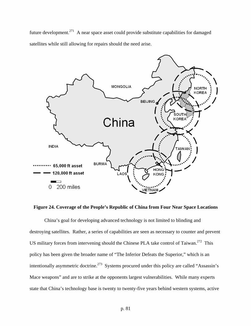
p. 81
future development.271 A near space asset could provide substitute capabilities for damaged
satellites while still allowing for repairs should the need arise.
Figure 24. Coverage of the People’s Republic of China from Four Near Space Locations
China’s goal for developing advanced technology is not limited to blinding and
destroying satellites. Rather, a series of capabilities are seen as necessary to counter and prevent
US military forces from intervening should the Chinese PLA take control of Taiwan.272 This
policy has been given the broader name of “The Inferior Defeats the Superior,” which is an
intentionally asymmetric doctrine.273 Systems procured under this policy are called “Assassin’s
Mace weapons” and are to strike at the opponents largest vulnerabilities. While many experts
state that China’s technology base is twenty to twenty-five years behind western systems, active
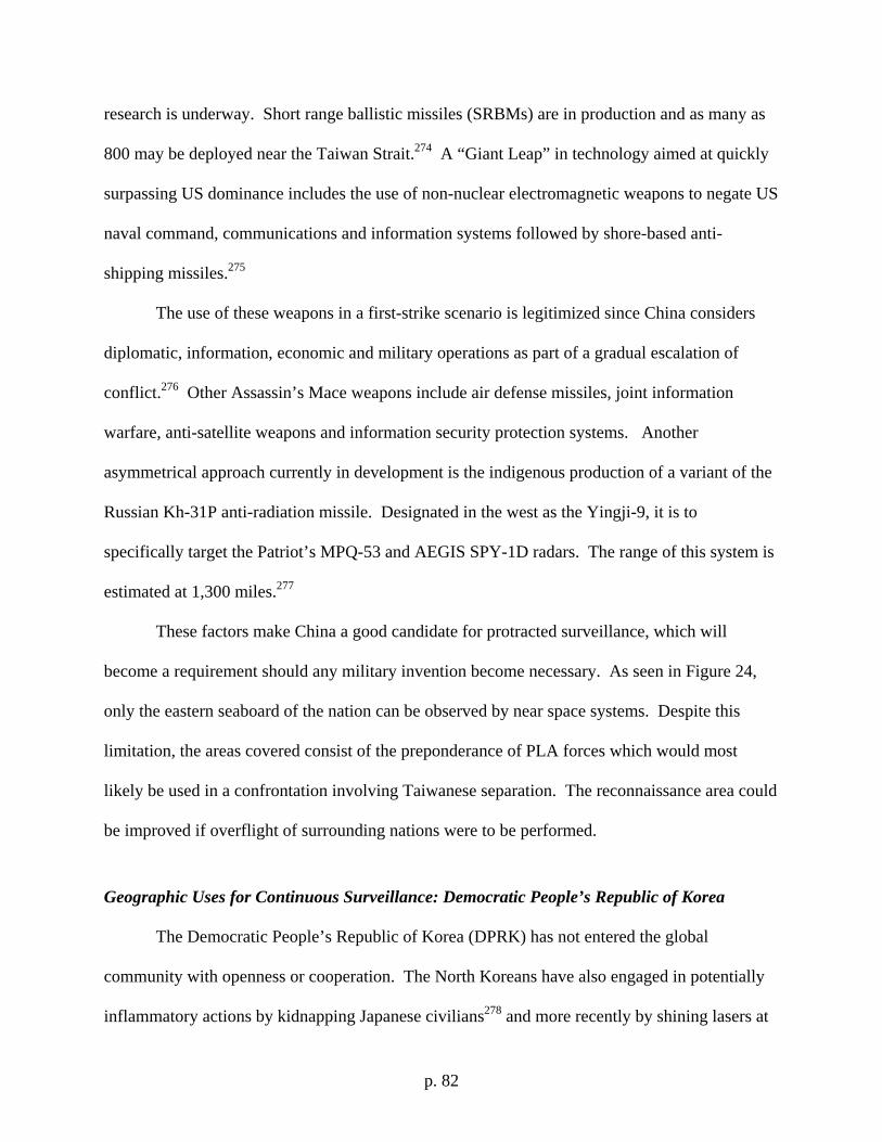
p. 82
research is underway. Short range ballistic missiles (SRBMs) are in production and as many as
800 may be deployed near the Taiwan Strait.274 A “Giant Leap” in technology aimed at quickly
surpassing US dominance includes the use of non-nuclear electromagnetic weapons to negate US
naval command, communications and information systems followed by shore-based anti-
shipping missiles.275
The use of these weapons in a first-strike scenario is legitimized since China considers
diplomatic, information, economic and military operations as part of a gradual escalation of
conflict.276 Other Assassin’s Mace weapons include air defense missiles, joint information
warfare, anti-satellite weapons and information security protection systems. Another
asymmetrical approach currently in development is the indigenous production of a variant of the
Russian Kh-31P anti-radiation missile. Designated in the west as the Yingji-9, it is to
specifically target the Patriot’s MPQ-53 and AEGIS SPY-1D radars. The range of this system is
estimated at 1,300 miles.277
These factors make China a good candidate for protracted surveillance, which will
become a requirement should any military invention become necessary. As seen in Figure 24,
only the eastern seaboard of the nation can be observed by near space systems. Despite this
limitation, the areas covered consist of the preponderance of PLA forces which would most
likely be used in a confrontation involving Taiwanese separation. The reconnaissance area could
be improved if overflight of surrounding nations were to be performed.
Geographic Uses for Continuous Surveillance: Democratic People’s Republic of Korea
The Democratic People’s Republic of Korea (DPRK) has not entered the global
community with openness or cooperation. The North Koreans have also engaged in potentially
inflammatory actions by kidnapping Japanese civilians278 and more recently by shining lasers at
p. 83
US AH-64 Apache helicopters flying south of the Demilitarized Zone (DMZ) in March 2003.
The device used against the Apache helicopter crew was most likely a Chinese ZM-87 laser
blinder.279 The Apache’s on-board laser detectors confirmed the use of the weapon.
Specifically, the ZM-87 is the world’s only known laser-based anti-personnel weapon and can
cause damage to human eyes at up to 3 miles.280 Also in March 2003 four North Korean fighters
(MiG-23s and MiG-29s) attempted to force a US RC-135 Rivet Joint to land, despite the fact that
it was operating 150 miles over international waters.281 The DPRK is also identified as one of
the leading proliferators of missile technology with Iran (No-Dong 2 missile technology) and
Syria as customers.282 North Korean actions since then have continued to degrade culminating in
their first testing of a nuclear weapon despite international pleas not to.283 To make matters
worse, North Korea’s poor economy and unemployment rate are making the disintegration of its
government a distinct possibility.284 All of these actions support the need for continuous
monitoring of North Korea by a low observable, unmanned system operating at a high altitude
(see Figure 25) incapable of being shot down for the foreseeable future.285
Figure 25. Coverage of North Korea by a Near Space Asset
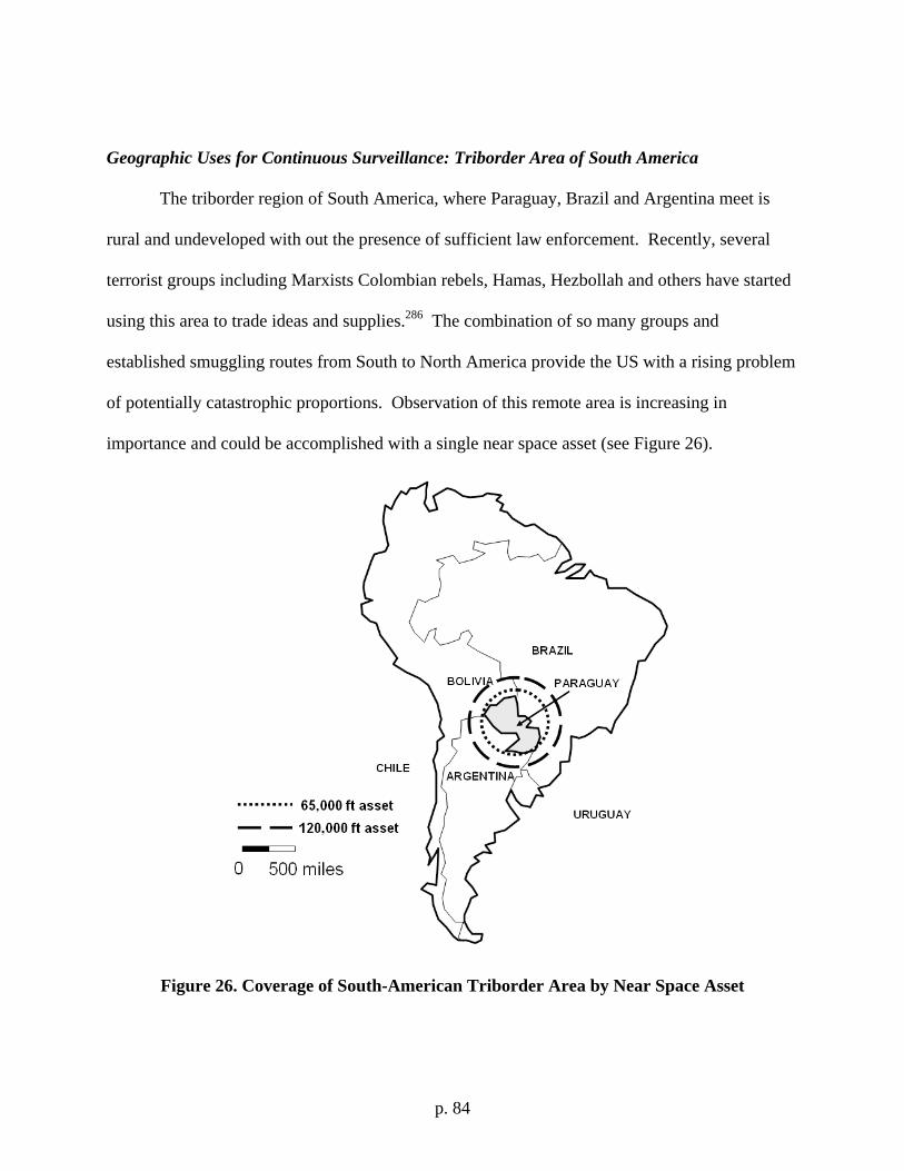
p. 84
Geographic Uses for Continuous Surveillance: Triborder Area of South America
The triborder region of South America, where Paraguay, Brazil and Argentina meet is
rural and undeveloped with out the presence of sufficient law enforcement. Recently, several
terrorist groups including Marxists Colombian rebels, Hamas, Hezbollah and others have started
using this area to trade ideas and supplies.286 The combination of so many groups and
established smuggling routes from South to North America provide the US with a rising problem
of potentially catastrophic proportions. Observation of this remote area is increasing in
importance and could be accomplished with a single near space asset (see Figure 26).
Figure 26. Coverage of South-American Triborder Area by Near Space Asset
p. 85
BIBLIOGRAPHY:
"About the Stratellite." Sanswire Networks (2006), http://www.sanswire.com/stratellite.htm. "Active Electronically Scanned Array." Wikipedia, 2006. Aftergood, Steven. "Rivet Joint." Federation of American Scientists, 2005. ———. "Senior Year / Aquatone / U-2 / Tr-1." Federation of American Scientists, 2000. "Agile Radar Guides Navy’s Super Hornets." Navy League of the United States (2006),
http://www.navyleague.org/sea_power/apr06-58.php. "Air Force Doctrine Document 1." 118: USAF, 2003. "Air Force Doctrine Document 2." edited by USAF, 160, 2000. "Air Force Wants Industry Ideas on Balloon-Based Radio Relay System." Military & Aerospace
Electronics Magazine (2006), http://mae.pennnet.com/articles/article_display.cfm?Section=ARCHI&C=ONEWS&ARTICLE_ID=249321&KEYWORDS=radio%20relay&p=32.
"Airborne Standoff Radar (Astor)." Raytheon (2006), http://www.raytheon.com/products/astor/. "Aircraft Specifications: All Uav/ Special Duty Aircraft." Air Attack, 2006. "The Airship "Skyfreighter"." Millenium Airship, Inc., 2005. Albright, David, and Corey Hinderstein. "The Clock Is Ticking, but How Fast?" 8: Institute for
Science and International Security (ISIS), 2006. Allen, Edward H. "The Case for near Space." Aerospace America 44, no. 2 (2006): 31-34. "Annual Report to Congress: The Military Power of the People's Republic of China 2005." 16.
The Pentagon, VA, 2005. "Another World First for Artemis: A Laser Link with an Aircraft." Science Daily (2006). "Apg-63 and Apg-70 Radars." Wikipedia, 2006. Ayres, Stephanie. "Airborne Stand-Off Radar System." Raytheon, 2006. Bakier, Abdul Hameed. "The Evolution of Jihadi Electronic Counter-Measures." Terrorism
Monitor, no. 17 (2006), http://www.jamestown.org/publications_details.php?volume_id=418&&issue_id=3849.
Barrie, Douglas. "Conformal Consensus." Aviation Week and Space Technology, 30 Oct 2006, 51.
Beshears, LCDR Troy. "Dhs Unmanned Aerial Vehicle Brief." edited by Homeland Security, 28: US Coast Guard.
"Boeing Demonstrates Uav Automated Aerial Refueling Capability." Defence Talk Dot Com (2006), http://www.defencetalk.com/news/publish/airforce/Boeing_Demonstrates_UAV_Automated_Aerial_Refueling_Capability10009185.php.
Boland, Rita. "Experimental Power System Expands Flight Capabilities.(United States. Naval Research Laboratory Develops Fuel-Cell-Powered Unmanned Aerial Vehicle)." Signal 60, no. 7 (2006): 45(3).
Booz, Allen & Hamilton. "Unmanned Aerial Vehicles (Uav): A Supplement to Battlefield Packages." 2002.
Briggs, MSgt. Julie. "Near Space Enhances Joint Warfighting." Air Force Print News (2005), http://www.af.mil/news/story.asp?storyID=123009865.
Bullis, Kevin. "Printing Fuel Cells." Technology Review (2006), http://www.technologyreview.com/read_article.aspx?id=17626&ch=energy.
p. 86
Burgess, Richard R. "Companies Studying Persistent Unmanned Maritime Isr for Navy.(Intelligence, Surveillance and Reconnaissance Aircraft )." Sea Power 48, no. 10 (2005): 52(3).
Burns, Robert. "U.S. Spy Plane Intercepted by N. Korea." The Milwaukee Journal Sentinel, 4 March 2003.
Bush, President George W. "The National Security Strategy of the United States of America." 54. Washington, D.C.: The White House, 2006.
———. "The National Strategy for Combating Terrorism." 23. Washington, D.C.: White House, 2006.
———. "President Bush's Statement on North Korea Nuclear Test." The White House (2006), http://www.whitehouse.gov/news/releases/2006/10/20061009.html.
Butler, Amy. "Smart and Flexible." Aviation Week and Space Technology, 30 Oct 2006, 52. Cain, Lt. Col. Anthony C. "Iran's Strategic Culture and Weapons of Mass Destruction:
Implications of Us Policy." 34. Maxwell AFB: Air War College, 2002. Cartwright, General James E. "Statement of General James E. Cartwright, Usmc Commander,
United States Strategic Command before the Strategic Forces Subcommittee on Space Policy." In Senate Armed Services Committee, 18. Washington, DC, 2005.
"The Case For "Near Space"." Air Force Magazine 88, no. 2 (2005): 15. Cheater, Major Julian, and Major. James P. Lake. "Future Unmanned Aircraft Technologies
Survey." Air Command & Staff College, 2007. Coe, Andrew J. "North Korea's New Cash Crop." The Washington Quarterly 28, no. 3 (2005):
11. Cole, Bernard D., and Paul H. B. Godwin. Advanced Military Technology and the Pla: Priorities
and Capabilities for the 21st Century. Edited by Larry M. Wortzel, The Chinese Armed Forces in the 21st Century. Carlisle, PA: U.S. Army War College, 1999.
Colella, LTC Robert A. "China's Space Ambitions: Danger or Opportunity?" National War College, 2006.
Colozza, Anthony. "Initial Feasibility Assessment of a High Altitude Long Endurance Airship." 95. Brook Park, OH: NASA STI Program Office, 2003.
Cordesman, Anthony H. Iran's Developing Military Capabilities. Vol. 27, Significant Issues Series. Washington, D.C.: Center for Strategic and International Studies, 2005.
Couvalt, Craig. "Chinese Test Anti-Satellite Weapon." SpaceRef.Com, no. 17 Jan 2007 (2007), http://www.spaceref.com/news/viewnews.html?id=1188.
Curry, Marty. "Theseus First Flight - May 24, 1996." National Aeronautics and Space Administration, 2002.
Danskine, Lt. Col. William B. "Aggressive Isr in the War on Terrorism." Air & Space Power Journal XIX, no. 2 (2005): 11.
David, Alon Ben, Robert Hewson, Damian Kemp, and Stephen Trimble. "Frontline Flyers." Jane's Defence Weekly, 10 May 2006 2006, 19-32.
Dell, Cary. "Lockheed Martin Delivers Aerostat Surveillance System to U.S. Army for Deployment in Iraq." Lockheed Martin Press Release (2004), http://www.lockheedmartin.com/wms/findPage.do?dsp=fec&ci=15190&rsbci=0&fti=0&ti=0&sc=400.
Dinerman, Taylor. "Near Space: A New Era of Operations of a New Pentagon Buzzword?" The Space Review (2004), http://www.thespacereview.com/article/230/1.
p. 87
———. "Near Space: Balloons, Satellites, and Suborbital Rockets." The Space Review (2005), http://www.thespacereview.com/article/416/1.
Douhet, Giulio. The Command of the Air. Translated by Dino Ferrari. New York: Coward-McCann, Inc., 1942.
Elias, Bart. "Lasers Aimed at Aircraft Cockpits: Background and Possible Options to Address the Threat to Aviation Safety and Security." edited by Congressional Research Service, 6: The Library of Congress, 2005.
Elliott, Derek J., and Matthew G. Thompson. "Comparion Of "Functional Concept of Battlespace Awareness" Versus the Concept Of "Power to the Edge," With a Focus on Integrating Shotspotter Sensors and Unmanned Aerial Vehicles." Naval Postgraduate School, 2005.
Ellis, Admiral James O. . "U.S. Strategic Command - Meeting Global Challenges." Joint Forces Quarterly, no. 35 (2004): 6.
England, Gordon. "Strategy for Homeland Defense and Civil Suppport." 19. Washington, D.C.: Department of Defense, 2005.
Everaerts, J. , N. Lewyckyj, and D. Fransaer. "Pegasus: Design of a Stratospheric Long Endurance Uav System Forremote Sensing." In Geo-Imaging Bridging Continents. Istanbul, Turkey: ISPRS Congress, 2004.
"Excalibur Uav Still in Development." Defense Industry Daily (2005), http://www.defenseindustrydaily.com/2005/04/excalibur-uav-still-in-development/index.php#more.
Eye in the Sky : The Story of the Corona Spy Satellites. Edited by Dwayne A. Day, John M. Logsdon and Brian Latell, Smithsonian History of Aviation Series. Washington, D.C.: Smithsonian Institution Press, 1998.
"Fact Sheet: Altair / Predator B ": National Aeronautics and Space Administration, 2006. "Fact Sheet: Proteus ": National Aeronautics and Space Administration, 2006. Finn, Anthony, Kim Brown, and Tony Lindsay. "Miniature Uav's & Future Electronic Warfare."
Aerosond, http://www.aerosonde.com/downloads/Aerosonde_DSTO_EW.pdf. "Focused Long Term Challenges (Fltcs)." edited by Air Force Research Laboratory, 22: AFRL,
2006. Foust, Jeff. "Floating to Space." The Space Review (2004),
http://www.thespacereview.com/article/151/1 Fulghum, David A. "Array of Hope." Aviation Week and Space Technology, 30 Oct 2006, 48-9. ———. "Ruling the Changes." Aviation Week and Space Technology, 30 Oct 2006, 49. Fulghum, David A., Douglas Barrie, and Robert Wall. "Sensors Vs. Airframes." Aviation Week
and Space Technology, 30 Oct 2006, 46-7. "Fundamentals of Full Spectrum Dominance." In FM 3-0 Operations: Headquarters Department
of the Army, 2001. Future Af Needs for Survivability. Edited by Lawrence J. Delaney. Washington, D.C.: The
National Academies Press, 2006. Garretson, Maj. Peter A. "Darpa Director's Outbrief." edited by USAF, 16: DARPA, 2006. Gertz, Bill. "Revealed: N. Korea Fired Laser at U.S. Troops." The Washington Times, 13 May
2003, 1. Goebel, Greg. "Astor & the Future of Battlefield Surveilance." FAQS Dot Org, 2002. Gordon, Michael R. and Trainor, Bernard E. Cobra Ii: The inside Story of the Invasion and
Occupation of Iraq. New York: Pantheon Press, 2004.
p. 88
Gordon, Michael R., and Bernard E. Trainor. Cobra Ii: The inside Story of the Invasion and Occupation of Iraq. New York: Pantheon Press, 2006.
Grant, Rebecca. "The Fallujah Model." Air Force Magazine 88, no. 2 (2005): 48(6). Greene, Kate. "More Efficient Solar Cells." Technology Review (2006),
http://www.technologyreview.com/read_article.aspx?id=17664&ch=nanotech. Greene, Lt. Col. Jonathan J. "Controlling Cas with the Predator: Is It Feasible?" The Air Land
Sea Bulletin 2006, no. 2 (2006): 4. Grinter, Lawrence E., and Barry R. Schneider. "On Twenty-First Century Warfare." In
Battlefield of the Future: 21st Century Warfare Issues, edited by Barry R. Schneider and Lawrence E. Grinter, 8. Maxwell AFB: Air War College, 1998.
Grossman, Elaine. "Global Dialogue on Space Rules Proves Elusive for Top Generals." Inside the Pentagon (2007), http://aimpoints.hq.af.mil/display.cfm?id=16422.
Hagee, Gen. Michael W. Usmc Concepts and Programs 2006: United States Marine Corps, 2006.
Hagenauer, Beth. "Nasa Dryden Exploring Uav Aerial Refueling Technologies." NASA News (2002), http://www.nasa.gov/centers/dryden/news/NewsReleases/2002/02-68.html.
Haines, Lester. "Us Rolls out Robotic Broadband Airship." The Register (2005). Hall, David H. "Integrated Survivability Assessment (Isa)." In Survice Engineering Company, 8.
Ridgecrest, CA, 2003. Haulman, Daniel L. "U.S. Unmanned Aerial Vehicles in Combat, 1991-2003." Short Studies
(2003), http://afhra.au.af.mil/short_studies/US_UAV_1991_2003.pdf. Heiligman, Dr. Mark, and 1Lt Sam Butler. 16 Nov 2006. Herger, Congressman Wally. "Speech at the Global Hawk Industry Team Conference."
Washington, D.C., 2006. "Heron." Israeli Aerospace Industries Ltd., 2006. "How to Eliminate Iran's Nuclear Weapons: A Symposium." 20 Apr 2006 2006. Hunt, Phil. "A160." Defense Advanced Research Projects Agency, 2006. Hurley, Alfred F. Billy Mitchell: Crusader for Air Power. Bloomington, IN: Indiana University
Press, 1964. "Implementation of the Npt Safeguards Agreement in the Islamic Republic of Iran." edited by
Board of Governers, 8: IAEA, 2006. "In Search of Persistence." C4ISR Journal (2006),
http://www.c4isrjournal.com/story.php?F=2017884. "An Introduction to the Virgin Atlantic Globalflyer." Virgin Atlantic, 2004. "Iran's Point Defense Upgraded " Defense Update News (2005), http://www.defense-
update.com/2005/12/irans-point-defense-upgraded.html. "Iran Spies on Aircraft Carrier." Military Dot Com (2006),
http://www.military.com/NewsContent/0,13319,118846,00.html?ESRC=dod.nl. "Iran: Is There a Way out of the Nuclear Impasse?" In Middle East Report No. 51, 26.
Brussels/Washington/Tehran: International Crisis Group, 2006. "Iranians Advising Hezbollah on Use of Missiles, Uavs." Aviation Week and Space Technology,
9 Aug 2006 2006, 3. Ison, David. "Persistent Coverage: Airships Return for High-Altitude Isr." C4ISR Journal
(2006), http://www.c4isrjournal.com/story.php?F=2005589. Jamison, Lewis, Geoffrey S. Sommer, and Isaac R. Porche III. "High-Altitude Airships for the
Future Force Army." 49. Santa Monica, CA: Rand Corporation, 2005.
p. 89
Jordan, Bryant. "Air Force Set to Cut Advanced Radar Plane: Plan Puts Fleet at Odds with Transformation." Air Force Times, 25 Oct 2006 2006.
Kenyon, Henry S. "Connectivity, Persistent Surveillance Model Future Combat." Signal 58, no. 9 (2004): 31(4).
———. "System Weaves Many Strands into One Picture.(Persistent Surveillance and Dissemination System of Systems)." Signal 60, no. 6 (2006): 75(3).
Ketcham, Ron, and David H. Hall. "Integrated Survivability Assessment (Isa) for Ot&E." 17: Joint Aircraft Survivability Program Office, 2003.
Kucera, Joshua. "Us Army Bolsters Intelligence Fusion.(Persistent Surveillance and Dissemination System of Systems)." Jane's Defence Weekly, April 6 2005, 7(1).
Kurzweil, Ray. The Singularity Is Near: When Humans Transcend Biology. New York, NY: Viking Press, 2005.
Lake, Capt. James P. "Flow Separation Prevention on a Turbine Blade in Cascade at Low Reynolds Number " Doctoral, Air Force Institute of Technology, 1999.
Lane, Lt. Col. Richard. "Near-Space Demo Aims to Prove Boost in Combat Communication Ability." Air Force Space Command News Service (2005).
Leopold, George. "Pentagon Urges 'Relevant' R & D." EE Times Online (2006), http://www.eetimes.com/news/latest/showArticle.jhtml;jsessionid=Y0VLK2XLXIPBUQSNDLRSKHSCJUNN2JVN?articleID=193400997.
"Lockheed Martin's Skunk Works Reveals High Altitude Unmanned System." (2006), http://www.lockheedmartin.com/wms/findPage.do?dsp=fec&ci=17787&rsbci=0&fti=112&ti=0&sc=400.
"Lockheed Unveils Hybrid Cruise Missile/Uav Plans.(Unmanned Aerial Vehicles)." Flight International, July 12 2005, NA.
"Lockheed Wins $149.2m Contract for High Altitude Airship." Defense Industry Daily (2006), http://www.defenseindustrydaily.com/2006/01/lockheed-wins-1492m-contract-for-high-altitude-airship-updated/index.php.
Lutz, H.P. . "Optical Communications in Space - Twenty Years of Esa Effort." European Space Agency Bulletin No. 91 (1997): 7.
Markham, Chris. "Chandler Firm to Give Gi's a Lift." East Valley Tribune (2005). McCaffrey, Gen. Barry R. "Global War on Terrorism." In Defense Worldwide Counter
Terrorism Conference. West Point: McCaffrey Associates, 2006. Miasnikov, Eugene. "Terrorists Develop Unmanned Aerial Vehicles: On "Mirsad 1" Fight over
Israel." 6: Center for Arms Control, Energy and Environmental Studies at MIPT, 2004. Miller, Jay. Lockheed's Skunk Works: The First Fifty Years. Arlington, TX: Aerofax, Inc, 1993. "Mim-23 Hawk." Wikipedia, 2006. "Mq-9 Reaper." Wikipedia - The Free Encyclopedia, 2006. Muradian, Vago. "China Attempted to Blind U.S. Satellites with Laser." Defense News Dot Com
(2006), http://www.defensenews.com/story.php?F=2124140&C=airwar Nagl, LTC John. "Learning to Eat Soup with a Knife: Counterinsurgency Lessons from Iraq and
Afghanistan." US Army, 2007. "Near-Space Access Program." AFRL Space Vehicles Directorate, 2003. "Near-Space Programs to Provide Persistent Space Capability." Air Force Space Command News
Service (2005), http://aimpoints.hq.af.mil/display.cfm?id=1909 "Near Space Becomes First Effort in Usaf 'Joint Warfighting Space'." Inside the Pentagon
(2004), http://www.insidedefense.com/.
p. 90
"Neuron Ucav Project Rolling Down the Runway." Defense Industry Daily (2006), http://www.defenseindustrydaily.com/2006/02/neuron-ucav-project-rolling-down-the-runway/index.php.
"New Weapons and Tactics in Afghanistan." Interavia Business & Technology 2001, 38. Newman, Richard J. "The Joystick War Run from Afar, Predators and Other Spy Gear Signal a
New Era of Remote-Control Warfare " U.S. News and World Report, 19 May 2003. "Nextgen Aeronautics' Uav with in-Flight Morphing Wings Test Flown." Aviation Week &
Space Technology 165, no. 6 (2006): 1. "Northrop Grumman to Build Stratospheric Surveillance Airship." Military & Aerospace
Electronics Magazine (2006). "Not Quite out of This World." The Economist (2004). "Overview of State-Sponsored Terrorism." In Patterns of Global Terrorism - 2000. Washington,
D.C.: Department of State, 2001. Owen, Mackubin T. "Conformity Needs Competition." Armed Forces Journal, no. June (2006):
24-34. "P-175 Polecat." Air Attack, 2006. Paone, Chuck. "New Radar Flies High as Crucial Tests Begin." Space War: Your World At War
(2006), http://www.spacewar.com/. Parsch, Andreas. "Aai Rq-7 Shadow 200." 2005. Pendall, Maj. David W. "Persistent Surveillance and Its Implications for the Common Operating
Picture." Military Review 85, no. 6 (2005): 41-50. Pike, John. "Mq-9a Predator B." Global Security.Org, 2005. ———. "Rq-4a Global Hawk (Tier Ii+ Hae Uav)." Global Security.ORG, 2006. ———. "S-200 Sa-5 Gammon." Global Security.Org, 2006. ———. "Unmanned Aerial Vehicles (Uavs)." Global Security.Org, 2006. Pillsbury, Michael. "China's Military Strategy Towards the U.S." 27, 2001. Piquepaille, Roland. "Who Pilots Nasa's Proteus Plane?" Technology Trends (2006),
http://www.primidi.com/2004/07/25.html. Plain, Charlie. "Around the World in 80 Hours." National Aeronautics and Space Administration
(2006), http://www.nasa.gov/missions/research/globalflyer_launch.html. "Predator B." General Atomics Aeronautical Systems, 2006. "Predator Educates Global Hawk." Defense Tech Dot Org (2006),
http://www.defensetech.org/archives/2006_04.html. "Predator Rq-1 / Mq-1 / Mq-9 Reaper - Unmanned Aerial Vehicle (Uav), USA." Airforce
Technology, 2006. "Predators Deliver the Goods in Iraq." Aero News Network (2006). Puttre, Michael. "Us Army to Deploy Aerostats in Baghdad.(Middle-East/Africa Report)(Brief
Article)." Journal of Electronic Defense 27, no. 3 (2004): 26(1). "R2508 Special Use Airspace Complex." Naval Air Warfare Center, Weapons Division, China
Lake, 2006. "Rapier Missile." Wikipedia, 2006. "Robo-Planes Fight for Airtime.(Technology)(Brief Article)." New Scientist 188, no. 2527
(2005): 25(1). Rockwell, David J. "Fighters Feature Electronic Attack." Aerospace America 44, no. 2 (2006):
18-22.
p. 91
Rolfsen, Bruce. "Afsoc Predator Was Involved in Zarqawi Assault " Air Force Times, 19 Jul 2006.
Rumsfeld, Donald H. "Quadrenial Defense Review Report." 92: Department of Defense, 2006. Rutan, Dick. "Voyage Flight Fun Facts." Dick Rutan Dot Com. "S-300." Wikipedia (2007), http://en.wikipedia.org/wiki/S-300. "Sa-12a Gladiator and Sa-12b Giant." Federation of American Scientists, 2000. "Sanswire's Defense Capabilities." Sanswire Networks, LLC, 2006. "Sanswire's Stratellite: Current Commercial Effort." Sanswire, 2005. Schanz, Marc V. "Rover's Here." Air Force Magazine Online (2005): 2. Scott, William B. "Lasecom Is Here." Aviation Week and Space Technology, 20 Nov 2006, 65. ———. "Morphing Wings." Aviation Week & Space Technology 165, no. 21 (2006): 2. ———. "Near-Space Frontier." Aviation Week & Space Technology, 14 Feb 2005, 71-72. Shachtman, Noah. "Giant Blimp, Deflated." Defense Tech Dot Org (2006),
http://www.defensetech.org/archives.html. Shalal-Esa, Andrea. "China Jamming Test Sparks U.S. Satellite Concerns." Reuters (2006),
http://today.reuters.com/news/articlenews.aspx?type=newsOne&storyID=2006-10-05T164730Z_01_N02361333_RTRUKOC_0_US-ARMS-SPACE.xml&WTmodLoc=Home-C2-TopNews-newsOne-11.
Shelton, Andrew, Agvinesh Tomar, J. V. R. Prasad, Marilyn J. Smith, and Narayanan Komerath. "Active Multiple Winglets for Improved Unmanned-Aerial-Vehicle Performance.(Author Abstract)." Journal of Aircraft 43, no. 1 (2006): 110(7).
Sherman, Kenneth B. "Us Navy Studying Persistent Unmanned Surveillance.(Persistent Unmanned Maritime Airborne Surveillance)." Journal of Electronic Defense 28, no. 11 (2005): 28(3).
Siegel, Jonas. "The Sky Is Filling." Bulletin of the Atomic Scientists 62, no. 3 (2006): 32-33. Sirak, Michael. "Us Air Force Sees Promise on 'near Space'." Space Data: In the News (2004),
http://www.spacedata.net/news101304.htm. Skinner, Tony. "Mini Datalink Sought for Uavs." Jane's Defence Weekly, 20 Sep 2006, 31. ———. "Usaf Moves to Make Use of High-Altitude Balloons." Jane's Defence Weekly, 20 Sep
2006, 30. "Skycom: Telecommunications." World SkyCat, 2006. "Skyfreight: Heavy-Lift Cargo." World Skycat, 2006. Squassoni, Sharon. "Iran's Nuclear Program: Recent Developments." In CRS Report for
Congress, 6. Washington, D.C.: Congressional Research Service, 2005. Stephens, Hampton. "Near-Space." Air Force Magazine 88, no. 7 (2005): 36-40. Stern, Jessica. "The Protean Enemy." Foreign Affairs 82, no. 4 (2003). Stewart, Mary Ann, Lt. Col. Kevin Frisbie, and Gary Trinkle. "High-Altitude Surveillance."
Geo-Intelligence (2004), http://www.geointelmag.com/geointelligence/article/articleDetail.jsp?id=109348.
Surek, Thomas. "Progress in U.S. Photovoltaics: Looking Back 30 Years and Looking Ahead 20." National Renewable Energy Laboratory (2003), http://www.nrel.gov/ncpv/thin_film/docs/surek_japan_talk_2003.ppt.
"Surface-to-Air Missile Systems (Russia)." Venik's Aviation, 2002. Swendsen, Richard. "Astor: Airborne Stand-Off Radar System." Raytheon, 2006. Takayama, Hideko , and Evan Thomas. "Lost, without a Trace." Newsweek International
Edition, 20 Feb 2006.
p. 92
Thibault, Tech. Sgt. Jennifer. "Near-Space Programs to Provide Persistent Space Capability." Air Force Space Command News Service (2005).
Tomme, Lt. Col. Ed. "Joint Concepts for the near-Space Environment." edited by Air Force Space Battlelab, 29, 2005.
———. "The Paradigm Shift to Effects-Based Space: Near-Space as a Combat Space Effects Enabler." College of Aerospace Doctrine, Research and Education, 2005.
———. "The Strategic Nature of the Tactical Satellite." edited by Air Power Research Institute, 48: Air University, 2006.
"Transformational Satcom (Tsat)." no. PE 0603845F (2005), http://www.dtic.mil/descriptivesum/Y2006/AirForce/0603845F.pdf.
"U-2 High Altitude Reconnaissance Aircraft (Dragon Lady), USA." Air Force Technology Dot Com, 2006.
"U.S. Kills Cole Suspect: Cia Drone Launched Missile." CNN Dot Com/World (2002), http://archives.cnn.com/2002/WORLD/meast/11/04/yemen.blast/index.html.
"Uk Stealth Drone Unveiled." Defense Tech Dot Org (2006), http://www.defensetech.org/archives/002084.html.
"Us Army; Balloons to Be Deployed to Baghdad.(Brief Article)." Flight International, 24 Feb 2004, 21.
"Us Plans to Retire B-52s, C-21s, F-117 & U-2 for More F-22s." Defense Industry Daily (2006), http://www.defenseindustrydaily.com/2006/01/us-plans-to-retire-b52s-c21s-f117-u2-for-more-f22s/index.php.
"Us Predator Drone Kills Six Al Qaeda Suspects." People's Daily (2002), http://english.people.com.cn/200211/05/eng20021105_106289.shtml.
USAF. "E-8c Joint Stars Fact Sheet." U.S. Air Force, 2005. ———. "Global Hawk Fact Sheet." U.S. Air Force, 2005. ———. "Mq-1 Predator Unmanned Aerial Vehicle Fact Sheet." U.S. Air Force, 2005. ———. "Rc-135v/W Rivet Joint Fact Sheet." U.S. Air Force, 2005. ———. "U-2s/Tu-2s Fact Sheet." United States Air Force, 2005. Victor, Arnie. "An/Apg-63(V3) Aesa Radar." Raytheon, 2006. "Virgin Atlantic Globalflyer." Wikipedia, 2006. "Voyager." National Air and Space Museum (1999),
http://www.nasm.si.edu/exhibitions/gal108/gal108.html. "Voyager Aircraft Return from Non-Stop Trip around the World." National Aeronautics and
Space Administration, 2002. Walker, Jan, and Phil Hunt. "Contractors for Walrus Program Announced." Defense Advanced
Research Projects Agency (2005). Wall, Robert. "Learning Curve: New Array Technology Promises Greater Threat Detection,
Fighter Protection." Aviation Week and Space Technology, 30 Oct 2006, 50. "Walrus Heavy-Lift Blimp Getting Off the Ground." Defense Industry Daily (2005),
http://www.defenseindustrydaily.com/2005/10/walrus-heavylift-blimp-getting-off-the-ground/index.php.
"Walrus Hunted to Extinction by Congress, Darpa?" Defense Industry Daily (2006), http://www.defenseindustrydaily.com/2006/04/walrus-hunted-to-extinction-by-congress-darpa/index.php.
Warford, Jim. "The Chinese Type 98 Main Battle Tank: A New Beast from the East." China Defense Dot Com (2005), http://www.china-defense.com/armor/type98/type98_3.html.
p. 93
Werenskjold, Maj. Craig J. "The Effect of Unmanned Aerial Vehicle Systems on Precision Engagement." Naval Postgraduate School, 2002.
Whittle, Richard. "F-22 Is on the Right Flight Path, Air Force Says." The Dallas Morning News (2006), http://www.dallasnews.com/sharedcontent/dws/bus/stories/101306dnbusf22.3017e82.html.
Windrem, Robert, Andrea Mitchell, and Carol Grisanti. "Cia Drone Kills Al-Qaida Operative." MSNBC Dot Com (2005), http://www.msnbc.msn.com/id/7847008/.
"X-47 Pegasus Naval Unmanned Combat Air Vehicle (Ucav-N), USA." Air Force Technology Dot Com (2007), http://www.airforce-technology.com/projects/x47/.
Zaloga, Steven J. Soviet Air Defence Missiles: Design, Development and Tactics. Surrey, United Kingdom: Jane's Information Group Limited, 1989.
p. 94
NOTES: 1 Admiral James O. Ellis, "U.S. Strategic Command - Meeting Global Challenges," Joint Forces Quarterly, no. 35 (2004): 30. 2 Donald H. Rumsfeld, "Quadrenial Defense Review Report," (Department of Defense, 2006), 55. 3 Ibid., 45, 55. 4 Ibid., 19. 5 George Leopold, "Pentagon Urges 'Relevant' R & D," EE Times Online (2006), http://www.eetimes.com/news/latest/showArticle.jhtml;jsessionid=Y0VLK2XLXIPBUQSNDLRSKHSCJUNN2JVN?articleID=193400997. 6 "Near-Space Programs to Provide Persistent Space Capability," Air Force Space Command News Service (2005), http://aimpoints.hq.af.mil/display.cfm?id=1909 7 Ibid. 8 General James E. Cartwright, "Statement of General James E. Cartwright, Usmc Commander, United States Strategic Command before the Strategic Forces Subcommittee on Space Policy," in Senate Armed Services Committee (Washington, DC: 2005), 9. 9 Lewis Jamison, Geoffrey S. Sommer, and Isaac R. Porche III, "High-Altitude Airships for the Future Force Army," (Santa Monica, CA: Rand Corporation, 2005), xi. 10 Ibid., 2. 11 Ibid., xii. 12 Rumsfeld, "Quadrenial Defense Review Report," 19. 13 Mary Ann Stewart, Lt. Col. Kevin Frisbie, and Gary Trinkle, "High-Altitude Surveillance," Geo-Intelligence (2004), http://www.geointelmag.com/geointelligence/article/articleDetail.jsp?id=109348. 14 Michael Sirak, "Us Air Force Sees Promise on 'near Space'," Space Data: In the News (2004), http://www.spacedata.net/news101304.htm. 15 LCDR Troy Beshears, "Dhs Unmanned Aerial Vehicle Brief," ed. Homeland Security (US Coast Guard), 8. 16 "Near Space Becomes First Effort in Usaf 'Joint Warfighting Space'," Inside the Pentagon (2004), http://www.insidedefense.com/. 17 Hampton Stephens, "Near-Space," Air Force Magazine 88, no. 7 (2005): 40. 18 "The Case For "Near Space"," Air Force Magazine 88, no. 2 (2005). 19 MSgt. Julie Briggs, "Near Space Enhances Joint Warfighting," Air Force Print News (2005), http://www.af.mil/news/story.asp?storyID=123009865. 20 Edward H. Allen, "The Case for near Space," Aerospace America 44, no. 2 (2006). 21 Ibid. 22 Tech. Sgt. Jennifer Thibault, "Near-Space Programs to Provide Persistent Space Capability," Air Force Space Command News Service (2005). 23William B. Scott, "Near-Space Frontier," Aviation Week & Space Technology, 14 Feb 2005. 24 Taylor Dinerman, "Near Space: Balloons, Satellites, and Suborbital Rockets," The Space Review (2005), http://www.thespacereview.com/article/416/1. 25 Lt. Col. Ed Tomme, "The Strategic Nature of the Tactical Satellite," ed. Air Power Research Institute (Air University, 2006). 26 Stephens, "Near-Space," 38. 27 "Near-Space Programs to Provide Persistent Space Capability." 28 "Lockheed Wins $149.2m Contract for High Altitude Airship," Defense Industry Daily (2006), http://www.defenseindustrydaily.com/2006/01/lockheed-wins-1492m-contract-for-high-altitude-airship-updated/index.php, Jeff Foust, "Floating to Space," The Space Review (2004), http://www.thespacereview.com/article/151/1 29 Jamison, Sommer, and Porche III, "High-Altitude Airships for the Future Force Army," 39. 30 Stewart, Frisbie, and Trinkle, "High-Altitude Surveillance." 31 Jamison, Sommer, and Porche III, "High-Altitude Airships for the Future Force Army," xii. 32 Ibid., xv. 33 Anthony Colozza, "Initial Feasibility Assessment of a High Altitude Long Endurance Airship," (Brook Park, OH: NASA STI Program Office, 2003), 72-93. 34 Ibid., 89. 35 Ibid., 68.

p. 95
36 Ibid., 93. 37 Jan Walker and Phil Hunt, "Contractors for Walrus Program Announced," Defense Advanced Research Projects Agency (2005). 38 "Walrus Heavy-Lift Blimp Getting Off the Ground," Defense Industry Daily (2005), http://www.defenseindustrydaily.com/2005/10/walrus-heavylift-blimp-getting-off-the-ground/index.php. 39 "Skyfreight: Heavy-Lift Cargo," (World Skycat, 2006). 40 Noah Shachtman, "Giant Blimp, Deflated," Defense Tech Dot Org (2006), http://www.defensetech.org/archives.html, "Walrus Hunted to Extinction by Congress, Darpa?," Defense Industry Daily (2006), http://www.defenseindustrydaily.com/2006/04/walrus-hunted-to-extinction-by-congress-darpa/index.php. 41 "The Airship "Skyfreighter"," (Millenium Airship, Inc., 2005), "Lockheed Wins $149.2m Contract for High Altitude Airship.", "Sanswire's Stratellite: Current Commercial Effort," (Sanswire, 2005), "Skyfreight: Heavy-Lift Cargo.", Lester Haines, "Us Rolls out Robotic Broadband Airship," The Register (2005), "Walrus Hunted to Extinction by Congress, Darpa?." 42 "Skycom: Telecommunications," (World SkyCat, 2006). 43 "Not Quite out of This World," The Economist (2004). 44 "Sanswire's Stratellite: Current Commercial Effort." 45 "About the Stratellite," Sanswire Networks (2006), http://www.sanswire.com/stratellite.htm, "Sanswire's Defense Capabilities," (Sanswire Networks, LLC, 2006). 46 "Lockheed Wins $149.2m Contract for High Altitude Airship.", Jonas Siegel, "The Sky Is Filling," Bulletin of the Atomic Scientists 62, no. 3 (2006). 47 Jamison, Sommer, and Porche III, "High-Altitude Airships for the Future Force Army," 9. 48 Alfred F. Hurley, Billy Mitchell: Crusader for Air Power (Bloomington, IN: Indiana University Press, 1964), 121. 49 Jamison, Sommer, and Porche III, "High-Altitude Airships for the Future Force Army.", Siegel, "The Sky Is Filling.", "Skycom: Telecommunications.", Haines, "Us Rolls out Robotic Broadband Airship.", "Walrus Heavy-Lift Blimp Getting Off the Ground." 50 Jamison, Sommer, and Porche III, "High-Altitude Airships for the Future Force Army," 32-33. 51 Ibid., xiv. 52 J. Everaerts, N. Lewyckyj, and D. Fransaer, "Pegasus: Design of a Stratospheric Long Endurance Uav System Forremote Sensing," in Geo-Imaging Bridging Continents (Istanbul, Turkey: ISPRS Congress, 2004), 1. 53 Colozza, "Initial Feasibility Assessment of a High Altitude Long Endurance Airship," 4. 54Phil Hunt, "A160," (Defense Advanced Research Projects Agency, 2006), Charlie Plain, "Around the World in 80 Hours," National Aeronautics and Space Administration (2006), http://www.nasa.gov/missions/research/globalflyer_launch.html, "Fact Sheet: Altair / Predator B " (National Aeronautics and Space Administration, 2006), "Fact Sheet: Proteus " (National Aeronautics and Space Administration, 2006), Alon Ben David et al., "Frontline Flyers," Jane's Defence Weekly, 10 May 2006 2006, USAF, "Global Hawk Fact Sheet," (U.S. Air Force, 2005), "Heron," (Israeli Aerospace Industries Ltd., 2006), "An Introduction to the Virgin Atlantic Globalflyer," (Virgin Atlantic, 2004), "Lockheed Martin's Skunk Works Reveals High Altitude Unmanned System," (2006), http://www.lockheedmartin.com/wms/findPage.do?dsp=fec&ci=17787&rsbci=0&fti=112&ti=0&sc=400, USAF, "Mq-1 Predator Unmanned Aerial Vehicle Fact Sheet," (U.S. Air Force, 2005), "P-175 Polecat," (Air Attack, 2006), Steven Aftergood, "Senior Year / Aquatone / U-2 / Tr-1," (Federation of American Scientists, 2000), Marty Curry, "Theseus First Flight - May 24, 1996," (National Aeronautics and Space Administration, 2002), "Virgin Atlantic Globalflyer," (Wikipedia, 2006), Dick Rutan, "Voyage Flight Fun Facts," (Dick Rutan Dot Com), "Voyager," National Air and Space Museum (1999), http://www.nasm.si.edu/exhibitions/gal108/gal108.html, "Voyager Aircraft Return from Non-Stop Trip around the World," (National Aeronautics and Space Administration, 2002), Roland Piquepaille, "Who Pilots Nasa's Proteus Plane?," Technology Trends (2006), http://www.primidi.com/2004/07/25.html. 55 Allen & Hamilton Booz, "Unmanned Aerial Vehicles (Uav): A Supplement to Battlefield Packages," (2002). 56 Future Af Needs for Survivability, ed. Lawrence J. Delaney (Washington, D.C.: The National Academies Press, 2006), 38. 57 Capt. James P. Lake, "Flow Separation Prevention on a Turbine Blade in Cascade at Low Reynolds Number " (Doctoral, Air Force Institute of Technology, 1999). 58 Beth Hagenauer, "Nasa Dryden Exploring Uav Aerial Refueling Technologies," NASA News (2002), http://www.nasa.gov/centers/dryden/news/NewsReleases/2002/02-68.html.

p. 96
59 "Boeing Demonstrates Uav Automated Aerial Refueling Capability," Defence Talk Dot Com (2006), http://www.defencetalk.com/news/publish/airforce/Boeing_Demonstrates_UAV_Automated_Aerial_Refueling_Capability10009185.php. 60 "Heron.", "P-175 Polecat." 61 "Lockheed Martin's Skunk Works Reveals High Altitude Unmanned System." 62 "Uk Stealth Drone Unveiled," Defense Tech Dot Org (2006), http://www.defensetech.org/archives/002084.html, "Neuron Ucav Project Rolling Down the Runway," Defense Industry Daily (2006), http://www.defenseindustrydaily.com/2006/02/neuron-ucav-project-rolling-down-the-runway/index.php, "Aircraft Specifications: All Uav/ Special Duty Aircraft," (Air Attack, 2006), "X-47 Pegasus Naval Unmanned Combat Air Vehicle (Ucav-N), USA," Air Force Technology Dot Com (2007), http://www.airforce-technology.com/projects/x47/. 63 Major Julian Cheater and Major. James P. Lake, "Future Unmanned Aircraft Technologies Survey," (Air Command & Staff College: 2007), 25 Jan 2007. 64 "Heron." 65 Everaerts, Lewyckyj, and Fransaer, "Pegasus: Design of a Stratospheric Long Endurance Uav System Forremote Sensing." 66 William B. Scott, "Morphing Wings," Aviation Week & Space Technology 165, no. 21 (2006): 72. 67 "Nextgen Aeronautics' Uav with in-Flight Morphing Wings Test Flown," Aviation Week & Space Technology 165, no. 6 (2006). 68 Andrew Shelton et al., "Active Multiple Winglets for Improved Unmanned-Aerial-Vehicle Performance.(Author Abstract)," Journal of Aircraft 43, no. 1 (2006): 114-5. 69 Future Af Needs for Survivability, 34. 70 Maj. Craig J. Werenskjold, "The Effect of Unmanned Aerial Vehicle Systems on Precision Engagement" (Naval Postgraduate School, 2002), 26. 71 "Lockheed Unveils Hybrid Cruise Missile/Uav Plans.(Unmanned Aerial Vehicles)," Flight International, July 12 2005. 72 Jamison, Sommer, and Porche III, "High-Altitude Airships for the Future Force Army," 29. 73 Thomas Surek, "Progress in U.S. Photovoltaics: Looking Back 30 Years and Looking Ahead 20," National Renewable Energy Laboratory (2003), http://www.nrel.gov/ncpv/thin_film/docs/surek_japan_talk_2003.ppt. 74 Colozza, "Initial Feasibility Assessment of a High Altitude Long Endurance Airship." 75 Surek, "Progress in U.S. Photovoltaics: Looking Back 30 Years and Looking Ahead 20." 76 Kate Greene, "More Efficient Solar Cells," Technology Review (2006), http://www.technologyreview.com/read_article.aspx?id=17664&ch=nanotech. 77 Colozza, "Initial Feasibility Assessment of a High Altitude Long Endurance Airship," 47. 78 Kevin Bullis, "Printing Fuel Cells," Technology Review (2006), http://www.technologyreview.com/read_article.aspx?id=17626&ch=energy. 79 Rita Boland, "Experimental Power System Expands Flight Capabilities.(United States. Naval Research Laboratory Develops Fuel-Cell-Powered Unmanned Aerial Vehicle)," Signal 60, no. 7 (2006). 80 "Apg-63 and Apg-70 Radars," (Wikipedia, 2006). 81 "Active Electronically Scanned Array," (Wikipedia, 2006). 82 "Agile Radar Guides Navy’s Super Hornets," Navy League of the United States (2006), http://www.navyleague.org/sea_power/apr06-58.php. 83 Arnie Victor, "An/Apg-63(V3) Aesa Radar," (Raytheon, 2006). 84 David J. Rockwell, "Fighters Feature Electronic Attack," Aerospace America 44, no. 2 (2006): 18. 85 Anthony Finn, Kim Brown, and Tony Lindsay, "Miniature Uav's & Future Electronic Warfare," Aerosond, http://www.aerosonde.com/downloads/Aerosonde_DSTO_EW.pdf. 86 Greg Goebel, "Astor & the Future of Battlefield Surveilance," (FAQS Dot Org, 2002), 4. 87 Chuck Paone, "New Radar Flies High as Crucial Tests Begin," Space War: Your World At War (2006), http://www.spacewar.com/. 88 Bryant Jordan, "Air Force Set to Cut Advanced Radar Plane: Plan Puts Fleet at Odds with Transformation," Air Force Times, 25 Oct 2006 2006. 89 Goebel, "Astor & the Future of Battlefield Surveilance.", Richard Swendsen, "Astor: Airborne Stand-Off Radar System," (Raytheon, 2006). 90 "Airborne Standoff Radar (Astor)," Raytheon (2006), http://www.raytheon.com/products/astor/. 91 Stephanie Ayres, "Airborne Stand-Off Radar System," (Raytheon, 2006).
p. 97
92 Future Af Needs for Survivability, 35. 93 David A. Fulghum, Douglas Barrie, and Robert Wall, "Sensors Vs. Airframes," Aviation Week and Space Technology, 30 Oct 2006, 47. 94 David A. Fulghum, "Ruling the Changes," Aviation Week and Space Technology, 30 Oct 2006, 49. 95 ———, "Array of Hope," Aviation Week and Space Technology, 30 Oct 2006, 48. 96 Douglas Barrie, "Conformal Consensus," Aviation Week and Space Technology, 30 Oct 2006, 51. 97 Fulghum, "Array of Hope.", Rockwell, "Fighters Feature Electronic Attack.", Robert Wall, "Learning Curve: New Array Technology Promises Greater Threat Detection, Fighter Protection," Aviation Week and Space Technology, 30 Oct 2006. 98 Wall, "Learning Curve: New Array Technology Promises Greater Threat Detection, Fighter Protection," 50. 99 Amy Butler, "Smart and Flexible," Aviation Week and Space Technology, 30 Oct 2006, 52. 100 David Ison, "Persistent Coverage: Airships Return for High-Altitude Isr," C4ISR Journal (2006), http://www.c4isrjournal.com/story.php?F=2005589. 101 Maj. Peter A. Garretson, "Darpa Director's Outbrief," ed. USAF, Service Chief's Intern Program (DARPA, 2006), "Lockheed Wins $149.2m Contract for High Altitude Airship.", "Northrop Grumman to Build Stratospheric Surveillance Airship," Military & Aerospace Electronics Magazine (2006). 102 "Lockheed Wins $149.2m Contract for High Altitude Airship." 103 "Focused Long Term Challenges (Fltcs)," ed. Air Force Research Laboratory (AFRL, 2006), 18. 104 Giulio Douhet, The Command of the Air, trans. Dino Ferrari (New York: Coward-McCann, Inc., 1942). 105 Lt. Col. Ed Tomme, "The Paradigm Shift to Effects-Based Space: Near-Space as a Combat Space Effects Enabler" (College of Aerospace Doctrine, Research and Education, 2005). 106 Colozza, "Initial Feasibility Assessment of a High Altitude Long Endurance Airship." 107 Future Af Needs for Survivability. 108 Cheater and Lake, "Future Unmanned Aircraft Technologies Survey." 109 Ibid., 19 Jan 2007. 110 Ibid., 17 Jan 2007. 111 Ibid., 18 Jan 2007. 112 Ibid., 17 Jan 2007. 113 Ibid., 24 Jan 2007. 114 Ibid., 17 Jan 2007. 115 Ibid., 25 Jan 2007. 116 Ibid., 17 Jan 2007. 117 Ibid. 118 Ibid., 18 Jan 2007. 119 Ibid. 120 Steven J. Zaloga, Soviet Air Defence Missiles: Design, Development and Tactics (Surrey, United Kingdom: Jane's Information Group Limited, 1989), 51. 121 Congressman Wally Herger, "Speech at the Global Hawk Industry Team Conference," (Washington, D.C.: 2006). 122 Richard J. Newman, "The Joystick War Run from Afar, Predators and Other Spy Gear Signal a New Era of Remote-Control Warfare " U.S. News and World Report, 19 May 2003. 123 USAF, "U-2s/Tu-2s Fact Sheet," (United States Air Force, 2005). 124 ———, "Global Hawk Fact Sheet." 125 Zaloga, Soviet Air Defence Missiles: Design, Development and Tactics, v. 126 John Pike, "S-200 Sa-5 Gammon," (Global Security.Org, 2006), "Sa-12a Gladiator and Sa-12b Giant," (Federation of American Scientists, 2000), Zaloga, Soviet Air Defence Missiles: Design, Development and Tactics, "Surface-to-Air Missile Systems (Russia)," (Venik's Aviation, 2002). 127 "S-300," Wikipedia (2007), http://en.wikipedia.org/wiki/S-300. 128 Jessica Stern, "The Protean Enemy," Foreign Affairs 82, no. 4 (2003). 129 "Surface-to-Air Missile Systems (Russia).", Zaloga, Soviet Air Defence Missiles: Design, Development and Tactics. 130 "Air Force Doctrine Document 1," (USAF, 2003), 42. 131 "Air Force Doctrine Document 2," ed. USAF (2000), 19. 132 David H. Hall, "Integrated Survivability Assessment (Isa)," in Survice Engineering Company (Ridgecrest, CA: 2003).
p. 98
133 Ibid. 134 John Pike, "Mq-9a Predator B," (Global Security.Org, 2005), USAF, "Mq-1 Predator Unmanned Aerial Vehicle Fact Sheet.", USAF, "Global Hawk Fact Sheet.", USAF, "E-8c Joint Stars Fact Sheet," (U.S. Air Force, 2005), USAF, "U-2s/Tu-2s Fact Sheet.", Zaloga, Soviet Air Defence Missiles: Design, Development and Tactics. 135 Future Af Needs for Survivability. 136 Jay Miller, Lockheed's Skunk Works: The First Fifty Years (Arlington, TX: Aerofax, Inc, 1993), 114, 71. 137 Hall, "Integrated Survivability Assessment (Isa)." 138 "R2508 Special Use Airspace Complex," (Naval Air Warfare Center, Weapons Division, China Lake, 2006). 139 ———, "Integrated Survivability Assessment (Isa)." 140 Ron Ketcham and David H. Hall, "Integrated Survivability Assessment (Isa) for Ot&E," (Joint Aircraft Survivability Program Office, 2003). 141 Future Af Needs for Survivability. 142 USAF, "U-2s/Tu-2s Fact Sheet." 143 ———, "Global Hawk Fact Sheet." 144 "Lockheed Martin's Skunk Works Reveals High Altitude Unmanned System." 145 Future Af Needs for Survivability, 30. 146 Rumsfeld, "Quadrenial Defense Review Report." 147 Future Af Needs for Survivability, 69. 148 Werenskjold, "The Effect of Unmanned Aerial Vehicle Systems on Precision Engagement", 24. 149 Ibid., 18. 150 Ibid., 27. 151 Ibid., 24. 152 Gen. Michael W. Hagee, Usmc Concepts and Programs 2006 (United States Marine Corps, 2006). 153 Rebecca Grant, "The Fallujah Model," Air Force Magazine 88, no. 2 (2005). 154 Ibid.: 51. 155 Ibid.: 53. 156 Lt. Col. Jonathan J. Greene, "Controlling Cas with the Predator: Is It Feasible?," The Air Land Sea Bulletin 2006, no. 2 (2006). 157 Daniel L. Haulman, "U.S. Unmanned Aerial Vehicles in Combat, 1991-2003," Short Studies Air Force Historical Research Agency (2003), http://afhra.au.af.mil/short_studies/US_UAV_1991_2003.pdf. 158 Werenskjold, "The Effect of Unmanned Aerial Vehicle Systems on Precision Engagement", 13. 159 Haulman, "U.S. Unmanned Aerial Vehicles in Combat, 1991-2003." 160 Michael R. Gordon and Bernard E. Trainor, Cobra Ii: The inside Story of the Invasion and Occupation of Iraq (New York: Pantheon Press, 2006), 186-7. 161 Ibid., 269. 162 Ibid., 300. 163 Ibid., 302. 164 Ibid., 307. 165 Anthony H. Cordesman, Iran's Developing Military Capabilities, vol. 27, Significant Issues Series (Washington, D.C.: Center for Strategic and International Studies, 2005), 41, Zaloga, Soviet Air Defence Missiles: Design, Development and Tactics, 319. 166 "Iran's Point Defense Upgraded " Defense Update News (2005), http://www.defense-update.com/2005/12/irans-point-defense-upgraded.html, "How to Eliminate Iran's Nuclear Weapons: A Symposium" (20 Apr 2006 2006), Zaloga, Soviet Air Defence Missiles: Design, Development and Tactics. 167 Cordesman, Iran's Developing Military Capabilities, 70. 168 "Mim-23 Hawk," (Wikipedia, 2006), "Rapier Missile," (Wikipedia, 2006). 169 "Mq-9 Reaper," (Wikipedia - The Free Encyclopedia, 2006), "Predator Rq-1 / Mq-1 / Mq-9 Reaper - Unmanned Aerial Vehicle (Uav), USA," (Airforce Technology, 2006), "Predator B," (General Atomics Aeronautical Systems, 2006), Pike, "Mq-9a Predator B.", John Pike, "Unmanned Aerial Vehicles (Uavs)," (Global Security.Org, 2006), John Pike, "Rq-4a Global Hawk (Tier Ii+ Hae Uav)," (Global Security.ORG, 2006), USAF, "Mq-1 Predator Unmanned Aerial Vehicle Fact Sheet.", USAF, "Global Hawk Fact Sheet." 170 "Predator Rq-1 / Mq-1 / Mq-9 Reaper - Unmanned Aerial Vehicle (Uav), USA.", USAF, "Mq-1 Predator Unmanned Aerial Vehicle Fact Sheet." 171 Pike, "Rq-4a Global Hawk (Tier Ii+ Hae Uav).", USAF, "Global Hawk Fact Sheet." 172 "Mq-9 Reaper.", "Predator B.", Pike, "Mq-9a Predator B."

p. 99
173 "Excalibur Uav Still in Development," Defense Industry Daily (2005), http://www.defenseindustrydaily.com/2005/04/excalibur-uav-still-in-development/index.php#more. 174 "U-2 High Altitude Reconnaissance Aircraft (Dragon Lady), USA," (Air Force Technology Dot Com, 2006), USAF, "E-8c Joint Stars Fact Sheet.", USAF, "Rc-135v/W Rivet Joint Fact Sheet," (U.S. Air Force, 2005), USAF, "U-2s/Tu-2s Fact Sheet." 175 "Us Plans to Retire B-52s, C-21s, F-117 & U-2 for More F-22s," Defense Industry Daily (2006), http://www.defenseindustrydaily.com/2006/01/us-plans-to-retire-b52s-c21s-f117-u2-for-more-f22s/index.php. 176 USAF, "E-8c Joint Stars Fact Sheet." 177 Steven Aftergood, "Rivet Joint," (Federation of American Scientists, 2005), USAF, "Rc-135v/W Rivet Joint Fact Sheet." 178 Rumsfeld, "Quadrenial Defense Review Report," 31. 179 Bruce Rolfsen, "Afsoc Predator Was Involved in Zarqawi Assault " Air Force Times, 19 Jul 2006. 180 Lt. Col. William B. Danskine, "Aggressive Isr in the War on Terrorism," Air & Space Power Journal XIX, no. 2 (2005): 74. 181 "U.S. Kills Cole Suspect: Cia Drone Launched Missile," CNN Dot Com/World (2002), http://archives.cnn.com/2002/WORLD/meast/11/04/yemen.blast/index.html, "Us Predator Drone Kills Six Al Qaeda Suspects," People's Daily (2002), http://english.people.com.cn/200211/05/eng20021105_106289.shtml. 182 Robert Windrem, Andrea Mitchell, and Carol Grisanti, "Cia Drone Kills Al-Qaida Operative," MSNBC Dot Com (2005), http://www.msnbc.msn.com/id/7847008/. 183 Rolfsen, "Afsoc Predator Was Involved in Zarqawi Assault ". 184 "Predators Deliver the Goods in Iraq," Aero News Network (2006). 185 "Predator Educates Global Hawk," Defense Tech Dot Org (2006), http://www.defensetech.org/archives/2006_04.html. 186 Eye in the Sky : The Story of the Corona Spy Satellites, ed. Dwayne A. Day, John M. Logsdon, and Brian Latell, Smithsonian History of Aviation Series (Washington, D.C.: Smithsonian Institution Press, 1998), Tomme, "The Strategic Nature of the Tactical Satellite," 3. 187 Abdul Hameed Bakier, "The Evolution of Jihadi Electronic Counter-Measures," Terrorism Monitor 4, no. 17 (2006), http://www.jamestown.org/publications_details.php?volume_id=418&&issue_id=3849. 188 Michael R. and Trainor Gordon, Bernard E., Cobra Ii: The inside Story of the Invasion and Occupation of Iraq (New York: Pantheon Press, 2004). 189 Jamison, Sommer, and Porche III, "High-Altitude Airships for the Future Force Army," 19. 190 Lawrence E. Grinter and Barry R. Schneider, "On Twenty-First Century Warfare," in Battlefield of the Future: 21st Century Warfare Issues, ed. Barry R. Schneider and Lawrence E. Grinter (Maxwell AFB: Air War College, 1998). 191 Cheater and Lake, "Future Unmanned Aircraft Technologies Survey," 18 Jan 2007. 192 Rumsfeld, "Quadrenial Defense Review Report," vi. 193 Ibid., 6. 194 Ibid., 23. 195 Stewart, Frisbie, and Trinkle, "High-Altitude Surveillance." 196 Sirak, "Us Air Force Sees Promise on 'near Space'." 197 "Near-Space Access Program," (AFRL Space Vehicles Directorate, 2003). 198 Cary Dell, "Lockheed Martin Delivers Aerostat Surveillance System to U.S. Army for Deployment in Iraq," Lockheed Martin Press Release (2004), http://www.lockheedmartin.com/wms/findPage.do?dsp=fec&ci=15190&rsbci=0&fti=0&ti=0&sc=400. 199 Michael Puttre, "Us Army to Deploy Aerostats in Baghdad.(Middle-East/Africa Report)(Brief Article)," Journal of Electronic Defense 27, no. 3 (2004). 200 "Us Army; Balloons to Be Deployed to Baghdad.(Brief Article)," Flight International, 24 Feb 2004. 201 Colozza, "Initial Feasibility Assessment of a High Altitude Long Endurance Airship," 5. 202 Stewart, Frisbie, and Trinkle, "High-Altitude Surveillance." 203 Stephens, "Near-Space," 40. 204 Taylor Dinerman, "Near Space: A New Era of Operations of a New Pentagon Buzzword?," The Space Review (2004), http://www.thespacereview.com/article/230/1. 205 Zaloga, Soviet Air Defence Missiles: Design, Development and Tactics. 206 Jamison, Sommer, and Porche III, "High-Altitude Airships for the Future Force Army," 30. 207 Cheater and Lake, "Future Unmanned Aircraft Technologies Survey," 26 Jan 2007.
p. 100
208 Ibid., 19 Jan 2007. 209 "Air Force Wants Industry Ideas on Balloon-Based Radio Relay System," Military & Aerospace Electronics Magazine (2006), http://mae.pennnet.com/articles/article_display.cfm?Section=ARCHI&C=ONEWS&ARTICLE_ID=249321&KEYWORDS=radio%20relay&p=32, Chris Markham, "Chandler Firm to Give Gi's a Lift," East Valley Tribune (2005). 210 Lt. Col. Richard Lane, "Near-Space Demo Aims to Prove Boost in Combat Communication Ability," Air Force Space Command News Service (2005), Lt. Col. Ed Tomme, "Joint Concepts for the near-Space Environment," ed. Air Force Space Battlelab (2005). 211 Tony Skinner, "Usaf Moves to Make Use of High-Altitude Balloons," Jane's Defence Weekly, 20 Sep 2006. 212 Vago Muradian, "China Attempted to Blind U.S. Satellites with Laser," Defense News Dot Com (2006), http://www.defensenews.com/story.php?F=2124140&C=airwar 213 Werenskjold, "The Effect of Unmanned Aerial Vehicle Systems on Precision Engagement", 27. 214 "Fundamentals of Full Spectrum Dominance," in FM 3-0 Operations (Headquarters Department of the Army, 2001). 215 Maj. David W. Pendall, "Persistent Surveillance and Its Implications for the Common Operating Picture," Military Review 85, no. 6 (2005): 43. 216 Marc V. Schanz, "Rover's Here," Air Force Magazine Online (2005). 217 Henry S. Kenyon, "System Weaves Many Strands into One Picture.(Persistent Surveillance and Dissemination System of Systems)," Signal 60, no. 6 (2006): 75. 218 Joshua Kucera, "Us Army Bolsters Intelligence Fusion.(Persistent Surveillance and Dissemination System of Systems)," Jane's Defence Weekly, April 6 2005, 7. 219 Richard R. Burgess, "Companies Studying Persistent Unmanned Maritime Isr for Navy.(Intelligence, Surveillance and Reconnaissance Aircraft )," Sea Power 48, no. 10 (2005). 220 Kenneth B. Sherman, "Us Navy Studying Persistent Unmanned Surveillance.(Persistent Unmanned Maritime Airborne Surveillance)," Journal of Electronic Defense 28, no. 11 (2005): 28-9. 221 Henry S. Kenyon, "Connectivity, Persistent Surveillance Model Future Combat," Signal 58, no. 9 (2004). 222 Ibid. 223 Mackubin T. Owen, "Conformity Needs Competition," Armed Forces Journal, no. June (2006). 224 Ray Kurzweil, The Singularity Is Near: When Humans Transcend Biology (New York, NY: Viking Press, 2005). 225 Dr. Mark Heiligman and 1Lt Sam Butler, 16 Nov 2006. 226 Tony Skinner, "Mini Datalink Sought for Uavs," Jane's Defence Weekly, 20 Sep 2006. 227 Andreas Parsch, "Aai Rq-7 Shadow 200," (2005). 228 Kurzweil, The Singularity Is Near: When Humans Transcend Biology, 67. 229 Derek J. Elliott and Matthew G. Thompson, "Comparion Of "Functional Concept of Battlespace Awareness" Versus the Concept Of "Power to the Edge," With a Focus on Integrating Shotspotter Sensors and Unmanned Aerial Vehicles" (Naval Postgraduate School, 2005), 5. 230 Ibid., 14. 231 Ibid. 232 "Transformational Satcom (Tsat)," no. PE 0603845F (2005), http://www.dtic.mil/descriptivesum/Y2006/AirForce/0603845F.pdf. 233 William B. Scott, "Lasecom Is Here," Aviation Week and Space Technology, 20 Nov 2006. 234 Ibid. 235 "Robo-Planes Fight for Airtime.(Technology)(Brief Article)," New Scientist 188, no. 2527 (2005). 236 "Another World First for Artemis: A Laser Link with an Aircraft," Science Daily (2006). 237 H.P. Lutz, "Optical Communications in Space - Twenty Years of Esa Effort," European Space Agency Bulletin No. 91 (1997). 238 Danskine, "Aggressive Isr in the War on Terrorism," 74. 239 Gordon England, "Strategy for Homeland Defense and Civil Suppport," (Washington, D.C.: Department of Defense, 2005), 2. 240 Pendall, "Persistent Surveillance and Its Implications for the Common Operating Picture," 45. 241 England, "Strategy for Homeland Defense and Civil Suppport." 242 LTC John Nagl, "Learning to Eat Soup with a Knife: Counterinsurgency Lessons from Iraq and Afghanistan," (US Army, 2007).Permission to include this information received from Lt. Col. Nagl on 14 Mar 2007. 243 Richard Whittle, "F-22 Is on the Right Flight Path, Air Force Says," The Dallas Morning News (2006), http://www.dallasnews.com/sharedcontent/dws/bus/stories/101306dnbusf22.3017e82.html.

p. 101
244 Nagl, "Learning to Eat Soup with a Knife: Counterinsurgency Lessons from Iraq and Afghanistan.", Whittle, "F-22 Is on the Right Flight Path, Air Force Says." 245 Colozza, "Initial Feasibility Assessment of a High Altitude Long Endurance Airship," 6. 246 President George W. Bush, "The National Strategy for Combating Terrorism," (Washington, D.C.: White House, 2006). 247 Gen. Barry R. McCaffrey, "Global War on Terrorism," in Defense Worldwide Counter Terrorism Conference (West Point: McCaffrey Associates, 2006). 248 "New Weapons and Tactics in Afghanistan," Interavia Business & Technology 2001. 249 President George W. Bush, "The National Security Strategy of the United States of America," (Washington, D.C.: The White House, 2006), 20. 250 "How to Eliminate Iran's Nuclear Weapons: A Symposium", Sharon Squassoni, "Iran's Nuclear Program: Recent Developments," in CRS Report for Congress (Washington, D.C.: Congressional Research Service, 2005). 251 David Albright and Corey Hinderstein, "The Clock Is Ticking, but How Fast?," (Institute for Science and International Security (ISIS), 2006), Squassoni, "Iran's Nuclear Program: Recent Developments." 252 "Iranians Advising Hezbollah on Use of Missiles, Uavs," Aviation Week and Space Technology, 9 Aug 2006 2006, Eugene Miasnikov, "Terrorists Develop Unmanned Aerial Vehicles: On "Mirsad 1" Fight over Israel," (Center for Arms Control, Energy and Environmental Studies at MIPT, 2004). 253 "Iran Spies on Aircraft Carrier," Military Dot Com (2006), http://www.military.com/NewsContent/0,13319,118846,00.html?ESRC=dod.nl. 254 "Overview of State-Sponsored Terrorism," in Patterns of Global Terrorism - 2000 (Washington, D.C.: Department of State, 2001). 255 "Implementation of the Npt Safeguards Agreement in the Islamic Republic of Iran," ed. Board of Governers (IAEA, 2006). 256 "Iran: Is There a Way out of the Nuclear Impasse?," in Middle East Report No. 51 (Brussels/Washington/Tehran: International Crisis Group, 2006), 1. 257 Ibid., 24-5. 258 Lt. Col. Anthony C. Cain, "Iran's Strategic Culture and Weapons of Mass Destruction: Implications of Us Policy," (Maxwell AFB: Air War College, 2002), 14. 259 Rumsfeld, "Quadrenial Defense Review Report," 35. 260 "Iran's Point Defense Upgraded ". 261 Ibid. 262 McCaffrey, "Global War on Terrorism." 263 Michael Pillsbury, "China's Military Strategy Towards the U.S.," (2001), 13. 264 "Annual Report to Congress: The Military Power of the People's Republic of China 2005," (The Pentagon, VA: 2005). 265 Bernard D. Cole and Paul H. B. Godwin, Advanced Military Technology and the Pla: Priorities and Capabilities for the 21st Century, ed. Larry M. Wortzel, The Chinese Armed Forces in the 21st Century (Carlisle, PA: U.S. Army War College, 1999), 163. 266 "Annual Report to Congress: The Military Power of the People's Republic of China 2005." 267 Andrea Shalal-Esa, "China Jamming Test Sparks U.S. Satellite Concerns," Reuters (2006), http://today.reuters.com/news/articlenews.aspx?type=newsOne&storyID=2006-10-05T164730Z_01_N02361333_RTRUKOC_0_US-ARMS-SPACE.xml&WTmodLoc=Home-C2-TopNews-newsOne-11. 268 Muradian, "China Attempted to Blind U.S. Satellites with Laser." 269 Bart Elias, "Lasers Aimed at Aircraft Cockpits: Background and Possible Options to Address the Threat to Aviation Safety and Security," ed. Congressional Research Service (The Library of Congress, 2005). 270 Craig Couvalt, "Chinese Test Anti-Satellite Weapon," SpaceRef.Com, no. 17 Jan 2007 (2007), http://www.spaceref.com/news/viewnews.html?id=1188. 271 Elaine Grossman, "Global Dialogue on Space Rules Proves Elusive for Top Generals," Inside the Pentagon (2007), http://aimpoints.hq.af.mil/display.cfm?id=16422. 272 LTC Robert A. Colella, "China's Space Ambitions: Danger or Opportunity?" (National War College, 2006), 7, Pillsbury, "China's Military Strategy Towards the U.S.," 8. 273 Pillsbury, "China's Military Strategy Towards the U.S.." 274 Ibid., 26.

p. 102
275 Colella, "China's Space Ambitions: Danger or Opportunity?" 10, Pillsbury, "China's Military Strategy Towards the U.S.," 11. 276 Pillsbury, "China's Military Strategy Towards the U.S.," 13. 277 Ibid., 22. 278 Hideko Takayama and Evan Thomas, "Lost, without a Trace," Newsweek International Edition, 20 Feb 2006. 279 Bill Gertz, "Revealed: N. Korea Fired Laser at U.S. Troops," The Washington Times, 13 May 2003. 280 Jim Warford, "The Chinese Type 98 Main Battle Tank: A New Beast from the East," China Defense Dot Com (2005), http://www.china-defense.com/armor/type98/type98_3.html. 281 Robert Burns, "U.S. Spy Plane Intercepted by N. Korea," The Milwaukee Journal Sentinel, 4 March 2003. 282 Cordesman, Iran's Developing Military Capabilities, 40. 283 President George W. Bush, "President Bush's Statement on North Korea Nuclear Test," The White House (2006), http://www.whitehouse.gov/news/releases/2006/10/20061009.html. 284 Andrew J. Coe, "North Korea's New Cash Crop," The Washington Quarterly 28, no. 3 (2005), McCaffrey, "Global War on Terrorism." 285 "In Search of Persistence," C4ISR Journal (2006), http://www.c4isrjournal.com/story.php?F=2017884. 286 Stern, "The Protean Enemy."