A Sensor-Driven Analysis of Distributed Direction ... - MDPI
Upload
khangminh22Category
view
0download
0
United States Military Academy
West Point, New York 10996
Distributed Sensor Networks on
the Future Battlefield
OPERATIONS RESEARCH CENTER
TECHNICAL REPORT
By
MAJ John B. Willis LTC Mark J. Davis
USMA Operations Research Center
May 2000
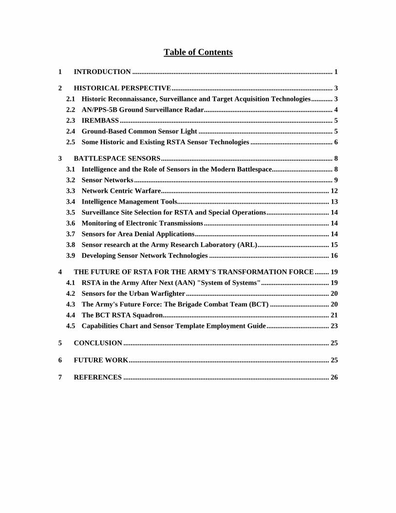
Table of Contents 1 INTRODUCTION ................................................................................................................ 1 2 HISTORICAL PERSPECTIVE.......................................................................................... 3
2.1 Historic Reconnaissance, Surveillance and Target Acquisition Technologies............ 3 2.2 AN/PPS-5B Ground Surveillance Radar........................................................................ 4 2.3 IREMBASS ....................................................................................................................... 5 2.4 Ground-Based Common Sensor Light ........................................................................... 5 2.5 Some Historic and Existing RSTA Sensor Technologies .............................................. 6
3 BATTLESPACE SENSORS................................................................................................ 8
3.1 Intelligence and the Role of Sensors in the Modern Battlespace.................................. 8 3.2 Sensor Networks ............................................................................................................... 9 3.3 Network Centric Warfare.............................................................................................. 12 3.4 Intelligence Management Tools..................................................................................... 13 3.5 Surveillance Site Selection for RSTA and Special Operations................................... 14 3.6 Monitoring of Electronic Transmissions ...................................................................... 14 3.7 Sensors for Area Denial Applications........................................................................... 14 3.8 Sensor research at the Army Research Laboratory (ARL)........................................ 15 3.9 Developing Sensor Network Technologies ................................................................... 16
4 THE FUTURE OF RSTA FOR THE ARMY'S TRANSFORMATION FORCE ........ 19
4.1 RSTA in the Army After Next (AAN) "System of Systems"...................................... 19 4.2 Sensors for the Urban Warfighter ................................................................................ 20 4.3 The Army's Future Force: The Brigade Combat Team (BCT) ................................. 20 4.4 The BCT RSTA Squadron............................................................................................. 21 4.5 Capabilities Chart and Sensor Template Employment Guide................................... 23
5 CONCLUSION ................................................................................................................... 25 6 FUTURE WORK................................................................................................................ 25 7 REFERENCES ................................................................................................................... 26
1
Distributed Sensor Networks on the Future Battlefield
Major John B. Willis Lieutenant Colonel Mark J. Davis
Operations Research Center
United States Military Academy West Point, New York 10996
ABSTRACT Key to achieving the Army Chief of Staff's vision are systems capable of providing commanders with information necessary to achieving local if not global superiority in decision making efficacy and efficiency. This capability will enable commanders to lead their forces in the conduct of decisive extended and close range engagements. On the battlefield of the future, advanced sensors connected to intelligent networked arrays, on manned and unmanned platforms, will be linked to commanders by enhanced communications and will provide timely knowledge of terrain, battlespace conditions, and forces. These highly automated sensors will be dispersed by ground troops, helicopters, and artillery or integrated with small, unattended aerial or ground vehicles (UAVs/UGVs). Responsibility for the employment of the sensor networks will likely fall to the Reconnaissance, Surveillance, and Target Acquisition (RSTA) Squadron of the proposed Objective Force Brigade Combat Team (BCT). This paper highlights the historic uses of sensors, desired sensor functions and capabilities, and the developing sensor technologies that will enable commanders to effectively employ the Army's new force in decisive engagements with less risk to military personnel. It further suggests a program of study related to composite sensor systems including UAVs, robotic UGVs, Future Scout and Cavalry System (FSCS), and manned systems.
1 INTRODUCTION A Star Destroyer moves through space, releasing Imperial probe robots from its underside. One of these probes zooms toward the planet Hoth and lands on its ice-covered surface.
A strange probe robot, with several extended sensors, emerges from the smoke-shrouded crater. The ominous mechanical probe floats across the snow plain and disappears into the distance.
Luke Skywalker notices something in the sky. He takes a pair of electrobinoculars from his utility belt and through them sees smoke rising from where the probe robot has crashed. LUKE: Echo Three to Echo Seven. Han, old buddy, do you read me? HAN SOLO: Loud and clear, kid. What's up? LUKE: Well, I finished my circle. I don't pick up any life readings. HAN: There isn't enough life on this ice cube to fill a space cruiser. The sensors are placed. I'm going back. LUKE: Right. I'll see you shortly. There's a meteorite that hit the ground near here. I want to check it out. It won't take long. (Later, back at the Rebel Base) GENERAL RIEEKAN: Solo? HAN: No sign of life out there, General. The sensors are in place. You'll know if anything comes around.
-Excerpt from The Empire Strikes Back George Lucas, 1980
2
Probe robots? Man-emplaced ground-based sensors? Certainly this is science fiction fantasy. Or maybe these are exactly the types of technologies that commanders need on the battlefield and happen to be under development today. Army Chief of Staff, General Eric K. Shinseki, recently outlined The Army Vision. He vowed to create a medium weight force that has the strategic and tactical mobility of today’s light forces, while possessing the same lethality and survivability of our heavy forces.
“…provide survivability through…long range acquisition, deep targeting, early attack, and first round kill…”
Key to achieving this vision is a system that will provide commanders with the information to achieve decision supremacy and enable them to lead their forces in the conduct of decisive extended and close range engagements. The Army Research Laboratory (ARL) and its federated partners from industry and academia are working to accelerate and harness research in sensors, communications, and information technologies to build the scientific foundation for the Future Combat System Advanced Technology Demonstrations. This will ensure that our soldiers are "Persuasive in Peace, and Invincible in War." The Sensors and Electron Devices Directorate (SEDD) of ARL in conjunction with industry and academic partners is conducting advanced research on sensor technology to provide the battlefield commander with affordable, near-perfect situational awareness and rapid, precise discrimination and targeting of all threats in all environments.3 Sensor technologies include signature modeling and simulation, single- and multi-sensor fusion target recognition, and signal processing for radar and acoustics. In the future, advanced sensors connected into intelligent networked arrays, or on manned or unmanned combat platforms, will be linked to commanders by enhanced communications and will provide timely knowledge of terrain, battlespace conditions and forces. New analytical tools, information presentation techniques and collaboration technologies will enable commanders to effectively employ the
Objective Force in decisive engagements with less risk to our soldiers.
3
2 HISTORICAL PERSPECTIVE
2.1 Historic Reconnaissance, Surveillance and Target Acquisition Technologies
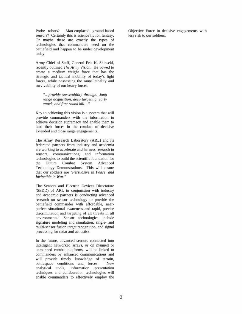
Reconnaissance is concerned with three components: enemy, weather, and terrain. Reconnaissance is active; it seeks out enemy positions, obstacles, and routes. Since movement draws attention, good reconnaissance uses stealth to avoid detection. Surveillance is passive. Surveillance implies observing a specified area or areas systematically from a fixed, concealed position.8 The primary goal of reconnaissance and surveillance is to tell commanders what they need to know in time for them to act. Successful reconnaissance and surveillance plans consider mission requirements, assets available, and the threat. Reconnaissance up through the American Revolution consisted of scouts and other soldiers on foot or horseback observing and reporting enemy activity. In 1794 during the Battle of Fleurus, the French employed a manned hot air balloon in the first case of aerial surveillance. The fundamental purpose of cavalry is to perform reconnaissance and to provide security in close operations. To perform these operations, European armies developed a highly specialized cavalry. The U.S. never developed specialization on this scale. Faced largely with frontier operations during the nineteenth century and an unconventional threat, the U.S. Army developed cavalry similar to European light cavalry.5
European light cavalry was largely equipped and armed with sabers, carbines, and pistols. It focused on wide-ranging reconnaissance and security tasks. The U.S. cavalry differences were a reliance on pistols and carbines versus bladed weapons and dismounted fighting once in contact with the enemy. The American Civil War, 1861 to 1865, saw extensive use of cavalry by both the North and the South. Cavalry performed a variety of functions including mounted charges, but it was during this period that they began to concentrate
on modern cavalry functions, such as raids, security operations, and reconnaissance.
Troopers on the Trail by Frederic Remington
When General Joseph Hooker took command of the Army of the Potomac in January 1863, he immediately saw the need for an effective centralized intelligence system.17 In February of that year, Colonel George H. Sharpe, an attorney and an officer of New York state volunteers, accepted the post of head of the Army's intelligence service. Under Sharpe, with direction from Hooker, the Bureau of Military Information (BMI) was created. Its sole focus was collection of intelligence on the enemy; it had no counterintelligence responsibilities. It soon developed into the first "all-source intelligence" organization in U.S. history. Sharpe obtained, collated, analyzed, and provided reports based on scouting, spying behind enemy lines, interrogations, cavalry reconnaissance, balloon observation, Signal Corps observation, flag signal and telegraph intercepts, captured Confederate documents and mail, Southern newspapers, and intelligence reporting from subordinate military units. As modern weapons increased in range, precision, and lethality, horse cavalry lost much of its ability to perform these traditional roles. Traditional capabilities were restored with mechanization, which placed modern weapons on armored platforms. The tank assumed some of these traditional cavalry roles, especially those associated with armored cavalry. Modern cavalry, with both air and ground assets, began to focus on reconnaissance, security, and the flexible employment capabilities of nineteenth century cavalry. During World War I, tethered observation balloons were widely used but eventually became too vulnerable to enemy action.23
4
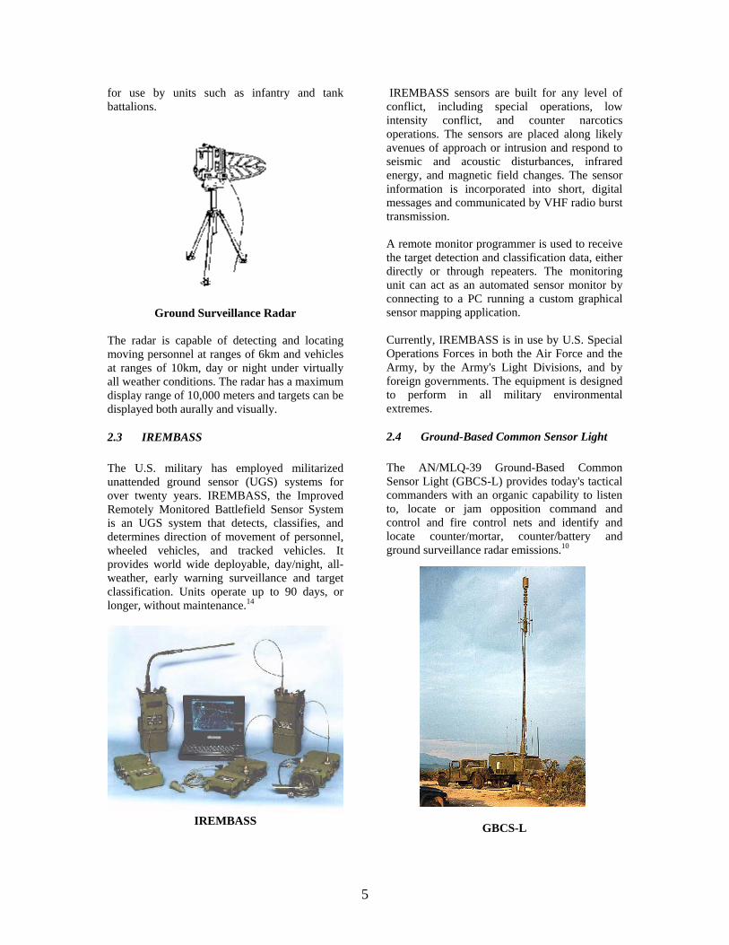
Airplanes also played an important reconnaissance role however, over the course of the war, airplanes would change dramatically from instruments of reconnaissance to offensive weapons. Technological advances made since World War II have contributed significantly to information gathering. Such devices as reconnaissance satellites, long-range cameras, high-flying reconnaissance airplanes, sensing instruments, and computers have greatly enhanced the abilities of intelligence agencies to gather information about enemy forces. During the Vietnam War, supply routes along the Ho Chi Minh Trail were virtually impossible to detect from the air. The Trail consisted of a vast array of secret paths through areas of dense vegetation. A range of hand- and air-emplaced sensors were developed to detect the presence of enemy troops or vehicles and to send signals over radio links to monitors based on the ground or in aircraft.
OH-58D Kiowa Warrior Scout Helicopters Despite the prevalence of jungle terrain in Vietnam, ten cavalry squadrons and a cavalry regiment saw combat. Air cavalry participated in the Grenada and Panama invasions. Most recently, two armored cavalry regiments, two air cavalry squadrons, and seven ground cavalry squadrons took part in Operation Desert Storm.
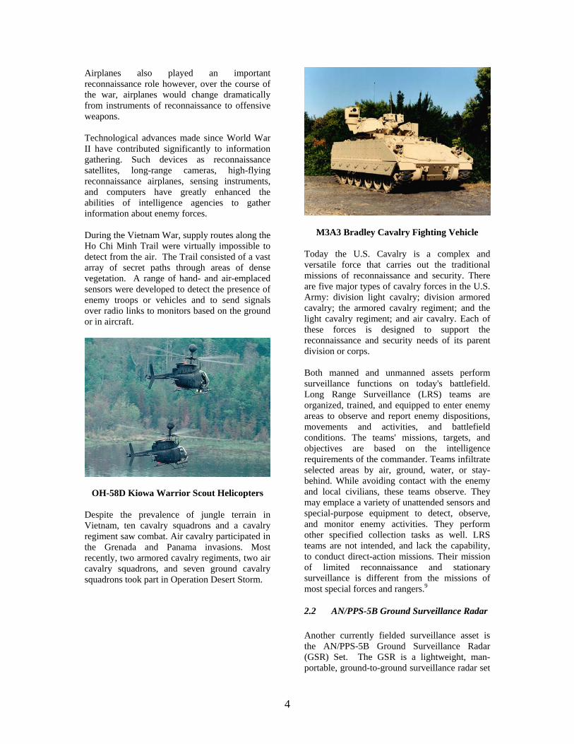
M3A3 Bradley Cavalry Fighting Vehicle Today the U.S. Cavalry is a complex and versatile force that carries out the traditional missions of reconnaissance and security. There are five major types of cavalry forces in the U.S. Army: division light cavalry; division armored cavalry; the armored cavalry regiment; and the light cavalry regiment; and air cavalry. Each of these forces is designed to support the reconnaissance and security needs of its parent division or corps. Both manned and unmanned assets perform surveillance functions on today's battlefield. Long Range Surveillance (LRS) teams are organized, trained, and equipped to enter enemy areas to observe and report enemy dispositions, movements and activities, and battlefield conditions. The teams' missions, targets, and objectives are based on the intelligence requirements of the commander. Teams infiltrate selected areas by air, ground, water, or stay-behind. While avoiding contact with the enemy and local civilians, these teams observe. They may emplace a variety of unattended sensors and special-purpose equipment to detect, observe, and monitor enemy activities. They perform other specified collection tasks as well. LRS teams are not intended, and lack the capability, to conduct direct-action missions. Their mission of limited reconnaissance and stationary surveillance is different from the missions of most special forces and rangers.9
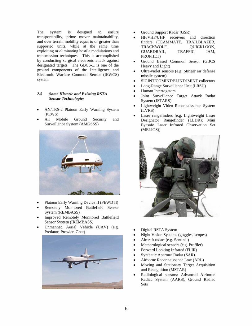
2.2 AN/PPS-5B Ground Surveillance Radar Another currently fielded surveillance asset is the AN/PPS-5B Ground Surveillance Radar (GSR) Set. The GSR is a lightweight, man-portable, ground-to-ground surveillance radar set
5
for use by units such as infantry and tank battalions.
Ground Surveillance Radar
The radar is capable of detecting and locating moving personnel at ranges of 6km and vehicles at ranges of 10km, day or night under virtually all weather conditions. The radar has a maximum display range of 10,000 meters and targets can be displayed both aurally and visually.
2.3 IREMBASS The U.S. military has employed militarized unattended ground sensor (UGS) systems for over twenty years. IREMBASS, the Improved Remotely Monitored Battlefield Sensor System is an UGS system that detects, classifies, and determines direction of movement of personnel, wheeled vehicles, and tracked vehicles. It provides world wide deployable, day/night, all-weather, early warning surveillance and target classification. Units operate up to 90 days, or longer, without maintenance.14
IREMBASS
IREMBASS sensors are built for any level of conflict, including special operations, low intensity conflict, and counter narcotics operations. The sensors are placed along likely avenues of approach or intrusion and respond to seismic and acoustic disturbances, infrared energy, and magnetic field changes. The sensor information is incorporated into short, digital messages and communicated by VHF radio burst transmission. A remote monitor programmer is used to receive the target detection and classification data, either directly or through repeaters. The monitoring unit can act as an automated sensor monitor by connecting to a PC running a custom graphical sensor mapping application. Currently, IREMBASS is in use by U.S. Special Operations Forces in both the Air Force and the Army, by the Army's Light Divisions, and by foreign governments. The equipment is designed to perform in all military environmental extremes.
2.4 Ground-Based Common Sensor Light The AN/MLQ-39 Ground-Based Common Sensor Light (GBCS-L) provides today's tactical commanders with an organic capability to listen to, locate or jam opposition command and control and fire control nets and identify and locate counter/mortar, counter/battery and ground surveillance radar emissions.10
GBCS-L
6
The system is designed to ensure transportability, prime mover maintainability, and over terrain mobility equal to or greater than supported units, while at the same time exploiting or eliminating hostile modulations and transmission techniques. This is accomplished by conducting surgical electronic attack against designated targets. The GBCS-L is one of the ground components of the Intelligence and Electronic Warfare Common Sensor (IEWCS) system.
2.5 Some Historic and Existing RSTA Sensor Technologies
• AN/TRS-2 Platoon Early Warning System
(PEWS) • Air Mobile Ground Security and
Surveillance System (AMGSSS)
• Platoon Early Warning Device II (PEWD II) • Remotely Monitored Battlefield Sensor
System (REMBASS) • Improved Remotely Monitored Battlefield
Sensor System (IREMBASS) • Unmanned Aerial Vehicle (UAV) (e.g.
Predator, Prowler, Gnat)
• Ground Support Radar (GSR) • HF/VHF/UHF receivers and direction
finders (TEAMMATE, TRAILBLAZER, TRACKWOLF, QUICKLOOK, GUARDRAIL, TRAFFIC JAM, PROPHET)
• Ground Based Common Sensor (GBCS Heavy and Light)
• Ultra-violet sensors (e.g. Stinger air defense missile system)
• SIGINT/COMINT/ELINT/IMINT collectors • Long-Range Surveillance Unit (LRSU) • Human Interrogators • Joint Surveillance Target Attack Radar
System (JSTARS) • Lightweight Video Reconnaissance System
(LVRS) • Laser rangefinders [e.g. Lightweight Laser
Designator Rangefinder (LLDR); Mini Eyesafe Laser Infrared Observation Set (MELIOS)]
• Digital RSTA System • Night Vision Systems (goggles, scopes) • Aircraft radar: (e.g. Sentinel) • Meteorological sensors (e.g. Profiler) • Forward Looking Infrared (FLIR) • Synthetic Aperture Radar (SAR) • Airborne Reconnaissance Low (ARL) • Moving and Stationary Target Acquisition
and Recognition (MSTAR) • Radiological sensors: Advanced Airborne
Radiac System (AARS), Ground Radiac Sets
7
• Biological agent sensors: Biological Integrated Detection System (BIDS), Joint Biological Point Detection System (JBPDS)
• Chemical agent sensors: Chemical Agent Monitor (CAM), Improved Chemical Agent Monitor (ICAM), Joint Chemical Agent Detector (JCAD), Joint Services Lightweight Standoff Chemical Agent Detector (JSLSCAD), M21 Remote Sensing Chemical Agent Alarm, Automatic Chemical Agent Alarm (ACADA), Multipurpose Integrated Chemical Agent Alarm (MICAD)
• Joint Service Lightweight NBC Reconnaissance System (JSLNBCRS)
• Remotely Controlled Reconnaissance Monitor (RECORM)
• Remote Sentry • AN/TRC-3A Wireless Seismic Intrusion
Detection Set • AN/PPS-6 Man Portable Radar System • Mobile Detection Assessment and Response
System (MDARS) • Hornet or Wide Area Munition (WAM)
combined with Air Deliverable Acoustic Sensor (ADAS) becomes Raptor - the Intelligent Combat Outpost (ICO). ADAS and a control station become Terrain Commander
• Artillery projectile protection devices such
as Shortstop Electronic Protection System (SEPS)
• Mine Detectors such as Handheld Standoff Minefield Detection System (HSTAMIDS)

8
3 BATTLESPACE SENSORS
3.1 Intelligence and the Role of Sensors in the Modern Battlespace
Individual sensors or those mounted on manned and unmanned platforms allow commanders to collect needed intelligence information. Intelligence can be classified into four primary categories: Imagery Intelligence or IMINT is the product of imagery analysis. Imagery is derived from, but is not limited to, radar, infrared, optical, and electro-optical sensors. IMINT and imagery systems increase the commander's ability to quickly and clearly understand his battle space and AI. IMINT is an important source of intelligence for intelligence preparation of the battlefield (IPB), targeting, terrain and environmental analysis, and battle damage assessment (BDA). IMINT is often primary source of intelligence for the physical damage assessment portion of BDA. IMINT is subject to some limitations. Because most imagery requires ground processing and analysis, IMINT may be unable to respond to time-sensitive requirements. Imagery collection may also be hampered by adverse weather and the vulnerability of the platform. As with other intelligence sources, IMINT is subject to threat attempts at deception. IMINT is most effective when used to cue other collection systems or to verify information provided by other sources. Systems that provide IMINT include the U2R Advanced Synthetic Aperture Radar System (ASARS), Joint STARS, UAV, and TENCAP systems. Measurement and Signature Intelligence or MASINT uses information gathered by technical instruments such as radars, lasers, passive electro-optical sensors, radiation detectors, seismic, and other sensors to measure objects or events to identify them by their signatures. MASINT is critical for updating data on smart munitions. As future adversaries develop new technologies to evade some of the SIGINT and IMINT collection systems, MASINT will be used as another means of sensing the enemy. MASINT exploits other information that is not gained through SIGINT, IMINT, or HUMINT. The Remotely Monitored Battlefield Sensor
System (REMBASS) is an example of a MASINT collector. Signals Intelligence or SIGINT results from collecting, locating, processing, analyzing, and reporting intercepted communications and noncommunications (for example, radar) emitters. SIGINT provides the commander with valuable intelligence and targeting information on enemy intentions, readiness status, and dispositions by intercepting and locating enemy command, maneuver, fire support, reconnaissance, air defense, and logistics emitters. SIGINT operations require efficient collection management and synchronization to effectively overcome and exploit enemy efforts to protect his critical communications and weapons systems through emissions control, communications operating procedures, encryption, and deception. SIGINT is subdivided into: communications intelligence (COMINT); electronic intelligence (ELINT); and foreign instrumentation signals intelligence (FISINT). Examples of SIGINT include ground-based intercept and direction finding (DF) systems such as the AN/PRD-12, the AN/TRQ-32A(V)2 (TEAMMATE), and the AIWRQ-I 52 (TRACKWOLF) systems. The GUARDRAIL Common Sensor (GRCS) is an example of an airborne intercept and DF system for both communications and noncommunications emitters. The AN/FSQ-144V (TROJAN) is the Army's remote collection system supporting in-garrison collection by tactical MI units. Human Intelligence or HUMINT is the oldest of the intelligence disciplines. HUMINT is particularly important in force protection during operations other than war (OOTW). Although HUMINT can be a sole collection discipline, it is normally employed to confirm, refute, or augment intelligence derived through other disciplines. HUMINT is less restricted by weather or the cooperation of the enemy than technical means and does not require fire, maneuver, or communications to collect. HUMINT is restricted by access to targets and timeliness and, by its nature, can be risky to the safety of the collectors. HUMINT collection is well suited to the initial detection of emerging threats if placement and access are established early. The success of HUMINT in areas not previously targeted will be marginal in the early phases of a conflict or OOTW operation. Its effectiveness improves as HUMINT refocuses its efforts on the AO. Interrogation and document
9
exploitation are examples of HUMINT operations. HUMINT collection may also be conducted by long-range surveillance units, scouts, and patrols. Examples of other sources of HUMINT are pilot debriefings, refugees, and defectors. Furthermore, special operations forces (SOF) operating in hostile, denied, or politically sensitive areas, provide a unique HUMINT source. Sensors have been designed to detect a wide variety of signatures produced by personnel, weapons platforms, munitions, weather, etc. Among these sensor types are: • Acoustic • Seismic • Magnetic • Infrared/Thermal • Forward Looking Infrared (FLIR) • Radar • Synthetic Aperture Radar (SAR) • Laser Radar (LADAR) • Millimeter Wave (MMW) Radar • Optical • Electro-optical • Temperature • Pressure • Vibration • Rotation • Velocity • Acceleration • Force • pH • Humidity • Strain • Radiation • Chemical • Biological • Electromagnetic field (EMF) • Ultra-violet • Olfactory The search and detection process for target acquisition is a series of progressive and interdependent steps by which soldiers and other sensors acquire enemy targets for destruction. It is a continuing requirement, whether in the defense or offense, moving or stationary, and has six steps4: • Search is the collective effort of using both
the unaided eye and available sensor assets within assigned sectors of observation, to survey for enemy presence.
• Detection is the discovery of any phenomena (personnel, equipment, objects) that are potential targets.
• Location is the determination (by direction, reference point, or grid) of where a potential military threat is on the battlefield (ground or air).
• Identification is the friendly, hostile, or neutral character of a detected potential target determined by its physical traits.
• Classification is the categorizing of a potential target by the relative level of danger it represents.
• Confirmation is the rapid verification of a target in terms of the initial identification and classification. During the conduct of fire, the tank commander (TC) and gunner must confirm that the target is properly identified as enemy and classified before engaging.
Beyond search through confirmation, some specific functions that sensors can perform in the modern battlespace include: • Security surveillance • Counter-sniper • Counter-indirect fire • Landmine alternatives • Track force movement • Counter-drug • Counter-terrorism • Quarantine enforcement • Battle damage assessment • Physiological monitoring • Targeting • Weather monitoring • Link to shooter/minefield/non-lethal
response • See through walls • Locate mines and unexploded ordnance • Locate underground facilities
3.2 Sensor Networks Sensor network users can be classified into the following types: • The soldier who programs, deploys and
maintains the sensor system. • The end user in the field, who will need
tactical situational awareness (e.g. simple alerts) via body worn devices for example.
10
• The signal analyst who must be provided information from which decisions can be derived about battlespace conditions, and be able to cue, task and query the sensors.
• The commander, who is informed of decisions made by the signal analyst abstracted to a level above sensor signal data.
• The system developer, who must be able to delve into details of the system for debugging and related purposes.
• The data collector, who performs field experiments to obtain reference data for signal processing algorithm development and testing.
The following are desired sensor network system capabilities: • Ultra reliable • Low cost • Small size/weight • Reduced logistical burden • Low maintenance • Provide high quality information • Present Information with clear 2-D and 3-D
color displays • Consume minimal power • Eliminate fratricide concerns • Operate in command and autonomous
modes • Provide tailorable response based on threat
and ROE • Deployable by untrained troops • Weatherproof • All-terrain • Utilize voice-activated interface tools • Report and prevent breaching, tampering,
and deception • Vary lethality of applied force • Resist electronic countermeasures (ECM) • Provide additional detail as requested • Receive a priori information to adjust
response/identification probabilities • Increase/decrease covertness • Imitate electronic signatures (decoy
function) • Receive new target types/templates • Receive new signal processing/decision-
making algorithms • Self-discover and self-locate • Deploy easily/rapidly • Communicate over extended ranges using
common protocol (e.g. Sensor Link Protocol - SLP)
• Request/provide authorization for lethal force
Soldiers in the future will not have to undertake the dangerous mission of gathering information for situation awareness and targeting. Rather these tasks will be undertaken by a force of unattended, highly automated sensors dispersed by ground troops, helicopters, and artillery or integrated in small-unattended aerial or ground vehicles where mobility is required. These hosts of miniature, energy efficient, sensors are able to organize into highly intelligent stationary or mobile ad hoc networks. The network of sensors collectively detect potential targets before activating more sophisticated, multi-sensor packages that locate, and classify or identify targets in spite of attempts to use camouflage, concealment and deception to defeat detection. These sensor arrays also provide the critical battlespace environmental data needed to develop the high resolution, weather forecasts that enable commanders to plan for and in real time task the weapons system that will achieve the optimum effect given the battlespace environment. To avoid over loading the wireless communications links and commanders with an over abundance of battlespace information the sensor arrays utilize advanced software techniques to assess the relevance of information against the mission assigned to the array. Then, like a forward observer or scout, the processors of the array transmit only the mission critical information. The sensor arrays are linked through reconfigurable, mobile, ad hoc satellite or terrestrial-based wireless networks to commanders. This highly flexible, networking technology allows wide area, high resolution battlespace information to be available on demand to both forces operation in the area and to mobile tactical operations centers. The mobile, ad hoc network technology supports both highly mobile users AND infrastructure, a condition that is unique to the military. The networks also provide a predictable quality of service that allows information latency to be managed throughout the depth and width of the battlespace. This ensures that commanders and soldiers across all echelons have the information
11
to create a common operating picture of the battlespace. Future generations of RSTA systems will include embedded sensing, intelligence, and networked communications to provide battlefield commanders with unprecedented battlefield situational awareness and command and control. This will allow the commanders' intent to shape the response of the system to the threats. Sensor networks integrated with these RSTA systems will monitor the battlefield, enemy forces, and non-combatants and communicate this information back to command and/or overwatch elements. Central to this networked sensor system is the ability to autonomously form distributed, robust, and dynamic communications networks amongst all the barrier or munition elements and their associated command elements. Features of this networking capability include the ability to15: • Determine the position of each asset in the
network relative to one another • Report successful or unsuccessful breaching
attempts (tampering) • Identify targets as combatant or non-
combatant • Request or provide authorization for
application of lethal force against combatants
• Vary the lethality of the applied force • Resist electronic countermeasures (ECM) Networked communications will also allow users to interact with the RSTA system in ways not possible today. For example, commanders will be able to ask for more detail from one or a set of select barrier nodes, inform the network of likely targets so as to adjust the a priori response and identification probabilities, or command the barrier to increase or decrease covertness. Networked communications will also allow RSTA operations and responses to be updated and tailored in real-time. This could include informing the network of new target types (e.g. providing new target templates), providing network with new signal processing and/or decision making algorithms, and informing network of conditions it cannot autonomously determine. The integrated sensor network should be easily and rapidly deployed (e.g. airdropped or
deployed via munitions onto the battlefield.) This requirement for simple node deployment necessitates that the network nodes be capable of self-discovery and self-configuration. The network should be highly capable, ultra-reliable, inexpensive, and use cooperation between nodes to produce high-quality information. Sensors should be designed to consume minimal power. Battery power has historically improved at rather slow pace, with no equivalent to the exponential growth experienced in computation, memory, and communication performance. The development and operation of sensor networks is a multi-faceted process involving tradeoffs in system architecture, software-hardware interplay, low power communication protocols, deployment methods, configuration schemes, packaging, user interfaces, external system gateways, etc. Densely deployed, networked microsensor arrays having the ability to detect and classify threats offer the possibility of dramatically increasing the operational flexibility of RSTA systems. For example, the sensor network should have the following capabilities: • Determine and communicate the battlespace
situation. This capability provides two operational benefits. The network will utilize local battlespace information to determine the appropriate response to detected threats thereby optimizing enemy delay. Battlespace information will also be relayed to remote overwatch personnel effectively providing sensor system functionality in addition to an area denial capability.
• Operate in both commanded and autonomous modes. The deployed system will be able to be commanded to enter various modes of operation. This is in contrast to current barrier systems. Remote commands will cause the system to activate, deactivate, or enter a mode wherein battlespace information is gathered without a lethal response in either a silent or networked mode. The system will be able to autonomously respond to detected threats according to the situation, as directed by downloaded rules of engagement, ranging from no response (e.g. known friendly troops in the area) to maximum lethality upon threat detection.
12
• Provide a tailorable response based on a commander's intent. Greater intelligence in the individual munitions comprising the system will enable more sophisticated responses, such as waiting for an entire convoy to be encircled before activating the munitions. The type of response will be dictated by pre-programmed or downloaded rules of engagement, such that the local commander's intent can be realized through the function of the barrier or munition delivery.
It is envisioned that single high-value sensor assets will be replaced by large arrays of distributed sensors for both security and surveillance applications. These self-organizing networks should be deployable by untrained troops in essentially any situation. Distributed sensing has the advantage of providing redundant and therefore highly reliable information on threats, as well as the ability to localize threats by both coherent and incoherent processing among the distributed sensor nodes. Sensor networks should provide the traditional roles of large-area and perimeter monitoring and will ultimately enable every platoon, squad, and soldier to deploy sensor networks to accomplish myriad mission and self-protection goals. Sensor networks should be capable of operation in desert, forest, arctic, and urban terrain. In the urban environment, these networks will improve troop safety as soldiers clear and monitor intersections, buildings, and rooftops by providing continuous vigilance for unknown troop and vehicle activity. One of the primary challenges facing sensor networks is accurate identification of the signal being sensed. Current research should yield state-of-the-art seismic, acoustic, and magnetic signal classification algorithms to accomplish this goal. Sensor-cued images of detected threats will be rapidly relayed to intelligence processing personnel and battlefield commanders for real-time threat ID and prosecution. These capabilities will provide unparalleled safety and awareness on the battlefield and help to realize the goal of zero friendly force casualties, even in the most stressing situations.
3.3 Network Centric Warfare
Joint Pub 3-13 Joint Doctrine for Information Warfare defines information superiority as the ability to collect, process, and disseminate an uninterrupted flow of information while exploiting and/or denying an adversary's ability to do the same. Network Centric Warfare (NCW) is an information superiority-enabled concept of operations that generates increased combat power by networking sensors, decision makers, and shooters to achieve shared awareness, increased speed of command, higher tempo of operations, greater lethality, increased survivability, and a degree of self-synchronization.2 In essence, NCW translates information superiority into combat power by effectively linking knowledgeable entities in the battlespace. NCW is not about turning the battle over to "the network" or even about relying more on automated tools and decision aids. It is really about exploiting information to maximize combat power by bringing more of our available information and warfighting assets to bear both effectively and efficiently. NCW is about developing collaborative working environments for commanders, and indeed for all military personnel to make it easier to develop common perceptions of the situation and achieve (self-) coordinated responses to situations. However, there is definitely a place for automated tools and decision aids on the battlespaces of the future. Information Superiority is a state that is achieved when a competitive advantage is derived from the ability to exploit a superior information position. Achieving information superiority increases the speed of command preempting adversary options, creates new options, and improves the effectiveness of selected options. This promises to bring operations to a successful conclusion more rapidly at a lower cost. The result is an ability to increase the tempo of operations and to preempt or blunt adversary initiatives and options. Information superiority is generated and exploited by adopting the network-centric concepts, pioneered in the commercial sector, that allow organizations to achieve shared awareness and self-synchronization. The bottom line for value creation in military operations involves the detection, identification, and disposal of the most important targets at any given time. The biggest challenge lies in fleeting targets, those that are mobile and whose value is time sensitive.

13
The mission space relevant to U.S. national security is expanding and becoming more complex. The United States, as the only superpower, has a key role to play in the post-Cold War era. Our roles and responsibilities are somewhat different from those we had in a bipolar world. Several important differences affecting military organizations and operations have already manifested themselves. The first is the increasing importance of operations other than war (OOTW) in which military organizations are being tasked to do a wide variety of non-traditional missions, from humanitarian relief to peace enforcement. Second, while these differences stem from geopolitical considerations, other changes in the mission space are driven by technology. Third is the emergence of the possibility of an entirely new form of warfare, Information Warfare, or perhaps more generically, Infrastructure Warfare. Finally, asymmetrical forms of warfare have become significantly more potent with the increased lethality and accessibility of weapons of mass destruction (WMD). Everyone seems to understand that sensors can be located throughout the battlespace (either in fixed locations or increasingly as mobile) and that a wide variety of sensors would exist. The difficulty seems to be in understanding the nature of the links among entities, and in assuming that providing the links is sufficient to achieve the desired result.
3.4 Intelligence Management Tools Streamlined command staffs of the future will utilize cognitive software tools and agents that augment the planning and decision-making process, enabling them to focus on practicing the Art of War. These software tools and agents will3: • Assess enemy intent based on the initial
Intelligence Preparation of the Battlefield and sensor reports.
• Develop and analyze multiple friendly
courses of action in a fraction of the time it takes a staff today to develop one or two courses of action.
• Continue to analyze selected friendly
courses of action as updated information on the intent of the enemy force is developed.
• Support the automated establishment of
sensor to weapon/munitions communications links for rapid target engagement and mission assessment.
• Assess the vulnerability of networks to
information operation attacks and take corrective action.
• Determine if networks are under attack,
contain the intrusion and provide an attack warning.
Collaborative tools will: • Enable automated and rapid development of
a robust, continuous common operating picture that allows tactical decision making at the lowest tactical levels of command consistent with the higher commander’s operational objectives.
• Present information in a compelling and
intuitive way to enable rapid and complete understanding of critical elements.
• Enable a hands free, speaker independent,
large vocabulary, voice interface to the computer; a key capability if mobile command and control is to become a reality.
Decision supremacy will enable: • The Joint Force Commander, while enroute,
to plan and execute precision strikes that disrupt efforts by an aggressor to set the terms of the battle prior to the arrival of our medium forces on the ground.
• Tactical commanders to conduct highly
lethal and decisive extended range engagements to establish the most favorable conditions, prior to closing with and destroying the elements of the aggressor force.
• Combat commanders to maneuver to
achieve positional superiority over the aggressor elements and fire the killing round before the enemy can react.
14
3.5 Surveillance Site Selection for RSTA and Special Operations
Surveillance sites are used for observation and monitoring. They are a vantage point from which visual, audible, olfactory, and electronic data on a target is collected. Selection of the sites is based on METT-T factors, but several general planning considerations apply. The sites6: • Afford adequate visual and electronic line-
of-sight target observation and security for the observers.
• Have as wide a field of view and as little
dead space as possible. • Are not near natural lines of drift or in
terrain that would naturally draw the attention of threat forces, such as atop a flat rock face on a hill.
• Have covered and concealed exit and entry
points. • Are far enough downwind from the target
and inhabited areas to minimize the olfactory detection of the site by dogs or people. Keep in mind that wind directions often change at various times of the day.
• In general, are as close or distant to the
target as mission and security considerations dictate.
• Have good overhead and side cover and
concealment. • Are capable of enacting battle drills to break
threat contact. • Afford reliable communications between the
observers and their main body, security element, and/or communications element.
• Are, above all, in a location that is not
obvious to threat forces. If all these features cannot be found in a single site (for example, daytime versus nighttime requirements), separate sites suited to the type of surveillance performed may be necessary. Multiple sites are mutually supporting if one site
is compromised, members of the other site are able to continue the surveillance mission and/or warn the rest of the Special Forces Operational Detachment (SFOD). Further, if the sites are not being used during the day, they should be kept under observation. If the sites can't be secured by observation, they should not be reused the following night. This practice prevents the SFOD from walking into an ambush while trying to reoccupy the position. The SFOD avoids establishing patterns and trails while moving to and from the different sites. In all cases, the SFOD selects alternate locations for its sites if the primary sites selected on the basis of map reconnaissance prove unsuitable.
3.6 Monitoring of Electronic Transmissions Given the progress in micro-miniature systems and information processing, it may soon be possible to monitor virtually all electronic transmissions, from radio and e-mail to cellular telephones. The only thing presently lacking is the information processing capability to usefully collect and analyze the resulting oceans of data. Very quickly the same progress could make it possible to conduct full-time, remote surveillance of any area, large or small. Sub-miniature video "cameras on a chip" for such systems are cheap and available right now.1 Later, thousands of tiny, inexpensive nanotech imaging devices monitored by automated systems would make it possible and feasible to monitor the entire public area of a city or, given the motivation and the capital, an entire country. Although such systems will be created as crime prevention measures, they will also have the effect of stripping the concealment and anonymity of covert operators, who after all are criminals to the target state.
3.7 Sensors for Area Denial Applications Recent events have led to the serious consideration of international banning of anti-personnel landmines (APL) and other contact initiated ordnance. This is due largely to their casualty potential of non-combatants, friendly forces and postwar civilian population. In the past, the primary use of anti-tank/personnel mines was to protect assets and canalize enemy troop movements, thus exerting a form of unmanned area denial and control. This mission is still necessary to the U.S. military and
15
alternative means are being studied to obtain the same effectiveness, while avoiding the problems of inflicting casualties on friendly forces and civilians. It is currently envisioned that any lethal APL alternative will likely include three elements: (1) precise, real-time surveillance systems to automatically detect, classify, and track vehicles and/or people; (2) precise firepower to immediately suppress movement of enemy forces; and (3) command and control systems (a "man-in-the-loop") to cue the precise firepower.
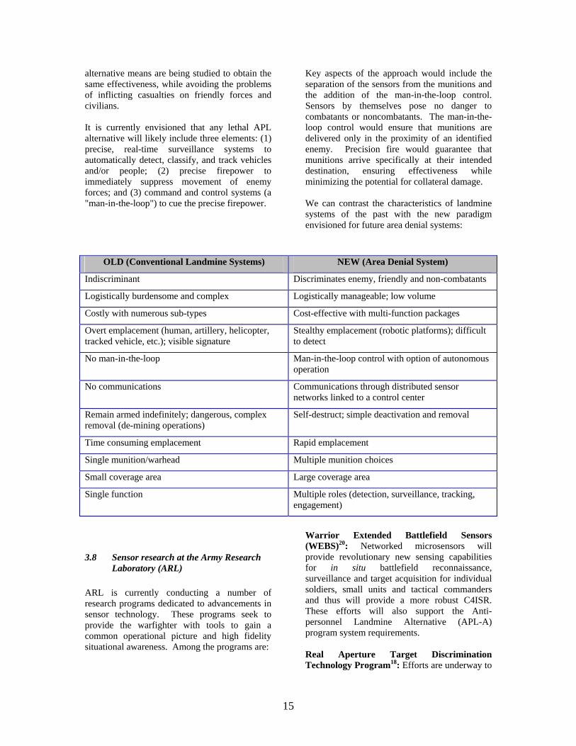
Key aspects of the approach would include the separation of the sensors from the munitions and the addition of the man-in-the-loop control. Sensors by themselves pose no danger to combatants or noncombatants. The man-in-the-loop control would ensure that munitions are delivered only in the proximity of an identified enemy. Precision fire would guarantee that munitions arrive specifically at their intended destination, ensuring effectiveness while minimizing the potential for collateral damage. We can contrast the characteristics of landmine systems of the past with the new paradigm envisioned for future area denial systems:
OLD (Conventional Landmine Systems) NEW (Area Denial System)
Indiscriminant Discriminates enemy, friendly and non-combatants
Logistically burdensome and complex Logistically manageable; low volume
Costly with numerous sub-types Cost-effective with multi-function packages
Overt emplacement (human, artillery, helicopter, tracked vehicle, etc.); visible signature
Stealthy emplacement (robotic platforms); difficult to detect
No man-in-the-loop Man-in-the-loop control with option of autonomous operation
No communications Communications through distributed sensor networks linked to a control center
Remain armed indefinitely; dangerous, complex removal (de-mining operations)
Self-destruct; simple deactivation and removal
Time consuming emplacement Rapid emplacement
Single munition/warhead Multiple munition choices
Small coverage area Large coverage area
Single function Multiple roles (detection, surveillance, tracking, engagement)
3.8 Sensor research at the Army Research Laboratory (ARL)
ARL is currently conducting a number of research programs dedicated to advancements in sensor technology. These programs seek to provide the warfighter with tools to gain a common operational picture and high fidelity situational awareness. Among the programs are:
Warrior Extended Battlefield Sensors (WEBS)20: Networked microsensors will provide revolutionary new sensing capabilities for in situ battlefield reconnaissance, surveillance and target acquisition for individual soldiers, small units and tactical commanders and thus will provide a more robust C4ISR. These efforts will also support the Anti-personnel Landmine Alternative (APL-A) program system requirements. Real Aperture Target Discrimination Technology Program18: Efforts are underway to
16
develop enhanced improved capabilities to reliably detect and discriminate current and future threat vehicles with minimal algorithm training. The Army Vision calls for a combat ready brigade to be deployed within 96 hours providing little or no opportunity to optimize a detection algorithm for a specific clutter environment. Further, the detection approach must support "seeing deep and attacking early" to improve platform survivability and enhance lethality. Thus detection and discrimination performance must meet or exceed today's state of the art, highly trained stationary-target-indication (STI) algorithms. Single Sensor Automatic Target Recognition (ATR)19: High-resolution IR/EO sensors are pervasive on the battlefield. Thermal imagers are second only to the individual soldier's eyes and ears as the sensor of choice. Aided or automatic target recognition (ATR) techniques and algorithms offer the potential to dramatically lessen operator workload and improve decision making. However, the variability of target and background signatures found in the thermal domain is enormous. Just some factors include time of day, location, solar loading (and its history), atmosphere, and, importantly, target induced effects up to and including dedicated camouflage, concealment and detection (CCD) efforts. This variability subverts the ability of modern ATR systems and algorithms to achieve the robust performance levels demanded by the military user. The Army Research Laboratory's Advanced Sensors Federated Laboratory consists of government, private industry and academic partners including: • Sanders - A Lockheed Martin Company
(lead) • Texas Instruments • Rockwell Science Center • Draper Laboratory • L3 Communications • U.S. Army Tank-automotive and
Armaments Command, Armament Research, Development and Engineering Center (TACOM-ARDEC)
• Environmental Research Institute of Michigan
• Georgia Tech. Research Corp. • Lockheed Missiles and Space Co. • Massachusetts Institute of Technology • Ohio State University Research Foundation
• United States Military Academy • University of Maryland • The Regents of the University of Michigan • Stanford University
3.9 Developing Sensor Network Technologies
Sensor technology has become increasingly important to the modern battlefield commander. The variety and sophistication of battlefield sensors has expanded greatly over the past few years and will continue to grow in the future. Single-domain sensor suites are being explored. Networked unattended ground sensors can be used to provide accurate targeting and intelligence information on ground and air targets. Future sensor systems will come in stationary and mobile configurations and provide both direct target information and target tagging capabilities so other sensors can locate and identify them. Such systems might be employed to provide high fidelity information at a few points on the battlefield or be used in close conjunction with weapon systems to provide area denial capabilities, similar to current minefields. Stationary Location Unattended Ground Sensors (SLUGS) are under development to provide multi-domain sensor detection, location, and identification of targets and operate as a network. Mobile Unattended Ground Sensors (MUGS) are small robots with sensors that will interact with SLUGS. MUGS will add the dimension of mobility to enhance target viewing and to provide evasion capabilities. Sensors will be available in a number of configurations, ranging from very inexpensive, low performance sensors to high performance, expensive ones. The low cost sensors are likely to be "trip wire" type sensors that provide an indication that a target is near, without providing much detail but will cost less than $10 each. Higher performance sensors are likely to include multiple sensor types (acoustic, seismic, magnetic, IR imager) that provide highly accurate target descriptions and will cost several hundred dollars each. Once deployed, sensors will operate as local networks with other MUGS or SLUGS or with other airborne or ground based sensors. Information from sensors will be fused whenever possible to locate and track targets. Targets to be detected include aircraft, wheeled and tracked vehicles, missiles, personnel, etc. Impulsive
17
events such as artillery fire, mortar fire, small arms fire, explosions, etc. could also be classified and located. All versions of such sensors will be relatively low cost to allow their widespread use and will come in a variety of configurations. These types of sensors, once emplaced, will power up and query their immediate surrounding area to locate their neighbors and themselves. Each emplaced sensor will become part of a distributed network that contains elements of varying capabilities. An integral part of such networks will be the ability of each sensor element to locate itself relative to its neighbors and pass information. Depending on mission requirements and particular sensor capabilities, the sensors may establish local "neighborhoods" of cooperating nodes to provide refined targeting information upon entry by a target into the local area. Sensor "neighborhood" management requirements will be dependent on the mission requirements and the type and quality of information necessary to successfully complete the mission. For example, upon receiving information about targets entering the sensor field, a commander may need visual confirmation of the target in order to take a particular action. Upon request (or previous direction), a sensor node with imaging capability would transmit an image for use by the commander. The requirement for the user is that networked sensors provide useful and timely information and not just data. A key focus of networked sensors is the ability to perform autonomous actions for particular sensor nodes and cooperative actions with neighboring nodes to enhance the information content and output of the sensor network. Currently under development by ARL and its federated partners as well as under several DARPA programs are micro-sized cooperation network-based unattended sensors. Activities are focused on the capabilities of independent sensing nodes containing acoustic, magnetic, and seismic sensing capability. The capability of micro-sized sensors to perform detection, identification, and tracking functions is being characterized, with an assessment of the additional functionality gained by networking various sensors together. This assessment
includes looking at the types of data that need to be exchanged between neighbors to gain an added capability. The extent to which data and information can be moved around the network provides a critical measure of performance for such a system. There are direct tradeoffs of this measure versus numbers of sensor, power, operational life expectancy, etc. that are critical to effective use of these systems and the information they can provide. There are also new measures of effectiveness for energy constrained processing (FLOPS/watt, etc.) which are being used to assess the effectiveness of processing algorithms and hardware. Research is also underway in the communications area, both in physical RF links and data protocols (e.g. Sensor Link Protocol or SLP) which are tailored to the needs of networked sensors. Communications is perhaps the most difficult part of implementing an effective situational awareness network. The types of sensors employed will by their nature require relatively little bandwidth (100Hz or less). Autonomous mobile ad hoc networks will be indispensable in maintaining information dominance by providing timely situational awareness data and direct access to real-time data from sensors or other time-sensitive sources. Energy efficient networking research is being implemented to minimize the consumption of precious battery power. Techniques such as transmitter and receiver power management, on-board signal processing, multiple access and multicasting, network route optimization, and message prioritization will be used to continuously monitor and adjust network characteristics to obtain an optimum balance between network connectivity and energy consumption. Research in advanced data coding and compression techniques will minimize network bandwidth requirements as well as reduce energy consumption. Finally, research efforts in information distribution technologies will be used to realistically manage information exchange failures in the varying and often tenuous communications conditions on the battlefield. Display and human interface work is aimed at producing effective information displays that will not overload the individual soldier. User
18
devices can be organized into the following classes: • A handheld or body worn device, which
serves both the person who deploys the sensor system, the common user, and data collection user.
• A PC or other workstation which serves the signal analyst and system developer.
• Sophisticated technologies such as the Combat information Processor (CIP) and Virtual Geographic Information System (VGIS) large screen display systems with 2-D and 3-D terrain map rendering which serve commanders.
Development efforts address all three user device classes above. A commercial off-the-shelf (COTS) handheld platform was used to study functionality for the individual warfighter or field user. Physical human factors and ergonomics issues remain and require considerations of the soldier as a system (e.g., what other devices must the warfighter possess for this mission). Display and control software was developed for a Handheld PC (HPC). Because of screen size limitations, the display is a simple map graphic background with active icons representing the state of each mode. Simple commands, such as altering the alarm sensitivity level, are communicated via touch screen taps and pull-down menus. Visualization tools have also been created in support of signal processing algorithm development. Fast wavelet transform techniques are used and give rise to time-frequency plots that are particularly suited to microsensor networks. The displays allow the signal analyst to use his or her intuition and human acuity to develop detection, identification and classification algorithms.
19
4 THE FUTURE OF RSTA FOR THE ARMY'S TRANSFORMATION FORCE
On those disappearing battlefields that do not center on urban environments and complex terrain, tanks will remain recognizable for at least a generation. We will see changes in lethality, protection, propulsion and weight, but the greatest advance will be in battlefield awareness. On-board, remote, and even strategic sensors will give our tankers a commanding view of the battlefield, and there will be a window of frustration as their vision outstrips their engagement range. Eventually, tanks will gain a much deeper, indirect-fire capability, and sensing munitions will make an increasing proportion of land engagements resemble over-the-horizon naval warfare. These extra-urban tanks will become lighter, and will go faster.16
Miniaturization of components, from engines through communications gear to ammunition, will pace advances in armor to make systems more rapidly deployable. Eventually, the tank's primary "armor" may be electromagnetic or may otherwise take advantage of physical principles we are only beginning to exploit. We can imagine developments from "battles of conviction," in which opposing combat systems struggle to "convince" each other's electronics to enter vulnerable configurations, to weapons that literally stop opponents in their tracks by manipulating the local environment. Many experiments will fail, but some--possibly the most radical--will succeed. Urban warfare is three-dimensional. Armored vehicles, using drones or ground robotics or hyper-sensors, must not only be able to see into multi-story structures and down into sewers, subways, and service tunnels, but must be able to introduce soldiers--in a protected manner--to upper-story or subterranean zones of operation. Secured areas might be outposted by robotics and picketed by soldiers cued by local fusion centers that combine intelligence from sources as diverse as miniature roaming sensors and national-level systems. Population control might be established by electronically registering every inhabitant with whom the force comes in contact and alerting in response to any human concentrations that do not fit habitation profiles. Eventually, body signature sensors should
identify fear, hostility, or positive demeanors on the part of the locals. Any means that can be developed to separate the hostile actor from the "sea of the people" is highly desirable, since, in urban operations, the enemy's ultimate camouflage is his humanity. In extremely vertical environments, robotics and troops are air-delivered by systems that can spoof enemy sensors and vision into registering multiple images or completely false images. As soldiers clear the buildings--preceded by their individual sensors--they push their individual weapon's selector switch to "Inhabited," and, upon entering a room, the weapon does not discharge if pointed at a noncombatant without violent intent.
4.1 RSTA in the Army After Next (AAN) "System of Systems"
Traditional military missions, once separated in time, distance, platform, and function, are now being fused. This integration of surveillance, information, battle management, and precision strike has become known over the last few years as a "system of systems."11 In February 1997 the Army's Training and Doctrine Command (TRADOC) directed the first of an annual series of "Army After Next" (AAN) games--the AAN being viewed as what the presently planned "digitized" Army (Force XXI) could evolve into in two or three decades. Based largely on GLOBAL precedents, this was a three-week, 300-person effort based on a year 2020 scenario involving a strong peer competitor. To an extent and granularity never before approached, the AAN wargame tested the strengths and vulnerabilities of a powerful US space-based C3I system, closely integrated with the sensor and reporting technologies associated with surveillance and reconnaissance. It linked those information systems to platforms capable of precision strike. All of these capabilities are key elements of a "system of systems." This information infrastructure operated in support of an extremely mobile, nonlinear, and self- supporting Army "battle force," with U.S. Marine Corps equivalents, having an improved ability to maneuver owing to a reliance on air- and naval- delivered long-range precise fires in lieu of organic artillery. Some findings of this game included:
20
• The strong influence of space-based systems on ground combat operations
• The vulnerability of ground forces to information warfare attacks.
• Reluctance on the part of national leaders to commit ground troops to a region early in a crisis.
• Dramatically shortened time frames in which critical decisions had to be made.
A real revolution may be emerging with the ability to integrate sensors and weapons to a degree that precision attack opportunities could be recognized, approved, and executed for maximum effect. Such an integration of surveillance and precision strike systems could result in a strategic shift of emphasis to the development of new concepts of conventional deterrence, and to the primacy of the "halting" phase (as opposed to the "buildup" or "counteroffensive" phases) of a U.S. military response to a cross-border invasion.
4.2 Sensors for the Urban Warfighter Future high-speed urban operations require a radically new land combat capability. While to many it will likely appear to be an evolutionary offspring of the existing Land Warrior concept, the 2025 Urban Warfighter System must be a revolutionary new man-machine fighting system with self-contained C4ISR, lethality, mobility, survivability, and sustainability far exceeding those of the current and near-term systems.12 The core of the Urban Warfighter System is a body suit with integral C4ISR, engagement, and active survivability systems. It provides immediate access to a variety of non-line-of-sight munitions and contains mobility enhancements allowing operation in horizontal and vertical dimensions at speeds greatly exceeding today's maximums. Individual sensors will provide constant physiological readings both to the soldier wearing the suit and to appropriate monitoring entities. The Urban Warfighter System must provide the individual with a comprehensive situational awareness capability. This implies easy-to-use, integrated communications and navigational systems that can provide real-time updates to the soldier and to relevant friendly elements. The system must also be able to connect with and
employ a wide variety of robotic systems, UAVs (unmanned aerial vehicles), and other sensor systems to determine who or what is in the buildings or streets around the warfighter--day or night. He needs to be able to communicate and "see" through walls. This capability will dramatically increase survivability and allow a very small number of soldiers essentially to "occupy" a large building or even a city block.
4.3 The Army's Future Force: The Brigade Combat Team (BCT)
"We intend to transform the Army, all components, into a standard design with internetted C4ISR packages that allow us to put a combat capable brigade anywhere in the world in 96 hours once we have received execute liftoff...To this end, we will begin immediately to turn the entire Army into a full spectrum force which is strategically responsive and dominant at every point on the spectrum of operations ...As quickly as we can, we will acquire vehicle prototypes, in order to stand up the first units at Fort Lewis, Washington...” - General Eric K. Shinseki
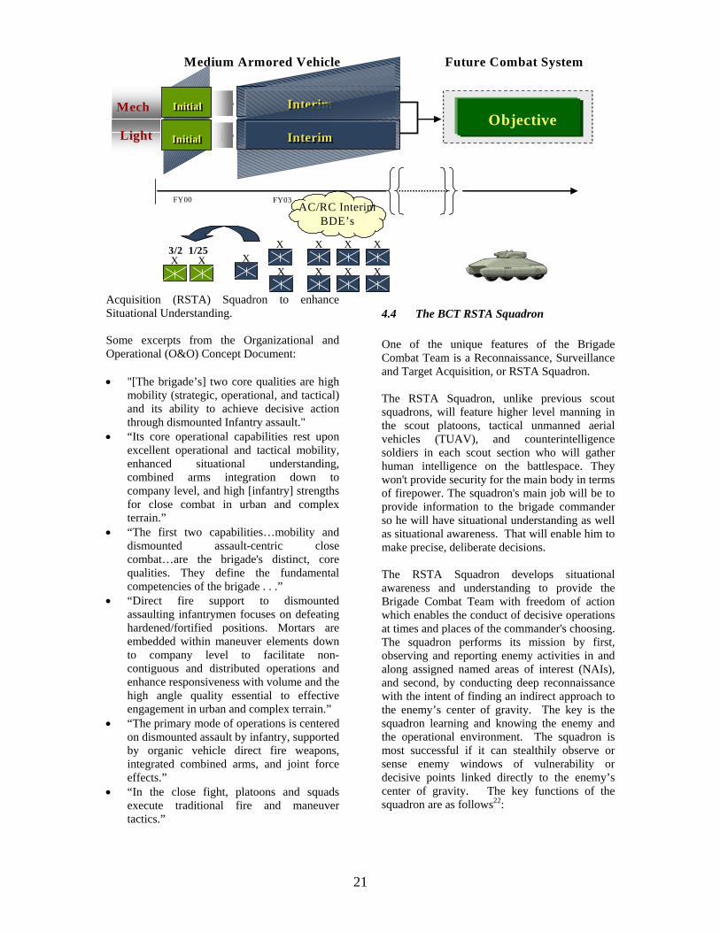
The Army has begun the transformation to the objective force by creating the first two initial brigades at Fort Lewis, Washington, and then will transform additional forces to extend interim force capabilities. TRADOC will develop the glide path that will take the Army from initial conversion of two brigades through to the objective force BCT of the 2012 timeframe. The BCT optimizes the tenets of its operational concept and organizational design by achieving the most effective balance of force projection and battlespace dominance. The prototype brigade is a divisional brigade. It represents a sharp departure from existing organizational concepts within the Army. It is non-traditional with respect to design, deployment process, and manner of employment. Its two core qualities are high mobility (strategic, operational and tactical) and its ability to achieve decisive action through dismounted infantry assault.21 The major fighting components are its motorized infantry battalions. The brigade has a robust Reconnaissance, Surveillance and Target
21
Acquisition (RSTA) Squadron to enhance Situational Understanding. Some excerpts from the Organizational and Operational (O&O) Concept Document: • "[The brigade’s] two core qualities are high
mobility (strategic, operational, and tactical) and its ability to achieve decisive action through dismounted Infantry assault."
• “Its core operational capabilities rest upon excellent operational and tactical mobility, enhanced situational understanding, combined arms integration down to company level, and high [infantry] strengths for close combat in urban and complex terrain.”
• “The first two capabilities…mobility and dismounted assault-centric close combat…are the brigade's distinct, core qualities. They define the fundamental competencies of the brigade . . .”
• “Direct fire support to dismounted assaulting infantrymen focuses on defeating hardened/fortified positions. Mortars are embedded within maneuver elements down to company level to facilitate non-contiguous and distributed operations and enhance responsiveness with volume and the high angle quality essential to effective engagement in urban and complex terrain.”
• “The primary mode of operations is centered on dismounted assault by infantry, supported by organic vehicle direct fire weapons, integrated combined arms, and joint force effects.”
• “In the close fight, platoons and squads execute traditional fire and maneuver tactics.”
4.4 The BCT RSTA Squadron One of the unique features of the Brigade Combat Team is a Reconnaissance, Surveillance and Target Acquisition, or RSTA Squadron. The RSTA Squadron, unlike previous scout squadrons, will feature higher level manning in the scout platoons, tactical unmanned aerial vehicles (TUAV), and counterintelligence soldiers in each scout section who will gather human intelligence on the battlespace. They won't provide security for the main body in terms of firepower. The squadron's main job will be to provide information to the brigade commander so he will have situational understanding as well as situational awareness. That will enable him to make precise, deliberate decisions. The RSTA Squadron develops situational awareness and understanding to provide the Brigade Combat Team with freedom of action which enables the conduct of decisive operations at times and places of the commander's choosing. The squadron performs its mission by first, observing and reporting enemy activities in and along assigned named areas of interest (NAIs), and second, by conducting deep reconnaissance with the intent of finding an indirect approach to the enemy’s center of gravity. The key is the squadron learning and knowing the enemy and the operational environment. The squadron is most successful if it can stealthily observe or sense enemy windows of vulnerability or decisive points linked directly to the enemy’s center of gravity. The key functions of the squadron are as follows22:
Medium Armored Vehicle Future Combat System
FY00 FY03
X X3/2 1/25
XX X X X
X X X X
LightLight
MechMech InitialInitial InterimInterim
InterimInterimInitialInitial
Objective
AC/RC InterimBDE’s
22
• Conducting reconnaissance operations in depth, by stealth, to detect enemy dispositions, organizations, decisive points and vulnerabilities.
• Employing sensors to enhance the complete situational awareness and understanding of the Brigade’s battlespace.
• Ensuring coverage of NAI’s throughout the depth of the Brigade’s sector.
• Maintaining surveillance and situational awareness/understanding for the brigade.
• Conducting chemical, biological, and nuclear detection surveys.
• Conducting limited screening operations--observe and report to provide early warning.
• Knowing the operational environment to include: regular and irregular enemy forces, special forces, terrorists, infrastructure, political factions, and supporting friendly government and non-government agencies.
The squadron performs surveillance, its primary reconnaissance task, through stealth. Employing this method, the squadron’s activities are dominated by patrolling and gathering information about assigned NAI’s while avoiding physical contact with the enemy. The squadron acquires information by employing quiet, deliberate, mounted and dismounted techniques, unmanned aerial systems, and ground sensor systems. Through the integration of these sensors, manned reconnaissance platforms, UAVs and dismounted scouts, the squadron defeats the effects of electronic spoofing, decoy arrays and dummy positions and other civil/military deception activities. If the squadron encounters enemy reconnaissance or security elements, it should engage them asymmetrically--employing long-range indirect fires, augmented attack helicopters, tactical fixed wing aircraft and directed EW/IO systems. Direct fire engagements with the scout platform’s weapon systems or Javelin should be limited to surprise and self-defense situations. The squadron must possess an analysis coordination element capable of fusing and maximizing the potential of its internal ISR capabilities, while linking seamlessly with the brigade's intelligence analysis capabilities. Internally, the squadron integrates the brigade’s organic reconnaissance and surveillance systems to provide the commander a real-time common
relevant picture of the friendly and enemy situation and to transmit that common relevant picture both vertically and horizontally. This requires an all weather ISR capability and a C4ISR organization sufficiently robust to operate 24 hours a day for extended periods. A key enabler to this capability is digitization and connectivity to the Army Battle Command System (ABCS). In addition, the squadron requires a long-range tactical Internet both internal and external to ensure adequate command and control and effective reporting over extended distances. In order to provide the brigade with maximum information and deep observation, the RSTA Squadron must operate apart and at extended distances from the main body. Therefore, the squadron requires platforms with an extended operating range and increased on-board storage capacity to reduce the burden on an austere service support system. Based on the distributed nature of the extended brigade battlespace the squadron requires embedded combat service support and logistics capabilities Plans for the Initial BCT RSTA Squadron are organized around a headquarters troop, a surveillance and target acquisition (STA) troop, and three ground reconnaissance troops. The STA troop consists of one UAV platoon, one ground sensor platoon, one NBC recce platoon, and a target acquisition platoon. The UAV platoon consists of four collection systems similar in capabilities to the Hunter UAV system. The target acquisition platoon consists of two Q36 and one Q37 artillery radar systems. The ground sensor platoon consists of a combination of eight REMBASS/PROPHET sensor systems. The NBC recce platoon consists of four Fox vehicles. The ground reconnaissance troops consist of three reconnaissance platoons each with four Medium Armored Vehicle (MAV) reconnaissance variants with dismount scouts, and one MAV mortar section. The troops must be able to successfully overcome enemy deception and screens. In Stability and Support Operations (SASO) this means having adequate capability and protection to indirectly overcome checkpoints and roadblocks. In Small Scale Contingency (SSC) operations this means being able, in self-defense, to detect and defeat enemy reconnaissance and selected light security elements. The troop scout platforms require aerial/ground sensors that
23
facilitate reconnaissance by stealth. The platforms require protection through the use of reach back fires and on board defensive systems if detected. In addition, the scout platforms require the capability to maintain detection overmatch through visual and/or sensor observation of the enemy and a 25mm gun for direct fire surprise engagements.
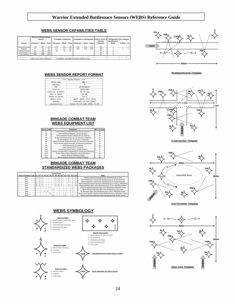
4.5 Capabilities Chart and Sensor Template Employment Guide
Soldiers in the RSTA Squadron's Surveillance Troop responsible for the emplacement of sensor systems will require a "user's guide" to conduct these operations. An example of such a guide was designed by USMA as a tool to aid soldiers in sensor employment and is shown on the following page. This training aid includes an equipment list and system packages for a BCT, a capabilities chart, a sensor report format, symbology for sensor representation on map overlays, and templates showing sensor emplacement strategies. As stated, the Reference Guide should be viewed as a preliminary example of a tool for soldiers. Parameters on the sensors capabilities chart are based on current estimates for acoustic, seismic, magnetic and passive IR sensors. As sensor technologies continue through development and fielding, the appropriate fielding agencies will provide accurate data to such tools.
24
BRIGADE COMBAT TEAMWEBS EQUIPMENT LIST
BRIGADE COMBAT TEAMSTANDARDIZED WEBS PACKAGES
Sensor Package Code S1 S2 S3 S4 S5 S6 S7 S8 S9 S10 S11 S12 S13 S14 RoleSP1 1 1 2 2 2 1 2 1 2 Hand-emplaced Roadway/Airstrip Monitoring (up to 5km)SP2 1 3 3 3 3 1 3 1 3 Hand-emplaced T-Intersection Monitoring (up to 10 intersections)SP3 2 4 4 3 3 1 3 1 3 Hand-emplaced X-Intersection Monitoring (up to 10 intersections)SP4 2 2 2 1 1 1 1 4 Hand-emplaced Platoon Perimeter Monitoring (up to 4 PLTs, 500x500m)SP5 3 3 3 3 3 2 3 2 8 Hand-emplaced Open Area Monitoring (up to 10 ea. 500x500m Areas)SP6 1 1 155mm Projectile Delivered Open Area Monitoring (500x500m Area)SP7 1 1 MLRS Rocket Delivered Open Area Monitoring (1x1km Area)SP8 3 3 1 Air Delivered Open Area Monitoring (up to 10 ea. 500x500m Areas)SP9 5 2 1 MUAV and Projectile Delivered Deep Monitoring (5 ea. 500x550m Areas)SP10 5 4 1 MUAV and Rocket Delivered Deep Monitoring (5 ea. 1x1km Areas)
Sensor Code
Sensor Code Equipment QTY of IssueS1 Hand-emplaced Seismic/Acoustic Set (10 Sensors) 24S2 Hand-emplaced Magnetic Set (10 Sensors) 24S3 Hand-emplaced Passive Infrared Set (10 Sensors) 24S4 Air-drop Seismic/Acoustic Set (10 Sensors/1 Repeater) 12S5 Air-drop Magnetic Set (10 Sensors/1 Repeater) 12S6 155mm Projectile Seismic/Acoustic (10 Sensors/1 Repeater) 16S7 MLRS Rocket Seismic/Acoustic (40 Sensors/4 Repeater) 12S8 FLIR Camera Set (3 Cameras) 12S9 Color Camera Set (3 Cameras) 12S10 Unmanned Ground Sensor Vehicle (UGSV) 5S11 Camera-mounted Micro Unmanned Air Vehicle Set (5 MUAVs) 4S12 Sensor Relay Station (Repeater) Set (3 Repeaters) 24S13 Sensor Network Monitoring Station 5S14 Sensor Network Monitoring Display (Portable) 24
WEBS SENSOR CAPABILITIES TABLE
Target Type BMP-3
Quantity 4
DTG 291800ZMar00
Location TW19931994
Direction of Travel SE 125 deg
Rate of Speed 34 kmh
Length of Column 350 m
Sensor ID(s) SA319, SA329, M711, IR420
Remarks Confirmed via FLIR camera
Operator/Unit Parker/19th MI Sqdn (RSTA) 3d BCT
**** Sensor Report ****
WEBS SENSOR REPORT FORMAT
Sensor Personnel Wheel Track Personnel Wheel Track Personnel Wheel TrackHand/Ground
Robot Artillery Air
Seismic/Acoustic 100 500 700 0.95 0.95 0.95 0.95 0.95 0.95 360 2 1 1Magnetic 6 30 50 0.9 0.9 0.9 0.85 0.85 0.85 360 2 1 1
Infrared Passive 40 100 100 .95 .98 .99 45 5FLIR Camera 1000 2000 2500 90 5Color Camera 1000 1500 1500 90 5
Emplacement Time (minutes)
Probabilities calculated at maximum effective rangeClear, noon, sparse vegetation
Maximum Effective Range (meters) Probability of Detection Probability of Classification Field of Vision or
Detection (degrees)
SENSOR SYMBOL
A = Sensor Type (S/A, M, PIR, FLIR, CAM)
B = ID Code/Channel
C = Team/Unit/Emplacement Means
D = Sensor Monitoring Set ID
E = Grid Location
REPEATER SYMBOL
A = Receiver/Transmit Channel
B = Team/Unit
C = Grid Location
A
D
CBE
BAC
MONITOR SYMBOL
A = Receiver Channel
B = Team/Unit
C = Grid LocationBAC
ABCDE
SENSOR FIELD SYMBOL
A = Sensor Type (S/A, M, PIR, FLIR, CAM)
B = ID Code/Channel
C = Unit/Emplacement Means
D = Sensor Monitoring Set ID
E = Grid Location
UNMANNED GROUND SENSOR VEHICLE (UGSV)
MICRO UNMANNED AIR VEHICLE (MUAV)
WEBS SYMBOLOGY
SAPIR M
PIR
ENEMY
500m
Roadway/Airstrip Template
CAM
ENEM
Y
PIR
PIR
PIR
SA
M
M
M
1 km1 km
MPIR SA
X-Intersection Template
CAM
Assembly Area
ENEMY
PIR
PIR
SA
M
M
500m
500m
MPIR
SA
Unit Perimeter Template
SAEN
EMY
PIR PIR
SA
M
M
500m
500m
M
PIR
SA
Open Area Template
SA
ENEM
Y
Warrior Extended Battlespace Sensors (WEBS) Reference Guide
25
5 CONCLUSION
Sensors have long provided commanders with the information needed to win wars and networked battlefield sensors will undoubtedly play a critical role in the Army's future force. Distributed sensing by organized or self-organizing arrays of dispersed sensors of various modalities is recognized as a pivotal element in the ability of defense forces to accomplish their mission. Researchers have made great progress in the development of low-cost sensing devices. At the same time, much research and development remains to be done to miniaturize the devices and reduce the cost. Issues of network organization, topology and information processing are principles for which challenges still exist. The Army, DoD, and the scientific and engineering communities must confront the opportunity to design future distributed sensing systems from a global point of view, in which devices, networks and information processing will be optimized not individually but as a system.
6 FUTURE WORK The Department of Systems Engineering at the U.S. Military Academy has taken the task of designing the organizational structure for the Objective Force RSTA Squadron. This effort will help lend credibility to parallel research and development programs such as WEBS, TUAVs, UGVs, FSCS, etc. Cadets and faculty from the Academy will employ a methodology known as the Systems Engineering Design Process (SEDP) to formulate, analyze and interpret alternative courses of action for RSTA Squadron design. Fundamental to the SEDP methodology are the following steps: • Problem definition • Value system design • Synthesis of alternatives • Systems modeling and analysis • Optimization of alternatives • Decision making • Planning for Action
The project will consider the breadth of existing RSTA assets as well as those currently under research and development. Alternative designs will examine both personnel and materiel requirements to meet the RSTA needs of the Objective Force BCT. This effort will represent a departure from current force structure design processes. Currently, Army organizations are often formulated by committee using pools of subject matter experts who employ the breadth of their experience to provide input on personnel/materiel needs for a given unit type. What results is the committee's "best guess" at what the force should look like. A systematic design methodology including alternative development, simulation, and optimization should serve as a better model for the creation of new force structures.
26
7 REFERENCES 1. Adams, Thomas K., Radical Destabilizing
Effects of New Technologies, Parameters, Autumn 1998, pp. 99-111
2. Alberts, David S., Network Centric Warfare:
Developing and Leveraging Information Superiority, DoD C4ISR Cooperative Research Program (CCRP), 1999
3. Army Research Lab Sensors and Electron
Devices Directorate, [web page] (February 2000), http://w3.arl.mil/sensors/index.html
4. FM 17-12-1-1 Tank Gunnery (Abrams),
May 1998 5. FM 17-95 Cavalry Operations, December
1996 6. FM 31-20-5 Special Reconnaissance
Tactics, Techniques, and Procedures for Special Forces, March 1995
7. FM 34-1 Intelligence and Electronic
Warfare Operations, September 1994 8. FM 34-2-1 Tactics, Techniques, and
Procedures for Reconnaissance and Surveillance and Intelligence Support to Counterreconnaissance, June 1991
9. FM 7-93 Long-Range Surveillance, October
1995 10. Ground-Based Common Sensor, [web page]
(November 1999), http://www.fas.org/irp/ program/collect/gbcs.htm
11. Haffa, Robert P., Patton, Jr., James, H.,
Gaming the "System of Systems, Parameters, Spring 1998, pp. 110-21.
12. Hahn II, Robert F., Jezior, Bonnie, Urban
Warfare and the Urban Warfighter of 2025, Parameters, Summer 1999, pp. 74-86
13. Joint Pub 3-13, Joint Doctrine for
Information Warfare, October 1998 14. L3 Communications - REMBASS, [web
page] (December 1998), http://www.l-
3com.com/cs-east/programs/tactical/ rembass.html
15. Marcy, H.O, Agre, J.R, Chein, C., Clare,
L.C., Robust Microsensor Networking for Area Denial, Rockwell Science Center, 1999
16. Peters, Ralph, The Future of Armored
Warfare, Parameters, Autumn 1997, pp. 50-59.
17. Rodgers, A.L., Surveillance and Target
Acquisition Systems, Brassey's Publishers, 1983
18. Sensors & Electron Devices Directorate
Program Formulation, Real Aperture Target Discrimination Technology Program, March 2000, p.91
19. Sensors & Electron Devices Directorate
Program Formulation, Single Sensor ATR, March 2000, p.125
20. Sensors & Electron Devices Directorate
Program Formulation, STO - Warrior Extended Battlespace Sensors (WEBS), ARL, March 2000, p. 131
21. Training and Doctrine Command
(TRADOC), The Full Spectrum Brigade Organizational and Operational Concept, November 1999
22. Wamble, Stacy, ArmyLINK News, "Brigade
Combat Team under construction at Fort Knox", [web page] (January 2000) http://www.dtic.mil/armylink/news/Jan2000/a20000105bct.html
23. Wohl, Robert, PBS interview on Modern
Warfare, University of California, http://www.pbs.org/greatwar/interviews
Copyright © 2022 FDOKUMEN