
Consistent Updating of Geographical DataBase as Emergent Property over Inuence System
11
Consistent Updating of Geographical DataBase as Emergent Property over Influence System Hakima Kadri-Dahmani, Cyrille Bertelle, G´ erard H.E. Duchamp, Aomar Osmani To cite this version: Hakima Kadri-Dahmani, Cyrille Bertelle, G´ erard H.E. Duchamp, Aomar Osmani. Consistent Updating of Geographical DataBase as Emergent Property over Influence System. International Journal of Modelling Identification and Control, 2008, 3 (1), pp.58-68. <hal-00281516> HAL Id: hal-00281516 https://hal.archives-ouvertes.fr/hal-00281516 Submitted on 22 May 2008 HAL is a multi-disciplinary open access archive for the deposit and dissemination of sci- entific research documents, whether they are pub- lished or not. The documents may come from teaching and research institutions in France or abroad, or from public or private research centers. L’archive ouverte pluridisciplinaire HAL, est destin´ ee au d´ epˆ ot et ` a la diffusion de documents scientifiques de niveau recherche, publi´ es ou non, ´ emanant des ´ etablissements d’enseignement et de recherche fran¸cais ou ´ etrangers, des laboratoires publics ou priv´ es.
-
Upload
univ-lehavre -
Category
Documents
-
view
0 -
download
0
Transcript of Consistent Updating of Geographical DataBase as Emergent Property over Inuence System
Consistent Updating of Geographical DataBase as
Emergent Property over Influence System
Hakima Kadri-Dahmani, Cyrille Bertelle, Gerard H.E. Duchamp, Aomar
Osmani
To cite this version:
Hakima Kadri-Dahmani, Cyrille Bertelle, Gerard H.E. Duchamp, Aomar Osmani. ConsistentUpdating of Geographical DataBase as Emergent Property over Influence System. InternationalJournal of Modelling Identification and Control, 2008, 3 (1), pp.58-68. <hal-00281516>
HAL Id: hal-00281516
https://hal.archives-ouvertes.fr/hal-00281516
Submitted on 22 May 2008
HAL is a multi-disciplinary open accessarchive for the deposit and dissemination of sci-entific research documents, whether they are pub-lished or not. The documents may come fromteaching and research institutions in France orabroad, or from public or private research centers.
L’archive ouverte pluridisciplinaire HAL, estdestinee au depot et a la diffusion de documentsscientifiques de niveau recherche, publies ou non,emanant des etablissements d’enseignement et derecherche francais ou etrangers, des laboratoirespublics ou prives.
Consistent Updating ofGeographical DataBase asEmergent Property overInfluence System
Hakima Kadri-Dahmani*LIPN - University of Paris 1399, avenue Jean-Baptiste Clement93430 Villetaneuse - FranceE-mail: [email protected]*Corresponding author
Cyrille BertelleLITIS - University of Le Havre25 rue Ph. Lebon - BP 54076058 Le Havre cedex - FranceE-mail: [email protected]
Gerard H. E. DuchampLIPN - University of Paris 1399, avenue Jean-Baptiste Clement93430 Villetaneuse - FranceE-mail: [email protected]
Aomar OsmaniLIPN - University of Paris 1399, avenue Jean-Baptiste Clement93430 Villetaneuse - FranceE-mail: [email protected]
Abstract: Geographic Information Systems will be expected in the future to evolveto integrate social simulations or ecological processes inside complex systems of activeand interactive entities. In a more practical aspect, GIS has now to evolve to manageupdating. We will explain how the updating processes can be described as an evolutionprocessus for GIS and make them transform from complicated systems to complex sys-tems. This evolution processus is decomposed in an influence table which correspondsto elementary canonical operations. The application of these elementary operations asbasic rules for each step of the GIS evolution over the connection graph which linksthe Geographical Database objects will create a dynamic interaction network whichcharaterizes the complexity. In addition to these updating elementary operations, weverify, during the processus, the maintenancy of the whole geographical database usinga constraint-based system. Our goal is to make the updating satisfying the global con-sistent property which emerges from the computation over the whole evolutive system.In this paper, we will give the whole processus description which leads to obtain thisemergent property of consistence from a dynamic propagation processus which allowsto obtain the global consistence from a local satisfaction property.
Keywords: geographical database; complex systems; spatial constraints; evolution;emergence.
Reference to this paper should be made as follows: Kadri-Dahmani, H.,Bertelle,C., Duchamp, G.H.E. and Osmani, A. (2006) ‘Consistent Updating of GeographicalDataBase as Emergent Property over Influence System’, Int. J. of Modeling, Identi-fication and Control, Special Issue Modelling Complex Systems, Vol. x, Nos. x/y/z,pp.xx–yy.
Biographical notes: Hakima Kadri-Dahmani is researcher at LIPN in the InstituteGalilee at the University of Paris 13, France. She completed her PhD degree fromUniversity of Paris 13 in 2005. Since many years, she has been researching in artificialintelligence, and geomatic at IGN-France and University of Paris 13.
1 INTRODUCTION
The development of huge networks of communicationsallows today to share a great amount of data. With theuse of these new technologies, the need of informationsbecomes important. The easy sharing of data all over theworld makes that interactions processes, at many differentscales, are needed to analyse the present world in all itscomplexity. We need new models based on the basis of thiscomplexity: interactions-based and multi-scales-based (3).
The new technologies and especially the satellites givea great amount of data concerning geographical informa-tions. The important improvement of computer sciences asthe science of modelization and conceptualisation and theincreasing performance of computers and networks, leadto buid efficient Geographic Information Systems (GIS).These GIS allow to represent heterogeneous informationswhich are strongly linked and stored in Geographical DataBases (GDB). These GDB based on vector representationare generally composed of layered classes of objects. Eachlayer is associated to a semantic thematic like road traffic,fluvial tracing, buildings, vegetation, etc.
Moreover, the new challenges in geography concernsalso the analysis and the understanding of the interactionsall over the world about social, geopolitic and ecologicalaspects. These challenges need to develop and managesuitable conceptual and generic models. Complex mod-elling to describe complex processus over the structurednetworks of GDB, is an efficient way to answer to thesechallenges. On the practical aspect, GIS developmentis concerned today with one of these complex proces-sus over GDB which is the updating processing for GIS (4).
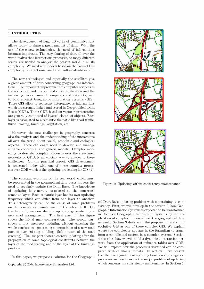
The constant evolution of the real world which mustbe represented in the geographical data bases induces theneed to regularly update the Data Base. The knowledgeof updating is generally associated to the concernedsemantic layer. Each semantic layer has its own updatingfrequency which can differ from one layer to another.This heterogeneity can be the cause of some problemson the consistency maintenance of the whole GDB. Onthe figure 1, we describe the updating generated by anew road arrangement. The first part of this figureshows the initial map configuration. The second partshows a first uncorrect updating without checking thewhole consistence, generating superposition of a new roadportion over existing buildings (left bottom of the roadcrossing). The last part shows a correct updating after thepropagation of some topological constraints between thelayer of the road tracing and of the layer of the buildingsposition.
In this paper, we propose a solution for the Geographi-
Copyright c© 200x Inderscience Enterprises Ltd.
Figure 1: Updating within consistency maintenance
cal Data Base updating problem with maintaining its con-sistency. First, we will develop in the section 2, how Geo-graphic Information Systems is expected to be transformedin Complex Geographic Information Systems by the ap-plication of complex processus over the geographical datanetwork. Section 3 deals with the proposed formalism ofevolutive GIS as one of these complex GIS. We explainwhere the complexity appears in the formalism to trans-form a complicated system in a complex system. Section4 describes how we will build a dynamical interaction net-work from the application of influence tables over GDB.We will explain how the processus described can be com-pared with cellular automata. In section 5, we presentthe effective algorithm of updating based on a propagationprocessus and we focus on the major problem of updatingwhich concerns the consistency maintenance. In Section 6,
2
we present the emergent property of the global consistencymaintenance from the local consistency maintenance. Sec-tion 7 presents implementations and experiments and weconclude in section 8.
2 FROM GIS TO COMPLEX GIS
A Geographic Information System (GIS) is a computer-based tool using geographical objects. A GIS is composedof a Geographical Data Base (GDB) with applicativeoperators which allow it to get, to stock, to verify, tomanipulate, to analyze and to represent the spatial dataof the GDB.
The originality of Geographical Data Base from or-dinary Data Base is the use of spacial data (11). thelatter may be represented in a Geographical Data Basewith two aspects: in raster mode or in vector mode. Theraster mode is based on a pixels grid representation. Thevector mode manipulates geographical features. In thefollowing, we will focus our attention on the vector moderepresentation where each feature is represented by anobject. Each object has a semantic part describing thenature of a feature which it represents and a geometricpart describing its shape and its localisation. The positionof the objects the ones compared with the others is animportant information which is usually represented in theGeographical Data Base.
So, in Geographical Data Bases, geographical infor-mation is often represented with three levels: geometric,semantic and topological. From each level, we candefine relations between objects that have to be linkedcorresponding to the specific level.
At the semantic level, a Geographical Data Base isoften structured with layers. Layers are generally definedconcerning a specific thematic like road traffic, fluvialtracing, building or vegetation. Generally, objects of asame layer have the same geometric representation andshare the same topological properties inside networks.
All these structured informations which defines a GISintroduce a great number of static dependences but eachlayer can be generally understood alone or some partsof each layer can be isolated to better understand thedependence between involved objects. Generally theapplicative operators can be computed on each of theseparts. In that way, we can consider classical GIS ascomplicated systems in the terminology proposed by LeMoigne (10). We can consider that the GeographicalData Base in association with the previous applicativeoperators which constitute the GIS is a closed system.
Today, the complexity of the world needs to use orto add additional functionalities on GIS. Geographicalinformations deal also with human-landscape interactions.
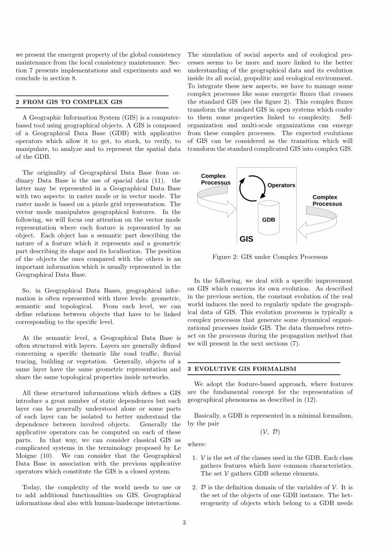
The simulation of social aspects and of ecological pro-cesses seems to be more and more linked to the betterunderstanding of the geographical data and its evolutioninside its all social, geopolitic and ecological environment.To integrate these new aspects, we have to manage somecomplex processes like some energetic fluxes that crossesthe standard GIS (see the figure 2). This complex fluxestransform the standard GIS in open systems which conferto them some properties linked to complexity. Self-organization and multi-scale organizations can emergefrom these complex processes. The expected evolutionsof GIS can be considered as the transition which willtransform the standard complicated GIS into complex GIS.
GDB
Operators
ComplexProcessus
ComplexProcessus
GIS
Figure 2: GIS under Complex Processus
In the following, we deal with a specific improvementon GIS which concerns its own evolution. As describedin the previous section, the constant evolution of the realworld induces the need to regularly update the geograph-ical data of GIS. This evolution processus is typically acomplex processus that generate some dynamical organi-zational processes inside GIS. The data themselves retro-act on the processus during the propagation method thatwe will present in the next sections (7).
3 EVOLUTIVE GIS FORMALISM
We adopt the feature-based approach, where featuresare the fundamental concept for the representation ofgeographical phenomena as described in (12).
Basically, a GDB is represented in a minimal formalism,by the pair
(V , D)
where:
1. V is the set of the classes used in the GDB. Each classgathers features which have common characteristics.The set V gathers GDB scheme elements.
2. D is the definition domain of the variables of V . It isthe set of the objects of one GDB instance. The het-erogeneity of objects which belong to a GDB needs
3
their classification for a better use. We consider 4classes of objects which are spread over two informa-tion levels: the geometric level which gathers geomet-ric primitives PG and the geometric objects OG, andthe semantic level which gathers simple semantic ob-jects OS and complicated semantic objects OC.
D = PG ∪ OG ∪ OS ∪ OC
The proposed model for a GDB which allows to evolvethrough updating operations must add some complemen-tary sets which will manage some dependences betweenthe geographical elements. So the model is composed of aquadruplet
(V , D, R, C)
where, in addition:
1. The connection graph over the GDB elements is basedon relations between these elements. R is the set ofthese relations. In our object representation, these re-lations correspond to relations between GDB basic ob-jects. The different kinds of relations that we considerare: composition relations RC , dependence relationsRD and topologic relations RT .
R = RC ∪ RD ∪ RT
2. C is the set of constraints defined between the vari-ables of V and/or between variables value of V . In ourobject modelization, this corresponds to constraintsdefined between the classes (constraints between vari-able) and/or between objects (constraints betweenvalues). These constraints manage the GDB evolu-tion on many levels, so we need to classify them insidedifferent categories corresponding to the concerned as-pect of evolution. On the first level, we have classifythese constraints in structural constraints and in nonstructural constraints.
This quadruplet corresponds to the GDB modelisationto prepare it to evolution.
Finally, to effectively manage evolution processes, wehave to modelize the updating informations in accordancewith the GDB conceptual model. We note M the updatingset where basis action is the transaction and the full modelfor the GDB is the 5-uplet
(V , D, R, C, M)
.
3.1 Features representation
Objects stored in a GDB constitute different componentsof CGIS at different levels : geometric and semantic level.
Definition 3.1. Given PG the geometric primitives setand T = {P, L, S} the set of possible types for geometricprimitives where P represent the points, L represent thelines et S represent the surfaces; We then define the func-tion type define from PG to T and which gives a type toeach geometric primitives.
Definition 3.2. A geometric object Og of OG is a pair(OB, OR) such that :
• OB is a subset of PG possessing more than 2 ele-ments ;
• OR is a set of binary relations between pairs of geo-metric primitives of Og such that OR ⊂ R (the latterbeing the set of all the possible binary relations betweenobjects).
Let OG be the set of geometric objects.
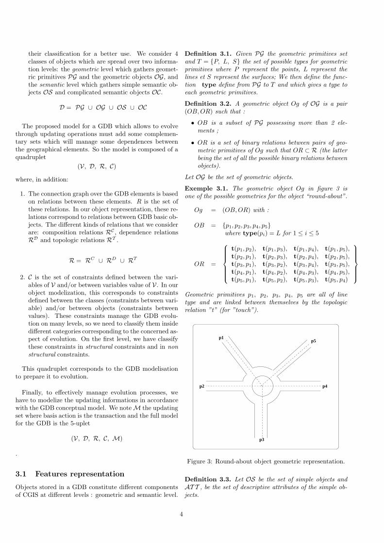
Exemple 3.1. The geometric object Og in figure 3 isone of the possible geometries for the object “round-about”.
Og = (OB, OR) with :
OB = {p1, p2, p3, p4, p5}where type(pi) = L for 1 ≤ i ≤ 5
OR =
t(p1, p2), t(p1, p3), t(p1, p4), t(p1, p5),t(p2, p1), t(p2, p3), t(p2, p4), t(p2, p5),t(p3, p1), t(p3, p2), t(p3, p4), t(p3, p5),t(p4, p1), t(p4, p2), t(p4, p3), t(p4, p5),t(p5, p1), t(p5, p2), t(p5, p3), t(p5, p4)
Geometric primitives p1, p2, p3, p4, p5 are all of linetype and are linked between themselves by the topologicrelation ”t” (for ”touch”).
p1
p2
p3
p4
p5
Figure 3: Round-about object geometric representation.
Definition 3.3. Let OS be the set of simple objects andAT T , be the set of descriptive attributes of the simple ob-jects.
4
A simple semantic object Os of OS is a pair (p, ATT ) suchthat :
• p is a geometric primitive : p ∈ PG ;
• ATT is a non-empty subset of AT T :ATT ∈ ℘(AT T ) − {φ}, where ℘(AT T ) stands forthe set of subsets of AT T .
Definition 3.4. A complex object Oc of OC is a pair(OBS, ATT ) such that :
• ATT is a non-empty subset of AT T :ATT ∈ ℘(AT T ) − {φ} ;
• OBS is a non-empty subset of simple semantic ob-jects : OBS ∈ ℘(OS) − {φ} ;
• ∀Os ∈ OBS, ∃ RC ∈ RC tel que RC(Oc, Os).
Let OC be the set of complex objects.
3.2 Relations representation
Since objects are classified in two different levels, only ob-jects of the same level can interact. The interaction net-work over these objects is based on relations between thesecomponents. These relations are also classified in two lev-els : semantic relations and topological relations.
1. Semantic relations: they are essential for the con-straints propagation description. They are composedof composition relations, RC , which allow to describeaggregation of some objects and dependence relations,RD, which describe that the modification of one ob-ject can lead to the modification of other ones;
Definition 3.5. One calls composition relation ofRC(O, O′) between O, a complex semantic object andO′ a simple semantic object, the relation which ex-presses the fact that ”O is composed of O′”.
Definition 3.6. One calls dependence relationRD(O, O′) between O and O′, the relation for which amodification of the object O (called master object), canalter the semantic attributes of the object O′ (calleddependent).
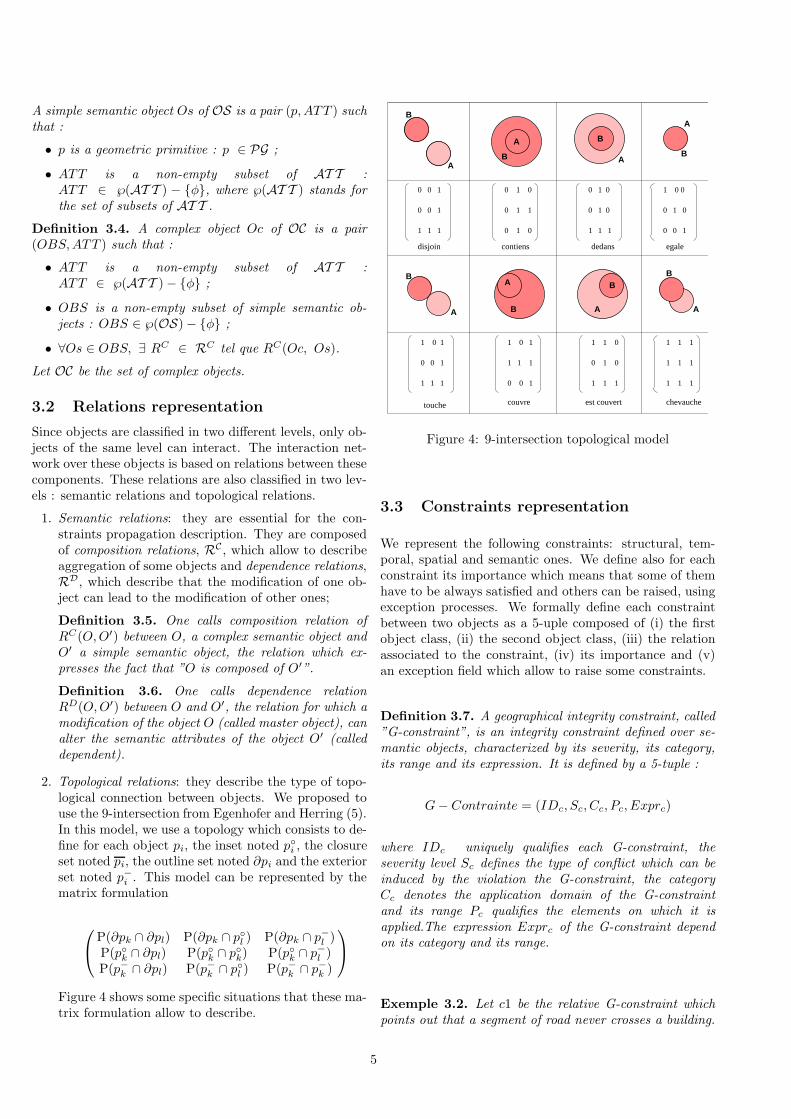
2. Topological relations: they describe the type of topo-logical connection between objects. We proposed touse the 9-intersection from Egenhofer and Herring (5).In this model, we use a topology which consists to de-fine for each object pi, the inset noted p◦i , the closureset noted pi, the outline set noted ∂pi and the exteriorset noted p−
i. This model can be represented by the
matrix formulation
P(∂pk ∩ ∂pl) P(∂pk ∩ p◦l) P(∂pk ∩ p−
l)
P(p◦k∩ ∂pl) P(p◦
k∩ p◦
k) P(p◦
k∩ p−
l)
P(p−k∩ ∂pl) P(p−
k∩ p◦
l) P(p−
k∩ p−
k)
Figure 4 shows some specific situations that these ma-trix formulation allow to describe.
disjoin
0 0 1
0 0 1
1 1 1
contiens
0 1 0
0 1 0
0 1 1
dedans
0 1 0
0 1 0
1 1 1
egale
1 0 0
0 1 0
0 0 1
touche
1 0 1
0 0 1
1 1 1
couvre
1 0 1
1 1 1
0 0 1
est couvert
1 1 0
1 1 1
0 1 0
1 1 1
1 1 1
1 1 1
chevauche
B
BB
B
B
B
B
A
A
B
A
A
A
A
A A
Figure 4: 9-intersection topological model
3.3 Constraints representation
We represent the following constraints: structural, tem-poral, spatial and semantic ones. We define also for eachconstraint its importance which means that some of themhave to be always satisfied and others can be raised, usingexception processes. We formally define each constraintbetween two objects as a 5-uple composed of (i) the firstobject class, (ii) the second object class, (iii) the relationassociated to the constraint, (iv) its importance and (v)an exception field which allow to raise some constraints.
Definition 3.7. A geographical integrity constraint, called”G-constraint”, is an integrity constraint defined over se-mantic objects, characterized by its severity, its category,its range and its expression. It is defined by a 5-tuple :
G − Contrainte = (IDc, Sc, Cc, Pc, Exprc)
where IDc uniquely qualifies each G-constraint, theseverity level Sc defines the type of conflict which can beinduced by the violation the G-constraint, the categoryCc denotes the application domain of the G-constraintand its range Pc qualifies the elements on which it isapplied.The expression Exprc of the G-constraint dependon its category and its range.
Exemple 3.2. Let c1 be the relative G-constraint whichpoints out that a segment of road never crosses a building.
5
In our language this G-constraint is defined as follows :
(IDc = c1,
Sc = relative,
Cc = topologique,
Pc = interclasse,
Exprc = expr1)
expr1 = (TRoute : Os1,
Batiment : Os2,
INTERSECT, interdit, φ).
3.4 Formalization of the updating flow
Evolution of a geographical data base often reflects theevolution of the nominal ground it is supposed to modelize.This induces, in the base, integration of a set of updateoperations which modify, in turn, components of thesystem (its objects). The alteration of certain componentscan affect other components in a recursive way. Accordingto the type of the operations under consideration, theirrunning can make the geographical data base swell, shrinkor change in content without altering the volume.
The set of the operations and of the involved objects isthe set of updating informations or, in other words, theupdating flux.
The updating informations proposed in the model isbased on 8 complex operations.
Definition 3.8. A complex operation is an operationwhich applies over simple or complex semantic ob-jects and which can split up into several simple op-erations. Let op co be a complex operation, op co ∈{Ccre, Csup, Scis, Fus, Agg, Cgeom, Cdesc, Stb}such that
Ccre = Creation complexe
Csup = Suppression complexe
Scis = Scission
Fus = Fusion
Agg = Aggregation
Cgeom = Modification geometrique
Cdesc = Changement descriptif complexe
Stb = Stabilite.
which are complex creation, complex suppression, split-ting, fusion, aggregation, geometric modification, com-plexe descriptive modification, stability. We have shown(9) that each complex operation can be decomposed as asequence of some of the 4 canonical operations: creation,suppression, descriptive modification and identity.
Definition 3.9. We call canonical operation every op-eration which cannot be split up in terms of other op-erations. Let op ca be a canonical operation, op ca ∈
{Cre, Sup, Desc, ID} such that
Cre = Creation
Sup = Suppression
Desc = Changement descriptif
ID = Identite.
To do an updating, one must define an execution orderfor the involved canonical operations. This leads us to thedefinition of a sequence.
Definition 3.10. A sequence is a totally ordered set ofcanonical operations which correspond to a given complexoperation.
Finally the basic updating unity is the transaction whichis a set of sequences of canonical operations.
4 DYNAMIC INTERACTION NETWORK
The integration of the updating flow in the geographicaldata base starts the dynamics of the system evolution.Let’s recall that updating flow is structured as a set oftransactions, each one is a set of canonical operationssequences. So, each canonical operation, applied on anobject, activates some falls of updating operations toapply on other objects. Although the starting operationis known, since it is a membership of the input updatingflow, the other consequent operations, called influenceoperations, are not known. Objects to which theseoperations are applied, called influenced objects, are noteither known.
Using the previous formalism, we will show in this sec-tion (i) how influenced objects are defined, (ii) how in-fluence operations are computed and (iii) how these ob-jects interact. We will show that all the computation canbe summarized inside a Table of Influences that cross theconnection graph to build an interaction network.
4.1 Topological influence area and connec-tion graph
We consider the target semantic object Oc to be updated.We define the Topological Influence Area as the following:
Definition 4.1. We consider Oc a target object to be up-dated from a GDB. Its Topological Influence area that wenote as Z it(Os), collects all the GDB objects which areinside a neighbourhood of Oc and which are linked to 0c.
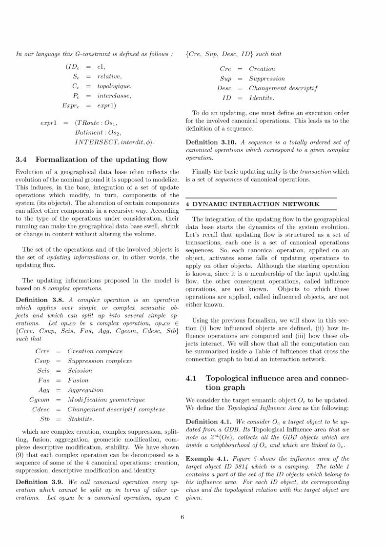
Exemple 4.1. Figure 5 shows the influence area of thetarget object ID 9814 which is a camping. The table 1contains a part of the set of the ID objects which belong tohis influence area. For each ID object, its correspondingclass and the topological relation with the target object aregiven.
6
We represent the topological influence area by a connec-tion graph which connects the objects linked by a topolog-ical relation.
Exemple 4.2. Figure 6 shows some element of the con-nection graph corresponding to some relation from the tar-get object ID 9814, based on the table 1.
ID CLASS RELATION7130 BATIMQCQ contains7135 BATIMQCQ contains7134 BATIMQCQ contains3640 ROUTE TR borders2264 ROUTE TR borders452 CARREFOURNA touchs453 CARREFOURNA touchs... ... ...
Table 1: Topological influence area from object ID 9814
ID 7135
Contains
ID 3640
ID 2264
ID 452
ID 7130
ID 453
ID 7134
Contains
Contains
Borders
Touchs
Borders
ID 9814
Touchs
CARREFOURNA
ROUTE_TR
BATIMQCQ
BATIMQCQ
BATIMQCQ
ROUTE_TR
CARREFOURNA
CAMPING
Figure 6: Connection graph (extract from object ID 9814)
4.2 Table of influences
Using the canonical decomposition of updating informa-tions, we can define a table of topological influences whichallows to obtain, from an operation applied to an specificobject, what are the effects on the other objects in itsneighbourhood. Corresponding to the 3 geometric prim-itives and the 4 canonical operations, we obtain a finitetable which can describe all the situations.
In the example corresponding to one line of the table oftopological influences shown in the table 2, the situationis the suppression of the area object p which constraints
p p′ Op(p) RT (p, p′) Influence
Area Area Suppress. In {ID, Sup-press.}
Table 2: One line in the table of topological influences
another area object p′ and that can lead to one of thefollowing operations for this second object, that is toremove it or not. To know what is the resulting operation,we need to explore the semantic influence which is itselfmanaged by another table of semantic influences.
4.3 From Connection Graph to Interac-tion Network
Because of the canonical decomposition, all the updatingprocesses are summarized in the influence table and theapplication of each line of this table can be considered as arule to be applied to the connected graph which describesthe objects of the GIS and the relations between them.
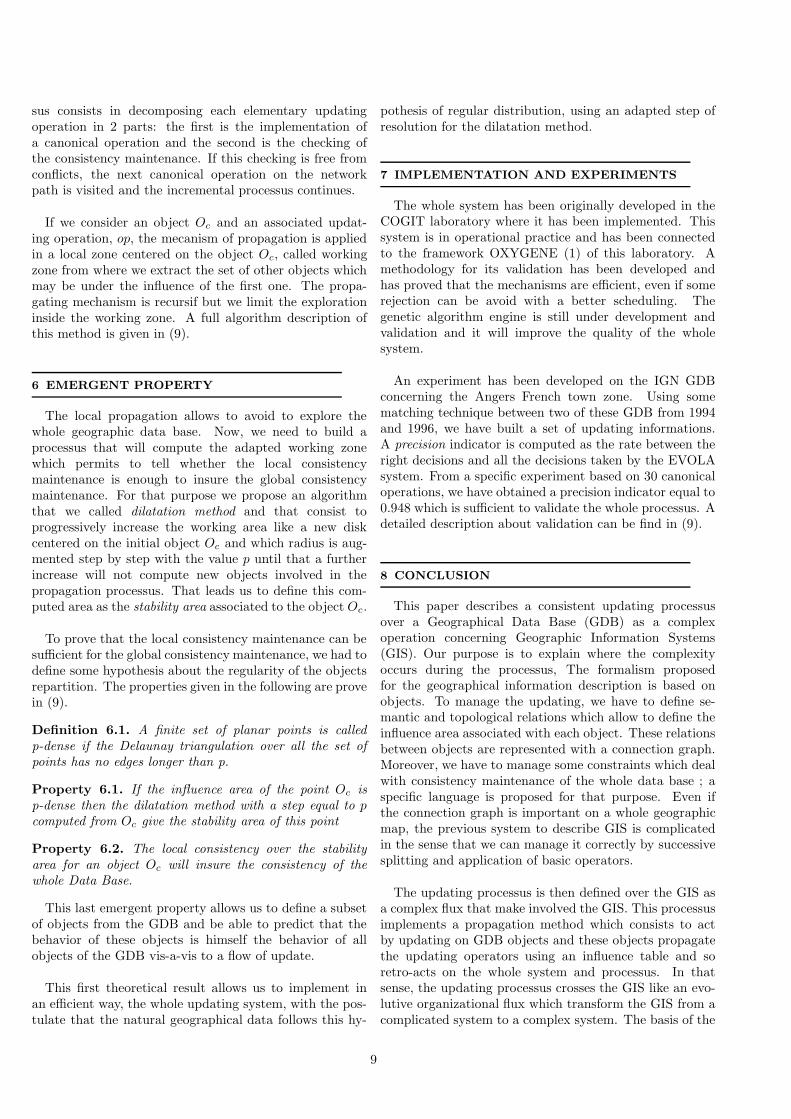
Using the influence table, we apply some rules andactivate some interactions between GIS objects relativelyto the updating operation that we presently manage. Inthat way, we build an interactive network that is developeddynamically during the processus (2). The new elementsaggregate to this interactive network will generate newprocesses. The complete algorithmic description is madein the following section.
We make some comparisons between the processus usedhere with the one usually use with cellular automata.These comparisons are summarized in figure 7. The con-nection graph which represent the GIS objects in relationcan be compared to the cellular automon mesh. The twodescribe potential connection. In some way, we can con-sider the mesh and the graph as dual representation. Therules for cellular automata and the influence table applica-tions make activated interactions that are represented inthe part (b) of the figure.
5 PROPAGATION AND CONSISTENCY
Propagate the effect of an updating operation in thegeographical data base means to execute the startingoperation and all the influence operations which resultfrom it without altering its consistency. This is translated,in our system, by the installation of the interactionnetwork built from the connection graph and the tableof influences. Once the interaction network is generated,it should be checked that it does not have inconsistency (8).
The inconsistency checking mecanism is based on ageneral incremental processus. The incremental proces-
7
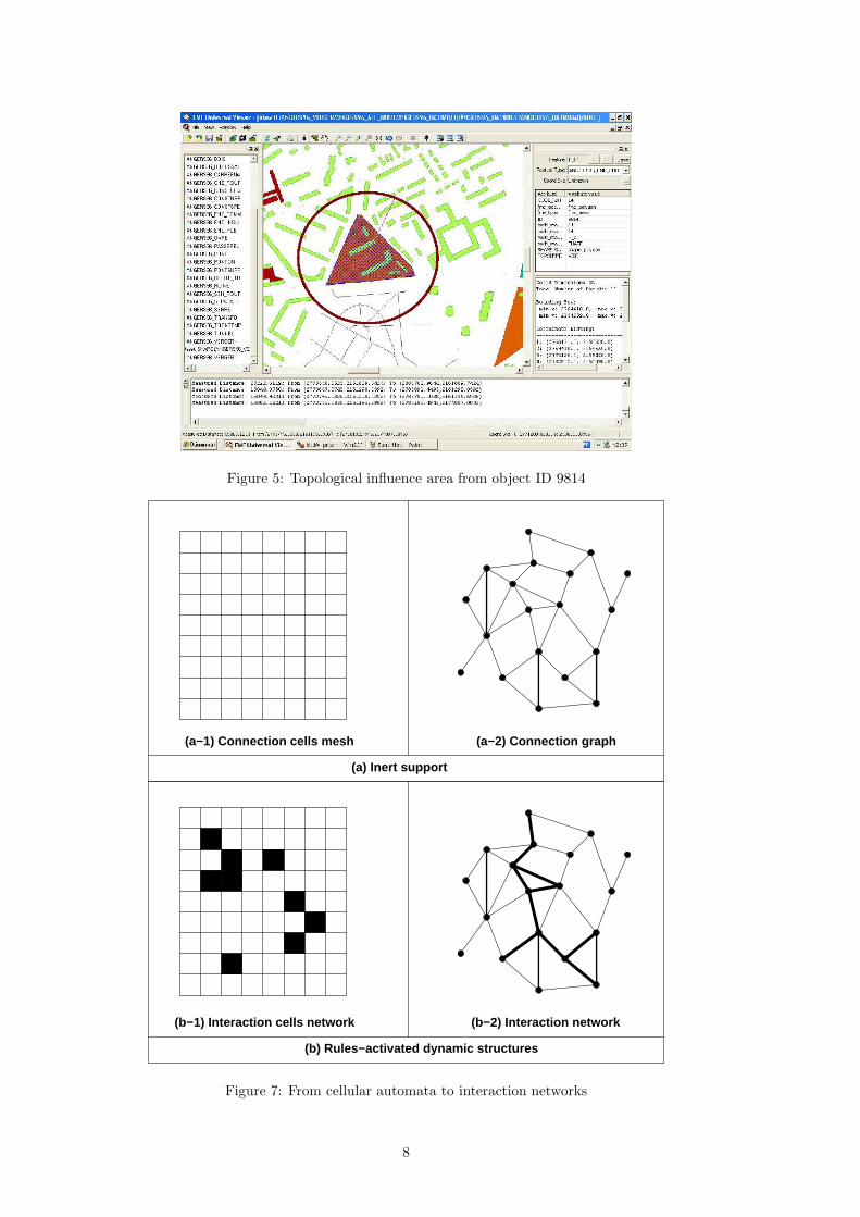
Figure 5: Topological influence area from object ID 9814
(a−2) Connection graph(a−1) Connection cells mesh
(b−2) Interaction network(b−1) Interaction cells network
(a) Inert support
(b) Rules−activated dynamic structures
Figure 7: From cellular automata to interaction networks
8
sus consists in decomposing each elementary updatingoperation in 2 parts: the first is the implementation ofa canonical operation and the second is the checking ofthe consistency maintenance. If this checking is free fromconflicts, the next canonical operation on the networkpath is visited and the incremental processus continues.
If we consider an object Oc and an associated updat-ing operation, op, the mecanism of propagation is appliedin a local zone centered on the object Oc, called workingzone from where we extract the set of other objects whichmay be under the influence of the first one. The propa-gating mechanism is recursif but we limit the explorationinside the working zone. A full algorithm description ofthis method is given in (9).
6 EMERGENT PROPERTY
The local propagation allows to avoid to explore thewhole geographic data base. Now, we need to build aprocessus that will compute the adapted working zonewhich permits to tell whether the local consistencymaintenance is enough to insure the global consistencymaintenance. For that purpose we propose an algorithmthat we called dilatation method and that consist toprogressively increase the working area like a new diskcentered on the initial object Oc and which radius is aug-mented step by step with the value p until that a furtherincrease will not compute new objects involved in thepropagation processus. That leads us to define this com-puted area as the stability area associated to the object Oc.
To prove that the local consistency maintenance can besufficient for the global consistency maintenance, we had todefine some hypothesis about the regularity of the objectsrepartition. The properties given in the following are provein (9).
Definition 6.1. A finite set of planar points is calledp-dense if the Delaunay triangulation over all the set ofpoints has no edges longer than p.
Property 6.1. If the influence area of the point Oc isp-dense then the dilatation method with a step equal to p
computed from Oc give the stability area of this point
Property 6.2. The local consistency over the stabilityarea for an object Oc will insure the consistency of thewhole Data Base.
This last emergent property allows us to define a subsetof objects from the GDB and be able to predict that thebehavior of these objects is himself the behavior of allobjects of the GDB vis-a-vis to a flow of update.
This first theoretical result allows us to implement inan efficient way, the whole updating system, with the pos-tulate that the natural geographical data follows this hy-
pothesis of regular distribution, using an adapted step ofresolution for the dilatation method.
7 IMPLEMENTATION AND EXPERIMENTS
The whole system has been originally developed in theCOGIT laboratory where it has been implemented. Thissystem is in operational practice and has been connectedto the framework OXYGENE (1) of this laboratory. Amethodology for its validation has been developed andhas proved that the mechanisms are efficient, even if somerejection can be avoid with a better scheduling. Thegenetic algorithm engine is still under development andvalidation and it will improve the quality of the wholesystem.
An experiment has been developed on the IGN GDBconcerning the Angers French town zone. Using somematching technique between two of these GDB from 1994and 1996, we have built a set of updating informations.A precision indicator is computed as the rate between theright decisions and all the decisions taken by the EVOLAsystem. From a specific experiment based on 30 canonicaloperations, we have obtained a precision indicator equal to0.948 which is sufficient to validate the whole processus. Adetailed description about validation can be find in (9).
8 CONCLUSION
This paper describes a consistent updating processusover a Geographical Data Base (GDB) as a complexoperation concerning Geographic Information Systems(GIS). Our purpose is to explain where the complexityoccurs during the processus, The formalism proposedfor the geographical information description is based onobjects. To manage the updating, we have to define se-mantic and topological relations which allow to define theinfluence area associated with each object. These relationsbetween objects are represented with a connection graph.Moreover, we have to manage some constraints which dealwith consistency maintenance of the whole data base ; aspecific language is proposed for that purpose. Even ifthe connection graph is important on a whole geographicmap, the previous system to describe GIS is complicatedin the sense that we can manage it correctly by successivesplitting and application of basic operators.
The updating processus is then defined over the GIS asa complex flux that make involved the GIS. This processusimplements a propagation method which consists to actby updating on GDB objects and these objects propagatethe updating operators using an influence table and soretro-acts on the whole system and processus. In thatsense, the updating processus crosses the GIS like an evo-lutive organizational flux which transform the GIS from acomplicated system to a complex system. The basis of the
9
updating is the use of influences tables which summarizeall the canonical operators needed. The applicationof this influence table can be compared with the rule-based processus which make involved a cellular automaton.
Finally we show how the updating processus, as acomplex flux over GIS, can lead to obtain an emergentproperty. This property allows to obtain the globalconsistency maintenance of the whole GDB from onlylocal consistency maintenance. We implement a dilatationmethod that can be considered as a way to obtain aself-organization concerning the updating problem.
The complex decomposition and description of the workpresented in this paper allows us to build conceptual mod-els over GIS which can be used to manage some otherskinds of complex processes. We can adapt this proposedmethod for updating flux to other kinds of complex pro-cesses flux. In these complex processes, we can considerthe human aspects of geography which deal with social,geopolitic and ecological purposes (6). The proposed meth-ods used here can give conceptual approaches to managesuch major developments which give all the power in theuse of GIS in our present complex world, to better under-stand and analyze it.
REFERENCES
[1] Badard, T. and Braun, A. (2003), ”OXYGENE:an open framework for the deployement of geo-graphic web services.”, in Proceedings/Actes, 21th In-ternational Cartographic Conference, Durban, SouthAfrica.
[2] Barabasi, A.-L. (2003), Linked, A Plume Book.
[3] Bossomaier, T.R.J. and Green, D.G. ed. (2000), Com-plex Systems Cambridge University Press.
[4] Cooper, A. and Peled, A. (2000), ”Updating and Ver-sionning of Spatial Data Bases”, in Proceedings ofthe International Cartographic Association’s Work-ing Group on Incremental Updating and Versionning,Amsterdam, The Netherlands.
[5] Egenhofer, M. and Herring, J. R. (1991), ”Catego-rizing Binary Topological Relations Between Regions,Lines and Points in Geographic Databases.”, Techni-cal Report, Department of Surveying, University ofMaine.
[6] Gimblett, H.R. (2002), ”Integrating Geographic In-formation Systems and Agent-based Modeling Tech-niques”, Santa Fe Institute Studies in the Sciences ofComplexity, Oxford University Press.
[7] Kadri-Dahmani, H. (2001), ”Updating in GIS: To-wards a more generic approach”, in Proceedings
20th International Cartographic Conference, Beijing,China.
[8] Kadri-Dahmani, H. and Osmani, A. (2002), ”Updat-ing Data in GIS: How to maintain Database Consis-tency?”, in Proceedings 4th International Conferenceof Entreprise Information System”, Ciudad Real.
[9] Kadri-Dahmani, H. (2005), ” Mise a jour desBases de Donnees geographiques et maintien de leurcoherence”, Ph.D. thesis, University of Paris 13.
[10] Le Moigne, J.-L. (1999), ”La modelisation dessystemes complexes”, Dunod.
[11] Rigaux, P., Scholl, M. and Voisard A. (2002), ”SpatialDatabases - with applications to GIS”, Morgan Kauf-mann.
[12] Tang, T.M.A.A. Y. and Usery, E.L. et al. (1996) ”Aspatial data model design for feature-based geograph-ical information system”, Int. J. of Geographical In-formation Science, Vol. 10, No. 5, pp.643–659.
10