Comparison of positional accuracy between RTK and RTX ...
7
See discussions, stats, and author profiles for this publication at: https://www.researchgate.net/publication/266956117 Comparison of positional accuracy between RTK and RTX GNSS gased on the autonomous agricultural vehicles under field... Article in Applied engineering in agriculture · January 2014 CITATIONS 0 READS 1,078 1 author: Some of the authors of this publication are also working on these related projects: LIFE+AGRICARBON - Sustainable agriculture in Carbon arithmetics. LIFE08 ENV/E/000129 View project Characterizing the phenotypic response in wheat and maize to water deficit through remote sensing technologies and data analysis. View project Juan Agüera Vega University of Cordoba (Spain) 56 PUBLICATIONS 395 CITATIONS SEE PROFILE All content following this page was uploaded by Juan Agüera Vega on 31 March 2015. The user has requested enhancement of the downloaded file. All in-text references underlined in blue are added to the original document and are linked to publications on ResearchGate, letting you access and read them immediately.
-
Upload
khangminh22 -
Category
Documents
-
view
5 -
download
0
Transcript of Comparison of positional accuracy between RTK and RTX ...
Seediscussions,stats,andauthorprofilesforthispublicationat:https://www.researchgate.net/publication/266956117
ComparisonofpositionalaccuracybetweenRTKandRTXGNSSgasedontheautonomousagriculturalvehiclesunderfield...
ArticleinAppliedengineeringinagriculture·January2014
CITATIONS
0
READS
1,078
1author:
Someoftheauthorsofthispublicationarealsoworkingontheserelatedprojects:
LIFE+AGRICARBON-SustainableagricultureinCarbonarithmetics.LIFE08ENV/E/000129Viewproject
Characterizingthephenotypicresponseinwheatandmaizetowaterdeficitthroughremotesensing
technologiesanddataanalysis.Viewproject
JuanAgüeraVega
UniversityofCordoba(Spain)
56PUBLICATIONS395CITATIONS
SEEPROFILE
AllcontentfollowingthispagewasuploadedbyJuanAgüeraVegaon31March2015.
Theuserhasrequestedenhancementofthedownloadedfile.Allin-textreferencesunderlinedinblueareaddedtotheoriginaldocumentandarelinkedtopublicationsonResearchGate,lettingyouaccessandreadthemimmediately.
Applied Engineering in Agriculture
Vol. 30(3): 361-366 © 2014 American Society of Agricultural and Biological Engineers ISSN 0883-8542 DOI 10.13031/aea.30.10342 361
COMPARISON OF POSITIONAL ACCURACY BETWEEN RTK AND RTX GNSS BASED ON THE AUTONOMOUS
AGRICULTURAL VEHICLES UNDER FIELD CONDITIONS
J. Carballido, M. Perez-Ruiz, L. Emmi, J. Agüera
ABSTRACT. Currently, many systems (machine vision, high resolution remote sensing, global positioning systems, and odometry techniques) have been integrated into agricultural equipment to increase the efficiency, productivity, and safety of the individual in all field activities. This study focused upon assessing a satellite-based localization solution used in straight path guidance of an autonomous vehicle developed for agricultural applications. The autonomous agricultural vehicle was designed and constructed under RHEA (Robot fleets for highly effective agriculture and forestry management) project and is part of a three-unit fleet of similar vehicles. Static tests showed that 99% of all positions are placed within a circle with a 2.9 cm radius centered at the geo-position using real-time satellite corrections (RTX). Dynamic tests between rows demonstrated a mean (N=610) of the standard deviation for real-time base station corrections (RTK) of 1.43 cm and for real-time satellite corrections (RTX) of 2.55 cm. These results demonstrate that the tractor was able to track each straight line with high degree of accuracy. The integration of a Global Navigation Satellite System (GNSS) with sensors (e.g., inertial sensor, altimeters, odometers, etc.) within the vehicle showed the potential of autonomous tractors for expanding agricultural applications utilizing this technology.
Keywords. Autonomous tractor, GNSS, Precision agriculture, RTK-GPS, Agricultural machinery.
nnovative technologies (i.e., GNSS, GIS, machine vision, sensors, agricultural machinery controller, and high resolution remote sensing) are beginning to play a vital role in agroforestry systems, as they aid in
compliance with current regulations while improving system cost and efficiency (Fountas et al., 2006; Sørensen and Bochtis, 2010). In recent years, several studies have emerged suggesting that fleet of automated agricultural machinery can increase sustainability and competitiveness in agricultural production (Blackmore et al., 2005; Peleg, 2005; Bakker et al., 2011). There are, however, important challenges that must be overcome in these fleet automated systems. These challenges include lowering the control system cost, increasing production flexibility, and reducing the number of devices aboard each fleet to avoid the failure of one vehicle causing the entire fleet to be out of order. Meanwhile, new systems must also have affordable automation systems and comply with health and safety regulations.
The placement of fleet automated technology in the agroforestry sector may provide a number of benefits, including 1) reducing environmental contamination from excessive agrochemical applications by adopting Global Navigation Satellite System (GNSS) based site-specific application techniques, 2) increasing yields by optimizing site-specific input application levels and 3) decreasing necessity of skilled farm laborers required to perform agricultural tasks.
An autonomous agricultural vehicle requires a combina-tion of several techniques (sensors, machine vision techniques, etc.) including GNSS. For real-time applications that require on-the-go corrections, a differential GNSS technique (DGNSS) is preferred to achieve very high location accuracy. As the resolution at which the geoposition improves, it increases the number of plant-specific management tasks suited for automation. A straightforward method to achieve accurate geopositioning is to use two GNSS receivers (a rover and a base) that track the same satellites. In this case, the position of the base (a stationary unit) can be accurately determined using satellite signals. The location information from the base can be used to correct the location of the rover, and this correction information can be communicated to the field GNSS receiver by a radio link (Heraud and Lange, 2009; Perez-Ruiz and Upadhyaya, 2012). This method allows for minimization of error and higher real-time accuracy (Leica Geosystems AG, 1999).
In today’s agricultural processes, RTK-DGNSS (Real Time Kinematic-Differential GNSS) based auto steering provides substantial savings in agro-chemicals and reduced
Submitted for review in July 2013 as manuscript number PM 10342;
approved for publication by the Power & Machinery Division of ASABE in April 2014.
The authors are Jacob Carballido del Rey, PhD. Student, and Juan Agüera Vega, ASABE Member, Professor, Department of RuralEngineering, ETSI Agrónomos y Montes, University of Córdoba, Spain;Manuel Pérez-Ruiz, Professor, Department of Aerospace Engineeringand Fluid Mechanics, Agro-forest Engineering, University of Seville,Spain; Luis Emmi, PhD. Student, Center for Automation and Robotic(UPM-CSIC), Madrid, Spain. Corresponding author: Manuel Pérez-Ruiz, Department of Aerospace Engineering and Fluid Mechanics, Agro-forest Engineering, University of Seville, Ctra. Sevilla-Utrera km 1, Seville 41013, Spain; phone: +34-955481389; e-mail: [email protected].
I

362 APPLIED ENGINEERING IN AGRICULTURE
hand-weeding requirements, with the associated environmental and economic advantages (Griepentrog et al., 2004; Blackmore et al., 2005; Fennimore et al., 2010). Although the use of two GNSS receivers requires a significant financial investment, RTK-GNSS systems are becoming increasingly common among commercial farming operations for automatic steering of tractors and other types of field equipment.
One disadvantage of using RTK-GNSS solutions in agriculture is the requirement that a base station be located within 10 km at all times, and this results in high capital cost. Multiple reference station RTK trials have been on-going since the late 1990’s (Hu et al., 2003; Ong Kim Sun and Gibbings, 2005). For example, both Leica Geo-systems and Trimble have provided such Network RTK services for the whole Great Britain since early 2006 (Edwards et al., 2010). Likewise, some government institutions are working to mitigating this challenge by developing a network of base stations, which provide access to the RTK correction signal over a wide geographic region via cellular or radio modem (Mesas and Torrecillas, 2007). In the future, this network may provide coverage to all farmers with RTK-GNNS receivers, eliminating the need for multiple base stations on each farm. However, another factor that must be considered, due to the increased use of GNSS base stations, is the lack of knowledge as to how the base station coordinates are influenced by the movement of tectonic plates (Prawirodirdjo and Bock, 2004).
Recently, a real-time positioning products has been released (i.e., RTX), claiming to bridge the gap between real-time RTK-PPP (Real Time Kinematic-Precise Point Positioning) and Network RTK-GNSS. These develop-ments are a combination of real-time data and innovative positioning algorithms to deliver centimeter accuracy around the world and allow satellite correction to be delivered directly to the GNSS rover receiver, with no need for additional equipment such as radios and antennas. Rizos et al. (2012) reported that RTX is capable of providing real-time positioning at 4 cm level horizontally (95%), with initialization times of less than 1 min.
The aim of this study was to determine the GNSS centimeter-level accuracy, through RTK (from base station) and RTX (from satellite) signals, of the straight path provided for an autonomous vehicle developed for agricultural applications.
MATERIAL AND METHODS GLOBAL NAVIGATION SATELLITE SYSTEM (GNSS) Real-Time Differential GNSS Correction
With 2 cm accuracy, RTK systems are the most accurate solution for GNSS (Global Navigation Satellite System) applications. An RTK system requires two receivers, a radio link, and an embedded navigation controller that integrates rover sensors and GNSS data to compute the final position of the rover receiver (Misra and Enge, 2006). In this study, an RTK-GNSS receiver (BX982, Trimble Navigation Ltd., Sunnyvale, Calif.) was used to accurately locate the autonomous tractor for all field trials. The GNSS-based navigation system included:
• a rover RTK-GNSS receiver with two GPS antennas mounted on top of the tractor’s cabin 2 m above the soil surface and 1.5 m apart,
• vehicle steering actuators, • manual override sensors, • steering angle sensors, • controller that implement steering correction
algorithms, and • terrain compensation sensing (i.e., pitch, roll, and
yaw). The system utilized an RTK-GNSS correction signal
from a local (located ~0.3 km from the test site) GNSS base station (Trimble Model BX982) to obtain RTK Fixed quality accuracy. The rover was set to output the “NMEA-0183 PTNL, AVR” string containing the geographic coordinates (latitude and longitude) and yaw angle in degree and range (m) between primary and secondary antennas at 1 Hz rate via an RS-232 serial connection.
Real-Time Extended GNSS Correction The real-time extended (RTX) positioning is a new
technology that provides users with centimeter-level real-time position accuracy. The correction signal is based on satellite information generated at processing centers and broadcast to users through satellites. Horizontal position error obtained in real-time, via a receiver acquiring the RTX correction data through the satellite link in North America (Ames, Iowa), was RMS 1.4 cm, with a 95% horizontal error of 2.4 cm (Leandro et al., 2011). Using an RTX signal is advantageous because it does not require a local base station for signal correction.
AUTONOMOUS AGRICULTURAL TRACTOR The autonomous agricultural tractor was designed and
constructed under a European research project and is part of a three-unit fleet of similar vehicles (RHEA, 2012). The platform of the autonomous vehicle was a conventional 38 kW tractor (New Holland model Boomer T3050, 3-point hitch, Zedelgem, Belgium) that was retrofitted for autonomous agricultural operations. Figure 1 shows the
Figure 1. Autonomous tractor unit configuration.

30(3): 361-366 363
equipment setup used in the field experiments, and figure 2 shows how the GNSS correction signals were captured and transmitted to the receiver through an external port.
A specially fabricated frame was located in the retrofit-ted tractor and used to mount the most necessary equipment, including the on-board computers, inertial measurement unit, modems for navigation, connector boxes, etc. The motion of the autonomous tractor had three primary degrees of freedom (longitudinal, lateral, and yaw). The tractor controller was responsible for sensing the vehicle location and heading angle.
To configure a fully autonomous agricultural system capable of ensuring precise navigation (navigation system), it is necessary to configure a framework (hardware and software) to merge perception (accurate vehicle positioning) and action (steering and speed control). The hardware framework should be modular, flexible, and robust, exhibiting real-time multitasking features and integrating modern standard communication protocols. Specifically, the vehicle controller used in this part of the experiment was based on a cRIO 9082 NI computer, and the control algorithms were developed using the LabVIEW graphical programming environment (Emmi and Gonzalez-De-Santos, 2012).
FIELD EXPERIMENT Field tests were performed over a 1 week period during
the winter of 2013 at the Center of Automatic and Robotic field experiment site, at the Spanish National Research Council (CISC), Madrid (latitude: 38.53894946 N, longitude: 121.7751468 W). Three criteria used for choosing the test plot were the following: (i) a plot that was almost flat, (ii) a plot large enough for five 20 m rows, and (iii) a plot that was within range of the correction base station used in the experiment.
A static test was carried out on a building of approxi-mately 20 m in length where an open sky was visible. In this first test the RTX calculation was performed for the rover receiver and provided an accurate position of the new European correction signal using a GNSS navigation receiver. The correction signal was tested for 30 minutes on three different days, at different times of the day, within the same week as a dynamic test. Based on manufacturer
recommendations (Lemmon and Wetherbee, 2005), this testing procedure would provide enough satellite constellation averaging to estimate the GNSS system accuracy.
Each dynamic test consisted of five passes of 20 m following a straight line (fig. 3). Two points (“AB”) for each straight line were generated as an actual geospatial location by an RTK-GNSS receiver using a handheld surveying system interfaced to a rover RTK-GPS (Trimble model Bx982). The geographic coordinates for points “A” and “B” were obtained by placing the bottom tip of the 2 m GPS antenna survey pole against the soil surface and holding the pole vertically with the aid of a bubble level.
Points A and B were established for a dual-purpose: a) the straight-line mission planning for the autonomous tractor and b) a straight-line marked on the ground for accuracy measurements. All passes were travelled at a travel speed of 2.5 km h-1.
Figure 4 shows the small tillage steel piece that was attached under the autonomous tractor, in the central axis, to mark the ground with the actual path of the autonomous tractor.
In this experiment, two types of GNSS correction signals were used: (1) RTK-GNSS signal provided by the base station and (2) RTX-GNSS based on satellite correction trough a satellite link.
DATA ANALYSIS The following raw GNSS data were recorded for all the
dynamic tests on the autonomous tractor: UTC time, longitude, latitude, height, velocity, signal quality indicator, PDOP, heading, and number of satellites. Only the time, longitude, latitude, and heading were utilized for the accuracy analysis. A program was created in LabVIEW (National Instruments, Austin, Tex.) to convert geographic coordinates to UTM coordinates.
To determine the accuracy of the autonomous tractor path compared to the prescribed path, the single point cross-track error (XTE) was defined as the perpendicular distance from the straight-line “AB” to each error measurements on the ground. Measurements were taken every 0.2 m between the ideal straight-line and the autonomous tractor path.
Total XTE was calculated using the root mean squared (RMS) value of all the single point XTEs along the full length of the straight-line (Taylor and Schrock, 2003). Cross-track error is an important variable that affects the potential skip or overlap.
For the t th pass, the RMS error was then calculated with the following equation:
=
=εtN
iit
tt e
NRMS
1
21 (1)
where Nt = total number of measurement point for the t th pass, eit = distance from the point i to the t th pass.
For the statistical analysis, the errors were calculated for each measurement. The SAS general linear models
Figure 2. Flowchart of the location system on autonomous tractor.

364 APPLIED ENGINEERING IN AGRICULTURE
procedure (SAS, 2008) was used to test for significant differences between both treatments (RTK vs. RTX) using ANOVA. Statistics for the GNSS receiver (RTX satellite correction) position accuracy values in static tests were calculated using JMP (SAS Institute, Cary, N.C.).
RESULTS AND DISCUSSION RTX-GNSS STATIC TEST
In total, 4970 GNSS data points were logged on three different days in the same week: day 1 (1220 data points), day 2 (1800 data points), and day 3 (1950 data points). Figure 5 shows the visibility of the GNSS satellite during
test day 2 (10 GPS + 7 GLONASS); these conditions were similar to other static and dynamic test days. Table 1 shows the mean, standard deviation, maximum, minimum, and RMS values for the GNSS receiver error when using the RTX correction signals. The small RMS error for this test with RTX correction indicates that RTX has the potential to be used in an autonomous tractor. The magnitudes of the average circular error probable (CEP) was 2.9 cm at 99%,
Figure 3. Straight mission for the autonomous tractor.
Figure 4. Implemented steel tillage bar on the autonomous tractor.
Figure 5. Plot of the visible GNSS satellites.
30(3): 361-366 365
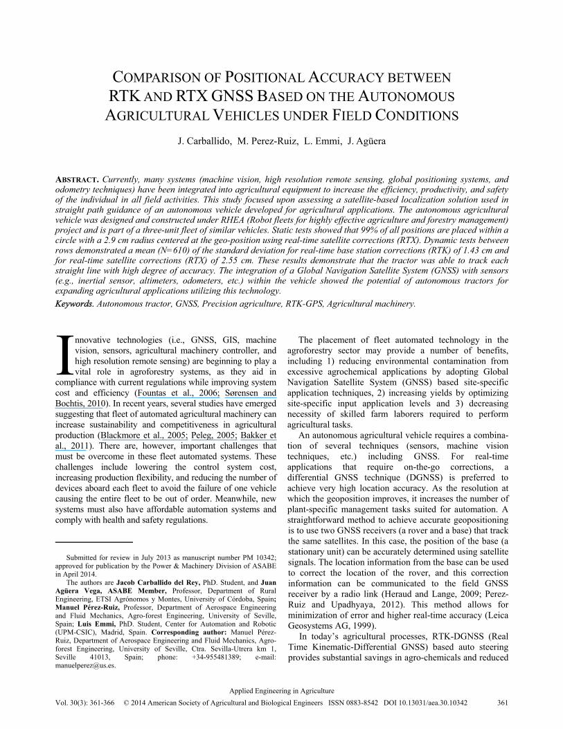
which means that 99% of all positions are placed within a circle with a 2.9 cm radius centered at a real position.
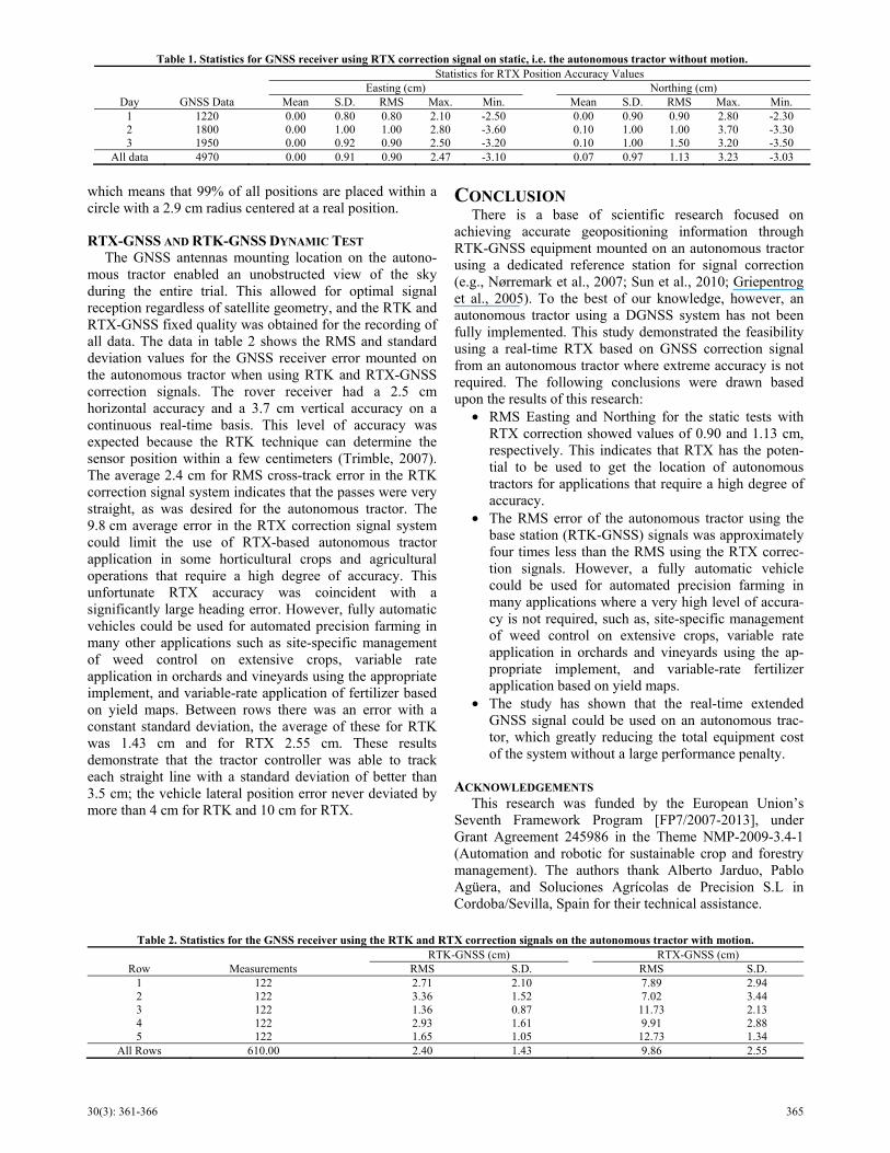
RTX-GNSS AND RTK-GNSS DYNAMIC TEST The GNSS antennas mounting location on the autono-
mous tractor enabled an unobstructed view of the sky during the entire trial. This allowed for optimal signal reception regardless of satellite geometry, and the RTK and RTX-GNSS fixed quality was obtained for the recording of all data. The data in table 2 shows the RMS and standard deviation values for the GNSS receiver error mounted on the autonomous tractor when using RTK and RTX-GNSS correction signals. The rover receiver had a 2.5 cm horizontal accuracy and a 3.7 cm vertical accuracy on a continuous real-time basis. This level of accuracy was expected because the RTK technique can determine the sensor position within a few centimeters (Trimble, 2007). The average 2.4 cm for RMS cross-track error in the RTK correction signal system indicates that the passes were very straight, as was desired for the autonomous tractor. The 9.8 cm average error in the RTX correction signal system could limit the use of RTX-based autonomous tractor application in some horticultural crops and agricultural operations that require a high degree of accuracy. This unfortunate RTX accuracy was coincident with a significantly large heading error. However, fully automatic vehicles could be used for automated precision farming in many other applications such as site-specific management of weed control on extensive crops, variable rate application in orchards and vineyards using the appropriate implement, and variable-rate application of fertilizer based on yield maps. Between rows there was an error with a constant standard deviation, the average of these for RTK was 1.43 cm and for RTX 2.55 cm. These results demonstrate that the tractor controller was able to track each straight line with a standard deviation of better than 3.5 cm; the vehicle lateral position error never deviated by more than 4 cm for RTK and 10 cm for RTX.
CONCLUSION There is a base of scientific research focused on
achieving accurate geopositioning information through RTK-GNSS equipment mounted on an autonomous tractor using a dedicated reference station for signal correction (e.g., Nørremark et al., 2007; Sun et al., 2010; Griepentrog et al., 2005). To the best of our knowledge, however, an autonomous tractor using a DGNSS system has not been fully implemented. This study demonstrated the feasibility using a real-time RTX based on GNSS correction signal from an autonomous tractor where extreme accuracy is not required. The following conclusions were drawn based upon the results of this research:
• RMS Easting and Northing for the static tests with RTX correction showed values of 0.90 and 1.13 cm, respectively. This indicates that RTX has the poten-tial to be used to get the location of autonomous tractors for applications that require a high degree of accuracy.
• The RMS error of the autonomous tractor using the base station (RTK-GNSS) signals was approximately four times less than the RMS using the RTX correc-tion signals. However, a fully automatic vehicle could be used for automated precision farming in many applications where a very high level of accura-cy is not required, such as, site-specific management of weed control on extensive crops, variable rate application in orchards and vineyards using the ap-propriate implement, and variable-rate fertilizer application based on yield maps.
• The study has shown that the real-time extended GNSS signal could be used on an autonomous trac-tor, which greatly reducing the total equipment cost of the system without a large performance penalty.
ACKNOWLEDGEMENTS This research was funded by the European Union’s
Seventh Framework Program [FP7/2007-2013], under Grant Agreement 245986 in the Theme NMP-2009-3.4-1 (Automation and robotic for sustainable crop and forestry management). The authors thank Alberto Jarduo, Pablo Agüera, and Soluciones Agrícolas de Precision S.L in Cordoba/Sevilla, Spain for their technical assistance.
Table 1. Statistics for GNSS receiver using RTX correction signal on static, i.e. the autonomous tractor without motion. Statistics for RTX Position Accuracy Values
Easting (cm) Northing (cm) Day GNSS Data Mean S.D. RMS Max. Min. Mean S.D. RMS Max. Min.
1 1220 0.00 0.80 0.80 2.10 -2.50 0.00 0.90 0.90 2.80 -2.30 2 1800 0.00 1.00 1.00 2.80 -3.60 0.10 1.00 1.00 3.70 -3.30 3 1950 0.00 0.92 0.90 2.50 -3.20 0.10 1.00 1.50 3.20 -3.50
All data 4970 0.00 0.91 0.90 2.47 -3.10 0.07 0.97 1.13 3.23 -3.03
Table 2. Statistics for the GNSS receiver using the RTK and RTX correction signals on the autonomous tractor with motion. RTK-GNSS (cm) RTX-GNSS (cm)
Row Measurements RMS S.D. RMS S.D. 1 122 2.71 2.10 7.89 2.94 2 122 3.36 1.52 7.02 3.44 3 122 1.36 0.87 11.73 2.13 4 122 2.93 1.61 9.91 2.88 5 122 1.65 1.05 12.73 1.34
All Rows 610.00 2.40 1.43 9.86 2.55

366 APPLIED ENGINEERING IN AGRICULTURE
REFERENCES Bakker, T., Asselt, K. V., Bontsema, J., Muller, J., & Straten, G.
(2011). Autonomous navigation using a robot platform in sugar beet field. Biosyst. Eng., 109(4), 357-368. doi:http://dx.doi.org/10.1016/j.biosystemseng.2011.05.001
Blackmore, S. B., Stout, B., Wang, M., & Runov, B. (2005). Robotic agriculture. In: J. Stafford (Ed.), Proc. of the 5th European Conference on Precision Agriculture. Uppsala, Sweden: .Wageningen Academic Publisher
Edwards, S. J., Clarke, P. J., Penna, N. T., & Goebell, S. (2010). An examination of network RTK GPS services in Great Britain. Survey Review, 42(316), 107-121. doi:http://dx.doi.org/10.1179/003962610X12572516251529
Emmi, L., & Gonzalez-De-Santos, P. (2012). Hardware architecture design for navigation and precision control in autonomous agricultural vehicles. Proc. of the First International Conference on Robotics and Associated High-technologies and Equipment for Agriculture (RHEA-2012), (pp. 217-221). Pisa, Italy: University of Pisa.
Fennimore, S. A., Tourte, L., Rachuy, J. S., Smith, R. F., & George, C. (2010). Evaluation and economics of a machine-vision guided cultivation program in broccoli and lettuce. Weed Tech., 24(1), 33–38. doi:http://dx.doi.org/10.1614/WT-09-022.1
Fountas, S., Wulfsohn, D., Blackmore, B. S., Jacobsen, H. L., & Perdersen, S. M. (2006). A model of decision making and information flows for information-intensive agriculture. Agric. Syst., 87(1), 192-210. doi:http://dx.doi.org/10.1016/j.agsy.2004.12.003
Griepentrog, H. W., Christensen, S., Søgaard, S., Nørremark, H. T., Lund, M., & Graglia, E. (2004). Robotic weeding. Proc. of AgEng 2004 Engineering the Future. Leuven, Belgium: Technologisch Instituut vzw, 2004
Griepentrog, H. W., Nørremark, M., Nielsen, H., & Blackmore, B. S. (2005). Seed mapping of sugar beet. Precision Agric., 6(2), 157-165. doi:http://dx.doi.org/10.1007/s11119-005-1032-5
Heraud, J. A., & Lange, A. F. (2009). Agricultural automatic vehicle guidance from horses to GPS: How we got here, and where we are going. ASABE Distinguished Lecture Series No.33. St. Joseph, Mich.: ASABE.
Hu, G., Khoo, H. S., Goh, P. C., & Law, C. L. (2003). Development and assessment of GPS virtual reference stations for RTK positioning. J. of Geodesy, 77(5-6), 292-302. doi:http://dx.doi.org/10.1007/s00190-003-0327-4
Leandro, R., Landau, H., Nitschke, M., Glocker, M., Seeger, S., Ghen, X., Deking, A., Tahar, M. Ben, Zhang, F., Ferguson, K., Stolz, R., Talbot, N., Lu, G., Allison, T., Brandl, M., Gomez, V., Cao, W., & Kipka, A. (2011). RTX Positioning: the next generation of cm-accurate real-time GNSS postioning. Proceeding of the ION GNSS, (pp. 1460-1475). Portland, Ore.: The Institute of Navigation
Leica Geosystems AG. (1999). Introduction to GPS (Global Positioning System). Heerbrugg, Switzerland: Leica Geosystems AG.
Lemmon, T., & Wetherbee, L. (2005). Trimble Integrated Surveying Techniques (White Paper). Westiminster, Colo.: Trimble Geomatics and Engineering Division.
Mesas, F. J., & Torrecillas, C. (2007). Andalusian network positioning. Mapping Interactivo. Retrieved from http://www.mappinginteractivo.com/plantilla-ante.asp?id_articulo=1432
Misra, P., & Enge, P. (2006). Global Position Systems: Signals, Measurements and Performance (2nd ed.). Lincoln, Mass.: Ganga-Jamuna Press.
Nørremark, M., Søgaard, H. T., Griepentrog, H. W., & Nielsen, H. (2007). Instrumentation and method for high accuracy georeferencing of sugar beet plants. Computers and Electronics in Agric., 56(2), 130-146. doi:http://dx.doi.org/10.1016/j.compag.2007.01.006
Ong Kim Sun, G., & Gibbings, P. (2005). How well does the virtual reference station (VRS) system of GPS base station perform in comparison to conventional RTK? J. of Spatial Sci., 50(1), 59-73. doi:http://dx.doi.org/10.1080/14498596.2005.9635038
Peleg, D. (2005). Distributed coordination algorithms for mobile swarms: new directions and challenges. In A. Pal, A. Kshemkalyani, R. Kumar, & A. Gupta (Eds.), Distributed Computing-IWDC 2005 (pp. 1-12). Springer-Verlag Berlin Heidelberg. doi:http://dx.doi.org/10.1007/11603771_1
Pérez-Ruiz, M., & Upadhyaya, S. K. (2012). Chapter 1: GNSS in precision agricultural operation. In F. Elbahhar (Ed.), New Approach of Indoor and Outdoor Localization Systems (pp. 1-26). InTech, under CCBY 3.0 license.
Prawirodirdjo, L., & Bock, Y. (2004). Instantaneous global plate motion model from 12 years of continuous GPS observations. J. of Geophysical Res., 109(B8), 1-15. doi:http://dx.doi.org/10.1029/2003JB002944
RHEA. (2012). A robot fleet for highly effective agriculture and foresty management. Retrieved from http://www.rhea-project.eu/
Rizos, C., Janssen, V., Robert, C., & Grinter, T. (2012). PPP versus DGNSS. Geomatic World, 20(6), 18-20.
SAS Institute . (2008). SAS/STAT 9.2 User's Guide. Cary, N.C.: SAS Institute, Inc.
Sørensen, C. G., & Bochtis, D. D. (2010). Conceptual model of fleet management in agriculture. Biosyst. Eng., 105(1), 41-50. doi:http://dx.doi.org/10.1016/j.biosystemseng.2009.09.009
Sun, H., Slaughter, D. C., Perez-Ruiz, M., Gliever, C., Upadhyaya, S. K., & Smith, R. F. (2010). RTK GPS mapping of transplanted row crops. Computers and Electronics in Agric., 71(1), 32-37. doi:http://dx.doi.org/10.1016/j.compag.2009.11.006
Taylor, R. K., & Schrock, M. D. (2003). Dynamic testing of GPS receivers. ASAE Paper No. 031013. St. Joseph, Mich.: ASAE.
Trimble Navigation Limited. (2007). Form 10-k annual report. Sunnyvale, Calif.
View publication statsView publication stats