Evaluation of GPS-RTK and Total Station for Topographic ...
10
GEODETA 2019 The 1st International Conference on Geodesy, Geomatics, and Land Administration 2019 Volume 2019 Conference Paper Evaluation of GPS-RTK and Total Station for Topographic Survey and Strategic Decision in Private Companies Mohammad Idris Survey Department, Geomatics Sub. Division, PMNP Division, PT. SMART Tbk, Ketapang, West Kalimantan 78813, Indonesia Abstract An accurate and efficient survey system is needed for survey based private companies to survive in the business and engineering world. Accuracies of GPS-RTK (Global Positioning System-Real Time Kinematic) system and TS (Total Station) were investigated in a topographic survey. The hypothesis proposed was that GPS-RTK system could be an alternative survey for moderate accuracy projects. 5.90 ha salt ponds area became a sample for the research. Full detailed measurement was conducted by both instruments to build a contour map. Time expenditure was recorded to identify each method of effectiveness. Maximum offset of elevation was 0.054 m (polygon) and 0.098 m (detail). The survey results demonstrated that even though GPS-RTK system was not only practical and efficient (time saving reached 30% verses TS and 33% more efficient in human resources) but also yielded acceptable accurate topographic maps for moderate accuracy engineering purposes, GPS-RTK system cannot be conducted for every terrain feature. Keywords: GPS-RTK system, total station, topographic survey, project accuracy, cost control 1. Introduction Many private engineering practices require significant investment. Therefore, an accu- rate cost estimate is fundamental for the success of any project. Topography is basic to many earth surfaces and thus topical surveying is one the applications used to obtain necessary and pertinent data. An inaccurate survey results in a topographic map that does not represent the construction area will make a biased or an erroneous investment. Since survey based private companies work in a competitive business environment, there is a need to demonstrate that they are above others in terms quality and that their strategic direction is more realistic and focus than perhaps government entities: they must provide expedient as well as accurate methodologies to gain their clients' confidence. Therefore, they always implement the newest, most precise and most efficient methods in line with their financial capabilities. How to cite this article: Mohammad Idris, (2019), ``Evaluation of GPS-RTK and Total Station for Topographic Survey and Strategic Decision in Private Companies'' in The 1st International Conference on Geodesy, Geomatics, and Land Administration 2019, KnE Engineering, pages 323--332. DOI 10.18502/keg.v4i3.5874 Page 323 Corresponding Author: Mohammad Idris [email protected] Received: 29 July 2019 Accepted: 24 November 2019 Published: 26 December 2019 Publishing services provided by Knowledge E Mohammad Idris. This article is distributed under the terms of the Creative Commons Attribution License, which permits unrestricted use and redistribution provided that the original author and source are credited. Selection and Peer-review under the responsibility of the GEODETA 2019 Conference Committee.
-
Upload
khangminh22 -
Category
Documents
-
view
0 -
download
0
Transcript of Evaluation of GPS-RTK and Total Station for Topographic ...

GEODETA 2019The 1st International Conference on Geodesy, Geomatics, andLand Administration 2019Volume 2019
Conference Paper
Evaluation of GPS-RTK and Total Station forTopographic Survey and Strategic Decision inPrivate CompaniesMohammad IdrisSurvey Department, Geomatics Sub. Division, PMNP Division, PT. SMART Tbk, Ketapang, WestKalimantan 78813, Indonesia
AbstractAn accurate and efficient survey system is needed for survey based private companiesto survive in the business and engineering world. Accuracies of GPS-RTK (GlobalPositioning System-Real Time Kinematic) system and TS (Total Station) were investigatedin a topographic survey. The hypothesis proposed was that GPS-RTK system couldbe an alternative survey for moderate accuracy projects. 5.90 ha salt ponds areabecame a sample for the research. Full detailed measurement was conducted by bothinstruments to build a contour map. Time expenditure was recorded to identify eachmethod of effectiveness. Maximum offset of elevation was 0.054 m (polygon) and0.098 m (detail). The survey results demonstrated that even though GPS-RTK systemwas not only practical and efficient (time saving reached 30% verses TS and 33% moreefficient in human resources) but also yielded acceptable accurate topographic mapsfor moderate accuracy engineering purposes, GPS-RTK system cannot be conductedfor every terrain feature.
Keywords: GPS-RTK system, total station, topographic survey, project accuracy, costcontrol
1. Introduction
Many private engineering practices require significant investment. Therefore, an accu-rate cost estimate is fundamental for the success of any project. Topography is basic tomany earth surfaces and thus topical surveying is one the applications used to obtainnecessary and pertinent data. An inaccurate survey results in a topographic map thatdoes not represent the construction area will make a biased or an erroneous investment.
Since survey based private companies work in a competitive business environment,there is a need to demonstrate that they are above others in terms quality and thattheir strategic direction is more realistic and focus than perhaps government entities:they must provide expedient as well as accurate methodologies to gain their clients'confidence. Therefore, they always implement the newest, most precise and mostefficient methods in line with their financial capabilities.
How to cite this article: Mohammad Idris, (2019), ``Evaluation of GPS-RTK and Total Station for Topographic Survey and Strategic Decision inPrivate Companies'' in The 1st International Conference on Geodesy, Geomatics, and Land Administration 2019, KnE Engineering, pages 323--332.DOI 10.18502/keg.v4i3.5874
Page 323
Corresponding Author:
Mohammad Idris
Received: 29 July 2019
Accepted: 24 November 2019
Published: 26 December 2019
Publishing services provided by
Knowledge E
Mohammad Idris. This article
is distributed under the terms of
the Creative Commons
Attribution License, which
permits unrestricted use and
redistribution provided that the
original author and source are
credited.
Selection and Peer-review under
the responsibility of the
GEODETA 2019 Conference
Committee.

GEODETA 2019
The GPS-RTK (Global Positioning System - Real Time Kinematic) system is consideredthe most useful system for topographic surveys between satellite survey technologies.Utilization of this system for surveys of multi-functional networks and, sometimes, alsothe detailed 3rd order network, is becoming more popular. The factor which makessurveys using the RTK measuring set more difficult within specific areas is the presenceof terrain obstacles. These can limit the simultaneous communication of the basicreceiver and the mobile receiver as well as interfere with the necessary communicationamong the five satellites required for GPS to be 100% reliable [1]. GPS-RTK based surveysare not only practical and fast but also yield more accurate topographic maps for designpurpose (for open area with no obstacles and using a model to generate contours) [2].
In many construction and estate monitoring processes, observations are obtainedby TS (Total Station). Furthermore, it is stated that TS is a more suitable method toconduct topographic surveying than using a Theodolite for private companies withinIndonesia, whether this is undertaken by the owner, contractor or consultant. Not onlydoes this instrument provide good accuracy, but also provides automatic computationfor the data. Total Station observation achieves only 1 mm standard deviation [3, 4].
The focus of this research is to evaluate the accuracies of RTK survey by GeodeticGPS and Tacheometric survey by TS in land surveying for construction practices, bothfor medium (cm class) and high (mm class) accuracy projects (this test was for landtrade's practice). This goal was achieved through following specific objectives:
1. evaluating the result and accuracy obtained from GPS-RTK and TS;
2. using supervised classification to perform data analysis provided from each datasource;
3. comparing the contour map provided from each data source; and
4. evaluating the cost (time expenditure) of both systems.
2. Materials dan Methods
The 32-ha population (5.90 ha sample), near Gresik city (4.37 km), East Java, Indonesiawas chosen as the test site. The area consisted of two main geographical features,salt ponds and fish ponds area. The salt ponds are an area free from both natural andman-made obstacles (such as trees and buildings). The fish ponds area was covered bytress along the embankments. The trees reached a height of no more than 5 meters.
DOI 10.18502/keg.v4i3.5874 Page 324
GEODETA 2019
(a) (b)
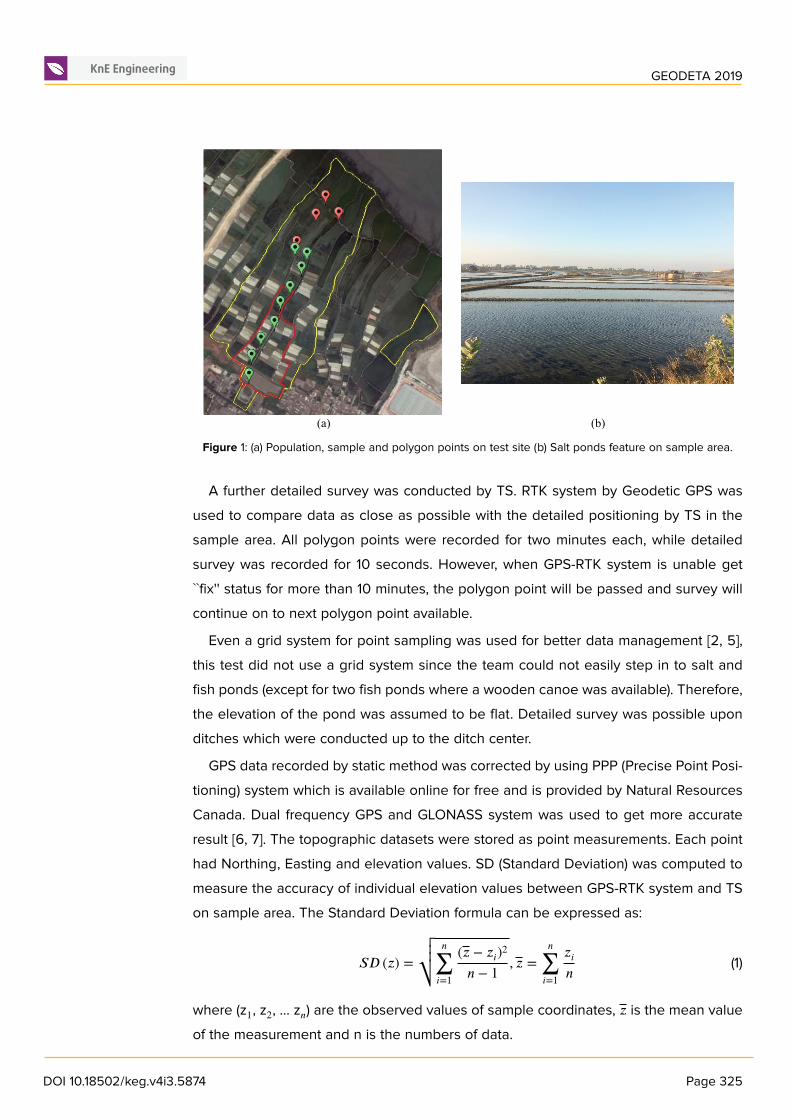
Figure 1: (a) Population, sample and polygon points on test site (b) Salt ponds feature on sample area.
A further detailed survey was conducted by TS. RTK system by Geodetic GPS wasused to compare data as close as possible with the detailed positioning by TS in thesample area. All polygon points were recorded for two minutes each, while detailedsurvey was recorded for 10 seconds. However, when GPS-RTK system is unable get``fix'' status for more than 10 minutes, the polygon point will be passed and survey willcontinue on to next polygon point available.
Even a grid system for point sampling was used for better data management [2, 5],this test did not use a grid system since the team could not easily step in to salt andfish ponds (except for two fish ponds where a wooden canoe was available). Therefore,the elevation of the pond was assumed to be flat. Detailed survey was possible uponditches which were conducted up to the ditch center.
GPS data recorded by static method was corrected by using PPP (Precise Point Posi-tioning) system which is available online for free and is provided by Natural ResourcesCanada. Dual frequency GPS and GLONASS system was used to get more accurateresult [6, 7]. The topographic datasets were stored as point measurements. Each pointhad Northing, Easting and elevation values. SD (Standard Deviation) was computed tomeasure the accuracy of individual elevation values between GPS-RTK system and TSon sample area. The Standard Deviation formula can be expressed as:
𝑆𝐷 (𝑧) =√√√⎷
𝑛
∑𝑖=1
(𝑧 − 𝑧𝑖)2𝑛 − 1 , 𝑧 =
𝑛
∑𝑖=1
𝑧𝑖𝑛 (1)
where (z1, z2, … z𝑛) are the observed values of sample coordinates, 𝑧 is the mean valueof the measurement and n is the numbers of data.
DOI 10.18502/keg.v4i3.5874 Page 325

GEODETA 2019
Since point sampling did not use a grid system, supervised classification was con-ducted in Autodesk Land Development 2009 software. Ponds and ditches will deter-mine the movement in each contour line. Two layers were created for the sample whichwas surveyed with Geodetic GPS and TS. Now onwards, these layers will be labelledas ``TS'' and ``GPS-RTK'' as shown in Fig. 2.
3. Result and Discussion
While TS gave a conventional interpretation of how a polygon survey was conducted(with TS two prisms were needed to be set on tripods), this condition forced the teamto have at least three members to be an efficient work force. In contrast, GPS-RTKsystem offered a more practical solution as it needed only two team members to carryout the polygon survey: one for handling the base station and another member forhandling the rover. GPS-RTK equipment was easier to mobilize because it has lesscomponents enabled the team to mobilize easier than using TS. However practicalin terms of less manpower or pieces of equipment required, GPS-RTK system did notproduce satisfactory results. As Figure 1 shows, only 9 of 13 polygon points were actuallymeasured. Measurement was conducted for every polygon point when a ``fix'' statuswas established. However, starting with the tenth point, the ``fix'' status was impossibleto obtain until 10 minutes after initiation therefore the survey passed on to the pointahead since ``float'' status would have had a major effect on the accuracy [8]. The reasonfor inability to obtain the ``fix'' was principally due to area being densely populated bytrees along the embankment of the pond which were up to 5 meters in height.
Table 1: 95% confidence interval of residuals by CSRS-PPP solution.
Benchmark 8
Latitude 0.021 m
Longitude 0.059 m
Ell. Height 0.077 m
Table 2: Polygon adjustment report by TS.
Polygon (TS)
Northing Error -0.002 m
Easting Error -0.049 m
Elevation Error -0.067 m
HD Error 0.050 m
SD Error 0.083 m
Closure Precision 1:10837
DOI 10.18502/keg.v4i3.5874 Page 326

GEODETA 2019
Since the aim of this paper is to evaluate the confidence and reliability of GPS-RTKsystem for survey based private companies (since private companies prefer fast, efficientand reliable methods), a repeated measurement for polygon was not conducted. By notrepeating the measurement meant the precision of polygon points could not be fullyevaluated. Both GPS-RTK system and TS used coordinates corrected by CSRS-PPP(Canadian Spatial Reference System-Precise Point Positioning) as a reference point.Dual frequency observation by CSRS-PPP had reference points of residuals in cm forNorthing, Easting and Ellipsoidal Height respectively as indicated in Table 1.
Therefore, polygon measurement which was conducted by TS provided adjustmentreport as indicated in Table 2. When error in mm class was observed for N and E,elevation errors were noted in cm. The closure precision was still acceptable for theproject to enter fourth order (≤1:6000) by Indonesia National Standard for horizontalcontrol traverse (SNI 19-6724-2002 by Badan Standarisasi Nasional) [3].
In order to check whether there were significant differences between GPS-RTKsystem and TS results, the differences were computed both for polygon points (Table3) and details on sample (Table 4). According to the obtained result, it clearly indicatesand proves that the differences lie on cm class for N, E and elevation respectively. Asindicated in Table 3, the maximum difference between GPS-RTK system and TS forpolygon points is 2.5 cm for Northing, 1.7 cm for Easting and 5.4 cm for Elevation. Theremaining coordinates were below these levels. Therefore, it can be concluded that thedifferences are ≤ 3 cm for 2D coordinates, while elevation still reached 5.4 cm.
Table 3: Coordinates difference between.
Point RTK-TS
ΔN ΔE ΔElevation
A 0.014 -0.006 -0.022
B 0.023 0.001 -0.013
C 0.021 0.014 -0.003
D 0.015 0.017 0.024
E 0.025 0.017 -0.012
F 0.015 0.014 0.054
G 0.008 -0.002 -0.007
As for detailed points on sample, in order to check whether there were significantdifferences between GPS-RTK system and TS results, the elevation difference was cal-culated. In addition, the standard deviation of the elevation difference betweenGPS-RTKsystem and TS were also considered. The elevation value was also compared betweenboth survey instruments. Not all sample points could be selected for computation sinceeach point was not in close position (< 1 m) and had the same terrain feature (same
DOI 10.18502/keg.v4i3.5874 Page 327

GEODETA 2019
embankment section or same salt pond). This condition occurred because the teamconsisted of three members so that detail measurement by both survey instrumentscouldn't be conducted at the same time. 68 sample points were chosen for statisticalcomputation.
Table 4: Statistical values for elevation difference of detailed points between GPS-RTK (ellipsoidal height)and TS (orthometric height).
Elevation (m)
Maximun 0.098
Minimum 0.000
Mean 0.034
SD 0.024
From Table 4, minimum elevation difference between GPS-RTK system (ellipsoidalheight) and TS (orthometric height) is 0.000 m. This result was obtained as the elevationdifference values were changed into positive values since the primary concern is thevalue instead of the position: whether it is higher or lower. 0.034 m - the mean averagewas enough to compromise the accuracy obtained by GPS-RTK system, however thedifferences did not reduce the measurements to dm classification. Thus, by comparingelevation obtained by both survey instruments, their measurement accuracy havingbeen verified, it can be concluded that the measurements were accurate for a mediumclass project such as construction plan, land evaluation and/or land trade for privatecompanies.
Once the contour was drawn from the points measured by GPS-RTK system and TS,different results were obtained. They can be seen on Fig. 2. Figure 2(a) shows howthe contour provided by GPS-RTK system does not move far from the contour obtainedby TS. The exception to this is contour 31.5 m and 32.0 m on X mark. These deviateda significant distance because of salt farmer activities during measurement. As statedpreviously, detailed measurement using GPS-RTK system was conducted after detailmeasurement by TS. Unfortunately, the embankment underwent a reconstruction sothat it changed the elevation of the land -- this can be observed in Fig. 2(b) too. X markindicates the salt farmer's activities of restructuring the embankment so much so thatthe contour was separated by a significant distance. Another example of this is shownon Fig. 2(c). There were several salt ponds where the contour by GPS-RTK systemwas visible but by TS was not visible (salt pond A and B). This happened because theelevation points provided by GPS-RTK system were lower than TS even though thedifference was < 1 dm. The shift (planimetric) between contour by GPS-RTK system andTS did not exceed 1.2 m. As such both contours do not form irregular pattern from each
DOI 10.18502/keg.v4i3.5874 Page 328

GEODETA 2019
other. Therefore, it can be concluded that the contour was still in same distribution andacceptable for medium accuracy projects (cm class accuracy).
(a) (b)
(c)
Figure 2: The contour lines provided by GPS-RTK system and TS.
In order to compare the cost (time expenditure) by using both survey instruments,effective time has been recorded throughout the measurement in sample. Effective timerefers to the time needed to measure the required tasks without taking considering thedelayed time due to unforeseen problems: effective time did not include the time fortransportation of the instrument home base to field and vice versa or delayed time dueto problems such as battery/power issues or incorrect readings.
As indicated in Table 5, preparation time between GPS-RTK system and TS wassame. Each private company usually has its own internal expected preparation time andanticipated duration for preparation. Preparation, in general terms, includes scanningof the area by the team for a better understanding as to what method should be used,preparing the stocked pegs and other supporting equipment for the project. Tripodsetup and centering for TS was the time expended for three setups of tripod in four setsof measurements. Thus, the required total time with TS was 880 minutes (14 hours 40
DOI 10.18502/keg.v4i3.5874 Page 329

GEODETA 2019
Table 5: Time expenditure for GPS-RTK system and TS measurement.
Time Expenditure (min)
Preparation 360 360
Tripod setup 48 3
Centering 48 8
Polygon measurement 24 -
Changing station 40 -
Detailed measurement 360 240
Total 880 611
minutes). While there was polygonmeasurement for TS, GPS-RTK system did not requirethis since the polygon method was conducted in the same way as detail measurement,but in a different duration of recording. On sample, detailed measurement for GPS-RTKsystem was conducted by one base station so that tripod setup was only for the basestation itself. The total required time with GPS-RTK system is less than TS at only 611minutes (10 hours 11 minutes). Both GPS-RTK system and TS conducted a review indetailed measurement so it would not be necessary for the team to go back to the testsite to collect additional data. This shows that using GPS-RTK system for topographicproject is more efficient than using TS -- up to 30% faster. Moreover, to conduct thisproject using GPS-RTK needs less team members (33% more efficient) compared withTS with 2 or 3 team members.
4. Conclusions
The use of data for topographic survey and strategic decision in survey based privatecompanies has to be undertaken carefully, with a high level of accuracy as well asexpediently since it is critical to any private company in order to survive in a competitiveengineering and business environment. Measurement and analysis were conducted toascertain whether there was a significant difference between RTK survey by GeodeticGPS and Tacheometric survey by TS. The intention was to investigate and observe thepossibility of using GPS-RTK as a survey instrument for medium and high constructionprojects in private companies.
Based on the results presented in this research, it has been revealed that GPS-RTKbased survey is not only practical and efficient but also yields acceptable accuratetopographic maps for medium accuracy construction purposes (time saving reached30% verses TS and 33% more efficient in human resources). Therefore, investment inGPS-RTK system might be worthwhile.
DOI 10.18502/keg.v4i3.5874 Page 330

GEODETA 2019
However, GPS-RTK based survey is useful when the terrain permits it since its systemdepends on terrain features, intensity of radio frequencies and obstacles, both naturaland man-made ones. When the conditions do not allow it, TS based survey is preferable
Even though measurement was conducted on sample, detail measurement couldnot be conducted using the gridding system given the limitation of terrain features.Moreover, precision survey was not conducted for the polygon since private companiesprefer to work in effective and efficient ways. Therefore, a precision survey should beconducted using a gridding system on the sample in order to observe (and confirm) theviability of GPS-RTK system for high accuracy construction projects.
References
[1] Malarski, R., et al. (2009). An Attempt to Apply GPS-RTK Technology for TopographicSurveys Within Urban Areas. Reports on Geodesy, edited by M. Barlik (De Gruyter,Berlin, 2009), pp. 251-260.
[2] Kizil, U. and Tisor, L. (2011). Evaluation of RTK-GPS and Total Station for Applicationsin Land Surveying. Journal of Earth System Science, vol. 120, no. 2. Edited by S. R.Shetye (Indian Academy of Science, Bengaluru, 2011), pp. 215-221.
[3] Chekole, S. D. (2014). Surveyingwith GPS, Total Station and Terrestrial Laser Scanner:a Comparative Study. MSc thesis, KTH Royal Institute of Technology.
[4] Luo, Y., et al. (2016). Analysis of Tunnel Displacement Accuracy with Total Station, inMeasurement 83, edited by P. Carbone (Elsevier Ltd, Amsterdam, 2016), pp. 29-37.
[5] Wilson, J. P., et al. (1998). Global Positioning System Sampling Intensity and PatternEffects on Computed Topographic Attributes. Soil Science Society of America
Journal, vol. 62, no. 5. Edited by D. Myrold et al. (ACSESS, Madison, 1998), pp.1410-1417.
[6] Bolbol, S., et al. (2017). Performance Evaluation of Precise Point Positioning (PPP)Using CSRS-PPP Online Service. American Journal of Geographic Information
System, vol. 6, no. 4. Edited by J. Han et al. (Scientific & Academic Publishing,Rosemead, 2017), pp. 156-167.
[7] Dawidowicz, K. and Krzan, G. (2014). Coordinate Estimation Accuracy of Static PrecisePoint Positioning Using on-line PPP Service, a Case Study in Acta Geodaetica et
Geophysica Hungarica 49(1), edited by V. Wesztergom (Akadémiai Kiadó, Budapest,2014), pp. 37-55.
[8] Xu, H. (2012). Application of GPS-RTK Technology in the Land Change Survey, inProcedia Engineering 29, edited by H. Guo (Elsevier Ltd, Amsterdam, 2012), pp.
DOI 10.18502/keg.v4i3.5874 Page 331

GEODETA 2019
3454-3459.
[9] BSN, SNI 19-6724-2002: Jaring kontrol horizontal (2002).
DOI 10.18502/keg.v4i3.5874 Page 332