
GPS for Dummies.pdf - X-Files
410
-
Upload
khangminh22 -
Category
Documents
-
view
1 -
download
0
Transcript of GPS for Dummies.pdf - X-Files


GPS FOR
DUMmIES‰


by Joel McNamara
GPS FOR
DUMmIES‰

GPS For Dummies®
Published byWiley Publishing, Inc.111 River StreetHoboken, NJ 07030-5774
Copyright © 2004 by Wiley Publishing, Inc., Indianapolis, Indiana
Published by Wiley Publishing, Inc., Indianapolis, Indiana
Published simultaneously in Canada
No part of this publication may be reproduced, stored in a retrieval system or transmitted in any form orby any means, electronic, mechanical, photocopying, recording, scanning or otherwise, except as permittedunder Sections 107 or 108 of the 1976 United States Copyright Act, without either the prior written permis-sion of the Publisher, or authorization through payment of the appropriate per-copy fee to the CopyrightClearance Center, 222 Rosewood Drive, Danvers, MA 01923, (978) 750-8400, fax (978) 646-8600. Requests tothe Publisher for permission should be addressed to the Legal Department, Wiley Publishing, Inc., 10475Crosspoint Blvd., Indianapolis, IN 46256, (317) 572-3447, fax (317) 572-4355, e-mail: [email protected].
Trademarks: Wiley, the Wiley Publishing logo, For Dummies, the Dummies Man logo, A Reference for theRest of Us!, The Dummies Way, Dummies Daily, The Fun and Easy Way, Dummies.com, and related tradedress are trademarks or registered trademarks of John Wiley & Sons, Inc. and/or its affiliates in the UnitedStates and other countries, and may not be used without written permission. All other trademarks are theproperty of their respective owners. Wiley Publishing, Inc., is not associated with any product or vendormentioned in this book.
LIMIT OF LIABILITY/DISCLAIMER OF WARRANTY: THE PUBLISHER AND THE AUTHOR MAKE NO REP-RESENTATIONS OR WARRANTIES WITH RESPECT TO THE ACCURACY OR COMPLETENESS OF THE CON-TENTS OF THIS WORK AND SPECIFICALLY DISCLAIM ALL WARRANTIES, INCLUDING WITHOUTLIMITATION WARRANTIES OF FITNESS FOR A PARTICULAR PURPOSE. NO WARRANTY MAY BE CRE-ATED OR EXTENDED BY SALES OR PROMOTIONAL MATERIALS. THE ADVICE AND STRATEGIES CON-TAINED HEREIN MAY NOT BE SUITABLE FOR EVERY SITUATION. THIS WORK IS SOLD WITH THEUNDERSTANDING THAT THE PUBLISHER IS NOT ENGAGED IN RENDERING LEGAL, ACCOUNTING, OROTHER PROFESSIONAL SERVICES. IF PROFESSIONAL ASSISTANCE IS REQUIRED, THE SERVICES OF ACOMPETENT PROFESSIONAL PERSON SHOULD BE SOUGHT. NEITHER THE PUBLISHER NOR THEAUTHOR SHALL BE LIABLE FOR DAMAGES ARISING HEREFROM. THE FACT THAT AN ORGANIZATIONOR WEBSITE IS REFERRED TO IN THIS WORK AS A CITATION AND/OR A POTENTIAL SOURCE OF FUR-THER INFORMATION DOES NOT MEAN THAT THE AUTHOR OR THE PUBLISHER ENDORSES THE INFOR-MATION THE ORGANIZATION OR WEBSITE MAY PROVIDE OR RECOMMENDATIONS IT MAY MAKE.FURTHER, READERS SHOULD BE AWARE THAT INTERNET WEBSITES LISTED IN THIS WORK MAY HAVECHANGED OR DISAPPEARED BETWEEN WHEN THIS WORK WAS WRITTEN AND WHEN IT IS READ.
For general information on our other products and services or to obtain technical support, please contactour Customer Care Department within the U.S. at 800-762-2974, outside the U.S. at 317-572-3993, or fax317-572-4002.
Wiley also publishes its books in a variety of electronic formats. Some content that appears in print maynot be available in electronic books.
Library of Congress Control Number: 2004102594
ISBN: 0-7645-6933-3
Manufactured in the United States of America
10 9 8 7 6 5 4 3 2 1
1B/SQ/QV/QU/IN

About the AuthorJoel McNamara first got involved with digital maps in the early 1980’s. At thetime he was studying archeology and instead of going out and playing IndianaJones, he found himself in front of a computer monitor trying to predictwhere archeological sites were located based on LANDSAT satellite data.
The lure of computers ultimately led to his defection from academia to thesoftware industry, where he worked as a programmer, technical writer, andmanager; eventually ending up at a rather large software company based inRedmond, Washington. Joel now writes and consults on technology he findsinteresting, such as GPS and digital maps.
Over the years he’s had practical experience using GPS and maps for wild-land firefighting, search and rescue, and disaster response and planning. He’salso an avid user of the great outdoors (which means there’s way too muchgear in his garage), competes in adventure races and other endurance sports,and so far has always found his way back home. In his spare time he volun-teers for a federal Disaster Medical Assistance Team.
This is his second book. The first was Secrets of Computer Espionage: Tactics& Countermeasures (also published by Wiley), a reference guide for computersecurity practitioners and anyone interested in stopping sneaky spies.


Author’s AcknowledgmentsFirst off, thanks to my wife, Darcy, for her support during my work on thisbook, especially for putting up with all of the maps, CD-ROMs, cables, manu-als, and GPS receivers scattered all over the house during the duration.
Next on the list are the folks at Wiley, including Katie Feltman, my acquisi-tions editor and Pat O’Brien, my project editor. And a special note of appreci-ation to GPS and map guru Gavin Hoban, who diligently served as mytechnical editor.
I’d also like to thank the following manufacturers for supplying review copiesof their products to write about: DeLorme (Caleb Mason), Endless Pursuit(Jack Robson), Lowrance (Steve Wegrzyn and Luke Morris), Magellan (AngelaLinsey-Jackson), Maptech (Martin Fox), Microsoft, National Geographic, andTopoFusion (Scott Morris). I especially appreciate the help from the folksnamed in the parentheses who went above and beyond the call of duty inanswering questions and providing assistance.
Finally, I’d like to express thanks to the following people for giving me feed-back on various parts of the book: Bob Daley, Jan Daley, Cynthia Engel, JeffMadden, Doug McNamara, and Judy McNamara.

Publisher’s AcknowledgmentsWe’re proud of this book; please send us your comments through our online registration formlocated at www.dummies.com/register/.
Some of the people who helped bring this book to market include the following:
Acquisitions, Editorial, and MediaDevelopment
Project Editor: Pat O’Brien
Acquisitions Editor: Melody Layne
Copy Editor: Teresa Artman
Technical Editor: Gavin Hoban
Editorial Manager: Kevin Kirschner
Media Development Manager:Laura VanWinkle
Media Development Supervisor:Richard Graves
Editorial Assistant: Amanda Foxworth
Cartoons: Rich Tennant(www.the5thwave.com)
Composition
Project Coordinator: Adrienne Martinez
Layout and Graphics: Amanda Carter, Andrea Dahl, Lauren Goddard, Lynsey Osborn, Heather Ryan
Proofreaders: Laura Albert, Brian H. Walls,TECHBOOKS Production Services
Indexer: TECHBOOKS Production Services
Publishing and Editorial for Technology Dummies
Richard Swadley, Vice President and Executive Group Publisher
Andy Cummings, Vice President and Publisher
Mary C. Corder, Editorial Director
Publishing for Consumer Dummies
Diane Graves Steele, Vice President and Publisher
Joyce Pepple, Acquisitions Director
Composition Services
Gerry Fahey, Vice President of Production Services
Debbie Stailey, Director of Composition Services

Contents at a GlanceIntroduction .................................................................1
Part I: All About Digital Maps ......................................9Chapter 1: Getting Started with Digital Maps ..............................................................11Chapter 2: Dissecting Maps ............................................................................................21
Part II: All About GPS ................................................47Chapter 3: GPS Fundamentals ........................................................................................49Chapter 4: Grasping Important GPS Concepts ............................................................69Chapter 5: Selecting and Getting Started with a GPS Receiver .................................83Chapter 6: Using GPS with a PDA ................................................................................105Chapter 7: Geocaching ..................................................................................................117
Part III: Digital Mapping on Your Computer ...............143Chapter 8: Digital Mapping Hardware Considerations .............................................145Chapter 9: Interfacing a GPS Receiver to a Computer ..............................................153Chapter 10: Using GPS Manufacturer Mapping Software .........................................169Chapter 11: Finding Places and Coordinates .............................................................181Chapter 12: On the Road with DeLorme Street Atlas USA .......................................193Chapter 13: On the Ground with Maptech Terrain Navigator .................................209Chapter 14: From the Air with USAPhotoMaps .........................................................227Chapter 15: Creating and Using Digital Maps with OziExplorer ..............................245Chapter 16: Going Three Dimensional with 3DEM ....................................................259
Part IV: Using Web-hosted Mapping Services .............275Chapter 17: Saving and Editing Street Maps ..............................................................277Chapter 18: Navigating Web Road Maps ....................................................................289Chapter 19: Exploring Web Topographic Maps .........................................................301Chapter 20: Overhead Image Web Sites ......................................................................315
Part V: The Part of Tens ...........................................331Chapter 21: Ten Great GPS and Map Web Sites .........................................................333Chapter 22: Ten Map Printing Tips .............................................................................337Chapter 23: Ten Tips for Athletes ...............................................................................343
Index .......................................................................357


Table of ContentsIntroduction..................................................................1
Who This Book Is For .....................................................................................2Setting Some GPS Expectations .....................................................................3How This Book Is Organized ..........................................................................4
Part I: All About Digital Maps ...............................................................4Part II: All About GPS ............................................................................5Part III: Digital Mapping on Your Computer .......................................5Part IV: Using Web-hosted Mapping Services ....................................5Part V: The Part of Tens ........................................................................5Icons Used in This Book .......................................................................6
Some Opening Thoughts ................................................................................6
Part I: All About Digital Maps .......................................9
Chapter 1: Getting Started with Digital Maps . . . . . . . . . . . . . . . . . . . .11What Is a Digital Map? ..................................................................................11
Static map .............................................................................................12Smart map ............................................................................................12
Mapping Programs ........................................................................................13Consumer programs ...........................................................................13GIS (Geographic Information System) ..............................................14
Using Digital Maps ........................................................................................15Mapping Software: The Essentials ..............................................................15
Standalone programs ..........................................................................16Programs with bundled maps ............................................................18Web-hosted mapping services ...........................................................19
Chapter 2: Dissecting Maps . . . . . . . . . . . . . . . . . . . . . . . . . . . . . . . . . . .21Discovering the Types of Maps ...................................................................21
Land .......................................................................................................22Marine ...................................................................................................25Aeronautical .........................................................................................26
Figuring Out Map Projections ......................................................................27Map Datums ...................................................................................................27

GPS For Dummies xiiWorking with Map Coordinate Systems .....................................................28
Latitude/longitude ...............................................................................29Universal Transverse Mercator (UTM) .............................................32Township and Range ...........................................................................34
Measuring Map Scales ..................................................................................36Looking at Map Symbols ..............................................................................38Digital Map Data ............................................................................................39
TIGER ....................................................................................................39Digital Line Graph (DLG) ....................................................................40Elevation data ......................................................................................42Digital Raster Graphics (DRG) ...........................................................42Digital Orthophoto Quadrangle (DOQ) ............................................44Satellite data .........................................................................................44
Part II: All About GPS ................................................47
Chapter 3: GPS Fundamentals . . . . . . . . . . . . . . . . . . . . . . . . . . . . . . . . .49What Is GPS? ..................................................................................................49How GPS Works .............................................................................................50
Eyeing satellites ...................................................................................51GPS radio signals .................................................................................52Covering ground stations ...................................................................53GPS receivers .......................................................................................53How accurate is a GPS receiver? .......................................................56
Information from GPS Receivers .................................................................58GPS Receiver Features ..................................................................................59
Display and output ..............................................................................59Alarms ...................................................................................................60Built-in maps ........................................................................................60Electronic compass .............................................................................62Altimeter ...............................................................................................62Increasing accuracy ............................................................................63WAAS .....................................................................................................63Differential GPS ....................................................................................64Antennas ...............................................................................................64Internal memory ..................................................................................66External storage ...................................................................................66Accessory programs ...........................................................................66User interface modes ..........................................................................66Synthesized voice ................................................................................67
The Future of GPS .........................................................................................68

Chapter 4: Grasping Important GPS Concepts . . . . . . . . . . . . . . . . . . . .69Linking GPS, Maps, and Coordinate Systems ............................................69Understanding GPS and Datums .................................................................72Setting Waypoints .........................................................................................73
Saving waypoints .................................................................................74Using the waypoint list .......................................................................75
Following Routes ...........................................................................................77Making Tracks ...............................................................................................79
Chapter 5: Selecting and Getting Started with a GPS Receiver . . . .83Selecting a GPS Receiver ..............................................................................84
To map or not to map .........................................................................86Road warriors ......................................................................................87Matching GPS receiver features to your activities ..........................88
Becoming Familiar with Your New GPS Receiver ......................................90Powering Your GPS Receiver .......................................................................91
Battery basics ......................................................................................92Power to the people ............................................................................94
Initializing Your GPS Receiver .....................................................................95Changing Receiver Settings .........................................................................98Using Your GPS Receiver ............................................................................100
Coming home .....................................................................................101How far, how fast? .............................................................................101Finding your ancestors .....................................................................102Simulating navigation .......................................................................102
Chapter 6: Using GPS with a PDA . . . . . . . . . . . . . . . . . . . . . . . . . . . . .105Choosing between a GPS Receiver and a PDA .........................................105
PDA advantages .................................................................................106PDA disadvantages ............................................................................106
Interfacing Your PDA to a GPS Receiver ...................................................108Handheld GPS receivers ...................................................................108Mouse GPS receivers .........................................................................109GPS receiver cards ............................................................................110GPS receiver sleeves .........................................................................111Bluetooth GPS receivers ...................................................................112GPS-integrated PDAs .........................................................................113
Reviewing PDA Mapping Software ............................................................113
xiiiTable of Contents

GPS For Dummies xivChapter 7: Geocaching . . . . . . . . . . . . . . . . . . . . . . . . . . . . . . . . . . . . . .117
Geocaching: The High-Tech Scavenger Hunt ...........................................117Getting Started Geocaching .......................................................................119
What you need to geocache .............................................................119Selecting a cache to look for ............................................................122Finding the cache ..............................................................................125GeoJargon: Speaking the lingo .........................................................132
Hiding a Cache .............................................................................................133Selecting a container .........................................................................133Location is everything ......................................................................134Stocking the cache ............................................................................136Submitting the cache ........................................................................137Maintaining the cache .......................................................................139
Geocaching Etiquette .................................................................................139Internet Geocaching Resources ................................................................140
Part III: Digital Mapping on Your Computer ...............143
Chapter 8: Digital Mapping Hardware Considerations . . . . . . . . . . .145Digital Mapping Software Choices ............................................................145Processing Power ........................................................................................146
Processors ..........................................................................................147Memory ...............................................................................................147
Storage Capacity .........................................................................................147Hard drives .........................................................................................148CD and DVD drives ............................................................................149
Display Equipment ......................................................................................150Graphics cards ...................................................................................150Monitors .............................................................................................150Printers ...............................................................................................150
Communication Capabilities ......................................................................151Communication ports .......................................................................151Internet connection ...........................................................................152
Chapter 9: Interfacing a GPS Receiver to a Computer . . . . . . . . . . . .153About (Inter)Face: Connectivity Rules .....................................................153Anatomy of a Link: Understanding the Interface Process ......................154Untangling Cables .......................................................................................155

xvTable of Contents
Understanding Ports and Protocols .........................................................156COM ports ..........................................................................................157USB ports ............................................................................................159Protocols ............................................................................................160
Managing Memory ......................................................................................160Transferring GPS Data ................................................................................162Troubleshooting Connection Problems ...................................................165Uploading Firmware Revisions to Your GPS Receiver ............................166
Chapter 10: Using GPS Manufacturer Mapping Software . . . . . . . .169Understanding Universal Principles of GPS Map Software ....................170
Three rules of GPS mapping software ............................................170Common GPS map software features ..............................................171Getting maps to GPS receivers ........................................................172
Reviewing GPS Manufacturer Software ....................................................173Magellan MapSend ............................................................................174Lowrance MapCreate ........................................................................176Garmin MapSource ............................................................................178
Chapter 11: Finding Places and Coordinates . . . . . . . . . . . . . . . . . . . .181Finding Your Way with Online Gazetteers ................................................181
Using the Geographic Names Information System (GNIS) ...........182Using the GEOnet Name Server (GNS) ............................................186
Converting Coordinates .............................................................................189Using GeoTrans ..................................................................................189Using online conversion utilities .....................................................191
Chapter 12: On the Road with DeLorme Street Atlas USA . . . . . . . .193Discovering Street Atlas USA Features .....................................................194Navigating Street Atlas USA .......................................................................194
Exploring the Street Atlas USA interface ........................................195Zooming in and out ...........................................................................196Moving around in Street Atlas USA .................................................197Getting POI information ....................................................................198
Finding an Address with Street Atlas USA ...............................................199Getting from Here to There with Street Atlas USA ..................................201
Creating a route .................................................................................202Getting directions ..............................................................................202Printing and saving directions .........................................................203
Moving Maps with Earthmate ....................................................................205

Other Street Navigation Software .............................................................207Microsoft Streets & Trips .................................................................208Rand McNally StreetFinder & TripMaker Deluxe ..........................208
Chapter 13: On the Ground with Maptech Terrain Navigator . . . . . .209Discovering Terrain Navigator ..................................................................210Displaying Maps and Finding Places ........................................................210Navigating a Terrain Navigator Map .........................................................213
Moving around in a map ...................................................................214Changing the map size ......................................................................214
Planning a Trip with Terrain Navigator ....................................................215Understanding Terrain Elevation ..............................................................217
Using a 3-D map image ......................................................................218Charting elevation profiles ...............................................................220
Reviewing Other Topographic Map Software ..........................................221DeLorme mapping products ............................................................221National Geographic mapping products ........................................223
Chapter 14: From the Air with USAPhotoMaps . . . . . . . . . . . . . . . . . .227Enhancing TerraServer-USA with USAPhotoMaps ..................................227Discovering USAPhotoMaps Features ......................................................228
Downloading Aerial Photographs ...................................................228Getting the Most from Aerial Photos ........................................................231
Switching between aerial photos and topographic maps ............231Moving around the map ...................................................................233Zooming in and out ...........................................................................234Enhancing contrast ...........................................................................234Entering text .......................................................................................235
Creating and Using Multiple Map Files .....................................................236Saving Aerial Photos ...................................................................................237Interfacing with a GPS receiver .................................................................238Reviewing Other Aerial Photo Software ...................................................239
TerraClient ..........................................................................................239TopoFusion .........................................................................................241ExpertGPS ...........................................................................................241QuakeMap ..........................................................................................243
Chapter 15: Creating and Using Digital Maps with OziExplorer . . .245Discovering OziExplorer Features ............................................................245Moving from Paper to Digital Maps ..........................................................248
Step 1: Scan the map .........................................................................249Step 2: Edit the map ..........................................................................250
GPS For Dummies xvi

xviiTable of Contents
Step 3: Calibrate the map .................................................................251Checking your work ..........................................................................257
Chapter 16: Going Three Dimensional with 3DEM . . . . . . . . . . . . . . .259Comparing 2-D and 3-D Maps ....................................................................259Discovering 3DEM Capabilities .................................................................260Using DEM Data to Create a Map ..............................................................260Creating a 3-D Map ......................................................................................263
Defining the display area ..................................................................263Creating a 3-D scene ..........................................................................264
Manipulating the 3-D Scene Window ........................................................266Saving and Printing a 3DEM Scene ............................................................267Overlaying Digital Raster Graphics Data ..................................................268
Downloading a sample DRG .............................................................268Loading the DRG as an overlay ........................................................269Working with overlay maps ..............................................................271
Reviewing Other 3DEM Features ...............................................................272Other 3-D Mapping Software ......................................................................272
Global Mapper ...................................................................................272MICRODEM .........................................................................................274Bundled map programs ....................................................................274
Part IV: Using Web-hosted Mapping Services .............275
Chapter 17: Saving and Editing Street Maps . . . . . . . . . . . . . . . . . . . .277Saving Maps .................................................................................................278
Save Picture As ..................................................................................278Using the Print Screen key ...............................................................279Using screen capture programs .......................................................279
Editing a Map ...............................................................................................281Opening a file .....................................................................................281Cropping .............................................................................................281Using colors and fonts ......................................................................282Adding symbols .................................................................................283Selecting the right file format ..........................................................286
Chapter 18: Navigating Web Road Maps . . . . . . . . . . . . . . . . . . . . . . .289Using Street Map Web Sites .......................................................................289
Listing common street map Web site features ..............................290Web versus PC software street maps ..............................................290

Reviewing Street Map Web Sites ...............................................................293MapQuest ...........................................................................................295Rand McNally .....................................................................................296Maporama ..........................................................................................298
Chapter 19: Exploring Web Topographic Maps . . . . . . . . . . . . . . . . . .301Using Web-hosted Topographic Maps ......................................................301
Advantages of topographic Web sites ............................................301Disadvantages of topographic Web sites .......................................302Deciding between Web-based maps and mapping programs ......302
Reviewing Topographic Map Web Sites ...................................................303Using Maptech MapServer ...............................................................303Using GPS Visualizer .........................................................................308TerraSever-USA ..................................................................................310Commercial topographic Web map sites .......................................311
Chapter 20: Overhead Image Web Sites . . . . . . . . . . . . . . . . . . . . . . . .315Using Web Aerial and Satellite Images .....................................................315Reviewing Aerial and Satellite Image Web Sites ......................................317
TerraServer-USA ................................................................................318TerraServer.com ................................................................................323GlobeXplorer ......................................................................................326
Part V: The Part of Tens ............................................331
Chapter 21: Ten Great GPS and Map Web Sites . . . . . . . . . . . . . . . . .333Comprehensive GPS Information ..............................................................333Current GPS News and Helpful Advice .....................................................334Technical GPS Information .........................................................................334Free Maps .....................................................................................................334Expert Desktop Mapping Guidance ..........................................................335Definitive Terrain Modeling Information ..................................................336
Chapter 22: Ten Map Printing Tips . . . . . . . . . . . . . . . . . . . . . . . . . . . . .337Make Your Paper Count ..............................................................................337Print in Color ...............................................................................................338Print the Scale ..............................................................................................338Print UTM Grids ..........................................................................................338Use Waterproof Paper .................................................................................338
GPS For Dummies xviii

Waterproof Your Plain Paper .....................................................................339Print More Map Area ...................................................................................340Put North at the Top ...................................................................................340Use the Best Page Orientation ...................................................................340Beware of False Economy ..........................................................................341
Chapter 23: Ten Tips for Athletes . . . . . . . . . . . . . . . . . . . . . . . . . . . . . .343General GPS Tips for Athletes ...................................................................343
Using a GPS receiver for training .....................................................343GPS receiver limitations for training ...............................................345How to carry your GPS receiver on foot ........................................346
GPS Products for Athletes ..........................................................................348Endless Pursuit ..................................................................................348Timex Speed + Distance/Bodylink ...................................................350Garmin Forerunner 201 .....................................................................351
GPS Tips for Specific Sports ......................................................................352GPS for cyclists ..................................................................................352GPS for golfers ...................................................................................353GPS for paddlers and rowers ...........................................................354GPS for race directors .......................................................................355
Index........................................................................357
xixTable of Contents

GPS For Dummies xx

Introduction
As you may have guessed from the title, this book is about GPS (the satellite-based Global Positioning System) and maps; digital maps
to be exact.
I remember back in 1989 when Magellan introduced the first handheld GPSreceiver, the NAV 1000. (Don’t worry. This isn’t going to be one of those“I used to walk 20 miles to school in the snow when I was your age,” stories.)The NAV 1000 was the size of a brick, and weighed a little less than twopounds. It was single channel receiver, could only track four satellites, andjust supported latitude and longitude coordinates. It could save 100 way-points and you could have a single route with up to 10 waypoints. It cost$2,500.
Fast forward to the present. Now I can go down to my neighborhood sportinggoods store and buy a GPS receiver smaller than a small cell phone. It weighsa couple of ounces, can track up to 12 satellites, and on a good day tells meexactly where I’m located to within about 10 feet; and in several differentcoordinate systems by the way. It supports 500 waypoints and 20 routes, with125 waypoints apiece. Best of all it costs around $100.
Maps have followed the same evolutionary path. Paper maps have turneddigital and now you can visit a Web site and print out a map with drivingdirections to just about anywhere for free. For under $100 you can buy map-ping software that has a collection of CD-ROMs with detailed topographicmaps that fully cover any state in the United States. Aerial photographs arereadily available over the Internet, and stunning three-dimensional maps canbe created with a few mouse clicks. Once the exclusive domain of profes-sional cartographers and GIS (Geographic Information System) specialists,the average computer user can create and use digital maps with relative ease.There are a number of free and inexpensive programs that make desktopmapping a reality for the rest of us.
So, does all this mean we’re entering the dawn of a new era where no matterwhere you are it’s going to be hard to get lost? Well, yes and no.

Over the past several years, GPS receivers have become extremely popularand affordable. Lots of people who venture away from urban areas are carry-ing them. Cars come installed with GPS navigation systems for negotiatingcity streets and highways. Cell phones are even starting to show up with tinyGPS receivers embedded inside. And even if you don’t have a GPS receiveryou can always go out on the Web and print a map of where you want to go.But, there are a few hitches in this perfect, always found world:
� GPS receivers tend to boast so many features it’s easy to get lost tryingto figure them all out. Plus, most GPS receiver owners typically only usea small subset of the available features (and sometimes don’t even knowhow to use these features well enough to avoid getting lost).
� GPS receivers have capabilities and limitations that many owners(or potential owners) really don’t understand. This leads to frustrationor not being able to use the devices to their full potential.
� While many people have a general knowledge of how to read a map, atleast the simple road variety, most don’t know how to really maximizeusing a map.
� And finally, the average computer user isn’t aware of the wealth of easy-to-use, free or inexpensive mapping resources he or she could be usingto stay found.
The purpose of this book is to help you better understand and use GPSreceivers and open your eyes to the world of digital mapping. And hopefullyput you on the path of always staying found or finding what you’re looking for.
Who This Book Is ForIf you’re browsing through this book at your favorite bookstore right now,and are wondering whether this book is for you, ask yourself these questions:
� Are you considering purchasing a GPS receiver?
� Have you recently purchased a GPS receiver?
� Have you owned a GPS receiver for a while, but want to get more out of it?
� Are you interested in using digital maps for your profession or hobby?
If you answered yes to any of these questions, then stop reading and immedi-ately proceed to the cash register, because this book will make your lifeeasier (if you’re still not convinced, feel free to continue flipping through thepages to see what I mean).
2 GPS For Dummies

Getting a bit more specific, people in the following groups should find thisbook especially useful:
� Recreation – Hikers, hunters, fishers, mountain bikers, trail runners,cross country skiers, snowshoers, snowmobilers, ATV and 4 x 4 drivers,prospectors, pilots, paddlers, geocachers, and anyone else who ven-tures outdoors away from cities and streets (with or without a GPSreceiver).
� Commercial – Land developers and real estate agents who are interestedin the competitive advantage maps can bring them for planning or mar-keting purposes.
� Government – Emergency response agencies (search and rescue, fire, lawenforcement, disaster relief) and urban planners who use maps as partof their planning and response activities.
� Environmental – Conservation agencies, organizations, consultants andscientists (biologists, botanists, and other ists) who use maps forresource management and research.
� Technology – Anyone who likes to play with cool technology.
You may have noticed I didn’t mention people like surveyors or GIS profes-sionals. If your job primarily focuses on GPS and/or maps, you’ll probablydiscover a few things in the following pages, but just remember that thisbook is for the average computer user and GPS receiver owner who doesn’thave your level of technical experience, proficiency, and skills. Please don’texpect to find the nuts and bolts and details of using GIS software or preci-sion surveying electronics.
Setting Some GPS ExpectationsBefore getting started, I’d like to set a few expectations about the contentyou’ll be reading about that relates to GPS receivers, just so we’re all on thesame page:
� This book focuses on handheld, consumer GPS receivers typically usedfor land navigation. In addition to these types of GPS receivers there arelarger and less portable consumer and commercial models that are usedin airplanes, boats, and vehicles. There are also restricted-use GPS unitsused by the U.S. government and military, and expensive receivers usedfor surveying. While some of these GPS receivers are discussed briefly,don’t expect to find out as much about them as about the portable, con-sumer models.
3Introduction

� While most GPS receivers have the same functionality, there are a lot ofdifferences in manufacturer and model user interfaces. In a way it’s likesitting someone down in front of three personal computers, one runningMicrosoft Windows XP, one running Linux (with the KDE or Gnome inter-face), and the other a Macintosh, and asking a computer novice volun-teer to perform an identical set of tasks on each of the computers. Goodluck! Because of this, you’re not going to find detailed instructions onhow to use specific GPS receiver models. What you will find is informa-tion on how to use most any GPS receiver, with some kindly suggestionstossed in when it’s appropriate to consult your user’s guide for details.
� Finally, don’t expect me to tell you what’s the best GPS receiver. Like anyconsumer electronics product, GPS receiver models are constantlychanging and being updated. Instead of recommending that you buy acertain brand or model (that could possibly be replaced by somethingcheaper and better over the course of a few months), I’ll tell you whatquestions to ask when selecting a GPS receiver and give you some hintson which features are best for different activities. You’ll be able to applythese questions and selection criteria to pretty much any GPS receiver(no matter how much the marketplace changes), to pick the right modelfor you.
Take comfort in the fact that it’s pretty hard to go wrong when you purchasea GPS receiver from one of the Big Three manufacturers (Garmin, Magellan,and Lowrance). All these companies make excellent products, and you canexpect to get a number of years use out of them. (The good news is that GPStechnology and product features haven’t changed as rapidly as personal com-puters. I can go out and happily use a GPS receiver from 1998, whereas thesame vintage personal computer would have been recycled a long time ago.)
How This Book Is OrganizedThis book is conveniently divided into several different parts. The content ineach part tends to be related, but by all means, feel free to skip around andread about what interests you the most.
Part I: All About Digital MapsThis part of the book introduces you to digital maps; actually it presentssome important universal concepts that apply to both paper and digital mapssuch as coordinate systems, datums, and how to read and use maps. Thefocus is primarily on land maps but there are a few brief mentions of nauticaland aeronautical charts. In this part you’ll find out about different types of
4 GPS For Dummies

digital maps that are available, especially the free ones you can get from theInternet and about some of the software you can use for digital mapping.
Part II: All About GPSThis is the part of the book devoted to demystifying GPS and GPS receivers.You’ll find out about the technology behind GPS (including its capabilitiesand limitations), basic GPS concepts such as waypoints, routes, tracks, andcoordinate systems, how to select and use a GPS receiver, how to use GPSwith PDAs (like Pocket PCs and Palms), and all about the popular GPS sportof geocaching.
Part III: Digital Mappingon Your ComputerIn this part we’ll take some of the theoretical information on digital mapsfrom Part I, and get practical. This section discusses computer requirementsneeded for basic digital mapping and reviews a number of different softwarepackages you can use to work with aerial photos and topographic and roadmaps. Many of these programs support uploading and downloading data toand from GPS receivers, so we’ll also spend some time talking about how tointerface a GPS receiver to a personal computer.
Part IV: Using Web-HostedMapping ServicesEven if you don’t have a GPS receiver or mapping software installed on yourcomputer, with an Internet connection and a Web browser you can still do aremarkable amount of digital mapping with free and subscription Web ser-vices. This section discusses how to access and use online street maps, topo-graphic maps, aerial photos, and some slick U.S. government-produced maps.You’ll also discover how to save and edit these Web-based maps.
Part V: The Part of TensAll Dummies books have a part called The Part of Tens, and this one is noexception. In this section you’ll find lists of what I consider the best GPS anddigital map Web sites on the Internet, where to find free digital maps, tips and
5Introduction

hints on printing maps, and if you’re a competitive or recreational athlete,how to use a GPS receiver in your outdoor workouts.
Icons Used in This BookMaps use symbols to quickly convey information, and this book does thesame by using icons to help you navigate your way around. They include:
Just a gentle little reminder about something of importance, and because Ican’t be there to mention it in person and give you a friendly but stern lookwhile wagging my finger, this icon will have to do.
I’ve tried to keep the real geeky, nerdy things to a bare minimum, but becausethis is a book about cool electronic gadgets and computer mapping, some-times the technical stuff does creep in. I’ll either give you a plain-Englishexplanation or point you off to a Web site where you can get additional details.
This is good stuff designed to make your life easier; usually gained frompractical experience and typically never found in manufacturer user guidesand product documentation; or if it is there, it’s buried in some obscureparagraph.
The little bomb icon looks like it should signify some pretty bad juju, but inreality it could represent something as minor as potentially causes a hangnail.The key here is to pay attention, because there might be something lurkingthat causes mental, physical, emotional, or monetary suffering of somedegree. Who would have thought reading GPS and Maps for Dummies couldbe an extreme sport?
Some Opening ThoughtsBefore you jump into the exciting world of GPS and digital maps, and I knowyou can’t wait, there are a couple final things I’d like to mention:
� There are lots of references to Web sites in this book. Unfortunately Websites change just about as fast as street maps in a city experiencing a lotof growth. If for some reason a link doesn’t work, you should haveenough information to find what you’re looking for by using a searchengine such as Google.
� You’re not going to find every GPS and map software title in existencementioned in the book. I’ve tried to list and describe many of the morepopular programs, but the realities of page count constraints prevents
6 GPS For Dummies

this book from turning into an encyclopedia. So please don’t get upset ifI didn’t mention a program you use or you feel slighted because I endedup talking about one program more than another.
� On some occasions while you’re reading this book you’re probably goingto think I’m starting to sound like a broken record on one point I feel isvery important. If you venture out away from civilization with your GPSreceiver, please bring a compass and a paper map with you, and knowhow to use all of them. That means really knowing how to use them, notjust kidding yourself that you do. From many years of doing search andrescue work and finding lost people, I’ve discovered the following truths:
• GPS receiver batteries die at the most inopportune time; especiallywhen you didn’t bring spare batteries with you.
• If a GPS receiver breaks or gets lost, it will be at the worst possiblemoment.
• GPS receivers are not Star Trek teleporters that will instantly trans-port you out of the wilderness and trouble (this is also true when itcomes to cell phones).
� All the information in this book should set you on your way to becomingan expert with a GPS receiver and maps. That is, if you go out and prac-tice! If you want to have guru status you need to be out there applyingwhat you discover in this book. Even if you don’t aspire to becoming onewith GPS and a master of maps, in order to get the most use out of yournavigation tools you need to become both comfortable and confidentwith them. Discover, experiment, and have fun!
7Introduction

8 GPS For Dummies

Part IAll About Digital
Maps

In this part . . .
While digital maps are made up of bits and bytes,they share a number of things in common with
their paper and ink cousins — like datums, coordinatessystems, scales, legends, and compass roses. In fact if youget some of these concepts down, which hopefully youwill after reading this part, you’ll be at home with justabout any map you encounter, whether it’s displayed onyour PC’s monitor or laying on the front seat of your car.
Paper maps have a certain old school charm, but digitalmaps are infinitely cooler. That’s because you can associ-ate data with a digital map and make it interactive andsmart. This part sets the stage for other chapters in thebook. We’re going to be talking about all sorts of PC, Web-based, and GPS maps, and it’s important that you under-stand the basics of how digital maps work and what typesof digital maps are out there; especially the free onesavailable on the Internet.

Chapter 1
Getting Started with Digital MapsIn This Chapter� Discovering digital maps
� Using digital maps
� Discovering types of map programs
� Understanding the differences between Geographic Information System (GIS) and consumer mapping programs
This chapter introduces you to the fundamentals of digital maps. You findout what a digital map is, the differences between static and smart digital
maps, and the different types of programs available for using digital maps.
What Is a Digital Map?Any map is a picture of where things are, generally associated with our planetand its geographic or man-made features. Road maps, hiking maps, maps toHollywood stars, and all sorts of other maps provide a sense of place and oftenhelp you get from one place to another.
Most maps are printed on paper. That’s pretty convenient. They can be foldedinto a lightweight, compact bundle (if you’ve had a little practice). Digital maps(maps made on a computer or meant to be used with a computer) serve thesame purpose as their paper cousins. It’s just more difficult to fold a CD.
Digital mapmaking is a significant leap forward from traditional paper maps.
� Maps can be made faster, cheaper, and more accurately.
This is important because of how quickly new roads, subdivisions, anddevelopment projects pop up in fast-growing urban areas. An old streetmap isn’t much help in a new subdivision with a couple of hundredhomes. The same problem affects political maps; an example is thechange in national names and borders after the end of the Soviet Union.
� Digital map data can be used with mapping software to make digitalmaps on your personal computer.

Read on to discover the many types of digital maps.
Static mapA static map is the simplest form of digital map. Often it’s a paper map that’sbeen scanned and turned into a BMP (bitmap) or JPG (graphic) file. Asidefrom displaying it, printing it, and perhaps making a few edits, what you cando with the map is limited.
Static maps used to be the only type; often, a static map is all you need.
Smart mapSmart digital maps (as shown in Figure 1-1) may look like static maps, butdata is associated with map locations. The data can be as basic as the lati-tude and longitude of a point, or as detailed about vegetation, soil type, andslope.
Spatial or geospatial data is associated with a place. The place can be smaller than a meter or as large as a country. Spatial data can be stored two ways:
� Embedded in a map graphic file
� Separate files with references to the locations
TIFF (Tagged Image File Format) is a popular format for storing graphics files.The GeoTIFF extension embeds geographic tags into map images. If you viewa GeoTIFF file with a standard graphics program, it looks like an ordinary map.A program that uses the data tags can access the spatial data associated witheach pixel in the image.
12 Part I: All About Digital Maps
Making mapsCartography is the art and science of makingmaps. Until the 1960s, maps were made the time-honored, traditional way:
1. Draw an original map by hand, based on landsurvey measurements and other information.
2. Print as many copies as you need.
That changed with the advent of computers,satellite imagery, and Global Positioning System(GPS), which made making maps much easier.Most paper maps now are generated or pro-duced on a computer.

Mapping ProgramsAlthough many different kinds of mapping programs are available, you canclassify map programs in two types: consumer programs and GeographicInformation System (GIS) software. Here is a quick look at each type.
Consumer programsA consumer mapping program is software that displays street maps, topo-graphic maps, marine charts, or aeronautical charts. Such mapping programs
88
824
1816
88
839
3821
88
828
2723
3231
3035
3433
56
12
34
87
1211
109
Figure 1-1:A smartmap has
associateddata.
13Chapter 1: Getting Started with Digital Maps

are easier to use (and much less expensive) than their professional counter-parts, meeting most computer users’ mapping needs.
This book focuses on mapping programs available to consumers.
GIS (Geographic Information System)A Geographic Information System (GIS) is an information system that analyzes,inputs, manipulates, outputs, retrieves, and stores spatial data. GIS is mostlyused by governments; large corporations; and engineering and GIS consultingfirms for land, natural resources, transportation, environmental, and urbanplanning and management.
Some people use the terms digital map and GIS interchangeably. This reallyisn’t correct. GIS isn’t just about making maps. GIS involves using computersand special software to help people make decisions by using spatial data.
Distinguishing between consumer mapping programs and GIS programs isimportant:
� GIS software, which is sold primarily to governments, corporations, andconsulting firms, is flexible, powerful, and relatively expensive.
� Consumer mapping programs target the needs of average computer users.These programs are much more limited in scope and functionality — and alot less expensive — than GIS programs.
GIS software typically has a steep learning curve; you can earn advanceddegrees in GIS. Consumer mapping programs can mostly be used rightout of the box and can be mastered in a relatively short period of time.
A typical consumer mapping program is a road map program that costs about$30 and provides exact routing directions to get from one location to another.This isn’t a static map because it has underlying data (such as street names,distances, and gas stations), which can lead you to think it’s a GIS program.Not so. A true GIS program has built-in precision tools that can (for example)let you input data about traffic flow and vehicle speeds, and then display everystreet where traffic volume exceeds 500 cars per hour and vehicle speeds are.5 miles an hour over the speed limit. The price tag for such a GIS programwould be at least $1,000, not to mention the costs of training people to use itand gathering all the traffic data to input into the system.
Of course, if you have a burning need for high-end precision and complexity,it’s still possible to get into GIS on the cheap. A growing community is develop-ing open source and free GIS programs. Although many of these programs lackthe polish of a commercial product, they do get the job done. The http://opensourcegis.org and www.freegis.org Web sites are two excellentresources for finding out more about free GIS programs.
14 Part I: All About Digital Maps
Using Digital MapsThere’s an old song that goes, “Anything you can do, I can do better.” If digitalmaps could sing that tune to their paper counterparts, they’d be right (for themost part). Digital mapping software offers all sorts of enhancements overpaper maps, including these capabilities:
� Finding street addresses quickly
� Interfacing with GPS receivers to see where you are or where you were
� Showing driving directions to just about anywhere
� Displaying terrain three-dimensionally
� Annotating maps with pop-up information
� Creating custom maps
� Printing a hard copy map (which is sometimes the most important)
Digital maps do have a few drawbacks, including these:
� You need a computer.
If you have a laptop or personal digital assistant (PDA), you can takemapping software on the road with you.
� You need software.
This book helps you select and use software packages, particularly map-ping programs in the free–$100 price range.
� You have to spend time mastering the software.
Most mapping software is readily usable, but all programs have nuancesthat sometimes make their features and user interfaces a little tricky.
Mapping Software: The EssentialsThe first step for digital mapping is to understand the available types of map-ping programs and their capabilities and limitations; that’s what this part ofthe book is all about.
After you know what software is available, you can match it to your needs. Aninvitation to a birthday party may consist only of displaying a screen captureof a street map on a Web site, editing and saving the map in Paint, and thene-mailing it to friends. A week-long backpacking expedition would require atopographic mapping program (showing land features) to plan your route,view elevation profiles, and upload location data to your GPS receiver.
15Chapter 1: Getting Started with Digital Maps

Before you can select the right tool for the right job, you need a generalhandle on the options that you can include in your digital-mapping toolchest. This section of the book organizes mapping programs into three categories:
� Standalone programs
� Programs bundled with maps
� Web-hosted mapping services
Standalone programsA standalone program is a program that can open and use digital maps. Theseprograms typically don’t come with map data, and you’ll need to downloador purchase the maps you’re interested in using.
Like with a word processor or a spreadsheet, a mapping program needs some-one to input data before it can be useful. In this case, the data is bits andbytes that describe how a map should be displayed. Fortunately, an amazingamount of map data is freely available on the Internet, most of it already col-lected by the government and in the public domain.
A big market exists for commercial map data. People buy data to use withtheir mapping programs because
� Free data may not be available for an area or a specific need.
� Commercial data may be enhanced with information unavailable in thefree versions.
� Firing up a CD filled with data is more convenient than searching for freedata and then downloading it.
Many standalone mapping programs aren’t tied to one data type. (Chapter 2shows which types of digital map data are commonly used.) Figure 1-2 showsa three-dimensional map of Mount St. Helens created with 3DEM from free U.S.Geological Survey (USGS) digital elevation map (DEM) data. (Mount St. Helens,an active volcano in Washington State, erupted in 1980.) The elevation mapshows the crater and how the volcano blew out its side.
Map programs are viewers, editors, or both:
� Viewers show only maps.
� Editors can make changes.
Usually you can’t change a base map you’ve opened from a data file, butyou can add text and draw shapes on top of the map.
16 Part I: All About Digital Maps

Many standalone programs are either free or shareware. Two aspects of suchprograms are especially worth noting:
� Some manufacturers offer free (or cheap) limited-feature versions of theirproducts that are otherwise available as pricy commercial software.
� Standalone mapping programs are mostly suited to a user who has inter-mediate to advanced computer skills and experience.
Examples of standalone mapping programs include OziExplorer (www.oziexplorer.com), USAPhotoMaps (http://jdmcox.com), and 3DEM(www.visualizationsoftware.com/3dem.html). Don’t forget that you can also make maps with Paint or any other general-purpose graphics pro-gram. This book shows how to use these programs and others.
Some free, noncommercial mapping programs have advanced features thatare normally more suited to professional users. Don’t be intimidated by everyfeature and option. You can use some commands and features to make mapsfor your needs. And you can master those other features if you ever need to.
One big disadvantage to standalone mapping programs is that you need tosearch the Internet for the data you need, find and download it, and thenopen it with the map program. This process sometimes involves registering amap so that the coordinates all line up. Also, even with a high-speed Internetconnection, downloading can still be a hassle. And after all that, you still haveto find the map data for an area that you want to view, and then successfullyload all that stuff into the mapping program.
Figure 1-2:A 3-D map
created witha free map
programand free
map data.
17Chapter 1: Getting Started with Digital Maps

Programs with bundled mapsMapping companies bundle software with digital maps. The program comeswith the map data and is distributed on CDs or DVDs; static or smart mapsthat have a lot of detail can be quite large in size. You install the mappingprogram, and you’re immediately ready to start using the data on the CD.
Data files bundled with software are often in a proprietary file format, whichcan be read and used only with the software that comes with the product.The same usually holds true for maps that you can upload to a GPS receiver;only maps from the manufacturer can be used.
Sometimes you don’t have much choice between using a standalone programor one bundled with maps.
� Topographic map data of the United States is widely available for free.You can use a number of free or shareware programs to view maps.
� Only outdated Census Bureau map data is available for United Statesstreets and roads. Most free or shareware programs don’t match thefeatures in commercial products.
Software that comes with bundled maps has gotten incredibly cheap over theyears. With discounts and rebates, you can often find road atlas software foraround $20 that covers the entire United States. For a little under $100, you canbuy programs that come with a full set of detailed digital topographic mapsfor an entire state. Considering that a single paper USGS 1:24,000 map costsaround $7 — and there can easily be over a thousand maps per state — that’sa pretty decent value. Figure 1-3 shows a map made by Terrain Navigator(www.maptech.com/land/TerrainNavigator), which is a topographic map-ping program that comes bundled with map data.
Manufacturers that sell bundled map programs (particularly those withstreet and road data) usually come out with a new release of their productevery year or so. In addition to enhancements in the software, the map datacontains new roads and updated services information (such as gas stations,restaurants, and hotels, called POIs, or Points of Interest). Whether you buy anupdated copy of the software every year depends on your circumstances. Ifyou usually travel on major roads, or in areas that haven’t experienced muchdevelopment and growth, you probably don’t need to update every year. Onthe other hand, road atlas software is fairly inexpensive, so if you travel a lotand rely on the program, it can be a cheap investment.
If you have beginning to intermediate computer skills and experience, you cancome up to speed quickly with bundled map programs. The user interfacesare generally simpler than those found in feature-rich, standalone programs.
Examples of programs that come bundled with maps are DeLorme’s StreetAtlas USA (www.delorme.com), National Geographic’s TOPO! (http://
18 Part I: All About Digital Maps

maps.nationalgeographic.com/topo), and mapping software from GPSmanufacturers that interfaces with their receivers. These programs andothers like them are discussed in following chapters.
Web-hosted mapping servicesA Web-hosted mapping service is a Web site that displays a map. You just needInternet access and a browser to view street maps, topographic maps, aerialmaps, satellite imagery, and many other types of maps. This eliminates pur-chasing and installing specialized programs and map data on your hard drive,swapping CDs to access new map data, and mastering a new program. (Figure1-4 is a detailed street map of downtown Port Townsend, Washington, usingwww.mapquest.com, a Web-hosted mapping service.)
If a map isn’t displayed, check your browser’s Java settings first. A number ofWeb-hosted mapping services, in particular the U.S. government sites that allshare the same mapping engine, require Java and/or JavaScript enabled inyour browser before maps can be correctly displayed.
Most Web-hosted mapping services are extremely easy to use. Anyone whocan use an Internet browser should be navigating through maps in no time.
Examples of Web-hosted mapping services include MapQuest (www.mapquest.com), TerraServer-USA (http://terraserver-usa.com), and TopoZone(www.topozone.com). You discover how to use these mapping Web sites andothers in other chapters of this book.
Figure 1-3:A 1:100,000scale topo-
graphic mapdisplayed
withMaptech’s
TerrainNavigator.
19Chapter 1: Getting Started with Digital Maps

Although most of these free Web sites don’t have all the features of a mapprogram that you install on your hard drive, they offer a surprising amount ofcapability, especially considering their cost. (Some mapping sites on the Webcharge for advanced services, such as color aerial photographs, larger mapsizes, and enhanced searching.)
Figure 1-4:A detailed
street map,using a
Web-hostedmappingservice.
20 Part I: All About Digital Maps
A few words on commercial GIS softwareThis book doesn’t dwell overmuch on commercialGIS software packages. If your mapping needsget complex enough to require GIS (or you justwant to find out more about these high-endmapping systems), check out the Web sites ofthe top three GIS companies:
� ESRI: Environmental Systems ResearchInstitute is the largest GIS company in themarketplace. Its Arc products (such asArcInfo and ArcView) are standards in theGIS field. For more information about ESRI,go to www.esri.com.
� MapInfo: MapInfo develops and sells a widearray of GIS products. For more information
on the company and its products, see www.mapinfo.com.
� Autodesk: Autodesk is the developer ofAutoCAD, a widely used computer-aideddesign program. Autodesk add-ons andstandalone GIS programs are used through-out the world. You can find out about theAutodesk mapping applications at www.autodesk.com.
The GIS Lounge is a great Web resource that isn’ttied to a specific manufacturer. This site providesinformation on all aspects of GIS, and has infor-mative and educational content for novices toprofessionals. For more information, go to www.gislounge.com.

Chapter 2
Dissecting MapsIn This Chapter� Discovering maps
� Understanding map projections
� Delving into datums
� Getting a handle on coordinate systems
� Differentiating digital map data types
Maps are everywhere. They tell us how to get places we want to go andgive us a better understanding of our surroundings.
Some people think that they can pick up a map and immediately start usingit. If you don’t have a lot of experience using different types of maps, that’s alittle like thinking just because you can read, you can sit down and understanda book that’s written in French, German, or Spanish even if you’ve never hada foreign language class in your life. Yes, you may make a little sense of thebook by picking out a few words you recognize or by looking at the pictures,but in the process, you’re missing out on some important information.
Discovering the Types of MapsMaps have their own language and a number of dialects depending on the typeof map. To use paper or digital maps effectively, you need at least a tourist’sunderstanding of their language. The more you know, the better off you are.
That’s what this chapter is all about — different types of maps, basic mapconcepts and principles, and the various kinds of digital maps that you canaccess on a computer. By the end of the chapter, you’ll have a handy enoughgrasp of conversational map-speak that you can ask the right questions toavoid getting lost.

Begin by looking at the basic types of maps that you can use to navigate andbetter understand your surroundings. (Although there are maps for travelingunder the ocean, visiting the moon, or zooming around in space, it’s unlikelythat you’ll need these anytime soon.)
An important point to consider is that no one universal map type does it all.Different map types display the different features and details that are suitedfor a particular use — or user. A skilled map user always selects a map thatmeets his or her specific needs.
Maps are almost always oriented so the top of the map is facing north. If amap doesn’t follow this convention, a good mapmaker places an arrow on themap that points north.
LandBecause we spend most of our time with our feet or tires on the ground, landmaps are pretty important to know how to use. In general, the two types ofland maps are topographic and planimetric.
22 Part I: All About Digital Maps
Anatomy of a mapMost maps have elements in common. Here aresome, along with the terms that cartographers(mapmakers) use to describe them:
Citation: This is information about data sourcesused in making the map and when the map wasmade.
Collar: This is the white space that surroundsthe neatline (see the upcoming definition) andthe mapped area.
Compass rose: A map has either a simple arrowthat shows north or a full compass rose (an imagethat indicates all four directions) so the user cancorrectly orient the map to a compass.
Coordinates: Maps usually have either lettersand numbers or coordinates (such as latitude
and longitude values) marked along the bordersso users can locate positions on the map.
Legend: This is a box that shows an explanationof symbols used on the map. Some maps show allthe symbols; others rely on a separate symbolguide.
Mapped area: This is the main part of the map,displaying the geographic area.
Neatline: This is the line that surrounds themapped area.
Scale: This distance-equivalence information(such as “one inch = one mile”) helps you esti-mate distances on a map and is typically found atthe bottom.
Title: This is usually the name of the map, but italso tells you which area it’s mapping.

Topographic mapsTopographic maps show natural land features such as lakes, rivers, and moun-tain peaks as well as man-made features such as roads, railroad tracks, andcanals. These maps also have contour lines that trace the outline of the terrainand show elevation. Contour lines suggest what the land looks like in threedimensions.
A contour interval is the distance between contour lines. For example, if acontour interval is 20 feet, every time you go up one contour line, the eleva-tion increases by 20 feet. Conversely, every time you go down a contour line,the elevation decreases by 20 feet. When the contour lines are close together,the terrain is steep. When they’re spread apart, the terrain is closer to flat.Different maps have different contour intervals and the distance is usuallynoted in the map legend.
The most popular topographic maps for use within the U.S. are made by theUnited States Geological Survey (USGS). These maps cover different sizes ofarea; the smaller the area, the greater the detail. Topographic maps are oftencalled topo maps. The topo maps that show the most detail are sometimescalled quad sheets or 7.5 minute maps because they map just one quadrangle(geographer-speak for rectangular shaped piece of land) that covers 7.5 min-utes of longitude and latitude. Figure 2-1, for example, is a topographic mapof The Dalles, Oregon.
A compass uses degrees to tell direction. North is 0 or 360 degrees, west is 90degrees, south is 180 degrees, and east is 270 degrees.
Figure 2-1:A topo-
graphic mapshowingcontour
lines andother
features.
23Chapter 2: Dissecting Maps

Most topographic maps show magnetic declination. Compass needles point tomagnetic north, but most maps are oriented to true north. Because the earth’smagnetic field varies from place to place, magnetic north usually isn’t the sameas true north; in the continental United States, the difference can be as muchas 20 degrees. If you don’t account for the magnetic declination, you can getfar off-course trying to navigate someplace with a compass. The declinationtells you how many degrees you need to adjust your compass: If the declina-tion is west, you subtract the degrees from 360 to get true north; if it’s east,you add the degrees.
Magnetic declination changes over time, and older USGS maps can have incor-rect declination information printed on them. Using the wrong declinationcan cause all sorts of navigation problems, so check the current declinationfor your area at the following Web site: www.ngdc.noaa.gov/cgi-bin/seg/gmag/declination1.pl.
If your job or hobby takes you off the beaten path, you definitely need a topo-graphic map. If you’re staying in your car, driving on paved roads, you proba-bly don’t need a topographic map.
Planimetric mapsPlanimetric maps don’t provide much information about the terrain. Lakes,rivers, and mountain pass elevations may be shown, but there isn’t anydetailed land information. A classic example of a planimetric map is a statehighway map or a road atlas. Planimetric maps are perfect in cities or on high-ways, but they’re not suited for backcountry use. Figure 2-2 is a planimetricmap of The Dalles, Oregon, area.
Figure 2-2:A plani-
metric maplacks terrainfeatures and
contours.
24 Part I: All About Digital Maps

When using planimetric maps, you’ll often encounter these terms:
� Atlas: An atlas is a collection of maps, usually in a book.
� Gazetteer: A gazetteer is a geographical dictionary or a book that givesthe names and descriptions of places.
MarineMarine charts are maps for inland, coastal, and deep-water navigation. Chartsfrom the National Oceanic and Atmospheric Administration (NOAA) are com-monly used for boating. They provide such important information as waterdepth, buoy locations, channel markers, and shipping lanes. See www.noaa.gov/charts.html for more on NOAA charts.
Marine charts aren’t available for all bodies of water. If you’re boating on alake or a river, you’ll probably use a topographic map for navigation.
This book focuses on land maps, so there isn’t much detail about marinecharts. Part of a marine chart of San Francisco Bay, California, is shown inFigure 2-3.
If you’re more of a sailor than a landlubber, check out Marine Navigator atwww.maptech.com. This commercial marine-navigation program displaysNOAA charts, aerial photographs, 3-D ocean-bottom contours, and tide andcurrent tables.
Figure 2-3:A NOAAnautical
chart,showing
importantfeatures for
mariners.
25Chapter 2: Dissecting Maps

AeronauticalMaps designed for aviation use are charts (a term that can also refer to theirmarine counterparts). These maps provide pilots with navigation informationincluding topographic features, major roads, railroads, cities, airports, visualand radio aids to navigation, and other flight-related data.
You can find such aeronautical chart types as
� VFR (Visual Flight Rules)
� IFR (Instrument Flight Rules) Enroute
� Terminal Area Charts
You can find more about aeronautical charts by visiting the Federal AviationAdministration (FAA) National Aeronautical Charting Office (NACO) at www.naco.faa.gov.
Figure 2-4 shows a pilot’s-eye view of the Seattle area.
FAA aviation charts aren’t freely available for download. The FAA offers amonthly service that provides all charts and updates on DVDs for a year, but the cost is over $300. A number of companies such as Jeppesen(www.jeppesen.com) and Maptech (www.maptech.com) make commercialflight-planning software packages that include digital charts, or you can trythe www.aeroplanner.com, a Web service that provides digital charts andother services to pilots. Another noncommercial source of FAA sectionalcharts is http://aviationtoolbox.org/raw_data/FAA_sectionals.
Figure 2-4:A sectional
aeronauticalchart for theSeattle area.
26 Part I: All About Digital Maps

Figuring Out Map ProjectionsMaking a map is quite a bit more challenging than you may think. A cartogra-pher’s first challenge is taking something that’s round like the earth (techni-cally it’s an ellipsoid that bulges in the middle and is flat at the top and bottom)and transforming it into something that’s flat, like a map.
Cartographers use a projection to reproduce all or part of a round body on a flat sheet. This is impossible without some distortion, so a cartographerdecides which characteristic (area, direction, distance, scale, or shape) isshown accurately and which will be distorted.
Although my high-school geography teacher may smack me on the head witha globe for saying this, the average map user doesn’t need to know what kindof projection was used to make a map. There are some exceptions if you’re a cartographer or surveyor, but usually you won’t get in trouble if you don’tknow the projection. So don’t panic if you can’t immediately tell a Lambertconformal from a Mercator or Miller projection. Just keep in mind what a pro-jection is and that there are different types of map projections.
Map DatumsA map datum is a mathematical model that describes the shape of an ellipsoid — in this case, the earth. Because the shape of the earth isn’t uni-form, over 100 datums for different parts of the earth are based on differentmeasurements.
Some serious math is involved here for getting into the nuts and bolts of mapdatums. If you’re the scholarly type, these Web sites provide lots of details onprojections and datums:
� Datums and Projections: A Brief Guide
http://biology.usgs.gov/geotech/documents/datum.html
� Peter Dana’s excellent Geographer’s Craft site
www.colorado.edu/geography/gcraft/notes/notes.html
Datums all have names, but they aren’t stuffy sounding. Datums often haveexotic, Indiana Jones-style names such as the Kerguelen Island, Djakarta, Hu-Tzu-Shan, or Qornoq datums. (The United States uses such boring datums asNAD 27 and WGS 84.)
27Chapter 2: Dissecting Maps
You only need to be concerned with datums under a few circumstances, suchas these:
� A location is plotted on two different maps.
� A map and a Global Positioning System (GPS) receiver are being used.
� Two different GPS receivers are being used.
In these instances, all the maps and GPS receivers must use the same datum.If the datums are different, the location ends up in two different physical placeseven though the map coordinates are exactly the same.
This is a common mistake: GPS receivers use the WGS 84 datum by default,and USGS topographic maps use the NAD 27 datum. If you mix the datums,your location can be off by up to 200 meters (roughly 200 yards, if you’re met-rically challenged).
Utilities can convert coordinates from one datum to another (some aredescribed in Chapter 11) but it’s easier just to get all the datums on the same map.
Working with Map Coordinate SystemsA coordinate system is a way to locate places on a map, usually some type ofgrid laid over the map. Grid systems are a whole lot easier to use and moreaccurate than “take the old dirt road by the oak tree for two miles, then turnleft at the rusted tractor, and you’ll be there when the road stops gettingbumpy.”
A simple coordinate system can consist of a vertical row of letters (A, B, C)on the left side of the map and a horizontal row of numbers (1, 2, 3) at thebottom of the map. If you want to tell someone where the town of BiggsJunction is (for example), you put your finger on the city and then move it ina straight line to the left until you hit the row of letters. Then put your fingeron the city again, but this time move down until you reach the row of num-bers. You now can say confidently that Biggs Junction is located at A12.
I call this the Battleship Grid System because it reminds me of the game whereyou call out coordinates to find your opponent’s hidden aircraft carriers, sub-marines, and destroyers. “B-3. You sank my battleship!”
A grid may be printed on the map or provide tick marks (representing the grid boundaries) at the map’s margins. Often maps have multiple coordi-nate systems so you can pick one that meets your needs or that you’re
28 Part I: All About Digital Maps

comfortable using. For example, USGS topographic maps have latitude andlongitude, Universal Transverse Mercator (UTM), and township and rangemarks.
Most coordinate systems are based on x and y; where x is a horizontal value,and y is a vertical value. A location’s coordinates are expressed by drawing astraight line down to x and across to y. Mathematician René Descartes devisedthis system in the 1600s.
Letter-and-number coordinate systems are fine for highway maps, road atlases,and other simple maps where precise locations aren’t needed. However, if youwant to focus on a precise location on a map, you need a more sophisticatedgrid system. That’s where coordinate systems such as latitude and longitudeand UTM come in.
When you’re figuring out a location’s coordinates on a paper map, you have afair amount of work to do, aligning the location with primary tick marks andthen adding and subtracting to get the exact coordinate. With digital maps ona computer, that’s usually just a matter of moving the cursor over a locationand watching with relief as the coordinates automatically appear. If you’reusing a paper map, you can make life easier with free overlay grids and rulersfrom www.maptools.com. With these, you can print grids and rulers for dif-ferent coordinate systems on clear transparency sheets.
Latitude/longitudeLatitude and longitude is the oldest map-coordinate system for plotting loca-tions on the earth. The Roman scholar Ptolemy devised it almost 2,000 yearsago. Ptolemy wrote about the difficulties of accurately representing the earthon a flat piece of paper and created latitude and longitude as a way of solvingthe problem. That’s pretty impressive for a time way before computers andsatellites.
Latitude and longitude are based on a little math, but they’re not really com-plicated. Angles are measured in degrees, and they’re used for measuring cir-cles and spheres. Spheres can be divided into 360 degrees; because the earthis basically a sphere, it can also be measured in degrees. This is the basis oflatitude and longitude, which use imaginary degree lines to divide the surfaceof the earth (see Figure 2-5).
The equator is an imaginary circle around the earth; the circles are an equaldistance from the north and south poles and perpendicular to the earth’saxis of rotation. The equator divides the earth into the Northern Hemisphere(everything north of the equator) and the Southern Hemisphere (everythingsouth of the equator).
29Chapter 2: Dissecting Maps

LatitudeLatitude is the angular distance measured north and south of the equator(which represents 0 degrees of latitude).
� As you go north from the equator, the north latitude increases to 90degrees when you arrive at the North Pole.
� As you go south of the equator, the south latitude increases to 90 degreesat the South Pole.
In the Northern Hemisphere, the latitude is always given in degrees north; inthe southern hemisphere, it’s given in degrees south.
LongitudeLongitude works the same way as latitude, but the angular distances are mea-sured east and west of the prime meridian (which marks the 0-degrees longitudeline that passes through Greenwich, England, without even disturbing traffic).
� When you travel east from the prime meridian, the longitude increasesto 180 degrees.
� As you go west from the prime meridian, longitude also increases to 180degrees. (The place where the two 180-degree longitudes meet is knownas the International Date Line.)
� In the Eastern Hemisphere (which is east of the prime meridian to 180degrees east), the longitude is given in degrees east.
� In the Western Hemisphere (which is west of the prime meridian to 180degrees west), longitude is expressed in degrees west.
One degree is actually a pretty big unit of measure. One degree of latitude orlongitude is roughly equal to 70 miles.
Degrees are composed of smaller, fractional amounts that sound like you’retelling time.
Figure 2-5:Latitude and
longitudeare imag-
inary linesthat provide
a locationreference.
30 Part I: All About Digital Maps

� Degree: A degree comprises 60 minutes.
One minute is about 1.2 miles.
� Minute: A minute is composed of 60 seconds.
One second is around .02 miles.
These measurement units are abbreviated with the following symbols:
� Degree: °
� Minute: '
� Second: "
If you use minutes and seconds in conjunction with degrees, you candescribe a very accurate location.
These distances are measured at the equator. At higher latitudes, the distancebetween longitude units decreases. The distance between latitude degrees isthe same everywhere.
If you are using latitude and longitude to locate Dillon Falls on a map of theDeschutes River in Oregon, its coordinates are
43° 57' 29.79" N 121° 24' 34.73" W
31Chapter 2: Dissecting Maps
Too much latitudeLatitude and longitude are pretty straightforwardand logical if you think about it. Unfortunately,over the years, people have muddied things abit by inventing different ways to represent lat-itude and longitude coordinates.
Latitude and longitude coordinates can be writ-ten as
� Degrees, minutes, and seconds: This is thetraditional way, with my example of DillonFalls expressed as 43° 57' 29.79" N 121° 24'34.73" W.
� Degrees and decimal minutes: Seconds aredropped, and the decimal version of minutes
is used along with degrees, so now the fallsare at 43° 57.4965' N 121° 24.5788' W.
� Decimal degrees: Minutes and seconds areboth dropped, and only the decimal repre-sentation of degrees is used, which puts thefalls at 43.9582750° N 121.4096490° W.
Remember: Although they look different, all thesecoordinate notations still point to the same loca-tion. The math is pretty straightforward if youwant to convert the coordinates from one formatto another. If you want to save time, point yourWeb browser to http://nris.state.mt.us/wis/location/latlong.asp wherethe friendly people at the Montana State Libraryhave a handy conversion calculator online.

That means that Dillon Falls is
� 41 degrees, 57 minutes, and 29.76 seconds north of the equator
� 121 degrees, 24 minutes, 34.73 seconds west of the prime meridian
Universal Transverse Mercator (UTM)Universal Transverse Mercator is a modern coordinate system developed inthe 1940s. It’s similar to latitude and longitude, but it uses meters instead ofdegrees, minutes, and seconds. UTM coordinates are very accurate, and thesystem is pretty easy to use and understand.
Although the United States hasn’t moved to the metric system, the system iswidely used by GPS receivers. UTM coordinates are much easier than latitudeand longitude to plot on maps. The two key values to convert metric measure-ments are
� 1 meter = 3.28 feet = 1.09 yards.
For ballpark measurements, a meter is a bit over a yard.
� 1 kilometer = 1,000 meters = 3,280 feet = 1,094 yards = 0.62 miles.
For ballpark measurements, a kilometer is a bit more than half a mile.
32 Part I: All About Digital Maps
Specialized coordinate systemsHere are a few other coordinate systems so youknow what they are:
MGRS (Military Grid Reference System): A coor-dinate system used by the U.S. and NATO militaryforces. It’s an extension of the UTM system. Itfurther divides the UTM zones into 100-kilometersquares labeled with the letters A–Z.
State Plane Coordinate System: A coordinatesystem used in the United States. Each state isdivided into at least one State Plane zone. Similarto the UTM system, it uses feet instead of meters.
Proprietary grids: Anyone can invent a coordi-nate system for finding locations on a map.
Examples of proprietary systems are ZIP code,the Maidenhead Locator System (a grid systemfor amateur radio operators) and ThomasBrothers street guides (that match a locationwith a page number and grid).
Most coordinate systems try to make navigationand surveying more accurate and simpler.
GPS is sending less-used coordinate systems theway of the dinosaur because you can quicklyand easily get precise location positions in eitherUTM coordinates or latitude and longitude withan inexpensive GPS receiver.

The UTM system is based on the simple A, B, C/1, 2, 3 coordinate system. Theworld is divided into zones:
� Sixty primary zones run north and south.
Numbers identify the zones that run north and south.
� Twenty optional zones run east to west.
These zones indicate whether a coordinate is in the Northern orSouthern Hemisphere.
Letters designate the east/west zones.
Often the letter is dropped from a UTM coordinate, and only the zone is usedto make things simpler. For example, because most of Florida is in Zone 17 R,if you were plotting locations in that state, you could just use Zone 17 in yourUTM coordinates. Figure 2-6 shows its UTM zone map.
To provide a precise location, UTM uses two units:
� Easting: The distance in meters to the east from the start of a UTMzone line
The letter E follows Easting values.
� Northing: The distance in meters from the equator
The letter N follows Northing values.
There’s no such thing as a Southing. Northing is used in the SouthernHemisphere to describe the distance away from the equator, even thougha location is south of the Equator. (Is that weird, or what?)
Figure 2-6:The UTMzone map
for theworld.
33Chapter 2: Dissecting Maps

Continuing with my example of Dillon Falls, if you use UTM to locate the falls,the coordinates look like this:
10T 0627598E 4868251N
That means that the falls are in Zone 10T, which is 4,868,251 meters north ofthe equator and 627,598 meters east of where the zone line starts. (For thoseof you without a calculator in front of you, that’s about 3,025 miles north ofthe equator, and about 390 miles east of where the number 10 Zone line startsout in the Pacific Ocean.)
Township and RangeThe Township and Range coordinate system has been used since the 1790s tosurvey public lands in the United States. Technically, the official name of thissystem is the Public Land Rectangular Survey (PLS), but in practical use, mostpeople call it Township and Range.
This coordinate system was developed after the American Revolution as away to survey and grant title to land that was newly acquired following thecountry’s independence. Thomas Jefferson helped develop the system, whichwas enacted under the Northwest Land Ordinance of 1785. Township andRange isn’t used in the eastern United States (or in a few other states)because land surveys in those states had been completed.
The system is based on the following components, which are shown inFigure 2-7:
� Meridians and baselines. These lines are the foundation of theTownship and Range system:
• Meridians are imaginary lines that run north to south.
• Baselines are lines that run east to west.
• An initial point is where a meridian and a baseline meet.
The California Bureau of Land Management has a nice online map of allthe meridians and baselines at www.ca.blm.gov/pa/cadastral/meridian.html.
� Townships: Townships are the horizontal part of the coordinate system.
• Each township is six square miles in size.
• Townships are identified by whole numbers starting with 1.
34 Part I: All About Digital Maps

• The first township at the intersection of a meridian and baseline is1, the next township is 2, and so on.
• If a township is north of the baseline, it’s identified with an N; if it’ssouth of the baseline, it’s designated with an S. For example, thefifth township north of a meridian and baseline is T. 5 N.
� Ranges: Ranges are the vertical part of the grid scale.
• Ranges are six miles wide.
• Ranges are numbered starting at the intersection of the meridianand the baseline.
• In addition to a number, a range is identified as being east or westof a meridian. For example, the third range west of the meridianand baseline is R. 3 W.
The intersection of a township and range (a 36-square mile parcel of land) alsois also called a township. This bit of semantics shouldn’t have an effect onyou using the coordinate system, but watch out for someone else doing this.
Like other coordinate systems, Township and Range uses smaller measure-ment units to identify a precise location. These units include
� Sections: A 36-square-mile township is further divided into 36 one-milesquares called sections.
Sections are numbered 1–36. Number 1 starts in the top, right of thetownship, and the numbers sequentially snake back and forth acrossthe section, ending at number 36 in the bottom-right corner.
� Quarters: Sections are divided even further by slicing them into quarters.
• Quarters are identified by the part of the section they occupy, suchas northwest, northeast, southwest, or southeast.
• You can further narrow the location with quarter quarters or quarterquarter-quarters.
Figure 2-7:Elements
that makeup the
Townshipand Range
system.
35Chapter 2: Dissecting Maps

Township and Range coordinates are a hodgepodge of abbreviations andnumbers that lack the mathematical precision of latitude and longitude orUTM. For example, the Township and Range coordinates of Dillon Falls are
SE 1/4 of SW 1/4 of NE 1/4, Sect. 4, T. 19 S, R. 11 E, Willamette Meridian
To describe a location with this coordinate system, you start from the small-est chunk of land and then work your way up to larger chunks. Some peopleignore this convention and reverse the order, skip the meridian, or use bothhalves and quarters. (Hey, it keeps life interesting. . . .)
Although scanned paper maps (such as USGS topographic maps) often showtownship and range information, most digital mapping software and GPSreceivers don’t support township and range. This is good news because latitude and longitude and UTM are much easier to use.
Township and range information usually is omitted from digital maps because
� The coordinate system is difficult to mathematically model.
� Townships and sections may be oddly shaped because of previouslygranted lands, surveying errors, and adjustments for the curvature ofthe earth.
Peter Dana’s comprehensive Geographer’s Craft Web site has lots of goodtechnical information on coordinate systems:
www.colorado.edu/geography/gcraft/notes/coordsys/coordsys.html
Measuring Map ScalesMost maps have a scale — the ratio of the horizontal distance on the map tothe corresponding horizontal distance on the ground. For example, one inchon a map can represent one mile on the ground.
The map scale is usually shown at the bottom of the map in the legend.Often, rulers with the scale mark specific distances for you. A scale from aUSGS topographic map is shown in Figure 2-8.
Many maps use a representative fraction to describe scale. This is the ratio ofthe map distance to the ground distance in the same units of measure. Forexample, a map that’s 1:24,000 scale means that one inch measured on themap is equivalent to 24,000 inches on the ground. The number can be inches,feet, millimeters, centimeters, or some other unit of measure.
The units on the top and bottom of the representative fraction must be thesame. You can’t mix measurement units.
36 Part I: All About Digital Maps

When you’re dealing with scale, keep these guidelines in mind:
� The smaller the number to the right of the 1, the more detail the map has.
A 1:24,000 map has much more detail than a 1:100,000 scale map. A1:24,000 map is a large-scale map, showing a small area.
� The smaller the number to the right of the 1, the smaller the area themap displays.
In Figure 2-9, the 1:100,000 scale map shows a much larger area than the1:24,000 scale map. A 1:100,000 map is a small-scale map, showing alarge area.
All sorts of rulers and measurement tools are calibrated to scale for measur-ing distance on paper maps. Mapping software makes distances easier andquicker to determine by offering tools that draw a line between two pointsand show an exact distance.
Figure 2-9:1:24,000 and
1:100,000scale
topographicmaps show
differentdetails and
areas.
Figure 2-8:Scale infor-
mation inthe legendof a USGS7.5 minute
topographicmap.
37Chapter 2: Dissecting Maps

Looking at Map SymbolsSymbols — icons, lines, and colored shading, as well as circles, squares, andother shapes — are important parts of a map’s language. They give the map amore detailed meaning without cluttering up the picture with too many words.They represent roads, rivers, railroads, buildings, cities, and just about anynatural or man-made feature you can think of. Symbols are either shown onthe map or are compiled in a separate map symbol guide. Some commonsymbols found on USGS topographic maps are shown in Figure 2-10.
Whether you’re using a paper or a digital map, always familiarize yourself withits symbols. The more symbols you know, the better decisions you make whenyou’re relying on a map for navigation.
Map symbols aren’t universal. A symbol can have different meanings on dif-ferent maps. For example, the symbol for a secondary highway on a USGStopographic map is a railroad on a Swiss map.
These Web sites show what symbols for different types of maps mean:
� Topographic maps
http://mac.usgs.gov/mac/isb/pubs/booklets/symbols
� Aeronautical charts
www.naco.faa.gov/index.asp?xml=naco/online/aero_guide
� Marine charts
http://chartmaker.ncd.noaa.gov/mcd/chart1/chart1hr.htm
Figure 2-10:Selected
USGS topo-graphic map
symbols.
38 Part I: All About Digital Maps

Digital Map DataHere I concentrate on digital map data that the U.S. government makes avail-able for free. You can make your own maps with this data by using freewareand shareware mapping programs discussed in other chapters of this book.
Although other countries use the same or similar data formats as the U.S. gov-ernment for producing digital maps, trying to obtain detailed international mapdata can be difficult. In some parts of the world, maps and map data are tightlycontrolled by the government because they’re are considered a key part of acountry’s national security. Chapter 22 lists a number of Internet resourceswhere you can get maps and map data for areas outside the United States.
TIGERThe U.S. Census Bureau produces Topologically Integrated GeographicEncoding and Referencing (TIGER) data for compiling maps with demo-graphic information. This vector data is a primary source for creating digitalroad maps of the United States. Figure 2-11 shows a map of downtown SanFrancisco created from Census Bureau TIGER data.
TIGER data is free (check out the Census Bureau Web site at www.census.gov/geo/www/tiger/index.html) but in some areas isn’t very accurate; roadsdon’t appear on the map and addresses aren’t in the right locations. The gov-ernment is improving the accuracy of the dataset, and plans to provide betterdata in the future. You’re better off using some of the free and commercialstreet map programs and Web sites discussed in Chapters 12 and 18.
Figure 2-11:TIGER data
viewed fromthe Census
Bureau’sWeb-basedmap viewer.
39Chapter 2: Dissecting Maps

Digital Line Graph (DLG)Digital Line Graph (DLG) data from the USGS is used to create vector maps.The data includes transportation networks, hydrography (measuring surfacewaters), boundaries, elevation contours, and man-made features. The formatis similar to TIGER data but generally has more accurate roads and otherfeatures.
40 Part I: All About Digital Maps
Mapmaker, mapmaker, make me a mapData for digital maps comes from governmentsources and commercial mapmaking companies,which license their maps to other companies.These entities get data from satellites, aerial pho-tographs, existing maps, or sometimes from folksdriving and walking around with a GPS receiver,using a laptop to record data. As an example,here are the main providers of digital map datafor the United States. (Most countries will havea similar collection of government agencies andcommercial sources that produce map data.)
� USGS: The United States Geological Survey(USGS) has been making United States landmaps since 1879.
mapping.usgs.gov
� Census Bureau: The Census Bureau is inthe map-making business because the datait collects is directly tied to location. Its Website has information on its TIGER data.
tiger.census.gov
� NOAA: The National Oceanic and Atmos-pheric Administration creates and main-tains nautical charts and other essentialdata for marine use.
www.noaa.com/charts.html
� FAA: The Federal Aviation AdministrationNational Aeronautical Charting Office (NACO)provides aviation charts and data for theUnited States.
www.naco.faa.gov
� NGA: The National Geospatial-IntelligenceAgency (formerly the National Imagery andMapping Agency) is the Department ofDefense agency for producing maps andcharts of areas outside the United States.
www.nga.mil
� States, counties, and cities: States, coun-ties, and larger cities have GeographicInformation System (GIS) divisions that pro-duce maps. This data is often available to thepublic for free or a small cost. To find whetherdigital map data is available for your area,search Google for your state, county, or cityand GIS.
� NAVTECH: Navigation Technologies is oneof the largest commercial suppliers of streetand road data. UPS, General Motors, Ford,DaimlerChrysler, and AAA use NAVTECH.
www.navtech.com
� GDT: Geographic Data Technology is a com-mercial supplier of digital map data. GDTlicenses its maps to ESRI, MapInfo, Map-Quest, and Expedia.
www.geographic.com/home/index.cfm
� TeleAtlas: TeleAtlas is a European mapmak-ing company with a United States presence.TeleAtlas licenses its maps to Lowrance,Microsoft, OnStar, and Rand McNally.
www.na.teleatlas.com

Figure 2-12 shows a map of the Atlanta Olympics Savannah Yachting Venue,created with USGS DLG data.
DLG data has basic information such as road types, bridges, and highwayroute numbers, but only GIS software can easily access these attributes.
Figure 2-12:A map
created withDLG data.
41Chapter 2: Dissecting Maps
Raster and vector mapsThese two terms describe the underlying formatof a digital map:
Raster maps are composed of a series of pixels(picture elements) aligned in a grid. Each pixel(or bit) contains information about the color tobe displayed or printed. Because bitmap imagescan be very large, graphics formats such as GIF(Graphic Interchange Format) and TIFF (TagImage File Format) use compression to makeimages smaller. An example of a raster map is apaper map that’s been scanned and saved asgraphic file.
Raster maps tend to show more detail than vectormaps and don’t look as computer-generated.Figure 2-1 is a raster map.
Vector maps are composed of many individualobjects. The objects are mathematically based.They can be points, lines, and shapes. Eachobject has properties that define its appearanceand attributes, such as color, thickness, and style.If you’ve used such graphics software as AdobeIllustrator or CorelDRAW (called object-orienteddrawing programs), you’ve used a vector graph-ics program. A map can contain thousands ofthese objects, but vector maps tend to be smallerthan raster maps because it’s more efficient tomathematically describe an object than draw itas a bitmap. Vector maps are scalable, whichmeans you can resize a vector map without dis-torting the map’s information. Vector mapsappear to be created with lines and shapes andare linear looking. Figure 2-2 is a vector map.
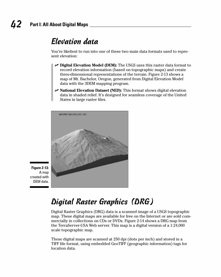
Elevation dataYou’re likeliest to run into one of these two main data formats used to repre-sent elevation:
� Digital Elevation Model (DEM): The USGS uses this raster data format torecord elevation information (based on topographic maps) and createthree-dimensional representations of the terrain. Figure 2-13 shows amap of Mt. Bachelor, Oregon, generated from Digital Elevation Modeldata with the 3DEM mapping program.
� National Elevation Dataset (NED): This format shows digital elevationdata in shaded relief. It’s designed for seamless coverage of the UnitedStates in large raster files.
Digital Raster Graphics (DRG)Digital Raster Graphics (DRG) data is a scanned image of a USGS topographicmap. These digital maps are available for free on the Internet or are sold com-mercially in collections on CDs or DVDs. Figure 2-14 shows a DRG map fromthe TerraServer-USA Web server. This map is a digital version of a 1:24,000scale topographic map.
These digital maps are scanned at 250 dpi (dots per inch) and stored in aTIFF file format, using embedded GeoTIFF (geographic information) tags forlocation data.
Figure 2-13:A map
created withDEM data.
42 Part I: All About Digital Maps

You can view the map by itself or both the map and its location data. Use oneof the following methods:
� View the map by opening the DRG file with any current graphics programthat supports large TIFF files.
� Use the DRG file with a mapping program that supports GeoTIFF to viewthe map and access its location data.
For more technical details about USGS digital map data, check out theagency’s product Web site:
mapping.usgs.gov/products.html
Figure 2-14:A map
composedof Digital
RasterGraphics
data.
43Chapter 2: Dissecting Maps
Who is Mr. Sid?This question is more accurately stated as whatis MrSID? MrSID is the Multi-Resolution Seam-less Image Database. It’s a file format used fordistributing large images over networks, origi-nally developed by a company called LizardTech.Graphics in MrSID format are compressed witha lossless compression algorithm (a method ofcompressing data that guarantees the originaldata can be restored exactly) designed to pro-duce relatively small, high-resolution images.
The file format is perfect for aerial and satelliteimages that have large file sizes, and the govern-ment is increasingly using it for distributing data.(The Library of Congress is even using it for elec-tronic versions of paper documents.) A numberof free viewers support MrSID; use Google to finddownload sites. (One of my favorites is IrfanView,which is available at www.irfanview.com.)

Digital Orthophoto Quadrangle (DOQ)Digital Orthophoto Quadrangle (DOQ) data consists of a computer-generatedimage of an aerial photograph. The image is corrected so that camera tilt andterrain relief don’t affect the accuracy. DOQs combine the image characteris-tics of a photograph with the geometric qualities of a map. Figure 2-15 showsa DOQ map of Mt. Bachelor, Oregon, from the TerraServer-USA Web site.
The USGS has DOQs available for the entire United States. Most are grayscale,infrared photos; there are higher-resolution color photos for a few large U.S.metropolitan areas.
A booming business provides high-resolution, color aerial photographs toindividuals, government agencies, corporations, and educational and non-profit organizations. Companies like AirphotoUSA (www.airphotousa.com),Keyhole (www.keyhole.com) and DeLorme’s TopoBird subsidiary (www.topobird.com) provide imagery with quality and resolution that’s close towhat was only available to intelligence agencies. If you want aerial photographsfor business or government purposes, check these commercial sources.
Satellite dataSatellites are the most exotic source of data for digital maps. Orbiting severalhundred miles above the earth, satellites provide photographs and othersensor data. NASA’s Landsat, the Space Shuttle, and other satellites collectraster data for most of the earth. It’s available both free and commercially.
Figure 2-15:A Digital
OrthophotoQuadrangle
map.
44 Part I: All About Digital Maps

Resolution defines the smallest object a satellite can distinguish. A satellitewith one-meter resolution can distinguish objects down to a meter (a littleunder 40 inches) in size.
Figure 2-16 is a ten-meter resolution SPOT satellite data of Mt. Bachelor, fromDeLorme’s Spot 10 collection of satellite data. (SPOT, which stands for SystemePour l’observation de la Terre, is a French commercial satellite program thatstarted in 1986.)
Although most free satellite imagery doesn’t come close to the resolution ofsome commercial sources, the government is relying increasingly on privatecompanies to acquire data. I expect that government sources eventually willrelease high-resolution, color imagery to the public.
Figure 2-16:A ten-meter
resolutionsatellite
image.
45Chapter 2: Dissecting Maps
I spyThe highest resolution commercial satelliteimagery available is .61 meters, from Digital-Globe’s QuickBird satellite (www.digitalglobe.com).
By 2006, commercial satellites are expected tohave resolution as high as 0.25 meters. That’spretty close to the resolution of spy satellites,
which are thought to have a resolution of 0.1meters. (The best spy satellites can reputedlydiscern objects about the size of a baseball.Despite what you see in the movies, licenseplate numbers are too small to be read by spysatellites, especially considering they don’t faceup toward space.)

46 Part I: All About Digital Maps

Part IIAll About GPS

In this part . . .
GPS stands for Global Positioning System, which is a nifty satellite system that tells you your location
anywhere on planet earth. This part is all about GPS. We’llstart with a broad overview of the satellite system andwork our way back down to earth and discuss handheld,consumer GPS receivers. By the end of the part you’llunderstand the technology behind GPS (without needingto be a rocket scientist), be able to navigate through thejungle of GPS receivers on the market, and have the skillsand knowledge to practically use a GPS receiver withoutbeing intimidated or confused by it.

Chapter 3
GPS FundamentalsIn This Chapter� Discovering how GPS works
� Understanding GPS capabilities and limitations
� Types of information you can get from a GPS receiver
� Getting familiar with common GPS receiver features
� Looking into the future of GPS
You’ve heard about GPS and probably know that it has something to dowith handheld gadgets and satellites that tell you where you’re located.
That’s great for starters, but to understand and use GPS, you need a bit moredetailed knowledge. Follow this chapter to go through some of the fundamen-tals of GPS so you have a better grasp of what it is and how you can use it.
What Is GPS?GPS stands for Global Positioning System. A special radio receiver measuresthe distance from your location to satellites that orbit the earth broadcastingradio signals. GPS can pinpoint your position anywhere in the world. Prettycool, huh? Aside from buying the receiver, the system is free for anyone.
You can purchase an inexpensive GPS receiver, pop some batteries in it, turnit on, and presto! Your location appears on the screen. No map, compass, sex-tant, nor sundial is required. Just like magic. It’s not really magic, though, buthas evolved from some great practical applications of science that have cometogether over the last 50 years.
Other satellite Global Positioning Systems are either in orbit or planned, butthis book uses the term GPS for the Global Positioning System operated bythe United States government.

How GPS WorksThe intricacies of GPS are steeped in mathematics, physics, and engineering,but you don’t need to be a rocket scientist to understand how GPS works.GPS is composed of three parts (as shown in Figure 3-1):
50 Part II: All About GPS
A short history of GPSMilitary, government, and civilian users all overthe world rely on GPS for navigation and locationpositioning, but radio signals have been usedfor navigation purposes since the 1920s. LORAN(Long Range Aid to Navigation), a position-findingsystem that measured the time difference ofarriving radio signals, was developed duringWorld War II.
The first step to GPS came way back in 1957when the Russians launched Sputnik, the firstsatellite to orbit the Earth. Sputnik used a radiotransmitter to broadcast telemetry information.Scientists at the Johns Hopkins Applied PhysicsLab discovered that the Doppler shift phenome-non applied to the spacecraft — and almostunwittingly struck gold.
A down-to-earth, painless example of theDoppler shift principle is when you stand on asidewalk and a police car speeds by in hot pur-suit of a stolen motorcycle. The pitch of the policesiren increases as the car approaches you andthen drops sharply as it moves away.
American scientists figured out that if they knewthe satellite’s precise orbital position, they couldaccurately locate their exact position on Earth bylistening to the pinging sounds and measuringthe satellite’s radio signal Doppler shift. Satellitesoffered some possibilities for a navigation andpositioning system, and the U.S. Department ofDefense (DoD) explored the concept.
By the 1960s, several rudimentary satellite-positioning systems existed. The U.S. Army,Navy, and Air Force were all working on inde-pendent versions of radio navigation systemsthat could provide accurate positioning and all-weather, 24-hour coverage. In 1973, the Air Forcewas selected as the lead organization to consol-idate all the military satellite navigation effortsinto a single program. This evolved into theNAVSTAR (Navigation Satellite Timing andRanging) Global Positioning System, which is theofficial name for the United States’ GPS program.
The U.S. military wasn’t just interested in GPS fornavigation. A satellite location system can beused for weapons-system targeting. Smartweapons such as the Tomahawk cruise missileuse GPS in their precision guidance systems.GPS, combined with contour-matching radar and digital image-matching optics, makes aTomahawk an extremely accurate weapon. Thepossibility of an enemy using GPS against theUnited States is one reason why civilian GPSreceivers are less accurate than their restricted-use military counterparts.
The first NAVSTAR satellite was launched in 1974to test the concept. By the mid-1980s, more satel-lites were put in orbit to make the system func-tional. In 1994, the planned full constellation of24 satellites was in place. Soon, the militarydeclared the system completely operational.The program has been wildly successful and isstill funded through the U.S. DoD.

� Satellites
� Ground stations
� Receivers
Eyeing satellitesIn GPS jargon, a satellite is the space segment. A constellation of 24 GPS satel-lites (21 operational and 3 spares) orbits about 12,000 miles above the Earth(as shown in Figure 3-2). The satellites zoom through the heavens at around7,000 miles per hour. It takes about 12 hours for a satellite to completely orbitthe Earth, passing over the exact same spot approximately every 24 hours.The satellites are positioned where a GPS receiver can receive signals from atleast six of the satellites at any time, at any location on the Earth (if nothingobstructs the signals).
A satellite has three key pieces of hardware:
� Computer: This onboard computer controls its flight and other functions.
� Atomic clock: This keeps accurate time within three nanoseconds(around three-billionths of a second).
� Radio transmitter: This sends signals to Earth.
Figure 3-1:GPS is
composedof satellites,
groundstations, and
receivers.
51Chapter 3: GPS Fundamentals

GPS satellites don’t just help you stay found. All GPS satellites since 1980carry NUDET sensors. No, this isn’t some high-tech pornography-detectionsystem. NUDET is an acronym for NUclear DETonation; GPS satellites havesensors to detect nuclear-weapon explosions, assess the threat of nuclearattack, and help evaluate nuclear strike damage.
The solar-powered GPS satellites have a limited life span (around 10 years).When they start to fail, spares are activated or new satellites are sent intoorbit to replace the old ones. This gives the government a chance to upgradethe GPS system by putting hardware with new features into space.
GPS radio signalsGPS satellites transmit two types of radio signals: C/A-code and P-code.Briefly, here are the uses and differences of these two types of signals.
Coarse Acquisition (C/A-code)Coarse Acquisition (C/A-code) is the type of signal that consumer GPS unitsreceive. C/A-code is sent on the L1 band at a frequency of 1575.42 MHz.
C/A broadcasts are known as the Standard Positioning Service (SPS).
C/A-code is less accurate than P-code (see the following section) and is easierfor U.S. military forces to jam and spoof (broadcast false signals to make areceiver think it’s somewhere else when it’s really not).
The advantage of C/A-code is that it’s quicker to use for acquiring satellitesand getting an initial position fix. Some military P-code receivers first trackon the C/A-code and then switch over to P-code.
Figure 3-2:The constel-
lation ofNAVSTARsatellitesand their
orbits.
52 Part II: All About GPS

Precision (P-code)P-code provides highly precise location information. P-code is difficult to jamand spoof. The U.S. military is the primary user of P-code transmissions, andit uses an encrypted form of the data (Y-code) so only special receivers canaccess the information. The P-code signal is broadcast on the L2 band at1227.6 MHz.
P-code broadcasts are known as the Precise Positioning Service (PPS).
Covering ground stationsGround stations are the control segment of GPS. Five unmanned ground stations around the Earth monitor the satellites. Information from the stations is sent to a master control station — the Consolidated SpaceOperations Center (CSOC) at Schriever Air Force Base in Colorado — wherethe data is processed to determine each satellite’s ephemeris and timingerrors.
An ephemeris is a list of the predicted positions of astronomical bodies suchas the planets or the Moon. Ephemerides (the plural of ephemeris) have beenaround for thousands of years because of their importance in celestial navi-gation. Ephemerides are compiled to track the positions of the numeroussatellites orbiting the earth.
The processed data is sent to the satellites once daily with ground antennaslocated around the world. This is kind of like syncing a personal digital assis-tant (PDA) with your personal computer to ensure that all the data is in syncbetween the two devices. Because the satellites have small built-in rockets,the CSOC can control them to ensure that they stay in a correct orbit.
GPS receiversAnyone who has a GPS receiver can receive the satellite signals to determinewhere he or she is located.
Satellite dataGPS units receive two types of data from the NAVSTAR satellites.
AlmanacAlmanac data contains the approximate positions of the satellites. The data isconstantly being transmitted and is stored in the GPS receiver’s memory.
53Chapter 3: GPS Fundamentals

EphemerisEphemeris data has the precise positions of the satellites. To get an accuratelocation fix, the receiver has to know how far away a satellite is. The GPSreceiver calculates the distance to the satellite by using signals from thesatellite.
Using the formula Distance = Velocity x Time, a GPS receiver calculates thesatellite’s distance. A radio signal travels at the speed of light (186,000 milesper second). The GPS receiver needs to know how long the radio signal takesto travel from the satellite to the receiver in order to figure the distance. Boththe satellite and the GPS receiver generate an identical pseudo-random codesequence. When the GPS receiver receives this transmitted code, it determineshow much the code needs to be shifted (using the Doppler-shift principle) forthe two code sequences to match. The shift is multiplied by the speed of lightto determine the distance from the satellite to the receiver.
Multiple satellitesA GPS receiver needs several pieces of data to produce position information:
� Location: A minimum of three satellite signals is required to find yourlocation.
� Position: Four satellite signals are required to determine your positionin three dimensions: latitude, longitude, and elevation.
Receiver typesGPS receivers generally fall into five categories.
Consumer modelsConsumers can buy practical GPS receivers in sporting goods stores. They’reeasy to use and are mostly targeted for recreational and other uses thatdon’t require a high level of location precision. The Big Three manufacturersin the consumer GPS market are Garmin (www.garmin.com), Magellan (www.magellangps.com), and Lowrance (www.lowrance.com). Consumer GPSreceivers are reasonably priced, from less than $100 to $400 in the U.S.
This book emphasizes the features of and how to use the consumer-oriented,handheld types.
When you buy a consumer receiver, opt for a 12-channel GPS model over anolder 8-channel model:
� 12-channel parallel receivers: These acquire satellites faster and oper-ate better under foliage and tree-canopy cover.
� 8-channel receivers: These are slow when acquiring satellite signals andhave difficulty operating even under light tree cover.
54 Part II: All About GPS

Don’t consider purchasing an 8-channel receiver. Even if you were given onefor free, it’s like running the latest version of Windows on a 386 computer.
U.S. military/government modelsGPS units that receive P-code and Y-code are available only to the government.These portable units are Precision Lightweight GPS Receivers (PLGRs — or,more fondly, pluggers). First-generation PLGRs were big and boxy and providedaccuracy within four meters. The newest precise GPS receivers are DAGRs(Defense Advanced Global Positioning System Receivers) and are smaller, moreaccurate, and have mapping features like consumer GPS units. For the specifi-cations of U.S. military GPS receivers, including pictures of different units, visithttp://army-gps.robins.af.mil.
Mapping/resource modelsThese portable receivers collect location points and line and area data that canbe input into a Geographic Information System (GIS). They are more precisethan consumer models, can store more data, and are much more expensive.
Survey modelsThese are used mostly for surveying land, where you may need accuracydown to the centimeter for legal or practical purposes. These units areextremely precise and store a large amount of data. They tend to be large,complex to use, and very expensive.
55Chapter 3: GPS Fundamentals
Selective Availability (SA)The average GPS user didn’t always have 15-meter accuracy. In the 1970s, studies showedthat the less-accurate C/A-code for nonmilitaryuse, was more accurate than the U.S. govern-ment intended. Originally thought to provideaccuracy within 100 meters, experiments showedthat C/A accuracy was in the range of 20–30meters. To reduce the accuracy of C/A-code, theU.S. government developed Selective Availability(SA). SA adds errors to NAVSTAR satellite dataand prevents consumer GPS receivers from pro-viding an extremely precise location fix.
Selective Availability was temporarily turned offin 1990 during the Persian Gulf War. There
weren’t enough U.S. and allies military P-codeGPS receivers, so the Coalition troops used civil-ian GPS receivers. The Gulf War was the firstuse of GPS in large-scale combat operations.
On May 2, 2000, SA was turned off permanently.Overnight, the accuracy of civilian GPS userswent from 100 meters to 15 meters. Turning off SAon a global scale was directly related to the U.S.military’s ability to degrade the C/A-code on aregional basis. For example, during the invasionof Afghanistan, the American military jammedGPS signals in Afghanistan to prevent theTaliban from using consumer receivers in oper-ations against American forces.

Commercial transportation modelsThese GPS receivers, not designed to be handheld, are installed in aircraft,ships, boats, trucks, and cars. They provide navigation information appropri-ate to the mode of transportation. These receivers may be part of anAutomated Position Reporting System (APRS) that sends the vehicle’s loca-tion to a monitoring facility.
Trimble Navigation (www.trimble.com) is one of the biggest players in thenonconsumer GPS receiver market. If you’re interested in discovering howcommercial and higher-end GPS units work and the features they support,check out the Trimble Web site.
How accurate is a GPS receiver?According to the government and GPS receiver manufacturers, expect yourGPS unit to be accurate within 49 feet (that’s 15 meters for metric-savvyfolks). If your GPS reports that you’re at a certain location, you can be rea-sonably sure that you’re within 49 feet of that exact set of coordinates.
GPS receivers tell you how accurate your position is. Based on the quality ofthe satellite signals that the unit receives, the screen displays the estimatedaccuracy in feet or meters. Accuracy depends on
� Receiver location
� Obstructions that block satellite signals
Even if you’re not a U.S. government or military GPS user, you can get moreaccuracy by using a GPS receiver that supports corrected location data.Corrected information is broadcast over radio signals that come from either
� Non-GPS satellites
� Ground-based beacons
Two common sources of more accurate location data are
� Differential GPS (DGPS)
� Wide Area Augmentation System (WAAS)
I cover both DGPS and WAAS in the following section on GPS receiver features.
Table 3-1 shows the accuracy you can expect from a GPS receiver. Thesenumbers are guidelines; at times, you may get slightly more or less accuracy.
56 Part II: All About GPS

Table 3-1 GPS AccuracyGPS Mode Distance in Feet Distance in Meters
GPS without SA 49 15
GPS with DGPS 10–16 3–5
GPS with WAAS 10 3
57Chapter 3: GPS Fundamentals
GPS errorsA number of conditions can reduce the accuracyof a GPS receiver. From a top-down perspective(from orbit down to ground level), the possiblesources of trouble look like this:
� Ephemeris errors: Ephemeris errors occurwhen the satellite doesn’t correctly trans-mit its exact position in orbit.
� Ionosphere conditions: The ionospherestarts at about 43–50 miles above the Earthand continues for hundreds of miles. Satellitesignals traveling through the ionosphereare slowed down because of plasma (a lowdensity gas). Although GPS receivers attemptaccount for this delay, unexpected plasmaactivity can cause calculation errors.
� Troposphere conditions: The troposphere isthe lowest region in the Earth’s atmosphereand goes from ground level up to about 11miles. Variations in temperature, pressure,and humidity all can cause variations in howfast radio waves travel, resulting in relativelysmall accuracy errors.
� Timing errors: Because placing an atomicclock in every GPS receiver is impractical,timing errors from the receiver’s less-preciseclock can cause slight position inaccuracies.
� Multipath errors: When a satellite signalbounces off a hard surface (such as a build-ing or canyon wall) before it reaches thereceiver, a delay in the travel time occurs,which causes an inaccurate distance cal-culation.
� Poor satellite coverage: When a significantpart of the sky is blocked, your GPS unit hasdifficulty receiving satellite data. Unfortu-nately, you can’t say that if 50 percent (orsome other percentage) of the sky is blocked,you’ll have poor satellite reception; this isbecause the GPS satellites are constantlymoving in orbit. A satellite that provides agood signal one day may provide a poorsignal at the exact same location on anotherday because its position has changed andis now being blocked by a tree. The moreopen sky you have, the better your chancesof not having satellite signals blocked.
Building interiors, streets surrounded by tallbuildings, dense tree canopies, canyons,and mountainous areas are typical problemareas.
If satellite coverage is poor, try moving to a dif-ferent location to see whether you get anyimprovement.

Although survey-grade GPS receivers can provide accuracy of less than twocentimeters, they are very specialized and expensive, require a lot of training,and aren’t very portable. Their accuracy is achieved with DGPS and post-processing collected data to reduce location errors. The average GPS userdoesn’t need this level of precision.
Clouds, rain, snow, and weather don’t reduce the strength of GPS signalsenough to reduce accuracy. The only way that weather can weaken signals iswhen a significant amount of rain or snow accumulates on the GPS receiverantenna or on an overhead tree canopy.
Information from GPS ReceiversGPS receivers provide your location and other useful information:
� Time: A GPS receiver receives time information from atomic clocks, soit’s much more accurate than your wristwatch.
� Location: GPS provides your location in three dimensions:
• Latitude (x coordinate)
• Longitude (y coordinate)
• Elevation
The vertical (elevation) accuracy of consumer GPS receivers isn’tthat great. It can be within 15 meters, 95 percent of time. Some GPSunits incorporate more accurate barometric altimeters for betterelevation information.
Your location can be displayed in a number of coordinate systems, such as
• Latitude/longitude
• Universal Transverse Mercator (UTM)
I cover coordinate systems in Chapter 2.
� Speed: When you’re moving, a GPS receiver displays your speed.
� Direction of travel: A GPS receiver can display your direction of travel ifyou’re moving.
If you’re stationary, the unit can’t use satellite signals to determinewhich direction you’re facing.
Some GPS units have electronic compasses that show the direction thereceiver is pointed whether you’re moving or standing still.
� Stored locations: You can store locations where you’ve been or want togo with a GPS receiver. These location positions are waypoints. Waypointsare important because a GPS unit can supply you with directions andinformation on how to get to a waypoint. A collection of waypoints that
58 Part II: All About GPS

plots a course of travel is a route, which can also be stored. GPS receiversalso store tracks (which are like an electronic collection of breadcrumbtrails that show where you’re been).
In Chapter 4, I show how to create and use waypoints, routes, and tracks.
� Cumulative data: A GPS receiver can also keep track of information suchas the total distance traveled, average speed, maximum speed, minimumspeed, elapsed time, and time to arrival at a specified location.
All this information is displayed on different pages of the GPS receiver’s dis-play screen. One page shows satellite status, another page displays a map,another displays trip data, and so on. With buttons on the receiver, you canscroll to an information page to view the data that you’re interested in seeing.
GPS Receiver FeaturesA number of GPS receivers are on the market. Usually a GPS receiver withmore features costs more.
GPS manufacturers have done a pretty good job making user interfaces easyto use. After you know the basic concepts of GPS receivers and are familiarwith a manufacturer’s user interface, a GPS unit is usually as easy to use as acellphone and easier to use than a personal computer.
Display and outputGPS receivers have three choices for information display or data output:
� Monochrome LCD screen: Most GPS receivers have a monochromeliquid crystal display (LCD) screen.
� Color screen: These are especially useful for displaying maps.
Color screens usually have shorter battery lives than monochrome ones.
� No screen: Some GPS receivers only transmit data through an expansionslot or a cable; a receiver with a cable is often called a mouse GPS receiverbecause it resembles a computer mouse. Such receivers are designed to interface with a laptop computer or PDA running special software.Figure 3-3 shows a DeLorme Earthmate GPS unit attached to a laptop. AllGPS data is sent to the laptop and processed there with mapping soft-ware. A Magellan SporTrak GPS receiver is shown on top of the laptopfor comparison.
Most GPS receivers that have screens can output data to a PC or PDA.
59Chapter 3: GPS Fundamentals

A GPS receiver’s screen size depends on the receiver’s size. Smaller, lightermodels have small screens; larger units sport bigger screens.
Generally, a bigger screen is easier to read. Different models of GPS receiveralso have different pixel resolutions; the higher the screen resolution, themore crisp the display will be. For night use, all screens can be backlit.
AlarmsA GPS receiver alarm can transmit a tone or display a message when youapproach a location that you specify. This feature can be especially usefulwhen you’re trying to find a place and visibility is limited by darkness orinclement weather — or you’re busy doing something else and aren’t lookingat the GPS receiver screen.
Built-in mapsEvery GPS receiver has an information page that shows waypoints andtracks. The page is a simple map that plots travel and locations. It doesn’tshow roads, geographic features, or man-made structures. Figure 3-4 showstwo GPS receiver screens: simple location plotting on the left, and a moresophisticated, uploaded map on the right.
Figure 3-3:A GPS
receiverwithout a
screen.
60 Part II: All About GPS

Some GPS receivers have maps that show roads, rivers, cities, and other fea-tures on their screens. You can zoom in and out to show different levels ofdetail. The two types of map receivers are
� Basemap: These GPS units have a basemap loaded into read-onlymemory that contains roads, highways, water bodies, cities, airports,railroads, and interstate exits.
Basemap GPS receivers aren’t expandable, and you can’t load moredetailed maps to the unit to supplement the existing basemap.
� Uploadable map: More detailed maps can be added to this type of unit(in either internal memory or an external memory card). You can installroad maps, topographic maps, and nautical charts. Many of these mapsalso have built-in databases, so your GPS receiver can display restau-rants, gas stations, or attractions near a certain location.
Chapter 9 covers features and how to use GPS receiver manufacturermapping programs to upload maps to your GPS unit.
Refer to Figure 3-4 to see screens from a GPS receiver with a simple plot mapand another GPS unit with an uploadable map.
GPS receivers that display maps use proprietary map data from the manufacturer. That means you can’t load another manufacturer’s or software company’s maps into a GPS receiver. However, clever hackersreverse-engineered Garmin’s map format. Programs on the Internet cancreate and upload your own maps to Garmin GPS receivers; GPSmapper ispopular.
A handheld GPS receiver’s screen is only several inches across. The limita-tions of such a small display certainly don’t make the devices replacementsfor traditional paper maps.
Figure 3-4:Simple and
sophisti-cated GPS
receiverscreens.
61Chapter 3: GPS Fundamentals

Electronic compassAll GPS receivers can tell you which direction you’re heading — that is, aslong as you’re moving. The minute you stop, the receiver stops acting as acompass. To address this limitation, some GPS receivers incorporate an elec-tronic compass that doesn’t rely on the GPS satellites.
OperationLike with an old-fashioned compass, you can stand still and see which direc-tion your GPS receiver is pointing toward. The only difference is that you seea digital display onscreen instead of a floating needle.
On some GPS receivers, you need to hold the unit flat and level for the com-pass to work correctly. Other models have a three-axis compass that allowsthe receiver to be tilted.
Paying attention to these factors can improve the performance and conve-nience of an electronic compass:
� Magnetic fields: Metal objects, cars, and other electronic devices reducethe accuracy of any electronic or magnetic compass.
� Battery life: Using an electronic compass can impact battery life. SomeGPS receivers have settings that turn off the compass or only use itwhen the receiver can’t determine a direction from satellite data.
CalibrationElectronic compasses need to be calibrated whenever you change batteries.If your GPS unit has an electronic compass, follow your user guide’s instruc-tions to calibrate it. Usually, this requires being outside, holding the GPS unitflat and level, and slowly turning in a circle twice.
AltimeterThe elevation or altitude calculated by a GPS receiver from satellite data isn’tvery accurate. Because of this, some GPS units have altimeters, which providethe elevation, ascent/descent rates, change in elevation over distance or time,and the change of barometric pressure over time. (The rough-and-ready ruleis that if barometric pressure is falling, bad weather is on the way; if it’s rising,clear weather is coming.) Calibrated and used correctly, barometric altimeterscan be accurate within 10 feet of the actual elevation. Knowing your altitudeis useful if you have something to reference it to, such as a topographic map.Altimeters are useful for hiking or in the mountains.
62 Part II: All About GPS

On GPS units with an electronic altimeter/barometer, calibrating the altimeterto ensure accuracy is important. To do so, visit a physical location with aknown elevation and enter the elevation according to the directions in youruser’s guide. Airports are good places to calibrate your altimeter or get aninitial base reading; their elevation is posted for pilots to calibrate their air-planes’ altimeters. If you’re relying on the altimeter/barometer for recre-ational use, I recommend calibrating it before you head out on a trip.
Increasing accuracySome GPS receivers have features that allow you to increase the accuracy ofyour location by using radio signals not associated with the GPS satellites. If you see that a GPS receiver supports WAAS or Differential GPS, it has thepotential to provide you with more accurate location data.
WAASWide Area Augmentation System (WAAS) combines satellites and ground sta-tions for position accuracy of better than three meters. Vertical accuracy isalso improved to three to seven meters.
WAAS is a Federal Aviation Administration (FAA) system, so GPS can be usedfor airplane flight approaches. The system has a series of ground-reference sta-tions throughout the United States. These monitor GPS satellite data and thensend the data to two master stations — one on the west coast and the otheron the east coast. These master stations create a GPS message that correctsfor position inaccuracies caused by satellite orbital drift and atmosphericconditions. The corrected messages are sent to non-NAVSTAR satellites instationary orbit over the equator. The satellites then broadcast the data toGPS receivers that are WAAS-enabled.
GPS units that support WAAS have a built-in receiver to process the WAASsignals. You don’t need more hardware. Some GPS receivers support turningWAAS on and off. If WAAS is on, battery life is shorter (although not as signifi-cantly as it is when using the backlight). In fact, on these models, you can’tuse WAAS if the receiver’s battery-saver mode is activated. Whether you turnWAAS on or off depends on your needs. Unless you need a higher level ofaccuracy, you can leave WAAS turned off if your GPS receiver supports tog-gling it on and off. WAAS is ideally suited for aviation as well as for open landand marine use. The system may not, however, provide any benefits in areaswhere trees or mountains obstruct the view of the horizon.
63Chapter 3: GPS Fundamentals

Under certain conditions — say, when weak WAAS satellite signals are beingreceived or the GPS receiver is a long way from a ground station — accuracycan actually worsen when WAAS is enabled.
WAAS is only available in North America. Other governments are establishingsimilar systems that use the same format radio signals such as
� European Euro Geostationary Navigation Overlay Service (EGNOS)
� Japanese Multi-Functional Satellite Augmentation System (MSAS)
Differential GPSSurveying and other work that demands a high level of precision useDifferential GPS (DGPS) to increase the position accuracy of a GPS receiver. A stationary receiver measures GPS timing errors and broadcasts correctioninformation to other GPS units that are capable of receiving the DGPS signals.Consumer GPS receivers that support DGPS require a separate beacon receiverthat connects to the GPS unit. Consumers can receive DGPS signals from freeor commercial sources.
Unless you’re doing survey or other specialized work, you really don’t needDGPS capabilities. For consumer use, the increased accuracy of DGPS hasmostly been replaced with WAAS.
Coast Guard DGPSDGPS signals are freely broadcast by a series of U.S. Coast Guard stations inthe United States. Whether you can receive these Coast Guard broadcastsdepends on your location.
For more information on DGPS, including coverage maps, pay a visit towww.navcen.uscg.gov/dgps/coverage/default.htm.
Commercial DGPSDGPS services are offered commercially for the surveying market. You canrent or purchase electronic and radio equipment for gathering precise loca-tion information in a relatively small area.
AntennasWell, yes, a GPS unit has to have an antenna to receive radio signals to do youany good. Several types are available, each with its advantages.
64 Part II: All About GPS

Internal antennasAll GPS receivers have one of two kinds of built-in antennas. One antennadesign isn’t superior to the other; performance is related to the receiver’santenna size. (Cough . . . bigger is better.)
PatchAn internal patch antenna is a square conductor mounted over a groundplane(another square piece of metal). Patch antenna models reacquire satellitesfaster after losing the signal.
For best performance with an internal patch antenna, hold the receiver faceup and parallel with the ground.
Quad helixAn internal quadrifilar helix antenna (or quad helix) is a circular tubewrapped with wire. Quad helix antennas are more sensitive and work betterunder tree cover than the other types.
For best performance with an internal quad helix antenna, hold the receiverso that the top is pointing up to the sky.
External antennasSome GPS receivers have connectors for attaching external antennas. Anexternal antenna is useful if the GPS receiver’s view of the sky is otherwiseblocked, like in a boat, a car, an airplane, or a backpack.
Reradiating antennasIf a GPS receiver doesn’t have a jack for connecting an external antenna, youcan improve the reception with a reradiating antenna. These antennas workjust as well as conventional external antennas that plug into a GPS receiver.
A reradiating antenna combines two GPS antennas:
� One antenna receives the GPS signal from the satellites.
� The other antenna is connected to the first and positioned next to theGPS unit’s internal antenna.
Here are a couple of sources for reradiating antennas:
� Roll your own: If you’re handy with a soldering iron, search Google forreradiating antenna GPS for tips on how to make one yourself.
� Buy one: Purchase an assembled reradiating antenna from Pc-Mobile atwww.pc-mobile.net/gpsant.htm.
65Chapter 3: GPS Fundamentals

Internal memoryA receiver’s internal memory holds such data as waypoints, track logs, routes,and uploadable digital maps (if the model supports them). The more memorythe receiver has, the more data you can store in it. All the data that’s beenstored in the GPS receiver is retained when the device is turned off.
GPS receivers have different amounts of memory. Unlike personal computers,you can’t add memory chips to a GPS unit to expand its internal memory.
External storageSome GPS receivers aren’t limited to internal memory for storage, using support memory cards that can be plugged into the receiver to store data.External memory can be either
� Manufacturer proprietary data cards
� Generic (and less expensive) storage, such as
• MultiMediaCard (MMC; www.mmca.org)
• Secure Digital (SD; www.sandisk.com)
Accessory programsMany GPS receivers have built-in accessory programs that display varioushandy features such as
� Calendars with the best time to hunt and fish
� Sunrise, moonrise, sunset, and moonset tables
� Tide tables
� Calculators
� Games
User interface modesSome GPS receivers have simple and advanced user interface modes.
66 Part II: All About GPS

� Simple mode: This displays only often used commands and features.
This is an excellent option for the novice user who wants to use basicGPS receiver functions without being distracted or confused by themany other features.
� Advanced mode: This shows all commands and features.
Synthesized voiceSome models of GPS receiver, designed primarily for automotive use, have asynthesized voice that provides you with route-finding information. Althoughthis feature has been available as an option in some luxury cars for manyyears (for example, in the OnStar system), portable GPS units that talk to youare available. You don’t have to pay monthly subscription fees for them, andyou can easily move them from car to car. (Ah, progress.)
You can find more information in Chapter 5 on how to select a portable GPSreceiver to use for road navigation.
If you’re using your GPS receiver primarily for navigation in your vehicle,mount it securely so that it doesn’t slide around the dashboard.
� GPS receiver manufacturers make mounting brackets for in-vehicle use.
� Do-it-yourself solutions can include Velcro, Silly Putty, small beanbags,or modeling clay (the nonhardening type).
Never mount your GPS unit where an airbag deploys during a crash.
67Chapter 3: GPS Fundamentals
GPS monopolyThe U.S. has had a monopoly on satellite-basedlocation systems over the years (the RussianGLONASS, Global Orbiting Navigation SatelliteSystem, has really never been a viable player),but that may soon change.
The European Union is moving toward deploy-ing its own positioning system called Galileo. Ifeverything goes as planned, Galileo will be oper-ational by 2008 with a constellation of 30 sta-tionary satellites. Position accuracy is touted aswithin a meter, which is ten times more precisethan what GPS currently provides to civilians.
The United States isn’t happy about this; as analternative, GPS prevents the U.S. governmentand military from selectively degrading signalsand blocking use elsewhere in the world. China,Israel, and India have expressed interest inbecoming involved with Galileo. As of early 2004,after a number of negotiation sessions, the U.S.and European Union had reached a number ofcompromises that met both parties’ needs.
http://europa.eu.int/comm/dgs/energy_transport/galileo/index_en.htm

The Future of GPSModern technology rapidly evolves, and the same holds true for GPS. Sinceconsumer GPS receivers first became available in the mid-1990s, the markethas grown tremendously because of cheaper receiver prices and new ways touse GPS. A peek into a crystal ball shows what the future may hold for GPS.
� More accurate: The United States has started planning the next generationof GPS, dubbed GPS III. Driving factors are better accuracy and reliability,improved resistance to signal jamming, and the looming European Galileosystem. Increasing the number of WAAS satellites in orbit is also planned.The first GPS III satellite is tentatively planned for launch in 2012. The U.S.government budget will have an impact on plans to improve the presentGPS system; the Iraq invasion delayed the launch of several satellites.
� Smaller: GPS receivers will continue to shrink. GPS units already areintegrated into wristwatches, and PC Card GPS receivers can plug into alaptop or PDA.
The three limiting factors that prevent a consumer receiver from shrink-ing are antenna size, screen size, and power source size
� Cheaper: Prices will continue to decline as manufacturing costsdecrease and production quantities increase.
� Easier to use: Simplified and less technical user interfaces will becomemore of a priority as GPS receivers become more appliancelike to meetthe needs of specialized markets. An example is Garmin’s Forerunnerproduct, which is targeted to runners and lacks a number of featurestypically found in traditional GPS receivers.
� Easier to view: Improved screen technology will make GPS receiverscreens brighter and easier to read.
� More integrated: GPS receivers are being integrated into cars and trucks,cellphones, PDAs, Family Radio Service (FRS) radios, and other consumerelectronic devices. Expect some new products and services that takeadvantage of location-aware data.
� Thriftier: User-replaceable AA and AAA batteries have long poweredportable GPS receivers, but expect some changes in power sources.
• Built-in Lithium ion (Li-Ion) and nickel metal-hydride (NiMH) bat-teries, popular in cellphones and laptops, make sense for GPSreceivers. Garmin started releasing rechargeable GPS receivers atthe end of 2003.
• Further on the horizon, miniature fuel cell technology will keepGPS units going and going without frequent battery changes.
� Less wired: Most GPS receivers transfer data from personal computersthrough a cable. Wireless technologies such as Bluetooth (www.bluetooth.com) and wireless USB are well suited for fast and easy datatransfers to GPS receivers without using cables.
68 Part II: All About GPS

Chapter 4
Grasping Important GPS ConceptsIn This Chapter� Understanding GPS, maps, and coordinate systems
� Working with GPS and datums
� Setting GPS receiver waypoints
� Using routes
� Making the most of tracks
In Chapter 3, I provide you with a pretty good idea of what GlobalPositioning System (GPS) is and how it works. In addition to knowing about
the satellites, ground stations, and receivers, however, you should have agrasp of some important concepts before you start using a GPS receiver —things like coordinate systems, datums, waypoints, routes, and tracks.
Even if you already own a GPS receiver and have used it for a while, this isstill a good chapter to skim through because some of these basic conceptsthat I discuss end up being overlooked in user manuals or can get a bit fuzzyif you don’t use your GPS receiver on a regular basis. Read on while I helpclarify some important terms and concepts (like datums and waypoints androutes) so you’ll be (pardon the pun) moving in the right direction.
Linking GPS, Maps, andCoordinate Systems
Some people think that after they have a GPS receiver, they really don’t needa map, especially if the receiver has built-in mapping capabilities. This isn’tnecessarily true. GPS receivers are best used in conjunction with maps,whether those maps are paper or digital. Here are some of the reasons why:
� Detail: Most maps on handheld GPS receivers don’t offer the detail offull-size paper or digital maps, especially topographic maps and nauticalcharts.

� Size: A GPS receiver’s screen is pretty darn small, and it’s just aboutimpossible to get the big picture that a full-size map can give you.
� Backup: If you have a paper map with you and know how to use it, themap becomes an important backup if your GPS receiver’s batteries failor if you encounter poor satellite coverage. Gadget lovers might con-sider a paper map and magnetic compasses primitive, but they don’trequire batteries — and both are lightweight and cheap, to boot.
� Complementary: After you get back home or to the office, you mightwant to see where you’ve been on a map, based on the locations thatyou’ve stored in the GPS receiver. With a digital map, you can easily plotthe exact route that you took or identify the places you visited.
All maps and GPS receivers use coordinate systems, which are grids on mapsthat enable you to find locations on a map. Because GPS receivers aredesigned for use with maps, they support a number of coordinate systemsthat correspond to those commonly found on maps. (Chapter 2 has informa-tion on using map coordinate systems.) Thus, you can take a location thatyou recorded on your GPS receiver and precisely locate it on a map.
By default, your GPS receiver displays positions in latitude and longitude.But you can change the settings to display locations in exotic-soundingcoordinate systems such as the Finnish KKJ27 grid, the Qatar grid, or theW Malaysian R grid. You probably won’t need to switch to some of theseobscure coordinate systems, so you can stick with latitude and longitude orUniversal Transverse Mercator (UTM), which are used pretty much every-where. If you’re fuzzy on what latitude and longitude or UTM are, check outChapter 2, which gives an overview of the two coordinate systems.
70 Part II: All About GPS
Land navigationDiscovering how to effectively use paper mapsand compasses for land navigation is both anart and a science, with complete books writtenon the subject. Here are two excellent, freeonline resources if you want to find out more.
� Map and Compass for Firefighters (NFES2554) is a self-study course developed bythe U.S. government for wildland firefight-ers. The course is available at www.nwcg.gov/pms/training/map_comp.pdf.
� Map Reading and Land Navigation (FM 3-25.26) is the U.S. Army field manual on the
subject, available at www.army.mil/usapa/doctrine/DR_pubs/dr_a/pdf/fm3_25x26.pdf.
Another great way to become a pro land navi-gator is through the sport of orienteering.Orienteering involves using a map and compassto find control points (small flags) in the short-est amount of time as possible. Do a Websearch for orienteering to find more about thesport and how you can participate in clubs andevents in your local area.

Suppose you have your GPS receiver set to latitude and longitude, and yourecord some locations. When you get home, you find out that your papermap doesn’t have latitude and longitude marks but uses only the UTM coor-dinate system. Not a problem. Look in your GPS receiver user manual forinformation on changing the coordinate system from latitude and longitudeto UTM. Location points that you store in latitude and longitude appear asUTM coordinates. This is a quick and easy way of converting data betweencoordinate systems. Or you can visit the Graphical Locator Home Page atMontana State University (www.esg.montana.edu/gl/index.html) to per-form online conversions of latitude and longitude and Township and Range.
Although Township and Range is a popular coordinate system used on manymaps in the United States, don’t expect your GPS receiver to support thissystem. Unlike the latitude and longitude and UTM grid systems, which weremathematically derived, grids in the Township and Range system may notalways be the same size, thus making it difficult for a GPS receiver to deter-mine coordinates in this system. Most maps that have Township and Rangeinformation also have latitude and longitude or UTM marks. If you have alocation reported in Township and Range, you’ll need to spend a bit of timelooking at a map, manually figuring out the position that the coordinatespoint to, and then plot that position by using a different coordinate system.
71Chapter 4: Grasping Important GPS Concepts
How much latitude?GPS units can display latitude and longitude inseveral different formats. Take the location atthe top of Mt. Bachelor (some great skiing inCentral Oregon if you’re ever in the neighbor-hood) and see how it can be expressed.
� Degrees, minutes, decimal seconds (D° M'S"): 43° 58' 46.94" N, 121° 41' 14.73" W
� Degrees, decimal minutes (D° M.M'): 43°58.7824' N, 121° 41.2455' W
� Decimal degrees (D.D°): 43.9797069° N,121.6874253° W
And just for fun, here are the UTM coordinatesfor that same location: 10T 0605273E, 48 70240N.
Ouch! Is this confusing or what? Although itdoesn’t seem like it, all these coordinates referto the exact same location. Remember, just likeconverting locations from one coordinate system
to another, you can also use your GPS receiveras a calculator to convert from different latitudeand longitude formats. Suppose you have somecoordinates in decimal degrees and need themin degrees, minutes, and seconds:
1. Change the coordinate settings in your GPSreceiver to decimal degrees.
2. Manually enter the coordinates as awaypoint.
3. Change the coordinate settings in your GPSreceiver to degrees, minutes, and seconds.
When you look at the coordinates of the way-point that you entered, they’re now displayed indegrees, minutes, and seconds. (Note: Becausechanging coordinate systems varies from modelto model, check your user manual for specificinstructions.)

Understanding GPS and DatumsAs I discuss in Chapter 2, a datum is a frame of reference for mapping. Becausethe earth isn’t flat, geographic coordinate systems use ellipsoids (think of asphere that’s not perfectly spherical, much like the shape of the Earth) to cal-culate positions on our third planet from the sun. A datum is the position ofthe ellipsoid relative to the center of the earth.
Unless you’re a cartographer or geographer, that probably hurts just thinkingabout it. Sparing you a long and detailed technical description (which you canget in Chapter 2), here are the two important things that you need to know:
� All maps have a datum. Hundreds of different datums are in use. Mostgood maps used for navigation — and highway maps don’t count —usually state which datum was used in making the map.
� You can set what datum your GPS receiver uses. An example of a GPSmap datum page is shown in Figure 4-1.
The default datum for GPS receivers is WGS 84, more formally known as theWorld Geodetic System 1984. WGS 84 was adopted as a world standard and isderived from a datum called the North American Datum of 1983.
Most USGS topographic maps that you use for hiking are based on an earlierdatum called the North American Datum of 1927, or NAD 27. This datum isdivided into different geographic areas, so if you’re in the United States — atleast in the lower 48 states — use a version of NAD 27 that mentions the con-tinental U.S.
So why is all this datum stuff so important? In the United States, if a positionis saved in a GPS receiver by using the WGS 84 datum and the same coordi-nates are plotted on a map that uses the NAD 27 datum, the location can beoff as much as 200 meters. That’s more than a couple of football fields off.The latitude and longitude coordinates will be identical, but the location isgoing to end up in two different spots.
Figure 4-1:A GPS
receivermap datum
page.
72 Part II: All About GPS

The moral of the story is to make sure that the datums on your GPS receiverand maps are the same. Or, if you’re with a group of people using GPSreceivers, make sure that all your datums match.
Not having the map datum match the GPS receiver datum is one of thebiggest errors that new users of GPS receivers make. I can’t emphasize thispoint strongly enough: Make sure that the two match!
Setting WaypointsA waypoint is GPS lingo for a location or point that you store in your GPSreceiver. Some manufacturers also call them marks or landmarks. A waypointconsists of the following information:
� Location: The location of the waypoint in whichever coordinate systemthe GPS receiver is currently using. Some receivers also store the eleva-tion of the location.
� Name: The name of the waypoint. You get to choose your own name; thelength varies between GPS receiver models from six characters on up.
� Date and time: The date and time the waypoint was created.
� Optional icon or symbol: An optional icon or symbol associated withthe waypoint that appears on the GPS receiver’s map page when thearea around the waypoint is displayed. This could be a tent for a camp-ground, a boat for a boat launch, or a fish for a favorite fishing spot.
73Chapter 4: Grasping Important GPS Concepts
Datum lessons learnedHere’s a quick story from my Forest Service fire-fighting days that illustrates the importance ofbeing aware of datums. A fire was reported in amountainous area of eastern Oregon, and mypartner and I helicopter-rappelled in to put outthe fire. Because the fire was bigger thanexpected, we requested some smokejumpers toassist. They were down from Alaska, helpingout during the lower 48’s fire season, and theyall had new handheld GPS receivers, whichwere pretty state of the art back then (1998). Thefire continued to grow, and we called in a smallair tanker to stop the fire’s spread. One of the
Alaska jumpers pulled out his GPS unit, and wecalled in an exact set of coordinates for the pilotto hit. As the tanker approached, the pilotradioed us, asking whether we were sure thatwas where we wanted the retardant to go.Turns out that the jumper still had his GPS unitset with an Alaska map datum (that didn’t matchthe local datum on the pilot’s GPS receiver), andthe coordinates that the Bureau of LandManagement (BLM) jumper gave were on theother side of the ridge, nowhere near the fire.Fortunately, the pilot used his own initiative anddumped his load right where it needed to go.

All GPS receivers can store waypoints, but the maximum number that youcan save varies from model to model. As a general rule, as the price of a GPSreceiver goes up, so does the number of waypoints that can be stored.Lower-end consumer GPS receivers store 100–250 waypoints, and top-of-the-line models can store 1,000 or more.
Saving waypointsThe two types of waypoints you can enter and save to your GPS receiver are
� Current location: GPS receivers have a button on the case or an onscreencommand for marking the current location as a waypoint. (Check youruser manual for details.) After the waypoint is marked, the GPS receiverscreen displays a waypoint information page where you can name thewaypoint and associate an icon with it.
� Known location: If you know the coordinates of a location that you wantto save as a waypoint, you can manually enter it in the GPS receiver.Most GPS receivers also allow you to mark wherever the cursor is on themap page as a waypoint. A known location could be a good fishing spotthat a friend saved to his GPS receiver or perhaps a lake you want tovisit that you got the coordinates from a digital map. Again, check youruser manual for directions on how to manually enter a waypoint. InFigure 4-2, you can see a Lowrance iFINDER waypoint page that’s dis-played when you press its ENT button.
Always use meaningful names when you save a waypoint. GPS receivers typi-cally assign a sequential number as the default waypoint name. Althoughnumbers and cryptic codes might make sense when you enter them, I guaran-tee you that you probably won’t remember what they mean a couple ofweeks down the road.
Some GPS units have a MOB function, which has nothing whatever to do withtommy guns or cement shoes. MOB stands for Man Overboard and wasdesigned for boaters to use in case someone fell into the water. (Go figure.)After seeing or hearing the splash, the captain can press a button (that cre-ates a waypoint appropriately named MOB) and then turn around and headback to the exact location of the unlucky sailor.
Although a GPS receiver is good for letting you know where you are, way-points are important for helping you get somewhere you’d like to go. GPSreceivers have a number of features that can help you navigate to a waypointthat you’ve entered.
Maybe you decide to go for a hike. Before you leave the trailhead, you savethe location of the parking lot as a waypoint, naming it PRKLOT. Note: SomeGPS receivers support waypoint names only in uppercase characters; othersallow you to use both uppercase and lowercase characters.
74 Part II: All About GPS

As you hike down the trail, you hear the call of a rare ivory-billed wood-pecker and head off into the brush, intent on getting a sighting of the veryelusive bird. After an hour of tromping around in the dense woods, you dis-cover two things. First, the bird was just a robin; second, you’re totallyturned around and are somewhat lost. But fortunately, because you have aGPS receiver with you (and have read this book), you know that you’ll be ableto easily find your way back to the car and be home in time for dinner. Thefollowing sections show you how.
Using the waypoint listGPS receivers have an information page that lists all the waypoints thatyou’ve created and stored. (Again, check your user manual for information onhow to access and use this list.) The waypoints can be listed by name orthose closest to your current location. By selecting a waypoint, no matterwhere you are, you can find your way to it.
� The distance to the waypoint, such as a parking lot or trailhead.
� The compass direction in degrees that you’ll need to head to get to thewaypoint.
In Figure 4-3, see a GPS receiver screen providing information on how toget to a selected waypoint.
PAGES FIND
MENU EXIT
ZOUT ZINEMT. . . PWR. . .
Quick Save
Create From
Create
Entered Pos
Cursor Pos
Projected Pos
Average Pos
Current Pos
Create Waypoint
Figure 4-2:A waypoint
page.
75Chapter 4: Grasping Important GPS Concepts

Any of the waypoints in the list can be deleted or edited. See your usermanual for specific instructions.
If you roam around the Internet searching for information about GPS, you’llcome across handy collections of waypoints that you can enter into your GPSreceiver. There are all manner of waypoint lists, from fishing spots to pubs inEngland. If you’re planning a vacation, consider doing a Web search ahead oftime to see whether there are any waypoints associated with your destina-tion. Then bring your GPS receiver along with you as a personal tour guide.
GPS receivers designed for outdoor use always assume a straight line as theroute between two points. That might be convenient for airplanes and boats,but it doesn’t take into account cliffs, rivers, streams, fences, and otherobstacles on land. GPS receivers designed for automobile navigation are a bitsmarter, having built-in databases of road information that’s used in suggest-ing and measuring appropriate routes from Point A to Point B.
Depending on the GPS receiver model, other waypoint-related informationthat you may be able to display includes
� Travel time: The amount of time it will take you to reach the waypointbased on your current speed.
� Compass: A picture of a compass that displays the waypoint directionheading.
� Directional arrow: An arrow that points in the correct direction thatyou should be heading.
� Navigational hints: A picture of a road that moves as you travel. If theroad is centered onscreen, your destination is straight ahead. If the roadveers to the right or the left, you need to correct your course so that theroad is centered. A symbol associated with the waypoint will grow largeras you get closer to it.
Some GPS receivers come with databases of cities, highways, airports, land-marks, and other geographic features. These are just waypoints stored inmemory that you can’t edit or delete to free up memory for new waypoints.
Figure 4-3:A GPS
receiverwaypoint list
screen.
76 Part II: All About GPS

Most GPS receivers support mapping. At the very least, a GPS receiver hasa simple plot display, a map page that shows waypoints, tracks (see theupcoming section, “Making Tracks”), and your current position. Moreadvanced (and expensive) GPS receivers support more sophisticated maps;your waypoints and tracks appear along with roads, rivers, bodies of water,and whatever built-in features the map has. When the map page is displayed,you can zoom in, zoom out, and move around the map with an onscreencursor that you control with buttons on the GPS receiver.
A map page can be orientated two ways: so either the top of the screenalways faces north or the top of the screen faces the direction you’re travel-ing. Orientating the screen to the north is probably the easiest if you’re usedto working with maps, which usually are orientated with their tops to thenorth.
Following RoutesA route is a course that you’re currently traveling or plan to take. In GPSterms, a route is the course between one or more waypoints (see Figure 4-4).If multiple waypoints are in a route, the course between two waypoints is aleg. A single route can be made up of a number of legs.
Suppose it was a beautiful day, and you went hiking, deciding to make a loop:hike from a parking lot trailhead to a scenic waterfall, go over to a lake forsome lunch on a sandy beach, and finally head cross-country until you reacha trail intersection that would take you back to your starting point at theparking lot. You’ve hiked in the area before; in fact, you’ve visited each ofyour planned destinations and marked them as waypoints in your GPS
LOOPLAKE
WTRFALL TRAILX
PRKLOT
Figure 4-4:Routes are
lines thatdefine
courses oftravel
betweenselected
waypoints.
77Chapter 4: Grasping Important GPS Concepts

receiver. However, you’ve never hiked this particular loop before, so youdecide to make a route called LOOP with the following legs that you’vealready previously entered as waypoints:
PRKLOT to WTRFALL
WTRFALL to LAKE
LAKE to TRAILX
TRAILX to PRKLOT
After you create your route, the GPS receiver tells you how long each leg willbe and also the total distance of the route. When you activate the route (tellthe GPS receiver you’re ready to use it), this information is displayed:
� Direction: The direction you need to travel in order to reach the nextwaypoint in the route
� Distance: How far away the next waypoint is
� Duration: How much time it’s going to take to get there
After you reach a waypoint in the route, the GPS receiver automatically startscalculating the information for the next leg. This continues until you reachyour final destination.
78 Part II: All About GPS
To route or not to routeA fair number of GPS receiver owners don’t useroutes and find them to be an overrated feature.After all, after you reach your first destination,you can easily select the next location from thewaypoint list and be on your way. In addition, ifyou want to record where you’ve been, justusing tracks is much easier. I discuss this in thesection, “Making Tracks.” However, here are acouple of situations when you should considerusing routes:
� If you’re traveling to the same location on aregular basis (such as a guide leadingclients on established trips).
� If you’re planning on sharing a route withother GPS receiver owners. Think of this as
being a virtual tour guide. Routes can bedownloaded and then uploaded to otherGPS receivers.
� If you have a mapping program, you canplan a trip ahead of time and create routeson your computer by simply clicking yourmouse where you want to go. When you’refinished, you can upload the route to yourGPS receiver.
Using routes is a personal preference. Try cre-ating and using routes to see whether they meetyour needs. If they don’t, you can get by withwaypoints and tracks.

Don’t confuse a route with an autoroute, which applies to GPS receivers thatcan provide you with turn-by-turn street directions to a destination you’redriving to. AutoRoute is also the name of a Microsoft European street map-ping program.
Routes can be created ahead of time or entered while you’re traveling. Likewith waypoints, after you create a route, you can delete or edit it, includingremoving or adding waypoints within legs.
Whenever you’re using a route or navigating to a waypoint, you don’t need toleave your GPS receiver on all the time. You can shut it off every now and thento conserve batteries. When you turn the GPS receiver back on, just selectthe waypoint or route that you were using, and the GPS receiver recalculatesyour present position and gives you updated information about how to reachyour destination.
The number of routes and the number of waypoints that a route can consistof vary from one GPS receiver to another. Some inexpensive GPS receiversdon’t support routes, but a high-end consumer GPS unit might have up to 50routes with up to 125 waypoints in each route.
Making TracksRemember the story of Hansel and Gretel, the kids who dropped bread-crumbs in the forest to try to find their way back home? Their story would’vehad a different ending if they had a GPS receiver because all newer GPSreceivers leave electronic breadcrumbs (called tracks or trails depending onthe manufacturer) while you travel. Every so often, the GPS receiver savesthe coordinates of the current position to memory. This series of tracks is atrack log or track history. (Because various GPS models handle tracks differ-ently, check your user manual for specific details.)
Note these differences between tracks and waypoints:
� Names and symbols: Although tracks and waypoints are both locationdata points, tracks don’t have names or symbols associated with themand can’t be edited in the GPS receiver.
� Autocreation: Unlike waypoints — that you need to manually enter —tracks are automatically created whenever a GPS receiver is turned on(that is, if you have the track feature enabled).
If track logging is enabled, tracks are shown on the GPS receiver’s map pagewhile you move, like a trail of breadcrumbs. The GPS receiver constantly col-lects tracks while it’s powered on, so you need to clear the current track logbefore you start a new trip. If you want, you can save a current track log.
79Chapter 4: Grasping Important GPS Concepts

If you turn your GPS receiver off or if you lose satellite reception, the GPSreceiver stops recording tracks. When it’s turned back on again or good satel-lite coverage resumes, the GPS receiver continues recording tracks, but it willassume that you traveled in a straight line between the last track locationsaved, before satellite reception was lost, and your current position.
Some GPS receivers allow you to set how often tracks are saved, either bytime or distance intervals. For example, you could specify that a track besaved every minute or each time that you travel a tenth of a mile. Leaving thedefault, automatic setting for track collection should work for most occa-sions. However, if you’re using your GPS receiver for specialized purposes(such as mapping a trail), you may want to experiment with different inter-vals to give you the level of detail that you need.
When you reach your final destination, your GPS receiver can optionally usethe track log to help you navigate back to your starting point by using thetrack data to guide you retracing your steps. Check your user manual formodel specific instructions on how to do this.
Tracks are probably one of the most useful GPS receiver features if you’reworking with digital maps. From a number of free and commercial mappingprograms, you can overlay your tracks on top of a map to see exactly whereyou’ve been. Figure 4-5 shows an example of track data collected during atrail run and then uploaded to a mapping program.
Figure 4-5:Track data
showswhere you
traveled.
80 Part II: All About GPS

Depending on the model, GPS receivers can store between 1,000 and 10,000tracks and up to 10 track logs. If you exceed the maximum number of tracks,the GPS receiver will either stop collecting tracks or begin overwriting theoldest tracks that were collected first with the most current ones. (Some GPSreceivers let you define what action to take.) The number of tracks collectedover time depends completely on your activity, speed, GPS coverage, and theGPS receiver’s track setting. Just to give you a ballpark idea, when I go trailrunning with a Garmin Geko 201, the receiver typically collects around 250tracks an hour on its default track setting.
Some GPS receivers reduce the number of tracks in saved track logs. Forexample, if you have 5,100 track points in the active track log, the numbermight be reduced to 750 track points when you save the log. This is done tosave memory. You’ll still have a general sense of where you’ve been, but youlose detail. If you need a high level of detail — such as if you were mapping atrail — always download the active track log to a computer first before savingthe track log to your GPS receiver.
You can download waypoints, routes, and tracks to your personal computer.The data can then be stored on your hard drive, used with digital mappingprograms, or loaded into other GPS receivers. You can also upload waypoints,routes, and tracks that you create on your computer to your GPS receiver.See Chapter 9 for tips on how to interface your GPS receiver to a computer.
81Chapter 4: Grasping Important GPS Concepts
GPSBabelYou won’t find any standards when it comes toGPS receiver waypoint, route, and track for-mats. Each GPS receiver manufacturer seemsto have its own data format. To further com-plicate things, software companies that makemapping programs also use their own dataformats. This can make exchanging GPS databetween different receivers and software a verybig challenge.
In order to help address this, the folks attopoGraphix (www.topographix.com), a GPSand map software company, developed GPX.GPX stands for GPS Exchange, which is a light-weight, XML (eXtensible Markup Language)data format for exchanging waypoints, routes,and tracks between applications and Web ser-vices on the Internet. GPX is slowly building up
momentum and is being adopted by both soft-ware vendors and Web service providers.
However, until a standard is widely adopted(and I’m personally not holding my breath), yourbest bet to exchange GPS data is the freeGPSBabel utility. This versatile program con-verts information created by one type of GPSreceiver or software program into formats thatcan be read by others. GPSBabel is available fora number of different operating systems as acommand line utility, and you can find easy-to-use Windows front-ends if you prefer a mouseand menus.
To get more information about GPSBabel anddownload the utility, visit http://gpsbabel.sourceforge.net.

82 Part II: All About GPS

Chapter 5
Selecting and Getting Started with a GPS Receiver
In This Chapter� Selecting a GPS receiver
� Matching GPS receivers with activities
� Powering your GPS receiver
� Initializing your GPS receiver
� Using your GPS receiver
This chapter is about selecting a GPS receiver and getting started using it.Choosing a GPS receiver can be quite an overwhelming experience. If you
look at handheld, portable GPS receivers that the Big Three (Garmin, Magellan,and Lowrance) currently offer, you’ll have around 50–60 GPS receivers tochoose from. That’s a lot of choices. And that’s only the beginning. After youpurchase one, you still need to find out how to use it.
This chapter should take some of the confusion out of buying a GPS receiverand help you come up to speed using it. (GPS For Dummies isn’t meant toreplace your user manual, though, which you should refer to while you’rereading the “Becoming Familiar with Your New GPS Receiver” section of thischapter.)
When it comes to selecting a GPS receiver, I won’t recommend that you buy aparticular brand or model or tell you which is best for hiking, geocaching (thebest Easter egg hunt in the world; see Chapter 9), or other activities. Rather, Ifollow more of a Socratic method, in which I ask you a number of questionsthat should help you make a pretty good and informed purchasing decision.

Selecting a GPS ReceiverBefore you purchase a GPS receiver, you should spend some time kicking theproverbial tires. Don’t rush out and buy a receiver based on one or two goodInternet reviews without having a chance to hold that very GPS receiver inyour hands to see how it works. Spend some time comparing different brandsand models to determine which one works best for you. Because GPS unitsare sold in most sporting goods stores and many large retail chains, youshouldn’t have to buy a receiver sight unseen.
The three largest manufacturers of consumer GPS receivers in the UnitedStates are Garmin, Magellan (a part of Thales Navigation), and Lowrance. Allthese manufacturers have extensive Web sites that provide detailed informa-tion about their products. If you’re in the market for a GPS receiver, definitelyspend some time browsing through product literature. The Web siteaddresses for these manufacturers are
� Garmin: www.garmin.com
� Magellan: www.magellangps.com
� Lowrance: www.lowrance.com
And don’t just look at the marketing literature. Download the user manualsfor the models you’re interested in to better understand their features.
All GPS receiver manufacturers offer free Adobe Acrobat PDF versions of theirproduct user manuals on their respective Web sites. If you’re in the marketfor a GPS receiver, these are excellent resources for comparing features andseeing what the user interface is like because the manuals have instructionsas well as screenshots.
Friends with GPS receivers are also a good source of information; ask to taketheir different brands and models out for a test drive.
Here are the two big questions that you should ask yourself before you beginyour GPS receiver search:
� What am I going to use it for? Think about what activities you’ll bedoing with your GPS receiver: hiking, biking, fishing, sales trips on theroad, and so on. What will you expect your GPS receiver to do? Navigatestreets or the wilderness, store favorite fishing spots, or find geocaches(hidden goodies from the popular electronic treasure hunting sport ofgeocaching)? When you get specific with your answers, you start toidentify features that your GPS receiver should have to meet your needs.
84 Part II: All About GPS

� How much do I want to spend? How much money you’ve got in yourwallet or purse is obviously going to influence which models you end upconsidering. The more features a GPS receiver has, the more it’s going tocost. So if you can figure out exactly what you’re going to use the receiverfor (see the preceding bullet) as well as which features you really need(versus those that are nice to have), you’ll end up saving some money.Generally, figure on spending anywhere from a little under $100 to $500for a handheld GPS receiver, although note that a few specialized auto-motive and aviation models can cost up to $1,000.
For the most part, the cost of a GPS receiver really has nothing to do withaccuracy. An expensive GPS receiver isn’t more accurate than a cheapermodel. The only exceptions to this rule are GPS receivers that support WideArea Augmentation System (WAAS), which can be more accurate than GPSreceivers that don’t have these enhanced location features.
Figuring out how much you want to spend and what you want your GPSreceiver to do narrows your options considerably, but you’re likely still going to be faced with a number of choices. The next step is to narrow downthe list of candidates with some more questions and things to consider,including
� Map display: Do you want to view maps on your GPS receiver? If so, youdefinitely need a mapping model — a GPS receiver that displays maps.See the later section, “To map or not to map.”
� Function: Will you use your GSP receiver primarily for road navigation oroutdoor recreation? Models are better suited for one or the other. See theupcoming section, “Road warriors.”
� Accessories: Does your budget include accessories such as cases, cables,vehicle mounting brackets, a case, and uploadable maps?
� Battery needs: Consider the following questions:
• How many hours does the GPS receiver run on a set of batteries?Remember two things: Different models (and their features) havedifferent battery diets, and different battery types have varying lifespans. (See the upcoming section, “Battery basics,” for the skinnyon the different types of batteries and their life expectancy.)
• Will you need to carry spare batteries (always a good idea), and ifso, how many? I recommend always carrying at least one fresh setof spare batteries.
• Will you be using a cigarette lighter power adapter as an alternativeto using batteries?
85Chapter 5: Selecting and Getting Started with a GPS Receiver

� Memory: How much memory does the GPS receiver have and is it expand-able? This is a critical question if you’re interested in a GPS receiver thatsupports uploadable maps. Visit the GPS receiver manufacturer Web siteto get an idea of how much memory maps can take up. Or better yet,check some of the Internet GPS information sources listed in Chapter 21,where users talk about how much memory they need for loading differ-ent types of maps.
� Display screen: Find out the following:
• How big is the screen and how well can you read it? Make sure toconsider visibility at night, in bright sunlight, and in poor weatherconditions. The size of the screen is directly related to the overallsize of the GPS receiver, so if you want a larger, more readablescreen, expect a larger GPS receiver to go with it.
• Do you really need a color screen? A color screen makes readingmaps easier because different colors are associated with map fea-tures. Note: Color is more of a preference than a requirement.
� User interface: Does operating the GPS receiver make sense to you? Sure,some learning is required to come up to speed, but using a GPS receivershould mostly be intuitive. Be sure to compare different brands andmodels because user interfaces are far from standardized.
� External controls: Look at different designs:
• Are the buttons and controls on the GPS receiver easy to use?Naturally, this is also related to the user interface.
• Are the controls hard to operate while wearing gloves or mittens?
� Weight and size: Do you want absolutely the smallest package you canget? Note that there’s only about a 7-ounce weight difference betweenthe lightest and heaviest handheld GPS receivers.
� Computer interface: Do you plan to connect your GPS receiver to a com-puter to download and upload data? If so, make sure that the receiver caninterface with a computer to exchange data; I think this feature is a mustso you can upgrade the GPS receiver’s firmware. See Chapter 9 for moredetails on connecting GPS receivers to computers.
To map or not to mapIn terms of features, probably the biggest decision you’ll need to make iswhether to get a GPS receiver that displays maps. If you plan to use your GPSreceiver for on-the-road navigation, you need a mapping model. If you’re pri-marily using your GPS receiver for outdoor activities, you need to decidewhether to spend the extra money and get a model that displays maps. Quitehonestly, no matter what a salesperson might tell you, a GPS receiver withbuilt-in maps isn’t required for activities such as hiking, geocaching, fishing,bird watching, kayaking, or other outdoor pursuits. Using waypoints (see
86 Part II: All About GPS

Chapter 4) and tracks are all you need to navigate and successfully stayfound. (Of course, you have a paper map and compass with you, and knowhow to use them, right?) Even though your GPS receiver doesn’t displaymaps, if it can interface with a PC, you can still download information onwhere you’ve been and have it show up in a digital mapping program.
That said, mapping GPS receivers are pretty handy because they give you aquick, big-picture view of where you’re located in relation to other features.And just the sight of a map, even though it’s tiny and lacks a lot of detail, canbe pretty reassuring at times; even for a seasoned outdoors-person.
Although I’m a firm believer that a mapping GPS receiver should never takethe place of a paper map and compass, if your budget allows a mapping GPSreceiver along with the digital maps to load with it, I’d say buy it. I personallyuse a mapping model for outdoor navigation and treat the map feature as justanother tool in my bag of navigation tricks. In Chapter 10, find out more aboutthe type of maps that you can use with GPS receivers.
Road warriorsIf you’ll use your GPS receiver primarily in a car or truck for road navigation,your feature criteria is a bit different than a GPS receiver designed primarilyfor outdoor recreational use. Although any GPS receiver with a base map oruploadable street maps can help you stay found on the road, some models aremore suited to automobile navigation. And although some GPS receivers aredesigned primarily for automotive use, I prefer handheld GPS receivers thatoffer versatility because they can be used in a car or for outdoor recreation.
Some important features to look for in a GPS receiver that you’re going to usefor road navigation include
� Automatic route selection: A GPS receiver designed for street navigationallows you to find addresses, street intersections, and highway exits. Justenter where you want to go, and the receiver calculates the shortest orfastest way to get there. Pretty slick, isn’t it? The selected route is high-lighted on the map screen, and your progress is displayed as you travel.If you encounter a traffic jam or other road problem, you can instructthe receiver to recalculate a new route from your present position andavoid the problem.
� Turn here directions: The GPS receiver lists all the streets and roads inyour route at which you’ll need to make turns, including the street name,an arrow that points to the correct turning direction, how far ahead theturn is, and how long it’s going to take to arrive at the turn. The GPSreceiver gives an audible or visual signal prior to when you need to turn.
� Points of interest: Maps that are used with road navigation GPS receivershave databases of information about gas stations, restaurants, freewayexits, hotels, attractions, entertainment, shopping, and emergency
87Chapter 5: Selecting and Getting Started with a GPS Receiver

services along your route. These are dubbed Points of Interest (POIs); theGPS receiver can display information about specific POIs.
� External antenna support: Because the metal body of a car or truck mightinterfere with satellite signals, an external antenna might be required toconnect to the GPS receiver. An external antenna also provides you withmore mounting location options because only the antenna (and not theGPS receiver) needs to be mounted someplace with a clear view of thesky. Note: Some heated windshields can block satellite signals. In caseslike that, you’ll probably need to use an external antenna with a magneticroof mount.
If you’re a GPS road warrior, you’ll definitely want a 12-volt cigarette lighteradapter so you don’t go through a lot of batteries during a trip.
And finally, if you’re more of an urbanite (versus an outdoors) adventurer,another option is to use a PDA, such as a Pocket PC or Palm with GPS hard-ware and street navigation software. Chapter 6 discusses the ins and outs ofusing PDAs with GPS.
Matching GPS receiver features to your activitiesAside from a few portable, specialized, single-purpose automotive and avia-tion GPS receivers, most GPS receivers are pretty versatile and can be used fora wide range of activities. However, some features make some GPS receiversmore suited to certain activities than others.
Table 5-1 contains a list of activities in which people typically use GPS receiversas well as a list of features that could be useful for each activity. Just remem-ber that these features aren’t necessarily required and that a bare-bones GPSreceiver will serve you equally well for basic navigation needs.
Table 5-1 Recommended GPS Receiver Features by ActivityActivity Useful Features
Hiking, mountain biking, cross-country skiing Altimeter/barometerElectronic compassSunrise/sunset tableUploadable topographic maps
Geocaching Electronic compassUploadable topographic maps
88 Part II: All About GPS

Activity Useful Features
Hunting Hunting and fishing calendarSunrise/sunset tableUploadable topographic maps
Fishing Fishing calendarFloats (it’s buoyant)Saltwater tide tableSunrise/sunset tableWaterproof
Boating (inland and offshore) External power supplyFloatsNMEA* output (for autopilots)Saltwater tide tableSunrise/sunset tableUploadable nautical chartsWaterproof
Canoeing, kayaking (inland and coastal) FloatsSaltwater tide tableSunrise/sunset tableUploadable nautical and topo-graphic mapsWaterproof
4 x 4-ing, motorcycling, ATV-ing Electronic compassExternal power supplyUploadable topographic maps
Flying External power supplyJeppesen database**WAAS
Mapping, data collection Area calculationDifferential GPSExternal antennaHelix versus patch antenna***Large number of waypoints andtracksWAAS
Caving, scuba diving, visiting art museums Sorry, you’re out of luck! Youneed a clear view of the sky fora GPS receiver to work.
*National Marine Electronics Association.**Jeppesen (www.jeppesen.com) is the leading U.S. supplier of pilot information. Its databasesinclude information about airports, radio frequencies, and other flight-planning data.***If there’s tree cover, most users prefer the increased sensitivity of a helix antenna. See Chapter3 for more information about the differences between helix and patch antennas.
89Chapter 5: Selecting and Getting Started with a GPS Receiver
GPS receivers that are advertised as waterproof typically comply with the IEC(European Community Specification) Standard 529 IPX7. This standard statesa device can be immersed in up to one meter (a little over three feet) of waterfor up to 30 minutes before failing. You can count on all handheld GPS receiversto be weatherproof (moisture-resistant), but if I’m doing an activity where mywaterproof IPX7 GPS receiver might end up taking a dunking, I carry it in water-proof bag that floats just for added security.
If you’re a pilot, you’ve probably figured out I don’t include much informationabout GPS and flying in this book. If you want the lowdown on selecting andusing GPS receivers for aviation, check out www.cockpitgps.com. John Bell,a commercial pilot, has written an excellent book — Cockpit GPS — that hemakes available as a shareware PDF file. Highly recommended.
After you narrow down your choices to a couple of different GPS receivers,check out what people have to say about the models you’re considering.Both www.amazon.com and http://reviews.cnet.com have lots of com-ments from consumers who have purchased popular GPS receivers. Performa search for the manufacturer and model and read online feedback.
Becoming Familiar with Your New GPS Receiver
After considering all the options, making your list, checking it twice, and find-ing out which GPS receivers are naughty and nice, you’ve finally come to thatblessed event where you’re the proud owner of a GPS receiver. But before youstep out the door for a 100-mile wilderness trek or cross-country road trip,intent on relying on your new electronic gadget as a guide, be sure spendsome time getting to know your GPS receiver.
A good place to start your GPS familiarization process is with the user manual.Many GPS receivers have a quick-start guide that gets you up and running ina matter of minutes. These guides are perfect for those impatient, got-to-have-it-now people; however, I suggest that you also take the time to read the fulluser manual. Otherwise, you could miss out on some important informationcontained in the full user manual.
In addition to the user manual, this section will also help you become familiarwith your GPS receiver so you can get the most out of it. Obviously, becauseso many GPS receiver models are on the market, don’t expect to find detailedoperating procedures for your specific model here: You need your user manualfor that. What you can expect is basic information that applies to most GPSreceivers, including some things most user manuals don’t mention.
90 Part II: All About GPS

91Chapter 5: Selecting and Getting Started with a GPS Receiver
Based on a number of years of search and rescue experience, I can list numer-ous occasions when hunters and hikers thought that their GPS receiver wassome kind of magic talisman that would prevent them from getting lost. Andquite often when the search teams finally found them, they had no clue what-soever how to properly use their GPS receiver. If you’re going to rely on a GPSreceiver for navigating outside of urban areas, take the time to find out howto use it so the friendly, local search-and-rescue people don’t have to comelooking for you. I’ll step off my soapbox now, thank you.
Powering Your GPS ReceiverBefore you can start using your GPS receiver, you obviously need to give itsome power. For portable GPS receivers, that usually means AA or AAA batter-ies. Manufacturers all give estimated battery lifetimes for their GPS receivers,but the actual number of hours a GPS receiver will run depends on how it’sbeing used. For example, with the backlight on, battery life goes down becausemore power is consumed. In addition, what type of batteries you’re using canalso make a difference.
Battery Tech 101You can really get geeky with batteries andpowering your GPS unit. If you get a charge outof electricity, here are some links to nitty-grittyinformation sources that cover voltage, mil-liamperes, and GPS drainage rates:
� Battery drain for selected GPS receivers:www.gpsinformation.net/main/bat-5.txt. This site offers the lowdown onjust how much juice different GPS receivermodels consume.
� The Great Battery Shootout!: www.imaging-resource.com/ACCS/BATTS/BATTS.HTM. This site is more orientated todigital cameras (not GPS receiver-specific),
but you’ll find some good data on how different types of batteries perform.
� Newsgroups:sci.geo.satellite-nav.Do a Google Groups search in this USENETnewsgroup for batteries and be prepared tospend a couple of hours reading througheducational (and sometimes controversial)posts.
When you check these sources, you’ll run intomAh, which means milliampere-hours. Mostrechargeable batteries like NiMH have the mAhrating printed on their label. This rating is thebattery capacity. Typically, the higher the mAhnumber, the longer the battery will last.

Battery basicsAlthough batteries may have the same size and shape, they definitely don’tperform the same. In Table 5-2 are the pluses and minuses of some of the dif-ferent types of batteries that you can use with your GPS receiver.
Table 5-2 Battery ComparisonType Rechargeable? Plus Minus
Alkaline No You can get these popu- Can’t be reused.lar batteries just about anywhere. They’re cheap (especially in quantity) and have a relatively long life
Lithium No These batteries are Can be up to ten lighter and work better times more expen-under extreme cold sive than alkaline conditions. They have batteries; can’t be the longest life and can recharged.be stored for up to ten years. These are differ-ent than the recharge-able lithium ion (Li-Ion) batteries found in lap-tops and cellphones. GPS receivers are start-ing to appear on the market with nonre-placeable Li-Ion batter-ies, though.
Nickel cadmium Yes NiCads were the first Only have about (NiCad) generation recharge one-third to one-
batteries, and they can quarter the life of be charged about 500 an alkaline battery. times. Can develop a
memory (can’t befully recharged).Have to buy acharger. Probablygoing the way ofthe dinosaur,replaced by NiMHbatteries.
92 Part II: All About GPS

Type Rechargeable? Plus Minus
Nickel metal- Yes NiMH batteries are Depending on the hydride (NiMH) much better than Ni- milliampere capac-
Cads because they ity (usually the have a longer life higher the better), (although not as long can cost a bit more as alkalines), don’t than lithium batter-suffer from memory ies. Have to buy a problems, can be re- charger.charged up to around 1,000 times, and are reusable.
Rechargeable Yes Usually last about one- Cost roughly the alkaline Have to buy a charger. same as NiMHs but
half to two-thirds as aren’t as popular. long as regular alkaline batteries and are re-chargeable up to 100 times.
Expect to pay about $4 for a four-pack of alkalines (the more you buy in asingle pack, the cheaper they are) and about $15 for NiMH. Chargers can runyou anywhere from $20–$50. (Some chargers come bundled with a set or twoof batteries.) When it comes to batteries and chargers, online prices arealmost always cheaper than full retail, so be sure to shop around.
93Chapter 5: Selecting and Getting Started with a GPS Receiver
Battery saver modeSome GPS receivers have a battery saver modethat can greatly extend the life of your batteries.(Check your user manual to see whether yourmodel has this feature and how to turn it on.)Normally, a GPS receiver processes satellitedata every second and determines your speedand location. Based on this information, the GPSreceiver predicts where you should be the nexttime it gets satellite data. If the prediction is closeto your actual position and battery saver modeis turned on, the GPS receiver will start receiv-ing satellite signals every five seconds or soinstead of every second. In addition, some of the
internal electronics are turned off during this waitperiod. Because a reduced amount of power isneeded, the battery life is extended.
The GPS receiver continues to access satellitedata every five seconds until the predicted loca-tion isn’t accurate anymore, at which time itswitches back to receiving data every second,starting the process over again. (Some GPSreceivers provide you with a number of choicesof how often satellite data is received. The more seconds, the more battery efficient thereceiver is.)

If you’re environmentally conscious or want to save some money over thelong term, use NiMH rechargeable batteries in your GPS receiver. Although acharger and pack of batteries obviously cost more than disposable alkalines,rechargeable batteries are a wise investment because they can be rechargedhundreds of times before they end up in a landfill.
Power to the peopleAfter you select the type of batteries you’re going to use, you should beaware of some other issues when it comes to powering GPS receivers:
� Battery life gauges: In the GPS receiver’s setup information page, you canspecify what type of battery you’re using, such as alkaline or NiMH. Thebattery type setting helps the GPS receiver make an accurate guess howlong the battery will last. Remember that different battery types havedifferent discharge rates. All GPS receivers also have an onscreen batterygauge that shows you how fully charged the batteries are. If you set thewrong type, the worst that will happen is that the gauge won’t be accu-rate. See how to extend battery life with some GPS receiver models inthe sidebar, “Battery saver mode.”
Always check the battery level of your GPS receiver before you head outon a trip and also remember to carry spare batteries. One way to tellwhich batteries are new or charged is to put a rubber band around thegood ones. By feeling around in your pack or pocket, you can instantlytell which ones are fresh. Note: Rechargeable batteries discharge fasterthan alkaline batteries when they’re not in use, so if you haven’t used yourGPS unit in a couple of months, don’t be surprised if those rechargeablebatteries are dead or don’t have much life left in them.
� Cigarette lighter adapters: If you’re primarily using your GPS receiver in a car or truck, you can save on battery costs by powering the GPSreceiver with a cigarette lighter adapter. These handy devices run a GPSreceiver from your car’s electrical system. You can buy a generic versionor one made for your model (sold by that GPS receiver manufacturer).Depending on the model, adapters cost between $20–$40, with the genericversions a bit cheaper than the manufacturer models.
Cigarette lighter power adapters have straight or coiled cables. Althoughcoiled cables are tidier, if your cigarette lighter isn’t close to the dash-board, a coiled cable can pull your GPS receiver off the dashboard if it’s not securely mounted. Adapters with straight cables don’t have thisproblem; you can tidy up any slack in the cable with a plastic zip tie.
94 Part II: All About GPS

Initializing Your GPS ReceiverYour GPS now has power, so it’s ready to go, right? Well, almost. After you putbatteries in your GPS receiver and turn it on for the first time, don’t expect itto instantly display your location. A GPS receiver first needs to go through aninitialization process before it can tell you where you are. The type of initial-ization and the amount of time it takes depends on what information the GPSreceiver has previously received from the satellites and when.
The process is mostly all automatic, and you don’t need to do much as yourGPS receiver starts up and begins to acquire satellites. Your GPS user manualmay contain model-specific initialization information.
To initialize a new GPS receiver, take it outside to someplace that has an unob-structed view of the sky (such as a large field or a park) and turn on the power.(You did install the batteries first, right?). After the start-up screen displays,the receiver will begin trying to acquire satellites.
It can take anywhere from 5–30 minutes for the GPS receiver to gather enoughsatellite data to get a position fix for the first time (usually more toward the 5minutes end of the scale). Don’t worry; your GPS receiver isn’t going to be thisslow all the time. After the GPS receiver is first initialized, it usually only takes15–45 seconds to lock on to the satellites when you turn it on in the future.
95Chapter 5: Selecting and Getting Started with a GPS Receiver
GPS receiver initialization nitty-grittyYou really don’t need to know this technical infor-mation to operate your GPS receiver, but to startacquiring satellites to get an accurate location fix,a GPS receiver needs the following satellite data:
� A current almanac (rough positions of all thesatellites in orbit)
� The GPS receiver’s current location
� The current date and time
� Ephemeris data (precise position of individ-ual satellites)
If some or all the data is missing or out-of-date,the GPS receiver needs to get updated informa-tion from the satellites before it can accurately fixa current position. The types of data that are out-of-date or missing determine how long the GPSreceiver takes to initialize. If the GPS receiver isbrand new, out of the box, several hundred milesaway from where it was last used, or has beenstored for a prolonged period of time, initializa-tion will take longer.

In order to speed up the location fix for the first time or when the GPS receiverhas been moved hundreds of miles since it was last turned on, many GPSreceivers have an option where you move a cursor on an onscreen map ofthe United States or world to show your general location. Providing a generallocation helps the GPS receiver narrow its search for satellites that are visiblefrom your present location, speeding up the initialization process.
Manufacturers often use the terms cold start and warm start to describe differ-ent GPS receiver start-up states and times. Unfortunately, their definitions ofthese terms can be different, which makes comparative information aboutstart times not very useful. Just remember that under the same conditions,with a similar view of the sky and with their antennas optimally orientated,most modern GPS receivers generally take the same amount of time to acquiresatellites and fix a location.
Most GPS receivers have a satellite status page that’s displayed while thereceiver is acquiring satellites; see an example status page in Figure 5-1. Thispage typically consists of two circles that represent a dome of sky above yourhead. The outer circle is the horizon, the inner circle is 45 degrees above thehorizon, and the center of the inner circle is directly overhead. The N on thepage represents north.
Based on the almanac information, the GPS receiver shows the position ofsatellites within the circles, representing them with numbers. As a signalfrom a satellite is acquired, the number is highlighted or bolded.
Underneath the circles are a series of bar graphs with numbers underneaththem that represent signal strength. The numbers correspond to the satel-lites that the GPS receiver has located. The more a bar is filled in, the betterthe GPS receiver is receiving signals from that particular satellite.
Figure 5-1:A GPS
receiversatellite
status page.
96 Part II: All About GPS

97Chapter 5: Selecting and Getting Started with a GPS Receiver
Trimble planning softwareDuring certain times of the day, you might havebetter satellite coverage than at other timesbecause of the number of satellites that are inview and the position of a single satellite rela-tive to the GPS receiver and other satellites inthe constellation.
Trimble Navigation (www.trimble.com), oneof the largest manufacturers of commercial andprofessional GPS receivers, has a free Windowsprogram called Planning, shown in the figurehere. Planning is designed for surveyors whoneed to know when the best time is to use GPSsurveying instruments. Just enter the latitudeand longitude coordinates of a location and thedate, and Planning gives you information on
� DOP: Dilution of Precision describes howaccurate a reported GPS position is. Thesmaller the DOP number, the higher theaccuracy.
� Satellites: You can see how many satellitesare in view if the sky is unobstructed, the opti-mum times of satellite visibility, and the satel-lite orbit paths.
You don’t need to be a surveyor to use this infor-mation. Knowing optimal GPS times is useful forall sorts of outdoor activities. For example, ifyou’re serious about geocaching, you can selectthe best time of day to look for caches whenyour GPS receiver gives you the most accuracy.
Planning is easy to use and works for any loca-tion in the world with all the GPS satellite infor-mation presented in graphs or lists.
To download Planning, go to www.trimble.com/planningsoftware_ts.asp?Nav=Collection-8425.

Try moving your GPS receiver to watch the satellite signal strength change. Ifsignals are weak or you get a message about poor satellite coverage, move toanother location and change the position of the receiver to better align it withthe satellites that are shown onscreen. If you’re successful, you’ll see newsatellites acquired, the signal strength increase, or both. The more satellitesyou acquire and the stronger the signals, the more accurate your receiver is.
Holding the GPS receiver properly will optimize signal reception. If your GPSreceiver has a patch antenna, hold it face up, parallel to the ground. If yourGPS receiver has a quad helix antenna, hold it straight up so that the top ofthe receiver is pointing toward the sky. Chapter 3 covers the differencesbetween patch and quad helix antennas.
After the GPS receiver gets enough information from the satellites to fix yourlocation, the screen typically displays an Estimated Position Error (EPE)number. Based on the satellite data received, this is the estimated error forthe current position. The smaller the number displayed, which will be in feetor meters, the more accurate your position.
Estimated Position Error (EPE) is a bit confusing. If you see an EPE of 20 feet, itdoesn’t mean that you’re within 20 feet of the actual coordinates. You’re actu-ally within up to two times the distance of the EPE (or even more) from theactual location. For example, if you have an EPE of 50, your location could be1–100 feet of the actual coordinates. EPE is not a maximum distance away fromthe actual location; it’s only a measurement estimate based on available satel-lite data. To complicate things even further, different GPS receiver manufactur-ers use different formulas for determining EPE, so if you set three different GPSreceiver brands next to each other, they all display different EPE numbers.Some manufacturers are conservative with their numbers, and others are opti-mistic. Don’t get too caught up with EPE numbers; just treat them as ballparkestimates — and remember, the smaller the number, the better.
Changing Receiver SettingsAfter you initialize your GPS receiver for the first time, you need to change afew of the receiver’s default system settings. You only need to do this once,and a few GPS receivers will prompt you to make some of these changes aspart of the initialization process. These changes are mostly to customize set-tings based on your location and needs. Check your user manual for specificinformation on how to change the system settings described below. An exam-ple of a GPS receiver system settings page is shown in Figure 5-2.
98 Part II: All About GPS
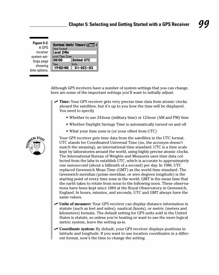
Although GPS receivers have a number of system settings that you can change,here are some of the important settings you’ll want to initially adjust:
� Time: Your GPS receiver gets very precise time data from atomic clocksaboard the satellites, but it’s up to you how the time will be displayed.You need to specify
• Whether to use 24-hour (military time) or 12-hour (AM and PM) time
• Whether Daylight Savings Time is automatically turned on and off
• What your time zone is (or your offset from UTC)
Your GPS receiver gets time data from the satellites in the UTC format.UTC stands for Coordinated Universal Time (no, the acronym doesn’tmatch the meaning), an international time standard. UTC is a time scalekept by laboratories around the world, using highly precise atomic clocks.The International Bureau of Weights and Measures uses time data col-lected from the labs to establish UTC, which is accurate to approximatelyone nanosecond (about a billionth of a second) per day. In 1986, UTCreplaced Greenwich Mean Time (GMT) as the world time standard. TheGreenwich meridian (prime meridian, or zero degrees longitude) is thestarting point of every time zone in the world. GMT is the mean time thatthe earth takes to rotate from noon to the following noon. These observa-tions have been kept since 1884 at the Royal Observatory in Greenwich,England. In hours, minutes, and seconds, UTC and GMT always have thesame values.
� Units of measure: Your GPS receiver can display distance information instatute (such as feet and miles), nautical (knots), or metric (meters andkilometers) formats. The default setting for GPS units sold in the UnitedStates is statute, so unless you’re boating or want to use the more logicalmetric system, leave the setting as-is.
� Coordinate system: By default, your GPS receiver displays positions inlatitude and longitude. If you want to use location coordinates in a differ-ent format, now’s the time to change the setting.
Figure 5-2:A GPS
receiversystem set-tings page
showingtime options.
99Chapter 5: Selecting and Getting Started with a GPS Receiver

� Datum: The default datum for all GPS receivers is WGS 84. Unless you’replanning on using your receiver with maps that have a different datum,leave the default setting. (See Chapter 4 for more information on typesof datums and their impact GPS position coordinates.)
� Battery type: The default battery setting on most GPS receivers is alka-line. If you’re using another type of battery, select the correct type. Thebattery type setting doesn’t affect the GPS receiver’s operation; it onlyensures that the battery life is correctly displayed on the screen becausedifferent types of batteries have different power characteristics.
� Language: Most GPS receivers are multilingual, so if you’d rather view theuser interface in a language other than English, it’s as simple as selectinga different language from a menu.
Using Your GPS ReceiverFinally! After you initialize your GPS receiver and change some of the systemsettings, it’s time to use it. Start with
� Going through the GPS receiver’s different onscreen pages and see whatinformation is displayed.
� Walking around and watching what happens to the numbers and yourposition on the GPS receiver’s mapping and trip pages. (Do this outside,of course.)
� Pressing buttons and seeing what happens. You may want to have youruser manual nearby in case you get lost between information screens.
GPS receivers are pretty robust, and you’re not going to hurt your new pur-chase by being curious.
GPS receiver screens can be scratched relatively easily. Investing in a carryingcase will keep the screen scratch-free; many cases have a clear plastic face thatallows you to use and view the GPS without taking it out of the case. Anotherway to keep the screen from being scratched is to buy thin, clear plastic sheetsused to protect PDA screens, cut them to shape, and place the sheet on topof the GPS receiver screen.
The following are some simple exercises you can try that will help you becomefamiliar with your GPS receiver. When you first start using your GPS receiver,take the user manual with you. If you forget how to do something or have aquestion, the manual will be right there for reference.
100 Part II: All About GPS

Coming homeEveryone has opinions and like to know where people stand on differentthings, so here’s an exercise to let you know exactly where you stand — when you’re outside your backdoor.
1. Take your GPS receiver outside where you live and create a waypointfor the spot where you’re standing.
See Chapter 4 for the skinny on creating waypoints.
2. Name the waypoint HOME.
3. Turn the GPS receiver off and go for a walk.
How far is up to you, but at least travel far enough that you can see yourstarting point.
4. When you’re ready to head back home, turn the GPS receiver back onand use it to navigate back to the HOME waypoint.
Be sure to move through the different onscreen pages to watch the direc-tion and distance change as you head back home.
After you enter the HOME waypoint, no matter where you are, if you haveyour GPS receiver with you, you can always tell exactly how far away homeis. Remember, this is in a straight line as the crow flies unless you’ve got aGPS receiver that supports autorouting.
How far, how fast?Your GPS receiver also contains a very accurate trip computer that displaysinformation about distance, speed, and time. After you read your user manualon how to reset and start the trip computer, here are some ideas for gettingfamiliar with how it works:
� When exercising: When you run, jog, bike, or whatever, take your GPSreceiver with you on your favorite course to see just how far you go. Atthe end, check your average and maximum speed. (Chapter 23 is filledwith tips on using GPS if you’re an athlete.)
� When on walks: If you have children and they walk to school, go withthem on their route to see exactly how far it is. (And then tell them youused to have to walk at least ten times that distance . . . in the snow . . .uphill both ways . . . when you were young.)
� When doing lawn work: The next time you cut the grass, take your GPSreceiver with you and see just how far you push your lawn mower.
101Chapter 5: Selecting and Getting Started with a GPS Receiver

Finding your ancestorsA lot of people are into genealogy these days, and your GPS receiver can be ahelpful tool in tracking your ancestors. When you visit a cemetery looking forlong-lost kin, bring your GPS receiver with you to record the exact locationsof tombstones and grave plots. You can pass the latitude and longitude on toother relatives doing their own genealogical research. The coordinates canbe extremely useful for someone locating a small out-of-the-way cemetery inthe countryside, or a relative buried in a cemetery with thousands of plots.
Simulating navigationSome GPS receivers have a simulator or demonstration mode. This is proba-bly one of the most overlooked (but coolest) features on a GPS receiver. Thesimulator mode acts as if the receiver is actually acquiring GPS satellite infor-mation. You select a speed and a direction, and the GPS receiver pretendsyou’re moving. Because the receiver isn’t relying on acquiring satellite data,you can comfortably sit inside the house in your favorite chair, getting famil-iar with your new purchase.
Depending on where you live or work, how many windows you have, andyour view of the sky, your GPS receiver might (might) work indoors (or atleast close to windows). Although you’re limited to what you can do with aGPS receiver indoors, it’s fun to see just how much GPS coverage you can getwalking around inside a building.
There are lots more things you can do with a GPS receiver besides using it forbasic navigation. Think outside the box. Some examples include
� Take digital pictures of cool places and record their coordinates with yourGPS receiver. You can post them on a Web site or e-mail them to friends.
� If you have a small GPS receiver (like a Garmin Geko), securely attach itto your dog’s collar and track where Fido goes for the day. (You can alsofind commercial GPS pet locator products on the market.)
� Use your track log to create art. Some GPS users express themselves asartists by using their GPS receiver to record their movements as they walkaround trying to create shapes or pictures. (Don’t believe me? Check outwww.gpsdrawing.com.)
Your goal should be to become confident using your GPS receiver and tohave fun in the process.
102 Part II: All About GPS

103Chapter 5: Selecting and Getting Started with a GPS Receiver
Virtual GPSLowrance (www.lowrance.com) has a uniqueseries of simulators for its sonar and GPS prod-ucts that run on your computer. Just downloadand run a program from the Internet, and a life-like replica of the product appears onscreen.The GPS receiver simulators don’t actually tracksatellites, but other than that, work just like thereal thing. Use your mouse to click buttons, andthe keyboard arrow and Enter keys to selectmenu items and change settings.
Although Lowrance designed the simulators as away for potential customers to become familiarwith their products (and for owners to practicewith them), GPS receiver simulators are an excel-lent way to find out about concepts and functionsthat are common to all GPS receivers, no matter
what the brand or model. The user interface andfeatures vary between brands and models, butkey GPS receiver concepts such as datums,coordinate systems, waypoints, routes, and tracksremain the same. The Lowrance simulator, shownin the figure here, lets you come up to speed onbasic GPS receiver operations without evenowning a receiver; plus it’s fun to play with. (If youdownload a simulator, get a copy of the real prod-uct’s user manual so you can understand and tryall the features. These can be downloaded fromthe Lowrance site as well.)
To download Lowrance simulators, go to www.lowrance.com/software/pcsoftware/demos.asp.

104 Part II: All About GPS

Chapter 6
Using GPS with a PDAIn This Chapter� Discovering the different types of PDA GPS systems
� Understanding the advantages and disadvantages to using PDAs
� Interfacing GPS receivers to PDAs
� Selecting GPS mapping software for your PDA
Personal digital assistants (PDAs), such as a Pocket PC or Palm, are apopular way of accessing GPS information. The PDA processes satellite
data from a GPS receiver and then displays your current location in a map-ping program.
You can use many different types of GPS receivers with PDAs, including hand-held, mouse, wireless, and card. This chapter helps you navigate through thePDA/GPS maze by reviewing the different hardware and software options andcomparing common, handheld GPS receivers (such as those discussed inChapter 5) with PDAs that use GPS. I start things off by discussing some ofthe advantages and disadvantages of PDA-based navigation systems.
Choosing between a GPS Receiver and a PDA
You might wonder why anyone would you want to use a PDA instead of ahandheld, consumer GPS receiver. That’s a very good question; you gadgetjunkies out there who have your hands raised and are answering, “Becauseit’s cool,” please put your hands down and continue reading.
You’ll find compelling advantages and disadvantages to using a PDA with GPSthat are based on your intended use and needs. To see whether you shouldeven be considering a PDA navigation system, review some of the pros andcons right from the start.
PDA advantagesAside from being cool, a PDA might make sense for you as part of a personalnavigation system for a number of reasons. Some of the advantages include
� Larger screens: PDAs have larger, higher-resolution, color screens com-pared with handheld GPS receivers. This is a big plus if your eyesight isn’tas good as it used to be — and it’s really important if you’re using thePDA while driving. You want to be able to quickly glance at a map on thescreen, determine your location, and then get your eyes back on the road.
� More maps: Most of the maps that you can upload to GPS receivers don’thave a lot of detail; especially the topographic maps. These maps tendto be vector line maps and don’t have the resolution or detail found onpaper maps that you’d use for hiking. Several mapping programs are avail-able for PDAs that support all types of maps, and you can even createyour own custom maps. With a PDA, you can use more detailed maps, likescanned, color 1:24,000 topographic maps. Bonus: You’re not locked in tousing only a GPS receiver manufacturer’s proprietary software and maps.
� Expandable memory: Unlike many GPS receivers, which have fixedamounts of memory, most PDAs support expandable memory with plug-in memory cards. The only limitation to the number of the mapsand amount of data that you can store is the size of the memory card.
� Usability: Although handheld GPS receivers are fairly easy to use, theuser interfaces found on PDAs are even simpler. Using a touch screenand stylus to enter data and commands is a lot faster and easier thanusing the buttons on a handheld GPS receiver.
� Custom programs: Developers can easily write custom programs forPDAs that access the data output from a GPS receiver. If you’re collect-ing information that’s based on location data, this can make your jobmuch easier than pressing buttons on a GPS receiver and then hand-writing remarks in a field notebook.
� PDA features: PDAs have all sorts of useful programs such as addressbooks, contact lists, and databases designed for readily storing data. A fair amount of this information tends to be location based (likeaddresses), and having a single information/navigation device is thedefinition of practical.
PDA disadvantagesAfter reading through advantages of using a PDA as your navigation system ofchoice, you’re probably sold on a using a PDA. However, they definitely aren’tfor everyone. Some of downsides include
106 Part II: All About GPS

� Ruggedness: Handheld GPS receivers are designed to take more abusethan PDAs, which often fail when they’re dropped or knocked around.Although you can buy ruggedized (with special enclosures that makethem waterproof, drop-proof, bear-proof, and kid-proof) PDAs, they’reconsiderably more expensive than off-the-shelf models; expect to spendat least several hundred dollars more.
� Weather/water resistance: Unlike GPS receivers, PDAs aren’t designedto be waterproof or even weatherproof. This can be a major issue if youplan on using your PDA navigation system outdoors in damp, rainy, orsnowy weather, you’re around water, or you have a leaky water bottle inyour backpack.
� Power considerations: Most PDAs use internal batteries that arerecharged through a docking cradle. If you’re away from a power source,this can be a serious issue because you can’t swap out dead or dyingbatteries for a convenient set of spare AA or AAA batteries like you canwith a handheld GPS receiver.
When it comes to weighing the pros and cons of PDA navigation systems, youreally have to examine your needs and planned use. If you plan on using aGPS receiver exclusively for road navigation, you should definitely consider aPDA. However if you’re going to be using GPS primarily in an outdoor setting,you’re probably better off with a handheld GPS receiver.
107Chapter 6: Using GPS with a PDA
OtterBoxesAlthough PDAs are relatively fragile and don’tget along well with water, you can find productson the market to protect them when exposed toharsh environments. Among my favorites areOtterBox cases. For a well-spent $20–25 for thelower-end models, these plastic containersdefend a PDA or other electronic devices fromMother Nature as well as not-too-carefulowners.
OtterBox has two products that let you operate aPDA (including using its stylus) while encased ina waterproof and crushproof housing. One model,the Armor 3600 shown in the figure here, has awaterproof portal that allows you to connect thePDA to an external GPS receiver with a serialcable. There are also accessories that accom-modate the oversize external antennas of GPS
receiver cards and sleeves. Tests performed bythe U.S. Forest Service indicated no satellitesignal degradation when GPS receivers wereused in the Armor cases.
The Armor series of cases do add bulk to the sizeof your PDA. However, considering the protectionthat they offer, the rugged cases are well suitedfor anyone who wants to venture out into thewilds and use a PDA without worrying about itbreaking. A 3600 Armor model will set you backabout $100; OtterBox also has other Armor casesfrom $20–50.
I like to think of the OtterBox Armor products asaccessories that turn your meek and mild PDAinto a tough and rugged Humvee. To find out moreabout the products, check out www.otterbox.com.

If you’re leaning toward a PDA navigation system (or already have one) andwant to operate it out in the elements, at least buy an OtterBox or some typeof protective bag. See the sidebar, “OtterBoxes.” (I also like the Voyageurwaterproof and padded bags, see http://voyageur-gear.com for productdetails.) I guarantee that your repair and replacement bills will be consider-ably less compared with stowing your PDA in a jacket pocket.
Interfacing Your PDA to a GPS ReceiverIf you’ve decided that a PDA navigation system meets your needs (or maybeyou just love cool high-tech toys), the first step is to decide how you’re goingto use to get GPS data into your PDA. Options for doing so include
� Handheld GPS receivers connected to the PDA with a serial (or USB)cable.
� Mouse GPS receivers (a GPS receiver with no display screen and a serialor USB cable).
� GPS receivers built into PC or memory cards.
� GPS receiver sleeves (expansion devices that slide on the back of certainmodels of PDAs).
� Wireless GPS receivers that transmit data with Bluetooth radio signals.Read more about these in the upcoming section, “Bluetooth GPSreceivers.”
� Integrated GPS receivers built directly into a PDA.
I’m assuming you already have a PDA or are currently shopping for one andhave a pretty good idea what you’re going to buy. It’s outside the scope ofthis book to make suggestions on which PDA you should use. (Plus I’m notgoing to pick sides in the Palm versus Pocket PC brand-loyalty wars.) Justkeep in mind that most PDAs can be interfaced with a GPS receiver one wayor another.
Look at the types of GPS receivers you can use with a PDA. Most of the GPSreceivers designed for use with PDAs cost as much as low-end to mid-rangehandheld GPS receivers. Some also work with laptop computers, which pro-vide the ultimate big-screen GPS display.
Handheld GPS receiversIf your PDA has a serial port, you can easily interface the PDA to a general pur-pose, handheld GPS receiver. Most of the information on connecting a personalcomputer to a GPS receiver that I discuss in Chapter 9 also applies to PDAs.
108 Part II: All About GPS

Because you’re using the handheld GPS receiver exclusively as a data inputsource — and really don’t care about what’s appearing on its screen — justabout any GPS receiver that can communicate with a computer via a serialport will fit the bill. You don’t need a lot of features and whistles and bells onthe GPS receiver if you’re primarily using it this way. This option makes a lotof sense because the GPS receiver can be used independently of the PDA,especially outdoors during bad weather.
The primary disadvantage is that you have to contend with two electronicdevices and the cable that connects them together. This can sometimes get abit messy in a car, with hardware and power and interface cables scatteredall over your dashboard. Also, this type of PDA navigation setup is a bit cum-bersome to deal with if you’re walking around.
One of the best sources of GPS receiver interface cables for a wide variety of PDAs is Pc-Mobile. Check out its extensive product Web site at http://pc-mobile.net.
Mouse GPS receiversGPS receivers that don’t have a display screen but connect to a computer witha serial or USB cable are often called mouse receivers because of their resem-blance to a computer mouse. A mouse GPS receiver acts as an input devicefor a PDA or laptop and only sends satellite data that it’s currently receiving.
109Chapter 6: Using GPS with a PDA
GPS and cellphonesYou can’t talk about PDAs and GPS without men-tioning cellular phones, especially as featuresand functionality of the two electronic devicesstart to converge.
GPS will play a large role in the future of cell-phones. The U.S. government has mandatedthat calls placed by cellphones to 911 emergencyoperators must reveal where the call was made,just like landline telephones. This new programworks by either triangulating a mobile phone’sposition via cellular phone network antennatowers or with a GPS receiver built into the cell-phone that transmits its location.
In 2003, the first GPS-enabled cellular phonesstarted to appear on the U.S. market. Phones likethe Motorola i730, i88, and i58sr cell phones allhave GPS receivers built inside them and arecapable of broadcasting their location. Internetsites and tracking software are available that canprovide you with the location of a GPS-enabledphone that’s subscribed to a location reportingservice.
As GPS-enabled phones start to become morecommon, it’s only a matter of time before navi-gation and map programs start to appear on thephones, which will bring a whole new meaningto using your phone to get directions.

Mouse GPS receivers are about half the size of the smallest handheld GPSreceivers (Figure 6-1 shows the size differences between several GPS receivers),but even so still have good satellite reception with open skies. Another advan-tage to a mouse GPS receiver is you can place it in an optimal spot on yourcar’s dashboard for satellite reception and then mount the PDA in the mostvisible place for driving. Depending on the model and type, a mouse GPSreceiver can be powered by a cigarette lighter adapter, rechargeable batter-ies, or the device it’s plugged in to.
Although mouse GPS receivers are smaller than handheld GPS receivers, youstill face the cable clutter issue, plus you can’t use the mouse receiver to getsatellite data unless it’s connected to a PDA or laptop.
Some of the vendors of mouse GPS receivers (and their Web sites where youcan get product information) include
� DeLorme: www.delorme.com
� Haicom: www.haicom.com.tw
� Holux: www.holux.com
� Mapopolis: www.mapopolis.com
GPS receiver cardsSome GPS receivers take the form of a card that you can plug into a PDAexpansion slot. The two types of GPS receiver cards are
� Memory cards: Most PDAs have a memory card slot that supports aCompact Flash (CF) or Secure Digital (SD) type of memory card. Both ofthese card formats also support hardware devices that can be embed-ded into the card: in this case, a GPS receiver. (PDAs without internalmemory card slots might have optional expansion packs that plug intothe PDA and provide a memory card slot.)
� PC Cards: A PC Card (also called a PCMCIA card) is a hardware expansioncard designed for laptops. PC Card devices include hard drives, modems,and GPS receivers. These receiver cards are mostly used with laptops,but some PDAs support expansion packs for using PC Card devices.
Using a GPS receiver card with your PDA means that you don’t need to worryabout an external GPS receiver or cables. You just plug the card into a slot, andthe GPS receiver starts accessing satellite data. However, note these drawbacks:
� Slot competition: CF and SD memory cards that function as GPS receiverstake up the expansion slot that’s used for additional PDA memory.
� Battery hogs: GPS receiver cards quickly run down your PDA’s battery ifyou’re not connected to an external power source.
110 Part II: All About GPS

Some of the main GPS receiver card manufacturers (and their Web sites) are
� Deluo: www.deluo.com
� Fortuna: www.fortuna.com.tw
� Haicom: www.haicom.com.tw
� Holux: www.holux.com
� Pharos: www.pharos.com
GPS receiver sleevesCertain models of iPAQ Pocket PCs and Palm OS PDAs have a proprietaryexpansion slot into which you can plug hardware devices. These add-onpieces of hardware are often called sleeves because they fit around the PDA.See a GPS receiver sleeve in Figure 6-2.
The same advantages and disadvantages found with GPS receiver cards(they’re convenient but can run down the PDA’s battery quickly) also applyto GPS sleeves. Additionally, a sleeve adds a lot of bulk to the size of a nor-mally slim PDA.
The main producer of Pocket PC and Palm sleeves is Navman. Expect tospend around $200–$250 for a GPS sleeve. Find more about these products at www.navman.com.
EarthproGPS
Figure 6-1:A mouse
GPSreceiver, on
the left, is smaller
than hand-held GPS
receivers.
111Chapter 6: Using GPS with a PDA

Bluetooth GPS receiversIf your PDA supports Bluetooth (a wireless communication standard; www.bluetooth.com), you have yet another GPS receiver option. Bluetooth GPSreceivers are pretty slick because they don’t
� Rely on the PDA’s batteries for power
They have their own power source and will run from 6–10 hours whenfully charged, depending on the model.
� Use up one of the PDA’s expansion slots
� Need cables that can get all tangled up
Bluetooth devices have about a 30-foot range, and the GPS receiver canbe placed in an optimal position on the dashboard to receive satellitesignals.
Just place your Bluetooth GPS receiver (about the size of a mouse GPSreceiver) anywhere with an open view of the sky, and it will broadcast GPSdata to your Bluetooth-enabled PDA. (If you have an older PDA that doesn’tsupport Bluetooth, there are Bluetooth receivers that plug into your PDA’smemory card slot.)
Many of the companies that manufacture GPS receiver cards, listed previ-ously, also make Bluetooth GPS receivers. Some other companies that offerBluetooth receivers include
Figure 6-2:A Navman
GPSreceiver
sleeve thatslides on tothe back of
a PDA.
112 Part II: All About GPS

� ALK Technologies: www.alk.com
� DeLorme: www.delorme.com
� EMTAC: www.emtac.com
For outdoor use, you can easily mount your Bluetooth GPS receiver on a highspot, such as on top of a pack (or some other location that’s in an optimal posi-tion to receive satellite signals) and wirelessly record GPS data with your PDA.OtterBox also makes waterproof cases for Bluetooth GPS receivers that don’tdegrade the transmitted radio signals so you can create a rugged wireless PDAnavigation system for use in harsh conditions. (See the sidebar, “OtterBoxes.”)
For an extensive list of the GPS receiver devices available for Pocket PC PDAs,including reviews and detailed specifications, check out www.gpspassion.com/en/hardware/gpslist.htm.
GPS-integrated PDAsThe most expensive option when creating a PDA navigation system is to pur-chase a PDA that comes with a built-in GPS receiver. In 2003, Garmin intro-duced the iQue 3600, a PDA that runs the Palm OS and features an integratedGPS receiver.
The iQue 3600 looks like a normal PDA but has a flip-up, adjustable antennathat pops out of the top. It has extensive mapping capabilities, including turn-by-turn voice directions and integration with the calendar and address bookprograms in which you can click an address and get instant directions. Formore information about the iQue 3600, visit www.garmin.com.
If the iQue becomes popular, look for other integrated GPS PDAs to bereleased by Garmin and other manufacturers in the future; especially as GPSreceiver components become smaller and cheaper. As this book went topress, Taiwanese manufacturer MiTAC announced the Mio 168, an integratedGPS/Pocket PC.
Reviewing PDA Mapping SoftwareIf you buy a GPS receiver specifically designed for PDA use, it will probablycome bundled with mapping software that includes map data and a programthat displays the maps and interfaces with the GPS receiver.
In addition to the program that runs on your PDA is a program that runs onyour PC; this program installs the maps on your PDA and can be used forroute planning. You select the maps that you want to install on your PC and
113Chapter 6: Using GPS with a PDA

then upload the selected map data to your PDA. Because the maps are typi-cally stored in the PDA’s memory card, the more memory you have, the moremaps you’ll be able to use.
Most PDA navigation software is designed for street navigation (see Figure 6-3for screenshot of a typical PDA street map program), and has features for get-ting around on roads and highways, including
� Autorouting: By inputting starting- and ending-point addresses, the mapprogram creates a route for you to follow to reach your destination. (Youusually can choose between fastest or shortest routes.) The route is out-lined on the map, and the program also provides turn-by-turn directionsto get to your destination.
� POI data: In addition to maps, most programs have extensive databasesof POIs (Points of Interest) information, including gas stations, restau-rants, shopping locations, and other useful travel data. POIs appear asicons on the map that you can click to get more information. You canalso search for specific POIs by geographic location.
� Real-time tracking: When your PDA is connected to a GPS receiver, anarrow moves on the screen, giving you real-time information about yourcurrent position as well as displaying where you’ve been.
� Voice prompts: In addition to displaying turn-by-turn directions on thescreen, many programs provide voice prompts that tell you when tomake turns to reach your final destination. This is a nice safety featurebecause you can pay more attention to the road and less attention to thePDA screen.
Figure 6-3:Map dis-play fromTeleType
GPS PocketPC software.
114 Part II: All About GPS

A number of PDA mapping programs are on the market, and I could easilydevote an entire book to discussing them all. Because this chapter providesonly a general review of using PDAs with GPS, Table 6-1 lists of some of themore popular PDA mapping programs; including which types of PDAs theywork with and a Web site address to get more product information. Most ofthese programs are sold individually or might come bundled with a GPSreceiver. Expect to pay anywhere between $40–$150 for a software package.
Table 6-1 Popular PDA Mapping ProgramsProgram Pocket PC Palm Web Site
DeLorme Street Atlas X X www.delorme.comUSA Handheld
Destinator X www.destinator1.com
Intellinav X www.intellinav.com
Mapopolis Navigator X X www.mapopolis.com
Microsoft Pocket Streets X www.microsoft.com
Quo Vadis X www.marcosoft.com
TeleType X www.teletype.com
TomTom Navigator X www.tomtom.com
One of the challenges in using a PDA in a car is dealing with the stylus. It can bequite a coordination test holding the stylus in your hand, tapping commandson the PDA with it, and driving at the same time. One slick solution is theStinger Stylus, which is a cross between a plastic ring and an artificial finger-nail. Just slip the Stinger over your finger, and your fingertip takes the place ofa stylus. For more information on the Stinger, go to www.stingerstylus.com.
Most of the software and maps that come bundled with the PDA GPS receiversare designed for road navigation. But what if you want to display topographicor nautical charts on your PDA or use real-time GPS tracking off the road?
You’re in luck because several PDA programs fill this need. Topographic mapdisplay is one area that PDA mapping software far exceeds handheld mappingGPS receivers. Your PDA can display full-color, detailed 1:24,000 scale mapsthat look exactly like the USGS paper versions. Compared with the 1:100,000scale vector maps typically used on mapping GPS receivers, there’s no com-parison when it comes to the amount of map detail that a PDA can display.
115Chapter 6: Using GPS with a PDA

If your journeys take you off the beaten path, here are four products youshould be aware of:
� FUGAWI: FUGAWI was one of the first Windows desktop mapping pro-grams and now works with Pocket PCs and Palms. The product comesbundled with U.S. street maps and nautical charts, or you can importmaps of your own, such as USGS Digital Raster Graphics topographicmaps. For additional product details, go to www.fugawi.com.
� Maptech Outdoor Navigator: The Maptech Outdoor Navigator is unique.Instead of being bundled with map data or requiring you to create yourown maps, (with purchase) you receive a year-long subscription todownload all the USGS topographic maps and NOAA nautical charts thatyou want from Maptech’s Internet servers. Nice. Versions of OutdoorNavigator are available for Pocket PCs and Palms. You can find moreabout the product at www.maptech.com.
� SkyEye: This is a slick shareware Pocket PC program that displays aerialphotographs and topographic maps that you can download from theInternet or create on your own. The program also interfaces with GarminGPS receivers to provide real-time mapping capabilities. For more aboutSkyEye’s features, visit www.etree.com/tech/notsofreestuff/skyeye/index.html.
� TeleType GPS: Although originally designed for street navigation,TeleType’s PDA mapping program supports importing aerial pho-tographs and digital maps from the TerraServer-USA Web site. For more information on the software, visit www.teletype.com.
� OziExplorerCE: OziExplorerCE is a Pocket PC version of the popularOziExplorer mapping program. The CE version allows you to importmaps that you’ve created with OziExplorer on your PC to your PDA. Seea review of the PC version OziExplorer in Chapter 15. For more informa-tion on the CE edition, go to www.oziexplorer.com.
Here are several excellent Internet resources that can provide you with moreinformation:
� Dale DePriest’s Navigation and GPS Articles: Dale DePriest is a longtimecontributor to the sci.geo.satellite-nav USENET newsgroup and thecomprehensive gpsinformation.net Web site. He has a considerableamount of practical information on using Palms, Pocket PCs, and GPS atwww.gpsinformation.org/dale.
� Pocket GPS World: Check out this European Web site for news, informa-tion, and forums devoted to mobile GPS products. The site has an exten-sive review section of PDA GPS receivers and is located at www.pocketgpsworld.com.
� GpsPasSion: This European site is devoted to Pocket PCs and GPS with forums, links, news, and more. To visit the site, go to www.gpspassion.com.
116 Part II: All About GPS

Chapter 7
GeocachingIn This Chapter� Understanding geocaching
� Finding out what you need to geocache
� Selecting a cache to look for
� Locating a cache
� Creating your own cache
� Discovering Internet geocaching resources
Probably the fastest way for you to get real-world experience with yourGPS unit is by going geocaching. This new, high-tech sport gets you out
of the house and into the fresh air as you use both the computer in your GPSunit and also the one in your head to find hidden treasure. Geocaching is afun and challenging activity that combines modern technologies like GPS andthe Internet, with primitive outdoor navigation and search skills that peoplehave been using for thousands of years. The sport also gives you a goodreason to visit places you’ve never been.
Geocaching is pronounced GEE-oh-cash-ing. Don’t pronounce cache as ca-shay, even if you’re French. Unless you want funny looks, stick with cash.
Geocaching: The High-Tech Scavenger Hunt
When the U.S. government turned off GPS Selective Availability (SA) in May2000, it was like magic. Suddenly civilian GPS receivers that were formerly

accurate to about 300 feet were accurate to 30 feet. This level of accuracyoffered some creative possibilities. Three days after SA was turned off, thefollowing message appeared in the sci.geo.satellite-nav USENET newsgroup:
From: Dave ([email protected])Subject: GPS Stash Hunt... Stash #1 is there!Newsgroups: sci.geo.satellite-navDate: 2000/05/03
Well, I did it, created the first stash hunt stash and hereare the coordinates:
N 45 17-460W122 24.800
Lots of goodies for the finders. Look for a black plasticbucket buried most of the way in the ground. Takesome stuff, leave some stuff! Record it all in thelog book. Have Fun!
Stash contains: DeLorme Topo USA software, videos, books,food, money, and a slingshot!
Earlier that day, in the same newsgroup, Dave Ulmer had proposed a world-wide stash hunt, where people would post GPS waypoints on the Internet tolead searchers to hidden goodies. While Ulmer envisioned thousands ofstashes tucked in places all over the world, he had no idea how popular hisidea would become.
Starting with a humble little bucket full of goodies in Oregon, Ulmer’s idea tookoff like wildfire. Within weeks, caches were hidden in Washington, Kansas,California, New Zealand, Australia, and Chile. A newsgroup and Web site thathosted the coordinates of the stashes soon popped up as the word started toget around.
118 Part II: All About GPS
The original caches: letterboxesThe whole geocaching concept isn’t that new.Over 100 years ago, something similar developedin England: letterboxing. Letterboxing comprisesplacing a blank logbook and a custom-maderubber stamp in a waterproof container andthen hiding it. Clues are distributed with thecontainer’s location, and searchers armed withinkpads and notebooks try to find the hidden box.If they are successful, they stamp the logbook
in the box with their own personal rubber stampand also stamp their logbook with the box’sstamp. This low-tech version of geocaching is stillvery popular. Depending on whom you talk to,10,000–40,000 letterboxes are hidden in England,and around 5,000 are lurking in the United States.Read more about letterboxing at www.letterboxing.org.

By the end of May, in a Yahoo! Group devoted to the new sport, member MattStum suggested that the sport be called geocaching in order to avoid some ofthe negative connotations associated with drugs and word stash. (A cache is ahidden place where goods or valuables are concealed.) Geocaching had a nicering to it, and it didn’t sound like a bad Cheech and Chong movie.
Today, geocaching has grown popular, and the rules are still pretty much thesame: Take some stuff, leave some stuff, record it in the logbook, and have fun!Relatively cheap and accurate GPS receivers and widespread Internet accesshave helped the sport flourish. As of November 2003, the www.geocaching.com site (currently the largest geocaching site on the Net) had over 72,500active caches in 188 countries listed in its database. That’s a lot of caches outthere to find! (Figure 7-1 shows a typical cache.)
Getting Started GeocachingJust about anyone can participate in geocaching; gender, age, and economicstatus don’t much matter. The main requirements are a spirit of adventure, alove of puzzles and mysteries, and a sense of fun. This section discusses whatyou need to geocache, how to select caches to look for, and how to find them.
What you need to geocacheGeocaching sounds pretty intriguing, doesn’t it? But before you can try it out,you need a few things. You probably already have many pieces of the required
OFFICIALGEOCACHE
PLEASE DO NOT DISTURB!
Cache Name:
Figure 7-1:Geocaches
hold alogbook and
goodies.
119Chapter 7: Geocaching

gear, and your biggest investment will be a GPS receiver if you don’t alreadyhave one. (Read Chapter 5 for the lowdown on selecting a receiver.) With thatin mind, here’s a list of basic things you need.
I start off with the technology-related items:
� Cache location: Obviously, you need to know where to look for a cache:a set of latitude and longitude or UTM (Universal Transverse Mercator)coordinates. You’ll find tens of thousands of caches freely listed on theInternet. For information on locating a geocache, see the appropriatelynamed section, “Selecting a cache to look for,” later in this chapter.
� Geocaching alias: Most people who geocache use a registered handle(alias) instead of their real name when they sign cache logs or makeInternet posts. The aliases are cool-sounding names like Navdog, WileyCacher, or Moun10Bike. Be imaginative and come up with an alias thatfits your personality. The aliases are all unique: If you try to register analias on one of the popular geocaching Web sites and someone elsealready has registered the alias, you need to select another name.
� GPS receiver: You can certainly find caches by using only a map andcompass (my adventure racing team does this to practice our navigationskills), but it’s sure a lot easier when using a GPS receiver. You don’t needan expensive GPS unit with lots of whistles and bells to geocache; a basicmodel around or under $100 will work just fine; receivers that supportWAAS (Wide Area Augmentation Service, as described in Chapter 3) usu-ally are more accurate than those that don’t.
Don’t forget to bring the GPS receiver user manual, especially if you justpurchased your receiver and are still trying to figure out how to use it.
A few other things can make your outing a little more enjoyable:
� Map and compass: A fair number of geocachers use only their GPSreceiver to get them to a cache, but a good local map of the area can be very helpful. Although a receiver can lead you directly in a straightline to cache, it’s probably not going to tell you about the river, deepcanyon, or cliffs between you and the cache. Even GPS receivers thatdisplay topographic maps often won’t show enough detail that can helpor hinder you on your way to a cache. Additionally, a map and compassserve as a backup just in case something goes wrong with your GPS.(Just make sure you know how to use them.)
� Pen or pencil and paper: Carry a small pad of paper and a pen or pencilfor taking notes about your route or things that you see on the way. Somegeocachers keep an ongoing journal of their adventures, and you neverknow — you might turn into a geocaching Hemingway.
� Something to leave in the cache: When you locate a cache, you’ll find allsorts of swags, which are treasures other people have left. Don’t expectdiamonds, gold bullion, or Super Bowl tickets, though. (You’re far morelikely to find baseball cards, costume jewelry, or corporate marketing
120 Part II: All About GPS

giveaways.) Just remember that one man’s trash is another man’s trea-sure. The best things to leave in a cache are unique, out-of-the-ordinaryitems (such as foreign coins, fossils, exotic matchbooks, or anything thathas a high cool factor). And, please, avoid leaving McToys, geocachinglingo for junk that you reasonably expect to find with fast-food kid’s meals.For more of the lingo, check out the section, “GeoJargon: Speaking thelingo,” later in this chapter.
� Appropriate clothes and footwear: There are no geocaching fashionpolice, so wear clothes that are comfortable, weather appropriate, andsuitable for getting dirty. Even if it’s the middle of summer, it’s not a bad idea to bring along a jacket in case of an unexpected rain shower or drop in the temperature. Also, make sure you’re wearing sturdy andcomfortable footwear if the cache is outside an urban area. High heelsand wingtip loafers generally aren’t recommended.
� Food and water: Some caches take all day to find, so be prepared withenough food and water to get you through your search; you can evenplan a picnic lunch or dinner around your outing.
� Walking stick/trekking poles: If the terrain is really rough, a good walk-ing stick or set of trekking poles can make life much easier when goingdownhill and negotiating uneven surfaces. A stick or a pole is also usefulfor poking around in rock cracks looking for a cache, just in case there’sa creepy-crawly inside.
� Digital camera: Although definitely not a required piece of geocachinggear, a number of cachers tote along a digital camera to record theiradventures or to post pictures on the Web.
� Small pack: It’s much easier to put all your geocaching gear in a smalldaypack rather than stuffing your pockets full of stuff.
Don’t forget a few safety-related items. As the Boy Scouts say, be prepared:
� Flashlight: This is a must-have for looking in cracks and crevices wherea cache might be hidden — and also in case you run out of daylight. Ifyou’re smart, your flashlight uses the same type of batteries as your GPSreceiver, giving you even more spare batteries.
� Cellphone: You probably have a cellphone, so bring it along (preferablywith the battery fully charged). Just a note of advice, from my searchand rescue experiences: I’ve found at times that people think of theircellphones as an absolute insurance policy against trouble. They canfail, cellphone batteries go dead, and you might have really bad cell coverage out in the middle of nowhere. So although a cellphone is greatto have along, be prepared to take care of yourself!
� Spare batteries: I always bring along spare batteries for anything thatuses them. (In this case, that means your GPS receiver and flashlight —and if you’re really safety conscious, your cellphone, too.)
121Chapter 7: Geocaching

That’s the basic gear you need for geocaching. The whole key with gear listsis to find out what works best for you. You’ll probably end up carrying toomuch stuff in your pack at first. After you’ve geocached for a while, checkyour pack and see what you’re not using so you can lighten your load.
Most geocaches are located in pretty tame, civilized areas (usually 100 feet orso off a main trail or road), but I advise letting someone know where you’regoing, when you’ll be back, and what to do if you’re late. Twisted ankles andbroken-down cars seem to happen a lot in areas without cellphone service. If you haven’t spent much time in the great outdoors, check out a list of TheTen Essentials (which has been expanded to 14 over the years) at www.backpacking.net/ten-essl.html.
Selecting a cache to look forAfter you get all your gear together, ready to venture out into the wilds, comesthis one small detail: How do you know where to look for a geocache?
Like most other modern-day searches for information, start with the Internet.Many Web sites have listings of geocaching caches. I list some of the bestInternet resources in the upcoming section, “Internet Geocaching Resources.”
Geocaching.com (www.geocaching.com) is currently the most widely usedsite and has the largest database of geocaches all over the world; most of theinformation in this chapter is orientated toward that site. However, if you useanother geocaching Web site, you’ll find most of the same general techniquesdescribed here for selecting a cache also apply to other sites.
You can set up a free user account on Geocaching.com to log caches that youfind, as well as to be informed of new caches that are placed in your area.Anyone with Internet access can freely view the cache locations without anaccount. Site owner Jeremy Irish also has Premium Member subscriptionservices ($30 per year) and sells products to help keep the site running.
To start, go to www.geocaching.com. Finding caches is as simple as enteringthe ZIP code for where you’re interested in geocaching. You can also searchfor caches by state, city, country, latitude, longitude, or by street address(only in the United States). The basic search screen is shown in Figure 7-2.
After you enter where you’d like to search for caches, a list of geocaches inthat area is displayed (see Figure 7-3). The list is sorted by how far away thecache is from the search criteria you entered; the closest geocaches are dis-played first. The name and type of the cache is shown, when it was first placed,when it was found last, and how difficult the cache is to get to and find. Youcan scroll through the list of geocaches until you find one that looks interest-ing. Cache names that are lined out are no longer active.
122 Part II: All About GPS

Figure 7-3:Geocaches
are listed byclosest first.
Figure 7-2:Just enter
your ZIPcode to
get startedgeocaching.
123Chapter 7: Geocaching

Just click the name of a cache displayed in the list about which you want moreinformation to see a page with the following information. (Cache details dis-played on the page are shown in the upcoming Figures 7-4 and 7-5.)
� Cache name: The name of the cache (usually the cache name has some-thing to do with the area where it’s hidden, who hid it, or a play onwords). Bonus: If you hide a cache, you get to name it.
� Who placed the cache: This is usually a cacher’s alias.
� Cache type: Caches can be traditional (a single container), multicaches(where clues in a single cache point to one or more other caches), orvirtual caches (a cool location that doesn’t have a container).
� Cache coordinates: These record where the cache is located in latitudeand longitude and UTM coordinates; these coordinates use the WGS 84datum, so be sure your GPS receiver is set to this datum.
� When the cache was hidden: The date the cache was originally placed.
� Cache waypoint name: All caches in the Geocaching.com database havea unique name: for example, GC followed by the numeric order the cachewas added to the database. You can use this to name a GPS waypoint forthe cache location.
� Difficulty: The difficulty rating is how hard the cache placer thinks thecache will be to find; 1 is easiest, and 5 is the most difficult. Whoeverplaces the cache decides the difficulty level, based on some general criteria, such as how steep or rocky the terrain is or if you have to gothrough very much underbrush to reach the cache.
� Terrain: The terrain rating is how difficult the terrain is. 1 is flat, easy,and level; 5 could be very steep and rocky with lots of underbrush andgenerally miserable travel conditions. Like with the difficulty rating, it’sup to the cache placer to rate the terrain.
� General description of the cache: Cache descriptions range from acouple of sentences to stories and history lessons about the location.Clues often appear in the description, so check it closely.
� Map location of the cache: At the top of the page is a small state mapfrom which you can take a general idea of where the cache is. A largermap with more detail appears at the bottom of the page. You can clickthe larger map and go to the MapQuest Web site, where you can zoom inon the cache site.
� Hints: The cache placer can optionally add hints to help a geocachernarrow his search. The hints are in code; I discuss these in the following“Finding the cache” section.
� Logged visits: This is a list of all the comments about the cache frompeople who have visited it and then logged Web site comments.
124 Part II: All About GPS

Some of these logged visit comments may contain spoilers, which are hintsthat may make it easier to find the cache. Although most cachers try not tospoil the fun for others, sometimes a clue accidentally appears.
Before heading out to search for a cache, check the last time someone foundit. Although Geocaching.com tries to keep track of inactive caches, sometimescaches that have been stolen or kidnapped by space aliens slip through thecracks. If you’re just getting started geocaching, go after caches that havehad some recent activity. This increases the odds that they’ll still be hidingwhere they’re supposed to be when you go looking for them.
Finding the cacheAfter you select a cache you want to search for, the next step is finding it.This might be a little bit more challenging than you think. Remember thatyour GPS receiver will only get you within 10–30 feet of the cache location —perhaps even farther away if you have poor satellite coverage or the cachehider’s coordinates are a little off. After your GPS unit gets you to the generalvicinity of the cache, start using your eyes and your brain, which at timesmight be more reliable than your GPS receiver.
Figure 7-4:Information
about acache
includes itsname, itslocation,
and adescription.
125Chapter 7: Geocaching

Sometimes a series of caches are located close together, usually separated byat least a tenth of a mile. Because you’re already in the neighborhood, con-sider trying to find several instead of going for just a single cache. Check outthe link on the cache description page that displays all the nearby cachesand how far away they are from each other.
Finding a cache boils down to following these general steps:
1. Enter the cache coordinates in your GPS receiver as a waypoint andthen add a name for the waypoint on your GPS receiver.
The methodology for entering waypoints differs from model to model.Check your user manual for specific instructions about how to enter andname a waypoint on your GPS model. Read more about this in Chapter 4.
You can use the six-character waypoint name on the cache descriptionWeb page for the name of the waypoint. Double-check that you’ve enteredthe correct coordinates. Many caches haven’t been found on the first trybecause of an typo in the coordinates in a GPS unit.
If you have an account on Geocaching.com, you can download the cachewaypoint to your computer from a link on the cache description pageand then upload the waypoint directly to your GPS receiver. Doing sohelps to eliminate errors caused by typos in GPS coordinates.
2. Print a copy of the cache description Web page so you can bring allthe information you need to find the cache with you.
If your printer is out of ink or you’re being frugal, scribble down thecoordinates and any other information that you think might be useful in locating the cache.
3. Gather your equipment, including your GPS receiver, map, compass,food, water, and other essential items mentioned in this chapter.
4. Head out to the cache’s starting point.
Drive or bike as close to the cache as you can get. Sometimes the cachedescriptions give you exact instructions, like at which parking lot ortrailhead to start from. The more challenging caches give you only thecoordinates, and it’s up to you to decide where you’ll start from and howyou’ll get there. One of the pleasures of geocaching is it’s usually not atimed event (although a few timed competitions are starting to crop up),and you can take as long as you want to reach the cache site, stoppingto smell the roses and enjoy interesting sights.
5. Turn on your GPS receiver and get a satellite lock.
Hopefully! If not, you brought that map and compass, right?
126 Part II: All About GPS

6. Save a waypoint for your starting point.
Getting back to your car can sometimes be a challenge after finding acache, and saving a waypoint with your car’s location can make lifemuch easier (and get you home in time for dinner). Your GPS manualcontains details for setting a waypoint for your particular model.
7. Double-check to make sure that you have the coordinates, cachedescription, hints, and the rest of your geocaching equipment in yourpossession. (Keeping it all together in a backpack is convenient.)
From personal experience, I can tell you it’s never any fun arriving at thecache and remembering that I left vital clues in the cache descriptionthat’s now a couple of miles away in the car.
8. Activate the cache’s waypoint.
Activating a waypoint tells the receiver to calculate the distance anddirection from your current spot to the waypoint’s location. Your GPSunit will let you know how far away the cache is and what direction youneed to head to get there. (This often is as simple as pressing a buttonon the GPS receiver and selecting the waypoint you want to go to.)
9. Follow the direction arrow, road map display, or compass ring onyour GPS receiver toward the cache.
A local map can come in handy as you move toward the cache becauseyou can use it to figure out what the terrain is like and whether anyrivers, cliffs, or mountains lie between you and the cache. You can usesome of the online digital maps discussed in Chapter 19 for preplanningor print them out to use in the field.
Don’t feel compelled to always head in the direction your GPS unit tellsyou to go. It might make more sense to walk around a pile of rocks ordowned trees than to go over the top of them. After you get around anobstacle, you can check your receiver again to get on the right course.
Watch your step! As you head toward the cache, don’t get so caught upin staring at your GPS receiver that you fall off a cliff or trip over a treeroot. And watch the scenery, too. Sometimes the journey is the reward.
10. When your receiver says you’re within 30 feet or so of the cache,move around and find the place that reports the closest distance tothe cache.
Begin your search at that spot. This is where the real fun starts. You nowshift from relying on technology to using your powers of observationand common sense. A cache could be inside a cave, tucked in a treehollow, hiding behind a rock outcropping, or concealed under a pile ofbrush. Some caches are easy to find, and others are devilishly difficult.
127Chapter 7: Geocaching
As you start looking around, you can do a few things to help improve yourodds of finding the cache:
� Find out the maximum distance to the cache. Check the EstimatedPosition Error (EPE) to see how accurate your GPS receiver currently is,based on the satellite coverage. Remember: The bigger the number, theless accuracy. This helps you roughly determine how large your searcharea is. For example, if the EPE is 20 feet, your search area is a circle witha 40-foot diameter, with the center at the closest location that you canget to the cache waypoint.
� Follow a magnetic compass. When you’re within 30 feet of the waypointand your GPS receiver is showing a consistent bearing to the cache (treecover and poor satellite coverage can cause the distance and directionnumbers to jump around), use a magnetic compass to guide yourself tothe cache. As you slow down, unless your receiver has an electronic com-pass, the direction that your receiver shows to the waypoint becomesless precise, and you can easily veer off-course. Handheld magnetic com-passes or electronic compasses built into the GPS unit don’t rely onsatellite signals, and won’t have this problem.
� Think about the container. Knowing what kind of container the cache isstored in can be a big help in identifying and eliminating possible hidingspots. Sometimes the cache description lists the container type (ammocan, plastic ware, bucket, or whatever), which can narrow your searchbased on the container size and shape. For example, you shouldn’t belooking for an ammo can in a three-inch-wide crack in a rock.
� Think about the terrain. Look at the surrounding environment to get ageneral idea of where a cache might be hidden. What natural (or man-made) features make a good hiding place? Remember, unlike pirate bootyhiding, geocaching has a rule against burying cache containers, so youshouldn’t be burrowing holes like a gopher.
128 Part II: All About GPS
Geocaching statsJust like any sport, geocaching has statistics(stats). In this case, stats refer to the number of caches that you’ve found and hidden. Whenyou sign up for a free or premium account atGeocaching.com, you can log the cachesyou’ve found as well as add caches that you’vehidden to the site’s extensive database. The Website tracks the finds and hides for you and dis-plays them on a user profile page. Other members
can check out your stats, and the number ofcaches that you’ve found appears next to youralias when you log your comments about a cacheyou’ve visited. Some geocachers are competi-tive and are in to racking up as many cachefinds as possible. Others are more blasé aboutthe whole numbers thing and could care less.Like so many other aspects of geocaching, it’sup to you how you want to play the game.
� Split up the work. If you’re geocaching with other folks, assign areas forpeople to check. Although you don’t need to precisely measure and grid-off squares, divvying up an area to search is faster and more efficientthan randomly wandering around.
� Think like a cache hider. If you were going to hide a cache, where wouldyou hide it? Sometimes trusting your intuition can be more effective thantrying to apply logic. After you check the ordinary places, start lookingin the unordinary spots.
There’s an old safety saying in wildland firefighting that goes, “Look up,look down, look all around.” The same advice applies to geocaching,which is an excellent way to improve your overall awareness and obser-vation skills.
Going in circlesThis will happen: You find the general cache location, but after a couple ofhours of wandering around in circles, you still can’t find the cache container.You’ve double-checked the coordinates, the satellite coverage is good, andyou’re starting to get a bit frustrated. Take a deep breath. Here’s what to do.
You can always resort to using a hint. Most cache description pages have ashort hint, but you have to work for it because it’s encoded. The reason for thespy stuff is so the hint doesn’t spoil the fun for another cacher who doesn’twant to use the hint as part of his search. Fortunately, the hint is encodedwith a simple substitution code (for example, A = M, B = N, C = O, and so on),so you don’t need to work for the NSA to be able to break it. The decodingkey is on the right side of the page, and it’s pretty easy to figure it out byhand. See Figure 7-5 for what a coded hint and decoding key look like.
One of the more challenging types of caches to find is a microcache. Insteadof using large containers, smaller ones — like small pill bottles, 35mm filmcanisters, or magnetic hide-a-keys — are used that only hold a piece of paperthat serves as the log. These caches are typically in urban areas and can becleverly hidden to avoid detection by nongeocachers passing by.
In addition to the hint, you can also look through the logged visit commentsthat other people have posted who have already found the cache. Althoughmost geocachers try to avoid including spoilers (way-too-obvious hints orcommentary) into their comments, sometimes enough information leaksthrough that can help you narrow your search.
How you go about finding the cache is up to you. Some purists will use onlythe coordinates and basic description of the cache, never using the hints or the comments. Other cachers decrypt the hint and read all the commentsbefore they head out the door on a search. It’s up to you.
129Chapter 7: Geocaching

There’s no shame in a DNF (Did Not Find); it happens to everyone. Go back to the cache location another day and try again. Geocaching is supposed tobe fun, so don’t take it too hard if you can’t locate a cache. Consider bringingsomeone else with you next time: Two heads are better than one, and a differ-ent set of eyes might find something you overlooked. Don’t be shy about logging a DNF for the cache at the Geocaching.com site. If a cache ownerhasn’t visited the site in a while, a number of logged DNFs could mean thatthe cache has been moved or stolen by someone. Unfortunately, cache van-dalism and thievery happen: For example, the cache you were looking formight have been stolen, and the database hasn’t been updated yet.
Lost but now foundIn more cases than not, after looking around for a while, behold! You find anold, olive-drab ammo can tucked behind some rocks. Congratulations, youfound your first geocache! Now what?
� Savor the moment. There’s definitely a sense of accomplishment whenyou find a cache and a little bit of childlike wonder as you open up thecontainer to see what types of treasures are inside.
� Sign the logbook. Write down the date, a few sentences about yourexperiences finding the cache, what you took and/or added, and your
Figure 7-5:If you’restumped(ha!), go
for a hint.
130 Part II: All About GPS

geocaching alias. Some people who are really into geocaching havecustom business cards or stickers made up for placing in the cache log.
� Read the logbook. It’s fun to read about other cachers’ adventures andwhen they discovered the cache.
� Exchange treasures. If you take something from the cache, leave some-thing. If you forgot your goodies, just sign the logbook. Quite a few geo-cachers are more into the hunt for the cache than for the loot inside.
Trading up means leaving something in the cache that’s better than whatyou take. There’s always been a considerable amount of discussion inthe geocaching community about how caches start out with cool stuffbut soon end up filled with junk (broken toys, beat-up golf balls, cheapparty favors, and so on). Some geocachers even take it upon themselvesto remove anything from a cache that doesn’t meet their personal qualitybar. If you can, trade up to make the finds more interesting for everyone.
� Cover your tracks. Seal the cache container up and put it back whereyou found it, making sure that it’s hidden just as well as it was before youfound it.
� Go home. Use the track-back feature of your GPS receiver to follow yourexact path back to your car. Better yet, activate the waypoint that you setfor your car (but see some different sights by taking a new route back towhere you started).
� Share your experiences. When you get back to your computer (if you’rea member of Geocaching.com), log your find on the Web site so the wholeworld knows you found the cache. Go to the cache description page andclick the Log Your Visit link at the top of the page. (This is completelyoptional. Some geocachers prefer operating under a low profile, keepingtheir discoveries and adventures to themselves.)
� Do it again (and again, and . . .). After you have your first cache findunder your belt, you’re ready to venture out into the brave new world ofgeocaching and find even more caches. As your experience with a GPSreceiver grows and your skills in navigation and cache finding improve,you’ll likely want to start challenging yourself more by going after cachesthat are more difficult to find and reach.
131Chapter 7: Geocaching
The force is strong with this oneA Star Wars Darth Vader action figure, TravelBug, started his travels in an Arkansas geocachein February, 2002. By the time he was returned tohis owner nine months later, he had journeyed
17,534.64 miles, including tagging along on aerialmissions in Afghanistan, pub-hopping in England,and working on his tan in Florida. At last report,Darth was getting some R&R in Texas.

GeoJargon: Speaking the lingoLike any sport or pastime, geocaching has its own language. Because thesport is so new, the jargon is still evolving, but here are some terms to befamiliar with so when you talk to other people about geocaching, you soundlike a pro.
� Archived: Caches that no longer exist but still appear in a Web site data-base for historical purposes. A cache can be archived because it has beenstolen, is no longer maintained, or does not abide by the guidelines forwhere caches should be placed.
� Cache machine: A preplanned event in a local area, where geocacherslook for caches. The event can last hours or days. This is a marathon-endurance session of geocaching, where you try to find as many cachesas you can in a set amount of time. The event is named after a dedicatedgeocacher. BruceS, a true cache machine, found 28 caches in 24 hours,totaling 86 finds in 5 days.
� DNF: Did Not Find (as in, did not find the cache). It happens to everyone.If you didn’t find the cache, try again on another day.
� FTF: First To Find. This means bragging rights that you were the firstperson to find a newly placed cache.
� GPSR/GPSr: GPS receiver. Many people drop the R and just call a GPSreceiver a GPS.
� Hitchhiker: An object that moves from cache to cache. A hitchhiker ismarked with some instructions, telling the finding geocacher to take itand place it in another cache.
� McToys: Cheap trinkets left in a cache, like the toys that appear in fast-food kids’ meals. There are better things to leave in caches.
� Muggles: People you encounter on the trail who aren’t geocachers; fromthe Harry Potter stories.
� Neocacher: An inexperienced or newbie geocacher.
� Signature item: Something unique that a particular geocacher alwaysplaces in a cache that he or she finds.
� Spoiler: Information that might give away the location of a cache.
� Swag: Goodies that you find in a cache; from the marketing term swag (orschwag) used to describe the promotional trash and trinkets (tchotchkes)handed out at trade shows.
� TNLN: Took Nothing, Left Nothing. Just what it sounds like. Also,TNLNSL, which means that the geocacher signed the cache log.
132 Part II: All About GPS
� Travel Bug (TB): A type of hitchhiker that you mark with a special dogtag purchased from Geocaching.com. When TBs are found, their journeyis tracked on the Geocaching.com Web site. Travel Bugs can have spe-cific goals (as in, getting from Point A to Point B) or are just releasedinto the world to see how far they can travel.
Hiding a CacheAfter a while, you might get the urge to set up a cache of your own. This sec-tion discusses how to create and hide your own cache. It’s not that difficult,and most cache hiders spend $10 or less to set up their cache, which is somepretty cheap entertainment these days. It’s also a way to give something backto the sport.
Don’t rush out and hide a cache before spending some time finding caches.Searching for other caches will give you some good ideas and set expectationsfor creating your own. Check out Geocaching.com for the FAQs there as wellas a complete set of guidelines for hiding and placing caches.
Selecting a containerFirst things first. You need something to house your cache in. The only realrequirement for the container is that it needs to be waterproof, although some-times cachers use plastic bags inside a nonwaterproof container. The size ofthe container determines where you’ll be able to hide the cache and how fullyou’ll be able to fill it with trading trinkets. Any container that you can thinkof has probably been used for geocaching, including plastic buckets with lids,breath mint tins, margarine tubs, 35mm film canisters, pill bottles, plastic Armydecontamination kit boxes, and PVC piping. You’ve probably got a suitablegeocaching container lying around the house or garage. Just for the record,the two most popular types of cache containers are
� Ammo cans: Made of military surplus steel, ammunition (ammo) canswork great because they’re sturdy and waterproof. They typically comein two sizes, based on the machine gun ammunition they once held:
• 50 caliber: 11 inches long, 5.5 inches wide, and 7–5 inches deep.
• 30 caliber: 10 inches long, 3.5 inches wide, and 6.75 inches deep.(The narrow cans tend to fill up with trinkets quicker.)
Depending on the terrain and vegetation, the olive-drab color makesammo cans difficult to spot. You can typically get ammo cans for aroundfive dollars or less from local or online Army surplus stores.
133Chapter 7: Geocaching

� Tupperware: Rectangular Tupperware or other plastic storage contain-ers are also a popular choice but aren’t quite as rugged as an ammo can.Sometimes a geocacher won’t reseal the lid very well. Plastic containersare cheaper and more available than ammo cans, and you can easilymatch a size to go with any cache. Some cache hiders spray paint thecontainers to make them blend better with the surroundings.
Location is everythingJust like in real estate or retail sales, location is everything when it comes toplacing a cache. After you select a container, figure out where to put it. Thelocation of your cache usually defines its success and popularity.
I recommend doing some initial research to locate a general area to hide yourcache. For many geocachers, visiting a new place with some unique feature,incredible scenery, or just gorgeous view is every bit as important as findinga cache. Keep this in mind as you use maps, travel guides, or memories fromyour own explorations to help you select a good cache location.
An important part of your homework is discovering where caches are and arenot permitted. The geocaching community tends to be very aware that thecontinued growth and success of the sport depends on good relationshipswith landowners.
If you want to place a cache on private property, always first ask the owner’spermission. Because geocaching is so new, many people don’t know what itis, so take the time to explain how the sport works.
Always check with a governmental agency before placing caches on its land.You can contact the agency directly, try a Google search to see whether itsgeocaching policies are published on the Web, or talk with other geocachersin your area to get their experiences in dealing with different agencies. Forexample, the U.S. Bureau of Land Management recognizes geocaching as arecreational activity and tends to be friendly toward cache hiders who wantto locate a cache in places other than wilderness or wilderness study areas.The U.S. National Park Service, on the other hand, prohibits placing geocacheson the land that it manages; if you’re caught hiding a cache on such land, it’sa federal offense. Yipes.
After you figure out the land ownership issues, the next step is to ensure thatyour cache appears in the Geocaching.com database. The site has a series ofcommon-sense criteria that a cache must meet to be added to its database.Generally a cache can’t be
134 Part II: All About GPS
� Buried: Covering it with braches or leaves is okay, but no digging, please.
� Placed in environmentally sensitive areas: This includes archaeologicaland historic sites.
� Placed in national parks or designated wilderness areas: This is a no-no.Sorry; them’s the rules.
� Placed within 150 feet of railroad tracks: Umm, this is for safety reasons.
� Placed anywhere that might cause concerns about possible terroristactivities: Use your post-9/11 brain. This includes areas near airports,tunnels, military facilities, municipal water supplies, and governmentbuildings or bridges.
� Placed within one-tenth of a mile of another cache: This is a rule foradding a cache to the Geocaching.com database as well as simple geo-caching etiquette.
� Of a commercial, political, or religious nature: Keep it neutral; don’tcache something promoting some business or cause.
The geocaching community polices itself fairly well. If you put a cache whereit shouldn’t be, a cacher will probably let the Geocaching.com administratorsknow about it, and the cache will be removed from the database.
After you select a good general location to put the cache, visit the area tofigure out exactly where you’re going to hide the cache. Use your creativity tofind a challenging hiding place: in a tree hollow, underneath bushes, wedgedin rocks, and so on. The more experience you have finding caches, the moreideas you’ll have for good hiding places.
After you find your secret hiding spot, you need to determine the cache’scoordinates as precisely as possible. (Use the WGS 84 datum; see Chapter 4for more on this.) This can be challenging because of less-than-perfect satel-lite coverage. You might find the location’s coordinates changing on your GPSreceiver every few seconds. Many GPS units have an averaging feature thatcompares coordinates at a single spot over a period of time and then averagesthe result. If your receiver does do averaging, get it as close to the cache aspossible, let it sit for five or ten minutes, and then copy down the cache coor-dinates and enter them as a waypoint.
A manual approach to averaging is to set a waypoint for the cache location,walk away, and then come back and set another waypoint. Repeat this untilyou have 6–12 dozen waypoints; then examine the list of waypoints, and pick the one that looks the most accurate (generally the value in the middleof the list).
135Chapter 7: Geocaching

Stocking the cacheHere are the basics of what to cache in your cache.
� Logbook and writing utensil
At the very minimum, your cache should contain a logbook and a pen orpencil so other cachers can write about their discovery. (Pencils workbetter in cold climates because the ink in most pens will freeze); mechan-ical pencils are the best because they don’t need sharpening. The logbookis usually a spiral notebook with the name of the cache written on thecover. Some cache hiders paste their personal logo or some other graphicto the notebook cover. As the cache founder, you should write some pro-found thoughts about the cache on the first page.
� Identifying information
The cache should have some information that identifies it as a geocache,describes what geocaching is, and provides instructions to the finder.(Non-geocachers often stumble upon a cache.) The Geocaching.com sitehas an information sheet in a number of different languages that you canprint out and place in your cache; laminating this sheet is a good idea.Be sure to mention the cache’s name and its coordinates.
� Treasures
Add some treasures to your cache. These should be unique and interest-ing items. Because geocaching is a family sport, initially put a mix ofthings in it that appeal to both adults and children. You don’t need to fillthe container up like a stocking at Christmas. Many caches start out with6–12 small items. If you want, you can add a hitchhiker or a Travel Bug.(Read more about both of these critters in the earlier section, “GeoJargon:Speaking the lingo.”)
Even though your storage container may be waterproof, always put your log-book and cache goodies into resealable plastic storage bags. This preventsyour cache from turning into a soggy mush when someone inevitably forgetsto seal the container’s lid.
136 Part II: All About GPS
Taking geocaching to the extremeAlthough geocaching usually doesn’t require ahigh degree of fitness or special skills, a fewcaches out there might be labeled extreme geo-caching. A cache might be perched midwaydown a cliff face, requiring climbing equipment torappel down to reach it. And a handful of caches
are underwater and can only be reached byscuba diving. (GPS doesn’t work underwater, sothis would be the spot for a boat to anchor.)Obviously, these types of caches limit the numberof finders but can be quite unique if you’re intochallenging and technical outdoor sport.
Submitting the cacheTime for a little advertising. It doesn’t do much good if people don’t knowabout your cache after you place it. The Geocaching.com Web site currentlyhas the largest database of caches and is where most people go to find infor-mation about caches. You need to have a free or premium account at the siteto be able to post your cache, so if you don’t have an account yet, go to thesite and sign up. (I promise that it’s quick and painless.)
After you log on to the site, submitting a cache is just a matter of filling out anonline form about your new pride and joy. You enter things like the cache’sname (think of something creative), its coordinates, the date it was placed,and other information similar to what you find when you’re looking at a cachedescription Web page.
If you’re having trouble trying to determine the terrain and difficulty ratings,head over to geocacher ClayJar’s online terrain and difficulty calculator, atwww.clayjar.com/gcrs.
After you enter all the cache information, submit the form. Volunteers willcheck things like whether all the information needed is present, the coordi-nates are generally correct, and the cache meets the general submission guidelines. Keep in mind that volunteers don’t physically visit the cachebecause that would require thousands of people all over the world with a considerable amount of free time on their hands. The approval process cantake up to a couple of days but is usually shorter. If you’re approved, yourcache is added to the database. If you’re not approved, you’ll be informedwhy, and you can either address the problem and resubmit or discuss theissue with the staff.
If you’re handy with HTML and your Internet provider supports Web hosting,you can associate a Web site with your cache. The Web site might have digi-tal photos, detailed maps, or anything else that supplements or complementsthe standard information found in a cache database entry.
137Chapter 7: Geocaching
Cache hiders checklistWhen you hide caches, you bring along most ofthe same things you have when you search forcaches. Here are a few other things not to forget:
� Waterproof cache container
� Cache log (spiral notebook)
� Pencils and/or pens to leave in the cache
� Resealable plastic bags
� Trinkets to stock the cache
� Notebook to record information about thecache to submit to the Geocaching.comdatabase

138 Part II: All About GPS
The Oregon Hell HoleIt all started in June when Croaker posted a mes-sage in a Geocaching.com Web forum, askingabout something called The Oregon Hell Hole.He remembered seeing a public television showabout it several years back. The Hell Hole wasconsidered such a dangerous place that theU.S. Forest Service didn’t want anyone to knowwhere it was located.
A geocacher named Moun10Bike mentioned thathe had an old newspaper article that describeda 200-foot-deep rift in the forest floor somewherein the Willamette National Forest, above the NorthFork of the Middle Fork of the Willamette River.The location had been deliberately kept out oftourist books and omitted from government mapssince the 1930s,and there were ominous quotesfrom a Forest Service geologist about how easyit would be for someone to get killed because ofthe crumbling rock around the deep hole.
Geocachers are by nature very curious people,and the thought of a spectacular geologic for-mation that was being covered up by the gov-ernment got the forum all riled up. Soon therewere posts from people examining aerial pho-tographs (some conspiracy theorists offeredthat likely even aerial photos had been doctored),visiting university libraries in search of old maps,asking relatives employed by the Forest Servicefor information, and trying to find a copy of the TVshow to see whether it might offer any clues tothe location of the secretive Hell Hole. Thirteendays after Croaker’s original post, Navdog solvedthe mystery when he located a videotape of theTV show at the library.
By pausing the video at a key point where a mapand aerial photograph were shown, like SherlockHolmes, Navdog put these and other cluestogether and posted a series of maps where hebelieved the Hell Hole was located. A few hourslater, Uplink confirmed Navdog’s hypothesis,
posting a scanned map from 1937 that had thewords Hell Hole printed exactly where Navdogthought the rift was.
There was much discussion about getting a groupof geocachers together to visit the place — notto descend into the Hell Hole but just to see whatit was like. Almost everyone agreed that placinga cache there wouldn’t be a good idea. (Mostgeocachers are sensitive to their sport beingpotentially overly regulated by federal land man-agers, and if the Forest Service had been tryingto keep the Hell Hole secret for all these years,it would be like thumbing your nose at them byadvertising a cache there.)
After several failed attempts by others, Grin’n’Bearit and Lef-t made it to the Hell Hole on July19. After about five hours of searching and bush-whacking, the geocachers found the Hell Holeand left a cache there.
The cache’s listing in the database generated astorm of controversy in the forum, with fearsabout safety and getting the Forest Service angryabout their once secret place now revealed tothe world. There was a heated debate, as eachside weighed in with their opinions.
In the end, Grin’n’Bearit returned to the Hell Hole.Instead of the tangle of underbrush he initiallyencountered, he found a new path from a differ-ent road. It was a three-minute walk from wherehe parked to the edge of the Hell Hole. Hereported well-used trails, all leading to the hole.He moved the cache to a safer spot and changedthe description in the database.
The story of the Oregon Hell Hole is a testamentto the ingenuity, creativity, and community spiritof geocachers as well as the struggles involved intrying to do the right thing for their sport. Althoughperhaps not as dramatic, lesser versions of thisstory happen every day.

Maintaining the cacheAfter you hide your cache and it appears in the database, your work isn’t overyet. You now have the responsibility of maintaining the cache. This meansvisiting the cache every now and then to verify that it’s there and in a goodstate of repair. You may even need to restock it with some trinkets if the supplyis running low. During your visits, check that the area around the cache isn’tbeing extremely impacted by people searching for the cache. If the site is beingdisturbed, consider either moving the cache to a new location or pulling thecache entirely. (If you decide to temporarily or permanently remove a cache,be sure to post a log entry to let other geocachers know when they look upinformation about the cache. Also, let the Geocaching.com administratorsknow so they can update their database.)
In addition to physically checking the cache, you should also check yourcache online and read the comments posted from people who have visitedthe cache. These comments can alert you when it’s time to make a mainte-nance call to the cache. Patience, Grasshopper! Sometimes it can take a while for someone to first find your cache and post about it.
Geocaching EtiquetteFor the most part, there aren’t a whole lot of rules when it comes to geo-caching. It mostly boils down to respecting other cachers and the land thatyou play on. Consider these etiquette points when you’re out geocaching:
� Always respect private property. Need I say more?
� Don’t leave food in a cache. Food can attract animals as well as getsmelly and messy, and plastic cache containers have been chewedthrough to get at a tasty snack.
� Never put anything illegal, dangerous, or possibly offensive in acache. Geocaching is a family sport, so be responsible.
� Always trade up or replace an item in the cache with something ofequal value. Don’t be a Scrooge; what’s the fun in that?
� Be environmentally conscious when searching for and hiding caches.Tread lightly on the land. Check out the Leave No Trace site atwww.lnt.org for more information.
� Geocaching is a pretty dog-friendly sport. Keep it that way by havingFido tethered in leash-only areas. And no matter how good your dog is,have a leash ready in case other people or animals are around.
139Chapter 7: Geocaching

� Cache In, Trash Out (CITO). If you see any litter on your way to or froma cache, get some additional exercise with a deep-knee bend, pick it up,and pack it out.
� Say thank you. After you visit a cache, send a quick e-mail, thank-youmessage to the geocacher that placed the cache or acknowledge him orher in your cache comments.
Internet Geocaching ResourcesBecause geocaching is very much a sport of the Internet community, theInternet contains some terrific sites about the sport. Here’s a sample:
� Geocaching.com (www.geocaching.com): This is the primary geocachingsite on the ’Net. In addition to an extensive database of caches and FAQsabout the sport, the site also has a large number of forums dedicated todifferent geocaching topics.
� Navicache.com (www.navicache.com): This is the second-largest Website dedicated to geocaching, but it’s still currently quite a bit smallerthan Geocaching.com in terms of caches listed. The site has many of thesame features as Geocaching.com and is often viewed as an alternativeto the more mainstream, larger site. There’s not much duplication in thecache listings between the two big sites, so be sure to check both theirlistings when searching for caches.
� Buxley’s Geocaching Waypoint (http://brillig.com/geocaching):This site has a comprehensive set of maps that provides a bird’s-eye viewof caches in your area. Just click a dot on the map for cache information.
If you want to socialize with other geocachers in your area, local and regionalclubs and Web sites have sprung up. Many of these sites have their own listsof caches and practical information for the novice or experienced cacher. Doa Google search for geocaching and your city or state to search for Web siteswith more information. You can also find out more about geocaching in yourarea by checking out the regional discussion forums at Geocaching.com.
The geocaching community is not immune to politics. Skirmishes and large-scale battles can break out between individuals and rival Web sites. It’s bestto duck your head, check your GPS receiver, and head to the cache waypoint.
140 Part II: All About GPS

141Chapter 7: Geocaching
Other caching pursuitsIn addition to geocaching, a number of otherGPS-related activities have sprung up on theInternet. A few that you might be interested ininclude
� Geodashing: This is a contest in whichrandom points are selected and players needto get within 100 meters of the location.There are no caches, hints, or terrain diffi-culty ratings, and the points can be any-where on Earth. In fact, some locations canbe impossible to reach. A new contest takesplace roughly every month. The goal of thegame is for teams to collect all the pointsfirst or to get as many as they can beforethe contest ends. For more details, check outwww.geodashing.org.
� The Degree Confluence Project: This is aninteresting project in which people use theirGPS receivers to visit places where latitudeand longitude lines converge. They take adigital picture, which is then published on a
Web site. The goal is to map all the majorlatitude/longitude intersections for the entireEarth. For more information, go to www.confluence.org.
� Benchmark hunting: Benchmarks are per-manent markers installed by the governmentfor survey purposes. Over one-half millionbenchmarks have been installed in theUnited States. The most familiar type is asmall, brass disk embedded into rock or con-crete. The National Geodetic Survey (www.ngs.noaa.gov) maintains a list of thebenchmarks and their locations. The Geo-caching.com site also provides benchmarklocations and lets you log a benchmark whenyou find one.
� GPS Drawing: This is an interesting form ofart based on using your GPS receiver torecord where you’ve been. For some amaz-ing examples, check out the gallery at www.gpsdrawing.com.

142 Part II: All About GPS

Part IIIDigital Mapping
on Your Computer

In this part . . .You get practical. This part is all about digital maps on
your PC — desktop mapping so to speak. You’ll findout about hardware (both basic requirements for desktopmapping and connecting a GPS receiver to a PC) andreview a number of different software packages you canuse to access aerial photos and topographic and streetmaps.

Chapter 8
Digital Mapping HardwareConsiderations
In This Chapter� Determining hardware requirements for different mapping activities
� Weighing hardware and peripheral digital mapping considerations
If you’re planning on using digital mapping software on your PC, you mightwonder about computer hardware and peripheral requirements (like a
printer). What kinds of computer and add-ons work best for creating andusing digital maps?
Your answer depends on what type of mapping you’ll be doing and what kindof software you plan to use to access and create maps. In this chapter, I leadyou through your choices to give you a pretty good idea whether your cur-rent computer can meet your mapping needs or whether you need to thinkabout investing in a new machine. I also cover how much storage you mightneed as well as what makes a good printer for mapmaking.
An Internet connection is a must for anyone interested in digital mapping.
Digital Mapping Software ChoicesUnderstandably, your hardware needs are driven by your software needs.Here are the three main types of mapping programs you’re most likely to use:
� Commercial mapping programs: Commercial mapping programs comebundled with maps and offer a number of powerful features but are rela-tively easy to use. Most commercial map programs don’t have extensivehardware requirements. In fact, many of the programs on the market work

fine with older computers. (I discuss GPS receiver manufacturer softwarein Chapter 10 and street and topographic map software in Chapters 12and 13.)
� Web-hosted map services: Web-hosted map services are accessed withyour Web browser. These map Web sites are easy to use but don’t offer asmany features as commercial or standalone mapping programs. ViewingWeb site maps isn’t a very resource-intensive activity. The speed of yourInternet connection is a bigger issue than the speed of your computer’sprocessor. (For more on using Web-hosted map services of various types,see Chapters 17, 18, and 19.)
� Standalone mapping programs: Standalone map programs are similarto commercial map software but don’t come bundled with maps; youneed to provide the map data yourself. If you’re using a standalone pro-gram to make maps from data that you download from the Internet —especially if you’ll be creating 3-D images — you want as much processorspeed, memory, and storage as your budget allows. It also doesn’t hurtto have a high-speed Internet connection to speed up downloads. (I talkabout some standalone map programs in Chapters 15 and 16.)
Additionally, you need to factor in your processing power as well as whattypes of storage devices, display devices, printers, and communicationsequipment you’ll need and use.
In most cases, if you’ve purchased a computer in the past couple of yearsthat runs Windows, it’s probably going to be more than adequate for com-puter mapping. (Always check a mapping software vendor’s Web site first,though, to ensure that your computer is compatible with the program youplan to use.)
Processing PowerWhen it comes to software, whether it’s an operating system or program, theprocessor and amount of memory your PC has can make a difference in per-formance. Some people think that just like money, you can never have enoughprocessor speed or memory; when it comes to mapping software, though,that’s not entirely true.
You don’t absolutely need to have the latest cutting edge and fastest technol-ogy for computer mapping. You can easily get by using older computers andperipherals. I have an old 500 MHz Pentium with 256K of RAM runningWindows 2000 that works fine for mapping. Granted, it’s a bit slower perform-ing some tasks than faster, newer computers, but it still gets the job done.With this in mind, take a look at practical processing and memory require-ments for mapping software.
146 Part III: Digital Mapping on Your Computer

ProcessorsMost commercial mapping programs have pretty humble processor require-ments. To use these programs, your computer should have a modernPentium or similar chip with a minimum speed of 300 MHz. That’s a prettymeager amount of computing power considering that current computersoffer at least six times greater processor speed, if not more. If you’re usingcommercial mapping software, just about any contemporary computer isgoing to fit the bill when it comes to processor requirements.
You’ll want a faster processor and more computing horsepower if you’re doinga lot of 3-D mapping or processing large amounts of map data — particularlycreating maps from data that you download from the Internet. This can be aprocessor-intensive task: The faster the chip, the quicker the map or terrainimage will be rendered and displayed. (Any Pentium III or above PC with aprocessor speed of over 1.2 GHz should suffice for the average map user.)
MemoryIf you look at the system requirements of commercial mapping software,you’ll see some ridiculously low memory requirements considering what’sstandard in today’s computers. (When was the last time you saw a computeradvertised with 16, 32, or 64K of RAM? That’s actually some of the stated min-imum memory requirements for a number of popular mapping programs.)Every contemporary computer should have enough memory to work withmost mapping programs.
However, memory is one of those things that you can’t have enough of.Although a computer with 128K of RAM is probably going to meet most ofyour mapping needs, more memory will improve performance. If you’re run-ning Microsoft Windows XP, you should consider running at least 256K of RAM.
Don’t fret over the different types of memory. Double Data Rate (DDR)memory chips are indeed faster than conventional, synchronous dynamicRAM (SDRAM) memory. But if you’re the average computer user doing typicalmapping projects, you’re probably not going to notice the difference.
Storage CapacityAnother important hardware consideration is storage capacity. Map data filesdon’t tend to be small like word processing or spreadsheet documents, soyou need to plan accordingly. This section gives you some advice on ensuringthat your storage space is adequate for your maps.
147Chapter 8: Digital Mapping Hardware Considerations

Hard drivesIn these days of cheap, large hard drives, it’s easy to get a little blasé aboutstorage space. Digital mapping can take up quite a lot of hard drive space,though, and you should be aware how much space your map software and itsdata can consume.
Software storage needsA mapping program can easily install between 300–500MB on your hard drive,and that doesn’t count all the map data that’s contained on a CD. Dependingon program options and the types of maps to be used, you can easily have upto 1GB of space taken up by a single mapping program. Always check thesoftware hardware requirements to ensure you’ll have enough storage spaceto install the program.
If you’re running low on hard drive space, some mapping programs have aminimal install option that leaves some program data on the CD instead ofwriting it to the hard drive by default.
Data storage needsMost commercial mapping programs come with map data on CDs, so youshouldn’t need to worry about storage space unless you plan on copying themap data on the CDs to your hard drive.
However, if you’re downloading lots of raw data from the Internet to createyour own maps, you definitely need to think about your storage space needs.Map data is not small. For example, a single map data file can easily take up5–10MB of space.
148 Part III: Digital Mapping on Your Computer
Sweet emulationSome mapping programs allow you to copy mapdata from a CD to your hard drive. This is usefulbecause then you don’t need to find misplaceddata CDs or swap between CDs to view differ-ent maps. Unfortunately, many commercialmapping programs don’t give you this option.
Skirt this problem with a special type of soft-ware: a CD emulator. This program allows you
to copy the contents of a CD onto your harddrive to create a virtual CD. This tricks a map-ping (or other) program into thinking that youinserted its CD when the data actually alreadyresides on your hard drive. Sweet. Do a Googlesearch for CD emulator to find information aboutvarious products. They tend to be reasonablypriced — under $40.

If you plan to collect lots of map data, you’ll definitely need a high-capacityhard drive for storage. At 10MB per data file, 100 files quickly can consume agigabyte of disk space. Although you can get by using smaller hard drives, I’dopt for at least an 80GB drive.
If you decide to get serious about computer mapping, I recommend that youpurchase a second internal or external hard drive to exclusively store yourdata. A second drive provides more performance and is easier to maintainand manage files. And because a second drive currently can be had for a littlemore than a dollar per GB, the bigger the better.
CD and DVD drivesJust about every commercial software manufacturer uses CDs to distributetheir products. Digital map manufacturers are no different; they extensivelyuse CDs for map data. For example, the National Geographic Back RoadsExplorer (a whopping 16-CD set) provides topographic maps for the entireUnited States. You can run these CDs on any CD drive; the higher the readspeed, the faster the map data will load and display.
Having a CD drive that can write (burn) CD-ROMs is way useful if you plan todownload large amounts of map data from the Internet. Because data filescan be very large, archive the data on CDs instead of cluttering your harddrive with infrequently used files. If you’re not going to be archiving mapdata, consider using CD-RWs (rewriteables) because you can delete files fromthem, using them again and again.
Computers are now commonly equipped with a DVD drive, which can readboth CDs and DVDs. DVDs rock because they can store a whole lot more datathan a CD; compare 4.7GB on a DVD versus a relatively paltry 700MB on a CD.As DVD drives become more commonplace on computers, expect map soft-ware companies to start offering their products on DVD media. This will makelife easier for vendors who currently distribute map data on multiple CDs.
149Chapter 8: Digital Mapping Hardware Considerations
DVD soupAs this book goes to press, DVD standardshave yet to be agreed on (by the manufactur-ers as well as the ever-important consumers).Check out this alphabet soup: There are DVD-ROM, DVD-R, DVD-RW, DVD+R, DVD+RW, andDVD-RAM formats. Some manufacturers are
hedging their bets on the standards race byoffering multiformat DVD drives. If you’re in themarket for a DVD drive, I’d certainly look for amultiformat drive until a single DVD standardemerges.

Display EquipmentObviously you’re going to want to see your maps, so you’ll need a few piecesof display equipment, such as a graphics card and monitor. Again, these don’thave to be anything fancy. (Are you noticing a theme here when it comes tomapping software hardware requirements?) Here are a few considerations fordisplay hardware.
Graphics cardsUnlike computer video games, graphics card requirements for mapping programs are pretty minimal. All you need is a Super Video Graphics Array(SVGA) card, which has come standard on computers for years. If your map-ping software supports 3-D terrain display, a card that has a graphics accelera-tor will draw map images faster. An accelerator isn’t an absolute requirementbecause most commercial programs that support 3-D rendering take advan-tage of a graphics accelerator only if it is present. Check the specs of your cur-rent PC (or one you’re considering purchasing) to see whether an acceleratoris present.
MonitorsJust like the broad, general hardware requirements theme for mapping,bigger (that is, a bigger monitor) is better. Although most programs work fineon a 15-inch monitor, the larger the monitor, the more map area can appearonscreen. 17-inch monitors, which come standard with most computersthese days, are more than adequate for digital mapping. However, if you’respending a lot of time using maps in front of a computer screen, consider alarger (19-inch or 21-inch) monitor, which is both easier on the eyes and candisplay much more data.
In Windows, change the display size of a monitor via the Display Propertiesdialog box. To access this, right-click the desktop and select Properties fromthe contextual menu that appears. On the Settings tab, you can change thedisplay area to different sizes such as 800 x 600, 1024 x 768, or 1280 x 1024pixels. Try some of these different settings to see which works best for yourmapping program as well as your eyes.
PrintersAt some point, you’re probably going to want to print a digital map. (SeeChapter 22 for some great tips on printing maps.) Expensive plotters and
150 Part III: Digital Mapping on Your Computer

large format printers are important for a professional mapmaker, but anyprinter that can output the map in a readable fashion is fine for the averagecomputer user. However, some printers are more suited for digital mappingthan others.
� Color printers: Black-and-white printers are perfectly suitable for print-ing maps, but color output is usually easier to read and understand,especially when using topographic maps. A colored map produced on acheap inkjet printer might be more useful than a crisp black-and-whitemap that came from an expensive laser printer. When cartographersmake maps, they design them to be either black and white or color.Important information can be lost when a map program translates acolor map into the inherent shades of gray in black and white.
� Resolution: The higher the print resolution in dots per inch (dpi), thebetter the map will appear; especially for maps that show a lot of detail.Printers designed for printing digital photos work quite well in repre-senting topographic and other detailed maps.
� Print speed: Some printers are faster than others, and a faster printermeans you get to see and use your printed map quicker. Printers arerated in pages per minute (ppm), which is the number of pages that canbe printed in a minute. When you’re comparing page per minute ratings,be sure you look at the numbers for printing graphics instead of at text.
� Cost per page: If you’re frequently printing maps, it makes good eco-nomic sense to use a printer with a reasonable cost-per-page rating (theestimated cost to print a single page, considering paper and ink). Cost-per-page rates vary considerably between printers and are usually men-tioned in magazine and online reviews.
Communication CapabilitiesIf you want your GPS receiver to be able to talk to your map software or ifyou plan on accessing the Internet to use Web map sites or to download mapdata, your PC needs to have some basic communication capabilities. Take aquick look here at communications ports and Internet connectivity.
Communication portsYou can connect most GPS receivers to your computer through the computer’sserial port. (I discuss ports and connectivity thoroughly in Chapter 9.) If youwant to download data from a GPS receiver to use with a digital map or uploadmaps and data to a GPS receiver, your computer needs a serial port and aspecial cable to connect the two devices. (Note: Some GPS receivers use afaster USB connector to interface with a computer.)
151Chapter 8: Digital Mapping Hardware Considerations

If your computer doesn’t have a serial port, as is the case with a number oflaptop computers, you need a USB adapter and serial cable to connect yourGPS receiver to a computer. Read more about this in Chapter 9, also.
If your GPS receiver supports both a serial connection and a Secure Digital(SD) or MultiMediaCard (MMC) memory card for storing data, use thememory card when you’re exchanging data. It’s both faster and easier to usethan a serial cable when interfacing the GPS receiver to your computer. Youwill need a card reader connected to your computer to transfer data to andfrom the memory card. See Chapter 9 for more on these memory cardsand readers.
Internet connectionYou need a modem and an Internet account if you want to
� Download mapping software updates
� Use Web-hosted mapping services
� Download data for creating maps
An Internet connection is a must for anyone interested in digital mapping.
If you plan to download digital maps and aerial photographs, you reallyshould have a broadband Internet account (DSL or cable modem). Even whencompressed, these files can be very large, and it can be painfully slow waitingfor the data to arrive on a slower, dialup connection.
152 Part III: Digital Mapping on Your Computer

Chapter 9
Interfacing a GPS Receiver to a Computer
In This Chapter� Transferring data between GPS receivers and computers
� Dealing with cables
� Understanding communications settings and protocols
� Using GPS receiver utility programs
� Upgrading GPS receiver firmware
Admittedly, your GPS receiver is pretty darned useful even if you can’t connect it to your computer. With your receiver, you can find your way
around as well as your way back, even if you don’t know what a computer is.The ability to connect your GPS receiver to your computer, however, can makeyour GPS receiver even more useful . . . heck, a lot more useful. Essentially, aconnection between your GPS receiver and your computer allows them to talkand share information, such as uploaded maps and waypoints to your receiveras well as downloaded receiver information that you store while on youradventures.
In this chapter, I show you why this interconnectivity is a fantastic addition toyour receiver. You’ll discover the ins and outs of the physical connections, howto get your computer and receiver to speak the same language, the lowdownon great receiver utility programs, and how to upgrade your receiver firmware.
About (Inter)Face: Connectivity RulesIf you choose to use a mapping GPS receiver (one that you can upload mapsto from a PC), you’re in the right chapter. And kudos to you to getting amodel that really lets you maximize using your GPS receiver. You’ll be out-door navigating and geocaching (check out Chapter 7) in no time. Here arethe very cool things you can do with a PC-compatible receiver:

� Back up and store GPS receiver waypoints, routes, and tracks on yourcomputer. (Get the skinny on all these important critters in Chapter 4.)
� Download waypoints, routes, and tracks from your GPS receiver to yourcomputer to use with computer mapping programs.
� Upload waypoints, routes, and tracks to your GPS receiver from othersources such as Internet sites, other GPS users, or mapping programs.
� Upload maps from your computer to your GPS receiver (if your receiversupports mapping). For more on selecting a GPS with mapping capabili-ties, see Chapter 5.
� Provide GPS data to a moving map program on a laptop for real-timetravel tracking such as the ones that I describe in Chapters 12 and 13.
� Update your GPS receiver’s firmware.
Anatomy of a Link: Understanding the Interface Process
Before I talk about how to interface a GPS receiver to a PC, you need tounderstand the types of data that can be passed between the two devices:
� GPS receiver to PC: Saved waypoints, routes, tracks, and current loca-tion coordinates
� PC to GPS receiver: Maps (if the GPS receiver supports them), way-points, routes, and tracks
You can interface a GPS receiver to a computer and transfer data in two ways:
� Cable: Most GPS receivers use a special cable, with one end that plugsinto the receiver and the other that plugs into the serial or UniversalSerial Bus (USB) port of your computer. (See the upcoming section,“Untangling Cables.”)
� Memory card: Some GPS receiver models use Secure Digital (SD) orMultiMediaCard (MMC) memory cards to store data. You transfer databetween the GPS receiver and your computer with a card reader con-nected to the computer. (See the later section, “Managing Memory.”)
If you use a Bluetooth wireless GPS receiver, you don’t need a cable ormemory card reader to transfer data. These are designed to be used exclu-sively with laptops and PDAs; I discuss these in Chapter 6.
154 Part III: Digital Mapping on Your Computer

Avoid GPS receivers that can’t interface with a personal computer. The bene-fits of connecting to a computer far exceed the few dollars you’ll save.
Untangling CablesIf your GPS receiver uses a cable to connect to a computer and you want tointerface the two, you need the right type of cable. Some GPS receivers comebundled with this cable; others don’t.
If you don’t have a cable for your GPS receiver, get one. Cables tend to vary indesign between manufacturers and models, so be sure to get the right one foryour GPS receiver. (See Figure 9-1 for examples of different types of cables.)You can purchase a cable directly from the manufacturer at its Web site orthrough a retailer. Expect cable prices to range from $20–$45.
Figure 9-1:GPS
receivercables for
differentmodels,
including a USB
adapter onthe left.
155Chapter 9: Interfacing a GPS Receiver to a Computer

For this connectivity, you need a PC interface cable. It has a connector thatattaches to the GPS receiver on one end and an RS-232, 9-pin serial connectoron the other end to connect to your computer.
Newer GPS receiver models support USB. If your GPS receiver supports bothserial and USB interfaces, use a USB cable for much faster communications.
If you bought a GPS receiver that didn’t come with a cable and you can’t find acable to buy, you’re not necessarily completely out of luck. If you’re handy witha soldering iron, most GPS receiver manufacturer Web sites describe the pin-out configurations of their cables so you can make your own. The tricky partcan sometimes be finding the right connector for the GPS receiver becausemost connectors vary between manufacturers and models. A number of how-tosites on the Internet show you how to build your own cables and where to getthe connectors. Do a Web search for gps cable connector and the brand of yourGPS receiver to find different options.
Some cables are designed to both power a GPS receiver from a cigarettelighter and to connect to a computer to send and receive data. These cablesare especially useful if you’re using your GPS receiver with a moving map pro-gram and a laptop. Just remember that you’ll also need to buy a dual, car cig-arette-lighter adapter so you can plug in both your GPS receiver and laptopinto a single cigarette lighter.
If you have a Garmin receiver, check out the Pfranc company for its qualityGarmin-compatible cables. Larry Berg started out making shareware Garmincable plugs, and his business grew. He now stocks a line of reasonably pricedcables for all Garmin models. Check out his Web site at www.pfranc.com.
Understanding Ports and ProtocolsArgg. You track down the right cable you need. You plug one end into yourGPS receiver and the other into your computer. And nothing happens. Exactly.Nothing should happen because you need to be running some type of soft-ware on your computer that enables the two devices to talk to each other.
Before I discuss interface software, however, I have to lay some groundwork.The programs designed to communicate with GPS receivers have one thing incommon: You need to specify certain communication parameters in both theprogram and the GPS receiver for the devices to successfully exchange data.If the settings aren’t correct, you may as well try to communicate with some-one a thousand miles away by sending smoke signals through a telephoneline. Although setting the right communications parameters isn’t that diffi-cult, it can be a bit confusing. This section guides you through the processand also gives you some tips on smoothing out some common problems thatyou may encounter, beginning with ports and their settings.
156 Part III: Digital Mapping on Your Computer

Setting up communications between a GPS receiver and a PC is a one-timeprocess. After you get everything working, no worries about the next time.
COM portsA COM port is a computer serial port that’s used to connect a mouse, modem,or other device, like a GPS receiver. (COM stands for communication, and theports are called serial ports because they receive data serially, one character ata time.) COM ports typically have a small oval, D-shaped connector (with ninepins) and are located on the back of your computer. (If you have other devicesplugged into your serial ports, you’ll need to unplug them so your GPS receivercable has a port to plug in to. You can plug the other devices back in whenyou’re through transferring data with your GPS receiver.)
Your PC might have one or two physical serial ports that you can plug devicesinto, but Windows allows you to assign a COM port number to each device.These numbers usually range from 1 to 4 but might go as high as 256 if a USBadapter is used, (which I talk about in the upcoming section, “USB ports”). Inmost cases, you won’t need to use Windows to reassign any of the port num-bers. Just know that you have numbered COM ports and that you need toassign one to your GPS receiver, which I talk about next.
To get more detailed information about COM ports and Windows, includinghow to change settings with Windows Device Manager, head to the Microsoftsupport Web site at http://support.microsoft.com and search theKnowledge Base for com port. Or pick up a copy of PCs For Dummies, 9thEdition (Wiley) by Dan Gookin, which has an excellent chapter that clearlyexplains everything you need to know about the subject.
The program you’re using to interface with the GPS receiver is where you needto specify which COM port number the receiver is connected to. Programs typ-ically use a drop-down list box that shows all the COM ports; just select onefrom there. (Some programs have an autoselect feature that tries to establishcommunications on all available COM ports until the port with the GPSreceiver is found.)
COM ports have properties that establish how the communication betweenthe two devices will occur. Generally, both of the devices need to have thesame settings. The COM port properties include
� Baud rate: Baud is the speed at which the port communicates withother devices. This number is in bits per second (bps): the bigger thenumber, the faster the speed.
� Data bits: This is the number of data bits that are transferred for eachcharacter, typically 7 or 8.
157Chapter 9: Interfacing a GPS Receiver to a Computer

� Parity: This is a form of error checking that ensures the integrity oftransferred data.
� Stop bits: This is how many bits follow a character and mark the end ofa data transmission.
� Flow control: Sometimes called handshaking, this is a way for onedevice to stop another device from sending data until it’s ready toreceive the data.
Although you can set COM properties in Device Manager, I recommendmaking changes in the program that you’re using to interface with the GPSreceiver. You’ll usually see an Options or Configuration menu in the programthat displays a dialog box where you can set these values. (See Figure 9-2 foran example of a communications setting dialog box in a mapping program.)
Unless the program specifies otherwise, here are the typical COM port set-tings to use when interfacing with a GPS receiver:
� Baud rate: 4,800 and 9,600 baud are almost certainly guaranteed to workwith all GPS receivers. You can increase the speed to a higher rate onsome types of GPS receivers. The higher the speed, the faster the datatransfer. I recommend experimenting until you find the fastest, most-reliable baud rate, and then using that setting.
� Data bits: 8.
� Parity: None.
� Stop bits: 1.
� Flow control: None.
Figure 9-2:Set COM
propertiesto match
yourinterfaceprogram.
158 Part III: Digital Mapping on Your Computer

Some GPS receivers allow you to set the baud rate in the system setup pageof the receiver, but other models don’t give you any control of the speed.Check your GPS receiver user guide for more information about your model.
USB portsConsumer GPS receivers first started appearing in the mid-1990s. At thattime, personal computers exclusively used serial ports to interface withother devices, making it easy for hardware manufacturers to design theirproducts to communicate through a serial port. GPS was initially popularwith sailors because they could connect a GPS receiver to an autopilot orchart plotter and navigate a vessel based on GPS data. With the right cable,you can also connect your GPS receiver to a computer and download andupload data.
Serial ports are now going the way of the dinosaur, replaced by easier-to-use and faster USB ports. In fact, some laptops no longer have serial ports.However, GPS manufacturers have been slow to jump on the USB bandwagonand until recently have relied on serial port connections for getting GPSreceivers and computers to talk to each other.
At some point, GPS receivers with USB connectivity will eventually becomewidely available in the marketplace. But until that time comes (and consider-ing the millions of GPS receivers already manufactured that can connect onlythrough a serial port), what do you do if your computer doesn’t have a serialport?
The solution is to use a USB serial port adapter. The adapter plugs into yourcomputer’s USB port and has a standard 9-pin connector that you can connectyour serial port devices to. After you install a driver for the adapter (whichcomes with the product on a disk or CD), Windows recognizes the adapter asa serial port. Just connect a PC interface cable to your GPS receiver and theadapter, and you’re all set to send and receive data between the two devices.(See a USB adapter in Figure 9-1.)
Note this one little “gotcha” to mention regarding USB adapters: Windowsmight squawk that you need a driver when you plug in the adaptor, but youknow you’ve already installed one. The fix: In the dialog box that’s promptingyou for the driver location, tell Windows to look in the C:\Windows\Driversdirectory. (This path is for Windows XP; the location varies in older versionsof Windows: for example, C:\WINNT\system32\drivers in Windows 2000.)Depending on what USB devices are running at the time, Windows XP mightassign the adapter to a different COM port from the last time it was usedand incorrectly assume it’s a new device that needs a new driver. This above-mentioned directory is where previously installed drivers are stored, savingyou from having to find the original driver distribution disk.
159Chapter 9: Interfacing a GPS Receiver to a Computer

All GPS receiver manufacturers sell their own branded serial-to-USB adapters,albeit at a premium price. If you’re on a tight budget, most any third-partyadapter that you buy from a computer retailer will work. These adapters tendto be cheaper than the GPS manufacturer brand-name models.
ProtocolsA protocol is a way for two devices to successfully talk with each other. Thinkof a protocol as a language with a strict set of rules. When one device sends amessage to another device, it expects a certain type of response back. Thisstructured, back-and-forth conversation takes place until one device sends amessage that says the conversation is over.
Likewise, when you connect a GPS receiver to a computer, a certain protocolis used to transfer data back and forth between the two devices. You need toensure that the same protocol has been selected for both devices. If two dif-ferent protocols are used, it’s like the GPS receiver speaking Russian to acomputer that understands only Chinese.
The protocols typically used with GPS receivers are
� NMEA: The National Marine Electronics Association came up with theNMEA 0183 standard, which is a protocol for transferring data betweenmarine-related electronics such as GPS receivers, autopilots, and chartplotters. Virtually all GPS receivers support the NMEA 0183 standard,which uses widely documented text messages. Typical NMEA dataincludes latitude, longitude, time, and satellite status.
NMEA comes in several different versions, including 1.5, 2.1, and 2.3.Make sure that this version number matches both the GPS receiver andthe computer program that you’re using.
� Proprietary: Some GPS manufacturers have their own proprietary proto-cols for communicating with a GPS receiver. These protocols send addi-tional data that isn’t included in the NMEA standard: for example,altitude, speed, and position error.
NMEA is the de facto standard for getting a GPS receiver to talk to a com-puter. However, some programs support GPS manufacturer proprietary proto-cols. If you have a choice between NMEA and a proprietary protocol (forexample, the Garmin protocol used with Garmin GPS receivers), select theproprietary protocol because it can supply richer data to a program.
Managing MemoryIf you own a GPS receiver that uses a memory card, congratulations! I person-ally like the versatility these receivers offer (such as stuffing a bunch of maps
160 Part III: Digital Mapping on Your Computer

onto a single, large-capacity memory card). This section talks about how toget the most out of your memory card GPS receiver. If your GPS receiver usesonly a cable to connect to a computer, you can skip this section. Better yet,read along to see how memory cards work for transferring data. (Figure 9-3shows a GPS receiver with a memory card.)
If your GPS receiver supports using a memory card, you have some signifi-cant advantages when exchanging data with a computer, including
� Upload speed: Uploading maps from your computer to a GPS receiver isconsiderably faster with a memory card than via a serial port cable.Because GPS receivers communicate at a fairly low baud rate, transfer-ring 10–20MB of map data can take a long time (up to hours dependingon how the serial port is configured).
� Affordable and practical: Memory cards have gotten inexpensive overthe years. You can load frequently used maps on several cards and notbother with repeatedly uploading data from map program CDs. You caneasily pick up a 128MB memory card, which I’d recommend as a minimumsize, for under $40. I like to use Froogle (http://froogle.google.com)to find the best prices online.
Figure 9-3:A LowranceiFINDER and
an MMCmemory
card.
161Chapter 9: Interfacing a GPS Receiver to a Computer

� More storage: Memory cards give you considerably more storage thanGPS receivers with fixed amounts of internal memory. You can currentlypurchase memory cards that provide between 8–512MB of data storage.Handheld GPS receivers that don’t support memory cards might haveonly 1–115MB of internal storage.
� Versatility: You can use the memory card in your PDA, digital camera,and cellphone (if all the devices support the same type of card).
� Minimal settings: When using a memory card, you don’t need to worryabout COM ports, baud rates, and protocols when transferring data.(However, if you’re using your GPS receiver with a laptop and cable con-nected to a moving map program, you still have to contend with gettingall the settings just right.)
Here are a few drawbacks to GPS receivers that support memory cards:
� Added cost: They add a bit more cost to the receiver price because ofthe built-in card reader and associated technology.
� Reader: You need a memory card reader connected to your computer totransfer data back and forth between the GPS receiver. However, somecomputers (notably laptops) have built-in card readers.
If your GPS receiver didn’t come with a card reader, any third-partyreader will work. These devices are inexpensive and easy to use. Justplug the reader into a USB port, and Windows treats the memory cardlike a hard drive or floppy disk. You can then copy data back and forthbetween your hard drive and the memory card. Card readers are inex-pensive, and you can purchase a basic model for under $20.
� Removal: Memory cards can be a little tedious to swap because youneed to remove the GPS receiver batteries to access the card slot.
Just like digitals cameras, GPS receivers that support memory cards usuallycome with a card that has a relatively small amount of storage space (8–16MB).In fact, if they both use the same type of memory card, you can swap a cardbetween your digital camera and GPS receiver. You’ll probably want to upgradeto a larger capacity card. Blank memory cards with the GPS receiver manufac-turer’s brand name tend to be more expensive than standard MMC and SDcards. I don’t find any difference between the two, and you can save moneywith third-party memory cards in your GPS receiver.
Transferring GPS DataAfter you have a cable and then get the ports, baud rates, and protocols allfigured out (or have a memory card and card reader), the next step is gettingthe data transferred between the GPS receiver and your computer. This iswhere software comes in, and you generally have three options:
162 Part III: Digital Mapping on Your Computer

� GPS manufacturer software: The commercial mapping programs thatGPS receiver manufacturers sell can all upload and download waypoints,routes, and tracks as well as upload maps to certain models of their GPSreceivers. (Using GPS manufacturer software packages and their featuresis presented in Chapter 10.)
GPS receivers that display maps work only with proprietary maps pro-vided by the manufacturer. You can’t upload maps from third-party map-ping programs into your receiver. Sometimes GPS novices believe thatthey can load maps from DeLorme, Maptech, National Geographic, orother mapping companies directly into their GPS receiver. You can’t.
� Third-party mapping software: Most third-party, commercial map pro-grams can also upload and download waypoints, routes, and tracks —they just can’t upload a digital map that appears on your PC. This is anessential feature so you can overlay GPS data on a digital map to seewhere you’ve been or plan a trip with the mapping software and thenupload waypoints and routes from your computer to a GPS receiver.
� GPS utilities: Software programs used to interface GPS receivers to com-puters are utility programs designed specifically to download and uploadwaypoints, routes, tracks, and other information. These programs areusually freeware or shareware and have a number of useful features.
GPS receiver interface programs tend to work the same way, although theyhave different menus, dialog boxes, commands, and appearances.
When you transfer data between your GPS receiver and PC, you’ll either be
� Capturing current location coordinates to use with a real-time mappingprogram you have running on your laptop (or PDA). As you move, yourlocation appears on the map.
� Downloading or uploading waypoints, routes, tracks, or map data.
The process to complete both of these tasks is the same. (If you have a GPSreceiver with a memory card, you don’t need a cable to download or uploadwaypoints, routes, tracks, or map data because you’ll be using the memorycard and a card reader to do this. However, you’ll still need a cable to captureyour current location to use with a real-time mapping program.) Take a lookat the general steps involved in transferring data with a cable:
1. Connect the PC interface cable to your computer and to your GPSreceiver.
2. Turn on your GPS receiver.
The GPS receiver doesn’t need to have a satellite fix to transfer dataunless you’re using the receiver with a mapping program that’s plottingyour current location.
3. Run the interface program.
163Chapter 9: Interfacing a GPS Receiver to a Computer

4. Ensure that the protocols and settings on both the GPS receiver andthe computer are the same.
See the earlier section, “Understanding Ports and Protocols.”
At this point you can
� Select the type of data (waypoints, routes, or tracks) and upload it to theGPS receiver from your computer or download it from the GPS receiverto your computer.
� Upload a map to the GPS receiver that was created with a GPS manufac-turer’s mapping program.
� Have the GPS receiver start providing location data to the interface pro-gram for real-time mapping.
164 Part III: Digital Mapping on Your Computer
G7ToWin and other utilitiesG7ToWin is the Swiss Army knife of the GPSworld. This free utility program works with mostall brands of popular GPS receivers. With thisWindows program, you can
� Upload waypoints, routes, and tracks toyour GPS receiver.
� Download waypoints, routes, and tracks toyour computer.
� Edit waypoint, route, and track data in aspreadsheet-style window.
� Create waypoints, routes, and tracks.
� Save waypoints, routes, and tracks in dif-ferent file types. (Remember that GPSreceiver and software manufacturers alluse a number of different file formats forwaypoints, routes, and tracks.)
� Save the image that appears onscreen ofmany Garmin GPS receivers.
G7ToWin is a must for the serious GPS receiveruser. Its author, Ron Henderson, continues toadd new features to the program. DOS and
Pocket PC versions of the utility are also avail-able. You can download G7ToWin at www.gpsinformation.org/ronh.
Other GPS utilities worth consideration include
� EasyGPS: A popular, free utility for creating,editing, and transferring waypoints androutes, available at www.easygps.com.
� GPS Utility: A popular freeware/sharewareprogram that lets you manipulate and mapwaypoints, routes, and tracks and workswith Geographic Information System (GIS)data. It’s available at: www.gpsu.co.uk.
� GPS TrackMaker: A free utility that creates,edits, and deletes waypoints, routes, andtracks. It supports mapping features. Youcan download the program at www.gpstm.com.
� GPSy: For users who want to interface theirreceiver with a Mac. For more information,see www.gpsy.com.

Check the program’s user manual or online help for specific instructions ontransferring data between your GPS receiver and a PC. If the program can’tconnect to the GPS receiver, read through the “Troubleshooting ConnectionProblems” section, later in this chapter.
If you’re transferring data to and from a memory card, refer to the GPSreceiver’s user manual or support Web site. With some receivers, you cansimply drag data between the memory card and the hard drive via WindowsExplorer. In other cases, you might need to use a utility program, such asG7ToWin or EasyGPS. (See the sidebar, “G7ToWin and other utilities.”)
Troubleshooting Connection ProblemsIf you follow the instructions that come with the your software to connectyour GPS receiver to a computer, usually getting the two devices talking ispainless.
If you do run into problems, follow this set of steps, in this order, to help youidentify a possible culprit for your connection troubles:
1. Always make sure the cable is securely plugged in to both the GPSreceiver and the computer. While you’re at it, check that the GPSreceiver is turned on.
2. Make sure that the baud rate and the protocol are the same in boththe GPS receiver and the interface program. Double-check this again ifyou can’t establish a connection.
Even if the baud rates match, they may be set too high — thus causingcommunication errors. When in doubt, lower the baud rate. You caneither step-down a rate at a time or go directly to 4,800 or 9,600 baud.Although this is slow, this rate shouldn’t generate errors.
3. In the interface program, make sure that the correct COM port is spec-ified. If you can’t get a connection, try different COM port numbers untilyou find one that works.
4. Always check the program’s user manual, online help, or support sec-tion of the vendor’s Web site for specific information on interfacingwith a GPS receiver.
If you can’t get your GPS receiver to talk to your computer and you happen tohave a PDA, turn off the PDA synchronization program first. PDA synchro-nization software that’s running in the background is a frequent culprit incausing GPS receiver interface problems.
165Chapter 9: Interfacing a GPS Receiver to a Computer

Uploading Firmware Revisions to Your GPS Receiver
Just like software vendors, GPS manufacturers find bugs and add enhance-ments to their products. New versions of a GPS receiver’s operating systemcan be upgraded through the receiver’s firmware (the updateable, read-onlysoftware that’s embedded in a hardware device).
Check that your GPS receiver’s firmware is current every few months or so,especially if your receiver is a newly released model. GPS manufacturers offerfree downloads of firmware upgrades on their Web sites, and these bug-fixesor new features can definitely make your GPS receiver perform better.
To upgrade your firmware
1. Check the current version of your GPS receiver firmware.
Sometimes this is displayed when the GPS receiver is turned on, or itmight be shown on an information page. Consult your user’s guide orthe manufacturer’s Web site for specific instructions on how to get thisinformation for your model.
2. Visit the manufacturers’s Web site and go to the software updates section.
Here are the URLs of the major GPS manufacturers:
• Garmin: www.garmin.com
If you have a Garmin GPS receiver, you can sign up for automatic e-mailnotification of firmware upgrades at the Garmin Web site. I expect otherGPS manufacturers to start offering this service.
• Lowrance: www.lowrance.com
• Magellan: www.magellangps.com
3. Find your GPS receiver model and check its manufacturer’s Web sitefor the latest firmware version.
If your firmware is older than the current version on the Web site, followthe online instructions to download the firmware installer. Usually, thehigher the version number, the more recent the firmware version.
Make sure that the firmware installer you download is for your GPSreceiver model. If you upload firmware designed for a different model,plan on the GPS receiver not working until you load the proper firmware.
4. Follow the installation instructions that come with the downloadedfile.
166 Part III: Digital Mapping on Your Computer

Usually firmware installation files come in two forms:
� A standalone program that runs on your computer, connects to the GPSreceiver, and sends the upgraded firmware to the receiver. You need tohave a PC interface cable attached to both the computer and the GPSreceiver.
� A special file that you copy to a memory card. When the GPS receiverstarts, it searches the card to see whether a firmware upgrade is pre-sent. If it is, the receiver uploads the upgrade. After the upgrade is suc-cessful, you can erase the firmware upgrade file from the memory card.
Upgrading a GPS receiver’s firmware is pretty easy; not too much can go wrong.About the only thing that can get you in trouble is if the GPS receiver’s batter-ies die midway through a firmware upload. A firmware upgrade usually onlytakes a few minutes to complete, but make sure that your batteries aren’t run-ning on empty before you start.
Some firmware update software works only on COM ports 1 through 4. Ifyou’re using a USB adapter, (which is usually set to COM port 5 or higher) andare having problems connecting to the GPS receiver, try reassigning the exist-ing COM ports to numbers higher than the USB adapter’s port; then set theadapter’s port number to 1. Refer to online Windows help (choose Start➪Help) and perform a search for device manager to get more information onchanging device settings.
167Chapter 9: Interfacing a GPS Receiver to a Computer

168 Part III: Digital Mapping on Your Computer

Chapter 10
Using GPS ManufacturerMapping Software
In This Chapter� Understanding how GPS manufacturer map software works
� Navigating through Magellan MapSend products
� Discovering Lowrance MapCreate products
� Exploring Garmin MapSource products
G PS receivers that support maps come with a basemap of the region theGPS receiver was sold in (such as North America or Europe) that shows
city locations, highways, major roads, bodies of water, and other features. (Forthe lowdown on GPS receivers, see Chapter 5.) Precisely what the basemapsdisplay varies by manufacturer and model. Although base- maps do providegeneral information, some GPS receiver users want more detailed maps thatshow city streets, topographic features, marine navigation aids, or placesoutside the United States.
The good news is you’re not limited to the basemap that came with yourGPS receiver: Most mapping GPS receivers allow you to upload more detailedmaps. These GPS receivers either have a fixed amount of internal memoryused to store the added maps, or they support external Secure Digital (SD) orMultiMediaCard (MMC) memory cards for map storage. (Check product mar-keting literature or the GPS receiver user manual for details on how manymegabytes of map data a particular model can store. More is always better.)
Different types of maps are available from GPS receiver manufacturers andare sold on CD-ROMs, including street maps, topographic maps, fishing maps,and nautical charts. These map products have software that you run on yourPC to install the maps, plan trips, and exchange data with your GPS receiver.
In this chapter, I discuss mapping software produced by the Big Three GPSreceiver manufacturers (Magellan, Lowrance, and Garmin). I also show youthe general features that all GPS map programs share as well as what kind ofmaps are available for the different GPS receiver brands.

Understanding Universal Principlesof GPS Map Software
Take a look at some universal GPS map software principles that apply to allmap software offered by GPS receiver manufacturers. I’ll present the importantrules that relate to GPS receivers that display maps and then discuss somecommon features all GPS receiver manufacturer software packages share.
Begin with the three rules of GPS receiver mapping software. If you’re consid-ering purchasing a GPS receiver or mapping software, pay attention to theserules to avoid hair-pulling frustration before or after shopping. Then I moveon to show you common GPS map software features and how to upload amap to your GPS receiver.
Three rules of GPS mapping softwareConsider these three basic tenets before you start to shop for GPS mappingsoftware.
� Not all GPS receivers can display maps. Lower-cost models (typicallyunder $150) or GPS receivers with very small screens usually don’t sup-port maps. If you already own a GPS receiver, make sure that it’s compat-ible with the map software you’re interested in using. Manufacturer Websites are pretty good about listing product compatibility. The sameholds true if you’re shopping for a new GPS receiver.
� You can use only proprietary products (made by the same companythat manufactures your GPS receiver). For example, you can’t useGarmin maps on a Magellan GPS receiver. Likewise, you can’t use third-party maps produced by DeLorme or Maptech on a Magellan GPSreceiver. Repeat after me, “You can only use Magellan maps on aMagellan GPS receiver” (or whichever brand you happen to be using).Admittedly, I’m belaboring this point, but a fair number of novice GPSusers think that they can load just about any map on their new GPSreceiver, which isn’t the case.
� Don’t expect the level of detail in a GPS map to match paper maps. Inorder to maximize memory space, GPS receivers use vector maps (createdwith lines and shapes) instead of raster maps (scanned paper maps). Andbecause a GPS receiver has a fairly small screen to display a map, don’texpect the map on your GPS receiver to appear as an identical version ofyour favorite paper map. Until GPS receivers incorporate science-fiction-like, holographic projection systems where a map appears in midair (andI’m not holding my breath), viewing a paper map will always be easierand more effective than staring at a map on a GPS receiver.
170 Part III: Digital Mapping on Your Computer

Keeping these three rules in mind when you go map shopping, you can gener-ally expect to pay anywhere from $100–$150 for a map software product froma GPS receiver manufacturer. You can easily avoid paying suggested retail formap software if you exploit the Internet for dealers offering better prices.
Even if your GPS receiver doesn’t support maps, you can still use a manufac-turer’s map program with your receiver to download and upload waypoints,routes, and tracks, as well as access maps on your PC. However, I find thatthe third-party products I discuss in Chapters 12 and 13 that can interfacewith GPS receivers have more features and better maps when it comes toPC use.
Common GPS map software featuresHere are some of the features that all GPS receiver map software have incommon.
� Upload maps to GPS receivers: The main job of a mapping program onyour computer is to upload maps to your GPS receiver. The maps appearthe same on your computer and your GPS receiver screen although theGPS receiver displays smaller portions of the map than you can view onyour computer screen. (And the map won’t appear in color if yourreceiver has a monochrome display.) You use the mapping software toselect the portions of the maps that you want to upload to your GPSreceiver. (To read how to upload to your receiver, see the followingsection.)
� Print from and use maps on your PC: In addition to uploading maps toa GPS receiver, you can also use the map software on your PC to viewand print maps, measure distances, and plan trips.
� Download waypoints, routes, and tracks from GPS receivers: With GPSmapping software, you can download information that you’ve recordedwith your GPS receiver, such as waypoints, routes, and tracks. You canstore this data on your PC’s hard drive or display it as an overlay on themaps displayed on your PC. (Read how to create and use waypoints,routes, and tracks in Chapter 4.)
� Upload waypoints, routes, and tracks to GPS receivers: In addition todownloading GPS data, you can also upload waypoints, routes, andtracks from your PC to a GPS receiver. For example, you can plot severalwaypoint locations on the PC map and then transfer them to your GPSreceiver.
� View POIs: Many software packages have Points of Interest (POIs), suchas restaurants, gas stations, and geographic features shown on the mapsthat you view with your PC or GPS receiver.
171Chapter 10: Using GPS Manufacturer Mapping Software

Getting maps to GPS receiversAll GPS manufacturer map programs upload maps to your GPS receiver insimilar ways. Although the user interfaces are different and the commandsvary, you load a map onto a GPS receiver by using the same basic process.
1. Run the map program and zoom in on the area that you want toupload to your GPS receiver.
2. Choose which parts of the map you want to upload to the GPSreceiver.
This usually means selecting one or more rectangular areas on the map.Depending on the program, you either draw a rectangle that defines theareas that you want to upload, or you select grid squares that appear onthe map that correspond to the areas you want to upload.
3. Connect your GPS receiver to your PC.
You use a special cable for this data transfer connection. To read moreon connecting your GPS receiver to a PC, go to Chapter 9.
If the GPS receiver uses a memory card to store maps, you can skip thisstep.
4. Set the communications parameters in the map program.
This comprises the COM port, baud rate, and other settings that areneeded so that the GPS receiver can successfully communicate with yourPC. (Read how to do this in Chapter 9.) This is usually a one-time setup,so you don’t need to repeat this each time you want to upload a map.
Again, you can skip this step if your GPS receiver uses a memory card.
5. Upload the map to your GPS receiver.
The program extracts the information that it needs from the map dataCD-ROM and builds a custom map of the area that you select. When thisprocess finishes, the program either starts uploading the map to the GPSreceiver or saves the map to your hard drive where you can copy it to amemory card (if applicable).
How long building a map takes depends on the size of the area that youselect, how much map detail you want to include, and how fast your PC is.This can range from a minute or less for small areas (such as a metropolitanarea) to five or ten minutes for a large map (such as one that includes manydifferent states). For example, when using Lowrance’s MapCreate, it takes alittle under five minutes to create a 26MB map of the state of Oklahoma andthe Texas panhandle on a typical PC that’s been manufactured within thepast several years.
How much time it takes to upload a map into a GPS receiver also depends onthe size of the area you select and how the receiver stores maps. If you’re
172 Part III: Digital Mapping on Your Computer

uploading a large map from a PC via a serial cable, it can take hours to trans-fer the map between a PC and your GPS receiver. GPS receivers that supportUniversal Serial Bus (USB) communications are much faster. For GPSreceivers that use SD or MMC memory for storage, after the map has beencreated and saved to the memory card, it’s just a matter of inserting the cardinto the receiver.
After you purchase GPS receiver map software, be sure to check the manufac-turer’s Web site every now and then to see whether updated releases of thePC software are available. You may be able to download upgraded versions ofthe program with bug fixes and enhanced features. Keep in mind that whenyou download the program, updated map data doesn’t come with it.
Some GPS receiver manufacturers use different methods for stemming soft-ware and map piracy. Both Garmin and Magellan use unlock codes on some oftheir map products that require you to visit a Web page and get a code toactivate the program. Some map products (notably nautical charts) havemultiple regions stored on CD-ROM, and you need to purchase an unlockcode for each region you want to access. In addition, programs commonlylink the serial number of a GPS receiver to a map, meaning that the map willwork only with the GPS receiver that the map was originally uploaded to.
Reviewing GPS Manufacturer SoftwareGPS receiver manufacturers have a number of software products available fortheir models that support maps. So you have a better understanding of whattypes of maps are available, here are the different map software packagesthat the major GPS receiver manufacturers offer. Read on to discover whattypes of maps you can upload to the three main brands of GPS receivers. Formore information and in-depth reviews of GPS receiver manufacturer mapproducts, including screenshots, visit http://gpsinformation.net.
GPS receivers sold in different parts of the world typically have differentbasemaps. For example, a GPS receiver sold in Germany will have a moredetailed basemap of Europe, compared with the same model of receiver soldin the United States.
I want to clarify a point that sometimes confuses current or prospective GPSreceiver owners: Each of the major GPS receiver manufacturers has their ownline of map products that all sound pretty similar. Here they are:
Magellan (www.magellangps.com) MapSend
Lowrance (www.lowrance.com) MapCreate
Garmin (www.garmin.com) MapSource
173Chapter 10: Using GPS Manufacturer Mapping Software

MapSend, MapCreate, and MapSource all refer to the respective PC programsthat allow you to view maps on your PC, upload maps to your GPS receiver,and manage GPS waypoints, routes, and tracks. Magellan, Lowrance, andGarmin ship these programs with their respective map products. Just remem-ber that MapSend, MapCreate, and MapSource are not maps nor map databut simply the programs that interface the map data.
In addition to map products, several GPS manufacturers sell waypoint androute management software. If you don’t care about uploading maps but wantto transfer and save waypoints, routes, and tracks, I recommend using thefree G7ToWin program (which works with most all GPS receivers) that youcan download at www.gpsinformation.org/ronh.
Some manufacturers offer GPS receivers bundled with map software andother accessories. These bundled products are usually cheaper than sepa-rately purchasing the GPS hardware and map software, so shop around.
Just like any other software line, GPS receiver manufacturers roll out newproducts, drop outdated ones, and add new features to existing products. Besure to check the manufacturer’s Web site to get the latest information onwhat map software is available for a particular model of GPS receiver.
Magellan MapSendMagellan manufactures the popular Meridian and SporTrak GPS receiverlines. The Meridian receivers use memory cards for map storage, and theSporTrak models have a fixed amount of internal memory to store maps. (Youcan upload maps to all SporTraks with the exception of the basic model.)
Software products that you can use with Magellan mapping GPS receiversinclude the following. Information about all these products is available at theMagellan Web site.
� MapSend DirectRoute: This software package provides street maps,POIs, automated street routing, and turn-by-turn directions for mostMeridian and SporTrak receivers. With automated street routing (alsocalled autorouting), you can enter a starting and destination streetaddress, and the GPS receiver will provide you with a route, includingstreet directions. Most GPS receivers give you a straight-line routebetween two points, but Magellan upgraded the firmware on a numberof their receivers to support both straight-line and street routes whenMapSend DirectRoute maps are uploaded. Versions of the software areavailable for the United States, major cities in Canada, and Europe. TheMapSend DirectRoute PC user interface is shown in Figure 10-1.
174 Part III: Digital Mapping on Your Computer

� MapSend BlueNav charts: These are nautical charts with detailedcoverage areas and enhanced marine navigation information, such ascurrents, tides, and port services. Charts, available for a number ofcoastal areas in North America and Europe, can be purchased onCD-ROM or preloaded SD memory cards.
� MapSend Topo: The Topo product is designed for outdoor recreationuse and features 1:100,000 scale topographic maps of the United States,including trails, roads, rivers, lakes, coastlines, and POIs. After youupload the maps, you can display elevation profiles on your GPSreceiver for roads, trails, and user-created routes.
� MapSend Streets & Destinations: Magellan’s original road map softwarepackage has versions available for the United States and Canada. If you’relooking for street navigation software for your Magellan, I recommendMapSend DirectRoute because of its autorouting features and more cur-rent NAVTECH maps. Choose Streets & Destinations if you have an olderGPS receiver that isn’t compatible with DirectRoute or if you’re on atight budget. (Streets & Destinations is a bit cheaper than DirectRoute.)
� MapSend Streets Europe: Magellan also offers street-level maps ofEurope for its GPS receivers. Like with Streets & Destinations (see the
Figure 10-1:MagellanMapSend
DirectRoutestreet map
software.
175Chapter 10: Using GPS Manufacturer Mapping Software

preceding bullet), if your GPS receiver is compatible with DirectRoute,I suggest going with the European version.
� MapSend WorldWide Basemap: This map software package expandsyour GPS receiver’s built-in basemap coverage to other internationalregions. Each basemap region has basic map features such as cities,highways, waterways, railroads, national boundaries, and shorelines.Don’t expect street-level detail, but there’s enough information to helpyou get around.
Check periodically for current information about Magellan map products;go to www.magellangps.com.
Lowrance MapCreateLowrance was the first manufacturer to offer a GPS receiver with uploadablemaps. (For you trivia buffs, it was the GlobalMap100, which first came out inApril, 1998.) The company continues the electronic map tradition with itscurrent line of iFINDER handheld GPS receivers; which use memory cards tostore maps.
If you own a Lowrance GPS receiver or are considering purchasing one, hereare the map products you can use:
� MapCreate: MapCreate is Lowrance’s primary map program for creatingGPS receiver maps of the United States. (See the MapCreate user inter-face in Figure 10-2.) In addition to street maps and points of interest,MapCreate also has an extensive database of navigation aids, wrecks, andobstructions for marine use. One nice feature of MapCreate is that youcan select polygon map regions to upload, which maximizes map storagespace. Although MapCreate currently doesn’t offer autorouting and turn-by-turn directions, Lowrance does plan to offer this feature in the future.
Several versions of MapCreate are available. If you’re using an iFINDERGPS receiver, be sure you get Version 6 or later.
� FreedomMaps: In addition to maps on CD-ROM, Lowrance also offersthe FreedomMaps product line, comprising memory cards preloadedwith maps of the United States, Europe, and Canada. Regional mapscome on 128MB and 256MB memory cards that you just plug into yourGPS receiver; no software or CD-ROMs are required.
� Navionics charts: Navionics (www.navionics.com) is one of the largestproducers of electronic nautical charts. Navionics Gold and Classiccharts and fishing HotMaps are all available on MMC memory cards andare also compatible with the iFINDER Pro GPS receiver.
176 Part III: Digital Mapping on Your Computer

Scout for current Lowrance map product information at www.lowrance.com.
Figure 10-2:Lowrance
MapCreatestreet map
software.
177Chapter 10: Using GPS Manufacturer Mapping Software
Do-it-yourself mapsFor the most part, GPS manufacturers have alock on the market when it comes to maps thatcan be uploaded to their receivers. GPSreceiver owners must use proprietary maps dis-tributed by the manufacturers.
However, a small group of technically adeptGPS and map enthusiasts have found waysaround this map monopoly. They have createdfree tools such as GPSMapEdit and Mapdekodewith which Garmin GPS receiver owners cancreate their own maps and upload them to their
receivers. Similar projects are under way forMagellan GPS receivers.
At the present, creating your own do-it-yourselfGPS receiver maps is a somewhat compli-cated process, but a number of tutorials areavailable on the Internet. (Here’s one for starters: www.gpstm.com/eng/dekode_eng.htm.)If you’re really interested in this topic, check outthe Yahoo! Group devoted to GPS map author-ing at groups.yahoo.com/group/map_authors.

Garmin MapSourceLike the other GPS receiver manufacturers, Garmin offers a number of differenttypes of maps for its products. Unlike Magellan and Lowrance, however, Garmindoesn’t use memory cards in its current line of handheld GPS receivers. Anymaps that you upload must be able to fit into whatever fixed memory the GPSreceiver has available for storage. (The amount of fixed memory depends onthe model, with high-end, handheld GPS receivers sporting between 56–115MBof memory.)
Although Garmin doesn’t use commonly available SD or MMC memory cardsin its GPS models, the company is using newer technology to make uploadingmaps quicker. Recent Garmin products feature USB connectivity, which isconsiderably faster than uploading a map to a GPS receiver through a PCserial port.
If you own a Garmin GPS receiver or are considering purchasing one, here aresome of the mapping software packages that you can use. Detailed informa-tion about all is available from the Garmin Web site.
� MapSource City Select: City Select contains street maps and points ofinterest and is designed to work with Garmin GPS receivers that supportautorouting (turn-by-turn street directions), such as the GPSMAP 196 andGPSMAP 60C/60CS. (If you own a GPS V or iQue 3600, this software camebundled with your GPS receiver.) The three versions of the product areavailable for North America, Europe, and South Africa.
� MapSource MetroGuide: MetroGuide is similar to City Select but isdesigned for Garmin GPS receivers that don’t support autorouting (suchas the eTrex Legend and Vista). Four versions of this product are avail-able, providing street maps for the United States, Canada, Australia, andEurope.
� MapSource WorldMap: This software provides basic international mapsthat expand the default basemap coverage that comes with your GPSreceiver.
GPS receivers sold in different parts of the world typically have differentbasemaps.
� MapSource BlueChart: BlueChart products are Garmin’s nautical chartsand are available in regional versions that cover the Americas as well asthe Atlantic and Pacific Oceans.
� Fishing Hot Spots: Fishing Hot Spots are maps of popular fishing areasin North America with depth contours, shoreline details, boat rampinformation, and fishing tips. The maps are sold for multistate regions.
178 Part III: Digital Mapping on Your Computer

� Minnesota LakeMaster ProMap: Designed specifically for GPS receiverowners who fish in the Minnesota area, this map product has maps ofpopular lakes and includes three-foot contours with underwater struc-ture detail, islands, reefs, points, bays, access points, and marinas.
� MapSource U.S. TOPO: The TOPO product contains 1:100,000 scalemaps of the United States and shows terrain contours, elevation, trails,roads, and summits. It’s designed for outdoor recreational use. (TheMapSource TOPO user interface is shown in Figure 10-3.)
� MapSource U.S. TOPO 24K: 24K doesn’t refer to gold but rather to1:24,000 scale maps, which have significantly more detail than the mapsfound in MapSource TOPO. The maps provide detailed coverage of U.S.national parks and surrounding national forest lands. Points of interestand park amenities are also included. Two versions of the product areavailable: National Parks, East and National Parks, West.
Check for current information about Garmin map products at www.garmin.com.
Figure 10-3:Garmin
MapSourceTOPO
software.
179Chapter 10: Using GPS Manufacturer Mapping Software

180 Part III: Digital Mapping on Your Computer
MapSource on the WebIf you use a Garmin GPS receiver and are inter-ested in seeing what maps from the different mapproducts look like — or to check out the amountof detail and coverage for certain areas — visitwww.garmin.com/cartography and checkout the MapSource Map Viewer.
Choose any of Garmin’s map products from adrop-down list, and the selected map is shownin your Web browser. After the map is dis-played, you can move around the map and zoomin and out. What you see on your PC monitor is
what you can generally expect to see on yourGPS receiver if you upload that particular mapproduct. Remember that your GPS receiverscreen is smaller; and, if it doesn’t support color,the map will be displayed in monochrome.
Even if you don’t use a Garmin GPS receiver, thisWeb site is useful for getting a better idea of thetypes of maps that are available for GPSreceivers, their general appearance, and whatinformation they show.

Chapter 11
Finding Places and CoordinatesIn This Chapter� Using online gazetteers
� Converting coordinates
When you start using a GPS receiver, you’ll soon discover that it’s prettynumbers-oriented. There’s time, speed, distance, altitude, and (of
course) the location coordinates. But quite often you’ll want names to gowith those numbers. Or you might need to convert those coordinate num-bers into another format. That’s where this chapter comes in. Read here todiscover how to locate places by their names and get their coordinates (andother information) and how to easily convert coordinates from one coordi-nate system to another.
Finding Your Way with Online GazetteersSometimes you need a little bit more information about a location.
� You know a place name, but you don’t know exactly where the place islocated.
� You’ve heard about a place but don’t know whether it’s a mountain peak,a river, or a town.
� You generally know where a place is, but you need the exact latitude andlongitude or Universal Transverse Mercator (UTM) coordinates.
In these cases, you can turn to a gazetteer, which is a collection of placenames with such useful data as geographic coordinates, elevation, and fea-ture type. Gazetteers are usually published as books, but digital versions areavailable. The U.S. government has two free online gazetteer services:
� GNIS provides information about places in the United States.
� GNS has information about locations all over the world.

Using the Geographic NamesInformation System (GNIS)The Geographic Names Information System (GNIS) is the federal repositoryof geographic name information. The database contains information onnearly 2 million physical and cultural geographic features in the United Statesand its territories: a city, dam, island, school, or any other designated featuretype. You can search for feature information at the GNIS Web site: http://geonames.usgs.gov.
The GNIS search page has a number of different data fields (as shown inFigure 11-1) that you can use to narrow down your search, including
� Feature Name: This is the name of the feature you’re looking for. Thiscan be either the whole name or a part of the name.
Feature name searches aren’t case sensitive.
� Query Variant Name?: Some features have other names in addition totheir primary name. If you select the Yes radio button, records withmatched variant names are displayed.
� State or Territory: From this drop-down list, select the state or territorywhere the feature is located.
Figure 11-1:Search for
geographicinformationby entering
what youknow about
a place.
182 Part III: Digital Mapping on Your Computer

� County Name: If you click the County Name button, a drop-down list boxshows all the counties in the currently selected state.
If you know the county where the feature is located, enter it to speed upyour search.
� Feature Type: The Feature Type drop-down list box contains all the fea-ture types, such as bridges, canals, lakes, and populated places. If youknow what the feature is, select its type.
� Elevation Range: The Elevation Range text boxes let you search for fea-tures that occur at a certain height range; use feet when entering therange values.
� Topo Map Name: You can confine a search to features only found withina United States Geological Survey (USGS) 7.5 minute topographic mapby entering the map’s exact name.
Follow these steps to perform a basic search for a feature:
1. Go to the GNIS Web site at http://geonames.usgs.gov.
2. Click the Query GNIS: U.S. and Territories link.
3. Enter the feature name that you want to search for in the FeatureName text box.
4. From the State or Territory drop-down list box, select the state wherethe feature is located.
5. Click the Send Query button.
183Chapter 11: Finding Places and Coordinates
Finding street address coordinatesCommercial services can provide the informa-tion latitude and longitude of a particular streetaddress, such as www.geocode.com (you cantest drive their Eagle geocoding technology forfree), but here’s also another free and easymethod:
1. Go to the www.terra-server-usa.comsite and enter a street address.
2. Select an aerial photo of the location.
An aerial photo displaying the streetaddress of the location is displayed with apushpin icon shown on top of the address.
3. When the photo is displayed, click the Infolink at the top of the page.
A grid appears over the aerial photo withthe latitude and longitude coordinates of theaddress.
The accuracy of this information varies, butusually it puts you in the general vicinity of theaddress you want. If you really want preciseinformation, visit the address with a GPSreceiver and record the coordinates.

The more you narrow a search, the faster it is. For example, if you know thecounty where a feature is located, select it. If you don’t know much informa-tion about the feature, be patient. The GNIS server can be pretty slow.
If GNIS finds any records that match your search criteria, it lists all thematching features. Figure 11-2 shows that a search for Horse Butte foundthree matches. Information about the features includes
� Feature name
� State
� County
� Feature type
� Latitude and longitude
� USGS 7.5 minute map that the feature appears on
If you aren’t sure which result you need, use this information to narrow yoursearch.
Figure 11-2:GNIS
searchdisplayresults.
184 Part III: Digital Mapping on Your Computer

After you pick a feature, click its Feature Name link to display more informa-tion. A new page (as shown in Figure 11-3) displays additional informationincluding:
� Elevation: The elevation of the feature is displayed in feet.
� TopoZone.com link: Clicking this link goes to the TopoZone.com Website and shows the feature location on a USGS topographic map.
� FIPS55 Place Code: Federal Information Processing Standard (FIPS) 55contains codes for named populated places, primary county divisions,and other locations in the United States. Click this link to display theFIPS55 code for the location; unless you know that you need this, thecode isn’t very relevant for the average user.
� Digital Raster Graphic (DRG) link: Click this link to display the featurelocation on a digitized version of a USGS topographic map; supplied bywww.terraserver-usa.com.
� Digital Orthophoto Quadrangle (DOQ) link: Click this link to display ablack-and-white aerial photograph of the feature location, supplied bywww.terraserver-usa.com.
� Tiger Map Server: Click this link to display a road map of the featurearea prepared from U.S. Census Bureau data.
� Watershed: Click this link to visit U.S. Environmental Protection Agency(EPA) maps and information about the watershed where the feature islocated.
You need an Internet connection to access the GNIS database. In addition tothe online search capabilities at the GNIS Web site, you can download textfiles of all the features and associated information for each state. The files arequote- and comma-delimited and can be opened with your own databasesand spreadsheets. The files come in compressed and uncompressed formats;if you have a slow Internet connection, download the Zip files.
Ever wanted to name a mountain or another land feature after yourself or aloved one? The U.S. Board on Geographic Names is responsible for namingand renaming features that appear on USGS maps. If there’s an unnamedgeographic feature, you can propose a new name for it (or suggest a namechange for an existing feature). The Board even has an online form that youcan fill out. Submitting the form doesn’t guarantee you’ll automatically getsome peak named after Uncle Harry; this is a rather big deal. For instructionson filling out the online form see http://geonames.usgs.gov/dgnp/dgnp.html.
185Chapter 11: Finding Places and Coordinates

Using the GEOnet Name Server (GNS)The GEONet Name Server (GNS) searches for features around the world. GNSis located at http://earth-info.nima.mil/gns/html/index.html.
The database contains over 3.5 million features and over 5 million placenames for locations outside of the United States. The military relies on GNSfor its operations, so the database is updated every other week.
GNS is primarily designed for military use. Some of the search criteria andinformation in the database isn’t very useful to the average civilian. At bestexpect to find these types of information for a given feature:
� Country
� Type
� Latitude and longitude
Figure 11-3:Detailed
informationfrom the
GNISdatabase.
186 Part III: Digital Mapping on Your Computer

To perform a basic GNS search for a feature, follow these steps:
1. Go to the GNS Web site at http://earth-info.nima.mil/gns/html.
2. Click the Access GNS link.
3. Click the GNS Search link in the GNS Main Menu at the left of the page.
The GNS search page is shown in Figure 11-4.
You can enter search criteria by scrolling down the page.
4. In the Name text box, enter the name of the feature you’re looking for.
A drop-down list box to the right of the text box lets you narrow yoursearch with these options:
• Starts With
• Is an Exact Match
• Contains
• Ends With
5. If you know the country the feature is located in, select the countryfrom the list.
6. Click the Search Database button.
Figure 11-4:The GNS
searchpage.
187Chapter 11: Finding Places and Coordinates

For GNS advanced searches, you can enter an extensive list of feature types aspart of your search criteria. These include oil pipelines, refugee camps, andvegetation types. Other options limit searches by the latitude and longitudeboundaries of a rectangle, use special character sets from foreign languages,and use government and military codes as part of the search. If you want torun these advanced searches, the GNS Web site has links with explanations.
If GNS finds records that match your search criteria, the features appear on anew page. A number of pieces of information are displayed (as shown inFigure 11-5). For the average civilian user, the most useful data includes
� Name of the feature.
� Region of the world where the feature is located. Click the link to get anexplanation of the abbreviation.
� Designation: The feature type (such as populated locality, farm, or reser-voir). Click the link to get the definition of the abbreviation.
� Latitude and longitude coordinates.
� Area: Country and state or province information for the feature. Clickthe link for the meaning of the code.
You can also download tab-delimited text files from the GNS Web site for anycountry that contain features and information. This data can easily beimported into spreadsheets and databases.
188 Part III: Digital Mapping on Your Computer
Waypoint repositoriesA number of Web sites provide waypoints thatyou can upload to your GPS receiver. (A way-point is a set of coordinates for a location.) Withthese waypoint repositories, you can search aregion or for a feature name for its waypoints ina database. If a waypoint has been logged in thesite database, you can download the waypointand then upload the coordinates to your GPSreceiver. Some of the waypoint sites include
� http://wayhoo.com: This site convertsGNIS and GNS feature information intowaypoints. There are also coordinates forairports and a database where users canupload waypoints.
� www.travelbygps.com: This site holdsa collection of waypoints for interestingplaces all over the world, including photosand descriptions. The site has an extensivecollection of links to Web sites with specialinterest waypoints.
� www.trailregistry.com: This is awaypoint collection dedicated to hikers andbackpackers.
� www.trailwaypoints.com: This is aGPS repository site that collects recreation-oriented waypoints from all over the world.

Converting CoordinatesSometimes you might need to convert from one coordinate system toanother. For example, you might have coordinates in latitude and longitudeand a map with a UTM grid. Although there are many algorithms that you canuse to convert data, let conversion utilities do all the work for you.
Using GeoTransGeoTrans is a popular, free Windows program developed by the Departmentof Defense (DoD). (GeoTrans is shown in Figure 11-6.) You can convert coor-dinates from many coordinate systems and datums. GeoTrans is available fordownload at http://earth-info.nima.mil/GandG/geotrans/geotrans.htm.
Follow these steps to convert between coordinate systems with GeoTrans:
1. Select the map datum used with the coordinates from the drop-downDatum list.
2. Select the coordinate system from the drop-down list below thedatum.
Figure 11-5:The results
of a GNSsearch for
Orinoco.
189Chapter 11: Finding Places and Coordinates

Use Geodetic if you’re converting from latitude and longitude.
3. Enter the coordinates in the appropriate text boxes.
• If you’ve converting from latitude and longitude, enter the coordinates.
• If you’re converting from UTM, enter the Zone, Hemisphere,Northing, and Easting.
4. In the lower part of the window, select the datum and the coordinatesystem that you want to convert to.
5. Click the Convert Upper→Lower button.
The converted coordinates appear in the lower part of the window.
GeoTrans’ Help file covers these advanced features if you need them:
� Converting datums used in foreign countries
� Determining distance errors when converting between maps and scales
Figure 11-6:GeoTransconverts
coordinatesto another
format.
190 Part III: Digital Mapping on Your Computer

Using online conversion utilitiesIf you don’t need to convert coordinates on a regular basis, you can savesome hard drive space by using a Web-based coordinate conversion utilityinstead of installing GeoTrans. Most conversion sites are pretty straightfor-ward to use; just enter the coordinate values that you want to convert andclick a button. These sites are a few of the most popular:
� For simple datum, latitude and longitude, and UTM coordinate conver-sions: http://jeeep.com/details/coord
� For latitude and longitude, UTM, and Township and Range conversions:www.esg.montana.edu/gl
� For advanced online and standalone conversion tools, visit the U.S.National Geodetic Survey: www.ngs.noaa.gov/TOOLS
191Chapter 11: Finding Places and Coordinates
The Graphical LocatorThe Environmental Statistics Group at MontanaState University hosts a very powerful onlinetool called the Graphical Locator. It’s a crossbetween a gazetteer and a coordinate utilityconverter. Some of its features are
� A map of the United States that shows coor-dinate information when you click a loca-tion. You can zoom in on regional and statemaps. (The maps only show geographicfeatures, not feature names.)
� Coordinate conversion utilities for latitudeand longitude, UTM, and township, range,and section.
� Extensive information on selected locations,including latitude and longitude; township,range, and section; UTM; elevation; state
and country; nearest named features anddistances; and USGS 7.5 minute topo-graphic map name.
The Graphical Locater is designed to work withlocations within the United States. It’s fairly easyto use; its author, D.L. Gustafson, has extensiveonline documentation on the utility.
I use the Graphical Locator for quickly gettingrough latitude and longitude coordinates of alocation. Because there are no place names onthe online maps, I consult a paper map withplace names to zero in where I want to get loca-tion information if I’m unfamiliar with the terrain.
To check out the Graphical Locator, visitwww.esg.montana.edu/gl.

192 Part III: Digital Mapping on Your Computer

Chapter 12
On the Road with DeLorme Street Atlas USA
In This Chapter� Getting to know Street Atlas USA
� Finding addresses and displaying maps
� Planning routes
� Using GPS with Street Atlas USA
� Reviewing other street navigation programs
In the pre-PC days, taking a trip across town, a state, or the country to visitsomeplace you’d never been before often involved planning worthy of a
major expedition. You’d have to carefully check maps, trying to figure out theshortest and fastest routes, guessing when and where you’d need to stop forgas, scribbling down notes, and highlighting roads on paper maps.
That’s all changed with inexpensive and easy-to-use street navigation software.Just run a program on your PC and enter the address of your starting pointand the final destination. Then, a few mouse clicks later, you’ve got both amap and exact turn-by-turn directions for how to get from Point A to Point B.
And as an added bonus, if you have a laptop and GPS receiver, you can takethis software on the road with you, track your location in real-time, and gethelpful hints in reaching your destination. (Most street navigation programsalso have versions that run on PDAs for ultimate portability.) Several streetnavigation software packages are on the market that can keep you from get-ting lost. They all generally work the same, with the primary differences inthe user interface and support of advanced features.
If you’ve never used a street navigation program before, this chapter gets youmoving in the right direction. I focus on DeLorme’s Street Atlas USA, showingyou its basic features and how to use them.

Discovering Street Atlas USA FeaturesLike other street navigation software, Street Atlas USA displays road maps ofthe United States, finds addresses, and creates routes between two or morepoints. Check out a few other program features that are important to knowabout.
� POIs: All street navigation programs contain extensive databases of POIs.POIs refer to Points of Interest, not to Hawaiian side dishes made from taroroot. POIs include restaurants (some of which might serve poi), hotels,parks, gas stations, and other locations you might be interested in whiletraveling. Street Atlas USA has a POI database that contains over fourmillion businesses, services, and organizations.
� Voice support: If you’re using a laptop and GPS receiver as part of a carnavigation system, Street Atlas USA can give you voice instructions whenyou need to turn to reach your destination. You can also use a voicerecognition feature to give Street Atlas USA commands instead of usinga keyboard or mouse.
� Routable roads: A big issue that all map companies face is ensuring thattheir road data is accurate, which can be very challenging consideringthe number of new roads that are built every year. Street Atlas USA has afeature that allows you to draw in roads that are missing on a map. Afteryou create a road, Street Atlas USA can use it when calculating routes.
� Customizable maps: Street Atlas USA has an extensive collection of draw-ing tools for customizing maps with symbols, shapes, and text annotations.
Street Atlas USA has many more features than I can cover in the space of thischapter (such as measuring distances and trip planning that takes fuel con-sumption as well as the number of hours spent driving into consideration).To find out more about all the program’s features, visit www.delorme.com.
Street Atlas USA comes on two CD-ROMs: one with the installation programand files, and the other with map data files. By default, you need to insert themap data CD-ROM each time you use the program. If you have enough space,you can copy the map data files to your hard drive; see the online Help forinstructions.
Navigating Street Atlas USAThe first thing that you notice about Street Atlas USA is that it doesn’t use afamiliar Windows, menu-based user interface. DeLorme uses a unique userinterface with its mapping programs; after you get the hang of it, it’s prettyeasy to use. I walk you through the user interface and then show you how tomove around inside a map.
194 Part III: Digital Mapping on Your Computer

Be sure to quickly browse through the PDF help file that comes with StreetAtlas USA, which you can access by clicking the HELP button at the top of thewindow. Street Atlas USA has a rich set of commands, often offering you sev-eral different ways to perform a single task or operation.
Exploring the Street Atlas USA interfaceThe Street Atlas USA user interface is made up of four different parts (as shownin Figure 12-1). They include the
� Map: The main map takes up most of the screen and is where all theaction takes place. You’ll find roads, bodies of water, parks, businessesand services, and other features displayed.
� Control Panel: The Control Panel, located to the right of the map, contains commands for moving around in the map and zooming in and out.
� Tab functions and options: Primary mapping commands and optionsare underneath the map in a series of tab items. For example, click theFind tab for searching commands and options.
You can shrink the size of the Tab area to show more map area by clicking the down-arrow icon in the right corner of the Tab area. If the Tab area has been minimized, clicking any tab will automaticallyexpand it.
� Overview Map: The Overview Map appears to the right of the Tab areaand contains a small map with a larger overview of the main map thatyou’re viewing.
195Chapter 12: On the Road with DeLorme Street Atlas USA
Complete campgroundsStreet Atlas USA is popular with RV owners whotravel across the United States. With a laptopand a GPS receiver, you’ve got your own personalnavigation system for vacations and touring.And if you’re a male (cough), you significantlyreduce the chances of getting lost and beingforced to ask for directions.
A POI database is a friendly traveling companion,but if you’re an RV-er, you can supplement it witheven more useful information.
The Discovery Motorcoach Owners AssociationWeb site has an extensive list of U.S. and Canadacampgrounds, including Wal-Mart and Costcolocations, which you can import into Street AtlasUSA and other mapping programs.
To download the free campground databaseand get complete instructions on how to load itinto Street Atlas USA, go to www.discoveryowners.com/cginfo.htm.

You can customize the Tab area by clicking the HELP button in the windowtitle and selecting the Tab Manager menu item. Use the Tab Manager to show,hide, or reorder the tabs.
Zooming in and outWith Street Atlas USA, you can view the entire United States and then zoom infor street-level detail. As you zoom in, the Data Zoom level, which is displayedat the top of the Control Panel, increases. Data Zoom level 2–0 shows theentire U.S., and Data Zoom level 16–0 shows the maximum amount of detailfor a location.
Beneath the Data Zoom are three buttons that control zooming. These but-tons, each with red arrows and pictures of the Earth, are from left to right
� Zoom out three levels: Click the button with three arrows pointing awayfrom Earth.
� Zoom out: Click the button with the red arrow pointing away from Earth.
� Zoom in: Click the button with the red arrow pointing toward Earth.
Figure 12-1:The Street
Atlas USA userinterface.
196 Part III: Digital Mapping on Your Computer
In addition to the zoom buttons, DeLorme also uses Octave controls, whichare up and down arrows next to the Zoom Data level value, allowing you tohave finer control over zooming in and out. Click the up arrow to zoom out;click the down arrow to zoom in.
When you click an Octave control, notice that the Zoom Data level numberchanges. The number to the right of the dash next to the Zoom Data level is theoctave value. For example, if the current Zoom Data level were 12-3, clickingthe Octave down arrow would zoom in and change the value to 12-4. (Octavesrange between 0 and 7, just like a diatonic music scale.)
You can also zoom in on a specific area by holding down the left mouse buttonand dragging down and to the right. This draws a rectangle and will zoom into that area when you release the mouse button. You can zoom out by holdingdown the left mouse button and dragging up and to the left.
Moving around in Street Atlas USAMouse around a little inside a Street Atlas USA map. Notice that as you movethe cursor around, information appears on the lower edge of the map. Anytimeyou move the cursor over a map feature, whether it’s a road, river, or evensome open space, a line of text appears at the bottom of the map with a briefdescription of the feature.
The numbers in parentheses that appear before a street name descriptionshow the range of street addresses in the general vicinity of the cursor. Thisis handy for getting a quick idea of addresses on a particular street.
You’re probably going to want to see more map than what appears on thescreen, and Street Atlas USA has several ways to move the map, including
� Centering: Click a location to center the map over the cursor.
� Dragging: Whenever you move the cursor to the edge of the map, itturns into a hand icon. Hold the left mouse button down and drag themap to scroll.
� Arrow keys: You can use Alt+ the keyboard arrow keys to move the mapin the direction of the arrow key you pressed.
� Compass Rose: In the Control Panel, beneath the zoom tools, is theCompass Rose. This is a series of nine buttons with yellow arrows. Clicka button to scroll the map in the direction of the arrow.
If you click the middle button in the Compass Rose, the previously viewedmap is displayed. You can view up to the last 256 previously displayed mapsby clicking this button.
197Chapter 12: On the Road with DeLorme Street Atlas USA

Getting POI informationGetting Point of Interest information from Street Atlas USA is a snap. Here’s how.
When you zoom in to level 15, you start to see POIs on the map, such asrestaurants, gas stations, theaters, hotels, and other businesses and services.At Zoom Data level 16, symbols appear that let show you what the POI is. Forexample, a plate with a fork and knife means a restaurant.
If you don’t know what a symbol means, click the HELP button in the windowtitle and choose Map Legend from the menu to display a list of all the mapsymbols and their meanings.
When you move the cursor over a POI, the business or service name, itsphone number (if available), and the type of POI are shown at the bottom ofthe map. You can also get more information about a POI (or any map feature)by moving the cursor over the POI, right-clicking, and choosing Info from thepop-up menu. Information about the POI appears in the Tab area, which youcan view by clicking the Info tab, as shown in Figure 12-2.
Figure 12-2:Find POI
informationon the
Info tab.
198 Part III: Digital Mapping on Your Computer

Don’t treat the POI database like an up-to-date phone directory. If you look uprestaurants, gas stations, and other businesses in your city, you’ll probablyfind a few listed that are out of business and others that are missing. DeLormeand other map companies try to keep POI data as current as possible, butbecause businesses come and go so often, it’s difficult to keep up with all thechanges.
Finding an Address with Street Atlas USA
Whenever I’m in San Francisco, I always try to visit Sam Wo’s, my favoriteauthentic, Chinese noodle joint, located smack-dab in the middle of Chinatown.Anytime I hear about friends or acquaintances heading to San Francisco, Ialways tell them to head downtown and check out this famous Chinese fixture.It’s been around for 100 years, Kerouac and Ginsberg hung out there, and itwas home to arguably the rudest waiter in the world.
If you don’t know San Francisco, finding this restaurant can be challenging.And even if you can get around the City by the Bay fairly well, giving precisedirections to visitors can also be a little demanding. This is where street navigation programs like Street Atlas USA really shine. As an example of find-ing a location and creating a map to get to it, here’s how to find Sam Wo’srestaurant:
1. Click the Find tab and then click the QuickSearch button.
You can perform several different types of searches, but this is a simpleQuickSearch. (I talk about Advanced searches and Radar in a minute.)The Find tab options and commands are shown in Figure 12-3.
2. In the Search For text box, enter the address you want to find.
Sam Wo’s restaurant is located at 813 Washington Street, 94108. You canenter the city and state along with the address, but if you know the ZIPcode, it’s quicker and easier to use it instead.
3. Click the Search button.
Street Atlas USA searches through map and street data; if the address is valid, a map of the location is displayed. In this case, Sam Wo’s is exactly where I remembered it to be. See the resulting map in Figure 12-4.
199Chapter 12: On the Road with DeLorme Street Atlas USA

Figure 12-4:A map
based onthe address
entered inthe Find tab.
Figure 12-3:Use the
Find tab tosearch foraddresses
andlocations.
200 Part III: Digital Mapping on Your Computer

In addition to a QuickSearch, which is great for basic searches involvingplaces, addresses, ZIP codes, and coordinates, you’ll find two other optionsin the Find tab:
� Advanced searches: As the name suggests, this option performs moredetailed, advanced searches. You can search by categories (such as rest areas, schools, and parks) as well as specify searches take placewithin a certain area (such as a ZIP code, county, or the current dis-played map).
� Radar searches: This is cool feature that lets you search for travel-related POIs within a certain distance of the current center of the map — or if you’re using a GPS receiver with Street Atlas USA, from your current location. For example, you could request, “Find me all the restaurants within one mile,” and a list of nearby restaurants wouldbe displayed. When you click a restaurant in the list, Street Atlas USAdraws a route on the map showing you how to get to the restaurant and tells you the address, how far away it is, and how long it will take to arrive.
Getting from Here to There with Street Atlas USA
Knowing the address of someplace and where it’s located is a start, but gettingthere in a timely fashion without getting lost or frustrated is the true test of adriver (or his or her navigator).
One of the benefits of street navigation software is that it can automaticallygenerate a route between two or more points. The software examines the roadsbetween your starting point and destination, measuring distance and factoringin speed limits to select either the shortest or fastest route.
Street navigation software can give you only its best guess when it comes to a route. A program can’t account for new roads that were built after themap data was compiled or local traffic patterns. You’ll probably be able tofind faster and more direct routes in cities based on your own local knowl-edge and experience. Although routes from software might not always be perfect, they’re much more accurate than guessing or driving around aimlessly.
Street Atlas USA has a number of powerful options for creating routes. To giveyou a better idea of how route finding works, start off simple.
201Chapter 12: On the Road with DeLorme Street Atlas USA

Creating a routeIf you’ve followed the chapter to this point, you can use the example map cre-ated in the earlier section, “Finding an Address with Street Atlas USA.” SupposeI want to give my friends this map of Chinatown, showing where Sam Wo’srestaurant is located. Great, but that’s not going to be much help if they’vejust arrived at the airport and are driving into the city. For their needs, I useStreet Atlas USA to create a route for them to follow to noodle nirvana.
1. Click the Route tab.
2. In the Start text box, enter your starting address.
I use a cool Street Atlas USA feature that lets you use the three-lettercode of an airport. I enter SFO, which is the code for San FranciscoInternational Airport.
3. For the destination, enter the address in the Finish text box.
Here, I enter Sam Wo’s address: 813 Washington Street, 94108.
When you enter a ZIP code as part of the search, Street Atlas USA removesthe ZIP code from the Finish text box when the calculated route is dis-played. The ZIP is required for the search but isn’t shown with the route.
4. Click the Calculate button.
Presto! A map appears with an outlined route from the airport to SamWo’s, as shown in Figure 12-5. The route distance is shown as well as anestimate of how long it will take to get there.
Remember that your Calculate result is based on driving the speed limit witha normal amount of traffic. You can zoom in on the map to get more detail.
On all street navigation software, you’ll find that the travel times for routestend to be conservative estimates. Nine times out of ten, you end up takingless time to reach your destination.
Getting directionsMaps with highlighted routes are pretty cool, but sometimes it’s nice to havea set of plain old turn right on Main Street, then take a left at the light directions.After you create a route (see the preceding section), Street Atlas USA can pro-vide you with turn-by-turn directions to get to your destination.
202 Part III: Digital Mapping on Your Computer

On the Route tab, click the Directions button. You’ll get a list of turn-by-turndirections with street names, distances, and total times for each part of theroute. The directions information is shown in Figure 12-6.
Printing and saving directionsAfter you have a map and driving directions (read earlier sections to followme to Sam Wo’s), you may need to make copies. Street Atlas USA has a numberof options for getting the information off your computer screen and printingit to paper or saving it to a file.
To print or save maps and directions, click the Print tab. You see two buttons:
� Click the Map button for options to print or save the current map.
� Click the Route button for print and save options of the current route.
Figure 12-5:Create a
map withroute
information.
203Chapter 12: On the Road with DeLorme Street Atlas USA

Saving and printing mapsAll the Print and Save command buttons are next to the Overview Map on thefar right of the Print tab area. You have buttons for
� Printing the current map
� E-mailing the print area as an attachment
� Saving the print area to disk as a graphics file
� Copying the print area to the Clipboard
If you select the Print Preview check box, the map is reduced in scale, and arectangle is displayed around the print area.
Saving and printing routesYou can also save and print route information in a number of different formats,including an overview map with directions, turn-by-turn details, and as stripmaps (detailed maps that follow a route with directions in the margins). Checkthe type of directions you’d like to create, using the Save and Print commandbuttons at the far end of the Tab area to output them. Figure 12-7 shows apreview of a Travel Package, which is a format that prints the route map withdirections at the bottom of the page.
Figure 12-6:Route
directionsdisplay onthe Route
tab.
204 Part III: Digital Mapping on Your Computer

If you want only a text version of the route directions, click the Route buttonin the Print tab and then mark the Directions check box. You can then eithersave the directions as a text file or e-mail them to a friend.
If you end up in Chinatown, the entrance to Sam Wo’s restaurant is throughthe street-level kitchen, so don’t think you’re in the wrong place. Head up thenarrow stairs to the second floor and don’t disturb the cooks on your wayup. Bon appétit!
Moving Maps with EarthmateIn addition to its mapping software, DeLorme also offers the small EarthmateGPS receiver that’s designed to work with Street Atlas USA and other mapprograms that use GPS data. (You can use other types of GPS receivers withStreet Atlas USA, too, but the Earthmate is designed to work with the programwith a minimal amount of setup.)
You can connect the Earthmate to a laptop via a Universal Serial Bus (USB)cable, serial cable, or a PowerPack that supports Bluetooth wireless
Figure 12-7:Print taband print
preview of a Travel
Package.
205Chapter 12: On the Road with DeLorme Street Atlas USA

communications. After you have the GPS receiver hooked up and Street Atlasis running, the two general modes of operation are
� General navigation: Street Atlas USA processes the received GPS dataand displays your current position on the map with a series of dots thatshows where you’ve traveled. As you move, the map automatically movesto show your position. In addition, your speed, direction of travel, andGPS satellite information is shown in the program’s GPS tab, as seen inFigure 12-8.
� Route: After you create a route (see the earlier section, “Creating aroute,”) in addition to the general navigation features, Street Atlas USAdisplays turn-by-turn directions onscreen, informing you how far yourdestination is and the travel time to your destination. If you have thevoice feature enabled, Street Atlas USA announces the directions; youcan choose from several different types of voices.
206 Part III: Digital Mapping on Your Computer
GPS car navigation systemsStreet navigation software coupled with a laptopand GPS receiver isn’t your only option to stayfound while driving through the asphalt jungle.GPS car navigation systems are starting tobecome popular as factory-installed options andthird-party add-ons for cars and trucks. Thesesystems are streamlined versions of street navi-gation programs, offering basic navigation fea-tures such as real-time map display, addresssearches, and route planning.
Car navigation systems range from portable,handheld GPS receivers that are equally at homeon the trail or the road to systems permanentlyinstalled in a vehicle. Some of the more sophis-ticated products use gyroscopes, connectionsto the Vehicle Speed Sensor (car-speak for aspeedometer), and three-axis accelerometersto provide speed and distance informationwhen a GPS signal is temporarily lost; such as intunnels or urban areas with tall buildings.
I have to admit I’m not a true road warrior anddon’t spend lots of time in my car. However, I didhave a chance to try out a Magellan RoadMateGPS navigation system (www.magellangps.com) for a while and was pretty impressed.RoadMate mounts on your dashboard (as shown
here) and is portable so you can easily transferit from one car to another. The version I testedhad an internal hard drive that was preloadedwith street maps of the entire U.S., so you can justplug it into your cigarette lighter and go. This isperfect for a business traveler who just flew intoa city he’s never been to before and has to spendthe next couple of days in a rental car trying tofind his way around. Routes are calculated in amatter of seconds, and a large, high-resolutionmap screen keeps your progress updated. Andwith a touch screen, voice prompts, and a simpleuser interface, even my nontechnical friendsand family members were able to figure out howto use it in no time.
Granted, the RoadMate is a single purposedevice, costs about as much as a low-end laptop,and doesn’t have all the features of a street nav-igation software package. However, if I wereregularly spending a lot of time on the road orvisiting cities I didn’t know very well, I’d give someserious consideration to it or a similar GPS nav-igation system. My crystal ball tells me it won’tbe too many years into the future when in-carnavigation systems start to become standard inmost new cars and trucks.

If you’re driving by yourself, be careful when using the GPS features of StreetAtlas USA with your laptop sitting next to you on the passenger seat. Fightthe tendency to get distracted from your driving while you look at the screenand use the mouse and keyboard to enter commands. I recommend someoneriding shotgun — that is, a navigator who’s in charge of running Street AtlasUSA. If you drive solo a lot, get a laptop-mounting bracket that places yourcomputer in a more visible and easy-to-use location.
Other Street Navigation SoftwareIn addition to Street Atlas USA, here are two other popular street navigationprograms available for navigating the roads of America. I don’t have enoughspace to fully describe them, but here’s some general information in caseyou’re shopping for software.
New versions of street navigation software are usually released annually withnew street and POI data as well as new features. If you travel in an area thatdoesn’t experience much growth or change, you probably don’t need toupgrade every year. On the other hand, because all the street navigation soft-ware packages retail for under $50, it’s not that expensive to stay current.
Figure 12-8:Real-time
map displaywith StreetAtlas USA
and anEarthmate
GPSreceiver.
207Chapter 12: On the Road with DeLorme Street Atlas USA
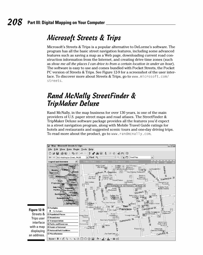
Microsoft Streets & TripsMicrosoft’s Streets & Trips is a popular alternative to DeLorme’s software. Theprogram has all the basic street navigation features, including some advancedfeatures such as saving a map as a Web page, downloading current road con-struction information from the Internet, and creating drive time zones (suchas show me all the places I can drive to from a certain location in under an hour).The software is easy to use and comes bundled with Pocket Streets, the PocketPC version of Streets & Trips. See Figure 12-9 for a screenshot of the user inter-face. To discover more about Streets & Trips, go to www.microsoft.com/streets.
Rand McNally StreetFinder & TripMaker DeluxeRand McNally, in the map business for over 130 years, is one of the mainproviders of U.S. paper street maps and road atlases. The StreetFinder &TripMaker Deluxe software package provides all the features you’d expect in a street navigation program, along with Mobile Travel Guide ratings forhotels and restaurants and suggested scenic tours and one-day driving trips.To read more about the product, go to www.randmcnally.com.
Figure 12-9:Streets &Trips userinterface
with a mapdisplaying
an address.
208 Part III: Digital Mapping on Your Computer

Chapter 13
On the Ground with MaptechTerrain Navigator
In This Chapter� Discovering Terrain Navigator features
� Using Terrain Navigator to plan trips
� Creating 3-D maps
� Reviewing other topographic map programs
If you spend a lot of time off the beaten path in the mountains, hills, deserts,and plains, you should consider using topographic mapping software. These
programs come bundled with United States Geological Survey (USGS) digitalmaps and are a perfect companion for any outdoor enthusiast. Before you headoff into the wilds, you can print a topographic map of an area you’re interestedin visiting and even plan your trip on your PC. If you have a GPS receiver, youcan interface it with the map program to see exactly where you’ve been orupload waypoint and route information entered on the electronic map to yourGPS receiver.
Commercial topographic software packages are easy to use, convenient (youdon’t need to find and download maps to use them), and economical. Most ofthe map products on the market cost under $100 and give you 1:24,000 scalemap coverage of a state or region; for the same price, other software providesless-detailed 1:100,000 scale maps of the entire U.S. This is a bargain consider-ing that a paper version of a USGS topographic map costs around $7, and youmight have to buy up to a thousand maps to fully cover a single state.
In this chapter, I discuss commercial software packages that offer topographicmaps of the U.S. I focus primarily on Maptech’s Terrain Navigator to illustratethese programs. Although they sport different user interfaces, most commer-cial topographic map programs share the same basic capabilities and features.At the end of this chapter, I briefly review some other popular topographicmap programs.

Discovering Terrain NavigatorMaptech’s Terrain Navigator (www.maptech.com) was one of the first commer-cial, Windows topographic map programs. (In the old days it was known asTopoScout.) Over the years, Terrain Navigator has evolved into a sophisticated,powerful, electronic mapping tool.
You can purchase different versions of Terrain Navigator. The program thataccesses map data is the same, but the maps that come bundled on CD-ROMsare different. Different versions of Terrain Navigator provide topographicmaps for individual states and different regions of the U.S. (in this chapter Iuse Oregon state maps). The majority of commercial map programs are alsosold this way. Plan on spending around a hundred dollars for a complete setof Terrain Navigator digital maps for a single state.
You use Terrain Navigator’s main features — which most other topographicmap products share — to help you
� Quickly find locations by name or coordinates.
� Accurately measure distance and area.
� Display terrain three-dimensionally.
� Show elevation profiles of routes of travel.
� Customize maps with labels, markers, and routes.
� Interface maps with GPS receivers to upload and download waypoints,routes, and tracks or use for real-time tracking.
Read on to take a look at some of Terrain Navigator’s basic features and seehow to use them. Whether you put on your boots and backpack is completelyup to you.
Maptech has a free demo version of Terrain Navigator that comes with asingle map of a wilderness area in Colorado. You can download the demo atwww.mpatech.com/support/downloads.cfm. Be sure to read through theonline help and tutorial because it describes a number of program featuresthat I don’t have space to cover in this chapter.
Displaying Maps and Finding PlacesWhen Terrain Navigator starts up, a map of the state or region that you’veinstalled on your PC is displayed. Figure 13-1 shows a state map: in this case,the state of Oregon. Here are the basic rules of engagement:
210 Part III: Digital Mapping on Your Computer

� If you know the general area you’d like to view, click there on the map. Agrid appears in the vicinity of where you click. Each of the rectangles inthe grid represents a 1:24,000 USGS topographic map.
� Moving the cursor over the grid displays the map name at the top of thewindow that’s associated with a rectangle.
� Double-click a rectangle to display a map.
� If you know the USGS map name, you can select it from the Map Namedrop-down list, which displays all the map names associated with thecurrently selected grid.
If you click different parts of the state map, you’ll notice that grids appear anddisappear. When a grid is displayed, it shows all the maps that are on one ofthe CDs that came with Terrain Navigator; the name of the CD appears in thewindow title. This helps you know which disc you need to insert into yourCD-ROM drive to display maps for different areas.
Double-clicking a grid rectangle is one way to display a map, but here arequicker and more precise ways to view a specific location. You can display a map by searching for
� City or town name
� ZIP code
� Coordinates
Figure 13-1:Terrain
Navigatorstate start-
up map.
211Chapter 13: On the Ground with Maptech Terrain Navigator

� Place names
� Features you’ve previously marked on the map
Suppose you vaguely remember hearing about a real cool hike to the top of amountain that has an amazing view. You know it’s somewhere around WaldoLake, Oregon, but the name of the mountain just isn’t coming to mind. Youthink it might have something to do with apples: Gala, Granny Smith, Braeburn,maybe Fuji. Even with fuzzy information like this, Terrain Navigator can helpyou zero in on the location. Here’s how:
1. Under the state map, click the Find button.
A pop-up menu appears.
2. Choose the Search All Place Names menu item.
The Search All Place Names dialog box opens.
3. In the Keyword text box, enter the place name you want to search for.
In this example, enter Fuji.
4. Click the Find button.
A list of places that match your search text is displayed, as shown inFigure 13-2. Ah, ha! There’s Fuji Mountain. That rings a bell.
Figure 13-2:Zero in ona locationfrom here.
212 Part III: Digital Mapping on Your Computer

5. Double-click the place name that you want to view.
For this example, double-click Fuji Mountain.
The map that corresponds to the place name is displayed with the loca-tion circled — in this case, exactly the place you were looking for, FujiMountain, a couple of miles southwest of Waldo Lake.
After the search map is displayed, you can search for other place names orcoordinates by clicking the Find Place button (with the binoculars icon) onthe toolbar.
Navigating a Terrain Navigator MapAfter you have a map displayed, as shown in Figure 13-3, you can do a lotmore than just look at it onscreen and print it out. One of biggest advantagesto a digital map is you can interact with the map more than if it were a papermap. Stick with me here to find out how to move around in a map and changeits size.
Figure 13-3:Terrain
Navigatormap of FujiMountain.
213Chapter 13: On the Ground with Maptech Terrain Navigator

Moving around in a mapMore than likely, you’ll want to move around the map and check out thecountryside that currently isn’t being displayed onscreen. Here’s how:
� Move the cursor to one of the edges of the map. The cursor turns intoan arrow; click to scroll the map in the direction that the arrow points.
� Click the Drag tool on the toolbar. (It’s shaped like a hand.) Move thecursor to the map and hold down the left mouse button; then scroll themap by dragging.
� Click the Center tool on the toolbar. (It’s shaped like a bull’s-eye withcrosshairs.) With this tool selected, wherever you click the map, themap is drawn so it’s centered at that location.
� Move the rectangle in the overview map. A small overview map appearsto the left of the main map. A blue rectangle shows what part of the mapis currently displayed onscreen. You can drag the overview map rectangleto show a new location onscreen.
As you move the cursor around the map, the coordinates and the elevationunder the cursor location are displayed in the toolbar. This is useful for deter-mining the exact locations of features on the map.
Changing the map sizeTerrain Navigator offers two ways for you to change the size of a map andshow more detail or area.
214 Part III: Digital Mapping on Your Computer
Shifty tipsDon’t overlook the keyboard and mouse short-cuts in Terrain Navigator that can speed thingsup as you move around the map. They include
� Shift+click: Zooms out and centers the mapat the location you clicked — unless thezoom-out (magnifying glass icon with a minussign) tool is selected, in which case you’llzoom in.
� Shift+Ctrl+click: Centers the map whereveryou click.
� Ctrl: Changes the cursor to the Drag tool andallows you to scroll the map.
� Right-click: Displays a pop-up menu withzoom and other options.

� Zooming: The toolbar has two icons bearing a magnifying glass: onewith a plus sign and the other with a minus sign. When the plus signmagnifying glass is selected, you zoom in when you click the map. Whenthe minus sign magnifying glass is selected, clicking zooms you out.
� Changing the scale: Maps can be displayed in either 1:24,000 (more detail,smaller area) or 1:100,000 scale (less detail, larger area). Note the mapscale command in the toolbar that displays a menu for selecting the scaleof your choice.
Planning a Trip with Terrain NavigatorIf you’ve followed this chapter to this point, you’ve located a map of FujiMountain. Keep your imagination flowing and plan a hiking trip there. Supposethat your friends gave you some vague directions about taking a series of log-ging roads to get to the trailhead. The trail wasn’t very well marked, but whenthey found it, it climbed steeply for a couple of miles to the summit. However,the last time you listened to your friends, the short pleasant hike that theydescribed turned into an eight-hour death march through thick underbrushand straight up a rock face. This time, you decide to use Terrain Navigator toget a better picture of this little outing.
1. Look on the map for a trail.
You want the one that goes to the summit of Fuji Mountain. (Only onetrail goes to the top.) As you follow it down, you see that it intersectswith an unimproved road — probably the logging road your friends toldyou about.
The symbol for a trail on USGS maps is a single dashed line. Lines withtwo sets of dashes indicate an unimproved road.
2. Click the Marker tool on the toolbar, move the cursor to where theroad intersects the trail, and click to create a waypoint for the trail-head (the beginning of the trail).
The Marker tool looks like a pyramid.
This creates a GPS waypoint at that location named Mrk1. Click the nameand rename it Fuji Trailhead.
3. Use the Marker tool to create another GPS waypoint at the end of thetrail.
This marks a waypoint at the summit of Fuji Mountain. Rename this oneFuji Mountain (see how in Step 2).
215Chapter 13: On the Ground with Maptech Terrain Navigator

With these two GPS waypoints set, you now know where the trail startsand ends. If you’re using a GPS receiver, the first waypoint will help youfind the trailhead, and the second waypoint will help you reach your finaldestination. You can manually enter the waypoints in your GPS receiveror have Terrain Navigator upload them for you.
Be sure that the map datum matches the datum your GPS receiver isusing (head over to Chapter 4 for information about what happens whendatums don’t match). You can set the map datum in Terrain Navigatorby choosing File➪Preferences➪General.
4. Click the Track tool on the toolbar to draw your planned course oftravel on the map.
The Track tool, which looks like a pencil, works by drawing a line from thelast place you clicked. However, it doesn’t allow you to freehand drawlike with a real pencil.
5. Follow the trail by clicking the mouse (like playing connect-the-dots).
Trace the trail that heads up Fuji Mountain, starting at the road intersec-tion. After you click, the current length (in feet or miles) of the track isdisplayed in the status bar below the map.
6. When you’re finished, right-click and choose Finish Track from thepop-up menu.
7. Edit the track, giving it a name and changing its color if you like.
Move the cursor on the track that you just created, right-click, and chooseEdit from the pop-up menu. You can now name the track (use Fuji) andchange its color if you like.
The finished map with the waypoints and the track is shown in Figure13-4. You can upload the waypoints and track data to your GPS receiverbefore you leave on the hike to help with your navigation.
Use Terrain Navigator to turn a track into a route. A route is a course of travelthat’s broken up into a series of waypoints that define segments of your trip.You navigate between the route waypoints to reach your final destination.Typically the number of track points is reduced when you convert a track toa route. Thus, there’s not as much detail, and you end up with straight linesinstead of curves. If you want to upload a course of travel to your GPS receiver,it’s more efficient to use a route than a track. To convert a route, right-click atrack and choose Create Route from the pop-up menu.
Even if you don’t have a GPS receiver to which you can upload waypoint,route, or track data, you can use Terrain Navigator to find a trail, print a mapof that trail to take with you, and determine the distance of your hike. Justremember to bring your compass!
216 Part III: Digital Mapping on Your Computer

You can upload data from topographic map programs to your GPS receiver or download waypoints, routes, and tracks from your GPS receiver to themap program. For example, you could overlay a track you recorded with yourGPS receiver on the electronic map to see where you had been. Check the mapprogram documentation or online help to find out how to interface your GPSreceiver. Chapter 9 has a number of hints and tips for connecting GPS receiversto PCs.
Understanding Terrain ElevationUnless you’ve had some experience reading topographic maps, trying to figureout terrain elevation based on contour lines can be challenging. (Contourlines are a way of representing height on a map.) Terrain Navigator has twofeatures — 3-D View and the Terrain Profile tool — that help you better visu-alize where the land starts to get steep or flatten. You can use the map fromearlier sections of this chapter to see just how much of a climb you’re in for.
Figure 13-4:A trail
map withwaypointsand track
can be sentto your GPS
receiver.
217Chapter 13: On the Ground with Maptech Terrain Navigator

Using a 3-D map imageUse Terrain Navigator to display 3-D, shaded relief images of a map to helpyou better understand the terrain. To show a 3-D image of the map that’s cur-rently displayed onscreen, click the 3-D View button on the toolbar. (It lookslike mountains with a small bar underneath.)
The topographic map of Fuji Mountain (including the markers and track addedin the earlier section, “Planning a Trip with Terrain Navigator”) is displayedin 3-D, as shown in Figure 13-5.
A red rectangle appears on the overview map, showing you the general loca-tion of the terrain, based on the current 3-D view of the map.
To control the view of the 3-D map
218 Part III: Digital Mapping on Your Computer
Other Maptech productsIn addition to Terrain Navigator, Maptech hasseveral other topographic map products thatyou might find useful, including
� Terrain Navigator Pro is Maptech’s high-endversion of Terrain Navigator targeted towardprofessional map users and is priced around$300 per state. Use its enhanced features to
� Display aerial photographs downloaded fromthe Maptech’s Internet servers.
� Locate street addresses.
� Link digital photos, spreadsheets, and otherfiles with locations on maps.
� Export maps for use with GeographicInformation System (GIS) programs such asArcGIS and AutoCAD.
� National Park Digital Guide has topo-graphic maps of all the National Parks in the
United States, including photos and infor-mation about sights and services bothinside and outside the parks. The guidecosts around $50.
� Appalachian, Continental Divide, andPacific Crest Trail products contain topo-graphic maps for the areas around each oneof these classic trails and cost under $100.The Appalachian Trail software, pricedaround $50, has extensive guidebook infor-mation along with maps.
� Outdoor Navigator is a mapping programfor Pocket PCs and Palm PDAs that lets youload detailed topographic maps on yourPDA. The product is priced around $100.
You can find more about these products and their features by visiting: www.maptech.com

� Click and drag the cursor on the map to rotate the image.
� Use the trackball control to the left of the map to rotate up, down, left,and right. You can also use the keyboard navigation arrow keys.
� Use the Elevation slider bar control (it has a picture of a truck, a heli-copter, and an airplane) to adjust the height you’re viewing the mapfrom.
� Use the zoom arrows above the Elevation slider bar to control how closeforward or backward your view of the terrain is.
� Use the Vertical Exaggeration buttons beneath the trackball control toincrease and decrease the vertical scale so elevation differences areeasy to distinguish.
To toggle back to a 2-D version of the map, click the 3-D View toolbar button.
If you want a true 3-D experience, Terrain Navigator comes with a special pairof red-and-blue-lens, stereoscopic glasses. If you click the 3-D Glasses icon,the map is colored so it appears to have three-dimensional depth when you’rewearing the glasses.
Figure 13-5:Manipulate
a topo-graphic
map in 3-D.
219Chapter 13: On the Ground with Maptech Terrain Navigator
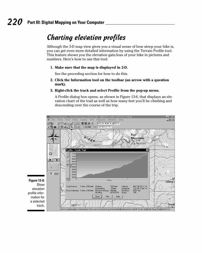
Charting elevation profilesAlthough the 3-D map view gives you a visual sense of how steep your hike is,you can get even more detailed information by using the Terrain Profile tool.This feature shows you the elevation gain/loss of your hike in pictures andnumbers. Here’s how to use this tool:
1. Make sure that the map is displayed in 2-D.
See the preceding section for how to do this.
2. Click the Information tool on the toolbar (an arrow with a questionmark).
3. Right-click the track and select Profile from the pop-up menu.
A Profile dialog box opens, as shown in Figure 13-6, that displays an ele-vation chart of the trail as well as how many feet you’ll be climbing anddescending over the course of the trip.
Figure 13-6:Show
elevationprofile infor-
mation for a selected
track.
220 Part III: Digital Mapping on Your Computer
Vertical profiles may have a lot of vertical exaggeration to show relativesteepness. This can make terrain appear steeper than it actually is.
Reviewing Other Topographic Map Software
In addition to Maptech and its topographic mapping programs, DeLorme andNational Geographic also offer software that’s suited for off-road use. As pre-viously mentioned, most topographic map programs have the same basic features; the biggest difference is their user interface. Because I don’t havethe time to cover the other mapping programs in detail, this section providesa brief description of a few popular programs, shows some screenshots togive you an idea of what the user interface is like, and provides manufacturerWeb sites to get more product information. When it comes to choosing a topo-graphic map program, you really can’t go wrong with any of the programsmentioned in this chapter.
You can’t upload detailed maps to your GPS receiver from any of the programsdiscussed in this chapter. GPS receivers that display maps can use only propri-etary maps (sold by the GPS manufacturer), and these tend to show consider-ably less detail than maps you can display on your PC. Several topographicmap software companies do offer products that you can use with a PocketPC/Palm PDA and GPS receivers that can display detailed topographic mapsjust as they appear on a PC screen.
DeLorme mapping productsDeLorme, well known for its Street Atlas USA road navigation software, alsomakes two topographic mapping programs: Topo USA and 3-D TopoQuads.DeLorme uses the same user interface for its entire line of consumer mappingproducts, so if you’re a happy user of Street Atlas USA and are looking for a mapprogram for off-road use, it makes sense to keep things in the DeLorme family.
DeLorme was one of the first vendors to offer customers a choice of map dataon CDs or DVDs. If you have a DVD player on your PC, DVDs are far more con-venient because you don’t have as many discs to keep track of, and you don’thave to swap discs as often to view maps of different areas.
221Chapter 13: On the Ground with Maptech Terrain Navigator

DeLorme topographic mapping products can interface with GPS receivers,display 3-D maps, search for locations, provide elevation profiles, and planfor trips just like other map programs. These two unique features in the pro-gram are especially useful:
� Satellite imagery: DeLorme sells 10-meter resolution color satellite datafor each state. When you use the images with DeLorme mapping products,you can view the satellite photos side by side with topographic maps in2-D or 3-D. (See an example produced by Topo USA in Figure 13-7.)
� Mural printing: If you need to produce a large map for a presentation,the programs support printing mural maps that are up to three pageshigh by three pages wide that you can join to make a large map.
To read more about DeLorme’s mapping programs, visit www.delorme.com.
Topo USATopo USA provides 1:100,000 scale topographic maps of the entire UnitedStates (for around the same price as a collection of 1:24,000 scale digitalmaps for a single state). Remember, you don’t get as much detail as youwould with a 1:24,000 scale map, but there’s enough detail for rudimentarynavigation and to use as a general reference.
Figure 13-7:3-D satelliteimage with
topographicmap dis-played in
Topo USA.
222 Part III: Digital Mapping on Your Computer

The Topo USA maps are vector-based (drawn with lines and shapes), so they don’t have the crisp appearance of a USGS digital raster map. However,DeLorme vector maps tend to have more updated road information becausesome of the scanned raster maps are based on data from maps made over 20years ago.
3-D TopoQuads3-D TopoQuads provides more detailed maps that are sold by state or region.The maps are displayed as vector maps until you zoom in far enough, andthen they become 1:24,000 scale USGS scanned digital raster maps. (See anexample of a map, including 2-D and 3-D views, in Figure 13-8.)
National Geographic mapping productsMany children got their first introduction to maps from National Geographicmagazines. Each month, a carefully folded paper map of somewhere foreignand exotic came nestled inside the magazine. National Geographic is still inthe map business, now producing several topographic map programs.
Figure 13-8:2-D and 3-D
display of1:24,000
topographicmaps in 3-DTopoQuads.
223Chapter 13: On the Ground with Maptech Terrain Navigator
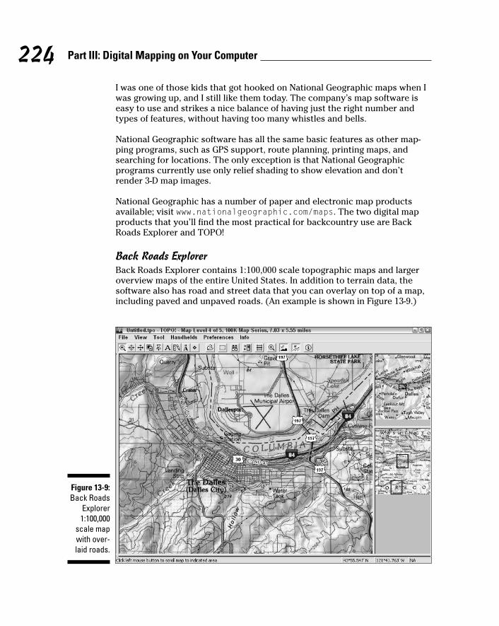
I was one of those kids that got hooked on National Geographic maps when Iwas growing up, and I still like them today. The company’s map software iseasy to use and strikes a nice balance of having just the right number andtypes of features, without having too many whistles and bells.
National Geographic software has all the same basic features as other map-ping programs, such as GPS support, route planning, printing maps, andsearching for locations. The only exception is that National Geographic programs currently use only relief shading to show elevation and don’trender 3-D map images.
National Geographic has a number of paper and electronic map productsavailable; visit www.nationalgeographic.com/maps. The two digital mapproducts that you’ll find the most practical for backcountry use are BackRoads Explorer and TOPO!
Back Roads ExplorerBack Roads Explorer contains 1:100,000 scale topographic maps and largeroverview maps of the entire United States. In addition to terrain data, thesoftware also has road and street data that you can overlay on top of a map,including paved and unpaved roads. (An example is shown in Figure 13-9.)
Figure 13-9:Back Roads
Explorer1:100,000
scale mapwith over-laid roads.
224 Part III: Digital Mapping on Your Computer

Unlike DeLorme’s Topo USA, Back Roads Explorer uses raster maps (scannedversions of paper maps), which contain more detail. If you prefer more of atraditional looking map to one that looks like it was computer-generated,you’ll like Back Roads Explorer.
Raster maps take up more disk space than vector maps because they’rescanned images of paper maps. Vector maps are smaller because they’re com-posed of lines and shapes. For example, the raster map data for the entireUnited States that comes with Back Roads Explorer fits on 17 CDs, but thesame vector data in Topo USA comes on 6 CDs.
With the option of overlaying up-to-date roads over topographic maps, BackRoads Explorer is ideal for basic navigation and is especially well suited for 4 x 4 enthusiasts who use a laptop and GPS receiver.
TOPO!National Geographic’s TOPO! line of software provides 1:24,000 maps for each of the states and is comparable with Maptech’s Terrain Navigator andDeLorme’s 3-D TopoQuads products. (A screenshot of a TOPO! 1:24,000 scalemap is shown in Figure 13-10.)
Figure 13-10:TOPO!
1:24,000scale topo-
graphicmap.
225Chapter 13: On the Ground with Maptech Terrain Navigator

One feature that I especially like in the TOPO! products is mapXchange. Youcan visit the National Geographic Web site and select the state you haveTOPO! maps for. A list of hikes and other outdoor activities is displayed withdescriptions, and you can freely download files that contain waypoints androutes you can use with TOPO! If you like, you can also upload your own filesof places you’ve been to share with other outdoor enthusiasts.
226 Part III: Digital Mapping on Your Computer

Chapter 14
From the Air with USAPhotoMapsIn This Chapter� Discovering USAPhotoMaps
� Downloading and displaying aerial photos
� Using aerial photo maps
� Reviewing other aerial photo programs
Aerial photos complement other types of maps because they give you asnapshot of reality. Programs that display aerials (map-speak shorthand
for aerial photos) are both inexpensive and easy to use. In this chapter, I reviewmapping programs that can exploit aerial photos, primarily focusing on thepopular shareware application, USAPhotoMaps.
To better illustrate the capabilities and functions of this program, I walk youthrough downloading an aerial photo, scrolling and zooming, interfacing theprogram with a GPS receiver, and saving map data.
To get the most from this chapter, download and install USAPhotoMaps(http://jdmcox.com) and then use the program to work through the exam-ples in the following pages. Unlike some shareware programs, USAPhotoMapsisn’t crippled; that is, all its features work when you download the program. Ifyou find the program useful, you can make a donation to the author’s PayPalaccount.
Enhancing TerraServer-USA with USAPhotoMaps
TerraServer-USA is a popular Web site that displays free aerial photographsand topographic maps of the U.S. that are produced by the United StatesGeological Survey (USGS). (Read more about TerraServer-USA in Chapter 20.)And although TerraServer-USA is a great Web-hosted mapping service, it hasseveral limitations:
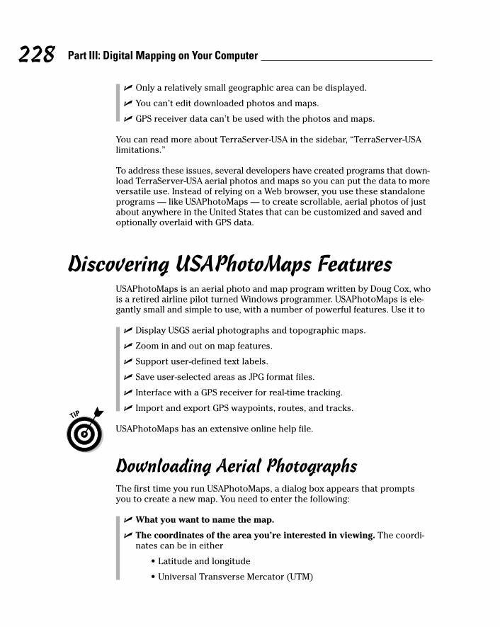
� Only a relatively small geographic area can be displayed.
� You can’t edit downloaded photos and maps.
� GPS receiver data can’t be used with the photos and maps.
You can read more about TerraServer-USA in the sidebar, “TerraServer-USAlimitations.”
To address these issues, several developers have created programs that down-load TerraServer-USA aerial photos and maps so you can put the data to moreversatile use. Instead of relying on a Web browser, you use these standaloneprograms — like USAPhotoMaps — to create scrollable, aerial photos of justabout anywhere in the United States that can be customized and saved andoptionally overlaid with GPS data.
Discovering USAPhotoMaps FeaturesUSAPhotoMaps is an aerial photo and map program written by Doug Cox, whois a retired airline pilot turned Windows programmer. USAPhotoMaps is ele-gantly small and simple to use, with a number of powerful features. Use it to
� Display USGS aerial photographs and topographic maps.
� Zoom in and out on map features.
� Support user-defined text labels.
� Save user-selected areas as JPG format files.
� Interface with a GPS receiver for real-time tracking.
� Import and export GPS waypoints, routes, and tracks.
USAPhotoMaps has an extensive online help file.
Downloading Aerial PhotographsThe first time you run USAPhotoMaps, a dialog box appears that promptsyou to create a new map. You need to enter the following:
� What you want to name the map.
� The coordinates of the area you’re interested in viewing. The coordi-nates can be in either
• Latitude and longitude
• Universal Transverse Mercator (UTM)
228 Part III: Digital Mapping on Your Computer

Read more about UTM, latitude, and longitude in Chapter 2. If you don’t knowthe latitude and longitude coordinates of the location you’re interested inseeing, quickly skip over to Chapter 11 to read how to find coordinates ofplace names.
As an example, create an aerial photomap of Seattle, Washington.
1. Enter the name, latitude, and longitude in the New Map dialog box.(See Figure 14-1.)
• Name: Seattle
• Latitude: 47.61431
• Longitude: 122.32898
2. Click OK.
A series of gray squares appear onscreen.
3. Download aerial photos from TerraServer-USA for the area that youspecified (with the latitude and longitude coordinates). Make sure thatyou’re connected to the Internet and then press the F key.
A mosaic of aerial photograph images replaces the gray squares as thescreen is filled with data from TerraServer-USA. The final result is shownin Figure 14-2.
If you’re using a firewall, your computer might complain when USAPhotoMapstries to connect to TerraServer-USA. Because the program is just downloadingmap data, you can give permission for USAPhotoMaps to access the Internet.
229Chapter 14: From the Air with USAPhotoMaps
TerraServer-USA limitationsThe first time you see USAPhotoMaps displayTerraServer-USA aerial photos, you’re probablygoing to say, “Wow! This is like having my ownpersonal spy satellite.” Well, sort of, but thereare a few catches:
� Yanks only: TerraServer-USA provides aerialphotos and maps of United States locationsonly. And although the aerial photo databaseis fairly complete, some areas in the U.S.don’t have photo data.
� Not always current: TerraServer-USA aerialphotographs tend to be not very current. Infact, they can be up to ten years old because
the USGS produces new sets of aerial photosonly as often as needs and budgets allow.
� No color: Only black-and-white photos arecurrently available. TerraServer-USA doesplan to carry more recent, high-resolution,color aerial photographs that the USGS hasproduced for selected urban areas, but it willbe many years until color aerial photographsare available of most of the United States.
� Data transfer hiccups: Network outages andserver upgrades can disrupt TerraServer-USA data transfers.

Figure 14-2:USAPhoto-
Maps aerialphoto
mosaic ofSeattle,
Washington.
Figure 14-1:Create a
new maphere.
230 Part III: Digital Mapping on Your Computer

If you plan to use USAPhotoMaps to build an extensive aerial photo collec-tion, a high-speed Internet connection will make your life much easier. Eachindividual aerial photo or topographic map image in the displayed mosaic isroughly 50–200K in size. (The actual size depends on how much unique ter-rain is shown in the image.) At 2 meters-per-pixel resolution, it takes 70 imagesto fill the screen of a 1024 x 768 monitor; that’s anywhere from 7–17MB of datato download.
Getting the Most from Aerial PhotosAfter you have an aerial photo displayed, navigate inside the image. (Readthe preceding section for how to download and display an aerial photo.)USAPhotoMaps has a number of different commands to view and manipulatethe photo.
The datum used for all TerraServer-USA maps is NAD 83. This is nearly identi-cal to the WGS 84 datum used as a default by GPS receivers. If you plan onusing your GPS receiver with USAPhotoMaps, be sure that the datum settingsmatch. (Read more about datums in Chapter 2.)
The first thing you’ll notice is that when you move the mouse cursor aroundthe screen, map coordinates appear in the window title bar. This feature allowsyou to move the cursor over a feature that’s shown on the aerial photo andget its precise coordinates.
You can change how you want the coordinates displayed from the View menu.Choose the Lat/Lon item and then specify whether you want the coordinatesshown in decimal degrees, degrees and decimal minutes, degrees/minutes/seconds, or UTM formats.
Press the X key to display a dialog box with the coordinates that the cursor iscurrently over. You can copy the coordinates from this dialog box and pastethem into another program.
Switching between aerial photos and topographic mapsAfter you know where you are in a photo (see the preceding section), look at the commands that you can use to move around. As I mention earlier,TerraServer-USA provides both aerial photos and USGS topographic maps,
231Chapter 14: From the Air with USAPhotoMaps

and USAPhotoMaps lets you switch between the two types of images. (Figure14-3 shows a topographic map.) This is useful because you can look at a topo-graphic map and then immediately see what the same location looks like asan aerial photo. This is a big advantage because aerial photos often showmore feature detail than topographic maps.
Here are the two ways (in USAPhotoMaps) to display a topographic map ver-sion of an aerial photo you’re viewing:
� From the View menu, choose Map Type➪Topo.
� Press the T key.
If gray squares appear onscreen, you haven’t downloaded map data for thatarea yet. To download the map, press the F key.
To switch back to an aerial photo view of the location
� From the View menu, choose Map Type➪Photo.
� Press the P key.
Figure 14-3:Use
USAPhoto-Maps to
display bothaerial photo-
graphs andtopographic
maps.
232 Part III: Digital Mapping on Your Computer

Moving around the mapYou’ve probably noticed that USAPhotoMaps doesn’t use scroll bars like otherWindows programs. Not to worry; you can still move around in a photo ormap by using the keyboard navigational arrow keys:
If you see gray squares while you’re scrolling, map data has yet to be down-loaded for that particular area. Figure 14-4 shows gray squares with aerialphoto data that hasn’t been downloaded. Here are two ways to fill the squareswith map or photo data:
� From the File menu, choose Download Map Data➪Fill Screen.
� Press the F key.
USAPhotoMaps connects to TerraServer-USA and downloads the map datafor that area.
Instead of scrolling, you can also go directly to a location that you know thecoordinates of. Just choose the Go To Lat/Lon item in the View menu andenter the coordinates.
Figure 14-4:The graysquaresindicate
where mapdata hasn’t
been down-loaded.
233Chapter 14: From the Air with USAPhotoMaps

USAPhotoMaps has two display modes: aerial photo and topographic map.When you download data to fill in the gray squares, only data for the particu-lar mode that you’re in is downloaded. For example, if you’re viewing an aerialphoto, only new aerial photo data is downloaded.
Zooming in and outYou can zoom in and out on an aerial photo or map to see more detail or geta larger, big picture view. For zooming, use these keys:
� Zoom in: Press Page Down or the plus (+) key.
� Zoom out: Press Page Up or the minus/dash (–) key.
The current zoom level appears in the window title bar, so you always knowhow far you’ve zoomed in or out.
The zoom level on the window title bar displays the resolution of the image. Ifthe resolution is 4 meters-per-pixel, each pixel (picture element) onscreen rep-resents an object 4 meters in size. (Remember that a meter is roughly a yard.)Smaller numbers mean higher resolution and greater detail. For example, 1meter-per-pixel resolution means that you can distinguish objects on the groundthat are one meter in size. Figure 14-5 shows a 2 meter-per-pixel aerial photo.
How far you can zoom in and out on an image depends on what type of mapyou’re viewing.
� Topographic maps: 4, 8, 16, or 32 meters-per-pixel
� Aerial photos: 1, 2, 4, 8, 16, 32, or 64 meters-per-pixel
If you’re switching back and forth between aerial photos and topographicmaps, use either a 4 or an 8 meters-per-pixel zoom level. This will give youclose to a one-to-one size representation of features on the aerial photo andthe topographic map.
Enhancing contrastOne of the things you’ll notice as you start to view aerial photos is that thecontrast might be lighter or darker with certain images. This has to do withthe amount of sunlight when the photo was taken and the background colorof the terrain.
234 Part III: Digital Mapping on Your Computer
To enhance less-than-optimal contrast, USAPhotoMaps has a nifty featurethat lets you adjust the contrast of the photos displayed onscreen by eitherlightening or darkening them. This can really enhance detail in a photo.
You can control the contrast of a photo by using these keys:
� Lighten: Press the B key.
� Darken: Press the D key.
You can also set contrast by selecting Brightness from the View menu, includ-ing restoring the contrast back to its default setting.
Entering textAfter you have an aerial photo displayed, you can add text labels to differentfeatures when the image is displayed at the 1- or 2-meter zoom levels. To entera text label
Figure 14-5:The aerial
photographof Seattleviewed at
2 meter-per-pixel
resolution.
235Chapter 14: From the Air with USAPhotoMaps

1. Move the mouse cursor to the location where you want the text to start.
2. Hold down the Shift key.
3. Move the cursor in the direction you want the text to be aligned.
A line is temporarily drawn as you move the cursor. For example, if youdraw a line at a 45-degree angle, the text will flow at a 45-degree angle.
4. Release the Shift key.
5. In the dialog box that appears, type in the text label and click OK.
A list of all the text labels is displayed.
Text in a label is limited to 60 characters and can be edited or deleted bychoosing Text➪List.
You can set the text color by choosing File➪Preferences➪Colors. The ColorPreference dialog box, which isn’t all that intuitive, uses a series of radio but-tons that correspond to red, green, and blue values. Your best bet for choosinga color you’d like is to enter some text and then display the Color Preferencedialog box. When you select different combinations of color radio buttons, thetext you entered changes color.
Creating and Using Multiple Map FilesUSAPhotoMaps uses a map file to name areas that have downloaded aerialphoto or map data. A map file is a bookmark for a general vicinity or location.For example, you might have downloaded aerial photos for the entire GrandCanyon. Instead of scrolling to view photos at each end, you could create twomap files, one called North Grand Canyon and the other South Grand Canyon.
To create a map file bookmark
1. From the File menu, choose New Map File.
2. In the New Map dialog box that appears, enter the name of the mapfile and the coordinates that you’d like to bookmark.
Refer to Figure 14-1.
3. Click OK.
After you create a map file, select it, and USAPhotoMaps displays the aerialphoto or map associated with that area.
To select and display a new map file
236 Part III: Digital Mapping on Your Computer

1. From the File menu, choose Open Map File.
2. Select the name of the map file to load.
3. Click OK.
The area that you bookmarked is now displayed onscreen.
Map file bookmarks are used to identify a general location. They shouldn’t beused for marking a very specific set of coordinates, such as a GPS waypoint.
Saving Aerial PhotosAfter you have an aerial photo or map displayed onscreen, you can save theimage to use with other programs:
� From the File menu: Choose Copy to Screen.jpg. This saves a copy ofthe aerial photo or map currently displayed onscreen to a file namedScreen.jpg in the same folder that USAPhotoMaps is installed in.
� Print Screen: Press the Print Screen key to save the current image to theClipboard. If you want to save only a portion of the map or aerial photothat appears onscreen, read Chapter 17 for practical tips on saving andediting images.
� BigJpeg: Use the BigJpeg utility. Doug Cox has a free utility that creates asingle, 1-meter resolution, JPG format graphics file from a photo or map.You define the boundaries of an area you want to save in USAPhotoMapsand then run BigJpeg to create the graphics file. You can downloadBigJpeg, with complete instructions, at http://jdmcox.com.
237Chapter 14: From the Air with USAPhotoMaps
Saving strategiesAfter an aerial photo or map is displayed on-screen, that data now resides on your harddrive. USAPhotoMaps doesn’t discard old datafiles as new data is downloaded. If you’ve alreadydownloaded a series of photos and maps for ageographic area, you don’t need to connect toTerraServer-USA again to access that data. Theonly limitation to the amount of photo and mapdata you can have is the size of your hard drive.
USAPhotoMaps writes all the data it gets fromTerraServer-USA to a single folder, so you cancopy that folder and its data to a CD or DVD. Thisis an excellent way to access aerial photos andmaps on a number of different computers thatmight not have an Internet connection (such aslaptops in the field). The USAPhotoMaps onlinehelp has instructions on how to do this.

Interfacing with a GPS receiverDownloading and viewing free aerial photos and maps is pretty cool, but ifyou have a GPS receiver, USAPhotoMaps has even more features that you canput to use, including
� Downloading waypoints, routes, and tracks from a GPS receiver tooverlay on aerial photos and maps. (See Figure 14-6 for an example of anaerial photo with overlaid track data.)
� Uploading waypoints and routes that you’ve created with USAPhotoMapsto your GPS receiver.
� Interfacing USAPhotoMaps to a GPS receiver for real-time updates ofyour current position shown on an aerial photo or topographic map.
USAPhotoMaps has a separate help file that covers only GPS-related topics.You’ll find comprehensive information on interfacing your GPS receiver tothe program and descriptions of GPS-related features. To display the help file,choose Help from the GPS menu.
Figure 14-6:Aerial photo
of a cross-country ski
area withtracks from
a GPSreceiver.
238 Part III: Digital Mapping on Your Computer

Click the mouse to add a waypoint wherever the cursor is currently positioned.You’ll be prompted to enter a description and a name (to identify the waypointif you upload it to a GPS receiver). The waypoint will be displayed as a dot onthe aerial photo or the map. Right-click the mouse button to display a list ofwaypoints.
Reviewing Other Aerial Photo SoftwareUSAPhotoMaps isn’t the only program that uses TerraServer-USA data to dis-play aerial photos and maps. Other mapping utilities have the same basic func-tionality with additional features. These programs are inexpensive, rangingfrom free to around $60. If you like USAPhotoMaps, take the time to downloadand try a few of these programs to see whether they meet your mapping needs.
TerraClientBill Friedrich’s TerraClient is a free, easy-to-use Windows program that dis-plays TerraServer-USA aerial photos and maps. It doesn’t interface with GPS
239Chapter 14: From the Air with USAPhotoMaps
Importing tracksUSAPhotoMaps can interface directly with your GPS receiver and download current track data.However, if you want to import existing GPS track logs into USAPhotoMaps, the data needs to be ina comma-delimited text file in the following order:
Track name, UTM zone, Northing, Easting, Hour, Minute, Second, Month, Date, Year, Altitude (in meters)
The first line of the file contains the field information and should exactly read as follows:
Track,UTM Zone,UTM Northing,UTM Easting,Hour,Min,Sec,Month,Date,Year,Alt(Meters)
The second line of the file starts listing the track data. An example line of data looks like this:
SKI,10,4873291,605991,17,56,30,11,29,2003,1935.27
Each line of data must have ten commas and end with a carriage return. The minimum amount of trackdata required is the UTM zone, Northing, and Easting.
Probably the easiest way to manipulate previously saved track data is to load a comma-delimitedfile containing the tracks into a spreadsheet and then arrange the columns of data.

receivers or use GPS data, but it does have two features that make it ideal forbeginning map users:
� Easy location lookup: Instead of knowing the exact coordinates of thearea you want to view, enter a place name and watch TerraClient returna list of possible matches. To view the aerial photo, click the one you’reinterested in.
� Superimposed maps: This is a very slick feature that allows you to super-impose a topographic map on top of an aerial photo (see Figure 14-7 foran example). You can control the transparency of the overlay so thatonly a faded, ghostlike image of the map appears on top of the aerialphotograph. This is very useful for quickly identifying features on aerialphotos.
TerraClient has an extremely user-friendly interface, and you can be up andrunning the program in a matter of minutes. You can download TerraClient athttp://billfriedrich.tripod.com.
Figure 14-7:TerraClient
showing anaerial photo
with topo-graphic map
overlay.
240 Part III: Digital Mapping on Your Computer

TopoFusionScott and Alan Morris, brothers and computer science graduate students,weren’t satisfied with the various Windows mapping programs on the market,so they wrote their own. Both are avid mountain bikers, GPS users, and outdoor recreationists; the features in their program reflect this. Some ofTopoFusion’s features include
� Optimized graphics routines for fast map display
� Terrain profiles of GPS tracks
� Multiple track file support for constructing trail networks
� Map digital photo support by determining the location where a photowas taken by correlating the photo time-stamps with those of the trackpoints
� Trip playback mode that replays your travel route and provides statistics
� Combining aerial photos with topographic maps for composite images
The Morris brothers are constantly adding new and useful features to theprogram and have an online support forum. If you’re using a GPS receiver aspart of a trail-mapping project or you are a serious outdoor enthusiast, theadvanced features of TopoFusion should put it high on your list.
To download a free demo version of TopoFusion and get more informationabout the program, go to www.topofusion.com. (See the demo version inFigure 14-8.)
ExpertGPSTopoGrafix is a software company that produces GPS and mapping programs.ExpertGPS is an extensive waypoint, route, and track management systemwith mapping capabilities grafted on top of it. (See Figure 14-9 for ExpertGPSdisplaying a waypoint list and overlaying waypoints and routes on an aerialphoto.)
ExpertGPS has a large number of features. In fact, at first glance, the extensivefeatures and user interface can be a little intimidating. However, if you’re a GPSpower user with a large collection of waypoints and route data, it’s definitelyworth spending some time working with the program to see whether it meetsyour needs.
241Chapter 14: From the Air with USAPhotoMaps

Figure 14-9:ExpertGPS
showingwaypointdatabase
and overlaidwaypoint
and routes.
Figure 14-8:TopoFusion
displaysTerraServer-
USA aerialphotos and
topographicmaps.
242 Part III: Digital Mapping on Your Computer

To download a fully functional, 31-day trial version of ExpertGPS, go to www.expertgps.com.
QuakeMapQuakeMap is written by Sergei Grichine and was originally designed to down-load worldwide earthquake data from various Internet sources and display theinformation on maps. The program has since evolved into a general purpose,mapping utility that uses TerraServer-USA data. You can use GPS data withQuakeMap, and if you’re a geocacher (see Chapter 7), the program has severalspecialized features designed for the sport.
To download a demo version of QuakeMap (see Figure 14-10 for a screenshotof QuakeMap displaying the location of an earthquake on an aerial photo) visitwww.earthquakemap.com.
Figure 14-10:QuakeMapshowing anaerial photoof a recent
Californiaearthquake.
243Chapter 14: From the Air with USAPhotoMaps

244 Part III: Digital Mapping on Your Computer

Chapter 15
Creating and Using Digital Maps with OziExplorer
In This Chapter� Discovering OziExplorer
� Converting paper maps to digital maps
� Scanning and editing digital maps
� Calibrating digital maps
OziExplorer is a popular, Windows shareware program that you can use tocreate your own digital maps. OziExplorer is widely used by recreation-
ists, land managers, and public safety agencies. The program doesn’t comebundled with a set of maps per se; instead, you can use it to view maps thatare commercially or freely available on the Internet in a number of differentdata formats, from which you can create your own do-it-yourself, digital maps.In this chapter, I describe some of OziExplorer’s features and then I walk youthrough the process of creating digital maps from scanned paper maps.
Discovering OziExplorer FeaturesOziExplorer is a powerful and versatile mapping program developed by DesNewman. (Newman hails from Australia, and Ozi is slang for Australia — getit?). Newman originally wrote the program for personal use during four-wheel-drive trips in the Australian outback. He released OziExplorer as shareware,which has evolved into a sophisticated mapping tool that’s constantly updated.Some of the program’s key features are that it
� Interfaces with GPS receivers: OziExplorer can communicate with justabout every GPS receiver on the market, allowing you to upload anddownload waypoints, routes, and tracks to and from GPS receivers andPCs. (For more on waypoints, routes, and tracks, see Chapter 4.)

� Works in many languages: Localized versions of OziExplorer are availablein a number of different languages, including English, German, French,Spanish, and Italian.
� Provides real-time tracking: If you have a laptop connected to a GPSreceiver, OziExplorer displays a moving map with your real-time, currentposition and other travel information. (For more on using a laptop intandem with a GPS receiver, see Chapter 9.)
� Is easy to use: OziExplorer boasts a large number of features, such asannotating maps and extensive import and export capabilities, all ofwhich are easy to use. Figure 15-1 shows a demo map that comes withOziExplorer and the program’s toolbar and menu-based user interface.
� Supports an extensive number of map formats: OziExplorer can accessmany popular digital map data formats (such as DRG, a Digital RasterGraphics map) and can associate georeferenced data with common graph-ics file types. For example, you can take a file that you created in Paintor some other graphic program and turn it into a smart map (a map wheregeographic coordinates are associated with individual pixels). Loadinggraphics files and calibrating the data to create digital maps are discussedin upcoming sections of this chapter.
Figure 15-1:A demo map in
OziExplorer.
246 Part III: Digital Mapping on Your Computer

The best way to find out about OziExplorer’s features is to download the pro-gram and try it. (OziExplorer works with PCs capable of running Windows 95through XP.). You can find it at www.oziexplorer.com. Two versions of theprogram come in the install package:
� Trial: The trial version is a limited version of OziExplorer that has all theprogram features enabled, except the program can’t
• Communicate with GPS receivers
• Save or load waypoints, routes, or tracks
• Save maps as image files
• Run for more than an hour at a time
� Shareware: The shareware version has a number of features disabledand has the following limitations:
• Only bitmap (BMP) images can be imported as maps (as opposedto many graphics file types in the registered version).
• Only two points can be used to calibrate a map, reducing thepotential accuracy. (Up to nine points are available in the regis-tered version.)
• Limited support is available for map projections, grid systems, anddatums (compared with extensive support in the full version).
Between these two programs available in the install package, you’ll be able toget a feel for all OziExplorer’s capabilities. And when you register the share-ware version, the full monty of features is enabled. The $85 registration fee isa nominal investment considering the many features that the full version ofOziExplorer offers.
If you’re looking for a street and road navigation program, OziExplorer isn’tthe best choice. Ozi is more suited for adventures off the beaten path. If youneed a program that helps you find the best route between two addresses onstreets and highways, you’re much better off using some of the commercialmapping programs that I describe in Chapter 12.
For more practical information on OziExplorer, including troubleshooting tips,check out the popular Yahoo! Groups e-mail list and forum devoted to theprogram at groups.yahoo.com/group/OziUsers-L.
In addition to OziExplorer, Des Newman also has two other related mappingprograms:
247Chapter 15: Creating and Using Digital Maps with OziExplorer

� OziExplorer3D: This program is used in conjunction with OziExplorer todisplay maps in three dimensions. OziExplorer writes elevation data to afile, which OziExplorer3D uses to display a 3-D representation of the map.OziExplorer3D is priced at $30.
� OziExplorerCE: OziExplorerCE is moving-map software for Pocket PC(formerly known as Windows CE) PDAs. You create maps and plan tripswith OziExplorer on your PC and then download the map data to yourPDA to use with OziExplorerCE. When you connect your PDA to a GPSreceiver, the program retrieves GPS data and displays your current loca-tion on a map. The PDA version of Ozi costs $30.
To discover more about the features of these two programs and downloaddemonstration versions, go to www.oziexplorer.com.
Moving from Paper to Digital MapsOziExplorer supports a number of different digital map types that use georef-erenced data (information that allows a program to precisely identify locationsand coordinates on a map). But one of the program’s most powerful featuresis its ability to turn your own graphics files into georeferenced maps. Thismeans if you have a paper map, you can scan it, load it into OziExplorer, andeffectively make it an electronic (digital) map. This is a three-step process:
1. Scan the map.
Use a scanner to create a digital image of the paper map. Stitch individualmap pieces, if necessary.
2. Edit the map.
Make changes to the scanned map before it’s used.
3. Calibrate the map.
Load the edited map into OziExplorer and associate georeferenced datawith the map image.
The following sections explore the above three steps in further detail.
Scanning and calibrating your own maps can be fairly time consuming andsometimes frustrating if you can’t seem to get the map coordinates to matchup with reality. Some maps are definitely easier to calibrate than others. Ifyou’re not technically inclined or are somewhat impatient, you’ll probablywant to stick to importing maps that are already georeferenced, such as freelyavailable United States Geological Survey (USGS) DRG topographic maps.(See Chapter 21 for places on the Internet you can download free maps.)
248 Part III: Digital Mapping on Your Computer

Step 1: Scan the mapThe first step when converting a paper map to a digital map is to scan themap and turn it into a graphics file. You don’t need an expensive, high-endscanner to accomplish this task; most any color scanner will work.
If you want to scan a large map — say, anything bigger than a legal size pieceof paper — consider literally cutting it up into pieces that will fit on yourscanner. (8.5 x 11 inches works well.) Instead of using a pair of scissors, use apaper cutter, such as those found at copy centers, to ensure that you end upwith straight cuts. The straight cuts are important for accurately aligning themap on your scanner. Although you can scan a large map one portion at atime without cutting it, it’s more of a challenge to get the edges lined up whenyou stitch them together as I discuss next.
Here are some tips to improve your map scanning:
� Use medium dpi: Scanning the map between 125–200 dots per inch (dpi)is good enough; you don’t need to scan at higher resolutions typicallyused for reproducing photos.
� Use color photo scanning: Most scanning software has different settingsfor different types of documents you want to scan, such as text, linedrawings, and photographs. Select the color photograph option to retainthe most detail. However, remember that most maps don’t have millionsof colors like photographs, so if your scanning software supports it, usea 256-color setting.
� Watch edge alignment: Place the to-be-scanned map directly on thescanner, ensuring that the edges are aligned directly against the scannerbed with no gaps. You need to keep the paper map as square as possibleto reduce distortion during a scan.
� Prevent edge distortion: To help keep the map edges pressed flat, leavethe scanner cover open and use a book or something heavy to set ontop of the map. The edges are typically where the most distortionoccurs during scanning because they tend to lift up.
� Experiment with settings: Try a couple of experimental scans first,changing the brightness and contrast settings. If you’re going to be scan-ning a number of maps over a period of time, write down the settingsthat gave you the best output so you can use them next time.
� Save the final scan as BMP: When you’re ready to produce a final scanof the map, initially save it as bitmap (BMP) format file. This producesan image that’s as close to the original map as possible; bitmap filesaren’t compressed like JPG and other graphics file formats. Bitmap filesdo take up a lot of memory and disk space, but after you edit a file, youcan save it as another graphics format that’s smaller in size.
249Chapter 15: Creating and Using Digital Maps with OziExplorer

If you have a map that’s made up of multiple image files, such as a large mapcut up into a series of smaller maps, you’ll need to stitch them and a single,large image. Commercial graphics program such as Adobe Photoshop andJasc Paint Shop Pro have commands for combining files. You can also manuallystitch together images with Microsoft Paint by using the Paste From commandof the Edit menu. Here’s a link to a great tutorial on stitching together scannedimages: www.sibleyfineart.com/index.htm?tutorial—join-scans.htm.
Step 2: Edit the mapAfter you successfully scan the map, make any last-minute changes to theimage. This could include
� Adjusting the brightness and contrast to make the map more readable.
� Adding symbols or text information.
� Removing the white space (or collar as it’s known in map-speak) thatsurrounds the map.
Use your favorite graphics program to make any final edits to the map image.After you’re through, save the map as a TIFF, PNG, or JPG file to reduce howmuch disk and memory space the image takes up. (These compressed fileformats are more space-efficient and memory-efficient.)
250 Part III: Digital Mapping on Your Computer
OziExplorer and World War IThe 1980s movie Gallipoli recounted theAustralian experience of fighting the Turksduring World War I. Although long before thetime of computers and mapping software, WWIalso has a link to OziExplorer.
Howard Anderson wrote a fascinating article onusing OziExplorer to locate old World War Itrench lines in France and Belgium. The remainsof the trenches are long gone, but by using oldmaps from the period, scanning them, and addinggeoreferenced data, Anderson was able toclearly determine where the trenches were dugduring the early 1900s.
After he had scanned and georeferenced theold military maps, Anderson used OziExplorer todraw GPS tracks on personally created digital
maps to trace the outlines of the trenches. Healso used waypoints to identify military and landfeatures. Anderson then took the tracks andwaypoints and overlaid them on a modern mapin OziExplorer. This revealed where the long-ago war emplacements once stood. Anderson’slast step was to visit France with a GPS receiverand his old and modern maps. He found that,with relative accuracy, he could stand on thesite of a trench where his grandfather hadfought over 85 years ago.
To read Anderson’s complete account, whichhas historical insights as well as his experi-ences in using OziExplorer, visit the WesternFront Association’s Web site at www.westernfrontassociation.com/thegreatwar/articles/trenchmaps/stand.htm.

The shareware version of OziExplorer can load only BMP images. Becausebitmaps aren’t compressed, the entire file must be loaded into memory,which can slow down the performance of computers that don’t have much RAM.
Step 3: Calibrate the mapAfter you scan, edit, and save your map, one more step is left before you canstart using the map with OziExplorer. At this point, your map is simply a graph-ics file. You can use Microsoft Paint or any another graphics program to view,edit, and print the map, but you want to turn the image into a smart map totake advantage of OziExplorer’s features.
This involves calibrating the map, which involves linking georeferenced datawith the map image so that each pixel in the map has a geographic coordinateassociated with it. When a map has georeferenced data, you can
� Move the cursor on the map, and OziExplorer will accurately report thecoordinates of the cursor in latitude and longitude or UTM (UniversalTransverse Mercator; read more about these in Chapter 2).
� Draw lines on the map to measure distance.
� Calculate the size of areas.
� Track and display your current position on the map when the computeris connected to a GPS receiver.
� Transfer GPS waypoints, routes, and tracks between the map and a GPSreceiver.
When you calibrate a map with OziExplorer, the georeferenced data isn’tembedded directly inside the image file. OziExplorer creates a separate MAPfile (.map) that contains the following information:
� The location of the map image file
� The map datum
� The map projection
� Map calibration data
Inside a MAP file, the file is in text format and can be viewed with any wordprocessor.
Calibration requires you to identify a series of points on the map with knowncoordinates. Depending on the number of points that you select, as well asthe map datum and projection, OziExplorer performs different mathematicalcalculations to link coordinate information with the map image.
251Chapter 15: Creating and Using Digital Maps with OziExplorer

To demonstrate the process of calibrating a map with OziExplorer, use ascanned copy of a 1:100,000 scale USGS topographic map. (Check out Chapter 21 for sources of free maps.)
252 Part III: Digital Mapping on Your Computer
FUGAWIFUGAWI is a popular Windows mapping pro-gram with some of the same basic features asOziExplorer.
Like OziExplorer, FUGAWI can read a number ofdifferent map formats with georeferenced data
as well as use do-it-yourself, calibrated, scannedimage maps. The program can also interfacewith a GPS receiver and handle waypoints,routes, and tracks. See a FUGAWI map in thefigure here.
Comparing FUGAWI with OziExplorer, you’ll seethat FUGAWI isn’t shareware, it’s priced a littlehigher, and it comes bundled with a base set ofmaps.
FUGAWI and OziExplorer both have extremelyloyal user bases. If you check around the Internet,you’ll see some strong feelings expressed aboutwhy one product is better than the other. (I think
OziExplorer has a better user interface and sup-ports a few more advanced features.) If you’reconsidering FUGAWI or OziExplorer, downloadthe free demo versions of each program and seewhich one you prefer.
For more information about FUGAWI and todownload the demo version of the software, visitwww.fugawi.com.

Some digital maps have georeferenced data embedded directly into the mapimage as tags or come with associated files that contain the reference data. (Acommon example is a DRG map.) OziExplorer can use these maps without goingthrough the calibration process that I describe next. Check the OziExplorer Website or the program’s online help for a full list of these supported map types.
Choosing calibration pointsTo associate georeferenced data with your scanned map, you’ll need to find aseries of points on the map with coordinates you know. If you can’t assign alatitude and longitude (or UTM) position to a few features on the map, youwon’t be able to calibrate the map.
Here are some ways in which you can pick calibration points:
� If the scanned map has a collar with coordinates printed on the edge,use the coordinate marks. USGS topographic maps are easy to calibratebecause each corner is marked with the latitude and longitude.
� Use another mapping program (such as those described in Chapter 14)to get the coordinates of a feature on a map that you want to calibrate.This can be a man-made feature (such as a building or a bridge) or a nat-ural feature (such as a mountain peak).
� If you’re in the United States, you can use National Geodetic Survey data-sheets to identify points on the ground that have known coordinatesassociated with them. Visit www.ngs.noaa.gov/cgi-bin/datasheet.prl to access datasheets for your area.
� Visit a location that’s clearly identifiable on the map, and use your GPSreceiver to record the coordinates for that location. Road intersectionsmake good calibration points. (Just watch out for traffic!)
The number of points that you select for calibration depends on the map andhow much accuracy you want. Use the following guidelines to determine howmany points you should use:
� Two points: If you’re limited to two calibration points, select two pointsat opposite corners of the map. (This is the only calibration methodavailable in the shareware version of OziExplorer.)
If you have a registered version of OziExplorer, always choose at leastthree calibration points, such as three corners of a map.
� Three or four points: Selecting three or four points (such as the mapcorners) provides better map accuracy and should be all you need forcalibrating most maps.
� Five or more points: If the latitude and longitude lines are curved, if thepaper map has been folded, or if the scan of the map is distorted, usemore than four points. OziExplorer supports up to nine calibration points;generally, the more points you choose, the better the accuracy with anymap that might have distortions that could impact accuracy.
253Chapter 15: Creating and Using Digital Maps with OziExplorer

Try to spread your calibration points out over as much of the map as possi-ble. If you clump the points together in a small area, the accuracy won’t be asprecise.
After you look at the map and determine which calibration points you’regoing to use, write down the coordinates and then double-check that they’recorrect. Entering calibration points with incorrect coordinates is a commoncause of map accuracy troubles.
In Figure 15-2, the example USGS topographic map was scanned in pieces,stitched, and then saved as a JPG file. The original paper map had the latitudeand longitude coordinates in all four corners, so I use these coordinates asthe calibration points. (This map is too large to reproduce here, so note thatyou can see the coordinates only in the upper-left corner.)
Setting calibration pointsAfter you decide which points you’ll use to calibrate the map, load the mapimage file into OziExplorer and do some georeferencing. Here are the stepsto take:
1. Select Load and Calibrate Map Image from the File menu; a file dialogbox is displayed.
2. Select the location of the map image file and click Open.
The map appears in a setup window, as shown in Figure 15-3.
Figure 15-2:Corner
coordinateson a map
make goodcalibration
points.
254 Part III: Digital Mapping on Your Computer

3. Enter the map’s name, datum, and projection.
Information provided on the example paper map says the datum is NAD 27 and the projection is Universal Transverse Mercator. Enter those values. (To read about map datums and projections, check outChapter 2.)
If you don’t know the map datum, make an educated guess or use WGS84. If you don’t know the map projection, try using Latitude/Longitude.Both of these settings can be changed later if they end up incorrect.
Entering the wrong map datum and projection can severely affect theaccuracy of your map. If you don’t know the datum and projection, your best bet when calibrating the map is to match coordinates that you recorded with your GPS receiver to features that you can clearlyidentify on the map; then use the WGS 84 datum and Latitude/Longitudeprojection.
4. For each calibration point (up to nine points), repeat the followingsteps:
a. Click the point’s tab in the setup window.
Figure 15-4 shows Point 1.
b. Move the cursor on the map over the point.
Figure 15-3:The
OziExplorersetup win-dow with a
loaded map.
255Chapter 15: Creating and Using Digital Maps with OziExplorer

The cursor turns into a cross-hair icon with the number 1 next toit. A zoom window shows a magnified image of the cursor locationallowing you to precisely place the cursor over the calibration point.
c. Click the left mouse button to select the calibration point.
A bull’s-eye appears over the calibration point.
After the bull’s-eye appears onscreen, you can move the calibrationpoint to a new location by holding down the Shift key and using thenavigational arrow keys. This gives you a fine level of control overplacing the calibration point.
d. Enter either the latitude and longitude or the UTM coordinates for thecalibration point.
OziExplorer expects the latitude and longitude coordinates to beexpressed in degrees and decimal minutes. If your coordinates arein another latitude and longitude format, you can quickly convertthem at this Web site: http://jeeep.com/details/coord.
5. When you’re finished, click Save.
OziExplorer prompts you for a name and where to save the MAP file.You’re now ready to start using your imported map. The examplescanned-and-calibrated map being used with tracks and waypoints isshow in Figure 15-5.
Figure 15-4:The first
calibrationpoint setup
window.
256 Part III: Digital Mapping on Your Computer

Maps that are made for general information purposes (such as park visitormaps or maps in textbooks) are usually difficult to calibrate correctly becausethey don’t have the level of accuracy as navigation or survey maps do. (In fact,they’re more of diagrams — not maps — because they don’t have projections.)The actual locations of features shown on the map might not be correct, anddistances and proportions might not be accurate.
Checking your workAfter you load and calibrate a scanned map, always check to make sure thatyour calibration was correct. Here are some ways to do this:
� Select Grid Line Setup from the Map menu. This allows you to overlaylatitude and longitude grid lines over the map. The overlaid grid linesshould match with the grid lines on the map or the coordinate marks onthe map edges.
On USGS topographic maps, don’t get latitude and longitude lines con-fused with the more predominant Township and Range lines. (To findout the difference between latitude and longitude and Township andRange, read Chapter 2.)
Figure 15-5:A scanned
andcalibrated
OziExplorermap with
waypointsand tracks.
257Chapter 15: Creating and Using Digital Maps with OziExplorer

� If your scanned map has a ruler printed on the map that shows distance(for example, in one-mile increments), select Distance Display from theView menu. This allows you to measure the distance of a line that youdraw on the map. The length of the map’s ruler should match whateverdistance is shown when you measure it.
� Move the cursor over a feature on the map with known coordinates. (Thecoordinates can come from a GPS receiver, another mapping program, ora gazetteer.) The cursor coordinates in OziExplorer should be relativelyclose to the known coordinates of the feature.
If any coordinate or distance numbers seem significantly off, there’s likely aproblem with your calibration. To address this, do the following:
1. Choose Check Calibration of Map from the File menu.
This displays the calibration setup window.
2. In the calibration setup window, verify or change calibration data.
• Make sure that your calibration points are in the proper locationon the map and have the correct coordinates.
• Try changing the map datum and/or projection to different values.
3. Click Save to save the results to a different MAP file.
The newly calibrated map is loaded and is displayed onscreen.
4. Check whether the calibration is more accurate.
If the calibration isn’t sufficiently accurate, repeat these steps.
258 Part III: Digital Mapping on Your Computer

Chapter 16
Going Three Dimensional with 3DEM
In This Chapter� Creating 3-D maps with DEM data
� Navigating inside 3-D maps
� Merging DEM and DRG data for 3-D overlays
� Reviewing other 3-D map programs
The freeware program 3DEM is a popular 3-D mapping program forWindows. In this chapter, I show you how easy it is to make 3-D maps of
your own with 3DEM’s features and freely available Digital Elevation Model(DEM) data. You’ll discover how to create basic 3-D elevation maps, navigateinside the maps, and overlay topographic maps on top of the 3-D images tocreate some pretty stunning, professional-looking maps. At the end of the chap-ter, I review several other 3-D mapping programs that are similar to 3DEM.
Comparing 2-D and 3-D MapsA 2-D digital map can give you a pretty good sense of place (see Chapters 13and 19 for examples of what 2-D contour maps look like), but a 3-D map canreally help you understand your surroundings. You can clearly see wheremountains rise up from the flats and canyons sink down from plateaus. 3-Dmapping programs display terrain features by either
� Using shading to show elevation changes (also known as shaded relief )
� Creating layered models of the terrain, just like a layer cake, with eachlayer representing a different elevation

With a 3-D map, instead of relying on contour lines to understand the terrain,the land features jump out at you and are immediately obvious. Professionalmap users such as surveyors, land managers, and public safety officials use 3-Dmaps in addition to 2-D maps because they provide a different perspective whenlooking at landforms. With a 3-D map, it’s also much easier to show what theterrain is really like to someone who’s unfamiliar with reading contour maps.
Discovering 3DEM Capabilities3DEM allows you to visualize terrain in three dimensions. Its name is a play onwords, referring to three-dimensional as well as Digital Elevation Model (DEM),which is the data the program uses to create maps. With 3DEM, you can
� Create and save 3-D maps based on elevation data.
� Change the view and perspective of 3-D maps.
� Overlay topographic maps on top of 3-D images.
� Identify coordinates on maps.
Developer Richard Horne made the program straightforward and easy to use.It’s fast because it uses the SGI/Microsoft OpenGL libraries for image rendering.
Time to put 3DEM to work. In the following sections, I use 3DEM to create somethree-dimensional maps. If you want to follow along with the examples, pointyour Web browser to www.visualizationsoftware.com/3dem.html anddownload 3DEM.
You might be wondering why the program icon associated with 3DEM is a pairof sunglasses with one red lens and one blue lens. 3DEM has an option to dis-play images that look even more three-dimensional if you’re wearing special3-D glasses with red and blue lenses. (Yup, just like cheesy movies such asthat 50s horror classic, House of Wax, where you wear the same kind of glasses,and it looks like Vincent Price is jumping out of the screen at you.) If you don’thave a pair of 3-D glasses lying around the office, visit www.3dglassesonline.com where you can get a pair for the price of a self-addressed envelope andpostage.
Using DEM Data to Create a MapThe first step in using 3DEM is to load a DEM file. DEM (Digital ElevationModel) is a file format that contains elevation data. DEM files are producedby the United States Geological Survey (USGS) and cover most all land areasin the U.S. Frugal mapmakers can retrieve free DEM files from many sites onthe Internet.
260 Part III: Digital Mapping on Your Computer

Chapter 21 covers Web sites where you can download DEM files and other freemap data. The 3DEM online Help also has several sources for no-cost DEMdata. In your search for DEM data, be aware that elevation data can often befound in Spatial Data Transfer Standard (SDTS) format files. You’ll need thefree utility SDTS2DEM to convert SDTS data into DEM files that can be usedwith the programs discussed in this chapter. You can download SDTS2DEM atwww.cs.arizona.edu/topovista/sdts2dem.
For this example, I use a DEM associated with the area around Mount St. Helens, the volcano in Washington State that erupted in 1980. Mount St.Helens is interesting because instead of blowing straight up, it blew out the side. This (and a small dome in the center of the crater) makes the stillactive volcano a good candidate to view three-dimensionally.
To follow along as I create a 3-D map, download the DEM file used in thisexample from the University of Washington’s Department of Geology Website. Here’s how:
1. Go to http://duff.geology.washington.edu/data/watiles/index.html.
2. Click the Hoquiam grid.
3. Click the 10-meter DEMs link.
Just a quick note about DEMs. You’ll often see references to 10-meterDEMs and 30-meter DEMs. These numbers refer to the elevation dataresolution: The smaller the number, the higher the resolution. For exam-ple, with a 10-meter DEM, the ground spacing between elevation pointsis 10 meters.
4. Click the Mount Saint Helens grid on the map (in the lower-right corner).
A Zip file (f2323.zip) downloads to your computer. The file is a bitover 2MB and contains a compressed version of the DEM file for MountSt. Helens.
5. Uncompress the Zip file to access the DEM file.
If you’re using Windows XP, double-click the Zip file to open it, and thencopy the f2323.dem file and paste it in a folder to uncompress and save it.
If you’re not using Windows XP, you need a utility to uncompress the Zipfile and extract the DEM data. I like the free file archiver 7-Zip, which isavailable at www.7-zip.org.
After you have a DEM file to work with, load it into 3DEM. This is simple:
1. Run 3DEM.
2. Choose Load Terrain Model from the File menu.
3. In the DEM File Type dialog box, make sure that USGS DEM is selectedand then click OK.
261Chapter 16: Going Three Dimensional with 3DEM

4. Select the DEM file you want to use (in this case, the f2323.dem filefrom the preceding steps) and then click Open.
3DEM displays a message that the DEM file is loading. After a few seconds(or minutes if you have a slow computer), a shaded image of the DEMfile is displayed, which looks like you’re viewing the location from directlyoverhead.
The image created with the Mount St. Helens DEM file is shown in Figure 16-1.The volcano crater is clearly visible, with the side of the mountain gone from the eruption. You can clearly see the landforms that surround the vol-cano, and shading is used to show terrain relief.
The DEM data is georeferenced. When you move the cursor around the map,3DEM displays the latitude, longitude, and elevation of the spot beneath thecursor.
Click the right mouse button and hold it down while drawing a line on themap. When you release the mouse button, an elevation profile window is dis-played that shows a chart with the elevation profile of the line you drew.
Figure 16-1:DEM data
convertsinto a
shadedrelief map.
262 Part III: Digital Mapping on Your Computer

Creating a 3-D MapWhen you have the DEM data loaded into 3DEM, you can create three-dimen-sional scenes of the area that’s displayed. It’s dangerous (and illegal) to ventureinside the Mount St. Helens crater in real life, but with 3DEM, you can get abetter idea of what the crater looks like from inside.
Defining the display areaTo define the area to display in 3-D, first look on the map for a square with anotch in the bottom of it. This is the View tool.
� The notch represents the direction you’re looking.
� The square is the area to render in 3-D.
To use the View tool, follow these steps:
1. Move the cursor to where you’d like the view to originate; then click.
This moves the view square to that location.
2. Move the cursor to one of the corners of the view square, and thenclick and hold down the left mouse button.
You can resize the square and rotate its position by moving the cursor.
3. Release the mouse button after you define the view area.
263Chapter 16: Going Three Dimensional with 3DEM
3-D display troubleshootingIf you get an error message, the system crashes,or the 3-D image isn’t rendered correctly, youprobably have an issue with your graphics card.
� Check for any updated drivers for the cardon the manufacturer’s Web site. If you findupdated drivers, install them.
� If that doesn’t solve the problem, turn off anyaccelerator options on the graphics card inthe Windows Display dialog box. The graph-ics card might conflict with OpenGL 3-D ren-dering libraries that come with the program.
See the 3DEM online Help for additional detailson troubleshooting drawing problems.

Creating a 3-D sceneAfter selecting the area, you’re now ready to create a 3-D scene:
1. Choose 3-D Scene from the Operation menu.
2. In the Terrain Projection Parameters dialog box that opens (as shown inFigure 16-2), enter options to change the appearance of the 3-D image.
For this example, use the default settings.
3. Click OK.
The Terrain Colors dialog box opens (as shown in Figure 16-3). The set-tings in this dialog box allow you to change the colors of the 3-D image,such as associating different colors with different elevations. For thisexample, use the default settings.
4. Click OK.
3DEM opens a separate window, displaying a smoothed, 3-D image of theview that you selected. In this example, Figure 16-4 shows the view insidethe Mount St. Helens crater.
Figure 16-2:Change the
3-D imageappearance
here.
264 Part III: Digital Mapping on Your Computer

Figure 16-4:A 3-D imagecreated fromthe selectedview, insidethe volcano
crater.
Figure 16-3:Change the
3-D imagecolor set-
tings here.
265Chapter 16: Going Three Dimensional with 3DEM

Manipulating the 3-D Scene WindowAfter you create a 3-D map in 3DEM, you can move around the scene to changeyour view. With this way-cool feature, you can look at a location from a numberof different perspectives. To move around the scene, do the following:
1. Choose Change Position from the Operation menu.
The Rotate or Shift Scene dialog box opens (see Figure 16-5), in whichyou can rotate or shift the scene.
2. Click the control buttons to move the 3-D scene until you are satisfiedwith the image.
Control buttons are described after these instructions.
3. Finish up by either
• Clicking OK when you’re done.
• Clicking Reset to restore the scene to its original appearance.
Figure 16-5:Use this
dialog boxto move
around a3DEM
scene.
266 Part III: Digital Mapping on Your Computer

Using the scene control buttons isn’t that intuitive from just looking at thedialog box. Here’s a brief description of what each of the buttons does:
� Elevation: These buttons control where the image appears in the scenewindow.
• Move Up: Moves the image toward the top of the window
• Move Down: Moves the image toward the bottom of the window
� Translation: The Translation buttons zoom in and out and move theimage to the sides.
• Move Closer: Zooms in on the image
• Left: Moves the image to the left of the window
• Right: Moves the image to the right of the window
• Move Away: Zooms out from the image
� Rotation: The Rotation buttons control the angle from which you viewthe image.
• Tilt Forward: Moves the image so you look at it from more of anoverhead view.
• Left: Rotates the image to the left.
• Right: Rotates the image to the right.
• Tilt Back: Moves the image so you look at it from more of a direct,on-the-ground view. You can also use this button to look at theunderside of the image.
� Movement Control: These radio buttons determine how much movementoccurs when you click the control buttons. Movement can be Coarse,Medium, or Fine.
Saving and Printing a 3DEM SceneAfter you have the appearance of a 3DEM scene just how you want it, you cansave the image to disk or print it. The several different options for saving andprinting are all found in the File menu, including
� Save Scene Image: Saves the image in one of nine different graphics for-mats, including BMP, JPG, and TIFF.
� Save Large Format Image: Saves the image as a large format graphicsfile, up to 6,000 pixels wide; you select the size. If you’re creating a map
267Chapter 16: Going Three Dimensional with 3DEM

for publication purposes, this option is useful for saving a large imagethat can be reduced in size yet still retains detail.
� Print Scene Image: Prints the image.
� Save Rotation Animation: Rotates the 3-D image 360 degrees and savesthe output as an AVI file that can be replayed as a movie with WindowsMedia Player or other multimedia software.
Overlaying Digital Raster Graphics DataUsing DEM data to create a three-dimensional map is pretty cool, but 3DEMallows you take one step beyond simple terrain modeling. You can also take aUSGS topographic map and overlay it on top of the DEM data to create a 3-Dtopographic map.
To do this, you need a topographic map in Digital Raster Graphics (DRG)format, which is another map data type produced by the USGS. A DRG fileis a scanned version of a topographic map that has georeferenced data asso-ciated with it. DRG maps typically come in the TIFF graphics format.
Downloading a sample DRGIf you’ve read this chapter to this point, continue with the running example.Download the DRG that’s associated with the Mount St. Helens DEM file alreadyloaded into 3DEM. (See the earlier section, “Using DEM Data to Create a Map.”)To download the DRG
1. Go to http://duff.geology.washington.edu/data/watiles/index.html.
2. Click the Hoquiam grid.
3. Click the clipped Digital Raster Graphics link.
The other link at the Web site, Digital Raster Graphics, contains the complete (unclipped) 7.5 minute topographic map, including the collar(the white space border that surrounds the map). 3DEM can remove aDRG file’s collar so it isn’t displayed in your map; if a clipped version isavailable, it saves a bit of processing time.
4. Click the Mount Saint Helens grid on the map (in the lower-rightcorner).
The file o46122b2.zip downloads to your computer. The file is a bit over3MB and contains a compressed version of the DRG for Mount St. Helens.
5. Uncompress the Zip file to access the DRG data.
268 Part III: Digital Mapping on Your Computer
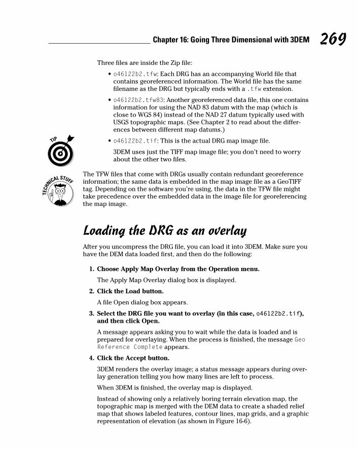
Three files are inside the Zip file:
• o46122b2.tfw: Each DRG has an accompanying World file thatcontains georeferenced information. The World file has the samefilename as the DRG but typically ends with a .tfw extension.
• o46122b2.tfw83: Another georeferenced data file, this one containsinformation for using the NAD 83 datum with the map (which isclose to WGS 84) instead of the NAD 27 datum typically used withUSGS topographic maps. (See Chapter 2 to read about the differ-ences between different map datums.)
• o46122b2.tif: This is the actual DRG map image file.
3DEM uses just the TIFF map image file; you don’t need to worryabout the other two files.
The TFW files that come with DRGs usually contain redundant georeferenceinformation; the same data is embedded in the map image file as a GeoTIFFtag. Depending on the software you’re using, the data in the TFW file mighttake precedence over the embedded data in the image file for georeferencingthe map image.
Loading the DRG as an overlayAfter you uncompress the DRG file, you can load it into 3DEM. Make sure youhave the DEM data loaded first, and then do the following:
1. Choose Apply Map Overlay from the Operation menu.
The Apply Map Overlay dialog box is displayed.
2. Click the Load button.
A file Open dialog box appears.
3. Select the DRG file you want to overlay (in this case, o46122b2.tif),and then click Open.
A message appears asking you to wait while the data is loaded and isprepared for overlaying. When the process is finished, the message GeoReference Complete appears.
4. Click the Accept button.
3DEM renders the overlay image; a status message appears during over-lay generation telling you how many lines are left to process.
When 3DEM is finished, the overlay map is displayed.
Instead of showing only a relatively boring terrain elevation map, thetopographic map is merged with the DEM data to create a shaded reliefmap that shows labeled features, contour lines, map grids, and a graphicrepresentation of elevation (as shown in Figure 16-6).
269Chapter 16: Going Three Dimensional with 3DEM

You can change the size of the map by choosing Resize Overhead View fromthe Operation menu. This brings up the Map Scale dialog box, where you canuse the slider bar to change the image size. Entering a 1 for the Map Scalevalue displays the map at a 1:1 ratio. You can move around the map withscroll bars if it’s too big to fit in the window.
Figure 16-6:Topographic
map com-bined withDEM data
showingfeatures and
elevation.
270 Part III: Digital Mapping on Your Computer
DRG filenamesSo what’s with the numbers in the DRG filename?Why couldn’t the USGS just have named it afterthe name of the topographic map (Mount St.Helens) to make things easier? There’s actuallysome logic behind the file-naming convention ofDRG map files (called the o-code, short for Ohio-code). Carve the o46122b2 filename to seewhat it means:
� 46: 46 degrees of latitude.
� 122: 122 degrees of longitude.
� b: A row within that latitude and longitudesquare. (Rows run south to north and arelabeled a–h.)
� 2: A column within the latitude and longitudesquare. (Columns run east to west and arenumbered 1–8.)
That makes a little more sense. All USGS DRGsuse this standard, which makes it easy for pro-grams to figure out which data files should beused for displaying adjacent maps.

Working with overlay mapsAfter you create an overlay map, you can print, save, and create 3-D scenesjust like with the map made from the DEM data in the preceding section.
In Figure 16-7, you can see a 3-D scene of inside the Mount St. Helens craterwith overlaid DRG data. Most of the menu and dialog box commands that Idescribe in earlier sections of this chapter work the same.
One command that’s unique to working with overlay maps displays the topo-graphic map without any relief shading (just like the paper version of the mapwould appear). To view the overlay map with no relief shading
1. Use the View tool to define the area you want to view. (Move and resizethe view square to choose the area.)
2. Choose Map Overlay View from the Operation menu.
3DEM displays the selected area as a topographic map without shading.To navigate around the map, use the window scroll bars.
3. To return to the shaded relief overlay map, choose Overhead Viewfrom the Operation menu.
Figure 16-7:A section of
an overlaymap dis-
played as a detailed
3-D scene.
271Chapter 16: Going Three Dimensional with 3DEM

Reviewing Other 3DEM Features3DEM has a number of other features worth mentioning:
� Multiple DEM file support: Instead of loading only a single DEM file at atime, 3DEM can merge DEMs to create 3-D models of large areas.
� GPS support: Waypoints, routes, and tracks can be downloaded from aGPS receiver and displayed on maps created by 3DEM.
� Aerial photo overlays: Aerial photographs can be overlaid on DEM data,just like DRG files, to create three-dimensional photos. (You need to geo-reference the photos first, which consists of identifying the coordinatesof several known points on the photo.)
� Flyby animation: 3DEM can create animation movies of flying over athree-dimensional scene.
� Additional data sources: 3DEM isn’t limited to using only DEM and DRGdata. 3DEM can create maps based on elevation data gathered by satel-lites, the Space Shuttle, and even Mars exploration probes.
After you master the basics of working with 3DEM, spend some time experi-menting with other program features. 3DEM has an extensive online Helpsystem that you can use to find out more about all aspects of the program.
If creating 3-D maps interests you, be sure to check out the Virtual TerrainProject at http://vterrain.org. This Web site is a clearinghouse for 3-Dterrain modeling information. You’ll find a number of links to resources andtools for creating three-dimensional maps of land forms and both natural andman-made features.
Other 3-D Mapping Software3DEM isn’t the only kid on the block when it comes to creating 3-D maps.Several other free or inexpensive Windows programs are available that youcan use for three-dimensional terrain modeling.
Global MapperGlobal Mapper is an easy-to-use, reasonably priced, and powerful mappingprogram that has some of the same features as 3DEM for processing DEM andDRG data. Global Mapper also has some options typically only found in expen-sive Geographic Information System (GIS) programs, including
272 Part III: Digital Mapping on Your Computer

� Extensive map data support: You can view and export a large number ofraster, vector, and elevation map data types.
� Multiple data layers: 3DEM works with only two layers (the elevation dataand the overlay image), but Global Mapper can use multiple layers of data.
� Relief shading: Like 3DEM, Global Mapper can create relief-shaded mapsto show elevation. (Global Mapper doesn’t produce layered 3-D imagesor animations.)
� Vector editing: Data in existing vector maps such as areas, lines, andpoints can be edited, and new data can be created.
� Contour generation: Contour lines maps can be generated by using ele-vation data.
� Line-of-sight tools: Global Mapper has a series of tools for determiningline-of-sight between two points and displaying view sheds (areas of terrain that can be seen from a certain vantage point). These tools areespecially useful for placing radio transmitters.
A trial version of Global Mapper (with limited features) is available. Folks inter-ested in digital maps should have this in their tool collection; it can displayjust about every digital map data type that’s commonly used. If you get seri-ous about making maps, consider purchasing the registered version becauseof its ability to export data, rectify images (make image data conform to a mapprojection system), and support multiple data layers.
You can find more about Global Mapper and download a free trial version of the program (a single license registration costs $179) at www.globalmapper.com.
The USGS (www.usgs.gov) distributes the free program dlgv32 Pro for usingDEM and DRG data. This is the same program as the unregistered version ofGlobal Mapper. Global Mapper is based on the publicly available source codeof an earlier USGS program called dlgv32; DLG stands for Digital Line Graph,which is a vector map data format.
273Chapter 16: Going Three Dimensional with 3DEM
TerraBase IIThe U.S. Army Engineer School at Fort LeonardWood (www.wood.army.mil/tvc) has a ver-sion of MICRODEM: TerraBase II. It’s the sameprogram as MICRODEM but was developed totrain soldiers on terrain analysis and using digitalmaps. The school’s Web site has an extensive
collection of screen capture, how-to videosdevoted to using MICRODEM. Although the AVIvideos are more oriented to military users, they’restill very helpful in finding how to get the mostout of MICRODEM for civilian purposes.

MICRODEMMICRODEM is a free Windows mapping program written by Peter Guth of theU.S. Naval Academy, Department of Oceanography. The program uses DEMdata to create terrain maps, contour maps, topographic profiles, and 3-Dscenes. The software can also overlay raster and vector data.
MICRODEM contains an impressive collection of features, including powerfuloptions for manipulating and analyzing geographic data. It also supports manydifferent map data types. These features can be a little overwhelming to anew user, and you really should spend some time reading the documentationto understand its capabilities before using the program. MICRODEM is wellsuited for the advanced digital map user.
You can download MICRODEM (the full install package is over 30MB) fromwww.usna.edu/Users/oceano/pguth/website/microdem.htm.
Bundled map programsIf you’re not that excited about finding and downloading DEM and DRG filesfor making your own 3-D maps, you can purchase a commercial softwarepackage that comes with map data and supports three-dimensional terrainviews. These commercial programs don’t have as many options for creatingcustom 3-D images compared with 3DEM, Global Mapper, and MICRODEM,but they’re very easy to use. Some programs to consider include
� Maptech Terrain Navigator
� DeLorme Topo USA and 3-D TopoQuads
� National Geographic TOPO!
I discuss these map products in more detail in Chapter 13.
274 Part III: Digital Mapping on Your Computer

Part IVUsing Web-hostedMapping Services

In this part . . .
The deal with this part is there are a whole lot of map-ping resources on the Web that are free. You know all of
those commercial programs in Part III that you have to shellout bucks for? In many cases you can get the same basicfunctionality (that means without the advanced featuresfound in commercial programs) for free, simply by knowingthe right place to point your Web browser. This part dis-cusses how to access and use online street maps, topo-graphic maps, aerial photos, and slick U.S. government-produced maps. You’ll also learn how to save and edit all ofthose wonderful, free Web-hosted maps.

Chapter 17
Saving and Editing Street MapsIn This Chapter� Saving Web maps
� Using fonts
� Adding symbols
� Selecting file formats
When you need to tell someone how to get somewhere, Web-hostedmapping services are a great resource for creating maps, especially
if you’re artistically challenged. You get a professional looking map by typingsome text and clicking a few buttons.
However, a Web map might not exactly meet your needs. Maybe it’s missing astreet name, or you want to add a few colored arrows to show a route througha confusing set of streets. Most map Web sites don’t have many options tocustomize a map.
This chapter has everything you need to customize a basic Web map. You’llalso find tips and hints on how to make your own maps, using a Web map asthe foundation. After you edit the map, you can
� Attach it to an e-mail.
� Paste it into a word processing document.
� Post it on a Web site.
� Print it on party invitations.
You’re not going to become a world-class cartographer overnight, but youcan produce some pretty good-looking maps.
The techniques in this chapter apply to any digital map. If you’re using amapping program, you can use the same methods to copy and save parts ofany map that’s onscreen.

Saving MapsMost Web-hosted mapping services don’t have an option for saving a map toyour hard drive. You can print the map, e-mail it, or maybe save a part of it soyou can upload to a personal digital assistant (PDA), but there’s no commandto save the map as a file.
Here are three paths around this roadblock:
� Right-click the map and choose Save Picture As.
� Use the Print Screen key.
� Use a screen capture program.
Save Picture AsAfter you display a map on a Web site, some Web sites let you save the mapto disk with a little-known browser command. Follow these steps:
1. Make the map the size that you want it in your Web browser.
When a screen capture is stored on the Clipboard, it’s saved in bitmap(.bmp) format. Bitmaps don’t scale very well, so you end up with jaggedlines or a blurry image if you shrink or enlarge the map in your graphicsprogram.
2. Right-click the map.
3. Choose Save Picture As (or Save Image As, depending on yourbrowser).
4. Select the file directory location to save the image.
The map picture is saved as a file to the directory location that you select.
278 Part IV: Using Web-hosted Mapping Services
Captured: Screen capture programsLots of screen capture programs are available onthe Internet. Most are either shareware or free-ware. Two of my favorites are
� SnagIt: A commercial screen capture utilitythat’s been around since the first versionsof Windows. It has a number of powerfulfeatures. It’s available at www.techsmith.
com/products/snagit/default.asp.
� MWSnap: If you’re on a budget, this is anexcellent freeware screen capture utility withlots of features. It’s easy on system resources,too. It’s available at www.mirekw.com/winfreeware/mwsnap.html.

Using the Print Screen keyBefore Windows appeared on personal computers, the Print Screen key on a PC keyboard sent a copy of the monitor screen to the local printer. WhenWindows was introduced, things changed. Here’s what happens now:
� Press Print Screen only. The entire screen is copied to the Clipboard.
� Press Print Screen while you hold down Alt. The active window iscopied to the Clipboard.
Using the Print Screen options are handy if a Web site has disabled the SavePicture As menu command or if the Web map isn’t being stored as a graphicsfile that can be easily saved.
Pressing Print Screen or Alt+Print Screen sometimes copies parts of the screenthat don’t have anything to do with the map, such as menus, title bars, andbuttons. If you don’t want these on your map, you can either use a screencapture program instead of Print Screen or manually edit the map in a graph-ics program. This chapter explains both.
Different keyboards label the Print Screen key different ways. It might be PrintScreen, PrintScreen, PrtSc, or something else, but you should be able to spotit. The key usually is to the right of the F12 function key.
Follow these steps to save a Web page map with Print Screen:
1. Display the map in the size you want to save.
Map Web sites usually can show maps in several sizes.
2. Press Alt+Print Screen to save the active window to the Clipboard.
This is more efficient than capturing the entire screen with just the PrintScreen key.
After the map is on the Clipboard
1. Run a graphics program such as Paint.
2. Use the Paste menu command to insert the Clipboard image into anew file.
3. Save the file.
Using screen capture programsScreen capture programs provide more options and flexibility than the PrintScreen key. For example, you can select part of the screen and copy it. Youjust save the map without editing all the clutter around it.
279Chapter 17: Saving and Editing Street Maps

Although screen capture programs have different user interfaces, they gener-ally work like this:
1. Run the screen capture program.
2. Assign a hot key (usually either a function key or a combination ofcontrol keys) that starts the screen capture.
3. Make the map the size you want it in your Web browser.
4. Press the hot key.
5. Click and draw a rectangle over the region of the screen that youwant to capture.
6. Use the capture command to copy the screen region to the Clipboard.
This command will vary depending on the screen capture program you’reusing. Depending on the screen capture program used, a copy of thatpiece of the screen is either placed on the Clipboard or directly savedto a file that you name.
Figure 17-1 shows a Web map selected with the MWSnap screen capture pro-gram to place in the Clipboard.
Figure 17-1:Using theMWSnap
screencapture
program tocopy a map
to theClipboard.
280 Part IV: Using Web-hosted Mapping Services

Editing a MapEditing a saved map is just a matter of opening the saved file with a graphicsprogram. The graphics program can be as basic as the Paint accessory pro-gram that comes with Windows or as sophisticated as a commercial, high-enddesign program.
A simple graphics program like Paint is fine if you’re not making a lot ofchanges.
If you’ve got an itch to be a cartographer and want to go beyond using gen-eral graphics programs, check out Map Maker, a popular commercial desktopmapping program. You can get a free, limited-feature version called Map MakerGratis at www.mapmaker.com.
Almost all Web maps have text at the bottom with copyright information andwhere the map came from. Leave it intact to respect the copyright and to creditthe company that provided the map.
Opening a fileIf you used Print Screen or a screen capture program, you need to get the mapinto the graphics program so that you can edit it. Follow these steps to load amap so you can edit it:
1. Run the graphics program.
2. If one isn’t already onscreen, open a new file.
3. In the Edit menu, select the Paste command. Or, if you’ve previouslysaved the map to a file, use the Open command in the File menu toopen it.
The map image is loaded, and you’re ready to change it.
CroppingIf your map file has more than just your map (such as unrelated windows,icons, or dialog boxes), one of the first things that you need to do when thecaptured screen is loaded in the graphics program is to crop (trim) the imageso only the map is shown.
281Chapter 17: Saving and Editing Street Maps

Automatic croppingAutomatic cropping is fast and easy if your graphics program has a crop com-mand. The command automatically removes everything outside of a selectedrectangle, leaving only the image within the rectangle intact.
Manual croppingIf your graphics program doesn’t have a crop command, you can crop a mapmanually by copying and pasting what you want. Follow these steps:
1. Use the selection tool to select the map.
2. In the Edit menu, choose the Copy command.
3. Open a new file.
4. In the Edit menu, choose the Paste command to place the map into thenew file.
Using colors and fontsThe colors and fonts that you use in a map can make a big difference inappearance and readability.
ColorsColors let a user quickly differentiate features on a map. A black-and-whitemap might convey the same information as a color map, but hues and shadescan make a map easier to read.
282 Part IV: Using Web-hosted Mapping Services
Pixels for freeAlthough a number of commercial graphics pro-grams are on the market, I’m a big fan of freesoftware. Here are some free graphics programsI find useful for creating my own maps:
� DrawPlus 4 (simple to use with lots of professional features): www.freeserifsoftware.com/serif/dp/dp4/index.asp.
� EVE (a very small, vector graphics programperfect for drawing diagrams and maps):www.goosee.com.
� OpenOffice-Draw (part of the OpenOfficesuite, which means you also get a wordprocessor, spreadsheet, and presentationsoftware in addition to a graphics program):www.openoffice.org.
� Zoner Draw 3 (fast with support for lots ofgraphics file types): www.zoner.com/draw3/default.asp.
All these programs are more powerful thanPaint, and have object-oriented (vector) draw-ing capabilities. Plus, you can’t beat the price.

Here are some of the most important rules when it comes to dealing with color:
� Use the same general color scheme as the Web map you’re editing.
Any text or features that you add to the map should be the same coloras the text and features shown on the Web map.
� Use contrast between background and text.
• On a light background, use dark text. Black text is usually best.
• On a dark background, use light text.
� Use bright colors to draw attention to a feature such as a location orroute of travel.
Use red to identify a location the user is searching for.
FontsText labels play an important role in maps; here are some well-founded guide-lines for using fonts and typeface styles with maps. These tips will make yourdigital maps easy on the eyes:
� When adding new labels, use the same typeface as Web map text (or as close to the typeface as possible).
� Feature names should be in a normal typeface. Don’t bold or italicize them.
� Feature names should only have the first letter capitalized.
Capitalizing an entire name on a map makes it harder to read.
� Text in a straight line is easier to read and find than curved text (such as a street name that curves around a corner).
� Sans serif fonts are easier to scan on a computer screen.
You’re reading a serif font right now. Sans serif fonts, such as Arial, have letters without serifs (small lines on the top and bottom of somecharacters).
If you must use a serif font, Georgia is more legible than Times NewRoman.
� Don’t mix fonts and font size when labeling map features unless youhave a really good reason.
Adding symbolsSymbols convey information without using words. For example, a tent meansa campground, a skier indicates a ski trail, and an airplane means an airport.
283Chapter 17: Saving and Editing Street Maps

Most Web maps don’t show many symbols. Adding your own symbols is aquick and easy way to improve a map’s readability. For example, if you make a map where the route passes a restaurant, you can add the usualround plate with a knife and fork in the center to show the restaurant on the map.
If you’re adding a symbol to a map, make sure that users will understandwhat it means. You may think a picnic table clearly represents a park, butsomeone else may have no idea what the symbol is and wonder why therewas a smudged blob on the map.
Finding symbolsHere are two ways you can get symbols for a map:
� Create your own. Making your own symbol involves using your graphicsprogram to design a small, icon-sized image.
If you’re not artistically inclined, this will result in something that lookslike a smudged blob.
� Use a symbol from a font. Many fonts contain symbols that you can useon your map. Some fonts are composed solely of mapping symbols. Usinga font symbol is quick and easy, and you don’t need a graphics art degreeto make one.
A number of fonts that contain map symbols are freely available on theInternet. Here are two Web sources that I turn to when I’m looking forsymbols to include on a map:
• Luc Devroye’s Map/Travel dingbats Web site has a large number oflinks to symbol fonts suitable for maps. Go to http://cgm.cs.mcgill.ca/~luc/travel.html.
• Mapsymbols.com contains a number of symbols formatted for usewith the commercial ArcInfo and ArcView Geographic InformationSystem (GIS) programs. A number of symbol fonts are also listed.Check out www.mapsymbols.com/symbols2.html.
Commercial GIS software companies offer free programs that can view GISfiles created by their full-featured programs. Many of these programs install acollection of symbol fonts into the Windows Font folder. (Some demonstra-tion versions of mapping programs do this, too.) Even though you might notuse the viewer or demo program, sometimes it’s worthwhile installing just to use the fonts.
284 Part IV: Using Web-hosted Mapping Services

Inserting symbolsFollow these steps to add a symbol from a font to a map in your graphics program:
1. Install the symbol font.
This process depends on your Windows version. Your Windows onlineHelp system or user guide has instructions for installing fonts.
2. Run the Character Map program by following one of these two steps:
• Choose Start➪Programs➪Accessories➪System Tools➪Character Map.
• Choose Start➪Run, and then type charmap in the Run dialog box.
3. Select the font you want from the Font drop-down list.
4. Click the symbol you want to use.
5. Click the Select button; then click the Copy button to copy the symbolto the Clipboard.
Figure 17-2 shows the Character Map user interface.
6. Select the text tool in your graphics program.
7. Move the cursor to where you want the symbol to appear and thenclick.
8. Paste the symbol from the Clipboard into the map.
Figure 17-2:Use
CharacterMap to
copy a mapsymbol
to theClipboard.
285Chapter 17: Saving and Editing Street Maps

Moving symbolsIf you want to move the symbol after you’ve placed it, follow these steps:
1. Click the graphics program’s selection tool.
2. Select the symbol.
3. Drag the symbol to a new location on the map.
Selecting the right file formatWhen the map is exactly how you want it, the last step is to save the file. It’simportant to select the file format that best suits your needs.
If you’re sending a map to someone as an e-mail attachment or posting it on aWeb page, be considerate of those who will view the map. Keep the file size assmall as possible while making the map retain enough detail to be easily read.
A map on a Web site should take less than ten seconds to download over adialup Internet connection — that means roughly less than a 70K graphics file.
BMPA bitmap (BMP) file is a bit-for-bit representation of how an image appears ona computer monitor. Bitmap files can contain millions of colors.
Don’t save your map as a bitmap file if you’re using it in e-mail or placing it ona Web site. Files in this format tend to be pretty large because images aren’tcompressed.
286 Part IV: Using Web-hosted Mapping Services
Missing Character Map?If Character Map doesn’t show up in the SystemTools menu, choose Start➪Select Programs andAccessories; some versions of Windows storethe command here instead of in System Tools. Ifyou still can’t find the program, you need toinstall it. This is easy and usually doesn’t requireinserting any floppy disks or CDs. Follow thesesteps to install Character Map:
1. Choose Start➪Settings➪Control Panel.
2. Double-click the Add/Remove Programsicon.
3. Click the Windows Setup tab and enableeither the System Tools or the Accessoriesoption, depending on your Windows version.
4. Click the Details button.
5. Enable the Character Map option.
6. Click Apply.

JPGA JPG (or JPEG; pronounced JAY-peg) file is designed for saving photographsand other complex images. JPG stands for Joint Photographic Experts Group,the people who came up with this file format.
It supports millions of colors. JPG images are compressed, so they’re smallerthan BMP files. The JPG format should be used for photographic quality imageswhere most pixels are different colors.
GIFGIF (pronounced jif or gif) should be your first file format choice for savingyour edited maps.
GIF stands for Graphics Interchange Format. GIF files are compressed but arelimited to a palette of 256 colors. This format is widely used for Web maps orany image that has large regions of the same color.
PNGPNG (Portable Network Graphics) is designed to support millions of colors forInternet use. It’s slowly replacing the GIF format. Because it produces relativelysmall files, you should consider using it for maps that will be sent in e-mail orassociated with a Web site.
287Chapter 17: Saving and Editing Street Maps
Designing maps for the WebSuccessfully designing maps that are displayed on a Web site isn’t just a matter of randomly select-ing fonts, colors, and lines and combining them.
If you’re serious about creating maps for the Web, check out these three excellent resources:
� Map Content and Design for the Web: A Guide to Optimizing Cartographic Images on the Web.A Canadian government site with detailed information on Web map design principles.
http://atlas.gc.ca/site/english/learning_resources/carto/content.html
� Web Cartography edited by Menno-Jan Kraak and Allan Brown. London: Taylor & Francis. A goodreference book on how maps are used on the Internet. The book has a companion Web site:
http://kartoweb.itc.nl/webcartography/webbook/index1.htm
� Web Style Guide: Basic Design Principles for Creating Web Sites by Patrick J. Lynch and SarahHorton. Not map-specific, but important style design guidelines for developing any Web site.There’s an online version of this guide:
http://info.med.yale.edu/caim/manual/contents.html

288 Part IV: Using Web-hosted Mapping Services

Chapter 18
Navigating Web Road MapsIn This Chapter� Exploring street map Web sites
� Reviewing common features
� Choosing between Web and PC street maps
� Taking a tour of street map Web sites
As surprising as it sounds, the Internet has actually made a big difference inhelping people in cars not get lost. Free Web services that provide street
maps and driving directions consistently generate some of the highest amountsof ’Net traffic. As an example, at the end of 2003, the popular MapQuest Website produced over 10 million maps and sets of driving directions per day with30 million visitors each month. That’s a lot of maps and a lot of people who arelooking for maps.
In this chapter, I explore the world of online street maps. Here you discover thebasic features that street map Web sites offer, some advantages and disadvan-tages to using the services, and some popular street map Web sites in action.
If you’ve never used a street map Web site before, use this chapter to get onthe road using them. And even if you’re a veteran online map user, you’llprobably discover some tips as well as other street map sites you might nothave known.
Using Street Map Web SitesA street map Web site is simply an easy-to-use front end to a large database thatcontains location and map information. When you visit a site and want to viewa map associated with a specific street address, the server retrieves the appro-priate data from a database and displays a map in your Web browser. You canthen scroll and zoom in and out on the map to change views and also get otherinformation (such as driving directions) by using your keyboard or mouse.

Map sites use geocoding to locate addresses, which means that latitude andlongitude coordinates are assigned a street address. These coordinates arethen passed to the map database to retrieve a map or driving directions.
Listing common street map Web site featuresYou can find quite a few street map Web sites on the Internet, and they gener-ally all have the same features in common, including
� Map display: Obviously, street map sites have street maps. Streets androads are displayed in vector maps (created with lines and shapes)instead of raster maps (scanned versions of paper maps). Vector mapsare faster and efficient to display. You can zoom in and out on the mapsto view them in different scales.
� Address searches: To display a map, you enter a street address, city,state, or ZIP code. The map Web site checks the location informationthat you entered to see whether it’s valid; if it is, the map is displayed.
� Route creation: In addition to showing a map of a single location, streetmap Web sites can also create routes that show you how to get fromPoint A to Point B. Just enter a starting and ending address, and the Website will display a map of how to get to your destination.
� Route directions: Street map Web sites also can provide you with dri-ving directions for getting to a location. The directions list streets, turns,and estimated times and distances for traveling between different partsof the route.
� Printing: All street map Web sites can output maps and driving direc-tions to your printer, which is usually easier than lugging your PC withyou on a trip.
Street map Web site companies usually don’t make their own maps but relyon map data licensed from one or more third-party map companies such asGeographic Data Technology (GDT), NAVTECH, and TeleAtlas. Although mapWeb sites might use the same data, their maps can look different dependingon how they display and use the data.
Web versus PC software street mapsIf you’ve read Chapter 12 (all about PC street-navigation programs), youmight be wondering whether you should use a Web-hosted street map or aprogram that comes bundled with a street map CD-ROM. Both can findaddresses, display street maps, and create routes. To answer your question,look at the advantages and disadvantages to using street map Web sites com-pared with their PC program cousins.
290 Part IV: Using Web-hosted Mapping Services

Street map Web site advantagesSome of the advantages that street map Web sites offer are that they’re
� Free: Street map Web sites are one of those valuable resources that youcan still get for free on the Internet. The companies that host these mapsites stay in business by selling advertising, offering other mappingproducts and services to corporate customers, or charging for premiumservices.
� Easy to use: Street map Web sites are very simple to use. They offerbasic mapping features and easy-to-understand user interfaces.
� Available almost anywhere: If you have an Internet connection and aWeb browser, you can find street addresses and create maps from justabout anywhere you can access the ’Net.
� More frequently updated: One of the big selling points to maps on Websites is they can be updated more frequently than maps that come withPC software; which tend to be updated annually. (However, I’ve yet tosee a map site provide details on how often and which maps have beenupdated.)
Street map Web site disadvantagesSome of the drawbacks to using street map Web sites include
� Limited POIs: PC street map software packages have a large number ofPoints of Interests (POIs) on maps such as gas stations, restaurants, andother businesses and services. Most street map Web sites don’t show
291Chapter 18: Navigating Web Road Maps
Map accuracyOn Christmas Day, 1998, a German driver out fora spin in a GPS-equipped BMW drove his carinto a river as he dutifully followed the direc-tions of his in-car navigation system. Despitethe stop signs, he continued down a ferry rampand drove into the Havel River, slowly sinking inabout 12 feet of water. Fortunately, the driverand his passenger were not injured. The digitalmap displayed in his dashboard showed abridge when it actually should have beenmarked as a ferry crossing — and the drivertrusted his BMW more than his common sense.
This is a rather extreme case, but it does illus-trate an important point: Street maps will
always have some errors in them, and you can’texpect 100 percent accuracy. Software compa-nies, Web sites, and map data vendors do trytheir best to keep maps current and up-to-date.(Most map Web sites even have ways to reporterrors in maps and driving directions.) However,when you consider the 3.95+ million miles ofpublic roads in the United States — with con-stant, ongoing construction — keeping mapsaccurate can be a daunting challenge. So trynot to get too frustrated if a map Web site occa-sionally makes a boo-boo. And watch out forferry crossings.

POIs or only display a limited number, such as selected hotels or otheradvertisement-based services
� Limited route capabilities: Many street map Web sites can create routesonly between two locations. PC map programs allow you to build routeswith multiple legs, change routes on-the-fly while you’re driving, andspecify locations to travel through on your way to a destination.
� No trip-planning features: PC street map programs support calculatingtrip costs, determining gas stops, setting typical driving speeds, andother advanced trip-planning features. Map Web sites don’t have allthese options.
� No customization options: Unlike PC map software, street map Websites don’t have drawing tools for customizing maps with added text orsymbols.
If you want to add text or symbols to a map created with a Web site,you’ll need to apply some of the techniques that I describe in Chapter 17and use a graphics program to edit your map.
� Lack of GPS compatibility: Unlike a laptop or PDA that’s running street-navigation software and is connected to a GPS receiver, Web sites don’tprovide you with real-time GPS tracking capabilities.
� Advertisements: If you use a street map Web site, be prepared for lots ofads. Although the ads pay for the mapping service (which allows theservice to continue to be free to you), ads can take up to two-thirds ofthe screen, leaving only a small portion available to display a map.
Choosing between Web-hosted and PC software street mapsIf you can’t make up your mind whether to use Web-hosted or PC softwarestreet maps, here are few guidelines:
� Infrequent use: If you need to look up an address only every now andthen and periodically plan trips, you’ll probably be served perfectly wellusing a street map Web site.
� Frequent use: If you travel quite a bit, you’ll likely want the additionalfeatures that I mention earlier in this chapter that are found in PC street-navigation programs. The enhanced features make life easier for the fre-quent traveler.
� Customizable: If you want to customize your maps such as adding textlabels to them, PC map software offers many more features and optionsfor creating custom maps.
� Speed: Even if you have PC map software, street map Web sites can befaster to use if you need to quickly look up a street address, especially ifyou have a broadband Internet connection.
292 Part IV: Using Web-hosted Mapping Services

Reviewing Street Map Web SitesIn this part of the chapter, I review several popular street map Web sites, talkabout their features, and show what their maps look like.
Map companies are always trying to improve the usability of their maps. Youmight find some differences in the appearance of the maps that you see dis-played on a Web site and the ones in this chapter.
To start with, all street map Web sites work the same when it comes to dis-playing maps and driving directions. Their user interfaces might be slightlydifferent, but if you’re familiar with using one street map Web site, you’ll beable to easily use others. By mastering these basic skills, using just about anystreet map Web site should be a snap:
� To display a map for a specific location, you enter an address, city,state (or country), and optional ZIP (or postal) code and then click asearch button. See an example of the MapQuest address search page inFigure 18-1.
Figure 18-1:MapQuest
addresssearch
page.
293Chapter 18: Navigating Web Road Maps

You can also just enter a city and state or a ZIP code to display anoverview map of an area.
� To display a driving route between two points, either in the form of amap or turn-by-turn directions, you click a directions button or link, andthen enter the address, city, state (or country), and optional ZIP (orpostal) code for the starting point and destination. As an example, theMapQuest driving directions search page is shown in Figure 18-2.
After a map is displayed, you can zoom in and out to show more detail or a larger area, respectively. Most maps feature a zoom scale with a series ofboxes with a plus and minus sign at each end. Clicking a box nearer to theplus sign zooms in, and clicking a box closer to the minus sign zooms out.
You can move around the map by clicking arrows or compass points thatborder the map; the map scrolls in the direction of the arrow or compass point.
All map Web sites provide an online help link. Even if you’ve used a streetmap Web site for a while, it’s worth your time to read the help information.There’s a good chance that you’ll discover something new that might saveyou some time.
Take a quick look at some street map Web sites.
Figure 18-2:MapQuest
drivingdirections
searchpage.
294 Part IV: Using Web-hosted Mapping Services

MapQuestMapQuest (www.mapquest.com) is the largest and most popular map Website on the Internet and provides street maps of North America and Europe.(You can also view less-detailed, worldwide, city, and country maps.) The sitewas first launched in 1996, and its corporate roots extend back to the 1960s,when its original parent company started making paper road maps that weredistributed by gas stations. America Online currently owns MapQuest, andthe site generates millions of maps each day and consistently ranks in top tenof the most-popular Web site lists.
After you search for an address and display a map, as shown in Figure 18-3,you can print it, e-mail the map as an attachment, or download it to a PDAthat’s running AvantGo (www.avantgo.com) software.
MapQuest can provide specially formatted maps and driving directions forwireless PDAs and cellphones with Internet connectivity. Check out the linkto Mobile MapQuest (look for Mobile) on the MapQuest home page for infor-mation on using different types of wireless devices.
Like all street map sites, MapQuest provides route maps (an example is shownin Figure 18-4) and driving directions. In addition to addresses, you can alsosearch for businesses by name or type even if you don’t know their address.
Figure 18-3:An address
searchMapQuest
map.
295Chapter 18: Navigating Web Road Maps

Rand McNallyRand McNally (www.randmcnally.com), in the map business since 1856, nowproduces both paper and electronic street maps for the United States. ItsWeb site offers some of the cleanest, easiest-to-read online maps that areavailable on the Internet; an example is shown in Figure 18-5. If you’re used tomaps with jagged lines that look computer-generated, the second-generationdigital maps that Rand McNally produces will pleasantly surprise you.
After you display a map, you can change its size, print it, e-mail it, or save itonline if you’ve previously registered with a free or paid Road Explorersmembership.
In addition to standard route mapping capabilities, Rand McNally has optionssuch as selecting fastest or shortest routes, whether to use a greater orlesser number of route steps, and displaying driving directions in several dif-ferent formats. (A simple route map is shown in Figure 18-6.) The site is alsoone of the best places on the Web for planning vacation road trips. RandMcNally has taken a large amount of content from its popular paper travelguides and put it online to help you find attractions and activities on yourtrips. The only major issue that I’ve found with this site is its servers seem toget bogged down every now and then, tending to be slower displaying mapsand generating routes compared with other sites.
Figure 18-4:A route
MapQuestmap.
296 Part IV: Using Web-hosted Mapping Services

Figure 18-6:A route
RandMcNally
map.
Figure 18-5:An address
searchRand
McNallystreet map.
297Chapter 18: Navigating Web Road Maps

MaporamaWhen I’m going to travel outside the United States, one of my first stops isMaporama (www.maporama.com), the French company that maintains a freestreet map Web site to showcase its mapping products and services. AtMaporama, you can look up street maps from all over the world. The level ofdetail varies depending on how industrialized a country is; for example, youget better maps for Switzerland than you will for Swaziland.
Street maps such as the one displayed in Figure 18-7, can be printed, e-mailed,or downloaded to a PDA. Maporama is one of the few mapping sites that letsyou select exactly what size to display the map and what colors you want themap shown in. For example, a grayscale color style is available for using mapson monochrome screen PDAs.
If you ever need latitude and longitude coordinates for an address,Maporama displays the coordinates (beneath the map) of an address you’vesearched for. The latitude and longitude might not be as precise as standingoutside the location with a GPS receiver in hand, but they’ll be close.
Figure 18-7:A
Maporamastreet map.
298 Part IV: Using Web-hosted Mapping Services

Maporama also displays routes and driving directions, but I find that theroute maps often don’t show as much detail as route maps created by otherWeb sites. (A sample map is shown in Figure 18-8.) Detailed turn-by-turndirections are displayed below the route map, though, steering you in theright direction to reach your destination. Maporama also has some nice fea-tures usually not found on map sites such as
� You can select routes depending on your mode of transportation: by car,foot, or foot and subway (more suited for Europe than the U.S.).
� Zoomed-in maps show numbered address ranges on street blocks.
� Symbols show transportation and other points of interest.
Figure 18-8:A route
Maporamamap.
299Chapter 18: Navigating Web Road Maps

300 Part IV: Using Web-hosted Mapping Services
More online street map sitesUse these alternative street map Web sites onthe ’Net to find your way around. Here are sev-eral other popular ones, with the geographicareas that they cover, and their Web addresses:
� Map24: Europe; www.map24.com
� Maps On Us: United States; http://mapsonus.com
� ViaMichelin: Europe; www.viamichelin.com
� Multimap: Europe, United States, andAustralia; www.multimap.com
� MSN maps and directions: North Americaand Europe; http://mappoint.msn.com
� Yahoo! maps: North America; http://maps.yahoo.com

Chapter 19
Exploring Web Topographic MapsIn This Chapter� Displaying maps with Maptech’s MapServer
� Creating GPS maps with GPS Visualizer
� Reviewing commercial topographic map Web sites
Web-hosted street maps are handy for finding your way around in cities,but what if your travels take you off-road, on less-beaten paths in
forests, mountains, and deserts? You’re in luck because a number of Websites provide free or inexpensive topographic maps of the United States thatyou can view, print, and take with you on your next adventure.
In this chapter, I discuss some of the differences between topographic mapsoffered on the Web and dedicated topographic mapping programs that runon your computer. I also present some popular topographic map Web sitesas well as basic instructions on using them to display maps.
Using Web-hosted Topographic MapsWeb-hosted topographic sites are fast and easy to use. If you’ve already readChapter 13 (which covers topographic map software for PCs), you might bewondering whether you should buy a mapping program or rely on free or low-cost Web map services. Look at some of the advantages and disadvantages tousing topographic map Web sites.
Advantages of topographic Web sitesTopographic map Web sites are pretty handy. Just visit a Web site and voilà! —instant map. These maps have several advantages:
� Available anywhere: If you can access a computer with an Internet connection — say at home, the office, a library, or an Internet café —topographic maps are but a few mouse clicks away.

� Easy to use: If you’re intimidated by the many options and commands inmost PC mapping software products, Web-hosted map sites usually havea basic set of features and commands that are easy to master and use.
� Inexpensive: If you’re on a budget, these Web sites are either free orcharge nominal subscription fees to access their maps.
Disadvantages of topographic Web sitesWeb-based topographic mapping sites have a few limitations:
� Small map size: Most sites display only relatively small-sized (onscreen,that is) maps.
� Internet accessibility issues: Sometimes you might not have access toan Internet connection, the mapping Web site could be down, or yourInternet connection could be very slow.
� Time investment: Saving a Web-displayed map (whether you’re usingscreenshots and other techniques described in Chapter 17 or download-ing a map from a commercial service) can be a time-consuming process.
� No advanced features: Most topographic map Web sites don’t have suchadvanced features as interfacing with a GPS receiver, the ability to changemap datums or display terrain three-dimensionally, or options for cus-tomizing maps. These features are common in PC mapping programs.
A number of these limitations are addressed by commercial map Web sitesthat I describe later in the “Commercial topographic Web map sites” section.
Deciding between Web-based maps and mapping programsHere are my recommendations as to whether you should use Web-basedtopographic maps or topographic mapping programs:
� Infrequent use: If you just want to print out a topographic map everynow and then, a free Web-hosted map site probably meets your needs.
� Frequent or sophisticated use: If you use topographic maps often, want tocreate custom maps, or interface your GPS with a digital topographic map,you’re better off with one of the map programs described in Chapter 13or trying a commercial Web site that offers topographic maps.
� Quickies: Even if you regularly use PC mapping software, topographicmap Web sites are great for quickly creating or viewing maps.
302 Part IV: Using Web-hosted Mapping Services

Reviewing Topographic Map Web SitesHere are some of the Web sites that you can visit to access topographic mapsof the United States. I cover both free and commercial sites and discuss someof their basic features. If you’re near a computer with an Internet connection,you can follow along as I step through some examples on how to display anduse topographic maps on several free Web sites.
Web sites come and go, and user interfaces and site features change.
Using Maptech MapServerMaptech (http://maptech.com) is a map and navigation software companythat produces topographic, nautical, and aviation mapping products. (I dis-cuss its Terrain Navigator software in Chapter 13.)
To showcase its map technology and sell products, Maptech hosts MapServer,the free Web service database that contains maps and the names of cities,lakes, mountains, and other features. You can visit MapServer by pointingyour Web browser to http://mapserver.maptech.com.
Displaying MapServer mapsMapServer can’t read your mind to know what map you want to look at, so youfirst enter some search information in the upper-left corner of the MapServerWeb page. For example, suppose you’re interested in looking at a map of the city of Bar Harbor, Maine. (Try the lobster ice cream if you’re ever in theneighborhood.) To display the map, follow these steps:
1. Enter Bar Harbor in the Enter City or Place Name text box.
You can also enter the ZIP code of a location (and click its Go! button) orclick the Advanced Search button to find a map by either its name or itslatitude and longitude coordinates.
2. Choose Maine from the Select State drop-down list box.
3. Click the Go! button.
A list of places matching the place that you entered is displayed. In thiscase, I get 24 matches for Bar Harbor (as shown in Figure 19-1). Click thefirst entry for a map of the city of Bar Harbor. You know that’s the rightone because it’s identified as a Populated Place (under the Type heading).
303Chapter 19: Exploring Web Topographic Maps

MapServer provides you with a bonus: You can also view several other typesof maps. These map types appear above the map as tabs, as shown in Figure19-2, and include
� Topo Map: A United States Geological Survey (USGS) topographic mapof the area
� Nautical Chart: A National Oceanic and Atmospheric Administration(NOAA) nautical chart of the area (if navigable waterways are nearby)
� Aeronautical Chart: A Federal Aviation Administration (FAA) aeronauti-cal chart of the area for use by pilots
� Nav Photo: An aerial photo of the area
The topographic map is displayed by default; change the display to anothertype of map by clicking one of the tabs. If the Nautical Chart or Nav Photo tabitems are dimmed, those types of charts aren’t available for viewing.
You can print the currently displayed map by choosing Print MY MAPS fromthe FUN TOOLS drop-down list box (lower-left corner of the screen, underCoordinates).
Figure 19-1:Search forplaces by
name, state,ZIP, or coor-
dinates inMapSearch.
304 Part IV: Using Web-hosted Mapping Services
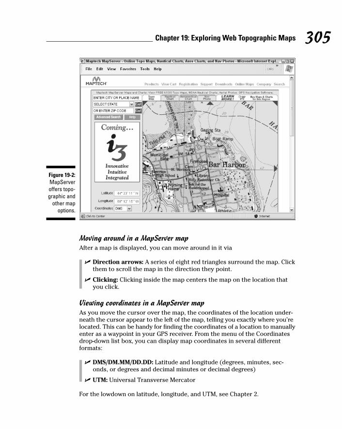
Moving around in a MapServer mapAfter a map is displayed, you can move around in it via
� Direction arrows: A series of eight red triangles surround the map. Clickthem to scroll the map in the direction they point.
� Clicking: Clicking inside the map centers the map on the location thatyou click.
Viewing coordinates in a MapServer mapAs you move the cursor over the map, the coordinates of the location under-neath the cursor appear to the left of the map, telling you exactly where you’relocated. This can be handy for finding the coordinates of a location to manuallyenter as a waypoint in your GPS receiver. From the menu of the Coordinatesdrop-down list box, you can display map coordinates in several different formats:
� DMS/DM.MM/DD.DD: Latitude and longitude (degrees, minutes, sec-onds, or degrees and decimal minutes or decimal degrees)
� UTM: Universal Transverse Mercator
For the lowdown on latitude, longitude, and UTM, see Chapter 2.
Figure 19-2:MapServeroffers topo-graphic and
other mapoptions.
305Chapter 19: Exploring Web Topographic Maps

MapServer displays all map coordinates using the NAD 27 map datum. If youdon’t know (or remember) what datums are, head to Chapter 4 to read whythey are important when you’re using a GPS receiver.
Changing a MapServer map sizeYou can change the size and appearance of a MapServer map three ways:
� Click To Zoom: Underneath the map are a series of bars between iconsof two magnifying glasses: one with a plus sign and the other with aminus sign. Click one of the bars to zoom in or out on the map. The barsclosest to the plus magnifying glass zoom in, and the bars closest to theminus magnifying glass zoom out.
� Scale: The Scale drop-down list box allows you to change the scale of themap. For example, a topographic map can be viewed at 1:24,000, 1:50,000,1:100,000, or 1:250,000 scale. The larger the number to the right of thecolon, the less detail there is and the more area shown. A 1:100,000 scalemap is shown in Figure 19-3.
� Zoom: Use the Zoom drop-down list box to change the size of the map,either showing it at 100% or reducing its size to 50% of normal. Selectthe size from the drop-down list box and click the Go! button. Figure 19-3shows the same map at 50% as in Figure 19-2 at 100%.
Figure 19-3:Map of Bar
Harborshown at1:100,000
scale with50% zoom.
306 Part IV: Using Web-hosted Mapping Services

Using MyMapsMapServer has a unique feature — MyMaps — that lets you create and savecustom maps. After you create a map, you can refer to it for future reference,e-mail it to friends, or add a link to the map on a Web site.
The MapServer Web site has a comprehensive tutorial for using MyMaps, butread along as I show you quickly how to create a custom map. Display themap you want to customize and follow these steps:
1. From the FUN TOOLS drop-down list box, choose Place an Icon.
This launches the MyMaps Wizard, which steps you through the processof building a custom map.
2. When the map in the wizard is the one you want, click NEXT.
3. Click a point on the map that you want to label with an icon.
A blue arrow pointing to that location appears.
4. Click NEXT.
5. Choose the type of symbol you want to associate with the locationfrom the list of symbol categories; then click NEXT.
For example, if the location is for transportation, choose Transportation.
A list of icons appears for the selected symbol type. If you chooseTransportation, icons of cars, planes, and other vehicles are displayed.
6. Click the icon you want to use and then click NEXT.
7. Enter a name to associate with the location; then click the PreviewName button to see the map. If you’re satisfied, click NEXT.
8. Decide whether to associate a Web site with the location:
• If you want someone to click the map location to visit a specifiedWeb site, enter a Web site address.
• If you don’t want a Web site link, click NEXT to continue.
9. Click the SAVE TO MYMAPS button to save your map.
A new drop-down list box named MYMAPS is added to the MapServer Webpage below the search boxes in the upper-right corner of the window.
� A list of all the maps that you’ve created appears in the list box. Choosinga map and clicking the Go! button displays the map.
� A Manage MYMAPS item in the drop-down list lets you delete a map orchange its name.
307Chapter 19: Exploring Web Topographic Maps

MyMaps stores information about the map you’ve created as a Web browsercookie. Whenever you visit the MapServer Web site, it checks for map cookiesand then displays the titles of any maps you’ve created in the MYMAPS drop-down list. Cookies apply only to the computer you used to create the maps; ifyou access MapServer from another computer, your MyMaps won’t appear.Maptech offers free registration on its Web site so you can log in to MapServerfrom any computer and have your MyMaps available.
Using GPS VisualizerGPS Visualizer is a slick, easy-to-use Web-based mapping program, written byAdam Schneider, that allows you to upload GPS waypoints and track files to aWeb site and then overlay them on topographic and other types maps.
GPS Visualizer relies on online sources that provide free topographic maps,aerial photos, satellite images, and street maps. Unlike many other sites thatare limited to making maps of the United States, GPS Visualizer can createmaps of Canada, Europe, and other places in the world.
GPS Visualizer has a number of powerful options for creating customizedmaps. In this section, I describe how to make a map using some of the Website’s basic features. After you master the general procedure, you can experi-ment on your own with some of the other advanced options.
If you’d like to follow my examples, point your Web browser to www.gpsvisualizer.com. GPS Visualizer is free, but if you find it useful, theauthor requests a small PayPal donation as a way of saying thanks.
Before you can use GPS Visualizer to display maps, you need to install thefree Adobe SVG Viewer plug-in to work with your Web browser. If you don’talready have the plug-in, you can download the viewer at www.adobe.com/svg/viewer/install.
Downloading sample GPS Visualizer dataTo demonstrate how GPS Visualizer works, I use sample GPS data availablefrom the GPS Visualizer Web site — in this case, a GPS record of a drive downthe California coast through the scenic artichoke fields. To download the data,follow these steps:
1. Click the Draw a map link on the GPS Visualizer home page.
2. Right-click and choose Save As (or Save Target As, depending on yourWeb browser). Click the GPX file from California link to save thesample_calif.gpx file to your hard drive.
308 Part IV: Using Web-hosted Mapping Services

You can input a number of different GPS data formats into GPS Visualizer,including GPX (a standardized format for inputting and outputting GPS data)and OziExplorer waypoint and track files, Geocaching.com LOC files, and tab-delimited text files. (Read about OziExplorer in Chapter 15; read about thesport of geocaching in Chapter 7.)
Displaying a GPS Visualizer mapAfter you have some sample GPS data to use, create a map with it. The GPSVisualizer map input form page, as shown in Figure 19-4, might seem a littleintimidating with all its different options. To get started making maps, youcan leave most of the default settings as they are. (If you’re feeling a bit over-whelmed, click the simple version of the map form link to display just thebasic input options.)
Each option has a question mark button to the right of it that you can click to display a window with more information about that option and how to use it.
Figure 19-4:GPS
Visualizermap input
form page.
309Chapter 19: Exploring Web Topographic Maps

To display a map, you tell GPS Visualizer what GPS data you plan on using:
1. Click the Browse button next to the File #1 text box and choose thelocation of the sample_calif.gpx file.
See preceding step list.
2. From the Background map drop-down list box, choose US: USGS TopoMap, Single Image.
While you’re there, check out the other background map options.
3. Select the Open in New Window check box (lower left of the screen).
4. Click the Draw the Map button (lower left of the screen).
A new window shows a map with the GPS data overlaid on it (as shownin Figure 19-5). Some of the features displayed on the map include
• Waypoints: Any GPS waypoints that were included with the uploadeddata are plotted on the map, identified by a circle and the waypointname. When you move the cursor over a waypoint label, the way-point name changes color so it’s easier to see. You can also click anddrag a waypoint label to move it. When you do, a line is drawn fromthe waypoint label to actual waypoint location. This is useful if thewaypoint label obscures something you want to see on the map.
• Tracks: The GPS track data showing the travel route is drawn on themap. By default, GPS Visualizer shows the elevation for differentsegments of the track path in different colors; note the legend at thebottom of the map with what the different colors mean. When youcreate a map, you can have other data (such as speed, heading, orslope) displayed in color on the track path.
• Background opacity: At the bottom of the map is a series of smallrectangles that let you fade the background map image. Click oneof the rectangles to set how faded you want the background mapto appear. The rectangle on the far right displays the map in fullcolor. The rectangle on the far left fades the map completely towhite (so it isn’t visible). Fade the background map to better seethe colors of your track log and waypoints.
GPS Visualizer can show an elevation profile based on track data. Click theDraw a profile link at the top of the Web page to use this feature.
TerraSever-USATerraServer-USA is a popular Web site that provides free USGS topographicmaps and aerial photos of the United States. (Chapter 20 contains an extensivedescription of the site and detailed instructions to display aerial photos.)Nearly all the commands used for viewing aerial photos also apply to display-ing topographic maps. Visit the Web site www.terraserver-usa.com.
310 Part IV: Using Web-hosted Mapping Services

Commercial topographic Web map sitesSeveral commercial Web sites sell digital topographic maps as well as allowpotential customers to view some of their maps for free (to get a hint of whattheir for-fee services are like). All these sites tend to have a similar businessmodel, offering
� Printed maps: You can buy printed copies of maps you view online.
� Subscriptions: On some sites, you can view only certain types of freemaps; to access other maps, you pay a subscription fee. Additionally,some sites offer different levels of services. For example, for an extra fee,you might get premium services, such as
• Downloading maps you can use with PC map programs
• Creating custom maps
• Uploading GPS data to use with Web-based maps
The cost of subscription services tends to be comparable or less than theprices of commercial mapping programs that you run on your PC.
Figure 19-5:A GPS
Visualizermap display
with over-laid GPS
data.
311Chapter 19: Exploring Web Topographic Maps

When it comes to commercial topographic map Web sites, you’re paying forconvenience in accessing and using the maps online as well as having anumber of different types of maps available in a single place. Although someof the same services are available for free elsewhere on the Internet, commer-cial map Web sites are priced reasonably enough that you can try them tosee whether they meet your needs.
These popular commercial map sites, along with some screenshots, give youan idea of what it’s like to use the online maps with your browser.
TopoZoneTopoZone, the first interactive Web mapping site on the Internet, provides acomprehensive collection of digital topographic maps and aerial photos forthe United States. Any Internet user can freely search for and view USGStopographic maps; a screenshot of accessing a map with TopoZone is shownin Figure 19-6. For a yearly subscription fee of under $50, the TopoZone Proservice offers access to aerial photos, street maps, downloading USGS DigitalRaster Graphics map, and other enhanced features. To read more aboutTopoZone, go to www.topozone.com.
Figure 19-6:Use
TopoZone toview a Webtopographic
map.
312 Part IV: Using Web-hosted Mapping Services
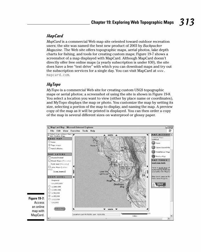
MapCardMapCard is a commercial Web map site oriented toward outdoor recreationusers; the site was named the best new product of 2003 by BackpackerMagazine. The Web site offers topographic maps, aerial photos, lake depthcharts for fishing, and tools for creating custom maps; Figure 19-7 shows ascreenshot of a map displayed with MapCard. Although MapCard doesn’tdirectly offer free online maps (a yearly subscription is under $30), the sitedoes have a free “test drive” with which you can download maps and try outthe subscription services for a single day. You can visit MapCard at www.mapcard.com.
MyTopoMyTopo is a commercial Web site for creating custom USGS topographicmaps or aerial photos; a screenshot of using the site is shown in Figure 19-8.You select a location you want to view (either by place name or coordinates),and MyTopo displays the map or photo. You customize the map by setting itssize, selecting a portion of the map to display, and naming the map. A previewcopy of the map as it will be printed is displayed. You can then order a copyof the map in several different sizes on waterproof or glossy paper.
Figure 19-7:Access
an online map with
MapCard.
313Chapter 19: Exploring Web Topographic Maps

Figure 19-8:Use MyTopo
to create atopographic
map.
314 Part IV: Using Web-hosted Mapping Services

Chapter 20
Overhead Image Web SitesIn This Chapter� Discovering aerial photos and satellite images
� Finding photos with TerraServer-USA
� Using TerraServer.com
� Exploring cities with GlobeXplorer
Although many Internet users know about street mapping Web sites likeMapQuest (see Chapter 18), fewer people are aware of Web sites that
provide free aerial photos (taken from aircraft) and satellite data. Theseimages complement traditional maps, displaying features that don’t show upon topographic or street maps, such as vegetation and unmarked roads ortrails. In addition, aerial photos and satellite images are often more up-to-datethan topographic maps and provide more timely and accurate information.
In this chapter, I present several popular Web sites that you can visit to viewaerial photos and satellite images; I also describe the basics of using three ofmy favorite aerial photo and satellite services.
I treat both aerial photos and satellite images as simply graphics images inthis chapter because that’s how you view them on the Web. Unless there’s aneed to specifically differentiate between an aerial photo and a satelliteimage, the word image in this chapter refers to both.
Using Web Aerial and Satellite ImagesOne of the biggest advantages to using an image captured from an airplane orsatellite is that it shows reality — not a cartographer’s representation drawnon a map. You can use aerial and satellite images to
� Complement a topographic map to help determine your current location.
� Find roads and trails not shown on maps.

� Better understand how thick tree and brush cover will be in an areayou plan to visit.
Don’t rely solely on these images for navigation. Aerial and satelliteimages typically don’t have natural or man-made features labeled orshow elevation contours.
� View neighborhoods in urban areas.
� Augment marketing endeavors, Web sites, or presentations. Aerialphotos are always attention-getters.
The two types of aerial photos and satellite images available on the Web are
� Government: Governments use aircraft and satellites to map land foradministrative and research purposes. Some maps are for intelligencegathering, but these images usually aren’t available to the public. Mostgovernment-produced images are usually free on the Internet. Keep inmind that many governments aren’t as liberal as the United States in dis-tributing images because of national security reasons.
� Commercial: A number of businesses specialize in taking aerial pho-tographs or reselling photos and satellite images from other vendors.Some of these companies let users browse their Web sites freely forreduced-scale or watermarked images (images with an overlaid logo ortext that might obscure detail), selling printed, full-size, unwatermarkedversions of these images.
You can download free or commercial aerial photos for mapping programs(such as some of the programs I discuss in Chapter 14), but Web-hostedaerial and satellite image services work well for a quick look at an area you’reinterested in. Some advantages to using Web-hosted image services include
� No need to have special software installed on a PC to view the images.(All you need is a Web browser.)
Some Web sites might require you to use a specific Web browser. Forexample, to access GlobeXplorer images, you need to use InternetExplorer.
� Access of images from any computer connected to the Internet.
� Simplified user interfaces of the Web pages that make viewing theimages easy.
To save and edit free aerial and satellite images displayed on Web sites, usethe techniques that I discuss in Chapter 17. However, purchasing a down-loaded image from a commercial site might be quicker and easier.
316 Part IV: Using Web-hosted Mapping Services

Don’t expect real-time, spy-satellite accuracy from free Web images. Theseimages can be over five years old and not show current roads or other fea-tures. (Image accuracy is better in wilderness, rural, or urban areas thathaven’t experienced a lot of natural or man-made change.)
Reviewing Aerial and Satellite Image Web Sites
Most aerial and satellite image Web sites like these have similar features anduser interfaces, so when you figure out how to use one, using another site iseasy. To give you a better idea of image resolution and how the sites work, Iuse a series of screenshots from each of these three Web sites to shows aerialphotos of downtown Seattle, Washington. (If you look really, really, close, youcan probably find a Starbuck’s or two.) I personally like these Web sitesbecause they offer a variety of free or reasonably priced images.
The data on each of these Web sites has strengths and weaknesses. Some dis-play free, high-resolution color images with corporate watermarks as well aslower-resolution color images with no watermarks. When I’m looking foraerial or satellite images, I generally visit all three to find an image that meetsmy needs and budget.
The availability of aerial and satellite images on the Web can change. For exam-ple, MapQuest (the popular street map Web site) used to display street mapsand aerial photos provided by GlobeXplorer, but the aerial photo service wasdiscontinued in December 2003. Microsoft’s TerraServer project stopped offer-ing satellite imagery for locations all over the globe in 2000. Serving up images
317Chapter 20: Overhead Image Web Sites
Airplane or satellite?You might think that the photos displayed onTerraServer-USA and other Web-hosted map-ping sites come from satellites, but these photosare actually taken from airplanes flying at pre-cise altitudes (up to 25,000 feet) with speciallymounted cameras. Images that come from satel-lites (or the Space Shuttle) can be photos, butthey can also be composite images put togetherfrom data that comes from sensors that detectdifferences in moisture, vegetation, or terrain.In general, satellite images don’t show as
much detail as aerial photos. That’s changing; commercial services (such as DigitalGlobe’sQuickBird satellite) can produce high-resolution,color photos on demand for anywhere in theworld. (See www.digitalglobe.com forsome amazing examples of high-resolutionsatellite images.) In general, if you see imageslabeled Landsat, SPOT, SPIN-2, or QuickBird,they came from satellites. Most other imagesare photos taken from airplanes.

on the Web costs for bandwidth and storage; what’s free today — particularly from commercial sites — might not be around tomorrow.
TerraServer-USAIn 1998, Microsoft, Compaq, the USGS, and several other partners launched theTerraServer Web site. The site was a technology demonstration for Microsoftsoftware and Digital (which had recently been purchased by Compaq) hard-ware and was dubbed “the world’s largest online database.” TerraServer had acollection of compressed aerial photos and satellite images that took up over aterabyte (TB) of space. (A terabyte, which is 1,024GB, was a lot of disk spaceback then.) Anyone with an Internet connection could freely browse throughthe database of images.
Now renamed TerraServer-USA (www.terraserver-usa.com), this site pro-vides aerial photos and topographic maps supplied by the USGS for justabout anywhere in the United States. Although most of the aerial photos thatTerraServer-USA provides are black-and-white, TerraServer-USA is addingUSGS Urban Areas aerial photography collections of mapping major metro-politan areas with high-resolution, color aerial photos.
Displaying TerraServer-USA aerial photosTo display an aerial photo from TerraServer-USA, you first enter some searchcriteria. You can search for aerial photos three different ways.
Zoom-in searchesWhen you visit the main page of the TerraServer-USA site at www.terraserver-usa.com, you’re greeted with a map of the world. Areas dis-played in green contain map data. Move the cursor to a location that youwant to view and click. Keep clicking and zooming in until the aerial photoyou’re interested is displayed.
General searchesSearch for a TerraServer-USA aerial photo of a city or well-known locationfrom the Search TerraServer text box. When you click the Go button, a list ofthe aerial photos that match the text is displayed. Click the text thatdescribes the image you’re interested in to display it.
You can make your search more specific by entering a city name followed by acomma, a space, and the standard two-letter postal abbreviation of the state.
For practice, try searching for a well-known landmark, such as the SpaceNeedle in Seattle, Washington. If you enter Space Needle, you get the aerialphoto of downtown Seattle as shown in Figure 20-1. There’s not much detail,but you can find out how to increase the resolution in the section titled“Changing image resolution in TerraServer-USA.”
318 Part IV: Using Web-hosted Mapping Services

Specific searchesThe most accurate way to search TerraServer-USA for aerial photos is to usethe Advanced Find options:
� Address: Enter a street address for the location that you’d like to view.The City, State, and ZIP Code fields are optional, but using them helpsnarrow down the search.
� Geographic: Enter the latitude and longitude coordinates, either in deci-mal degrees or degrees, minutes, and seconds.
� Place: Enter a place name and the state (and optionally the country).You can enter a partial place name; for example, entering San withCalifornia as the state displays all the locations with names beginningwith San, such as San Diego, San Francisco, and even Santa Clara.
After you enter your search criteria, click the Go button, and the aerialphoto is displayed. If several images match your selection criteria, youcan choose the exact photo you’re interested in from a list.
Moving in a TerraServer-USA photoWhen you view an aerial map in TerraServer-USA, a frame with arrows sur-rounds the image (refer to Figure 20-1). Click one of the arrows to pan themap in that direction. There’s also a compass rose to the left of the image
Figure 20-1:A Terra-
ServerUSAaerial
photo ofdowntown
Seattle,Washington.
319Chapter 20: Overhead Image Web Sites

that works the same way. Click a compass direction to scroll the map; forexample, click E (for east) to scroll the map to the right.
Displaying a TerraServer-USA topographic mapIn addition to displaying aerial photos, TerraServer-USA also can show aUSGS topographic map of the same area that the aerial photo displays. (SeeFigure 20-2 for a topographic map of the area around the Space Needle.)
� To display a map: From the View drop-down list (to the left of the aerialphoto and above the compass), select Topo Map. A topographic map inroughly the same scale as the aerial photo is displayed.
� To display an aerial photo: To return to the aerial photo image, selectAerial Photo from the View drop-down list.
TerraServer-USA is starting to provide high-resolution, color aerial photos ofcertain large metropolitan areas in the United States. If these images are avail-able for the area you’re viewing, Urban Areas will appear in the View drop-down list. Select Urban Areas in the list to display a color photo.
Figure 20-2:A Terra-
Server-USAtopographic
map ofdowntown
Seattle,Washington.
320 Part IV: Using Web-hosted Mapping Services

Changing image resolution in TerraServer-USAAfter you display an aerial photo or a map, you can change the resolution.Resolution, especially when dealing with aerial photos, is expressed in meters(about a yard for nonmetric types). An aerial photo with 1-meter resolutionmeans that you can see an object on the ground that’s one square meter insize. The smaller the resolution number, the more detail the image shows. Forexample, Figure 20-3 shows the Space Needle viewed at 1-meter resolution.
Topographic maps can be displayed from 2 to 512 meters in resolution, andaerial photos can be shown from 1 to 512 meters. If there’s data for an urbanarea with high-resolution, color photos, you can go from .25 to 64 meters; .25 meters is enough detail to start seeing people on the street, as shown inFigure 20-4.
A resolution scale is shown immediately below the compass, to the left of themap or aerial photo. To change the image resolution, you can either
� Click one of the bars between the plus and minus buttons. The farthestbar on the left provides the least amount of detail and largest area, andthe bar on the extreme right shows the greatest amount of detail and thesmallest area.
� Click the minus button or the plus button. This decreases or increasesresolution one step at a time, respectively.
Figure 20-3:The SpaceNeedle, inthe center,viewed at
1-meterresolution.
321Chapter 20: Overhead Image Web Sites
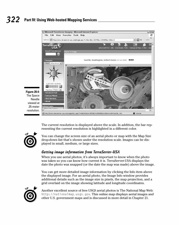
The current resolution is displayed above the scale. In addition, the bar rep-resenting the current resolution is highlighted in a different color.
You can change the screen size of an aerial photo or map with the Map Sizedrop-down list that’s shown under the resolution scale. Images can be dis-played in small, medium, or large sizes.
Getting image information from TerraServer-USAWhen you use aerial photos, it’s always important to know when the photowas taken so you can know how current it is. TerraServer-USA displays thedate the photo was snapped (or the date the map was made) above the image.
You can get more detailed image information by clicking the Info item abovethe displayed image. For an aerial photo, the Image Info window providesadditional details such as the image size in pixels, the map projection, and agrid overlaid on the image showing latitude and longitude coordinates.
Another excellent source of free USGS aerial photos is The National Map Web:http://nationalmap.usgs.gov. This online map displays aerial images andother U.S. government maps and is discussed in more detail in Chapter 21.
Figure 20.4:The Space
Needleviewed at.25-meter
resolution.
322 Part IV: Using Web-hosted Mapping Services

TerraServer.comTerraServer.com (not to be confused with TerraServer-USA) is an offshoot ofthe original Microsoft TerraServer research project. When the originalTerraServer was launched in 1998, the site offered SPIN-2 satellite imagerythat covered Europe, Asia, and other areas outside the United States. Thesatellite data was leased for 18 months; in 2000, Aerial Images (the companythat owned the leased data) decided to launch its own Web site,TerraServer.com (www.terraserver.com).
TerraServer.com sells aerial photos and satellite images from a number of dif-ferent image providers. Currently, this site does not offer topographicalmaps, although that service is supposed to be on the way. You can freelyview images that have a maximum 8-meter resolution. (An example image ofdowntown Seattle in this resolution is shown in Figure 20-5.) With 8-meterresolution, you can easily see large buildings, but the detail isn’t as great asthe 1-meter (or lower) resolution USGS aerial photos that TerraServer-USAprovides. TerraServer.com does make higher-resolution images available; youjust need to subscribe to the service to be able to view them. (Subscriptionfees range from $6.95 for a day’s use to $99.95 for a year.) There are addi-tional charges for downloading the images or ordering printed copies ofthem; depending on the size of the option and whether you want a digital orprinted copy, expect to pay between $5–$80 per image.
323Chapter 20: Overhead Image Web Sites
Homeland insecurityIn December 2003, some aerial photos ofWashington DC — long available from variousWeb sites — changed. Photos of such buildingsas the White House, the Vice President’s residence, and the Capitol were altered so only blurred pixels appeared instead of sharpdetail. (You can view some of the before andafter photos at http://cryptome.org/seatsuneyeball.htm.)
The changes were made by EarthDataInternational, a company that the United StatesGeological Survey (USGS) contracts to takeaerial photos. (The USGS then sells the imagesto companies for commercial use.) WhenEarthData went to the U.S. Secret Service to getpermission to fly over airspace that’s beenrestricted since the September 11, 2001, terror-ist attacks, the Secret Service requested thatthe images of certain buildings be degraded.
The Federal government isn’t alone in limitingInternet access to aerial photos. The New Yorkstate GIS (Geographic Information System)Clearinghouse (www.nysgis.state.ny.us)offers high-resolution aerial photos of the entirestate but also restricts Web access to photoswith areas that are deemed sensitive.
Just how much additional security is providedfrom censoring publicly available aerial photosis debatable. Images of the same governmentbuildings and critical infrastructure facilities canbe downloaded and viewed from other sources.And blacking out or reducing the detail of criticalfacilities might just end up drawing a terrorist’sattention to someplace that domestic authoritieshave identified as a possible target. Sigh.Welcome to the brave new world of post-9/11.
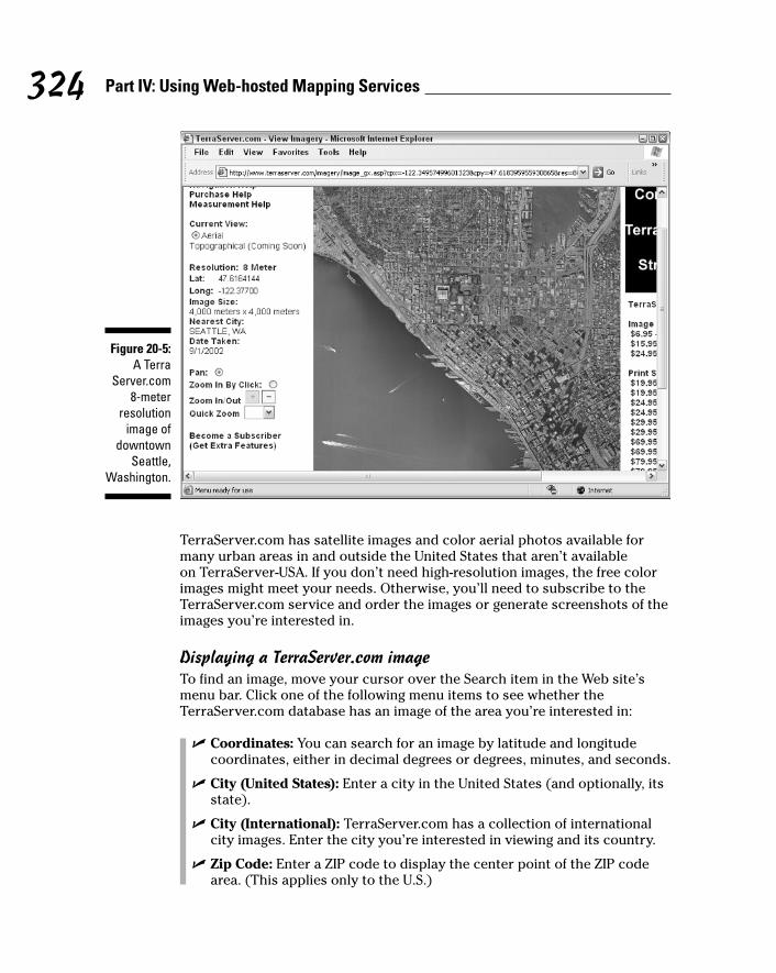
TerraServer.com has satellite images and color aerial photos available formany urban areas in and outside the United States that aren’t available on TerraServer-USA. If you don’t need high-resolution images, the free colorimages might meet your needs. Otherwise, you’ll need to subscribe to theTerraServer.com service and order the images or generate screenshots of theimages you’re interested in.
Displaying a TerraServer.com imageTo find an image, move your cursor over the Search item in the Web site’smenu bar. Click one of the following menu items to see whether theTerraServer.com database has an image of the area you’re interested in:
� Coordinates: You can search for an image by latitude and longitudecoordinates, either in decimal degrees or degrees, minutes, and seconds.
� City (United States): Enter a city in the United States (and optionally, itsstate).
� City (International): TerraServer.com has a collection of internationalcity images. Enter the city you’re interested in viewing and its country.
� Zip Code: Enter a ZIP code to display the center point of the ZIP codearea. (This applies only to the U.S.)
Figure 20-5:A Terra
Server.com8-meter
resolutionimage of
downtownSeattle,
Washington.
324 Part IV: Using Web-hosted Mapping Services

� County: Enter a county in the United States (and optionally, its state). Animage with the center of the county will be displayed.
� Address: Enter a street address (United States) and the city and state(or ZIP code).
After you enter your search criteria and click Search, TerraServer.comqueries its database for matches. The three possible search outcomes are
� Bupkis: No images in the TerraServer.com database meet your criteria.
Check your spelling or change your search criteria before you give up.
� Multiple matches: A appears with the matching images; you select theone you want. For example, if you search for a city named Bend butdon’t specify the state, you get a list of cities in Oregon, Montana,California, Texas, and other states.
� Perfect match: TerraServer.com found a single match in its database.Pay dirt! From the list of available image types (with the supplier, date,and resolution), click the image you’d like to view.
TerraServer.com has many international images, but don’t expect photos ofevery place on Earth. The international images are mostly large urban areasand aren’t available for all metropolitan areas outside the United States.
Moving in a TerraServer.com imageAfter you display an image, you can change the image’s location by panningand its resolution by zooming in and out.
� Panning: Panning simply means moving the image to view an unseenarea. It’s like scrolling without the scroll bars. To pan the image
1. Make sure that the Pan radio button to the left of the image isselected.
2. Hold down the left mouse button on the image and drag thedirection you want to move the image.
For example, to see more area to the north of the image, drag downtoward the bottom of the screen.
3. Release the mouse button.
After a moment, the new image is displayed.
� Zooming: TerraServer.com has a plus and minus button to the left of theimage (refer to Figure 20-5) to control zooming in and out. (There’s alsoa Zoom In by Click radio button that you can select so that when youclick the image, you automatically zoom in.)
325Chapter 20: Overhead Image Web Sites

Unless you’ve subscribed to the TerraServer.com service, you can’t zoomin on an image beyond 8-meter resolution. However, you can zoom out toview a larger area with less detail.
When you move the cursor over an image, the latitude and longitude coordi-nates of the location under the cursor are displayed to the left of the image.This is helpful for identifying specific locations.
GlobeXplorerGlobeXplorer (www.globexplorer.com) specializes in selling online aerialphotos, satellite images, and maps of the United States. You can browsethrough the GlobeXplorer’s database of images for free, but all images aremarked with a series of GlobeXplorer watermarks. If you subscribe to theGlobeXplorer service for a fee ($29.95 a month), you can view images withoutwatermarks.
The watermarks aren’t small and subtle. If you want to use the images forsomething other than personal reference, you’ll need to subscribe to the ser-vice or buy a copy of the image without the watermarks. However, you canincrease the resolution of images to 1-meter or less for a considerable amountof detail. GlobeXplorer also has a very large database of color images.
Displaying a GlobeXplorer imageGlobeXplorer uses the ImageAtlas Web-based tool to search through the com-pany’s database of aerial images. You start ImageAtlas from GlobeXplorer’smain Web page.
After ImageAtlas is running, you can search for images three different ways:
� Map: ImageAtlas starts up with a satellite image, basemap of the UnitedStates. Click an area to zoom in, and keep clicking until the locationyou’re interested in appears. The map to the left of the image showssuch features as cities and roads to help you figure out where you are.
� Address: Enter the street address of the place you want to see in thetext boxes next to the left of the image. At the minimum, you need to fillin a city and state or a ZIP code.
� Latitude and longitude: If you know the latitude and longitude of thelocation, you can use it to display the image. Enter the coordinates indecimal degrees in the text boxes to the left of the image.
After you enter the address or coordinates, click the Find Image button, andthe aerial photo is displayed.
326 Part IV: Using Web-hosted Mapping Services

GlobeXplorer works only with Microsoft’s Internet Explorer Web browser. Ifyou’re using Netscape, Mozilla, Opera, or another browser, you need to useInternet Explorer to access the Web site.
Zooming in on a GlobeXplorer imageAfter an image is displayed at GlobeXplorer.com, you can zoom in to see moredetail. Underneath the image is a zoom scale, represented by a series of dots.
� Clicking the dot to the farthest left displays the largest area of coverageat the least amount of resolution. The dots on the extreme left displaysatellite images of the area.
� Clicking the dot on the farthest right displays the smallest area of cover-age with the greatest amount of detail. The dots on the right displayaerial photos of the area.
A zoom box lets you draw a rectangle over the part of the photo where youwant to see more detail. Follow these steps:
1. Select the Drag a Box to Zoom In radio button.
2. Move the cursor over the area you want to zoom in on.
3. Hold down the left mouse button and draw a rectangle over the area.
When you release the mouse button, the image zooms in to the area thatyou defined with the rectangle. An example of a zoomed in image at max-imum resolution is shown in Figure 20-6.
327Chapter 20: Overhead Image Web Sites
Black-and-white or color?Ever wonder why some images are shown inblack-and-white while others are displayed incolor? The short answer is that black-and-whitefilm was used to create most of the USGS aerialphoto data for the United States — and black-and-white film, processing, and photographicpaper are cost-effective and stable. Color film,processing, and photographic paper are expen-sive, and color exposures (positives, negatives,and prints) can lose tonal quality over time.Commercial companies that produce customaerial photos and images for resale tend to use
color film for enhanced resolution and viewing.Most of the large urban areas in the U.S. havecolor images available because there is agreater opportunity for a commercial aerialphoto company to sell the data, thus recoupingthe costs of taking the aerial photos and makinga profit. Sometime in the future, high-resolutioncolor images of the entire U.S. will be available,but for now, if the area you’re interested is faraway from a major city, you’ll just have to settlefor black-and-white.

Moving around in a GlobeXplorer imageAfter you display an image, you can move to a new location to focus on thearea you want to view.
� A frame with compass directions surrounds the photo. Click the com-pass direction to scroll the image. For example, if you click NORTH, theimage scrolls up to the north.
� Select the Pan/Recenter radio button beneath the zoom scale. When youclick the image, the photo is reorientated so wherever you clickedappears in the center. You can also move the image by holding down theleft mouse button while the cursor is over the photo and then dragging.When you release the mouse button, a new location is shown.
Overlaying a street map in GlobeXplorerGlobeXplorer has a slick feature with which you can overlay a MapQueststreet map over a portion of the image. (An example is shown in Figure 20-7.)Because an aerial photo isn’t labeled with streets, this option can help youquickly orientate yourself. To overlay a street map
Figure 20-6:ImageAtlas
display ofthe Space
Needle,zoomed in at
maximumresolution.
328 Part IV: Using Web-hosted Mapping Services

1. Select the Map & Aerial Overlay Toggle radio button beneath thezoom scale so that (Aerial On) is displayed
2. Move the cursor over the image.
As you move the cursor, a semitransparent image of a street map is over-laid on the image.
Figure 20-7:A street
mapoverlaid on
an aerialphoto of
downtownSeattle,
Washington.
329Chapter 20: Overhead Image Web Sites

330 Part IV: Using Web-hosted Mapping Services

Part VThe Part of Tens

In this part . . .
All Dummies books have a part called The Part ofTens, and this one is no exception. This is a rather
eclectic collection of GPS and map-related information.Stuff so intriguing and thought provoking that it deserveda part of its own (or something like that).

Chapter 21
Ten Great GPS and Map Web SitesIn This Chapter� Getting up-to-speed on GPS
� Staying current with GPS news
� Getting technical GPS information
� Downloading free maps
� Mapping from your desktop
� Modeling terrain
The Internet has a tremendous number of GPS and map resources. Thischapter contains what I consider the ten best (actually, there’s more than
ten, but who’s counting?) Web sites about GPS and digital mapping. Listed Websites have product reviews, in-depth technical information, friendly people toask questions, and many sources for free maps to download.
Comprehensive GPS InformationWhen I’m asked for an Internet GPS resource, I suggest these two Web sites:
� www.gpsinformation.net: Since 1997, Joe Mehaffey, Jack Yeazel, andDale DePriest have compiled information about GPS, including receivers,software, and antennas. Their comprehensive and frequently updatedWeb site is packed with technical information, reviews, and commonsense advice for novice to experienced GPS users. This site is a must for anyone who owns or is considering owning a GPS receiver. You’ll discover something here, however much experience you have.
� http://vancouver-webpages.com/peter/index.html: Peter Bennett’sGPS site was one of the first Internet sites devoted to the topic of GPS.The site contains links and information resources for different brands ofGPS receivers. If you’re writing your own program to interface with a GPSreceiver, this is the place to find out about National Marine ElectronicsAssociation (NMEA) and other manufacturer communication protocols.

Current GPS News and Helpful AdviceThe sci.geo.satellite-nav newsgroup is one of the best Internet resourcesfor current GPS-related news. The newsgroup also features a cadre of frequentcontributors who provide answers to all types of questions about GPS.
Before you post a question to the newsgroup, such as What’s the best GPSreceiver?, search through old posts with Google for previous discussionthreads about your question. GPS newsgroup gurus are generally patient, butthey do expect you to do a little homework first. If you can’t find any archivedinformation that helps, post a question (and provide as much detailed infor-mation as possible). If you’re asking which GPS receiver might be the best,provide as much detailed information about your needs as you can.
If you don’t have USENET newsgroup reading software or your ISP doesn’tcarry the sci.geo.satellite-nav news feed, you can view and post groupmessages with a Web browser at Google’s cache of this newsgroup:
groups.google.com/groups?hl=en&lr=&ie=UTF-8&group=sci.geo.satellite-nav
Geocaching.com’s discussion forums are an excellent source of news andadvice. Because GPS receivers are integral to the sport of geocaching (readabout this in Chapter 7), check out the GPS Units and Software forum wheregeocachers share their experience and wisdom with others. You’ll find lots of timely news and reviews. Geocachers are some of the most serious civilianusers of GPS, so there’s excellent real-world information. The forums arelocated at forums.groundspeak.com/GC.
If you own a popular Magellan Meridian GPS receiver, one of the best sourcesof information on the receiver is the Magellan Meridian Yahoo! Group athttp://groups.yahoo.com/group/Magellan_Meridian.
Technical GPS InformationIf you’re interested in technical, nitty-gritty details of GPS, check Sam Wormley’sGPS Resources Web site. It’s a collection of links to sites that get into the sci-ence of GPS and other resources that are more suited to the average consumerGPS user. Go to www.edu-observatory.org/gps/gps.html.
Free MapsYes, one of the joys of the Internet is that you can download all sorts of freedigital maps. Most of the map data has been created by various government
334 Part V: The Part of Tens

agencies and is made freely available to the public. In most cases, you’ll needmapping programs to view the maps (described in different chapters of thebook), but some of the maps can be opened with graphics programs to printand use. The biggest challenge in downloading free maps is finding them.Here are some Web sites that you should find helpful in your search:
� www.doylesdartden.com/gis: David Doyle is an environmental geologist(and dart frog aficionado) who maintains an extensive list of U.S. digitalmap resources. His list at this site is organized by state. You’ll find hun-dreds of links for aerial photographs, topographic maps, geological maps,and many other different types of digital maps.
� www.macgpspro.com/html/newhtml/maplibrary.html: JamesAssociates makes MacGPS Pro, a product for interfacing GPS receivers.The company hosts a list of United States and international free mapsources.
� www.lib.berkeley.edu/EART: Unlike the United States (where digitalmaps are readily available), in other parts of the world, accurate mapsare considered essential to national security and can be difficult to obtain.One of my favorite sources for international maps is the University ofCalifornia Berkeley’s online Earth Sciences & Map Library, where youcan download topographic maps for many countries.
� www.lib.utexas.edu/maps: My other favorite academic map site is theUniversity of Texas at Austin’s Perry-Castañeda Library Map Collection.This site has an extensive collection of online maps (as well as links tosites that host maps) for countries and places all over the world.
� oddens.geog.uu.nl/index.html: The most comprehensive collectionof map links on the Internet is Odden’s Bookmarks. This European Website has over 20,000 links to maps and map sites all over the world. You can spend hours browsing through links to international mapsources.
Expert Desktop Mapping GuidancePaul Pingrey is a longtime forester who recognized the importance of digitalmapping for land management purposes and decided to spread the word. HisDigital Grove Web site is a collection of mapping programs, map data sources,and information on how to create 2-D and 3-D maps. Pingrey focuses on freeand low-cost programs, proving that you don’t need to spend thousands ofdollars on Geographic Information System (GIS) software or be a GIS profes-sional to produce high-quality maps. Pingrey frequently updates his easy-to-navigate and well-designed site with new tools and information. If you’reinterested in desktop mapping (and you don’t need to be land manager orforester), check it out at www.digitalgrove.net.
335Chapter 21: Ten Great GPS and Map Web Sites

Definitive Terrain Modeling InformationThis book really only scratches the surface of some of the cool things you cando with 3-D mapping. The most definitive Internet resource on the subject isJohn Childs’ Digital Terrain Modeling Journal. Childs’ Web site presents practi-cal how-to tutorials, data sources, and news for creating 3-D maps. Even if youaren’t interested in making your own 3-D maps, you should visit this site justto see some of the stunning images that are possible to create by using freeand low-cost software. Childs’ site is at www.terrainmap.com.
336 Part V: The Part of Tens

Chapter 22
Ten Map Printing TipsIn This Chapter� Using legal sized paper
� Selecting color versus black-and-white maps
� Printing the scale
� Displaying UTM grids
� Using waterproof paper
� Waterproofing paper
� Printing more map than you need
� Ensuring north is up
� Deciding on landscape versus portrait mode
� Is it really free?
If you’re using a digital map, odds are that sooner or later you’re going towant to print it. Paper maps don’t run out of batteries, and they’re pretty
easy to carry wherever you go. You can just use the Print command to trans-form the bits into ink, but some other techniques make using a paper mapeasier.
Make Your Paper CountThe more map and information you can get on a sheet of paper, the better. Most home and business printers are usually fed a diet of 8.5 x 11-inch paper . . . but 8.5 x 14-inch, legal size paper exists, too. One legal size sheet gives you 119square inches of print area; an 8.5 x 11-inch sheet has only 93.5 square inches of print area.
Some mapping programs can reduce the map scale to get more data on apage. For example, more of the map appears when you print at 75 percent ofthe original instead of 100 percent. Remember, though, that the detail on themap becomes smaller and more difficult to read when you reduce the scale.

Just remember when you reduce the size of a map that displays a printedscale, such as 1:24,000 or one-inch-equals-a-mile, that the scale will no longerbe accurate on the reduced map.
Print in ColorMaps are usually printed in color because it’s easier for the brain to recog-nize and process colors than plain black-and-white. For example, on a UnitedStates Geological Survey (USGS) topographic map, you can tell at a glancethat lightly shaded green areas are forested and that a solid red line is amajor highway. Although navigating with a black-and-white map is certainlypossible, using a map that’s printed in color is quite a bit easier.
Print the ScaleA map without a scale is like a recipe with only the ingredients listed — notthe quantities. You can guess that you add a tablespoon of salt instead of acup, but the dish tastes a whole lot better if you know the proper amounts.The same is true with a map. If the scale is printed on a map (especially withdistance rulers), you can easily judge how far features are from each other.
Print UTM GridsMost mapping software that supports topographic maps can overlayUniversal Transverse Mercator (UTM) coordinate system grids on the map. Ifyou’re using a GPS receiver with your map, UTM grids make it extremely easyto figure out where you are on the map. Just look at the GPS coordinates ofyour position, and then count the Northing and Easting tick marks on themap to find your location. (Chapter 2 shows you how to use UTM coordinatesto plot locations.)
Use Waterproof PaperIf you plan to use your map outdoors, consider printing it on waterproofpaper. Waterproof paper for common inkjet printers uses a vinyl material toproduce waterproof, durable, and tear-resistant maps. The paper is a littlethicker than regular paper, but you can still fold it. There is also specialwaterproof paper for copiers and laser printers that serves a similar function.
338 Part V: The Part of Tens

Waterproof paper is a little pricey — about a dollar a sheet. To prevent your-self from wasting expensive paper from printing blunders, first print the mapon normal paper to make sure that it looks right.
Never use waterproof inkjet paper in copiers or laser printers. The heat of theirprinting processes can melt waterproof inkjet paper and wreck the printer.
Here are three sources of waterproof paper for your maps:
� Latitude 26: This company sells waterproof inkjet paper in a number ofsizes, including rolls. Its Web site has information on paper specifica-tions and pricing: www.lat26inc.com.
� National Geographic: National Geographic sells waterproof AdventurePaper for inkjet printers. You can order it from this Web site: http://maps.nationalgeographic.com/topo/adventure.cfm.
� Rite in the Rain: Rite in the Rain is a popular supplier of waterproof field notebooks and paper. If you want to print maps on laser printers or copy machines, Rite in the Rain makes the right kind of paper for you.This Web site has a list of various waterproof paper products: www.riteintherain.com.
If you’re not venturing into the weather, consider using digital photographypaper if you have an inkjet printer. The quality and detail is much better thanplain paper for topographic maps.
Waterproof Your Plain PaperIf you must use plain-paper maps outdoors, here are some ways to avoid arunny, pulpy mess:
� Carry your maps in a watertight map case or a resealable food storage bag.
� Create waterproof maps with these options:
• Sealers coat a piece of paper in clear plastic. One of my favoritecommercial sealers is Map Seal. A 4-ounce bottle coats approxi-mately 8–10 square feet of paper and costs around $7. You can findthis at www.aquaseal.com/map-seal.html.
• Contact paper is transparent plastic with a sticky back. You cansandwich a piece of paper between two sheets to waterproof themap. Contact paper, which is cheap, comes in rolls so you can cutit to size. Just remember that contact paper doesn’t hold up overthe long haul.
339Chapter 22: Ten Map Printing Tips

• Lamination involves placing the paper between sheets of a specialplastic that seals (when heated) around the paper. Copy centerscharge a few dollars to laminate a letter-size piece of paper.
Maps laminated with thick plastic can’t be folded. Lighter laminates canbe folded.
If you’re on a budget, put two maps together back to back and then lami-nate them. If you’re laminating many maps, the savings add up.
Print More Map AreaIf you’re planning on visiting a specific place, add a little more area to yourmap than you think you need. It’s tempting just to print a map that showsexactly where you’re going — and nothing more. But what if you decide totake a side trip to someplace just off your route that isn’t on the map? What if you’re interested in a feature you see in the distance? From my years ofsearch and rescue and outdoor recreation experience, I’ve discovered thatyou should always have more map than you think you’ll need.
Put North at the TopMost maps are orientated with north at the top. When you print a map, followthe same convention. If the map doesn’t have a compass rose that indicatesdirections, you’ll know that
� North is at the top of the map.
� East is to the right.
� South is at the bottom.
� West is to the left.
If you’re using a graphics program to edit a digital map, consider adding anorth-pointing arrow in case the map doesn’t have one. It’s a reassuringreminder that north is indeed the direction you think it is.
Use the Best Page OrientationBefore you print your map, decide which page orientation will work best. Inyour software’s Page Setup dialog box, select the orientation.
340 Part V: The Part of Tens

� Portrait prints the map lengthwise. This is the default for most printers.
� Landscape prints the map widthwise.
Use the Print Preview command (if the software supports it) to see what theprinted map will look like. If the orientation doesn’t display as much of themap as you want, change the orientation to the other format.
Beware of False EconomyI can remember when gas stations gave away road maps for free. (I sometimescatch myself saying, “Back in the days when maps were free . . . ” when I’mreminiscing.)
It’s easy to think that the days of free gas station maps are back. You can down-load free maps from the Internet or use inexpensive mapping software. Get adigital map, fire up the color printer, and you’ve got a map! (Just remember thecost of the paper, ink cartridges, printer wear and tear, and the time involved inprinting a map.)
Here’s an expensive example. An entire USGS 7.5 minute topographic maptakes either nine sheets of 8.5 x 11-inch paper or six sheets of 8.5 x 14-inchlegal size paper if you’re printing at 1:24,000 scale. The costs add up whenyou’re using special paper and lots of color, which empties your ink car-tridges. Compare this with shelling out six dollars for an official copy of theUSGS map.
Sometimes paper maps for a few dollars can’t be beat.
341Chapter 22: Ten Map Printing Tips

342 Part V: The Part of Tens
Chapter 23
Ten Tips for AthletesIn This Chapter� Understanding benefits and limitations of GPS receivers for training
� Determining the best way to carry your GPS receiver
� Cycling, golf, and water sports
� Organizing races with GPS
I do a lot of running and biking, every now and then entering some prettycrazy endurance events like ultramarathons, Ironman triathlons, and
adventure races. A GPS receiver can make a pretty good training partner: Youcan use it for lots of things besides helping you avoid getting lost. This chap-ter is for athletes who exercise outside in the fresh air (sorry, no gym tips)and want to know how to incorporate GPS receivers into their workouts.Observant readers will notice more than ten tips in this chapter. It’s yourbonus for getting to the end of the book (and paying attention).
General GPS Tips for AthletesGPS tips in this chapter apply to a number of different sports:
� Different uses for GPS when exercising
� GPS limitations while training
� Carrying a GPS receiver
Using a GPS receiver for trainingA GPS receiver not only helps you successfully get between Point A and PointB but is also handy for staying found. These tips apply to almost any sport:
� Measure distances over known courses: Instead of guessing the courseor route length, you can use a GPS receiver to measure the distance witha fair amount of accuracy.

� Better understand the elevation of courses: Elevation data can give youa more accurate sense of how flat or hilly a course really is. Even if yourGPS receiver doesn’t have a barometric altimeter (which is required formore precise altitude measurement), the elevation data associated withrecorded tracks gives you a ballpark idea of how steep a course is.
� Better understand speed: Your GPS receiver has a trip computer thatprovides information about your maximum, minimum, and averagespeed. By analyzing track data, you can measure your speed over indi-vidual sections of a course.
� Discover new courses: Uploading recorded tracks to an aerial photo ortopographic map shows you where you’ve been and can also revealnearby roads or trails that you didn’t know about.
Your GPS receiver can play a few roles as an electronic training partner:
� Data logger: In this mode, the GPS receiver records data that youprocess when you get back home. You download the data to your PCand a program that analyzes the track log. While you’re working out, younever really look at the GPS receiver (unless you get lost, of course).
You can use any general purpose GPS receiver as a data logger. I like theGarmin Geko series because they’re small, lightweight, inexpensive (the201 model is under $140) and easy to carry. (Avoid the Geko 101 becauseit can’t interface to a computer, which means you can’t analyze track logs.)
When you’re logging data, follow these rules:
• Lock sufficient satellites: Always make sure your GPS receiver has alock on at least four satellites (the minimum you need for a good 3-D fix) before you start your workout.
• Start clean: Before you start, clear the active track log. When you’refinished working out, immediately turn off the GPS receiver.
Always download the active log to your computer first before saving it in the GPS receiver. Some GPS receivers remove the track date and timedata or compress the number of tracks when you save a track log.
� Coach: In this mode, you use the GPS receiver to give you immediatefeedback while you’re working out. It’s still logging track data, but you’relooking at the screen, checking your speed, distance, and time. SeveralGPS receivers on the market are specifically designed to perform as aworkout coach; I discuss these models in this chapter.
Don’t use your GPS receiver’s battery saver mode if you’re using your GPSreceiver to record tracks while you’re working out. The accuracy of yourtracks will be diminished because satellite data is received less often. Userechargeable batteries instead.
344 Part V: The Part of Tens

Aside from a GPS receiver and a cable to download the collected data to acomputer (see Chapter 9 to read how), you also need software so you cananalyze your performance based on the tracks that have been recorded.Some possibilities include
� Endless Pursuit (www.endlesspursuit.com): This Web-hosted, work-out-logging product is designed specifically for athletes. I review this inthe section, “Endless Pursuit.”
� TopoFusion (www.topofusion.com): Although this mapping programwasn’t designed primarily to log workouts, its authors include featuresso an athlete better understands his or her performance over a setcourse by analyzing track data, including moving, stopped, uphill, down-hill, and flat time; up/down/flat distance; average uphill/downhill grade;and maximum speed. A recent beta version of the program included anathlete’s logbook and difficulty-and-effort indices for record tracks. Thisprogram, reasonably priced at $40, is turning into one of my favorite log-ging tools.
� GPS utility programs: Two shareware programs — GPS Utility (www.gpsu.co.uk) and GARtrip (www.gartrip.de) — are general-purposeGPS tools but have features for analyzing track logs. Both programs havefeatures that examine distance, speed, and time data. Registered ver-sions are available for under $50.
� Spreadsheets: Because track data can be exported into comma- or tab-delimited text files (see Chapter 9 for a list of GPS conversion utilities,with some tips on using them), if you know your way around a spread-sheet program such as Microsoft Excel, it’s pretty easy to write yourown formulas and macros to analyze the data that you collect.
GPS receiver limitations for trainingBefore you start training with a GPS receiver, don’t expect precise accuracyof the receiver all the time. Speed and distance measurements are based onexact position data; if the location coordinates the GPS receiver is reportingaren’t accurate, the speed and distance data isn’t accurate, either.
The main cause of inaccurate GPS data is poor satellite signal reception. Whenyou train under heavy tree canopies, in canyons (whether natural or the urbantype from tall buildings), or anywhere satellite signals are obstructed, yourspeed and distance data isn’t going as accurate as if you had a clear sky.
To me, this isn’t critical. The data from my GPS receiver is far more accuratethan guessing how far and how fast I’ve gone. I treat a GPS receiver as simplyanother tool that gives me training data to process so I can fine-tune myworkouts and performance, just like using a watch or a heart-rate monitor.
345Chapter 23: Ten Tips for Athletes

Here are a few ways to address GPS accuracy issues for training:
� Repeat and average: If you’re measuring a specific running or bikingcourse, do it several times and average the results to compensate forany GPS inaccuracies.
� Watch for breaks: Watch for any possible breaks in satellite coverage onthe course that might affect accuracy. This is usually easy to spotbecause track points displayed on a map will suddenly be off-course andare easily distinguished by jagged lines.
How to carry your GPS receiver on footIf you use a GPS receiver for your outdoor workouts, one of your biggest deci-sions will be how to carry the GPS receiver. The simplest way is just to hold itin your hand, if it’s free. Of the number of other different ways to carry a GPSreceiver (which I discuss next), the best carry methods will
� Provide optimal GPS satellite signal reception: Where you work outmight dictate how you carry your GPS receiver. If you live on the plains(flat) without any trees and have excellent satellite reception, you havemore options than in the Pacific Northwest (heavy tree canopies).
� Be comfortable: Carrying a GPS receiver should not distract you fromyour workout. However you carry it, it should be comfortable, and youreally shouldn’t notice carrying or wearing it.
Here are some different ways to carry a GPS receiver while working out. Howyou carry a GPS receiver usually ends up being a personal preference. Try afew of these methods to see which one works best for you.
ArmbandsArmbands, especially with smaller, lightweight GPS receivers, are one of myfavorite forms of no-hands carry. An armband is simply a GPS receiver casemounted to an adjustable elastic band.
When worn on the upper arm, the GPS receiver isn’t blocked by your body asmuch as wearing the receiver at your waist, which means better satellitesignal reception. In areas without many sky obstructions, armbands can alsobe worn on your forearm, so you can look at the screen while you exercise.
I use an armband with a plastic case that’s produced by Endless Pursuit(www.endlesspursuit.com). The case fits a Garmin Geko like a glove. Afteryou adjust the elastic band, it’s hard to tell you’re wearing it. (See Figure 23-1for an illustration of the armband.)
346 Part V: The Part of Tens

Not many armbands are built for small and mid-sized GPS receivers. Look forarmbands designed for Family Radio Service (FRS) radios. If you’re handywith a sewing machine (or know someone who is), it’s relatively easy to makean armband out of nylon, elastic, and Velcro for your GPS receiver.
Cases, belts, pockets, and packsMost GPS receiver cases have a loop on the back to hold the case on a belt.
If you’re wearing shorts or tights and don’t have a belt, waist packs for carry-ing a radio or a cassette/CD player are an option. These packs can accommo-date larger GPS receivers. They’re not very noticeable when you’re workingout because they’re designed not to bounce much. Small fanny packs andwaist packs that carry water bottles also carry a GPS receiver.
If the GPS receiver is small, try carrying it in your front pants pocket. I’ve car-ried a Garmin Geko while running and cross-country skiing in trail-runningshorts and tights with zipper pockets. Although satellite reception is some-times lost while under heavy tree cover, the GPS receiver records track dataas long as I have a mostly clear view of the sky.
OK
Endless Pursuit
Figure 23-1:Carry a GPS
receiver inan armband.
347Chapter 23: Ten Tips for Athletes

The main disadvantage to carrying your GPS receiver on or below your waistis that it’s not the best place for satellite reception. There’s a good chancethat you’ll lose the signal in areas with reduced satellite coverage.
If you use a hydration pack or a lightweight backpack, you can get your GPShigher for better satellite reception by mounting the case either on one of thefront shoulder straps or putting the GPS receiver in the upper, top pocket ofyour backpack. (It isn’t as accessible in the backpack pocket but should getgood satellite reception.)
Water bottle hand strapsMany trail and ultramarathon runners run with water bottles in their hands,using special hand strap products that fit on a water bottle so you aren’talways clutching the bottle and can relax your hands. (FastDraw by UltimateDirection is one; see www.ultimatedirection.com.) I’ve seen trail runnerswith small GPS receiver cases mounted to these hand straps. Just add someVelcro to the GPS receiver case and the hand strap, and you’re ready to go.
GPS Products for AthletesSeveral GPS products on the market are specifically designed for athletes.These products offer athletes specialized features that normally aren’t foundin general purpose GPS hardware and software.
Endless PursuitEndless Pursuit is an Internet-based service that allows athletes to track theirtraining on the Web. The service is based on using a Garmin or Magellan GPSreceiver to collect data about your workout and then uploading the GPS datato a Web site through your browser. After the site collects waypoint and trackdata of a workout, it produces 40 statistics and 14 charts. (Sample results areshown in Figure 23-2.) You can review workout information such as
� Total time elapsed (at motion and at rest)
� Distance (uphill, downhill, and flat)
� Altitude
� Maximum and average speed (including uphill, downhill, and flat)
� Average pace
� Calories expended
� Power generated in watts
348 Part V: The Part of Tens

The Web site also serves as cumulative training log for all your workouts. Afteryou sign in, a monthly calendar lists all your workouts by day, showing thetype of activity, what time of day you worked out, distance, and total elapsedtime (see Figure 23-3). Click a previous workout to display all the details aboutthe session, including aerial photographs and topographic maps of your route.You can even compare workouts to see how you’ve improved.
Check the community section at the Web site where folks can post theirworkout data for anyone who has Internet access. All the published workouts(or treks, as Endless Pursuit calls them) are indexed. For example, you can doa search for all the mountain bike rides in Central Oregon and get maps ofroutes, trail reviews, and even download the waypoints and tracks associatedwith the trek directly to your GPS receiver.
Endless Pursuit is easy to use and well designed. The data that it providesgoes far beyond the distance, speed, and time information from a normal GPSreceiver. (Note the add-on option to integrate heart-rate monitor data withyour GPS data.) Although just about any outdoor athlete can benefit fromEndless Pursuit, it’s especially well suited for mountain and road bikers, run-ners, and triathletes.
Figure 23-2:The EndlessPursuit Web
site basesworkout
informationon GPS
data.
349Chapter 23: Ten Tips for Athletes

To fully use the site, purchase a Performance Pass ($149), which allows you tostore data for up to 150 workouts; you can delete old ones to free up space.Endless Pursuit also offers a bundled package priced at $299 that includes aPerformance Pass, GPS receiver, cable, armband, and bike mount that provideseverything you need to start logging GPS data.
You can register for a free trial of Endless Pursuit and read more about theservice by visiting www.endlesspursuit.com.
Timex Speed + Distance/BodylinkThe Timex Speed + Distance system is a cigarette pack-size GPS receiver thatstraps on your arm and transmits data to a special wristwatch. You can lookat your watch and see how far you’ve gone and how fast you’re going.
Timex updated the system in 2003, adding more components and calling itBodylink. In addition to the GPS receiver and watch, the Bodylink includes a heart-rate monitor (the GPS receiver, watch, and heart-rate monitor areshown in Figure 23-4) and a data recorder that collects data from both theGPS receiver and the heart-rate monitor. You can connect the data recorderto your personal computer to upload your workout data and analyze it withthe included software.
Figure 23-3:Log your
workoutswith a
calendarfrom
EndlessPursuit.
350 Part V: The Part of Tens

This is pretty close to being the Holy Grail for athletes who want perfor-mance data. Time, speed, distance, and heart-rate data can be viewed withtraining software to understand your fitness and the effectiveness of yourworkouts.
You can’t use Bodylink for navigation. Your current location doesn’t appearon the watch, and the system doesn’t support tracks and waypoints. (Timexmight add navigation capabilities to future models.) To find different Bodylinkmodels, which retail between $250 and $300, go to www.timex.com.
Garmin Forerunner 201Garmin’s Forerunner 201 is a GPS receiver primarily for runners: The receiverlooks like an oversized watch and is designed to wear on your wrist. (TheForerunner 201 is shown in Figure 23-5.) Some of its features include
� Time (overall and lap), speed (current and average), and distance display
� Waypoint and track log support
� Stored workout history
� Pace and calories-expended information
� Large, easy-to-read screen
� Fifteen-hour, rechargeable lithium ion (Li-Ion) battery
� PC interface and training log software
Unlike the Timex Bodylink system (which Garmin originally provided the tech-nology for), the Forerunner’s GPS receiver is built into the watch: It doesn’trequire a separate armband unit.
The Forerunner 201 doesn’t support a heart-rate monitor, but I wouldn’t be toosurprised if future versions will incorporate heart-rate monitor technology.
GPS
10:11158
Figure 23-4:Timex
BodylinkGPS
receiver,heart-rate
monitor, andwatch.
351Chapter 23: Ten Tips for Athletes

I’m impressed with the Forerunner 201’s performance, especially for a firstgeneration entry in this market. The satellite reception has been good, andits data is useful for understanding biking, running, and skiing workouts.(Garmin recently released the Forerunner 101, a cheaper model that runs onAAA batteries. I’d avoid this product because it doesn’t have a PC interface,which means that you can’t download and analyze your track data norupgrade the firmware.)
The Forerunner 201 has a suggested retail price of $160. To find out moreabout product specifications and to download the user manual, go to www.garmin.com/products/forerunner201. There’s also a great e-mail listdevoted to the product that can be accessed at http://groups.yahoo.com/group/GarminF.
GPS Tips for Specific SportsYou can use a GPS receiver for almost any type of outdoor sport where you’rein motion. Here’s how GPS fits into the context of several specific sports.
GPS for cyclistsIf you’re a road cyclist or mountain biker, a GPS receiver can replace yourbike computer because it can display time, speed, and distance information.Most GPS receiver manufacturers make bike mounts for their handheldmodels; these mounts also fit on motorcycle and snowmobile handlebars.
LAP PACE
LAP PACE
LAP DIST
10:3001:23
24.8okreset
mode
Figure 23-5:The GarminForerunner
201 GPSreceiver.
352 Part V: The Part of Tens

The main advantages of using a GPS receiver for biking are that it
� Doesn’t need calibrating
� Is easy to switch between different bikes
� Has navigation features including maps (if supported)
Compared with bike computers, GPS receivers have a few disadvantages:
� Shorter battery life
� Higher price
� Larger size
� Accuracy affected by tree cover
If you just want to use your GPS receiver for logging data, such as recordingtrail routes under heavy tree cover, try stowing your GPS receiver in a back-pack and mounting an external antenna on the top of your bike helmet,threading the antenna cable out the back of the helmet and into the packwhere it’s plugged in to the GPS receiver. It might sound and look geeky, but asetup like this gives you optimum satellite reception. Just make sure that theantenna cable is tucked in and secured so it doesn’t catch on a tree branch.
Some Garmin GPS receivers, notably the eTrex models when used with Garminbike mounts, can intermittently shut down when biking on rough terrain. YourGPS receiver probably isn’t defective. The battery compartment of the eTrexdoesn’t provide a snug fit for the batteries; vibration can jostle the batteriesaround, causing power loss. If this happens, tape the batteries together or usea small piece of cardboard as a shim to fill the extra space.
GPS for golfersBecause golf is all about distance and getting a ball from Point A to Point B inthe least number of strokes, GPS offers some interesting possibilities.
The simplest way to use GPS in golf is to bring your GPS receiver with you thenext time you play and mark the center of greens as waypoints. When youplay the course again, you can select the waypoints for a pretty good idea ofthe distance to the next green and use that information when selecting anappropriate club. (GPS receivers and devices like laser range finders aren’tallowed in tournament play — and some of your purist golf partners mightnot approve of electronics for casual play.)
Some golf courses are on the GPS bandwagon, offering cart-based computersthat display color maps; the distance to the greens, holes, and hazards; protips; and other information. As an example, visit www.riteconcepts.com tosee a demonstration of its OnCourse GPS product.
353Chapter 23: Ten Tips for Athletes

A number of personal GPS products are developed specifically for golfers:
� Suunto G9: Suunto makes an oversize watch that’s a GPS receiver thatmeasures your strokes and stores game statistics (www.suunto.com).
� SkyGolf: SkyGolf sells a standalone GPS golf computer, the SG2 PersonalDigital Caddie (www.skygolfgps.com).
� PDA software: A number of popular golf software packages come bun-dled with a GPS receiver for Pocket PC and Palm PDAs, including
• StarCaddy: www.starcaddy.com
• GolfPS: www.golfps.com
GPS golf devices can slow down the game while players fiddle with their elec-tronic gadgets. If you use a GPS golf device, remember to be courteous toother players and not get too engrossed with your nonregulation helper.
GPS for paddlers and rowersFor athletes who row or paddle for fitness or in competitions, a GPS receiverprovides a quick and easy way to gauge distance and speed without installinga speedometer in your boat; they’re also cheaper than venturi speedometers.
I’ve seen GPS receiver cases mounted to canoes, kayaks, and rowing shellsusing Velcro, duct tape, webbing, and custom-made fiberglass holders, alloptimally placed to let the athlete read the screen and click buttons.
Obviously, make sure that your GPS receiver stays dry. Your GPS receivershould have an IPX 7 rating (submersible for 30 minutes in one meter of water).Regardless of the rating, I use a waterproof bag. Voyageur bags (one is shownin Figure 23-6), priced under $25, are durable, watertight, and buoyant; it’s easyto see the screen and use the receiver while it’s in the bag. You can get informa-tion on the Voyageur product line by visiting http://voyageur-gear.com.
354 Part V: The Part of Tens
Windsurfing and GPSGPS receivers are popular in windsurfing.Windsurfers use GPS receivers in waterproofbags to measure maximum speed and recordtracks. Dennis Cornhill wrote a nice Excel
spreadsheet for analyzing windsurfing track logs:www.geocities.com/denniscornhill/SailTrack.html.

If you’re using a GPS receiver in any type of watercraft, tether the GPSreceiver (or its case or bag) to yourself or the boat. This is good insuranceagainst your receiver swimming to the bottom.
GPS for race directorsIf you’re organizing and promoting a race with running, cycling, cross-countryskiing, or just about any other activity that follows a set course, a GPSreceiver can be a handy tool. With it you can
� Measure the course distance.
� Create a map of the course by overlaying tracks on an aerial photo ortopographic map.
� Use waypoints to mark the precise locations of aid stations.
� Publish the course track log on the Internet for athletes with GPSreceivers who want to train on the course before the race.
One of my favorite programs for race planning is TopoFusion (www.topofusion.com; read more about this in Chapter 14). It imports waypoints and tracks fromGPS receivers and displays them on aerial photos and topographic maps down-loaded from TerraServer-USA. (Read all about TerraServer-USA in Chapter 20.)Its PhotoFusion feature makes it excellent for promoting races on the Internet.
Figure 23-6:A GPS
receiver in a Voyageur
dry bag.
355Chapter 23: Ten Tips for Athletes

If you bring a digital camera while recording course information with your GPSreceiver, you can take photos at key points (such as intersections, extreme ter-rain, aid stations, or scenic views). Afterwards, TopoFusion associates the timeyou took the photo with time data in the track log and gives you the coordi-nates where you took the picture.
TopoFusion can automatically generate a Web page that shows the recordedtracks overlaid on both an aerial photo and topographic map. Wherever youstopped and took a photo with your digital camera, TopoFusion places acamera icon at that location on the map. (Just make sure your digital cameraclock is synced with the time on your GPS receiver.) When someone viewsthe Web page and moves the cursor over the camera icon, a thumbnail imageof the photo is displayed in the upper-right corner of the window. If a cameraicon on the map is clicked, the full-sized photo is displayed. Because athleteslike to have as much information about a race ahead of time, participants willlove you if you add this to a Web site promoting a race or an event.
TopoFusion does all the HTML and JavaScript coding for you; you don’t needto know anything about developing a Web page. Just upload all the digitalphotos and the files TopoFusion created to a Web server, and you’ve got aninstant online information source and interactive map for your race. If youcan code HTML, you can modify the page’s information and appearance.
356 Part V: The Part of Tens

• Numerics •3-D mapping
animation, 268, 272color, 264–265DEM, 260–262, 272elevation, 217–221glasses, 3-D, 219, 260MapTech Terrain Navigator 3-D View, 217,
218–219moving image on screen, 267overlay map, 268–271, 272printing, 267–268rectifying image, 273rotating image, 266, 267shading, 259, 262, 269, 271, 273shifting image, 266topographic map, 217–221, 222, 223,
268–2712-D map compared, 259–260
3-D TopoQuads software, 223, 2743-D View (MapTech Terrain Navigator),
217, 218–2193DEM software
animation, 268, 272color, 264–265data source overview, 272DEM data, loading, 260–262, 272display area, 263downloading, 260DRG topographic map, overlaying on
DEM image, 268–271Elevation buttons, 267glasses, 3-D, 260graphics card compatibility, 263help, online, 261Map Overlay View, 271Movement Control buttons, 267OpenGL library usage, 260Operation menu, 264, 271
Overhead View, 271printing, 267–268Rotate or Shift Scene dialog box, 266Rotation buttons, 267saving file, 267–268scene, 264–268Terrain Colors dialog box, 264Terrain Projection Parameters dialog
box, 264Translation buttons, 267troubleshooting, 263View tool, 263Web site, 260zooming, 267
7.5 minute map, 237-Zip software, 261911 call from GPS-enabled cellphone, 109
• A •accuracy. See also error
C/A-code versus P-code signal, 52calibrating map, needed for, 257DGPS, 57DLG data, 40DOP measurement, 97EPE measurement, 98, 128military versus civilian GPS, 50, 55receiver, 55, 56–58, 85, 128SA effect on, 55, 57, 118satellite coverage effect on, 97signal strength effect on, 98, 345–346speed tracking, 345street map, 291TIGER data, 39UTM, 32WAAS, 57Web map, 291
Add/Remove Programs utility (Windows), 286
Index

Adventure Paper waterproof paper, 339Aerial Images (company), 323. See also
TerraServer.com Web siteaerial photograph. See photograph, aerialaeronautical
chart, 26, 38, 304software, 26
AirphotoUSA Web site, 44ALK Technologies Bluetooth receiver, 113almanac, 53, 96altimeter, 62–63, 88American Paper Optics Web site
(3dglassesonline.com), 260animation, 3-D mapping, 268, 272antenna, receiver, 64–65, 88, 353Appalachian Trail software, 218APRS (Automated Position Reporting
System), 56Aquaseal Map Seal (paper waterproofing
product), 339Arc software, 20area, mapping, 22armband, carrying receiver on, 346–347Army
Engineer School at Fort Leonard Wood, 273
GPS, role in creating, 50Map Reading and Land Navigation online
field manual, 70receiver specification, 55
ascent rate, 62–63Atlanta (Georgia) Olympics Savannah
Yachting Venue map, 41atlas
described, 25road atlas, 24, 29
atmosphere condition affecting signalreception, 57, 58
authoring map, 177Autodesk software, 20Automated Position Reporting System
(APRS), 56automobile GPS. See vehicle GPSAutoRoute software, 79autorouting
MapCreate, 176MapSend DirectRoute, 175
PDA navigation software, 114printing autorouting direction, 203–205receiver support, 79, 178route versus, 79street, 201–205Web-based, 290, 292, 294, 296, 299
availability, selective. See SA (SelectiveAvailability)
AvantGo software, 295aviationtoolbox.org Web site, 26
• B •Back Roads Explorer software, 224–225Backpacker Magazine Web map
recommendation, 313Backpacking.net Web site, 122Bar Harbor (Maine) topographic map,
303–305barometer, 63, 88baseline, 34basemap, 61battery
alkaline, 92, 93compass drain, 62cost, 93environmental considerations, 94life gauge, 94lithium, 68, 92mAh rating, 91memory, 92NiCad, 92NiMH, 68, 92, 93, 94PDA battery, 107, 112receiver drain rate, comparing, 85, 91, 94rechargeable, 91, 92–93saver mode, 93, 344screen drain, 59system default, changing, 100WAAS drain, 63
Battleship Grid System, 28baud rate, 157, 158, 159, 165Bell, John (Cockpit GPS), 90belt, carrying receiver on, 347–348benchmark hunting, 141bicycling, using GPS in, 101, 352–353BigJpeg software, 237
358 GPS For Dummies

bitdata bit, 157, 158stop bit, 158
bitmap, 12, 41, 249, 278, 286. See also rasterdata format
BLM (Bureau of Land Management), 134BlueChart software, 178Bluetooth wireless technology, 68, 112–113BMP files, 12, 286. See also bitmapBoard on Geographic Names, 185boat, using receiver in, 355Bodylink receiver, 350–351Brown, Allan (Web Cartography), 287Bureau of Land Management (BLM), 134business name, searching on
MapQuest, 295Buxley’s Geocaching Waypoint Web
site, 140
• C •C/A (Coarse Acquisition) code signal,
52, 55cable, 59, 109, 155–156, 165Cache In, Trash Out (CITO) 140. See also
geocachingcalibrating
compass, 62map, 248, 251–258
camera time, synchronizing receiver with, 356
campground database, Street Atlas USA, 195
car GPS. See vehicle GPScartographer, 22cartography, 12case, protective
PDA, 107–108, 113receiver, 346–347, 348
CD-ROMemulator software, 148map storage on, 149
cellphonegeocaching, bringing when, 121GPS-enabled, 2, 109
Census Bureau, 18, 39, 40Center tool (MapTech Terrain
Navigator), 214Character Map (Windows), 285–286chart
aeronautical, 26, 38, 304marine, 25, 38, 176, 304
Charting and Navigation Theme Web site, 40
citation, map, 22CITO (Cache In, Trash Out), 140. See also
geocachingCity Select software, 178ClayJar Geocache Rating System Web
site, 137Clipboard (Windows)
screen capture, copying to, 237, 278–280symbol, copying to, 285
clockreceiver clock, 57, 58, 99satellite atomic clock, 51timing error, 57
Coarse Acquisition code signal (C/A codesignal), 52, 55
Coast Guard, 64Cockpit GPS and Basic GPS Navigation Web
site, 90Cockpit GPS (John Bell), 90collar, map, 22, 250color
highlighting feature using, 283JPG, 287PDA, 106, 115printing, 151, 338raster data format, 41receiver, 59, 86scanning, 249street map, 282–283TerraServer-USA photograph, 229text, 236, 2833-D map, 264–265topographic map, 151track, 216Web map, 283
Color Preference dialog box(USAPhotoMaps), 236
359Index

COM port, 157–159communication
port, 151–152, 156–160protocol, 160, 165
compassbattery drain, 62calibrating, 62degree measurement, 23geocaching, for, 120, 127, 128magnetic declination, 24magnetic field, disruption by, 62Map and Compass for Firefighters online
course, 70receiver electronic compass, 62, 76, 88safety, carrying backup compass for, 7waypoint direction, pointing to, 76
compass rose (map detail), 22, 197compression, file, 41, 43, 185, 287computer hardware
graphics card, 150, 263hard drive, 148–149Internet connection, 146, 152, 231memory, 147memory card reader, 162monitor, 150port, 151–152, 156–160processor, 147
computer, interfacing receiver withbaud rate, 157, 158, 159, 165buying receiver, considerations when, 86cable, via, 59, 109, 155–156, 165connection, troubleshooting, 165flow control, 158handshaking, 158memory card, using, 154, 161, 165overview of interface process, 154–155parity, 158PDA synchronization, closing before, 165protocol, communication, 160, 165route, transferring, 163, 164, 171, 238software role, 162–164, 171track, transferring, 163, 164, 171, 238–239waypoint, transferring, 138, 163, 164, 171,
238–239wireless, 68, 108, 112–113
Consolidated Space Operations Center(CSOC), 53
contact paper, 339Continental Divide software, 218contour
interval, 23line, 23, 217, 260
Control PanelStreet Atlas USA, 195Windows, 286
coordinate. See also latitude; longitude;UTM (Universal Transverse Mercator)
Battleship Grid System, 28calibration point, of, 253–254converting system, 28, 71, 189–191described, 28highway map, 29lettering system, 28, 29location coordinate, finding using GNIS,
182–186location coordinate, finding using GNS,
186–189location coordinate, finding using
MapTech MapServer Web site, 305Maidenhead Locator System, 32map, display on, 22, 29, 70MapTech Terrain Navigator display, 214MGRS, 32numbering system, 28, 29quadrangle, 23receiver, used on, 32, 36, 71, 99road atlas, 29State Plane Coordinate System, 32tick mark, 28, 29topographic map, 29Township and Range system, 29,
34–35, 71USAPhotoMaps display, 231
Coordinated Universal Time. See UTCcopying
photograph, aerial, 237screen capture, using, 237, 278–280
copyright, 281cost
battery, receiver, 93paper map, 18
360 GPS For Dummies

printing, 151, 341receiver, 1, 54, 68, 85software, 14, 18, 171topographic map, 18, 302, 311–312Web map, 291, 302, 311–312
Creating Background Maps for Garmin GPStutorial, 177
cropping digital map, 281–282cruise missile, 50Cryptome Web site, 323CSOC (Consolidated Space Operations
Center), 53currency
Census Bureau data, 18paper versus digital map, 11photograph, aerial, 317satellite image, 317street map, 11, 194, 199, 291TerraServer-USA Web site, 229Web map, 291
cycling, using GPS in, 101, 352–353
• D •DAGR (Defense Advanced Global
Positioning System Receiver), 55The Dalles (Oregon)
planimetric map, 24topographic map, 23
Darth Vader cache, 131. See alsogeocaching
data formatbitmap, 12, 41, 249, 278, 286choosing appropriate, 286–287compression, 41, 43, 185, 287converting to another, 81file size considerations, 225, 231, 286Garmin data format hack, 61, 177GeoTIFF, 12, 43GIF, 41, 287GPX, 81JPG, 12, 287MrSID, 43OziExplorer support, 246PNG, 287
proprietary, 18, 61, 177, 221software requirement, 16, 18TIFF, 12, 41, 43vector, 40–41, 170, 225, 273
Date Line, International, 30datum
converting to another, 28, 189–190, 191MapTech Terrain Navigator,
specifying in, 216OziExplorer, specifying in, 255receiver, 27–28, 72–73, 100TerraServer-USA map, 231topographic map, 28
Datums And Projections: A Brief GuideWeb site, 27
DDR (Double Data Rate) memory, 147declination, magnetic, 24Defense Advanced Global Positioning
System Receiver (DAGR), 55Degree Confluence Project, 141degree measurement
compass, 23decimal notation, 31latitude, 30–31longitude, 30minute, 31second, 31
DeLorme. See also Street Atlas USAsoftware
Bluetooth support, 113Earthmate receiver, 59, 205–207mouse receiver, 110mural map printing, 222satellite data available from, 45, 222Spot 10 collection, 453-D TopoQuads software, 223, 274Topo USA software, 222–223, 274TopoBird Web site, 44
Deluo receiver card, 111DEM (digital elevation map), 16, 42,
260–262, 272DEM File Type dialog box (3DEM), 261Department of Defense (DoD), 50, 189DePriest, Dale (writer on navigation and
GPS), 116
361Index

Descartes, René (mathematician), 29descent rate, 62–63desktop mapping, 1Destinator software, 115DGPS (Differential GPS), 56–57, 58, 64dialog box. See specific dialog boxDid Not Find (DNF), 130, 132. See also
geocachingdigital elevation map (DEM), 16, 42Digital Elevation Model (DEM),
260–262, 272Digital Grove Web site, 335Digital Line Graph (DLG), 40–41, 273Digital Orthophoto Quadrangle (DOQ), 44Digital Raster Graphic (DRG), 42–43,
268–271Digital Terrain Modeling Journal Web
site, 336DigitalGlobe QuickBird satellite, 45, 317Dillon Falls (Oregon)
latitude/longitude, 31–32Township and Range coordinate, 36UTM coordinate, 34
Dilution of Precision (DOP), 97direction of travel returned by receiver, 58direction, turn-by-turn. See autoroutingDirectRoute software, 174–175Discovery Motorcoach Owners Association
Web site, 195Display dialog box (Windows), 263Display Properties dialog box
(Windows), 150distance, tracking, 59, 78, 101, 343, 351DLG (Digital Line Graph), 40–41, 273dlgv32 Pro software, 273DNF (Did Not Find), 130, 132. See also
geocachingDoD (Department of Defense), 50, 189dog, attaching receiver to, 102DOP (Dilution of Precision), 97Doppler shift, 50, 54DOQ (Digital Orthophoto Quadrangle), 44Double Data Rate memory (DDR
memory), 147Download Map Data ➪ Fill Screen
(USAPhotoMaps), 233
Doyle’s GIS Links Web Page, 335dpi (dots per inch), 151Drag tool (MapTech Terrain
Navigator), 214drawing, GPS, 102, 141DrawPlus 4 software, 282DRG (Digital Raster Graphic), 42–43,
268–271DVD, map storage on, 149
• E •Eagle geocoding technology, 183Earth Sciences and Map Library Web
site, 335EarthData International (company), 323earth-info Web site, 186, 189Earthmate receiver, 205–207earthquake data, mapping, 243Easting UTM value, 33EasyGPS software, 164editing saved map, 17, 250–251, 281–287EGNOS (European Euro Geostationary
Navigation Overlay Service), 64elevation
DEM, 42GNIS elevation information, 183, 185mapping, 42, 217–221MapTech Terrain Navigator elevation
display, 214, 217–221NED, 42profile, 220–221, 310receiver, returned by, 54, 58, 62–63sport, using elevation data in, 3443-D display, 217–221
Elevation buttons (3DEM), 267ellipsoid, 72e-mailing map, 15, 204, 286EMTAC Bluetooth receiver, 113encryption of satellite signal, 53Endless Pursuit
armband, 346Web site, 344, 348–350
Enroute aeronautical chart, 26
362 GPS For Dummies
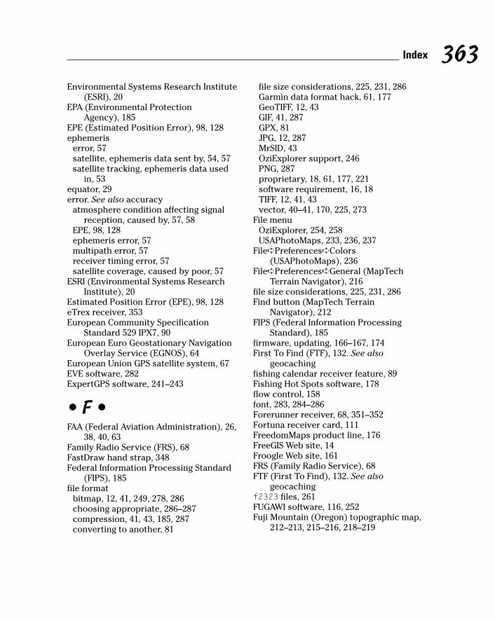
Environmental Systems Research Institute(ESRI), 20
EPA (Environmental Protection Agency), 185
EPE (Estimated Position Error), 98, 128ephemeris
error, 57satellite, ephemeris data sent by, 54, 57satellite tracking, ephemeris data used
in, 53equator, 29error. See also accuracy
atmosphere condition affecting signalreception, caused by, 57, 58
EPE, 98, 128ephemeris error, 57multipath error, 57receiver timing error, 57satellite coverage, caused by poor, 57
ESRI (Environmental Systems ResearchInstitute), 20
Estimated Position Error (EPE), 98, 128eTrex receiver, 353European Community Specification
Standard 529 IPX7, 90European Euro Geostationary Navigation
Overlay Service (EGNOS), 64European Union GPS satellite system, 67EVE software, 282ExpertGPS software, 241–243
• F •FAA (Federal Aviation Administration), 26,
38, 40, 63Family Radio Service (FRS), 68FastDraw hand strap, 348Federal Information Processing Standard
(FIPS), 185file format
bitmap, 12, 41, 249, 278, 286choosing appropriate, 286–287compression, 41, 43, 185, 287converting to another, 81
file size considerations, 225, 231, 286Garmin data format hack, 61, 177GeoTIFF, 12, 43GIF, 41, 287GPX, 81JPG, 12, 287MrSID, 43OziExplorer support, 246PNG, 287proprietary, 18, 61, 177, 221software requirement, 16, 18TIFF, 12, 41, 43vector, 40–41, 170, 225, 273
File menuOziExplorer, 254, 258USAPhotoMaps, 233, 236, 237
File➪Preferences➪Colors(USAPhotoMaps), 236
File➪Preferences➪General (MapTechTerrain Navigator), 216
file size considerations, 225, 231, 286Find button (MapTech Terrain
Navigator), 212FIPS (Federal Information Processing
Standard), 185firmware, updating, 166–167, 174First To Find (FTF), 132. See also
geocachingfishing calendar receiver feature, 89Fishing Hot Spots software, 178flow control, 158font, 283, 284–286Forerunner receiver, 68, 351–352Fortuna receiver card, 111FreedomMaps product line, 176FreeGIS Web site, 14Froogle Web site, 161FRS (Family Radio Service), 68FTF (First To Find), 132. See also
geocachingf2323 files, 261FUGAWI software, 116, 252Fuji Mountain (Oregon) topographic map,
212–213, 215–216, 218–219
363Index

• G •Galileo satellite system, 67Garmin
autorouting support, 178BlueChart software, 178cable, compatible, 156City Select software, 178Creating Background Maps for Garmin
GPS tutorial, 177data format hack, 61, 177eTrex receiver, 353Fishing Hot Spots software, 178Forerunner receiver, 68, 351–352Geko receiver, 81, 344iQue 3600 GPS-integrated PDA, 113MapSource software, 173–174, 178–180MetroGuide software, 178Minnesota LakeMaster ProMap
software, 179receiver firmware upgrade, 166software unlock code, 173TOPO software, 179Web site, 54, 180WorldMap software, 178
GARtrip software, 345gazetteer
described, 25GNIS, 182–186GNS, 186–189
GDT (Geographic Data Technology) datasupplier, 40, 290
Geko receiver, 81, 344genealogy research, using GPS in, 102Geocache Rating System Web site, 137geocaching
alias, 120archived cache, 132battery, spare, 121BLM land, on, 134camera, 121cellphone, 121CITO, 140clothing, appropriate, 121compass, 120, 127, 128
container, 128, 133–134, 136Darth Vader cache, 131daypack, 121difficulty rating, 124discussion forum, 138, 140, 334DNF, 130, 132etiquette, 139–140exchanging treasure, 131extreme, 136finding cache, 125–131flashlight, 121footwear, appropriate, 121FTF, 132handle, 120hiding cache, 133–136hint, 124, 125, 129–130history, 118–119hitchhiker, 132, 133inactive cache, 125information about cache, retrieving from
Web site, 122–125information sheet, leaving with
cache, 136introduced, 83logging, 124–125, 128, 130–131, 136machine event, 132maintaining cache, 139map, 120, 124, 127McToy cache, 132microcache, 129muggle, 132National Park Service land, on, 134neighborhood, multiple caches in same,
126, 135neocacher, 132Oregon Hell Hole cache, 138policing by geocaching community, 135property, on private, 134, 139rating system, 137receiver, 84, 120, 132removing cache, 139safety, 121, 122, 127satellite coverage, choosing time of day
for best, 97selecting cache to look for, 122–125spoiler, 125, 129, 132
364 GPS For Dummies

statistics, keeping, 128stocking cache, 136submitting cache to Web site, 135, 137swag, 120–121, 132TB, 133team, working in, 129, 130terrain rating, 124TNLN, 132TNLNSL, 132trading up, 131underwater, 136waypoint, 124, 126, 127, 135, 140
Geocaching Waypoint Web site, 140Geocaching.com Web site
difficulty rating, 124, 137discussion forum, 138, 140, 334FAQ section, 133listing caches, 122–124LOC files, 309number of caches listed, 119removing cache, 135searching, 122–123submitting cache, 135, 137TB tracking, 133terrain rating, 124user account, 122visit log, 124–125, 128, 131waypoint, downloading, 126
Geocode.com Web site, 183geocoding, 183, 283, 290Geodashing, 141Geographer’s Craft Web site, 27, 36Geographic Data Technology data supplier
(GDT data supplier), 40, 290Geographic Information System (GIS), 14Geographic Information System
Clearinghouse (GIS Clearinghouse), 323Geographic Names Information System
(GNIS), 182–186GEONet Name Server (GNS), 186–189georeferenced data, 248, 253, 262Georgia font, 283geospatial data, 12GeoTIFF files, 12, 43GeoTrans software, 189–190GIF (Graphic Interchange Format), 41, 287
GIS (Geographic Information System), 14GIS (Geographic Information System)
Clearinghouse, 323GIS Links Web Page, 335GIS Lounge Web site, 20glasses, 3-D, 219, 260Global Mapper software, 272–273GlobalMap100 receiver, 176GlobeXplorer Web site, 316, 326–327GLONASS (Global Orbiting Navigation
Satellite System), 67GNIS (Geographic Names Information
System), 182–186GNS (GEONet Name Server), 186–189golf, using GPS in, 353–354GolfPS software, 354Gookin, Dan (PCs For Dummies), 157GPS Drawing Web site, 102, 141GPS Exchange (GPX), 81GPS Resources Web site, 334GPS III satellite system, 68GPS TrackMaker software, 164GPS Utility software, 164, 345GPS Visualizer Web site, 308–310, 311GPSBabel software, 81gpsinformation.net Web site, 91, 116, 164,
173, 333GPSMapEdit software, 177GPSmapper software, 61GpsPasSion Web site, 116GPSy software, 164GPX (GPS Exchange), 81Graphic Interchange Format (GIF), 41, 287Graphical Locator Web site, 31, 71, 191graphics card, computer, 150, 263graphics software, editing digital map
using, 17, 250–251, 281–286Greenwich
prime meridian, 30Royal Observatory, 99
gridBattleship Grid System, 28MapTech Terrain Navigator, 211transparency overlay for paper map, 29
ground station, 53
365Index

Groundspeak geocaching discussionforum, 334
G7ToWin software, 164, 174
• H •Haicom receiver, 110, 111hand strap, carrying receiver on, 348handle (alias), 120handshaking, 158hard drive, computer, 148–149heart-rate monitor, integrating with
receiver, 349, 350–351hemisphere, 29, 30highway map, 24, 29history of GPS, 50hitchhiker, 132, 133. See also geocachingHolux receiver, 110, 111HOME waypoint, saving, 101Horton, Sarah (Web Style Guide: Basic
Design Principles for Creating WebSites), 287
hot key, 280hydrography, 40
• I •IEC (European Community Specification)
Standard 529 IPX7, 90IFR (Instrument Flight Rules) Enroute
aeronautical chart, 26Imaging Resource Web site, 91initial point, 34Intellinav software, 115International Date Line, 30Internet connection, 146, 152, 231ionosphere condition affecting signal
reception, 57iQue 3600 GPS-integrated PDA, 113IrfanView Web site, 43
• J •James Associates MacGPS Pro
software, 335Java/JavaScript Web map requirement, 19
jeeep.com Web site, 191Jeppesen software, 26, 89Johns Hopkins Applied Physics Lab, 50JPG (Joint Photographic Experts Group)
format, 12, 287
• K •Keyhole Web site, 44Knowledge Base, Microsoft, 157Kraak, Menno-Jan (Web Cartography), 287
• L •Lambert conformal projection, 27laminating paper map, 340landmark. See waypointlandscape page orientation, 341laptop computer
receiver, interfacing with, 59, 68vehicle, using in, 207
latitudeabbreviation, 31calculation, 54decimal notation, 31degree measurement, 30–31described, 30geocoding, 290history, 29map, display on, 22, 29mathematics based on, 29north, 30notation conversion calculator, online, 31receiver, returned by, 54, 58, 71south, 30street address, finding latitude of,
183, 298UTM conversion, 190
Latitude 26 (company), 339Leave No Trace Web site, 139leg (course between two waypoints), 77legend, map, 22, 198letterboxing, 118Li-Ion (Lithium ion) battery, 68, 92LOC files, 309location calculation by receiver, 54
366 GPS For Dummies

longitudeabbreviation, 31calculation, 54decimal notation, 31degree measurement, 30east, 30geocoding, 290history, 29map, display on, 22, 29mathematics based on, 29notation conversion calculator, online, 31prime meridian, 30receiver, returned by, 54, 58, 71street address, finding longitude of,
183, 298UTM conversion, 190west, 30
Lowrancefirmware upgrade, 166FreedomMaps product line, 176iFINDER receiver, 74, 176MapCreate software, 172, 173–174,
176–177Navionics marine chart, 176receiver simulator, 103Web site, 54
Lynch, Patrick J. (Web Style Guide: BasicDesign Principles for Creating WebSites), 287
• M •MacGPS Pro software, 335Magellan
DirectRoute software, 174–175firmware, updating, 166, 174MapSend software, 173, 174–176Meridian receiver, 334NAV 1000 receiver, 1RoadMate navigation system, 206software unlock code, 173Web site, 54
magnetic declination, 24mAh (milliampere-hour), 91
Maidenhead Locator System, 32Man Overboard function (MOB
function), 74Map and Compass for Firefighters online
course, 70Map button (Street Atlas USA), 203Map Content and Design for the Web: A
Guide to Optimizing CartographicImages on the Web, 287
.map files, 251Map Legend feature (Street Atlas USA), 198Map Maker Gratis software, 281Map menu (OziExplorer), 257Map Overlay View (3DEM), 271Map Reading and Land Navigation online
field manual, 70Map Seal (paper waterproofing
product), 339Map Type➪Photo (USAPhotoMaps), 232Map Type➪Topo (USAPhotoMaps), 232MapCard Web site, 313MapCreate software, 172, 173–174, 176–177Mapdekode software, 177MapInfo software, 20Mapopolis
mouse receiver, 110Navigator software, 115
Maporama Web site, 298–299MapQuest Web site, 19, 293, 294–296Maps On Us Web site, 300Maps Web site (Yahoo!), 300MapSend software, 173, 174–176MapSource software, 173–174, 178–180Mapsymbols.com Web site, 284MapTech Appalachian Trail software, 218MapTech Continental Divide software, 218MapTech flight-planning software, 26MapTech MapServer Web site, 303–308MapTech Marine Navigator software, 25MapTech National Park Digital Guide
software, 218Maptech Outdoor Navigator software,
116, 218MapTech Pacific Crest Trail software, 218
367Index

MapTech Terrain Navigator softwareCenter tool, 214coordinate display, 214datum, specifying, 216demo version, 210Drag tool, 214elevation display, 214, 217–221Find button, 212glasses, 3-D, 219grid, 211introduced, 18keyboard shortcut, 214map data bundled with, 274map display, 210–211, 213–215Marker tool, 215mouse shortcut, 214Pro version, 218Profile dialog box, 220receiver, transferring data to/from, 217scale, changing, 215searching, 211–213Terrain Profile tool, 220–2213-D View, 217, 218–219toolbar, 213, 214Track tool, 216USGS topographic data, use of, 211versions available, 210Vertical Exaggeration buttons, 219waypoint, marking, 215–216Web site, 210zooming, 215, 219
Map/Travel dingbats Web site, 284Map24 Web site, 300marine chart, 25, 38, 176, 304Marine Navigator software, 25mark
range mark, 29tick mark, 28, 29
Marker tool (MapTech Terrain Navigator), 215
McToy cache, 132. See also geocachingmemory
battery memory, 92card, 154, 161–162, 165computer, 147DDR, 147
MMC, 66, 152PDA, 106receiver, 66, 86, 154, 160–162, 165SD, 152SDRAM, 147
Mercator projection, 27meridian (imaginary line running
north/south), 30, 34, 36Meridian receiver, 334metric conversion, 32MetroGuide software, 178MGRS (Military Grid Reference System), 32MICRODEM software, 273–274Microsoft
Knowledge Base, 157MSN Maps and Directions Web site, 300OpenGL library, 260Pocket Streets software, 115, 208Streets & Trips software, 208TerraServer research project, 317,
318, 323Mike Sibley Fine Art Web site, 250Military Grid Reference System (MGRS), 32Miller projection, 27milliampere-hour (mAh), 91Minnesota LakeMaster ProMap
software, 179minute (degree measurement), 31Mio 168 PDA, 113MiTAC Mio 168 PDA, 113MMC (MultiMediaCard) memory, 66, 152MOB (Man Overboard) function, 74monitor, computer, 150Montana State Library Graphical Locator
Web site, 31, 71, 191motorcycle, mounting receiver on, 352Mount Bachelor (Oregon)
DOQ map, 44latitude/longitude, 71SPOT satellite data, 45UTM coordinate, 71
Mount St. Helens (Washington)3-D map, 16–17, 261–2623DEM scene, 264–265
mouse receiver, 59, 108, 109–110Movement Control buttons (3DEM), 267
368 GPS For Dummies

MrSID (Multi-Resolution Seamless ImageDatabase), 43
MSAS (Multi-Functional SatelliteAugmentation System), 64
MSN Maps and Directions Web site, 300muggle, 132. See also geocachingMultimap Web site, 300MultiMediaCard memory (MMC memory),
66, 152Multi-Resolution Seamless Image Database
(MrSID), 43MWSnap software, 278, 280MyMaps feature (MapTech MapServer Web
site), 307–308MyTopo Web site, 313–314
• N •NACO (National Aeronautical Charting
Office), 26, 38, 40name, proposing for unnamed feature, 185nanosecond, 99National Elevation Dataset (NED), 42National Geodetic Survey, 191, 253National Geographic
Adventure Paper, 339Back Roads Explorer software, 224–225TOPO! software, 18–19, 225–226, 274Web site, 224
National Geophysical Data Center (NGDC), 24
National Geospatial-Intelligence Agency(NGA), 40
National Map Web site, 322National Marine Electronics Association
(NMEA), 160, 333National Oceanic and Atmospheric
Administration. See NOAANational Park Digital Guide software, 218National Park Service land, geocaching
on, 134National Wildfire Coordinating Group
(NWCG), 70nautical chart, 25, 38, 176, 304NAV 1000 receiver, 1
Navicache.com Web site, 140navigation simulator, receiver, 102Navigator software, 115Navionics marine chart, 176Navman PDA sleeve, 111NAVSTAR (Navigation Satellite Timing and
Ranging), 50, 52, 53, 55NAVTECH data supplier, 40, 290neatline, 22NED (National Elevation Dataset), 42neocacher, 132. See also geocachingNew Map dialog box (USAPhotoMaps), 236NGA (National Geospatial-Intelligence
Agency), 40NGDC (National Geophysical Data
Center), 24NiCad (nickel cadmium) battery, 92NiMH (nickel metal-hydride) battery, 68,
92, 93, 94911 call from GPS-enabled cellphone, 109NMEA (National Marine Electronics
Association), 160, 333NMEA-0183 and GPS Information Web
site, 333NOAA (National Oceanic and Atmospheric
Administration)Charting and Navigation Theme Web
site, 40marine chart resources, 25, 304National Geodetic Survey, 191, 253NGDC, 24Office of Coast Survey
(chartmaker.ncd.noaa.gov), 38north
latitude, 30map orientation with north on top, 22, 24,
77, 340true versus magnetic, 24
Northing UTM value, 33Northwest Land Ordinance of 1785, 34Notes and Study Materials for GIS and the
Geographer’s Craft Web site, 27, 36NUDET (NUclear DETonation) sensor, 52NWCG (National Wildfire Coordinating
Group), 70
369Index
• O •Odden’s Bookmarks Web site, 335Office of Coast Survey
(chartmaker.ncd.noaa.gov), 38Olympics Savannah Yachting Venue
map, 41OnCourse GPS product, 353Open Source GIS Web site, 14OpenOffice-Draw software, 282Operation menu (3DEM), 264, 271Oregon Hell Hole cache, 138. See also
geocachingorienteering, 70OtterBox PDA case, 107–108, 113Outdoor Navigator software, 116, 218overhead image. See photograph, aerialOverhead View (3DEM), 271overlay map, 268–271, 272Overview Map feature (Street Atlas
USA), 195OziExplorer software
CE version, 116, 248datum, specifying, 255downloading, 247File menu, 254, 258format support, 246language support, 246map, calibrating, 248, 251–258map, creating georeferenced, 248, 253map, creating smart, 251Map menu, 257map, scanning paper, 248projection, specifying, 255receiver, interfacing with, 245registering, 247road navigation using, 247shareware version, 247street navigation using, 2473D version, 248tracking, real-time, 246trial version, 247View menu, 258Web site, 247World War I trench discovery, role in, 250Yahoo! Group, 247
• P •Pacific Crest Trail software, 218pack, carrying receiver in, 347–348paddling, using GPS in, 354–355pages per minute (ppm), 151panning, 325paper map. See also printing
backup to GPS, as, 7, 70contact paper, 339cost, 18currency, 11digital map, converting to, 251–258grid transparency overlay, 29laminating, 340land navigation using, 70online course for using, 70scanning, 41, 248, 249–250size, choosing when printing, 337–338waterproof, 338–340
parity, 158PC interface cable, 156Pc-Mobile Web site, 65, 109P-code signal, 52–53, 55PCs For Dummies (Gookin), 157PDA (personal digital assistant)
autorouting using, 114battery, 107, 112Bluetooth support, 112–113case, protective, 107–108, 113color, 106, 115expansion slot, 112golf GPS software, 354GPS-integrated, 113mapping software, 106, 113–116memory, 106POI display, 114power source, 107, 112receiver card, 110–111receiver, interfacing with, 59, 108–113receiver, using PDA as, 105–108, 110–113ruggedness, 107screen, 106sleeve, 108, 111–112street navigation, using for, 88, 114, 115stylus, 115
370 GPS For Dummies

synchronization, closing beforeinterfacing receiver with computer, 165
topographic map display, 115, 116track, logging, 114user interface, 106vehicle, using in, 110, 115voice support, 114water resistance, 107weather resistance, 107Web map, loading, 295
Perry-Castañeda Library Map CollectionWeb site, 335
personal digital assistant. See PDApet location using GPS, 102Pfranc cabling, 156Pharos receiver card, 111photograph, aerial
color, 327commercial, 316contrast, changing, 234–235copying, 237currency, 317DEM data, overlaying with, 272GlobeXplorer Web site, 328–329government-provided, 316MapTech MapServer Web site, 304MyTopo Web site, 313National Map Web site, 322panning, 325resolution, 44, 234, 321–322safety considerations when using for
navigation, 316satellite image, 315–318, 323–324, 326–327saving, 237security considerations, 323street map, overlaying, 328–329TerraServer.com Web site, 323–326TerraServer-USA Web site, 227–231, 233,
235, 318–322text, adding, 235–236TopoZone Web site, 312training course, discovering new
using, 344USAPhotoMaps, working with in, 228–232,
234, 237use, suggested, 315–316
USGS, 227–228, 231, 313, 318–322, 323, 327watermark, 316, 326Web-based, overview of, 316–318
pixel, 234planimetric map, 24–25Planning software, 97PLGR (Precision Lightweight GPS
Receiver), 55PLS (Public Land Rectangular Survey), 34plugger (receiver type), 55PNG (Portable Network Graphics)
format, 287pocket, carrying receiver in, 347–348Pocket GPS World Web site, 116Pocket Streets software, 115, 208POI (Point of Interest)
introduced, 18PDA display, 114receiver display, 87–88software viewing functionality, 171street map display, 194, 198–199, 292Web map display, 291–292
point, initial, 34port, communication, 151–152, 156–160Port Townsend (Washington) street map,
19, 20Portable Network Graphics format (PNG
format), 287portrait page orientation, 341ppm (pages per minute), 151Precision Lightweight GPS Receiver
(PLGR), 55prime meridian, 30Print Screen key, 237, 278–279printing
area printed, adding more than needed, 340
autorouting direction, 203–205color, 151, 338cost, 151, 341mural map, 222north, putting at top, 340page orientation, 340–341paper, size, 337–338paper, waterproof, 338–340ppm, 151
371Index

printing (continued)printer, 150–151resolution, 151scale, including, 338sizing map for, 337–338software, role in, 171speed, 151street map, 203–205, 2903DEM, 267–268topographic map, 302, 304, 311, 313UTM grid, including, 338Web map, 290
processor, computer, 147Profile dialog box (MapTech Terrain
Navigator), 220profile, elevation, 220–221, 310projection, 27, 255protocol, communication, 160Ptolemy (Roman scholar), 29public domain map, 16Public Land Rectangular Survey (PLS), 34
• Q •quad sheet, 23quadrangle, 23QuakeMap software, 243quarter (Township and Range coordinate
system division), 35QuickBird satellite, 45, 317QuickSearch button (Street Atlas USA), 199Quo Vadis software, 115
• R •race direction, using GPS in, 355–356Rand McNally
StreetFinder software, 208TripMaker Deluxe software, 208Web site, 296–297
range mark, 29raster data format
bitmap, 12, 41, 249, 278, 286color, 41compression, 41DEM, use in, 42
DRG, 42–43, 185, 268–271file size, 225introduced, 41NED, use in, 42resolution, 41, 42vector versus, 41, 225
receiveraccessory software, built-in, 66accuracy, 55, 56–58, 85, 128activity, matching with, 88–90alarm, 60almanac data received by, 53, 96altimeter, 62–63, 88antenna, 64–65, 88, 353APRS, 56area calculation functionality, 89armband, carrying on, 346–347ascent rate returned by, 62–63atmosphere condition affecting signal
reception, 57, 58autorouting support, 79, 178barometer, 63, 88basemap receiver, 61battery drain rate, comparing, 85, 91, 94baud rate when interfacing with
computer, 157, 158, 159, 165belt, carrying on, 347–348bicycle, mounting on, 352–353Bluetooth support, 68, 112–113boat, using in, 355buying, 84–90cable, 59, 109, 155–156, 165camera time, synchronizing, 356case, protective, 346–347, 348cellphone, GPS-enabled, 2, 109channel support, 8 versus 12, 54–55clock, 57, 58, 99color, 59, 86communication protocol when
interfacing with computer, 160, 165compass, electronic, 62, 76, 88connection to computer,
troubleshooting, 165consumer model, 54–55control, external, 86coordinate system, 32, 36, 71, 99
372 GPS For Dummies

cost, 1, 54, 68, 85DAGR, 55data, cumulative, 59data logger mode, 344datum, 27–28, 72–73, 100descent rate returned by, 62–63direction of travel returned by, 58display, 59–60, 85, 86dog, attaching to, 102elevation returned by, 54, 58, 62–63EPE, 98, 128ephemeris data received by, 54firmware, updating, 166–167, 174fishing calendar feature, 89floating, 89flow control when interfacing with
computer, 158geocaching, for, 84, 120, 132handheld, 108–109handshaking when interfacing with
computer, 158heart-rate monitor, integrating with, 349,
350–351holding properly, 98initializing, 95–98language, changing, 100latitude returned by, 54, 58, 71learning to use, 90–91location, saving, 58, 74–75longitude, returned by, 54, 58, 71manual, user, 84, 90manufacturers, major, 54map, built-in, 60–61, 86map, uploading to, 61, 87, 172–173,
217, 221map, using with external, 69–71mapping model, 55, 86–87MapTech Terrain Navigator, transferring
data to/from, 217measurement unit, 99memory, 66, 86, 154, 160–162, 165memory card, interfacing with computer
using, 154, 161, 165metric measurement conversion, 32MOB function, 74motorcycle, mounting on, 352
mouse receiver, 59, 108, 109–110navigation simulator, 102OziExplorer, interfacing with, 245pack, carrying in, 347–348parallel, 54parity when interfacing with
computer, 158PDA, interfacing with, 59, 108–113PDA receiver card, 110–111PDA synchronization, closing before
interfacing with computer, 165PDA, using as receiver, 105–108, 110–113PLGR, 55plugger, 55pocket, carrying in, 347–348POI display, 87–88, 114power supply, external, 85, 88, 89processing speed, 54protocol, communication, 160, 165reception, optimizing, 98resource model, 55road navigation, 87–88, 175route, activating, 78route, transferring to/from computer, 163,
164, 171, 238ruggedness, 107satellite data needed, 95satellite distance calculation, 54satellite status page, 96screen, 59–60, 70, 86, 100, 170simulator, 102, 103size, 1, 68, 86snowmobile, mounting on, 352software role when interfacing with
computer, 162–164, 171spoofing, 52sport, using in, 343–348start, cold/warm, 96storage, external, 66survey model, 55, 58system setting, changing default, 98–100timing error, 57Township and Range coordinate support,
36, 71track, logging, 59, 79–81, 102, 114, 344
373Index

receivertrack, transferring to/from computer, 163,
164, 171, 238–239transportation model, commercial, 56travel time display, 76type overview, 54–56U.S. military/government model, 55USAPhotoMaps, interfacing with, 238–239USB support, 151–152, 156, 159–160, 167user interface, 59–60, 66–67, 68, 86, 100UTM coordinate usage, 32vehicle receiver, mounting, 67, 110vehicle receiver, running from cigarette
lighter adapter, 85, 88, 94voice support, 67, 114WAAS support, 63, 85watch, integration with, 350–351, 354water bottle hand strap, carrying on, 348water resistance, 90, 354–355waypoint storage, 58–59, 73–77, 101waypoint, transferring to/from computer,
138, 163, 164, 171, 238–239wearing, 346–348weather resistance, 90Web site, uploading receiver data to, 348weight, 86wireless connection to computer, 68, 108,
112–113rectifying image, 273registering map, 17relief, shaded, 259, 262, 269, 271, 273resolution
dpi, 151map, digital, 151, 234, 249photograph, aerial, 44, 234, 321–322printing, for, 151raster map, 41, 42satellite image, 45, 317
Rite Concepts OnCourse GPS product, 353Rite in the Rain (company), 339road atlas, 24, 29RoadMate navigation system, 206Rotate or Shift Scene dialog box
(3DEM), 266Rotation buttons (3DEM), 267Route button (Street Atlas USA), 203
route (course between waypoints)activating, 78autorouting versus, 79computer, transferring to/from, 163, 164,
171, 238distance, tracking, 78duration, calculating, 78introduced, 58–59leg, 77planning tool, as, 78–79software for managing, 174track, converting to route, 216
rowing, using GPS in, 354–355Royal Observatory, 99ruler, map
scale display, 36–37transparency overlay, 29
Run dialog box (Windows), 285running speed, tracking, 101, 351
• S •SA (Selective Availability), 55, 57, 117–118safety
aerial photograph navigation, 316compass backup, 7geocaching, 121, 122, 127paper map backup, 7vehicle GPS, 207
sample_calif.gpx file, 308San Francisco (California)
downtown map created from TIGER data, 39
marine chart of San Francisco Bay, 25Sam Wo’s restaurant, 199, 202, 205
sans serif font, 283satellite
almanac data sent by, 53, 96atmosphere condition affecting signal,
57, 58C/A-code signal, 52, 55clock, atomic, 51computer, onboard, 51control of, 53coverage, error caused by poor, 57
374 GPS For Dummies

coverage, moving receiver for better, 98coverage, variance with time of day, 97DeLorme, satellite data available from,
45, 222DigitalGlobe QuickBird, 45, 317distance calculation by receiver, 54Doppler shift, 50, 54encryption of signal, 53ephemeris data sent by, 54, 57ephemeris used in tracking, 53European Union system, 67Galileo system, 67GLONASS, 67GPS III system, 68image, 315–318, 323–324, 326–327life span, 52mapping based on satellite data, 44–45multipath error, 57NAVSTAR, 50, 52, 53, 55NUDET sensor, 52number in orbit, 51number needed to calculate location,
54, 344obstruction blocking signal, 54, 56, 88,
89, 345P-code signal, 52–53, 55radio transmitter, 51receiver, satellite data needed by, 95receiver, satellite status page, 96rocket, built-in, 53signal strength, effect on accuracy, 98,
345–346solar-powered, 52speed, 51sport using GPS, signal reception,
345–346Sputnik, 50United States government system, 49, 67Y-code signal, 53, 55
Savannah Yachting Venue map, 41Save Picture As command (Windows), 278saving
editing saved map, 17, 250–251, 281–287HOME waypoint, 101location, 58, 74–75map, 203–205, 278–280
photograph, aerial, 237scale
fraction, representative, 36–37introduced, 22measurement unit, 36printing, including when, 338ruler display, 36–37topographic map, 37, 306
scanning paper map, 41, 248, 249–250sci.geo.satellite-nav newsgroup,
91, 334screen
capture, 237, 278–280PDA, 106receiver, 59–60, 70, 86, 100, 170
Screen.jpg file, 237SD (Secure Digital) memory, 66, 152SDRAM (synchronous dynamic RAM), 147SDTS (Spatial Data Transfer Standard)
format, 261SDTS2DEM software, 261sealer (paper waterproofing product), 339searching
business name, 295Geocaching.com Web site, 122–123GlobeXplorer Web site, 326MapQuest, 295MapTech Terrain Navigator, 211–213Street Atlas USA, 199–201TerraServer.com Web site, 324–325TerraServer-USA Web site, 183, 318–319USGS topographic map using GNIS, 183Web map, 290, 293–294, 295
Seattle (Washington)aerial photograph from GlobeXplorer
Web site, 328–329aerial photograph from TerraServer.com
Web site, 324aerial photograph from TerraServer-USA
Web site, 229–230, 235, 318–319,320–322
aerial photograph with street mapoverlay, 329
aeronautical chart, 26second (degree measurement), 31
375Index

section (Township and Range coordinatesystem division), 35
Secure Digital memory (SD memory), 66, 152
Selective Availability (SA), 55, 57, 117–118serial port, 157serif font, 2837.5 minute map, 237-Zip software, 261SGI (Silicon Graphics, Inc.) OpenGL
library, 260SG2 Personal Digital Caddie, 354shaded relief, 259, 262, 269, 271, 273shed, view, 273Sibley Fine Art Web site, 250SkyEye software, 116SkyGolf GPS system, 354sleeve, PDA, 108, 111–112smart map, 12–13, 246, 251SnagIt software, 278snowmobile, mounting receiver on, 352software. See also specific software
aeronautical, 26CD-ROM emulator, 148commercial, 20, 145–146computer/receiver interface role,
162–164, 171consumer mapping, 13–14cost, 14, 18, 171data format requirement, 16, 18editor, 16feature overview, 171file format requirement, 16, 18free, 14, 17GIS software, 14golf GPS software, 354graphics software, editing map using, 17hardware requirement, 146–152input data, 16, 17learning curve, 14, 15, 18manufacturer software overview, 169–171map data bundled with, 18–19, 274open source, 14PDA mapping software, 106, 113–116POI viewing functionality, 171printing, role in, 171
receiver accessory software, built-in, 66screen capture, 278, 279–280shareware, 17sport software overview, 345spreadsheet software, managing sport
data in, 345standalone, 16–17, 146, 167topographic mapping, 15, 175, 209Township and Range coordinate system
support, 36track, loading, 80unlock code, 173upgrading, 173, 174version, keeping up with latest, 18viewer, 16waypoint management software, 174Web map versus, 146, 290–292, 302
spatial data, 12Spatial Data Transfer Standard format
(SDTS format), 261speed tracking
accuracy, 345average speed, 59, 344, 348cycling speed, 101, 352maximum/minimum speed, 59, 344,
345, 348paddling speed, 354running speed, 101, 351vehicle GPS speed sensor, 206walking speed, 101windsurfing speed, 354
SPIN-2 satellite imagery, 323spoiler, 125, 129, 132. See also geocachingspoofing, 52sport, using GPS in
cycling, 101, 352–353distance, tracking, 343, 351elevation information, 344golf, 353–354heart-rate monitor, integrating with
receiver, 349, 350–351logging, 344, 348–349, 353paddling, 354–355race direction, 355–356receiver, carrying, 343–348rowing, 354–355
376 GPS For Dummies

signal reception considerations, 345–346software overview, 345speed, tracking, 344, 345, 348,
350–351, 354Web site overview, 345
SPOT (Systeme Pour l’observation de laTerre), 45
Spot 10 data collection (DeLorme), 45spreadsheet software, managing exercise
data in, 345SPS (Standard Positioning Service), 52Sputnik satellite, 50StarCaddy software, 354Start➪Program➪Accessories➪System
Tools➪Character Map (Windows), 285
Start➪Run (Windows), 285Start➪Settings➪Control Panel (Windows),
286stash hunt, 118. See also geocachingState Plane Coordinate System, 32static map, 12Stinger Stylus accessory, 115stitching scanned images, 250stop bit, 158Street Atlas USA software
address, finding, 199–201autorouting, 201–205campground database, 195Compass Rose, 197Control Panel, 195currency, 194, 199Earthmate receiver, using with, 205–207e-mailing from, 204Find tab, 199–200help file, 195Info tab, 198Map button, 203map, customizing, 194Map Legend feature, 198navigating, 197Octave control, 197Overview Map feature, 195PDA compatibility, 115POI database, 194, 198–199printing, 203–205
QuickSearch button, 199Route button, 203Route tab, 202saving, 203–205searching, 199–201Travel Package format, 204user interface, 195–196voice support, 194Web site, 115zooming, 196–197
street mapaccuracy, 291address, finding, 199–201address latitude/longitude, finding,
183, 298aerial photograph, overlaying, 328–329autorouting, 201–205copying using screen capture, 237,
278–280currency, 11, 194, 199, 291editing saved map, 281–287geocoding, 290help link, 294navigating, 294PDA, navigating using, 88, 114, 115POI display, 194, 198–199, 292printing, 203–205, 290saving, 203–205, 278–280symbol, adding, 283–286Web-based, 289–292
StreetFinder software, 208Streets & Trips software, 208strip map, 204Suunto G9 receiver, 354SVGA (Super Video Graphics Array), 150swag, 120–121, 132. See also geocachingsymbol
map, adding to, 283–286topographic map symbol overview, 38
synchronous dynamic RAM (SDRAM), 147Systeme Pour l’observation de la Terre
(SPOT), 45
377Index
• T •Tagged Image File Format (TIFF), 12, 41, 43TB (Travel Bug), 133. See also geocachingTeleAtlas data supplier, 40, 290TeleType software, 115, 116terminal area aeronautical chart, 26TerraBase II software, 273TerraClient software, 239–240Terrain Colors dialog box (3DEM), 264Terrain Navigator software
Center tool, 214coordinate display, 214datum, specifying, 216demo version, 210Drag tool, 214elevation display, 214, 217–221Find button, 212glasses, 3-D, 219grid, 211introduced, 18keyboard shortcut, 214map data bundled with, 274map display, 210–211, 213–215Marker tool, 215mouse shortcut, 214Pro version, 218Profile dialog box, 220receiver, transferring data to/from, 217scale, changing, 215searching, 211–213Terrain Profile tool, 220–2213-D View, 217, 218–219toolbar, 213, 214Track tool, 216USGS topographic data, use of, 211versions available, 210Vertical Exaggeration buttons, 219waypoint, marking, 215–216Web site, 210zooming, 215, 219
Terrain Profile tool (MapTech TerrainNavigator), 220–221
Terrain Projection Parameters dialog box(3DEM), 264
TerraServer research project, 317, 318TerraServer.com Web site, 323–326TerraServer-USA Web site
color, 229
currency, 229data transfer disruption, 229datum, 231limitations, 227–228, 229photograph, aerial, 227–231, 233, 235,
318–322resolution, 321–322searching, 183, 318–319street address coordinate, finding, 183topographic map display, 227, 320–322zooming, 318, 321–322
textaerial photograph, adding to, 235–236color, 236, 283font, 283, 284–286map, adding to, 236, 283Web map, 281, 283
Text➪List (USAPhotoMaps), 236Thomas Brothers street guide, 323-D mapping
animation, 268, 272color, 264–265DEM, 260–262, 272elevation, 217–221glasses, 3-D, 219, 260MapTech Terrain Navigator 3-D View, 217,
218–219moving image on screen, 267overlay map, 268–271, 272printing, 267–268rectifying image, 273rotating image, 266, 267shading, 259, 262, 269, 271, 273shifting image, 266topographic map, 217–221, 222, 223,
268–2712-D map compared, 259–260
3-D TopoQuads software, 223, 2743-D View (MapTech Terrain Navigator),
217, 218–2193DEM software
animation, 268, 272color, 264–265data source overview, 272DEM data, loading, 260–262, 272display area, 263downloading, 260DRG topographic map, overlaying on
DEM image, 268–271
378 GPS For Dummies

Elevation buttons, 267glasses, 3-D, 260graphics card compatibility, 263help, online, 261Map Overlay View, 271Movement Control buttons, 267OpenGL library usage, 260Operation menu, 264, 271Overhead View, 271printing, 267–268Rotate or Shift Scene dialog box, 266Rotation buttons, 267saving file, 267–268scene, 264–268Terrain Colors dialog box, 264Terrain Projection Parameters dialog
box, 264Translation buttons, 267troubleshooting, 263View tool, 263Web site, 260zooming, 267
tick mark, 28, 29TIFF (Tagged Image File Format), 12, 41, 43TIGER (Topologically Integrated
Geographic Encoding andReferencing), 39, 185
time for activity, choosing optimal, 97Times New Roman font, 283Timex Speed + Distance system, 350–351timing error in receiver clock, 57title, map, 22TNLN (Took Nothing, Left Nothing), 132TNLNSL (Took Nothing, Left Nothing,
Logged), 132Tomahawk cruise missile, 50TomTom Navigator software, 115topo map. See topographic mapTOPO software (Garmin), 179TOPO! software (National Geographic),
18–19, 225–226, 274Topo USA software, 222–223, 274TopoBird Web site, 44TopoFusion software, 241, 242, 345,
355–356topographic map
Bar Harbor (Maine), 303–305color, 151contour interval, 23
contour line, 23, 217coordinate system, 29cost, 18, 302, 311–312The Dalles (Oregon), 23datum, 28DEM image, overlaying with DRG
topographic map, 268–271DRG, 42–43, 185, 268–271Fuji Mountain (Oregon), 212–213,
215–216, 218–219magnetic declination error in older, 24PDA display, 115, 116printing, 302, 304, 311, 313quad sheet, 23quadrangle, 23range mark, 29scale, 37, 306searching using GNIS, 1837.5 minute map, 23software, topographic mapping, 15,
175, 209steepness, indication on, 23symbol overview, 383-D display, 217–221, 222, 223, 268–271Township mark, 29training course, discovering new
using, 344Web-based, advantages/disadvantages of,
301–302topoGraphix GPX data format, 81Topologically Integrated Geographic
Encoding and Referencing (TIGER), 39, 185
TopoScout software, 210. See alsoMapTech Terrain Navigator software
TopoVista Web site, 261TopoZone Web site, 19, 185, 312Township and Range coordinate system,
29, 34–35, 71track
color, 216computer, transferring to/from, 163, 164,
171, 238–239GPS Visualizer Web site, using in, 310MapTech Terrain Navigator, using in, 216PDA, logging by, 114receiver, logging by, 59, 79–81, 102,
114, 344route, converting to, 216
379Index

track (continued)software, loading into, 80Web map, using in, 310
Track tool (MapTech Terrain Navigator),216
TrackMaker software, 164trading up, 131. See also geocachingTrail Waypoints Web site, 188trailhead, 215TrailRegistry Web site, 188Translation buttons (3DEM), 267Travel Bug (TB), 133. See also geocachingTravel by GPS Web site, 188Travel Package format (Street Atlas
USA), 204trek (Endless Pursuit published
workout), 349Trimble Navigation
Planning software, 97receiver, 56
TripMaker Deluxe software, 208troposphere condition affecting signal
reception, 57turn-by-turn direction. See autorouting
• U •Ultimate Direction FastDraw hand
strap, 348United States Geological Survey. See USGSUnited States government. See specific
department and resourceUniversal Serial Bus (USB), 151–152, 156,
159–160, 167Universal Transverse Mercator. See UTMUniversity of Arizona TopoVista Web
site, 261University of California Berkeley Earth
Sciences and Map Library Web site, 335
University of Texas at Austin Perry-Castañeda Library Map Collection Web site, 335
University of Washington Department ofGeology Web site, 261
USAPhotoMaps softwareaerial photograph, copying, 237aerial photograph, downloading from
TerraServer-USA, 228–231, 233
aerial photograph, saving, 237aerial photograph, switching between
topographic map and, 231–232, 234Color Preference dialog box, 236contrast, changing, 234–235coordinate display, 231downloading, 227File menu, 233, 236, 237file size considerations, 231firewall, configuring for, 229help file, 228Internet connection, 231map display, navigating, 233map files, working with multiple, 236–237New Map dialog box, 236receiver, interfacing with, 238–239text, adding to image, 235–236Web site, 227zooming, 234
USB (Universal Serial Bus), 151–152, 156,159–160, 167
user interfacereceiver, 59–60, 66–67, 68, 86, 100Street Atlas USA, 195–196
USGS (United States Geological Survey)aerial photograph, color, 327aerial photograph, company contracted
to take, 323aerial photograph display in MyTopo Web
site, 313aerial photograph display in National
Map Web site, 322aerial photograph display in TerraServer-
USA Web site, 227–228, 231, 318–322coordinate system, 29Datums And Projections: A Brief Guide
Web site, 27DEM data, free, 16dlgv32 Pro software, 273DOQ map, 44home page, 40product Web site, 43topographic data, MapTech Terrain
Navigator use of, 211topographic map, coordinate system, 29topographic map, datum used, 28topographic map, DRG, 42–43, 185,
268–271topographic map, introduced, 23
380 GPS For Dummies

topographic map, magnetic declinationerror in older, 24
topographic map, MapTech TerrainNavigator use of, 211
topographic map, searching using GNIS, 183
topographic map, symbol overview, 38topographic map, viewing using MapTech
MapServer Web site, 304topographic map, viewing using MyTopo
Web site, 313topographic map, viewing using
TerraServer-USA Web site, 227,320–322
topographic map, viewing usingTopoZone Web site, 312
UTC (Coordinated Universal Time), 99UTM (Universal Transverse Mercator)
accuracy, 32converting to/from, 71Easting value, 33introduced, 29latitude/longitude conversion, 190location coordinate, finding using
MapTech MapServer Web site, 305metric conversion, 32Northing value, 33printing, including when, 338zone system, 33, 34
• V •vector format, 40–41, 170, 225, 273vehicle GPS
integrated, 68laptop computer, using, 207PDA, using, 110, 115receiver, mounting, 67, 110receiver, running from cigarette lighter
adapter, 85, 88, 94safety, 207speed sensor, 206windshield, signal blocking by heated, 88
Vertical Exaggeration buttons (MapTechTerrain Navigator), 219
VFR (Visual Flight Rules) aeronauticalchart, 26
ViaMichelin Web site, 300View menu (OziExplorer), 258view shed, 273View tool (3DEM), 263Virtual Terrain Project, 272Visualization Software Web site, 260voice
PDA support, 114receiver voice support, 67, 114Street Atlas USA support, 194
Voyageur receiver bag, 354, 355
• W •WAAS (Wide Area Augmentation System),
56–57, 63–64, 85walking speed, tracking, 101watch, receiver integration with,
350–351, 354water bottle hand strap, carrying receiver
on, 348water resistance
PDA, 107receiver, 90, 354–355
watermark, image, 316, 326Wayhoo.com Web site, 188waypoint
compass pointing to, 76computer, transferring to/from, 138, 163,
164, 171, 238–239date/time information, 73geocaching, 124, 126, 127, 135, 140GPS Visualizer Web site, using in, 308, 310HOME waypoint, saving, 101icon, 73leg, 77location information, 73MapTech Terrain Navigator, marking in,
215–216name, 73, 126receiver, storage by, 58–59, 73–77, 101software for waypoint management, 174track versus, 79Web map, using in, 308, 310Web site repository overview, 188
wearing receiver, 346–348
381Index

weatherPDA weather resistance, 107receiver weather resistance, 90signal, weather condition affecting, 58
Web Cartography (Kraak and Brown), 287Web map. See also specific Web site
accuracy, 291autorouting, 290, 292, 294, 296, 299availability, 291, 301Backpacker Magazine
recommendation, 313color, 283connection considerations, 146cookie, 308copying using screen capture, 280copyright, 281cost, 291, 302, 311–312currency, 291customizing, 292data format, appropriate, 287data source, 290ease of use, 291, 302geocoding, 290introduced, 19–20Java/JavaScript requirement, 19loading speed, 292PDA, loading to, 295POI display, 291–292printing, 290searching, 290, 293–294, 295size, 302software mapping versus, 146,
290–292, 302subscription-based service, 311symbol display, 284text, 281, 283topographic Web map advantages/
disadvantages, 301–302track, 310waypoint, 308, 310zooming, 294, 306
Web site, uploading receiver data to, 348Web Style Guide: Basic Design Principles
for Creating Web Sites (Lynch andHorton), 287
Web-hosted mapping service. See Web mapWestern Front Association Web site, 250Wide Area Augmentation System (WAAS),
56–57, 63–64, 85Windows
Add/Remove Programs utility, 286Character Map, 285–286Clipboard, copying image to using screen
capture, 237, 278–280Clipboard, copying symbol to, 285Control Panel, 286Display dialog box, 263Display Properties dialog box, 150Run dialog box, 285Save Picture As command, 278
windsurfing, using GPS in, 354wireless receiver, 68, 108, 112–113, 295World War I trench discovery, GPS
role in, 250WorldMap software, 178
• Y •Yahoo!
Forerunner receiver Group, 352GPS map authoring Group, 177Maps Web site, 300Meridian Group, 334OziExplorer Group, 247
Y-code signal, 53, 55
• Z •zone system, UTM, 33, 34Zoner Draw 3 software, 282zooming
GlobeXplorer Web site, 327–328MapTech Terrain Navigator, 215, 219Street Atlas USA, 196–197TerraServer.com Web site, 325–326TerraServer-USA Web site, 318, 321–3223DEM, 267USAPhotoMaps, 234Web map, 294, 306
382 GPS Navigation For Dummies

PERSONAL FINANCE
Also available:
Estate Planning For Dummies(0-7645-5501-4)401(k)s For Dummies (0-7645-5468-9)Frugal Living For Dummies(0-7645-5403-4)Microsoft Money “X” ForDummies (0-7645-1689-2)Mutual Funds For Dummies(0-7645-5329-1)
Personal Bankruptcy ForDummies (0-7645-5498-0)Quicken “X” For Dummies (0-7645-1666-3)Stock Investing For Dummies(0-7645-5411-5)Taxes For Dummies 2003 (0-7645-5475-1)
Also available:
Business Plans Kit ForDummies (0-7645-5365-8)Consulting For Dummies (0-7645-5034-9)Cool Careers For Dummies (0-7645-5345-3)Human Resources Kit ForDummies (0-7645-5131-0)Managing For Dummies (1-5688-4858-7)
QuickBooks All-in-One DeskReference For Dummies (0-7645-1963-8)Selling For Dummies (0-7645-5363-1)Small Business Kit ForDummies (0-7645-5093-4)Starting an eBay Business ForDummies (0-7645-1547-0)
The easy way to get more done and have more fun
Available wherever books are sold.Go to www.dummies.com or call 1-877-762-2974 to order direct.
BUSINESS & CAREERS
Also available:
Controlling Cholesterol ForDummies (0-7645-5440-9)Dieting For Dummies (0-7645-5126-4)High Blood Pressure ForDummies (0-7645-5424-7)Martial Arts For Dummies (0-7645-5358-5)Menopause For Dummies(0-7645-5458-1)
Nutrition For Dummies (0-7645-5180-9)Power Yoga For Dummies (0-7645-5342-9)Thyroid For Dummies (0-7645-5385-2)Weight Training For Dummies(0-7645-5168-X)Yoga For Dummies (0-7645-5117-5)
HEALTH, SPORTS & FITNESS
0-7645-5231-7 0-7645-2431-3 0-7645-5331-3
0-7645-5314-3 0-7645-5307-0 0-7645-5471-9
0-7645-5167-1 0-7645-5146-9 0-7645-5154-X

Also available:
America’s National Parks ForDummies (0-7645-6204-5)Caribbean For Dummies (0-7645-5445-X)Cruise Vacations ForDummies 2003(0-7645-5459-X)Europe For Dummies (0-7645-5456-5)Ireland For Dummies (0-7645-6199-5)France For Dummies(0-7645-6292-4)
London For Dummies (0-7645-5416-6)Mexico’s Beach Resorts ForDummies (0-7645-6262-2)Paris For Dummies(0-7645-5494-8)RV Vacations For Dummies(0-7645-5443-3)Walt Disney World & OrlandoFor Dummies (0-7645-5444-1)
Available wherever books are sold. Go to www.dummies.com or call 1-877-762-2974 to order direct.
A world of resources to help you grow
HOME, GARDEN & HOBBIES
Also available:
Auto Repair For Dummies (0-7645-5089-6)Chess For Dummies (0-7645-5003-9)Home Maintenance ForDummies (0-7645-5215-5)Organizing For Dummies (0-7645-5300-3)Piano For Dummies (0-7645-5105-1)
Poker For Dummies (0-7645-5232-5)Quilting For Dummies (0-7645-5118-3)Rock Guitar For Dummies (0-7645-5356-9)Roses For Dummies (0-7645-5202-3)Sewing For Dummies (0-7645-5137-X)
Also available:
Bartending For Dummies (0-7645-5051-9)Chinese Cooking ForDummies (0-7645-5247-3)Christmas Cooking ForDummies (0-7645-5407-7)Diabetes Cookbook ForDummies (0-7645-5230-9)
Grilling For Dummies (0-7645-5076-4)Low-Fat Cooking ForDummies (0-7645-5035-7)Slow Cookers For Dummies(0-7645-5240-6)
FOOD & WINE
TRAVEL
0-7645-5295-3 0-7645-5130-2 0-7645-5106-X
0-7645-5250-3 0-7645-5390-9 0-7645-5114-0
0-7645-5453-0 0-7645-5438-7 0-7645-5448-4

Available wherever books are sold. Go to www.dummies.com or call 1-877-762-2974 to order direct.
Plain-English solutions for everyday challenges
COMPUTER BASICS
Also available:
PCs All-in-One DeskReference For Dummies (0-7645-0791-5)Pocket PC For Dummies (0-7645-1640-X)Treo and Visor For Dummies(0-7645-1673-6)Troubleshooting Your PC ForDummies (0-7645-1669-8)
Upgrading & Fixing PCs ForDummies (0-7645-1665-5)Windows XP For Dummies (0-7645-0893-8)Windows XP For DummiesQuick Reference (0-7645-0897-0)
Also available:
Excel Data Analysis ForDummies (0-7645-1661-2)Excel 2002 All-in-One DeskReference For Dummies (0-7645-1794-5)Excel 2002 For DummiesQuick Reference (0-7645-0829-6)GoldMine “X” For Dummies (0-7645-0845-8)
Microsoft CRM For Dummies(0-7645-1698-1)Microsoft Project 2002 ForDummies (0-7645-1628-0)Office XP For Dummies (0-7645-0830-X)Outlook 2002 For Dummies(0-7645-0828-8)
BUSINESS SOFTWARE
0-7645-0838-5 0-7645-1663-9 0-7645-1548-9
0-7645-0822-9 0-7645-0839-3 0-7645-0819-9
• Find listings of even more For Dummies titles
• Browse online articles
• Sign up for Dummies eTips™
• Check out For Dummies fitness videos and other products
• Order from our online bookstore
Get smart! Visit www.dummies.com
™

Also available:
Adobe Acrobat 5 PDF ForDummies (0-7645-1652-3)Fireworks 4 For Dummies (0-7645-0804-0)Illustrator 10 For Dummies (0-7645-3636-2)
QuarkXPress 5 For Dummies(0-7645-0643-9)Visio 2000 For Dummies (0-7645-0635-8)
Available wherever books are sold. Go to www.dummies.com or call 1-877-762-2974 to order direct.
Helping you expand your horizons and realize your potential
INTERNET
Also available:
America Online 7.0 ForDummies (0-7645-1624-8)Genealogy Online ForDummies (0-7645-0807-5)The Internet All-in-One DeskReference For Dummies (0-7645-1659-0)Internet Explorer 6 ForDummies (0-7645-1344-3)
The Internet For DummiesQuick Reference (0-7645-1645-0)Internet Privacy For Dummies(0-7645-0846-6)Researching Online ForDummies (0-7645-0546-7)Starting an Online BusinessFor Dummies (0-7645-1655-8)
Also available:
CD and DVD Recording ForDummies (0-7645-1627-2)Digital Photography All-in-One Desk ReferenceFor Dummies (0-7645-1800-3)Digital Photography ForDummies Quick Reference (0-7645-0750-8)Home Recording forMusicians For Dummies (0-7645-1634-5)
MP3 For Dummies (0-7645-0858-X)Paint Shop Pro “X” ForDummies (0-7645-2440-2)Photo Retouching &Restoration For Dummies (0-7645-1662-0)Scanners For Dummies (0-7645-0783-4)
DIGITAL MEDIA
GRAPHICS
0-7645-0894-6 0-7645-1659-0 0-7645-1642-6
0-7645-1664-7 0-7645-1675-2 0-7645-0806-7
0-7645-0817-2 0-7645-1651-5 0-7645-0895-4

Available wherever books are sold. Go to www.dummies.com or call 1-877-762-2974 to order direct.
The advice and explanations you need to succeed
Also available:
Chemistry For Dummies (0-7645-5430-1)English Grammar ForDummies (0-7645-5322-4)French For Dummies (0-7645-5193-0)The GMAT For Dummies (0-7645-5251-1) Inglés Para Dummies (0-7645-5427-1)
Italian For Dummies (0-7645-5196-5)Research Papers ForDummies (0-7645-5426-3)The SAT I For Dummies (0-7645-5472-7)U.S. History For Dummies (0-7645-5249-X)World History For Dummies(0-7645-5242-2)
SELF-HELP, SPIRITUALITY & RELIGION
Also available:
The Bible For Dummies (0-7645-5296-1)Buddhism For Dummies (0-7645-5359-3)Christian Prayer For Dummies(0-7645-5500-6)Dating For Dummies (0-7645-5072-1)Judaism For Dummies (0-7645-5299-6)
Potty Training For Dummies(0-7645-5417-4)Pregnancy For Dummies (0-7645-5074-8)Rekindling Romance ForDummies (0-7645-5303-8)Spirituality For Dummies (0-7645-5298-8)Weddings For Dummies (0-7645-5055-1)
Also available:
Labrador Retrievers ForDummies (0-7645-5281-3)Aquariums For Dummies (0-7645-5156-6)Birds For Dummies (0-7645-5139-6)Dogs For Dummies (0-7645-5274-0)Ferrets For Dummies (0-7645-5259-7)
German Shepherds ForDummies (0-7645-5280-5)Golden Retrievers ForDummies (0-7645-5267-8)Horses For Dummies (0-7645-5138-8)Jack Russell Terriers ForDummies (0-7645-5268-6)Puppies Raising & TrainingDiary For Dummies (0-7645-0876-8)
PETS
EDUCATION & TEST PREPARATION
0-7645-5302-X 0-7645-5418-2 0-7645-5264-3
0-7645-5255-4 0-7645-5286-4 0-7645-5275-9
0-7645-5194-9 0-7645-5325-9 0-7645-5210-4

WEB DEVELOPMENT
Also available:
ASP.NET For Dummies (0-7645-0866-0)Building a Web Site ForDummies (0-7645-0720-6)ColdFusion “MX” ForDummies (0-7645-1672-8)Creating Web Pages All-in-One Desk ReferenceFor Dummies (0-7645-1542-X)
FrontPage 2002 For Dummies(0-7645-0821-0)HTML 4 For Dummies QuickReference (0-7645-0721-4)Macromedia Studio “MX”All-in-One Desk ReferenceFor Dummies (0-7645-1799-6)Web Design For Dummies (0-7645-0823-7)
Also available:
Beginning Programming ForDummies(0-7645-0835-0)Crystal Reports “X”For Dummies (0-7645-1641-8)Java & XML For Dummies (0-7645-1658-2)Java 2 For Dummies (0-7645-0765-6)JavaScript For Dummies(0-7645-0633-1)Oracle9i For Dummies (0-7645-0880-6)
Perl For Dummies (0-7645-0776-1)PHP and MySQL ForDummies (0-7645-1650-7)SQL For Dummies(0-7645-0737-0)VisualBasic .NET ForDummies (0-7645-0867-9)Visual Studio .NET All-in-OneDesk Reference For Dummies(0-7645-1626-4)
We take the mystery out of complicated subjects
Available wherever books are sold.Go to www.dummies.com or call 1-877-762-2974 to order direct.
PROGRAMMING & DATABASES
Also available:
CCNP All-in-One CertificationFor Dummies (0-7645-1648-5)Cisco Networking ForDummies (0-7645-1668-X)CISSP For Dummies (0-7645-1670-1)CIW Foundations ForDummies with CD-ROM(0-7645-1635-3)
Firewalls For Dummies (0-7645-0884-9)Home Networking ForDummies (0-7645-0857-1)Red Hat Linux All-in-OneDesk Reference For Dummies(0-7645-2442-9)TCP/IP For Dummies(0-7645-1760-0)UNIX For Dummies(0-7645-0419-3)
LINUX, NETWORKING & CERTIFICATION
0-7645-1643-4 0-7645-0723-0 0-7645-1630-2
0-7645-0746-X 0-7645-1657-4 0-7645-0818-0
0-7645-1545-4 0-7645-0772-9 0-7645-0812-1