commission for aeronautical meteorology - WMO Library
192
WORLD METEOROLOGICAL ORGANIZATION COMMISSION FOR AERONAUTICAL METEOROLOGY ABRIDGED FINAL REPORT OF THE NINTH SESSION Montreal, 5-28 September 1990 (Held in part conjointly with the Communications.iMeteorology/Operations (COMIMET/OPS) Divisional Meeting (1990) ofICAO) \ WMO-No. 752\ Secretariat of the World Meteorological Organization. Geneva· Switzerland 1991
-
Upload
khangminh22 -
Category
Documents
-
view
4 -
download
0
Transcript of commission for aeronautical meteorology - WMO Library

WORLD METEOROLOGICAL ORGANIZATION
COMMISSION FOR AERONAUTICAL METEOROLOGY
ABRIDGED FINAL REPORT
OF THE
NINTH SESSION
Montreal, 5-28 September 1990
(Held in part conjointly with the Communications.iMeteorology/Operations (COMIMET/OPS)
Divisional Meeting (1990) ofICAO)
\ WMO-No. 752\
Secretariat of the World Meteorological Organization. Geneva· Switzerland 1991

© 1991, World Meteorological-Organization
ISBN 92-63-10752~ 1
NOTE
The designations employed and the presentation of material in this publication do not imply the expression of any opinion whatsoever on the .part of the Secret~iat of the World Meteorological Organization concerning the legal status of any country, territory, city or area, or of its authorities, or concerning the delimitation of its frontiers or boundaries.

PART I
SEPARATE MEETINGS OF THE COMMISSION FOR
AERONAUTICAL METEOROLOGY
(Agenda items 1-3 and 11-20)


CONTENTS
PART I - SEPARATE MEETINGS OF THE COMMISSION FOR AERONAUTICAL METEOROLOGY
GENERAL SUMMARY OF THE WORK OF THE SESSION
1. 2. 3.
11. 12.
13.
l4.
15.
16. 17. 18. 19. 20.
Opening of the session ..•...•.•........................•...•...... Organization of the session .......•..•.........•.•..•............• Reports by the president of the Commission and chairmen of working groups ..................................••................ Specialized training of aeronautical meteorological personnel ..... Publications and guidance material for the Aeronautical Meteorology Programme .........................•.•.•...•....•...... WMO Third Long-term Plan for the Aeronautical Meteorology Programme ............•..•.............•..•........................ Co-operation with other WMO bodies and international organizations .........•......................••••................. Review of previous resolutions and recommendations of the Commission and relevant Executive Council resolutions ......•...... Scientific lectures .............................................. . Establishment of working groups and nomination of rapporteurs .... . Election of officers .......................•.....•............•... Date and place of the tenth session .........................•..... Closure of the session ...................................•........
RESOLUTIONS ADOPTED BY THE SESSION
1.
2.
3.
4.
5.
Review of the resolutions and recommendations of the Commission for Aeronautical Meteorology ..........................• Advisory Working Group of the Commission for Aeronautical Meteorology ................................................•...... Working Group on Advanced Techniques Applied to Aeronautical Meteorology ...................................................... . Working Group on the Provision of Meteorological Information Required Before and During Flight ................................• Rapporteur on Meteorological Observations and Information Distribution Arrangements for Local Aeronautical Users •....•......
RECOMMENDATIONS ADOPTED BY THE SESSION
1. 2.
Specialized training for aeronautical meteorological ~personnel .... Review of resolutions of the Executive Council based on previous recommendations of the Commission for Aeronautical Meteorology ....
ANNEXES
I. List of persons attending the session
II. Agenda .•..........................................................
1 2
2 6
8
9
11
11 12 12 13 13 l3
14
16
17
18
20
21
21
22
26

VI CONTENTS
III. List of documents
A. "DOC" series ...... "" ..... ""."................................................ 28 B. IIPI~'I series .. " .................. " ................................. " ............................ ".... 29
PART II - MEETINGS HELD CONJOINTLY WITH THE COMMUNICATIONS/METEOROLOGY/ OPERATIONS (COM/MET/OPS) DIVISIONAL MEETING (1990) OF ICAO

GENERAL SUMMARY OF THE WORK OF THE SESSION
1. OPENING OF THE SESSION (agenda item 1)
1.1 The ninth session of the Commission for Aeronautical Meteorology (CAeM) was held at the rCAO Headquarters in MontreaL Canada, from 5 to 28 September 1990. Part of the session (from 5 to 11 September and 19 to 26 September) was held conjointly with the ICAO Communications/Meteorology/ Operations (COM/MET/OPS) Divisional Meeting (1990).
1.2 The session was opened by the president of the Commission, Mr J. Kastelein, at 10.35 a.m. on 5 September 1990. rn his speech, the president greeted all the participants and welcomed, in particular, the new members to their first meeting of CAeM.
1.3 The meeting was addressed by Mr V.P. Singh, president of the rCAO Air Navigation Commission who, on welcoming participants to Montreal, remarked that it was always a pleasure to meet and work with colleagues from the meteorological community. The purpose of the conjoint meeting was to review and update certain requirements for international civil aviation and Mr Singh expressed the hope that with the continuing excellent relationship between the two organizations, the heavy work-load during the meeting would be expeditiously dealt with to the benefit of aviation into the next century.
1.4 On behalf of the Secretary-General of WMO, Professor G.O.P. Obasi, a warm welcome was extended to all participants by Dr J .L. Rasmussen, Director of the World Weather Watch Department. He conveyed the Secretary-General' s gratitude to rCAO for their very kind offer to act as hosts for the ninth session of the CAeM and expressed WMO's pleasure to be working so closely with rCAO again. This co-operation had as its objective the continuous improvement and global standardization of meteorological services to aviation to contribute to the safety, economy and efficiency of air transport.
1. 5 Dr Rasmussen stressed the close links that the Aeronautical Meteorology Programme had. with the other WMO Programmes ~ particularly the World Weather Watch. He pointed out that the success of the World Area Forecast System (WAFS) was dependent on the proper functioning of the different components of the World Weather Watch, namely the Global Observing
. System, the Global Data-processing System and the Global Telecommunication System.
1. 6 The importance of the joint work of the Commission at this session together with the rCAO COM/MET/OPS Divisional Meeting was underlined by Dr Rasmussen who said that it would be likely to have far-reaching effects on the meteorological support glven to aviation in the next few years. He pointed out that with global air traffic expected to double by the turn of the century, this support would become even more critical.
1. 7 One item on the agenda of the conjoint meeting, the revision of meteorological codes, was singled out by Dr Rasmussen as being extremely important. This r-evision had been a major exercise over the preceding year and he conveyed the gratitude of the Secretary-General to all those who had worked so hard to arrive at the proposals before the meeting, in particular the president of the Commission, Mr J. Kastelein. Dr Rasmussen closed his address by wishing participants a most constructive session and a pleasant stay in Montreal.

2 GENERAL SUMMARY
1.8 There were 106 participants at the 'session. These included delegates from 57 Members of WMO and observers from 'i international organizations. A complete 1is,t of participants is given as Annex I to this report.
2. ORGANIZATION OF THE SESSION (agenda item 2)
2.1 Consideration of the report on credentials (agenda item 2.Il
At the first plenary meeting the representative of the Secretary-General pres,ented a provisional list of participants which was accepted as a first report on credentials; further reports were submitted to the session at ensuing plenary meetings. It was decided not to establish a Credentials Committee.
2.2 Adoption of the agenda (agenda item 2.2)
The provisional agenda was adopted by the session. The final agenda is reproduced as Annex II to this report together with an indication of relevant documents and the numbers of resolutions and recommendations.
2.3 Establishment of committees (agenda item 2.3)
In accordance with Regulation 23 of the WMO General Regulations, the Commission established a Nomination Committee and a Co-ordination Committee. It was agreed not to establish working committees but to work in a committee of the whole. The Nominations Committee was composed of the principal delegates of the UK (chairman), Colombia, Cote d'Ivoire, and the USSR. The Co-ordination Committee was composed of the president and vice-president of CAeM and the representative of the Secretary-General. Mr N.E. Kamenya (United Republic of Tanzania) was appointed rapporteur on previous recommendations and resolutions of the-Commission.
2.4 Working arrangements and other organizational matters (agenda item 2.4)
The Commission approved various organizational aspects of the session at its first plenary meeting. The Commission agreed that. in accordance with WMO General Regulation 109, no minutes of the session would be prepared but that statements by delegations would be reproduced and distributed as and when requested, in accordance with Regulation 110.
3. REPORTS BY THE PRESIDENT OF THE COMMISSION AND CHAIRMEN OF WORKING GROUPS (agenda item 3)
3.1 The Commission noted with appreciation the report of its president, which reviewed the activities of the Commission since its eighth session in 1986.
3.2 The Commission was gratified to note that Tenth Congress, Geneva, 1987, had endorsed the decision by the Executive CounCil that more support be given to the Aeronautical Meteorology Programme in view of the developing requirements of international air navigation for meteorological services. It also noted that Congress had agreed that WMO' s work in this field should be further strengthened in order to give impetus to the further development of the World Weather Watch, thus contributing to maintaining the integrity of national Meteorological Services.

GENERAL SUMMARY 3
3.3 The Commission welcomed the fact that all regional associations had concurred with this view and further noted that the Executive Council, in all its sessions since CAeM-VIII, had consistently expressed its satisfaction with the progress of the work of the Commission.
3.4 In his report. the president pointed out that although meteorological support would continue to be of major importance in the economy, efficiency and safety of air transport, the current economic and political climates were not conducive to the full development of aeronautical meteorology. The pressure on national government agencies to increase effectiveness and efficiency would remain strong while the need to reduce staff could force meteorological services towards extensive centralization. He expressed his concern over the development of automation and its application to specialized aeronautical services when the only objective was to save on manpower. The introduction of computer technology, while essential for improvements in meteorology, was not always conducive to a fully responsive aeronautical meteorological service.
3.5 The president stressed the vital link between support by the Executive Council and an active Commission. He urged the individual Commission members to ensure that their permanent representatives were kept informed about the problems and needs that occurred in the application of meteorology to aviation. The integrity of the WMO Basic Systems was to a large degree dependent on services to aviation and he pointed out that approximately 30% of the synoptic stations in the Global Observing System were located at aerodromes.
3.6 The president expressed his appreciation president of CAeM, for his outstanding help in the working groups and all members who had served on Secretariats for their co-operation and help.
to Mr C. Sprinkle. viceintersessional period, the them and the WMO and ICAO
3.7 The report by the chairman of the Working Group on Meteorological Observations and Information Distribution Arrangements for Local Aeronautical Users (METODA) was approved by the Commission. It noted that the group had concentrated its work since CAeM-VIII on the production of the Guide on Meteorological Observation and Information Distribution Systems at Aerodromes. The Commission agreed that this would, in the first instance, be of considerable use to national authorities responsible for planning and installing meteorological observing and distribution systems at aerodromes. The conclusions reached by the session on these items are recorded under agenda item 12.
3.8 The Commission commended the working group for its initiative in beginning a study on the definition of visibility. It agreed that the increasing use of automatic observing systems and the growing economic importance of visibility In aeronautical observations required greater uniformity in the. measurement and reporting of visibility. The Commission felt that this work should be continued In the next intersessional period in close collaboration with CIMO.
3.9 The Commission noted that CIMO at its tenth session, Brussels, September 1989, had set up a Working Group on Aerodrome Meteorological Measurements which would include a representative of CAeM. The Commission expressed its gratitude for the efforts of the working group and thanked its chairman, Mr J. Goas (France), for his hard work during the intersessional period.

4 GENERAL SUMMARY
3.10 The Conunission noted with appreciation the report by the chairman of the Working Group on the Provision of Meteorological Information Required Before and During Flight (PROMET) and thanked its chairman, Mr K. Pollard OBE (UK). Satisfaction was expressed with regard to the important work carried out by the group in the intersessional period since 1986.
3.11 The major items dealt with by the working group in that period were the following:
(a) The World Area Forecast System. The working group closely monitored the status and implementation of the World Area Forecast System (WAFS) by means of members' participation in the various ICAO/WMO meetings on the implementation and co-ordination of the WAFS. In particular, it endeavoured to focus the attention of all concerned on the implementation of the WAFS on those elements of the World Weather Watch (WWW) which could provide support, in some cases essential, to the system. PROMET members played an important role in the ICAO WAFS Study Group which had its first meeting in MontreaL 12-16 September 1988 and its second in Montreal 10-13 October 1989. The conclusions of the session on those matters are recorded under agenda item 4;
(b) Aeronautical meteorological codes. At PROMET-V, a thorough review was undertaken of the perceived deficiencies in the codes a.nd this review formed part of the background material for the formulation by ICAO of new draft operational requirements. WMO was requested to undertake consequential amendments to the associated codes. A sub-group of PROMET augmented by code experts met in Geneva from 2-6 October and again from 20-23 November 1989. In line with the draft operational requirements, the sub-group produced proposals for changes to the codes which were considered by the Codes Sub-Group of the CBS Working Group on Data Management. Geneva, 26 February to 2 March 1990 and subsequently by the full CBS Working Group on Data Management, Geneva, 5-9 February 1990. The conclusions reached on these matters by the session are recorded under agenda item 5;
(c) Improved forecasting methods. In view of the establishment of the ATEAM Working Group at CAeM-VIII, it was felt that the promotion and formulation of proposals for the introduction of improved forecasting methods should be more properly undertaken by it. 'However, as the accuracy of such forecasts depends to a large extent on the observational data available the working group developed varying meteorological data requirements of different types of forecast offices. The conclusions of the session on these matters are recorded under agenda item 7;
(d) A""r"e,.a'----'M"-e"-t=e"o:or"oc=l"o"'g"'i"c..,a.,l'-_W=a .. t"c"h. The working group deve loped draft meteorological data requirements of a meteorological office having responsibility for area meteorological watch, considered by the session under agenda item 7;
(e) Model charts and forms. The model charts and forms contained in the Appendix to WMO Technical Regulations [C.3.3.] and consequential amendments to the text of [C.3.3.] which had been developed by PROMET were approved in 1987 by the President of WMO in accordance with the authority vested in him by WMO General Regulation 9 (5). This action was subsequently endorsed by EC-XXXIX in Resolution 9;

GENERAL SUMMARY 5
(f) The Guide to Aeronautical completed and presented to the
Meteorological Commission under
Off ice Practices agenda item 12;
was
(g) Liaison was undertaken with CBS on questions relating the WWW for aeronautical meteorology, such as the reporting of volcanic ash cloud;
to the use of observing and
(h) Wind-speed depiction on WAFS upper-air charts. It was agreed by PROMET that RAPCs using kilometres per hour as their wind-speed unit should insert in the legend of each relevant chart, the phrase "wind-speed in knots or exact equivalent in kilometres per hour" to avoid ambiguity. This was endorsed by the Executive Council in Resolution 9 (EC-XXXIX).
3.12 The Commission agreed that the cordial working relations established with ICAO and the aeronautical users had been beneficial to all and had, in no small measure, contributed to the successful completion of a number of the tasks delegated to PROMET.
3.l3 The Commission then considered the report of the chairman of the Working Group on Advanced Techniques Applied to Aeronautical Meteorology (ATEAM). It welcomed the initiative of the group under its chairman, Dr N.D. Gordon (New Zealand), in meeting four times during the intersessional period, three of these being without financial support from the Organization.
3.14 The ATEAM Newsletter which reported to a1l CAeM members on research and development activities relevant to aeronautical meteorology was welcomed by the Commission. It was noted that three such Newsletters had been produced and had been greeted with much satisfaction by the members. The Commission agreed that. as much benefit was derived from this method of disseminating information, such Newsletters should be continued in the next intersessional period.
3.15 The Commission noted the proposed WMO Technical Note on "Interpretation Techniques in Aeronautical Meteorology" currently being prepared by the ATEAM Working Group with the aid of' seconded experts, Messrs C. Hall (UK), B. Golding (UK) and L. Wilson (Canada).
3.16 The Commission attached considerable importance to the involvement of the working group in the organization of conferences on subjects relevant to aeronautical meteorology. The proposed WMO Technical Conference on Tropical Aeronautical Meteorology (TECTAM) planned for 1992 was noted by· the Commission. The conclusions of the session on this item were recorded under agenda item 11.
NOTE: Agenda items 4 to 10 inclusive were considered conjointly with Communications/Meteorology/Operations- (COM/MET/OPS) Divisional (1990) ; the report on these discussions is reproduced in Part II report.
the ICAO Meeting of _ this

6 GENERl\L SUMMARY
11. SPECIALIZED TRAINING OF AERONAUTICAL METEOROLOGICAL PERSONNEL (agenda item 11)
11.1 Training events of particular interest to the Commission since its last session were noted. These were:
8-12 Dec. 1986
26 Oct.- 6 Dec. 1988
29 Jan. - 3 Feb. 1989
16-27 Oct. 1989
RA III Regional Training Seminar on the Operation of Meteorological Offices at Airports, Buenos Aires, Argentina;
Weather Forecasters' Course, Quezon City, Philippines;
Third International Conference on Aviation Weather System, Anaheim, USA;
the
Training Seminar on with Emphasis on Tallahassee, USA.
Aeronautical Meteorology Satelli te Applications,
The Commission singled out the Training Seminar held in Tallahassee, Florida, in which the USA had shared the costs with WMO as being an excellent method for Members to contribute to the global training requirements of the aeronautical meteorological community.
11. 2 The Commission noted the various relevant training publications which had been issued since November 1986. It welcomed the fact that following a decision by Tenth Congress, the Secretariat was to act as an exchange forum for audiovisual and computer software materials. It further noted the information provided on the procedures for the acquisition and loan of such materials contained in the WMO Catalogue of Meteorological Training Publications and Audiovisual Aids, published and distributed to all Members in 1987. The Commission invited members to assist in, and contribute to, the enlargement of the WMO Library by providing relevant textbooks and other material training aids.
11.3 The Commission acknowledged with pleasure the help provided by the UNDP, the VCP and the WMO regular budget in providing training for a total of 15 fellows iii fields relevant to aeronautical meteorology during the period 1987 to 1989.
11.4 The Commission noted with satisfaction the training events· ~n aeronautical meteorology planned to be held by the end of 1991, subject to the availability of funds. These were a training seminar on new forecasting techniques in aeronautical meteorology in RA I and a regional training seminar on aeronautical forecasting, briefing and documentation. in RA II and RA V. It also noted the co-sponsorship by WMO of the American Meteorological Society's Fourth International Conference on the Aviation Weather System to be held. in Paris from 24-26 June 1991.
11.5 It was agreed by the Commission that a WMO Technical Conference on Tropical Aeronautical Meteorology (TECTAM) should be held in the latter half of 1992 with the following subject areas:
(a) . Numerical weather prediction for tropical and sub-tropical areas including global model performance, prospects for regional/mesoscale models and operational uses;

GENERAL SUMMARY 7
(b) Satellite/radar imagery interpretation;
(c) Aviation weather hazards.
It further agreed that the ATEAM working group should be closely involved with TECTAM's organization.
11. 6 The Commission approved the training during the next financial period (1992-1995) Executive Council and Cg-XI:
events planned subj ect to the
to be organized approval of the
• Training emphasis
seminar on aeronautical on satellite applications;
meteorology with special
• Training seminar on aeronautical meteorology with emphasis on radar meteorology;
• Two regional training seminars on new forecasting techniques in aeronautical meteorology to be organized with ICAO.
The Commission urged its members to continue to provide financial and other support for the organization of training events, in particular through the hosting of training events and meeting appropriate expenses for lecturers and participants.
11.7 The Commission noted that following the decision of Tenth Congress, WMO publication No. 240 - Compendium of training facilities for meteorology and operational hydrology, 1982 was under revision and members were urged to submit new information as necessary.
11. 8 The Commission noted views expressed at the informal meeting of Heads of national training divisions of Meteorological Services of seven developed countries, in Toronto, Canada, 12 to 15 July 1988. The Commission agreed with the views of this meeting that it would be useful to share information on four specific topic areas of common interest:
(a) Application of computer-assisted learning techniques ~n or individual programmes;
to
(b) Use of interactive video disks as a teaching tool in meteorological training;
(c) Training aspects of Doppler radar, its operation and maintenance;
(d) Update of facilities, programmes, and personalities associated with meteorological training with attention to aviation meteorology.
11.9 The summaries of training requirements in relevant subject areas as indicated by 91 WMO Members were presented to the Commission which noted that the meeting of such requirements would depend almost entirely on external financial support.
11.10 The Commission agreed that specialized training in aeronautical meteorology was of paramount importance, particularly in developing countries. Because of the costs involved it was felt that such training should preferably be carried out on a regional basis and in this connection a

8 GENERAL SUMMARY
call was made to strengthen the Regional Meteorological Training Centres. The view was expressed that there was merit in involving air traffic control personnel in future aeronautical meteorological training events. The Commission noted that Argentina could provide training for Spanish speaking Class I, II, III and IV personnel.
11.11 Concern was expressed about the difficulty in some developing countries to adequately maintain modern equipment required for aeronautical meteorology. The Commission noted the concern and recognized the need for specialized training for staff involved in maintaining the equipment.
11.12 The suggestion that personnel from developing countries could benefit from training in the forecast centres of the developed world was greeted with enthusiasm by the Commission. It noted the details of such training currently being carried out by the WAFCs London and Washington and it was expected that this would continue. The Commission was gratified by the information that a seminar was to be arranged in conjunction with WMO in the United Kingdom on aeronautical forecasting with special emphasis on the practical application of numerical weather model products and was likely to take place later in 1991 or early 1992.
11.13 The meeting discussed a suggestion, made by several members, that airlines might be approached to provide assisted travel for students attending training seminars. It was pointed out that arrangements on a local basis already existed in some areas to enable meteorologists to gain experience on familiarization flights, which might be used for the purpose of travel to such seminars. Members recognized that some States were unable to benefit from aeronautical training because of a lack of funds for travel and subsistence. It was said that as lATA already supported the training of non-meteorological staff. perhaps such schemes might be extended to other groups. The observer from lATA informed the meeting that airlines would find it difficult to provide free transportation; however. there might be other ways that assistance could be provided.
11.14 The Commission agreed that although basic training in aeronautical meteorology was still very necessary there was an increasing need for specialized training associated with advances in the application of advanced technologies and techniques. It further agreed that such training could be of considerable benefit to the aviat'ion community and adopted Recommendation 1 (CAeM-IX) .
11.15 A particular training problem involving the aviation community was brought to the Commission's attention. It was noted that pilots based in temperate latitudes were mainly trained in temperate latitude meteorology and that a need existed for training in tropical meteorology. The need was expressed for guidance material for this purpose. This problem was further discussed under agenda item 12.
12. PUBLICATIONS AND GUIDANCE MATERIAL FOR THE AERONAUTICAL METEOROLOGY PROGRAMME (agenda item 12)
12.1 The English editions of the Guide on Meteorological Observation and Information Distribution Systems at Aerodromes prepared by the METODA Working Group and the Guide to Practices for Meteorological Offices Serving Aviation prepared under the aegis of the PROMET Working Group were presented to the

GENERAL SUMMARY 9
Conunission by the chairmen of the respective working groups. The Commission noted with much satisfaction the publication of the two Guides. Taking into account the views of EC-XXXVIII that the Guides should have a high priority, the Commission urged that they should be translated into the working languages of WMO as soon as possible and given wide distribution.
12.2 The Commission was informed that the WMO Technical Note No. 158 "Handbook of Meteorological Forecasting for Soaring Flight" was currently being updated by the Organisation Scientifique et Technique Internationale du Vol a voile (OSTIV) in collaboration with WMO.
12.3 The Commission noted with approval the proposed WMO Technical Note on "Interpretation Techniques in Aeronautical Meteorology" dealing with numerical weather prediction, its automated post-processing and artificial intelligence techniques. The Commission agreed that this Technical Note would fill a perceived need in developing countries.
12.4 The Commission expressed its appreciation to all those who had so generously helped in the preparation of this guidance material. The involvement of members in this very important task was seen as crucial by the Commission and it was hoped that the same spirit of co-operation would continue in the future. It agreed that the Guides were very valuable and, at sessions of the Commission, they should be examined to determine whether they should be updated.
12.5 In a general discussion on possible new publications, it was agreed by the Commission that there was a need for guidance material on quality control verification of aviation weather forecasts. Recognizing the pioneering work of Dr Gordon in this. respect the Commission felt it essential that he be associated with this task. Assistance was offered by Canada in this respect.
12.6 The Commission felt that with the imminent adoption of aeronautical meteorological codes, a need would exist for guidance for non-meteorological personnel, possibly in the form of a joint circular or a simple small explanatory guide.
the new material WMO/ICAO
12.7 The view was expressed that· it would be useful to detail all the differing specifications for meteorological parameters in WMO Technical Regulations C.3.1/ICAO Annex 3 for the benefit of instrument manufacturers and national Meteorological Services.
12.8 The proposed guidance material for the training of the aviation conununity on tropical meteorology was discussed and it was agreed that this could take the form of a loose-leaf compendium containing a section on basic tropical meteorology, a section on specific tropical weather systems, perhaps on a country by country basis and a section of instructor lecture notes.
13. WMO THIRD LONG-TERM. PLAN FOR THE AERONAUTICAL METEOROLOGY PROGRAMME (agenda item 13)
13.1 The Commission examined the draft Part II of the WMO Third Long-term Plan 1992-2001 concerning the Aeronautical Meteorology Programme and the relevant comments made by EC-XLII, Geneva, June 1990. It was agreed that the TLTP would constitute the overall objectives and broad work progranune of the Commission and its working groups and rapporteur in the coming intersessional

10 GENERAL SUMMARY
period. The terms of reference of working groups and the rapporteur adopted by the Conunission were also directed towards achieving the objectives of the TLTP. These are recorded under agenda item 15.
13.2 In the general discussion on the Third Long-term Plan, it was noted that one of the major problems over the next ten years was the amount of financial support available to aeronautical meteorology. Aviation has grown year by year and with this trend expected to continue, the demand on aeronautical meteorology would also increase. At the moment, aeronautical meteorology is locked into a zero-growth situation and with the competition for scarce funds from such politically sensitive issues as climate change and environmental pollution this is unlikely to change. In this connection a warning was sounded of a possible exodus of skilled aeronautical forecasters to other better funded fields. The need for a continuing dialogue with the aviation conununity was stressed as being vital to ensure that they were satisfied with the products. It was felt by some delegates that automation might offer a partial solution to the problem of finance, but others pointed out that this was not necessarily the case in the developing world. Training and technical assistance for developing countries was felt by the Conunission to merit special attention in the coming years although the point was made that the rapid advances in technology and techniques must not be overlooked. Concern was expressed by some delegates concerning the role of national Services in the future when the final phase of the WAFS was implemented.
13.3 The Conunission then examined the plan in detail. Specific points made which would be submitted to the Eleventh Congress in 1991 concerned:
• Increased attention to the possible meteorological support for flight monitoring;
• The opportunities that .,i11 be available through increased computer and conununications technology;
• Emphasis on the importance of a user/provider dialogue;
• The need for standardization of automated interactive information systems;
• The need for training seminars and workshops on tropical and sub-tropical aeronautical meteorology including arid and semi-arid areas;
• Assistance in the appreciation and understanding by general aviation pilots of meteorological products.
13.4 lATA reminded the session of the concerns it had expressed at CAeM-VIII (abridged report, general summary, paragraph 9.2) concerning the cost implications of new equipment envisaged as part of the Area Meteorological Watch. That meeting had "agreed in principle that, in the light of the developments in technology and methodology, the concept of area meteorological watch might need to be reviewed in order better to meet stated user requirements. The Commission held the view that details of such a concept would have to be further elaborated, in particular with regard to the cost-effectiveness of the technology and methodology applied in operational services". lATA felt that there remained aspects to this programme that would be extremely expensive and which could not be supported by lATA on operational or cost/benefit grounds.

GENERAL SUMMARY
14. CO-OPERATION WITH OTHER WMO BODIES AND INTERNATIONAL ORGANIZATIONS (agenda item 14)
11
14.1 The Commission re-affirmed its view that the success of the aeronautical meteorology programme was highly dependent on close co-operation and a good working relationship with a variety of bodies both within and outside the WMO structure.
14.2 It was noted by the Commission that within WMO, overall liaison with other technical commissions was undertaken through the annual meeting of presidents of technical commissions. The Commission welcomed the very active co-operation with the Commission for Instruments and Methods of Observation (CIMO) since CAeM-VIII. The partiCipation of the president of CAeM in the International Organizing Committee of the WMO Intercomparison of Visibility Measurements was illustrative of the close co-operation of the two Commissions as was the participation in the METODA Working Group of the CIMO Rapporteur on Aerodrome Meteorological Measurements. The Commission noted that CIMO, at its extraordinary session, Brussels, November 1989 had set up a Working Group on Aerodrome Meteorological Measurements on which CAeM was represented. The Commission further welcomed the very useful co-operation with the Commission for Basic Systems (CBS) concerning the question of observing and transmitting information on volcanic ash clouds potentially hazardous to aviation, the general co-ordination of the WWW and the World Area Forecast System (WAFS) and in particular aeronautical meteorological codes. The Commission further noted with approval the increased co-operation with the Commission for Atmospheric Sciences (CAS) particularly through the ATEAM's liaison with the CAS Working Groups on Short- and Medium-term Weather Prediction Research and that on Atmospheric Boundary Layer Problems.
14.3 It was agreed by the Commission that the working arrangements between WMO and ICAO, laid down in 1954, were the basis for the excellent relationship that currently existed between the two organizations. The mutual participation in all bodies dealing with questions of interest to aeronautical meteorology at the level of global and regional planning groups, working groups and expert panels was endorsed by the Commission. The considerable contribution of ICAO representatives who attended all meetings of the CAeM working groups was commended by the Commission.
14.4 The active and effective participation by lATA, IFALPA, IAOPA and ASECNA in the work of CAeM and its working groups since CAeM-VIII was acknowledged with appreciation by the Commission which further agreed that close and cordial relations with these organizations had contributed in no small measure to the work achieved, par-ticularly in the field of aeronautical meteorological codes.
15. REVIEW OF PREVIOUS RESOLUTIONS AND RECOMMENDATIONS OF THE COMMISSION AND RELEVANT EXECUTIVE COUNCIL RESOLUTIONS (agenda item 15)
15.1 In accordance with current practices the Commission examined those resolutions and recommendations adopted prior to its ninth session which were still in force. Resolution 1 (CAeM-IX) was adopted.
15.2 The Commission also examined the resolutions of the Executive Council within the field of activity of CAeM. Recommendation 2 (CAeM-IX) was adopted.

12 GENERAL SUMMARY
16. SCIENTIFIC LECTURES (agenda item 16)
16.1 The following lectures were presented during the session:
• Aeronautical Forecasting; Progress and Prospects, Dr N.D. Gordon, New Zealand Meteorological Service, P.O. Box 722, Wellington L New Zealand
• Weather Avoidance Radar for Aviation, Dr P. Hildebrand, NCAR, Boulder, Colorado, USA.
16.2 The president thanked both lecturers for their excellent and most interesting lectures. The Commission expressed its gratitude to the Atmospheric Environment Service (AES) of Environment Canada for daily briefings during the session showing real-time aviation weather information.
17. ESTABLISHMENT OF WORKING GROUPS AND NOMINATION OF RAPPORTEURS (agenda item 17)
17.1 The Commission established the working groups considered necessary for the work of the Commission between the ninth and tenth sessions. In respect of the Advisory Working Group and the Working Group on Advanced Techniques Applied to Aeronautical Meteorology (ATEAM) the Commission decided that those working groups should have a limited number of members. Resolutions 2 (CAeM-IX) and 3 (CAeM-IX) were adopted.
17.2 Noting the continuing importance of the Working Group on the Provision of Meteorological Information Required Before and During Flight (PROMET) the Commission agreed that the group be again given a core membership and that Members operating WAFCs and RAFCs and other Members willing to participate actively in the work of the group should be invited to nominate experts. It was noted that due to the limited funds available for the support of working groups, it would not be possible to finance the attendance of all members of the group, except for those qualifying under Regulation 35 (2) of the WMO General Regulations, i.e. the core members. Recognizing the importance of collaboration with ICAO and user organizations which, in the past, had greatly contributed to the progress made by the working group on PROMET, the Commission agreed that ICAO, lATA, IAOPA, IFALPA and ASECNA be invited to participate in the work of PROMET. Resolution 4 (CAeM-IX) was adopted.
17.3 The Commission agreed that a Rapporteur on Meteorological Observations and Information Distribution Arrangements for Local Aeronautical Users should be appointed. Resolution 5 (CAeM-IX) was adopted.
17.4 The Commission authorized its president to invite additional experts, as required, to participate in the work of CAeM working groups, if that should be deemed necessary.
17.5 The Commission, noting the importance of the activities of the working groups, encouraged its president and the WMO Secretariat to seek ways and means of informing the members of the Commission of progress in the work by distribution as appropriate of reports of sessions, newsletters, circular letters from the president of CAeM, etc.

GENERAL SUMMARY l3
18. ELECTION OF OFFICERS (agenda item 18)
Mr C. Sprinkle Commission and Mr N.D. secret ballot.
(USA) was llllanimously elected president of the Gordon (New Zealand) was elected vice-president by
19. DATE AND PLACE OF THE TENTH SESSION (agenda item 19)
The Commission decided that the date and place of its tenth session should be fixed at a later date and requested its president to make the necessary arrangements in consultation with the Secretary-General.
20. CLOSURE OF THE SESSION (agenda item 20)
20.1 In his closing address, the president of the Commission, Mr J. Kastelein, expressed his appreciation to all participants for their valuable contribution to the work of both the separate session of the Commission and the part held conjointly with the rCAO COM/MET/OPS Divisional Meeting (1990). He gave thanks to the vice-president and president-elect, Mr C. Sprinkle, the chairmen of the Commission working groups, Mr J. Goas, Dr N.D. Gordon and Mr K. Pollard OBE, for their efforts on behalf of the Commission and for the co-operative spirit in which they worked which had contributed so much to the success of the Commission. He also expressed both his and the Commission's gratitude to the Secretary-General and the staff of the WMO Secretariat for their able support to the Commission during the previous eight years and extended his thanks to the ICAO Secretariat staff for their contribution to a very successful session.
20.2 Concern was expressed by several delegates about the four week duration of the meeting, which was felt to be too long. It was noted that the Executive Council had agreed with this view and had requested the SecretaryGeneral of WMO to explore, in conjunction with rCAO, ways of shortening the meteorological components of such conjoint meetings in the future.
20.3 Many representatives then took the floor to offer their appreciation and warm expressions of gratitude to Mr Kastelein who had so ably and wisely guided the Commission's work during the previous two intersessional periods. His profolllld knowledge of aeronautical meteorology and his dedication to the work of the Commission would be sorely missed. The close and cordial relationships with rCAO and aviation user organizations had been in large measure forged by Mr Kastelein and the fund of goodwill that currently existed would be of lasting benefit to those who succeeded him.
20.4 The ninth session of the Commission for Aeronautical Meteorology closed at 11.30 a.m. on Friday, 28 September 1990.

RESOLUTIONS ADOPTED BY THE SESSION
Res. 1 (CAeM-IX) - REVIEW OF THE RESOLUTIONS AND RECOMMENDATIONS OF THE COMMISSION FOR AERONAUTICAL METEOROLOGY
THE COMMISSION FOR AERONAUTICAL METEOROLOGY,
CONSIDERING all resolutiens adopted prier te its ninth sessien are new 'Obsolete,
CONSIDERING that all recemmendati'Ons adepted prier t'O its ninth sessien and still in force have been recensidered,
NOTING the acti'On taken 'On the recenunendatiens ad'Opted prier te its ninth session,
DECIDES:
(1) Not te keep in ferce Res'Oluti'Ons 1-5 (CAeM-VIII);
(2) To keep in ferce Recommendatiens 3 (CAeM-VII), 2 and 3 (CAeM-VIII) the texts 'Of which are incerperated in this repert;
(3) Te publish in the repert 'Of the ninth sessien the texts 'Of the recenunendatiens te be kept in force.
NOTE: The texts of the recellUl1endations which are to be kept ln ferce are rep reduced in the annex te this reselutien.
Annex te Reselutien 1 (CAeM-IX)
Rec. 3 (CAeM-VII) - RADIOSONDE ASCENTS
THE COMMISSION FOR AERONAUTICAL METEOROLOGY,
NOTING:
(I) That several new techniques are being used 'Or develeped t'O derive herizental and vertical distributions of temperature and meisture threugh'Out the atmesphere,
(2) That within the Integrated WWW System Study, the design 'Of an 'Optimum observing system cemprising varieus observing techniques has been initiated,
CONSIDERING:
(1) That CBS is studying the best mix 'Of 'Observing systems, but this has yet to be determined,

RESOLUTION 1 15
(2) The need for adequate observations for aeronautical meteorology,
RECOMMENDS that there should be no reduction in, or limitation of, radiosonde ascents until an optimum mix of the various observing sub-systems of the GOS has been determined.
Rec. 2 (CAeM-VIII) - WIND SPEED DEPICTION ON WAFS UPPER-AIR CHARTS
THE COMMISSION FOR AERONAUTICAL METEOROLOGY,
NOTING the present WMO practice of depicting wind speeds in knots by means of shaded pennants for 50 knots, full feathers for ten knots and half feathers for five knots in meteorological charts both for aeronautical and other purposes,
CONSIDERING:
(1) The operational implications of using different units of wind speed for shaded pennants and feathers on aeronautical meteorological charts,
(2) The potential problems resulting from the use of different units of wind speed for meteorological services in general,
RECOMMENDS:
(1) That shaded pennants and feathers on WAFS upper-air charts should denote knots or their exact equivalent in kilometres per hour as shown in the legend of the chart, until the mutually agreed application date when kilometres per hour becomes the sole unit of wind speed in aeronautical charts;
(2) That in the meantime alternative solutions for the depiction of wind speeds in kilometres per hour should be explored.
Rec. 3 (CAeM-VIII) - AIRCRAFT OBSERVATIONS
THE COMMISSION FOR AERONAUTICAL METEOROLOGY,
NOTING:
(1) That the quality of forecast output is dependent upon the quality and quantity of basic data available,
(2) The lack of upper-air data over some parts of the world,
CONSIDERING:
(1) The importance of the timely availability observations at national meteorological centres and RAPCs and in input data to the numerical weather models at the WAFCs,
of aircraft particular as
(2) That the world-wide implementation of automated air reporting systems will not be possible within the short or medium term,

16 RESOLUTION 2
REQUESTS:
(1) Members concerned to ensure that aircraft observations reported during flight are processed in a timely fashion and made available to WAFCs and RAPCs via the GTS, in the appropriate format;
(2) The Secretary-General of WMO to invite the Secretary-General of ICAO to promote the prompt handling of aircraft observations in view of the importance that the Commission attaches to these data.
Res. 2 (CAeM-IX) - ADVISORY WORKING GROUP OF THE COMMISSION FOR AERONAUTICAL METEOROLOGY
THE COMMISSION FOR AERONAUTICAL METEOROLOGY,
NOTING:
(1) The report of the president of the Commission to CAeM-IX,
(2) Resolution 2 (CAeM-VIII) Commission for Aeronautical Meteorology,
Advisory Working Group of the
(3) The valuable work carried out by the Advisory Working Group since the eighth session of the Commission,
CONSIDERING the continuing usefulness of a working group in advising the president of the Commission and in assisting him in his duties of co-ordination and planning,
DECIDES:
(1) To re-establish the Advisory Working Group of the Commission for Aeronautical Meteorology with the following terms of reference:
(a)
(b)
(c)
( d)
To advise the president of the Commission, as necessary, in the performance of his duties;
To assist the president in identifying priorities in requirements for research and development in support of aeronautical meteorology;
To assist the president as regards the specialized training of personnel engaged in, aeronautical meteorological activities;
To advise the president technical publications meteorology;
on the preparation and review of in the field of aeronautical
(e) To assist the president in short- and long-term planning of the work of the Commission and of its working groups and to keep under review the work of the Commission;

follows:
RESOLUTION 3 17
(2) That the composition of the Advisory Working Group should be as
President of CAeM (chairman);
Vice-president of CAeM;
Chairman of the Working Group on the Provision of Meteorological Information Required Before and During Flight;
Chairman of the Working Group on Advanced Techniques Applied to Aeronautical Meteorology;
Rapporteur on Meteorological Observations and Information Distribution Arrangements for Local Aeronautical Users;
An expert designated by France;
An expert designated by Nigeria;
An expert designated by USSR.
Res. 3 (CAeM-IX) - WORKING GROUP ON ADVANCED TECHNIQUES APPLIED TO AERONAUTICAL METEOROLOGY
THE COMMISSION FOR AERONAUTICAL METEOROLOGY,
NOTING the continuing rapid developments in the application of modern forecast techniques and methodologies,
CONSIDERING:
(1) The potential benefit of the application of advanced techniques and methodologies to aeronautical meteorological services,
(2). The development of advanced techniques for the quality control of meteorological data and forecasts,
DECIDES:
(1) To establish a Working Group on Advanced Techniques applied to Aeronautical Meteorology with the following terms of reference:
(a)
(b)
To promote research and development on the meteorological phenomena of particular aircraft operations;
forecasting of importance to
To reVl ew and techniques and forecasting;
report on research and technologies related
development In to aeronautical
(c) To prepare and review guidance material on advanced techniques relevant to aeronautical forecasting;

18 RESOLUTION 4
(d) To review and report on procedures for monitoring and verifying aeronautical forecasts;
(e)
(f)
(g)
(h)
To advise on the use of numerical model output in aeronautical forecasting;
To advise on the use of statistical methods and artificial intelligence in aeronautical forecasting;
To advise techniques forecasting;
To maintain Atmospheric aeronautical requirements;
on and
the introduction of technologies relevant
modern to
forecasting aeronautical
close liaison with Sciences, particularly meteorological research
the Commission for with respect to
and development
(2) To invite the following Members to designate an expert to serve on the group:
Austria
Canada
Japan
Sweden
USA;
(3) To designate, in accordance with Regulation 31 of the WMO General Regulations, Mr C. McLeod (Canada) as chairman of the working group.
Res. 4 (CAeM-IX) - WORKING GROUP ON THE PROVISION OF METEOROLOGICAL INFORMATION REQUIRED BEFORE AND- DURING FLIGHT
THE COMMISSION FOR AERONAUTICAL METEOROLOGY,
CONSIDERING:
(1) The continuing need to improve the quality of meteorological information required for air operations~
(2) The operational and technological advances in the field of meteorology and data processing,
DECIDES:
(1) To establish a Working Group on the Provision of Meteorological Information Required Before and During Flight with the following terms of reference:
I
I
I

RESOLUTION 4 19
(a) To advise on the implementation and operation of the World Area Forecast System and co-ordinate as appropriate with the World Weather Watch;
(b) To formulate proposals for the amendment of aeronautical codes, coding instructions and meteorological message formats to meet operational requirements;
(c) To act as the Commission focal point for ICAO and aeronautical user organizations on all aspects relating to the provision and distribution of meteorological information to meet stated requirements;
(d) To promote and formulate proposals for the introduction of improved methods of area meteorological watch;
(e) To keep under continuous review the regulatory and guidance material related to the provision of services to aviation;
(f) To keep under review guidance material on aeronautical meteorological practices;
(g) To liaise with CBS on questions relating to the .use of the WWW for aeronautical meteorology;
(2) To give the working group the following membership:
(a) One expert designated by each of the following Members:
Australia
Brazil
Federal Republic of Germany
Japan
Kenya
USSR;
(b) Additional experts to be nominated by Members having accepted responsibility for the operation of a WAFC or RAPC;
(c) Experts nominated by other Members wishing to participate actively in the work of the group;
(3) To designate, in accordance with Regulation 31 of the WMO General Regulations, Mr J. Dear (Australia) as chairman of the working group;
REQUESTS the Secretary-General to invite ICAO, ASECNA, lATA, IFALPA and IAOPA to participate in the work of the group.

20 RESOLiITION 5
Res. 5 (CAeM-IX) - RAPPORTEUR ON METEOROLOGICAL OBSERVATIONS AND INFORMATION DISTRIBUTION ARRANGEMENTS FOR LOCAL AERONAUTICAL USERS
THE COMMISSION FOR AERONAUTICAL METEOROLOGY.
CONSIDERING:
(1) The continuing need for advice on meteorological observing arrangements at aeronautical meteorological stations. adequate to meet stated aeronautical requirements and which conform to WMO standard observing practices and instrument specifications.
(2) The continuing need for advice on the distribution of meteorological information related to the aerodrome to meet the requirements for the rapid distribution. accessibility and presentation of the information to users.
(3) The establishment by the Commission for Instruments and Methods of Observation (CIMO) of a Working Group on Aerodrome Meteorological Measurements.
DECIDES:
(1) To appoint a Rapporteur on Meteorological Observations and Information Distribution Arrangements for Local Aeronautical Users with the following terms of reference:
(a) To provide advice on aerodromes to meet particular through:
meteorological observing arangements at stated aeronautical requirements. in
(i) The development of functional statements for specialized instruments and methods of observation;
(ii) The monitoring of developments in observing techniques including the automation·of observations;
(iii) 'The promotion of standardizati.on of observing and processing techniques used in automated observing systems;
(b) To provide advice on arrangements for the distribution at the aerodr.ome of meteorological data and information;
(c) To keep under review guidance material on (a) and (b) above;
(d) To serve as the CAeM representative on the CIMO Working Group on Aerodrome Meteorological Measurements;
(e) To liaise with ICAO and aeronautical user organizations;
(f) To contribute to the reV1Slon of the WMO Guide on Meteorological Instruments and Methods of Observation;
(2) To invite Mr C. R. Flood (UK) to serve as the rapporteur.

RECOMMENDATIONS ADOPTED BY THE SESSION
Rec. 1 (CAeM-IX) - SPECIALIZED TRAINING FOR AERONAUTICAL METEOROLOGICAL PERSONNEL
THE COMMISSION FOR AERONAUTICAL METEOROLOGY.
NOTING the increasing need. particularly in developing countries. for specialized training in aeronautical meteorology. both basic training and that associated with advances in the application of advanced technologies and techniques.
CONSIDERING the significant economic benefits ultimately accruing to the aviation community from improvements through implementing modern aeronautical meteorological systems. practices and procedures.
REQUESTS:
(1) Members of WMO to make available places. where practical. on any specialized aeronautical meteorology workshops and training sessions that they conduct. for aeronautical meteorological personnel of other Members;
(2) The Secretary-General of WMO to approach the Secretary-General of lCAO and relevant user organizations to consider ways in which assistance could be given to further WMO/ICAO programmes of aeronautical meteorological training.
Rec. 2 (CAeM-IX) - REVIEW OF RESOLUTIONS OF THE EXECUTIVE COUNCIL BASED ON PREVIOUS RECOMMENDATIONS OF THE COMMISSION FOR AERONAUTICAL METEOROLOGY
THE COMMISSION FOR AERONAUTICAL METEOROLOGY.
NOTING with satisfaction the action taken by the Executive Council on the previous recommendations of the Commission for Aeronautical Meteorology.
CONSIDERING that many of these recommendations have become redundant in the meantime.
RECOMMENDS that Resolutions 14 (EC-XXXVIII), 7 (EC-XLI) be no longer considered necessary.
9 IEC-XXXIX). and

ANNEX I
LIST OF PERSONS ATTENDING THE SESSION
1. Officers of the session
president J. Kastelein C. Sprinkle - vice-president
2. Representatives of Members of WMO
R. A. Sonzini
J. Dear
H. PUmpel H. Cordes
A. Isa
P. A. A. Nadin C. G. G. de Ridder
S. F. Kesianye
J. P. M. Oliveira
D. Ouattara
S. Eboumbou-Moukoko
M. W. Balshaw L. Berntsen R. Doyle C. McLeod G. Rodrigue R. B. Saunders W. Wiggem M. L. Masek
F. Caceres N. P. Silva
Chen Guo Fan Chen Shan Min Li Hui-Bin
N.S. Arias de Gomez J. Zea-Mazo
A. S. Cissoko
J. Ayon Alfonso
B. Dybdahl p. D. Akjaer B. C. Christensen
principal delegate
principal delegate
principal delegate delegate
principal delegate
principal delegate delegate
principal delegate
delegate
principal delegate
principal delegate
principal delegate alternate delegate delegate delegate delegate delegate delegate
delegate delegate
principal delega'te· delegate delegate
principal delegate delegate
principal delegate
principal delegate
principal delegate delegate delegat.e
Argentina
Austrialia
Austria
Bahrain
Belgium
Botswana
Brazil
Burkina Faso
Cameroon
Canada
Chile
Chi'ha
Colombia
Cote d'Ivoire
Cuba
Derunark

ANNEX I 23
2. Rep~esentatives of Membe~s of WMO (contd.l
p. E. K. Nurrninen p~incipal delegate Finland
J. Goas principal delegate F~ance
I. Dubernet delegate
P. G~anitzny p~incipal delegate Ge~many, Fede~al
F. Qui~ing delegate Republic of
G. K. Anaglate principal delegate Ghana F. Opuku delegate
C. K. R. Lau p~incipal delegate Hong Kong
J. Szalma principal delegate Hunga~y
B. Jonsson p~incipal delegate Iceland
L. H. Si~ega~ p~incipal delegate Indonesia H. Ha~janto delegate
H. Taghizadeh Ko~aym principal delegate Iran, Islamic M. J. Shanehsaz delegate Republic of
P. A. Lyons p~incipal delegate I~eland
F. Falcone delegate Italy
R. G. W~ight principal delegate Jamaica
N. Maeda p~incipal delegate Japan H. Iwashita delegate
W. M. Chebuka:ka p~incipal delegate Kenya
A. Gamudi p~incipal delegate Libyan A~ab Jamahi~ya
A. L. Dambe delegate Malawi
J. M. Mifsud p~incipal delegate Malta
S. Soussa Fe~~ei~a p~incipal delegate Mozambique
E. Hofstee p~incipal delegate Netherlands J. Kastelein delegate C. Kooman delegate
N. D. Go~don p~incipal delegate New Zealand
K. Rufai principal delegate Nigeria
H. Fossheim principal delegate Norway
J. H. AI-Bulushi p~incipal delegate Oman S. A. Al-Adhaly delegate

24 I\NNEX I
2. Representatives of Members of WMO(contd.)
A. A. Khan· principal delegate Pakistan
P. S. Yoo principal delegate Republic of Korea
A. AI-Angary principal delegate Saudi Arabia
O. Sall principal delegate Senegal A. Ndiaye delegate
F. C. M. Bijoux principal delegate Seychelles
C. Callejas delegate Spain F. Castejon delegate
B. Hellroth principal delegate Sweden A. Gudrnundsson delegate
K. H. Hack principal delegate Switzerland J. G. Walker delegate
K. Quenum principal delegate Togo
S. R. Pollonais principal delegate Trinidad and Tobago
T. Jedidi principal delegate Tunisia
J. P. Popov principal delegate Union of Soviet A. Rasputikov delegate Socialist Republics V. A. Ivanov delegate E. Varenova delegate G. A. Syrkine delegate A. Liakhov delegate
M. Abdulla principal delegate United Arab Emirates A. N. Akkeen alternate A. A. Rarna Sastry delegate
C. R. Flood principal delegate United Kingdom of F. Dalton delegate Great Britain and K. Pollard delegate Northern Ireland V. R. Thompson delegate
N. KamElnya principal delegate United Republic of Tanzania
C. Sprinkle principal delegate United States of J. Uecker alternate America S. Albersheim delegate D. A. Haldeman delegate A. Hernhuter delegate R. J. Heuwinkel delegate D. L. Hollenbeck delegate R. Petersen delegate

ANNEX I 25
2. Representatives of Members of WMO (contd.)
M. Kostic principal delegate Yugoslavia
J. Bwaila principal delegate Zimbabwe
3. Invited expert
K. Pollard Chairman of PROMET
4. Lecturers
N. Gordon P. Hildebrand
5. Observers from international organizations
F. J. F. Richard
S. Calabrese A. Laaksonen
S. Cernava
P. Leguerrier
6. WMO Secretariat
Airline Worldwide Telecommunications and Information Services (SITA)
International Air Transport Association (IATA)
International Civil Aviation Organization (ICAO)
League of Red Cross and Red Crescent Societies (LRCRCS)
J. L. Rasmussen - Representative of the Secretary-General K. J. Macleod

ANNEX II
AGENDA
Agenda item
1.
2.
2.1
2.2
2.3
2.4
3.
OPENING OF THE SESSION
ORGANIZATION OF THE SESSION
Consideration of the report on credentials
Adoption of the agenda
Establishment of committees
Working arrangements and other organizational matters
REPORT BY THE PRESIDENT OF THE COMMISSION AND CHAIRMEN OF WORKING GROUPS
4. WORLD AREA FORECAST SYSTEM* (Agenda item 4 of the lCAO MET/COM/OPS Divisional Meeting (1990))
5. AERONAUTICAL METEOROLOGICAL CODES* (Agenda item 5 of the ICAO MET/COM/OPS Divisional Meeting (1990))
6. AERONAUTICAL CLIMATOLOGICAL INFORMATION* (Agenda item 6 of the ICAO MET/COM/OPS Divisional Meeting (1990))
7. SIGMET INFORMATION AND WARNINGS OF HAZARDOUS WEATHER IN THE VICINITY OF AERODROMES* (Agenda item 7 of the ICAO MET/COM/OPS Divisional Meeting (1990))
Relevant Resolutions documents adopted
1; 2 PINK 1
1; 2 PINK 1
1; 2 PINK 1
1; 2 PINK 1
1; 2 PINK 1
1; 2 PINK 1
22; 24; 25; 28; 28 ADD. 1 PINK 2
Recommendations adopted
* Agenda items 4, 5, 6, 7, 8, 9 and 10 were considered by the conjoint session.

ANNEX II
Agenda item Relevant Resolutions documents adopted
8. AUTOMATIC WEATHER OBSERVING SYSTEMS* (Agenda item 8 of the ICAO MET/COM/OPS Divisional Meeting (1990»
9. PROVISION OF METEOROLOGICAL INFORMATION FOR HELICOPTER OPERATIONS* (Agenda item 9 of the ICAO MET/COM/OPS Divisional Meeting (1990»
10. AIR REPORTING* (Agenda item 10 of the ICAO MET/COM/OPS Divisional Meeting (1990»
11.
12.
13.
14.
SPECIALIZED TRAINING OF AERONAUTICAL METEOROLOGICAL PERSONNEL
PUBLICATIONS AND GUIDANCE MATERIAL FOR THE AERONAUTICAL METEOROLOGY PROGRAMME
WMO THIRD LONG-TERM PLAN FOR THE AERONAUTICAL METEOROLOGY PROGRAMME
CO-OPERATION WITH OTHER WMO BODIES AND INTERNATIONAL ORGANIZATIONS
29 PINK 3 PINK 3 ADD.l
21; 23 PINK 4
30 PINK 5
27 PINK 6
15. REVIEW OF PREVIOUS RESOLUTIONS 26
16.
17.
18.
AND RECOMMENDATIONS OF THE PINK 7 COMMISSION AND RELEVANT EXECUTIVE COUNCIL RESOLUTIONS
SCIENTIFIC LECTURES PINK 10
ESTABLISHMENT OF WORKING GROUPS PINK 12 AND NOMINATION OF RAPPORTEURS
ELECTION OF OFFICERS PINK 8 PINK 9
19. DATE AND :PLACE OF TENTH SESSION PINK 11
20. CLOSURE OF THE SESSION
1
27
Recommendations adopted
1
2
* Agenda items 4, 5, 6, 7, 8, 9 and 10 were considered by the conjoint session.

Doc. No.
Title
ANN E X III
LIST OF DOCUMENTS
A. "DOC" series
INF. 1 Working arrangements and other organizational matters
INF.2
1
2
21
22
23
24
25
Material arrangements for the session
Provisional Agenda
Explanatory Memorandum relating to the Provisional Agenda
Publications and guidance material for the aeronautical meteorology programme - Guide to Practices for Meteorological Offices Serving Aviation.
Reports by the president of the Commission and chairmen of working groups
Report by the chairman of the Working Group on the Provision of Meteorological Information Required Before and During Flight (PROMET)
Publication and guidance material for the aeronautical meteorology programme
- Guide to Meteorological Observations and Information Distribution Systems at Aerodromes
Reports by the president of the Commis~ sion and chairmen of working groups
Reports by the president of CAeM
Reports by the president of the Commission and chairmen of working groups
Report by the chairman of the Working Group on Meteorological Observations and Information Distribution Arrangements for Local Aeronautical Users (METODA)
Agenda item
2.4
2.2
2.2
12
3
12
3
3
Submitted by
Chairman of PROMET
Chairman of PROMET
Chairman of METODA
President of CAeM
Chairman of METODA

Doc. No.
26
27
28
29
30
1
2
3
4
5
6
ANNEX III
Title
Review of previous resolutions and recommendations of the Commission and relevant Executive Council resolutions
Co-operation with other WMO bodies and international organizations
Reports by the president and chairmen of working groups
Report by the chairman of the Working Group on i\dvanced Techniques i\pplied to i\eronautical Meteorology (i\TEi'IM)
ADD. 1
Specialized training of aeronautical meteorological personnel
WMO Third Long-term Plan for the i\eronautical Meteorology Progamme
B. npINK II series
Opening of the session
Organization of the session
Reports by the president of the Commission and chairmen of working groups
Specialized t~aining of aeronautical meteorological personnel
ADD. 1
Publications and guidance material for the Aeronautical Meteorology Programme
WMO Third Long-term Plan for the Aeronautical Meteorology Programme
Co-operation with other WMO bodies and international organizations
i\genda item
15
14
3
11
13
1, 2
3
11
12
13
14
Submitted by
Secretary-General
Secretary-General
Chairman of i\TEi'IM
Secretary-General
Secretary-General
President of the Commission
29
Co-chairman of the Conunittee of the Whole
Co-chairman of the Conunittee of the Whole
Co-chairman of the Committee of the Whole
Co-chairman of the Committee of the Whole
Co-chairman of the Committee of the Whole

30
Doc. No.
7
8
9
10
11
12
ANNEX III
Title
Review of previous resolutions and recommendations of the Commission and relevant Executive Council resolutions
Election of officers
Election of officers
Scientific lectures
Date and place of the tenth session
Establishment of working groups and nomination of rapporteurs
Agenda item
15
18
18
16
19
17
Submitted by
Rapporteur
Chairman of the Nominations Committee
President of the Commission
President of the Commission
President of the Commission
President of the Commission

PART II
MEETINGS HELD CONJOINTLY WITH THE
COMMUNICATIONS/METEOROLOGY/OPERATIONS
(COM/MET/OPS) DIVISIONAL MEETING (1990) OF ICAO
(Agenda items 4-10)


i-Table of Contents i-I
TABLE OF CONTENTS
LIST OF RECOMMENDATIONS.................................................. i-4
HISTORY OF THE MEETING. • • . • . . • • • • • • . . . •. . . . . • . • . . . . . . . . . . . . • . . • • • • • • • . . . • ii-l
1. Duration •..•••••••.•.•.•..••.....•..••••.........••.••.•..•.••• 2. Representation ............•.•.•••.........•••................•. 3. Officers •..•......................•••.............•.•.••....... 4. Secretariat ........•...•..•.••.•...........••...........•....•• 5. Approval of the agenda ....•...........•.............•••.••.•... 6. Working arrangements ............••.............•............... 7. Films and presentations •...•••........•...••.......••...••...••
ii-I ii-I ii-I ii-l ii-2 ii-2 ii-3
LIST OF REPRESENTATIVES .••............•..•••••.......•...•..........•...• iii-l
AGENDA OF THE MEETING. . • • . . • . • • • • • . • . . . . . . . . . . . . • . . . . . . . . . . • • • • • • . . . . . . . . i v-I
REPORT ON THE AGENDA
Agenda Item 4: World area forecast system
4.1: Review of current Annex 3 specifications and guidance material related to the WAFS, with a view to improving these specifications in the light of experience since the COM/MET Divisional Meeting (1982).................... 4-1
4.2: Development of an amendment to Annex 3 related to the transition to the final phase of the WAFS................ 4-1
Agenda Item 5: Aeronautical MET codes
Review and updating of the aeronautical requirements in Annex 3, relating to the reporting and forecasting of meteorological conditions at aerodromes on which the METAR, SPECI and TAF codes are based..................... 5-1
Agenda Item 6: Aeronautical climatological information
Review and updating of specifications in Annex 3, to bring them in line with modern computerized methods of climatological data storage.............................. 6-1
Agenda Item 7: SIGMET information and warnings of hazardous weather in the vicinity of aerodromes
7.1: Development of an amendment to Annex 3 introducing the concept of en-route warnings for VFR operations, additional to the existing SIGMET information............ 7-1
7.2: Extension of wind shear-type warnings to other hazardous phenomena in the climb-out and approach paths. .... . . .. . . . 7-8

i-2 i-Table of Contents
Agenda Item 8: Automatic weather observing stations
Assessment of the suitability of automatic weather observing systems to meet current aeronautical requirements for the observing and reporting of meteorological information at aerodromes, as well as any new requirements that may arise during discussions under subject 5 above.................................... 8-1
Agenda Item 9: Provision of meteorological information for helicopter operations
Development of an amendment to Annex 3 to take account of the specific requirements of helicopter operations for meteorological. information. . • • • • . . . . • . . . . • . . • . . • • . • • • 9-1
Agenda Item 10: Air reporting.
Exchange of views on the impact of various air/ground·· data-link systems on the current Annex 3 requirements for air reporting......................................... 10-1

i-Table of Contents i-3
LIST OF RECOMMENDATIONS*
4/1 Depiction of information on volcanic eruptions in WAFS significant weather charts ..••••••.•.••.•..........•..•...•• 4-5
4/2 RSPP Amendment to Annex 3/Technical Regulations (C.3.1) - World area forecast system (WAFS) .•..........•..••.•.•.•......... 4-8
5/1 RSPP Amendment to Annex 3/Technical Regulations (C.3.l) -Aeronautical requirements for the provision of
5/2
5/3
5/4
6/1
711
712
7/3
714
715
meteorological reports and forecasts at aerodromes .......... 5-11
Development of a new attachment to Annex 3/Technical Regulations (C. 3.1) . . . • • . . . . . . . . . . . . . . . . • . . • . . . . . . . . . . . . . • . . 5-12
Guidance material concerning proposed new aeronautical requirements and associated meteorological codes ............ 5-12
Monitoring and review of operational experience with the introduction of new aeronautical requirements and meteorological codes........................................ 5-13
RSPP Amendment to Annex 3/Technical Regulations (C.3.1) -Aeronautical climatological information .........•..........•
Study regarding the provision and dissemination of information of low level weather phenomena hazardous to general aviation .•..........................................
RSPP Amendment to Annex 3/Technical Regulations (C.3.1) -Alignment of Chapter 10 with Annex 11 ...•..•.........•......
Aeronautical advisories for volcanic ash clouds ...••••......
RSPP Amendment to Annex 3/Technical Regulations (C.3.1) - SIGMET informa tion ......................•••••......•............•..
Attachment to Annex 3/Technical Regulations (C.3.1) containing guidance for the preparation of SIGMET
6-4
7-3
7-3
7-5
7-7
messages............................ ............••••....... 7-7
7/6 RSPP Amendment to Annex 3/Technical Regulations (C.3.1) -
8/1
Issuance of special reports for changes in significant meteorological conditions in the climb-out and approach areas....................................................... 7-9
Attachment C to Annex 3/Technical Regulations (C.3.1) -Operationally desirable and currently attainable accuracy of measurement or observation ..............•................ 8-3
* Recommendations annotated "RSPP" relate to proposals for amendment of Standards, Recommended Practices, Procedures for Air Navigation Services, or guidance material in an Annex.

i-4
8/2
8/2
9/1
9/2
9/3
lOll
i-Table of Contents
RSPP Amendment to Annex 3/Technical Regulations (C.3.1) -Meteorological observations and reports ....•••........•..•••
RSPP Amendment to Annex 3/Technical Regulations (C.3.1) -Meteorological observations and reports ••••...•.....••.•.••.
RSPP
Inclusion of "state of the sea" and "sea-surface temperature" in flight documentation •......•••••••........••
Amendment to Annex 3/Technical Regulations (C.3.1) -International helicopter operations ......•.••..............•
Guidance material on provision of meteorological service
8-3
8-3
9-2
9-3
for international helicopter operations..................... 9-3
Development of ICAO/WMO Technical Regulations SARPs related to automated air reporting for meteorological information ... 10-7

i-Table of Contents
PROPOSi\LS FOR lIMENDMENT TO ANNEXES
1. Proposals for amendments to Annexes called for in those recommendations annotated as RSPP are given in the following appendices.
Agenda Item 4, Appendix B - Proposals to amend Annex 3/Technical Regulations (C.3.1l - Transition to the
i-5
final phase of the WAFS ..................... 4B-l Agenda Item 5, Appendix - Proposals to amend Annex 3/Technical
Regulations (C.3.1) - Aeronautica requirements for the provision of meteorological information in aerodrome reports and forecasts ..•................•... 5A-l
Agenda Item 6, Appendix - Proposals to amend Annex 3/Technical Regulations (C.3.1) - Aeronautical climatological information .................. 6A-l
Agenda Item 7, Appendix A - Proposals to amend Annex 3/Technical Regulations (C.3.1) - Alignment of Chapter 10 with Annex 11 .•.................. 7A-l
Appendix B - Proposals to amend Annex 3/Technical Regulations (C.3.1) - VOR SIGMET broadcasts 7B-l
Appendix C - Proposals to amend Annex 3/Technical Regulations (C.3.l) - Issuance of special reports in the climb-out and approach areas .. 7C-l
Agenda Item 8, Appendix - Proposals to amend Annex 3/Technical Regulations (C.3.l) - Automated weather observing station ........•.................. 8A-l
Agenda Item 9, Appendix - Proposals to amend Annex 3/Technical Regulations (C.3.l) - Helicopter international operations ..........•.......... 9A-l
2. The text of the Annex amendments is arranged in two columns. In the first column the relevant existing text of Annex 3/Technical Regulations (C.3.l) is reproduced and in the second column the proposed amendment is shown, use being made of the following diagrammatic devices:
X'---------j
L ____ I---:I de 1 ete
new text to replace the existing text
new text to be inserted at X
text to be deleted


ii - History of the Meeting ii-1
HISTORY OF THE MEETING
1. Duration
1.1 The Communications/Meteorology/Operations (COM/MET/OPS) Divisional Meeting (1990) was opened by the President of the Council, Dr. A. Kotaite, at 1100 hours on 5 September 1990 in the Assembly Hall of the Headquarters of the Organization in Montreal. At the opening Plenary, the meeting was also addressed by the President of the Air Navigation Commission, Mr. V. Singh and by Mr. J. Kastelein, President of the Commission for Aeronautical Meteorology. The meeting was held in part conjointly with the Ninth Session of the Commission for Aeronautical Meteorology (CAeM-IX) of the World Meteorological Organization (WMO). Agenda Items 4 to 10 were considered jointly with the CAeM-IX. The closing Plenary was held on 28 September 1990.
2. Representation
2.1 The COM/MET/OPS Divisional Meeting (1990) was attended by 219 representatives from fifty-eight Contracting States and ten international organizations. A list of representatives in both the COM/MET/OPS Divisional Meeting and the CAeM-IX may be found on pages iii-l to iii-II, showing a combined attendance of 291 participants representing sixty-eight Contracting States/WMO Members and eleven international organizations.
3. Officers
3.1 The following officers were elected at the first Plenary meeting:
Chairman First Vice-Chairman Second Vice-Chairman
4. Secretariat
F. Rico (France) G. Rodrigue (Canada) F.N. Hoyer (Brazil)
4.1 The Secretary of the meeting was Mr. J. Chagas, Chief of the Communications (COM) Section. He was assisted by. officers of the Air Navigation Bureau and the regional offices of ICAO, and by officers of the WMO Secretariat as indicated in paragraph 6 below.
4.2 General administrative arrangements for the meeting were made under the direction of Mr. M. Pereyra, Director, Bureau of Administration and Services. Translation and interpretation services were provided by the Language and Publications Branch under the direction of its Chief, Mr. B. Rutgers, assisted by Mr. M. Meleras (Interpretation Section), Mr. B. Callaghan (English and Publications Section), Mr. Y. Couchoud (French Section), Mr. Y. Beliaev (Russian Section) and Mr. M. Olivera (Spanish Section). Ms. J. Bacon and Ms. S. Beliveau acted as precis writers for the Plenary meetings.

ii-2 ii - History of the Meeting
4.3 The physical arrangements for the meeting were made by Mr. M. Blanch, Conference Officer, Conference and Office Services Section; Ms. A. Craig, Document Control Officer; Mr. A. Courville, Chief, Printing Unit; and Mr. T. Horvath, Chief, Registry, Distribution and Archives Section.
5. Approval of the agenda
5.1 The agenda transmitted to the meeting by the Air Navigation Commission was adopted at the first Plenary meeting.
6. Working arrangements
6.1 The organization plan submitted to States in advance of the meeting was approved without change at the opening Plenary. The plan called for the establishment of three committees.
6.2 The three committees were constituted as shown below. Each committee established working groups, as necessary, to facilitate progress.
Committee A (to consider Agenda Items 1, 2 and 3)
Chairman Vice-Chairman Secretary
M. Lampi (Finland) M. Mebratu (Ethiopia) F. Shilling, assisted by N. Ostiguy, E. Godberson and R. Wicker (ICAO)
Committee B (to consider Agenda Items 4 and 10)
Chairman Vice-Chairman Secretary
J. Ayon (Cuba) A.L. Dambe (Malawi) S. Cernava (ICAD) and J. Rasmussen (WHO), assisted by F.A.L Oliveira, T. Fox, M.C.F. Heijl and R . Wicker (WAD)
Committee C (to consider Agenda Items 5, 6, 7, 8 and 9)
Chairman Vice-Chairman Secretary
N.Gordon (New Zealand) N. Kamenya (Tanzania) T. Fox (ICAO) and K.J. Macleod (WHO), assisted by B. Barrefors, J. Gelso,F.A.L Oliveira, O.M. Turpeinen andB. Sutter (ICAO)
Other specialist officers of the lCAO Secretariat provided advice to the meeting as required.

ii - History of the Meeting ii-3
6.3 A Co-ordinating Group was established in accordance with the Directives to Divisional-type Air Navigation Meetings and Rules of Procedure for their Conduct (Doc 8143-AN/873/3), and met when necessary throughout the meeting. The members were the Chairman and Vice-Chairmen of the meeting and the Chairmen of the three committees. The Secretary of the meeting, the Secretaries of the committees and representatives of the various Secretariat services catering to the meeting attended all meetings of the Co-ordinating Group. The group was able to co-ordinate the activities of the meeting using the services and accommodations available.
7. Films and presentations
7.1 Historical marine meteorological charts and contemporary rCAO WAFS charts, showing examples of meteorological support to international transport, were displayed on the mezzanine.
7.2 A weather briefing, prepared by Environment Canada, was presented daily from 10 to 21 September 1990 between 0900 and 0920 hours in Conference Rooms 3 and 4. A permanent display of the current weather conditions and the public weather forecast for Quebec regions and across Canada provided by Envirorunent Canada was also available for delegates to the meeting on the mezzanine.
7.3 A satellite broadcast ground receiving station on loan to rCAO by the United States Delegation to rCAO, was displayed in operation (receiving WAFS digital facsimile charts).~
7.4 A visit to the Canadian Meteorological Centre (CMC) at Dorval was organized on Wednesday, 26 September 1990, by Environment Canada.


iii - List of Representatives iii-l
LIST OF REPRESENTATIVES
CS - Contracting State M - Member NCS - Non-Contracting State NM - Non-Member
PrD - Principal Delegate D - Delegate
Alt - Alternate Adv - Adviser
CObs - Chief Observer Obs - Observer
STATE/TERRITORY ICAO WMO NAME lCAO WMO
Argentina CS M Sonzini, R.A. D PrD Furch, J.C. Alt Manzanares, T.R. Adv
Australia CS M Thomas, T.D. D Wilkes, M.W. Alt Dear, J. Adv PrD Shee, A.F. Adv Tarbet, D.M. Adv
Austria CS M PUmpel, H. D PrD Cordes, H. Alt D Froeschl, S.J. Alt
Bahrain CS M Mohammed, A.A. D Isa, A. PrD
Belgium CS Me' Nadin, P.A.A D PrD de Ridder, C.G.G Alt D
Botswana CS M Kesianye, S.F. PrD
Brazil CS M Hoyer, F. D Oliveira, J.P.M. Alt D Oliveira, R. Adv
Burkina Faso CS M Ouattara, D. PrD

iii-2 iii - List of Representat'ives
STATE /TERR nORY lCAO WHO NAME lCAO WMO
Cameroon CS M Eboumbou-Moukoko, S. D PrD Nganko, P. Alt
Canada CS M Rodrigue, G. D D Balshaw, M.W. Alt PrD Berntsen, L. Alt Alt Saunders, R.B. Alt D Beak, A.K. Adv Bowen, R. Adv Calow, T.C. Adv Carew, A.S. Adv Doan, J. Adv Downey, R. Adv Doyle, R. Adv D Duguay, G. Adv Lefebvre, R. Adv· Lynch, D. Adv Masek, M.L. Adv Mcleod, J.C. Adv Ruden, J. Adv Shimizu, G.M. Adv Adv Wiggins, W. Adv Adv
C hile CS M· Cac_eres, F. D D
Ormazabal, M. D Silva, N.P. D D
.. Lopez, R . Adv . Zurob, R . Adv
hinl' CS M . Chen Xu Hua D Chen Guo Fan PrD
C
Chen Shan Min D Hai Bin Huang Alt
c· Li Hui-Bin Alt D Xin An Bi Alt
olombia CS M Barbosa Sicard, E. D Arias de Gomez, N.S. Alt PrD
C
Zea-Mazo, J. D

iii - List of Representatives iii-3
STATE/TERRITORY lCAO WHO NAME lCAO WMO
Cote d'lvoire CS M Elefteriou, G. D Cissoko, A.S. PrD Yao, K.J.-B. Alt
Cuba CS M Ayon Alfonso, J. D PrD Vinas Valdes, N. Alt Martinez Padron, A. Alt Ordaz Estevez, R.N. Alt
Denmark CS M Christensen, B.C. Alt D Gohs, P. D Dybdahl, B. PrD Aakjaer, P.D. D Laursen, K.S. Alt
Ethiopia CS M Minie Mebratu D Tekie, G.E. Alt
Finland CS M Lampi, M.N.J. D Nurminen, P.E.K. PrD Korhonen, D.P. Alt
France CS M Rico, F.M. D Goas, J. Adv PrD Ordas, J.-C. Alt Bey tout , J.-P. Adv Chrupek, N. Adv Dubernet, 1. Adv D Zinovieff, E. Adv
Germany, Federal Republic CS M Granitzny, P. D PrD of Bauer, S. Alt
Quiring, F. Alt D Lang, R.A. Adv Philippi, E. Adv Strick, J.S. Adv

iii-4 iii - List of Representatives
STATE/TERRITORY ICAO WHO NAME ICAO WHO
Ghana CS H Aws-Khanddey, E.A. D Anaglate, G.K. PrD Opoku, F. D
Greece CS H Constantis, G. D Nanidis, G. Alt
Honduras CS M Vasquez, R.C.A D
Hungary CS M Szalma, J. PrD
Iceland CS M Jonsson, B. D PrD Arndal, S. Alt Hawksson, H. Alt
India ' CS M Garg, L.R. D Arora, D.P. Alt Pattanayak, V. Adv
"
Indonesia CS M Manurung, P. D Sir.egar J L.H. PrD Harjanto, H. D Soesilo, F. Alt '.
ran, Islamic Republic of CS M Taghizadeh Koraym, H. PrD Shanehsaz, M.J. D
I
Azimi-Omid, H. Alt Bahramnejad, Z. Alt
I reI and CS M ' Lyons, P.A. D PrD O'Connor, A.C. Alt
taly CS M ' Stea-Antonini, G. D Falcone, F. D
I
Ramilli, U. Alt Carlo, G. Adv Giacopello, R. Adv Palma, C. Adv

iii - List of Representatives iii-5
STATE/TERRITORY rCAO WMO NAME ICAO WHO
Jamaica CS M Gunter, A.C. D Wright, R.G. D Roberts, W.A. Alt
Japan CS M Okada, K. D Maeda, N. Alt PrD Kato, S. Alt Takahashi, T. Alt Takaoka, S. Alt Ishikawa, P. Adv Iwashita, H. Adv Adv Kasamaki, K. Adv Kobayashi, T. Adv
Kenya CS M Chebukaka, W. M . D PrD Odundo, LN. Alt
Lesotho CS M Machobane, S.M. D
Libyan Arab Jamahriya CS M Gammudi, A. PrD
Malawi CS M Dambe, A.L. D Phesele, L.Z. D
Malta CS M Abela, A. D Mifsud, J.M. PrD
Mauritania CS M M'Boirick, O.G. D Mohamed, O.M.L. Alt
Mauritius CS M Appadoo, V. D
Mexico CS M Moreno, A. D
Mozambique CS H Sousa Ferreira, S. PrD

iii-6 iii - List of Representatives
STATE/TERRITORY rCAO WHO NAME ICAO WMO
Netherlands, Kingdom of the CS M Paar, H.G. D Hofstee, E. Art PrD Kooman, C. Alt D Kraan, M.A. Alt van Noort, H. AIt Kastelein, J. Adv D
New Zealand CS M Gordon, N.D. PrD
Nigeria CS M Kofon, E. D Rufai, K. PrD Eniojukan, D.O. Alt Ogboro, T. Alt Ojukwu, N. Alt
orway CS M Mydland, O. D Fossheim, H. Alt PrD
N
Brekkenes, O. Alt Pettersen, K. AIt
. . -
o man CS M AI-Bulushi, J:H. D PrD AI-Adha1y, S.A. A1t D
' .. <
P akistan CS M Khan., A.A. PrD
P anama CS M Bonilla A., J.B. D de 1a Guardia, O.M. A1t Montero S., E. A1t
P hilippines CS M Mag1ahus, C. D
P oland CS M Kurek, T. D Leszczuk, M. Alt
R epublic of Korea CS M Yoo, P-S. D PrD

iii - List of Representatives iii-7
STATE/TERRITORY ICAO WMO NAME ICAO WMO
Saudi Arabia CS M AI-Ghamdi, S. D AI-Angary, A. PrD AI-Beshi, H.A.M. Adv
Senegal CS M Sall, O. PrD Ndiaye, A. D Diop, C.M. Adv
Seychelles CS M Bijoux, F.C.M. PrD
Spain CS M Adrover, L. D Callejas, C. D Cebollero Marin, A. Alt Dhalluin, M.J. Alt Ramos, S. Alt Valverde, L. Alt Castejon, F. Adv Adv Esteban, E. Adv
Sweden CS M Andersson, B.-R. D Hellroth, B. Alt PrD Cederborg, E. Alt Gudmundsson, A. Alt D Skarsfjaell , S. Alt Jonsson, L. Alt
Switzerland CS M Kunz, D. D PrD Hack, K.-H. Alt Bachofner, B. Alt Gasser, P. Alt Lang, H. Alt Mueller, P. Alt Walker, J.G. Alt
PrD Togo CS M Quenum, K. D
Laikpei, T. Alt PrD
Trinidad and Tobago CS M Pollonais, S.R. I

iii-8 iii - List of Representatives
STATE/TERRITORY reAO WMO NAME rCAO WMO
Tunisia CS M Ellouz, E. D Jedidi, T. PrD Benalaya, M.A. Alt Hadjaij, M. Alt
Union of Soviet Socialist CS 'M Oulanov, A. D Republics Kojoukhar, E. Alt
Popov, J.P. Alt PrD Egorov, E. Adv Ivanov, V.A. Adv' D Liakhov, A. Adv D Louniakov, V. Adv Loginov, ' V. Adv Oreshin, V.N. Adv Rasputikov, A. Adv Adv Romanenko, Y.F. Adv Adv Syrkine, 'G.A. Adv D Zimenkov, Y. Adv Znamensky, Y . Adv
..
United Arab Emirates CS M Abdulla, A.M. D PrD Rama Sastry, A.A. -D"
, , Akkeen, A.N. Alt Alt
nited.Kingdom CS '. M Gamester, M.A. D Flood, C.R. Alt PrD
U
Lau, C.K.R. Adv PrD1' Bowes, K.G. Alt Dalton, F. Alt D' Hardwick, L. Alt Thompson, V.R. Alt D Davis, R.G. Adv Leung, W.Y. Adv Pollard, K. Adv D
,.
nited Republic of Tanzania CS M Newa, C. D Kyarwenda, G.P.T. Alt
U
Kamenya, N. Adv PrD
'" For Hong Kong

iii - List of Representative" iii-9 ------------------STATE/TERRITORY ICAO WMO ~AME ICAD WMD
United States CS M Kelly, E. D Sprinkle, C. Alt PrD Haldeman, D.A. D Petersen, R. D Clark, M.E. Adv Albersheim, S. Adv Cooper, D. Adv Covell, R.K. Adv Christiana, G. Adv Foose, V. Adv Hernhuter, A. Adv D Heuwinkel, R.J. Adv D Hollenbeck, D.L. Adv D Hutchison, K. Adv Kraus, K. Adv Markey, G. Adv Rose, F.L. Adv Sakai, G Adv Titus, W.M. Adv Trombley, D.J. Adv Uecker, J. Adv Alt
Venezuela CS .M Vera Barrios J L.E. D Mijares, L.F. Alt Smarelli, O. Alt Manrique, M. Adv Rodriguez, M. Adv
PrD Yugoslavia CS M Kostic, M.
PrD Zimbabwe CS M Bwaila, J. Adv

iii-IO iii - List of Representatives
INTERNATIONAL ORGANIZATIONS
Aeronautical Radio, Inc. (ARINC)
Agency for the Security of Aerial Navigation in Africa and Madagascar (ASECNA)
International Air Transport Association (lATA)
NAME
Adelson, E.R. Ligler, G.
Wamen-Ngatchou, J.-B.
Gustafsson, U.R.C. Adam, V.J. Calabrese, S. Eick, D. Garcia, A. King, K.H. Knable, C. Laaksonen, A. Rankin, J.A. Reddan, M.R. Savic-Matic, L. Schoen, C.H. Van Den Boogaard, K. White, J.
International Committee of the Red Cross Leguerrier, P. (ICRC)
International Civil Aviation Organization (ICAO)
Cernava, S.
International Council of Aircraft Owner Brown, S. and Pilot Associations (IAOPA)
International Federation of Air Line Pilots' Associations (IFALPA)
International Maritime Satellite Organization (INMARSAT)
Smart, E.P.
Featherstone, D.
ICAO WMO
Obs Obs
Obs
CObs Obs Obs CObs Obs Obs Obs Obs Obs Obs Obs Obs Obs Obs Obs
Obs
CObs
Obs Obs
Obs
Cobs

iii - List of Representatives
INTERNATIONAL ORGANIZATIONS
International Telecommunications Satellite Organization (INTELSAT)
International Society for Aeronautical Telecommunications (SITA)
World Meteorological Organization (WHO)
NAME
Maleter, A.
Medhane, S. Nicolle, G.D. Perry, G. Richard, F.J.-F.
Macleod, K.J. Rasmussen, J.L.
iii-ll
IeAO WMO
Obs
Obs Obs Obs Obs Obs
Obs Obs


iv - Agenda of the Meeting
AGENDA
Agenda Item 1: Development of the IeAO position for the International Telecommunication Union World Administrative Radio Conference
iv-1
1.1: Review of WARe-MOB-87 actions that affect aviation;
1.2: Consideration of studies and material developed by Aeronautical Mobile-Satellite Service (AMSS) Panel, All Weather Operations Panel (AWOP) and Frequency Management Study Group (FMSG) in response to WARC-MOB-87 actions; and
1.3: Identification of items requiring further study/documentation, and development of a plan to complete those actions.
Agenda Item 2: Develop methods and procedures for improved use of 118 - 137 MHz band
2.1: Identify regions where congestion of VHF band is considered serious and estimate additional channel requirements;
2.2: Review potential methods to resolve congestion, including reduced channel spacing (12.5 kHz) and assess financial/operational impacts; and
2.3: Develop agreed course of action.
Agenda Item 3: Determine long-range requirements for high frequency (HF) radio systems for air ground use
3.1: Develop forecast regarding future requirement of HF for air traffic control/operational control purposes;
3.2: Identify any aeronautical requirements for HF spectrum if ATe and operational control use satellite systems in place of HF systems; and
3.3: Initiate planning as necessary to support decisions taken.
* Considered by conjoint part of meeting with the Ninth Session of the Commission for Aeronautical Meteorology (CAeM-IX) of the World Meteorological Organization (WMO).

iv-2 iv - Agenda of the Meeting
Agenda Item 4: World area forecast system
1'4.1: Review of current Annex 3 specifications and guidance material related to the WAFS, with a view to improving these specifications in the light of experience since the COM/MET Divisional Meeting (1982); and
;'4.2: Development of an amendment to Annex 3 related to the transition to the final phase of the WAFS.
;'Agenda Item 5: Aeronautical MET codes
Review and updating of the aeronautical requirements in Annex 3, relating to the reporting and forecasting of meteorological conditions at aerodromes on which the METAR, SPECI and TAF codes are based.
"'Agenda Item 6: Aeronautical climatological information
Review and updating of specifications in Annex 3, to bring them in line with modern computerized methods of climatological data storage.
Agenda Item 7: SIGMET information and warnings of hazardous weather in the vicinity of aerodromes
*7.1: Development of an amendment to Annex 3 introducing the concept of en-route warnings for VFR operations, additional to the existing SIGMET information; and
1'7.2: Extension of wind shear-type warnings to other hazardous phenomena in the climb-out and approach paths.
"'Agenda Item 8: Automatic weather observing stations
Assessment of the suitability of automatic weather observing systems to meet current aeronautical requirements for the observing and reporting of meteorological information at aerodromes, as well as any new requirements that may arise during discussions under subject 5 above.
;, Considered by conjoint part of meeting with the Ninth Session of the Commission for Aeronautical Meteorology (CAeM-IX) of the World Meteorological Organization (WMO).

Report on Agenda Item 4 4-1
Agenda Item 4: World area forecast system
4.1 Introduction
4.1.1 As it was considered difficult to differentiate discussions on the two agenda sub-items, it was agreed from the outset to consider the subject under one single heading, namely the world area forecast system (WAFS).
4.1.2 The continued interest shown in this subject was illustrated by the large number of working papers presented by States/Members and international organizations. Discussions began with a review of the WAFS as it had progressed up to the present. The meeting noted background information provided by the rCAO Secretariat on the rather long development programme for the WAFS from its inception in 1982 with the development, by the Communications/Meteorology (COM/MET) Divisional Meeting of a substantive amendment to Annex 3 enshrining the system in rCAO and World Meteorological Organization (WMO) regulatory documents. This amendment, which became applicable in 1984, related to the initial phase of the system, it being understood that transition to a final phase, where only two world area forecast centres (WAFCs) would be required, was not feasible in the then foreseeable future due to two constraints:
a) lack of an efficient low cost distribution system; and
b) inability of the meteorological community to devise methods for the computer preparation of significant weather (SIGWX) forecasts on a global scale.
4.1.3 With the advent of technology permitting the use of satellite broadcasts, to be received through small inexpensive receive-only earth-stations, the first obstacle to the transition to the final phase was eliminated. Meanwhile, States were actively developing methods for the objective preparation of SIGWX forecasts, i.e. by computer.
4.1.4 The main task which the meeting had before it under this agenda item was the development of a proposal to amend Annex 3/Technical Regulations (C.3.l) to permit a gradual and smooth transition to the final phase of the WAFS. In addition, amendments could also be considered which the meeting judged to be necessary in the light of experience since the WAFS was first implemented.
4.2 Co-operation by WMO
4.2.1 The meeting noted the close relationship and supporting role of the WMO World Weather Watch (WWW) to the WAFS. This support is provided primarily through the WWW Global Observing System and, as required, by the Global Data Processing System and the Global Telecommunication System.
4.2.2 Regarding the dissemination of WAFS products, the meeting emphasized the need for close co-operation between ICAO and WMO in the planning and implementation of satellite-based communications systems to avoid costly overlap and duplication. In this respect, the meeting urged that the joint study by

4-2 Report on Agenda Item 4
reAO and W~!O of the feasibility of joint use of satellite dissemination l:,." completed as a matter of urgency.
4.3 Discussion
4.3.1 The meeting agreed that a number of different aspects of the subject had to be addressed. It recalled, in particular, that the main prerequisite for the final phase of the WAFS that had been identified by the COM/MET Divisional ~leeting (1982) was the dissemination of WAFS data direct to States in grid-point format. The COM/MET Divisional Meeting (1982) concluded that "as a satellite communication system appeared to furnish the best means for' the final phase of the WAFS, an early study should be made of the various aspects involved" (see Report of the COM/MET/82 Divisional Meeting, Doc 9367, paragraph 4.2.12.1). This, in turn, presupposed that both SIGWX forecasts and upper wind/temperature data would be disseminated in grid-point format.
4.3.2 On the basis of the foregoing, the meeting then proceeded to analyse the current status of computer preparation of significant weather forecasts, identifying progress that had been made so far in relation to the parameters listed in Annex 3/Technical Regulations (C.3.1), paragraph 9.6.1.
4.3.3 Extracts of the information provided by the United Kingdom, as the Provider State of one of the WAFCs, on the progress of the work on the various parameters is reproduced in Appendix A. The United States, the Provider State of the other WAFC, indicated that very similar and parallel progress had been made in Washington on the same task.
4.3.4 It was noted that other States, including Canada, Japan and the Union of Soviet Socialist Republics, were also carrying out active research in the same field.
4.3.5 The consensus of the meeting was that the' current state-of-the-art in the computer preparation of significant weather forecasts demanded human intervention to obtain a product suitable for presentation to the user community. In a number of countries, interactive computer graphics workstations had been developed that permitted the interaction of the forecaster with the computer to achieve the desired output.
4.3.6 The meeting took the foregoing into consideration in the development of the comprehensive proposal for the amendment of Annex 3/Technical Regulations (C. 3.1) reproduced in Appendix B.
4.4 Evolution of the WAFS
4.4.1 The meeting noted the decision by the United States to uplink to a suitable communications satellite global wind and temperature data in digital grid-point format, and also significant weather charts in digital facsimile format. These data will then be broadcast by the satellite, for reception in the CAR and SAM Regions initially, and shortly thereafter in the PAC and Eastern Asia Regions. In accordance with current air navigation plans, the RAFCs Brasilia and Buenos Aires will transmit their SIGWX forecast charts to

Report on Agenda Item 4 4-3
\,'ashin~tol1} using wMO GTS medium-speed circuits already plann~d unde-r the World Weather Watch Plan. The United States will endeavour to uplink those charts, as well as charts prepared by other RAFCs associated with Washington and made available at the uplink site. It was further noted that the United States will bear the cost of the entire space segment, i.e. both uplink and downlink - User States will only need to procure a small, inexpensive receive-only earth station and appropriate output and processing equipment. The United States indicated that the broadcast for CAR and SAM States will start in 1992, and for PAC and Asia shortly thereafter.
4.4.2 It was also noted that the EUR Region has endorsed the concept of a satellite broadcast system, as one of the means for dissemination of WAFS data and charts in service area 7 and western part of service area 1.
Note.- These service areas are depicted in the regional air navigation plans for the areas concerned.
4.4.3 The meeting noted that the study called for in paragraph 4.2.2 was directly applicable to these satellite broadcast pians.
4.4.4 The meeting also noted that, in accordance with a proposed amendment to Annex 10 presently under consideration by the ICAO Air Navigation Commission, the satellite broadcasts of WAFS data would be encrypted to ensure authorized use only.
4.4.5 As mentioned in paragraph 4.3.3, the London and Washington WAFCs, as well as a number of other centres., are currently developing the capability of generating significant weather forecasts from numerical weather prediction (NWP) models. Consultations with user groups have indicated the continuing requirement for significant weather charts in the format now appearing in the appendix to Annex 3/WMO Technical Regulations (C.3.l). As a consequence, it has been found necessary to establish interactive graphics work stations to derive charts on that format from the NWP data.
4.4.6 It was felt that, for computer flight planning, the current requirement consisted of upper wind, upper air temperature, height and value of maximum wind and tropopause height forecasts in digital grid-point format. For pre-flight planning, briefing and in-flight use, upper wind/temperature charts as well as significant weather charts in pictorial format were needed. These could be exchanged, for example, in digital facsimile format. The operators recognized that digital facsimile techniques offered a high quality solution to the present and intermediate term problems of transmission of WAFS upper air wind and temperature charts and significant weather charts. Whilst the transmission of grid point wind and temperature data in digital format for reception through receive-only earth stations would also commence with the satellite broadcasts, the transmission of significant weather data in digital format remained a long term objective.
4.4.7 It was further recognized that all the data listed in the previous paragraph were suitable for broadcast by satellite.

Report on Agenda Item 4
4..4.8 The meeting noted that the meteorologi CA 1 services in some r~gions had not so far benefitted from the WAFS due to the fact that the initial phase had not yet been fully implemented in all regions due primarily to telecommunications difficulties.
4.4.9 A proposal to upgrade to a Standard the Recommended Practice in paragraph 3.2.2 of Annex 3/Technical Regulations (C.3.l) requiring that "in case of interruption of the operation of a WAFC, its functions should be carried out by the other WAFC" was presented to the meeting. Representatives of the WAFCs indicated that although they agreed to the proposal in principle, in practice they considered that full implementation of a back-up service was not entirely feasible, and hence they would prefer the paragraph to remain as a Recommended Practice. This view was endorsed by the meeting. The view was expressed by delegates from some RAFC Provider States that these centres should be kept in operation even during the final phase" of the system, for the purpose of ensuring a back-up for WAFS data in the event of temporary failure of the WAFCs or of the rece1v1ng equipment in the States of the corresponding regions. Although the proposal to keep ~he RAFCs operational as an alternative to the system is not foreseen in the final phase of the WAFS, it was nevertheless stated that it would be a complement to that phase, especially in those regions where the RAFCs are presently operating satisfactorily and it may be necessary to keep them as an alternative. In these cases the necessary arrangements could be made by a regional air navigation agreement. However, it was recognized that to maintain the aeronautical requirement for those RAFCs would be against the spirit of the relevant Council decisions regarding the final phase of the WAFS and would, in any case, not be cost-effective. Under these circumstances, the meeting felt that, based on planning in the regions concerned, the RAFCs would have to remain in operation under conditions determined by regional air navigation agreement. The meeting, therefore, was unable to reach a consensus on the proposal to retain regional centres for back-up purposes only.
4.4.10 Concern was expressed about the likely quality of the significant weather charts to be issued by the WAFCs, particularly for the tropics and the southern hemisphere. It was felt that machinery should be established to enable RAFCs to provide timely feedback to the WAFCs in the event of significant error and thus facilitate timely amendment.
4.4.11 France presented detailed information on a satellite broadcast system denominated "RETIM", using the European satellite EUTELSAT, for the dissemination of meteorological products. Although the system is primarily aimed at satisfying national requirements and some 180 stations had already been installed in France, several other reception sites will be installed in ~astern Europe by the end of 1990. In addition, several West European and North African States had also shown interest in the system. It was also pointed out that France had formally proposed, during the last meeting of the Meteorological Advisory Group (METAG) of the European Air Navigation Planning Group, to fulfil the role of transmitting centre for the dissemination of WAFS products in service area 7 and on the western part of service area 1 as well. Moreover, it was stressed that coverage of such a system was not restricted and that it could serve other countries, particularly African countries, by using other satellite channels.

Report on Agenda Item 4 4-5
4.5 Inclusion of information on volcanic "ruptions in WAFS SIGWX charts
4.5.1 Due to the special characteristics of volcanic ash clouds, it was considered that precise information on the occurrence of such phenomena could not be adequately depicted in SIGWX charts valid for 18 and 24 hours after the time of the synoptic data on which the forecasts were based.
4.5.2 However, it was agreed that when a volcanic ash cloud was reported in an area, a very general warning inviting the user to look for SIGMETs that could have been issued for that area, should be included in the charts. In this connexion, the meeting was advised by representatives of thOe operators that dissemination of this information by SIGMET was still not satisfactory.
4.5.3 The meeting felt that WMO should be requested to develop, in consultation with ICAO, appropriate symbology to represent the phenomenon in significant weather charts. The following recommendation was formulated:
Recommendation 4/1 - Depiction of information on volcanic eruptions in WAFS significant weather charts
That WMO, in consultation with ICAO, develop appropriate symbology to represent the occurrence of volcanic eruptions in WAFS significant weather charts.
4.6 Resolution of WAFS data in space and time
4.6.1 The meeting was advised that, with increased computer power available at the two world centres, an increase in the horizontal resolution of WAFS grid-point data from the current 2tO x 5° was feasihle. The WAFS Study Group had demonstrated that an increase to a resolution of l~o x 2tO would offer significant advantages to the airlines while retaining compatibility with the current grid. On the other hand, it was recognized that many airlines' data processing systems would not have the ability of using the increased resolution in the foreseeable future. In this connexion, the meeting noted that Aeronautical Radio, Inc. (ARINC) had expressed an interest in data at l~o x l~o resolution.
4.6.2 The meeting was advised that, as a result of a request from the WAFS Study Group, a survey of lATA's member airlines had suggested that WAFS data in the future would be useful at the following levels:
Flight levels: 50 (for IGA) 100 150 200 250 290 310
330 350 370 390 410 450

~-6 Report on Agenda Item 4
4.6.3 It was not clear whether this increase in the number of levels would be more useful to airlines than the increase in horizontal grid density. Both offered potential improvements in accuracy and reduced the need for interpolation in airline flight planning systems.
4.6.4 The meeting was of the opinion that before a firm requirement could be established, a study was needed of the comparative merits of any increased resolution, against a background of communications capacity limitations. The work already carried out in the WAFS Study Group established the improvement in accuracy from using a 2io x ItO grid (rather than the existing S° x 2io grid) for the dissemination of WAFS winds and temperatures. The meeting was informed that further studies will be carried out by the two WAFCs by April 1991 based on new numerical weather prediction models at both centres to determine what extra advantage can be obtained from:
a) increasing the number of vertical levels from those currently specified in Annex 3/Technical Regulations (C.3.l);
b) increasing the horizontal grid density to ItO x ItO; and
c) increasing the time resolution in the forecasts from six hours to three hours.
4.6.5 It was understood that, following the completion of the studies and consideration by the WAFS Study Group, an appropriate amendment to Annex 3 would be developed and processed on an expedited basis.
4.7 Additional matters related to the WAFS
4.7.1 The meeting next considered a proposal that ICAO and WMO should carry out a study of the concept and implementation of a quantitative definition of in-flight icing severity levels on which a decision could be taken on the introduction of standardized icing criteria (based on forecast liquid water content) for meteorological forecasts, aircraft certification and operational use. The meeting was informed that a similar proposal had been made to the last meeting of the WAFS Study Group and that the Air Navigation Commission, when considering a progress report on the work of the study group, had agreed that the Secretariat should consult selected States on "the need and feasibility of developing quantitative airframe icing criteria" and report back to the Commission in due course. While the meeting supported the proposal, in view of the fact that the Air Navigation Commission was already pursuing the matter, it was agreed that no purpose would be served by the meeting making any recommendations on the subject.
4.7.2 The attention of the meeting was drawn to the need to provide coverage on WAFS charts over Antarctica to serve flights between South America and New Zealand. In this regard, it was recalled that the Second Caribbean/South American Regional Air Navigation Meeting (1989), in its Recommendation 9/3, had proposed that WAFS upper air ·charts should be extended

Report on Agenda Item 4 4-7
1:0 cover extreme southern latitudes. This recommendation had subsequenr:ly he~!l approved by the ICAO Council and, in taking action on the recommendation, the necessary co-ordination with the WAFC Provider State concerned was being undertaken by ICAO. In addition to the foregoing, however, Argentina indicated that there was a need for SIGWX charts over these areas. Moreover, the Buenos Aires RAFC was prepared to extend its area of responsibility to more extreme latitudes (from 60 0 S to 75°S), and that a proposal to this effect .as currently being processed by the ICAO regional office concerned, in accordance with Annex 3/Technical Regulations (C.3.l), 3.3.3.
4.7.3 A proposal was made that RAFCs should produce only two SIGWX charts which should cover the layers from the surface to FL 100 and from FL 100 to FL 600. It was recalled that the current provisions require a high-level SIGWX chart for the layer between FL 250 and 450 and, if determined by regional air navigation, a medium level SIGWX chart covering the layers FL 100 to FL 250 for limited geographical areas, and an extension of the high level SIGWX chart to FL 600. The meeting recalled that the WAFS was not required to produce SIGWX charts covering the layer below FL 100, it being considered that such forecasts should be a national responsibility. Moreover, the selection of the upper and lower limits of the high-level SIGWX chart had been carefully chosen to maximize operational usefulness whilst at the same time minimizing clutter. It was the opinion of the WAFCs provider States present and lATA that the situation had not changed. Under these circumstances, the meeting was unable to support the proposal and re-affirmed the existing requirements.
4.7.4 The meeting considered a proposal by IFALPA that the current requirements in Annex 3/Technical Regulations (C.3.l), 9.4.5 a) that winds on charts should be depicted by arrows with feathers, should be expanded to make provision for the optional addition of streamlines. This proposal was supported by one State. The meeting was aware that a similar proposal had been made originally to the Area Forecast Panel when the plans for the WAFS were being developed. The proposal had not been supported for two main reasons; the first concerned the decrease in legibility of charts when additional lines are introduced and the second concerned the increased computer time required to produce the charts which, in turn, affected the cost and time of issuance of the charts. The WAFC Provider States indicated that tests on the production of streamlines had been conducted as recently as two years ago, and although the computer time required had decreased somewhat, the legibility still suffered. Under these circumstances, the m8eting considered that, whilst streamlines might be included on charts at a national level, they should not be introduced as a WAFS requirement.
4.7.5 Having completed its review of the proposal for amendment of Annex 3/Technical Regulations (C.3.l), the meeting felt that it would be desirable to improve the order of the various Standards and Recommended Practices related to the WAFS, in order to group together provisions dealing with similar matters. It was understood that, during the further processing of the amendment, the Secretariat would take the necessary action in this regard.
4.7.6 Taking into consideration the views expressed during the discussions, the meeting then developed a proposal for the amendment to

Report on Agenda Item 4
Annex 3/Technical Regulations (C.3.l). The following recommendabon ",,,·s formulated:
RSPP Recommendation 4/2 - Amendment to Annex 3/Technical Regulations (C.3.1) - World area forecast system (WAFS)
That, in order to improve the current Standards and Recommended Practices related to the WAFS and to permit a gradual and smooth transition to its final phase, Annex 3/Technical Regulations (C.3.1) be amended as shown in Appendix B to this part of the report.

Appendix A to the Report on Agenda Item 4 4A-1
APPENDIX A
EXTRACTS OF INFORMATION PROVIDED BY THE UNITED KINGDOM
1. Active thunderstorms. The forecast depth and tops OT convective clouds are calculated at each grid point of the NWP model. Deep convective cloud forecasts are used to infer the presence of moderate or severe iCing and turbulence, and the risk of thunderstorms. Additional information concerning the likelihood of severe storms is provided by the forecasts of convective available potential energy (CAPE), from which the intensity' and depth of updraughts can be inferred. In association with the forecast humidity field for FL 240 or the forecast upper layer cloud, areas of embedded cumulonimbus clouds are delineated.
2. Tropical cyclones. The NWP model forecasts of the position, movement and evolution of tropical cyclones, supported by forecast intervention at the analysis stage, are at least as good as those obtained using traditional forecasting methods. The associated clouds are forecast using the NWP model convection scheme as at 1 above.
3. Severe line squalls. Severe line squalls are active cold fronts with vigorous convection and gusty surface winds. The scheme used in 1 above identifies deep convection and, where this is clearly associated with an organized weather system, the presence of a severe line squall is inferred.
4. Moderate or severe turbulence (in-cloud or clear air). In-cloud turbulence is associated with convective clouds and is inferred from 1 above. Forecast probabilities of encountering clear air turbulence (CAT) are calculated directly from the NWP model forecasts of vertical and horizontal wind shear. This 'technique was developed in 1976 on the basis of pilot reports and verified again in 1986 using pilot reports.
5. Moderate or severe icing. Forecasts of moderate or severe icing in convective clouds are readily derived from the convective cloud forecasts in 1 above, by association with the forecast freezing level, and the forecast upper air temperatures. Forecasts of moderate or severe icing in layer cloud are now obtained from the new forecasts of liquid water content (LWC).
6. Hail. This requirement can be inferred from 1 above.
7. Widespread sandstorm/duststorm. Using a "land surface type" identifier - together with NWP model forecasts of the surface wind speed, vertical velocities, and a surface wetness criterion - a good indication is obtained of where sandstorms/duststorms are likely to originate. A trajectory model is available to track the advecting sand/dust in the upper air. A similar model is used to track volcanic dust, provided that information concerning the source of the activity is available, e.g. location, vertical velocity, density and size of ejected material.

4A-2 Appendix A to the Report on Agenda Item 4
8. For FL 100 to FL 250, clouds· associated with! to 6 above. Convective cloud forecasts are available at 1 above. Layer cloud forecasts are available from the NWP model.
9. Above FL 250 cumulonimbus cloud associated with 1 to 6 above. Cumulonimbus cloud forecasts are available at 1.
10. Surface position of well-defined convergence zones. A good indication of the surface position of well-defined convergence zones can be obtained from NWP model forecasts of the convergence of the low level wind field, together with forecasts of deep convection.
11. Surface position, speed and direction of movement of frontal systems. Using NWP model forecasts, a good indication of the positions of active fronts is obtained from the 1 000 - 500 hPa thermal gradient and the 850 hPa wet bulb potential temperature gradient, together with the vertical velocity and the rainfall. From two sets of charts, the speed and direction of movement of the frontal system is calculated.
12. Freezing level, for FL 100 to 250. Forecast upper air temperatures are available with the grid point upper winds.
13. Tropopause heights. Tropopause height forecasts are produced at each of the NWP model grid points. Recent work has been carried out to improve the tropopause algorithm, by identifying the correct (i.e. lower) level in areas of multiple tropopauses.
14. Jetstreams. Forecasts of the maximum wind speed, direction and height are produced at each of the NWP model grid points. Work to automatically define a jetstream riband is underway.

Appendix B to the Report on Agenda Item 4
APPENDIX B
PROPOSALS FOR AMENDMENT TO ANNEX 3/TECHNICAL REGULATIONS (C.3.1) -TRANSITION TO THE FINAL PHASE OF THE WAFS
Existing text of Annex 3 Proposed amendment
CHAPTER 3. WORLD AREA FORECAST SYSTEM AND METEOROLOGICAL OFFICES
3.1 Objectiv., Ind compo ..... of tb ... orld arel forecast system
3.1.1 The objectives of the world area forecast system shall be:
heioht and value of laxil a) to supply meteorological offices with forecasts of en· I route meteorological conditions concerning upper
winds, -upper.air temperature~tropopaus¥I1d signifi-hei"t cant weather in pictorial and/or alphanumeric form
suitable, as far as practicable, for direct use by operators. flight crew members, air traffic serv~ces units and other aeronautical users; r beioht and value of lax
b) to supply meteorological authorities and other users with upper wind. upper-air temperaturc?'and tropopause height forecast;[or grid points in digital fonn. and forecasts of signific
These objectives shall be achieved through a comprehensive, phenoJena
integrated, world-wide an~. as far as practicable. uniform system. and in a cost-effective man!ler.
Nole.- Guidance on principles/or the world area/orecast system is contained in ICA 0 Doc 8896, Manual of Aero-nautical Meteorological Practice. and in the WMO Guide on
I delete Meteorological Orfice Practices.
3.2 World ..... (ORCaSt centres
3.2.1 A Contracting State. having accepted the responsi-bility for providing a world area forecast centre (W AFC) within the framework of the world area forecast system, shall arrange for that centre:
a) to prepare global forecasts for grid points in digital form for all required levels and in a standard format; the forecasts shall comprise upper winds. upper-air temperatures. tropopause heights and maximum wind
um wind,
imul wind
ant weather
4B-1
speed, direc:lion and height; b) to prepare global fore casts of significant
x weather phenolena;
Note.- An explanation for the format of the amendment proposal is provided on page i-6.

4B-2 Appendix B to the Report on Agenda Item 4
Existing text of Annex 3 Proposed amendment
b) to issue the forecasts for grid points to regional area c) to issue the forecasts referred to in a) and forecast centres (RAFCs) as required; and b) above in digital and/or pictorial fori: and t c to prepare and issue amendments to the forecasts!:]·
gnel POints as necessary 10 accoraance with tnc criteria specified in 3.2.q.
1 dl NOl<. Guidane. on Ihe procedur .. to be /ollo .. el1 oy a
~ AFC is contain«l in Allac:hment A.
. 1 d.lete
late 1: Criteria for tbe issuance of alendlents "- to the forecasts are given in 3.2.9 and 3.2.10
x lote 2: Specifications for the preparation of
significant weaUer and upper-air prognostic charts are contained in tbe Appendil.
3.2.2 RecommeadIUoD.- In case 0/ interruption 0/ the operation 0/ Q WAFC. its functions should be carried oul by the other WAFC. of upper winds and telperatures, beight and value ~~.3 Recommendaliou.- The /orecasts"prepared " .. /Ce)
of lalilul winds and tropopause heights ail by a WAFC should be valid for 12. 18, 24 and JO hours
after the time VOOOO and 1200 UTC) /0/ the synoptic data on which Ihe forecasts were based and should be available for slart 0/ transmission as soon as technically feasible but not '-I d.l .t. later than 6 hours after standard time 0/ observation.

Appendix B to the Report on Agenda Item 4 4B-3
Existing text of Annex 3 Proposed amendment
3.2.1 Recommendation.- forecasts of significant weather phenouena prepared twice a day by NAfCs should be valid for 18 and 24 hours after the tile of the synoptic data on which the forecasts are based.
x, ____________________________________ ~~ 3.2.5 Recollendation.- Forecasts of
significant weather phenomena should include all the itels listed in paragraph 9.6.1. When the forecasts are issued in chart form, they should be in agreelent with the specifications in paragraph 3.3. 7 .
i3.2.4l Recommeudation.- The grid point forecasts prepareaoy a -wAFCS1Iolilii comprrse:
oj wind and temperaTure dala for flight levels 50 (850 hPa). 100 (700 hPa). J80 (500 hPa). 240 (400 hPa). 300 (300 hPa). 340 (250 hPa). 390 (200 hPa) and 450 (150 hPa);
b) tropopause height, and direction, speed and height oj maximum wind; and .
c) wind and temperature data for flighT levels 530 (100 hPo) and 600 (70 hPo) when and where required.
JJ.rSl WAFCs shall adopt uniform tonnats and codes for tne supply of forecasts and amendments.
r-----r.rn RecommendatioD.- Amendments /0 upper wind and upper-air temperature-7orecasts Sfiolili17ie LSSuea In
accordance with the Jollo wing criteria:
Upper wind
Change in direction of JO° or more, provided the wind speed is 60 kmlh (30 kt) ormore before or after the change; change in speed of 40 kmlh (20 kt) or more."
Upper·air temperatures
Change 0/ more than 5°C.
3.2.6 Recollendation.- Auendlents to forecasts of significant weather phenomena should he issued in accordance with the criteria in paragraph 3.2.10 and supplied in the form of abbreviated plain language lessages.
1'3.2.7
3.2.8

4B-4 Appendix B'to the Report on Agenda Item 4
Existing text of Annex 3 Proposed amendment
x'--__________________ -,f-~ 3.2.10 Reconendation.- NArCs should apply the following criteria for the amendment of significant en-route weather forecasts:
~. Recommendlltion. Amendments to the upper wind and upper-air temperature forecasts should be prepared in the form of amended meteorological bullet~ns ~::. abbreviated olain.lanEuaO' ,i.ln h.
IRAFCslwith the minimum possible delay,
Note.- Guidance on 'h~ we 0/ abbreviated plain /angLiage is given in- Attachment B.
Aircraft icing and turbulence
Newly expected occurrence; error in expected position of phenomena; intensity increasing; intensity decreasing froa severe to light or nil, or fro. loderate to nil.
Jet streaas
Newly expected occurrence or disappearance; error in expected position> 400 kl; error in speed> 201; error in core height> 900 I (3 000 ft) •
other significant en-route weather phenolena
Newly expected occurrence; no longer expected.
3.2. 11
I delete

Appendix B to the Report on Agenda Item 4
Existing text of Annex 3
3.3 Regional .rel forecast. (entres
3.3.1 A Contracting State. having accepled A the responsibility for providing a regional area forecast centre (RAFC) within the framework of the area forecast system, shall arrange for that centre:
a) to receive global digital grid point data from a W AFC. so as to meet the needs of meteorological authorities and other users within its service area, including those needs related to centralized flight planning;
b) to store the digital grid point data received from a W AFC, and to process and supply selectively these data to meteorological authorities and other users in its service area, in an agreed format;
c) to prepare upper wind and temperature charts on the basis of the data received, and to supply the relevant charts and abbreviated plain·language amendments thereto to users as agreed between the RAFC and the users within its service area;
Note.- The upper wind and temperature charts will be produced from grid point data received from a WAFC. except on those occasions when the RAFC considers it essential to adjust the chart(s) on the basis Of recent basic data received.
d) to notify the relevant W:AFC immediately of the content of and reasons for any amendments it has issued to the forecast received from the W AFC;
e) to prepare significant weather charts and, as required, significant weather forecast messages in abbreviated plain language, for its area of responsibility;
Proposed amendment
I bv reaional air naviaation agreement,
Note.-In order to prepore .. ~~lh~.~,;e~C:h~a~rt~s;a~n;d~a~m;,en~d~-;"--1 __ G~L==== ments thereto the RAFC wil, IIC~U ,0 receIve uaSlC also synoptic and asynopt;c data, including satellfte data (polar·orbiting and geostationary) and aircraft meteoro· logical reports.
4B-S

4B 6 Appendix B to the Report on Agenda Item 4
Existing text of Annex 3
o to supply the significant weather charts, significant weather forecast messages in abbreviated plain language, and plain-language amef!dments thereto in the same manner as In c) above;
g) to exchange the significant weather charts and abbreviated plain-language amendments thereto with other RAfCs as necessary, so as to enable each centre to provide significant weather charts for its area of coverage;
h) to prepare WINTEM messages and issue them to users as required.
Note I. - Guidance on the procedures to be jollowed by a regional area jorecast centre is contained in Attachment A.
Note 2.- Specifications for the preparation Of signifl~ant weather and Upper-air prognostic charts are rontained in the Appendix.
NOIe 3.- Guidance on the preparation oj abbreviated plain-language significant weather forecast messages is cOn/ained in Auachment B.
NO/e 4.- The WINTEM code is contained in WMO Publication No. 306, Manual on Codes, VolUme I.
3.3.3 RecommeDdation.- The areas of responsibility for the preparation of Significant weather jorecasts should be as agreed by the RAFCs responsible for providingtarea }OreCOS1SJ for /light operations conducted over the area oj coverage. and subject to subsequent regional air navigation agreement.
Note.- The areas of responsibility are contained in the relevant Regional Air Navigation Plan.
Proposed amendment
significant weather charts and plain language a.endlents thereto
3.3.5 Rt<ommendltioD.- RAFC products should be issUed four times a day for FIXed valid times of ()()()(), 0600, J 200 and J 800 UTe. The transmission of each forecast should be complete<f,fine hours before ilsJVaik!itime, unless otherwise I va li d i t v determined by regional air navigation agreemem. l'-_l_-;r-_____ _
I at least Notf'_ - Such regional agreement should take into account.
as necessary. Ihe flight documentation requirements for interregional flights and the exchange of SIGWX charts between RAFCs concerned.

Appendix B to the Report on Agenda Item 4 4B-7
Existing text of Annex 3 Proposed amendment
3.3.6 Rf'CommendatioD.- The digital data should be transmitted to meteorological authorities and other users with minimum delay a/ler receipt from the W AFC.
3.3.7 Recommendation.- The significant weather charts listed in paragraph 9 . 6 . 1 shou/~ cover the following IQyer~' include the phenomena
between o)Tihe lave, between! f/iphr levels 250 and 450;
blithe layer beTweerl. /lighT levels 100 and 250 for limiTed I delete geographical areas, as determined by regional air navigation agreement; x and
e)1 the layer between I flight levels 450 and 600 if so delete determined by regional oir navigation agreement. When
so determined, forecasts covering the loyer between flight levels 450 and 600 should be combined with those I covermg the toyer between Jlighl levels 250 and 451t at a I above
3.3.8 Recommend.tioD.- The upper wind and upper-air temperature charts should ~oveij' -
al flight If!Vel 340 (250 hPal~ I be orovided for
fliaht bJ other I/evels os determined by regional air navigation
agreement.
3.3.9 RecommeDd.tioD.- Amendments to Significant weather forecasts should be supplied in the form oj abbrevi-ated plain-language messages.
Note.- Guidance on the preparation oj abbreviated plain-language significant weather forecast messages i5 contained in Attachment B.

4B-B Appendix B to the Report on Agenda Item 4
Existing text of Annex 3
3.3.10 Recommendation.- RAFCs should apply the following criteria jar the amendment oj significant en-foute weather forecasts:
Aircraft icing and turbulence
Proposed amendment
Jet strens Newly expected occurrence; error in expected position oj phenomena; intensity increasing; intensity decreasing from severe 10 lighl or nil, or from moderate 10 nil, Newly expected occurrence or disappearance; error x:-;---:-= ________________ -+_-l in expected position> 400 kI; error in speed> Other significant en-route weather phenomena 201; error in core beight > 900 I (3 000 It),
Newly expected occurrence; no longer expected.
3.3.11 RecommeodatioD.- RAFCs should supply /0
meteor%gical authorities and of her users wilhin their service al'eas amendments to upper wind and upper-air temperature forecasts recervedL/rom a WAFC.
3.4 Meteorological offices
3.4.5 The extent to which an aerodrome meteorological office prepares forecasts andlor makes use of!assistancelfrom
x RAFCs and other sources shall be detennined by tne Meteorological- Authority concernea.
3.5 MeteorologiCIII watcb offKeS
3.5.3 The extcnt to whictl a meteorological watch office makes use ofl8S"SIanccl'romJV'l''-s ano _O<I1Cr sources sna" be detenninea oy tne MetearOlOg,,:.., Autnonty concern ... ,
with linilul delay alter receipt
Droducts
LJ NAFCs and/or
Droducts
Lr WArc, andJQr

Appendix B to the Report on Agenda Item 4 4B-9
Existing text of Annex 3
CHAPTER 9. SERVICE FOR OPERATORS AND FLIGHT CREW MEMBERS
9.4 Flight documentation - general
9.4.1 Rccommendation.- Flight documentation for flights rj more than fWD hours' duration should comprise information on:
OJ upper winds and upper-air temperatures;
bl expected significant en-foute weather phenomena and, if re{e~'anl. tropopause heights and jerstreams;
Proposed amendment
C) aerodrome /orecasrfl ~--~--------------~ x __________________________________ --~
9.4.2 Recommendalion.- Flight dOClimerllarion for fli?,hts of IWO hours' duration or less should comprise III/(lrmation on:
d) SIGNET information and appropriate special air reports for a distance corresponding to the first two hours flying tile and SIGNET inforlation for volcanic ash cloud and tropical cyclone related to the whole route. oj IIpper winds and upper-air Temperatures:
bJ expecred sign{fico1l1 en-roule weal her phel/omena alld. if fe/eranl. tropopause heighB and jets/reams;
c) aerodrome forecasts;
dJ aerodrome reports. special reports. STCAIET in/ormation and appropriate special air-reporls.
Note. - AppropriaIe special air-reports ..... iII be those nOI already used';n the preparation 0/ SIC.MET messages.
However, in accordance with regional air navigation agreement or, in the absence thereof when agreed between (he meteorological authori,.J..' and operator concernf?d. jJighl documentation for flights after a short intermediate stop or turnaround may be limited 10 Ihe .... ?rmation operationally needed bUI in all cases theflight documentation should at least comprise information on C) and d).
9.4.4 Recommendation.- Charts included in /fight documentation xshould have Ihe following physical characteristics:
oj for convenience. Ihe largest size 0/ charts should be aboul42 x 30 em (standard size A3) and the smallest sile should be about 21 x 30 em Istandard size A4J. The choice between these sizes should depend on Ihe roule lenglhs and the amount of delail that needs ro be given in the charts as agreed between Meteorological Au/hori!ies and users;
Note.- Appropriate special air reports will be tbose not already used in preparation of SIGNET
L-. less ages •
sbould have a high standard of clarity and legibility, and

4B-IO Appendi:x B to the Report on Agenda Item 4 ~~-----
Existing text of Annex 3 Proposed amendment
9.6 flight documentation _ significant weather charts
9.6 .. 1 Where information On significant en-roUfe weather phenomena is supplied in chart form to flight crew members before departure:, the charts shaH be significant wearher charts valid for a specified fixed time. Such charts shall show, as appropriate- to the- flight:
a) active thunderstorms;
b) tropical c-yclone;
c) severe fme squaJIs;
d) moderate or severe turbulence (in cloud or clear air);
e) moderate or severe icing;
[ f) hail; I deloh r;>J. widespread sandstorm/duststorm"
. I f \
~ for flight level 100 to flight level 250. clouds associated with a) loW above; 1....Lal
up above flight ieve1250. cumulonimbus .Ioud associated f I with aj to!.Wabove;
rDl surface position of well-defined convergence zones; Lli
i \ ~ surface positions, speed and direction of movemem of
framal systems;
-.il II} freezing level. fOf night level 100 10 night level 250;
Lr deleto A tropopause heights;
l!!.l1 .i.-e[~tr.eamsn .1' kl X Note /.- For aircraft operating above flight le\'eJ 250.
111\ items aJ 10 ~re only required if expected to be above thaI ....,. and level.
'-- m) inforlation on the location and tiling, if possible, of volcanic eruptions producing ash clouds of significance to aircraft operations.
111

Appendix B to the Report on Agenda Item 4
Existing text of Annex 3 Proposed amendment
CHAPTER 10. ,:\FORMA TIO~ FOR AIR TRAFFIC SERVICES, SEARCH A~D RESCljE SERVICES A~D
AERO~AUTICAL I~FORMATIO~ SERVICES
10.1 Information for air traffic ser,,"ices units
10.1.13 RecommendatioD.- When computer-processed upper-air data jor grid points are made available to air traffic services units in digital form Jor use by air traffic services computers. the contents. formal and transmission arrangements should be as agreed between the Meteorological Authority and the appropriate ATS Authority. J Where the dala are supplied in Q code form prescribed by the World Meteorological Organization, use should be made oj the
GRID code form emOloying the OPtion provided l'hh;er~e~mjj~D~r;J_t-_-Qd!elle~tiLe=== upper-a" forecast dala Jor aeronautical ourposesJThe dala should normally be supplied as soon as is practicable after the processing of the forecasts has been c~mpleled.
leleto Note. The GRID code (orm is contained in WMO
Publication No. 306. Manual on Codes, Volume I.
4B-ll

~4~B:..-..:1:.:2~ _________ ~A"pc.opendix B to the Report on Agenda Item 4
Existing text of Annex 3
CHAPTER 11. REQUIREMENTS FOR AND USE OF COMMUNICATIONS
NO/~.-I' is r«ogniz.td (hal if is for tach Contracting Siau (0 drcidt upon its 01+'n inltrnal organiUllion Qnd responsibility for implementing the communications facilities referred to in Ihis CUpltr.
11.] Requirements ror commuDications
11.1.1 Suitable lclecommunications facilities shall be made' available to ~rmil aerodrome mefeorological offices and, as necessary. aeronautical meteorological stations to supply the reqUired meteorological information to air traffic services unitS on the aerodromes for which those offices and stations are responsible, and in particular to aerodrome conlIal lowen, approach control offices and the aeronaullcal telecommunications stations serving thes~ a~rodromes.
11.1.2 Suitable telecommunications facilities shall be made available to permit meteorological watch offices 10
~upply the required meteorological information to air traffic servic~ and search and rescue ser\'ice~ units in respect of the night information reglom, control are:as and se:arch and re~ue regions for which those offices are: responsible, and in particular ro flight information centres, area control cemre~ and rescue: co·ordination cenlres and the associated aeTOnautical telecommunications stations.
x. ____________________________ ~~
Proposed amendment
11.1.3 Suitable telecommunications facilities shall be made available to perDit vorld and regional area forecast centres to supply the required vorld area forecast systeo products to leteorological offices, leteorological authorities and other users.
Il.L! Reconendation.- The teleconunications facilities used for the supply of vorld area forecast system products should be:
al for vorld area forecast centres, the aeronautical fixed service; and
bl for regional area forecast centres, the aeronautical fixed service, except as otherwise deterlined by regional air navigation agree.ent.

Appendix B to the Report on Agenda Item 4
Existing text of Annex 3
'11,1.31 Telecommunications facilities between meteorolOgical 011 ices and. al necessary, aeronautical meteorolOgical stations and aerodrome control towers or approach conlrol offices shall permit communications by direct speech, the speed with ""hieb the communications can be established being such Ihal the required point~ may normally br contacted within approximately J 5 seconds.
111.1.41 RKommrndation.- TelecommunicDlions facili· Iws between merfor%gieDI offices and flight m/ormatlon ten",s. Grea cOluro/ Unlres, rescut co-ordinQlion centres and Ileronaulicill lelecomm"mcDliom stalions should permit:
II) communicQlions by direct spe«h. the sJWed with which Ihe communications can be established being such ThaI Ihe required points may normally be eOn/Qeled within approximately J 5 s«ontis; Dnd
b) primed cOlJlmunicallons, .. 'hen a rf'cord IS required by Iht recipients; the message trans;l lime should nOI exeetd 5 minutes.
Nott.- Inill. 1.3 and /I. 1,41 "appro)timarelJ' 15 seconds" rrlers to telephony communicatIOns Inyo/~'ing switchboard
o~ral;otl and "5 minutes" rejers 10 printed communications ;II\1oly;na retransmission.
Ill.l.S' Reco .... tadltJoD.- Thi' lelecommunicQtions locilil~ r~uir«1 in lICcordanct wilh V 1.1.3 ana u. J •• "hould IN suppkmtnltd. as lind where necesstJry. oy oln., Jorms OJ ,,;sual or .dio communicaiiolU. fOl example, ciostd-circuil 'ekl/ision .,. .porll,e injornuzlioll processin, systems.
I 11.1.61 RecolllmeadaUoD. As agrt<d INlw .. n tht MetMrologlcll1 Aulhority and operators, prol/i.siOit should M made 10 tnable operalors to eslablish suitable ttleeommuni· CIIliolts facilities for obtaining meltorologlCol in/ormalion /,0lIl .rodromt mettorologicaloffi«s or olhtl appropriate ~u'ta.
Proposed amendment
11.1.5
r 11.1.6
11.1.5 and 11.1.6
111.1.1
111.1.5 and 11.1.6
.111.1.8
4B-13

4B 14 Appendix B to the Report on Agenda Item 4
Existing text of Annex 3 Proposed amendment
-
l.!..!.J.2l Suitable telecommunications facilities 'hall be il}').9
made 8,.ailable to permit mrleoroJogicaJ offices to exchange operational meteorological information with other meleoro-Joaical offices.
J11.1.10 11.1.8 RecommeDdation.- The telecommunication
jacilities used jor the exchange oj operational meteorological information presenred In the Jorm oJ messages or in digital form should be the aeronautical fu:ed telecommunication network. The use of of her AFS circuits should be determined _ by regional air nOl-'igorion agreement.
I should be the aeronautical fixed service.
r Lll.J.11
fuil Ret'ommrndalion._ L'nless otherWise dererm.ned by frgiolla/ air nOl'igation agreement. AF7},' menoges 2: cOn/aining operationaJ. mettorologlCal in/ormotion should and lxI11etins Qch,f'\'C Iransil llmes of less Ihan fhe follOWing:
S/G.\fET messages and speCial Abbreviated plain lanquaqe orr.rtports . .... ... . .. . .. . . - ... 5 minureJ alendlents to siqnificant x weather and upper air Amt'nded aNodrOnlc' !orecQs15 and forecasts ••••••••••••• I ••••••••••••• 5 lihutes correClIom 10 aerodrome forecasts . ... ", . . 5 m;nulrs ..
At'rodrome reporlsI .... ilh,
"ft", .. herf' Tl!qulff'd. Irend·r.~pe O-'JO(j km gelete landmg JOT('CQS1S mXJNMI .. 5 minutes
1 1 Trend-tvne londinafQIecasts ..tnOOrCJme joreclJsll mUff thon
900km WlMTEM lessaqes ...................... 15 linutes ~/erttd sped,!' rcporrs (~()Q S,w, .. /0 mmllftj Abbreviated plain Janquaqe x siqnificant weather
15 linutes forecast lessaqes •••••• , ••••••••••• I

Appendix B to the Report on Agenda Item 4
Existing text of Annex 3
f 11_1.10 I Rrcommendatlon.- When upper-oJr dOlO for grid points in di,i(ol form art made o\'oilabJf' jor LIse by QIf
tlo/fic HTVIC'tS C'ompUl.,s. tht transmission arrangements slttJuld bt' as ag,trd Mlwt't"n 'hi' Mertorologica! A Ufhorl1Y Dnd
II" IJp"ropritlu A-TS .... &It hority.
I t 1.1.111 ... _ ... 110 •. - 'J'A.n upp'r·oir do,o jor ,rid pollHS in di,iHll form Drt made a\tai/oble (0 OpPflJtors jar /light plan"ing by C'ompuler, the transmission arrangements
111.1.12
111.1.13
world or sltould M as ",reed among Ihlirtglonal flrtolorrcasl Cl'nl'tJ{k..._-+_-{~~i!t:::= tltt M~"o,ologiC'.' A-lIlhoril}:'Dfld Ihr opera'Mt - concerned
11.1 VK of .ron.urlcal ftud Jtnitt
Proposed amendment
4B 15
.... uaicalio .. z'---------~f_---4 - meteorological bulletins in alphanumeric format
11.1.1 MeteorotOBical bulletins containing operational meteoroloaicaJ information to be transmitted via the aeronaulical fiftd ser"'ice shall be originated by the appropriate meleoroloaical orfice Or aeronautical meteorological stalion.
NO/~.- M~/~orologic-QI bullrtins containing aperD(ionaJ ml'll'otologiC'o/ in/ormation authorized /Or transmisSion via thr «ronautieal flXrd sl'fviu orr !istrd in Annex /0. Volumr 1/, Chaplu 4, tOI~ther with the rtlrvanr prlonlies and priority ;nd~eators.
I J .2.2 RK'OJlIIMndalion.- Whtntvn possible, ex· ehanfrs of o~rationDI mltrora/ogie.1 in/ormo/ion should be madt In consolidottd bulletins oj Ihr some /ypes of rnrltor%gica/ in/ormation.
J 1.2.3 RKolIIlM1Hl.tion.- MeltoTa/ogical buJ/efim ~tqMirrd for schedultd ".nsmissions should be filed regularly and Of 1M prrscribtd schtdultd times. Atrodrome uports should IN jiJrd /"r transmission nOI later 'han 5 minutes after the «Iuallimr 0/ obsrrval;on. Aerodrome forrcaslS should be /il«l jor ,ransm;JSiof!·tll INSI ont hour be/art the commtn('fIftl'nl oj th,ir ~riod of WllidilY, unltSj Dlherwise deferm;fi~d by 'I'glo".' .ir II,.\li,,,,;On 1I1rtement.

4B-16 Appendix B to the Report on Agenda Item 4 ~--------------
Existing text of Annex 3 Proposed amendment
11.2.4 Meteorological bulletins comamm,g operational melC'oroIQgl~al information 10 be Iran5mifled via the aero-naulical fixed sen ice facilitlt's shall contam a heading consJSrlOg 0(:
a) an identifier of four letten an . if required, ~me or two delete
fie:ure's;
'\ b) (he ICAO four-Ietler location indicalOh,-corre~pondin!!
10 the gtographlcallocation of the meleOfolo~i(al office orlgmalln(!. or compiling the melcoToloikal bulletin:
<I a dale-lime group;
d) if required. a Ihree-I("(ltr indlcalOr.
,\UIe J. - /HID/led speCifications on formal and wiJ!('IIfS '11. ] Use of aeronautical fixed service , 0/ the heading art gn'en III the W.\fO !l.1anual on Ihe: GI~-,bal cOllunications - world area forecast Telecommunicatiom System. I·ull/me I and an' Tf'pruriuL"£'d III system products the ICAD Manual of Aeronaulical Meleorological Pracu..:e fDU( 88"6). ll.J.I Recollendation.- World area forecast
/\i(l/f' 2.- leAO localion mdlcolors are /t5reti in IC~O system products in grid point or ~hart forls
Doc 7910 - location Indicators. r should be transmitted using binary data cClmunications or digital facsimile techniques.
II .2.5 MC'IC'Ofological bullelim containing operalional The lethod and channels used for the m~teo,ological information 10 be Iransmitted \·ia the aero- dissemination of the products should be as nautical fi~ed lelecommunicallon n('lI,I,ork (AFTN) shall be encapsulated in the' lex I pan of Ihe AFTN message formal.
II.S Disseminalion or .rea rorK.llb 1l.J.2 Recollendation,- Where world area
I!.S.I RKOmmf'ndllion.- H'hert regional area jortCaSI forecast systel products are disselinated in chart ('enUrs issue 'heir forteas,s in the form oj churlS. Iht jacsimilt ..... fon, the facililies used for Iheir IransmiSSlOn should bt such as to permil receplion in Siaies Jocaled .... ithin 'he gtographica/ area dturmined by regional air nanga/IOn agreement.
Jj.5.' RH"ommrndalion.- The' quality oj the charlJ rll1.J.] r«tiv~d should IN such DS 10 permit reproduction in Q suJ-/icitnlly legible form jar flighf planning and documental/on. Chor/s rtuived should be !t'gible ovt'r 95 per cem of their orea.
11.1. 4 !eteorological bulletins containing WAFS I I U.] I R«olDmondllion.- Transmissions should be products in digital fori to be transmitted via sut'h III 10 tnsure IhQI Ihelf inttrrUplion should nor exceed JO aeronautical fixed service facilities shall
J"inllltS during any period oj 6 hours. contain a beading as given in paragraph 11.2.4.

Appendix B to the Report on Agenda Item 4 .4B-17
Existing text of Annex 3 Proposed amendment
11.4 ~ u .. or .rrona~Ii<o1 mobile .. ,,·i« ('ommunlcltloRS
111.3 . .11 The conlent!. and formal of reports, fOreC3!iIS and 11.4.1
SIGMET information transmilled to aircraft !ihall be con-sistent with the pro\isions of Chapters 4, 6 and 7 of this Annex.
11.4.2 111.3.~ RKommend.lion.- The contents and formal oj
Q"-r~pons /ransmilltd b)" Qirera!, shouJd bf consislf'nr with lhl! p,o~'lsions oj Chop'., 5 of this Anne." and oj 'he Procedures for Air Navigallon Services - Rules of the Air and Air Traffic Services (Doc 4444J. Appendix).
I 11.l.3
_~ T~e substance ~f a ~el('oro~Oljcal bulletin lraftSmUled \'11 the aeronaullcal mobile serVIce shall remain unchanged from thai contained in the bulletin as originated.
~ l'~ or aeronautical broadcaSlill& sen ict - 111.5
contl'nh of \··OLMET broadcasts
h 1.4. J I Continuou!) \ OlMET broadca5lSo, normal!) on 11.5.1 \rr~ high rrequencit~ (\ HF). Sohal! contain cur~enl aerodrome "cather reports. "lAi!.h trend part~ ... here available.
·111 -1.21 Scheduled VOlMET broad~as.t5.
11.5.2 normall~ on
hIgh frequen.:ics (HFI. ... hall conraln current aerodrome
rel"hHb. With. trend pan~ IA. here 3' ailable. anyerodrome where so deterlined by reqional air naviqation rorC':"!i.h, aqreeleot
Ii 1.4.' I R«o .. me.dalion.- Tltf.' ot!rodrumt'.\ for ","h/ch
r~pons and lor,cQst~ art' to bt: mcluded fn • DL.\fET hruori- 1115.3 ,"05U. 'the wquencE In '-°h,,·h Ore"' are co be rransmuled und rhe
br(ludnl!l lime should /Ie derelf",ned by regional .If
ntll/tf,U/lOfl ag.reemt'm.
111.5.4 III ~." I Rrc:ommt"nda'iun. U hen a r'purl has IWI tI"JI ed {r1l1l1 all Der(ldru"'c~ in 111"(' for 0 broadcuHo .Jilt' taleH Illddohll:.rt'tl()rI shoutd be mdud,'d,. Ih,· hroodt·uH, II.pelher
"'HII Ihe rum' of (J/Jj£,,,olltWIJ.

4B-18 Appendix B to the Report on Agenda Item 4
Existing text of Annex 3
111.4.6 ,. Rf'('ommrndllion. SIGMET message.! lhvuld be ;nc-/udl'd in schl'dull'd J DL.H£T broadcasts ,f dt'Iermmed by uK/onal air nO"'Igollon agrumenl. Where this IS done. thE' S/G.\1ET mesSQge or an md,callDn 0/ "NIL SIGMET" should hI' Irans.mifled 01 Ihe beginning oj the broad('QSI or oj Q fiveminute lIme bloC'k.
I J I 4- 7J RH'ommt'ndalion.- The (oments and. Jor~Ql 0/ reporls. foreC'asl.~ and SIGMET in/ormation included In
J'OL.\fET broadtasts should be consilIent With the prol'isinns oj Chaplf"., 4,6 and 7 of thlS Annex. liS applicable to buJletlns dlSieminall'd I¥yond the of'rodrome of origin.
Attachment A (pages 47 and 48)
Proposed amendment
Ll1.5.5
11.5.6
l...J 11.5.7
delete in toto
{Re-nulber Attachlents B to E as A to DJ

Report on Agenda Item 5 5-1
Agenda Item 5: Aeronautical MET codes
5.1 Introduction
5.1.1 The meeting was aware that the aeronautical requirements for the provision of meteorological information in reports and forecasts at aerodromes had last been reviewed in depth during the period 1964 to 1966. A number of minor changes had been made from time to time to the METAR/SPECI and TAF codes since their introduction in 1968, but essentially they had not undergone any fundamental changes and had stood the test of time very well. It was noted that the possible need to make rather more substantial changes to these codes based on new aeronautical requirements had first ·been considered at the conjoint Communications/Meteorology (COM/MET) Divisional Meeting (1982)/Seventh Session of the WHO Commission for Aeronautical Meteorology. A number of proposals had been made but the COM/MET/82 Meeting agreed not to recommend any changes to the codes at that time. In particular, the COM/MET/82 Meeting had expressed the view that "should there be a need to change the content or format of the METAR and SPECI codes, for whatever reason, it would be best that WHO, in consultation with ICAO, undertake an over-all review of the codes rather than deal with such changes piecemeal."
5.1.2 Information was provided to the meeting that since the conjoint meeting in 1982, additional difficulties in the use of the METAR/SPECI and TAF codes had been reported to ICAO, and especially difficulties in the operational interpretation of these codes by non-meteorological personnel such as flight dispatchers, air traffic controllers and pilots. In order to assess if the difficulties with the codes reported to ICAO were of world-wide scope, and to give States in all ICAO regions the opportunity to make initial comments on these or any other difficulties specific to their regions, States and interested international organizations had been requested to comment on the subject. On the basis of the information provided by States, it was concluded. that the problem was one of world-wide scope and the Air Navigation Commission agreed that the requirements on which the codes were based should be reviewed and updated as necessary and the resulting amendment proposal included as an agenda item for consideration at the conjoint Communications/Meteorology/Operations (COM/MET/OPS) Divisional Meeting (1990)/Ninth Session of the WHO Commission for Aeronautical Meteorology.
5.1.3 The meeting was informed that, following consultations between ICAO and WHO and other interested international organizations, it had been agreed that the only efficient way to conduct a review of the requirements, update them as necessary and develop a proposal to amend the associated codes in a reasonable time-frame was for ICAO, with the assistance of the International Air Transport Association (lATA), the International Council of Aircraft Owner and Pilot Associations (IAOPA) and the International Federation of Air Line Pilots' Associations (IFALPA), to conduct a complete review of the aeronautical requirements and for WHO, in consultation with the foregoing international organizations, to develop a parallel draft amendment to the corresponding aeronautical codes. .0

5-2 Report on Agenda Item 5
5.1.4 This work was duly carried out by ICAD, in consultation with the international organizations concerned, and the resulting proposal for the amendment of Annex 3fTechnical Regulations (C.3.1) was submitted to the meeting, as part of the documentation developed by the Secretariat. A parallel proposal to amend the aeronautical codes based on the proposed aeronautical requirements was developed by the WHD in co-ordination with IADPA, lATA, ICAD and IFALPA for presentation to a meeting of the WHO Commission for Basic Systems which was scheduled to meet immediately following this meeting.
5.2
5.2.1
Review of the proposal to amend Annex 3fTechnical Regulations (C.3.1)
General
5.2.1.1 The meeting began its discussions on this agenda item with a general review of the proposal, taking into account information provided by WHO regarding the manner in which it was proposed to reflect the requirements in the corresponding aeronautical meteorological codes. There was a consensus that the draft requirements represented a definite improvement from the operational standpoint, whilst at the same time retaining the meteorological requirements largely intact. Moreover, it was clear from information provided to the meeting, that the proposed amendment would make it easier for States in North and Central America, who are currently reviewing their regional codes, to adopt the new METARfSPECI and TAF codes. It was agreed that if such· world-wide standardization of the codes could in fact be achieved, this could only enhance safety.
5.2.1.2 Some concern was expressed that any changes in the codes would require corresponding changes in the· software used for processing operational meteorological information. It was indicated that such changes could take at least threeyears.to be effected. Whilst this was considered unavoidable, the benefits to be derived from more up-to-date operational requirements, together with a world-wide use of a unified code, were deemed to outweigh the inconvenience and costs resulting from the changed requirements.
5.2.1.3 Following this general.review of the to discussions of the "mendment proposal itself. upon in the following paragraphs.
proposal, the meeting moved on These discussions are reported
5.2.2 Time group in the aerodrome report and aerodrome forecast
5.2.2.1 The meeting considered the proposal that, in the groups indi~ating time of observation in the aerodrome report and the period of validity iti the aerodrome forecast, the letter "z" should be included to indicate Universal Co-ordinated Time. It was agreed that this proposal would eliminate any possible misinterpretation between groups which could have the same "numerical" content and also improve the self-evident nature of the messages.
5.2.2.2 As regards the use of bulletins to transmit operational meteorological messages, the question of the need to include a time group with each message in the bulletin was raised to cover the possibility that individual

Report on Agenda Item 5 5-3
messages might be extracted from the bulletin and perhaps reassembled in new bulletins for flight documentation purposes. The meeting felt, however, that as the amendment proposal had introduced new text which adequately addressed this concern, it was not necessary to require the time group to be included in every message of a bulletin.
5.2.3 Surface wind
5.2.3.1 The proposal to amend the requirements relating to the reporting and forecasting of surface wind introduced provisions to discourage the reporting and forecasting of variable surface wind except when this was unavoidable. The meeting recognized that the use of "variable" penalizes operations because operators' regulations require that the most conservative forecast of wind be used in these cases. In light of these considerations, the proposal was supported.
5.2.3.2 The proposed amendment also introduced requirements to clarify the reporting procedure when a discontinuity in the surface wind was observed; to clarify the source of data from which averages and variations were to be derived; to provide for reporting surface wind variations in reports disseminated beyond the aerodrome to assist in operational decisions; and to lower the current "definition" of light winds from "10 km/h (5 kt)" to "6 km/h (3 kt)" due to the fact that even surface winds of 7 to 10 km/h were of operational interest. Considering these proposals in turn, the meeting agreed to the lower "definition" of light winds, but a number of delegates expressed reservations concerning the proposal to disseminate information on surface wind variations beyond the aerodrome, mainly because it was felt that some aerodrome reports could be used up to one hour after the time of observation, at which time information on wind variations would be of little or no value. On the other hand, the users pointed out that, whilst such "late" information might be of marginal interest to a pilot, it was still of considerable interest to
.centralized flight dispatch units which might not be located at the same aerodrome. In light of these explanations, the meeting was able to support the proposal. Regarding the proposal to clarify the procedure governing the source of data from which averages an4 variations are to be derived when a discontinuity occurs, it was pointed out that there was a need to define exactly what was meant by "discontinuity". In order to cover this point, it was agreed that a marked discontinuity in this context would refer to a sustained change in wind direction of 30° or more, with a wind speed of 20 km/h (10 kt) before or after the change, or a change in wind speed of 20 km/h (10 kt) or more, lasting at least two minutes.
5.2.3.3 The question of the referencing of surface wind to "true" versus "magnetic" north in aerodrome reports was raised. The meeting was aware that this matter had been discussed at the COM/MET/82 Divisional Meeting where the use of a "magnetic" reference for surface wind had not been agreed, and concurred with the reasons given at that time. In this connexion, it was pOinted out that meteorologists normally use the reference "true" north and considered it an operational requirement for air traffic services units to convert such values into "magnetic" directions.

5-4 Report on Agenda Item 5
5.2.4 Visibility
5.2.4.1 Under this heading, the amendment proposal introduced a reporting scale for visibility and text to standardize reporting the lowest visibility when the visibility varies in different directions. The meeting recognized that this latter procedure had been in the WMO Manual on Codes for many years but had not been in Annex 3. The meeting was aware that the problem of the representativeness of visibility observations at aerodromes had been a recurrent one. The amendment proposed that to assist pilots in this respect, more detail could be provided on significant directional variations. In order to do this, it was proposed that three levels of reporting be used as follows:
a) the visibility representative of the aerodrome and its immediate vicinity was to be reported when the visibility was roughly the same in all directions;
b) if the visibility was not roughly the same in all directions and the visibility in one or more directions was more than 50 per cent above the lowest visibility, the lowest visibility and its general direction in relation to the aerodrome were to be reported; and
c) if there were significant directional differences in visibility during low visibility operations, i.e.· where the lowest visibility was < 1 500 m and the visibility in another direction was > 5 000 m, the directional variations should also be reported in addition to the lowest visibility.
5.2.4.2 The meeting first looked at the proposed reporting scale for visibility which modified the existing reporting scale by reducing the reporting steps to 50 m for visibilities below 500 m whilst increasing the steps to 500 m for visibilities between 1 500 m and 5 000 m. This particular amendment was cause for concern among some delegates who felt that the reduction of the steps below 500 m might indicate to pilots a spurious accuracy, whilst the increase in the steps above 1 500 m to 500 m would in fact provide values which were less accurate than those the observer was able to provide at present. Some delegates also mentioned that since the current increment of 100 m is well harmonized with non-precision approach minima, the proposed increase of the steps to 500 m for visibilities between 1 500 m and 5 000 m would "reduce the efficiency of air traffic. Another delegate poirited out that the use of "500 m steps between 1 500 m and 5 000 m"could mean that aircraft having operating minima which do not fall exactly on a particular step could in fact be prevented from landing simply due to rounding down to the nearest lower 500 m step. This led to a general discussion on the question of the "accuracy" of observed values and the "precision" of reported values in connexion with the observation and reporting of visibility. It was understood that the term "accuracy" referred to the ability of an observer or a device to measure a certain parameter down to a small value, whilst "precision" referred to the requirements for the steps in the scale used in reporting that parameter. In this connexion, the view was expressed that the reporting resolution, i.e. "precision" should be in line with the observing resolution.

Report on Agenda Item 5 5-5
5.2.4.3 The due to the fact met whilst from eliminated from
users indicated, however, their full support for the proposal that their requirements for low visibility operations would be an operational point of view unnecessary steps would be the range 1 500 m to 5 000 m.
5.2.4.4 Taking account of the foregoing arguments, the meeting accepted the proposal for 50 m steps up to 500 m. In order to accommodate the valid concerns of those delegates who wished to retain 100 m steps above 1 500 m, the meeting agreed, therefore, to extend the upper limit for 100 m steps to 3 000 m, thereby, covering most of the States' minima related to low visibility operations.
5.2.4.5 Regarding the proposal to introduce the concept of "lowest visibility" into Annex 3/Technical Regulations (C.3.1), the meeting noted that this concept was already part of the observing procedures. However, some delegations indicated that in their national procedures the concept of "prevailing visibility" was used. One delegate also mentioned that the reporting of the lowest visibility would introduce more stringent restrictions to aircraft operations around airports because VFR flights, which are possible under the reporting of prevailing visibility, would sometimes become impossible. The meeting nevertheless felt that the current procedure for reporting "lowest visibility" should be introduced into Annex 3/Technical Regulations (C.3.l).
5.2.4.6 The meeting next considered the proposal to transfer the reporting of directional variations of visibility from supplementary information to the main body of the report and to increase the reporting detail. Whilst agreeing in principle with this proposal, some concern was expressed regarding the requirement, under certain conditions, to indicate the general direction of the variations in visibility from the aerodrome. Particular reference was made to the difficulty that would arise for aerodromes having a large magnetic variation. It was agreed, however, that all references to direction in Annex 3/Technical Regulations (C.3.l) were understood to be true north and that it should be unde'rstood that the direction from the aerodrome should refer, in general, to direction from the aerodrome reference point.
5.2.4.7 A proposal was made that visibility observations for reports disseminated beyond the aerodrome made at aerodromes where runway visual range (RVR) was not reported should be averaged over a specified period. In view of the practical difficulties for the observer in carrying out such a protracted visibility observation, the proposal was not supported.
5.2.5 Runway visual range
5.2.5.1 The meeting agreed that RVR was One of the most important elements in the report from the point of view of operational decision making. In this regard, it was considered that the reporting of RVR in increased detail would assist aircraft operations. The additional detail proposed involved the reporting of significant RVR changes (upward/downward) and significant variations (maximum/minimum) during the la-minute period preceding the observation.

5-6 Report on Agenda I tern 5
5.2.5.2 This proposal elicited substantial interest, in view of its evident operational value. However, it was felt that only a significant change in the RVR should be reported, and in this respect, a change should be considered significant if the RVR values during the la-minute period preceding the observation had shown a tendency such that the mean during the first five minutes of that period varied by 100 m or more from the mean during the second five minutes of the period.
5.2.5.3 A simplification of the procedure for reporting RVR outside the critical limits of 50 m and 1 500 m Was proposed. It was also proposed that the averaging period for RVR values reported locally at the aerodrome be standardized at one minute and for RVR values reported beyond the aerodrome be standardized at ten minutes. These proposals were accepted by the meeting. The reporting of RVR following a marked' discontinuity was also discussed and the meeting felt it necessary to specify Under which conditions discontinuities should be taken into account. A similar text to that proposed for surface wind was considered appropriate in this regard.
5.2.5.4 The attention of the meeting was drawn to difficulties which were experienced in assessing RVR in desert areas. The meeting recognized that this was a long-standing problem for which a complete solution did not appear to be readily available.
5.2.6 Present weather
5.2.6.1 The meeting noted that the current procedures for reporting present weather had been the subject of numerous difficulties. It was recognized that the list of present weather phenomena required to be reported given in paragraph 4.8.2 of Annex 3/Technical Regulations (C.3.1) was a subset of the more extensive list used for full synoptic reporting and therefore tied to some extent to the synoptic procedures. From the operational point of view the weather reporting procedures had proved to be rather restrictive .. In particular, they Were incapable of dealing with the occurrence of more than one weather phenomenon at the same time and, following the implied "synoptic" rule of reporting the higher "code figure", could result in important operational information being omitted.
5.2.6.2 Whilst the meeting appreciated that the additional synoptic code figures mitigated this to some extent, as these were intended for the information of meteorologists, it was considered unreasonable to expect non-meteorological personnel to learn or look-up the code figures in order to obtain a good description of the weather. In order to address .these difficulties the meeting noted that the proposal introduced a more flexi'ble abbreviated plain language procedure which would permit the observer to describe the weather in detail a.nd under criteria required specifically for operational purposes. There was a consensus that the proposed changes would represent a definite improvement in the reporting of present weather.
5.2.6.3 Questions were raised regarding some of the details of the reporting procedures. These questions concerned whether in fact there was a need to report moderate rain, the priority for reporting present weather when more than

Report on Agenda Item 5 5-7
three weather phenomena were observed simultaneously and the need for more detail in the procedures for reporting dust and sand. In light of the ensuing discussions it was agreed that there was no need to change the proposal. The meeting did, however, agree to a proposal to introduce duststorm and sandstorm into the list of weather phenomena in their own right.
5.2.6.4 As regards the question of the definition of the term "blowing" in relation to dust, sand and snow (including snowstorm), it was agreed that this term should be used to report dust, sand and snow raised by the wind more than 2 m above ground level. "Blowing snow" should also be used to report snow carried by the wind and lifted more than 2 m above ground level and mixed with snow falling from cloud.
5.2.7 Cloud
5.2.7.1 Wi th respect to this element, it was proposed that .the cloud amount should be reported using the abbreviated plain language terms SCT/BKN/OVC instead of "oktas", and that cloud types except cumulonimbus (CB) and cumulus congestus (TCU) should not be indicated. The supporting argument was that this would improve the self-evidency of cloud reporting and eliminate information that is considered redundant from the operational standpoint.
5.2.7.2 A number of delegates expressed difficulty with this part of the proposal. In particular, they felt that while the two proposals taken separately might be less of a cause for concern, the use of "SCT/BKN/OVC" in Annex 3/Technical Regulations· (C. 3.1), 4.9.4 instead of "oktas" would automatically reduce the number of cloud layers to be reported to a maximum of two plus convective cloud. This, together with the elimination of cloud types, would mean -that pilots would not receive sufficient information on which to base operational decisions. This, in turn, could cause a decrease in the level of safety especially for VFR flights when there are mUltiple cloud layers.
5.2.7.3 Following a long discussion, it was agreed that there would be merit in reporting cloud using SCT/BKN/OVC to enhance self evidency and facilitate world-wide standardization, but that the inclusion of cloud groups in reports should continue to be determined by the amount of each layer in oktas as in the current Annex 3/Technical Regulations (C.3.1) 4.9.4. In effect, this meant that the maximum number of cloud layers to be reported would remain unchanged, the cloud amounts would be reported in terms of "SCT/BKN/OVC"and, except for CB and TCU, cloud types would not be reported.
5.2.8 Vertical visibility
5.2.8.1 The meeting noted that the current reporting scale for vertical visibility used the height of cloud base .reporting scale which was direct reading in steps of 30 m (100 ft). The proposal before the meeting suggested amending the current scale for reporting vertical visibility to require steps of 3 m (10 ft) and the introduction of the scale into Annex 3/Technical Regulations (C.3.1). The proposed decrease in the size of the reporting steps presented considerable difficulties for many delegates. Once again, the objection was raised that it was not possible to observe to such a level of accuracy, which,

5-8 Report on Agenda Item 5
in turn, led to further discussion on accuracy of observing and precision in reporting.
5.2.8.2 Quite apart from any considerations of accuracy and precision, the view was also expressed by some delegates that while it was possible to report vertical visibility, the reports were virtually useless and the forecasts totally so. On the other hand, the meeting was reminded that such reports had been provided at aerodromes for many years, evidently to the benefit of the users. 'The representative of the users advised the meeting that vertical visibility was indeed useful but only if the reporting scale was based on 3 m (10 ft) steps, which fitted in with aerodrome operating minima. The reason given was that with the current scale, vertical visibility repotts' during' Category III operations could prevent an airline from landing at an aerodrome, the prime example being the inability to report vertical visibility below 30 m' (100 ft) except as "zero". The meeting was informed that from the users' point of view, if,the reporting scale could not be amended they had no' requirement for the information. It was pointed out, however, that the current information on vertical visibility was not only us,eful in fog/low stratus conditions but also in cases of snow showers and dust/sandstorms. Various solutions to the problem were put forward ranging from total deletion of the requirement to limiting the proposed smaller reporting steps to below 60 m (200 ft). However, following a long discussion, the meeting agreed that the existing reporting procedures should be retained unchanged.
5.2.9 Pressure and temperature
5.2.9.1 The meeting next considered the proposal that pressure and temperature information should 'be included in-a1l reports. It was noted that this would ensure, inter alia, that the latest report for an aerodrome obtained from an operational meteorological (OPMET) data bank would always include pressure and temperature information. The meeting agreed to this proposal noting that it would improve the provision of operational information to pilots and flight dispatchers.
5.2.10 Supplementary information
5.2.10.1 As far as this information was concerned, the meeting noted that in reports disseminated beyond the aerodrome it was proposed that the information be reduced to the absolute minimum so as to facilitate automatic processing. It was proposed, therefore, that information on fog dispersal operations (DENEB) should not be included and where information on low level wind shear was required to be disseminated beyond the aerodrome, this should be restricted to a simple indication of the existence of wind shear and the runway and phase of operation affected. It was also proposed that the indication of certain recent weather phenomena of operational interest should be included as supplementary information in abbreviated plain language.
5.2.10.2 Regarding the' dissemination of wind shear information beyond the aerodrome, some delegates considered that, in view of the variability of wind shear in space and time, such information was useless. It was pointed out, however, that in any case this was an existing procedure which only applied when

Report on Agenda Item 5 5-9
circumstances so warranted. It was recognized that there were such circumstances, for example, non-transitory wind shear associated with low level jet streams or local topography. In view of this the meeting agreed to the proposal. The proposal to include information on recent weather was also agreed to, but was changed slightly to indicate that such information was clearly not· required when the weather concerned was actually occurring at the time of observation.
5.2.10.3 An additional proposal was put to the meeting that information on "runway state" should be included in supplementary information. The meeting noted that runway state groups had been appended to METARs for many years in the EUR Region for selected aerodromes whose reports circulate on the Meteorological Operational Telecommunications Network, Europe (MOTNE) and that this arrangement had worked well. Some delegates expressed concern that the inclusion of this information might delay the issuance of the METAR itself. It was agreed that each region should be permitted to decide itself on this matter taking into account all the relevant operational considerations. Consequently, the meeting agreed to propose the introduction of such an enabling recommendation into Annex 3/Technical Regulations (C.3.1).
5.2.11 Trend forecast
5.2.11.1 The meeting noted that the proposal to amend the trend forecast had been aligned as necessary with the proposal to amend the main body of the aerodrome report, the list of weather phenomena to.be included in the trend had been expanded to include all weather phenomena of operational interest, and the criteria for forecasting changes in surface wind expanded to include changes of operational significance such as might necessitate runway changes or indicate that crosswind limits could be exceeded. In addition, a rather more precise change indication procedure was proposed which would permit an indication of the expected changes more exactly when the forecaster was in a position to do so. Some delegates objected that it was going to be rather difficult for forecasters to use the new change indicator "BECMG AT", because it provides no leeway for the time the change was expected to occur. It was pointed out that this indicator was intended to replace the existing "RAPID" and clearly would only be used when the forecaster had some confidence in the timing, such as might be the case with a sea breeze change or passage of a cold front.
5.2.11.2 Some delegates queried the use of "BECMG" both from the standpoint of understanding its meaning in English and also its difficulty of pronunciation for Hispanophones. These difficulties were acknowledged by the meeting but it was pointed out that the thrust of this particular proposal was to get away from the change indicator "GRADU" which had the unfortunate connotation of a smooth, steady change from one atmospheric state to another, whereas in practice the change might be anything but smooth. Moreover, in choosing the abbreviation "BECMG", the meeting was informed that no better abbreviation had been available derived from any of the four official languages and, indeed, the meeting could not offer a better alternative. Under these circumstances and taking due account of the support for the proposed change itself the meeting agreed to the proposal including use of the abbreviation "BECMG" realizing that, in VOLMET broadcasts intended exclusively for domestic operations, the abbreviation would

5-10 Report on Agenda Item 5
be decoded into an appropriate equivalent word in the language used in the broadcast.
5.2.11.3 Regarding the criteria for forecast changes in surface wind, the meeting agreed to the proposal but also agreed that the same criteria should be reflected in the criteria for aviation selected special weather report- (SPECI) in Annex 3/Technica1 Regulations (C.3.1), paragraph 4.3.3.
5.2 .ll. 4 Some delegates felt that references to weather in the proposed procedures for the trend and aerodrome forecasts should make specific mention of "duststorms" and "sandstorms" and this was agreed by the meeting. Clarification was provided that the abbreviation "TS" was intended to be used without qualification in the report to mean-"thunderstorm at the aerodrome but no precipitation observed", but required qualifiers in the trend and aerodrome forecasts. - -
5.2.12 Aerodrome forecast
5.2.12.1 The meeting recognized that, as-in the case of the trend forecast, the proposal to amend the aerodrome forecast had been aligned with the proposals to amend the aerodrome report. In addition, it was noted-that the criteria for the indication of changes in aerodrome forecasts had been brought up to the same level of detail as those which-already applied -td-the trend forecast. The meeting was informed that the current procedures for the use-of change indicators in the aerodrome forecast had caused fundamental difficulties fer non-meteorological personnel. In particular, the interpretation of long and complex aerodrome forecasts in order to extract the expected meteorological conditions at a given time or period in the future could be extremely difficult and time consuming. Moreover, the over-use-of change-indicators and the overlapping of their associated time periods often meant that changes were "nested" within· other changes which rendered it necessary to "decode" the whole aerodrome forecast backwards in order to obtain each forecast element for any specific time or period. The meeting noted that the proposal dealt with this problem in two ways .. Firstly- it proposed the possibility of sub-dividing the validity period where the forecaster expected one-set of meteorological conditions to change more or less completely to another set of conditions. This would permit pilots and flight dispatchers to concentrate on only those sub-sections of the aerodrome forecast relevant to the period in which they were interested. Secondly, the proposal reduced the current large number of change indicators to two (BECMG and TEMPO) and introduced rather more stringent procedures for their use.
5.2.12.2 The meeting also noted that it was proposed to place limitations on the use of _probability groups in the aerodrome forecast. In this regard, the meeting appreciated that many airlines were subject to conservative national regulations which for flight planning purposes rendered it necessary to treat all probability statements as if they were unqualified forecasts. Consequently, overuse by forecasters of PROBlO and PROB20 severely penalized these operations. It was proposed, therefore, that only PROB30 and PROB40 be used and only to qualify forecast temporary fluctuations in the meteorological conditions.

Report on Agenda Item 5 5-11
5.2.12.3 The meeting was in general agreement with the proposal but queried a few points of detail. In particular, the users suggested that the criteria for forecasting changes in surface wind should be aligned with those proposed for the trend forecast and this was agreed by the meeting. The meeting also agreed that the procedures relating to the aerodrome forecast should be aligned, as necessary, with those already agreed for the trend, including the use of SCT/BKN/OVC for forecasting cloud and with retention of a maximum of three cloud layers in addition to a cumulonimbus and the retention of the existing reporting scale for vertical visibility. A question was raised why "towering cumulus" should not be forecast, but following assurances from the users that this was not a requirement the matter was not pursued.
5.3 Introduction of the new aeronautical meteorological requirements and associated codes
5.3.1 Having satisfied itself that the aeronautical requirements for the provision of meteorological reports and forecasts at aerodromes were stated correctly in the amendment proposal, the meeting turned to the question of the implementation date for the introduction of the new codes to be based upon these requirements. The meeting recognized that the next regular applicability date for the amendment of Annex 3/TechnicalRegulations (C.3.1) was 12 November 1992, and it would be expected that any amendment proposals developed by the meeting would normally become applicable on that date. A number of delegates pointed out that implementation of the new codes would require considerable training for all operational personnel and re-programming of data processing software. In this regard, November 1992 was considered too soon to accomplish this. On the other hand, some delegates cautioned that waiting too long before implementation would only prolong the already long period during which the codes would not fully meet current aeronautical requirements. In view of the foregoing considerations and taking into account the advantage of choosing the first of the month for data processing purposes, it was agreed that a compromise applicability date of 1 July 1993 should be proposed. A question was raised concerning the need for consequential amendments to other ICAO documents, such as the Procedures for Air Navigation Services - ICAO Abbreviations and Codes (PANS-ABC, Doc 8400) to include the many new abbreviations proposed. The meeting was advised that all consequential amendments would be identified as was customary at the time the amendment proposals to Annex 3 were considered by the Air Navigation Commission.
5.3.2 The following recommendation was developed by the meeting to take account of the proposed new Annex 3/Technical Regulations (C.3.1) provisions and the proposed applicability date of their introduction:
RSPP Recommendation 5/1 - Amendment to Annex 3/Technical Regulations (C.3.1) - Aeronautical requirements for the provision of meteorological reports and forecasts at aerodromes
That, in order to update the requirements for the prov1s10n of meteorological reports and forecasts at aerodromes:
a) Annex 3/Technical Regulations (C.3.1) be amended in accordance with the appendix to the report on this agenda item; and
b) the applicability date of the amendment be I July 1993.

5-12 Report on Agenda Item 5
5.3.3 The attention of the meeting was drawn to difficulties experienced by States and particularly meteorological instrument manufacturers, in abstracting the various criteria for the preparation of aerodrome reports and forecasts from Chapters 4 and 6 of Annex 3/Technical Regulations (C.3.1). The meeting agreed, therefore, that it would be of considerable assistance if these were to be reflected in tabular form in a new attachment to Annex 3/Technical Regulations (C.3.1). In order to achieve rhis, the meeting developed the following recommendation:
Recommendation 5/2 - Development of a new attachment to Annex 3/Technical Regulations (C.3.1)
That, in order to assist aeronautical personnel and meteorological instrument manufacturers in interpreting the criteria for the preparation of aerodrome reports and forecasts, ICAO, in consultation with WHO:
a) develop a new attachment to Annex 3/Technical Regulations (C.3.1) presenting, in a tabular format, the criteria for the preparation of aerodrome reports and forecasts contained ih Chapters 4 and 6 of the document; and
b) arrange for its processing together with the other amendments proposed by the meeting.
5.3.4 Continuing the discussion on the question of the training needed prior to the introduction of the new codes, the meeting agreed that it would be necessary for WHO to develop, as soon as practicable, in consultation with ICAO, appropriate guidance material to assist States' meteorological and civil aviation authorities, operators and pilots in implementing the new requirements. In this regard, the meeting developed the following recommendation:
Recommendation 5/3 - Guidance material concerning proposed new aeronautical requirements and associated meteorological codes
That WHO, in consultation with ICAO, develop and issue as soon as practicable appropriate guidance material to assist States' meteorological and civil aviation authorities, operators and pilots in the application of the new aeronautical requirements and associated aeronautical meteorological codes.
5.3.5 Finally, the consensus of the meeting was that in view of the many new concepts which had been introduced into the proposed codes, it was imperative that ICAO, WHO and the users closely monitor the introduction of the new codes, and approximately one year to eighteen months following the introduction of the codes conduct a review of the situation and take the necessary action to introduce any changes which may then be required in the

Report on Agenda Item 5
light of experience. In this regard, the meeting developed the following recommendation:
5-13
Recommendation 5/4 - Monitoring and review of operational experience with the introduction of new aeronautical requirements and associated meteorological codes
That leAD and WMD, in consultation with other interested international organizations, monitor the introduction of the new aeronautical requirements and associated codes from the operational and meteorological standpoints and, approximately one year to eighteen months following their introduction, review the situation and take appropriate action to introduce any changes which may be necessary in the light of experience in using the codes.


Appendix to the Report on Agenda Item 5 SA-l
APPENDIX A
PROPOSALS TO AMEND ANNEX 3/TECHNICAL REGULATIONS (C.3.l) -AERONAUTICAL REQUIREMENTS FOR THE PROVISION OF METEOROLQGICAL
INFORMATION IN AERODROME REPORTS AND FORECASTS
Existing text of Annex 3 Proposed amendment
, -l 60 CHAPTER •. METEOROLOGICAL OBSERVATIONS
AND REPORTS
J 20
... -1..10
4.3.3 Recommendation.- Reports of special obser- ..I delete )"'alions indicating changes in accordance wilh Ihe following d) vhen the vind changes through values of crit~ria should be prepared as seJected special rep0rls: operational significance. The threshold
II) ~n 1M mean sur/act! wind dir«tion 1tas chanltd by values should be established by the ug. or mon from Ilr.at liven in 1M kltesl report, 1M leteorological authority in consultation with mea. • btlo,. a.dlnr _'I<r tluo cha ... Mi ... the appropriate ATS autbority and operators
Imkmlh l.l-tJ '" mo", .. concerned, taking into account changes in t~ wind which would:
b) when Ihe ml'an surface wind speed has changed by require a change 20 km/h (/0 kl) or more from lhal gillen in the lalest I) in runway(s) in use; and
reDort. e mean speed before and/or after the change L ibti'lg 60 kmlh (JO kO or more' I 2) indicate that the runway tailvind and
crosswind cOlponents have changed through r-c) when lhe variDtion from Ihe mtlln sur/ace wind s~ values representing the lain operating
(rusts) has increas:ed by 10 km/II (10 Ct) or mQn from lilit, for typical aircraft operating at thot given in lhe latest nport, the mean ·speed be/Ort the aerodrole.
X and/or after tM clumge being 30 km/h (IS tt) or more,'
JdjJ when the visibility changes to or passes: J-l el ..
1) 800 or J 500 m. aapt lhat l'IIch repons an not J II
.
required wlten I"LInway visual range is ,;ven: g) When the onset, cessation or change in
2) either 5 ()()() or 8 ()()() m, in ca.sD where 5ignU1Ctlnl intensity of any of the following. oc_curs: numbers Of flights IIrt o~rated in accort.krnu with
. freezing precipitation .' the visual flight rules; the value of either j 000 or
, 000 m should ~ selected in tICCOrdance with lhe minimum visibilitjl criteria in <ffeer in lire State • IOderate or heavy rain, snow, ice pellets, concerned; hail, soft hail, rain and snov tixed .
--' --I!lJ when the runway ~isual range cJumges to or passes lSO, -J50. 600 or BOO m; .
lov drifting dust, sand or snow
- bloving dust, sand or snow (including f) when a thunderstorm, hail, mow and rain miud, snowston)
/ret1.ing prei"ipitation, drifting snow, duststorm. SlInd-storm, squall or funnel cloud (tornado or waterspout) - dustston begins Of ends or changes in imensity;
- sandston
- thunderston (with rain, ice pellets, hail, soft hail, snov, or cOlbinations thereof)
)te.- An explanation for the format of the amendment proposal is provided on 'ge i-6.

5A-2 Appendix to the Report on Agenda Item 5
Existing text of Annex 3 Proposed amendment
- squall
- funnel cloud (tornado or waterspout)
- other weather phenotena given in l. g.l causing a significant change in visibility or runway visual range.
•
kf when t~ height of base o~col'lf'in~ ~or~ than" I hI
1.rth• lnv.st ClOud layer aklQS oj the sky changes to or passes:
I) 60. ISO or JOO m (200. SOO or I 000 fr);
2) .,SO m (I 5()(} It). in cases where significant numbers of /lights are operated in accordance with the visual Gil flight rules;
J r a cloud laver g wlren the amount of ICio.«iI below 4S0 m (/ SOO fl)
changes: . .
J) from" OKlas or less to more than" aklas; or
2)- from mor~ 'lion -I oklas 10 II oktas or less.
elcept that vhen the 10-linute period includes a 4.5 0_ ..... reportI •• or .. ,r ... 10'" larked discontinuity in the wind direction and/or
speed, only data occurrinq since the discontinuity r- should pe used for obtaining lean values, hence ... the "till interval in these circulStances should be
correspondingly reduced. . . 4.U --.-.- T1w _,in, pmod/OI' wind ot.rv.t;OM should II"
II) 10 ",ilrut.. /tII' rrptHU dl&mninlltod beyoM tM _<fI
II) 1 minut .. /o, rrpor(s u.rod ot tM _TO"" /01' tokNJI/ ..
- hlndin, _ /01' wind indictIt",. in IIIr trtiff/' Jote.- A larked discontinuity occurs vhen .",ita uniU. there is a sustained chanqe in vind direction of
lOo or lore, with a vind speed of 20 kl/h (10 tt) x before or after the chanqe, or a ching. in, vind , speed of 20 kl/h (10 tt) or lore, lastinq at
least 2 linutes.

Appendix to the Report on Agenda lt~e~m~5~ __________________ ~5~A~-~3~
Existing text of Annex 3 Proposed amendment
.......J 6 km1h--13 ktl
,..lis 20 h'h '10 ktl or .ore
When the 30-.in'ute period' i'ncfudes a marked discontinuity in the wind direction and/or speed, only variations in direction and speed occurring
4.5.6 RecomlDe.dlllo8.- In "PDrls for tab-off and since the discontinuity should he reported. The landin,. '11l1rilltions in Ih~ wind dir«lion should IH ,i'lltn when variations in direction and speed should he tht lotal 'IIar/alioll is 60° or mol" with mean spetds above
jTO kmlh (5 kll: such direct;ona/variations should IH eXprtlSm derived:
.. tho two ... tromo/iir«IIo/u DOtWH' W"cn In. Win. 'as- a) for non-automated syste.s fro. the wind var/ttl dUrin, the pm' 10 minutn. Varialions from the mean direction and speed indicators or fro. the wind sPftd (,usts) durin, the ptlSt 10 m;nutn should ~ ane.ograph recorder trace if available; and/o ftDOT/ttI only when lht varidl;a" from Ihe mean spnat half-
r
I Itxceedod 20 kmlh-{JO kIF niell spHd varlallons (gusts) snoiiliJ b) for autolated syste.s frol the actual .easure IH upnssed as 1M maximum and minimum spetds at/ained.
In rt~rt;-'~r tab~;f. surface winds o/rio km/It (5 k~or leu values of wind direction and speed, and not should include II range of wind dir«/ions, whtne\ltr possible. frol the 2-linute and lO-linute running
d
x averages required onder 1.5.5. ---
4.5.8 RHommelldafJoa.- In rrporls in IlbbrnialM plain /IInlulIgt, Ih~ wind dir«lion and spetd alld significIIlIl lIari-IIlions Ihtrwf should M ,i~n; lilt wind dirtclion should M ,ivtn in IhTH figurrs rounded 10 Iht "ellrtsl 10 de,rtls true. L- Note.- See note under 1.5.5 for IXllmple, 2770 should be ,ive" IlS "280" .. Ihis should M follo~ by ""I" lind by Iht wind spnd. The unils IIHd for sptN should br kilomttrrs ~r hour or knots lind should M indicIII«I in Iht writt,n form of Iht musale. When direclional IIl1rialions lit? 10 M reponed. Iht two W"mt. dir«lions M/MWn which Ihe wind has varitd should M rtport«l in d.,r_. for ... Q",plo. "VRB BTN J501 AND 0501". Whon variations from Iht mtan spnd II" 10 br rrporlN Ihty should IN rtport«J liS Iht maximum ~nd minimum tlailits of Ihe sfJNd flllilintd in ki/omtllft per hour or knots in lht /omr "MAX70 MNM20 u
or "MAXJJ MNMJO". rtsp«litltly. WIItn Iht wind is m!m. Ihts should be indicillm by 1M lerm "CA LM", In ~portsfor tQto-ofl. Ii,ht .. rillblo winds 011/0 kmlh (5 ttl or Itss lind Wlritllions in wind di~/ion las Ihan 1110 0 should
6 tl" (J itl Iw indiCfltod in tM form "VRB BTN J5DIAND OJOI6KMH"
, where it is not possible to report a lean wind (or "VRB BTN J50lAND D50IJKT'~; ill olhor ~pon., Z wzrillbl, wind difffl;on should M lndiCllltd b)' Iht lerm direction, such as in light wind conditions (6 --"RB"' III t~ lorm "VRB6/(MH" (or ""RBJKT',. il/h (3 it) or less), or at higher wind speeds,
- for elalple , when a thunderstor. passes over the 4.5.9 --.-.- In ,."ru diDnniNIlod aerodroJe, a
bqond 1M _romo: r fire I ete
tl} ~riIItiolU/to", IIw IftNn wind dinclion .rItould~be 'tvq,'
bJ _mum wind spftt/ mould ". illt:11IIkd only If II 1 if the total variation is 60 0 or lOre wi th lean e.....u 1M m"'n Ip!«/ by 10 kmlh (10 Irtl "r fflfHf!; speeds above 6 II/h (3 tt) e} ",Inimum wind $pttt/ Mould 1101 M "\'tn,

5A-4 Appendix to the Report on Agenda Item 5
Existing text of Annex 3 Proposed amendment
4.6 0 .... "'1.' •• d reportln, or .llIlbUIt)'
less than 500 • it should be expressed in steps of 50. in the for. 'VIS 350M', when it is 500.
".6.3 Recommnd •• ion._lnreporls;nQbbrtviQt~dplain or lIore but less than J 000 J in steps of 100 IIi lan,uo,~. Ih~ nom~ of tht ~/tmtnt sh~uld be ,iv~n ~nd tift J 000 D. or lore but less than 5 000 I in steps of unilswedjor visibility should Iwspecijiedclearly. H-htntht 500 Ij 5 000 • or lore but less than 10 kl in v,,' ibm'lJ is ~ km or ItSS. " snould hP expressea In Incrtmtnts I . _. .. . .. - -- ~-+ __ kilo.etre steps
lof JOO m. in Ihe jorm "VIS 300M ... · when il ~ mort th~n I j km. bUI/~ss Ihon JO km. the units should M kIlometre 'I!
Ihe/orm "VIS 7KM··.· and when il is JO km or man. it should br rilJen 4S JO km. actpl when Ihe conditions for tht u.st' 0/
CA VOK gpply. Hote.- Guidance on currently attainable
accuracy for observing visibility is given in x'-------------------t---1 Attach .. nt c. x~ ____________________________ ~~
L 4.6.5 Recollendation.- In reports disseainated beyond the aerodrome, when the visibility is not the same in different directions the lowest visibility should be reported. When the visihility is not the sOle in different directions and the visibility in one or lore directions is lOre than 50 pereent above the lowest visibility, the lowest visibility observed should be reported and its general direction in relation to the aercdrole reference point indicated by reference to one of the eight points of the compass, for eXaiple, 'VIS 1200& ro S'. If the lowest visibility is observed in lOre than one direction, then the lost operationally significant direction should be reported. Significant directional variations fro. the lowest visibility should be reported when the lowest visibility is less than 1 500 I and the visihility in another direction is lore than 5 000 I, for exaople 'VIS 1200K ro S 6KlI ro W·. Where sucb variations in visibility are observed in lOre than one direction, then the lOSt operationally significant direction should be reported. When the visibility is fluctuating rapidly, and significant directional variations cannot be given, the lowest visibility should be reported, with noindieation of direction.

Appendix to the Report on Agenda l~em 5 5A-5
Existing text of Annex 3 Propoeed amendment
4.7 Oboom ...... reportl ••• , n .... ' yID" nllie
.. , •. 7.7 Reco.lIHadaOo.,- WJr~r~ a Iransmissomettr is
II.Jftl jor determination O/I1UIWIlY lI&suG/ TQII,e:
II) tM convenioll 01 ill Mldin,s should M btJSttd on Ihe IIPpropriGI' inlensity of tM nlllwoy Ii,hts.'
b) Ih' awra,in, p'riod 0/ ilS rNdin,s should 6. .. p'riod l,,1,t, 101 bfUwttn 10 s«ontJS GnD) J mlnule; afIQ
c) ils rNdinf/S should 6. updQlN as MCWQr)/ 10 p'rmillM provision of cum,.,. repn!Stlllllliw valllD,
Nole.- GuidaniY 011 1M t:O,.~;on 0/ lransmissom~t~r nadin,s inlo runway visual ranl~ is ,;Wlt ill A"achm~ltl D •
. .. and one tnousand fiv, hundred lelres the upper
4.7.11 RecommendaUon.- Fifty metres should be con~ I r limit sidelW1the lower Iimir or assessments 0 runway v,sua range. Be ow thi limi reports should merely indicate that the Li Oul,ide of these runway visual range is less Ihan 50nz.:in IheJorm "RVR BLW limits 50Mi
or lore than I 500 I
Jor 'RVR ABOVE 1500N' resDectively
... 4.7.13 RKommeadl.loa.- In reports ;n abbnvialed
plain language Ihe name of the elemenl should Iw given in abbreviated form and Ihe units used should be included. lor example. uRVR -100M". When runway visual range is abow Ihe maximum value which call be determined by the system in Ust. it should be reportttlllll the jorm '"R VI< , for example, in the fOri 'RVR /JlIlVE 12ooH', where the 1700M"; Ihe use of this form oj reporling should be limited figure 1 200 is the laximIII value that can be 10 CQRS where runway visllal range is above a value between deterained by the syste •. J 500 m and 2 000 f WlJen tne runway vtSualra;.ge IS DeIOW
Ihe minimum lIalue which can be determined by Ih~ system in 1tH', ;1 should be nportN, lor ~xample. in Ih~ form "RVR -BLW 150M" when Ihe fi,un 150 is Ihe minimum value that can be det~rminN by tha' syst~m. 1/ "Illway visual range is obstnN from ant location alon, Ihe runway. aboul 300 m
from 1M Ihruhold. il should be included without any indictltion of local;on. If the runway visual range is observed from mor~ than one localion along the runway, the value ~p~ntativt of Ih~ touchdown tone should M given first. followed by the valun rtpresenlative oj the mid-poinl and

5A-6 Appendix to the Report on Agenda Item 5
Existing text of Annex 3
SIO{J-'rnd. The localiofU for which these values ar~
,epresentalille should 1M indicated QS "TDZ", "MID" and "END" respectively, fa' example. "RVR R WY 16 TDZ 6()()M MID 500M END 400MB. When there is more than one runway in use, the ollai/oble runway visual range lIalues 10' each runway should be given and the runways to which Ihe values refer should be indicaled. for example, "R WY 26 RVR jOOM R WY 20 RVR 800M .... if more than one runway is in use, bUI runway visual,ange is available only for one runway, Ihal in/o,mation should br indicated in Ihe lorm "RWY 20 .RVR JooM".
Proposed amendment
the runway visual range reported should be the lean value during the 10-linute period illediately preceding the observation and only the value representative of the touchdown zone should be given with no indication of location on the runway. If the runway visual range values during the IO-linute period have shown a tendency, such that the lean during the first 5 linutes varies by 100 I or lore frol the lean during the second 5
4.7.14 Roco""' •• dl' •• ",IO~'",.~..,/!!n~,,,,o,=oo,,,,ts= ... dl.JS'7· C'0",m"inc:a,,'O'<d., linutes of the period, this should be indicated. iMyond 1M a~rodromrlo"')1 tht valul! rrpr~nlalillr of Iht I When the variation shows an increase or decrease
I'awcnaown :on .. nou,o .. Kiv.n and no indicalion o/Ioco,ion ,1--41--1 of the runway visual range values this should he Ion Iht ",,,WilY should M included.] Where thtrt is mOTf (haD indicated by the abbreviation 'U' or 10' ono "'nway ava,'ab/~ lo,/andin&, louchdown :ono runway respectively in the fon 'RNY 12 RVR 200K/U'. In visual ran,1! values should M included for all such runways circulStances when actual fluctuations during the and Ihe runways 10 which tltt va/un refer should M indicalM lO"linute period indicate no distinct tendency in Ih./o,m "RWY 26 RVR JooM RWY 20 RVR 8ooM".11iiI- this should be reported using the abbreviation
Ir~ports disuminolw M)'ond Ih~ o~rodrom~, rllllwaylvLsIIQI 'I', When indications of tendency are not Tangr SIIOUla iW OQMa 011 the SQm~ light inttnsit, ~lIin,s as available, none of the foregoing abbreviations Ihos~ app,oprWlt /0' USt du,inK lakr--of! lind landing at tllr limr Ih~ npo,Us madt, bUI txcluding any trmpo'llry d.anlrs should be included. If the one-linute runway in Iholighl intensily ","in,.. visual range values during the 10-linute period
illediately preceding the observation vary frol the lean value by lore than 50 I or lore than 20 percent of the lean value, yhichever is greater, the one-linute lean linilul and the one-linute lean lalilul values should be reported instead of the 10-linute lean value, in the fori 'iVY 26 iVR MI"7001 IAXI200!'. If the 10-linute period illediately preceding the observation includes a larked discontinuity in runway visual range ,alues, only those values occurring after the discontinuity should be used to obtain lean values, tendencies and variations.
iote.- A larked discontinuity occurs vhen there is a sustained change in runyay visual range, lasting at least 2 linutes, consistent with the
x'-------____________ t-~criteria for the issuance of selected special reports given in 4.3.3

Appendix to the Report on Agenda Item 5 SA-7
Existing text of Annex 3
4.' ObSC'rvina Ind ~porUng or prrH'nl wothrr
4.8.1 Rrtommtnd.lion.-A For "porls jor (ake·off and landing, ,h, prf'Senl weother iriformarion should M ~presenfolive, as jar as ;s practicable, o/Iht lake-off and climb--oul Qreo or of Ih,. approach and landing area res/J«tively. Obser,'olions of present wealher made for reports disstminalN beyond the aerodrome should be represenla/;ve of the aerodrome and its immediate viC'inity.
4.8.2 RuommtndIUon.- The present weather pheno-. mena which should be reported if they are occurring al or "tar the aerodrome are set out ~/ow. loge/her with Ihe relevant abbreviations and code figures. I" reports in abb""ioltd plain langua,e only the abbreviations should be UMd,' in reports ;n thr METAR and SPECI code/arms the code !igures and the Dbbr~v;Ql;OnS should be used.
Driule - DZ (50-53) Heavy drilli. - XXDZ (54-55) Frtning driule - FZDZ (56) H~avy jrnz;ng driule - XXFZDZ (57) Recrnt driule - REDZ (20) _
Dust devils - PO (OB)
Dusthau- HZ (05-06)
Duslstorm, sondstorm. rising (07,30-32) dust or SIlnd - SA
Heavy duststorm or sandstorm - XXSA (33-35)
Fog - Fa (42-47) Fog patch .. - BCFG (40-<11) Freezing log - FZFG (48-49) Shallow log - MIFG (11-/2)
Fllnn~1 rloud (tornado or wal~rspollt) - Fe (19)
Hail- GR - (89, 93) Heavy hail - XXGR (90, 94) So/t hail - GR (87-88) Rtm'nt hail - REGR (27)
r-
-
-
Proposed amendment
The present weather occurring at and/or near the aerodroae should be observed,
4.8.2 Reconnendation.- Present weather phenonena should be reported in teras of type and characteristics and qualified with respect to intensity or proximity to tbe aerodrome, as appropriate.
4.8,3 Recolaendation.- The types of present weather phenonena which should be reported, their respective abbreviations and relevant criteria for their reporting of significance to aviation are as follows:
a) precipitation
Drizzle DZ Rain RA Snow SN Snow grains SG Ice pellets PE Dianond dust (ice crystals) Ie
- Reported only when associated visibility is 3 000 I or I es s •
Bail GR - Reported when diameter
of largest hailstones is 5 mD or more.
Soft hail (snow pellets) GS - Reported when dialeter
of largest hailstones is less than 5 II.

SA-8 Appendix to the Report on Agenda Item 5
Existing text of Annex 3 Proposed amendment
Misl- BR (10)
Rain - RA (58-6J, 91) Hellvy rain - XXRA (64-65, 92) b) Obscurations Ihydroleteors) Frnzing rain - FZRA (66) HNVY fr~e1.ing rai" - XXFZRA (67)
Fog FG Rain and snow - RASN (68) Heal'Y rain and snow - XXRASN (69) Reported when visibility Ruent rain - RERA (11) is less than 1 000 I, Reunt freezing rain - REFZRA (24) except when qualified by Rtunt rain and snow - RERASN (lJ) 'MI', 'BC' or 'VC' Isee
Show,.. - RASH (80) 4.8.4 and 4.8.5).
Mist BR Heavy showe,.. - XXSH (81-82) Reported when visibility Shown 0/ rtlin and
snow - RASN (8J) is at least 1 000 I but Heavy showers 0/ ,."in lInd not lore than J 000 I.
mow-XXRASN (84)
Snow showers - SNSH (85) c) Obscurations Ilitholeteors) HMVY snow .shaKlrrs - XXSNSH (86) Reun, showers - RESH (15) The following should be used only when the R~nl mow show" - RESNSH (26) obscuration consists predolinantly of
Smoke- FU (04) litboleteors and the visibility is J 000 1 or less except 'SA' vhen qualified by 'DR' Isee
Snow- SN (7().7J) 4.8.4) and volcanic ash.
Blow;ng 5now - BLSN (J8-39) Sand SA Low drifling snow - DRSN (36-J7) ,
Hellvy snow - XXSN (74-75) Dust Iwidespread) DU la ".lIels - PE (79) Haze HZ Reunlsnow - RESN (12) Sioke FU Snowgrllins - sa (77) Volcanic Ash VA
Squall- SQ (/8) d) Other pbenolena
Thunde,..lorm - TS (/7.95) Dust Devils Ivell developed PO Heavy thunderstorm - XXTS (97) dust/sand vhirls) Thunderstorm with hail - TSGR (96) squall SQ Thunderstorm with duSls/arm Funnel cloud Itornado or FC
or SIlndslorm - T.SSA (98) waterspout) Heavy Ihu~derslorm with oustston OS
hili! - XXTSGR (99) Sandston S5 Recent thunderstorm - RET'S (19)

Appendix to the Report on Agenda Item 5 5A-9
Existing text of Annex 3
4.8.3 RKommendation.- The modifier Urecent" should be applied. if the phenomenon WQS observed during the hour preceding the time oj observation, This modifier should IN used only in reports disseminated beyond the aerodrome oj origin and only in (Jccordance with regional air navigation agreement.
Proposed amendment
4.8.4 Recommendation.- The characteristics of the present leather pheno!ena which should be reported, as necessary, ind their respective abbreviations are as follows:
Thunderston TS - Used to report a
thunderstorm vith rain 'TSRA', snow 'TSSN', ice pellets 'TSPE', hail 'TSGR' or soft hail 'TSGS' or combinations thereof, for exnple, 'TSRASN'. When thunder is heard during the IO-minute period preceding the time of observation but no precipitation is observed at the aerodrome, the abbreviation 'TS' should be used without qualification.
Shover SH - Used to report showers of
rain 'SHRA', snow 'SHSN', ice pellets 'SHPE', hail 'SHGR', soft hail 'SHGS', or combinations thereof, for exalple 'SHRASH'. Showers observed in the vicinity of the aerodrole [see 4.8.5) should be reported as 'veSH' without qualification regarding type or intensity of precipitation.
Freezing [supercooled vater FZ droplets or precipitation, used only with FG, D! and RA)
Blowing - Used to report DU, SA or Bt
5M [including snows tori) raised by the wind to a height of 2 I [6 ft) or lore above the ground; in the case of snow, also used to report snow falling frol a cloud.and Jired with snow raised by the vind frol the qround.
Lov drifting [used with SA, DU or 51 DR raised by the vind to less than 2 I [6 ft) above ground level)
Shallow II Patches [fog patches or aerodrole Be
Rartially covered by fog)

5A-IO Appendix to the Report on Agenda Item 5
Existing text of Annex 3 Proposed amendment
4.8.5 Recollendation.- The relevant intensity or, as appropriate, the proximity to theaerodrole of the reported present veather phenolena should be indicated as follols:
( abhreviated (mAR) ph in lanquaqe)
Liqht lBL Moderate 10D Beavy BVI
(no indication) +
- ased o~ly lith precipitation, SR, rs, SLSI, ILSA, SLDO, DS, 55 tnd Fe
Vicinity - not It the lerodrole hut
not further alay than approlilltely 8 kl Ind used onlY·litb !S, DS, 55, SB, PO, ILDO, ILSA and ILSI.
PG, pc,
4.8.6 Recolleedation.- In reports in
ve
abbreviated plain language, one or lOre up to a IaximUi of three of tbe present weather abbreviations qiven in 4.8.3 should be used, as necessary, together witll an indication, where appropriate, of tbe characteristics and intensity or prod~ty to the aerodrote, so as to convey a co.plete description of tbe present weather at or near tbe aerodrote of significance to flight operations. In reportinq this intonation, tbe indication of intensity or proli~ty as appropriate, should be reported first followed respectively by the characteristics and tile type of weatber phenotena in the fOIl "BVY TSRA" or '"JCFC". libere two different types of weatller are observed, they should be reported in two separate groups, in tbe fOIl"BVY DZ FC' or 'FBL DZ VCFG" wbere the intensity or prolility indicator refers to tbe weatller phenoteDon which follows tile indicator. However, different types of .precipitation occurrinq at tbe tite of observation should be reported as one single group witll the do~nant type of precipitation reported first and preceded by only one intensity gualifier which refers to the intensity of tbe total precipitation in the fOIl "BVY TSRASJI' or "FBL SIIIA FC".

Appendix to the Report on Agenda Item 5 5A-ll
Existing text of Annex 3 Proposed amendment
•. 9 Observing .Dd .. portiD. 01 doud
... Recommend.tlon.- In reports in abbreviated 2!..a;n
using the abbreviations 'SCT' (H oktas) , 'SKN' 4.9.4 (5"7 oktas) or 'OVC' (8 oktas)
language, cloud amount should be givt'nl in oklas. fo I"xamp," "'0 I 11 In.,, art no clouas. and In. r.m
Lo1.VI\ IS nOI appropria,.. Ih'_~_"'''L" snoulo '" • . us«J. When the sky is obscurro ana in/ormanDn on verttca • abbreviation l'Lf:jbilily is ollai/able, ;/ should IN reported 'In l1Ie }arm .. VER VIS", /olloJged by tile value 0/ the ve,ucol visibility and the. units used When several layers or masses of cloud are ob~"'ti:t. ihtir amount and height should be reported in the jot/owin, ord": to be reported· as SCT, SKN or OVC
r- as appropriate
oj the lowest layer or mass, regardless oj amou~ to be reported as SKB or OVC
b) lhe nat iIIyer or mass. co'llering more tluzn 2/0,- r as appropriate
c) tM next higher layer or mas:s, covering more thon 4/ .
J cUlUlonilbus and/or towering CUlulus clouds d)lcumulommbus C oudJL wnenrver 00"",",,,,, anu 1101 I
report~d in aj to cj Gbove.
I should be identified
The Iyp' oj cloudln .. ds In '" TPoar"d bnly jar cumulonimbus and towering cUlulus when observed at or near the when il is ObservN at or neGr the aerodrome. I nLS snOU1D oe aerodrole. These should be given as 'CB' and ,iven as "CB ". The height oj ~ oj cloud should be giv.n, 'TCO' respectively, The height of the base of together with Ih~ units IIS«I.' ill the form "500,""" or cloud should be reported in steps of lO I (100 ft) "500FT',. When tM cloud ~ is difjuse or ragged or fluelu- Up to l 000 I (10 000 ft) toqether with the units aling rapidly. Ihe minimum hei,ht 01 the cloud. or cloud used, in the fori 'lOOK' or '1 OOOFT' and in fragments. should M given_ lollowed by the relevant'~ steps of lOO I (1 000 ft) above l 000 I (10 000 "DfF" or "RAG" or "FLUe". '"' ft) •
---l abbreviation
When an individual layer (lass) of cloud is '-- cOlposed of c~lulonilbus and towering cUlulus
clouds with a COil on cloud base, tbe type of cloud should be reported as cUlulonilbus only,
.. late." rowering cUlulus (TCu) is used to
- indicate calnlas conge stUB clouds of great vertical eItent,

5A-12 Appendix to the Report on Agenda Item 5
Existing text of Annex 3
4.1' ObKnio ... d .. portI •• or olr Ie_penhl" ud dew-poiat &elllpe ...... re
Proposed amendment
4.10.1 R ........ dall ••. TMairlempealunandlhe to the nearest whole degree Celsius, with observed tk.~w~.PO~;";':.;I~.m;pe~,~a;lU~yt~Jh~OU~Id~",,~,,~po;;;"~ed~ll f·'n~w~h~o~/.~tJ,~.~r~,,,~s~-i-1 ul ues involving O. 5°C rounded up to the next rU/Slus~ hiqher whole degree Celsius.
4.10.4 RecommudatioD.- In reports dissem;1Ullfti beyond the llUodrome oj origin DU lemptrlltur~ lind dew
Jpoint t~m~ratvrr sJrOMld be included in DCCortltznu wilh ngionD! llir 1UWiratioll Ilgreemenl.
t.1l Otani., ... nporfl_ •• f .......... 1-
I d.l.h
~.: ;.s R ...... _.datl ••. - Int 11'~O;;u;;;t;r;;n;r;eI,;,p;;o;,:;r;-' -;;dW~·;;;.m;;;:;.-t--II:; nl~ ,,,.~ 1111, "t .L:=== fUlled ""YOM Ih. a.,od,om. of o,igin QNH valun should "" includtdJ In IlccordQ;'c~ wJl iii",ona lIir navi alion IIllree- J lind tho
Imtnt~ Tlro~lvQI"es should M rounded down to 1M llearest 10 ... ' whok h«lopascal.
t.u ObRnI8,." .. porIla, of .pplellle.tlr} I.rona.tio.
4.12.1 R.........ad.tloa.- Observations made 01 IIBOdromes should include lire avai/able supplementary in/ormation concerning si,nijicanl mrleorological conditions. ptJrticularly tho~ in the Ilpprooch lind climlJ.oul IIreas. and
, specifically Ihe'localion. 0/ cumulonimbus or Ihunderslorm. moderlllr or Mven lurbulr"ce. wind shear. hail, severe line. $Quail. moderate or ~wrr icing,' /rm;n, prrcipilation. marked mOllntain waves, sandslorm, dllSlstorm, blowing snow or /u~nel cloud (Iornado or waterspout). Where practicable. the in/ormation should identify the vertical ex/rnl and dinelion and rate 0/ movemenl 0/ the phenomenon. As icing, lurbulrna and 10 a large eXlenl, wind shear, for Ihe
'time !Hing cannot be solis/aclorily observed from the ground,

Appendix to the Report on Agenda Item 5 5A-13
Existing text of Annex 3 Proposed amendment
evidena 0/ their existence should M der;l1ed from aircraft 1.12.2 Recommendation.- freezing precipitation;
loderate or heavy rain, snow, hail, soft hail or observations during the climb-aut or approoch phases oj flight ice pellets; loderate or heavy blowing snow 10 be made in accordance with Chapter j • .5,j, J. (including snowstorm) duststorl, sandstorm,
Nort.- The preparation and dissemination oj warnings 0/ thunderstorm or volcanic ash observed at the wind sheaf in Ihe climb-out and approach paths is dealt with r- aerodrole during the period since the last issued in Chapter 7. 7.4.1 to 7.4.5. routine report but not at the tile of observation
should be included as supplementary information. 4.12.2 R",ommendIUon.- Significant directional
variations in visibility, particularly those affecting the I-,approach ana. ·shouJd be observed and nported.
1.12.3 Recollendation.- Information on the state x of the runway should be included in accordance 4.12ID Recommendation.- The available supplementary i1iformation should be included in abbreviated plain language. with regional air navigation agreelent. Wind shear in Ihe approach area should be reported. jor .xampie. as "SURFA CE WIND J20120KMH WIND A T 60M J60150KMH IN APCH" (or "SURFACE WIND J201/0KT WIND AT 6() M J60125KT IN APCH"). Moderate '-i 4 turbulence and icing ;n r/oud in the climb-out area should be reported as "MOD TURB AND ICE INC IN CLIMB· OUT"", Wirectiona/ variations in visibility should be reported del.te
, .With an indication of the direction 0/ observation, j'or examp/~" "VIS }fX)()M TO S".
I 5 4.12~~J Recommend.tlon.- Where fog dispersal oper-
ations a~ ~;ng carried out this should be indicated by adding 6 the term "DENEB".
Information on recent weather of operational 4.12.[f Recommendation. p,gn~,cQnr ",reClIona, vaTl- lignificance as given in 4.12.2 observed at the
lions In VIS; ilil indications·o "Hf;nPrsal nnprotjnn~ aerodrome within the period since the last issued where local circumstances so warrant. in/ormation on wind routine report but not at the tile of observation shear should be added in rrports disseminated beyond Ihe aerodrome. while other supplementary in/ormation should be added in such reports only in accordance with regional air Inforlation on recent siqniiicant weather should nalligation ag~men'. Z be added in the fori, for exuple, 'REfZRA'.
Note.- The local circumstances re/enwi to in 4.12.151"" Information on wind shear should be added, if
include, but are not necessarily limited to, wind shear oj a necessary, in the fora 'ws TKOF (OR LOG) RWY 12'.
non-transitory nature such as mighl be associated with low l~lIe/temperature inversions or /oca/topography.
Y6

SA-14 Appendix to the Report on Agenda Item 5
Existing text of Annex 3 Proposed amendment
4.13 Co.lenll of repoI1I
4.13.1 RKolDmead.tlon.- Rout;n~ X reports shoula soecial and selected so,cial
contain Ihe follow;ng in/ormation in the order indic:alecl
l aj identification of the type of "'port; , except that special reports need not contain information as provided for under 4.3.2
bj location indicator;
c) lime 0/ lhe obsuwllion;
dj surfact! wind direction and speed;
e) visibility;
-n- nmway visual range. when applicablt~·
Ii p,...nt weather; .....--I and towerino cUlulu< rl nn,s
h) cloud amount. type (in nports-rin abbrevialw ptain language only for cumulonimbus a. or near .ne aerc>- (included in .routine Ind selected special reports drame) and height of base; and, in accordance with regional air navigation
agreelent, in special reports) i) air lem~ralure and dew-point tem~raturif
j) QNH and. when applicable. QF~
k) supplementary ir{forma(ion. (QFE included only in reports disselinated locally
Nole. The location indicators referred to under b) and at the aerodrole by agreelent between the
their significations are published in leAO Doc 7910 - leteorological and air traffic services Location Indicators. authorities and operators concerned)
v ., r 1 , .
4.13.2 RecommHdaUoa.- Spec;"/ nports shoula Mote 2.- For explanation of towering cUlulus contain tht .SQmt ;n!ormGtion lIS routine nporu lind in Ihr
I- see note following 4.9.4 SQmf ordtr. ucrpl thQI lIir tfm~rtJlun. dtw<-poi", Ifm~rQ· ~
l /ure and QNHIQFE valu .. need not be included.
1 delete 4.11~ When th. followins conditions obtain simul-
2 taneously al the lime or obsenalioo:
a) visibility, 10 km or more;
b) no cloud below I 500 m (5 000 fl) Ot below th. ,",hest .. minimum sector altitude I whichever is arealer. and no cumulonimbus;

Appendix to the Report on Agenda Item S
Existing text of Annex 3
information on visibility. runway visual range, present weather and cloud amauot, type and height shaU be replaced in all meteorological repons by the term "CAVOK".
4. J3~ Recommeadation. Where reports jor lake-off and landing Ofe required by the local aerodrome control lower and/or approach control office, the contents oj such reports should be determined by local agreement. All elements included in rt!por/S for lake·off and landing should be based on observations which are representative oj conditions existing immediately prior to the transmission 0/ the report.
4.14 Form.'.' .eport.
Proposed amendment
1 "ndstnn dustotnrn
nnst sann nr
I Tl
4.14.6 RecoMme.d.tloa.- Routine reports in abbreviated plain language should be identified as "MET REPORT" and special and Mi«led sp«;ol reports as "SPECIAL", Wht'n a group 0/ routinr rrporlS is d~minQltd. Ihl id~n(if~r need only 1M used with (he jint report: in (he case 0/ sp«ial and sr/«tld special nports Iht idenlifier should a/ways be included with each rtporl. The actual time 0/ makin the observation should be ,i.en in hours r; and minute uSin~l-I+---r. IU::T::C-i7"· n--:-t"Ch-e -17"0-rln-=-' 7"2 2"')::0::Z::'
l1ou, jigu'6 in lhe form "21JO·'. Till/etters "UTe" should I I ." ~ . . .,.. wnen a group oJ reports IS
i~cluded in II meSSD,t, the actual time 0/ the /irst report conllJined in the message should M ,iven; the lime 0/ any other report includtd in tht mtSSDge should be givtn only if it differs from the time of the first report by more than 10 minuter.
SA-1S

SA 16 . Appendix to the Report on \genda Item 5
Existing text of Annex 3
CHAPTER 6. FORECASTS
6.1 Aerodrome foreeull
6.2.2 An aerodrome forecast shall consist of a concise statement of the expected meteorological conditions at an aerodrome during a specified period; it shan include surface wind. visibility, weather and clOUlrl~ _________ -t-J
I
Proposed amendment
and expected changes to one or lore of these r- elements during the period
based on the following:
al when the surface vind is forecast to change through values of operational significance the threshold values should be established by the leteoroloqical authority in consultation with the appropriate ATS authority and operators concerned, taking into account changes in the wind vhich would:
G • .l.' RecommeDdatio •• _ The criteria used for the inc/u. sian 0/ change groups in aerodromr /or«os/S or for the amendment oj aerodrome forecasts should bek-onsislent with j
J71Ie CFllenQ used for selected special reports. J~-~--l
11 require a change in runway(sl in use; and
21 indicate that the runway tailvind and crosswind cOlponents viII cbange through values representing the lain operating lilits for typical aircraft operating at the aerodrote;
bl when the visibility is forecast to change to or pass through:
11 ISO, 350, 600, 800 or 1 sao I;
21 either 5 000 I or 8 000 I in cases vhere significant nUlbers of flights are operated in accordance vith the visual flight rules; the value of either 5 000 I or 8 000 I
should be selected in accordance with the linilul visibility criteria in effect in the state concerned;
cl vhen any of the folloving veatber pbenolena are forecast to begin or end or cbange in intensity:
- freezing precipitation
- loderate or beavy rain, snow, ice pellets, bail, soft hail, rain Ind Bnov lixed

Appendix to the Report on Agenda Item S SA-17
Existing text of Annex 3 Proposed amendment
low drifting dust, sand or snow
blowing dust, sand or snow (including snowstorm)
dusts torn
sandstorl
• thunders tori (with rain, ice pellets, hail, soft bail, snow, or combinations thereof)
squall
• funnel cloud (tornado or waterspout)
• other weather phenolena given in 4.8.l only if they are expected to cause a significant change in visibility;
d) when the height of base of the lowest layer or lass of cloud covering lore than I oktas is forecast to change to or pass through:
1) 60, 150 or lOO I (200, 500 or 1 000 ft); or
2) 450. (I 500 ft), in cases where significant nUlbers of flights are operated in accordance with the visual flight rules;
e) when the alount of a layer or lass of cloud helow 450 I 11 500 ft) is forecast to change: .
I) frol SCT or SKC to BKM or OVC; or
2) frol BKM or OVC to SCT or SKC;
f) when cUlulonilbus clouds are forecast to develop or dissipate;
g) when the vertical visibility is forecast to change to or pass through lO, 60 or ISO I (100, 200 or 500 ft);

5A-I8 Appendix to the Report on Agenda Item 5
Existing text of Annex 3
6.2.6 Recommendolloa.- The period of validity- of routine aerodrome forecasts should be nol less than 9, hours nor more than 24 hours; this period should M determined by 'rtRianal ai, navigation agreemen(l(l(ou"llne aerodrome forecasts valid for Ius rhan 12 houn should be issutd tW!ry, J hours and those valid for 11 10 14 hours should ~ issuod evtry 6 #toun.
. Proposed ~mendment
h) vhen it i~ forecast tbat conditions viii cbange to 'CAVOl' or 'CAVOl' conditions viii cease; and
!21!: - specifications for CAVOl are given in 4.13.2.
i) any other criteria based on local aerodrole operating linila, as agreed betveen the leteorological authority and the operators, including those concerned under 6.2.3.
The period of validity should be sub-divided, as necessary, in accordance with 6.2.15.
6.2.10 Recolliatend.tloD.- Aerodrome forecasts in Ihe TAF codtform should contain all in/ormation /or-which lhe code provides except lhat lhe optional groups should M used in accordance wi/h regional air navigation agreement or agreement between the Meteorological Authorities conCf!med. Lnanges anet proooollllles ~nou,u ue malcalea USing fne
appropriate abbreviation, jor uamp/~, "GRADU /JJ6"1_t--{~~L=== (meaning gradually belween BOO UTC ond 16(}() UTC); Ih. r delete figure code for the change indica/or should not be used ..
x . 6.2.11 Recollendation.- When a change in any of the elelents given in 6.2.2 is required to be indicated in accordance with the criteria given in 6.2.5, the change indicators 'BECMG' or 'TEMPO' should be used followed by the tile period during vhich the change is elpected to occur. The tile period should be indicated as the beginning and end of the period in whole hours OTe, for exaaple, 'BECIG 060S' (TAF code fori) or 'BECKG 06/0S' (abbreviated plain languageJ. Only those elelents for which a significant change is expected should be included following a change indicator. Bovever, in the case of significant changes in respect of cloud, III cloud groups, including layers or lasses not expected to change, should be indicated.

Appendix to the Report on Agenda Item 5 SA-19
Existing text of Annex 3 Proposed amendment
6.2.12 Recollendation.- The change indicator 'BECMG' and the associated tile group should be used to describe cbanges wbere tbe aeteorological conditions are expected to reach or pass through specified threshold values at a regular or irregular rate and at an unspecified tile during tbe tile period. The tile period should norlally not exceed two hours but in any case should not exceed four hours.
6.2.13 Recollendation.- fbe change indicator 'TElPO' and the associated tiu group should be used to describe expected frequent or infrequent telporary fluctuations in the leteorological conditions which reach or pass specif~ed threshold values and last for a period of less than one hour in each instance and, in the aggregate, cover less than one balf of the forecast period during whicb the fluctuations are expected to occur, for exalple, 'TEMPO 1211' (TAP code fori) or 'TEMPO 12/11' (abbreviated plain language). If tbe telpo'rary fluctuation is expected to last one hour or longer, the change group 'BECIG' sbould be used in accordance with 6.2.12 or the validity period should be sub-divided in accordance with 6.2.15.
6.2.11 Recollendation.- The probability of occurrence of an alternative value of a forecast elelent should be indicated, as necessary, by use of the abbreviation 'PROB' falloved by the probability in tens of percent and the tile period during vhich the alternative value is expected to apply. The probability inforlation should be placed after the elelent forecast and be folloved by the alternative elelent, in the fori, '1500 PROB30 1214 0800' (TAr code fori) or 'VIS 15001 PROB30 12/11 8001' (abbreviated plain language). The probability of a forecast of telporary fluctuations in leteorological conditions should be indicated, as necessary, by use of the abbreviation 'PROB' followed by the probability in tens of percent, placed before the change indicator 'TEIPO' and associated tile group, in tbe fori 'PROBIO TEIPO 1517' (TAr code fori) or 'PROBIO TEIPO 15/17' (abbreviated plain language). A probability of an alternative value or change of less than 30 percent should not be considered

5A'-20 Appendix to the Report on Agenda Item 5
Existing text of Annex 3 Proposed amendment
sufficiently significant to be indicated. A probability of an alternative value or change of 50 percent or lore, for aviation purposes, should not be considered a probability but instead should be indicated, as necessary, by use of the change indicators 'BBCIG' or 'TEIPO' or by sUhdivision of the validity period using the abbreviation 'FI'. The probability group should not be used to qualify the change indicator 'BBCIG' nor the tile indicator 'FI'.
6.2.15 Recollendation.- Where one set of prevailing weather conditions is expected to change significantly and lore or less cOlpletely to a different set of conditions, the period of validity should be sub-divided into self-contained periods using the abbreviation 'FI' followed il.ediately by a two-figure tile group in whole hours UTC indicating the tile the change is expected to occur, for exalple, 'FilS' (in both TAF code fori and abbreviated plain language). The sub-divided period following the abbreviation 'FX' should be self-contained and all forecast conditions given before the abbreviation should be superseded by those following the abbreviation.
6.2.16 Recollendation.- When it is not possible to forecast a prevailing Burface lind direction due to its expected variability, for exalple, during light wind conditions (6 tl/h (3 tt) or less) or thunderstolls, the forecast lind direction should be indicated by use of the abbreviation 'VRB'. When the lind is forecast to be call this should be indicated by the terl 'CALI'.
6.2.17 Recollendation.- When the visibility is forecast to be less than 500 • it should be expressed in steps of 50 I in the fori '0350' (TAr code fori) or 'VIS 3501' (abbreviated plain language); vhen it is forecast to be'500 I or lore but less than 3 DOD I in steps of 100 I; 3 000 I
or lore but less than 5 000 I in steps of 500 I; 5 000 I or lore but less than 10 tl in tiloletre steps in the fori '7000' (TAr code fori) or 'VIS 7KI' (abbreviated pI lin llnguage) and Ihen it is forecast to be 10 tl or lore it should be expressed as 10 tl except when conditions of

Appendix to the Report on Agenda Item 5 SA-21
Existing text of Annex 3 Proposed amendment
CAVOK are forecast to apply. When visibility is forecast to vary in different directions the lowest forecast visibility should be given.
Hote.- Guidance on operationally desirable accuracy of forecasts of visibility is given in Attachunt E.
6.2.18 Recol.endation.- The following weather phenolena, their characteristics and, vhere appropriate, intensity should be forecast if they are expected to occur at the aerodrole:
- freezing precipitation
- loderate or heavy rain, snow, ice pellets, hail, soft hail, rain and snOi liled
- low drifting dust, sand or snow
- blowing dust, sand or snow (including snowstorl)
- duststorl
- sands tori
- thunderstorl (with rain, ice pellets, hail, soft hail, snow, or cOlbinations thereof)
- squall
- funnel cloud (tornado or waterspout)
- other weather phenolena given in I.B.3 only if they are elpected to cause a significant change in visibility.
Par exalple, telporary, loderate thunders tori vith rain should be indicated in the fori 'TEKPO 1214 !SRA' (in the TAP code fori) or 'TEKPO 12/11 100 !SRA' (in abbreviated plain language). The eIpected end of occurrence of those phenolena should be indicated by the abbreviation 'lSi', in the fori, for exuple, "BECIIG 13/14 WSW" (in both the UP code fon and abbreviated plaiD lInguage).

5A-22 Appendix to the Report on Agenda Item 5
Existing text of Annex 3
6.2.11 Recommend.do •. - In aerodrome jor«asls in abbreviated plain languQge~ cloud amount should be given in oklas. jar example. "618", //no clouds are forecast, and the abbr?vialion "CA VOK" is nol appropriate. Ihe abbreviation "SKe" should be used following the change indicator. When leverallayers or masses of cloud are forecast. the;r Qmounl and height of 00" should bo included in the followin, order:
il) the lowest layer or mQ$.S. regardless 0/ amount:
b) 1M next layer or mllSS, rovering mon than 218;
c} Ihe next higher layer or mllS$, colln-ing mon thon 4/8; .
d) cumulonimbus cloud. if nol DITNdy includod UndOT 0)
10 c) Dbo~.
Wht'n so determined by rqiona{ air Iflll'iga/iolf IIgTftmenl. cloud in/ormation should be limil(d to cloud 0/ operational si,ni/icDnCf!. i.e. cloud bolow I JOO m ($ 000 ft) at lhe hi,hnl minimum $JfClor IIllitllde whicMver is gfWIte,. lind CIImulonimbus whtn~' forecast. In applyin, _this limitation. when no cumulonimbus lind no cloud bolow I JOO m ($ 000 ft) or IMlo'll the highest minimum I«to' altitude which"D' is ,retl,tf an /Or«llSt. and UCA VOK JJ 0' "SKC" an not approprUr". lhe Qbb,..,./Qlion "NSC" should bo u.rod followi., 1M chDn,~ indiCGlor.
Proposed amendment
6.2.19 Recollendation.- Cloud alount should be forecast using the abbreviations 'SeT', 'BIH' or 'OVC' as lecessary. If no clouds are forecast, and the abbreviation 'CAVe!' is not appropriate, the abbreviation 'SIC' should be used. Ihen it is not possible to forecast clouds due to the e~pected obscuration of the sky, and inforlation on vertical visihility is available at the aerodrole, the vertical visibility should be forecast in the fori 'VER VIS' followed by the forecast value of tbe vertical visihility Ind the
1-+---1 units used. Ihen several layers or lasses of cloud are forecast, their Blount and height of base should be included in the following order:
al the lowest layer or IBSS regardless of Blount. to be forecast as SCT, B1H or OVC as appropriate;
bl the next layer or lass covering lore than 2/8, to be forecast as SCT, BIH or OVC as appropriate;
cl tbe next higber layer or lass covering lore than 1/8 to be forecast as BIH or OVC as appriopriate; and
d) cUlulonilbus clouds ,hen ever forecast and not already included under a) to c) above.
When so deterlined by regional air navigation agreelent, cloud inforlation should be lilited to cloud of operational significance, i.e. cloud below I 500 I (5 000 ft) or the highest linilul sector altitude Whichever is greater, and cUlulonilbus whenever forecast. In applying this lilitation, when no cUlulonilbus and no cloud below I 500 I (5 000 ftl or below tbe highest linilul sector altitude whicbever is greater are forecast, and 'CAV01' or 'SIC' are not appropriate, the abbreviation 'ISC' should be used.

Appendix to the Report on Agenda Item 5 SA-23
Existing text of Annex 3
6.3.4 A trend-type landin, forecul shall consist of a routine, special or selected special rcpon for an aerodrome to which is appended a concise Slat,ment of the expected trend of Ihe meteorolollcal conditio .. at that aerodrome. The period of validity of a trend-type landi.. forecast shall be
Proposed amendment
J sianificant 1 hours from the time of the rcpon which form. pan of the landin, forecast.n..- trend·type - la1ldllli - fortcaJf -,hillIndicatnnan, .. In r .. pect DIone or more of the e,emenlSH surrace wind, visibility, weather and cloud. Only lhose-
hall be · I ded • However, in the case of significant changes in elements' . Inc u ,or which 8KCIiiiI,e u .xpected. X When no ch .... IS expected to occur, this shall be indicated '-..,-....., respect of cloud, all cloud groups, including by thet.rm "NOSIO", in both th. METAR code form and layers or lasses not erpected to change, shall be lb. abbreviated plain-lan,u ... version. indicated, In the case of a significant change in
visibility, the phenolenon causing the reduction 6.3.5 _ ...... d.IiH.- Elemenls olher IMn :tIl,faa!
wind, .isibility, WHIM' end doud should. if so G,reed belween Ihe Melcor%,iN/ AUlhorily and 1M OpertllO, coru:erMd, be /IIe/uded in II Irflnd-Iype iarJdin, fOrflCfJSl.
6.3.6 When. chan •• i, .xpected to occur,tbe trend pan of th. trend-type f"'.~." , dt.aIl '-in .-;th "'"" .... r th. changc indicatorsJ.p'GRADU", "RAPID". "TEMPO". ulNiER" or "lEND", The time aroup is used only when ""propri.t. and ,hall follow the ch .... indicator. Dependent on the chanlc indicator used. this ,roup indicates either the tim. of th. chlD,e or the boainni., of the period durin, which the chanle is expected to take place. For examplc. a Ifadual chan,. expected to commence ot 1730 UTe shall be indicated in Ih. form "ORADU 1730HR" (METAR code form), or "ORADU 1730" (.bbreviated plain lan,uose). The chan,e indicators shall be used as foHows:
0) "ORADU" ,h.1I be used if the ch ..... are •• pected to take place at an approximately constant rate throulhout the forecast period, or durin, a specllied pan thereof;
b) "RAPID"shall be used instead of "ORADU" when the chanles are expected to take place durina a period lastinl less th.n half an hour;
c) "TEMPO" shan ~ used ir the chules are expected to lasl for a period of less than one hour and changes lake place sufficiently infrequently ror the prevailina con· ditions to remain those of the report;
of visibility should also be indicated.
.---I 'lIECMC' or 'TEMPO'.
6.3.1 The change indicator 'BECXG' shall be used to describe forecast changes where the leteorological conditions are expected to reach or pass through specified values at a regular or irregular rate. The period during which, or the tile at which, the change is forecast to occur shall be indicated, using the abbreviations 'FH', 'TL', or 'AT', as appropriate, each followed by a tile group in hours and linutes. When the change is forecast to begin and end wholly within the trend forecast period, the beginning and end of the change shall be indicated by using the abbreviations 'FX' and 'TL' respectively with their associated tile groups, for exalple, for a trend forecast period frol 1000 to 1200 UTC in the fori, 'BECKG F!10JO TLl130' (in both KETAR code forI and abbreviated plain language). When the change is forecast to cOllence at the beginning of the trend forecast period but be cOlpleted before the end of that period, the abbreviation 'FH' and its associated tile group Ihall be olitted and only 'TL' and its associated tile group shall be used, for exalple 'BECKG TL1100' (in both BITAR code forI and abbreviated plain language). Wben the change is forecast to begin durioq the trend forecast period and be cOlpleted at the end of

SA 24 Appendix to the Report on Agenda Item 5
Existing text of Annex 3
d) "INTER" shan re used ir the chan.es ar. expected to oc:c:ur frequently for short periods of time, thr con· ditions nuctuating almost constantly between those in the repon or those in the preceding pan of the forecast. and those in the forecast itself;
e' "TEND" shall be used ir non. or the terms uGRADU", ·'RAPJD". "TEMPO" and "INTER" applies.. h shall not be used if some other indicator has already appeared in the precedins part.
Proposed amendment
that period, the ahbreviation 'TL' and its associated tile group shall be olitted and only 'FH' and its associated tile group shall be used, for exalple 'BECKG 'H1IOO' (in both HETAR code fan and abbreviated plain language). When the chanqe is forecast to occur at a specified tile durinq the trend forecast period, the abbreviation 'AT' folloved by its associated tile qroup shall be used, for exa.ple 'BECHG ATIIOO' (in both HETAR code fori and abbreviated plain lanquage). When the change is forecast to cOllence at the beqinninq of the trend forecast period and be cOlpleted by the end of that period or when the chanqe is forecast to occur vithia the trend forecast period but the tile is uncertain, the abbreviations 'FI', 'TL' or 'AT' and their associated tile qroups shall be olitted and the chanqe indicator 'BECKG' shall be used alone.
6.l.8 The change indicator 'fRIPO' shall be used to describe forecast tnporary fluctuations- in the leteoroloqical conditions which reach or pass specified values and last for a period of less than one hour in each instance and, in the aggreqate, cover less tban one half of the period durinq which the fluctuations are forecast to occur. The period during which the telporary fluctuations are forecast to occur shall be indicated, using the abbreviations 'FH' and/or 'TL', as appropriate, each followed by a tile group in boors and linutes. When the period of telporary fluctuations in the leteorological conditions is forecast to begin and end wbolly within the trend forecast period, the beginning and end of the period of telporary fluctuations shall be indicated by using tbe abbreviations 'FK' and 'TL' respectively with tbeir associated tile qroups, for exalple, for a trend forecast period from 1000 to 1200 UTC in the fori 'TEIPO FHIOlO fLIIlO' (in both IETAR code fori and abbreviated plain language). When the period of teaporary fluctuations is forecast to cOllence' at tbe beginning of tbe trend forecast period but cease before the end of that period, the abbreviation 'FH' and its associated tile qroup sball be olitted and only 'fL' and ita associated tile group sball be used, for elalple, 'TEHPO fLIIlO' (in both IE fAR code fori Ind Ibbreviated plain language). Wben tbe period of telporary fluctuations is forecast to begin durinq the trend forecast period and cease by the end of that

Appendix to the Report on Agenda Item 5 5A-25
Existing text of Annex 3
type landing (orecasts.
part of Ih. chusts in the surrace wind
Proposed amendment
period, the abbreviation '!L' and its associated tile group shall be olitted and only '1M' and its associated tile group shall be used, for exalple 'TEMPO IK10lO' (in both METAR code for! and abbreviated plain language). When the period of telporary fluctuations is forecast to COllence at the heginning of the trend forecast period and cease by the end of that period, both abbreviations 'IX' and 'TL' and their associated tile groups shall be olitted and the change indicator '!BIPO' shall be used alone.
c) chanqes in the wind throuqh values of operational siqnificance. The threshold values should be established by the aeteoroloqical authority in consultation with the appropriate ATS authority and operators concerned, takinq into account chanqes in the wind which would:
I) require a change in runwayls) in use; and
2) indicate that the runway tailwind and crossvind cOlpanents viii change through values representing the lain operating li.its for typical aircraft operating at the aerodrol!.
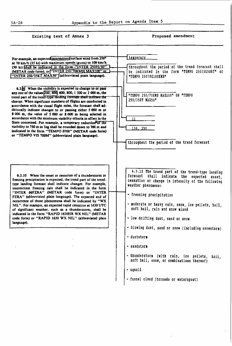
SA 26 Appendix to the Report on Agenda Item 5
Existing text of Annex 3 Proposed amendment
For-example. an expectedintennillcndsurrace wind from 250· telDorar. at 70 tm/h (35 tt) with maximum speeds lIusts) to 100 kmth (50 tt) a In lcate In
.. I " throughout the period of the trend forecast shall (METAR codeform). orr'INT R 2S be indicated in the fon 'TEMPO 25035G50KT' or
I"INTER 2S0/3SKT MAXSO", (abbreyiated plain lanlu .. e). 'TEMPO 25070GIOOKMH'
6.3121. When !be yisibifity is expected to chanae to or pass anyone of !be value5jZOO. ~ 600. 800. I 500 or 3 000 m. !be
'TEMPO 250j70KKH MAXlOO' OR 'TEMPO trend pan of the treno-,ype ,.nUlUa .•• " ,,~w ..
cbange. When sianificant numbers of niahts ue conducted in . 250jJ5KT MAI50' accordance with the yisual nilht ru .... the forecasl shall ad-ditionally indicate chanles to or passin. either j 000 m or I 000 m, tbe yalue of 5 000 or 8 000 m beinl selected in accordance with the minimum visibility CI'.hen. in cffect in the ..., 11 State concerned. For .. ample, a Icmporuy reductlorrv, tne visibilily to TSO m in fOl .baIl be rounded down 10 700 m and '-1 150 350 indicated in lbe form "TEMPO 0700" (METAR code form) or "TEMPO VIS 700M" (abbreyiated plain Ianluoae).
throughout the period of the trend forecast .
6,3.10 When the onset or cessation of a thunderstorm or 6.3.12 The trend part of the trend-type landing
forecast shall indicate the expected onset, freezing precipitation is expected. the trend part or the trend- cessation or change in intensity of the following type landing forecast shall indicate chanses. For example, leather phenolena: intermittent freezins rain shall be indicated in. the form "INTER 66FZRA" (METAR code form) or "INTER - freezing precipitation FZRA" (abbreyialed plain language). Th. expected end of occurrence of those phenomen. shall be indicated by "WX
loderate or heavy rain, snow, ice NIL", For example, an expected rapid cessation at J630 UTe . pellets, hail, of sisnificant weather. such as a thunderstorm. shall be soft hail, rain and snow Ii xed indicated in the form "RAPID 1630HR WX NIL" (METAR code form) or "RAPID 1630 WX NIL" (abbreyiated plain - low drifting dust, sand or snow lanloage).
- blowing dust, sand or snow (including snowston)
- dustston
- sandston
- thunders ton (with rain, ice pellets, hail , soft hail, snow, or cOlbinations thereof)
- squall
- funnel cloud (tornado or waterspout)

Appendix to the Report on Agenda Item 5 5A-27
Existing text of Annex 3 Proposed amendment .
- other weather phenolena given in 4.8.3 which are expected to cause a significant change in visibility.
For exalple, forecast temporary loderate freezing rain hetween 0300 and 0130 OTC shall he indicated in the fori 'TEKPO FK0300 TL0430 FZRA' (KETAR code fori) and 'TEKPO FK0300 TLOl30 KOD FZRA' (abbreviated plain language). The expected end of occurrence of those Jhenolena shall be indicated by the abbreviation 'SSW'. For example, an expected cessation at 1630 UTC , of significant weather, such as a thunderstorl, shall be indicated in the fori 'BECKC AT1630 NSW' (in both KETAR code fori and abbreviated plain language).
6.3il..!1 When Ihe heigh, of the base oflcloud coyerilli I I . -
Imore than 4_0kla~is below,or is expected to raU below I 13 ~SO m (I SIlO f,), Ihe trend part of 'he trend-,ype landing fore-cast shall indicate chanses to or passing Iny one of the fol-Iowin, .llues: 30,60,90, ISO, 300 and 4S0 m (100, 200. 300, -, a cloud laver of BKN or OVC extent SOD, I 000 Ind I SOD h). When 'he heigh' of 'he base ollcloud.J is below or is e.pected '0 fan below 4SO m (I SIlO ft), 'he trend a cloud laver part of the trend-type landing forecast shall also indicate changes in cloud amount froml4 aktas or less to mort than SeT or SKC increasing to BKN or OVC, or changes 14 aklas. or changes from more than" oktas to" oktas or less_
frol BKN or OVC decreasing to SCT or SKC, for for example. I trend from 4 otlas or less towards 8 oktas of Slr.'us cloud II 300 m (I 000 h) shall be indicated in Ihe form exalple a forecast rapid increase in stratus clou "TEND 8STOIO" (MET AR code form) or "TEND 8/8 at 1130 OTC fro! SCT to OVC shall be indicated in 300M" (abbrevia,ed plain langua.e). the fori 'BECKG ATl130 OlC010' (!ETAR Code fori)
or 'BECKG AT 1130 OVC 300K' (abbreviated plain
d
language),
x 6.3@. The order of ,he .lements and 'he terminology, 6,3.14 When the sky is expected to reaain or
units anO sca'es useO In the trend pan of the trend-type becole, obscured and vertical visibility landing forecast shan be the same as those used in the rcpon observations are available at the aerodrole, the to which it is appended. trend part of the trend-type landing forecast
shall indicate changes in vertical visibility to or passing anyone of the following values 30, 60 or 150 I (100, 200 or 500 ftl,
6,3,15 criteria for the indication of changes based on local aerodrole operating linila, additional to those specified in 6,3,10 to 6.3.14, shall be used as agreed between the leteorological authority and the operator(s) concerned.
'--i 16

, 5A-28 Appendix to the Report on Agenda Item 5
Existing text of Annex 3 Proposed amendment
DA,.\lrLD OF auoatl
£u-MI 1._ M ........ -'
II .lIU",.I,_ "iOO '0.-..11", ........ '·: 1oI1n"" YUDD ")0 l"UIOMH DMD llUO ~!lC )Sone nil, 1011
" ... .,.,......,.rt """'''''"fIO'' t_ .... _ -' _Iw noWlI .... ~'ETAJf~ a) XETAR for YUDO (Donlon/International)' MIT tEPOIl \"00 10 J"4II~UlH Vts IIIIroll\'l. I~I Fe lIt)OO:\I Tit DPI' QNH 1011
dM ....... -t .... _ IETAR YUDO 16l0Z 24015KM8 0600 R12/1000U a_, ... "-' fill' DMIoo&II ... ~· • 11)0 UTe; -r_ "'-4 di • ..,;. 1.0 "rm: ...... ...-.. " 1,'"'-' ...... ' "-; .,..~~" toO -.lm:"""',....w , .. ,. I ceo Nlrn: rOlII~ .• piar"'Wllrllf "In"". d .... _ Fe DZ SCTOI0 OVC020 17/16 QI018 BECKG TL1700 lliu , ...... r'IU'<r. J ."., of ........... "" -., XIO ........ a II,," pUl •. ln ......... ","" _, _ II" !.lit Co\OIII 08,0 Fe BECIG AT1800 9999 85M = ,.pt'\.; __ ..... _.n ""'"' c.w.: 40--~ ImlP!"UWt 16 ....... c.,,,.,; Q~H IOIIIlei::.<l;ll&loQh .
. ,. ... _ ..... · __ ,., .... __ .... ~_ ... _ ... _-_-_-__ I .. ____ ... ,..f/_·~ _
b) Abbreviated plain-language report (sane _ , • .,. __ ... _ ..... IA_~J."" .... -'"""_fJ~ __ .··~_-_-'--_ .. ___
location and weather conditions as METAR)
XET REPORT YUDO 16l0Z 240/15KMB VIS 600M RVR RMY12 IOOOX/U FG DZ SCT lOOM OVC 700M T17 DPI6 QNB 1018 BECKe TL1700 VIS 800K BECKe AT1800 VIS IOU MSlI =
C) Xeaning of both reports
Rootine report for Donlon/International' at 1610 UTC; surface wind direction 240 degrees; wind speed 15 kiloleters per hour; visibility 600 letres; runway visual range representative of the touchdown zone for runway 12 is 1 000 letres and the runway visual ranqe values have shown an upward tendency during previous 10 linutes; fog and drizzle; scattered cloud at lOO letres; overcast cloud at 700 letres; air telperature 17 degrees Celsius; dew-point telperatore 16 degrees Celsius; QNH 1018 hectopascals; trend during next two hours visibility becolinq 800 letres by 1700 UTC; at 1800 UTC visibility becoling 10 kiloleters or lore and nil siqnificant leather.

Appendix to the Report on Agenda Item 5 5A-29
Existing text of Annex 3
II Sl'ErI j.- rllDO I~~·:
SPEa YUDO illS IJOUIJ'II.T UIII tn'S lC-.s
~I A"""""'''''''''''""", __ ....... _ .... r.oWIf ...... JI>ECJ),'
SI'£C1AL YUDO 11""""2:I1tT MAX" NNMIO VIS 1JID4 n 111 CI JCmfT
cl"""'~""~ SdKIIIiII..-cW""," _ DIIaIooIII ... ..-..,s·1II1111 UTe; _r.- ...;..tdlnc!ioII so ...... _itod ~ 1J ....
r-,::-",,:,::J:.!::,-::::::::,-:: ~~=::-; .. ": =-n.-:;l: ~o= :~:~:= UHO'WI. .
.,.-~
"'-__ "' .... -.. .• _Sl __ "'t_M ....... __ ,-....-...,_ .... -t ........ --*'. "._. ,,_ .... A_ J.,.'---'_ -.. ,._,., _".wI .. _ ..... .., .. ____ _
~J._ '-"-.miI:r,....
VOLCANIC AC'TIYnY IEPOItT 'rUS" JJlJGD NT TlOnENo VOLCANO MlHN I163J'" numb lJl"' LAItOl ASH CLOUD UnNDING TO ""'lOX _ FUT NOVING SW.
II ..... : " .... InhfI,..,., ..... .., s;a.,'IbIDf~ ......... __ II IKIO UTe _11M: u..llr.M _~. .. ,. T ... ,.. ...... s. ...... J ____ ,II 116 ...... ,! ........... III I"'" I1TC _11M 1),..; • ..,.,. ...... _ .......... ........ 1O~tI' 101D) r .... -"" WI to _11-_ .. ., .iroaiH..
Proposed amendment
a) SPECI for YUDO (Donlon/International)'
SPECI YUDO 1115Z 05025G17KT 1200HE 6000S +TSRA BKM005CB 25/22 01008 TEMPO TL1200 0600 BECKG AT1200 9999 KSW SCTOl5 OVCIOO =
b) Abbreviated plain-language report (same location and weather conditions as SPECI)
SPECIAL YUDO 1115Z 050/25lT MAX17 NNK10 VIS 1200N TO HE 60001 TO S HVY TSRA BKi CB 500FT T25 DP22 ONH 1008 TEMPO TL1200 VIS 600M BECKG AT1200 10K! lSi SCT [500FT ove 10000FT =
c) leaning of both reports
Selected special report for Donlon/International' at 1115 UTC: surface wind direction 050 degrees: wind speed 25 kt gusting between 10 and 17 knots (iinilul wind speed not to be included in SPECI): visibility lowest to north east at I 200 letres, visibility 6 000 letres to South: heavy thunders tori with rain: BKI cUlulonilbus cloud at 500 feet; air telperature 25 degrees Celsius: dew-point telperature 22 degrees Cellius; QNH 1008 hectopascals; trend during next two hours,visibility telporarily 600 letres frol 1115.to 1200, becoling at 1200 UTC visibility 10 h or lore, thunder.storl ceases and nil significant weather, scattered cloud at 1 500 feet and overcast cloud at 10 000 feet.

SA-3D Appendix to the Report on Agenda Item 5
Existing text of Annex 3 Proposed amendment
D.uuLDor "Dloa.a.~rouc.urs
., TAFj., rtIDOm.../~": a) TAP for IUDO (Donlon/Internationalt)
TAl" YUDOItI. I.,IKNH IICIIDtsCIQDGaADU 1111_ JDDII!'nIIII
.IA........,,.. ..... '- ...... ___ ~ TAF 160000Z IUDO 0624 130181HH 9000 BIN020
fC'ST nmo It/l ...... IIOIH YI;I ... "' ... GlADU IJlII YlI .... 01111- 'DI BECKG 0608 SCTOl5CB BII020 TEKPO 0812 ct~., ..... ~ 17025G40lKH 1000 TSRA SCTOIOCB BII020 FHI2 ~--"""""'--"''-''f __ UTC'''_UTC;twflCC'''~IJO'''''. 150151KH 9999 BII020 BIII00 .... .,.. I ........ ,.. .... ; ..... kt t u....v...,.w." ~ dcud. 600 _ (I~ w.-·~~-Ii ... iIIo""',"I;"""""""' __ IJCOUTC"'I_U'TC"~·~ 1~·*iIdr""'·""""'_"'.IID_ ._- b) Abbreviated plain-Ianquaqe aerodrole forecast ...... '- .. --.... ............ -u....._ .. ~ __ N __ ,. ........ ___ ~_~
~ ""'-··--A-.J. .. _____ Sl ____ N ....... -_"' ___
(for sale location and weather conditions)
FCST 160000Z IUDO 06/24 130/1811B VIS 911 BII 600K BECKG 06/08 SCT CB 450K BKI 6001 TEMPO 08/12 170/25 liB IAI40 VIS 10001 100 TSRA SCT CB 300K Bli 600K FIl2 lSD/1511B lOKI BU 6001 BU 3000K
c) leaninq of hoth forecasts:
. Aerodrole forecast for Donlon/Internationalt issued on the 16th of the lonth at OOOOUTC valid frol 0600 UTC to 2400 UTC on the 16th of the lonth; surface lind direction 130 deqrees; wind speed 18 kiloleters per hour; visibility 9 ii, broien cloud at 600 lettes; hecoling between 0600 UTC and 0800 UTC, scattered cUlulonilbus cloud at 450 letres and broken cloud at 600 letres; telporarily between 0800 UTC and 1200 OTC surface wind direction 170 deqrees; wind speed 25 iilollters per hour gustinq to 40 iiloleters per hour; visibility 1 000 let res in a loderate thunders tori with rain, scattered cUlulonilbus cloud at 300 letres and broken cloud at 600 letres; frol 1200 UTC surface wind direction 150 degrees; vind speed 15 kilouters per hour; visibIlity 10 il or lore; nil significant weather, broken cloud at 600 letres and broken cloud at 3 000 utres.

Appendix to the Report on Agenda Item 5 5A-31
Existing text of Annex 3
CHAPTER 9. SERVICE FOR OPERATORS AND FLIGHT CREW MEMBERS
9.\ e. .... 1 pro.lslons
9.1.6 Recommendation.- M~/eorologi(QI in/ormation supplied 10 O~rQIOrS and flight crew members should include
reports for Ihe aerodrome 0/ departure, Ihe aero-drame 0/ intendea /anamg ana alternate aeroaromes localeu within 2 hours'fly;ng lime oj Ihe aerodrome 0/ deoa"ure, but with possible exceptions for certain routes and operations as determined by regional air navigation agreement. Additional
Proposed amendment
I delete
rel.vanl repom should b. supplied if avai/able. x. _____ +_-i Where such infonation is provided in the fOnl of bulletins of reports, the time of ohservation indicated in the bulletin heading should be retained. In cases where a new bulletin to leet particular operational needs is compiled fro. reports taken froD other bulletins, the tiDe of ohservation of each report should be clearly identified, either in the new bulletin beading or as part of the individual reports.
- - - - - - -- -


Report on Agenda Item 6· 6-1
Agenda Item 6: Aeronautical climatological information
6.1 Introduction
6.1.1 The meeting noted that the proposal under discussion had been based on earlier work by ICAO, when a relevant proposal for the amendment of Annex 3JTechnical Regulations (C.3.1), which reviewed and updated the specifications in Annex 3JTechnical Regulations (C.3.1), Chapter 8 to bring them in line with modern computerized methods of climatological data storage, had been developed and circulated to States and international organizations for comment.
6.1.2 The meeting was informed that when the Air Navigation Commission (ANC) reviewed the replies from States and international organizations concerned, it noted the general acceptance of the broad objectives of the proposal. The ANC noted also that it had not been possible to reach a consensus with WHO on certain aspects of the proposal and requested the Secretariat to endeavour to resolve the difficulties. In order to clarify these difficulties, the ANC had agreed that a questionnaire should be sent to States to ascertain their views on specific aspects of the matter which had caused difficulty for WHO, such as the use made of aeronautical climatological tables, and whether there was a need to differentiate between States that processed climatological data by computer and those that carried out the task manually. The results of the questionnaire had proved to be very interesting, indicating, inter alia, that of the States replying:
a) 73 per cent used climatological tables as a basis from which to derive climatological summaries;
b) 67 per cent used the climatological tables to assist aeronautical forecasters in discharging their responsibilities towards aviation, e.g. to assist in the preparation of advisory aerodrome"forecasts when the ttnormal" aerodrome forecasts were not received;
c) 84 per cent needed the climatological tables to· answer requests from aviation users for non-standard climatological information that could be satisfied by information contained in climatological summaries; and
d) 58 per cent believed that, with respect to requirements for aeronautical climatological summaries,there was no need to make a distinction between States storing and processing climatological data by computer and those employing manual methods.
6. L 3 It was noted that as a result of the questionnaire, and of the subsequent discussions with WHO and other international organizations concerned, a revised proposal for the amendment of Chapter 8 of Annex 3JTechnical

6-2 Report on Agenda Item 6
Regulations (C.3.1) had been developed for consideration by the COM/MET/OPS Divisional Meeting (1990).
6.2
6.2.1
Proposal to amend Annex 3/Technical Regulations (C.3.1), Chapter 8 -Aeronautical Climatological Information
The meeting noted that the proposal:
a) permitted the delegation of responsibility for the preparation of aeronautical climatological information, from one State to another;
b) deleted the requirement for aeronautical descriptive climatological memoranda;
c) specified the desirable minimum number of years used to derive the information;
d) introduced recommendations related to the collection of meteorological information on existing and planned regular and alternate aerodromes, to enable the preparation of aeronautical climatological information; and
e) aligned the elements to be included in·aerodrome climatological tables with those required for the preparation of aerodrome climatological summaries.
6.2.2 The meeting began its discussions with a review of the current provisions in Chapter 8 of Annex 3/Technical Regulations (C.3.l), and of the main objectives of the proposals for the amendment of those provisions.
6.2.3 The meeting noted that, in 1984, WHO had initiated the CLICOM project, a "package" concept which included computer hardware specifications, user-friendly software and training. Since that time, there had been some important changes and improvements to the system and there were currently some 100 WHO Members using the system. It was indicated that the system could produce, for all the standard climatological parameters:
a) computed monthly data from daily data;
b) computed monthly means and extremes;
c) tabulations of daily means and extremes;
d) bi-variant frequency distributions for any parameter;
e) monthly graphs of daily data;
f) annual graphs of monthly data; and

Report on Agenda Item 6 6-3
g) monthly data tabulations including means, extremes and daily values.
6.2.4 Representatives of the operators advised the meeting that, in view of the very low usage made of aeronautical climatological information by airlines, there was no need to publish the data in printed form, but that with modern electronic data processing (EDP) it should be possible to satisfy specific needs of the airlines and other users by accessing a suitable data base. The meeting was unable to agree with this view, on the basis that, in many States, EDP was either not available or did not have sufficient reliability to replace printed climatological data. In any case, it was felt that the climatological information was needed by other non-aviation users, not only airlines, and therefore there was a need for printed publication of the data.
6.2.5 One delegate expressed the view that the proposed amendment did not adequately cover the question of who should pay for a tailor-made request by an airline for certain climatological data. That delegate felt that the user who made the request should pay for the associated cost. The matter was not pursued.
6.2.6 A suggestion was made to the effect that, perhaps, a list of the most commonly used climatological parameters and combinations thereof could be developed, and this data could then be made available on request, either in print or in electronic form, in an expeditious manner. Although recognizing the merits of the suggestion, the meeting felt that such data could probably be obtained as a result of bilateral agreements between operators and the meteorological authorities concerned.
6.2.7 The question of the authority responsible for the preparation of aeronautical climatological data was raised by a delegate. The meeting was reminded that, in accordance with Annex 3/Technical Regulations (C.3.l), each Contracting State needed to designate the meteorological authority responsible for the provision of meteorological service for international air navigation. As aeronautical climatological data were part of the requirements in Annex 3/ Technical Regulations (C.3.l), the meteorological authority designated b~ the State was the entity responsible also for the provision of aeronautical climatological data.
6.3 Amendment to Annex 3/Technical Regulations (C.3.1)
6.3.1 The meeting then carried out a review of the proposal to amend Annex 3/Technica1 Regulations (C.3.1) presented to it by the Secretariat, and agreed that the amendment covered adequately the points described in paragraph 6.2.1. Clarification was sought as to the meaning of "specified times" mentioned in paragraph 8.3.1 e) of the proposal. It was explained that these times were those included in the forms adopted by WMO for climatological summaries, in their Technical Regulations, Volume II, C.3.2, and that the note inserted at the end of paragraph 8.3.1 was intended exactly to bring the reader's attention to the relationship between the paragraph and the WMO forms.

6-4 Report on Agenda Item 6
6.3.2 Noting the general support for the proposal, the meeting then developed the following recommendation:
RSPP : Recommendation 6/1 - Amendment to Annex 3/Technical , .
Regulations (C.3.l) - Aeronautical climatological information
That, in order to review and update the current specifications and bring them in line with modern computerized methods of climatological data processing, Annex 3/Technical Regulations (C.3.!) be amended as shown in the appendix to this part of the report.

Appendix to the Report on Agenda Item 6 6A-l
X
APPENDIX
PROPOSALS TO AMEND ANNEX 3/TECHNICAL REGULATIONS (C.3.l) -AERONAUTICAL CLIMATOLOGICAL INFORMATION
Existing text of Annex 3 Proposed amendment
CHAPTER ,.
AERONAUTICAL CLIMATOLOGICAL INFORMATION
Note.- In cases where it is impracticable to leet the requirelents for aeronautical clilatological inforlation on a national basis, the collection, processing and storage of observational data lay be effected through computer facilities available for international use, and the responsibility for the preparation of the required aeronautical clilatological inforlation lay be delegated by agreelent between the leteorological autborities concerned.
'.1 Ge.raI ,*o.ildo ..
1.1.1 Aeronautical dim'lolotical information required for the pl.nnin, of Oi,ht operations shall be prepared in the form of .~e dUhatololl:Ical tabfeu aerourome C Im.- and (alOlial summanes lea esCTI IVe C Ima-
l!O oglcal. memoran u~n information shall be supplied to L.f delete aeronautical users ~ agreed between the Meteorological Authority and those users.
r·araoraOh 3.1.l and Nolr.- Climlllolol;clIl dQIQ Tt'qllind for tNrOdromr
plu"";,,, Pflrposn tln., Dill in Anntx UJ!('flacnmrnt A. norlally be based on observations lade 1.1.2 Reco.lllf11dat!oll. Arronllulkal ciimlllOloxictll I period of at least five years and the
in/ormation sltollldl~ bagd on ob~rva[ions madr owr Q I ~Ilm r ~ yraTs and Ihat ptrloo snorUQ IN mQlcaltu In Int InJormallon supplttd.
_8.1.3 RecoalHftd.tiOli. .A.tronaulical climuliilClilcal information should ~ prtPOTN In Ih~ forms and IIccordmr to
LJ delete . h~-firviJiiiiblres JW .4txtd ,by Ih~ World Mel~orological
O,.,aniulio1l.
Note.- An explanation for the format of the amendment proposal is provided on page i-6.
over a

6A 2 Appendix to the Report on Agenda Item 6
Existing text of Annex 3 Proposed amendment
------
J &.~_~-_R«omm~nd.tion. ,AeronQutical climalological
information should be ~xdionged on requ('sf Mlwnn Meteorological Authorities. OfNr010rS and olher aeronQutical uurs desir,,,, $lJch in/ormation should' normally apply to the M'eINiroJol'ica/ Authority rnponsible for il.S"'p!eparol;o or t: Ihe Mneoroiogical Authority oj rhe Stale Of rile operaforJ -!delete
r of (he other oeronautical use.
X ,
8.1. 4 Recommendation.- Meteorological .observations for regular and alternate aerodromes should be collected, processed and stored in a form suitable for the preparation of aerodrome clilatological infonation.
8.1. 5 Reco •• endation.- Cli.atological data related to sites for new aerodroJes and to additional runways at existing aerodro.es should be collected starting as early as possible before the conissioning of those aerodraaes or runways
-
'.1 Af'rodrumf d ... oIo&ln.I .....
... 1.1.3 llKom .... liOli. Atrodrome eli
. _. include inforlation required for the preparation
tables sltoult/f.I'Vt III INsI itiformtllion on surjiIU wind. ~I- of aerodroJe clilatological sunaries in I ~ut"";'YlruntwlY 'jIiswJ/ IYInle. dowd .i,III lind IImOUlfl, tem/Nfllhlrr 'tt,d pressure. accordance with 8.3.1.

Appendix to the Report on Agenda Item 6 6A-3
Existing text of Annex 3
1.3 Aerodrome tUm.loloaleal summ~ries
8.3.1 Recommeadatioa. Each Contracting Sltll~ I should prepare tlnd publish. or othtrwiM make Qllaililble. . aerodrome climatological summarws Jor each Tegillar lind
II/Ierna/e inle"Ulliona/ aerodrome within its territory,
8.3.2 Recollimeadalioll.- An aerodrome climillolo,ica/ summary should ,illt information on surJaa wind. lIuibililylnmway VUuG/ range, cloud amount and height. lem~rau"e' and pressure and. where aerodrome climatological ,abies !Ire p· ..... ared. Ihe summary should be based on Ihe some obServQlionD/ data.
Proposed amendment
8.l.1 Recommendation.- Aerodrome clilatological sUllaries should cover:
a) frequencies of the occurrence of runway visual range/visibility and/or height of the base of the lowest cloud layer of BKH or ove extent below specified values at specified tiles;
b) frequencies of visibility below specified values at specified tiles;
c) frequencies of the height of the base of the lovest cloud layer of BKH or ove extent below specified values at specified tiles;
d) frequencies of occurrence of concurrent wind direction and speed within specified ranges;
e) frequencies of surface telperature in specified ranges of SoC at specified tiles; and
f) lean values and variations therefrol, including laxilul and linilul values of leteorological elelents required for operational planning purposes, including take off perforlance calculations.
Hote.- Models of clilatological sUllaries related to a) to e) above are given in WMO Publication No. 49, Technical Regul~tions, Vol. Il, C.l.2.
8.l.2 Recollendation.- Aerodrole clilatological sUllaries should follow the procedures prescribed by the World Meteorological organization. Where cOlputer facilities are available to store, process and retrieve the inforlation, the sUllaries should be published, or otherwise lade available to aeronautical users on request. Where such cOlputer facilities are not available, the sUllaries should be prepared using the lodels specified by the World Meteorological organization, and should be published and kept up to date as necessary.

6A-4 Appendix to the Report on Agenda Item 6
Existing text of Annex 3
•.• Aero •• ulbl descriplive dimaloloaJeal .t.on .... 8.4.1 RecomIDtHatlO •. - bell COn/TaC/m, SIair
should pUpGn- Qnd pub/isn, or olherwiR make QlJai/ablr. Iltronaulica/ descriptive ciimalolo,icil/ memoranda for irs It"iIOTY. By Dlmment /wlwnn tht MtlnJrolo,ica/ Au/hofilia conurned. Iht memoranda may 11150 IN produced coll«I;~/y for 1M l.rritoriG oj R'i.ra/ CantrIlCI;", Slatts.
1 .... 2 RtcoIllIlMHatioa,- Similar memoranda should be p,tptlr«l and pub/Wwd. or othtrwiM mild. aWJilablt, Jor sp«ific IlrfiU or portions 0/ ai' rOU"5 over infernalional WQlrn. tilhe, indillidlla7ly by tht Contrllcting Slall providing air mvfu: MTlIU:n. within 1M fll,hl ",fanniuion n,ion. or coIl«liwly by qrftmtlfl IImon,s( IIw Contraclin, SIllies -.
8 .... l ·Jteco. ...... 1io •. - An fttonauliall dncriptillt dinullolo,;ct:1I m~morllndum mould Ii", tlllHsl injormolion OIl· fIPIIW wiNb. _ . IIP""~- -1""pnlllllle tlnd si,nifialnl Mof'OIIl~ ...-..,. plwftontMa.
orilY, on Qvmlable 10 any and to others concerned wilh to ihterntllionai air navigation," ological observational data galion or operational alUIlysis.
Proposed amendment
IditDrial lote: fhis paragraph Deeds to be printed in bin foot.

Report on Agenda Item 7 7-1
Agenda Item 7: SIGMET information and warnings of hazardous weather in the vicinity of aerodromes
7.1
7.1.1
Development of an amendment to Annex 3 introducing the concept of en-route warnings for VFR operations, additional to the existing SIGMET information
Introduction
7.1.1.1 The meeting recognized that SIGMET information messages contained some of the most important meteorological information issued in support of aircraft operations. It was agreed that, in general, the SIGMET system had worked reasonably well, although it had not been without its problems and, for a number of reasons, those problems seemed to be getting worse. The meeting noted that problems had been reported at the 29th Meeting of the European Air Navigation Planning Group (EANPG) (Paris, 1988) and the Limited African-Indian Ocean Regional Air Navigation Meeting (Lome, 1988). The former had recommended that, in view of the serious shortcomings in the interpretation of the criteria for the format and issuance of SIGMETs, ICAO in co-ordination with WHO, as appropriate, should review the provisions concerning SIGMET information in Annex 3/Technica1 Regulations (C.3.1); while the latter had recommended that ICAO, in consultation with WHO, should study the operational desirability and feasibility of introducing an additional category of SIGMET to cater for medium/low level operations. The meeting was informed that in order to meet the requests of those regional meetings, the Air Navigation Commission had agreed that the Secretariat should review the SIGMET provisions in Annex 3/Technical Regulations (C.3.1) and develop an appropriate amendment to Annex 3/Technical Regulations (C.3.1) for consideration by the COM/MET/OPS Divisional Meeting (1990).
7.1.2 Problems with the issuance and transmission of SIGMETs
7.1.2.1 It was noted that the main problem that had arisen was that, for one reason or another, SIGMETs were not always transmitted to aircraft in flight. It was recognized that to some extent this was due to the fact that, except for SIGMETs included on VOLMET broadcasts, all other SIGMETs had to be transmitted to pilots through air traffic services (ATS) air-ground voice communications. The meeting was aware that the increase in air traffic over the past ten years had meant that communications were overloaded at many ATS positions especially at.peak hours, and the transmission of SIGMET information to pilots was sometimes either delayed or omitted entirely. The view was expressed that this problem was exacerbated by the fact that many SIGMETs Were issued for weather phenomena which, in accordance with Annex 3/Technica1 Regulations (C.3.1), 7.1.1, did not warrant issuance of a SIGMET. The meeting agreed that issuance of such unnecessary SIGMETs delayed the transmission of correctly prepared SIGMETs and downgraded the whole SIGMET system in the eyes of air traffic service personnel and pilots. Moreover, it was noted that SIGMETs often

7-2 Report on Agenda Item 7
contained much unnecessary descriptive detail which lengthened the over-all message and contributed to the delays in transmission.
7.1.2.2 The meeting had the benefit of statistics derived from data which had been presented by Ireland to the second, fourteenth and fifteenth meetings of the Meteorological Advisory Group (METAG) to the EANPG in 1978 and 1988. Those statistics, which concerned SIGMETs circulating on the Meteorological Operational Telecommunications Network, Europe (MOTNE) during three randomly selected periods in 1978, 1987 and 1988, showed that almost one half of all SIGMETs issued during these periods had been unnecessary; and that the vast majority of SIGMETs issued for thunderstorms had been unnecessary.
7.1.2.3 In addition to the issuance of such a large number of unnecessary SIGMETs, the meeting noted that procedural errors continued to occur, examples cited being the omission of the four-letter location indicators for the flight information region (FIR) and meteorological watch office (MWO), etc., which could cause difficulty for operational meteorological (OPMET) data banks. A point which the meeting considered more important, however, was the inclusion of much unnecessary descriptive detail in SIGMETs which in some cases doubled the length of the message. This was particularly noticeable in the case of SIGMETs issued for "active thunders.torms" where forecasters included details of forecast iCing, turbulence and hail. The meeting felt that this was probably due to the confusing definition of "active" in Annex 3/Technical Regulations (G.3.1).
7.1. 3 Proposals to extend the SIGMET procedures to cover general aviation operations at low levels
7.1.3.1 The meeting noted that in the proposal to introduce a "SIGMET LOW", the intention was to issue such SIGMETs for subsonic cruising levels below FL 250 for moderate icing and turbulence and for widespread overcast stratus and/or visibility below 5 000 m. The meeting felt that, while meteorological services could no doubt comply with such a requirement, the number of SIGMET LOW likely to be required would be very high and in some regions could easily double the existing average number of SIGMETs. It was noted that the number of additional SIGMETs could be reduced if the requirement to issue SIGMET LOW for low stratus/visibility were to be eliminated, but even so it was agreed that there would still be an appreciable increase over the current number of SIGMETs issued. The consensus was that any proposal which increased the number of SIGMETs would only worsen the existing problem of transmission of SIGMETs to aircraft by ATS units. The view was expressed that such an increase might not be so important if the SIGMET and the SIGMET LOW could be addressed to ATS units serving lower airspace and only the SIGMET to ATS units serving upper airspace. The meeting agreed, however, that whilst this ideal situation might be applicable in some regions, in general the result would be that the ATS unit serving upper airspace would likely be swamped with both SIGMET and SIGMET LOW, and. this could only exacerbate the existing difficult situation.
7.1.3.2 Under the foregoing circumstances, the meeting was not able to agree to the proposal to introduce a SIGMET LOW. The meeting did, however, feel that

Report on Agenda Item 7 7-3
the prOV.1S10n of information on hazardous weather in "advisories" for low/medium level operations, which could include conditions less severe than those for which the existing SIGMETs were issued, should be studied by ICAD in consultation with WMO. Furthermore, the means of dissemination of such information to general aviation should also be studied at the same time. In this regard the meeting developed the following recommendation:
7.1.4
Recommendation 7/1 - Study regarding the provision and dissemination of information of low level weather phenomena hazardous to general aviation
That ICAD, in consultation with WMO, investigate ways and means of providing and disseminating to general aviation information on low level weather conditions hazardous to their operation.
Information related to a change from VFR to IFR conditions
7.1.4.1 The meeting also noted that, in accordance with Annex 11 paragraphs 4.2.1 and 4.2.4, flight information service for VFR flights had to include, inter alia, the provision of both pertinent SIGMET information and available information concerning weather conditions along the route likely to make VFR operation impracticable. It was suggested that the only requirements would therefore be in respect of moderate icing and moderate turbulence as warnings to low-level IFR flights. Moreover, it was pointed out in this connexion that there was no specific mention of this in Annex 3/ Technical Regulations (C.3.l), Chapter 10. It was proposed that this should be rectified, and the meeting then developed the following recommendation;
7.1.5
RSPP Recommendation 7/2 - Amendment to Annex 3/Technical Regulations (C.3.1) - Alignment of Chapter 10 with Annex 11
That, in order to introduce specific reference to the need to provide flight information centres with meteorological information required to enable them to discharge their responsibilities towards flights conducted under visual flight rules, Annex 3/Technical Regulations (C.3.1) be amended in accordance with Appendix A to the report on this agenda item.
Proposals to rationalize procedures for the issuance of SIGMET information
7.1.5.1 The proposal before the meeting called for the introduction of a definitive list of en-route weather phenomena and their descriptions in abbreviated plain language in Annex 3/Technical Regulations (C.3.1), 7.1.1.

7-4 Report on Agenda Item 7
It was noted that this concept could also be extended to cover other appropriate parts of Annex 3/Technical Regulations (C.3.l), 7.2.1.
7.1.5.2 The consensus of the meeting was that this proposal could assist in rendering SIGMETs rather more concise than was currently the case. This would be in accordance with Annex 3/Technical Regulations (C.3.l), 7.1.1. It was agreed, however, that careful consideration would have to be given to the permitted list of weather phenomena and their descriptions in abbreviated plain language which would be proposed for inclusion in Annex 3/Technical Regulations (C.3.l), 7.1.1. In this regard, the meeting developed the required list taking into account the following points:
a) severe icing and turbulence should not refer to icing/turbulence associated with thunderstorms;
b) reference to "active" in respect of thunderstorms was misleading and should, therefore be deleted;
c) it was essential that thunderstorms "embedded" in cloud, "obscured" by haze or smoke and "frequent" i.e. with little or no separation between cumulonimbus should warrant issuance of a SIGMET. The same considerations applied to "line squall". The foregoing description of thunderstorms should also be qualified, if appropriate, by the addition of "heavy hail";
d) the term "widespread" in relation to sandstorm/duststorm was replaced by "heavy" to align with the proposed procedure for reporting weather in the aeronautical meteorological codes;
e) inclusion of the name of the relevant FIR in the text of the SIGMET message; and
f) inclusion of freezing rain as this could cause severe icing.
7.1.5.3 In order to take account of the foregoing proposal for the amendment of Annex 3/Technical Regulations (C.3.1), the meeting developed material which forms part of Recommendation 7/4 below.
7.1.6 SIGMETs for volcanic ash clouds
7.1.6.1 The meeting was informed by a number of States, including Provider States having experience in issuing SIGMETs for volcanic ash, that the current requirement in Annex 3/Technical Regulations (C.3.1), 7.2.5, permitting the period of validity of SIGMETs for volcanic ash to be extended up to twelve hours, in their opinion was quite impossible given current volcanic activity observing techniques, especially concerning ash particle size and density. The· operators pointed out that this was an existing provision to meet the requirements for pre-flight planning for long-haul flights. The meeting had already agreed, however, that such information could be given in a general way

Report on Agenda Item 7 7-5
on world area forecast system (WAFS) significant weather (SIGWX) charts as discussed under Agenda Item 4, paragraph 4.5. It was pointed out that the possibility of including information on volcanic ash cloud on SIGWX charts had not been available at the time the extension of the validity period of SIGMETs for volcanic ash cloud had originally been agreed. On this basis, the meeting considered that the reasons advanced by the States with experience in issuing SIGMETs for volcanic ash were valid, and therefore decided that the current SIGMET provision in Annex 3/Technica1 Regulations (C.3.1), 7.2.5 and 7.2.6 should be amended to eliminate the special extension of the validity period and time of issuance for SIGMETs concerning volcanic ash clouds. This amendment proposal forms part of Recommendation 7/4 below. The meeting agreed, however, that the attention of the Air Navigation Commission should be drawn to this decision, with a request that States and international organizations be invited to comment in particular on this amendment when the proposed Standards and Recommended Practices (SARPs) are circulated for comment. In this regard, it was understood that the Secretariat would draw the Air Navigation Commission's attention to this matter during the initial review of the proposed SARPs.
7.1.6.2 A question Was raised regarding the dissemination of SIGMETs for volcanic ash for pre-flight planning for long-haul flights. The meeting was informed that the planning for the exchange of SIGMETs is an ICAO regional air navigation matter, and that the basic operational requirements governing such exchanges indicated that to accommodate planning for long-haul flights, SIGMETs for volcanic ash cloud and tropical cyclones related to the whole route needed to be available at departure aerodromes. It was agreed, however, that arrangements should be made to introduce requirements to ensure that SIGMETs on volcanic ash were transmitted to WAFCs and, as appropriate, to RAFCs. It was agreed that this procedure should apply equally to SIGMETs for tropical cyclones. This was included as part of Recommendation 7.1/4 below.
7.1.7 Aeronautical advisories for volcanic ash cloud
7.1.7.1 The question was raised whether the issuance of information on volcanic ash cloud could not be treated in a manner similar to that for tropical cyclones. In this regard, the meeting noted that tropical cyclones were indicated on WAFS SIGWX charts and were included in SIGMETs (valid up to six hours). In addition, ICAO was in the process of making arrangements for the inclusion of requirements for the dissemination of tropical cyclone advisories in the regional air navigation plans to cater to the special requirements for pre-flight planning for long-haul flights. It was agreed that it would be appropriate to deal with volcanic ash cloud in the same way and the meeting, therefore, developed the following recommendation:
Recommendation 7/3 - Aeronautical advisories for volcanic ash clouds
That ICAO, in consultation with WHO, make arrangements for the issuance and exchange of aeronautical advisories for volcanic ash clouds as determined by regional air navigation agreement.

7-6
7.1. 8
Report on Agenda Item 7
Broadcast of SIGMET messages from VHF omnidirectional radio range (VOR)
7.1.8.1 The meeting then considered a proposal concerning broadcasting of SIGMET messages on selected VOR beacons in areas of heavy traffic. It was suggested that the routine broadcast of SIGMETs in this manner within an FIR would complement the requirement for ATS units to transmit the SIGMETs to aircraft in flight and would enable pilots to obtain SIGMET information when it was convenient for them to do so in respect of cockpit workload. Additionally, transmission on VOR channels could be optimized by transmitting from each VOR only those SIGMETs appropriate to the routes flown by aircraft from the VOR. Possible problems which might need to be resolved concerned the VOR system's limitations as to the depth of modulation and the priori'ty given to VOR beacon identification which could adversely affect the quality and legibility of proposed SIGMET VOR broadcasts.
7.1.8.2 It was recognized that the proposed method for transmitting SIGMET messages would present some difficulties. Some delegates expressed the view that the use of selected VORs would limit reception of SIGMETs to aircraft on certain routes only. In addition, there were a considerable number of aircraft equipped with inertial navigation systems (INS), not using the VORs and consequently not receiving the VOR voice transmission. The same would apply to aircraft with automatically-tuned radio navigation systems. There was also the risk that a crew might tune in on a VOR without receiving any message, and a later message on that VOR would then not be received. As the VOR was not necessarily required to provide a simultaneous communication channel according to the provisions of Annex 10, one delegate indicated that VORs in his State were not equipped with such a function. With respect to the use of selected VORs, it was explained that their use within a particular FIR was intended to ensure a cost-effective service which would nevertheless provide a comprehensive geographical coverage.
7.1.8.3 One State informed the meeting that it had been broadcasting SIGMETs from some of its VORs for a number of years and that pilots had expressed satisfaction with the system. Another State was in the process of developing a similar system within its own airspace. The meeting agreed that the dissemination of SIGMETs from VORs should not replace the preferred methods of transmitting SIGMETs to aircraft in flight given in the Procedures for Air Navigation Services - Rules of the Air and Air Traffic Services (PANS-RAG, Doc 4444), Part VI, paragraph 1.3.1.1. The International Air Transport Association (lATA) expressed the view that this might be seen as a simple option by ATS authorities to dispense with their responsibility for the direct transmission of SIGMETs. While noting the possible difficulties, the meeting decided, nevertheless, that in view of the problems associated with the direct transmission of SIGMETs to aircraft by ATS units, suitable provisions should be introduced in Annex 3/Technical Regulations (C.3.1) to permit those States in a position to do so, to make use of selected VORs for this purpose. Account was taken of this in Recommendation 7/4 below.

Report on Agenda Item 7 7-7
7.1. 9 Amendment to Annex 3/Technical Regulations (C.3.1)
7.1.9.1 In order to take account of the foregoing proposals to amend Annex 3/Technical Regulations (C.3.1), the meeting developed the following recommendation:
7.1.10
RSPP Recommendation 7/4 - Amendment to Annex 3/Technical Regulations (C.3.1) - SIGMET information
That, in order to:
a) rationalize the SIGMET format;
b) restrict the validity period of SIGMETs related to volcanic ash cloud to four to six hours;
c) arrange for the transmission of SIGMETs related to tropical cyclones and volcanic ash cloud to WAFCs and appropriate RAFCs; and
d) permit dissemination of SIGMET messages on appropriate VOR beacons,
Annex 3JTechnical Regulations (C.3.1) be amended in accordance with Appendix B to the report on this agenda item.
Guidance on the preparation of SIGMETs
7.1.10.1 The meeting was of the opinion that one of the main reasons for the issuance of unnecessary SIGMETs was the lack of precise rules for forecasters on which to base the preparation of SIGMETs. It was therefore agreed that detailed instructions concerning the application of the criteria for the preparation of SIGMETs together with a menu of options for the information which is permitted to be included in the SIGMET should be prepared. It was also agreed that examples of SIGMET messages, as well as messages cancelling a SIGMET, should be included as an attachment to Annex 3/Technical Regulations (C.3.1). The following recommendation was developed in this regard:
Recommendation 7/5 - Attachment to Annex 3/Technical Regulations (C.3.l) containing guidance for the preparation of SIGMET messages
That ICAO, in consultation with WHO:
a) develop a new attachment to Annex 3/Technical Regulations (C.3.1) containing guidance material concerning the preparation of SIGMET messages, based upon the amendment proposal given in Appendix B to this agenda item; and
b) process the material to be included in this attachment together with the amendment proposal referred to in Recommendation 7/4.

7-8
7.2
7.2.1
Report on Agenda.ltem 7
Extension of wind shear-type warnings to other hazardous phenomena in the climb out and approach paths
Introduction
7.2.1.1 The meeting was informed that in the course of the Air Navigation Commission's consideration of the comments made by States and international organizations on the proposal to amend Annex 3/Technical Regulations (C.3.1) to include provisions for wind shear warnings (Amendment 64, applicable November 1984), questions had been raised whether such warnings should be restricted to wind shear or extended to other hazardous weather phenomena that could affect the climb-out and approach phases of flight, and whether "nil encounter" reports should be made by pilots for all forecast meteorological conditions and not only for wind shear.
7.2.2 Current rCAD provisions
7.2.2.1 The meeting noted that the current prov1s10ns in Annex 3/Technical Regulations (C.3.1) required that "observations made at aerodromes should include the available supplementary information concerning significant meteorological conditions, particularly those in the approach and climb-out areas .. ,If, Such observations were included in routine and special reports disseminated locally at the aerodrome and certain of these conditions warranted inclusion in routine reports (METAR) and selected special reports (SPECr) disseminated beyond the aerodrome. The meeting noted that currently wind shear was the. only significant meteorological condition in the climb-out and approach areas that warranted issuance of a specific warning.
7.2.2.2 The meeting further noted that the provisions in the Procedures for Air Navigation Services - Rules of the Air and Air Traffic Services (PANS-RAC, Doc 4444) stipulated, inter alia, that information regarding significant changes in the meteorological conditions in the take-off and climb-out areas, obtained by the approach control unit after departing aircraft had established contact with the unit, should be transmitted to the aircraft without delay. Similarly, for arriving aircraft, current information on meteorological conditions in the approach, missed approach or climb-out areas also had to be transmitted as early as possible after an aircraft has established communication with the approach control unit.
7.2.2.3 The meeting noted, however, that there was no explicit requirement in Annex 3/Technical Regulations (C.3.1) that the observation of significant meteorological conditions in the approach and climb-out areas should necessitate the issuance of a special report for that reason alone. This meant that between hourly observations the occurrence of significant weather conditions in the climb-out or approach areas would not warrant the issuance of a special report unless one or more of the other weather elements changed significantly, thus necessitating the issuance of a special report. The meeting felt that such information should nevertheless trigger the issuance of a special report for

Report on Agenda Item 7 7-9
local dissemination at the aerodrome. It was considered that this would ensure that all pilots received the information regardless of the communications frequency they were operating on at the time. Two States informed the meeting that such arrangements were already implemented at their aerodromes and that no major problems had been encountered.
7.2.2.4 On the basis of the foregoing, the meeting developed appropriate proposals for the amendment of Annex 3/Technical Regulations (C.3.l), which are included in Recommendation 7/6 below.
7.2.3 Warnings of significant weather conditions in the climb-out and approach areas
7.2.3.1 The meeting next considered whether wind shear warnings could be extended to the other phenomena listed in Annex 3, paragraph 4.12.1. It was felt that the introduction of another series of warnings at the aerodrome would severely overload the air-ground communications and could dilute the effect of the wind shear warnings. Thus, the extension of warnings to other phenomena was not agreed by the meeting.
7.2.3.2 The meeting agreed that microbursts and funnel clouds, the most hazardous forms of the wind shear, should be explicitly stated in the note following paragraph 7.4.1 of Annex 3/Technical Regulations (C.3.1).
7.2.3.3 The question of whether "nil encounter" reports by pilots, when wind shear conditions were forecast but not encountered, should be extended to apply to all meteorological conditions was next considered by the meeting. It was felt that such reports, if made continually, would overload communication channels and, if omitted occasionally, either because of cockpit workload or previous "nil encounter n reports, could be misleading. The meeting agreed, therefore, that "nil encounter" reports should continue to be applied only in the case of wind shear warnings.
7.2.3.4 The meeting then developed a proposal for amendment of Annex 3/Technical Regulations (C.3.1) to amend the note to paragraph 7.4.1 to include wind shear warnings in the information to be provided to ATS units and to introduce provisions requiring the issuance of special reports for local dissemination at the aerodrome for changes in significant meteorological conditions in the climb-out and approach path. In this regard, the meeting developed the following recommendation:
RSPP Recommendation 7/6 - Amendment to Annex 3/Technical Regulations (C.3.1) - Issuance of special reports for changes in significant meteorological conditions in the climb-out and approach areas
That, in order to provide for issuance of special reports for changes in significant meteorological conditions in the climb-out and approach areas, Annex 3/Technical Regulations (C.3.1) be amended in accordance with Appendix C to the report on this agenda item.

7-10 Report on Agenda Item 7
7.3 Statement by the Delegation of Switzerland
7.3.1 Switzerland is most concerned about the safety aspects involved in the decision reflected in paragraph 7.1.6.1 and the corresponding amendment to the Annex 3 provisions relating to SIGMET warnings of volcanic ash clouds.
7.3.2 Although we agree that it is very difficult to forecast volcanic eruptions, we nevertheless are of the firm opinion that once an ash cloud has formed, forecasts and corresponding warnings for the next twelve hours "are possible and feasible in many cases. Moreover, we are very concerned that the meeting, when taking its decision, has hardly taken into account the well-stated operational requirement for such SIGMETs of twelve hours validity time.
7.3.3 This decision inevitably will lead to an unacceptable lack of appropriate warnings of volcanic ash for the pre-flight planning, route selection and minimum fuel considerations of medium- and long-range flights. Moreover, the decision taken is not in line with the agreement to have on the WAFS SIGWX charts very general warnings of volcanic ash simply instructing the user to look for SIGMETs (see report on Agenda Item 4, paragraph 4.5.2).
7.3.4 Therefore, whilst accepting that there are good reasons to amend Annex 3 Recommendation 7.2.6, we can not agree with the amendment to Recommendation 7.2.5.

Appendix A to the Report on Agenda Item 7
APPENDIX A
PROPOSALS TO AMEND ANNEX 3/TECHNICAL REGULATIONS (C.3.1) -ALIGNMENT OF CHAPTER 10 WITH ANNEX 11
Existing text of Annex 3 Proposed amendment
H.PTER ]0. I:\FOR~IATIO:-.i FOR AIR TRAFFIC SERVICES, SEARCH A:\D RESCUE SERVICES A:\D
AERO:-.iAUTICAL I!'tFORMA TIO:-.i SERVICES
Information for air traffic sen'jces units
1.7 The following meteoro]ogica1 information shall be ed, as necessary, to a flight information centre or an ;onlrol centre by its associated meteorological watch
'outine reports and selected special rcpons, including ;urrenl pressure data for aerodromes and other ocations. aerodrome forecasts and landing forecasts md amendments thereto, covering the flight infor· .nation region or the control area and, if required by the 'light information centre or area control centre. :ovcring aerodromes in neighbouring flight information -egions, as determined by regional air navigation 19reement;
7A-l
)recasts of upper winds. upper-air temperatures and .gnificant en-route weather phenomena and amendlents thereto.~GM m armauan an appropriate ~ecial air-re-pons for the rught information region or Jntrol area and, if determined by regional air navia!ion agreement and required by the flight information ;:ntre _or area control centre. for neighbouring flight lformalion regions;
particularly those which are likely to make operation under visual flight rules ilpracticable,
ny other meteorological information required by the light information centre OJ area control centre to meet ~quests from aircraft in flight; if the information !quested is not available in the associated meteorologial walch office. that office shall request the assistance f another meteorological office in suppbing it;
lformation received on volcanic ash cloud, for which SIGMET has not already been issued, as agreed ~tween the Meteorological and ATS authorities )ncerned.
,._ An explanation for the format of the amendment proposal is provided on , i-6.
- - - - - - - - - - - -


Appendix B to the Report on Agenda Item 7
APPENDIX B
PROPOSALS TO AMEND ANNEX 3/TECHNICAL REGULATIONS (C.3.l) _ VOR SIGNET BROADCASTS
Existing text of Annex 3
CHAPTER 7. SIGMEl INFORMATION, AERODROME WARNINGS AND WIND SHEAR WARNINGS
7.] SIGMET information -general pro\'isions
Proposed amendment
7B-1
7.1.1 SIGMET information shall be issued by a meteoro. in abbreviated plain lInguage concerning the logical watch office and shall give a concise descTiplion<l'O""'I~-+--l occurrence and/or expected occurrence specified en·route weather phenomena. which may affect the safety of aircraft operations. and of the development of those phenomena in time and space. The information shall/inc;Jude tne occurrence ana/or expected occurrence of one or more of the following:
a) at subsonic cruising levels:
- active thunderstorms - tropical cyclone - severe Hne squall - heavy hail - severe turbulence - severe icing - marked mountain waves - widespread sandstormJdustsrorm - volcanic ash cloud;
b) at transonic levels and supersonic cruising levels:
- moderate or se\lere turbulence - cumulonimbus clouds - haiJ - volcanic ash cloud.
Note.- The requirement to issue SIGMET inform.a{ion regarding aClive thunderstorms refers 10 the occurrence or e:..-pecled occurrence o[ an ar~a 0/ widespread cumulonimblls clouds or cumulom-mbus along a line with lillie or no space bel ween indil'idual clouds, or (0 cumulonimbus embedded in cloud layers or concealed by haze. II does nOI refer to isolaled or scattered cumulonimbus nOl embedded ih cloud layers or concealed by haze.
be indicated using one of the following appropriate:
a) at subsonic cruising levels:
- thunders ton obscured
eJbedded
frequent,
line squall
obscured with heavy hail
elbedded with heavy hail
frequent, with heavy hail
line squall with heavy hail
- tropical cyclone . tropical cyclone
OBSC TS
EKBD TS
FRQ TS
LSQ TS
OBse TS HVYGR
EKBD TS HVYGR
FRQ TS HVYGR
LSQ TS HVYGR
TC (+cyclone nne)
Note.- An explanation for the format of the amendment proposal is provided on page i-6·
as

7B-2 Appendix B to the Report on Agenda Item 7
Existing text of Annex 3 Proposed amendment
- turbulence . severe turbulence
icing severe icing
freezing rain
- lountain wave severe lountain wave
- duststor. • heavy duststorl
- sandston • heavy sandstorl
- volcanic ash • volcanic ash
SEV TURB
SEV ICE
FZRA
SEV HTW
UVY os
UVY SS
VA (tvolcano nne)
b) at transonic levels and supersonic cruising levels:
- turbulence loderate turbulence
severe turbulence
- cUlulonilbus isolated clliulonilbus
- hail
occasional cunlooilbus
frequent cUlulooilbus
. haH
- volcanic ash • volcanic ash
BOD TURB
SEV TDRB
IS01 CB
ocn CB
FRO CB
GR
VA (tvolcano nne)
lote.- Guidance on the preparation of SIGIET less ages is given in Attlchleot •••

Appendix B to the Report on Agenda Item 7 7B-3
Existing text of Annex 3 Proposed amendment
7.1.2 fRt'commendalion. SIC/wET in/ormafion SnOUlQ SIGMET information shall not contain unnecessary not confain unnecessary descripTive material. For example,
messages concerning an active thunderstorm area, Q tropical descriptive laterial, In describing the weather cyclone or a severe line squall should not include references to phenoaena for which the SIGMET is issued, no associated turbulence. icing or hail, unless the associated descriptive laterial additional to that given in phenomena ore considered 10 kvrront special arrention. In 7,1.1 shall be inc luded, SIGMET information tropical are05, during periods when thunderSTorm oelivi,-v is a concerning thunderstorls or a tropical cyclone sha frequent occurrence, SIGMEr in/ormation relating to rhol not include references to associated turbulence an phenomenon should only be issued in respect of inrense or ICing, However, the occurrence of beavy hail with ..... idespread thunderstorms. tbunderstorm shall be indicated,
7.1.3 SIGMET information shall be cancelled when t-he phenomena are no longer occurring or are no longer expected to Occur in the area.
7.2 Format lind exchsmgt of SIGMET lI"'~ssages
7.2.1 A SIGMET message shall contain the following information as"l1ecessary and in the order indicated:
aJ location indicaLOT of the air traffic services unit serving the flight information region or control area to which the SIGMET message refers; for example,IYUeQ; I'YUCC'
Note.- In cases where the airspace is divided into a flight injormation region (FiR) anti an upper flight-in/ormation region (VIR), the SIGl14ET is identified by the localion indica/or oj the air traffic sen·ices unit serving the FIR; nevertheless, the SIGMET message applies 10 the whole airspace within the lalera/limits '1/ the FIR, i.e. 10 the FIR and to the VIR. The particular areas aild/or flight levels ajfected by the meteorological phenomena cQusing the Issuance of the SIGMET are given in the text of the message. .J 'SIGXET 5'
b) message identification and sequence number; for . example, 5IGMET It
Note.- The sequence oj SIGMET messages may be . indicated by figures or a combination of figures and
·-Ielters .
• c) date-time groups indicating the period of validitv. for 'VALID 2212151221600' example,lvalid rrom 1215 UTe to 1600 UTe on the
122nd day of the month; j '1000-'
d) location indlcalor of the meteorological watch office originating the message followed by a hyphen 10
separate the preamble from the text" for example e) on tbe next line, nale of the fliqbt inforlatio IYUDOI; reqion or control Ire a for vhicb the SIGIET is ~ issced for elilple 'AISVELL FIR';
II d
n

is 4 Appendix B to the Report on Agenda Item 7
Existing text of Annex 3 Proposed amendment
e) phenomenon causing the message; for example. se,,-ere tlOrbulence;
1 ) phenomenon and description 01 the phenomenon f) description of the phenomenon; for example. in clear causing the issuance of the SIGNET taken, as
air~ appropriate, frol the list given in 7.1.1; for exalple, 'FRQ TS';
and expected to continue, using the abbreviation r- 'OBS' and where relevant the tile of observation,
g) indication whether the information is- observed~ore~ I using the abbreviation 'FCST'; m;nd related tlm~ lOr example, ooserved at 121
J I TC; .
h) location and revel; for examoledover ::tIDy/ tsistock atf Im,hr level 2S0' I 'STRYlBISTOK AT ·fL250'· .
i) movement Of expected movement given in kilometres Def hour Of knots' fOf examole movmg east j "XOV ~ 40 IOO!'" 140 km/h'
j) chanlles in intensity; usinR". as _apQ!~iate. the term f"intensifvin2" "weakeninll." or "no change". I abbreviations 'INTSf' 'WKN' or 'NC·. ...
7.2.3 Messages containing SIGMET information for subsonic aircraft shall be identified as "SIGMET", those containillP-~rormation for supersonic aircraft durinjl tran- . sonic or supersonic night shall be identified as "SIGMET --j SIGHT SST".
7.2.4 The .!lequence number referred [Q in 7.2.1 b) shall correspond with the number of SIGMET messages issued for Separate series of sequence nUlbers shall be use the flight information region since 0001 UTe on the day for 'SIGKET' and 'SIGKET SST' lessages.
d
concerned.x
7.2.5 Ret'ommendalion.- The period of validity oj a SIGMET message should be not more than 6 hours. and prej~ erably not more .than 4 hours xcept In tTle speCIal case oj
delete ~iC ash cloud where the period mav be extended Zl./2...to 12J !ir lr should be indicated by the term "VALID" Jollowed
by date-time groups indicating the beginning and the end oj that period in sixJigures each. separated by "/"; for example. a period of validity from 1215 UTe 101600 UTe on Ihe 22nd day oj the month should be given as "VALID 221215/ 221600".

Appendix B to the Report on Agenda Item 7 7B-5
Existing text of Annex 3 Proposed amendment
7.2.6 Recommendation.- A SIGMET message relating delete 10 the expected occurrence of weather phenomena listed in
7.1.1, wit t e exce tion 0 va conic ash c/ou should be issued no( more than 6 hours, and pre/erably not more than 4 hours, before the e~cred time of occurrence 2L that
I delete phenomenon., SIGMET messages concerning volcanic ash cloud expected 10 affect a flight information region should be issued at least 12 hours before the commencement of the period of validity Jnd should be updated at {east every 6 hours.
7.2.7 Recommendation.- SIGMET messages should be disseminated to me/eorologlcal walch offlce_~ unu 10 Omer meteorological offices in accordance Wilh regional air na,,'j·
l lAICs and as iate, RAFes
galion agreement,
lYUCC SIGMET S VALID 121215/121600 YUoo.SEV CAT DRS AT 1210 YUSB FL2SO MOl,' E 010 KMH WKN
I,flce SH:ln 5 nUb J212H/WUG nDo· "nULL Pli m tvll OIS 17 i21D fDsa PLHO laY I U liB II
MNlIill,: The fiflb SIGMET messqe lsSUed for tM AMS",,'ELL· ru.ht in(onnation rqion (idellti~~y YUCC Ams .... ell
l!:-t~ ohin lanauage area control ceDtre) by the Donlon.'lnlernJ.tiona/· mtteorolo'ical"':~ ~DO} SIIl~ 0001 UTC: the meuqe i! "alid from illS UTC 10 1600 lITC on the Und of the month; ICYtre c ear Ii lur ulcn.;;e ... ·11 obStr"o'ed al 1210 UTC o"er and Sib) 'Bislock" aerodrOme (¥USB) al fli&hl level 250; the lurbulen~ ilo elp«ted 10 move casl ... -.rd~ .1 4CllUlomclres peT houl
Luuru ud to .. eaken in inlensity.
• F.oetitic>w IocaUOIU

7B-6 Appendix B to the Report on Agenda Item 7
EXisting text of Annex 3
CHAPTER 9. SERVICE FOR OPER-\TORS A!,;D FLIGHT CREW MEMBERS
~l.9 Information for aireraf( in night
9.9.1 Meteorological information for use by aircraft in ight shall be supplied by a meteorological office to its
Proposed amendment
·
ssoci"a.ted air traffic services unit and through VOLMETX'_--t-"i:!ii~tQj~lijill roadcasts. Meteorological infonnation for planning by the ann VOR STGi"ET peralar for aircraft in flight shall be supplied on request, as greed between the Meteorological Authority or Authorities nd the op,erator concerned.
9.9.2 Meteorological information for use by aircraft in light shall bC' supplied to air traffic sen"ices units in accord.nec' with the specifications of Chapter 10.
9-.9.3 Rfcommendation.- Meteo'~/orzjcal information houJd be supplied through VOLMET 'broadcasts as deler. nined by regional air navigation agreement, and in accord-Ina with rhe specifications of Chapter II.
CHAPTER 11. REQUIREMENTS FOR AND USE OF COMMUNICATIONS
11.3 t:st of aeronautical mobile strvice communicalions
11.3.2 Recollendation.- The contents and fori at 11.3.1 The contents and format of repons, forecasts and of VOR SIGUT broadcasts 'should be consistent with
SIGMET information transmitted to aircraft shall be coo- the provisions of Chapter 7 of this Anner and sistent with the pro'lisions of Chapters 4. 6 and 7 of this r Chapter 4 of Annn 11.
~z~n~"~.~w=~~~===;~~~~~:;~====~ L-____________ ___ 11.3!lfTKommenaatroli. -:-J1ie contents ana formal oJ -- W',-,-----
a;r-r~porl.J tral1.Sm;lI~d by Qircrojl should be consisUnt with th~ provu;olU of Chapl~r j of this Annex and of tM Procedures for Air N.'Iilation Services - Rules of thr Air and Air Ttame Services (Doc 4#4), App*ndix I.
II.lUT The substance of • meteorological bulletin transmitted 'Ii& the aeronautical mobile ser'lice shall remain unchan,ed rrom thlt contained in the bulletin 1.5 orilinated.
- - - - - -

Appendix C to the Report on Agenda Item 7
APPENDIX C
PROPOSALS TO AMEND ANNEX 3/TECHNICAL REGULATIONS (C.3.1) -ISSUANCE OF SPECIAL REPORTS IN THE CLIMB OUT AND APPROACH AREAS
Existing text of Annex 3
CHAPTER 4. METEOROLOGICAL OBSERVATIONS AND REPORTS
4.3 Special obsenatioDS, speeial reports and selected special reports
4.3.1 A list of criteria for special observations shall be established by the Meteorological Authority, in consultation with the appropriate ATS Authority, operators and others concerned. The list shall include those value whi :
armO~l closely correspond with the operating minima of the operators using the aerodrome;
Proposed amendment
the fol1011ioo
..j those 'IlIlues vIlich
7C-l
b1tsatisfy other local requirements of the air traffic services units and of the operators;
~x~ ____________________ ~ ___________ + __ ~cl r c~ constitute criteria for selected special repons.
Note.- A selected special report is 0 report prepared in accordance with criteria listed in 4.3.3 and in/ended primarily for dissemination beyond the aerodrome of origin.
the availahle supplelentary information concerninq the occurrence of siqnificant leteoroloqical conditions .in the approach and clilb-out areas as qiven in ~.12.1:
-I dl those ruues vIlich
Note.- An explanation for the format of the amendment proposal is provided on
page i-6.

7C-2 Appendix C to the Report on Agenda Item 7
Existing text of Annex 3
CHAPTER 7. SIGMET INFORMATION, AERODROME WARNINGS A!,;D WI:,\D SHEAR WARNINGS
7.4 ·Wind she.ar warnings
7.4.1 Recommendation.- Wind shear warnings should give concise-information of {he observed or expected existence 0/ wind shear which could Qdve~/y Q/Ject Qircraft on the approach path or take-off path betwnn runway level and 500 m (1 600 Ii) above thaI level. The t41Qrnings should be . prepared and disseminated in accordance with local ar· rangemenrs with the appropriate A T.S Authority and operators concerned and by the m~'eorological office designated (0 pro-vide service for the aerodrome.
Nole J .-' Where local topography has been sho ..... n to produce significant wind shears 01 heighTS in excess of 500 m (1 60011) above runway level then 500 m (1 600 It) should not be considered restrictive.
Note 2.- Wind shear conditions are normally-associated with one or more of the following phenomena;
Proposed amendment
_ thunderstorms X I licrobursts and funnel _ cold or warm Ir'-an-t-s--------------+--IclOUd [tornado or waterspout I _ strong surface winds cDupled-wilh loca/topography - seQ breeze fronts _ mountain waves _ low-level temperature inversions
CHAPTER 10. INFORMATION F,.OR AIR TRAFFIC SERVICES, SEARCH AND RESCUE SERVICES AND
AERONAUTICAL INFORMATION SERVICES
10.1.5 The following meteorological information shall be supplied, as necessary, to an aerodrome control tower by its associated aerodrome meteorological office:
a) rouline, special and selecled special reports, including current pressure data, aerodrome and landing forecasts and amendments thereto, for the aerodrome concerned;
b) S I GMET inf ormation :x:a;;n;;d~ae~r:;;o;Jd_;;ro;;m;;:;;e_;";;·a;;r:;:n;;;jn;;g;,s:;; -----t-{Jiii!Jsh~earm:ii1iiIi!i§=

Appendix C to the Report on Agenda Item 7
Existing text of Annex 3
c) any additional meteorological information agreed upon locally, such as reports for take·off or forecasts of surface wind for the determination of possible runway changes;
d) information received on volcanic ash cloud. for which a SIGMET has not already been issued, as agreed between the Meteorological and A TS authorities concerned.
10.1.6 The following meteorological information shall be supplied, as necessary, to an approach control office by its associated aerodrome meteorological office:
a) routine. special and selected special reports, including current pressure data, aerodrome and landing forecasts ana amendments thereto tor tne aerodrome(s) with which the approach control office is concerned;
b) SIGMET information an appropnate speCla aurepons for the airspace with which the approach control office is concerned and aerodrome warnings;
c) any additionaJ meteorological information agreed upon locally. such as repons for landing;
d) information received on volcanic ash cloud, for which a SIGMET has not already been issued, as agreed between the Meteorological and ATS authorities concerned.
Proposed amendment
viM shear varni s
7C-3


Report on Agenda Item 8 8-1
Agenda Item 8: Automatic weather observing stations
8.1 Introduction
8.1.1 Under this agenda item, the meeting considered a proposal to amend Annex 3/Technical Regulations (C.3.1) to take account of the capability of automated systems to observe and report the meteorological parameters required for aviation purposes. The proposal was based on the current capability and suitability for automating the observation of specific meteorological elements.
8.1.2 The meeting recognized that automated observing systems could not at present fully meet the requirements of Annex 3/Technical Regulations (C.3.1), Chapter 4 for routine and special reports, although a number of the elements of the reports could be assessed or measured satisfactorily. In this connexion, the meeting noted that surface wind, runway visual range (RVR) , air temperature, dew-point temperature and atmospheric pressure could be satisfactorily automated. In order to meet fully the requirements, all other elements, i.e. visibility, present weather, cloud and supplementary information, would have to be inserted in the reports by an observer.
8.1.3 The meeting noted that developments in the field of automated observing systems may permit some of the remaining elements to be assessed or measured with sufficient accuracy and representativeness in the near future. However, it was not expected that fully-automated systems would be able to meet the operational requirements for meteorological information for some time to come. It was recognized that among the major problems to be solved were the representativeness of the current "spot" observations over a wider area and the observing of weather phenomena in the vicinity of aerodromes.
8.2 Proposal to amend Annex 3/Technical Regulations (C.3.1)
8.2.1 The meeting began a detailed discussion of the proposal with a general review of the current situation, during which a number of delegations provided information on the implementation of automatic weather observing systems in their States. The meeting found this information extremely interesting, and many questions were raised concerning the cost of the systems, the kinds of sensors included and experience of the operation and maintenance of the implemented systems. It was noted that semi-automated systems took over repetitive and mechanistic elements of the observation which allowed the observer to concentrate on the elements of visibility, weather and cloud. The systems might also allow the observer to undertake other duties whilst attending to observing and thereby allowed his time to be better managed and in this respect possibly lead to a reduction of over-all costs. Dissemination of reports and data processing could also be rationalized. The facility of placing different instruments where they were most needed was a benefit referred to by one delegate.

8-2 Report on Agenda Item 8
8.2.2 The meeting recognized that despite their obvious advantages, the automated observing systems could at the moment only fulfil part of the operational requirements in Annex 3/Technical Regulations (C.3.1). It was noted that semi-automated systems were a development to be welcomed because they required an involvement by a trained observer who was able to input supplementary weather information in addition to assessments of visibility, weather and cloud. Such systems also facilitate the issue of special reports made by the observer which with the supplementary information contribute to air safety. It was agreed by the meeting that the first imperative in international air navigation was safety, and this could not be compromised. In this connexion, the potential difficulty of providing aerodrome forecasts (TAFs) for aerodromes with fully automated observing systems was noted by the meeting.
8.2.3 The question was raised concerning measurement comparisons for different systems, and it was noted that although the systems as such were not compared, the individual sensors comprising a system such as ceilometers were compared as part of the routine comparison of meteorological instruments. The recently concluded WMO inter-comparison of visibility measurements hosted by the United Kingdom was cited as an example.
8.2.4 The question of the automated cloud height and visibility measurements was referred to by one delegate who said that at certain times, particularly at night, automated observations were preferable to visual observations. Another delegate, in referring to extensive studies in his State on visibility, runway visual range (RVR) and cloud base measurements said that forward-scatter instruments for visibility measurements were very promising. He further pointed out that these measurements and those from cloud ceilometers could be made more representative than would at first seem apparent by algorithms employed in such measurements using integration over time.
8.2.5 The concern by some particularly in indispensable.
question of representativeness of observations was noted with delegates. It was felt that as regards visibility observations, the take-off and landing phase of flight, a human observer was
8.2.6 The meeting agreed that as Attachment C of Annex 3/Technical Regulations (C.3.l)- Operationally desirable and currently attainable accuracy of measurement or observation had been compiled in 1974, there was a need for it to be updated and that this should be undertaken by WMO in co-operation with lCAO. The observer from lATA stated that his organization would be happy to assist in the revision of Attachment C in respect of operationally required

Report on Agenda Item 8 8-3
accuracy of observation and measurement, and the meeting noted with gratitude lATA's offer of help in this exercise. The following recommendation was then developed by the meeting:
Recommendation 8(1 - Attachment C to Annex 3(Technical Regulations (C.3.1) - Operationally desirable and currently attainable accuracy of measurement or observation
That ICAO and WMO, respectively, develop, with the assistance of other interested international organizations, proposals to update Attachment C to Annex 3(Technical Regulations (C.3.1) in respect of:
a) the operationally-desirable accuracy of measurement or observation; and
b) the currently attainable accuracy of measurement or observation.
8.2.7 The following recommendation was formulated by the meeting to take account of the proposed new Annex 3(Technical Regulations (C.3.1) provisions.
RSPP Recommendation 8(2 - Amendment to Annex 3(Technical Regulations (C.3.1) - Meteorological observations and reports
That, in order to update the requirements for meteorological observations and reports at aerodromes to take account of automated weather observing systems, Annex 3(Technical Regulations (C.3.l) be amended in accordance with the appendix to the report on this agenda item.


Appendix to the Report on Agenda Item B BA-1
APPENDIX
PROPOSALS TO AMEND ANNEX 3/TECHNICAL REGULATIONS (C. 3 .1) -AUTOMATED WEATHER OBSERVING STATION
Existing text of Annex 3
CHAPTER 4. METEOROLOGICAL OBSERVATIONS AND REPORTS
4.1 Aeronautical meteoroloaicaJ statioas aad observaUoDS
4.1.8 Recommeadation. :~~n integrated Qu/omatic syst~m is used JOT the disseminl1lion/ display of meteorological in/ormation, it should be capable 0/ accepting the manual insertion 0/ dala covering 1!lose meteorological elements which cannot ~ observed by automatic means.
"
Proposed amendment
Where
------------------------~
4.1m The observations shall form the basis for the preparation of reports to be -disseminated at the aerodrome of origin and for reports to be disseminated beyond the aerodrome of origin.
4.1.rn Owing to the variability of meteorological el~' ements in space and time, to limitations of observing techniques and to limitations caused by the definitions of some of the elements. the specific value of any of the clements given in a report shall be understood by the recipient to be the best approximation to the actual conditions at the time of observation.
Note. - Guidana on the operationally desirable and currently allainable accuracy 0/ meQSUrement or observation is given in Attachment C.
l.I.9 Recollendation.- Where autolatie Obs!rvinq eq~iplent forls part of an inteqrated sell-aut?latIC systel, displays of data which are lade available to the local ATS units should be a sub~et of ~nd displayed parallel to those aV~llable In the local leteorological service unit. In those displays, each leteoroloqical elelent. should be anno~ated to identify, as ~pproprlate, t~e locations for which the elelent IS representative.
"-1 10
'-I 11
Note.- An explanation for the format of the amendment proposal is provided on page i-6.

BA-2 Appendix to the Report on Agenda Item B
Exis ting text of Annex 3
4.6 Obsen'ing and reporting of visibility
4.6.3 Recommendation.- In reports in abbreviated plain language, the name oj the element should be given and the lJni(s ,used jor visibilit); should be specified clearly. U.'hen the IIlSibiliry is 5 km or less. it should be expressed in increments oj JOO m, in the form "VIS 300M"; when il is more than j km, but less than JO km, the units should be kilometres, in the form "VIS 7KM .... and when it is 10 km or more, it should be given as 10 km, except when the conditions jar the use oj CA VOK apply.
Note.- Specifications concerning the use of CA VOK are given in 4.13.3.
Proposed amendment
4.6.4 Recollendation.- Where observations are lade using autolatic observing equiplent, provision should be lade for lanual insertion of
x'-___________________ -+_-l.the horizontal visibility value(s) in the corresponding displays.
4.8 Obsrr\'ing .nd ~poning of presenl wUlher
4.8.3 Rt!'commendation.- The modifier "recent".should be applied, if Ihe phenomenon WQS observed during the hour preceding the time of observation. This modifier- should be used only in repons disseminated beyond the aerodrome 0/ or.igin and only in accordance Wilh ",egianal air na~'igation agreement.
x~--------________ ~ ______________ _4--~ 4.8.4 Reconendation.- Where observations are lade using autolatic observing equipment, provision should be lade for lanual insertion in the corresponding displays of those weather elelents which cannot be deterlined adequately hy that equipaent.

Appendix to the Report on Agenda Item B BA-3
Existing text of Annex 3
4.9 Observing Ind reporting of doud
4.9.4 Recommendation.- Tn reports in abbreviated plain 'language. cloud amount should be given in oklas. for example. "618", 1/ there are no clouds. and the term "CA VOK" is not appropriate. the term "SKC" should be used. "'hen the sky is obscured and in/ormation on venieal visibility is al·of/able. it should be reported in the form "VER VIS", followed by the value oj the vertical visibility and the unics used. When several layers or masses of cloud are observed, their amount and height should be reported in the following order:
oj the lowest layer or mass, regardless of amount;
b) the next layer or-mass. covering more lhan 218;
c) the nexl higher layer or mass, covering more than 4/8;
d) cumulonimbus clouds, whenever observed and not reported in a) to c) above,
The type of cloud needs to be reported only for cumulonimbus when it is observed at or near tile aerodrome. This should be given as "CB ", The height of base of cloud should be given, together with the units used, in lhe form "500M" or "500FT". When the cloud base is diffuse or ragged or fluctu. ating rapidly, the minimum height of the cloud, or cloud fragments, should be given, followed by the relevant term "DIF" or "RAG" or "FLUC".
K~ ____________ ~ __________ ~~~ ____ -; __ ~
Proposed amendment
4.9.5 Recollendation.- Where ceiloleters are used as a part of autolated observing equipment to leasure heiqht of cloud base, provision should be lade for lanual insertion of cloud alounts and, vbere appropriate, cloud type(s), together vith the heights of those layers or lasses not directly leasurable by the ceiloleter(sl.

8A-4 Appendix to the Report on Agenda.Item 8
EXisting text of Annex 3
4. \l 0 .... '.1111' •• d reponilll of suppHlMnUiry illrorm.tioB
4'. !-1.5 RH'ommrnd.tion,._ Significant directional vorl:Ilions i17 I.·isibility. indicDtions oj jog dispersal operations and, lI'here local circumstonces so warrant, information on wind shear should be added in reports disseminoled beyond Ihe aerodrome. while olher supplementary information should be Jdded in such reports only in Ilccordance with regional air novigation agreement.
N011!._ The' foCtII circumstances referred 10 in 4.12.5 include. but are no/ necessarily limiled /0, wind shear oj a flon-Iransi'tory nalure such as might be associaled .... ith low leve/temperature inversions or local topography.
Proposed amendment
1.12.6 Reco.lendation.- Wbere ob~ervations are lade using autolatic observing equiplent, provision should be lade for lanual insertion of inforlation concerning significant leteorological
x'----------___________ .-,_--i conditions which cannot be detenined adequately by that equiplent.

Report on Agenda Item 9
Agenda Item 9: Provision of meteorological information for helicopter operations
9.1 Introduction
9-1
9.1.1 The meeting noted that the existing Annex 3/Technical Regulations (C.3.1) made no specific mention of helicopter operations even though there were now over 18 000 registered helicopters, not including those in China and the Union of Soviet Socialist Republics. In the past, it had been considered that very few helicopter operations were international and that their requirements were in any case adequately covered under the requirements for "aircraft" in Annex 3/Technical Regulations (C.3.1).
9.1.2 The meeting was aware that improvements in technology had allowed helicopters to fly further and higher and that there were a large number of helicopter operations between States and particularly over the high seas in support of off-shore oil exploration and production.
9.1.3 It was noted that many of the flights off-shore or in mountainous areas experienced adverse weather and weather changes could be rapid. Additionally, it was pointed out that medical evacuation helicopter operations, by their very nature, often involved operations in extreme weather conditions. In the particular case of flights to off-shore structures, although many of these might be strictly within a national domain (i.e. territory and territorial waters), some flights might originate from outside this area and often alternate aerodromes were located in another State. The meeting was advised that many of these flights were to be considered as international and in order to accommodate them it was necessary to consider whether Annex 3/Technical Regulations (C.3.1) should be amended and new SARPs introduced.
9.2 International helicopter operations requirements
9.2.1 It was agreed that by and large, helicopter operations required the same meteorological information as other low level operations but with particular safety-related emphasis on surface visibility, amount, base and tops of cloud below FL 100, sea state and sea-surface temperatures, mean sea level pressure, and the occurrence and expected occurrence of turbulence and icing.
9.2.2 The meeting recognized that there was a great variety of helicopter operations, as well as regional differences in the requirements for meteorological service for such operations. It was therefore felt that amendments to Annex 3/Technical Regulations (C.3.1) should be formulated so as to permit the necessary flexibility in the application of the new provisions. Consequently, the proposals for amendments were formulated as recommendations, many of which should be subject to regional air navigation agreement.
9.2.3 The meeting recalled that, in its discussion on aeronautical meteorological codes under Agenda Item 5, it had eliminated the requirement for cloud type other than towering cumulus and cumulonimbus to be included in

9-2 Report on Agenda Item 9
aerodrome reports and forecasts. Although some delegates expressed the view that this should also apply to meteorological information for helicopter operations, it was decided that the mention of cloud types, where available under regional air navigation agreement, could provide useful additional information for low level helicopter operations. In this context the meeting agreed that in reports from, and forecasts for, off-shore structures, cloud heights should be given reference to mean sea level, and other parameters should be given with reference to the helideck. In addition, they were the only source of such information from off-shore structures on which to base the provision of aerodrome forecasts.
9.2.4 It was recalled that the question of liquid water content had already been discussed under Agenda Item 4 and that the agreements reached would apply equally to helicopter operations.
9.2.5 The meeting rec.ognized that there was a requirement, at least in some regions, to provide information.conce-rning the sea-surface temperature and state of the sea to off-shore helicopter operations and agreed that this matter should be subject to regional air navigation agreement. Noting that the current provisions for significant weather (SIGWX) charts did not provide for the state of the sea and sea-surface temperatures, the meeting developed the following recommendation.
Recommendation 9/1 - Inclusion of "state of the sea" and "sea surface temperature Ii in flight documentation
That WHO, in consultation with ICAO and other international organizations concerned, develop appropriate means of indica-ting t·state of the- sea" and "sea-surface temperature tl
.
in route forecasts in tabular form and on low level ·SIGWX charts.
9.2.6 In this context the meeting felt that information on sea-surface temperature and on ocean currents should be included in the information to be supplied to search and rescue services units and agreed to include those items in its proposal to amend Annex 3/Technical Regulations (C.3.1).
9.2.7 The meeting agreed that, especially in the case of off-shore helicopter operations, it was of vital importance for the meteorological offices concerned to receive air-reports from helicopters in flight. It was recognized, however, that the current provisions of Annex 3/Technical RegUlations (C.3.1), 5.3.1 and 5.3.2 would effectively eliminate such reports, and the meeting therefore agreed that the requirements for air-reports from helicopters should be as agreed between the meteorological authorities and helicopter operators concerned ..
9.2.8 Concern was expressed that the proposed new prov1s10ns could create an additional financial burden on developing countries where large numbers of

Report on Agenda Item 9 9-3
off-shore helicopter operations took place. In this context the meeting was informed that in at least one State the operators of off-shore structures for which forecasts are issued, were required to establish and operate aeronautical meteorological stations contributary to the services provided specifically for their benefit.
9.2.9 In view of the foregoing the meeting developed the following recommendation:
RSPP Recommendation 9/2 - Amendment to Annex 3/Technical Regulations (C.3.l) - International helicopter operations
That, in order to update the current provisions to take account of the special requirements for meteorological information by helicopter operations, Annex 3/Technical Regulations (C.3.l) be amended as shown in the appendix to this part of the report.
9.3 Guidance material
9.3.1 The meeting felt that, in view of the growing importance of international helicopter operations, there was a need to provide guidance material in order to amplify the new provisions of Annex 3/Technical Regulations (C.3.l) in this respect. The meeting developed the following recommendation:
Recommendation 9/3 - Guidance material on provision of meteorological service for international helicopter operations
That ICAD and WMD develop guidance material for the provision of meteorological support to international helicopter operations, based on the relevant provisions of Annex 3/Technical Regulations (C.3.1).


Appendix to the Report on Agenda Item 9 9A 1
APPENDIX
PROPOSALS TO AMEND ANNEX 3/TECHNICAL REGULATIONS (C.3.1) _ HLLICOPTER INTERNATIONAL OPERATIONS
EXisting text of Annex 3
CHAPTER 4. METEOROLOGICAL OBSERVATIONS AND REPORTS
4.1 AeroDlutical meteorological stations aDd observations
4.l.T Each Contracting State shall establish at aerodromes and other points of significance tn international air navigation, in its territoryl SUCh aeronautical meteorological stations as it determines to be necessary. An aeronautical meteorological station may be a separate station or may be combined with a synoptic station.
4.lllJ Aeronautical meteorologiCal staUons shall make routine observations at fixed intervals. At aerodromes. the routine observations shall be supplemented by special observations whenever specified changes occur in respect of surface wind, visibility. runway visual range, present weather and/or cloud. Other non-routine observations. such as observations for take~ff and landing, shall be made as agreed between the Meteorological Authority and the appropriate A TS Authority.
4.9 ObseninC IDd reportiDg of cloud
4.9.3 RecommendatioD.- The height of the base of cloud should n.ormally be reported above aerodrome elevation. When aprecision approach runway is'in use which has Q threshold elevation ISm (50 ft) or mOre belo w the aerodrome elevation, local arrangements should be made in order thar the height of .clouds reported to arriving aircraft should refer 10 Ihe threshold eleva/ion.
Proposed amendment
1.1.2 Recollendation.- Each Contracting State should establish, or arrange for the establishlent of, aeronauticll leteorological stations on offshore structures or at other points of
r-- significance in support of helicopter operations to off'shore structures, if required by regional air navigation agreement.
J 1
(Renulber 4.1.3 to 4.1.10 as 4.1.1 to 4.1.11 respectively)
In the case of reports frol off-shore structures r- the height of the base of cloud should be given
above lean sea level.
x. ____________ ~~
Note.- An explanation for the format of the amendment proposal is provided on page i-6.

9A-2 Appendix to the Report on Agenda Item 9
EXisting text of Annex 3
4~ 12- ObseniDg and: repOJ1iDg of supplementary information
4.12.4· Rtcommendalion.- Where Jog dispersal operations ore being carried OUf rhis shouJd be indicated by adding the term "DENEB",
4.12.5 Rf'('ommendalion.- Significant directional variaTions in \,isibiiity. indications of fog dispersal operations and, where local circums[ances so warrant, in/ormation on wind shear should Oe added in reports disseminated beyond the aerodrome, whUe other supplementary in/ormation should be added in such reporrs only in accordance with regional air navigation agreement.
."-'ote.- The local circumstances referred to in 4.12.5 include, bUI Ofe not necessarifr limited 10, wind shear oj a non-transitory nature such as might be associated with low level temperature inversions or local lop~grQph)'. x~·--__ --____________________________ -1 __
CHAPTER S. AIRCRAfT OBSERV A nONS AND REPORTS
5.3 Rovti-.- .aircnf' obJenllioll5;
S .3..1 Routine observations shall be made in relation to those air traffic services_ reporting points or intervals:
a) at which the applicable air traffic services procedures require routine position reports;- and
Proposed amendment
4.12.6 Recollendation.- Infonation on seasurface tel perature and the state of the sea
. shnuld be included in reports fro. aeronautical leteorological stations established on off-shore structures in support of helicopter operations, as deterlined by regional air navigation agreeaent.
Rote.- The state of the sea is specified in iKO Publication No. )06, Manual on Codes, Volule I, Code table 3100.
5.l.2 RecoJlendation.- For helicopter operations to and frol aerodroles on off-shore structures, routine observations should be lade fro. helicopters at points and tiles as agreed between the leteorological authorities and the helicopter
:It op.erators concerned.
·--:s~. 3:1; l£lr.An::=:ai:r:cr:a;'fl~S~h:al~l~be:=:e:x:em=Pt::e~d~f~ro:m:=:m:a~k~i:ng~ro~u~t~m~e=$~H=j1
b) which are those separated by distances corresponding most closely to intervals of one hour of Oying time.
observation'x"xw...;h;:;e;:;n...;: -------------~-t,11 L --1....,1<-___ _
a) the flight duration is 2 hours or less; or
b) the aircraft is at a distance equivalent to less than one hour of flying time from the next intended point of landing; or
0) the altitude of the Oisht path is below I SOO m
-; the
sDec~ 5.1.1

Appendix to the Report on Agenda Item 9 9A-3
Existing text of Annex 3
5.3Ul. Recommendation. ~aa~Tlona/ exemptions ,may be prescribed by regional air nOl'/gallOn agreemenf for /lIghts o'.er faules and areas with high density OjT traffiC and/or with adequate synoptic networks. Such procedures should lake the form oj exemption or designation procedures and should:
oj make il possible Jor (he minimum requirements for aircraft observations of 0/1 mefeorological offices concerned to be met;
b) lake into consideration the need Jar data jor Ihe planning 0/ hjgh-Ie~'el operations of (he future;
c) be as simple as possible (0 implement and pre/erably be oj a roulint nature not involving considerallon of indi~'idual cases;
d) be such that, as for as practicable, all offices im'oit"ed ore aware of the aircrafl from which obseT\"arions should be available.
CHAPTER 9. SERVICE FOR OPERATORS AND FI.IGHT CREW MEMBERS-
9.1 Inform.doD for Prr-fti&bt pla.nnln& by operalon .
9.2.1 Meteorological information for pre-flight planning by operators shall include ~y or all of the following information, as required:
a) current and forecast upper winds, upper-aU temperatures. tropopause heights and maximum wind information;
b) existing and expected significant en-route weather phenomena and jetstream information;
c) a forecast for ta.k.e-off;
d) aerodrome repons and aerodrome forecasts.
9.2.2 RtcommendatioD.- Meteorological inJormation for pre-flight planning by operators for supersonic aircraft should include data covering the levels used for transonic and supersonic flight, together wilh the levels that may be used for subsonic flight. Panicular mention should be made oj occurrence and expected occurrence, location and vertical extent oj cumulonimbus clouds, turbulence and precipitation.
Proposed amendment
9.2.3 Recommendation.- Xeteorological inforlation for pre-flight planning by operators of helicopters flying to off-shore structures should include data covering the layers frOD sealevel to FL 100. Particular mention should be lade of the expected surface visibility, the aJount, type (where available), base and tops of cloud below FL 100, sea state and sea surface
r- temperature, lean sea level pressure, and the occurrence and expected occurrence of turbulence and icing, as determined by regional air navigation agreelent.

9A-t. Appendix to the Report on Agenda Item 9
Existing text of Annex 3
9-.2.~ When upper-air information is supplied in chan fonn. u shall consist of charts for standard isobaric surfaces and/or other types of upper-air charts as applicable.
9.2.11] Recommeoda!ioD.- The upper wind and upper-air temperature in/ormation and the significanr en-foute weather information requested for pre-j7igh! planning by the operator should normally be supplied as soon as it becomes available. but not later than 3 hours before departure. Other meleorological information requested for pre-flight planning by the operator should normally be supplied as soon as is practicable.
Proposed amendment
1 j
9.2,(3 Rt'commendatioD. Whenever lU·rlb;;;e:C:co(;:mrneessaapp·l--C16====== parent- 'hat the meteorological information to be included in the flight documentation will differ materially/rom that made available for pre·flight planning, "the opera/or should be advised immediately and, if practicable, be supp/jed wllh the rn/sed in/ormation.
....
9.6 Fligbt documentalion-significant wrltber cbarts
9.6.3 Rccommcodatioo.- Significant weather charts for low-level flights, including those in accordance with the visual flight rules, operating up to flight level 100 should show. as appropriate to the flight:
aj froms and convergence zones and their expected movement~·
b) areas and levels afjecJed by thunderstorm, tropical cye/one, line squall. hail, moderate or severe turbulence in cloud or in clear air. mountain waves and associated downdrafts. aircrajt icing, freezing precipitation, widespread sandstorm or duststorm, Jog, precipitation and other phenomena causing widespread reduction of visibility to less than 10 km;
cj cloud amount, type and height indications oj bases -and tops;
d) surface visibility, if less than 10 km:
e) pressure centres and their expected movernen!,'
I) height indication O/ODC level(s) if lower than the top of the airspace for which the forecast is provldeau
r
X N=-o-re-.-_-:Ex=-a-m-p""C(;-es-oj-;-:r7he-;joC-r-m-o'-/'p-re-s-en-r'-a"7r,'-·o-n-o-/"-s,"·g-n"ifi",·-+--J
cant weather charts are given in Section 3 of the Appendix.
g) sea-surface telperature and state of the sea, as determined by regional air navigation agreement

Appendix to the Report on Agenda Item 9 9A-5
Existing text of Annex 3
9.8 Flight documentation - supple men tar} charts and other forms of presentation
9.8.1 Recommendation.- Where flight Boel/menlotion cOl'ering the significant en·roure weather conditions is nol supplied in chart form, it should be presented in labular form and 'or as on abbreviaTed ploin·/onguage lex!.
,,,,"'Ole.- Examples oj the form of presentation oj zabular forecasts Ofe given in the Appendix.
9. S.2 Recommendation.- Where flight documentation is supplied in the form of an abbreviated plain-language (ext, il should co\.'er the whole fOute 10 be flown. If such documenlotion co ... ·ers more than one route, it should permit ready idenl(ficorion by the user of the in/ormation rele\'ont 10 the route 10 be flown.
9.8.3 Recommendation.- Flight documentation for 101\'.
/£>\'el fiif!./II!i, including those in accordance \I illl rhe dSl/ol flight rules. should contoin the following injormation as appropr;ale 10 the flight and. where 'he forecasts are issued in the form of an abbreviated plain-language lext, ;n the order indicated:
• aJ pressure centres, fronts and convergence zones and their expected movements o,!d developments,'
b) significDnl weather phenomena as specified in 9.6.3 b};
c) cloud amount, type and heighl indications of bases and lOPS,"
d) surface visibility, if less Ihan 10 km;
e) pressure values for altimeter setliag, if required;
f) height indication of DOC level(s), if lower than the top of the airspace for which the forecast is supplied;
g) upper winds Dnd upper-air temperatures jor points separaTed by no more than 500 km (JOO NM) and for allitude intervals nal exceeding I 500 m (5 000 ill up to flight/evel JOO. If a~'a;lable. upper winds and upper-air temperatures should be supplied jor _altilude intervals nol exce~ding 900 m (J 000 il);
X
lW if 'nee-essary, a brief general indicalion (outlook) concerning changes which are expected 10 occur after the end of the forecast period.
h)
r-
~il
Proposed amendment
sea-surface telperature and state of the sea, as deterlined by regional air navigation agreuent;

Appe.ndix to the' Report on Agenda Item 9
Existing text of Annex 3 Proposed amendment
CHAPTER til. INFORMATION FOR AIR TRAFFIC SERVICES,. SEARCH AND RE~UE SERVICES AND
AERONAUTICAL INFORMATION SERVICES
lO~l, IllformatioD' for SHJdI,' ad: I'ftt'UC
servim units
):0:.2.1' Meteorological offi"clCS_designated, by; the M'eleorolagjcal Authority, ill' accordance- with regional'- air' navigation 3'greement shalr supply' search, and- rescue- services units wfth [he: meteorologjcaI-informalion, they' rcqufre- in' a. form: cst-ab. listiec:tby mutual agreement. ror that purpose', [he; designatedme[eorolagicat office- shalt maintain liai-son with. rhe s-earch and; re'\cue. services: unit': tht:oughour a' search and, rescu~: operatioR.
1:0.2.2 rnfor-mat-ion' ro- be supplied (-0' re-scue-co'-ordirratlon' Ce-niFeS shalfiitcliJde·the meteDrologicai' ..:onditionS' that' e.'ti-sred' in. t'lle, rasl, kno.'o\- n- position af a mlssjng, aircra-ft and along (tie: inTended: route: o-f tJiar aircrat;~ \\-it-h' particular r.eference LO-:
a)'- significant' en'~roUl'e ~eaLher phenomena;,
b.) cloud amount" and [,ype~, particularlY- ,umuloni-mbus-~
nei"g-'ll, indicari'ons of bases- and' tops,;
c)' \-'isibiliry and ph~nomena reducing' visibilit-y_;
dl surface. wind and: upper wind:.
e). state or'-ground, in panicul'ar., any snew cover or flooding; s!a-surface· telpeuture., stat~ 0·(· the -:::::-~:;::::=:::::;-;=;;r;::::;:==-:::-:;:::-::=~=~--+--j, sea, ice cover if a.ny a;nd ocean currents
f} b!are of {he' sea and s ..... ell[ if relevant' to [-he search area;
g'l- s.ea, leveL pressure -data:.
1-0\2'.3 RecommendalioD,.- On request from tlie rescue co·ordinOlion cenue, the designated' meteorological oj/ice should arrange to obtaiff details 0/ the flight diJcumelllation which WQs!iupplied Jo the missing aircraft, IOgeUler with any amendmems to Ihe jarecast wliicli were transmilled to the aircraft in /light.,

Report on Agenda Item 10 10-1
Agenda Item 10: Air reporting
10.1 Introduction
10.1.1 The meeting began its exchange of views on this agenda item with a review of use made by meteorologists of air-reports and of problems which have arisen with the existing air-reporting procedures. It also reviewed current and planned future developments in the fields of telecommunications, air traffic control, operations and meteorology which, directly or indirectly, would affect the reporting of meteorological information to and from aircraft in the future.
10.2 Current use of air-reports
10.2.1 Use as basic meteorological data
10.2.1.1 The meeting recognized that the data available from land-based observing systems were not evenly distributed and there were many parts of the world, especially over the oceans, the tropics and the southern hemisphere, where there was little or no information. In this respect, the value and importance of aircraft reports if received promptly was emphasized, as they were used to:
a) assist in the monitoring and updating of forecasts; and
b) provide data for the numerical forecast models from data-sparse land and ocean areas.
10.2.1.2 The meeting also recognized that in some parts of the world the financial and technical means were lacking for the establishment and maintenance of adequate networks of observing stations. Moreover, the exchange of upper-air information between regions was sometimes inadequate. In view of this, the meeting felt that air-reports were invaluable in complementing the observing networks.
10.2.2 Use by meteorological watch offices
10.2.2.1 The meeting noted the paramount importance of special air-reports in assisting meteorological watch offices CMWOs) in maintaining an effective watch over the flight information regions for which they were responsible and in the issuance of SIGMET messages. It was agreed that, whatever form the future airreporting procedures might take, it was essential in the interests of safety, that they continue to cover the requirements for special air-reports.
10.3 Difficulties with the current air-reporting procedures
10.3.1 There was a long discussion on the difficulties that had arisen with the current air-reporting procedures. These difficulties seemed to have become more noticeable from the late 19705 as more and more aircraft were fitted with inertial navigation systems (INS) and other automatic equipment, and cockpit

10-2 Report on Agenda Item 10
crew strength decreased from the hitherto customary two pilots plus navigator andlor flight engineer to the increasingly common, two-pilot cockpit. During this period the number of post-flight air-reports received has remained largely static and in some areas, particularly data-sparse areas, has actually decreased.
10.3.2 The meeting recognized that the reasons for the disappointing reception of air-reports were complex and very difficult to isolate. Certainly, the automation of navigation had had an influence. One positive aspect of this was the fact that en-route wind data provided by INS were generally more accurate than manually produced wind data. In this regard, it was noted that some ICAO regions have included in their regional supplementary procedures exemptions from routine air reporting for aircraft not having such equipment. On the other hand, pilots for the most part, no longer calculated the wind manually but read it from the INS and passed the information to ATS units together with position reports as part of their routine air-reports at designated ATS/MET reporting points,. and in many cases there may be a reluctance to complete and deliver a separate written post-flight air-report. The meeting agreed that this would not be quite so important if the data passed in-flight to ATS units actually reached the meteorological offices, but frequently it did not. It was pOinted out that this could be due to the fact that the interface between the ATS unit and the meteorological office was often overloaded, a situation which was getting steadily worse as air traffic continued to increase. The meeting noted that the same ,problem affected the transmission of special air-reports, which frequently were received late or not at all by meteorological watch offices.
10.3.3 Concern was also expressed that the format of the AIREP was not rigidly specified. This led to variations, for instance:
a) the position may be given as derived from a navigation beacon, a latitude and longitude in whole degrees or in degrees and minutes or some combination of these. There were some 15 000 beacons world-wide and some of the indicators were duplicated. For those navigation aids which constitute ATS/MET reporting points, such duplication causes ambiguity as to the position to which an observation refers. This would render the observed data useless for further processing by the WAFC computers; and
b) there was no indicator for missing data. If not reported, wind and.temperature may either be omitted from the message or coded as -99, IIII or, in the case of one airline as 0 degrees 0 knots which could easily be interpreted as calm.
Reports in a free-style format were very difficult to decode automatically and even complex programmes handling AIREPS fail to interpret some of them.

10.4
10.4.1
Report on Agenda Item 10
Technological and procedural changes affecting air reporting
WHO programme for the automated reporting of meteorological information from aircraft
10.4.1.1 The meeting recognized that the potential for automating the
10-3
reporting of certain parts of the air-report, e.g. wind/temperature and turbulence either through geostationary satellite data links or direct to ground stations had been noticed by meteorologists almost as soon as the first commercial aircraft were equipped with INS in the early 1970s. In order to exploit this potential, seventeen automated air-reporting systems called "aircraft to satellite data relay" (ASDAR) had been developed and produced in the United States, together with eleven units reporting automatically direct to ground stations via a digital VHF data link called "aircraft communications and reporting system" (ACARS). The units were evaluated operationally during the WHO Global Atmospheric Research Programme and proved to be successful. This led to the formation of a WHO AS DAR consortium in 1982 to provide the financial resources needed to make available a flight-certificated, commercial ASDAR unit for use on B-747, L-1011 and DC-10 aircraft. The satellite certification process was completed in 1988. The meeting was informed that aircraft certification through the Civil Aviation Authority of the United Kingdom was in the final stages with the United States Federal Aviation Administration (FAA) certification to follow. Thirteen units have been ordered and a number of the original batch of ASDAR units were still operating and providing data regularly.
10.4.2 Airline company VHF and satellite communications systems
10.4.2.1 The meeting recalled that during the 19708, while meteorologists were exploring meanS to take advantage of the potential for automated air reporting, airlines were conducting parallel studies for operational control purposes. Initially, the airline interest, which originated first in the United States, was to automate the company routine information exchanges. Up to the present time about 2 500 aircraft world-wide had been equipped for very high frequency (VHF) data link equipment primarily for company communications. In particular, VHF data link systems were being installed on thirty aircraft operating from Australia which would transmit automatically an equivalent vertical gust velocity as an indicator for turbulence, in addition to wind and temperature. Airlines operating long-haul fleets intend eventually to install satellite ACARS to enable the exchange of information with their aircraft around the world.
10.4.2.2 In addition to the exchange of purely aircraft-related and passenger-related data which airline companies were automating, many airlines had plans to automate the exchange of meteorological information including the transmission of en-route and climb/descent winds (and perhaps other parameters) in reports from aircraft, and the transmission to aircraft of the latest available destination weather and SIGMETs, etc. These processes will not replace the existing ATC reporting requirements to ensure safety in the air.
10.4.2.3 The company central networks. Data
exchange computer transfer
of data automatically between aircraft and the airline would be effected through interoperable ground data to and from aircraft would be made in the required

10-4 Report on Agenda Item 10
ACARS format and through regional VHF transmit/receive ground stations. At a later date, two improvements were planned for this system. The first, which was referred to as "aviation VHF packet communication (AVPAC)", involves the introduction of a world-wide network using X.25 protocols, whilst the second involves data transfer via communications satellites.
10.4.3 Mode S communications
10.4.3.1 The meeting noted that, in addition to aircraft surveillance capabilities (identification and three-dimensional position), Mode S secondary surveillance radars supported two-way air-ground digital data link, time-shared on the surveillance channel. The availability of the data link will make it possible for aircraft to interact directly with ground data bases without the use of radiotelephony. Examples of this would be the extraction of meteorological information, such as surface observations from ground meteorological data bases, and also the downlinking to meteorological data bases of meteorological observations, for .example, wind and temperature, made automatically on board the aircraft. The downlinking of meteorological information from the aircraft could be initiated automatically by the air traffic controller or could be arranged on a regular basis. The meeting waS informed that, operational trials of Mode S are currently under way in a number of States and the implementation of Mode S as part of the air traffic control environment is expected to begin during the next few years.
10.4.4 Future air navigation system
10.4.4.1 Information was provided to the meeting about the ICAD future air navigation system (FANS) concept. This system has been designed on the basis of currently available and expected future advanced technology, including interoperable air/ground terrestrial and space communications to permit, inter alia, the automatic dependent surveillance (ADS) of aircraft by ATC and en=route navigation using satellites, all of which will depend upon the availability of global digital air/ground communications data links. The meeting expressed considerable interest in the latter, because among the future requirements for the air traffic management system under the FANS concept was a requirement for the automatic transmission of wind and other meteorological information from aircraft in conjunction with the ADS function. The Mode S surveillance and communication systems discussed in paragraph 10.4.3 above will form a subnetwork of the future aeronautical telecommunication network and is expected to bear the brunt of the communications load in dense air traffic areas. Under the current FANS proposal for the content of ADS messages, meteorological information transmitted automatically from aircraft is classified as an "associated ADS report" and would comprise wind speed and direction with a resolution of 2 km/h (I kt) and 0.7° respectively, and temperature with a resolution of 0.25°C. The associated reports would be made available automatically or in response to a request from the ground station. The meeting was informed that a substantial number of ADS-equipped aircraft were expected to be operating world-wide by 1995.

Report on Agenda Item 10 10-5
10.4.5 Aeronautical telecommunication network
10.4.5.1 The meeting was informed of the aeronautical telecommunication network (ATN) concept which has also been embodied in the ICAO future air navigation system. The ATN provides for the interchange of digital data between end-users (aircrew, air traffic controllers, aircraft operators, etc.) over dissimilar air/ground and ground/ground communications links (e.g. AMSS, SSR Mode S, AVPAC, CIDIN and others). The ATN, which is based on the ISO open systems interconnection reference model, provides for the internetworking of aeronautical and ground data links, or "subnetworks" in OSI terminology. User access to the ATN is via a gateway known as an ATN router. ATN routers may be either mobile (aircraft) or fixed (ground-based). The ATN router selects ground and aeronautical subnetworks based on user-specified communication requirement and subnetwork availability. This action is transparent to the user who therefore does not need to know the· area of coverage of particular subnetworks nor to change communications procedures depending upon the subnetwork that is in use.
10.5 Automation of air reporting
10.5.1 During the discussion on the automation of air reporting, a number of points were made by delegates, and these are described in the following paragraphs.
10.5.2 Due to the fact that it will take many years before a suitable number of aircraft are equipped with automatic reporting means, of one of the types described in paragraphs 10.4.2 to 10.4.4 above, there will be a period during which manual reporting will need to co-exist with automated reporting. For this reason, any amendment to Annex 3/Technical Regulations (C.3.l), Chapter 5, will need to take this into consideration and therefore permit the two systems to be applicable. In this connexion, it was recalled that, within the ICAO regional machinery, management of the air reporting system was already being carried out.
10.5.3 There was still a need to improve the system for the preparation, transmission and use of manual air-reports. In this regard, the meeting noted that this was a continuing effort by both ICAO and WHO in their respective regional activities.
10.5.4 Introduction of automated air-reports was expected to result in much improved availability of MET information, particularly over data-sparse areas. This would be translated into better upper air forecasts and, as a consequence, improved safety.
10.5.5 One of the most important parameters that could be measured and transmitted by automated air reporting systems was turbulence, particularly clear air turbulence, and it was imperative that data on this parameter be included in automated routine air-reports. However, it was pointed out that neither the question of the appropriate parameter for reporting turbulence, nor the general possibility to automate the observing of turbulence were yet solved, and hence these reports possibly would have to remain special air-reports made by the pilot.

10-6 Report on Agenda Item 10
10.5.6 Messages containing automated air-reports had to be transmitted from aircraft, and then circulated in both aeronautical and WMO circuits, which emphasizes the need for standardization of codes/formats. In this connexion, action by WMO to develop the aircraft to satellite data relay (ASDAR), and then the aircraft meteorological data relay (AMDAR) codes waS noted with appreciation. These codes are character-oriented and, as such, they may not be suitable for use by some airline ope~ators and would certainly not be appropriate for the automated ATS environment expected towards the end of the decade. It was felt that, in order to take full advantage of the capabilities of the ATN (see paragraph 10.4.5) including the Mode S, satellite and VHF data links, a binary code would be necessary. While the WMO BUFR code could provide important inputs on the binary representation of meteorological parameters, an aviation-specific downlink format/code would be needed to optimize use of the air-to-ground data link and further studies were needed to this end.
10.5.7 Information was provided on the formation of an ad hoc group composed of, inter alia, representatives of airlines, WMO, Aeronautical Radio, Inc. (ARINC), Airlines Electronic Engineering Committee (AEEC), aircraft and avionics manufacturers which had held a first informal meeting recently. At this meeting a list of all unresolved issues was established and it was agreed to carry out a detailed study on the possibility to automate the reporting of the parameters desired by WMO and to develop message formats for automated routine meteorological air-reports on airline company data links intended a~ possible future industry standards under the auspices of AEEC. This group agreed to have a second meeting early in 1991 and until then to hold consultations in sub-groups concerning technical as well as managerial and financial questions.
10.S.B Concern was expressed by representatives of the airlines that, once the company data links were operational, they would be used for the provision of basic meteorological data. As airlines considered that they were not necessarily users of these data, and airlines themselves had to pay to the data link service providers (e.g. ARINC and SITA) for the transmission of the automated air-reports, they felt that a system of cost recovery would need to be considered. This matter, however, was not pursued by the meeting.
10.5.9 The question was raised as to whether the use of company data links for the transmission of meteorological information could be regulated by ICAO. It was felt that, as a general rule, company channels were, by definition, of a private nature. However, the attention of the meeting was drawn to the fact that since activity-was already under way to standardize the contents, codes and formats of automated air-reports on a voluntary basis or as AEEC industry standards (see paragraph 10.5.7 above), this could well form an important basis for the development of SARPs for a future ICAO air-reporting system. However, insofar as pilots were concerned, they might well consider that their obligation for air reporting under the ICAO provisions was covered by the automated reporting. It was pointed out that some AIREPs contained safety information in addition to meteorological information and that any automated meteorological reporting would not dispense with this obligation. In view of this, a system had to be devised to ensure that the automated reports were distributed as required.

Report on Agenda Item 10 10-7
10.5.10 The meeting recognized that there was a need to develop procedures for automated air reporting aimed at establishing a requirement for the data at a sufficient density of points (a distance of 100 km corresponding to about 10 minutes flight time was mentioned). The reports would need to be made and transmitted at those points and also during ascent and descent (ideally every 100 m from the ground to 1 000 m, and every 500 m above 1 000 m), as opposed to the present system that calls for AIREPs to be made at fixed geographical points.
10.5.11 The view was also expressed that, as technology was fast evolving and it was difficult to foresee the actual characteristics of electronic systems that could be implemented in the next few years, it would be better not to change Annex 3/Technical Regulations (C.3.1) at this stage. However, the meeting felt that the current air reporting procedures were in urgent need of updating and that it would be feasible to develop procedures of a general nature calling for the use of automated reporting for meteorological information in certain areas, whilst still permitting manual reporting in other regions.
10.5.12 The meeting felt that an ICAO body or bodies should develop, as a matter of urgency, Standards and Recommended Practices (SARPs) related to automated air reporting, taking into consideration all the points made during the discussions. The nature and identity of the body could not be determined, but it was felt that it should have the participation of experts from a number of disciplines, such as meteorology, communications, air traffic services and airlines, and work with the active participation of WHO. It was felt that WHO, through the Commission for Aeronautical Meteorology, would need to come forward with corresponding proposals on the meteorological requirements for automated aircraft reports.
10.5.13 On the basis of the above, and concerns previously expressed by the Commission for Aeronautical Meteorology [Recommendation 3 (CAeM-VIII) - Aircraft Observations], the following recommendation was formulated:
Recommendation 10/1 - Development of ICAO/WHO Technical Regulations SARPs related to automated air reporting for meteorological information
That ICAO, in consultation with WHO, arrange for a suitable body to develop a proposal to amend the current Chapter 5 of Annex 3/Technical Regulations (C.3.1) to:
a) update the provisions for manually-produced air-reports;
b) develop Standards and/or Recommended Practices related to automated air reporting for meteorological information; and
c) develop consequential amendments to other relevant ICAO documents.