Colonel Rodney Cox, St. Paul District Corps of Engineers ...
49
59 M I NUTES North Dakota State llater Commission Held at the Ramada lnn Grand Forks, North Dakota Hay 9, 1973 The North Dakota State l,later Commlssion held its meeting at the Ramada lnn, Grand Forks, North Dakota, on May l, 1973. Governor-Chairman, Arthur A. Link, called the meeting to order at l:45 p.m. I.IEI.iBERS PRESENT: Ãffi ,-fÇ Governor-Cha i rman Richard Gallagher, Vice Chairman, llandan James Jungroth, Ìlember from Jamestolvn Alvin Kramer, llember from Minot Gordon Gray, l'lember f rom Val ley City Donald Noteboom, I'lember f rom McKenzie County Vernon Fahy, State Engineer and Secretary, North Dakota State l,later Commiss ion, B i smarck OTHERS PRESENT: Cornmission, Bismarck Colonel Rodney Cox, St. Paul District Corps of Engineers Robert Calton, St. Paul District Gorps of Engineers Russell Dushinske, Executive Vice President, North Dakota l{ater Users Association, ltlinot l,Ja I ter Dockter, Governorrs 0f f ice, B ismarck Murray Sagsveen, Governor's Office, Bismarck CQNSIDERATION 0F MINUTES 0F lt was rpved by Commissloner Jungroth, APRIL 24-25, 1973 l,lEETlNc - seconded by Conmissioner Kramer and carried, APPROVED that the reading of the minutes of April 2h-25, 1973 meeting be dispensed with and approved as circulated by mail. APPEARANCE 0F FORj,|ER GOVERNOR Governor Lînk informed Commission members ldllllAl{ L. GUY PoSTPoNED T0 that due to a previous commitment, forrner AN0THER l.,lEETlNG Governor L/i I I iam L, Guy wi I I be unable to attend the meet¡ng. Governor Guy was requested to attend the Commission meeting to extend his views and comments on metters pendlng before the State llater Cormission. REPORT ON STATUS OF PROJECTS IN NORTH DAKOTA UNDER THE JURISDICTION OF THE ST. PAUL DISTRICT CORPS OF ENGINEERS . COLONEL RODNEY COX (esz) Colonel Rodney Cox of the St. Paul District Corps of Engineers provided the Cornmission with a stetus report on varÎous Projects ln North Dakota which fall within the drainage basins under the jurisdiction of the St. Paul District Corps of Engineers. The report provided by Colonel Cox is appended hereto. (See Appendix rrA")
-
Upload
khangminh22 -
Category
Documents
-
view
1 -
download
0
Transcript of Colonel Rodney Cox, St. Paul District Corps of Engineers ...

59
M I NUTES
North Dakota State llater CommissionHeld at the Ramada lnn
Grand Forks, North Dakota
Hay 9, 1973
The North Dakota State l,later Commlssionheld its meeting at the Ramada lnn, Grand Forks, North Dakota, on May l, 1973.Governor-Chairman, Arthur A. Link, called the meeting to order at l:45 p.m.
I.IEI.iBERS PRESENT:Ãffi ,-fÇ Governor-Cha i rmanRichard Gallagher, Vice Chairman, llandanJames Jungroth, Ìlember from JamestolvnAlvin Kramer, llember from MinotGordon Gray, l'lember f rom Val ley CityDonald Noteboom, I'lember f rom McKenzie CountyVernon Fahy, State Engineer and Secretary, North Dakota State
l,later Commiss ion, B i smarck
OTHERS PRESENT:
Cornmission, BismarckColonel Rodney Cox, St. Paul District Corps of EngineersRobert Calton, St. Paul District Gorps of EngineersRussell Dushinske, Executive Vice President, North Dakota l{ater
Users Association, ltlinotl,Ja I ter Dockter, Governorrs 0f f ice, B ismarckMurray Sagsveen, Governor's Office, Bismarck
CQNSIDERATION 0F MINUTES 0F lt was rpved by Commissloner Jungroth,APRIL 24-25, 1973 l,lEETlNc - seconded by Conmissioner Kramer and carried,APPROVED that the reading of the minutes of April
2h-25, 1973 meeting be dispensed with andapproved as circulated by mail.
APPEARANCE 0F FORj,|ER GOVERNOR Governor Lînk informed Commission membersldllllAl{ L. GUY PoSTPoNED T0 that due to a previous commitment, forrnerAN0THER l.,lEETlNG Governor L/i I I iam L, Guy wi I I be unable to
attend the meet¡ng. Governor Guy was
requested to attend the Commission meeting to extend his views and comments onmetters pendlng before the State llater Cormission.
REPORT ON STATUS OF PROJECTS
IN NORTH DAKOTA UNDER THE
JURISDICTION OF THE ST. PAULDISTRICT CORPS OF ENGINEERS .COLONEL RODNEY COX(esz)
Colonel Rodney Cox of the St. Paul DistrictCorps of Engineers provided the Cornmissionwith a stetus report on varÎous Projectsln North Dakota which fall within thedrainage basins under the jurisdiction ofthe St. Paul District Corps of Engineers.The report provided by Colonel Cox is
appended hereto. (See Appendix rrA")

60
ln the statement presented by Colonel Cox,he indicated that North Dakota was the only state of the seven states under theSt. Paul District office which îs loaning rnoney for flood control construction.Governor-Chairman Link requested that Colonel Cox incorporate this statement inwith the progress report. Governor-Chairman Link also indicated that close liaisonshould be maintained $rith the Corps of Engineers and other federal agencies in they'rater and related land resources f ields.
REPORT 0N MISSOURI RIVER Conmissioner Gray reported on a meetingBASIN COÌ{H|SS|ON IIEETING held with state members of the Missouri(#1569) River Basin Cormission. Commiss¡oner Gray
informed the members that consideratîonwas being given by the states to employlng a man to place in the l{issouri RîverBasin Corrnission offices to keep abreast of statesr ¡nterest. Commissioner Grayindicated that under this proposal, each of the l0 states would contribute $2500toward meeting the salary and other expenses of hiring a man to represent thestates. Further consideration by the states on this proposal will be forthcomingat a meeting scheduled for July at Great Falls. lt hras the general consensus ofthe upstream statesr representat¡ves that they should be better informed ofBasin Commiss¡on act¡vities. Apparently, there is a fear thet the numerousfederal agencies making up the Missouri River Basln Connission might makedecisions which would not âlbrays be in concurrence with the statesr desîres,
The Cormission staff ¡s to provide asynopsis to State þJater Commission members prior to the next meeting regardingNorth Dakotars general interests and the various problems facing North Dakotawhich should be considered by the ilissouri River Basin Commission. lt was thegeneral consensus of the Gommission nembers that we should proceed on such anendeavor. The final decision is to be made at the next Uater Gommission meeting.
Joe Grimes, State Engineer for South Dakota,ís acting as Chairman for the state grouP.
INVITATIoNS FR0l4 SEVERAL Secretary Vernon Fahy read a letter fromCITIES FQR FUTURE STATE Bob Stranik from Dickinson inviting theITATER COMMISSION HEETINGS State ì,later Commission to D¡ckinson for
a summer meeting. Secretary Fahy alsoread a letter from Gordon Berg, Chairman of the Sweetwater-Dry Lake LlaterManagement District, Devils Lake, North Dakota, for a meeting to be held inDevils Lake in the near future by the State ldater Cormission.
After some discussion by the Commission members,it was moved by Gornmissioner Gray, seconded byCorunissioner Jungroth and carried, that thenext meeting of the State ÌJater Commission beheld in Devils Lake on June 12, 1973, beginningat 9:00 a.m., CDT. The meeting arrangements andagenda ere to be developed by Secretary Fahy'Russell Dushinske, Executive Vice President ofthe North Dakota l,later Users Association, andGordon Berg.

6t
HOORE ENGINEERING REQUEST FOR
APPROVAL OF PLANS FOR I'ATERAND SET.'ER DISTRICTS BY THEBARNES COUNTY I.'ATER MANAGEI.TENT
DISTRICT AND THE RUSH RIVERT.'ATER I{ANAGE}IENT DISTRICTl#t36o, 1397 and 7t6l
ART GREENBERG T.'ATER
PERI| tT N0. r 9t 6
land.
Secretary Fahy explained the differentplans being advanced by Hoore Engineeringfor the Barnes County l{ater ManagementD i st r i ct Sewer and l,Iater I mprovementDistrict #1, and the Rush River l,laterl{anagement District Sewer lmprovementDistrict #1.
Secretary Fahy presented the appl icationof Art Greenberg, hrater permit No. 1916,for the irrigatlon of 1906.0 acres of
It was moved by Commissioner Gray, secondedby Commissioner Jungroth and carried, to approvethe plans and specifications as submitted byi1oore Engineerìng for the above two notedproJects, and that Resolution No. 73-5-340,Approval of Plans and Specifications forBarnes County t{ater l,lanagement DistrictSewer and lJater lmprovement District #1,and Resolution No. 73-5-3U, Approval of Plansand Specif ications for Rush River l,laterl,lanagement District Sewer lmprovement District#1, be adopted. (See Append¡x rrB¡r and [Ctr)
These resolutions refer to ResolutionNo. 73-3-338, Barnes County lrlater llanagement District's Proposal for Constructionof Sewer and Uater System, and Resolution No.73-3-337, Rush River üIater l.lanage-ment Districtrs Proposal for Constructlon of Sewer System, Brooktree l{ells NearHarwood, North Dakota, granting approval of the proposed projects, which wereadopted by the State Ùúater Commission at their l,larch 28, 1973 meeting.
PRICE QUOTATION 0N PRINTING The coloring books which had been developed25,000 C0LORING B00KS by the State Uater Commission staff and
distrîbuted to the various schools through-out North Dakota have been quite popular in the schoolsr systems and a number oforders are noh, in the offices of the State Water Conmissíon and cannot be fulfilled.
It was moved by Commiss¡oner Kramer, seconded byCommissioner Jungroth and carried, that anadditional 25,000 coloring books be ordered andthat printing of such books be put out for bids.
After some discussion, it was moved by CorunissíonerGallagher, seconded by Cormlssioner Gray and carried,that the permit be granted for application of 1906.0acre-feet of water on 1906.0 acres of land, and thatcertain restrìctions be placed on the permit. Therestrictions provide that he be allovled to utilizethis amount of water at e rate of not more than6OOO gallons per minute when flow in the Red Riveris equal to 200 cubic feet per second or riþre. Hemay, upon written approval of the State UaterConmission, withdraw brater when the water drops

6z
below 200 cfs provided, however, that no withdrawalswill be authorized when the flow in the river islesi than 6l cfs.
ESTABLISH|{ENT 0F DIVIDE Secretary Fahy indicated thet a requestCOUNTY ITATER I'IANAGEI.IENT had been received f rom the Divide GountyDISTRICT Conmissioners for establ ishment of aG158il county-br¡de water management d istr ict.
Secretary Fahy pointed out that theCommîssionrs Attorney met with the Divide County Cormissioners on l{ay 8, 1973,to proceed with establishment of such a district.
It was moved by Commissioner Kramer, secondedby Conmissloner Noteboom and carrled, thatthe State llater Commission adopt ResolutionNo. 73-5-342, Authorîzing thç Establ ishment ofDivide County Uater l,lanagement District, whichauthorizes the Governor to execute the StateÙJater Commission's 0rder establ ishing theDivide County t{ater Management District.(See Appendix rrDrr)
TESTIM0NY 0FFERED lN Secretary Fahy advised Gormission membersbIASH|NGT0N, D. C. 0N that he had appeared before the SenateSENATE BILLS 1616 Subcormi ttee on Publ ic Ùlorks on a bi I IAND 806 being presented by Senator Burdick to fundU576-l-ll $9.5 m¡ I I ion in monies for bank stabi I lza-
tion works in the reach of the llissouriRiver between Garrison Dam and the 0ahe Reservoir tailwaters. Testimony wasalso offered on Senate B¡ll 806 to extend funding for several Corps of Engineersauthorities.
QAtlE INTER-AGENCY Secretary Fahy informed the CommissionCOUNCIL l.lEETlNG members that he had attended a recent
meet¡ng of the Oahe lnter-Agency Counci I
and it had expressed considerable concern over erosion occurring south ofBismarck and also access for fishermen and others brant¡ng to ut¡l¡ze the OaheReservoir take area. One of the county engineers indicated that he was goingto open a section line and build a road into the Corps' take area. The Oahe
lnter-Agency Council was to study this problen.
REQUEST FOR FURTHER Secretary Fahy informed Conmission members
GR0UND-ì,,ATER sTUDlEs that a prevîous study for munlcipal ground-FOR THE CITY OF !',ater supply for the city of Lansford wasLANSFORD not extensive enough and that a reguest(#1357) had been received from the city for further
study of ground-brater resources in thearea. Estinated costs of the study was $51000 and secretary Fahy recormendedthat the Commission píck up S4r000 of the total.

63
It was moved by Cormissioner Kramer, secondedby Conmissioner Jungroth and carried, that theConmission part¡cipate in the ground-waterfor the city of Lansford în an arþunt not toexceed $4,000 of the total est¡mated cost ofs5, ooo.
HICHIGAN-II|SCONSIN Secretary Fahy stated that Delton Schulz,PIPELINE COMPANY ITATER Office Engineer for the State braterPERI{IT APPLICATION Commission, and himself had met u,¡th
representatives of the Michîgan-ì{iscons inPipeline Company the previous evening to obtain further information on theirapplicat¡on for industrial water use.
After considerable discussion regardingthe different guantities now being advocated for the conversion of coal to gas,it was suggested by Cormission members that the Commission staff prepare a detailedreport on the application and that such report be made available to CoÍìm¡ssionmembers. lf at all possible, a decision was to be made regarding the applicationprior to June l, 1973.
before the Commission,be adjourned.
There being no further business to comeit was moved by Cormissioner Kramer that the meeting
rnonSec reta ry
ATTEST:
Governor-Cha i rnan
6\
APPENDlX |lAil
PHASE II REPORT
ON
TMERTM sunfry, rARK RrvER, NoRTE DAKoTA
RED RIVER OF TIIE NORTH BASIN
FOR
FLOOD COI|TROL AÀID RELATED PTIRPOSES
PF{ffitåMflffiABYT'T_BE H,ËVISED
DEPARTMENT OF TTTE AXMYSt. Paul Dlstrict, Corps of Englneers
St. Paul, MfnnesoÈa 55101
vtay L973

tl
NCSED-PB
SUBJECT:
DEPARTME¡TT OF THE AR}ÍYSt. Paul DLstrfct, Corps of Engineers1210 U.S. Post Office & Cgstom House
St. Paul, Ìllnnesota 55l0l
Interfm Survey, park Rlver, North Dakota, Red Rl.ver ofthe North Basin, for Flood conEror- and Rerated purposea
AITIT{ORITT.
1. This report fs subnttted fn.accordance wfth auEhorfzf.ng resolu_!1:f -of the congresslonal public Itorks Cor@itrees adopted IS ¡.ro"1950 (seuace), 27 June 1950 (House), and 19 July 1950 tuou".i r---'directing
_a general basÍn-¡Éde review of prfor reports on the RedRfver of the North.
15 June 1950. -ilResolved by the co,EÉtÈee on publlc works of the uniÈedstates senate, That the Board of Engineers for Rlvers a¡rdIlarbors, created under section 3 of the River and HarborAct, approved June L3, L9O2, be, and fs hereby, requestedÈo review the reports on the Red Rlver.of the ñorth,I'finnesota and'North DakoÈa, subnitted in House DocunentNumbered 185, Eighty-first Congrese, and prÍor Eeports,wÍth a vLe¡s to deÈe.rminlng f.f ih. reconmendations con-tained thereLn should be ¡uodifÍed at thís tr.me Ln vfer¡of the dÍsastrous floods of AprÍl and May 1950 and rnvLerv of the inÈernational aspects of the flood problenson which much infonnation may be obtained from ùoninion,províncial, nunicipal, and oÈher lnterests io Caoadathrough the lnvestigaÈions already under way in accord,ancewíth Article'rx of Èhe Boundary l^Iâters trealy of January .
1909. "
Ðfvislon EnglneerNorth CenEral Dl-visfonChicago, Illfnols
27 June 1950. -t'Resolved by the comlttee on publÍc Ílorks of the House ofRepresentaÈives, united states, That Èhe Board of Englneersfor RLvers and llarbors be, and is hereby, requesÈed to re-view the reports on the Red RÍver of thã uorit drainage
I
III
I
I
I
iI
I

!t
Basin, MLnneeota, SouÈh Dakota, and North Dakota,subnftÈed 1n House Document No. 185, 81st Congress,lst Sessfon, and prior reports, wlÈh a vfew Èo deter-uíning wheËher the recommendatíons contained therelnshouLd be rnoclified 1a any nay at thls tÍEe.¡l
19 July 1950. -I'Resolved by the Co"r-f.tÈee on Public T.Iorks of the Houseof Representatives, United SteÈes, That the Board of EngL-neers for Rivers and Earbors, be, and is hereby, requestedto revier¿ the reports ori the Red River of the North drainagebasin, Minnesota, SouÈh DakoÈa¡ and North Dakota, subnlttedin House Document No. 185, 81st Congress, lsË Sesslon, andprior reporËs, with a view to detennfning if the recouu¡enda-tions contained theref.n should. be nodifl.ed aÈ this tlme 1nview of the disastrous floods of AprÍI- and May, .1950, andin view of the internaÈi.onal aspecÈs of Èhe floo<l problenon which much Ínfo¡mation rnay be obtalned fron Dominlon,provÍneial, municipal and other'ínterests Ín Canada througbthe investlgaËíons already under way in accordance ¡riÈhArtLcle IX of the BoundalT lJaters-Treaty of January'1909.rr.
E)ME}IT OF II{VESTIGATTON
2. SCOPE
As part of the current basín-nrlde surirey of the Red Rlver of theNorth, Ëhe l¡ater rnenagement qnd related problems and needs in the ParkRiver subbasfn are considered iu thls interim survey. The Park Rlversubbasln has several watersheds, the prlncipal ones being the North,lfiddle, and South Sranches which join to form the uain sten Park RiverJust west of Graftonr N. Dak., and Ifillor¡ Creek r¡hlch JoÍns the malnscem Park River near Oakwood, N.'Dak. Since the Middle Branch ParkRiver and ïIillow Greek have been studied and the North Branch ParkRiver ls befng srudied by the Soil Gonserîvetion Senrice, only the SouthBranch and ¡rain sten Park River have receÍved thê major study emphasfsin this report. The present and foreseeable future problems and needsof the South Branch and main sËem Park Rfver are identiffedr.and pos-sible soluEions to these problens and needs are analyzed. The analysesof possible solut,ions.to the subbasin problems recognlze their relaÈion-ship wiEh problens throughouÈ the Red Rlver of the North basín Èo fnsurecornpatibility wíth potential future basin-r¡ide developmenÈ.
3. SUR\ÆYS AI.ID INYESTIGATIONS
This survey is based upon ff.eld instrument sur:ueys, aerÍa1 topo-graphíc meps,'subsurface exploraÈíons, fLood damage appraisals, andoffíce analyses of the hydrologlc, hyd.raulic, design, and economlcfactors fnvolved. Reports of other ageneies and organizattons used,in conjunction with this report include the following:
2

i... *1 :
-t
a. watèr bupply and l{aÈer Quality control study, Red River ofthe North Basin, Mínnesota-North Dakota, u.s. publrc Íåartrr sentce,July 1965.
b. comprehensíve Frauework study, souris-Red-Rainy RlverBasins ConmÍsslon, Field Revlew Draft, Lg7t.
c. Bnvironmental, Socf.al and Economic ConsLderations for WaterRe-source Planning Ín the park River subbasln, North Dakota, ResearctrReports Nos. 1 ^n!^2_r
university of North Dakota, Grand Forks, NorthDakota, Febnrary L97L.
d. prelimínery Report, on Economic proJections for selectedGeographlc Areas, L929 to 2020, (oBERs) u.s. I{ater Resources council,March 1968.
The Distrlct Engineer and members of his staff made a fÍe1d reconnais-sance of the study area. state and Federal aþencl.es lrere consulted,throughout the ptudy, and public ¡ieetings witñ loca1 interests and a'Citizens Advisory Comfttee also providãd valuable fnpuÈ to Èhe
"or*r"yinvestigaÈion.
P&IOR REPORTS
4. senate DocunenÈ No. 194, 78th congress, 2d session, contafns asur:\rey report dated 16 April lg42 evaluating the f100d control andvater supply needs of the Park RLver subbasin. This document author-Ízed construcÈfon of Honrme Dau and Lake to provlde .an assured waÈer.supply for the communftíes of park River anã Grafton, and Èo pro*rra.li¡¡ited flood control to the areas along Èhe south Branch and'mainsËen Park Rlver.
5. House Document No, lB5, Slst congress, lsE sessf_on, the reporÈbeing reviewed, eontains a survey reporÈ dated 24 septernber l94i onthe Red River of the North'basin for flood control ".,d
oth"r purposes.The document recoû[ends const.ruct,ion of several Lmproveurents thróugh-out the Red River of the North basin; however, it recognfzes the above_r¡enEioned document as adequaËely meeÈing the needs o¡ ttre park Riversubbasin and does not recoîuuend any additLonal irnprovements for thePark River subbasin.
BASIN DESCRIPTION
6, LOCATION AI{D STREA},ÍS
The ?ark Rl-ver drains 1,010 square miles of the northeastern NorÈhDakota countles of fùalsh, pembÍna, and cavaller, wl-th 52 percent., 26percent, and 22 percent of che Èoral basin l0cated Ín the r."p."ål.,r"countieê, as shown on plate 1. The headwaters rise in ttr" ¿rift prairle
3

of southeestern cavalÍer cgptrty at an approxímate elevatton of 1600feet above ¡¡ean sea level.(r) The three principal headwater streaas,the southr Middle, and North Branches, emerge from the dríft praLrLeescarpment' abouE 13 níles wesÈ of Grafton, and florv generally 1n asouÈheast and easterly dfrectíon tq an aluost co¡¡non confluence2 or 3 niles wesÈ of Grafton. From thLs point the ?ark Rl.ver mar.u6teu forrows a generally meanderÍng course easÈ¡¡ard across the veryfrat Red River valley plain and Joins rhe Red Ríver of the Norrh36 miles south of the ínternational boundary aÈ abouË elevaÈion 760.As the headwat,er braoches emerge fro¡n Ëhe escarpúent, the valleyedi¡niuish rapidly until the channel banks are at the sane or some¡¡hathigher elevation than the adjacent plains. The drainage area aboveGrafton is 695 square mÍles, ¡¡ith.Èhe south, Mlddle, and North BranchesêonÈaining 297 square miles (43 percent) , 165 square míles (24 percent),and 233 square miles (33 percent), respectlvely.
7 TOPOGRAPTTY
The Park RÍver !ùaÈershed fncludes tr^ro well-defined topographLcsubdivisions of the great rnterior Plains region of North AmerJ.ca, theDrift Pralrfe Plateau in the west, and the Red River Valley fn the east.The transition fron thé mod.erately rolling ground moraine of theDrift Prairie Pl-ateau to the flat bed of glacial Lake Agasslz, whichconprises the Red River valley, occurs in two stages. The mosÈ sÍgnif-icant transiEion is through the PenbLna Escarpment norÈheast of Àda¡s.After the escarpment, the river passes through a moderately dissectedglacial ouÈwash plain before reachfng the beach ridges of glacial LakeAgassiz near Park River. The terrain slopes about 50, 30, and 5 feetper rnile in the escarpment, the outwash plain, aud thg glacial lake bed,resPectively, with very 1ÍttLe deffned Èerrain slope in the Drl-fË Prairleregion.
8. GEOLOGY AI{D SOILS
The Park River basÍn fs coveretl lrtth a mantle of glactal drfftranging from only a few feeÈ in Èhe escarpment and parts of the DrlftPrairie ereas to around 300 feet near the Red River of the North iu thebed of Lake Agasslz. The glacial drift covers cretaceous shales of thePierre, Niobrara, and carl-ile Fo::urations in and west of the escarpnent.The glacial drift and lake sediments in the Red River Valley portion ofthe basin cover sedimentary deposíts of the cretaceous, sLlurian, andOrdovician Periods
9. The thin glacial tíll layer of solL in the Drift PralrLe PlaÈeauis composed of a heÈerogeneous mass of clays, sands, gravels¡ andboulders. In the river valleys and sÈreams of the basin, the soLls con-sist of alluvial deposits of clays, sÍlËs, and Lenses of sands and gravels,
(1) All elevarionslevel) darum, 1929 eð,
1n thÍs report refer to fejustment.
4
et, above ns1 (mean sea

wLth nuroerous boulders sÈrer¡n along the watercourses. The soils inthe ouÈwash delta between Èhe escarpment and glacial lake bed arepredominantly silty sands and gravels. rn the lake bed, soLlsconsLst of upper alluvial sandy silts and lower lacustrine clays.Further informaÈl.on on geology and soils is gf.ven in appeudf:r i.10. STREAM CHARAGTERISTICS
The stream characterístice of the south Branch and main steuPark Rlver are quÍEe varied, ranging from a broad sha11o¡r valley lnthe drÍft praÍrie area to a wide, deeply entra¡rehed valley in tÍreescarpment and outwash plain eree. rn, the g1äcia1 lake bed area,the river becomes a genLly meanderÍng strea¡n wlth a shallow bed andsÈreambanks at or slighcly above the elevation of the adJacent plaf.n.The main sten Park River has similar characÈerisÈics to ihe towástreach of the south Braneh, although the wÍdth of the strea¡¡.1.sgreater. The Midille and North Branches have characÈeristics alsosLnllar to the South Branch in.the respeeÈive reacheso .
11. The valley width and depÈhs, respectively, are abouÈ one-fourthnfle and 30 feet ln the drift pral-rLe area, one-haLf nLle and 130feet Ín the escarpment, one-half nire and go feet in the outwashplaln, and 100 feet and 20 feet fn the glacial lake becl erea, Thestream slopes are .about 3 feet, 30 feet, 20 feeÈ, 5 feet, and 1 footper uÍle Ín the Drfft Prairfe, escarpment, outwash plain, and upperand lower glacial lake bed reaches, respectivery. The channet täpac-ltles of the strea&s range fron 500 to 11000 cfs (cubic feet persecond) in the loç¡er reaches of the North, Mfddle, and south Branchesand about. 21000 to 31000 cfs along the srain stem park River.
L2. TERRESTRTAL VEGETATION
The natural vegetatlon in the regLoa fs typical of Èhe EastenDeciduogs. ForesÈ and Ternperate Grassland Biomes of North aneríea.Küchler(1) nr" mapped four potential cllmax co¡uuunitres for thegeneral area lncluding Northern Floodplafn Forest, oak savanna, Blue-sÈem Prairier and l^lheatgrass-Bluestem-Needlegrass Prairie. Vegetatfonl-n Èhe actual study area consists nostly of declduous forests ãlongthe river ¡vluich are characterized by a doninance of bur oak on theslopes and bur oak, American elu, and green ash on the floodplain.The tree layer is continuous at the canopy level, provldJ.ng coverageusually exceedfng 80 percent. The trees reach hefghts of'30 to 40feet on the slopes and 50 to 60 feet on the froodplain. The shruband herbaceous layers are generally dístinct where gtazLng ls notexcessive' The more conmon shrubs include chokecherry, t.aze]-, wildrose, and snowberry. The li¡nited grasslands ¡¡ithin Èhe actual studyarea are nosÈly deforested rÍver valley sl0pes. No rare and en-dangered or othen¡ise un{que plant. speeies or plant êonnunitl-es have
(1) Küchlet, A, I{., PotenÈial NaÈural Vegetation of the ConterminusUnited States, AmerLcan Geographtcal Socfetyt Ner.r York, 1964.
5

have beeo ldentlfLed frm the study area. However, the floodplalu.forests along the south Branch r.n the GrafÈon area, whlch appärentlyescaged the effecÈs of a severe fl.re about g9 to 90 years
"!ã, rsgenerally a ttrore mature biological systeD wlLh larger trees and alesser dominance of bur oak than forests ín upstream arees. Thenatural vegetaÈion in a 2-uile-wrde srrip of land arong the SouthBranch and main stem park Rrver represents about 1 perãent, 24 pet-centr and 8 percent of total lands Ln ehaÈ strip in the DrlftPrairie, the escarpmeût, and Èhe lake bed reaches, respecËlvely.
13. TERRESÎRIAL I.NLDLIEE
The natural wildlife found Ín the foresÈed areas of Èhe basluis typical of other forested habl-tats of eastern NorEh Dakota. Themore proninent and noticeable specLes luclude whlte-tall deer, coyote,raccoon, skunk, mink, badger, fox, rabbÍt, and. squírrgl. Many otirersna1l nongame nannnals are also known to exist in-the area. rire prtrnewildlffe habitat is Located in the escarpment area where the greätestamounÈ of natural wooded ereas exists. The birdlife of the bãsJ.n,ç-hÍch appears Èo be typicai of forest,eä areas, lncrudes gieat bluåherons, various har¡ks, woodpeckers, and sparrows. Few reptile specf.esoccur in norÈheastern NorÈh Dakota including the park R:ivãr basià,only one saake was identiffed and no turtles $rere obse:rred ln thestrea¡û. The l-ack of turtles is attrÍbutable to Èhe íntermÍttenÈ natureof the g!¡gamg. .-
L4. AquATrc Brol.ocrcAl. SYSTEMS
BíologLcal sysÈems of the South Branch Park Rlver are llruited bythe intermiEtent nature of the sbrean. Flo¡¡s are often reduced to atrÍckre by rnÍdsuruner and much of the strea¡n bed Ls dry by october.Feru garne flsh are present but a few norÈhern píke, walleye, and channelcatfish are taken from lower reaches during epring hígh waier. Most ofÈhe angler take, however, consisÈs of smal1 rough, and forage specÍes.Hosune Lake is the major fishery resource in the basÍn, suppoitini w"rn-nater species above aud below the dam. Horme Lake does noc provide ahigh quallty fishery because of probLens relaced to turbfdity and waterlevel flucÈuations.
15. tfaPs
Available maps of the.entire basr.n lnclude: Il.s. Ar:ury corps ofEngfneers, Amy Map senrÍce Daps, scale Lz25oroo0, coûtour interval50 feet; county highway naps, ssale r.z]'2(>r7oo; and u.s. Departsment ofAgrÍculture aerial photographs, scale r:201000. Avallabre maps ofporËíons of the basin inelude u.S. Geological sunrey quadrangie maps,scale L:24ro00, contour inÈerval 5 feet; u.s. Army corps of Èngineersgef{ topographic maps, dausftes, üpper South Branch Þark ntvãr, scalerz2r4o0, contour interr¡al 5 feeti and u.s. Amy corps of Engfne"iu,.pr,Homme Rese¡¡¿oir, scale Lz2r4OO, contour int,erval 5 feeÈ.
6

t
ECONOMIC DEVELOPMEIÙT
16. POPUI.ATION
the populatlon of the basln, as lndLcatecl by Èhe populaÈlon Lnwalsh county (see table 1), has slowly declfned over the perfod fron1940 to L970. Thís decline is atÈributed to nLgration from farusand snalr Èo!ùns to urban areâsl The clty of Grafton shows a steadyincrease over the perfod 1940 to 1960, and a reduced facrease from1960 to L97o. The city of Park River, N. Dak., experÍenced a sinllarÍncrease fro¡n 1940 to 1960, and then a decline iu population from1960 to 1970. the population of the basín is expected to stabilfzeand then increase, with Èhe major increases attributed to contLnuedgrowÈh aÈ Grafton and Park River. The rural populatlon is expectedto continue declíning for several years, but at a slower rate thanin the pasÈ and at some t,ine Ln the future the rural population wllltend to stablllze
lable 1 - Populatfon.of counties .and principal comqunities Ín thePark River subbasin
Countíes and comnunitles 1940 1950 1960 1S7O 2O1o(I)
GraftonPark RLverI,Ialsh County
Total Park River subbasin(2)
4,0701r409
201747
4,9oLL1692
18,859
,885,813,997
5,9461,680
L6 r25L
10,9002,690
19 r2OO
51
L7
L6,255
(1) Projected estimates.(2) The cltles of Grafton and Park Rfver, and portions of the
rest of walsh county populacloris are lncLuded ln the Park River sub-basÍn figures. Àbout 46 percent of lfal-sh County lies fn the parkRiver subbasin.
L7. IIIDUSTRY AND N.{PLOYMENT
The easterl-y half of the Park River basln fs located Ín the fertileheart of the Red River valley, which fs capable of producing abundanthigh-value crops, partÍcularly v¡heatr sugar beets, and potatoes. Thêrnajor emplo¡menE in the basin is agrículturally oriented. Sen¡lces and.agricultural, and wholesale and retail trade eccount for about 75 perc-entof the Ëota1 basin employment,. Although agricultural emplo¡ment ís ex-pected to declíne in the future as faru income and mechanizaÈion increase,farm-related cornmercÍa1 and LndustrLal businesses are expeeÈed tofncrease.
7

I
18. NATTIRAL Æ{D ECONOMIC RESOI'RCES
the mosc luportant natural resource fn the basin Ís the rfcliagrlcultural land ln the Red River Valley area. ThÍs land l-s capableof high productsion and is the mainstay of con¡nerce in the basLn.Also very important are Èhe natural forested areas along the rlvercorridors, as.these systems provide Èhe diversity to'the basin thatis essentÍal to naintafn a desirable place to 1ive, AgrLculturalconrmodfties are the essentfal element fn the basfn econo¡¡ty.
19. RECREATION
Recreation in Èhe basin consisËs prinarily of the parks audswinnÍng pools aÈ the conmuniÈÍes throughout Ëhe basla and also therecreation facilitfes aË Eome Lake. Hoome Lake provldes the onlymajor fishing opportuaity in the basin. Hunting, f.or both small andbig gane, 1s locally and regionally LmporÈant 1n the escarpmeut area.
20: TRAI{SPORTATION
Excellent transportatlon facllltfes sen¡e the needs ln the basÍn.Railroad service which links the basin to narkets in Duluth, Minneapolis-St. Paul, Minn., and other areas Ís provlded by Burllngton Northern, Inc.,and the Soo Line Railroad. Several maJor State and Federal highwaysservice Ehe area, including Interstate Híghway 29 which ¡rí11 soon beconpleted. CoÍrnercial airline serrrice for the basin 1s avaLlable atGrand Þork-er N. Dak., abouÈ 50 niles southeast of Grafton. Several smal-laírfields throughout the basin are used maínly for private crafÈ. Thelargest of these airfields is located at GrafÈon.
CTIMAÎOLOGY
2L. The National l{eather Serrríce has daily clímaÈology records forGrafton and Park River. lhe records indlcate that the average Bontl¡lytemperatures vary from about 70o F 1o July to 50 F in Januarry, with ex-treme recorded temperac,ures of 1080 F and -47o F. The average annualprecipLtatl-on fn Èhe basin ís about 18 lnches. Snorsfall averagesinches per year, r.rhich represents about percent of the annual preeLpf-Ëation. Ileavy loca1 sunmer thunderstonns occur com¡nonly in the ParkRiver basin. More detalled lnforil¿tlon on climatoLogy is presented 1oappendix B.
RIJNOFF A¡ID STREAMFLOI{ DATA
22. STREAI'ÍFI.,OTÙ RECORDS
Streamfloi¡ data are obtained by the U.S. Geological Survey aÈGrafÈon and below Home Dam on the South Branch Park River,. The.U.S,Geologlcal Survey has maintained continuous waÈer stage recorders atGraf ton since 1931 and belo¡r Ho'rrme Da¡n since 1949. The records areclassÍfied as faír and good, respect,tvely.
I

¡-
23. RI¡NOFF CITARACTERISTICS
the ma¡rimun dlscharges of the year for Èhe park River basinusually occur iu late March or ln Apr1l, followrog the sprl-ng snow-melt runoff. occasionally these high flows are increased and pro-longed by accompanying raíns. Runoff ín the basin decreaseb durlngthe summer months and frequently cessaÈlon of flor¡ occurs durlngthe winter months' Drainage above the Red River valley floor Íswell developed and consequently produces a large amount of runoff.Excluding the base f1ow, the largest :rrsoff experienced was 3.3inches ln May 1950.
24. Low flows in Èhe Park River basin occur durlng the late surnerand fall months when evapotranspiration rates are high and during Èhemidwinter months r¡hea the Park River 1s ice-covered. rn Èhe su¡Etrerand fal1' groundwater seepage accounts for all tbe strea¡rflorv durlngperiods of lítÈle or no precipitation. Adclitional information oun¡noff and strea¡rflo¡¡ is given in appendlx B.
VTATER RESOIJRCE PROBLEIß¡
25. The water resource manegement anå related problems of the þarkRiver basin fnclude flood control, rùeter supply, and water-basedrecreation. The flood control probl-ems are concentrated Ln the flatlake plaín areas of the basin, particulerly at Grafton where 82 per-cent of the flood damages occur. Ihe principal water supply problepís providing Grafton and Park River wiÈh an assured water source dur-Lng a drought period. since water-based recreation is not abundänÈ,an lnnediate need exísts for addftÍooal recreacional opportunitiesas well as the increased future recreaÈional needs of the basln.
SrooDs
26. FLOOD CHARACTERTSÎICS
Floods on the Park River usually occur in the early spring whennelting sno\r causes rapld runoff in the escarpment region along theheadrvater branches. FacÈors affecting the size of spring floods Ln-clude the amount of snær on the ground, the depth of frost Ln theground, temperatures during breakupr and spring ral-ns¡ No known floodshave occurred in the falI or $rLnter seasons. Homre Dam and Lake andÈhe upstream SoiL Conservation Sen¡ice reservoirs retard the runofffrom the area above tsheir outlets so Ëhat the flood peaks downstreamare somewhat nodified. Damaging floods occur prftnarily east of theescarpment. rn thls erea, where the land. is very flat and banks arelow, flood flows inundate conslderable rural. area. The totel duraÈLonof the large floods on the south Branch Park River at park River andGrafton, is usually about 25 and 30 days., respectLvely.
9

27, rn addftlou Èo flooding in an I adJacent to the park trùlver bastn,flood flo¡¡s contribute sltghtly to Èhe magnitude and duratl.on offloods on the Red River of the North. Thã park Rive¡ d.rafnage areaemounts to approxinaÈely 3 percent of Èhe Red River of the wãrthdraJ.nage erea. at the international boundary.
28. ELOODS OF RECORD
fire largest flood of record oE the.park River oecurred tn Aprll1950. The fl-ood resulred from the rapid nelting of a very heaÇ- snowcover thaÈ was concentraÈed over Ëhe enÈire basÍn. peak disch"ig""obserr¡ed were 5,?9q cfs on 18 April 1950 below Home Dam, aod Lzrooocfs on 19 April 1950 aÈ Grafton. Following a recesslon, additÍonalsnowmelÈ aud sprlng ralns caused a second discharge of record. withpeak flows of 5,030 cfs on 9 May 1950 below Horme Dan, and gr730 cfson 9 lfay 1950 at Grafton. rn additÍon, a naximum discharge år rrooocfs on 24 April i950 was recorded belo¡¡ llo¡ome Dam but thtã was thèresult of feilure of the eDergency enbankment used in consÈnrctlon ofÈhe dam. The variation in peak dfscharges of specjfic floods ís shown1n table 2. Data on these floods are given Ín appendlx B.
?ab1e 2 - cornparison of peak díscharges aÈ gaging stations for theSouth Branch Park River
Date fon
MayApril
lÍayAprilAprí1April
794819501.950L962t965t969
5,20O5 r03O
100900
3,2,
11r 700t2,6008,7305,9005 r7LO4rggo
29. - rLOoD FREQTJENCTES
Based upon analysís of dl-scharge records on the park River, fre-quencies of occurrence of peak díscharges have been developed ¡óth atGrafton and at Park River. The discharge-frequency curves at Glaftonfor naEural and existing condítíons have also been nodiffed to reflectboth the operation of Honrne Dam and Lake and Èhe soil conservatfonreservoírs. Table 3 sur-arizes peak'discharges to be expected at,selected frequencles et the gagíng statiou in Grafton. The proced,uresfollowed in the frequency determinations are included tn appändtx Bwl.Èh uore detailed data.
10
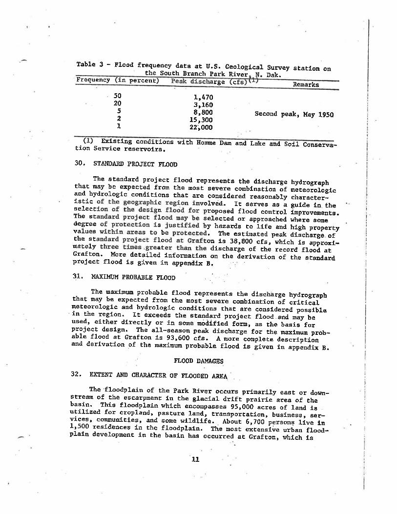
Table 3 - Flood frequency daËa at U.S. Geolog lca1 Sun¡ey statlon onthe South Branch Park Ríver Dak.Frequency n peÏcent rge c Renarks
502052I
rr47o3r1608,800
15 r30022;OOO
Second peak, May 1950
( Exfstfng conditÍons wi th Home Dan and Lake and So11 Conselt\ra-Èion Sen¡ice resen¡ol_rs.
30. STAIiTDARD PROJEcT FLOOD
the standard project flood represents the discharge hydrographthat may be expecÈed from the uost severe combínation õr nãteoiologtcand hydroLogic conditfons that are consldered reasonably character_istic c olveid. It serves as a gul.de Ln ËheseLecÈ n roposed flood conÈro1 fmprovementg.The st 1o eLäcted or approached. where sonedegree s y hazards to'itr" and hfgh piop.r.yvalues b . Ttre esti.r¡ared peak dilchãiã". orthe st 1o oa is 3g,gOO cfs, whlcf, i" -ãppro*f-
nately er discharle of the record flood atGrafton. More detaÍled lnfomatlon on the ãerivatÍon of the standardproject flood is gÍven in appendLx B.
31. }fNfi}f[I}r PROBASLE FLOOD
The maxL¡rum probable flood rêpresents the dlschãrge hydrographthat may be expeeted from the Bost severe comblnation of critical¡neteorologic and hydrologic conditíóns that are considered possiblein the region. rt exceeds the s¡aTdard pro5eci f1ood.."a ,ãy-i"-used, eirher directLy or in søre nóåifieã rõrn, as the b""i"'rãJp-rojeet desl.gn. The all-season peak discharge for the ¡na:<imun prôb-able flood at Grafr.on is 93,600 ã-t". A more-coruplete aes.rrpiiånand derLvatfon of the maxiuu¡n probable flood ts iiven in appãndix B.,
FLOOD DAMAGES
32. EXTENT A}ID CTTARACTER OF ELOODED AREA
The floodpLain of the park River occurs prínariry east or down-stream of the escarpment ín Èhe glacial drift prairÍe area of thebasin. This floodplain whfch .oäo.p.u"es 951000 acres of land fsutilized for cropland, pasture 1and, trao"po"tation, business, "ãr-vices¡ cofl'rünitLes, and some wfId1Lie. Àbãut 61700 pe:i"o""-iirã-i,11500 residênces Ln the floodplain. The most extensive urban flood-plain developnent in the basÍà has occurred at Grafton, s¡hlch is
11

located Just downstrean from the confluence of the North, south, andMfddre Branches of the Park River. The city of park River has a fewlow-lying der¡elopnents located fn the fLoodplain. Appendix c dfs-cusses the Park River basLn f]-oodplaln with respecÈ to hfstorlccondf Èions.. I
33. ELOOD DAI'fAGE ST'R\IEgS
EstLnaÈed flood damages and flood-related costs at Grafton wereobÈafned through fLeld investigatÍons ¡yhich included Ínterrriews ¡¡fthproperty owners and publÍc officials, publÍshed economic data, andon-síte examination of structures and theÍr contents. These su¡iueysare correlated wÍth property values and depths of flooiling. urbanflood damage data at Grafton were obtained ln 1963, 1970, and. L972by these ínvestigations. Àgricultural flood damage evaluaÈion lrasbased on data provlded by the u.s. DeparÈDent of AgrículÈure, soilconservation serr¡1ce. All flood daoage evaluations are based onJuLy L972 pÈice levels.
34. CHARACTER OF FLOOD DAMAGES
of the total flood danages lu Èhe Park RLver basfn, approxiuateiy83 percent are urban dam.ages of ¡ùich 99 percent occur at'Grafton and1 pereent at Park River. Flood damages to agriculturaL crops andrural developments consÈitute the remainiag 17 pereent. Table 4 pre-sents a breakdown of the totsa1 floocl damages into the varfous urbanl¿nd-use types at Grafton for the standard project flood.
Table 4 - suumary of urban flood damages'resultiug froa the standardect flood Grafton N. Dak
eof total urban
ResidentLalCormercialIndustrlal'Publlc and oÈher
Total 100
5938
21
35, rncluded in the business danages are losses to sÈocks, equipnenÈ,buildings, landr. roads, !¡ages, aod busl.ness proflts. Resldentlal dam-ages fnclude the physical darnage to dwellíngs, personal property, andreal estat,e improvenents along wiÈh costs of evacuatíon, emergencyguârters, and reoccupation. Also, losses include daarage to roads andbridges and disruption of highway and raiL traffíc. other losses Èothe public in general fnclude costs incurred durl.ng flood emergenclessuch-as flood fighÈingr lncreased expense of .nomai nunic!.pal iunctions,and dísasÈer'relief.

36. UVALUATION OF ETOOD DAMAGES
The evaluatLon of the flood damage potentfal ln the park Rlverbasfn was correrated r¡tth flood freguency data to obtain averageafinual danages. rn this analysis¡ present condiÈfon flood danãgeeare based on the damage poÈentíal espected in 1980, the earlfestdate that the proposed flood control lmprovenent ¡¿ould be conpletedand 1n effective operation. Thus, estir¡ates of average annual dan-eges are based, on 1980 condltions and are sunmarized in table 5.Further details of the eval-uation of flood dàrnages and the develop-ment of average annual damages are provided fn appendíx C.
lable 5 - of aver annual flood aÈ GrafÈonage eq
Tyoe (1980-2080)
ResidentialCouunercial and. fndustrtalPublic
lotal
$994,000828r000153,000
1,975,000
TJATER SI'PPLY A¡üD úIATER QUAIITY
37. WATER STIPPLY NEEDS
The major water supply needs ín the basln exfsE at the connunltfesof Park River and Grafton. The maJor Índust.rial waËer users, maíulypotato processors, are located at Grafton and use about 0.3 ngd(níllion gallons per day). The rural, domesÉic, and !-fvestock ¡¡aterdenand is estimated eÈ about 0.2 ngd, íncluding use by the small com-munities of l,Ilnto aod Edinburg, N. Dak, No large denand currentlyexists for water for irrigation, although about 5Qr000 acres ln thebasln are sultable for l-rrigaÈion. MunLcÍpal r¡aÈer supply needs forGrafton and Park RÍver are Àhown 1n table 6.
Table 6 - Munlcf.pal water supply needs at Grafton and park Rlver, N. Dak.(1970-2030)
Per capita(2) ,r"T::il".(1)Couaunfty Year Population lrater use (spcd) Med CfsAcre-feetper day
Grafton L97020002030
Park River L97O20002030
5r9507,900
10r900
1r6802,0002,2OO
115L25150
0.7 1.11.0 1.5L.6 2.5
0.1 0.2o.2 0.30.2 0.4
2.L3.05.0
80100110
0.40.6o.7
(1) Based on populacion and economic base studfes , refer to appendf.x C.(2> Gallons per capíca daily. Based on Souris-Red-Rainy Rlver BasinsGon¡¡lssfon Comprehensive Framework Study.
13

38. T{AIER QUALTIY
The water'quallÈy of boËh the surface tüater.and groundwater frouthe gl-acial drift aquLfers in the basln ís consfdered undesirable be-cause of high coricentraEions of total dissolved solid.s (TDs) andhardness. the surface staËer ls uore deslrable than the groundwaÈer;however, both require extensÍve treaütrent to Eeet PublÍe Health SenrfcedrinkJ-ng ttater staudards. SaLine !üater from deep sediuentary depositsis available, buÈ would regul-re extensive and costly desalinizaÈion,treatment to be suitable for domesÈic uses. Thís salirieîater isaccepÈable for lndustrial needs.
39. SOURCE AITD ADEQUACY 0F PRESEÌìIÎ I{ATER SIIppLy
BoÈh Grafton and park RLver depedd on Honme Lake and the parkRÍver for their source of water supply. park River also uses somegroundwater to supplernent Èhe supply from Houne Lake. other communl-ties in the basin rely mainly on groundrirater. The ioduscrial waterusèrs use the salfnè ¡vaÈei fro¡n the:bedrock aquifers. The rural wa¡erneeds will be supplied from the FordvilLe glacfal drÍft aqulfer vLaan extensive pipeline netwo¡k.
40- All waÈer supply sources ín the basl.n are consLdered adequate tomeet presenÊ and future rreter demands, Ð(cept Houue Lake and the parkRiver ¡vhÍch are not considered adequate to Eeet the needs of Grafton.Due to the large nater supply denand, at Graftoa,, the hfgh rransmissfonloss of Í¡ater Ln the natural river charmel between Hom¡e Dan andGrafton, and the reduced effective lrater supply storage in llorme Lake,Grafton could experÍence a !ùate? shortage with Èhe oecurrence of a naJordrought.
ITATER-BASED RECREATION
4L
L4

EXISTING AI{D AUIHORIZED IIATER RESOI'RCE PROJECÎS
42. CORPS OF ENGINEERS PROJECTS
Hornne Damr located on the South Branch Park RÍver about 4 ¡nflesupstreain of the clty of Park RLverr. lras constructed and placed fnoperation in L951. The resenroir has a total storage capaclty of31650 acre-feet. rt was authorizeð. to provide !üater supply fôr thecomrunfÈies of Grafton and Park Rfver and llmfted storage for regu-lation of sprÍng flood flows. currenÈ1y, the city of pãrk RLver-hasa pipeline connected to an outlet valve at Horure Dam for its waÈersupply, whereas Grafton relfes on releases from the dam to be trans-ferred. by gravity flow ín Èhe natural river charuel. The recreatlonarea at the dam includes facílLties for picnickÍng, campÍng, swftmiug,and boat J.aunchl.ng.
43. In 1960, the Corps of Engl.neers cornpleted channel inprovement ofthe Park Ríver ¡vhich consfsted of cLearfag thg channels of obstructfngÈrees and brush and snagging of fallen tree's, brush and d.ebris inthe following reaches:
e. The North Branch frou about 5 uriles northwest of Eooþle,N. Dak., to fts junction nith the lfidille Branch.
b. the Micldle Branch from about 6.5 mir-es southwest of Hoopleto its Junctfon with the South Branrch.
c. The south Branch fron the lrestezn 1Íuits of the clty ofPark River Èo Íts junctlon nrith the Middle Branch.
d. the Park River from the junction of rhe south and MlddleBrandhes to a pofut about 10 uíles above Èhe mouth of Èhe park River.
44. SOIL coNSERvATIoN sERvIcE II'IPRo\rEMENTS
Flood control improvemen.ts planned by the Soil Consenration Sen¡fcefor the Middle Branch Park River under Èhe Public Lanr 566 program lrereauthorized for ínstallation and are currently under consÈr:r¡ctlon. ThestructuraL irnprovernents ínclude five floodwater-retarding structureswÍth a total flood conÈrol storage of 11r76o acre-feeÈ and 37.6 uilesof shannel improvement. These flood control measures províde prinef_-pal flood damage reducÈion along Èhe Middle Btanch park River ándLinited flood sÈage reductfon along the nafn stem park Rlver.
45. Aclditional flood control improvemenÈs are authorized for theWi11ow Creek watershed in the norËheast portion of. the basfn, consLst-tng of 56 miles of channer improvement. and one floodwater-retardfngstructure !ùÍth a flood control storage or. 21490 acre-feet. The flooddamage'reduction fr-om these ímprovements occr¡rs primarily along Wtllowcreek, lrith neglÍgtbre effect on Èhe mein ste¡n park River.
15

46. OTHER IMPROVEMENTS
À surrrey of the eastern part of lùalsh county was made in 1905 andplans were developed for a eornprehensíve dralo.gá "y"tem for the parkRiver. By L947 ' abouÈ 30 miles of this drainagã syste$ had been coa-p.leted, which incl-uded a 3-¡ri1e cutof f channel on the south BranchPark River, located about 6 ríver miles upstrear fron Grafton.
IìæROVEMENÎS DESIRED
47. . Followíng the drought years of the 1930rs, !ùater suppry became amajor concern and Homre Dam was consÈructed to neet thls-baiic nee¿and to also provfde some linited flood control. The large floods of1948 and 1950, .the latter occuriÍng durÍng constructton õt Homne Dam,emphasized the need for further flood conirol. RecognÍzing the remaLn_ing need for urban flood control at Graftoa and roral frooã conÈro1along wÍth a need for addftionaL ¡¡ater supply for Grafton and foradditional warer-based recreaËíon in the iã"io, thís study consiãersall alternatlves to meet these needg.
48. An opinion survey of the residenÈs in the South Branch anil mainstem Park River area'was co¡rducted in 1970 to detennine the views ofed that the public supports they, and r¡ater-based recreation Ln
1 views on the possible al_ternaEivest 197L a Citlzens AdvÍsory Com-or Ì{iIlian L. Guy of North Dakotato further investigate the alternaÈÍve rrater managemenÈ plan. Afters-everal meetings, in June L972 tt.e cirLzens Advtsõry coilrittee madethe following recourendatlons to the Governor:
e Urban f c for the comnLttee unani-mously de cided thaÈ a rlng levee and f1 bypass channel at Graftonappeared to be the most feasfble nethod for elininaÈíng the threat offlood damage at Grafton and Èhq t.this plan should receive further study.
b. The connittee unanimously decLdedthaÈ cha Branch pa¡k River, brídie ral.sesin the sbe Ímplemented. erating plan for H'o¡nme Dam should
construction of a multiple-purpose dan and lake oo the souËh Braneh of,Èhe Park Rl_ver.
L6

OBJECiTTVES OF PLAII FORMTILAÎION
49. The basÍc objectLves of plan fonrulatíon are Èo develop a planwhfch w111 províde the besË uses, or combination of uses, of naterand related land resources to neet all foreseeable shorÈ- and long-term needs of Èhe Park Rlver basÍn. In pursult of Èhis general ob-jecÈ1ve, the follorrrfng specific planning prineÍples and obJectlvesguided for¡¡ulation of the plan of improvemenÈ.:
a. The plan Eust presen e to the uaximum possíble extentÈhe qualLty of the natural and human envLronnent.
b. The plan must be socÍally accèptable.
c. The pl-an EusË enhance the econonLc l¡elfare of the localpeople and add to their securiËy and ¡rell-being.
d. The plan musÈ enhance national econo'nlc developrnent byíncreasing the value of the NaÈlonrs otrtput of goods and serr¡icesand fmprorring national econouic efficlency.
e. The plan must, fit intejgrally fnto an overall plan forrüater and related land resources nanagement and developoent for theRed trùlver of the North basín.
f,. The plan must be Èechnfcally feasible to furplement.
In additlon to these specific principles and obJectives, the generalguÍdelines of gfvlng equal consLderation Èo the economfc development,social wetl-beLng¡ and naËural eurrirorrnental quality pararneters wasfollowed in evaluating Èhe alternaÈive lrater managements.
50. In the forurulation of sÍngle-purpose and rrultiple-purpose alter-natLves, the provLsfon of adeguate flood protectlon, en assured watersupply, and additional- opporEuníties for water-based recreaÈion vereconsídered to be the major waÈer and related needs for the SouthBranch and main stem Park River basin. Adequate fl-ood protecËion forGrafÈon is consídered to be at least the l-percent chance Ievel, withadequate room for future growÈh. Adequate fLood proÈeetion for therural areas is considered to be at abouÈ the lO-perqenE chance level.An assured water supþ1y for the study area is considered to provLdefor Graftonts present and future water supply needs wLth occurrenceof a Z-percent, chance drought. A water surface a¡ea of about 500 to600 acres would provide additional water-based recreation facilLtiesneeded 1n the aree.
L7

t-
SINGLE-PIIRPOSE MEASURSS CONSTDEREÍ)
51. FLOOD COI{TROL
síngle-purpose measures considered for reducÍug frood danagesinclude boËh nonstructural and strucÈural measures.. The nonstruc-tural Eeasures Ínclude flood rvarnÍng, floodplain evacuaÈfon, floodproofing, floodpl-ain regulation, flood insurancê, and the irdo noÈhing'lalternative. The structural ¡Deesures include levees at Grafton,a flood b¡pass channel at Grafton, combLnaÈion of a levee and flooilbypass channel at Grafcon, channeL improvemenÈ in È,he rural reachegof the souÈh Branch and. main stem Park River, channel f.roprovementthrough Grafton, and upstream reseruoir storage..
52. NONSTRUCÎTIRAL MEASTIRES
a. Do nothing. -'the rrdo nottringtt a1t'ernadíve does nod sò1vethe flood ãffi=n'the basln. The ãurrent flood-prone aréas inthe basin would remain subJeeÈ to floo.d damage. The enÈlre eity ofGrafton would remain in the floodplain classification along with theJ.ow-lying developments in Park Rlver and aLmost the entite rural areaeast of the escarpment. rn accordance with current Federal legfs-lation, the fuÈure growth and developnent of the floodplaín arãas ¡¡í11be slov¡ed somer,rhat due to the lack of Federal fundÍng avaflable tohomes and busínesses ín the f1-oodplain.
b. Flood {3rning.. - Flood warnfng ¡vouLd consfst of predLctfng thetirringan¿ffi,ilodsanda11owingioievacuationoffiood-proneereas or erection of emergency flood protective measures. Flood warníngis not effectíve as a aea¡,s of preventing flood danages Ín the basln.The greatesË flood hazard in the basin is from the spring snowmelt, arelativery slow-rlsing flood capable of belng reasonably predicted bythe methods ¡shich ere currenËly avallabl-e. SÍnce the sLow-risLng natgreof floods lessens the potenEíal for loss of life, and most of the flooddamages fn Èhe basin are associaEed with the actual lnundation of theproperties, the damages prevented by a flood warnlng system would benegligible. Flood warning is not c,onsidered to be soclally or econqml-cally accepËable as an effectÍve ueans of solrring flood problems fnthe basin, '
c. Floodplaln evacuat,fon. - Floodplain evacuaÈion would consl.st ofpermanent evacuation of developed areas in the fl-oodplaín, lncludLngacquisition of lands by purchase, removal of lmprovernents, and reLocaÈl-onsof the population from Èhese areas. Land acguLred in thls Eanner couldbe used for agrieulËure, parks, or other purposes which rsould not inter-fere wiÈh flood flows or result Ín maJor flood damage. The evacuatl.on
18

of the floodplatn rrould affect about 11500 residences and about 6¡700people, the rnåJority located Ín Grafton (11200 homes, 250 businessea,and 61000 people). The evacuaÈioncoste_of. movl.ng only Èhe hornes andbusínesses at.Grafton.are estima.ted at over $35 ¡rillion. Additional'cgsts associated wÍÈh proiriding conparable public facillÈies includl.ng"'communicätÍons and transportaÈlon are noE avaflable. The nearest con-,tiguous high ground would be located in the e{¡carpuent erea near ParkRiver about 15 nÍIes to the west, as lands to the north, souÈh, andeast are sítuated Ln the floodplain quite sfmilar to Èhat at Grafton.Although flood danages and flood damage potentlal would be ell.mLnateðfrom the urban and resfdential developments, the agrlcultural'f1ooddamages would not be appreciably reduced. EvacuaËion ís noÈ conslderedan acceptable alternative from econmic and socfal- well-befng aspects.1o be acceptable from the environmental standpoLnÈ, the cLty ofGrafton would have to be moved, co a biologically less sensiELve areaÈhaa arLsÈs Ín lts currenÈ locatfon.
d. Flood prooflng. - Flood prooflng ¡uou1d consisÈ of a conbibe-tion of stEìú-õffiT-f-añÇes and adjustnents Èo properties subJeet toflooding priuarily for the reducÈLon and elíruination of flood darnages.AlÈhough best applLed to new constructLon, fÈ 1s also applfcable toexÍstíng facÍlft.les. Due to the relatively low stages and velocltLesthat are experienced, flood proofing could be used for the develop-Eents et Grefton and also Èhe fan¡steads fn the rural erees. Floodproofing, although considered econornically feaslble, is very cosËlyand would not completely solve the flood problens aË Grafton, thelarge number of businesses and residences to be flood proofed ¡¡ouldresult in disnrption of the currenÈ residentsr way of lffe, Thtsalternative is not acceptable as a complete soluÈíon to flooding fnthe basLn fron the soeÍa1 well-belng standpoint.
e. Flo-odplaLn r.equlatLon. - Floodplain regulation consistsprirnarily of regulatÍng new development Ín existing floodplatn areas,Floodplain regulations do rioÈ su¡¡sntly exist, Ín the basln. Sfncethe entire eour¡nunfty ofirafton l-s locaÈed 1n the floodplaLn, andthe nearest high ground Ls Located over 15 ¡nLles away, floorlplal.n reg-ulations are not considere{ appropriate as an effective neans ofreducing exlstÍng flood darnages in the basi.n. Floodplain regulatlon,although not a compleÈe solution to flood damage reductlon, should bepart of any flood protection system and could be effecÈive ín ParkRiver and rural areas.
f. Flood insurance. - Flood insurance would provide a supple-ment, to otñer:EIooil õoñtiol measures Ln that iÈ ¡rould asslst in reln:bursing the affecÈed properÈy ohrners for losses sustained fron flooddamages. Fl-ood insurance is considered appropríate where lLmitedproteetion Ís already provlded, and additional flood proÈectlon lsdesíred. Thís measure does noÈ reduce flood damages in and of itself.It does, however, afford the índívÍdual affected some economlc proÈec-tlon fro¡r flood loss by spreading his losses over a large group ofpersons. Flood insurance used as a supplement to floodplain regula-tLons arid other flood damage reduction measures could provide li¡riÈedeconomie protectl-on for exist,ing developrnents. Federally subsidiaedflood insurance Ls not currently avaÍlable in the basln. This measureis noË consi.dered an adequate solutfon Èo the flood problems of the basLn.
I
19

53. SÎRUCTTTRAL MEÀSIIRES
a. Levees at Glafton. - Levees at Grafton would coasLst of aring Levee around the SECEiOIr of Èowrr north of the river and anotherrlng levee around the section of tolrn'south of the rlver. The leveewould be a¡r earth embank¡renÈ excep! the reaches adJacent to therÍver which would be a concreEe floodr¡aIl. In the constrictedreach of Èhe rl-ver between the north and south levees, the channelwould have Èo be shaped and riprapped to provide for more effl-clentflow of water. ConstrucÈion of thís levee system and channel 1n-provenenË would requlre approxluaÈely 115 acre6 of la¡d for rl.ghts-of-way, relocatÍon of about 15 homes, three bridge raises, and. Èwobridge reuovals. The channel iuproveuenÈ would disrupt about 1 nileof natural river channel. Construction of the floodwalls and leveewould dísrupt about 15 acres of natural wooded areas along the presentriver channel, about 10 percent of the naÈuraL wooded areas Ehatpresently exist 1n Grafton, Because the areas to the ûorth and southof the river at Grafton are necessary for bank overfLor¡ for the largerfloods, it is esÈimaÈed. that several feet of bacËwater effects couldbe caused by the levee plau of constricting the river to lts naturalchannel. Thís backwater could cause s.ignifieant adverse effects toupstream rural properÈy owners. To provl.de edeguate flow area Ln thenatural river chanael area for these larger floods, Èhe levees andfloodwall ¡¡ould have Èo be noved back from the river to such anextent that Èhey would adversely affect exlstLng developments ln theareao
b. Flood typass ctan""f at Grafton. - The flood bypass channelat Grafto of a bypass chânnel to thenorth of Grafton which is connected by tieback levees to an inter-ceptor draÍn upstream and to Èhe r¡est of Grafton. ThLs bypass channel,interceptor draÍn, and tieback levee systen would prevent both riverand overland floodwaters fron affectíng developments at Grafton. Thebypass channel inlet strir¡cture would aLlo¡r nor¡raI 1ow flows throughthe natural river channel to Grafton and divert flows fn excess ofchannel capaclty at Grafton lnto Èhe bypass channel-. The intercepÈordraln would cut off the overla¡rd flows, divertlng Èhem back ínto theriver, wíth the Èieback levees containing these flonrs to the lnlet ofthe bypass channel. The design capaclty of the bypass channel nrouldbe about 141500 cfs, with the river cha¡rnel through Grafton carryingabouÈ 51000 cfs. The bypass channel would cut off about 7 river m1les.from the nomal flood channel, The bypass channel and assócla.tedfeatures would require about 285 acres of rf.ghts-of-way, fncluding10 acres of natural woodlands, about 3 percent of the woodland in thevicinity. About 0.2 nile of natural ríver channel would be.affected,The bypass channel would provide adequaÈe flood protection forGrafton and adJaeent rural areas.
20

c.conbínatio - &"
lst'of aring levee compleÈely encircling GrafEon, with the river trrrougrrGrafton regulated by upstrean and dorinstreaq gated couÈrol "tri"trrr"".The bypass channel would be located to Èhe noittr of the levee, witha broad-crested welr as the conÈrol for flows entering the chånnel.The river length for flood flosrs would be reduced by ãbout s iiiãs.The upsÈream gated control st¡iucture in Èhe levee wãuld allow no¡mallow flows to pass through Grafton. l{hen flood flows occur, tuã-"p-stream gated control scructure would be closed, routing the entLrerlver flow through the bSrpass channel. Flood protectión provl.dedexistÍng agrfcultural areas would only be to tho"e lands incorporatedinside the levee boundaries. Lands outslde the levee boundarlãs,either upstreen or dor¡nstreem¡ woull noÈ be appreciably affected byincreased or decreased frood stages for largei-nooa fiows. TheJgvee would proÈect approxinateLy 21700 acrãs of land, includfnf750 acres developed wi-thLn presenÈ city liuits. The levee woulãprovide adequate flood protectton for Grafton. Large floods r¡ou1dexceed Èhe capaciÈy of the b1ryass channel and'fnundãte the surroundfngagrlcultural- areas ín a manner sfmilar to whaÈ would occur ¡sÍthout prõj-ecÈ consÈruction. lhe levee and bypass channel wouLd requfre about 235acres ín rights-of-wey, íncluding about 5 acres of natural ¡¡oodedareas, about 2 percenÈ of the natural wooded area in the vicinLty.About 0.1 mile of natural strean ehannel wouLd be dlsrupÈed. rtrísmeasure has a benefit-cost raÈÍo of 3.g.
d. Rure,l ch?Fge1, í.o"o.r*"nt. - Rur¿r chaunel improvemenÈ r¡ourdconsist of increasing the channel capacity Ln the rural reaches of thesouth Branch and main sten park River from the cfty of park Rlver toOalcwood. The channel would require varyi.ng degrees of nodlficaÈion tohandle lO-percenË design flows. About 290-acxás of Land n¡out¿ie re-guired for rights-of-way, includfag 200 acres'.of natural wooded, ereaaaloug the river, about 7 percent of the total natural areas along thereach Èo be lmproved,. ChanneL improvemenE ¡uould alter abouÈ g2 ãffesof norual stre¿rm channel.' Reduction of nrral flood darnages would besignl-ficant (53 percent). Rural channel improvernent wrth a benefLt-cost ratÍo of 0,3 is not econouically feasible.
e at Graf Ghannel improvenent eÈGrafton wou requfre nereasíng the natural rLver channel capacitythrough Grafton Èo handle about 22'OOO cfe and uslnB tieback leveesand an lnterceptor dra{.n west of Grafton Èo contain and rouÈe theoverland flows to the improved channel. About, 4 niLès of naÈuralríver channel would be nodified, and 145 aeres of l-and would be re:quired for rfghts-of-way, includ tng 45 acres of natural wooded areaal-ong the river, about 30 percent of the natural rsooded area in thevLclnity. Extensive spoil banks from channel excavation th rough thecity would detract from the aesthetLc nature of the rlver. A1 thoughchannetr improvement through Grafton r¿ith a benefiÈ-cost raËlo of I.2ls economically feasible, the social well-beLng in the relocatlon andaesthetic funpacts wouldof both Èhe sÈream andslgnifícanrly af fected.
be signÍficant; and the environmental qualLtythe natural ¡sooded
-f
2t
area in GrafÈon would be

- f: UPstream reservolr storage. - Upstreâm resenroir sÈorage lrasinvestigated aÈ nine rocaÈÍons in the escarpment area west of paikRíver, including the raising of Horme Dam. Each has varyl.ng degreesof capability in meeting the downstrea¡D flood reducÈion needs, ãndalso varyÍng degrees of impacts on the environnent and the reÀidentsin the reservoir areas. The uost preferable reselr¡oir alternatfvesappear to be one reservol-r or a combination of reservoirs. sinceinfomation for the cornblnaÈlon of reservol.rs would be qutte sfmilarto that for the single reservoir, only the síngle reservoir alterna-tive ls evaluated here. Although upsÈream reservoÍr storage couldprovide major downstrean flood.danage reductlon in the ntrãl areasalong the south Branch of the park River and reduce total flood dau-ages by 54 pereent, fLood damages at Grafton for the major floods¡rould be only slightly reduced, and very llttle area would be renovedfrom the floodplaín. Flood stage reducÈion at Grafton for the largefloods would not be slgnificant. construction of a sfngle res.rvolrn¡ould nodify to some degree about l-0 miles of free-flowing strean andabout 615 acres of natural woodland area. The total woodiand affectedrePresents about 28 peréent of the oatural wòoded'area in the vicinl-ty,about 10 percent of the natural wooded area Ln the escarprueni reaches,and about 7 percent of the total natural r¿ooded. area from the reservolrsite dor.m along the s'outh Branch and ¡naín srem park RÍver to the RedRfver of the North. A total of. 2r4oo acres of private lànd would berequired for dan and resen¡oÍr constructlon, fncludÍng lrgoo acresof woodland. The aesthetic impaet of a reseryoir ¡¡ould be slgnlfLcantin that the natural wooded habitdt r¿ould be repraced by an aqiaticenvÍronment.. the resen¡oír is economically feasfble.
54. tr'IATER ST]PPLY
The rnajor singl-e-purpose measures considered for provlding anassured ¡¡ater supply for the Park Rlver basin Ínclude upstreem reaer-voir storage along Èhe south Branch park Rlver, off-channel stor4ge arGtafton along the main stem Park River, groundwater from the FordVilteaguifer transferred vfa plpeline, and water frorn the Red Ríver of theNorth transferred via pipelfne. Either the off-channel sÈorage atGrafton or the rcater purnped from the Red River of the North aie themore desÍrable and feasible alteroaÈives. úIat,er supply in upstreamreservoirs along the south Branch park River is desfrable only ifused Ín conjunctf-on with a multiple-purpose reservoir (9ee appendix F).
55. I{ATER-BASED RXCREATION
Due to the lack of natural water surface area in the basin¡ pro-visl'on of rnajor water-based recreatÍon facilities nrould regufre con-struction of an impoundment. Such an undertaking vrould only be feaslblei-n conJunctfon wÍth a nultiple-purpose project. (see appendix D.)
22

56. SI'MMARY OF SINGLE-PURPOSE UEASURES
The single-purpose flood control Eeasures deemed mosÈ accepËablefrom econmic, social ¡rell-being, and envirom¡ental quallty criterfafnclude a flood bypass channel at Grafton, a combinatlon levee andflood bypass channel at Grafton, and upstrean resen¡oir storage.The "do nothlng" a1ÈernatLve nust always be considered as the alter-natLve'to ari acceptable actÍon plan. the flood control Eeasureathat are considered as possibl-e supplements Èo any maJor &easureinclude flood proofing, floodplain regulation, and flood insurance.The flood control measures considered least acceptable include floodwarning, floodplaín evacuatfon, levees at Grafton, and rural andurban channel Ímprovement.
57. Evaluatíon of the rùater supply alternatLves fncldates that bothoff-channel sÈoráge at Grafton and water from the Red River of theNorch would be aeeeptable ¡reasures. trIater supply in upstrea¡r reser-voir storage, along wf.th water-based recreatíon, should only be con-sid,ered acceptable lf included in a nulËlple-purÞose rese¡¡roir.
T.IATER MANAGEMEÌÍI PLAI{S CONSIDERED
58. The l¡ater nanagement plans consfdered reductfon of flood damagesand províslon of assured lrater supply and additional water-basedrecreatlon opportunitÍes as naLn obJectives. Adequate reductf.onof flood damages for the basín musÈ include some fom of local protec-tLon at Grafton. Upstreaur reservoir storage, although providing flooddanage reduction, does not, slgaificanÈly affect the stages of thelarger floods'at Grafton and woul-d not Temove any porEion of GrafÈonfrom Èhe .floodplai.n. the most aceeptable meaaures for.pneventingflooil damages and providing an assured lraËer supply are i.ncorporatedín the following considered alternative water manegenent plans.. Pro-vlsion of additlonal water-based recreatfon ùras fncluded only in plansínvolving upstream rese:soir storager
a. Plan 1 - Do nothlng. - Should an acceptable water menagenenÈplan not be selected, the rrdo nothingtt alternatlve would be the Ln-evltable resutrt. All r¡ater-relaùed problerus in the basin would con-tlnue to exfst ia the future.
b, Plan 2 - Combination levee and flood ass.channel atGraf ton. - aÈ GraftonffifrIl'roví de adequaÈe flood protectlon for the city of Grafton, butwould noÈ reduce flood damages in other arees of the basl-n. The totalflood darnages 1n the study area r¡ould be reduced by 76 percenÈ, and90 percent of Èhe persons liviug Ín the flood-prone areas ¡¡ould beproteeted. The brídge openíngs over the bypass channel r¡ould belarger than the channel area' so that bacl¡cs¡aËer effect.s upstream ofthe bridge would be sllght for flood flows of the magnitude of thel-percent chance and the standard project flood.. Thts alterr¡aÈive
23

plan rtould be the most econoul-cal Eeans of providing adequate floodproteccion for Grafton (firsÈ cost - $8.2 nillion; benefLt-cosÈratio = 3.8), and would also provide the greatest net return on theínvestment (net benefits = $1.37 million). the plan would requireabout 235 acres of prlvate lands for constnrctloa, most of r¡hfch arevaluab1e croplands, and reloeation of one famstead. The planwould not appreciably change the flood threat to surrounding flood-plain areas. the dÍrecË enviro¡mental qualfty'Ínpacts of thls planwould be small, as on1-y 0.1 nile of natu¡al stream bed and 5 acresof natural ¡yooded river boÈtom habitat would be modlfl.ed or dLsturbed.Âbout 150 acres of woodland exLst in ghe Gráfton area ¡¡lthf-n Èhelevees and would be protected from flooding. As assured water supplyfor Grafton could be provLded by an off-channel storage resen¡olr.Additional water-based recreatloo would aot be provided with thls p1an.
c. ?lan 3 - Flood bypass channel at Graftou. - ltrls plan wouldcsnsist of a flood b¡ryass channel at, GrafÈon, an ínterceptor dra{n westof Grafton, and tieback levees extsending fron the inÈerceptor drain toth'e inLet of the bypass channel. thiê plan would providè adequateflood protectíori for both the development at Grafton and agrlculturalcropland in the adjacent erea. Àbout 77 percent of the flood damagesln Ehe study area would be elíninated and about 93 percent of thepersons lfving iu flood-prone areas would be protected. About 285 acresof prívate lands, mostly valuable cropland, would be requLred. for con-sEr:uctÍon, including abot¡t 10 acres of natural wooded area along theriver channel. Only 0.2 nile of natural stream channel and l-0 aciesof natural wooded land adjacent to the river would be dfsrupted.ThÍs pltrn fs economlcally feasible. ^An assured wacer supply could beprovided by off-channel storage at Grafton. AddLtional water-basedrecreat,ion would not be provlded with thfs plan.
d. Ptan 4 - Multiple-guipose reservoir and flood byp¡rss channelaÈ Grafton. - A rnultiple-purpose ralong the SouÈh Braach and main stassrs¡sd lreter supply for both ?ark River and Grafton, and provide op-po'rtunJ.ties for water-based reereation. The flood bypass channel atGrafton would be si¡rilar in features as theÈ listed in plan 3 exceptth;rt it v¡ould be slightly smaller. The flood protection provl.dedGrafton would be comparable Èo Èhat provl-ded by the other alternaÈLvepl.rias. This plan would reduce total flood daruages in the basin bya'a.¡t¡i 90 percent and protect about 97 percent of the persons livfng 1uEhe fLood-prone areas. This plan is socially acceptable because of ltswi4espread social benefits, and relatÍvely mínor social disadvantages.The najor social disadvantages would be relocatfon of four far¡rsteadsand acquisition of over 21600 acres of prívaÈe lands, including abouÈ875 ac'':es of agricultural 1and. An addítional 31600 acres of prLvatelands r¡ould probably be required for fish .and w.ild1tfe nitigatfon.The impact of this plan on the existing envíronmental qualÍty of, thebasl.n r¡ould be great, with about 625 acres of natural wooded area. and
esen¡oir would reduce fLood damagesem of the Park River, provide an
24

good wildlife habitat being disturbed or nodifl.ed. About 7 mlles ofth:: naÈural free-florring strean would be affected by constructlonor changed to a standíng tüater system, with an additional 3 uflesof natural stream bed subject to Íntermltteat floodl-ng changes. The625 acres of wooded land represent about 7 percent of the totalwooded area along a 2-ni1e strip adjacent Èo the enÈire reach ofthe South Branch and main stem of the Park River', and about 10 per-cent of the total wooded area along a conparable strLp Ín the fmedl.-aEe project erees.
e. Plan 5 - UulÈÍple-resen/oir sysqe! and flood bypass channelet Grafton. - The mult íple-reservo ir sys ten would Ínc-lu-d e -lõur ïesFvolrs for fLood control and a reservoir for water supply, ¡sater-based,recreationr.and líniÈed flood control. The fLood b¡¡pass channel atGrafton would be comparable 1n feaÈures and slze to that descrLbedin p1;ra 3. This plan wouLd provide flood protectfon for Grafton cm-parab.le to the other plans, an .assured water supp'ly f or Graf ton an!Parli RÍver, ánd addLtlonal ¡¡ater area for recreation. Ilowever, theflood proËectlon provlded Park River and the rural areas would besomewhat less than Èhe l0-percent protectl-on level . Three famsteadswould be affected and about Lr62O acre6 of total prfvate lands wouldbe aequired plus about 31600 acres of additional lands for fish andwi.ldlife nitigation. About 15 miles of natural strea.u bed would. bemodlfÍed, elther pèrmanently or intemlÈtently, and about 585 acresof natural ¡tooded area r¡ou1d also be modl-ff.ed. The environmentalimpact of this plan is sígnifícanÈ.
f.. Plan 6 - Multiple-purpose reser¡roÍr and combfnation lsveeand fì'rod a on.
n resPe bed ín plan 4, and the cø-bination levee and flood bypass channel is siuilar to that descrLbedin plan 2. This plan is economLcally feasfble (benefLt-cost retlo =1.S). Adequace f.lood protecÈl.on for the enEire study ar.ea, an assureds¡eter supply, and aðditional waÈer-based recreation ¡¡ould be provf.dedwith this plan. The envlronc¡ental iarpacts and soci-al acceptabllity.of thl-s plan are conparable to those for plan 4.
g, Plan 7 - Multlple-reseñyoir system and conrbfnatfon leveeand fl-ood Ie-Eæ and the levee and flood b¡rpasscÌ¡an¡rel described in plan 2.
PLAI{ SELECTION
59. The seveu alternaÈive water Banagement plans ¡¡ere all consideredfeasible alternatlves; ho!ùever, the pJ-an selected uust neet a11. òfÈhe planning objectives. Each plan was rated Ín conrparíson to theóther plans in tenrs of the major beneficial or negaÈÍve aspecÈs byChe plannlng obJectives of econonics, social ¡¡ell-belng, and
25

envfronmental gualfty. The uosÈ attractlve plan by the natl.onaleconomfc development objecÈLve Ís plan 2, combfnatlon levee andflood dlversion channel ar Grafton; by rhe social we!.l-belng obJec-tive is plan 4, nultíple-purpose reservoÍr and a flood bypaõs cñannelat, crafton; and by the environmeotal quality obJectlve, pran 1, donothlng. weighting each planning objecrfve equally and àonparingthe alternative plans shows that plan 2 has the highest overallracing and ¡,¡ould be consfdered as the plaa whích best neets thepl.anning objectives.
6I). Plan 2 fs economically feasible and the most, econornfcallyefficient plan with the highest beuefit-cosÈ ratlo and the g.ã"testnet benefits. Aside from the I'do nothf.ngt' alternativqr it is themost environmentally acceptable pLan trÍÈh the least anouo,t of naturalarea disturbed by construcÈion (5 aeres) and with the least, iurpactof the considered plans on other naÈural systerus. pran 2 has å hrghdegree of social acceptabJ.lity as reduction of flood damages andproEecÈion of persons are both very hígh wíth this plan, even thoughrel¡rtiveLy lfrÈle agrlcultural land ls protected f-róm fiood damages.the water needs of the area can be met, although addÍtfonal watei-based, recreatíon opportunLt.ies are n<lt proviiteã. ì.
SCALE OF SELECTED PLÆ{ DEVELOPMEIII
61. the scale of develoPmenÈ of the combinatloa levee and flood bypasseJtennel was selected utilízing the Èhree planníng objectíve parameters.r.rârious levee'and diversion cha¡rnel designs rangfng .from no levee Ëo.Ievee protection exceeding Èhe standard project flóod and froo no b¡passcilerr[el. to bypass channel protection at about the l-percent recurrenceIeve1 were combined. All of Èhe posslble combinatÍons were evaluated,from economics, social well-beíng¡ and envÍronnental qualfty.
62. The econonlc developnent evaluatlon of the conbinatlons of varfous-sieed levees and bypass channels Ìras based o¡r net benefits attributableto the project. The ma¡<iuum net benefits occur at e hlgh degree oflevee protectlon co¡nbined wtth a snalr-slzed bypass channel, and aË a¡redium-sízed bypass channel wLth no l-evee protectiorr. Negative netbenefits occur at Lower levels of levee BroÈection combinãd wtth eitherno diversion channel or a vety Large bypass channel. OÈher co¡nbinatfonso.f the levee and byaass channel have varying degrees of benefíts in ex-cess of costs.
63. The socíal r¡ell-bef.ng evaluation of cornbinati.ons of varl-ous sizesof a levee and bypass channel was based on the criterfa of flood, pro-Èection provided, amount of lands required, vLsual aesthetic írnpaäts,and transportation and other f.nconveniences. The importance of-theparameÈer ranged frou flood control as tho mosÈ important to vlsualappeal as the least. important. The degree to whlch Èhe people were af--fecËed, the number of persons affectec!, and the relatfve- frniortance ofthe parameterð v¡ere all used to detenrine the aecepÈabluty -of gachcombinatLon p1an. The relative accep;abflLty of the various combLnacfon
'1 '
26
t

plans shows that the most accePtable plan occurs wLÈh l-perceaÈlevee protecÈlon and a nediun-sÍzed flood bypass ehannel. A largerlevee is considered unnecessary and a smaller levee would be lnef-fectlve. No levee and a small channel are socially unaccePtable.
64. The environmental quality aspecÈs of the varl.ous combLnatfonswere evaluated based on Ehe ÈoÈal- acreage of natural ¡¡ooded areathat would be directly affected by a plan. The most desl'rablecombination from environmental quallty would be no levee or channel.The least desirable conbinatlon would be a levee of any slze ¡riÈhoutany flood bypass channel.
65. In vlewlng the comblnatfon plaus cmposlÈely fron the three obJec-tlves, tqro areas appear to be most acceptabler either a levee provf-d-íng J--percent flood proteetlon ¡¡Ith a mediun-sized bypass channeltor a levee provfdl-ng standard proJect flood protecË1on with a medfum-sized channel.
66, The selecÈed combination'of'levee'and flood b¡pass channel ln-'cludes a levee providing staudard proJect flood protectLon and aflood b¡pass chan¡rel designed for uear the 10-percent flow. ThfschoÉce places the sel-ected plan Ln the inosÈ econoulcally efficientarea, j-n a socLally accepÈable eree, and also fn an accepÈable areaf ¡:¡¡m envLronmental quality. Thls plan was selected over the othermost desirable combinatíons primarily beeause of the increased floodprotecÈion províded Grafton, recogaizlng that the social well-beingaad envlronmenÈal quality ParameÈers were sÈill aeceptable. Aitdi-tional details of plan fomulation are given ín appendix H.
PLA}¡ OF IMPROVEMENT
67.
(eee þaragraph 58. b.)
27

CONCLUSIONS
68. The selecEion of a plan Èo meet the basfc needs of Èhe SouthBranch and maln stem Park Rtver basin, recognfzíng the three plân-ning objecÈÍves of economíc development, social well-being, andenvironmental guall,ty, resulted in Èhe seLectlon of a cosrbÍnaÈloalevee and flood bypass channel at Grafton to solve the major floodcontrol needs of the basin. This plan would elÍu¡-tnate over 75 per-cenE of the flood damages Ln the basin by the trosÈ economical lteans.Flood damages ln other areas of the basin ¡,rould not be reduced by '
this plan; however, it is felt that the flood damages to low-lyingdevelopments fn Park Rlver and to faûnsteads in Èhe rural reachesof the basin could best be solved by irnplenrentation of floodplafuregulations.
69. Because of the sma1L, well-defined floodplain f.n Park Rlver,floodplain regulations for Park River should consÍst of land-useconËrols to precluda developoent in the lorv-lyí.ng areas. Due to thelarge floodplain ín the rural areas of the basfn, floodplaÍn regu-lations for these arees should conslst primarJ.ly of buLlcling codesthat would requfre that nerr buildings be constructed to ¡ninimLze floodda.nages. Thls could be achieved by flood prooflng nelr or exlstlngsÈructures, raising the nain level of nev¡ buildings to above thel-percent flood elevation, or constructíng fannstead levees Èo proÈecteither nerù or existing s.tructures. PreventLon of flood danages toagricultural crop productLon ç¡as found not econonlcally feasible.Therefore, effecÈive land managemenÈ measures should be ineorporatedin upland farming practices nherever necessary to optinize vatet reten-tion capablll-tles. Famers in the floodplain areas shoul-d alsoincorporate eppropriate land managemenE, and croppíng measures tominf.mize their crop losses due to flood daraages, . Àlthough Lt is reeog-nfzed thaÈ these land management measures will noÈ elimínate the croplosses due to flooding 1n the basfn, Ëhese measures may tend to reducesuch losses.
70. It is concluded thaÈ water supply for Grafton should be utfllzedfrom the Park Rfver under the present system, buÈ that eiËher off-channelsÈorage at Grafton or a pipeline Èo the Red River of the North should beconstructed to supplement the present supply, In the future as watersupply needs increase, or if a drought perlod is experienced, eLÈherof these alternatives should be utilized in the wl-nÈer months t,o provldeGrafÈon wLEh water and ellminate the need for watet releaseq from HoumeDam wbich cause íce buÍldup problems in the rlver channel along theSouth Branch Park River.
7L. AdditLonal major water-based recreaEion opportunlties, nalnlylakes, although needed and deslred, are not feasLble Èo provfde l-n thebasin. However, the natural wooded corridors along the rivers shouldbe protected from further clearing and, wherever feaslbler'apprþprlaterecreatfon opporEunities should be provfded along the exisÈing rlvercorridors.
28

,'
72. The cosrbl-nation levee and flood bypass channel at Grafton aeproposed would elíminate Èhe ¡ûaJor flood problems fn the basLn.These measures are consfdered the best overall major plan recogtlz-ing econornic developuenÈ, social well-being, and environmental quall.tyas equal plannlng object,lves. The addLtional ueasures whLch are pro-posed would aid in solving the reu¡ainíng water and related problemsfn the basln.
73. Our cooperative pl-anning efforEs !ù.ith the Grafton city officialsand residents have revealed strong support for the conblnatLon leveeand flood bypass channel at Grafton and a wfllingness to furnlsh thelocal assurances. Further planning meeÈings will be held r¡1th allother lnterests ln the basin durlng Vlay L973. The draft of the reporÈand the draft of the environmenÈal sÈate¡nenE will be furnished toTederal and StSte agencies for rêviers and conmenÈ, and a public meeÊ-fng wfll be held Ín June L973. The DistrÍctrs ffnal reports arescheduled to be submitted to bur Division offLce in July 1973..
29

))
I
LÏ\--//
H
c A IER
'a
LEGEND;
StsERy0tR sllE' c0ilsl0tRttt
cHililtEL trPn0ÍtIEltf; ..0Ûtrst0[ cflilt[tL i
LtvÊE
ilrlEtcEPIdn !ßilI
K
tleet=2
uouNfAtr{
o
\¡
È
qt{q
¡¡ E ¡:I E¡ Eâ II
D>>>>>>>>>
v
n
WALS
T
stMBINA
tl¡ItRtX sURYfl Ff¡R r[000 co¡rrotr[0 ifl.tfto PURP0SES
PARN RIYER 8ÁStt{, iloRTil 0A¡(oTA
ALTERNATIVE FLOOD CONTROLI'IEASURES CONDII)ERED
" sI. til,!. nItt. 0tsIntcI
E N(,.

t
crvjl lloR(s PnoGnAl6 rNNOruE DA¡(OTA
STÆTT'S R¡PONÍ
DEPARTMEflT OF THE ArltrSt. PanI District, Corps of Eng:ineers
St. Paul, Min¡resota SrLOL5 l{av 19?3
:l.t't'l-t.t.t.. I:f.t
Ii

I
'aI
ttI
I!a
iì
I
1. Sor¡ris Bir¡er
a.
ST.ëTTF I@OTtrCIVIL ÍIORIIS PROGRAì,f' IN NORTTT DÆ(OtrA
ST. PATII DTSÎRICÎ9 !,fa¡r 19?3
I CþNSTRUCTION GENER.åT
ldlnot chn"nel(f) Roosevelt Pa.rk cìrËoff - coup]-ete(al Second. stage clearing - 98 perceat complete
igi lBrtrô staeã cha¡n'J lnproverbut - ewarcl this IY -
2
b. Burllnglon Resertoir(r) project fo¡sr¡tation DM - being cotçleterl thfs lTtãi IJC-study of resert¡oir effesbs in Caneda tleleyett pendling
agreetent oa approval of proJect loeationr sizet end'
. oPerating PIan.(3) h-vironnental coBcelnE - Btreau of Sport Fisheries and
lÍitdÌrfe threatens to bring Deparbrneat of Interior ibtoobJeetions to resenroir becan¡se of effects on ref\:ges.
She¡renae River
e'. Ashtabula ReservoLr - fi:It e6S.S F16 cfsGi--Ñ;ãi¿o" improvenente pr-amed.tbis su@er at orô Elebr{r 26
anit Eggerts Lanain! rith a user charge rrhere facilitiga ene
. ¿Taitable.(Z) tr\rtr:re recreation Íuprovenents ttepÞirclent rr¡ron n9w f¡gliq
efrective-i ¡"ry ]9it+- see :.tr' to Gov' LiDk ¡+ Apr 19?3'
Kinclrecl ResersoirRevlew stuôy rurôenray. . fhLs fiscal year rrcrk Ii'n'''tetl prinarily-tostucly of g¡or:nchrater effects attribr¡üúIe to the resenoir pooln*aäa coãperative\r 1a.rge1y by the Corps.aatl the llater Corrnission.lle a¡e curreutly re'rrlewing a¡r atlvaace drafb of the results as pre-p.aretl by the U.á. Ceotogical- S¡:rey. l¡lith nexb fiscal year fìrnd's
i. propg"e to contract for a¡ envlrcnmental i¡rrentory, prepa¡e an
ealirrci-.ntat iryact statement e snd, consider the vall¡e of the poolon ôih¡biou of irrigatioa retr¡:r' f}*s'
b.
3. Peubi¡a Biver
ê. Pembl-na local Protection

a. Pe¡ibina loca1 proteetion (cont)(1) locar cóop: cash cont. est at $355,000
" lands t' throoo(Z) Plan to adveztise and. an¡ardl tbls fiscal. year.(E) Local interests assure us they ca¡ meet eooperation br¡t
have hatl so4e proble¡os obtaining rigbt-of-way.
PembllÍer Rese:¡¡oir(f) Recent rneeting with Ca.nadia¡r menbers of rJC tesk force indicates
p¡¡ogress. Benefits nny be less than our origfna.I estl.mates. -but Manitoba seens inter¡ested.
(2) ÌIith the prospects of a 5-3/I+ percent interest rate in theUnitect States anct using a f-, perceat interest rate for Ca?a¿Ia,economic feasibility is less tha¡r 1.0. Eolrever, we eor¡J.d. stil]-recorrrnend. Fecleral parbicipation if cooperatlon by Ca¡rada rrereassured.
h. Rr¡sh Rlver, Iower Branch
a. Work iuvolves ehan¡eI irprovements a¡rcl relatecl'¡rork.(r) Contract ava¡tl $?zt-,ooo - l+/25¡72(z) rnitÍateai vork May ?2(3) Schech:lecl coupletion Novernber 73(l+) Prcigress 35 percent corylete
II GB{ERAL IIIIIESTIGÀTTONS
L. .Park River
a Grafüon (see ¡¡epolt)
2. Red River Basin, Geaerala. -Antelope Creekb. Bed Lalre River, Mi¡¡.e. Final report
(iaterln)
3. U¡ban stucliesa. Fargo - lloorheaôb. Grancl Forks - East Graacl Forksc. These stu&i-es eover maJor rnetropolitan a'reas and. cover coordinatecl
planning for aì] water resouree pno'bJ.ens pa:ticu-Lerly water supply,. sater qua]ity, la¡d-use as it relates to water, fJ.ood, cont¡oL.
cl. Ibe Fargo - lvfoorhead. urba¿ study '!rar¡ proposed. for Level- B Coo¡lerativestudy by FetiereJ- - State agencies.
e. Or¡r Dtilt¡th - Su¡rerior stuQr is of tLis sco¡le.
ì. Sor:ris - Rett-Rainy BÍver Basins Comissíon
b
2
-

III OPENATION AI{D MATI{TBTA¡ÍCE
No¡mar Poor .313]. l+iSo 517 eReservoir data
Lake IÞaverseResenratioa Controllühite Roclc
Orr¡elI
âshtabr¡la
Bed. Lahes
Eomne
976.o972.o
1OT0.0
tz66.o
lr7l+.0
1080.0
rcl+9.O
L265.2
]åTl+.2
1080.0
977.9972.2
rc49.6
7265.6
].1?b.3
1080.1
976.t+97L.9
roh8.7
J265.5
It?l+.3
1080.0
0
276
13
220
Ir
e7697L
5l+
- i--:: - ;-':¡rl--l- :'f:::'::-:: i- ¡i3!--lEl-- -;----- ----:: -' .'r-: :1

65
APPENDIX IIBIf
RESoLUTt0N 73-5-340
Approval of Plans and Specificationsfor Barnes County LJater Hanagement Distr¡ct
Sewer and l,later lmprovenent Dlstrict #l
BE lT RESOLVED by the North Dakota State Ìlater Commission that the plans
and specifications for improvements in Barnes County Water }lanagement DistrictSewer and l.Jater lmprovement District #1, Barnes County, North Dakota, heretofore
prepared by Moore Engineering, Engineer for the District, be and the same hereby
are approved, ratified and confirmed as to the plans and specifications in
accordance with which said'improvements shall be constructed and the Secretary
of the l.Iater Management Dístrict shal I f ile the same in his off ice open to
publ ic inspection.
N0l.r, THEREFORE, BE lT RESOLVED by the North Dakota State Water Commission
in meeting duly assembled this 9th day of Hay, 1973, in Grand Forks, North
Dakota, that the above stated specifications and plans are hereby approved.
FOR THE NORTH DAKOTA STATE WATER COMMISSION:
/S/ Arthur A. Link.r1" Arthur A, Link
Governor-Cha î rman
i; I t.
', ,(
SEAL(';'" |t,
,rr,,,, r,r.l
i,lr l, i,\.
(
(
ATTEST:
/S/ Vernon FahvVernon FahySec reta ry

66
APPENDIX IICII
R€SoLUTt0N 73-5-34t
Approval of Plans and SpecificatÍonsfor Rush River l,later Management Dîstrict
Sewer lmprovement District #l
BE lT RESOLVED by the North Dakota State lJater Commission that the plans
and specifications for ¡mprovements in.the Rush River llater Management District
Sewer lmprovement District #1, Cass County, North Dakota, heretofore prepared
by Hoore Engineering, Engineer for the District, be and the same hereby'are
approved, ratified and confirmed as to the plans and specifications in accordance
with which said improvements shall be constructed and the Secretary of the lrlater
Hanagement District shalì f¡le the same in his office ópen to public inspection.
NOW, THEREFORE, BE lT RES0LVED by the North Dakota State lfater Commission
in meeting duly assembled this lth day of May,1973, in Grand Forks, North
Dakota, that the above stated specifîcations and plans are hereby approved.
FOR THE NORTH DAKOTA STATE I.'ATER COI{H¡SSION:
hu A. Linkr r
Governor-Cha i rman,.(
E'AL..
ATTEST:
lS/ Vernon FahvVernon FahySec reta ry

67
RESoLUTT0N 73-5-3t2 APPENDIX IIDII
Authorizlng the Establ ¡shment ofDivide County t'/ater Management District
I'IHEREAS, Divide County, North Dakota, acting by and through its Board of
County Comn¡issioners, on the lSth day of April, 1973, fÍled with the North
Dakota State Water Commission, its petition requesting the establíshment of a
water management d¡strict embrac.íng the terrîtory within Divide County; and
ITHEREAS, the report of the Chief Engineer of this Cornnission and the facts
adduced at a public hearíng held in the Divide County Courthouse on the 8th day
of May,1g73, disclosed that the investigation, regulation and conservation of
water-bearing aquifers within Divide County can best'be accompllshed by a brater
manågement district in cocrperation with state and federal agencies.
NOt/, THEREFoRE, BE lT RESoLVED that the North Dakota state water commiss¡on'
in meeting duty assembled this 9th day of May, 1973, in Grand Forks, North Dakota'
does hereby authorize and direct the Chairman and Secretary of this Cormission to
execute an grder establishing a v,rater management d¡stfict embracing the territory
ur¡th¡n Divide Gounty and designated as the Divide County l'rater !'lanagement DÎstrict'
FOR THE NORTH DAKOTA STATE I.TATER COI'IMISSION:
r n
Governor-Cha i rman
ATTEST:
Vernon Fernon a
Secretâ rY

68
ORDER
ESTABL I SH I NG D IV I DE COUNTY T.'ATER
HANAGEMEI¡T DISTRICTStlC Projecr No. 1585
WHEREAS, Divide County, acting by and:through its Board of County Commissioners,
did on the lSth day of April, 1973, f ïle with the North Dakota State l,later Commission
its petition requesting the establishment of a water management district embodying
within its boundaries all of :the territory v,,¡thîn.the county; and
I,,HEREAS,.the petition of Divide County vúas accompaníed by a certif ied copy
of a resolution of the Board of Gounty CommÎssioners, adopted on the lTth day of
April,1973, author¡zing and directing for and on behalf of Divide County, the
filing of such petition; and
I,IHEREAS, the report of the Chief Engineer of the State l,Jater Commission
and evidence submitted at a publíc hearing held in the city of Crosby on,the
Stfr day of May,1973, after legal notice:thereof, dlsclosed that a hrater manâgement
district would provide a responsible legal entity to serve the people of:the county
through whom they can deal with all state and federal agencies in all aspects of
the county¡s water resources; and
¡IHEREAS, the Conunission at its regular meeting held at Grand Forks, North
Dakota on the lth day of l'{ay, 1973, approved the petition of Divide County and
directed its Chairman and Secretary to execute the 0rder of the Commission
establishing a hrater månêgement d¡strict to be designated and known as the Divide
County Urater Hanagement District.
The Divíde County tlater Management District, embracing within its boundaries
the territory brith¡n.the limits of Dlvide County, is hereby established.
Dated at Grand Forks, North Dakota, this tth day of May,1973'
NORTH DAKOTA STATE lrrATER C0MMISSI0N
", / (M'(Arthur A. Link' Governol:and tx-OfficÍo Chairman of the North DakotaState l¡Jater Commi ss ion

69
ATTEST:
Lr1L)ernon reta
STATE OF NORTH DAKOTA ))
COUNTY OF BURLEIGH )ss
0n:this ì4th day of May, 1973, before me a Notary Public in and for
Burleigh County and:the State of North Dakota, personally appeaied Honorable
Arthur A. Link, known to me to be.the Governor of North Dakota and Ex-Officio
Chairman of the North Dakota State l,later Corunisslon, and Vernon Fahy, known
to me to be.the.Chief Engineer and Ex-0fficio Secretary of the said Corrnission
and acknowledged to me that the Commission had executed.the within and foregoing
Order establishing,the Divide County tdater Hanagement District.
atary
State ófe Yt
Hy Commission Expires \;d"^ zct, ra?(---qtF'

NORTH DAKOTA STATE TTER COI'IMISS.IONFINANCIAL STATEI,IENT I{AY 31, 1973
197 I -7 3 APPROPR IAT I ONS
')
c5-1.2
Account BalancesUNEXPENDED ENCUHB. UNENCI.II'IB.
GENERAL OPERATIONS ACCOUNT
l00l-salaries Expense (l)
2001-Fees ¿ SerY¡ces
2051-Data Processing
3fi)l-Suppl ies e Haterial s
4001 -Equipnent
7701 -Red -8as i n Cmm,
TOTAL GENERAL OPERATIONS
7721-Vest River Diversion (2)
COIITRACT FUND
Available FundsAPPRO PR,I,AÏ I ON REC E I PTS
$ 934,62t.00 $
162,625.0O
4,500. oo
I 63,600. oo
25,000. 00
60,000. 00
$t,350,346.00 $
$ r32,400.00 $
DisbursernentsTO DATE MAY, '73
$ 821 ,664.96
I 4t ,599.23
4,094.84
151,862.21
19,268.31
60,000,00
$t , t98,479.55
i 1t3,993.36
$40,t27.t3
8,675.s1
6t 3.38
17,954.20
I t9.00
$t t2,956.04
2t,o35.77
405. l6
ll,737.79
5,731 .69
$t5t,866.54 $
$ t8,406.64 $
5,630. oo
$l l2,956.04
21,o35.77
4o¡. og
l1 ,737 .79
t 0l .69
5,630.00 gt5r,303.54
- $ t8,r{o6.64
$
i67,tß9.22
S 8,779.30
t 6-770-rÃntract ,¡Cashtr $1 ,000,000Contract Collections 900,000 $1r900,000Collection to Date i 779,060.16Transfer frorn 001 to 336 900,000.00
TOTAL CONTRACT FUND sl ,900,000.00
GRAND TOTALS 53,382,7tß.OO
$l ,643,827.1+4 $t 43, Isr43-I
i256,t72.56s256.172.56sl .679,060. t6 st .643.827.1{4
sf .679.060.16 s2.956.3o0.35 s2t9.390.88 5426.445.74 5202.035.00
22.16.36
ç 59,767.56s 59,767 .56
s22g,477 .7\
(l) lncludes $88,550.00 Federal Grantlncludes $15,000.00 Emergency Conm. Authorization toSupervise $18ì,934 Publ lc ÌJorks Project
(21 lncludes $32,400.00 Federal crant
>kUnencumbered by the fact thet some of the projects authorizedwill not be funded until during the 1973-75 biennium
o

7lNORTH DAKOTA STAÎE I'ATER CO}IHISSION
PAYROLL - April 1973'k
Pos rr roN , @!59NAHE GROSS
H0tsvEEN, l'llL0 uJ.
BAESLER, GORDON
BALLIET, ALLENcHRISTENSEN, RAYHoND
DALLY, ANTOINETTEEMERSON, HATTFAHY, VERN
FRoEL I CH, LARRY
GALLAGHER, RICHARD
GEHRING, OSCAR
GRAY, GoRDoNGRUNSETH, ARLANDHANSoN, HARoLDHANSON, }'ILLIAI,IHoETZER, STEVEJ0cHtH, cLIFF0RDJUNGRoTH, JAMESKLAPPRODT, LEROY
KL I NG, THOHAS
KNUTSON, LEWISKocH, t(AYKRAHER, ALVINLtNDVtG, MILToNLocKEN, SHARoN
MAYHEtT, R0GERHEES, LADARANAMURt , GARVI N
NAPL I N, CHARLESNEAL, DEAN
NELSoN, c. P.NOTEBOOM, DONALDo I BR I EN, GEoRGE
PUTZ, ROY
ROTH, TERRANCE
SAcKHAN, EUGENE
SC HAAI,I , }JEND ELLscHMtD, RoGER
SCHUETTE, GERALD
scHULZ, DELT0NscoTT, LLoYDSENGER, ANTON
SENZEK, GoRDoN
5 I EHS, MYRNA
SPEAKS, GLENN
SPRENGER, THOHAS
sv t HLA, R0sAL l ESl,rANS0N, R0NALD
TILLOTSON, ANN
uLRtcH, RoGER
ttALTERS0N, HotrARD
wELCH, CYNTHIAI.'ERN ER, ROBERTstrc GR0UP I Ns.SWC RET-HATCHING
SOC IAL SECUR ITY
STATE ENG I NEEP.
I¡TATER RIGHTS TECHNIC IANRODT.IAN
CONSTRUCTION ENGINEERSTENOGRAPHERASS I STANT SECRETARYASSISTANT CHI EF ENGINEERGEOLOG I ST
COHMISSIONERLAB TECHN IC IANcoltMIsstoNERINVESTIGATIONS ENG INEERcot{Mtssl0NERDRAFTSI.IANASSISTANT DESIGN ENG¡NEER
ATTORNEYCOMMISSIONERENGINEER TECHNICIANSOILS TECHNICIANDR I LLERACCOUNTANTCOMMISSIONERGROUND.}IATER ENG I NEER
CHIEF STENOGRAPHERCONSTRUCTION I NSPECTORFlELD ENGINEERCHEM 1 STGEOLOG I STLAB TECHNIC IANDRA I MGE ENG I NEER
COHHISSIONERDRAFTSHANOFFICE ASSISTANTCONSTRUCTION INSPECTOR
SURVEYORASSISTANT DRILLERGROUND.T.'ATER HYDROLOG I ST
CONSTRUCT I ON I NSPECTOR
OFFICE ENGINEERCHI EF DRAFTSHANCONSTRUCTION INSPECTOR
EDA ENGINEERSTENOGRAPHEROPERATORPROJECTION ENG INEERSTENOGRAPHERDESIGN ENGINEERRESEARCH ASSISTANTRODT.IAN
CONSTRUCTION SUPT.STENOGRAPHERDRAFTSMAN
tNc.JuLYrT2tNc.JuLYrT2I NC .JULY ' 72I NC .JULY | 72tNc.JULY'|72tNc.JULYrT2STA.SEPT. r72
INC.JULY¡72STA.JULY'6IINC.JULYIT2STA. JULY I 70t Nc . JuLY, 72RES . APR IL'73lNc.DEC.r72INC.JULYIT2INc.JULY!72STA. SEPT. '67INC.JULYIT2STA.SEPT.I7ItNc.JuLY'72INC.JULYIT2STA.APR. | 70tNc.JULYrT2tNc.JuLY']72STA.APR. I 73tNc.JuLYrT2INC.JULYIT2INC.JULYIT2STA.SEPT.'7ItNc.JuLY'72STA.APR. I73
tNc.DEC. r72
I NC .JULY I 72STA.APR. I73
tNc.JuLY'72¡ NC.APR. | 73I NC.JULY I 72srA.APR. ¡ 73tNc.JuLYfT2tNc.DEC.¡72I NC. JULY | 72STA.JAN. r73
lNc.JuLYrT2RES.APR. I73STA.APR. r73
tNc.JuLYrT2INC.JULY¡72tNc.JuLY'72INC.JULY'72INC.JULYIT2STA.SEPT. I 70tNc.DEC.r72
$ t,875.00850.00575.o0945.0043o. oo
I ,265.00t,625.00I,0t5.00
75.006s¡. oo60.00
l,t45.oo30.00
600.00945.00
l,35o.ooI 20.00620. oo265.00795.003l 5 .0041. oo
t,265.00650. oo| 37.50880.00940.00
'tPd. i n Hay

)NORTH DAKOTA STATE ER COHMISSION
F.INANC ¡AL STATEMI ,/ JULY 3I , 1973197 | -7 3 APPRoPR IAT loNS
D i sbursementsTO D/\]-E JULY I73
c5-1.2
$ 1{6,630.25
6.5t2.02
1 ,8gg.t7
$ 55,041 .l{4
$ 4,264.80
Account BalancesUNEXPENDED
g 26,70t .47
3,6t4.43
53.24
t0t.t3
t ot .69
$ 30,57t.96
ç 4,738.O7
)
GENERAL OPERATIONS ACCOUNT
I 001 -Sal ar i es Expense ( | )
2001-Fees ê Servises
2051 -Data Processi ng
3001-Suppl ies ¿ Materlals
4001-Equipment
7701-Red Basin Comn.
TOTAL GENERAL OPERÂTIONS
7721-ttest River Di vers ion (2)
CONTRACT FUND
336-77}-Contract rrCashtr 91 r000,Contract Col lectlons 900,Colleetion to DateTransfer from 001 to 336
TOTAL CONTRACT FUND
GRAND TOTALS
Available FundsAPPROPRIATION RECEI PTS
$ 934,62t.00
t62,625.oo
4,5oo.oo
I 63 ,600. oo
25 ,000.00
60 .000. 00
$1,350,3115.00
$ I 32,4oo.oo
$
$1,900,000
$ 907 ,9t9.53
159, 0 t o.57
4,4+6.16
I 63 ,498.87
24,898.31
000. 00
$
$
$¡ ,3f g ,77 4.04
ç 127 ,661 .93
000000
$ 835,550.721,000,000.00
$l ,835 ,550.72 9t,807 ,437.32 $ 87,406. t5 $ 28, r t3.40 (3)
s3,254,873.29 sttß,712.39 S 63.423.43
(21 tncludes $32,400.00 Federal Grant(l) lncludes $88,550.00 Federal Grantlncludes $15,000,00 Emergency Comm. Authorlzatlon tosupervise $l8l ,934 Publ lc wo¡'ks Project
(3) $28,113.40 nel contract fund account balance based upon net cgllectionand transfer of 91,835,550.V2
¡\tl.¡

ORIGINAL MINUTES DO NOT CONTAIN PAGES:
73, 74