Climatic implications of correlated Upper Pleistocene glacial and fluvial deposits on the Cinca and...
12
Climatic implications of correlated Upper Pleistocene glacial and fluvial deposits on the Cinca and Gállego Rivers (NE Spain) based on OSL dating and soil stratigraphy Claudia J. Lewis a, ⁎, Eric V. McDonald b , Carlos Sancho c , José Luis Peña d , Edward J. Rhodes e, 1 a Earth & Environmental Sciences Division, MS D452, Los Alamos National Laboratory, Los Alamos, NM, 87545, USA b Desert Research Institute, 2205 Raggio Parkway, Reno, NV, USA c Departamento de Ciencias de la Tierra, Universidad de Zaragoza, Zaragoza, Spain d Departamento de Geografía y Ordenación del Territorio, Universidad de Zaragoza, Zaragoza, Spain e Laboratory of the Research Laboratory for Archaeology and the History of Art, University of Oxford, Oxford, UK abstract article info Article history: Received 1 July 2008 Accepted 9 January 2009 Available online 22 January 2009 Keywords: glacial deposits fluvial terraces OSL dating soil stratigraphy climate change Pleistocene Pyrenees–Ebro basin We correlate Upper Pleistocene glacial and fluvial deposits of the Cinca and Gállego River valleys (south central Pyrenees and Ebro basin, Spain) using geomorphic position, luminescence dates, and time-related trends in soil development. The ages obtained from glacial deposits indicate glacial periods at 85 ± 5 ka, 64 ± 11 ka, and 36±3 ka (from glacial till) and 20 ±3 ka (from loess). The fluvial drainage system, fed by glaciers in the headwaters, developed extensive terrace systems in the Cinca River valley at 178±21 ka, 97±16 ka, 61 ± 4 ka, 47 ± 4 ka, and 11 ± 1 ka, and in the Gállego River valley at 151 ± 11 ka, 68 ± 7 ka, and 45 ± 3 ka. The times of maximum geomorphic activity related to cold phases coincide with Late Pleistocene marine isotope stages and Heinrich events. The maximum extent of glaciers during the last glacial occurred at 64 ± 11 ka, and the terraces correlated with this glacial phase are the most extensive in both the Cinca (61 ± 4 ka) and Gállego (68 ± 7 ka) valleys, indicating a strong increase in fluvial discharge and availability of sediments related to the transition to deglaciation. The global Last Glacial Maximum is scarcely represented in the south central Pyrenees owing to dominantly dry conditions at that time. Precipitation must be controlled by the position of the Iberian Peninsula with respect to the North Atlantic atmospheric circulation system. The glacial systems and the associated fluvial dynamic seem sensitive to 1) global climate changes controlled by insolation, 2) North Atlantic thermohaline circulation influenced by freshwater pulses into the North Atlantic, and 3) anomalies in atmospheric circulation in the North Atlantic controlling precipitation on the Iberian Peninsula. Our scenario of glacial and fluvial evolution during the Late Pleistocene in northern Spain could be extrapolated to other glaciated mountainous areas in southern Europe. © 2009 Elsevier B.V. All rights reserved. 1. Introduction The Iberian Peninsula is located in a pivotal geographic position that is highly sensitive to climatic perturbations in the North Atlantic. Some investigators have proposed, from paleoclimate marine proxies in the western Mediterranean area, a link between North Atlantic circulation and weather in Iberia (e.g., Cacho et al., 2000; Sánchez- Goñi et al., 2002; Bout-Roumazeilles et al., 2007). What is lacking, however, is a robust determination of the timing of Pleistocene cold stages on the Iberian peninsula and their consequences in terms of glacial and fluvial sedimentary deposits. Until now, few chronologic data have been available to pin down the timing and extent of major Pleistocene glaciations in any of the mountain ranges of southern Europe (e.g., Lewin et al., 1991; Hughes et al., 2006a,b). Furthermore, the timing of maximum ice extent is a controversial topic (Hughes and Woodward, 2008). The global Last Glacial Maximum (LGM) is associated with a major advance of glaciers in some parts of northwest Europe, and it is generally agreed that maximum cold occurred at 20– 18 ka (e.g., Bowen et al., 1986). However, this does not represent the timing of the maximum extent of glaciers in either the northern (Hérail et al., 1986: N 45 ka BP) or southern Pyrenees (García-Ruiz et al., 2003: before 30 ka BP; Sancho et al., 2003, 2004: 53.2 ± 6.6 ka BP). The LGM in the Pyrenees began as early as 50–60 ka and ended around 18 ka (Pallás et al., 2006). Only in the eastern Pyrenees did the maximum ice advance occur during the LGM (Delmas et al., 2008). The chronological framework is based on radiocarbon-dated glacial lacustrine records (Hérail et al., 1986; García-Ruiz et al., 2003), luminescence-dated moraines and fluvioglacial records (Sancho et al., 2003, 2004), and exposure ages (cosmogenic isotope analyses) on boulders and glacial erosion landforms (Pallás et al., 2006; Delmas et al., 2008). Chronological control on Pleistocene fluvial terrace development in southern Europe is somewhat better (Macklin et al., 2002), especially on the Iberian Peninsula (Santisteban and Schulte, 2007). Major fluvial Global and Planetary Change 67 (2009) 141–152 ⁎ Corresponding author. Tel.: +1 505 665 7728; fax: +1 505 667 1628. E-mail address: [email protected] (C.J. Lewis). 1 Now at: Department of Environmental and Geographical Sciences, Manchester Metropolitan University, Manchester, UK. 0921-8181/$ – see front matter © 2009 Elsevier B.V. All rights reserved. doi:10.1016/j.gloplacha.2009.01.001 Contents lists available at ScienceDirect Global and Planetary Change journal homepage: www.elsevier.com/locate/gloplacha
Transcript of Climatic implications of correlated Upper Pleistocene glacial and fluvial deposits on the Cinca and...

Global and Planetary Change 67 (2009) 141–152
Contents lists available at ScienceDirect
Global and Planetary Change
j ourna l homepage: www.e lsev ie r.com/ locate /g lop lacha
Climatic implications of correlated Upper Pleistocene glacial and fluvial deposits onthe Cinca and Gállego Rivers (NE Spain) based on OSL dating and soil stratigraphy
Claudia J. Lewis a,⁎, Eric V. McDonald b, Carlos Sancho c, José Luis Peña d, Edward J. Rhodes e,1
a Earth & Environmental Sciences Division, MS D452, Los Alamos National Laboratory, Los Alamos, NM, 87545, USAb Desert Research Institute, 2205 Raggio Parkway, Reno, NV, USAc Departamento de Ciencias de la Tierra, Universidad de Zaragoza, Zaragoza, Spaind Departamento de Geografía y Ordenación del Territorio, Universidad de Zaragoza, Zaragoza, Spaine Laboratory of the Research Laboratory for Archaeology and the History of Art, University of Oxford, Oxford, UK
⁎ Corresponding author. Tel.: +1 505 665 7728; fax:E-mail address: [email protected] (C.J. Lewis).
1 Now at: Department of Environmental and GeogMetropolitan University, Manchester, UK.
0921-8181/$ – see front matter © 2009 Elsevier B.V. Adoi:10.1016/j.gloplacha.2009.01.001
a b s t r a c t
a r t i c l e i n f oArticle history:
We correlate Upper Pleisto Received 1 July 2008Accepted 9 January 2009Available online 22 January 2009Keywords:glacial depositsfluvial terracesOSL datingsoil stratigraphyclimate changePleistocenePyrenees–Ebro basin
cene glacial and fluvial deposits of the Cinca and Gállego River valleys (southcentral Pyrenees and Ebro basin, Spain) using geomorphic position, luminescence dates, and time-relatedtrends in soil development. The ages obtained from glacial deposits indicate glacial periods at 85±5 ka, 64±11 ka, and 36±3 ka (from glacial till) and 20±3 ka (from loess). The fluvial drainage system, fed by glaciersin the headwaters, developed extensive terrace systems in the Cinca River valley at 178±21 ka, 97±16 ka,61±4 ka, 47±4 ka, and 11±1 ka, and in the Gállego River valley at 151±11 ka, 68±7 ka, and 45±3 ka. Thetimes of maximum geomorphic activity related to cold phases coincide with Late Pleistocene marine isotopestages and Heinrich events. The maximum extent of glaciers during the last glacial occurred at 64±11 ka, andthe terraces correlated with this glacial phase are the most extensive in both the Cinca (61±4 ka) and Gállego(68±7 ka) valleys, indicating a strong increase in fluvial discharge and availability of sediments related to thetransition to deglaciation. The global Last Glacial Maximum is scarcely represented in the south centralPyrenees owing to dominantly dry conditions at that time. Precipitation must be controlled by the position ofthe Iberian Peninsula with respect to the North Atlantic atmospheric circulation system. The glacial systemsand the associated fluvial dynamic seem sensitive to 1) global climate changes controlled by insolation, 2)North Atlantic thermohaline circulation influenced by freshwater pulses into the North Atlantic, and 3)anomalies in atmospheric circulation in the North Atlantic controlling precipitation on the Iberian Peninsula.Our scenario of glacial andfluvial evolution during the Late Pleistocene in northern Spain could be extrapolatedto other glaciated mountainous areas in southern Europe.
© 2009 Elsevier B.V. All rights reserved.
1. Introduction
The Iberian Peninsula is located in a pivotal geographic positionthat is highly sensitive to climatic perturbations in the North Atlantic.Some investigators have proposed, from paleoclimate marine proxiesin the western Mediterranean area, a link between North Atlanticcirculation and weather in Iberia (e.g., Cacho et al., 2000; Sánchez-Goñi et al., 2002; Bout-Roumazeilles et al., 2007). What is lacking,however, is a robust determination of the timing of Pleistocene coldstages on the Iberian peninsula and their consequences in terms ofglacial and fluvial sedimentary deposits.
Until now, few chronologic data have been available to pin down thetiming and extent ofmajor Pleistocene glaciations in any of themountainranges of southern Europe (e.g., Lewin et al.,1991;Hughes et al., 2006a,b).
+1 505 667 1628.
raphical Sciences, Manchester
ll rights reserved.
Furthermore, the timing of maximum ice extent is a controversial topic(Hughes andWoodward, 2008). The global Last Glacial Maximum (LGM)is associated with a major advance of glaciers in some parts of northwestEurope, and it is generally agreed that maximum cold occurred at 20–18 ka (e.g., Bowen et al., 1986). However, this does not represent thetiming of the maximum extent of glaciers in either the northern (Hérailet al., 1986: N45 ka BP) or southern Pyrenees (García-Ruiz et al., 2003:before 30 ka BP; Sancho et al., 2003, 2004: 53.2±6.6 ka BP). The LGM inthe Pyrenees began as early as 50–60 ka and ended around 18 ka (Palláset al., 2006). Only in the eastern Pyrenees did the maximum ice advanceoccur during the LGM(Delmas et al., 2008). The chronological frameworkis based on radiocarbon-dated glacial lacustrine records (Hérail et al.,1986; García-Ruiz et al., 2003), luminescence-dated moraines andfluvioglacial records (Sancho et al., 2003, 2004), and exposure ages(cosmogenic isotope analyses) on boulders and glacial erosion landforms(Pallás et al., 2006; Delmas et al., 2008).
Chronological control on Pleistocene fluvial terrace development insouthern Europe is somewhat better (Macklin et al., 2002), especially onthe Iberian Peninsula (Santisteban and Schulte, 2007). Major fluvial

142 C.J. Lewis et al. / Global and Planetary Change 67 (2009) 141–152
aggradation events appear to correlate across the Mediterranean basinand may be synchronous with climate changes (Macklin et al., 2002).However, compiled chronological data for Iberia suggesteach river systemmay respond differently to local and regional climate control and othereffects (Santisteban and Schulte, 2007).
The Cinca and Gállego are major rivers of northern Spain with theirheadwaters in the highest part of the Pyrenean range (Fig. 1). Their rivervalleys preserve excellent records of glacial episodes and periods offluvialincision and aggradation (Sancho et al., 2004). Moraines and fluvialterraces from this area provide a means of dating cold periods in the
Fig. 1. Location of the study area in the northeastern Iberia
Pyrenees for comparison with the few dated glacial and fluvial depositsfrom other areas in Europe and to proxy records of climate change.
In this paper, we present chronological data on Upper Pleistoceneglacial and fluvial deposits fromvalleys in the south central Pyrenees andEbro basin, analyze the response of glacial and fluvial systems to climatechange, and relate the climate signal evident in northern Spain to climaticchanges recorded in both the Mediterranean and the North Atlantic. Thechronology of valley glacier dynamics and the associated fluvial responsein areas of southern Europemay have implications for our understandingof the effects of global climate change on continental areas.
n Peninsula. Digital elevation model from SRTM data.

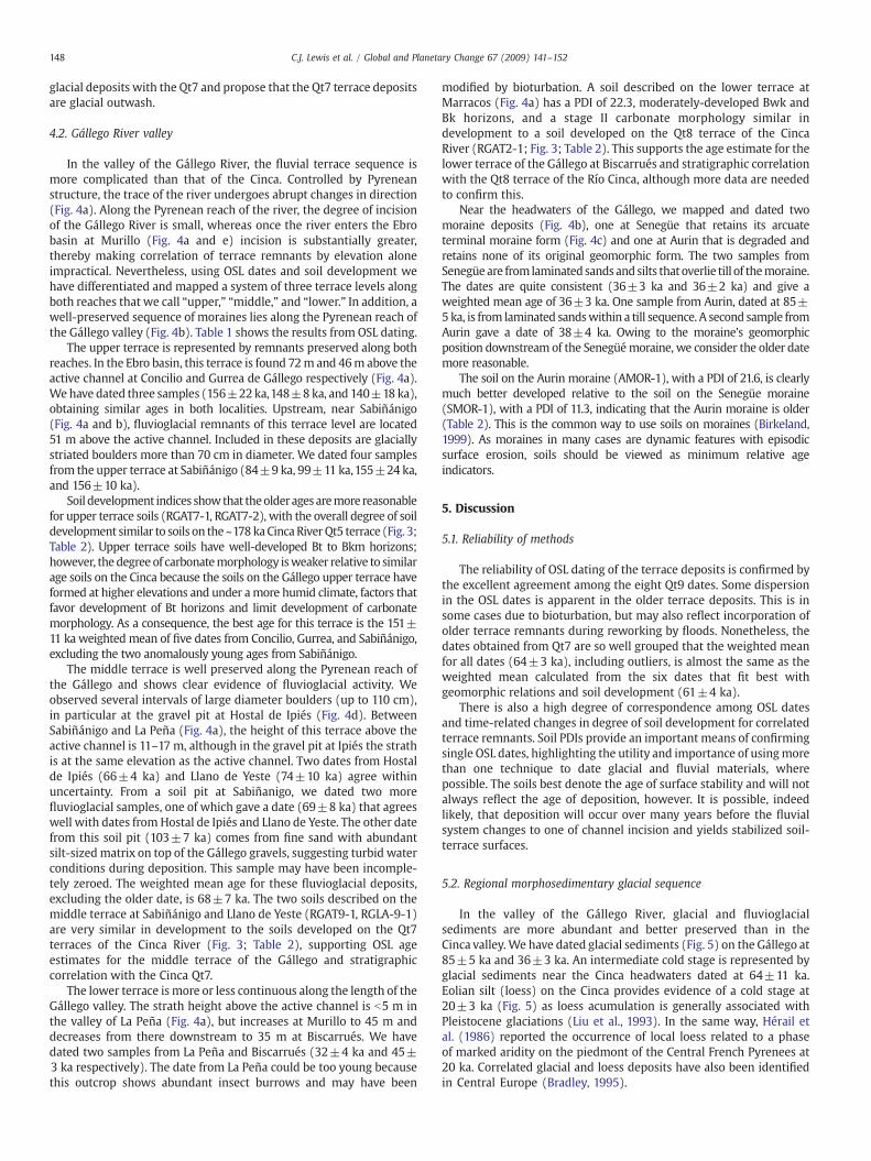
Fig. 2. Glacial and fluvial deposits of the Cinca River: a) Distribution of glacial tills and fluvial terrace deposits along the Cinca valley, b) Outcrop of moraine deposits near theheadwaters of the Cinca (at Salinas), c) Qt7 morphogenetic surface and related deposits at Ainsa with the Internal Pyrenees in the background, d) Qt7 terrace deposits near Albalate,with sand lens at base of outcrop used for OSL dating, e) Detailed geomorphological map of terrace sequence in the Ebro basin reach of the Cinca River.
143C.J. Lewis et al. / Global and Planetary Change 67 (2009) 141–152

144 C.J. Lewis et al. / Global and Planetary Change 67 (2009) 141–152
2. Study area
Numerous moraine remnants preserved in the headwaters of theCinca and Gállego Rivers demonstrate that the length of valley glacierssurpassed 35 km, and the thickness of ice exceeded 500 m in somelocalities (Chueca et al., 1998). In addition, fluvial terraces are wellpreserved and easily recognized along the valleys of the Cinca andGállegoRivers. Strath terraces comprise the dominant terrace type on both rivers(Sancho, 1988; Benito, 1989). Terrace deposits in the vicinity of terminalmoraines in many cases show signs of fluvioglacial activity, providing adirect link between glacial episodes and fluvial terrace formation.
Wehave studied thefluvial terracesof theCincaRiver (Fig.1) along theentire length of its valley (~170 km long) and the terraces of the Gállegofrom the headwaters to the town of Gurrea (~130 km) in the Ebro basin;below Gurrea, thick composite fill terraces related to gypsum bedrockdissolution obscure relations near the Gállego's confluence with the EbroRiver (Benito et al., 1998). On both the Cinca and Gállego, broad terracetreads (paleochannels of a braided stream) are underlain typically by b2–10 m of largely cobble-sized gravels in a sand matrix with sparse sandlenses. Terrace deposits also contain large (20–100 cmdiameter) roundedboulders. Separation between adjacent strath terraces ranges up to 40m,facilitating mapping and measurement of the straths and the alluvialdeposits that overlie them. Along both rivers, straths are carved intoPaleozoic basement, Cretaceous to Eocene marine strata of a previousextensional episode, Eocene to Miocene Pyrenean synorogenic marinestrata along the mountain reaches, and Eocene to Miocene synorogeniccontinental strata along the Ebro basin reach.
3. Material and methods
Geomorphicmappingonanaerial photographic base (1:18,000 scale),soils analysis, and numeric dating were carried out as part of this study.Mapped terrace remnants were extensively field checked.
We used optically stimulated luminescence (OSL) techniques todate the following: 1) sand lenses within glacial till, 2) well-sortedfluvial sands from lenses within massive gravel deposits, 3) overbankdeposits on top of the gravels, and 4) eolian silt on top of terracedeposits. We used standard sampling techniques for poorly lithifiedmaterials, sampling with plastic andmetal tubes or under a light-tightblack plastic sheet into plastic bags that were then wrapped inaluminum foil. Sample preparation and OSL measurements werecarried out at the Luminescence Dating Laboratory of the ResearchLaboratory for Archaeology and the History of Art (University ofOxford, UK) and the Luminescence Dating Laboratory of the ResearchSchool of Earth Sciences (The Australian National University, Aus-tralia). Sand-sized quartz was extracted using the methodologydescribed by Rhodes (1988), which includes sieving, concentratedhydrofluoric acid treatment, and density separation of heavy mineralsusing sodium polytungstate solution. OSL dating was based on a singlealiquot regenerative-dose (SAR) protocol (Murray and Wintle, 2000,2003), using a Risø TL-DA-15 automated luminescence reader. For themajority of the samples, the dose rate is based on in situ gamma rayspectrometry. For a few samples, beta and gamma dose rate wereestimated using neutron activation analysis (NAA) of sediment U, Thand K content, and cosmic dose rates were calculated using theequations of Prescott and Hutton (1994). Based on in-situ samples, avalue of 10±5% water content was used in age calculations.
Details of the statistical methods used to derive the equivalent doseestimates, the number of aliquotsmeasured, and discussion of the issue ofthe degree of OSL signal zeroing are included in the supplementary data(Appendix A). The sedimentary contexts dated here can providesignificant challenges for OSL dating, but our results provide a highdegree of consistency within individual exposures and for specificgeomorphic features, and therefore we have confidence in their veracity.
We report here 53 new OSL dates. All OSL dates are presented withone-sigma uncertainties.Wheremultiple dates were obtained for a given
terrace ormoraine, we determine aweightedmean age inwhichweightsare based on the uncertainty associatedwith each age determination.Werefer to these weighted mean ages as “mean ages”.
We used 14C dating for two samples of charcoal found in soil pits interrace deposits. These samples were analyzed using accelerated massspectrometry (AMS) techniques at the University of Arizona.
We also used soil development indices to correlate principal terracelevels and to evaluate the dates determined by OSL and radiocarbon. Soilswere described according to standard methods and nomenclature of theU.S. Soil Survey Staff (1993). Sample analyses were conducted at theDesert Research Institute's Soil Characterization andQuaternary PedologyLaboratory. Time-related changes in soilmorphologywere analyzedusinga well-tested soil development index (SDI; Harden, 1982; Harden andTaylor,1983;McDonald et al.,1996). Calculation of SDI values is based on aconversion of soil morphology (field properties such as color andstructure) into numerical data to enable a quantitative comparison ofthe degree of soil development. Points are assigned to each propertybased on the difference between the described soil property and theparent material. Index values were calculated using morphologic proper-ties of rubification, texture, structure, dry consistence, moist consistence,secondary carbonates, lightening, and argillans. A Horizon DevelopmentIndex (HDI) value is obtained by normalizing these properties and aProfile Development Index (PDI) is calculated from HDI values andhorizon thickness. The PDI values reflect the overall degree of soildevelopment and provide a means of comparison among soils within agiven sequence or area and can be used to develop a soil chronofunction.WeplotPDI valuesusingmeanageestimates fordated terraces toevaluateboth radiometric age estimates and correlations of terrace stratigraphybetween the Cinca and Gállego Rivers. The PDI has proven useful forproviding correlations and calibrated age estimates for undated surfaces.
4. Distribution and chronology of glacial and fluvialmorphosedimentary records
4.1. Cinca River valley
We focus on five Pleistocene terraces preserved along the CincaRiver (Sancho, 1988), numbered Qt5, Qt6, Qt7, Qt8, and Qt9 fromoldest to youngest, and on outcrops of glacial tills near the headwatersof the Cinca (Fig. 2a). Table 1 shows the results from OSL dating.
Terraces Qt5 and Qt6 are well-developed in the lower, Ebro basinreach of the river (Fig. 2e). Between Monzon and Fraga (Fig. 1), theyare 60–80m above the active channel (Fig. 2a and e).We obtained twodates (Table 1) for Qt5 (171±22 ka and 180±12 ka), giving aweighted mean age of 178±21 ka, and one date for Qt6 (97±16 ka)(Table 1). In additon, a single sample of eolian silt (loess) on top offluvial gravels of the Qt5 gave an age of 20±3 ka.
The relative degree of soil development is consistent with thestratigraphic separation between the Qt5 and Qt6 terraces and the ageestimates (Fig. 3; Table 2). The Qt5 soils at Belver (RCT6-1, RCT6-2, RCT6-3) have PDI values that range from 45.1 to 59.9, and havewell developedBk and Bkm horizons with stage III+ to IV+ carbonate morphology. Onlyone soil was described on the Qt6 surface at Belver (RCT5-1). This soil isweaker in development relative to the soils on the Qt5, having a PDI of43.0, a well developed Btk horizon, and strong stage III+ carbonatemorphology. Thedifference in soil development corroborates theyoungerage of the Qt6 terrace, although we have only one observation on thisterrace for comparison with other terraces.
The Cinca Qt7 terrace (Fig. 2c, d and e) is prominent in the landscape(~4 kmwide along the Ebro basin reach of the river and 35–50 m abovethe active channel) and can be traced along 140 km of the river's length.Fourteen OSL dates were obtained on this terrace (Table 1). Two samplesfrom overbank sands on Qt7 terrace remnants at Alfántega and El Grado(Fig. 2a) gave dates of 52±11 ka and 54±9 ka and likely correspond tolargefloods during formationof the next younger terraceQt8 (see below).However, they overlap other dates in this groupwithin uncertainties. One
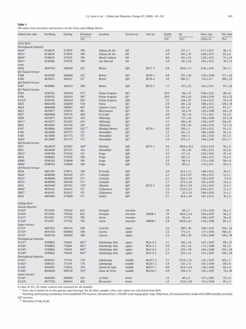
Table 1OSL dates from moraines and terraces on the Cinca and Gállego Rivers.
Oxford lab code Northing Easting Elevation Location Terrace no. Soil no. Depth De Dose rate OSL date
(m) (m) (Gy) (mGy/a) (ka)
Cinca RiverFluvioglacial depositsX814⁎ 4718674 271870 789 Salinas de Sin NA 5.0 127±7 2.77±0.17 46±4X815⁎ 4718674 271870 789 Salinas de Sin NA 5.0 161±13 2.60±0.15 63±6X829⁎ 4718674 271870 789 Mesón Salinas NA 8.0 161±33 2.28±0.15 71±15X831⁎ 4718480 270710 760 San Marcial NA 2.0 141±22 1.85±0.12 76±13LoessX818 4619704^ 268358 247 Belver Qt4 RCT7-3 0.8 58.0±7.1 2.96±0.19 20±3Qt5 fluvial terraceX398 4618380 266866 215^ Belver Qt5 RCT6-1 0.8 237±26 1.39±0.09 171±22X399 4619473 266357 217^ Belver Qt5 RCT6-2 1.0 209±7 1.16±0.7 180±12Qt6 fluvial terraceX397 4618085 266253 200 Belver Qt6 RCT5-1 1.7 157±23 1.62±0.11 97±16Qt7 fluvial terraceX395 4700762 265624 575^ Pueyo Araguas Qt7 10.0 84±15 3.00±0.21 28±6X396 4700762 265624 585^ Pueyo Araguas Qt7 20.0 156±26 2.46±0.18 63±12X1122⁎ 4700762 265624 585^ Pueyo Araguas Qt8 7.5 128±27 2.16±0.12 59±13X825 4692548 268289 534 Ainsa Qt7 2.0 241±22 1.88±0.12 128±14X824 4684406 269987 487 Ligüerre Cinca Qt7 0.9 161±6 1.85±0.12 87±7X823 4678877 270913 461 Moscarazos Qt7 1.0 82±15 1.28±0.08 64±13X827 4669686 270714 404^ El Grado Qt7 2.0 94±14 1.75±0.11 54±9X820 4633077 263267 243 Alfántega Qt7 2.0 117±16 1.40±0.09 83±13X811⁎ 4633077 263267 243 Alfántega Qt7 1.5 196±10 1.46±0.07 134±9X822 4634387 263310 247 Alfántega Qt7 2.0 128±26 2.44±0.16 52±11X197 4618846 265647 262^,# Albalate-Belver Qt7 RCT4-1 0.6 150±3 2.45±0.12 61±3X199 4613809 267775 173 Almudáfar Qt7 1.2 101±5 1.80±0.09 56±4X198 4613809 267775 173 Almudáfar Qt7 2.3 118±5 1.82±0.10 65±5X810⁎ 4613809 267775 173 Almudáfar Qt7 2.0 223±5 1.84±0.10 121±7Qt8 fluvial terraceX817 4624970^ 262087 184# Albalate Qt8 RCT3-1 1.0 89.0±10.2 2.26±0.14 39±5X821 4614698 267127 154 Almudáfar Qt8 3.1 83±10 1.96±0.13 42±6X833⁎ 4598786 279236 112 Fraga Qt8 3.5 117±6 2.50±0.16 47±4X834 4598802 279195 109 Fraga Qt8 5.5 150±5 1.89±0.13 79±6X808⁎ 4598765 278848 109 Fraga Qt8 5.5 88±4 1.75±0.10 50±4X809⁎ 4598765 278848 109 Fraga Qt8 5.5 90±2 1.79±0.11 50±3Qt9 fluvial terraceX828 4667581 270671 358 El Grado Qt9 2.0 18.3±1.1 1.86±0.12 10±1X826⁎ 4648906 266149 271 Castejón Qt9 2.1 21.8±0.7 1.89±0.13 12±1X812⁎ 4648906 266149 271 Castejón Qt9 2.7 18.0±7.6 1.46±0.07 9±4X813⁎ 4648906 266149 271 Castejón Qt9 2.7 27.0±3.6 1.91±0.10 14±2X816 4625045^ 261783 178# Albalate Qt9 RCT2-1 2.0 26.5±1.8 2.15±0.14 12±1X806⁎ 4618145 263612 171 Chalamera Qt9 5.2 23.0±2.3 2.03±0.11 11±1X807⁎ 4618145 263612 171 Chalamera Qt9 5.2 22±1.4 1.96±0.10 11±1X832 4605683 275009 117 Zaidín Qt9 2.1 18.4±3.6 1.81±0.12 10±2
Gallego RiverGlacial depositsX1143⁎ 4713769 718320 822 Senegüe moraine 1.0 84±7 2.35±0.10 36±3X1144⁎ 4713769 718320 822 Senegüe moraine SMOR-1 1.0 69.0±2.4 1.94±0.07 36±2X1127⁎ 4711957 717750 785 Aurin moraine 2.8 56±6 1.48±0.07 38±4X1128⁎ 4711957 717750 785 Aurin moraine AMOR-1 2.8 118.0±4.1 1.39±0.06 85±5Upper terraceX1112⁎ 4687422 685514 509 Concilio upper 1.6 280±36 1.80±0.10 156±22X1114⁎ 4656724 685892 360 Gurrea upper 2.3 173±4 1.17±0.05 148±8X1115⁎ 4656724 685892 360 Gurrea upper 2.3 168±20 1.20±0.06 140±18Fluvioglacial depositsX1137⁎ 4709862 716641 801# Sabiñanigo Alto upper RGA-2-2 3.1 165±16 1.67±0.07 99±11X1138⁎ 4709862 716641 801# Sabiñanigo Alto upper RGA-3-2 2.9 145±14 1.72±0.08 84±9X1139⁎ 4709862 716641 801# Sabiñanigo Alto upper RGA-4-2 2.3 255±38 1.64±0.08 155±24X1140⁎ 4709862 716641 801# Sabiñanigo Alto upper RGA-5-2 2.3 252±12 1.61±0.07 156±10Fluvioglacial depositsX1141⁎ 4709321 717174 770 Sabiñanigo middle RGAT7-2 1.5 151.0±7.6 1.47±0.07 103±7X1142⁎ 4709321 717174 770 Sabiñanigo middle RGAT7-2 1.4 125±13 1.81±0.09 69±8X1126⁎ 4701910 712613 704 Hostal de Ipies middle RGIT7-1 8.0 91.0±4.4 1.38±0.06 66±4X1106⁎ 4694454 690726 553# Llano de Yeste middle RGLA9-1 0.9 104±13 1.41±0.05 74±10Lower terraceX1116⁎ 4694492 690682 553 La Peña lower 1.5 40±4 1.27±0.05 32±4X1124⁎ 4677559 684914 462 Biscarrués lower 1.2 51.0±2.8 1.13±0.04 45±3
A value of 10±5% water content was assumed for all samples.⁎ Dose rate is based on in-situ gamma spectroscopy. For all other samples, dose rate values are calculated from NAA.^ Northing and Easting coordinates from handheld GPS receiver; elevation from 1:50,000-scale topographic map. Otherwise, all measurements made with differentially corrected
GPS receiver.# Elevation of top of pit.
145C.J. Lewis et al. / Global and Planetary Change 67 (2009) 141–152

Table 2Summary of soil PDI values and B horizon development.
Soil number Location Terracea PDI value B horizonb
typeCarbonate stagemorphologyc
Cinca RiverRCT6-1 Belver Qt5 59.9 Bk–Bkm III+
RCT6-2 Belver Qt5 45.1 Bk–Bkm IV+
RCT6-3 Belver Qt5 51.5 Bk–Bkm IV+
RCT5-1 Belver Qt6 43.2 Btk III+
RCTM4-1 Monzón Qt7 27.0 Btk IIRCTM4-2 Monzón Qt7 29.6 Btk IIRCT4-1 Albalate Qt7 31.5 Btk II+
RCT4-2 Albalate Qt7 29.9 Btk–Bkm IIIRCTZ4-1 Almudafar Qt7 33.3 Btk IIRCT3-1 Albalate Qt8 24.7 Btk–Bk I+
RCT3-2 Albalate Qt8 23.2 Btk–Bk I+
RCTM2-1 Castejón Qt9 14.7 Bwk–Bk II+
RCT2-1 Albalate Qt9 18.1 Bwk I−
RCT1-1 Albalate Qt10 5.6 Bw 0
Gállego RiverRGAT7-1 Sabiñánigo Alto Qt5 58.2 Bt–Btk–Bk I
RGAT7-2 Sabiñánigo Alto Qt5 68.7 Btk–Bkm–Bk III+
RGIT 7-1 Ipiés Qt7 28.1 Btk–Bk II+
RGAT9-1 Sabiñánigo Qt7 33.1 Bt–Btk IIRGLA9-1 Llano de Yeste Qt7 30.9 Btk–Bk IIRGM7-2 Murillo Qt5 45.3 Btk–Bkm–Bk III+
RGAT2-1 Marracos Qt8 22.3 Bwk–Bk IIRGALA-11 La Peña Qt9 13.0 Bk ISMOR-1 Senegüe 11.3 Bw IAMOR-1 Aurín 21.6 Btk–Bk III
a Cinca River terrace number. For Gállego River, correlations with Cinca terraces arebased on soil development.
b B horizons: w, color or structure B; k, accumulation of carbonates; t, accumulationof clay; m, cemented.
c Carbonate stage morphology from Gile et al. (1981) and Birkeland (1999).
Fig. 3. Profile Development Index (PDI) values plotted with mean radiometric (OSL, 14C)age estimates for terraces along the Cinca and Gállego Rivers. Best fit line to linearregression uses soil and age data for terraces on the Rio Cinca only. Hatched bars aremeanradiometric age ranges (one-sigma) for each terrace.
146 C.J. Lewis et al. / Global and Planetary Change 67 (2009) 141–152
date of 28±5 ka came from a sand lens riddled with insect burrows andlikely resulted from light exposure due to bioturbation. Six samplesconstitute a tightlygrouped set of dateswith aweightedmean age of 61±4 ka. Finally, five dates from this terrace are significantly older than theclusterofdates that fall between56and64ka; thesefivedates fall into twogroups with weighted mean ages of 126±11 ka and 86±12 karespectively. One of these dates comes from an isolated terrace remnantat Ligüerre de Cinca (Table 1) that has an elevation above the activechannel similar to Qt7 remnants upstream and downstream. However,without further geochronologic data, we cannot rule out the possibilitythat this is a remnant of a terrace older thanQt7.We therefore interpret allthese older dates as coming from remnants of older terraces incorporatedinto Qt7.
Five soils described on Qt7 terraces at Monzón, Albalate, andAlmudáfar (RCTM4-1, RCTM4-2, RCT4-1, RCT4-2, RCTZ4-1) have PDIvalues ranging from 27.0 to 33.3 and with moderately- to well-developed Btk horizons and stage II to weak stage III carbonatemorphology (Fig. 3; Table 2). The soils developed on the Qt7 terracesare noticeably less developed than soils on the older Qt5 and Qt6terraces, indicating that the soils on the Qt7 terraces must beconsiderably younger than the best age of 97±16 ka for the Qt 6terrace. Moreover, the five PDI values for the soils form a tight clusteraround the best fit line, generally supporting an age of ~61 ka for theQt7 surface. We note that the soil pits at Albalate and Almudáfar werethe source of four OSL dates, three of which fall in the range 56–65 ka.
TheCincaQt8 terrace is not as extensivelypreservedas theQt7. It cropsout only along the lower 35 kmof the river, where it is ~2–3 kmwide andsits about 20 m above the river (Fig. 2e). We have obtained six OSL dates(Table1)onQt8deposits, fourofwhichare fromthe sameoutcropat Fraga(Fig. 2a). Three of these latter dates range from 39±5 ka to 50±3 ka andoverlap within uncertainties; the fourth is considerably older (79±6 ka)and perhaps reflects incorporation of an older terrace remnant, althoughthere is no observable geomorphic reasonwhy this samplemight be olderthan the rest. The sixdates onQt8give abest ageof 51±4ka.Disregardingthe outlier gives an age of 47±4 ka, which is the same withinuncertainties.
Two soilsweredescribed on theQt8 terrace atAlbalate (RCT3-1, RCT3-2) with PDI values of 24.7 and 23.2 (Fig. 3; Table 2). These soils havemoderately developed Btk horizonswith stage I+ carbonatemorphology.The soils on the Qt8 are less developed relative to the soils on the Qt7terrace, supporting the OSL age of 47±4 ka for the Qt8; however, the PDIvalues of the two soils fall below the the bestfit line, suggesting that thesesoils may be younger than the best age estimate for the Qt8.
The Cinca Qt9 (Fig. 2e) terrace sits about 6–10 m above the activechannel of the Cinca River. It is generally co-extensive with the Qt7and traceable along ~140 km of the river's total length. The Qt9 is alsoapproximately co-extensive with the Qt8, where the latter ispreserved, and much the same width (~2 km wide). We haveobtained eight OSL dates (Table 1) on sand lenses within gravels of theQt9 terrace along the Ebro basin reach, achieving good repeatabilityon three samples from Castejón del Puente and two samples fromChalamera (Fig. 2a). All dates are well grouped, ranging from 9 to14 ka. The weighted mean age for these deposits is 11±1 ka.
This age is corroborated by soils on the Qt9 terrace at Castejón delPuente and Albalate (RCT2-1, RCTM-1). The two soils have PDI valuesof 14.7 and 18.1 (Fig. 3; Table 2) and moderately developed Bw and Bkhorizons with stage I–II carbonate morphology. The PDI values ofthese soils bracket the best fit line, supporting an age of about 11 ka forthe Qt9 terrace. OSL dates from Castejón del Puente and Albalate comefrom the soil pits.
At Ainsa (Fig. 2a), we obtained two 14C dates from the base of athick sequence of overbank sand on top of terrace gravels close tothe elevation of the active channel. These dates, 15.2±0.1 ka BP and22.1±0.2 ka radiocarbon BP, constrain the gravels beneath to be atleast that old and demonstrate the existence of important floodsduring the Last Glacial Maximum.
In addition, near the headwaters of the Cinca at Salinas and SanMarcial (~25 km from the headwaters; Fig. 2a), we mapped and datedglacial and fluvioglacial deposits (Fig. 2b). The lack of interfingeringrelationships between these deposits and terrace remnants in the areamakes direct correlation difficult to confirm. Four OSL dates on thesedeposits range from 46±4 ka to 76±13 ka. The oldest one (SanMarcial) clearly corresponds, based on sedimentological field evi-dence, to a fluvioglacial deposit with terrace morphology located 1 km
147C.J. Lewis et al. / Global and Planetary Change 67 (2009) 141–152
to the south. The one young date among these four seems anomalousand may pertain to a later phase of glaciation; the outcrop wasdeformed by ice pushing (Fig. 2b), whichmay have mixed superposed
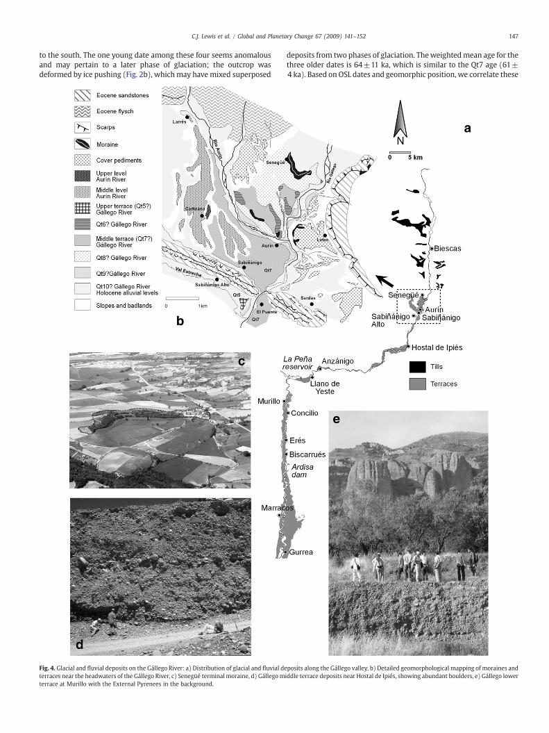
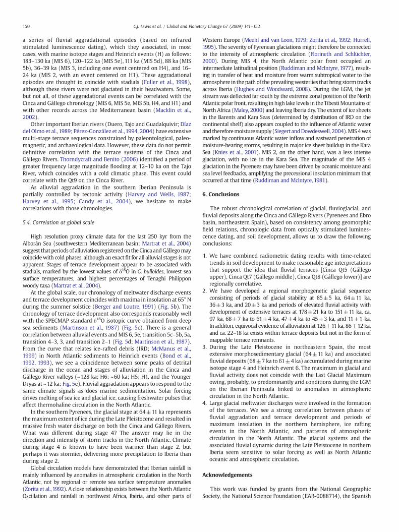
Fig. 4. Glacial and fluvial deposits on the Gállego River: a) Distribution of glacial and fluvial deterraces near the headwaters of the Gállego River, c) Senegüé terminal moraine, d) Gállegomterrace at Murillo with the External Pyrenees in the background.
deposits from two phases of glaciation. Theweightedmean age for thethree older dates is 64±11 ka, which is similar to the Qt7 age (61±4 ka). Based on OSL dates and geomorphic position, we correlate these
posits along the Gállego valley, b) Detailed geomorphological mapping of moraines andiddle terrace deposits near Hostal de Ipiés, showing abundant boulders, e) Gállego lower
148 C.J. Lewis et al. / Global and Planetary Change 67 (2009) 141–152
glacial deposits with the Qt7 and propose that the Qt7 terrace depositsare glacial outwash.
4.2. Gállego River valley
In the valley of the Gállego River, the fluvial terrace sequence ismore complicated than that of the Cinca. Controlled by Pyreneanstructure, the trace of the river undergoes abrupt changes in direction(Fig. 4a). Along the Pyrenean reach of the river, the degree of incisionof the Gállego River is small, whereas once the river enters the Ebrobasin at Murillo (Fig. 4a and e) incision is substantially greater,thereby making correlation of terrace remnants by elevation aloneimpractical. Nevertheless, using OSL dates and soil development wehave differentiated and mapped a system of three terrace levels alongboth reaches that we call “upper,” “middle,” and “lower.” In addition, awell-preserved sequence of moraines lies along the Pyrenean reach ofthe Gállego valley (Fig. 4b). Table 1 shows the results from OSL dating.
The upper terrace is represented by remnants preserved along bothreaches. In the Ebro basin, this terrace is found 72m and 46m above theactive channel at Concilio and Gurrea de Gállego respectively (Fig. 4a).We have dated three samples (156±22ka,148±8 ka, and 140±18 ka),obtaining similar ages in both localities. Upstream, near Sabiñánigo(Fig. 4a and b), fluvioglacial remnants of this terrace level are located51 m above the active channel. Included in these deposits are glaciallystriated boulders more than 70 cm in diameter. We dated four samplesfrom the upper terrace at Sabiñánigo (84±9 ka, 99±11 ka,155±24 ka,and 156±10 ka).
Soil development indices showthat theolderagesaremore reasonablefor upper terrace soils (RGAT7-1, RGAT7-2), with the overall degree of soildevelopment similar to soils on the ~178 kaCincaRiverQt5 terrace (Fig. 3;Table 2). Upper terrace soils have well-developed Bt to Bkm horizons;however, thedegree of carbonatemorphology isweaker relative to similarage soils on the Cinca because the soils on the Gállego upper terrace haveformed at higher elevations and under amore humid climate, factors thatfavor development of Bt horizons and limit development of carbonatemorphology. As a consequence, the best age for this terrace is the 151±11 kaweighted mean of five dates from Concilio, Gurrea, and Sabiñánigo,excluding the two anomalously young ages from Sabiñánigo.
The middle terrace is well preserved along the Pyrenean reach ofthe Gállego and shows clear evidence of fluvioglacial activity. Weobserved several intervals of large diameter boulders (up to 110 cm),in particular at the gravel pit at Hostal de Ipiés (Fig. 4d). BetweenSabiñánigo and La Peña (Fig. 4a), the height of this terrace above theactive channel is 11–17 m, although in the gravel pit at Ipiés the strathis at the same elevation as the active channel. Two dates from Hostalde Ipiés (66±4 ka) and Llano de Yeste (74±10 ka) agree withinuncertainty. From a soil pit at Sabiñanigo, we dated two morefluvioglacial samples, one of which gave a date (69±8 ka) that agreeswell with dates fromHostal de Ipiés and Llano de Yeste. The other datefrom this soil pit (103±7 ka) comes from fine sand with abundantsilt-sizedmatrix on top of the Gállego gravels, suggesting turbid waterconditions during deposition. This sample may have been incomple-tely zeroed. The weighted mean age for these fluvioglacial deposits,excluding the older date, is 68±7 ka. The two soils described on themiddle terrace at Sabiñánigo and Llano de Yeste (RGAT9-1, RGLA-9-1)are very similar in development to the soils developed on the Qt7terraces of the Cinca River (Fig. 3; Table 2), supporting OSL ageestimates for the middle terrace of the Gállego and stratigraphiccorrelation with the Cinca Qt7.
The lower terrace is more or less continuous along the length of theGállego valley. The strath height above the active channel is b5 m inthe valley of La Peña (Fig. 4a), but increases at Murillo to 45 m anddecreases from there downstream to 35 m at Biscarrués. We havedated two samples from La Peña and Biscarrués (32±4 ka and 45±3 ka respectively). The date from La Peña could be too young becausethis outcrop shows abundant insect burrows and may have been
modified by bioturbation. A soil described on the lower terrace atMarracos (Fig. 4a) has a PDI of 22.3, moderately-developed Bwk andBk horizons, and a stage II carbonate morphology similar indevelopment to a soil developed on the Qt8 terrace of the CincaRiver (RGAT2-1; Fig. 3; Table 2). This supports the age estimate for thelower terrace of the Gállego at Biscarrués and stratigraphic correlationwith the Qt8 terrace of the Río Cinca, although more data are neededto confirm this.
Near the headwaters of the Gállego, we mapped and dated twomoraine deposits (Fig. 4b), one at Senegüe that retains its arcuateterminal moraine form (Fig. 4c) and one at Aurin that is degraded andretains none of its original geomorphic form. The two samples fromSenegüeare from laminated sands andsilts thatoverlie till of themoraine.The dates are quite consistent (36±3 ka and 36±2 ka) and give aweighted mean age of 36±3 ka. One sample from Aurin, dated at 85±5ka, is from laminated sandswithin a till sequence. A second sample fromAurin gave a date of 38±4 ka. Owing to the moraine's geomorphicposition downstream of the Senegüémoraine, we consider the older datemore reasonable.
The soil on the Aurin moraine (AMOR-1), with a PDI of 21.6, is clearlymuch better developed relative to the soil on the Senegüe moraine(SMOR-1), with a PDI of 11.3, indicating that the Aurin moraine is older(Table 2). This is the common way to use soils on moraines (Birkeland,1999). As moraines in many cases are dynamic features with episodicsurface erosion, soils should be viewed as minimum relative ageindicators.
5. Discussion
5.1. Reliability of methods
The reliability of OSL dating of the terrace deposits is confirmed bythe excellent agreement among the eight Qt9 dates. Some dispersionin the OSL dates is apparent in the older terrace deposits. This is insome cases due to bioturbation, but may also reflect incorporation ofolder terrace remnants during reworking by floods. Nonetheless, thedates obtained from Qt7 are so well grouped that the weighted meanfor all dates (64±3 ka), including outliers, is almost the same as theweighted mean calculated from the six dates that fit best withgeomorphic relations and soil development (61±4 ka).
There is also a high degree of correspondence among OSL datesand time-related changes in degree of soil development for correlatedterrace remnants. Soil PDIs provide an important means of confirmingsingle OSL dates, highlighting the utility and importance of usingmorethan one technique to date glacial and fluvial materials, wherepossible. The soils best denote the age of surface stability and will notalways reflect the age of deposition, however. It is possible, indeedlikely, that deposition will occur over many years before the fluvialsystem changes to one of channel incision and yields stabilized soil-terrace surfaces.
5.2. Regional morphosedimentary glacial sequence
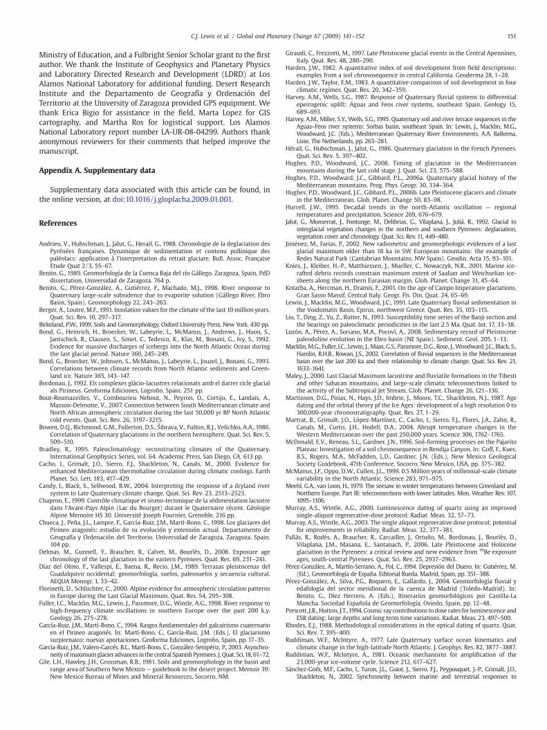
In the valley of the Gállego River, glacial and fluvioglacialsediments are more abundant and better preserved than in theCinca valley.We have dated glacial sediments (Fig. 5) on the Gállego at85±5 ka and 36±3 ka. An intermediate cold stage is represented byglacial sediments near the Cinca headwaters dated at 64±11 ka.Eolian silt (loess) on the Cinca provides evidence of a cold stage at20±3 ka (Fig. 5) as loess acumulation is generally associated withPleistocene glaciations (Liu et al., 1993). In the same way, Hérail etal. (1986) reported the occurrence of local loess related to a phaseof marked aridity on the piedmont of the Central French Pyrenees at20 ka. Correlated glacial and loess deposits have also been identifiedin Central Europe (Bradley, 1995).

Fig. 5. Phases of glacial andfluvial activity on the Cinca andGállego Rivers (northern Spain) related to other paleoenvironmental records (adapted fromMartrat et al., 2004): a)Weightedmeanages with uncertainties of glacial, fluvial, and eolian (loess) morphosedimentary units, b) Insolation at 65° N during summer (Berger and Loutre, 1991), c) SPECMAP standard isotope curve(Martinsonetal.,1987), d)Marine isotope stages (Martinsonetal.,1987), e)Proportionofdetrital lithics (ice rafteddebris;McManuset al.,1999)andHeinrich ice raftingevents (Bondet al.,1992,1993) in North Atlantic marine sediments. Abbreviations: QtUp, Gállego upper terrace; QtMid, Gállego middle terrace; QtLow, Gállego lower terrace. Vertical bars show correlations of datedglacial and fluvial deposits with climate proxies (width of bars not scaled to reflect uncertainties).
149C.J. Lewis et al. / Global and Planetary Change 67 (2009) 141–152
From our data, we propose a regional, multi-phase scenario ofglaciation, with single or multiple events within the periods 90–80 ka,75–52 ka, 39–32 ka, and 22–17 ka. Our results confirm that themaximumextent of glacial ice in the southern Pyrenees during the lastglacial occurred at 64±11 ka, well prior to the LGM (García-Ruiz et al.,2003; Sancho et al., 2003). Fluvial discharge from melting LGMglaciers was small, as evidenced by the scarcity of correspondingterrace deposits. This is consistent with the well established view thatglaciers during the LGM were restricted to the headwaters of riverdrainages in the Central Pyrenees (García-Ruiz et al., 2003; Palláset al., 2006). During marine isotope stage 2 (MIS 2), loess accumula-tion (dated at 20±3 ka) took place in areas of the Ebro basin adjacentto the Cinca and Gállego Rivers, locally covering some previous terracesurfaces. By contrast with the rest of the Pyrenees, the maximum iceadvance in the eastern Pyrenees occurred late, during MIS 2 (Delmaset al., 2008).
In general, our chronology of glacial events in the Pyrenees bolstersprevious models derived from geomorphic and stratigraphic relations inother areas of the Pyrenees (Vilaplana,1983; Bordonau,1992; García-Ruizand Martí-Bono, 1994; Chueca et al., 1998; Serrano, 1998) whiledemonstrating via OSL dating and soils geomorphology that the timingof the southern European glacial maximum hypothesized by previousauthors, well prior to the LGM, is essentially correct. Our data confirm alocal glacial maximum several thousand to tens of thousands of yearsearlier than the global LGM (Hughes and Woodward, 2008). Asynchro-neity of glaciation in southernEuropewith respect to northern Europehasalso beendocumented in theCantabrianMountains of Spain (Jiménez and
Farias, 2002), the French Pyrenees (Hérail et al.,1986; Andrieu et al.,1988;Jalut et al., 1992), the French Vosges (Seret et al., 1990), the Swiss Alps(Chapron, 1999), the Italian Apennines (Giraudi and Frezzotti, 1997;Kotarba et al., 2001), and the Pindus Mountains in Greece (Woodwardet al., 2004).
5.3. Regional morphosedimentary fluvial sequence
The robust correlation among terraces on the two rivers allows usto construct a regional morphogenetic scenario of glacial outwash andterrace development at 178±21 ka to 151±11 ka, ca. 97 ka, 68±7 kato 61±4 ka, 47±4 ka to 45±3 ka, and 11±1 ka (Fig. 5). In additon,evidence of fluvial activity at 126±11 ka, 86±12 ka, and ca. 22–18 kahas been noted, but no mapped terrace remnants correspond to thesedeposits.
For the rest of the Pyrenees and Ebro basin, chronologic data onterraces are limited, andmore data are required to thoroughly test ourregional scenario. Nevertheless, some comparisons can be made withpreviously published data. In the central Ebro basin, Luzón et al.(2008) obtained four OSL ages grouped around 78–73 ka and 58–50 ka from Ebro River terraces affected by synsedimentary karsticsubsidence. One of the best developed terraces in the Cinca–Gállegosystem (68±7 ka to 61±4 ka) overlaps the ages of the Ebro terraceswithin uncertainties, suggesting a link not only between periods ofalluviation but also between periods of glacial outwash and formationof karst topography. On the southern side of the Ebro basin(Guadalope River and tributaries), Fuller et al. (1998) differentiated
150 C.J. Lewis et al. / Global and Planetary Change 67 (2009) 141–152
a series of fluvial aggradational episodes (based on infraredstimulated luminescence dating), which they associated, in mostcases, with marine isotope stages and Heinrich events (H) as follows:183–130 ka (MIS 6), 120–122 ka (MIS 5e), 111 ka (MIS 5d), 88 ka (MIS5b), 36–39 ka (MIS 3, including one event centered on H4), and 16–24 ka (MIS 2, with an event centered on H1). These aggradationalepisodes are thought to coincide with stadials (Fuller et al., 1998),although these rivers were not glaciated in their headwaters. Some,but not all, of these aggradational events can be correlated with theCinca and Gállego chronology (MIS 6, MIS 5e, MIS 5b, H4, and H1) andwith other records across the Mediterranean basin (Macklin et al.,2002).
Other important Iberian rivers (Duero, Tajo and Guadalquivir; Díazdel Olmo et al., 1989; Pérez-González et al., 1994, 2004) have extensivemulti-stage terrace sequences constrained by paleontological, paleo-magnetic, and archaeological data. However, these data do not permitdefinitive correlation with the terrace systems of the Cinca andGállego Rivers. Thorndycraft and Benito (2006) identified a period ofgreater frequency large magnitude flooding at 12–10 ka on the TajoRiver, which coincides with a cold climatic phase. This event couldcorrelate with the Qt9 on the Cinca River.
As alluvial aggradation in the southern Iberian Peninsula ispartially controlled by tectonic activity (Harvey and Wells, 1987;Harvey et al., 1995; Candy et al., 2004), we hesitate to makecorrelations with those chronologies.
5.4. Correlation at global scale
High resolution proxy climate data for the last 250 kyr from theAlborán Sea (southwestern Mediterranean basin; Martrat et al., 2004)suggest thatperiodsof alluviation registeredon theCincaandGállegomaycoincidewith cold phases, although an exactfit for all alluvial stages is notapparent. Stages of terrace development appear to be associated withstadials, marked by the lowest values of δ18O in G. bulloides, lowest seasurface temperatures, and highest percentages of Tenaghi Philipponwoody taxa (Martrat et al., 2004).
At the global scale, our chronology of meltwater discharge eventsand terrace development coincideswithmaxima in insolation at 65° Nduring the summer solstice (Berger and Loutre, 1991) (Fig. 5b). Thechronology of terrace development also corresponds reasonably wellwith the SPECMAP standard δ18O isotopic curve obtained from deepsea sediments (Martinson et al., 1987) (Fig. 5c). There is a generalcorrelation between alluvial events andMIS 6, 5e, transition 5c–5b, 5a,transition 4–3, 3, and transition 2–1 (Fig. 5d; Martinson et al., 1987).From the curve that relates ice-rafted debris (IRD; McManus et al.,1999) in North Atlantic sediments to Heinrich events (Bond et al.,1992, 1993), we see a coincidence between some peaks of detritaldischarge in the ocean and stages of alluviation in the Cinca andGállego River valleys (~128 ka; H6; ~60 ka; H5; H1, and the YoungerDryas at ~12 ka; Fig. 5e). Fluvial aggradation appears to respond to thesame climate signals as does marine sedimentation. Solar forcingdrives melting of sea ice and glacial ice, causing freshwater pulses thataffect thermohaline circulation in the North Atlantic.
In the southern Pyrenees, the glacial stage at 64±11 ka representsthe maximum extent of ice during the Late Pleistocene and resulted inmassive fresh water discharge on both the Cinca and Gállego Rivers.What was different during stage 4? The answer may lie in thedirection and intensity of storm tracks in the North Atlantic. Climateduring stage 4 is known to have been warmer than stage 2, butperhaps it was stormier, delivering more precipitation to Iberia thanduring stage 2.
Global circulation models have demonstrated that Iberian rainfall ismainly influenced by anomalies in atmospheric circulation in the NorthAtlantic, not by regional or remote sea surface temperature anomalies(Zorita et al., 1992). A close relationship exists between the North AtlanticOscillation and rainfall in northwest Africa, Iberia, and other parts of
Western Europe (Meehl and van Loon, 1979; Zorita et al., 1992; Hurrell,1995). The severity of Pyrenean glaciations might therefore be connectedto the intensity of atmospheric circulation (Florineth and Schlüchter,2000). During MIS 4, the North Atlantic polar front occupied anintermediate latitudinal position (Ruddiman and McIntyre, 1977), result-ing in transfer of heat and moisture from warm subtropical water to theatmosphere in thepath of theprevailingwesterlies that bring storm tracksacross Iberia (Hughes and Woodward, 2008). During the LGM, the jetstreamwas deflected far south by the extreme zonal position of the NorthAtlantic polar front, resulting inhigh lake levels in the TibestiMountainsofNorth Africa (Maley, 2000) and leaving Iberia dry. The extent of ice sheetsin the Barents and Kara Seas (determined by distribution of IRD on thecontinental shelf) also appears coupled to the influence of Atlantic waterand thereforemoisture supply (Siegert andDowdeswell, 2004).MIS4wasmarked by continuous Atlantic water inflow and eastward penetration ofmoisture-bearing storms, resulting in major ice sheet buildup in the KaraSea (Knies et al., 2001). MIS 2, on the other hand, was a less intenseglaciation, with no ice in the Kara Sea. The magnitude of the MIS 4glaciation in the Pyrenees may have been driven by oceanic moisture andsea level feedbacks, amplifying the precessional insolationminimum thatoccurred at that time (Ruddiman and McIntyre, 1981).
6. Conclusions
The robust chronological correlation of glacial, fluvioglacial, andfluvial deposits along the Cinca and Gállego Rivers (Pyrenees and Ebrobasin, northeastern Spain), based on consistency among geomorphicfield relations, chronologic data from optically stimulated lumines-cence dating, and soil development, allows us to draw the followingconclusions:
1. We have combined radiometric dating results with time-relatedtrends in soil development to make reasonable age interpretationsthat support the idea that fluvial terraces [Cinca Qt5 (Gállegoupper), Cinca Qt7 (Gállego middle), Cinca Qt8 (Gállego lower)] areregionally correlative.
2. We have developed a regional morphogenetic glacial sequenceconsisting of periods of glacial stability at 85±5 ka, 64±11 ka,36±3 ka, and 20±3 ka and periods of elevated fluvial activity withdevelopment of extensive terraces at 178±21 ka to 151±11 ka, ca.97 ka, 68±7 ka to 61±4 ka, 47±4 ka to 45±3 ka, and 11±1 ka.In additon, equivocal evidence of alluviation at 126±11 ka, 86±12 ka,and ca. 22–18 ka exists within terrace deposits but not in the form ofmappable terrace remnants.
3. During the Late Pleistocene in northeastern Spain, the mostextensive morphosedimentary glacial (64±11 ka) and associatedfluvial deposits (68±7 ka to 61±4 ka) accumulated duringmarineisotope stage 4 and Heinrich event 6. The maximum in glacial andfluvial activity does not coincide with the Last Glacial Maximumowing, probably, to predominantly arid conditions during the LGMon the Iberian Peninsula linked to anomalies in atmosphericcirculation in the North Atlantic.
4. Large glacial meltwater discharges were involved in the formationof the terraces. We see a strong correlation between phases offluvial aggradation and terrace development and periods ofmaximum insolation in the northern hemisphere, ice raftingevents in the North Atlantic, and patterns of atmosphericcirculation in the North Atlantic. The glacial systems and theassociated fluvial dynamic during the Late Pleistocene in northernIberia seem sensitive to solar forcing as well as North Atlanticoceanic and atmospheric circulation.
Acknowledgements
This work was funded by grants from the National GeographicSociety, the National Science Foundation (EAR-0088714), the Spanish
151C.J. Lewis et al. / Global and Planetary Change 67 (2009) 141–152
Ministry of Education, and a Fulbright Senior Scholar grant to the firstauthor. We thank the Institute of Geophysics and Planetary Physicsand Laboratory Directed Research and Development (LDRD) at LosAlamos National Laboratory for additional funding. Desert ResearchInstitute and the Departamento de Geografía y Ordenación delTerritorio at the University of Zaragoza provided GPS equipment. Wethank Erica Bigio for assistance in the field, Marta Lopez for GIScartography, and Martha Ros for logistical support. Los AlamosNational Laboratory report number LA-UR-08-04299. Authors thankanonymous reviewers for their comments that helped improve themanuscript.
Appendix A. Supplementary data
Supplementary data associated with this article can be found, inthe online version, at doi:10.1016/j.gloplacha.2009.01.001.
References
Andrieu, V., Hubschman, J., Jalut, G., Herail, G., 1988. Chronologie de la deglaciation desPyrénées françaises. Dynamique de sedimentation et contenu pollinique despaléolacs: application à l'interpretation du retrait glaciare. Bull. Assoc. FrançaiseEtude Quat 2/3, 55–67.
Benito, G., 1989. Geomorfología de la Cuenca Baja del río Gállego. Zaragoza, Spain, PdDdissertation, Universidad de Zaragoza. 764 p.
Benito, G., Pérez-González, A., Gutiérrez, F., Machado, M.J., 1998. River response toQuaternary large-scale subsidence due to evaporite solution (Gállego River, EbroBasin, Spain). Geomorphology 22, 243–263.
Berger, A., Loutre, M.F., 1991. Insolation values for the climate of the last 10million years.Quat. Sci. Rev. 10, 297–317.
Birkeland, P.W., 1999. Soils and Geomorphology. Oxford University Press, New York. 430 pp.Bond, G., Heinrich, H., Broecker, W., Labeyrie, L., McManus, J., Andrews, J., Huon, S.,
Jantschick, R., Clausen, S., Simet, C., Tedesco, K., Klas, M., Bonani, G., Ivy, S., 1992.Evidence for massive discharges of icebergs into the North Atlantic Ocean duringthe last glacial period. Nature 360, 245–249.
Bond, G., Broecker, W., Johnsen, S., McManus, J., Labeyrie, L., Jouzel, J., Bonani, G., 1993.Correlations between climate records from North Atlantic sediments and Green-land ice. Nature 365, 143–147.
Bordonau, J., 1992. Els complexes glàcio-lacustres relacionats amb el darrer cicle glacialals Pirineus. Geoforma Ediciones, Logroño, Spain. 251 pp.
Bout-Roumazeilles, V., Combourieu Nebout, N., Peyron, O., Cortijo, E., Landais, A.,Masson-Delmotte, V., 2007. Connection between South Mediterranean climate andNorth African atmospheric circulation during the last 50,000 yr BP North Atlanticcold events. Quat. Sci. Rev. 26, 3197–3215.
Bowen, D.Q., Richmond, G.M., Fullerton, D.S., Šibrava, V., Fulton, R.J., Velichko, A.A., 1986.Correlation of Quaternary glaciations in the northern hemisphere. Quat. Sci. Rev. 5,509–510.
Bradley, R., 1995. Paleoclimatology: reconstructing climates of the Quaternary.International Geophysics Series, vol. 64. Academic Press, San Diego, CA. 613 pp.
Cacho, I., Grimalt, J.O., Sierro, F.J., Shackleton, N., Canals, M., 2000. Evidence forenhanced Mediterranean thermohaline circulation during climatic coolings. EarthPlanet. Sci. Lett. 183, 417–429.
Candy, I., Black, S., Sellwood, B.W., 2004. Interpreting the response of a dryland riversystem to Late Quaternary climate change. Quat. Sci. Rev. 23, 2513–2523.
Chapron, E., 1999. Contrôle climatique et sismo-tectonique de la sédimentation lacustredans l'Avant-Pays Alpin (Lac du Bourget) durant le Quaternaire récent. GéologieAlpine Memoire HS 30. Université Joseph Fournier, Grenoble. 216 pp.
Chueca, J., Peña, J.L., Lampre, F., García-Ruiz, J.M., Martí-Bono, C., 1998. Los glaciares delPirineo aragonés: estudio de su evolución y extensión actual. Departamento deGeografía y Ordenación del Territorio. Universidad de Zaragoza, Zaragoza, Spain.104 pp.
Delmas, M., Gunnell, Y., Braucher, R., Calvet, M., Bourlès, D., 2008. Exposure agechronology of the last glaciation in the eastern Pyrenees. Quat. Res. 69, 231–241.
Díaz del Olmo, F., Vallespí, E., Baena, R., Recio, J.M., 1989. Terrazas pleistocenas delGuadalquivir occidental: geomorfología, suelos, paleosuelos y secuencia cultural.AEQUA Monogr. 1, 33–42.
Florineth, D., Schlüchter, C., 2000. Alpine evidence for atmospheric circulation patternsin Europe during the Last Glacial Maximum. Quat. Res. 54, 295–308.
Fuller, I.C., Macklin, M.G., Lewin, J., Passmore, D.G., Wintle, A.G., 1998. River response tohigh-frequency climate oscillations in southern Europe over the past 200 k.y.Geology 26, 275–278.
García-Ruiz, J.M., Martí-Bono, C., 1994. Rasgos fundamentales del galcairismo cuaternarioen el Pirineo aragonés. In: Martí-Bono, C., García-Ruiz, J.M. (Eds.), El glaciarismosurpirenaico: nuevas aportaciones. Geoforma Ediciones, Logroño, Spain, pp. 17–35.
García-Ruiz, J.M., Valero-Garcés, B.L., Martí-Bono, C., González-Sempériz, P., 2003. Asynchro-neityofmaximumglacier advances in the central SpanishPyrenees. J. Quat. Sci.18, 61–72.
Gile, L.H., Hawley, J.H., Grossman, R.B., 1981. Soils and geomorphology in the basin andrange area of Southern NewMexico — guidebook to the desert project. Memoir 39:New Mexico Bureau of Mines and Mineral Resources, Socorro, NM.
Giraudi, C., Frezzotti, M., 1997. Late Pleistocene glacial events in the Central Apennines,Italy. Quat. Res. 48, 280–290.
Harden, J.W., 1982. A quantitative index of soil development from field descriptions:examples from a soil chronosequence in central California. Geoderma 28, 1–28.
Harden, J.W., Taylor, E.M., 1983. A quantitative comparison of soil development in fourclimatic regimes. Quat. Res. 20, 342–359.
Harvey, A.M., Wells, S.G., 1987. Response of Quaternary fluvial systems to differentialepeirogenic uplift: Aguas and Feos river systems, southeast Spain. Geology 15,689–693.
Harvey, A.M., Miller, S.Y., Wells, S.G., 1995. Quaternary soil and river terrace sequences in theAguas–Feos river systems: Sorbas basin, southeast Spain. In: Lewin, J., Macklin, M.G.,Woodward, J.C. (Eds.), Mediterranean Quaternary River Environments. A.A. Balkema,Lisse, The Netherlands, pp. 263–281.
Hérail, G., Hubschman, J., Jalut, G., 1986. Quaternary glaciation in the French Pyrenees.Quat. Sci. Rev. 5, 397–402.
Hughes, P.D., Woodward, J.C., 2008. Timing of glaciation in the Mediterraneanmountains during the last cold stage. J. Quat. Sci. 23, 575–588.
Hughes, P.D., Woodward, J.C., Gibbard, P.L., 2006a. Quaternary glacial history of theMediterranean mountains. Prog. Phys. Geogr. 30, 334–364.
Hughes, P.D., Woodward, J.C., Gibbard, P.L., 2006b. Late Pleistocene glaciers and climatein the Mediterranean. Glob. Planet. Change 50, 83–98.
Hurrell, J.W., 1995. Decadal trends in the north-Atlantic oscillation — regionaltemperatures and precipitation. Science 269, 676–679.
Jalut, G., Monserrat, J., Fontunge, M., Delibrias, G., Vilaplana, J., Juliá, R., 1992. Glacial tointerglacial vegetation changes in the northern and southern Pyrenees: deglaciation,vegetation cover and chronology. Quat. Sci. Rev. 11, 449–480.
Jiménez, M., Farias, P., 2002. New radiometric and geomorphologic evidences of a lastglacial maximum older than 18 ka in SW European mountains: the example ofRedes Natural Park (Cantabrian Mountains, NW Spain). Geodin. Acta 15, 93–101.
Knies, J., Kleiber, H.-P., Matthiessen, J., Mueller, C., Nowaczyk, N.R., 2001. Marine ice-rafted debris records constrain maximum extent of Saalian and Weichselian ice-sheets along the northern Eurasian margin. Glob. Planet. Change 31, 45–64.
Kotarba, A., Hercman, H., Dramis, F., 2001. On the age of Campo Imperatore glaciations,Gran Sasso Massif, Central Italy. Geogr. Fís. Din. Quat. 24, 65–69.
Lewin, J., Macklin, M.G., Woodward, J.C., 1991. Late Quaternary fluvial sedimentation inthe Voidomatis Basin, Epirus, northwest Greece. Quat. Res. 35, 103–115.
Liu, T., Ding, Z., Yu, Z., Rutter, N., 1993. Susceptibility time series of the Baoji section andthe bearings on paleoclimatic periodicities in the last 2.5 Ma. Quat. Int. 17, 33–38.
Luzón, A., Pérez, A., Soriano, M.A., Pocoví, A., 2008. Sedimentary record of Pleistocenepaleodoline evolution in the Ebro basin (NE Spain). Sediment. Geol. 205, 1–13.
Macklin,M.G., Fuller, I.C., Lewin, J.,Maas, G.S., Passmore, D.G., Rose, J.,Woodward, J.C., Black, S.,Hamlin, R.H.B., Rowan, J.S., 2002. Correlation of fluvial sequences in the Mediterraneanbasin over the last 200 ka and their relationship to climate change. Quat. Sci. Rev. 21,1633–1641.
Maley, J., 2000. Last Glacial Maximum lacustrine and fluviatile formations in the Tibestiand other Saharan mountains, and large-scale climatic teleconnections linked tothe activity of the Subtropical Jet Stream. Glob. Planet. Change 26, 121–136.
Martinson, D.G., Pisias, N., Hays, J.D., Imbrie, J., Moore, T.C., Shackleton, N.J., 1987. Agedating and the orbital theory pf the Ice Ages: development of a high resolution 0 to300,000-year chronostratigraphy. Quat. Res. 27, 1–29.
Martrat, B., Grimalt, J.O., López-Martínez, C., Cacho, I., Sierro, F.J., Flores, J.A., Zahn, R.,Canals, M., Curtis, J.H., Hodell, D.A., 2004. Abrupt temperature changes in theWestern Mediterranean over the past 250,000 years. Science 306, 1762–1765.
McDonald, E.V., Reneau, S.L., Gardner, J.N., 1996. Soil-forming processes on the PajaritoPlateau: Investigation of a soil chronosequence in Rendija Canyon. In: Goff, F., Kues,B.S., Rogers, M.A., McFadden, L.D., Gardner, J.N. (Eds.), New Mexico GeologicalSociety Guidebook, 47th Conference. Socorro, New Mexico, USA, pp. 375–382.
McManus, J.F., Oppo, D.W., Cullen, J.L., 1999. 0.5 Million years of millennial-scale climatevariability in the North Atlantic. Science 283, 971–975.
Meehl, G.A., van Loon, H., 1979. The seesaw in winter temperatures between Greenland andNorthern Europe. Part III: teleconnections with lower latitudes. Mon. Weather Rev. 107,1095–1106.
Murray, A.S., Wintle, A.G., 2000. Luminescence dating of quartz using an improvedsingle-aliquot regenerative-dose protocol. Radiat. Meas. 32, 57–73.
Murray, A.S., Wintle, A.G., 2003. The single aliquot regenerative dose protocol; potentialfor improvements in reliability. Radiat. Meas. 32, 377–381.
Pallás, R., Rodés, A., Braucher, R., Carcailler, J., Ortuño, M., Bordonau, J., Bourlés, D.,Vilaplana, J.M., Masana, E., Santanach, P., 2006. Late Pleistocene and Holoceneglaciation in the Pyrenees: a critical review and new evidence from 10Be exposureages, south-central Pyrenees. Quat. Sci. Rev. 25, 2937–2963.
Pérez-González, A., Martín-Serrano, A., Pol, C., 1994. Depresión del Duero. In: Gutiérrez, M.(Ed.), Geomorfología de España. Editorial Rueda. Madrid, Spain, pp. 351–388.
Pérez-González, A., Silva, P.G., Roquero, E., Gallardo, J., 2004. Geomorfología fluvial yedafología del sector meridional de la cuenca de Madrid (Toledo-Madrid). In:Benito, G., Díez Herrero, A. (Eds.), Itinerarios geomorfológicos por Castilla-LaMancha. Sociedad Española de Geomorfología, Oviedo, Spain, pp. 12–48.
Prescott, J.R., Hutton, J.T.,1994. Cosmic ray contributions to dose rates for luminescence andESR dating: large depths and long term time variations. Radiat. Meas. 23, 497–500.
Rhodes, E.J., 1988. Methodological considerations in the optical dating of quartz. Quat.Sci. Rev. 7, 395–400.
Ruddiman, W.F., McIntyre, A., 1977. Late Quaternary surface ocean kinematics andclimatic change in the high-latitude North Atlantic. J. Geophys. Res. 82, 3877–3887.
Ruddiman, W.F., McIntyre, A., 1981. Oceanic mechanisms for amplification of the23,000-year ice-volume cycle. Science 212, 617–627.
Sánchez-Goñi, M.F., Cacho, I., Turon, J.L., Guiot, J., Sierro, F.J., Peypouquet, J.-P., Grimalt, J.O.,Shackleton, N., 2002. Synchroneity between marine and terrestrial responses to

152 C.J. Lewis et al. / Global and Planetary Change 67 (2009) 141–152
millennial scale climatic variability during the last glacial period in the Mediterraneanregion. Clim. Dyn. 19, 95–105.
Sancho, C., 1988. Geomorfología de la cuenca baja del río Cinca. PhD thesis, University ofZaragoza. 743 p.
Sancho, C., Peña, J.L., Lewis, C., McDonald, E., Rhodes, E., 2003. Preliminary dating ofglacial and fluvial deposits in the Cinca River Valley (NE Spain): chronologicalevidences for the Glacial Maximum in the Pyrenees? In: Ruiz, M.B., Dorado, M.,Valdeolmillos, A., Gil, M.J., Bardají, T., Bustamante, I., Martínez, I. (Eds.), QuaternaryClimatic Changes and Environmental Crises in the Mediterranean Region.Universidad de Alcalá-Ministerio de Ciencia y Tecnología-INQUA, Alcalá deHenares, Spain. ISBN: 84-699-8798-4, pp. 169–173.
Sancho, C., Peña, J.L., Lewis, C., McDonald, E., Rhodes, E., 2004. Registros fluviales yglaciares cuaternarios en las cuencas de los ríos Cinca y Gállego (Pirineos ydepresión del Ebro). In: Colombo, F., Liesa, C.L., Meléndez, G., Pocoví, A., Sancho, C.,Soria, A.R. (Eds.), Itinerarios Geológicos por Aragón. Sociedad Geológica de España,Geo-Guías 1. Salamanca, Spain, pp. 181–205.
Santisteban, J.I., Schulte, L., 2007. Fluvial networks of the Iberian Peninsula: a chronologicalframework. Quat. Sci. Rev. 26, 2738–2757.
Seret, G., Dricot, E., Wansard, G., 1990. Evidence for an early glacial maximum in theFrench Vosges during the last glacial cycle. Nature 346, 453–456.
Serrano, E., 1998. Geomorfología del Alto Gállego (Pirineo aragonés). InstituciónFernando el Católico. Zaragoza, Spain. 501 pp.
Siegert, M.J., Dowdeswell, J.A., 2004. Numerical reconstructions of the Eurasian icesheet and climate during the later Weichselian. Quat. Sci. Rev 23, 1273–1283.
Thorndycraft, V.R., Benito, G., 2006. The Holocene fluvial chronology of Spain: evidencefrom a newly compiled radiocarbon database. Quat. Sci. Rev. 25, 223–234.
U.S. Soil Survey Staff, 1993. Examination and description of soils. Soil ConservationService. Soil survey manual. U.S. Department of Agriculture Handbook 18.Washington, D.C., USA, Chapter 3.
Vilaplana, J.M., 1983. Quaternary glacial geology of the Alta Ribagorza basin (CentralSouthern Pyrenees). Acta Geol. Hisp. 18, 217–233.
Woodward, J.C.,Macklin,M.G., Smith, G.R., 2004. Pleistocene glaciation in themountains ofGreece. In: Ehlers, J., Gibbard, P.L. (Eds.), Quaternary Glaciations: Extent andChronology, Part I: Europe. Elsevier, Amsterdam, The Netherlands, pp. 155–173.
Zorita, E., Kharin, V., von Storch, H., 1992. The atmospheric circulation and sea surfacetemperature in the North Atlantic area in winter: their interaction and relevance forIberian precipitation. J. Clim. 5, 1097–1108.