Commented City Walksca/commented-city-walks/ Commented City Walks

H E I N R I C H - B A R T H - I N S T I T U T
T H E P OW E R O F
WA L L S
COLLO
QUIU
M A
FRIC
ANUM |
5

HEINRICH-BARTH-INSTITUT e.V.in Kooperation mit der Universität zu Köln
5 C O L L O Q U I U M A F R I C A N U M
Beiträge zur interdisziplinären Afrikaforschung
Contributions to Interdisciplinary Research in Africa
Contributions à la recherche interdisciplinaire en Afrique
K Ö L N 2 0 1 3
The Power of Walls − Fortifications in
Ancient Northeastern Africa
Proceedings of the
International Workshop
held at the University of Cologne
4th−7th August 2011
Edited byFriederike Jesse & Carola Vogel
H E I N R I C H - B A R T H - I N S T I T U T

Aerial view of the Gala Abu Ahmed fortress. (© University of Cologne, ACACIA project)
To Rudolph Kuper
for his commitment to African Archaeology and his long-lasting and passionate work in Northeastern Africa which ‒ among other things ‒
led to the discovery of Gala Abu Ahmed more than 25 years ago.

HEINRICH-BARTH-INSTITUT e.V., Köln 2013Jennerstraße 8, D–50823 Köln
http://www.hbi-ev.uni-koeln.de
This book is in copyright. No reproduction of any partmay take place without the written permission of thepublisher.
Bibliographic information published by Die DeutscheBibliothek
Die Deutsche Bibliothek lists this publication in theDeutsche Nationalbibliografie; detailed bibliographic data are available on the Internet at http://www.dnb.ddb.de
Typeset, digital image editing and layout: Lutz Hermsdorf-KnauthPrinted in Germany by Hans Kock GmbH, Bielefeld
ISBN 978-3-927688-39-1
Financed by Deutsche Forschungsgemeinschaft

Contents
Preface . . . . . . . . . . . . . . . . . . . . . . . . . . . . . . . . . . . . . . . . . . . . . . . . . . . . . . . . . . . . . . . . . . 8
Friederike Jesse & Carola VogelIntroduction . . . . . . . . . . . . . . . . . . . . . . . . . . . . . . . . . . . . . . . . . . . . . . . . . . . . . . . . . . . . 11
Border and Territory
Dan’el KahnThe History of Kush – an Outline . . . . . . . . . . . . . . . . . . . . . . . . . . . . . . . . . . . . . . . . . 17
Anja KootzState-Territory and Borders versus Hegemony and its Installations: Imaginations Expressed by the Ancient Egyptians during the Classical Periods . . . 33
László TörökEgypt’s Southern Frontier Revisited . . . . . . . . . . . . . . . . . . . . . . . . . . . . . . . . . . . . . . . 53
Fortifications between Syria/Palestine and Nubia – Overview of the Historical Development of Fortifications
Carola VogelKeeping the Enemy Out ‒ Egyptian Fortifications of the Third and Second Millennium BC . . . . . . . . . . . . . . 73
Květa SmolárikováEgyptian Fortifications from the First Millennium BC . . . . . . . . . . . . . . . . . . . . . . . 101
Bogdan ŻurawskiStrongholds on the Middle Nile: Nubian Fortifications of the Middle Ages . . . . 113
Mariusz DrzewieckiFortifications and the Post-Meroitic Period in Upper Nubia: Some Thoughts . . . . 145
6
Systems of Border Protection
James K. HoffmeierReconstructing Egypt’s Eastern Frontier Defense Network in the New Kingdom (Late Bronze Age) . . . . . . . . . . . . . . . . . . . . . . . . . . . . . . . . . . . . . . . . 163
Lucia MoriFortified Citadels and Castles in Garamantian Times: the Evidence from Southern Fazzan (Libyan Sahara) . . . . . . . . . . . . . . . . . . . . . . . . 195
Derek A. WelsbyRome’s Solution for the Defence of its Desert Frontier – a Model for Understanding the Strategies Adopted to Combat Similar Problems by the States on the Middle Nile? . . . . . . . . . . . . . . . . . . . . . . . . . 217
Single Sites – Locations, Architecture, Garrison and Function
Irene Forstner-MüllerCity Wall(s) in Avaris . . . . . . . . . . . . . . . . . . . . . . . . . . . . . . . . . . . . . . . . . . . . . . . . . . . 241
Pamela Rose & Alison GascoigneHisn al-Bab: More Symbol than Substance . . . . . . . . . . . . . . . . . . . . . . . . . . . . . . . . . 251
Stuart Tyson SmithThe Garrison and Inhabitants: A View from Askut . . . . . . . . . . . . . . . . . . . . . . . . . 269
Lisa HeidornDorginarti: Fortress at the Mouth of the Rapids . . . . . . . . . . . . . . . . . . . . . . . . . . . . 293
Dieter EignerA Stone Building in the Desert Sands ‒ Some Remarks on the Architecture of the Gala Abu Ahmed Fortress . . . . . . . . . . . . . . . . . . . . . . . . . . . . . . . . . . . . . . . . . 309
Friederike JesseFar from the Nile ‒The Gala Abu Ahmed Fortress in Lower Wadi Howar (Northern Sudan) . . . . . . 321
The Authors . . . . . . . . . . . . . . . . . . . . . . . . . . . . . . . . . . . . . . . . . . . . . . . . . . . . . . . . . . . 353
7

8
The story behind this book can be traced back to the winter of 2008/09 and to the WadiHowar desert region in northern Sudan where a team of the University of Cologne wasdoing excavation work at the Gala Abu Ahmed fortress. One of the important questionsof the project was ‘Why was it necessary to build such a massive structure at this rather re-mote location?’ While working and in the evenings at the camp we came up with fasci-nating theories of the ‘who’ and ‘why’. Beyond, there were a lot of serious discussionsabout the functions of the different buildings we uncovered from beneath the sand, aboutthe possible trade routes or thoroughfares crossing this part of the Sahara, and whether ornot an Egyptian influence was possible despite the distance. The large amount of archae-ological evidence pointing to a Pharaonic context such as faience fragments, sherds madeof marl clay or pieces of alabaster led to the discussion whether or not the Egyptians mayeven have been responsible for the construction of Gala Abu Ahmed itself.
Against this background, the question of frontiers and their protection became important.While discussing all these topics and realising that we could not find sufficient answers,we came to a point when someone asked ‘Why don’t you organise a workshop on thistopic?’ The idea was born and a little more than two years later an international workshopentitled ‘The Power of Walls – Ancient Fortifications in Northeastern Africa’ was held atthe University of Cologne. The meeting was part of the Gala Abu Ahmed research projectand funded by the Deutsche Forschungsgemeinschaft (DFG). As the organisers, we wereoverwhelmed by the strong and positive reactions to the invitations – news of the work-shop spread quickly and many people called to ask whether they could participate. Thatencouraged us very much and confirmed the necessity of discussions about fortifications,frontiers, territories and their protection in northeastern Africa.
About 30 researchers from different countries in Europe, but also from the Sudan and theUnited States finally met for a long and intense weekend in Cologne: 4th–7th August 2011.We would like to thank all participants for attending, for their contributions and their en-thusiasm for discussion. The workshop venue was appropriately located in the ancientfortifications of the town of Cologne, now used by the University of Cologne. We wouldlike to thank the Institute of Geography and especially Andreas Janotta for their hospital-ity. The workshop venue represents only a small part of the enormous Prussian fortifica-tions which turned Cologne into one of the most impressive fortified towns in Europe inthe 19th century. An excursion to the well preserved ‘Fort X’ was the obvious thing to do –Dirk Wolfrum, Peter Sievert, Werner Pitzler and Uwe Zinnow of the ‘ArbeitsgemeinschaftFestung Köln’ vividly brought these powerful ancient walls to life for us. The realisationof the whole workshop would not have been possible without the help of Eymard Fäder,
Preface

City Wall(s) in Avaris 241
Irene Forstner-Müller
City Wall(s) in Avaris
While urban fortifications are a well known phenomenon in the Ancient Near East in the2nd millennium B.C., they are less well attested in Egypt. There is no evidence for city wallsin New Kingdom Egypt (Pilgrim 2010: 265; Spence 2004). During the Middle Kingdomand the Second Intermediate Period the situation is slightly different, as they do occuralthough they are not a common phenomenon even then (Kemp et al. 2004: 259f.).
One of the few examples known from these periods is Elephantine, the capital of theFirst Upper Egyptian Nome. Due to the town’s pivotal position at the 1st Cataract, thedoorway to Nubia, it is not surprising that fortifications/city walls are known there fromthe Early Dynastic period onwards (Ziermann 1993). During the Middle Kingdom in thelate 12th Dynasty a city wall was built (Pilgrim in press). This wall was partly repaired inthe 17th Dynasty and abandoned in the early 18th Dynasty by which time Elephantine hadalready lost its strategic position as the fortress at the southern Egyptian border (for thedevelopment of Elephantine as a border fortress from the Middle Kingdom to the NewKingdom cf. Pilgrim 2010).
In Avaris city walls and similar fortifications are attested for the Second Intermediateperiod (Fig. 1). At that time Avaris was one of the largest towns in Egypt and the AncientNear East (see also Bietak 2010: 13). By the 15th Dynasty, when it was the capital of at leastthe northern part of Egypt, it covered an area of more than 260 ha (for the latest map of thegeophysical survey cf. Forstner-Müller et al. 2010). Fortifications, albeit not a closedperimeter, were detected at the northern, southern and eastern limits of the town.
The North: ‘Ezbet Helmi
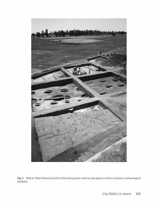
Parts of this city wall were excavated by the Austrian mission in the late 1980s and early1990s in the northern section of ancient Avaris at the modern village of ‘Ezbet Helmi (Jánosi1994: 28–30) (Fig. 2).
There, in areas H/I–VI, the site was occupied during the later Second IntermediatePeriod. While small buildings and attached domestic installations such as ovens coveredthe area from the early Hyksos Period onwards (Bietak et al. 2001: 30–31, 48 and figs. 8–9),the settlement pattern changed distinctively with the construction of the city wall in the lateHyksos Period. The whole northern part of the town was now protected by a largefortification wall with bastions towards the Nile and the area became more prestigious incharacter. A large garden was situated to the immediate south of the wall (Jánosi 1994: 30).

242 Irene Forstner-Müller
The wall itself was built from dark grey mud bricks. It was aligned to the Pelusiac branchof the Nile, therefore in this area in an east-west direction. Only the foundations of thiswall were preserved. Its base is 6.20 m wide. The northern face of the wall was battered.The 5.30 m-wide bastions protruded ca. 3.60 m from the façade and were 18.10 m apart.The foundation bed was filled with yellow sand. Whether an earlier thick muddy-sandylayer was artificial and is evidence of a land-reclamation strategy or constituted a naturalphenomenon remains to be seen (Jánosi 1994: 28).
In a later phase (Jánosi 1994: 29), the wall was reinforced at its northern face by amud brick casing which was built along the slope and filled the gaps between thebastions.
The same wall, visible in the magnetogram (Forstner-Müller 2010: fig. 12), extendedtowards the east and was at least 280 m long.
Fig. 1 Overall map of Avaris/Tell el-Dab’a, the city wall is marked in white (graphic: Leila Masoud, copyrightAustrian Archaeological Institute).
City Wall(s) in Avaris 243
Fig. 2 Wall in ‘Ezbet Helmi/area H/I; in the back garden with tree pits (photo: Archive Austrian Archaeolo gicalInstitute).

244 Irene Forstner-Müller
Fig. 3 Magnetic image of Ezzawin (measurement T. Herbich, Archive Austrian Archaeological Institute).

City Wall(s) in Avaris 245
The South: Ezzawin and Tell el-Dab’a
Artificial fortifications are also visible at the southern limits of Avaris (Fig. 3). There, at themodern village of Ezzawin, an extensive magnetic survey has revealed a suburban townquarter (Forstner-Müller et al. 2010: 73f. and figs. 1–2, 4). The survey shows a densely built-up quarter with buildings and streets. Following the slightly irregular street-grid, thebuildings are generally oriented SWW-NEE and NNW-SSE, but neighboring houses alltend to follow slightly different alignments, varying by a few degrees. A surface potterysurvey allows a cautious dating of this area to the later Second Intermediate Period. To thesouth a clearly defined border is visible.
A magnetic anomaly with a maximum width of 30 m runs along the southern borderof the town (Forstner-Müller et al. 2010: 73f. and fig. 4). The area to the south of this linewas once under water. Perhaps the anomalies recorded to the southeast of the settlementreflect harbor installations where the floodplain was dredged in order to create a place fordocking boats.
This line continues to the east and is also visible, with interruptions, to the south ofthe modern village of Tell el-Dab’a.
In spring 2012 auger drillings were undertaken in order to investigate the nature ofthese installations, to establish whether these are fortifications made of mud brick ormuddy-sandy reinforcements along the shore of the river Nile. First results hint at thefact that at least part of the installations consist of mud brick.
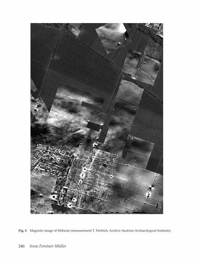
The East: ‘Ezbet Machali and ‘Ezbet Mehesin
Similar fortifications are also visible (Fig. 4) in the results of the geophysical surveywhich was undertaken in the eastern part of the town in the vicinity of the modernvillages of ‘Ezbet Machali and ‘Ezbet Mehesin (Forstner-Müller et al. 2008). This part,like the area in Ezzawin to the south can be interpreted as a suburban quarter of Avaris.At its eastern edge an anomaly is visible, running along the bank of a subsidiary branchof the Pelusiac branch in a north-south direction. The extension of the magnetic featureis rather restricted. Perhaps it was necessary to fortify the river bank against flood events.Auger drillings undertaken during the spring season in 2012 in order to get a better ideaabout the nature of these reinforcements proved that, as in the south, the magneticanomaly most probably originates from mud brick constructions.
246 Irene Forstner-Müller
Fig. 4 Magnetic image of Mehesin (measurement T. Herbich, Archive Austrian Archaeological Institute).

City Wall(s) in Avaris 247
Conclusion
In the later Second Intermediate Period parts of the town of Avaris were protected by acity wall. This wall did, however, not enclose the entire town. It was constructed in partsof the town that were deemed vulnerable and can thus be considered a real defencesystem, not a symbolic one. Besides their defensive character, these walls also servedideological purposes by demonstrating royal power and control over the enclosed area.
The situation in the town shows a different picture within the individual town quarters.A main wall with bastions was erected along the northwestern edge of Avaris along themain branch of the Pelusiac Nile. It seems that threats were expected from this direction.Fortified installations are also known from the south and to a minor degree from theeast of Avaris. There the main aim, besides defense, might also be to provide protectionfrom natural events such as the Nile flood and erosion of the shore.
There is little doubt that the threats to Avaris were realistic, not perceived (Spence2004: 269). The historical sources from the Second Intermediate Period show a complexpolitical situation, with three major political players: the Hyksos in the north, the Thebankings and the rulers of Kush in the south (see Davies 2003). This period was not acontinuous time of peace but a time of struggle for power between the Hyksos kings ofthe 15th Dynasty in the north and their Theban counterparts in the south (Gardiner 1916;Habachi 1972). Besides the Kamose stelae, this change in the extent of Hyksos territoryand the relationship between the rulers in the north and the vassals in the south becomesevident in the papyrus Rhind which shows that at least at some time in the reign of KingApophis the Hyksos were accepted as regular rulers over Egypt even by Thebes. This hasalso been confirmed by the latest excavation results at Edfu, where several sealingimpressions bearing the name of King Khyan were found within layers of the 17th Dynasty(Moeller & Marouard in press).
The building of a fortification/defense system at Avaris in the later Second Intermediateperiod may well be connected to the aforementioned historical events and threats. Even ifKamose’s attack against Avaris was not decisive, the protection of at least some parts of thecapital became necessary.
In the New Kingdom the city wall was no longer in use at Avaris. This is a generalphenomenon all over Egypt at this period when the character of towns changed and citywalls fell out of fashion or were no longer necessary (Spence 2004; for Elephantine seePilgrim in press).

248 Irene Forstner-Müller
Bibliography
Bietak, M.2010 Houses, Palaces and Development of Social Structure in Avaris. In: Bietak, M., E. Czerny & I. Forstner-
Müller, eds., Cities and Urbanism in Ancient Egypt, Vienna, 22nd‒26th November 2006. Untersuchungender Zweigstelle Kairo 35, Denkschriften der Gesamtakademie 60, Vienna 2010: 11‒68.
Bietak, M., J. Dorner & P. Jánosi2001 (mit einem Beitrag von A. von den Driesch & J. Peters), Ausgrabungen im Palastbezirk von Avaris.
Vorbericht Tell el-Dab‘a/‘Ezbet Helmi 1993–2000. Egypt & Levant 11, 2001: 27–119.
Davies, V.2003 Kush in Egypt: a new historical inscription. Sudan & Nubia 7, 2003: 52–54.
Forstner-Müller, I.2010 Settlement Patterns at Avaris, A Study on two Cases. In: Bietak, M., E. Czerny, I. Forstner-Müller, eds.,
Cities and Urbanism in Ancient Egypt, Vienna, 22nd–26th November 2006. Untersuchungen derZweigstelle Kairo 35, Denkschriften der Gesamtakademie 60, Vienna 2010: 103–124.
Forstner-Müller, I., T. Herbich, C. Schweitzer & M. Weissl2008 Preliminary report on the geophysical survey at Tell el-Dab‘a in spring 2008. Egypt & Levant 18, 2008:
100–106.2010 Preliminary Report on the Geophysical Survey at Tell el-Dab‘a/Qantir in Spring 2009 and 2010.
Jahreshefte des Österreichischen Archäologischen Instituts in Wien 79, 2010: 67–86.
Gardiner, A. H. 1916 The Defeat of the Hyksos by Kamose: The Carnarvon Tablet, No. I. Journal of Egyptian Archaeology 3,
1916: 95–110.
Habachi, L.1972 The Second Stela of Kamose. Abhandlungen des Deutschen Archäologischen Instituts Kairo 8, Cairo
1972.
Jánosi, P.1994 Tell el-Dab‘a-‘Ezbet Helmi. Vorbericht über den Grabungsplatz H/I (1989–1992). Egypt & Levant 4,
1994: 20–38.
Kemp B., N. Moeller, K. Spence & A.L. Gascoigne 2004 Egypt’s Invisible Walls. Cambridge Archaeological Journal 14/2, 2004: 259–288.
Moeller, N. & G. Marouardin press (with a contribution by N. Ayers), Discussion of Late Middle Kingdom and early second
Intermediate Period history and chronology in relation to the Khayan sealings discovered at Tell Edfu.Egypt & Levant 21, in press.
von Pilgrim, C. 2010 Elephantine – (Festungs-)Stadt am Ersten Katarakt. In: Bietak, M., E. Czerny & I. Forstner-Müller, eds.,
Cities and Urbanism in Ancient Egypt, Vienna, 22nd‒26th November 2006. Untersuchungen derZweigstelle Kairo 35, Denkschriften der Gesamtakademie 60, Vienna 2010: 257–265.
in press Untersuchungen zur Stadtbefestigung: Die Stadtmauer des Mittleren Reiches. In: Raue, D., F.Arnold, P. Kopp & C. von Pilgrim, Stadt und Tempel von Elephantine, 36./37./38. Grabungsbericht.Mitteilungen des Deutschen Archäologischen Instituts Kairo 67 (2011), in press.

City Wall(s) in Avaris 249
Spence, K.2004 Royal Walling Projects in the Second Millennium BC: Beyond an Interpretation of Defence. In: Kemp,
B. et al., Egypt’s Invisible Walls. Cambridge Archaeological Journal 14/2, 2004: 265–271.
Ziermann, M.1993 Elephantine XVI: Befestigungsanlagen und Stadtentwicklung in der Frühzeit und im frühen Alten
Reich. Archäologische Veröffentlichungen 87, Cairo 1993.

Copyright © 2022 FDOKUMEN