
City fortifications and the form of European cities, with special reference to Croatia
15
Transcript of City fortifications and the form of European cities, with special reference to Croatia


Urban Morphology (2008) 12 (2), 117-29 © International Seminar on Urban Form, 2008 ISSN 1027-4278
City fortifications and the form of European cities,with special reference to Croatia
Damir Krajnik, Mladen Obad Šƒitaroci and Bojana Bojaniƒ Obad ŠƒitarociUniversity of Zagreb, Faculty of Architecture, Ka…iƒeva 26, 10000 Zagreb, Croatia.
E-mail: [email protected]
Revised version received 12 May 2008
Abstract. Developments on the sites of bastion fortifications are often well-designed expansions of city cores with mainly public buildings, representativeresidential buildings and public spaces. The transformation of bastionfortifications in the Croatian towns of Karlovac and Osijek in the early-twentieth century resulted in the creation of urban landscapes that can becompared in their characteristics with similar areas in major cities such asFrankfurt, Hamburg and Copenhagen. Developments in these two towns arecomparable to those in the nineteenth century in many parts of Europe. Theyare inner fringe belts forming boundary zones between historically andmorphologically distinct housing areas.
Key Words: city fortifications, urban transformation, public buildings,fringe-belt concept, Croatia
The transformation of bastion fortificationzones in European towns in the nineteenthcentury resulted in some of the most importanturban achievements of the time. Well-knownexamples such as Vienna, Frankfurt, Bremenand Brno show that the spaces created in placeof former bastion fortifications are frequentlywell-designed extensions to city corescontaining mainly public buildings, represent-ative residential buildings and public civicspaces. This pattern of transformation offortifications significantly influenced nine-teenth-century town planning and had a stronginfluence on the transformation of some townsin the twentieth century. The aim of this paperis to use the towns of Karlovac and Osijek asexamples of Croatian towns where suchtransformation of bastion fortifications wasrealized in the early-twentieth century, and todemonstrate that the spaces created in place ofthe former fortifications have similar
characteristics to those of transformations ofbastion fortifications in other European andCroatian cities during the nineteenth century.
Construction of bastion fortifications inEuropean cities
The medieval fortifications of European cities,comprising high defence walls and towers, losttheir purpose in the late-fifteenth centuryowing to the development of militarytechniques, particularly the use of gunpowderand the improvement of firearms. In the early-sixteenth century a new type of bastionfortification system was developed and built inmany places. This new type was influenced bythe treatises and theoretical studies of Italianand Central European Renaissance theoristsdealing with ideal city concepts, and was ananswer to the requests from state rulers for

118 City fortifications and urban form
more efficient defences. A pivotal moment inthe further development of military fortifi-cations was Charles VIII’s invasion of Italy in1494, after which the inadequacy of medievalfortifications to withstand gunpowder artillerybrought about an increased development ofbastion fortifications (Duffy, 1979). Incontrast to mainly vertical medieval walls,bastion fortifications are markedly horizontal,with complex ground plans. They are con-structed in materials different from those usedin medieval fortifications, generally being ofstone and brick combined with earth to absorbthe impact of cannon balls. The first bastionfortifications were built in Italy at the end ofthe fifteenth century. From the early-sixteenthcentury the construction of bastion fortifi-cations spread across Italy, and then Italianbuilders helped the diffusion of such systemsacross Europe.
The wars of religion strongly influenced theconstruction and development of the bastiontype of fortification system both on Europe'sborders (for example in Croatia, which repre-sented a first line of defence against theOttoman Empire) and in its centre, as inFrance during the French wars of religionbetween 1560 and1630 (Wolfe, 2000, p. 320).During four centuries, between the fifteenth
and eighteenth centuries, bastion fortificationsstrongly defined the form of European cities,having both a practical and a stronglyexpressed symbolic meaning. They were alsoan important accompaniment of Europeanoverseas expansion (Parker, 2000, pp. 573-604).
Owing to Croatia’s geopolitical position atthe crossroads of the civilizations and culturesof East and West, the construction of bastionfortifications there started simultaneously withthe first European examples and lasted untilthe nineteenth century: Karlovac was foundedin 1579, for example, and Palmanova, Italy, in1593 (Figure 1). During three centuries ofalmost continuous warfare, a stronglydefended border between the Habsburg andOttoman Empires was established in the areaof continental Croatia. This frontier consistedof a great number of bastion type fortifi-cations, which were either modernizedmedieval fortifications (Varaždin, Križevci,Osijek) or newly constructed fortifications(Karlovac). The most important fortificationswere built during the eighteenth century,mostly following Vauban principles of fortifi-cation architecture. The fortifications builtduring this period are the strongest and mostcomplex fortification constructions in conti-
Figure 1. Karlovac in 1579. Source: Žmega… (2000, p. 114).

City fortifications and urban form 119
nental Croatia and are characterized by acomplex system of stone or brick elements(Figure 2). With the exception of somealterations and renovations of fortifications(Osijek, Karlovac), which continued through-out the twentieth century, the construction ofbastion type fortifications in the area ofcontinental Croatia ceased in the middle of theeighteenth century (Žmega…, 2000, p. 36).
The transformation of bastion fortificationsin European cities
As a result of changes in the geopolitical
situation in Europe, coupled with changes inwarfare caused by the modernization of fire-arms, the bastion fortifications of Europeancities lost their purpose. In the early-nine-teenth century there was a need for theirintegration into the urban fabric. With thewidespread levelling of fortifications duringthe nineteenth century new spatial possibilitiesappeared in European cities, both for connect-ing what had been separated parts of the town,and in creating new, very valuable buildingland in city centres.
The transformation of bastion fortificationzones in European towns in the late-nineteenthand early-twentieth centuries resulted in well-
Figure 2. Slavonski Brod in 1768. Source: Markoviƒ (1994, p. 142).

120 City fortifications and urban form
designed extensions of city cores. Such urbantransformations, creating new urban qualitiesand new town identities, are often named ring-concept transformations.
The term ring concept is used to mean amodel of transformation employed in theplanning of spaces created in place of bastionfortifications in nineteenth-century Europeantowns. At the time of the planning andrealization of such transformations the ringconcept had not yet been defined, but a greatnumber of spaces created in that way possessvery similar urban characteristics. The areascreated in place of bastion fortificationsbecame reserve spaces for future publicspaces. When the old city cores became toocramped for the new functions of the towncentre, this space enabled town extensions tobe created (Kneževiƒ, 1996, p. 313).
The fact that the areas of cities created inplace of former fortifications represent clearlydefined morphological regions (Conzen, 1975)dominated by various institutions, publicutilities and open spaces, indicates that thesespaces are in fact fringe belts (Kristjánsdóttir,2001, p. 114; Whitehand, 2001, pp. 103-9). Ifthey are the innermost of two or more fringebelts, Conzen (1960, pp. 58-65) refers to themas inner fringe belts. These zones represent ahiatus in the growth of the residential areas of
the city and, because of their designed publicopen spaces and buildings, they create a newidentity and a new urban quality for thesetowns.
The transformation of bastion fortificationsin the towns of continental Croatia
The bastion fortifications in continentalCroatia (Figure 3) lost their purpose in thenineteenth century because of the reducedTurkish threat, the shifting of the HabsburgEmpire defence frontier farther to the east, andthe change in warfare resulting from furtherartillery modernization. The development ofindustry, traffic and trade, mainly in the towns(Zagreb, Varaždin, Osijek, Karlovac andKoprivnica), brought about the creation of anew middle class (burghers). This new classbecame the main factor in the creation ofpublic spaces, especially public parks (Hajós,2007, p. 70; Bojaniƒ Obad Šƒitaroci and ObadŠƒitaroci, 2007). The fortifications within thecity limits became an obstacle to urbandevelopment and, as a result, in the early-nine-teenth century there was a growing initiativefor their demolition and the inclusion of thenewly created areas in the urban fabric. Inmost cases this was realized in the late-nine-
Figure 3. Location of Osijek and Karlovac within continentalCroatia.

City fortifications and urban form 121
teenth century, but in Karlovac and Osijek, asa result of their important strategic positionand unstable geopolitical situation, the trans-formation of the fortifications occurred asrecently as the early-twentieth century.
Karlovac
The construction of Karlovac’s fortificationstook place within 10 years, between 1579 and1589. During the following period, up to themiddle of the nineteenth century, because ofthe marshy land, unsuitable for foundations,and repeated floods and fires, there werefrequent periods of constructional activity.This involved maintaining and renovating boththe bastion fortifications and the houses inside
the walls, but it did not result in any significantchanges in the layout of the bastions. A moresignificant change to the original plan of thefortifications occurred at the time of the greatrenovation of the fortifications between 1739and 1777. The last construction works on thefortifications took place between 1839 and1850 (Figure 4). The Karlovac fortificationsremained intact until 1926 because of militaryregulations forbidding any construction insidethe fortification area. The only exception tothat rule was the creation of the Promenada, acontinuous tree-lined promenade, created in1861 on the glacis area, and soon to becomeone of the main public spaces. Similarpromenades were created on the site of bastionfortifications in the late-eighteenth and early-nineteenth centuries in Bremen, Linz, Graz,
Figure 4. Karlovac in 1863. Source: Gradski muzej Karlovac (Karlovac City Museum).
122 City fortifications and urban form
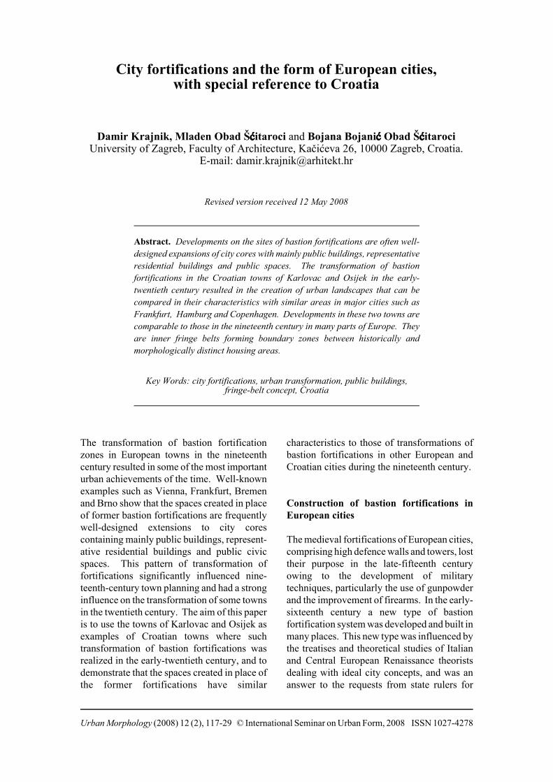
Lucca, Szeged and other European towns.After the laws forbidding any construction inthe fortification zone were abolished in 1925,the fortifications were partially demolished,but this was not followed by any significantnew construction. As a result, the layout ofthe fortifications has mostly been preserved.
The transformation of the fortification zonemostly took place between 1926 and themiddle of the twentieth century. Newconstruction took place in the western part,where blocks were built in place of thebastions. At the same time two new blockswere built between the sites of the twobastions, in the curtain wall area. An armybarracks was built in the east inside thefortification’s fosse, and a school building wasconstructed in the south fosse area. Two new
streets were formed in place of the formerbridge entrances over the fosses, linking thecity core and the suburbs. The most importantelement of the transformation is the connectionof the town centre to the suburbs by a contin-uous ring of parks created in place of thebastion fortifications. For the most part, theoutline of the former fortress was preserved(Figure 5).
Osijek
The historical development of the bastionfortifications and town of Osijek, today’scentre of the eastern part of continentalCroatia, can be followed from the time of theliberation of the medieval town from Ottoman
Figure 5. Karlovac in 1999. Source: Republika Hrvatska, Državnageodetska uprava (Republic of Croatia, State Geodetic Administration).
City fortifications and urban form 123
rule in 1687. The first modernization of the town forti-
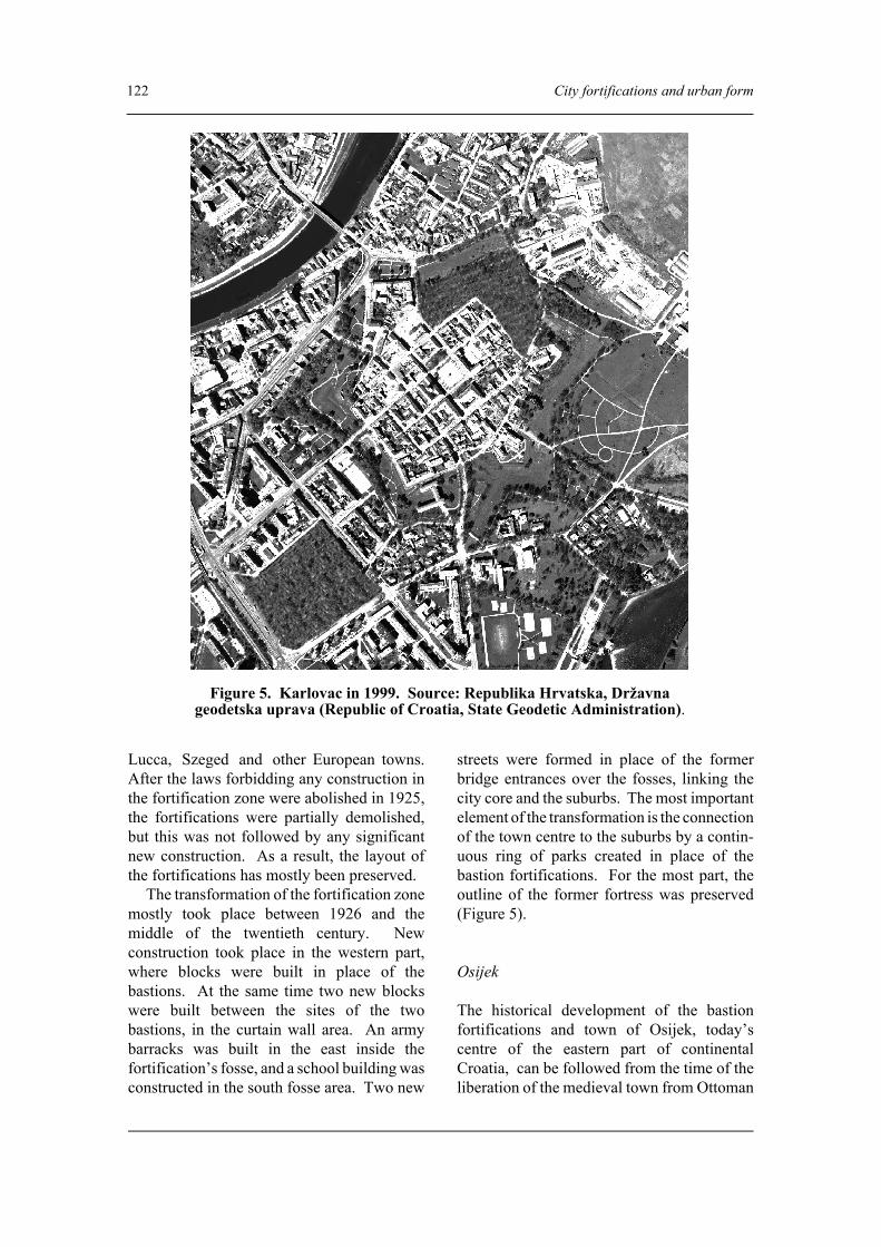
fications took place in the late-seventeenthcentury when, in place of the former Turkishtowers, the bastions and additional externalfortification buildings were constructed. Thisimproved the efficiency of the defence system.During this modernization the walls werecovered in durable materials (brick and stone).A second renovation and modernizationfollowed in the early-eighteenth century. Theground plan of the fortifications was definedby 1720 and, with only small changes, waspreserved until its demolition in the twentiethcentury. There was one exception: a change tothe ground plan was made in the northerndefences where, after the regulation of theRiver Drava and the creation of embankmentson the former marshy land, three new bastionswere built by 1750. The bastion fortifications(covering 80 ha) that had been constructed bythe end of the eighteenth century enclosed acity core covering only 15 ha (Figure 6).
After 1923, transformation of the bastion
fortifications of Osijek was guided by a clearplan. A system of park spaces and publicbuildings was constructed in place of theformer fortifications. Over 3 years (1923 -1926) the bastion fortifications were almostcompletely demolished. The whole transform-ation process was realized in 20 years (by themiddle of the twentieth century). The first stepin this process was taken with an internationaldesign competition in 1925. The first prizewent to the Vienna landscape architect AlbertEsch. Following his proposal, but in a reducedform more appropriate to the social andeconomic conditions and the context, the ideaof a park ring in place of the fortifications wasimplemented. Most of this park frameworkwas created in the 1930s when an existing parkin the western part of the former fortificationswas extended and three new parks created inthe south-western part. The parks in the south-eastern part of the former fortifications werecreated only in the late-twentieth century. Incontrast to the western and southern parts, thesite of the eastern part was, immediately after
Figure 6. Osijek in 1784. Source: Mažuran (1996).
124 City fortifications and urban form
Figure 7. Osijek in 2001. Source: Republika Hrvatska, Državna geodetska uprava(Republic of Croatia, State Geodetic Administration).
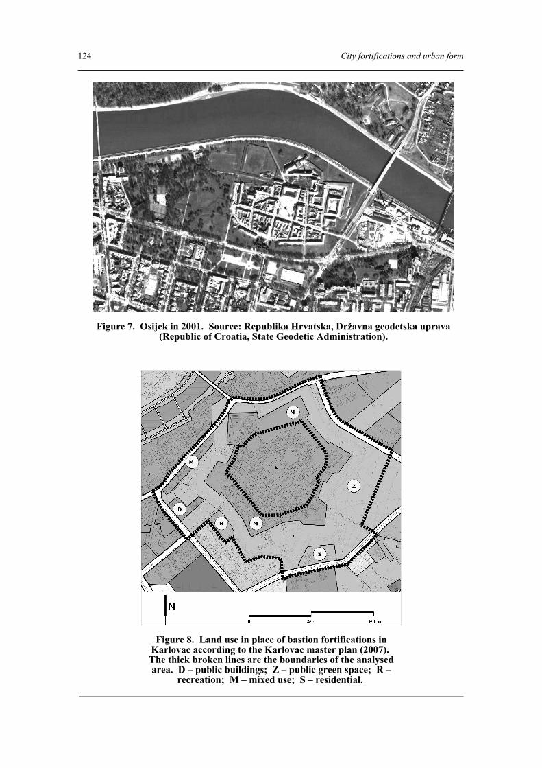
Figure 8. Land use in place of bastion fortifications inKarlovac according to the Karlovac master plan (2007). The thick broken lines are the boundaries of the analysedarea. D – public buildings; Z – public green space; R –
recreation; M – mixed use; S – residential.

City fortifications and urban form 125
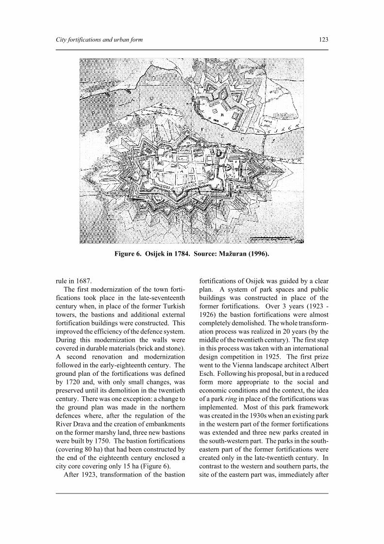
demolition of the fortifications, degraded bythe introduction of industrial land use. Thisindustrial land use has been maintained untiltoday. After the demolition of the 80 ha ofbastion fortifications, only the north-easternpart, containing the Eugene bastion and theWater Gate, was preserved. Not only were thefortifications almost completely erased but thenew construction and the new street linescompletely obliterated the former fortificationsplan. As a result, the elements of the formerfortifications are not easily recognizable,though the configuration of the park belt in thewestern and south-eastern part gives a broadindication of their extent (Figure 7).
Characteristics of the spaces created inplace of the bastion fortifications
The land use of the spaces created in place of
the bastion fortifications is evident from thedrawings in the master plans of Karlovac andOsijek (Arhitektonski fakultet Sveu…ilišta uZagrebu, Zavod za urbanizam, prostornoplaniranje i pejsažnu arhitekturu, 2007; Zavodza urbanizam i izgradnju d.d. Osijek, 2006).Of the area developed in place of thefortifications in Karlovac, 64.6 per cent istaken by parks and recreational areas (Z andR), 1.9 per cent by areas with public buildings(D), and 32.2 per cent by mixed and residentialuse (M and S) (Figure 8).
A similar situation occurs in Osijek wherethe parks (Z) and recreational areas (R) occupy63.4 per cent of the area formerly occupied bythe fortifications, areas with public buildings(D) 4.6 per cent, mixed and residential use (Mand S) 10.1 per cent and infrastructural areas(IS) and areas of special use (N) 6.2 per cent(Figure 9). Thus in both towns the masterplans show some two-thirds of the area as
Figure 9. Land use in place of bastion fortifications in Osijek according to the Osijekmaster plan (2006). The thick broken lines are the boundaries of the analysed area. D –
public buildings; Z – public green space; R – recreation; M – mixed use; S – residential; IS – utilities; N – military.
126 City fortifications and urban form
being occupied by some kind of public land orpublic building.
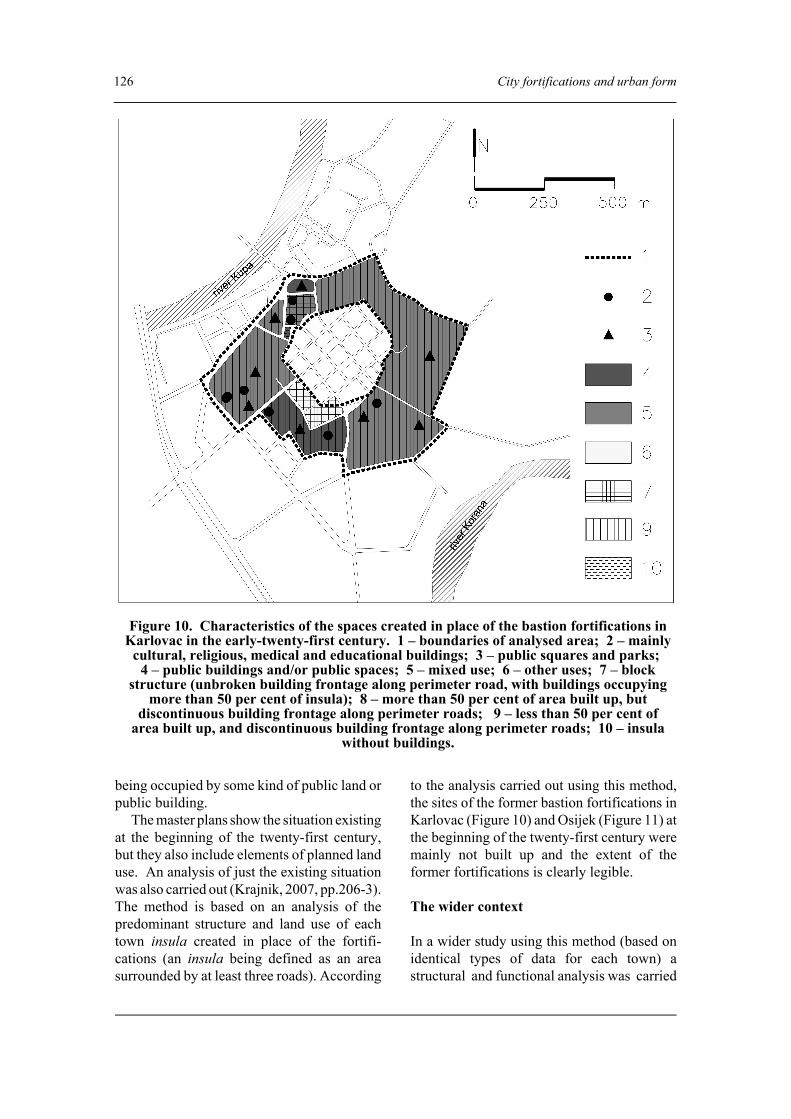
The master plans show the situation existingat the beginning of the twenty-first century,but they also include elements of planned landuse. An analysis of just the existing situationwas also carried out (Krajnik, 2007, pp.206-3).The method is based on an analysis of thepredominant structure and land use of eachtown insula created in place of the fortifi-cations (an insula being defined as an areasurrounded by at least three roads). According
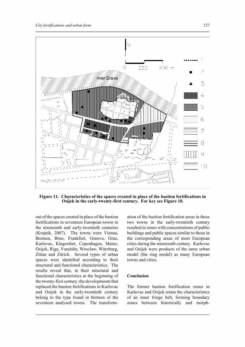
to the analysis carried out using this method,the sites of the former bastion fortifications inKarlovac (Figure 10) and Osijek (Figure 11) atthe beginning of the twenty-first century weremainly not built up and the extent of theformer fortifications is clearly legible.
The wider context
In a wider study using this method (based onidentical types of data for each town) astructural and functional analysis was carried
Figure 10. Characteristics of the spaces created in place of the bastion fortifications inKarlovac in the early-twenty-first century. 1 – boundaries of analysed area; 2 – mainly
cultural, religious, medical and educational buildings; 3 – public squares and parks; 4 – public buildings and/or public spaces; 5 – mixed use; 6 – other uses; 7 – block
structure (unbroken building frontage along perimeter road, with buildings occupyingmore than 50 per cent of insula); 8 – more than 50 per cent of area built up, but
discontinuous building frontage along perimeter roads; 9 – less than 50 per cent ofarea built up, and discontinuous building frontage along perimeter roads; 10 – insula
without buildings.
City fortifications and urban form 127
out of the spaces created in place of the bastionfortifications in seventeen European towns inthe nineteenth and early-twentieth centuries(Krajnik, 2007). The towns were Vienna,Bremen, Brno, Frankfurt, Geneva, Graz,Karlovac, Klagenfurt, Copenhagen, Mainz,Osijek, Riga, Varaždin, Wroclaw, Würzburg,Zittau and Zürich. Several types of urbanspaces were identified according to theirstructural and functional characteristics. Theresults reveal that, in their structural andfunctional characteristics at the beginning ofthe twenty-first century, the developments thatreplaced the bastion fortifications in Karlovacand Osijek in the early-twentieth centurybelong to the type found in thirteen of theseventeen analysed towns. The transform-
ation of the bastion fortification areas in thesetwo towns in the early-twentieth centuryresulted in zones with concentrations of publicbuildings and public spaces similar to those inthe corresponding areas of most Europeancities during the nineteenth century. Karlovacand Osijek were products of the same urbanmodel (the ring model) as many Europeantowns and cities.
Conclusion
The former bastion fortification zones inKarlovac and Osijek retain the characteristicsof an inner fringe belt, forming boundaryzones between historically and morph-
Figure 11. Characteristics of the spaces created in place of the bastion fortifications inOsijek in the early-twenty-first century. For key see Figure 10.

128 City fortifications and urban form
ologically distinct housing areas. These zonesinclude large areas of public space (parks andsquares) interspersed with large institutionaland landmark buildings of architectural note.In both cases these are zones with a sparseroad network and a low incidence of radialroads (cf. Whitehand, 2001, p. 105). In bothtowns at the outset of the twenty-first centurythe zones formed in place of the bastionfortifications have identities that clearlydistinguish them from the urban areas inwhich they are embedded.
The inner fringe belts in Karlovac andOsijek can also be related to the economicconditions of their origin. Whitehand in hisland-rent theory (1972a, pp. 52-3; 1972b)associates the creation of fringe belts withslumps in residential building. In Croatia, inaddition to the effects of slumps in residentialbuilding, the design of the areas formed inplace of the fortifications in the early-twentiethcentury was also marked by the financialinability of municipalities to implement theplanned transformations. A good example isthe transformation of the Karlovac fortifi-cations. In this case the municipality offeredits wealthy citizens the fortification land freebut on condition that they demolished thefortifications at their own expense in order tobuild housing and also to create public parks.
Acknowledgements
This work was undertaken within the researchframework of the scientific project Urban andlandscape heritage of Croatia as a part ofEuropean culture conducted at the Faculty ofArchitecture, University of Zagreb (ChiefResearcher: Professor Mladen Obad Šƒitaroci),with the support of the Ministry of Science,Education and Sport of the Republic of Croatia.The authors are grateful to the anonymous refereesand J. W. R. Whitehand for their suggestionsconcerning the preparation of the final version ofthe paper.
References
Arhitektonski fakultet, Zavod za urbanizam,prostorno planiranje i pejsažnu arhitekturu
(2007) Generalni urbanisti…ki plan gradaKarlovca (Grad Karlovac, Karlovac).
Bojaniƒ Obad Šƒitaroci, B. and Obad Šƒitaroci, M.(2004) Gradski perivoji Hrvatske u 19. stoljeƒu(University of Zagreb, Zagreb).
Conzen, M. R. G. (1960) Alnwick, North-umberland: a study in town-plan analysisInstitute of British Geographers Publication 27(George Philip, London).
Conzen, M. R. G. (1968) ‘The use of town plans inthe study of urban history’, in Dyos, H. J. (ed.)The study of urban history (Edward Arnold,London) 113-30.
Conzen, M. R. G. (1975) ‘Geography and town-scape conservation’, in Uhlig, H. and Lienau, C.(eds) Anglo-German Symposium in AppliedGeography, 1973 (Lenz, Giessen) 95-102.
Duffy, C. (1979) Siege warfare: the fortress in theearly modern world, 1494-1660 (Routledge,London).
Duffy, C. (1985) The fortress in the age of Vaubanand Frederick the Great, 1660-1789 (Routledgeand Kegan Paul, London).
Giedion, S. (1947) Space, time and architecture(Harvard University Press, Cambridge).
Gutkind, E. A. (1964) International history of citydevelopment: urban development in CentralEurope (Collier-Macmillian, London).
Gutkind, E. A. (1965) International history of citydevelopment: urban development in the Alpineand Scandinavian countries (Collier-Mac-millian, London).
Gutkind, E. A. (1972) International history of citydevelopment: urban development in East-Central Europe – Poland, Czechoslovakia andHungary (Free Press, New York).
Hajós, G. (2007) Stadtparks in der österreichischenMonarchie 1765-1918 (Böhlau, Wien).
Kneževiƒ, S. (1996) Zagreba…ka zelena potkova(Školska knjiga, Zagreb).
Kostof, S. (1992) The city assembled: the elementsof urban form through history (Thames andHudson, London).
Krajnik, D. (2007) ‘Urbanisti…ka preobrazbabastionskih utvrdjenja’, unpublished PhD thesis,University of Zagreb.
Kristjánsdóttir, S. (2001) ‘The integration ofarchitectural and geographical concepts in urbanmorphology: preliminary thoughts’, in Scheer,B. C. (ed.) Proceedings of the InternationalSeminar on Urban Form, September 5-9, Cin-cinnati, Ohio, USA (University of Cincinnati,Cincinnati) 113-15.
Le Halle, G. (1983) Précis de la fortification (PCVÉditions, Paris).

City fortifications and urban form 129
Markoviƒ, M. (1994) Brod (Matica Hrvatska,Osijek).
Markoviƒ, M. (2001) Hrvatski gradovi na starimplanovima i vedutama (Antun Gustav Matoš,Zagreb).
Mažuran, I. (1996) Od turskog do suvremenogOsijeka (Školska knjiga, Zagreb).
Mollik, K., Reining, H. and Wurzer, R. (1980)Plannung und Verwicklichung der WienerRingstrassenzone (Franz Steiner, Wiesbaden).
Parker, G. (2000) ‘The artillery fortress as anengine of European overseas expansion, 1480-1750’, in Tracy, J. D. (ed.) City walls: the urbanenceinte in global perspective (CambridgeUniversity Press, New York) 386-418.
Pepper, S. (2000) ‘Siege law, siege ritual, and thesymbolism of city walls in Renaissance Europe’,in Tracy, J. D. (ed.) City walls: the urbanenceinte in global perspective (CambridgeUniversity Press, New York) 573-604.
Stübben, J. (1890) Der Städtebau (Arnold Berg-strasser, Darmstadt).
Tracy, J. D. (ed.) (2000) City walls: the urbanenceinte in global perspective (CambridgeUniversity Press, New York).
Whitehand, J. W. R. (1972a) ‘Building cycles and
the spatial pattern of urban growth’, Trans-actions of the Institute of British Geographers56, 39-55.
Whitehand, J. W. R. (1972b) ‘Urban rent theory,time series and morphogenesis: an example ofeclecticism in geographical research’, Area 4,215-22.
Whitehand, J. W. R. (2001) ‘British urban morph-ology: the Conzenian tradition’, UrbanMorphology 5, 103-9.
Whitehand, J. W. R. and Morton, N. J. (2003)‘Fringe belts and the recycling of urban land: anacademic concept and planning practice’,Environment and Planning B, Planning andDesign 30, 819-39.
Wolfe, M. (2000) ‘Walled towns during the Frenchwars of religion’, in Tracy, J. D. (ed.) Citywalls: the urban enceinte in global perspective(Cambridge University Press, New York) 317-48.
Zavod za urbanizam i izgradnju d.d. Osijek (2006)Generalni urbanisti…ki plan grada Osijeka(Grad Osijek, Osijek).
Žmega…, A. (2000) Bastioni kontinentalne Hrvatske(Institut za povijest umjetnosti, GoldenMarketing, Zagreb).
Gianfranco Caniggia, architetto romano: conference held in the Facoltàdi Architettura ‘Valle Giulia’ and the Accademia Nationale di San Luca,Rome, Italy, 9-10 May 2008
This long-awaited conference on the architecturaland theoretical work of Gianfranco Caniggia was,for the academic community in Rome, in someways an acknowledgement of a debt forgotten for20 years. After Caniggia’s death, just a fewmentions of his work appeared in the architecturalliterature in Italy, with the remarkable exception ofthe observations of the distinguished historianManfredo Tafuri: he pointed out that Caniggia wasnot proposing a regressive utopia, but a fertile,rigorous method of investigating the roots of acommon architectural language that involvedposing questions more than providing solutions.
Caniggia’s research and didactic work werecommonly suspected of proposing a sort of‘archaeology of city and territory’ that wasunsuitable for present-day conditions. A previousconference on Caniggia, held in July 2002 in Como,was well attended by ISUF members, but attracted
few participants prominent in Italian architecturalcircles. The conference in Rome, in contrast, couldbe regarded as in many respects a turning point inthe appreciation of Caniggia. A number of eminentarchitects and historians discussed the vitality andsubstantive contribution of his work.
Among the opening speeches, BededettoTodaro’s had special significance. As Dean of thehosting faculty, he pointed out to the manyarchitects and students who filled the main hall, thatCaniggia had provided an unusual way forward incontemporary architecture: the study of the city asa rational, continuous flow of transformations. Thiswas, he said, an alternative to the current stream ofspectacular designs without roots, which is thecontemporary ‘language plague’, to use ItaloCalvino’s words.
The first session, chaired by Giuseppe Strappa,was held in the main hall of the Facoltà di