COASTAL AQUIFERS MANAGEMENT IN CROATIA - UNECE
20
Workshop on the protection of groundwater as a source of drinking water in karst area Malinska, Island Krk (Croatia) 14-15 April 2008 COASTAL AQUIFERS MANAGEMENT IN CROATIA COASTAL AQUIFERS MANAGEMENT IN CROATIA ZELIMIR PEKAS, Croatian Waters ZAGREB, Croatia
-
Upload
khangminh22 -
Category
Documents
-
view
0 -
download
0
Transcript of COASTAL AQUIFERS MANAGEMENT IN CROATIA - UNECE

Workshop on the protection of groundwateras a source of drinking water in karst area
Malinska, Island Krk (Croatia) 14-15 April 2008
COASTAL AQUIFERS MANAGEMENT IN CROATIACOASTAL AQUIFERS MANAGEMENT IN CROATIA
ZELIMIR PEKAS, Croatian WatersZAGREB, Croatia

CROATIACROATIA
- terrestrial area 56.538 sq km - territorial sea area 31.071 sq km- length of coastline 5.835 km- 1.185 islands (66 inhabited)- Croatia population 4.44 million
(census 2001)

INSTITUTIONAL ASPECTS INSTITUTIONAL ASPECTS OF WATER MANAGMENT IN CROATIAOF WATER MANAGMENT IN CROATIA
•• The Water Act and the Water Management Financing The Water Act and the Water Management Financing Act, both enacted in 1995 and amended in 2005, define Act, both enacted in 1995 and amended in 2005, define the legal framework of water management in Croatia. the legal framework of water management in Croatia.
•• The longThe long--term strategic planning document in the field term strategic planning document in the field of water management is the Strategy of Water of water management is the Strategy of Water Management. Management.
•• The Strategy of Water Management is harmonized with The Strategy of Water Management is harmonized with other sectoral strategies, and generally complies with the other sectoral strategies, and generally complies with the requirements set in EU Water Framework Directive .requirements set in EU Water Framework Directive .

Water Management InstitutionsWater Management InstitutionsTwo government institutions have direct responsibility for waterTwo government institutions have direct responsibility for water management in management in Croatia:Croatia:
–– Ministry for Regional Development, Forestry and Water ManagementMinistry for Regional Development, Forestry and Water Management–– Croatian Waters (Hrvatske Vode), national water agencyCroatian Waters (Hrvatske Vode), national water agency
Ministry for Regional Development, Forestry and Water ManagementMinistry for Regional Development, Forestry and Water Management -- Water Water Management Directorate (WMD) Management Directorate (WMD) is responsible for:is responsible for:
• administrative and other issues related to integrated management of water resources and water management systems
• incorporating water resources management and development into overall economic development framework.
• in the field of water protection, it is responsible for protection of drinking water sources and the sea from land-based pollution sources.
• for planning and coordinating development and construction of large water supply and wastewater collection and treatment systems
• for monitoring of surface waters and groundwater

Croatian WatersCroatian Waters
as the national water agencyas the national water agency•• has overall responsibility for performing activities related to has overall responsibility for performing activities related to management management
of national and local watersof national and local waters•• development of river basin management plans development of river basin management plans •• closely cooperates with local water companies in municipalities closely cooperates with local water companies in municipalities and and
countiescounties•• coordinates and finances implementation of water quality monitorcoordinates and finances implementation of water quality monitoring of ing of
surface waters performed by authorized laboratoriessurface waters performed by authorized laboratories
Other Other Responsible InstitutionsInstitutions
1.1. Ministry of Environmental Protection, Physical Planning and CoMinistry of Environmental Protection, Physical Planning and Construction nstruction 2.2. Ministry of Health and Social Welfare (drinking water quality)Ministry of Health and Social Welfare (drinking water quality)3.3. Ministry of the Sea, Tourism, Transport and DevelopmentMinistry of the Sea, Tourism, Transport and Development4.4. Ministry of Finance Ministry of Finance
On the local levelOn the local level, municipal and county authorities are responsible for , municipal and county authorities are responsible for design and implementation of infrastructure projects, including design and implementation of infrastructure projects, including water water supply and wastewater collection and treatment systems.supply and wastewater collection and treatment systems.

BASIC DATABASIC DATA
Two different hydrogeological units: - Danube basin within the Black Sea
catchment area (about 62 % of total terrestrial area)
- Adriatic basin, which includes the Adriatic Sea coastal area (mostly karst area).
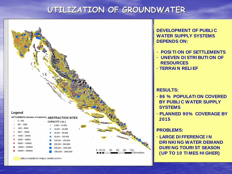
UTILIZATION OF GROUNDWATERUTILIZATION OF GROUNDWATER
DEVELOPMENT OF PUBLIC WATER SUPPLY SYSTEMS DEPENDS ON:
- POSITION OF SETTLEMENTS- UNEVEN DISTRIBUTION OF
RESOURCES - TERRAIN RELIEF
RESULTS:- 86 % POPULATION COVERED
BY PUBLIC WATER SUPPLY SYSTEMS
- PLANNED 90% COVERAGE BY 2015
PROBLEMS:- LARGE DIFFERENCE IN
DRINKING WATER DEMAND DURING TOURIST SEASON (UP TO 10 TIMES HIGHER)

QUALITY OF GROUNDWATERQUALITY OF GROUNDWATER
• GROUNDWATER QUALITY IS MONITORED AT ABSTRACTION SITES
• NATIONAL MONITORING SYSTEM IS UNFINISHED
• GROUNDWATER QUALITY IS GENERALLY VERY GOOD
PROBLEMS:
• INCREASED TURBIDITY AND MYCROBIOLOGICAL POLLUTION DURING FIRST RAINS, AFTER A LONG DRY PERIOD
PROTECTION OF DRINKING WATER SOURCESPROTECTION OF DRINKING WATER SOURCES
main condition of drinking water source protection main condition of drinking water source protection --establishment of water protection zones of the source and establishment of water protection zones of the source and implementation of planned protection measuresimplementation of planned protection measures
LEGAL FRAMEWORK OF PRESENT PROTECTIONLEGAL FRAMEWORK OF PRESENT PROTECTION•• Water Act Water Act ((9595//0505))•• Regulation on the estabishment of sanitary protection zones Regulation on the estabishment of sanitary protection zones
for drinking water sources (2002)for drinking water sources (2002)
HistoryHistory- Protection started in the 1970s- First regulation in 1986- Protection in karst areas (Article 4) – criteria for
protection zones were defined by individual investigators for specific situations on case-by-case basis

Criteria for the definition of protection zonesCriteria for the definition of protection zones
Protection ZoneGroundwater flow toward pumping station
Apparent groundwater velocity (cm/s)
Necessary hydrogeological basis
I A Immediate area of pumping station Must be fence protected S 1:1,000
I B Immediate surface catchment Must be marked with signs S 1:1,000
Zone of strict restriction II 24 h
Catchment’s discharge zone > 3 cm/s
S 1:5,000
Zone of restriction and control
III 1 to 10 days
Assumed catchment’sretention zone(GW flow velocity 1 to 3 cm/s)
S 1:25,000
Zone of limited protection IV 10 to 50 days GW flow velocity < 1 cm/s S 1:50,000
Zone of special protection
Water protection reserve Main recharge area Mountainous area. Assumed
catchment’s recharge zone S 1:50,000
Zone of strict protection regime
••Multidisciplinary CommissionMultidisciplinary Commission for establishment of protection zonesfor establishment of protection zones•• DecisionDecisions on protection zones ares on protection zones are made by cmade by countyounty assembliesassemblies
•• TransboundaryTransboundary problemsproblems -- HarmonizationHarmonization


HUGE PERCENT OF THE AREA IS UNDER PROTECTION, RESULTING IN LAND USE CONFLICTS

IMPLEMENTATION OF IMPLEMENTATION OF EU WATER FRAMEWORK DIRECTIVE IN CROATIAEU WATER FRAMEWORK DIRECTIVE IN CROATIA
• IMPLEMENTATION OF EU WFD STARTED IN 2002
• INITIAL GWB CHARACTERIZATION CARRIED OUT ON THE BASIS OF AVAILABLE DATA AND EXPERT ASSUMPTIONS
• GROUPING OF GWB’S PERFORMED
• RISK ASSESSMENT
ONGOING PROJECTS:
• MONITORING ESTABLISHMENT
• FURTHER CHARACTERIZATION OF GWB’S WHICH ARE DETERMINED AS AT RISK
• DEVELOPMENT OF MANAGEMENT PLANS

UNESCOINTERNATIONAL HYDROLOGICAL PROGRAMME
The First Workshop on Mediterranean Coastal Aquifers programme, “Regional Strategies to manage and protect Mediterranean coastal aquifers” was organised in Chia-Laguna, Sardinia, Italy, 23-24 September 2006.
PROJECT: “Strategic Partnership for the Mediterranean Sea Large Marine Ecosystem – Regional Component: Implementation of agreed actions for the protection of the environmental resources of the Mediterranean Sea and its coastal areas,
COMPONENT 1Integrated approaches for the implementation of the SAPS and NAPS: ICZM (Integrated Coastal Zone Mangement), IWRM (Integrated Water Resource Mangement) and management of coastal aquifers,
SUB-COMPONENT 1.1“Management of Coastal Aquifers and Groundwater”
The aim of Sub-Component 1.1 is to discuss and demonstrate immediate and long term national coastal management issues, cost-effective development opportunities and capacities for regional dissemination as well as replicate the found solutions accross the Mediterranean region.

The work was organized in two groups.Group I. had the task to develop the consolidated work-plan for full UNESCO Sub-component 1.1: “ Management of Coastal Aquifers, Groundwater and Land”,Group II. had to prepare the work-plan for aquifer vulnerability mapping and hydrogeological characterisation, and propose potential pilot aquifers and demonstrations.
The expected outcomes of the Workshop were to find opportunities for activities/demonstrations in Croatia for regional replication and dissemination/exchange and capacity building for regional replication.
The Second Workshop on The "Management of Coastal Aquifers and Groundwater“was held in Zagreb, Croatia, 18 – 19 June 2007, with a field trip organized on 20June. The participants included the UNESCO representatives as well as numerous Italian and Croatian experts.

WORKING GROUP 1: Consolidated workplan for full UNESCO component “Management of Coastal Aquifers and Groundwater”
The group concluded that the workplan should include the folowing issues:
1. River basins (catchment areas) – areas of special interest are transboundary RBs2. Sub-regions – Adriatic (Eastern Coast), North Africa, Middle East3. Exchange and capacity building, including networks, forums, etc.4. Full recognition of importance of replications (model application)5. Inventory assessment of coastal aquifer resources in Croatia 6. Exchange of risk assessment studies in the Mediterranean7. Approximation (harmonization) of the European system and directives (WFD) –
integrated Mediterranean system8. New issues and specific objectives within the objectives of the Project9. Ecohydrology and integrated water resources10. Considerations of impacts of climate change on coastal aquifers and coastal
ecosystems11. Land–based sources – interaction between continental and sea water (seepage of
pollutants into the sea, eutrophication)12. Vulnerability to emerged and submerged coastal pollution
RECOMMENDATIONS OF THE SECOND WORKSHOPRECOMMENDATIONS OF THE SECOND WORKSHOP
RECOMMENDATIONS OF THE SECOND WORKSHOPRECOMMENDATIONS OF THE SECOND WORKSHOP
Addressing the specific situation in Croatia, the group made the analyized thepresent state and issues of interest:
1. Existing National Water Protection Plan (Croatia)2. Involvement of the Marine and Coastal Protection Unit - Ministry of
Environmental Protection, Physical Planning and Construction into the Project3. Ecohydrology – the Neretva River delta (wetlands) – coastal aquifer system4. Potential replication in Albanian coastal wetlands5. Establishment of optimal monitoring system for coastal GW6. Sustainable management of coastal aquifers as a factor of coastal areas
development
Due to the possible selection of Croatia as the location for the pilot project, the following suggestions were made:
1. Croatia – case of adaptation to the EU directives, coastal River Basin concept2. Legislation for coastal aquifer protection and land use, with particular attention
to water supply for small communities3. Considerations of common guidelines, including institutional organization at
regional level, for coastal aquifers, groundwater, surface waters and land4. Coordination mechanism for the Project implementation

Working group 2: “Vulnerability mapping and hydrogeological characterization
– pilot aquifers and demonstrations”Group 2 considered mosly technical aspects of the topic, and suggested the following list of activities:
1. Preparation of a check-list of data and attributes of data (resolution, type of data support, etc.)2. Preparation of state-of-the-art availability of data quantity and quality, gaps, and necessary
data to assess potential risks and vulnerability (Croatian partners in general) – preliminary work
3. A working meeting with Croatian, Italian and other Mediterranean experts to study the feasibility of the proposed pilot projects – proposed date: beginning of 2008
4. Short training courses on vulnerability mapping and risk assessment for technical staff and experts from Croatian institutions, including universities
5. Elaboration of vulnerability maps in the selected case study and technological tools (GIS, databases, Internet map service, etc.)
6. Elaboration of methodological approach for assessment of risk and uncertainty based on the experience acquired within the case study
7. Organization of ad hoc and coordination meetings between partners
8. Organization of regional workshops for dissemination of results and best experiences in view of regional replication
RECOMMENDATIONS OF THE SECOND WORKSHOPRECOMMENDATIONS OF THE SECOND WORKSHOP
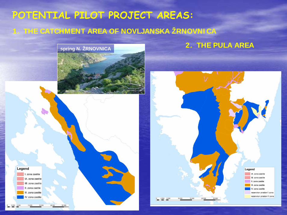
POTENTIAL PILOT PROJECT AREAS:1. THE CATCHMENT AREA OF NOVLJANSKA ŽRNOVNICA
2. THE PULA AREAspring N. ŽRNOVNICA
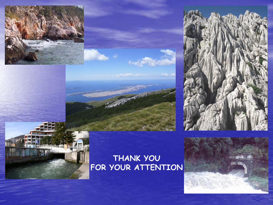
THANK YOU FOR YOUR ATTENTION