CITY COUNCIL REGULAR MEETING AGENDA - Utah.gov
124
CITY COUNCIL REGULAR MEETING Tuesday, July 05, 2022, at 7:00 PM Court Room/Council Chambers (2nd Floor) and Online MEETING PARTICIPATION In Person – Meetings are held on the 2 nd floor in the Court Room/Council Chambers at City Hall YouTube Live – Santaquin City Channel https://bit.ly/2P7ICfQ Comments may be submitted to [email protected] for consideration. To review the Santaquin City Council Meeting Protocols, please go to the following link: https://www.santaquin.org/citycouncil/page/santaquin-city-council-protocols. ADA NOTICE If you are planning to attend this Public Meeting and due to a disability need assistance in understanding or participating in the meeting, please notify the City Office ten or more hours in advance and we will, within reason, provide what assistance may be required. AGENDA ROLL CALL PLEDGE OF ALLEGIANCE INVOCATION / INSPIRATIONAL THOUGHT DECLARATION OF POTENTIAL CONFLICTS OF INTEREST CONSENT AGENDA (MINUTES, BILLS, ITEMS) Minutes 1. 06-07-2022 City Council Work Session Minutes 2. 06-07-2022 City Council Minutes 3. 06-21-2022 City Council Work Session Minutes 4. 06-21-2022 City Council Minutes Bills 5. City Expenditures for 06/16/2022 to 06/24/2022 totaling $574,233.63 PUBLIC FORUM, BID OPENINGS, AWARDS, AND APPOINTMENTS Recognitions 6. Volunteer of the Month - Tyler Warner Awards 7. Award of the Contract for City Hall Commercial Kitchen Equipment to Bintz Public Forum FORMAL PUBLIC HEARING
-
Upload
khangminh22 -
Category
Documents
-
view
0 -
download
0
Transcript of CITY COUNCIL REGULAR MEETING AGENDA - Utah.gov

CITY COUNCIL REGULAR MEETING
Tuesday, July 05, 2022, at 7:00 PM
Court Room/Council Chambers (2nd Floor) and Online
MEETING PARTICIPATION
In Person – Meetings are held on the 2nd floor in the Court Room/Council Chambers at City Hall
YouTube Live – Santaquin City Channel https://bit.ly/2P7ICfQ
Comments may be submitted to [email protected] for consideration.
To review the Santaquin City Council Meeting Protocols, please go to the following link:
https://www.santaquin.org/citycouncil/page/santaquin-city-council-protocols.
ADA NOTICE
If you are planning to attend this Public Meeting and due to a disability need assistance in understanding or participating in the meeting, please notify the City Office ten or more hours in advance and we will, within reason, provide what assistance may be required.
AGENDA
ROLL CALL
PLEDGE OF ALLEGIANCE
INVOCATION / INSPIRATIONAL THOUGHT
DECLARATION OF POTENTIAL CONFLICTS OF INTEREST
CONSENT AGENDA (MINUTES, BILLS, ITEMS)
Minutes
1. 06-07-2022 City Council Work Session Minutes
2. 06-07-2022 City Council Minutes
3. 06-21-2022 City Council Work Session Minutes
4. 06-21-2022 City Council Minutes
Bills
5. City Expenditures for 06/16/2022 to 06/24/2022 totaling $574,233.63
PUBLIC FORUM, BID OPENINGS, AWARDS, AND APPOINTMENTS
Recognitions
6. Volunteer of the Month - Tyler Warner
Awards
7. Award of the Contract for City Hall Commercial Kitchen Equipment to Bintz
Public Forum
FORMAL PUBLIC HEARING

BUILDING PERMIT & BUSINESS LICENSE REPORT
NEW BUSINESS
Ordinances
8. Ordinance 07-01-2022 - Amending Land Use Table and Associated Definitions in the Main Street Business Districts Zone
Resolutions
9. Resolution 07-01-2022 Purchase of Real Property for Corridor Preservation for the East Side Frontage Road
Discussion & Possible Action
10. Approve Purchase of Pavilion for Ahlin Pond Park per RAP Tax Approval
11. Scenic Ridge Estates Preliminary Plan
12. Stratton Acres Preliminary Plan
REPORTS OF OFFICERS, STAFF, BOARDS, AND COMMITTEES
REPORTS BY MAYOR AND COUNCIL MEMBERS
EXECUTIVE SESSION (May be called to discuss the character, professional competence, or physical or mental health of an individual)
EXECUTIVE SESSION (May be called to discuss the pending or reasonably imminent litigation, and/or purchase, exchange, or lease of real property)
ADJOURNMENT
CERTIFICATE OF MAILING/POSTING
The undersigned duly appointed City Recorder for the municipality of Santaquin City hereby certifies that a copy of the foregoing Notice and Agenda was e-mailed to the Payson Chronicle, Payson, UT, 84651, posted on www.santaquin.org, as well as posted on the State of Utah’s Public Notice Website.
BY:
Amalie R Ottley, City Recorder
City Council Work Session, June 7th, 2022 Page 1 of 2
CITY COUNCIL WORK MEETING Tuesday, June 7th at 5:30 PM
Court Room/Council Chambers (2nd floor) and Online
Mayor Olson called the meeting to order at 5:30 p.m.
ROLL CALL
Councilors present included Councilors Hathaway, Montoya, and Siddoway.
Councilor Adcock was excused from attending the meeting.
Councilor Mecham joined the meeting via Zoom.
Staff members present included City Manager Norm Beagley, Community Development
Director Jason Bond, Finance Director Shannon Hoffman, Recorder Amalie Ottley, Assistant
Penny Reeves.
PLEDGE OF ALLEGIANCE
Councilor Montoya led the pledge of allegiance.
INVOCATION / INSPIRATIONAL THOUGHT
An invocation was offered by Community Development Director Jason Bond. DISCUSSION ITEMS
1. Initiating Proposed Legislative Actions:
Director Bond addressed protocols for how City Council members may initiate and propose legislative actions within the city. Director Bond pointed out that Section 10-16-030 of the City Code focuses on City Council protocols and how actions may be taken. Director Bond brought up the ability to discuss items and topics at work session meetings. Mayor Olson addressed the need for a quorum to initiate proposed legislative actions per City and State law. Mayor Olson also addressed the need for requested topics to be discussed in open meetings for transparency purposes.
2. Detached Accessory Dwelling Units:
Mayor Olson discussed the differences between the City’s R8 and R10 zones and the historical, large residential lots. Mayor Olson addressed the issues that may arise should the City Council make blanket statements and regulations within the above stated zones. He pointed out initial Planning and Zoning requirements and their application to current ordinances. Director Bond expounded on Detached Accessory Dwelling Units and showed
MINUTES
Item # 1.

City Council Work Session, June 7th, 2022 Page 2 of 2
the parcel sizing in the city zones. He expressed the importance of the City Council understanding further legislative processes when considering changes to zoning within the city. The City Council discussed a possible application process for residents to expand or build ADU’s in the R10/R8 zones subject to meeting city regulations and parameters. The City Council requested that the Planning Commission address lot size requirements for potential ADU allowances in R8 and R10 zones. Mayor Olson agreed. City administration will move forward with adding the requested discussion item to a future Planning Commission agenda. City Manager Beagley added the concern for a good understanding between City administration, staff, and the City Council for issues and direction on desired topics that can be brought up on future agendas.
OTHER BUSINESS
The City Council and Mayor Olson discussed the upcoming City Council Regular Meeting agenda and corresponding items.
ADJOURNMENT
Councilor Montoya moved to adjourn. Motion seconded by Councilor Hathaway. Vote was
unanimous in favor. Meeting adjourned at 6:36 p.m.
ATTEST:
______________________________ ______________________________
Daniel M. Olson, Mayor Amalie R. Ottley, City Recorder
Item # 1.

City Council Meeting, June 7th, 2022 Page 1 of 10
CITY COUNCIL REGULAR MEETING Tuesday, June 7th at 7:00 PM
Court Room/Council Chambers (2nd floor) and Online
Mayor Olson called the meeting to order at 7:00 p.m.
ROLL CALL
Councilors present included Councilors Hathaway, Montoya, and Siddoway.
Councilor Mecham joined the meeting via Zoom.
Councilor Adcock was excused from the meeting.
Former City Manager Ben Reeves also joined the meeting via Zoom.
Others present included City Manager Beagley, Community Development Director Jason Bond,
Attorney Brett Rich, Finance Director Shannon Hoffman, Recorder Amalie Ottley, Community
Services Director John Bradley, Public Works Director Jason Callaway, Assistant Penny Reeves,
Jim Rowland from Payson/Santaquin Area Chamber of Commerce.
Various members of the public were also present.
PLEDGE OF ALLEGIANCE
Jason Bond led the Pledge of Allegiance
INVOCATION/INSPIRATIONAL THOUGHT
An Invocation was offered by Councilor Montoya
DECLARATION OF POTENTIAL CONFLICTS OF INTEREST
There were no declarations of potential conflicts offered by any of the councilors.
CONSENT AGENDA (MINUTES, BILLS, ITEMS)
1. City Council Work Session Minutes – May 17,2022
2. City Council Minutes – May 17, 2022
3. Combined City Council & Planning Commission Minutes – May 31, 2022
4. City Expenditures for May 12 to June 01, 2022 totaling $2,559,566.27
MINUTES
Item # 2.

City Council Meeting, June 7th, 2022 Page 2 of 10
Councilor Mecham moved to approve the Consent Agenda items consisting of the Work Session
and Regular Council Meeting minutes from May 17th, Combine City Council & Planning
Commission Minutes from May 31, and finally, the City Expenditures for May 12th thru June 1st,
2022. Councilor Hathaway seconded the motion.
Councilor Adcock Absent
Councilor Hathaway Yes
Councilor Mecham Yes
Councilor Montoya Yes
Councilor Siddoway Yes
Motion passed unanimously in the affirmative.
RECOGNITIONS
5. Employee of the Month – Braden Williams
Penny Reeves presented Braden Williams with Employee of the Month for June, 2022.
Braden has worked for the city for about 1 1/2 years and has been a great benefit to our public works department and to Santaquin City. He has picked up on the meter reading system and is constantly learning new skills that will help the department and our city in the future. Last fall, Braden was driving down 100 North on his day off and noticed water in the road. After investigating, he found a broken pipe in a sprinkler system. Not only was the water running down the street, but it had also started filling up the window well at the resident’s home. Braden immediately turned the water off averting flooding into the resident’s home. Braden then called his boss, and they were able to get in touch with the homeowner. She was very grateful for Braden noticing an issue and taking care of it. It goes back to what has always been encouraged in the public works department; if an employee is in town, they are working, no matter if it is their day off or not. When asked what Braden likes about his job, he said, “It is helping people with whatever they need with their meters and connections.” It is evident that Braden does love helping our citizens.
Braden is married to his sweetheart Lauren, and they have three children. He was born and raised in Santaquin and they’ve recently purchased their third home here in Santaquin. His extended family is all still in the town, and he loves being close to them.
A big thank you is extended to Braden for his service to Santaquin City and the residents of this community. He is a great example of a dedicated employee and deserving of this recognition.
PUBLIC FORUM
No members of the public wished to address the City Council.
BUILDING PERMIT & BUSINESS LICENSE REPORT
Community Development Director Bond presented the Building Permit & Business License
Report. 203 total Building Permits have been issued in 2022. Two new business licenses were
issued in the last month.
Item # 2.
City Council Meeting, June 7th, 2022 Page 3 of 10
SANTAQUIN CITY FY2022-2023 BUDGET PRESENTATION
Former City Manager Ben Reeves presented the proposed FY2022-2023 Santaquin City Budget,
the proposed Santaquin Local Building Authority budget and the proposed Santaquin Water
District budget to the City Council and members of the public.
PUBLIC HEARING
Councilor Hathaway motioned to enter into a Public Hearing to address the FY2022-2023
Santaquin City Budget. Councilor Siddoway seconded.
Councilor Adcock Absent
Councilor Hathaway Yes
Councilor Mecham Yes
Councilor Montoya Yes
Councilor Siddoway Yes
Motion passed unanimously. Public Hearing entered into at 7:20 p.m.
No members of the public wished to address the Council regarding the budget. The City Council
thanked Ben and Shannon for their work on the budget process.
Councilor Montoya motioned to adjourn the Public Hearing. Councilor Hathaway seconded.
Councilor Adcock Absent
Councilor Hathaway Yes
Councilor Mecham Yes
Councilor Montoya Yes
Councilor Siddoway Yes
Public Hearing adjourned at 7:21 p.m.
CONVENE OF THE SANTAQUIN LOCAL BUILDING AUTHORITY
Motion made by Councilor Montoya to enter into a Santaquin Local Building Authority Agency
Board Meeting. Motion seconded by Councilor Siddoway.
Councilor Adcock Absent
Councilor Hathaway Yes
Councilor Mecham Yes
Councilor Montoya Yes
Councilor Siddoway Yes
The Santaquin Local Building Authority meeting was convened at 7:26 p.m.
Item # 2.
City Council Meeting, June 7th, 2022 Page 4 of 10
Motion made by Board Member Siddoway to enter into a Public Hearing to address the Local
Building Authority FY2022-2023 Budget. Motion seconded by Board Member Hathaway.
Board Member Adcock Absent
Board Member Hathaway Yes
Board Member Mecham Yes
Board Member Montoya Yes
Board Member Siddoway Yes
Formal Public Hearing opened at 7:27 p.m.
No members of the public wished to address the board.
Motion made by Board Member Hathaway to adjourn the Formal Public Hearing for the
Santaquin Local Building Authority. Motion seconded by Board Member Siddoway.
Formal Public Hearing adjourned at 7:32 p.m.
Motion made by Board Member Montoya to adjourn the Santaquin Local Building Authority
meeting and enter back into a Regular City Council meeting.
Board Member Adcock Absent
Board Member Hathaway Yes
Board Member Mecham Yes
Board Member Montoya Yes
Board Member Siddoway Yes
The Santaquin Local Building Authority meeting was adjourned at 7:33 p.m.
CONVENE OF THE SANTAQUIN WATER DISTRICT
Motion made by Councilor Montoya to enter into a Santaquin Water District Meeting. Motion
seconded by Councilor Hathaway.
Councilor Adcock Absent
Councilor Hathaway Yes
Councilor Mecham Yes
Councilor Montoya Yes
Councilor Siddoway Yes
The Santaquin Water District meeting was convened at 7:34 p.m.
Motion made by Board Member Montoya to enter into a Public Hearing to address the
Santaquin Water District FY2022-2023 Budget. Motion seconded by Board Member Siddoway.
Item # 2.

City Council Meeting, June 7th, 2022 Page 5 of 10
Councilor Adcock Absent
Councilor Hathaway Yes
Councilor Mecham Yes
Councilor Montoya Yes
Councilor Siddoway Yes
Formal Public Hearing opened at 7:34 p.m.
No members of the public wished to address the board.
Motion made by Board Member Montoya to adjourn the Formal Public Hearing for the
Santaquin Water District. Motion seconded by Board Member Siddoway.
Councilor Adcock Absent
Councilor Hathaway Yes
Councilor Mecham Yes
Councilor Montoya Yes
Councilor Siddoway Yes
Motion made by Board Member Montoya to adjourn the Santaquin Water District meeting and
enter back into a Regular City Council meeting. Motion seconded by Board Member Hathaway.
Board Member Adcock Absent
Board Member Hathaway Yes
Board Member Mecham Yes
Board Member Montoya Yes
Board Member Siddoway Yes
The Santaquin Local Building Authority meeting was adjourned at 7:36 p.m.
NEW BUSINESS
7. Ordinance 06-01-2022 Commercial, Cosmetology Definition & Land Use
Director Bond presented the Planning Commission’s positive recommendation to amend the
City Code to define Commercial, Cosmetology and permit the land use in the Main Street
Business Districts Zone. The Council inquired about licensing requirements for this type of
business.
Councilor Montoya moved to approve Ordinance 06-01-2022 amending Santaquin City Code
defining Commercial, Cosmetology and permit the land use in all areas of the Main Street
Business Districts Zone, providing for codification, correction of scrivener’s errors, severability,
and an effective date for the ordinance. Councilor Siddoway seconded the motion.
Councilor Adcock Absent
Item # 2.

City Council Meeting, June 7th, 2022 Page 6 of 10
Councilor Hathaway Yes
Councilor Mecham Yes
Councilor Montoya Yes
Councilor Siddoway Yes
Motion passed unanimously in the affirmative.
8. Ordinance 06-02-2022 Menu Board Amendment
Director Bond presented the Planning Commission’s positive recommendation to amend the
City Code to allow for additional menu boards at drive-in restaurant sites increasing two menu
boards per site to two menu boards per drive aisle.
Councilor Mecham moved to approve Ordinance 06-02-2022 amending Santaquin City Code to
allow two drive-in restaurant menu boards per drive-in aisle and allow larger directional and
instructional signs, providing for codification, correction of scrivener’s errors, severability, and
an effective date for the ordinance. Councilor Hathaway seconded the motion.
Councilor Adcock Absent
Councilor Hathaway Yes
Councilor Mecham Yes
Councilor Montoya Yes
Councilor Siddoway Yes
Motion passed unanimously in the affirmative.
DISCUSSION & POSSIBLE ACTION ITEMS; RESOLUTIONS
9. D&PA – Financial Approval of the Recreation, Arts, and Parks (RAP) Tax Expenditures for
FY2022-2023 Utilizing Tax Proceeds from Prior Fiscal Year
Community Services Director John Bradley presented utilization of RAP Tax monies in years past
to the City Council. Director Bradley pointed out what programs RAP Tax funds will be applied
to this Fiscal Year. Councilor Montoya inquired about line items on the worksheet presented.
Councilor Hathaway commended the RAP Tax committee and their work with Director Bradley
on the funding that will be applied to benefit members of the community.
Councilor Montoya motioned to approve RAP Tax Expenditures. Councilor Mecham seconded
the motion.
Councilor Adcock Absent
Councilor Hathaway Yes
Councilor Mecham Yes
Councilor Montoya Yes
Item # 2.

City Council Meeting, June 7th, 2022 Page 7 of 10
Councilor Siddoway Yes
10. Resolution 06-04-2022 Utah Outdoor Recreation Grant Funding
Councilor Montoya motioned to approve Resolution 06-04-2022 approving a State of Utah
Outdoor Recreation Grant Funding Agreement with the State of Utah, Governor’s Office of
Economic Opportunity. Councilor Mecham seconded the motion.
Councilor Adcock Absent
Councilor Hathaway Yes
Councilor Mecham Yes
Councilor Montoya Yes
Councilor Siddoway Yes
Motion passed unanimously in the affirmative.
11. D&PA – Purchase of a Restroom for Prospector View Park
Mayor Olson discussed the expenditure of the restroom for Prospector View Park that would be
funded by the Utah Outdoor Recreation Grant.
Councilor Siddoway motioned to approve the purchase of the restroom for Prospector View
Park. Councilor Hathaway seconded.
Councilor Adcock Absent
Councilor Hathaway Yes
Councilor Mecham Yes
Councilor Montoya Yes
Councilor Siddoway Yes
Motion passed unanimously in the affirmative.
12. Resolution 06-05-2022 Amendment to MAG CDBG Funding Interlocal Agreement
Councilor Montoya motioned to approve Resolution 06-05-2022 adopting an amendment to
the 2016 Mountainland Association of Governments (MAG) CDBG Interlocal Agreement.
Councilor Siddoway seconded the motion.
Councilor Adcock Absent
Councilor Hathaway Yes
Councilor Mecham Yes
Councilor Montoya Yes
Item # 2.

City Council Meeting, June 7th, 2022 Page 8 of 10
Councilor Siddoway Yes
Motion passed unanimously in the affirmative.
13. Resolution 06-06-2022 Employment Contract for Finance Director
Councilor Montoya motioned to approve Resolution 06-06-2022 approving an employment
agreement with Shannon Hoffman as the Santaquin City Finance Director. Councilor Mecham
seconded the motion.
Councilor Adcock Absent
Councilor Hathaway Yes
Councilor Mecham Yes
Councilor Montoya Yes
Councilor Siddoway Yes
Motion passed unanimously in the affirmative.
14. Discussion – City Organizational Structure
City Manager Beagley presented his recommendations in moving forward with the City’s
Organizational Structure and organization among employees and management.
15. Resolution 06-07-2022 Employment Contract for Assistant City Manager
Per the prior discussion on the City Organizational Structure, City Manager Beagley made a
positive recommendation to the Council to appoint Jason Bond as the new Santaquin City
Assistant City Manager.
Councilor Mecham motioned to approve Resolution 06-07-2022 authorizing an employment
agreement with Jason Bond for the Assistant City Manager position. Councilor Montoya
seconded the motion.
Councilor Adcock Absent
Councilor Hathaway Yes
Councilor Mecham Yes
Councilor Montoya Yes
Councilor Siddoway Yes
Motion passed unanimously in the affirmative.
Mayor Olson excused himself from the meeting. Mayor Pro tempore (pro tem), Lynn Mecham,
stepped in to assist in the meeting. Five-minute break requested.
Item # 2.
City Council Meeting, June 7th, 2022 Page 9 of 10
REPORTS OF OFFICERS, STAFF, BOARDS, AND COMMITTEES
City Manager Norm Beagley updated the City Council on a future Fire Station design and
potential properties. He gave notice on the completion of the water tank and the leak tests. He
stated that the booster pump will be online next year. Manager Beagley updated the council on
the progress of the City Hall building. Manager Beagley spoke about the MAG funds that were
awarded to the city and upcoming negotiations on the purchase of property. Manager Norm
also spoke to recent meetings with Nebo School District and the Department of Natural
Resources.
Community Development Director Bond updated the City Council on agenda items for
upcoming Planning Commission meetings and Public Hearings.
REPORTS OF MAYOR AND COUNCIL MEMBERS
Councilor Montoya reported on the activities of the Youth City Council. The Youth Council
helped at the Memorial Day breakfast as well as the Library Summer Reading Kick-Off events.
Councilor Montoya commended Jennifer Wagner on her efforts in writing grants and receiving
over $80,000 in grant monies for the library.
Councilor Siddoway stated that he recently attended the 5k and mile run. He enjoyed seeing
the youth participate in that activity. He reminded the public and council to support the
Hometown Markets on Monday nights.
Councilor Hathaway will be attending a SUVMWA South Utah Valley Municipal Water Agency
meeting and a Mount Nebo Water agency meeting. He stated that he will be attending an event
to award the rodeo of the year.
Community Director Bond expressed his gratitude for the approval of the opportunity to move
forward in the Assistant City Manager position.
ADJOURNMENT
Councilor Montoya motioned to adjourn the meeting. Councilor Siddoway seconded the
motion.
Councilor Adcock Absent
Councilor Hathaway Yes
Councilor Mecham Yes
Councilor Montoya Yes
Councilor Siddoway Yes
Item # 2.

City Council Meeting, June 7th, 2022 Page 10 of 10
Regular City Council Meeting adjourned at 9:05 p.m.
ATTEST:
______________________________ ______________________________
Daniel M. Olson, Mayor Amalie R. Ottley, City Recorder
Item # 2.

City Council Work Session, June 21st, 2022 Page 1 of 2
CITY COUNCIL WORK MEETING Tuesday, June 21st at 5:30 PM
Court Room/Council Chambers (2nd floor) and Online
Mayor Olson called the meeting to order at 5:30 p.m.
ROLL CALL
Councilors present included Councilors Adcock, Hathaway, Mecham, Montoya, and Siddoway
Staff members present included City Manager Norm Beagley, Assistant City Manager Jason
Bond, Recorder Amalie Ottley, Assistant Kathy Swenson.
Councilor Montoya led the pledge of allegiance.
INVOCATION / INSPIRATIONAL THOUGHT
An invocation was offered by Councilor Mecham. DISCUSSION ITEMS
1. SITLA Property Development Agreement Mayor Olson and the Council discussed concerns with water availability and mitigations for dust and blasting in the development/mining area. Mayor Olson also expressed his concerns to have representation on behalf of the city at upcoming meetings regarding SITLA development agreement discussions to convey information back to the council and city administration. City Council agreed to move forward with the State’s plans to mass grade/mine the area but expressed their desire to be made aware of upcoming meetings and corresponding information.
2. Dowdle Art Studios Puzzle Assistant City Manager Bond and the City Council discussed the possibility of the city commissioning a Dowdle Art Studios puzzle. City administration recommended that should the City Council move forward with the proposal of a Santaquin City Dowdle Art puzzle that they not expect a profit but rather expect it to be a benefit to the community. The City Council discussed looking at the budget for a project like this and moving it to a future date down the road.
3. Upcoming City Council Meeting Agenda Items The City Council and Mayor Olson reviewed the upcoming meeting agenda items.
MINUTES
Item # 3.

City Council Work Session, June 21st, 2022 Page 2 of 2
ADJOURNMENT
Councilor Mecham moved to adjourn the meeting. Councilor Montoya seconded the motion.
Meeting adjourned at 6:40 p.m.
ATTEST:
______________________________ ______________________________
Daniel M. Olson, Mayor Amalie R. Ottley, City Recorder
Item # 3.

City Council Meeting, June 21st, 2022 Page 1 of 10
CITY COUNCIL REGULAR MEETING Tuesday, June 21st at 7:00 PM
Court Room/Council Chambers (2nd floor) and Online
Mayor Olson called the meeting to order at 7:04 p.m.
ROLL CALL
Councilors present included Councilors Adcock, Hathaway, Mecham, Montoya, and Siddoway.
Others present included City Manager Norm Beagley, Assistant City Manager Jason Bond,
Attorney Brett Rich, Finance Director Shannon Hoffman, Recorder Amalie Ottley, Assistant
Kathy Swenson, and John Janson with People and Place
Former City Manager Ben Reeves joined the meeting via Zoom.
PLEDGE OF ALLEGIANCE
Councilor Mecham led the Pledge of Allegiance
INVOCATION/INSPIRATIONAL THOUGHT
An Invocation was offered by City Manager Beagley.
DECLARATION OF POTENTIAL CONFLICTS OF INTEREST
There were no declarations of potential conflicts offered by any of the councilors.
CONSENT AGENDA (MINUTES, BILLS, ITEMS)
1. City Expenditures for 06/02/2022 to 06/15/222 in the amount of $2,083,794.14
2. D&PA – Out of State Training Request for Jason Bond to go to ICMA 2022 in Columbus,
Ohio.
Councilor Mecham moved to approve the Consent Agenda items consisting of City Expenditures
totaling $2,083,794.14 and the Out of State Training Request for Jason Bond to attend the 2022
ICMA training in Columbus, Ohio. Councilor Siddoway seconded the motion.
Councilor Adcock Yes
Councilor Hathaway Yes
Councilor Mecham Yes
Councilor Montoya Yes
Councilor Siddoway Yes
MINUTES
Item # 4.
City Council Meeting, June 21st, 2022 Page 2 of 10
Motion passed unanimously in the affirmative.
RECOGNITIONS
3. Payson & Santaquin Area Chamber of Commerce
Stephanie Taylor represented the Chamber of Commerce presenting the May Business of
the Month to Lance Group Homes, a Santaquin City business. The Chamber acknowledged
the contributions to the community that Lance Group Homes provides. The City Council
expressed their gratitude and appreciation to Lance Group Homes and the positive impact
they have on the City of Santaquin and its residents.
PUBLIC FORUM
No members of the public wished to address the City Council.
NEW BUSINESS
4. Resolution 06-01-2022 Establishment of the Fee Schedule for Santaquin City
Councilor Montoya moved to approve Resolution 06-01-2022 establishing the fee schedule
for Santaquin City. Councilor Mecham seconded the motion.
Councilor Adcock Yes
Councilor Hathaway Yes
Councilor Mecham Yes
Councilor Montoya Yes
Councilor Siddoway Yes
Motion passed unanimously in the affirmative.
5. Resolution 06-02-2022 Establishment of the FY2022-2023 Certified Tax Rate
Councilor Mecham moved to approve Resolution 06-02-2022 establishing the FY2022-2023
Certified Tax Rate. Councilor Hathaway seconded the motion.
Councilor Adcock Yes
Councilor Hathaway Yes
Councilor Mecham Yes
Councilor Montoya Yes
Councilor Siddoway Yes
Motion passed unanimously in the affirmative.
6. Resolution 06-03-2022 Adoption of the Final FY2022-2023 Budget
Item # 4.

City Council Meeting, June 21st, 2022 Page 3 of 10
Former City Manager Ben Reeves presented the Final FY2022-2023 Budget. Mayor Olson
and the City Council discussed specific line items and changes in those lines from last year
to this year. Council addressed increases in cost of living (COLA) as well as inflation the city
is experiencing this year and will continue to experience in the future. Finance Director
Hoffman addressed the moving of funds from line items to others in order to track funds
and spending in the city more accurately. Mayor Olson recognized the efforts of Manager
Reeves and Director Hoffman in their extensive work on the budget.
Councilor Montoya moved to approve Resolution 06-03-2022 establishing the Final FY2022-
2023 Budget. Councilor Hathaway seconded the motion.
Councilor Adcock Yes
Councilor Hathaway Yes
Councilor Mecham Yes
Councilor Montoya Yes
Councilor Siddoway Yes
Motion passed unanimously in the affirmative.
CONVENE THE COMMUNITY DEVELOPMENT & RENEWAL AGENCY FOR SANTAQUIN CITY:
Motion made by Councilor Mecham to enter into a Community Development & Renewal
Agency for Santaquin City Meeting. Motion seconded by Councilor Hathaway
Councilor Adcock Yes
Councilor Hathaway Yes
Councilor Mecham Yes
Councilor Montoya Yes
Councilor Siddoway Yes
Meeting opened at 7:37 p.m.
7. Motion made by Board Member Siddoway to enter into a Public Hearing for the Community
Development & Renewal Agency of Santaquin City FY2022-2023 Budget. Motion seconded by
Board Member Mecham.
Board Member Adcock Yes
Board Member Hathaway Yes
Board Member Mecham Yes
Board Member Montoya Yes
Board Member Siddoway Yes
Public Hearing started at 7:38 p.m.
Item # 4.
City Council Meeting, June 21st, 2022 Page 4 of 10
No members of the public wished to comment.
Motion made by Board Member Montoya to close the Public Hearing. Motion Seconded by
Board Member Hathaway.
Board Member Adcock Yes
Board Member Hathaway Yes
Board Member Mecham Yes
Board Member Montoya Yes
Board Member Siddoway Yes
Public Hearing closed at 7:40 p.m.
8. Motion made by Board Member Mecham to approve Resolution 06-01-2022-CDA
Community Development & Renewal Agency FY2022-2023 Budget. Motion seconded by Board
Member Siddoway.
Board Member Adcock Yes
Board Member Hathaway Yes
Board Member Mecham Yes
Board Member Montoya Yes
Board Member Siddoway Yes
9. Motion made by Board Member Adcock to approve Resolution 06-02-2022-CDA Designating
the West Side Survey Area and Authorizing Related Actions. Motion seconded by Board
Member Siddoway.
Board Member Adcock Yes
Board Member Hathaway Yes
Board Member Mecham Yes
Board Member Montoya Yes
Board Member Siddoway Yes
Motion made by Board Member Mecham to adjourn the Community Development & Renewal
Agency for Santaquin City and enter back into a Regular City Council Meeting. Motion seconded
by Board Member Hathaway
Board Member Adcock Yes
Board Member Hathaway Yes
Board Member Mecham Yes
Board Member Montoya Yes
Board Member Siddoway Yes
Item # 4.

City Council Meeting, June 21st, 2022 Page 5 of 10
Meeting adjourned at 7:50 p.m.
CONVENE THE LOCAL BUILDING AUTHORITY OF SANTAQUIN CITY
Motion made by Councilor Mecham to enter into a Local Building Authority of Santaquin City
Meeting. Motion seconded by Councilor Montoya.
Councilor Adcock Yes
Councilor Hathaway Yes
Councilor Mecham Yes
Councilor Montoya Yes
Councilor Siddoway Yes
Meeting opened at 7:51 p.m.
10. Motion made by Board Member Montoya to enter into a Public Hearing for the Local
Building Authority of Santaquin City FY2022-2023 Budget. Motion seconded by Board Member
Siddoway.
Board Member Adcock Yes
Board Member Hathaway Yes
Board Member Mecham Yes
Board Member Montoya Yes
Board Member Siddoway Yes
Public Hearing started at 7:52 p.m.
No members of the public wished to comment.
Motion made by Board Member Montoya to close the Public Hearing. Motion Seconded by
Board Member Mecham.
Board Member Adcock Yes
Board Member Hathaway Yes
Board Member Mecham Yes
Board Member Montoya Yes
Board Member Siddoway Yes
Public Hearing closed at 7:53 p.m.
11. Motion made by Board Member Mecham to Approve Resolution 06-01-2022-LBA Local
Building Authority of Santaquin City FY2022-2023 Budget. Motion seconded by Board Member
Siddoway.
Item # 4.

City Council Meeting, June 21st, 2022 Page 6 of 10
Board Member Adcock Yes
Board Member Hathaway Yes
Board Member Mecham Yes
Board Member Montoya Yes
Board Member Siddoway Yes
Motion made by Board Member Montoya to adjourn the Local Building Authority of Santaquin
City and enter back into a Regular City Council Meeting. Motion seconded by Board Member
Mecham.
Board Member Adcock Yes
Board Member Hathaway Yes
Board Member Mecham Yes
Board Member Montoya Yes
Board Member Siddoway Yes
Meeting adjourned at 7:55 p.m.
CONVENE THE SANTAQUIN SPECIAL SERVICE DISTRICT:
Motion made by Councilor Montoya to enter into a Santaquin Special Service District Meeting.
Motion seconded by Councilor Hathaway.
Councilor Adcock Yes
Councilor Hathaway Yes
Councilor Mecham Yes
Councilor Montoya Yes
Councilor Siddoway Yes
Meeting opened at 7:55 p.m.
12. Motion made by Board Member Mecham to enter into a Public Hearing for the Santaquin
Special Service District FY2022-2023 Budget. Motion seconded by Board Member Siddoway.
Board Member Adcock Yes
Board Member Hathaway Yes
Board Member Mecham Yes
Board Member Montoya Yes
Board Member Siddoway Yes
Public Hearing started at 7:56 p.m.
No members of the public wished to comment.
Item # 4.

City Council Meeting, June 21st, 2022 Page 7 of 10
Motion made by Board Member Montoya to close the Public Hearing. Motion Seconded by
Board Member Mecham.
Board Member Adcock Yes
Board Member Hathaway Yes
Board Member Mecham Yes
Board Member Montoya Yes
Board Member Siddoway Yes
Public Hearing closed at 7:57 p.m.
13. Motion made by Board Member Mecham to Approve Resolution 06-01-2022-SSD
Santaquin Special Service District FY2022-2023 Budget. Motion seconded by Board Member
Siddoway.
Board Member Adcock Yes
Board Member Hathaway Yes
Board Member Mecham Yes
Board Member Montoya Yes
Board Member Siddoway Yes
Motion made by Board Member Mecham to adjourn the Santaquin Special Service District and
enter back into a Regular City Council Meeting. Motion seconded by Board Member Siddoway.
Board Member Adcock Yes
Board Member Hathaway Yes
Board Member Mecham Yes
Board Member Montoya Yes
Board Member Siddoway Yes
Meeting adjourned at 7:59 p.m.
ORDINANCES
14. Ordinance 06-03-2022 Adoption of the General Plan
Assistant Manager Bond presented the ordinance adopting the General Plan.
Councilor Mecham moved to approve Ordinance 06-03-2022 adopting the General Plan of
Santaquin City, providing for codification, correction of scrivener’s errors, severability, and
an effective date for the ordinance to include an update on the future land use map and
edits. Motion seconded by Councilor Hathaway.
Councilor Adcock Yes
Item # 4.

City Council Meeting, June 21st, 2022 Page 8 of 10
Councilor Hathaway Yes
Councilor Mecham Yes
Councilor Montoya Yes
Councilor Siddoway Yes
Motion passed unanimously in the affirmative.
DISCUSSION & POSSIBLE ACTION
15. D&PA – Preliminary Design Agreement for the Fire Station Property
Mayor Olson presented the opportunity for the city to use Impact Fees to contemplate a design
agreement for a future fire station and property thereof. The City Council discussed the two
proposed properties owned by the city. The Council also discussed the pros and cons of two
separate locations in the city.
Motion made by Councilor Montoya to approve a contract with WPA Architecture for concept
and preliminary design serviced for a new fire station in an amount not to exceed $40,000.
Motion seconded by Councilor Adcock.
Councilor Adcock Yes
Councilor Hathaway Yes
Councilor Mecham Yes
Councilor Montoya Yes
Councilor Siddoway Yes
Motion passed unanimously in the affirmative.
16. D&PA – Approval of funding to MAG
Motion made by Councilor Mecham to approve funding to MAG in support of their regional
transportation planning efforts. Specifically, to support MAG's efforts to help obtain funding for
an Environmental Impact Statement (EIS) and related work, in preparation for the possible
reconstruction of the UDOT I15 Santaquin Main Street interchange for the two year, $75,000
per year plan. Motion seconded by Councilor Hathaway.
Councilor Adcock Yes
Councilor Hathaway Yes
Councilor Mecham Yes
Councilor Montoya Yes
Councilor Siddoway Yes
Motion passed unanimously in the affirmative.
Item # 4.

City Council Meeting, June 21st, 2022 Page 9 of 10
REPORTS OF OFFICERS, STAFF, BOARDS, AND COMMITTEES
City Manager Beagley updated the City Council on the Center Street Storm Drain Project and
the bids that the city has received that were much higher than expected. As such, funds will not
be drawn from MAG/CDBG at this time for that project. Director Hoffman confirmed that an
extension for CDBG funds was requested and granted by MAG last year. No further extension
is available. The city is currently under contract for the frontage road corridor preservation
property purchase. He updated the Council on needs of the rodeo for stock/cattle storage at
the site. Previously approved additional CDBG/MAG funding will be utilized for kitchen
equipment at the new City Hall building.
Assistant Manager Bond updated the Council on job postings for the open Assistant and
Planner positions. An ARC meeting will be held on Thursday, June 23rd to address renderings for
the McDonald’s restaurant. Jason addressed upcoming DRC and Planning Commission meeting
agenda items.
REPORTS BY MAYOR AND COUNCIL MEMBERS
Councilor Hathway updated the Council on the recent Mt. Nebo Water Agency meeting and the
Ground Water Management Plan. Councilor Hathaway attended the banquet for Rodeo Award
of the Year and commended members of the rodeo that have done such a great job this year.
Councilor Mecham addressed the feedback he’s received on the Hometown Market from both
residents and out-of-towners.
Councilor Siddoway had no updates.
Councilor Adcock expressed his concerns for illegal activity in the area and recommended that
residents take extra caution to lock their doors at their homes and on their vehicles.
Councilor Montoya updated everyone on the Youth Council activities. Councilor Montoya
stated she will be attending a land planning conference this coming week in Lehi, Utah.
Mayor Olson met with CUP last week to go over plans for access to water in the Summit Ridge
tank. He commended the work of Engineering and Public Works to help with the project. The
bike park in Santaquin Canyon is coming along. He updated the council on recent meetings with
the DWR and Forrest Service.
ADJOURNMENT
Councilor Siddoway motioned to adjourn the Regular City Council Meeting. Councilor Montoya
seconded the motion.
Meeting adjourned at 8:50 p.m.
Item # 4.

City Council Meeting, June 21st, 2022 Page 10 of 10
ATTEST:
______________________________ ______________________________
Daniel M. Olson, Mayor Amalie R. Ottley, City Recorder
Item # 4.
Payee Name Payment Date Amount Description Ledger Account
Beckstead, Sidney Mclane 6/21/2022 $18.50 WITNESS FEE - CASE #215500275 1042310 - PROFESSIONAL & TECHNICAL
BOUNCIN BINS RENTALS, LLC- UTAH 6/21/2022 $2,247.78 Bounce Houses 6240490 - FAMILY NIGHT EXPENSE
CARQUEST AUTO PARTS STORES 6/21/2022 $27.68 Vapor can for Explorer 5440250 - EQUIPMENT MAINTENANCE
CARQUEST AUTO PARTS STORES 6/21/2022 $32.19 Oil for F150 1060240 - SUPPLIES
CARQUEST AUTO PARTS STORES 6/21/2022 $41.38 Oil for f150's 1060240 - SUPPLIES
CARQUEST AUTO PARTS STORES 6/21/2022 $178.90 Oil and oil filters for PW trucks 1060240 - SUPPLIES
$280.15
CASTRO, CLAUDIA CHAVEZ 6/21/2022 $245.00 BAIL REFUND - CASE #195501101 1022430 - COURT FINES AND FORFEITURES
CENTURYLINK 6/21/2022 $177.15 Land LIne - PS Facility Elavator/Emergency Line PD 4340240 - TELEPHONE & INTERNET
CHEMTECH-FORD, INC 6/21/2022 $25.00 Water quality testing 5140310 - PROFESSIONAL & TECHNICAL SVCS
CHEMTECH-FORD, INC 6/21/2022 $80.00 Effluent testing 5240310 - PROFESSIONAL & TECHNICAL SVCS
CHEMTECH-FORD, INC 6/21/2022 $125.00 Water quality testing 5140310 - PROFESSIONAL & TECHNICAL SVCS
$230.00
CHILD SUPPORT SERVICES/ORS 6/24/2022 $140.31 Garnishment - Child Support 1022420 - GARNISHMENTS
CLASSIC CAR WASH OF SANTAQUIN 6/21/2022 $58.20 Car washes for trucks 1060250 - EQUIPMENT MAINTENANCE
CLASSIC CAR WASH OF SANTAQUIN 6/21/2022 $65.00 Car wash passes for Building Inspection vehicles 1068250 - EQUIPMENT MAINT
$123.20
DEPT OF GOVERNMENT OPERATIONS 6/21/2022 $69.67 MAY ADMINISTRATION 1043260 - FUEL
DEPT OF GOVERNMENT OPERATIONS 6/21/2022 $222.74 COMMUNITY SERVICES 6740260 - FUEL
DEPT OF GOVERNMENT OPERATIONS 6/21/2022 $271.60 MAY ENGINEERING 1048260 - FUEL
DEPT OF GOVERNMENT OPERATIONS 6/21/2022 $365.90 MAY INSPECTIONS 1068260 - FUEL
DEPT OF GOVERNMENT OPERATIONS 6/21/2022 $662.47 MAY P/W CEMETERY 1077260 - FUEL
DEPT OF GOVERNMENT OPERATIONS 6/21/2022 $662.47 MAY P/W DUMP 1062260 - FUEL
DEPT OF GOVERNMENT OPERATIONS 6/21/2022 $662.47 MAY P/W PARK 1070260 - FUEL
DEPT OF GOVERNMENT OPERATIONS 6/21/2022 $662.47 MAY P/W ROADS 1060260 - FUEL
DEPT OF GOVERNMENT OPERATIONS 6/21/2022 $662.48 MAY P/W SEWER 5240260 - FUEL
DEPT OF GOVERNMENT OPERATIONS 6/21/2022 $662.48 MAY P/W WATER 5140260 - FUEL
DEPT OF GOVERNMENT OPERATIONS 6/21/2022 $3,031.03 MAY FIRE 7657260 - FUEL
DEPT OF GOVERNMENT OPERATIONS 6/21/2022 $5,428.13 MAY POLICE 1054260 - FUEL
$13,363.91
FAIRBANKS, DAVID 6/21/2022 $1.43 Refund: 7000742 - FAIRBANKS, DAVID 5113110 - ACCOUNTS RECEIVABLE
GREG'S DISTINCTIVE DECORATING 6/21/2022 $800.00 Powder Coat Train 1051480 - CHRISTMAS LIGHTS
Hales, Abigail 6/22/2022 -$64.64 REISSUE CH #85805 LOST CHECK 1015800 - SUSPENSE
Hales, Abigail 6/22/2022 $64.64 REISSUE CH #85805 LOST CHECK - PAYROLL CHECK 1015800 - SUSPENSE
$0.00
Hales, Alice 6/22/2022 -$91.42 REISSUE CH #85806 LOST CHECK 1015800 - SUSPENSE
Hales, Alice 6/22/2022 $91.42 REISSUE CH #85806 LOST CHECK - PAYROLL CHECK 1015800 - SUSPENSE
$0.00
HEALTH EQUITY INC, 6/17/2022 $50.00 Replenish for HCRA - vjxo2zx 1022502 - FSA
HEALTH EQUITY INC, 6/17/2022 $944.48 Replenish for HCRA - meba1tw 1022502 - FSA
HEALTH EQUITY INC, 6/22/2022 $1,596.48 Replenish for HCRA - xdy0muw 1022502 - FSA
$2,590.96
HENRY SCHEIN 6/21/2022 $234.00 EMS Supplies 7657242 - EMS - SUPPLIES
HONEY BUCKET 6/21/2022 $201.60 Portapottie rental 6140240 - BASEBALL SUPPLIES
HOOSER, BILL 6/21/2022 $18.50 WITNESS FEE - CASE #215500052 1042310 - PROFESSIONAL & TECHNICAL
HORROCKS ENGINEERS, INC 6/21/2022 $3,970.50 East Bench Debris Basin Final Design 4140816 - NRCS - DEBRIS BASIN STUDY
HORROCKS ENGINEERS, INC 6/21/2022 $5,649.50 Santaquin East Bench debris basin final design 4140816 - NRCS - DEBRIS BASIN STUDY
HORROCKS ENGINEERS, INC 6/21/2022 $219,437.43 East Bench Debris Basin Final Design 4140816 - NRCS - DEBRIS BASIN STUDY
$229,057.43
HUMPHRIES INC 6/21/2022 $81.69 Medical Oxygen 7657242 - EMS - SUPPLIES
JEWELL, ERIC 6/21/2022 $489.04 2022 JUSTICE COURT JUDGES' CONFERENCE 1042230 - EDUCATION, TRAINING & TRAVEL
JMART PRINTING 6/21/2022 $2,150.00 Lot Signs for Building Construction Sites 1068240 - SUPPLIES
JOHNSON, AMY 6/22/2022 -$19.83 REISSUE CH #83033 - DID NOT RECEIVE 1015800 - SUSPENSE
JOHNSON, AMY 6/22/2022 $19.83 REISSUE CH #83033 - DID NOT RECEIVE REIMBURSEMENT 1015800 - SUSPENSE
$0.00
KBARSAM BUCKLES & MORE 6/21/2022 $1,395.00 rodeo buckles (main rodeo) 6240260 - RODEO EXPENSE
SANTAQUIN CITY CORPORATION
Check Register
CHECKING - ZIONS - 06/16/2022 to 06/24/2022
Item # 5.

KBARSAM BUCKLES & MORE 6/21/2022 $3,720.00 Buckles-Little Buckaroo Rodeo 6240260 - RODEO EXPENSE
$5,115.00
KC LOWHAM 6/21/2022 $18.50 WITNESS FEE - CASE #215600001, 215600013, 215500254 1042310 - PROFESSIONAL & TECHNICAL
KEITH JUDDS PRO-SERVICE, INC 6/21/2022 $222.80 Expedition repair 7657250 - FIRE - EQUIPMENT MAINTENANCE
LOCAL BUILDING AUTHORITY OF SANTAQUIN CITY UTAH 6/24/2022 $1,000.00 Tranfer funds to LBA to pay Entity Regs & for Small surplus 1090884 - TRANSFER TO LBA
MOUNTAINLAND SUPPLY 6/21/2022 $71.79 Paint for blue stakes 5140240 - SUPPLIES
MOUNTAINLAND SUPPLY 6/21/2022 $11,676.26 Meters 5140242 - METERS & MXU'S
MOUNTAINLAND SUPPLY 6/21/2022 $11,676.26 Meters 5240242 - METERS & MXU'S
MOUNTAINLAND SUPPLY 6/21/2022 $11,676.26 Meters 5440242 - METERS & MXU'S
$35,100.57
MURDOCK FORD 6/21/2022 $34.96 Wiper Blades 1054250 - EQUIPMENT MAINTENANCE
MURDOCK FORD 6/21/2022 $40.03 Oil Change/Rot Tires, Lerwill 1054250 - EQUIPMENT MAINTENANCE
$74.99
NEBO LODGE #45 6/24/2022 $18.00 FOP Dues (Nebo Lodge #45) 1022425 - FOP DUES
NIELSEN & SENIOR, ATTORNEYS 6/21/2022 $8,480.68 Legal - Civil June 2022 1043331 - LEGAL
NIELSEN & SENIOR, ATTORNEYS 6/21/2022 $21,528.86 Legal - Criminal June 2022 1043331 - LEGAL
$30,009.54
NORTHWEST FENCE & SUPPLY 6/21/2022 $2,229.57 RAP TAX EXPENSE - CALLAWAY FIELD FABRIC 6640720 - RAP TAX EXPENSE
PAYSON CITY SOLID WASTE 6/21/2022 $5,472.82 Solids from WRF 5240530 - WRF - SOLID WASTE DISPOSAL
PETERBILT OF UTAH, INC. 6/22/2022 $5,910.13 Tender 141 engine repairs 7657250 - FIRE - EQUIPMENT MAINTENANCE
PODIUM CORPORATION, INC. 6/21/2022 $672.30 For June 2022 4340119 - PODIUM COMMUNICATION SOFTWARE
POLYDYNE INC. 6/21/2022 $4,261.21 Polymer 5240510 - WRF - CHEMICAL SUPPLIES
PREMIER VEHICLE INSTALLATION, INC 6/21/2022 $240.00 Remove Watchguard/ Labor 4240771 - LEASE PURCHASES
PROVO ABSTRACT COMPANY, INC 6/22/2022 $10,000.00 Closing Costs for Property Purchase 4540307 - SR 198/HIGHLAND DR REALIGNMENT
RED RHINO INDUSTRIAL 6/21/2022 $174.25 Bolts and saddles for straw bails type 1 pond 5440240 - SUPPLIES
RED RHINO INDUSTRIAL 6/21/2022 $947.96 Clamps and cable for type 1 ponds (barley straw) 5440240 - SUPPLIES
$1,122.21
ROCK MOUNTAIN TECHNOLOGY 6/22/2022 -$1,564.00 Customer Deposit Pre-payment credit 4340507 - MICROSOFT OFFICE 365 LICENSES
ROCK MOUNTAIN TECHNOLOGY 6/22/2022 $5.85 Microsoft Azure Directory 4340507 - MICROSOFT OFFICE 365 LICENSES
ROCK MOUNTAIN TECHNOLOGY 6/22/2022 $130.00 Splashtop Premium (13 users) 4340500 - SOFTWARE EXPENSE
ROCK MOUNTAIN TECHNOLOGY 6/22/2022 $178.20 Customer Depost Additional Premium License 4340507 - MICROSOFT OFFICE 365 LICENSES
ROCK MOUNTAIN TECHNOLOGY 6/22/2022 $211.75 Microsoft Exchange Online (55 @3.85) 4340507 - MICROSOFT OFFICE 365 LICENSES
ROCK MOUNTAIN TECHNOLOGY 6/22/2022 $310.75 Splashtop (113 users @2.75) 4340500 - SOFTWARE EXPENSE
ROCK MOUNTAIN TECHNOLOGY 6/22/2022 $1,366.20 Microsoft Business Premium (69 @ 19.80) 4340507 - MICROSOFT OFFICE 365 LICENSES
ROCK MOUNTAIN TECHNOLOGY 6/22/2022 $2,160.00 Cloud backup (12,000 GB @.18) 4340500 - SOFTWARE EXPENSE
ROCK MOUNTAIN TECHNOLOGY 6/22/2022 $2,850.00 Monthly Service Agreement 4340100 - COMPUTER SUPPORT CONTRACT - RMT
$5,648.75
ROCKY MOUNTAIN POWER 6/21/2022 $12.60 1000 N CENTER PARK 1070270 - UTILITIES
ROCKY MOUNTAIN POWER 6/21/2022 $18.83 1269 S RED CLIFF DRIVE 1060270 - UTILITIES - STREET LIGHTS
ROCKY MOUNTAIN POWER 6/21/2022 $19.24 115 W 860 N - STRONGBOX 1060270 - UTILITIES - STREET LIGHTS
ROCKY MOUNTAIN POWER 6/21/2022 $33.58 1595 S LONGVIEW ROAD 1060270 - UTILITIES - STREET LIGHTS
ROCKY MOUNTAIN POWER 6/21/2022 $381.23 1215 N CENTER ST - PUBLIC WORKS BLDG SITE 1051270 - UTILITIES
ROCKY MOUNTAIN POWER 6/21/2022 $465.96 10 W GINGER GOLD ROAD (LIFT STATION) 5240270 - UTILITIES
ROCKY MOUNTAIN POWER 6/21/2022 $1,202.45 Canyon Road Boosters 5440273 - UTILITIES
ROCKY MOUNTAIN POWER 6/21/2022 $10,996.24 1215 N CENTER 5240500 - WRF - UTILITIES
$13,130.13
SANTAQUIN CITY UTILITIES 6/24/2022 $770.00 Utilities 1022350 - UTILITIES PAYABLE
SELECTHEALTH, INC 6/22/2022 $54,460.00 Pre-Payment for July 2022 to Initiate Plan 1022500 - HEALTH INSURANCE
SKAGGS PUBLIC SAFETY UNIFORM 6/21/2022 $163.08 Uniforms- Wall 1054240 - SUPPLIES
SKAGGS PUBLIC SAFETY UNIFORM 6/21/2022 $178.15 Uniforms- Beckstead 1054240 - SUPPLIES
SKAGGS PUBLIC SAFETY UNIFORM 6/21/2022 $1,090.26 Uniforms- Lerwill 1054240 - SUPPLIES
$1,431.49
SPEED-E CRETE CONCRETE LLC 6/21/2022 $274.00 Pad for AC at East Side Booster 5440240 - SUPPLIES
STAKER PARSON COMPANIES 6/21/2022 $142.87 Road base for patching 1060240 - SUPPLIES
STAPLES 6/21/2022 $199.46 General Office Supplies 1043240 - SUPPLIES
STAPLES 6/21/2022 $299.99 Auto Paper Folder - notices 1078240 - SUPPLIES
STAPLES 6/21/2022 $300.00 Auto Paper Folder - tags 1043240 - SUPPLIES
$799.45
UTAH COUNTY LODGE #31 6/24/2022 $180.00 FOP Dues (Ut County Lodge #31) 1022425 - FOP DUES
Item # 5.

UTAH LOCAL GOVERNMENT TRUST 6/21/2022 $2,934.15 Workers Comp Insurance June 2022 1022250 - WORKMENS COMPENSATION PAYABLE
UTAH LOCAL GOVERNMENT TRUST 6/21/2022 $63,202.70 Annual Property Insurance Premium 1043510 - INSURANCE AND BONDS
UTAH LOCAL GOVERNMENT TRUST 6/21/2022 $77,185.00 Annual Liability Insurance Premium 1043510 - INSURANCE AND BONDS
$143,321.85
WALMART BRC - GE CAPITAL RETAIL BANK 6/21/2022 $28.42 B-DAY CARDS & WATER FOR RABIES CLINIC 1054240 - SUPPLIES
WALMART BRC - GE CAPITAL RETAIL BANK 6/21/2022 $29.02 SENIOR FOOD 7540480 - FOOD
WALMART BRC - GE CAPITAL RETAIL BANK 6/21/2022 $33.40 SENIOR FOOD 7540480 - FOOD
WALMART BRC - GE CAPITAL RETAIL BANK 6/21/2022 $65.96 SENIOR FOOD 7540480 - FOOD
$156.80
$574,233.63
Item # 5.

Item # 5.

4340119 - PODIUM COMMUNICATION SOFTWARE
4340100 - COMPUTER SUPPORT CONTRACT - RMT
Item # 5.
To: Mayor Olson and City Council
From: John Bradley, Community Services Director
Date: July 5, 2022
RE: New City Hall Kitchen Appliances
With the construction of the new City Hall progressing nicely, we have reviewed the appliances and
needed kitchen equipment for both the commercial cooking kitchen as well as the serving/warming
kitchen area. These appliances and the kitchen equipment will be part of the Multipurpose room
amenities.
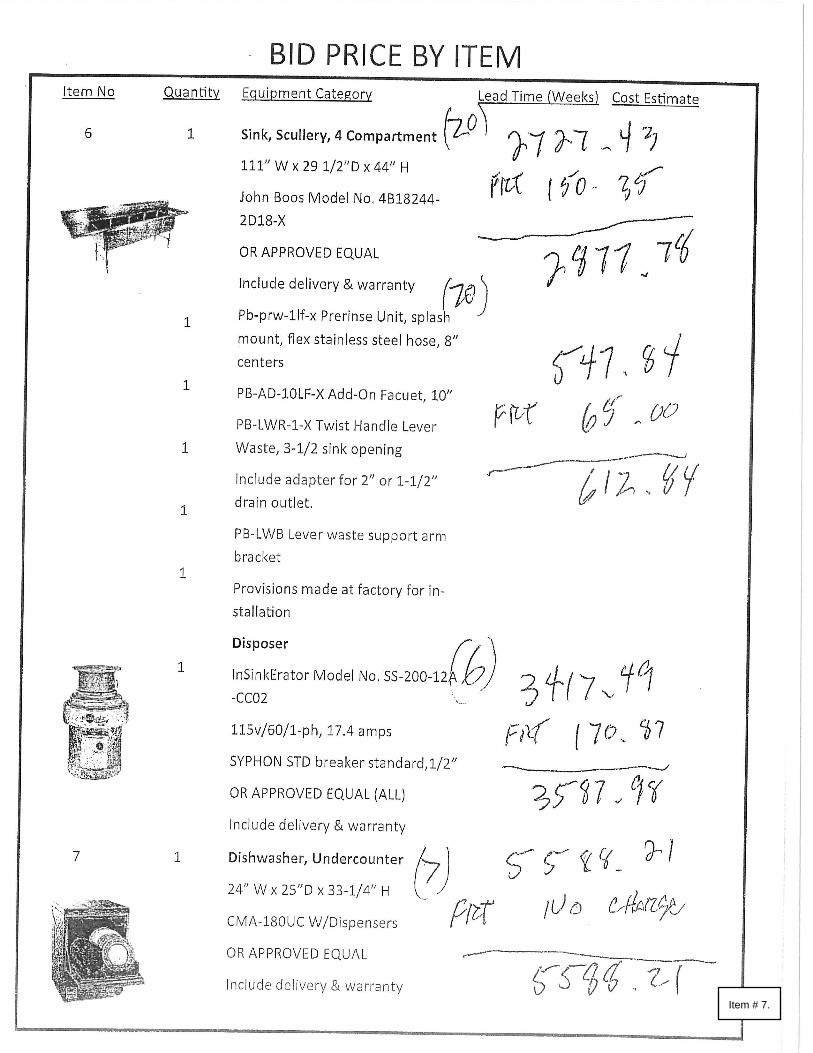
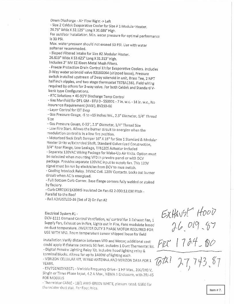
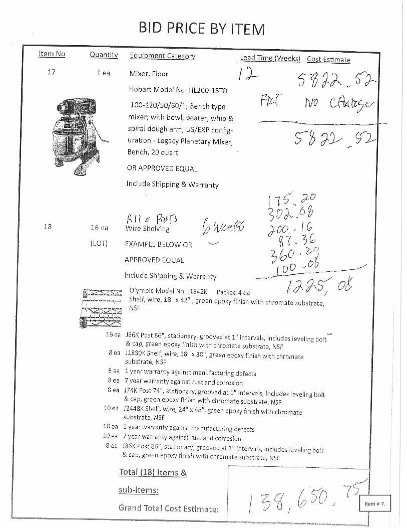
Specifications were assembled, and 3 bids were obtained.
Part of this project will be paid for by CDBG funds.
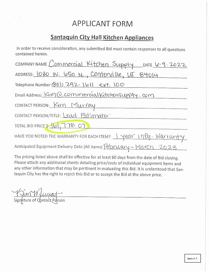
We recommend going with the bid Bintz/Bargreen has provided for the cost of $138,650.75. They were
the low bid. They were also the company that originally helped design the kitchen for us.
Staff Recommendation:
Motion to approve a purchase agreement with Bintz/Bargreen for the new appliances and kitchen
equipment for City Hall for a not to exceed amount of $138,650.75.
Item # 7.

Item # 7.

Item # 7.

Item # 7.

Item # 7.
Item # 7.

Item # 7.

Item # 7.

Item # 7.

Item # 7.
Item # 7.

Item # 7.
Item # 7.

Item # 7.
Item # 7.

ORDINANCE NO. 07-01-2022
AN ORDINANCE AMENDING SANTAQUIN CITY CODE TO UPDATE AND
CLARIFY LAND USE DEFINITIONS AND THE LAND USE TABLE IN THE MAIN
STREET BUSINESS DISTRICTS ZONE, PROVIDING FOR CODIFICATION,
CORRECTION OF SCRIVENER'S ERRORS, SEVERABLILITY, AND AN
EFFECTIVE DATE FOR THE ORDINANCE
WHEREAS, the City of Santaquin is a fourth-class city of the state of Utah; and
WHEREAS, the City Council has specific authority pursuant to Title 10, Chapter 9a Utah Code
Ann. (1953 as amended) to adopt a zoning plan including an ordinance and map which divide the
municipality into districts or zones and within such districts to regulate the erection, construction,
reconstruction, alteration, repair and uses of buildings and structures and the uses of land; and
WHEREAS, the state legislature has granted general welfare power to the City Council,
independent, apart from, and in addition to, its specific grants of legislative authority, which
enables the city to pass ordinances which are reasonably and appropriately related to the objectives
of that power, providing for the public safety, health, morals, and welfare; and
WHEREAS, the City Council desires to amend Santaquin City Code Title 10 Chapter 08 Section
020 and Title 10 Chapter 20 Section 190 to update and clarify land use definitions and the land use
table in the Main Street Business Districts Zone; and
WHEREAS, the Santaquin City Planning Commission held a public hearing on June 14, 2022
and June 28, 2022, which hearing was preceded by the posting of public notice in at least three
public places within the City limits of Santaquin City; and
WHEREAS, after the noted public hearing, the Santaquin City Planning Commission forwarded
a recommendation to the City Council.
NOW, THEREFORE, BE IT ORDAINED by the City Council of Santaquin City, State of Utah,
as follows:
Section I. Amendments
Title 10 Chapter 08 Section 020 is amended as follows: (underlined text is added, stricken text is deleted)
ALCOHOLIC BEVERAGE, CLASS A LICENSESESTABLISHMENT: A license to sell An
establishment that sells beer on the premises, in original sealed containers no larger than two (2)
liters (2 l), for consumption off the premises, in accordance with the ordinances of the city,
provided beer is not sold by minors, except under the supervision of a person twenty one (21) years
of age or older who is on the premisesas provided by state law. No beer shall be sold through a
drive-up window.
Item # 8.

ALCOHOLIC BEVERAGE, CLASS B LICENSEESTABLISHMENT: An establishment that
sells beer A license to sell beer in the original containers, and on draft, in containers no larger than
two (2) liters (2 l), for on premises consumption; beer in sealed containers no larger than two (2)
liters (2 l) may be sold for consumption off premises in accordance with the alcoholic beverage
control act, and the ordinances of the city.
ALCOHOLIC BEVERAGE, CLASS C LICENSEESTABLISHMENT: A license which entitles
restaurant and or private club licensees to that sells liquor and beer for consumption on the
premises, and to sell beer in sealed containers no larger than two (2) liters (2 l), for off premises
consumption, as specifically defined in, and in accordance with, the alcoholic beverage control
act.
ALCOHOLIC BEVERAGE, CLASS D LICENSEESTABLISHMENT: A license which allows
the storage, sale, service, and consumption of liquor, wine, heavy beer, and beer for contracted
banquet activities on the premises of a hotel, resort facility, sports center, or convention center. It
also allows for room service in hotels and resorts.
ALCOHOLIC BEVERAGE, CLASS E- PACKAGE AGENCYESTABLISHMENT: Liquor
stores that offer a modest selection of liquor and alcohol products. They may be located in hotels,
resorts and as a stand-alone building. Products are sold for consumption off of the agency premises.
This includes state liquor stores.
AUTOMOTIVE SERVICE AND REPAIR, MAJOR: An establishment primarily engaged in the
repair or maintenance of motor vehicles, trailers, and similar large mechanical equipment,
including paint, body and fender and engine and engine parts, provided, it is conducted within a
completely enclosed building. Accessory activities may include a car wash service that complies
with the provisions of SCC 10.48.060 or obtains a conditional use permit thereunder.
AUTOMOTIVE SERVICE AND REPAIR, MINOR: An establishment primarily engaged in the
repair or maintenance of motor vehicles, trailers, and similar mechanical equipment, including
brake, muffler, tire repair and change, lubrication, tune ups, safety inspections and emission
testing, detailing shops, overhaul or transmission work, but does not include an establishment that
qualifies as a major automotive service and repair facility, and provided it is conducted within a
completely enclosed building. Accessory activities may include a car wash service that complies
with the provisions of SCC 10.48.060 or obtains a conditional use permit thereunder.
COMMERCIAL, CONVENIENCE: Establishments which are designed and intended to serve
the daily or frequent trade or service needs of surrounding population. Such establishments
typically include grocery stores, variety stores, drugstores, dry cleaning, beauty shops,
barbershops, or a combination thereof and having floor areas typically less than fifty thousand
(50,000) square feet. Convenience stores do not typically include repair garages, automobile
sales, service or storage.
COMMERCIAL, RETAIL SALES AND SERVICES: Establishments which primarily engage in
the sale of general retail goods and/or accessory services (e.g., businesses within this definition
include those which conduct sales and storage entirely within an enclosed structure, with the
exception of occasional outdoor "sidewalk" promotions); and businesses specializing in the sale
of either general merchandise or convenience goods. Services may include laundromats with
Item # 8.

coin operated self-service machines, furniture and appliance stores, self-service or full service
car washes, and repair services for small household appliances or equipment. Work conducted on
the premises may include handicraft production of tangible goods such as pottery, jewelry,
picture frames, or leather goods.
DRIVE-IN RETAIL: Any form of merchandising, serving, or dispersing of goods in which
service is provided to customers while they remain in their automobiles., but not to include
drive-through restaurants.
GARAGE: A building, or part thereof, designed for the parking or temporary storage of
automobiles of the occupants and visitors of the premises.
HOTEL/MOTEL: As used in this title, the terms “Hotel” and “Motel” have the same meaning. A
building or group of buildings containing individual sleeping units, offered, designed and used
primarily for the accommodation of short-term guests not to exceed thirty (30) consecutive
calendar days or business professionals on temporary assignment, and with automobile parking or
storage available. This definition includes auto courts, motor lodges, and tourist courts. To be
classified under this definition, the use must have and maintain a functional lobby for check in/out
with an entryway for vehicle loading and unloading during check in/out, a luggage storage area,
an on site manager twenty four (24) hours a day, housekeeping of rooms at intervals normally no
more than forty eight (48) hours, continuous open access for public safety personnel and the use
should have at least three (3) or more of the following amenities conveniently located:
Concierge.
Guest laundry.
Guest pool.
Meeting rooms (minimum capacity of 25 people).
Outdoor or indoor sports court.
Recreation room or exercise room.
Restaurant/food service area.
Facilities not meeting the minimum requirements may fall under the definition for multiple-unit
or multiple-family dwellings (i.e., apartments).
MOTEL/HOTEL: See definition of Hotel/Motel.
PUBLIC BUILDING: a building which is owned or leased by a federal, state, or local,
governmental entity for public administration and/or services.
PUBLIC PARK OR PLAYGROUND: A tract of land which is owned by the public and which
has been partially or totally developed or designated for recreational purposes.
Item # 8.
RESTAURANTS, DRIVE-THROUGH: A use providing preparation and retail sale of food and
beverages, which may either be consumed on the premises or dispensed through one or more
drive-through lanes.
WEDDING CHAPEL: An establishment that primarily provides the facilities and services for
weddings on a commercial basis. This definition does not include churches and similar facilities
where weddings are an ancillary use.
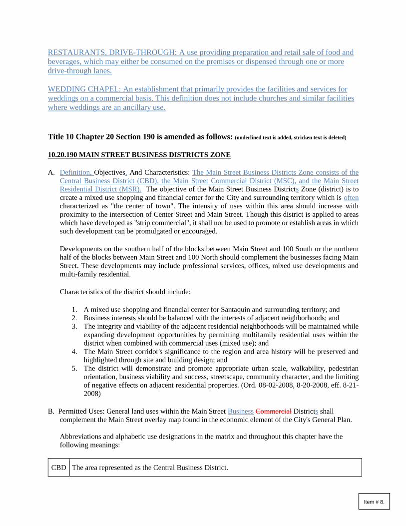
Title 10 Chapter 20 Section 190 is amended as follows: (underlined text is added, stricken text is deleted)
10.20.190 MAIN STREET BUSINESS DISTRICTS ZONE
A. Definition, Objectives, And Characteristics: The Main Street Business Districts Zone consists of the
Central Business District (CBD), the Main Street Commercial District (MSC), and the Main Street
Residential District (MSR). The objective of the Main Street Business Districts Zone (district) is to
create a mixed use shopping and financial center for the City and surrounding territory which is often
characterized as "the center of town". The intensity of uses within this area should increase with
proximity to the intersection of Center Street and Main Street. Though this district is applied to areas
which have developed as "strip commercial", it shall not be used to promote or establish areas in which
such development can be promulgated or encouraged.
Developments on the southern half of the blocks between Main Street and 100 South or the northern
half of the blocks between Main Street and 100 North should complement the businesses facing Main
Street. These developments may include professional services, offices, mixed use developments and
multi-family residential.
Characteristics of the district should include:
1. A mixed use shopping and financial center for Santaquin and surrounding territory; and
2. Business interests should be balanced with the interests of adjacent neighborhoods; and
3. The integrity and viability of the adjacent residential neighborhoods will be maintained while
expanding development opportunities by permitting multifamily residential uses within the
district when combined with commercial uses (mixed use); and
4. The Main Street corridor's significance to the region and area history will be preserved and
highlighted through site and building design; and
5. The district will demonstrate and promote appropriate urban scale, walkability, pedestrian
orientation, business viability and success, streetscape, community character, and the limiting
of negative effects on adjacent residential properties. (Ord. 08-02-2008, 8-20-2008, eff. 8-21-
2008)
B. Permitted Uses: General land uses within the Main Street Business Commercial Districts shall
complement the Main Street overlay map found in the economic element of the City's General Plan.
Abbreviations and alphabetic use designations in the matrix and throughout this chapter have the
following meanings:
CBD The area represented as the Central Business District.
Item # 8.
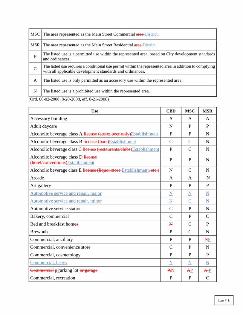
MSC The area represented as the Main Street Commercial area District.
MSR The area represented as the Main Street Residential area District.
P The listed use is a permitted use within the represented area, based on City development standards
and ordinances.
C The listed use requires a conditional use permit within the represented area in addition to complying
with all applicable development standards and ordinances.
A The listed use is only permitted as an accessory use within the represented area.
N The listed use is a prohibited use within the represented area.
(Ord. 08-02-2008, 8-20-2008, eff. 8-21-2008)
Use CBD MSC MSR
Accessory building A A A
Adult daycare N P P
Alcoholic beverage class A license (store; beer only)Establishment P P N
Alcoholic beverage class B license (bars)Establishment C C N
Alcoholic beverage class C license (restaurants/clubs)Establishment P C N
Alcoholic beverage class D license
(hotel/conventions)Establishment P P N
Alcoholic beverage class E license (liquor store Establishment, etc.) N C N
Arcade A A N
Art gallery P P P
Automotive service and repair, major N N N
Automotive service and repair, minor N C N
Automotive service station C P N
Bakery, commercial C P C
Bed and breakfast homes N C P
Brewpub P C N
Commercial, ancillary P P NP
Commercial, convenience store C P N
Commercial, cosmetology P P P
Commercial, heavy N N N
Commercial pParking lot or garage AN AP A P
Commercial, recreation P P C
Item # 8.

Commercial, repair services P P N
Commercial, retail sales and services P P N
Conference and convention facility C N N
Convalescent home, rest home, or nursing home N P P
Dance hall, discotheque C C N
Daycare center A P C
Drive-in retail N P N
Dwelling, Accessory Unit Attached N N A
Dwelling, Accessory Unit Detached N N A
Dwelling, Bachelor N N P
Dwelling, Bunkhouse N N A
Dwelling, caretaker N N A
Dwelling, multiple-family C C C
Dwelling, single-family detached N N P
Dwelling units above first story office, retail or commercial P C C
Feedlot N N N
Furniture and appliance stores P P N
Governmental offices P P P
Healthcare facility, assisted living facilities N P P
Hotel P P C
Impound Yard N N N
Institutions P P P
Junkyard N N N
Library P P P
Mixed use development C C C
Mobile Home Park N N N
Mortuary, funeral home N P C
Motel N N N
Park P P P
Permanent makeup establishment P P NP
Private club P C N
Professional office or financial services P P P
Public or quasi-public buildings CP CP CP
Item # 8.

Public park, private park or playground P P P
Public safety building C C P
Recreational vehicle court (RV) parks) N N N
Religious center P P P
Resident healthcare facility P P P
Residential facility for persons with a disability See 10.60 N N P
Residential facility for the elderly See 10.56 N N P
Residential support facility N N C
Restaurant P P C
Restaurant, with drive-through facilities N P N
School, commercial (art, music, hair, massage) P P C
School, public or quasi-public C C C
Seasonal businesses C P N
Sexually oriented business See 3.24 N N N
Slaughterhouse N N N
Social or reception center P C C
Storage Units Facilities N N N
Street vendors P P N
Tattoo parlor C P N
Temporary Uses See 10.16.300 C P N
Telecommunications sites. See SCC 10.16.340 paragraph D
Tobacco specialty shop in accordance with Utah State Code P C N
Transitional treatment home - large N N C
Transitional treatment home - small N N C
Truck stop N N N
Transitional victim home N N C
Veterinary hospital, large animal N N N
Veterinary hospital, small animal N P C
Wedding chapels P P C
Section II. Severability
If any part of this ordinance or the application thereof to any person or circumstances shall, for
any reason, be adjudged by a court of competent jurisdiction to be unconstitutional or invalid, such
judgment shall not affect, impair of invalidate the remainder of this ordinance or the application
Item # 8.
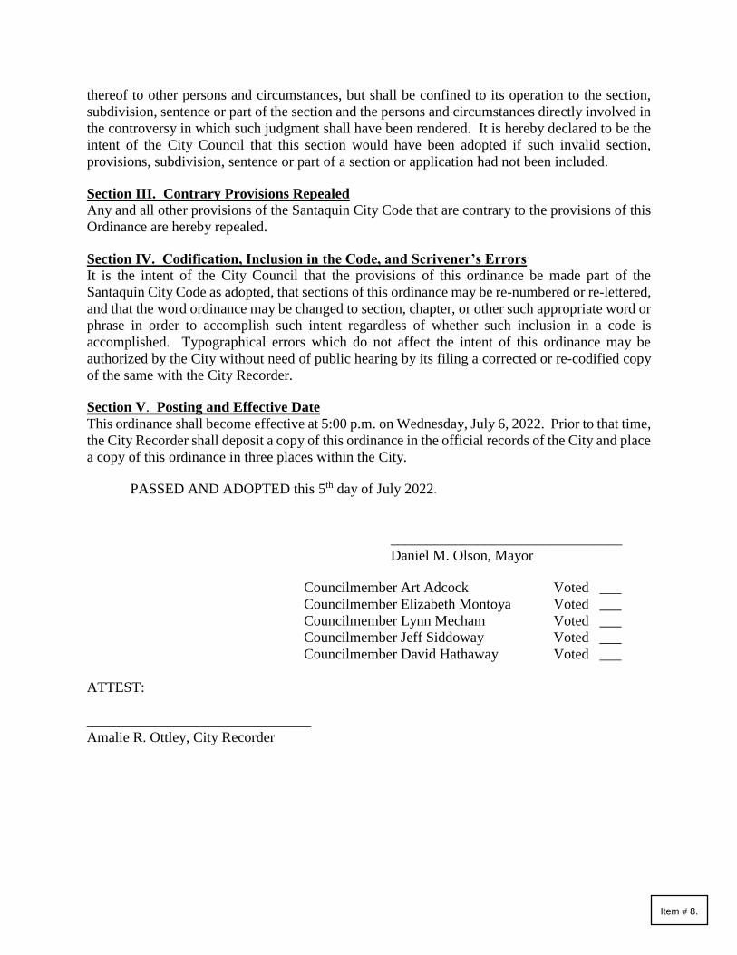
thereof to other persons and circumstances, but shall be confined to its operation to the section,
subdivision, sentence or part of the section and the persons and circumstances directly involved in
the controversy in which such judgment shall have been rendered. It is hereby declared to be the
intent of the City Council that this section would have been adopted if such invalid section,
provisions, subdivision, sentence or part of a section or application had not been included.
Section III. Contrary Provisions Repealed
Any and all other provisions of the Santaquin City Code that are contrary to the provisions of this
Ordinance are hereby repealed.
Section IV. Codification, Inclusion in the Code, and Scrivener’s Errors It is the intent of the City Council that the provisions of this ordinance be made part of the
Santaquin City Code as adopted, that sections of this ordinance may be re-numbered or re-lettered,
and that the word ordinance may be changed to section, chapter, or other such appropriate word or
phrase in order to accomplish such intent regardless of whether such inclusion in a code is
accomplished. Typographical errors which do not affect the intent of this ordinance may be
authorized by the City without need of public hearing by its filing a corrected or re-codified copy
of the same with the City Recorder.
Section V. Posting and Effective Date
This ordinance shall become effective at 5:00 p.m. on Wednesday, July 6, 2022. Prior to that time,
the City Recorder shall deposit a copy of this ordinance in the official records of the City and place
a copy of this ordinance in three places within the City.
PASSED AND ADOPTED this 5th day of July 2022.
________________________________
Daniel M. Olson, Mayor
Councilmember Art Adcock Voted ___
Councilmember Elizabeth Montoya Voted ___
Councilmember Lynn Mecham Voted ___
Councilmember Jeff Siddoway Voted ___
Councilmember David Hathaway Voted ___
ATTEST:
_______________________________
Amalie R. Ottley, City Recorder
Item # 8.

STATE OF UTAH )
) ss. COUNTY OF UTAH )
I, AMALIE R. OTTLEY, City Recorder of Santaquin City, Utah, do hereby certify and declare that the above and foregoing is a true, full, and correct copy of an ordinance passed by the City Council of Santaquin City, Utah, on the 5th day of July 2022, entitled
“AN ORDINANCE AMENDING SANTAQUIN CITY CODE TO UPDATE AND
CLARIFY LAND USE DEFINITIONS AND THE LAND USE TABLE IN THE MAIN
STREET BUSINESS DISTRICTS ZONE, PROVIDING FOR CODIFICATION,
CORRECTION OF SCRIVENER'S ERRORS, SEVERABLILITY, AND AN
EFFECTIVE DATE FOR THE ORDINANCE.”
IN WITNESS WHEREOF, I have hereunto set my hand and affixed the Corporate Seal of Santaquin City Utah this 5th day of July, 2022.
_____________________________ Amalie R. Ottley Santaquin City Recorder
(SEAL)
Item # 8.

AFFIDAVIT OF POSTING STATE OF UTAH )
) ss. COUNTY OF UTAH ) I, Amalie R. Ottley, City Recorder of Santaquin City, Utah, do hereby certify and declare that I posted in three (3) public places the ordinance, which is attached hereto on the 5th day of July, 2022.
The three places are as follows: 1. Zions Bank 2. Post Office 3. City Office
I further certify that copies of the ordinance so posted were true and correct copies of said ordinance. ________________________________ Amalie R. Ottley Santaquin City Recorder The foregoing instrument was acknowledged before me this ___ day of ________, 20__, by Amalie R. Ottley.
________________________________ Notary Public
Item # 8.

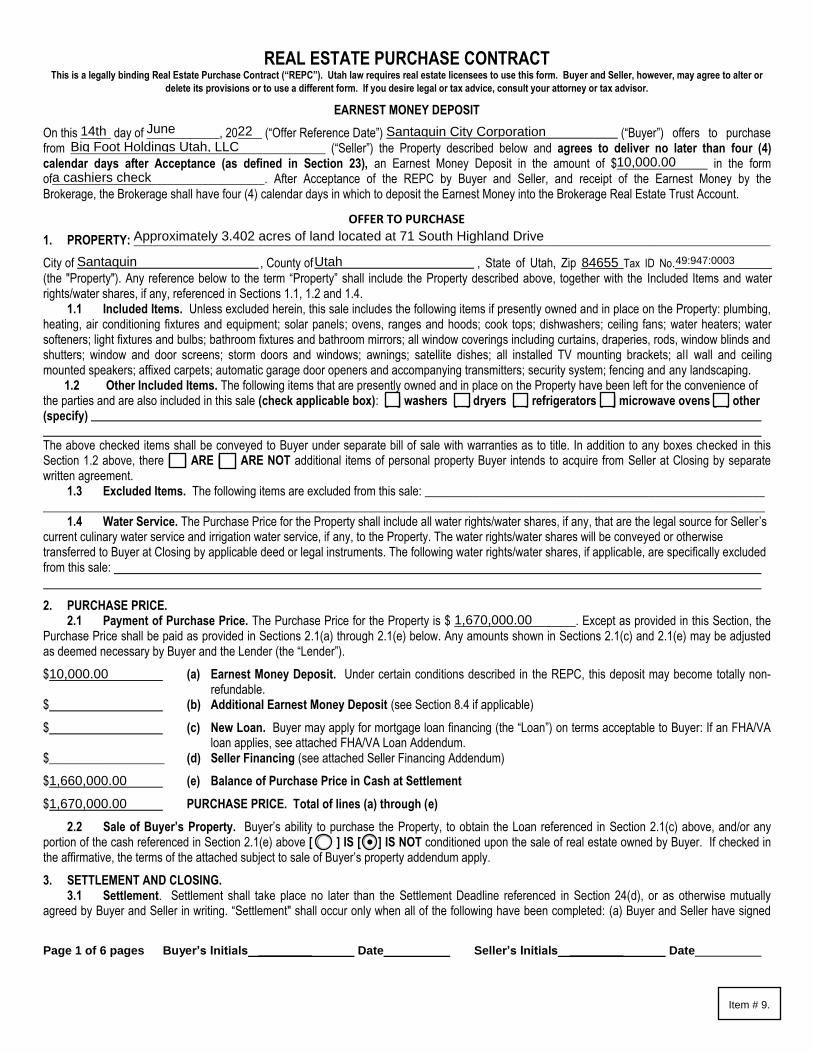
Santaquin City Resolution 07-01-2022 A RESOLUTION APPROVING THE PURCHASE OF REAL PROPERTY FOR
CORRIDOR PRESERVATION FOR THE EAST SIDE FRONTAGE ROAD
WHEREAS, the City of Santaquin is a fourth class city in the State of Utah with the
responsibility of providing certain transportation infrastructure for the benefit of the City and its residents; and
WHEREAS, the Utah Department of Transportation t (“UDOT”) has on multiple occasions
indicated the need to relocate the existing intersection of Main Street, Highland Drive, and HWY 198 farther away (to the east) from the I-15 freeway interchange; and
WHEREAS, this relocation will help to better accommodate the future, larger footprint of
the interchange, to be reconstructed; and
WHEREAS, one of the parcels the City would need to acquire in order to accommodate
this relocation of the intersection of Main Street, Highland Drive, and HWY 198, identified as parcel number 49:947:0003 on the records of the Utah County Recorder’s Office (the “Property”) recently became available for sale with a listing price of $1,750,000.00; and
WHEREAS, a UDOT certified appraiser values the Property at $1,670,000.00; and
WHEREAS, Santaquin City applied for Utah County Corridor Preservation funds
administered by Mountainland Association of Governments (MAG); and
WHEREAS, MAG and Utah County have awarded Santaquin City said Corridor
Preservation funds in an amount of $1,670,585.00 to purchase the available property; and
WHEREAS, At the Santaquin City Council’s direction, staff and Mayor Olson entered
into negotiations with the property owner; and
WHEREAS, the property owner has accepted Santaquin City’s offer to purchase the
property for the amount of the UDOT certified appraisal, which is $1,670,000.00, using the Corridor Preservation funds awarded by MAG; and
WHEREAS, Santaquin City’s closing costs for this property purchase are estimated to
be approximately $5,600.00;
NOW THEREFORE, be it resolved by the City Council of Santaquin City, Utah as
follows:
1. Mayor Daniel M. Olson is authorized to execute all purchase, settlement, and closing documents necessary to acquire the Property for corridor preservation in accordance with the terms and conditions set forth in the agreement attached hereto.
Item # 9.

2. This resolution shall be effective upon passage.
ADOPTED AND PASSED by the City Council of Santaquin City, Utah, this 5th day of
July 2022. SANTAQUIN CITY _____________________________ Daniel M. Olson, Mayor
Councilmember Art Adcock Voted ___
Councilmember Elizabeth Montoya Voted ___
Councilmember Lynn Mecham Voted ___
Councilmember Jeff Siddoway Voted ___
Councilmember David Hathaway Voted ___
Attest: ____________________________ Amalie R. Ottley, City Recorder
Item # 9.
Page 1 of 6 pages Buyer’s Initials ________ Date Seller’s Initials ________ Date
The above checked items shall be conveyed to Buyer under separate bill of sale with warranties as to title. In addition to any boxes checked in this Section 1.2 above, there [ ] ARE [ ] ARE NOT additional items of personal property Buyer intends to acquire from Seller at Closing by separate written agreement.
1.3 Excluded Items. The following items are excluded from this sale: ________________________________________________________ _______________________________________________________________________________________________________________________
1.4 Water Service. The Purchase Price for the Property shall include all water rights/water shares, if any, that are the legal source for Seller’s current culinary water service and irrigation water service, if any, to the Property. The water rights/water shares will be conveyed or otherwise transferred to Buyer at Closing by applicable deed or legal instruments. The following water rights/water shares, if applicable, are specifically excluded from this sale:
2. PURCHASE PRICE.2.1 Payment of Purchase Price. The Purchase Price for the Property is $ ____________________. Except as provided in this Section, the
Purchase Price shall be paid as provided in Sections 2.1(a) through 2.1(e) below. Any amounts shown in Sections 2.1(c) and 2.1(e) may be adjusted as deemed necessary by Buyer and the Lender (the “Lender”).
$ (a) Earnest Money Deposit. Under certain conditions described in the REPC, this deposit may become totally non-refundable.
$ (b) Additional Earnest Money Deposit (see Section 8.4 if applicable)
$ (c) New Loan. Buyer may apply for mortgage loan financing (the “Loan”) on terms acceptable to Buyer: If an FHA/VAloan applies, see attached FHA/VA Loan Addendum.
$___________________ (d) Seller Financing (see attached Seller Financing Addendum)
$ (e) Balance of Purchase Price in Cash at Settlement
$ PURCHASE PRICE. Total of lines (a) through (e)
2.2 Sale of Buyer’s Property. Buyer’s ability to purchase the Property, to obtain the Loan referenced in Section 2.1(c) above, and/or any portion of the cash referenced in Section 2.1(e) above [ ] IS [ ] IS NOT conditioned upon the sale of real estate owned by Buyer. If checked in the affirmative, the terms of the attached subject to sale of Buyer’s property addendum apply.
3. SETTLEMENT AND CLOSING.3.1 Settlement. Settlement shall take place no later than the Settlement Deadline referenced in Section 24(d), or as otherwise mutually
agreed by Buyer and Seller in writing. “Settlement" shall occur only when all of the following have been completed: (a) Buyer and Seller have signed
REAL ESTATE PURCHASE CONTRACT This is a legally binding Real Estate Purchase Contract (“REPC”). Utah law requires real estate licensees to use this form. Buyer and Seller, however, may agree to alter or
delete its provisions or to use a different form. If you desire legal or tax advice, consult your attorney or tax advisor.
EARNEST MONEY DEPOSIT
On this _____ day of ____________, 20____ (“Offer Reference Date”) (“Buyer”) offers to purchase from __________________________________________ (“Seller”) the Property described below and agrees to deliver no later than four (4) calendar days after Acceptance (as defined in Section 23), an Earnest Money Deposit in the amount of $_______________ in the form of___________________________________. After Acceptance of the REPC by Buyer and Seller, and receipt of the Earnest Money by the Brokerage, the Brokerage shall have four (4) calendar days in which to deposit the Earnest Money into the Brokerage Real Estate Trust Account.
OFFER TO PURCHASE
1. PROPERTY: _________________________________________________________________________________________________________
City of , County of , State of Utah, Zip _______Tax ID No.________________(the "Property"). Any reference below to the term “Property” shall include the Property described above, together with the Included Items and water rights/water shares, if any, referenced in Sections 1.1, 1.2 and 1.4.
1.1 Included Items. Unless excluded herein, this sale includes the following items if presently owned and in place on the Property: plumbing, heating, air conditioning fixtures and equipment; solar panels; ovens, ranges and hoods; cook tops; dishwashers; ceiling fans; water heaters; water softeners; light fixtures and bulbs; bathroom fixtures and bathroom mirrors; all window coverings including curtains, draperies, rods, window blinds and shutters; window and door screens; storm doors and windows; awnings; satellite dishes; all installed TV mounting brackets; all wall and ceiling mounted speakers; affixed carpets; automatic garage door openers and accompanying transmitters; security system; fencing and any landscaping. 1.2 Other Included Items. The following items that are presently owned and in place on the Property have been left for the convenience of the parties and are also included in this sale (check applicable box): [ ] washers [ ] dryers [ ] refrigerators [ ] microwave ovens [ ] other (specify)
14th June 22 Santaquin City CorporationBig Foot Holdings Utah, LLC
10,000.00a cashiers check
Approximately 3.402 acres of land located at 71 South Highland Drive
Santaquin Utah 84655 49:947:0003
1,670,000.00
10,000.00
1,660,000.00
1,670,000.00
Item # 9.

Page 2 of 6 pages Buyer’s Initials ________ Date Seller’s Initials ________ Date
and delivered to each other or to the escrow/closing office all documents required by the REPC, by the Lender, by the title insurance and escrow/closing offices, by written escrow instructions (including any split closing instructions, if applicable), or by applicable law; (b) any monies required to be paid by Buyer or Seller under these documents (except for the proceeds of any Loan) have been delivered by Buyer or Seller to the other party, or to the escrow/closing office, in the form of cash, wire transfer, cashier’s check, or other form acceptable to the escrow/closing office.
3.2 Closing. For purposes of the REPC, “Closing” means that: (a) Settlement has been completed; (b) the proceeds of any new Loan have been delivered by the Lender to Seller or to the escrow/closing office; and (c) the applicable Closing documents have been recorded in the office of the county recorder (“Recording”). The actions described in 3.2 (b) and (c) shall be completed no later than four calendar days after Settlement.
3.3 Possession. Except as provided in Section 6.1(a) and (b), Seller shall deliver physical possession of the Property to Buyer as follows: [ ] Upon Recording; [ ] _____Hours after Recording; [ ] Calendar Days after Recording. Any contracted rental of the Property prior to or after Closing, between Buyer and Seller, shall be by separate written agreement. Seller and Buyer shall each be responsible for any insurance coverage each party deems necessary for the Property including any personal property and belongings. The provisions of this Section 3.3 shall survive Closing.
4. PRORATIONS / ASSESSMENTS / OTHER PAYMENT OBLIGATIONS.4.1 Prorations. All prorations, including, but not limited to, homeowner’s association dues, property taxes for the current year, rents, and
interest on assumed obligations, if any, shall be made as of the Settlement Deadline referenced in Section 24(d), unless otherwise agreed to in writing by the parties. Such writing could include the settlement statement. The provisions of this Section 4.1 shall survive Closing.
4.2 Special Assessments. Any assessments for capital improvements as approved by the homeowner’s association (“HOA”) (pursuant to HOA governing documents) or as assessed by a municipality or special improvement district, prior to the Settlement Deadline shall be paid for by:
Seller Buyer Split Equally Between Buyer and Seller Other (explain) ________________________________________________ .The provisions of this Section 4.2 shall survive Closing.
4.3 Fees/Costs/Payment Obligations. (a) Escrow Fees. Unless otherwise agreed to in writing, Seller and Buyer shall each pay their respective fees charged by the
escrow/closing office for its services in the settlement/closing process. The provisions of this Section 4.3(a) shall survive Closing. (b) Rental Deposits/Prepaid Rents. Rental deposits (including, but not limited to, security deposits, cleaning deposits and prepaid rents)
for long term lease or rental agreements, as defined in Section 6.1(a), and short-term rental bookings, as defined in Section 6.1(b), not expiring prior to Closing, shall be paid or credited by Seller to Buyer at Settlement. The provisions of this Section 4.3(b) shall survive Closing.
(c) HOA/Other Entity Fees Due Upon Change of Ownership. Some HOA’s, special improvement districts and/or other specially plannedareas, under their governing documents charge a fee that is due to such entity as a result of the transfer of title to the Property from Seller to Buyer. Such fees are sometimes referred to as transfer fees, community enhancement fees, HOA reinvestment fees, etc. (collectively referred to in this section as “change of ownership fees”). Regardless of how the change of ownership fee is titled in the applicable governing documents, if a change of ownership fee is due upon the transfer of title to the Property from Seller to Buyer, that change of ownership fee shall, at Settlement, be paid for by: [ ] Seller [ ] Buyer [ ] Split Equally Between Buyer and Seller [ ] Other (explain) ________________________________________________. The provisions of this Section 4.3(c) shall survive Closing.
(d) Utility Services. Buyer agrees to be responsible for all utilities and other services provided to the Property after the SettlementDeadline. The provisions of this Section 4.3(d) shall survive Closing.
(e) Sales Proceeds Withholding. The escrow/closing office is authorized and directed to withhold from Seller’s proceeds at Closing,sufficient funds to pay off on Seller’s behalf all mortgages, trust deeds, judgments, mechanic's liens, tax liens and warrants. The provisions of this Section 4.3(e) shall survive Closing.
5. CONFIRMATION OF AGENCY DISCLOSURE. Buyer and Seller acknowledge prior written receipt of agency disclosure provided by theirrespective agent that has disclosed the agency relationships confirmed below. At the signing of the REPC:
Seller’s Agent(s) , represent(s) [ ] Seller [ ] both Buyer and Seller as Limited Agent(s);
Seller’s Agent(s) Utah Real Estate License Number(s): .
Seller’s Brokerage , represents [ ] Seller [ ] both Buyer and Seller as Limited Agent;
Seller’s Brokerage Utah Real Estate License Number: .
Buyer’s Agent(s) , represent(s) [ ] Buyer [ ] both Buyer and Seller as Limited Agent(s);
Buyer’s Agent(s) Utah Real Estate License Number(s): .
Buyer’s Brokerage , represents [ ] Buyer [ ] both Buyer and Seller as a Limited Agent.
Buyer’s Brokerage Utah Real Estate License Number: .
6. TITLE & TITLE INSURANCE.6.1 Title to Property. Seller represents that Seller has fee title to the Property and will convey marketable title to the Property to Buyer at
Closing by general warranty deed. Buyer does agree to accept title to the Property subject to the contents of the Commitment for Title Insurance (the “Commitment”) provided by Seller under Section 7, and as reviewed and approved by Buyer under Section 8.
(a) Long-Term Lease or Rental Agreements. Buyer agrees to accept title to the Property subject to any long-term tenant lease orrental agreements (meaning for periods of thirty (30) or more consecutive days) affecting the Property not expiring prior to Closing. Buyer also agrees to accept title to the Property subject to any existing rental and property management agreements affecting the Property not expiring prior to Closing.
BreAnna Nixon
9142369-SA00
Equity Real Estate (Advisors)
8569847-B000
N/A
N/A
N/A
N/A
✔
✔
✔
✔
✔
Item # 9.
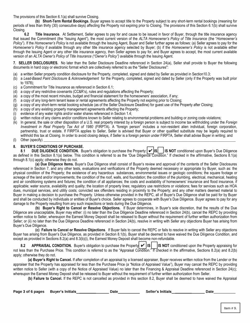
Page 3 of 6 pages Buyer’s Initials ________ Date Seller’s Initials ________ Date
The provisions of this Section 6.1(a) shall survive Closing. (b) Short-Term Rental Bookings. Buyer agrees to accept title to the Property subject to any short-term rental bookings (meaning for
periods of less than thirty (30) consecutive days) affecting the Property not expiring prior to Closing. The provisions of this Section 6.1(b) shall survive Closing.
6.2 Title Insurance. At Settlement, Seller agrees to pay for and cause to be issued in favor of Buyer, through the title insurance agency that issued the Commitment (the “Issuing Agent”), the most current version of the ALTA Homeowner’s Policy of Title Insurance (the “Homeowner’s Policy”). If the Homeowner’s Policy is not available through the Issuing Agent, Buyer and Seller further agree as follows: (a) Seller agrees to pay for the Homeowner’s Policy if available through any other title insurance agency selected by Buyer; (b) if the Homeowner’s Policy is not available either through the Issuing Agent or any other title insurance agency, then Seller agrees to pay for, and Buyer agrees to accept, the most current available version of an ALTA Owner’s Policy of Title Insurance (“Owner’s Policy”) available through the Issuing Agent.
7. SELLER DISCLOSURES. No later than the Seller Disclosure Deadline referenced in Section 24(a), Seller shall provide to Buyer the followingdocuments in hard copy or electronic format which are collectively referred to as the "Seller Disclosures":
(a) a written Seller property condition disclosure for the Property, completed, signed and dated by Seller as provided in Section10.3;(b) a Lead-Based Paint Disclosure & Acknowledgement for the Property, completed, signed and dated by Seller (only if the Property was built prior
to 1978);(c) a Commitment for Title Insurance as referenced in Section 6.1;(d) a copy of any restrictive covenants (CC&R’s), rules and regulations affecting the Property;(e) a copy of the most recent minutes, budget and financial statement for the homeowners’ association, if any;(f) a copy of any long-term tenant lease or rental agreements affecting the Property not expiring prior to Closing;(g) a copy of any short-term rental booking schedule (as of the Seller Disclosure Deadline) for guest use of the Property after Closing;(h) a copy of any existing property management agreements affecting the Property;(i) evidence of any water rights and/or water shares referenced in Section 1.4;(j) written notice of any claims and/or conditions known to Seller relating to environmental problems and building or zoning code violations;(k) In general, the sale or other disposition of a U.S. real property interest by a foreign person is subject to income tax withholding under the Foreign
Investment in Real Property Tax Act of 1980 (FIRPTA). A “foreign person” includes a non-resident alien individual, foreign corporation,partnership, trust or estate. If FIRPTA applies to Seller, Seller is advised that Buyer or other qualified substitute may be legally required towithhold this tax at Closing. In order to avoid closing delays, if Seller is a foreign person under FIRPTA, Seller shall advise Buyer in writing; and
(l) Other (specify) _______________________________________________________________________________________________________
8. BUYER’S CONDITIONS OF PURCHASE.8.1 DUE DILIGENCE CONDITION. Buyer's obligation to purchase the Property: [ ] IS [ ] IS NOT conditioned upon Buyer’s Due Diligence
as defined in this Section 8.1(a) below. This condition is referred to as the “Due Diligence Condition.” If checked in the affirmative, Sections 8.1(a) through 8.1(c) apply; otherwise they do not.
(a) Due Diligence Items. Buyer’s Due Diligence shall consist of Buyer’s review and approval of the contents of the Seller Disclosuresreferenced in Section 7, and any other tests, evaluations and verifications of the Property deemed necessary or appropriate by Buyer, such as: the physical condition of the Property; the existence of any hazardous substances, environmental issues or geologic conditions; the square footage or acreage of the land and/or improvements; the condition of the roof, walls, and foundation; the condition of the plumbing, electrical, mechanical, heating and air conditioning systems and fixtures; the condition of all appliances; the costs and availability of homeowners’ insurance and flood insurance, if applicable; water source, availability and quality; the location of property lines; regulatory use restrictions or violations; fees for services such as HOA dues, municipal services, and utility costs; convicted sex offenders residing in proximity to the Property; and any other matters deemed material to Buyer in making a decision to purchase the Property. Unless otherwise provided in the REPC, all of Buyer’s Due Diligence shall be paid for by Buyer and shall be conducted by individuals or entities of Buyer's choice. Seller agrees to cooperate with Buyer’s Due Diligence. Buyer agrees to pay for any damage to the Property resulting from any such inspections or tests during the Due Diligence.
(b) Buyer’s Right to Cancel or Resolve Objections. If Buyer determines, in Buyer’s sole discretion, that the results of the DueDiligence are unacceptable, Buyer may either: (i) no later than the Due Diligence Deadline referenced in Section 24(b), cancel the REPC by providing written notice to Seller, whereupon the Earnest Money Deposit shall be released to Buyer without the requirement of further written authorization from Seller; or (ii) no later than the Due Diligence Deadline referenced in Section 24(b), resolve in writing with Seller any objections Buyer has arising from Buyer’s Due Diligence.
(c) Failure to Cancel or Resolve Objections. If Buyer fails to cancel the REPC or fails to resolve in writing with Seller any objectionsBuyer has arising from Buyer’s Due Diligence, as provided in Section 8.1(b), Buyer shall be deemed to have waived the Due Dil igence Condition, and except as provided in Sections 8.2(a) and 8.3(b)(i), the Earnest Money Deposit shall become non-refundable.
8.2 APPRAISAL CONDITION. Buyer's obligation to purchase the Property: [ ] IS [ ] IS NOT conditioned upon the Property appraising for not less than the Purchase Price. This condition is referred to as the “Appraisal Condition.” If checked in the affirmative, Sections 8.2(a) and 8.2(b) apply; otherwise they do not.
(a) Buyer’s Right to Cancel. If after completion of an appraisal by a licensed appraiser, Buyer receives written notice from the Lender or theappraiser that the Property has appraised for less than the Purchase Price (a “Notice of Appraised Value”), Buyer may cancel the REPC by providing written notice to Seller (with a copy of the Notice of Appraised Value) no later than the Financing & Appraisal Deadline referenced in Section 24(c); whereupon the Earnest Money Deposit shall be released to Buyer without the requirement of further written authorization from Seller.
(b) Failure to Cancel. If the REPC is not cancelled as provided in this section 8.2, Buyer shall be deemed to have waived the Appraisal
✔
✔
Item # 9.

Page 4 of 6 pages Buyer’s Initials ________ Date Seller’s Initials ________ Date
Condition, and except as provided in Sections 8.1(b) and 8.3(b)(i), the Earnest Money Deposit shall become non-refundable.
8.3 FINANCING CONDITION. (Check Applicable Box) (a) [ ] No Financing Required. Buyer’s obligation to purchase the Property IS NOT conditioned upon Buyer obtaining financing. If
checked, Section 8.3(b) below does NOT apply. (b) [ ] Financing Required. Buyer’s obligation to purchase the Property IS conditioned upon Buyer obtaining the Loan referenced in
Section 2.1(c). This Condition is referred to as the “Financing Condition.” If checked, Sections 8.3(b)(i), (ii) and (iii) apply; otherwise they do not. If the REPC is not cancelled by Buyer as provided in Sections 8.1(b) or 8.2(a), then Buyer agrees to work diligently and in good faith to obtain the Loan.
(i) Buyer’s Right to Cancel Before the Financing & Appraisal Deadline. If Buyer, in Buyer’s sole discretion, is not satisfied with theterms and conditions of the Loan, Buyer may, after the Due Diligence Deadline referenced in Section 24(b), if applicable, cancel the REPC by providing written notice to Seller no later than the Financing & Appraisal Deadline referenced in Section 24(c); whereupon $___________ of Buyer’s Earnest Money Deposit shall be released to Seller without the requirement of further written authorization from Buyer, and the remainder of Buyer’s Earnest Money Deposit shall be released to Buyer without further written authorization from Seller.
(ii) Buyer’s Right to Cancel After the Financing & Appraisal Deadline. If after expiration of the Financing & Appraisal Deadlinereferenced in Section 24(c), Buyer fails to obtain the Loan, meaning that the proceeds of the Loan have not been delivered by the Lender to the escrow/closing office as required under Section 3.2, then Buyer shall not be obligated to purchase the Property and Buyer or Seller may cancel the REPC by providing written notice to the other party.
(iii) Earnest Money Deposit(s) Released to Seller. If the REPC is cancelled as provided in Section 8.3(b)(ii), Buyer agrees that all ofBuyer’s Earnest Money Deposit, or Deposits, if applicable (see Section 8.4 below), shall be released to Seller without the requirement of further written authorization from Buyer. Seller agrees to accept, as Seller’s exclusive remedy, the Earnest Money Deposit, or Deposits, if applicable, as liquidated damages. Buyer and Seller agree that liquidated damages would be difficult and impractical to calculate, and the Earnest Money Deposit, or Deposits, if applicable, is a fair and reasonable estimate of Seller’s damages in the event Buyer fails to obtain the Loan.
8.4 ADDITIONAL EARNEST MONEY DEPOSIT. If the REPC has not been previously canceled by Buyer as provided in Sections 8.1, 8.2 or 8.3, as applicable, then no later than the Due Diligence Deadline, or the Financing & Appraisal Deadline, whichever is later, Buyer: [ WILL WILL NOT deliver to the Buyer’s Brokerage, an Additional Earnest Money Deposit in the amount of $_________________. The Earnest Money Deposit and the Additional Earnest Money Deposit, if applicable, are sometimes referred to herein as the “Deposits”. The Earnest Money Deposit, or Deposits, if applicable, shall be credited toward the Purchase Price at Closing.
9. ADDENDA. There [ ] ARE [ ] ARE NOT addenda to the REPC containing additional terms. If there are, the terms of the following addenda areincorporated into the REPC by this reference: [ ] Addendum No. _____________ [ ] Seller Financing Addendum [ ] FHA/VA Loan Addendum[ ] Other (specify) .
10. HOME WARRANTY PLAN / AS-IS CONDITION OF PROPERTY.10.1 Home Warranty Plan. A one-year Home Warranty Plan [ ] WILL [ ] WILL NOT be included in this transaction. If included, the Home
Warranty Plan shall be ordered by [ ] Buyer Seller and shall be issued by a company selected by ] Buyer ] Seller. The cost of the Home Warranty Plan shall not exceed $ _______ and shall be paid for at Settlement by Buyer [ ] Seller.
10.2 Condition of Property/Buyer Acknowledgements. Buyer acknowledges and agrees that in reference to the physical condition of the Property: (a) Buyer is purchasing the Property in its “As-Is” condition without expressed or implied warranties of any kind; (b) Buyer shall have, during Buyer’s Due Diligence as referenced in Section 8.1, an opportunity to completely inspect and evaluate the condition of the Property; and (c) if based on the Buyer’s Due Diligence, Buyer elects to proceed with the purchase of the Property, Buyer is relying wholly on Buyer’s own judgment and that of any contractors or inspectors engaged by Buyer to review, evaluate and inspect the Property. The provisions of Section 10.2 shall survive Closing.
10.3 Condition of Property/Seller Acknowledgements. Seller acknowledges and agrees that in reference to the physical condition of the Property, Seller agrees to: (a) disclose in writing to Buyer defects in the Property known to Seller that materially affect the value of the Property that cannot be discovered by a reasonable inspection by an ordinary prudent Buyer; (b) carefully review, complete, and provide to Buyer a written Seller property condition disclosure as stated in Section 7(a); (c) deliver the Property to Buyer in substantially the same general condition as it was on the date of Acceptance, as defined in Section 23, ordinary wear and tear excepted; (d) deliver the Property to Buyer in broom-clean condition and free of debris and personal belongings; and (e) repair any Seller or tenant moving-related damage to the Property at Seller’s expense. The provisions of Section 10.3 shall survive Closing.
11. FINAL PRE-SETTLEMENT WALK-THROUGH INSPECTION. No earlier than seven (7) calendar days prior to Settlement, and upon reasonablenotice and at a reasonable time, Buyer may conduct a final pre-Settlement walk-through inspection of the Property to determine only that the Propertyis “as represented,” meaning that the items referenced in Sections 1.1, 1.2 and 8.1(b)(ii) ("the items") are respectively present, repaired or corrected asagreed. The failure to conduct a walk-through inspection or to claim that an item is not as represented shall not constitute a waiver by Buyer of the rightto receive, on the date of possession, the items as represented.
12. CHANGES DURING TRANSACTION. Seller agrees that except as provided in Section 12.5 below, from the date of Acceptance until the date ofClosing the following additional items apply:
12.1 Alterations/Improvements to the Property. No substantial alterations or improvements to the Property shall be made or undertaken without prior written consent of Buyer.
12.2 Financial Encumbrances/Changes to Legal Title. No further financial encumbrances to the Property shall be made, and no changes in
10,000.00
N/A
One
✔
✔
✔
✔
✔
Item # 9.

Page 5 of 6 pages Buyer’s Initials ________ Date Seller’s Initials ________ Date
the legal title to the Property shall be made without the prior written consent of Buyer. 12.3 Property Management Agreements. No changes to any existing property management agreements shall be made and no new property
management agreements may be entered into without the prior written consent of Buyer. 12.4 Long-Term Lease or Rental Agreements. No changes to any existing tenant lease or rental agreements shall be made and no new
long-term lease or rental agreements, as defined in Section 6.1(a), may be entered into without the prior written consent of Buyer. 12.5 Short-Term Rental Bookings. If the Property is made available for short-term rental bookings as defined in Section 6.1(b), Seller MAY
NOT after the Seller Disclosure Deadline continue to accept short-term rental bookings for guest use of the property without the prior written consent of Buyer.
13. AUTHORITY OF SIGNERS. If Buyer or Seller is a corporation, partnership, trust, estate, limited liability company or other entity, the personsigning the REPC on its behalf warrants his or her authority to do so and to bind Buyer and Seller.
14. COMPLETE CONTRACT. The REPC together with its addenda, any attached exhibits, and Seller Disclosures (collectively referred to as the“REPC”), constitutes the entire contract between the parties and supersedes and replaces any and all prior negotiations, representations, warranties,understandings or contracts between the parties whether verbal or otherwise. The REPC cannot be changed except by written agreement of theparties.
15. MEDIATION. Any dispute relating to the REPC arising prior to or after Closing: [ ] SHALL [ ] MAY AT THE OPTION OF THE PARTIES firstbe submitted to mediation. Mediation is a process in which the parties meet with an impartial person who helps to resolve the dispute informally andconfidentially. Mediators cannot impose binding decisions. The parties to the dispute must agree before any settlement is binding. The parties willjointly appoint an acceptable mediator and share equally in the cost of such mediation. If mediation fails, the other procedures and remedies availableunder the REPC shall apply. Nothing in this Section 15 prohibits any party from seeking emergency legal or equitable relief, pending mediation. Theprovisions of this Section 15 shall survive Closing.
16. DEFAULT.16.1 Buyer Default. If Buyer defaults, Seller may elect one of the following remedies: (a) cancel the REPC and retain the Earnest Money
Deposit, or Deposits, if applicable, as liquidated damages; (b) maintain the Earnest Money Deposit, or Deposits, if applicable, in trust and sue Buyer to specifically enforce the REPC; or (c) return the Earnest Money Deposit, or Deposits, if applicable, to Buyer and pursue any other remedies available at law.
16.2 Seller Default. If Seller defaults, Buyer may elect one of the following remedies: (a) cancel the REPC, and in addition to the return of the Earnest Money Deposit, or Deposits, if applicable, Buyer may elect to accept from Seller, as liquidated damages, a sum equal to the Earnest Money Deposit, or Deposits, if applicable; or (b) maintain the Earnest Money Deposit, or Deposits, if applicable, in trust and sue Seller to specifically enforce the REPC; or (c) accept a return of the Earnest Money Deposit, or Deposits, if applicable, and pursue any other remedies available at law. If Buyer elects to accept liquidated damages, Seller agrees to pay the liquidated damages to Buyer upon demand.
17. ATTORNEY FEES AND COSTS/GOVERNING LAW. In the event of litigation or binding arbitration arising out of the transaction contemplated bythe REPC, the prevailing party shall be entitled to costs and reasonable attorney fees. However, attorney fees shall not be awarded for participation inmediation under Section 15. This contract shall be governed by and construed in accordance with the laws of the State of Utah. The provisions of thisSection 17 shall survive Closing.
18. NOTICES. Except as provided in Section 23, all notices required under the REPC must be: (a) in writing; (b) signed by the Buyer or Seller givingnotice; and (c) received by the Buyer or the Seller, or their respective agent, or by the brokerage firm representing the Buyer or Seller, no later than theapplicable date referenced in the REPC.
19. NO ASSIGNMENT. The REPC and the rights and obligations of Buyer hereunder, are personal to Buyer. The REPC may not be assigned byBuyer without the prior written consent of Seller. Provided, however, the transfer of Buyer’s interest in the REPC to any business entity in which Buyerholds a legal interest, including, but not limited to, a family partnership, family trust, limited liability company, partnership, or corporation (collectivelyreferred to as a “Permissible Transfer”), shall not be treated as an assignment by Buyer that requires Seller’s prior written consent. Furthermore, theinclusion of “and/or assigns” or similar language on the line identifying Buyer on the first page of the REPC shall constitute Seller’s written consent onlyto a Permissible Transfer.
20. INSURANCE & RISK OF LOSS.20.1 Insurance Coverage. As of Closing, Buyer shall be responsible to obtain casualty and liability insurance coverage on the Property in
amounts acceptable to Buyer and Buyer’s Lender, if applicable. 20.2 Risk of Loss. If prior to Closing, any part of the Property is damaged or destroyed by fire, vandalism, flood, earthquake, or act of God, the
risk of such loss or damage shall be borne by Seller; provided however, that if the cost of repairing such loss or damage would exceed ten percent (10%) of the Purchase Price referenced in Section 2, either Seller or Buyer may elect to cancel the REPC by providing written notice to the other party, in which instance the Earnest Money Deposit, or Deposits, if applicable, shall be returned to Buyer.
21. TIME IS OF THE ESSENCE. Time is of the essence regarding the dates set forth in the REPC. Extensions must be agreed to in writing by allparties. Unless otherwise explicitly stated in the REPC: (a) performance under each Section of the REPC which references a date shall absolutely berequired by 5:00 PM Mountain Time on the stated date; and (b) the term "days" and “calendar days” shall mean calendar days and shall be countedbeginning on the day following the event which triggers the timing requirement (e.g. Acceptance). Performance dates and times referenced herein shallnot be binding upon title companies, lenders, appraisers and others not parties to the REPC, except as otherwise agreed to in writing by such non-party.
✔
Item # 9.
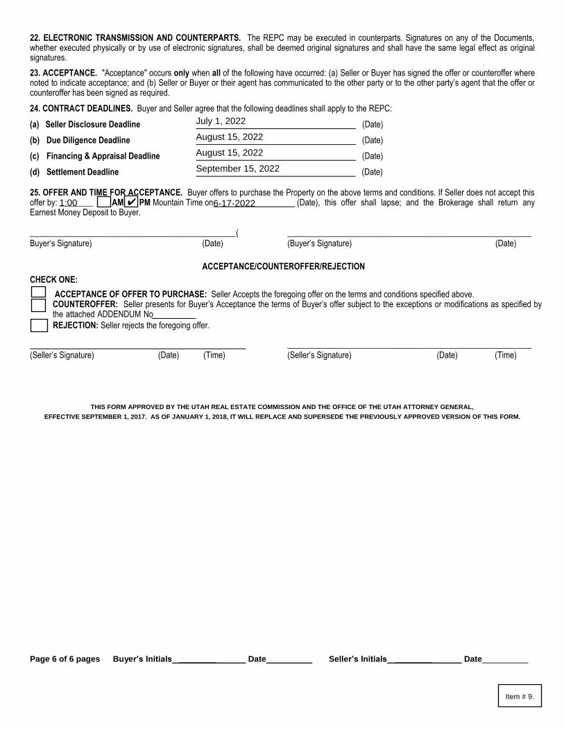
Page 6 of 6 pages Buyer’s Initials ________ Date Seller’s Initials ________ Date
22. ELECTRONIC TRANSMISSION AND COUNTERPARTS. The REPC may be executed in counterparts. Signatures on any of the Documents,whether executed physically or by use of electronic signatures, shall be deemed original signatures and shall have the same legal effect as originalsignatures.
23. ACCEPTANCE. "Acceptance" occurs only when all of the following have occurred: (a) Seller or Buyer has signed the offer or counteroffer wherenoted to indicate acceptance; and (b) Seller or Buyer or their agent has communicated to the other party or to the other party’s agent that the offer orcounteroffer has been signed as required.
24. CONTRACT DEADLINES. Buyer and Seller agree that the following deadlines shall apply to the REPC:
(a) Seller Disclosure Deadline (Date)
(b) Due Diligence Deadline (Date)
(c) Financing & Appraisal Deadline (Date)
(d) Settlement Deadline (Date)
25. OFFER AND TIME FOR ACCEPTANCE. Buyer offers to purchase the Property on the above terms and conditions. If Seller does not accept thisoffer by: ________ [ ] AM [ ] PM Mountain Time on (Date), this offer shall lapse; and the Brokerage shall return anyEarnest Money Deposit to Buyer.
_________________________________________________(Buyer’s Signature) (Date)
__________________________________________________________(Buyer’s Signature) (Date)
ACCEPTANCE/COUNTEROFFER/REJECTION
CHECK ONE:
ACCEPTANCE OF OFFER TO PURCHASE: Seller Accepts the foregoing offer on the terms and conditions specified above. COUNTEROFFER: Seller presents for Buyer’s Acceptance the terms of Buyer’s offer subject to the exceptions or modifications as specified by the attached ADDENDUM No
REJECTION: Seller rejects the foregoing offer.
(Seller’s Signature) (Date) (Time) __________________________________________________________(Seller’s Signature) (Date) (Time)
THIS FORM APPROVED BY THE UTAH REAL ESTATE COMMISSION AND THE OFFICE OF THE UTAH ATTORNEY GENERAL,
EFFECTIVE SEPTEMBER 1, 2017. AS OF JANUARY 1, 2018, IT WILL REPLACE AND SUPERSEDE THE PREVIOUSLY APPROVED VERSION OF THIS FORM.
July 1, 2022
August 15, 2022
August 15, 2022
September 15, 2022
1:00 6-17-2022✔
Item # 9.

ADDENDUM NO. TO
REAL ESTATE PURCHASE CONTRACT
THIS IS AN [ ] ADDENDUM [ ] COUNTEROFFER to that REAL ESTATE PURCHASE CONTRACT (the "REPC") with
an Offer Reference Date of , including all prior addenda and counteroffers, between
as Buyer, and as Seller,
regarding the Property located at . The
following terms are hereby incorporated as part of the REPC:
To the extent the terms of this ADDENDUM modify or conflict with any provisions of the REPC, including all prior addenda and counteroffers, these terms shall control. All other terms of the REPC, including all prior addenda and counteroffers, not modified by this ADDENDUM shall remain the same. [ ] Seller [ ] Buyer shall have until [ ] AM [ ] PM Mountain Time on (Date), to accept the terms of this ADDENDUM in accordance with the provisions of Section 23 of the REPC. Unless so accepted, the offer as set forth in this ADDENDUM shall lapse.
[ ] Buyer [ ] Seller Signature (Date) (Time) [ ] Buyer [ ] Seller Signature (Date) (Time)
ACCEPTANCE/COUNTEROFFER/REJECTION CHECK ONE: [ ] ACCEPTANCE: [ ] Seller [ ] Buyer hereby accepts the terms of this ADDENDUM.
[ ] COUNTEROFFER: [ ] Seller [ ] Buyer presents as a counteroffer the terms of attached ADDENDUM NO. .
(Signature) (Date) (Time) (Signature) (Date) (Time)
[ ] REJECTION: [ ] Seller [ ] Buyer rejects the foregoing ADDENDUM.
(Signature) (Date) (Time) (Signature) (Date) (Time)
THIS FORM APPROVED BY THE UTAH REAL ESTATE COMMISSION AND THE OFFICE OF THE UTAH ATTORNEY GENERAL, EFFECTIVE JANUARY 1, 2020. IT REPLACES AND SUPERSEDES ALL PREVIOUSLY APPROVED VERSIONS OF THIS FORM.
Item # 9.
nbeagley
Text Box
ONE
nbeagley
Text Box
X
nbeagley
Text Box
June 14, 2022
nbeagley
Text Box
Santaquin City Corporation
nbeagley
Text Box
Buyer's purchase of the Property is contingent upon acceptable results from a complete Phase I Environmental Site Assessment report. Buyer agrees to order and pay for all costs associated to the Phase I Environmental Site Assessment report as part of and during the Due Diligence period. Buyer's purchase of the Property is contingent upon the allocation and payment, at settlement, of Corridor Preservation funds provided by Utah County and administered by Mountainland Association of Governments (MAG). Accordingly, the first sentence in Section 8.3B is changed to read as follows: "Buyer’s obligation to purchase the Property IS conditioned upon Buyer obtaining the funds provided by Utah County and administered by Mountainland Association of Governments." Buyer's purchase of the Property is contingent upon approval by the Santaquin City Council during an official open public meeting as part of and during the Due Diligence period.
nbeagley
Text Box
X
nbeagley
Text Box
1:00
nbeagley
Text Box
X
nbeagley
Text Box
June 17, 2022
nbeagley
Text Box
X
nbeagley
Text Box
Big Foot Holdings Utah, LLC
nbeagley
Text Box
71 South Highland Drive (UT County Parcel Serial Number 49:947:0003

DEPOSIT OF EARNEST MONEY WITH TITLEINSURANCE COMPANY ADDENDUM TOREAL ESTATE PURCHASE CONTRACT
ADDENDUM # TWO (2)
THIS IS AN [X] ADDENDUM [ ] COUNTEROFFER to that REAL ESTATE PURCHASE CONTRACT (the "REPC") with anOffer Reference Date of June 14, 2022 , including all prior addenda and counteroffers, betweenSantaquin City Corporation as Buyer, and Big Foot Holdings Utah, LLC as Seller, regarding the Property located at71 South Highland Dr. Santaquin Ut 84655, Tax ID: 49:947:0003. The following terms are hereby incorporated aspart of the REPC.
1. The REPC is amended as follows: Buyer and Seller agree that the Earnest Money Deposit, or Deposits, will be held with aTitle Insurance Company instead of deposited in the Buyer’s Brokerage Trust Account. The Title Insurance Companyis Provo Abstract Title Company-Mike Crandall locatedat: 105 E 300 S, Provo, UT 84606 phone number 801.373.7570 and [email protected].
ATTENTION: Buyer and Seller are advised that the Title Insurance Company may require, through separate writteninstructions, that BOTH the Buyer and Seller mutually authorize disbursement of the Earnest Money Deposit, even if the REPCstates that no additional written authorization is required, which may result in additional delays and costs for either party toreceive the Earnest Money Deposits.
Buyer and Seller acknowledge that the Utah Division of Real Estate has no authority over the Title Insurance Company’srelease or disbursement of the Earnest Money Deposit.
To the extent the terms of this ADDENDUM modify or conflict with any provisions of the REPC, including all prior addenda andcounteroffers, these terms shall control. All other terms of the REPC, including all prior addenda and counteroffers, not modifiedby this ADDENDUM shall remain the same. [ ] Seller [X] Buyer shall have until 5 : 00 [ ] AM [X] PM Mountain Timeon June 20, 2022 (Date), to accept the terms of this ADDENDUM in accordance with the provisions of Section 23 of theREPC. Unless so accepted, the offer as set forth in this ADDENDUM shall lapse.
[ ] Buyer [ ] Seller Signature (Date) (Time) [ ] Buyer [ ] Seller Signature (Date) (Time)
ACCEPTANCE/COUNTEROFFER/REJECTIONCHECK ONE:[ ] ACCEPTANCE: [ ] Seller [ ] Buyer hereby accepts the terms of this ADDENDUM.
[ ] COUNTEROFFER: [ ] Seller [ ] Buyer presents as a counteroffer the terms of the attached ADDENDUM NO .
[ ] REJECTION: [ ] Seller [ ] Buyer rejects the foregoing ADDENDUM.
(Signature) (Date) (Time) (Signature) (Date) (Time)
(Signature) (Date) (Time) (Signature) (Date) (Time)
Michael Charles Petersen dotloop verified06/16/22 5:46 AM PDTZXSK-YIRU-CCT1-DFYPMichael Colton Petersen dotloop verified
06/15/22 9:39 PM MSTGUSR-G6RS-NQSE-56BI
dotloop signature verification: dtlp.us/uFxw-Je3D-yOer
Item # 9.

THIS FORM APPROVED BY THE UTAH REAL ESTATE COMMISSION AND THE OFFICE OF THE UTAH ATTORNEY GENERAL, EFFECTIVEJANUARY 1, 2018
MCP06/15/22
9:39 PM MSTdotloop verified
MCP06/16/22
5:46 AM PDTdotloop verified
dotloop signature verification: dtlp.us/uFxw-Je3D-yOer
Item # 9.
To: Mayor Olson and City Council
From: John Bradley, Community Services Director
Date: July 5, 2022
RE: Hexagon Picnic Pavilion
City Council recently approved the 2022-23 RAP Tax project list. One item on that list is a Hexagon
Picnic Pavilion for Theodore Ahlin Park. This project will be installed in late Fall 2022.
We have received 4 bids and recommend going with the low bid LuckyDog Recreation for the cost of
$65,694.50
Staff Recommendation:
Approve the purchase and installation of a Hexagon pavilion from LuckyDog Recreation for their bid
price of $65,694.50.
Item # 10.

Item # 10.

Item # 10.

Item # 10.
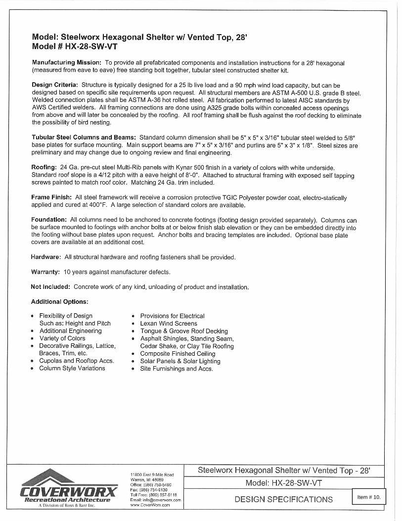
Item # 10.

Item # 10.
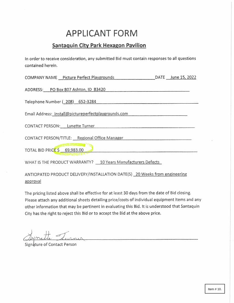
Item # 10.

Item # 10.

MEMORANDUM To: Mayor Olson and City Council
From: Jon Lundell, City Engineer
Date: June 23, 2022
RE: Scenic Ridge Estates Subdivision Preliminary Review
The Scenic Ridge Estates Subdivision is located at approximately 430 South and 1200 East. The proposed subdivision consists of 8 single-family lots on 4.76 acres and is in the R-12 PUD zone. The lots range from 12,000 square feet (.28 acres) to 41,299 square feet (0.95 acres). The development agreement that created the PUD has expired and the development must follow the R-12 zoning requirements. Interior lots are required to be at least 12,000 square feet and have 100 feet of frontage. Corner lots are required to be at least 13,225 square feet and have 115 feet of frontage. The proposed subdivision meets all the R-12 zoning requirements. The entire development is in the Hillside Overlay and will need to meet the requirements in 10.20.230 of the Santaquin City Code. The Hillside Overlay requires 10% of the net developable acreage to be improved open space. Open Space lot 1 will be used to meet this requirement and will include a drainage channel and a 10’ wide trail along it. A portion of the proposed development, specifically located within Lot 8, is within a future water pressure zone. The buildable portion of this lot, as indicated on the plat, is located within the existing pressure zone and has been shown to have adequate water pressure to serve the home. This lot and the remaining properties located east of the proposed roadways are anticipated to be developed further once additional water infrastructure is constructed (i.e.: Water tank, booster pump station, etc.). The Planning Commission’s recommendation is as follows:
Commissioner Hoffman motioned to recommend approval of the Scenic Ridge Estates Subdivision with the following condition:
All planning and engineering redlines be addressed. Commissioner McNeff seconded the motion. Commissioner Wood, Absent; Commissioner Lance, Yes; Commissioner Hoffman, Yes; Commissioner Howard, Absent; Commissioner McNeff, Yes; Commissioner Nixon, Yes; Commissioner Romero, Yes; Commissioner Weight, Yes. Vote was unanimous in favor. Motion passed.
This is a preliminary subdivision application review for the City Council to determine whether the proposed subdivision complies with Santaquin City Code or not. The City Council will be the land use authority for the preliminary plan. Recommended Subdivision Motion: “Motion to approve the Scenic Ridge Estates Subdivision with the following condition:
- All planning and engineering redlines be addressed. Attachments:
- Preliminary plan
Zone: R-12 PUD Size: 4.76 Acres Lots: 8
Item # 11.

ROADWAY 55704 S.F.
1.28 AC.
OPEN SPACE 20537 S.F.
0.47 AC.
LOT 4 13013 S.F.
0.30 AC.
LOT 3 16100 S.F.
0.37 AC.
LOT 5 12010 S.F.
0.28 AC.
LOT 1 12084 S.F.
0.28 AC.
LOT 2 12420 S.F.
0.29 AC.
LOT 8 41299 S.F.
0.95 AC.
LOT 6 12002 S.F.
0.28 AC.
LOT 7 12030 S.F.
0.28 AC.
DRAWN:DESIGNER:REVIEWED:
PROJECT #
20SM4196
RJMRJMBJW
REVISIONS1.
HORIZ: 1"=80'VERT: 1"=10'
WARNINGCALL BLUE STAKES
(24" x 36" SHEET)
epicENGINEERING
SCENIC RIDGE ESTATES
OVERALL AREA PLAN
1" = 80' 1"0
SHEET 1 COVER SHEET
SHEET 2 PLAT (SHEET ONE)
SHEET 3 PLAT (SHEET TWO)
SHEET 4 PLAT (SHEET THREE)
SHEET 5 OVERALL AREA PLAN
SHEET 6 LOT LAYOUT
SHEET 7 OVERALL WATER
SHEET 8 OVERALL SEWER
SHEET 9 OVERALL STORM DRAIN
SHEET 10 SLOPE MAP
SHEET 11 CONSTRUCTION TRAFFIC MAP
SHEET 12 OVERALL GRADING PLAN
SHEET 13 PLAN AND PROFILE (430 SOUTH STREET)
SHEET 14 PLAN AND PROFILE (1200 EAST STREET)
SHEET 15 DETAIL SHEET
SHEET 16 DETAIL SHEET
SHEET 17 DETAIL SHEET
NOTE: PLAN AND PROFILE SHEETS (SHEETS 13-14) WILL BEPROVIDED AT FINAL SUBMISSION
430 SOUTH
VICINITY MAPSANTAQUIN, UT
N.T.S.
270 SOUTH
1030
EAS
T
OAK SUM
MIT DR.
900
EAST
300 SOUTH
PROJECT SITE
PROPERTY OWNER
BASTIAN HOMES, LLC1184 S. 1150 W.
PAYSON, UTAH, 84651
PROPERTY DEVELOPER
BASTIAN HOMES, LLC1184 S. 1150 W.
PAYSON, UTAH, 84651
1. THE DEVELOPER AND GENERALCONTRACTOR UNDERSTAND THAT IT ISHIS/HER RESPONSIBILITY TO ENSURE THATALL IMPROVEMENTS INSTALLED WITHINTHIS DEVELOPMENT ARE CONSTRUCTED INFULL COMPLIANCE WITH ALL STATE ANDSANTAQUIN CITY CODES, ORDINANCESAND STANDARDS. THESE PLANS ARE NOTALL INCLUSIVE OF ALL MINIMUM CODES,ORDINANCES AND STANDARDS. THIS FACTDOES NOT RELIEVE THE DEVELOPER ORGENERAL CONTRACTOR FROM FULLCOMPLIANCE WITH ALL MINIMUM STATEAND SANTAQUIN CITY CODES,ORDINANCES AND STANDARDS.
PRELIM 1
430 SOUTH ST
1200 EAST ST
Item # 11.
AutoCAD SHX Text
SHEET
AutoCAD SHX Text
SHEET TITLE:
AutoCAD SHX Text
PROJECT NAME:
AutoCAD SHX Text
SCALES
AutoCAD SHX Text
0
AutoCAD SHX Text
1"
AutoCAD SHX Text
BAR SCALE MEASURES 1" ON A FULL SIZE SHEET. ADJUST FOR A HALF SIZE SHEET.
AutoCAD SHX Text
PLAN SET:
AutoCAD SHX Text
S:\PROJ\SMALL PROJECTS\2020 PROJECTS\Scenic Ridge Estates - Santaquin\Scenic Ridge\DWG\Scenic Ridge 7 Lot Remnant Resolution.dwg
AutoCAD SHX Text
5/31/22
AutoCAD SHX Text
NORTH
AutoCAD SHX Text
SHEET INDEX
AutoCAD SHX Text
NORTH
AutoCAD SHX Text
CONSTRUCTION NOTES
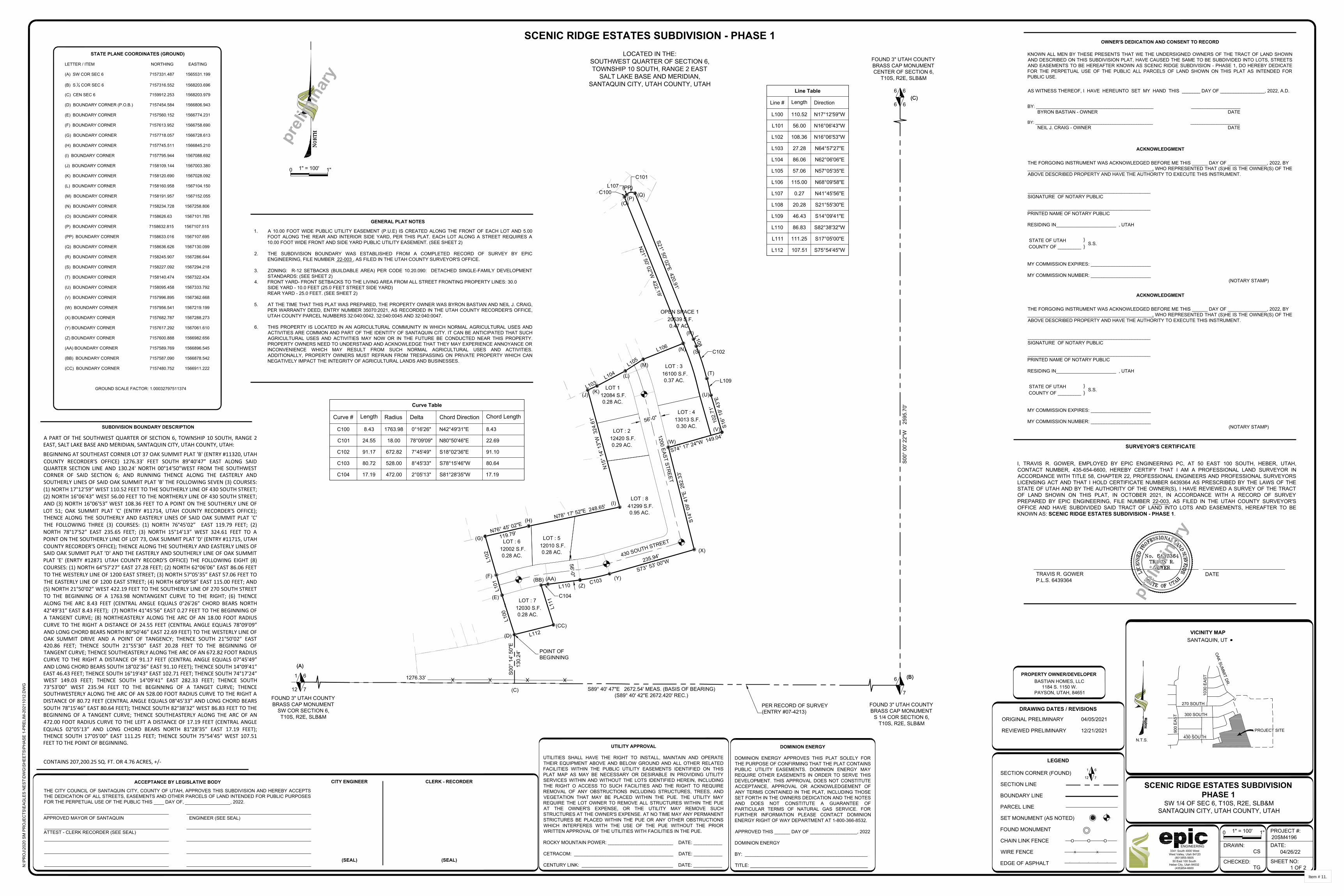
SD
XXXXXXXX
Line Table
Line #
L301
Length
0.27
Direction
N41°45'56"E
LOT : 50 55703 S.F.
1.28 AC.
OPEN SPACE 1 20539 S.F.
0.47 AC.
LOT : 3 16100 S.F.
0.37 AC.
LOT : 5 12010 S.F.
0.28 AC.
LOT 1 12084 S.F.
0.28 AC.
LOT : 2 12420 S.F.
0.29 AC.
LOT : 6 12002 S.F.
0.28 AC.
LOT : 7 12030 S.F.
0.28 AC.
S21° 50' 02"E 420.91'
L108
L109
S14°
09'
41"
E 2
82.3
3'
S73° 53' 00"W235.94'
C103L110
C104
L111
L112
L102
L103L104
L105
L106
N21° 50' 02"W 422.19'
C100
S00°
14'
50"
E13
0.24
'
C101
N76° 45' 02"E
119.79'
L100
N78° 17' 52"E 248.65'
C102
S74° 17' 24"W 149.04'
LOT : 4 13013 S.F.
0.30 AC. S16°
19'
43"
E10
2.71
'
L101
LOT : 8 41299 S.F.
0.95 AC.
N15
° 14'
13"
W 3
24.6
1'
L107
Curve #
C300
C301
Length
8.43
24.55
Radius
1763.98
18.00
Line Table
Line #
L100
L101
L102
L103
L104
L105
L106
L107
L108
L109
L110
L111
L112
Length
110.52
56.00
108.36
27.28
86.06
57.06
115.00
0.27
20.28
46.43
86.83
111.25
107.51
Direction
N17°12'59"W
N16°06'43"W
N16°06'53"W
N64°57'27"E
N62°06'06"E
N57°05'35"E
N68°09'58"E
N41°45'56"E
S21°55'30"E
S14°09'41"E
S82°38'32"W
S17°05'00"E
S75°54'45"W
Curve Table
Curve #
C100
C101
C102
C103
C104
Length
8.43
24.55
91.17
80.72
17.19
Radius
1763.98
18.00
672.82
528.00
472.00
Delta
0°16'26"
78°09'09"
7°45'49"
8°45'33"
2°05'13"
Chord Direction
N42°49'31"E
N80°50'46"E
S18°02'36"E
S78°15'46"W
S81°28'35"W
Chord Length
8.43
22.69
91.10
80.64
17.19
LOCATED IN THE:SOUTHWEST QUARTER OF SECTION 6,TOWNSHIP 10 SOUTH, RANGE 2 EAST
SALT LAKE BASE AND MERIDIAN,SANTAQUIN CITY, UTAH COUNTY, UTAH
SCENIC RIDGE ESTATES SUBDIVISION - PHASE 1
300 SOUTH
430 SOUTH
VICINITY MAPSANTAQUIN, UT
N.T.S.
270 SOUTH
1030
EAS
T
OAK SUM
MIT DR.
900
EAST
300 SOUTH
430 SOUTH
1" = 100'
04/26/22
1 OF 2
CS
TG
20SM4196PROJECT #:
DATE:
SHEET NO:
1"
DRAWN:
CHECKED:
0
3341 South 4000 West West Valley, Utah 84120
(801)955-560550 East 100 South
Heber City, Utah 84032(435)654-6600
ENGINEERING
SW 1/4 OF SEC 6, T10S, R2E, SLB&MSANTAQUIN CITY, UTAH COUNTY, UTAH
N:\P
RO
J\20
20 S
M P
RO
JEC
TS\E
AGLE
S N
EST\
DW
G\S
HEE
TS\P
HAS
E 1-
PREL
IM-2
0211
012.
DW
G
SCENIC RIDGE ESTATES SUBDIVISIONPHASE 1
6
7
1
12SECTION CORNER (FOUND)
SECTION LINE
BOUNDARY LINE
PARCEL LINE
SET MONUMENT (AS NOTED)
FOUND MONUMENT
CHAIN LINK FENCE
WIRE FENCE
EDGE OF ASPHALT
LEGEND
O O O
X X
/ / / / /
ACCEPTANCE BY LEGISLATIVE BODY
THE CITY COUNCIL OF SANTAQUIN CITY, COUNTY OF UTAH, APPROVES THIS SUBDIVISION AND HEREBY ACCEPTSTHE DEDICATION OF ALL STREETS, EASEMENTS AND OTHER PARCELS OF LAND INTENDED FOR PUBLIC PURPOSESFOR THE PERPETUAL USE OF THE PUBLIC THIS DAY OF, , 2022.
CITY ENGINEER
(SEAL)
CLERK - RECORDER
(SEAL)
APPROVED MAYOR OF SANTAQUIN
DOMINION ENERGY APPROVES THIS PLAT SOLELY FORTHE PURPOSE OF CONFIRMING THAT THE PLAT CONTAINSPUBLIC UTILITY EASEMENTS. DOMINION ENERGY MAYREQUIRE OTHER EASEMENTS IN ORDER TO SERVE THISDEVELOPMENT. THIS APPROVAL DOES NOT CONSTITUTEACCEPTANCE, APPROVAL OR ACKNOWLEDGEMENT OFANY TERMS CONTAINED IN THE PLAT, INCLUDING THOSESET FORTH IN THE OWNERS DEDICATION AND THE NOTESAND DOES NOT CONSTITUTE A GUARANTEE OFPARTICULAR TERMS OF NATURAL GAS SERVICE. FORFURTHER INFORMATION PLEASE CONTACT DOMINIONENERGY RIGHT OF WAY DEPARTMENT AT 1-800-366-8532.
APPROVED THIS ______ DAY OF __________________, 2022
DOMINION ENERGY
BY: _______________________________________________
TITLE: _____________________________________________
DOMINION ENERGY
UTILITIES SHALL HAVE THE RIGHT TO INSTALL, MAINTAIN AND OPERATETHEIR EQUIPMENT ABOVE AND BELOW GROUND AND ALL OTHER RELATEDFACILITIES WITHIN THE PUBLIC UTILITY EASEMENTS IDENTIFIED ON THISPLAT MAP AS MAY BE NECESSARY OR DESIRABLE IN PROVIDING UTILITYSERVICES WITHIN AND WITHOUT THE LOTS IDENTIFIED HEREIN, INCLUDINGTHE RIGHT O ACCESS TO SUCH FACILITIES AND THE RIGHT TO REQUIREREMOVAL OF ANY OBSTRUCTIONS INCLUDING STRUCTURES, TREES, ANDVEGETATION THAT MAY BE PLACED WITHIN THE PUE. THE UTILITY MAYREQUIRE THE LOT OWNER TO REMOVE ALL STRUCTURES WITHIN THE PUEAT THE OWNER'S EXPENSE, OR THE UTILITY MAY REMOVE SUCHSTRUCTURES AT THE OWNER'S EXPENSE. AT NO TIME MAY ANY PERMANENTSTRICTURES BE PLACED WITHIN THE PUE OR ANY OTHER OBSTRUCTIONSWHICH INTERFERES WITH THE USE OF THE PUE WITHOUT THE PRIORWRITTEN APPROVAL OF THE UTILITIES WITH FACILITIES IN THE PUE.
ROCKY MOUNTAIN POWER: _________________________ DATE: ___________
CETRACOM: ______________________________________ DATE: ___________
CENTURY LINK: ___________________________________ DATE: ___________
UTILITY APPROVAL
ENGINEER (SEE SEAL)
SUBDIVISION BOUNDARY DESCRIPTION
STATE PLANE COORDINATES (GROUND)
LETTER / ITEM NORTHING EASTING
(A) SW COR SEC 6 7157331.487 1565531.199
(B) S 14 COR SEC 6 7157316.552 1568203.696
(C) CEN SEC 6 7159912.253 1568203.979
(D) BOUNDARY CORNER (P.O.B.) 7157454.584 1566806.943
(E) BOUNDARY CORNER 7157560.152 1566774.231
(F) BOUNDARY CORNER 7157613.952 1566758.690
(G) BOUNDARY CORNER 7157718.057 1566728.613
(H) BOUNDARY CORNER 7157745.511 1566845.210
(I) BOUNDARY CORNER 7157795.944 1567088.692
(J) BOUNDARY CORNER 7158109.144 1567003.380
(K) BOUNDARY CORNER 7158120.690 1567028.092
(L) BOUNDARY CORNER 7158160.958 1567104.150
(M) BOUNDARY CORNER 7158191.957 1567152.055
(N) BOUNDARY CORNER 7158234.728 1567258.806
(O) BOUNDARY CORNER 7158626.63 1567101.785
(P) BOUNDARY CORNER 7158632.815 1567107.515
(PP) BOUNDARY CORNER 7158633.016 1567107.695
(Q) BOUNDARY CORNER 7158636.626 1567130.099
(R) BOUNDARY CORNER 7158245.907 1567286.644
(S) BOUNDARY CORNER 7158227.092 1567294.218
(T) BOUNDARY CORNER 7158140.474 1567322.434
(U) BOUNDARY CORNER 7158095.458 1567333.792
(V) BOUNDARY CORNER 7157996.895 1567362.668
(W) BOUNDARY CORNER 7157956.541 1567219.199
(X) BOUNDARY CORNER 7157682.787 1567288.273
(Y) BOUNDARY CORNER 7157617.292 1567061.610
(Z) BOUNDARY CORNER 7157600.888 1566982.656
(AA) BOUNDARY CORNER 7157589.769 1566896.545
(BB) BOUNDARY CORNER 7157587.090 1566878.542
(CC) BOUNDARY CORNER 7157480.752 1566911.222
GROUND SCALE FACTOR: 1.00032797511374
KNOWN ALL MEN BY THESE PRESENTS THAT WE THE UNDERSIGNED OWNERS OF THE TRACT OF LAND SHOWNAND DESCRIBED ON THIS SUBDIVISION PLAT, HAVE CAUSED THE SAME TO BE SUBDIVIDED INTO LOTS, STREETSAND EASEMENTS TO BE HEREAFTER KNOWN AS SCENIC RIDGE SUBDIVISION - PHASE 1, DO HEREBY DEDICATEFOR THE PERPETUAL USE OF THE PUBLIC ALL PARCELS OF LAND SHOWN ON THIS PLAT AS INTENDED FORPUBLIC USE.
AS WITNESS THEREOF, I HAVE HEREUNTO SET MY HAND THIS _______ DAY OF _________________, 2022, A.D.
BY: __________________________________________________ _____________________ BYRON BASTIAN - OWNER DATE
BY: __________________________________________________ _____________________ NEIL J. CRAIG - OWNER DATE
OWNER'S DEDICATION AND CONSENT TO RECORD
}}
THE FORGOING INSTRUMENT WAS ACKNOWLEDGED BEFORE ME THIS ______ DAY OF _______________, 2022, BY , WHO REPRESENTED THAT (S)HE IS THE OWNER(S) OF THEABOVE DESCRIBED PROPERTY AND HAVE THE AUTHORITY TO EXECUTE THIS INSTRUMENT.
_______________________________________________SIGNATURE OF NOTARY PUBLIC
_______________________________________________PRINTED NAME OF NOTARY PUBLIC
RESIDING IN_______________________ , UTAH
MY COMMISSION EXPIRES: _______________________
MY COMMISSION NUMBER: _______________________
ACKNOWLEDGMENT
STATE OF UTAHCOUNTY OF _________
(NOTARY STAMP)
S.S.
BASTIAN HOMES, LLC1184 S. 1150 W.
PAYSON, UTAH, 84651
PROPERTY OWNER/DEVELOPER
DRAWING DATES / REVISIONS
ORIGINAL PRELIMINARY 04/05/2021
REVIEWED PRELIMINARY 12/21/2021
DATE
SURVEYOR'S CERTIFICATE
TRAVIS R. GOWERP.L.S. 6439364
PROJECT SITE
FOUND 3" UTAH COUNTYBRASS CAP MONUMENT
S 1/4 COR SECTION 6,T10S, R2E, SLB&M
6
7
6 6
6 6
FOUND 3" UTAH COUNTYBRASS CAP MONUMENTCENTER OF SECTION 6,
T10S, R2E, SLB&M
FOUND 3" UTAH COUNTYBRASS CAP MONUMENT
SW COR SECTION 6,T10S, R2E, SLB&M
1 6
12 7
430 SOUTH STREET
1200 EAST STREET
S89° 40' 47"E 2672.54' MEAS. (BASIS OF BEARING)(S89° 40' 42"E 2672.420' REC.)
S00°
00'
22"
W
259
5.70
'
PER RECORD OF SURVEY(ENTRY #07-4213)
(A)
(B)
(C)
1" = 100' 1"0
preli
min
ary
preli
min
ary
POINT OFBEGINNING
I, TRAVIS R. GOWER, EMPLOYED BY EPIC ENGINEERING PC, AT 50 EAST 100 SOUTH, HEBER, UTAH,CONTACT NUMBER, 435-654-6600, HEREBY CERTIFY THAT I AM A PROFESSIONAL LAND SURVEYOR INACCORDANCE WITH TITLE 58, CHAPTER 22, PROFESSIONAL ENGINEERS AND PROFESSIONAL SURVEYORSLICENSING ACT AND THAT I HOLD CERTIFICATE NUMBER 6439364 AS PRESCRIBED BY THE LAWS OF THESTATE OF UTAH AND BY THE AUTHORITY OF THE OWNER(S), I HAVE REVIEWED A SURVEY OF THE TRACTOF LAND SHOWN ON THIS PLAT, IN OCTOBER 2021, IN ACCORDANCE WITH A RECORD OF SURVEYPREPARED BY EPIC ENGINEERING, FILE NUMBER 22-003, AS FILED IN THE UTAH COUNTY SURVEYOR'SOFFICE AND HAVE SUBDIVIDED SAID TRACT OF LAND INTO LOTS AND EASEMENTS, HEREAFTER TO BEKNOWN AS: SCENIC RIDGE ESTATES SUBDIVISION - PHASE 1.
GENERAL PLAT NOTES
1. A 10.00 FOOT WIDE PUBLIC UTILITY EASEMENT (P.U.E) IS CREATED ALONG THE FRONT OF EACH LOT AND 5.00FOOT ALONG THE REAR AND INTERIOR SIDE YARD, PER THIS PLAT. EACH LOT ALONG A STREET REQUIRES A10.00 FOOT WIDE FRONT AND SIDE YARD PUBLIC UTILITY EASEMENT. (SEE SHEET 2)
2. THE SUBDIVISION BOUNDARY WAS ESTABLISHED FROM A COMPLETED RECORD OF SURVEY BY EPICENGINEERING, FILE NUMBER 22-003 , AS FILED IN THE UTAH COUNTY SURVEYOR'S OFFICE.
3. ZONING: R-12 SETBACKS (BUILDABLE AREA) PER CODE 10.20.090: DETACHED SINGLE-FAMILY DEVELOPMENTSTANDARDS: (SEE SHEET 2)
4. FRONT YARD- FRONT SETBACKS TO THE LIVING AREA FROM ALL STREET FRONTING PROPERTY LINES: 30.0SIDE YARD - 10.0 FEET (25.0 FEET STREET SIDE YARD)REAR YARD - 25.0 FEET. (SEE SHEET 2)
5. AT THE TIME THAT THIS PLAT WAS PREPARED, THE PROPERTY OWNER WAS BYRON BASTIAN AND NEIL J. CRAIG,PER WARRANTY DEED, ENTRY NUMBER 35070:2021, AS RECORDED IN THE UTAH COUNTY RECORDER'S OFFICE,UTAH COUNTY PARCEL NUMBERS 32:040:0042, 32:040:0045 AND 32:040:0047.
6. THIS PROPERTY IS LOCATED IN AN AGRICULTURAL COMMUNITY IN WHICH NORMAL AGRICULTURAL USES ANDACTIVITIES ARE COMMON AND PART OF THE IDENTITY OF SANTAQUIN CITY. IT CAN BE ANTICIPATED THAT SUCHAGRICULTURAL USES AND ACTIVITIES MAY NOW OR IN THE FUTURE BE CONDUCTED NEAR THIS PROPERTY.PROPERTY OWNERS NEED TO UNDERSTAND AND ACKNOWLEDGE THAT THEY MAY EXPERIENCE ANNOYANCE ORINCONVENIENCE WHICH MAY RESULT FROM SUCH NORMAL AGRICULTURAL USES AND ACTIVITIES.ADDITIONALLY, PROPERTY OWNERS MUST REFRAIN FROM TRESPASSING ON PRIVATE PROPERTY WHICH CANNEGATIVELY IMPACT THE INTEGRITY OF AGRICULTURAL LANDS AND BUSINESSES.
}}
THE FORGOING INSTRUMENT WAS ACKNOWLEDGED BEFORE ME THIS ______ DAY OF _______________, 2022, BY , WHO REPRESENTED THAT (S)HE IS THE OWNER(S) OF THEABOVE DESCRIBED PROPERTY AND HAVE THE AUTHORITY TO EXECUTE THIS INSTRUMENT.
_______________________________________________SIGNATURE OF NOTARY PUBLIC
_______________________________________________PRINTED NAME OF NOTARY PUBLIC
RESIDING IN_______________________ , UTAH
MY COMMISSION EXPIRES: _______________________
MY COMMISSION NUMBER: _______________________
ACKNOWLEDGMENT
STATE OF UTAHCOUNTY OF _________
(NOTARY STAMP)
S.S.
56'-0"
56'-0"
(A)
(B)
(C)
(C)
(D)
(E)
(F)
(G)
(H)
(I)
(J) (K)
(L)
(M)
(N)
(O)(P)
(Q)
(R)
(S)
(T)
(U)
(V)
(W)
(X)
(Y)(Z)
(AA)(BB)
(CC)
ATTEST - CLERK RECORDER (SEE SEAL)
1276.33'
A PART OF THE SOUTHWEST QUARTER OF SECTION 6, TOWNSHIP 10 SOUTH, RANGE 2EAST, SALT LAKE BASE AND MERIDIAN, SANTAQUIN CITY, UTAH COUNTY, UTAH:
BEGINNING AT SOUTHEAST CORNER LOT 37 OAK SUMMIT PLAT 'B' (ENTRY #11320, UTAHCOUNTY RECORDER'S OFFICE) 1276.33' FEET SOUTH 89°40'47” EAST ALONG SAIDQUARTER SECTION LINE AND 130.24' NORTH 00°14'50”WEST FROM THE SOUTHWESTCORNER OF SAID SECTION 6; AND RUNNING THENCE ALONG THE EASTERLY ANDSOUTHERLY LINES OF SAID OAK SUMMIT PLAT 'B' THE FOLLOWING SEVEN (3) COURSES:(1) NORTH 17°12'59” WEST 110.52 FEET TO THE SOUTHERLY LINE OF 430 SOUTH STREET;(2) NORTH 16°06'43” WEST 56.00 FEET TO THE NORTHERLY LINE OF 430 SOUTH STREET;AND (3) NORTH 16°06'53” WEST 108.36 FEET TO A POINT ON THE SOUTHERLY LINE OFLOT 51; OAK SUMMIT PLAT 'C' (ENTRY #11714, UTAH COUNTY RECORDER'S OFFICE);THENCE ALONG THE SOUTHERLY AND EASTERLY LINES OF SAID OAK SUMMIT PLAT 'C'THE FOLLOWING THREE (3) COURSES: (1) NORTH 76°45'02” EAST 119.79 FEET; (2)NORTH 78°17'52” EAST 235.65 FEET; (3) NORTH 15°14'13” WEST 324.61 FEET TO APOINT ON THE SOUTHERLY LINE OF LOT 73, OAK SUMMIT PLAT 'D' (ENTRY #11715, UTAHCOUNTY RECORDER'S OFFICE); THENCE ALONG THE SOUTHERLY AND EASTERLY LINES OFSAID OAK SUMMIT PLAT 'D' AND THE EASTERLY AND SOUTHERLY LINE OF OAK SUMMITPLAT 'E' (ENRTY #12871 UTAH COUNTY RECORD'S OFFICE) THE FOLLOWING EIGHT (8)COURSES: (1) NORTH 64°57'27” EAST 27.28 FEET; (2) NORTH 62°06'06” EAST 86.06 FEETTO THE WESTERLY LINE OF 1200 EAST STREET; (3) NORTH 57°05'35” EAST 57.06 FEET TOTHE EASTERLY LINE OF 1200 EAST STREET; (4) NORTH 68°09'58” EAST 115.00 FEET; AND(5) NORTH 21°50'02” WEST 422.19 FEET TO THE SOUTHERLY LINE OF 270 SOUTH STREETTO THE BEGINNING OF A 1763.98 NONTANGENT CURVE TO THE RIGHT; (6) THENCEALONG THE ARC 8.43 FEET (CENTRAL ANGLE EQUALS 0°26'26” CHORD BEARS NORTH42°49'31” EAST 8.43 FEET); (7) NORTH 41°45'56” EAST 0.27 FEET TO THE BEGINNING OFA TANGENT CURVE; (8) NORTHEASTERLY ALONG THE ARC OF AN 18.00 FOOT RADIUSCURVE TO THE RIGHT A DISTANCE OF 24.55 FEET (CENTRAL ANGLE EQUALS 78°09'09”AND LONG CHORD BEARS NORTH 80°50'46” EAST 22.69 FEET) TO THE WESTERLY LINE OFOAK SUMMIT DRIVE AND A POINT OF TANGENCY; THENCE SOUTH 21°50'02” EAST420.86 FEET; THENCE SOUTH 21°55'30” EAST 20.28 FEET TO THE BEGINNING OFTANGENT CURVE; THENCE SOUTHEASTERLY ALONG THE ARC OF AN 672.82 FOOT RADIUSCURVE TO THE RIGHT A DISTANCE OF 91.17 FEET (CENTRAL ANGLE EQUALS 07°45'49”AND LONG CHORD BEARS SOUTH 18°02'36” EAST 91.10 FEET); THENCE SOUTH 14°09'41”EAST 46.43 FEET; THENCE SOUTH 16°19'43” EAST 102.71 FEET; THENCE SOUTH 74°17'24”WEST 149.03 FEET; THENCE SOUTH 14°09'41” EAST 282.33 FEET; THENCE SOUTH73°53'00” WEST 235.94 FEET TO THE BEGINNING OF A TANGET CURVE; THENCESOUTHWESTERLY ALONG THE ARC OF AN 528.00 FOOT RADIUS CURVE TO THE RIGHT ADISTANCE OF 80.72 FEET (CENTRAL ANGLE EQUALS 08°45'33” AND LONG CHORD BEARSSOUTH 78°15'46” EAST 80.64 FEET); THENCE SOUTH 82°38'32” WEST 86.83 FEET TO THEBEGINNING OF A TANGENT CURVE; THENCE SOUTHEASTERLY ALONG THE ARC OF AN472.00 FOOT RADIUS CURVE TO THE LEFT A DISTANCE OF 17.19 FEET (CENTRAL ANGLEEQUALS 02°05'13” AND LONG CHORD BEARS NORTH 81°28'35” EAST 17.19 FEET);THENCE SOUTH 17°05'00” EAST 111.25 FEET; THENCE SOUTH 75°54'45” WEST 107.51FEET TO THE POINT OF BEGINNING.
CONTAINS 207,200.25 SQ. FT. OR 4.76 ACRES, +/-
(PP)
Item # 11.
AutoCAD SHX Text
NORTH
AutoCAD SHX Text
GOWER
AutoCAD SHX Text
TRAVIS R.
AutoCAD SHX Text
No. 6439364
AutoCAD SHX Text
Y
AutoCAD SHX Text
U
AutoCAD SHX Text
E
AutoCAD SHX Text
V
AutoCAD SHX Text
R
AutoCAD SHX Text
S
AutoCAD SHX Text
R
AutoCAD SHX Text
O
AutoCAD SHX Text
D
AutoCAD SHX Text
N
AutoCAD SHX Text
A
AutoCAD SHX Text
L
AutoCAD SHX Text
L
AutoCAD SHX Text
S
AutoCAD SHX Text
N
AutoCAD SHX Text
A
AutoCAD SHX Text
I
AutoCAD SHX Text
O
AutoCAD SHX Text
S
AutoCAD SHX Text
O
AutoCAD SHX Text
F
AutoCAD SHX Text
E
AutoCAD SHX Text
P
AutoCAD SHX Text
R
AutoCAD SHX Text
D
AutoCAD SHX Text
L
AutoCAD SHX Text
C
AutoCAD SHX Text
I
AutoCAD SHX Text
E
AutoCAD SHX Text
E
AutoCAD SHX Text
N
AutoCAD SHX Text
S
AutoCAD SHX Text
T
AutoCAD SHX Text
A
AutoCAD SHX Text
S
AutoCAD SHX Text
E
AutoCAD SHX Text
T
AutoCAD SHX Text
U
AutoCAD SHX Text
F
AutoCAD SHX Text
T
AutoCAD SHX Text
O
AutoCAD SHX Text
H
AutoCAD SHX Text
A
AutoCAD SHX Text
NORTH
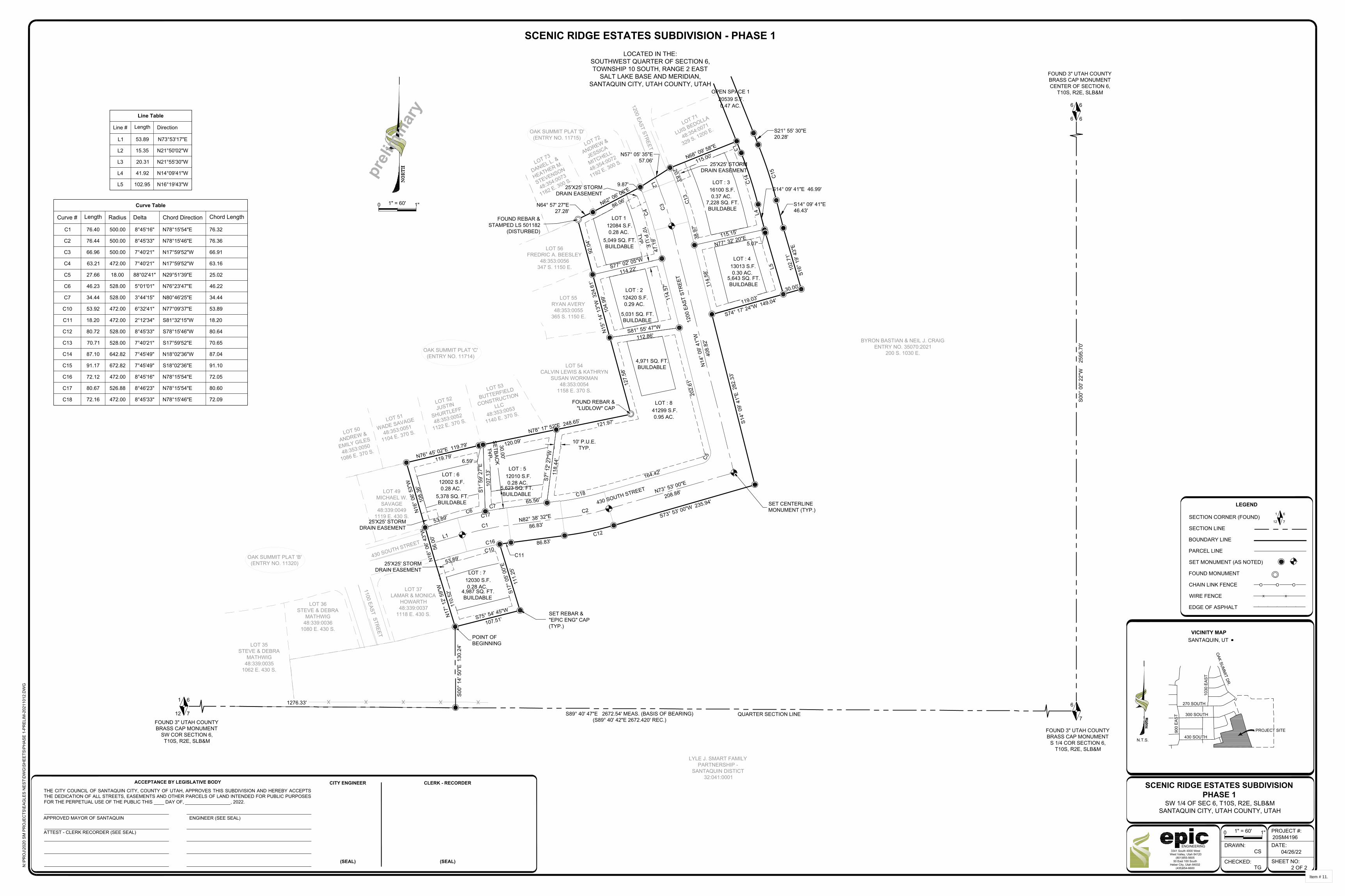
SD
XXXXXXXXXXXXXXX
LOT : 50 55703 S.F.
1.28 AC.
OPEN SPACE 1 20539 S.F.
0.47 AC.
LOT : 3 16100 S.F.
0.37 AC.
LOT : 5 12010 S.F.
0.28 AC.
LOT 1 12084 S.F.
0.28 AC.
LOT : 2 12420 S.F.
0.29 AC.
LOT : 6 12002 S.F.
0.28 AC.
LOT : 7 12030 S.F.
0.28 AC.
53.89'
65.56'
164.42'
C5
202.
61'
114.
57'
47.1
9'C
4
9.87'
20.83'
C13
38.9
7'
114.
58'
53.89'C10
5.07'
C14
N77° 32' 20"E115.15'
S1° 5
9' 2
7"E
107.
13'
S7° 1
2' 2
7"W
118.
44'
S77° 02' 05"W
114.22'
S81° 55' 47"W
112.86'
C1N82° 38' 32"E
86.83'
C2
N73° 53' 00"E
208.88'
N14
° 09'
41"
W
408.
82'
C3N62° 06' 06"E
86.06'
N16
° 06'
53"
W
108.
36'
119.79'
120.09'
121.97'
104.
99'
S16°
19'
43"
E10
2.71
'
S17°
05'
00"
E
111.
25'
S75° 54' 45"W
107.51'
N17
° 12'
59"
W
110.
52'
L5
L4
L3
L2
L1
C15
N64° 57' 27"E27.28'
N57° 05' 35"E57.06' N68° 09' 58"E
115.00'
LOT : 4 13013 S.F.
0.30 AC.
119.03'30.00'
S74° 17' 24"W 149.04'
S14° 09' 41"E46.43'
N76° 45' 02"E 119.79'
N16
° 06'
43"
W
56.0
0'
N15
° 14'
13"
W 3
24.6
1'
LOT : 8 41299 S.F.
0.95 AC.
127.
58'
92.0
4'
S21° 55' 30"E20.28'
S14°
09'
41"
E 2
82.3
3'
S73° 53' 00"W 235.94'
C12
86.83'
C11
S00°
14'
50"
E 1
30.2
4'
S14° 09' 41"E 46.99'
N78° 17' 52"E 248.65'
C16
C17
C18
30.00'SETBAC
KTYP.
10' P.U.E.TYP.
10' P.U.E.
TYP.
6.59'
C6C7
Line Table
Line #
L1
L2
L3
L4
L5
Length
53.89
15.35
20.31
41.92
102.95
Direction
N73°53'17"E
N21°50'02"W
N21°55'30"W
N14°09'41"W
N16°19'43"W
Curve Table
Curve #
C1
C2
C3
C4
C5
C6
C7
C10
C11
C12
C13
C14
C15
C16
C17
C18
Length
76.40
76.44
66.96
63.21
27.66
46.23
34.44
53.92
18.20
80.72
70.71
87.10
91.17
72.12
80.67
72.16
Radius
500.00
500.00
500.00
472.00
18.00
528.00
528.00
472.00
472.00
528.00
528.00
642.82
672.82
472.00
526.88
472.00
Delta
8°45'16"
8°45'33"
7°40'21"
7°40'21"
88°02'41"
5°01'01"
3°44'15"
6°32'41"
2°12'34"
8°45'33"
7°40'21"
7°45'49"
7°45'49"
8°45'16"
8°46'23"
8°45'33"
Chord Direction
N78°15'54"E
N78°15'46"E
N17°59'52"W
N17°59'52"W
N29°51'39"E
N76°23'47"E
N80°46'25"E
N77°09'37"E
S81°32'15"W
S78°15'46"W
S17°59'52"E
N18°02'36"W
S18°02'36"E
N78°15'54"E
N78°15'54"E
N78°15'46"E
Chord Length
76.32
76.36
66.91
63.16
25.02
46.22
34.44
53.89
18.20
80.64
70.65
87.04
91.10
72.05
80.60
72.09
1" = 60'
04/26/22
2 OF 2
CS
TG
20SM4196PROJECT #:
DATE:
SHEET NO:
1"
DRAWN:
CHECKED:
0
3341 South 4000 West West Valley, Utah 84120
(801)955-560550 East 100 South
Heber City, Utah 84032(435)654-6600
ENGINEERING
SW 1/4 OF SEC 6, T10S, R2E, SLB&MSANTAQUIN CITY, UTAH COUNTY, UTAH
N:\P
RO
J\20
20 S
M P
RO
JEC
TS\E
AGLE
S N
EST\
DW
G\S
HEE
TS\P
HAS
E 1-
PREL
IM-2
0211
012.
DW
G
SCENIC RIDGE ESTATES SUBDIVISIONPHASE 1
CITY ENGINEER
(SEAL)
CLERK - RECORDER
(SEAL)
1" = 60' 1"0
FOUND 3" UTAH COUNTYBRASS CAP MONUMENT
S 1/4 COR SECTION 6,T10S, R2E, SLB&M
6
7
6 6
6 6
FOUND 3" UTAH COUNTYBRASS CAP MONUMENTCENTER OF SECTION 6,
T10S, R2E, SLB&M
FOUND 3" UTAH COUNTYBRASS CAP MONUMENT
SW COR SECTION 6,T10S, R2E, SLB&M
1 6
12 7
1276.33'
S89° 40' 47"E 2672.54' MEAS. (BASIS OF BEARING)(S89° 40' 42"E 2672.420' REC.)
S00°
00'
22"
W
259
5.70
'
LYLE J. SMART FAMILYPARTNERSHIP -
SANTAQUIN DISTICT32:041:0001
LOCATED IN THE:SOUTHWEST QUARTER OF SECTION 6,TOWNSHIP 10 SOUTH, RANGE 2 EAST
SALT LAKE BASE AND MERIDIAN,SANTAQUIN CITY, UTAH COUNTY, UTAH
SCENIC RIDGE ESTATES SUBDIVISION - PHASE 1
300 SOUTH
VICINITY MAPSANTAQUIN, UT
N.T.S.
270 SOUTH
1030
EAS
T
OAK SUM
MIT DR.
900
EAST
300 SOUTH
430 SOUTH
LOT 35STEVE & DEBRA
MATHWIG48:339:0035
1062 E. 430 S.
LOT 36STEVE & DEBRA
MATHWIG48:339:0036
1080 E. 430 S.
LOT 37LAMAR & MONICA
HOWARTH48:339:0037
1118 E. 430 S.
1100 EAST STREET
430 SOUTH STREET
OAK SUMMIT PLAT 'B'(ENTRY NO. 11320)
LOT 49MICHAEL W.
SAVAGE48:339:0049
1119 E. 430 S.
LOT 54CALVIN LEWIS & KATHRYN
SUSAN WORKMAN48:353:0054
1158 E. 370 S.LOT 53
BUTTERFIELD
CONSTRUCTION
LLC
48:353:0053
1140 E. 370 S.
LOT 52
JUSTIN
SHURTLEFF
48:353:0052
1122 E. 370 S.LOT 51
WADE SAVAGE
48:353:0051
1104 E. 370 S.LOT 50
ANDREW &
EMILY GILES
48:353:0050
1086 E. 370 S.
OAK SUMMIT PLAT 'C'(ENTRY NO. 11714)
LOT 55RYAN AVERY48:353:0055
365 S. 1150 E.
LOT 56FREDRIC A. BEESLEY
48:353:0056347 S. 1150 E.
LOT 73
DANIEL L. &
HEATHER M.
STEVENSON
48:354:0073
1182 E. 300 S.
LOT 72
ANDREW &
JESSICA
MITCHELL
48:354:0072
1192 E. 300 S.
LOT 71
LUIS BEDOLLA
48:354:0071
329 S. 1200 E.
1200 EAST STREET
OAK SUMMIT PLAT 'D'(ENTRY NO. 11715)
BYRON BASTIAN & NEIL J. CRAIGENTRY NO. 35070:2021
200 S. 1030 E.
430 SOUTH STREET
1200
EAS
T ST
REE
T
POINT OFBEGINNING
FOUND REBAR &"LUDLOW" CAP
SET REBAR &"EPIC ENG" CAP(TYP.)
5,049 SQ. FT.BUILDABLE
5,031 SQ. FT.BUILDABLE
5,623 SQ. FT.BUILDABLE5,378 SQ. FT.
BUILDABLE
5,643 SQ. FT.BUILDABLE
7,228 SQ. FT.BUILDABLE
preli
min
ary
6
7
1
12SECTION CORNER (FOUND)
SECTION LINE
BOUNDARY LINE
PARCEL LINE
SET MONUMENT (AS NOTED)
FOUND MONUMENT
CHAIN LINK FENCE
WIRE FENCE
EDGE OF ASPHALT
LEGEND
O O O
X X
/ / / / /
PROJECT SITE
QUARTER SECTION LINE
SET CENTERLINEMONUMENT (TYP.)
25'X25' STORMDRAIN EASEMENT
25'X25' STORMDRAIN EASEMENT
4,987 SQ. FT.BUILDABLE
ACCEPTANCE BY LEGISLATIVE BODY
THE CITY COUNCIL OF SANTAQUIN CITY, COUNTY OF UTAH, APPROVES THIS SUBDIVISION AND HEREBY ACCEPTSTHE DEDICATION OF ALL STREETS, EASEMENTS AND OTHER PARCELS OF LAND INTENDED FOR PUBLIC PURPOSESFOR THE PERPETUAL USE OF THE PUBLIC THIS DAY OF, , 2022.
APPROVED MAYOR OF SANTAQUIN ENGINEER (SEE SEAL)
ATTEST - CLERK RECORDER (SEE SEAL)
25'X25' STORMDRAIN EASEMENT
25'X25' STORMDRAIN EASEMENT
FOUND REBAR &STAMPED LS 501182
(DISTURBED)
4,971 SQ. FT.BUILDABLE
Item # 11.
AutoCAD SHX Text
NORTH
AutoCAD SHX Text
NORTH

MBOX
MBOX
Line Table
Line #
L301
Length
0.27
Direction
N41°45'56"E
OPEN SPACE 1 20539 S.F.
0.47 AC.
C300L301
C301
S21° 50' 02"E 420.91'
N21° 50' 02"W 422.19'
Curve Table
Curve #
C300
C301
Length
8.43
24.55
Radius
1763.98
18.00
Delta
0°16'26"
78°09'09"
Chord Direction
N42°49'31"E
N80°50'46"E
Chord Length
8.43
22.69
FOUND 3" UTAH COUNTYBRASS CAP MONUMENT
S 1/4 COR SECTION 6,T10S, R2E, SLB&M
6
7
6 6
6 6
FOUND 3" UTAH COUNTYBRASS CAP MONUMENTCENTER OF SECTION 6,
T10S, R2E, SLB&M
FOUND 3" UTAH COUNTYBRASS CAP MONUMENT
SW COR SECTION 6,T10S, R2E, SLB&M
1 6
12 7 S89° 40' 47"E 2672.54' MEAS. (BASIS OF BEARING)(S89° 40' 42"E 2672.420' REC.)
S00°
00'
22"
W
259
5.70
'
LOCATED IN THE:SOUTHWEST QUARTER OF SECTION 6,TOWNSHIP 10 SOUTH, RANGE 2 EAST
SALT LAKE BASE AND MERIDIAN,SANTAQUIN CITY, UTAH COUNTY, UTAH
SCENIC RIDGE ESTATES SUBDIVISION - PHASE 1
300 SOUTH
VICINITY MAPSANTAQUIN, UT
N.T.S.
270 SOUTH
1030
EAS
T
OAK SUM
MIT DR.
900
EAST
300 SOUTH
430 SOUTH
preli
min
ary
6
7
1
12SECTION CORNER (FOUND)
SECTION LINE
BOUNDARY LINE
PARCEL LINE
SET MONUMENT (AS NOTED)
FOUND MONUMENT
CHAIN LINK FENCE
WIRE FENCE
EDGE OF ASPHALT
LEGEND
O O O
X X
/ / / / /
PROJECT SITE
1" = 60'
05/31/2022
3 OF 3
JF
TG
20SM4196PROJECT #:
DATE:
SHEET NO:
1"
DRAWN:
CHECKED:
0
3341 South 4000 West West Valley, Utah 84120
(801)955-560550 East 100 South
Heber City, Utah 84032(435)654-6600
ENGINEERING
SW 1/4 OF SEC 6, T10S, R2E, SLB&MSANTAQUIN CITY, UTAH COUNTY, UTAH
N:\P
RO
J\20
20 S
M P
RO
JEC
TS\E
AGLE
S N
EST\
DW
G\S
HEE
TS\P
HAS
E 1-
PREL
IM-2
0211
012.
DW
G
SCENIC RIDGE ESTATES SUBDIVISIONPHASE 1
CITY ENGINEER
(SEAL)
CLERK - RECORDER
(SEAL)
1" = 30' 1"0
QUARTER SECTION LINE
BYRON BASTIAN & NEIL J. CRAIGENTRY NO. 35070:2021
200 S. 1030 E.
LOT 71LUIS BEDOLLA
48:354:0071329 S. 1200 E.
SEE SHEET 2
OAK SUMMIT PLAT 'D'(ENTRY NO. 11715)
SET REBAR &"EPIC ENG" CAP
(TYP.)
OAK SUMMIT PLAT 'E'(ENTRY NO. 12871)
LOT 92STEPHEN CHERRINGTON
48:378:0092823 S. OAK SUMMIT DRIVE
OAK SUMMIT DRIVE
270 S
OUTH STREET
LOT 70LACEY & STEPHEN CROOK
48:354:0070309 S. 1200 EAST
LOT 69GERALD L. BOWMAN
48:354:00691209 E. 300 SOUTH
1200 EAST STREET
OAK SUMMIT PLAT 'E'(ENTRY NO. 12871)
LOT 68JEFFREY R. VAN AUSDAL
48:354:00681197 E. 300 SOUTH
LOT 85JAY TYLER HOOP
48:378:00851212 E. 270 SOUTH
ACCEPTANCE BY LEGISLATIVE BODY
THE CITY COUNCIL OF SANTAQUIN CITY, COUNTY OF UTAH, APPROVES THIS SUBDIVISION AND HEREBY ACCEPTSTHE DEDICATION OF ALL STREETS, EASEMENTS AND OTHER PARCELS OF LAND INTENDED FOR PUBLIC PURPOSESFOR THE PERPETUAL USE OF THE PUBLIC THIS DAY OF, , 2022.
APPROVED MAYOR OF SANTAQUIN ENGINEER (SEE SEAL)
ATTEST - CLERK RECORDER (SEE SEAL)
Item # 11.
AutoCAD SHX Text
NORTH
AutoCAD SHX Text
NORTH

ROADWAY 55704 S.F.
1.28 AC.
OPEN SPACE 20537 S.F.
0.47 AC.
LOT 4 13013 S.F.
0.30 AC.
LOT 3 16100 S.F.
0.37 AC.
LOT 5 12010 S.F.
0.28 AC.
LOT 1 12084 S.F.
0.28 AC.
LOT 2 12420 S.F.
0.29 AC.
LOT 8 41299 S.F.
0.95 AC.
LOT 6 12002 S.F.
0.28 AC.
LOT 7 12030 S.F.
0.28 AC.
1" = 80' 1"0
430 SOUTH
VICINITY MAPSANTAQUIN, UT
N.T.S.
270 SOUTH
1030
EAS
T
OAK SUM
MIT DR.
900
EAST
300 SOUTH
PROJECT SITE
1. THE DEVELOPER AND GENERALCONTRACTOR UNDERSTAND THAT IT ISHIS/HER RESPONSIBILITY TO ENSURE THATALL IMPROVEMENTS INSTALLED WITHINTHIS DEVELOPMENT ARE CONSTRUCTED INFULL COMPLIANCE WITH ALL STATE ANDSANTAQUIN CITY CODES, ORDINANCESAND STANDARDS. THESE PLANS ARE NOTALL INCLUSIVE OF ALL MINIMUM CODES,ORDINANCES AND STANDARDS. THIS FACTDOES NOT RELIEVE THE DEVELOPER ORGENERAL CONTRACTOR FROM FULLCOMPLIANCE WITH ALL MINIMUM STATEAND SANTAQUIN CITY CODES,ORDINANCES AND STANDARDS.
PRELIM 5
DRAWN:DESIGNER:REVIEWED:
PROJECT #
20SM4196
RJMRJMBJW
REVISIONS1.
HORIZ: 1"=80'VERT: 1"=10'
WARNINGCALL BLUE STAKES
(24" x 36" SHEET)
epicENGINEERING
SCENIC RIDGE ESTATES
OVERALL AREA PLAN
430 SOUTH ST
1200 EAST ST
370 SOUTH ST
300 SOUTH ST
1150 EAST ST
Item # 11.
AutoCAD SHX Text
NORTH
AutoCAD SHX Text
NORTH
AutoCAD SHX Text
CONSTRUCTION NOTES
AutoCAD SHX Text
SHEET
AutoCAD SHX Text
SHEET TITLE:
AutoCAD SHX Text
PROJECT NAME:
AutoCAD SHX Text
SCALES
AutoCAD SHX Text
0
AutoCAD SHX Text
1"
AutoCAD SHX Text
BAR SCALE MEASURES 1" ON A FULL SIZE SHEET. ADJUST FOR A HALF SIZE SHEET.
AutoCAD SHX Text
PLAN SET:
AutoCAD SHX Text
S:\PROJ\SMALL PROJECTS\2020 PROJECTS\Scenic Ridge Estates - Santaquin\Scenic Ridge\DWG\Scenic Ridge 7 Lot Remnant Resolution.dwg
AutoCAD SHX Text
5/31/22

ROADWAY 55704 S.F.
1.28 AC.
OPEN SPACE 20537 S.F.
0.47 AC.
LOT 4 13013 S.F.
0.30 AC.
LOT 3 16100 S.F.
0.37 AC.
LOT 5 12010 S.F.
0.28 AC.
LOT 1 12084 S.F.
0.28 AC.
LOT 2 12420 S.F.
0.29 AC.
LOT 8 41299 S.F.
0.95 AC.
LOT 6 12002 S.F.
0.28 AC.
LOT 7 12030 S.F.
0.28 AC.
1" = 80' 1"0
430 SOUTH
VICINITY MAPSANTAQUIN, UT
N.T.S.
270 SOUTH
1030
EAS
T
OAK SUM
MIT DR.
900
EAST
300 SOUTH
PROJECT SITE
1. THE DEVELOPER AND GENERALCONTRACTOR UNDERSTAND THAT IT ISHIS/HER RESPONSIBILITY TO ENSURE THATALL IMPROVEMENTS INSTALLED WITHINTHIS DEVELOPMENT ARE CONSTRUCTED INFULL COMPLIANCE WITH ALL STATE ANDSANTAQUIN CITY CODES, ORDINANCESAND STANDARDS. THESE PLANS ARE NOTALL INCLUSIVE OF ALL MINIMUM CODES,ORDINANCES AND STANDARDS. THIS FACTDOES NOT RELIEVE THE DEVELOPER ORGENERAL CONTRACTOR FROM FULLCOMPLIANCE WITH ALL MINIMUM STATEAND SANTAQUIN CITY CODES,ORDINANCES AND STANDARDS.
PRELIM 6
DRAWN:DESIGNER:REVIEWED:
PROJECT #
20SM4196
RJMRJMBJW
REVISIONS1.
HORIZ: 1"=80'VERT: 1"=10'
WARNINGCALL BLUE STAKES
(24" x 36" SHEET)
epicENGINEERING
SCENIC RIDGE ESTATES
LOT LAYOUT
DENSITY TABLE
ZONE R-12
LOTS 8 RESIDENTIAL1 OPEN SPACE
TOTAL ACREAGE 4.76 +/- 100%
LOT ACREAGE 3.03 +/- 63%
STREET RIGHT-OF-WAY ACREAGE 1.28 +/- 27%
OPEN SPACE ACREAGE 0.47 +/- 10%
NOTE:SEE SHEET 3 FOR ROADWAY ANDRESIDENTIAL LOT INFORMATION
Item # 11.
AutoCAD SHX Text
NORTH
AutoCAD SHX Text
NORTH
AutoCAD SHX Text
CONSTRUCTION NOTES
AutoCAD SHX Text
SHEET
AutoCAD SHX Text
SHEET TITLE:
AutoCAD SHX Text
PROJECT NAME:
AutoCAD SHX Text
SCALES
AutoCAD SHX Text
0
AutoCAD SHX Text
1"
AutoCAD SHX Text
BAR SCALE MEASURES 1" ON A FULL SIZE SHEET. ADJUST FOR A HALF SIZE SHEET.
AutoCAD SHX Text
PLAN SET:
AutoCAD SHX Text
S:\PROJ\SMALL PROJECTS\2020 PROJECTS\Scenic Ridge Estates - Santaquin\Scenic Ridge\DWG\Scenic Ridge 7 Lot Remnant Resolution.dwg
AutoCAD SHX Text
5/31/22
AutoCAD SHX Text
SETBACKS PER R-12 CODE: -FRONT: 30' 30' -REAR: 25' 25' -SIDE: 10'10'
AutoCAD SHX Text
SETBACKS PER R-12 CODE: -FRONT: 30' 30' -REAR: 25' 25' -SIDE: 10'10'

ROADWAY 55704 S.F.
1.28 AC.
OPEN SPACE 20537 S.F.
0.47 AC.
LOT 4 13013 S.F.
0.30 AC.
LOT 3 16100 S.F.
0.37 AC.
LOT 5 12010 S.F.
0.28 AC.
LOT 1 12084 S.F.
0.28 AC.
LOT 2 12420 S.F.
0.29 AC.
LOT 8 41299 S.F.
0.95 AC.
LOT 6 12002 S.F.
0.28 AC.
LOT 7 12030 S.F.
0.28 AC.
1" = 60' 1"0
430 SOUTH
VICINITY MAPSANTAQUIN, UT
N.T.S.
270 SOUTH
1030
EAS
T
OAK SUM
MIT DR.
900
EAST
300 SOUTH
PROJECT SITE
1. THE DEVELOPER AND GENERALCONTRACTOR UNDERSTAND THAT IT ISHIS/HER RESPONSIBILITY TO ENSURE THATALL IMPROVEMENTS INSTALLED WITHINTHIS DEVELOPMENT ARE CONSTRUCTED INFULL COMPLIANCE WITH ALL STATE ANDSANTAQUIN CITY CODES, ORDINANCESAND STANDARDS. THESE PLANS ARE NOTALL INCLUSIVE OF ALL MINIMUM CODES,ORDINANCES AND STANDARDS. THIS FACTDOES NOT RELIEVE THE DEVELOPER ORGENERAL CONTRACTOR FROM FULLCOMPLIANCE WITH ALL MINIMUM STATEAND SANTAQUIN CITY CODES,ORDINANCES AND STANDARDS.
PRELIM 7
DRAWN:DESIGNER:REVIEWED:
PROJECT #
20SM4196
RJMRJMBJW
REVISIONS1.
HORIZ: 1"=60'VERT: 1"=10'
WARNINGCALL BLUE STAKES
(24" x 36" SHEET)
epicENGINEERING
SCENIC RIDGE ESTATES
CULINARY MASTERPLAN
430 SOUTH STREET
LOT 54CALVIN LEWIS &KATHRYN SUSAN
WORKMAN48:353:0054LOT 53
BUTTERFIELD
CONSTRUCTION
LLC
48:353:0053LOT 52
JUSTIN
SHURTLEFF
48:353:0052LOT 51
WADE
SAVAGE
48:353:0051LOT 50
ANDREW &
EMILY GILES
48:353:0050
LOT 55RYAN AVERY48:353:0055
LOT 56FREDRIC A.BEESLEY
48:353:0056
LOT 73
DANIEL L. &
HEATHER M.
STEVENSON
48:354:0073
LOT 72
ANDREW &
JESSICA
MITCHELL
48:354:0072
LOT 71
LUIS BEDOLLA
48:354:0071
1200 EAST STREET
430 SOUTH STREET
1200 EAST STREET
1" = 60'
8" D.I. CULINARY WATER LINEFIRE HYDRANT(TYP.)
STUB 6" LINE FORFIRE HYDRANT(TYP.)
FIRE HYDRANT(TYP.)
8" D.I.C
ULIN
ARY W
ATER LIN
E
EXISTING 8" D.I. CULINARY WATER LINE
250.0' FIRE HYDRANT RADIUS
250.0' FIRE HYDRANT RADIUS
250.0' FIRE HYDRANT RADIUS
CW-5'PI-7'
5'7'
N.T.S.
Item # 11.
AutoCAD SHX Text
NORTH
AutoCAD SHX Text
NORTH
AutoCAD SHX Text
CONSTRUCTION NOTES
AutoCAD SHX Text
SHEET
AutoCAD SHX Text
SHEET TITLE:
AutoCAD SHX Text
PROJECT NAME:
AutoCAD SHX Text
SCALES
AutoCAD SHX Text
0
AutoCAD SHX Text
1"
AutoCAD SHX Text
BAR SCALE MEASURES 1" ON A FULL SIZE SHEET. ADJUST FOR A HALF SIZE SHEET.
AutoCAD SHX Text
PLAN SET:
AutoCAD SHX Text
S:\PROJ\SMALL PROJECTS\2020 PROJECTS\Scenic Ridge Estates - Santaquin\Scenic Ridge\DWG\Scenic Ridge 7 Lot Remnant Resolution.dwg
AutoCAD SHX Text
5/31/22
AutoCAD SHX Text
SINGLE WATER METER
AutoCAD SHX Text
PRESSURE IRRIGATION METER
AutoCAD SHX Text
FIRE HYDRANT
AutoCAD SHX Text
LEGEND:
AutoCAD SHX Text
H
AutoCAD SHX Text
Y
AutoCAD SHX Text
D
AutoCAD SHX Text
EXISTING FIRE HYDRANT
AutoCAD SHX Text
H
AutoCAD SHX Text
Y
AutoCAD SHX Text
D
AutoCAD SHX Text
AIR RELEASE VALVE
AutoCAD SHX Text
STREET LIGHT (TYP)
AutoCAD SHX Text
CONNECT TO EXISTING 8" CULINARY MAIN W/ VALVE
AutoCAD SHX Text
CONNECT TO EXISTING 8" CULINARY MAIN W/ VALVE
AutoCAD SHX Text
CULINARY METER 5' OFF UPHILL PROPERTY LINE (TYP) PRESSURE IRRIGATION METER 7' OFF UPHILL PROPERTY LINE (TYP)
AutoCAD SHX Text
H
AutoCAD SHX Text
Y
AutoCAD SHX Text
D
AutoCAD SHX Text
H
AutoCAD SHX Text
Y
AutoCAD SHX Text
D
AutoCAD SHX Text
CAP DRY CULINARY LINE (TYP)
AutoCAD SHX Text
STUB DRY CULINARY LINE (TYP)
AutoCAD SHX Text
DRY 8" CULINARY LINE FOR FUTURE (TYP)
AutoCAD SHX Text
CAP DRY CULINARY LINE (TYP)
AutoCAD SHX Text
±181' DRY 8"CULINARY LINE FOR FUTURE (TYP)
AutoCAD SHX Text
CULINARY METER 5' OFF UPHILL PROPERTY LINE (TYP) PRESSURE IRRIGATION METER 7' OFF UPHILL PROPERTY LINE (TYP)
AutoCAD SHX Text
STREET LIGHT (TYP)
AutoCAD SHX Text
STREET LIGHT (TYP)
AutoCAD SHX Text
STREET LIGHT (TYP)
AutoCAD SHX Text
AIR RELEASE AT HIGH POINT (TYP)
AutoCAD SHX Text
CULINARY AND PRESSURE IRRIGATION LATERALS CAP FOR FUTURE (TYP)
AutoCAD SHX Text
CULINARY AND PRESSURE IRRIGATION LATERALS CAP FOR FUTURE (TYP)
AutoCAD SHX Text
H
AutoCAD SHX Text
Y
AutoCAD SHX Text
D
AutoCAD SHX Text
CULINARY METER 5' OFF UPHILL PROPERTY LINE (5299') PRESSURE IRRIGATION METER 7' OFF UPHILL PROPERTY LINE (5299')
AutoCAD SHX Text
PRESSURE IRRIGATION LOS LINE
AutoCAD SHX Text
CULINARY WATER LOS LINE
AutoCAD SHX Text
CONNECT TO EXISTING 8" IRRIGATION MAIN
AutoCAD SHX Text
CAP PRESSURE IRRIGATION LINE (TYP)
AutoCAD SHX Text
CAP PRESSURE IRRIGATION LINE (TYP)
AutoCAD SHX Text
CONNECT TO EXISTING 8" IRRIGATION MAIN
AutoCAD SHX Text
STOP/ADDRESS SIGN (TYP)

S
S
S
S
S
S
ROADWAY 55704 S.F.
1.28 AC.
OPEN SPACE 20537 S.F.
0.47 AC.
LOT 4 13013 S.F.
0.30 AC.
LOT 3 16100 S.F.
0.37 AC.
LOT 5 12010 S.F.
0.28 AC.
LOT 1 12084 S.F.
0.28 AC.
LOT 2 12420 S.F.
0.29 AC.
LOT 8 41299 S.F.
0.95 AC.
LOT 6 12002 S.F.
0.28 AC.
LOT 7 12030 S.F.
0.28 AC.
1" = 60' 1"0
430 SOUTH
VICINITY MAPSANTAQUIN, UT
N.T.S.
270 SOUTH
1030
EAS
T
OAK SUM
MIT DR.
900
EAST
300 SOUTH
PROJECT SITE
1. THE DEVELOPER AND GENERALCONTRACTOR UNDERSTAND THAT IT ISHIS/HER RESPONSIBILITY TO ENSURE THATALL IMPROVEMENTS INSTALLED WITHINTHIS DEVELOPMENT ARE CONSTRUCTED INFULL COMPLIANCE WITH ALL STATE ANDSANTAQUIN CITY CODES, ORDINANCESAND STANDARDS. THESE PLANS ARE NOTALL INCLUSIVE OF ALL MINIMUM CODES,ORDINANCES AND STANDARDS. THIS FACTDOES NOT RELIEVE THE DEVELOPER ORGENERAL CONTRACTOR FROM FULLCOMPLIANCE WITH ALL MINIMUM STATEAND SANTAQUIN CITY CODES,ORDINANCES AND STANDARDS.
PRELIM 8
DRAWN:DESIGNER:REVIEWED:
PROJECT #
20SM4196
RJMRJMBJW
REVISIONS1.
HORIZ: 1"=60'VERT: 1"=10'
WARNINGCALL BLUE STAKES
(24" x 36" SHEET)
epicENGINEERING
SCENIC RIDGE ESTATES
SEWER MASTER PLAN
430 SOUTH STREET
LOT 54CALVIN LEWIS &KATHRYN SUSAN
WORKMAN48:353:0054LOT 53
BUTTERFIELD
CONSTRUCTION
LLC
48:353:0053LOT 52
JUSTIN
SHURTLEFF
48:353:0052LOT 51
WADE
SAVAGE
48:353:0051LOT 50
ANDREW &
EMILY GILES
48:353:0050
LOT 55RYAN AVERY48:353:0055
LOT 56FREDRIC A.BEESLEY
48:353:0056
LOT 73
DANIEL L. &
HEATHER M.
STEVENSON
48:354:0073
LOT 72
ANDREW &
JESSICA
MITCHELL
48:354:0072
LOT 71
LUIS BEDOLLA
48:354:0071
1200 EAST STREET
430 SOUTH STREET
1200 EAST STREET
8" PVC SEWER MAIN
8" PVC SEW
ER M
AIN
EXISTING 8" PVC SEWER
SS
SS
SS
SS
SS
SS
SSSS
SS
SS
SS
SS
SS
SS
SS
SS
SS
SS
EXISTING 8" PVC SEWER
Item # 11.
AutoCAD SHX Text
NORTH
AutoCAD SHX Text
NORTH
AutoCAD SHX Text
CONSTRUCTION NOTES
AutoCAD SHX Text
SHEET
AutoCAD SHX Text
SHEET TITLE:
AutoCAD SHX Text
PROJECT NAME:
AutoCAD SHX Text
SCALES
AutoCAD SHX Text
0
AutoCAD SHX Text
1"
AutoCAD SHX Text
BAR SCALE MEASURES 1" ON A FULL SIZE SHEET. ADJUST FOR A HALF SIZE SHEET.
AutoCAD SHX Text
PLAN SET:
AutoCAD SHX Text
S:\PROJ\SMALL PROJECTS\2020 PROJECTS\Scenic Ridge Estates - Santaquin\Scenic Ridge\DWG\Scenic Ridge 7 Lot Remnant Resolution.dwg
AutoCAD SHX Text
5/31/22
AutoCAD SHX Text
CONNECT TO EXISTING SEWER MAIN EXISTING SEWER MANHOLE (TYP)
AutoCAD SHX Text
GRAVITY SEWER LATERAL 10' FROM CENTER ON DOWNHILL SIDE OF LOT (TYP)
AutoCAD SHX Text
CAPPED GRAVITY SEWER LATERAL FOR FUTURE (TYP)
AutoCAD SHX Text
LEGEND:
AutoCAD SHX Text
GRAVITY SEWER SERVICE LATERAL
AutoCAD SHX Text
GRAVITY SEWER SERVICE LATERAL CAPPED FOR FUTURE
AutoCAD SHX Text
GRAVITY SEWER LATERAL 10' FROM CENTER ON DOWNHILL SIDE OF LOT (TYP)
AutoCAD SHX Text
CAPPED GRAVITY SEWER LATERAL FOR FUTURE (TYP)
AutoCAD SHX Text
CONNECT TO EXISTING SEWER STUB WITH NEW 4' SEWER MANHOLE (TYP)
AutoCAD SHX Text
4' SEWER MANHOLE (TYP)

5290
5300
5310
5320
5330533053305330533053305330
5340
5350
5360
5300
5310
5320
5330
5340
5350
5290
5300
5310
5320
5280
5290
5300
5310
-8.3%
-8.3%
-8.3%
-10.
0%
-10.0%
-10.
0%
ROADWAY 55704 S.F.
1.28 AC.
OPEN SPACE 20537 S.F.
0.47 AC.
LOT 4 13013 S.F.
0.30 AC.
LOT 3 16100 S.F.
0.37 AC.
LOT 5 12010 S.F.
0.28 AC.
LOT 1 12084 S.F.
0.28 AC.
LOT 2 12420 S.F.
0.29 AC.
LOT 8 41299 S.F.
0.95 AC.
LOT 6 12002 S.F.
0.28 AC.
LOT 7 12030 S.F.
0.28 AC.
1" = 60' 1"0
430 SOUTH
VICINITY MAPSANTAQUIN, UT
N.T.S.
270 SOUTH
1030
EAS
T
OAK SUM
MIT DR.
900
EAST
300 SOUTH
PROJECT SITE
1. THE DEVELOPER AND GENERALCONTRACTOR UNDERSTAND THAT IT ISHIS/HER RESPONSIBILITY TO ENSURE THATALL IMPROVEMENTS INSTALLED WITHINTHIS DEVELOPMENT ARE CONSTRUCTED INFULL COMPLIANCE WITH ALL STATE ANDSANTAQUIN CITY CODES, ORDINANCESAND STANDARDS. THESE PLANS ARE NOTALL INCLUSIVE OF ALL MINIMUM CODES,ORDINANCES AND STANDARDS. THIS FACTDOES NOT RELIEVE THE DEVELOPER ORGENERAL CONTRACTOR FROM FULLCOMPLIANCE WITH ALL MINIMUM STATEAND SANTAQUIN CITY CODES,ORDINANCES AND STANDARDS.
PRELIM 9
DRAWN:DESIGNER:REVIEWED:
PROJECT #
20SM4196
RJMRJMBJW
REVISIONS1.
HORIZ: 1"=60'VERT: 1"=10'
WARNINGCALL BLUE STAKES
(24" x 36" SHEET)
epicENGINEERING
SCENIC RIDGE ESTATES
STORM WATER MASTERPLAN
430 SOUTH STREET
LOT 54CALVIN LEWIS &KATHRYN SUSAN
WORKMAN48:353:0054LOT 53
BUTTERFIELD
CONSTRUCTION
LLC
48:353:0053LOT 52
JUSTIN
SHURTLEFF
48:353:0052LOT 51
WADE
SAVAGE
48:353:0051LOT 50
ANDREW &
EMILY GILES
48:353:0050
LOT 55RYAN AVERY48:353:0055
LOT 56FREDRIC A.BEESLEY
48:353:0056
LOT 73
DANIEL L. &
HEATHER M.
STEVENSON
48:354:0073
LOT 72
ANDREW &
JESSICA
MITCHELL
48:354:0072
LOT 71
LUIS BEDOLLA
48:354:0071
1200 EAST STREET
430 SOUTH STREET
1200 EAST STREET
Item # 11.
AutoCAD SHX Text
NORTH
AutoCAD SHX Text
NORTH
AutoCAD SHX Text
CONSTRUCTION NOTES
AutoCAD SHX Text
SHEET
AutoCAD SHX Text
SHEET TITLE:
AutoCAD SHX Text
PROJECT NAME:
AutoCAD SHX Text
SCALES
AutoCAD SHX Text
0
AutoCAD SHX Text
1"
AutoCAD SHX Text
BAR SCALE MEASURES 1" ON A FULL SIZE SHEET. ADJUST FOR A HALF SIZE SHEET.
AutoCAD SHX Text
PLAN SET:
AutoCAD SHX Text
S:\PROJ\SMALL PROJECTS\2020 PROJECTS\Scenic Ridge Estates - Santaquin\Scenic Ridge\DWG\Scenic Ridge 7 Lot Remnant Resolution.dwg
AutoCAD SHX Text
5/31/22
AutoCAD SHX Text
STORMBRIXX INFILTRATION GALLERY OR EQUIVALENT (TYP)
AutoCAD SHX Text
STORMBRIXX INFILTRATION GALLERY OR EQUIVALENT (TYP)
AutoCAD SHX Text
STORM DRAIN CATCH BASIN W/ 18" PIPE TO INFILTRATION GALLERY
AutoCAD SHX Text
STORM DRAIN CATCH BASIN W/ 18" PIPE TO INFILTRATION GALLERY
AutoCAD SHX Text
STORM DRAIN CATCH BASIN W/ 18" PIPE TO SINGLE STORM BRIXX OR EQUIV FOR FUTURE
AutoCAD SHX Text
STORM DRAIN EASEMENT SEE PLAT
AutoCAD SHX Text
INFILTRATION GALLERY SIZED TO DETAIN ROADWAYS CONSTRUCTED SEE STORM DRAIN REPORT
AutoCAD SHX Text
INFILTRATION GALLERY SIZED TO DETAIN ROADWAYS CONSTRUCTED SEE STORM DRAIN REPORT
AutoCAD SHX Text
STORM DRAIN CATCH BASIN W/ 18" PIPE TO SINGLE STORM BRIXX OR EQUIV FOR FUTURE

5290
5300
5310
5320
5330533053305330533053305330
5340
5350
5360
5300
5310
5320
5330
5340
5350
5290
5300
5310
5320
5280
5290
5300
5310
-8.3%
-8.3%
-8.3%
-10.
0%
-10.0%
-10.
0%
ROADWAY 55704 S.F.
1.28 AC.
OPEN SPACE 20537 S.F.
0.47 AC.
LOT 4 13013 S.F.
0.30 AC.
LOT 3 16100 S.F.
0.37 AC.
LOT 5 12010 S.F.
0.28 AC.
LOT 1 12084 S.F.
0.28 AC.
LOT 2 12420 S.F.
0.29 AC.
LOT 8 41299 S.F.
0.95 AC.
LOT 6 12002 S.F.
0.28 AC.
LOT 7 12030 S.F.
0.28 AC.
1" = 60' 1"0
430 SOUTH
VICINITY MAPSANTAQUIN, UT
N.T.S.
270 SOUTH
1030
EAS
T
OAK SUM
MIT DR.
900
EAST
300 SOUTH
PROJECT SITE
1. THE DEVELOPER AND GENERALCONTRACTOR UNDERSTAND THAT IT ISHIS/HER RESPONSIBILITY TO ENSURE THATALL IMPROVEMENTS INSTALLED WITHINTHIS DEVELOPMENT ARE CONSTRUCTED INFULL COMPLIANCE WITH ALL STATE ANDSANTAQUIN CITY CODES, ORDINANCESAND STANDARDS. THESE PLANS ARE NOTALL INCLUSIVE OF ALL MINIMUM CODES,ORDINANCES AND STANDARDS. THIS FACTDOES NOT RELIEVE THE DEVELOPER ORGENERAL CONTRACTOR FROM FULLCOMPLIANCE WITH ALL MINIMUM STATEAND SANTAQUIN CITY CODES,ORDINANCES AND STANDARDS.
PRELIM 10
DRAWN:DESIGNER:REVIEWED:
PROJECT #
20SM4196
RJMRJMBJW
REVISIONS1.
HORIZ: 1"=60'VERT: 1"=10'
WARNINGCALL BLUE STAKES
(24" x 36" SHEET)
epicENGINEERING
SCENIC RIDGE ESTATES
OVERALL SLOPE MAP
430 SOUTH STREET
LOT 54CALVIN LEWIS &KATHRYN SUSAN
WORKMAN48:353:0054LOT 53
BUTTERFIELD
CONSTRUCTION
LLC
48:353:0053LOT 52
JUSTIN
SHURTLEFF
48:353:0052LOT 51
WADE
SAVAGE
48:353:0051LOT 50
ANDREW &
EMILY GILES
48:353:0050
LOT 55RYAN AVERY48:353:0055
LOT 56FREDRIC A.BEESLEY
48:353:0056
LOT 73
DANIEL L. &
HEATHER M.
STEVENSON
48:354:0073
LOT 72
ANDREW &
JESSICA
MITCHELL
48:354:0072
LOT 71
LUIS BEDOLLA
48:354:0071
1200 EAST STREET
430 SOUTH STREET
1200 EAST STREET
Item # 11.
AutoCAD SHX Text
NORTH
AutoCAD SHX Text
NORTH
AutoCAD SHX Text
CONSTRUCTION NOTES
AutoCAD SHX Text
SHEET
AutoCAD SHX Text
SHEET TITLE:
AutoCAD SHX Text
PROJECT NAME:
AutoCAD SHX Text
SCALES
AutoCAD SHX Text
0
AutoCAD SHX Text
1"
AutoCAD SHX Text
BAR SCALE MEASURES 1" ON A FULL SIZE SHEET. ADJUST FOR A HALF SIZE SHEET.
AutoCAD SHX Text
PLAN SET:
AutoCAD SHX Text
S:\PROJ\SMALL PROJECTS\2020 PROJECTS\Scenic Ridge Estates - Santaquin\Scenic Ridge\DWG\Scenic Ridge 7 Lot Remnant Resolution.dwg
AutoCAD SHX Text
5/31/22

NTS
430 SOUTH
VICINITY MAPSANTAQUIN, UT
N.T.S.
270 SOUTH
1030
EAS
T
OAK SUM
MIT DR.
900
EAST
300 SOUTH
PROJECT SITE
1. THE DEVELOPER AND GENERALCONTRACTOR UNDERSTAND THAT IT ISHIS/HER RESPONSIBILITY TO ENSURE THATALL IMPROVEMENTS INSTALLED WITHINTHIS DEVELOPMENT ARE CONSTRUCTED INFULL COMPLIANCE WITH ALL STATE ANDSANTAQUIN CITY CODES, ORDINANCESAND STANDARDS. THESE PLANS ARE NOTALL INCLUSIVE OF ALL MINIMUM CODES,ORDINANCES AND STANDARDS. THIS FACTDOES NOT RELIEVE THE DEVELOPER ORGENERAL CONTRACTOR FROM FULLCOMPLIANCE WITH ALL MINIMUM STATEAND SANTAQUIN CITY CODES,ORDINANCES AND STANDARDS.
PRELIM 11
DRAWN:DESIGNER:REVIEWED:
PROJECT #
20SM4196
RJMRJMBJW
REVISIONS1.
HORIZ: 1"=60'VERT: 1"=10'
WARNINGCALL BLUE STAKES
(24" x 36" SHEET)
epicENGINEERING
SCENIC RIDGE ESTATES
CONSTRUCTIONTRAFFIC MAP
Item # 11.
AutoCAD SHX Text
NORTH
AutoCAD SHX Text
NORTH
AutoCAD SHX Text
CONSTRUCTION NOTES
AutoCAD SHX Text
SHEET
AutoCAD SHX Text
SHEET TITLE:
AutoCAD SHX Text
PROJECT NAME:
AutoCAD SHX Text
SCALES
AutoCAD SHX Text
0
AutoCAD SHX Text
1"
AutoCAD SHX Text
BAR SCALE MEASURES 1" ON A FULL SIZE SHEET. ADJUST FOR A HALF SIZE SHEET.
AutoCAD SHX Text
PLAN SET:
AutoCAD SHX Text
S:\PROJ\SMALL PROJECTS\2020 PROJECTS\Scenic Ridge Estates - Santaquin\Scenic Ridge\DWG\Scenic Ridge 7 Lot Remnant Resolution.dwg
AutoCAD SHX Text
5/31/22

5290
5300
5310
5320
5330533053305330533053305330
5340
5350
5360
5300
5310
5320
5330
5340
5350
5290
5300
5310
5320
5280
5290
5300
5310
-8.3%
-8.3%
-8.3%
-10.
0%
-10.0%
-10.
0%
ROADWAY 55704 S.F.
1.28 AC.
OPEN SPACE 20537 S.F.
0.47 AC.
LOT 4 13013 S.F.
0.30 AC.
LOT 3 16100 S.F.
0.37 AC.
LOT 5 12010 S.F.
0.28 AC.
LOT 1 12084 S.F.
0.28 AC.
LOT 2 12420 S.F.
0.29 AC.
LOT 8 41299 S.F.
0.95 AC.
LOT 6 12002 S.F.
0.28 AC.
LOT 7 12030 S.F.
0.28 AC.
1" = 60' 1"0
430 SOUTH
VICINITY MAPSANTAQUIN, UT
N.T.S.
270 SOUTH
1030
EAS
T
OAK SUM
MIT DR.
900
EAST
300 SOUTH
PROJECT SITE
1. THE DEVELOPER AND GENERALCONTRACTOR UNDERSTAND THAT IT ISHIS/HER RESPONSIBILITY TO ENSURE THATALL IMPROVEMENTS INSTALLED WITHINTHIS DEVELOPMENT ARE CONSTRUCTED INFULL COMPLIANCE WITH ALL STATE ANDSANTAQUIN CITY CODES, ORDINANCESAND STANDARDS. THESE PLANS ARE NOTALL INCLUSIVE OF ALL MINIMUM CODES,ORDINANCES AND STANDARDS. THIS FACTDOES NOT RELIEVE THE DEVELOPER ORGENERAL CONTRACTOR FROM FULLCOMPLIANCE WITH ALL MINIMUM STATEAND SANTAQUIN CITY CODES,ORDINANCES AND STANDARDS.
PRELIM 12
DRAWN:DESIGNER:REVIEWED:
PROJECT #
20SM4196
RJMRJMBJW
REVISIONS1.
HORIZ: 1"=60'VERT: 1"=10'
WARNINGCALL BLUE STAKES
(24" x 36" SHEET)
epicENGINEERING
SCENIC RIDGE ESTATES
OVERALL GRADINGPLAN
430 SOUTH STREET
LOT 54CALVIN LEWIS &KATHRYN SUSAN
WORKMAN48:353:0054LOT 53
BUTTERFIELD
CONSTRUCTION
LLC
48:353:0053LOT 52
JUSTIN
SHURTLEFF
48:353:0052LOT 51
WADE
SAVAGE
48:353:0051LOT 50
ANDREW &
EMILY GILES
48:353:0050
LOT 55RYAN AVERY48:353:0055
LOT 56FREDRIC A.BEESLEY
48:353:0056
LOT 73
DANIEL L. &
HEATHER M.
STEVENSON
48:354:0073
LOT 72
ANDREW &
JESSICA
MITCHELL
48:354:0072
LOT 71
LUIS BEDOLLA
48:354:0071
1200 EAST STREET
430 SOUTH STREET
1200 EAST STREET
56.00'
56.00'
Item # 11.
AutoCAD SHX Text
NORTH
AutoCAD SHX Text
NORTH
AutoCAD SHX Text
CONSTRUCTION NOTES
AutoCAD SHX Text
SHEET
AutoCAD SHX Text
SHEET TITLE:
AutoCAD SHX Text
PROJECT NAME:
AutoCAD SHX Text
SCALES
AutoCAD SHX Text
0
AutoCAD SHX Text
1"
AutoCAD SHX Text
BAR SCALE MEASURES 1" ON A FULL SIZE SHEET. ADJUST FOR A HALF SIZE SHEET.
AutoCAD SHX Text
PLAN SET:
AutoCAD SHX Text
S:\PROJ\SMALL PROJECTS\2020 PROJECTS\Scenic Ridge Estates - Santaquin\Scenic Ridge\DWG\Scenic Ridge 7 Lot Remnant Resolution.dwg
AutoCAD SHX Text
5/31/22
AutoCAD SHX Text
ROAD SLOPES MEET ALL CITY STANDARDS OF THE HILLSIDE OVERLAY ZONE CODE
AutoCAD SHX Text
56' ROW CROSS SECTION TO MATCH EXISTING ASPHALT, CURB AND GUTTER AND SIDEWALK
AutoCAD SHX Text
ROAD SLOPES MEET ALL CITY STANDARDS OF THE HILLSIDE OVERLAY ZONE CODE
AutoCAD SHX Text
56' ROW CROSS SECTION TO MATCH EXISTING ASPHALT, CURB AND GUTTER AND SIDEWALK

N:\P
RO
J\20
20 S
M P
RO
JEC
TS\E
AGLE
S N
EST\
DW
G\S
HEE
TS\P
HAS
E 1-
UTI
LITY
-202
1040
6.D
WG
REVISIONS1.
HORIZ: 1"=80'VERT: N/A
WARNINGCALL BLUE STAKES
(24" x 36" SHEET)
epicENGINEERING
SCENIC RIDGE ESTATES
DETAIL SHEET 1
PRELIM 15
LEGEND
/ / / / / EXIST EDGE OF ROADEXIST MAJOR CONTOUREXIST MINOR CONTOUR
< < EXIST DITCH FLOW LINE/ / / / / NEW EDGE OF ROAD
NEW MAJOR CONTOURNEW MINOR CONTOUR
< < NEW DITCH FLOW LINENEW PROPERTY LINEPROPERTY BOUNDARYUTILITY EASEMENT
1. THE DEVELOPER AND GENERALCONTRACTOR UNDERSTAND THAT IT ISHIS/HER RESPONSIBILITY TO ENSURE THATALL IMPROVEMENTS INSTALLED WITHINTHIS DEVELOPMENT ARE CONSTRUCTED INFULL COMPLIANCE WITH ALL STATE ANDSANTAQUIN CITY CODES, ORDINANCESAND STANDARDS. THESE PLANS ARE NOTALL INCLUSIVE OF ALL MINIMUM CODES,ORDINANCES AND STANDARDS. THIS FACTDOES NOT RELIEVE THE DEVELOPER ORGENERAL CONTRACTOR FROM FULLCOMPLIANCE WITH ALL MINIMUM STATEAND SANTAQUIN CITY CODES,ORDINANCES AND STANDARDS.
DRAWN:DESIGNER:REVIEWED:PROJECT #
20SM4196
JNSJFJF
DATE: 11/01/21
X EXIST BARBED WIREFENCE
Item # 11.
AutoCAD SHX Text
SHEET
AutoCAD SHX Text
SHEET TITLE:
AutoCAD SHX Text
PROJECT NAME:
AutoCAD SHX Text
SCALES
AutoCAD SHX Text
0
AutoCAD SHX Text
1"
AutoCAD SHX Text
BAR SCALE MEASURES 1" ON A FULL SIZE SHEET. ADJUST FOR A HALF SIZE SHEET.
AutoCAD SHX Text
CONSTRUCTION NOTES
AutoCAD SHX Text
PLAN SET:

N:\P
RO
J\20
20 S
M P
RO
JEC
TS\E
AGLE
S N
EST\
DW
G\S
HEE
TS\P
HAS
E 1-
UTI
LITY
-202
1040
6.D
WG
REVISIONS1.
HORIZ: 1"=80'VERT: N/A
WARNINGCALL BLUE STAKES
(24" x 36" SHEET)
epicENGINEERING
SCENIC RIDGE ESTATES
DETAIL SHEET 2
PRELIM 16
LEGEND
/ / / / / EXIST EDGE OF ROADEXIST MAJOR CONTOUREXIST MINOR CONTOUR
< < EXIST DITCH FLOW LINE/ / / / / NEW EDGE OF ROAD
NEW MAJOR CONTOURNEW MINOR CONTOUR
< < NEW DITCH FLOW LINENEW PROPERTY LINEPROPERTY BOUNDARYUTILITY EASEMENT
1. THE DEVELOPER AND GENERALCONTRACTOR UNDERSTAND THAT IT ISHIS/HER RESPONSIBILITY TO ENSURE THATALL IMPROVEMENTS INSTALLED WITHINTHIS DEVELOPMENT ARE CONSTRUCTED INFULL COMPLIANCE WITH ALL STATE ANDSANTAQUIN CITY CODES, ORDINANCESAND STANDARDS. THESE PLANS ARE NOTALL INCLUSIVE OF ALL MINIMUM CODES,ORDINANCES AND STANDARDS. THIS FACTDOES NOT RELIEVE THE DEVELOPER ORGENERAL CONTRACTOR FROM FULLCOMPLIANCE WITH ALL MINIMUM STATEAND SANTAQUIN CITY CODES,ORDINANCES AND STANDARDS.
DRAWN:DESIGNER:REVIEWED:PROJECT #
20SM4196
JNSJFJF
DATE: 11/01/21
X EXIST BARBED WIREFENCE
Item # 11.
AutoCAD SHX Text
SHEET
AutoCAD SHX Text
SHEET TITLE:
AutoCAD SHX Text
PROJECT NAME:
AutoCAD SHX Text
SCALES
AutoCAD SHX Text
0
AutoCAD SHX Text
1"
AutoCAD SHX Text
BAR SCALE MEASURES 1" ON A FULL SIZE SHEET. ADJUST FOR A HALF SIZE SHEET.
AutoCAD SHX Text
CONSTRUCTION NOTES
AutoCAD SHX Text
PLAN SET:

N:\P
RO
J\20
20 S
M P
RO
JEC
TS\E
AGLE
S N
EST\
DW
G\S
HEE
TS\P
HAS
E 1-
UTI
LITY
-202
1040
6.D
WG
REVISIONS1.
HORIZ: 1"=80'VERT: N/A
WARNINGCALL BLUE STAKES
(24" x 36" SHEET)
epicENGINEERING
SCENIC RIDGE ESTATES
DETAIL SHEET 3
PRELIM 17
LEGEND
/ / / / / EXIST EDGE OF ROADEXIST MAJOR CONTOUREXIST MINOR CONTOUR
< < EXIST DITCH FLOW LINE/ / / / / NEW EDGE OF ROAD
NEW MAJOR CONTOURNEW MINOR CONTOUR
< < NEW DITCH FLOW LINENEW PROPERTY LINEPROPERTY BOUNDARYUTILITY EASEMENT
1. THE DEVELOPER AND GENERALCONTRACTOR UNDERSTAND THAT IT ISHIS/HER RESPONSIBILITY TO ENSURE THATALL IMPROVEMENTS INSTALLED WITHINTHIS DEVELOPMENT ARE CONSTRUCTED INFULL COMPLIANCE WITH ALL STATE ANDSANTAQUIN CITY CODES, ORDINANCESAND STANDARDS. THESE PLANS ARE NOTALL INCLUSIVE OF ALL MINIMUM CODES,ORDINANCES AND STANDARDS. THIS FACTDOES NOT RELIEVE THE DEVELOPER ORGENERAL CONTRACTOR FROM FULLCOMPLIANCE WITH ALL MINIMUM STATEAND SANTAQUIN CITY CODES,ORDINANCES AND STANDARDS.
DRAWN:DESIGNER:REVIEWED:PROJECT #
20SM4196
JNSJFJF
DATE: 11/01/21
X EXIST BARBED WIREFENCE
Item # 11.
AutoCAD SHX Text
SHEET
AutoCAD SHX Text
SHEET TITLE:
AutoCAD SHX Text
PROJECT NAME:
AutoCAD SHX Text
SCALES
AutoCAD SHX Text
0
AutoCAD SHX Text
1"
AutoCAD SHX Text
BAR SCALE MEASURES 1" ON A FULL SIZE SHEET. ADJUST FOR A HALF SIZE SHEET.
AutoCAD SHX Text
CONSTRUCTION NOTES
AutoCAD SHX Text
PLAN SET:
AutoCAD SHX Text
4'
AutoCAD SHX Text
28'
AutoCAD SHX Text
28'
AutoCAD SHX Text
L
AutoCAD SHX Text
C
AutoCAD SHX Text
56' RIGHT OF WAY
AutoCAD SHX Text
6'
AutoCAD SHX Text
6'
AutoCAD SHX Text
(10' MINIMUM SEPARATION)
AutoCAD SHX Text
18"
AutoCAD SHX Text
(NOTE 1)
AutoCAD SHX Text
2.0%
AutoCAD SHX Text
4" CONCRETE SIDEWALK
AutoCAD SHX Text
2.0%
AutoCAD SHX Text
2.0%
AutoCAD SHX Text
TV/TELEPHONE
AutoCAD SHX Text
POWER
AutoCAD SHX Text
GAS
AutoCAD SHX Text
WATER
AutoCAD SHX Text
SEWER
AutoCAD SHX Text
%%UTYPICAL COVER OVER UTILITIES
AutoCAD SHX Text
%%UMINIMUM UTILITY SEPARATION
AutoCAD SHX Text
%%UGENERAL NOTES%%U
AutoCAD SHX Text
1)
AutoCAD SHX Text
2.0%
AutoCAD SHX Text
4'
AutoCAD SHX Text
20'
AutoCAD SHX Text
20'
AutoCAD SHX Text
44'
AutoCAD SHX Text
40'
AutoCAD SHX Text
2)
AutoCAD SHX Text
SEWER/WATER 10' HORIZONTAL GAS MINIMUM 3' HORIZONTAL POWER MINIMUM 12" HORIZONTAL TELEPHONE MIN. 12" HORIZONTAL TELEVISION MIN. 12" HORIZONTAL
AutoCAD SHX Text
18" MINIMUM VERTICAL CLEARANCE WHERE CLOSER THAN 10' OR AT SEWER/WATER CROSSING. OR AS ESTABLISHED BY JSSD.
AutoCAD SHX Text
ROADWAY CROSS SECTION DETAIL TO MATCH EXISTING AT TIE-IN LOCATIONS
AutoCAD SHX Text
SEWER 8' WATER 5' UNDER 7300' ELEVATION AND OUTSIDE OF ROADWAY; 7' ABOVE 7300' ELEVATION AND IN ANY ROADWAY. MAXIMUM BURIAL DEPTH IS 10' STORM DRAIN 24" MINIMUM GAS 30" POWER 40" TELEPHONE 24" TELEVISION 24"
AutoCAD SHX Text
AS REQUIRED SLOPE EASEMENTS
AutoCAD SHX Text
TOP OF CUT SLOPES SHALL BE ROUNDED
AutoCAD SHX Text
AS REQUIRED SLOPE EASEMENTS
AutoCAD SHX Text
8" BASE COURSE
AutoCAD SHX Text
(SEE NOTE 2)
AutoCAD SHX Text
(SEE NOTE 2)
AutoCAD SHX Text
CUT/FILL SLOPES ARE 3(H):1(V) BELOW A HEIGHT OF 5 FEET AND 2(H):1(V) ABOVE A HEIGHT OF 5 FEET AND SHALL BE PROTECTED WITH AMERICAN GREEN C-350 MATTING, OR APPROVED EQUAL.
AutoCAD SHX Text
2)
AutoCAD SHX Text
3" ASPHALT
AutoCAD SHX Text
SUB-BASE PER GEOTECHNICAL REPORT

MEMORANDUM
To: Mayor Olson and City Council
From: Jon Lundell, City Engineer
Date: June 23, 2022
RE: Stratton Acres Subdivision Preliminary Plan Review
The Stratton Acres Subdivision is located at approximately Royal Land Drive and 200 East. The proposed subdivision is in the R-10 zone and consists of 37 single-family lots on 12.39 acres. Each lot is required to be a minimum of 10,000 square feet and have a minimum lot frontage of 80 feet. Corner lots are required to have 95 feet of frontage. The proposed subdivision meets all the R-10 zoning requirements. The lots range from 10,000 square feet (.23 acres) to 14,018 square feet (.31 acres). The proposed development is adjacent to property owned by Nebo School District and has been working with the district to construct the full roadway width of 200 East. This will provide a full width roadway for the length of the project. Additionally, the developer has worked with the School District to accommodate the storm water that is generated within the proposed roadways in a retention basin on northwest portion of the school district property. This storm water retention basin will be located within an easement on the school district property that will allow Santaquin city to access and maintain the proposed pond. To adequately serve the proposed development with wastewater collection, the developer must install off-site sewer north of proposed development through the future roadways of 200 East and Ginger Gold Roadway. The sewer line will need to be located within a similar easement as the proposed retention pond, until 200 East and Ginger Gold Road is constructed. The Planning Commission’s recommendation is as follows:
Commissioner Nixon made a motion to recommend approval of the Stratton Acres Subdivision with the following condition:
All planning and engineering redlines be addressed. Commissioner Weight seconded the motion. Commissioner Wood, Absent; Commissioner Lance, Yes; Commissioner Hoffman, Yes; Commissioner Howard, Absent; Commissioner McNeff, Yes; Commissioner Nixon, Yes; Commissioner Romero, Yes; Commissioner Weight, Yes. Vote was unanimous in favor. Motion passed.
This is a preliminary subdivision application review for the City Council to determine whether the proposed subdivision complies with Santaquin City Code or not. The City Council will be the land use authority for the preliminary plan. Recommended Subdivision Motion: “Motion to approve the Stratton Acres Subdivision with the following condition:
- All planning and engineering redlines be addressed. Attachments:
1. Preliminary Plans
Zone: R-10 Size: 12.39 Acres Lots: 37
Item # 12.

Item # 12.

Item # 12.

LEGEND BOUNDARY LINEADJOINING PARCELS
EXISTING CURB & GUTTEREXISTING EDGE OF ASPHALT
EXISTING SEWER LINEEXISTING WATER LINEEXISTING STORM DRAIN
SDCB CATCH BASINSSMH SEWER MANHOLE
FH FIRE HYDRANTSDMH STORM DRAIN MANHOLE
EXISTING FENCE LINE
BENCHMARK
LOCATION LOCATED IN THE NORTHWEST QUARTER OF
SECTION 36, TOWNSHIP 9 SOUTH, RANGE 1 EAST,SALT LAKE BASE AND MERIDIAN.
SURVEYORS CERTIFICATE
Robert LawPLS# 9679988
Date:
To: Cedar Point Capital, Inc., its successor and/or assigns as their respective interests may appear, Old RepublicNational Title Insurance Company, and Cottonwood Title Insurance Agency
This is to certify that this map or plat and the survey on which it is based were made in accordance with the 2016Minimum Standard Detail Requirements for ALTA/NSPS Land Title Surveys, jointly established and adopted byALTA and NSPS. The field work was completed on: March 9, 2021.
NARRATIVE The purpose of this survey is to show the relationship of Survey Parcel with surrounding parcels andimprovements, as well as to provide those named in the Surveyors Certificate a ALTA/NSPS survey for their use inevaluating the site.
This Survey does not guarantee title to line, nor is it proof of ownership, nor is it a legal instrument of conveyance.Furthermore, any survey markers set in conjunction with this survey are not intended to represent evidence ofownership of the subject property or its ad joiners. The general intent of this survey is to portray where possible therecord title lines of the subject property and to show their relationship to any evidence of use and/or possession.
This survey represents opinions based on facts and evidence. As the evidence changes or if new evidence isdiscovered or recovered, then the surveyor reserves the right to modify or alter his opinions pertaining to thissurvey according to this new evidence.
This survey shows all easements of record as disclosed by the title report as shown hereon. The surveyor hasmade no independent search for record easements or encumbrances. This survey depicts all observableimprovements or other indications of easements and utilities. Utilities shown hereon are based on a combination ofvisual inspection by survey crews and drawings provided by local utility companies during the course of the survey.It is the contractors responsibility to seek blue stake information and verify utility locations prior to any excavation.
Basis of Bearing is North 89°32'33" East between the East Quarter corner and the West Quarter corner of Section36, Township 9 South, Range 1 East, Salt Lake Base and Meridian as shown hereon.
EY
AH
9679988
ROBERT
RV
DAN SU
ORF
P
ETTS A FO UT
SE
NOISL
RO
AL
LAW
3-16-2021
REFERENCE DOCUMENTSAPPLE HOLLOW AT THEORCHARDS PLAT A-11
ENTRY: 127545:2019 MAP #16860
THE ORCHARDS PLAT G-1ENTRY: 1027589:2019 MAP #16746
APPLE VALLEY PLAT AENTRY: 46147:2018 MAP #16048
LEGAL DESCRIPTIONS
SURVEY DESCRIPTION
TITLE REPORT EXCEPTIONS
FLOOD ZONE PARCELS LIE WITHIN FLOOD ZONE X,
AREA OF MINIMAL FLOOD HAZARDCOMMUNITY-PANEL NUMBER 49049C0975F,
EFFECTIVE DATE: JUNE 19, 2020
3-16-2021
SECTION LINE
Old Republic National Title Insurance CompanyCottonwood Title Insurance AgencyFile Number: 140882-KIFCommitment Date: January 25, 2021 at 7:30 AM
1.-13. {Not a survey matter}
14. Easement Agreement in favor of Qwest Corporation d/b/a CenturyLink QC, its successors, assigns, lessees,licensees, agents and affiliates to construct, operate, maintain, repair, expand, replace and remove a communicationsystem and incidental purposes, by instrument recorded October 7, 2020, as Entry No. 156593:2020.
NOTE: The legal description appears to contain an error. {Affects Parcel 1 as shown hereon}
15. A Deed of Trust to secure an indebtedness in the amount shown below, and any other obligations securedthereby: Trustor: Cascade Shadows, Inc., as to Parcels 6, 7, 8, 11, 13, 14 and 15; C.K. Farms, Inc., as to Parcels 1,2 and 3; Kimball T. Stratton, as to Parcels 4, 5 and 9; Kimball T. Stratton and Marlene Evans Stratton, husband andwife as joint tenants, as to Parcel 10; Trustee: Bank of Utah; Beneficiary: Bank of Utah; Amount: $1,315,000.00;Dated: February 5, 2019; Recorded: February 8, 2019 as Entry Number 10996:2019. (covers Parcel 1 and otherland) {Not a survey matter}
Request for Copy of Notice of Default and Notice of Sale be mailed to: President Bank of Utah at 2605 WashingtonBlvd., Ogden, UT 84401 dated February 5, 2019 and recorded February 8, 2019 as Entry No. 11029:2019.
16. Assignment of Rents recorded February 8, 2019 as Entry No. 10997:2019 as additional security for the paymentof the indebtedness secured by said Deed of Trust. (covers Parcel 1 and other land) {Not a survey matter}
17. Revolving Credit Deed of Trust to secure an indebtedness in the amount shown below, and any other obligationssecured thereby: Trustor: Cascade Shadows, Inc., as to Parcels 6, 7, 8, 11, 13, 14 and 15; Kimball T. Stratton, as toParcels 4 and 9; Kimball T. Stratton and Marlene Evans Stratton, husband and wife as joint tenants, as to Parcel 10;Trustee: Bank of Utah; Beneficiary: Bank of Utah; Amount: $400,000.00; Dated: February 5, 2019; Recorded:February 8, 2019 as Entry Number 10998:2019. (covers Parcel 1 and other land) {Not a survey matter}
18. Notwithstanding those items described herein-above, the Land is also subject to any additional discrepancies,conflicts in the boundary lines, shortage in area, encroachments, or any other facts which an ALTA/NSPS Survey,(made in accordance with the current Minimum Standard Detail Requirements for Land Title Surveys jointlyestablished and adopted by (ALTA) American Land Title Association and (NSPS) National Society of ProfessionalSurveyors) may disclose.
19. {Not a survey matter}
(NOT TO SCALE) VICINITY MAP
EAST 1/4 CORNER SECTION 36,TOWNSHIP 9 SOUTH, RANGE 1 EAST
SALT LAKE BASE & MERIDIANNAD83 ELEVATION=4793.24
PARCEL 1: (29-042-0049)
Commencing 17.76 chains East of the Southwest corner of the Northwest quarter of Section 36, Township 9South, Range 1 East, Salt Lake Base and Meridian; thence East 5.98 chains; thence North 13.59 chains; thenceEast 25 links; thence North 6.45 chains to a point 20 chains North of the South line of said Northwest quarter;thence West 5.78 chains; thence South 6.45 chains; thence West 50 links; thence South 13.59 chains to thebeginning.
ALSO that portion of land acquired by Boundary Line Agreement recorded March 19, 2007 as Entry No.39584:2007.
LESS AND EXCEPTING THEREFROM the following:
Beginning at a point located North 89°32'33" East along the quarter section line 1,136.25 feet from the Westquarter corner of Section 36, Township 9 South, Range 1 East, Salt Lake Base and Meridian; thence North01°41'33" East 17.18 feet; thence along the arc of a 790.00 foot radius curve (radius bears North 14°48'36" East)80.27 feet through a central angle of 05°49'18" (Chord: South 78°06'03" East 80.23 feet) to said quarter sectionline; thence South 89°32'33" West along said quarter section line 79.02 feet to the point of beginning.
ALSO LESS AND EXCEPTING that portion of land deeded to Kenyon L. Farley and Irene Farley aka Irene L.Farley by Boundary Line Agreement recorded March 19, 2007 as Entry No. 39584:2007.
PARCEL 2: (29-042-0046)
Commencing North 1323.92 feet and East 1184.66 feet from the West quarter corner of Section 36, Township 9South, Range 1 East, Salt Lake Base and Meridian; thence South 423.05 feet; thence West 22.17 feet; thenceNorth 01°41'33" East 21.06 feet; thence North 00°13'13" West 402 feet; thence East 23.09 feet to the beginning.
Beginning at the southeast corner of Lot 209 of The Orchards Plat G-1, Entry Number 102759:2019, Map Number16746; said point being North 89°32'33" East, along the section line, 1146.15 feet and North 317.94 feet from theWest Quarter Corner of Section 36, Township 9 South, Range 1 East, Salt Lake Base and Meridian; said WestQuarter Corner of Section 36 being South 89°32'33" West, along the section line, 5292.30 feet from the EastQuarter Corner of said Section 36; and running thence along the easterly boundary line of said The Orchards PlatG-1 the following two (2) calls; thence North 01°38'35" E, 595.10 feet; thence North 00°13'13" West, 139.06 feet toa point at the southeast corner of the Apple Hollow at The Orchards Plat A-11, Entry Number 12754:2019, MapNumber 16860; thence North 00°13'13" West, along the easterly boundary line of said Apple Hollow at TheOrchards Plat A-11, 258.32 feet; thence East, 411.19 feet; thence South 00°27'27" East, 409.77 feet; thence South89°32'33" West, 16.49 feet; thence South 00°27'27" East, 896.96 feet to a point the quarter section line; thenceSouth 89°32'33" West, along said quarter section line, 351.58 feet to a point on a non-tanget 790.00 foot radiuscurve to the right; thence 79.47 feet along said curve through a central angle of 05°45'50" (chord bears North78°07'37" West, 79.44 feet); thence North 01°38'35" East, 301.17 feet to the point of beginning.
Contains: 12.39 Acres
ICV IRRIGATION CONTROL VALVE
MAIN STREET
INTE
RSTA
TE 1
5
100 NORTH
200 NORTH
300 NORTH
SUBJECTPROPERTY
400 NORTH
730 NORTH
200
EAST
150
EAST
CENTER ST
ROYAL LAND DR
100
WES
T
STRAWBERRY CANAL ROAD
750 NORTH
560 NORTH
200
WES
T
300
WES
T
400
EAST
300
EAST
Item # 12.
AutoCAD SHX Text
SHEET NO.
AutoCAD SHX Text
SURVEY BY :
AutoCAD SHX Text
CHECKED BY :
AutoCAD SHX Text
SCALE :
AutoCAD SHX Text
DESIGNED BY :
AutoCAD SHX Text
DRAWN BY :
AutoCAD SHX Text
NO.
AutoCAD SHX Text
DESCRIPTION
AutoCAD SHX Text
APP'D
AutoCAD SHX Text
DATE
AutoCAD SHX Text
DRAWING FILE
AutoCAD SHX Text
PROJECT NUMBER
AutoCAD SHX Text
LAST REVISED
AutoCAD SHX Text
ORIG. DATE :
AutoCAD SHX Text
SANDY, UT 84070
AutoCAD SHX Text
FAX: (801) 562-2551
AutoCAD SHX Text
9270 SOUTH 300 WEST
AutoCAD SHX Text
PHONE: (801) 562-2521
AutoCAD SHX Text
CIVIL ENGINEERING LAND SURVEYING PROJECT MANAGEMENT
AutoCAD SHX Text
GEOTECHNICAL MATERIALS TESTING INSPECTIONS
AutoCAD SHX Text
1/2
AutoCAD SHX Text
ALTA/NSPS SURVEY
AutoCAD SHX Text
CEDAR POINT CAPITAL, INC.
AutoCAD SHX Text
RSL
AutoCAD SHX Text
1"=50'
AutoCAD SHX Text
N/A
AutoCAD SHX Text
BCB
AutoCAD SHX Text
PEPG CREW
AutoCAD SHX Text
MARCH 16, 2021
AutoCAD SHX Text
1435.2110
AutoCAD SHX Text
DWG\ALTA-01
AutoCAD SHX Text
CITY
AutoCAD SHX Text
SANTAQUIN
AutoCAD SHX Text
PARCEL 1: 29-042-0049
AutoCAD SHX Text
PARCEL 2: 29-042-0046
AutoCAD SHX Text
03/2021

200 EAST
12.39 Acres (539,676 Sq. Ft.)
120 EAST
990
NO
RT
H
120 EAST
RO
YA
L L
AN
D D
RIV
E 940
NO
RT
H
BOAR
D O
F ED
UC
ATIO
N O
FN
EBO
SC
HO
OL
DIS
TRIC
T34
:619
:000
1
HRHJ HOLDINGS LLC29:042:0066
BOARD OF EDUCATION OFNEBO SCHOOL DISTRICT
29:042:0061CASCADE SHADOWS INC
29:041:0176
LPT FAMILY FUNDING LC29:042:0042
OVERALL SUBJECT PROPERTY
S 00°11'20" E 2653.70' (CALC)S 00°11'18" E 2653.70' (REC)
WEST 1/4 CORNER SECTION 36,TOWNSHIP 9 SOUTH, RANGE 1 EASTSALT LAKE BASE & MERIDIAN(MONUMENT NOT FOUND)
BASI
S O
F BE
ARIN
GS
89°3
2'33
" W 5
292.
35' (
PER
TH
E O
RC
HAR
DS
PLAT
G-1
)S
89°3
2'33
" W 5
292.
30' (
CAL
C)
EAST 1/4 CORNER SECTION 36,TOWNSHIP 9 SOUTH, RANGE 1 EASTSALT LAKE BASE & MERIDIAN(MONUMENT FOUND) N 00°31'49" W 2640.61' (MEAS)
N 00°31'47" W 2640.62' (REC)
NORTHWEST CORNER SECTION 36,TOWNSHIP 9 SOUTH, RANGE 1 EAST
SALT LAKE BASE & MERIDIAN(MONUMENT FOUND)
NORTHEAST CORNER SECTION 36,TOWNSHIP 9 SOUTH, RANGE 1 EAST
SALT LAKE BASE & MERIDIAN(MONUMENT FOUND)
S 89
°41'
02" W
527
6.56
' (M
EAS)
S 89
°41'
03" W
527
6.52
' (R
EC)
NORTH 1/4 CORNERSECTION 36, T9S, R1E
SLB&M (MONUMENTNOT FOUND)
S 89
°40'
56" W
263
7.17
' (R
EC)
S 89
°41'
11" W
263
9.65
' (R
EC)
PARCEL 1: 29:042:0049
PARCEL 2: 29:042:0046PARCEL 1: LESS AND EXCEPTING
P.O.B.N 01°38'35" E 301.17'
N 01°38'35" E 595.10'N 00°13'13" W 139.06'
N 00°13'13" W 258.32'
EAST
411
.19'
S 00°27'27" E 409.77'S 89°32'33" W 16.49'
S 00°27'27" E 896.96'
S 89
°32'
33" W
351
.58'
R=790.00'D=05°45'50"L=79.47'CB=N78°07'37"WCL=79.44'
N 8
9°32
'33"
E 1
146.
15' (
P.O
.B.)
NORTH 317.94' (P.O.B.)
EX. IRR VALVEEX. WTR VALVE
EX. TRANSFORMER
EX. SSMHLID=4815.46FL 8" (E)=4806.51FL 8" (W)=4806.46
EX. SDMHLID=4815.21FL 15" (N/S)=4809.81FL 15" (W)=4809.66
EX. TELE PEDESTAL
EX. IRR VALVE EX. WTR VALVE
EX. SSMHLID=4829.45FL 8" (E)=4820.75FL 8" (W)=4820.70
EX. TRANSFORMEREX. TELE PEDESTAL
EX. STORM TECHMANHOLE
LID=4836.76
EX. FH
EX. SSMHLID=4836.28
FL 8" (S)=4826.98FL 8" (W)=4826.93
EX. TRANSFORMER
EX. ASPHALT ROAD
EX. D
IRT
RO
AD
EX. 8" PVC
EX. 8" PVC
EX. ICV
EX. 4" PVCEX. 2" AIR VENT
EX. IRR VALVE
EX. WTR VALVE
EX. ICV
5.0' EASEMENT IN FAVOR OFQWEST CORPORATION d/b/a
CENTURY LINK QC
14
4.6' TITLE OVERLAP
12.6' TITLE OVERLAP
15.6' TITLE OVERLAP
12.1' TITLE GAP
FND PLUGPLS166406
FND R&CPLS166406
FND R&CPLS166406
FND R&CPLS166406
(0.36' EAST OFLOT CORNER
16.5' TITLE GAP
PORTION OF LAND ACQUIREDPER BOUNDARY LINE AGREEMENTENTRY NO. 39584:2007
Item # 12.
AutoCAD SHX Text
SHEET NO.
AutoCAD SHX Text
SURVEY BY :
AutoCAD SHX Text
CHECKED BY :
AutoCAD SHX Text
SCALE :
AutoCAD SHX Text
DESIGNED BY :
AutoCAD SHX Text
DRAWN BY :
AutoCAD SHX Text
NO.
AutoCAD SHX Text
DESCRIPTION
AutoCAD SHX Text
APP'D
AutoCAD SHX Text
DATE
AutoCAD SHX Text
DRAWING FILE
AutoCAD SHX Text
PROJECT NUMBER
AutoCAD SHX Text
LAST REVISED
AutoCAD SHX Text
ORIG. DATE :
AutoCAD SHX Text
SANDY, UT 84070
AutoCAD SHX Text
FAX: (801) 562-2551
AutoCAD SHX Text
9270 SOUTH 300 WEST
AutoCAD SHX Text
PHONE: (801) 562-2521
AutoCAD SHX Text
CIVIL ENGINEERING LAND SURVEYING PROJECT MANAGEMENT
AutoCAD SHX Text
GEOTECHNICAL MATERIALS TESTING INSPECTIONS
AutoCAD SHX Text
2/2
AutoCAD SHX Text
ALTA/NSPS SURVEY
AutoCAD SHX Text
CEDAR POINT CAPITAL, INC.
AutoCAD SHX Text
RSL
AutoCAD SHX Text
1"=50'
AutoCAD SHX Text
N/A
AutoCAD SHX Text
BCB
AutoCAD SHX Text
PEPG CREW
AutoCAD SHX Text
MARCH 16, 2021
AutoCAD SHX Text
1435.2110
AutoCAD SHX Text
DWG\ALTA-01
AutoCAD SHX Text
CITY
AutoCAD SHX Text
SANTAQUIN
AutoCAD SHX Text
PARCEL 1: 29-042-0049
AutoCAD SHX Text
PARCEL 2: 29-042-0046
AutoCAD SHX Text
03/2021
AutoCAD SHX Text
s
AutoCAD SHX Text
ST
AutoCAD SHX Text
s
AutoCAD SHX Text
T
AutoCAD SHX Text
T
AutoCAD SHX Text
T
AutoCAD SHX Text
T
AutoCAD SHX Text
s
AutoCAD SHX Text
ST
AutoCAD SHX Text
SCALE IN FEET
AutoCAD SHX Text
50
AutoCAD SHX Text
0
AutoCAD SHX Text
50
AutoCAD SHX Text
100
AutoCAD SHX Text
THE ORCHARDS PLAT G-1
AutoCAD SHX Text
APPLE HOLLOW AT THE ORCHARDS PLAT A-11
AutoCAD SHX Text
208
AutoCAD SHX Text
207
AutoCAD SHX Text
206
AutoCAD SHX Text
205
AutoCAD SHX Text
204
AutoCAD SHX Text
203
AutoCAD SHX Text
202
AutoCAD SHX Text
201
AutoCAD SHX Text
209

Item # 12.

Item # 12.

Item # 12.

Item # 12.

Item # 12.

Item # 12.

Item # 12.

Item # 12.
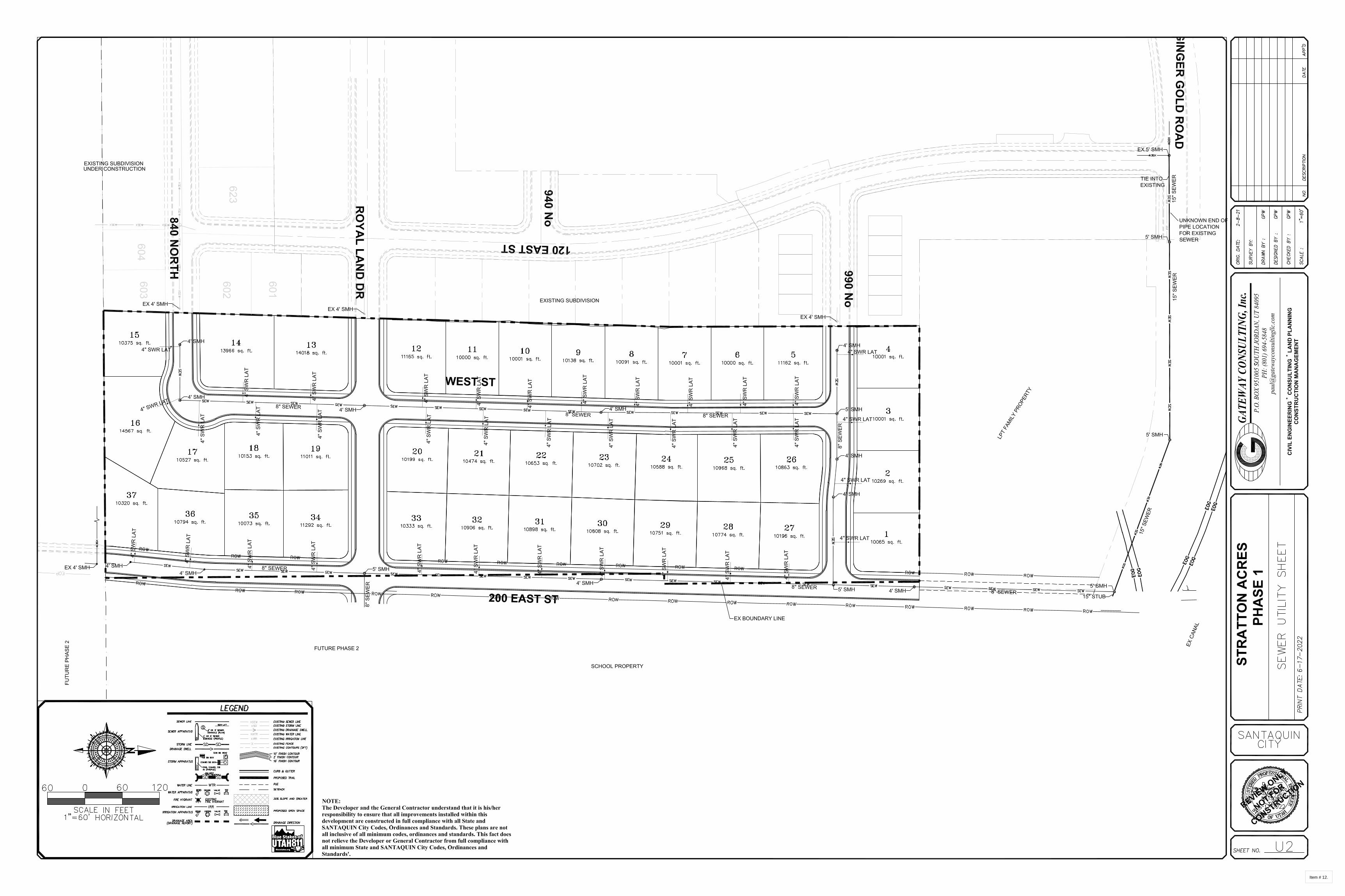
Item # 12.
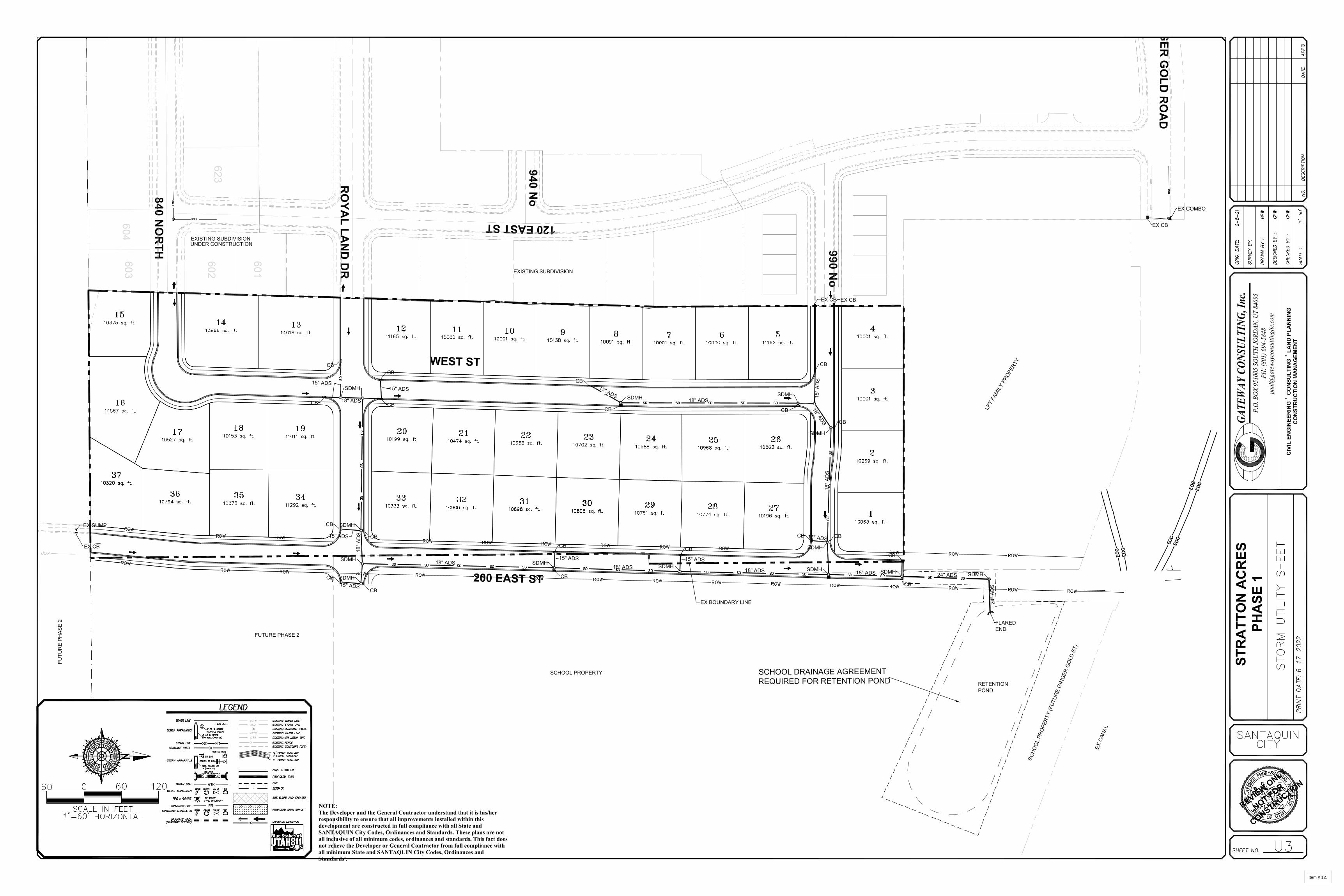
Item # 12.

Item # 12.

Item # 12.

Item # 12.
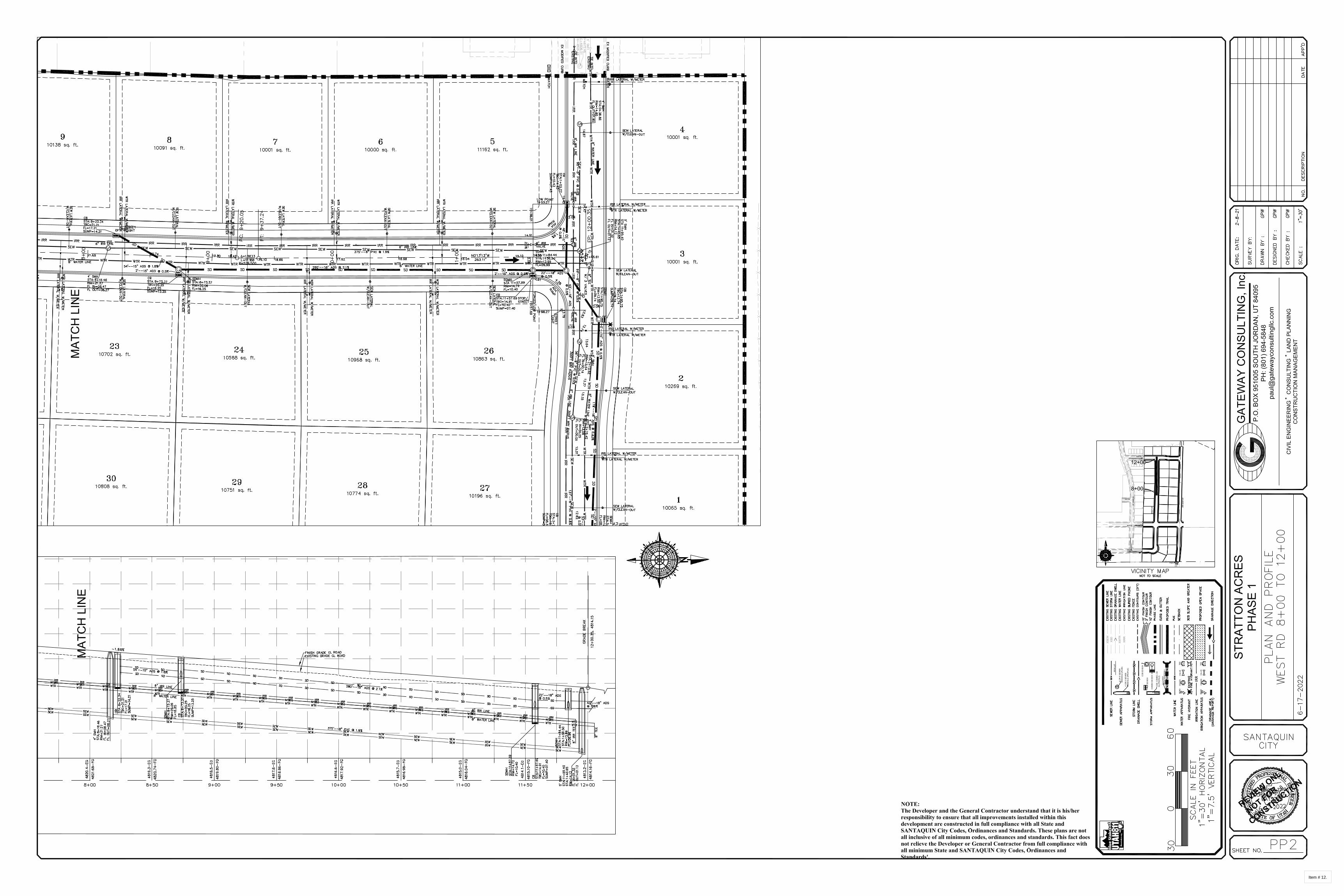
Item # 12.

Item # 12.

Item # 12.

Item # 12.
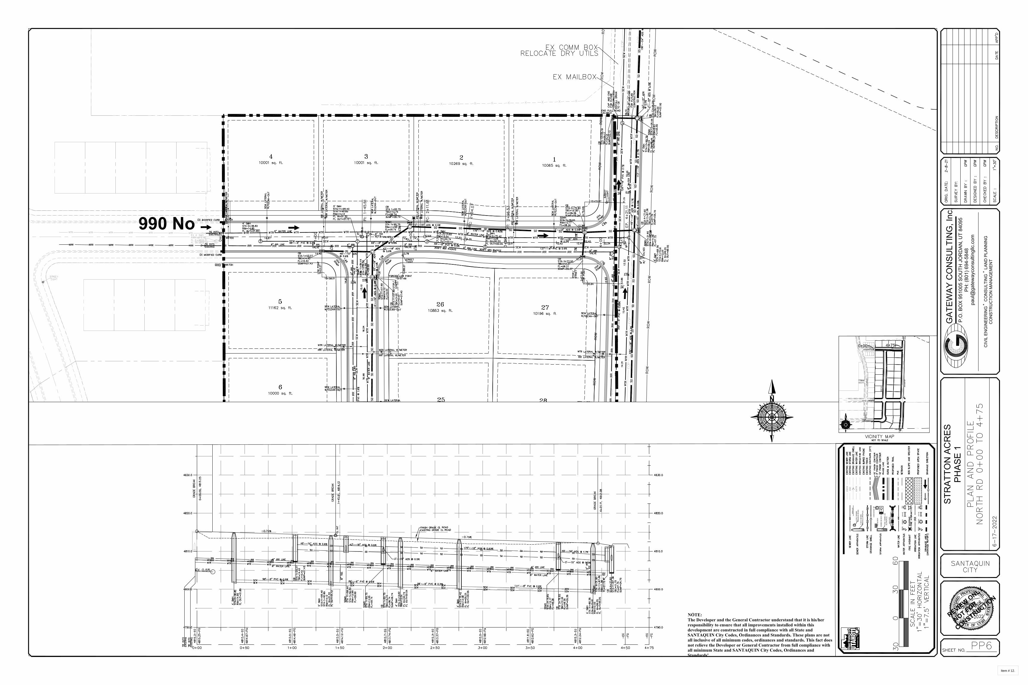
Item # 12.

Item # 12.

Item # 12.

Item # 12.

Item # 12.
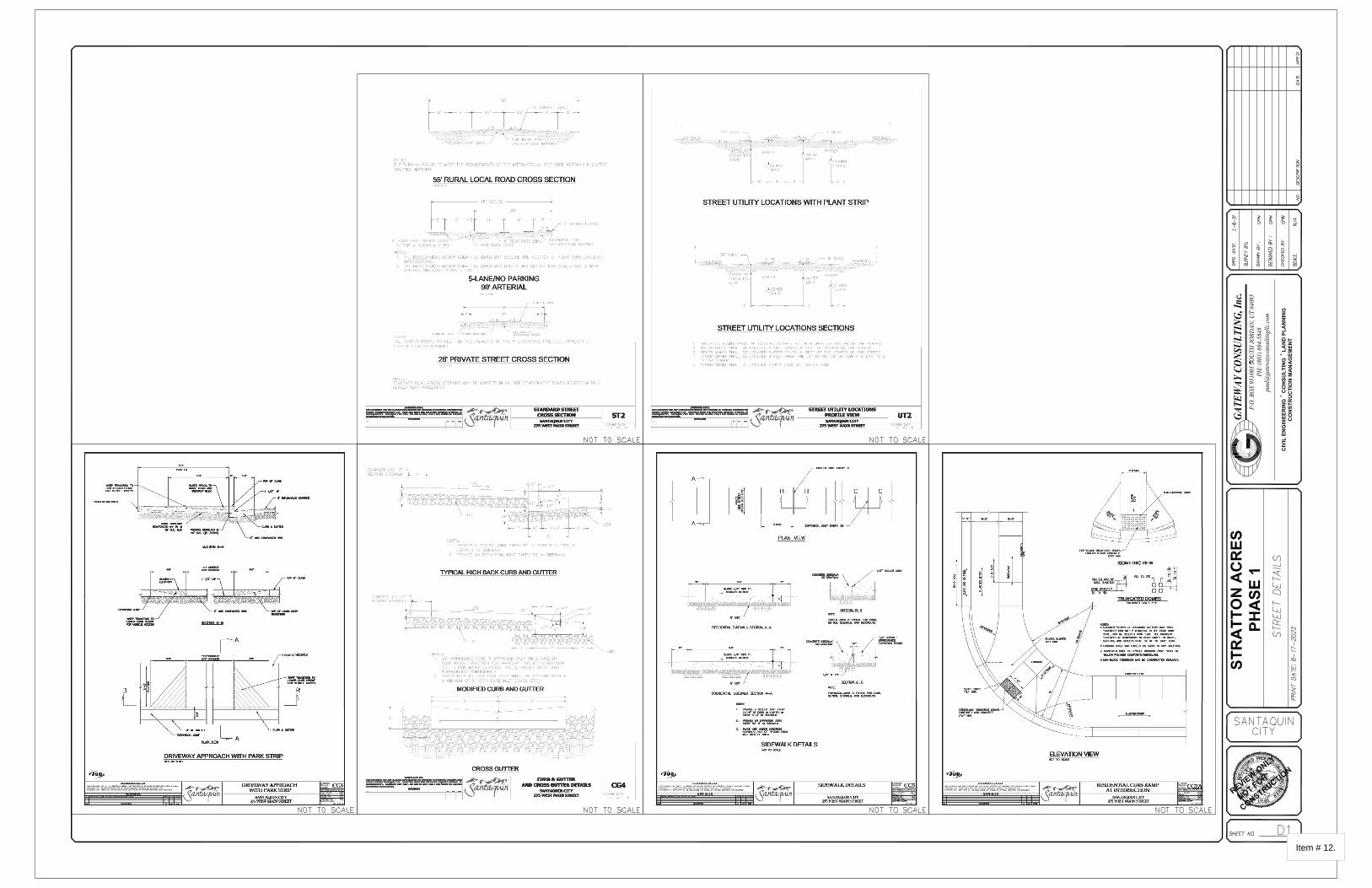
Item # 12.

Item # 12.

Item # 12.

Item # 12.

Item # 12.

Item # 12.