Chemistry and microbiology of the Critical Zone along a steep ...
21
Contents lists available at ScienceDirect Catena journal homepage: www.elsevier.com/locate/catena Chemistry and microbiology of the Critical Zone along a steep climate and vegetation gradient in the Chilean Coastal Cordillera Ralf A. Oeser a, ⁎ , Nicole Stroncik a,d , Lisa-Marie Moskwa b , Nadine Bernhard e , Mirjam Schaller f , Rafaella Canessa g , Liesbeth van den Brink h , Moritz Köster i , Emanuel Brucker j , Svenja Stock k , Juan Pablo Fuentes l , Roberto Godoy m , Francisco Javier Matus n , Rómulo Oses Pedraza o,p , Pablo Osses McIntyre q , Leandro Paulino r , Oscar Seguel s , Maaike Y. Bader g , Jens Boy t , Michaela A. Dippold i , Todd A. Ehlers f , Peter Kühn e , Yakov Kuzyakov k , Peter Leinweber u , Thomas Scholten e , Sandra Spielvogel v , Marie Spohn j , Kirstin Übernickel f , Katja Tielbörger h , Dirk Wagner b,w , Friedhelm von Blanckenburg a,c a GFZ German Research Centre for Geosciences, Section 3.3 Earth Surface Geochemistry, Telegrafenberg, D-14473 Potsdam, Germany b GFZ German Research Centre for Geosciences, Section 5.3 Geomicrobiology, Telegrafenberg, D-14473 Potsdam, Germany c Freie Universität Berlin; Institute of Geological Science, Malteserstr. 74-100, Building N, D-12249 Berlin, Germany d GFZ German Research Centre for Geosciences, Section 3.1 Inorganic and Isotope Geochemistry, Telegrafenberg, D-14473 Potsdam, Germany e University of Tübingen, Soil Science and Geomorphology, Rümelinstraße 19-23, D-72070 Tübingen, Germany f University of Tübingen, Department of Geosciences, Wilhelmstraße 56, D-72074 Tübingen, Germany g Philipps-University Marburg, Ecological Plant Geography, Deutschhausstraße 10, D-35032 Marburg, Germany h University of Tübingen, Plant Ecology, Auf der Morgenstelle 5, D-72076 Tübingen, Germany i Georg-August-University Göttingen, Biogeochemistry of Agroecosystems, Büsgenweg 2, D-37077 Göttingen, Germany j University of Bayreuth, Institute of Soil Ecology, Dr.-Hans-Frisch-Straße 1-3, D-95448 Bayreuth, Germany k Georg-August-University Göttingen, Soil Science of Temperate Ecosystems, Büsgenweg 2, D-37077 Göttingen, Germany l Universidad de Chile, Facultad de Ciencias Forestales y de la Conservación de la Naturaleza, Av. Santa Rosa, 11315 La Pintana, Santiago, Chile m Universidad Austral de Chile, Instituto de Ciencias Ambientales y Evolutivas, Avenida Eduardo Morales Miranda, Campus Isla Teja, Valdivia, Chile n Universidad de La Frontera, Departamento de Ciencias Químicas y Recursos Naturales, Scientific and Technological Bioresource Nucleus (BIOREN-UFRO), Temuco, Chile o Centro de Estudios Avanzados en Zonas Aridas (CEAZA), Raúl Britán #1305, Campus Andrés Bello Universidad de La Serena, La Serena, Chile p Universidad de Atacama, CRIDESAT, Copayapu 484, Copaipó, Chile q Pontificia Universidad Católica de Chile, Instituto de Geografía, Vicuña Mackenna 4860, Macul, Santiago, Chile r Universidad de Concepción, Departamento de Suelos y Recursos Naturales, Facultad de Agronomía, Avda. Vicente Méndez 595, Chillán, Chile s Universidad de Chile, Facultad de Ciencias Agronómicas, Av. Santa Rosa #11315, 8820808 La Pintana, Santiago, Chile t Leibniz University Hannover, Institute of Soil Science, Herrenhäuser Straße 2, D-30419 Hannover, Germany u University of Rostock, Faculty of Agricultural and Environmental Sciences, Soil Science, Justus-von-Liebig-Weg 6, D-18059 Rostock, Germany v Christian-Albrechts-University Kiel, Institute of Soil Science, Herman-Rodewlad-Straße 2, D-24118 Kiel, Germany w University of Potsdam, Institute of Earth and Environmental Science, Karl-Liebknecht-Strasse 24-25, 14476 Potsdam, Germany ARTICLE INFO Keywords: Weathering Denudation Microbial abundance Climate Chile ABSTRACT The Chilean Coastal Cordillera features a spectacular climate and vegetation gradient, ranging from arid and unvegetated areas in the north to humid and forested areas in the south. The EarthShape project (“Earth Surface Shaping by Biota”) uses this natural gradient to investigate how climate and biological processes shape the Earth's surface. We explored the Critical Zone, the Earth's uppermost layer, in four key sites located in desert, semi- desert, Mediterranean, and temperate climate zones of the Coastal Cordillera, with the focus on weathering of granitic rock. Here, we present first results from 16 approximately 2 m-deep regolith profiles to document: (1) https://doi.org/10.1016/j.catena.2018.06.002 Received 16 December 2017; Received in revised form 27 April 2018; Accepted 1 June 2018 ⁎ Corresponding author. E-mail addresses: [email protected] (R.A. Oeser), [email protected] (N. Stroncik), [email protected] (L.-M. Moskwa), [email protected] (N. Bernhard), [email protected] (M. Schaller), [email protected] (R. Canessa), [email protected] (L. van den Brink), [email protected] (M. Köster), [email protected] (E. Brucker), [email protected] (S. Stock), [email protected] (J.P. Fuentes), [email protected] (R. Godoy), [email protected] (F.J. Matus), [email protected], [email protected] (R. Oses Pedraza), [email protected] (P. Osses McIntyre), [email protected] (L. Paulino), [email protected] (O. Seguel), [email protected] (M.Y. Bader), [email protected] (J. Boy), [email protected] (M.A. Dippold), [email protected] (T.A. Ehlers), [email protected] (P. Kühn), [email protected] (Y. Kuzyakov), [email protected] (P. Leinweber), [email protected] (T. Scholten), [email protected] (S. Spielvogel), [email protected] (M. Spohn), [email protected] (K. Übernickel), [email protected] (K. Tielbörger), [email protected] (D. Wagner), [email protected] (F. von Blanckenburg). Catena 170 (2018) 183–203 Available online 19 June 2018 0341-8162/ © 2018 Elsevier B.V. All rights reserved. T
-
Upload
khangminh22 -
Category
Documents
-
view
1 -
download
0
Transcript of Chemistry and microbiology of the Critical Zone along a steep ...

Contents lists available at ScienceDirect
Catena
journal homepage: www.elsevier.com/locate/catena
Chemistry and microbiology of the Critical Zone along a steep climate andvegetation gradient in the Chilean Coastal Cordillera
Ralf A. Oesera,⁎, Nicole Stroncika,d, Lisa-Marie Moskwab, Nadine Bernharde, Mirjam Schallerf,Rafaella Canessag, Liesbeth van den Brinkh, Moritz Kösteri, Emanuel Bruckerj, Svenja Stockk,Juan Pablo Fuentesl, Roberto Godoym, Francisco Javier Matusn, Rómulo Oses Pedrazao,p,Pablo Osses McIntyreq, Leandro Paulinor, Oscar Seguels, Maaike Y. Baderg, Jens Boyt,Michaela A. Dippoldi, Todd A. Ehlersf, Peter Kühne, Yakov Kuzyakovk, Peter Leinweberu,Thomas Scholtene, Sandra Spielvogelv, Marie Spohnj, Kirstin Übernickelf, Katja Tielbörgerh,Dirk Wagnerb,w, Friedhelm von Blanckenburga,c
aGFZ German Research Centre for Geosciences, Section 3.3 Earth Surface Geochemistry, Telegrafenberg, D-14473 Potsdam, GermanybGFZ German Research Centre for Geosciences, Section 5.3 Geomicrobiology, Telegrafenberg, D-14473 Potsdam, Germanyc Freie Universität Berlin; Institute of Geological Science, Malteserstr. 74-100, Building N, D-12249 Berlin, GermanydGFZ German Research Centre for Geosciences, Section 3.1 Inorganic and Isotope Geochemistry, Telegrafenberg, D-14473 Potsdam, GermanyeUniversity of Tübingen, Soil Science and Geomorphology, Rümelinstraße 19-23, D-72070 Tübingen, GermanyfUniversity of Tübingen, Department of Geosciences, Wilhelmstraße 56, D-72074 Tübingen, Germanyg Philipps-University Marburg, Ecological Plant Geography, Deutschhausstraße 10, D-35032 Marburg, GermanyhUniversity of Tübingen, Plant Ecology, Auf der Morgenstelle 5, D-72076 Tübingen, GermanyiGeorg-August-University Göttingen, Biogeochemistry of Agroecosystems, Büsgenweg 2, D-37077 Göttingen, GermanyjUniversity of Bayreuth, Institute of Soil Ecology, Dr.-Hans-Frisch-Straße 1-3, D-95448 Bayreuth, GermanykGeorg-August-University Göttingen, Soil Science of Temperate Ecosystems, Büsgenweg 2, D-37077 Göttingen, GermanylUniversidad de Chile, Facultad de Ciencias Forestales y de la Conservación de la Naturaleza, Av. Santa Rosa, 11315 La Pintana, Santiago, ChilemUniversidad Austral de Chile, Instituto de Ciencias Ambientales y Evolutivas, Avenida Eduardo Morales Miranda, Campus Isla Teja, Valdivia, ChilenUniversidad de La Frontera, Departamento de Ciencias Químicas y Recursos Naturales, Scientific and Technological Bioresource Nucleus (BIOREN-UFRO), Temuco, Chileo Centro de Estudios Avanzados en Zonas Aridas (CEAZA), Raúl Britán #1305, Campus Andrés Bello Universidad de La Serena, La Serena, ChilepUniversidad de Atacama, CRIDESAT, Copayapu 484, Copaipó, Chileq Pontificia Universidad Católica de Chile, Instituto de Geografía, Vicuña Mackenna 4860, Macul, Santiago, ChilerUniversidad de Concepción, Departamento de Suelos y Recursos Naturales, Facultad de Agronomía, Avda. Vicente Méndez 595, Chillán, ChilesUniversidad de Chile, Facultad de Ciencias Agronómicas, Av. Santa Rosa #11315, 8820808 La Pintana, Santiago, Chilet Leibniz University Hannover, Institute of Soil Science, Herrenhäuser Straße 2, D-30419 Hannover, GermanyuUniversity of Rostock, Faculty of Agricultural and Environmental Sciences, Soil Science, Justus-von-Liebig-Weg 6, D-18059 Rostock, Germanyv Christian-Albrechts-University Kiel, Institute of Soil Science, Herman-Rodewlad-Straße 2, D-24118 Kiel, GermanywUniversity of Potsdam, Institute of Earth and Environmental Science, Karl-Liebknecht-Strasse 24-25, 14476 Potsdam, Germany
A R T I C L E I N F O
Keywords:WeatheringDenudationMicrobial abundanceClimateChile
A B S T R A C T
The Chilean Coastal Cordillera features a spectacular climate and vegetation gradient, ranging from arid andunvegetated areas in the north to humid and forested areas in the south. The EarthShape project (“Earth SurfaceShaping by Biota”) uses this natural gradient to investigate how climate and biological processes shape the Earth'ssurface. We explored the Critical Zone, the Earth's uppermost layer, in four key sites located in desert, semi-desert, Mediterranean, and temperate climate zones of the Coastal Cordillera, with the focus on weathering ofgranitic rock. Here, we present first results from 16 approximately 2m-deep regolith profiles to document: (1)
https://doi.org/10.1016/j.catena.2018.06.002Received 16 December 2017; Received in revised form 27 April 2018; Accepted 1 June 2018
⁎ Corresponding author.E-mail addresses: [email protected] (R.A. Oeser), [email protected] (N. Stroncik), [email protected] (L.-M. Moskwa),
[email protected] (N. Bernhard), [email protected] (M. Schaller), [email protected] (R. Canessa),[email protected] (L. van den Brink), [email protected] (M. Köster), [email protected] (E. Brucker),[email protected] (S. Stock), [email protected] (J.P. Fuentes), [email protected] (R. Godoy), [email protected] (F.J. Matus), [email protected],[email protected] (R. Oses Pedraza), [email protected] (P. Osses McIntyre), [email protected] (L. Paulino), [email protected] (O. Seguel), [email protected] (M.Y. Bader),[email protected] (J. Boy), [email protected] (M.A. Dippold), [email protected] (T.A. Ehlers), [email protected] (P. Kühn),[email protected] (Y. Kuzyakov), [email protected] (P. Leinweber), [email protected] (T. Scholten), [email protected] (S. Spielvogel),[email protected] (M. Spohn), [email protected] (K. Übernickel), [email protected] (K. Tielbörger),[email protected] (D. Wagner), [email protected] (F. von Blanckenburg).
Catena 170 (2018) 183–203
Available online 19 June 20180341-8162/ © 2018 Elsevier B.V. All rights reserved.
T

architecture of weathering zone; (2) degree and rate of rock weathering, thus the release of mineral-derivednutrients to the terrestrial ecosystems; (3) denudation rates; and (4) microbial abundances of bacteria and ar-chaea in the saprolite.
From north to south, denudation rates from cosmogenic nuclides are ~10 t km−2 yr−1 at the arid Pan deAzúcar site, ~20 t km−2 yr−1 at the semi-arid site of Santa Gracia, ~60 t km−2 yr−1 at the Mediterranean cli-mate site of La Campana, and ~30 t km−2 yr−1 at the humid site of Nahuelbuta. A and B horizons increase inthickness and elemental depletion or enrichment increases from north (~26°S) to south (~38°S) in these hor-izons. Differences in the degree of chemical weathering, quantified by the chemical depletion fraction (CDF), aresignificant only between the arid and sparsely vegetated site and the other three sites. Differences in the CDFbetween the sites, and elemental depletion within the sites are sometimes smaller than the variations induced bythe bedrock heterogeneity. Microbial abundances (bacteria and archaea) in saprolite substantially increase fromthe arid to the semi-arid sites.
With this study, we provide a comprehensive dataset characterizing the Critical Zone geochemistry in theChilean Coastal Cordillera. This dataset confirms climatic controls on weathering and denudation rates andprovides prerequisites to quantify the role of biota in future studies.
1. Introduction
The Earth's surface, where rock, the atmosphere, the hydrosphere,and the biosphere interact, is often referred to as the Critical Zone(Anderson et al., 2007). Soils, mantling 95% of the terrestrial Earth'ssurface, are the top layer of this zone. Soil is made “from below” byweathering, the breakdown of rocks and minerals (Riebe et al., 2017),and “from above” by the addition of organic matter and atmosphericinputs (Chorover et al., 2007). Weathering turns fresh rock into aloosely consolidated “regolith” (comprising both mobile soil at the topand weathered rock beneath it). The inorganic chemical process ofweathering involves the dissolution of primary minerals and theirpartitioning into solutes and secondary minerals (e.g. amorphous andcrystalline oxides, clays). These abiotic weathering products, as well asorganic compounds, are exported from catchments via erosion andrivers (Gaillardet et al., 1999; Hilton, 2017). The Critical Zone thusplays an important role in the cycling of mineral nutrients across theEarth's surface and the mechanisms of weathering are key.
Numerous studies have shown that soil physico-chemical para-meters, such as soil organic matter, soil acidity, exchangeable ions,extractable oxides, and volumetric strain (ε) systematically change withtemperature and precipitation (e.g. Bardelli et al., 2017; Bojko andKabala, 2017; Khomo et al., 2013; Khomo et al., 2011; Khormali et al.,2012). Egli et al. (2003) have shown that the amount of smectite andthe degree of weathering in Alpine soils increase with precipitation.Moreover, the degree of plagioclase weathering seems to increase ex-ponentially with temperature and linearly with precipitation (Dereet al., 2013). Still, from studies that make use of climatic gradients noclear relationship between climate and denudation rates has yetemerged. Large variations in denudation rates in any given climateindicate that a potential climatic imprint might have been severelyoverprinted by factors such as uplift, physical and chemical bedrockcharacteristics, and biota (e.g. Dixon et al., 2009; Egli et al., 2004;Ferrier et al., 2012; Riebe et al., 2004; Schaller et al., 2018; Starke et al.,2017). In this context, Owen et al. (2011) postulated that a mean an-nual precipitation threshold exists below which bedrock denudation isprecipitation-dependent and above which soil production from bedrockis controlled by complex feedback mechanisms between tectonics,temperature, and biota.
One of the key players in weathering processes is biota, which isreceiving increasing scientific attention in this context (Amundsonet al., 2015b; Brantley et al., 2011; Egli et al., 2014; Hahm et al., 2014).A broad spectrum of biota (plants, animals, and microorganisms) in-teracts with the Earth's surface, although the direction and magnitudeof the effects biota has on Earth-surface processes, and conversely theEarth surface effects on biota, are still not well understood (e.g. Wilckeet al., 2017). For example, little is known about microorganisms thatlive beneath soil, even though more than one third of the microbialbiomass is concentrated in regolith depths deeper than 25 cm (Fierer
et al., 2003; Schutz et al., 2010). Several studies demonstrated thateven in the saprolite active bacterial cells exist (Buss et al., 2005;Richter and Markewitz, 1995). Biogenic weathering is a potentiallyimportant mechanism because microorganisms in the regolith arehighly specialized to their environment (Fritze et al., 2000; Ghiorse andWilson, 1988; Zvyagintsev, 1994). Fungi and their associated bacteriacan directly weather minerals (Balogh-Brunstad et al., 2008; Quirket al., 2014; Smits et al., 2012). In this process they mobilize mineral-bound nutrients (e.g. P, Ca, Mg, K) that are essential elements to plants.When these nutrients are made available for plants, a biogeochemicalcycle is induced that, for some elements, exceeds the weathering fluxmeasured in rivers up to a factor of 40 and more (e.g. Uhlig et al., 2017;Wilcke et al., 2017). This biotically modulated silicate weathering is ofmajor significance for global atmospheric CO2 cycles in the Phanerozoic(Doughty et al., 2014; Pagani et al., 2009; Quirk et al., 2012) and forsustaining a continuous soil cover (Amundson et al., 2015a). Whetherthese biological mechanisms overwhelm the abiotic weathering me-chanisms and whether they serve to provide a feedback balancing soilerosion and soil production have never been shown, owing to the lackof diagnostic observables that allow distinguishing between abiotic andbiotic drivers.
To resolve the control of climate and biota on rock disintegration,we combined the fields of geochemistry, soil science, biogeochemistry,and geomorphology and applied these to different study sites along theChilean Coastal Cordillera. We did this within the German-funded“EarthShape” (Earth surface shaping by biota) research priority pro-gram along four Critical Zone field sites along a latitudinal transect inthe Chilean Coastal Cordillera. The Coastal Cordillera of Chile en-compasses a prominent climate and vegetation gradient that provides anatural laboratory for investigating biotic and abiotic weathering pro-cesses. Soil formation processes in this region were previously exploredby Owen et al. (2011). The authors found a 40-fold increase in soilproduction rate from 1mMy−1 in the hyper-arid to 40mMy−1 in thearid region. Vázquez et al. (2016) described a>30m thick weatheringprofile developed on granitic bedrock in the Coastal Cordillera in theMediterranean climate of central Chile. The authors calculated denu-dation rates (derived from cosmogenic 10Be) from 20 to 70mMy−1,leading to mean residence times of 0.5 to 1.8Ma for minerals in thesaprolite.
The investigated areas of this study include (from north to south)the Pan de Azúcar National Park (~26°S), Santa Gracia Nature Reserve(~30°S), La Campana National Park (~33°S), and Nahuelbuta NationalPark (~38°S). Site selection for these areas was based on the minimaltectonic and lithologic differences, and their position along the climate(arid to humid) gradient. We thus followed the “climosequence” ap-proach (e.g. Egli et al., 2003). In each of these four study sites, fourregolith profiles were excavated on different slope positions.
In this paper, we (1) describe the architecture of the weatheringzone; and quantify (2) the degree and rate of rock weathering, thus the
R.A. Oeser et al. Catena 170 (2018) 183–203
184

release of mineral-derived nutrients to the terrestrial ecosystems; (3)denudation rates from cosmogenic nuclides; and (4) microbial abun-dances of bacteria and archaea in the saprolite. We discuss these resultson (1) a continental scale, on which the observed geochemical sig-natures are mainly caused by large scale variations in precipitation andvegetation cover, on (2) a hillslope scale, where influences on weath-ering and microbial abundances are caused by differing solar irradia-tion on N- and S-facing slopes, and on (3) a regolith profile scale. Withinthe scope of the “EarthShape” research program, we thus contributetowards addressing the question: how does the gradient in precipitationand vegetation cover influence weathering, microbial abundances, andmineral nutrient supply to ecosystems? In a companion paper(Bernhard et al., 2018) the site-specific characterization of the soil andits properties are described. With these two papers, we also provide thebasic Critical Zone background data that will serve as basis for futurestudies employing other field and laboratory techniques to decipher therole of biota along this transect.
2. Study area
2.1. Geological and climatic conditions
Central Chile (~25–40°S) is built of three structural units (fromWest to East): The Coastal Cordillera, the Central Depression, and thePre-Western Cordillera of the Andes. Of these, the Coastal Cordillera isthe oldest and westernmost trench-parallel morpho-structural unit. TheCoastal Cordillera is composed of the remnants of a Late Paleozoic toMesozoic magmatic arc and Paleozoic metamorphic rocks (Charrieret al., 2007; Hervé et al., 2007; Hervé et al., 1988; Pankhurst andHervé, 2007; Parada et al., 1988; Vázquez et al., 2016). The northernCoastal Cordillera (~21–27°S) is suggested to have experienced ex-humation between ~118–152Ma and 60–80Ma prior to Andeanmountain building (Juez-Larré et al., 2010). Following this (from~40Ma to present), deformation migrated to the east of the CoastalCordillera and led to the onset of Andes mountain building and plateauformation (Barnes and Ehlers, 2009). Less well known is the tectonichistory of the Coastal Cordillera south of 27°S, although it is commonlyassumed to be similar to the northern Cordillera. More recently, on-going and minor amounts of Quaternary neotectonic activity have beendocumented in the northern Coastal Cordillera (Riquelme et al., 2003;Starke et al., 2017).
The EarthShape study area features a vegetation gradient controlledby climate, ranging over 1300 km (from 26°06′S to 37°48′S), spanningfrom arid, via Mediterranean, to humid-temperate climate conditions.Within this area four different sites were chosen, all located within80 km of the Pacific coast and within plutonic rocks of the ChileanCoastal Cordillera (Fig. 1). The basement at those four sites is mainlycomposed of: (1) monzo- to syenogranitic intrusions (Pan de Azúcar,Triassic age; Parada et al., 2007), (2) pyroxene and hornblende-bearingdiorites and monzodiorites (Santa Gracia granite, 98–89Ma; Moscosoet al., 1982), and (3), (4) tonalites and granodiorites (Nahuelbutacomplex, 294Ma; Parada et al., 2007 and the Illapel Plutonic Complexin La Campana, 130–90Ma; Parada et al., 1999).
The 30-year mean annual precipitation (MAP) at the study sitesincreases from north to south, from 10mm yr−1 in Pan de Azúcar,89 mmyr−1 in Santa Gracia, 436mmyr−1 in La Campana, to1084mm yr−1 in Nahuelbuta, respectively (Fig. 2a; Ministerio de ObrasPúblicas, 2017). The mean annual air temperatures (MAT) vary be-tween 18.1 °C in the northernmost site and 14.1 °C in the southernmostsite (Fig. 2b; Ministerio de Obras Públicas, 2017). The northernmostsite, Pan de Azúcar, is located at the southern border of the AtacamaDesert. The aridity of the Atacama Desert has developed in the Miocene(Clarke, 2006; Dunai et al., 2005), and the hyperaridity in the earlyQuaternary (Jungers et al., 2013). The sites were unglaciated during thelast glacial maximum (Hulton et al., 2002) and are situated in nationalparks and nature reserves, where anthropogenic influence is minimized
compared to the surrounding areas. However, occasional grazing bycows (La Campana; Rundel and Weisser, 1975) and goats (Santa Gracia;Armesto et al., 2007; Bahre, 1979) within the protected areas have beenreported by local authorities.
2.2. Critical Zone description
In each study site, three south-facing (S-facing) profiles at top-,mid-, and toe-slope position and, as an initial cross-check for aspect, asingle north-facing (N-facing) mid-slope regolith profile were in-vestigated (Figs. 3–6; Table S1).
Here, we describe the soil as consisting of the O, A, and B horizon,underlain by a C horizon consisting of saprolite (bedrock that wasweathered in situ). In this paper, we call the entire zone above un-weathered bedrock “regolith” (Scott and Pain, 2008), which thuscomprises saprolite and soil. The vascular flora of each study site was
Fig. 1. Intrusion age and spatial extension of the granitoid rocks in the fourprimary EarthShape study sites (open squares) along the Chilean CoastalCordillera from north to south: Pan de Azúcar, Santa Gracia, La Campana, andNahuelbuta.(Map modified from SERNAGEOMIN, 2003.)
R.A. Oeser et al. Catena 170 (2018) 183–203
185

classified after Marticorena and Quezada (1985) and Luebert andPliscoff (2006).
2.2.1. Pan de AzúcarThe S-facing regolith profiles in Pan de Azúcar national park (AZ) are
located on a slope of 9m length. The N-facing slope is located at adistance of 30m from the S-facing slope. The elevations range from 328to 343m above sea level (a.s.l.) with hillslope angles between 25 and40° (Fig. 3b; Table S1).
The profiles' surfaces are comprised of fine grained, quartz-rich
granite gruss of a few cm in thickness with a grayish to yellow color(Fig. 3c). At the very top of this A horizon, where silt- and clay-sizedparticles are absent, angular fragments occur in size of up to 1 cm.Below the top layer, a B horizon of reddish-brown color is found. Thesize of fragments increases downwards. The transition to the saproliteof the C horizon occurs at 20 to 25 cm depth and does neither dependon slope position nor aspect.
The saprolite has a reddish-brown color and is characterized bycoarse-grained material (Fig. 3). The entire regolith is jointed, withjoint width and joint spacing augmenting with depth. Joints are either
Fig. 2. Compilation of precipitation (A) and temperature (B) data from climate stations in vicinity of the respective EarthShape study sites (Ministerio de ObrasPúblicas, 2017). Bars on the very right-hand side of both panels show climate data from April 16 to April 17 at the EarthShape climate stations within the study sites(Ehlers et al., 2017).
Fig. 3. Photographs of the S-facing mid slope regolith profile (AZPED 50) in Parque Nacional Pan de Azúcar (AZ) including horizon boundaries (white dashed line), aschematic depth profile (a), a cross section through the S-facing catena and adjacent N-facing regolith profile (b). The regolith in AZ developed on a coarse-grained,feldspar-rich granite. Its cover lacks fine-grained particles which are removed by wind (c). Fractures are either filled with clay-sized particles of unknown com-position or gypsum and carbonate (d).
R.A. Oeser et al. Catena 170 (2018) 183–203
186

Fig. 4. Photographs of the S-facing mid slope pit (SGPED 40) in Reserva Natural Santa Gracia (SG) including horizon boundaries (white dashed line), a profile sketch,and a cross section through the S-facing catena and adjacent N-facing pit. The catena developed on a medium grain size granitic substrate. The regoliths' upper layeris characterized by bioturbation and a high root density (a). At the pits' base, two major joint sets are preserved. Here, roots penetrate the fractures and weather theadjacent rock face (b).
Fig. 5. Photographs of the S-facing mid slope pit (LCPED 20) in Parque Nacional La Campana (LC) including horizon boundaries (white dashed line), a profile sketch,and a cross section through the S-facing catena and adjacent N-facing pit. Both coarse- and fine-grained granodiorite comprise the substrate of the regolith (boundaryshown by the red dashed line) (a); scale bar size: 10 cm. Mid slope pits (S- and N-facing) are affected by mass movement downslope, leading to an accumulation ofangular fragments in the soil columns (b). (For interpretation of the references to color in this figure legend, the reader is referred to the web version of this article.)
R.A. Oeser et al. Catena 170 (2018) 183–203
187

filled with fine-grained material of unknown composition or withvisible calcite and gypsum crystals (Fig. 3d). At the base of the regolithprofiles, the width of the joints decreases; the joints pinch out to thebottom. Unweathered parent material was not observed. Dead rootmaterial has been found in the profiles only rarely.
The area belongs to the vegetation formation “Mediterraneancoastal desert scrub of Euphorbia lactiflua and Eulychnia saint-pieana”(Luebert and Pliscoff, 2006). The vegetation cover is very low (< 10%)and is represented only by small shrubs, geophytes and annual plants(Armesto et al., 1993), which are present in more abundance in smallravines. On the sampled S-facing slope, a few individuals of Tetragoniamaritima, Nolana mollis, Perityle sp. and Stipa plumosa can be found. Onthe N-facing slope, single individuals of N. mollis and Cristaria in-tegerrima are present. From these species, only T. maritima, N. mollis andC. integerrima maintain their vegetative structures during dry years.
2.2.2. Santa GraciaIn the natural reserve of Santa Gracia (SG) the three S-facing re-
golith profiles are located on a 153-m long slope. The N-facing regolithprofile is located at a distance of 160m from the S-facing mid-slopeprofile. The elevations of these four profiles range from 628 to 718ma.s.l. with the two mid-slope profiles at approximately 690m a.s.l.Slope angle is slightly lower than in Pan de Azúcar and varies between15 and 25° at the mid-slope regolith profiles (Fig. 4b; Table S1).
The surface of the regolith profiles in Santa Gracia is composed ofsub-angular, coarse sand-sized quartz and granodiorite fragments. Thisbrownish A horizon is made of grussified granodioritic, silt to fine sand-sized particles, supporting fragments of up to 2mm in diameter. Rootsare abundant in this horizon and reach diameters of up to 1 cm (Fig. 4).This horizon is underlain by a brownish white-spotted transitional (B)horizon. Within this horizon, the proportion of fragments increases withtheir size, resulting in a fine-grained matrix that is supported by coarse
fragments at the horizon's base. Fine roots pervade this horizon. Theextent of the soil horizon (comprised of A and B horizon) increases fromthe top- to toe-slope regolith profiles of the S-facing slope from 30 to55 cm (Table S1). The depth of the soil horizon in the regolith profile onthe N-facing slope (SGPED70) is thinner (35 cm) and its brownish colorless dominant.
The orange-brownish saprolite is dominated by greenish-blackweathered biotite and hornblende and reddish feldspars, respectively.Fragments are up to 1 cm in size and are surrounded by fine-grainedmaterial and fine roots. Joint spacing in the weathered granodiorite isapproximately 30 cm. Roots (average diameter of 1mm) penetrate thefractures and weather the adjacent rock face (Fig. 4d). In contrast to theS-facing regolith profiles, the weathered bedrock in the N-facing re-golith profile exhibits a white and gray mottled pattern at depth, withonly a few orange spots visible.
The vegetation belongs to the “Interior Mediterranean desert scrubof Heliotropium stenophyllum and Flourensia thurifera” formation(Luebert and Pliscoff, 2006). The original vegetation has been highlydisturbed and the current shrubby vegetation is influenced by livestockgrazing (mostly goats; Bahre, 1979). For these reasons, combined withthe semi-arid climate, vegetation cover is low, especially in the her-baceous layer. The shrub layer is sparse (∼30–40% cover) and isdominated by Proustia cuneifolia and Senna cumingii on the sampled S-facing slope, and by Cordia decandra and Adesmia sp. on the N-facingslope. On the latter slope, the cactus Cumulopuntia sphaerica is veryabundant and the columnar cactus Eulychnia acida is present with in-dividuals of> 2m height (i.e. cardonal vegetation community; Bahre,1979). In the area, some individuals of the shrubs Balbisia peduncularis,Baccharis paniculata and Bulnesia chilensis also occur.
2.2.3. La CampanaThe regolith profiles in La Campana national park (LC) are located on
Fig. 6. Photographs of the S-facing mid slope pit (NAPED 20) in Parque Nacional Nahuelbuta (NA) including horizon boundaries (white dashed line), a profile sketch,and a cross section through the S-facing catena and adjacent N-facing pit. Very high organic matter content, characterize the upper horizons of the four pits (a).Fragments are absent in the regoliths' A-Horizon; they occur in the B-Horizon in the form of weathered granodiorite (b). Rare fragments of mafic composition are alsofound.
R.A. Oeser et al. Catena 170 (2018) 183–203
188
a S-facing slope of 152m length where the S-facing and the N-facingmid-slope regolith profiles are separated by 173m. The elevations ofthe four profiles range from 706 to 750m a.s.l. with the two mid-slopeprofiles being at 730 and 734m a.s.l., respectively. The mean slopeangle at the mid-slope profiles is around 18° (Fig. 5b; Table S1).
The regolith at this site is covered by an O horizon of a few cen-timeters thickness, composed of litter and tree-debris mixed withgranitic gruss of sand size. The dark-brown A horizon on the S-facingcatena has a thickness of up to 40 cm. In contrast, the N-facing regolithprofile's A horizon is of grayish-brown color and measures only 12 cm.It is composed of fine-sand to silt-sized particles, hosting some grano-dioritic fragments of up to 3mm in diameter and is highly permeated byroots of various sizes. The base of the soil horizon is characterized by abrown to orange-brown transitional (B) horizon. As the matrix iscoarsening downwards, the number of fragments increases and thehorizon shifts from a matrix- to a clast-supported one. The final tran-sition from soil to saprolite occurs at a depth of 60 cm within 3 to 5 cm.At the N-facing slope, this transition occurs at a shallower depth.
The saprolite develops from (at least) two distinct granodioritetypes: a coarse-grained and a fine-grained one (Fig. 5c). In both cases,the granodiorite fabric is still visible and the mineral composition(plagioclase≫ quartz≫ K-feldspar & biotite) is similar. Throughout thesaprolite, fine roots are common and are most abundant within frac-tures.
The vegetation of La Campana belongs to the “CoastalMediterranean sclerophyllous forest of Lithraea caustica and Cryptocaryaalba” formation (Luebert and Pliscoff, 2006) and includes examples ofall the major biotic communities of sclerophyllous forest of centralChile (Gajardo, 1994; Rundel and Weisser, 1975). Vegetation cover ishigh, with almost 100% ground cover. The forest canopy is dominatedby the evergreen sclerophyllous trees L. caustica, C. alba, Quillaja sa-ponaria, and in lower abundance Kageneckia oblonga. The medium shrublayer is dense and dominated by Colliguaja odorifera, Aristeguietia salviaand Retanilla trinervia, and in less abundance Podanthus mitiqui. Theherbaceous layer presents a high cover and diversity and is especiallyrich in annual species. The most abundant species are Geranium ro-bertianum, Stellaria media and the fern Adiantum chilense. Along the S-facing catena, the trees L. caustica and C. odorifera are the most abun-dant and dominant species. In less abundance, P. mitiqui and A. salviaare found in the shrub layer, while the herbaceous layer is dominatedby Alstroemeria sp., G. robertianum, S. media, Solenomelus pedunculatusand A. chilense. Near the N-facing slope profile, high vegetation is lessabundant and less rich in species. The canopy is strongly dominated byL. caustica, accompanied by some individuals of Jubaea chilensis. Themost abundant shrub is R. trinervia, followed by A. salvia and C. odor-ifera. Poaceae spp. and Sonchus oleraceus dominate the herbaceous layer,where climbing species like Tropaeolum sp. and Dioscorea sp. also occur.
2.2.4. NahuelbutaThe regolith profiles in the Nahuelbuta national park (NA) are located
on a 136-m long S-facing slope where the S-facing and the N-facingmid-slope regolith profiles are separated by 145m. The elevations ofthese four profiles range from 1219 to 1248m a.s.l., being the highestamong the four study sites. Slope angles of around 14° at the mid-slopeprofiles are the smallest of the study area (Fig. 6b; Table S1).
The regolith at Nahuelbuta is covered by a 2 to 5 cm thick O hor-izon, almost entirely composed of roots, leaves, and moss. The A hor-izon is characterized by a large number of roots (various sizes, up to3 cm in diameter; Fig. 6) and a brown to black color. This horizon ismainly composed of silt-sized particles, forming nodular soil ag-gregates, giving this layer a granular texture. In the upper part of the Ahorizon, up to 1mm large quartz grains are embedded and at the base,larger granodioritic fragments occur. The transitional (B) horizon in-creases in thickness from the top to the toe slope regolith profile on theS-facing catena. Its matrix is made of fine-sand sized particles, hostingsub-angular granodioritic fragments. As depth increases, fragment
abundance and size is increasing and the horizons' color is lighter.Unlike in the upper two S-facing regolith profiles, where the transitionfrom soil to saprolite is gradual, the S-facing toe slope and the N-facingmid-slope profile are characterized by a thin soil-saprolite transitionzone. At this transition, highly weathered mafic rock (NAPED30) andgranodioritic core stones (NAPED40) appear, respectively.
The saprolite is coarse-grained and disaggregates readily. Its colorvaries from dark gray to whitish. The dark color is attributed toweathered bedrock of mafic composition and the whitish color toweathered rock with an increased plagioclase abundance. Some reddishintercalations within the saprolite follow fluid pathways along formerlyopen fractures and pathways once occupied by roots.
The dominant vegetation belongs to the “Coastal temperate forest ofAraucaria araucana” formation (Luebert and Pliscoff, 2006). Here also,vegetation cover is 100%. The general area also supports tall evergreenmixed forest dominated by the broadleaved Nothofagus dombeyi and theiconic conifer A. araucana, but around the soil pits the forest is moreopen and dominated by the lower-stature deciduous trees Nothofagusobliqua and Nothofagus antarctica, together with the tall A. araucana.The dominant shrub species is Gaultheria mucronata, but other specieslike Azara microphylla, Baccharis sp., Ribes magellanicum and Berberismontana are also present. At the herbaceous level, Stipa sp. and Mutisiadecurrens are very abundant. However, herbaceous diversity is veryhigh and is also represented by e.g. Chusquea culeou, Bromus sp., Violamaculata and Adenocaulon chilense. Around the regolith profile on the N-facing slope, N. obliqua and N. antarctica are the most abundant speciesin the canopy and the understory is dominated by G. mucronata andStipa sp. Along the catena on the S-facing slope, the canopy is less denseand A. araucana is the most abundant species, followed by N. antarctica,while in the understory C. culeou is very common. Lichens of the genusUsnea abundantly cover most of the tree trunks and branches.
3. Material and analytical methods
3.1. Sampling
Regolith samples were collected from bottom to top (if applicable)in a continuous sequence of depth increments, amounting to a thicknessof 5 cm (uppermost two samples), 10 cm (3rd sample from top), and20 cm (4th sample from top and below), respectively. About 1 kg ofmaterial was taken per sample. In addition, saprolite samples (50ml)were taken under sterile conditions for DNA-based analyses of micro-bial abundances. These latter samples were stored and transportedunder frozen conditions to Germany.
Underlying unweathered bedrock has not been reached in the re-golith profiles of this study and the depth to bedrock remains unknown.However, a set of 20 bedrock samples (4 in Pan de Azúcar, 8 in SantaGracia, 5 in La Campana and 3 in Nahuelbuta, respectively) was thusobtained from nearby outcrops.
All sample metadata are already available on a public server usingunique sample identifiers in form of the new “International Geo SampleNumber” (IGSN).
3.2. Bedrock and regolith geochemistry
Major and trace element concentration of bedrock and regolithsamples were determined using the PANalytical AXIOS advanced X-RayFluorescence spectrometer at the GFZ German Research Centre forGeosciences, Section “Inorganic and Isotope Geochemistry”. The deviceis equipped with a Rh anode X-ray tube, which was operated at anexcitation voltage of 25 to 60 kV and currents between 60 and 160mA.Measuring times for major elements varied between 10 and 20 s, fortrace elements it was set to 40 s.
Prior to measurement, each sample was milled in an agate mortarand sieved through a 62 μm gauze sieve. Powdered samples were driedat 105 °C for 24 h before glass bead preparation. Glass beads were made
R.A. Oeser et al. Catena 170 (2018) 183–203
189

with 1 g of sample material, 6 g of dilithiumtetraborate, and up to 1 g ofammonium nitrate, brought to complete fusion in a heating system insix steps of up to 8-minute intervals. The intervals were adjusted de-pending on the concentration of organic compounds. The loss on igni-tion for each sample was determined by weighing the glass beads andthe platinum crucibles used for glass bead preparation before and afterfusion.
XRF data of regolith samples have been recalculated to a volatilefree basis using.
=− −
X XSUM LOI LOI
[ ] [ ]( )
,recalcmeasured
measured measured bedrock (1)
where [X]recalc and [Xmeasured] refers to the recalculated and measuredconcentration of an element, SUMmeasured to the sum of all elementsanalyzed, and LOImeasured to the samples' loss on ignition, respectively.LOIbedrock is the average loss on ignition of associated bedrock samples.
Pedogenic oxides of Iron (Fe), Aluminum (Al), Manganese (Mn), andSilicon (Si) were determined at University Bern with the dithionite-ci-trate method as described by Mehra and Jackson (1958). Active oxidesof the same elements were examined as ammonium-oxalate extractablecompounds (Schwertmann, 1964; modified after Tamm, 1922). Oxidesassociated with soil organic matter (SOM) were extracted with a 0.1 Mpyrophosphate reagent (Na2P2O7×10 H2O) at pH 10. Elements havebeen analyzed on an ICP-MS (7700x Agilent Technologies).
Mineral assemblages and approximate mineral abundances in re-presentative bedrock samples were estimated at GFZ Potsdam usingthin section microscopy and standard point counting techniques.
3.3. Cosmogenic 10Be in quartz
For determination of the in situ-produced 10Be concentration inquartz, the saprolite samples were washed, dried, and sieved to afraction of 0.25 to 2.0mm at the University of Tübingen, Department ofGeosciences, Germany. The 1.0 to 2.0mm fraction was crushed to 0.25to 1.0 mm. After magnetic separation and treatment with HCl, thesample material was leached with HF/HNO3. The remaining non-quartzminerals were dissolved and meteoric 10Be was removed from quartzgrains by HF etching. A total of 15 to 35 g of cleaned quartz was spikedwith ∼0.3 mg 9Be and dissolved with concentrated HF. Beryllium wasseparated from other elements with column chromatography and pre-cipitation techniques after von Blanckenburg et al. (1996). After oxi-dation BeO was mixed with Nb powder for measurement of 10Be/9Beratios at the accelerator mass spectrometer (AMS) facility in Cologne.Uncertainty on measured ratios is reported as 1σ. Calculated sampleconcentrations were corrected for a combined mass spectrometry andchemistry blank of 3.4× 10⁴ atoms.
3.4. DNA extraction and quantification of 16S rRNA gene copies
Total genomic DNA was extracted at GFZ Potsdam from saprolitesamples which were collected under sterile conditions. The PowerSoil®DNA Isolation Kit was used for soils from La Campana, Santa Gracia,and Nahuelbuta with a maximum sample amount of 0.25 g each.Samples from Pan de Azúcar were treated with the PowerMax® SoilDNA Isolation Kit (both from MoBio Laboratories, CA, USA). Beforeprocessing, saprolite samples from Pan de Azúcar and Santa Graciawere crushed by hand. Following this, DNA was extracted in triplicatesfollowing the manufacturer's protocol with one exception; DNA elutionwas done with PCR-grade water. Final concentrations were measuredwith a NanoPhotometer® (P360, Implen GmbH, Germany). Purity wascontrolled by the optical density values of OD260/OD280 and OD260/OD230.
Gene copy numbers of universal bacteria and universal archaeawere determined by quantitative polymerase chain reaction (qPCR).16S rRNA genes were amplified by using the bacterial primer pairEub341F (5′–CCT ACG GGA GGC AGC AG–3′) and Eub534R (5′–ATT
ACC GCG GCT GCT GG–3′) (Muyzer et al., 1993), and the archaealprimer pair 340F (5′–CCC TAC GGG GYG CAS CAG–3′) and 1000R(5′–GGC CAT GCA CYW CYT CTC–3′) (Gantner et al., 2011). The qPCRassay was carried out in a total reaction volume of 20 μl using the KAPASYBR® FAST qPCR Kit Master Mix (2X) Universal (Kapa Biosystems,Sigma-Aldrich, Germany) in accordance with the manufacturer's re-commendations. Quantification was performed in the CFX96 Connect™Real-Time System (Bio-Rad Laboratories, CA, USA) with the followingcycling program for bacterial 16S rRNA genes (and archaeal 16S rRNAgenes): initial denaturation at 95 °C for 3min, followed by 40 (45) cy-cles of denaturation at 95 °C for 3 s, annealing at 60 °C (57 °C) for 20 s,elongation at 72 °C for 30 s. Fluorescence was measured at 80 °C. Themelting curve was recorded by rising temperature from 65 to 95 °C. Dueto preliminary experiments, DNA extracts were used in 1:10 for archaeaand 1:100 dilutions for bacteria to avoid putative inhibitions of co-ex-tracted substrates. Every qPCR run included blanks, calibration stan-dards in triplicates and saprolite samples in quadruplicates. The reac-tion efficiency ranged between 92.0 and 98.6%. Data analysis wascarried out using the CFX Manager™ Software (Bio-Rad Laboratories,CA, USA).
4. Calculation of weathering indicators and denudation rates
To quantify the element fluxes as well as the weathering intensitiesthat emerge when the bedrocks' elements are solubilized in percolatingfluids and new elements are introduced from the atmosphere, variousindices and coefficients have been developed. The common denomi-nator of all these approaches is the identification of an element con-sidered to be immobile during weathering. Furthermore, cosmogenicnuclide concentration can be converted into rates of mass removal. Inthe following, we outline these quantification approaches.
4.1. Chemical index of alteration (CIA), chemical depletion fraction (CDF),mass transfer coefficient (τ), and volumetric strain (ε)
To assess the relative degree of chemical weathering, we used theCIA (Eq. (2)) developed by Nesbitt and Young (1982). In this approach,aluminum is assumed to be an immobile element and the degree ofweathering is traced by comparing the aluminum content of a samplewith this of the readily soluble cations calcium, sodium and potassiumin silicate minerals.
=+ + +
×CIA Al OAl O CaO Na O K O
100.2 3
2 3 2 2 (2)
The CIA in unweathered granitoid rock has values of 45 to 55. Thedegree of weathering has to be evaluated from the CIA in weatheredmaterial relative to its respective unweathered precursor. As weath-ering proceeds the CIA evolves to a maximum value of 100 (Nesbitt andYoung, 1982).
To calculate the relative mass loss caused by chemical weathering ofthe parent rock we used the chemical depletion fraction (CDF; Riebeet al., 2003):
= − = −CDFX
X1
[ ][ ]
CDF 1[X ]
[X ],i parent
i weathered
i parent
i weathered (3)
where [Xi]weathered and [Xi]parent represent the concentration of theimmobile element Xi in weathered regolith and unweathered parentbedrock, respectively. If no element loss has occurred during the tran-sition from parent rock to regolith, the CDF is zero. If weathering hasproceeded to completion (i.e. only quartz, clay minerals, and secondaryoxides remain), the CDF attains a maximum value of ca. 0.5 in graniticrock.
To estimate the relative loss of individual elements (X), we used themass transfer coefficient τ (tau; Anderson et al., 2002; Brimhall andDietrich, 1987). It is important to note that the ratio of X in weatheredmaterial to X in unweathered parent rock depends on both the loss of X
R.A. Oeser et al. Catena 170 (2018) 183–203
190

and the loss of other elements besides X. To take the loss of other ele-ments into account, the calculation of τ involves concentrations of animmobile element Xi in parent material relative to weathered material:
= × −τ XX
XX
[ ][ ]
[ ][ ]
1.Xweathered
parent
i parent
i weathered (4)
If τ=0 no loss of X has occurred compared relative to the parentmaterial. τ < 0 denotes relative elemental loss, τ > 0 denotes gain,respectively.
The conversion of primary minerals into secondary phases and so-lutes is usually accompanied by a change in density ρ and volume V. Ameasure of this change and an estimate of deformation is the volumetricstrain ε (Brimhall and Dietrich, 1987):
= × −ερ
ρX
X[ ]
[ ]1.
[X ][X ]
parent
weathered
i parent
i weathered
i parent
i weathered (5)
Positive values of ε indicate dilation, negative ones collapse of aprofile. Values near zero are evidence of isovolumetric weathering.
4.2. Denudation rates based on cosmogenic nuclides and immobile elements
At each primary study site, the total denudation rate D (int km−2 yr−1) was determined for the mid-slope regolith profile of the S-facing and N-facing catena (AZPED50 & 21, SGPED40 & 70, LCPED20 &40, and NAPED20 & 40; Table S6). To ensure that the calculated Dreflects that of the regolith profiles and is not influenced by mixing ofthe surface layer with material from above (e.g. Heimsath et al., 1997),mobile material from the soil layer was avoided. Thus, we determinedthe in situ-produced 10Be concentrations in quartz from material sam-pled from the top of the physically immobile saprolite just below themobile soil layer (see Schaller et al., 2018). D measures the total massloss within the adsorption depth of cosmic rays (ca. 1 m; e.g. Dixonet al., 2009; Riebe and Granger, 2013; Riebe et al., 2001), which entailschemical loss (weathering, W) and physical loss (erosion, E):
= +D E W (6)
If mass loss by weathering occurs beneath the cosmic ray adsorptiondepth, as it is likely in the saprolite that is weathered at great depth inthe Chilean Coastal Cordillera (Vázquez et al., 2016), then the 10Beconcentration does not account for this loss and D is a minimum esti-mate (Riebe and Granger, 2013). Nucleonic, stopped muonic, and fastmuonic production rates P at sea level and high latitude (SLHL) used for
denudation rate calculation are 3.92 atoms g−1 yr−1 (Borchers et al.,2016), 0.012 atoms g−1 yr−1, and 0.039 atoms g−1 yr−1, respectively(Braucher et al., 2011). SLHL production rates were scaled to samplealtitude and latitude with the online tool of Marrero et al. (2016) usingthe scaling procedure based on Lifton et al. (2014). Shielding factors fortopography and slope are 1.0. No shielding by snow has been taken intoaccount. However, in order to correct for the influence of increasingvegetation cover on the production rate, shielding by vegetation of2.3% for acadian/boreal forest and 7.3% for rain forest have been ap-plied in La Campana and Nahuelbuta, respectively (Plug et al., 2007).Shielding factors due to sample overburden (depth and soil density)were calculated for nucleonic, stopped, and fast muonic productionrates. The adsorption lengths used were 157, 1500, and 4320 g cm−2,respectively (Braucher et al., 2011). Denudation rates D [t km−2 yr−1]were calculated based on the blank-corrected nuclide concentrations[atoms g−1], the 10Be decay constant λ=4.99×10⁻⁷ yr−1 (Chmeleffet al., 2010; Korschinek et al., 2010), and the respective productionrates P [atoms g−1 yr−1] at sample depths and adsorption lengths Λ[g cm−2] for each production mechanism using Eq. (7):
⎜ ⎟= ⎛⎝
− ⎞⎠
D P[ Be]
λ Λ10 (7)
The weathering rate can be calculated from D by using the CDF,which is a measure of the fraction of the total denudation that is ac-counted for by chemical weathering or also the ratio of chemicalweathering to total denudation W/D. W is given by:
= D CDFW · . (8)
We determined W with the CDF averaged over all soil samples, thuscalculating a maximum chemical loss over the entire regolith profile.
5. Results
5.1. Chemical and mineralogical bedrock composition and classification
Major and selected trace element concentrations and density of localbedrock for each of the study sites are listed in Table S2. The bedrock inPan de Azúcar and La Campana is characterized by SiO2 > 71wt% anda high Na2O and K2O content (∼7wt%; Fig. 7a). Apart from Mg, Ca,and Ba, major and trace elements show uniform concentrations (i.e.standard deviations below 15%). In contrast, bedrock samples fromSanta Gracia and Nahuelbuta show extensive compositional
Fig. 7. Classification diagrams for siliceous igneous and volcanic rocks. (a) Total alkali versus silica diagram introduced by Le Bas et al. (1986). (b) Q-AnOr diagramof Streckeisen and LeMaitre (1979), where the mineral modes were determined from XRF analyses by the CIPW norm calculation. Field association as follows: a -Alkali-feldspar granite; b - Syenogranite; c - Monzogranite; d - Alkali-feldspar Quartz Syenite; e - Quartz Syenite; f - Quartz Monzonite; g - Quartz Monzodiorite; h -Syenite; i - Monzonite; j - Monzogabbro; k – Diorite.
R.A. Oeser et al. Catena 170 (2018) 183–203
191

heterogeneities. In Santa Gracia and Nahuelbuta, the standard devia-tion of the major and trace element concentrations is 33 and 50%, re-spectively. At Santa Gracia, the SiO2 concentration is by far the lowest(50 wt% < SiO2 < 64wt%) whereas the MgO concentration is thehighest (0.91 wt% < MgO < 5wt%) of all analyzed bedrock samples.The major element bedrock composition at Nahuelbuta is similar to thatof Santa Gracia with the exception of SiO2 concentrations that are65–70wt%.
Modal mineral abundances based on CIPW norm calculation(Johannsen, 1937) of average bedrock composition for each study siteare given in Table S3. With the exception of Santa Gracia, bedrockcomposition includes quartz (≥35 vol%) and feldspar-rich (Pl≥ 35 vol%; Kfs≥ 17 vol%) granitoid rocks. According to the two classification
schemes of igneous and volcanic rocks introduced by Le Bas et al.(1986; Fig. 7a) and Streckeisen and LeMaitre (1979; Fig. 7b), thebedrock samples from Pan de Azúcar, La Campana, and Nahuelbuta aregranites, granodiorites, and tonalites, respectively. Santa Gracia bed-rock yield CIPW-based mineral modes for plagioclase- (An + Ab) of67 vol%, pyroxenes (14 vol%), quartz (9 vol%), and K-feldspar (5 vol%)rock. Both schemes classify these rocks as gabbros and diorites – ig-neous rocks with a low quartz content.
5.2. Regolith chemistry and weathering patterns
Major element concentrations of the four regolith profiles at eachsite are shown in Table S4 and Fig. 8. The principle differences in the
Fig. 8. Depth-dependent major element composition (corrected for LOI following Eq. (1)) of the four primary EarthShape study sites (regolith profile names indicatedabove). Differences between sites are attributed to large-scale bedrock variations and differences within the single catenae to small-scale lateral and vertical bedrockheterogeneities. Vertical variations within a profile (i.e. LCPED30, NAPED20, NAPED40) reflect a change in substrate. Dashed lines indicate the soil – saproliteboundary.
R.A. Oeser et al. Catena 170 (2018) 183–203
192
overall compositions between the sites reflect the differences in bedrockcomposition. The compositional heterogeneity is small in Pan deAzúcar, Santa Gracia and La Campana within the saprolite. Only atNahuelbuta the saprolite shows a high level of compositional hetero-geneity between and within profiles, which is due to initial bedrockheterogeneity. Importantly, no gradients towards the base of the pro-files are observed, implying that the weathering front has not beenreached in any of these profiles. A and B horizon samples have a higherdegree of heterogeneity, with some showing an increase in P and Caconcentrations.
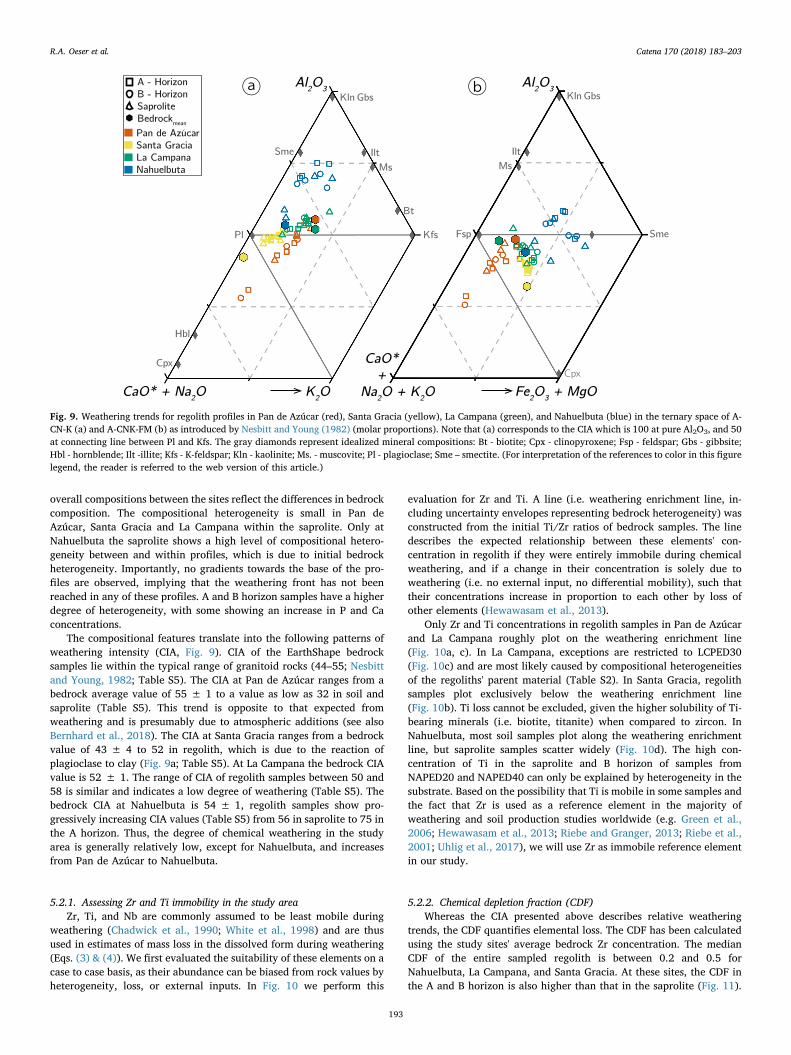
The compositional features translate into the following patterns ofweathering intensity (CIA, Fig. 9). CIA of the EarthShape bedrocksamples lie within the typical range of granitoid rocks (44–55; Nesbittand Young, 1982; Table S5). The CIA at Pan de Azúcar ranges from abedrock average value of 55 ± 1 to a value as low as 32 in soil andsaprolite (Table S5). This trend is opposite to that expected fromweathering and is presumably due to atmospheric additions (see alsoBernhard et al., 2018). The CIA at Santa Gracia ranges from a bedrockvalue of 43 ± 4 to 52 in regolith, which is due to the reaction ofplagioclase to clay (Fig. 9a; Table S5). At La Campana the bedrock CIAvalue is 52 ± 1. The range of CIA of regolith samples between 50 and58 is similar and indicates a low degree of weathering (Table S5). Thebedrock CIA at Nahuelbuta is 54 ± 1, regolith samples show pro-gressively increasing CIA values (Table S5) from 56 in saprolite to 75 inthe A horizon. Thus, the degree of chemical weathering in the studyarea is generally relatively low, except for Nahuelbuta, and increasesfrom Pan de Azúcar to Nahuelbuta.
5.2.1. Assessing Zr and Ti immobility in the study areaZr, Ti, and Nb are commonly assumed to be least mobile during
weathering (Chadwick et al., 1990; White et al., 1998) and are thusused in estimates of mass loss in the dissolved form during weathering(Eqs. (3) & (4)). We first evaluated the suitability of these elements on acase to case basis, as their abundance can be biased from rock values byheterogeneity, loss, or external inputs. In Fig. 10 we perform this
evaluation for Zr and Ti. A line (i.e. weathering enrichment line, in-cluding uncertainty envelopes representing bedrock heterogeneity) wasconstructed from the initial Ti/Zr ratios of bedrock samples. The linedescribes the expected relationship between these elements' con-centration in regolith if they were entirely immobile during chemicalweathering, and if a change in their concentration is solely due toweathering (i.e. no external input, no differential mobility), such thattheir concentrations increase in proportion to each other by loss ofother elements (Hewawasam et al., 2013).
Only Zr and Ti concentrations in regolith samples in Pan de Azúcarand La Campana roughly plot on the weathering enrichment line(Fig. 10a, c). In La Campana, exceptions are restricted to LCPED30(Fig. 10c) and are most likely caused by compositional heterogeneitiesof the regoliths' parent material (Table S2). In Santa Gracia, regolithsamples plot exclusively below the weathering enrichment line(Fig. 10b). Ti loss cannot be excluded, given the higher solubility of Ti-bearing minerals (i.e. biotite, titanite) when compared to zircon. InNahuelbuta, most soil samples plot along the weathering enrichmentline, but saprolite samples scatter widely (Fig. 10d). The high con-centration of Ti in the saprolite and B horizon of samples fromNAPED20 and NAPED40 can only be explained by heterogeneity in thesubstrate. Based on the possibility that Ti is mobile in some samples andthe fact that Zr is used as a reference element in the majority ofweathering and soil production studies worldwide (e.g. Green et al.,2006; Hewawasam et al., 2013; Riebe and Granger, 2013; Riebe et al.,2001; Uhlig et al., 2017), we will use Zr as immobile reference elementin our study.
5.2.2. Chemical depletion fraction (CDF)Whereas the CIA presented above describes relative weathering
trends, the CDF quantifies elemental loss. The CDF has been calculatedusing the study sites' average bedrock Zr concentration. The medianCDF of the entire sampled regolith is between 0.2 and 0.5 forNahuelbuta, La Campana, and Santa Gracia. At these sites, the CDF inthe A and B horizon is also higher than that in the saprolite (Fig. 11).
Fig. 9. Weathering trends for regolith profiles in Pan de Azúcar (red), Santa Gracia (yellow), La Campana (green), and Nahuelbuta (blue) in the ternary space of A-CN-K (a) and A-CNK-FM (b) as introduced by Nesbitt and Young (1982) (molar proportions). Note that (a) corresponds to the CIA which is 100 at pure Al2O3, and 50at connecting line between Pl and Kfs. The gray diamonds represent idealized mineral compositions: Bt - biotite; Cpx - clinopyroxene; Fsp - feldspar; Gbs - gibbsite;Hbl - hornblende; Ilt -illite; Kfs - K-feldspar; Kln - kaolinite; Ms. - muscovite; Pl - plagioclase; Sme – smectite. (For interpretation of the references to color in this figurelegend, the reader is referred to the web version of this article.)
R.A. Oeser et al. Catena 170 (2018) 183–203
193

This increase in the intensity of weathering between saprolite and soil ismost pronounced in the S-facing mid-slope profile at Santa Gracia(weathering intensity increase by 28%) and in the top-slope pit at LaCampana (weathering intensity increase by up to 35%; Table S5). Onlyin Pan de Azúcar the degree of weathering as quantified by the CDF isvery low: at this site, the saprolite CDF is zero within uncertainty andonly the thin A horizon shows some loss with a median CDF of 0.1. TheB horizon shows enrichment (CDF < 0), which is due to atmosphericinput and the formation of gypsum and calcite precipitates in thishorizon. Differences in the degree of weathering between N- and S-fa-cing regolith profiles are either not resolvable or, as in Nahuelbuta,caused by substrate heterogeneities within the profile. However, allCDF values are subject to high uncertainties, as shown by the standarddeviation of the pooled samples at each site (Fig. 11). These un-certainties stem from the chemical heterogeneity in the bedrock (Figs. 7& 10; Table S2) and heterogeneities within the regolith profiles (Fig. 10;Table S4). This limits the attainable resolution in CDF to±0.04 at Pande Azúcar,± 0.6 at Santa Gracia, and± 0.1 for Nahuelbuta and LaCampana (Table S5). Due to the high uncertainty of the CDF in SantaGracia, we cannot exclude that the degree of weathering is actuallylower than estimated at this site. The large variation in the Zr con-centration within the regolith profiles in Nahuelbuta, especially inNAPED20 (Table S4), account for the high variability in CDF values inthis study site.
5.2.3. Elemental mass transfer coefficients (τ)Elemental mass transfer coefficients (τ) have been calculated using
the Zr concentration of each regolith profile's lowermost sample as re-ference since the geochemical heterogeneity of bedrock (Table S2) doesnot allow the identification of a representative Zr concentration from
rock samples. We thus evaluate vertical structure in elemental loss orgain relative to the base of the regolith profiles, rather than relative tobedrock. For Fig. 12, we averaged τ values for A, B and saprolite hor-izons within each site (Table S5) to resolve statistically significantpatterns for each site.
The regolith at Pan de Azúcar shows almost no losses, but an en-richment (i.e. τ > 0) of Ca and Mg with decreasing depth. At SantaGracia, averaged τ values for major elements and P in the saproliteindicate neither loss nor gain (i.e. τ=0; Fig. 12b). These elements areslightly depleted in A and B horizons. In La Campana, only Na and Siare lost in significant proportions from the saprolite (Fig. 12c; TableS5). These elements are progressively depleted with decreasing depth. Pand K are depleted in the A and B horizon relative to the saprolite.Significant differences are apparent in the depletion of Ca, Mg, Fe, andMn between the N- and the S-facing mid slope profile (Table S5). InNahuelbuta, τ values spread widely around their median values, whichwe attribute to the large chemical heterogeneity within the parentmaterial (Fig. 12d; Table S4 and S5). In the A and B horizons, τ valuesindicate moderate (i.e. τCa, K, Mg≈−0.25) to high depletion (i.e. τP,Si≈−0.60).
5.2.4. Volumetric strain (ε)Volumetric strain has been calculated using each study sites'
average bedrock density and Zr content (Table S2) along with the re-golith samples' bulk density (Bernhard et al., 2018) and Zr content(Table S4). Largest volumetric expansion is seen in saprolite and soilsamples from Nahuelbuta, ranging from 0.22 in saprolite to 1.54 in soil(Fig. 13; Table S5). The saprolite in the two sites further north (LaCampana and Santa Gracia) experienced neither expansion nor collapse(Fig. 13; Table S5). For Pan de Azúcar, strain values in saprolite have
Fig. 10. Ti and Zr concentration measured in soil, saprolite, and bedrock at the four primary EarthShape study sites. Solid lines (with error envelope, dashed) indicatethe weathering enrichment line for bedrock composition, constructed from initial element ratios from bedrock samples and their uncertainty, as quantified by the Tiand Zr concentration of multiple bedrock samples.
Fig. 11. Chemical Depletion Fraction (CDF) for each study sites' averaged A horizon (top), B horizon (middle) and saprolite (bottom) samples. See legend in panel afor the explanation of the uncertainty bars. The accuracy of the absolute CDF values is limited by the variability in the respective sites' bedrock Zr concentration asindicated by the gray 1σ bar at the graphs' bottom. Note that the Y-axis scale is expanded by a factor of three for the A and B horizon in Pan de Azúcar.
R.A. Oeser et al. Catena 170 (2018) 183–203
194

not been calculated because no measurements of density were avail-able. Whereas the soil horizons in La Campana and Santa Gracia areaffected by minor dilation (ε≈ 0.25) and collapse (ε≈−0.25), re-spectively, the A- and B-horizons in Pan de Azúcar show a higher vo-lume expansion (ε≈ 0.8; Fig. 13; Table S5).
5.3. Pedogenic oxides
The oxalate-extractable Fe (Feo, ferrihydrite and poorly crystalizedgoethite) and dithionite-extractable Fe (Fed, well crystalized goethite,hematite, and lepidocrocite) were normalized to the total samples' Feconcentration determined from XRF analyses (Table S4). The Feo/Fetotratio in Pan de Azúcar, Santa Gracia, and La Campana ranges from0.002 to 0.025 with slightly increasing proportions of extractable Fe
towards the A horizon (Fig. 14a–c). Differences between oxalate- anddithionite-extractable Fe are most pronounced in Pan de Azúcar and LaCampana. In Nahuelbuta, both the Fed/Fetot and Feo/Fetot ratios in-crease to values up to 0.24 in the A and B horizons. Pyrophosphate-extractable Fe (Fep, organic-bound colloidal Fe) range from 15 to6870 ppm. The absolute Fep concentration substantially increase fromLa Campana to Nahuelbuta. The northern three study sites' average Fepis ∼200 ppm.
From the oxalate-extractable Al (Alo, amorphous Al-Si-OH) and di-thionite-extractable Al (Ald, clay) we have calculated oxalate-ex-tractable (Alo/Altot) and dithionite-extractable Al fractions (Ald/Altot)that range between 0.1 and 0.2 (Fig. 14). Large differences between thetwo extracts were observed only in Nahuelbuta and to some extent inSanta Gracia (Fig. 14b and d). In Nahuelbuta, fractions of extractable Al
Fig. 13. Volumetric strain (ε) for each study sites' averaged A horizon (top), B horizon (middle) and saprolite (bottom) samples. Positive values denote to expansionand negative values to collapse of the regolith profile. See legend in panel a for the explanation of the uncertainty bars. The accuracy of the absolute ε values islimited by the variability in the respective sites' bedrock Zr concentration as indicated by the gray 1σ bar at the graphs' bottom. Note that the Y-axis scale is expandedby a factor of three for the A and B horizon in Pan de Azúcar. In this study site, no ε is available for the saprolite, as bulk density has not been determined for thesesamples.
Fig. 12. Elemental mass transfer coefficient (τ, the fractional element loss that was calculated here relative to the sample at the base of the regoliths profile) for eachstudy sites' averaged A horizon (top box), B horizon (middle box), and saprolite (bottom box) samples. The upper graphs show τ values for Si, Mg, and P, whereas thelower graphs show τ values for Na, K, and Ca. Note that the shown τ values are only stacked for visualization reasons and represent τ values averaged over the studysites' specific horizons. Further, the Y-axis scale is expanded by a factor of three for the A and B horizon in Pan de Azúcar.
R.A. Oeser et al. Catena 170 (2018) 183–203
195

increase towards the profiles' A and B horizons. Here, the differencesbetween oxalate- and dithionite-extractable fractions become increas-ingly pronounced. Pyrophosphate-extractable Al (Alp, organic-boundcolloidal Al) ranges from 30 to 12,500 ppm. Alike Fep, the highest ab-solute Alp concentration is observed in Nahuelbuta.
Only small amounts of Si were extracted by oxalate (Sio), dithionite(Sid), and pyrophosphate (Sip). Oxalate-extractable Si ranges from 65 to1500 ppm, dithionite-extractable Si ranges from 65 to 3800 ppm, andpyrophosphate-extractable Si ranges from values below detection limitto 1615 ppm, respectively (Table S4). For all fractions, lowest valuesare observed in Pan de Azúcar (with the exception of Sip in LaCampana) and highest values are observed in Nahuelbuta. The oxalate-extractable Mn (Mno), dithionite-extractable Mn (Mnd), and pyropho-sphate-extractable Mn (Mnp) range from 36 to 1400 ppm, from 22 to1600 ppm, and from 1 to 420 ppm, respectively (Table S4).
5.4. Denudation, weathering, and erosion rates
In situ-produced 10Be concentrations in quartz used for denudationrate calculations range between 8.9 ± 0.4 and45.0 ± 1.4× 10⁴ atoms gQtz−1 (Table S6). Denudation rates D calcu-lated from these nuclide concentrations increase from Pan de Azúcar (S-facing: 11.0 ± 0.7 t km−2 yr−1; N-facing: 8.2 ± 0.5 t km−2 yr−1) toSanta Gracia (S-facing: 22.4 ± 1.5 t km−2 yr−1; N-facing:15.9 ± 0.9 t km−2 yr−1) and La Campana (S-facing:53.7 ± 3.4 t km−2 yr−1; N-facing: 69.2 ± 4.6 t km−2 yr−1). D at thesouthernmost location, Nahuelbuta, is lower than that at La Campana(S-facing: 47.5 ± 3.0 t km−2 yr−1; N-facing: 17.7 ± 1.1 t km−2 yr−1;Table S6).
Based on denudation rates and the CDF derived from Zr con-centrations in soil and bedrock samples, respectively, the chemical
Fig. 14. Ratios of Al and Fe concentrations of the pedogenic oxide fraction (oxalate extracted, closed symbols; dithionite extract, open symbols) relative to totalsample concentration. Regolith profile names are indicated above and dashed lines indicate the soil–saprolite boundary.
R.A. Oeser et al. Catena 170 (2018) 183–203
196

weathering rate and the physical erosion rate are calculated using Eqs.(6) and (8) (Table S6). The average chemical weathering rates increasefrom Pan de Azúcar (≈0.9 t km−2 yr−1; excluding the negative W valuefor AZPED21) to Santa Gracia (≈9.5 t km−2 yr−1) and La Campana(≈32.8 t km−2 yr−1). The physical erosion rate is similar in Pan deAzúcar and Santa Gracia (≈10.1 and ≈9.6 t km−2 yr−1), whereas thephysical erosion rate is higher in La Campana (≈28.7 t km−2 yr−1)than at the locations further North. The heterogeneity in bedrock andregolith Zr concentrations prohibits the calculation of an accurateweathering rate at Nahuelbuta. Taking the total denudation rates atface value, the estimated chemical weathering rates in Nahuelbutawould be ≈5.5 t km−2 yr−1 and the physical erosion rates would be≈27.1 t km−2 yr−1. However, we have no confidence in the accuracyof these estimates.
5.5. Microbial abundance in saprolite
The extraction of total genomic DNA resulted in high variability(Fig. 15). Lowest DNA amounts were detected in saprolites from Pan deAzúcar with a minimum of 14.5 ± 2.5 μg gregolith−1, followed by
Nahuelbuta ranging from 14.0 ± 1.0 to 26.0 ± 2.0 μg gregolith−1. Incontrast, highest DNA yields and variations from 20.5 ± 0.5 to44.1 ± 11.1 μg gregolith−1 were obtained in saprolites from SantaGracia. DNA concentration in La Campana mainly varied around27.0 μg gregolith−1 (Table S7).
Quantification of 16S rRNA genes revealed consistently higherabundances of bacteria than archaea within the saprolite samples(Fig. 16). Pan de Azúcar was the only primary study site with no to-pography-specific variations. Bacterial cell numbers ranged constantlyaround 105 gene copy numbers per gram of regolith. Archaea werelower by up to two orders of magnitude. Saprolites from Santa Graciarevealed the overall highest bacterial abundances in the top slope with6.5× 107 gene copies gregolith−1. The lowest bacterial cell numberswith 3.9×10⁴ copy numbers gregolith−1 were detected in the mid-slope(N) in La Campana. In Nahuelbuta, the highest and lowest archaealabundances were obtained, ranging from 1.2× 10² in the mid-slope (S)to 5.2×10⁶ gene copy numbers gregolith−1 in the toe-slope. However,relative microbial abundances did not significantly differ between theregions Nahuelbuta, La Campana, and Santa Gracia (P > 0.09). Onlydata from Pan de Azúcar turned out to be significantly different from allother study sites (P < 0.05). In general, bacteria outnumber archaea inall study sites. In the driest regions Santa Gracia and Pan de Azúcar, thehighest archaea-to-bacteria ratios were detected (Table S7). The overallhighest archaea-to-bacteria ratio (1:217) was obtained in the mid-slope(N) in Santa Gracia. The mid-slope (S) of La Campana showed thelowest archaea-to-bacteria ratio (1:3).
6. Discussion
Assuming that the EarthShape approach, namely that geologicalboundary conditions (i.e. bedrock, rock uplift rate) do not differ alongthe transect, the bio-climatic forcings can be evaluated. We initiate thisevaluation by structuring the observed geochemical trends into threecategories: (1) A continental latitudinal trend, where (chemical)weathering intensity increases from north to south as precipitation andvegetation cover increase; (2) a local trend, where regolith on the N-facing catenae is exposed to more incoming solar radiation and thus lessmoisture is available for weathering reactions and plant biomass com-pared to the S-facing slope, and (3) an in-situ trend, where weatheringintensity decreases with increasing regolith depth. We discuss thesetrends for the four EarthShape study sites. Further, we discuss the dri-vers of weathering and whether it is possible to discern abiotic frombiotic processes.
Fig. 15. Concentration of extracted DNA, averaged over the entire sampledsaprolite depth. Box plots represent the sum of values of all topographic posi-tions combined in Nahuelbuta (NAPED), La Campana (LCPED), Santa Gracia(SGPED) and Pan de Azúcar (AZPED). Median lines are indicated within theboxes of which the size corresponds to± 25% of the data, whereas the whiskersshow±1 st dev of all data. DNA was extracted from saprolite samples in tri-plicates.
Fig. 16. Abundance of bacterial (open) and archaeal (patterned boxes) 16S rRNA gene copy numbers per gram of regolith in the primary study sites, averaged overthe entire sampled saprolite depth. Saprolite samples were collected along the hillslope catena at four different positions. Box plots represent the sum of all replicatesamples, each measured in quadruplicate qPCR reactions. Median lines are indicated within the boxes of which the size corresponds to±25% of the data, whereasthe whiskers show±1 st dev of all data. S= south facing, N=north facing.
R.A. Oeser et al. Catena 170 (2018) 183–203
197

6.1. The continental trend
6.1.1. Permanent slow erosion: denudation rates and saprolite residencetimes
Total denudation rates increase from Pan de Azúcar(8–11 t km−2 yr−1) to Santa Gracia (16–22 t km−2 yr−1) and reach amaximum in La Campana (54–69 t km−2 yr−1). Although MAP (Fig. 2)and vegetation cover increase from north to south, the denudation ratein Nahuelbuta is lower (18–48 t km−2 yr−1; Table S6) than in LaCampana. If not caused by a differing influence of biota on denudationprocesses (Schaller et al., 2018) between La Campana and Nahuelbuta,the difference in denudation rate between the two sites can be ex-plained with (1) the hillslopes in La Campana that are the steepest of allstudy sites (Table S1); and (2) higher uplift rates in the region of LaCampana compared to the other parts of the Chilean Coastal Cordillera(Carretier, 2018; Carretier et al., 2013), both leading to higher denu-dation rates. The denudation rates of this study are in agreement withpublished data. Owen et al. (2011) reported average bedrock erosionrates of active slopes from locations near Pan de Azúcar and SantaGracia of 2.7 ± 0.4 mm·ky−1 and 26 ± 7mm·ky−1, respectively.Based on a bedrock density of ρ=2.6 g·cm−3, these rates equal a de-nudation rate of ∼7 t km−2 yr−1 and ∼70 t km−2 yr−1, respectively.At a location 50 km south from La Campana, the total denudation ratesrange from 42 to 147 t km−2 yr−1 (Vázquez et al., 2016), which en-compasses our value of 60 t km−2 yr−1. All these rates are at the lowerend of global cosmogenic nuclide-based soil denudation rates (Dixonand von Blanckenburg, 2012). The relative uniformity and narrowrange can be attributed to the uniform tectonic drivers in the wholestudy area (Blanco-Chao et al., 2014; Melnik, 2016). Furthermore, thelow denudation rates in the two northern sites are typical for thoseobserved in arid areas (e.g. Carretier et al., 2015; Cockburn et al., 1999;Kober et al., 2007; Starke et al., 2017).
Residence times of material in the uppermost 60 cm of regolith(which is the cosmic ray mean attenuation pathway, used by conven-tion to report residence times based on cosmogenic nuclides; vonBlanckenburg, 2005) and the denudation rate are around 200 kyr inPan de Azúcar, 100 kyr in Santa Gracia, 30 kyr in La Campana, and 40to 100 kyr in Nahuelbuta. Thus, over these averaging time scales, thematerial contained in a 60 cm depth interval of regolith is being re-placed by supply of material from depth, its removal by erosion at thesurface, and weathering in the weathering zone. The regolith is thuspermanently turned over by slow erosion.
6.1.2. Degree of weatheringPrior to comparing the degree of weathering between the four study
sites, differences in their bedrock composition and potential externalinputs have to be evaluated. All study sites are underlain by granitoidrock. However, its composition differs between sites. Bedrock at Pan deAzúcar and La Campana is granodioritic, bedrock at Santa Gracia ismore mafic, ranging to quartz gabbro, and Nahuelbuta is intermediatewith tonalitic composition (Fig. 7).
External input in the form of volcanic ash potentially affectsNahuelbuta, given the sites' proximity to the Andean volcanic arc(Moreno and Clavero Ribes, 2006; Naranjo and José, 2005; Paradaet al., 2007; Petit-Breuilh and Lobato, 1994). Volcanic input results insoils with andic properties. Andic soils are defined to exist if the bulkdensity is typically lower than 0.9 g cm−3, Alo+ 1/2 Feo exceeds avalue of 0.4 or 2% (Bäumler et al., 2005, and references therein; Parfittand Clayden, 1991), and a considerable amount of glass is found in thesoil fraction < 2mm (i.e.< 30%; Soil Survey Staff, 1999). The for-mation of allophane and imogolite would emerge if these glassesweather and ultimately lead to Sio/Alo ratios between 0.5 and 1 (Wada,1989). In the soils of Nahuelbuta, bulk density is close to the thresholdof 0.9 g cm−3 or below (Bernhard et al., 2018) and Alo+ 1/2 Feo ratiosexceed 0.4% persistently. However, Alo+ 1/2 Feo > 2% were neverattained (Table S4) and no volcanic glass particles were found. Thus,
the soils of Nahuelbuta reveal some features of andic soils. Still, neitherthe chemical composition of the investigated regolith samples nor thepedogenic oxides indicate the presence of volcanic ash: (1) No enrich-ment in Na, K, or Mg is observed in A or B horizons in any regolithprofile. Mixing models between characteristic Mg and Na concentra-tions in andesitic volcanic ash and the Nahuelbuta saprolite indicatethat volcanic ash additions, if occurring in soil, are insignificant andwithin the resolution of the sample, and are thus< 2% (Fig. 17); (2)Sio/Alo ratios are< 0.25; and (3) prevailing west winds (García, 1994)would impede the deposition of thick volcanic ash layers in this area.
The input of sea spray into the soil profiles is well-documented onlyat Pan de Azúcar by (1) lower CIA values in regolith than in bedrock(Fig. 9), (2) positive τCa and τMg (Fig. 12), and (3) further supported bypositive ε (Fig. 13) despite CDF being close to zero (Fig. 12) in the soilhorizons.
In granitoid rock, the maximum degree of weathering (CDF) is ty-pically 50%, as the remaining mass is insoluble quartz and clay mi-nerals (Hewawasam et al., 2013). Such maximum CDF would corre-spond to a CIA of 1. In Pan de Azúcar, physical erosion exceedschemical weathering by an order of magnitude (Table S6). Here, theprocesses disintegrating rock and developing regolith are mainly phy-sical weathering (CDF≈ 0.1 over the entire profile; Fig. 11) and aremostly attributed to either insolation- or salt weathering, or a combi-nation of both. This is also in agreement with the low abundance ofmicroorganisms in the saprolite at this site. Upon insolation weath-ering, diurnal or annual heating and cooling cycles lead to a granulardisintegration of biotite and to the grussification of feldspar and quartz.This process opens pathways along grain boundaries and ultimatelyincreases the reactive surface of rock (e.g. Tchakerian and Pease, 2015;and references therein). Sea spray in combination with coastal fog (i.e.camanchaca) provides considerable amounts of water (e.g. Larrainet al., 2002). Consequently, the formation of gypsum and anhydrite(Fig. 3) further fracture the rock (i.e. salt weathering) and percolatingmoisture and oxygen initiate biotite weathering. These processes re-lease approximately 8 to 10% of the total Fe from primary minerals andform secondary phases (Fig. 14). In Santa Gracia, chemical weatheringequals physical erosion (Table S6). The high degree of weathering(CDF≈ 0.4–0.5; Fig. 11) despite low precipitation can be attributed to
Fig. 17. Mixing model between average Na and Mg concentrations ofNahuelbuta saprolites (Na2O: 1.64 wt% and MgO: 1.50 wt%) and andesitic ash(Na2O: 3.40 wt% and MgO: 4.81 wt%), respectively. The black line representsthe mixing line between 0% volcanic ash input to the left and 100% volcanicash input to the right. Symbols represent samples from the A and B horizons atNahuelbuta. The model indicates that the contribution of ash at the Nahuelbutasite is, if existing at all, insignificant.
R.A. Oeser et al. Catena 170 (2018) 183–203
198
the low abundance of quartz on the one and the high abundance ofweatherable plagioclase and mafic minerals on the other hand (Fig. 9;Table S3). However, given the high uncertainty in the bedrocks' Zrcontent and arising CDF uncertainties, we cannot exclude that thefraction of chemical weathering on total denudation is lower in thisstudy site. In La Campana, chemical weathering also equals physicalerosion (Table S6). Such a degree of weathering (CDF≈ 0.3–0.6;Fig. 11) is expected in such a Mediterranean climate (e.g. Schoonejanset al., 2016). However, Al is also lost as indicated by negative τ values(Table S5). Thus, secondary mineral formation seems to be subordinate(Fig. 9). In Nahuelbuta, physical erosion outpaces chemical weatheringby a factor of 5 (Table S6). However, we are unable to assign reliableratios of erosion to weathering due to the high heterogeneity in bedrockand regolith samples.
Concentrations of oxalate- and dithionite-extractable Fe and Al(relative to the samples' Fe and Al content; Fig. 14) are increasing withincreasing precipitation. Together, the proportion of well-crystallizedFe oxides (e.g. goethite, lepidocrocite, hematite) in the extractable Fedecreases with increasing precipitation (Feo/Fed; Table S4). These ob-servations are in accordance with (1) chemical pedogenic developmentthat is higher in humid climates compared to arid climates and, hence, ahigher production rate of pedogenic Fe oxides and hydroxides(Alexander, 1985; Birkeland et al., 1989) and (2) a higher proportion ofoxalate extractable oxides under more humid and, hence, higher soilmoisture conditions (Schwertmann, 1964, 1985).
Regolith density in saprolite is another indicator of the degree ofweathering. Along the transect, saprolite density (Bernhard et al., 2018)is 1.5–1.7 g cm−3 in Santa Gracia, 1.4–1.8 g cm−3 in La Campana, and0.9–1.3 g cm−3 in Nahuelbuta (Table S4). In Pan de Azúcar, no volu-metric samples were taken from the hard saprolite. By comparison,typical density in saprolites measured in weathering studies overgranitoid rock in a range of denudation and climate zones are1.0–1.5 g cm−3 in deep, slow humid tropical weathering,1.3–2.5 g cm−3 in tropical granite rejuvenated by constant erosion, and2.0–2-6 g cm−3 in rapidly eroding temperate climate (Anderson et al.,2002; Braun et al., 2009; Brimhall et al., 1991; Buss et al., 2017; Busset al., 2008; Hewawasam et al., 2013; Scholten et al., 1997; White,2002). Within uncertainties, the volumetric strain ε is zero in saprolitesamples from Santa Gracia and La Campana (Fig. 13b, c). In Nahuelbutaε, in saprolite largely scatters around its median value of about 1(Fig. 13d). However, this scatter arises from the high variation of Zrwithin the regolith profile and is not necessarily related to expansionupon the formation of secondary minerals. Consequently, the Earth-Shape transect is subject to strong isovolumetric weathering despitestrong differences in mass loss.
6.2. The local trend: N-facing versus S-facing hillslopes
The A and B horizons are thicker (with the exception of Pan deAzúcar) on S-facing slopes (Table S1), which is expected on N-facingslopes in the southern hemisphere as they are more prone to solar ra-diation and therefore experience more xeric conditions (Dixon, 2015).Still, neither in chemical property nor in the derived depletion indices(i.e. CDF & τ) we find significant differences between regolith profileson N- and S-facing slopes. Additionally, pedogenic oxides neither differsignificantly in (1) their total abundance, nor (2) their proportion ofoxalate-extractable oxides, nor (3) their degree of chemical pedogenicdevelopment between regolith profiles on N- and S-facing slopesthroughout all four study sites (Table S4).
In the two northern sites Pan de Azúcar and Santa Gracia, wheresolar inclination is high, the differences in microclimate and hencechanges in vegetation cover and type between N- and S-facing slopesare minimal. Still, each combination of different (micro-) climate andbiota might result in discernable weathering patterns. Thus, emergingdifferences in the weathering pattern in these sites might either notexist or might not be resolvable with the analyzes we applied. However,
the absence of significant differences in La Campana and Nahuelbuta isparticularly surprising given the substantial differences in the vegeta-tion and species composition between the N- and S-facing slopes inthese sites. If the exposure to sunlight indeed controls biomass growth,then the absence of N–S differences in the degree of weathering andother chemical pedogenic properties could indicate that either thedifferences in vegetation between slopes are not big enough to be re-flected on regolith processes, or that the impact of biogenic weatheringin these four study sites is low.
La Campana was the only site showing N–S differences in bacterialand archaeal gene copies in saprolite. Archaea- to bacteria ratios dif-fered among slopes in all sites, but showing contrasting patterns indifferent sites. In the saprolite on S-facing slopes of the Pan de Azúcarand Nahuelbuta region, bacteria are outnumbering archaea by far. In LaCampana and Santa Gracia, this trend is seen in the saprolite on the N-facing slopes.
6.3. The in-situ trend: vertical structure of the weathering zone
Along the gradient the degree of soil formation increased withprecipitation and vegetation cover (Bernhard et al., 2018) as shown byincreasing thickness of soil horizons and an increasing amount of ox-alate- and dithionite-leachable Al and Fe (Fig. 14, Tables S1 & S4).However, neither do total denudation rates nor the degree of weath-ering regularly increase with precipitation and vegetation cover. Wecannot establish whether this observation also holds for the depth of theweathering zone, because in none of the regolith profiles the weath-ering front has been encountered. As our profiles attain a depth of 2mat the most, this observation is expected as global depth profiling inweathered granitoid rock resulted in a mean depth of 13 ± 5m for thelocation of the weathering front (i.e. where rock is converted into sa-prolite; Bazilevskaya et al., 2013). In the Chilean Coastal Cordillera,this depth appears to be even higher, exceeding 30m in some cases(Vázquez et al., 2016). Such great depth, if not due to an inheritedweathering history, could also be explained with the overall low ero-sion rates that prevents a steady state between weathering front ad-vance rate and erosion at the surface (Lebedeva et al., 2010).
Within the sampled regolith profiles, vertical gradients are virtuallyabsent within the saprolite. This stability hints at a depletion gradientthat is located at a much greater depth. However, gradients in ele-mental concentrations and depletion do appear within the soil horizons.Namely, P concentrations increase over those found in the saprolite inall sites, and strongly so in Nahuelbuta. This increase hints at nutrientuplift and recycling via leaf and root litter (Jobbagy and Jackson,2004). Vertical gradients in element depletion are not discernable dueto the high initial bedrock heterogeneity.
That the depth profiles of pedogenic oxides show a relative decreasein pedogenic to total oxide ratios in Nahuelbuta and to a lesser extendin La Campana can be interpreted to be caused by gradients in regolithmoisture. For the other two sites, there is no clear decrease of this ratiowith depth, which can be explained by the lower infiltration into theseprofiles.
Total microbial abundances decrease with depth at all study sites,containing the highest abundances in surface soils as shown in(Bernhard et al., 2018). This pattern is in agreement with several otherstudies, which highlight the importance of soil depth and plant C inputon microbial abundance and community structures (Agnelli et al., 2004;Eilers et al., 2012; Fierer et al., 2003; Will et al., 2010). Moreover,bacteria numerically dominate over archaea also in the saprolites in allsites.
6.4. Is the biogenic weathering engine discernable?
The coastal dry environments of northern Chile (from 20 to 32°S;Pan de Azúcar and Santa Gracia) are characterized by permanently lowwater availability and biotic activities that are controlled by rare
R.A. Oeser et al. Catena 170 (2018) 183–203
199

episodic moisture inputs (Armesto et al., 2007; Rundel et al., 2007).Samples from these two sites show no significant element depletion inthe soil compared to the saprolite (Figs. 11 & 12). In the samples fromNahuelbuta, which receive the largest amount of annual rainfall, ele-ments such as Ca, Mg, K, and Na that do not form insoluble hydroxidesand are readily leached, show the largest degree of depletion (Fig. 12).Thus, as a result of this increased leaching with increasing precipitationthe pools of mineral-derived nutrients decrease along the precipitationgradient from north to south. Yet, at none of the sites the regolith is sodepleted in mineral nutrients that the weathering zone would be“supply-limited”. In the geochemical terminology, this means that nu-tritive elements are wholesale absent in regolith, which then dependson recycling and aeolian inputs (Dixon et al., 2012; Porder et al., 2007;Uhlig et al., 2017). The main imprint of biogenic processes we found tobe the enrichment of P and partly Mg that can be observed in samplesfrom the A- compared to the B-horizons at La Campana and Nahuelbuta(Fig. 12c, d). This surface enrichment shows that nutrient uplift andvegetation recycling is at work at those sites (e.g. Jobbagy and Jackson,2004; Porder and Chadwick, 2009).
All sites do contain distinct bio-signatures though. Properties foundin the A and B horizons of soils that can, in theory, be interpreted to beinfluenced by biota, such as total organic carbon content and C/N ratiosshow pronounced trends along the transect (Bernhard et al., 2018). Inthe saprolite, bacterial gene copies (indicative for universal abun-dances) are highest at the non-arid sites. Previous studies already in-dicated that deeper soil layers contain microbial communities, specia-lized for low C and O2 input (Fritze et al., 2000; Ghiorse and Wilson,1988; Zvyagintsev, 1994). This strategy to exploit different ecologicalniches is also provided by the interaction with soil minerals (Ehrlich,1995). Several studies already demonstrated the crucial influence ofminerals on the bacterial community structure (Carson et al., 2009;Carson et al., 2007; Certini et al., 2004). Thus, it is suggested that thesemicrobes may provide a biological contribution to mineral-weatheringprocesses.
7. Conclusions
We provided first interpretation of a comprehensive geochemicaldataset, addressing how climate and vegetation cover influenceweathering, microbial abundance and potential activity, and mineralnutrient supply to different ecosystems in the Chilean CoastalCordillera. We explored four sites along a climate gradient from arid tohumid with S-and N-facing regolith profiles that experienced low andhigh insolation, respectively. We provided a complete description of (1)the regolith profiles and their vegetation cover; (2) the denudation ratesthat describe their permanent turnover by erosion and weathering; (3) acomprehensive geochemical characterization of regolith and bedrock aswell as (4) microbial abundances in the saprolite.
We found that denudation rates generally increase with increasingprecipitation and vegetation cover from north to south, being highest inthe Mediterranean climate of La Campana, where hillslopes are alsohighest. Further south in Nahuelbuta where precipitation and the ve-getation cover are highest, denudation rates are lower than in LaCampana. However, hillslopes in Nahuelbuta are also lower than in LaCampana. These low slopes can explain the difference in denudationrate if it is not due to the higher vegetation cover. Chemical depletionand microbial abundances in saprolite are low in Pan de Azúcar (aridand sparsely vegetated site) and are higher in the three southern (morehumid and denser vegetated) sites that do not show pronounced dif-ferences between them. However, no clear trend of chemical depletionand microbial abundances with increasing precipitation and vegetationcover has been found.
We have shown that the thickness of the soil horizons is higher on S-facing slopes compared to the N-facing analogues. However, expecteddifferences in the degree of chemical weathering between S- and N-facing slopes could not be detected. Thus, the N–S comparison did not
yet allow to discern the effects of abiotic versus biotic weathering.Even though indicators of weathering characteristics that allow to
distinguish the abiotic (purely climate-related) from the biotic (climate-and bio-related) driver have not yet emerged, the EarthShape studysites are suited to evaluate biological effects on weathering, using ad-vanced biological and geochemical techniques. Future studies shouldfocus on the unique and puzzling features of the EarthShape CriticalZones such as (1) the low chemical weathering rates, which appear tobe contradicted by the substantial depth of the weathering front; and(2) the interacting role of climate, vegetation, microbiota, and fauna incontrolling the respective erosion and weathering rates. These findingswill eventually be placed into the context of efforts to derive the abioticand biotic driving forces that shape the Critical Zone, both within futurestudies in the “EarthShape” project, and within global studies of theCritical Zone (Brantley et al., 2016; Chorover et al., 2007; Hilton, 2017;Riebe et al., 2017).
Data availability: All data used in this study are available as asupplementary dataset in Oeser et al. (2018), containing the tablesS1–S8 (https://doi.org/10.5880/GFZ.3.3.2018.001).
These data are freely available under the Creative CommonsAttribution 4.0 International (CC BY 4.0) open access license at GFZdata services.
When using the data please cite: Data supplement to: Chemistry andMicrobiology of the Critical Zone along a steep climate and vegetationgradient in the Chilean Coastal Cordillera. GFZ data services.
Acknowledgements
Special thanks to CONAF for giving us the opportunity to work inthe national parks of Pan de Azúcar, La Campana, and Nahuelbuta. Wealso thank CEAZA for facilitating access to the Reserva Natural SantaGracia. We thank Anja Schleicher at GFZ Section 3.1 Inorganic andIsotope Geochemistry for support of XRF analyses. We are grateful forthe comments of two anonymous reviewers that helped to improve thispaper. This project is funded by the German Science Foundation DFG-SPP 1803 (EarthShape; www.earthshape.net).
References
Agnelli, A., Ascher, J., Corti, G., Ceccherini, M.T., Nannipieri, P., Pietramellara, G., 2004.Distribution of microbial communities in a forest soil profile investigated by micro-bial biomass, soil respiration and DGGE of total and extracellular DNA. Soil Biol.Biochem. 36, 859–868.
Alexander, E.B., 1985. Estimating relative ages from iron-oxide/total-iron ratios of soils inthe Western Po Valley, Italy - a discussion. Geoderma 35, 257–259.
Amundson, R., Berhe, A.A., Hopmans, J.W., Olson, C., Sztein, A.E., Sparks, D.L., 2015a.Soil and human security in the 21st century. Science 348, 1261071.
Amundson, R., Heimsath, A., Owen, J., Yoo, K., Dietrich, W.E., 2015b. Hillslope soils andvegetation. Geomorphology 234, 122–132.
Anderson, S.P., Dietrich, W.E., Brimhall Jr., G.H., 2002. Weathering profiles, mass-bal-ance analysis, and rates of solute loss linkages between weathering a small, steepcatchment. Geol. Soc. Am. Bull. 114, 1143–1158.
Anderson, S.P., von Blanckenburg, F., White, A.F., 2007. Physical and chemical controlson the critical zone. Elements 3, 315–319.
Armesto, J.J., Vidiella, P.E., Gutiérrez, J.R., 1993. Plant communities of the fog-freecoastal desert of Chile: plant strategies in a fluctuating environment. Rev. Chil. Hist.Nat. 66, 271–282.
Armesto, J.J., Arroyo, M.T., Hinojosa, L.F., 2007. The Mediterranean environment ofcentral Chile. In: Veblen, T., Young, K., Orme, A. (Eds.), The Physical Geography ofSouth America. Oxford Univ. Press, New York, pp. 184–199.
Bahre, C.J., 1979. Destruction of the Natural Vegetation of North-Central Chile. Univ ofCalifornia Press.
Balogh-Brunstad, Z., Keller, C.K., Gill, R.A., Bormann, B.T., Li, C.Y., 2008. The effect ofbacteria and fungi on chemical weathering and chemical denudation fluxes in pinegrowth experiments. Biogeochemistry 88, 153–167.
Bardelli, T., Gomez-Brandon, M., Ascher-Jenull, J., Fornasier, F., Arfaioli, P., Francioli, D.,Egli, M., Sartori, G., Insam, H., Pietramellara, G., 2017. Effects of slope exposure onsoil physico-chemical and microbiological properties along an altitudinal climose-quence in the Italian Alps. Sci. Total Environ. 575, 1041–1055.
Barnes, J.B., Ehlers, T.A., 2009. End member models for Andean Plateau uplift. Earth Sci.Rev. 91, 105–132.
Bäumler, R., Caspari, T., Totsche, K.U., Dorji, T., Norbu, C., Baillie, I.C., 2005. Andicproperties in soils developed from nonvolcanic materials in Central Bhutan. J. PlantNutr. Soil Sci. 168, 703–713.
R.A. Oeser et al. Catena 170 (2018) 183–203
200

Bazilevskaya, E., Lebedeva, M., Pavich, M., Rother, G., Parkinson, D.Y., Cole, D., Brantley,S.L., 2013. Where fast weathering creates thin regolith and slow weathering createsthick regolith. Earth Surf. Process. Landf. 38, 847–858.
Bernhard, N., Moskwa, L.-M., Schmidt, K., Oeser, R.A., Aburto, F., Bader, M.Y., Baumann,K., von Blanckenburg, F., Boy, J., van den Brink, L., Brucker, E., Canessa, R., Dippold,M.A., Ehlers, T.A., Fuentes, J.P., Godoy, R., Köster, M., Kuzyakov, Y., Leinweber, P.,Neidhard, H., Matus, F., Mueller, C.W., Oelmann, Y., Oses, R., Osses, P., Paulino, L.,Schaller, M., Schmid, M., Spielvogel, S., Spohn, M., Stock, S., Stroncik, N., Tielbörger,K., Übernickel, K., Scholten, T., Seguel, O., Wagner, D., Kühn, P., 2018. Pedogenicand microbial interrelations to regional climate and local topography: new insightsfrom a climate gradient (Arid to Humid) along the Coastal Cordillera of Chile. Catena170, 335–355. http://dx.doi.org/10.1016/j.catena.2018.06.018.
Birkeland, P.W., Burke, R.M., Benedict, J.B., 1989. Pedogenic gradients for Iron andaluminum accumulation and phosphorus depletion in Arctic and Alpine soils as afunction of time and climate. Quart. Res. 32, 193–204.
Blanco-Chao, R., Pedoja, K., Witt, C., Martinod, J., Husson, L., Regard, V., Audin, L.,Nexer, M., Delcaillau, B., Saillard, M., Melnick, D., Dumont, J.F., Santana, E.,Navarrete, E., Martillo, C., Pappalardo, M., Ayala, L., Araya, J.F., Feal-Perez, A.,Correa, D., Arozarena-Llopis, I., 2014. The rock coast of South and Central America.In: Rock Coast Geomorphology: A Global Synthesis. 40. pp. 155–191.
Bojko, O., Kabala, C., 2017. Organic carbon pools in mountain soils — sources ofvariability and predicted changes in relation to climate and land use changes. Catena149, 209–220.
Borchers, B., Marrero, S., Balco, G., Caffee, M., Goehring, B., Lifton, N., Nishiizumi, K.,Phillips, F., Schaefer, J., Stone, J., 2016. Geological calibration of spallation pro-duction rates in the CRONUS-Earth project. Quat. Geochronol. 31, 188–198.
Brantley, S.L., Megonigal, J.P., Scatena, F.N., Balogh-Brunstad, Z., Barnes, R.T., Bruns,M.A., Van Cappellen, P., Dontsova, K., Hartnett, H.E., Hartshorn, A.S., Heimsath, A.,Herndon, E., Jin, L., Keller, C.K., Leake, J.R., McDowell, W.H., Meinzer, F.C.,Mozdzer, T.J., Petsch, S., Pett-Ridge, J., Pregitzer, K.S., Raymond, P.A., Riebe, C.S.,Shumaker, K., Sutton-Grier, A., Walter, R., Yoo, K., 2011. Twelve testable hypotheseson the geobiology of weathering. Geobiology 9, 140–165.
Brantley, S.L., DiBiase, R.A., Russo, T.A., Shi, Y., Lin, H., Davis, K.J., Kaye, M., Hill, L.,Kaye, J., Eissenstat, D.M., Hoagland, B., Dere, A.L., Neal, A.L., Brubaker, K.M.,Arthur, D.K., 2016. Designing a suite of measurements to understand the criticalzone. Earth Surf. Dyn. 4, 211–235.
Braucher, R., Merchel, S., Borgomano, J., Bourlès, D.L., 2011. Production of cosmogenicradionuclides at great depth: a multi element approach. Earth Planet. Sci. Lett.309, 1–9.
Braun, J.-J., Descloitres, M., Riotte, J., Fleury, S., Barbiéro, L., Boeglin, J.-L., Violette, A.,Lacarce, E., Ruiz, L., Sekhar, M., Mohan Kumar, M.S., Subramanian, S., Dupré, B.,2009. Regolith mass balance inferred from combined mineralogical, geochemical andgeophysical studies: Mule Hole gneissic watershed, South India. Geochim.Cosmochim. Acta 73, 935–961.
Brimhall, G.H., Dietrich, W.E., 1987. Constitutive mass balance relations between che-mical composition, volume, density, porosity, and strain in metasomatic hydro-chemical systems: results on weathering and pedogenesis. Geochim. Cosmochim.Acta 51, 567–587.
Brimhall, G.H., Christopher, J.L., Ford, C., Bratt, J., Taylor, G., Warin, O., 1991.Quantitative geochemical approach to pedogenesis: importance of parent materialreduction, volumetric expansion, and eolian influx in lateritization. Geoderma 51,51–91.
Buss, H.L., Bruns, M.A., Schultz, D.J., Moore, J., Mathur, C.F., Brantley, S.L., 2005. Thecoupling of biological iron cycling and mineral weathering during saprolite forma-tion, Luquillo Mountains, Puerto Rico. Geobiology 3, 247–260.
Buss, H.L., Sak, P.B., Webb, S.M., Brantley, S.L., 2008. Weathering of the Rio Blancoquartz diorite, Luquillo Mountains, Puerto Rico: coupling oxidation, dissolution, andfracturing. Geochim. Cosmochim. Acta 72, 4488–4507.
Buss, H.L., Chapela Lara, M., Moore, O.W., Kurtz, A.C., Schulz, M.S., White, A.F., 2017.Lithological influences on contemporary and long-term regolith weathering at theLuquillo Critical Zone Observatory. Geochim. Cosmochim. Acta 196, 224–251.
Carretier, S., 2018. Review of erosion dynamics along the major N-S climatic gradient inChile and perspectives. Geomorphology 300, 45–68.
Carretier, S., Regard, V., Vassallo, R., Aguilar, G., Martinod, J., Riquelme, R., Pepin, E.,Charrier, R., Hérail, G., Farías, M., Guyot, J.L., Vargas, G., Lagane, C., 2013. Slopeand climate variability control of erosion in the Andes of central Chile. Geology 41,195–198.
Carretier, S., Regard, V., Vassallo, R., Aguilar, G., Martinod, J., Riquelme, R.,Christophoul, F., Charrier, R., Gayer, E., Farías, M., Audin, L., Lagane, C., 2015.Differences in 10Be concentrations between river sand, gravel and pebbles along thewestern side of the central Andes. Quat. Geochronol. 27, 33–51.
Carson, J.K., Rooney, D., Gleeson, D.B., Clipson, N., 2007. Altering the mineral compo-sition of soil causes a shift in microbial community structure. FEMS Microbiol. Ecol.61, 414–423.
Carson, J.K., Campbell, L., Rooney, D., Clipson, N., Gleeson, D.B., 2009. Minerals in soilselect distinct bacterial communities in their microhabitats. FEMS Microbiol. Ecol.67, 381–388.
Certini, G., Campbell, C.D., Edwards, A.C., 2004. Rock fragments in soil support a dif-ferent microbial community from the fine earth. Soil Biol. Biochem. 36, 1119–1128.
Chadwick, O.A., Brimhall, G.H., Hendricks, D.M., 1990. From a black to a gray box — amass balance interpretation of pedogenesis. Geomorphology 3, 369–390.
Charrier, R., Pinto, L., Rodríguez, M.P., 2007. Tectonostratigraphic evolution of theAndean Orogen in Chile. In: Moreno, T., Gibbons, W. (Eds.), The Geology of Chile.The Geological Society of London, pp. 21–114.
Chmeleff, J., von Blanckenburg, F., Kossert, K., Jakob, D., 2010. Determination of the10Be half-life by multicollector ICP-MS and liquid scintillation counting. Nucl.
Instrum. Methods Phys. Res., Sect. B 268, 192–199.Chorover, J., Kretzschmar, R., Garcia-Pichel, F., Sparks, D.L., 2007. Soil biogeochemical
processes within the critical zone. Elements 3, 321–326.Clarke, J.D.A., 2006. Antiquity of aridity in the Chilean Atacama Desert. Geomorphology
73, 101–114.Cockburn, h.A.P., Seid, M.A., Summerfield, M.A., 1999. Quantifying denudation rates on
inselbergs in the central Namib Desert using in situ–produced cosmogenic 10Be and26Al. Geology 27, 399–402.
Dere, A.L., White, T.S., April, R.H., Reynolds, B., Miller, T.E., Knapp, E.P., McKay, L.D.,Brantley, S.L., 2013. Climate dependence of feldspar weathering in shale soils along alatitudinal gradient. Geochim. Cosmochim. Acta 122, 101–126.
Dixon, J.C., 2015. Soil Morphology in the Critical Zone: The Role of Climate, Geology,and Vegetation in Soil Formation in the Critical Zone, Principles and Dynamics of theCritical Zone. Elsevier, pp. 147–172.
Dixon, J.L., von Blanckenburg, F., 2012. Soils as pacemakers and limiters of global silicateweathering. Compt. Rendus Geosci. 344, 597–609.
Dixon, J.L., Heimsath, A.M., Amundson, R., 2009. The critical role of climate and sa-prolite weathering in landscape evolution. Earth Surf. Process. Landf. 34, 1507–1521.
Dixon, J.L., Hartshorn, A.S., Heimsath, A.M., DiBiase, R.A., Whipple, K.X., 2012.Chemical weathering response to tectonic forcing: a soils perspective from the SanGabriel Mountains, California. Earth Planet. Sci. Lett. 323-324, 40–49.
Doughty, C.E., Taylor, L.L., Girardin, C.A., Makhi, Y., Beerling, D.J., 2014. Montane forestroot growth and soil organic layer depth as potential factors stabilizing Cenozoicglobal change. Geophys. Res. Lett. 41, 983–990.
Dunai, T.J., González López, G.A., Juez-Larré, J., 2005. Oligocene–Miocene age of aridityin the Atacama Desert revealed by exposure dating of erosion-sensitive landforms.Geology 33, 321.
Egli, M., Mirabella, A., Sartori, G., Fitze, P., 2003. Weathering rates as a function ofclimate: results from a climosequence of the Val Genova (Trentino, Italian Alps).Geoderma 111, 99–121.
Egli, M., Mirabella, A., Mancabelli, A., Sartori, G., 2004. Weathering of soils in alpineareas as influenced by climate and parent material. Clay Clay Miner. 52, 287–303.
Egli, M., Dahms, D., Norton, K., 2014. Soil formation rates on silicate parent material inalpine environments: different approaches-different results? Geoderma 213,320–333.
Ehlers, T.A., von Blanckenburg, F., Übernickel, K., 2017. EarthShape weather station datacollection. Retrieved from https://esdynamics.geo.uni-tuebingen.de/earthshape/index.php?id=68.
Ehrlich, H.L., 1995. How microbes influence mineral growth and dissolution. Chem. Geol.132, 5–9.
Eilers, K.G., Debenport, S., Anderson, S., Fierer, N., 2012. Digging deeper to find uniquemicrobial communities: the strong effect of depth on the structure of bacterial andarchaeal communities in soil. Soil Biol. Biochem. 50, 58–65.
Ferrier, K.L., Kirchner, J.W., Finkel, R.C., 2012. Weak influences of climate and mineralsupply rates on chemical erosion rates: measurements along two altitudinal transectsin the Idaho Batholith. J. Geophys. Res. Earth 117 (n/a-n/a).
Fierer, N., Schimel, J.P., Holden, P.A., 2003. Variations in microbial community com-position through two soil depth profiles. Soil Biol. Biochem. 35, 167–176.
Fritze, H., Pietikäinen, J., Pennanen, T., 2000. Distribution of microbial biomass andphospholipid fatty acids in Podzol profiles under coniferous forest. Eur. J. Soil Sci. 51,565–573.
Gaillardet, J., Dupré, B., Louvat, P., Allègre, C.J., 1999. Global silicate weathering andCO2 consumption rates deduced from the chemistry of large rivers. Chem. Geol. 159,3–30.
Gajardo, R., 1994. La vegetación natural de Chile: clasificación y distribución geográfica.Editorial Universitaria, Santiago.
Gantner, S., Andersson, A.F., Alonso-Sáez, L., Bertilsson, S., 2011. Novel primers for 16SrRNA-based archaeal community analyses in environmental samples. J. Microbiol.Methods 84, 12–18.
García, N.O., 1994. South American climatology. Quat. Int. 21, 7–27.Ghiorse, W.C., Wilson, J.T., 1988. Microbial ecology of the terrestrial subsurface. In:
Laskin, A.I. (Ed.), Advances in Applied Microbiology. Academic Press, pp. 107–172.Green, E., Dietrich, W., Banfield, J., 2006. Quantification of chemical weathering rates
across an actively eroding hillslope. Earth Planet. Sci. Lett. 242, 155–169.Hahm, W.J., Riebe, C.S., Lukens, C.E., Araki, S., 2014. Bedrock composition regulates
mountain ecosystems and landscape evolution. Proc. Natl. Acad. Sci. U. S. A. 111,3338–3343.
Heimsath, A.M., Dietrich, W.E., Nishiizumi, K., Finkel, R.C., 1997. The soil productionfunction and landscape equilibrium. Nature 388, 358–361.
Hervé, F., Munizaga, F., Parada, M.A., Brook, M., Pankhurst, R.J., Snelling, N.J., Drake,R., 1988. Granitoids of the Coast Range of central Chile: geochronology and geologicsetting. J. S. Am. Earth Sci. 1, 185–194.
Hervé, F., Faundez, V., Calderón, M., Massonne, H., Willner, A., 2007. Metamorphic andplutonic basement complexes. In: Moreno, T., Gibbons, W. (Eds.), The Geology ofChile. The Geological Society of London, pp. 5–19.
Hewawasam, T., von Blanckenburg, F., Bouchez, J., Dixon, J.L., Schuessler, J.A.,Maekeler, R., 2013. Slow advance of the weathering front during deep, supply-lim-ited saprolite formation in the tropical Highlands of Sri Lanka. Geochim. Cosmochim.Acta 118, 202–230.
Hilton, R.G., 2017. Climate regulates the erosional carbon export from the terrestrialbiosphere. Geomorphology 277, 118–132.
Hulton, N.R.J., Purves, R.S., McCulloch, R.D., Sugden, D.E., Bentley, M.J., 2002. The LastGlacial Maximum and deglaciation in southern South America. Quat. Sci. Rev. 21,233–241.
Jobbagy, E.G., Jackson, R.B., 2004. The uplift of soil nutrients by plants: biogeochemicalconsequences across scales. Ecology 85, 2380–2389.
R.A. Oeser et al. Catena 170 (2018) 183–203
201

Johannsen, A., 1937. A descriptive petrography of the igneous rocks. Geol. FoereninganStockh. Foerhandlingar 59, 363–364.
Juez-Larré, J., Kukowski, N., Dunai, T.J., Hartley, A.J., Andriessen, P.A.M., 2010.Thermal and exhumation history of the Coastal Cordillera arc of northern Chile re-vealed by thermochronological dating. Tectonophysics 495, 48–66.
Jungers, M.C., Heimsath, A.M., Amundson, R., Balco, G., Shuster, D., Chong, G., 2013.Active erosion–deposition cycles in the hyperarid Atacama Desert of Northern Chile.Earth Planet. Sci. Lett. 371-372, 125–133.
Khomo, L., Hartshorn, A.S., Rogers, K.H., Chadwick, O.A., 2011. Impact of rainfall andtopography on the distribution of clays and major cations in granitic catenas ofsouthern Africa. Catena 87, 119–128.
Khomo, L., Bern, C.R., Hartshorn, A.S., Rogers, K.H., Chadwick, O.A., 2013. Chemicaltransfers along slowly eroding catenas developed on granitic cratons in southernAfrica. Geoderma 202-203, 192–202.
Khormali, F., Ghergherechi, S., Kehl, M., Ayoubi, S., 2012. Soil formation in loess-derivedsoils along a subhumid to humid climate gradient, Northeastern Iran. Geoderma 179-180, 113–122.
Kober, F., Ivy-Ochs, S., Schlunegger, F., Baur, H., Kubik, P.W., Wieler, R., 2007.Denudation rates and a topography-driven rainfall threshold in northern Chile:multiple cosmogenic nuclide data and sediment yield budgets. Geomorphology 83,97–120.
Korschinek, G., Bergmaier, A., Faestermann, T., Gerstmann, U.C., Knie, K., Rugel, G.,Wallner, A., Dillmann, I., Dollinger, G., von Gostomski, C.L., Kossert, K., Maiti, M.,Poutivtsev, M., Remmert, A., 2010. A new value for the half-life of 10Be by Heavy-IonElastic Recoil Detection and liquid scintillation counting. Nucl. Instrum. MethodsPhys. Res., Sect. B 268, 187–191.
Larrain, H., Velásquez, F., Cereceda, P., Espejo, R., Pinto, R., Osses, P., Schemenauer, R.S.,2002. Fog measurements at the site “Falda Verde” north of Chañaral compared withother fog stations of Chile. Atmos. Res. 64, 273–284.
Le Bas, M.J., Le Maitre, R.W., Streckeisen, A.L., Zanettin, B., 1986. A chemical classifi-cation of volcanic rocks based on the total alkali-silica diagram. J. Petrol. 27,745–750.
Lebedeva, M.I., Fletcher, R.C., Brantley, S.L., 2010. A mathematical model for steady-state regolith production at constant erosion rate. Earth Surf. Process. Landf. 35,508–524.
Lifton, N.A., Sato, T., Dunai, T.J., 2014. Scaling in situ cosmogenic nuclide productionrates using analytical approximations to atmospheric cosmic-ray fluxes. Earth Planet.Sci. Lett. 386, 149–160.
Luebert, F., Pliscoff, P., 2006. Sinópsis bioclimática y vegetacional de Chile. EditorialUniversitaria, Santiago de Chile.
Marrero, S.M., Phillips, F.M., Borchers, B., Lifton, N., Aumer, R., Balco, G., 2016.Cosmogenic nuclide systematics and the CRONUScalc program. Quat. Geochronol.31, 160–187.
Marticorena, C., Quezada, M., 1985. Catálogo de la flora vascular de Chile. Gayana Bot.42, 5–157.
Mehra, O.P., Jackson, M.L., 1958. Iron oxide removal from soils and clays by a dithionite-citrate system buffered with sodium bicarbonate. Natl. Conf. Clays Clays Miner.317–327.
Melnik, D., 2016. Rise of the central Andean coast by earthquakes straddling the Moho.Nat. Geosci. 9, 401–407.
Ministerio de Obras Públicas, M, 2017. Información Oficial Hidrometeorológica y deCalidad de Aguas en Línea. In: DGA.
Moreno, H., Clavero Ribes, J., 2006. Geología del Volcán Villarrica - Regiones de LaAraucanía y de Los Lagos, Carta Geológica de Chile, Serie Geología Básica No. 98. In:Sernageomin.
Moscoso, R., Nasi, C., Salinas, P., 1982. Hoja Vallenar y parte norte de La Serena: regionesde Atacama y Coquimbo: carta geológica de Chile 1:250.000. Servicio Nacional deGeología y Minería Chile.
Muyzer, G., De Waal, E.C., Uitterlinden, A.G., 1993. Profiling of complex microbial po-pulations by denaturing gradient gel electrophoresis analysis of polymerase chainreaction-amplified genes coding for 16S rRNA. Appl. Environ. Microbiol. 59,695–700.
Naranjo, S., José, A., 2005. Geología del Volcán Llaima, Región de La Araucanía, Escala:1:50.000, Carta Geológica de Chile, Serie Geología Básica n°88, Santiago. ServicioNacional de Geología y Minería.
Nesbitt, H.W., Young, G.M., 1982. Early Proterozoic climates and plate motions inferredfrom major element chemistry of lutites. Nature 299, 715–717.
Oeser, R.A., Stroncik, N., Moskwa, L.-M., Bernhard, N., Schaller, M., Canessa, R., van denBrink, L., Köster, M., Brucker, E., Stock, S., Fuentes, J.P., Godoy, R., Matus, F.J., OsesPedraza, R., Osses McIntyre, P., Paulino, L., Seguel, O., Bader, M.Y., Boy, J., Dippold,M.A., Ehlers, T.A., Kühn, P., Kuzyakov, Y., Leinweber, P., Scholten, T., Spielvogel, S.,Spohn, M., Übernickel, K., Tielbörger, K., Wagner, D., von Blanckenburg, F., 2018.Data supplement to: chemistry and microbiology of the Critical Zone along a steepclimate and vegetation gradient in the Chilean Coastal Cordillera. In: GFZ DataServices, http://dx.doi.org/10.5880/GFZ.3.3.2018.001.
Owen, J.J., Amundson, R., Dietrich, W.E., Nishiizumi, K., Sutter, B., Chong, G., 2011. Thesensitivity of hillslope bedrock erosion to precipitation. Earth Surf. Process. Landf.36, 117–135.
Pagani, M., Caldeira, K., Berner, R., Beerling, D.J., 2009. The role of terrestrial plants inlimiting atmospheric CO2 decline over the past 24million years. Nature. http://dx.doi.org/10.1038/nature08133.
Pankhurst, R.J., Hervé, F., 2007. Introduction and overview. In: Moreno, T., Gibbons, W.(Eds.), The Geology of Chile. The Geological Society of London.
Parada, M.A., Rivano, S., Sepulveda, P., Herve, M., Herve, F., Puig, A., Munizaga, F.,Brook, M., Pankhurst, R., Snelling, N., 1988. Mesozoic and cenozoic plutonic de-velopment in the Andes of central Chile (30°30′–32°30′S). J. S. Am. Earth Sci. 1,
249–260.Parada, M.A., Nyström, J.O., Levi, B., 1999. Multiple sources for the Coastal Batholith of
central Chile (31–34°S): geochemical and Sr–Nd isotopic evidence and tectonic im-plications. Lithos 46, 505–521.
Parada, M.A., López-Escobar, L., Oliveros, V., Fuentes, F., Morata, D., Calderón, M.,Aguirre, L., Féraud, G., Espinoza, F., Moreno, H., Figueroa, O., Muñoz Bravo, J.,Vásquez, R.T., Stern, C.R., 2007. Andean magmatism. In: Moreno, T., Gibbons, W.(Eds.), The Geology of Chile. The Geological Society of London.
Parfitt, R.L., Clayden, B., 1991. Andisols - the development of a new order in soil tax-onomy. Geoderma 49, 181–198.
Petit-Breuilh, M., Lobato, J., 1994. Análisis comparativo de la cronología eruptivahistórica de los volcanes Llaima y Villarrica (38°–39° L.S.). Congresso GeològicoChileno, pp. 366–370.
Plug, L.J., Gosse, J.C., McIntosh, J.J., Bigley, R., 2007. Attenuation of cosmic ray flux intemperate forest. J. Geophys. Res. Earth Surf. 112.
Porder, S., Chadwick, O.A., 2009. Climate and soil-age constraints on nutrient uplift andretention by plants. Ecology 90, 623–636.
Porder, S., Vitousek, P.M., Chadwick, O.A., Chamberlain, C.P., Hilley, G.E., 2007. Uplift,erosion, and phosphorus limitation in terrestrial ecosystems. Ecosystems 10,159–171.
Quirk, J., Beerling, D.J., Banwart, S.A., Kakonyi, G., Romero-Gonzalez, M.E., Leake, J.R.,2012. Evolution of trees and mycorrhizal fungi intensifies silicate mineral weath-ering. Biol. Lett. 8, 1006–1011.
Quirk, J., Andrews, M.Y., Leake, J.R., Banwart, S.A., Beerling, D.J., 2014.Ectomycorrhizal fungi and past high CO2 atmospheres enhance mineral weatheringthrough increased below-ground carbon-energy fluxes. Biol. Lett. 10.
Richter, D.D., Markewitz, D., 1995. How deep is soil? Bioscience 45, 600–609.Riebe, C.S., Granger, D.E., 2013. Quantifying effects of deep and near-surface chemical
erosion on cosmogenic nuclides in soils, saprolite, and sediment. Earth Surf. Process.Landf. 38, 523–533.
Riebe, C.S., Kirchner, J.W., Granger, D.E., Finkel, R.C., 2001. Strong tectonic and weakclimatic control of long-term chemical weathering rates. Geology 29, 511–514.
Riebe, C.S., Kirchner, J.W., Finkel, R.C., 2003. Long-term rates of chemical weatheringand physical erosion from cosmogenic nuclides and geochemical mass balance.Geochim. Cosmochim. Acta 67, 4411–4427.
Riebe, C.S., Kirchner, J.W., Finkel, R.C., 2004. Erosional and climatic effects on long-termchemical weathering rates in granitic landscapes spanning diverse climate regimes.Earth Planet. Sci. Lett. 224, 547–562.
Riebe, C.S., Hahm, W.J., Brantley, S.L., 2017. Controls on deep critical zone architecture:a historical review and four testable hypotheses. Earth Surf. Process. Landf. 42,128–156.
Riquelme, R., Martinod, J., Hérail, G., Darrozes, J., Charrier, R., 2003. A geomorpholo-gical approach to determining the Neogene to Recent tectonic deformation in theCoastal Cordillera of northern Chile (Atacama). Tectonophysics 361, 255–275.
Rundel, P.W., Weisser, P.J., 1975. La Campana, a new national park in central Chile. Biol.Conserv. 8, 35–46.
Rundel, P.W., Villagra, P., Dillon, M., Roig-Junent, S., 2007. Arid and semi-arid ecosys-tems. In: Veblen, T., Young, K., Orme, A. (Eds.), The Physical Geography of SouthAmerica. Oxford Univ. Press, New York, pp. 158–183.
Schaller, M., Ehlers, T.A., Lang, K.A.H., Schmid, M., Fuentes-Espoz, J.P., 2018.Addressing the contribution of climate and vegetation cover on hillslope denudation,Chilean Coastal Cordillera (26°–38°S). Earth Planet. Sci. Lett. 489, 111–122.
Scholten, T., Felix-Henningsen, P., Schotte, M., 1997. Geology, soils and saprolites of theSwaziland Middleveld. Soil Technol. 11, 229–246.
Schoonejans, J., Vanacker, V., Opfergelt, S., Ameijeiras-Mariño, Y., Christl, M., 2016.Kinetically limited weathering at low denudation rates in semiarid climatic condi-tions. J. Geophys. Res. Earth 121, 336–350.
Schutz, K., Kandeler, E., Nagel, P., Scheu, S., Ruess, L., 2010. Functional microbialcommunity response to nutrient pulses by artificial groundwater recharge practice insurface soils and subsoils. FEMS Microbiol. Ecol. 72, 445–455.
Schwertmann, U., 1964. Differenzierung der Eisenoxide des Bodens durch Extraktion mitAmmoniumoxalat-Lösung. J. Plant Nutr. Soil Sci. 105, 194–202.
Schwertmann, U., 1985. The effect of pedogenic environments on iron oxide minerals. In:Advances in Soil Science. Springer, New York, pp. 171–200.
Scott, K.M., Pain, C.F., 2008. Regolith Science. Springer.SERNAGEOMIN, 2003. Mapa Geológico de Chile: versión digital. Servicio Nacional de
Geología y Minería, Publicación Geológica Digital, No. 4, Santiago.Smits, M.M., Bonneville, S., Benning, L.G., Banwart, S.A., Leake, J.R., 2012. Plant-driven
weathering of apatite - the role of an ectomycorrhizal fungus. Geobiology 10,445–456.
Staff, S.S, 1999. Soil Taxonomy. A Basic System of Soil Classification for Making andInterpreting Soil Surveys. USDA Natural Resources Conservation Service,Washington.
Starke, E., Ehlers, T.A., Schaller, M., 2017. Tectonic and climatic controls on the spatialdistribution of denudation rates in northern Chile (18°S to 23°S) determined fromcosmogenic nuclides. J. Geophys. Res. Earth 122.
Streckeisen, A.L., LeMaitre, R.W., 1979. Chemical approximation to modal QAPF classi-fication of the igneous rocks. N. Jb. Mineral. 136, 169–206.
Tamm, O., 1922. Method for the estimation of the inorganic components of the gel-complex in soils. Medd Statens Skogsförsöksanst. 19, 385–404.
Tchakerian, V., Pease, P., 2015. The critical zone in desert. Environments 449–472.Uhlig, D., Schuessler, J.A., Bouchez, J.L., Dixon, J., von Blanckenburg, F., 2017.
Quantifying nutrient uptake as driver of rock weathering in forest ecosystems bymagnesium stable isotopes. Biogeosci. Discuss. 1–28.
Vázquez, M., Ramírez, S., Morata, D., Reich, M., Braun, J.-J., Carretier, S., 2016. Regolithproduction and chemical weathering of granitic rocks in central Chile. Chem. Geol.
R.A. Oeser et al. Catena 170 (2018) 183–203
202
446, 87–98.von Blanckenburg, F., 2005. The control mechanisms of erosion and weathering at basin
scale from cosmogenic nuclides in river sediment. Earth Planet. Sci. Lett. 237,462–479.
von Blanckenburg, F., O'Nions, R.K., Belshaw, N.S., Gibb, A., Hein, J.R., 1996. Globaldistribution of beryllium isotopes in deep ocean water as derived from Fe-Mn crusts.Earth Planet. Sci. Lett. 141, 213–226.
Wada, K., Dixon, J.B., 1989. Allophane and imogolite. In: Weed, S.B. (Ed.), Minerals inSoil Environments, pp. 1051–1087.
White, A.F., 2002. Determining mineral weathering rates based on solid and soluteweathering gradients and velocities: application to biotite weathering in saprolites.Chem. Geol. 190, 69–89.
White, A.F., Blum, A.E., Schulz, M.S., Vivit, D.V., Stonestrom, D.A., Larsen, M., Murphy,
S.F., Eberl, D., 1998. Chemical weathering in a tropical watershed, LuquilloMountains, Puerto Rico: I. Long-term versus short-term weathering fluxes. Geochim.Cosmochim. Acta 62, 209–226.
Wilcke, W., Velescu, A., Leimer, S., Bigalke, M., Boy, J., Valarezo, C., 2017. Biologicalversus geochemical control and environmental change drivers of the base metalbudgets of a tropical montane forest in Ecuador during 15 years. Biogeochemistry1–23.
Will, C., Thurmer, A., Wollherr, A., Nacke, H., Herold, N., Schrumpf, M., Gutknecht, J.,Wubet, T., Buscot, F., Daniel, R., 2010. Horizon-specific bacterial community com-position of German grassland soils, as revealed by pyrosequencing-based analysis of16S rRNA genes. Appl. Environ. Microbiol. 76, 6751–6759.
Zvyagintsev, D., 1994. Vertical distribution of microbial communities in soils. In: Ritz, K.,Dighton, J., Giller, K. (Eds.), Beyond the Biomass. Wiley, West Sussex, UK, pp. 29–37.
R.A. Oeser et al. Catena 170 (2018) 183–203
203