Characteristics and implications of ca. 1.4 Ga deformation across a Proterozoic mid-crustal section,...
17
119 RESEARCH INTRODUCTION The regional context and tectonic setting for widespread Mesopro- terozoic (ca. 1.4 Ga) granitic magmatism across the southwestern United States has long been a subject of debate. Granites of this age were formed during an interval of voluminous igneous activity between 1.6 and 1.3 Ga that occurred throughout Paleoproterozoic crustal provinces in Laurentia and Baltica, and granites of similar age have been documented on nearly every other continent (Anderson and Morrison, 2005). Petrogenetic mod- els constrained by geochemical and isotopic data (e.g., Anderson and Cullers, 1999; Frost et al., 2001b; Goodge and Vervoort, 2006) typically involve widespread partial melting of preexisting Paleoproterozoic lower crust of varying compositions (Anderson and Morrison, 2005). In North America the alkaline, ferroan geochemistry of the granites (A-type, sensu lato; Frost et al., 2001a) and a perceived lack of dynamic fabric through- out the plutons and batholiths (Bickford and Anderson, 1993) are viewed as evidence for regional plutonism within a setting of crustal extension or mantle upwelling (Anderson, 1983; Hoffman, 1989; Frost and Frost, 1997; Ferguson et al., 2004). Consistent with this model, the evidence for high-temperature, low-pressure metamorphism at ca. 1.4 Ga is wide- spread (Pedrick et al., 1998; Williams et al., 1999). The thermal perturba- tion caused resetting of 40 Ar/ 39 Ar ages in Paleoproterozoic rocks exposed throughout the southwestern United States, with temperatures >550 °C attained in the vicinity of the Wet Mountains of southern Colorado (Fig. 1; Shaw et al., 1999, 2005). Throughout the subsurface of the mid-continent region, the volumi- nous ferroan granites emplaced at shallow levels at ca. 1.4 Ga are largely undeformed (Bickford and Anderson, 1993). However, in exposures of the Rocky Mountains and the southwestern United States (Fig. 1), ca. 1.4 Ga granites commonly exhibit foliation (e.g., Aleinikoff et al., 1993) and, in many cases, are spatially associated with lithosphere-scale shear zones (e.g., Selverstone et al., 2000; Shaw et al., 2001; Jessup et al., 2006). Regional shear zones and other coeval deformational features generally record northwest-southeast shortening that has been attributed to intra- continental tectonism at ca. 1.4 Ga driven by active convergence along the distal southern margin of Laurentia (Nyman et al., 1994). The finding of contractional deformation that is contemporaneous with ferroan, alkalic magmatism presents a serious problem from a petrological standpoint, however, because such granites are nearly universally derived from mag- matic differentiation of mantle-derived tholeiite and are associated with extensional or hotspot settings (Frost et al., 2001a). The Wet Mountains are a critical locality in which to examine the discrepancy between petrological models and structural observations for events at ca. 1.4 Ga. Proterozoic gneisses exposed throughout the Wet Mountains host voluminous alkalic, ferroan granites (Bickford and Ander- son, 1993; Cullers et al., 1992; Cullers et al., 1993) and exhibit structures formed during northwest-southeast shortening (Siddoway et al., 2000) or east-northeast–west-southwest dextral transcurrent deformation (Andro- nicos et al., 2002). Non-migmatitic mid-crustal gneisses in the north pass into migmatitic gneisses that represent deeper levels in the south (Figs. 1 and 2), a transition that is accompanied by a change in structural style and a mode of plutonism from discrete plutons to pervasive dikes and Characteristics and implications of ca. 1.4 Ga deformation across a Proterozoic mid-crustal section, Wet Mountains, Colorado, USA James V. Jones III 1 , Christine S. Siddoway 2 , and James N. Connelly 3 1 DEPARTMENT OF EARTH SCIENCES, UNIVERSITY OF ARKANSAS LITTLE ROCK, LITTLE ROCK, ARKANSAS 72204, USA 2 DEPARTMENT OF GEOLOGY, COLORADO COLLEGE, COLORADO SPRINGS, COLORADO 80903, USA 3 DEPARTMENT OF GEOLOGICAL SCIENCES, JACKSON SCHOOL OF GEOSCIENCES, UNIVERSITY OF TEXAS AT AUSTIN, AUSTIN, TEXAS 78712, USA ABSTRACT In the Wet Mountains, Colorado, Proterozoic rocks exposed along an oblique north-south tilted section preserve evidence of regional defor- mation and high temperature metamorphism in the middle and lower crust at ca. 1435–1365 Ma. Deformation of gneisses in the northern Wet Mountains is partitioned within discrete zones of subvertical foliation and northeast-trending folds, a product of northwest-south- east contraction or constriction associated with transcurrent deformation. Gneisses in the north are generally not migmatitic, and gra- nitic intrusions form discrete bodies with distinct contacts. Shear zone foliation is cut by a late syntectonic dike with a U-Pb zircon age of 1430+5/–3 Ma, constraining the age of shear zone deformation in the upper crust. In the central to southern Wet Mountains, gneisses exhibit migmatitic foliation that dips moderately northeast, with dip- to oblique-slip mineral lineation throughout. Granite forms pervasive sills and interconnected sheets with gradational or indistinct contacts. Gneissic granite that yields a U-Pb zircon age of 1435 ± 4 Ma was emplaced into amphibolite gneiss containing 1436 ± 2 Ma metamorphic zircon. Younger, foliated granite sills were emplaced at 1390 ± 10 Ma. Our new results indicate contemporaneous deformation and metamorphism throughout the middle and lower crust at ca. 1.4 Ga. We interpret the zone of migmatitic crust pervaded by granite to represent a weak, low-viscosity, flowing lower crust that controlled the pattern of distributed deformation in the comparatively strong, brittle crust above. Thus, the Wet Mountains may be viewed as a deeply exhumed analog for the mid-crustal, low-viscosity layers that are inferred to exist in modern intracontinental orogenic settings and continental rift provinces. LITHOSPHERE; v. 2; no. 2; p. 119–135. doi: 10.1130/L78.1 For permission to copy, contact [email protected] | © 2010 Geological Society of America *Corresponding author e-mail: [email protected].
-
Upload
coloradocollege -
Category
Documents
-
view
2 -
download
0
Transcript of Characteristics and implications of ca. 1.4 Ga deformation across a Proterozoic mid-crustal section,...

LITHOSPHERE | Volume 2 | Number 2 | www.gsapubs.org 119
RESEARCH
INTRODUCTION
The regional context and tectonic setting for widespread Mesopro-terozoic (ca. 1.4 Ga) granitic magmatism across the southwestern United States has long been a subject of debate. Granites of this age were formed during an interval of voluminous igneous activity between 1.6 and 1.3 Ga that occurred throughout Paleoproterozoic crustal provinces in Laurentia and Baltica, and granites of similar age have been documented on nearly every other continent (Anderson and Morrison, 2005). Petrogenetic mod-els constrained by geochemical and isotopic data (e.g., Anderson and Cullers, 1999; Frost et al., 2001b; Goodge and Vervoort, 2006) typically involve widespread partial melting of preexisting Paleoproterozoic lower crust of varying compositions (Anderson and Morrison, 2005). In North America the alkaline, ferroan geochemistry of the granites (A-type, sensu lato; Frost et al., 2001a) and a perceived lack of dynamic fabric through-out the plutons and batholiths (Bickford and Anderson, 1993) are viewed as evidence for regional plutonism within a setting of crustal extension or mantle upwelling (Anderson, 1983; Hoffman, 1989; Frost and Frost, 1997; Ferguson et al., 2004). Consistent with this model, the evidence for high-temperature, low-pressure metamorphism at ca. 1.4 Ga is wide-spread (Pedrick et al., 1998; Williams et al., 1999). The thermal perturba-tion caused resetting of 40Ar/39Ar ages in Paleoproterozoic rocks exposed throughout the southwestern United States, with temperatures >550 °C attained in the vicinity of the Wet Mountains of southern Colorado (Fig. 1; Shaw et al., 1999, 2005).
Throughout the subsurface of the mid-continent region, the volumi-nous ferroan granites emplaced at shallow levels at ca. 1.4 Ga are largely undeformed (Bickford and Anderson, 1993). However, in exposures of the Rocky Mountains and the southwestern United States (Fig. 1), ca. 1.4 Ga granites commonly exhibit foliation (e.g., Aleinikoff et al., 1993) and, in many cases, are spatially associated with lithosphere-scale shear zones (e.g., Selverstone et al., 2000; Shaw et al., 2001; Jessup et al., 2006). Regional shear zones and other coeval deformational features generally record northwest-southeast shortening that has been attributed to intra-continental tectonism at ca. 1.4 Ga driven by active convergence along the distal southern margin of Laurentia (Nyman et al., 1994). The fi nding of contractional deformation that is contemporaneous with ferroan, alkalic magmatism presents a serious problem from a petrological standpoint, however, because such granites are nearly universally derived from mag-matic differentiation of mantle-derived tholeiite and are associated with extensional or hotspot settings (Frost et al., 2001a).
The Wet Mountains are a critical locality in which to examine the discrepancy between petrological models and structural observations for events at ca. 1.4 Ga. Proterozoic gneisses exposed throughout the Wet Mountains host voluminous alkalic, ferroan granites (Bickford and Ander-son, 1993; Cullers et al., 1992; Cullers et al., 1993) and exhibit structures formed during northwest-southeast shortening (Siddoway et al., 2000) or east-northeast–west-southwest dextral transcurrent deformation (Andro-nicos et al., 2002). Non-migmatitic mid-crustal gneisses in the north pass into migmatitic gneisses that represent deeper levels in the south (Figs. 1 and 2), a transition that is accompanied by a change in structural style and a mode of plutonism from discrete plutons to pervasive dikes and
Characteristics and implications of ca. 1.4 Ga deformation across a Proterozoic mid-crustal section, Wet Mountains, Colorado, USA
James V. Jones III1, Christine S. Siddoway2, and James N. Connelly3
1DEPARTMENT OF EARTH SCIENCES, UNIVERSITY OF ARKANSAS LITTLE ROCK, LITTLE ROCK, ARKANSAS 72204, USA2DEPARTMENT OF GEOLOGY, COLORADO COLLEGE, COLORADO SPRINGS, COLORADO 80903, USA3DEPARTMENT OF GEOLOGICAL SCIENCES, JACKSON SCHOOL OF GEOSCIENCES, UNIVERSITY OF TEXAS AT AUSTIN, AUSTIN, TEXAS 78712, USA
ABSTRACT
In the Wet Mountains, Colorado, Proterozoic rocks exposed along an oblique north-south tilted section preserve evidence of regional defor-mation and high temperature metamorphism in the middle and lower crust at ca. 1435–1365 Ma. Deformation of gneisses in the northern Wet Mountains is partitioned within discrete zones of subvertical foliation and northeast-trending folds, a product of northwest-south-east contraction or constriction associated with transcurrent deformation. Gneisses in the north are generally not migmatitic, and gra-nitic intrusions form discrete bodies with distinct contacts. Shear zone foliation is cut by a late syntectonic dike with a U-Pb zircon age of 1430+5/–3 Ma, constraining the age of shear zone deformation in the upper crust. In the central to southern Wet Mountains, gneisses exhibit migmatitic foliation that dips moderately northeast, with dip- to oblique-slip mineral lineation throughout. Granite forms pervasive sills and interconnected sheets with gradational or indistinct contacts. Gneissic granite that yields a U-Pb zircon age of 1435 ± 4 Ma was emplaced into amphibolite gneiss containing 1436 ± 2 Ma metamorphic zircon. Younger, foliated granite sills were emplaced at 1390 ± 10 Ma. Our new results indicate contemporaneous deformation and metamorphism throughout the middle and lower crust at ca. 1.4 Ga. We interpret the zone of migmatitic crust pervaded by granite to represent a weak, low-viscosity, fl owing lower crust that controlled the pattern of distributed deformation in the comparatively strong, brittle crust above. Thus, the Wet Mountains may be viewed as a deeply exhumed analog for the mid-crustal, low-viscosity layers that are inferred to exist in modern intracontinental orogenic settings and continental rift provinces.
LITHOSPHERE; v. 2; no. 2; p. 119–135. doi: 10.1130/L78.1
For permission to copy, contact [email protected] | © 2010 Geological Society of America
*Corresponding author e-mail: [email protected].

JONES ET AL.
120 www.gsapubs.org | Volume 2 | Number 2 | LITHOSPHERE
sills (Bickford et al., 1989). In this paper we present new high-precision U-Pb geochronology for zircon and titanite in order to refi ne the ages of magmatism, deformation, and metamorphism during the ca. 1.4 Ga event in the northern and southern Wet Mountains. We sampled granites, granite gneisses, and amphibolite gneisses from exposures across the contrasting structural levels to determine the age of shear zone development in the north versus penetrative deformation in the south. The new data help to refi ne our understanding of the contradictory viewpoints on the question of Mesoproterozoic granite emplacement in a contractional (Nyman et al., 1994) versus an extensional setting (e.g., Anderson, 1983; Anderson and Cullers, 1999; Frost et al., 2001b; Dean et al., 2002). Our aim is to provide a sound geochronological framework for the ongoing effort to develop a tectonic model that unifi es petrological, geochemical, and structural geol-ogy data for the 1.4 Ga event in the Wet Mountains, with consequences for the broader region of southwestern Laurentia.
GEOLOGIC SETTING
Exposures of Precambrian crustal rocks across the southwestern United States are made up of a diverse assemblage of metavolcanic rocks,
metasedimentary rocks, and mafi c and granitoid plutons that were formed and accreted to the southern margin of the Archean Wyoming Province between 1.8 and 1.6 Ga (Condie, 1982; Karlstrom and Bowring, 1988; Reed et al., 1993) as part of a protracted period of Laurentian crustal growth (Whitmeyer and Karlstrom, 2007). These exposures have been divided into several orogenic provinces on the basis of rock ages and isotopic characteristics (Fig. 1). The Yavapai Province is interpreted to represent a complex collage of predominantly juvenile arc terranes char-acterized by rocks with Nd model ages between 2.0 and 1.8 Ga (Bennett and DePaolo, 1987). Rocks of the Yavapai Province were accreted to the Laurentia margin 1.78–1.70 Ga along a belt stretching from Colorado to Arizona and New Mexico (Fig. 1). The fi nal collisional phase of this long-lived, progressive orogenic event occurred between ca. 1.71 and 1.70 Ga (Karlstrom and Bowring, 1988) and was followed by ~40 m.y. of volumi-nous post-orogenic granitoid magmatism (Anderson and Cullers, 1999), erosional unroofi ng, and widespread sedimentation (Jones et al., 2009). The Mazatzal Province lies to the south of the Yavapai Province and extends across central and southern New Mexico and Arizona (Fig. 1). Mazatzal Province rocks are characterized by Nd model ages between 1.8 and 1.7 Ga (Bennett and DePaolo, 1987) and were accreted to southern
Approx. area of Fig. 2
Transition Zone
0 100
km
35°N
40°N
105°W110°W
Belt
OVERTHR
UST
BE
LT
Grenville Front
Cheyenne
GRENVILLEPROVINCE
SOUTHERNGRANITE
RHYOLITEPROVINCE
105°W110°W
Mazatzal
deformation
front
YAVAPAIPROVINCE
MAZATZALPROVINCE
MO
JAVE
PR
OVI
NC
E
WYOMINGPROVINCE
350-500°C
km
0 100
Ca. 1.1 Ga rocks
Ca. 1.4 Ga plutons
Precambrian uplifts
300-350°C
300-350°C
<300°C
>500°C
350-500°C
Temperature ca. 1.4 Ga
>500°C
ArcheanCraton <300°C
A B
Figure 1. (A) Regional index map of the southwestern United States. Precambrian exposures (gray) and ca. 1.4 Ga granites (black) are emphasized.
Proterozoic crustal provinces, inferred boundaries or transition zones, and approximate age ranges are shown (Condie, 1986; Bennett and DePaolo,
1987; Karlstrom and Bowring, 1988; Wooden et al., 1988; Wooden and DeWitt, 1991). Regional qualitative strain ellipse inferred from structural data
from the southern Rocky Mountains and Arizona (Graubard and Mattinson, 1990; Kirby et al., 1995; Nyman and Karlstrom, 1997; Shaw et al., 2001;
Selverstone et al., 2000). (B) Map showing estimate of regional ca. 1.4 Ga temperature inferred from thermochronologic data (from plate 2 of Shaw et
al., 2005, and references therein).

LITHOSPHERE | Volume 2 | Number 2 | www.gsapubs.org 121
DEFORMATION ACROSS A PROTEROZOIC MID-CRUSTAL SECTION | RESEARCH
38°N
??
?
Zones of high strain
Geology after Tweto (1979)Siddoway et al. (2000)
U-Pb geochronology of Bickford et al. (1989)* Jones et al. (2009)** Jones (2005) *** with 2 uncertainty
1706(5)*
Cañon City
Blue RidgeQuartzite
1663(4)*
Oak Creek pluton
W. McCoyGulch pluton
Crampton Mt. pluton
Twin Mt.pluton
1362(7)*
San Isabel granite
1371(14)*
Basement gneiss and amphibolite
Mafic gneisses
Paleoproterozoic granitic rocks
Mesoproterozoic granitic rocks
N
Ilsefault zone
GarellPeakpluton
0 10 20 km
Quartzite
1486(36)*
Williams Ck./ Bear Ck. complexAmphibolite 1436±2 MaG2 granite 1435±4 MaG3 granite 1390±10 Ma
1442(7)*1439(8)*
Newlin Creekshear zone
N. Hardscrabble Ck.
Grape
Ck.
Arkansas River
ArkansasRiver
1666(22)*
Five Pts.def. zone
1705(8)*
1706(5)**
Rattlesnake Gulch***Amphibolite ca. 1436 MaG3 granite
Five Points Gulch shear zonePegmatite dike 1430+5/-3 Ma
1706(5)
52
~~
~~
~~
~~
~~
~~
6255
7727
71
6271
78
43 35
69
5484
4478
81
~~
~~
~~
~~
~~
~~
~~
~~
~~
~~
~~
~~
~
COLORADO
σ
Ilse fault zone
ca. 1390 Ma
1460(21)*
1474(7)*
Figure 2. Generalized Precambrian geology of the Wet Mountains, Colorado. Areas sampled for new U-Pb geochronology and summary of new U-Pb
zircon ages are indicated, along with a summary of published U-Pb ages.
JONES ET AL.
122 www.gsapubs.org | Volume 2 | Number 2 | LITHOSPHERE
Laurentia during the Mazatzal orogeny ca. 1.66–1.60 Ga (Silver, 1965; Karlstrom and Bowring, 1988; Amato et al., 2008). Deformation related to the Mazatzal orogeny propagated northward into the southern part of the Yavapai Province (Transition Zone, Fig. 1), and the Mazatzal deformation front represents the approximate northern limit of these effects (Shaw and Karlstrom, 1999). Various workers have challenged the juvenile arc accre-tion model for the Yavapai and Mazatzal orogenies on the basis of zircon ages, lithological associations, and limited Hf isotopic data (Bickford and Hill, 2007a; Bickford et al., 2008), but alternative models are still being evaluated and debated (Duebendorfer, 2007; Karlstrom et al., 2007; Bick-ford and Hill, 2007b).
After an ~150 m.y. tectonic lull, renewed southward growth of Lau-rentia is inferred to have occurred during the Mesoproterozoic. This interpretation is based on a large crustal province with Nd model ages of 1.5–1.3 Ga extending from northern Mexico to Labrador, Canada (Bennett and DePaolo, 1987; Patchett and Ruiz, 1989; Karlstrom et al., 2001). An episode of widespread granitic magmatism, local emplace-ment of mafi c dikes, and regional high-temperature, low-pressure meta-morphism occurred throughout the southwestern United States between 1.47 and 1.36 Ga (Reed et al., 1993; Williams, 1991; Williams et al., 1999), and rocks of this age currently account for nearly 20% of all Precambrian exposures across the region (Fig. 1). Circa 1.4 Ga granites, previously described as being A-type because of their alkalinity, anhydrous charac-ter, and presumed anorogenic tectonic setting (Loiselle and Wones, 1979; Anderson, 1983; Anderson and Cullers, 1999), are ferroan in nature (Frost et al., 2001a), a geochemical characteristic that is indicative of mantle infl uence (Frost and Frost, 1997) and is generally associated with exten-sional tectonic environments such as continental rifting (Emslie, 1978; Whalen et al., 1987; Eby, 1990). However, regional evidence exists for contractional to strike-slip deformation within the thermal aureoles of plu-tons and contemporaneous reactivation of northeast-striking crustal shear zones in the Rocky Mountains and southwestern United States (Graubard and Mattinson, 1990; Shaw et al., 2001; McCoy et al., 2005; Jessup et al., 2006). Nyman et al. (1994) suggested that ca. 1.4 Ga magmatism coin-cided with regional contraction arising from a convergent plate boundary on a distal southern margin of Laurentia.
PROTEROZOIC GEOLOGY OF THE WET MOUNTAINS
The Wet Mountains, Colorado, lie within the Yavapai Province south of the Mazatzal deformation front (Fig. 1; Shaw and Karlstrom, 1999) and constitute a large (100 km × 30 km) block of nearly continuous Pro-terozoic exposure that is transected by Phanerozoic brittle faults (Fig. 2). Over the Wet Mountains, aeromagnetic anomaly patterns (Oshetski and Kucks, 2000) defi ne strong northeast-trending lineaments that may corre-spond with structures that were developed during Paleoproterozoic accre-tion (Karlstrom and Bowring, 1988; Karlstrom and Humphreys, 1998). Circa 1.4 Ga plutons in the Wet Mountains are spatially associated with the lineaments, suggesting that they may have been reactivated during the Mesoproterozoic (Finn and Sims, 2005). Together with the magnetic data, a pronounced positive gravity anomaly for the Wet Mountains (Snelson et al., 2005; Pardo et al., 2008) suggests the presence of abundant Fe-enriched plutonic rocks beyond the limits of current exposures.
Metavolcanic and metasedimentary successions dominated by quartz-ose and quartzofeldspathic gneisses make up most of the basement expo-sures in the northern Wet Mountains. The basement rock assemblage also includes abundant schist, calc-silicate gneiss, mafi c gneiss, and amphibo-lite (Fig. 3). Map-scale lithologic units range in thickness from tens to hundreds of meters, and contacts are commonly sharp but are locally gra-dational across distances of a few meters. Superb exposures are accessed
along the approximately east-west Arkansas River canyon in the northern part of the range (Arkansas River Gorge; Fig. 3). Basement exposures throughout the central and southern Wet Mountains have a narrower com-positional range and are dominated by interlayered quartzose and quartz-ofeldspathic gneiss, amphibolite gneiss, and metagabbro (Fig. 4). Rare exposures of schist, marble, and calc-silicate gneiss exist. In general, met-amorphic grade increases from north to south across the range. Whereas exposures in the Arkansas River Gorge record peak metamorphic condi-tions of greenschist to amphibolite facies (Siddoway et al., 2000), gneisses of the central and southern Wet Mountains are migmatitic throughout (e.g., Boyer, 1962; Siddoway et al., 2000) and underwent upper-amphibolite- to granulite-facies metamorphism (Brock and Singewald, 1968; Lanzirotti, 1988). Amphibole is stable throughout the central and southern Wet Moun-tains, and 40Ar/39Ar hornblende thermochronologic data indicate tempera-tures exceeding 500 °C over a wide region in the southern part of the range at ca. 1.4 Ga, compared with temperatures of 350–500 °C in the north during the same time (Fig. 1; Shaw et al., 2005; Siddoway et al., 2000).
Numerous granitoid intrusions cut across the basement rock assem-blages in the Wet Mountains, and these igneous rocks are divided into two general age groups. Paleoproterozoic intrusive rocks are correlated with the Routt plutonic suite of Tweto (1987) and include foliated tonal-ite and granodiorite of the ca. 1705 Ma Twin Mountain and Crampton Mountain plutons and weakly foliated to undeformed granodiorite of the ca. 1663 Ma Garell Peak pluton (Fig. 3; Bickford et al., 1989). Other Paleoproterozoic intrusive rocks, broadly referred to as G1 granitoids by Siddoway et al. (2000), are exposed as networks of coarse-grained to K-feldspar-megacrystic dikes and sills that are isoclinally folded and share the host rock foliation but have margins that are obliquely discor-dant to compositional layering in wall rocks. Mesoproterozoic intrusive rocks are correlated with the Berthoud suite of Tweto (1987) and contain a variably deformed suite of Mesoproterozoic granites emplaced between 1474 and 1361 Ma (Bickford et al., 1989). In the northern Wet Moun-tains, Mesoproterozoic intrusions include the relatively undeformed West McCoy Gulch and Hindman Gulch plutons and strongly foliated Oak Creek pluton (Figs. 2 and 3; Bickford et al., 1989; Cullers et al., 1993). In the central and southern Wet Mountains, Siddoway et al. (2000) described two separate suites of presumed Mesoproterozoic granitoids that are pri-marily exposed as networks of sills and dikes. Coarse-grained to K-feld-spar megacrystic granites referred to as G2 by Siddoway et al. (2000) are commonly concordant with respect to wall-rock gneiss foliation and are locally strongly deformed. A younger suite of granitoids referred to as G3 (Siddoway et al., 2000) contains fi ne-grained granitic sills that are con-cordant to discordant with respect to wall-rock gneiss foliation but com-monly contain a well-developed dynamic foliation that is parallel with the surrounding wall-rock and granite fabric. The youngest Mesoproterozoic intrusion in the entire range is the San Isabel pluton (Fig. 2), an extensive body ~10 km by 30 km as exposed in the southern Wet Mountains. The San Isabel pluton consists of largely undeformed monzogranite to syeno-granite that crystallized 1371–1362 Ma (Bickford et al., 1989) at depths estimated at 17–23 km (500–700 MPa) on the basis of Al-in-hornblende geobarometry and the presence of primary, euhedral magmatic epidote (Cullers et al., 1992). Abundant sapphirine is stable in large roof pendants within the San Isabel batholith (Heimann et al., 2005), an indication that gneisses of the southern Wet Mountains attained temperatures ≥700 °C (Raymond et al., 1980) during its emplacement.
In the northern Wet Mountains, granitoids such as the West McCoy Gulch pluton (Fig. 2) are commonly exposed as discrete, map-scale bod-ies with sharp contacts. Although similar map-scale intrusions with dis-tinct contacts such as the Oak Creek and San Isabel plutons also occur in exposures farther to the south (Fig. 2), the prevalent form of granite

LITHOSPHERE | Volume 2 | Number 2 | www.gsapubs.org 123
DEFORMATION ACROSS A PROTEROZOIC MID-CRUSTAL SECTION | RESEARCH
3
Geo
logi
cal c
onta
ct (
dash
edw
here
unc
erta
in)
Fau
lt (d
ashe
d w
here
unc
erta
in)
Ark
ansa
s R
iver
U.S
. Hig
hway
50
Peg
mat
ite/a
plite
Gra
nite
/G3
Mes
opro
tero
zoic
intr
usiv
e ro
cks
Pal
eopr
oter
ozoi
c in
trus
ive
rock
s
Gra
nodi
orite
Qua
rtz
dior
ite
Pha
nero
zoic
und
iffer
entia
ted
Pal
eopr
oter
ozoi
c gn
eiss
and
sup
racr
usta
l roc
ks
Am
phib
olite
/maf
ic a
nd c
alc-
silic
ate
gnei
ss
Qua
rtz
gnei
ss +
/- b
iotit
e
Fel
sic
gnei
ss
Sch
ist
U-P
b sa
mpl
e lo
calit
y
Sym
met
rical
fold
axi
al tr
ace
(das
hed
whe
re u
ncer
tain
)
Asy
mm
etric
fold
axi
al tr
ace
(das
hed
whe
re u
ncer
tain
)
Met
amor
phic
folia
tion
and
linea
tion
in g
neis
s
Met
amor
phic
folia
tion
and
linea
tion
in p
luto
nic
rock
MN
N
12°
2000
ft 1km
~~~~~~~~~~~~ ~~~~~~~~~~~~~~~~~~~~~
App
rox.
area
of
enla
rgem
ent
7777
8186
78
89
7373
79
8768
4938
8281
51
7051
6480
3843
3533
6056
19 666125
35
54
8023
45
36
62
71
29
5984
39
69 69
47
47
52
72
68
84
57
56
88
52
44
42
4650
55
70
34
65
76
76
6658 68
64
DU
J01-
FP
1D
efor
med
peg
. dik
e14
30+
5/-3
Ma
Xgn
Xs
1705
± 8
Ma
Cra
mpt
on M
t. ba
thol
ithB
ickf
ord
et a
l., 1
989
J03-
TM
1Q
uart
z di
orite
1420
-04
Ma
(ttn
)
Par
kdal
egr
aben
5850
5850
43
n =
143
Mea
n pl
ane:
331
, 56°
NE
n =
113
Mea
n di
rect
ion:
45°
/015
Fiv
e P
oint
s G
ulch
she
ar z
one
(FP
SZ
) -
Gne
iss
Fol
iatio
n (S
sz)
Line
atio
n (L
sz)
She
ep B
asin
dom
ain
- In
trus
ive
rock
s an
d gn
eiss
A.
B.
n =
116
Mea
n pl
ane:
235
, 87°
Nn
= 5
8M
ean
dire
ctio
n: 6
2°/0
45
C.
D.
Fol
iatio
nLi
neat
ion
ILSEFAULT
She
epB
asin
TEXAS CREEK FAULT
SH
EE
P B
AS
IN D
OM
AIN
FPS
Z 1
3
2In
dex
to g
eolo
gic
map
ping
:1.
Map
ping
and
str
uctu
ral d
ata
from
this
stu
dy;
g
eolo
gic
cont
acts
from
Tay
lor
et a
l. (1
975a
& b
)2.
Map
ping
by
Sid
dow
ay e
t al.
(200
0); s
truc
tura
l dat
a
from
Sid
dow
ay e
t al.
(200
0) a
nd th
is s
tudy
3. S
iddo
way
et a
l. (2
002)
; thi
s st
udy
38°2
7´30
˝N
105°32´30˝W
ECHO PARK
GRABEN
TE
XA
S C
RE
EK
DO
MA
IN
MA
P U
NIT
S
38°2
5´N
MA
P S
YM
BO
LS
Fig
ure
3. G
en
era
lized
geo
log
ic m
ap
of
the e
aste
rn A
rkan
sa
s R
ive
r G
org
e, n
ort
he
rn W
et
Mo
un
tain
s, C
olo
rad
o. S
ee
in
de
x f
or
so
urc
es o
f g
eo
log
ic m
ap
pin
g a
nd
str
uctu
ral d
ata
. N
ew
U-P
b a
ges
(th
is s
tud
y)
an
d p
ub
lish
ed
ag
es o
f th
e C
ram
pto
n M
ou
nta
in b
ath
olith
(B
ick
ford
et
al.,
19
89
) a
re i
nd
ica
ted
. S
tru
ctu
ral
da
ta a
nd
syn
thesis
fro
m t
he F
ive P
oin
ts G
ulc
h s
hear
zo
ne (
FP
SZ
) an
d
Sh
eep
Basin
do
main
are
rep
resen
ted
on
lo
wer-
hem
isp
he
re,
eq
ua
l-a
rea
ste
reo
ne
t d
iag
ram
s.
Fo
lia
tio
n p
lott
ed
as p
ole
s,
an
d l
ine
ati
on
data
are
plo
tted
sep
ara
tely
, w
ith
th
e r
ock t
yp
e f
rom
wh
ich
measu
rem
en
ts w
ere
taken
in
dic
ate
d a
bo
ve t
he d
iag
ram
s. A
ve
rag
e o
rie
nta
tio
ns w
ere
ca
lcu
late
d u
sin
g G
EO
rie
nt
9.1
(H
olc
om
be, 20
03).
JONES ET AL.
124 www.gsapubs.org | Volume 2 | Number 2 | LITHOSPHERE
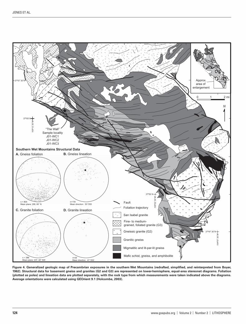
n = 386Mean plane: 237, 48° NW
n = 804Mean plane: 268, 66° N
n=118Mean direction: 55°/355
n=29Mean direction: 41°/352
C. Granite foliation D. Granite lineation
A. Gneiss foliation B. Gneiss lineation
Mafic schist, gneiss, and amphibolite
Granitic gneiss
Migmatitic and lit-par-lit gneiss
Gneissic granite (G2)
Fine- to medium-grained, foliated granite (G3)
San Isabel granite
Foliation trajectory
Fault
“The Wall”Sample locality
J01-WC1J01-WC2J01-WC3
Southern Wet Mountains Structural Data
2 mi0 1
105º
12´3
0˝W
37º55´N
105º
02´3
0˝W
37º50´N
104º
57´3
0˝W
37º47´30˝N
37º57´30˝N
N
~~
~~
~~
~~
~~
~~
~~
~~
~~
~~
~~
~~
~~
~~
~~
~~
~
Approx.area of
enlargement
Figure 4. Generalized geologic map of Precambrian exposures in the southern Wet Mountains (redrafted, simplifi ed, and reinterpreted from Boyer,
1962). Structural data for basement gneiss and granites (G2 and G3) are represented on lower-hemisphere, equal-area stereonet diagrams. Foliation
(plotted as poles) and lineation data are plotted separately, with the rock type from which measurements were taken indicated above the diagrams.
Average orientations were calculated using GEOrient 9.1 (Holcombe, 2003).

LITHOSPHERE | Volume 2 | Number 2 | www.gsapubs.org 125
DEFORMATION ACROSS A PROTEROZOIC MID-CRUSTAL SECTION | RESEARCH
occurs as a network of G2 and G3 granitoid sills and dikes that pervade the gneissic host rock. Igneous bodies, meters to centimeters in dimen-sion, form a distributed magmatic framework that makes up 40% to 100% of outcrops. Owing to the pervasive nature and indistinct contacts of the diverse granites, many of which exhibit penetrative dynamic fabrics, most of the Wet Mountains have been represented on geological maps as undif-ferentiated Proterozoic gneisses (e.g., Scott et al., 1978) with relatively few map-scale intrusive bodies. Notable exceptions are the detailed map of Brock and Singewald (1968) and the moderately detailed map of Boyer (1962), both of which attempted to distinguish the diverse granites and granitic gneisses that constitute the Mesoproterozoic bedrock. The loca-tion and nature of the transitional boundary between the discrete plutons within nonmigmatitic gneisses in the north to the region of diffuse “frame-work” magmatism within migmatites in the south coincide with a kilome-ter-wide zone of voluminous granite and pegmatite south of the Arkansas River Gorge (Siddoway et al., 2000) of presumed ca. 1.4 Ga age.
Proterozoic Structural Elements
The change in the style of magmatism from north to south across the range coincides with a change in structural style and fabric orientation. The northern part of the range exhibits upright, open folds and subver-tical foliation formed at moderate metamorphic conditions, whereas the central and southern part of the range contains shallowly to moderately dipping, penetrative gneissic fabrics formed at high temperatures. In our research we selected two areas in the north and south to map in detail, with attention to deformation structures, fabric and fold orientations, and kinematics. The mapping guided the selection of samples for new U-Pb geochronology described below.
Figure 3 is a compilation map for Proterozoic exposures along the Arkansas River Gorge in the northern Wet Mountains. The central ele-ment is the 2–5-km-wide Five Points Gulch shear zone (Fig. 3; Siddoway et al., 2000), a north-northwest–striking, subvertical high strain zone that exhibits an oblique lineation defi ned by aligned sillimanite. Exposures within the shear zone are dominated by K-feldspar-biotite-quartz-plagio-clase-muscovite gneisses with localized zones of quartz-muscovite ± sil-limanite “pod” rock (e.g., Pedrick et al., 1998). High-strain layers sepa-rate lower strain domains with biotite foliation that is tightly folded into upright, north-northwest–trending folds. The dominant shear zone fabric (S
sz) strikes north-northwest and dips steeply east-northeast, with an aver-
age orientation of 335/63°E (Fig. 3A). The sillimanite mineral lineation plunges moderately north-northeast with an average orientation of 45°/015 (Fig. 3B) but is locally steep to subvertical. The presence of strongly aligned prismatic sillimanite and garnet with symmetrical tails within high strain zones indicates peak metamorphic conditions of >700 °C and 500 MPa during shear zone deformation (Givot and Siddoway, 1998). Kine-matic indicators across the shear zone include ductile shear bands, asym-metric tails on garnet, and en echelon tension-gash arrays. Many of these indicators appear in zones with minor amounts of leucosome, suggesting onset of melting (cf. Sawyer, 2008) during one episode of movement along the shear zone. Kinematic indicators and asymmetric folds in parts of the shear zone with steeply plunging lineations show sinistral reverse-oblique, east-side-up displacement (Fig. 5), consistent with the juxtaposition of higher temperature shear zone rocks against the lower temperature Texas Creek association to the west (Siddoway et al., 2000).
We identify two domains with contrasting fabric geometries, deforma-tion styles, and/or fabric intensity on either side of the Five Points Gulch shear zone; these are the Texas Creek and Sheep Basin domains to the west and east, respectively (Fig. 3). Quartzose and quartzofeldspathic gneisses of sedimentary origin dominate exposures in the Texas Creek
domain (Fig. 3), and these rocks are interfolded and interfoliated with a mafi c and felsic association of gneisses (Siddoway et al., 2000) that origi-nated as bimodal volcanic rocks (Stiles, 1997; Wearn and Wobus, 1998). Subordinate schists contain mineral assemblages indicative of metamor-phism at 650 °C and <400 MPa (Siddoway et al., 2000; Goodge and Sid-doway, 1997). Large cordierite poikiloblasts within one schist unit pre-serve a penetrative crenulation cleavage (S1) that disrupts compositional layering defi ned by quartz and opaque inclusions, inferred to be relict bedding (Siddoway et al., 2000). Microstructural relationships indicate S1 development during an early stage of a progressive deformation event (D1) accompanied by metamorphism (M1) involving growth of 10–20 cm cordierite and plagioclase poikiloblasts (Siddoway et al., 2000). Outside the metamorphic megacrysts, the dominant foliation, S2, is defi ned by aligned micas and quartz ribbons, and S2 wraps around the cordierite poi-kiloblasts. S2 forms the dominant fabric and compositional layering in the Texas Creek association as a whole. The S2 fabric is deformed by upright,
view to S
view to S
SE
xenolith
A B
C
Figure 5. Field photographs from the eastern Arkansas River Gorge. (A)
Cross-sectional view looking to south of deformed pegmatite dike (sam-
ple J01-FP1; Fig. 3 for location) from within the Five Points Gulch shear
zone. Overall shear sense across the zone is east side up. (B) Close-up of
shear bands that offset the pegmatite dike shown in (A). (C) View down
on deformed quartz diorite of the Crampton Mountain batholith (sample
J03-TM1; Fig. 3 for location) with shear band and elongate mafi c xenolith.

JONES ET AL.
126 www.gsapubs.org | Volume 2 | Number 2 | LITHOSPHERE
kilometer-scale, east-trending folds (F2) with a cumulative π−axis orienta-tion of 45°/081 (Siddoway et al., 2000). These folds are interpreted to have formed during a second deformation event (D2) involving subhorizontal, north-northwest–directed shortening (Siddoway et al., 2000), and they are sharply truncated to the east by the Five Points Gulch shear zone.
East of the Five Points Gulch shear zone, along the easternmost 10 km of the Arkansas River Gorge, exposures in the Sheep Basin domain consist of tonalite, quartz diorite, and granodiorite of the 1705 ± 8 Ma Crampton Mountain pluton (Bickford et al., 1989) along with localized exposures of gray quartz biotite and amphibolite gneiss wall rock. On the western side of the domain the north-northwest–striking fabric of the Five Points Gulch shear zone passes into asymmetric northeast-plunging folds in the gneisses over a distance of a few hundred meters. Northeast-striking, subverti-cal foliation in gray gneisses has an average orientation of 235/87° NW (Fig. 3C) and is defi ned by biotite and amphibole and locally enhanced by dynamically recrystallized plagioclase, K-feldspar, and quartz. The folia-tion orientation is generally parallel to the western margin of the 150 km2 Crampton Mountain pluton (Fig. 3), and abundant fl attened mafi c enclaves with aspect ratios up to 30:1 are parallel with the surrounding fabric (Fig. 5C). Well-developed biotite and/or amphibole mineral lineation in the metaplutonic rocks plunges moderately to steeply northeast with an average orientation of 62°/045 (Fig. 3D). Locally developed asymmetric fabrics include C-S foliation and ductile shear bands (Fig. 5C). Kinematic indicators observed along the east-northeast–trending southern margin of the Crampton Mountain pluton (Fig. 3 map) show dominantly reverse, northwest-side-up displacement with a component of sinistral offset. The eastern boundary of the Sheep Basin domain is the Ilse fault zone, a struc-ture of probable Neoproterozoic ancestry (cf. Timmons et al., 2002) that most recently was reactivated during formation of the Tertiary Parkdale graben (Fig. 3; Fryer, 1996; Kelley and Chapin, 2004).
In exposures ~15 km south of the Arkansas River Gorge, focused work on the Mesoproterozoic Oak Creek pluton (Dean et al., 2002) established that the intrusion has a layered character indicative of emplacement in sheets and exhibits a northwest-striking solid-state foliation concordant with that in host gneisses. An east-southeast–trending mineral-stretching lineation is well developed, particularly on the pluton margins, and is associated with kinematic criteria that indicate normal-oblique displace-ment with pluton side down.
Exposures in the central and southern Wet Mountains exhibit remark-ably consistent geometries of foliation and folds that defi ne a dominant east-west pattern over 100 km2 of exposure (Fig. 4). Deformation affected both wall-rock gneisses and granitic phases G1 through G3 that pervade the range, as is evident where foliation trajectories cross multiple litho-logic boundaries in Figure 4. The dominant compositional layering and migmatitic foliation in the central Wet Mountains strikes east-west with moderate to shallow north-northwest dips with an average orientation of 270/50°N (Siddoway et al., 2000; Jones, 2005). North-plunging biotite lineation with an average orientation of 52°/003 is well developed in bio-tite gneiss units and at granitic gneiss–amphibolite gneiss contacts (Sid-doway et al., 2000; Jones, 2005). Tight-to-isoclinal folds with amplitudes ranging from tens of centimeters to more than a kilometer deform the gneissic layering and granitic sills, providing evidence that the foliation is a composite fabric that resulted from multiple episodes of broadly coaxial deformation. In the southern Wet Mountains there is some discrepancy in the foliation orientations of G2 and G3 granitic intrusions versus those of the gneissic rocks. Whereas the average foliation in gneisses strikes east-west and dips moderately north (average orientation, 283/56°N; Fig. 4), consistent with the central domain, the well-developed, locally gneissic foliation in G2 and G3 sills strikes east-northeast and dips moderately north-northwest (average orientation, 243/43°N; Fig. 4C). Mineral linea-
tion in both gneisses and G2 + G3 granites is essentially parallel, trending toward azimuth 350–355 (Fig. 4B and 4D). Kinematic shear sense indica-tors, including asymmetric folds, indicate reverse (top to the south) shear sense in both wall-rock gneisses and G2 and G3 granite sills.
In the central Wet Mountains, Lanzirotti (1988) found evidence for three episodes of penetrative deformation, all attributed to northwest-southeast shortening, in exposures in the Tyndall Mountain quadrangle (Brock and Singewald, 1968). The fi rst two deformation events (D1 and D2) are broadly correlated with ca. 1.7 Ga plutonism, constrained locally by a 1692 ± 5 Ma U-Pb zircon age (Bickford et al., 1989) from granulites in the central part of the range (Lanzirotti, 1988; Brock and Singewald, 1968). Lanzirotti (1988) suggested that the third deformation (D3) might have coincided with the emplacement of a suite of younger deformed plu-tons at 1650–1615 Ma (Bickford et al., 1989), but D3 might have been con-temporaneous also with ca. 1.4 Ga metamorphism and magmatism. U-Pb zircon and titanite data from 10 km to the east along Rattlesnake Gulch (Fig. 2) suggest that 1691–1680 Ma amphibolite and felsic gneiss under-went at least one episode of deformation involving foliation development and isoclinal folding prior to emplacement of a fi ne-grained granite sill 1679 ± 2 Ma (Jones, 2005). There is also evidence of metamorphic zircon and titanite growth or recrystallization in amphibolite between 1436 and 1390 Ma accompanied by at least one episode of deformation involving fabric overprinting or reactivation (Jones, 2005). However, direct evidence of ca. 1.4 Ga magmatism is lacking from the central Wet Mountains.
U-Pb GEOCHRONOLOGY
We undertook new U-Pb geochronology to constrain precisely the age of deformation and metamorphism in the northern and southern Wet Mountains, respectively. Samples were collected from the well-charac-terized structural sites described in the previous section to help assess whether the contrasting structural styles developed in the northern ver-sus the central and southern part of the range were contemporaneous or had developed at different times. Because the age of deformation in the Texas Creek domain of the Arkansas River Gorge was reasonably well established (see below; Siddoway et al., 2002; Siddoway et al., 2000), sampling in the northern Wet Mountains was concentrated within the Five Points Gulch shear zone and Sheep Basin domain to address the timing of deformation in the shear zone and in metaplutonic rocks exposed in the eastern Arkansas River Gorge (Fig. 3). In the southern Wet Mountains, we targeted multiple generations of deformed tabular granite intrusions that occur as a network of sills and sheets in outcrop and their metamorphosed Paleoproterozoic country rocks. The samples were collected from a single large exposure of gneiss and granite along the Wet Mountains’ southwest-ern escarpment near the intersection of Bear Creek and Williams Creek (Boyer, 1962; Callahan, 2002; Perkins, 2002). This exposure, informally named “The Wall” because of its subvertical aspect, nearly 100 m in height (Fig. 6), is 0.5 km east of the Pole Creek Trailhead along San Isabel National Forest Road 630 (Fig. 4).
Sample processing and analytical techniques followed those described by Jones and Connelly (2006). We present isotopic data and sample loca-tion coordinates in Table 1 and associated concordia diagrams in Figures 7 and 8. Results described in the following section are grouped according to general locations in the Wet Mountains.
Northern Wet Mountains–Arkansas River Gorge
Deformed Pegmatite Dike (J01-FP1)
Within the Five Points Gulch shear zone there is an array of subver-tical dikes oriented parallel to the north-northwest–striking shear zone

LITHOSPHERE | Volume 2 | Number 2 | www.gsapubs.org 127
DEFORMATION ACROSS A PROTEROZOIC MID-CRUSTAL SECTION | RESEARCH
J01-WC1Amphibolite
J01-WC3G3 granite
J01-WC2G2 granite
View to NNE
Figure 6. Field photograph of “The Wall,” a large, vertical exposure in the
southern Wet Mountains that is characterized by penetrative, moderately
north-northwest–dipping fabrics. Sample localities for U-Pb geochronol-
ogy (see Fig. 9) are indicated by stars.
TABLE 1. WET MOUNTAINS U-Pb ISOTOPIC DATA
thgieWnoitcarF(mg)
)aM( segA*soitar cimota detcerroCderusaeMnoitartnecnoC
U(ppm)
PbR
(ppm)Common PbT
(pg)
206Pb204Pb
208Pb206Pb
206Pb238U
207Pb235U
207Pb206Pb
206Pb238U
207Pb235U
207Pb206Pb
Deformed pegmatite dike (J01-FP1; N 38° 27.32′, W 105° 30.83′)
Z1 lg prsm euh clr abr 0.002 184 46 3 2000 0.0630 0.25184 76 3.1665 110 0.09119 18 1448 1449 1451Z2 euh tips clr lt brn abr 0.001 1318 306.8 2 13238 0.0072 0.24679 72 3.0683 84 0.09017 14 1422 1425 1429Z3 euh tip dk brn abr 0.002 801 178.3 2 8826 0.0054 0.23654 90 2.9262 100 0.08972 20 1369 1389 1420
9441254155418321190.02614081.34651352.09240.01017312.671417100.0rba pit nrb4ZZ5 sm brn tip abr 0.001 2264 499.9 4 4540 0.0058 0.23444 90 2.9091 102 0.09000 20 1358 1384 1425
Foliated quartz diorite, Crampton Mountain pluton (J03-TM1; N 38° 28.79′, W 105° 25.36′)
T1 md-lg pale brn ang frags abr 0.081 46 11.7 381 168 0.1327 0.24413 60 2.9953 108 0.08899 24 1408 1406 1404T2 md-lg pale brn ang frags abr 0.093 40 10.6 504 133 0.1528 0.24636 60 3.0519 126 0.08985 28 1420 1421 1422T3 md-lg pale brn ang frags abr 0.171 42 11 919 139 0.1482 0.24785 58 3.1032 122 0.09081 26 1427 1433 1443
Amphibolite (J01-WC1; N 37° 55.22′, W 105° 9.97′)
Z1 md sbhd-sbrnd tan abr 0.001 354 87 2 3853 0.0615 0.24793 70 3.0911 90 0.09042 14 1428 1430 1434Z2 lg clr sbhd abr 0.002 1108 269.2 5 6483 0.0559 0.24647 64 3.0787 82 0.09059 10 1420 1427 1438Z3 sm clr sbhd prsm abr 0.001 833 203.7 1 11913 0.0572 0.24782 56 3.0927 72 0.09051 10 1427 1431 1436
Coarse-grained, foliated granite sill (J01-WC2; N 37° 55.22′, W 105° 9.97′)
Z1 sm rnd sbhd bge abr 0.001 193 54 2 1880 0.2147 0.24875 68 3.0972 92 0.09030 16 1432 1432 1432Z2 sm-md euh prsm clr abr 0.002 101 26.6 2 1591 0.1350 0.24908 76 3.1082 122 0.09050 26 1434 1435 1436Z3 sm clr sbhd prsm abr 0.001 319 85.6 2 1777 0.1644 0.24865 70 3.0984 120 0.09037 26 1432 1432 1433T1 md-lg pale brn ang-sbrnd abr 0.128 74 22.8 335 429 0.4864 0.22671 60 2.7218 78 0.08708 16 1317 1334 1362T2 md-lg pale brn ang-sbrnd abr 0.138 84 24.6 369 452 0.4806 0.21671 52 2.6154 70 0.08753 14 1264 1305 1372T3 md-lg pale brn ang-sbrnd abr 0.085 75 22.9 197 505 0.4249 0.23518 58 2.8202 86 0.08697 18 1362 1361 1360T4 md-lg pale brn ang-sbrnd abr 0.063 73 25 139 511 0.6093 0.23488 68 2.8401 86 0.08770 14 1360 1366 1376T5 md-lg pale brn ang-sbrnd abr 0.108 70 22.5 230 517 0.4847 0.23604 62 2.8505 80 0.08758 14 1366 1369 1373T6 md-lg pale brn ang-sbrnd abr 0.101 75 24.5 257 474 0.4847 0.24064 58 2.9165 118 0.08790 28 1390 1386 1380
Fine-grained, foliated granite sill (J01-WC3; N 37° 55.22′, W 105° 9.97′)
Z1 md-lg euh brn-orng abr 0.003 464 111 3 8586 0.0337 0.24742 56 3.0929 70 0.09066 10 1425 1431 1440Z2 md sbhd tan abr 0.001 362 86 6 1165 0.0187 0.24891 60 3.1277 92 0.09113 16 1433 1440 1449Z3 sm sbhd tan-clr abr 0.001 255 73.1 2 3380 0.0714 0.28416 76 3.9539 110 0.10092 20 1612 1625 1641Z4 md sbhd tan-clr abr 0.001 576 139.5 2 4360 0.0250 0.25226 60 3.1977 80 0.09194 14 1450 1457 1466
Abbreviations: abr—abraded; ang—angular; bge—beige; brn—brown; clr—clear; dk—dark; euh—euhedral; frags—fragments; lg—large; lt—light; md—medium; orng—orange; prsm—prisms; sm—small; sbhd—subhedral; sbrnd—subround. *Ratios corrected for fractionation; 1 pg and 0.25 pg laboratory Pb and U blanks, respectively, and initial common Pb calculated using Pb isotopic compositions of Stacey and Kramers (1975). All fractions of zircon and titanite are extensively abraded (Krogh, 1982) unless otherwise noted. Two-sigma (2σ) uncertainties on isotopic ratios are reported after the ratios and refer to the fi nal digits. PbR refers to radiogenic Pb; Common PbT refers to total common Pb.

JONES ET AL.
128 www.gsapubs.org | Volume 2 | Number 2 | LITHOSPHERE
2.92 3.20 3.48
.2341
.2491
.2641
207 Pb235 U
206 Pb238 U
A Back-rotated pegmatite dike (J01-FP1)
Zircon tips1430+5/-3 Ma
(43%)
1380
1410
1440
1470
1500
1530
Z1
Z2
Z3
Z5
Z6
252 ± 300 Ma
Zircon coresCa. 1450 Ma
2.62 3.02 3.42
.2158
.2382
.2606
207 Pb235 U
206 Pb238 U
B Foliated quartz diorite (J03-TM1)
1443 Ma
1300
1350
1400
1450
1500
T1
T2T3
0 Ma reference line
core
Figure 7. U-Pb concordia diagrams for samples from the Arkansas River Gorge, northern Wet Mountains. Ages are determined by linear regres-
sion through the data except where indicated, and probability of fi t (%) is indicated in parentheses. See text for details.
2.88 3.08 3.28
.2338
.2450
.2562
207 Pb235 U
206 Pb238 U
Amphibolite (J01-WC1)
Avg. 207Pb/206Pb age1436±2 Ma1375
1400
1425
1450
1475
Z1
Z2Z3
2.70 3.58 4.46
.2088
.2542
.2996
207 Pb235 U
206 Pb238 U
G3 fine-grained, foliated granite (J01-WC3)
1749±28 Ma
1390±10 Ma(23%)1300
1400
1500
1600
1700
Z1Z2
Z3
Z4
0 Ma reference line
2.58 2.90 3.22
.2155
.2341
.2527
207 Pb235 U
206 Pb238 U
G2 gneissic granite (J01-WC2)
TitaniteT2,T4, and T5
1375±2 Ma(25.8%)
1362 Ma
1300
1350
1400
1450
Z1Z2
Z3
T1
T2
T3
T4T5
ZirconAvg. 207Pb/206Pb age
1435±4 Ma
0 Ma43±65 Ma
A B
C
Figure 8. U-Pb concordia diagrams for samples from the southern Wet
Mountains. Ages are determined by linear regression through the data
except where indicated, and probability of fi t (%) is indicated in parenthe-
ses. See text for details.

LITHOSPHERE | Volume 2 | Number 2 | www.gsapubs.org 129
DEFORMATION ACROSS A PROTEROZOIC MID-CRUSTAL SECTION | RESEARCH
foliation (Fig. 3). These intrusions both follow and sharply cut across the shear zone fabric, S
sz, and they generally lack internal foliation; thus they
are interpreted to be coeval with at least one major phase of shear zone deformation. To determine the age of syntectonic dike emplacement, a 20–30-cm-thick, subvertical pegmatite dike was sampled near the east margin of the Five Points Gulch shear zone (Fig. 3; Table 1). The pegma-tite dike is concordant but truncates the shear zone foliation along parts of its margin. It is cut in turn by a series of en echelon, east-dipping shear bands with reverse-oblique kinematics (Figs. 5A and 5B), consistent with east-side-up displacement across the Five Points Gulch shear zone (Sid-doway et al., 2000).
The pegmatite yielded a single population of tan to brown, euhedral to subhedral zircon with prismatic faces indicative of an igneous origin. Most of the grains contain dark brown xenocrystic cores surrounded by light tan to clear euhedral tips (Fig. 7A inset). Tips were mechanically separated from core material using tweezers, and the constituent parts of the grains were then abraded, dissolved, and analyzed separately. The 207Pb/206Pb ages of two core fractions of dark brown zircon material overlap concordia at 1451 and 1449 Ma (fractions Z1 and Z4, Table 1; Fig. 7A). Three frac-tions of zircon tip material (Z2, Z3, and Z5) defi ne a line with intercepts of 1430+5/–3 Ma and 252 ± 300 Ma (Fig. 7A).
Foliated Quartz Diorite of the Crampton Mountain Pluton (J03-TM1)
Quartz diorite exhibiting C-S foliation was collected from exposures in the Sheep Basin domain for U-Pb titanite geochronology to determine the age of dynamic metamorphism and foliation development. The U-Pb zircon age of 1705 ± 8 Ma for emplacement of the Crampton Mountain pluton was determined previously by Bickford et al. (1989). The sample site is in the southwestern part of the Crampton Mountain pluton ~1 km west of the dated locality of Bickford et al. (1989) (Fig. 3). Titanite observed in thin section forms submillimeter clusters that are elongate parallel to the biotite foliation, indicating that titanite formed as a product of metamorphic recrystallization. Abundant titanite in the mineral sepa-rate consists of dark brown angular fragments that were handpicked for three fractions (T1–T3; Table 1). The 207Pb/206Pb ages range from 1443 to 1404 Ma (Table 1), and fractions T2 and T1 overlap concordia at 1422 Ma and 1404 Ma (Fig. 7B).
Southern Wet Mountains–Bear Creek–Williams Creek
Amphibolite (J01-WC1)
Medium- to coarse-grained amphibolite is the prevalent host rock to the two generations of granite, G2 and G3. This sample contained sparse relict clinopyroxene, nearly wholly replaced by amphibole with pro-nounced shape preferred orientation. Prominent foliation strikes east-west and dips moderately north, hosting a north-northwest–plunging amphi-bole lineation (Fig. 4A and 4B). The amphibolite yielded a single popula-tion of pink to tan, subrounded to subhedral, equant zircon interpreted to be metamorphic in origin. Three fractions (Z1–Z3) plot close to concordia and have an average 207Pb/206Pb age of 1436 ± 2 Ma (Fig. 8A).
Coarse-Grained, Foliated Granite Sill (J01-WC2)
Coarse-grained to K-feldspar-megacrystic G2 granite forms 1–5-m-thick sills in exposures throughout the southern Wet Mountains. The granite margins are generally concordant with host rock foliation but also cut obliquely across compositional layering and isoclinal folds in the gneisses. Moderate to strong foliation in the sills is defi ned by crystallographic pre-ferred orientation of biotite and dynamically recrystallized K-feldspar and quartz (Fig. 9A). The dynamic fabric strikes east-northeast and dips moderately north-northwest (Fig. 4C), hosting a pronounced downdip
view to ENE
G3
G2
N
B
C
A
Figure 9. Field photographs of granitoids exposed in the southern Wet
Mountains. (A) View down on G2 granite fl oat block with gneissic fabric
defi ned by recrystallized K-feldspar and biotite. (B) View down on G3 fi ne-
grained granite sill cutting obliquely across gneissic foliation (highlighted
by lines) in coarse-grained G2 granite. (C) G3 granite sill containing
well-developed foliation and small, asymmetric open folds. Folds have
southward vergence that is consistent with reverse-sense, top-up-to-the-
south–southeast kinematic indicators elsewhere throughout the sill.

JONES ET AL.
130 www.gsapubs.org | Volume 2 | Number 2 | LITHOSPHERE
mineral lineation defi ned by biotite and quartz (Fig. 4D). Asymmetric folds and mineral microstructures record reverse-sense, top-up-to-the-south–southeast kinematics.
The G2 granite yielded a single population of pink to clear, euhedral to subhedral, prismatic zircon consistent with an igneous origin. Three fractions (Z1–Z3) overlap concordia with an average 207Pb/206Pb age of 1435 ± 4 Ma (Fig. 8B), and this age is interpreted to represent emplace-ment and crystallization of the coarse-grained granite. The granite also yielded abundant dark brown, angular titanite fragments. Thin section study revealed the presence of titanite oriented parallel to the dominant gneissic fabric defi ned by dynamically recrystallized K-feldspar, quartz, and biotite, an indication that titanite grew or recrystallized during meta-morphism accompanying solid-state deformation of the granite sill. Three titanite fractions (T2, T4, and T5) defi ne a line with intercepts of 1375 ± 2 Ma and 43 ± 65 Ma, and two fractions (T1 and T3) are colinear along a reference chord with intercepts of ca. 1362 Ma and 0 Ma (Fig. 8B).
Fine-Grained, Foliated Granite Sill (J01-WC3)
Fine-grained G3 granite forms sills that cut across foliated G2 gran-ite sills and foliation, with compositional layering and isoclinal folds in both amphibolite gneiss and granitoid gneisses (Fig. 9B). G3 sills range in thickness from 0.5 to 5.0 m and exhibit solid-state biotite foliation that strikes east-northeast and dips moderately north-northwest (Fig. 4C), with moderately north-northwest–plunging biotite mineral lineation (Fig. 4D). Asymmetric mineral fabrics record reverse-sense, top-up-to-the-south–southeast kinematics, and entire sills are locally deformed by asymmetric folds with east-trending axes and southward vergence (Fig. 9C).
The G3 granite yielded a single population of brown to tan, equant, euhedral to subhedral prismatic zircon. We interpret that clear, euhedral tips surrounding slightly darker, translucent xenocrystic cores represent igneous overgrowths. The small size of the zircon grains made mechani-cal separation of the cores from rims impossible; therefore air abrasion of shorter duration was used so that the volumetrically minor amount of overgrowth material was retained. Four zircon fractions (Z1–Z4) defi ne a line with intercepts of 1749 ± 28 Ma and 1390 ± 10 Ma (Fig. 8C).
DISCUSSION
Interpretation of U-Pb Geochronology Results
The late tectonic pegmatite dike (J01-FP1) intruded near the eastern margin of the Five Points Gulch shear zone yielded zircon cores with ages of 1451 and 1449 Ma (Fig. 7A) that are interpreted to represent inherited grains derived from nearby Mesoproterozoic granitic plutons such as the Oak Creek pluton (Fig. 2). We interpret the upper intercept age of 1430+5/–3 Ma for the zircon tips to represent growth during crystallization of the pegmatite dike, with the lower intercept refl ecting more recent Pb loss caused by a disturbance arising from Phanerozoic tectonism. Growth of metamorphic titanite occurred from 1443 to 1404 Ma during development of the north-east-striking foliation within quartz diorite of the Crampton Mountain plu-ton (J03-TM1, Fig. 7B), which we attribute to the deformation that caused development of northeast-trending asymmetrical folds in the Sheep Basin domain. We interpret the range of ages from the titanite fractions to refl ect pulses of metamorphism throughout a protracted Mesoproterozoic tectono-thermal event in the northern Wet Mountains, consistent with 40Ar/39Ar ages from across the region (Shaw et al., 2005; Siddoway et al., 2000).
Consistent U-Pb zircon ages of ca. 1435 Ma were acquired from samples of granite and amphibolite gneiss from the southern Wet Moun-tains. The coarse-grained K-feldspar-megacrystic G2 granite (J01-WC2) yielded three concordant zircon fractions with an average 207Pb/206Pb age
of 1435 ± 4 Ma (Fig. 8B), interpreted to represent the time of emplace-ment and crystallization of the pervasive granite sills. The 1436 ± 2 Ma age of metamorphic zircon within amphibolite gneiss that forms part of the host rock is identical within analytical uncertainty to the age of associ-ated G2 granite. The amphibolite gneiss contains evidence for extensive retrogression of clinopyroxene to amphibole, an indication that heat and possibly fl uids introduced during the voluminous emplacement of G2 sills caused dynamic recrystallization and breakdown of primary pyroxene, leading to growth of metamorphic zircon.
U-Pb results for metamorphic titanite from the G2 granite reveal that tectonothermal metamorphism continued after G2 emplacement at ca. 1435 Ma in the southern Wet Mountains. Two titanite age popula-tions defi ne reference chords with upper intercepts at 1375 ± 2 Ma and ca. 1362 Ma (Fig. 8B). The ages overlap the 1362 ± 7 Ma and 1371 ± 14 Ma emplacement ages for the San Isabel granite (Bickford et al., 1989). Therefore we attribute the growth of metamorphic titanite to thermal perturbation and fl uid fl ow associated with emplacement of the ca. 1365 Ma San Isabel granite batholith, the main body of which is exposed ~5–10 km from the sampled outcrops (Fig. 4).
Zircon from the G3 granite sill (J01-WC3, Fig. 8C) defi nes a chord with a lower intercept of 1390 ± 10 Ma, interpreted as the age of crystallization of the granitic sill. This age falls between the other two age groupings, suggesting that plutonism continued and that elevated temperatures were sustained between dynamic and magmatic events. We interpret the 1749 ± 28 Ma upper intercept for sample J01-WC3 to refl ect zircon inheritance, thus providing an indirect constraint upon the protolith age for basement gneisses in the southern Wet Mountains.
Age and Kinematics of Deformation in the Northern Wet
Mountains
The earliest preserved record of deformation in the northern Wet Moun-tains is in the Texas Creek domain (Fig. 3) of the Arkansas River Gorge. Siddoway et al. (2000) interpreted D1 progressive development of a pen-etrative cleavage (S1) and growth of cordierite (M1) wrapped by preva-lent S2 foliation to have occurred during the Paleoproterozoic, broadly synchronous with emplacement of the 1663 ± 4 Ma Garell Peak pluton (Fig. 2; Bickford et al., 1989). The Texas Creek and Sheep Basin domains were folded during subsequent D2 north-south (Texas Creek) to northeast-southwest (Sheep Basin) shortening (Siddoway et al., 2000). Subsequent research has recognized a defl ection of fabrics in folded gneisses around the 1474 ± 7 Ma West McCoy Gulch pluton (Fig. 2; Bickford et al., 1989) and that ca. 1430–1420 Ma monazite inclusions are present in M1 cordi-erite poikiloblasts in F2 fold limbs (Siddoway et al., 2002). Thus, regional heating and contraction during D2 were broadly coeval with G2 granitic magmatism during the Mesoproterozoic.
Because the Five Points Gulch shear zone truncates F2 folds of the adjacent Texas Creek domain (Fig. 3), major movement upon the shear zone development is attributed to a third phase of deformation (D3) that followed closely upon or was an outgrowth of the folding event. Our new U-Pb age for a syntectonic pegmatite dike indicates that D3 deformation in the Five Points Gulch shear zone occurred at ca. 1431 Ma. Work by Dean et al. (2002) indicates that emplacement of the 1439 ± 8 Ma Oak Creek pluton (Bickford et al., 1989; Cullers et al., 1993) was syntec-tonic, thus indicating that D3 deformation was widespread throughout the northern Wet Mountains. The northeast- to east-directed extensional fabrics that overprint regional foliation along the margin of the pluton (Dean et al., 2002; Siddoway et al., 2002) are generally parallel to folds within the Sheep Basin domain and lineation in the Crampton Mountain pluton (Figs. 2 and 3). Our new titanite ages indicate that the effects of

LITHOSPHERE | Volume 2 | Number 2 | www.gsapubs.org 131
DEFORMATION ACROSS A PROTEROZOIC MID-CRUSTAL SECTION | RESEARCH
D3 were through 1422–1404 Ma in the Crampton Mountain pluton. The presence of dynamically recrystallized plagioclase and K-feldspar, quartz, and biotite refl ect strain at relatively high temperatures in the northern Wet Mountains during D3 deformation.
To summarize, the structures of the northern Wet Mountains, active in the interval 1444–1431 Ma, show (1) sinistral oblique motion upon the north-south–striking Five Points Gulch shear zone, with east-northeast–directed opening indicated by the pegmatite dike array; (2) normal-sense, northeast-southwest–directed displacement on the margins of the Oak Creek pluton; and (3) north-south to northwest-southeast contraction in the Texas Creek and Sheep Basin domains, respectively, forming kilometer- to meter-scale folds. The contrasting kinematics from coeval structures may be reconciled within a regional strain state having the maximum and mini-mum fi nite strain axes in the plane of the earth, with the intermediate axis vertical; in other words, within a transcurrent strain state (Fig. 10, inset).
Alternatively, the formation of the Five Points Gulch shear zone, Oak Creek pluton, and pegmatite dike array, and to some extent the distribu-tion of granite and pegmatite, were controlled by preexisting structures or
mechanical anisotropies within host rocks. The margin of the Crampton Mountain batholith (Figs. 2 and 3) is an example of one such element that may control the northeast-oriented structure of the Sheep Basin domain, which mirrors the mapped geometry of the southern margin of the batho-lith fairly closely (Fig. 3) but contrasts with the orientation of north-north-west–striking foliation (S
sz) in the Five Points Gulch shear zone. In either
case, the Mesoproterozoic ages of folding, shear zone formation, and fab-ric reactivation suggest that the different structural domains in the northern Wet Mountains refl ect varying mechanical responses to ca. 1.4 Ga subho-rizontal, north-northwest–directed shortening, possibly with a signifi cant transcurrent component, under moderate- to high-temperature conditions.
Age and Kinematics of Deformation in the Central and Southern
Wet Mountains
In the central Wet Mountains, direct evidence of ca. 1.4 Ga magma-tism is lacking. The orientation and style of deformation is similar to that recorded in exposures farther to the south, and Siddoway et al. (2000)
Mid-crustal magma layer(Shaw et al., 2005)Oak Creek pluton (?)
Shallow to subhorizontallower-crustal flowConcordant, “framework”granitic magmatismex. G2 and G3 granite sillsca. 1435-1360 Ma
Subvertical fabrics,partitioned deformationLocalized, discrete granitic plutonismFive Points shear zoneca. 1430-1405 Ma
Music Pass plutonSangre de Cristo Mts.(Jones and Connelly, 2006)
Homestake s.z. (Shaw et al., 2001)Vernal Mesa s.z. (Jessup et al., 2005)
10 km
20 km
Mid-crustal plutons (e.g., San Isabel)and granitoid sill networks
Upper crustal plutons (e.g., Vernal Mesa)
Approximate level of current exposure
Brittle-ductile
transition
N
~~~~~~~~~~~~~~~~~~~~~~~~~~~~~~~~~~~~~
~~~~~~~~~~~~~~~~~~~~~~~~~~~~~~~~~~~~~
~~~~~~~~~~~~~~~~~~~~~~~~~~~~~~~~~~~~~~~~~~~~~~~~~~~~~~~~~~~~~~~~~~~~~~~~~~~~~~~~~~~~~~~~~~~~~~~~~~~~~~~~~~~~~~~~~~~~~~~~~~~~
FPSZ
SheepBasinfolds
Oak Creekstretching direction
Contractiondirection for
folds and reversesense shears
Reverse sense shears
Normal sense zone
Figure 10. Schematic block diagram of the middle crust beneath southern Colorado ca. 1.4 Ga. Interpreted, reconstructed relationships illustrate
contrasting structural and magmatic styles with relative position (i.e., depth) in the crust. Shallower levels of exposure are characterized by steeply
dipping to subvertical fabrics, and deformation is commonly localized along discrete shear zones. Examples include the Five Points Gulch shear zone
(FPSZ, Fig. 3) in the northern Wet Mountains, and the Homestake and Vernal Mesa shear zones (Shaw et al., 2001; Jessup et al., 2006) exposed to the
north and northwest in Colorado. Deeper levels of exposure are characterized by moderately to shallowly dipping, penetrative gneissic fabrics and
penetrative deformation. Examples include exposures in the southern Wet Mountains (Fig. 4) and Taos Range to the south (Pedrick et al., 1998) in
northern New Mexico. Inset is a qualitative strain ellipse representing the orientation of different structural elements in the Wet Mountains, Colorado,
relative to northwest-southeast shortening interpreted by Nyman et al. (1994) at ca. 1.4 Ga (modifi ed from Siddoway et al., 2000).

JONES ET AL.
132 www.gsapubs.org | Volume 2 | Number 2 | LITHOSPHERE
suggested that many of the deformed granites are likely correlative with the G2 and G3 granites that were dated as part of this study. In exposures along Rattlesnake Gulch (Fig. 2), Jones (2005) documented syntectonic growth or recrystallization of metamorphic zircon and titanite in amphib-olite between 1436 and 1390 Ma associated with fabric overprinting or reactivation. Otherwise, available age information indicates that deforma-tion and metamorphism recorded in exposures of the central Wet Moun-tains is predominantly Paleoproterozoic in age (Brock and Singewald, 1968; Lanzirotti, 1988; Bickford et al., 1989).
In contrast, our new results from exposures in the southern Wet Moun-tains reveal that nearly all of the observed deformation occurred during the Mesoproterozoic. The earliest recognized phase of high-temperature, penetrative deformation occurred during emplacement of coarse-grained G2 granitic sills at 1435 ± 4 Ma. Magmatism was accompanied by folia-tion development and extensive recrystallization or new growth of meta-morphic zircon in wall-rock amphibolite at 1436 ± 2 Ma. The observa-tion that granitic sills locally cut a preexisting wall-rock foliation requires at least one phase of earlier, likely Paleoproterozoic, deformation and metamorphism; however, any isotopic record of these events has been obliterated by ca. 1.4 Ga thermal effects (Shaw et al., 2005). Gneissic G2 granite sills were affected by reverse-sense, north-northwest to south-southeast–directed crustal fl ow. Fine-grained G3 granite sills emplaced at 1390 ± 10 Ma cut the gneissic fabric in G2 granites and wall rocks, and they exhibit the same kinematic sense; thus the duration of crustal fl ow deformation was on the order of 45 m.y. The 1362 ± 7 Ma San Isabel granite (Bickford et al., 1989) cuts all fabrics, and it is largely undeformed, so it provides a minimum age for all Mesoproterozoic deformation in the southern part of the range.
Circa 1.4 Ga Regional Penetrative Flow in the Lower Middle Crust
New U-Pb zircon and titanite results for tectonized granites and host gneisses prove that the Wet Mountains underwent deformation between ca. 1435 and 1360 Ma, coincident with regional granitic magmatism (Reed et al., 1993; Anderson and Cullers, 1999). Deformation was localized within subvertical shear zones in the northern part of the range, with development of cylindrical upright folds. The partitioning of strain upon discrete zones is consistent with 1.4 Ga structural styles in exposures of the Sangre de Cristo Mountains (Jones and Connelly, 2006), the Black Canyon of the Gunnison (Jessup et al., 2006), the Idaho Springs–Ralston Creek shear zone (McCoy et al., 2005), and the Homestake shear zone (Shaw et al., 2001; Selverstone et al., 2000). The shallowly to moderately dipping dynamic fabrics that are syntectonic with respect to pervasive granite sills of 1435–1390 Ma age, dis-covered in the southern Wet Mountains, are somewhat unique in the Meso-proterozoic record of the southern Rocky Mountains.
The relatively deep exposure of granites and migmatitic host gneisses in the southern Wet Mountains are a consequence of differential exhuma-tion and uplift that caused northward tilting of the entire range. Evidence of this comes from comparison of geobarometry described above from the north versus south (Siddoway et al., 2000; Cullers et al., 1992). The contrast in depth of exposure is best explained by differential exhuma-tion that caused 10°–15° of northward tilt. In addition, apatite-fi ssion-track thermochronology from north to south across the Wet Mountains indicates substantial Cenozoic exhumation that elevated a Late Cretaceous apatite partial annealing zone and the Eocene Rocky Mountain erosion surface (Kelley and Chapin, 2004) that had been established during and after the Laramide orogeny. Taking the two factors into account, a conservative estimate for northward tilt of the Wet Mountains crystalline block is 15° to 25°. Thus, during Proterozoic time the foliation dips in the central and southern Wet Mountains would have been relatively shallow, at 35° or less.
The access to deep crustal levels in the southern Wet Mountains reveals a consistent top-to-the-south–southeast transport sense in the restored geometry of shallowly dipping fabrics that accords with the kinematics of deformation of steep foliation in mid-crustal exposures of the northern Wet Mountains. The presence of syntectonic granites that were strongly affected by the deformation provides evidence of subhorizontal crustal fl ow. The earliest recognized episode of pervasive fl ow accompanied the emplacement of coarse-grained G2 granites at 1435 Ma, and the consis-tent deformational record of fi ne-grained G3 dikes suggests that crustal fl ow continued until the 1390 Ma emplacement of G3 granites. The simi-larity of structures of older G2 and younger G3 granites indicates a stable strain state for 45 million years, suggesting long-lived, subhorizontal fl ow in a magma-rich environment.
IMPLICATIONS FOR Ca. 1.4 Ga TECTONIC MODELS
Granite magmatism associated with contrasting structures of the north-ern and southern Wet Mountains occurred during the narrow time interval of 1444–1431 Ma, with deformation at shallower crustal levels localized within discrete subvertical shear zones like the Five Points Gulch shear zone (Siddoway et al., 2000; Shaw et al., 2001; McCoy et al., 2005) or distributed throughout the Texas Creek and Sheep Basin domains as mesoscopic upright folds. An east-west–oriented zone containing abun-dant pegmatite and granite appears to demarcate the transition in structural styles (Siddoway et al., 2000; Collins et al., 2004). This zone of granite may have been emplaced along a rheological and thermal barrier (Fig. 10; cf. Shaw et al., 2005) at the upper boundary of the sill and dike networks at deeper levels of the southern Wet Mountains. The more coherent body of the Oak Creek pluton (Fig. 2; Cullers et al., 1993), at approximately the same crustal level, has a sheeted aspect (Dean et al., 2002) that may refl ect emplacement into a dilational structure controlled by mechani-cal anisotropies in the host gneisses (cf. McFadden et al., 2010) within a unifi ed strain state (see above). The pegmatite and granite emplaced at the boundary may have insulated the deeper crust and helped sustain the higher temperatures at depth (Shaw et al., 2005) that are recorded by the metamorphic mineral assemblages and the new zircon and titanite ages reported here. At depth the voluminous G2 and G3 granite may have advected heat and signifi cantly weakened the lower crust, thus permitting long-lived penetrative deformation and subhorizontal, north-northeast to south-southeast–directed fl ow.
Models for intraplate deformation predict that the strength of the lower crust fundamentally infl uences the geometry and strain distribution within an active orogen. Royden (1996) demonstrated that a weak lower crust underlying a strong upper crust permits transmission of compressive stresses >1000 km from a convergent boundary, leading to development of a broad orogen with high average elevation but low relative relief. The spatial extent of the zone of fl ow in the southern Wet Mountains suggests that the pervasive sills of ca. 1435 Ma granite emplaced within high-temperature host gneisses acted to weaken the lower crust and propagate deformation across a wide region of southwest Laurentia in Mesoprotero-zoic time. Consequently the exposures of deep crust in the Wet Mountains merit further study as an analog for low-viscosity layers that are inferred in modern intracontinental orogenic settings like Tibet and the Altiplano (e.g., Nelson and Project INDEPTH, 1996; Brasse et al., 2002).
The fl ow direction for deep levels in the southern Wet Mountains is parallel with the contraction direction identifi ed for shallower levels in the north, suggesting that north-northwest–south-southeast kinematic transport controlled the overarching pattern of deformation in the Wet Mountains. Our fi ndings are consistent with interpretations of Nyman et al. (1994) and Nyman and Karlstrom (1997) that ca. 1.4 Ga deformation

LITHOSPHERE | Volume 2 | Number 2 | www.gsapubs.org 133
DEFORMATION ACROSS A PROTEROZOIC MID-CRUSTAL SECTION | RESEARCH
was controlled by far-fi eld stresses transmitted from a distant plate bound-ary, and the magmas may have profoundly weakened the lower crust and facilitated the propagation of deformation throughout such a broad region. However, evidence for lower crustal fl ow in a compressional setting for ca. 1.4 Ga magmatism seemingly confl icts with the petrogenesis and tec-tonic association of ferroan granites (Eby, 1990; Frost et al., 2001a). We recognize that ferroan granites are not commonly associated with conver-gent tectonic environments and are not known to occur within modern intracontinental orogenic settings. We also acknowledge the well-estab-lished indications of mantle involvement in ferroan granite petrogenesis (Frost et al., 2001a) and the strong association of ferroan granites and extensional or hotspot settings (Emslie, 1978; Whalen et al., 1987; Eby, 1990; Frost and Frost, 1997). But we also believe that widespread evi-dence for ca. 1.4 Ga deformation in exposures throughout the southern Rocky Mountains and southwestern United States, and particularly our new evidence for long-lived magma-enhanced crustal fl ow at deeper struc-tural levels, warrants consideration as well.
Shaw et al. (2005) speculated that topographically driven syncontrac-tional extension at shallower crustal levels at ca. 1.4 Ga could reconcile regional structural evidence for shortening with the geochemical charac-teristics of coeval granites. Modern orogens and orogenic plateaus com-monly display evidence for synchronous shortening and extension both parallel and perpendicular to the orogen (e.g., Burchfi el et al., 1992), and the apparent contrast between shortening in the southwestern United States and extension in the granite-rhyolite provinces of the mid-continent region might simply refl ect contrasting levels of exposure. Emplacement of mantle-derived tholeiite required for generating ferroan granites could be related to asthenospheric upwelling driven by thermal or convective removal of an orogenically thickened lithosphere (e.g., Houseman et al., 1981) or by emplacement of a large mantle plume (Hoffman, 1989; Frost and Frost, 1997; Ferguson et al., 2004). The former mechanism is a pro-cess believed to occur quite commonly in convergent orogenic systems (e.g., Collins, 1994; Cloos, 2003) and has been inferred along the eastern margin of Laurentia during approximately the same time (Rivers, 1997). The latter mechanism was likely responsible for producing extremely fer-roan and alkalic granites at ca. 1.4 Ga in southern Wyoming (Frost and Frost, 1997).
Alternatively, the indications of transcurrent strain in the northern Wet Mountains, together with regional evidence for localized extension (e.g., Kirby et al., 1995) and oblique movement along ca. 1.4 Ga shear zones (e.g., Selverstone et al., 2000; Shaw et al., 2001; Jessup et al., 2006), sug-gest that regional shortening at ca. 1.4 Ga may have involved a signifi cant transpressional component. Ferroan granites may be associated with trans-current settings (Sylvester, 1989; Düzgören-Aydin et al., 2001; Deering et al., 2008), and a transpressional strain fi eld would allow for structures indicating shortening and simultaneous tholeiitic diking and underplating in the lower crust. The spatial association of shear zones and ca. 1.4 Ga granites suggests that these structures may have conveyed magma upward from sites of underplating, differentiation, and additional melt generation in the lower crust (Fig. 10; Nyman et al., 1994). Dilation or extension may have occurred locally in areas where preexisting crustal fabrics were oriented at an angle to the regional northeast-striking structural grain (e.g., Kirby et al., 1995; Nyman and Karlstrom, 1997; Karlstrom and Hum-phreys, 1998; Dean et al., 2002; Jessup et al., 2005).
CONCLUSIONS
Several important insights emerge from new geologic and geochrono-logic data from an oblique Proterozoic crustal section in the Wet Moun-tains, Colorado:
1. Mid-crustal deformation in the northern part of the range involved folding, shear zone formation, and development of subvertical fabrics between 1431 and 1404 Ma. Strain was partitioned in discrete structural domains, owing to varying mechanical responses to ca. 1.4 Ga subhori-zontal, north-northwest–directed shortening or transcurrent strain.
2. At deeper levels, granite sills and dikes intruded migmatitic host gneisses that underwent pervasive subhorizontal lower crustal fl ow 1435–1390 Ma, with south-southeast–directed transport, resulting in wide-spread, gently dipping fabrics.
3. The contrasting deformation styles and plutonism in the northern and southern Wet Mountains were contemporaneous and broadly kine-matically compatible, with minor differences attributable to increasing depth of exposure from north to south across the range or differential motions during poly-stage exhumation.
4. Metamorphic temperatures were suffi ciently high to induce meta-morphic growth of titanite and zircon, and thus were suffi cient to create a weak, low-viscosity lower crust that would fl ow in response to dynamic or gravitational stresses.
Furthermore, the kinematics of mid- to lower crustal structures of the Wet Mountains is in accord with results over a broad region and thus lend support to the identity of the Wet Mountains as a deeply exhumed analog for the mid-crustal, low-viscosity layers of the type that are inferred to exist in modern intracontinental orogenic settings. Our fi ndings are con-sistent with an orogenic setting for widespread granitic magmatism at ca. 1.4 Ga and further suggest that the granites may have played a key role in weakening the lower crust, thus allowing deformation to propagate over such a broad region. More work is needed to better understand the geo-chemistry and petrogenesis of granites exposed at deep crustal levels in the Wet Mountains and to assess the extent and geometry of transcurrent deformation locally and throughout the surrounding region in an effort to reconcile the contrasting interpretations of the tectonic environment for the remarkable extent of potassic, ferroan granites at ca. 1.4 Ga.
ACKNOWLEDGMENTS
The ideas presented in this paper have benefi ted signifi cantly from dis-cussions with Chris Andronicos, Karl Karlstrom, Mike Williams, Colin Shaw, and Micah Jessup. Field assistance was provided by Owen Cal-lahan, George Perkins, Adam Krawiec, and Tom Collins III. Analytical assistance was provided by Kathy Manser. Reviews by Pat Bickford and Ron Frost helped to improve the organization and clarity of the manu-script. Sources of funding for this research included the Keck Geology Consortium, NSF-EAR 0101314 to CSS, NSF-EAR-0003528 to JNC, and the Geology Foundation and Department of Geological Sciences at the University of Texas at Austin.
REFERENCES CITED
Aleinikoff, J.N., Reed, J.C., Jr., and DeWitt, E., 1993, The Mount Evans batholith in the Colorado Front Range: Revision of its age and reinterpretation of its structure: Geological Society of America Bulletin, v. 105, p. 791–806, doi: 10.1130/0016-7606(1993)105<0791:TMEBIT>2.3.CO;2.
Amato, J.M., Boullion, A.O., Serna, A.M., Sanders, A.E., Farmer, G.L., Gehrels, G.E., and Wooden, J.L., 2008, Evolution of the Mazatzal province and the timing of the Mazat-zal orogeny: Insights from U-Pb geochronology and geochemistry of igneous and metasedimentary rocks in southern New Mexico: Geological Society of America Bul-letin, v. 120, p. 328–346, doi: 10.1130/B26200.1.
Anderson, J.L., 1983, Proterozoic anorogenic granite plutonism of North America, in Medaris, L.G., et al., eds., Proterozoic Geology: Selected Papers from an International Proterozoic Symposium: Geological Society of America Memoir 161, p. 133–154.
Anderson, J.L., and Cullers, R.L., 1999, Paleo- and Mesoproterozoic granite plutonism of Col-orado and Wyoming: Rocky Mountain Geology, v. 34, p. 149–164, doi: 10.2113/34.2.149.
Anderson, J.L., and Morrison, J., 2005, Ilmenite, magnetite, and peraluminous Mesoprotero-zoic anorogenic granites of Laurentia and Baltica: Lithos, v. 80, p. 45–60, doi: 10.1016/j.lithos.2004.05.008.
JONES ET AL.
134 www.gsapubs.org | Volume 2 | Number 2 | LITHOSPHERE
Andronicos, C.L., Siddoway, C.S., and Carrick, T., 2002, Transtensional shear zones in southern Laurentia: Implications for 1.4 Ga tectonics: Geological Society of America Abstracts with Programs, v. 34, no. 3, p. 29.
Bennett, V.C., and DePaolo, D.J., 1987, Proterozoic crustal history of the western United States as determined by neodymium isotopic mapping: Geological Society of America Bulletin, v. 99, p. 674–685, doi: 10.1130/0016-7606(1987)99<674:PCHOTW>2.0.CO;2.
Bickford, M.E., and Anderson, J.L., 1993, Middle Proterozoic magmatism, in Reed, J.C., Jr., et al., eds., Precambrian: Conterminous U.S.: Boulder, Colorado, Geological Society of America, Geology of North America, v. C-2, p. 540–544.
Bickford, M.E., and Hill, B.M., 2007a, Does the arc accretion model adequately explain the Paleoproterozoic evolution of southern Laurentia?: An expanded interpretation: Geol-ogy, v. 35, p. 167–170, doi: 10.1130/G23174A.1.
Bickford, M.E., and Hill, B.M., 2007b, Does the arc accretion model adequately explain the Paleoproterozoic evolution of southern Laurentia?: An expanded interpretation: Reply: Geology, v. 35, no. 1, p. e144, doi: 10.1130/G24042Y.1.
Bickford, M.E., Cullers, R.L., Shuster, R.D., Premo, W.R., and Van Schmus, W.R., 1989, U-Pb zircon geochronology of Proterozoic and Cambrian plutons in the Wet Mountains and southern Front Range, Colorado, in Grambling, J.A., and Tewksbury, B.J., eds., Protero-zoic Geology of the Southern Rocky Mountains: Geological Society of America Special Paper 235, p. 49–64.
Bickford, M.E., Mueller, P.A., Kamenov, G.D., and Hill, B.M., 2008, Crustal evolution of southern Laurentia during the Proterozoic: Insights from zircon Hf isotopic studies of ca. 1.75 Ga rocks in central Colorado: Geology, v. 36, p. 555–558, doi: 10.1130/G24700A.1.
Boyer, R.E., 1962, Petrology and structure of the southern Wet Mountains, Colorado: Geo-logical Society of America Bulletin, v. 73, p. 1047–1070, doi: 10.1130/0016-7606(1962)73[1047:PASOTS]2.0.CO;2.
Brasse, H., Lezaeta, P., Rath, V., Schwalenberg, K., Soyer, W., and Haak, V., 2002, The Bolivian Altiplano conductivity anomaly: Journal of Geophysical Research, v. 107, no. B5, 2096, doi: 10.1029/2001JB000391.
Brock, M.R., and Singewald, Q.D., 1968, Geologic Map of the Mt. Tyndall Quadrangle, Custer County, Colorado: U.S. Geological Survey Geologic Quadrangle Map GQ-596, scale 1:24,000.
Burchfi el, B.C., Chen, Z., Hodges, K.V., Liu, Y., Royden, L.H., Deng, C., and Xu, J., 1992, The South Tibetan Detachment System, Himalayan Orogen: Extension Contemporaneous with and Parallel to Shortening in a Collisional Mountain Belt: Geological Society of America Special Paper 269, 41 p.
Callahan, O., 2002, Preliminary evidence for syntectonic emplacement of Mesoproterozoic plutons in the southern Wet Mountains, Colorado, in Proceedings, Keck Research Sym-posium in Geology, 15th, Amherst, Massachusetts: Lancaster, Pennsylvania, Franklin and Marshall College, p. 137–140.
Cloos, M., 2003, Collisional delamination, lithospheric rupture and magmatism: Geological Society of America Abstracts with Programs, v. 35, p. 95.
Collins, T.R., IV, Siddoway, C.S., Jones, J.V., III, and Tellio, C., 2004, Shear zone roots in the middle crust: The transition from partitioned deformation to penetrative ductile fl ow in the northern Wet Mountains, CO: Geological Society of America Abstracts with Pro-grams, v. 36, no. 5, abs. 217-4.
Collins, W.J., 1994, Upper- and middle-crustal response to delamination: An example from the Lachlan fold belt, eastern Australia: Geology, v. 22, p. 143–146, doi: 10.1130/0091-7613(1994)022<0143:UAMCRT>2.3.CO;2.
Condie, K.C., 1982, Plate tectonics model for Proterozoic continental accretion in the south-western United States: Geology, v. 10, p. 37–42, doi: 10.1130/0091-7613(1982)10<37:PMFPCA>2.0.CO;2.
Condie, K.C., 1986, Geochemistry and tectonic setting of early Proterozoic supracrustal rocks in the southwestern United States: Journal of Geology, v. 94, p. 845–864, doi: 10.1086/629091.
Cullers, R.L., Griffi n, T., Bickford, M.E., and Anderson, J.L., 1992, Origin and chemical evolu-tion of the 1360 Ma San Isabel Batholith, Wet Mountains, Colorado: A mid-crustal gran-ite of anorogenic affi nities: Geological Society of America Bulletin, v. 104, p. 316–328, doi: 10.1130/0016-7606(1992)104<0316:OACEOT>2.3.CO;2.
Cullers, R.L., Stone, J., Anderson, J.L., Sassarini, N., and Bickford, M.E., 1993, Petrogenesis of Mesoproterozoic Oak Creek and West McCoy Gulch plutons, Colorado: An example of cumulate unmixing of a mid-crustal, two-mica granite of anorogenic affi nity: Pre-cambrian Research, v. 62, p. 139–169, doi: 10.1016/0301-9268(93)90098-M.
Dean, R.L., Andronicos, C., Siddoway, C., and Ray, J., 2002, Syntectonic emplacement of the 1.44 Ga Oak Creek pluton, Wet Mountains, Colorado: Geological Society of America Abstracts with Programs, v. 34, no. 6, p. 243.
Deering, C.D., Cole, J.W., and Vogel, T.A., 2008, A rhyolite compositional continuum gov-erned by lower crustal source conditions in the Taupo Volcanic Zone, New Zealand: Journal of Petrology, v. 49, p. 2245–2276, doi: 10.1093/petrology/egn067.
Duebendorfer, E.M., 2007, Research focus: Crust formation in the western United States: Geology, v. 35, p. 191, doi: 10.1130/0091-7613(2007)35[191:RFCFIT]2.0.CO;2.
Düzgören-Aydin, N.S., Malpas, J., Goncuoglu, M.C., and Erler, A., 2001, A review of the nature of magmatism in central Anatolia during the Mesozoic post-collisional period: International Geology Review, v. 43, p. 695–710, doi: 10.1080/00206810109465042.
Eby, G.N., 1990, The A-type granitoids: A review of their occurrence and chemical character-istics and speculations on their petrogenesis: Lithos, v. 26, p. 115–134, doi: 10.1016/0024-4937(90)90043-Z.
Emslie, R.F., 1978, Anorthosite massifs, rapakivi granites, and late Proterozoic rifting of North America: Precambrian Research, v. 7, p. 61–98, doi: 10.1016/0301-9268(78)90005-0.
Ferguson, C.B., Duebendorfer, E.M., and Chamberlain, K.R., 2004, Synkinematic intrusion of the 1.4-Ga Boriana Canyon Pluton, northwestern Arizona: Implications for ca. 1.4-Ga regional strain in the western United States: Journal of Geology, v. 112, p. 165–183, doi: 10.1086/381656.
Finn, C.A., and Sims, P.K., 2005, Signs from the Precambrian: The geologic framework of the Rocky Mountain region derived from aeromagnetic data, in Karlstrom, K.E., and Keller, G.R., eds., The Rocky Mountain Region: An Evolving Lithosphere: American Geophysi-cal Union Geophysical Monograph 154, p. 39–54.
Frost, B.R., Barnes, C.G., Collins, W.J., Arculus, R.J., Ellis, D.J., and Frost, C.D., 2001a, A geochemical classifi cation for granitic rocks: Journal of Petrology, v. 42, p. 2033–2048, doi: 10.1093/petrology/42.11.2033.
Frost, C.D., and Frost, B.R., 1997, Reduced rapakivi-type granites: The tholeiite connection: Geology, v. 25, p. 647–650, doi: 10.1130/0091-7613(1997)025<0647:RRTGTT>2.3.CO;2.
Frost, C.D., Bell, J.M., Frost, B.R., and Chamberlain, K.R., 2001b, Crustal growth by magmatic underplating: Isotopic evidence from the Sherman batholith: Geology, v. 29, p. 515–518, doi: 10.1130/0091-7613(2001)029<0515:CGBMUI>2.0.CO;2.
Fryer, S.L., 1996, Laramide faulting associated with the Ilse fault system, northern Wet Moun-tains, Colorado [M.S. thesis]: Fort Collins, Colorado State University, 119 p.
Givot, R.M., and Siddoway, C.S., 1998, Deformation of mid-Proterozoic metamorphic rocks, Five Points Gulch shear zone, Colorado: Geological Society of America Abstracts with Programs, v. 30, no. 6, p. 9.
Goodge, J.W., and Siddoway, C., 1997, Mineral reactions and petrogenetic implications of Fe-Mn-andalusite, northern Wet Mountains, Colorado: Geological Society of America Abstracts with Programs, v. 29, no. 5, p. 11.
Goodge, J.W., and Vervoort, J.D., 2006, Origin of Mesoproterozoic A-type granites in Lau-rentia: Hf isotope evidence: Earth and Planetary Science Letters, v. 243, p. 711–731, doi: 10.1016/j.epsl.2006.01.040.
Graubard, C.M., and Mattinson, J.M., 1990, Syntectonic emplacement of the approximately 1440 Ma Mt. Evans Pluton and history of motion along the Idaho Springs–Ralston Creek shear zone, central Front Range, Colorado: Geological Society of America Abstracts with Programs, v. 22, no. 6, p. 12.
Heimann, A., Spry, P.G., and Teale, G., 2005, Zincian spinel associated with Proterozoic base-metal sulfi de occurrences, Colorado: A re-evaluation of gahnite composition as a guide in exploration: Canadian Mineralogist, v. 43, p. 601–622.
Hoffman, P.F., 1989, Speculations on Laurentia’s fi rst gigayear (2.0–1.0 Ga): Geology, v. 17, p. 135–138, doi: 10.1130/0091-7613(1989)017<0135:SOLSFG>2.3.CO;2.
Holcombe, R.J., 2003, GEOrient v. 9.1, http://www.holcombe.net.au/software/ index.html.Houseman, G.A., McKenzie, D.P., and Molnar, P., 1981, Convective instability of a thick-
ened boundary layer and its relevance for the thermal evolution of continental con-vergent belts: Journal of Geophysical Research, v. 86, p. 6115–6132, doi: 10.1029/JB086iB07p06115.
Jessup, M.J., Karlstrom, K.E., Livaccari, R., Connelly, J., Tyson, A., and Rogers, S.A., 2005, Complex Proterozoic crustal assembly of southwestern North America in an arcu-ate subduction system: The Black Canyon of the Gunnison, southwestern Colorado, in Karlstrom, K.E., and Keller, G.R., eds., The Rocky Mountain Region—An Evolving Lithosphere: Tectonics, Geochemistry, and Geophysics: American Geophysical Union Geophysical Monograph 154, p. 21–38.
Jessup, M.J., Jones, J.V., III, Karlstrom, K.E., Williams, M.L., Connelly, J.N., and Heizler, M.T., 2006, Three Proterozoic orogenic episodes and an intervening exhumation event in the Black Canyon of the Gunnison region, Colorado: Journal of Geology, v. 114, p. 555–576, doi: 10.1086/506160.
Jones, J.V., III, 2005, Proterozoic tectonic evolution of southern Laurentia: New constraints from fi eld studies and geochronology in southern Colorado and northern New Mexico, U.S.A. [Ph.D. thesis]: Austin, University of Texas at Austin, 204 p.
Jones, J.V., III, and Connelly, J.N., 2006, Proterozoic tectonic evolution of the Sangre de Cristo Mountains, southern Colorado, U.S.A.: Rocky Mountain Geology, v. 41, p. 79–116, doi: 10.2113/gsrocky.41.2.79.
Jones, J.V., III, Connelly, J.N., Karlstrom, K.E., Williams, M.L., and Doe, M.F., 2009, Age, prov-enance, and tectonic setting of Paleoproterozoic quartzite successions in the south-western United States: Geological Society of America Bulletin, v. 121, p. 247–264.
Karlstrom, K.E., and Bowring, S.A., 1988, Early Proterozoic assembly of tectonostratigraphic terranes in southwestern North America: Journal of Geology, v. 96, p. 561–576, doi: 10.1086/629252.
Karlstrom, K.E., and Humphreys, E.D., 1998, Persistent infl uence of Proterozoic accretionary boundaries in the tectonic evolution of southwestern North America; interaction of cra-tonic grain and mantle modifi cation events: Rocky Mountain Geology, v. 33, p. 161–179.
Karlstrom, K.E., Ahall, K.I., Harlan, S.S., Williams, M.L., McLelland, J., and Geissman, J.W., 2001, Long-lived (1.8–1.0 Ga) convergent orogen in southern Laurentia, its extensions to Australia and Baltica, and implications for refi ning Rodinia: Precambrian Research, v. 111, p. 5–30, doi: 10.1016/S0301-9268(01)00154-1.
Karlstrom, K.E., Whitmeyer, S.J., Williams, M.L., Bowring, S.A., and Jessup, M.J., 2007, Does the arc accretion model adequately explain the Paleoproterozoic evolution of southern Laurentia?: An expanded interpretation: Comment: Geology, v. 35, no. 1, p. e143–e144, doi: 10.1130/G23971C.1.
Kelley, S.A., and Chapin, C.E., 2004, Denudation history and internal structure of the Front Range and Wet Mountains, Colorado, based on apatite-fi ssion-track thermochronol-ogy: New Mexico Bureau of Geology and Mineral Resources Bulletin, v. 160, p. 41–77.
Kirby, E., Karlstrom, K.E., Andronicos, C.L., and Dallmeyer, R.D., 1995, Tectonic setting of the Sandia Pluton; an orogenic 1.4 Ga granite in New Mexico: Tectonics, v. 14, p. 185–201, doi: 10.1029/94TC02699.
Krogh, T.E., 1982, Improved accuracy of U-Pb zircon ages by the creation of more concor-dant systems using an abrasion technique: Geochimica et Cosmochimica Acta, v. 46, p. 637–649, doi: 10.1016/0016-7037(82)90165-X.
Lanzirotti, A., 1988, Geology and geochemistry of a Proterozoic supracrustal and intrusive sequence in the Central Wet Mountains, Colorado [M.S. thesis]: Socorro, New Mexico Institute of Mining and Technology, 164 p.
LITHOSPHERE | Volume 2 | Number 2 | www.gsapubs.org 135
DEFORMATION ACROSS A PROTEROZOIC MID-CRUSTAL SECTION | RESEARCH
Loiselle, M.C., and Wones, D.R., 1979, Characteristics and origin of anorogenic granites: Geological Society of America Abstracts with Programs, v. 11, p. 468.
McCoy, A.M., Karlstrom, K.E., Williams, M.L., and Shaw, C.A., 2005, Proterozoic ancestry of the Colorado mineral belt: Ca. 1.4 Ga shear zone system in southern Colorado, in Karlstrom, K.E., and Keller, G.R., eds., The Rocky Mountain Region: An Evolving Litho-sphere: American Geophysical Union Geophysical Monograph 154, p. 71–90.
McFadden, R., Teyssier, C., Siddoway, C.S., Whitney, D., and Fanning, C.M., 2010, Oblique dilation, melt transfer, and gneiss dome emplacement: Geology (in press), doi: 10.1130/G30493.1.
Nelson, K.D., and Project INDEPTH, 1996, Partially molten middle crust beneath southern Tibet: Synthesis of Project INDEPTH: Science, v. 274, p. 1684–1688, doi: 10.1126/science.274.5293.1684.
Nyman, M.W., and Karlstrom, K.E., 1997, Pluton emplacement processes and tectonic setting of the 1.42 Ga Signal Batholith, SW USA; Important role of crustal anisotropy dur-ing regional shortening: Precambrian Research, v. 82, p. 237–263, doi: 10.1016/S0301-9268(96)00049-6.
Nyman, M.W., Karlstrom, K.E., Kirby, E., and Graubard, C.M., 1994, Mesoproterozoic con-tractional orogeny in western North America; evidence from ca. 1.4 Ga plutons: Geol-ogy, v. 22, p. 901–904, doi: 10.1130/0091-7613(1994)022<0901:MCOIWN>2.3.CO;2.
Oshetski, K.C., and Kucks, R.P., 2000, Colorado Aeromagnetic and Gravity Maps and Data: A Web Site for Distribution of Data (online version): U.S. Geological Survey OF-00-42.
Pardo, J., Keller, G.R., and Holloway, S., 2008, New observations on the extent of Cambrian rifting in Colorado: An update: Geological Society of America Abstracts with Programs, v. 40, no. 6, p. 545.
Patchett, P.J., and Ruiz, J., 1989, Nd isotopes and the origin of Grenville-age rocks in Texas: Implications for Proterozoic evolution of the United States mid-continent region: Jour-nal of Geology, v. 97, p. 685–695, doi: 10.1086/629352.
Pedrick, J.N., Karlstrom, K.E., and Bowring, S.E., 1998, Reconciliation of confl icting tectonic models for Proterozoic rocks of northern New Mexico: Journal of Metamorphic Geol-ogy, v. 16, p. 687–707, doi: 10.1111/j.1525-1314.1998.00165.x.
Perkins, G., 2002, Dynamic high-temperature metamorphism and deformation during emplacement of the San Isabel Pluton, Wet Mountains, Colorado, in Proceedings, Keck Research Symposium in Geology, 15th, Amherst, Massachusetts: Lancaster, Pennsyl-vania, Franklin and Marshall College, p. 153–156.
Raymond, W.H., Leiggi, P.A., and Sheridan, D.M., 1980, Sapphirine in Precambrian Rocks Associated with Stratabound Sulfi de Deposits, Custer County, Colorado: U.S. Geologi-cal Survey Bulletin 1513, 22 p.
Reed, J.C., Jr., Bickford, M.E., and Tweto, O., 1993, Proterozoic accretionary terranes of Colo-rado and southern Wyoming, in Reed, J.C., Jr., et al., eds., Precambrian: Conterminous U.S.: Boulder, Colorado, Geological Society of America, Geology of North America, v. C-2, p. 110–121.
Rivers, T., 1997, Lithotectonic elements of the Grenville Province: Review and tectonic impli-cations: Precambrian Research, v. 86, p. 117–154, doi: 10.1016/S0301-9268(97)00038-7.
Royden, L., 1996, Coupling and decoupling of crust and mantle in convergent orogens; implications for strain partitioning in the crust: Journal of Geophysical Research, v. 101, p. 17,679–17,705, doi: 10.1029/96JB00951.
Sawyer, E.W., 2008, Atlas of Migmatites: Quebec, Canadian Mineralogist Special Publication 9, Mineralogical Association of Canada, 373 p.
Scott, G.R., Taylor, R.B., Epis, R.C., and Wobus, R.A., 1978, Geologic Map of the Pueblo 1 × 2 Degree Quadrangle, South-Central Colorado: U.S. Geological Survey Map I-1022, 2 sheets, scale 1:250,000.
Selverstone, J., Hodgins, M., Aleinikoff, J.N., and Fanning, C.M., 2000, Mesoproterozoic reactivation of a Paleoproterozoic transcurrent boundary in the northern Colorado Front Range: Implications for ~1.7- and 1.4-Ga tectonism: Rocky Mountain Geology, v. 35, p. 139–162, doi: 10.2113/35.2.139.
Shaw, C.A., and Karlstrom, K.E., 1999, The Yavapai-Mazatzal crustal boundary in the South-ern Rocky Mountains: Rocky Mountain Geology, v. 34, p. 37–52, doi: 10.2113/34.1.37.
Shaw, C.A., Snee, L.W., Selverstone, J., and Reed, J.C., Jr., 1999, 40Ar/39Ar thermochronology of Mesoproterozoic metamorphism in the Colorado Front Range: Journal of Geology, v. 107, p. 49–67, doi: 10.1086/314335.
Shaw, C.A., Karlstrom, K.E., Williams, M.L., Jercinovic, M.J., and McCoy, A.M., 2001, Elec-tron-microprobe monazite dating of ca. 1.71–1.63 Ga and ca. 1.45–1.38 Ga deforma-tion in the Homestake shear zone, Colorado: Origin and early evolution of a persis-tent intracontinental tectonic zone: Geology, v. 29, p. 739–742, doi: 10.1130/0091-7613(2001)029<0739:EMMDOC>2.0.CO;2.
Shaw, C.A., Heizler, M.T., and Karlstrom, K.E., 2005, 40Ar/30Ar thermochronologic record of 1.45–1.35 Ga intracontinental tectonism in the southern Rocky Mountains: Interplay of conductive and advective heating with intracontinental deformation, in Karlstrom,
K.E., and Keller, G.R., eds., The Rocky Mountain Region: An Evolving Lithosphere: American Geophysical Union Geophysical Monograph 154, p. 163–184.
Siddoway, C.S., Givot, R.M., Bodle, C.D., and Heizler, M.T., 2000, Dynamic versus anoro-genic setting for Mesoproterozoic plutonism in the Wet Mountains, Colorado: Does the interpretation depend on level of exposure?: Rocky Mountain Geology, v. 35, p. 91–111, doi: 10.2113/35.1.91.
Siddoway, C.S., Jones, J., Williams, M.L., Andronicos, C.L., Connelly, J., and Karlstrom, K.E., 2002, The Mesoproterozoic record in the Wet Mountains, Colorado: Geological Society of America Abstracts with Programs, v. 34, no. 6, p. 181.
Silver, L.T., 1965, Mazatzal orogeny and tectonic episodicity, in Abstracts for 1964: Boulder, Colorado, Geological Society of America Special Paper 82, p. 185–188.
Snelson, C.M., Keller, G.R., Miller, K.C., Rumpel, H.M., and Prodehl, C., 2005, Regional crustal structure derived from the CD-ROM 99 seismic refraction/wide-angle refl ection profi le: The lower crustal and upper mantle, in Karlstrom, K.E., and Keller, G.R., eds., The Rocky Mountain Region: An Evolving Lithosphere: American Geophysical Union Geophysical Monograph 154, p. 271–292.
Stacey, J.S., and Kramers, J.D., 1975, Approximation of terrestrial lead isotopic evolution by a two-stage model: Earth and Planetary Science Letters, v. 26, p. 207–221, doi: 10.1016/0012-821X(75)90088-6.
Stiles, L., 1997, Petrology and geochemistry of granite in the northern Wet Mountains, south-central Colorado: Proceedings, Keck Research Symposium in Geology, 10th, April 1997, Keck Geology Consortium, p. 269–272, http://keckgeology.org/fi les/pdf/symvol/10th/Colorado/stiles.pdf.
Sylvester, P.J., 1989, Post-collisional alkaline granites: Journal of Geology, v. 97, p. 261–280, doi: 10.1086/629302.
Taylor, R.B., Scott, G.R., Wobus, R.A., and Epis, R.C., 1975a, Reconnaissance Geologic Map of the Cotopaxi 15-minute Quadrangle, Fremont and Custer Counties, Colorado: U.S. Geological Survey Miscellaneous Investigations Series Map I-900, scale 1:62,500.
Taylor, R.B., Scott, G.R., Wobus, R.A., and Epis, R.C., 1975b, Reconnaissance Geologic Map of the Royal Gorge Quadrangle, Fremont and Custer Counties, Colorado: U.S. Geological Survey Miscellaneous Investigations Series Map I-869, scale 1:62,500.
Timmons, J.M., Heizler, M., and Karlstrom, K.E., 2002, Proterozoic and Paleozoic ancestry of regional Laramide fault networks: Using 40Ar/39Ar K-feldspar thermochronology to evaluate early cooling/exhumation histories across discrete fault zones: Geological Society of America Abstracts with Programs, v. 34, no. 6, p. 181.
Tweto, O., 1979, Geologic Map of Colorado: Colorado Geological Survey, scale 1:500,000.Tweto, O., 1987, Rock units of the Precambrian basement in Colorado: U.S. Geological Sur-
vey Professional Paper 1321-A, p. A1–A54.Wearn, K.M., and Wobus, R.A., 1998, Early Proterozoic metavolcanics of the Arkansas River
Canyon, Howard to Royal Gorge, central Colorado: Eos (Transactions, American Geo-physical Union), v. 79, p. 355.
Whalen, J.B., Currie, K.L., and Chapell, B.W., 1987, A-type granites: Geochemical character-istics, discrimination and petrogenesis: Contributions to Mineralogy and Petrology, v. 95, p. 407–418, doi: 10.1007/BF00402202.
Whitmeyer, S.J., and Karlstrom, K.E., 2007, Tectonic model for the Proterozoic growth of North America: Geosphere, v. 3, p. 220–259, doi: 10.1130/GES00055.1.
Williams, M.L., 1991, Heterogeneous deformation in a ductile fold-thrust belt: The Proterozoic structural history of the Tusas Mountains, New Mexico: Geological Society of America Bulletin, v. 103, p. 171–188, doi: 10.1130/0016-7606(1991)103<0171:HDIADF>2.3.CO;2.
Williams, M.L., Karlstrom, K.E., Lanzirotti, A., Read, A.S., Bishop, J.L., Lombardi, C.E., Pedrick, J., and Wingsted, M.B., 1999, New Mexico middle crustal cross sections: 1.65-Ga mac-roscopic geometry, 1.4-Ga thermal structure, and continued problems in understand-ing crustal evolution: Rocky Mountain Geology, v. 34, p. 53–66, doi: 10.2113/34.1.53.
Wooden, J.L., and DeWitt, E., 1991, Pb isotopic evidence for the boundary between the early Proterozoic Mojave and central Arizona crustal provinces in western Arizona, in Karl-strom, K.E., ed., Proterozoic Geology and Ore Deposits of Arizona: Arizona Geological Society Digest, v. 19, p. 27–50.
Wooden, J.L., Stacey, J.S., Howard, K.A., Doe, B.R., and Miller, D.M., 1988, Pb isotopic evi-dence for the formation of Proterozoic crust in the southwestern United States, in Ernst, W.G., ed., Metamorphism and Crustal Evolution of the Western United States [Rubey Volume]: Englewood Cliffs, New Jersey, Prentice-Hall, v. 7, p. 68–86.
MANUSCRIPT RECEIVED 4 SEPTEMBER 2009REVISED MANUSCRIPT RECEIVED 16 DECEMBER 2009MANUSCRIPT ACCEPTED 12 JANUARY 2010
Printed in the USA