Petrophysics of the B-Reservoir in Eyram Field, Onshore Niger Delta
Upload
khangminh22Category
view
0download
0
Norfolk Boreas Offshore Wind Farm
Chapter 22 Onshore Ecology Environmental Statement Volume 1 Applicant: Norfolk Boreas Limited Document Reference: 6.1.22 RHDHV Reference: PB5640-006-022 Pursuant to APFP Regulation: 5(2)(a)
Date: June 2019 Revision: Version 1 Author: Royal HaskoningDHV
Photo: Ormonde Offshore Wind Farm

Environmental Statement Norfolk Boreas Offshore Wind Farm 6.1.22 June 2019 Page i
Date Issue
No.
Remarks / Reason for Issue Author Checked Approved
27/02/19 01D First draft for Norfolk Boreas Limited review GC CS/AH/KW CD/JL
29/03/19 02D Second draft for Norfolk Boreas Limited review GC CD/JL/AH AmH/JL
01/05/19 01F Final for DCO submission GC CD JL

Environmental Statement Norfolk Boreas Offshore Wind Farm 6.1.22 June 2019 Page ii
Table of Contents
22 Onshore Ecology ..................................................................................................... 1
22.1 Introduction ........................................................................................................... 1
22.2 Legislation, Guidance and Policy ............................................................................. 2
22.3 Consultation ......................................................................................................... 13
22.4 Assessment Methodology ..................................................................................... 21
22.5 Scope ................................................................................................................... 27
22.6 Existing Environment ............................................................................................ 38
22.7 Potential Impacts.................................................................................................. 74
22.8 Cumulative Impacts ............................................................................................ 163
22.9 Inter-relationships .............................................................................................. 177
22.10 Interactions ........................................................................................................ 178
22.11 Summary ............................................................................................................ 182
22.12 References ......................................................................................................... 187

Environmental Statement Norfolk Boreas Offshore Wind Farm 6.1.22 June 2019 Page iii
Tables
Table 22.1 NPS assessment requirements relevant to onshore ecology 7
Table 22.2 Relevant local planning policies 11
Table 22.3 Norfolk Boreas Consultation responses 14
Table 22.4 Definitions of importance levels for onshore ecology 22
Table 22.5 Definitions of magnitude levels for onshore ecology 23
Table 22.6 Impact significance matrix 25
Table 22.7 Impact significance definitions 25
Table 22.8 Study areas for different onshore ecology receptors used for this EcIA 28
Table 22.9 Data sources 30
Table 22.10 Designated sites for nature conservation of relevance to onshore ecology 39
Table 22.11 Habitat footprints within the onshore project area 50
Table 22.12 NBSG bat roost records 52
Table 22.13 Core foraging areas of the Paston Great Barn and Old Hills barbastelle colonies
54
Table 22.14 Species recorded during 2017 and 2018 bat activity surveys 57
Table 22.15 Important bat hedgerow networks (cells that are shaded in blue indicated that
the transect meets the criteria for ‘importance’) 60
Table 22.16 Water vole survey results (as shown in Figure 22.7) 63
Table 22.17 Water bodies with great crested newt presence within the great crested newt
study area 65
Table 22.18 Reptile presence / absence survey results 67
Table 22.19 National Fish Population Database records for bullhead, brook lamprey and
brown trout 70
Table 22.20 Embedded mitigation 75
Table 22.21 Embedded mitigation for onshore ecology 78
Table 22.22 Worst case assumptions – Scenario 1 81
Table 22.23 Worst case assumptions – Scenario 2 83
Table 22.24 Water vole impacts along the cable route (see Figure 22.7) 135
Table 22.25 Potential effects upon notable fish species 154
Table 22.26 Potential cumulative impacts 163
Table 22.27 Summary of projects considered for the CIA in relation to onshore ecology 165
Table 22.28 Statutory designated sites subject to >1% of the relevant nutrient nitrogen
deposition 171
Table 22.29 Chapter topic inter-relationships 177
Table 22.30 Interaction between impacts 179
Table 22.31 Potential impacts identified for onshore ecology under Scenario 1 183
Table 22.32 Potential impacts identified for onshore ecology under Scenario 2 185

Environmental Statement Norfolk Boreas Offshore Wind Farm 6.1.22 June 2019 Page iv
Figures (Volume 2)
Figure 22.1 Norfolk Boreas study areas
Figure 22.2 Statutory designated sites
Figure 22.3 Non-statutory designated sites
Figure 22.4 Habitats of Principal Importance
Figure 22.5 Extended Phase 1 Habitat survey (including Norfolk living map)
Figure 22.6 Great crested newt presence/absence survey results
Figure 22.7 Water vole and otter survey results
Figure 22.8 Bat activity survey locations
Figure 22.9 Bat emergence/re-entry surveys
Figure 22.10 Reptile survey results
Figure 22.11 Botanical survey results
Figure 22.12 Invertebrate results
Appendices (Volume 3)
Appendix 22.1 Extended Phase 1 Habitat Survey Reports
Appendix 22.2 Great Crested Newt Survey Reports
Appendix 22.3 Water Vole Survey Reports
Appendix 22.4 Bat Activity Survey Reports
Appendix 22.5 Bat Emergence Re-entry Survey Reports
Appendix 22.6 Desmoulin's Whorl Snail Survey Reports
Appendix 22.7 Botanical Survey Reports
Appendix 22.8 Reptile Survey Reports
Appendix 22.9 Norfolk Hawker Dragonfly Survey Report
Appendix 22.10 Ecosystem Services Assessment
Appendix 22.11 Norfolk Vanguard Onshore Ecology Consultation Responses

Environmental Statement Norfolk Boreas Offshore Wind Farm 6.1.22 June 2019 Page v
Glossary of Acronyms
AONB Area of Outstanding Natural Beauty
BAP Biodiversity Action Plan
BCT Bat Conservation Trust
CIA Cumulative Impact Assessment
CIEEM Chartered Institute for Ecology and Environmental Management
CIRIA Construction Industry Research and Information Association
CMS Construction Method Statement
CRoW Countryside and Rights of Way Act
CWS County Wildlife Site
dB Decibels
DCO Development Consent Order
DECC Department of Energy and Climate Change
Defra Department for Environment, Food and Rural Affairs
EcIA Ecological Impact Assessment
EEC European Economic Community
EIA Environmental Impact Assessment
EPP Evidence Plan Process
EPS European Protected Species
ES Environmental Statement
ETG Expert Topic Group
ha Hectares
HDD Horizontal Directional Drilling
HRA Habitats Regulations Assessment
HSI Habitat Suitability Index
HVAC High Voltage Alternating Current
HVDC High Voltage Direct Current
ICZM Integrated Coastal Zone Management
IPC Infrastructure Planning Committee
JNCC Joint Nature Conservation Committee
LBAP Local Biodiversity Action Plan
LNR Local Nature Reserve
LwA Sound power level
m Metres
NBSG Norfolk Barbastelle Study Group
NERC Act Natural Environment and Rural Communities Act
NNR National Nature Reserve
NPPF National Planning Policy Framework
NPS National Policy Statement
NVC National Vegetation Classification
NWT Norfolk Wildlife Trust
O&M Operations and Maintenance
OLEMS Outline Landscape Environmental Management Strategy
PMoW Precautionary Method of Working
PEIR Preliminary Environmental Information Report

Environmental Statement Norfolk Boreas Offshore Wind Farm 6.1.22 June 2019 Page vi
pSPA Potential Special Protection Area
RNR Roadside Nature Reserve
RPA Root Protection Area
SAC Special Area of Conservation
SNCB Statutory Nature Conservation Body
SPA Special Protection Area
SSSI Site of Special Scientific Interest
TN Target Note
UK BAP UK Biodiversity Action Plan
UKHPI UK Habitat of Principal Importance
Glossary of Terminology
Attenuation pond zone Zone within which the attenuation pond at the onshore project substation or Necton National Grid substation will be located.
Cable pulling Installation of cables within pre-installed ducts from jointing pits located along the onshore cable route.
Ducts A duct is a length of underground piping, which is used to house electrical and communication cables.
Indicative mitigation planting
Areas identified for mitigation planting at the onshore project substation and Necton National Grid substation.
Jointing pit Underground structures constructed at regular intervals along the onshore cable route to join sections of cable and facilitate installation of the cables into the buried ducts.
Landfall Where the offshore cables come ashore at Happisburgh South.
Landfall compound Compound at landfall within which HDD drilling would take place.
Link boxes Underground chambers or above ground cabinets next to the cable trench housing low voltage electrical earthing links.
Mobilisation area
Areas approx. 100 x 100m used as access points to the running track for duct installation. Required to store equipment and provide welfare facilities. Located adjacent to the onshore cable route, accessible from local highways network suitable for the delivery of heavy and oversized materials and equipment.
National Grid new / replacement overhead line tower
New overhead line towers to be installed at the National Grid substation.
National Grid overhead line modifications
The works to be undertaken to complete the necessary modification to the existing 400kV overhead lines.
National Grid substation extension
The permanent footprint of the National Grid substation extension.
National Grid temporary works area
Land adjacent to the Necton National Grid substation which would be temporarily required during construction of the National Grid substation extension.
Necton National Grid substation
The grid connection location for Norfolk Boreas and Norfolk Vanguard
Onshore 400kV cable route
Buried high-voltage cables linking the onshore project substation to the Necton National Grid substation.
Onshore cables The cables which take the electricity from landfall to the onshore project

Environmental Statement Norfolk Boreas Offshore Wind Farm 6.1.22 June 2019 Page vii
substation.
Onshore cable route The up to 35m working width within a 45m wide corridor which will contain the buried export cables as well as the temporary running track, topsoil storage and excavated material during construction.
Onshore project area The area of the onshore infrastructure (landfall, onshore cable route, accesses, trenchless crossing zones and mobilisation areas; onshore project substation and extension to the Necton National Grid substation and overhead line modifications).
Onshore project substation
A compound containing electrical equipment to enable connection to the National Grid. The substation will convert the exported power from HVDC to HVAC, to 400kV (grid voltage). This also contains equipment to help maintain stable grid voltage.
Running track The track along the onshore cable route which the construction traffic would use to access workfronts.
The Applicant Norfolk Boreas Limited
The project Norfolk Boreas Wind Farm including the onshore and offshore infrastructure.
Transition pit Underground structures that house the joints between the offshore export cables and the onshore cables.
Trenchless crossing zone (e.g. HDD)
Areas within the onshore cable route which will house trenchless crossing entry and exit points.
Workfront A length of onshore cable route within which duct installation works will occur, approximately 150m.

Environmental Statement Norfolk Boreas Offshore Wind Farm 6.1.22 June 2019 Page 1
22 ONSHORE ECOLOGY
22.1 Introduction
1. This chapter of the Environmental Statement (ES) considers the potential impacts of
the proposed Norfolk Boreas project (herein ‘the project’) on onshore ecology.
2. This chapter provides an overview of the existing baseline environment in respect to
onshore ecology within a study area around the project onshore infrastructure. This
chapter then provides an Ecological Impact Assessment (EcIA) of the potential
impacts of construction, operation and decommissioning of the onshore cable and
associated infrastructure for the project based on the baseline environment
available at the time of the production of this chapter.
3. Vattenfall Wind Power Limited (VWPL) (the parent company of Norfolk Boreas
Limited) is also developing Norfolk Vanguard, a ‘sister project’ to Norfolk Boreas. To
minimise impacts associated with onshore construction works for the two projects,
Norfolk Vanguard are seeking to obtain consent to undertake enabling works for
both projects at the same time. However, Norfolk Boreas needs to consider the
possibility that Norfolk Vanguard may not proceed to construction.
4. The EcIA has therefore been undertaken using the following two alternative
scenarios (further details are presented in Chapter 5 Project Description):
• Scenario 1 – Norfolk Vanguard proceeds to construction and installs ducts and
other shared enabling works for Norfolk Boreas.
• Scenario 2 – Norfolk Vanguard does not proceed to construction and Norfolk
Boreas proceeds alone. Norfolk Boreas undertakes all works required as an
independent project.
5. This EcIA also considers transboundary impacts, and cumulative impacts of existing
and proposed projects in respect of onshore ecology.
6. This chapter refers to other chapters within this ES which present baseline data or
impact assessments which are relevant to the assessment of potential impacts upon
onshore ecology. The relevant chapters are:
• Chapter 20 Water Resources and Flood Risk;
• Chapter 23 Onshore Ornithology;
• Chapter 25 Noise and Vibration;
• Chapter 26 Air Quality; and
• Chapter 29 Landscape and Visual Impact Assessment.
7. Potential impacts on birds are not considered in this chapter but are discussed in full
in Chapter 23 Onshore Ornithology.

Environmental Statement Norfolk Boreas Offshore Wind Farm 6.1.22 June 2019 Page 2
22.2 Legislation, Guidance and Policy
22.2.1 Legislation
8. There are a number of pieces of legislation applicable to onshore ecology. The
following sections provide detail on key pieces of International and UK legislation
which are relevant to this chapter.
22.2.1.1 Habitats Directive - Council Directive 92/43/EEC on the Conservation of Natural
Habitats and of Wild Fauna and Flora
9. This Directive provides protection for specific habitats listed in Annex I and species
listed in Annex II of the Directive. The Directive sets out decision making procedures
for the protection of Special Areas of Conservation (SAC) and Special Protection
Areas (SPA), implemented in the UK through The Conservation of Habitats and
Species Regulations 2017.
10. The European Union (Withdrawal) Act 2018 ensures that all statutory instruments
created under EU Directives, including The Conservation of Habitats and Species
Regulations 2017, will continue to apply once the UK exits the European Union.
22.2.1.2 Birds Directive - Council Directive 79/409/EEC on the Conservation of Wild Birds
11. This Directive provides a framework for the conservation and management of wild
birds in Europe (also see Chapter 23 Onshore Ornithology). The most relevant
provisions of the Directive are the identification and classification of SPAs for rare or
vulnerable species listed in Annex I of the Directive and for all regularly occurring
migratory species (required by Article 4). It also establishes a general scheme of
protection for all wild birds (required by Article 5). The Directive requires national
Governments to establish SPAs and to have in place mechanisms to protect and
manage them. The SPA protection procedures originally set out in Article 4 of the
Birds Directive have been replaced by the Article 6 provisions of the Habitats
Directive, and are implemented in the UK through The Conservation of Habitats and
Species Regulations 2017.
22.2.1.3 Wildlife and Countryside Act 1981 (as amended)
12. This Act makes it an offence (with exception to species listed in Schedule 2 and with
additional penalties for species listed in Schedule 1) to intentionally: kill, injure, or
take any wild bird; take, damage or destroy the nest of any wild bird while that nest
is in use or being built; and take or destroy an egg of any wild bird.
13. The Act makes it an offence to intentionally kill, injure or take any animal listed in
Schedule 5 of the act and protects occupied and unoccupied places used for shelter
or protection.

Environmental Statement Norfolk Boreas Offshore Wind Farm 6.1.22 June 2019 Page 3
14. The Act makes it an offence (subject to exceptions) to intentionally pick, uproot or
destroy any wild plant listed in Schedule 8 of the Act.
15. The Act makes it a criminal offence to plant or otherwise cause to grow any non-
native, invasive species listed under Schedule 9 of the Act.
16. The Act makes provision for the notification and confirmation of Sites of Special
Scientific Interest (SSSI).
22.2.1.4 The Conservation of Habitats and Species Regulations 2017
17. The Regulations transpose the Council Directive 92 / 43 / EEC the ‘Habitats Directive’
in to national law (in respect of England and Wales) and requires the state to
designate SACs and SPAs.
18. The Regulations make it an offence (subject to exceptions) to deliberately capture,
kill, disturb, or trade in the animals listed in Schedule 2, or pick, collect, cut, uproot,
destroy, or trade in the plants listed in Schedule 4.
19. The Regulations require competent authorities to consider or review planning
permission, applied for or granted, affecting a European site, and, subject to certain
exceptions, restrict or revoke permission where the integrity of the site would be
adversely affected.
22.2.1.5 The Protection of Badgers Act 1992
20. The Act makes it an offence to wilfully kill, injure or take, or attempt to kill, injure or
take a badger Meles meles; and to cruelly ill-treat a badger.
21. The Act makes it an offence to intentionally or recklessly damage, destroy or
obstruct a badger sett, or to disturb a badger whilst in a sett.
22.2.1.6 Natural Environment and Rural Communities (NERC) Act 2006
22. Section 41 of the Act requires the Secretary of State to compile a list of habitats and
species of principal importance for the conservation of biodiversity in England
(herein ‘S41 species’).
23. Decision makers of public bodies, in the execution of their duties, must have regard
to the conservation of biodiversity in England, and the list is intended to guide them.
22.2.1.7 The Hedgerow Regulations 1997
24. The Regulations make it an offence to remove or destroy certain hedgerows without
permission from the local planning authority and the local planning authority is the
enforcement body for such offences.
22.2.1.8 Marine and Coastal Access Act 2009
25. The Act includes provisions for the coastal environment including improving access
to the coast and undertaking Integrated Coastal Zone Management (ICZM), which

Environmental Statement Norfolk Boreas Offshore Wind Farm 6.1.22 June 2019 Page 4
brings policy makers, decision makers and stakeholders together to manage coastal
and estuarine areas.
22.2.1.9 The Commons Act 2006
26. The Act aims to protect areas of common land, in a sustainable manner delivering
benefits for farming, public access and biodiversity (Department for Environment,
Food and Rural Affairs (Defra), 2013).
22.2.1.10 Countryside and Rights of Way Act 2000 (CRoW)
27. The Act amends the law relating to public rights of way including making provision
for public access on foot to certain types of land. Amendments are made in relation
to SSSIs to improve their management and protection, as well as to the Wildlife and
Countryside Act 1981, to strengthen the legal protection for threatened species.
Provision is also made for Areas of Outstanding Natural Beauty (AONB) to improve
their management.
22.2.2 Guidance
28. The impact assessment has been based upon the following guidance and standards:
• Chartered Institute of Ecology and Environmental Management (CIEEM) (2018)
Guidelines for Ecological Impact Assessment in the UK and Ireland: Terrestrial,
Freshwater, Coastal and Marine;
• British Standard 42020:2013 – Biodiversity. Code of Practice for planning and
development;
• Construction Industry Research and Information Association (CIRIA) C648 (2006)
Control of water pollution from linear construction projects; and
• CIRIA Guidance note C692 Environmental Good Practice on Site Guide (3rd
Edition).
29. The following species-specific guidance and standards have been used during the
EcIA process:
• Standing advice on protected species:
o Natural England (2014a) Otters: surveys and mitigation for development
projects. Natural England Standing Advice;
o Natural England (2014b) White-clawed crayfish: surveys and mitigation for
development projects. Natural England Standing Advice;
o Natural England (2015a) Badgers: surveys and mitigation for development
projects. Natural England Standing Advice;
o Natural England (2015b) Bats: surveys and mitigation for development
projects. Natural England Standing Advice;
o Natural England (2015c) Great crested newts: surveys and mitigation for
development projects. Natural England Standing Advice;

Environmental Statement Norfolk Boreas Offshore Wind Farm 6.1.22 June 2019 Page 5
o Natural England (2015d) Invertebrates: surveys and mitigation for
development projects. Natural England Standing Advice;
o Natural England (2015e) Reptiles: surveys and mitigation for development
projects. Natural England Standing Advice; and
o Natural England (2015f) Water voles: surveys and mitigation for
development projects. Natural England Standing Advice.
• Natural England and Forestry Commission (2018) Ancient woodland and veteran
trees: protecting them from development. Natural England and Forestry
Commission Standing Advice;
• British Standard 5837: 2012 – Trees in relation to design, demolition and
construction;
• Bat Conservation Trust (BCT) and Institute of Lighting Engineers (ILP) (2018) Bats
and Artificial Lighting in the UK;
• Dean et al. (2016) The Water Vole Mitigation Handbook (The Mammal Society
Guidance Series);
• Edgar et al. (2010) Reptile Habitat Management Handbook;
• English Nature (2001) Great Crested Newt Mitigation Guidelines;
• Joint Nature Conservation Committee (JNCC) (2003) Herpetofauna Worker’s
Manual;
• Strachan and Moorhouse (2011) Water Vole Conservation Handbook, 3rd
Edition; and
• GB Non-native Species Secretariat Species Information (Updated 2015)
(http://www.nonnativespecies.org/factsheet/index.cfm).
22.2.3 Policy
22.2.3.1 National Planning Policy Framework (NPPF)
30. The NPPF, first published in 2012 and revised in 2018 replaces the former series of
Planning Policy Statements. From its outset the document makes plain that it is
concerned with Sustainable Development, and paragraph 8 states that there are
three objectives to which the planning system will seek to achieve sustainable
development: economic, social and environmental, and that all three are
interdependent and need to be pursued in mutually support ways. The
environmental objective is defined (as per the framework document) below:
• “an environmental objective – to contribute to protecting and enhancing our
natural, built and historic environment; including making effective use of land,
helping to improve biodiversity, using natural resources prudently, minimising
waste and pollution, and mitigating and adapting to climate change, including
moving to a low carbon economy”.

Environmental Statement Norfolk Boreas Offshore Wind Farm 6.1.22 June 2019 Page 6
22.2.3.2 Natural Environment White Paper 2011
31. The paper was the first White Paper produced by the government in 20 years. The
paper contains plans to reconnect nature, connect people and nature for better
quality of life and capture and improve the value of nature.
22.2.3.3 A Green Future: Our 25 Year Plan to Improve the Environment 2018
32. The plan sets out 10 goals and a range of high-level policies aimed at helping “the
natural world regain and retain good health”. The key policies within the plan
relevant for this chapter are:
• Embedding an ‘environmental net gain’ principle for development, including
housing and infrastructure;
• Focusing on woodland to maximise its many benefits; and
• Protecting and recovering nature (including improving biosecurity to protect and
conserve nature).
22.2.3.4 Biodiversity 2020: A Strategy for England’s wildlife and ecosystem services
33. The Strategy sets out how England will implement the 2010 Aichi Biodiversity
Targets, European Commission’s 2011 EU Biodiversity Strategy and the
recommendations of the 2011 Natural Environment White Paper. It contains the
following relevant targets:
• Better wildlife habitats with 90% of priority habitats in favourable or recovering
condition and at least 50% of SSSIs in favourable condition, while maintaining at
least 95% in favourable or recovering condition;
• More, bigger and less fragmented areas for wildlife, with no net loss of priority
habitat and an increase in the overall extent of priority habitats by at least
200,000ha;
• By 2020, at least 17% of land and inland water, especially areas of particular
importance for biodiversity and ecosystem services, conserved through
effective, integrated and joined up approaches to safeguard biodiversity and
ecosystem services including through management of our existing systems of
protected areas and the establishment of nature improvement areas;
• Restoring at least 15% of degraded ecosystems as a contribution to climate
change mitigation and adaptation;
• By 2020, to see an overall improvement in the status of our wildlife and to
prevent further human-induced extinctions of known threatened species; and
• By 2020, significantly more people to be engaged in biodiversity issues, aware of
its value and taking positive action.
22.2.3.5 National Policy Statements
34. The assessment of potential impacts upon terrestrial ecology has been made with
specific reference to the relevant National Policy Statements (NPS). These are the

Environmental Statement Norfolk Boreas Offshore Wind Farm 6.1.22 June 2019 Page 7
principal decision-making documents for Nationally Significant Infrastructure
Projects (NSIPs). Those relevant to the project are:
• Overarching NPS for Energy (EN-1) (Department of Energy and Climate Change
(DECC), 2011a);
• NPS for Renewable Energy Infrastructure (EN-3) (DECC, 2011b); and
• NPS for Electricity Networks Infrastructure (EN-5) (DECC, 2011c).
35. The specific assessment requirements for terrestrial ecology, as detailed in the NPSs,
are summarised in Table 22.1, together with an indication of the paragraph numbers
of the ES chapter where each is addressed.
Table 22.1 NPS assessment requirements relevant to onshore ecology
NPS Requirement NPS
Reference
ES Reference
EN-1 Overarching NPS for Energy
‘Where the development is subject to EIA [Environmental
Impact Assessment] the applicant should ensure that the ES
[Environmental Statement] clearly sets out any effects on
internationally, nationally and locally designated sites of
ecological or geological conservation importance, on
protected species and on habitats and other species
identified as being of principal importance for the
conservation of biodiversity. The applicant should provide
environmental information proportionate to the
infrastructure where EIA is not required to help the
Infrastructure Planning Commission (IPC) [now the Planning
Inspectorate and the Secretary of State] consider thoroughly
the potential effects of a proposed project.’
Section 5.3.3
Existing environment is
discussed in section 22.6.
Assessment is set out in
sections 22.7 and 22.8.
‘The applicant should show how the project has taken
advantage of opportunities to conserve and enhance
biodiversity and geological conservation interests.’
Section
5.3.4
Embedded mitigation
measures are presented in
section 22.7.1 and further
mitigation measures are set
out in sections 22.7 and 22.8.
‘When considering the application, the IPC will have regard
to the Government’s biodiversity strategy as (sic) set out in
‘Working with the grain of nature’, which aims to halt or
reverse declines in priority habitats and species; accept the
importance of biodiversity to quality of life. The IPC will
consider this in relation to the context of climate change.
As a general principle, and subject to the specific policies
below, development should aim to avoid significant harm to
biodiversity and geological conservation interests, including
through mitigation and consideration of reasonable
alternatives (as set out in section 4.4 above); where
significant harm cannot be avoided, then appropriate
compensation measures should be sought.
In taking decisions, the IPC should ensure that appropriate
weight is attached to designated sites of international,
Sections
5.3.5 –
5.3.8
Embedded mitigation
measures are presented in
section 22.7.1 and further
mitigation measures are set
out in sections 22.7 and 22.8.

Environmental Statement Norfolk Boreas Offshore Wind Farm 6.1.22 June 2019 Page 8
NPS Requirement NPS
Reference
ES Reference
national and local importance; protected species; habitats
and other species of principal importance for the
conservation of biodiversity; and to biodiversity and
geological interests within the wider environment.’
‘The IPC will have the same regard to potential Special
Protection Areas (pSPAs) and Ramsar sites as those sites
identified through international conventions and European
Directives.’
Section
5.3.9
Designated sites are discussed
in section 22.6. Assessment is
set out in sections 22.7 and
22.8. Site selection decisions
have been made to avoid
interest features at
designated sites.
‘Many SSSIs are also designated as sites of international
importance and will be protected accordingly. Those that are
not, or those features of SSSIs not covered by an
international designation, should be given a high degree of
protection.’
Section
5.3.11
Designated sites are discussed
in section 22.6. Assessment is
set out in sections 22.7 and
22.8. Site selection decisions
have been made to avoid
interest features at
designated sites.
‘Where a proposed development on land within or outside
an SSSI is likely to have an adverse effect on an SSSI (either
individually or in combination with other developments),
development consent should not normally be granted.
Where an adverse effect, after mitigation, on the site’s
notified special interest features is likely, an exception should
only be made where the benefits (including need) of the
development at this site, clearly outweigh both the impacts
that it is likely to have on the features of the site that make it
of special scientific interest and any broader impacts on the
national network of SSSIs.’
Section
5.3.11
Designated sites are discussed
in section 22.6. Assessment is
set out in sections 22.7 and
22.8. Site selection decisions
have been made to avoid
interest features at
designated sites.
‘The IPC will have regard to sites of regional and local
biodiversity and geological interest, which include Regionally
Important Geological Sites, Local Nature Reserves and Local
Sites when considering applications since they are
recognised to have a fundamental role in meeting overall
national biodiversity targets.’
Section
5.3.13
Designated sites are discussed
in section 22.6. Assessment is
set out in sections 22.7 and
22.8. Site selection decisions
have been made to avoid
interest features at
designated sites.
‘Ancient woodland is a valuable biodiversity resource both
for its diversity of species and for its longevity as woodland.
Once lost it cannot be recreated.
The IPC should not grant development consent for any
development that would result in its loss or deterioration
unless the benefits (including need) of the development, in
that location outweigh the loss of the woodland habitat.
Aged or ‘veteran’ trees found outside ancient woodland are
also particularly valuable for biodiversity and their loss
should be avoided.
Section
5.3.14
Impacts to woodland and
trees are discussed in sections
22.7 and 22.8, including
avoidance and mitigation
measures.

Environmental Statement Norfolk Boreas Offshore Wind Farm 6.1.22 June 2019 Page 9
NPS Requirement NPS
Reference
ES Reference
Where such trees would be affected by development
proposals the applicant should set out proposals for their
conservation or, where their loss is unavoidable, the reasons
why.’
The IPC will aim to maximise opportunities to build in
beneficial biodiversity features when considering proposals
as part of good design.
Section
5.3.15
Embedded mitigation
measures are presented in
section 22.7.1 and further
mitigation measures are set
out in sections 22.7 and 22.8.
This includes replanting and
reinstatement of habitat
where considered necessary.
The IPC shall have regard to the protection of legally
protected species and habitats and species of principal
importance for nature conservation.
‘The IPC shall refuse consent where harm to the habitats or
species and their habitats would result, unless the benefits
(including need) of the development outweigh that harm. In
this context the IPC should give substantial weight to any
such harm to the detriment of biodiversity features of
national or regional importance which it considers may result
from a proposed development.’
Sections
5.3.16 –
5.3.17
The existing environment for
protected and important
species and habitats is
discussed in section 22.6.
Assessment is set out in
sections 22.7 and 22.8.
The applicant should include appropriate mitigation
measures as an integral part of the proposed development
and demonstrate that:
• during construction, they will seek to ensure that activities will be confined to the minimum areas required for the works;
• during construction and operation best practice will be followed to ensure that risk of disturbance or damage to species or habitats is minimised, including as a consequence of transport access arrangements;
• habitats will, where practicable, be restored after construction works have finished; and
• opportunities will be taken to enhance existing habitats and, where practicable, to create new habitats of value within the site landscaping proposals.
Section
5.3.18
Embedded mitigation
measures are presented in
section 22.7.1 and further
mitigation measures are set
out in sections 22.7 and 22.8.
This includes replanting and
reinstatement of habitat
where considered necessary.
‘The IPC will need to take account of what mitigation
measures may have been agreed between the applicant and
Natural England, and whether Natural England has granted
or refused or intends to grant or refuse, any relevant
licences, including protected species mitigation licences.’
Section
5.3.20
Embedded mitigation
measures are presented in
section 22.7.1 and further
mitigation measures are set
out in sections 22.7 and 22.8.
EN-3 NPS for Renewable Energy Infrastructure
‘Proposals for renewable energy infrastructure should
demonstrate good design in respect of landscape and visual
Section
2.4.2
Project design has avoided
sensitive features where

Environmental Statement Norfolk Boreas Offshore Wind Farm 6.1.22 June 2019 Page 10
NPS Requirement NPS
Reference
ES Reference
amenity, and in the design of the project to mitigate impacts
such as noise and effects on ecology.’
possible. Embedded
mitigation measures are
presented in section 22.7.1
and further mitigation
measures are set out in
sections 22.7 and 22.8.
‘Ecological monitoring is likely to be appropriate during the
construction and operational phases to identify the actual
impact so that, where appropriate, adverse effects can then
be mitigated and to enable further useful information to be
published relevant to future projects.’
Section
2.6.70
Monitoring is discussed in
mitigation set out in sections
22.7 and 22.8.
‘There may be some instances where it would be more
harmful to the ecology of the site to remove elements of the
development, such as the access tracks or underground
cabling, than to retain them.’
Section
2.7.15
Decommissioning is discussed
in section 22.7.7
22.2.3.6 Local Planning Policy
36. EN-1 states, in paragraph 4.1.5 that:
• “Other matters that the IPC [now the Planning Inspectorate and the Secretary of
State] may consider important and relevant to its decision-making may include
Development Plan Documents or other documents in the Local Development
Framework. In the event of a conflict between these or any other documents
and an NPS, the NPS prevails for the purposes of IPC decision making given the
national significance of the infrastructure.”
37. The onshore project area falls within the following local authority boundaries:
• Norfolk County Council;
• Breckland Council;
• Broadland District Council; and
• North Norfolk District Council.
37. Table 22.2 provides details of the local planning policy documents and the relevant
policies in respect of onshore ecology. Designated areas which these policies may
refer to are shown on Figure 22.2. A number of policies which primarily relate to the
management of water resources, and which are inter-linked with onshore ecology
are discussed in Chapter 20 Water Resources and Flood Risk.

Environmental Statement Norfolk Boreas Offshore Wind Farm 6.1.22 June 2019 Page 11
Table 22.2 Relevant local planning policies
Document Policy /
Guidance
Policy / Guidance purpose
Norfolk County Council
Norfolk County Council's
Environmental Policy (2016)
1 Protect and enhance the county’s wildlife and the quality
and character of the Norfolk landscape and coast;
encouraging the variety of habitats and species to deliver
the aims of Biodiversity 2020.
2 Ensure nature contributes to the economic and social
health of urban and rural areas in Norfolk for current and
future generations.
Breckland Council
Breckland Council Adopted
Core Strategy and
Development Control
Policies Development Plan
Document (2009)
SS1 Spatial
Strategy
Minimal development within the countryside, including the
comprehensive protection from development of:
• Breckland SPA and its qualifying features;
• SSSIs;
• Ramsar site at Redgrave and South Lopham Fen;
• NNRs [National Nature Reserves]/ LNRs [Local Nature Reserves];
• Any areas identified as priority habitats or target areas for habitat creation in the Norfolk Biodiversity Action Plan.
CP10 Natural
Environment
The enhancement of biodiversity and geodiversity in the
district will be sought. There is an expectation that
development will incorporate biodiversity or geological
features where opportunities exist. Development that fails
to exploit opportunities to incorporate available
biodiversity or geological features will not be considered
appropriate.
All international, national, regional and local sites (CWS
[County Wildlife Site], Ancient woodland, LNRs, UK Habitat
of Principal Importance [UKHPI]) for wildlife conservation
will require a full environmental assessment for any
development proposals which may affect them.
A buffer zone of 1,500m around the Breckland SPA, within
which certain development controls are in place.
Ecological networks should be considered by any
development proposal. This includes major river valleys
and connections between core woodland areas within and
outside the district.
DC12 Trees
and
Landscape
Any development that would result in the loss of, or the
deterioration in the quality of, an important natural
feature(s), including protected trees and hedgerows will
not normally be permitted.
The retention of trees, hedgerows and other natural
features in-situ will always be preferable. Where the loss of
such features is unavoidable, replacement provision should
be of a commensurate value to that which is lost.

Environmental Statement Norfolk Boreas Offshore Wind Farm 6.1.22 June 2019 Page 12
Document Policy /
Guidance
Policy / Guidance purpose
Appropriate landscaping schemes to mitigate against the
landscape impact of and complement the design of new
development will be required, where appropriate.
Broadland District Council
Joint Core Strategy for
Broadland, Norwich
and South Norfolk (2011;
updated 2014)
Policy 1: Addressing
climate
change and
protecting
environmental
assets
The environmental assets of the area will be protected,
maintained, restored and enhanced and the benefits for
residents and visitors improved.
All new developments will ensure that there will be no
adverse impacts on European and Ramsar designated sites
and no adverse impacts on European protected species in
the area and beyond including by storm water runoff,
water abstraction, or sewage discharge.
In areas not protected through international or national
designations, development will:
• Minimise fragmentation of habitats and seek to conserve and enhance existing environmental assets of acknowledged regional or local importance. Where harm is unavoidable, it will provide for appropriate mitigation or replacement with the objective of achieving a long-term maintenance or enhancement of the local biodiversity baseline.
North Norfolk District Council
North Norfolk Local
Development Framework:
Core Strategy (2008,
updated 2011)
SS1 Spatial
Strategy for
North Norfolk
and SS2
Development
in the
Countryside
North Norfolk outside of named settlements is designated
as Countryside and development will be restricted to
particular types of development to support the rural
economy, meet affordable housing needs and provide
renewable energy.
EN3
Undeveloped
Coast
In the Undeveloped Coast only development that can be
demonstrated to require a coastal location and that will
not be significantly detrimental to the open coastal
character will be permitted.
EN7
Renewable
Energy
Renewable energy proposals will be supported and
considered in the context of sustainable development and
climate change, taking account of the wide environmental,
social and economic benefits of renewable energy gain.
Large scale renewable energy proposals should deliver
economic, social, environmental or community benefits
that are directly related to the proposed development and
are of reasonable scale and kind to the local area.
EN9
Biodiversity
and Geology
All development proposals should:
• Protect the biodiversity value of land and buildings and minimise fragmentation of habitats;

Environmental Statement Norfolk Boreas Offshore Wind Farm 6.1.22 June 2019 Page 13
Document Policy /
Guidance
Policy / Guidance purpose
• Maximise opportunities for restoration, enhancement and connection of natural habitats; and
• Incorporate beneficial biodiversity conservation features where appropriate.
Development proposals that would cause a direct or
indirect adverse effect to nationally designated sites or
other designated areas or protected species will not be
permitted unless:
• They cannot be located on alternative sites that would cause less or no harm;
• The benefits of the development clearly outweigh the impacts on the features of the site and the wider network of natural habitats; and
• Prevention, mitigation and compensation measures are provided.
22.3 Consultation
38. Consultation is a key driver of the EIA process, and is an ongoing process throughout
the lifecycle of the project, from the initial stages through to consent and post-
consent. To date, consultation regarding onshore ecology has been conducted
through the Scoping Report (Royal HaskoningDHV, 2017) the Evidence Plan Process
(EPP), namely the Onshore Ecology and Ornithology Method Statement (Royal
HaskoningDHV, 2018, unpublished) and the Preliminary Environmental Information
Report (PEIR) (Norfolk Boreas Limited, 2018). Feedback received during the process
to date has been incorporated into this ES.
39. Further consultation has been undertaken through an Expert Topic Group (ETG)
meeting held in February 2019.
40. As the majority of the onshore infrastructure for Norfolk Boreas and Norfolk
Vanguard is co-located, the pre-application consultation undertaken for Norfolk
Vanguard is relevant to both projects and has been used to inform the approach to
this assessment. In addition, where possible any comment received as part of the
Norfolk Vanguard examination process, up to Deadline 5 (20th March 2019) have
also be considered. The Norfolk Vanguard responses considered are provided in
Appendix 22.11.
41. Further details regarding the project consultation process are included the
Consultation Report (document reference 5.1).
42. A summary of the consultation undertaken for Norfolk Boreas to date is provided in
Table 22.3.

Environmental Statement Norfolk Boreas Offshore Wind Farm 6.1.22 June 2019 Page 14
Table 22.3 Norfolk Boreas Consultation responses
Consultee Document /
Date
Comment Response / where
addressed in the ES
Secretary of
State
Scoping Opinion
June 2017
The ES should make it clear how the zone
of influence for the project has been
defined and how this has been used to
identify the ecological receptors likely to
be affected by the proposals.
The study areas used
within this EcIA are set
out in section 22.5.
Secretary of
State
Scoping Opinion
June 2017
The summary of impacts provided in [the
scoping report] excludes effects during
operation from permanent/temporary
habitat loss, temporary/permanent
habitat fragmentation and the spread of
non-invasive species. While it is
acknowledged that effects from non-
invasive species are more likely to occur
during the construction and
decommissioning phases it is not clear
why effects on permanent habitat loss
and fragmentation have been scoped out.
The SoS [Secretary of State] does not
agree that sufficient evidence has been
presented to allow these effects to be
scoped out.
Potential impacts
arising from
permanent loss of
habitat is considered
in section 22.7 under
construction impacts.
These impacts are not
included again in
section 22.7.6 under
operation impacts, as
this would be double-
counting.
Secretary of
State
Scoping Opinion
June 2017
The intention to produce an Invasive
Species Management Plan is welcomed.
The Applicant’s attention is drawn to the
comments from NE [Natural England] and
the EA [Environment Agency] in Appendix
3 regarding the presence of invasive
species, particularly in relation to aquatic
habitats, and the need to provide a
detailed assessment of biosecurity
requirements in the ES.
Biosecurity measures
required are discussed
in sections 22.7 and
22.8 of this chapter.
Secretary of
State
Scoping Opinion
June 2017
The Applicant is strongly advised to
consider the advice from NE and the EA on
the potential risks associated with the use
of Horizontal Direct Drilling (HDD) under
the River Wensum (see Appendix 3 of this
report) and how these might be
minimised.
Consideration of
impacts upon the River
Wensum are discussed
in sections 22.7 and
22.8 of this chapter.
Secretary of
State
Scoping Opinion
June 2017
It is not entirely clear from the Scoping
Report whether effects on the River
Wensum SAC/SSSI will be covered in the
onshore ecology section of the ES or in the
section dealing with water resources and
flood risk. Given the statutory ecological
designations covering the River Wensum
the SoS recommends that the ecological
effects are reported in the onshore
Consideration of
impacts upon the River
Wensum SAC / SSSI
are discussed in
sections 22.7 and 22.8
of this chapter.

Environmental Statement Norfolk Boreas Offshore Wind Farm 6.1.22 June 2019 Page 15
Consultee Document /
Date
Comment Response / where
addressed in the ES
ecology chapter with appropriate cross
referencing to the water resources
chapter.
Secretary of
State
Scoping Opinion
June 2017
The Applicant’s attention is drawn to the
comments from NE in Appendix 3 of this
Opinion about the potential cumulative
effects from the Norfolk Boreas, Norfolk
Vanguard and Hornsea Three wind farms
onshore cables and coastal defence
works. The Applicant is advised to
specifically discuss the potential for these
cumulative effects through the EPP so as
to inform the EIA cumulative assessment.
Cumulative impacts
arising from these
three projects are
considered in section
22.8 of this chapter.
Environment
Agency
Scoping Opinion
June 2017
Baseline data sources appear to be
thorough for the various ecological
receptors although there didn’t appear to
be information included about possible
riparian impacts of the proposed works to
marginal habitat, for example impact to
water voles and other protected species
that may be present.
Full water vole surveys
of all watercourses to
which survey access
was available was
conducted in 2017 and
2018. Field signs of
otter were also
searched for along all
riparian habitats to
which survey access
was available.
Potential impacts upon
sensitive ecological
features of the River
Wensum and notable
fish species were also
considered. Impacts
upon all these species
are presented in
sections 22.7 and 22.8
of this chapter.
Environment
Agency
Scoping Opinion
June 2017
Further detail should be included in
relation to invasive non-native species and
the disease they may spread. …The cable
route is shown to pass through the River
Bure and Wensum catchments where
American signal crayfish are present (and
found recently to be infected by crayfish
plague which is fatal to our native
species). Chinese mitten crab are also
present in our waterbodies and off the
Norfolk coast, these also act as a vector
for the spread of crayfish plague so
making sure appropriate biosecurity
techniques are in place is vital for works
both off and onshore are paramount.
Biosecurity measures
required are discussed
in sections 22.7 and
22.8 of this chapter.

Environmental Statement Norfolk Boreas Offshore Wind Farm 6.1.22 June 2019 Page 16
Consultee Document /
Date
Comment Response / where
addressed in the ES
Therefore, a detailed assessment of
biosecurity requirements in the
Environmental Statement is necessary.
Every part of the cable route should be
assessed for species present, where is
passing through next and how this can be
managed to reduce spread. Measures
detailing how equipment, plant, etc. will
be treated between sites should be
included.
Environment
Agency
Scoping Opinion
June 2017
Whilst HDD is the preferred method for
routing cable under sensitive features, risk
of bentonite leaks as described would not
be acceptable where risk of a leak can be
appropriately managed to ensure this
doesn’t happen. …Given the risk of drill
fluid release into sensitive receptors the
following measures be factored into the
Environmental Statement and
construction method statements: Where
HDD is proposed, soils of the site must be
fully assessed to understand the potential
risk of fluid release into sensitive
receptors. The drill path must be kept
sufficiently deep to reduce the potential
of drilling fluid releases reaching a
receptor Access pits are dug a suitable
distance back from waterbodies, whilst
taking into account the potential effects
that this may have on the surrounding
area. Operatives to monitor drilling fluid
pressure and the volume of drilling fluid
returns, to detect losses. A contingency
plan is produced in case of drilling fluid
pressure decreases. The ground surface
above the drilling path must be inspected
for evidence of inadvertent drilling fluid
releases The sensitive receptor must be
monitored for evidence of inadvertent
drilling fluid releases. This risk can be
minimised using best practice and
ensuring that the drilling occurs at
sufficient depth below the river/ground
surface. Clean-up materials and
equipment, such as straw bales, sandbags,
silt traps etc. must be present on site
during the drilling operations.
Measures to minimise
the impacts of
bentonite leaks are
discussed in sections
22.7 and 22.8 of this
chapter.
Forestry
Commission
Scoping Opinion
June 2017
We would expect the environmental
statement to consider how these
techniques impact on any woodland to
These indirect effects
on ancient woodland
are discussed in

Environmental Statement Norfolk Boreas Offshore Wind Farm 6.1.22 June 2019 Page 17
Consultee Document /
Date
Comment Response / where
addressed in the ES
which they are applied: the likely impacts
of disturbance, dust, water table effects
and lighting. This should also encompass
how the recommended ’15 metre buffer’
between any development and Ancient
Woodland described in the Standing
Advice for Ancient Woodland (from the
canopy edge and not from the trunks of
trees) will be applied as a protective
measure.
sections 22.7 and 22.8
of this chapter.
ETG (Norfolk
County Council,
Breckland
Council,
Broadland
District Council,
North Norfolk
District Council)
Norfolk Boreas
Onshore Ecology
and Ornithology
Method
Statement
January 2018
No comments on the proposed
methodology received.
No action required.
Natural England Norfolk Boreas
Onshore Ecology
and Ornithology
Method
Statement
January 2018
Natural England agree that surveys should
be undertaken this year [2018] to fill in
any data gaps (providing access is
available) and to consolidate existing
ecological information.
Additional baseline
data collected in spring
2018 is presented in
section 22.7. Baseline
data collection in 2018
is still ongoing, and full
data will be presented
in the ES.
Natural England Norfolk Boreas
Onshore Ecology
and Ornithology
Method
Statement
January 2018
We query definition of some of the low
value habitats:
Low value receptors are stated as being as
follows:
• Network of inter-connected hedgerows including some species-rich hedgerows;
• Other features identified as wildlife corridors or migration routes.
Natural England query the definition of
the receptors above, i.e. the wildlife
corridor/mitigation routes, such as
hedgerows, as these may be key
supporting habitat for designated site
features, such as bats. We advise that
these receptors are given further
consideration and/or that further
justification to their assignment of low
value needs to be provided.
These habitats have
been assigned a ‘low’
importance in
accordance with the
CIEEM guidelines
(2018) to account for
the value of habitat
networks which are
not of greater value
due to being
confirmed to support a
notable or legal
protected species. For
example, a hedgerow
which is confirmed as
supporting commuting
or foraging bats will be
categorised as a
habitat of high
importance. By giving
these habitat networks
a low value (and not
no value) their

Environmental Statement Norfolk Boreas Offshore Wind Farm 6.1.22 June 2019 Page 18
Consultee Document /
Date
Comment Response / where
addressed in the ES
importance outside of
the legal protected
and notable habitat
and species has been
included within the
assessment.
Norfolk County
Council
Norfolk Boreas
Onshore Ecology
and Ornithology
Method
Statement
January 2018
2017 bat activity surveys have not been
made available to date. Given the
previously identified issues around data
collection and methodology changes
during the season, we feel unable to make
a comment on their appropriateness at
this stage. At the Vanguard ETG meeting
earlier this month, I also asked questions
around barbastelle bat roosts close to
Paston Barn SAC and suggested if the
barbastelles using these roosts should be
considered as part of the Paston SAC
population.
The final bat survey
report was presented
within the Norfolk
Vanguard ES at
Appendix 22.5.
Comments on the final
data collected would
be welcomed. Please
note that further bat
activity survey data is
being collected during
summer 2018.
Natural England PEIR October
2018
Ongoing issues for Vanguard Terrestrial
Ecology:
• River Wensum SAC – further information required
• Paston Great Barn SAC – further information required
• Norfolk Valley Fens SAC – further information required
Issues raised in
relation to the Norfolk
Vanguard HRA have
been considered
within the Norfolk
Boreas HRA. The
findings of the Norfolk
Boreas HRA are
summarised in section
22.7.
The Forestry
Commission
PEIR October
2018
We are aware that the proposers have
used the Horlock Rules and that the route
endeavours to avoid passing through
ancient woodland and other woodland
and trees. However, there are places
where it skirts the boundaries of ancient
woodland and consideration of potential
impacts of the cabling process also needs
to be considered and any mitigations
measures which might be required at
certain locations. We have looked at the
PIER (sic) and see quite a lot about
landscape impact, but not so much about
physical impact on the ancient woodlands
which we acknowledge are few on the
route.
The onshore project
area will stay at least
15m from all ancient
woodlands, as per
Forestry Commission
guidance (Natural
England and Forestry
Commission, 2014).
Potential impacts upon
ancient woodlands are
considered in section
22.7.
The Forestry
Commission
PEIR October
2018
Little Wood to the North West of
Dereham Map 19 and 20 of 22 does
appear to be impacted, the route runs
through the southern edge between Little
Route selection at
Little Wood / Old Carr
has been undertaken
to specifically avoid

Environmental Statement Norfolk Boreas Offshore Wind Farm 6.1.22 June 2019 Page 19
Consultee Document /
Date
Comment Response / where
addressed in the ES
Wood and Old Carr, however any damage
to this small area of ancient woodland
may make it unviable, a better option
would be to move the route to the north
of the wood, on the map it doesn’t appear
to require much of a re-route, this would
mean that the two woods could be
buffered at some future date to offer
greater climate change resilience. The
Standing Advice provides detail on
considerations such as impact of noise,
dust, changes to water table to name
three, any buffering with new plantings
might help mitigate this prior to
commencement of construction Whilst
Necton Great Wood appears far enough
away from the sub-station development
(500metres) to suffer few impacts there is
an opportunity to link the smaller woods
nearby with some judicious planting this
would provide some wildlife corridors as
well as screening. We have not examined
any mitigation proposals associated with
this scheme only what is in the PIER.
ancient woodland. In
this location, as there
was no viable
alternative route
available, the project
intends to use
trenchless techniques
to install the cable
beneath these ancient
woodlands. Potential
impacts on ancient
woodland is
considered in section
22.7.
Norfolk County
Council
PEIR October
2018
The ecological baseline information
provided in Chapter 22 of the PEIR for the
Boreas project is essentially the same as
that in the PEIR and DCO submission for
the sister Vanguard project, although
some additional ecological surveys are
described that were undertaken in 2018.
The Natural Environment Team are
supportive of the approach taken with
regards to ecology and agree the baseline
data presented in the current PEIR is
appropriate. It is noted that in some
locations, survey access was not possible
in either 2017 or 2018, and surveys in
these areas will be required in due course.
As with the Vanguard project, some
mitigation for ecology is embedded
through design (summarised in Tables
22.22 and 22.23 of Chapter 22 of the PEIR)
and some will be achieved through the
Outline Landscape and Ecological
Management Plan which will be submitted
with the DCO submission. We are
supportive of this approach.
No action required.

Environmental Statement Norfolk Boreas Offshore Wind Farm 6.1.22 June 2019 Page 20
Consultee Document /
Date
Comment Response / where
addressed in the ES
Environment
Agency
PEIR October
2018
22.2.3.3 A Green Future: Our 25 Year Plan
to Improve the Environment 2018 This has
been incorporated into many elements of
the project however it should also be
extended to achieving ‘net gain’ in priority
habitat rather than just an aspiration to
avoid net loss. For example, additional
pollinator corridors could be planted to
link other habitat in the ecological
network which is aligned with the
National Pollinator Strategy.
Other options could involve partnership
with the EA on the River Wensum
restoration project. This is an ongoing
project to restore the River Wensum SSSI/
SAC/ SPA. This could include floodplain
reconnection, installation of woody
debris, creation of berms and tree
planting.
Enhancements such as these will help
ensure that there is no net loss of
biodiversity and contribute to the
government’s target of leaving the
environment in a better state than when
we found it.
River enhancements at
water crossing
locations are discussed
within Chapter 20
Water Resources and
Flood Risk, and
summarised in section
22.7.
Environment
Agency
PEIR October
2018
22.7.5.17: Impact 17: Fish
If using open-cut trenching at Reepham
Stream and Booton Watercourse, we
would like to see riverine habitat
improvements (such as installing gravel
riffles or shallow bays) used in conjunction
with the existing mitigation plan listed for
brown trout and bullhead. These
improvements could potentially create
new or improve the existing spawning
habitat, providing a net gain for
biodiversity.
River enhancements at
water crossing
locations are discussed
within Chapter 20
Water Resources and
Flood Risk, and
summarised in section
22.7.
Environment
Agency /
Natural England
February 2019
ETG Minutes
‘Net gain’ may be an area where NE
stance varies from Norfolk Vanguard and
something they would be looking at for
large NSIP projects to achieve, especially
in relation to bats.
Habitat enhancements
associated with the
project are set out in
section 22.7.

Environmental Statement Norfolk Boreas Offshore Wind Farm 6.1.22 June 2019 Page 21
22.4 Assessment Methodology
22.4.1 Impact Assessment Methodology
43. Chapter 6 EIA Methodology details the general impact assessment method. The
following sections describe more specifically the EcIA methodology proposed in
relation to onshore ecology that is based on the Guidelines for Ecological Impact
Assessment in the UK and Ireland: Terrestrial, Freshwater, Coastal and Marine
(CIEEM, 2018). The methodology was consulted on and agreed via stakeholder
review of the Onshore Ecology and Ornithology Method Statement (Royal
HaskoningDHV, 2018, unpublished) (with Natural England, the Environment Agency,
Norfolk County Council, Norfolk Wildlife Trust, North Norfolk District Council and
Breckland Council) and the Scoping Report (Royal HaskoningDHV, 2017).
44. The CIEEM guidelines aim to predict the residual impacts on important ecological
features affected, either directly or indirectly by a development, once all the
appropriate mitigation has been implemented.
45. The approach to determining the significance of an impact follows a systematic
process for all impacts. This involves identifying, qualifying and, where possible,
quantifying the sensitivity, value and magnitude of all ecological receptors which
have been scoped into this assessment. Using this information, a significance of each
potential impact has been determined. Each of these steps is set out in the
remainder of this section.
46. The EcIA has used professional judgement to ensure the assessed significance level is
appropriate for each individual receptor, taking account of local values for
biodiversity to avoid a subjective assessment wherever possible as per the CIEEM
guidelines. As a result, the assessed significance level may not always be directly
attributed to the guidance matrix detailed below.
22.4.1.1 Importance
47. The first stage of an EcIA is determining the importance of ecological features or
receptors. CIEEM identifies the important ecological features as those key sites,
habitats and species which have been identified by European, national and local
governments and specialist organisations as a key focus for biodiversity conservation
in the UK. These include:
• Statutory and non-statutory designated sites for nature conservation;
• Species occurring on national biodiversity lists;
• UK Habitats of Principal Importance; and
• Red listed, rare or legally protected species.

Environmental Statement Norfolk Boreas Offshore Wind Farm 6.1.22 June 2019 Page 22
48. Importance is also qualified by the geographic context of an ecological receptor, i.e.
a species which may be not recognised on a national biodiversity list may be locally
in decline, and therefore its local importance is greater than its national importance.
49. For this EcIA, the guidelines outlined in Table 22.4 have been followed to provide the
relative importance of different ecological features.
Table 22.4 Definitions of importance levels for onshore ecology
Importance Definition
High • An internationally designated site or candidate site or an area which the statutory nature conservation organisation has determined meets the published selection criteria for such designation, irrespective of whether or not it has yet been notified;
• A nationally designated site or a discrete area, including ancient woodlands, which the statutory nature conservation organisation has determined meets the published selection criteria for national designation (e.g. SSSI selection guidelines) irrespective of whether or not it has yet been notified;
• A viable area of a habitat type listed in Annex I of the Habitats Directive, or smaller areas of such habitat which are essential to maintain the viability of a larger whole;
• A viable area of a UK Habitat of Principal Importance or smaller areas of such habitat which are essential to maintain the viability of a larger whole;
• A European protected species listed in The Conservation of Habitats and Species Regulations 2017; or
• A regularly occurring, nationally significant population / number of any internationally important species.
Medium • County Council / Unitary Authority designated sites and other sites which the designating authority has determined meet the published ecological selection criteria for designation, including Local Nature Reserves selected on defined ecological criteria and Wildlife Trust sites;
• Viable areas of habitat identified in a Local Biodiversity Action Plan (LBAP);
• Semi-natural woodland greater than 0.5 hectares (ha) which is considered to be in ‘good condition’;
• Any regularly occurring population of a nationally important species which is threatened or rare in the region; or
• A regularly occurring, locally significant number of a species identified as important on a regional basis.
Low • Semi-natural woodland greater than 0.25ha which is considered to be in ‘good condition’ or greater than 0.5ha in unfavourable condition;
• Network of inter-connected hedgerows including some species-rich hedgerows;
• Individual Important hedgerows or other ancient-countryside linear features;
• Viable areas of habitat identified in a sub-county (District / Borough) BAP;
• Any regularly occurring population of a nationally important species which is not threatened or rare in the region or county;
• Sites / features that are scarce within the District / Borough or which appreciably enrich the District / Borough habitat resource; or
• Other features identified as wildlife corridors or migration routes.
Negligible • Features of value to the immediate area only e.g. within the site.

Environmental Statement Norfolk Boreas Offshore Wind Farm 6.1.22 June 2019 Page 23
50. In addition to the features listed in Table 22.4, ecological features which play a key
functional role in the landscape or are locally rare have been considered. The
importance of such features has been determined using professional judgement.
51. CIEEM places the emphasis on using professional judgement when considering the
importance of ecological receptors, based on available guidance, information and
expert advice (CIEEM, 2016). Different aspects of ecological importance should be
taken into account, including designations, biodiversity value, potential value,
secondary or supporting value, social value, economic value, legal protection and
multi-functional features.
22.4.1.2 Magnitude
52. The magnitude of the impact is assessed according to:
• The extent of the area subject to a predicted impact;
• The duration the impact is expected to last prior to recovery or replacement of
the resource or feature;
• Whether the impact is reversible, with recovery through natural or spontaneous
regeneration, or through the implementation of mitigation measures or
irreversible, when no recovery is possible within a reasonable timescale or there
is no intention to reverse the impact; and
• The timing and frequency of the impact, i.e. conflicting with critical seasons or
increasing impact through repetition.
53. Table 22.5 summarises the definitions of magnitude that have been used for the
onshore ecology receptors.
Table 22.5 Definitions of magnitude levels for onshore ecology
Magnitude Definition
High Major impacts on the feature / population, which would have a sufficient effect to alter
the nature of the feature in the short to long term and affect its long-term viability. For
example, more than 20% habitat loss or damage.
Medium Impacts that are detectable in short and long-term, but which should not alter the long-
term viability of the feature / population. For example, between 10 - 20% habitat loss or
damage.
Low Minor impacts, either of sufficiently small-scale or of short duration to cause no long-
term harm to the feature / population. For example, less than 10% habitat loss or
damage.
Negligible / No
change
A potential impact that is not expected to affect the feature / population in any way,
therefore no effects are predicted.
22.4.1.2.1 Duration
54. The definitions of duration used within this EcIA are dependent on the individual
ecological receptor, and how sensitive it is to effects over different timescales.
However, in general terms the following definitions have been used:

Environmental Statement Norfolk Boreas Offshore Wind Farm 6.1.22 June 2019 Page 24
• Short term – effects which at most occur over a part of – or over a part of a key
period of – a species’ active season or a habitat’s growing season, i.e. typically
effects which occur over a matter of days or weeks;
• Medium term – effects which occur over the full duration of a species’ active
season or a habitat’s growing season, i.e. typically effects which occur over a
matter of months or one year; and
• Long term – effects which occur over the multiple active or growing seasons, i.e.
typically effects which occur over more than one year.
55. Where deviations from these definitions are used within section 22.7 this is
explained within the text.
22.4.1.3 Impact significance
56. Following the identification of receptor importance and magnitude of the effect, it is
possible to determine the significance of the impact.
57. Ecologically significant impacts are defined as:
• ‘…impacts on structure and function of defined sites, habitats or ecosystems and
the conservation status of habitats and species (including extent, abundance and
distribution)’ (CIEEM, 2018).
58. Impacts are unlikely to be significant where features of low importance are subject
to small scale or short-term effects. If an impact is found not to be significant at the
level at which the resource or feature has been valued, it may be significant at a
more local level.
59. CIEEM recommend that the following factors are taken into account when
determining significance for selected ecological receptors.
22.4.1.3.1 Designated/defined sites and ecosystems
• Designated sites – is the project and associated activities likely to undermine the
site’s conservation objectives, or positively or negatively affect the conservation
status of species or habitats for which the site is designated, or may it have
positive or negative effects on the condition of the site or its interest/qualifying
features?
• Ecosystems – is the project likely to result in a change in ecosystem structure
and function?
22.4.1.3.2 Habitats and species
• Habitats – conservation status is determined by the sum of the influences acting
on the habitat that may affect its extent, structure and functions as well as its
distribution and its typical species within a given geographical area; and

Environmental Statement Norfolk Boreas Offshore Wind Farm 6.1.22 June 2019 Page 25
• Species – conservation status is determined by the sum of influences acting on
the species concerned that may affect its abundance and distribution within a
given geographical area (CIEEM, 2018).
60. Following the identification of receptor importance and magnitude of effect, the
significance of the impact has been considered using the matrix presented in Table
22.6 below and knowledge of the ecological features affected.
61. The assessment of potential impacts has been undertaken assuming that all
embedded mitigation and project decisions made during the design process to
minimise impacts will be successfully implemented. Where, following this
assessment, significant impacts are identified, additional mitigation measures are
then proposed. This is the general approach, however there are exceptions to this,
for example where a specific mitigation has been recommended by a stakeholder
which may provide a benefit but does not reduce the impact to a lower category. A
final assessment of the residual impacts remaining following implementation of
these additional mitigation measures is then made.
Table 22.6 Impact significance matrix
Negative magnitude Beneficial magnitude
High Medium Low Negligible Negligible Low Medium High
Imp
ort
ance
High Major Major Moderate Minor Minor Moderate Major Major
Medium Major Moderate Minor Minor Minor Minor Moderate Major
Low Moderate Minor Minor Negligible Negligible Minor Minor Moderate
Negligible Minor Negligible Negligible Negligible Negligible Negligible Negligible Minor
62. The impact significance categories are defined as shown in Table 22.7.
Table 22.7 Impact significance definitions
Impact Significance Definition
Major Very large or large change in receptor condition, both adverse or beneficial, which
are likely to be important considerations at a regional or district level because they
contribute to achieving national, regional or local objectives, or, could result in
exceedance of statutory objectives and / or breaches of legislation.
Moderate Intermediate change in receptor condition, which are likely to be important
considerations at a local level.
Minor Small change in receptor condition, which may be raised as local issues but are
unlikely to be important in the decision making process.
Negligible No discernible change in receptor condition.
Environmental Statement Norfolk Boreas Offshore Wind Farm 6.1.22 June 2019 Page 26
Impact Significance Definition
No impact No impact, therefore no change in receptor condition.
63. Note that for the purposes of this EcIA, major and moderate impacts are considered
to be significant. In addition, whilst minor impacts are not significant in their own
right, it is important to distinguish these from other non-significant impacts as they
may contribute to significant impacts cumulatively or through interactions.
64. Embedded mitigation has been referred to and included in the initial assessment of
impact. If the impact does not require mitigation (or none is possible) the residual
impact remains the same. If, however, mitigation is required an assessment of the
post-mitigation residual impact is provided.
22.4.1.4 Approach to predicting impacts for unsurveyed areas
65. For all unsurveyed areas where potential impacts have been identified, post-consent
ecological surveys will be required. Full details of these requirements are provided
for each receptor within section 22.7.
66. Please see section 22.5.3 for a full assessment of the coverage and quality of the
data used to inform the ecological baseline presented within this EcIA.
22.4.2 Cumulative Impact Assessment
67. Chapter 6 EIA Methodology provides a general methodology with regards to the CIA.
This chapter includes those cumulative impacts that are specific to onshore ecology.
68. The key consideration used in relation to linear development such as the onshore
project area is whether there is spatial or temporal overlap of effects from multiple
projects on the same receptors. Therefore, for habitats and non-mobile species,
unless there is a spatial overlap there is no pathway for cumulative impact between
spatially separated projects. There is however potential for a cumulative impact
upon the overall habitat resource at a regional or national level. Where potential
regional or national level impacts are identified and considered to be relevant they
are highlighted in the CIA.
69. For mobile species there is only a pathway for cumulative impact if there is spatial
overlap of potential receptor ranges and a temporal overlap with the activity or its
resultant impact i.e. where developments follow on from one another before the
species has recovered from displacement or other impact. In addition, whilst it is
assumed that any consented development would be subject to mitigation and
management measures which would reduce impacts to non-significant unless there
were exceptional circumstances, it is accepted that such projects may contribute to a
wider cumulative impact.

Environmental Statement Norfolk Boreas Offshore Wind Farm 6.1.22 June 2019 Page 27
70. Finally, in cases where this project has negligible or no impact on a receptor (through
for example avoidance of impact through routeing or construction methodology) it is
considered that there is no pathway for a cumulative impact.
71. Further details of the methods used for the CIA for onshore ecology are provided in
section 22.8 .
22.4.3 Transboundary Impact Assessment
72. There are no transboundary impacts with regards to onshore ecology as the
proposed onshore project area works is not sited in proximity to any international
boundaries. Transboundary impacts are therefore scoped out of this assessment
and will not be considered further.
22.4.4 Habitats Regulations Assessment
73. A Habitats Regulations Assessment (HRA) Report (document reference 5.3) has been
prepared for the project and has been submitted as part of the DCO application. The
HRA Report contains an assessment of whether or not the project will have an
adverse effect upon the integrity of a European site (i.e. SPA, SAC or Ramsar sites),
either alone or in combination with other projects.
74. This chapter draws on the information provided and assessed within the HRA Report
where relevant to do so, i.e. where potential impacts upon ecological receptors
which are associated with European sites and their qualifying features have been
identified. For more details regarding the HRA assessment, please refer to the HRA
Report (document reference 5.3) submitted alongside the ES as part of the DCO
application.
22.5 Scope
22.5.1 Study Area
75. The onshore development footprint is referred to hereafter as the onshore project
area and is shown on Figure 22.1. The onshore infrastructure considered within this
assessment includes the following elements:
• Scenario 1:
o Landfall;
o Cable pulling through pre-installed ducts:
o Onshore project substation;
o Extension to the Necton National Grid substation; and
o Landscape and planting schemes.
• Scenario 2:

Environmental Statement Norfolk Boreas Offshore Wind Farm 6.1.22 June 2019 Page 28
o Landfall;
o Duct installation including trenchless crossing (e.g. HDD) and mobilisation
areas;
o Cable pulling;
o Onshore project substation;
o Extension to the Necton National Grid substation;
o Overhead line modifications at Necton National Grid substation; and
o Landscape and planting schemes.
76. The onshore infrastructure is set out in full detail in Chapter 5 Project Description.
77. The study areas for specific onshore ecological receptors used in this EcIA are
provided in Table 22.8. Different study areas have been used for different receptors
depending on their sensitivity and on their habitat preferences. These study areas
were selected according to standard guidance and professional judgement. All study
areas presented below have been discussed and agreed with stakeholders as part of
the Norfolk Boreas EPP.
Table 22.8 Study areas for different onshore ecology receptors used for this EcIA
Data / survey Study area Study area name used in
the remainder of this
document
Statutory designated sites Within 2km of the onshore project area
(Figure 22.2).
‘designated site study area’
Statutory designated sites
located
Within 200m of site access routes which
exceed set air quality criteria (Figure 26.1,
Chapter 26 Air Quality)
‘construction vehicle
exhaust emissions study
area’
Non-statutory designated sites Within 2km of the onshore project area
(Figure 22.3).
‘designated site study area’
UKHPI and Norfolk LBAP
Habitats
Within 50m of the onshore project area
(Figure 22.5).
‘habitats and species study
area’
Protected and notable species
(except great crested newts Triturus cristatus)
Within 50m of the onshore project area
(Figure 22.5).
‘habitats and species study
area’
Great crested newts Within 250m of the temporary1 onshore
project area and within 500m of the
permanent onshore project area (Figure
22.6).
‘great crested newt study
area’
22.5.2 Data Sources
78. This EcIA has been informed by desk-based information and field survey data
collected with respect to Norfolk Vanguard. As the majority of the onshore project
1 ‘Temporary onshore project area’ includes the landfall and onshore cable route works; ‘permanent onshore project area’ includes the onshore project substation and Necton National Grid substation extension.

Environmental Statement Norfolk Boreas Offshore Wind Farm 6.1.22 June 2019 Page 29
areas for both projects cover the same footprint, the data collected as part of the
Norfolk Vanguard project has been used to characterise the baseline for the project
and in turn used to inform this EcIA. This approach has been discussed and agreed in
consultation with Natural England and Norfolk County Council (see section 22.3).
79. Baseline survey data was collected from July 2016 onwards, with the field survey
data collection programme completed by the end of October 2017. The suitability of
this data for characterising the baseline environment was discussed and agreed with
Natural England as part of the EPP (see section 22.3). This data has been collected
for the appropriate study areas for the receptor concerned and based upon the
project information available at the time of collection.
80. The data sources used to inform the EcIA are summarised in Table 22.9.
81. In addition to the baseline data collected in 2016, a further field survey programme
was undertaken in 2018, the scope of which was outlined in the Onshore Ecology
and Onshore Ornithology Method Statement (Royal HaskoningDHV, 2018,
unpublished). This additional survey effort was designed to provide targeted data to
cover selected gaps in the existing baseline data for the study areas. Using aerial
photography and Living Map data, 15 areas (termed ‘priority areas’) for further
survey were identified within the unsurveyed sections of the onshore project area.
82. The priority areas were identified as being either potentially important ecological
areas due to their proximity to designated sites (e.g. the River Wensum) or sensitive
habitats (e.g. woodlands, watercourses, etc.), or the locations of more complex
infrastructure (e.g. HDD compounds). The scoping process for identifying these
priority areas is explained in full in Appendix 22.1 Extended Phase 1 Habitat Survey
Reports. An Extended Phase 1 Habitat Survey followed by species-specific surveys
(where relevant) were undertaken at each of the priority areas. The 2018 field
survey programme was undertaken between February and October 2018 (see Table
22.9 for details).

Environmental Statement Norfolk Boreas Offshore Wind Farm 6.1.22 June 2019 Page 30
Table 22.9 Data sources
Data source Date Data contents Coverage Status
Desk study data
JNCC July
2016
(updated
March 2018)
European designated sites (SPA, SAC, Ramsar sites) Onshore project area plus a
2km buffer
Data obtained
JNCC
Natural England July
2016
(updated
March 2018)
UK designated sites (SSSI, NNR, LNR, Ancient Woodland) Onshore project area plus a 2km buffer
Data obtained
JNCC July
2016
(updated
March 2018)
UK Habitats of Principal Importance Onshore project area plus a 50m buffer
Data obtained
Norfolk
Biodiversity
Information
Service (NBIS)
July
2016
Locally designated sites (CWS, Roadside Nature Reserves (RNR)) Onshore project area plus a
2km buffer
Data obtained
NBIS July
2016
Protected and notable species records including:
• Wildlife & Countryside Act 1981 Schedules 1,5, 8 & 9;
• The Conservation of Habitats & Species Regulations 2017 Schedules 2 & 5;
• Protection of Badgers Act 1992;
• Bonn Convention Appendix 1 & 2;
• Bern Convention Annex 1 & 2;
• Habitats Directive Annex 2, 4 & 5;
• NERC Act 2006 Section 41 species;
• UK BAP species (both local and national);
Onshore project area plus a
2km buffer (5km for bats)
Data obtained

Environmental Statement Norfolk Boreas Offshore Wind Farm 6.1.22 June 2019 Page 31
Data source Date Data contents Coverage Status
• Veteran trees2; IUCN Red List Species;
• Nationally Notable species;
• Locally Rare species.
APEM March 2017 High-resolution aerial photography data Onshore project area plus a
50m buffer
Data obtained
NBIS March 2017 Norfolk ‘Living Map’ remote sensing habitat mapping data Onshore project area plus a
50m buffer
Data obtained
Norfolk
Barbastelle Study
Group
June 2017
(further
clarification
on data
provided
January
2018)
Barbastelles Barbastella barbastellus:
• Radiotracking data for maternity colonies, to show roost locations and home ranges;
• Barbastelle roosts (summer and winter), commuting routes (at hedgerow level as far as possible), core foraging areas;
• Additional acoustic data for later summer/autumn.
Other bat species:
• Roosts, species, type and counts; and
• Acoustic records.
Radiotracking data and
other species roost data:
Onshore project area plus a
5km buffer
Commuting routes and
acoustic data: onshore
project area plus 50m
buffer
Data obtained
Norfolk LBAP June 2017 Lists of Norfolk priority habitat and species. Information on Norfolk’s ecological
networks.
Onshore project area plus a
50m buffer
Data obtained
NWT July 2017 Management Statement for Kerdiston Old Hall Meadows Site-specific information Data obtained
Environment
Agency
March 2018 Records of:
• Crayfish (all species);
• Fish species from the National Fish Population Database
Details of river restoration works at Wendling Beck.
Watercourses in the
Wensum and Bure
catchments within the
onshore project area plus a
50m buffer
Data obtained
2 Veteran trees are not precisely defined (Forestry Commission, 2018), however the criteria set out in Veteran Trees: A guide to good management (Natural England, 2000) has been used here.

Environmental Statement Norfolk Boreas Offshore Wind Farm 6.1.22 June 2019 Page 32
Data source Date Data contents Coverage Status
Field survey data
2017 Extended
Phase 1 Habitat
Survey
February
2017
An Extended Phase 1 Habitat Survey following ‘Extended Phase 1’ methodology
as set out in Guidelines for Baseline Ecological Assessment (Institute of
Environmental Assessment (IEMA), 1995). Habitats were classified and mapped
following JNCC’s Handbook for Phase 1 habitat survey: A technique for
environmental audit (2010).
Included a search for:
• Field signs of badgers;
• Assessment of roost suitable of trees and structures for bats;
• Assessment of commuting / foraging suitability of all linear features for bats;
• Field signs of otter Lutra lutra;
• Assessment of suitability of watercourse to support water voles Arvicola amphibius;
• Habitats suitability assessment of all standing water bodies for ability to support great crested newts;
• Assessment of suitability of habitats to support reptiles;
• Assessment of suitability of habitats to notable invertebrates; and
• Evidence of non-native invasive species.
Great crested newts:
Onshore project area plus
250m buffer (temporary
works) and 500m buffer
(permanent works)
All other habitats and
species: Onshore project
area plus a 50m buffer)
Coverage of approx. 50% of
survey area.
Full survey results
available
2017 Great
Crested Newt
Survey
March-June
2017
A great crested newt presence / likely absence survey of those standing water
bodies identified during the Extended Phase 1 Habitat Survey as providing
‘average’, ‘good’ or ‘excellent’ habitat suitability to supporting breeding
populations of great crested newts.
Onshore project area plus a
250m (temporary works)
and 500m (permanent
works) buffer
Coverage of approx. 30% of
survey area.
Full survey results
available
2017 Water Vole
Survey
May-June
2017
A water vole presence / absence and population estimate survey of those
watercourses identified as suitable to support water voles during the Extended
Phase 1 Habitat Survey. Field signs of otters were also searched for during this
survey.
Onshore project area plus a
50m buffer
Coverage of approx. 50% of
survey area.
Full survey results
available

Environmental Statement Norfolk Boreas Offshore Wind Farm 6.1.22 June 2019 Page 33
Data source Date Data contents Coverage Status
2017 Reptile
Presence/
Absence Survey
April-
September
2017
A reptile presence / absence survey of all habitat mosaics identified during the
Extended Phase 1 Habitat Survey as providing suitable habitat for common
reptile species.
Onshore project area plus a
50m buffer
Full survey results
available
2017 Bat
Emergence / Re-
entry Surveys
April -
October
2017
Bat emergence / re-entry surveys of all trees and structures identified during the
Extended Phase 1 Habitat Survey as providing moderate or high suitability to
support roosting bats.
Onshore project area plus a
50m buffer
Full survey results
available
2017 Bat Activity
Surveys
May -
October
2017
Bat activity surveys of all linear features (hedgerows, watercourses scrub patches
and woodland edges, coastline) identified during the Extended Phase 1 Habitat
Survey as providing moderate or high suitability to support commuting or
foraging bats.
Onshore project area plus a
50m buffer
Full survey results
available
2017
Desmoulin’s
whorl snail
Survey
July 2017 A survey for the Desmoulin’s whorl snail within floodplain habitats adjacent to
the River Wensum.
Floodplain habitats of the
River Wensum
Full survey results
available
2017 Odonata
Transect Survey
July 2017 A transect survey for the Norfolk hawker (adult stage) along drainage ditches
adjacent to the River Bure.
Drainage ditches of the
River Bure floodplain
Full survey results
available
2017 Botanical
National
Vegetation
Classification
(NVC) Survey
July 2017 A NVC survey searching for the qualifying flora species (Stream water-crowfoot
R. penicillatus ssp. Pseudofluitans, thread-leaved water-crowfoot R. trichophyllus
and fan-leaved water-crowfoot R. circinatus) of the River Wensum SAC.
Floodplain habitats of the
River Wensum
Full survey results
available
2018 Extended
Phase 1 Habitat
Survey
February
2018
An Extended Phase 1 Habitat Survey following ‘Extended Phase 1’ methodology
as set out in Guidelines for Baseline Ecological Assessment (Institute of
Environmental Assessment, 1995). Habitats were classified and mapped
following JNCC’s Handbook for Phase 1 habitat survey: A technique for
environmental audit (2010).
Included a search for:
• Field signs of badgers;
• Assessment of roost suitable of trees and structures for bats;
15 ‘priority areas’ located
within the onshore
infrastructure (plus a 50m
buffer) for which data was
not obtained in 2017.
2017 and 2018 surveys
achieved a combined
Full survey results
available

Environmental Statement Norfolk Boreas Offshore Wind Farm 6.1.22 June 2019 Page 34
Data source Date Data contents Coverage Status
• Assessment of commuting / foraging suitability of all linear features for bats;
• Field signs of otter;
• Assessment of suitability of watercourse to support water voles;
• Habitats suitability assessment of all standing water bodies for ability to support great crested newts;
• Assessment of suitability of habitats to support reptiles;
• Assessment of suitability of habitats to notable invertebrates; and
• Evidence of non-native invasive species.
coverage of approx. 65% of
survey area.
2018 Great
Crested Newt
Survey
March-June
2018
A great crested newt presence / likely absence survey of those standing water
bodies identified during the 2018 Extended Phase 1 Habitat Survey as providing
‘average’, ‘good’ or ‘excellent’ habitat suitability to supporting breeding
populations of great crested newts located within the onshore project area.
All unsurveyed water
bodies located within the
onshore project area plus a
250m (temporary works)
and 500m (permanent
works) buffer
2017 and 2018 surveys
achieved a combined
coverage of coverage of
approx. 45% of the great
crested newt study area.
Full survey results
available
2018 Water Vole
Survey
May-June
2018
A water vole presence / absence and population estimate survey of those
watercourses identified as suitable to support water voles during the 2018
Extended Phase 1 Habitat Survey. Field signs of otters were also searched for
during this survey.
All watercourses located
within the 15 ‘priority
areas’
2017 and 2018 surveys
achieved a combined
coverage of approx. 65% of
survey area.
Full survey results
available
2018 Reptile
Presence/
Absence Survey
April-
September
2018
A reptile presence / absence survey of all habitat mosaics identified during the
2018 Extended Phase 1 Habitat Survey as providing suitable habitat for common
reptile species.
All suitable habitats located
within the 15 ‘priority
areas’
Full survey results
available

Environmental Statement Norfolk Boreas Offshore Wind Farm 6.1.22 June 2019 Page 35
Data source Date Data contents Coverage Status
Onshore project area plus a
50m buffer
2018 Bat
Emergence / Re-
entry Surveys
April -
October
2018
Bat emergence / re-entry surveys of all trees and structures identified during the
2018 Extended Phase 1 Habitat Survey as providing moderate or high suitability
to support roosting bats.
All suitable habitats located
within the 15 ‘priority
areas’
Onshore project area plus a
50m buffer
Full survey results
available
2018 Bat Activity
Surveys
May -
October
2018
Bat activity surveys of all linear features (hedgerows, watercourses scrub patches
and woodland edges, coastline) identified during the 2018 Extended Phase 1
Habitat Survey as providing moderate or high suitability to support commuting or
foraging bats.
All suitable habitats located
within the 15 ‘priority
areas’
Onshore project area plus a
50m buffer
Full survey results
available
2018
Desmoulin’s
whorl snail
Survey
August 2018 A survey for the Desmoulin’s whorl snail within floodplain habitats adjacent to
the River Wensum not surveyed in 2017.
Floodplain habitats of the
River Wensum unsurveyed
in 2017
Full survey results
available
2018 Botanical
NVC Survey
July 2018 A NVC survey searching for the qualifying flora species (Stream water-crowfoot
R. penicillatus ssp. Pseudofluitans, thread-leaved water-crowfoot R. trichophyllus
and fan-leaved water-crowfoot R. circinatus) of the River Wensum SAC not
surveyed in 2017.
Floodplain habitats of the
River Wensum unsurveyed
in 2017
Full survey results
available

Environmental Statement Norfolk Boreas Offshore Wind Farm 6.1.22 June 2019 Page 36
22.5.3 Assumptions and Limitations
83. Biological records data provided by NBIS includes records collected by members of
the public and volunteers, and therefore these are not necessarily subject to quality
control or necessarily contain full details of, or spatially accurate information for, the
species recorded. The absence of records does not imply any species, habitat or
designation is absent from the search area. Nor does recorded presence imply
current, continuing or breeding presence. Despite these caveats, biological records
provide very useful supporting data to provide context when field survey data is not
available.
84. No accuracy assessment has been carried out on the Norfolk Living Map by NBIS, and
it is anticipated that there may be errors in the data, for example where there was
cloud cover in the remote sensing imagery, or shadow caused by steep gulleys or on
north-facing slopes. However, such errors are likely to be systematic and as such it
has been possible to check the Living Map habitat classification against the field
survey data and to identify which habitat types have been misidentified. One
example is the wet grassland in Wendling Carr, which has been incorrectly identified
as Lowland Mixed Deciduous Woodland, likely due to the presence of a small
number of scattered trees. Such errors have been identified during the production of
the Extended Phase 1 Habitat Survey maps and therefore minimised as far as
possible.
85. The field surveys which have been undertaken to inform this EcIA have been
undertaken during the 2017 and 2018 ecological survey season. As the project is yet
to receive consent, landowner agreement is an ongoing process and as such
landowner access to undertake field surveys is dependent on permission being
granted by individual landowners. Full landowner access has not been possible
during the 2017 and 2018 field surveys. Access has been possible to approximately
65% of the field survey study area (the onshore infrastructure plus a 50m buffer).
The Norfolk Living Map data provided by NBIS has been used to characterise the
habitats for the remaining 35% of the study area, and other desk study data (e.g.
Norfolk Barbastelle Study Group barbastelle radio-tracking data) has been used to
provide other information for species where possible.
86. For the purposes of this EcIA, and for areas where survey data is not available due to
access restrictions, a precautionary approach has been adopted, i.e. it has been
assumed that protected or notable species will be present within these unsurveyed
areas. In these instances, an assessment of the habitat and its suitability to support
protected or notable species has been made using either the findings from the 2017
and 2018 Extended Phase 1 Habitat Surveys or from reviewing the Norfolk Living
Map data. Where surveys have not been possible due to the lack of landowner

Environmental Statement Norfolk Boreas Offshore Wind Farm 6.1.22 June 2019 Page 37
access, full surveys of these areas will be carried out post-consent and prior to the
commencement of construction activities.
87. Some habitats could not be fully accessed during the field surveys due to physical
barriers preventing entry, for example complex field drain networks or dense scrub.
However, these areas were encountered infrequently and, where they were, they
were recorded and it was noted that the presence of field signs within these areas
could not be ruled out.
88. To ensure surveys could be conducted with sufficient lead-in time to inform this
assessment, the Extended Phase 1 Habitat Surveys were undertaken during February
2017 and early March 2017, and during February 2018, which is outside of the
optimal survey period for identifying ground flora species and hence habitat
communities. Despite this, sufficient evidence was found during the survey to
successfully identify habitat communities, and a number of early season plant
species were able to be identified. In order to ensure that rare plant species which
may be present during the summer period were not overlooked, where sensitive
habitats were identified, further targeted botanical surveys were recommended and
were subsequently undertaken in the summer months of 2017 and 2018 within the
optimum surveying window for plant species.
89. The survey team made the utmost effort to cover every habitat and record all field
signs present during the 2017 and 2018 field surveys carefully following the relevant
established methodology, although it is not possible to rule out the potential that
some field signs can be missed or overlooked due to human error. The data
presented in Appendices 22.1 – 22.9 and summarised in section 22.6 is considered to
provide an accurate description of the habitats and accurate account of species
presence / absence within the survey area.
90. The one exception to this is the Norfolk hawker dragonfly survey (Appendix 22.9). It
is acknowledged that although the results gathered within the survey report are
useful, they do not meet the British Dragonfly Society criteria for establishing
breeding presence (i.e. evidence of a copulating pair of dragonflies, females
ovipositing, or the presence of a larva, exuvia or teneral individuals at the water
body (BDS, 2015)). However following route refinements, the suitable habitats for
Norfolk hawker dragonfly identified at the River Bure are no longer located within
the onshore project area. If there is any risk to this species arising from any changes
to the project, further survey(s) will be undertaken to determine whether breeding is
taking place.
91. Despite the survey limitations described, the data collected is sufficient to identify
the nature and scale of impacts likely to arise as a result of the project in order to
produce a robust EcIA. Where there are gaps in the data collected due to landowner

Environmental Statement Norfolk Boreas Offshore Wind Farm 6.1.22 June 2019 Page 38
access restrictions, impenetrable habitat or other restrictions, by using detailed desk
study data where available (e.g. using the Norfolk Living Map) and by assuming that
species are present within these unsurveyed areas the EcIA presented in this chapter
ensures that a ‘worst case’ assessment of impacts upon ecological receptors has
been adequately undertaken.
22.6 Existing Environment
22.6.1 Statutory Designated Sites
92. A total of 373 statutory designated sites for nature conservation are located within
the designated sites study area (Figure 22.2). These are:
• Two SACs / SSSIs;
• One NNR / SSSI;
• 10 other SSSIs (including to the three referred to above);
• Three LNRs; and
• 20 ancient woodlands.
93. One of these sites, the River Wensum SAC and SSSI, is also located directly within the
onshore project area.
94. A further SSSI (Happisburgh Cliffs) is designated for its geological features only and is
not considered further in this chapter. Due to its geological designation, this SSSI is
considered in Chapter 19 Ground Conditions and Contamination.
95. Table 22.10 lists the 37 statutory designated sites that are located within the
designated sites study area. Table 22.10 also provides a summary of the qualifying
features/reasons for notification of these designated sites. The legislation
underpinning statutory designated sites is discussed in section 22.2.1. The locations
of these statutory designated sites are also shown on Figure 22.2.
96. In addition to these sites, Chapter 26 Air Quality identified eight statutory designated
sites for nature conservation which have been scoped into the construction vehicle
emissions study area (see Figure 26.3). These sites are shown in Table 26.20 Chapter
26 Air Quality.
97. All statutory designated sites for nature conservation are considered to be of high
importance.
3 Following consultation with Natural England as part of the Norfolk Vanguard EPP in March 2018, the HRA Report for Norfolk Boreas (Document reference 5.3) has screened in a further designated site, The Broads SAC (Broad Fen, Dilham component SSSI). This site is located 3.6km from the onshore project area and is therefore located outside the designated sites study area used for this EcIA. The conclusions of the HRA Report with respect to The Broads SAC are summarised within Section 22.7.

Environmental Statement Norfolk Boreas Offshore Wind Farm 6.1.22 June 2019 Page 39
Table 22.10 Designated sites for nature conservation of relevance to onshore ecology
Site Name Level of
Designation
Location
(National Grid
Reference (NGR)
/ Distance from
onshore project
area / size
Qualifying features/reasons for notification
Norfolk Valley Fens (Component: Booton Common)
SAC TL 937960 0.6km 616.48ha
Annex I habitats that are a primary reason for selection of this site:
• Alkaline fens. Annex I habitats present as a qualifying feature, but not a primary reason for selection of this site:
• Northern Atlantic wet heaths with Erica tetralix;
• European dry heaths;
• Semi-natural dry grasslands and scrubland facies on calcareous substrates (Festuco-Brometalia) (* important orchid sites);
• Molinia meadows on calcareous, peaty or clayey-silt-laden soils (Molinion caeruleae);
• Calcareous fens with Cladium mariscus and species of the Caricion davallianae (Priority feature); and
• Alluvial forests with Alnus glutinosa and Fraxinus excelsior (Alno-Padion, Alnion incanae, Salicion albae) (priority feature).
Annex II species that are a primary reason for selection of this site:
• Narrow-mouthed whorl snail Vertigo angustior; and
• Desmoulin`s whorl snail Vertigo moulinsiana.
River Wensum SAC, SSSI TF 942246 to TG 250078 Within onshore project area 306.79ha
SAC Annex I habitats that are a primary reason for selection of this site:
• Watercourses of plain to montane levels with the Ranunculion fluitantis and Callitricho-Batrachion vegetation.
Annex II species that are a primary reason for selection of this site:
• White-clawed (or Atlantic stream) crayfish. Annex II species present as a qualifying feature, but not a primary reason for selection of this site:
• Desmoulin`s whorl snail Vertigo moulinsiana;
• Brook lamprey Lampetra planeri; and
• Bullhead Cottus gobio.

Environmental Statement Norfolk Boreas Offshore Wind Farm 6.1.22 June 2019 Page 40
Site Name Level of
Designation
Location
(National Grid
Reference (NGR)
/ Distance from
onshore project
area / size
Qualifying features/reasons for notification
SSSI The Wensum has been selected as one of a national series of rivers of special interest as an example of an enriched, calcareous lowland river. With a total of over 100 species of plants, a rich invertebrate fauna and a relatively natural corridor, it is probably the best whole river of its type in nature conservation terms, although short stretches of other similar rivers may show a slightly greater diversity of species. Key features: calcareous river habitat, flora, invertebrate assemblage.
Paston Great Barn SAC, SSSI TG 322344 3km (NB: located outside of 2km buffer, but scoped in due to large home range of interest feature (barbastelle bat)) 0.95ha
SAC Annex II species that are a primary reason for selection of this site
• Barbastelle bat. SSSI This site is notified as it supports the only barbastelle bat maternity roost in Norfolk and one of only three known in the UK. Key features: barbastelle bat.
Beetley & Hoe Meadows
SSSI TF 982174 to TF 979169 1.4km 11.7ha
Beetley and Hoe Meadows are situated in the valley of a tributary of the River Wensum, and represent one of the finest remaining areas of wet unimproved grassland in Norfolk. Springs emerge from the valley-side and variations in the acidity and dampness of the underlying soils account for the exceptionally wide range of grassland communities occurring on the site. The unimproved grassland is species-rich and includes several locally uncommon plants. The meadows are under a traditional management of summer grazing. Key features: wet unimproved grassland habitat, locally uncommon flora.
Dereham Rush Meadow
SSSI TF 976140 0.4km 20.6ha
This site comprises an area of winter-flooded meadowland and alder carr along the valley of a small tributary of the River Wensum, and exhibits a wide range of grassland and woodland communities which are particularly unusual in Norfolk. The site is also of interest for its breeding bird population including snipe, lapwing, sedge warbler and reed warbler, and winter floods are periodically used by waterfowl. Key features: grassland and woodland habitats, breeding bird assemblage.
Foxley Wood SSSI, NNR TG 056227 SSSI

Environmental Statement Norfolk Boreas Offshore Wind Farm 6.1.22 June 2019 Page 41
Site Name Level of
Designation
Location
(National Grid
Reference (NGR)
/ Distance from
onshore project
area / size
Qualifying features/reasons for notification
1.5km 122.7ha
Foxley Wood forms the largest area of ancient woodland now remaining in Norfolk, and includes an unusually wide range of woodland stand types, including several which are nationally rare. The wood is also exceptionally rich in plant species, with over 250 different species recorded, and there is in addition considerable entomological interest, in particularly butterfly species. NNR Foxley Wood NNR is the NWT’s premier woodland reserve and the largest remaining ancient woodland in the county. The site is a good example of how ancient woodland can be restored following coniferisation. Key features: ancient woodland, nationally rare woodland stands types, flora assemblage, and rare butterflies.
Dillington Carr, Gressenhall
SSSI TF 971158 0.4km 49.0ha
This site is an extensive area of carr woodland and open water occupying the valley floor and sides of a small tributary of the River Wensum. The wettest areas of carr are probably the best example of sump alder woodland in west Norfolk, closely resembling the carr woodlands found in Broadland. The site also includes extensive stands of the nationally rare lowland bird cherry-alder woodland. Irrigation reservoirs have been created within the carr and these flooded areas of former woodland support the freshwater component of an outstanding assemblage of breeding birds including several uncommon species. Key features: sump alder woodland habitat, lowland bird cherry-alder woodland habitat, breeding bird assemblage.
East Ruston Common
SSSI TG 340280 2km 38.3ha
East Ruston Common is a large area of unimproved heathland and fen situated in the valley of a tributary of the River Ant. Acidic flushes emerging from sands and gravels at the base of surrounding high ground, are a notable feature of the site and an unusual plant community has developed in these conditions, providing a contrast with the majority of the spring-fed fens which are calcareous. There is a very clear zonation of vegetation types from acidic grassland through acidic flush and fen to carr woodland on the lowest-lying ground. Two rare species of spider have been recorded on the site. Key features: unusual acidic fen habitat, rare spider species.
Holly Farm Meadow, Wendling
SSSI TF 936131 0.9km 2.5ha
This site, which is situated in the valley of a small tributary of the River Wensum, is a valuable example of a calcareous spring-line meadow with gradations between wet and dry conditions. It supports an area of species-rich unimproved fen grassland which is maintained by seasonal grazing. Key features: calcareous spring-line meadow habitat.

Environmental Statement Norfolk Boreas Offshore Wind Farm 6.1.22 June 2019 Page 42
Site Name Level of
Designation
Location
(National Grid
Reference (NGR)
/ Distance from
onshore project
area / size
Qualifying features/reasons for notification
Honeypot Wood, Wendling
SSSI TF 932144 1.4km 9.03ha
A good example of an ancient, coppiced, ash-maple wood on calcareous soil. Key features: ancient woodland habitat.
Whitwell Common SSSI TG 088206 1.2km 19.17ha
Whitwell Common lies in the valley of a tributary of the River Wensum and supports a wide range of wetland plant communities’ characteristic of peat-based soils. Calcareous flushes are present in low-lying hollows created by past peat cutting and a variety of interesting plants are associated with this uncommon habitat type. Wet valley alder wood, fen communities and unimproved neutral grassland are also represented on the site. Key features: unimproved grassland habitat, alder carr habitat, flora assemblage.
Bryant's Heath, Felmingham
SSSI TG 259294 1.5km 17.56ha
Bryant's Heath is an area of dry acidic heathland, unusual in that it encompasses within a relatively small area a mix of dry heath, wet heath and fen communities. Rich plant communities, including several plants that are now uncommon in East Anglia are present. Key features: dry heathland habitat, wet heathland habitat, nationally uncommon flora
Cawston and Marsham Heaths
SSSI TG 170235 1.8km 125.7ha
Cawston and Marsham Heaths form the largest area of Heather-dominated heathland now remaining in east Norfolk. They represent a locally scarce type which shows affinities to the Atlantic coastal heaths found in western Britain. There is a diverse flora which includes a rich assemblage of lichens. The site is also of considerable ornithological interest. Key features: dry heathland habitat, breeding bird assemblage, wintering bird roost (hen harriers).
Happisburgh Cliffs Geological SSSI, no ecological reasons for notification
Booton Common SSSI TG 113230 0.6km 7.73ha
Booton Common lies in the valley of a tributary of the River Wensum, about 1 mile east of Reepham. The principal interest of the site is associated with a mosaic of wet calcareous fen grassland and acid heath communities which have developed due to the naturally undulating ground. Areas of tall fen and a strip of valley alder woodland occupy the lower ground adjacent to the stream. Key features: wet heathland habitat, calcareous fen habitat, breeding bird assemblage.
Felmingham Cutting
LNR TG 248 287
A butterfly nature reserve, home to 16 different species.

Environmental Statement Norfolk Boreas Offshore Wind Farm 6.1.22 June 2019 Page 43
Site Name Level of
Designation
Location
(National Grid
Reference (NGR)
/ Distance from
onshore project
area / size
Qualifying features/reasons for notification
2km 1.04ha
Knapton Cutting LNR TG 299 329 1.1km 0.87ha
A butterfly nature reserve.
Pigney's Wood LNR TG295319 Adjacent to onshore project area 20.87ha
Pigney’s Wood is a woodland site with reedbeds, a scrape, and wildflowers, butterflies, trees and birds.
Cawston Wood5 Ancient Woodland
N/A4
Identified in the Ancient Woodland Inventory. Foxley Wood
Great Wood5
Honeypot Wood
Jack Bells Grove
Necton Wood5
Newhall Grove
North Grove5
Old Carr
Old Lane Carr
Potters Grove
4 Data not available 5 Also a County Wildlife Site

Environmental Statement Norfolk Boreas Offshore Wind Farm 6.1.22 June 2019 Page 44
Site Name Level of
Designation
Location
(National Grid
Reference (NGR)
/ Distance from
onshore project
area / size
Qualifying features/reasons for notification
Sparham Grove Ancient Woodland
N/A4
Identified in the Ancient Woodland Inventory. Sparham Wood6
The Leaselands
The Tollands6
5 x Unnamed Woodlands6
6 Also a County Wildlife Site, only 4 of the unnamed woodlands

Environmental Statement Norfolk Boreas Offshore Wind Farm 6.1.22 June 2019 Page 45
22.6.2 Non-statutory Designated Sites
98. There are 95 non-statutory designated sites (CWS) and Roadside Nature Reserves
(RNR) within and up to 2km of the designated sites study area, as shown on Figure
22.3. Five of these sites are located directly within the onshore project area. These
sites are Wendling Carr CWS (CWS no. 1013), Little Wood CWS (CWS no. 2024), Land
South of Dillington Carr CWS (CWS no. 1025), Marriott's Way CWS (CWS no. 2176)
(crossed twice) and Paston Way and Knapton Cutting CWS (CWS no. 1175). In
addition, there is a proposed CWS which, if it receives designation, will be located
within the onshore project area at Kerdiston between Kerdiston Hall and the
Marriott’s Way (‘Kerdiston Old Hall Meadows’).
99. 11 of these 95 CWS are also designated as ancient woodlands (Table 22.10) including
Necton Wood, which is in close proximity to the onshore project substation.
100. All non-statutory designated sites are considered to be of medium importance.
22.6.3 Terrestrial Habitats
101. The baseline presented here is based on the findings from the 2017 and 2018
Extended Phase 1 Habitat Surveys. Where habitats were not recorded during these
surveys due to landowner access restrictions, they have been described using the
information gathered from the Norfolk ‘Living Map’. Full details of the habitats
present are provided in Appendix 22.1 Extended Phase 1 Habitat Survey Reports.
Features of interest are denoted using Target Notes (TNs), which are referenced
using a numbering system. The locations of the TNs are shown on Figure 22.5, and
further details are provided within Appendix 22.1. Please note that habitat areas
provided here relate to the areas of habitat found within the onshore project area,
not the species study area (i.e. the onshore project area plus a 50m buffer).
22.6.3.1 Woodland
102. Several woodland habitats are UKHPI, including the following three habitat types,
which are present within the species study area:
• Lowland mixed woodland;
• Wet woodland; and
• Wood-pasture and parkland.
103. Lowland mixed deciduous woodland, wet woodland, and wood-pasture and parkland
are also listed as Priority Habitats on the Norfolk LBAP.
104. There are approximately 8.3ha of woodland habitat located within the onshore
project area (see Figure 22.5), equating to approximately 1.9% of the onshore
project area. The majority of this woodland habitat comprises broadleaved and

Environmental Statement Norfolk Boreas Offshore Wind Farm 6.1.22 June 2019 Page 46
coniferous plantation woodland (4.1ha), and broadleaved semi-natural woodland
(4.2ha).
105. Small parcels of lowland mixed woodland are located within the onshore project
area at TN7 on the east side of the River Bure, TN10 at the King’s Beck, TN78, at the
railway cutting at Northall Green (TN173), at two locations on The Marriott’s Way
(TN264), and at Witton Hall (see Figure 22.5). Land at Dillington Carr (TN158) is also
an area of transitional wet woodland habitat.
106. Typical semi-natural woodland composition recorded during the 2017 and 2018
Extended Phase 1 Habitat Surveys was English oak Quercus robur and ash Fraxinus
excelsior woodland, with alder Alnus glutinosa and goat willow Salix caprea with an
understorey dominated by hazel Corylus avellana, hawthorn Crataegus monogyna
and elder Sambucus nigra. Ground flora typically comprised of dog’s mercury
Mercurialis perennis, nettle Urtica dioica, lords and ladies Arum maculatum, wood
avens Geum urbanum and ground ivy Glechoma hederacea.
107. Mixed semi-natural woodland is also present within the species study area and
typically consists of: beech Fagus sylvatica, ash, English oak, sweet chestnut
Castanea sativa, larch Larix decidua and cherry laurel Prunus laurocerasus.
108. Small areas within the 2017 and 2018 survey area were classified as wood-pasture
and parkland, typically where oak standards in hedgelines had become overgrown
and remained after the hedgeline had been removed.
22.6.3.2 Scrub
109. Approximately 0.8ha of scrub habitat is located in scattered parcels throughout the
onshore project area (see Figure 22.5). The areas where scrub was recorded
represented a range of habitat sub-types, including transitional habitat between
woodland and grassland, boundary features, waste ground, watercourse margins or
field margins. Species composition varied, with elder and crack willow Salix fragilis
common in wood scrub and bramble dominating where no woody species were
present.
22.6.3.3 Isolated trees
110. Isolated trees are located throughout the species study area, associated with
previous hedgerow lines, other linear features (e.g. fence lines and watercourses),
isolated within the middle of pasture fields or private residential gardens.
111. Two veteran trees (one English oak, one alder) were noted during the 2017 and 2018
Extended Phase 1 Habitat Surveys at TN168 and TN288 (see Figure 22.5).
22.6.3.4 Hedgerows
112. Hedgerows are both UKHPI and Norfolk LBAP priority habitats.

Environmental Statement Norfolk Boreas Offshore Wind Farm 6.1.22 June 2019 Page 47
113. A total of 355 hedgerows were recorded within the species study area during the
2017 and 2018 Extended Phase 1 Habitat Survey, of which 143 are located within the
onshore project area. A further 53 were identified from the Norfolk ‘Living Map’,
totalling approximately 2.5km in length of hedgerow. These hedgerows are located
both along the margins and throughout the onshore project area (see Figure 22.5).
114. Of the 143 hedgerows recorded within the onshore project area during the 2017 and
2018 Extended Phase 1 Habitat Survey, 88 hedgerows are species-rich (both intact
and defunct, and with/without trees). The remaining 55 hedgerows are species-poor
(both intact and defunct, and with/without trees), all of which are common features
throughout the onshore project area.
115. Species-rich hedgerows typically consisted of shrub and tree species including field
maple, elm, hawthorn, blackthorn Prunus spinosa, rose Rosa canina, hazel, English
oak, holly Ilex spp., ash, ivy Hedera spp., with ground flora typically including
common nettle, cleavers Galium aparine, broad-leaved dock Rumex obtusifolius,
herb Robert Geranium robertianum, dog’s mercury, lords and ladies, and red dead-
nettle Lamium purpureum. Species-poor hedgerows were characterised as having
fewer than five species in a 30m stretch and were typically dominated by hawthorn.
22.6.3.5 Unimproved and semi-improved grassland
116. No areas of unimproved grassland were recorded within the species study area.
117. Semi-improved grassland was recorded within the onshore project area during the
2017 and 2018 Extended Phase 1 Habitat Surveys, covering approximately 3.3ha
(0.8% of the onshore project area).
118. The areas of semi-improved grassland recorded during the 2017 and 2018 Extended
Phase 1 Habitat Surveys comprise coarse, ruderal grass species and ruderal herbs.
Cock’s foot Dactylis glomerata, rough meadow grass Poa trivialis, meadow foxtail
Alopecurus pratensis, ribwort plantain Plantago lanceolata, creeping buttercup
ranunculus repens, white clover Trifolium repens and red dead-nettle Lamium
purpureum are common species found within these habitats.
119. No species-rich grasslands were noted during the 2017 and 2018 Extended Phase 1
Habitat Surveys.
22.6.3.6 Marshy grassland
120. Marshy grassland was recorded in nine locations within the onshore project area
during the 2017 and 2018 Extended Phase 1 Habitat Survey, totalling approximately
12.8ha (2.9% of the onshore project area).
121. Marshy grassland was recorded adjacent to watercourses within the species study
area, at the River Wensum, River Bure, North Walsham and Dilham Canal and at

Environmental Statement Norfolk Boreas Offshore Wind Farm 6.1.22 June 2019 Page 48
minor watercourses near Salle and Sparham during the 2017 and 2018 Extended
Phase 1 Habitat Surveys. Patches of common rush Juncus effuses in the wet areas are
typical, with pendulous sedge Carex pendula, common vetch Agrostis capillaris,
common bent and cranesbill Geranium pratense.
122. Selected areas of marshy grassland are also classified as coastal and floodplain
grazing marsh, which is both a UKHPI and Norfolk LBAP priority habitat. This habitat
is located in three areas within the species study area: namely at the River Wensum,
Salle, and the North Walsham and Dilham Canal (see Figure 22.4).
22.6.3.7 Improved grassland
123. Improved grassland which is subject to regular grazing was recorded in 11 separate
locations within the onshore project area during the 2017 and 2018 Extended Phase
1 Habitat Surveys, and a further seven areas were identified from the Norfolk ‘Living
Map’ (see Figure 22.5) totalling approximately 2.1% of the onshore project area.
Typically, where this habitat has been recorded, the sward was short and grazed,
and of low diversity, dominated by cock’s foot and perennial rye-grass Lolium
perenne with broad-leaved dock Rumex obtusifolius, sorrel Rumex acetosa, and
patches of nettle, ragwort Senecio jacobaea and thistle species Cirsiurn sp.
22.6.3.8 Tall ruderal vegetation
124. Localised areas of tall ruderal habitat were recorded within the species study area
during the 2017 and 2018 Extended Phase 1 Habitat Surveys (see Figure 22.5). This
habitat was recorded typically along roads or track boundaries, or adjacent to scrub
land. The typical species recorded include common nettle, common hogweed
Heracleum sphondylium, broad-leaved dock and ribwort plantain.
22.6.3.9 Lowland fen
125. Lowland fen, which is a UKHPI, was also noted within the species study area at
Dillington Carr in the data received as part of the desk study (JNCC, 2016). Survey
access to this location has not been possible at the time of preparing this ES, and the
Norfolk Living Map identifies this habitat as deciduous woodland, so it is uncertain as
to the actual nature of this habitat. Prior to ground-truthing post-consent, and
based on JNCC data and aerial photography of the site, it is assumed that this habitat
is indeed lowland fen. Desk study data received from JNCC indicates that there is
1.0ha of lowland fen within the species study area, all of which is located at
Dillington Carr.
126. Lowland fen is also a Norfolk LBAP priority habitat.

Environmental Statement Norfolk Boreas Offshore Wind Farm 6.1.22 June 2019 Page 49
22.6.3.10 Standing water
127. Ponds are a UKHPI and Norfolk LBAP priority habitat.
128. There are a total of 220 standing water bodies (i.e. ponds, lakes, ditches) located
within the great crested newt study area7, of which 19 are located within or adjacent
to the onshore project area (see Figure 22.5). Standing water accounts for
approximately 0.7ha (0.2%) of habitat within the onshore project area.
22.6.3.11 Running water
129. Rivers are a UKHPI but are not a Norfolk LBAP priority habitat.
130. There are five main rivers located within the species study area (see Chapter 20
Water Resources and Flood Risk for locations). These are:
• River Wensum;
• River Bure;
• King’s Beck;
• Wendling Beck; and
• North Walsham and Dilham Canal.
131. In addition, there are numerous minor watercourses and field drains located
throughout the species study area.
22.6.3.12 Coastal habitats
132. There are two coastal habitat types within the species study area. These include
intertidal sand and dune grassland, which cover 6.3ha (1.4%) and 0.8ha (0.2%) of the
onshore project area respectively. Coastal sand dunes are a UKHPI and Norfolk LBAP
priority habitat.
22.6.3.13 Other habitats
22.6.3.13.1 Arable land
133. The largest habitat by area within the species study area is arable land (382ha). This
equates to approximately 87% of the onshore project area.
134. Whilst arable land is not a designated habitat, cereal field margins are a UKHPI and
Norfolk LBAP priority habitat. These will constitute a small proportion of the 382ha
identified above.
22.6.3.13.2 Buildings
135. There are no significant built-up areas within the species study area; however, there
are several buildings and structures which were noted during the 2017 and 2018
7 Within 250m of the temporary onshore project area and within 500m of the permanent onshore project area (Figure 22.5)

Environmental Statement Norfolk Boreas Offshore Wind Farm 6.1.22 June 2019 Page 50
Extended Phase 1 Habitat Surveys. These are primarily residential dwellings and
farm buildings.
22.6.3.14 Summary
136. Table 22.11 summarises the footprints of each habitat type described in section
22.6.3. The totals below are the combined totals derived from the 2017 and 2018
Extended Phase 1 Habitat Surveys and the Norfolk Living Map, unless otherwise
specified.
Table 22.11 Habitat footprints within the onshore project area
Habitat type Area (ha) % of onshore
project area
Habitat designation
Lowland mixed deciduous
woodland 0.6 0.1%
UKHPI, Norfolk LBAP
Broadleaved semi-natural
woodland 3.6 0.8%
UKHPI, Norfolk LBAP
Broadleaved plantation
woodland 0.6 0.1%
UKHPI, Norfolk LBAP
Coniferous plantation woodland 3.0 0.7% -
Mixed plantation woodland 0.5 0.1% -
Dense/continuous scrub 0.7 0.2% -
Scattered scrub 0.1 <0.1% -
Broadleaved parkland /
scattered trees <0.1 <0.1%
UKHPI, Norfolk LBAP
Improved grassland 9.1 2.1% -
Marshy grassland 12.8 2.9% -
Coastal and floodplain grazing
marsh 0.1 <0.1%
UKHPI, Norfolk LBAP
Semi-improved grassland 3.3 0.8% -
Poor semi-improved grassland 6.4 1.4% -
Tall ruderal 0.1 <0.1% -
Standing water 0.7 0.2% UKHPI, Norfolk LBAP
Running water 0.7 0.2% UKHPI
Cultivated / disturbed land -
arable 382.1 86.7%
(NB: cereal field margins are a UKHPI
and Norfolk LBAP habitat)
Cultivated / disturbed land -
amenity grassland 0.7 0.2%
-
Gardens 0.5 0.1% -
Bare ground 1.3 0.3% -
Urban 6.5 1.5% -

Environmental Statement Norfolk Boreas Offshore Wind Farm 6.1.22 June 2019 Page 51
Habitat type Area (ha) % of onshore
project area
Habitat designation
Other habitat 0.1 <0.1% -
Intertidal mud / sand 6.3 1.4% UKHPI
Dune grassland 0.8 0.2% Norfolk LBAP
Beach <0.1 <0.1% -
Maritime Cliff and Slopes <0.1 <0.1% UKHPI, Norfolk LBAP
22.6.4 Ecological Networks
137. The onshore project area is not located within any of The Wildlife Trusts’ ‘Living
Landscapes’ areas.
138. The onshore project area crosses three key ecological networks identified by the
2006 Report of Ecological Network Mapping Project for Norfolk (NWT, 2006), namely
the River Wensum and River Bure river valleys and the North Walsham and Dilham
Canal.
22.6.5 Protected, Notable and Invasive Species
139. This section provides a summary of the key species recorded within the habitats and
species study area, drawing on the information provided by NBIS, the Environment
Agency and the NBSG, findings of the 2017 and 2018 field surveys conducted to date
(see Table 22.9 for further information).
22.6.5.1 Badgers
22.6.5.1.1 Desk study
140.
22.6.5.1.2 Field survey
141.
Numerous field signs
including latrines, tracks, paths and snuffle holes were observed within the survey

Environmental Statement Norfolk Boreas Offshore Wind Farm 6.1.22 June 2019 Page 52
area.
142. Approximately 35% of the survey area has not been surveyed for badgers as
landowner access could not be agreed, as set out in section 22.5.3. The impacts
described in section 22.7 consider the potential impacts on the badger resource
found, and on the potential resource present within the unsurveyed areas.
143. Badgers are protected under the Protection of Badgers Act 1992.
144. As a regularly occurring population of a nationally important species which is not
threatened or rare in the county, badgers are considered to be of low importance.
22.6.5.2 Bats
22.6.5.2.1 Desk study
145. NBIS hold records of eight species of bat within 5km of the onshore project area,
namely:
• Western Barbastelle Barbastella barbastellus;
• Serotine Eptesicus serotinus;
• Natterer's Myotis nattereri;
• Lesser noctule Nyctalus leisleri;
• Nathusius's pipistrelle Pipistrellus nathusii;
• Common pipistrelle Pipistrellus pipistrellus;
• Soprano pipistrelle Pipistrellus pygmaeus; and
• Brown long-eared Plecotus auritus.
146. These species have been recorded at various locations, including Witton Bridge,
Ridlington, Edingthorpe, Brick Kiln Farm, Bacton, Blickling, Silvergate Village,
Edingthorpe and Edingthorpe Green.
147. In addition, NBSG hold records of a further one species, Daubenton’s bat, within 5km
of the onshore project area.
148. NBSG also hold records of a further 29 bat roosts located within 5km of the onshore
project area. These results are summarised in Table 22.12.
Table 22.12 NBSG bat roost records
Roost location Roost type Species present
Blickling Hall Estate, Great & Waterloo Woods
(7 roosts)
Maternity Barbastelle
8 Please note – due to ongoing persecution of this species the results of the badger survey are confidential and the relevant sections of Appendix 22.1 will not be publicly available.

Environmental Statement Norfolk Boreas Offshore Wind Farm 6.1.22 June 2019 Page 53
Roost location Roost type Species present
Blickling Hibernation Daubenton’s
Natterer’s
Brown long-eared
Barbastelle
Hercules Wood Hibernation Daubenton’s
Natterer’s
Brown long-eared
Barbastelle
Bacton Wood Bat box Common pipistrelle
Soprano pipistrelle
Natterer’s
Witton Hall Hibernation Daubenton’s
Natterer’s
Brown long-eared
Witton Church Maternity Brown long-eared
Ridlington Church Maternity Common pipistrelle
Paston Great Barn Maternity
Day
Hibernation
Common pipistrelle (day; hibernation)
Soprano pipistrelle (day; hibernation)
Natterer’s (maternity)
Brown long-eared (maternity)
Barbastelle (maternity)
Old Hill Woods Maternity Barbastelle
Calthorpe Broad Maternity Barbastelle
Swan Farm, Meeting House Hill Bad weather Barbastelle
White Horse Common Bad weather Barbastelle
Edingthorpe Heath Day Barbastelle
Edingthorpe Green Day Barbastelle
Witton Hall
(4 roosts)
Day
Bad weather
Barbastelle
Manor Farm, Witton Bridge Day Barbastelle
The Grange, Pollard Street Day Barbastelle
Stow Hill Bad weather Barbastelle
Paston Green Day Barbastelle
Knapton House Day Barbastelle
149. None of these bat roosts are located within the habitat and species study area.

Environmental Statement Norfolk Boreas Offshore Wind Farm 6.1.22 June 2019 Page 54
150. Approximately 4km of the onshore cable route is within the known home ranges of
the Old Hills and Paston Great Barn barbastelle colonies, as indicated by the data
obtained from the NBSG and from their radio-tracking surveys. Table 22.13 contains
details of the core foraging areas for the Paston Great Barn and Old Hills colonies
found within the onshore project area.
Table 22.13 Core foraging areas of the Paston Great Barn and Old Hills barbastelle colonies
Core foraging area Barbastelle maternity colony Activity type
North Walsham and Dilham
Canal and land east of the North
Walsham and Dilham Canal
Paston Great Barn
Old Hills
Foraging
Hedgerow along North
Walsham Road from
Edingthorpe Green to
Edingthorpe Heath
Paston Great Barn
Old Hills
Commuting / foraging
Witton Hall Plantation along Old
Hall Road
Paston Great Barn Commuting / foraging
Road from Bacton Wood to
Witton
Paston Great Barn Commuting
Two hedgerows between
Witton and North Walsham
Road
Paston Great Barn Commuting / foraging
151. In addition to the core foraging area described above, occasional foraging bats have
also been recorded along the drains and hedgerows at Ridlington Street.
22.6.5.2.2 Field survey
Bat roosts
152. All trees and structures (a total of 405 features) noted during the 2017 and 2018
Extended Phase 1 Habitat Survey were assessed from the ground using binoculars
(following the Bat Conservation Trust’s (BCT) Bat Surveys for Professional Ecologists:
Good Practice Guidelines (3rd Ed.) (2016)) for their suitability to support roosting
bats. Following route refinement since the 2017 Extended Phase 1 Habitat Survey,
134 of these are now located within the habitat and species study area of which 45
are located within the onshore project area (see Figure 22.5).
153. Of the 134 trees and structures located within the habitat and species study area, 80
were assessed as providing low suitability for roosting bats and 46 as providing
moderate suitability. Full details of the preliminary daytime roost assessments are
provided in Appendix 22.1.
154. Those trees with low suitability for supporting roosting bats were not surveyed
(following the BCT’s Bat Surveys for Professional Ecologists: Good Practice Guidelines
(3rd edition) (BCT, 2016), no surveys are required). 19 of the 46 trees identified as

Environmental Statement Norfolk Boreas Offshore Wind Farm 6.1.22 June 2019 Page 55
providing moderate suitability were subject to bat emergence / re-entry surveys
during 2017 to confirm the presence/absence of roosting bats. Of the remaining 27
trees, seven were subject to bat emergence / re-entry surveys (as three ‘groups’)
during 2018. These surveys were undertaken in accordance with the methodology
outlined in the 2016 BCT guidance, i.e. each tree / structure, was subject to two
survey visits (i.e. one dusk emergence survey and one dawn re-entry survey)
between May and September with one survey visit between May and August. Full
details of the 2017 and 2018 bat emergence / re-entry surveys are provided within
Appendix 22.5.
155. The bat emergence / re-entry surveys recorded no roosts present within these 35
trees within the onshore project area. However, three bat roosts were confirmed
within the trees and structures located within the habitat and species study area.
These roosts include a probable pipistrelle spp. roost (NV-BER20), a soprano
pipistrelle roost (NV-BER22) and a brown-long eared roost (NV-BER44).
156. 20 of the 35 trees within the habitat and species study area identified as providing
moderate suitability and scoped into the 2017 and 2018 bat emergence / re-entry
surveys were not surveyed due to landowner access constraints (nine in 2018;
eleven in 2018).
157. A review of the Living Map dataset has identified 11 additional locations as
potentially providing roosting habitat for bats, due to the presence of trees or
structures, which were unable to be surveyed during the 2017 or 2018 Extended
Phase 1 Habitat Survey, as set out in section 22.5.3. The impacts described in section
22.7 consider the impacts on the bat resource within the three known roosts
located within the habitat and species study area plus the potential impacts of the
20 unsurveyed trees and the potential bat resource present within the unsurveyed
areas.
Commuting and foraging bats
158. In addition to trees and structures, all linear features (e.g. watercourses, hedgerows)
were categorised in terms of their suitability to support commuting or foraging bats
following the BCT 2016 guidance (BCT, 2016). This categorisation was based on the
habitat type and their connection to the surrounding habitat. The categorisation
used was:
• Defunct hedgerows and field drains typically provided low suitability for
commuting and foraging bats;
• Intact species rich hedgerows, areas of scrub and small watercourses typically
provided moderate suitability for commuting and foraging bats; and

Environmental Statement Norfolk Boreas Offshore Wind Farm 6.1.22 June 2019 Page 56
• Species-rich hedgerows with trees and large watercourses well connected to the
wider landscape typically provided high suitability for commuting and foraging
bats.
159. In total, 335 linear features (which included both watercourses and hedgerows)
were assessed for their suitability to support commuting or foraging bats during the
2017 and 2018 Extended Phase 1 Habitat Surveys. Of these, 117 were assessed as
providing low suitability to support commuting or foraging bats, 218 as providing
moderate or high suitability.
160. Following onshore route refinements since the 2017 Extended Phase 1 Habitat
Survey, only 143 of the 335 linear features are located within the onshore project
area. Of these, 55 are assessed as providing low suitability to support commuting or
foraging bats and 88 as providing moderate or high suitability. The locations of these
commuting and foraging features are shown on Figure 22.5. A further 53 potential
linear features have been identified within the onshore project area using the Living
Map.
161. Bat activity surveys were undertaken to ascertain the level of bat activity along the
commuting or foraging features identified as providing moderate or high suitability
to supporting commuting or foraging bats. Those features with low suitability for
supporting commuting or foraging bats were not surveyed (following the BCT’s Bat
Surveys for Professional Ecologists: Good Practice Guidelines (3rd edition) (BCT,
2016)). The linear features identified as providing moderate or high suitability to
supporting commuting or foraging bats during the 2017 Extended Phase 1 Habitat
Survey were grouped into a series of habitat networks, following which 24 survey
transects were designed to cover as many of the habitat networks as possible.
Subsequently, a suite of bat activity surveys (herein ‘the 2017 bat activity surveys’)
were undertaken along the 24 transects within the onshore project area between
May and October 2017. A further seven transects were designed based on the
findings of the 2018 Extended Phase 1 Habitat Survey. These seven additional
transects were surveyed between April and October 2017 (herein ‘the 2018 bat
activity surveys’). The location of these transects and the locations of the commuting
and foraging features are shown on Figure 22.8.
162. Data were collected over a six-month period with the aim of providing a detailed
understanding of the usage of potential commuting and foraging features within the
onshore project area by bats. Where survey access was possible, all transects were
walked bi-monthly and all bat echolocations recorded. Static detectors were also set
out along each transect for five nights each month, with two or three detectors
placed on transects covering linear features identified as providing ‘moderate’ or
‘high’ suitability for supporting commuting and foraging bats respectively. Data
collected from 24 transects was identified as suitably robust to draw conclusions

Environmental Statement Norfolk Boreas Offshore Wind Farm 6.1.22 June 2019 Page 57
about the value of the linear features for commuting / foraging bats. Full details of
the 2017 and 2018 bat activity surveys and the process of scoping the surveys are
provided within Appendix 22.4.
163. Bats were recorded on all transects surveyed and often in large numbers, with peak
counts for bat passes reaching over 1,000 passes on eight transects. A total of nine
species were recorded during the entire suite of the 2017 bat activity surveys. The
nationally rare barbastelle species was recorded at 28 out of 31 transects surveyed.
The species recorded are summarised in Table 22.14.
Table 22.14 Species recorded during 2017 and 2018 bat activity surveys
Species No. of
transects
recorded
Transects recorded UK Status9 Habitat preferences
Barbastelle 28 BACT04, BACT05, BACT08,
BACT09, BACT10, BACT13,
BACT14, BACT16, BACT17,
BACT18, BACT19, BACT20,
BACT21, BACT22, BACT26,
BACT28, BACT30, BACT31,
BACT32, BACT33, BACT34
NB-BACT01, NB-BACT02,
NB-BACT03, NB-BACT04,
NB-BACT05, NB-BACT06,
NB-BACT07
Rare Riparian zones and broad-leaved woodland were habitats most strongly selected for foraging. Hedgerows should be protected as commuting corridors (Zeale et al., 2012).
Serotine 26 BACT04, BACT05, BACT08,
BACT10, BACT14, BACT16,
BACT17, BACT18, BACT19,
BACT20, BACT21, BACT22,
BACT26, BACT28, BACT29,
BACT30, BACT31, BACT32,
BACT34
NB-BACT01, NB-BACT02,
NB-BACT03, NB-BACT04,
NB-BACT05, NB-BACT06,
NB-BACT07
Uncommon, largely restricted to south of U.K.
Less dependent on hedgerows than smaller species (Verboom & Huitema 1997).
Leisler’s 7 BACT05, BACT08, BACT09,
BACT17, BACT27, BACT29,
BACT30,
Uncommon in
GB although
may be under
recorded [Few
records in
Norfolk]
[Data not available – however likely similar to noctule species.]
Myotis spp.
(inc.
Daubenton’s)
30 BACT04, BACT05, BACT08,
BACT09, BACT10, BACT13,
BACT14, BACT16, BACT17,
Common Closely associated with hedgerows for commuting / foraging (Limpens & Kapteyn 1991)
9 Source: Bat Conservation Trust (2014) The state of the UK’s bats 2014 National Bat Monitoring Programme Population Trends http://www.bats.org.uk/pages/nbmp.html

Environmental Statement Norfolk Boreas Offshore Wind Farm 6.1.22 June 2019 Page 58
Species No. of
transects
recorded
Transects recorded UK Status9 Habitat preferences
BACT18, BACT19, BACT20,
BACT21, BACT22, BACT26,
BACT27, BACT28, BACT29,
BACT30, BACT31, BACT32,
BACT33, BACT34
NB-BACT01, NB-BACT02,
NB-BACT03, NB-BACT04,
NB-BACT05, NB-BACT06,
NB-BACT07
Noctule 30 BACT03, BACT04, BACT05,
BACT08, BACT09, BACT10,
BACT13, BACT14, BACT16,
BACT17, BACT18, BACT19,
BACT20, BACT21, BACT22,
BACT26, BACT28, BACT29,
BACT30, BACT31, BACT32,
BACT33, BACT34
NB-BACT01, NB-BACT02,
NB-BACT03, NB-BACT04,
NB-BACT05, NB-BACT06,
NB-BACT07
Uncommon Tree roosting species, less dependent on hedgerows than smaller species (Verboom & Huitema 1997).
Nathusius’
pipistrelle
29 BACT03, BACT04, BACT05, BACT09, BACT10, BACT14, BACT16, BACT17, BACT18, BACT19, BACT20, BACT21, BACT22, BACT26, BACT27, BACT28, BACT29, BACT30, BACT31, BACT32, BACT33, BACT34 NB-BACT01, NB-BACT02, NB-BACT03, NB-BACT04, NB-BACT05, NB-BACT06, NB-BACT07
Uncommon but widespread, may be under recorded [Few records in Norfolk]
Less dependent on hedgerows than other species (Kelm et al, 2014)
Common
pipistrelle
31 BACT03, BACT04, BACT05, BACT08, BACT09, BACT10, BACT13, BACT14, BACT16, BACT17, BACT18, BACT19, BACT20, BACT21, BACT22, BACT26, BACT27, BACT28, BACT29, BACT30, BACT31, BACT32, BACT33, BACT34 NB-BACT01, NB-BACT02, NB-BACT03, NB-BACT04, NB-BACT05, NB-BACT06, NB-BACT07
Common
Closely associated with
hedgerows for commuting /
foraging (Limpens &
Kapteyn 1991; Kelm et al,
2014))
Soprano
pipistrelle
31 BACT03, BACT04, BACT05, BACT08, BACT09, BACT10, BACT13, BACT14, BACT16,
Common Closely associated with
hedgerows for commuting /

Environmental Statement Norfolk Boreas Offshore Wind Farm 6.1.22 June 2019 Page 59
Species No. of
transects
recorded
Transects recorded UK Status9 Habitat preferences
BACT17, BACT18, BACT19, BACT20, BACT21, BACT22, BACT26, BACT27, BACT28, BACT29, BACT30, BACT31, BACT32, BACT33, BACT34 NB-BACT01, NB-BACT02, NB-BACT03, NB-BACT04, NB-BACT05, NB-BACT06, NB-BACT07
foraging. (Kelm et al, 2014)
Preference for presence of
standard trees in linear
features (Boughley et al.,
2011)
Brown long-
eared
26 BACT03, BACT04, BACT05, BACT16, BACT17, BACT18, BACT19, BACT20, BACT21, BACT22, BACT26, BACT27, BACT28, BACT29, BACT30, BACT31, BACT32, BACT33, BACT34 NB-BACT01, NB-BACT02, NB-BACT03, NB-BACT04, NB-BACT05, NB-BACT06, NB-BACT07
Common Closely associated with
hedgerows for commuting /
foraging (Limpens &
Kapteyn 1991; Kelm et al,
2014))
164. In order to determine the importance of the linear features which are located within
the habitat and species study area, criteria have been defined and agreed with the
Norfolk Vanguard ETG (which in turn also apply to Norfolk Boreas) in order to
differentiate between important linear features which are integral to the functioning
of the bat resource within the region. The following criteria have been used to
identify an ‘important’ feature:
• At least one barbastelle passes on more than two separate survey nights (i.e. to
ensure that it was not simply one bat flying round and round on one occasion);
and
• A peak count of >200 bat passes along a single commuting / foraging feature
within a transect10.
165. Barbastelle bats are rare across Europe and therefore any linear feature which is
reliably used as a commuting or foraging feature is an important linear feature.
Based on the evidence from the dataset collected, a >1% relative abundance
10 The Norfolk Vanguard assessment used the relative abundance of the peak count for each transect to identify suitable threshold for ‘importance’ for commuting / foraging features. All features of greater than 1% relative abundance were identified as being important. 1% relative abundance in the 2017 bat activity survey equated to a peak count of approximately 190 bat passes per night. Therefore a threshold of 200 bat passes per night has been used to identify importance, based on the results found in 2017.

Environmental Statement Norfolk Boreas Offshore Wind Farm 6.1.22 June 2019 Page 60
threshold is considered a reasonable threshold for ensuring all key habitats for bats
are included.
166. Table 22.15 summarises the results of applying these criteria to the datasets to
identify important linear features.
Table 22.15 Important bat hedgerow networks (cells that are shaded in blue indicated that the transect meets the criteria for ‘importance’)
BACT Bat passes - peak count per
detector per night
No. of nights with 1+
barbastelle pass
Important bat
hedgerow network
Species richness
2017
3 177 0 - 5
4 527 2 Yes 8
5 1412 7 Yes 9
8 1197 1 Yes 7
9 301 3 Yes 7
10 845 10 Yes 7
13 723 0 Yes 5
14 684 11 Yes 7
16 999 3 Yes 6
17 664 3 Yes 9
18 716 4 Yes 9
19 594 7 Yes 8
20 894 5 Yes 8
21 176 2 - 6
22 550 13 Yes 7
26 494 1 Yes 9
27 1605 0 Yes 7
28 283 6 Yes 8
29 223 0 Yes 9
30 1329 3 Yes 9
31 877 6 Yes 8
32 697 8 Yes 8
33 1057 2 Yes 8
34 1542 5 Yes 8
2018
1 350 7 Yes 8
2 518 2 Yes 8

Environmental Statement Norfolk Boreas Offshore Wind Farm 6.1.22 June 2019 Page 61
BACT Bat passes - peak count per
detector per night
No. of nights with 1+
barbastelle pass
Important bat
hedgerow network
Species richness
3 890 12 Yes 8
4 1162 3 Yes 8
5 338 6 Yes 8
6 775 6 Yes 8
7 1023 7 Yes 8
167. Twenty-nine of the 31 transects surveyed in 2017 and 2018 were identified as
containing important features for commuting and foraging bats. Of the remaining
two, BACT21 is located adjacent to North Walsham and Dilham Canal, which is within
the known home range of the Paston Great Barn barbastelle maternity colony. The
remaining survey transect, BACT03, is notable as it is the only transect which covers
species-poor hedgerows (including those with trees).
168. Following refinement during the site selection process, BACT13, BACT34 and BACT30
are no longer located within the habitat and species study area and consequently
have not been considered further in this EcIA.
169. The results from the 2017 and 2018 surveys indicate that there is a very good bat
resource present throughout the survey area, with species-rich intact hedgerows
(with and without trees) providing a very well used network of habitats within the
habitat and species study area. The results indicate that it is not possible to identify
key areas and features within the habitats and species study area which are of higher
value for commuting and foraging bats; rather that all suitable habitat should be
assumed to be an important feature for commuting foraging bats. Therefore, for the
purposes of this EcIA, all species-rich hedgerows which occur within the habitat and
species study area are assumed to be important bat commuting / foraging features,
and are considered as such with sections 22.7 and 22.8. Where species-poor intact
hedgerows have been identified, although not ‘important’, these have been
demonstrated within the 2017 and 2018 activity surveys to still support a smaller bat
assemblage and therefore also provide commuting and foraging habitat within the
wider landscape.
170. A review of the Living Map dataset identified 53 linear features as potentially
providing suitable habitat for commuting or foraging bats due to the presence of
intact hedgerows, watercourses, scrub, and other linear features. No information is
available concerning the suitability of these features to support commuting or
foraging bats. The location of these features is shown on Figure 22.5. These features
were not surveyed during the 2017 or 2018 Extended Phase 1 Habitat Survey as
landowner access could not be agreed, as set out in section 22.5.3. The impacts
described in section 22.7 consider the potential impacts on the bat resource within

Environmental Statement Norfolk Boreas Offshore Wind Farm 6.1.22 June 2019 Page 62
the 58 moderate or highly suitable linear features (species-rich hedgerows)
identified above, and on the potential bat resource present within the unsurveyed
areas.
171. All bats are European Protected Species (EPS). Barbastelle, brown long-eared bat,
noctule and soprano pipistrelle are all Norfolk LBAP priority species.
172. As EPS, all bat species are considered to be of high importance.
22.6.5.3 Water vole
22.6.5.3.1 Desk study
173. NBIS holds six records for water vole within 2km of the onshore project area. These
records are located within the North Walsham and Dilham Canal and within the
Pigney’s Wood LNR (TN347, Figure 22.5).
22.6.5.3.2 Field survey
174. During the 2018 and 2017 Extended Phase 1 Habitat Surveys, 59 watercourses were
assessed for their suitability to support water voles. Of these, 52 were assessed as
being of optimal habitat and the remaining seven were assessed as being sub-
optimal. An additional two watercourses were subsequently identified and assessed
as optimal water vole habitat following the 2017 water vole survey. Therefore, a
total of 54 watercourses were scoped in for water vole presence/absence surveys.
175. Those watercourses assessed as sub-optimal were assessed as such primarily due to
the watercourse having very little bank for burrowing, noted as being of very poor
water quality, very shallow banks, low flows, evidence of regular channel
maintenance or isolation from any connecting habitat. Watercourses assessed as
sub-optimal were not subject to further surveys.
176. Following route refinement since the 2017 Extended Phase 1 Habitat Survey was
undertaken, 38 of the 54 watercourses are within the habitat and species study area
and therefore required a water vole presence/absence survey to be undertaken.
The remaining sub-optimal watercourses were scoped out and no further survey was
undertaken.
177. A water vole survey was undertaken on 34 of the 38 watercourses during both 2017
and 2018. The remaining four watercourses were not surveyed due to landowner
access not being obtained at the time of the 2017 and 2018 water vole surveys.
178. Water voles were recorded in nine of the 34 surveyed watercourses, eight of which
are located within the onshore project area. Table 22.16 provides details of those
watercourses where presence was recorded. The location of these watercourses is
shown on Figure 22.7. Full results to date from the water vole survey are presented

Environmental Statement Norfolk Boreas Offshore Wind Farm 6.1.22 June 2019 Page 63
in Appendix 22.3.
179. A further three watercourses were identified by the Norfolk Living Map as suitable
for water vole. These watercourses were not surveyed for water vole in 2017 and
2018 as landowner access could not be agreed, as set out in section 22.5.3. The
impacts described in section 22.7 consider the potential impacts on the water vole
resource found, and on the potential resource present within the unsurveyed areas.
Table 22.16 Water vole survey results (as shown in Figure 22.7)
Water-
course
Location Maximum number of
latrines within a 100m
section
Other field
signs 11
Highest population
density recorded within
watercourse
WV05 Within the habitat and
species study area
0 Yes Low
WV13 Within the onshore
project area
0 Yes Low
WV14 Within the onshore
project area
0 Yes Low
WV15 Within the onshore
project area
2 Yes Low
WV32 Within the onshore
project area
15 Yes High
WV22 Within the onshore
project area
0 Yes Low
NB-
WV01
Within the onshore
project area
1 Yes Low
NB-
WV07
Within the onshore
project area
0 Yes Low
NB-
WV10
Within the onshore
project area
0 Yes Low
180. The one watercourse where a high population density of water voles has been
recorded is the River Wensum (WV32), as shown on Figure 22.7.
181. Water voles are protected under the Wildlife and Countryside Act 1981 (as
amended) and are a Norfolk LBAP priority species.
182. As a nationally important species which is threatened in the region, water voles are
11 i.e. burrows, feeding stations, runs, prints

Environmental Statement Norfolk Boreas Offshore Wind Farm 6.1.22 June 2019 Page 64
considered to be of medium importance.
22.6.5.4 Otter
22.6.5.4.1 Desk study
183. NBIS holds two records for otter within 2km of the onshore project area. These
records are shown within the North Walsham and Dilham Canal and within the
Pigney’s Wood LNR (TN347, Figure 22.5).
22.6.5.4.2 Field survey
184. During the 2017 and 2018 Extended Phase 1 Habitat Surveys, 59 watercourses were
assessed for their suitability to support otters. Of these, seven were assessed as
being suitable for commuting and foraging otter as they were running watercourses
of sufficient depth and size, functionally connected to the local river network. These
watercourses are:
• WV13 (Wendling Beck);
• WV15 (Penny Spot Beck);
• WV32 (River Wensum);
• WV22 (River Bure);
• WV23 (King’s Beck);
• WV24 (drain adjoining King’s Beck); and
• WV27 (North Walsham and Dilham Canal).
185. The remaining 52 watercourses were scoped out of further assessment.
186. Suitable otter resting habitat was also observed in the woodland on the left hand
bank of the River Bure, within the survey area (TN283), as shown on Figure 22.5 and
Figure 22.7. Feeding remains and a potential holt was also observed adjacent to the
River Bure (NB-TN39). Potential otter resting sites were also noted at TN12 and
TN254, although no field signs were observed at these sites.
187. Field signs of otter were searched for during the 2017 and 2018 water vole surveys.
Otter spraints were found in two locations, at WV15 (tributary of the River Wensum)
and at WV22 (the River Bure), as shown on Figure 22.7.
188. No further watercourses within the unsurveyed areas were identified by the Norfolk
Living Map as being suitable for otter. As such the survey data collected to date for
otters is considered sufficient to characterise the baseline environment.
189. Otter are an EPS and are a Norfolk LBAP priority species.
190. As an EPS, otters are considered to be of high importance.

Environmental Statement Norfolk Boreas Offshore Wind Farm 6.1.22 June 2019 Page 65
22.6.5.5 Great crested newt
22.6.5.5.1 Desk study
191. NBIS returned no records of great crested newt within 2km of the onshore project
area. However, great crested newts are known to be present within 2km of the
search area from ecological surveys undertaken for other projects, namely Dudgeon
Offshore Wind Farm (Dudgeon Offshore Wind Limited, 2009).
22.6.5.5.2 Field survey
192. A total of 220 standing water bodies are located within the great crested newt study
area defined within section 22.5.1 (of which 19 are located within – or immediately
adjacent to - the onshore project area).
193. During the 2017 and 2018 Extended Phase 1 Habitat Surveys, 121 of these were
subject to a Habitat Suitability Index (HSI) assessment following the methodology
devised by Oldham et al. (2000) to determine their suitability to support great
crested newts. The remaining 99 standing water bodies are located within the great
crested newt study area, but could not be surveyed as landowner access was not
forthcoming.
194. Part of the terrestrial habitat suitability assessment includes an assessment of the
habitat surrounding a potential breeding pond for its suitability to support foraging
and hibernating newts. Suitable terrestrial habitat for supporting foraging and
hibernating great crested newts was observed throughout the survey area.
195. Forty-nine of these standing water bodies were identified during the HSI assessment
as suitable for supporting great crested newts. Of these, 28 were subject to great
crested newt presence/absence surveys to determine the presence/likely absence of
great crested newts in 2017 and 2018 (herein ‘the 2017 and 2018 great crested
newts surveys’). The remaining 21 standing water bodies could not be surveyed as
landowner access was not forthcoming.
196. The 2017 and 2018 great crested newts surveys identified 4 standing water bodies as
supporting breeding populations of great crested newts, and the remaining 24
standing water bodies as ‘likely absent’ of great crested newts.
Table 22.17 Water bodies with great crested newt presence within the great crested newt study area
Water body Peak adult count
using any method
Eggs found Population size class
assessment
Metapopulation
TF9010-50 2 No Small Metapopulation 1
TF9614-154 1 Yes Small Metapopulation 2

Environmental Statement Norfolk Boreas Offshore Wind Farm 6.1.22 June 2019 Page 66
Water body Peak adult count
using any method
Eggs found Population size class
assessment
Metapopulation
TF9614-155 12 No Medium Metapopulation 2
TF0721-256 3 No Small Metapopulation 3
197. Six water bodies located within the onshore project area and a further 114 water
bodies identified within the great crested newt study area have not been surveyed
for great crested newts as landowner access could not be agreed, as set out in
section 22.5.3. Approximately 45% of the water bodies located within the great
crested newt study area have therefore been surveyed to date. The impacts
described in section 22.7 consider the potential impacts on the great crested newt
resource found, and on the potential resource present within the unsurveyed areas.
198. Great crested newts are an EPS and a Norfolk LBAP priority species.
199. As an EPS, great crested newts are considered to be of high importance.
22.6.5.6 Reptiles
22.6.5.6.1 Desk study
200. NBIS returned three records for common lizard and grass snake within 2km of the
onshore project area, located near Necton and Blickling.
22.6.5.6.2 Field survey
201. During the 2017 and 2018 Extended Phase 1 Habitat Surveys, 22 areas of suitable
habitat mosaics were identified as potentially being suitable to support common
species of reptiles within the onshore project area. These are located at TN117,
TN140, TN141, TN163, TN173, TN196, TN199, TN204, TN224, TN231, TN277, TN289,
TN315, TN358, TN374, TN399, NB-TN11, NB-TN13, NB-TN21, NB-TN24, NB-TN35 and
NB-TN49. The locations of these areas are shown on Figure 22.5. These mosaics
contain a range of habitats, including wet and tussocky grassland with long sward,
watercourses, debris piles and leaf litter, woodland edges and scrub. A further
suitable location was identified during the 2017 reptile presence / absence survey at
plantation woodland near Salle (NGR: TG120242).
202. Following refinement during the site selection process, only 21 of these 22 habitat
mosaics are now located within the habitat and species study area.
203. Reptile presence / absence surveys were undertaken during 2017 and 2018 on 19 of
the 21 areas. The locations of the reptile presence / absence survey areas are shown
in Figure 22.10.

Environmental Statement Norfolk Boreas Offshore Wind Farm 6.1.22 June 2019 Page 67
204. Small numbers of common reptiles (1-7 no.) were recorded in seven of the reptile
habitat mosaics. Grass snake and slow worm were the only species recorded at any
site, and more than one individual was recorded at only NV-RE01, NV-RE21 and NB-
RE05. The results of the reptile presence / absence survey are shown in Table 22.18.
Table 22.18 Reptile presence / absence survey results
Reptile habitat
mosaic
Species recorded Peak count (within habitat
mosaic)
Location
NV-RE01 Slow worm 6 Within the habitat and species
study area
NV-RE04 Slow worm 1 Within the onshore project area
(accesses)
NV-RE12 Grass snake 1 Within the onshore project area
NV-RE13 Grass snake 1 Within the onshore project area
NV-RE21 Slow worm
Grass snake
5 (slow worm)
2 (grass snake)
Within the habitat and species
study area
NB-RE03 Grass snake 1 Within the onshore project area
NB-RE05 Slow worm 2 Within the onshore project area
205. Further details of the 2017 and 2018 reptile presence / absence surveys are
presented within Appendix 22.8.
206. A review of the Living Map dataset has identified no potential additional areas of
suitable habitat for common reptile species within the unsurveyed areas of the
onshore project area. Two locations which were identified during the 2017 Extended
Phase 1 Habitat Survey could not be surveyed for reptile presence / absence (NV-
RE05 and NV-RE16). These areas have not been surveyed for reptiles as landowner
access could not be agreed, as set out in section 22.5.3. The impacts described in
section 22.7 consider the potential impacts on the reptiles found, and on the
potential resource present within the unsurveyed areas.
207. Reptiles are protected under the Wildlife and Countryside Act 1981 (as amended).
208. As a nationally important species which is rare in the region, reptiles are considered
to be of medium importance.
22.6.5.7 White-clawed crayfish
22.6.5.7.1 Desk study
209. NBIS holds no records for white-clawed crayfish within 2km of the onshore project
area. Advice received from the Environment Agency indicated that white-clawed

Environmental Statement Norfolk Boreas Offshore Wind Farm 6.1.22 June 2019 Page 68
crayfish are not known to be present in any reaches located within the habitat and
species study area (Environment Agency, 2017). Further data supplied from the
Environment Agency showing the results of the most recent white-clawed crayfish
surveys indicates that white-clawed crayfish are not present in the Blackwater, a
tributary of the Wensum upstream of the habitat and species study area
(Environment Agency, 2018).
210. The River Wensum and River Bure are known to support populations of white-
clawed crayfish in other reaches (Environment Agency, 2017).
211. White-clawed crayfish are an EPS and are a Norfolk LBAP priority species.
212. As EPS, white-clawed crayfish are considered to be of high importance.
22.6.5.8 Other invertebrates
22.6.5.8.1 Desk study
213. NBIS holds records for 64 notable invertebrates within 2km of the onshore project
area, including notable bee, dragonfly, butterfly, moth, cricket and beetle species.
214. Of these 64 species, the following invertebrate species are subject to Norfolk Species
Action Plans: silver-studded blue butterfly Plebejus argus, little-whirlpool ram's-horn
snail Anisus vorticulus, depressed river mussel Pseudanodonta complanata, shining
ram's-horn snail Segmentina nitida, narrow-mouth whorl snail Vertigo angustior,
Desmoulin's whorl snail Vertigo moulinsiana, ground beetle Ophonus laticollis,
brush-thighed seed-eater beetle Harpalus froelichii, flixweed flea beetle Psylliodes
sophiae and the Norfolk hawker dragonfly Anaciaeshna isosceles.
22.6.5.8.2 Field survey
Desmoulin’s whorl snail
215. Following consultation with Natural England as part of Norfolk Vanguard EPP (Royal
HaskoningDHV, 2016), targeted surveys for the Desmoulin’s whorl snail (a qualifying
feature of the River Wensum SAC) of the floodplain habitat adjacent to the River
Wensum that are within the habitat and species study area were undertaken to
understand any potential effects of the project on this species within both the SAC
boundary and its associated ditches (see Figure 22.12).
216. Desmoulin’s whorl snail surveys of the banks of the River Wensum and the ditches of
the floodplain on the southern and northern banks of the River Wensum (the ‘2017
and 2018 Desmoulin’s whorl snail survey area’) were carried out in August 2017 and
August 2018, following the monitoring protocol developed by Killeen and Moorkens
(2003). The locations of these surveys are shown in Figure 22.12.

Environmental Statement Norfolk Boreas Offshore Wind Farm 6.1.22 June 2019 Page 69
217. Desmoulin’s whorl snail was not recorded during any survey, and is therefore
considered to be absent from the 2017 and 2018 Desmoulin’s whorl snail survey
area. Furthermore, no records of Desmoulin’s whorl snail were identified during the
desk study, indicating that this species has not been recorded within 2km of the
onshore project area previously. The full findings of the Desmoulin’s whorl snail
survey are shown in Appendix 22.6.
218. As a species which is a qualifying feature of the River Wensum SAC, Desmoulin’s
whorl snail is considered to be of high importance.
Norfolk hawker dragonfly
219. During the 2017 reptile surveys, the Norfolk hawker dragonfly was recorded at one
location (TG 20027 28654) along a drainage ditch adjacent to the River Bure on 5th
June 2017. This species has not previously been recorded at this location along the
River Bure, with the only records returned by NBIS within 2km of the onshore project
area being unconfirmed sightings located at Pigney’s Wood.
220. The Norfolk hawker is protected under the Wildlife and Countryside Act 1981 (as
amended), is listed as ‘Endangered’ in the Odonata Red Data List and is a Norfolk
LBAP priority species.
221. As a nationally important species which is rare in the region, the Norfolk hawker is
considered to be of medium importance.
222. Suitable habitats for other notable invertebrates were not identified within the
habitat and species study area.
22.6.5.9 Fish
22.6.5.9.1 Desk study
223. NBIS returned no records of notable fish species within 2km of the onshore project
area. The Environment Agency National Fish Population Database returned records
of the following Annex II fish species (and qualifying features of the River Wensum
SAC) within watercourses within the habitat and species study area:
• Bullhead; and
• Brook lamprey.
224. Records of brown trout salmo trutta, a NERC Act 2006 Section 41 species, were also
provided.
225. Table 22.19 summarises the National Fish Population Database for each watercourse
within the habitat and species study area.

Environmental Statement Norfolk Boreas Offshore Wind Farm 6.1.22 June 2019 Page 70
Table 22.19 National Fish Population Database records for bullhead, brook lamprey and brown trout
Watercourse Catchment Species recorded Record location
Wendling Beck Wensum Bullhead
Brown Trout
Within the habitat and species
study area
Penny Spot Beck Wensum Bullhead
Brown Trout
Within the habitat and species
study area
River Wensum Wensum Bullhead
Brown Trout
Brook lamprey
Upstream and downstream of the
habitat and species study area
Reepham Stream
(western branch)
Wensum Bullhead Upstream of the habitat and
species study area
Reepham Stream
(eastern branch)
Wensum Bullhead Upstream of the habitat and
species study area
Booton
Watercourse
Wensum Brown trout Upstream and downstream of the
habitat and species study area
River Bure Bure Bullhead
Brown Trout
Brook lamprey
Upstream and downstream of the
habitat and species study area
King’s Beck Brown Trout
Brook lamprey
Upstream and downstream of the
habitat and species study area
226. Bullhead and brook lamprey, as qualifying features of the River Wensum SAC, are
considered to be of high importance.
227. As a nationally important species which is uncommon in the region, brown trout is
considered to be of medium importance.
22.6.5.10 Protected flora
22.6.5.10.1 Desk study
228. NBIS returned records of the notable plant species holly-leaved naiad Najas marina
has been recorded within 2km of the onshore project area.

Environmental Statement Norfolk Boreas Offshore Wind Farm 6.1.22 June 2019 Page 71
22.6.5.10.2 Field survey
229. No evidence of this species or any other notable plant species was recorded during
the 2017 and 2018 Extended Phase 1 Habitat Surveys.
230. Following consultation with Natural England as part of Norfolk Vanguard EPP (Royal
HaskoningDHV, 2016), a detailed botanical survey (i.e. NVC survey) of the floodplain
habitat adjacent to the River Wensum within the habitat and species study area has
been undertaken in order to confirm whether species which comprise the River
Wensum SAC designated habitat ‘Water courses of plain to montane levels with the
Ranunculion fluitantis and Callitricho-Batrachion vegetation’ are present. Surveys
were subsequently undertaken in July 2017 and August – September 2018, the aim
of which was:
• To identify the NVC communities within the River Wensum SAC;
• To note if the following plants are growing within the River Wensum or ditches
of the adjacent floodplain habitats:
o pond water-crowfoot Ranunculus peltatus;
o stream water-crowfoot Ranunculus penicillatus ssp. pseudofluitans;
o river water-crowfoot Ranunculus fluitans.
• To identify the NVC communities within the floodplain habitats found adjacent
to the River Wensum; and
• To look for presence of calcareous groundwater springs/seepage within the
floodplain habitats.
231. These surveys covered the River Wensum within the SAC boundaries and the
floodplain habitat on the right-hand (southern) and left-hand (northern) banks of the
River Wensum (herein referred to as the ‘survey area’). The location of these surveys
is shown in Figure 22.11. The scope for this survey was set out within the Onshore
Ecology and Onshore Ornithology Method Statement and agreed with the Norfolk
Boreas ETG in January 2018 (Royal HaskoningDHV, 2018).
232. Two main NVC communities (following Rodwell, 2006) were identified within the
stretch of the River Wensum surveyed in July 2017:
• A8a-Nuphar lutea community, species-poor sub community; and
• S5-Glycerietum maximae swamp, Alisma plantago-aquatica-Sparganium
erectum sub community.
233. The semi-improved grassland adjacent to the River Wensum consisted of three main
NVC communities (following Rodwell, 2006), which were often transitional to each
other:
• MG1 - Arrhenatherum elatius grassland Festuca rubra sub-community;

Environmental Statement Norfolk Boreas Offshore Wind Farm 6.1.22 June 2019 Page 72
• MG6 – Lolium perenne-Cynosusus cristatus grassland; and
• MG10 – Holco-Juncetum effusi rush pasture.
234. Five separate communities (following Doarks and Leach, 1990) were identified within
the drain ditches of the River Wensum floodplain within the survey area:
• Aquatic End Group A5b – Lemna minor-Lemna trisulca-filamentous algae;
• Aquatic End Group A6 - Callitriche stagnalis/platycarpa;
• Aquatic End Group A7b - Potamogenton pectinatus-Myriophyllum spicatum;
• Emergent End Group E1 – Carex riparia/acutiformis-Phragmities australis;
• Emergent End Group E2 – Glyceria Maxima-Berula erecta; and
• Emergent End Group E3 - Juncus effusus.
235. None of the following species, associated with the River Wensum SAC habitat were
recorded during the 2017 and 2018 botanical surveys within the River Wensum or its
floodplain: R. peltatus, R. penicillatus ssp. pseudofluitans or R. fluitans.
236. There was no evidence of calcareous groundwater spring or seepage activity with
the survey area.
237. The full findings of the 2017 and 2018 botanical surveys are shown in Appendix 22.7.
238. As species which support the Annex 1 habitat Water courses of plain to montane
levels with the Ranunculion fluitantis and Callitricho-Batrachion vegetation these are
considered to be of high importance.
22.6.5.11 Invasive non-native species
22.6.5.11.1 Desk study
239. NBIS returned records of a number of different invasive non-native species within
2km of the onshore project area:
• Japanese knotweed Fallopia japonica has been recorded at three locations,
including Drabblegate, Aylsham and Burnt Fen Cottages;
• American mink Neovison vison have been recorded at five locations along the
River Wensum; and
• Signal crayfish Pacifastacus leniusculus have been recorded at two locations at
Park Farm on the River Wensum and on Booton Watercourse.
240. The Environment Agency provided records from 1989-present indicating that signal
crayfish are present in the following watercourses within the habitat and species
study area:
• Blackwater drain;
• Reepham Stream;
• River Wensum; and

Environmental Statement Norfolk Boreas Offshore Wind Farm 6.1.22 June 2019 Page 73
• Wendling Beck.
241. Records have been found within the onshore cable route at the Blackwater Drain at
Salle (NGR: TG 12530 24550).
22.6.5.11.2 Field survey
242. During the 2017 and 2018 Extended Phase 1 Habitat Surveys, non-native invasive
species were recorded at two locations:
• One established patch of Japanese knotweed, approximately 30m2 in area, was
identified within the survey area at TN291; and
• One patch of giant hogweed Heracleum mantegazzianum at TN29 (see Figure
22.5).
243. These locations are shown on Figure 22.5.
244. Signal crayfish were also recorded in the River Wensum during the 2017 botanical
survey within the habitat and species study area and along the River Bure (as otter
feeding remains) during the 2018 Extended Phase 1 Habitat Survey.
245. The 2017 and 2018 Extended Phase 1 Habitat Surveys was conducted outside the
optimum season for identifying other invasive flora species; therefore, invasive flora
species may have been present and not noted during the field survey.
246. Invasive species are listed in Schedule 9 of the Wildlife and Countryside Act 1981 (as
amended).
247. As the risk posed by these species is of national importance, these species are
considered to be of medium importance.
22.6.6 Biodiversity
248. Following the publication of the Infrastructure Planning (Environmental Impact
Assessment) Regulations 2017, an EcIA must consider the potential impact not upon
‘flora and fauna’ but instead upon ‘biodiversity, with particular attention to species
and habitats protected under the Habitats Directive and Birds Directive’. This EcIA
has considered potential impacts upon biodiversity through considering the
potential impacts on those sites, habitats and species protected through EU and UK
law or through local policy, as representing the elements of UK biodiversity most at
risk of loss, isolation or degradation.
22.6.7 Anticipated Trends in Baseline Conditions
249. The ecological baseline described in the preceding sections provides a summary of
the habitats and species present within the study areas. In broad terms, the study

Environmental Statement Norfolk Boreas Offshore Wind Farm 6.1.22 June 2019 Page 74
areas represent typical lowland UK habitat types largely comprised of arable
farmland with hedgerows, with pockets of woodland, wetland and standing and
flowing water. Within this habitat mosaic, the key habitats for notable species are
typically designated sites and parcels of woodland and wetland, with species in other
areas relying strongly on ecological corridors such as watercourses and hedgerows
between arable farmland.
250. The overall trend in the UK is for a decline in priority species since the 1970s,
although the gradient of this decline has lessened since 2000 (Defra, 2017). This
overall trend is driven by certain species groups, with moths in particular declining
by approximately 80% over this period (Defra, 2017). Habitat connectivity has
remained static since 1990, and indicators of ecosystems services provision
(pollinators) have also remained static over the short term. Perhaps most relevant to
the study areas, species associated with farmland have declined over the short and
long term, with farmland birds and butterflies both declining, whilst mammal (bats)
numbers increased from 1999-2015, but the increase has levelled out from the
period 2010-2015 (Defra, 2017).
251. Attempts to manage trends in biodiversity are delivered through EU, UK and local
legislation and policies. The UK has transposed protection for European protected
species and habitats into UK law12, and also provides domestic legislation for species
and sites not covered by European protection. The UK’s approach to managing
Biodiversity Loss is set by Biodiversity 2020: a strategy for England’s wildlife and
ecosystem services (Defra, 2011). The policies set out under this strategy seek to
reverse these declining trends. Data is still being gathered to determine success of
these measures, however for the time being it appears that declining trends in
biodiversity for the habitats and species present within the study areas may
continue. As a consequence, it is assumed that the ecological baseline within the
study areas will continue to change over time as measures to try and manage the
decline in protected species and habitats continue.
22.7 Potential Impacts
252. The following sections describe the impacts upon those ecological receptors
described in section 22.6 predicted to arise as a result of the construction, operation
and decommissioning phases of the project, following the methodology set out in
section 22.4. Information on the embedded mitigation which has already been
included in the project, and on the project worst case assumptions against which the
assessment is undertaken, is also included.
12 These species will continue to be protected under the European Union (Withdrawal) Act 2018, which ensures that the domestic legislation which transposes EU Directives protecting habitats and species into UK law is retained following the UK’s exit from the EU.

Environmental Statement Norfolk Boreas Offshore Wind Farm 6.1.22 June 2019 Page 75
253. The EcIA is being undertaken for the following two alternative scenarios therefore an
assessment of potential impacts has been undertaken for each scenario:
• Scenario 1 – Norfolk Vanguard proceeds to construction, and installs ducts and
other shared enabling works for Norfolk Boreas.
• Scenario 2 – Norfolk Vanguard does not proceed to construction and Norfolk
Boreas proceeds alone. Norfolk Boreas undertakes all works required as an
independent project.
254. Where the assessment of the impact is different for Scenario 1 and Scenario 2 a
separate assessment is presented under each impact heading. Where this is
relevant, Scenario 2 is presented first as it would generally result in the more
significant impacts.
22.7.1 Embedded Mitigation
255. Norfolk Boreas Limited has committed to a number of techniques and engineering
designs/modifications inherent as part of the project, during the pre-application
phase, in order to avoid a number of impacts or reduce impacts as far as possible.
Embedding mitigation into the project design is a type of primary mitigation and is
an inherent aspect of the EIA process.
256. A range of different information sources have been considered as part of embedding
mitigation into the design of the project (for further details see Chapter 4 Site
Selection and Assessment of Alternatives, Chapter 5 Project Description, and Chapter
7 Technical Consultation) including engineering requirements, feedback from the
community and landowners, ongoing discussions with stakeholders and regulators,
commercial considerations and environmental best practice.
257. The following sections outline the key embedded mitigation measures relevant for
this assessment. These measures are presented in Table 22.20. Where embedded
mitigation measures have been developed into the design of the project with
specific regard to onshore ecology, these are described in Table 22.21.
Table 22.20 Embedded mitigation
Parameter Mitigation measures embedded into the project design Notes
Project Wide
Commitment to
HVDC technology
Commitment to HVDC technology minimises
environmental impacts through the following design
considerations;
• HVDC requires fewer cables than the HVAC solution. During the duct installation phase this reduces the cable route working width for Norfolk Boreas to 35m from the previously identified worst case of 50m. As a result, the overall footprint of the onshore cable
Norfolk Boreas Limited
has reviewed
consultation received and
in light of the feedback,
has made a number of
decisions in relation to
the project design. One of
these decisions is to

Environmental Statement Norfolk Boreas Offshore Wind Farm 6.1.22 June 2019 Page 76
Parameter Mitigation measures embedded into the project design Notes
route required for the duct installation phase is reduced from approx. 300ha to 210ha;
• The width of permanent cable easement is also reduced from 25m to 13m;
• Removes the requirement for a cable relay station as permanent above ground infrastructure;
• Reduces the maximum duration of the cable pulling phase from three years down to two years;
• Reduces the total number of jointing pits for Norfolk Boreas from 450 to 150; and
• Reduces the number of drills needed at trenchless crossings (including landfall).
deploy HVDC technology
as the export system.
Site Selection The project has undergone an extensive site selection
process which has involved incorporating environmental
considerations in collaboration with the engineering
design requirements. Considerations include (but are not
limited to) adhering to the Horlock Rules for onshore
project substations and Necton National Grid extension
and associated infrastructure, a preference for the
shortest route length (where practical) and developing
construction methodologies to minimise potential
impacts.
Key design principles from the outset were followed
(wherever practical) and further refined during the EIA
process, including;
• Avoiding proximity to residential dwellings;
• Avoiding proximity to historic buildings;
• Avoiding designated sites;
• Minimising impacts to local residents in relation to access to services and road usage, including footpath closures;
• Utilising open agricultural land, therefore reducing road carriageway works;
• Minimising requirement for complex crossing arrangements, e.g. road, river and rail crossings;
• Avoiding areas of important habitat, trees, ponds and agricultural ditches;
• Installing cables in flat terrain maintaining a straight route where possible for ease of pulling cables through ducts;
• Avoiding other services (e.g. gas pipelines) but aiming to cross at close to right angles where crossings are required;
• Minimising the number of hedgerow crossings, utilising existing gaps in field boundaries;
• Avoiding rendering parcels of agricultural land inaccessible; and
• Utilising and upgrading existing accesses where possible to avoid impacting undisturbed ground.
Constraints mapping and
sensitive site selection to
avoid a number of
impacts, or to reduce
impacts as far as possible,
is a type of primary
mitigation and is an
inherent aspect of the EIA
process. Norfolk Boreas
Limited has reviewed
consultation received to
inform the site selection
process (including from
local communities,
landowners and
regulators) and in
response to feedback, has
made a number of
decisions in relation to
the siting of project
infrastructure. The site
selection process is set
out in Chapter 4 Site
Selection and Assessment
of Alternatives.

Environmental Statement Norfolk Boreas Offshore Wind Farm 6.1.22 June 2019 Page 77
Parameter Mitigation measures embedded into the project design Notes
Long HDD at
landfall
Use of long HDD at landfall to avoid restrictions or
closures to Happisburgh beach and retain open access to
the beach during construction. Norfolk Boreas Limited
have also agreed to not use the beach car park at
Happisburgh South.
Norfolk Boreas Limited
has reviewed
consultation received and
in response to feedback,
has made a number of
decisions in relation to
the project design. One
of those decisions is to
use long HDD at landfall.
Scenario 1
Strategic approach
to delivering
Norfolk Boreas
and Norfolk
Vanguard
Under Scenario 1, onshore ducts will be installed for both
projects at the same time, as part of the Norfolk
Vanguard construction works. This would allow the main
civil works for the cable route to be completed in one
construction period and in advance of cable delivery,
preventing the requirement to reopen the land in order
to minimise disruption. Onshore cables would then be
pulled through the pre-installed ducts in a phased
approach at later stages.
In accordance with the Horlock Rules, the co-location of
Norfolk Boreas and Norfolk Vanguard onshore project
substations will keep these developments contained
within a localised area and, in so doing, will contain the
extent of potential impacts.
The strategic approach to
delivering Norfolk Boreas
and Norfolk Vanguard in
order to minimise
environmental impacts
has been a consideration
from the outset.
Scenario 2
Duct Installation
Strategy
Under Scenario 2, the onshore cable duct installation
strategy is to install ducts in sections to minimise
impacts. Construction teams would work on a short
section (approximately 150m length) and once the cable
ducts have been installed, the section would be back
filled and the top soil reinstated before moving onto the
next section. This would minimise the amount of land
being worked on at any one time and would also
minimise the duration of works on any given section of
the route.
This has been a very early
project commitment.
Chapter 5 Project
Description provides a
detailed description of
the process.
Trenchless
Crossings
Commitment to trenchless crossing techniques to
minimise impacts to the following specific features;
• Wendling Carr County Wildlife Site;
• Little Wood County Wildlife Site;
• Land South of Dillington Carr County Wildlife Site;
• Kerdiston proposed County Wildlife Site;
• Marriott's Way County Wildlife Site / Public Right of Way (PRoW);
• Paston Way and Knapton Cutting County Wildlife Site;
• Norfolk Coast Path;
• Witton Hall Plantation along Old Hall Road;
• King’s Beck;
A commitment to a
number of trenchless
crossings at certain
sensitive locations was
identified at the outset.
However, Norfolk Boreas
Limited has committed to
certain additional
trenchless crossings as a
direct response to
stakeholder requests.

Environmental Statement Norfolk Boreas Offshore Wind Farm 6.1.22 June 2019 Page 78
Parameter Mitigation measures embedded into the project design Notes
• River Wensum;
• River Bure;
• Wendling Beck;
• Wendling Carr;
• North Walsham and Dilham Canal;
• Network Rail line at North Walsham that runs from
Norwich to Cromer;
• Mid-Norfolk Railway line at Dereham that runs from
Wymondham to North Elmham; and
• Trunk Roads including A47, A140, A149.
Table 22.21 Embedded mitigation for onshore ecology
Parameter Mitigation measures embedded for onshore ecology Notes
Designated
sites
Constraints mapping was undertaken prior to the publication of
the Norfolk Vanguard EIA Scoping Report (Royal HaskoningDHV,
2016). This exercise was used to determine the route options
for the onshore project area for the project. The following
ecological receptors were considered as part of the constraints
mapping process:
• International designated sites for nature conservation (SAC, SPA, Ramsar sites);
• National designated sites for nature conservation (The Broads National Park, SSSI, NNR, LNR); and
• Ancient woodland. These ecological receptors have been avoided during the onshore project area route selection process.
More information can
be found in Chapter 4
Site Selection and
Assessment of
Alternatives.
Route
Refinement
Route refinements have included consideration of more detailed ecological constraints, and the following principles have been applied when refining the onshore project area:
• Ancient woodland – following the Forestry Commission’s Standing Advice on Ancient Woodland and Veteran Trees, a buffer of 15m around all ancient woodlands has been used (Forestry Commission, 2014);
• Woodland – areas of woodland have been avoided where possible during the route selection process;
• Habitat – standing water bodies, trees, and agricultural ditches have been avoided where possible; and
• Hedgerows – the number of hedgerow crossings has been minimised as far as possible, taking other fixed constraints into account.
Further information on
the route refinement
process can be found
in Chapter 4 Site
Selection and
Assessment of
Alternatives.

Environmental Statement Norfolk Boreas Offshore Wind Farm 6.1.22 June 2019 Page 79
Parameter Mitigation measures embedded for onshore ecology Notes
Hedgerow and
watercourse
crossings
The working width at hedgerow and watercourse crossings is
13m13 (reduced from 25m) due to the selection of a HVDC
electrical solution.
Where hedgerow gaps are required beyond the two-year duct
installation phase (i.e. for the duration of the subsequent two-
year cable pulling phase), the number of gaps required will be
minimised as far as possible and will be no wider than 6m.
Further information
can be found in
Chapter 5 Project
Description.
County
Wildlife Sites
In response to comments from stakeholders raised as part of
the Norfolk Vanguard EPP, Norfolk Boreas Limited is proposing
to use trenchless crossing techniques (e.g. HDD) at all CWS and
proposed CWS crossed by the onshore project area in order to
minimise the impacts upon the habitats contained within these
sites.
This includes proposed trenchless crossing techniques (e.g.
HDD) at the following locations:
• Wendling Carr CWS (CWS no. 1013);
• Little Wood CWS (CWS no. 2024),
• Land South of Dillington Carr CWS (CWS no. 1025),
• Kerdiston proposed CWS (no CWS number);
• Marriott's Way CWS (CWS no. 2176) (in two locations); and
• Paston Way and Knapton Cutting CWS (CWS no. 1175).
At five of these six locations, no works will be undertaken within
the CWS boundary.
Further information on
trenchless crossing
techniques can be
found in Chapter 5
Project Description.
At one location,
Wendling Carr CWS,
only a temporary
running track will be
required to pass
through the CWS. This
will be a 6m by up to
180m track located
within the CWS. This is
shown on Figure 22.3.
Construction
Programme
The construction programme for the onshore cables has been
designed to minimise the duration and extent of impacts to
ecological receptors at any given location along the onshore
cable route.
Specifically:
• During the two-year duct installation phase (under Scenario 2 only), each duct installation team will work along a short section of the cable route, approximately 150m at a time. Where possible, each 150m workfront (approximately 0.7ha in area) will be reinstated following duct installation, before works commence on the next section. The works at each section, including reinstatement, will take approximately one week (up to two in a worst case). Within each section, a 6m wide strip will be retained for the running track, for up to the remainder of the two-year duct installation phase (i.e. as a worst case a 60km by 6m strip along the onshore
For further details on
the construction
approach and
programme, please see
Chapter 5 Project
Description.
13 This width assumes that the onshore cable route bisects each hedgerow in a perpendicular fashion. In reality, some hedgerows will be crossed at an angle, therefore increasing the maximum width of the gap required up to a possible 16.5m. Where this is the case for a particular receptor, it is noted within this report.

Environmental Statement Norfolk Boreas Offshore Wind Farm 6.1.22 June 2019 Page 80
Parameter Mitigation measures embedded for onshore ecology Notes
cable route will be lost for the duration of the cable duct installation);
• During the two year cable pulling phase, a reduced 12km by 6m strip along the onshore cable route is anticipated to be lost potentially for a further 16 weeks in any one area per annum for the running track, thus minimising the number of hedgerow gaps required for the duration of construction down to approximately 20%. The hedgerow gap has also been reduced to the width of the running track (6m) for the cable pull; and
• The majority of disturbance to watercourses will only occur during the two-year duct installation phase. Once the ducts are in the ground, subsequent cable pulling operations will not result in further disturbance to watercourses. There may be disturbance to a small number of watercourses which need to be crossed when the running track is reinstated to facilitate the cable pulling operations.
Strategic
landscape
mitigation
Mitigation measures associated with the onshore project
substation, National Grid substation extension and access from
the A47 form part of a strategic approach to enhancing
landscape character and biodiversity in the local area. Figure
29.11 (Scenario 1) and Figure 29.22 (Scenario 2) in Chapter 29
Landscape and Visual Impact Assessment shows how mitigation
planting will contribute to the wider landscape structure of the
area and help consolidate green corridors for wildlife.
For further details on
project landscaping,
please see Chapter 29
Landscape and Visual
Impact Assessment.
22.7.2 Outline Landscape and Environmental Management Strategy
258. The mitigation measures set out within this EcIA will be delivered via an Outline
Landscape and Environmental Management Strategy (OLEMS) (document reference
8.7). This document, submitted alongside the ES as part of the DCO application, is
the primary document detailing the ecological mitigation measures required in order
to ensure that all potential impacts identified within this EcIA are reduced to a non-
significant level. The document encapsulates those mitigation measures proposed
for individual ecological receptors within this EcIA and sets out how they will fit into
the wider approach to managing landscape impacts during construction and
operation of the project.
259. The OLEMS aims to ensure that all mitigation proposed within this EcIA is part of an
integrated management strategy which will ensure that adverse impacts upon
biodiversity and ecological networks are not treated in isolation.
260. As outlined in section 22.5.3, access for the full survey extent was not possible in
2017 or 2018 (access has been possible to approximately 65% of the field survey
study area). As a consequence, the detailed mitigation measures which will be
included within the OLEMS for these inaccessible areas have been based on a
precautionary, non-specific approach and the requirement that further post-consent

Environmental Statement Norfolk Boreas Offshore Wind Farm 6.1.22 June 2019 Page 81
surveys for these unsurveyed areas will be undertaken. The OLEMS therefore
provides a route map of how potential ecological impacts in those inaccessible areas
will be managed.
261. Chapter 29 Landscape and Visual Impact Assessment includes details of mitigation
planting schemes for the proposed permanent works at the onshore substation.
These have been developed in consultation with Norfolk County Council, and these
requirements will be included within the OLEMS.
22.7.3 Monitoring
262. The development of the detailed design and Code of Construction Practice (CoCP)
(DCO Requirement 20), post consent, will refine the worst-case impacts assessed in
this EcIA. It is recognised that monitoring is an important element in the
management and verification of the actual project impacts. The requirement for,
and the appropriate design and scope of, monitoring will be agreed with the
appropriate stakeholders and included within the CoCP and the Ecological
Management Plan (which will be based on the OLEMS). An outline CoCP (document
reference 8.1) has been submitted as part of the DCO application.
22.7.4 Worst Case
263. The EcIA has used the Rochdale Envelope principle and assessed impacts against
defined project worst case assumptions.
264. This section sets out the worst case assumptions with respect to onshore ecology.
The worst case assumptions include the parameters of the different potential
construction options for the project which would result in the greatest potential
impact upon the ecological receptors described in section 22.6. Chapter 5 Project
Description sets out the details of the project.
265. Table 22.22 sets out those parameters which comprise the worst case assumptions
for onshore ecology under Scenario 1, and Table 22.23 sets out those parameters
which comprise the worst case assumptions for onshore ecology under Scenario 2.
Table 22.22 Worst case assumptions – Scenario 1 Worst case assumptions
Parameter Worst case criteria Worst case definition Notes
Landfall
Construction Method
Maximum drill length
Temporary works
footprint
Trenchless technique
(e.g. HDD)
1,000m
6,000m2
Worst case construction noise
levels and vibration levels are as
set out within Chapter 25 Noise
and Vibration.

Environmental Statement Norfolk Boreas Offshore Wind Farm 6.1.22 June 2019 Page 82
Worst case assumptions
Parameter Worst case criteria Worst case definition Notes
Maximum temporary
works duration
20 weeks Based on 7am-7pm normal
working hours. 7 days a week.
Landfall
compounds
Maximum number and
maximum land take for
temporary landfall
compounds
6,000m2 Assumes two compounds
at3,000m2 (each 50m x 60m) to
support parallel drilling rigs.
Onshore cable route
Construction
(cable pulling only)
Cable pulling maximum
footprint
Gaps at hedgerow /
other crossing points
Excavated material for
running track
85,500m2
6m
21,600m3
Cable pulling footprint include the
running track and jointing pits.
Worst case construction noise
levels are as set out within
Chapter 25 Noise and Vibration.
Permanent
jointing pits
Maximum number and
required dimensions
Assume 150 at 90m2
and 2m deep each
Dimension 6m (w) x 15m (l).
Spaced approximately one per
circuit per 800m cable.
Construction
programme –
cable pulling works
Jointing pit/hardstand
area
Running track
Total construction
window
10 weeks
16 weeks
2 years
In any one area per annum during
the 2 year cable pulling phase.
2 years phased cable pulling
works
Decommissioning Jointing pits and ducts
left in-situ
Where cables are in pre-installed
ducts, cables may be extracted
once de-energised.
Onshore project substation
Construction
Maximum land take for
construction works at
the onshore project
substation
Maximum land take for
temporary works area
at Spicers Corner
95,000m2
10,000m2
Operational area for substation
(250m x 300m) plus temporary
construction compound (200m x
100m).
Spicers corner compound 100m x
100m.
Maximum duration
30 months
Indicative construction window
24 months
Worst case construction noise
levels are as set out within
Chapter 25 Noise and Vibration.
Operation Maximum land take for
permanent footprint
Access
75,000m2
One visit per week
Operational footprint 250m x
300m
Site lighting required during
maintenance visits

Environmental Statement Norfolk Boreas Offshore Wind Farm 6.1.22 June 2019 Page 83
Worst case assumptions
Parameter Worst case criteria Worst case definition Notes
Worst case operational noise
levels are as set out within
Chapter 25 Noise and Vibration.
Decommissioning No decision has been made regarding the final decommissioning policy for the
onshore project substation, as it is recognised that industry best practice, rules and
legislation change over time. However, the onshore project equipment will likely be
removed and reused or recycled. The detail and scope of the decommissioning works
will be determined by the relevant legislation and guidance at the time of
decommissioning and agreed with the regulator. A decommissioning plan will be
provided. As such, for the purposes of a worst case, impacts as for the construction
phase are assumed.
National Grid extension and overhead line modification
Construction Maximum land take for
construction works at
substation extension
Maximum duration
95,250m2
30 months
Operational area (135m x 150m)
plus temporary compound
adjacent to eastern extension site
(150m x 200m) and compound
adjacent to the Norfolk Vanguard
Extension (300m x 150m).
Indicative construction timing 24
months
Worst case construction noise
levels are as set out within
Chapter 25 Noise and Vibration.
Operation Maximum land take for
substation extension
permanent footprint
Access
20,250m2
1 visit per month
Permanent eastern extension
footprint 135m x 150m
Site lighting required during
maintenance visits
Table 22.23 Worst case assumptions – Scenario 2
Worst case assumptions
Parameter Worst case criteria Worst case definition Notes
Landfall
Construction Method
Maximum drill length
Temporary works
footprint
Maximum temporary
works duration
Trenchless technique
(e.g. HDD)
1,000m
6,000m2
20 weeks
Worst case construction noise
levels are as set out within
Chapter 25 Noise and Vibration.
Landfall
compounds
Maximum number and
maximum land take for
temporary landfall
compounds
6,000m2 each to
support parallel drill
rigs
Assumes two compounds at
3,000m2 (each 50m x 60m) to
support parallel drilling rigs

Environmental Statement Norfolk Boreas Offshore Wind Farm 6.1.22 June 2019 Page 84
Worst case assumptions
Parameter Worst case criteria Worst case definition Notes
Onshore cable route
Construction Construction method
Maximum working
width and length
Onshore cable route
maximum footprint
Total maximum duct
installation footprint
Gaps at hedgerow /
other crossing points
Maximum hedgerows
to be removed
Running track
excavated material
Trench excavated
material
Cable pulling maximum
footprint
Open cut trenching
and trenchless
crossing methods
35m and 60km
2,100,000m2
2,452,500m2
13m14
16515
108,000m3
180,000m3
85,500m2
Worst case construction noise
levels are as set out within
Chapter 25 Noise and Vibration.
Total duct installation footprint
includes the onshore cable route
footprint plus all associated works
footprints (mobilisation areas,
trenchless launch and reception
sites).
Cable pulling footprints include
the running track and jointing pit.
Permanent
jointing pits
Maximum number and
required dimensions
Assume 150 at 90m2
and 2m deep each
Dimension 6m (w) x 15m (l).
Spaced approximately one per
circuit per 800m cable.
Mobilisation areas Maximum number and
required dimensions
Assumes 14 at
10,000m2
Including area at Spicers Corner
Trenchless launch
and reception sites
Maximum number and
maximum land take for
Assumes 16 pairs at
7,500m2 and 5,000m2
Assumed to be up to 150m x 50m
and 100m x 50m
14 The gap at hedgerows is indicative, depending on the angle of crossing. This width assumes that the
onshore cable route bisects each hedgerow in a perpendicular fashion. In reality, some hedgerows will be
crossed at an angle, therefore increasing the maximum width of the gap required up to a possible 16.5m.
Where this is the case for a particular receptor, it is noted within this report. Mitigation by design with respect
to hedgerows already included in Chapter 5 Project Description. 15 Hedgerows estimated based on 110 hedgerows surveyed within the onshore infrastructure plus a further 55 identified from the Norfolk Living Map and aerial photography taken in 2017. The final number of hedgerows to be removed will be determined during surveys of the unsurveyed areas post-consent when access becomes available.
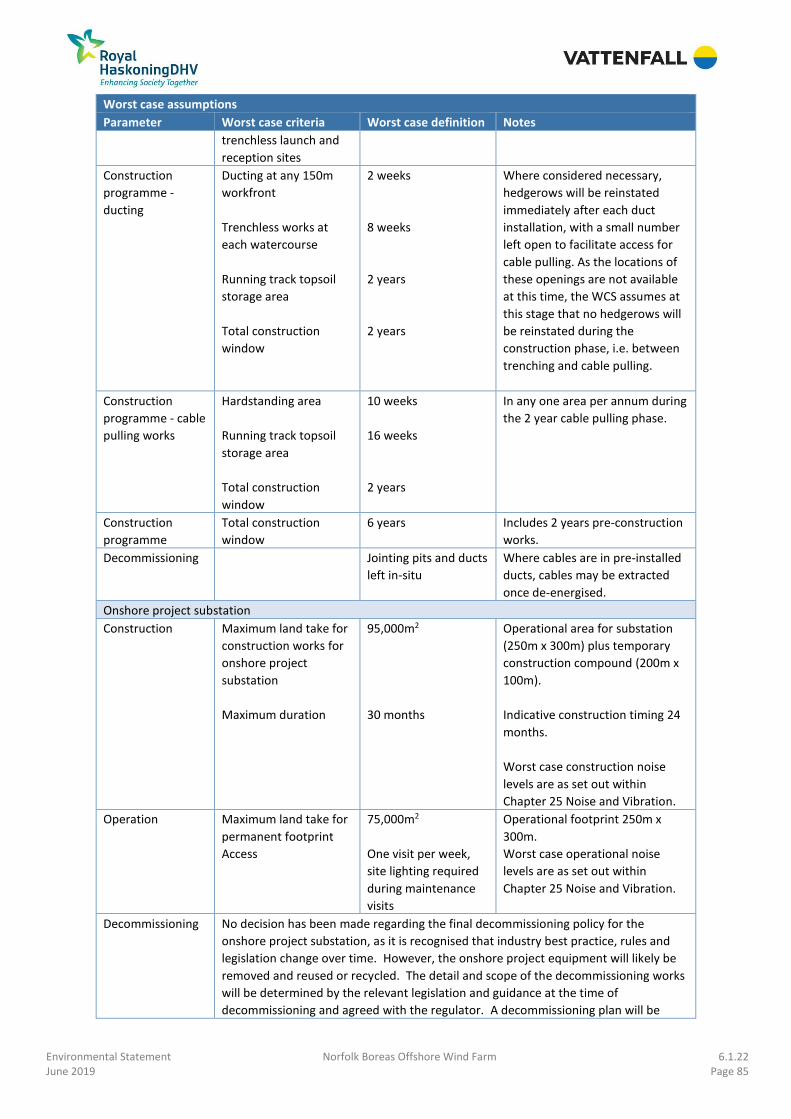
Environmental Statement Norfolk Boreas Offshore Wind Farm 6.1.22 June 2019 Page 85
Worst case assumptions
Parameter Worst case criteria Worst case definition Notes
trenchless launch and
reception sites
Construction
programme -
ducting
Ducting at any 150m
workfront
Trenchless works at
each watercourse
Running track topsoil
storage area
Total construction
window
2 weeks
8 weeks
2 years
2 years
Where considered necessary,
hedgerows will be reinstated
immediately after each duct
installation, with a small number
left open to facilitate access for
cable pulling. As the locations of
these openings are not available
at this time, the WCS assumes at
this stage that no hedgerows will
be reinstated during the
construction phase, i.e. between
trenching and cable pulling.
Construction
programme - cable
pulling works
Hardstanding area
Running track topsoil
storage area
Total construction
window
10 weeks
16 weeks
2 years
In any one area per annum during
the 2 year cable pulling phase.
Construction
programme
Total construction
window
6 years Includes 2 years pre-construction
works.
Decommissioning Jointing pits and ducts
left in-situ
Where cables are in pre-installed
ducts, cables may be extracted
once de-energised.
Onshore project substation
Construction
Maximum land take for
construction works for
onshore project
substation
Maximum duration
95,000m2
30 months
Operational area for substation
(250m x 300m) plus temporary
construction compound (200m x
100m).
Indicative construction timing 24
months.
Worst case construction noise
levels are as set out within
Chapter 25 Noise and Vibration.
Operation Maximum land take for
permanent footprint
Access
75,000m2
One visit per week,
site lighting required
during maintenance
visits
Operational footprint 250m x
300m.
Worst case operational noise
levels are as set out within
Chapter 25 Noise and Vibration.
Decommissioning No decision has been made regarding the final decommissioning policy for the
onshore project substation, as it is recognised that industry best practice, rules and
legislation change over time. However, the onshore project equipment will likely be
removed and reused or recycled. The detail and scope of the decommissioning works
will be determined by the relevant legislation and guidance at the time of
decommissioning and agreed with the regulator. A decommissioning plan will be

Environmental Statement Norfolk Boreas Offshore Wind Farm 6.1.22 June 2019 Page 86
Worst case assumptions
Parameter Worst case criteria Worst case definition Notes
provided. As such, for the purposes of a worst case, impacts as for the construction
phase are assumed.
National Grid extension and overhead line modification
Construction Maximum land take for
construction works at
substation extension
Maximum land take for
temporary works area –
overhead line
Maximum duration
97,500m2
176,310m2
30 months
Operational area (200m x 150m)
plus temporary compounds
(150m x 150m and 300m x 150m).
Indicative construction window
24 months
Worst case construction noise
levels are as set out within
Chapter 25 Noise and Vibration.
Operation Maximum land take for
substation extension
permanent footprint
Maximum land take for
overhead line
permanent footprint
Access
30,000m2
Up to 1,000m2
1 visit per month
Permanent western extension
footprint 200m x 150m
Site lighting required during
maintenance visits
266. Chapter 5 Project Description outlines the timings to be assessed in relation to the
phasing of the works. In all cases for onshore ecology; the two phase option, where
cables are installed in two consecutive years to facilitate the commissioning of the
offshore wind turbine planting, is assumed to be the worst case. This is due to the
increased length of time that ecological receptors will be potentially impacted by the
project.
22.7.5 Potential Impacts during Construction
22.7.5.1 Impact 1: Statutory designated sites
22.7.5.1.1 Scenario 1 and Scenario 2
Landfall
267. There are no terrestrial ecology statutory designated sites within 2km of the landfall
location. As such there will be no change upon statutory designated sites due to the
proposed project landfall works under either scenario.

Environmental Statement Norfolk Boreas Offshore Wind Farm 6.1.22 June 2019 Page 87
22.7.5.1.2 Scenario 2
Onshore cable route
268. There are 37 terrestrial statutory designated sites within 2km of the onshore cable
route (of which 20 are ancient woodlands, see Figure 22.2). Following embedded
mitigation to avoid statutory designated sites during the site selection process, only
two designated sites, namely the River Wensum SAC and SSSI and Old Carr ancient
woodland, are located within the onshore cable route. The remaining 35 sites have
been avoided entirely and therefore no direct impacts on these sites will occur.
269. The following designated sites are located within 500m of the onshore cable route,
and have therefore been considered further due to the potential for indirect effects
upon these sites to occur:
• River Wensum SSSI and SAC;
• Dillington Carr, Gressenhall SSSI;
• Dereham Rush Meadow SSSI;
• Pigney’s Wood LNR; and
• The following ancient woodlands:
o Old Lane Carr;
o Bacton Wood;
o The Leaselands;
o Sparham Grove;
o North Grove; and
o Great Wood.
270. Although located further than 500m from the onshore project area, as a result of
consultation with Natural England as part of the EPP, the following European
designated sites have also been considered further for indirect impacts:
• Paston Great Barn SAC;
• Norfolk Valley Fens SAC (Booton Common component SSSI);
• The Broads SAC (Broad Fen, Dilham component SSSI);
• Holly Farm Meadow, Wendling SSSI; and
• Whitwell Common SSSI.
271. A full HRA Report has been prepared providing information on the potential for likely
significant effects on European and Ramsar sites arising from the project. The
information provided here summarises the information presented in the HRA Report
submitted as part of the DCO application. Please refer to the HRA Report (document
reference 5.3) for full details of potential effects on European and Ramsar sites.
River Wensum SAC and SSSI
272. As part of the embedded mitigation, the River Wensum will be crossed using

Environmental Statement Norfolk Boreas Offshore Wind Farm 6.1.22 June 2019 Page 88
trenchless crossing techniques (e.g. HDD), in order to minimise direct impacts upon
this site and the habitats/species for which it is designated.
273. The trenchless crossing receptor zone for the River Wensum is located within the
floodplain habitat on the south bank of the River Wensum. This habitat was surveyed
during the 2017 and 2018 botanical survey and 2017 and 2018 invertebrate survey
for presence of qualifying features of the River Wensum SAC (Ranunculion fluitantis
and Callitricho-Batrachion vegetation and Desmoulin’s whorl snail). These species
were not found during the 2017 and 2018 surveys and are therefore considered to
be absent from the floodplain habitat on the south bank of the River Wensum and
the River Wensum and floodplain on the north bank. Therefore, potential direct
effects upon these qualifying features will not occur at this location.
274. There is a risk of indirect impacts upon the qualifying features of the River Wensum
SAC and notified features of the River Wensum SSSI due to works on the land which
is functionally connected to the River Wensum at Elsing. The following potential
indirect effects have been identified:
• Potential indirect effects on local hydrological conditions within the River
Wensum channel due to the introduction of impermeable features (buried
cables);
• Potential indirect effects on water quality arising from accidental release of
lubricants, fuels, oils and drilling fluid from construction machinery working in
and adjacent to surface watercourses; and
• Potential increase in the supply of fine sediment to surface watercourses
through surface runoff and the erosion of exposed soils.
275. The HRA Report quantified the magnitude of effect on the local hydrological
conditions as negligible, although it identified the potential effect arising from
release of lubricants, fuels, oils and drilling fluid and release of fine sediment as of
low magnitude without mitigation.
276. In addition to the SAC features identified above, barn owls (Tyto alba) are a notified
feature of the River Wensum SSSI and have been recorded holding territories within
the habitat and species study area during the 2017 breeding bird survey. The
territory is located outside of the onshore project area (see Appendix 23.4), and as
no record of a breeding site was recorded, the potential effects on this species are
predicted to be negligible.
277. The potential indirect effects upon the River Wensum SAC and SSSI arising from
changes in water regime, risk of pollutant release, dust emissions, and temporary
construction lighting during construction are discussed in detail in Chapter 20 Water
Resources and Flood Risk, Chapter 26 Air Quality and Chapter 29 Landscape and
Visual Impact Assessment. No significant impacts arising from changes in water

Environmental Statement Norfolk Boreas Offshore Wind Farm 6.1.22 June 2019 Page 89
regime, pollutant release, changes in dust levels and construction lighting have been
identified within these chapters.
278. Please refer to the HRA Report (document reference 5.3) for further details of the
assessment undertaken with respect to the River Wensum SAC.
Paston Great Barn SAC and SSSI
279. Paston Great Barn SAC and SSSI is located approximately 3km north of the onshore
cable route and is designated for its barbastelle bat population. The HRA Report
identifies a 5km study area around Paston Great Barn as an appropriate study area
for potential impacts upon this site.
280. The project involves hedgerow removal at 16 of the 17 hedgerows of moderate or
greater suitability to support commuting / foraging bats within the Paston Great
Barn study area identified within the HRA Report. This is predicted to result in the
following impacts on the barbastelle colony of Paston Great Barn:
• Direct loss of 198m of hedgerow foraging / commuting habitat across six
hedgerows (<0.05% of the available habitat within the Paston Great Barn
colony’s home range);
• Fragmentation of approximately 11ha of broadleaved woodland, rank grassland,
hedgerows and drainage ditches around Witton used by barbastelles of the
Paston Great Barn colony (approximately 0.6% of the Paston Great Barn
maternity colony home range); and
• Indirect effects upon commuting bats arising from construction lighting.
281. Hedgerows will be replanted following works at each location (replanting is
described in more detail below). Hedgerows are anticipated to take between 3-7
years to mature, therefore the habitat loss will be temporary and will take place over
the medium term (i.e. during the lifespan of one barbastelle). A maximum hedgerow
gap of 6m will be retained, if required, for two years to allow for the running track
required for cable pulling. All UK bat species are considered able to traverse gaps of
10m or less (JNCC, 2001; BCT, 2012). The duration and scale of this work is
anticipated to give rise to an effect of low magnitude.
282. Please refer to the HRA Report (document reference 5.3) for further details of the
assessment undertaken with respect to Paston Great Barn SAC.
Norfolk Valley Fens SAC (Booton Common SSSI)
283. Booton Common SSSI, a component SSSI of the Norfolk Valley Fens SAC, is located
600m from the onshore project area. Although outside of the designated sites study
area used within this EcIA, following consultation as part of the EPP, Natural England
requested that potential impacts upon all component SSSIs of the Norfolk Valley

Environmental Statement Norfolk Boreas Offshore Wind Farm 6.1.22 June 2019 Page 90
Fens SAC be considered within this assessment. This includes the following
component SSSIs:
• Badley Moor;
• Buxton Heath;
• Potter & Scarning Fens, East Dereham; and
• Southrepps Common.
284. The HRA Report considered potential indirect effects upon these five component
SSSIs arising from changes to the water supply mechanism which supports these
component SSSIs. The wetland water supply mechanism (‘WETMECs’) accounts
(Wheeler and Shaw, 2000) for all sites were reviewed to identify the water supply
mechanism for each site. In relation to surface water supply, Booton Common is
located 1.5km downstream of the nearest watercourse crossing location, and the
remaining component SSSIs are located upstream of the project, and at least 2.8km
from the onshore project area. In relation to groundwater supply, the chalk aquifer
within the onshore project area is not lower than 15m in any location, which is at
least 5m below the deepest excavation employed for the project (up to 10m for
trenchless crossings). As such, no pathway of effect has been identified between the
project and the component SSSIs of the Norfolk Valley Fens SAC; as such, no change
is anticipated upon the Norfolk Valley Fens SAC.
285. The HRA Report also considered potential indirect effects upon Booton Common
arising from changes to local air quality from construction traffic.
286. Booton Common is located approximately 1.4km south of the nearest access route
for construction vehicles for the proposed project, and is located 600m from the
onshore project area. As such, following Institute of Air Quality Management (IAQM)
guidance, it is considered to be outside the potential zone of influence of the project
in terms of air quality emissions (see Chapter 26 Air Quality).
287. As such, no change is anticipated upon the component SSSIs of the Norfolk Valley
Fens SAC.
288. Please refer to the HRA Report (document reference 5.3) for further details of the
assessment undertaken with respect to Norfolk Valley Fens SAC.
The Broads SAC (Broad Fen, Dilham SSSI)
289. Although outside of the designated sites study area used within this EcIA, following
consultation as part of the Norfolk Vanguard EPP, Natural England requested that
potential impacts upon The Broads SAC be considered within this assessment.
290. The HRA Report considered potential indirect effects upon The Broads SAC arising
from changes to the water supply mechanism for Broad Fen, Dilham (component

Environmental Statement Norfolk Boreas Offshore Wind Farm 6.1.22 June 2019 Page 91
SSSI of The Broads SAC) and changes to suitable habitats for otter (a qualifying
feature). The ‘WETMECs’ accounts (Wheeler and Shaw, 2000) for Broad Fen, Dilham
was reviewed in order to identify the water supply mechanism for the site.
291. In relation to surface water, as the North Walsham and Dilham Canal would be
crossed using trenchless techniques, no effects upon local hydrological conditions
are anticipated at this site. The Hundred Stream will be crossed using trenching
techniques. As detailed in Chapter 20 Water Resources, the construction techniques
at this location will ensure that flow is maintained, and that risk of release of
pollutants and sediment is minimised as far as possible. Given the distance between
this site and the onshore project area (4.6km in a straight line), the magnitude of
these potential effects is considered to be negligible. In relation to groundwater,
although there is a possibility that the site is part-groundwater fed, the main supply
mechanism for the site appears to be winter floods. As such, no pathway of effect
has been identified between the project and the component SSSIs of The Broads
SAC; as such, no change is anticipated upon The Broads SAC.
292. Otters are potentially present along the North Walsham and Dilham Canal within the
onshore project area. As this site will be avoided through the use of trenchless
crossing techniques (e.g. HDD), direct effects to otter habitats have been avoided.
No signs of otters were recorded adjacent to the North Walsham and Dilham Canal
during the 2017 water vole surveys (which also looked for signs of otter). The
Hundred Stream within the onshore project area is not suitable for otters.
293. As such, the greatest magnitude of effect upon The Broads SAC is considered to be
negligible.
294. Please refer to the HRA Report (document reference 5.3) for further details of the
assessment undertaken with respect to The Broads SAC.
Dillington Carr, Gressenhall SSSI
295. Dillington Carr, Gressenhall SSSI is located approximately 550m downstream of the
cable route, on the Wendling Beck watercourse.
296. As part of the embedded mitigation, the Wendling Beck will be crossed using
trenchless crossing techniques (e.g. HDD), in order to avoid direct impacts upon this
watercourse and the habitats and species it supports.
297. There are potential indirect effects upon the Dillington Carr, Gressenhall SSSI arising
from changes in water regime due to the trenchless crossing receptor site works
located adjacent to the Wendling Beck upstream of the SSSI proposed for the
Wendling Beck. These effects are anticipated to arise due to the risk of pollutant and
fine sediment release from the works at the trenchless crossing zone at the
Wendling Beck during construction. Given the distance between this site and the

Environmental Statement Norfolk Boreas Offshore Wind Farm 6.1.22 June 2019 Page 92
onshore project area, the magnitude of these potential effects is considered to be
negligible.
Dereham Rush Meadow SSSI
298. Dereham Rush Meadow is located approximately 400m from the onshore project
area. As such no direct impacts upon this site are anticipated.
299. Due to its proximity, the following potential indirect effects may occur:
• Indirect effects upon the habitats and species of the SSSI arising from
construction dust emissions;
• Indirect effects upon the habitats and species of the SSSI arising from pollutant
release; and
• Indirect effects upon the species of the SSSI arising from temporary construction
lighting.
300. These effects are discussed in Chapter 20 Water Resources and Flood Risk, Chapter
26 Air Quality and Chapter 29 Landscape and Visual Impact Assessment. No
significant impacts arising from changes in dust levels, risk of pollutant release and
construction lighting have been identified by these chapters, and therefore no
change upon this SSSI is anticipated.
Holly Farm Meadow, Wendling SSSI
301. Holly Farm Meadow, Wendling SSSI is located approximately 900m from the onshore
project area. As such no direct or indirect effects arising from dust, noise or lighting
emissions upon this site are anticipated.
302. Following consultation with Natural England, the potential water supply mechanism
for this site has been identified to determine whether there is any risk of trenching
or trenchless techniques giving rise to an effect upon the water supply mechanism.
The ‘WETMECs’ accounts (Wheeler and Shaw, 2000) for Holly Farm Meadow,
Wendling was reviewed in order to identify the water supply mechanism for the site.
This site is understood to be predominantly groundwater fed, from a shallow
intrusion of chalk at this location (Wheeler and Shaw, 2000). A review of BGS
borehole data obtained for the nearest trenchless crossing location within the
onshore project area to Holly Farm Meadow, Wendling indicates that the chalk is
located approximately 17m below ground at level (see Chapter 19 Ground
Conditions and Contamination). As trenchless crossing activities at most go down to
10m below ground level, no pathway of effect has been identified between the
project and the SSSI; as such, no change is anticipated upon the Holly Farm Meadow,
Wendling SSSI.

Environmental Statement Norfolk Boreas Offshore Wind Farm 6.1.22 June 2019 Page 93
Whitwell Common SSSI
303. Whitwell Common SSSI is located approximately 1.2km from the onshore project
area. As such no direct or indirect effects arising from dust, noise or lighting
emissions upon this site are anticipated.
304. Following consultation with Natural England as part of the EPP, the potential water
supply mechanism for this site has been identified to determine whether there is any
risk of trenching or trenchless techniques giving rise to an effect upon the water
supply mechanism. The ‘WETMECs’ accounts (Wheeler and Shaw, 2000) for Whitwell
Common was reviewed in order to identify the water supply mechanism for the site.
The site is thought to be predominantly groundwater fed, from a chalk aquifer below
drift deposits at this location (Wheeler and Shaw, 2000). A review of BGS borehole
data obtained for the nearest trenchless crossing location within the onshore project
area to Holly Farm Meadow, Wendling indicates that the chalk is located
approximately 24m below ground at level. As trenchless crossing activities at most
go down to 10m below ground level, no pathway of effect has been identified
between the project and the SSSI; as such, no change is anticipated upon the
Whitwell Common SSSI.
Pigney’s Wood LNR
305. Pigney’s Wood LNR is located adjacent to the onshore cable route. Due to its
proximity, the following potential indirect effects may occur:
• Indirect effects upon the habitats and species of the LNR arising from
construction dust emissions;
• Indirect effects upon the habitats and species of the LNR arising from pollutant
release; and
• Indirect effects upon the species of the LNR arising from temporary construction
lighting.
306. These effects are discussed in, Chapter 20 Water Resources and Flood Risk, Chapter
26 Air Quality and Chapter 29 Landscape and Visual Impact Assessment. No
significant impacts arising from changes in dust levels, risk of pollutant release and
construction lighting have been identified by these chapters, and therefore no
change is anticipated.
Ancient woodlands
307. There are eight ancient woodlands located within 500m of the onshore cable route
(see Figure 22.2). A buffer of 15m around all ancient woodland forms part of the
embedded mitigation (see Table 22.21). These woodlands are:
• Old Lane Carr (330m south of the cable route);
• Bacton Wood (180m south of the cable route);
• The Leaselands (30m west of the cable route);

Environmental Statement Norfolk Boreas Offshore Wind Farm 6.1.22 June 2019 Page 94
• Sparham Grove (450m east of the cable route);
• Old Carr (Dillington) (adjacent to the cable route);
• North Grove (130m west of the cable route);
• Great Wood (250m south of the cable route); and
• Necton Wood (adjacent to the cable route).
308. Following the Forestry Commission’s guidance on assessing the impacts of
development (Natural England and Forestry Commission, 2018), the following
potential effects on ancient woodland from development on adjacent land have
been considered:
• Fragmentation and loss of ecological connections with surrounding woodland/
veteran trees and the wider natural landscape;
• Reduction in the area of other semi-natural habitats adjoining ancient
woodland;
• Increased deposition of dust, particularly from quarries, resulting in physical
and/or chemical effects;
• Impacts on local hydrology through drainage or water table levels changing;
• Change to the landscape context for ancient woods and veteran trees; and
• Change to light pollution at night (if development includes street lighting).
309. Indirect effects are not predicted to arise in relation to Old Lane Carr, Bacton Wood,
Sparham Grove and North Grove ancient woodlands given their distance from the
onshore cable route. In addition, the onshore cable route is not located within an
important ecological corridor for any of these woodlands.
310. Potential effects arising from changes in local hydrology, dust emissions, light levels
and landscape context are discussed in Chapter 20 Water Resources and Flood Risk,
Chapter 26 Air Quality and Chapter 29 Landscape and Visual Impact Assessment. A
Construction Surface Water and Drainage Plan will form part of the CoCP (DCO
Requirement 20(2)(i)) to address the changes to local hydrology and the measures
that will be implemented to manage them. An outline CoCP (document reference
8.1) has been prepared and submitted with the DCO application.
311. There will be loss of approximately 40m of species-poor hedgerow with trees in two
locations which potentially act as linkages between Necton Wood and Great Wood.
Barbastelle bats have been recorded commuting along these features during the
2017 activity survey. These gaps may potentially affect commuting routes between
these two ancient woodlands. As this potential fragmentation effect is focussed on
two connections only, the impact is considered to be of low magnitude.
312. Construction works associated with the installation of the cable route will not result
in the reduction of the area of other semi-natural habitats adjoining ancient
woodland.

Environmental Statement Norfolk Boreas Offshore Wind Farm 6.1.22 June 2019 Page 95
313. No significant impacts arising from changes in dust levels or in the lighting provision
and landscape context have been identified in the assessments reported in Chapter
26 Air Quality or Chapter 29 Landscape and Visual Impact Assessment. As such, a low
magnitude of effect is anticipated.
Onshore project substation
314. There are two ancient woodlands within 2km of the onshore project substation
location, namely Necton Wood (ancient semi-natural) and Great Wood (ancient
semi-natural and ancient replanted) which are located approximately 150m north
and approximately 600m east of the onshore project substation respectively. There
are no other terrestrial statutory designated sites located within 2km of the onshore
project substation.
315. Following the Forestry Commission’s guidance on assessing the impacts of
development (Natural England and Forestry Commission, 2018), as the onshore
project substation location is located within 500m of Necton Wood, the following
potential effects on ancient woodland from development on adjacent land have
been considered:
• Fragmentation and loss of ecological connections with surrounding woodland/
veteran trees and the wider natural landscape;
• Reduction in the area of other semi-natural habitats adjoining ancient
woodland;
• Increased deposition of dust, particularly from quarries, resulting in physical
and/or chemical effects;
• Impacts on local hydrology through drainage or water table levels changing;
• Change to the landscape context for ancient woods and veteran trees; and
• Change to light pollution at night (if development includes street lighting).
316. Potential effects arising from changes in local hydrology, dust emissions, light levels,
and landscape context are discussed in Chapter 20 Water Resources and Flood Risk,
Chapter 26 Air Quality and Chapter 29 Landscape and Visual Impact Assessment.
317. Construction of the onshore substation will result in the permanent loss of
approximately 390m of hedgerow (of which 360m is species-poor hedgerow with
trees, and 30m species-rich hedgerow with trees), and the further temporary loss of
approximately 400m of hedgerow (of which 130m is species-rich hedgerow with
trees, and 270m species-rich hedgerow). Approximately 30m of the hedgerow
permanently affected is identified as important bat commuting / foraging habitat,
while approximately 360m is identified as other habitat supporting commuting /
foraging bats; all 400m of the of the hedgerow temporarily affected is identified as
important bat commuting / foraging habitat. Construction of the onshore project
substation will therefore affect the woodland’s ecological connections, although this

Environmental Statement Norfolk Boreas Offshore Wind Farm 6.1.22 June 2019 Page 96
is of local scale in the context of the wider hedgerow resource within the region, and
therefore is an effect of low magnitude. Fragmentation of habitat networks that
have been identified as important for supporting commuting and foraging bats will
occur, but not between other ancient woodlands in the vicinity of Necton Wood. The
magnitude of this effect is also low.
318. No significant impacts arising from changes in dust levels or in the lighting provision
and landscape context have been identified by Chapter 26 Air Quality or Chapter 29
Landscape and Visual Impact Assessment. As such, no change upon this receptor is
anticipated.
National Grid substation extension and overhead line modifications
319. There are two ancient woodlands within 2km of the National Grid substation
extension, namely Necton Wood (Ancient semi-natural) and Great Wood (ancient
semi-natural and ancient replanted). Necton Wood is located approximately 150m
east and Great Wood is approximately 1.4km east of the overhead line temporary
works area at its closest point (and 1km and 2.2km from the National Grid substation
extension respectively). There are no other terrestrial ecology statutory designated
sites located within 2km of the National Grid substation extension and overhead line
modifications.
320. Following the Forestry Commission’s guidance on assessing the impacts of
development (Natural England and Forestry Commission, 2018), as the proposed
National Grid substation extension works are located within 500m of Necton Wood,
the following potential effects on ancient woodland from development on adjacent
land have been considered:
• Fragmentation and loss of ecological connections with surrounding woodland/
veteran trees and the wider natural landscape;
• Reduction in the area of other semi-natural habitats adjoining ancient
woodland;
• Increased deposition of dust, particularly from quarries, resulting in physical
and/or chemical effects;
• Impacts on local hydrology through drainage or water table levels changing;
• Change to the landscape context for ancient woods and veteran trees; and
• Change to light pollution at night (if development includes street lighting).
321. Potential effects arising from changes in local hydrology, dust emissions, light levels,
and landscape context are discussed in Chapter 20 Water Resources and Flood Risk,
Chapter 26 Air Quality and Chapter 29 Landscape and Visual Impact Assessment.
322. The proposed National Grid substation extension works would result in the potential
loss of approximately 210m of species-poor hedgerow (100m of which is with trees).
Given the higher quality of linking habitat found in other areas surrounding the

Environmental Statement Norfolk Boreas Offshore Wind Farm 6.1.22 June 2019 Page 97
proposed substation site, this is not anticipated to be an important linking habitat
with Necton Wood. The proposed National Grid substation extension works are
therefore not anticipated to affect the woodland’s ecological connections. Based on
current available data, this is therefore an effect of negligible magnitude.
323. No significant impacts arising from changes in dust levels or in the lighting provision
and landscape context have been identified by Chapter 26 Air Quality or Chapter 29
Landscape and Visual Impact Assessment. As such, no change upon this receptor is
anticipated.
Road transport network
324. Chapter 26 Air Quality considers the potential impacts of increases in nutrient
nitrogen deposition arising from increases in road traffic during the construction
phase of the project upon sensitive habitats and species which are qualifying
features of SAC, SPA and SSSIs located within 200m of the road transport network.
This assessment of the air quality impacts arising from increases in road traffic on
the road transport network has been undertaken following the latest Institute of Air
Quality Management (IAQM) guidance on assessment of impacts on air quality
arising from road traffic emissions (IAQM, 2014). Details are provided in Chapter 26
Air Quality.
325. There are 13 sites located within the construction vehicle emissions study area. Of
these, Chapter 26 Air Quality predicts nutrient nitrogen deposition of <1% of the
critical load at all sites. As such, no change is anticipated.
Impact without mitigation
326. No change is anticipated on the Norfolk Valley Fens SAC, Dereham Rush Meadow
SSSI, Holly Farm Meadow, Wendling SSSI, Whitwell Common SSSI and Pigney’s Wood
LNR. A temporary effect of negligible magnitude is anticipated on The Broads SAC,
Dillington Carr, Gressenhall SSSI as a result of works on the onshore cable route.
327. An effect of low magnitude is anticipated on the River Wensum SAC and SSSI and the
Paston Great Barn SAC and SSSI as a result of works on the onshore cable route. An
effect of low magnitude is also anticipated on Necton Wood ancient woodland as
result of the onshore cable route and the onshore project substation, and an effect
of negligible magnitude as a result of the National Grid substation extension.
328. In accordance with Table 22.4 statutory designated sites are of high importance.
329. Without mitigation, the greatest magnitude arising from the onshore project area is
at the River Wensum SAC and SSSI, Paston Great Barn SAC and SSSI and Necton
Wood ancient woodland. This is low magnitude of effect upon a high importance
receptor, resulting in an impact of at worst moderate adverse significance.

Environmental Statement Norfolk Boreas Offshore Wind Farm 6.1.22 June 2019 Page 98
Mitigation
River Wensum SAC and SSSI
330. The following mitigation measures will be put in place to minimise the risk of
sediment or pollutant release into the watercourses which are functionally
connected to the River Wensum:
• A scheme and programme for each watercourse crossing, diversion and
reinstatement, which will include site specific details regarding sediment
management and pollution prevention measures will be developed. This scheme
will be submitted to and approved by the relevant planning authority in
consultation with Natural England. This commitment is secured through DCO
Requirement 25 (Watercourse Crossings). This scheme will include the specific
measures listed below;
• Best practice topsoil management practices will be followed. All topsoil will be
reinstated and measures will be put in place to reinstate any damage to ground
conditions caused by vehicle tracking. All sediment management measures used
(e.g. sediment traps) will be removed and disposed of following construction.
The practices to be followed will be detailed in a CoCP, the details and content
of which will be agreed with the relevant local planning authority in consultation
with stakeholders (including the Environment Agency and Natural England) in
advance of construction. An outline CoCP has been submitted alongside the DCO
application (document reference 8.1);
• A Construction Surface Water and Drainage Plan will be developed as part of the
CoCP (DCO Requirement 20(2)(i)) in consultation with the relevant regulators
and implemented to minimise water within the cable trench and other working
areas and ensure ongoing drainage of surrounding land. This typically includes
interceptor drainage ditches being temporarily installed parallel to the trenches
and soil storage areas to provide interception of surface water runoff and the
use of pumps to remove water from the trenches during duct installation.
Drainage would remain in place for the duration of the construction period,
including during the cable pulling phase;
• Existing tracks and roadways will be utilised for access where possible. Where
temporary accesses are needed, topsoil and surface water management
measures will be employed;
• Geotextile, or other suitable material, will be used, where required, to allow the
safe storage and movement of vehicles within the area, maintain required
drainage, and prevent soil erosion and increased surface runoff;
• A break-out contingency plan will be drafted in case of break-out of drilling fluid
during trenchless crossing construction. The details of this plan will be included
in the CoCP;

Environmental Statement Norfolk Boreas Offshore Wind Farm 6.1.22 June 2019 Page 99
• The working methodology will follow construction industry good practice
guidance, as detailed in the Environment Agency’s Pollution Prevention
Guidance (PPG) notes (including PPG01, PPG05, PPG08 and PPG21)16, and
CIRIA’s ‘Control of water pollution from construction sites – A guide to good
practice’ (2001), such as having spill kits on site at all times, checking equipment
regularly to ensure leakages do not occur, and limiting refuelling of construction
plant to designated impermeable areas; and
• The project is aiming for a construction scenario whereby works within the River
Wensum floodplain (i.e. land north of Penny Spot Beck) are not required, and a
trenchless crossing technique (e.g. HDD) at the River Wensum would run
beneath this area. However, in advance of a more detailed assessment of
ground conditions, this cannot be confirmed at this stage. If land north of Penny
Spot Beck within the River Wensum floodplain is used during construction, then
works will take place outside of the winter period (October – February inclusive)
to avoid the wettest period of the year to minimise the risk of effects on local
ground conditions due to vehicle tracking, unless otherwise agreed with Natural
England.
331. These mitigation measures will be applied for all works at trenchless crossing zones
and are considered suitable for minimising the risk of sediment / pollutant release
into watercourses functionally connected with the River Wensum. These measures
are good construction working practices and are captured in the OLEMS (document
reference 8.7) submitted as part of the DCO application.
Dillington Carr, Gressenhall SSSI
332. The mitigation measures outlined with respect to the River Wensum will be applied
for all works at the trenchless crossing zone at Wendling Beck and are considered
suitable for minimising the risk of sediment / pollutant release into the Wendling
Beck.
Paston Great Barn SAC and SSSI
333. To minimise the potential effect upon commuting and foraging barbastelle bats
arising from temporary loss of habitat, the following mitigation measures will be
implemented:
• Hedgerow removal will be programmed during winter where possible, to allow
bats time to adjust to the change prior to their maternity period. Hedgerows will
be removed as close to the onset of works as possible, and works will not
commence after nights of poor weather (in case of bad weather roosts being
used);
16 The Environment Agency’s PPG were formally withdrawn on 17 December 2015. However, the guidance contains the best reference source for good practice guidance regarding pollution prevention, and in the absence of any formally statutory guidance provides the best framework for managing pollution prevention.

Environmental Statement Norfolk Boreas Offshore Wind Farm 6.1.22 June 2019 Page 100
• Replanting will where possible follow in the first winter after construction, with
the exception of the 6m gap required for the running track (BCT, 2012).
Replanting will follow guidance within the Norfolk hedgerow BAP and will
include appropriate species for north-east Norfolk (NBP, 2009), including ground
flora planting designed to encourage insect biomass (BCT, 2012). Future
hedgerow management to include allowing standard trees to develop to
improve quality of the hedgerow as a foraging resource. Hedges will be double-
planted with 2m grassland strips on both sides so there is always a leeward side
to forage;
• Subject to landowner permissions, the 16 hedgerows that have been identified
as supporting foraging and commuting bats will be left to become overgrown
either side of the section to be removed prior to construction. Hedgerows will
be allowed to become overgrown within the onshore cable route, therefore at
each hedgerow a total of up to 22m will be left to become overgrown in this
manner. This measure will be undertaken to improve the quality of the
surrounding hedgerow as a resource for commuting and foraging bats (BCT,
2015);
• A Hedgerow Mitigation Plan will be developed in consultation with Natural
England prior to the removal of hedgerows. This mitigation plan will detail the
reinstatement approach for hedgerows removed during construction and the
monitoring and maintenance requirements following hedgerow planting. This
commitment is captured within the OLEMS (document reference 8.7);
• Pre-construction bat activity surveys at the six hedgerows not yet surveyed will
be undertaken to provide full baseline data for these features.
334. In addition to the above mitigation measures, during detailed project design
undertaken post-consent, the project will seek to avoid mature trees within
hedgerows through the micro-siting of individual cables, in order to retain as many
mature trees as possible given the benefits they provide within linear commuting /
foraging features (following Boughley et al., 2011).
Ancient woodlands
335. The mitigation measures listed under Paston Great Barn SAC and SSSI will also be
applied to the two species-rich hedgerows between Necton Wood and Great Wood.
336. The landscaping proposals described in Chapter 29 Landscape and Visual Impact
Assessment have been designed so that any ecological connections severed by
construction of the onshore project substation are recreated to ensure ecological
corridors connect Necton Wood to other woodlands to the east and south.

Environmental Statement Norfolk Boreas Offshore Wind Farm 6.1.22 June 2019 Page 101
Impact following mitigation
337. With the implementation of the mitigations measures, the greatest magnitude of
effect upon a statutory designated site is expected to be negligible, resulting in a
minor adverse residual impact being predicted.
22.7.5.1.3 Scenario 1
Onshore cable route
338. Up to 12km of the 6m wide running track installed for Norfolk Vanguard will be
required during the cable pulling works. As the exact location of the running track
which will be required is not yet known, it has been assumed as a worst case that the
running track may be required in any location along the cable route.
River Wensum SAC and SSSI
339. Although the exact areas of running track required are not known, there is some
design flexibility governing the location of jointing pits along the cable route, with a
pit required every 500 to 1000m along the cable route. This allows for the option, in
some cases, to avoid sensitive locations, particularly around locations of cable ‘stop
ends’. For example, where possible a jointing pit would not be sited within the
floodplain habitat of the River Wensum (as shown in Figure 22.11). Areas of the River
Wensum catchment will involve the construction of a 6m wide running track along
the route of the running track used for Norfolk Vanguard. This will have a localised,
short term effect on runoff rates for up to 16 weeks per annum during the two-year
cable pulling phase. This is an effect of negligible magnitude.
Paston Great Barn SAC and SSSI
340. Under a worst case, a running track may be required at the 16 hedgerows located
within the Paston Great Barn study area identified within the HRA Report. A
maximum hedgerow gap of 6m will be retained, if required, at any one location for
the duration of the two-year cable pulling phase to allow for the running track
required for cable pulling works All UK bat species are considered able to traverse
gaps of 10m or less (JNCC, 2001; BCT, 2012). As set out in the Draft DCO (document
reference 3.1) cable pulling works will take place 7am-7pm and construction lighting
adjacent to these hedgerows will not be required outside of these times. The
duration and scale of this effect is anticipated to give rise to an effect of negligible
magnitude.
Norfolk Valley Fens SAC (Booton Common SSSI)
341. The works proposed under Scenario 1 are well within the envelope set out above for
Scenario 2, which predicted no change upon the Booton Common SSSI and the
Norfolk Valley Fens SAC. As such, no change is anticipated upon the Booton Common
SSSI and the Norfolk Valley Fens SAC under Scenario 1.

Environmental Statement Norfolk Boreas Offshore Wind Farm 6.1.22 June 2019 Page 102
The Broads SAC (Broad Fen, Dilham SSSI)
342. As outlined under Scenario 2, the Hundred Stream will not be crossed using
trenchless techniques and therefore may require temporary works to allow the
running track to cross the watercourse during cable pulling works. The construction
techniques at this location will ensure that flow is maintained and that risk of release
of pollutants and sediment is minimised as far as possible, as per Scenario 2. Given
the distance between this site and the onshore project area, the magnitude of these
potential effects is considered to be negligible.
Dillington Carr, Gressenhall SSSI
343. As outlined under the River Wensum SAC and SSSI, although the exact areas of
running track required are not known, a jointing pit would not be required
immediately adjacent to the Wendling Beck at Dillington, which is upstream of the
Dillington Carr, Gressenhall SSSI. Areas of the Wendling Beck catchment will involve
the construction of a 6m wide running track along the route of the running track
used for Norfolk Vanguard. This will have a localised, short term effect on runoff
rates for up to 16 weeks per annum during the two-year cable pulling works. This is
an effect of negligible magnitude.
Dereham Rush Meadow SSSI
344. As outlined under the River Wensum SAC and SSSI, although the exact areas of
running track required are not known, a jointing pit would not be required within
400m Dereham Rush Meadow SSSI. As a consequence, indirect effects in this
location during the 16 week per annum during the two-year cable pulling works are
not anticipated to arise, and no change upon Dereham Rush Meadow SSSI is
anticipated.
Holly Farm Meadow, Wendling SSSI
345. As cable pulling works will not involve any new excavation works outside of the
footprint excavated for Norfolk Vanguard, there is no pathway to affect the
groundwater supply to Holly Farm Meadow, Wendling SSSI which is located 900m
from the onshore project area. As such, no change upon Holly Farm Meadow,
Wendling SSSI is anticipated.
Whitwell Common SSSI
346. As cable pulling works will not involve any new excavation works outside of the
footprint excavated for Norfolk Vanguard, there is no pathway to affect the
groundwater supply to Whitwell Common SSSI which is located 1.2km from the
onshore project area. As such, no change upon Holly Farm Meadow, Wendling SSSI is
anticipated.

Environmental Statement Norfolk Boreas Offshore Wind Farm 6.1.22 June 2019 Page 103
Pigney’s Wood LNR
347. As outlined under the River Wensum SAC and SSSI, although the exact areas of
running track required are not known, a jointing pit would not be required within
100m Pigney’s Wood LNR. As a consequence, construction works in this location
during the 16 week per annum (over two years) cable pulling works is not
anticipated to give rise to indirect effects, and no change upon Pigney’s Wood LNR is
anticipated.
Ancient woodlands
348. The four ancient woodlands identified as potentially subject to indirect effects during
the project construction phase under Scenario 2 (The Leaselands, Old Carr
(Dillington), Great Wood and Necton Wood) will be potentially subject to the same
indirect effects for up to 16 weeks per annum during the two-year cable pulling
works. This is a medium term effect of negligible magnitude. Potential effects arising
from changes in local hydrology, dust emissions, light levels and landscape context
are discussed in Chapter 20 Water Resources and Flood Risk, Chapter 26 Air Quality
and Chapter 29 Landscape and Visual Impact Assessment. A Construction Surface
Water and Drainage Management Plan will form part of the CoCP (DCO Requirement
20(2)(i)) to address the changes to local hydrology and the measures that will be
implemented to manage them. An outline CoCP (document reference 8.1) has been
prepared and submitted with the DCO application.
Onshore project substation
349. The onshore project substation works under Scenario 1 may give rise to potential
indirect effects upon Necton Wood and Great Wood ancient woodlands (as per
Scenario 2).
350. Construction of the onshore project substation will result in the permanent loss of
approximately 240m of species-rich hedgerow with trees and a further temporary
loss of 120m of species-rich hedgerow with trees. All 240m of the hedgerow
permanently affected is identified as important bat commuting / foraging habitat.
Construction of the onshore project substation will therefore affect the woodland’s
ecological connections, although this is of local scale in the context of the wider
hedgerow resource within the region, and therefore is an effect of low magnitude.
Fragmentation of habitat networks that have been identified as important for
supporting commuting and foraging bats will occur, but not between other ancient
woodlands in the vicinity of Necton Wood. The magnitude of this effect is also
considered to be low.
National Grid substation extension
351. Necton Wood is located approximately 700m from the National Grid substation
extension under Scenario 1. As such indirect effects are unlikely to arise during the
construction phase from dust, noise, temporary lighting and changes in the local

Environmental Statement Norfolk Boreas Offshore Wind Farm 6.1.22 June 2019 Page 104
hydrology regime or habitat fragmentation. No change is therefore anticipated upon
this receptor.
Impact without mitigation
352. No change is anticipated on the Norfolk Valley Fens SAC, Dereham Rush Meadow
SSSI, Holly Farm Meadow, Wendling SSSI, Whitwell Common SSSI or Pigney’s Wood
LNR. A temporary effect of negligible magnitude is anticipated on the River Wensum
SAC and SSSI, Paston Great Barn SAC and SSSI, The Broads SAC, Dillington Carr,
Gressenhall SSSI and on ancient woodland, as a result of works along the onshore
cable route.
353. An effect of low magnitude is anticipated on Necton Wood ancient woodland as
result of the onshore project substation. No change is anticipated in statutory
designated sites as a result of the National Grid substation extension.
354. In accordance with Table 22.4 statutory designated sites are of high importance.
355. Without mitigation, the greatest magnitude of effect arising from the onshore
project area is at Necton Wood ancient woodland. This is considered to be low on a
high importance receptor, resulting in an impact of at worst moderate adverse
significance.
Mitigation
356. The mitigation set out under Scenario 2 (see section 22.7.5.1.2) for ancient
woodlands would be adhered to under Scenario 1.
Impact following mitigation
357. With the implementation of these mitigation measures, the greatest magnitude of
effect upon a statutory designated site is expected to be reduced to negligible,
resulting in a minor adverse residual impact being predicted.
22.7.5.2 Impact 2: Non-statutory designated sites
22.7.5.2.1 Scenario 1 and Scenario 2
Landfall
358. There is one non-statutory designated site within 2km of the landfall, namely The
Marram Hills CWS which is located approximately 800m south-east of the landfall.
Due to the distance between the Marram Hills CWS and the works at the landfall,
there will be no change upon non-statutory designated sites.
Onshore project substation
359. There are five non-statutory designated sites within 2km of the onshore project
substation, namely Necton Wood, Great Wood, Fox Covert, Necton Old Common
and Land Adjacent to River Wissey. The latter four sites are located over 650m from
the onshore project substation, and as such there will be no change upon these non-

Environmental Statement Norfolk Boreas Offshore Wind Farm 6.1.22 June 2019 Page 105
statutory designated sites due to the construction of the onshore project substation.
360. The one remaining site, Necton Wood, is located approximately 130m from the
onshore project substation. Indirect impacts may potentially arise during the
construction phase from dust, noise, temporary lighting and changes in the local
hydrology regime. These effects will continue for up to 30 months under both
scenarios. No significant impacts have been identified within Chapter 20 Water
Resources and Flood Risk, Chapter 25 Noise and Vibration, Chapter 26 Air Quality
and Chapter 29 Landscape and Visual Impact Assessment. These effects are
identified within the relevant chapter to be of low magnitude. These indirect effects
are therefore predicted to be of low magnitude.
22.7.5.2.2 Scenario 2
Onshore cable route
361. There are five CWSs and one proposed CWS located within the onshore cable route
(see Figure 22.3), specifically:
• Wendling Carr (CWS no. 1013), an area of semi-improved neutral grassland with
a thin belt of semi-natural woodland;
• Little Wood CWS (CWS no. 2024), an ancient woodland;
• Paston Way & Knapton Cutting (CWS no. 1175), an ecological corridor with a
butterfly reserve and wet woodland;
• Marriott’s Way (CWS no. 2176), a green woodland corridor;
• Land south of Dillington Carr (CWS no. 1025), an area of wet woodland; and
• Kerdiston Old Hall Meadows (proposed CWS so it has not been assigned a
number at the time of preparing this chapter), proposed for its semi-improved
grassland, hedgerow and ditch mosaic.
362. As part of the embedded mitigation measures, all of the CWSs, including the
proposed CWS, will be crossed using trenchless crossing techniques (e.g. HDD), in
order to minimise direct impacts upon these sites.
363. One of these sites, Wendling Carr CWS, will require a 6m wide running track to be
constructed across it. The running track will be approximately 180m long, and will
result in the temporary loss of approximately 0.1ha grazed meadow habitat. This
represents approximately 2.8% of the total grazed meadow habitat within the CWS.
The running track will be microsited to avoid sensitive features within the grazed
meadow (i.e. mature trees) where possible. The running track will also need to cross
the Wendling Beck. The running track will remain in place for the full duration of the
onshore construction period in the worst case (i.e. four years in total). These effects
are predicted to be of low magnitude given the scale of habitat loss and the
temporary nature of the habitat loss.

Environmental Statement Norfolk Boreas Offshore Wind Farm 6.1.22 June 2019 Page 106
364. In addition to the six CWS / proposed CWS avoided through the use of trenchless
techniques (e.g. HDD), a further seven CWS (namely Necton Wood, Old Carr, Pits
near Mill Street, Long Hollands Clump and belt, Pond Wood, Holly’s Grove, Vernon
Wood), are located adjacent to the trenchless crossing zones along the onshore
cable route and therefore indirect effects during the construction phase may be
experienced. Indirect impacts may potentially arise during the construction phase
from dust, noise, temporary lighting and changes in the local hydrology regime.
These effects will occur over two years (duct installation) plus a further 16 weeks in
any one area per annum during the two-year cable pulling works. No significant
impacts have been identified within Chapter 20 Water Resources and Flood Risk,
Chapter 25 Noise and Vibration, Chapter 26 Air Quality and Chapter 29 Landscape
and Visual Impact Assessment. These effects are identified within the relevant
chapter to be of low magnitude. These indirect effects are therefore predicted to be
of low magnitude.
National Grid substation extension and overhead line modifications
365. There are four non-statutory designated sites within 2km of the National Grid
substation extension and overhead line modifications, namely Necton Wood, Great
Wood, Fox Covert and Necton Old Common. The latter three sites are located over
1.4km from the onshore project substation, and as such there will be no change
upon these non-statutory designated sites due to the proposed National Grid
substation extension and overhead line modifications.
366. Necton Wood is located approximately 150m from the overhead line modifications
(and 1km from the National Grid substation extension). Indirect impacts may
potentially arise during the construction phase from dust, noise, temporary lighting
and changes in the local hydrology regime. These effects will continue for
approximately 30 months during construction. No significant impacts have been
identified within Chapter 20 Water Resources and Flood Risk, Chapter 25 Noise and
Vibration, Chapter 26 Air Quality and Chapter 29 Landscape and Visual Impact
Assessment. These effects are identified within the relevant chapters to be of low
magnitude. These indirect effects to Necton Wood are therefore predicted to be of
low magnitude
Impact without mitigation
367. No change is anticipated to non-statutory sites as a result of the landfall works. At
Wendling Carr CWS a direct effect of low magnitude is anticipated as result of the
installation of the running track.
368. Potential indirect effects of low magnitude are anticipated at 13 non-statutory
designated sites identified above as a result of the onshore cable route, onshore
project substation and National Grid substation extension.

Environmental Statement Norfolk Boreas Offshore Wind Farm 6.1.22 June 2019 Page 107
369. In accordance with Table 22.4 non-statutory designated sites are of medium
importance.
370. Without mitigation, the greatest magnitude of effect arising from the onshore
project area is low, on a medium importance receptor, resulting in an impact of at
worst minor adverse significance.
Mitigation
371. Following advice received from NWT during the Norfolk Vanguard EPP, the
management proposals for Wendling Car CWS have been taken into account when
considering mitigation for Norfolk Boreas. The management proposals for the site
state that control of the young (pioneer) species of the broadleaved woodland parcel
on the site should be prevented from establishing within the grazed meadow where
possible. Methods other than grazing should be used to achieve this. Furthermore,
continued monitoring of the site is recommended (NWT, 1996). As such a pre-
construction botanical survey of Wendling Carr CWS will be undertaken. Following
the botanical survey and subsequent consultation with NWT, manual clearance of
any pioneer woodland species establishing within the meadow should be carried out
within the grazed meadow prior to construction of the running track. This mitigation
approach is set out in the OLEMS (document reference 8.7) provided with the DCO
application.
372. Best practice construction mitigation measures will be in place to minimise dust and
noise emissions during construction. These measures are described in full in Chapter
25 Noise and Vibration and Chapter 26 Air Quality.
Impact following mitigation
373. If these mitigation measures are applied, the greatest magnitude of effect upon a
non-statutory designated site is expected to be reduced to negligible, resulting in a
minor adverse residual impact.
22.7.5.2.3 Scenario 1
Onshore cable route
374. Under Scenario 1, the 6m wide running track will be reinstalled within the Wendling
Beck CWS and used for up to 16 weeks in any one area per annum during the two-
year cable pulling works. The potential temporary effects of reinstating this running
track will be as per Scenario 2 (i.e. of low magnitude).
375. As the exact location of the running track which needs to be reinstated is not known
at this stage, there is potential for indirect effects on the 13 CWS located adjacent to
the onshore cable route to arise during 16 weeks in any one area per annum during
the two-year cable pulling works. Indirect impacts may potentially arise during the
construction phase from dust, noise, temporary lighting and changes in the local

Environmental Statement Norfolk Boreas Offshore Wind Farm 6.1.22 June 2019 Page 108
hydrology regime. No significant impacts have been identified within Chapter 20
Water Resources and Flood Risk, Chapter 25 Noise and Vibration, Chapter 26 Air
Quality and Chapter 29 Landscape and Visual Impact Assessment. These effects are
medium-term and predicted to be of low magnitude.
National Grid substation extension
376. Necton Wood is located approximately 700m from the National Grid substation
extension under Scenario 1. As such, unlike Scenario 2, indirect effects are unlikely to
arise during the construction phase from dust, noise, temporary lighting and changes
in the local hydrology regime. No change is therefore anticipated upon this receptor.
Impact without mitigation
377. No change is anticipated to non-statutory sites as a result of the landfall works or the
works at the National Grid substation extension. As per Scenario 2 effects of low
magnitude are anticipated as a result of works on the onshore cable and at the
onshore project substation.
378. In accordance with Table 22.4 non-statutory designated sites are of medium
importance.
379. Without mitigation, the greatest magnitude of effect is low on a medium importance
receptor, resulting in an impact of at worst minor adverse significance.
Mitigation
380. The mitigation set out under Scenario 2 (see section 22.7.5.2.2) for the Wendling
Carr CWS and the requirements for best practice construction mitigation measures
would be adhered to under Scenario 1.
Impact following mitigation
381. If these mitigation measures are applied, the greatest magnitude of effect upon a
non-statutory designated site is expected to be reduced to negligible, resulting in a
minor adverse residual impact.
22.7.5.3 Impact 3: Arable land
22.7.5.3.1 Scenario 1 and Scenario 2
Landfall
382. The landfall works will lead to a temporary loss of approximately 0.6ha of arable land
for the duration of the construction phase (20 weeks for duct installation followed
by up to 16 weeks for cable pulling over approximately four years). Cereal field
margins, a UKHPI and Norfolk LBAP habitat, were not identified in any of the arable
habitats found at the landfall. Arable land is typically of low ecological value due to
the homogeneity of the habitat as well as farming practices and the presence of
insecticides and herbicides within the crops. As such this habitat is of negligible

Environmental Statement Norfolk Boreas Offshore Wind Farm 6.1.22 June 2019 Page 109
importance. Given the extent of arable land within the surrounding area, the
magnitude of effect is predicted to be negligible.
22.7.5.3.2 Scenario 2
Onshore cable route
383. The construction of the onshore cable route will result in a temporary loss of
approximately 333ha of arable land during the cable duct installation element of the
construction phase (approximately two years) and up to approximately 7ha for 16
weeks in any one area per annum during the two year cable pulling works element
of the construction phase.
384. Cereal field margins were identified in a number of areas along the cable route
during the 2017 and 2018 Extended Phase 1 Habitat Survey. As a UKHPI, this habitat
type is of high importance. There is likely to be a negligible temporary loss of cereal
field margin habitat. Loss of this habitat will not coincide with arable cropping on the
adjacent arable land, therefore the role of these habitats as conservation headlands
will not be affected during construction. The area of cereal field margin lost (a small
fraction of total arable land) is of a small scale in the context of the 750ha of field
margins within Norfolk. As such, the magnitude of effect is considered to be
negligible.
Onshore project substation
385. The onshore project substation works will lead to a temporary loss of approximately
9.5ha of arable land for the duration of the construction phase (approximately 30
months). Cereal field margins were not identified in any of the arable habitats found
at the onshore project substation, as such this habitat is of negligible importance.
Given the extent of arable land in the surrounding area, the magnitude of effect is
considered to be negligible.
National Grid substation extension and overhead line modifications
386. Work at the National Grid substation extension and overhead line modifications will
result in a temporary loss of approximately 27.4ha of arable land for the duration of
the construction phase (approximately 30 months). Cereal field margins were not
identified in any of the arable habitats found at the National Grid extension zone, as
such this habitat is of negligible importance. Given the extent of arable land in the
surrounding area, the magnitude of effect is considered to be negligible.
Impact without mitigation
387. Works at the landfall, onshore project substation and National Grid substation
extension will result in temporary loss of arable land of negligible magnitude on a
habitat of negligible importance.

Environmental Statement Norfolk Boreas Offshore Wind Farm 6.1.22 June 2019 Page 110
388. Works on the onshore cable route will result in a temporary loss of arable land of
negligible magnitude. This includes loss of cereal field margin (a small fraction of
total arable land), which habitat as a UKHPI is of high importance.
389. Without mitigation, the greatest magnitude arising from the project is negligible on a
high importance receptor, resulting in an impact of at worst minor adverse
significance (upon cereal field margins).
Mitigation
390. The locations of all cereal field margins within the onshore project area identified
during the 2017 and 2018 Extended Phase 1 Habitat Surveys or during post-consent
surveys of the unsurveyed areas will be recorded, and these habitats should be
reinstated post-construction.
Impact following mitigation
391. With these mitigation measures in place, the greatest magnitude of effect upon
arable land would remain negligible, which is expected to result in a minor adverse
residual impact (upon cereal field margins).
22.7.5.3.3 Scenario 1
Onshore cable route
392. Up to 12km of 6m running track will be required to be reinstalled during the cable
pulling works. As the exact location of the running track which will be required is not
yet known, it has been assumed that the running track may be required in any
location along the cable route.
393. The onshore cable route works will result in a temporary loss of approximately 7ha
for 16 weeks per annum during the two year cable pulling element of the
construction phase.
394. As for Scenario 2, the area of cereal field margin (a small fraction of total arable land)
lost is of a small scale in the context of the 750ha of field margins within Norfolk. As
such, the magnitude of effect is negligible.
Onshore project substation
395. The onshore project substation works will lead to at most a temporary loss of
approximately 9.5ha of arable land for the duration of the construction phase
(approximately 30 months). Cereal field margins are a UKHPI and Norfolk LBAP
habitat. This habitat was not identified in any of the arable habitats found at the
onshore project substation. As such this habitat is of negligible importance. Given
the extent of arable land in the surrounding area, the magnitude of effect is
negligible.

Environmental Statement Norfolk Boreas Offshore Wind Farm 6.1.22 June 2019 Page 111
National Grid substation extension
396. Work at the National Grid substation extension will result in a temporary loss of
approximately 9.5ha of arable land for the duration of the construction phase
(approximately 30 months). Cereal field margins are a UKHPI and Norfolk LBAP
habitat. This habitat was not identified in any of the arable habitats found at the
National Grid extension zone. As such this habitat is of negligible importance. Given
the extent of arable land in the surrounding area, the magnitude of effect is
considered to be negligible.
Impact without mitigation
397. As for Scenario 2 works at the landfall, onshore project substation and National Grid
substation extension will result in temporary loss of arable land of negligible
magnitude on a habitat of negligible importance.
398. Works on the onshore cable route will result in temporary loss of arable land of
negligible magnitude. This includes loss of cereal field margin (a small fraction of
total arable land), which habitat as a UKHPI is of high importance.
399. Without mitigation, the greatest magnitude of effect arising from the project is
negligible on a high importance receptor, resulting in an impact of at worst minor
adverse significance (upon cereal field margins).
Mitigation
400. The mitigation set out under Scenario 2 (see section 22.7.5.3.2) for cereal field
margins would also be adhered to under Scenario 1.
Impact following mitigation
401. With these mitigation measures in place, the greatest magnitude of effect upon
arable land would remain negligible, which is expected to result in a minor adverse
residual impact (upon cereal field margins).
22.7.5.4 Impact 4: Woodland, trees and scrub
22.7.5.4.1 Scenario 1 and Scenario 2
Landfall
402. The landfall works are located outside of any woodland habitat and as such no
change upon these habitats is anticipated as a result of the landfall works under both
scenarios.
Onshore project substation
403. There are no woodland habitats located within the onshore project substation and
as such no change upon these habitats is anticipated as a result of the project under
both scenarios. Potential effects upon the Necton Wood Ancient Woodland, located
within 150m of onshore project substation, are considered in section 22.7.5.1.

Environmental Statement Norfolk Boreas Offshore Wind Farm 6.1.22 June 2019 Page 112
22.7.5.4.2 Scenario 2
Onshore cable route
404. As part of the embedded mitigation, the avoidance of ancient woodland and
woodland parcels where possible was a key design principle applied during the site
selection process. This includes the use of trenchless crossing techniques (e.g. HDD)
at any location where mixed lowland deciduous woodland is present and which
cannot be avoided (for example, at Little Wood Ancient Woodland). Site selection
also followed the principle that no works will take place within 15m of any
woodland. Adherence to these principles means that no change upon woodland is
anticipated as a result of the project.
405. Isolated mature trees located within the onshore cable route will need to be
removed during the construction phase. Two veteran trees are located within the
onshore cable route. TN288 at the River Bure will be avoided using trenchless
techniques. The remaining tree at TN168 (see Figure 22.5) will be avoided through
micrositing of the route as part of the project embedded mitigation. Loss of other
mature trees encountered along the route represents an effect of medium
magnitude on a receptor with negligible importance. Trees located within
hedgerows are discussed in section 22.7.5.5.
National Grid substation extension and overhead line modifications
406. There are woodland strips along the A47 located within the overhead line temporary
working area. Temporary works at this location will not involve the removal of this
woodland, although pruning works may be required. Pruning works are anticipated
to have a negligible effect upon trees of the woodland in this location. As a
consequence, a negligible effect is anticipated upon this habitat.
Impact without mitigation
407. No change is anticipated on woodland habitats or trees as a result of works at the
landfall, onshore project substation or the National Grid substation extension.
408. The onshore cable route and overhead line modifications could result in a potential
pruning or loss of mature trees which represents an effect of medium magnitude on
a receptor with negligible importance.
409. Without mitigation, the greatest effect arising on the project is of medium
magnitude on a receptor with negligible importance (mature trees), resulting in an
impact of at worst negligible significance.
Mitigation
410. A pre-construction walkover survey will be undertaken by a suitably qualified
Arboriculturalist. This survey will define specific mitigation measures to protect
trees situated adjacent to the working width, including defining root protection

Environmental Statement Norfolk Boreas Offshore Wind Farm 6.1.22 June 2019 Page 113
areas. The arboricultural report will be submitted to and agreed with the local
authority prior to the commencement of any construction works. In addition, the
following mitigation measures will also be undertaken:
• The roots of retained trees along the edge of the working width will be
protected from soil compaction by using appropriate measures (e.g. fencing off
sensitive areas, use of ground protection matting, etc.) within the trees’ Root
Protection Areas (the extent of which will be calculated using guidance from
BS5837: 2012);
• Facilitation pruning may be recommended where tree crowns are at risk from
impact by machinery or high sided vehicles;
• Where possible, removal of vegetation will be timed to avoid the bird breeding
season (March to October inclusive); and
• If bat roosts are found in the trees then the measures set out in section
22.7.5.10 (bat mitigation) will be followed.
411. This mitigation is set out in the OLEMS (document reference 8.7) submitted as part
of the DCO application.
Impact following mitigation
412. Following mitigation, the magnitude of effect would be remain medium upon a
receptor of negligible importance, ensuring a residual impact of negligible
significance (upon mature trees) remains.
22.7.5.4.3 Scenario 1
Onshore cable route
413. Under Scenario 1, no woodland habitat would be removed to facilitate the cable
pulling works. As such no change is anticipated upon this receptor.
National Grid substation extension and overhead line modifications
414. There are no woodland habitats located within the National Grid substation
extension area under Scenario 1. As a consequence, no change is anticipated upon
this habitat under this scenario.
Impact without mitigation
415. As this habitat would not be removed, or is not located within the onshore project
area under Scenario 1, no impact is anticipated upon this receptor.
Mitigation
416. No mitigation is proposed under Scenario 1.

Environmental Statement Norfolk Boreas Offshore Wind Farm 6.1.22 June 2019 Page 114
22.7.5.5 Impact 5: Hedgerows
22.7.5.5.1 Scenario 1 and Scenario 2
Landfall
417. There are no hedgerows located within the landfall and as such no change upon
these habitats is anticipated under either scenario.
22.7.5.5.2 Scenario 2
Onshore cable route
418. The construction of the onshore cable route will result in a temporary loss of
approximately 2.5km of hedgerow habitat across 196 hedgerows (of which up to
1.8km may be species-rich17 (141 hedgerows)) for two years during the duct
installation element of the construction phase. Of these hedgerows, approximately
230m across 39 hedgerows will also be lost for an additional two years during the
cable pulling element of the construction phase. As part of the project’s embedded
mitigation, the maximum size of the hedgerow gap created is 13m for perpendicular
crossings. As a viable area of UKHPI and Norfolk BAP hedgerow habitat, the local
resource is of high importance. The scale of the habitat loss is of low magnitude as
although individual gaps are small, 2.5km of hedgerow represents a notable area of
habitat at a district level.
Onshore project substation
419. Construction of the onshore substation will result in the permanent loss of
approximately 390m of hedgerow (of which 360m is species-poor hedgerow with
trees, and 30m species-rich hedgerow with trees), and the further temporary loss of
approximately 400m of hedgerow (of which 130m is species-rich hedgerow with
trees, and 270m species-rich hedgerow). As a viable area of UKHPI and Norfolk BAP
hedgerow habitat, the local resource is of high importance. The scale of the habitat
loss is of low magnitude given the context of surrounding hedgerows.
National Grid substation extension and overhead line modifications
420. The National Grid substation extension will result in a potential temporary loss of
approximately 210m of species-poor hedgerow (100m of which is with trees) for the
duration of the construction phase (approximately 30 months). As a viable area of
UKHPI and Norfolk BAP hedgerow habitat, the local resource is of high importance.
The scale of the habitat loss is of low magnitude given the context of surrounding
hedgerows.
17 1.8km assumes, following a precautionary approach, that all hedgerows identified using the Norfolk Living Map and aerial photography are species-rich.

Environmental Statement Norfolk Boreas Offshore Wind Farm 6.1.22 June 2019 Page 115
Impact without mitigation
421. Works on the onshore cable route, onshore project substation and the National Grid
substation extension are anticipated to have an effect of low magnitude on
hedgerows which are considered of high importance. No change upon hedgerows is
anticipated at the landfall.
422. Without mitigation, the greatest effect arising from the project is of low magnitude
on a high importance receptor, resulting in an impact of at worst moderate adverse
significance.
Mitigation
423. To minimise the potential effect upon hedgerows arising from temporary loss of
habitat, the following mitigation measures will be implemented. Note, this
mitigation applies to hedgerows that will be removed – additional mitigation applies
to those hedgerows which have been identified as important for the species which
they support (for example, see section 22.7.5.1):
• Replanting will where possible follow in the first winter after construction of all
except the 6m gap required for the running track. Replanting will follow
guidance within the Norfolk Hedgerow BAP and will include appropriate species
for north-east Norfolk (NBP, 2009), including ground flora planting designed to
encourage insect biomass (BCT, 2012). Future hedgerow management to include
allowing standard trees to develop to improve quality of the hedgerow as a
foraging resource. Hedges will be double-planted with 2m grassland strips on
both sides so there is always a leeward side to forage;
• A Hedgerow Mitigation Plan will be developed in consultation with Natural
England prior to the removal of hedgerows. This mitigation plan will detail the
reinstatement approach for hedgerows removed during construction and the
monitoring and maintenance requirements following hedgerow planting. This
commitment is captured within the OLEMS (document reference 8.7).
424. In addition to the above mitigation measures, during detailed project design, the
project will seek to avoid mature trees within hedgerows through the micro-siting of
individual cables, in order to retain as many mature trees as possible.
425. The landscaping proposals described in Chapter 29 Landscape and Visual Impact
Assessment have been designed to ensure that new planting is created to
compensate for the permanent loss of species-rich hedgerow at the onshore project
substation. Approximately 230m of new hedgerow is proposed along the western
margin of onshore project substation, and a further approximately 1km of existing
hedgerow will be enhanced with adjacent woodland and species-rich grassland
planting. Please see Chapter 29 Landscape and Visual Impact Assessment for full
details of the proposed landscape mitigation planting.

Environmental Statement Norfolk Boreas Offshore Wind Farm 6.1.22 June 2019 Page 116
Impact following mitigation
426. These mitigation measures will ensure that the habitat which is temporarily lost for
between two and four years (plus the length of time for reinstatement hedgerows to
mature) is replaced by improved hedgerow habitat which meets the criteria set out
in the Norfolk Hedgerow BAP (NBP, 2009). Therefore, in the long-term, there will be
a beneficial effect upon this receptor. However, given the duration of these
temporary effects before reaching this point (up to 11 years for restored hedgerows
to be greater value than that lost during construction), the magnitude of effect will
remain low on a high importance receptor, resulting in a residual impact of
moderate adverse significance.
22.7.5.5.3 Scenario 1
Onshore cable route
427. Under Scenario 1, all existing hedgerow will have been removed by Norfolk
Vanguard. As a consequence there will be no change on this receptor during the
cable pulling works.
Onshore project substation
428. Construction of the onshore substation will result in the permanent loss of
approximately 240m of species-rich hedgerow with trees, and the further temporary
loss of approximately 120m f hedgerow of species-rich hedgerow with trees. As a
viable area of UKHPI and Norfolk BAP hedgerow habitat, the local resource is of high
importance. The scale of the habitat loss is of low magnitude given the context of
surrounding hedgerows.
National Grid substation extension
429. The National Grid substation extension will result in a potential permanent loss of
approximately 140m of species-poor defunct hedgerow. As a viable area of UKHPI
and Norfolk BAP hedgerow habitat, the local resource is of high importance. The
scale of the habitat loss is of low magnitude given the context of surrounding
hedgerows.
Impact without mitigation
430. No change to hedgerows is anticipated for the cable pulling or landfall works.
However, works at the onshore project substation and the National Grid substation
extension are anticipated to have an effect of low magnitude on hedgerows which
are considered of high importance.
431. Without mitigation, the greatest effect arising from the project is of low magnitude
on a high importance receptor, resulting in an impact of at worst moderate adverse
significance.

Environmental Statement Norfolk Boreas Offshore Wind Farm 6.1.22 June 2019 Page 117
Mitigation
432. The mitigation set out under Scenario 2 (see section 22.7.5.4.2) for hedgerows would
be adhered to under Scenario 1.
Impact following mitigation
433. These mitigation measures will ensure that the habitat which is permanently lost at
the onshore project substation and National Grid substation extension is replaced by
new hedgerow habitat which meets the criteria set out in the Norfolk Hedgerow BAP
(NBP, 2009). The provision of improved local hedgerow habitat (as detailed in
Chapter 29 Landscape and Visual Impact Assessment) ensures that the adverse
effect of losing habitat at these locations is of negligible magnitude, resulting in a
residual impact of minor adverse significance.
22.7.5.6 Impact 6: Grassland
22.7.5.6.1 Scenario 1 and Scenario 2
Landfall
434. The onshore elements of the landfall works are located outside of any grassland
habitat and as such no change upon these habitats is anticipated as a result of the
project under either scenario.
Onshore project substation
435. There are no grassland habitats located within the onshore project substation and as
such no change upon these habitats is anticipated as a result of the project under
either scenario.
National Grid substation extension and overhead line modifications
436. There are no grassland habitats located within the National Grid substation
extension and as such no change upon these habitats is anticipated as a result of the
project under either scenario.
22.7.5.6.2 Scenario 2
Onshore cable route
437. The onshore cable route works will result in a temporary loss of approximately 1ha
of coastal floodplain grazing marsh UKHPI and Norfolk LBAP habitat for trenchless
crossing works within the River Wensum floodplain and adjacent to the North
Walsham and Dilham Canal for the duration of the trenchless crossing works
element of the construction phase (approximately eight weeks) and for a further 16
weeks in any one area per annum during the two year cable pulling element of the
construction phase. The onshore cable route works will lead at most to a temporary
loss of 3.3ha of semi-improved grassland and 12.8ha of marshy grassland. All
habitats will be reinstated upon completion of the project. Reinstatement of these
grasslands will be by natural regeneration following demobilisation.

Environmental Statement Norfolk Boreas Offshore Wind Farm 6.1.22 June 2019 Page 118
438. Potential effects upon the species which utilise this habitat are considered in
Chapter 23 Onshore Ornithology.
439. As a UKHPI, coastal floodplain grazing marsh is of high importance. The area of
coastal floodplain grazing marsh lost is of a small scale in the context of the 29,500ha
of this habitat within Norfolk. As the potential effects are of short duration and
reinstatement will happen rapidly, the magnitude of effect is negligible.
Impact without mitigation
440. A potential effect on grassland is only anticipated as part of the onshore cable route,
where a temporary loss of semi-improved and marshy grassland of negligible
magnitude is anticipated on a receptor of high importance, resulting in an impact of
minor adverse significance.
Mitigation
441. All grassland habitats would be reinstated following the completion of works,
including coastal floodplain grazing marsh. Reinstatement of these grasslands will be
by natural regeneration following demobilisation.
442. The mitigation measures set out with respect to the River Wensum SAC and SSSI will
be adhered to during all works undertaken within the UKHPI coastal and floodplain
grazing marsh. These construction working practices are captured in the OLEMS
(document reference 8.7) submitted as part of the DCO application.
Impact following mitigation
443. Following implementation of these mitigation measures, the magnitude of these
effects will reduce although will remain of negligible magnitude as this receptor will
still be subject to short-term disturbance during construction prior to reinstatement.
As such, a residual impact of minor adverse significance would remain.
22.7.5.6.3 Scenario 1
Onshore cable route
444. Under Scenario 1, all existing grasslands which are located in areas where the
running track would need to be reinstalled for the project will have been removed
for Norfolk Vanguard. As a consequence there will be no change on this receptor
during the cable pulling works.
Impact without mitigation
445. Under Scenario 1, this habitat would not be affected during the construction phase,
resulting in no impact upon this receptor.
Mitigation
446. No mitigation is proposed under Scenario 1.

Environmental Statement Norfolk Boreas Offshore Wind Farm 6.1.22 June 2019 Page 119
22.7.5.7 Impact 7: Coastal habitats
22.7.5.7.1 Scenario 1 and Scenario 2
Landfall
447. The onshore elements of the landfall works are located outside of any coastal
habitat and as such no change upon these habitats is anticipated as a result of the
project.
All other infrastructure
448. There are no coastal habitats located within or adjacent to any other element of the
onshore project area, and as such no change upon these habitats is anticipated to
arise from these elements of the construction phase.
Impact without mitigation
449. As these habitats are not present within the onshore project area, no impact upon
this receptor is anticipated under either scenario.
Mitigation
450. No mitigation is required.
22.7.5.8 Impact 8: Watercourses and Ponds
22.7.5.8.1 Scenario 1 and Scenario 2
Landfall
451. The onshore elements of the landfall works are located outside of any rivers or
ponds and as such no change upon these habitats is anticipated as a result of the
project under either scenario.
Onshore project substation
452. There are no rivers or ponds located within the onshore project substation and as
such no change upon these habitats is anticipated as a result of the project under
either scenario.
National Grid substation extension
453. The National Grid substation extension will result in a temporary loss of one pond
(TF8810-8-A) (maximum) during the construction phase (approximately 30 months).
The project design includes the reinstatement of all ponds temporarily lost during
construction, where possible. Ponds are a UKHPI and a Norfolk LBAP habitat, and as
such are of high importance. Given the extent of these habitats within the wider
environment, and the reversible nature of these effects, this impact is anticipated to
be of low magnitude. The potential for these habitats to support protected or
notable species is considered in section 22.7.5.13.

Environmental Statement Norfolk Boreas Offshore Wind Farm 6.1.22 June 2019 Page 120
22.7.5.8.2 Scenario 2
Onshore cable route
454. The onshore cable route will result in a temporary loss of 16 ponds during the cable
ducting element of the construction phase (approximately two years) and potentially
for a further 16 weeks in any one area per annum during the two year cable pulling
element of the construction phase. Two further ponds, also located within the
onshore project area, will be avoided using trenchless crossing techniques. All lost
ponds will be reinstated as part of the project embedded mitigation. Ponds are a
UKHPI and a Norfolk LBAP habitat, and as such are of high importance. Given the
extent of these habitats within the wider environment, this effect is anticipated to
be of low magnitude. The potential for these habitats to support protected or
notable species is considered in section 22.7.5.13.
455. Five main rivers will be crossed by the onshore cable route, one of which – the
Wendling Beck – is crossed twice (i.e. six main river crossings in total). These
watercourses will be crossed using trenchless crossing techniques (e.g. HDD) as part
of embedded mitigation, and as such there will be no direct effects upon these
receptors. A total of 27 other watercourse crossings will be made using trenched
techniques during the construction phase. Potential indirect effects arising from all
watercourse crossings are considered in Chapter 20 Water Resources and Flood Risk.
Rivers are a UKHPI and a Norfolk LBAP habitat, and as such are of high importance.
Given the extent of these habitats within the wider environment, this effect is
anticipated to be of low magnitude.
Impact without mitigation
456. No change to watercourses or ponds are anticipated during the landfall or onshore
project substation works. For the National Grid substation extension a temporary
loss of a low magnitude of effect is anticipated on one pond, a receptor of high
importance. On the onshore cable route effects of low magnitude are anticipated on
ponds and watercourses, both considered receptors of high importance.
457. Without mitigation, the greatest magnitude of effect arising from the project is of
low magnitude on a high importance receptor, and results in an impact of at worst
moderate adverse significance.
Mitigation
458. All pond habitats lost during construction will be reinstated as far as possible
following the completion of works. All pond restoration will follow the guidelines set
out in the Norfolk Ponds BAP (NBP, 2010). The project is also retaining the option to
recreate a greater number of ponds than is lost during project construction (five) or
restore new ponds outside the onshore project area. This will be agreed during the
great crested newt mitigation licencing process post-consent (see section 22.7.5.13

Environmental Statement Norfolk Boreas Offshore Wind Farm 6.1.22 June 2019 Page 121
for further details). Full details of this approach to mitigation is set out in section
22.7.5.13.
459. These measures are captured in the OLEMS (document reference 8.7) which has
been submitted with the DCO application.
460. Mitigation measures to reduce the potential direct and indirect effects on
watercourses during watercourse crossing activities are described in detail in
Chapter 20 Water Resources and Flood Risk. These include construction practices to
mitigate the potential effects of sediment and pollutant release to watercourses
during construction. These measures will be secured via a CoCP (DCO Requirement
20), an outline version of which has been submitted as part of the DCO application
(document reference 8.1).
Impact following mitigation
461. Following implementation of these mitigation measures, the long-term habitat
improvement following the ponds restoration, means the magnitude of effect will be
negligible, giving an expected residual impact of minor adverse significance.
22.7.5.8.3 Scenario 1
Onshore cable route
462. Under Scenario 1, all existing ponds will have been removed by Norfolk Vanguard. As
a consequence there will be no change on this receptor during the cable pulling
works.
463. During cable pulling works up to 12km of the 6m running track will be reinstated. As
the exact location of the running track which will be required is not yet known, it has
been assumed that the running track may require temporary watercourse crossings.
Potential indirect effects arising from all watercourse crossings are considered in
Chapter 20 Water Resources and Flood Risk. Rivers are a UKHPI and a Norfolk LBAP
habitat, and as such are of high importance. Given the extent of these habitats
within the wider environment, this effect is anticipated to be of low magnitude.
Impact without mitigation
464. As for Scenario 2, no change to watercourses or ponds are anticipated during the
landfall or onshore project substation works. For the National Grid substation
extension a temporary loss of low magnitude is anticipated on one pond, a receptor
of high importance. On the onshore cable route effects of low magnitude are
anticipated on watercourses, considered receptors of high importance.
465. Without mitigation, the greatest magnitude of effect arising the project is low on a
high importance receptor, and results in an impact of at worst moderate adverse
significance.

Environmental Statement Norfolk Boreas Offshore Wind Farm 6.1.22 June 2019 Page 122
Mitigation
466. The mitigation set out under Scenario 2 (see section 22.7.5.8.2) for watercourses and
ponds would be adhered to under Scenario 1.
Impact following mitigation
467. Following implementation of these mitigation measures, the long-term habitat
improvement following the ponds restoration, means the magnitude will be reduced
to negligible, giving an expected residual impact of minor adverse significance.
22.7.5.9 Impact 9: Badgers
22.7.5.9.1 Scenario 1 and Scenario 2
Landfall
468. No badger setts or field signs of badgers were recorded within 50m of the landfall,
therefore no change is predicted upon badgers at the landfall as a result of the
project under either scenario.
Onshore project substation
469. No badger setts or field sign of badgers were recorded within 50m of the onshore
project substation, therefore no change upon badgers at the onshore project
substation works is anticipated as a result of the project under either scenario.
National Grid substation extension and overhead line modifications
470. No badger setts or field sign of badgers were recorded within 50m of the National
Grid substation extension, therefore no change is predicted upon badgers at the
proposed National Grid substation extension as a result of the project under either
scenario.
22.7.5.9.2 Scenario 2
Onshore cable route
471.
472.

Environmental Statement Norfolk Boreas Offshore Wind Farm 6.1.22 June 2019 Page 123
473. The construction of the onshore cable route would also represent the temporary loss
of a negligible area (approximately 13m) of arable margin and hedgerow foraging
This is sub-optimal foraging habitat, and in the context of the available foraging
resource surrounding the identified setts this is small in scale. Furthermore, creation
of the running track will result in potential fragmentation of badger territories, over
two years. Given the extensive alternative foraging habitat available within the
habitat and species study area and that the onshore cable route does not separate
two main setts at any location within the habitat and species study area, this is
considered to have a negligible effect upon local badger territories.
474. Overall the magnitude of effect is medium as the local badger population would be
directly affected given the long-term nature of the effect on the local badger
population in three locations.
Unsurveyed areas
475. Approximately 35% of the habitat and species study area has not been surveyed for
field signs of badgers. In these areas, following a precautionary approach it has been
assumed that active main setts may be present within or adjacent to the onshore
cable route, and which may be destroyed during the project construction phase.
Should this occur, this would represent an effect of medium magnitude.
Impact without mitigation
476. A potential effect on badgers is only anticipated as part of the onshore cable route
works where an overall effect of medium magnitude is anticipated on a receptor of
low importance, resulting in an impact of at worst minor adverse significance.
Unsurveyed areas
477. Without mitigation, the greatest magnitude of effect arising from the unsurveyed
areas is medium on a low importance receptor, resulting in an impact of at worst
minor adverse significance.
Mitigation
478. All active setts (of any category) found within the onshore project area would need
to be closed and destroyed. This would require the preparation and submission of a
licence application to Natural England and would follow their Standing Advice
(Natural England, 2015a) on sett closure and destruction. An artificial sett would also
be required for all main setts that are to be closed and destroyed.

Environmental Statement Norfolk Boreas Offshore Wind Farm 6.1.22 June 2019 Page 124
479. The exact details of sett closure would be agreed in advance with Natural England
through the licensing process, and would follow Natural England’s Standing Advice
(Natural England, 2015a) on sett closure and destruction.
480. In order to minimise the potential disturbance effects on badger during the
construction phase, mitigation measures will be agreed in advance of any works
within 30m of an active badger sett (following Natural England’s Standing Advice on
the impact of development on badgers (Natural England, 2015a; English Nature,
2002)), which will include consideration of habitat manipulation, buffer zones for
different construction activities within 30m of known badger setts, timing of
construction works and construction lighting.
481. Adherence to mitigation measures agreed in advance with Natural England would be
considered sufficient that a licence to disturb a badger sett will not be required.
482. A pre-construction badger survey of all active badger setts found within the habitat
and species study area will be undertaken in advance of construction to ensure that
the location of setts has not changed. If setts have now moved closer to the onshore
project area, a suitably qualified ecologist would assess whether a disturbance
licence may be required (or alternatively works under a badger class licence). The
details of this licence would need to be agreed with Natural England in advance of
construction.
483. All hedgerow habitat removed will be reinstated in line with the Norfolk Hedgerow
BAP (NBP, 2009).
484. These measures are captured in the OLEMS (document reference 8.7).
Unsurveyed areas
485. For all unsurveyed areas of the onshore cable route, a full badger survey will be
undertaken to search for field signs of badgers within the habitat and species study
area.
486. If active setts (any category) are found within the onshore project area, the
mitigation set out above for sett closure would be adhered to.
Impact following mitigation
487. Following implementation of these mitigation measures, the risk of disturbance to
badger setts is reduced to an effect of negligible magnitude. Potential medium-term,
localised habitat fragmentation of low magnitude will remain, which is likely to result
in a residual impact of at worst minor adverse significance.
Unsurveyed areas
488. As above, following implementation of these mitigation measures, the risk of
disturbance to badger setts or killing or injuring badgers is reduced to a negligible

Environmental Statement Norfolk Boreas Offshore Wind Farm 6.1.22 June 2019 Page 125
magnitude. Potential medium-term, localised habitat fragmentation of low
magnitude will remain, giving an expected residual impact of at worst minor adverse
significance.
22.7.5.9.3 Scenario 1
Onshore cable route
489. All setts located within the onshore cable route will have been closed by Norfolk
Vanguard.
490. The 12 active setts (five main setts and a seven subsidiary and outlier setts) located
outside of the onshore project area but within 30m of the onshore cable route will
potentially be subject to temporary disturbance arising from vehicle movements and
spoil storage within 30m of these active setts for 16 weeks per annum during the
cable pulling element of the construction phase.
491. The use of the running track would also represent the temporary fragmentation of
badger territories, over up to two years. Given the extensive alternative foraging
habitat available within the habitat and species study area and that the onshore
cable route does not separate two main setts at any location within the habitat and
species study area, this is considered to have a negligible effect upon local badger
territories.
492. Overall the magnitude of effect is low as the local badger population would be
indirectly affected in the medium term.
Impact without mitigation
493. A potential effect on badgers is only anticipated as
works where an overall effect of low magnitude is anticipated on a receptor of low
importance, resulting in an impact of at worst minor adverse significance.
Mitigation
494. The mitigation set out under Scenario 2 (see section 22.7.5.9.2) would be adhered to
under Scenario 1.
Impact following mitigation
495. Following mitigation, the risk of disturbance to badger setts is reduced to an effect of
negligible magnitude and potential habitat fragmentation will remain of negligible
magnitude. The greatest effect arising from the project is negligible magnitude on a
low importance receptor, resulting in a residual impact of at worst negligible
significance.

Environmental Statement Norfolk Boreas Offshore Wind Farm 6.1.22 June 2019 Page 126
22.7.5.10 Impact 10: Bats
22.7.5.10.1 Scenario 1 and Scenario 2
Landfall
496. Barbastelle bats of the Paston Great Barn maternity colony are known to use the
north Norfolk coastline for foraging and commuting purposes. The key areas of the
coastline are from Mundesley to Walcott (NBSG, 2017). These areas are located
approximately 5km from the landfall. There are no other suitable commuting /
foraging or potential bat roost features located within the landfall. In light of this, no
change upon commuting or foraging bats is anticipated.
22.7.5.10.2 Scenario 2
Onshore cable route
497. There are 143 identified commuting / foraging features (i.e. hedgerows) along the
onshore cable route, totalling approximately 5km of suitable commuting / foraging
habitat (see Figure 22.5). This includes 88 important features for commuting and
foraging bats (approximately 1.8km) and 55 other linear features (approximately
0.7km) which are suitable for commuting / foraging bats, but which have not been
identified as ‘important’ within the landscape.
498. Furthermore, the 88 important features include five areas that have been identified
as important core areas for barbastelle bat colonies at Paston Great Barn SAC and
Old Hill Woods. Potential impacts upon the Paston Great Barn SAC are considered
within section 22.7.5.1. Potential impacts upon the Paston Great Barn SAC colony
are considered in the HRA Report and the conclusions of the HRA Report have been
used to inform the assessment presented below. The HRA Report (document
reference 5.3) has been submitted as part of the DCO application.
499. Potential impacts on the Old Hill Woods colony is considered with the wider impact
assessment upon commuting / foraging bats below.
500. As part of the embedded mitigation, individual hedgerow crossings have been
reduced from 35m to 13m wide, resulting in a 60% reduction in the amount of
commuting or foraging habitat removal required during the construction phase of
the works. In light of this embedded mitigation, the following impacts are
anticipated upon the important features:
• Direct loss of up to 1.1km of hedgerow foraging / commuting habitat across 88
important features to facilitate cable trenching for the duration of the two year
cable trenching works;
• Fragmentation of foraging / commuting habitat for bats commuting or foraging
across 88 important features to facilitate cable trenching for the duration of the
two year cable trenching works, including 16 hedgerows located within core

Environmental Statement Norfolk Boreas Offshore Wind Farm 6.1.22 June 2019 Page 127
foraging areas within the home ranges for the Old Hills and Paston Great Barn
maternity colonies18, of which approximately 12 will be required to remain open
during the two year cable pulling works; and
• Indirect effects upon commuting bats arising from construction lighting.
501. The following impacts are anticipated upon the commuting foraging / commuting
features not classified as important:
• Direct loss of up to 0.7km of hedgerow foraging / commuting habitat across 55
features to facilitate cable trenching for the duration of the two year cable duct
installation;
• Fragmentation of foraging / commuting habitat for bats commuting or foraging
across 55 features to facilitate cable trenching for the duration of the two year
cable duct installation, of which approximately 11 will be required to remain
open during the two year cable pulling works; and
• Indirect effects upon commuting bats arising from construction lighting, for the
duration of the two year duct installation, plus a further 16 weeks per annum in
any one area during the two year cable pulling works.
502. No active bat roosts have been found within the onshore project area. Three active
bat roosts have been recorded within trees within the habitat and species study
area. The following impacts are anticipated upon these bat roosts:
• Indirect effects upon the trees which support three active roosts arising from
vehicle tracking and spoil storage within the root protection area of these trees
for two years during the duct installation phase; and
• Indirect effects upon three bat roosts arising from construction lighting in works
adjacent to these roosts for the two year duct installation, plus a further 16
weeks in any one area per annum in any one area during the two year cable
pulling works.
503. Approximately 1.1km loss of important bat features and 0.7km loss of other bat
features is of local scale in the context of the wider hedgerow resource within the
region: this equates to approximately 0.22km and 0.12km of hedgerow lost per km2,
which represents approximately 5% and 3% of the typical amount of hedgerow per
km2 within the county (NBP, 2009), which is an effect of low magnitude.
504. Habitat fragmentation for 88 important features and 55 other features represents
fragmentation across multiple habitat networks across the county. Gaps of 13m are
over the threshold above which fragmentation effects may occur (BCT guidance
advices that gaps should not exceed 10m (BCT, 2012)). As such, fragmentation
effects for those species which are most closely associated with hedgerows for
18 Please refer to the HRA Report for full details on the hedgerows within the Paston Great Barn core foraging area potentially affected during construction of the project.

Environmental Statement Norfolk Boreas Offshore Wind Farm 6.1.22 June 2019 Page 128
commuting or foraging (common pipistrelle, soprano pipistrelle, brown long-eared,
Daubenton’s, and barbastelle) may potentially still occur. This effect is anticipated to
be of medium magnitude.
505. Indirect effects and impacts upon roosting bats are anticipated to be localised and of
low likelihood of disturbing commuting or foraging bats, therefore this magnitude of
effect is negligible.
Unsurveyed areas
506. Approximately 53 linear features were identified by the Norfolk Living Map and
aerial photography but not surveyed for their suitability to support commuting or
foraging bats. Under a precautionary approach, it has been assumed that these
features may provide valuable habitat for commuting or foraging bats. The impacts
upon these linear features will be in line with those set out above for important
features.
507. 20 trees and structures were not surveyed during the 2017 and 2018 Bat Activity
Survey. A further 11 areas within the habitat and species study area were identified
by the Norfolk Living Map and aerial photography as potentially containing
additional trees which may be suitable to support roosting bats. As such, and by
applying a precautionary approach, it has been assumed that these trees may
support roosting bats. Therefore, the following effects may occur (in addition to
those identified above):
• A risk of killing or injuring roosting bats when trees are removed to facilitate
cable trenching works; and
• A risk of destroying active roosts when trees are removed to facilitate cable
trenching works.
508. These effects would result in the killing or injuring of individuals across a range of
habitats within the habitats and species study area. As such the potential magnitude
of effect is high.
Onshore project substation
509. There are four identified commuting / foraging features (i.e. hedgerows) within the
onshore project substation, totalling approximately 790m of hedgerow (of which
270m is species-rich hedgerow, 360m species-poor hedgerow with trees, and 160m
species-rich hedgerow with trees) (see Figure 22.5). Approximately 430m of this
hedgerow is identified as important bat commuting / foraging habitat, while 360m is
identified as other habitat supporting commuting / foraging bats.
510. The following impacts are anticipated upon these features:
• Permanent loss of up to 30m of important foraging / commuting habitat;

Environmental Statement Norfolk Boreas Offshore Wind Farm 6.1.22 June 2019 Page 129
• Permanent loss of up to 360m of other foraging / commuting habitat;
• Temporary loss of up to 400m of important foraging / commuting habitat during
the 30 month construction phase;
• Fragmentation of foraging / commuting habitat by severing the commuting
route for bats commuting north-south through the onshore project area; and
• Indirect effects upon commuting bats arising from construction lighting.
511. No active bat roosts have been found within the habitat and species study area. As
such no change is anticipated upon roosting bats.
512. An approximately 30m permanent loss and 400m temporary loss of important bat
features and 360m loss of other bat features is of local scale in the context of the
wider hedgerow resource within the region, which is an effect of low magnitude.
513. Fragmentation of habitat networks that have been identified as important for
supporting commuting and foraging bats will occur. Gaps of up to 30m will be
generated, which cannot be traversed by commuting bats (any species). This effect is
a localised but permanent effect. Figure 22.5 shows the alterative habitat networks
available within the immediate surroundings, which will mitigate some of the
potential effect. However, as the commuting route has been identified as supporting
an important bat population, the magnitude of effect is assessed to be medium.
National Grid substation extension and overhead line modifications
514. There are four identified commuting / foraging features (i.e. hedgerows) within the
area of the National Grid substation extension and overhead line modifications,
totalling approximately 210m of species-poor hedgerow (see Figure 22.5). These
hedgerows are assessed as not providing important bat commuting / foraging
habitat, but are used by commuting / foraging bats (i.e. are ‘other’ bat features).
515. The following impacts are anticipated upon the other bat features:
• Direct loss of up to 210m of other foraging / commuting habitat during the 30
month construction phase; and
• Indirect effects upon commuting bats arising from construction lighting.
516. No active bat roosts have been found within the habitat and species study area. As
such no change is anticipated upon roosting bats.
517. Approximately 210m loss of bat features not classified as ‘important’ is of local scale
in the context of the wider hedgerow resource within the region, which is an effect
of negligible magnitude.
Impact without mitigation
518. During works on the onshore cable route and onshore project substation the
potential loss of bat features is anticipated as having an effect of low magnitude and

Environmental Statement Norfolk Boreas Offshore Wind Farm 6.1.22 June 2019 Page 130
the fragmentation of habitat networks is anticipated as having an effect of medium
magnitude. Potential indirect effects and loss of bat features at the National Grid
substation extension are anticipated to have an effect of negligible magnitude.
519. In accordance with Table 22.4 bats are of high importance.
520. Without mitigation, the greatest effect arising from the project is medium
magnitude on a high importance receptor, which results in an impact of at worst
major adverse significance.
Unsurveyed areas
521. Without mitigation, the greatest potential effect arising from the unsurveyed areas is
high magnitude on a high importance receptor, resulting in an impact of at worst
major adverse significance.
Mitigation
522. The following mitigation measures will be adhered to for all important bat
commuting / foraging features:
• Hedgerow removal will be programmed for winter where possible, to give bats
time to adjust to the change prior to the maternity period. Hedgerows will be
removed as close to the onset of works as possible, and works will not
commence after nights of poor weather (in case of bad weather roosts being
used);
• Hedgerow replanting will where possible follow in the first winter after
construction, with the exception of the 6m gap required for the running track
(BCT, 2012). Replanting will follow guidance within the Norfolk hedgerow BAP
and will include appropriate species for north-east Norfolk (NBP, 2009),
including ground flora planting designed to encourage insect biomass (BCT,
2012). Future hedgerow management to include allowing standard trees to
develop to improve quality of the hedgerow as a foraging resource. Hedges will
be double-planted with 2m grassland strips on both sides so there is always a
leeward side to forage;
• Subject to landowner permissions, the 16 hedgerows that are important for
foraging and commuting bats of the Paston Great Barn / Old Hills maternity
colonies would be left to become overgrown either side of the section to be
removed prior to construction. Hedgerows would be allowed to become
overgrown within the onshore cable route width, therefore at each hedgerow a
total of up to 22m will be left to become overgrown in this manner. This would
be undertaken to improve the quality of the surrounding hedgerow as a
resource for commuting and foraging bats (Bates, 2010);
• The project will seek to avoid mature trees within hedgerows through the micro-
siting of individual cables, in order to retain as many mature trees as possible

Environmental Statement Norfolk Boreas Offshore Wind Farm 6.1.22 June 2019 Page 131
given the benefits they provide within linear commuting / foraging features
(following Boughley et al., 2011); and
• Mitigation planting at the onshore project substation has been designed to
replace and improve all ecological connections currently located within the
onshore project substation footprint. This includes creation of new woodland
strips connecting the commuting / foraging resources severed by the
construction phase works. The location of this mitigation planting can be seen in
Chapter 29 Landscape and Visual Impact Assessment.
• A Hedgerow Mitigation Plan will be developed in consultation with Natural
England prior to the removal of hedgerows. This mitigation plan will detail the
reinstatement approach for hedgerows removed during construction and the
monitoring and maintenance requirements following hedgerow planting. This
commitment is captured within the OLEMS (document reference 8.7).
523. The following mitigation measures will be adhered to for all other bat commuting /
foraging features:
• Hedgerow removal will be programmed for winter where possible, to give bats
time to adjust to the change prior to the maternity period. Hedgerows will be
removed as close to the onset of works as possible, and works will not
commence after nights of poor weather (in case of bad weather roosts being
used);
• Hedgerow replanting will, where possible, follow in the first winter after
construction, with the exception of the 6m gap required for the running track
(BCT, 2012). Replanting will follow guidance within the Norfolk hedgerow BAP
(NBP, 2009). Future hedgerow management to include allowing standard trees
to develop to improve quality of the hedgerow as a foraging resource; and
• The project will seek to avoid mature trees within hedgerows through the micro-
siting of individual cables, in order to retain as many mature trees as possible
given the benefits they provide within linear commuting / foraging features
(following Boughley et al., 2011).
524. The three trees which support bats roosts located within the habitat and species
study area will be subject to the following mitigation measures to ensure that the
construction works do not affect the tree’s health or the long term survival of the bat
roost:
• A tree survey of the trees will be constructed prior to works; and
• The tree’s Root Protection Area (RPA) will be calculated and appropriate
measures (e.g. fencing off sensitive areas, use of ground protection matting,
etc.) will be deployed within the trees’ RPA.

Environmental Statement Norfolk Boreas Offshore Wind Farm 6.1.22 June 2019 Page 132
525. To avoid indirect effects arising from the construction phase works, the following
mitigation measures will be adhered to:
• Construction phase lighting will be used between 7am-7pm in low light
conditions, with lower-level security lighting outside of these times; and
• All temporary lighting to be designed in line with the BCT and ILP Bats and
Artificial Lighting in the UK guidance (BCT and ILP, 2018). This will include the
use of directional lighting during construction.
526. The measures described above is captured in the OLEMS (document reference 8.7).
Unsurveyed areas
527. 20 trees and structures were not surveyed during the 2017 and 2018 bat emergence
/ re-entry survey and therefore they will need to be surveyed during the post-
consent survey effort to confirm whether they support roosting bats.
528. If bats or signs of bats are found in any of the features, appropriate mitigation
measures would be developed adhering to Natural England Standing Advice (Natural
England, 2015b), which may include blocking up features, soft felling and timing of
works. An EPS licence may be necessary to work on or remove the trees.
529. The approach to unsurveyed areas described above is captured in the OLEMS
(document reference 8.7).
Impact following mitigation
530. Following implementation of these mitigation measures, the potential fragmentation
effects will be reduced, although will not be completely avoided until the mitigation
planting matures. In the long-term, once planting matures, there will be a beneficial
effect upon this receptor. However, given the duration of these temporary effects
before reaching this point (up to 11 years for restored hedgerows to be of greater
commuting / foraging value than that lost during construction), a residual impact of
moderate adverse significance is expected to remain.
Unsurveyed areas
531. Following implementation of these mitigation measures, the risk of killing or injuring
bats will be reduced to a negligible level and the potential fragmentation effects will
be reduced, although fragmentation effects will remain while the mitigation planting
matures. In the long-term, once planting matures, there will be a beneficial effect
upon this receptor. However, given the duration of these temporary effects before
reaching this point (up to 11 years for restored hedgerows to be of greater
commuting / foraging value than that lost during construction), a residual impact of
moderate adverse significance is expected to remain.

Environmental Statement Norfolk Boreas Offshore Wind Farm 6.1.22 June 2019 Page 133
22.7.5.10.3 Scenario 1
Onshore cable route
532. Under a worst case, a running track may be required at up to approximately 23
hedgerows during the cable pulling works. A maximum hedgerow gap of 6m will be
retained, if required, for the duration of the two-year cable pulling works to allow for
the running track. All UK bat species are considered able to traverse gaps of 10m or
less (JNCC, 2001; BCT, 2012). Cable pulling will take place 7am-7pm and construction
lighting adjacent to these hedgerows will not be required. The duration and scale of
this effect is anticipated to give rise to an effect of negligible magnitude.
Onshore project substation
533. There are four identified commuting / foraging features (i.e. hedgerows) within the
onshore project substation, totalling approximately 360m of species-rich hedgerow
with trees (see Figure 22.5). This hedgerow is identified as important bat commuting
/ foraging habitat.
534. The following impacts are anticipated upon these features:
• Permanent loss of up to 240m of important foraging / commuting habitat;
• https://royalhaskoningdhv.box.com/s/jpkqzok6m1uaz3tf1j2esy3oufxjd8k8Temp
orary loss of up to 120m of important foraging / commuting habitat during the
30 month construction phase;
• Fragmentation of foraging / commuting habitat by severing the commuting
route for bats commuting north-south through the onshore project area; and
• Indirect effects upon commuting bats arising from construction lighting.
535. No active bat roosts have been found within the habitat and species study area. As
such no change is anticipated upon roosting bats.
536. An approximately 240m permanent loss and 120m temporary loss of important bat
features is an effect of low magnitude. Fragmentation of habitat networks that have
been identified as important for supporting commuting and foraging bats will occur.
Gaps of up to 240m will be generated, which cannot be traversed by commuting bats
(any species). This effect is a localised but permanent effect on the 240m affected
area. Figure 22.5 shows the alterative habitat networks available within the
immediate surroundings, which will mitigate some of the potential effect. However,
as the commuting route has been identified as supporting an important bat
population, the magnitude of effect is assessed to be medium.
National Grid substation extension
537. There are no identified commuting / foraging features (i.e. intact hedgerows) within
the area of National Grid substation extension. Therefore no change is anticipated
upon this receptor under Scenario 1.

Environmental Statement Norfolk Boreas Offshore Wind Farm 6.1.22 June 2019 Page 134
Impact without mitigation
538. During works on the onshore cable route potential loss of bat features is anticipated
as having an effect of negligible magnitude. The potential loss of bat features at the
onshore project substation is anticipated as having an effect of low magnitude and
the fragmentation of habitat networks is anticipated as having an effect of medium
magnitude. No change is anticipated on bats as a result of the National Grid
substation extension under Scenario 1.
539. Without mitigation, the greatest effect arising from the project is medium
magnitude on a high importance receptor, which results in an impact of at worst
major adverse significance.
Mitigation
540. The mitigation set out under Scenario 2 (see section 22.7.5.10.2) for minimising
disturbance effects and for pre-construction surveys would be adhered to under
Scenario 1.
Impact following mitigation
541. Following implementation of these mitigation measures, the short-term habitat
fragmentation effects will be mitigated through enhanced planting at the onshore
project substation. As such, the residual effect is of negligible magnitude, which is
expected to result in a minor adverse residual impact following mitigation.
22.7.5.11 Impact 11: Water vole
22.7.5.11.1 Scenario 1 and Scenario 2
Landfall
542. There are no watercourses within or adjacent to the landfall which are suitable for
water voles. As such there will be no change upon water voles due to the proposed
landfall works under either scenario.
22.7.5.11.2 Scenario 2
Onshore cable route
543. To date, field signs of water vole have been recorded on seven watercourses along
the onshore cable route, as shown on Figure 22.7.
544. Of these seven watercourses, only one has recorded a high density of water voles –
the River Wensum (WV32) (see Figure 22.7).
545. Three of the seven watercourses where water voles have been recorded, i.e. the
River Wensum, the River Bure and the Wendling Beck at Dillington, will be subject to
trenchless crossing techniques (e.g. HDD) as part of embedded mitigation to avoid
potential impacts at these locations. Table 22.24 summarises the potential effects on

Environmental Statement Norfolk Boreas Offshore Wind Farm 6.1.22 June 2019 Page 135
these and on the remaining four watercourses where water voles have been
recorded.
Table 22.24 Water vole impacts along the cable route (see Figure 22.7)
Watercourse
(see Figure
22.7 for
locations)
Effects % of local of
habitat
affected
Magnitude
of effect
(without
mitigation)
WV13 None, trenchless crossing techniques (e.g. HDD) used. 0% No change
WV14 • A risk of killing or injuring water voles which are undertaking foraging within the watercourse;
• Temporary loss of approximately 45m of suitable watercourse habitat, which is functionally connected to an identified water vole burrow;
• Fragmentation of the local drainage ditch network;
• A risk of habitat degradation due to pollutant release during the construction phase.
10% Medium
WV15 As per WV14. 10% Medium
WV22 None, trenchless crossing techniques (e.g. HDD) used. 0% No change
WV32 None, trenchless crossing techniques (e.g. HDD) used. 0% No change
NB-WV01 As per WV14. 10% Medium
NB-WV07 As per WV14. 10% Medium
NB-WV10 As per WV14. 10% Medium
546. The maximum magnitude of effect upon these receptors during construction works
along the cable route is anticipated to be medium.
Unsurveyed areas
547. An additional three watercourses have been identified using the Norfolk Living Map
and aerial photography which may be optimal habitat for water voles. A further two
watercourses were scoped into the 2017 Water Vole Survey but were unable to be
surveyed in 2017 or 2018 due to landowner access restrictions. During construction
works within these watercourses there is a potential risk of killing or injuring water
voles which are using the bank habitat for foraging/commuting. There is also a risk of
habitat degradation due to pollutant release during the construction phase or risk of
destroying water vole burrows. There is also the potential for a temporary loss of
approximately 35m of suitable habitat functionally connected to identified water
vole burrows at ten locations, which could also result in fragmentation of the local
water vole habitat network.
548. The impacts will occur for up to eight weeks at each watercourse (duct installation)

Environmental Statement Norfolk Boreas Offshore Wind Farm 6.1.22 June 2019 Page 136
plus a further 16 weeks per annum during the following two year cable pulling
element of the construction phase, and therefore will be short-term for water voles’
life-cycle but regularly recurring over a period of four years. The impacts will be
localised on narrow sections of a water vole’s territory in each location. As the
populations recorded on these watercourses are currently unknown and may
potentially be high, the magnitude of effect is anticipated to be medium.
Onshore project substation
549. One watercourse (a ditch, WV05) is located within the onshore project substation
temporary construction compound zone. A single potential water vole burrow was
recorded along this watercourse during the 2017 Water Vole Survey (Figure 22.7).
This burrow is located approximately 350m west of the onshore project substation.
550. Water vole territories can extend up to 500m, as such water voles may be active
adjacent to the onshore project substation. There is a risk of killing or injuring water
voles which are using the bank habitat for foraging/commuting. There is also a risk of
habitat degradation due to pollutant release during the construction phase. These
risks will occur for up to 30 months during construction of the onshore project
substation. Noise and visual disturbance are unlikely to have a significant effect on
water voles (Dean et al., 2016). The construction phase works will affect
approximately 5% of the available foraging habitat within the drainage network at
this location. As such, the magnitude of effect is anticipated to be low.
National Grid substation extension and overhead line modifications
551. Two watercourses (ditches) are located adjacent to the National Grid substation
extension. No water vole field signs were recorded along these watercourses, but a
single potential water vole burrow was recorded along an adjacent connecting
watercourse during the 2017 Water Vole Survey (WV05, Figure 22.7). This burrow is
located approximately 40m south of the National Grid substation extension works.
552. Water vole territories can extend up to 500m, as such water voles may be active
adjacent to the National Grid substation extension. There is a risk of killing or injuring
water voles which are undertaking bankside foraging adjacent to the laydown area.
There is also a risk of habitat degradation due to pollutant release during the
construction phase. Noise and visual disturbance are unlikely to have a significant
effect on water voles (Dean et al., 2016). The construction phase works will affect
approximately 5% of the available foraging habitat within the drainage network at
this location. As such, the magnitude of effect is anticipated to be low.
Impact without mitigation
553. Potential effects on water voles of low magnitude are anticipated at as a result of
the works at the onshore project substation and National Grid substation extension
and of medium magnitude during construction of the onshore cable route.

Environmental Statement Norfolk Boreas Offshore Wind Farm 6.1.22 June 2019 Page 137
554. In accordance with Table 22.4 water voles are of medium importance.
555. Without mitigation, the greatest effect arising from the project is medium
magnitude on a medium importance receptor, resulting in an impact of at worst
moderate adverse significance.
Unsurveyed areas
556. Assuming that water voles are found within the unsurveyed areas, without
mitigation, the greatest effect arising from the project is medium magnitude on a
medium importance receptor, resulting in an impact of at worst moderate adverse
significance.
Mitigation
557. In order to minimise the direct effects upon water voles during the construction
phase, the following mitigation measures will be implemented:
• For works at watercourses WV14 and WV15 (both Penny Spot Beck), NB-WV01,
NB-WV07 and NB-WV10 displacement under licence of the width of the cable
route (i.e. 35m) will be conducted prior to works. Displacement will follow the
protocol set out in Appendix 1 of the Water Vole Mitigation Handbook (2016).
Details of this protocol will be agreed with Natural England in advance of
construction; a pre-construction survey will be undertaken prior to work to
identify the current distribution of water voles within the habitat and species
study area; post-construction monitoring during the breeding season one year
after completion of construction will be undertaken to determine the status of
the water vole population; habitats will be fully reinstated following works. The
guidelines for habitat restoration set out in Water Vole Mitigation Handbook
(2016) will be adhered to; and for works to habitats immediately adjacent to
WV05, a pre-construction survey will be undertaken to ensure that the water
vole populations have not changed. If no field signs of water voles are found
within 50m of the project, no further mitigation is required.
558. These measures are captured within the OLEMS (document reference 8.7) submitted
with the DCO application.
Unsurveyed areas
559. A pre-construction survey of the two inaccessible watercourses plus the potential
additional three watercourses will be undertaken post-consent.
560. For all watercourses where signs of water vole activity are found, the mitigation set
out above would be adhered to.
Impact following mitigation
561. Following implementation of these mitigation measures, the potential magnitude of
effect on water voles is reduced to at most low, and a residual impact of minor

Environmental Statement Norfolk Boreas Offshore Wind Farm 6.1.22 June 2019 Page 138
adverse significance would remain.
Unsurveyed areas
562. Following implementation of these mitigation measures, the potential magnitude of
effect on water voles within the unsurveyed areas is reduced to at most low, and an
impact of minor adverse significance would remain following mitigation.
22.7.5.11.3 Scenario 1
Onshore cable route
563. Under Scenario 1, water voles would have been displaced from the five
watercourses which would need the running track to be reinstated across them. As
water vole would have already been displaced from these watercourses, no change
is anticipated upon this receptor.
Onshore project substation
564. One watercourse (a ditch, WV05) is located within the onshore project substation
temporary construction compound zone. A single potential water vole burrow was
recorded along this watercourse during the 2017 Water Vole Survey (Figure 22.7).
This burrow is located approximately 350m west of the onshore project substation.
565. Water vole territories can extend up to 500m, as such water voles may be active
adjacent to the onshore project substation. There is a risk of killing or injuring water
voles which are using the bank habitat for foraging/commuting. There is also a risk of
habitat degradation due to pollutant release during the construction phase. These
risks will occur for up to 30 months during construction of the onshore project
substation. Noise and visual disturbance are unlikely to have a significant effect on
water voles (Dean et al., 2016). The construction phase works will affect
approximately 5% of the available foraging habitat within the drainage network at
this location. As such, the magnitude of effect is anticipated to be low.
National Grid substation extension and overhead line modifications
566. Under Scenario 2, there are no watercourses located within 300m of the National
Grid substation extension works. As such, there will be no change upon this receptor
for Scenario 1.
Impact without mitigation
567. Potential effects of low magnitude on water voles are anticipated at as a result of
the works at the onshore project substation.
568. In accordance with Table 22.4 water voles are of medium importance.
569. Without mitigation, the greatest effect arising from the project is low magnitude on
a medium importance receptor, resulting in an impact of at worst minor adverse
significance.

Environmental Statement Norfolk Boreas Offshore Wind Farm 6.1.22 June 2019 Page 139
Mitigation
570. In order to minimise the direct effects upon water voles during the construction
phase, the following mitigation measures will be implemented:
• A pre-construction survey will be undertaken prior to work to identify the
current distribution of water voles within the habitat and species study area.
Impact following mitigation
571. Following implementation of these mitigation measures, the potential magnitude of
effect on water voles is reduced to at most low, and a residual impact of minor
adverse significance would remain.
22.7.5.12 Impact 12: Otters
22.7.5.12.1 Scenario 1 and Scenario 2
Landfall
572. There are no watercourses or coastal areas within or adjacent to the landfall which
are suitable for otter. As such there will be no change upon otter due to the
proposed landfall works under either scenario.
Onshore project substation
573. There are no watercourses within or adjacent to the onshore project substation
which are suitable for otters. As such there will be no change upon otters due to the
proposed onshore project substation works under either scenario.
National Grid substation extension and overhead line modifications
574. There is one watercourse located within the National Grid substation extension
temporary works area is assessed as being suitable for otters, with one potentially
suitable otter resting place being identified at TN12 (Figure 22.5), approximately
200m from the National Grid substation extension temporary works area. No otter
field signs were observed at this location, so this is not considered to be an active
otter resting place. As such, no direct effects will occur.
575. There is potential for indirect effects on otters from noise and lighting associated
with the construction works under both scenarios. This will occur for a maximum
duration equivalent to construction of the National Grid substation extension and
overhead line modification (up to 30 months). As otter territories are very large (up
to 30km) and these effects will be short-term and extremely localised, and not near
any confirmed otter resting sites, this is likely to produce an effect of negligible
magnitude.
22.7.5.12.2 Scenario 2
Onshore cable route
576. No otter holts or resting places were recorded within the habitat and species study

Environmental Statement Norfolk Boreas Offshore Wind Farm 6.1.22 June 2019 Page 140
area. A total of seven watercourses within the onshore cable route were assessed as
being suitable to support commuting otter, with evidence of otter noted at the River
Bure, River Wensum (and associated drains) and the North Walsham and Dilham
Canal.
577. All seven of these watercourses will be subject to trenchless crossing techniques
(e.g. HDD) as part of embedded mitigation to avoid potential impacts at these
locations. As a consequence, no direct effects upon otters are anticipated.
578. There is potential for indirect effects on otters due to noise and lighting associated
with the construction phase works. This will occur for the maximum duration of the
trenchless crossing works (approximately eight weeks) and for a further 16 weeks
per annum during the two year cable pulling element of the construction phase at
any one location. As otter territories are very large (up to 30km) and these effects
will be short-term and extremely localised, and not near any confirmed otter resting
sites, this is likely to produce an effect of negligible magnitude.
Impact without mitigation
579. No change is anticipated on otters as a result of works at the landfall or onshore
project substation. Potential indirect effects of negligible magnitude are anticipated
at the National Grid substation extension and the onshore cable route.
580. In accordance with Table 22.4 otters are of high importance.
581. Without mitigation, the greatest effect arising from the project is of negligible
magnitude on a high importance receptor, resulting in an impact of at worst minor
adverse significance.
Mitigation
582. In order to minimise the indirect effects upon otters during the construction phase,
the following mitigation measures will be implemented:
• Wherever possible, night-time working near watercourses will be avoided or
else minimised; and
• Exit ramps from excavations will be provided at night near watercourses with
confirmed presence, to provide otters with a means of escape.
583. These measures are captured within the OLEMS (document reference 8.7) submitted
as part of the DCO application.
Impact following mitigation
584. Following implementation of these mitigation measures, the potential magnitude of
effect on otters remains negligible, and a residual impact of minor adverse
significance remains.

Environmental Statement Norfolk Boreas Offshore Wind Farm 6.1.22 June 2019 Page 141
22.7.5.12.3 Scenario 1
Onshore cable route
585. There is a potential for indirect effects on otters due to noise and lighting associated
with the cable pulling works. This will occur for up to 16 weeks per annum during the
two year cable pulling at any one location. As otter territories are very large (up to
30km) and these effects will be short-term and extremely localised, and not near any
confirmed otter resting sites, this is likely to produce an effect of negligible
magnitude.
Impact without mitigation
586. As in Scenario 2, there is the potential for indirect effects of negligible magnitude
during works at the National Grid substation extension and the onshore cable route.
587. Without mitigation, the greatest effect arising from the project is of negligible
magnitude on a high importance receptor, resulting in an impact of at worst minor
adverse significance.
Mitigation
588. The mitigation set out under Scenario 2 (22.7.5.12.2) would be adhered to for
Scenario 1 works.
Impact following mitigation
589. Following implementation of these mitigation measures, the potential magnitude of
effect on otters remains negligible, and a residual impact of minor adverse
significance remains following mitigation.
22.7.5.13 Impact 13: Great Crested Newts
22.7.5.13.1 Scenario 1 and Scenario 2
Landfall
590. There are no standing water bodies within 250m of the landfall works. As such there
will be no change upon great crested newts due to the proposed landfall works
under both scenarios.
Onshore project substation
591. There are no water bodies located within the onshore project substation which are
suitable for supporting great crested newts or in which great crested newts have
been found under either scenario.
592. There is one water body located within 500m of the permanent works at the
onshore project substation which has been found to support breeding populations of
great crested newts (see Figure 22.6).

Environmental Statement Norfolk Boreas Offshore Wind Farm 6.1.22 June 2019 Page 142
593. For this water body located within 500m of the temporary works, the following
impacts may occur:
• Risk of killing or injuring foraging newts during the construction phase;
• Temporary loss of a negligible amount of suitable habitat (<0.1ha) due to
physical features in the landscape separating these ponds from the onshore
project area (see Figure 22.6) for approximately 30 months; and
• Temporary habitat fragmentation of a negligible amount of suitable habitat
(<0.1ha) for approximately 30 months.
594. The landscape surrounding the pond where presence has been found indicates that
it is very unlikely that the onshore project area overlaps with the territorial ranges of
individuals using these breeding ponds. Pond TF9010-50 is located approximately
230m from the onshore substation temporary works area (see Figure 22.6), which is
located within arable habitat (suboptimal for foraging newts) and is separated from
that area by a hedgerow habitat. In light of this, based on the survey information to
date it is considered unlikely that great crested newts are actively foraging within the
onshore project area. The low likelihood of occurrence in addition to its localised
and small scale nature represents an effect of negligible magnitude.
Unsurveyed areas
595. There are no unsurveyed water bodies located within the footprint of the onshore
substation.
596. There are two unsurveyed standing water bodies located within 500m of the
temporary works area at the onshore substation. Under a precautionary approach, it
is therefore assumed at this time that these water bodies support great crested
newts.
597. For both of these standing water bodies, the following impacts may occur:
• Risk of killing or injuring breeding and foraging newts during the construction
phase; and
• Temporary habitat loss of approximately 30m of suitable habitat (hedgerow
foraging habitat) for approximately 30 months.
598. The landscape surrounding these two ponds indicates that it is very unlikely that the
onshore project area overlaps with the terrestrial ranges of potential great crested
newts using these ponds. Pond TF9010-31 is located adjacent to Necton Wood,
which represents higher quality foraging and hibernating habitat and 150m from the
onshore substation, separated from it by an arable field; TF9009-33 is located
approximately 400m from the onshore project area and is surrounded by scrub and
hedgerows (see Figure 22.6). On this basis, it is considered unlikely that great crested
newts are actively foraging within the onshore substation area. The low likelihood of

Environmental Statement Norfolk Boreas Offshore Wind Farm 6.1.22 June 2019 Page 143
great crested newts being present in addition to the localised and small scale nature
of the effect represents an effect of negligible magnitude.
National Grid substation extension and overhead line modifications
599. There are no water bodies located within or up to 500m from the National Grid
substation extensions and overhead line modifications which are suitable for
supporting great crested newts or in which great crested newts have been found. As
such there will be no change upon great crested newts due to the National Grid
substation extension and overhead line modifications under either scenario.
Unsurveyed areas
600. There are no unsurveyed water bodies located within the National Grid substation
extension and overhead line modifications. There are two unsurveyed water bodies
located within 500m of the permanent works at the National Grid substation
extensions and overhead line modifications. The location of these water bodies is
shown on Figure 22.6. Under a precautionary approach, it is therefore assumed at
this time that these water bodies support great crested newts.
601. For these two water bodies, the following impacts may occur:
• Risk of killing or injuring breeding and foraging newts during the construction
phase; and
• Temporary habitat loss of approximately 900m of suitable habitat (hedgerow
foraging habitat along the A47) for approximately 30 months.
602. These potential effects, if realised, would occur on a local scale to one or two
discrete populations. As a consequence, this represents a low magnitude of effect.
22.7.5.13.2 Scenario 2
Onshore cable route
603. There are no confirmed great crested newt breeding ponds located within the
onshore project area.
604. There are four water bodies located within the onshore project area which are
suitable for supporting great crested newts, but in which no great crested newts
were recorded during the 2017 and 2018 great crested newt surveys.
605. Embedded mitigation has led to trenchless techniques (e.g. HDD) being proposed at
two of these four standing water bodies. The remaining two will be temporarily lost
during construction.
606. There are three water bodies located within 250m of the temporary works along the
cable route which have been found to support breeding populations of great crested
newts (see Figure 22.6):

Environmental Statement Norfolk Boreas Offshore Wind Farm 6.1.22 June 2019 Page 144
• TF9614-154
• TF9614-155
• TG0721-256
607. For water bodies located within 250m of the temporary works, the following impacts
may occur:
• Risk of killing or injuring foraging newts during the construction phase;
• Temporary habitat loss of a negligible amount of suitable habitat (<0.1ha) due to
physical features in the landscape separating these ponds from the onshore
project area (see Figure 22.6) for approximately two years plus a further 16
weeks per annum during the two year cable pulling; and
• Temporary habitat fragmentation of a negligible amount of suitable habitat
(<0.1ha) for approximately two years plus a further 16 weeks per annum over
two years during the cabling pulling.
608. The landscape surrounding the three ponds where presence has been found
indicates that it is very unlikely that the onshore project area overlaps with the
terrestrial ranges of individuals using these breeding ponds. Ponds TF9614-154 and
TF9614-155 are separated from the onshore project area by flowing water (the
Wendling Beck) and a minor road and TG0721-256 is located approximately 160m
from the onshore project area, and is located within a domestic garden and
surrounded by localised barrier to movement. In light of this and based on the
survey information to date, it is considered unlikely that great crested newts are
actively foraging within the onshore project area. The low likelihood of impact in
addition to the localised and small scale nature of the effect represents an effect of
negligible magnitude.
Unsurveyed areas
609. There are five unsurveyed water bodies located within the onshore cable route. The
location of these water bodies is shown on Figure 22.6.
610. There are a further 111 unsurveyed standing water bodies located within 250m of
the temporary works along the cable route. Under a precautionary approach, it is
therefore assumed at this time that these water bodies potentially support great
crested newts.
611. For the 116 standing water bodies identified above, the following impacts may
occur:
• Risk of killing or injuring breeding and foraging newts during the construction
phase;
• Temporary habitat loss of up to six potential breeding ponds;

Environmental Statement Norfolk Boreas Offshore Wind Farm 6.1.22 June 2019 Page 145
• Temporary habitat loss of approximately 13.42ha of suitable habitat (including
grassland foraging habitat, woodland edges for hibernation, areas of scrub and
other marginal habitats) for approximately two years plus a further 16 weeks per
annum during the two year cable pulling; and
• Temporary habitat fragmentation for approximately two years plus a further 16
weeks per annum over two years during the cable pulling.
612. These potential effects, if found to occur, will occur on a large spatial scale across the
county. As a consequence, this represents a high magnitude of effect.
Impact without mitigation
613. Potential effects on great crested newts of negligible magnitude are anticipated as a
result of the onshore cable route and onshore project substation. No change is
anticipated as a result of the landfall or National Grid substation extension.
614. In accordance with Table 22.4 great crested newts are of high importance.
615. Without mitigation, the greatest magnitude arising from the project is negligible, on
a high importance receptor, resulting in an impact of at worst minor adverse
significance.
Unsurveyed areas
616. The presence of unsurveyed water bodies is anticipated to have an effect of
negligible magnitude at the onshore project substation, low at the National Grid
substation extension and high on the onshore cable route.
617. Without mitigation, the greatest potential magnitude arising from unsurveyed areas
is high, on a high importance receptor, resulting in an impact of at worst major
adverse significance.
Mitigation
618. A pre-construction presence / absence survey of all water bodies located within
250m of the onshore project area and 250m of each confirmed breeding pond will
be undertaken post-consent, one year in advance of construction to ensure that the
local great crested newt population distribution has not changed. As a presence /
absence survey, eDNA methods would be suitable.
619. As the likelihood of encountering great crested newts during construction is low, but
a risk of killing or injuring great crested newts exists, a precautionary method of
working (PMoW) will be followed during the construction phase in areas within
250m of all confirmed breeding ponds (TF9614-154, TF9614-155, TG0721-256 and
TF9010-50). The PMoW will be agreed with Natural England prior to construction,
and would include details of the locations of terrestrial habitat affected surrounding

Environmental Statement Norfolk Boreas Offshore Wind Farm 6.1.22 June 2019 Page 146
identified great crested newt breeding ponds, habitat manipulation and
reinstatement required, and ecological supervision of the works.
620. These measures are captured within the OLEMS (document reference 8.7) provided
with the DCO application.
Unsurveyed areas
621. Five water bodies located within the onshore project area plus 111 water bodies
located within the great crested newt study area (i.e. a total of 116 water bodies)
were not surveyed during the 2017 and 2018 Great Crested Newt Surveys and will be
surveyed during the post-consent survey effort to confirm whether they support
breeding populations of great crested newts.
622. Should great crested newts be found within these water bodies, then mitigation will
be required. The potential worst case mitigation measures which might be required
are set out within the Norfolk Boreas draft great crested newt mitigation licence
application. The measures outlined within the draft licence application are in
accordance with the Great Crested Newt Mitigation Guidelines (English Nature,
2001) and include:
• A capture and release programme under licence, including the use of exclusion
fencing, receptor sites for translocation;
• Terrestrial and aquatic habitat reinstatement;
• Ecological supervision of the works; and
• A programme of post-construction monitoring.
623. A draft great crested newt mitigation licence application will be prepared for Norfolk
Boreas. The need for a final great crested newt mitigation licence application
following post-consent surveys of the 120 unsurveyed water bodies will be agreed
with Natural England via consultation post-consent. The agreed approach would be
in accordance with the Great Crested Newt Mitigation Guidelines (English Nature,
2001).
624. All ecological management proposals is captured within the OLEMS (document
reference 8.7).
625. Following consultation with Natural England held in March 2018, the project has
discussed retaining the option to use ‘alternative’ approaches to delivering great
crested newt mitigation under Natural England’s new licensing policies (Policies ‘1’
and ‘2’) which have been in place since December 2016 (Natural England, 2016).
These policies allow for the opportunity to undertake habitat creation or restoration
both onsite and offsite (i.e. away from the development site boundary) as an
alternative to trapping, translocating and excluding newts, provided it can be proven
that this action is more likely to improve the conservation status of the species, and

Environmental Statement Norfolk Boreas Offshore Wind Farm 6.1.22 June 2019 Page 147
that other criteria set out in the policies can be met. Following these discussions, the
project has agreed to retain the option of using alternative approaches to delivering
great crested newt mitigation under Natural England’s new licensing policies
alongside the ‘traditional’ approach outlined earlier in this section. At this stage, only
the principles of such an alternative approach have been proposed. In summary,
these are:
• Breeding ponds: Where direct impacts on confirmed breeding ponds (of any
population size) are anticipated, traditional mitigation methods including fencing
and trapping (ring-fencing) will be undertaken. However, rather than recreating
the ponds within the onshore project area, it is proposed that habitat
enhancement / pond restoration measures are undertaken within 500m of those
breeding ponds affected. Further surveys will be required to support this
approach;
• Terrestrial habitats: Where direct impacts upon terrestrial habitats are
anticipated, it is recommended that unless a medium or high population has
been recorded, or the pond is located within 50m of the onshore project area,
exclusion fencing is not required. Where this is identified, instead habitat
enhancement / pond restoration measures are undertaken within 500m of those
breeding ponds affected. Further surveys will be required in order to support
this approach; and
• The location of all offsite mitigation would be identified in partnership with the
Norfolk Ponds Project (NPP) and Norfolk Farming and Wildlife Advisory Group
(Norfolk FWAG). Where habitat creation is considered, the location of ‘ghost
pond’ sites would be considered (Alderton et al., 2017).
626. The final detailed approach to great crested newt mitigation will be agreed with
Natural England via consultation on a final great crested newt mitigation licence
post-consent.
Impact following mitigation
627. Following implementation of these mitigation measures, the magnitude of effect on
great crested newts remains negligible, and a residual impact of minor adverse
significance would be anticipated..
Unsurveyed areas
628. Following implementation of these mitigation measures, the potential magnitude of
effect on great crested newts is reduced to negligible, resulting in a residual impact
of minor adverse significance.

Environmental Statement Norfolk Boreas Offshore Wind Farm 6.1.22 June 2019 Page 148
22.7.5.13.3 Scenario 1
Onshore cable route
629. Under Scenario 1, for water bodies located within 250m of the temporary works, the
following impacts may occur:
• Risk of killing or injuring foraging newts during the cable pulling;
• Temporary habitat loss of a negligible amount of suitable habitat (<0.1ha) due to
physical features in the landscape separating these ponds from the onshore
project area (see Figure 22.6) for up to 16 weeks per annum during the two year
cable pulling; and
• Temporary habitat fragmentation of a negligible amount of suitable habitat
(<0.1ha) for up to 16 weeks per annum over two years during the construction
phase.
630. As for Scenario 2, it is considered unlikely that great crested newts are actively
foraging within the onshore project area. The low likelihood of impact in addition to
the localised and small scale nature of the effect represents an impact of negligible
magnitude.
Unsurveyed areas
631. Under Scenario 1, for the 111 standing water bodies identified above, the following
impacts may occur:
• Risk of killing or injuring breeding and foraging newts during the cable pulling;
• Temporary habitat loss of approximately 13.42ha of suitable habitat (including
grassland foraging habitat, woodland edges for hibernation, areas of scrub and
other marginal habitats) for up to 16 weeks per annum during the two year
cable pulling; and
• Temporary habitat fragmentation for up to 16 weeks per annum over two years
during the construction phase.
632. As for Scenario 2, these potential effects, if found to occur, will occur on a large
spatial scale across the county. As a consequence, this represents a high magnitude
of effect.
Impact without mitigation
633. Potential effects on great crested newts of negligible magnitude are anticipated as a
result of the onshore cable route and onshore project substation. No change is
anticipated as a result of the landfall or National Grid substation extension.
634. Without mitigation, the greatest magnitude arising from the project is negligible, on
a high importance receptor, resulting in an impact of at worst minor adverse
significance.

Environmental Statement Norfolk Boreas Offshore Wind Farm 6.1.22 June 2019 Page 149
Unsurveyed areas
635. The presence of unsurveyed water bodies is anticipated to have an effect of
negligible magnitude at the onshore project substation, low at the National Grid
substation extension and high on the onshore cable route.
636. Without mitigation, the greatest potential magnitude arising from unsurveyed areas
is high, on a high importance receptor, results in an impact of at worst major
adverse significance.
Mitigation
637. The mitigation set out under Scenario 2 (see section 22.7.5.13.2) would be adhered
to for Scenario 1.
Impact following mitigation
638. Following implementation of these mitigation measures, the magnitude of effect on
great crested newts remains negligible, and a residual impact of minor adverse
significance will be expected following mitigation.
Unsurveyed areas
639. Following implementation of these mitigation measures, the potential magnitude of
effect on great crested newts is reduced to negligible, resulting in a residual impact
of minor adverse significance.
22.7.5.14 Impact 14: Reptiles
22.7.5.14.1 Scenario 1 and Scenario 2
Landfall
640. No suitable habitats for reptiles were identified during the 2017 Extended Phase 1
Habitat Survey at the landfall and as such no change upon common reptile species is
anticipated to arise due to the proposed landfall works.
Onshore project substation
641. No suitable habitats for reptiles were identified during the 2017 or 2018 Extended
Phase 1 Habitat Surveys within or adjacent to the onshore project substation. As
such there will be no change to common reptile species due to the onshore project
substation works.
National Grid substation extension and overhead line modifications
642. No suitable habitats for reptiles were identified during the 2017 or 2018 Extended
Phase 1 Habitat Surveys within or adjacent to the National Grid substation extension
zone. As such there will be no change to common reptile species due to the onshore
project substation works.

Environmental Statement Norfolk Boreas Offshore Wind Farm 6.1.22 June 2019 Page 150
22.7.5.14.2 Scenario 2
Onshore cable route
643. Small numbers of common reptile species have been recorded using the following
seven locations within the habitat and species study area: NV-RE01, NV-RE04, NV-
RE12, NV-RE13, NV-RE21, NB-RE03 and NB-RE05 (see Figure 22.10). Of these, NV-
RE04, NV-RE12, NV-RE13, NB-RE03 and NB-RE05 are located within the onshore
project area.
644. The construction phase works could risk killing or injuring reptiles which are active
within habitats within or adjacent to the habitat mosaics within which they have
been recorded. These risks will occur for approximately two years (duct installation)
plus a further 16 weeks in any one area per annum during the following two year
cable pulling, and therefore will be long-term for common reptiles’ life-cycle. As the
populations recorded in all areas of the route are small, the magnitude of impact is
anticipated to be low.
645. Habitat loss and habitat fragmentation are considered unlikely to occur given that in
all instances where reptiles have been recorded much more suitable habitat is found
outside of the onshore project area.
Unsurveyed areas
646. Two areas of habitat mosaics were identified during the 2017 Extended Phase 1
Habitat Survey but due to landowner access restrictions, these areas were unable to
be surveyed during the 2017 and 2018 survey effort. The potential exists therefore
for the construction phase works to give rise to the following impacts at these
locations:
• A risk of killing or injuring reptiles which are active within habitats within the
onshore project area;
• A risk of habitat loss at eight reptile habitat mosaics; and
• A risk of habitat fragmentation at eight reptile habitat mosaics.
647. The impacts will occur approximately two years (duct installation) plus a further 16
weeks in any one area per annum during the following two year cable pulling, and
therefore will be long-term for common reptiles’ life-cycle. As the populations
recorded in all areas of the route are currently unknown and may potentially be
high, the magnitude of effect is anticipated to be medium.
Impact without mitigation
648. A potential change to reptiles is only anticipated at five isolated locations along the
onshore cable route, where the low magnitude of effect is anticipated on a receptor
of medium importance, resulting in an impact of minor adverse significance.

Environmental Statement Norfolk Boreas Offshore Wind Farm 6.1.22 June 2019 Page 151
Unsurveyed areas
649. Without mitigation, the presence of unsurveyed areas along the onshore cable route
has the potential for an effect of medium magnitude on a medium importance
receptor, resulting in an impact of at worst moderate adverse significance.
Mitigation
650. The numbers of reptiles potentially affected is small but a risk of killing or injuring
these reptiles exists. As such, a PMoW will be followed during the construction
phase in those locations where reptiles have been recorded. The PMoW will be
agreed with Natural England prior to construction, and will include details of pre-
construction habitat manipulation, ecological supervision, and post-construction
habitat reinstatement.
651. Details of the proposed PMoW is provided within the OLEMS (document reference
8.7) submitted as part of the DCO application.
Unsurveyed areas
652. If small populations of reptiles are found within the unsurveyed areas of suitable
habitat mosaics, then the PMoW would also be implemented for these sites. If high
populations of reptiles are found, then in addition to the adherence to the PMoW, a
capture and release programme would also be implemented. The details of a
capture and release programme would be drafted following the Reptile Mitigation
Guidelines (Natural England, 2011) and agreed with Natural England in advance of
works.
653. This approach to unsurveyed areas is captured within the OLEMS (document
reference 8.7).
Impact following mitigation
654. Following implementation of these mitigation measures, the potential magnitude of
effect on common reptiles is reduced to negligible. As a consequence, a residual
impact of minor adverse significance is expected to remain..
Unsurveyed areas
655. Following implementation of these mitigation measures, the potential magnitude of
effect on common reptiles is reduced to a negligible. As a consequence, a residual
impact of minor adverse significance is expected to remain..
22.7.5.14.3 Scenario 1
Onshore cable route
656. Under Scenario 1, the cable pulling works could risk killing or injuring reptiles which
are active along the running track adjacent to the habitat mosaics within which they
have been recorded. These risks will occur for up to 16 weeks per annum during the

Environmental Statement Norfolk Boreas Offshore Wind Farm 6.1.22 June 2019 Page 152
two year cable pulling, and therefore will be medium-term for common reptiles’ life-
cycle (although will recur over two consecutive seasons). As the populations
recorded in all areas of the route are small, the magnitude of impact is anticipated to
be negligible.
657. Habitat loss and habitat fragmentation are considered unlikely to occur given that in
all instances where reptiles have been recorded much more suitable habitat is found
outside of the onshore project area.
Impact without mitigation
658. A potential change to reptiles is only anticipated as part of the onshore cable route,
where the effect of negligible magnitude is anticipated on a receptor of medium
importance, resulting in an impact of minor adverse significance.
Mitigation
659. The mitigation set out under Scenario 2 (see section 22.7.5.14.2), including
developing a PMoW, will be adhered to during the Scenario 1 works.
Impact following mitigation
660. Following implementation of these mitigation measures, the potential magnitude of
effect on common reptiles remains negligible. As a consequence, a residual impact of
minor adverse significance is expected to remain..
22.7.5.15 Impact 15: White-clawed crayfish
22.7.5.15.1 Scenario 1 and Scenario 2
Landfall
661. There are no watercourses within or adjacent to the landfall which are suitable for
white-clawed crayfish. As such there will be no change upon white-clawed crayfish
due to the proposed landfall works under either scenario.
Onshore cable route
662. There are two watercourses within the survey area, the River Wensum and the River
Bure, which support white-clawed crayfish in reaches outside of the habitat and
species study area. Both of these watercourses will be subject to trenchless crossing
techniques (e.g. HDD) as part of embedded mitigation to avoid potential impacts at
these locations. As such there will be no impact upon white-clawed crayfish
associated with the onshore cable route under either scenario.
Onshore project substation
663. There are no watercourses within or adjacent to the onshore project substation
which are suitable for white-clawed crayfish. As such there will be no impact upon
white-clawed crayfish due to the proposed onshore project substation works under
either scenario.

Environmental Statement Norfolk Boreas Offshore Wind Farm 6.1.22 June 2019 Page 153
National Grid substation extension and overhead line modifications
664. There are no watercourses within or adjacent to the National Grid substation
extensions and overhead line modifications which are suitable for white-clawed
crayfish. As such there will be no impact upon white-clawed crayfish due to the
National Grid substation extension and overhead line modifications under either
scenario.
Impact without mitigation
665. As there is no pathway, there is anticipated to be no impact upon this receptor
during the construction phase.
Mitigation
666. As there is no impact upon this receptor, no mitigation is proposed.
22.7.5.16 Impact 16: Other invertebrates
22.7.5.16.1 Scenario 1 and Scenario 2
Landfall, onshore project substation, National Grid substation extension and overhead line
modifications
667. There are no suitable habitats within or adjacent to the landfall, onshore project
substation, National Grid substation extension and overhead line modifications
which are suitable for Desmoulin’s whorl snail or the Norfolk hawker. As such there
will be no impact upon these receptors
22.7.5.16.2 Scenario 2
Onshore cable route
668. The Desmoulin’s whorl snail is a qualifying feature of the River Wensum SAC.
Consideration of the potential impacts upon this species is set out in section
22.7.5.1. As detailed in section 22.7.5.1, the 2017 and 2018 surveys did not record
the presence of this species and therefore it is considered to be absent from within
the onshore project area (i.e. the floodplain habitat on the southern bank of the
River Wensum), and as such no impact is anticipated upon this receptor during the
construction phase. The HRA Report (document reference 5.3) submitted with the
DCO application provides full details of the potential effects upon the River Wensum
SAC.
669. The Norfolk hawker has been recorded in drainage ditches adjacent to the River
Bure. The ditch where the Norfolk hawker has been recorded and other suitable
drainage ditches within the floodplain of the River Bure will be crossed using
trenchless crossing techniques (e.g. HDD) as part of the embedded mitigation
measures to avoid potential impacts to the River Bure. As a consequence, there is
anticipated to be no change upon this receptor during the construction phase.

Environmental Statement Norfolk Boreas Offshore Wind Farm 6.1.22 June 2019 Page 154
Impact without mitigation
670. As these species are either not present or being avoided through embedded
mitigation, no impact is anticipated upon these receptors.
Mitigation
671. As there is no impact on this receptor, no mitigation is proposed. Good construction
practice measures will be used when working within the River Wensum floodplain,
and these are described in section 22.7.5.1.
22.7.5.16.3 Scenario 1
Onshore cable route
672. Under Scenario 1, as described in section 22.7.5.1.3, cable pulling works would not
take place adjacent to the River Wensum floodplain. As a consequence, there will be
no effects arising from the cable pulling and no change upon this receptor is
anticipated.
Impact without mitigation
673. As these species are either not present or being avoided, no impact is anticipated
upon these receptors.
22.7.5.17 Impact 17: Fish
22.7.5.17.1 Scenario 1 and Scenario 2
Landfall, onshore project substation, National Grid substation extension and overhead line
modifications
674. There are no suitable habitats within or adjacent to the landfall, onshore project
substation, National Grid substation extension and overhead line modifications
which are suitable for notable fish species. As such there will be no change upon
these receptors.
22.7.5.17.2 Scenario 2
Onshore cable route
675. Notable fish species have been identified in a number of watercourses crossing the
onshore cable route. The potential effects upon these species are summarised in
Table 22.25.
Table 22.25 Potential effects upon notable fish species
Watercourse Species
recorded
Record location Potential effects
Wendling Beck Bullhead
Brown Trout
Within the habitats and
species study area
Avoided through trenchless crossing
techniques – indirect effects only

Environmental Statement Norfolk Boreas Offshore Wind Farm 6.1.22 June 2019 Page 155
Watercourse Species
recorded
Record location Potential effects
Penny Spot
Beck
Bullhead
Brown Trout
Within the habitats and
species study area
Avoided through trenchless crossing
techniques – indirect effects only
River Wensum Bullhead
Brown Trout
Brook lamprey
Upstream and downstream
of the habitats and species
study area
Avoided through trenchless crossing
techniques – indirect effects only
Reepham
Stream
(western
branch)
Bullhead Upstream of the habitats
and species study area
Crossed using trenched techniques –
potential direct effects
Reepham
Stream (eastern
branch)
Bullhead Upstream of the habitats
and species study area
Crossed using trenched techniques –
potential direct effects
Booton
Watercourse
Brown trout Upstream and downstream
of the habitats and species
study area
Crossed using trenched techniques –
potential direct effects
River Bure Bullhead
Brown Trout
Brook lamprey
Upstream and downstream
of the habitats and species
study area
Avoided through trenchless crossing
techniques – indirect effects only
King’s Beck Brown Trout
Brook lamprey
Upstream and downstream
of the habitats and species
study area
Avoided through trenchless crossing
techniques – indirect effects only
676. Potential direct effects upon bullhead and brown trout may occur at the following
watercourses:
• Reepham Stream (western branch);
• Reepham Stream (eastern branch); and
• Booton Watercourse.
677. These works may potentially give rise to loss of spawning grounds for brown trout
and bullhead during the construction phase during trenching works at these three
locations. Works will take place over one week at each of these locations, so the
potential effect will be short term and localised, representing a very small proportion
of the potential spawning period for either species (November to February for brown
trout and February to June for bullhead (Wild Trout Trust, 2018; Tomlinson &
Perrow, 2003). The magnitude of the effect is therefore considered to be low.

Environmental Statement Norfolk Boreas Offshore Wind Farm 6.1.22 June 2019 Page 156
678. Potential indirect effects upon these fish species may occur at the eight
watercourses listed in Table 22.25. These include risk of pollutant release and
increased sediment runoff from works adjacent to these watercourses. These effects
are described in full in section 22.7.5.1.
Impact without mitigation
679. A potential change to notable fish species is only anticipated as part of the onshore
cable route, where trenching works could result in an effect of low magnitude upon
a high importance receptor. A resultant impact of moderate adverse significance is
anticipated upon these receptors.
Mitigation
680. Prior to construction, a survey of the three locations outlined above will be
undertaken to assess the suitability of the substrate at these locations for supporting
spawning bullhead and brown trout.
681. If suitable habitat for these species is identified, appropriate mitigation (such as
ecological supervision during works, timing of works to avoid sensitive seasons or
micrositing) would be agreed with Natural England post-consent.
682. The mitigation set out in section 22.7.5.1 will be applied to all works adjacent to the
watercourses in Table 22.25 in order to mitigate any potential direct and indirect
effects.
Impact following mitigation
683. Following implementation of these mitigation measures, the risk of direct and
indirect effects upon notable fish species, is reduced to a negligible magnitude of
effect. As a consequence, a residual impact of minor adverse significance is expected
to remain.
22.7.5.17.3 Scenario 1
Onshore cable route
684. Under Scenario 1, if notable fish species are found (during the Norfolk Boreas pre-
construction habitat assessment) to be spawning at the Reepham Stream (eastern
and western branches) and the Booton watercourse within the onshore cable route,
then these areas will be potentially disturbed for a second time when the running
track is reinstated across these watercourses during the cable pulling works. In this
instance, these works may potentially give rise to loss of spawning grounds for
brown trout and bullhead during the construction phase for a second time at these
three locations. Works will take place over one week at each of these locations, so
the potential effect will be short term and localised. The magnitude of the effect is
therefore considered to be low.

Environmental Statement Norfolk Boreas Offshore Wind Farm 6.1.22 June 2019 Page 157
Impact without mitigation
685. A potential change to notable fish species is only anticipated as part of the onshore
cable route, where installation of the running track could result in an effect of low
magnitude upon a high importance receptor, and an impact of moderate adverse
significance is anticipated upon these receptors.
Mitigation
686. The mitigation set out under Scenario 2 (see section 22.7.5.17.2) would be adhered
to during the construction phase works.
Impact following mitigation
687. Following implementation of these mitigation measures, the risk of direct and
indirect effects upon notable fish species, is reduced to a negligible magnitude. As a
consequence, a residual impact of minor adverse significance is expected to remain.
22.7.5.18 Impact 18: Protected flora
22.7.5.18.1 Scenario 1 and Scenario 2
Landfall, onshore project substation, National Grid substation extension and overhead line
modifications
688. There are no suitable habitats within or adjacent to the landfall, onshore project
substation or National Grid substation extension and overhead line modifications
which are suitable to support the species which comprise the River Wensum SAC
qualifying feature ‘watercourses of plain to montane levels with the Ranunculion
fluitantis and Callitricho-Batrachion vegetation’. As such there will be no change
upon this receptor under either scenario.
Onshore cable route
689. The River Wensum will be crossed using trenchless crossing techniques (e.g. HDD) as
part of embedded mitigation to avoid potential impacts at these crossing points. The
species which comprise the River Wensum SAC qualifying feature ‘watercourses of
plain to montane levels with the Ranunculion fluitantis and Callitricho-Batrachion
vegetation’ may also be present in the marginal vegetation within watercourses
within the River Wensum floodplain. The River Wensum floodplain was therefore
surveyed as part of the 2017 and 2018 botanical surveys of theses habitats. These
species were not found to be present (see Appendix 22.7). As a consequence, no
change upon this receptor is anticipated under either scenario. The HRA Report
(document reference 5.3) submitted with the final DCO application provides full
details of the potential effects upon the River Wensum SAC.

Environmental Statement Norfolk Boreas Offshore Wind Farm 6.1.22 June 2019 Page 158
Impact without mitigation
690. As notable flora species have not been identified within the habitats and species
study area, no impact upon these species is anticipated under either scenario.
Mitigation
691. As there is no impact on this receptor, no mitigation is proposed. Good construction
practice measures will be used when working within the River Wensum floodplain,
and these are described in section 22.7.5.1.
22.7.5.19 Impact 19: Invasive non-native species
22.7.5.19.1 Scenario 1 and Scenario 2
Landfall
692. There are no invasive non-native species recorded within or adjacent to the landfall.
As the construction will involve bringing in plant and equipment to the habitats and
species study area, including plant which will be used in other areas of the onshore
project area where presence of invasive species is known to occur, there is a risk of
releasing non-native species into the habitats and species study area during the
construction phase. The risk of introducing non-native species over the long term is
anticipated to have an effect of medium magnitude.
Onshore cable route
693. The invasive species signal crayfish have been recorded on the River Wensum and
River Bure, and the invasive American mink has also been recorded on the River
Wensum. There is no risk of releasing American mink into other locations, as this
species will not be transferred by construction plant. The River Wensum and River
Bure will be crossed using trenchless crossing techniques (e.g. HDD) as embedded
mitigation, and as such there is no risk of releasing signal crayfish into other areas of
the habitats and species study area at these locations. The following two
watercourses have also been identified within the study area as supporting signal
crayfish (see Chapter 20 Water Resources and Flood Risk for locations of these
watercourses):
• Blackwater drain; and
• Reepham Stream.
694. These watercourses are proposed to be crossed using trenching methods. As such
any plant working in these watercourses will be at risk of transporting and releasing
signal crayfish between areas of the cable route, or carrying or transferring crayfish
plague. The risk of introducing signal crayfish or crayfish plague to other areas of the
cable route over the long term is anticipated to have an effect of medium
magnitude.

Environmental Statement Norfolk Boreas Offshore Wind Farm 6.1.22 June 2019 Page 159
695. There is a risk of the construction phase works causing the Japanese knotweed
located at TN291 (see Figure 22.5) to be spread to other areas of the habitats and
species study area during construction. The risk of introducing non-native species
over the long term is assessed as an effect of medium magnitude.
Unsurveyed areas
696. Approximately 35% of the onshore cable route has been surveyed for invasive non-
native species, so the presence of further invasive non-native species cannot be
ruled out completely at this stage. If invasive species are found in these areas, the
risk of spreading further non-native invasive species to other areas of the habitats
and species study area during construction exists, which will also represent an effect
of medium magnitude.
Onshore project substation
697. There are no invasive non-native species recorded within or adjacent to the onshore
project substation. As the construction works will involve bringing in plant and
equipment to the habitats and species study area, including plant which will be used
in other areas of the onshore project area where presence of invasive species is
known to occur, there is a risk of releasing non-native species into the habitats and
species study area during the construction phase. The risk of introducing non-native
species over the long term is assessed as an effect of medium magnitude.
National Grid substation extension and overhead line modifications
698. There are no invasive non-native species recorded within or adjacent to the National
Grid substation extensions and overhead line modifications. As the construction
works will involve bringing in plant and equipment to the habitats and species study
area, including plant which will be used in other areas of the onshore project area
where presence of invasive species is known to occur, there is a risk of releasing non-
native species into the habitats and species study area during the construction
phase. The risk of introducing non-native species over the long term is assessed as an
effect of medium magnitude.
Impact without mitigation
699. During construction works within the onshore project area, there is a risk of
introducing non-native species which is anticipated to have an effect of medium
magnitude.
700. Without mitigation, the greatest effect arising from the project is of medium
magnitude on a medium importance receptor, and this is anticipated to result in an
impact of at worst moderate adverse significance.

Environmental Statement Norfolk Boreas Offshore Wind Farm 6.1.22 June 2019 Page 160
Unsurveyed areas
701. If invasive species are found in unsurveyed areas, the risk of spreading non-native
invasive species during construction exists, which will represent an effect of medium
magnitude on a receptor of medium importance, resulting in an impact of
moderate adverse significance.
Mitigation
702. The following mitigation will be undertaken:
• The unsurveyed areas will be surveyed as part of the post-consent survey effort,
and the locations of all stands of invasive species will be recorded and their
extent mapped.
703. Prior to construction, an Invasive Species Management Plan will be developed. This
plan will be agreed with the Environment Agency and Natural England in advance of
construction and would include the following:
• A plan of all invasive species locations and extents;
• A protocol for removing the Japanese knotweed stand east of the River Bure and
for managing the waste generated;
• Good site practice measures for managing the spread of invasive species;
• Good site practice measures for managing the spread of invasive species during
works at watercourses;
• A requirement for an Ecological Clerk of Works (ECoW) and details of their
responsibilities with respect to non-native invasive species.
704. The Invasive Species Management Plan will form part of the project CoCP. Further
details of the content of which will go into the Invasive Species Management Plan
will be set out in the outline CoCP (document reference 8.1) provided as part of the
DCO application.
Impact following mitigation
705. Following implementation of these mitigation measures, the risk of spreading
invasive species, is reduced to a low magnitude of effect. As a consequence, a
residual impact of minor adverse significance is expected to remain.
Unsurveyed areas
706. As above, following implementation of these mitigation measures, the risk of
spreading invasive species, is reduced to a low magnitude effect. As a consequence,
a residual impact of minor adverse significance is expected to remain.
22.7.6 Potential Impacts during Operation
707. Potential operational impacts are limited to maintenance activities at the onshore
project substation and National Grid substation extension, as no regular works are

Environmental Statement Norfolk Boreas Offshore Wind Farm 6.1.22 June 2019 Page 161
required on the onshore cable route. As a result, the impacts during operation are
substantially less than those identified during construction.
22.7.6.1 Impact 1: Disturbance to habitats and species from maintenance activities
22.7.6.1.1 Scenario 1 and Scenario 2
Onshore project substation
708. Routine maintenance of the onshore project substation will require one visit per
week, during normal construction hours. As a consequence, disturbance from noise
and human presence (above general operational movements on and off site) is
predicted to be of negligible magnitude and to only affect receptors in the
immediate vicinity of the onshore project substation under either scenario.
National Grid substation extension
709. Routine maintenance of the National Grid substation extension will require one visit
per week, during normal construction hours. As a consequence, disturbance from
noise and human presence (above general operational movements on and off site) is
predicted to be of negligible magnitude and to only affect receptors in the
immediate vicinity of the National Grid substation extension under either scenario.
Impact without mitigation
710. Without mitigation, the greatest effect arising from the project is of negligible
magnitude, on at worst, high importance receptors. This will result in an impact of at
worst a minor adverse significance.
Mitigation
711. No mitigation is proposed.
22.7.6.2 Impact 2: Disturbance to fauna from operational lighting and noise
22.7.6.2.1 Scenario 1 and Scenario 2
Onshore project substation
712. Operational lighting at the onshore project substation under either scenario will be
provided for operation and maintenance activities only, and under normal conditions
it will not be lit. As a consequence, disturbance from lighting (above general
operational movements on and off site) is predicted to be of a negligible magnitude
of effect and to only affect receptors in the immediate vicinity of the onshore project
substation.
National Grid substation extension
713. Operational lighting at the National Grid substation extension under either scenario
will be provided for operation and maintenance activities only, and under normal
conditions it will not be lit. As a consequence, disturbance from lighting (above
general operational movements on and off site) is predicted to be of a negligible

Environmental Statement Norfolk Boreas Offshore Wind Farm 6.1.22 June 2019 Page 162
magnitude of effect and to only affect receptors in the immediate vicinity of the
National Grid substation extension.
Impact without mitigation
714. Without mitigation, the greatest effect arising from the project is of negligible
magnitude of effect, on at worst high importance receptors. This is predicted to
result in an impact of at worst minor adverse significance.
Mitigation
715. A lighting scheme will be designed for the final design for the permanent
infrastructure, which will include measures to minimise light spill and be designed in
line with the ‘Bats and Artificial Lighting in the UK’ guidance (BCT and ILP, 2018).
Impact following mitigation
716. Following implementation of these mitigation measures, the magnitude of effect will
remain negligible. As a consequence, a residual impact of minor adverse significance
is expected to remain..
22.7.7 Potential Impacts during Decommissioning
717. This section describes the potential impacts of the decommissioning of the onshore
infrastructure with regards to impacts on onshore ecology. The potential
decommissioning impacts would be the same under Scenario 1 and Scenario 2,
therefore have not been assessed separately. Further details are provided in
Chapter 5 Project Description.
718. No decision has been made regarding the final decommissioning policy for the
onshore cables, as it is recognised that industry best practice, rules and legislation
change over time. It is likely the cables would be pulled through the ducts and
removed, with the ducts themselves sealed and capped and left in-situ.
719. In relation to the onshore project substation, the programme for decommissioning is
expected to be similar in duration to the construction phase. The detailed activities
and methodology would be determined later within the project lifetime, but are
expected to include:
• Dismantling and removal of outside electrical equipment from outside of the
onshore project substation buildings;
• Removal of cabling from site;
• Dismantling and removal of electrical equipment from within the onshore
project substation buildings;
• Removal of onshore project substation building and minor services equipment;
• Demolition of the support buildings and removal of fencing;
• Landscaping and reinstatement of the site (including land drainage); and

Environmental Statement Norfolk Boreas Offshore Wind Farm 6.1.22 June 2019 Page 163
• Removal of areas of hard standing.
720. Whilst details regarding the decommissioning of the onshore project substation are
currently unknown, considering the worst case which would be the removal and
reinstatement of the current land use at the site, it is anticipated that the impacts
would be no worse than those during construction.
721. The decommissioning methodology would need to be finalised nearer to the end of
the lifetime of the project so as to be in line with current guidance, policy and
legislation at that point. Any such methodology and associated mitigation would be
agreed with the relevant authorities and statutory consultees. The decommissioning
works could be subject to a separate licencing and consenting approach.
22.8 Cumulative Impacts
722. The assessment of cumulative impact has been undertaken here as a two stage
process. Firstly, all the impacts from previous sections have been assessed for
potential to act cumulatively with other projects. A summary of this assessment is
set out in Table 22.26.
Table 22.26 Potential cumulative impacts
Impact Potential for
cumulative impact
Rationale
Construction
1 Statutory
designated sites
Yes Impacts to interest features of designated sites may be
exacerbated by other projects
2 Non-statutory
designated sites
Yes Impacts to interest features of designated sites may be
exacerbated by other projects
3 Arable land Yes Loss of habitat due to other projects may increase the
cumulative loss of habitat within the county
4 Woodland, trees
and scrub
Yes Loss of habitat due to other projects may increase the
cumulative loss of habitat within the county
5 Hedgerows Yes Loss of habitat due to other projects may increase the
cumulative loss of habitat within the county
6 Grassland Yes Loss of habitat due to other projects may increase the
cumulative loss of habitat within the county
7 Coastal habitats No No impacts have been identified in section 22.7.
8 Watercourses and
ponds
Yes Loss of habitat due to other projects may increase the
cumulative loss of habitat within the county
9 Badgers Yes Impact to species due to other projects may increase
the cumulative impacts to species within the county
10 Bats Yes Impact to species due to other projects may increase
the cumulative impacts to species within the county

Environmental Statement Norfolk Boreas Offshore Wind Farm 6.1.22 June 2019 Page 164
Impact Potential for
cumulative impact
Rationale
11 Water vole Yes Impact to species due to other projects may increase
the cumulative impacts to species within the county
12 Otter Yes Impact to species due to other projects may increase
the cumulative impacts to species within the county
13 Great crested newts Yes Impact to species due to other projects may increase
the cumulative impacts to species within the county
14 Reptiles Yes Impact to species due to other projects may increase
the cumulative impacts to species within the county
15 White-clawed
crayfish
No No impacts have been identified in section 22.7.
16 Other invertebrates No No impacts have been identified in section 22.7.
17 Fish Yes Impact to species due to other projects may increase
the cumulative impacts to species within the county
18 Protected flora No No impacts have been identified in section 22.7.
19 Invasive non-native
species
Yes Other projects may exacerbate the risk from invasive
species within the county
Operation
1 Habitat and species
during maintenance
Yes Impact to species due to other projects may increase
the cumulative impacts to species within the county
2 Fauna during
operational lighting
and noise
Yes Impact to species due to other projects may increase
the cumulative impacts to species within the county
Decommissioning
The detail and scope of the decommissioning works will be determined by the relevant legislation and
guidance at the time of decommissioning and agreed with the regulator. A decommissioning plan will be
provided. As such, cumulative impacts during the decommissioning stage are assumed to be no worse than
those identified during the construction stage.
723. The second stage of the CIA is an assessment of whether there is spatial or temporal
overlap between the extent of potential effects of the onshore project area and the
potential effects of other projects scoped into the CIA upon the same receptors. To
identify whether this may occur, the potential nature and extent of effects arising
from all projects scoped into the CIA have been identified and any overlaps between
these and the effects identified in section 22.7 have also been identified. Where
there is an overlap, an assessment of the cumulative magnitude of effect is provided.
724. Projects identified for potential cumulative impacts that were agreed as part of the
Norfolk Boreas PEIR consultation. These projects, as well as any relevant
development applications submitted since this consultation have been considered
and their anticipated potential for cumulative impact are detailed in Table 22.27.

Environmental Statement Norfolk Boreas Offshore Wind Farm 6.1.22 June 2019 Page 165
Table 22.27 Summary of projects considered for the CIA in relation to onshore ecology
Project Status Development
period
19Distance from
onshore
project area
(km)
Project definition Project data
status
Included
in CIA
Rationale
National Infrastructure Planning
Norfolk Vanguard
Offshore Wind
Farm
Application
submitted
Expected construction 2020
to 2025
0 – projects are
co-located
Full ES available:
https://infrastructure.
planninginspectorate.g
ov.uk/projects/eastern
/norfolk-
vanguard/?ipcsection=
docs
High Yes Overlapping proposed project
boundaries may result in impacts of a
direct and / or indirect nature during
construction and operation.
Hornsea Project
Three Offshore
Wind Farm
Application
submitted
Expected
construction
start date
2021.
Duration 6 to
10 years
dependent on
phasing.
0 – cable intersects project
32km between
substation
locations
Full ES available:
https://infrastructure.
planninginspectorate.g
ov.uk/projects/eastern
/hornsea-project-
three-offshore-wind-
farm/?ipcsection=docs
High Yes Overlapping proposed project
boundaries at Salle Park may result in
impacts of a direct and / or indirect
nature during construction and
operation
Dudgeon Offshore
Wind Farm
Commissione
d
Constructed 0 http://dudgeonoffshor
ewind.co.uk/
High Yes Already constructed
A47 corridor
improvement
programme –
North Tuddenham
to Easton
Pre-
application
(application
due 2020)
Start works
April 2021
Open May
2023
26.7 https://highwaysengla
nd.co.uk/projects/a47-
north-tuddenham-to-
easton-improvement-
scheme/
Medium No Development is located 2.5km from
the project boundary and is therefore
outside of the study areas considered
within this chapter. No cumulative
impacts are anticipated.
19 Shortest distance between the considered project and Norfolk Vanguard – unless specified otherwise.

Environmental Statement Norfolk Boreas Offshore Wind Farm 6.1.22 June 2019 Page 166
Project Status Development
period
19Distance from
onshore
project area
(km)
Project definition Project data
status
Included
in CIA
Rationale
A47 corridor
improvement
programme – A47
Blofield to North
Burlingham
Pre-
application
(application
due 2019)
Start works 2021
Open 2022 25
https://highwaysengla
nd.co.uk/projects/a47-
blofield-to-north-
burlingham/
Medium No Development is located 25km from
the project boundary and is therefore
out of the study areas for onshore
ecology. No cumulative impacts are
anticipated.
A47 corridor
improvement
programme – A47 /
A11 Thickthorn
Junction
Pre-
application
(application
due 2019)
Start works
2021
Open 2023
18 https://highwaysengla
nd.co.uk/projects/a47-
thickthorn-junction/
Medium No Development is located 18km from
the project boundary and is therefore
outside the study areas for onshore
ecology. No cumulative impacts are
anticipated.
Norwich Western
Link
Pre-
application
Expected
construction
start late
2022
2.8 https://www.norfolk.g
ov.uk/roads-and-
transport/major-
projects-and-
improvement-
plans/norwich/norwich
-western-link
Medium No Development is located 2.8km from
the project boundary and is therefore
outside of the study areas considered
within this chapter. No cumulative
impacts are anticipated.
Third River Crossing
(Great Yarmouth)
Pre-
application
(application
due 2019)
Expected construction start in late 2020
Open early
2023
28 https://www.norfolk.g
ov.uk/roads-and-
transport/major-
projects-and-
improvement-
plans/great-
yarmouth/third-river-
crossing
Medium No Development is located 18km from
the project boundary and is therefore
outside the study area(s) identified for
onshore ecology. No cumulative
impacts are anticipated.

Environmental Statement Norfolk Boreas Offshore Wind Farm 6.1.22 June 2019 Page 167
Project Status Development
period
19Distance from
onshore
project area
(km)
Project definition Project data
status
Included
in CIA
Rationale
King’s Lynn B
Power Station
amendments
Approved Expected
construction
start 2018 to
2022
28 https://www.kingslynn
bccgt.co.uk/
High No Development is located 18km from
the project boundary and is therefore
outside the study area(s) identified for
onshore ecology. No cumulative
impacts are anticipated.
North Norfolk District Council
PF/17/1951
Erection of 43 dwellings and new access with associated landscaping, highways and external works
Approved Anticipated Q2 2018
0.7 Application available: https://idoxpa.north-norfolk.gov.uk/online-applications/applicationDetails.do?activeTab=summary&keyVal=_NNORF_DCAPR_92323
High No Development is located 0.7km from the project boundary and is therefore within the designated sites study area, but is more than 5km from the internationally designated sites and 2km from the nationally designated sites considered in this chapter. No cumulative impacts are anticipated.
Bacton and Walcott
Coastal
Management
Scheme
Submitted Expected Construction start date Spring 2019
1.0 Public information
leaflets available:
https://www.north-
norfolk.gov.uk/media/
3371/bacton-to-
walcott-public-
information-booklet-
july-2017.pdf
Medium No Coastal protection scheme is located
1km from the project boundary and
2.5km from the landfall location. The
scheme is restricted to works to
coastal habitats, which will be avoided
for Norfolk Boreas through the use of
trenchless techniques at the landfall.
No cumulative impacts are
anticipated.
Coastal
defence/protection
works,
Happisburgh
PF/18/0751
Approved Coastal
protection
over 10 year
duration from
August 2018
0.12 https://idoxpa.north-
norfolk.gov.uk/online-
applications/applicatio
nDetails.do?activeTab=
Medium No Coastal protection scheme is located
0.1km from the project boundary.
However the scheme is restricted to
works to coastal habitats, which will
be avoided for Norfolk Boreas through

Environmental Statement Norfolk Boreas Offshore Wind Farm 6.1.22 June 2019 Page 168
Project Status Development
period
19Distance from
onshore
project area
(km)
Project definition Project data
status
Included
in CIA
Rationale
summary&keyVal=_NN
ORF_DCAPR_93543
the use of trenchless techniques at the
landfall. No cumulative impacts are
anticipated.
Breckland Council
Erection of 85
Dwellings with
Associated Open
Space
3PL/2018/1246/F
Awaiting
Decision
Application
received
04/10/18.
1.26
http://planning.breckla
nd.gov.uk/OcellaWeb/
planningDetails?refere
nce=3PL/2018/1246/F
&from=planningSearch
Medium No Development is located 1.4km from
the project boundary and is therefore
within the designated sites study area,
but is more 600m from the nearest
designated site considered in this
chapter (River Wensum). No
cumulative impacts are anticipated.
Residential
development of 40
No. units
comprising a mix of
housing types,
accommodating
open space and
appropriate
associated
infrastructure with
vehicle access via
Hall Road
3PL/2018/0993/F
Approved
Application
approved
11/02/19.
Construction
must begin
within 2
years.
1.42
http://planning.breckla
nd.gov.uk/OcellaWeb/
planningDetails?refere
nce=3PL/2018/0993/F
&from=planningSearch
Medium No Development is located 1.3km from
the project boundary and is therefore
within the designated sites study area,
but is more than 2km from the
designated sites considered in this
chapter. No cumulative impacts are
anticipated.

Environmental Statement Norfolk Boreas Offshore Wind Farm 6.1.22 June 2019 Page 169
725. Under Scenario 2 Norfolk Vanguard would not proceed to construction, as such
there would be no cumulative impacts and therefore this scenario is not considered
as part of the CIA.
726. Under Scenario 1 the installation of ducts for the onshore cable route for Norfolk
Boreas will be conducted as part of Norfolk Vanguard construction. Therefore, the
elements of Norfolk Vanguard that are considered in the CIA are the Norfolk
Vanguard cable pulling and onshore project substation (including the National Grid
substation extension, any landscaping or planting, and the onshore 400kV cable
route).
727. In summary, the following projects will be assessed for potential direct cumulative
impacts (where relevant):
Scenario 1
• Norfolk Vanguard Offshore Wind Farm;
• Dudgeon Offshore Wind Farm;
• Hornsea Project Three Offshore Wind Farm.
Scenario 2
• Dudgeon Offshore Wind Farm;
• Hornsea Project Three Offshore Wind Farm.
728. To avoid confusion between different projects, the Norfolk Boreas Offshore Wind
Farm, previously referred to as ‘the project’, is referred to as ‘Norfolk Boreas’ within
this section.
729. The cumulative impact summary presented below presents both Scenario 1 and
Scenario 2 together where the cumulative impact is the same. Where the
significance of the cumulative impact is different for Scenarios 1 and 2, this is set out
below.
22.8.1 Cumulative Impacts during Construction
22.8.1.1 Cumulative Impact 1: Statutory designated sites
22.8.1.1.1 Scenario 1
730. The Norfolk Boreas onshore project substation is located adjacent to the Norfolk
Vanguard onshore project substation. The onshore project substation is not located
within 2km of a statutory designated site. The onshore project substation is located
within 500m of ancient woodlands potentially affected by Norfolk Vanguard, and
therefore has the potential to give rise to cumulative effects by extending the period
over which these ancient woodlands will be subject to indirect effects. As this
involves only an extension in a duration of effect which is already long term, this will

Environmental Statement Norfolk Boreas Offshore Wind Farm 6.1.22 June 2019 Page 170
not change the significance of the impact described above. As such, cumulative
effects are of the same significance set out in section 22.7 (minor adverse).
22.8.1.1.2 Scenario 1 and 2
731. Of the statutory designated sites considered within section 22.7, Booton Common
SSSI (a component of Norfolk Valley Fens SAC) is located both within 2km of the
cable route (although outside the habitats and species study area) and
approximately 500m west of Hornsea Project Three. No change is anticipated upon
Booton Common SSSI arising from Norfolk Boreas alone, therefore cumulative
effects are not anticipated. The River Wensum SAC and SSSI is also crossed by both
the onshore project area and Hornsea Project Three. The locations at which these
two projects cross the River Wensum are approximately 10km apart. As trenchless
techniques will be used at this site for Norfolk Boreas, cumulative effects are unlikely
to occur. As such, cumulative effects are of the same significance set out in section
22.7 (minor adverse).
732. No other statutory designated sites fall within 2km of the project and within 2km of
any of the projects listed in Table 22.27. No other ancient woodlands fall within
500m of the project and within 500m of any of the projects listed in Table 22.27. As
such, no further cumulative effects upon other statutory designated sites are
anticipated to arise, and cumulative effects are of the same significance set out in
section 22.7 (minor adverse).
733. There is the potential for air quality emissions arising from increase in vehicle
movements associated with Norfolk Boreas and Hornsea Project Three to act
cumulatively. Chapter 26 Air Quality considered the potential impacts of increases in
nutrient nitrogen deposition arising from increases in road traffic during the
construction phase of the project in combination with Hornsea Project Three upon
sensitive habitats and species which are qualifying features of SAC, SPA and SSSIs
located within 200m of the road transport network (see Figure 26.3 and Table 26.20
Chapter 26 Air Quality). This assessment of the cumulative air quality impacts arising
from increases in road traffic on the road transport network has been undertaken
following the latest IAQM guidance on assessment of impacts on air quality arising
from road traffic emissions (IAQM, 2014).
734. There are 13 statutory designated sites for nature conservation which have been
scoped into the construction vehicle emissions study area (see Figure 26.3 and Table
26.20 Chapter 26 Air Quality). Of these, Chapter 26 Air Quality predicted nutrient
nitrogen deposition of >1% of the critical load to occur at two of the sites under
Scenario 2. These sites are summarised in Table 22.28 below.

Environmental Statement Norfolk Boreas Offshore Wind Farm 6.1.22 June 2019 Page 171
Table 22.28 Statutory designated sites subject to >1% of the relevant nutrient nitrogen deposition
Statutory
Designated site
Nutrient nitrogen
deposition sensitive
habitat or features
present within the site
Lowest Critical
Load (kgN.ha-1.y-1)
Suitable habitat
present within 50m
of road network?
% of critical
load
Felbrigg Woods
SSSI
Broadleaved, mixed and yew woodland
10 Yes 2%
River Wensum
SAC / SSSI
Rich Fens 15 No 2%
735. At Felbrigg Woods SSSI, the only habitat type within the study area is broadleaved
woodland. At the critical load (10 kgN.ha-1.y-1) for broadleaved woodlands, nutrient
nitrogen deposition is anticipated to result in changes in soil processes, nutrient
imbalance, altered composition mycorrhiza and ground vegetation (Bobbink et al.,
2011). As the project is anticipated to result in a temporary increase in nutrient
nitrogen deposition at only 2% of the critical load (0.15 kgN.ha-1.y-1) for areas
immediately adjacent to the road network only (woodland provide a rough surface
which will ensure that nutrient nitrogen deposition rapidly drops off with distance
from source) for the duration of the construction period, the localised, temporary
effect is not anticipated to change the structure and function of the habitat and the
is anticipated to be of negligible magnitude.
736. At the River Wensum SAC/SSSI, no nitrogen sensitive rich fens habitat is present
within 200m of the road network. As such, no change is anticipated.
737. An effect of negligible magnitude upon a high importance receptor gives rise to an
impact of minor adverse significance. As such effects are of the same significance set
out in section 22.7.5.1.
22.8.1.2 Cumulative Impact 2: Non-statutory designated sites
22.8.1.2.1 Scenario 1
738. The Norfolk Boreas substation is located adjacent to the Norfolk Vanguard onshore
project substation. The onshore project substation is located over 200m from
Necton Wood CWS. There is the potential therefore for cumulative effects by
extending the period over which this CWS will be subject to indirect effects. As this
involves only an extension in a duration of effect which is already long term, this will
not change the significance of the impact described above. As such, cumulative
effects are of the same significance set out in section 22.7 (minor adverse).
22.8.1.2.2 Scenario 1 and 2
739. Of the non-statutory designated sites considered within section 22.7 five (Necton
Wood, Marriott’s Way, Salle Common & Adjacent Land, Salle Park, Reepham

Environmental Statement Norfolk Boreas Offshore Wind Farm 6.1.22 June 2019 Page 172
Meadows) are located within 2km of both the project and projects listed in Table
22.27. Of these, only one (Marriott’s Way) is located within 100m of the project and
projects listed in Table 22.27. As this site will be crossed by the Norfolk Boreas
project using trenchless techniques, there will be no cumulative effects upon this
site. As such, cumulative effects are of the same significance set out in section 22.7
(minor adverse).
22.8.1.3 Cumulative Impact 3: Arable land
22.8.1.3.1 Scenario 1
740. The Norfolk Vanguard onshore project substation will result in the additional
permanent loss of 7.5ha, plus temporary loss of 2ha of arable land. The arable
habitats within the Norfolk Boreas onshore project substation have been identified
as habitats of negligible importance during the 2017 and 2018 Extended Phase 1
Habitat Surveys. As such negligible cumulative effects are anticipated to arise as a
result of these projects and cumulative effects are of the same significance set out in
section 22.7 (minor adverse).
22.8.1.3.2 Scenario 1 and 2
741. Cereal field margin habitat, a UKHPI and habitat of high importance is likely to be lost
due to Hornsea Project Three simultaneously with Norfolk Boreas. The area of cereal
field margin lost due to Hornsea Project Three has not been identified in the ES, but
the scale of the impacts is anticipated to be similar to Norfolk Boreas and as such is
of a small scale in the context of the 750ha of field margins within Norfolk. As such,
the magnitude of the cumulative effect is assessed as negligible and therefore
cumulative effects are of the same significance set out in section 22.7 (minor
adverse).
22.8.1.4 Cumulative Impact 4: Woodland, trees and scrub
742. No woodland, tree or scrub habitats are located within 50m of both Norfolk
Vanguard or Hornsea Project Three and the Norfolk Boreas project. As such no
cumulative effect is experienced and the effects are of the same significance set out
in section 22.7 (no impact for Scenario 1; negligible for Scenario 2).
22.8.1.5 Cumulative Impact 5: Hedgerows
22.8.1.5.1 Scenario 1
743. The Norfolk Boreas onshore project substation will result in the additional loss of
270m of species-poor hedgerow. Hedgerows are a UKHPI and habitat of high
importance. The scale of this loss is in proportion to the habitat loss for Norfolk
Vanguard, and as such cumulative effects are of the same significance set out in
section 22.7 (minor adverse for Scenario 1).

Environmental Statement Norfolk Boreas Offshore Wind Farm 6.1.22 June 2019 Page 173
22.8.1.5.2 Scenario 1 and 2
744. Hedgerow habitat is likely to be lost due to Hornsea Project Three simultaneously
with Norfolk Boreas. The area of hedgerow habitat lost due to Hornsea Project Three
within 50m of Norfolk Boreas restricted to the loss of 6m of hedgerow in one
location, and is therefore small in proportion to the up to 2.1km of hedgerow
anticipated to be lost as a result of Norfolk Boreas. As such, cumulative effects are
of the same significance set out in section 22.7 (moderate adverse).
22.8.1.6 Cumulative Impact 6: Grassland
745. No grassland habitats are located within 50m of both Norfolk Vanguard or Hornsea
Project Three and Norfolk Boreas. As such no cumulative effect is experienced and
effects are of the same significance set out in section 22.7 (no impact for Scenario 1;
minor adverse for Scenario 2).
22.8.1.7 Cumulative Impact 7: Coastal Habitats
746. As these habitats are not present within the onshore project area; no impact as a
result of Norfolk Boreas is anticipated, therefore cumulative effects are of the same
significance set out in section 22.7 (no impact).
22.8.1.8 Cumulative Impact 8: Watercourses and ponds
747. Two watercourses crossed by the onshore project area, the River Wensum and the
River Bure, are also crossed by Hornsea Project Three. These watercourses will be
crossed using trenchless crossing techniques (e.g. HDD) by Norfolk Boreas and by
Hornsea Project Three as part of embedded mitigation, and as such there will no
cumulative effect on these receptors and therefore effects are of the same
significance set out in section 22.7 (minor adverse).
22.8.1.9 Cumulative Impact 9: Badgers
22.8.1.9.1 Scenario 1
748. Badgers have not been recorded within the Norfolk Boreas onshore project
substation area and as such there is no cumulative effect upon this receptor. As
such, effects are of the same significance set out in section 22.7 (negligible for
Scenario 1).
22.8.1.9.2 Scenario 1 and 2
749. Badgers have not been recorded in the land within Hornsea Project Three and within
50m of the onshore project area. As such cumulative effect is experienced, and
therefore effects are of the same significance set out in section 22.7 (negligible for
Scenario 1; minor adverse for Scenario 2 and unsurveyed areas).

Environmental Statement Norfolk Boreas Offshore Wind Farm 6.1.22 June 2019 Page 174
22.8.1.10 Cumulative Impact 10: Bats
22.8.1.10.1 Scenario 1
750. The Norfolk Boreas onshore project substation will result in the additional loss of
270m of hedgerows used for bat commuting and foraging habitat. This loss is of a
commensurate scale to the habitat lost under Norfolk Vanguard and as such the
magnitude of effect is the same. As such, cumulative effects are of the same
significance set out in section 22.7 (minor adverse for Scenario 1).
22.8.1.10.2 Scenario 1 and 2
751. Two hedgerows which fall within 50m of both Hornsea Project Three and Norfolk
Boreas have been identified as suitable commuting or foraging features for bats.
Hornsea Project Three will cross these three hedgerows using trenchless crossing
techniques, and will result in a maximum removal of 6m of hedgerow at either
location. As such, cumulative effects are of the same significance set out in section
22.7 (minor adverse for Scenario 1; moderate adverse for Scenario 2 and
unsurveyed areas).
22.8.1.11 Cumulative Impact 11: Water voles
22.8.1.11.1 Scenario 1
752. The Norfolk Boreas onshore project substation is located adjacent to the Norfolk
Vanguard onshore project substation and is not located within or adjacent to any
suitable water vole habitat. As such no cumulative effect is experienced, and
therefore effects are of the same significance set out in section 22.7 (minor
adverse).
22.8.1.11.2 Scenario 1 and 2
753. No watercourses suitable for water vole are located within 50m of both Hornsea
Project Three and the Norfolk Boreas project. As such no cumulative effect is
experienced, and therefore cumulative effects are of the same significance set out in
section 22.7 (minor adverse).
22.8.1.12 Cumulative Impact 12: Otters
22.8.1.12.1 Scenario 1
754. No habitats suitable for otter are located within 50m of both Norfolk Vanguard or
Hornsea Project Three and Norfolk Boreas. As such no cumulative effect is
experienced, and therefore effects are of the same significance set out in section
22.7 (minor adverse).

Environmental Statement Norfolk Boreas Offshore Wind Farm 6.1.22 June 2019 Page 175
22.8.1.12.2 Scenario 1 and 2
755. Two watercourses which contain habitats suitable for otter crossed by the onshore
project area, the River Wensum and the River Bure, are also crossed by Hornsea
Project Three. These watercourses will be crossed using trenchless crossing
techniques (e.g. HDD) by Norfolk Boreas and Hornsea Project Three as part of
embedded mitigation, and as such there will be no cumulative effects upon these
receptors. As such, effects are of the same significance set out in section 22.7 (minor
adverse).
22.8.1.13 Cumulative Impact 13: Great Crested Newts
22.8.1.13.1 Scenario 1
756. Great crested newts are present within 500m of the Norfolk Vanguard onshore
project substation. The Norfolk Vanguard onshore project substation will result in
the additional loss of 270m of hedgerow foraging habitat. This is a likely good
foraging habitat for great crested newts breeding at water body TF9010-50. Given
the paucity of other good foraging habitat nearby, these features may provide
important habitat for great crested newts. This does not raise the magnitude of the
effects, which remains low following the mitigation set out in section 22.7 and which
therefore results in a cumulative effect of the same significance set out in section
22.7 (minor adverse for Scenario 1).
22.8.1.13.2 Scenario 1 and 2
757. There are no suitable water bodies for supporting great crested newts within 250m
of the onshore project area and within Hornsea Project Three. Therefore, no change
is anticipated upon this receptor due to this project. As such, no cumulative effect is
experienced and effects are the same significance set out in section 22.7 (minor
adverse for Scenario 1 and 2; minor adverse for unsurveyed areas).
22.8.1.14 Cumulative Impact 14: Reptiles
758. No habitats suitable for common reptiles are located within 50m of both Norfolk
Vanguard or Hornsea Project Three and Norfolk Boreas. As such no cumulative effect
is experienced, and therefore effects are of the same significance set out in section
22.7 (minor adverse).
22.8.1.15 Cumulative Impact 15: White-clawed crayfish
759. As no change upon these species is anticipated to arise as a result of Norfolk Boreas,
no cumulative effect is experienced; the effects are of the same significance as set
out in section 22.7 (no impact).

Environmental Statement Norfolk Boreas Offshore Wind Farm 6.1.22 June 2019 Page 176
22.8.1.16 Cumulative Impact 16: Other invertebrates
760. As no change upon these species is anticipated to arise as a result of Norfolk Boreas,
no cumulative effect is experienced; the effects are of the same significance as set
out in section 22.7 (no impact).
22.8.1.17 Cumulative Impact 17: Fish
761. There are no notable fish species recorded within the Norfolk Boreas and Norfolk
Vanguard landfall works and onshore project substation areas. As such no
cumulative effect is experienced, and therefore cumulative effects are of the same
significance set out in section 22.7 (minor adverse).
762. One watercourse which supports brown trout, bullhead and brook lamprey, the
River Wensum, is also crossed by both the onshore project area and Hornsea Project
Three. The locations at which these two projects cross the River Wensum are
approximately 10km apart. As trenchless techniques will be used at this site for
Norfolk Boreas and for Hornsea Project Three, cumulative effects are unlikely to
occur. As such, cumulative effects are of the same significance set out in section 22.7
(minor adverse).
22.8.1.18 Cumulative Impact 18: Protected flora
763. As no change upon these species is anticipated to arise as a result of Norfolk Boreas,
no cumulative effect is experienced; the effects are of the same significance as set
out in section 22.7 (no impact).
22.8.1.19 Cumulative Impact 19: Invasive non-native species
764. There are no invasive non-native species recorded within or adjacent to the areas
which lie within both Norfolk Boreas and projects listed in Table 22.27. However, as
the construction of the projects listed in Table 22.27 will involve bringing in plant and
equipment to the habitats and species study area, including plant which will be used
in other areas of the country, there is a risk of releasing non-native species along the
full extent of the construction phase works for Hornsea Project Three (minor
adverse).
765. With the mitigation measures set out in section 22.7 adhered to during construction
of Norfolk Boreas, this risk is reduced and the magnitude of effect remains low. As
such, cumulative effects are of the same significance set out in section 22.7 (minor
adverse).
22.8.2 Cumulative Impacts during Operation
22.8.2.1 Cumulative Impact 1: Disturbance to habitats and species from maintenance
activities
766. The Norfolk Vanguard and Dudgeon Offshore Wind Farm are anticipated to have
similar maintenance requirements as Norfolk Boreas (i.e. one visit per week, during

Environmental Statement Norfolk Boreas Offshore Wind Farm 6.1.22 June 2019 Page 177
normal construction hours), all of which are small in scale. As a consequence,
disturbance from noise and human presence (above general operational movements
on and off site) is predicted to be of negligible cumulative magnitude and only affect
receptors in the immediate vicinity of the onshore project substation. As such,
cumulative effects are of the same significance set out in section 22.7 (minor
adverse).
22.8.2.2 Cumulative Impact 2: Disturbance to fauna from operational lighting and noise
767. Operational lighting from the Dudgeon Offshore Wind Farm onshore substation is
subject to mitigation measures as part of its consent conditions, including screening
to minimise the levels of light pollution arising from the site. Operational lighting at
the Norfolk Vanguard onshore project substation will be provided for operations and
maintenance activities only, and under normal conditions it would not be lit. As a
consequence, disturbance from lighting (above general operational movements on
and off site) is predicted to be of negligible cumulative magnitude and only affect
receptors in the immediate vicinity of the onshore project substation. As such,
cumulative effects are of the same significance set out in section 22.7 (minor
adverse).
22.8.3 Cumulative Impacts during Decommissioning
768. Decommissioning of Norfolk Vanguard and Hornsea Project Three may potentially
take place at the same time as Norfolk Boreas. The detail and scope of the
decommissioning works for Norfolk Boreas will be determined by the relevant
legislation and guidance at the time of decommissioning and agreed with the
regulator. A decommissioning plan will be provided. As such, cumulative impacts
during the decommissioning stage are assumed to be no worse than those identified
during the construction stage.
22.9 Inter-relationships
769. Table 22.29 lists out the inter-relationships between this chapter and other chapters
within this ES.
Table 22.29 Chapter topic inter-relationships
Topic and description Related Chapter Where addressed in
this Chapter
Rationale
Potential impacts to
watercourses and how this
will affect the species they
support
Chapter 20 Water Resources and Flood Risk
Section 22.7.5.1,
22.7.5.8, 22.7.5.11,
22.7.5.12, 22.7.5.15,
22.7.5.17 and
22.7.5.19.
Works at watercourses may
influence ecological species
and habitats
Habitats which support
onshore ornithology Chapter 23 Onshore Ornithology
Section 22.7.5.1,
22.7.5.3, 22.7.5.4,
22.7.5.5, 22.7.5.6.
Onshore ornithology may
share habitats of

Environmental Statement Norfolk Boreas Offshore Wind Farm 6.1.22 June 2019 Page 178
Topic and description Related Chapter Where addressed in
this Chapter
Rationale
importance with onshore
ecology
Noise disturbance on
protected species Chapter 25 Noise and Vibration
Section 22.7.5.1,
22.7.5.2 and 22.7.5.9 -
22.7.5.12.
Noisy activities associated
with construction may
disturb protected species
Dust impacts to habitats and
species Chapter 26 Air Quality
Section 22.7.5 (all
sections)
Changes in dust levels in the
air may affect ecological
habitats and species
Lighting impacts to
protected species
Landscape mitigation
planting
Chapter 29 Landscape and Visual Impact Assessment
Section 22.7.5 (all
sections)
Construction and
maintenance lighting
(covered in Chapter 29) may
cause disturbance to
protected species
Mitigation planting at the
substation has been
designed to provide
biodiversity benefit
22.10 Interactions
770. The impacts identified and assessed in this chapter have the potential to interact
with each other, which could give rise to synergistic impacts as a result of that
interaction. The worst case impacts assessed within the chapter take these
interactions into account and for the impact assessments are considered
conservative and robust. For clarity the areas of interaction between impacts are
presented in Table 22.30, along with an indication as to whether the interaction may
give rise to synergistic impacts.

Environmental Statement Norfolk Boreas Offshore Wind Farm 6.1.22 June 2019 Page 179
Table 22.30 Interaction between impacts
Potential interaction between impacts
Construction
1 S
tatu
tory
de
sign
ate
d s
ite
s
2 N
on
-sta
tuto
ry
de
sign
ate
d s
ite
s
3 A
rab
le la
nd
4 W
oo
dla
nd
, tre
es
and
scr
ub
5 H
ed
gero
ws
6 G
rass
lan
d
7 C
oas
tal h
abit
ats
8 W
ate
rco
urs
es
and
po
nd
s
9 B
adge
rs
10
Bat
s
11
Wat
er
vole
s
12
Ott
er
13
Gre
at c
rest
ed
ne
wts
14
Re
pti
les
15
Wh
ite
-cla
we
d
cray
fish
16
Oth
er
inve
rte
bra
tes
17
Fis
h
18
Pro
tect
ed
flo
ra
19
Inva
sive
no
n-
nat
ive
sp
eci
es
1 Statutory
designated
sites
- Yes No Yes No Yes No Yes No Yes Yes Yes No No Yes Yes Yes Yes Yes
2 Non-
statutory
designated
sites
- - No Yes Yes Yes No Yes No Yes Yes Yes No No No No No No Yes
3 Arable
land
- - - No No No No No No No No No No No No No No No No
4
Woodland,
trees and
scrub
- - - - Yes No No No No Yes No No No Yes No No No No Yes
5
Hedgerows
- - - - - No No No No Yes No No Yes Yes No No No No Yes
6 Grassland - - - - - - No No No Yes No No Yes Yes No No No Yes Yes
7 Coastal
habitats
- - - - - - - No No No No No No No No No No No No

Environmental Statement Norfolk Boreas Offshore Wind Farm 6.1.22 June 2019 Page 180
Potential interaction between impacts
Construction
1 S
tatu
tory
de
sign
ate
d s
ite
s
2 N
on
-sta
tuto
ry
de
sign
ate
d s
ite
s
3 A
rab
le la
nd
4 W
oo
dla
nd
, tre
es
and
scr
ub
5 H
ed
gero
ws
6 G
rass
lan
d
7 C
oas
tal h
abit
ats
8 W
ate
rco
urs
es
and
po
nd
s
9 B
adge
rs
10
Bat
s
11
Wat
er
vole
s
12
Ott
er
13
Gre
at c
rest
ed
ne
wts
14
Re
pti
les
15
Wh
ite
-cla
we
d
cray
fish
16
Oth
er
inve
rte
bra
tes
17
Fis
h
18
Pro
tect
ed
flo
ra
19
Inva
sive
no
n-
nat
ive
sp
eci
es
8
Watercourses
and ponds
- - - - - - - - No Yes Yes Yes Yes Yes Yes Yes Yes Yes Yes
9 Badgers - - - - - - - - - No No No No No No No No No No
10 Bats - - - - - - - - - - No No No No No No No No No
11 Water
voles
- - - - - - - - - - - No No No No No No No Yes
12 Otter - - - - - - - - - - - - No No No No No No No
13 Great
crested
newts
- - - - - - - - - - - - - No No No No No Yes
14 Reptiles - - - - - - - - - - - - - - No No No No No
15 White-
clawed
crayfish
- - - - - - - - - - - - - - - No No No Yes
16 Other
invertebrate
- - - - - - - - - - - - - - - - No No Yes
17 Fish - - - - - - - - - - - - - - - - - No Yes

Environmental Statement Norfolk Boreas Offshore Wind Farm 6.1.22 June 2019 Page 181
Potential interaction between impacts
Construction
1 S
tatu
tory
de
sign
ate
d s
ite
s
2 N
on
-sta
tuto
ry
de
sign
ate
d s
ite
s
3 A
rab
le la
nd
4 W
oo
dla
nd
, tre
es
and
scr
ub
5 H
ed
gero
ws
6 G
rass
lan
d
7 C
oas
tal h
abit
ats
8 W
ate
rco
urs
es
and
po
nd
s
9 B
adge
rs
10
Bat
s
11
Wat
er
vole
s
12
Ott
er
13
Gre
at c
rest
ed
ne
wts
14
Re
pti
les
15
Wh
ite
-cla
we
d
cray
fish
16
Oth
er
inve
rte
bra
tes
17
Fis
h
18
Pro
tect
ed
flo
ra
19
Inva
sive
no
n-
nat
ive
sp
eci
es
18
Protected
flora
- - - - - - - - - - - - - - - - - - Yes
19 Invasive
non-native
species
- - - - - - - - - - - - - - - - - - -
Operation
1 Habitat and species during maintenance 2 Fauna during operational lighting and noise
1 Habitat and
species
during
maintenance
- No
2 Fauna
during
operational
lighting and
noise
- -
Decommissioning
It is anticipated that the decommissioning impacts will be no worse than
those of construction.

Environmental Statement Norfolk Boreas Offshore Wind Farm 6.1.22 June 2019 Page 182
22.11 Summary
771. A summary of the impact assessment for onshore ecology is presented in the tables
below. Table 22.33 provides a summary of the impact assessment under Scenario 1,
and Table 22.34 provides a summary of the impact assessment under Scenario 2. In
accordance with the methodology for assessment presented in section 22.4 this
table should only be used in conjunction with the additional narrative explanations
provided in section 22.7.
772. Under Scenario 1, with the application of mitigation measures the project is
predicted to have no greater than minor adverse impacts in relation to onshore
ecology.
773. Under Scenario 2, the potential significance in surveyed areas with the application of
mitigation is deemed to be no greater than minor adverse for most receptors.
Potential moderate adverse impacts have been identified for bats and hedgerows,
however, these impacts will reduce over time as replacement hedgerows mature
(see sections 22.7.5.5 and 22.7.5.10).
774. In unsurveyed areas, the potential significance is also deemed to be not greater than
minor adverse for most species following mitigation. Potential moderate adverse
impacts have been identified for bats. For all unsurveyed areas where potential
impacts have been identified, pre-construction ecological surveys will be undertaken
and, where the presence of these species is confirmed, appropriate mitigation
measures would be developed, adhering to Natural England Standing Advice, to
reduce impacts.
775. Mitigation measures would be developed in consultation with the relevant Statutory
Nature Conservation Body (SNCB) and Local Authority through the Ecological
Management Plan in accordance with the OLEMS (document reference 8.7)
submitted with the DCO application.

Environmental Statement Norfolk Boreas Offshore Wind Farm 6.1.22 June 2019 Page 183
Table 22.31 Potential impacts identified for onshore ecology under Scenario 1
Potential
Impact
Receptor Importance Significance (without mitigation)20 Mitigation Residual Impact
Surveyed areas Unsurveyed areas Surveyed areas Unsurveyed areas
Construction
1 Statutory designated
sites
High Moderate
adverse
N/A Yes Minor adverse N/A
2 Non-statutory
designated sites
Medium Minor adverse N/A Yes Minor adverse N/A
3 Arable land High Minor adverse N/A Yes Minor adverse N/A
4 Woodland, trees and
scrub
Negligible No impact N/A N/A No impact N/A
5 Hedgerows High Moderate
adverse
N/A Yes Minor adverse N/A
6 Grassland High No impact N/A N/A No impact N/A
7 Coastal habitats High No impact N/A N/A No impact N/A
8 Watercourses and ponds High Moderate
adverse
N/A Yes Minor adverse N/A
9 Badgers Low Minor adverse N/A Yes Negligible N/A
10 Bats High Major adverse N/A Yes Minor adverse N/A
11 Water vole Medium Minor adverse N/A N/A Minor adverse N/A
12 Otter High Minor adverse N/A Yes Minor adverse N/A
13 Great crested newts High Minor adverse Major adverse Yes Minor adverse Minor adverse
20 Significance is presented for both the impacts predicted based on survey data obtained to date and for the potential impacts which may arise if we assume that a receptor is present within the unsurveyed areas. Where the data obtained to date is adequate to fully described the ecological baseline, ‘N/A’ is presented within the ‘unsurveyed’ columns.

Environmental Statement Norfolk Boreas Offshore Wind Farm 6.1.22 June 2019 Page 184
Potential
Impact
Receptor Importance Significance (without mitigation)20 Mitigation Residual Impact
Surveyed areas Unsurveyed areas Surveyed areas Unsurveyed areas
14 Reptiles Medium Minor adverse N/A Yes Minor adverse N/A
15 White-clawed crayfish High No impact N/A N/A No impact N/A
16 Other invertebrates High No impact N/A N/A No impact N/A
17 Fish High Moderate
adverse
N/A Yes Minor adverse N/A
18 Protected flora High No impact N/A N/A No impact N/A
19 Invasive non-native
species
Medium Moderate
adverse
Moderate adverse Yes Minor adverse Minor adverse
Operation
1 Habitat and species
during maintenance
High Minor adverse N/A N/A Minor adverse N/A
2 Fauna during operational
lighting and noise
High Minor adverse N/A Yes Minor adverse N/A
Decommissioning
Impacts no worse than those during construction
Cumulative – construction and operation
Impacts as per construction and operation for all potential impacts.
Cumulative – decommissioning
The detail and scope of the decommissioning works will be determined by the relevant legislation and guidance at the time of decommissioning and agreed with the
regulator. A decommissioning plan will be provided. As such, cumulative impacts during the decommissioning stage are assumed to be no worse than those
identified during the construction stage.

Environmental Statement Norfolk Boreas Offshore Wind Farm 6.1.22 June 2019 Page 185
Table 22.32 Potential impacts identified for onshore ecology under Scenario 2
Potential
Impact
Receptor Importance Significance21 Mitigation Residual Impact
Surveyed areas Unsurveyed areas Surveyed areas Unsurveyed areas
Construction
1 Statutory designated
sites
High Moderate
adverse
N/A Yes Minor adverse N/A
2 Non-statutory
designated sites
Medium Minor adverse N/A Yes Minor adverse N/A
3 Arable land High Minor adverse N/A Yes Minor adverse N/A
4 Woodland, trees and
scrub
Negligible Negligible N/A Yes Negligible N/A
5 Hedgerows High Moderate
adverse
N/A Yes Moderate adverse N/A
6 Grassland High Minor adverse N/A Yes Minor adverse N/A
7 Coastal habitats High No impact N/A N/A No impact N/A
8 Watercourses and ponds High Moderate
adverse
N/A Yes Minor adverse N/A
9 Badgers Low Minor adverse Minor adverse Yes Minor adverse Minor adverse
10 Bats High Major adverse Major adverse Yes Moderate adverse Moderate adverse
11 Water vole Medium Moderate
adverse
Moderate adverse Yes Minor adverse Minor adverse
12 Otter High Minor adverse N/A Yes Minor adverse N/A
21 Significance is presented for both the impacts predicted based on survey data obtained to date and for the potential impacts which may arise if we assume that a receptor is present within the unsurveyed areas. Where the data obtained to date is adequate to fully described the ecological baseline, ‘N/A’ is presented within the ‘unsurveyed’ columns.

Environmental Statement Norfolk Boreas Offshore Wind Farm 6.1.22 June 2019 Page 186
Potential
Impact
Receptor Importance Significance21 Mitigation Residual Impact
Surveyed areas Unsurveyed areas Surveyed areas Unsurveyed areas
13 Great crested newts High Minor adverse Major adverse Yes Minor adverse Minor adverse
14 Reptiles Medium Minor adverse Moderate adverse Yes Minor adverse Minor adverse
15 White-clawed crayfish High No impact N/A N/A No impact N/A
16 Other invertebrates High No impact N/A Yes No impact N/A
17 Fish High Moderate
adverse
N/A Yes Minor adverse N/A
18 Protected flora High No impact N/A N/A No impact N/A
19 Invasive non-native
species
Medium Moderate
adverse
Moderate adverse Yes Minor adverse Minor adverse
Operation
1 Habitat and species
during maintenance
High Minor adverse N/A N/A Minor adverse N/A
2 Fauna during operational
lighting and noise
High Minor adverse N/A Yes Minor adverse N/A
Decommissioning
Impacts similar to those during construction
Cumulative – construction and operation
Impacts as per construction and operation for all potential impacts.
Cumulative – decommissioning
The detail and scope of the decommissioning works will be determined by the relevant legislation and guidance at the time of decommissioning and agreed with the
regulator. A decommissioning plan will be provided. As such, cumulative impacts during the decommissioning stage are assumed to be no worse than those
identified during the construction stage.

Environmental Statement Norfolk Boreas Offshore Wind Farm 6.1.22 June 2019 Page 187
22.12 References
Alderton, E., Sayer, C.D., Davies, R., Lambert, S.J., Axmacher, J.C. (2017) Buried alive: Aquatic plants survive in ‘ghost ponds’ under agricultural fields. Biological Conservation, Volume 212, Part A, August 2017, Pages 105-110
Bat Conservation Trust and Institute of Lighting Engineers (2018). Bats and Artificial Lighting in the UK: Bats and the Built Environment Series, Guidance Note 08/18.
Bat Conservation Trust (2012). Professional Training Standards for Ecological Consultants.
Bat Conservation Trust (2015). Bat Conservation Trust (2016). National Bat Monitoring Programme: Annual Report 2015.
Bat Conservation Trust (2016). Bat Surveys for Professional Ecologists: Good Practice Guidelines (3rd ed.).
Bobbink, R, Braun, S, Nordin, A, Power, S, Schutz, K, Strengbom, J, Weijters, M, Tomassen, H (2011) Review and revision of empirical critical loads and dose-response relationships. Proceedings of an expert workshop, Noordwijkerhout, 23-25 June 2010.
Boughey, KL, Lake, IR, Haysom, KA and Dolman, PM (2011) Improving the biodiversity benefits of hedgerows: How physical characteristics and the proximity of foraging habitat affect the use of linear features by bats. Biological Conservation, 144 (6). pp. 1790-1798.
British Dragonfly Society (BDS) (2015). Methodology for monitoring important sites. May 2015
British Standard 5837: 2012 – Trees in relation to design, demolition and construction
Chartered Institute of Ecology and Environmental Management (2018). Guidelines for Ecological Impact Assessment in the UK and Ireland: Terrestrial, Freshwater, Coastal and Marine. Chartered Institute of Ecology and Environmental Management, Winchester.
Chartered Institute of Ecology and Environmental Management (2016). Professional Code of Conduct, Revised June 2016.
Dean, M., Strachan R., Gow, D. and Andrews, R. (2016). The Water Vole Mitigation handbook (the mammal Society Mitigation Guidance Series. Eds Fiona Matthews and Paul Chanin. The Mammal Society, London.
Department of Energy and Climate Change (2011a) Overarching NPS for Energy (EN-1) Available online at: https://www.gov.uk/government/uploads/system/uploads/attachment_data/file/47854/1938-overarching-nps-for-energy-en1.pdf. Accessed 23/03/2018.
Department of Energy and Climate Change (2011b) NPS for Renewable Energy Infrastructure (EN-3) Available online at: https://www.gov.uk/government/uploads/system/uploads/attachment_data/file/37048/1940-nps-renewable-energy-en3.pdf. Accessed 23/03/2018.
Department of Energy and Climate Change (2011c) NPS for Electricity Networks Infrastructure (EN-5) Available online at: http://www.nemo-link.com/pdf/cpo/The_National_Policy_Statement_for_Electricity_Networks_Infrastructure_(EN-5).pdf. Accessed 23/03/2018.

Environmental Statement Norfolk Boreas Offshore Wind Farm 6.1.22 June 2019 Page 188
Department for Environment, Food and Rural Affairs (Defra) (2011) Biodiversity 2020: A strategy for England’s wildlife and ecosystem services
Department for Environment, Food and Rural Affairs (Defra) (2017) Biodiversity 2020: a strategy for England’s wildlife and ecosystem services: Indicators
Doarks, C. & Leach, S.J. (1990). A classification system for grazing marsh dyke vegetation in Broadland. NCC Field Unit Report
Edgar, P., Foster, J. and Baker, J. (2010). Reptile Habitat Management Handbook. Amphibian and Reptile Conservation, Bournemouth.
English Nature (2001). Great Crested Newt Mitigation Guidelines
English Nature (2002). Badgers and Development
Environment Agency (2017). Pers. comm. [via email] 24th March 2017.
Forestry Commission (2014). Standing Advice for Ancient Woodland and Veteran Trees. StAdv/AWVT/NE/Apr2014
GB Non-native Species Secretariat Species Information (2015) (http://www.nonnativespecies.org/factsheet/index.cfm).
Institute of Environmental Assessment (1995). Guidelines for Baseline Ecological Assessment.
Joint Nature Conservation Committee (2001). Habitat Management for Bats. Available at: http://jncc.defra.gov.uk/pdf/Habitat_Management_for_bats.pdf
Joint Nature Conservation Committee (2003). Herpetofauna Worker’s Manual.
Joint Nature Conservation Committee (2016). UK designated sites and Habitats of Principal Importance dataset
Joint Nature Conservation Committee (2010). Handbook for Phase 1 habitat survey: A technique for environmental audit.
Killeen IJ & Moorkens EA (2003). Monitoring Desmoulin’s Whorl Snail, Vertigo moulinsiana. Conserving Natura 2000 Rivers Monitoring Series No. 6, English Nature, Peterborough.
Natural England (2000) Veteran Trees: A guide to good management (IN13)
Natural England (2011) Reptile Mitigation Guidelines.
Natural England (2014a) Otters: surveys and mitigation for development projects. Natural England Standing Advice
Natural England (2014b) White-clawed crayfish: surveys and mitigation for development projects. Natural England Standing Advice
Natural England (2015a) Badgers: surveys and mitigation for development projects. Natural England Standing Advice
Natural England (2015b) Bats: surveys and mitigation for development projects. Natural England Standing Advice

Environmental Statement Norfolk Boreas Offshore Wind Farm 6.1.22 June 2019 Page 189
Natural England (2015c) Great crested newts: surveys and mitigation for development projects. Natural England Standing Advice;
Natural England (2015d) Invertebrates: surveys and mitigation for development projects. Natural England Standing Advice
Natural England (2015e) Reptiles: surveys and mitigation for development projects. Natural England Standing Advice
Natural England (2015f) Water voles: surveys and mitigation for development projects. Natural England Standing Advice
Natural England (2016) Wildlife licensing: comment on new policies for European protected species licences. Consultation outcome. December 2016 [Updated January 2017].
Natural England and Forestry Commission (2018) Ancient woodland and veteran trees: protecting them from development. Natural England and Forestry Commission Standing Advice;
Norfolk Barbastelle Study Group (NBSG) (2017). Radio tracking and acoustic records for barbastelle bats. [Pers. comm. 6/7 June 2017].
Norfolk Biodiversity Partnership (NBP) (2009) Norfolk Biodiversity Action Plan: Hedgerows. Ref 1/H5, November 2009 (Version 3).
Norfolk Biodiversity Partnership (NBP) (2010) Norfolk Biodiversity Action Plan: Ponds. Ref 2/H10, April 2010.
Norfolk Boreas Limited (2018). Norfolk Boreas Offshore Wind Farm Preliminary Environmental Information Report. Chapter 22 Onshore Ecology. Available online at https://corporate.vattenfall.co.uk/projects/wind-energy-projects/vattenfall-in-norfolk/norfolkboreas/documents/preliminary-environmental-information-report/. Accessed 16/01/2019.
Norfolk Vanguard Limited (2018) The Norfolk Vanguard Offshore Wind Farm Environmental Statement. Available at: https://infrastructure.planninginspectorate.gov.uk/projects/eastern/norfolk-vanguard/. Accessed 16/01/2019.
Norfolk Wildlife Trust (NWT) (1996). County Wildlife Site Survey Form: Wendling Carr. Ref No. 1013.
Norfolk Wildlife Trust (NWT) (2006). Report of Ecological Network Mapping Project for Norfolk.
Medcalf K. A., Parker J.A., Turton, N., and Bell, G. (2013). Making Earth Observation Work for UK Biodiversity Conservation – Phase 2. Report to the JNCC and Defra.
Oldham R.S., Keeble J., Swan M.J.S. & Jeffcote M. (2000). Evaluating the suitability of habitat for the Great Crested Newt (Triturus cristatus). Herpetological Journal 10 (4), 143-155.
Royal HaskoningDHV (2016). Norfolk Vanguard Offshore Wind Farm Environmental Impact Assessment Scoping Report. Document Reference PB4476-102-001 .

Environmental Statement Norfolk Boreas Offshore Wind Farm 6.1.22 June 2019 Page 190
Royal HaskoningDHV (2017). Norfolk Boreas Offshore Wind Farm Environmental Impact Assessment Scoping Report. Document Reference PB5640-102-100.
Royal HaskoningDHV (2018) (Unpublished). Norfolk Boreas Offshore Wind Farm: Onshore Ecology and Onshore Ornithology Method Statement. Document Reference PB5640-004-005.
Stone, E.L. (2013) Bats and lighting: Overview of current evidence and mitigation guidance.
Strachan, Moorhouse and Gelling (2011). Water Vole Conservation Handbook 3rd Edition. Wildlife Conservation Unit, University of Oxford.
Tomlinson M.L. & Perrow M.R. (2003). Ecology of the Bullhead. Conserving Natura 2000 Rivers Ecology Series No. 4. English Nature, Peterborough.
B.D. Wheeler & S.C. Shaw (2000) A Wetland Framework For Impact Assessment At Statutory Sites In Eastern England: Site Accounts. R&D Technical Report W6-068/TR2. Environment Agency, Bristol.
Wild Trout Trust (2018). The Brown Trout Lifecycle. Available at: https://www.wildtrout.org/content/trout-lifecycle
Copyright © 2022 FDOKUMEN