Chapter 2: Late Prehistoric Period Northern Highland Ecuador
22
16 Chapter 2: Late Prehistoric Period Northern Highland Ecuador 2.1. Previous Ethnohistoric Research After the conquest of Cuzco, the Inca capital city in central Perú, agents of the Spanish crown were sent throughout the empire to conduct an inventory of their new acquisitions, as well as make observations of the practices of the local populations. These inventories covered a large portion of Perú and the interior portions of Ecuador, but not quite reaching Colombia. Many of these notes are general observations about the state of society at the time, documenting such important details as place-names, general counts of population, locations of particular settlements, and social organization. This information has provided the foundation for archaeological investigations of the region, including interpretations of social and political organization. Among the most useful Spanish-era records for the understanding of Late Period culture include La Crónica del Perú (Cieza de León 1553); Relaciones Geográficas de Indias (Borja 1562; Anónimo 1573, 1582; Paz Ponce de León 1582); Compendio historial del estado de los indios del Perú (Lope de Atienza 1575?); Visita de la encomienda de Francisco Ruiz (Mosquera y San Martín 1559); and Audiencia de Quito (Archivo General de Indias, Sevilla 1578-1612). These records, among others, were the primary sources used by multiple chroniclers of the late Prehistoric period, most notably Salomon (1986), Larraín-Barros (1980), Caillavet (1981, 1985) and Oberem and Moreno (1981). 2.1.1. Social Stratification and Hierarchy Ethnohistoric sources are clear about the presence of chiefs in the highland area before the arrival of the Inca. Paz Ponce de León described house sizes as the distinction between the chiefs and the lower, subservient class (cited in Athens 1980). Juan de Salinas Loyola describes the social hierarchy observable in the chiefdoms around Quito that persisted into the colonial period:
Transcript of Chapter 2: Late Prehistoric Period Northern Highland Ecuador

16
Chapter 2: Late Prehistoric Period Northern Highland Ecuador
2.1. Previous Ethnohistoric Research
After the conquest of Cuzco, the Inca capital city in central Perú, agents of the
Spanish crown were sent throughout the empire to conduct an inventory of their new
acquisitions, as well as make observations of the practices of the local populations. These
inventories covered a large portion of Perú and the interior portions of Ecuador, but not
quite reaching Colombia. Many of these notes are general observations about the state of
society at the time, documenting such important details as place-names, general counts of
population, locations of particular settlements, and social organization. This information
has provided the foundation for archaeological investigations of the region, including
interpretations of social and political organization.
Among the most useful Spanish-era records for the understanding of Late Period
culture include La Crónica del Perú (Cieza de León 1553); Relaciones Geográficas de
Indias (Borja 1562; Anónimo 1573, 1582; Paz Ponce de León 1582); Compendio
historial del estado de los indios del Perú (Lope de Atienza 1575?); Visita de la
encomienda de Francisco Ruiz (Mosquera y San Martín 1559); and Audiencia de Quito
(Archivo General de Indias, Sevilla 1578-1612). These records, among others, were the
primary sources used by multiple chroniclers of the late Prehistoric period, most notably
Salomon (1986), Larraín-Barros (1980), Caillavet (1981, 1985) and Oberem and Moreno
(1981).
2.1.1. Social Stratification and Hierarchy
Ethnohistoric sources are clear about the presence of chiefs in the highland area
before the arrival of the Inca. Paz Ponce de León described house sizes as the distinction
between the chiefs and the lower, subservient class (cited in Athens 1980). Juan de
Salinas Loyola describes the social hierarchy observable in the chiefdoms around Quito
that persisted into the colonial period:

17
"The government, which in antiquity was controlled by the chiefs, each in his own
territory, was feared for his harshness, and could do whatever he wanted without
thought otherwise, and if he wanted, he could order the execution of a subject.
The chiefs had their capitanes, which obey the chief of their parcialidad, and the
capitanes and Indians obeyed their chief" (Paz Ponce de León [1573] in
Ponce1991:217-8).
Little is known about the way chiefs acquired power within this political system;
however, it is clear that an administrative system with at least two levels of control was in
place. According to Anónimo:
“The natives live in sectors [parcialidades] one separate from another…the chiefs
have their captains [capitanes], whom the Indians of each sector obeyed; both the
Indians and the capitanes obeyed their cacique” ([1573] (1965):224-7).
According to the Visita conducted by San Martín and Mosquera, each cacique, or
chief, resided with multiple wives and servitors at the largest settlement in each territory
([1559] in Salomon 1986). Each sub-chief, or capitán, carried out the will of his cacique
in his own sector, or principalidad, within the larger territory of the cacicazgo. The basic
unit within the parcialidad was the llakta, or village, which was, at minimum, a center
where a major maize field was cultivated in the name of the political leader and where the
lord had his household (Salomon 1986:122-3). Parcialidades varied in size from 20-100
households with a total of 70-400 individuals. The rest of the population resided in a
dispersed pattern in neighboring maize fields. In each cacicazgo, or chiefly territory, the
cacique and his capitanes constituted an elite social class; but the majority of the
population was found in the dispersed hamlets that supported the llakta (Oberem 1981).
While a single parcialidad constituted an autonomous community headed by a
cacique in northern Ecuador, in southern Ecuador it was more common for several
parcialidades to be aggregated as a single political unit, with one parcialidad designated
as the hub of political power (Salomon 1986). This description is somewhat confusing, as
many Spanish accounts mention several different terms for political leaders, including
18
caciques, principales, and capitanes. To clarify, the term cacique is best used as a blanket
term for the main chief in charge of a particular parcialidad. In the case of a single llakta
that is not under the jurisdiction of another larger parcialidad, it is appropriate to call the
political leader of that llakta a cacique. However, in cases where several llakta are under
the jurisdiction of another more powerful llakta, the leader with control over the largest
territory would be termed the cacique, and the local political leaders for each smaller
llakta would be termed his capitanes or principales. These two terms appear
interchangeable and are likely the result of different divisions of the Spanish government
recording the same information.
Because tolas were used as building platforms for chiefly residences during the
late Prehistoric period, they are considered one of the main markers of chiefly status, as
well as the location of the chiefly center of power. Adding to the status of these features
was their use as venues for community feasts:
"The residential structures of the caciques and senores were large like a church,
and these places were where they made their presence and where people came
together to drink" (Anónimo de Quito [1573]1965:123).
The differences in sizes of tolas observed at the larger sites in the region may relate to
accounts that principales followed a dual residence pattern, with one household in his
parcialidad, and a second in the cacique’s settlement:
“The capitanes, who ordinarily had their houses close to those of the chief, and
dwelt there or else kept persons there to advise them on whatever happened, on
understanding, would send their cachas, which means messengers, who then
gathered the people to carry out the will of their land” (Anónimo de Quito
[1573]1965:224-7).
A dual residence pattern could have been one strategy for maintaining political
ties between the leaders of dispersed settlements.
19
2.1.2. Interactions among Chiefly Communities
The amount of power exercised by chiefs over their community was also
controlled by the social rules connected with kinship ties. Marriages between elites of
different communities were fairly common, and helped to strengthen the connections
between social groups (Atienza [1575]1931:81). Oberem also describes the practice of
"child-lending". Gerónimo Puento, the cacique of Cayambe, was raised by the cacique of
Otavalo for several years while he was a child (Oberem 1978:53 in Bray 1991). This
practice served to strengthen social ties between different cacicazgos while still
maintaining political divisions. Exogamy and child exchange were recorded as practices
"facilitating the movement of people between different villages" (Oberem 1978 in Bray
2008). Sources also indicate institutionalized trade and the importation of exotic goods
from lowland and jungle regions (Salomon 1986; Oberem 1978).
Maize was probably the most significant and most voluminous crop produced in
Pre-Incaic times in the highland region (Salomon 1986). Part of this is based on the
climate and productivity of the region, but the consumption of this crop, in various forms,
touches almost every aspect of ritual and everyday life according to the Spanish accounts
of the time (Atienza[1575?] 1931). Raw maize was exchanged as a type of currency, but
it did not initiate a social tie sensu Mauss the way that cooked maize did (Salomon 1986).
One expression of this social tie was the act of laborers being paid in cooked maize by
their sponsor (Anónimo [1573] 1965:226). The exchange of chicha, or corn beer,
signaled the existence of a stronger and more substantial social tie. Under no
circumstances could one reject the offer of chicha from an ally; this highlights the
political sway of this exchange, as well as the setup for the return gift (Mauss 1967). In
exchange for chicha, commoners were expected to offer their labor as well as a tribute of
raw maize to the cacique. In addition to cooked maize, chicha, herbs, tubers, beans, red
pepper, and salt were commonly consumed (Anónimo [1573]1965:226).
Chicha has a complex significance in Pre-Incaic life because it was used for a
number of different purposes, including drinking parties, curing, rites of passage, and as a
daily beverage (Anónimo [1573]1965). Brewing of chicha was not restricted to the

20
chief's compound and was produced on a frequent basis by individual households. "The
chief's claim to mobilize all village members to produce his maize, and to offer all of
them processed maize in return, was a signal of rank only in the sense that his social
network was (locally) all-encompassing" (Salomon 1986:81). It appears as though the
production and consumption of chicha was always a local affair, in that the members of
the outlying community would congregate at the chief's compound on various occasions
to consume chicha produced by his secondary wives (Tovar Pinzon 1970).
The raw maize used in the production of the higher status chicha originated in the
fields of the commoners and utilized by the chief's specialized workers. As Salomon
points out, the political power gleaned by the chief through this production process rests
in the immediate community. The community members also retain most of the control
over the chief's access to raw maize; their only obligation to contribute was the threat of
bodily or political harm by not paying tribute (Anónimo [1573]1965:227). However, the
exchange of chicha created a system of "institutionalized generosity" that took advantage
of the link between the native lord and his access to abundant resources (Murra
1964:433-4). Family members would have felt moral, ethical, and social obligation to
participate in this exchange system, or face some type of social consequence. Murra
mentions that this same pattern of providing raw materials, food, and drink to community
members in exchange for labor was observed during the subsequent Inca period (Bray
2008).
Tolas served as the link between the social obligations of the feast and the
political aspirations of a local leader. There are also significant from the standpoint of
settlement patterns, as they indicate the concentration of wealth, labor, and ceremonial
activity. The development of larger structures over time is indicative of an increase in
population density. Burned cane stalks preserved in a trough features at the site of
Socapamba support ethnohistoric descriptions of house features observed by the Spanish.
One such description by Juan de Salinas Loyola described the commoners' role in the
construction of house structures for the elite, as well as their function as feasting
locations:
21
“The houses constructed by the men and chiefs are large like a church, and this is
where [the chiefs] made their presence and came to drink together…For the other
important houses, and those of the chiefs and captains, the Indians brought the
necessary wood, and if they were the main joists, each captain divided them up [to
complete the work]” (Paz Ponce de León [1573]1991:216).
This evidence supports Athens’ description of tolas functioning as house mounds
for the elite (1980), which is the perspective also taken by Bray (1991), Cordero Ramos
(1998), and Salomon (1978).
2.1.3. Exchange
The Spanish described a number of items of wealth that were traded into the
highlands from highland groups further north and from the tropical lowlands. They
included tobacco, coca, necklaces made of insect wing covers, silver bracelets, seed-like
gold beads, mantles, Spondylous shell beads, and hatchets (Salomon 1986:90-92). Yumbo
peoples from the western montaña provided a steady supply of parrots, monkeys,
medicinal plants, and children to the highlands (Oberem 1974). The uncommon pondo or
amphora vessel type found at mound sites throughout the region (as described by Athens
1980) may have also been a prestige good, based on the more complex surface treatment
of these vessels in comparison to most pottery from the area, and because of their
probable use in ritual chicha consumption. Panzaleo pottery, from the south, is another
likely prestige good, indicated by its limited representation at individual sites, but
widespread distribution at sites across the region (Bray 1995).
Prestige goods from the lowlands made their way into the hands of elites through
a special group of traders known as mindalaes (Salomon 1986). These individuals had a
unique and privileged status within society and were often sponsored by individual chiefs
to conduct trade excursions (Salomon 1986; Bray 1991). During Inca times, these
individuals had their own private district in Quito and were given different tribute rules
by the Spanish. The activities of the mindalaes give the impression that they were
attached specialists (Costin 1991), but sources indicate that only some of their excursions

22
were financed by elites. Their political independence enabled them to own special
facilities where they stored goods that were not required to be given up as tribute, and
were then able to exchange them independently in the markets of Quito (Salomon 1986).
This arrangement enabled certain individuals to acquire large stockpiles of goods that
they could distribute in exchange for political and social favors. Mindalaes did not wield
the same amount of power as local chiefs, but their access to prestige goods, and their
ability to exchange them, certainly undermined the redistributive authority of elites.
Salt, cotton, and ají, a type of hot pepper, were also important trade goods linking
the highlands and the lowlands in northern Ecuador. Ethnohistoric records describe the
ubiquity of these products in the households of both the elite and the general community.
As Anónimo (1573) describes, "a pint of toasted or boiled maize and three or four red
peppers with a fistful of salt" was the minimally acceptable ration for a person traveling
(Salomon 1986:73). Bray suggests that because these goods were available to everyone, it
is unlikely that the elite controlled their importation (1991). Salmon supports this
interpretation, pointing out that elites would not be able to create a political monopoly if
these goods were distributed evenly and with disregard for social position or allegiance to
the chief. Additionally, the ability of a kinship or household unit to provide these
products to its members would have signified their economic self-sufficiency (Salomon
1986).
2.2. Previous Archaeological Research
Jijón y Caamaño (1914, 1920, 1952) was the first to describe archaeological
horizons in the País Caranqui. Focusing on burial types and pottery styles, he designated
three main periods based on relative dates: Periodo de las Tolas Habitaciones (habitation
mounds, AD 1250-1525); Periodo de las Tolas con Pozos (mounds with pit burials;
positive painting on ceramics; AD 1000-1250), and Periodo de los Pozos Sepulcrales (pit
burials, negative painting on ceramics; 600-100 BC). He was also the first to suggest that
large quadrilateral tolas used for habitation were constructed during the late Prehistoric
23
period. Finally, he identified the differences between Caranqui pottery, found in the
Imbabura and Pichincha provinces of Ecuador, and Carchi pottery, found further north in
modern-day Carchi province, bordering Colombia, indicating that they represented
separate cultural traditions despite their close geographic proximity.
J. Stephen Athens and Alan Osborn were the first to produce a stratigraphically
controlled ceramic sequence for the region following their excavations at the sites of
Socapamba, La Chimba, and Im-11 (1974, 1978). At Socapamba, they encountered both
Regional Developmental (500 BC- AD 500) and Integration Period (AD 500-1500)
deposits. Among their most significant finds were burials attributed to the Regional
Developmental period that demonstrated differential status based on age and sex (1980).
Im-11 represented a densely populated settlement, possibly a village, representing the
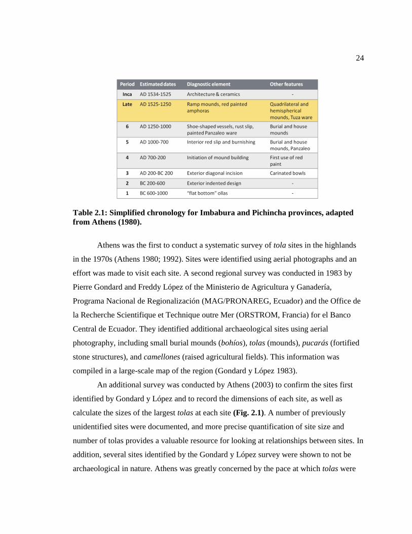
earliest period of occupation associated with ceramic manufacture. Linda Goff (1980)
further refined the Regional Developmental ceramic sequence, providing important
evidence for the simultaneous occupation of La Chimba and Socapamba. Her work
demonstrated an observable contrast between ceramics from the Regional Developmental
and Late Periods that supports change in cultural and political organization over time
(Table 2.1).
Excavation of the large, multiple-tola site of Cochasquí was conducted by Udo
Oberem, Albert Meyers and Wolfgang Wurster from 1969-1981. This site contains
multiple styles of tola, including at least one large ramped quadrilateral tola constructed
using cangahua (indurated volcanic tuff) blocks. Their excavations identified what are
now considered the representative ceramic styles for the Late Period, including red-on-
white painting and Panzaleo exotic ware. They also identified trough-like features,
burials, and house floor surfaces. Carbon-14 dates for mound E, the largest tola at the
site, dated the feature to AD 1450-1530, securing its age to the Late Period. Excavations
of smaller tolas, dated to about AD 900, revealed more burials and refuse related to
domestic activities, suggesting that the function of tolas changed over time. In contrast to
Athens, Oberem came to conclusion that tolas were important ceremonial centers and not
just used for the constructions of chiefly residences (1989).
24
Table 2.1: Simplified chronology for Imbabura and Pichincha provinces, adapted
from Athens (1980).
Athens was the first to conduct a systematic survey of tola sites in the highlands
in the 1970s (Athens 1980; 1992). Sites were identified using aerial photographs and an
effort was made to visit each site. A second regional survey was conducted in 1983 by
Pierre Gondard and Freddy López of the Ministerio de Agricultura y Ganadería,
Programa Nacional de Regionalización (MAG/PRONAREG, Ecuador) and the Office de
la Recherche Scientifique et Technique outre Mer (ORSTROM, Francia) for el Banco
Central de Ecuador. They identified additional archaeological sites using aerial
photography, including small burial mounds (bohíos), tolas (mounds), pucarás (fortified
stone structures), and camellones (raised agricultural fields). This information was
compiled in a large-scale map of the region (Gondard y López 1983).
An additional survey was conducted by Athens (2003) to confirm the sites first
identified by Gondard y López and to record the dimensions of each site, as well as
calculate the sizes of the largest tolas at each site (Fig. 2.1). A number of previously
unidentified sites were documented, and more precise quantification of site size and
number of tolas provides a valuable resource for looking at relationships between sites. In
addition, several sites identified by the Gondard y López survey were shown to not be
archaeological in nature. Athens was greatly concerned by the pace at which tolas were
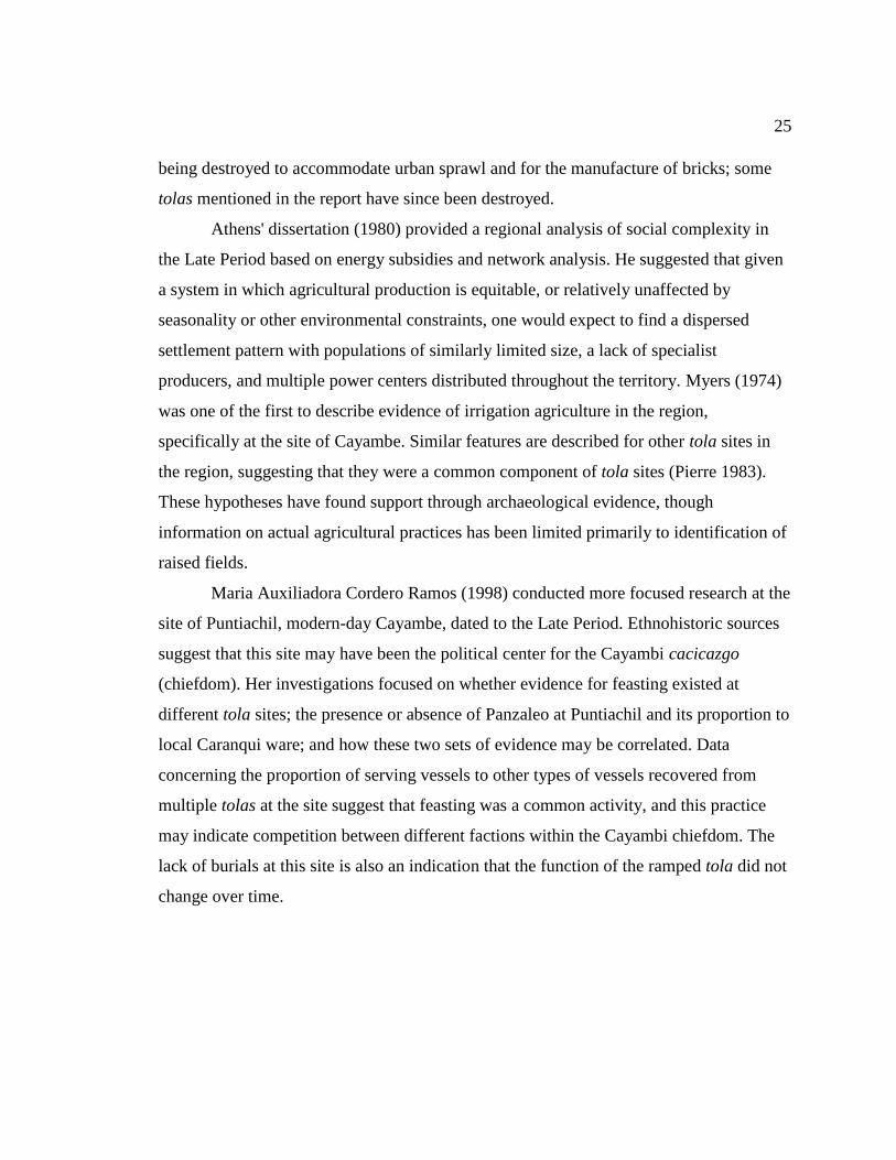
25
being destroyed to accommodate urban sprawl and for the manufacture of bricks; some
tolas mentioned in the report have since been destroyed.
Athens' dissertation (1980) provided a regional analysis of social complexity in
the Late Period based on energy subsidies and network analysis. He suggested that given
a system in which agricultural production is equitable, or relatively unaffected by
seasonality or other environmental constraints, one would expect to find a dispersed
settlement pattern with populations of similarly limited size, a lack of specialist
producers, and multiple power centers distributed throughout the territory. Myers (1974)
was one of the first to describe evidence of irrigation agriculture in the region,
specifically at the site of Cayambe. Similar features are described for other tola sites in
the region, suggesting that they were a common component of tola sites (Pierre 1983).
These hypotheses have found support through archaeological evidence, though
information on actual agricultural practices has been limited primarily to identification of
raised fields.
Maria Auxiliadora Cordero Ramos (1998) conducted more focused research at the
site of Puntiachil, modern-day Cayambe, dated to the Late Period. Ethnohistoric sources
suggest that this site may have been the political center for the Cayambi cacicazgo
(chiefdom). Her investigations focused on whether evidence for feasting existed at
different tola sites; the presence or absence of Panzaleo at Puntiachil and its proportion to
local Caranqui ware; and how these two sets of evidence may be correlated. Data
concerning the proportion of serving vessels to other types of vessels recovered from
multiple tolas at the site suggest that feasting was a common activity, and this practice
may indicate competition between different factions within the Cayambi chiefdom. The
lack of burials at this site is also an indication that the function of the ramped tola did not
change over time.
26
Figure 2.1: Locations of tola sites in the highland region of Northern Ecuador.
2.3. Archaeological Record
2.3.1. Tolas
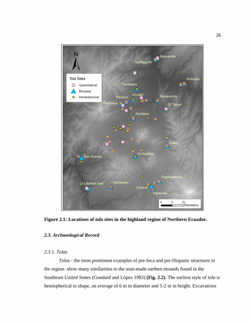
Tolas - the most prominent examples of pre-Inca and pre-Hispanic structures in
the region- show many similarities to the man-made earthen mounds found in the
Southeast United States (Gondard and López 1983) (Fig. 2.2). The earliest style of tola is
hemispherical in shape, an average of 6 m in diameter and 1-2 m in height. Excavations
27
show that they functioned as burial mounds (Athens and Osborn 1974). The earliest date
for this style of tola is AD 680, obtained from a charcoal lens from mound #18 at the site
of Socapamba (Athens 1980:133). Other hemispherical mounds are at least 30 m in
diameter and greater than 5 m in height and also served as burial mounds. The two styles
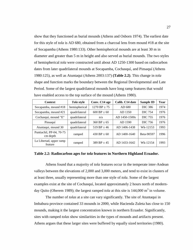
of hemispherical tola were constructed until about AD 1250-1300 based on radiocarbon
dates from later quadrilateral mounds at Socapamba, Cochasquí, and Pinsaquí (Athens
1980:125), as well as Atuntaqui (Athens 2003:137) (Table 2.2). This change in tola
shape and function marks the boundary between the Regional Developmental and Late
Period. Some of the largest quadrilateral mounds have long ramp features that would
have enabled access to the top surface of the mound (Athens 1980).
Context Tola style Conv. C14 age Calib. C14 date Sample ID Year
Socapamba, mound #18 hemispherical 1270 BP ± 75 AD 680 DIC 386 1974
Socapamba, mound #21 quadrilateral 600 BP ± 60 AD 1350 DIC 754 1976
Cochasquí, mound "E" quadrilateral n/a AD 1450-1500s DIC 755 1976
Pinsaquí quadrilateral 360 BP ± 65 AD 1590 DIC 756 1976
Atuntaqui, mound 30 quadrilateral 519 BP ± 46 AD 1406-1438 Wk-12153 1993
Puntiachil, PP-04, 70-75
cm depth ramped 430 BP ± 60 AD 1400-1640 Beta-90597 1996
La Libertad, upper ramp
feature ramped 389 BP ± 45 AD 1433-1642 Wk-12154 1993
Table 2.2: Radiocarbon ages for tola features in Northern Highland Ecuador.
Athens found that a majority of tola features occur in the temperate inter-Andean
valleys between the elevations of 2,000 and 3,000 meters, and tend to exist in clusters of
at least three, usually representing more than one style of tola. Some of the largest
examples exist at the site of Cochasquí, located approximately 2 hours north of modern-
day Quito (Oberem 1989); the largest ramped tola at this site is 144,000 m3 in volume.
The number of tolas at a site can vary significantly. The site of Atuntaqui in
Imbabura province contained 33 mounds in 2000, while Hacienda Zuleta has close to 150
mounds, making it the largest concentration known in northern Ecuador. Significantly,
sites with ramped tolas show similarities in the types of mounds and artifacts present.
Athens argues that these larger sites were buffered by equally sized territories (1980).
28
Figure 2.2: Ramped and non-ramped tolas at Cochasquí (source: procultur-
ecuador.blogspot.com 2011).
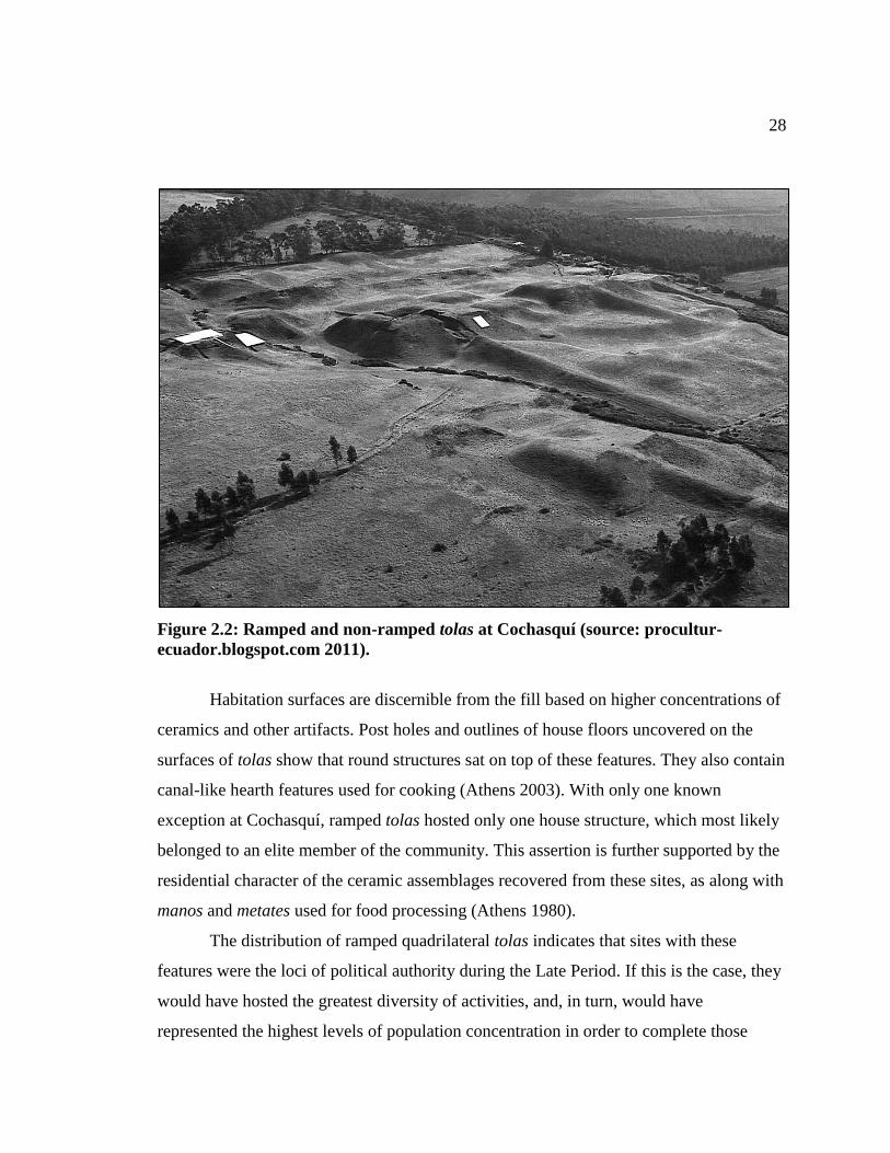
Habitation surfaces are discernible from the fill based on higher concentrations of
ceramics and other artifacts. Post holes and outlines of house floors uncovered on the
surfaces of tolas show that round structures sat on top of these features. They also contain
canal-like hearth features used for cooking (Athens 2003). With only one known
exception at Cochasquí, ramped tolas hosted only one house structure, which most likely
belonged to an elite member of the community. This assertion is further supported by the
residential character of the ceramic assemblages recovered from these sites, as along with
manos and metates used for food processing (Athens 1980).
The distribution of ramped quadrilateral tolas indicates that sites with these
features were the loci of political authority during the Late Period. If this is the case, they
would have hosted the greatest diversity of activities, and, in turn, would have
represented the highest levels of population concentration in order to complete those
29
activities (Athens 1980). The central planning of the ramped tolas at sites, their similar
techniques of construction and the similarity between the ceramic assemblages at
different tolas stand as proof that tolas of this style were built during the same period.
Radiocarbon dates also support this theory (Athens 1976).
2.3.2. Camellones
Ridge-and-furrow fields, or camellones, are another significant archaeological
feature of the highlands, and are often found in association with the ramped quadrilateral
mounds of the Late Period (Athens 1980; Bray 1991). Modern agricultural practices do
not utilize these features because the more productive marshy conditions that once
characterized the area were converted to pastureland by Spaniards (Bray 1991; Wilson et
al 2002). The width of the raised portion of the camellones is between 2.5 and 3.5 meters,
with a length of several meters. Based on analysis of stratigraphy within these features,
they were created by digging ditches and then using the excavated material to create the
raised agricultural beds (Wilson et al. 2002).
Redoximorphic features such as clay and Fe depletions, as well as gleyed soil
prove that the camellones were used to facilitate the movement of water (Wilson et al.
2002:269). They functioned by draining water from swampy regions and redistributing it
in order to regulate the surface temperature of the raised beds. Knapp and Ryder (1983)
conducted a series of planting experiments in ancient camellones near Quito, and found
that the system effectively prevented frost formation on important crops such as maize
and potatoes. This advantage would have enabled double-cropping as well, producing a
food base they propose could have supported 700 individuals per km2 (Knapp and Ryder
1983; Knapp 1991). The site of Puntiachil, east of present-day Quito, has approximately
1200 hectares of visible camellones, which likely would have been necessary to support
this important population center (Bray 1991).
The scale of these features would have also required a large labor investment for
their construction and maintenance. Micromorphological analysis of several camellones
at the site of Zuleta shows that ash from the eruption of Quilotoa in AD 1280 was cleared

30
from the features before it became incorporated into the soil (Wilson et al 2002: 277). A
profile of site 4 at Zuleta shows that the original trough of the camellón had filled with
material and experienced three phases of clearing (Wilson et al. 2002:277). Similar
maintenance activities were observed on camellón features at Puntiachil (Myers 1974),
supporting the interpretation that they played an important role in agricultural production.
2.3.3. Pucarás
Pucarás, or fortified hilltop sites, have been described in both the highland and
coastal regions of Ecuador and Peru and are attributed to the Cayambe people who
attempted to hold off the Inca advance around AD 1500 (Bray 2008). They were
successful for about 9 years, but were eventually defeated by the Inca. Sites of this type
are concentrated in the Pambamarca complex in northern Ecuador. They are all similar in
size and lack evidence of residential structures, indicating that they were intended as
short-duration defensive locations. The uniformity of their construction may reflect
standardized construction (Bray 1990). More recent investigations by Samuel Connell
and Chad Gifford on pucarás (2002-present) have investigated the possibility that that
these locations were used by both the local population and the Inca. These structures and
their associated bola throwing stones and obsidian weapons are the only archaeological
indications of armed conflict in the region (Ogburn et al 2009).
2.3.4. The Built Environment and Social Status
Structures and earthworks, such as tolas, camellones, and pucarás, are important
subjects of archaeological investigation because they modify the landscape in ways that
influence the development of social institutions. Earle describes three attributes of the
built landscape that makes these structures significant to the population: scale, exposure,
and permanence (2001). By building an architectural feature larger than the typical
household or communal structure, a chief makes an overt statement about his social
standing and economic wealth. Earle refers to this strategy as the scale aspect of the built
environment. Construction not only confers prestige, but it also allows the social,

31
political, and economic power of the elite to be experienced by a large group of people
simultaneously. Individuals' daily experience of working around structures and their
general visibility explains the concept of exposure. Finally, structures built from stone,
earth, and clay have a physical permanence that suggests that the power of the elite
transcends time, with the same structures, the physical representations of the power of the
chiefly office, remaining part of the landscape for multiple generations (Earle 2001). The
prominence of these structures within the landscape helps legitimize the social hierarchy
and encourage its maintenance over time.
While the built environment works to increase the prominence of the elite, it can
also enforce cultural norms and expected behaviors (Earle 2001). Ritual and sacred
behavior performed on elevated platforms and earthworks physically situate these
activities above the mundane tasks of everyday life, bringing attention and prestige to
those behaviors. Individuals who are not directly involved with the ritual activities that
take place at these sites remain witnesses to feasting and other socially persuasive acts
intentionally put on display to encourage involvement by the community.
In summary, archaeological investigation of the northern highlands has revealed
several important elements of the political system in place during the Late Period. Tolas
are evidence of concentrated political and communal power. Ceramic assemblages that
include forms used for food preparation, as well as ornamental service forms, indicate
that feasting activities took place at tola mounds. Not only did tolas require the labor
input of many individuals, but they served as venues utilized by all members of society,
acting to socially unify the immediate area. The implication of local leaders mobilizing
labor, coupled with burial data pointing to social stratification, strongly supports the
ethnohistoric description of chiefdoms in the area.
Interpretations of the nature of political authority, as practiced by chiefs during
the Late Period, are tied to questions about the amount of contact and exchange occurring
between these groups. On the one hand, similarity in style of the local Caranqui ceramic
ware supports the cultural unity of settlements within the highland region (Bray 1991).
However, it is unknown whether local ceramics or other goods were exchanged within

32
the highlands between chiefdoms and their associated villages. Similarly, circulation of
exotic goods from regions outside of the highlands shows that trading relationships
existed between distance settlements. At the same time, it is not clear that similar
relationships existed within the highlands, and whether they operated at the local or
regional scale.
2.4. Interpretations of Regional Organization
As described by Bray (2008), scholars of Ecuadorian prehistory have differed in
their interpretations of regional political organization during the Pre-Inca period.
Espinosa (1983), Larraín-Barros (1980) and Caillavet (1981) have argued for the
preeminence of the Caranqui, Otavalo, Cayambe, or Cochasquí chiefdoms (Bray 2008),
suggesting the beginning of a regional hierarchy, perhaps along the line of a paramount
chieftaincy. An alternative model describes each of the chiefdoms as semi-autonomous
(Bray 2008), with the largest sites reflecting population size rather than higher levels of
political authority. A review of the arguments for each side of the debate provides a
useful framework for interpreting the results of settlement pattern analysis, presented in
the next chapter.
2.4.1. Nested Regional Hierarchy
Some ethnohistoric records refer to four major polities present at the time of
Spanish conquest: Cochasquí, Caranqui, Otavalo, and Cayambe (Athens 1980:148). The
recognition of these sites as separate political entities is suggestive of a factional system.
Caranqui and Otavalo are in fact only a few kilometers apart, while Cochasquí and
Cayambe both occur in separate parts of the southern region. Interestingly, Socapamba is
absent from this list despite its strategic position at the northernmost edge of the
Guayllabamba Basin. Based on the ethnographic information, hostilities existed between
these different polities, but the fact that there are few references to actual warfare
suggests that the hostilities may have been more political.
33
Conversely, the Caranqui and Cayambi were the dominant chiefdoms in the
region based on several lines of evidence, as outlined by Probanza de Puento (1974).
First, Otavalo and Cochisqui (presumably Cochasquí) were ancient subjects of Cayambe
during the Inca wars. Second, many other smaller llaktas were subjects of Cayambe.
Third, Caranqui was not a subject of Cayambe, making it more powerful than other
llaktas, but weaker than Cayambe, because it had no subjects of its own. Finally, the two
chiefdoms were linked by a shared kin network (Puente 1974:28-48). Larraín-Barros also
described the Caranqui and the Cayambi as the two prominent cacicazgos of the region
(1980). The Cayambi cacique Nasacoto Puento was responsible for organizing a local
resistance force against the Inca invasion in the early 1520s, which has led some to
believe that this chiefdom was regionally dominant. The Caranqui pueblo is an example
of the Inca of strategy of conquering areas around the most powerful settlement in the
area as a way to undermine the local power structure (Bray 2008), suggesting that
Caranqui had local political significance.
Bray describes the territory occupied by both the Caranqui and Cayambi
chiefdoms as the Caranqui polity, which she describes as a non-state entity. This term is
somewhat confusing as it has alternately been called the País Caranqui and the Cara
region. Nevertheless, archaeological and toponymic evidence supports a model of a
territory extending from the Chota-Mira River in the north to the Guayllabamba River in
the south (Bray 2008).
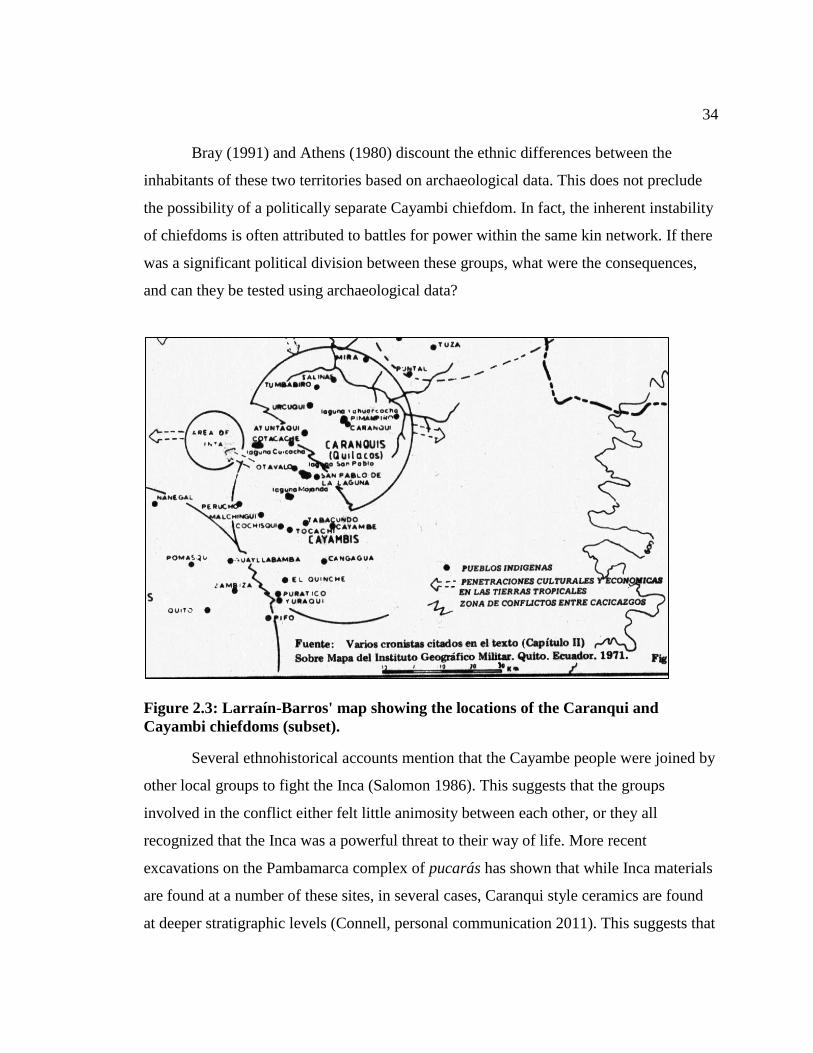
Using information from various chroniclers working for the Spanish crown,
Larrain-Barros created a map separating the Caranquis from the Cayambis (Fig. 2.3). In
his division, the Caranquis inhabited the northern section of the País Caranqui, with
Atuntaqui, Cotacache, and Laguna San Pablo on the southwestern border. The Cayambis
inhabited the southern section of the territory, with the southern boundary near modern-
day Pifo, extending a few kilometers west of the Guayllabamba River (Larraín-Barros
1980:99). Cordero Ramos also describes the cacicazgo Cayambi as a separate entity from
the cacicazgo Caranqui, with the modern town of Cayambe (ancient pueblo of Puntiachil)
as its capital.
34
Bray (1991) and Athens (1980) discount the ethnic differences between the
inhabitants of these two territories based on archaeological data. This does not preclude
the possibility of a politically separate Cayambi chiefdom. In fact, the inherent instability
of chiefdoms is often attributed to battles for power within the same kin network. If there
was a significant political division between these groups, what were the consequences,
and can they be tested using archaeological data?
Figure 2.3: Larraín-Barros' map showing the locations of the Caranqui and
Cayambi chiefdoms (subset).
Several ethnohistorical accounts mention that the Cayambe people were joined by
other local groups to fight the Inca (Salomon 1986). This suggests that the groups
involved in the conflict either felt little animosity between each other, or they all
recognized that the Inca was a powerful threat to their way of life. More recent
excavations on the Pambamarca complex of pucarás has shown that while Inca materials
are found at a number of these sites, in several cases, Caranqui style ceramics are found
at deeper stratigraphic levels (Connell, personal communication 2011). This suggests that
35
the features were utilized by both the Inca and Cara peoples during different periods, with
the possibility that some of the structures were constructed by the local population and
then used by the conquering Inca.
2.4.2. Isolated Chiefdoms
Ethnohistoric records of the interactions between the chiefdoms around the Quito
area also make references to warfare between settlements. Athens provides a translation
of one such description:
"They brought war upon one another about the land they possessed, and the more
powerful Indian displaced the other of all he possessed; and these controversies
they always had with their neighbors, of a manner that all was anarchy" (Paz
Ponce de León [1582] in Athens 1980:198).
Conflict between neighboring groups is indicative of a lack of regional-scale political
organization. However, because the degree and scale of conflict is not clear, only limited
interpretations about political organization can be made from this information.
2.5. Linking Arguments and Expectations
In spite of the emerging picture of Northern Highland chiefdoms, several basic
questions remain unanswered concerning the political and economic organization of these
pre-Inca chiefly societies. Specifically, what was the degree and scale of interaction
between these groups?
To understand the relationships between settlements within a chiefdom political
organization, it is necessary to characterize the scale at which the system operated. The
most effective way to make this determination is to evaluate the amount of interaction
occurring between settlements in close proximity to each other, and to contrast that with
the interactions observed for settlements the greatest distance apart within the same
system.
36
A geographic comparison of relative site sizes and locations is an effective means
of determining if all settlements are of a similar size and contain similar numbers, sizes,
and types of tola features. Obvious differences in the sizes of sites and their components
are suggestive of a regional political organization, as opposed to a more localized and
isolated political system in the first scenario. Larger, more complex sites may occur in
geographically strategic locations or enjoy better access to significant natural, cultural, or
labor resources (King 1986).
Information about the movement of ceramic products between neighboring sites
also clarifies the degree of hostility between political units, as successful trade depends
on relatively stable relationships between groups. A generalized pattern of exchange
between ramped tola sites would suggest amicable relationships, while a general
preference for the local production of ceramic vessels would suggest that interactions
were restricted to the local level, and political organization at the regional scale was
limited.
Based on the ethnohistoric data, there is little reason to believe that the entire
Guayllabamba Basin was controlled by the same regional political system. Factional
competition existed between several settlements and descriptions of the Cayambi and
Caranqui chiefdoms identify a regional division between the north and the south. The
expectation is that there will be any area between clusters of more northern and more
southern clusters of sites in which no sites are recorded. This would express a political
buffer zone between the two chiefdoms as a reflection of hostile relations.
There is also an expectation for settlement hierarchy within the northern or
southern zones. In other words, at least one site in the north and one in the south will
stand out as being the largest or having the greatest number of tolas (or both). If a
subregional hierarchy does not exist, it would suggest that sites were highly isolated
politically, and the term "chiefdom" was not meant to refer to a unified political system in
the literature.
The expectation is that the chemical data for ceramics from the study area will
follow a similar pattern of separation between the more northern and more southern
37
settlements. One would expect to see a limited number of ceramic composition groups
that occur in both the north and the south. If specific sites in either region stand out as
larger, one would expect more ceramic composition groups to be represented at these
sites because larger territories had greater access to resources and political power (Earle
1987).
Chapter 3 discusses the concepts of settlement pattern analysis and how they were
applied to Late Period ramped tola sites as a way to determine the distribution of chiefly
political power. This chapter also explores the evidence for an against an integrated
political system organized at the regional scale, including settlements from Imbabura and
Pichincha provinces.