Chapter 16 Road Sector Development Plan 16.1 Road ...
171
Nicaragua National Transportation Plan Final Report 16-1 Chapter 16 Road Sector Development Plan 16.1 Road Network Improvement Plan 16.1.1 Introduction As mentioned in Chapter 13.5, the main policies of the transport sector in the National Transport Plan is to develop a transport network system to support economic growth, assist social activities so as to decrease regional disparities, and to develop infrastructure resilient to the impact of climate change. This chapter discusses the various measures to realize the policies established. 16.1.2 Planning Methodology Figure 16.1.1 illustrates the planning process of the road network development plan. The development projects or the candidate projects that will contribute in improving the existing road network will be selected by integrating the projects that are being implemented or are on the course of planning by MTI with the proposed improvement works to improve the present road network. Figure 16.1.1 Planning Process of Road Network Development Plan Source: JICA Study Team 16.1.3 Present Road Network Although, the total road network in Nicaragua totals to 23,647km, only the basic road network under the jurisdiction of MTI, which totals to approximately 8,517 km (trunk road and collector road) will be targeted for road network development plan. 16.1.4 Integration of On-going and Planned Projects On-going projects and planned projects for fiscal year 2014-2016 were identified and those that needed to be included in the NTP were selected. Currently, there are some projects that are on-going. There are some more that has been planned for implementation in MTI’s investment plan for 2014-2016. The lists of these projects are provided in chapter 8. Where the on-going projects are mostly related to renovation of existing roads, many of the planned projects are yet to find a financial resource for commencement of construction work. Therefore, these projects, with an Present Road Network Proposed Improvement Works On-going and Planned Projects Planning Concept Proposed Road Network Development Projects (Candidate Projects)
-
Upload
khangminh22 -
Category
Documents
-
view
4 -
download
0
Transcript of Chapter 16 Road Sector Development Plan 16.1 Road ...

Nicaragua National Transportation Plan Final Report
16-1
Chapter 16 Road Sector Development Plan
16.1 Road Network Improvement Plan
16.1.1 Introduction
As mentioned in Chapter 13.5, the main policies of the transport sector in the National Transport
Plan is to develop a transport network system to support economic growth, assist social activities
so as to decrease regional disparities, and to develop infrastructure resilient to the impact of climate
change.
This chapter discusses the various measures to realize the policies established.
16.1.2 Planning Methodology
Figure 16.1.1 illustrates the planning process of the road network development plan. The
development projects or the candidate projects that will contribute in improving the existing road
network will be selected by integrating the projects that are being implemented or are on the course
of planning by MTI with the proposed improvement works to improve the present road network.
Figure 16.1.1 Planning Process of Road Network Development Plan Source: JICA Study Team
16.1.3 Present Road Network
Although, the total road network in Nicaragua totals to 23,647km, only the basic road network
under the jurisdiction of MTI, which totals to approximately 8,517 km (trunk road and collector
road) will be targeted for road network development plan.
16.1.4 Integration of On-going and Planned Projects
On-going projects and planned projects for fiscal year 2014-2016 were identified and those that
needed to be included in the NTP were selected. Currently, there are some projects that are
on-going. There are some more that has been planned for implementation in MTI’s investment plan
for 2014-2016. The lists of these projects are provided in chapter 8. Where the on-going projects
are mostly related to renovation of existing roads, many of the planned projects are yet to find a
financial resource for commencement of construction work. Therefore, these projects, with an
Present Road Network
Proposed Improvement Works
On-going and Planned Projects Planning Concept
Proposed Road Network
Development Projects
(Candidate Projects)

Nicaragua National Transportation Plan Final Report
16-2
exception to the three projects mentioned below, have been included in the improvement works in
the NTP. The three projects hereunder are on-going and are expected to be completed shortly. The
first two projects are related to new construction. However, these roads are planned in the NTP to
be upgraded to a higher class from its present class as mentioned in the succeeding section. The
third project is rehabilitation of NIC-21A from El Pajero to Muy Muy.
i) NIC-71 (Nueva Guinea to Bluefields)
ii) Nueva Esperanza to El Tortuguero
iii) NIC-21A (El Paraíso to Muy Muy)
16.1.5 Planning Concept
Figure 16.1.2 illustrates the
basic concept of the
improvement works for
realizing the road sector
development strategies
mentioned in the previous
chapter.
Concept ‘A’ targets enhancing
intermodal connectivity and
multimodal transport systems
by strengthening the principal
corridors that would minimize
the travel time between the
Atlantic side and Pacific Side
international class ports.
Concept ‘B’ targets
improvement of the existing
roads in high potential
productive area to reduce the
vehicle operation cost and
enhance the industrial
activities.
Concept ‘C’ aims to provide reasonable access to strengthen communications and regional
activities of communities in the eastern side of the country that currently have no accessible roads.
Concept ’D’ aims to establish road network resilient to natural disasters to minimize adverse effect
on life of people and economy due to damages to infrastructure induced by natural disasters.
The basic directions followed in planning the improvement works are as follows:
i) Utilization of existing roads to the possible extent
ii) Enhancement of Functional and hierarchical road network
iii) Securing safe and stable road and structures
iv) Maintaining service level
v) Guide future land use
16.1.5.1 Functions and Characteristics of Roads and Design Standard
Nicaragua applies SIECA Standards, which is complemented by the American standards
recommended by AASHTO. Although the SIECA standard is based on AASHTO, certain criteria
are seen to vary from by AASHTO recommendations, mainly because of modifications undertaken
to adapt to the regional conditions. One such example is the standards for widths (lanes, shoulders,
sidewalks). It not only differs from the recommended values of AASHTO, but also do not
correspond to the functional classification.
Figure 16.1.2 Planning Concept
Source: JICA Study Team
B
C
C
D
A
A
D

Nicaragua National Transportation Plan Final Report
16-3
Therefore, the study recommends application of AASHTO’s standard for planning the roads. The
proposed functions, characteristics and major design criteria are recommended as shown in Table
16.1.1. The cross sections to be applied for each class are shown in Figure 16.1.3 and Figure 16.1.4,
which is followed by brief explanation of each cross section elements.
Table 16.1.1 Proposed Functions, Characteristics and Design Standard
Class
Item
ARTERIALS COLLECTORS
Local Roads Main Trunk Secondary Trunk Main Collectors
Secondary
Collectors
Function Important road network for Central American Region and connect departmental capitals and economical centers with populations over 50,000 people.
Important road network for Nicaragua at a National Level and connect departmental capitals, important economic centers as well as provide access to border posts and connect primary arterials
Important road network for Nicaragua at a regional level, Connect with one or more departmental capitals with population over 10,000 people, connect urban areas not covered by arterials and connect secondary arterials.
Important road network for Nicaragua at a regional level, connect regions or municipalities to the national road network, connect regions or municipalities with more than 5,000 population to the national road network
Important road network for Nicaragua at a municipality level and Lies under MTI jurisdictions but do not meet the requirements of upper category roads
Correspondence to SIECA classification
Central American Road
Mesoamerican Highway
Primary National Road
Secondary National Road
Tertiary National Road
Municipality Road
Traffic Flow AADT
(vehicles per day)
1000 or more ⋜500<1000 approximately 500 50 or more 50 or less
Design Traffic by lane (ADT)
(Unit: thousand)
17 – 18 (International
Corridors) 10 – 12 for others
10 – 12 10 – 12
(9 in case of 2-lane) 10 – 12
(9 in case of 2-lane)
Design Speed (km/h)
100, 80, 60 80, 60, 50 60, 50, 40 50,40,30 40, 30, 20
Target Speed (km/h)
60 40 30 20 20
Right of Way (m)
40m 40m 40m 20m 20m
Level of Service
B B C,D C,D D
Lane Width (m) 3.6 3.6 3.3 3.0 3.0
Median Width (m) Urban only
6.0 -10.0 2.0 – 9.0 3.0 – 4.8 3.0 – 4.8 None
Shoulder (m) 0.6 - 2.5 0.6 - 1.8 0.6 – 1.5 0.3 - 1.2 0.5
Sidewalk (m) Urban only
2.0 – 4.5 2.0 – 4.5 2.0 – 3.5 If required If required
Note 1: Service Level B: Reasonably free flow, C:Stable flow D:Approaching unstable flow
Note 2: Number of lane is decided based on future traffic demand forecast
Source: Red Vial Nicaragua 2011, MTI and AASHTO

Nicaragua National Transportation Plan Final Report
16-4
Fig
ure
16.1
.3 P
rop
ose
d S
tan
dard
Cro
ss S
ecti
on
for
Main
Tru
nk
Ro
ad
(U
rba
n A
rea
) S
ou
rce:
JIC
A S
tud
y T
eam

Nicaragua National Transportation Plan Final Report
16-5
Figure 16.1.4 Proposed Standard Cross Section for Each Functional Claffication Source: JICA Study Team

Nicaragua National Transportation Plan Final Report
16-6
(1) Pavement Type
Pavement type selection is a management decision process. The successful application of the
pavement-type selection process requires a multidisciplinary approach and needs to take into
account various factors such as construction cost (initial and life cycle cost), design life, traffic type,
traffic volume, functional classification, ambient climate condition etc. Roads in Nicaragua have
either asphalt, concrete, adoquín, or gravel pavement. The main trunk roads and most of the
secondary trunk roads and collector roads in the western side of the country basically have asphalt
pavement. Concrete pavement is observed in the eastern part of the country.
The improvement works proposed in the NTP assumes application of asphalt pavement. In general,
the study team recommends asphalt concrete on all roads, particularly the trunk roads. Generally
asphalt pavement has advantages from the point of view of initial investment cost, repair,
maintenance, splitting and cracking, and driving formability compared with hydraulic concrete.
Application of concrete pavement or adoquín can be considered on collector roads, especially in
the eastern side of the country where traffic volume is less and the materials are locally available
and it does not require high level technology or heavy special equipment to construct. It also
generates employment opportunities for the community. However, it should be noted that the
pavement type and structure should be determined based on the actual requirements of the site.
(2) Drainage facilities
The major reason for deterioration of road condition is improper drainage system. Adequate
drainage facilities are recommended to be provided in all roads in the urban area and along the
following segments of a rural road.
lowest section of a sag curve,
where the longitudinal grade (profile) exceeds 3 percent,
a cut section (rain from the road side in-flows to the road),
creek or streams, and
swampy area, rivers or watershed area,
(3) Road Ancillary facilities
To endorse safety and smooth operation of traffics, provision of road ancillary facilities is
important and these facilities should comply with the standards of the country. Recommendation
for provision on the roads proposed is discussed hereunder.
1) Guardrails
The major locations where guardrails are recommended to be installed are;
along the outer side of a sharp (acute) curve ,
along the valley side or over the stretch where the vertical height of an embankment exceeds
3 meters
in front of large sized side open ditch
at the approach of a bridge
2) Traffic Signs
Traffic signs are an essential part of supplementary facilities and an effective means of achieving
safety and efficiency of a road, as it supplements the physical layout of a road by informing,
pre-warning and controlling the drivers. In general, there are three types of traffic signs;
Regulatory signs; indicate legal requirements of traffic movement
Warning signs; indicate conditions that may be hazardous to road users
Guiding/informatory signs; convey information or guidance to the driver
All types of road signs are recommended to be provided on the roads proposed for new
construction.

Nicaragua National Transportation Plan Final Report
16-7
3) Road Marking
Like road signs, all roads proposed for new construction are recommended to be marked either for
the purpose to supplement the traffic signs or serve independently to indicate certain regulations or
hazardous conditions.
There are three general types of road marking: pavement marking, object markers, and road studs.
Pavement markings: Centerlines, lane lines, side/edge lines, and no overtaking lines are
recommended. For nighttime visibility, small glass beads are recommended to be mixed with
paint or thermoplastic before applying to the road, given that the road has an asphalt
pavement.
Object Markers: physical obstructions in or near carriageway that are not removable or
removable is impractical are recommended to be adequately marked by painting or highly
visible material.
Road Studs: Hybrid marking consisting of both reflective road markings and reflective studs
can be useful for night time driving in unlit areas. Use of these studs is recommended for
roads in urban area and rural areas where the roads have asphalt pavement.
4) Street Lightning
Street lightning improves the safety of a road. General statistics worldwide indicate that the
nighttime accident rate is higher than during daylight hours, which may be attributed to impaired
visibility. Therefore, it is effective to provide lights along the roads where there are plenty of
pedestrians and at critical points where in the past repeated accidents have occurred. Also, lightning
is recommended to be provided along the proposed bypasses and peripheral road.
(4) Standards for Planning of Bridges
MTI uses a Terms of Reference (TOR) during the contract out of the design work. In general, it
allows the consultant to follow a standard, usually SIECA or the American (LFRD), as far as the
output meets the requirements stipulated in the TOR.
The TOR of MTI usually stipulates applying the recently updated requirements of the AASHTO
LFRD Hydraulic Design Series Number 5 from FHWA standards, which takes into consideration
in the design to moderate possible seismic forces. Not having the standards in MTI, the planning
division does not have full knowledge of the design work and is quite dependent upon the
consultants. Therefore, it is recommended that the following standards, manual and specifications
be designated as the official standards of MTI for the design purpose of bridges and culverts, and
capacity enhancement of the concerned personals be conducted through technical cooperation.
STANDARDS
AASHTO LRFD Bridge Design Specifications, 4th Ed., 2007
AASHTO Standard Specifications for Highway Bridges, 17th Ed., 2002
REFERENCES
Specifications for Highway Bridges, Japan Road Association, 2002
Specification for River Facilities, Japan River Association, 1998
16.1.6 Proposed Improvement Works
The proposed improvement works for solving the issues of the existing road network consist of the
following works;
i) Development of new roads,
ii) Improvement of existing roads,
iii) Rehabilitation of existing roads,
iv) Surface improvement of other roads
v) Provision of new bridges
vi) Measures against road disasters

Nicaragua National Transportation Plan Final Report
16-8
Improvement and rehabilitation works are defined in this development works based on the practice
in Nicaragua as follows:
Improvement:
Improvement is defined as the works conducted without any changes or modifications of the
original centerline of the existing road. This covers works like widening, partial and temporal
maintenance of road surface and reconstruction. Reconstruction here means works undertaken to
reconstruct the entire pavement structure of a segment, for example from gravel pavement to
asphalt pavement.
Rehabilitation:
It is undertaking of major improvement works where the initial centerline of the existing road and
other elements maybe modified to meet the required design criteria as in the case of upgrading an
existing road to a higher class and essentially consists of re-pavement, widening, and modification
of geometric requirements.
16.1.6.1 Development of New Roads
Fourteen (14) roads have been proposed in various parts of the country, much of which is
concentrated in the eastern region. Location of these roads is shown in Figure 16.1.5. These roads
are expected to form an integral part of the existing road network and contribute in achieving the
long term development visions of the National Transport Plan.
Figure 16.1.5 Locations and Outline of Newly Proposed Roads Source: JICA Study Team

Nicaragua National Transportation Plan Final Report
16-9
The proposed roads total to an approximate length of 793.4 km, which comprises 81.1 km of main
trunk road, 284.5km of main collectors and 427.8km of secondary collectors. The proposed roads
can be divided into four categories based on its functions. Brief explanation including objective,
description and outcomes of each category is as follows.
(1) Bypasses
1) Objective
To provide a short cut avoiding the built-up area, which would allow through traffic flow without
interference from local traffic, as well as reduce congestion in the urban area and improve road
safety.
2) Description
At present, international traffics travelling
along the Pacific Corridor and those calling
and leaving the existing port Corinto run
through built-up areas such as Leon and
Chinandega, causing traffic congestion and
adverse environmental impacts at these cities.
In order to improve such condition, two
bypasses as shown in Figure 16.1.6 are
proposed. Bypass-1 consists of R_NR13,
NIC-22 and NIC-16. R_NR13 is a newly
proposed road, to be raised of category to main
trunk which is approximately 15.5 km long and
links main trunk road NIC-12A with NIC-22. It
starts at El Empalme Puerto Sandino on
NIC-12A and ends at La Paz Centro at the
intersection of NIC-28 and NIC-22.
NIC-22 and NIC-16 are collector roads and needs to be improved and upgraded to main trunk roads
in order to function as a bypass.
Bypass-2 on the other hand is a new road approximately 33km long and connects the existing port
town Corinto with national highways NIC-12A and NIC-26 at the intersection of these two roads at
Telica.
Both the bypasses are designated as an international corridor and are proposed to be classified into
the main trunk road. These roads will have 4-lanes, based on the results of the traffic demand
forecast, and the cross section for main trunk rural type shown in Figure 16.1.3 will apply.
Pavement type is proposed to be asphalt pavement, which is similar to the existing pavement type.
3) Outcome
Reduction of travel time (Figure 16.1.7).
Time required to travel from Empalme
Puerto Sandino to Villa 15 de Julio thru
bypass-1 (Route-B) compared to
existing route (Route-A) is reduced by
7% or more.
Time required to travel from Corinto to
Telica thru bypass-2 (Route-D)
compared to existing route (Route-C) is
reduced by 31% or more.
Mitigation of traffic congestion at Leon
and Chinandega
Improvement of environment at Leon
and Chinandega
Figure 16.1.6 Proposed Bypasses
Source: JICA Study Team
Figure 16.1.7 Reduction of Travel Time
Source: JICA Study Team

Nicaragua National Transportation Plan Final Report
16-10
(2) Peripheral Road
1) Objective
To provide a road to decongest and improve the traffic flow of the existing main trunk roads by
diverting traffics whose trips do not originate from or end in the center of Managua City.
2) Description
An enlarged map showing the proposed peripheral road is illustrated in Figure 16.1.8. Having an
approximate length of 32.6 km, the road will connect national highway NIC-12A with national
highway NIC-01 at the east of the airport. The alignment of the road runs in the east-west direction
in the suburbs, avoiding high residential areas at the south of Managua City. It will cross with
NIC-02 and NIC-04 at about a 10km radial distance from the center of Managua. As this road
connects two major trunk roads, the peripheral road is also proposed to be classified as a major
trunk road and will have four-lanes as necessitates by the traffic demand forecast. However, it may
be constructed to have 2-lanes in the initial stage. An urban 2-lanes or 4-lanes, as shown in Figure
16.1.3, are recommended to be applied as the standard cross section.
Figure 16.1.8 Proposed Peripheral Road
Source: JICA Study Team
3) Outcome
Reduction of travel time (Figure 16.1.9)
Time required to travel from Nandaime
(NIC-2) to San Benito (NIC-1) thru
peripheral road (Route-B) compared to
the existing route (Route-A) is reduced by
25%
The road will allow traffics on
north-south corridors (NIC-1, NIC-2, and
NIC-4) to swiftly travel to east-west
direction without having to enter the
capital city of Managua.
It will contribute in mitigating traffic
congestion and improving environment of
Managua and the abutting area.
Figure 16.1.9 Comparison of Travel Time
Source: JICA Study Team

Nicaragua National Transportation Plan Final Report
16-11
(3) Redundant Road
1) Objective
To provide a road that would function as a redundant road (back up road) of the Northern Corridor,
which is the only current road connecting to the north-east region, so as to enhance access to the
region during natural calamities.
2) Description
NIC-21B, the only road linking Puerto
Cabezas, a port town where the existing
domestic port is currently undergoing
development works for upgrading, is a
secondary trunk road designated as the
Northern Corridor. This corridor is
expected to play a vital role in transporting
freight after completion of the port
upgrading work. As such, it is not only a
strategically important road but also a
life-line of the people of the abutting
communities. However, this road is
extremely vulnerable to natural disasters
and is often impassable. Roads R_NR11
and R_NR12 are proposed as alternative
roads for NIC-21B. The former road, which is approximately 53.5km long connects Siuna with
Bonanza and is functionally classified as main collector. The latter road is an extension of the
former road connecting Bonanza with NN-73 at Point C (La Tronquera) and is approximately
72.1km long. It is functionally classified into secondary collector.
3) Outcome
The roads can function as alternative (backup) roads of NIC-21B during disaster period.
The roads can function as a bypass connecting Siuna with Point ‘C’ to reduce the travel time
from Point ‘C’ to Siuna by 26% in comparison to the existing route (NN-73 – NIC-21B).
This can function as feeder roads in future for local roads connecting communities along
River Coco.
(4) Other Roads (Missing Links)
1) Objective
To provide new roads to link communities in the eastern part of the country where there are either
no proper access or are only accessible by water transport currently.
2) Description
Ten (10) new roads as indicated by R_NR1 to R_NR10 in Figure 16.1.11 are proposed. The total
length of these roads is approximately 633km. R_NR3, R_NR5, and R_NR9 are functionally
classified into main collectors while others are classified into second collectors. All these roads are
planned to have 2-lanes and the cross section shown in Figure 16.1.4 is proposed. At this stage,
asphalt pavement has been chosen for these roads. However, it is recommended that the pavement
type to be applied should be determined during the design stage taking into consideration various
factors such as the initial and life-cycle cost, construction efficiency, characteristic of the roads and
subgrades, available material etc. as application of concrete pavement or Adoquin might prove
advantageous in terms of climate, available material and technology, job opportunities of the
communities.
Figure 16.1.10 Proposed Alternative Road Source: JICA Study Team
NIC-21B
NN-73
LEGEND Secondary Trunk Main Collector
Secondary Collector

Nicaragua National Transportation Plan Final Report
16-12
Figure 16.1.11 Other Proposed Roads (Missing Links)
Source: JICA Study Team
3) Outcome
27 communities, mostly in the Atlantic side that had no proper road access will be
accessible.
Road network that will strengthen links between the east and the west side will be
strengthened.
Road network that will strengthen links between the north and south side of the country in
the eastern region will be strengthened.
16.1.6.2 Improvement of Existing Roads
(1) Widening
1) Objective
To provide additional lanes on the existing roads for mitigating traffic congestion and improve
environment of abutting areas.
2) Description
Figure 16.1.12 shows the volume-capacity ratio (VCR) of the existing roads. The left figure (a)
shows the present condition, while the right figure (b) shows the VCR in 2033 without
implementation of improvement works. The red line indicates the segments where the traffic
volume has exceeded the capacity (VCR>1.5) of the roads. The figure in the left shows that a

Nicaragua National Transportation Plan Final Report
16-13
segment along NIC-1 and NIC-4 is already experiencing occasional congestion while the figure in
the right side shows that the congestion will spread to NIC-2, NIC-12A and NIC-28 including the
ones already mentioned above, if remedial works are not undertaken.
(a) VCR of Existing Roads (2013) (b) VCR of Existing Roads (2033)
(without improvement works) Figure 16.1.12 Volume Capacity Ratio of Existing Roads
Source: JICA Study Team
In order to mitigate the congestion, the roads
highlighted in Figure 16.1.13 are proposed for
widening. On NIC-4, the segment between Jean
Paul Genie Road and Masaya, which is approx.
19.6 km long, is proposed to be widened to 6-lanes
from its present 4-lanes. On the other hand, NIC-1,
NIC-2, NIC-12A and NIC28) are proposed to be
widened to 4-lanes from its present 2-lanes and the
total length accounts to approximately 388.2 km.
The cross section for rural main trunk as shown in
Figure 16.1.4 is proposed. All the segments are
proposed to be provided with asphalt pavement.
3) Outcome
Secure smooth traffic flow and mitigation of
traffic congestion
Improve environment of suburban and urban
areas
(2) Reconstruction of Existing Roads
1) Objective
To reconstruct existing road segments with pavement in significantly deteriorated condition.
2) Description
As mentioned in Chapter 8, a significant segment of secondary trunk roads and collector roads are
in deteriorated condition causing abrupt drop of average vehicle speed, significant reduction of
level of service and increase of riding discomfort. Also it is in such a state that the vehicles
travelling these roads might even suffer damage to their tires, axles, springs and chassis and
furthermore, increase the vehicle operation costs and the number of serious accidents.
To remedy the situation, these roads need to be reconstructed. The existing pavement of the
damaged sections needs to be demolished, removed and repaved by reposing the road base. The
segments of the roads that need to be repaved are indicated by green lines in Figure 16.1.14. These
roads have been selected from the importance of role they play in supporting the economic
activities of the highly potential productive areas. The segments consist of secondary trunk roads
Figure 16.1.13 Segments for Widening
Source: JICA Study Team
NIC-2
Mateare
Tipitap
a
Masaya
Rotonda JPG
Cuidad Sandino
San Benito
San Isidro
Nandaim
e
Jinotepe
Rivas
NIC-4
NIC-12A
Chinandega
Leon
NIC-1
NIC-28
NIC-2
NIC-1
NIC-4
NIC-1
NIC-4
NIC-2
NIC-12A
NIC-28

Nicaragua National Transportation Plan Final Report
16-14
and main collectors.
NIC-9, NIC-12B and
NIC21B are secondary
trunk roads and totals to
an approximate length of
437.5 km. All other roads
are main collector and are
approximately 388.2 km
long. Application of
asphalt pavement is
proposed for all roads.
However, the pavement
type particularly for main
collector roads is
recommended to be
reconsidered during the
design stage based on the
actual requirements of the
site.
3) Outcome
Puerto Cabezas,
which is
approximately 515
km away from
Managua, will be
reachable in 8.5
hours; approximately 5 hours faster than now (reduction of travel time by about 40%)
Reduce vehicle operation cost and contribute in enhancing industrial/agricultural activities
Increase riding comfort and reduce serious accidents
16.1.6.3 Rehabilitation of Existing Roads
(1) Objective
To rehabilitate existing roads to satisfy the design criteria necessitated by upgrading the functional
classification
(2) Description
Figure 16.1.15 shows the segments of the existing roads that are proposed for rehabilitation.
Figure 16.1.14 Segments of Existing Roads Proposed for
Reconstruction Source: JICA Study Team
Timber
Livestock
Dairy products
Coffee, Cacao,
Basic grains
Hydro
energy
Tourism
Tourism
Fish,
shrimp
lobster
Fish,
shrimp
lobster
Gold
mines
Hydro
energy
Sugarcane
R_IC1
NIC21B
R_IC3
R_IC2
R_IC4
R_IC5
R_IC8 R_IC7
R_IC11
R_IC12
R_IC13
R_IC14
R_IC15
R_IC16
R_IC10
R_IC9
R_IC6

Nicaragua National Transportation Plan Final Report
16-15
Figure 16.1.15 Proposed Roads for Rehabilitation
Source: JICA Study Team
Rehabilitation consists of upgrading of functional classification, improvement of alignments,
carriageway widening, reconstruction of pavement, and other necessary ancillary works. Outline of
upgrading with respect to each classification is summarized in Table 16.1.2.
Table 16.1.2 Outline of Proposed Roads for Rehabilitation
Codes
Upgrading
Road Class Reason
Total
Length
(km)
Remarks
From To
R_IR S.T M.T International corridor
Segment 130.0
Only re-classification (No improvement
work required)
R_IR9, R_IR10 S.C M.T International corridor
(Bypass) 70.4
Cross section shown in Figure 16.1.4
(2-lane rural trunk road) to be applied
R_IR1, R_IR2,
R_IR8, R_IR13 M.C S.T
Connects with trunk road at
both ends 348.9
R_IR2-1,R_IR8
-1, R_IR12 S.C S.T
Connects to international port
or to secondary trunk road 293.4
R_IR4, R_IR6,
R_IR7,R_IR11 S.C M.C
Connects with higher tier of
roads 220.7
Cross section shown in Figure 16.1.4
(2-lane main collector) to be applied
R_IR3, R_IR5 Local S.C Connects with main collector
at either end 156.0
Cross section shown in Figure 16.1.4
(2-lane secondary collector to be
applied
Source: JICA Study Team
At this stage, asphalt pavement type is proposed for all roads. However, reconsideration for
application of different pavement type, especially on collector roads is recommended during design
stage, based on the actual requirements for each road.
(3) Outcome
Improves hierarchical system of basic road network
Contributes in strengthening the transport corridors
Upgrading of R_IR8 and R_IR8-1 will provide an alternate road (redundant road) for
NIC-21B to function during natural disaster
R_IR
R_IR2-1
Widening
New
Nicaragua National Transportation Plan Final Report
16-16
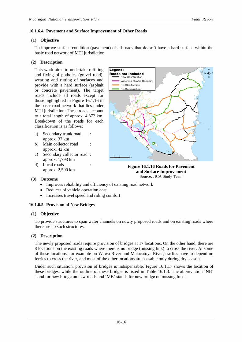
16.1.6.4 Pavement and Surface Improvement of Other Roads
(1) Objective
To improve surface condition (pavement) of all roads that doesn’t have a hard surface within the
basic road network of MTI jurisdiction.
(2) Description
This work aims to undertake refilling
and fixing of potholes (gravel road),
wearing and rutting of surfaces and
provide with a hard surface (asphalt
or concrete pavement). The target
roads include all roads except for
those highlighted in Figure 16.1.16 in
the basic road network that lies under
MTI jurisdiction. These roads account
to a total length of approx. 4,372 km.
Breakdown of the roads for each
classification is as follows:
a) Secondary trunk road :
approx. 37 km
b) Main collector road :
approx. 42 km
c) Secondary collector road :
approx. 1,793 km
d) Local roads :
approx. 2,500 km
(3) Outcome
Improves reliability and efficiency of existing road network
Reduces of vehicle operation cost
Increases travel speed and riding comfort
16.1.6.5 Provision of New Bridges
(1) Objective
To provide structures to span water channels on newly proposed roads and on existing roads where
there are no such structures.
(2) Description
The newly proposed roads require provision of bridges at 17 locations. On the other hand, there are
8 locations on the existing roads where there is no bridge (missing link) to cross the river. At some
of these locations, for example on Wawa River and Malacatoya River, traffics have to depend on
ferries to cross the river, and most of the other locations are passable only during dry season.
Under such situation, provision of bridges is indispensable. Figure 16.1.17 shows the location of
these bridges, while the outline of these bridges is listed in Table 16.1.3. The abbreviation ‘NB’
stand for new bridge on new roads and ‘MB’ stands for new bridge on missing links.
Figure 16.1.16 Roads for Pavement
and Surface Improvement Source: JICA Study Team
Legend:
Roads not included

Nicaragua National Transportation Plan Final Report
16-17
Figure 16.1.17 Location of New Bridges
Source: JICA Study Team
(3) Outcome
Elimination of missing links and improvement of connectivity of the roads
Table 16.1.3 Outline of Newly Proposed Bridges
Code Bridge or
River Name Location
(Dept) Road Name
(Class)
Proposed
Type/Width (m) Length
(m)
R_NB1 Mahogany River R.A.A.S New (R3)
(M.C) 3-span(15+20+15)
RC T Girder, w=10.0m 50
R_NB2 El Rama River R.A.A.S New (R3)
(M.C) 4-span(4 x 50m)
PC Box Girder, w=10.0m 200
R_NB3 Nawawas River R.A.A.S NN-23B (R4)
(M.C) 3-span(3x20)
RC T Girder, w=10.0m 60
R_NB4 Waspado River R.A.A.S NN-23B (R5)
(M.C) 2-span(2x20)
RC T Girder, w=10.0m 40
R_NB5 Kurinwas River R.A.A.S NN-129 (R5)
(M.C) 3-span(15+20+15)
RC T Girder, w=10.0m 50
R_NB6 Grande de Matagalpa-1 R.A.A.S NN-129 (R5)
(M.C) 2-span(2 x 17.5)
RC T Girder, w=10.0m 35
R_NB7 Grande de Matagalpa-2 R.A.A.S NIC-13 (R6)
(S.C) 3-span(25+25+25)
PC I Girder, w=9.0m 75
R_NB8 Makantaka (Rio Grande) R.A.A.S NIC-39 (R9)
(M.C) 3-span(3x50)
PC Box Girder, w=10.0m 150
R_NB9 Kuanwatla R.A.A.N New (R8) 2-span(2x15) 30

Nicaragua National Transportation Plan Final Report
16-18
Code Bridge or
River Name Location
(Dept) Road Name
(Class)
Proposed
Type/Width (m) Length
(m) (S.C) RC T Girder, w=9.0m
R_NB10 Alamikamba (Rio Prinzapolka)
R.A.A.N New (R9)
(M.C) 4-span(4x30)
PC I Girder, w=10.0m 120
R_NB11 Frio River Rio S. juan
New (R2) (S.C)
3-span(20+20+20) RC T Girder, w=9.0m
60
R_NB12 Zapote River Rio S. juan
New (R2) (S.C)
3-span(20+20+20) RC T Girder, w=9.0m
60
R_NB13 Guacalito River Rio S. juan
New (R2) (S.C)
2-span(2x20) RC T Girder, w-9.0m
40
R_NB14 Colon Rio S. juan
New (R2) (S.C)
2-span(2x20) RC T Girder, w=9.0m
40
R_NB15 Brito River Rivas New (R1)
(S.C) 1-span
PC I Girder, w=9.0m 35
R_NB16 El Tular River Carazo New(R10)
(S.C) 1-span
PC I Girder, w=9.0m 30
R_NB17 Tecolapa River Carazo New (R10)
(S.C) 1-span
PC I Girder, w=9.0m 32
BM1 Puente El Tamarindo Leon NIC-70 A
(MC) 4-span(4 x 25)
PC I Girder, w=10.0m 100
BM2 Puente Baguas Boaco NIC-31 (S.C)
2-span(2 x 18.5) RC T Girder, w=9.0m
37
BM3 Puente Wawa Boom R.A.A.N NIC-21B
(S.T) 5-span(5x31)
PC I Girder, w=10.8m 155
BM4 Puente Malacatoya River Granada NIC-39 (M.C)
3-span(3 x 25) PC I Girder, w=10.0m
75
BM5 El Paso de Panaloya Granada NIC-39 (M.C)
6-span (6 x 50) PC Box Girder, w=10.0m
300
BM6 Puente Tecolostote #2 (El Papayal)
Boaco NIC-39 (M.C)
4-span(4 x 25) PC I Girder, w=10.0m
100
BM7 Wiwili Nueva
Segovia NIC-43&NIC-51
(S.C) 5-span (5 x 50)
PC Box Girder, w=9.0m 250
BM8 Puente Rio Abajo Esteli NN-8 (M.C)
2-span(2 x 20) RC T Girder, w=10.0m
40
Source: JICA Study Team
16.1.6.6 Replacement of Damaged and Temporary Bridges
(1) Objective
To replace bridges on the existing roads those are structurally weak.
(2) Description
As identified in Chapter 8.2, many crossings on rivers are provided by temporary bridges such as
warren truss or those that are currently in a damaged state caused by past disasters. Scouring at
piers and abutment is also prominent at many locations. These bridges are very vulnerable not only
against natural disasters but also in normal time due to its weak structural condition.
Countermeasures to avoid these bridges from falling down or being washed away needs immediate
attention. The locations of these bridges are shown in Figure 16.1.18 and the outline is summarized
in Table 16.1.4 and Table 16.1.5.

Nicaragua National Transportation Plan Final Report
16-19
Figure 16.1.18 Location of Damaged and Temporary Bridges
Source: JICA Study Team
Table 16.1.4 Outline of Temporary Bridges to be Replaced
Code Bridge or
River Name Location
(Dept)
Road Name (Class)
Proposed
Type/Width (m) Length
(m)
R_BT1 Puente San Judas Nueva
Segovia NN-19 (M.C)
1-span PC I Girder, w=10.0m 25
R_BT2 Puente Santa Rosa Del Penon Leon
NIC-35C (S.C)
3-span(2x15.5+20) RC T Girder, w=9.0m 51
R_BT3 Puente La Potranca R.A.A.N NIC-21B
(S.T) 2-span(2x20)
RC T Girder, w=10.8m 40
R_BT4 Puente Sunsin No.2 R.A.A.N NIC-21B (S.T)
2-span(2x18.5) RC T Girder, w=10.8m
37
R_BT5 Puente Rio Luku R.A.A.N NIC-21B
(S.T) 2-span(2 x 16.5)
RC T Girder, w=10.8m 31
R_BT6 Puente Rio Labu R.A.A.N NIC-21B
(S.T) 3-span(3 x 30)
PC I Girder, w=10.8m 90
R_BT7 Puente Pasle Matagalpa NN-129 (M.C)
2-span(2 x 17.5) RC T Girder, w=10.8m 35
R_BT8 Puente Rio El Cua (La Maroanosa) Jinotega
NIC-43 (S.C)
3-span(3 x 25) PC I Girder, w=10.0m 75
Source: JICA Study Team
Puente La Tonga (2013)
Legend Damaged Bridge
Temporary Bridge

Nicaragua National Transportation Plan Final Report
16-20
Table 16.1.5 Outline of Damaged Bridges to be Replaced
Code Bridge or
River Name Location
(Dept) Road Name
(Class)
Proposed
Type/Width (m) Length
(m)
R_BD1 Puente Wani R.A.A.N NIC-5
(S.C to S.T) 3-span(3x47)
PC Box Girder, w=10.8m 141
R_BD2 Puente El Tuma (Mulukuku)
R.A.A.S NIC-21B (S.T)
5-span(3x40+55) PC I Girder, Steel Truss,
w=10.8m 175
R_BD3 Puente Prinzapolka R.A.A.N NIC-21B
(S.T) 3-span(3x31)
PC I Girder, w=10.8m 93
R_BD4 Puente Banacruz R.A.A.N NIC-21B
(S.T) 2-span (2*22.5)
RC T Girder, w=10.8 45
R_BD5 Puente Paso Real (Esteli) Estelí
NIC-3 (S.C to S.T)
3-span (3*25) PC Box Girder, w=10.8m 75
R_BD6 Puente Rio Zinica R.A.A.N NIC-5
(S.C to S.T) 2-span (2*20.5)
RC T Girder, w=10.8m 41
R_BD7 Puente San Pablo R.A.A.N NIC-5
(S.C to S.T) 2-span (2*18)
RC T Girder, w=10.8m 36
R_BD8 Puente La Esperanza
R.A.A.S NIC-7 (M,T)
6-span (2*17+4x50) RC T Girder and PC Box
Girder, w=10.8m 234
R_BD9 Puente Cuisala Chontales NIC-7 (M,T)
1-span PC Box Girder, w=10.8m
50
R_BD10 Puente Rosa Grande R.A.A.N
NIC-5 (S.C to S.T)
3-span (2*14+20) RC T Girder, w=10.8m 48
Source: JICA Study Team
(3) Outcome
Improve connectivity of road network
Realize reliable structure against disasters
16.1.6.7 Road Disaster Prevention Plan
(1) General
Road disasters in Nicaragua are generally caused by two phenomena; hurricanes (floods, heavy
rainfall) and earthquakes. The common disasters triggered by these phenomena are, but not limited
to;
Slope failure
Rock Fall
Landslide
Debris flow
Collapse of bridge and scouring of bridge pier and foundation
(2) Selection of Countermeasures for each Type of Road Disasters
Selection of countermeasure depends on the type of road disaster to be treated. Wrong selection can
result into application of ineffective uneconomic measures. A simple method of selecting suitable
countermeasures in relation to the types of road disasters where they are aptly applicable is
summarized in Table 16.1.6.

Nicaragua National Transportation Plan Final Report
16-21
Table 16.1.6 Applicable Countermeasures in Relation to Type of Road Disasters Road Disaster Countermeasures
Cut Slope Failure
Embankment Slope Failure
Fall Landslide Debris Flow
Drainage work Surface drainage ✓ ✓ ✓ ✓
Sub-surface drainage ✓ ✓ ✓
Protection work Vegetation ✓ ✓ ✓ ✓
Spraying ✓ ✓
Pitching ✓ ✓ ✓
Crib ✓ ✓ ✓
Earthwork Removal ✓ ✓
Recutting ✓ ✓
Re-filling ✓
Earth Removal ✓
Counterweight ✓
Structural work Retaining
wall
Stone ✓ ✓
Gravity ✓ ✓ ✓
Supporte
d
✓ ✓
Gabion ✓ ✓ ✓
Anchoring ✓ ✓
Foot protection ✓
Piling
Fixing work Supporting ✓
Anchoring ✓
Catch work ✓ ✓
Rock fall prevention work ✓
Hillside work ✓
Torrent work ✓
Sabo work ✓
Avoidanc
e
Route relocation ✓ ✓
Bridge ✓ ✓
Source: JICA Study Team
16.1.6.8 Proposed Development Projects
The projects that can be proposed from among the improvement works identified in the previous
section can be divided into road and bridge related projects. Projects related to roads are
summarized in Table 16.1.7 under the following categories.
i) New road construction (Road network improvement)
ii) Road improvement (Capacity enhancement)
iii) Improvement/upgrading road class
iv) Improvement/rehabilitation
Similarly, the projects related to bridge are summarized under the following categories.
i) Newly proposed bridges on new proposed roads
ii) Newly proposed bridges existing roads (Missing link)
iii) Replacement of temporary or damaged bridges
iv) Repairing of temporary or damaged bridges

Nicaragua National Transportation Plan Final Report
16-22
Table 16.1.7 Proposed Road Projects (1/2)
Road
Class
No. of
Lanes
Length
(km)
7663.892
New Roads 793.4 874.88
R_PR1 Chiquilistagua(NIC-12) - San Benito(NIC-1) M.T(Urban) 4 32.6 183.119 SR-2, SR-4
R_NR1 San Juan del Sur - El Coyol S.C 2 22.5 17.63 SR-2
R_NR2 Cardenas - Santa Fé S.C 2 102.0 75.934 SR-2
R_NR3 El Rama - Las Brenas M.C 2 36.0 42.306 SR-1, SR-2, SR-3
R_NR4 El Ayote - El Tortuguero S.C 2 82.7 70.167 SR-3
R_NR5 El Tortuguero - La Cruz De Río Grande M.C 2 32.0 26.348 SR-3
R_NR6 San Pedro del Norte - La Cruz De Río Grande S.C 2 76.5 60.628 SR-3
R_NR7 Makantaka - Karawala S.C 2 72.1 49.15 SR-3
R_NR8 Point B (Marinlaya Creek) - Prinzapolka S.C 2 47.0 32.112 SR-3
R_NR9 La Cruz de Río Grande - Alamikamba M.C 2 62.5 51.516 SR-3
R_NR10 La Trinidad - Masachapa S.C 2 25.0 22.611 SR-3
R_NR11 Siuna - Bonanza M.C 2 55.0 53.508 SR-3, SR-5
R_NR12 Bonanza - Point C (La Tronquera) M.C 2 99.0 72.134 SR-3, SR-5
R_NR13 Empalme Puerto Sandino - La Paz Centro M.T 4 15.5 40.677 SR-1, SR-2, SR-3
R_NR14 Empalme de Telica - Puerto Corinto M.T 4 33.0 77.04 SR-1, SR-2, SR-3
1127.9
R_IW1 NIC-2 Int. - Leon (NIC-12A) M.T 4 (2) 87.3 225.78 SR-1,SR-4
R_IW2 Leon - Chinandega (NIC-12A) M.T 4 (2) 57.4 158.07 SR-1,SR-4
R_IW3 C. Sandino - Mateare (NIC-28) M.T 4 (2) 17.8 46.55 SR-1,SR-4
R_IW4 NIC-12A Int. – Jinotepe (NIC-2) M.T 4 (2) 44.0 123.90 SR-1,SR-4
R_IW5 Jinotepe - Nandaime (NIC-2) M.T 4 (2) 36.5 84.38 SR-1,SR-4
R_IW6 Nandaime - Rivas (NIC-2) M.T 4 (2) 51.9 129.14 SR-1,SR-4
R_IW7 Jean Paul Genie Rd. - Masaya (NIC-4) M.T 6 (4) 19.6 116.27 SR-1,SR-4
R_IW8 Tipitapa – San Isidro (NIC-1) M.T 4 (2) 93.3 243.78 SR-1,SR-4
387.53
R_IC1 Boaco - Muy Muy (NIC-9) S.T 2 50.9 25.22 SR-3,SR-5
R_IC2 Muy Muy - Rio Blanco (NIC-21B) S.T 2 58.5 27.32 SR-3,SR-5
R_IC3 Rio Blanco - Puerto Cabezas (NIC-21B) S.T 2 315.7 158.42 SR-1,SR-2,SR-3,SR-5
R_IC4 Cosiguina - Potosi (NIC-12B) S.T 2 12.4 5.60 SR-1,SR-2,SR-3,SR-5
R_IC5 Telpaneca - Pueblo Nuevo (NIC-38&51) M.C 2 53.0 23.95 SR-2,SR-5
R_IC6 Cuyalli – San Rafael Del Norte (NIC-41) M.C 2 36.9 15.24 SR-3,SR-5
R_IC7 NIC-24B – Ville Las Pilas (NN-270) M.C 2 11.5 5.20 SR-3,SR-5
R_IC8 El Sauce – Guacucal (NIC-38) M.C 2 10.6 4.38 SR-3,SR-5
R_IC9 Santa Rosa – Camoapa (NIC-19B1) M.C 2 27.8 12.56 SR-2
R_IC10 La libertad – Santo Tomas (NIC-23A) M.C 2 22.9 10.35 SR-2
R_IC11 Esquipulas – La Concepcion (NIC-20B1) M.C 2 18.8 6.60 SR-2,SR-5
R_IC12 Masaya - Zambrano (NIC-27) M.C 2 25.0 11.63 SR-2,SR-4
R_IC13 El Rosaria – La Conquista (NIC-20C) M.C 2 13.5 5.58 SR-2
R_IC14 Boom Siril – Waspan (NN-73) M.C 2 115.0 51.97 SR-3,SR-5
R_IC15 Rivaz - Tola (NIC-62) M.C 2 13.2 5.45 SR-2,SR-5
R_IC16 Peripheral road Ometepe Island (NIC-64) M.C 2 40.0 18.08 SR-3,SR-5
Improvement (Widening of main trunk road for increasing capacity)
Improvement (Reconstruction of pavement, no widening)
Note: Numbers inside parenthesis is the initial number of lanes
M.T.:Main Trunk, S.T.: Secondary Trunk, M.C.:Main Collector, S.C.:Secondary Collector
CodeRoad Segment
(From - To)
ProposedCost
(million US$)
Remarks
(Supporting
Sytrategies)
Grand Total
Source: JICA Study Team

Nicaragua National Transportation Plan Final Report
16-23
Table 16.1.7 Proposed Road Projects (2/2)
Road
Class
No. of
Lanes
Length
(km)
1089.4 911.8
R_IR1 Granada - Tecolostote (NIC-39) M.C to S.T 2 54.3 47.80 SR-2, SR-4
R_IR2 La Gateada - Nueva Guinea (NIC-71) M.C to S.T 2 58.5 50.32 SR-1, SR-2
R_IR2-1 Nueva Guinea - Bluefields (NIC-71) S.C to S.T 2 77.2 68.42 SR-1, SR-2,SR-3
R_IR3 EI Rama - Kukra Hills - Laguna de Perlas Local to S.C 2 71.0 39.10 SR-2, SR-3
R_IR4 Santa Domingo - EI Ayote (NIC23B) S.C to M.C 2 53.0 31.57 SR-2, SR=3
R_IR5 Nueva Esparanza - EI Tortuguero Local to S.C 2 85.0 48.70 SR-2
R_IR6 Rio Blanco - San Pedro del Norte (NIC-13C) S.C to M.C 2 71.5 39.85 SR-2, SR-3
R_IR7 Empalme Almikamba - Alamikamba (NN-2) S.C to M.C 2 34.0 24.77 SR-3
R_IR8 EI Escudo - Empalme La Viola (Various) M.C to S.T 2 175.0 268.00 SR-1, SR-2, SR-3, SR-5
R_IR8-1 Empalme La Viola. - Siuna (NIC-21B) (NIC-57 54&5) S.C to S.T 2 175.0 Included SR-1, SR-2, SR-3, SR-5
R_IR9 Malpaisillo - Villa 15 de Julio (NIC68INN252) S.C to M.T 4 34.0 80.58 SR-1, SR-4
R_IR10 La Paz Centro - Malpaisillo (NIC-22) S.C to M.T 4 36.4 86.87 SR-1, SR-4
R_IR11 Empalme San Ramon - Matiguas (NIC-33) S.C to M.C 2 62.2 36.68 SR-2, SR-5
R_IR12 Pajaro Negro - EI Triunfo (NN-114) S.C to S.T 2 41.2 35.33 SR-1, SR-3
R_IR13 EI Empalme - San Jacinto (NIC-70A) M.C to S.T 2 61.1 53.85 SR-1, SR-2,SR-4
- 1824.40
R_IR 4,372 1824.40 All Strategies
2506.90
R_MR - 2506.90 All Strategies
30.50
R_DM - 30.50 SR-5
Improvement (Pavement program + local road improvement)
Maintenance work
(85.9 million US$ 1st year and increment of 1.3 million US$ per year)
Protection works against disasters
Note: Numbers inside parenthesis is the initial number of lanes
M.T.:Main Trunk, S.T.: Secondary Trunk, M.C.:Main Collector, S.C.:Secondary Collector
All roads without hard pavement in the basic network of 8,500 km that is not
included in the above list
Maintenance of entire basic network (8,500km+newly proposed road including
bridges)
Provision and replacement of culverts, provision of falling prevention device on
existing bridge, road slope protection scour protection at substructures
Remarks (Supporting
Sytrategies)
Cost
(million US$)
ProposedRoad Segment
(From - To)Code
�Rehabilitation (widening of existing, re-classification for satisfying)
Source: JICA Study Team

Nicaragua National Transportation Plan Final Report
16-24
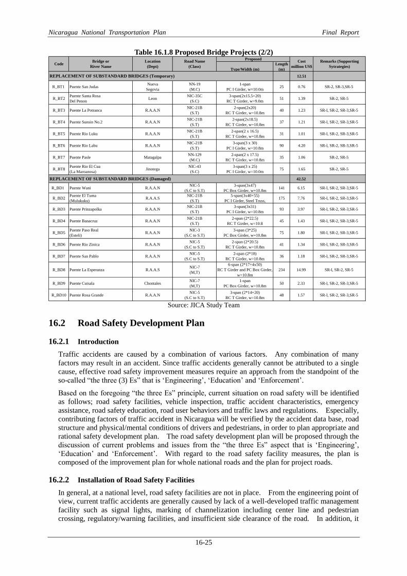
Table 16.1.8 Proposed Bridge Projects (1/2)
�
Type/Width (m)
Length
(m)
148.84
47.24
R_NB1 Mahogony River R.A.A.SNew (R3)
(M.C)
3-span(15+20+15)
RC T Girder, w=10.0m50 1.51 SR-1 , SR-2, SR-3
R_NB2 El Rama River R.A.A.SNew (R3)
(M.C)
4-span(4 x 50m)
PC Box Girder, w=10.0m200 12.04 SR-1 , SR-2, SR-3
R_NB3 Nawawas River R.A.A.SNN-23B (R4)
(M.C)
3-span(3x20)
RC T Girder, w=10.0m60 1.34 SR-3
R_NB4 Waspedo River R.A.A.SNN-23B (R5)
(M.C)
2-span(2x20)
RC T Girder, w=10.0m40 1.21 SR-3
R_NB5 Kurinwas River R.A.A.SNN-129 (R5)
(M.C)
3-span(15+20+15)
RC T Girder, w=10.0m50 1.51 SR-3
R_NB6 N/A R.A.A.SNN-129 (R5)
(M.C)
2-span(2 x 17.5)
RC T Girder, w=10.0m35 0.95 SR-3
R_NB7 Grande de Matagalpa R.A.A.SNIC-13 (R6)
(S.C)
3-span(25+25+25)
PC I Girder, w=9.0m75 1.65 SR-3
R_NB8 Makantaka (Rio Grande) R.A.A.SNIC-39 (R9)
(M.C)
3-span(3x50)
PC Box Girder, w=10.0m150 9.94 SR-3
R_NB9 Kuanwatla R.A.A.NNew (R8)
(S.C)
2-span(2x15)
RC T Girder, w=9.0m30 0.82 SR-3
R_NB10Alamikamba (Rio
Prinzapolka)R.A.A.N
New (R9)
(M.C)
4-span(4x30)
PC I Girder, w=10.0m120 8.81 SR-3
R_NB11 Frio River Rio S. juanNew (R2)
(S.C)
3-span(20+20+20)
RC T Girder, w=9.0m60 1.32 SR-3
R_NB12 Zapote River Rio S. juanNew (R2)
(S.C)
3-span(20+20+20)
RC T Girder, w=9.0m60 1.32 SR-3
R_NB13 Guacalito River Rio S. juanNew (R2)
(S.C)
2-span(2x20)
RC T Girder, w-9.0m40 1.09 SR-3
R_NB14 Colon Rio S. juanNew (R2)
(S.C)
2-span(2x20)
RC T Girder, w=9.0m40 1.09 SR-3
R_NB15 Brito River RivasNew (R1)
(S.C)
1-span
PC I Girder, w=9.0m35 0.95 SR-2, SR-3
R_NB16 El Tular River CarazoNew(R10)
(S.C)
1-span
PC I Girder, w=9.0m30 0.82 SR-2, SR-3
R_NB17 Tecolapa River CarazoNew (R10)
(S.C)
1-span
PC I Girder, w=9.0m32 0.87 SR-2, SR-3
46.57
BM 1 Puente El Tamarindo LeonNIC-70 A
(MC)
4-span(4 x 25)
PC I Girder, w=10.0m100 1.70 SR-2, SR-5
BM 2 Puente Baquas BoacoNIC-31
(S.C)
2-span(2 x 18.5)
RC T Girder, w=9.0m37 1.01 SR-2, SR-5
BM 3 Puente Wawa River R.A.A.NNIC-21B
(S.T)
5-span(5x31)
PC I Girder, w=10.8m155 6.33 SR-l , SR-2, SR-3,SR-5
BM 4 Puente Malacatoya River GranadaNIC-39
(M.C)
3-span(3 x 25)
PC I Girder, w=10.0m75 1.67 SR-2
BM 5 El Paso de Panaloya GranadaNIC-39
(M.C)
6-span (6 x 50)
PC Box Girder, w=10.0m300 18.06 SR-2
BM 6Puente Tecolostote #2
(El Papayal)Boaco
NIC-39
(M.C)
4-span(4 x 25)
PC I Girder, w=10.0m100 1.69 SR-l , SR-2
BM 7 WiwiliNueva
Segovia
NIC-43&NIC-51
(S.C)
5-span (5 x 50)
PC Box Girder, w=9.0m250 14.90 SR-2, SR-3
BM 8 Puente Rio Abajo EsteliNN-8
(M.C)
2-span(2 x 20)
RC T Girder, w=10.0m40 1.21 SR-2, SR-3
GRAND TOTAL
Remarks (Supporting
Sytrategies)
Bridge or
River Name
Location
(Dept)
Road Name
(Class)
ProposedCost
million US$
NEW BRIDGES (on proposed road)
NEW BRIDGES (to connect missing link)
Code
Source: JICA Study Team
Nicaragua National Transportation Plan Final Report
16-25
Table 16.1.8 Proposed Bridge Projects (2/2)
�
Type/Width (m)
Length
(m)
12.51
R_BT1 Puente San JudasNueva
Segovia
NN-19
(M.C)
1-span
PC I Girder, w=10.0m25 0.76 SR-2, SR-3,SR-5
R_BT2Puente Santa Rosa
Del PenonLeon
NIC-35C
(S.C)
3-span(2x15.5+20)
RC T Girder, w=9.0m51 1.39 SR-2, SR-5
R_BT3 Puente La Potranca R.A.A.NNIC-21B
(S.T)
2-span(2x20)
RC T Girder, w=10.8m40 1.23 SR-l, SR-2, SR-3,SR-5
R_BT4 Puente Sunsin No.2 R.A.A.NNIC-21B
(S.T)
2-span(2x18.5)
RC T Girder, w=10.8m37 1.21 SR-l, SR-2, SR-3,SR-5
R_BT5 Puente Rio Luku R.A.A.NNIC-21B
(S.T)
2-span(2 x 16.5)
RC T Girder, w=10.8m31 1.01 SR-l, SR-2, SR-3,SR-5
R_BT6 Puente Rio Labu R.A.A.NNIC-21B
(S.T)
3-span(3 x 30)
PC I Girder, w=10.8m90 4.20 SR-l, SR-2, SR-3,SR-5
R_BT7 Puente Pasle MatagalpaNN-129
(M.C)
2-span(2 x 17.5)
RC T Girder, w=10.8m35 1.06 SR-2, SR-5
R_BT8Puente Rio El Cua
(La Maroanosa)Jinotega
NIC-43
(S.C)
3-span(3 x 25)
PC I Girder, w=10.0m75 1.65 SR-2, SR-5
42.52
R_BD1 Puente Wani R.A.A.NNIC-5
(S.C to S.T)
3-span(3x47)
PC Box Girder, w=10.8m141 6.15 SR-l, SR-2, SR-3,SR-5
R_BD2Puente El Tuma
(Mulukuku)R.A.A.S
NIC-21B
(S.T)
5-span(3x40+55)
PC I Girder, Steel Truss,175 7.76 SR-l, SR-2, SR-3,SR-5
R_BD3 Puente Prinzapolka R.A.A.NNIC-21B
(S.T)
3-span(3x31)
PC I Girder, w=10.8m93 3.97 SR-l, SR-2, SR-3,SR-5
R_BD4 Puente Banacruz R.A.A.NNIC-21B
(S.T)
2-span (2*22.5)
RC T Girder, w=10.845 1.43 SR-l, SR-2, SR-3,SR-5
R_BD5Puente Paso Real
(Esteli)R.A.A.N
NIC-3
(S.C to S.T)
3-span (3*25)
PC Box Girder, w=10.8m75 1.80 SR-l, SR-2, SR-3,SR-5
R_BD6 Puente Rio Zinica R.A.A.NNIC-5
(S.C to S.T)
2-span (2*20.5)
RC T Girder, w=10.8m41 1.34 SR-l, SR-2, SR-3,SR-5
R_BD7 Puente San Pablo R.A.A.NNIC-5
(S.C to S.T)
2-span (2*18)
RC T Girder, w=10.8m36 1.18 SR-l, SR-2, SR-3,SR-5
R_BD8 Puente La Esperanza R.A.A.SNIC-7
(M,T)
6-span (2*17+4x50)
RC T Girder and PC Box Girder,
w=10.8m
234 14.99 SR-l, SR-2, SR-5
R_BD9 Puente Cuisala ChontalesNIC-7
(M,T)
1-span
PC Box Girder, w=10.8m50 2.33 SR-l, SR-2, SR-3,SR-5
R_BD10 Puente Rosa Grande R.A.A.NNIC-5
(S.C to S.T)
3-span (2*14+20)
RC T Girder, w=10.8m48 1.57 SR-l, SR-2, SR-3,SR-5
Remarks (Supporting
Sytrategies)
REPLACEMENT OF SUBSTANDARD BRIDGES (Temporary)
REPLACEMENT OF SUBSTANDARD BRIDGES (Damaged)
CodeBridge or
River Name
Location
(Dept)
Road Name
(Class)
ProposedCost
million US$
Source: JICA Study Team
16.2 Road Safety Development Plan
16.2.1 Introduction
Traffic accidents are caused by a combination of various factors. Any combination of many
factors may result in an accident. Since traffic accidents generally cannot be attributed to a single
cause, effective road safety improvement measures require an approach from the standpoint of the
so-called “the three (3) Es” that is ‘Engineering’, ‘Education’ and ‘Enforcement’.
Based on the foregoing “the three Es” principle, current situation on road safety will be identified
as follows; road safety facilities, vehicle inspection, traffic accident characteristics, emergency
assistance, road safety education, road user behaviors and traffic laws and regulations. Especially,
contributing factors of traffic accident in Nicaragua will be verified by the accident data base, road
structure and physical/mental conditions of drivers and pedestrians, in order to plan appropriate and
rational safety development plan. The road safety development plan will be proposed through the
discussion of current problems and issues from the “the three Es” aspect that is ‘Engineering’,
‘Education’ and ‘Enforcement’. With regard to the road safety facility measures, the plan is
composed of the improvement plan for whole national roads and the plan for project roads.
16.2.2 Installation of Road Safety Facilities
In general, at a national level, road safety facilities are not in place. From the engineering point of
view, current traffic accidents are generally caused by lack of a well-developed traffic management
facility such as signal lights, marking of channelization including center line and pedestrian
crossing, regulatory/warning facilities, and insufficient side clearance of the road. In addition, it

Nicaragua National Transportation Plan Final Report
16-26
is seen that the occurrence of traffic accidents around intersections, including merging/diverging
from the side roads is extremely high. In terms of driver and pedestrian behavior, it is observed
that drivers generally pay little attention to the pedestrians and hazardous locations along the
national roads. This attitude must be changed with pedestrian traffic considered as important as
vehicular traffic, through the provision of safe and convenient facilities and the according of
sufficient priority to pedestrians on roads. In order to understand the merits of road safety
facilities, it is necessary that the road safety facility should be installed in the correct place. The
typical hazardous locations (black Spots) are defined by the sections of small radius bend, long
straight, major intersection, in front of public building, entrance of town/village, entrance of bridge,
and animal crossings. The basic combination plan for the installation of road safety facilities at
typical hazardous locations is shown in Figure 16.2.1, and a typical combination plan of road safety
facilities is illustrated in Figure 16.2.1. It is highly recommended that the road safety facility at the
hazardous locations (black spots) will be installed based on the typical combination plan.
1. Small Radius Bend Section 2. Long Straight Section
3. Intersection
Road Post with Reflector
Rumble Strip
Road Marking of Overtaking Prohibition
Warning Sign of Left Bend
Rumble Strip
Regulatory Sign of Maximum Speed
Road Marking of Pedestrian Crossing
Warning Sign of Intersection Ahead
Warning Sign of Pedestrian Crossing
Road Marking of No overtaking & Direction
Regulatory Sign of Stop
Warning Sign of School
Warning Sign of Speed Down
Road Marking of Overtaking Prohibition
Rumble Strip
Road Marking of Pedestrian Crossing
5. Entrance of Town/Village 6. Entrance of Bridge Section
7. Animal Crossing Section 8. Zigzag/Falling Lock Section in Mountain
Rumble Strip
Warning Sign of Speed Down
Regulatory Sign of Maximum Weight
Guard Fence
Road Marking of Overtaking Prohibition
Warning Sign of Cattle Crossing
Road Marking of Overtaking Prohibition
Warning Sign of Zigzag Road
Warning Sign of Falling Lock
Guard Fence
Figure 16.2.1 Typical Combination Plan of Road Safety Facilities at the Hazardous Locations
Source: JICA Study Team

Nicaragua National Transportation Plan Final Report
16-27
16.2.3 Practical Realization and Enhancement for the Road Safety National Committee
At present, the road safety system has generally established involving key government agencies
such as Road Safety National Committee (hereinafter refer to as the “CONASEV”), MTI/local
governments, National Police and Ministry of Education. However, the present CONASEV is not
retained sufficient function. In order to implement a good coordination and management, via the
CONASEV, the CONASEV will be enhanced by the staff’s reinforcement and it function.
(1) Enhancement Plan of CONASEV Function
CONASEV office should be early break away from the National Traffic Safety Area (DSTN,
Dirección Seguridad de Transito Nacional in Spanish) a Secretariat, and the CONASEV should
hold an independent authority and will be enhanced by effective function and staffing. The
CONASEV should function as four (4) sections, in order to implement their duties of
administration, statistical data, training and education, and operation and management. The staff
for CONASEV will be seconded to the secretariat from member agencies such as the MTI,
National Police and etc. The organization and activities of the CONASEV are shown in Figure
16.2.2.
Figure 16.2.2 Proposed Organization and Activities of CONASEV Source: JICA Study Team
The CONASEV, as an advisor to the National Police, has the following functions:
a) Promote civil society participation in the problem of land traffic, particularly the safety of the population, road safety education and accident prevention.
b) Coordinate the actions of private organism carrying out activities related to education and road safety.
c) Propose and promote education provisions and actions for traffic and accident prevention to the National Police and Traffic Safety specialists.
d) In coordination with the Ministry of Transportation and Infrastructure, provide advice on the organization, planning and supervision of road safety education programs promoted by the Enforcement Authority of this Law.
e) Establish the necessary coordination with national and international organizations, with the aim of promoting mutual cooperation with the implementing authority of this Law in order to provide support in the implementation of road safety education and accident prevention projects and any other functions as stipulated by law.
(2) Formulation of 5-Year Action Road Safety Programs (5-Year RSAP)
The CONASEV has established National Road Safety Strategy (NRSS) 2005-2010 in order to
Executive Director:1 person
Administrative Section
Reporting vehicle/accident statistics, and publication
Analysis of accidents Making conclusions for
safety
Data Statistics Section
Training and Educational Section
Operating and Management Section
General affairs Accounting Others
Management of circulating /conducting for public education of regulations
Training public/private institutions
Training human resource
Operating and management of Road Safety Action Plan
Operating of annual schedule
Collection and arrangement of annual budget
Specialist: 1 person
Admin.: 1 person
Specialist: 1 person
Specialist: 1 person
Nicaragua National Transportation Plan Final Report
16-28
reduce road traffic accidents. However, as the result of the report (EVALUACIÓN DE LA
ESTRATEGIA NACIONAL DE SEGURIDAD VIAL 2005-2010, AGOSTO 2013) for the
assessment of road safety strategy, the report is mentioned that many results were not achieved. It
is necessary that the method and the strategy of the NRSS should be revised.
In response on the situation above, it was identified that the measures from “the 3 Es” aspect will
be established in accordance with a consistent policy of the target final goal and systematic
schedule. It is, therefore, recommended that the 5-Year RSAP should be revised as the 5-Year
National Road Safety Strategy for CONASEV. The overall RSAP is proposed as below:
1. Enforcement of National Road Safety Committee (CONASEV) for coordination and
management of road safety
2. Road accident data system
3. Road safety funding
4. Road safety audit-hazardous locations (Traffic Accident Monitoring System)
5. Road environment and road design
6. Road safety education for children
7. Law enforcement
8. Technical inspection
9. Drivers training
10. Emergency assistance to traffic victims
11. Road safety public campaign
12. Partnerships with private and non government organization
13. Road accident costing
14. Road safety research institution
(3) Objectives
The objective of traffic accident monitoring plan is to formulate the accident monitoring system by
introducing five functions of database system, analysis system, planning system, implementation
system, and follow-up system, for target groups of road planners and engineers and National
Police.
(4) Formulation of Traffic Accident Monitoring Plan by Target Group
The target group for the traffic accident monitoring plan (hereinafter refer to as the “TAMS) will be
divided to two (2) groups; a) road planners and engineers for relevant government agencies such as
CONASEV, MTI, MECD, AMUNIC, MINSA and etc., and b) National Police such as researcher
and statistics specialist for traffic accidents. The traffic accident monitoring plan focuses on the
introduction of technical method for traffic accident measures. The traffic accident monitoring
plan (TAMS) consists of the following five (5) functions (see Figure 16.2.3):
Investigation and database system: study of accident statistics, and investigation of user’s
behavior;
Analysis on hazardous locations and confirmation of problems: examination of accident
records, collection of relevant materials, field investigation, extraction of accident pattern
frequently, and presumption of accident causes;
Planning of measures: selection of measures corresponding to presumed causes, examination
of applicability on measures, clarification of effects and side effects of measures, and
examination of combination on measures;
Implementation of countermeasures: cost estimation for measures, examination of finance,
consultation with agencies concerned, explanation to residents, decision on sequence of
implementation, and implementation, and
Follow-up system: measurement of effect of countermeasures, comparison before and after,
campaign of traffic safety education, and strengthen of traffic enforcement by traffic police

Nicaragua National Transportation Plan Final Report
16-29
• Study of accident statistics
• Investigation of user’s behavior
• Examination of accident records
• Collection of relevant materials
• Field investigation
• Extraction of accident pattern frequently
• Presumption of accident causes
• Selection of measures corresponding to presumed causes
• Examination of applicability on measures
• Clarification of effects and side effects of measures
• Examination of combination on measures
• Cost estimation for measures
• Examination of finance
• Consultation with agencies concerned
• Explanation to residents
• Decision on sequence of implementation
• Implementation
• Measurement of effect of countermeasures
• Comparison before and after
• Campaign of traffic safety education
• Strengthen of traffic enforcement by traffic police
5. Follow-Up
1. Investigations and Database System
2. Analysis on Hazardous Locations and Confirmation of Problems
3. Planning of Measures
4. Implementation of Measures
Figure 16.2.3 Procedure of Key Works for TAMS
Source: JICA Study Team
(5) Traffic Accident Database System
1) Coded Items for the Accident-Recording Sheet
Information for any one accident should be contained in a single accident report form, and should
be designed so that it can be used directly for computer data entry. Current coded items of
accident-recording sheets in Nicaragua are insufficient for assessment of road safety. The
information related to collision type and location details should be revised, in order to analyze
hazardous locations (black spots) and confirmation of problems. The type of collision and road
conditions should be described in more detail.
The following coded items by category will be proposed in the formulation of accident-recording
Nicaragua National Transportation Plan Final Report
16-30
sheet as shown in Table 16.2.1.
Table 16.2.1 Coded Items by Category for Accident-Recording Sheet Category Major Items
1. Registration of report Police station/report No./officer name/date. 2. Date of accident DD/MM/YY 3. Time of accident H/M 4. Severity of accident (4 items) Fatal injury/serious injury/slight injury/damage only 5. Place of accident (4 items) Street name/administrative zone/detailed location (distance from
landmark)/GPS coordinates (in middle term) 6. Weather conditions (4 items) Clear/cloudy/foggy/rain. 7. Road type (18 items) Straight/roundabout/curve/X-junction/T-junction/Y-junction/bridge/
slope National road//km No./major road in city/minor road in city/local road/other Paved/unpaved/construction site/unknown
8. Cause of accident (36 items)
Human error: speed/failure to respect traffic rights/failure to respect/ right of way/driving against flow of traffic/failure to respect traffic signs/ dangerous over taking/using mobile phone/wrong use of high beam/alcohol abuse/drug abuse/careless lane change/fatigue or illness/other Road condition: potholes/dirt/sand/gravel/dust/animal on the road/ object on the road/other Weather condition: Rain/cloudy/mist/wet road/other Vehicle defeat: brake failure/tire blow out/steering wheel failure/ headlight failure/load falling off/other
9. Collision type (12 items) Head-on/rear end/right-angle/side swipe/overturned/fell alone (for two wheelers)/hit object on the road/hit object off the road/ hit parked vehicle/hit pedestrian/hit animal/other
10. Hit and run Yes/No 11. Vehicle involved (10 items) Bus/minibus/microbus/trailer/truck/pickup/car/motorcycle/ mototaxi
(Caponera)/other 12. Movement condition (10 items) Going straight ahead/right turn/left-turn/U-turn/overtaking/
reversing/sudden start/sudden stop/parking/other 13. Violation (9 items) Excess speed/driving against traffic flow/failure to respect right of
way/failure to respect necessary distance/careless lane change/ without driving license/aggressive driving/mechanical failure/ other
14. Driver: name/gender/age Xxxx/male/female/xx 15. Driver: residence (4 items) Province/other province/foreigner/unknown 16. Driver: occupation (19 items) Child/student/worker/vender/mototaxi driver/taxi driver/ house
keeping/farmer/fisherman/professional/business man/teacher/ tourist/police/solder/other government employee/unemployed/ unknown/other
17. Driver: wearing helmet or sheet belt Yes/No/N.A/unknown 18. Driver: driving license Yes/No/N A/unknown 19. Driver: substance use Alcohol: Yes/suspected/No/unknown
Drugs: Yes/suspected/No/unknown 20. Driver: severity of injure No apparent injury/superficial injury/moderate/severe/died at the
accident site 21. Detailed accident scene sketch Place conditions/place of collision 22. Brief description of accident Comments by reporter, about accident condition 23. Name of reporter Signature/traffic department/officer
Source: JICA Study Team
2) Data Processing and Statistics System
To analyze traffic accident, the collection, accumulation, and analysis of various fundamental data,
by location and by area, is essential. The statistics based on accident-recording sheets should be
collected and accumulated. A database should be formulated and information supplied to those who
are concerned with traffic accident prevention and improvement of traffic safety facilities. In
consequence of data processing, an annual statistics of traffic accident will be published
periodically.
a) Examination of Accident Records
Based on the collection of data on traffic accidents occurred at and around hazardous locations, an
interpretation of traffic accident record will be done. The following interpretation should be

Nicaragua National Transportation Plan Final Report
16-31
recommended.
Traffic accident report in which the statements of drivers and pedestrians concerned and the
views of police.
Key items of accident-recording sheet: type of accident, road and traffic conditions, state of
traffic violation, outline of accident, heedlessness of person secondarily involved, grade of
responsibility, and sketch of scene with primarily/secondarily person involved.
b) Collection of Relevant Materials
In addition to the summarization of traffic accidents records, it is necessary to summarize road and
traffic conditions at and around the hazardous locations. The following interpretation should be
recommended.
Road conditions should be summarized such as road width, pedestrian crossing, stopping
line of vehicles and lane mark, placement of guard fence, roadside conditions, traffic lights
and signs, and bus stop.
The items of relating to traffic conditions should be summarized such as traffic flow volume,
and pedestrian crossing traffics.
In addition, signal phase and traffic regulation should be summarized.
c) Field Investigation
In order to understand the field conditions, an investigation of road and traffic conditions should be
carried out. The important aspects of field investigation, at the outset, are to summarize the causes
and effects of the accidents occurred, to rearrange data regarding roadside conditions, to pick out
traffic data necessary for analysis, to review traffic management scheme applied at the hazardous
location concerned, and subsequently to understand the general characteristics of the hazardous
location. The following field investigation should be recommended.
Right-turn and left-turn traffic, vehicle behavior, pedestrian behavior, road condition (main
and miner road), land use in proximity of location, and visibility of signal lights/signs and
location.
d) Extraction of Accident Pattern Frequently
Collect data on traffic accidents having occurred at the around hazardous location concerned, and
record these data in a sample of collision diagram as shown in Figure 16.2.4, it is desirable to
collect a lot of data ranging over a long period under the condition that road and traffic have not
sustainability changed.

Nicaragua National Transportation Plan Final Report
16-32
Symbol Meaning Symbol Meaning Symbol Meaning Symbol Meaning
Vehicle (Forward) Head-on collision
Vehicle (Backward) Side-swipe on passing
Motorcycle Side-swipe on overtaking
Bicycle Rear-end collision
Pedestrian Right angle collision
Train Side collision
Parking/stopping vehicle Side collision at left-turn
Deviation from road
Fall before collision
�
Driver Involved Injury or Damage Accident Type Weather
Fatality
Serious
Injury
Physical damage
I
Raining
Snow
Wet surface
Fog
Icy surface
R
S
W
F
Figure 16.2.4 A Sample of a Collision Diagram
Source: JICA Study Team
e) Presumption of Accident Causes
Based on the analysis of field investigation including the road/traffic conditions, and extraction of
accident pattern frequently, the accident causes at the hazardous location will be presumed.
Generally, the causes of traffic accident will be indicated by accident pattern and road conditions.
3) Planning Measures
The task is to plan measures based on the accident causes. The key tasks are, a) selection of
measures corresponding to presumed causes, b) examination of applicability on measures, c)
clarification of effects and side effects of measures, and d) examination of combination on
measures. In this section, the target hazardous location for planning measure will be assumed a
case of intersection.
a) Selection of Measures Corresponding to Presumed Cause
The improvement of an accident-prone intersection should be identified the basic conditions of the
intersection such as the area of intersection (sufficient or not), and actual traffic flow (smooth or
complicated). These items are fundamental to minimize accident and should be most identified
prior to detail planning. Table 16.2.2shows presumed countermeasures by type of accidents.
Table 16.2.2 Presumed Countermeasures by Types of Accident
Countermeasures and Accident Types
Vehicle-to-vehicle accident Pedestrian
accident Bicycle
accident Right angle
collision
Side collision at left-turn
Rear-end collision at
crossing 1. New installation of traffic lights 1) O - - O ?
2. Addition of signal light for vehicles 2) O O - -
3. Exclusive left-turn phase (green arrow) 3) O O ?
4. “Stop” regulation (installation of signs and markings)
O - - - -
5. Improvement of visibility of “Stop” sign (illuminated sign)
? - - - -
6. Exclusive left-turn lane (change of center line) 4)
- - O O -
7. High skid resistant pavement at entrance of intersection 5)
- - O -
Notes: O: Effective. ?: It is thought to be effective, but has not been made clear as of yet. More follow-up survey is necessary. -: The relation between the accident type and countermeasures has not been clarified. 1: There are some cases where rear-end collisions occur more. 2: Side-collision at left-turn increases. 3: Rear-end collision increases. 4: Rear-end collision increases. 5 Attention should be paid to noise level. Road surface conditions should be continuously maintained.
Source: The planning and Design At-Grade Intersection, Japan Society Traffic Engineer
b) Examination of Applicability on Measures
Adequate countermeasures must be examined for preventing accidents according to the details of
accidents. It is, however, regrettable that the present conditions, which effect many kinds of
countermeasures at intersection, are only rarely grasped. Therefore, based on the understanding of

Nicaragua National Transportation Plan Final Report
16-33
field conditions and effects of measures, an examination of applicability on selected measures
corresponding to presumed causes should be implemented carefully.
c) Impact of the implementation of measures
Actually, some countermeasures are implemented simultaneously. In medical treatment, for
example, just as the administration of medicines always has the problem of side effects, it is also
necessary to pay attention to side effects and ripple effects without fall when implementing
measures for preventing accidents. In some cases, there is transformation in accident type by
measures for preventing accident. Even though the measures are implemented especially to
prevent one accident type, not only this accident type but also other types must be compared. And
sufficient study is necessary when other accident type increase even if that accident type decreases.
This is because there are some cases in which measures give rise to bad influence; i.e. side effects
of the implementation of measures.
d) Examination of Combination on Measures
Since Table 16.2.2 comprehensibly shows measures according to the type of accidents, a minute
study is absolutely necessary because the best countermeasure for an accident type varies with
many kinds of factors of each intersection and even the same countermeasure will have different
effects depending on the spots or methods adaptation.
4) Implementation of Measures
The task is to implement the proposed measures based on selected planning measures. The key
tasks are, a) cost estimation for measures, b) examination of finance, c) consultation with agencies
concerned, d) explanation to residents, and e) implementation.
5) Follow-Up
The task is to follow up the measures implemented. The key tasks are: 1) measurement of effects of
countermeasures, 2) comparison of before/after surveys, and 3) execution of campaign and
enforcement.
After implementation of measures, it is necessary to check in the after study whether or not
measures are functioning as expected. Among evaluations for implemented measures, the main
method is the comparison between the before-and-after studies for traffic accidents. The
following main factors for evaluation will be recommended as shown in Table 16.2.3.
In addition, the follow-up for traffic safety education for drivers, pedestrians and traffic trainers by
introducing the implementation of workshop and campaign propaganda will be executed.
Table 16.2.3 Main Factor for Comparative Evaluation between Before-And-After Studies
Evaluation Items Comparison Method Factor
a) Comparison of number of accidents
Number of decrease -
Rate of decrease All accidents, By accident type.
b) Comparison of accident rate
Difference in accident rate -
Rate of decrease in accidents All accidents, By accident type.
c) Comparison of the degree of the damage
Decrease in number of casualties
Decrease in number of casualties of much greater damage than definite standard.
Decrease in number of casualties of much greater damage than special standard (fatalities, etc.).
Rate of decrease in degree of damage (number of casualties per accident, etc.)
-
d) Comparison of accident cost
Comparison with all accident costs.
-

Nicaragua National Transportation Plan Final Report
16-34
Comparison between investment in measures for preventing accidents and benefit of decrease in number of accidents
-
Source: JICA Study Team
16.2.4 Formulation of Traffic Safety Education System
The objective of the traffic safety education plan is to formulate the road safety education and
campaign program for target groups of the professional drivers, the traffic trainers and the general
public.
(1) Proposal of A Pilot Traffic Safety Education Program
As previously pointed out in the proposal of 5-Year RSAP, the traffic safety education system was
formulated in the Action Plan No. 6 “Road Safety Education for Children” and Action Plan No.11
“Road Safety Public Campaign. Therefore, this section discusses that traffic safety education
focuses on short term program. In order to examine and to identify an influence and effect of
proposed program, it is highly recommended that a pilot traffic safety education program by using
the method of workshop and campaign propaganda will be conducted. The pilot traffic safety
education program is composed of a workshop and campaign propaganda on street.
1) Methodology
The programs of traffic safety education are comprised of the following 5 parts.
Organizing practical demonstration team: staffing, activity assignment;
Scheduling of activities: periodic meeting, scheduling of each activities;
Preparation of education materials: texts, video films, lecture materials for workshop, design
of pamphlet/sticker/uniform (T-shirts)/slogan for campaign/text paper;
Training education by workshops: lecture by Nicaraguan Experts for road users/local
residents;
Execution of traffic safety campaign: campaign propaganda by mass media and campaign on
street by school students/staff, and
Impact study of workshop and campaign: participants in the workshop (before/after) and
practical demonstration team.
The programs are classified into 3 levels such as the professional drivers, the traffic trainers and the
general public. Level 1 is a workshop for government-employed drivers/public utility drivers.
This program aims at the professional drivers of public utilities. Level 2 is a workshop for
training trainers such as traffic police. Level 3 is a traffic safety campaign for the general public.
Each workshop will be conducted by using materials prepared as texts.
2) Organizing Practical Demonstration Team for Workshop and Campaign Propaganda on
Street
The practical demonstration team, which composes of CONASEV, MTI and the National Police
will conduct the traffic safety education program and campaign. Based on the results of this
program and campaign, the sustainable activities of traffic safety education system will be
conducted.
3) Implementation of Workshop
a) Preparation of Educational Materials
In order to clarify the technique of traffic safety education and implementing method, texts for
traffic safety education will be prepared by the practical demonstration team, which is comprised of
target, contents and methods. The traffic safety workshop and campaign will be conducted by
using the text. The text for Level 1 and Level 3 is comprised of 5 lectures such as 1) ethics, 2)
responsibility of drivers, 3) driving manners, 4) traffic safety (defensive driving and basic

Nicaragua National Transportation Plan Final Report
16-35
troubleshooting), and 5) traffic rule and regulation. The text for Level2 is comprised of 5 lectures
such as 1) organizing traffic safety education and promotion, 2) traffic safety education efficiency
guideline, 3) role of traffic police and traffic enforcement, 4) driver license and 5) driver school.
b) Execution of workshop
The workshop will be executed during 1 day; the lecture for road users will be implemented by
Nicaraguan Experts (CONASEV, MTI and National Police).
4) Implementation of Campaign Propaganda
a) Propaganda by Mass Media
The campaign propaganda using mass media will be done. The type of mass media is composed
of 6 types such as 1) TV spots, 2) advertising of newspaper, 3) radio broadcasting, 4) banners on
street, 5) poster and 6) pamphlets.
b) Participation of School Students in the Campaign on Street
School students will be participated in the campaign propaganda. The school students gather at the
corner of the signalized intersection, and they distribute stickers and pamphlets to pedestrians and
drivers.
c) Driving Guidance and Enforcement by National Police Officers
At the signalized intersection, the vehicles at each approach intersection will be controlled and
drivers will be guided on proper driving manner by the National Police officers. The main
activities of National Police officers are as follows: to guide drivers stop their vehicles before the
stop line, to guide drivers who are driving to use proper lane, and to guide pedestrians to walk on
designated pedestrian crossing.


Nicaragua National Transportation Plan Final Report
17-1
Chapter 17 Transport Corridor and Logistics Development Plan
17.1 Transport Corridor Development Plan
(1) Definition of Transport Corridor
Transport corridor can be defined as the transport links formed to serve as the major trunk route of
land transport between terminals of subject link and play an important role for an effective and
dynamic transport of cargo and passengers in one country. The transport corridor often traverses
plural number of countries and is structured by road, ports at both terminals of the link, railway,
cross-border trade facilities, major telecommunication link (optical fiber, microwave link, etc.),
power grid, oil pipeline, alike. The terminal of a transport link is commonly composed of sea port,
Inland Container Depot (ICD), logistic park, and major cities. Figure 17.1.1 illustrates the
identified transport corridors of Nicaragua that are composed of such elements and key components
mentioned above and the trade cargo traffic pattern envisioned toward the future.
Transport Corridor Identified Trade Cargo Traffic Pattern Envisioned
Figure 17.1.1 Identified Transport Corridors of Nicaragua and Trade Cargo Traffic Pattern
Envisioned Source: JICA Study Team
(2) Transport Corridors Identified
The outlines of transport corridors identified are as follows.
1. The Pacific Corridor: This corridor exists at present and traverses Nicaragua from north to
south along the Pacific Coast and links between CBPs at north. The Pan American Highway
forms a southern part of this corridor;
2. The Atlantic Corridor: This corridor exists at present and traverses Nicaragua from north to
south along the inner part of the Pacific Coast and the eastern lake shore of the Lake
Nicaragua. The Pan American Highway forms a northern part of this corridor;
3. The Central Corridor: This corridor does not exist at present but it is planned to be an
important transport corridor of Nicaragua that traverses from east to west connecting with the
Puerto Corinto in Chinandega Department along the Pacific Coast and Bluefields in RAAS
along the Atlantic Coast; and
4. The Northern Corridor: This corridor likewise does not exist at present but it is planned to
be an important transport corridor of Nicaragua as well and it traverses the northern part of
Nicaragua from east to west linking Managua and Bilwi Port of Puerto Cabezas in RAAN.
(3) Key Components of Each Transport Corridor
Table 17.1.1 tabulates the abstract feature and key components of each transport corridor.

Nicaragua National Transportation Plan Final Report
17-2
Table 17.1.1 Key Components of Each Corridor Component Trunk Road Sea Port
Airport Logistic
Park
Agro-
processing Park Corridor From To Pacific Atlantic
Pacific
Corridor
Guasaule
CBP
Penas Blancas
CBP
A.C.
Sandino
Managua
West LP
1. Chinandega APP
Atlantic
Corridor
El Espinio
CBP
Los Ranchos
CBP
Puerto
Corinto
A.C.
Sandino
Managua
East LP
1. Matagalpa APP
Central
Corridor
Puerto
Corinto Port
Bluefields
Port
Puerto
Corinto
Bluefields
Port
Bluefields
Airport
Bluefields
LP
1. Bluefields APP
2. Nueva Guinea APP
Northern
Corridor
Managua Puerto
Cabezas
Bilwi Port Bilwi
Airport
Puerto
Cabezas LP
1. Puerto Cabezas
APP
Source: JICA Study Team
(4) Strategic Investment for Creation of Transport Corridor
Under limited financial resources and scarce government budget, the transport infrastructure
development should be carried out strategically pursuant to the development visions and direction
set forth. The subject of investment is to be selected carefully in accordance with the development
priority and concentrated to achieve the objectives of investment program in as effective as
possible. The formulation of plans to develop the transport corridor is one of the solutions to
achieve the utmost investment effects in view of improvement of logistic performance in Nicaragua.
As discussed in Chapter 22.4 Economic Analysis,, transforming the traffic pattern of international /
regional trade cargo attributes a high investment return in view of transport economy. Therefore,
the concentration of investment to develop the new transport corridors are thought be imperative
for substantial improvement and development of transport infrastructure in Nicaragua. It is to be
noted that the effects of development or improvement of transport corridor is not limited only to
ensure a higher investment return in view of transport economy but accelerates the economic
development of areas or regions under the influential zones along the transport corridor in
particular and the national economy in general.
The development of new transport corridor such as the Central Corridor and the Northern Corridor
will not serve only for the strong development and expansion of national economy but also narrow
the gap between the regions as well as alleviate the poverty in the area where the poverty
occurrence is high at present such as RAAN and RAAS departments.
(5) Stage-wise Development of Transport Corridor
The transport corridor can be developed as an Economic Corridor to make such a transport corridor
play as a backbone of region or area where such corridor traverses. A plausible development
sequence of a transport corridor to an economic corridor by stage is as follows:
Stage-1 Transport Corridor: Provision of links physically between areas or regions
Stage-2 Multimodal Transport Corridor: Integration of various modes of transport along the
transport corridor created (Land transport, maritime transport, inland water transport, air transport,
railway transport, etc.)
Stage-3 Logistic Corridor: Harmonization of the institutional framework of multimodal transport
so as to facilitate the efficient flow of cargo and passengers
Stage-4 Economic Corridor: Promotion of direct investment to various economic sectors such as
agriculture sector, industrial sector, tourism sector, etc. thereby generating economic activities
along the less-developed areas in the region but along the Logistic Corridor.
At any rate the physical linkage and logistics facilitations is prerequisite to form the economic
corridor as presented above.
(6) Development Plan of Each Key Components
The development plans of each key component forming the transport corridor development are
presented in respective sub-chapter in this report and their project profiles are presented in Chapter
23 Project Profile.
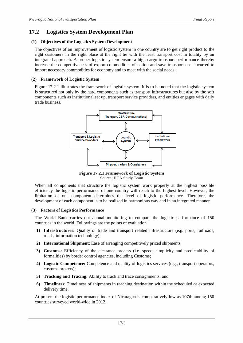
Nicaragua National Transportation Plan Final Report
17-3
17.2 Logistics System Development Plan
(1) Objectives of the Logistics System Development
The objectives of an improvement of logistic system in one country are to get right product to the
right customers in the right place at the right tie with the least transport cost in totality by an
integrated approach. A proper logistic system ensure a high cargo transport performance thereby
increase the competitiveness of export commodities of nation and save transport cost incurred to
import necessary commodities for economy and to meet with the social needs.
(2) Framework of Logistic System
Figure 17.2.1 illustrates the framework of logistic system. It is to be noted that the logistic system
is structured not only by the hard components such as transport infrastructures but also by the soft
components such as institutional set up, transport service providers, and entities engages with daily
trade business.
Figure 17.2.1 Framework of Logistic System
Source: JICA Study Team
When all components that structure the logistic system work properly at the highest possible
efficiency the logistic performance of one country will reach to the highest level. However, the
limitation of one component determines the level of logistic performance. Therefore, the
development of each component is to be realized in harmonious way and in an integrated manner.
(3) Factors of Logistics Performance
The World Bank carries out annual monitoring to compare the logistic performance of 150
countries in the world. Followings are the points of evaluation.
1) Infrastructures: Quality of trade and transport related infrastructure (e.g. ports, railroads,
roads, information technology);
2) International Shipment: Ease of arranging competitively priced shipments;
3) Customs: Efficiency of the clearance process (i.e. speed, simplicity and predictability of
formalities) by border control agencies, including Customs;
4) Logistic Competence: Competence and quality of logistics services (e.g., transport operators,
customs brokers);
5) Tracking and Tracing: Ability to track and trace consignments; and
6) Timeliness: Timeliness of shipments in reaching destination within the scheduled or expected
delivery time.
At present the logistic performance index of Nicaragua is comparatively low as 107th among 150
countries surveyed world-wide in 2012.

Nicaragua National Transportation Plan Final Report
17-4
(4) Solutions to Improve the Logistics Performance of Nicaragua
The solutions to improve the logistic performance of Nicaragua and the expected results can be
summarized as follows:
1) Infrastructures: Sea ports, roads, and airport that structure each transport corridor identified
are to be improved or developed. The infrastructure to reinforce and expand the use
information technology is to be prepared;
2) International Shipment: Develop the new sea ports along the Atlantic Coast to diversify the
international trade routes and to enable the choice of ports easier so as to arrange
competitively priced shipments;
3) Customs: The customs clearance process is to be simplified thereby speed of customs
clearance increase and formalities can be predicted by consigner / consignees. Regional
agreements on cross-border trade procedures are to be made by member countries aiming at
operating a single-window and single-stop system. The cross-border trade infrastructure is to
be designed and developed in accordance with the agreed rules and procedures. Necessary
equipment for customs clearance including inspection of dangerous cargoes and quarantine
are to be provided;
4) Logistic Competence: The competence and quality of logistics services or transport operators
are to be fostered and improved;
5) Tracking and Tracing: Ability to track and trace consignments is to be improved; and
6) Timeliness: Timeliness of shipments in reaching destination within the scheduled or expected
delivery time are ensured by use of information technologies and foster the professional spirits
of the transporter as well as logistic service providers. The warehouses are to be provided at
strategic places or develop the logistic parks at strategic locations along the transport corridor
and immediate behind the sea ports.
The development of logistic parks accelerates the implementation of such solutions listed above.
17.3 Establishment of Logistic Parks, Agro-processing Parks and
Improvement of CBPs
(1) Locations of Logistic Parks, Agro-processing Parks and CBPs
Figure 17.3.1 illustrates the locations of logistic parks, agro-processing parks and CBPs that are
considered as the key components for the logistic infrastructure development plan.
Figure 17.3.1 Locations of Logistic System Development Plan
Source: JICA Study Team

Nicaragua National Transportation Plan Final Report
17-5
17.3.1 Project for Establishment of Logistic Parks (LPs)
Objectives of Logistic Parks: The objectives of logistic parks are as follows:
1) Consolidation of containerizable cargoes1 for Less Container Load shipment (LCL)
2so as to
optimize the space of one container fully. This way of shipment of goods reduces the freight
cost for Small-medium sized Enterprises (SME) who engages with international / regional
trade (i.e. shipper, trader, consigner, etc.)
2) Increase the loading ratio by securing return cargo to the trucks delivered their containerized
cargo to the logistic park. This way of shipment of container increases the Loading Ratio (LR)3
of each truck that undertakes the land transport on the way to return to the original point of
such truck. Therefore, the transport cost of goods can be reduced or make the price of goods at
the market competitive.
3) The necessary works for customs clearance of goods (i.e. documentations, payment of tax and
levy, quality inspection, etc.) can be prepared prior to enter into the cross-border trade facility
(i.e. sea port, airport, CBP, etc.) thus the waiting time of trucks at customs can be shorten
thereby reduce the transport cost.
4) Warehouses provided in the LP are possible to store the goods as inventory of shipper / trader
to make their delivery of goods to the consignees, wholesalers, retailers, etc. easier in timely
manner or make Just-In-Time (JIT)4 delivery of goods to purchaser of goods possible.
5) Provision of refrigerated warehouses provided in the LP is possible to store the perishable
goods for SMEs who are not afforded to own their own refrigerated storing facility.
Locations of Logistic Parks: The project envisages the establishment of logistic parks at strategic
locations along the transport corridor. Table 17.3.1 shows the location of logistic parks planned and
proposed.
Table 17.3.1 Proposed Location of Logistic Parks Development Projects Department Location-1 Location-2
Pacific Corridor Behind Puerto Corinto West of Managua
Atlantic Corridor Matagalpa East of Managua
Central Corridor Behind Bluefields Port
Northern Corridor Behind Bilwi Port
Source: JICA Study Team
Outline of Logistic Parks: The area of one logistic park is around 45,000 m2. The park is
consisted of warehouse, truck parking area, utility delivery system, administration buildings, etc.
Figure 17.3.2 illustrates a typical plan of logistic park and images of logistic park.
1 Containerizable cargoes means the cargo is possible to be shipped by container unlike non- containerized cargo such as
bulk, break-bulk or liquid cargo which is difficult or not suitable to be loaded to one container. 2 Less Container Load (LCL) means that one container is used by several consigners unlike the case of Full Container Load
shipment (FCL) which is used only one consigner by filling full space of one container by consigners cargo. LCL shipment
is arranged by shipping / trucking / forwarding company or logistic service providers whose transport service is of an
integrated nature. 3 Loading Ratio (LR) means the ratio of loading cargo on one truck / ship. The LR of truck that has no cargo loaded on the
way back to the original point is 0.5. While the same but with return cargo or the truck use their trip fully with cargo
loaded is 1.0. The transport cost of goods by truck at LR1 fully utilize the Vehicle Operation Cost (VOC) is the least
transport cost per ton-km for moving of goods from one place to the other. 4 Just-In-Time method is the modern method of delivering goods to the final customer by shipper of goods when the final
customer needs such goods as scheduled thereby eliminating excessive inventory at the premised of final customer so as to
keep price competitiveness of the final customer (often manufacturers) as high as possible.

Nicaragua National Transportation Plan Final Report
17-6
Figure 17.3.2 Typical Area Plan of Logistic Parks and Its Image Source: JICA Study Team prepared the images from various website of logistic providers in Thailand and Vietnam
Mode of Investment: The land for LP can be prepared by the government on its own land or
purchase a proper land for LP from the private land owner and the necessary infrastructure
including the utility delivery system (i.e. main power supply, stand-by power system, water supply,
communication system, etc.) and waste treatment system (i.e. solid waste treatment plant, liquid
waste treatment plant, etc.) can be provided by the government. Such land prepared for the
operation of LP can be leased out to plural number of private logistic providers, forwarders,
warehousing operators, truckers, etc. who want to use such facilities for their own business. Such
type of contract is called the Land-lord Type Contract. In such a way the private investors /
transport business operators are possible to utilize such infrastructure easily so as to increase the
transport business performances.
17.3.2 Project for Establishment of Agro-processing Parks (APPs)
Objectives of Agro-processing Parks: The objectives of Agro-processing Parks (APP) project are
as follows:
1) Enhancement of agricultural products exports which is main stay of foreign currency earnings
of Nicaragua can be realized;
2) Value on the agricultural products can be added;
3) Participation of small-medium scale farmers on value added activities on their agricultural
products can be promoted to share the income by all;
4) Expanding markets accelerate the production volume of and added value on agricultural
products; and
5) Rationalize the flow of agricultural products from farm to the APP and to the market makes the
agricultural product exports of Nicaragua more competitive.
Locations of Agro-processing Parks: The project envisages the establishment of agro-processing
parks at strategic locations along the transport corridor. Table 17.3.2 shows the location of logistic
parks.
Table 17.3.2 Location of Agro-processing Parks Development Projects
Corridor Location-1 Location-2
Department City Department City
Pacific Corridor Chinandega Chinandega
Atlantic Corridor Matagalpa Matagalpa
Central Corridor Boaco Juigalpa RAAS Nueva Guinea
Northern Corridor RAAN Puerto Cabezas
Note: See Figure 17.3.1
Source: JICA Study Team
Agro-processing Activities: Table 17.3.3 tabulates the possible products produced but not limited
through processing of various kinds of agricultural products as the raw materials. The raw materials

Nicaragua National Transportation Plan Final Report
17-7
to be processed at each APP planned should be the major agricultural products cultivated in
respective department and their surrounding department. For instance the main raw materials to be
processed at Chinandega AAP may be beans; at Matagalpa AAP may be coffee and horticulture
products; at Juigalpa and Nueva Guinea may be beef meats and cow milk; and at Puerto Cabezas
may be woods, marine products, and horticultural products.
Table 17.3.3 Plausible Agricultural Products Produced by APP Raw Material Product-1 Product-2 Product-3 Product-4
Meat (Beef, hog, chicken, etc) Processed Frozen Offal Leather
Cow Milk Processed Cheese Skim milk Dried milk
Beans (Soya beans, ground nuts, etc.) Dried Edible oil Cake Fertilizer
Grains (Wheat, rice, sorghum, etc) Milled Edible oil Cake Fodder
Marine (fish, shrimp, lobster, etc) Peeled Frozen Prepared Fodder
Fruits and Vegetables Packed Frozen Dried Prepared
Woods Sawn
lumber
Veneer Complex Furniture
Horticulture products (Flower, etc) Fresh Cut Stock Ornament
Source: JICA Study Team
Outline of Agro-processing Parks: The area of one agro-processing park or the industrial estate
specifically designed for processing, storing and delivery of agricultural products is around 4,000
m2 – 6,000 m
2 depending on what agricultural products to be processed stored and delivered. Figure
16.3.3 illustrates a typical plan of agro-processing-park and image of such park. The key
components of APP are as follows:
i) Land prepared with ample size of access road;
ii) Infrastructure for utility delivery services (i.e. power, water, communication, etc)
iii) Infrastructure for liquid and solid waste treatment system;
iv) Warehouses for products in general and refrigerated warehouse in particular;
v) Administration building that houses the laboratory for quality inspection and quarantine;
offices for logistic service providers; and general administration.
Mode of Investment: The land for Logistic Park (LP) can be prepared by the government on its
own land or purchase a proper land for APP from the private land owner and the necessary
infrastructure including the utility delivery system (i.e. main power supply, stand-by power system,
water supply, communication system, etc.) and waste treatment system (i.e. solid waste treatment
plant, liquid waste treatment plant, etc.) can be provided by the government. Such land prepared for
the operation of APP can be leased out to plural number of industrial company engaging the
processing of agricultural products, association of small-medium scale farmers, individual investor
engaging with export of agricultural products, etc. who want to use such facilities for their own
business. Such type of contract is called the Land-lord Type Contract. In such a way the private
investors are possible to utilize such infrastructure easily so as to increase the added-value on
agricultural products for both export market and domestic market.
17.3.3 Project for Expansion and Improvement of Cross-border Trade Infrastructure (CBTI)
Objectives of Agro-processing Parks: The objectives of expansion and improvement of
Cross-border Trade Infrastructure Project are as follows:
1) Enhancement of regional trade among member countries forming the Central American region
by facilitating cross-border trade among such countries;
2) Contributing economic growth of the member countries by means of reducing the transport
costs especially by streamlining the flow of goods through the cross-border facilities (i.e.
customs clearance, quarantine procedures, inspection of dangerous goods, etc.)
Locations of Cross-border Points (CBPs): The project envisages the expansion of CBTI and
improvement of their performances for customs clearing operation and management of dangerous

Nicaragua National Transportation Plan Final Report
17-8
goods and traffic at CBPs. The locations of CBPs are indicated in Figure 17.3.3.
Figure 17.3.3 Project Locations of CBTI in Nicaragua
Source: JICA Study Team
Estimated Cargo Volumes Through CBPs: The estimated international and regional cargo
volumes passing through the CBPs are shown in Table 17.3.4.
The estimation of cargo volume at each CBP is carried out are based on both CASE-1 that does not
consider the development of new ports planned to be developed along the Atlantic Coasts namely
Bilwi Port and Bluefields Port; and CASE-2 that considers the development of these ports along
the Atlantic Coast to transform the international trade traffic pattern.
Table 17.3.4 Estimated Cargo Volume for Each CBP (Unit: ‘000 tonnes per year)
CBP Neighboring
Country
CASE-1 CASE-2
2013 2023 2033 2023 2033
Las Manos Honduras 210 470 880 460 1,210
El Espino Honduras 130 280 430 290 470
Guasaule Honduras 920 2,090 4,080 1,650 3,210
Penas Blancas Costa Rica 530 1,160 1,590 560 890
Los Ranchos Costa Rica 0 20 240 20 200
Total 1,790 4,020 7,220 2,980 5,960
Change in times 1.0 2.3 4.0 1.7 3.3
Note:
1) The above estimated volumes do not include the volume of transit cargo passing through Nicaragua.
2) The approximate volume of transit cargo is around 30% of the estimated volume.
3) The ratio of transit cargo volume is determined based on the result of traffic survey in 2013.
Source: JICA Study Team
As shown in the above table, the cargo volume passing through CBPs is expected to increase 3.3 to
4.0 times of 2013 by 2033 or in coming 20 years. At present in 2013 the waiting time for customs
clearance at CBPs in north is around 12 hours in average and the same at CBP in south is around
24 hours. Unless this situation is rectified otherwise the performance of CBP operation would
hinder the sound economic growth.
Improvement of CBP or CBTI projects: At present as of December 2013 the review of regional
trade performance including the preparation of improvement plans of CBPs in the Central
American region that is composed of 7 countries (i.e. Mexico, Guatemala, Honduras, El Salvador,
Nicaragua, Costa Rica and Panama) has been on going by the consultants hired by the World Bank

Nicaragua National Transportation Plan Final Report
17-9
aiming at facilitation of regional trade. The major aim of said study is to prepare and improve the
Cross-border Trade Agreement (CBTA) thereby introduce Single-window and Single-stop system
in this region. The feature of CBTI projects to be planned aiming at improvement of customs
clearance performance by streamlining and simplification of the procedures in collaboration with
countries directly concerned at the border gates should be prepared in accordance with the outcome
of legislation of CBTA by member countries in the future. Under such situation the design on the
CBTI project has not been carried out however the projects are identified as the key components
forming a part of transport corridor improvement and development projects.
Lacking of Necessary Equipment and IT System: The designs of CBTI projects cannot be
carried out since the outcomes of CBTA has not been available as mentioned in preceding
paragraph, yet the needs of improving the performances of CBPs have been identified. All CBPs
lack a provision of equipment or X-ray machine to check the dangerous cargoes loaded on trucks as
well as the Electronic Data Interchange (EDI) and electronic fund transfer (EFT) system.


Nicaragua National Transportation Plan Final Report
18-1
Chapter 18 Public Passenger Transport Development Plan
The intercity bus transportation in Nicaragua has been established in proportion as the trends of
passenger demand and bus operation supply; therefore, many buses operate in competition of each
other in the national road network. There is need for the efficient bus route operation network and a
large capacity bus in consideration of good accessibility and efficient mobility. In addition, many
old aged bus fleets are operating in poor vehicle maintenance, and the bus terminal facility is poor
condition due to a lack of well-developed bus service system, this situation leads to a lack of
comfort and safety operation for bus passengers. Therefore, an appropriate systematic public
passenger transport development plan will be recommended taking into consideration the
importance of strengthening the passenger public transport system for safe and smooth operation
on roads.
The public passenger transport demand plan consists of 1) Formulation of “Hub-and Spoke” Bus
Network, 2) Introduction of Large Capacity Bus, 3) Improvement of Bus Terminal and
Construction of Roadside Station “Michi-no-Eki”, 4) Improvement of Mechanical Vehicle
Inspection and Promotion of Road Safety Education, 5) Formulation for Computerized Registration
System of Operation License and Statistic Data and 6) Reform the Law No. 524.
18.1 Reorganization of Route on “Hub-and-Spoke” Bus Network System
The introduction of “Hub-and-Spoke” Bus Network System (hereinafter refer to as the “HAS
system”) that consists of the trunk service by trunk bus network and local service by feeder bus
network is proposed instead of the present destination-based system. The trunk bus routes with
increased frequency will be operated among Department Capitals and the feeder bus routes will be
operated from the cities and villages to the bus terminal on the trunk bus network. The trunk bus
route will be operated by a large capacity bus and express bus in order to increase effective
carrying capacity. The feeder bus route will be operated by a micro bus in proportion to the local
demand, and take transfer at the bus terminal providing connectivity. This will bring the effects to
reduce operating costs as well as increase the operating efficiency. HAS system consists of a
network with trunk bus routes (approximate total distance:1,750km) and feeder bus routes
(approximate total distance:2,320km), respectively Figure 18.1.1.
T.B
Bus Stop
Bus Stop: Water Transport Service Network
Lo
cal
Bu
s S
erv
ice
Net
wo
rk
Trunk Bus Service Network
Bus Terminal
Figure 18.1.1 Reorganization of Route on HAS Bus Network System
Source: JICA Study Team

Nicaragua National Transportation Plan Final Report
18-2
18.2 Introduction of Large Capacity Bus
(1) Future Bus Passenger Demand in Trunk Bus Route and Future Demand of Large
Capacity Bus
Future bus passenger demand in trunk bus route was forecasted based on the results of passenger
survey conducted by Directorate General of Land Transportation (DGTT) of MTI in 44 interurban
bus routes and the results of traffic survey by JICA Study Team. On the basis of these surveys and
OD table of bus passengers in 2013, an OD table of future bus passengers was prepared also taking
into account future economic indicators and bus network. And the traffic assignment was made by
computer simulation (JICA-STRADA) based on daily bus passenger demand in each section of bus
network in order to forecast the future daily bus passenger demand in each section of bus network.
The future demand of large capacity bus with a capacity of 60 passengers by the trunk bus route
was estimated based on the result of future daily public bus passenger. (See Table 18.2.1)
1) Future Daily Public Bus Passenger Demand in Trunk Interurban Bus Routes
The future daily public bus passenger demand is shown in Figure 18.2.1. The number of present
daily passenger ranges 100 to 7,700 passengers (2-way volume). The large passenger demand is
expected on NIC-1 at 400-10,300 passengers, NIC-4 at 2,100-5,300 passengers, NIC-12A at
1,900-3,700 passengers, NIC-28 at 2,600 passengers and NIC-2 at 2,000 passengers respectively.
The number of passenger in 2033 is expected to range 220 to11,440 passenger/day (2-way
volume).

Nicaragua National Transportation Plan Final Report
18-3
Figure 18.2.1 Future Daily Public Bus Passenger Demand of Each Section in Bus Network Source: JICA Study Team
Year 2013 (Unit: pax/2-way. day)
300
400
1,000
300
2,100
1,500
2,800
2,000
7,700
1,500
100
100
200
1,200
800
400
500
200
Year 2023
400
500
1,300
400
2,800
1,900
3,700
2,600
10,300
2,000
200
200
200
1,600
1,100
600
800
300
Year 2033
500
600
1,430
500
3,200
2,200
4,100
3,000
11.440
2,200
220
300
300
1,870
1,300
800
1,000
320

Nicaragua National Transportation Plan Final Report
18-4
2) Future Demand of Large Capacity Bus by 44 Trunk Interurban Route
Based on the future daily public bus passenger demand by route, Table 18.2.1 shows the future
demand of large capacity bus for 44 interurban bus route. The required daily volume of large
capacity bus by trunk route was estimated in the range of 2 and 104 buses (2-way volume) in 2023,
and 2 and 116 buses (2-way volume) in 2033 respectively. The total introduction buses was
estimated at 1,000 buses in 2023 and 1,124 buses in 2033.
Table 18.2.1 Future Demand of Large Capacity Bus for 44 Interurban Bus Route
Department Municipality No. Route (Origin -Destination)
Required Bus Fleet
Y 2023 Y 2033
Carazo Jinotepe
1 Jinotepe-Managua (near El Crucero) 34 38
2 Jinotepe-Masaya 38 42
3 Jinotepe-Masaya (near La Concha) 30 34
Rivas Rivas 4 Rivas-Managua 24 26
5 Rivas-Jinotepe 24 26
Jinotega Jinotega 6 Jinotega-Managua 14 18
Chontales Juigalpa 7 Juigalpa-Managua 24 30
8 Juigalpa-Rama 18 22
9 Juigalpa-Nueva-Guinea 10 12
Estelí Estelí 10 Estelí-Managua 12 12
11 Estelí-Ocotal 4 4
12 Estelí-Somoto 10 12
13 Estelí-Matagalpa 26 30
14 Estelí-León 6 6
15 Masaya-Estelí 4 4
16 Estelí-Jalapa 2 2
17 Estelí-San Rafael-Jinotega 4 4
18 Estelí-Jícaro-Murra 2 2
León León 19 León-Managua 56 62
20 León-Chinandega-Corinto 92 102
21 León-Malpaisillo-San Isidro 34 36
Nueva Segovia Ocotal 22 Ocotal-Managua 16 20
23 Ocotal-Managua 14 18
Chinandega Chinandega 24 Chinandega-Matagalpa 2 2
25 Masaya-Chinandega 4 4
Matagalpa Matagalpa 26 Matagalpa-Managua 40 46
27 Matagalpa-León 4 4
28 Matagalpa-Jinotega 20 22
29 Matagalpa-Jinotega-Guayaca 4 4
Boaco Boaco 30 Boaco-Managua 18 20
Madriz Madriz 31 Somoto-Managua (Express Bus) 6 6
32 Somoto-Ocotal 4 4
Masaya Masaya 33 Masaya-Managua,Roberto Huembes Market (Express Bus) 62 70
34 Masaya-Matagalpa 4 4
35 Masaya-Tipitapa (Express Bus) 18 20
36 Masaya-Jinotepe (Ordinary Bus) 32 34
Granada Granada 37 Granada-UCA-Managua 44 52
38 Granada-Oriental-Managua 14 16
39 Granada-Masaya 40 46
40 Granada-Nandaime 30 36
41 Granada-Jinotepe 14 16
42 Granada-Rivas 10 10
Managua Managua 43 Chinandega-Managua (Express Bus) 28 30
Tipitapa 44 Cristo Rey-Tipitapa-Managua (Ordinary Bus) 104 116
Total 1,000 1,124
Source: JICA Study Team
(2) Proposed Large Capacity Bus
Depend on the adoption of HAS Bus Network System and the future daily public bus passenger
demand in trunk bus network, the large capacity bus will be introduced, offering both lower

Nicaragua National Transportation Plan Final Report
18-5
operating costs and higher service reliability. One door regular large bus with 60 passengers
(including 11 auxiliary seats) will be proposed for the trunk bus network.
(3) Project Cost Estimate
The project cost for the introduction of large capacity bus was estimated at 92.4 million US dollars
in 2023 and at 103.4 million US dollars in 2033 respectively.
18.3 Improvement of Bus Terminal and Construction of Road Side
Station
(1) Improvement of Bus Terminal
The existing problems and issues of bus terminals are pointed out as follows; 1) lack of service
facilities for passengers, 2) small land area for terminal and parking, 3) necessity to separate from
market facilities to mitigate the chronic congestion due to mixed traffic flows with market and
other shops, and 4) necessity to create transfer function with feeder buses. In order to ensure
efficient and comfortable service and transfer function between trunk service and feeder service, a
bus terminal improvement plan is proposed. The target year of the plan will be set in 2023 as a
short-middle term plan.
1) Land Area of Bus Terminal and Parking
The capacity required of bus berth and land area of the bus terminal area is determined based on the
future passenger demand and future bus fleet with consideration for operation period and
dispatching schedule aiming at target year 2023. The bus berth required by bus terminal is in the
range of 2-6 berths. The largest number of bus berth required at 6 berths is observed at the Masaya
bus terminal. For the Managua bus terminal, in consideration of directional allocation of bus
terminal for the North, South and East, the number of bus berth required per each directional bus
terminal is at about 4 berths. The land area required by number of berth is at 6,520 m2 for 2-3
berths, 8,300 m2 for 3-4 berths and 9,620 m2 for 5-6 berths respectively. Table 18.3.1 Shows the
bus terminal location by bus berth required.
Table 18.3.1 Number Required of Bus Berths and Land Area by Major Target Bus Terminal
Department Municipality No. Bus Terminal
Bus Fleet Required Total Bus Berth and Land Area in 2023
2023 2033
Operation Period/Bus Dispatching
Schedule
Total Bus Berth
Required
Land Area
Required (M2)
Carazo Carazo 1 Jinotepe 172 190 12 hrs, 15 min 5 9,620
Rivas Rivas 2 Rivas 58 62 12 hrs, 30 min 3 8,300
Jinotega Jinotega 3 Jinotega 42 48 12 hrs, 30 min 3 8,300
Chontales Chontales 4 Juigalpa 52 64 12 hrs, 30 min 3 8,300
Estelí Estelí 5 Estelí 70 76 12 hrs, 30 min 4 8,300
León León 6 León 192 210 12 hrs, 15 min 5 9,620
Nueva Segovia Nueva Segovia 7 Ocotal 38 46 12 hrs, 30 min 3 8,300
Chinandega Chinandega 8 Chinandega 126 138 12 hrs, 15 min 4 8,300
Matagalpa Matagalpa 9 Matagalpa 100 112 12 hrs, 30 min 5 9,620
Boaco Boaco 10 Boaco 18 20 12 hrs, 30 min 2 6,520
Madriz Madriz 11 Somoto 34 40 12 hrs, 30 min 2 6,520
Masaya Masaya 12 Masaya 232 258 12 hrs, 15 min 6 9,620
Granada Granada 13 Granada 152 176 12 hrs, 15 min 4 8,300
Managua Managua for 3 B.T 14 Managua 496 562 12 hrs, 15 min 4 x 3 8,300
Tipitapa 15 Tipitapa 122 136 12 hrs, 15 min 4 8,300
Source: JICA Study Team, 2013
2) Layout of Typical Bus Terminal by Type
The layout of typical bus terminal by type will be proposed in Figure 18.3.1. The Alternative Type

Nicaragua National Transportation Plan Final Report
18-6
1 takes an advantage for the site condition at entrance and exit from/to two different roads, in
contrast, the Alternative Type 2 takes an advantage for only in case which is constructed in front of
main road. These alternatives will be proposed depending on the site condition. The typical bus
terminal is comprised of road area (trunk bus terminal and feeder bus transfer terminal), footway
area, platform with shelter and building area (restaurant, toilet, kiosk and ticket counter).
Alternative Type 1 Alternative Type 2
Figure 18.3.1 Layout of Typical Bus Terminal by Type Source: JICA Study Team
3) Project Cost Estimate
For the bus terminal improvement plan targeted in 2023, the Alternative Type 2, which is lower
than construction cost of the Alternative Type 1, is proposed. The cost for each berth size is shown
as follows: 0.82 million US dollars for 6-5 berth, 0.71 million US dollars for 4-3 berth and 0.56
million US dollars for 2berth. The total project cost for 17 bus terminals is estimated at 11.95
million US dollars.
(2) Construction of Roadside Station
1) Function of Roadside Station
The construction of roadside station is planned to promote the road service facility for the safe
driving and comfortable service for road users such as public bus and private vehicles, and
contributing tourism promotion and local economy. The function of roadside station is mainly
classified into three (3) functions such as 1) the Rest Facility for public toilet, parking and public
bus stop, 2) the Information Facility for road/traffic condition guidance, regional information
guidance (tourism spots and events) and emergency contact for traffic accident/disaster and 3) the
Regional Partnership Facility for restaurant, direct sale store, shop of special local products and
holding of events. The operation and management of roadside station will be conducted by
introducing the third sector system with public- private partnership that aims to take advantage of
business expertise in the private sector to ensure the sustainable profitability.
2) Main Factors for Development of Successful Roadside Station
The roadside station has linked to road transport with local and regional development goals. The
following four (4) factors seem to be the reasons for the development of successful roadside
station.
The cost of the roadside station construction will be paid by public sector (Government), in
addition, the public sector will be provided the support for the operation. On the other hand,
the private sector (local community) will provide with a venue for activities. Accordingly,
the project of roadside station will contribute to the long-term aim of regional development.
Building Area (Restaurant, Toilet,
Ticket Counter, etc.)
Footway Area
Platform/Shelter
Ped
estr
ian
Bri
dg
e
Pedestrian Bridge
Taxi/Private Cars
Footway Area
Building Area (Restaurant,
Toilet, Ticket Counter, etc.)
Platform/Shelter
Platform/Shelter
Pla
tfo
rm/S
hel
ter
Pla
tfo
rm/S
hel
ter
Taxi/Private Cars Footway Area
Fo
otw
ay A
rea
Footway Area

Nicaragua National Transportation Plan Final Report
18-7
In the planning stage of the project, the local residents will be involved and participate on an
equal bases, because, the organization, role, construction and operation of the roadside
station will be clarified in a through the exchange of their views and opinions.
The Roadside Station is attractive to drivers and travelers according the multi-service at a
single facility for the rest area, toilet, restaurant, shopping and information of tourism, etc.
The sales promotion of local product will be important to success for the management of
roadside station, for instance, to provide distinctive local product where cannot be obtained
elsewhere, the effort are made to encourage the local resident or local farm/fishery
producers to provide a variety of products by using local resources in inventive way.
3) Location Planed of “Roadside Station”
The candidate locations of roadside station were roughly selected based on the Road Network
Characteristics (accessibility, volume of through traffic), traffic flow condition (guaranteed a
profitable traffic volume) and regional characteristics (local products, tourist attractions).
Following seven (7) roadside stations will be constructed in the trunk roads such as NIC-1, NIC-2,
NIC-7 and NIC-12A as shown in Figure 18.3.2 below.
No.1: NIC-2, Nandaime - Rivas
No.2: NIC-12A, Leon - Chinandega
No.3: NIC-1, Ciudad Dario - Sebaco
No.4: NIC-21B Rio Blanco -
Mulukuku
No.5: NIC-7, Juigalpa - Acoyapa
No.6: NIC-1, Estelí - Palacaguina
No.7: NIC24B, Guasaule - Somotillo
Figure 18.3.2 Seven (7) Candidate Locations of Roadside Station
Source: JICA Study Team
4) Layout of Typical Roadside Station
The layout of typical Roadside Station is proposed in Figure 18.3.3. A compact style facility will

Nicaragua National Transportation Plan Final Report
18-8
be made an appeal of “Festivity” and “Amenity” to the road user without felling of pressure, and
will be also made an appeal of “Landmark”. The total area of site will be estimated at 4,700 m2,
which is comprised of parking area at 1,600 m2, road and plaza area at 1,200 m2, building area at
650 m2 and other area such as green area at 1,250 m2.
Image of Full View
Sourec: CLMVT Project
Plan View
Restaurant
Information Center
Shops
Toilet
PlazaBus Parking Lot
Small Car Parking Lot
Bus Stop
Figure 18.3.3 Layout of Typical Roadside Station
Source: JICA Study Team
5) Project Cost Estimate
The project cost for the construction of one roadside station is estimated at 0.6 million US dollars
(including operation cost). The total project cost for the seven (7) roadside stations was estimated at
4.2 million US dollars.
18.4 Improvement of Mechanical Vehicle Inspection and Promotion of
Road Safety Education
The improvement of mechanical vehicle inspection and promotion of road safety education is
proposed to ensure safety motor vehicles and to attain save-energy, low-pollution, and
harmonization with other social economy, in addition, to mitigate the traffic accident involving the
public transport operators.
(1) Improvement Plan of Mechanical Vehicle Inspection System
Traffic accidents occur due to negligence of drivers and pedestrians. Through optimum vehicle
maintenance based on vehicle periodic inspection, the traffic accidents involving vehicles can be
reduced, which then allows the safe public passenger transport.
1) Current Mechanical Vehicle Inspection System
In recent years, the public transport vehicle (buses/taxies) inspection system in Nicaragua was
realized by licensed private companies and the vehicle inspection was finally approved by the
National Police. However, from this year 2013, the vehicle inspection procedure for public
transport vehicle was changed that the vehicle inspection could be licensed to complete
responsibility of the MTI and Municipality. The inspection system was revised through change in
2005. However, the quality of existing technical inspection by licensed private companies, the MTI
and the National Police is quite simple, through the mechanical professionals by their visual
observation. It is necessary that more rigorous technical inspection items by a standard should be
adopted.
2) Inspection Items proposed for Standard
Current vehicle inspection consists of the following components: confirmation of vehicle
registration (chassis, body, engine), consistent with the registration (chassis, body, engine) and
general inspection of the measures taken. New inspection item proposed is comprised of 1) Part I:
Chassis, 2) part II: Body, 3) Part III: Lamp. Each part is composed of detailed items. The detailed

Nicaragua National Transportation Plan Final Report
18-9
items for technical inspection are shown in Table 18.4.1. A sample of a format sheet for the
technical inspection items is shown in Table 18.4.2.
Table 18.4.1 Inspection Items Proposed of Standard
PartNo. of Sub-
itemsBus/Taxi
1 High beam lamp 7
2 Low beam lamp 5
3 Lamp for vehicle width 7
4 Turning lamp 8
5 Tail lamp 5
6 Stop lamp 6
7 Reversing lamp 6
8 License plate lamp 6
9
Lamp for vehicle's height
and categories (for 12
10 Inside vehicle lamp 5
11 Lamp for route plate 2
12 Side lamp (option) 10
13 Side turn lamp (option) 5
14 Fog lamp (option) 7
15 High mount stop lamp 9
16 Other lamps 1
Items
III. Lamp
Source: JICA Study Team
Table 18.4.2 Sample of a Format Sheet for Technical Inspection Items
Part How to check Bus/Taxi
1. White or light yellow
2. 2 units
3. Fixed at the front in the same level both left & right each one
4. Both of them must be the same color
5. Fixed higher than the ground at least 40cm but not exceed 1.35m
6. They will be lightened whenever tail lamps are lightened except in case of
temporary signal
7. Additional 2 units are allowed (option)
1. White or light yellow same as high beam lamp
2. 2 units
3. Fixed at the front in the same level both left & right each one
4. Fixed higher than the ground 40cm but not exceed 1.35m. And the length
from the edge must not exceed 40 cm.
5. They will be lightened whenever tail lamps are lightened
2 Low beam lamp
Items
III. Lamp
1 High beam lamp
Source: JICA Study Team
(2) Facility Plan Proposed for Vehicle Inspection System
A suitable vehicle inspection is to obey the inspection items proposed and standards and understand
PartNo. of Sub-
itemsBus/Taxi
1 Frame 3
2 Bumper 3
3 Turning control system 4
4 Disc wheel 1
5 Tires 2
6 Axle 1
7 Spring 1
8 Shock absorber 2
9 Mud flap 6
10 Hand brake 2
11 Parking brake 6
12 Engine 3
13 Exhaust system 5
14 Drive train system 3
15 Ignition system 1
16 Electric system 6
17 Horm 6
18 Fuel tank 4
19 Speedometer 3
20 Tachometer 3
Items
I. Chassis
PartNo. of Sub-
itemsBus/Taxi
1 Windshield and glass body 4
2 Rear view mirror 2
3 Wiper 4
4 Sun visor 1 -
5 Rear body 4 -
6 Letter, Picture or any mark 7
7 Body color 1
8 Roof 2
9 Floor 2
10 Side window 7
11 Entrance door 8
12 Emergency door 7
13 Driver seat 3
14 Passenger seat 2
15 Driver cab 3 -
16 Driver partition 2
17 Passenger grip 4
18 Bell for stop signal 2
19 Fluorescent pad 13
20 Safety belt 1
Items
II. Body

Nicaragua National Transportation Plan Final Report
18-10
the merit of safety vehicles. In this plan, a computerized automatic vehicle inspection system will
be proposed. This automatic vehicle inspection system consists of 5 blocks, and each block inspect
the different elements such as confirmation of registration, brake function, lights, exhaust and body,
etc. and overall assessment is done at the end of process. Figure 18.4.1 shows the arrangement of a
computerized automatic vehicle inspection system.
Block No.1
• Confirmation of identity
• Appearance inspection
Block No.2
• Side slip inspection
• Brake inspection
• Speedometer inspection
• Headlight inspectionBlock No.3
• Exhaust emission
inspection
Block No.4
• Undercarriage inspection
Block No.5
• Synthetic judgment
Block No.6
• Other inspection machines
Figure 18.4.1 Arrangement of Major Inspection Items Source: Motor Vehicle Inspection and Registration Guide in Japan.
1) Project Cost Estimate
A complete set of Computerized Vehicle Inspection System will be installed in Managua City. The
project cost is estimated at 18.6 million US dollars.
(3) Promotion of Road Safety Education for Public Transport Operators
The training program for public transport operators for road safety by introducing a safe driving
manager in public entities will be proposed, in order to mitigate the traffic accident involving the
public transport operators. It is important that operators of public transport such as buses and taxis
recognize the importance of respecting traffic rules and that the road safety managers understand
the safe handling duty to implement road safety programs. That is, the assignment of road safety
manager in public transport entity is proposed to educate their drivers. In particular, the preparation
of guide and training workshops is proposed as described below.
Development of guide for safe handling managers of public transport operators
Training for safe handling managers through workshops
18.5 Formulation for Computerized Registration System of Operation
License and Statistic Data
The computerized registration system of operation license and the statistics data is proposed to
formulate the data basic system for the registration of operation license and statistics of bus
operation system, by using a computer means in a consistent manner.

Nicaragua National Transportation Plan Final Report
18-11
(1) Current Computerized Registration System for the Operation License and Statistic Data
The computerized registration system for the operation license and statistic data in the DGTT
Office was currently established, which is the so-called the “SIG-DGTT” (Sistema de Información
General). Currently this system is in the process of upgrading by adding the statistical data of bus
operation. The system of SIG-DGTT is comprised of 1) Registration Module (registration, data
processing, storage), 2) Delegation Module (connection and exchange of data on line), 3) Transport
Regulation Module (Operating data, routes, fleet, fee, etc.) and 4) Concession Management Module
(management of concession). It is necessary to promote the development of the system to update
the data to implement the public bus transport improvement plan.
(2) Data Base for Transport Regulation Module
At present, the transport regulation module has been formulated based on the existing data base
from the bus companies. However, these data base was collected from the limited information of
bus companies; for instance, the data of passenger trip characteristics is not enough, which is one
basic element in the development of bus route network, bus fleet and new bus mode. It is highly
recommended that the plan of passenger characteristics survey will be carried out in order to obtain
the latest data base of passenger demand to complement Transport Regulation Module.
18.6 Reform of the Law No. 524
When the MTI tries to modify bus service network or upgrading the operating system, it is required
to grant the concession to private bus operators. Law No. 524, General Land Transport law defines:
Concessions will be awarded in accordance with the quotas allocated by the last PNT. In future, the
legal reform will be necessary in Nicaragua in case of planning / implementing of public transport
reorganization (bus, taxi), operating schedule modification, introduction of s large capacity bus and
modification of fee, etc.
The following dispositions of Law No. 524are proposed to be reformed: 1) Reforms to the current
valid regulatory legal framework, 2) Transformation of the public transport model, 3) Create
moratorium regulations to new concession, 4) Create the competency that allows MTI to practice
the sector stewardship, 5) Create the conditions for other transport modes and 6) Establish the
State’s obligation in the formulation of public policies. Discussion should be promoted on these
points of reforms.


Nicaragua National Transportation Plan Final Report
19-1
Chapter 19 Water Transport Sector Development Plan
The water transport sector development plan composes several plans in 5 different areas as follows:
1. Expansion and improvement of existing sea port;
2. Development of new sea port;
3. Development of inland water transport (IWT);
4. Improvement of lake ports; and
5. Improvement of maritime transport system
19.1 Expansion and Improvement of Existing Sea Port
19.1.1 Expansion and Improvement of Puerto Corinto Port
(1) Present Situation of Puerto Corinto
Feature of Puerto Corinto: The Puerto Corinto is one of six commercial ports of Nicaragua under
the management of EPN and it is one of five ports complies with the international standards
(PBIP-ISPS Code). It is the largest port in Nicaragua and located along the Pacific Coast. Figure
19.1.1 illustrates the outline of the Puerto Corinto.
Figure 19.1.1 Outlook of Puerto Corinto
Source: ENP
As shown in the above photos the Puerto Corinto, this port is naturally secured against the waves of
the Pacific Ocean. The port has 2 berths of which total length is 610 m. The one berth having berth
length 370 m serves for general cargoes and the other berth having a berth length 240 m serves for
containers, respectively. At the eastern end of these berths there exists a loading facility for bulk
cargoes but it has not been used at present. A new cargo handling facilities for the bulk cargo is
planned to be constructed at this location and its purchasing process has been on-going as of
December 2013. At the western end of these berths there exists a jetty for liquid cargoes, equipped
with four Alba ships (medusas in Spanish and dolphins in English). The port depth varies from
12.60 m to 13.25 m at high tide. The port is managed by EPN, with a staff of 240 people, and the
stevedoring works are undertaken by three private stevedoring companies authorized by DGTA and
hired by EPN: ESENSA, EMTRAMPSA, and COSEPORSA.
Cargo Handling Volume: Table 19.1.1 shows the historical change of cargo handling volume by
type of trade and the number of ship calls per year. The total cargo volume handled by the Puerto

Nicaragua National Transportation Plan Final Report
19-2
Corinto in 2012 was 2.6 million tonnes. The same in 2001 was 1.1 million tonnes, thus, it has
increased at almost 1.45 times in 11 years or grown at 8.2% per year. The number of ship calls has
increased at almost 1.60 times in the same period or grown at 8.8% per year. The volume of
inbound cargo has increased at almost 2.2 times and the same of outbound cargo has increased at
2.0 times or 9.6% and 11.6% per year, respectively.
Table 19.1.1 Changes of Cargo Handling Volume by Puerto Corinto (Unit: to nes/Year)
YEAR IMPORT EXPORT T TAL Ship Call
2001 812,966 301,822 1,114,789 264
2002 916,756 189,973 1,106,729 241
2003 901,432 186,040 1,087,472 225
2004 904,558 222,012 1,126,569 238
2005 1,200,683 376,474 1,577,157 300
2006 1,312,860 346,683 1,659,543 400
2007 1,502,473 481,767 1,984,240 460
2008 1,476,257 442,231 1,918,488 443
2009 1,482,459 465,498 1,947,957 404
2010 1,423,506 667,107 2,090,613 449
2011 1,806,938 631,029 2,437,967 431
Source: JICA Study Team prepared based on the data obtained from EPN
Table 19.1.2 shows the changes of cargo handling volume by type of cargo.
Table 19.1.2 Changes of Cargo Handling Volume by Type of Cargo in Puerto Corinto
YEAR GENERAL CONTAINER LIQUID BULK RORO TOTAL
2001 33,652 68,764 394,507 603,516 14,350 1,114,789
2002 22,503 56,651 408,576 604,595 14,403 1,106,729
2003 25,097 70,704 417,411 563,370 10,890 1,087,472
2004 45,100 96,054 441,810 702,601 10,657 1,296,222
2005 61,707 122,659 533,031 842,866 16,895 1,577,157
2006 68,633 315,478 517,216 741,886 17,024 1,660,236
2007 74,351 422,104 648,331 817,585 21,869 1,984,240
2008 92,321 467,513 660,687 684,062 13,906 1,918,489
2009 38,377 468,852 881,607 552,184 6,977 1,947,957
2010 45,471 576,702 715,415 739,567 13,458 2,090,613
2011 39,317 713,197 816,284 851,582 17,588 2,437,967
2012 42,675 774,104 885,995 924,307 19,090 2,646,169
(Unit: tonnes/year)
Source: JICA Study Team prepared based on the data obtained from EPN
Container Handling Volume: As shown in the above table the container handling volume of
Puerto Corinto in 2012 was 774,000 tonnes or almost 65,000 TEUs while these of 2001 were
68,760 tonnes or almost 9,600 TEUs. Thus it has increased almost 6.8 times in 11 years or grown
at 19.0% per year which is tremendous. As the figure illustrates it is clear that a substantial increase
of cargo volume handled by Puerto Corinto is attributed by a rapid increase of container hadling
volume. Table 19.1.3 shows the changes of container volume handled by Puerto Corinto.
Table 19.1.3 Changes of Container Handling Volume by Puerto Corinto
Year Container
Box 20-footer 40-footer Box TEUs
Average
Tonnage 20-footer 40-footer
2002 5,664 1,888 3,776 5,664 8,870 6.39 21% 79%
2003 6,957 2,319 4,638 6,957 10,957 6.45 21% 79%
2004 9,374 3,125 6,249 9,374 15,675 6.13 20% 80%
2005 11,368 3,789 7,579 11,368 18,002 6.81 21% 79%
2006 28,093 9,364 18,729 28,093 46,088 6.85 20% 80%
2007 35,128 11,709 23,419 35,128 58,555 7.21 20% 80%
2008 36,219 12,073 24,146 36,219 58,880 7.94 21% 79%
2009 35,549 11,850 23,699 35,549 56,189 8.34 21% 79%
2010 41,194 13,731 27,463 41,194 64,937 8.88 21% 79%
2011 50,654 16,885 33,769 50,654 80,119 8.90 21% 79%
Source: JICA Study Team prepared the table based on data obtained from EPN
The average weight of container is 8.9 tons per TEU and the share between 20-footer container and
40-footer container is 20:80.
At present 6 – 7 shipping companies use the Puerto Corinto namely MAERSK, NYK, APL, MSC,

Nicaragua National Transportation Plan Final Report
19-3
CMA, China Shipping, CSAV, etc. The maximum size of container ship calls the port is 27,000
DWT. An average loading / unloading volume of container is around 300 TEUs per ship. Although
there exist one shore container gantory crane most of the container ships call Puerto Corinto uses
their own gears. Therefore, the berthing time is relatively long and port productivity is considered
as relatively low.
Cargo Demand Forecast: The cargo demand forecast of the Puerto Corinto in 2023 and 2033 are
1.68 million tonnes and 3.2 million tonnes per year excluding the volume of liquid cargo,
respectively. The volume of container is estimated at 83,000 TEUs and 104,000 TEUs,
respectively.
Ship Call by International Cruisers: The number of port call to Puerto Corinto by the internatioal
cruisers of more than 20,000 DWT is around 11 times in the past 10 years. Although the berthing
time of such cruisers is around 48 hours the occupation of berth by cruiser often hinder the berthing
the cargo ships especially the container ships.
Number of Berths: Although the cargo volume handled by Puerto Corinto is not much at present
however as it is only one port operating in Nicaragua to deal with most of international cargoes of
any kinds the port operation is complex as a large-scale port in other countries. The berth functions
as a multipurpose berth at present however as the handling volume of container increases at least
one berth is to be assigned specifically for the container ships.
Support Facility for Cargo Handling: The cargo handling yard space often limit the cargo
handling capacity and quite influential to the cargo handling capacity of the port. As the Puerto
Corinto commenced its operation as the first commercial port of Nicaragua in 19th century and it
has expanded to date to meet with ever increasing cargo demand the immediate behind of the port
has been already filled by the residential areas since the town has been expanded and developed as
the port city since long time ago. Thus, the space available for cargo handling yard is quite limited
and there exist no room for futher expansion.
Port Access Road: As discussed above the town behind Puerto Port has been developed and
expanded continuously since the time Puerto Corinto started its operation the access road attached
to the port is narrow and space for widening of the access road within the town is quite difficult.
Cargo Handling Equipment: Table 19.1.4 shows the major cargo handling equipment in Puerto
Corinto at present.
Table 19.1.4 Container Handling Equipment Operating in Puerto Corinto Equipment Quantity (Unit) Remarks
Shore Gantory Crane 1
Spreader Capacity: 40 tons
Capacity: 22 boxes per hour
Make: 1975
Prime mover 9
Container chassis 15
Container stacker 4
Forklift 21
Source: JICA Study Team prepared based on the data and information obtained from EPN
Customs Clearance Operation: In the past the customs clearance operation has been done in the
administration builiding located inside of the port premises. It took almost 2.5 hours per one
consigner with processing around 74 documents by 17 persons. However, this has been shortened
to around 30 minutes by simplification of processing 55 documents by 4 persons. This was
achieved by a provision of ante-port (preliminary processing of customs and shiping documents)
located at around 1.5 km away from the port. However, the Port Electronic Data Interchange
System (EDI) has not been introduced yet in Puerto Corinto although most of the ports located in
neigboring countries along the Atlantic Coast has already operating Port EDI.

Nicaragua National Transportation Plan Final Report
19-4
Issues to be Addressed: The cargo demand forecast for Puerto Corinto toward 2033 is 4.6 million
excluding petroleum products in the case if no international class port is developed at the Atlantic
Coast or 3.2 million in the case if the international ports are developed along the Atalantic Coast.
To address such issues the Puerto Corinto is needed to be expanded to meet with ever increasing
cargo demand and the efficiency of cargo handling should be maximized at least investment cost.
(2) Outline of the Puerto Corinto Expansion Project
The Project envisages the expansion of Puerto Corinto and increase the cargo handling capacity to
meet with the ever increasing cargo demand. The Project is composed of three (3) key components
as follows:
i. Provision of two (2) berths that is possible to accommodate two container ships at the same
time as a short-term plan;
ii. Provision of cargo handling equipments as a short-term plan;
iii. Preparation of port access roads;
iv. Introduction of Port EDI as a short-term plan; and
v. Expansion of container handling yard behind the present port premises as a medium term
plan;
vi. Development of new berths at the eastern end of the port as a long-term plan.
The outline of each projects are as described below by order.
1) Reformation of one existing berth for container ship berth
The one berth currently used for general cargo beside present container berth is to be reformed to a
container berth having berth length of 230 m to accommodate the container ship of which length is
around 210 m. The works required is demolishing present Cargo Freight Station (CFS) or
warehouse and provide the rails to move the shore gantory crane to this new berth. The estimated
cost for the demolishing existing CFS and reformation of general cargo berth to a container berth is
estimated to be at US$ 15.0 million.
2) Provision of container handling equipment
There exists one shore gantory crane having handling capacity of 22 boxes per hour with lifting
capacity of 40 tonnes. However this crane is quite old and its designed capacity cannot be achieved
at present. Most of the shipping company preferes to use the shore gantory crane at the port and
avoid to use their own ship gears. Most of the container ships serving along the Atlantic Coast of
the Central America and the South America are operated under feeder service most of them are of
Lift-on Lift-off (Lo-Lo)type container ship. As the cargo handling efficiency by ship’s own gear is
low when it is compared with the use of shore gantory crane, the shipping company prefers to use
the shore gantory crane so as to shorten berthing time as much as possible.
Table 19.1.5 tabulates the cargo handling equipment recommended but not limited to add on top of
existing fleet of cargo handling equipment at Puerto Corinto. The total cost estimated to this
component of the project is US$ 15.0 million.
Table 19.1.5 Cargo Handling Equipment for the Puerto Corinto Equipment Quantity (Units)
Shore gantory crane 2
Rubber Tired Gantory Crane 2
Prime mover 8
Container chassis 16
Container stacker 2
Source: JICA Study Team

Nicaragua National Transportation Plan Final Report
19-5
3) Preparation of port access road
The widening of the road in the town immediately behind
the port in Puerto Corinto is quite difficult because of
density of residential area is quite high and a construction
of new elevated road linking between backyard and the
port along the coast line is possible but its investment
cost is enormously high as well. Therefore, the regulating
several roads as one way road to enter into or exit from
the port are recommended. Figure 19.1.2 illustrates the
proposed relevant road accessing to the port entrance
gates. The estimated cost of this project is US$ 5.0
million.
4) Introduction of port EDI system
Cargo handling capacity depends on the length and
number of berthes, area of container handling yard or
container terminal, number and type of cargo handling
equipment used, and cargo handling management system.
A Port EDI system is recommended to be introduced for the cargo handling management system so
as to avoid an excessive investment to the port infrastructure but increased cargo handling
efficiency as well as shorten time for lengthy customs clearance procedures. The cost on an
introduction of EDI cannot be estimated simply as it depends on the opeation and management plan
of the port and level of integration with other operation such as customs clearance etc. However, it
is around US$ 4.0 million as an indicative cost.
5) Expansion of container yard behind the port
premises
The port cargo handling capacity depends on the area of
container yard as well. Figure 19.1.3 illustrates the areas
where the container yard is proposed to be expanded.
However, it requires a large number of resettlement of
residents the difficultities of negotiation with existing
residents cannot be estimated and the cost for relocation
cannot be estimated at present.
6) Development of new multipurpose berth(s)
The Puerto Corinto plays an important role for the
expansion and promotion of trade of Nicaragua thus it
functions as an integrated port complex handling bulk, break-bulk, liquid and container cargoes.
Those projects described above are mostly related to the expansion and improvement of handling
capacity of container cargo. If two berths for container ships would be realized as planned above
the available berth length for general cargo
ships will become around 130 m. As the port
calls by the ships of which length is 150 m –
210 m accounts for around 80% of the total
ship calls. One or two berths for general cargo
or for multipurpos berth(s) is recommended to
be provided. Figure 19.1.4 presents the plan on
a construction of new berths at the easten end
of existing port.
The estimated cost for the new berths as
planned is US$ 170 million.
Figure 19.1.2 Proposed Port Access
Road Regulating Plan
Figure 19.1.3 Proposed Areas for
the Expansion of Container Yard
Figure 19.1.4 Plan on Development of New
Berths

Nicaragua National Transportation Plan Final Report
19-6
(3) Notes on the Puerto Corinto Expansion Project
The expansion of cargo handling capacity of the Puerto Corinto is imperative however as the
backyard of the port is congested by the residential area and the access to the port would continue
to be one of the important issues to be addressed toward the future. It is recommended to carry out
the preparation of the master plan for the Puerto Corinto Development Plan taking into
consideration of finding the best solution in this regard.
19.1.2 Expansion and Improvement of Bilwi Port
(1) Present Situation of Bilwi Port
Feature of the Bilwi Port at Present: As shown in Figure 19.1.5, the major facility of this port is
a jetty made of wood. The size of this jetty is 461m long and 7 m width. Present jetty was
reconstructed after original one was destroyed by hurricane in the past. The original length of jetty
was 1,500 m long. The water depth at the tip of jetty is shallow therefore the size of ship that can
be moored with this jetty is limited. The maximum cargo vessel size to accommodate at present is
4,000 DWT of which length is 109 m with 4.8 m draft. Before the Hurricane Felix attacked
Nicaragua’s Caribbean Coast hard in 2007 the draft was 5.6m. This is to be noted strongly that
once a hurricane of the Caribbean Sea occurs and hits the Atlantic Coast of Nicaragua the channel
dredged will be easily buried by a huge volume of drafted sand of sea bottom. The elevation of the
jetty is 3.0m from the sea level (MWL) and the tidal difference is 0.5 m. Although the detailed data
was not available with regard to the cargo volume handled to date, there was one record of 15,000
tonnes of liquid cargo was unloaded. This jetty is used often for unloading of marine products
landed (mostly lobster) and loading of ice blocks and materials needed for fishing.
Cargo Demand Forecast: The cargo demand forecast of Bilwi Port for 2023 and 2033 are 1.3
million tonnes and 1.68 million tonnes, respectively.
(2) Outline of the Bilwi Port Improvement Project
Although the Bilwi Port has not played an important role as the international port to serve the need
of economy in the northern part of the Atlantic Coast of Nicaragua yet, its potentiality to serve as
an international port is quite high subject to the completion of links between Managua and Puerto
Cabezas and port capacity of New Bilwi Port planned. A drastic change of international trade cargo
traffic can be foreseen so far.
AlbaNISA of Venezuelan and Nicaraguan joint venture investment company has already prepared
the plan and the detailed designs of new Bilwi Port of which major component is a jetty made of
concrete has been prepared for the implementation of the project. Figure 19.1.5 illustrates the
outline of this plan.
Figure 19.1.5 Plan of New Bilwi Port
Source: Albanisa S.A.
(3) Notes on the New Bilwi Port Project
The feasibility study of New Bilwi Port has been completed and preliminary design of the port and
supporting facilities for the construction of New Bilwi Port has been already prepared as well. The
implementation of the project is likely to go on in coming year. However, it is not clear whether the

Nicaragua National Transportation Plan Final Report
19-7
port designed is capable to handle 1.0 million tons of cargo a year since the area of berth is narrow
and the distance between the coast and berth is almost 1,500 m and the cargo is to be transported by
trailer trucks along this narrow jetty.
The feasibility study has been carried out and completed however it is not known whether a
sufficient depth of study on the oceanographic conditions has been done and analyzed to reflect
such conditions to the basic design of the port infrastructure. A vulnerability of physical structure
of jetty although it is made of concrete against the hurricane often occurred in the Caribbean Coast
is not known therefore an in-depth study in this respect is needed to be carried out to confirm its
technical feasibility of the project.
19.2 Development of New Sea Port along the Atlantic Coast or Bluefields
(1) Background of the Project
It was the dream of Nicaragua transport sector entities to have an international class commercial
port along the Atlantic Coast for a long time as it is located within the territory of Nicaragua thus
no crossing the borders are required and the maritime distance from Nicaragua to the countries
located at the Atlantic side can be shorten substantially. This means the transport cost especially for
the import cargo can be reduced substantially as well.
One of the candidate sites for the development of new port was the Monkey Point and a plan has
been prepared for Monkey Point Port Development Project. However, this project composed of not
only a port but also a large-scale town that support the port operation and management as well as a
road linking with the Atlantic Corridor of which length is more than 600 km. The port designed
faces directly with the Atlantic Ocean and the port is protected by an artificial breakwater. At
present, no human and economic activity takes place at the candidate location. The location is
covered by natural rain forest and the backyard of the selected site is hilly terrain. The estimated
cost is more than US$ 400 million (port alone).
Another candidate site was Bluefields. Bluefields is situated at the mouth of the Escondido River
and engulfed by the Bluefields Bay. There has been a port called El Bluff and it has served as a
transit port for centuries. Bluefields is a capital city of RAAS and its population is more than
70,000 however this city has been physically isolated by swamp and low land forest. At present,
the road linking with the Atlantic Corridor or Nueva Guinea and Bluefields City has been under
construction with the financial assistance of both the World Bank and JICA.
The candidate site for new port in and around Bluefields City was thought to be not appropriate as
it is located near the mouth of the Escondido River and the water depth of the Bluefields Bay is
quite shallow as it is almost 2.5 m in average throughout the area of the Bluefields Bay. However,
if a proper technology is applied to prevent the sedimentation for channel and berth front and the
cost is reasonable then the Bluefields can be considered as an appropriate port location taking into
consideration that the location is closed to existing city of 70,000, airport, protection by natural
breakwater, and so on.
(2) Preliminary Site Survey on Candidate Site for New Port
Figure 19.2.1 shows the points selected as the candidate site for new port. The survey took place in
November 2013 to compare the merits and demerits of each site taking into consideration of
vulnerability of port infrastructure against possible hurricane, oceanographic conditions such as
tide, maneuverability of cargo handling, estimated cost, connectivity and accessibility with the
main land, economic activity in and around the bay, social matters such as indigenous population,
environment in general, etc. As a result of preliminary studies on comparison of nine (9) candidate
sites the site in the Bluefields Bay and close to the airport is selected. However, the final selection
should dependent on the result of in-depth study on oceanographic data, meteorological data,
morphologic data, berth metric data, bottom soil data, water quality data, environmental impact
assessment, etc.
Table 19.2.1 shows the comparison of rough cost estimation of each candidate site. The major

Nicaragua National Transportation Plan Final Report
19-8
factor for cost comparison are the volume of capital dredging of channel, construction cost of
breakwater, submersible dyke for protection of sedimentation, berth, terminal, causeway, access
bridge, access road, etc.
Figure 19.2.1 Candidate Sites Selected for New Bluefields Port
Source: JICA Study Team
Table 19.2.1 Cost Comparison of Candidate Sites Channel Dyke Breakwater Access bridge Access road
L (km) L (km) L(km) L (km) L (km)
1 282 16.0 19.1 3.5 0 10.0
2 247 12.9 12.9 1.8 0 5.3
3 235 8.9 6.4 2.1 1.8 6.2
4 250 13.4 6.4 2.1 0 4.5
5 332 5.6 0 5.4 3.1 7.5
6 238 5.8 3.0 2.1 3.1 8.8
7 341 2.0 0 5.1 6.6 6.7
8 289 4.9 1.8 0 7.1 7.2
9 335 0.8 0 3.4 6.6 8.0
El Bluff South
El Bluff
El Bluff North
Candidate Site
Bluefields North
Isla El Venado
Cost
(US$ Mill)
Deer Point
No.
Bluefields South
Bluefields
Bluefields Bay
Note: 1) Dyke means a submersible dyke planned to be constructed on the bottom of the sea and designed to
protect direct entering of suspended materials that occurs sedimentation of channel and beth front. 2) The cost of cargo handling equipment, etc. is included in the total cost at US$ 20 million.
Source: JICA Study Team
(3) Conceptual Design of New Bluefields Port
Among 8 candidate sites two alternative plans are selected for further comparison. These are the
plan on site of Bluefields and Bluefields Bay. The candidate sites facing directly with the Atlantic
Ocean were eliminated as the length of breakwater is relatively long and their costs are so high
although those sites do not needs the channel dredging works. In addition to these factors, the
accessibility and maneuverability are comparatively low.
Figure 19.2.2 illustrates the plans of those selected two alternatives.
Alternative-1 Bluefields Alternative-2 Bluefields Bay
Figure 19.2.2 Alternative Plans of New Bluefields Port Source: JICA Study Team

Nicaragua National Transportation Plan Final Report
19-9
Figure 19.2.3 illustrates the typical section of wharf and general layout of container yard together
with their images. The berth length is planned to be 450 m which is capable to accommodate 2
feeder ships of around 25,000 DWT. The water depth is planned to be 12.0 m.
Figure 19.2.3 Conceptual Plan of New Bluefields Port and its Image
Source: JICA Study Team
(4) Estimated Cost of the Project
As discussed in preceding section the final selection of project site should be dependent on an
integrated comparison of technical as well as economic and financial viability analysis. However,
the preliminary estimated cost for this new port can be set at US$ 250 million for economic and
financial analysis in this report.
(5) Investment Mode
The New Bluefields Port can be implemented under the Public-Private-Partnership type investment
contract between the government agency or EPN and the private container terminal operator or
logistic company qualified and selected by EPN as the concessionaire or terminal operator. Under
the Land-lord Type Contract, the government agency would invest to the common structures such
as wharf, channel, breakwater, dyke, access road, etc. and the concessionaire would invest to the
preparation of container yard and provision of cargo handling equipment such as gantry crane,
RTG, forklifts, stackers, yard truck, yard chassis, etc. The owner of the port would lease out to the
concessionaires the right of use of wharf and container yard under the agreement and a certain
percentage of the annual revenue of the terminal operator will be paid to the port owner as a
land-lord.
19.3 Development of inland water transport (IWT)
(1) Background of the projects
The economic disparity between the departments located at the Atlantic side (RAAN and RAAS)
and the Pacific side is quite significant. The major cause of this disparity is the geological
conditions of RAAN and RAAS in general. Throughout both departments the land is low, flat and
swampy and because of high precipitation the low land forest is dense. The climate condition is
another factor. A constant north easterly wind throughout a year bring a relatively wet air to whole
areas of both department from the coast to the mild mountain range run through north-south and
traversing a center part of the country cause a high precipitation of this area. Therefore, there run a
numerous rivers and streams. This makes difficult to construct the road network and therefore the
people in RAAN and RAAS depend on the rivers for their transportation. Under such a condition,
the Project envisages to develop and maintain the inland water transport network to meet with the
daily transport needs of the people and their livelihood as well as welfare.

Nicaragua National Transportation Plan Final Report
19-10
(2) Feature of the projects
The inland water transport is a traditional transport mode of the people in both RAAN and RAAS
as the road network has not been developed fully covering these departments. Major rivers run
from west to east and run off to the shore of the Atlantic Coast. Major livelihood of the populations
reside along the Atlantic Coast is a coastal fishery. It is not easy to access to the market for them as
the products are to be transported by boat for a distant market several kilometers away from their
base along the coast which is often dangerous because of sudden change of weather, gale, high
wave, strong tide, etc. If there is a canal along inner part of the Atlantic Coast this will serve as a
trunk line to be used for water transport throughout a year as the water surface of canal is calm and
protected for safe and speedy water transport. Although the inland water transport is a common and
popular transport mode in both department there are no public transport system using a water bus
or boat can accommodate 30 – 40 passengers together with cargo bay. One components of the
project is a provision of such water transport bus.
(3) Number of Expected Beneficiaries
The population of RAAN and RAAS are around 314,000 and 306,000, respectively. Of which
around 1/3 of the total populations lives along the Atlantic Coast. The project envisages
development and maintenance of inner coastal canal along the Atlantic Coast and provision of the
public water transport. Therefore, the total number of beneficiaries relevant to this project can be
estimated at around 100,000 in RAAN and 50,000 in RAAS.
(4) Components of the project
The project is composed of three key components as follows:
i. Development and rehabilitation of inner coastal canal network for water transport;
ii. Provision of fleets of canal dredging and maintenance works; and
iii. Provision of inland water buses.
19.3.1 Inner Coastal Canal Development and Rehabilitation Project
(1) Outline of the project
This project envisages the development by canal dredging and rehabilitation of existing canal or
river to suitable for inland water transport aiming at safe and smooth water transport in both RAAN
and RAAS. The total length of the canal is 250 km stretching from Plankila along the Coco River
in RAAN to the Bluefields Bay in RAAS. Figure 19.3.1 illustrates the alignment of planned canal
and sections where the canal dredging is needed.
The width of canal is 10 m sufficient for a boat passing each other and its depth is – 3 m. The
length of canal that require dredging works to cut and open the canal linking with the rivers is
estimated to be around 98 km in total of 13 sections. The estimated cost of dredging is around
US$ 15.8 million.
(2) Mode of Operation
The dredging works is planned to be carried out under forced account system based on the budget
appropriated to the road maintenance organization. The key equipment or fleet for dredging works
is planned to be provided through one component of the project which is outline in following
section.
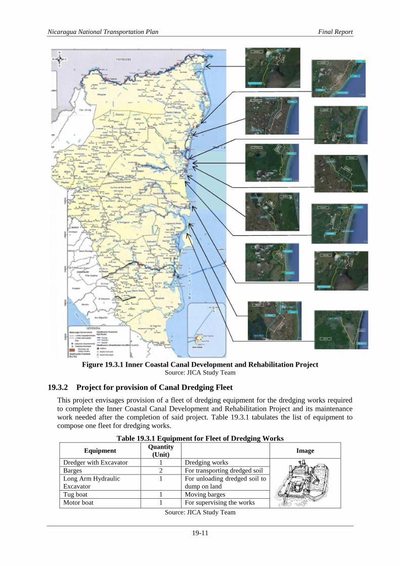
Nicaragua National Transportation Plan Final Report
19-11
Figure 19.3.1 Inner Coastal Canal Development and Rehabilitation Project
Source: JICA Study Team
19.3.2 Project for provision of Canal Dredging Fleet
This project envisages provision of a fleet of dredging equipment for the dredging works required
to complete the Inner Coastal Canal Development and Rehabilitation Project and its maintenance
work needed after the completion of said project. Table 19.3.1 tabulates the list of equipment to
compose one fleet for dredging works.
Table 19.3.1 Equipment for Fleet of Dredging Works
Equipment Quantity
(Unit) Image
Dredger with Excavator 1 Dredging works
Barges 2 For transporting dredged soil
Long Arm Hydraulic
Excavator
1 For unloading dredged soil to
dump on land
Tug boat 1 Moving barges
Motor boat 1 For supervising the works
Source: JICA Study Team

Nicaragua National Transportation Plan Final Report
19-12
19.3.3 Project for provision of Water Buses
This project envisages provision of three (3) units of river and canal water transport buses having
accommodation capacity of 30 – 40 passengers furnished with a cargo bay for transportation of
goods. Three (3) units of this type of boat have been already provided under the grant-in-kind of
the World Bank. Two units of them were delivered to Puerto Cabezas and one unit was delivered to
Bluefields already. The estimated cost of the project is US$ 1.2 million.
The docks along the river and canal for the water transport in RAAN and RAAS are planned to be
constructed by concerned municipality government where the docks are demanded by population
residing along the river and canal.

Nicaragua National Transportation Plan Final Report
20-1
Chapter 20 Airport Development Plan
20.1 Augusto C. Sandino International Airport
20.1.1 Runways
A single runway with efficient taxiway system is possible to handle annual aircraft movements of
195,000 to 240,0001. Since the result of annual aircraft movement demand forecast was
approximately 77,000 in 2033, current single runway is judged possible to handle the demand even
beyond 2033.
B737-800 is the model of major aircraft landing this airport that is demanded by airline companies
among current aircrafts landing at Augusto C. Sandino International Airport. Taking into account
the trend of airline preference for the route between North America and Central America, small
size jet aircraft such as B737-800 and A320 will remain be used toward the future. According to
the aircraft characteristics that relates to the airport planning, B737-800 requires 3,100 m runway
length at Augusto C. Sandino International Airport. It is necessary to extend the runway to 3,100 m
to improve safety aircraft operation and to cope with the demand. Figure 20.1.1 is the photos of
typical B737-800 model jet aircraft and view of passenger terminal from the top of command tower
of Augusto C. Sandino International Airport.
Figure 20.1.1 View of Augusto C. Sandino International Airport and B737-800
Source: JICA Study Team
20.1.2 Apron
Location of the existing passenger terminal area at the north side of the runway of Augusto C.
Sandino International Airport cannot satisfy full ICAO compliance of the airport because the tail
wing of small size jet aircraft in the apron penetrates the transitional surface, which is ICAO
Standard for the precision approach runway. Also, the distance between the parallel taxiway and
the runway is 150 m and it is less than the ICAO recommendation of 176 m for Code D aircraft in
instrument approach runway.
To solve above issues it is recommended to relocate the apron for larger size aircraft to the
southern side of the runway.
According to the results of air traffic demand forecast, jet aircraft might be introduced to the
domestic routes by year 2020 so that it is recommended to construct a new international and
domestic passenger building in the south side of the runway. The existing international passenger
building would be used for general aviation and office space.
It conflicts with current EAAI’s plan to construct a cargo terminal in the south however there are
plenty of spaces in the southern area so that both cargo terminal and passenger terminal can be
constructed together. Detailed study is required to prepare a future development plan in the area.
Phased development plan is recommended to construct the new terminal area. The new apron in the
1 ICAO Planning Manual Part 1 Master Plan

Nicaragua National Transportation Plan Final Report
20-2
south should have capacity of 6 parking spots for small size jet, 1 spot for twin turboprop and 3
spots for small turboprop in 2033. The following table shows facility requirements for the new
apron in 2020, 2025, 2030 and 2033.
Table 20.1.1 New Apron Spot Requirements International Domestic
SJ TTP STP SJ TTP STP
2020 5 1 1 1 2 1
2025 5 1 1 2 2 1
2030 6 1 2 3 2 1
2033 6 1 3 3 2 2
Source: JICA Study Team
20.1.3 Passenger Building
Capacity of the existing international passenger building is estimated to be able to handle 600 peak
hour passengers and the floor area is 24,900 sq.m. Thus, the floor area per peak hour passenger is
41.5 sq.m to provide better service level to the new international building, 45 sq.m per peak hour
passengers is adopted to calculate required floor area of the new international passenger building.
For calculation of domestic passenger building, generic area per peak hour passenger of 30 sq.m
per peak hour passenger is adopted. The table below shows requirements of buildings.
Table 20.1.2 Facility Requirements of Passenger Building at Augusto C. Sandino International
Airport
International
Year Annual Passenger Busy day passenger Busy Hour Passenger
(PHP)
Passenger Building
Area (45 sq.m/PHP)
2015 1,319,500 4,400 326 14,651
2020 1,815,000 6,100 440 19,793
2025 2,485,600 8,300 605 27,225
2030 3,420,300 11,500 829 37,284
2033 4,148,200 13,900 1,140 51,304
Domestic
Year Annual Passenger Busy day passenger Busy Hour Passenger
(PHP)
Passenger Building
Area (30 sq.m/PHP)
2015 187,300 700 48 1,434
2020 261,400 900 62 1,873
2025 365,000 1,300 87 2,614
2030 509,500 1,700 122 3,650
2033 622,400 2,100 170 5,095
Source: JICA Study Team
Comparing the facility requirement and the existing passenger building, it is necessary to expand
the capacity of the international passenger building or to build a new building by 2025.
20.1.4 Proposed Development Plan
Figure 20.1.2 illustrates the direction of transferring the passenger and cargo terminal in the future.
Short Term
- Airport Master Plan Study
- Expansion of the runway to 3,100 m to the east
Medium Term
- Development of southern terminal area with new aprons, international and domestic
passenger building, road and car parks.
Long Term
- Development of cargo terminal

Nicaragua National Transportation Plan Final Report
20-3
Figure 20.1.2 Expansion Plan of A. C. Sandino International Airport
Source: JICA Study Team
20.2 Puerto Cabezas Airport
20.2.1 Facility Requirements
Puerto Cabezas Airport is the second largest airport in Nicaragua in terms of passenger volume.
The passenger is composed of 39,483 domestic and 1,276 international passengers in 2011.
According to the results of the air traffic demand forecast, annual arrival of domestic passengers
will reach to 173,500 and the peak day passenger is projected to be 579 in 2033. Currently, twin
turboprop aircraft with 40 seats (ATR42) is operated for this airport. Taking into consideration of
the peak day passengers in future, it is expected that small size jet aircraft will be operated for the
domestic routes. Since the runway length is 2,471 m and the pavement strength is PCN
54/R/C/Y/W, the runway is adequate to operate small size jet for domestic route. However, this
length is not adequate to operate small jet with full load, so that runway extension will be required
in future.
Passenger building should be developed to meet with future demand. As the share of international
passenger volume is estimated at low, no special facility for international passenger will be
required.
The following table summarizes facility requirements of the airport.
Table 20.2.1 Facility Requirements of Puerto Cabezas Airport
Annual
Passengers
Busy Day
Passengers
Busy Hour
Passenger Apron Spot PTB Area
2015 51,030 171 20 TTP:1 700
2020 71,850 240 26 SJ:1 TTP:1 910
2025 100,910 337 36 SJ:1 TTP:2 1,260
2030 141,480 472 51 SJ:2 TTP:2 1,785
2033 173,180 578 71 SJ:2 TTP:2 2,485
Source: JICA Study Team
Puerto Cabezas is popular for sea products and there is potential to export these products to USA.
Therefore, it is recommended to build the cold storage facilities within the airport and processing
plants of the intermediaries, and secure the export channels to promote the export of these local
fishery products.
Construction of fuel supply facility is also recommended. Because fuel supply to aircraft is only
possible in Augusto C. Sandino Airport, utilization of aircraft in domestic route is limited.

Nicaragua National Transportation Plan Final Report
20-4
20.2.2 Development Plan
Figure 20.2.1 illustrates the perspective view of Puerto Cabezas Airport expansion plan.
Short Term
- Construction of a new passenger building
- Construction of a new fuel storage
Medium Term
- Construction of a new cargo terminal
Long Term
- Extension of the runway
Figure 20.2.1 Perspective View of Puerto Cabezas Expansion Plan
Source: JICA Study Team
20.3 Bluefields Airport
20.3.1 Facility Requirements
The passenger arrival volume was 32,530 as a domestic passenger and 6,196 as an international
passenger in 2011. ATR42 is currently used. There are 2 daily flights to Corn Island as of
November 2013. According to the air traffic demand forecast, annual domestic passengers will be
152,800 and international passengers will be 320,000 in 2033. To consider the volume, small size
jet aircraft will be operated in domestic routes by that time.
As the existing runway is not designed for small jet aircraft, runway extension and pavement
overlay will be required.
Apron expansion and new passenger building will be required. Table below summarized facility
requirements of Bluefields Airport.
Table 20.3.1 Facility Requirements of Bluefields Airport
Annual
Passengers
Busy Day
Passengers
Busy Hour
Passenger Apron Spot PTB Area
Domestic
2015 37,380 125 17 TTP:1 595
2020 52,620 176 19 TTP:1 665
2025 73,910 247 27 SJ:1 TTP:1 945
2030 103,630 346 37 SJ:1 TTP:2 1,295
2033 126,850 423 52 SJ:2 TTP:2 1,820
International
2015 8,460 29 29 TTP: 1 1,015
2020 12,450 42 32 TTP: 1 1,120
2025 17,790 60 32 TTP: 1 1,120
2030 25,420 85 32 TTP: 1 1,120
2033 31,490 105 32 TTP: 1 1,120
Source: JICA Study Team
There is a plan to develop Bluefields port. To construct a new cargo facility on the south side of the
airport is recommended. Because there is no fuel supply in the airport, operation of aircraft is
limited, it is recommended to construct fuel storage in the airport.

Nicaragua National Transportation Plan Final Report
20-5
20.3.2 Development Plan
Figure 20.3.1 illustrates the basic plan of Bluefields Airport Expansion Plan.
Short Term
- Rehabilitation of runway pavement
- Expansion of the runway strip and to cut trees at the south west part of the airport
- Construction of a new fuel storage
Medium Term
- Construction of a new passenger building in new terminal area
Long Term
- Construction of a new cargo terminal
- Extension of the runway
Figure 20.3.1 Basic Plan of Bluefields Airport Expansion Plan
Source: JICA Study Team
20.4 Corn Island Airport
20.4.1 Facility Requirements
There were 30,546 domestic passengers and 4,058 international passengers in 2011 in Corn Island
Airport. ATR42 is used between Bluefields and Corn Island. According to the air traffic demand
forecast, annual domestic passenger will be 139,990 and international will be 19,930 in 2033.
Small size jet aircraft may be introduced in the future. To accommodate jet aircraft, runway
extension and overlay work and expansion of the runway strip will be required. Apron for small jet
aircraft and turboprop aircraft will also be required. Construction of passenger building to handle
both international and domestic passenger will be required.
Table 20.4.1 Facility Requirements of Corn Island Airport
Annual
Passengers Busy Day
Passengers Busy Hour Passenger
Apron Spot PTB Area
Domestic
2015 41,250 138 16 TTP:1 560
2020 58,080 194 21 TTP:1 735
2025 81,570 272 30 TTP:1 1,050
2030 114,360 382 41 TTP:2 1,435
2033 139,990 467 58 SJ:1 TTP:2 2,030
International
2015 5,350 18 20 TTP: 1 700
2020 7,880 27 28 TTP: 1 980
2025 11,260 38 20 TTP: 1 700
2030 16,090 54 30 TTP: 1 1,050
2033 19,930 67 40 TTP: 1 1,400
Source: JICA Study Team
Passenger
Cargo

Nicaragua National Transportation Plan Final Report
20-6
The operation of the airport is limited to day light time because there is no airfield lighting system.
Airfield Lighting System for night time operation will expand the time of airport operation and also
as this is an isolated island, extension airport operation time will be useful for emergency cases. It
is recommended to install airfield lighting system.
20.4.2 Development Plan
Figure 20.4.1 illustrates the basic plan of Bluefields Airport Expansion Plan.
Short Term
- Installation of airfield lighting system
- Rehabilitation of airfield pavements
- Installation of new fence
Medium Term
- Construction of a new control tower
- Construction of a new passenger building
Long Term
- Expansion of the runway strip
Figure 20.4.1 Basic Plan of Corn Island Airport Expansion Plan
Source: JICA Study Team
20.5 San Carlos Airport
20.5.1 Facility Requirements
As the runway slope is steep and narrow, and there is no space to
expand the airport. For this reason there is a plan to construct a
new airport at the eastern side of the airport. However, it should
be considered that the road between San Carlos and Managua
had been improved and it takes approximately 4 hours by car and
6 hours by bus to Managua.
San Carlos has potential for tourism development because there
is an old fortress and San Juan River. It is recommended to
construct the new airport with basic facilities only such as gravel
runway and a small passenger building but to secure the area for
future expansion.
Figure 20.5.1 San Carlos
Airport Runway View Source: JICA Study Team

Nicaragua National Transportation Plan Final Report
20-7
Table 20.5.1 Facility Requirements of San Carlos Airport
Annual
Passengers Peak Day
Passengers Apron Spot
2015 4,290 15 STP:2
2020 6,030 21 STP:2
2025 8,480 29 STP:2
2030 11,880 40 STP:3
2033 14,550 49 STP:3
Source: JICA Study Team
20.5.2 Development Plan Short Term
- To construct new airport with gravel runway and small passenger building
Medium Term
- Construction of runway pavement
- Expansion of apron area
Long Term
- Expansion of passenger building
20.6 Bonanza Airport
20.6.1 Facility Requirements
Bonanza Airport is located in Bonanza Municipality. Because road condition between Bonanza to
neighboring town, Rosita, is bad and it takes approximately 3 hours from Bonanza to Rosita. The
existing airport plays important role for people in Bonanza and for the mining company. If the road
between Bonanza and Rosita would be developed, the airport in Rosita could serve for Bonanza
Municipality but until that time Bonanza Airport should be maintained.
As there is no complete fence, it is necessary to construct boundary fence for safe aircraft operation.
As Bonanza Municipality prepared city development plan and airport is included in the project. It is
recommended to develop the terminal area and new access road. As the airport surrounded by hills
it is not possible to introduce jet aircraft in the airport.
Table 20.6.1 Facility Requirements of Bonanza Airport
Annual
Passengers Peak Day
Passengers Apron Spot
2015 14,200 48 STP:2
2020 20,000 67 STP:2
2025 28,080 94 STP:3
2030 39,380 132 STP:4
2033 48,200 161 STP:5
Source: JICA Study Team
20.6.2 Development Plan Short Term
- To construct new boundary fence
Medium Term
- To construct new passenger building
20.7 Rosita Airport
20.7.1 Facility Requirements
Rosita airport has not been used since 2006 because of an issue with landowner of the airport area.
The airport is located in flat area and there is potential to develop large airport. Since road
condition between neighboring towns such as Bonanza and Siuna is bad, it is recommended to
re-open the airport to provide direct access to Managua from Rosita.

Nicaragua National Transportation Plan Final Report
20-8
The facility requirements of Rosita airport are same as the Bonanza Airport.
20.7.2 Development Plan Short Term
- To construct new boundary fence
- To construct a new gravel runway
Medium Term
- To construct new passenger building
20.8 Siuna Airport
Siuna airport is located in the middle of Siuna town. One side of the runway is hill and the other
side is valley. A main road is running along the runway and the other side of the runway is hill.
There are many obstacles in the terminal area including Government buildings. It is very difficult
to develop the airport to comply with safety standard.
It is recommended to close the airport and develop the road to Rosita airport.
20.9 San Juan de Nicaragua Airport
San Juan de Nicaragua Airport is located in the southeast edge of the country close to Costa Rica
border. The airport was constructed in 2012. The airport was constructed to intend to develop the
tourism in the area but there is not many tourist hotel and capacity to accommodate large volume of
tourist. To consider the scale of tourism development in the area, it is reasonable to presume
current airport is adequate for the future.
Figure 20.9.1 Airport Facilities and Runway views from San Juan de Nicaragua Airport
20.10 Ometepe Airport
Ometepe Airport is in La Paloma, located 2 km from Moyogalpa at the northwestern side of the
Ometepe Island in Nicaragua Lake. The airport was under construction as of November 2013. The
airport is developed for tourism development. The current airport facility is adequate for future
demand and no development will be required in near future.
Figure 20.10.1 Airport Facilities and Runway views from Ometepe Airport

Nicaragua National Transportation Plan Final Report
21-1
Chapter 21 Expected Environmental Impacts of the Master Plan
21.1 Introduction
This is a general preliminary assessment of expected social and environmental impacts of the
Master Plan. The methods of assessment were by (i) examining various maps such as elevation
map, protected area map, wetland map, topographic map, etc. and by (ii) utilizing knowledge of
national engineers working within the Team and MTI engineers. Maps clearly illustrate projects
that might fall inside nature reserve or projects that might pass through wetland or mountainous
areas. This information provides an initial idea if a project would generate high impact on the
environment. Likewise, discussions with engineers familiar with the area provide unique insight on
the cultural heritage of the communities that might be negatively affected by the projects. Figure
21.1.1 shows the location of the road improvement projects and the environment protection area.
Figure 21.1.1 New Road Construction and Reserve Areas
Source: JICA Study Team
21.2 Road and Bridge Projects within Nature Reserves
21.2.1 Road Projects
The locations of road projects are presented in Figure 21.2.1 for main trunk roads subject for
widening, Figure 21.2.2 for roads subject for pavement upgrade, and Figure 21.2.3 for roads need
to be widen to satisfy design criteria. The above-mentioned maps show projects that will pass along
environmentally sensitive areas.

Nicaragua National Transportation Plan Final Report
21-2
Figure 21.2.1 Main Trunks Roads subject for widening and Reserve Areas
Source: JICA Study Team

Nicaragua National Transportation Plan Final Report
21-3
Figure 21.2.2 Roads subject for pavement upgrading and Reserve Areas
Source: JICA Study Team
Figure 21.2.3 Roads subject for widening to satisfy design criteria and Reserve Areas
Source: JICA Study Team

Nicaragua National Transportation Plan Final Report
21-4
21.2.2 Bridge Projects
The location of bridge project is presented in the Figure 21.2.4. By looking at this map, it is easy to
identify bridge projects located inside the environmentally sensitive areas. Obviously, projects
inside the reserve area require careful planning to carry out construction works to minimize
environmental impacts.
Figure 21.2.4 Location of Bridge Projects and Reserve Areas
Source: JICA Study Team
21.3 Scoping of Projects
The scoping of projects was defined through the workshops held between JICA Study Team, MTI
engineers and the personnel responsible of environment issues. There was only limited information
regarding the generality of projects like their approximate geographical location and environment
protection area. Drawing up the scope was conducted with the scoping matrix method shown in
Table 21.3.1 - Tabla.21.3.10. On the other hand, a detailed definition of scope of evaluation was
not made. The results of the scoping related to Environmental Impact Assessment of the projects
are shown below:
Construction of New Road (Table 21.3.1)
Road Improvement by Widening of Main Trunks (Table 21.3.2)
Road Improvement by Upgrading of pavement (Table 21.3.3)
Road Rehabilitation by Widening to satisfy design criteria (Table 21.3.4)
Bridge Projects (Table 21.3.5)
Bus related Projects (Table 21.3.6)
Marine and Water Sector Projects (Table 21.3.7)

Nicaragua National Transportation Plan Final Report
21-5
Aviation Sector Projects (Table 21.3.8)
Logistics related Projects (Table 21.3.9)

Nica
rag
ua
Na
tion
al T
ran
spo
rtatio
n P
lan
Fin
al R
epo
rt
21-6
Table 21.3.1 Scoping Matrix for Road Projects (New Road Construction)
Source: JICA Study Team
Code Road Name /Environmental Items
Hu
man
Healt
h a
nd
So
cie
ty
Air p
ollu
tion
Wate
r pollu
tion
Soil
conta
min
atio
n
Waste
Nois
e a
nd v
ibra
tion
Offensiv
e o
dor
Accid
ent
Hazard
ous m
ate
rials
Natu
ral E
nvir
on
men
t
Topogra
phy &
geogra
phic
al f
eatu
res
Soil
ero
sio
n
Gro
undw
ate
r
Gro
und s
ubsid
ence
Riv
erb
ed s
edim
ent
Hydro
logic
al s
ituatio
n
Coasta
l zone (
mangro
ves, cora
l reefs
, tid
al f
lats
, etc
.)
Fauna, flo
ra a
nd b
iodiv
ers
ity
Landscape
Glo
bal w
arm
ing / C
limate
change
So
cia
l E
nvir
on
men
t
Involu
nta
ry r
esettle
ment
Local e
conom
y s
uch a
s e
mplo
ym
ent &
livelih
ood
Tra
velling a
nd m
obility
Relo
catio
n o
f exis
ting facilitie
s
Land u
se a
nd u
tiliz
atio
n o
f lo
cal r
esourc
es (
change o
f la
nd u
se)
Socia
l capita
l and lo
cal d
ecis
ion-m
akin
g s
yste
m
Exis
ting s
ocia
l infr
astr
uctu
re a
nd s
erv
ices
Vuln
era
ble
gro
ups, in
dig
enous a
nd / o
r A
fro-d
escendants
Gender
Child
ren’s
rig
ht
Cultu
ral h
erita
ge
Local c
onfli
ct of in
tere
sts
Wate
r usage o
r w
ate
r right and m
em
bers
hip
Sanita
tion
Infe
ctio
us d
isease s
uch a
s H
IV/A
IDS
Rem
ark
s
R_PR1 Chiquilistagua (NIC-12) - San Benito(NIC-1) ◯ ◯ ◯ ◯ ◯ ◯ ◯ ◯ ◯ ◯ ◯ ◯ ◯ ◯ ◯ ◯ Urban road
R_NR1 San Juan Del Sur - El Coyol ◯ ◯ ◯ ◯ ◯ ◯ ◯ ◯ ◯ ◯ ◯ ◯ ◯ ◯
R_NR2 Cardenas - Santa Fe ◯ ◯ ◯ ◯ ◯ ◯ ◯ ◯ ◯ ◯ ◯ ◯ ◯ ◯ ◯ ◯ Wildlife Refuge
R_NR3 El Rama - Las Brenas ◯ ◯ ◯ ◯ ◯ ◯ ◯ ◯ ◯ ◯ ◯ ◯ ◯ ◯ ◯ ◯ Natural reserve
R_NR4 El Ayote - El Tortuguero ◯ ◯ ◯ ◯ ◯ ◯ ◯ ◯ ◯ ◯ ◯ ◯ ◯ ◯
R_NR5 El Tortuguero - La Cruz De Rio Grande ◯ ◯ ◯ ◯ ◯ ◯ ◯ ◯ ◯ ◯ ◯ ◯ ◯ ◯ ◯
R_NR6 San Pedro Del Norte - La Cruz de Rio Grande ◯ ◯ ◯ ◯ ◯ ◯ ◯ ◯ ◯ ◯ ◯ ◯ ◯ ◯ ◯ ◯
R_NR7 Makantaka - Karaw ala ◯ ◯ ◯ ◯ ◯ ◯ ◯ ◯ ◯ ◯ ◯ ◯ ◯ ◯ ◯ ◯ ◯ ◯ ◯ Natural reserve
R_NR8 Point B - Prinzapolka ◯ ◯ ◯ ◯ ◯ ◯ ◯ ◯ ◯ ◯ ◯ ◯ ◯ ◯ ◯ ◯ ◯ ◯ ◯Inundat ion area and
biological reserve area
R_NR9 La Cruz De Rio Grande - Alamikamba ◯ ◯ ◯ ◯ ◯ ◯ ◯ ◯ ◯ ◯ ◯ ◯ ◯ ◯ ◯ ◯ ◯ ◯Likely to pass thru
reserved area
R_NR10 La Trinidad - Masachapa ◯ ◯ ◯ ◯ ◯ ◯ ◯ ◯ ◯ ◯ ◯ ◯ ◯ ◯ ◯ ◯
R_NR11 Siuna - Bonanza ◯ ◯ ◯ ◯ ◯ ◯ ◯ ◯ ◯ ◯ ◯ ◯ ◯ ◯ ◯Biosphere reserve and
mountainous area
R_NR12 Bonanza - Point C ◯ ◯ ◯ ◯ ◯ ◯ ◯ ◯ ◯ ◯ ◯ ◯ ◯ ◯ Biosphere reserve
R_NR13 Empalme Puerto Sandino - La Paz Centro ◯ ◯ ◯ ◯ ◯ ◯ ◯ ◯ ◯ ◯ ◯ ◯ ◯ ◯
R_NR14 Empalme de Telica - Puerto Corinto ◯ ◯ ◯ ◯ ◯ ◯ ◯ ◯ ◯ ◯ ◯ ◯ ◯ ◯
Note: ◯ Likely to cause signif icant negative impact

Nica
rag
ua
Na
tion
al T
ran
spo
rtatio
n P
lan
Fin
al R
epo
rt
21-7
Table 21.3.2 Scoping Matrix for Road Projects (Widening of Main Trunk Road)
Source: JICA Study Team
Code Road Name /Environmental Items
Hu
man
Healt
h a
nd
So
cie
ty
Air p
ollu
tion
Wate
r pollu
tion
Soil
conta
min
atio
n
Waste
Nois
e a
nd v
ibra
tion
Offensiv
e o
dor
Accid
ent
Hazard
ous m
ate
rials
Natu
ral E
nvir
on
men
t
Topogra
phy &
geogra
phic
al f
eatu
res
Soil
ero
sio
n
Gro
undw
ate
r
Gro
und s
ubsid
ence
Riv
erb
ed s
edim
ent
Hydro
logic
al s
ituatio
n
Coasta
l zone (
mangro
ves, cora
l reefs
, tid
al f
lats
, etc
.)
Fauna, flo
ra a
nd b
iodiv
ers
ity
Landscape
Glo
bal w
arm
ing / C
limate
change
So
cia
l E
nvir
on
men
t
Involu
nta
ry r
esettle
ment
Local e
conom
y s
uch a
s e
mplo
ym
ent &
livelih
ood
Tra
velling a
nd m
obility
Relo
catio
n o
f exis
ting facilitie
s
Land u
se a
nd u
tiliz
atio
n o
f lo
cal r
esourc
es (
change o
f la
nd u
se)
Socia
l capita
l and lo
cal d
ecis
ion-m
akin
g s
yste
m
Exis
ting s
ocia
l infr
astr
uctu
re a
nd s
erv
ices
Vuln
era
ble
gro
ups, in
dig
enous a
nd / o
r A
fro-d
escendants
Gender
Child
ren’s
rig
ht
Cultu
ral h
erita
ge
Local c
onfli
ct of in
tere
sts
Wate
r usage o
r w
ate
r right and m
em
bers
hip
Sanita
tion
Infe
ctio
us d
isease s
uch a
s H
IV/A
IDS
Rem
ark
s
R_IW1 NIC-2 Int. - León (NIC-12A) ◯ ◯ ◯ ◯ ◯ ◯ ◯ ◯
R_IW2 León - Chinandega (NIC-12A) ◯ ◯ ◯ ◯ ◯ ◯ ◯ ◯
R_IW3 C. Sandino - Mateare (NIC-28) ◯ ◯ ◯ ◯ ◯ ◯ ◯ ◯
R_IW4 NIC-12A Int. – Jinotepe (NIC-2) ◯ ◯ ◯ ◯ ◯ ◯ ◯ ◯
R_IW5 Jinotepe - Nandaime (NIC-2) ◯ ◯ ◯ ◯ ◯ ◯ ◯ ◯
R_IW6 Nandaime - Rivas (NIC-2) ◯ ◯ ◯ ◯ ◯ ◯ ◯ ◯
R_IW7 Jean Paul Genie Rd. - Masaya (NIC-4) ◯ ◯ ◯ ◯ ◯ ◯ ◯ ◯
R_IW8 Tipitapa – San Isidro (NIC-1) ◯ ◯ ◯ ◯ ◯ ◯ ◯ ◯ ◯ ◯ w ith bridge
Note: ◯ Likely to cause signif icant negative impact

Nica
rag
ua
Na
tion
al T
ran
spo
rtatio
n P
lan
Fin
al R
epo
rt
21-8
Table 21.3.3 Scoping Matrix for Road Projects (Reconstruction – change of pavement)
Code Road Name /Environmental Items
Hu
man
Healt
h a
nd
So
cie
ty
Air p
ollu
tion
Wate
r pollu
tion
Soil
conta
min
atio
n
Waste
Nois
e a
nd v
ibra
tion
Offensiv
e o
dor
Accid
ent
Hazard
ous m
ate
rials
Natu
ral E
nvir
on
men
t
Topogra
phy &
geogra
phic
al f
eatu
res
Soil
ero
sio
n
Gro
undw
ate
r
Gro
und s
ubsid
ence
Riv
erb
ed s
edim
ent
Hydro
logic
al s
ituatio
n
Coasta
l zone (
mangro
ves, cora
l reefs
, tid
al f
lats
, etc
.)
Fauna, flo
ra a
nd b
iodiv
ers
ity
Landscape
Glo
bal w
arm
ing / C
limate
change
So
cia
l E
nvir
on
men
t
Involu
nta
ry r
esettle
ment
Local e
conom
y s
uch a
s e
mplo
ym
ent &
livelih
ood
Tra
velling a
nd m
obility
Relo
catio
n o
f exis
ting facilitie
s
Land u
se a
nd u
tiliz
atio
n o
f lo
cal r
esourc
es (
change o
f la
nd u
se)
Socia
l capita
l and lo
cal d
ecis
ion-m
akin
g s
yste
m
Exis
ting s
ocia
l infr
astr
uctu
re a
nd s
erv
ices
Vuln
era
ble
gro
ups, in
dig
enous a
nd / o
r A
fro-d
escendants
Gender
Child
ren’s
rig
ht
Cultu
ral h
erita
ge
Local c
onfli
ct of in
tere
sts
Wate
r usage o
r w
ate
r right and m
em
bers
hip
Sanita
tion
Infe
ctio
us d
isease s
uch a
s H
IV/A
IDS
Rem
ark
s
R_IC1 Boaco - Muy Muy (NIC-9) ◯ ◯ ◯ ◯ ◯ ◯ ◯ ◯ ◯ ◯ w ith bridge
R_IC2 Muy Muy - Rio Blanco (NIC-21B) ◯ ◯ ◯ ◯ ◯ ◯ ◯ ◯ ◯ ◯ w ith bridge
R_IC3 Río Blanco - Puerto Cabezas (NIC-21B) ◯ ◯ ◯ ◯ ◯ ◯ ◯ ◯ ◯ ◯ ◯ ◯ Miskito community
R_IC4 Cosiguina - Potosí (NIC-12B) ◯ ◯ ◯ ◯ ◯ ◯ ◯ ◯
R_IC5 Telpaneca - Pueblo Nuevo (NIC-38&51) ◯ ◯ ◯ ◯ ◯ ◯ ◯ ◯ ◯ ◯ w ith bridge
R_IC6 Cuyalli – San Rafael Del Norte(NIC-41) ◯ ◯ ◯ ◯ ◯ ◯ ◯ ◯
R_IC7 NIC-24B – Ville Las Pilas (NN-270) ◯ ◯ ◯ ◯ ◯ ◯ ◯ ◯
R_IC8 El Sauce – Guacucal (NIC-38) ◯ ◯ ◯ ◯ ◯ ◯ ◯ ◯
R_IC9 Santa Rosa – Camoapa (NIC-19B1) ◯ ◯ ◯ ◯ ◯ ◯ ◯ ◯
R_IC10 La Libertad – Santo Tomas (NIC-23A) ◯ ◯ ◯ ◯ ◯ ◯ ◯ ◯
R_IC11 Esquipulas – La Concepción (NIC-20B1) ◯ ◯ ◯ ◯ ◯ ◯ ◯ ◯
R_IC12 Masaya - Zambrano (NIC-27) ◯ ◯ ◯ ◯ ◯ ◯ ◯ ◯
R_IC13 El Rosaria – La Conquista (NIC-20C) ◯ ◯ ◯ ◯ ◯ ◯ ◯ ◯
R_IC14 Boom Siril – Waspan (NN-73) ◯ ◯ ◯ ◯ ◯ ◯ ◯ ◯ ◯ Biological reserve
R_IC15 Rivas - Tola (NIC-62) ◯ ◯ ◯ ◯ ◯ ◯ ◯ ◯
R_IC16 Peripheral road Ometepe Island (NIC-64) ◯ ◯ ◯ ◯ ◯ ◯ ◯ ◯
Note: ◯ Likely to cause signif icant negative impact Source: JICA Study Team

Nica
rag
ua
Na
tion
al T
ran
spo
rtatio
n P
lan
Fin
al R
epo
rt
21-9
Table 21.3.4 Scoping Matrix for Road Projects (Widening to Satisfy Design Criteria)
Code Road Name /Environmental Items
Hu
man
Healt
h a
nd
So
cie
ty
Air p
ollu
tion
Wate
r pollu
tion
Soil
conta
min
atio
n
Waste
Nois
e a
nd v
ibra
tion
Offensiv
e o
dor
Accid
ent
Hazard
ous m
ate
rials
Natu
ral E
nvir
on
men
t
Topogra
phy &
geogra
phic
al f
eatu
res
Soil
ero
sio
n
Gro
undw
ate
r
Gro
und s
ubsid
ence
Riv
erb
ed s
edim
ent
Hydro
logic
al s
ituatio
n
Coasta
l zone (
mangro
ves, cora
l reefs
, tid
al f
lats
, etc
.)
Fauna, flo
ra a
nd b
iodiv
ers
ity
Landscape
Glo
bal w
arm
ing / C
limate
change
So
cia
l E
nvir
on
men
t
Involu
nta
ry r
esettle
ment
Local e
conom
y s
uch a
s e
mplo
ym
ent &
livelih
ood
Tra
velling a
nd m
obility
Relo
catio
n o
f exis
ting facilitie
s
Land u
se a
nd u
tiliz
atio
n o
f lo
cal r
esourc
es (
change o
f la
nd u
se)
Socia
l capita
l and lo
cal d
ecis
ion-m
akin
g s
yste
m
Exis
ting s
ocia
l infr
astr
uctu
re a
nd s
erv
ices
Vuln
era
ble
gro
ups, in
dig
enous a
nd / o
r A
fro-d
escendants
Gender
Child
ren’s
rig
ht
Cultu
ral h
erita
ge
Local c
onfli
ct of in
tere
sts
Wate
r usage o
r w
ate
r right and m
em
bers
hip
Sanita
tion
Infe
ctio
us d
isease s
uch a
s H
IV/A
IDS
Rem
ark
s
R_IR1 Granada - Tecolostote (NIC-39) ◯ ◯ ◯ ◯ ◯ ◯ ◯ with bridge and soft soil
R_IR2 La Gateada - Nueva Guinea (NIC-71) ◯ ◯ ◯ ◯ ◯ ◯ Biosphere reserve area
R_IR2-1 Nueva Guinea - Bluefields (NIC-71) ◯ ◯ ◯ ◯ ◯ ◯ ◯ ◯ ◯ ◯Natural and biosphere
reserve
R_IR3 El Rama-Kukra Hills-Laguna de Perlas ◯ ◯ ◯ ◯ ◯ ◯ ◯ ◯ ◯ ◯ Passes wetland
R_IR4 Santa Domingo - El Ayote (NIC23B) ◯ ◯ ◯ ◯R_IR5 Las Esparanza - El Tortuguero ◯ ◯ ◯ ◯ Natural reserve
R_IR6 Río Blanco - San Pedro del Norte (NIC-13C) ◯ ◯ ◯ ◯R_IR7 El Empalme - Alamikamba (NN-288) ◯ ◯ ◯ ◯
R_IR8 Int. of NIC-24B- End of NIC 54(Various) ◯ ◯ ◯ ◯M ountainous area with
frequent rain shower
R_IR8-1 NIC 54&Int. of NIC-21B(NIC-57,54&5) ◯ ◯ ◯M ountainous area with
frequent rain shower
R_IR9 Malpaisillo - Villa 15 de Julio(NIC68/NN252) ◯ ◯ ◯R_IR10 La Paz Centro - Malpaisillo (NIC-22) ◯ ◯ ◯R_IR11 Empalme San Ramon - Matiguas (NIC-33) ◯ ◯ ◯ ◯R_IR12 Pajaro Negro - El Triunfo (NN-114) ◯ ◯ ◯ ◯ Biosphere reserve area
R_IC13 El Empalme – San Jacinto (NIC-70A) ◯ ◯ ◯ ◯
Note: ◯ Likely to cause signif icant negative impact Source: JICA Study Team
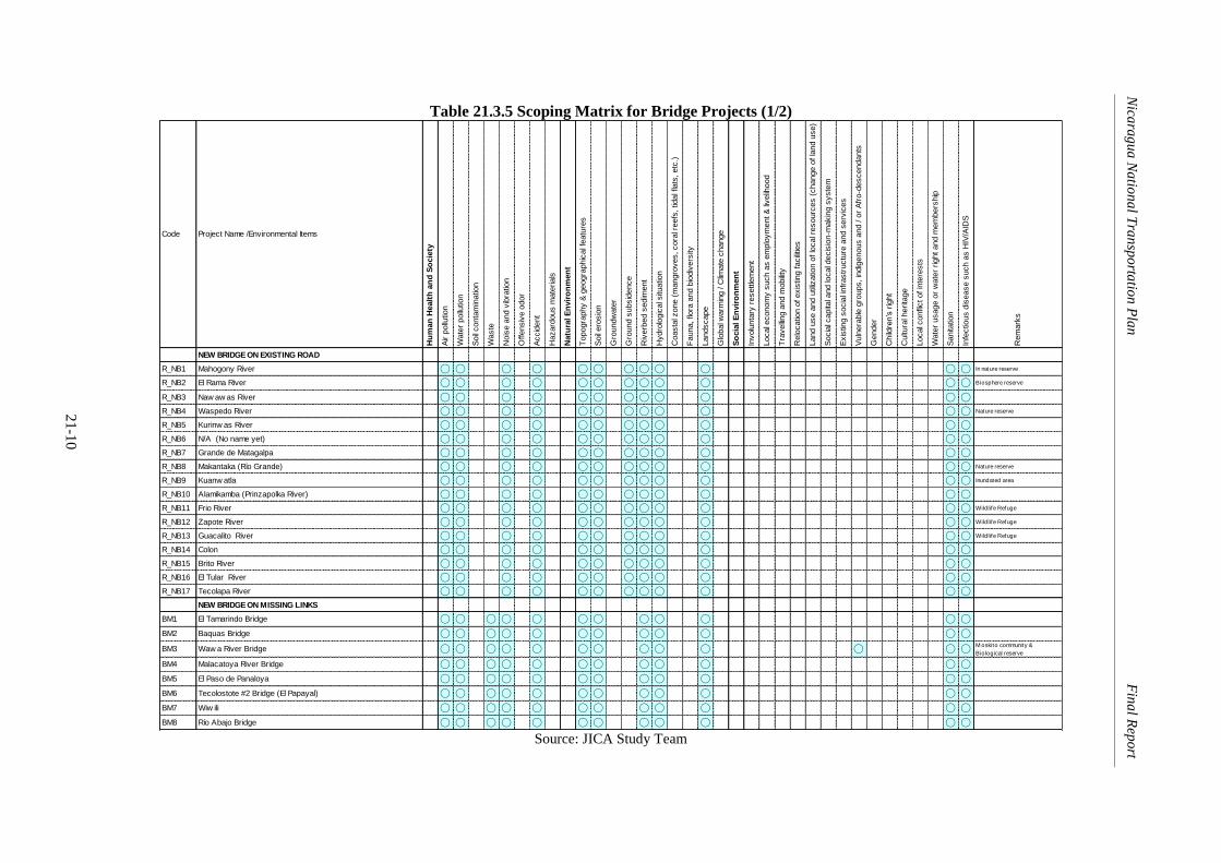
Nica
rag
ua
Na
tion
al T
ran
spo
rtatio
n P
lan
Fin
al R
epo
rt
21-1
0
Table 21.3.5 Scoping Matrix for Bridge Projects (1/2)
Code Project Name /Environmental Items
Hu
man
Healt
h a
nd
So
cie
ty
Air p
ollu
tion
Wate
r pollu
tion
Soil
conta
min
atio
n
Waste
Nois
e a
nd v
ibra
tion
Offensiv
e o
dor
Accid
ent
Hazard
ous m
ate
rials
Natu
ral E
nvir
on
men
t
Topogra
phy &
geogra
phic
al f
eatu
res
Soil
ero
sio
n
Gro
undw
ate
r
Gro
und s
ubsid
ence
Riv
erb
ed s
edim
ent
Hydro
logic
al s
ituatio
n
Coasta
l zone (
mangro
ves, cora
l reefs
, tid
al f
lats
, etc
.)
Fauna, flo
ra a
nd b
iodiv
ers
ity
Landscape
Glo
bal w
arm
ing / C
limate
change
So
cia
l E
nvir
on
men
t
Involu
nta
ry r
esettle
ment
Local e
conom
y s
uch a
s e
mplo
ym
ent &
livelih
ood
Tra
velling a
nd m
obility
Relo
catio
n o
f exis
ting facilitie
s
Land u
se a
nd u
tiliz
atio
n o
f lo
cal r
esourc
es (
change o
f la
nd u
se)
Socia
l capita
l and lo
cal d
ecis
ion-m
akin
g s
yste
m
Exis
ting s
ocia
l infr
astr
uctu
re a
nd s
erv
ices
Vuln
era
ble
gro
ups, in
dig
enous a
nd / o
r A
fro-d
escendants
Gender
Child
ren’s
rig
ht
Cultu
ral h
erita
ge
Local c
onfli
ct of in
tere
sts
Wate
r usage o
r w
ate
r right and m
em
bers
hip
Sanita
tion
Infe
ctio
us d
isease s
uch a
s H
IV/A
IDS
Rem
ark
s
NEW BRIDGE ON EXISTING ROAD
R_NB1 Mahogony River ◯ ◯ ◯ ◯ ◯ ◯ ◯ ◯ ◯ ◯ ◯ ◯ In nature reserve
R_NB2 El Rama River ◯ ◯ ◯ ◯ ◯ ◯ ◯ ◯ ◯ ◯ ◯ ◯ Biosphere reserve
R_NB3 Naw aw as River ◯ ◯ ◯ ◯ ◯ ◯ ◯ ◯ ◯ ◯ ◯ ◯
R_NB4 Waspedo River ◯ ◯ ◯ ◯ ◯ ◯ ◯ ◯ ◯ ◯ ◯ ◯ Nature reserve
R_NB5 Kurinw as River ◯ ◯ ◯ ◯ ◯ ◯ ◯ ◯ ◯ ◯ ◯ ◯
R_NB6 N/A (No name yet) ◯ ◯ ◯ ◯ ◯ ◯ ◯ ◯ ◯ ◯ ◯ ◯
R_NB7 Grande de Matagalpa ◯ ◯ ◯ ◯ ◯ ◯ ◯ ◯ ◯ ◯ ◯ ◯
R_NB8 Makantaka (Río Grande) ◯ ◯ ◯ ◯ ◯ ◯ ◯ ◯ ◯ ◯ ◯ ◯ Nature reserve
R_NB9 Kuanw atla ◯ ◯ ◯ ◯ ◯ ◯ ◯ ◯ ◯ ◯ ◯ ◯ Inundated area
R_NB10 Alamikamba (Prinzapolka River) ◯ ◯ ◯ ◯ ◯ ◯ ◯ ◯ ◯ ◯ ◯ ◯
R_NB11 Frio River ◯ ◯ ◯ ◯ ◯ ◯ ◯ ◯ ◯ ◯ ◯ ◯ Wildlife Refuge
R_NB12 Zapote River ◯ ◯ ◯ ◯ ◯ ◯ ◯ ◯ ◯ ◯ ◯ ◯ Wildlife Refuge
R_NB13 Guacalito River ◯ ◯ ◯ ◯ ◯ ◯ ◯ ◯ ◯ ◯ ◯ ◯ Wildlife Refuge
R_NB14 Colon ◯ ◯ ◯ ◯ ◯ ◯ ◯ ◯ ◯ ◯ ◯ ◯
R_NB15 Brito River ◯ ◯ ◯ ◯ ◯ ◯ ◯ ◯ ◯ ◯ ◯ ◯
R_NB16 El Tular River ◯ ◯ ◯ ◯ ◯ ◯ ◯ ◯ ◯ ◯ ◯ ◯
R_NB17 Tecolapa River ◯ ◯ ◯ ◯ ◯ ◯ ◯ ◯ ◯ ◯ ◯ ◯
NEW BRIDGE ON MISSING LINKS
BM1 El Tamarindo Bridge ◯ ◯ ◯ ◯ ◯ ◯ ◯ ◯ ◯ ◯ ◯ ◯
BM2 Baquas Bridge ◯ ◯ ◯ ◯ ◯ ◯ ◯ ◯ ◯ ◯ ◯ ◯
BM3 Waw a River Bridge ◯ ◯ ◯ ◯ ◯ ◯ ◯ ◯ ◯ ◯ ◯ ◯ ◯M oskito community &
Biological reserve
BM4 Malacatoya River Bridge ◯ ◯ ◯ ◯ ◯ ◯ ◯ ◯ ◯ ◯ ◯ ◯
BM5 El Paso de Panaloya ◯ ◯ ◯ ◯ ◯ ◯ ◯ ◯ ◯ ◯ ◯ ◯
BM6 Tecolostote #2 Bridge (El Papayal) ◯ ◯ ◯ ◯ ◯ ◯ ◯ ◯ ◯ ◯ ◯ ◯
BM7 Wiw ili ◯ ◯ ◯ ◯ ◯ ◯ ◯ ◯ ◯ ◯ ◯ ◯
BM8 Río Abajo Bridge ◯ ◯ ◯ ◯ ◯ ◯ ◯ ◯ ◯ ◯ ◯ ◯ Source: JICA Study Team

Nica
rag
ua
Na
tion
al T
ran
spo
rtatio
n P
lan
Fin
al R
epo
rt
21-1
1
Table 21.3.5 Scoping Matrix for Bridge Projects (2/2)
Code Project Name /Environmental Items
Hu
man
Healt
h a
nd
So
cie
ty
Air p
ollu
tion
Wate
r pollu
tion
Soil
conta
min
atio
n
Waste
Nois
e a
nd v
ibra
tion
Offensiv
e o
dor
Accid
ent
Hazard
ous m
ate
rials
Natu
ral E
nvir
on
men
t
Topogra
phy &
geogra
phic
al f
eatu
res
Soil
ero
sio
n
Gro
undw
ate
r
Gro
und s
ubsid
ence
Riv
erb
ed s
edim
ent
Hydro
logic
al s
ituatio
n
Coasta
l zone (
mangro
ves, cora
l reefs
, tid
al f
lats
, etc
.)
Fauna, flo
ra a
nd b
iodiv
ers
ity
Landscape
Glo
bal w
arm
ing / C
limate
change
So
cia
l E
nvir
on
men
t
Involu
nta
ry r
esettle
ment
Local e
conom
y s
uch a
s e
mplo
ym
ent &
livelih
ood
Tra
velling a
nd m
obility
Relo
catio
n o
f exis
ting facilitie
s
Land u
se a
nd u
tiliz
atio
n o
f lo
cal r
esourc
es (
change o
f la
nd u
se)
Socia
l capita
l and lo
cal d
ecis
ion-m
akin
g s
yste
m
Exis
ting s
ocia
l infr
astr
uctu
re a
nd s
erv
ices
Vuln
era
ble
gro
ups, in
dig
enous a
nd / o
r A
fro-d
escendants
Gender
Child
ren’s
rig
ht
Cultu
ral h
erita
ge
Local c
onfli
ct of in
tere
sts
Wate
r usage o
r w
ate
r right and m
em
bers
hip
Sanita
tion
Infe
ctio
us d
isease s
uch a
s H
IV/A
IDS
Rem
ark
s
REPLACEMENT OF TEMPORARY BRIDGE
R_BT1 San Judas Bridge ◯ ◯ ◯ ◯ ◯ ◯ ◯ ◯ ◯ ◯ ◯ ◯
R_BT2 Santa Rosa Del Peñón Bridge ◯ ◯ ◯ ◯ ◯ ◯ ◯ ◯ ◯ ◯ ◯ ◯
R_BT3 La Potranca Bridge ◯ ◯ ◯ ◯ ◯ ◯ ◯ ◯ ◯ ◯ ◯ ◯
R_BT4 Sunsin No.2 Bridge ◯ ◯ ◯ ◯ ◯ ◯ ◯ ◯ ◯ ◯ ◯ ◯
R_BT5 Luku River Bridge ◯ ◯ ◯ ◯ ◯ ◯ ◯ ◯ ◯ ◯ ◯ ◯ Biosphere reserve
R_BT6 Labu River Bridge ◯ ◯ ◯ ◯ ◯ ◯ ◯ ◯ ◯ ◯ ◯ ◯
R_BT7 Pasle Bridge ◯ ◯ ◯ ◯ ◯ ◯ ◯ ◯ ◯ ◯ ◯ ◯
R_BT8 El Cua River Bridge (La Maroanosa) ◯ ◯ ◯ ◯ ◯ ◯ ◯ ◯ ◯ ◯ ◯ ◯
REPLACEMENT OF DAMAGE BRIDGE
R_BD1 Wani River ◯ ◯ ◯ ◯ ◯ ◯ ◯ ◯ ◯ ◯ ◯ ◯
R_BD2 El Tuma Bridge (Mulukuku) ◯ ◯ ◯ ◯ ◯ ◯ ◯ ◯ ◯ ◯ ◯ ◯ Biosphere reserve
R_BD3 Prinzapolka Bridge ◯ ◯ ◯ ◯ ◯ ◯ ◯ ◯ ◯ ◯ ◯ ◯ Biosphere reserve
R_BD4 Banacruz Bridge ◯ ◯ ◯ ◯ ◯ ◯ ◯ ◯ ◯ ◯ ◯ ◯
R_BD5 Paso Real Bridge(Estelí) ◯ ◯ ◯ ◯ ◯ ◯ ◯ ◯ ◯ ◯ ◯ ◯ Biosphere reserve
R_BD6 Zinica River Bridge ◯ ◯ ◯ ◯ ◯ ◯ ◯ ◯ ◯ ◯ ◯ ◯ Biosphere reserve
R_BD7 Puente San Pablo Bridge ◯ ◯ ◯ ◯ ◯ ◯ ◯ ◯ ◯ ◯ ◯ ◯ Biosphere reserve
R_BD8 La Esperanza Bridge ◯ ◯ ◯ ◯ ◯ ◯ ◯ ◯ ◯ ◯ ◯ ◯ Biosphere reserve
R_BD9 Cuisala Bridge ◯ ◯ ◯ ◯ ◯ ◯ ◯ ◯ ◯ ◯ ◯ ◯
R_BD10 Rosa Grande Bridge ◯ ◯ ◯ ◯ ◯ ◯ ◯ ◯ ◯ ◯ ◯ ◯
R_MR Maintenance of entire basic netw ork ◯ ◯ ◯ ◯ ◯ ◯
R_DM Provision and replacement of infrastructure against disaster ◯ ◯ ◯ ◯ ◯ ◯
Note: ◯ Likely to cause signif icant negative impact Source: JICA Study Team

Nica
rag
ua
Na
tion
al T
ran
spo
rtatio
n P
lan
Fin
al R
epo
rt
21-1
2
Table 21.3.6 Scoping Matrix for Bus Related Projects
Code Project Name /Environmental Items
Hu
man
Healt
h a
nd
So
cie
ty
Air p
ollu
tion
Wate
r pollu
tion
Soil
conta
min
ation
Waste
Nois
e a
nd v
ibra
tion
Off
ensiv
e o
dor
Accid
ent
Hazard
ous m
ate
rials
Natu
ral
En
vir
on
men
t
Topogra
phy &
geogra
phic
al fe
atu
res
Soil
ero
sio
n
Gro
undw
ate
r
Gro
und s
ubsid
ence
Riv
erb
ed s
edim
ent
Hydro
logic
al situation
Coasta
l zone (
mangro
ves,
cora
l re
efs
, tidal flats
, etc
.)
Fauna,
flora
and b
iodiv
ers
ity
Landscape
Glo
bal w
arm
ing /
Clim
ate
change
So
cia
l E
nvir
on
men
t
Involu
nta
ry r
esett
lem
ent
Local econom
y s
uch a
s e
mplo
ym
ent
& liv
elih
ood
Tra
velli
ng a
nd m
obili
ty
Relo
cation o
f exis
ting f
acili
ties
Land u
se a
nd u
tiliz
ation o
f lo
cal re
sourc
es (
change o
f la
nd u
se)
Socia
l capital and local decis
ion-m
akin
g s
yste
m
Exis
ting s
ocia
l in
frastr
uctu
re a
nd s
erv
ices
Vuln
era
ble
gro
ups,
indig
enous a
nd /
or
Afr
o-d
escendants
Gender
Child
ren’s
rig
ht
Cultura
l herita
ge
Local conflic
t of
inte
rests
Wate
r usage o
r w
ate
r right
and m
em
bers
hip
Sanitation
Infe
ctious d
isease s
uch a
s H
IV/A
IDS
Rem
ark
s
B_F Big Capacity Bus for Inter-Urban Bus route*
B_T Bus Terminal (Big Size Buses) ◯ ◯ ◯ ◯ ◯ ◯ ◯ ◯B_T Bus Terminal (Middle Size Buses) ◯ ◯ ◯ ◯ ◯ ◯ ◯ ◯B_T Bus Terminal (Small Size Buses) ◯ ◯ ◯ ◯ ◯ ◯ ◯ ◯B_RS Roadside Station ◯ ◯ ◯ ◯ ◯ ◯B_I Bus Inspection Workshop ◯ ◯ ◯ ◯
Note: * Not appropriate to carry out project scoping
◯ Likely to cause significant negative impact Source: JICA Study Team

Nica
rag
ua
Na
tion
al T
ran
spo
rtatio
n P
lan
Fin
al R
epo
rt
21-1
3
Table 21.3.7 Scoping Matrix for Port and Water Transport Related Projects
Code Project Name /Environmental Items
Hu
man
Healt
h a
nd
So
cie
ty
Air p
ollu
tion
Wate
r pollu
tion
Soil
conta
min
atio
n
Waste
Nois
e a
nd v
ibra
tion
Offensiv
e o
dor
Accid
ent
Hazard
ous m
ate
rials
Natu
ral E
nvir
on
men
t
Topogra
phy &
geogra
phic
al f
eatu
res
Soil
ero
sio
n
Gro
undw
ate
r
Gro
und s
ubsid
ence
Riv
erb
ed s
edim
ent
Hydro
logic
al s
ituatio
n
Coasta
l zone (
mangro
ves, cora
l reefs
, tid
al f
lats
, etc
.)
Fauna, flo
ra a
nd b
iodiv
ers
ity
Landscape
Glo
bal w
arm
ing / C
limate
change
So
cia
l E
nvir
on
men
t
Involu
nta
ry r
esettle
ment
Local e
conom
y s
uch a
s e
mplo
ym
ent &
livelih
ood
Tra
velling a
nd m
obility
Relo
catio
n o
f exis
ting facilitie
s
Land u
se a
nd u
tiliz
atio
n o
f lo
cal r
esourc
es (
change o
f la
nd u
se)
Socia
l capita
l and lo
cal d
ecis
ion-m
akin
g s
yste
m
Exis
ting s
ocia
l infr
astr
uctu
re a
nd s
erv
ices
Vuln
era
ble
gro
ups, in
dig
enous a
nd / o
r A
fro-d
escendants
Gender
Child
ren’s
rig
ht
Cultu
ral h
erita
ge
Local c
onfli
ct of in
tere
sts
Wate
r usage o
r w
ate
r right and m
em
bers
hip
Sanita
tion
Infe
ctio
us d
isease s
uch a
s H
IV/A
IDS
Rem
ark
s
PORT PROJECTS
W_EP_1 Expansion of Puerto Corinto ◯ ◯ ◯ ◯ ◯ ◯ ◯ ◯ ◯ ◯ ◯ ◯ ◯ ◯ ◯ ◯ ◯ ◯W_NP_1 Construction of New Bluefields Port ◯ ◯ ◯ ◯ ◯ ◯ ◯ ◯ ◯ ◯ ◯ ◯ ◯ ◯ ◯ ◯ ◯ ◯ ◯ ◯ ◯ ◯ Reserve area
W_EP_1 Expansion of Puerto Cabezas ◯ ◯ ◯ ◯ ◯ ◯ ◯ ◯ ◯ ◯ ◯ ◯ ◯ ◯ ◯ ◯ ◯ Biological reserve
WATER TRANSPORT
W_IW_1 Inland Water Way along Atlantic Coast ◯ ◯ ◯ ◯ ◯ ◯ ◯ ◯ ◯ ◯ ◯ ◯ ◯ ◯ ◯ ◯ ◯ ◯ ◯ ◯ ◯ ◯ ◯W_NW_1 Channel Dredging Fleet*
W_NW_2 Passenger Boats for Public Water Transport Services in RAAN*
W_NW_3 Passenger Boats for Public Water Transport Services in RAAS*
W_NW_4 Improvement of River and Lake Ports ◯ ◯ ◯ ◯ ◯ ◯ ◯ ◯ ◯ ◯ ◯ ◯ ◯ ◯ ◯ ◯ ◯ ◯ ◯ ◯ ◯ ◯Note: * Not appropriate to carry out project scoping
◯ Likely to cause signif icant negative impact Source: JICA Study Team

Nica
rag
ua
Na
tion
al T
ran
spo
rtatio
n P
lan
Fin
al R
epo
rt
21-1
4
Table 21.3.8 Scoping Matrix for Aviation Related Projects
Code Project Name /Environmental Items
Hu
man
Healt
h a
nd
So
cie
ty
Air p
ollu
tion
Wate
r pollu
tion
Soil
conta
min
atio
n
Waste
Nois
e a
nd v
ibra
tion
Offensiv
e o
dor
Accid
ent
Hazard
ous m
ate
rials
Natu
ral E
nvir
on
men
t
Topogra
phy &
geogra
phic
al f
eatu
res
Soil
ero
sio
n
Gro
undw
ate
r
Gro
und s
ubsid
ence
Riv
erb
ed s
edim
ent
Hydro
logic
al s
ituatio
n
Coasta
l zone (
mangro
ves, cora
l reefs
, tid
al f
lats
, etc
.)
Fauna, flo
ra a
nd b
iodiv
ers
ity
Landscape
Glo
bal w
arm
ing / C
limate
change
So
cia
l E
nvir
on
men
t
Involu
nta
ry r
esettle
ment
Local e
conom
y s
uch a
s e
mplo
ym
ent &
livelih
ood
Tra
velling a
nd m
obility
Relo
catio
n o
f exis
ting facilitie
s
Land u
se a
nd u
tiliz
atio
n o
f lo
cal r
esourc
es (
change o
f la
nd u
se)
Socia
l capita
l and lo
cal d
ecis
ion-m
akin
g s
yste
m
Exis
ting s
ocia
l infr
astr
uctu
re a
nd s
erv
ices
Vuln
era
ble
gro
ups, in
dig
enous a
nd / o
r A
fro-d
escendants
Gender
Child
ren’s
rig
ht
Cultu
ral h
erita
ge
Local c
onfli
ct of in
tere
sts
Wate
r usage o
r w
ate
r right and m
em
bers
hip
Sanita
tion
Infe
ctio
us d
isease s
uch a
s H
IV/A
IDS
Rem
ark
s
A_ER_1 Runw ay Extension of A. C. Sandino ◯ ◯ ◯ ◯ ◯ ◯ ◯A_ET_1 Exp. of International Passenger Terminal ◯ ◯ ◯ ◯ ◯ ◯ ◯A_RT_1 Rehabilitation of Domestic Passenger Terminal ◯ ◯ ◯ ◯ ◯ ◯ ◯A_NT_1 Const. of New Passenger Terminal at South Side ◯ ◯ ◯ ◯ ◯ ◯ ◯ ◯ ◯ ◯ Land aqquisition
A_NA_1 Const. of New Apron and Taxiw ay at South Side ◯ ◯ ◯ ◯ ◯ ◯ ◯ ◯ Land aqquisition
A_NC_1 Const. of New Cargo Terminal Building at South Side ◯ ◯ ◯ ◯ ◯ ◯ ◯ ◯ ◯ Land aqquisition
A_EA_1 Exp. of Apron for Cargo Terminal at South Side ◯ ◯ ◯ ◯ ◯ ◯ ◯ ◯ ◯ Land aqquisition
A_RR_1 Rehab. of Runw ay Pavement at Bluefields Airport ◯ ◯ ◯ ◯ ◯ ◯A_ER_2 Expansion of Runw ay Strip at Bluefields Airport ◯ ◯ ◯ ◯ ◯ ◯A_NF_1 Const. of New Fuel Yard at Bluefields Airport ◯ ◯ ◯A_NT_2 Const. of New Passenger Terminal at Bluefields Airport ◯ ◯ ◯ ◯ ◯ ◯ ◯A_NA_2 Const. of New Apron at Bluefields Airport ◯ ◯ ◯ ◯ ◯ ◯A_ER_3 Extension of Runw ay of Bluefields Airport ◯ ◯ ◯ ◯ ◯ ◯ ◯A_NC_2 Const. of New Cargo Terminal at Bluefields Airport ◯ ◯ ◯ ◯ ◯ ◯ ◯A_NA_3 Const. of New Apron at Bluefields Airport ◯ ◯ ◯ ◯ ◯ ◯ ◯A_NT_3 Const. of New Passenger Terminal at Bilw i Airport ◯ ◯ ◯ ◯ ◯ ◯ ◯A_NF_3 Construction of New Fuel Yard at Bilw i Airport ◯ ◯ ◯A_NC_2 Construction of New Cargo Terminal at Bilw i Airport ◯ ◯ ◯ ◯ ◯ ◯ ◯A_EA_2 Extension of Runw ay at Bilw i Airport ◯ ◯ ◯ ◯ ◯ ◯ ◯A_RR_2 Rehab. of Runw ay Pavement at Corn Island Airport ◯ ◯ ◯ ◯ ◯A_NF_4 Installation of Airf ield Lighting System at Corn Island Airport
A_NF_5 Installation of New Fence at Corn Island Airport
A_NF_6 Construction of New Control Tow er at Corn Island Airport ◯ ◯ ◯ ◯ ◯A_ER_3 Expansion of Runw ay Strip at Corn Island Airport ◯ ◯ ◯ ◯ ◯
Note: ◯ Likely to cause signif icant negative impact Source: JICA Study Team

Nica
rag
ua
Na
tion
al T
ran
spo
rtatio
n P
lan
Fin
al R
epo
rt
21-1
5
Table 21.3.9 Scoping Matrix for Logistics Related Projects
Code Project Name /Environmental Items
Hu
man
Healt
h a
nd
So
cie
ty
Air p
ollu
tion
Wate
r pollu
tion
Soil
conta
min
ation
Waste
Nois
e a
nd v
ibra
tion
Off
ensiv
e o
dor
Accid
ent
Hazard
ous m
ate
rials
Natu
ral
En
vir
on
men
t
Topogra
phy &
geogra
phic
al fe
atu
res
Soil
ero
sio
n
Gro
undw
ate
r
Gro
und s
ubsid
ence
Riv
erb
ed s
edim
ent
Hydro
logic
al situation
Coasta
l zone (
mangro
ves,
cora
l re
efs
, tidal flats
, etc
.)
Fauna,
flora
and b
iodiv
ers
ity
Landscape
Glo
bal w
arm
ing /
Clim
ate
change
So
cia
l E
nvir
on
men
t
Involu
nta
ry r
esett
lem
ent
Local econom
y s
uch a
s e
mplo
ym
ent
& liv
elih
ood
Tra
velli
ng a
nd m
obili
ty
Relo
cation o
f exis
ting f
acili
ties
Land u
se a
nd u
tiliz
ation o
f lo
cal re
sourc
es (
change o
f la
nd u
se)
Socia
l capital and local decis
ion-m
akin
g s
yste
m
Exis
ting s
ocia
l in
frastr
uctu
re a
nd s
erv
ices
Vuln
era
ble
gro
ups,
indig
enous a
nd /
or
Afr
o-d
escendants
Gender
Child
ren’s
rig
ht
Cultura
l herita
ge
Local conflic
t of
inte
rests
Wate
r usage o
r w
ate
r right
and m
em
bers
hip
Sanitation
Infe
ctious d
isease s
uch a
s H
IV/A
IDS
Rem
ark
s
F_IC_1 Improvement of CBTF at Guasaule) ◯ ◯ ◯ ◯ ◯ ◯ ◯ ◯ ◯ ◯F_IC_2 Improvement of CBTF (El Espinio) ◯ ◯ ◯ ◯ ◯ ◯ ◯ ◯ ◯ ◯F_IC_3 Improvement of CBTF (Las Manos) ◯ ◯ ◯ ◯ ◯ ◯ ◯ ◯ ◯ ◯F_IC_4 Improvement of CBTF (Penas Blancas) ◯ ◯ ◯ ◯ ◯ ◯ ◯ ◯ ◯ ◯F_IC_5 Improvement of CBTF (San Pancho) ◯ ◯ ◯ ◯ ◯ ◯ ◯ ◯ ◯ ◯F_NL_1 Managua East Logistic Park ◯ ◯ ◯ ◯ ◯ ◯ ◯ ◯F_NL_2 Managua West Logistic Park ◯ ◯ ◯ ◯ ◯ ◯ ◯ ◯F_NL_3 Chinandega Logistic Park ◯ ◯ ◯ ◯ ◯ ◯ ◯ ◯F_NL_4 Bluefields Logistic Park ◯ ◯ ◯ ◯ ◯ ◯ ◯ ◯F_NA_1 Chinandega Agro-processing Estate ◯ ◯ ◯ ◯ ◯ ◯ ◯ ◯F_NA_2 Matagalpa Agro-processing Estate ◯ ◯ ◯ ◯ ◯ ◯ ◯ ◯F_NA_3 Juigalpa Agro-processing Estate ◯ ◯ ◯ ◯ ◯ ◯ ◯ ◯F_NA_4 Nueva Guinea Agro-processing Estate ◯ ◯ ◯ ◯ ◯ ◯ ◯ ◯F_NA_5 Cold Storage at Bilwi ◯ ◯ ◯ ◯
Note: CBTF = Cross Border Trade Facility
◯ Likely to cause significant negative impact
Source: JICA Study Team

Nicaragua National Transportation Plan Final Report
21-16
21.4 Expected Environmental Impacts of the Master Plan
The expected major social and environmental impacts of construction of new infrastructure are
divided into (i) before and during construction period and (ii) operation and maintenance period.
The results of the impact assessment for each project obtained through the discussion in the
working groups for scoping are shown below.
21.4.1 Road and Bridge Projects
The followings are the evaluation results of: Construction of new roads, Road improvement by
widening of main trunks, Road improvement by upgrading of pavement and Road rehabilitation by
widening to satisfy design criteria.
(1) Construction of New Roads
1) Before and During Construction Period
Land acquisition from private land owners for road right of way is necessary to all roads
which could create local conflicts.
Most of the new roads are passing environmentally critical areas thus losing of flora and
disturbance of fauna might occur.
The construction of about 875 km new road would contribute negatively in global warming
due to substantial cutting of trees that help absorb heat.
Communal land of indigenous people along the Caribbean Coast might be affected by some
projects.
Topographic and geographical features might be modified due to cutting and filling
particularly those roads in high elevation which could result to soil erosion if proper
measures are not in place.
New road project normally involved involuntary resettlement. The urban road project is
certain to create involuntary resettlement.
Ground subsidence might turns out to be a serious issue particularly to roads passing
low/wet land located along the Caribbean Coast.
During construction period, air and noise pollution, vibration and dust will be generated
which could affect residents nearby the project site.
Riverbed sediment might become temporary issue to road project with bridge during
construction. As a result water pollution in terms of increase in level of siltation might also
occur.
Sanitation during construction might become an issue if proper disposal facility is not
provided. Likewise, issue of disease such as HIV can be an issue if not properly address due
to accumulation of large number of migrant workers.
2) Operation and Maintenance Period
Accident might increase as a result of increased speed.
Air and noise pollution will increase due to increased traffic.
After construction, the new roads will make accessibility easy. This new access will
contribute to the change of land use to some areas (e.g. from forestry to farming).
(2) Road Improvement by widening of main trunks
1) Before and During Construction Period
Road widening is almost sure to create involuntary resettlement and land acquisition.
During construction period, air and noise pollution, vibration and dust will be generated
which could affect residents living near the project site.
Relocation of existing facilities such as water pipes, telephone lines, electric cables, etc.
might be carried out.
During construction, riverbed sediment might become temporary issue to road project with
bridge. As a result water pollution in terms of increase in level of siltation might also occur.
Waste would come mostly from soil cutting and other dredged materials that have to be

Nicaragua National Transportation Plan Final Report
21-17
removed and dumped to designated area.
Sanitation might become an issue if proper disposal is not provided. Likewise, issue of
disease such as HIV can be an issue if not properly address due to accumulation of large
number of migrant workers.
2) Operation and Maintenance Period
Accident might increase due to increased speed.
Air and noise pollution will increase due to increased traffic
Increase in surface run-off due to widening of paved surface of the road
(3) Road Improvement by Upgrading of Pavement
1) Before and During Construction Period
During construction period, air and noise pollution, vibration and dust will be generated
which could affect residents nearby the project site.
Some road projects have bridges and therefore during construction, riverbed sediment might
become temporary issue. As a result water pollution in terms of increase in level of siltation
might also occur.
Traveling and mobility might be affected due to temporary closure of road as a result of
construction works. This temporary road closure might affect also access to existing social
infrastructure services.
Some projects run deep into the areas of indigenous people which could affect these
vulnerable people and create local conflict.
Sanitation might become an issue if proper disposal is not provided. Likewise, issue of
disease such as HIV can be an issue if not properly address due to accumulation of large
number of migrant workers.
2) Operation and Maintenance Period
Accident might increase due to increased speed as a result of improved pavement
Air and noise pollution will increase due to increased traffic
Increase in surface run-off due to paved surface.
(4) Road Rehabilitation by widening to satisfy design criteria
1) Before and During Construction Period
Relocation of existing facilities such as water pipes, telephone lines, electric cables, etc.
might be carried out particularly at the beginning and end of each road project close to
major settlements.
During construction period, air and noise pollution, vibration and dust will be generated
which could affect residents nearby the project site.
Some road projects have bridges and therefore during construction, riverbed sediment might
become temporary issue. As a result water pollution in terms of increase in level of siltation
might also occur.
Some road projects passes through low laying areas with soft ground thus ground
subsidence might emerge as an issue.
Some road projects are located in areas which experience intense and frequent rainfall (e.g.
Siuna) thus any obstruction to water flow might create flooding.
Cutting and filling to road projects located in mountainous areas with frequent rainfall might
contribute to soil erosion if not correctly handle.
Some projects run deep into the areas of indigenous people which could affect these
vulnerable people and create local conflict.
Sanitation might become an issue if proper disposal is not provided. Likewise, issue of
disease such as HIV can be an issue if not properly address due to accumulation of large
number of migrant workers.
2) Operation and Maintenance Period
Accident might increase due to increased speed as a result of improved pavement

Nicaragua National Transportation Plan Final Report
21-18
Air and noise pollution will increase due to increased traffic
Increase in surface run-off due to widening of paved surface
21.4.2 Bridge Projects
(1) Before and During Construction Period
Water pollution will increase temporarily in terms of water turbidity during soil cutting,
construction of embankment, installation of piers, and other construction works.
Level of siltation might also temporarily increase as a result of construction works
Waste as a result of dredging, soil cutting, tree cutting, etc. might be emerge as a serious
issue during construction
Air pollution, noise and vibration will also increase due to generated vehicular traffic bring
in/out construction materials. Noise and vibration of actual construction work and machine
noise might also be an issue.
Sanitation might become an issue if proper disposal is not provided. Likewise, issue of
disease such as HIV can be an issue if not properly address due to accumulation of large
number of migrant workers.
(2) Operation and Maintenance Period
The new bridges might contribute in acceleration of change of land use (e.g. from forestry to
farming use) due to improved accessibility.
The new bridge will also change the landscape of the area and the new generated vehicular
traffic will increase air and noise pollution.
21.4.3 Bus related Projects
(1) Before and During Construction Period
Construction of bus terminal inside the city will increase air and noise pollution as well as
vibration.
Relocation of existing facilities such as water pipes, telephone lines, etc. might be
necessary.
Although exact location of bus terminals are not yet identified, experience shows that
large-scale project inside the city involves involuntary resettlement.
Securing large area to be used as terminal is expected to create local conflict with the land
owners.
For Roadside Stations, modification of the land’s topography as well as cutting of trees
might be necessary.
Sanitation might become an issue if proper disposal is not provided. Likewise, issue of
disease such as HIV can be an issue if not properly address due to accumulation of large
number of migrant workers.
(2) Operation and Maintenance Period
The new structure will affect the landscape of the area.
Sanitation might emerge as an issue if vendors are not organized as observed in other
countries
For Roadside Station, the attracted vehicular traffic will contribute in air and noise pollution.
Likewise, concreting of expansive parking space will increase run-off water.
For bus terminals inside the city, new traffic attracted in the facility will contribute to traffic
congestion thus air and noise pollution.
21.4.4 Marine and Water Sector Projects
(1) Before and During Construction Period
Securing large vacant land for new port project might create local conflict.
Increase in air pollution, water pollution, vibration and siltation is expected during the
construction stage.
Large scale cutting, soil dredging, and filling is expected for new port which could create

Nicaragua National Transportation Plan Final Report
21-19
several impacts in the area.
Dredging will also have significant impact in terms of marine life, and perhaps even
modification of flow regimes. Dumping of the substantial waste generated from dredge soil
will also be a serious issue.
For the case of new Bluefields Port, ecological impacts are also anticipated since the area is
covered by the natural reserve of the country.
Inadequate management of inland waterways dredging could create negative impacts on the
surrounding environment.
(2) Operation and Maintenance Period
Construction of new port will dramatically alter the landscape of the area.
During operation, leak of hazardous materials like oil from ships would be a serious concern
Offensive odor might come from the cargoes of these ships like fish and other cargoes with
strong odor.
21.4.5 Aviation Sector Projects
(1) Before and During Construction Period
Land acquisition is necessary to some projects in urban area like the expansion of Augusto
C. Sandino International Airport and housing resettlement is one of the most focused issues.
Increase in air pollution, noise and vibration is expected during construction. Likewise
waste that would come from soil works (cutting, extracting, and filling) would necessitate
proper dumping.
Relocating of existing facilities due to expansion like drainage pipes, water pipes, telephone
cables, electric cables, etc., might be necessary.
Due to rugged terrain of some airports (Bluefields and Bilwi), further expansion of runway
might entail heavy cutting and filling of soil.
Concentration of large number of migrant workers might pose a challenge in terms of
sanitation as well as infectious disease.
(2) Operation and Maintenance Period
One of the reasons for expansion of Augusto C. Sandino International Airport is to
accommodate projected increase of passenger users by serving large aircraft. Increase in the
size of aircraft will bring increase level of noise.
Landscape of the area will likely be affected by imposing structure (e.g. control tower, new
terminal) that would be added to the existing airport.
21.4.6 Logistics related Projects
(1) Before and During Construction Period
There would be increase in air pollution, noise and vibration during construction period.
Acquisition of land from private individuals might take place for logistic parks and
agro-processing estate which could create local conflict.
Cutting of trees and modification of land’s topography and geography might be necessary
for construction of these sprawling facilitate.
During improvement works of the five cross border facilities, flow of traffic might be
affected thus people’s access to service might also be affected.
The concentration of large number of migrant workers might pose a challenge in terms of
sanitation as well as infectious disease.
(2) Operation and Maintenance Period
Landscape of the area will likely be affected due to these massive infrastructure
developments.
New attracted vehicular traffic will increase air, noise and vibration.


Nicaragua National Transportation Plan Final Report
22-1
Chapter 22 Project Prioritization and Evaluation
22.1 Summary of Transport Sector Master Plan and Projects
The proposed projects in the transport sector plan are summarized as Table 22.1.1 by transport
sub-sector. Total project cost is 8,826 million US$. The most of the project cost is occupied by land
transport sector (road), which is about US$ 7,812.7 million with 89% share. The total length of
road improvement project is 7,488km and the bridge projects with more than 30m length account
43 bridges. he land transport (Road) sector project included the MTI rural road development
project with 4372 km. The project location is shown in the
Figure 22.1.1.
Table 22.1.1 Summary of Transport Master Plan Projects
Sub-Sector Project Cost
Million US$ Project Summary
Land Transport Sector (Road) 7,812.7 Road Length = 7,488km
Bridge; 43 locations, 3, 486m
Land Transport Sector (Bus) 138.2 Bus Fleet = 1124, Bus Inspection depot =1
Bus Terminal= 17, Roadside Station =7
Water Transport Sector 57.5 Canal Improvement =24 km
Boat Replacement, Doc Repair
Maritime Transport Sector 381.0 Corinto, Bilwi, Bluefields and others
Aviation Sector 361.0 Managua, Bluefield, Bilwi, Corn Island
Logistic Sector 75.6 Cross Border Point =5, Logistic Center =5
Agro Business Park =4
Total 8,826.0
Source: JICA Study Team

Nica
rag
ua
Na
tion
al T
ran
spo
rtatio
n P
lan
F
ina
l Rep
ort
22-2
Figure 22.1.1 Location Map of Master Plan Project
Source: JICA Study Team

Nicaragua National Transportation Plan Final Report
22-3
22.2 Investment Fund Analysis
(1) Analysis of Public Investment Fund on Transport Sector
Funding of transport infrastructure in Nicaragua is severely constrained due to low level of general
revenue, much subsidy and inadequate pricing to secure social activity, etc. The total MTI budget is
about 134 million US$ in 2013 including the administrative expense. Among that, the public
investment fund is about 121 million US$ in 2013. This is 1.7% of GDP including administrative
expenses and 1.25% GDP for Investment. MTI budget comes from 30 % national revenue, 50 %
ODA loan, 20% ODA grant in last 5 years average.
Table 22.2.1 Public Investment Budged of MTI (unit million Cordoba)
2008 2009 2010 2011 2012 2013
PIP Total 1,788.38 2,287.97 2,622.77 2,893.00 3,131.49 3,420.28
Current Expenses 226.93 285.10 244.92 277.81 308.88 338.95
Capital Expenditure
(Investment) 87% 88% 91% 90% 90% 90%
Capital Expenses 1,561.45 2,002.87 2,377.85 2,615.19 2,822.61 3,081.33
National Resources 338.44 539.45 658.09 884.10 938.90 1118.42
External Resources 1223.01 1463.42 1719.76 1,731.09 1883.71 1,962.91
Loan 888.27 1,246.46 1,462.24 1,327.30 852.23 1,157.77
Donation 334.74 216.96 257.54 403.79 1,031.47 805.14
PIP in million US$ 92.33 112.49 122.79 129.04 132.97 134.13
Source: MTI, (PIP=Public Investment Program)
The budget of FOMAV for the past 5 years from 2008 till 2012 is summarized in the following
table.
Table 22.2.2 Maintenance Budget of FOMAV (unit: million US$)
Item 2008 2009 2010 2011 2012
Fuel Tax Rate 12% 15% 16% 16% 16%
Annual Revenue (million US$) 22.16 30.05 30.98 31.55 37.59
Municipal Subsidy (20%) (million US$) 4.43 6.01 6.2 6.31 7.52
FOMAV Maintenance Budget (million US$) 17.72 24.04 24.78 25.24 30.07
Source: Aplicación de recursos en mantenimiento vial 2008-2012
(2) Investment Funding Scenario
An exercise has been made to estimate the future scenario of the transport sector funding for
different assumed levels of dependency on ODA. The total budget for the transport sector is the
sum of the budget for the aforementioned organizations, MTI, FOMAV, ENP, EAAI and INAC.
The three scenarios are as follows:
Scenario 1: National fund increases in proportion of GDP growth rate and heavy a).
dependence on ODA continues as the existing situation (70%).
Scenario 2: National fund increases in proportion of GDP growth rate Dependence on ODA b).
decreases gradually from 70% (2013) to 50% (2033).
Scenario 3: National fund increases in proportion of GDP growth rate Dependence on ODA c).
more decreases gradually from 70% (2013) to 33% (2033).
Available public investment fund is estimated 4,818 to 7,554 million US$ in total next 20 years,
dependency on ODA share (not included private investment fund).

Nicaragua National Transportation Plan Final Report
22-4
Table 22.2.3 Public Investment fund for Transport Sector from 2014 to 2033 (Unit; million US$ in 2013 constant price)
Scenario 1 (ODA=70% in 2033)
Scenario 2 (ODA=50% in 2033)
Scenario 3 (ODA = 33% in 2033)
MTI (National Fund) 1281.6 1281.6 1281.6 MTI (ODA Loan) 3203.9 1986.1 1580.2 MTI (ODA, Grant) 1281.6 469.7 169.2 FOMAV 1591.5 1591.5 1591.6 Others (EPN, EAAI, INAC, etc) 196.0 196.0 196.0 Total 7554.5 5524.9 4818.5
Source: JICA Study Team
Figure 22.2.1 Senario1(MTI Budget; National=30%, Loan=50%, Grant=20% in 2033)
Source: JICA Study Team
Figure 22.2.2 Senario2 (MTI Budget; National=50%, Loan=50%, Grant=0% in 2033)
Source: JICA Study Team
0.0
100.0
200.0
300.0
400.0
500.0
600.0
700.0
800.0
2013
2014
2015
2016
2017
2018
2019
2020
2021
2022
2023
2024
2025
2026
2027
2028
2029
2030
2031
2032
2033
MTI (National Fund) MTI (ODA Loan) MTI (ODA, Grant) FOMAV Others (EPN, EAAI, etc) Total
0.0
100.0
200.0
300.0
400.0
500.0
600.0
700.0
800.0
2013
2014
2015
2016
2017
2018
2019
2020
2021
2022
2023
2024
2025
2026
2027
2028
2029
2030
2031
2032
2033
MTI (National Fund) MTI (ODA Loan) MTI (ODA, Grant) FOMAV Others (EPN, EAAI, etc) Total

Nicaragua National Transportation Plan Final Report
22-5
Figure 22.2.3 Senario3 (MTI Budget; National=67%, Loan=33%, Grant=0% in 2033)
Source: JICA Study Team
(3) Comparison between Investment Budget and Project Cost
Available investment budget related road, land and water transport under MTI and FOMAV
jurisdiction is US$4,622 – US$7,358 million, instead required project cost under JICA-PNT and
FOMAV is US$ 8,080 million. The project cost of maritime, aviation and logistic sector is
US$ 746 million, which expected from the private sector loan or PPP fund, because generating
income form the project.
Table 22.2.4 Comparison between Investment Budget and Project Cost
Sector Fund Type
Budget Scenario
1
Budget Scenario
2
Budget Scenario
3 Project
Cost ODA= 70% in
2033
ODA=50% in
2033
ODA=33% in
2033
Public Sector
Project
MTI (National Fund) 1281.6 1281.6 1281.6
8,080
MTI (ODA Loan) 3203.9 1986.1 1580.2
MTI (ODA, Grant) 1281.6 469.7 169.2
FOMAV 1591.5 1591.5 1591.6
Sub-Total 7358.5 5,328.90 4622.4
(91%) (66%) (57%)
PPP and
Private sector
Project
Others (EPN, EAAI,
INAC etc.) 196 196 196
746 Gov. Private / PPP
Fund ? ? ?
Total 7554.5 5524.9 4818.5 8,826
Source: JICA Study Team
Considering the debt relief of $ 4500 million that was given by the IMF in 2004 and the downward
trend in ODA allocation into the public sector in recent years, Scenario 2 is the most realistic.
However, it is only possible to ensure 66% of investment budget for the master plan project among
the land transport and water transport sub-sector. These sector projects are managed by MTI and
should be covered by all public funds. Therefore, it is necessary to prioritize the project that was
proposed in the master plan, Nicaragua will take the project steadily based on the project priority.
0.0
100.0
200.0
300.0
400.0
500.0
600.0
700.0
800.0
2013
2014
2015
2016
2017
2018
2019
2020
2021
2022
2023
2024
2025
2026
2027
2028
2029
2030
2031
2032
2033
MTI (National Fund) MTI (ODA Loan) MTI (ODA, Grant) FOMAV Others (EPN, EAAI, etc) Total

Nicaragua National Transportation Plan Final Report
22-6
As for maritime, aviation and logistic sub-sector, project implementation is expected as PPP
projects with private and public capital. It is important for these kinds of projects to develop the
investment environment.
22.3 Project Prioritization
Based on the results of public fund analysis, it became clear that it is important to make the priority
among the proposed projects. The project prioritization expectedly gives stead implementation. In
this section the methodology of project prioritization is described.
22.3.1 Approach of Project Prioritization
Project evaluation is frequently conducted by means of precise costs and benefits. This evaluation
technique is widely recognized as appropriate for appreciating the contribution of a project to
long-term sustainable economic development. The analysis of costs and benefits is centered on
quantifiable parameters without possible implications generated by efforts to assess
non-quantifiable variables. But the value of projects is not only defined by its monetary
performance, but also increasingly by external non-quantifiable variables.
This consideration underlies the selection of a multi-criteria analysis (MCA) for the prioritization
of the Master Plan projects and programs. The key advantage of MCA is that it allows integrating
into a comprehensive assessment both quantifiable and non-quantifiable variables, offering
therewith a full-scale multi-dimensional appreciation of different development alternatives
facilitating at the end its ranking and prioritization. The reason for evaluating the Master Plan
candidate projects by means of an MCA is in order to be as strong as possible in an effort to
appreciate a range of strategic variables using an algorithm-based calculation methodology. The
generated information will enable decision-makers to formulate a reasoned decision under
consensus conditions, rather than according to exclusively financial or economic rationales.
The rank-weighting evaluation method of the study will in particular incorporate arguments
generally excluded in traditional (numerical) evaluation methods to allow comparing possible
investment alternatives against concrete monetary and non-monetary policy objectives,
The prioritization process in JICA-PNT ranks the selected projects on the basis of a range of
established evaluation criteria and applies weighting techniques and sensibility testing to appreciate
the contribution of different projects to achieving policy objectives according to different priorities.
The key features of the proposed evaluation method are:
The use of objectively verifiable indicators (OVI) to guarantee an evaluation that reduces
the risk of data manipulation thanks to the potential to verify the validity of the variables;
The allocation of weights to evaluation criteria based upon a range of variables considered
realistic and in line with socio-economic and political policy priorities that guarantees that
those projects considered most "important" are given a suitable and equitable evaluation;
and,
Sensitivity testing of the different alternatives to assess the level to which any particular
alternative contributes to the achievement of specific objectives and to identify the true
boundaries that projects contribute to improving current situation.
The detailed settings of the model have been thoroughly tested on their relevance, quality and
consistency. Several tests were conducted to investigate the relevance of the criteria and the quality
of the weighting system.
The OVI parameters, factors and weightings attached thereto were reviewed in detail with person
concerned of MTI and other institution as well as 4th Stakeholder meeting in November 2013. The
exchange of information was most helpful and beneficial. Complete consensus on factors and
weightings was achieved. Conclusions of the consensus building process are part and parcel of the
MCA and project prioritization process.

Nicaragua National Transportation Plan Final Report
22-7
22.3.2 Evaluation Indicators
The objectively verifiable indicators (OVI) used in the multi-criteria evaluation are summarized in
Table 22.3.1 and briefly explained hereafter. The evaluation indicators are grouped into 6
categories as;
Development Strategy Indicators
Economic Indicators
Social Indicators
Environment Indicator
Implementation Indicators
Project Maturity
The evaluation indicators by evaluation group are as Table 22.3.1.
Table 22.3.1 Evaluation Indicators for project prioritization
Group Evaluation Indicators
Development Strategy
Indicators;
Compliance with Long Term Development Vision toward to 2033,
Compliance with Sector Development Vision
Compliance with Transport Sector Development Vision and Policy
Overall Development Strategy relevant to Transport Corridor
Development /Classification of Project (International, Regional,
Domestic or Road Class)
Economic Indicators; Demand,
Cost Efficiency (Unit Cost),
Economic Viability (IRR or B/C),
Scale of Beneficiaries,
Influenced Area
Social Indicators; Project Location (Pacific, Central, Atlantic),
Contribution to Poverty Alleviation (GDP per Capita)
Environment Indicators; Human Health impact
Natural Environment Impact,
Social Environment Impact,
Vulnerability against Disaster (Alternative)
Implementation Indicators; Scale of Project (Cost)
Private Sector Involvement,
Regulatory Set-up, Related Project
Project Maturity Project Progress Situation (On-going, Committed with/ without
Funding, F/S, Design, plan only) Source: JICA Study Team
22.3.3 Weight of Evaluation Indicators
Based on the discussion with MTI and the relevant agencies, the weight of the evaluation group
and indicators are shown in Table 22.3.2. The weight of development strategy indicators is 20
points, 30 points for economic indicators, 20 points for social indicators, 20 points for
environmental indicators and 10 points for implementation indicators. The total points sums up to
100 points.
Each index is divided into 2-5 stages, the weight of the index point is given. The some indicators
cannot be quantified, which is divided into 2-5 levels by a qualitative assessment, then the weight
of the index point is given as following the Table below. If the indicator assessment is not
identified, the average score or the medium will be given.

Nicaragua National Transportation Plan Final Report
22-8
Table 22.3.2 Weight of Evaluation Indicators
Source: JICA Study Team
22.3.4 Result of MCA
The key points of each project are shown in Table 22.3.3 based on the assessment results conducted
with MCA. The above points mean the degree of importance of each project, although it does not
directly express the priority. The implementation plan for phase shall be prepared in accordance
with the priorities that will be finally identified through the discussion with related parties of MTI
and other institutions based on the results of the analysis of the related projects, projects of adjacent
sections and maturity of each project.
Group ScoreRank1
LowRank2 Rank3 Rank4
Rank5
High
Economic Objective 2 No - - - Yes
Social Objective 2 No - - - Yes
Environmental Objective 1 No - - - Yes
1st Economic Sector 3 No - - - Yes
2nd Economic Sector 1 No - - - Yes
3rd Economic Sector 1 No - - - Yes
TP1 1.5 No - - - Yes
TP2 1.5 No - - - Yes
TP3 1.5 No - - - Yes
TP4 0 No - - - Yes
TP5 0.5 No - - - Yes
5 Yes - - - Yes
Road Project 5 <500 500-2000 2000-50005000-10000 >100000
Bridge Project 5 <80 80-120 120-160 160-200 >200
Other Project 5 small middle big
Road Project 5 <400 400-600 600-800 800-1000 >1000
Other Project 5 big middle small
5 <0.5 0.5-1.0 1.0-1.5 1.5-2.0 >2.0
5 <6% 6%-12% 12%-18% 18%-24% >24%
5 small - middle - big
5 small - middle - big
10 Pacific - Central - Atlantic
10 >1400 1200-1400 1000-1200 800-1000 <800
5 big - middle - small
5 big - middle - small
10 big - middle - small
2 big - middle - small
3 PPP - - - Gov
5 - - F/S Design On-going
Social Indicators
Weight = 20 point
Compliance with
Transport Sector
Development Vision
and Policy
Development
Strategy
Indicator
Weight = 20 point
Overall Development Strategy relevant to
Transport Corridor Development
Economic
Indicators
Weight = 30 point
Scale of Influenced Area (GDP)
Project Location (Pacific, Central, Atlantic),
Contribution to Poverty Alleviation (GDP per
Capita)
Implementation
Indicators
Weight = 10 point
Environment
Indicators
Weight = 20 point
Evaluation Indicators
Demand (vehicle /day),
Cost Efficiency (Unit
Cost; million US$/km
),
Economical Viability (B/C)
Economical Viability (IRR)
Scale of Beneficiaries (Population)
Compliance with Long
Term Development
Vision
Compliance with
Sector Development
Vision
Project Progress Situation
Private Sector Involvement
Human Health and Society Impact
Natural Environment Impact,
Social Environment Impact,
Scale of Project (Cost)
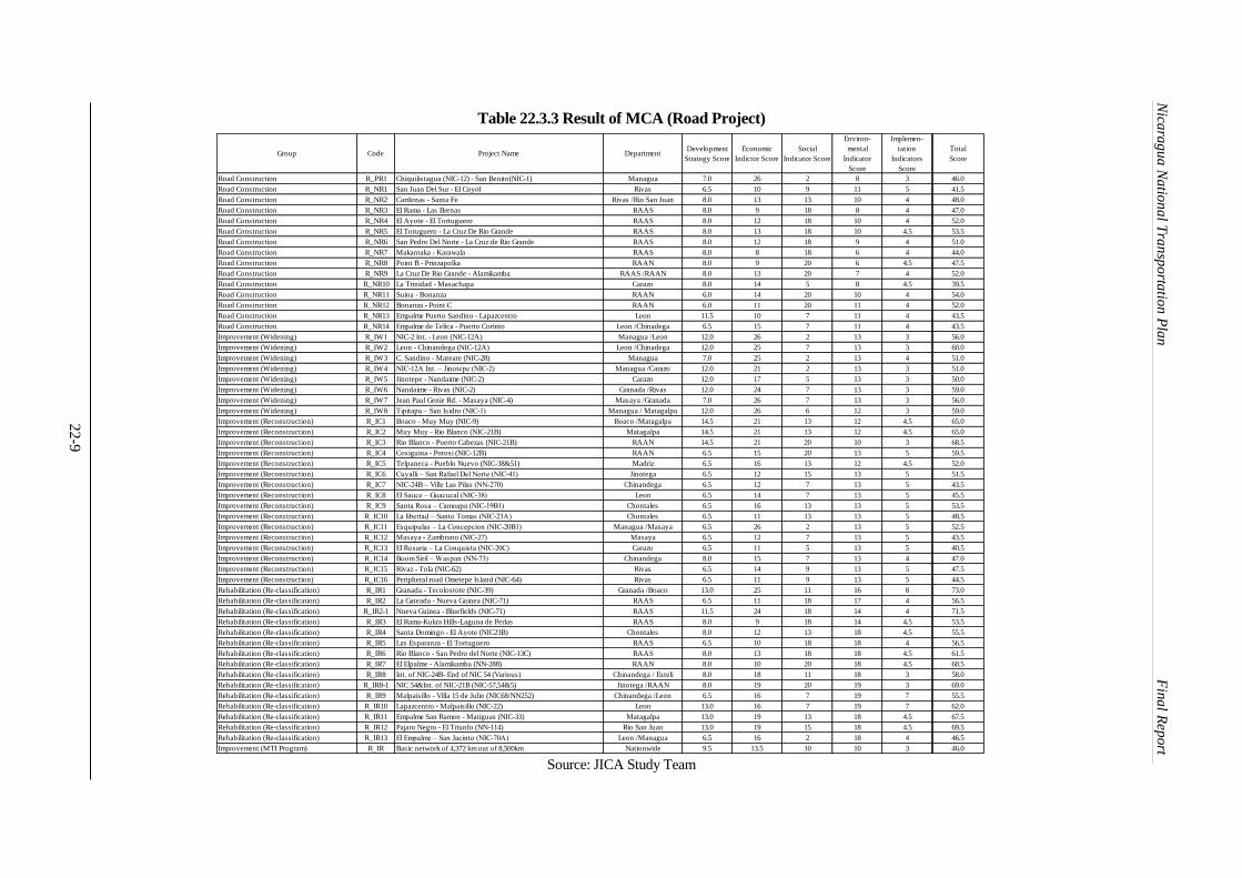
Nica
rag
ua
Na
tion
al T
ran
spo
rtatio
n P
lan
F
ina
l Rep
ort
22-9
Table 22.3.3 Result of MCA (Road Project)
Source: JICA Study Team
Group Code Project Name DepartmentDevelopment
Strategy Score
Economic
Indictor Score
Social
Indicator Score
Environ-
mental
Indicator
Score
Implemen-
tation
Indicators
Score
Total
Score
Road Construction R_PR1 Chiquilistagua (NIC-12) - San Benito(NIC-1) Managua 7.0 26 2 8 3 46.0
Road Construction R_NR1 San Juan Del Sur - El Coyol Rivas 6.5 10 9 11 5 41.5
Road Construction R_NR2 Cardenas - Santa Fe Rivas /Rio San Juan 8.0 13 13 10 4 48.0
Road Construction R_NR3 El Rama - Las Brenas RAAS 8.0 9 18 8 4 47.0
Road Construction R_NR4 El Ayote - El Tortuguero RAAS 8.0 12 18 10 4 52.0
Road Construction R_NR5 El Toruguero - La Cruz De Rio Grande RAAS 8.0 13 18 10 4.5 53.5
Road Construction R_NR6 San Pedro Del Norte - La Cruz de Rio Grande RAAS 8.0 12 18 9 4 51.0
Road Construction R_NR7 Makantaka - Karawala RAAS 8.0 8 18 6 4 44.0
Road Construction R_NR8 Point B - Prinzapolka RAAN 8.0 9 20 6 4.5 47.5
Road Construction R_NR9 La Cruz De Rio Grande - Alamikamba RAAS /RAAN 8.0 13 20 7 4 52.0
Road Construction R_NR10 La Trinidad - Masachapa Carazo 8.0 14 5 8 4.5 39.5
Road Construction R_NR11 Suina - Bonanza RAAN 6.0 14 20 10 4 54.0
Road Construction R_NR12 Bonanza - Point C RAAN 6.0 11 20 11 4 52.0
Road Construction R_NR13 Empalme Puerto Sandino - Lapazcentro Leon 11.5 10 7 11 4 43.5
Road Construction R_NR14 Empalme de Telica - Puerto Corinto Leon /Chinadega 6.5 15 7 11 4 43.5
Improvement (Widening) R_IW1 NIC-2 Int. - Leon (NIC-12A) Managua /Leon 12.0 26 2 13 3 56.0
Improvement (Widening) R_IW2 Leon - Chinandega (NIC-12A) Leon /Chinadega 12.0 25 7 13 3 60.0
Improvement (Widening) R_IW3 C. Sandino - Mateare (NIC-28) Managua 7.0 25 2 13 4 51.0
Improvement (Widening) R_IW4 NIC-12A Int. – Jinotepe (NIC-2) Managua /Carazo 12.0 21 2 13 3 51.0
Improvement (Widening) R_IW5 Jinotepe - Nandaime (NIC-2) Carazo 12.0 17 5 13 3 50.0
Improvement (Widening) R_IW6 Nandaime - Rivas (NIC-2) Granada /Rivas 12.0 24 7 13 3 59.0
Improvement (Widening) R_IW7 Jean Paul Genie Rd. - Masaya (NIC-4) Masaya /Granada 7.0 26 7 13 3 56.0
Improvement (Widening) R_IW8 Tipitapa – San Isidro (NIC-1) Managua / Matagalpa 12.0 26 6 12 3 59.0
Improvement (Reconstruction) R_IC1 Boaco - Muy Muy (NIC-9) Boaco /Matagalpa 14.5 21 13 12 4.5 65.0
Improvement (Reconstruction) R_IC2 Muy Muy - Rio Blanco (NIC-21B) Matagalpa 14.5 21 13 12 4.5 65.0
Improvement (Reconstruction) R_IC3 Rio Blanco - Puerto Cabezas (NIC-21B) RAAN 14.5 21 20 10 3 68.5
Improvement (Reconstruction) R_IC4 Cosiguina - Potosi (NIC-12B) RAAN 6.5 15 20 13 5 59.5
Improvement (Reconstruction) R_IC5 Telpaneca - Pueblo Nuevo (NIC-38&51) Madriz 6.5 16 13 12 4.5 52.0
Improvement (Reconstruction) R_IC6 Cuyalli – San Rafael Del Norte (NIC-41) Jinotega 6.5 12 15 13 5 51.5
Improvement (Reconstruction) R_IC7 NIC-24B – Ville Las Pilas (NN-270) Chinandega 6.5 12 7 13 5 43.5
Improvement (Reconstruction) R_IC8 El Sauce – Guacucal (NIC-38) Leon 6.5 14 7 13 5 45.5
Improvement (Reconstruction) R_IC9 Santa Rosa – Camoapa (NIC-19B1) Chontales 6.5 16 13 13 5 53.5
Improvement (Reconstruction) R_IC10 La libertad – Santo Tomas (NIC-23A) Chontales 6.5 11 13 13 5 48.5
Improvement (Reconstruction) R_IC11 Esquipulas – La Concepcion (NIC-20B1) Managua /Masaya 6.5 26 2 13 5 52.5
Improvement (Reconstruction) R_IC12 Masaya - Zambrano (NIC-27) Masaya 6.5 12 7 13 5 43.5
Improvement (Reconstruction) R_IC13 El Rosaria – La Conquista (NIC-20C) Carazo 6.5 11 5 13 5 40.5
Improvement (Reconstruction) R_IC14 Boom Siril – Waspan (NN-73) Chinandega 8.0 15 7 13 4 47.0
Improvement (Reconstruction) R_IC15 Rivaz - Tola (NIC-62) Rivas 6.5 14 9 13 5 47.5
Improvement (Reconstruction) R_IC16 Peripheral road Ometepe Island (NIC-64) Rivas 6.5 11 9 13 5 44.5
Rehabilitation (Re-classification) R_IR1 Granada - Tecolostote (NIC-39) Granada /Boaco 13.0 25 11 16 8 73.0
Rehabilitation (Re-classification) R_IR2 La Gateada - Nueva Guinea (NIC-71) RAAS 6.5 11 18 17 4 56.5
Rehabilitation (Re-classification) R_IR2-1 Nueva Guinea - Bluefields (NIC-71) RAAS 11.5 24 18 14 4 71.5
Rehabilitation (Re-classification) R_IR3 El Rama-Kukra Hills-Laguna de Perlas RAAS 8.0 9 18 14 4.5 53.5
Rehabilitation (Re-classification) R_IR4 Santa Domingo - El Ayote (NIC23B) Chontales 8.0 12 13 18 4.5 55.5
Rehabilitation (Re-classification) R_IR5 Las Esparanza - El Tortuguero RAAS 6.5 10 18 18 4 56.5
Rehabilitation (Re-classification) R_IR6 Rio Blanco - San Pedro del Norte (NIC-13C) RAAS 8.0 13 18 18 4.5 61.5
Rehabilitation (Re-classification) R_IR7 El Elpalme - Alamikamba (NN-288) RAAN 8.0 10 20 18 4.5 60.5
Rehabilitation (Re-classification) R_IR8 Int. of NIC-24B- End of NIC 54 (Various) Chinandega / Esteli 8.0 18 11 18 3 58.0
Rehabilitation (Re-classification) R_IR8-1 NIC 54&Int. of NIC-21B (NIC-57,54&5) Jinotega /RAAN 8.0 19 20 19 3 69.0
Rehabilitation (Re-classification) R_IR9 Malpaisillo - Villa 15 de Julio (NIC68/NN252) Chinandega /Leon 6.5 16 7 19 7 55.5
Rehabilitation (Re-classification) R_IR10 Lapazcentro - Malpaisillo (NIC-22) Leon 13.0 16 7 19 7 62.0
Rehabilitation (Re-classification) R_IR11 Empalme San Ramon - Matiguas (NIC-33) Matagalpa 13.0 19 13 18 4.5 67.5
Rehabilitation (Re-classification) R_IR12 Pajaro Negro - El Triunfo (NN-114) Rio San Juan 13.0 19 15 18 4.5 69.5
Rehabilitation (Re-classification) R_IR13 El Empalme – San Jacinto (NIC-70A) Leon /Managua 6.5 16 2 18 4 46.5
Improvement (MTI Program) R_IR Basic network of 4,372 km out of 8,500km Nationwide 9.5 13.5 10 10 3 46.0

Nica
rag
ua
Na
tion
al T
ran
spo
rtatio
n P
lan
F
ina
l Rep
ort
22-1
0
Table 22.3.4 Result of MCA (Bridge Project)
Source: JICA Study Team
Group Code Project Name DepartmentDevelopment
Strategy Score
Economic
Indictor Score
Social
Indicator Score
Environ-
mental
Indicator
Score
Implemen-
tation
Indicators
Score
Total
Score
New Bridge (on proposed road) R_NB1 Mahogony River RAAS 6.5 11.5 18 13 5 54.0
New Bridge (on proposed road) R_NB2 El Rama River RAAS 6.5 11.5 18 13 5 54.0
New Bridge (on proposed road) R_NB3 Nawawas River RAAS 6.5 12.5 18 13 5 55.0
New Bridge (on proposed road) R_NB4 Waspedo River RAAS 6.5 15.5 18 13 5 58.0
New Bridge (on proposed road) R_NB5 Kurinwas River RAAS 6.5 15.5 18 13 5 58.0
New Bridge (on proposed road) R_NB6 N/A RAAS 6.5 15.5 18 13 5 58.0
New Bridge (on proposed road) R_NB7 Grande de Matagalpa RAAS 6.5 13.5 18 13 5 56.0
New Bridge (on proposed road) R_NB8 Makantaka (Rio Grande) RAAS 6.5 13.5 18 13 5 56.0
New Bridge (on proposed road) R_NB9 Kuanwatla RAAN 6.5 11.5 20 13 5 56.0
New Bridge (on proposed road) R_NB10 Alamikamba (Rio Prinzapolka) RAAN 6.5 13.5 20 13 5 58.0
New Bridge (on proposed road) R_NB11 Frio River Rio San Juan 6.5 13.5 15 13 5 53.0
New Bridge (on proposed road) R_NB12 Zapote River Rio San Juan 6.5 13.5 15 13 5 53.0
New Bridge (on proposed road) R_NB13 Guacalito River Rio San Juan 6.5 11.5 15 13 5 51.0
New Bridge (on proposed road) R_NB14 Colon Rio San Juan 6.5 11.5 15 13 5 51.0
New Bridge (on proposed road) R_NB15 Brito River Rivas 6.5 13.5 9 13 5 47.0
New Bridge (on proposed road) R_NB16 El Tular River Carazo 6.5 17.5 5 13 5 47.0
New Bridge (on proposed road) R_NB17 Tecolapa River Carazo 6.5 17.5 5 13 5 47.0
New Bridge (Missing link) R_BM1 Puente El Tamarindo Leon 11.5 13.5 7 13 5 50.0
New Bridge (Missing link) R_BM2 Puente Baquas Boaco 11.5 18.5 13 13 5 61.0
New Bridge (Missing link) R_BM3 Puente Wawa River RAAN 11.5 15.5 20 13 5 65.0
New Bridge (Missing link) R_BM4 Puente Malacatoya River Granada 11.5 20.5 7 13 5 57.0
New Bridge (Missing link) R_BM5 El Paso de Panaloya Granada 11.5 20.5 7 13 5 57.0
New Bridge (Missing link) R_BM6 Puente Tecolostote #2 (El Papayal) Boaco 11.5 16.5 13 13 5 59.0
New Bridge (Missing link) R_BM7 Wiwili Jinotega 6.5 14.5 15 13 5 54.0
New Bridge (Missing link) R_BM8 Puente Rio Abajo Esteli 6.5 13.5 11 13 5 49.0
Bridge Replacement (Temporary) R_BT1 Puente San Judas Nueva Segovia 6.5 15.5 13 13 5 53.0
Bridge Replacement (Temporary) R_BT2 Puente Santa Rosa Del Penon Leon 6.5 12.5 7 13 5 44.0
Bridge Replacement (Temporary) R_BT3 Puente La Potranca RAAN 11.5 13.5 20 13 5 63.0
Bridge Replacement (Temporary) R_BT4 Puente Sunsin No.2 RAAN 11.5 13.5 20 13 5 63.0
Bridge Replacement (Temporary) R_BT5 Puente Rio Luku RAAN 11.5 15.5 20 13 5 65.0
Bridge Replacement (Temporary) R_BT6 Puente Rio Labu RAAN 11.5 16.5 20 13 5 66.0
Bridge Replacement (Temporary) R_BT7 Puente Pasle Matagalpa 11.5 16.5 13 13 5 59.0
Bridge Replacement (Temporary) R_BT8 Puente Rio El Cua (La Maroanosa) Jinotega 6.5 16.5 15 15 5 58.0
Bridge Replacement (Damaged) R_BD1 Puente Wani RAAN 6.5 15.5 20 13 5 60.0
Bridge Replacement (Damaged) R_BD2 Puente El Tuma (Mulukuku) RAAN 11.5 14.5 20 13 5 64.0
Bridge Replacement (Damaged) R_BD3 Puente Prinzapolka RAAN 11.5 16.5 20 13 5 66.0
Bridge Replacement (Damaged) R_BD4 Puente Banacruz RAAN 11.5 13.5 20 13 5 63.0
Bridge Replacement (Damaged) R_BD5 Puente Paso Real (Esteli) Esteli 6.5 12.5 11 13 5 48.0
Bridge Replacement (Damaged) R_BD6 Puente Rio Zinica RAAN 6.5 15.5 20 13 5 60.0
Bridge Replacement (Damaged) R_BD7 Puente San Pablo RAAN 6.5 15.5 20 13 5 60.0
Bridge Replacement (Damaged) R_BD8 Puente La Esperanza RAAS 6.5 13.5 18 13 5 56.0
Bridge Replacement (Damaged) R_BD9 Puente Cuisala Chontales 11.5 15.5 13 13 5 58.0
Bridge Replacement (Damaged) R_BD10 Puente Rosa Grande RAAN 6.5 15.5 20 13 5 60.0
Maintenance Program R_MR Maintenance of entire basic network Nationwide 11.0 15 10 16 3 55.0
Disaster Mitigation Program R_DM Provision and replacement of infrastructure against disaster Nationwide 1.5 15 10 16 4.5 47.0

Nica
rag
ua
Na
tion
al T
ran
spo
rtatio
n P
lan
F
ina
l Rep
ort
22-1
1
Table 22.3.5 Result of MCA (Other Project)
Source: JICA Study Team
Group Code Project Name DepartmentDevelopment
Strategy Score
Economic
Indictor Score
Social
Indicator Score
Environ-
mental
Indicator
Score
Implemen-
tation
Indicators
Score
Total
Score
Bus Fleet B_FL Big Capacity Bus for Inter-Urban Bus route Nationwide 6.0 17.5 10 20 6 59.5
Bus Terminal B_TB Big Size of Bus Terminal Nationwide 5.5 15 10 18 3 51.5
Bus Terminal B_TM Middle Size of Bus Terminal Nationwide 5.5 15 10 18 3 51.5
Bus Terminal B_TS Small Size of Bus Terminal Nationwide 5.5 15 10 18 3 51.5
Roadside Station B_RS Roadside Station Nationwide 7.5 15 10 18 3 53.5
Bus Inspection Workshop B_IN Bus Inspection Workshop Managua 3.5 15 10 18 3 49.5
Sea Port Development (Corinto) W_EP_1 Expansion of Puerto Corinto Chinandega 9.5 16.5 6 11 5 48.0
Sea Port Development (Bluefields) W_NP_1 Construction of New Bluefields Port RAAS 9.5 17.5 15 10 1 53.0
Sea Port Development (Cabezas) W_EP1 Expansion of Puerto Cabezas RAAN 9.5 14.5 15 11 6 56.0
Waterway W_IW1 Inland Water Way along Atlantic Coast RAAS /RAAN 3.5 15 15 8 5 46.5
Waterway W_IW2 Maintenance of Inland Water Way RAAS /RAAN 3.5 15 15 10 5 48.5
Waterway W_NW1 Channel Dredging Fleet RAAS /RAAN 3.5 15 15 15 5 53.5
Passenger Docs (RAAN) W_NW2 Passenger Boats for Public Water Transport Services RAAN 3.5 15 15 18 5 56.5
Passenger Docs (RAAS) W_NW3 Passenger Boats for Public Water Transport Services RAAS 3.5 15 15 18 5 56.5
Passenger Docs (River and Lake Port) W_NW4 Improvement of River and Lake Ports Nationwide 3.5 15 10 8 5 41.5
A. C. Sandino International Airport A_ER_1 Runway Extension of A. C. Sandino Managua 12.0 17.5 6 14 7 56.5
A. C. Sandino International Airport A_ET_1 Expansion of Existing International Passenger Terminal Managua 12.0 17.5 6 17 5.5 58.0
A. C. Sandino International Airport A_RT_1 Rehabilitation of Existing Domestic Passenger Terminal Managua 12.0 17.5 6 12 5.5 53.0
A. C. Sandino International Airport A_NT_1 Construction of New Passenger Terminal at South Side Managua 12.0 17.5 6 13 5 53.5
A. C. Sandino International Airport A_NA_1 Construction of New Apron and Taxiway at South Side Managua 12.0 17.5 6 19 7.5 62.0
A. C. Sandino International Airport A_NC_1 Construction of New Cargo Terminal Building at South Side Managua 10.5 17.5 6 18 5.5 57.5
A. C. Sandino International Airport A_EA_1 Expansion of Apron for Cargo Terminal at South Side Managua 10.5 17.5 6 14 7 55.0
Bluefield Airport A_RR_1 Rehabilitation of Runway Pavement RAAS 4.5 15 15 14 8 56.5
Bluefield Airport A_ER_2 Expansion of Runway Strip RAAS 4.5 15 15 17 5 56.5
Bluefield Airport A_NF_1 Construction of New Fuel Yard RAAS 4.5 15 15 18 5 57.5
Bluefield Airport A_NT_2 Construction of New Passenger Terminal at North Side RAAS 4.5 15 15 13 3 50.5
Bluefield Airport A_NA_2 Construction of New Apron at North Side RAAS 4.5 15 15 14 5 53.5
Bluefield Airport A_ER_3 Extension of Runway RAAS 4.5 15 15 13 5 52.5
Bluefield Airport A_NC_2 Construction of New Cargo Terminal at South Side RAAS 4.5 15 15 13 3 50.5
Bluefield Airport A_NA_3 Construction of New Apron at South Side RAAS 4.5 15 15 16 8 58.5
Bilwi Airport A_NT_3 Construction of New Passenger Terminal RAAN 4.5 15 15 16 6 56.5
Bilwi Airport A_NF_3 Construction of New Fuel Yard RAAN 4.5 15 15 18 8 60.5
Bilwi Airport A_NC_2 Construction of New Cargo Terminal RAAN 4.5 15 15 16 6 56.5
Bilwi Airport A_EA_2 Extension of Runway RAAN 4.5 15 15 16 8 58.5
Corn Island Airport A_RR_2 Rehabilitation of Runway Pavement RAAN 4.5 15 15 17 5 56.5
Corn Island Airport A_NF_4 Installation of Airfield Lighting System RAAN 4.5 15 15 20 5 59.5
Corn Island Airport A_NF_5 Installation of New Fence RAAN 4.5 15 15 20 5 59.5
Corn Island Airport A_NF_6 Construction of New Control Tower RAAN 4.5 15 15 17 5 56.5
Corn Island Airport A_ER_3 Expansion of Runway Strip RAAN 4.5 15 15 18 5 57.5
Cross Border Point (Guasaule) F_IC_1 Cross-border Trade Facility of Guasaule CBP Chinandega 9.5 17.5 6 17 8 58.0
Cross Border Point (El Espino) F_IC_2 Cross-border Trade Facility of El Espinio CBP Madriz 9.5 14.5 10 17 8 59.0
Cross Border Point (Las Manos) F_IC_3 Cross-border Trade Facility of Las Manos CBP Nueva Segovia 9.5 13.5 10 17 5 55.0
Cross Border Point (Penas Blancas) F_IC_4 Cross-border Trade Facility of Penas Blancas CBP Rivas 9.5 17.5 6 17 8 58.0
Cross Border Point (Psan Pancho) F_IC_5 Cross-border Trade Facility of San Pancho CBP Rio San Juan 9.5 13.5 10 19 5 57.0
Logistic Park (Mamagua East)) F_NL_1 Managua East Logistic Park Managua 9.5 15 6 19 3 52.5
Logistic Park (Managua West) F_NL_2 Managua West Logistic Park Managua 9.5 15 6 17 3 50.5
Logistic Park (Chinadega) F_NL_3 Chinandega Logistic Park Chinandega 9.5 15 6 14 3 47.5
Logistic Park (Bluefileds) F_NL_4 Bluefields Logistic Park RAAS 9.5 15 15 14 3 56.5
Agro Processing Estate (Chinandega) F_NA_1 Chinandega Agro-processing Estate Chinandega 7.5 15 6 14 3 45.5
Agro Processing Estate (Matagalpa) F_NA_2 Matagalpa Agro-processing Estate Matagalpa 7.5 15 10 14 3 49.5
Agro Processing Estate (Juigalpa) F_NA_3 Juigalpa Agro-processing Estate Chontales 7.5 15 10 14 3 49.5
Agro Processing Estate (Nueva Guinea) F_NA_4 Nueva Guinea Agro-processing Estate RAAS 7.5 15 15 17 3 57.5
Agro Processing Estate (Bilwi) F_NA_5 Cold Storage at Bilwi RAAN 7.5 15 15 18 3 58.5
Nicaragua National Transportation Plan Final Report
22-12
Nica
rag
ua
Na
tion
al T
ran
spo
rtatio
n P
lan
Dra
ft F
inal
Rep
ort
22.4 Economic Analysis
This chapter presents the results of the evaluation of the economic viability of identified projects
that is used in multi criteria analysis. It is concerned with the determination of the net benefits that
will accrue to the economy as a result of the project. Only tangible costs and benefits are
considered in the evaluation. The evaluation on each project aiming at determining their priorities
and timing of implementation is carried out in an integrated way of project evaluation of which
details are presented in other chapter.
22.4.1 Methodology of Economic Analysis
(1) Viability Indicators
The relevant economic viability criterion is derived from a procedure aimed at maximizing the
overall objectives of the national economy. Economic viability is ensured by computation of the
Economic Internal Rate of Return (EIRR) of the project. The EIRR is to be more than the
opportunity cost of country where subject project is planned. As commonly adopted for the
economic analysis in the Central American region by the international financial institutions 12
percent discount rate is used as the economic opportunity cost of capital and this rate is used to
calculate the following economic viability indicators as well.
(i) EIRR Economic Internal Rate of Return
(ii) B/C Benefit Cost Ratio
(iii) NPV Net Present Value
1) EIRR
EIRR is the rate that shows the current-value of the total sum of the amount of annual net benefits
of the project zero. It shows the efficiency of the project in view of national economy or more than
the opportunity cost determined. This means that if the EIRR of a project is 12% then such a
project is considered as viable and worth to consider for its implementation in view of national
economy.
2) B/C
B/C is the ratio of the total amount of benefit to the total amount of the project expense. Generally,
it can be said that an economy internal rate of return (EIRR) and Benefit-Cost ratio (B/C) show the
economic viability of a project. It is assumed that if the EIRR is more than a predetermined
opportunity cost or discount rate (i.e. 12%) B/C should be more than 1.0. A project of which B/C is
computed at less than 1.0 is considered is not viable thus it is suggested to move its timing behind
the project of which B/C is more than 1.0. However, in case of the projects covered in this study,
the timing of implementation will be defined taking into account the social and environmental
factors in addition to the economic factor
3) Net Present Value (NPV)
NPV is the sum of total amount of annual net benefit discounted at social discounted rate of the
country. NPV shows the total sum of the current-value of social surplus amount produced by the
project. When EIRR is more than 12% and B/C is more than 1.0, NPV shows positive value. On
the contrary if EIRR is less than 12% or B/C is less than 1.0, NPV shows negative value. The
amount of NPV computed can be used as the element to compare the competitiveness of respective
project in view of national economy.
(2) Economic Cost1
The total construction costs of subject project are estimated firstly on the basis of the market price
as financial costs and it is converted to the economic costs for the economic analysis. The monetary
unit shown therein, therefore, is based on prevailing market prices of required goods and services at
present or November 2013. Taxes composed of the current tax and import duties are subtracted as
1 The detailed tax must be calculated in the design stage.
Nicaragua National Transportation Plan Final Report
22-13
Nica
rag
ua
Na
tion
al T
ran
spo
rtatio
n P
lan
Dra
ft F
inal
Rep
ort
transfer payment from the total financial cost estimated. Tax rates applied for this subtraction were
16 % as value added tax on all prices estimated for local components and 5 % as import duties on
all prices estimated for foreign components. The economic cost of all projects evaluated is
estimated by subtracting 17% from the project cost estimated on market price and no acquisition
cost of land is considered.
(3) Quantifiable Benefits
The benefits are estimated based on the comparison of the With Case and Without Case of the
Project. The quantifiable benefits applied for the economic analysis of the projects of which aims
are to develop and improve the transport performance are as follows:
1) Road
Benefits due to saving of the Vehicle Operation Cost (VOC); and
Benefits due to saving the Travel Time Cost (TTC)
2) Sea Port
Benefits due to avoiding vessel waiting time or reduced turn-round times of ship in port;
Benefits due to shorten a maritime transport distance because of changing its geographical
location of port between new port and existing port; and
Amalgamated benefits due to saving of land transport cost or trucking cost for port cargo
because of changing geographical location of subject port as a new port and existing port.
3) Airport
Benefits due to saving an economic operation cost of aircraft that plies between origin
airport and destination airport when it is compared with the same by land transport or any
other means of transport; and
Benefits due to saving of an economic operation cost of aircraft which is larger and more
economical than using current aircraft which is smaller than the aircraft planned to be
introduced.
(4) Qualitative Benefits
The typical economic benefits accrued to the implementation of a project but cannot be computed
quantitatively or are intangible and/or regarded as so called indirect benefits of project for the
development and improvement of transport sector can be as follows:
Contribution to enhancement of agricultural and industrial development along the transport
corridor;
Contribution to enhancement of value-added activities along project transport corridor;
Facilitation of international and regional trade;
Improvement of land productivity along project transport corridor;
Increased tourism activities at potential tourism destinations along the transport corridor;
Generation of additional short-term employment in the construction period; and
Generation of job opportunities relevant to transport industries.
Those intangible benefits are not considered however these are considered for an integrated
evaluation of a project taking into account other factors of which details are discussed in Chapter
22.3.
(5) Presumptions for Computing Economic Viability Indicators
In order to conduct the computation of economic viability indicators the project implementation
framework has to be established and defined. The project implementation framework consists of
the following components and their data.
(i) Investment plan period
(ii) Design and construction period
(iii) Project commissioning year
(iv) Project Life

Nicaragua National Transportation Plan Final Report
22-14
Nica
rag
ua
Na
tion
al T
ran
spo
rtatio
n P
lan
Dra
ft F
inal
Rep
ort
(v) Currency
1) Investment plan period
The investment plan period is defined as the total time period between the start of the cost stream
and the end of the cost and benefit stream. The cost stream is defined to start with the final
engineering design of the Project and ended at the terminating year of its project life.
2) Design and construction period:
After the completion of the detailed design of the Project and the financial arrangement, the tender
is called and contract will be awarded to the selected contractors to execute required work. The
design and construction period counted from the date of awarding contractors to the contractor is
assumed to be 2 to 5 years depends on its scale of subject project.
3) Project commissioning year:
The commissioning of the project is assumed to take place immediately after the year when all
required construction works is completed and become ready for commissioning its operation.
4) Project Life:
The project life normally extends over a period of 20 - 30 years starting from the year of
commissioning of the project operation. In the evaluation of the Project, thirty (30) years is
considered applicable taking into account the scale and type of the project. During the investment
plan period, the cost and benefits are recorded annually over the whole period separately for each
benefit and cost components.
5) Currency:
The currency used in the economic evaluation is US Dollar. The exchange rate of Nicaraguan
Cordoba to the United States Dollar is NIC 25.0 per US$ as of November 2013.
(6) Economic Costs
1) Composition of direct cost
The direct cost estimated for each subject project is as shown in Table 22.4.3.
2) Schedule for replacement of machinery
The replacement costs for major machinery were scheduled according to the assumption of life of
relevant machine and equipment where such replacement is necessary during the project time
frame. The residual value of assets is not considered.
3) Physical and price contingency
Price contingency is added on top of the direct costs estimated for the above at the rate of 5 % and
physical contingency is added on such cost at the rate of 10%.
4) Operation and maintenance cost
The operation and maintenance costs are composed of cash-outflow throughout the project period
where such cost is applicable for evaluation of the project. The rates of maintenance cost of project
are as follows:
i) Road: Operation cost of road is not considered as all roads identified are not toll roads.
Maintenance cost is estimated per kilometer for road project by road classification.
ii) Sea Port: Operation cost of relevant port is estimated by applying an average operation
cost of port cargo handling cost analyzed per ton of cargo. Maintenance cost of facilities
such as berth, pier, yard, administration buildings, etc. are estimated by applying a
certain ratio to the total investment cost for the construction of such facilities. The cost
for maintenance dredging is estimated as per schedule of major maintenance dredging
(say each 5-year) as shown in its economic viability indicator calculation sheet for
relevant port project.

Nicaragua National Transportation Plan Final Report
22-15
Nica
rag
ua
Na
tion
al T
ran
spo
rtatio
n P
lan
Dra
ft F
inal
Rep
ort
iii) Air Port: Operation cost of airport is not considered for economic analysis.
Maintenance cost of facilities such as runway, taxiway, apron, terminals, tower,
administration buildings, etc. are estimated by applying a certain ratio to the total
investment cost for the construction of such facilities.
(7) Formulas for Computation of Economic Benefits
1) Estimation of Economic Benefits from Road Project
The total saving of Vehicle Operation Cost (VOC) and Travel Time Cost (TTC) per each year due
to investment to road project can be computed by applying the following formula:
ASTCT1 = (((VOCT1Wo + TTCT1Wo) x LWo x AADTT1) + (VOCT2Wo + TTCT2Wo) x
LWo x AADT2)) – ((VOCT1W + TTCT1W) x LW x AADT1) + (VOCT2Wo+TTCT2W) x
LWo x AADT2))) x 365
Where:
ASTCT1 = Annual Saving of Transport Cost of Type-1 Vehicle due to
increased speed of travel
VOCT1Wo = VOC of Type-1 vehicle at speed under without project conditions
VOCT1W = VOC of Type-1 vehicle at speed under with project conditions
TTCT1Wo = TTC of Type-1 vehicle at speed under without project conditions
TTCT1W = TTC of Type-1 vehicle at speed of under with project conditions
LWo = Length of travel under without project condition
LW = Length of travel under with project condition
AADT1 = Annual Average Daily Traffic volume of Type1 vehicle
2) Estimation of Economic Benefits from Port Project
The reduction in vessel’s waiting time due to investment to the port to increase its port capacity or
to maintain the berth occupancy rate at appropriate level is considered can be computed by
applying following formula:
ASCRVWT = (AWTVWo – AWTVW) x DVC
Where:
ASCRVWT = Annual Saving Cost due to Reduction of Vessel’s Waiting Time
AWTVWo = Waiting Time of Vessel in days under Without Project Case
AWTVW = Waiting Time of Vessel in days under With Project Case
DVC = Daily Vessel Cost
The annual vessel waiting time can be obtained by applying a queuing theory to approximate the
waiting time based on the relationship between berth utilization ratio and average ship waiting time
in accordance with the recommended formula to use for the port development planning by
UNCTAD (A Handbook for Planners in Developing Countries, Second Edition 1985). More
specifically the quantification of relationship between waiting time and berth utilization in units of
average service time based on E2/E2/n system, which is considered as the best estimate of queuing
time for specialized terminal, is applied.
3) Saving of land cargo transport for international freight
Under the master plan the development of new seaports along the Atlantic Coast is planned to be
developed aiming at shorten the total running distance of land transport of international freight as
well as eliminating truck waiting time at cross-border customs facilities. Table 22.4.1 summarizes
the distance and truck waiting time at CBPs that can be eliminated due to the development of new
ports along the Atlantic Coast for handling the international freight transport.

Nicaragua National Transportation Plan Final Report
22-16
Nica
rag
ua
Na
tion
al T
ran
spo
rtatio
n P
lan
Dra
ft F
inal
Rep
ort
Table 22.4.1 Travel Distance and Waiting Time under Without Case
Port Country Distance Waiting Time at CBP
Km Hours
Puerto Cortes Honduras 470 24
Puerto Limon Costa Rica 450 48
Puerto Corinto*1 Nicaragua 1,359 0
Note:
1. Almost 50% of the total cargo volume handled at Puerto Corinto of Nicaragua is destined to and
imported from the countries located at the Atlantic side such as EU, eastern part of USA, Venezuela,
Brazil, etc.
2. Those seaborne cargos to and from Puerto Corinto is transferred at the inlet and outlet of Panama
Canal. The distance between Puerto Corinto and Balboa Port of Panama is around 1,284 km and the
railway transferring the containers between Balboa Port and Colon Port of Panama is around 75 km:
The container transfer between Balboa Port and Colon Port is undertaken by railway. (Annual
transport volume is 670,000 TEUs)
Source: JICA Study Team
Table 22.4.2 shows the total annual freight volume in million ton-km in 2013, 2023 and 2033,
respectively under Without Project Case and With Project Case as well as the difference between
two cases.
Table 22.4.2 Estimated Freight Volume in Million Ton-km
With Project
Total (Including External Ports) (Unit: million ton-km)
Year Export Import Domestic Total
2013 401 2,150 1,520 4,072
2023 739 4,096 2,207 7,042
2033 1,147 9,344 2,855 13,345
Without Project
Total (Including External Ports) (Unit: million ton-km)
Year Export Import Domestic Total
2013 263 1,321 1,520 3,104
2023 580 2,287 2,207 5,074
2033 778 4,789 2,855 8,421
Difference between With and Without Project
Total (Including External Ports) (Unit: million ton-km)
Year Export Import Domestic Total
2013 138 829 0 967
2023 160 1,808 0 1,968
2033 368 4,556 0 4,924
Source: JICA Study Team
As shown in the above table, the difference of freight volume between two cases in ton-km is
estimated to be almost 1 billion ton-km in 2013, 2 billion ton-km in 2023 and 5 billion ton-km in
2033. The type major vehicles transporting international freight or port cargo is container trailer
truck that carries around 15 tons of containerized cargo in an average. The VOC of trailer truck
running at 50 kph which is an average running speed of such type of vehicle along the main trunk
road is estimated to be at US$ 0.0383 per ton-km. The maritime transport cost of 40 footer
container between Puerto Corinto and Puerto Balboa of Panama is estimated at around US$650 per
FEU or US$0.0319/ton-km assuming that an average weight of containerized goods is 15 tons per
FEU. Based on these presumptions the transport cost saved due to use of new ports planned to be
developed along the Atlantic Coast namely new Bluefields port and new Puerto Cabezas the
amalgamated cost saved was computed as US$105 million in 2013, US$207 million and US$447
million in 2033, respectively.
As such the economic benefits delineated due to a shifting of the location of seaports for

Nicaragua National Transportation Plan Final Report
22-17
Nica
rag
ua
Na
tion
al T
ran
spo
rtatio
n P
lan
Dra
ft F
inal
Rep
ort
international freight operation of Nicaragua is enormous and substantial.
22.4.2 Economic Viability Indicators Computed
Table 22.4.3 summarizes the results of computing economic viability indicators for road projects
identified and seaport project.
As shown in the above table, EIRR is more than 12%, B/C is more than 1.0 and the NPV is positive,
therefore, the project is considered as worth for investment and it is substantially contribute to the
national economy. This high rate of return is attributed by a substantial transport development in
view of both land transport and maritime transport. These projects can be considered as a key
project to increase the transport performance of Nicaragua economically by make it possible to
develop a new transport and economic corridor traversing the center part of the country from east
to west as interoceanic transport corridor.


Nicaragua National Transportation Plan Final Report
22-18
Table 22.4.3 Result of Economic Viability
Source: JICA Study Team
Length Demand
Vehicle/day B/C NPV IRR
Road Construction R_PR1 Chiquilistagua (NIC-12) - San Benito(NIC- Managua 183.1 148.6 L=32.6km 25,596 3.48 332.68 32.1%
Road Construction R_NR1 San Juan Del Sur - El Coyol Rivas 17.6 15.1 L=22.5km 100 0.40 -9.00 2.6%
Road Construction R_NR2 Cardenas - Santa Fe Rivas /Rio San Juan 75.9 71.9 L=102.0km 193 0.75 -18.10 8.5%
Road Construction R_NR3 El Rama - Las Brenas RAAS 42.3 35.7 L=36.0km 113 0.30 -24.14 N.A.
Road Construction R_NR4 El Ayote - El Tortuguero RAAS 70.2 58.7 L=82.7km 194 0.74 -15.23 8.4%
Road Construction R_NR5 El Toruguero - La Cruz De Rio Grande RAAS 26.3 22.0 L=32.0km 145 0.52 -10.61 5.1%
Road Construction R_NR6 San Pedro Del Norte - La Cruz de Rio RAAS 60.6 50.6 L=76.5km 235 0.93 -3.36 10.9%
Road Construction R_NR7 Makantaka - Karawala RAAS 49.2 40.9 L=72.1km 41 0.18 -34.37 N.A.
Road Construction R_NR8 Point B - Prinzapolka RAAN 32.1 26.7 L=47.0km 57 0.24 -20.67 N.A.
Road Construction R_NR9 La Cruz De Rio Grande - Alamikamba RAAS /RAAN 51.5 42.9 L=62.5km 96 0.35 -27.97 1.6%
Road Construction R_NR10 La Trinidad - Masachapa Carazo 22.6 19.2 L=25.0km 100 0.36 -12.15 1.7%
Road Construction R_NR11 Suina - Bonanza RAAN 53.5 45.0 L=55.0km 204 0.64 -15.90 7.1%
Road Construction R_NR12 Bonanza - Point C RAAN 72.1 66.0 L=99.0km 121 0.45 -36.50 3.7%
Road Construction R_NR13 Empalme Puerto Sandino - Lapazcentro Leon 40.7 34.5 L=15.5km 360 0.45 -17.44 4.1%
Road Construction R_NR14 Empalme de Telica - Puerto Corinto Leon /Chinadega 77.0 65.3 L=33.0km 1,349 1.21 12.58 13.9%
Improvement (Widening) R_IW1 NIC-2 Int. - Leon (NIC-12A) Managua /Leon 225.8 193.7 L=87.3km 11,447 2.42 253.11 24.5%
Improvement (Widening) R_IW2 Leon - Chinandega (NIC-12A) Leon /Chinadega 158.1 135.6 L=57.4km 11,972 2.18 146.93 22.4%
Improvement (Widening) R_IW3 C. Sandino - Mateare (NIC-28) Managua 46.6 39.9 L=17.8km 16,318 3.47 90.70 32.3%
Improvement (Widening) R_IW4 NIC-12A Int. – Jinotepe (NIC-2) Managua /Carazo 123.9 106.3 L=44.0km 11,889 2.36 133.08 24.2%
Improvement (Widening) R_IW5 Jinotepe - Nandaime (NIC-2) Carazo 84.4 72.4 L=36.5km 7,074 2.16 77.90 22.4%
Improvement (Widening) R_IW6 Nandaime - Rivas (NIC-2) Granada /Rivas 129.1 110.8 L=51.9km 10,147 3.38 243.18 31.3%
Improvement (Widening) R_IW7 Jean Paul Genie Rd. - Masaya (NIC-4) Masaya /Granada 116.3 99.7 L=19.6km 40,808 5.92 442.17 47.1%
Improvement (Widening) R_IW8 Tipitapa – San Isidro (NIC-1) Managua / Matagalpa 243.8 185.0 L=93.3km 15,714 5.39 751.57 43.9%
Improvement (Reconstruction) R_IC1 Boaco - Muy Muy (NIC-9) Boaco /Matagalpa 25.2 21.6 L=50.9km 2,849 1.93 21.43 21.2%
Improvement (Reconstruction) R_IC2 Muy Muy - Rio Blanco (NIC-21B) Matagalpa 27.3 23.4 L=58.5km 2,332 1.74 18.69 19.5%
Improvement (Reconstruction) R_IC3 Rio Blanco - Puerto Cabezas (NIC-21B) RAAN 158.4 135.9 L=315.7km 909 1.47 68.07 16.8%
Improvement (Reconstruction) R_IC4 Cosiguina - Potosi (NIC-12B) RAAN 5.6 4.8 L=12.4km 100 0.66 -1.75 6.9%
Improvement (Reconstruction) R_IC5 Telpaneca - Pueblo Nuevo (NIC-38&51) Madriz 23.9 20.5 L=53.0km 757 0.92 -1.76 10.6%
Improvement (Reconstruction) R_IC6 Cuyalli – San Rafael Del Norte (NIC-41) Jinotega 15.2 13.1 L=36.9km 404 0.48 -7.52 3.4%
Improvement (Reconstruction) R_IC7 NIC-24B – Ville Las Pilas (NN-270) Chinandega 5.2 4.5 L=11.5km 212 0.38 -3.00 0.9%
Improvement (Reconstruction) R_IC8 El Sauce – Guacucal (NIC-38) Leon 4.4 3.8 L=10.6km 450 0.99 -0.03 11.6%
Improvement (Reconstruction) R_IC9 Santa Rosa – Camoapa (NIC-19B1) Chontales 12.6 10.8 L=27.8km 436 0.85 -1.81 9.6%
Improvement (Reconstruction) R_IC10 La libertad – Santo Tomas (NIC-23A) Chontales 10.3 8.9 L=22.9km 73 0.13 -8.36 N.A.
Improvement (Reconstruction) R_IC11 Esquipulas – La Concepcion (NIC-20B1) Managua /Masaya 6.6 5.7 L=18.8km 8,505 4.96 25.72 47.9%
Improvement (Reconstruction) R_IC12 Masaya - Zambrano (NIC-27) Masaya 11.6 10.0 L=25.0km 550 0.41 -6.35 1.7%
Improvement (Reconstruction) R_IC13 El Rosaria – La Conquista (NIC-20C) Carazo 5.6 4.8 L=13.5km 124 0.26 -3.91 N.A.
Improvement (Reconstruction) R_IC14 Boom Siril – Waspan (NN-73) Chinandega 52.0 44.6 L=115.0km 38 0.22 -37.71 N.A.
Improvement (Reconstruction) R_IC15 Rivaz - Tola (NIC-62) Rivas 5.5 4.7 L=13.2km 419 0.93 -0.36 10.8%
Improvement (Reconstruction) R_IC16 Peripheral road Ometepe Island (NIC-64) Rivas 18.1 15.5 L=40.0km 39 0.23 -13.01 N.A.
Rehabilitation (Re-classification) R_IR1 Granada - Tecolostote (NIC-39) Granada /Boaco 47.8 41.0 L=54.3km 6,126 5.52 183.14 45.4%
Rehabilitation (Re-classification) R_IR2 La Gateada - Nueva Guinea (NIC-71) RAAS 50.3 43.2 L=58.5km 858 0.60 -17.25 6.3%
Rehabilitation (Re-classification) R_IR2-1 Nueva Guinea - Bluefields (NIC-71) RAAS 68.4 58.7 L=77.2km 2,861 3.36 136.89 31.5%
Rehabilitation (Re-classification) R_IR3 El Rama-Kukra Hills-Laguna de Perlas RAAS 39.1 33.5 L=71.0km 131 0.30 -24.79 N.A.
Rehabilitation (Re-classification) R_IR4 Santa Domingo - El Ayote (NIC23B) Chontales 31.6 27.1 L=53.0km 391 0.58 -11.90 5.7%
Rehabilitation (Re-classification) R_IR5 Las Esparanza - El Tortuguero RAAS 48.7 41.8 L=85.0km 90 0.28 -31.28 N.A.
Rehabilitation (Re-classification) R_IR6 Rio Blanco - San Pedro del Norte (NIC-13C) RAAS 39.9 34.5 L=71.5km 235 0.84 -5.83 9.6%
Rehabilitation (Re-classification) R_IR7 El Elpalme - Alamikamba (NN-288) RAAN 24.8 21.2 L=34.0km 75 0.20 -17.11 N.A.
Rehabilitation (Re-classification) R_IR8 Int. of NIC-24B- End of NIC 54 (Various) Chinandega / Esteli 134.0 115.0 L=175.0km 772 0.64 -41.26 6.9%
Rehabilitation (Re-classification) R_IR8-1 NIC 54&Int. of NIC-21B (NIC-57,54&5) Jinotega /RAAN 134.0 115.0 L=175.0km 772 0.64 -41.26 6.9%
Rehabilitation (Re-classification) R_IR9 Malpaisillo - Villa 15 de Julio Chinandega /Leon 80.6 69.1 L=34.0km 2,859 1.82 52.18 19.4%
Rehabilitation (Re-classification) R_IR10 Lapazcentro - Malpaisillo (NIC-22) Leon 86.9 74.5 L=36.4km 2,278 1.37 25.33 15.4%
Rehabilitation (Re-classification) R_IR11 Empalme San Ramon - Matiguas (NIC-33) Matagalpa 36.7 31.5 L=62.2km 468 0.70 -9.89 7.6%
Rehabilitation (Re-classification) R_IR12 Pajaro Negro - El Triunfo (NN-114) Rio San Juan 35.3 30.3 L=41.2km 2,775 3.32 69.67 31.3%
Rehabilitation (Re-classification) R_IR13 El Empalme – San Jacinto (NIC-70A) Leon /Managua 53.8 46.2 L=61.1km 1,108 1.27 12.18 14.6%
Sea Port Development (Corinto) W_EP_1 Expansion of Puerto Corinto Chinandega 191.2 162.5 1.29 198.00 33.0%
Sea Port Development (Bluefields) W_NP_1 Construction of New Bluefields Port RAAS 273.2 232.2 2.71 519.00 27.0%
Economic ViabilityGroup Project Name
Financial
CostDepartmentCode
Economic
Cost


Nicaragua National Transportation Plan Final Report
22-19
Nica
rag
ua
Na
tion
al T
ran
spo
rtatio
n P
lan
D
raft F
inal R
epo
rt
22.5 Road High Priority Project form Multi Criteria Analysis
The top 10 priority projects based on Multi Criteria Analysis is shown in Table 22.5.1. Many of the
top 10 projects with high total score is a road improvement project on trunk road located on the
Caribbean side and central region in Nicaragua. These projects match with the strategy corridor
proposed and will contribute greatly to both the social development for poverty area and
enhancement of economic growth.
Most of the top 10 projects with economic indexes are road widening projects located at the pacific
side. The road widening project much contribute to solve the traffic congestion, this will expect
benefits of vehicle travel time.
Most of the top 10 projects with social indexes are related road improvement and road new
construction projects at RAAN, RAAS area. By implementing these projects, the region relying on
water transport is connected by land transport, the development of undeveloped resource becomes
possible to lead to the activation of the socio-economic activities and contribute regional disparities
and poverty reduction.
Table 22.5.1 High Priority Project of Road Improvement Project by Multi Criteria Analysis
Source: JICA Study Team
High Score Group Code Project Name DepartmentTotal
Score
Economic
Score
Social
Score
Rehabilitation (Re-classification) R_IR1 Granada - Tecolostote (NIC-39) Granada /Boaco 73.0 38 11
Rehabilitation (Re-classification) R_IR2-1 Nueva Guinea - Bluefields (NIC-71) RAAS 71.5 35.5 18
Rehabilitation (Re-classification) R_IR12 Pajaro Negro - El Triunfo (NN-114) Rio San Juan 69.5 32 15
Rehabilitation (Re-classification) R_IR8-1 NIC 54&Int. of NIC-21B (NIC-57,54&5) Jinotega /RAAN 69.0 25.5 20
Improvement (Reconstruction) R_IC3 Rio Blanco - Puerto Cabezas (NIC-21B) RAAN 68.5 34 20
Rehabilitation (Re-classification) R_IR11 Empalme San Ramon - Matiguas (NIC-33) Matagalpa 67.5 32 13
Improvement (Reconstruction) R_IC1 Boaco - Muy Muy (NIC-9) Boaco /Matagalpa 65.0 34 13
Improvement (Reconstruction) R_IC2 Muy Muy - Rio Blanco (NIC-21B) Matagalpa 65.0 34 13
Rehabilitation (Re-classification) R_IR10 Lapazcentro - Malpaisillo (NIC-22) Leon 62.0 29 7
Rehabilitation (Re-classification) R_IR8 Int. of NIC-24B- End of NIC 54 (Various) Chinandega / Esteli 58.0 24.5 11
Improvement (Widening) R_IW8 Tipitapa – San Isidro (NIC-1) Managua / Matagalpa 59.0 37.5 6
Improvement (Widening) R_IW1 NIC-2 Int. - Leon (NIC-12A) Managua /Leon 56.0 37.5 2
Improvement (Widening) R_IW2 Leon - Chinandega (NIC-12A) Leon /Chinadega 60.0 36.5 7
Improvement (Widening) R_IW6 Nandaime - Rivas (NIC-2) Granada /Rivas 59.0 35.5 7
Improvement (Widening) R_IW7 Jean Paul Genie Rd. - Masaya (NIC-4) Masaya /Granada 56.0 32.5 7
Improvement (Reconstruction) R_IC11 Esquipulas – La Concepcion (NIC-20B1) Managua /Masaya 52.5 32.5 2
Improvement (Widening) R_IW4 NIC-12A Int. – Jinotepe (NIC-2) Managua /Carazo 51.0 32.5 2
Road Construction R_PR1 Chiquilistagua (NIC-12) - San Benito(NIC- Managua 46.0 32.5 2
Rehabilitation (Re-classification) R_IR7 El Elpalme - Alamikamba (NN-288) RAAN 60.5 14.5 22
Road Construction R_NR9 La Cruz De Rio Grande - Alamikamba RAAS /RAAN 52.0 17.5 22
Road Construction R_NR8 Point B - Prinzapolka RAAN 47.5 13.5 22
Rehabilitation (Re-classification) R_IR6 Rio Blanco - San Pedro del Norte (NIC-13C) RAAS 61.5 17.5 20
Improvement (Reconstruction) R_IC4 Cosiguina - Potosi (NIC-12B) RAAN 59.5 21.5 20
Rehabilitation (Re-classification) R_IR5 Las Esparanza - El Tortuguero RAAS 56.5 14.5 20
Road Construction R_NR11 Suina - Bonanza RAAN 54.0 18.5 20
Rehabilitation (Re-classification) R_IR3 El Rama-Kukra Hills-Laguna de Perlas RAAS 53.5 13.5 20
Road Construction R_NR5 El Toruguero - La Cruz De Rio Grande RAAS 53.5 17.5 20
Road Construction R_NR4 El Ayote - El Tortuguero RAAS 52.0 16.5 20
Road Construction R_NR12 Bonanza - Point C RAAN 52.0 15.5 20
Road Construction R_NR6 San Pedro Del Norte - La Cruz de Rio RAAS 51.0 16.5 20
Road Construction R_NR7 Makantaka - Karawala RAAS 44.0 12.5 20
Total Score Top 10
Economic Score Top 10
Social Score Top 10


Nicaragua National Transportation Plan Final Report
23-1
Chapter 23 Implementation Program
23.1 Stage-wise Plan
The stage-wise plan was formulated taking as its basis the results of project priority evaluation
described in Chapter 22, realizing at the time the consultation with relevant agencies and the MTI
to analyze the progress of other existing projects as well as to coordinate with other donor’s
projects. Furthermore the positional relationship of mutual project and the scale of the project are
considered for distributing the projects list to short-term, medium-term and long-term program.
The short-term plan is 2014-2018, the medium-term plan is 2019-2023 and the long-term plan is
2024-2033. Considering the shortage of the public investment fund for the next 20 years from 2014
to 2033 discussed, the part of the long term projects are postponed after 2033, super long term
program.
Table 23.1.1 Project Cost by Staging (Short, Middle and Long Term)
Sub-Sector Short Term Middle Term Long Term
Total 2014-2018 2019-2023 2024-2033 After 2034
Land Transport (Road) 737.1 1,867.3 2,650.7 2,557.5 7,812.7
Land Transport (Bus) 99.1 28.8 10.3 0.0 138.2
Maritime Transport Sector 190.6 190.6 0.0 0.0 381.2
Water Transport Sector 18.2 18.2 5.3 15.9 57.5
Aviation Sector 0.0 236.5 95.9 0.0 361.0
Logistic Sector 10.6 26.0 39.0 0.0 75.6
Total
(Share %)
1,055.5 2,367.3 2,801.3 2,573.4 8,826.1
12% 27% 32% 29% 100% Source: JICA Study Team
The project cost by stage-wise, short and middle, long term projects are shown in Table 23.1.1. The
each project list with stage wise and cost are shown in Figure 23.1.1 and Table 23.1.2


Nicaragua National Transportation Plan Final Report
23-2
Figure 23.1.1 Project Staging Plan
Source: JICA Study Team


Nicaragua National Transportation Plan Final Report
23-3
Table 23.1.2 Staging Plan No. 1
Source: JICA Study Team
2014-2018 2019-2023 2024-2033 2034- 2014-2018 2019-2023 2024-2033 2034-
Land Transport (Road) Road Construction R_PR1 Chiquilistagua (NIC-12) - San Benito(NIC-1) 183.1 20% 80% 36.6 146.5 MTI Gov L=32.6km
Land Transport (Road) Road Construction R_NR1 San Juan Del Sur - El Coyol 17.6 50% 50% 8.8 8.8 MTI Gov L=22.5km
Land Transport (Road) Road Construction R_NR2 Cardenas - Santa Fe 75.9 20% 80% 15.2 60.7 MTI Gov L=102.0km
Land Transport (Road) Road Construction R_NR3 El Rama - Las Brenas 42.3 50% 50% 21.2 21.2 MTI Gov L=36.0km
Land Transport (Road) Road Construction R_NR4 El Ayote - El Tortuguero 70.2 100% 70.2 MTI Gov L=82.7km
Land Transport (Road) Road Construction R_NR5 El Toruguero - La Cruz De Rio Grande 26.3 100% 26.3 MTI Gov L=32.0km
Land Transport (Road) Road Construction R_NR6 San Pedro Del Norte - La Cruz de Rio Grande 60.6 50% 50% 30.3 30.3 MTI Gov L=76.5km
Land Transport (Road) Road Construction R_NR7 Makantaka - Karawala 49.2 50% 50% 24.6 24.6 MTI Gov L=72.1km
Land Transport (Road) Road Construction R_NR8 Point B - Prinzapolka 32.1 50% 50% 16.1 16.1 MTI Gov L=47.0km
Land Transport (Road) Road Construction R_NR9 La Cruz De Rio Grande - Alamikamba 51.5 50% 50% 25.8 25.8 MTI Gov L=62.5km
Land Transport (Road) Road Construction R_NR10 La Trinidad - Masachapa 22.6 100% 22.6 MTI Gov L=25.0km
Land Transport (Road) Road Construction R_NR11 Suina - Bonanza 53.5 50% 50% 26.8 26.8 MTI Gov L=55.0km
Land Transport (Road) Road Construction R_NR12 Bonanza - Point C 72.1 50% 50% 36.1 36.1 MTI Gov L=99.0km
Land Transport (Road) Road Construction R_NR13 Empalme Puerto Sandino - Lapazcentro 40.7 50% 50% 20.3 20.3 MTI Gov L=15.5km
Land Transport (Road) Road Construction R_NR14 Empalme de Telica - Puerto Corinto 77.0 50% 50% 38.5 38.5 MTI Gov L=33.0km
Land Transport (Road) Improvement (Widening) R_IW1 NIC-2 Int. - Leon (NIC-12A) 225.8 50% 50% 112.9 112.9 MTI Gov L=87.3km
Land Transport (Road) Improvement (Widening) R_IW2 Leon - Chinandega (NIC-12A) 158.1 100% 158.1 MTI Gov L=57.4km
Land Transport (Road) Improvement (Widening) R_IW3 C. Sandino - Mateare (NIC-28) 46.6 50% 50% 23.3 23.3 MTI Gov L=17.8km
Land Transport (Road) Improvement (Widening) R_IW4 NIC-12A Int. – Jinotepe (NIC-2) 123.9 100% 123.9 MTI Gov L=44.0km
Land Transport (Road) Improvement (Widening) R_IW5 Jinotepe - Nandaime (NIC-2) 84.4 100% 84.4 MTI Gov L=36.5km
Land Transport (Road) Improvement (Widening) R_IW6 Nandaime - Rivas (NIC-2) 129.1 50% 50% 64.6 64.6 MTI Gov L=51.9km
Land Transport (Road) Improvement (Widening) R_IW7 Jean Paul Genie Rd. - Masaya (NIC-4) 116.3 50% 50% 58.1 58.1 MTI Gov L=19.6km
Land Transport (Road) Improvement (Widening) R_IW8 Tipitapa – San Isidro (NIC-1) 243.8 10% 10% 40% 40% 24.4 24.4 97.5 97.5 MTI Gov L=93.3km
Land Transport (Road) Improvement (Reconstruction) R_IC1 Boaco - Muy Muy (NIC-9) 25.2 100% 25.2 MTI Gov L=50.9km
Land Transport (Road) Improvement (Reconstruction) R_IC2 Muy Muy - Rio Blanco (NIC-21B) 27.3 100% 27.3 MTI Gov L=58.5km
Land Transport (Road) Improvement (Reconstruction) R_IC3 Rio Blanco - Puerto Cabezas (NIC-21B) 158.4 20% 20% 60% 31.7 31.7 95.1 MTI Gov L=315.7km
Land Transport (Road) Improvement (Reconstruction) R_IC4 Cosiguina - Potosi (NIC-12B) 5.6 100% 5.6 MTI Gov L=12.4km
Land Transport (Road) Improvement (Reconstruction) R_IC5 Telpaneca - Pueblo Nuevo (NIC-38&51) 23.9 100% 23.9 MTI Gov L=53.0km
Land Transport (Road) Improvement (Reconstruction) R_IC6 Cuyalli – San Rafael Del Norte (NIC-41) 15.2 100% 15.2 MTI Gov L=36.9km
Land Transport (Road) Improvement (Reconstruction) R_IC7 NIC-24B – Ville Las Pilas (NN-270) 5.2 100% 5.2 MTI Gov L=11.5km
Land Transport (Road) Improvement (Reconstruction) R_IC8 El Sauce – Guacucal (NIC-38) 4.4 100% 4.4 MTI Gov L=10.6km
Land Transport (Road) Improvement (Reconstruction) R_IC9 Santa Rosa – Camoapa (NIC-19B1) 12.6 100% 12.6 MTI Gov L=27.8km
Land Transport (Road) Improvement (Reconstruction) R_IC10 La libertad – Santo Tomas (NIC-23A) 10.3 100% 10.3 MTI Gov L=22.9km
Land Transport (Road) Improvement (Reconstruction) R_IC11 Esquipulas – La Concepcion (NIC-20B1) 6.6 100% 6.6 MTI Gov L=18.8km
Land Transport (Road) Improvement (Reconstruction) R_IC12 Masaya - Zambrano (NIC-27) 11.6 100% 11.6 MTI Gov L=25.0km
Land Transport (Road) Improvement (Reconstruction) R_IC13 El Rosaria – La Conquista (NIC-20C) 5.6 100% 5.6 MTI Gov L=13.5km
Land Transport (Road) Improvement (Reconstruction) R_IC14 Boom Siril – Waspan (NN-73) 52.0 100% 52.0 MTI Gov L=115.0km
Land Transport (Road) Improvement (Reconstruction) R_IC15 Rivaz - Tola (NIC-62) 5.5 100% 5.5 MTI Gov L=13.2km
Land Transport (Road) Improvement (Reconstruction) R_IC16 Peripheral road Ometepe Island (NIC-64) 18.1 100% 18.1 MTI Gov L=40.0km
Land Transport (Road) Rehabilitation (Re-classification) R_IR1 Granada - Tecolostote (NIC-39) 47.8 50% 50% 23.9 23.9 MTI Gov L=54.3km
Land Transport (Road) Rehabilitation (Re-classification) R_IR2 La Gateada - Nueva Guinea (NIC-71) 50.3 50% 50% 25.2 25.2 MTI Gov L=58.5km
Land Transport (Road) Rehabilitation (Re-classification) R_IR2-1 Nueva Guinea - Bluefields (NIC-71) 68.4 100% 68.4 MTI Gov L=77.2km
Land Transport (Road) Rehabilitation (Re-classification) R_IR3 El Rama-Kukra Hills-Laguna de Perlas 39.1 100% 39.1 MTI Gov L=71.0km
Land Transport (Road) Rehabilitation (Re-classification) R_IR4 Santa Domingo - El Ayote (NIC23B) 31.6 100% 31.6 MTI Gov L=53.0km
Land Transport (Road) Rehabilitation (Re-classification) R_IR5 Las Esparanza - El Tortuguero 48.7 50% 50% 24.4 24.4 MTI Gov L=85.0km
Land Transport (Road) Rehabilitation (Re-classification) R_IR6 Rio Blanco - San Pedro del Norte (NIC-13C) 39.9 100% 39.9 MTI Gov L=71.5km
Land Transport (Road) Rehabilitation (Re-classification) R_IR7 El Elpalme - Alamikamba (NN-288) 24.8 50% 50% 12.4 12.4 MTI Gov L=34.0km
Land Transport (Road) Rehabilitation (Re-classification) R_IR8 Int. of NIC-24B- End of NIC 54 (Various) 134.0 20% 40% 40% 26.8 53.6 53.6 MTI Gov L=175.0km
Land Transport (Road) Rehabilitation (Re-classification) R_IR8-1 NIC 54&Int. of NIC-21B (NIC-57,54&5) 134.0 20% 40% 40% 26.8 53.6 53.6 MTI Gov L=175.0km
Land Transport (Road) Rehabilitation (Re-classification) R_IR9 Malpaisillo - Villa 15 de Julio (NIC68/NN252) 80.6 100% 80.6 MTI Gov L=34.0km
Land Transport (Road) Rehabilitation (Re-classification) R_IR10 Lapazcentro - Malpaisillo (NIC-22) 86.9 100% 86.9 MTI Gov L=36.4km
Land Transport (Road) Rehabilitation (Re-classification) R_IR11 Empalme San Ramon - Matiguas (NIC-33) 36.7 100% 36.7 MTI Gov L=62.2km
Land Transport (Road) Rehabilitation (Re-classification) R_IR12 Pajaro Negro - El Triunfo (NN-114) 35.3 100% 35.3 MTI Gov L=41.2km
Land Transport (Road) Rehabilitation (Re-classification) R_IR13 El Empalme – San Jacinto (NIC-70A) 53.8 100% 53.8 MTI Gov L=61.1km
Land Transport (Road) Improvement (MTI Program) R_IR Basic network of 4,372 km out of 8,500km 1824.4 1% 1% 2% 96% 18.2 18.2 36.5 1,751.4 MTI Gov L=4372.0km
Implementing Schedule of Cost (US$ million)Cost
(million
Implementing ScheduleProject Configuration
Investment
ModeSector Group Project NameCode
Executing
Agency


Nicaragua National Transportation Plan Final Report
23-4
Table 23.1.3 Staging Plan No. 2
Source: JICA Study Team
2014-2018 2019-2023 2024-2033 2034- 2014-2018 2019-2023 2024-2033 2034-
Land Transport (Road) New Bridge (on proposed road) R_NB1 Mahogony River 1.51 50% 50% 0.8 0.8 MTI Gov L=50m
Land Transport (Road) New Bridge (on proposed road) R_NB2 El Rama River 12.04 50% 50% 6.0 6.0 MTI Gov L=200m
Land Transport (Road) New Bridge (on proposed road) R_NB3 Nawawas River 1.34 100% 1.3 MTI Gov L=60m
Land Transport (Road) New Bridge (on proposed road) R_NB4 Waspedo River 1.21 50% 50% 0.6 0.6 MTI Gov L=40m
Land Transport (Road) New Bridge (on proposed road) R_NB5 Kurinwas River 1.51 50% 50% 0.8 0.8 MTI Gov L=50m
Land Transport (Road) New Bridge (on proposed road) R_NB6 N/A 0.95 50% 50% 0.5 0.5 MTI Gov L=35m
Land Transport (Road) New Bridge (on proposed road) R_NB7 Grande de Matagalpa 1.65 50% 50% 0.8 0.8 MTI Gov L=75m
Land Transport (Road) New Bridge (on proposed road) R_NB8 Makantaka (Rio Grande) 9.94 50% 50% 5.0 5.0 MTI Gov L=150m
Land Transport (Road) New Bridge (on proposed road) R_NB9 Kuanwatla 0.82 50% 50% 0.4 0.4 MTI Gov L=30m
Land Transport (Road) New Bridge (on proposed road) R_NB10 Alamikamba (Rio Prinzapolka) 8.81 50% 50% 4.4 4.4 MTI Gov L=120m
Land Transport (Road) New Bridge (on proposed road) R_NB11 Frio River 1.32 50% 50% 0.7 0.7 MTI Gov L=60m
Land Transport (Road) New Bridge (on proposed road) R_NB12 Zapote River 1.32 50% 50% 0.7 0.7 MTI Gov L=60m
Land Transport (Road) New Bridge (on proposed road) R_NB13 Guacalito River 1.09 50% 50% 0.5 0.5 MTI Gov L=40m
Land Transport (Road) New Bridge (on proposed road) R_NB14 Colon 1.09 50% 50% 0.5 0.5 MTI Gov L=40m
Land Transport (Road) New Bridge (on proposed road) R_NB15 Brito River 0.95 50% 50% 0.5 0.5 MTI Gov L=35m
Land Transport (Road) New Bridge (on proposed road) R_NB16 El Tular River 0.82 50% 50% 0.4 0.4 MTI Gov L=30m
Land Transport (Road) New Bridge (on proposed road) R_NB17 Tecolapa River 0.87 50% 50% 0.4 0.4 MTI Gov L=32m
Land Transport (Road) New Bridge (Missing link) R_BM1 Puente El Tamarindo 1.70 100% 1.7 MTI Gov L=100m
Land Transport (Road) New Bridge (Missing link) R_BM2 Puente Baquas 1.01 100% 1.0 MTI Gov L=37m
Land Transport (Road) New Bridge (Missing link) R_BM3 Puente Wawa River 6.33 100% 6.3 MTI Gov L=155m
Land Transport (Road) New Bridge (Missing link) R_BM4 Puente Malacatoya River 1.67 100% 1.7 MTI Gov L=75m
Land Transport (Road) New Bridge (Missing link) R_BM5 El Paso de Panaloya 18.06 100% 18.1 MTI Gov L=300m
Land Transport (Road) New Bridge (Missing link) R_BM6 Puente Tecolostote #2 (El Papayal) 1.69 100% 1.7 MTI Gov L=100m
Land Transport (Road) New Bridge (Missing link) R_BM7 Wiwili 14.90 100% 14.9 MTI Gov L=250m
Land Transport (Road) New Bridge (Missing link) R_BM8 Puente Rio Abajo 1.21 100% 1.2 MTI Gov L=40m
Land Transport (Road) Bridge Replacement (Temporary) R_BT1 Puente San Judas 0.756 100% 0.8 MTI Gov L=25m
Land Transport (Road) Bridge Replacement (Temporary) R_BT2 Puente Santa Rosa Del Penon 1.39 100% 1.4 MTI Gov L=51m
Land Transport (Road) Bridge Replacement (Temporary) R_BT3 Puente La Potranca 1.23 100% 1.2 MTI Gov L=40m
Land Transport (Road) Bridge Replacement (Temporary) R_BT4 Puente Sunsin No.2 1.21 100% 1.2 MTI Gov L=37m
Land Transport (Road) Bridge Replacement (Temporary) R_BT5 Puente Rio Luku 1.01 100% 1.0 MTI Gov L=31m
Land Transport (Road) Bridge Replacement (Temporary) R_BT6 Puente Rio Labu 4.20 100% 4.2 MTI Gov L=90m
Land Transport (Road) Bridge Replacement (Temporary) R_BT7 Puente Pasle 1.06 100% 1.1 MTI Gov L=35m
Land Transport (Road) Bridge Replacement (Temporary) R_BT8 Puente Rio El Cua (La Maroanosa) 1.65 100% 1.7 MTI Gov L=75m
Land Transport (Road) Bridge Replacement (Damaged) R_BD1 Puente Wani 6.15 100% 6.1 MTI Gov L=141m
Land Transport (Road) Bridge Replacement (Damaged) R_BD2 Puente El Tuma (Mulukuku) 7.76 100% 7.8 MTI Gov L=175m
Land Transport (Road) Bridge Replacement (Damaged) R_BD3 Puente Prinzapolka 3.97 100% 4.0 MTI Gov L=93m
Land Transport (Road) Bridge Replacement (Damaged) R_BD4 Puente Banacruz 1.43 100% 1.4 MTI Gov L=45m
Land Transport (Road) Bridge Replacement (Damaged) R_BD5 Puente Paso Real (Esteli) 1.80 100% 1.8 MTI Gov L=75m
Land Transport (Road) Bridge Replacement (Damaged) R_BD6 Puente Rio Zinica 1.34 50% 50% 0.7 0.7 MTI Gov L=41m
Land Transport (Road) Bridge Replacement (Damaged) R_BD7 Puente San Pablo 1.18 50% 50% 0.6 0.6 MTI Gov L=36m
Land Transport (Road) Bridge Replacement (Damaged) R_BD8 Puente La Esperanza 14.99 100% 15.0 MTI Gov L=234m
Land Transport (Road) Bridge Replacement (Damaged) R_BD9 Puente Cuisala 2.33 100% 2.3 MTI Gov L=50m
Land Transport (Road) Bridge Replacement (Damaged) R_BD10 Puente Rosa Grande 1.57 50% 50% 0.8 0.8 MTI Gov L=48m
Land Transport (Road) Maintenance Program R_MR Maintenance of entire basic network 2,506.9 20% 20% 60% 501.4 501.4 1,504.1 FOMAV Gov L=9293.0km
Land Transport (Road) Disaster Mitigation Program R_DM Provision and replacement of infrastructure against disaster 30.5 50% 50% 15.3 15.3 MTI Gov
Land Transport (Bus) Bus Fleet B_FL Big Capacity Bus for Inter-Urban Bus route 103.4 70% 20% 10% 72.4 20.7 10.3 MTI PPP 1124 Bus Fleet
Land Transport (Bus) Bus Terminal B_TB Big Size of Bus Terminal 2.46 50% 50% 1.2 1.2 MTI PPP 3
Land Transport (Bus) Bus Terminal B_TM Middle Size of Bus Terminal 7.81 50% 50% 3.9 3.9 MTI PPP 11
Land Transport (Bus) Bus Terminal B_TS Small Size of Bus Terminal 1.68 50% 50% 0.8 0.8 MTI PPP 3
Land Transport (Bus) Roadside Station B_RS Roadside Station 4.2 50% 50% 2.1 2.1 MTI PPP 7
Land Transport (Bus) Bus Inspection Workshop B_IN Bus Inspection Workshop 18.6 100% 18.6 MTI PPP 1
Project ConfigurationImplementing Schedule Implementing Schedule of Cost (US$ million) Executing
Agency
Investment
ModeSector Group Code Project Name
Cost
(million


Nicaragua National Transportation Plan Final Report
23-5
Table 23.1.4 Staging Plan No. 3
Source: JICA Study Team
2014-2018 2019-2023 2024-2033 2034- 2014-2018 2019-2023 2024-2033 2034-
Maritime Transport Sector Sea Port Development W_EP_1 Expansion of Puerto Corinto 58.0 50% 50% 29.0 29.0 EPN PPP 1 berth 230 m Container
Maritime Transport Sector Sea Port Development W_NP_1 Construction of New Bluefields Port 273.2
50% 50% 136.6 136.6
EPN PPP 2 berth 230 m, - 12.0m,
Channel 12.9km. Land-
lord type contract with
selected concessionaire forMaritime Transport Sector Sea Port Development W_EP1 Expansion of Bilwi Port 50.0 50% 50% 25.0 25.0 EPN PPP 1 berth 480 m concrete
Water Transport Sector Waterway W_IW1 Inland Water Way along Atlantic Coast 16.5 10% 10% 20% 60% 1.7 1.7 3.3 9.9 MTI Gov 15 sections, Width 10m
Water Transport Sector Waterway W_IW2 Maintenance of Inland Water Way 10.0 10% 10% 20% 60% 1.0 1.0 2.0 6.0 MTI Gov
Water Transport Sector Waterway W_NW1 Channel Dredging Fleet 8.0 50% 50% 4.0 4.0 MTI Gov Purchase of barge mounted
Water Transport Sector Passenger Docs W_NW2 Passenger Boats for Public Water Transport Services in
RAAN
4.050% 50% 2.0 2.0
MTI Gov Accommodation: 30-40
passengers, catamaran typeWater Transport Sector Passenger Docs W_NW3 Passenger Boats for Public Water Transport Services in
RAAS
4.050% 50% 2.0 2.0
MTI Gov Accommodation: 30-40
passengers, catamaran typeWater Transport Sector Passenger Docs W_NW4 Improvement of River and Lake Ports 15.0 50% 50% 7.5 7.5 MTI Gov For enhancement of
Aviation Sector A. C. Sandino International Airport A_ER_1 Runway Extension of A. C. Sandino 46.0 68% 22% 31.3 10.1 EAAI Gov Up to 3,100 for A310
Aviation Sector A. C. Sandino International Airport A_ET_1 Expansion of Existing International Passenger Terminal 40.0 68% 22% 27.2 8.8 EAAI PPP
Aviation Sector A. C. Sandino International Airport A_RT_1 Rehabilitation of Existing Domestic Passenger Terminal 30.0 68% 22% 20.4 6.6 EAAI PPP
Aviation Sector A. C. Sandino International Airport A_NT_1 Construction of New Passenger Terminal at South Side 70.068% 22% 47.6 15.4
EAAI PPP Acquisition of land at
south side is itsAviation Sector A. C. Sandino International Airport A_NA_1 Construction of New Apron and Taxiway at South Side 30.0
68% 22% 20.4 6.6EAAI Gov Acquisition of land at
south side is itsAviation Sector A. C. Sandino International Airport A_NC_1 Construction of New Cargo Terminal Building at South Side 30.0
68% 22% 20.4 6.6EAAI PPP Acquisition of land at
south side is itsAviation Sector A. C. Sandino International Airport A_EA_1 Expansion of Apron for Cargo Terminal at South Side 40.0
68% 22% 27.2 8.8EAAI Gov Acquisition of land at
south side is itsAviation Sector Bluefield Airport A_RR_1 Rehabilitation of Runway Pavement 5.0 63% 37% 3.2 1.9 EAAI Gov
Aviation Sector Bluefield Airport A_ER_2 Expansion of Runway Strip 5.0 63% 37% 3.2 1.9 EAAI Gov Extension: 300m
Aviation Sector Bluefield Airport A_NF_1 Construction of New Fuel Yard 2.0 63% 37% 1.3 0.7 EAAI Gov
Aviation Sector Bluefield Airport A_NT_2 Construction of New Passenger Terminal at North Side 5.0 63% 37% 3.2 1.9 EAAI PPP
Aviation Sector Bluefield Airport A_NA_2 Construction of New Apron at North Side 5.0 63% 37% 3.2 1.9 EAAI Gov
Aviation Sector Bluefield Airport A_ER_3 Extension of Runway 5.0 63% 37% 3.2 1.9 EAAI Gov Largest aircraft: B737
Aviation Sector Bluefield Airport A_NC_2 Construction of New Cargo Terminal at South Side 3.0 63% 37% 1.9 1.1 EAAI PPP
Aviation Sector Bluefield Airport A_NA_3 Construction of New Apron at South Side 5.0 63% 37% 3.2 1.9 EAAI Gov
Aviation Sector Bilwi Airport A_NT_3 Construction of New Passenger Terminal 4.0 50% 50% 2.0 2.0 EAAI PPP Plan and design completed
Aviation Sector Bilwi Airport A_NF_3 Construction of New Fuel Yard 3.0 50% 50% 1.5 1.5 EAAI Gov
Aviation Sector Bilwi Airport A_NC_2 Construction of New Cargo Terminal 3.0 50% 50% 1.5 1.5 EAAI PPP
Aviation Sector Bilwi Airport A_EA_2 Extension of Runway 10.0 50% 50% 5.0 5.0 EAAI Gov
Aviation Sector Corn Island Airport A_RR_2 Rehabilitation of Runway Pavement 5.0 50% 50% 2.5 2.5 EAAI Gov
Aviation Sector Corn Island Airport A_NF_4 Installation of Airfield Lighting System 1.0 50% 50% 0.5 0.5 EAAI Gov
Aviation Sector Corn Island Airport A_NF_5 Installation of New Fence 1.0 50% 50% 0.5 0.5 EAAI Gov
Aviation Sector Corn Island Airport A_NF_6 Construction of New Control Tower 3.0 50% 50% 1.5 1.5 EAAI Gov
Aviation Sector Corn Island Airport A_ER_3 Expansion of Runway Strip 10.0 50% 50% 5.0 5.0 EAAI Gov
Logistic Sector Cross Border Point F_IC_1 Cross-border Trade Facility of Guasaule CBP 10.0 50% 50% 5.0 5.0 DGA / Gov
Logistic Sector Cross Border Point F_IC_2 Cross-border Trade Facility of El Espinio CBP 2.0 100% 2.0 DGA / Gov
Logistic Sector Cross Border Point F_IC_3 Cross-border Trade Facility of Las Manos CBP 2.0 100% 2.0 DGA / Gov
Logistic Sector Cross Border Point F_IC_4 Cross-border Trade Facility of Penas Blancas CBP 10.0 50% 50% 5.0 5.0 DGA / Gov
Logistic Sector Cross Border Point F_IC_5 Cross-border Trade Facility of San Pancho CBP 10.0 100% 10.0 DGA / Gov
Logistic Sector Logistic Park F_NL_1 Managua East Logistic Park 5.0
50% 50% 2.5 2.5
MTI PPP Infrastructure is to be
developed by the public
sector and the land parcels
are rented out to theLogistic Sector Logistic Park F_NL_2 Managua West Logistic Park 5.0 50% 50% 2.5 2.5 MTI PPP
Logistic Sector Logistic Park F_NL_3 Chinandega Logistic Park 5.0 100% 5.0 MTI PPP
Logistic Sector Logistic Park F_NL_4 Bluefields Logistic Park 5.0 100% 5.0 MTI PPP
Logistic Sector Agro Processing Estate F_NA_1 Chinandega Agro-processing Estate 4.4
100% 4.4
MAGFOR PPP Infrastructure (Land,
utilities, solid and liquid
waste treatment units, etc.
) is to be developed by the
public sector and the landLogistic Sector Agro Processing Estate F_NA_2 Matagalpa Agro-processing Estate 4.4 50% 50% 2.2 2.2 MAGFOR PPP
Logistic Sector Agro Processing Estate F_NA_3 Juigalpa Agro-processing Estate 4.4 50% 50% 2.2 2.2 MAGFOR PPP
Logistic Sector Agro Processing Estate F_NA_4 Nueva Guinea Agro-processing Estate 4.4 50% 50% 2.2 2.2 MAGFOR PPP
Logistic Sector Agro Processing Estate F_NA_5 Cold Storage at Bilwi 4.0 100% 4.0 MAGFOR PPP
Project ConfigurationImplementing Schedule Implementing Schedule of Cost (US$ million) Executing
Agency
Investment
ModeSector Group Code Project Name
Cost
(million


Nicaragua National Transportation Plan Final Report
23-6
23.2 Roadmap for Public Private Partnership (PPP) for Public
Infrastructure Development
23.2.1 Needs for Private Finance for Public Infrastructure
Possible public investment fund (or budget) was estimated in Section 22.1. Three scenarios were
studied and estimated as follows;
Table 23.2.1 Possible Public Investment Fund And Required Investment
Sector Scenario
Possible Public
Investment up to 2033
(Million US$)
Required Investment
up to 2033 (Million S$)
Road, Land and
Water Transport
Sector
1 7,358.5
8,080 2 5,328.9
3 4,622.4
Maritime, Aviation
and Logistics Sector
1 196.0
746 2 196.0
3 196.0 Source: JICA Study Team
For the road, land and water transport sector, under Scenario 1, the estimated public investment
cannot cover required investment which means that the Government has to defer implementation of
some projects or seek other source of fund such as the private financing for public investment.
For the maritime, aviation and logistics sector, the estimated possible public investment amount is
only ¼ of the required investment. Therefore, the private financing for this sector should be
seriously seeked. It is easy to say to introduce the private financing for the public infrastructure, but
quite difficult in reality and legal, institutional and procedural arrangements etc. must be made
prior to the implementation of public projects by a PPP modality.
23.2.2 Definition and Objectives of PPP
(1) Definition of PPP
The term “Public-Private Partnership (PPP)” describes a range of possible relationship among
public and private entities in the context of infrastructure and other services. (Source: The
Public-Private Partnership Handbook (2008, ADB))
(2) Objectives of PPP
1) Mobilization of Private Capital
To deliver required public service to people as early as possible by mobilizing private
capital, and to reduce the public sector’s financial burden.
The need of the private sector in entering into a PPP is to seek compensation of its services
through fees for service, rendered, resulting in an appropriate return on capital.
2) Tool for Greater Efficiency
The public sector has rather few incentives for efficiency structures into its organization and
process and is rather poorly positioned to efficiently build and operate infrastructure.
The private sector, however, enters into an investment with the clear goals of maximizing
profits by increased efficiency in investment and operations with full utilization of the
private sector’s know-how and skills.
3) Faster Implementation
The allocation of design and construction responsibility to the private sector, combined with
payments linked to the availability of a service, provides significant incentives for private
sector to deliver capital projects within shorter construction timeframes.

Nicaragua National Transportation Plan Final Report
23-7
4) Reduced Whole Life Costs
PPP Projects which require operational and maintenance service provision provide the
private sector with strong incentives to minimize costs over the whole life of a project,
something that is inherently difficult to achieve within the constraints of traditional public
sector budgeting.
(3) Image of PPP Structure
Image of PPP structure for revenue (income) generating projects is shown in Figure 23.2.1. When a
project can generate higher revenue, majority of a project can be done by a private sector and
involvement of the public sector can be minimal.
On the other hand, when a project can generate less revenue, majority of responsibility of a project
needs to be shouldered by the private sector.
PPPPrivatization
Conventional Public Sector Operation
O & M
· BOT Scheme with
Government Upfront Subsidy
· Pure BOT
Scheme
· Segment Dividing Scheme
· Work Dividing
Scheme
High Profitability
Low Profitability
WeakStrong
Public Sector Involvement
Public Sector Involvement
· Service
Payment Scheme
· Lease Scheme
Public Sector Involvement vs. Profitability
Figure 23.2.1 Image of PPP Structure
Source: JICA Study Team
23.2.3 PPP Modalities
(1) Revenue Generating Projects
The following projects can generate revenues as shown in Table 23.2.2.
Table 23.2.2 Revenue Generating Projects
Project Sources of Revenue
Toll Road Project Toll Fee Service Area Operation Others
Port Project Cargo Handling Charge Berth Charge Others

Nicaragua National Transportation Plan Final Report
23-8
Project Sources of Revenue
Airport Project
Landing Fee
Tenant Fee from restaurants, stores, etc at Terminal Building
Others
Source: JICA Study Team
Some of or all of investment can be recovered by revenues, therefore, there are high chances for the
private sector to invest the project and recover all or some of its investment. When a private sector
cannot recover all of its investment, the public sector can provide government’s subsidy/Viability
Gap Financing (VGF).
There are many kinds of PPP modalities or arrangements between the public and the private sectors
in order for the private sector investment to be financially viable.
The Government’s financial support for the private sector can be minimal when a project is highly
profitable. On the other hand, when a project is less profitable, higher financial support of the
Government is required in order for the private sector can be minimal when a project is less
profitable, higher financial support of the Government is required in order for the private sector to
recover its investment.
Typical PPP modalities are shown in Table 23.2.3.
Table 23.2.3 Typical PPP Modalities
Responsibility
Public Private
Type-1: Pure BOT
Type
Right-of-Way Acquisition Design, construction and O & M
Financing of above
Investments will be recovered by
revenue of a project.
Type-2: BOT Type
with
Government’s
Subsidy/ Viability
Gap Financing
Right-of-Way Acquisition
Provide up-front subsidy/VGF
Design, construction and O & M
Financing of above with
Government’s subsidy/VGF
Investment will be recovered by
revenue of a project.
Type-3:
Construction
Work sharing
Type between the
Public and the
Private
Right-of-Way Acquisition
Design and Construction of the
Government responsible portion of a
Project
Portion constructed by the Government
will be leased to the Private sector at
agreed lease fee which varies from 0 to
100% of Government expenditure.
Design and construction of the
private sector responsible portion.
O & M of a total project.
Financing of above.
The private sector pays agreed lease
fee of the Government constructed
portion to the Government.
Investment and lease fee will be
recovered from revenue of a total
project.
Type-4: Service
Payment Type
Right-of-Way Acquisition.
During O & M period, the Government
will pay service fee to the private sector,
provided that agreed service level is
attained by the private sector.
Revenue collected by a private sector
usually turns over to the Government.
When revenue is not enough to pay service
fee, the Government adds subsidy.
Design, construction and O & M
Financing of above.
Receive service fee from the
Government to recover investment.
Type-5: O & M
Type
Right-of-Way Acquisition
Design and Construction
O & M
The private sector pays lease fee (or
agreed amount) to the Government.
Lease fee ranges from 0 to 100% of
Government investment.
Source: JICA Study Team

Nicaragua National Transportation Plan Final Report
23-9
(2) Non-Revenue Generating Projects
The private sector financing for the non-revenue generating projects is also possible. Source of
fund of such projects has been purely the national budget. The concept is that a project is initially
financed by the private sector, and then the Government pays back to a private sector its investment
at an annual installment basis from the national budget. In short, “Build now by a private sector,
and then pay later by the Government”.
Table 23.2.4 Concept of PP Non-Revenue Generating Project
1 2 3 4 5 6 7 8 9 10 11 12
100 100 100
150 150
Implemented
by PPPCase-2
Source of FundYear
Implemented by
Conventional Way (all
by the Government
National BudgetCase-1
Finance a ProjectPrivate
Sector
Pay back to the Private
(Construction Cost +
Interest + Profit) from
National Budget
Public
Sector
Governtment Investment = 300
3-year Implementation: Higher Annual budget must be secured than Case-
Annual national budget = Private Sector Investment/10 years
* Amount of annual national budget required is much less than Case-1
Private Sector Investment = 300 + Loan Interest + Profit (Public Sector may complete a project in a shorter time)
Source: JICA Study Team
1) Basic Rule of This Type of PPP
If the private sector proposes to provide the same level of service as the Government, the
implementing cost by the private sector must be cheaper than that of the Government at net
present value basis.
If the private sector proposes the same cost as the Government, the private sector must
provide better level of service than the Government.
2) Advantages of This Type of PPP
Since the annual budget allocation for a project under Case-2 is much less than Case-1,
budget allocation becomes easier and additional projects will be accommodated in an annual
budget, thus the Government can implement more projects and provide better services to the
people.
3) Critical Issue on the part of the Private Sector
Under this type of PPP, the Government has to commit and guarantee to the private sector that the
Government shall pay an agreed amount to the private sector over the concession period. There is a
serious risk that the proposed budget by the Government is not approved by the Parliament.
Multi-year budgeting system for this type of PPP projects that needs to be established.

Nicaragua National Transportation Plan Final Report
23-10
Topics: PPP Experience of Other Latin American Countries in Infrastructure Projects
Brazil, Peru, Chile, Mexico and Colombia have made significant advances in PPP as an instrument for
luring private sector’s investment to fund infrastructure projects. These countries had launched several
successful projects as diverse as port, airport, road, railway, irrigation, energy and even public
buildings (e.g. Prison Complex in Minais Gerais). Colombia was the first Latin country to introduce
PPP in 1993 in its ports in Cartagena and Santa Marta. Other countries followed but Peru made a
distinction for its concession contract for Port of Paita which allows the Government to received more
than 100 million USD as a result of the bidding process.
Airport projects financed through PPP have also strong presence of which some notable projects
include Santiago International Airport (SCL) and Arturo Merino Benítez International Airport in Chile
and the concession for the El Dorado Airport second runway in Colombia. Similarly, Brazil in 2006
achieved a railway project (4th Line of the Metro of Sao Paulo) through collaboration of public and
private sectors. World Bank report (2013) noted that the whole project is based in the concession
granted by the State of Sao Paulo, for a period of 30 years for maintenance and operation of a 12.8 km
stretch of the Yellow Line subway, between Luz and Taboão.
PPP road projects are more common among these countries indicating the prime importance of this
sector as well as perhaps easiness of packaging a viable contract. As shown in Table 1, there are many
successful projects in road sector with varying type of concession package that can be a useful
reference for Nicaragua. Main characteristics of PPP infrastructure projects in these countries are
indicated in Table 2.
Table 1. PPP Road Projects in Other Latin American Countries
Country Concession
contracts
Type of
concession
Concessio
n Period*
Length
(km)*
Infra-structur
e
Award
of
contract
Start
of
works
Amount
of
Investmen
t (M US$)
Peru
IIRSA Sur Co-financed 30 years 1,500.
0 Greenfield 2005 2006 809.00
IIRSA Norte Self-finance
d 30 years 955.1 Greenfield 2005 2006 200.00
Chile
North Coastal
Highway Co-financed 30 years 42.3 Greenfield 1999 1999 480.00
Melipilla bypass Co-financed 30 years 8.7 Greenfield 2003 2003 20.00
Mexico Monterrey-Cadereyt
a Co-financed 30 years 29.5 Brownfield 1998 1998 60.00**
Colombi
a
Bosa - Granada -
Girardot Co-financed 30 years 125 Brownfield 2004 2004 80.00
Pereira - La Victoria Co-financed 16.5
years*** 54.5 Brownfield 2004 2004 175.54
Source: Best Practices in Pub-Private Partnerships Financing in Latin America: the role of innovative approaches, World
Bank, January 2013
Note 1: * Compiled by the JICA Study Team
Note 2: ** Currency is Mexican Peso
Note 3: *** The term of the concession contract has been estimated at 16.5 years, starting on September 27, 2004, date of
signing the certificate of initiation of the contract, although the actual term will end when the expected revenue
proposed by the concessionaire is attained. However, in no case may the contract’s duration exceed 21 years from
the date of signing the certificate of initiation of the contract.

Nicaragua National Transportation Plan Final Report
23-11
Table 2. Comparative Analysis of Country's PPP Parameters Peru Chile Mexico Colombia
1. Experience using PPPs Short Medium Long Medium
2. Importance of PPPs in
public investment
Moderately
important
Extremely
important Important Important
Growing Stable Growing Stable
3. Transport infrastructure
with largest investments
Roads Roads Roads Roads
Railways Airports Railways
Airports Urban
infrastructure Airports
Public equipment Ports
4. Most projects Brownfield Brownfield Greenfield Greenfield
Brownfield
5. Specific legislation on
concessions or PPPs
Yes Yes No No
Not developed Special law
6. Average concession
period
Legal maximum
60 years
Legal maximum 50
years
Legal maximum 30
years
Varying periods,
anticipated revenue
Varying periods
7. Main source of payment Users Users Users Users
Public contributions Shadow tolls
8. Bidding system
Open (technical and
economic
requirements)
Open (economic
variable)
Open (less public
contribution)
Open (economic
variable)
9. Demand risk Transferred to the
Government
Reduced in
contracts
Reduced in
contracts
Reduced in
contracts
10. Remuneration based on
quality indicators No
Only for road
security
Yes, for shadow
tolls No
11. Financing National banks National banks National banks National banks
Capital market Capital market
12. Frequency of
renegotiations High Medium High High
Source: Best Practices in Pub-Private Partnerships Financing in Latin America: the role of innovative approaches, World
Bank, January 2013

Nicaragua National Transportation Plan Final Report
24-1
Chapter 24 Institutional and Regulation Plan
24.1 Institutional and Regulation Plan
24.1.1 Transport Policy
One of transportation policies is an “Organized transport institution, regulation and human capacity
to enhance transport development (TP4)” as mentioned in Chapter 13. This policy aims to take into
account the following directions.
(1) To reinforce the capacity of transport related organization,
(2) To acquire the enough skill and ability in transport sector,
(3) To strengthen the coordination among key players, and
(4) To create the framework for participation of private sector
In accordance with the above, JICA team has planned the basic concept to describe what Ministry
of Transport and Infrastructure (MTI) is supposed to be about future transport sector related
institution and regulation.
24.1.2 Issues and Current Action in MTI related Institution concern
The transport sectors are administered by MTI. MTI has encompassed and classified as political
actor, regulator, go-between and executor to improve all transport sectors based on “National Plan
of Human Development (PNDH) ” and “Transportation and Infrastructure Strategic Plan of
Nicaragua 2007-2011” (SP) . The SP has considered being the heart of the work of an organization
and concluded the strength point of MTI organization as follows,
(1) MTI has the legal mandate to run through based on law and decree.
(2) MTI has experience in developing the Strategic Plan in 2007 so that MTI has the response to
implement the future National Transportation Plan.
(3) MTI has a diverse group of professionals with experience to perform.
(4) MTI has maintained a smooth and effective communication under government institution.
(5) MTI has capacity for coordination with international donors.
(6) MTI created the public service center.
(7) MTI has a manual analysis and job descriptions for all positions available.
The SP also pointed out some improvements for growth of MTI function. JICA team has identified
the issues and summarized the current status of making strategy/policy/plan, capacity of
organization/personnel and operating system/equipment in MTI based on SP’s conclusions and
current interview survey as shown in Table 24.1.1.
Table 24.1.1 Identification of Issue and Current Status
Identification of Issue Current Action and Status in MTI
[Strategy/Policy/Plan]
1. Policy, planning, capacity and organization
are insufficient.
[Strategy/Policy/Plan]
MTI is following the strategic plan based on PNDH
and SP 2011. However, still under highly participative
process. Coordination intuition is needed.
2. The plan / implementing capacity and
organization of a new project are insufficient.
JICA team has observed the budget of a new project is
limited.
3. Domestic financial resources are insufficient. National budget is limited. Infrastructure project is
depended on support of international donors.

Nicaragua National Transportation Plan Final Report
24-2
Identification of Issue Current Action and Status in MTI
4. Lack of updated methodology for
development of investment program.
JICA has been developing the proposed National
Transportation Plan.
[Organization/Personnel]
5. Lack of experience in the implementation,
monitoring and evaluation of strategic and
operation plan
[Organization/Personnel]
MTI has been implementing the National System of
Public Investment (SNIP) to monitor this kind of
procedure. Facilitation intuition is needed.
6. Institutional plans are not handled as a
management tool.
MTI will recruit international consultant to prepare
future Strategic Institutional Plan.
7. The specialists about the
plan/analysis/inspection of transportation are
insufficient.
It is necessary to develop the training course subject to
plan/analysis/inspection.
8. Knowledge of concession for public transport
is insufficient.
Clause of concession under Law No. 524 is reviewing
in MTI.
Law on PPP has been processed. After enactment of
this law, MTI should disseminate to staffs how going
to apply.
9. Technical unit for disaster management is not
established.
Department of Road Management is in charge.
Procedure of road disaster is needed to establish based
on adequate management.
10. The organization control in a municipality
level is too weak and is not operating enough.
It is necessary to establish the inter-ministerial
committee to coordinate the development of
municipality and MTI regional office.
11. Slow administrative processes. MTI has been improving the system.
12. Training in the fundamental education level
and technical knowledge for staff is not made
enough.
MTI is going on the training program supported by
World Bank.
It is necessary to develop the own training course for
newly admission staffs.
[System/Equipment]
13. There is no optimal access to government
information system and internal to MTI.
[System/Equipment]
There are many useful data in MTI. MTI has to
manage how to disseminate these data to practical use.
14. Lack of formal channel of communication
between organizations of MTI. It is necessary to establish the inter-ministerial
committee to discuss about development plan or other
theme in MTI.
15. Deficiency in the maintenance and
improvement of computer systems such as
Bridge Management System, Application of
HDM-4.
There is a training course subject to practical software
use funded by World Bank. However, only few staffs
obtained knowledge. Those staffs should be trainers
for other staffs to disseminate the knowledge.
Source: JICA Study Team
MTI has been recruiting the consultant to prepare the Strategic Institutional Plan (SPI) for the
period of 2014-2018. SPI must be based on the definition of operative plans and budgetary
programing to reach the aims that are searching with a view to the challenges of the sector in the
21st century.
The expected outputs are to develop the Institutional Diagnosis, Strategic Institutional Plan
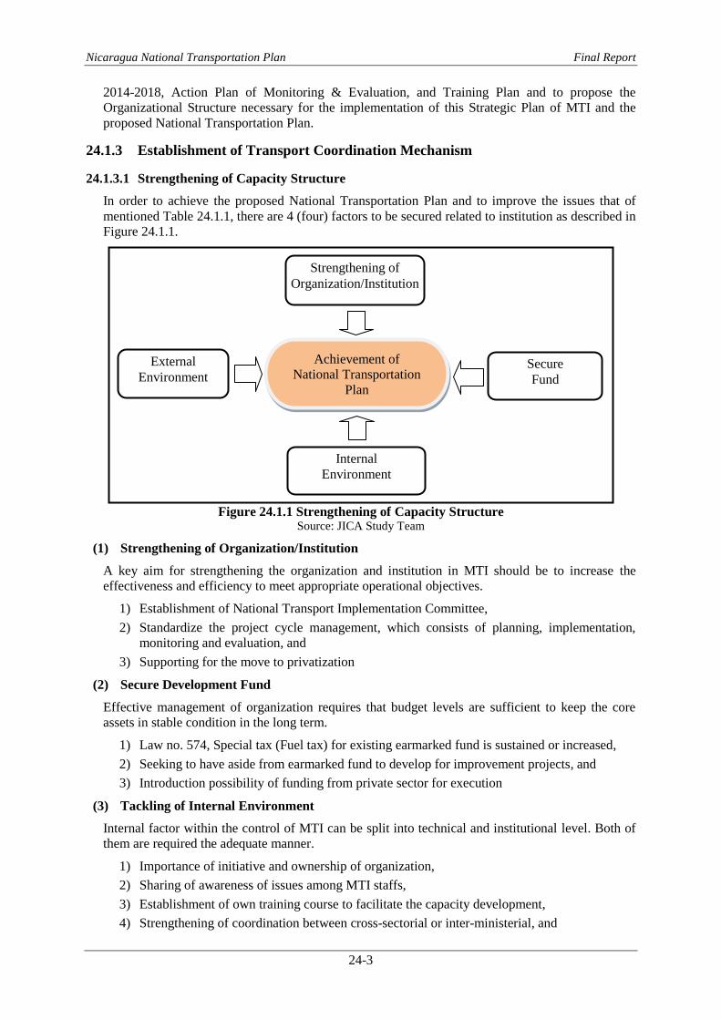
Nicaragua National Transportation Plan Final Report
24-3
2014-2018, Action Plan of Monitoring & Evaluation, and Training Plan and to propose the
Organizational Structure necessary for the implementation of this Strategic Plan of MTI and the
proposed National Transportation Plan.
24.1.3 Establishment of Transport Coordination Mechanism
24.1.3.1 Strengthening of Capacity Structure
In order to achieve the proposed National Transportation Plan and to improve the issues that of
mentioned Table 24.1.1, there are 4 (four) factors to be secured related to institution as described in
Figure 24.1.1.
Figure 24.1.1 Strengthening of Capacity Structure
Source: JICA Study Team
(1) Strengthening of Organization/Institution
A key aim for strengthening the organization and institution in MTI should be to increase the
effectiveness and efficiency to meet appropriate operational objectives.
1) Establishment of National Transport Implementation Committee,
2) Standardize the project cycle management, which consists of planning, implementation,
monitoring and evaluation, and
3) Supporting for the move to privatization
(2) Secure Development Fund
Effective management of organization requires that budget levels are sufficient to keep the core
assets in stable condition in the long term.
1) Law no. 574, Special tax (Fuel tax) for existing earmarked fund is sustained or increased,
2) Seeking to have aside from earmarked fund to develop for improvement projects, and
3) Introduction possibility of funding from private sector for execution
(3) Tackling of Internal Environment
Internal factor within the control of MTI can be split into technical and institutional level. Both of
them are required the adequate manner.
1) Importance of initiative and ownership of organization,
2) Sharing of awareness of issues among MTI staffs,
3) Establishment of own training course to facilitate the capacity development,
4) Strengthening of coordination between cross-sectorial or inter-ministerial, and
Strengthening of
Organization/Institution
Achievement of
National Transportation
Plan
Secure
Fund
External
Environment
Internal
Environment

Nicaragua National Transportation Plan Final Report
24-4
5) Availability of management information such as system for road/bridge inventory and traffic
data
(4) Expected External Environment
External factors are those, over which the organization itself has no direct control, but which
constrain the way that organization can operate.
1) The proposed National Transport Plan to be approved by National Assembly,
2) Growth of macro economy,
3) Continuous support from international donors, and
4) Aggressive investment from private sector with protection by law
It is difficult for MTI to achieve to meet those factors in short term. However, all of organization
concern should unify to tackle the current issues so as to implement the proposed National
Transportation Plan accordingly.
The other hand, JICA team has emphasized the participant of private sector in Chapter 24.2 so that
MTI and organization concern should improve the following governance standard to avoid the
participant from unreasonable investors,-
To ensure the independence from political intervention and an explicit purpose and role of
each private investor as a legal system, as well as determine the accountability from each
private investor.
To consider for government regulatory commitment and transparency of decision making
for the promotion of private investment.
24.1.3.2 Proposed National Transport Implementation Committee
There is an adequate institutional system, National System of Public Investment (SNIP) in MTI,
which assesses for the projects not only transport sector but also other public sectors to facilitate
development program at planning and implementation stage. This system aims to be for
administrative agency, interagency coordinator nature of legal advice, and consultation of public
investment projects for all of sectors and its institutions. The SNIP is functioning and the annual
development plan in the country is determined in accordance with this process.
However, the decision process of formulation of development programs or selection of priority
projects before applying this system for transport sector has not been established to ensure an
integrated approach internally. In this regards, it is important that once the development programs
for each transport sub sector are allocated, approval mechanisms shall provide institutional checks
to determine inter-sectorial priorities. The coordination among the ministries must be done before
decision of annual program and debated on the matters relating to the integration of all modes of
transport on which the sectorial prioritization of investment are based.
Therefore, MTI shall find a suitable approach to establish and manage a national coordination
keeping in view of institutional environment and requirements of trade and transport facilitation.
It is proposed that the National Transport Implementation Committee (the Committee) shall be
established to remedy transport system and to deal with efficiency projects based on the proposed
National Transportation Plan. The Committee shall discuss and evaluate subjects concerning
national transport and advise the results after the discussions. The Committee would also convey
the results to MTI concerned to take action. The Committee shall be headed by the Minister of MTI
and comprised of representatives from all authorities concerned and key players from industry and
academia, such as professor and representative of business community and bus association.
The Proposed Committee performance is summarized the following manners:

Nicaragua National Transportation Plan Final Report
24-5
Table 24.1.2 Function of National Transport Implementation Committee
Purpose/Objective
Development and acceleration of transport network
Implementation, monitoring and assessment of proposed National
Transportation Plan
Strengthening of the coordination of traffic modes
Harmonization of cross-discussion of the organization
Duty and Responsibility
To study the strategy and policy to ensure proper coordination in the
facilitation of all modes of transport
To study, review comment and propose all laws and regulation on
transport issues
To supervise and encourage transport operators for modernization of
transport fleets and introduction of advanced information technology
To coordinate with all relevant organizations both domestic and abroad for
collecting and sharing information/best practices
To seek assistance or possible funding from international donors and
private sector
To closely cooperate and coordinate with the regional transport
committees to reach common requirements on identification of regulations
and harmonized documentations
Member
Chairman: Ministry of MTI
Member: Vice Minister of MTI
Director General of MTI
Representative of Ministry of Finance and Public Credit
Representative of Ministry of Energy and Mine
Representative of National Port Authority
Representative of Ministry of Industry and Commerce
Representative of INAC
Representative of Traffic Police
Representative of RAAN
Representative of RAAS
Professor from UNI and UCA
Representative of bus association
Representative of COSEP
Frequency 4 times a year
Source: JICA Study Team
24.1.3.3 Proposed Coordination and Research Section
In order to sustain and facilitate the Committee, the contact office is to provide as a secretariat to
support to the Committee under MTI organization. This section shall be in charge not only
recording the discussion of the Committee but also carrying out research and development to
provide technical support to the Committee. This section supposes to have three main functional
tasks;
Coordination: Focus on requirement, monitoring and analyzing of the domestic and bilateral
or multi-lateral projects. This section shall mainly analyze the public investment fund on
transport sector based on comparison between investment budget and project cost annually.
Research: Focus on the research and analyses of the issues and needs of transport
development.
Information: Focus on the collection and dissemination of information and the establishment
of a data bank in which all transport and road traffic related statistics. The data bank shall
also keep all the result of traffic studies conducted by international donors.
24.2 Enhancement of Institutional Capacity for Sub Sector
24.2.1 Institutional Capacity of Road Maintenance Fund
Road maintenance fund (RF) of Nicaragua has adequate road maintenance on firm basis, such as
fuel tax (16% per gallon of fuel), with monitoring to ensure efficient use of money accompanied by

Nicaragua National Transportation Plan Final Report
24-6
annual report. However, this revenue from earmarked fund is lower than planned amount of
maintenance works so that it is able to disrupt with the infrastructure development in the future.
Technical point of view has been described in Chapter 15 so that this chapter has been noted from
the viewpoint of institution and legislation with the validation and review of measures based on the
following consideration.
(1) Stability of road fund
RFs continue to be impacted by “budget” allocations, with long elapsed time and large arrears.
Revenue from the fuel tax is credited directly into the road fund account, regularly, creating a
stable basis for the RFs. It may be too simplistic to assume that RFs will always be inviolate. It is
essential to design RFs to maximize the probability that they will not be abused, rather than simply
legislation a RF existence. The structural safeguards necessary to provide protection to the RFs
require a strong political will. Full commercialization of the road sector would provide a strong
barrier to such intervention.
In addition, adequate user representation and transparent dissemination of the activities are required
to establish a check-and-balance system to improve accountability in the day-to-day activities. It is
important for the RFs to be supported by well established enforcement tools to recover money
owed to the RFs.
However, even the institution and management would be functioned, other sources of earmarked
fund shall be sought to increase for development use other than national budget referring other
countries practice as follows:
Additional user charge (Part of tires or spare parts cost)
Road and bridge toll
Part of vehicle registration and inspection fees
Part of driving license fee
Part of fine for traffic violation
Part of fine for overloaded vehicles
International border transit fee (Temporary legislation)
Introduction of Labor-based technology to reduce the construction cost
The other hand, FOMAV has been also planning to start the project for “Financial Sustainability
and Institutional Strengthening Study for Maintenance Road Fund” to seek the road fund and
management system.
(2) Performance monitoring
One of the requirements of RFs management is to set up arrangements for independent monitoring
of performance of RFs and the quantity, quality, and cost of maintenance works. The RFs accounts
shall be prepared on a quarterly basis and audited by an independent external auditor for example.
Though preparation of audited accounts is a step forward in improving accountability in the use of
RFs, the accounts shall be prepared without any explanation in the use of RFs.
Table 24.2.1 is summarized the assessment and indicator of RFs to improve the maintenance
system in MTI.
Table 24.2.1 Assessment and Indicator of Road Fund
Strengthening Factor Organization & Institution Secure Fund
Expected Outcome
* Establishment of fund management
system
* Regal framework for seeking other fund
* Enhancement of data bank
* Training program for technical and
administration
* Participation system of private sector
(Fund & Procurement)
* Management of fuel tax
* Seeking the other fund allocation
or new earmarked fund
* Contractual framework of
private sector fund

Nicaragua National Transportation Plan Final Report
24-7
Strengthening Factor Organization & Institution Secure Fund
Viewpoint of Assessment
or Indicator
* Justification and management of
maintenance budget
* Management of data bank
* Capacity assessment for maintenance
works
* Transparency of procurement
Procedure
* Monitoring of timely disbursement
* Analysis of fund balance sheet
* Settlement of complex task for
participant of private sector
Source: JICA Study Team
(3) Key Lessons
Even institution and legislation become fulfilled, the available RFs are not sufficient in most
countries to fully finance of the entire road network. To ensure efficient distribution of available
resources it is imperative to: (i) define a high priority core network; (ii) prioritize the road network
not only on the basis of economic return but also social and environmental returns; (iii) focus on
maintaining this network in good condition; (iv) set up performance agreements between the fund
administration and the executing road agency; (v) develop and implement the technical
standards/handbooks with clear documentation of quality and quantity; (vi) create an enabling
environment for small scale contractors to participate in road maintenance, such as Labor-based
technology; and (vii) develop a road and bridge inventory (or a road data bank) including traffic
data and actual road conditions with functional responsibilities system, such as method of HDM-4
and Bridge Management System in MTI.
24.2.2 Institution of Waterway Transport for Inner Coastal Development
In case of developing the water transport for passenger through utilization of canal where is located
Plankila (Rio Coco) in RAAN and Bluefields bay in RAAS, organization structure should be
prepared and decided to operate with sustainable manner. Prior to considering the organizational
structure, MTI shall study the following four patterns of combination for operation structure to
manage in this kind of waterway transport.
Table 24.2.2 Operation Pattern of Waterway Management Operation Structure Advantage Weakness
1 *Direct management by MTI *Maintaining the quality of
service to passengers
*High employment and
maintenance costs
2
*Construction of facilities by MTI
*Concessionaire to suitable private
sector for operation & maintenance
*Reduce financial risk in future *Necessity of effort to
increasing passenger
3
*Fund, know-how and operation by
Private
*Subsidy or incentive from MTI
*Creation of new industries
*Revitalization of the economy
*Necessity of effort to
increasing passenger
4
*Full developing by private sector
*Business approval and issuance of
license by DGTA
*Risk avoidance for earning and
operation
*Difficulty of keeping high
public services
Source: JICA Study Team
Figure 24.2.1 is described in the recommendable operation structure for waterway transport and
Table 24.2.3 is shown in role and responsibility matrix as each organization concern. Although for
the legislation and most of facilities provisions are under responsibility of MTI, issuance of license
and education are under DGTA. And private sector shall operate and maintain the waterway
transport with subsidy or incentive from MTI. Therefore, MTI shall monitor and evaluate their
performance regularly. However, in case of extension plan or some other peripheral development
would be arisen, MTI shall require the Committee to discuss and obtain the comment.
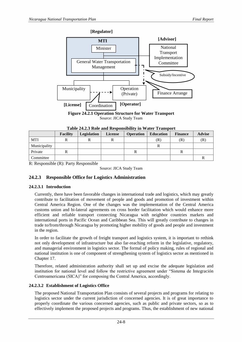
Nicaragua National Transportation Plan Final Report
24-8
Figure 24.2.1 Operation Structure for Water Transport
Source: JICA Study Team
Table 24.2.3 Role and Responsibility in Water Transport Facility Legislation License Operation Education Finance Advise
MTI R R R (R) (R) (R)
Municipality R
Private R R R
Committee R
R: Responsible (R): Party Responsible Source: JICA Study Team
24.2.3 Responsible Office for Logistics Administration
24.2.3.1 Introduction
Currently, there have been favorable changes in international trade and logistics, which may greatly
contribute to facilitation of movement of people and goods and promotion of investment within
Central America Region. One of the changes was the implementation of the Central America
customs union and bi-lateral agreements on cross border facilitation which would enhance more
efficient and reliable transport connecting Nicaragua with neighbor countries markets and
international ports in Pacific Ocean and Caribbean Sea. This will greatly contribute to changes in
trade to/from/through Nicaragua by promoting higher mobility of goods and people and investment
in the region.
In order to facilitate the growth of freight transport and logistics system, it is important to rethink
not only development of infrastructure but also far-reaching reform in the legislative, regulatory,
and managerial environment in logistics sector. The formal of policy making, rules of regional and
national institution is one of component of strengthening system of logistics sector as mentioned in
Chapter 17.
Therefore, related administration authority shall set up and excise the adequate legislation and
institution for national level and follow the restrictive agreement under “Sistema de Integración
Centroamericana (SICA)” for composing the Central America, accordingly.
24.2.3.2 Establishment of Logistics Office
The proposed National Transportation Plan consists of several projects and programs for relating to
logistics sector under the current jurisdiction of concerned agencies. It is of great importance to
properly coordinate the various concerned agencies, such as public and private sectors, so as to
effectively implement the proposed projects and programs. Thus, the establishment of new national
National
Transport
Implementation
Committee
MTI
Minister
General Water Transportation
Management
Municipality Operation
(Private)
Subsidy/Incentive
[Regulator]
[License] [Operator]
[Advisor]
Coordination
Finance Arrange

Nicaragua National Transportation Plan Final Report
24-9
level of logistics administration office under MTI as regulatory and the Committee as advisor is
recommended.
(1) Logistics Office
Logistics office shall be established under MTI to function as regulatory office. It will also act as
coordinator for several concerned agencies in the administration of logistics through the following
major activities,
Policy and planning in logistics development,
Efficiency of cargo distribution,
Planning on important matters concerning proper facilitation and regulation,
Coordination of several concerned agent in the administration of logistics, and
Project planning and implementation in logistics project such as logistics parks.
To carry out the tasks relevant to the above activities, the logistics office shall have at least
following 3 sections as shown in Table 24.2.4.
Table 24.2.4 Task in Logistics Office Section Task
Planning Section
*Coordination of other agencies concerned with logistics
*Master planning in logistics development
*Foreign relations such as Cross-border Trade Infrastructure (CBTI) &
Cross-border Trade Agreements (CBTA)
Project Section
*Review of plan for logistics parks
*Approval of application for projects
*Evaluation and monitor the projects
Administration Section
*Financial planning
*Procurement and administration to private company
*Personnel, accounting and management of office
Source: JICA Study Team
(2) Transport Implementation Committee
As the Committee has been mentioned the duty and responsibility in Table 24.1.2, policy, strategy
and implementation of projects for logistics sectors shall be discussed in the Committee. And the
Committee shall then convey the results to the logistics office under MTI to take action. Especially,
The Committee shall coordinate and monitor the progress in implementing the SICA framework
agreements on cross-border transport as well.
24.2.3.3 Enhancement of Institutional Connectivity for Corridor Development
JICA study team has focused the enhancement of institutional connectivity to set up the
development of logistic system so as to improve the Cross-border Trade Infrastructure (CBTI) in
parallel with the establishment of Cross-border Trade Agreement (CBTA) among composing
Central America. The relevant authority is considering the specific integration initiatives related to
corridor development. Table 24.2.5 is shown in policy and key activity in accordance with
appropriate situation to strengthen the institution for corridor development.
Table 24.2.5 Key Activity for Institutional Connectivity Policy Key Activity
1
Operationalizing the framework
agreement on transport facilitation
Improvement of Cross-border Trade Infrastructure
(CBTI) in parallel with establishment of Cross-border
Trade Agreement (CBTA)
2
Implementation the initiatives to
facilitate interstate passenger
land transportation
Expedition the implementation of the existing bilateral
and regional arrangements
Developing a regional arrangement on facilitation of
interstate passenger land transportation
3
Acceleration the free flow of goods in
the region by eliminating barriers to
merchandise trade
Strengthening the behaviour principle based on Central
American Customs Union Framework agreement

Nicaragua National Transportation Plan Final Report
24-10
Policy Key Activity
4 Acceleration the development of an
efficient logistics sector
Removal of substantially all restrictions on trade in
services for logistics services
5
Substantially improvement trade
facilitation and Enhancement the
border management capabilities in the
region
Developing the implementation of National Single
Windows in the region
Synchronising the procedures, formalities and practices
in border management and its harmonisation to the
extent in the region
6
Strengthening the institutional capacity
in lagging areas in the region
Facilitation the flow of technical assistance from the
donor to Nicaragua and regional groupings for capacity
building
Source: JICA Study Team
24.2.3.4 Attraction of Foreign Investment
Foreign investment is essential for improving of the logistics system, corridor development and
enjoying from the significant tax benefits. However, there are still inadequate system, insufficient
business know-how and lack of human resources in Nicaragua. JICA team has mentioned the
following necessities to facilitate to the foreign investors.
(1) Transparency in market
Market transparency is a prerequisite for foreign investment. Private companies consider the
market transparency to be a more important factor than incentives in attracting foreign investment
in usual business practice. It is obvious that private companies prefer standardized interpretations
of regulations. To achieve this, it is necessary to make great effort in minimizing the loopholes that
induce personal discretion in interpretation of regulations as much as possible. However,
modifications of regulations or preparation of detailed standardized interpretation and manuals of
the regulations will require a long time to complete. In this regard, “Trouble Shooting Office” for
foreign investors such as logistics office is a proven approach applied by logistic and
agro-processing parks.
(2) Incentives
Incentives system is a popular tool used to attract investment. Several incentives are given to the
foreign investors even currently in Nicaragua such as 100% income tax exemption for 10 years,
100% exemption on import taxes for machinery, equipment and raw materials, and others. Since
Nicaragua is a latecomer to industrialization among Central America countries, there is a great
need for Nicaragua to offer better incentives to compete favorably against them in attracting
foreign investment. Nicaragua shall consider variety of incentives from various aspects which can
generate a more attractive business environment compared to its competitor’s countries. As regards
foreign investment in logistics, the following measures and/or incentives are potential tools that
could be used;-
Compliance of Central America customs union Agreement
Acceptable business in SEZ
Longer length of income tax free period in the logistics parks or SEZ
Application of special depreciation
Favorable work permits for foreigners

Nicaragua National Transportation Plan Final Report
25-1
Chapter 25 Capacity Development Plan
25.1 Purpose of Capacity Development
25.1.1 Concept of Capacity Development
Capacity Development (CD) refers to the ongoing process of enhancing the problem-solving
abilities of organization by taking into account all the factors at the individual, organizational, and
social levels. Capacity is defined as the ability of organizations to solve problems on their own.
Capacity is not simply transferable and its sustainability is largely dependent on the initiative and
ownership of the target organization involved.
For example, effective road development management would not only be limited to the sufficient
know-how possessed by MTI and its staff, but also extend to various other elements. These include
a role-sharing mechanism that involves the private sector such as contractor, communities such as
roadside residents, and the government’s department in charge such as an institutional setup that
determines the technical standards, as well as the policies that set goals of road development (see
Figure 25.1.1).
Figure 25.1.1 Concept of Capacity Development
Source: JICA Study Team
The based on the above, MTI shall consider the following concept of basic awareness to each target
organization to improve.
Each organization must be developing capacities by themselves
Ownership by MTI is vital
Joint efforts with the participation of each organization in MTI are important
A long-term commitment is required
Creating a sustainable mechanism after capacity training course
Systemic thinking and program approaches
A flexible approach responsive to the development needs and conditions
25.1.2 Evaluation of Capacity Development
The evaluation of capacity development (CD) is based on measuring the level of achievement of
the expected results that the organization establishes. The following flowchart illustrates the
institutional and individual approach to conduct the evaluation of CD.
Social Level
Organization Level
Individual Level
Increasing personnel ability
Improving department ability
Technical standards/handbooks
Social awareness of road development
Government policies

Nicaragua National Transportation Plan Final Report
25-2
The key of CD is the availability of strategies with institutional, organizational and individual
viewpoints in the assistance program and its approaches when the concerned party tries to achieve
the expected results.
It is also important to implement activities to achieve the goal by choosing a suitable process with
specific indicators. To this end, the MTI must exercise strong leadership and tackle the problems,
while the executives must continue to assess the processes.
Regarding to the method of evaluation of CD, it is necessary to refer the "concept of basic
awareness to each target organization to improve." shown in the preceding paragraph of 25.1.1 and
realize it in both qualitative and quantitative way.
Qualitative Evaluation Quantitative Evaluation
Availability of training plans to achieve the
expected results
Number of people who participated in training
Comprehension of training content (confirmed
by test)
Availability of action plans to achieve the
expected results
Number of achieved projects
Existence of management goals (expected
results) of the specific institution (division/
section)?
Extending pavement durability, Increase of
pavement rate, Reduction of number of traffic
accidents (road sector)
Reduction of transportation costs, Time
reduction of customs clearance, Increase of
transport volume (logistic sector)
Increase of frequency of use, increase of
transport volume (port and airport sector)
25.1.3 Institutional Capacity of MTI
MTI should operate the institution establishing the overall goal, objectives of each division and the
expected results to be achieved through the attainment of the objectives. To achieve the results and
strengthen the institutional capacity, it is necessary to grasp the current situation of its capacity. For
that purpose, the JICA Study Team consulted with the Department of Human Resources and
classified the current capacity. Figure 25.1.2 shows four (4) main factors to improve the
institutional capacity in view of individual, organization and social levels. Out of these four factors,
“work procedures and work tools” is the most important. Work procedures include technical
guidelines / hand books that lead the staffs to actually do the tasks in accordance with prescribed
standard procedure. Another important factor of institutional capacity is the enhancement of
capacity of staff. The enhancement of individual capacity can be achieved through teamwork in
each division and section. However, it is inevitable that individual differences occur according to
the academic and professional career, as well as the motivation. Currently in the MTI, there is
cross-communication through the training, therefore the institutional flexibility is maintained.
However, it will become increasingly necessary to identify the focus and capacity building manner
by classifying factors. To this end, it is imperative to develop and implement training plans
continuously to minimize the difference in individual capacity.
Individual
Level
Organizational
Level O
ver
all
Go
al
Objectives of
Division Expected
Results Evaluation
Confirmation
of Capacity
Implementati
on of Training
OJT/OffJT
Achievement
of Results

Nicaragua National Transportation Plan Final Report
25-3
Figure 25.1.2 Factors Influencing Institutional Capacity
Source: JICA Study Team
Institutional
Capacity
Organization
Work Procedures &
Work Tools
Capacity of Staff
Equipment &
Facilities
Structure/Chart
Job Description
Scale of Staff Size
Internal Rules
Guidelines/Handbooks
Information/Reporting
System
IT system/Data Bank
Road Inventory/Bridge
Management
Educational Background
Experience Record
Training Record
Moral/Motivation
Cross-sectorial Relation
Computer/Testing
Intranet/ Software
Office Space/Laboratory

Nicaragua National Transportation Plan Final Report
25-4
25.1.4 Capacity Gap Assessment
Capacity gap assessment (CGA) is the starting point and essential part of the CD because it makes
apparent the strength and weakness of the organization for which the training program is
implemented.
(1) Methodology
One of the most commonly methods for assessing the existing capacity of an organization is to
distribute questionnaires to the staffs of the organization and let each staff member evaluate his/her
capacity. This method cannot avoid subjective judgment of each staff member but the average of
the whole is supposed to indicate the existing situation correctly.
There are 10-20 questions covering the each sector involved in CD of target organization. The
following items are shown for example of road sector. MTI shall prepare the questionnaires for
each field of work.
1) Road condition survey
2) Design of road maintenance and construction works
3) Technical standards and handbooks
4) Material test
5) Work execution planning
6) Cost estimate
7) Knowledge and skill of inspection for quality control
8) Filing of data/drawings
The questionnaire shall ask two kinds of knowledge;
1) Level of knowledge needed for carrying out his/her duties and
2) Level of knowledge he/she actually possesses.
The level of knowledge is rated in the following 5 levels.
Level 1: I do not know the subject at all; I have never heard of this word.
Level 2: I know the subject but do not know what it is; I have heard the word but never
learned anything about it.
Level 3: I know what it is but cannot use in the actual work. I learned about it in school
(university) or I have attended seminar/workshop but I have not used it and need
some training to be able to use it in daily works.
Level 4: I have used or referred or kept the subject to carry out the work in the past
experience.
Level 5: I can use the knowledge/skill in the daily works, perfectly and can teach other staffs.
The difference between the above two is considered to be the gap of knowledge for each field of
work.
(2) Distribution and Collection of Questionnaire
The questionnaire shall be distributed to persons working in engineering-related departments and
administration departments of MTI including regional offices. The date for collection of the filled
questionnaire shall be two weeks later normally.
(3) Data Compilation
1) Coding
Human Resources Management office shall involve inputting non-numerical data, organization and
position level of each staff member, it is necessary to assign code number for these data.
As for position level, coding numbers of 1 to 5 shall be given to various levels as shown below:

Nicaragua National Transportation Plan Final Report
25-5
Table 25.1.1 Coding for Position Level
Code No. MTI Regional Office
1 Deputy Director, Chief of Office Director, Deputy Director
2 Deputy Chief Chief of Office
3 Sr. Engineer Sr. Engineer
4 Engineer Engineer
5 Technician Technician Source: JICA Study Team
2) Data Compilation and Analysis
Data shall compile in excel data sheets and excel is chosen as the tool for analysis of the data for its
suitability.
(4) Analysis after the implementation of CGA
The CGA does clarify the required and existing skill within the capacity that both the organization
and the individual possess. However, it is not an omnipotent methodology which makes analysis in
an instant, but it is a method of analysis with the advantages and weaknesses (as described in the
table below) that can be applied when the training plans are prepared.
Strengths Weaknesses
Confirmation of individual capacity is
possible.
If the training program is prepared
according to the level of capacity,
automatically it reveals the level of each
participant.
It allows reflect the results in planning of
training.
Intensive time and effort are needed in the
implementation and analysis of CGA.
It can be used as a guide for determining
remuneration and promotion.
There are peoples who respond in the
contradictory way to the reality.
It can be used as a basis for explaining to
acquire the training budget.
Given the large number of persons subject
to EBC, there is a possibility that the results
of analysis cannot be obtained.
It can serve as a guideline to indicate the next
level to reach for each individual.
25.2 Current practice of Capacity Development Program in MTI
(1) Existing Training Program of MTI
MTI planned the five years training program from 2008 to 2012 and requested to National
Assembly in 2007. This program contained the institutional strengthening plan of MTI, which once
implemented with the support of financial institutions, will give solution to the problems that are
currently present in the institution, primarily the lack of trained staff throughout the process of the
project cycle and the lack of equipment necessary for the performance of institutional functions.
MTI in its effort to improve the institutional capacity has raised the challenge of increasing and
updating the levels of knowledge of technical staff in several stages. A training program for
personnel engaged in the activity of road construction, road and transportation planning will be
implemented in its different modalities. Within performance of this training program were
proposed to obtain the following master or diploma: transportation engineering, administrative law
or transportation planning that come to strengthen the institution professional, assessment and plan
design solutions to problems that arise in the daily work of the different areas to which they belong.

Nicaragua National Transportation Plan Final Report
25-6
Table 25.2.1 Summary of Proposed Training Course of MTI
Training Course Required
Person Training Course
Required Person
Master of law and regulation of contracts 30 Specialization of hydrology 2
Master of land transport and routes 18 Specialization of structural
engineering
6
Master of transportation planning 4 Specialization of topography 6
Graduate of project formation and
evaluation
11 Master of pavement design
2
Diploma of project management 2 Master of transport economy 2
Specialization of cost and budget 6 Master of urban legislation 1
Specialization of road design 6 Graduate of project management 13
Specialization of geotechnical 6 Graduate of project audit 6
Specialization of hydraulics 6 Graduate of road works 10
Specialization of pavement 6 Graduate of administration network 1
Specialization of traffic 6 Graduate of functional management 4
Total 152 Source: JICA Study Team
However, MTI has not performed approximately 80% of this training programs due to funds were
limited. MTI has been seeking the training funds which maybe come from mainly external funds to
carry out this program even year 2012 were over. JICA Study Team recommended continuing with
training courses (see Table 25.2.2).
Table 25.2.2 Actual Performance of Training Course No SUBJECT/SOURCES OF FINANCING CENTER OF STUDY DURATION PARTICIPANTS AREAS (OFFICE)
1 MASTER IN TELEMATIC AND NETWORKS
Universidad Iberoamericana
de Ciencias y Tecnologìa
(UNICIT)
2 YEARS 1 INFORMÀTICA ( IT OFFICE)
2POSTGRADUATE FORMULATION EVALUATION OF PUBLIC
INVESTMENT PROJECT (EXTERNAL FUNDS)
Direcciòn General de Inversi
òn Pùblica (General
Direction of Public
Investment)
3 MONTHS 2 ADQ - DGV
3 MASTER IN LAND TRANSPORT/ROUTES (WORLD BANK)Universidad Nacional de
Ingenierìa (UNI)3½ YEARS 28
DGV,DGP,DGTT, DGNCDU,
COERCO, PASTDANIDA,
ECONS-3,FOMAV,
31
4 MASTERS ADMINISTRATION OF CONTRACTS (IDB FUNDS)Universidad
Centroamericana (UCA)2 YEARS 33
ADQ,DAL,DGV, DGP,DGAF,
AUD INT, ECONS-3,
COERCO,EICMEP
33
5 IT Consulting web page update Private Consultant 3 MONTHS 7 DS, REL. PUB, INFORMÀTICA
7
6
POSTGRADUATE FORMULATION, EVALUATION AND
ADMINISTRATION OF INVESTMENT PROJECTS WITH
EMPHASIS ON TRANSPORTATION INFRASTRUCTURE (WB
FUNDS)
Universidad Nacional de
Ingenierìa (UNI)6 MONTHS 14 DGV, DGP, ADQ, UGA, DS, FOMAV.
14
2011
TOTAL
TOTAL
TOTAL
TOTAL
2008
2009
2010
Source: JICA Study Team

Nicaragua National Transportation Plan Final Report
25-7
No SUBJECT/SOURCES OF FINANCING CENTER OF STUDY DURATION PARTICIPANTS AREAS (OFFICE)
7POSTGRADUATE QUALITY MANAGERS FORMATION IN THE
PUBLIC SECTOR
Ministerio de Hacienda y Cr
èdito Pùblico (Ministry of
Finance)
3 MONTHS 3 CAPAI, DGV
8 GRADUATE SUSTAINABLE TRANSPORTUniversidad Nacional de
Ingenierìa (UNI)4 MONTHS 6 DGTT
9 INTENSIVE COURSE ON RIGHT OF CONTRACTS MTI - Private Consultant 6 MONTHS 36DGTT, DGV, DAL, ADQ, DGTA,
RRHH, DGP, DGAF
10 GRADUATE IN RIGID PAVEMENT Tecnologico de Monterrey 10 MONTHS 2 DGP, DGNCDU
11 COURSE IN ASPHALT PAVEMENT Tecnologico de Monterrey 10 MONTHS 4 DGV,
51
12 SPECIAL GRADUATE IN BUSINESS TAXATIONCETAE Academia Tributaria
(TAXATION ACADEMY)3 MONTHS 5 DS, DGAF, DAL, DGV
13MASTER IN BUSINESS MANAGEMENT AND
ADMINISTRATIONUniversidad de Chile 20 MONTHS 1 DGV
14 LAW LABOUR/BUSINESS POSTGRADUATEUniversidad politecnica
(UPOLI)2½ MONTHS 1 RRHH
15 ASPHALT MIXTURES TESTING Tecnologico de Monterrey 2 WEEKS 12DGNCDU, DGV, COERCO, ADQ,
UNAN, FOMAV, UNI, D
16 CONSTRUCTION MATERIALS TESTING Tecnologico de Monterrey 2 WEEKS 12DGNCDU, DGV, COERCO, ADQ,
UNAN, FOMAV, UNI, D
17 SOIL TESTING Tecnologico de Monterrey 2 SEMANAS 13DGNCDU, DGV, COERCO, ADQ,
UNAN, FOMAV, UNI, D
18 SECOND INTENSIVE COURSE IN RIGHT OF CONTRACTS MTI- Private Consultant
6 MONTHS
(IN
PROCESS)
37
DGV, DAL, ADQ, RRHH, DGP,
DGAF, DGNCDU, COERCO,
FOMAV, EICMEP, ECONS-3,
ENCOSE.
81TOTAL
TOTAL
2013
2012
Source: JICA Study Team
The trainers were professors from university or foreign experts. This arrangement of trainers is
very reasonable in the beginning stage of CD. Although it may be better to invite outside trainer(s)
depending on the subject and availability of competent outside resource, it is realistic to invite the
trainers within the MTI, including affiliated institutions.
(2) Evaluation report prepared by World Bank consultant
The preparation of report was considered in the plan of action of the technical visit conducted in
March, 2012. World Bank (WB) has been developing institutional strengthening, which have
helped to improve the management of the institution, making rational use of material and human
resources with supporting program. These achievements have been realized by strengthening the
skills of the staff through the various components referred to in the various Agreements credits. In
order to have highly qualified personnel and equipment required to provide better service to the
public, in compliance with the provisions of the National Human Development Plan and Strategic
Plan of the MTI, this strengthening plan is a necessary continuity to be maintained for the proper
development of the projects.
The justification of this evaluation report is that the implementation of the WB program has been
contributing to the smooth functioning and operation of the areas involved, with which it aims to
achieve the levels of acceptance of outcomes indicators, linked to MTI plans and programs.
(3) Review of Current Training Program
The JICA team has observed this training course and MTI program. Although there are several
sessions in this training course where engineering and administration subjects are covered, these
sessions are considered to cover general topics of road section, mainly. And WB is supporting not
only arrangement of the training course and seminars but also provision of some equipment
including office use and testing materials as well.
From those described above, the followings may be concluded:
1) The training course of MTI is designed for upgrading the capacity of MTI staff as
government officials.
2) Trainees seem to be obtaining the certification of training course personally. Trainees
should disseminate the knowledge to other colleague in his/her management office.

Nicaragua National Transportation Plan Final Report
25-8
3) WB program covered the general knowledge of capacity but is not sustained to the future.
Because fund and duration of support is limited.
4) Therefore, it is recommended that the training plan specifically should design for MTI
original, especially trainers have to be MTI management and implement in a sustainable
manner.
5) The transportation sub sector should be also designed other than road sector.
25.3 Proposal of Training Plan
Effective and efficient training is essential when capacity strengthening of an organization is
intended. A preliminary training plan has been prepared based on the discussions between the
relevant officials of MTI and workshop conducted by JICA team as well as the result of the review
of the current status of existing training of MTI. This proposal of training plan shows content of
training course, objective, outcome, and target organization but does not show details of
implementation of the training courses. The details of training courses are discussed and decided by
MTI management based on conducting of capacity gap assessment.
(1) Method of Improving One’s Capacity
When someone hears the word ‘training’, he/she may think of a training event delivered to a group
of people who are allowed to leave their daily work place (called ‘group training). However, there
are various ways to improve one’s capacity. Methods of improving one’s capacity are usually
categorized those as shown in Figure 25.3.1. These methods are explained below:
Figure 25.3.1 Methods of Capacity Improvement
Source: JICA Study Team
1) Self-Learning (Self-Development)
An organization generally establish management goals (expected results) and give a periodical
training to their staff. However, it is also necessary that each individual make efforts to overcome
their weakness that is identified in CGA and strengthen their capacity not only relaying on the
training provided by the organization. The key to strengthen the individual capacity lies in
recognizing the importance of self-learning. When someone is assigned to a new position, he or she
will try to make efforts to do their best and achieve the expected results. This is usually done
through learning with assistance of available reference. However, self-learning and
self-development is difficult to achieve without a strong motivation of the person who intends to
learn, so it is essential to have the tools mentioned above in Figure 25.1.2, in other words, to make
the technical references that the institution have and do challenges constantly setting personal
goals.
Self-Learning
On-The-Job Training
(OJT)
Group Training Individual Training
Training
Capacity Improvement
Off-The-Job Training
(OffJT)

Nicaragua National Transportation Plan Final Report
25-9
2) Types of Training
On-the-job training (OJT): Training given in one’s working place.
Off-the-job training (OffJT): Training given outside of one’s work place.
3) By the number of participants (usually applied to OffJT)
Group training: Training where large number of trainees is trained together.
Individual training: Training given on individual basis.
These types of training are compared in the following Table 25.3.1 and Table 25.3.2.
Table 25.3.1Comparison of OJT and OffJT OJT OffJT
Des
crip
tio
n Training given through day-to-day work in
one’s work place.
Trainer can be trainee’s manager of senior
worker
Trainee is discharged from daily duties and
allowed to participate in training.
Usually implemented at location other than
trainees work place (but can be in the same
building).
Ad
van
tag
e
Usually efficient and effective because
training is done through actual works.
The outcome can be used immediately after
completion of training.
Cost is minimal and usually does not need
special budget.
Daily duties need not to be interrupted.
Trainee can concentrate in the training.
Trainers can be selected from qualified
persons.
Due to above, training can be efficient and
effective, and can be implemented in shorter
period than OJT.
Dis
adv
anta
ge Unless systematically planned, often
interrupted/ignored when urgent works come
in, or for any other reasons.
Can be biased or have some problem if the
knowledge of trainer (manager or senior
worker) is biased.
Daily duties need to be interrupted.
Need certain amount of budget.
Source: JICA Study Team
Table 25.3.2 Comparison of Group Training and Individual Training Group Training Individual Training
Des
crip
tio
n Large number of trainees is trained at the same
time.
Contents of training are decided before
trainees are selected.
One trainee or small number of trainees is
trained at one time.
Trainee is selected first and outline of
training is decided.
Typical example is studying abroad for
high-level education.
Ad
van
tag
e
Many trainees can be trained at one time.
Cost per trainee is usually lower than
individual training.
Thus, effective when large numbers of people
need to be trained on particular subject in a
short period.
Network of trainees is often created which
later can help further improvement of trainees’
capacity.
Level of training can be freely set based on
the objective and level of trainee.
Thus, high-level training, such as study of
state-of-the-art engineering, is possible.
Dis
adv
anta
ge Effectiveness and efficiency may not be
uniform over all trainees.
Number of trainee is limited.
Therefore, is not suitable when large number
of people need to be trained in a short period.
Cost per person is high.
Source: JICA Study Team
Although types of training are usually classified as above, there is no clear boundary between them.
For example, OJT often needs to be supported by self-learning and actually self-learning is a part
of OJT process. Another example of unclear boundary between types of training is that two persons

Nicaragua National Transportation Plan Final Report
25-10
or more are invited to counterpart training in Japan but it is not called group training. Type of
training has to be adopted considering the advantages and disadvantages as shown above. However,
importance and effectiveness of OJT should not be underestimated.
(2) Target Level of Knowledge to be acquired through Training and Level of Trainee
A training course is designed to let the trainees acquire targeted level of knowledge and/or skill.
Also, target group of the people to be trained is selected. These are necessary to achieve the
objectives of the training course. JICA team has considered it appropriate to deliver training
courses in two levels, intermediate level and advanced level, as briefly explained in Table 25.3.3.
Target group of trainee are selected for each training course.
Table 25.3.3 Level of Training
Level Description
Intermediate
Target is to teach how to actually supervise the works at the office and site.
Main topics of training are fundamental points of using the
standards/handbooks, knowledge of checking material, method of
execution, checking the performance of works (for example).
Advanced
They are expected to be leader or advisor to other staff.
After training, trainees are expected to know how to secure required
quality, meaning and interpretation of standards/handbooks, procedures of
lab tests and field tests and their problems, how to prevent use of
sub-standard material, how to realize good execution (for example). Source: JICA Study Team
(3) Trainer
In order to make the proposed training plan sustainable, trainers shall be selected among MTI staffs.
Basic qualifications of trainers are as listed below:
Table 25.3.4 Qualification of Trainer
Condition Description
Academic Knowledge
Sufficient academic knowledge is required. This typically includes,
minimum, university-level, desirably, graduate-level educational
background on the subject. Nevertheless, basic theories of related
transport sector need to be taught by trainer(s) with
university-or-above educational background.
The trainer needs to be able to teach basic theory of the subject.
Practical Experience
Rich experience obtained through positive participation in actual
projects of the subject. The trainer is required to possess sufficient
knowledge on actual cases of problems and solutions, prevention of
the problem, etc.
Working Knowledge Based on the sufficient academic knowledge and practical
experience as cited above, the trainer needs to have organized
knowledge which can be used in actual works of the subject.
Presentation Skill The trainer needs to have good presentation skill. If a candidate for
trainer needs improvement, ‘training of trainers’ (TOT) should be
given. Source: JICA Study Team
It is a matter of course that anyone cannot be expected to be a good trainer without training and
experience. Accordingly, ‘training-of-trainer’ (TOT) is necessary after candidates of trainers are
selected. Actual candidates of trainers shall be selected upon close consultation among MTI. One
important consideration is that persons responsible for preparation of a standard/handbook or other
similar document know the document best therefore; they should be the trainers in the introduction
workshop of the said document.

Nicaragua National Transportation Plan Final Report
25-11
(4) Training Evaluation
At the end of the training event, evaluation sheets are handed out to, and filled by all the
participants. The items to be typically evaluated are as follows:
Increase of the participant’s knowledge on the subject and/or degree of understanding
Teaching material
Trainer’s lecture
Duration of the training event
Usefulness
A training report should be prepared after the data of evaluation sheets are compiled and analyzed.
End-of-training report should include the following information/data.
General information (Title of the training and objective/target, date, venue, trainers etc.)
Participants list (actual)
Training material
Cost (budget and actual expenditure)
Result of analysis of evaluation sheets
The above data/information is very useful when similar training will be planned in the future.
(5) Log Frame of the Proposed Training Plan
Main focus of the proposed training plan is a total transport sector and the necessity of training
courses shall be recommended by JICA team written in practical frame. This log frame (logical
framework) here considers the CD of the overall MTI. Table 25.3.5 below shown is the log frame
of the proposed training plan of each transport sector. This log frame is formulated in consideration
of discussions in workshop and MTI program in 2007.
It is recommended that the training plan shall be reviewed again when the nominated key persons
start the training courses. The ideas and requests from the practical operations staff (Human
Resources Management Office) are very important to prepare in details of designing plan. The plan
focuses on the CD and empowerment of organization that is the foundation of the governmental
administration. The expected result has two parts that are i) targeting the improvement of
individual capability and ii) targeting organizational empowerment.
The program should be well balanced to provide target organization with both engineering and
administration skills. In other words, the MTI needs human resources with both engineering
knowledge and administrative capacity. JICA team recommends again even training courses can be
successful, dissemination of knowledge to other colleague is more important so that MTI should
arrange to organize a harmonized holistic CD plan using practical OJT method.
Table 25.3.5 Log Frame of Capacity Development (Transport Planning)
Indicator
[Overall Goal]
To enhance the capacity for planning and management
of environmentally sustainable transportation system
based on concept of Green Economy which aims
simultaneous pursuit of preservation and economic
development.
1. Monitoring and evaluation of the
proposed National Transportation Plan
(NTP).
2. Socio-economic indicators (Production,
income, population).
3. Degree of people satisfaction.
[Objective]
To be able to propose the Action Plan on
environmentally sustainable transport in consideration
of current status of country.
1. Development of Action Plan for short
term
2. Regional development plan that utilize
the potential factor
[Expected outcome]
1. Participants can review and analyze the current
1. Monitoring the plan of each sector in

Nicaragua National Transportation Plan Final Report
25-12
Indicator
situation and issues of sustainable transportation
system.
2. Participants can identify the direction and extension
methods of policies, programs, and projects for
sustainable transportation system.
3. Participants can draft an Action Plan.
4. Participants can propose an Action Plan to related
organizations.
NTP.
2.1Regional development plan.
2.2Traffic demand forecast.
3. Prioritization of projects. 4. Discussion in the Committee.
[Activities]
•Review of current situation of administration system.
•Analysis of the national concept of transport network.
•Review of initiatives and programs in Central
America Region.
•Review of transport planning and land use.
•Review of city planning in nationwide.
•Review of public transport planning and Traffic
Demand Management (TDM).
•Observation of environment and people-friendly
related to transport infrastructure.
•Analysis of budget request.
•Preparation of action plan.
[Target Group]
Middle ranking officer who have more
than 3 years of experience in relevant
sector.
Source: JICA Study Team

Nicaragua National Transportation Plan Final Report
25-13
Table 25.3.6 Log Frame of Capacity Development (Road Administration)
Indicator
[Overall Goal]
To develop the capacity of road administration for the
related government officials.
1. Monitoring of the proposed National
Transportation Plan.
2. Differences between plan and actual
development.
[Objective]
To improve the road planning, construction and
maintenance ability of the mid-level official in road
sector. To confirm the participant's learning by a
presentation based on knowledge acquired by lectures
and site visits.
1. Budget for road improvement.
2. Ratio of pavement.
3. Average speed, traffic density and
transportation cost.
4. Number of traffic accidents
[Expected outcome]
1. To understand the process of road planning and
points to consider during preparation.
2. To understand the effects of road development and
the evaluation method of the project.
3. To understand the process of road structure (mainly
bridges) planning and points to consider during
preparation.
4. To understand the road pavement.
5. To understand the new technologies and standards.
1. 1Road planning for short term.
1.2Traffic survey
2. Road inventory.
3. Bridge Management System.
4. Design standard and specification.
5. Participation of the seminar,
particularly the latest method and
international standards.
[Activities]
【Subject related with Road Network Planning】
•Preparation method of road network planning.
•Observation of other countries outline of road
administration.
•Practice of economics analysis, project evaluation and
demand forecast.
•Practice of disaster prevention plan in the road
network.
•Site observation.
【Subject related with Road Route Planning】
•Preparation of road route planning.
•Review of road related legislation.
•Practice of public involvement, environment impact
assessment (EIA).
•Inspection of road Structure(Bridges, Pavement.
•Preparation and management of road construction
method and construction machinery.
•Practice of Road Safety.
•Management of road maintenance and life cycle cost
assessment.
[Target Group]
1. Engineers who graduate the university
(civil engineering) or the equivalent.
2. A mid-level officer in charge of road
planning and expected to be assigned
to the leading position in the future.
Source: JICA Study Team

Nicaragua National Transportation Plan Final Report
25-14
Table 25.3.7 Log Frame of Capacity Development (Road Maintenance)
Indicator
[Overall Goal]
To strengthen capacity of the organizations for road
management and maintenance with knowledge and
skills required for survey, planning, routine and
periodic maintenance method with due considerations
for cost and quality.
Adequate maintenance system is
established.
[Objective]
Road management and maintenance activities are
improved in the target organizations.
1. Lengthen pavement's life-span.
2. Budget for maintenance works.
[Expected outcome]
1. Analysis of current understanding on road
management and maintenance system.
2. Improvement of the sustainable road management
and maintenance system.
3. Enhancement of basic knowledge on road
management and maintenance such as road design
and maintenance with due consideration for
life-cycle cost.
4. Enhancement of basic skills such as survey,
planning, routine and periodic maintenance
(procurement, supervision, examination and disaster
mitigation).
5. Consideration of necessary measures to strengthen
road management and maintenance and draft action
plans.
1. Annual report of maintenance work.
2. Annual plan of maintenance work.
3. Handbooks for method of maintenance
works.
4. 1 Contract of maintenance works. 4.2 Budget of maintenance works.
5. Action plan.
[Activities]
•Preparation of framework of road maintenance and
management (organization, budget, out-source, law).
•Practice of road design standard, construction
standards, construction management, and
maintenance plan considering life cycle cost.
•Study on emergent operation against natural disaster,
temporary repair work, case study.
•Site observation for basic skills in view of following
manners:
(1) management and maintenance with quality and
cost effectiveness,
(2) quality control for road management and
maintenance,
(3) measures to institutionalize proper road
management and maintenance.
•Preparation of action plan.
[Target Group]
Civil engineers in charge of road
management and maintenance activities
(survey, planning and routine/periodic
maintenance) with over 5 years working
experiences.
Source: JICA Study Team

Nicaragua National Transportation Plan Final Report
25-15
Table 25.3.8 Log Frame of Capacity Development (Logistics Sector)
Indicator
[Overall Goal]
To improve the distribution infrastructures of
international corridors, as well as the institutional and
operational arrangements which allow the
infrastructure to function appropriate and effectively.
To focus on improvement of the port cargo transport
efficiency that is the issue of the ports as gateways of
international corridors.
1. Establishment of Cross Border Trade
Agreement.
2. Establishment of adequate
management system.
[Objective]
To improve the ability to facilitate logistic system and
to cope with the current issues of this field.
To enhance the capacity of the officer in charge of port
planning or port administration for port planning,
administration and operation.
1. Transportation cost.
2. Time for custom clearance.
3. Cargo volume.
[Expected outcome]
1. To understand the present situation and the issues of
Cross Border.
2. To cover strategic thinking, planning &
development, management of the transport, packing,
handling, storing and information technology.
3. To understand the port administration and operation
system, port cargo transport and the measures for
strengthening international competitiveness.
4. To understand appropriate PPP introduction and
measures to improve PPP conditions.
1. Collection of legislation documents.
2. Action plan.
3. Collection of documents and keeping
to data bank.
4. Legislation and number of investors.
[Activities]
•Analysis of current situation of domestic, regional
distribution and international corridor.
• Analysis of the selection of shipping companies
calling at the ports.
•Analysis of current situation of port cargo transport.
• Structural analysis of the cost of port cargo transport.
•Observation of the approach from the hardware
aspect (efficiency improvement by infrastructure
upgrading).
•Observation of the approach from the software aspect
(Port procedure simplification, coordination with the
Customs, ICT).
•Study on Framework of PPP in port sector.
•Discussion on the issues on cargo dwell time and
current challenges to reduce it.
•Identification of problems, examination of
countermeasures.
•Preparation of action plan.
[Target Group]
1. Officials of governmental or public
organization, being engaged in
logistics with a position to carry out
action plan.
2. Participant has more than three years
of occupational experience in logistics
sector.
Source: JICA Study Team

Nicaragua National Transportation Plan Final Report
25-16
Table 25.3.9 Log Frame of Capacity Development (Port Sector)
Indicator
[Overall Goal]
To improve the port administration or management,
and trainer company of maritime planning, to solve for
current various issues.
1. Economic growth.
2. Tourism growth.
3. Development of waterway transport
system.
[Objective]
To consider on their own how to address various
issues they have and then create Action Plan.
1. Capacity of Cargo volume.
2. Dependency on the use of ports.
3. Improvement of legal framework..
[Expected outcome]
1. Participants identify the current issues pertaining to
port improvement.
2. Participants acquire and explain about basic
technical knowledge for port improvement.
3. Participants learn about port development/planning
methodology and preliminarily draft plans.
4. Participants determine and explain problematic
surrounding ports in the region.
5. Participants formulate action plans that cover
port-related global issues and sustainable efforts.
1. Clarification of issues.
2. Achievement of capacity
development.
3. Design standard and specification.
4.1Regional development plan.
4.2EIA.
5. Action plan.
[Activities]
•Review of current issues, policies and development
planning.
•Practice of port planning/designing and formulation
of plans and designs.
•Analysis of inspection system and port information.
•Study on inspection and management system in
surrounding ports in the region.
•Practice of the maintenance and management as well
as the effective use of port facilities.
•Study on environmental conservation and
environmental impact assessment.
•Study on prevention of disasters of port facilities.
•Preparation of action plan.
[Target Group]
1. A mid-level personnel whose
responsibilities involve problem
solving of global issues (such as
maintenance, environment, disaster
management, etc.).
2. Port engineers who have been
engaged in practical business in the
port field for at least three (3) years.
Source: JICA Study Team

Nicaragua National Transportation Plan Final Report
25-17
Table 25.3.10 Log Frame of Capacity Development (Aviation Sector)
Indicator
[Overall Goal]
To obtain the basic knowledge on construction,
management and maintenance of the airport
development, and the opportunity to make efficient
airport development plans with professional
consultation.
1. Economic growth.
2. Tourism growth.
3. Development of air freight transport
system.
[Objective]
Participants may propose airport development plan
considering construction, management and
maintenance.
1. Number of passengers.
2. Extension of runway.
3. Expansion of Aircraft parking.
4. Knowledge of international standard.
[Expected outcome]
1. To summarize the current situation and
challenge/concern on airport development planning.
2. To learn and explain the knowledge on airport
develop plan considering construction, management
and maintenance.
3. To formulate the draft airport development plan
based on the situation and challenge/concern
4. To formulate and share the action plan among in the
organizations.
1. Annual report.
2. Design standards.
3. Monitoring the plan of each sector in
NTP.
4. Action plan.
[Activities]
•Review and discussion on followings subject:
(1) aviation administration,
(2) airport Planning (elemental planning, public
involvement),
(3) airport management and maintenance (total
management of primary facilities and terminal
building),
(4) study on latest technology (against national
disaster).
•Preparation of action plan.
[Target Group]
1. Officers in charge of planning,
management and maintenance of
airport development.
2. With more than 5 years of
occupational experiences in the
division of airport planning,
management and maintenance, and
will be in same occupation more than
3 years.
Source: JICA Study Team


Nicaragua National Transportation Plan Final Report
26-1
Chapter 26 Conclusion and Recommendation
26.1 Conclusion
The Nicaragua National Transport Plan, formulated by the JICA Study Team, is composed of the
following plans and programs in order to assist sustainable economic growth and contribute to
reduction of poverty and regional disparity.
Long term development vision targeting the year 2033
Transport sector analysis based on the extensive transport survey
Transport sector development vision targeting the year 2033
Multi-modal National transport plan covering land, water and air transport targeting the year
2033
Transport sector action plan and investment plan, stage-wising by short, middle and
long-term development
Implementation structure and capacity development plan to execute the proposed plans and
programs
The study considered the transport situation and development strategy not only in Nicaragua but
also in Central America Region in the analysis and planning stages. A total of six stakeholder
meetings (including the Public Seminar which disclosed the output of the study) have been carried
out during the study. Broad opinions on transport sector issues were collected and reflected into the
plan. The study was carried out in close collaboration with concerned organizations particularly
MTI. Likewise, a total of four Steering Committee meetings were conducted which ensured that
consensus were reached among the major stakeholders. In addition, technology transfer to the
concerned organizations was conducted in view of a need to update the NTP in the future.
MTI, as a key counterpart of this study was actively involved throughout the process at the
technical and administrative matters with high motivation to acquire new knowledge.
The Long-term Development Vision, which set goals and direction of economic development and
social development of Nicaragua, is a prerequisite of the National Transport Plan (NTP)_. The said
vision is consistent with the National Human Development Plan (PNDH 2012-2016) formulated by
the Government of Nicaragua. The NTP covers development plan for all transport sub-sectors such
as land, water and air transport and took into account the integration of multi modal transport
system. Likewise, passenger transport and logistics transportation plans and programs were also
included. The NTP is integrated and comprehensive transport plan for Nicaragua which illustrates
the future roadmap for transport sector. The proposed projects in the NTP encompassed completely
new programs/projects as well as those proposed by related agencies.
In order to implement the transport sector projects and programs proposed in the National
Transport Plan, it is necessary to maintain the balance between investment and budget. In this
context, the implementation plans in the short, medium, long and very long term and investment
plans were proposed. Furthermore, the preparation of plans for strengthening the implementation
system and capacity of relevant organizations in the transport sector, which are necessary to
support the implementation of the plans, was an important part of this study. The National
Transport Plan that provides for a longer period vision should have a universal concept of
development, but its implementation plan must be flexible to the economic and social situation in
the future. To this end, it is dispensable to go updating the National Transportation Plan with a
certain interval like every 10 years. Considering that, the experts of JICA Study Team made
technical transfer regarding to the necessary technology in the transport sector of Nicaragua
through the OJT and workshop training, etc.
We hope that the National Transport Plan, which was proposed in this study, will be implemented
consistently and updated timely by Nicaraguan side.

Nicaragua National Transportation Plan Final Report
26-2
26.2 Recommendation
To facilitate early realization of the NTP and to ensure that long term recommended projects are
still effective and justifiable in the coming years, the following are recommended:
The National Transport Plan should be authorized by the Government as the country’s
national transport plan. The proposed transport sector development vision and strategy
should be kept and maintained while implementation timing is flexible.
Green transport oriented, which is a harmonization of the development with environment to
address climate change and vulnerability to disaster, must be observed during the
implementation of the projects.
Only 67% of the required investment budget for transport sector is covered over the next 20
years. This means that 33% are budgeted after 2034. The transport sector development,
along with the other sectors such as energy, water and others, is an important sector for
economic and social development of Nicaragua. Recognizing this, flexible public
investment allocation for the transport sector should be considered.
Private sector investment to transport sector development through PPP should be introduced.
Organizational and institutional environment for private sector investment should be
formulated immediately.
This study proposes a step-wise development plan composed of short, medium and long
term plan. As far as medium and long term plan is concerned, implementation schedule
should be made flexible depending on the future changed of social and economic condition.
The long-term development vision and socioeconomic framework which are the foundation
of the NTP have to be adjusted depending on the future economic and social circumstances
of Nicaragua. Periodic update by MTI is necessary to reflect changed in social and
economic conditions.
Nicaragua Grand Canal is not considered in the NTP due to lack of details (engineering,
financial and environmental considerations). However, once the Grand Canal is built, its
impact on the transport sector and economy of the country is very huge. Thus, when firm
plan for Grand Canal is committed, the NTP should be updated.

APPENDIX


Nicaragua National Transportation Plan Final Report
A-1
A.1 Road Development Plan of MTI Related to National Transport Plan
Número Red Nombre del TramoLong.
(km)Departamento Municipios Preinversión Inversión Total
76.87 0.11 63.54 63.65
1 NIC-7 San Lorenzo - Santo Tomás 9.00 Boaco, Chontales San Lorenzo, Comalapa, Juigalpa, Santo Tomás 10.75 10.75
2 NIC-24b Chinandega - Guasaule 32.00 Chinandega Chinandega, Villanueva, Somotillo 24.00 24.00
3 NIC-28 Empalme Izapa - La Paz Centro 10.01 León La Paz Centro 0.11 6.54 6.65
4 NIC-28 Las Piedrecitas - Mateare (4 Carriles) 18.07 Managua Managua, Ciudad Sandino, Mateares 14.46 14.46
5 NIC-1 La Garita - Tipitapa (4 carriles) 7.79 Managua Tipitapa 7.79 7.79
258.60 2.38 213.95 216.33
6 NIC-49 Estelí - La Aceituna - El Sauce 43.78 Estelí Estelí, El Sauce 0.47 27.14 27.62
7 NIC-70A San Francisco Libre - Quebrada Honda 10.00 Managua San Francisco Libre 6.20 6.20
8 NIC-70A San Francisco Libre - Los Zarzales 28.42 Managua, León San Fco. Libre, El Jicaral 18.57 18.57
9 NIC-8 Empalme Las Conchitas - Masachapa 32.86 Managua San Rafael del Sur 0.35 27.93 28.29
10 NIC-64 Moyogalpa - La Flor - Altagracia 11.04 Rivas Altagracia, Moyogalpa 0.12 6.84 6.96
11 NIC-23AEmpalme Sn. Pedro de Lóvago - Puente El Pastal (Lim. Mcpal. Sn Pedro
de Lóvago/La libertad) - La Libertad15.13 Chontales Sn. Pedro de Lóvago, La Libertad 0.16 9.89 10.05
12 NN-73 Empalme Waspám - Santa Martha 30.49 RAAN Puerto Cabezas 0.33 30.49 30.82
13 NN-73 Santa Martha - Waspám 86.88 RAAN Puerto Cabezas, Waspán 0.94 86.88 87.82
TRAMOS DE LA RED COLECTORA SECUNDARIA 1,663.54 12.97 1,096.73 1,109.70
14 NIC-53 Macuelizo - Santa María 30.46 N. Segovia 0.33 19.91 20.23
15 NN-13 Ciudad Antigua - Lim. Dptal. Nva. Segovia/Madriz - Telpaneca 20.88 N. Segovia, Madriz Ciudad Antigua, Telpaneca 0.23 13.64 13.87
16 NIC-55 El Jicaro - Murra 19.27 N. Segovia Jicaro 8.64 8.64
17 NN-19 El Jicaro - La Mía 15.28 N. Segovia El Jícaro, Jalapa 0.17 9.47 9.64
18 NIC-55 Murra - El Rosario 27.14 N. Segovia Murra 0.29 17.74 18.03
19 NN-16 Las Vueltas - Las Cruces (Susucayán) 12.00 N. Segovia Ciudad Antigua 7.84 7.84
20 NIC-51 Empalme Panalí - Santa Rosa de Ventilla - Wiwilí de Nueva Segovia 31.10 N. Segovia Quilalí, Wiwilí 0.34 19.28 19.62
21 NN-26 Palacaguina - Lim. Mcpal. Palacaguina/Telpaneca - Los Lirios 19.30 Madriz Palacagüina, Telpaneca 0.21 12.61 12.82
22 NIC-51 San Juan de Rio Coco - Las Cruces 14.00 Madriz San Juan Río Coco 8.40 8.40
23 NN-8 Condega - Lim. Mcpal. Condega/Pueblo Nuevo - Pueblo Nuevo 10.16 Estelí Condega, Pueblo Nuevo 0.11 6.64 6.75
24 NN-38 Empalme El Regadío - El Regadío 2.92 Estelí Estelí 0.03 1.91 1.94
25 NN-38 Empalme El Regadio - Empalme Tranquera - S. J. Limay (P. Gualilica) 29.58 Estelí Esteli 18.64 18.64
26 NIC-35B Estelí - Escuela Miraflores 27.90 Estelí Estelí 0.30 18.23 18.53
27 NIC-35B Escuela Miraflores - Empalme Quiata 9.35 Estelí Estelí, San Sebastián de Yalí 0.10 6.11 6.21
28 NIC-35A Estelí (Inter Nic-1) - La Estanzuela 5.68 Estelí Estelí 0.06 3.71 3.77
29 NIC-35A La Estanzuela - Lim. Mcpal. Estelí/Sn. Nicolás - San José de la Laguna 10.77 Estelí Estelí, San Nicolás 0.12 7.03 7.15
30 NIC-38San Juan de Limay - Lim. Mcpal. Sn. Juan de Limay/Pueblo Nuevo -
Paso Hondo30.43 Estelí Sn. Juan de Limay, Pueblo Nuevo 0.33 19.89 20.21
31 NIC-38 Paso Hondo - Pueblo Nuevo 5.50 Estelí Pueblo Nuevo 0.06 3.59 3.65
32 NN-43 Empalme Chilamatillo - Lim. Dptal. Estelí/Jinotega - La Concordia 15.34 Estelí, Jinotega Estelí, La Concordia 0.17 10.02 10.19
33 NIC-38 San Juan de Limay - Achuapa 16.00 Estelí San Juan de Limay 0.07 8.11 8.18
34 NIC-32B Sn. Fco. Del Norte - Lim. Dptal. Chinandega/Estelí - Sn. Juan de Limay 22.62 Chinandega, Estelí Sn. Fco. del Norte, Sn. Juan de Limay 0.24 14.78 15.03
35 NN-255 Empalme Larreynaga - Larreynaga 6.35 León Larreynaga 4.15 4.15
36 Nic. 68 Mina Limón - La Palma - Empalme Mayocunda 17.98 León Larreynaga, Villanueva 0.19 11.75 11.94
37 NIC-60 Empalme Salinas Grandes - Salinas Grandes 12.07 León León 0.13 7.89 8.02
38 Nic. 40 El Tránsito - La Gloria 10.25 León Nagarote 0.11 6.70 6.81
39 NIC-40 Empalme El Tránsito - El Tránsito 12.48 León Nagarote 0.13 8.16 8.29
40 NN-234 La Ceiba - La Paz Centro 17.26 León 0.19 11.28 11.47
41 NN 232 Nagarote - Venecia 22.64 León Nagarote 0.19 14.79 14.99
42 NN 202 - NIC . 20AZ. Franca - S. Grande - PROINCO - San Francisco - Tip Top 22.67 Managua Managua, Nindiri 19.27 19.27
43 NIC-34B La Trinidad - San Rafael del Sur 24.00 Carazo / Managua Diriamba, San R. del Sur 16.80 16.80
44 NIC-34B La Trinidad - Barranco Bayo - Las Salinas 52.10 Carazo Diriamba, Jinotepe, Sta. Teresa 0.56 34.05 34.61
45 NN-197 Masatepe - San José - Monte Redondo 7.20 Masaya Masatepe 4.71 4.71
46 NN-211 Ochomogo - Las Salinas 28.84 Rivas Tola, Belén 18.85 18.85
47 NIC-62 Entrada El Guacalito - Las Salinas 18.87 Rivas Tola 0.20 12.33 12.54
48 Nic-72 Rivas - El Bastón - Las Marias - Nacascolo - La Talanguera 24.68 Rivas San Juan del Sur 0.27 16.13 16.39
49 NN-224 San Juan del Sur - El Ostional - El Naranjo 28.49 Rivas San Juan del Sur 17.66 17.66
50 NIC-66 Cárdenas - Colón 30.88 Rivas Cárdenas 20.18 20.18
51 NN-80 San Jose de los Remates - La Cañada 8.68 Boaco San José de los Remates 5.67 5.67
52 NN-83 San José de los Remates - Lim. Mcpal. S J de Los R/Santa Lucía - Las 15.79 Boaco Sn. J. de los Remates, Sta. Lucía 0.17 10.32 10.49
53 NIC-59 Boaquito - Santa Lucía 11.59 Boaco Sta. Lucía 0.13 7.57 7.70
54 NIC-59 Santa Lucia - Boaco 5.00 Boaco Santa Lucia, Boaco 3.27 3.27
55 NIC-59 Papaturro - Boaquito 3.53 Boaco Sta. Lucía, Teustepe 0.04 2.31 2.34
56 NN-83 Las Mercedes - Lim. Mcpal. Santa Lucía/Boaco - Empalme La Florida 6.78 Boaco Sta. Lucía, Boaco 0.07 4.43 4.50
57 NIC-61 Boaco - La Aurora 23.76 Boaco Boaco 0.26 15.53 15.78
58 NIC-61 La Aurora - Lim. Dptal. Boaco/Matagalpa - El Lunal 13.70 Boaco, Matagalpa Sn. J. de los Remates, Muy Muy 0.15 8.95 9.10
59 NIC-17 Rancho Rojo (Emp. Murra) - La Calamidad 9.74 Boaco Camoapa 5.84 5.84
60 Nic. 17 La Calamidad - Empalme Masigue 11.75 Boaco Boaco, Camoapa 0.13 7.68 7.81
61 NIC-31 Empalme Masigue - Empalme La Corona 9.66 Boaco Camoapa, Boaco 0.10 6.31 6.42
62 NIC-31 El Portón - Santa Elisa - Empalme La Corona 22.49 Boaco Boaco 0.24 14.70 14.94
63 NIC-17 Empalme Masigue - La Embajada - Río Quisaura - Villa Siquia 54.01 Boaco Camoapa 0.58 35.29 35.88
64 NIC-23B Santo Domingo - Los Chinamos 16.74 Chontales Santo Domingo 16.15 16.15
65 NIC-37B Juigalpa - Puerto Díaz 27.36 Chontales Juigalpa 0.30 17.88 18.17
66 NIC-3 San Sebastian de Yalí - Condega 39.66 Jinotega San Seb. Yali, Condega 20.42 20.42
67 NIC-35D San Sebastián de Yalí - La Rica 23.21 Jinotega San Sebastián de Yalí 0.25 15.17 15.42
68 NIC-41 San Gabriel - Las Cruces 25.12 Jinotega Jinotega 0.27 15.57 15.85
69 NIC-51 Pantasma (Praderas) - Empalme Panalí - Quilalí 33.61 Jinotega Pantasma, Quilalí 0.36 20.84 21.20
70 NIC-43 Pantasma (Praderas) - Estancia Cora - Empalme Maleconcito 35.76 Jinotega Sta Ma. de Pantasma, Wiwili de Jinotega 0.39 22.17 22.56
71 NIC-43 Empalme Maleconcito - Wiwilí de Jinotega 12.61 Jinotega Wiwilí de Jinotega 0.14 8.24 8.38
72 NN-51 Puente La Pavona - La Pita - Empalme Maleconcito 35.75 Jinotega El Cua, Wiwilí de Jinotega 0.39 23.36 23.75
73 NN-46 La Trinidad - Sacaclí - San Gabriel 44.30 Jinotega La Trinidad, Jinotega 0.48 28.95 29.43
74 NN-51 Empalme Peñas Blancas - Abisinia 7.37 Jinotega El Cua 0.08 4.57 4.65
75 NN-51 Empalme Cerro Verde - Empalme El Portillo 12.30 Jinotega Jinotega, El Cua 8.04 8.04
76 NN-66 Empalme El Portillo - El Cua 12.00 Jinotega El Cua 7.84 7.84
77 NN-66 El Cua - San José de Bocay 32.63 Jinotega El Cua, San José Bocay 19.76 19.76
78 NIC-47 Empalme Terrabona - Terrabona 17.90 Matagalpa Terrabona 11.10 11.10
79 NIC-47 Terrabona (Instituto de Terrabona) - La Estrella 20.55 Matagalpa Matagalpa 0.22 13.43 13.65
80 NIC-47 La Estrella - Matagalpa 13.51 Matagalpa Matagalpa 0.15 8.83 8.97
81 NIC-9 Empalme San Francisco - San Ramón 4.70 Matagalpa Matagalpa 4.00 4.00
82 NIC-33 San Ramón - Empalme El Jobo - Empalme El Bonete 52.70 Matagalpa San Ramón, Matiguas 0.57 34.44 35.01
83 NIC-19A Esquipulas - Empalme San Dionisio 28.10 Matagalpa Esquipulas, San Dionisio 18.36 18.36
84 NIC-19A San Dionisio - Planta Ocalca 15.57 Matagalpa San Dionisio 10.17 10.17
85 NIC-5 La Carpa - Waslala 28.82 Matagalpa Rancho Grande, Waslala 0.31 17.87 18.18
86 NIC-5 Waslala - Zinica - El Naranjo 39.23 RAAN Waslala 0.42 25.64 26.06
87 NIC-5 El Naranjo - Empalme El Hormiguero 43.64 RAAN Siuna 0.47 28.52 28.99
88 NIC-5 Empalme El Hormiguero - Siuna (Inter Nic-21) 14.87 RAAN Siuna 0.16 9.72 9.88
89 NIC-13B Río Blanco - Bocana de Paiwas 21.94 RAAS Río Blanco, Paiwas 12.29 12.29
90 NN-288 Empalme Alamikamba - Alamikamba 33.60 RAAN Prinzapolka 0.36 33.60 33.96
91 NIC-30 Rosita - Bonanza 32.12 RAAN Rosita, Bonanza 0.35 32.12 32.47
92 NN-134 Nueva Guinea - Empalme Talolinga 28.95 RAAS Nueva Guinea 0.31 18.92 19.23
TRAMOS DE LA RED CAMINOS VECINALES 1,360.57 14.00 891.09 905.09
93 NN-11 Dipilto Viejo - Lim. Mcpal. Dipilto/Macuelizo - Ococona 16.35 N. Segovia Macuelizo 0.18 10.68 10.86
94 NN-15 Alalí - Las Camelias 17.50 N. Segovia Sn. Fernando 0.19 11.44 11.63
95 NN-22 Jalapa - Monte Frío - La Florida 13.45 N. Segovia Jalapa 0.15 8.79 8.93
96 NN-23 La Limonera (Jalapa) - El Escambray 5.85 N. Segovia Jalapa 0.06 3.82 3.89
97 NN-20 Sabana Larga - Valle Siapalí 6.90 N. Segovia El Jícaro 0.07 4.51 4.58
98 NN-33 San Lucas - Patio Grande - Quilalí 20.60 N. Segovia Quilalí 0.22 13.46 13.68
99 NN-3 Somoto - Puente Las Lajas - Icalupe 29.56 Madriz Somoto 0.32 19.32 19.64
100 NN-5 Somoto - Lim. Dptal. Madriz/Estelí - Guasuyuca - El Limón 19.58 Madriz, Estelí Somoto, Pueblo Nuevo 0.21 12.80 13.01
101 NN-10 Totogalpa - El Cuje 13.05 Madriz Totogalpa 0.14 8.53 8.67
102 NN-25 Palacaguina - Río Grande - La Plazuela 10.81 Madriz Palacagüina 0.12 7.06 7.18
103 NN-35 Condega - El Peñasco 15.55 Estelí Condega 0.17 10.16 10.33
104 NN-7 Empalme La Fraternidad - Lim. Mcpal. Sn. Juan de Limay/Pueblo Nuevo - 18.50 Estelí Sn. Juan de Limay, Pueblo Nuevo 0.20 12.09 12.29
TRAMOS DE LA RED TRONCAL PRINCIPAL
TRAMOS DE LA RED COLECTORA PRINCIPAL
Millones US$
MINISTERIO DE TRANSPORTE E INFRAESTRUCTURADIVISIÓN GENERAL DE PLANIFICACIÓNTRAMOS DE CARRETERAS ANEXOS AL PNT


Nicaragua National Transportation Plan Final Report
A-2
105 NN-37 Escuela de Agricultura - Escuela Miraflores 21.27 Estelí Estelí 0.23 13.90 14.13106 NN-39 Estelí - Rodeo Grande 13.98 Estelí Estelí 0.15 9.14 9.29
107 NN-40 Achuapa - La Aceituna 16.53 León achuapa 0.18 10.80 10.98108 NIC-73 Tipitapa - San Juan 9.68 Managua Tipitapa 0.10 6.33 6.43109 NN 169 Santa Ana - El Boquete 13.00 Managua Managua, El Crucero 11.05 11.05110 NN-280 California - San Diego 13.15 Managua Villa El Carmen 8.59 8.59
111 NN-287 San Gregorio - Buena Vista - Los Baltodanos - El Chilamate 9.69 Carazo Diriamba 0.10 6.33 6.44112 NN-196 La Paz de Carazo - San Pedro 5.20 Carazo La Paz de Carazo 0.06 3.40 3.45113 NN-204 Santa Teresa - El Sol 8.79 Carazo Santa Teresa 0.09 5.74 5.84
114 NN-200 Pio XII - El Portillo - El Coyolar 13.08 Masaya Nandasmo, Niquinohomo 0.14 8.55 8.69115 NN-183 INCA - Comunidad Los 24 10.95 Masaya Masaya 0.12 7.16 7.27116 NN 149 Malacatoya - Tipitapa (Victoria de julio) 29.00 Granada Granada, Tipitapa 18.95 18.95117 NN-191 Monte Verde - Casa de Tejas 23.34 Granada Granada 0.25 15.25 15.50
118 NN-217 Pica Pica - El Menco 10.22 Rivas Buenos Aires, Potosí 0.11 6.68 6.79119 NN-86 Buenaventura - Filas Verdes 11.00 Boaco Boaco 0.12 7.19 7.31120 NN-82 Boaco - Santa Inés 10.20 Boaco Boaco 0.11 6.67 6.78121 NN-93 Boaco Viejo - Yalwas 18.92 Boaco Camoapa 0.20 12.36 12.57
122 NN-91 Sacal - Lomas de Cafén 9.14 Boaco Boaco 0.10 5.97 6.07123 NN-91 Lomas de Cafén - Boaco Viejo 8.02 Boaco Boaco 0.09 5.24 5.33124 NIC-13A Empalme La Corona - San José de la Vega 15.96 Boaco Boaco 0.17 10.43 10.60125 NN-92 Lomas de Cafén - Peñas de Cafén 2.65 Boaco Boaco 0.03 1.73 1.76
126 NN-95 Puente El Congo - El Paraíso 24.83 Boaco Boaco 0.27 16.23 16.49127 NN-101 Empalme La Viuda - Río Murra 9.18 Boaco Camoapa 0.10 6.00 6.10128 NN-89 Camoapa - Puente La Codorniz 14.43 Boaco Camoapa 0.16 9.43 9.59129 NN-90 Camoapa - El Tesorero 7.50 Boaco Camoapa 0.08 4.90 4.98
130 NN-190 El Palo - Miramontes 10.71 Boaco Sn. Lorenzo 0.12 7.00 7.11131 NIC-37A Cuapa - Comarca El Zancudo 23.15 Chontales Juigalpa 0.25 15.13 15.38132 NN-107 Empalme Betulia - Comarca Arena 23.19 Chontales La Libertad 0.25 15.15 15.40133 NN-109 Juigalpa - San Ramón 4.39 Chontales Juigalpa 0.05 2.87 2.92
134 NN-110 Apompuá - Lim. Mcpal. Juigalpa/San Pedro de Lóvago - San Bartolo 12.60 Chontales Juigalpa, Sn. Pedro de Lóvago 0.14 8.23 8.37135 NN-112 La Palma - Pikin Guerrero - La Plazuela 35.50 Chontales Acoyapa, Juigalpa 0.38 23.20 23.58136 NN-125 San Pedro de Lóvago - El Apante 5.46 Chontales Sn. Pedro de Lóvago 0.06 3.57 3.63137 NN-124B San Pedro de Lóvago - Bulgaria 22.16 Chontales Sn. Pedro de Lóvago 0.24 14.48 14.72
138 NN-126 San Pedro de Lóvago - La Cusuca 6.08 Chontales Sn. Pedro de Lóvago 0.07 3.97 4.04139 NN-108 Los Chinamos - El Guineal (Río) 12.06 Chontales Sto. Domingo 0.13 7.88 8.01140 NN-123 Santo Tomás - El Jicarito 10.55 Chontales Sto. Tomás 0.11 6.89 7.01
141 NN-127 La Pita - Los Mollejones 5.42 Chontales Sto. Tomás 0.06 3.54 3.60142 NN-128 Villa Sandino - Guarumo - El Guabo - Villa Campana 43.95 Chontales Villa Sandino, Santo Tomás 0.47 28.72 29.20143 NN-129 La Curva - Kamusaska 14.52 Chontales Villa Sandino 0.16 9.49 9.65144 NN-110 San Bartolo - Puertas de Paris 7.80 Chontales Sn. Pedro de Lóvago 0.08 5.10 5.18
145 NN-115 El Almendro - El Silencio 9.78 Rio San Juan El Almendro 0.11 6.39 6.50146 NN-119 San Antonio - Marlon Zelaya - Buena Vista 16.70 Rio San Juan El Castillo 0.18 10.91 11.09147 NN-118 La Azucena - La Esperanza - Boca de Sabalos 24.50 Rio San Juan San Carlos, El Castillo 0.26 15.44 15.70148 NN-44 San Rafael del Norte - Los Chaguitones 19.50 Jinotega San Rafael del Norte 0.21 12.74 12.95
149 NN-48 Sisle - Santa Fé - La Reforma 13.20 Jinotega Jinotega 0.14 8.63 8.77150 NN-49 La Porrita - Sacramento 20.85 Jinotega Jinotega 0.23 13.63 13.85151 NIC-43 Wiwilí - Wamblán 38.99 Jinotega Wiwilí 0.42 25.48 25.90152 NN-53 Los Robles - Palo Blanco 6.40 Jinotega Jinotega 0.07 4.18 4.25
153 NN-52 Venecia - Zaragoza 15.45 Jinotega Jinotega 0.17 10.10 10.26154 NN-55 San José - La Colonia 14.10 Jinotega Jinotega 0.15 9.21 9.37155 NN-54 La Colonia - Lim. Dptal. Jinotega/Matagalpa - Empalme Sta. Rosa 17.04 Jinotega Jinotega 0.18 11.14 11.32156 NN-54 Empalme Sta. Rosa - Santa Rosa 1.96 Jinotega Jinotega 0.02 1.28 1.30
157 NN-66 San José de Bocay - Ayapal 38.00 Jinotega San José de Bocay 0.41 24.83 25.24158 NN-63 El Tuma - km 164.053 1.22 Matagalpa El Tuma 0.01 0.80 0.81159 NN-63 km 166.79 - El Quebradón 10.76 Matagalpa El Tuma 0.12 7.03 7.15160 NIC-45 Empalme Tapasle - El Guapotal Central 8.89 Matagalpa La Dalia 0.10 5.81 5.91
161 NN-64 Km 175.105 - Bul Bul 19.36 Matagalpa La Dalia 0.21 12.65 12.86162 NN-58 El Arenal - La Sultana 14.65 Matagalpa, Jinotega Matagalpa, Jinotega 0.16 9.57 9.73163 NN-60 Santa Emilia - El Roblar 18.65 Matagalpa San Ramón 0.20 12.19 12.39164 NIC-45 Empalme El Jobo - Pancasán 7.47 Matagalpa Matiguás 0.08 4.88 4.96
165 NIC-45 Pancasán - Brasilia 15.89 Matagalpa Matiguás 0.17 10.38 10.56166 NIC-45 Brasilia - El Guapotal 9.25 Matagalpa Matiguás 0.10 6.04 6.14167 NN-70 Las Minitas - La Patriota 19.51 Matagalpa Matiguás 0.21 12.75 12.96168 NN-75 Sébaco - La Labranza 16.50 Matagalpa Sébaco 0.18 10.78 10.96
169 NN-76 Cuajiniquilapa - Maunica 10.64 Matagalpa Ciudad Darío 0.11 6.95 7.07170 NN-79 Puente El Venado - Las Delicias 5.79 Matagalpa Ciudad Darío 0.06 3.78 3.85171 NN-251 Empalme El Muñeco - Wanawas 15.73 Matagalpa Río Blanco 0.17 10.28 10.45
172 NN-71 Paiwitas - San José de Paiwas 6.32 Matagalpa Río Blanco 0.07 4.13 4.20173 NN-294 Puente Paiwas - Cabecera de Paiwas 2.21 Matagalpa Río Blanco 0.02 1.44 1.47174 NN-72 Empalme El Aulo (La Pedrera) - Empalme El Muñeco 3.64 Matagalpa Río Blanco 0.04 2.38 2.42175 NN-72 Empalme El Muñeco - San Andrés de Boboke 26.12 Matagalpa Río Blanco 0.28 17.07 17.35
176 NN-295 Wanawana - Coop. Sandino 2.99 Matagalpa Río Blanco 0.03 1.95 1.99177 NN-253 Ubu Norte - Perro Mocho 9.27 Matagalpa Río Blanco 0.10 6.06 6.16178 NN-299 Baka - Cerro El Tigre 7.40 RAAN Mulukuku 0.08 4.84 4.92179 NN-297 Wilikón - Wasayamba 6.36 RAAN Mulukuku 0.07 4.16 4.22
180 NN-131 Las Miradas - Kurinwás - San José 36.04 RAAS Nueva Guinea 0.39 23.55 23.94181 NN-132 El Corocito - El Chasmolar 10.00 RAAS Nueva Guinea 0.11 6.53 6.64182 NN-133 Nueva Guinea - Los Angeles - Nueva Holanda 23.40 RAAS Nueva Guinea 0.25 15.29 15.54183 NN-135 Empalme El Verdum - El Verdum - La Unión 26.17 RAAS Nueva Guinea 0.28 17.10 17.38
184 NN-136 Empalme Yolaína - La Fonseca 25.72 RAAS Nueva Guinea 0.28 16.81 17.09185 NN-138 Empalme Nuevo León - La Providencia 9.20 RAAS Nueva Guinea 6.01 6.01
OTROS CAMINOS VECINALES 623.03 6.89 510.68 517.57186 NN San José de Cusmapa - Aguas Calientes - El Taburete (SF del Norte) 29.57 Madriz Cusmapa, Sn fco. Norte 0.32 18.63 18.95
187 NN Acceso a Chinandega (4 Carriles) 7.00 Chinandega Chinandega 0.06 5.60 5.66188 NN Hospital España - La Tejana 2.24 Chinandega Chinandega 1.46 1.46189 NN San Sebastián - Pellizco Occidental 4.87 Chinandega Chinandega 3.18 3.18190 NN Sirama Norte - Las Nubes 4.15 Chinandega Chinandega 2.71 2.71
191 NN Empalme Israel - El Bonete - La Palma 13.09 Chinandega Villanueva 0.14 8.55 8.70192 NN Empalme Cosiguina - Buena Vista 27.32 Chinandega El Viejo 0.30 17.85 18.15193 NIC-12 Nueva Circunvalación León 10.20 León León 10.20 10.20194 NN Ticuantepe - Sto. Domingo - San Judas 27.00 Managua Managua, Ticuantepe 22.95 22.95
195 NN El Rosario - Guisquiliapa 2.16 Carazo El Rosario 0.02 1.41 1.43196 NN Sapoa - El Naranjo 25.59 Rivas Cárdenas, San Juan del Sur 0.28 16.72 17.00197 NN Comalapa - San Francisco de Cuapa 20.00 Chontales Comalapa, San Francisco de Cuapa 0.22 13.07 13.29198 NN El Zancudo - Amores del Sol - Comarca Arenas 30.00 Chontales La Libertad 0.32 19.60 19.93
199 NN La Libertad - Betulia - La Calamidad 57.71 Chontales La Libertad 0.62 37.71 38.34200 NN Colonia Río Rama - Salto Grande 6.50 Chontales El Coral 0.07 4.25 4.32201 NN Colonia Río Rama - El Tamboral - El Nisperal 13.00 Chontales, Rio San Juan El Coral, El Almendro 0.14 8.50 8.64
202 NN Colonia Río Rama - El Venado 8.00 Chontales, Rio San Juan El Coral, El Almendro 0.09 5.23 5.31203 NN El Rótulo - Colonia Río Rama 5.62 Chontales El Coral 0.06 3.67 3.73204 NN Providencia - Monkey Point 75.00 RAAS Nueva Guinea, Bluefields 1.50 112.50 114.00205 NN Bocana de Paiwas - Villa Siquia 15.00 RAAS Paiwas 0.16 9.80 9.96
206 NN La Pañuela - La Parra - El Bambu 13.21 RAAS El Ayote 0.14 8.63 8.78207 NN La Esperanza (El Areno) - Wapi 31.44 RAAS El Rama 0.34 23.58 23.92208 NN Empalme Kukra Hill - Kukra Hill 6.50 RAAS Kukra Hill 0.07 4.25 4.32209 NN Empalme Tumarín - El Tortuguero 25.00 RAAS El Tortuguero, La Cruz de Rio Grande 0.27 25.00 25.27
210 NN Empalme El Comején - Rancho Grande 4.37 Matagalpa Rancho Grande 0.05 2.86 2.90211 NN Waslala - San Antonio de Yaró 31.45 RAAN Waslala 0.34 20.55 20.89212 NN Waslala - San José de Caskita 13.80 RAAN Waslala 0.15 9.02 9.17213 NN Siuna - El Dos - Rosita 55.36 RAAN Siuna, Rosita 0.61 55.36 55.97
214 NN Bonanza (Estadio) - Planta Hidroeléctrica El Salto 5.38 RAAN Bonanza 0.06 3.52 3.57215 NN Bonanza (Estadio) - Laguna Siempre Viva 15.04 RAAN Bonanza 0.16 9.83 9.99216 NN Waspám - Bilwaskarma - Koom 32.36 RAAN Waspán 0.35 21.15 21.50217 NN Waspám - Kisalaya 5.10 RAAN Waspán 0.06 3.33 3.39
3,982.60 36.34 2,776.00 2,812.34 TOTAL