
Chapter 14 Ohio - Department of Energy
468
AUGUST 2016 Nationwide Public Safety Broadband Network Draft Programmatic Environmental Impact Statement for the Central United States Montana North Dakota South Dakota Wyoming Utah Colorado Nebraska Kansas Minnesota Iowa Missouri Illinois Ohio Wisconsin Michigan Indiana VOLUME 12 - CHAPTER 14 Colorado Illinois Indiana Iowa Kansas Michigan Minnesota Missouri Montana Nebraska North Dakota Ohio South Dakota Utah Wisconsin Wyoming
-
Upload
khangminh22 -
Category
Documents
-
view
0 -
download
0
Transcript of Chapter 14 Ohio - Department of Energy

AUGUST 2016
Nationwide Public Safety Broadband NetworkDraft Programmatic Environmental Impact Statementfor the Central United States
Montana North Dakota
South DakotaWyoming
UtahColorado
Nebraska
Kansas
Minnesota
Iowa
Missouri
IllinoisOhio
Wisconsin
Michigan
Indiana
VOLUME 12 - CHAPTER 14
ColoradoIllinoisIndianaIowaKansasMichiganMinnesotaMissouriMontanaNebraskaNorth DakotaOhioSouth DakotaUtahWisconsinWyoming

Page Intentionally Left Blank.

Nationwide Public Safety Broadband NetworkDraft Programmatic Environmental Impact Statementfor the Central United States
VOLUME 12 - CHAPTER 14
August 2016
First Responder Network Authority
Amanda Goebel Pereira, AICP NEPA Coordinator First Responder Network Authority U.S. Department of Commerce 12201 Sunrise Valley Dr. M/S 243 Reston, VA 20192
Cooperating Agencies Federal Communications Commission General Services Administration U.S. Department of Agriculture—Rural Utilities Service U.S. Department of Agriculture—U.S. Forest Service U.S. Department of Agriculture—Natural Resource Conservation Service U.S. Department of Defense—Department of the Air Force U.S. Department of Energy U.S. Department of Homeland Security

Page Intentionally Left Blank.

Draft Programmatic Environmental Impact Statement Chapter 14 FirstNet Nationwide Public Safety Broadband Network Ohio
Contents Ohio ......................................................................................................................... 14-7
Affected Environment .................................................................................... 14-8 Infrastructure .................................................................................... 14-8 Soils................................................................................................ 14-39 Geology .......................................................................................... 14-48 Water Resources ............................................................................ 14-66 Wetlands ........................................................................................ 14-77 Biological Resources ..................................................................... 14-84 Land Use, Recreation, and Airspace ............................................ 14-113 Visual Resources .......................................................................... 14-136 Socioeconomics ........................................................................... 14-149
Environmental Justice .................................................................. 14-166 Cultural Resources ....................................................................... 14-171 Air Quality ................................................................................... 14-186 Noise ............................................................................................ 14-196 Climate Change ............................................................................ 14-200 Human Health and Safety ............................................................ 14-207
Environmental Consequences .................................................................... 14-221 Infrastructure ................................................................................ 14-221 Soils.............................................................................................. 14-232 Geology ........................................................................................ 14-240 Water Resources .......................................................................... 14-251 Wetlands ...................................................................................... 14-265 Biological Resources ................................................................... 14-277 Land Use, Recreation, and Airspace ............................................ 14-325 Visual Resources .......................................................................... 14-339 Socioeconomics ........................................................................... 14-347
Environmental Justice .................................................................. 14-360 Cultural Resources ....................................................................... 14-368 Air Quality ................................................................................... 14-376 Noise ............................................................................................ 14-382 Climate Change ............................................................................ 14-390 Human Health and Safety ............................................................ 14-403
Acronyms ............................................................................................................. 14-417 References ............................................................................................................ 14-421 Geographic Information System (GIS) References ............................................. 14-456
August 2016 14-1

Draft Programmatic Environmental Impact Statement Chapter 14 FirstNet Nationwide Public Safety Broadband Network Ohio
List of Tables Table 14.1.1-1: Relevant Ohio Infrastructure Laws and Regulations .......................... 14-8 Table 14.1.1-2: Ohio Interstates.................................................................................. 14-10 Table 14.1.1-3: Amtrak Train Routes Serving Ohio................................................... 14-13 Table 14.1.1-4: Key Ohio Indicators .......................................................................... 14-15 Table 14.1.1-7: Ohio P25 Systems ............................................................................. 14-20 Table 14.1.1-8: Telecommunications Access Providers and Coverage in Ohio in 2013 ................................................................................................................ 14-22 Table 14.1.1-9: Wireless Telecommunications Coverage by Providers in Ohio.............................................................................................................................. 14-23 Table 14.1.1-10: Number of Commercial Towers in Ohio by Type .......................... 14-30 Table 14.1.1-11: Fiber Provider Coverage ................................................................. 14-33 Table 14.1.2-1: Relevant Ohio Soils Laws and Regulations ...................................... 14-40 Table 14.1.2-2: Characteristics of Major Land Resource Areas in Ohio .................... 14-42 Table 14.1.2-3: Major Characteristics of Soil Subordersa Found in Ohio, as depicted in Figure 14.1.2-2 .......................................................................................... 14-45 Table 14.1.3-1: Relevant Ohio Geology Laws and Regulations ................................ 14-49 Table 14.1.4-1: Relevant Ohio Water Laws and Regulations .................................... 14-66 Table 14.1.4-2: Section 303(d) Impaired Waters of Ohio, 2010 ................................ 14-71 Table 14.1.4-3: Description of Ohio’s Principal Aquifers .......................................... 14-75 Table 14.1.5-1: Relevant Ohio Wetlands Laws and Regulations ............................... 14-77 Table 14.1.5-2: Ohio Wetland Types, Descriptions, Location, and Amount, 2014.............................................................................................................................. 14-79 Table 14.1.6-1: Relevant Ohio Biological Resources Laws and Regulations ............ 14-84 Table 14.1.6-2: USEPA Level III Ecoregions of Ohio ............................................... 14-87 Table 14.1.6-3: Federally Listed Mammal Species of Ohio ....................................... 14-97 Table 14.1.6-4: Federally Listed Bird Species of Ohio .............................................. 14-99 Table 14.1.6-5: Federally Listed Reptile Species of Ohio ........................................ 14-100 Table 14.1.6-6: Federally Listed Fish Species of Ohio ............................................ 14-101 Table 14.1.6-7: Federally Listed Invertebrate Species of Ohio ................................ 14-102 Table 14.1.6-8: Federally Listed Plant Species of Ohio ........................................... 14-110 Table 14.1.7-1: Major Land Use in Ohio by Coverage Type ................................... 14-115 Table 14.1.7-2: SUA Designations ........................................................................... 14-125 Table 14.1.7-3: Other Airspace Designations ........................................................... 14-126 Table 14.1.7-4: Type and Number of Ohio Airports/Facilities ................................ 14-128 Table 14.1.8-1: Relevant Ohio Visual Resources Laws and Regulations ................ 14-136 Table 14.1.8-2: Ohio Designated Regional Heritage Areas ..................................... 14-141 Table 14.1.8-3: Ohio National Parks and Affiliated Areas ....................................... 14-143 Table 14.1.8-4: Examples of Ohio State Parks and Associated Visual Attributes.................................................................................................................... 14-144 Table 14.1.8-5: Ohio State Forests ........................................................................... 14-145 Table 14.1.8-6: Ohio State Scenic Rivers ................................................................. 14-147 Table 14.1.8-7: Ohio National Wildlife Refuges ...................................................... 14-148 Table 14.1.8-8: Ohio National Natural Landmarks .................................................. 14-149 Table 14.1.9-1: 2014 Land Area, Estimated Population, and Population Density of Ohio .......................................................................................................... 14-152
August 2016 14-2

Draft Programmatic Environmental Impact Statement Chapter 14 FirstNet Nationwide Public Safety Broadband Network Ohio
Table 14.1.9-2: Recent Population Growth of Ohio ................................................. 14-152 Table 14.1.9-3: Projected Estimated Population Growth of Ohio ............................ 14-153 Table 14.1.9-4: Population of the 10 Largest Population Concentrations in Ohio............................................................................................................................ 14-154 Table 14.1.9-5: Selected Economic Indicators for Ohio........................................... 14-157 Table 14.1.9-6: Selected Economic Indicators for the 10 Largest Population Concentrations in Ohio, 2009–2013 .......................................................................... 14-161 Table 14.1.9-7: Employment by Class of Worker and by Industry, 2013 ................ 14-161 Table 14.1.9-8: Employment by Selected Industries for the 10 Largest Population Concentrations in Ohio, 2009–2013 ........................................................ 14-162 Table 14.1.9-9: Selected Housing Indicators for Ohio, 2013 ................................... 14-163 Table 14.1.9-10: Selected Housing Indicators for the 10 Largest Population Concentrations in Ohio, 2009–2013 .......................................................................... 14-163 Table 14.1.9-11: Residential Property Values in Ohio, 2013 ................................... 14-164 Table 14.1.9-12: Residential Property Values for the 10 Largest Population Concentrations in Ohio, 2009–2013 .......................................................................... 14-164 Table 14.1.9-13: State and Local Government Revenues, Selected Sources, 2012............................................................................................................................ 14-166 Table 14.1.10-1: Estimated Population by Race and Hispanic Status, 2013 ............ 14-168 Table 14.1.10-2: Percentage of Estimated Population (Individuals) in Poverty, 2013 ............................................................................................................. 14-168 Table 14.1.11-1: Relevant Ohio Cultural Resources Laws and Regulations ............ 14-172 Table 14.1.11-2: Archaeological Sites on the National Register of Historic Places in Ohio ............................................................................................................ 14-178 Table 14.1.12-1: Ohio Ambient Air Quality Standards ............................................ 14-187 Table 14.1.12-2: Major Air Pollutant Source Thresholds......................................... 14-188 Table 14.1.12-3: De Minimis Levels ......................................................................... 14-190 Table 14.1.12-4: Ohio Nonattainment and Maintenance Areas by Pollutant and County ................................................................................................................. 14-193 Table 14.1.12-5: Violations of NAAQS by Ohio Counties in 2013 ......................... 14-194 Table 14.1.13-1: Relevant Ohio Noise Laws and Regulations ................................. 14-198 Table 14.1.14-1: Relevant Ohio Climate Change Laws and Regulations ................ 14-201 Table 14.1.14-2: Ohio CO2 Emissions from Fossil Fuels by Fuel Type and Source, 2013 .............................................................................................................. 14-202 Table 14.1.15-1: Relevant Ohio Human Health and Safety Laws and Regulations ................................................................................................................ 14-208 Table 14.2.1-1: Impact Significance Rating Criteria for Infrastructure .................... 14-223 Table 14.2.2-1: Impact Significance Rating Criteria for Soils ................................. 14-234 Table 14.2.3-1: Impact Significance Rating Criteria for Geology ............................ 14-242 Table 14.2.4-1: Impact Significance Rating Criteria for Water Resources .............. 14-253 Table 14.2.5-1: Impact Significance Rating Criteria for Wetlands .......................... 14-267 Table 14.2.6-1: Impact Significance Rating Criteria for Terrestrial Vegetation, Wildlife, Fisheries, and Aquatic Habitats .............................................. 14-278 Table 14.2.6-2: Impact Significance Rating Criteria for Threatened and Endangered Species ................................................................................................... 14-312
August 2016 14-3

Draft Programmatic Environmental Impact Statement Chapter 14 FirstNet Nationwide Public Safety Broadband Network Ohio
Table 14.2.7-1: Impact Significance Rating Criteria for Land Use, Recreation, and Airspace ........................................................................................... 14-326 Table 14.2.8-1: Impact Significance Rating Criteria for Visual Resources ............. 14-341 Table 14.2.9-1: Impact Significance Rating Criteria for Socioeconomics ............... 14-348 Table 14.2.10-1: Impact Significance Rating Criteria for Environmental Justice ......................................................................................................................... 14-361 Table 14.2.11-1: Impact Significance Rating Criteria for Cultural Resources ......... 14-369 Table 14.2.12-1: Impact Significance Rating Criteria for Ohio ............................... 14-377 Table 14.2.13-1: Impact Significance Rating Criteria for Noise .............................. 14-384 Table 14.2.14-1: Impact Significance Rating Criteria for Climate ........................... 14-391 Table 14.2.15-1: Impact Significance Rating Criteria for Human Health and Safety ......................................................................................................................... 14-404
List of Figures Figure 14.1.1-1: Ohio Transportation Networks......................................................... 14-11 Figure 14.1.1-2: Wireless Network Configuration ..................................................... 14-17 Figure 14.1.1-3: Ohio MARCS-IP P25 Network and Tower Locations ..................... 14-19 Figure 14.1.1-4: Top Wireless Providers Availability in Ohio ................................... 14-24 Figure 14.1.1-5: Sprint and T-Mobile Wireless Availability in Ohio ......................... 14-25 Figure 14.1.1-6: WATCH TV, Cricket Wireless, and MetaLINK Technologies, Inc. Wireless Availability in Ohio ........................................................ 14-26 Figure 14.1.1-7: Gold Radio Group, Country Connections LLC, and North Coast Wireless Communications Wireless Availability in Ohio ................................. 14-27 Figure 14.1.1-8: Other Providers Wireless Availability in Ohio ................................ 14-28 Figure 14.1.1-9: Types of Towers................................................................................ 14-29 Figure 14.1.1-10: FCC Tower Structure Locations in Ohio ....................................... 14-31 Figure 14.1.1-11: Typical Fiber Optic Network in Ohio ............................................ 14-32 Figure 14.1.1-12: Fiber Availability in Ohio for Time Warner and Frontier Cable ............................................................................................................................ 14-34 Figure 14.1.1-13: AT&T Ohio, CenturyLink, and MegaPath Corporation’s Fiber Availability in Ohio ............................................................................................ 14-35 Figure 14.1.1-14: Other Provider’s Fiber Availability in Ohio .................................. 14-36 Figure 14.1.2-1: Locations of Major Land Resource Areas in Ohio .......................... 14-41 Figure 14.1.2-2: Ohio Soil Taxonomy Suborders ....................................................... 14-44 Figure 14.1.3-1: Physiographic Regions and Provinces of Ohio ................................ 14-50 Figure 14.1.3-2: Generalized Surface Geology for Ohio ............................................ 14-54 Figure 14.1.3-3: Generalized Bedrock Geology for Ohio .......................................... 14-56 Figure 14.1.3-4: Ohio 2014 Seismic Hazard Map ...................................................... 14-61 Figure 14.1.3-5: Ohio Landslide Incidence and Susceptibility Hazard Map .............. 14-62 Figure 14.1.3-6: Areas Susceptible to Subsidence due to Karst Topography in Ohio ......................................................................................................................... 14-64 Figure 14.1.3-7: Locations of Abandoned Mines throughout Ohio............................ 14-65 Figure 14.1.4-1: Major Ohio Watersheds and Surface Waterbodies .......................... 14-68 Figure 14.1.4-2: Section 303(d) Impaired Waters of Ohio, 2014 ............................... 14-72 Figure 14.1.4-3: Principal and Sole Source Aquifers of Ohio .................................... 14-76
August 2016 14-4

Draft Programmatic Environmental Impact Statement Chapter 14 FirstNet Nationwide Public Safety Broadband Network Ohio
Figure 14.1.5-1: Wetlands by Type, in Ohio, 2014 .................................................... 14-81 Figure 14.1.5-2: Old Woman Creek NERR ................................................................ 14-83 Figure 14.1.6-1: USEPA Level III Ecoregions in Ohio .............................................. 14-86 Figure 14.1.6-2: Important Bird Areas in Ohio .......................................................... 14-92 Figure 14.1.6-3: ESA Designated Critical Habitat for Rabbitsfoot in Ohio ............. 14-108 Figure 14.1.7-1: Major Land Use Distribution by Coverage Type........................... 14-116 Figure 14.1.7-2: Land Ownership Distribution......................................................... 14-119 Figure 14.1.7-3: Ohio Recreation Resources ............................................................ 14-121 Figure 14.1.7-4: National Airspace Classification Profile ........................................ 14-124 Figure 14.1.7-5: Composite of Ohio Airports/Facilities ........................................... 14-129 Figure 14.1.7-6: Public Ohio Airports/Facilities ...................................................... 14-130 Figure 14.1.7-7: Private Ohio Airports/Facilities ..................................................... 14-131 Figure 14.1.7-8: SUAs in Ohio ................................................................................. 14-134 Figure 14.1.7-9: MTRs in Ohio ................................................................................ 14-135 Figure 14.1.8-1: Representative Sample of Some Cultural and Heritage Resources that May be Visually Sensitive ................................................................. 14-139 Figure 14.1.8-2: Natural Areas that May be Visually Sensitive ............................... 14-142 Figure 14.1.8-3: Brandywine Falls at Cuyahoga Valley National Park ................... 14-143 Figure 14.1.8-4: Shawnee State Park ........................................................................ 14-144 Figure 14.1.8-5: Little Miami River Wild and Scenic River .................................... 14-147 Figure 14.1.8-6: Serpent Mound Cryptoexplosive Structure .................................... 14-148 Figure 14.1.9-1: Estimated Population Distribution in Ohio, 2009–2013 ................ 14-155 Figure 14.1.9-2: Median Household Income in Ohio, by County, 2013 .................. 14-159 Figure 14.1.9-3: Unemployment Rates in Ohio, by County, 2014 ........................... 14-160 Figure 14.1.10-1: Potential for Environmental Justice Populations in Ohio, 2009–2013.................................................................................................................. 14-170 Figure 14.1.11-1: Timeline of Prehistoric Human Occupation ................................ 14-173 Figure 14.1.11-2: Approximate Historic Boundaries of Major Tribes in Ohio ........ 14-177 Figure 14.1.11-3: National Heritage Area (NHA) and National Register of Historic Places (NRHP) Sites in Ohio ....................................................................... 14-182 Figure 14.1.11-4: State Heritage Areas in Ohio ....................................................... 14-183 Figure 14.1.11-5: Representative Architectural Styles of Ohio ................................ 14-185 Figure 14.1.12-1: Nonattainment and Maintenance Counties in Ohio ..................... 14-192 Figure 14.1.13-1: Sound Levels of Typical Sounds ................................................. 14-197 Figure 14.1.14-1: Ohio CO2 Emissions from Fossil Fuels by Fuel Type 1980-2012 .................................................................................................................. 14-203 Figure 14.1.14-2: Köppen-Geiger Climate Classes for U.S. Counties ..................... 14-205 Figure 14.1.15-1: Number of Telecommunication Line Installers and Repairers Employed per State, May 2014 ................................................................. 14-211 Figure 14.1.15-2: TOXMAP Superfund/NPL and TRI Facilities in Ohio (2013) ......................................................................................................................... 14-215 Figure 14.1.15-3: High Priority Abandoned Mine Lands in Ohio (2015) ................ 14-218 Figure 14.1.15-4: Power Outage at AT&T Switching Office (Akron, OH) ............. 14-219 Figure 14.2.14-1: Ohio Low Emission Scenario Projected Temperature Change ....................................................................................................................... 14-393
August 2016 14-5

Draft Programmatic Environmental Impact Statement Chapter 14 FirstNet Nationwide Public Safety Broadband Network Ohio
Figure 14.2.14-2: Ohio High Emission Scenario Projected Temperature Change ....................................................................................................................... 14-393 Figure 14.2.14-3: Predicted Seasonal Precipitation Change for 2071 to 2099 Compared to 1970 to 1999 Baseline in a Low Emissions Scenario .......................... 14-395 Figure 14.2.14-4: Predicted Seasonal Precipitation Change for 2071 to 2099 Compared to 1970 to 1999 Baseline in a High Emissions Scenario .......................... 14-396
August 2016 14-6

Draft Programmatic Environmental Impact Statement Chapter 14 FirstNet Nationwide Public Safety Broadband Network Ohio
OHIO
American Indian tribes with a rich cultural history lived in what is now the state of Ohio for centuries before the 1600s. Ohio’s first American settlers arrived in 1788, as a group of 48 homesteaders sponsored by the Ohio Company, who had purchased over a million acres of land in the Northwestern Territory (including the area that would eventually become the state of Ohio). In 1803, Ohio became the 17th state to enter the Union (State of Ohio, 2011). Ohio is bordered by Lake Erie and Michigan to the north, Indiana to the west, Kentucky and West Virginia to the south, and Pennsylvania to the east. This chapter provides details about the existing environment of Ohio as it relates to the Proposed Action.
General facts about Ohio are provided below: • State Nickname: The Buckeye State (WorldAtlas, 2016) • Land Area: 40,860.69 square miles; U.S. Rank: 34 (U.S. Census Bureau, 2015x) • Capital: Columbus (WorldAtlas, 2016) • Counties: 88 (U.S. Census Bureau, 2015b) • 2015 Estimated Population: 11,613,423; U.S. Rank: 7 (U.S. Census Bureau, 2015x) • Most Populated Cites (2014): Cleveland, Columbus, Cincinnati, Dayton, and Akron (U.S.
Census Bureau, 2015b) • Main Rivers: Cuyahoga River, Grand River, Great Miami River, Little Miami River,
Mahoning River, Maumee River, Muskingum River, Ohio River, Sandusky River, Scioto River, St. Mary’s River (WorldAtlas, 2016)
• Bordering Waterbodies: Ohio River and Lake Erie (WorldAtlas, 2016) • Mountain Ranges: Allegheny Mountains (WorldAtlas, 2016) • Highest Point: Campbell Hill (1,550 ft.) (USGS, 2016a)
August 2016 14-7

Page Intentionally Left Blank.

Draft Programmatic Environmental Impact Statement Chapter 14 FirstNet Nationwide Public Safety Broadband Network Ohio
AFFECTED ENVIRONMENT
Infrastructure
14.1.1.1. Definition of the Resource
This section provides information on key Ohio infrastructure resources that could potentially be affected by FirstNet projects. Infrastructure consists of the systems and physical structures that enable a population in a specified area to function. Infrastructure is entirely man-made with a high correlation between the type and extent of infrastructure and the degree to which an area is characterized as “developed.” Infrastructure includes a broad array of facilities such as utility systems, streets and highways, railroads, airports, buildings and structures, ports, harbors and other man-made facilities. Individuals, businesses, government entities, and virtually all relationships between these groups depend on infrastructure for their most basic needs, as well as for critical and advanced needs (e.g., emergency response, health care, and telecommunications).
Section 14.1.1.3 provides an overview of the traffic and transportation infrastructure in Ohio, including road and rail networks and airport facilities. Ohio public safety infrastructure could include any infrastructure utilized by a public safety entity1 as defined in Title VI of the Middle Class Tax Relief and Job Creation Act of 2012 (Public Law [Pub. L.] No. 112-96, Title VI Stat. 156 (codified at 47 United States Code [U.S.C.] 1401 et seq.) (the Act), including infrastructure associated with police, fire, and emergency medical services (EMS). However, other organizations can qualify as public safety services as defined by the Act. Public safety services in Ohio are presented in more detail in Section 14.1.1.4. Section 14.1.1.5 describes specific public safety communications infrastructure and commercial telecommunications infrastructure in Ohio. An overview of utilities in Ohio, such as power, water, and sewer, are presented in Section 14.1.1.6.
14.1.1.2. Specific Regulatory Considerations
Multiple Ohio laws and regulations pertain to the state’s public utility and transportation infrastructure and its public safety community. Table 14.1.1-1 identifies the relevant laws and regulations, the affected agencies, and their jurisdiction as derived from the state’s applicable statutes and administrative rules referenced in column one. Appendix C, Environmental Laws and Regulations, identifies applicable federal laws and regulations.
Table 14.1.1-1: Relevant Ohio Infrastructure Laws and Regulations State Law/Regulation Regulatory Agency Applicability
Ohio Administrative Code (OAC) 4501 Department of Public Safety and Code 3750 Emergency Response Commission
Department of Public Safety and Emergency Response Commission
Develops a statewide emergency operations plan; adopts and enforces rules; organizes, coordinates, and maintains efforts of state and local governments and private organizations to enhance the security and protection of critical infrastructure; develops and coordinates policies, protocols, and strategies that may be used to prevent, detect, prepare for, respond to, and recover from terrorist acts or threats. (OAC, 2008)
1 The term “public safety entity” means an entity that provides public safety services (7 U.S. Code [U.S.C.] § 140126).
August 2016 14-8

Draft Programmatic Environmental Impact Statement Chapter 14 FirstNet Nationwide Public Safety Broadband Network Ohio
State Law/Regulation Regulatory Agency Applicability
Ohio Revised Code: Title 49 Public Utilities
Public Utilities Commission of Ohio (PUCO)
Supervises and regulates public utilities and railroads; requires public utilities to furnish necessary and adequate services and facilities; orders repairs, improvements, additions, extensions and/or abandonment of public utilities as necessary; initiates programs that will promote and encourage conservation of energy and a reduction in the growth rate of energy consumption.
Ohio Revised Code: Title 45 Motor; Title 49 Public Utilities; OAC 5501 Department of Transportation; Code 153:2 Department of Transportation
Ohio Department of Transportation (ODOT)
Regulates the operation and use of motor vehicles; sets traffic rules and laws; adopts, administers, and enforces airport zoning regulations that regulate and restrict land use; coordinates and develops state policy and planning to meet present and future needs for adequate transportation facilities within the state; establishes; constructs, improves, maintains, and repairs public roads and highways; purchases or appropriates property for state highways, road, bridges, and other transportation projects. (OAC, 2008)
14.1.1.3. Transportation
This section describes the traffic and transportation infrastructure in Ohio, including specific information related to the road networks, airport facilities, rail networks, harbors, and ports. The movement of vehicles is commonly referred to as traffic, as well as the circulation along roads. Roadways in the state can range from multilane road networks with asphalt surfaces, to unpaved gravel or private roads. The information regarding existing transportation systems in Ohio are based on a review of maps, aerial photography, and federal and state data sources.
The Ohio Department of Transportation (ODOT) has jurisdiction over freeways and major roads, airports, railroads, mass transit, and ports in the state; local counties have jurisdiction for smaller streets and roads. The mission of the ODOT is to “provide easy movement of people and goods from place to place, we will: Take care of what we have; Make our system work better; Improve safety; Enhance capacity” (ODOT, 2015a).
Ohio has an extensive and complex transportation system across the entire state. The state’s transportation network is comprised of: • 123,297 miles of public roads (FHWA, 2014) and 26,986 bridges (FHWA, 2015a); • 5,288 miles of freight rail network (ODOT, 2014); • 683 aviation facilities, including airstrips and heliports (FAA, 2015a); and • 4 major ports that includes both public and private facilities (U.S. Census Bureau, 2013).
Road Networks
As identified in Figure 14.1.1-1, the major urban centers of the state from north to south are Toledo, Cleveland, Akron, Youngstown, Findlay, Columbus, Zanesville, Springfield, Dayton, and Cincinnati (U.S. Department of Commerce, 2013a). Ohio has eight major interstates connecting its major metropolitan areas to one another, as well as to other states. Travel outside the major metropolitan areas is conducted on interstates, state, and county roads. Table 14.1.1-2
August 2016 14-9

Draft Programmatic Environmental Impact Statement Chapter 14 FirstNet Nationwide Public Safety Broadband Network Ohio
lists the interstates and their start/end points in Ohio. Per the national standard, even numbered interstates run from west to east with the lowest numbers beginning in the south; odd numbered interstates run from north to south with the lowest numbers beginning in the west (FHWA, 2015b).
Table 14.1.1-2: Ohio Interstates
Interstate Southern or western terminus in OH
Northern or eastern terminus in OH
I-70 IN line near New Paris WV line at Bridgeport I-71 KY line in Cincinnati I-90 in Cleveland I-74 IN line in Harrison I-75 in Cincinnati I-75 I-71 in Cincinnati MI line in Toledo I-76 I-71 in Seville PA line at Petersburg I-77 WV line in Marietta I-90 in Cleveland I-80 IN line near Edon PA line near Hubbard I-90 IN line near Edon PA line at Conneaut
In addition to the Interstate System, Ohio has both National Scenic Byways and State Scenic Byways. National and State Scenic Byways are roads that are recognized for one or more archaeological, cultural, historic, natural, recreational, and scenic qualities (FHWA 2013).
Figure 14.1.1-1 illustrates the major transportation networks, including roadways, in Ohio. Section 14.1.8, Visual Resources, describes the National and State Scenic Byways found in Ohio from an aesthetic perspective.
National Scenic Byways are roads with nationwide interest; the byways are designated and managed by the U.S. Department of Transportation’s Federal Highway Administration. Ohio has five National Scenic Byways (FHWA, 2015c): • Amish Country Byway: 76.2 miles in northeast Ohio. • Historic National Road: 824.2 miles through Illinois, Indiana, Maryland, Ohio, Pennsylvania,
and West Virginia. • Lake Erie Coastal Ohio Trail: 293 miles through northern Ohio. • Ohio and Erie Canalway: 110 miles in northeast Ohio. • Ohio River Scenic Byway: 943 miles through Illinois, Indiana, and Ohio.
August 2016 14-10

Draft Programmatic Environmental Impact Statement Chapter 14 FirstNet Nationwide Public Safety Broadband Network Ohio
Figure 14.1.1-1: Ohio Transportation Networks
August 2016 14-11
Draft Programmatic Environmental Impact Statement Chapter 14 FirstNet Nationwide Public Safety Broadband Network Ohio
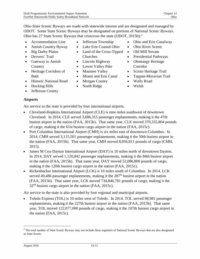
Ohio State Scenic Byways are roads with statewide interest and are designated and managed by ODOT. Some State Scenic Byways may be designated on portions of National Scenic Byways. Ohio has 27 State Scenic Byways that crisscross the state (ODOT, 2015b):2 • Accommodation Line • Amish Country Byway • Big Darby Plains • Drovers’ Trail • Gateway to Amish
Country • Heritage Corridors of
Bath • Historic National Road • Hocking Hills • Jefferson County
• Jefferson Township • Lake Erie Coastal Ohio • Land of the Cross-Tipped
Churches • Lincoln Highway • Lower Valley Pike • Maumee Valley • Miami and Erie Canal • Morgan County • North Ridge
• Ohio and Erie Canalway • Ohio River Scenic • Old Mill Stream • Presidential Pathways • Olentangy Heritage
Corridor • Scioto Heritage Trail • Tappan-Moravian Trail • Wally Road • Welsh
Airports
Air service to the state is provided by four international airports. • Cleveland-Hopkins International Airport (CLE) is nine miles southwest of downtown
Cleveland. In 2014, CLE served 3,686,315 passenger enplanements, making it the 47th busiest airport in the nation (FAA, 2015b). That same year, CLE moved 370,335,804 pounds of cargo, making it the 61st busiest cargo airport in the nation (FAA, 2015c).
• Port Columbus International Airport (CMH) is six miles east of downtown Columbus. In 2014, CMH served 3,115,501 passenger enplanements, making it the 50th busiest airport in the nation (FAA, 2015b). That same year, CMH moved 8,056,811 pounds of cargo (CMH, 2015).
• James M Cox-Dayton International Airport (DAY) is 10 miles north of downtown Dayton. In 2014, DAY served 1,120,842 passenger enplanements, making it the 84th busiest airport in the nation (FAA, 2015b). That same year, DAY moved 52,086,800 pounds of cargo, making it the 120th busiest cargo airport in the nation (FAA, 2015c).
• Rickenbacker International Airport (LCK) is 10 miles south of Columbus. In 2014, LCK served 49,486 passenger enplanements, making it the 287th busiest airport in the nation (FAA, 2015b). That same year, LCK moved 734,846,781 pounds of cargo, making it the 32nd busiest cargo airport in the nation (FAA, 2015c).
Air service to the state is also provided by four regional and municipal airports. • Toledo Express (TOL) is 10 miles west of Toledo. In 2014, TOL served 98,981 passenger
enplanements, making it the 227th busiest airport in the nation (FAA, 2015b). That same year, TOL moved 122,077,000 pounds of cargo, making it the 107th busiest cargo airport in the nation (FAA, 2015c).
2 The total number of State Scenic Byways may not include those segments of National Scenic Byways that are also designated as State Scenic.
August 2016 14-12

Draft Programmatic Environmental Impact Statement Chapter 14 FirstNet Nationwide Public Safety Broadband Network Ohio
• Akron-Canton Regional Airport (CAK) is 14 miles southeast of Akron and 10 miles northwest of Canton. In 2014, CAK served 771,155 passenger enplanements, making it the 97th busiest airport in the nation (FAA, 2015b). That same year, CAK moved approximately 284,000 pounds of cargo, making it the 340th busiest cargo airport in the nation (USDOT, 2016).
• Youngstown-Warren Regional Airport (YNG) is 11 miles north of Youngstown and 10 miles east of Warren. In 2014, YNG served 65,983 passenger enplanements, making it the 255th busiest airport in the nation (FAA, 2015b). That same year, YNG moved approximately 110,000 pounds of cargo, making it the 471st busiest cargo airport in the nation (USDOT, 2016).
• Cincinnati Municipal Airport – Lunken Field (LUK) is three miles southeast of Cincinnati. In 2014, LUK served 13,459 passenger enplanements, making it the 374th busiest airport in the nation (FAA, 2015b). That same year, LUK moved approximately 39,000 pounds of cargo, making it the 459th busiest cargo airport in the nation (USDOT, 2016).
Figure 14.1.1-1 illustrates the major transportation networks, including airports, in the state. Section 14.1.7, Land Use, Recreation, and Airspace, provides greater detail on airports and airspace in Ohio.
Rail Networks
Ohio is connected to a network of passenger rail (Amtrak), public transportation (commuter rail), and freight rail. The Ohio Rail Development Commission (ORDC) also promotes rail tourism, “which includes scenic railroads, rail museums, rail excursion organizations and other rail tourism organizations,” in the state (ODOT, 2016a).
Figure 14.1.1-1 illustrates the major transportation networks, including rail lines, in Ohio.
Amtrak runs three lines through Ohio: Capitol Limited, Cardinal, and Lake Shore Limited. The Capitol Limited runs daily between Washington, DC and Chicago and it makes five stops in Ohio (ODOT, 2010a). The Cardinal runs daily between New York and Chicago and it stops at only one station in Ohio (ODOT, 2010a). The Lake Shore Limited runs between Chicago and either New York City or Boston, with five stops in Ohio (ODOT, 2010a). In fiscal year 2015, Amtrak served over 142,000 passengers in Ohio (NARP, 2015). Table 14.1.1-3 provides a complete list of Amtrak lines that run through Ohio.
Table 14.1.1-3: Amtrak Train Routes Serving Ohio
Route Starting Point Ending Point Length of Trip Major Cities Served in Ohio
Capitol Limited Washington, DC
Chicago, IL 18 hours Alliance, Cleveland, Elyria, Sandusky, Toledo
Cardinal New York, NY Chicago, IL 26 hours 30 minutes Cincinnati Lake Shore Limited
New York, NY or Boston, MA
Chicago, IL 19 hours Bryan, Toledo, Sandusky, Elyria, Cleveland
Source: (Amtrak, 2015)
August 2016 14-13

Draft Programmatic Environmental Impact Statement Chapter 14 FirstNet Nationwide Public Safety Broadband Network Ohio
The Greater Cleveland Regional Transit Authority operates the RTA Rapid Transit System, otherwise known as “The Rapid.” The Rapid operates three lines on dedicated tracks; each line starts on the outskirts of the city and converge downtown (RTA, 2015). The red line operates 60 heavy-rail cars on 19 miles of track; it serves 18 stations and over 6.4 million passengers per year (RTA, 2016). The blue and green lines operate 48 light-rail cars on 15.3 miles of track; they serve 34 stations and more than 2.6 million passengers per year (RTA, 2016).
Freight railroad companies own 5,288 miles of track in Ohio, making Ohio fourth in the nation for total miles of rail (ODOT, 2014). In addition, Ohio is first in the nation for the highest concentration of rail lines, with 0.128 rail miles per square mile (ODOT, 2014). Four Class I freight rail companies operate in Ohio: Canadian National/Grand Trunk operates on 7 miles of track in Ohio, CSX Transportation operates on 1,912 miles of track, Norfolk Southern Corporation operates on 2,233 miles of track, and Canadian Pacific operates on track in Ohio (ODOT, 2010b) (ODOT, 2015c). In addition, 3 regional railroads, 30 short line railroads, and 15 terminal carriers operate in the state as of 2010 (ODOT, 2010b). As of 2012, Ohio was the sixth busiest state in the nation in terms of tons of freight rail originating in the state and fifth in terms of freight rail terminating in the state (Association of American Railroads, 2016). A total of 276 million tons of freight traveled by rail in Ohio in 2010 (ODOT, 2010c). According to the Association of American Railroads 2010 data, 63 million tons of freight originated in Ohio, while 84,4 million tons terminated in the state (ODOT, 2010c).
Harbors and Ports
The state of Ohio shares its northern border with Lake Erie, making it an ideal location for the development of ports and harbors. A number of facilities dot the 265 miles of shoreline, including everything from small harbors to large international shipping ports. These ports moved a total of 40.6 million tons of commodities in 2008. In that same year, ports along the 451 miles of the Ohio River moved 63 million tons of commodities. Accordingly, Ohio is ranked 8th in the nation for total water tonnage moved. (ODOT, 2016b)
Shipping facilities exist in the cities of Cleveland, Lorain, Toledo, and Ashtabula, while smaller harbors can be found in Huron, Fairport, and Conneaut along the lakeshore (U.S. Census Bureau, 2013). The largest shipping port in the state is the Port of Toledo, in the northwest corner of the state. The Port of Toledo is on the Maumee River, just south of Lake Erie (Toledo Seaport, 2015a). The Port of Cleveland is directly on the Lake Erie shore, at the juncture of the Cuyahoga River and the Lake (Port of Cleveland, 2015a). West of Cleveland is the Port of Lorain, just off Lake Erie with the port facilities on the west bank of the Black River, at its juncture with Lake Erie (Lorain Port Authority, 2015a). The fourth shipping port is the Port of Ashtabula, which is on the Ashtabula Harbor at the juncture of the Ashtabula River and Lake Erie. In addition to shipping facilities, Ashtabula offers mooring for boats (USACE, 2015a).
As depicted in Figure 14.1.1-1, the Port of Toledo can be reached over land via I-75 or I-80, and is serviced by four rail lines: Norfolk Southern Corp (NS), CSX Transportation, Canadian National, and Wheeling and Lake Erie. Its cargo goods include grain, coal, and iron ore (Toledo Seaport, 2015a). Overall, the 150-acre facility handles the some of the most diverse cargo of all
August 2016 14-14

Draft Programmatic Environmental Impact Statement Chapter 14 FirstNet Nationwide Public Safety Broadband Network Ohio
of the United States’ Great Lakes ports (Toledo Seaport, 2015b). In 2013, the Port of Toledo imported $743 million worth of cargo, weighing 3,343,420 tons, and exported $536 million in goods, weighing 4,152,076 tons (U.S. Census Bureau, 2013).
The Port of Cleveland can be accessed via I-90, I-71, and I-77 (Port of Cleveland, 2015b). It is served by rail lines from Cleveland Commercial Railroad, CSX Transportation, and Norfolk Southern Corp (Port of Cleveland, 2015c). Among other cargo, the port facilities move both iron ore and limestone (Port of Cleveland, 2015d). In 2013, the Port of Cleveland imported $390 million worth of cargo, weighing 1,443,697 tons, and exported $26 million in goods, weighing 130,624 tons (U.S. Census Bureau, 2013).
The Port of Lorain offers a number of non-shipping services, including a number of cruises on the Black River (Lorain Port Authority, 2015b). It is easily accessible via nearby I-90 (Lorain Port Authority, 2015a). The Port of Lorain does a minimal amount of shipping, exporting approximately $100,000 in goods in 2013 (U.S. Census Bureau, 2013).
The Port of Ashtabula on the Ashtabula Harbor can be reached using I-90 and offers both shipping and boat docking services. Rail service to the Port of Ashtabula is the purview of Norfolk Southern and SCX rail lines. Among other cargo, the port handles the shipping of iron ore, stone, limestone, sand, and gravel (City of Ashtabula, 2015). In 2013, the Port of Ashtabula imported $131 worth of cargo goods, weighing 647,057 tons, and exported $104 million in cargo weighing 849,992 tons (U.S. Census Bureau, 2013).
14.1.1.4. Public Safety Services
Ohio public safety services generally consist of public safety infrastructure and first responder personnel aligned with the demographics of the state. Table 14.1.1-4 presents Ohio’s key demographics including estimated population; land area; population density; and, municipal governments. More information about these demographics is presented in Section 14.1.9, Socioeconomics; however, these demographics are key to understanding the breadth of public safety services throughout the state.
Table 14.1.1-4: Key Ohio Indicators
Ohio Indicators Estimated Population (2015) 11,613,423 Land Area (square miles) (2010) 40,860.69 Population Density (persons per sq. mile) (2010) 282.3
Municipal Governments (2007) 938
Sources: (U.S. Census Bureau, 2015x) (U.S. Census Bureau, 2015c) (National League of Cities, 2007) (U.S. Census Bureau, 2016)
Table 14.1.1-5 presents Ohio’s public safety infrastructure, including fire and police stations. Table 14.1.1-6 identifies first responder personnel including dispatch, fire and rescue, law enforcement, and emergency medical personnel in the state.
August 2016 14-15

Draft Programmatic Environmental Impact Statement Chapter 14 FirstNet Nationwide Public Safety Broadband Network Ohio
Table 14.1.1.5: Public Safety Infrastructure in Ohio by Type Infrastructure Type Number
Fire and Rescue Stations a 1,746 Law Enforcement Agencies b 831 Fire Departments c 1,144 a Data collected by the U.S. Fire Administration in 2015. b Number of agencies from state and local law enforcement include: local police departments, sheriffs’ offices, primary state law enforcement agencies, special jurisdictional agencies, and other miscellaneous agencies, collected by the U.S. Bureau of Justice Statistics in 2008. c Data collected by the U.S. Fire Administration in 2015.
Sources: (U.S. Fire Administration, 2015a) (U.S. Bureau of Justice Statistics, 2011)
Table 14.1.1.6: First Responder Personnel in Ohio by Type
First Responder Personnel Number Police, Fire and Ambulance Dispatchers a 4,160 Fire and Rescue Personnel b 37,818 Law Enforcement Personnel c 37,295 Emergency Medical Technicians and Paramedics d e 10,570 a BLS Occupation Code: 43-5031. b BLS Occupation Codes: 33-2011 (Firefighters), 33-2021 (Fire Inspectors and Investigators), 33-1021 (First-Line Supervisors of Fire Fighting and Prevention Workers), and 53-3011 (Ambulance Drivers and Attendants, Except Emergency Medical Technicians). Volunteer firefighters reported by the U.S. Fire Administration. c Full-time employees from state and local law enforcement agencies which include: local police departments, sheriffs’ offices, primary state law enforcement agencies, special jurisdictional agencies, and other miscellaneous agencies, collected by the U.S. Bureau of Justice Statistics in 2008. d BLS Occupation Code: 29-2041. e All BLS data collected in 2015. Sources: (U.S. Fire Administration, 2015a) (U.S. Bureau of Justice Statistics, 2011) (BLS, 2015a)
14.1.1.5. Telecommunications Resources
There is no central repository of information for public safety communications infrastructure and commercial telecommunications infrastructure in Ohio; therefore, the following information and data are combined from a variety of sources, as referenced.
Communications throughout the state are based on a variety of publicly- and commercially-owned technologies, including coaxial cable (traditional copper cable), fiber optics, hybrid fiber optics/coaxial cable, microwave, wireless, and satellite systems providing voice, data, and video services. Figure 14.1.1-2 presents a typical wireless configuration including both a narrowband public safety land mobile radio network (traditional radio network) and a commercial broadband access network (wireless technology); backhaul (long-distance wired or wireless connections), core, and commercial networks including a long term evolution (LTE) evolved packet core (modern broadband cellular networks); and, network applications (software) delivering voice, data, and video communications (FCC, 2016a).
August 2016 14-16

Draft Programmatic Environmental Impact Statement Chapter 14 FirstNet Nationwide Public Safety Broadband Network Ohio
Prepared by: Booz Allen Hamilton
Figure 14.1.1-2: Wireless Network Configuration
Public Safety Communications
In order to protect and best serve the public interest, first responder and law enforcement communities must be able to communicate effectively. The evolution of the communications networks used by public safety stakeholders toward a broadband wireless technology, such as LTE (see Section 14.1.1.5, Telecommunications Resources), has the potential to provide users with better coverage, while offering additional capacity and enabling the use of new applications that would likely make their work safer and more efficient. Designing such a network presents several challenges due to the uniqueness of the deployment, the requirements, and the nationwide scale (NIST, 2015). Historically, there have been many challenges and impediments to timely and effective sharing of information including jurisdictional challenges, funding challenges, the pace of technology evolution, and communication interoperability. Communication interoperability has been a persistent challenge, along with issues concerning spectrum availability, embedded infrastructure, and differing standards among stakeholders (NTFI, 2005). This has caused a fragmented approach to communications implementation across the U.S. and at the state level, including in Ohio.
There are five key reasons why public safety agencies often cannot connect through existing communications (NTFI, 2005):
August 2016 14-17

Draft Programmatic Environmental Impact Statement Chapter 14 FirstNet Nationwide Public Safety Broadband Network Ohio
• Incompatible and aging communications equipment, • Limited and fragmented funding, • Limited and fragmented planning, • A lack of coordination and cooperation, and • Limited and fragmented radio spectrum.
To help enable the public safety community to incorporate disparate Land Mobile Radio networks with a nationwide public safety LTE broadband network, the U.S. Department of Commerce Public Safety Communications Research Program (PSCR) – Boulder Laboratories, in 2015, prepared a locations-based services (LBS) research and development roadmap to examine the current state of location-based technologies, forecast the evolution of LBS capabilities and gaps, and identify potential research and development opportunities that would improve the public safety community’s use of LBS within operational settings. This is the first of several technology roadmaps that PSCR plans to develop over the next few years (PSCR, 2015).
To address the need for greater interoperability in Ohio across public safety LMR systems, the state committed to a major upgrade of its legacy 800 MHz analog system, Multi-Agency Radio System (MARCS), to a digital Project 25 system (MARCS-IP P25). This new P25 system is capable of operating at 800 MHz and 700 MHz and was upgraded in order to expand capacity and coverage (The Ohio Chapter of APCO, Inc., 2012). In Ohio, the Multi-Agency Radio Communications System (MARCS) Program Office, within the Ohio Department of Administrative Services, is responsible for the oversight, maintenance, and repair of the MARCS network. Policy is set via an interagency working group, of which the Ohio State Chief Information Officer is Chair, and member agencies include the Department of Public Safety, Department of Transportation, Budget and Management, Department of Natural Resources, and the Fire Marshall. (DAS, 2016)
Statewide Public Safety Networks
In 2012, Ohio’s rationale for the modernization from the MARCS LMR 800 MHz system to the current statewide digital P25 technology MARCS-IP P25 system, was driven by multiple factors cited by the state: (1) the 1337 disparate radio systems leading to financial inefficiencies, (2) the desire to increase interoperability, (3) the need to increase capacity, (4) the need to enhance the state’s ability to adopt future LMR and broadband systems, and (5) the need to address the availability of the MARCS platform’s core parts (State of Ohio, 2012). The MARCS-IP P25 system offers statewide coverage to public safety and other state agencies over its 800 MHz/700 MHz system, which covers all counties in Ohio as Figure 14.1.1-3 illustrates (State of Ohio, 2012).
As of mid-2015, there were 18 public safety P25 systems operational in Ohio. Two of these systems originate in adjacent states, Michigan’s Public Safety Communications Systems and Indiana’s Project Hoosier SAFE-T system (Project 25, 2015c) (Project 25, 2015b). The majority of these P25 systems operate on 800 MHz but due to the spectrum availability limitations of 800 MHz in Ohio, an increasing number of these P25 systems also operate on 700 MHz, as Table 14.1.1-7 below indicates (Project 25, 2015c) (Project 25, 2015b).
August 2016 14-18

Draft Programmatic Environmental Impact Statement Chapter 14 FirstNet Nationwide Public Safety Broadband Network Ohio
Figure 14.1.1-3: Ohio MARCS-IP P25 Network and Tower Locations
August 2016 14-19

Draft Programmatic Environmental Impact Statement Chapter 14 FirstNet Nationwide Public Safety Broadband Network Ohio
Table 14.1.1-5: Ohio P25 Systems Ohio P25 Public Safety Systems Frequency Band
Austintown/Boardman Public Safety System 800 MHz Barberton Public Safety 800 MHz Belmont County 800 MHz Canton/Stark County 800 MHz Central Ohio Interoperable Radio System 800 MHz City of Parma/Ottawa County P25 800 MHz Greater Cleveland Radio Communications Network 800 MHz Hamilton County-Cincinnati Public Safety 800 MHz Indiana Project Hoosier SAFE-T (Motorola) 800 MHz Miami County P25 800 MHz Michigan’s Public Safety Communications System 800 MHz Northwest Ohio Regional Public Safety System 700 MHz/800MHz Ohio MARCS-IP: Radio Communications (P25) 700 MHz/800 MHz Summit County P25 700 MHz Ohio MARCS Multi-Agency Radio Communications (P25) 700 MHz
Sources: (Project 25, 2015a)
In addition to the statewide MARCS-IP P25 system, a number of Ohio’s P25 LMR public safety systems provide regional and multi-county coverage including; the Northwest Ohio Regional System (3 Counties: Lucas, Fulton, Wood), Central Ohio Interoperable Radio System (2 Counties: Delaware and Franklin), and Hamilton County-Cincinnati Public Safety (2 Counties: Hamilton OH and Campbell KY) (RadioReference.com, 2015b).
Ohio has implemented a multi-level approach to increasing interoperability in the state with interoperable channels available on a county, regional, state, and national basis. The states’ Statewide Communications Interoperable Plan (SCIP) summarizes the key elements of Ohio’s approach as follows; “In addition to the individual county capabilities, a number of common interoperability channels are available throughout the state. These include common VHF3 channels, common UHF4 and UHF Med channels, 800 MHz National Public Safety Planning Advisory Committee (NPSPAC) mutual aid channels and common MARCS talk groups. Additionally, a number of citywide, countywide, and regional shared systems are available in different areas throughout the state” (State of Ohio, 2008).
City and County Public Safety Networks
At the local and county public safety level, legacy analog VHF or UHF systems continue to provide dispatch and tactical communications with voice communication capabilities for police/sheriff, fire, and EMS users (RadioReference.com, 2015b). With the availability of the digital P255 MARCS-IP system in Ohio, an increasing number of city and county public safety departments, such as county sheriff’s departments, are using the MARCS-IP system (RadioReference.com, 2015b).
3 VHF band covers frequencies ranging from 30 MHz to 300 MHz (NTIA, 2005). 4 UHF band covers frequencies ranging from 300 MHz to 3000 MHz (NTIA, 2005). 5 Project-25 (P25) is a suite of standards for digital radio communications for use by federal, state, and local public safety agencies in North America to enable them to communicate with other agencies and mutual aid response teams in emergencies.
August 2016 14-20

Draft Programmatic Environmental Impact Statement Chapter 14 FirstNet Nationwide Public Safety Broadband Network Ohio
Public Safety Answering Points (PSAPs)
According to the Federal Communication Commission’s (FCC) Master PSAP registry, there are 352 PSAPs serving Ohio’s 88 counties (FCC, 2015a).
Commercial Telecommunications Infrastructure
Ohio’s commercial telecommunications industry and infrastructure is robust with multiple service providers, offering products and services via the full spectrum of telecommunications technologies (FCC, 2014a) (FCC, 2014b). The following sub-sections present information on Ohio’s commercial telecommunications infrastructure, including information on the number of carriers and technologies deployed; geographic coverage; voice, Internet access, and wireless subscribers; and the quantity and location of telecommunications towers, fiber optic plant, and data centers.
Carriers, Coverage, and Subscribers
Ohio’s commercial telecommunications industry provides the full spectrum of telecommunications technologies and networks, including coaxial cable (traditional copper cable), fiber optics, hybrid fiber optics/coaxial cable, microwave, wireless, and satellite systems. Table 14.1.1-8 presents the number of providers of switched access6 lines, Internet access,7 and mobile wireless services including coverage.
6 “A service connection between an end user and the local telephone company’s switch; the basis of plain old telephone services (POTS)” (FCC, 2014b). 7 Internet access includes Digital Subscriber Line (DSL), cable modem, fiber, satellite, and fixed wireless providers.
August 2016 14-21

Draft Programmatic Environmental Impact Statement Chapter 14 FirstNet Nationwide Public Safety Broadband Network Ohio
Table 14.1.1-6: Telecommunications Access Providers and Coverage in Ohio in 2013
Commercial Telecommunications Access Providers
Number of Service
Providers
Coverage of Households
Switched access line a 189 92.2% of households Internet access b 102 61% of households Mobile wireless c 8 100% of population
a Switched access lines are a service connection between an end user and the local telephone company’s switch (the basis of older telephone services); this number of service providers was reported by the FCC as of December 31, 2013 in Table 17 in “Local Telephone Competition: Status as of December 31, 2013” as the total of ILEC and non-ILEC providers. (FCC, 2014a) b Internet access providers are presented in Table 21 in “Internet Access Services: Status as of December 31, 2013” by technology provided; number of service providers is calculated by subtracting the reported Mobile Wireless number from the total reported number of providers. (FCC, 2014b) c Mobile wireless provider data is provided by the FCC in the sources identified. However, NTIA’s National Broadband Map provides newer data, so FirstNet is using NTIA’s GIS-based data from the National Broadband Map instead of the data reported by the FCC. The process for retrieving the National Broadband Map data is explained in detail in a subsequent footnote in Section 14.1.1.5, Last Mile Fiber Assets.
Sources: (FCC, 2014a) (FCC, 2014b) (NTIA, 2014)
Table 14.1.1-9 shows the wireless providers in Ohio along with their geographic coverage. The following five maps, Figure 14.1.1-4 to Figure 14.1.1-8, show the combined coverage for the top two providers, AT&T Mobility LLC and Verizon Wireless’ coverage; Sprint, T-Mobile; W.A.T.C.H. TV, Cricket Wireless, and MetaLINK Technologies Inc.; Gold Radio Group, North Coast Wireless, and Country Connections LLC; and the coverage of all other providers with less than five percent coverage area, respectively.8
8 The broadband map utilized data collected as part of the broadband American Recovery and Reinvestment Act initiative. The data was retrieved from the FCC National Broadband Map website (www.broadbandmap.gov/data-download). Each state’s broadband data was downloaded accordingly. The data pertaining to broadband data/coverage for census blocks, streets, addresses, and wireless were used. Census blocks, roads, and addresses were merged into one file and dissolved by similar business and provider names. Square miles were calculated for each provider. The maps show all providers over 5% on separate maps; providers with areas under 5% were merged and mapped as “Ohio Other Fiber Providers”. All Wireless providers were mapped as well; those with areas under 5% were merged and mapped as “Ohio Other Wireless Providers”. Providers under 5% were denoted in their respective tables.
August 2016 14-22

Draft Programmatic Environmental Impact Statement Chapter 14 FirstNet Nationwide Public Safety Broadband Network Ohio
Table 14.1.1-7: Wireless Telecommunications Coverage by Providers in Ohio
Wireless Telecommunications
Providers Coverage
AT&T Mobility LLC 98.22% Verizon Wireless 90.33% Sprint 72.77% T-Mobile 26.12% W.A.T.C.H. TV 13.13% Cricket Wireless 10.37% MetaLINK Technologies, Inc.
8.97%
Gold Radio Group 8.29% North Coast Wireless Communications
5.69%
Country Connections LLC
5.11%
Othera 45.38%
Source: (NTIA, 2014) a Other: Provider with less than 5% coverage area. Providers include: Amplex Wireless; Intelliwave, LLC; CT Communications, Inc.; 5G Mesh; Cincinnati Bell Wireless LLC; Broadband Networks; Bright.Net North; BrightWireless; Reliable Wireless Solutions; SOCS Wireless; Hometown Cable Company, LLC; NexGenAccess; North West Net, Inc.; Access Ohio Valley; bright.net-Wabash Communications; Bresco Broadband; Safe-T.net, LLC; RAA Services; Heavenwire.net; Wavelinc Communications; Imagine Networks, LLC; SAA bright.net, Inc.; UDATAnet Wireless; Hocking Internet Technologies, Ltd.; Mechcom Dot Net; DataBit Solutions; BluSky Wireless; Avolve; New Era Broadband, LLC; Waldron Communication Company; JB-Nets; Jenco Wireless; 1 Touch Technology Solutions, LLC; SkyRunner Wireless Networks; Dark Horse Networks; Ripflo Network, LLC; StratusWave Communications; Mikulski Net; Redbird Internet Services; PowerNet Global; Mango Bay Internet; Smart Networks; GMN Broadband; Rowe Internet; D&P Communications; LightSpeed Technologies; Kosinet.com; Firewire Internet; Connect Akron.
August 2016 14-23

Draft Programmatic Environmental Impact Statement Chapter 14 FirstNet Nationwide Public Safety Broadband Network Ohio
Figure 14.1.1-4: Top Wireless Providers Availability in Ohio
August 2016 14-24

Draft Programmatic Environmental Impact Statement Chapter 14 FirstNet Nationwide Public Safety Broadband Network Ohio
Figure 14.1.1-5: Sprint and T-Mobile Wireless Availability in Ohio
August 2016 14-25

Draft Programmatic Environmental Impact Statement Chapter 14 FirstNet Nationwide Public Safety Broadband Network Ohio
Figure 14.1.1-6: WATCH TV, Cricket Wireless, and MetaLINK Technologies, Inc. Wireless Availability in Ohio
August 2016 14-26

Draft Programmatic Environmental Impact Statement Chapter 14 FirstNet Nationwide Public Safety Broadband Network Ohio
Figure 14.1.1-7: Gold Radio Group, Country Connections LLC, and North Coast Wireless Communications Wireless Availability in Ohio
August 2016 14-27

Draft Programmatic Environmental Impact Statement Chapter 14 FirstNet Nationwide Public Safety Broadband Network Ohio
Figure 14.1.1-8: Other Providers Wireless Availability in Ohio
August 2016 14-28

Draft Programmatic Environmental Impact Statement Chapter 14 FirstNet Nationwide Public Safety Broadband Network Ohio
Towers
There are many types of domestic towers employed today by the telecommunications industry, government agencies, and other owners. Towers are designed and used for a variety of purposes, and the height, location, and supporting structures and equipment are all designed, constructed, and operated according to the technical specifications of the spectrum used, the type of equipment mounted on the tower, geographic terrain, need for line-of-sight transmissions to other towers, radio frequency needs, and other technical specifications. There are three general categories of stand-alone towers: monopole, lattice, and guyed. Typically, monopole towers are the smallest, followed by lattice towers at a moderate height, and guyed towers at taller heights (with the guyed wires providing tension support for the taller heights) (CSC, 2007). In general, taller towers can provide communications coverage over larger geographic areas, but require more land for the actual tower site, whereas shorter towers provide less geographic coverage and require less land for the tower site (USDA, 2009). Figure 14.1.1-9 presents representative examples of each of these categories or types of towers.
Prepared by: Booz Allen Hamilton
Figure 14.1.1-9: Types of Towers
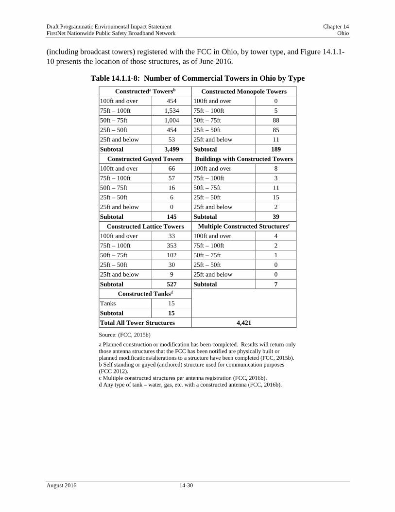
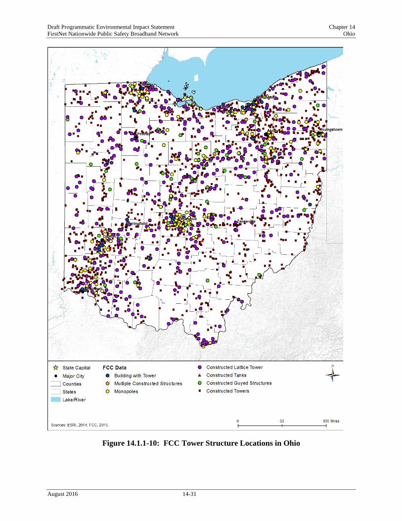
Telecommunications tower infrastructure can be found throughout Ohio, although tower infrastructure is concentrated in the higher and more densely populated areas of Ohio; Toledo, Cleveland, Findlay, Akron, Youngstown, Zanesville, Columbus, Springfield, Dayton, and Cincinnati. Owners of towers and some types of antennas are required to register those infrastructure assets with the FCC (FCC 2016).9 Table 14.1.1-10 presents the number of towers
9 An antenna structure must be registered with the FCC if the antenna structure is taller than 200 feet above ground level or may interfere with the flight path of a nearby airport (FCC, 2016c).
August 2016 14-29
Draft Programmatic Environmental Impact Statement Chapter 14 FirstNet Nationwide Public Safety Broadband Network Ohio
(including broadcast towers) registered with the FCC in Ohio, by tower type, and Figure 14.1.1-10 presents the location of those structures, as of June 2016.
Table 14.1.1-8: Number of Commercial Towers in Ohio by Type Constructeda Towersb Constructed Monopole Towers
100ft and over 454 100ft and over 0 75ft – 100ft 1,534 75ft – 100ft 5 50ft – 75ft 1,004 50ft – 75ft 88 25ft – 50ft 454 25ft – 50ft 85 25ft and below 53 25ft and below 11 Subtotal 3,499 Subtotal 189
Constructed Guyed Towers Buildings with Constructed Towers 100ft and over 66 100ft and over 8 75ft – 100ft 57 75ft – 100ft 3 50ft – 75ft 16 50ft – 75ft 11 25ft – 50ft 6 25ft – 50ft 15 25ft and below 0 25ft and below 2 Subtotal 145 Subtotal 39
Constructed Lattice Towers Multiple Constructed Structuresc 100ft and over 33 100ft and over 4 75ft – 100ft 353 75ft – 100ft 2 50ft – 75ft 102 50ft – 75ft 1 25ft – 50ft 30 25ft – 50ft 0 25ft and below 9 25ft and below 0 Subtotal 527 Subtotal 7
Constructed Tanksd Tanks 15
Subtotal 15 Total All Tower Structures 4,421
Source: (FCC, 2015b) a Planned construction or modification has been completed. Results will return only those antenna structures that the FCC has been notified are physically built or planned modifications/alterations to a structure have been completed (FCC, 2015b). b Self standing or guyed (anchored) structure used for communication purposes (FCC 2012). c Multiple constructed structures per antenna registration (FCC, 2016b). d Any type of tank – water, gas, etc. with a constructed antenna (FCC, 2016b).
August 2016 14-30
Draft Programmatic Environmental Impact Statement Chapter 14 FirstNet Nationwide Public Safety Broadband Network Ohio
Figure 14.1.1-10: FCC Tower Structure Locations in Ohio
August 2016 14-31

Draft Programmatic Environmental Impact Statement Chapter 14 FirstNet Nationwide Public Safety Broadband Network Ohio
Fiber Optic Plant (Cables)
Fiber optic plant, or cables, can be buried directly in the ground; pulled, blown, or floated into ducts, conduits, or innerduct (flexible plastic protective sleeves or tubes); placed under water; or installed aerially between poles, typically on a utility or road right-of-way. A fiber optic network includes an access network consisting of a central office, distribution and feeder plant (cables of various sizes directly leaving a central office and splitting to connect users to the network), and a user location, as shown in Figure 14.1.1-11. The network also may include a middle mile component (shorter distance cables linking the core network between central offices or network nodes across a region) and a long haul network component (longer distance cables linking central offices across regions) (FCC, 2000).
Figure 14.1.1-11: Typical Fiber Optic Network in Ohio Prepared by: Booz Allen Hamilton Source: (ITU-T 2012)
Last Mile Fiber Assets
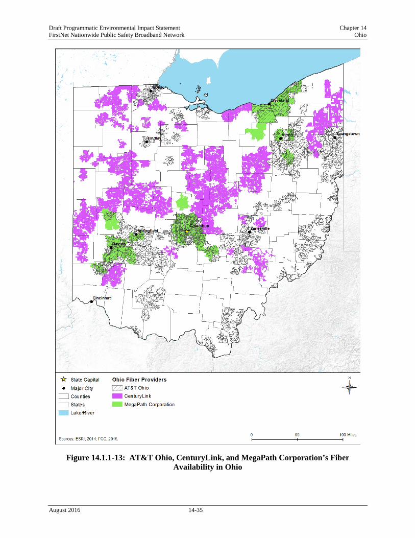
In Ohio, fiber access networks are concentrated in the highest population centers as shown in the figures below. In Ohio, there are 62 fiber providers that offer service in the state, as listed in
August 2016 14-32

Draft Programmatic Environmental Impact Statement Chapter 14 FirstNet Nationwide Public Safety Broadband Network Ohio
Table 14.1.1-11 (NTIA, 2014). Figure 14.1.1-12 shows coverage for Time Warner Cable and Frontier Communications; Figure 14.1.1-13 shows coverage for CenturyLink, AT&T Ohio, and MegaPath Corporation; and Figure 14.1.1-14 shows coverage for other providers with less than 5 percent coverage area, respectively.
Table 14.1.1-9: Fiber Provider Coverage Fiber Provider Coverage
Time Warner Cable 39.57% Frontier Communications 24.56% CenturyLink 16.38% AT&T Ohio 14.87% MegaPath Corporation 5.78% Othera 24.13%
Source: (NTIA, 2014) a Other: Provider with less than 5% coverage area. Providers include: Windstream Corporation; Cincinnati Bell Telephone Company LLC; Armstrong Cable Services; WideOpenWest; Massillon Cable TV, Inc.; Comcast; TDS Telecom; FairPoint Communications; Suddenlink Communications; Buckeye CableSystem; Level 3 Communications, LLC; CT Communications, Inc.; Wabash Mutual Telephone Company; Telephone Service Company; FiberNet, LLC; Sycamore Telephone Company; Falcon1; Horizon Chilicothe Telephone; BTC Multimedia; Nelsonville TV Cable, Inc.; TW Telecom of Ohio LLC; NKTelco Inc.; Bryan Municipal Utilities; Cox Communications; GLW Broadband, Inc.; New Knoxville Telephone Company; Sherwood Mutual Telephone Association; Ottoville Mutual Telephone Company; Jefferson County Cable; Suite224 Internet; BTC Communications; The Nova Telephone Company; Arthur Mutual Telephone Company; Crystal Broadband Networks; Kalida Telephone Company, Inc.; FJ Communications; Hometown Cable Company, LLC; FUSION; Bright Net BRT; Ayersville Telephone Company; Ridgeville Telephone Company; Farmers Mutual Telephone Company; Glandorf Telephone Company, Inc.; Doylestown Cable TV; CableSuite 541, Inc.; Bellaire Television Cable Co, Inc.; City of Wadsworth; Oberlin.net; Vaughnsville Communications; Woodsfield Municipal Cable; Ohio.Net Internet Providers; RTEC Communications; Mediacom Heritage Telephone Company; S. Bryer Cable TV Corp.; East Cleveland Cable TV and Communications, LLC; Cogent.
August 2016 14-33

Draft Programmatic Environmental Impact Statement Chapter 14 FirstNet Nationwide Public Safety Broadband Network Ohio
Figure 14.1.1-12: Fiber Availability in Ohio for Time Warner and Frontier Cable
August 2016 14-34
Draft Programmatic Environmental Impact Statement Chapter 14 FirstNet Nationwide Public Safety Broadband Network Ohio
Figure 14.1.1-13: AT&T Ohio, CenturyLink, and MegaPath Corporation’s Fiber Availability in Ohio
August 2016 14-35

Draft Programmatic Environmental Impact Statement Chapter 14 FirstNet Nationwide Public Safety Broadband Network Ohio
Figure 14.1.1-14: Other Provider’s Fiber Availability in Ohio
August 2016 14-36

Draft Programmatic Environmental Impact Statement Chapter 14 FirstNet Nationwide Public Safety Broadband Network Ohio
Data Centers
Data centers (also known as network access points, collocation facilities, hosting centers, carrier hotels, and Internet exchanges) are large telecommunications facilities that house routers, switches, servers, storage, and other telecommunications equipment. These data centers facilitate efficient network connectivity among and between telecommunications carriers, and between carriers and their largest customers. These facilities also provide racks and cages for equipment, power and cooling, cabling, physical security, and 24x7 monitoring (CIO Council, 2015; GAO, 2013). Ownership of data centers may be public or private; comprehensive information regarding data centers may not be publicly available as some are related to secure facilities.
14.1.1.6. Utilities
Utilities are the essential systems that support daily operations in a community and cover a broad array of public services, such as electricity, water, wastewater, and solid waste. Section 14.1.4, Water Resources, describes the potable water sources in the state.
Electricity
Electric Utilities in Ohio are regulated by the Public Utilities Commission of Ohio (PUCO). Their duties include regulating utility rates, resolving disputes between customers and utilities and ensuring the reliability of the services they provide (PUCO, 2015a). In the case of electric utilities, the PUCO regulates utilities that provide transmission and distribution services, but not generation utilities (PUCO, 2015b). There are 37 regulated utilities, known as generating companies, that are dedicated to the distribution of electricity in Ohio, 332 electricity brokers, and 104 marketer utilities. Broker companies assume “the contractual and legal responsibility for the sale and/or arrangement for the supply of retail electric generation service to a retail customer without taking title to the power supplied”, while marketers are those who assume “the contractual and legal responsibility for the sale and provision of retail electric generation service to a retail customer who had title to the electric power provided at some point during the transaction” (PUCO, 2015c). In 2014, the majority of Ohio’s electricity came from plants using coal as a fuel source. Other major facilities use nuclear power or natural gas to generate power (EIA, 2015a). In 2014, coal fueled plants generated 89,879,052 megawatthours10 of the total 134,476,405 megawatthours produced in the state, accounting for 67 percent of the total production (EIA, 2015a). Natural gas fueled generation plants produced 23,636,445 megawatthours, or 18 percent; and nuclear power facilities also contributed 16,284,440 megawatthours, or 12 percent of the total. Other sources of electricity included petroleum coke, biomass, wind, solar, and hydroelectric (EIA, 2015a). In 2013, Ohio’s commercial sector used 18.6 percent of the total energy in 2013, the residential sector used 24.4 percent, and the transportation sector used 24.6 percent. In addition, the industrial sector of the state used 32.5
10 One megawatthour is defined as “one thousand kilowatt-hours or 1million watt-hours.” One watthour is “the electrical energy unit of measure equal to one watt of power supplied to, or taken from, an electric circuit steadily for one hour.” (EIA, 2016)
August 2016 14-37

Draft Programmatic Environmental Impact Statement Chapter 14 FirstNet Nationwide Public Safety Broadband Network Ohio
percent and the previous year, “Ohio ranked sixth in the nation in 2012 in energy consumption by the industrial sector” (EIA, 2015b).
Water
The PUCO regulates Ohio’s investor-owned water utilities, but does not regulate utilities run by municipalities, counties, cooperatives, or water districts (PUCO, 2015d). Their jurisdiction includes the regulation of utility rates, the resolving of disputes, and the oversight of service reliability (PUCO, 2015a). Nine investor-owned utilities operate under the jurisdiction of the PUC (PUCO, 2015e). The quality and safety of Ohio’s drinking water is regulated by the Ohio Environmental Protection Agency (OEPA). This regulation includes the development of rules to match United States EPA federal regulations, inspections of water treatment facilities, monitoring regulatory compliance for water systems, and reporting to the federal government (OEPA, 2015a). This regulation extends to the monitoring of Ohio’s approximately 4,800 public water systems, which are defined as “a system that provides water for human consumption to at least 15 service connections or serves an average of at least 25 people for at least 60 days each year” (OEPA, 2015b). In Ohio, these public water facilities serve about 11 million people each day, and with the aim of protecting public health, test their water for contamination regularly. “Currently, more than 95 percent of community water systems meet all health-based standards” (OEPA, 2015b). Ohio’s Source Water and Assessment Protection program ensures that its 4,500 public water systems, excluding private residential water systems, identify the source of their water and any possible sources of contamination (OEPA, 2015c).
Wastewater
Ohio’s wastewater is regulated with permits and certifications. Permits are used to regulate wastewater treatment facilities and their discharges. Ohio EPA issues National Pollutant Discharge Elimination System (NPDES) permits to facilities discharging pollutants into state waters (OEPA, 2015d). General permits are used to permit actions at facilities that have similar operations and wastewater. The Ohio EPA does issue different types of permits for discharge facilities with specific needs, including more tailored individual permits. Other types include pretreatment, stormwater, and bio-solid disposal permits (OEPA, 2015d). The Ohio EPA also certifies wastewater facility operators, and currently has more than 12,000 certified operators (OEPA, 2015e). Operator certifications are divided by class, which require different amounts of training and operational experience (OEPA, 2015f). In addition to a high school diploma or equivalent, certification applicants must have 1040 hours of operating experience for Class A, 12 months for Class I, 36 months for Class II, 60 months (including 12 months as Class II) for Class III, and 36 months as Class III for Class IV (OEPA, 2015f).
Solid Waste Management
Ohio’s solid waste is managed by Ohio EPA’s Division of Materials and Waste Management (DMWM). DMWM ensures that regulatory standards are met by Ohio waste management facilities and promotes actions to reduce waste and conserve energy (OEPA, 2015g). It also updates and implements the state Solid Waste Management Plan, which “establishes waste
August 2016 14-38

Draft Programmatic Environmental Impact Statement Chapter 14 FirstNet Nationwide Public Safety Broadband Network Ohio
reduction and recycling goals to be achieved by the state and establishes strategies for the appropriate management of the state’s solid waste stream” (OEPA, 2015h).
Ohio’s waste management planning is handled by solid waste districts, each of which represents either one county or a combination of counties. These districts houses 81 landfills, which accepted a total of 22,226,387 tons of waste in 2014. Of this, 12,387,518 tons came from within the district where it was landfilled, while 6,764,782 tons were produced out of district. Out of state sources contributed 3,074,088 tons of material (OEPA, 2015i). Out of the 22 million tons of waste, about 10 million was classified as general waste and approximately 9.5 million as industrial waste (OEPA, 2015i). The 2009 State Solid Waste Management Plan specifies a goal of reducing or recycling a minimum of 50 percent of the solid waste generated in the state. Strategies to accomplish this include providing financial assistance to aid local government projects, improving reporting for industrial waste generators, and adding recycling services to contracts for state government buildings (OEPA, 2010a).
Soils
14.1.2.1. Definition of the Resource The Soil Science Society of America defines soil as:
(i) “The unconsolidated mineral or organic material on the immediate surface of the Earth that serves as a natural medium for the growth of land plants.” (NRCS, 2015a)
(ii) “The unconsolidated mineral or organic matter on the surface of the Earth that has been subjected to and shows effects of genetic and environmental factors of: climate (including water and temperature effects), and macro- and microorganisms, conditioned by relief, acting on parent material over a period of time. A product-soil differs from the material from which it is derived in many physical, chemical, biological, and morphological properties and characteristics.” (NRCS, 2015a)
Five primary factors account for soil development patterns. A combination of the following variables contributes to the soil type in a particular area (University of Minnesota, 2001): • Parent Material: The original geologic source material from the soil formed affects soil
aspects, including color, texture, and ability to hold water. • Climate: Chemical changes in parent material occur slowly in low temperatures. However,
hot temperatures evaporate moisture, which also facilitates chemical reactions within soils. The highest degree of reaction within soils occurs in temperate, moist climates.
• Topography: Steeper slopes produce increased runoff, and, therefore, downslope movement of soils. Slope orientation also dictates the microclimate to which soils are exposed, because different slope faces receive more sunlight than others do.
• Biology: The presence/absence of vegetation in soils affects the quantity of organic content of the soil.
• Time: Soil properties are dependent on the period over which other processes act on them.
August 2016 14-39

Draft Programmatic Environmental Impact Statement Chapter 14 FirstNet Nationwide Public Safety Broadband Network Ohio
14.1.2.2. Specific Regulatory Considerations
The Proposed Action must meet the requirements of the National Environmental Policy Act (NEPA) and other applicable laws and regulations. Applicable federal laws and regulations that apply for Soils, such as the Farmland Protection Policy Act of 1981, are in Appendix C, Environmental Laws and Regulations. A list of applicable state laws and regulations is included in Table 14.1.2-1 below.
Table 14.1.2-1: Relevant Ohio Soils Laws and Regulations State Law/Regulation Regulatory Agency Applicability
OAC 1501:15-1 Erosion and Sediment Control
Ohio Department of Natural Resources, Division of Soil and Water Resources
An Erosion and Sediment Control Plan is required for soil disturbing activities or development including land grading, excavating, or filling.
14.1.2.3. Environmental Setting
Ohio is composed of four Land Resource Region (LRR),11 as defined by the National Resources Conservation Service (NRCS) (NRCS, 2006): • Central Feed Grains and Livestock Region, • East and Central Farming and Forest Region, • Lake State Fruit, Truck Crop, and Dairy Region, and • Northeastern Forage and Forest Region.
Within and among Ohio’s four LRRs are 10 Major Land Resource Areas (MLRA),12 which are characterized by patterns of soils, climate, water resources, land uses, and type of farming (NRCS, 2006). The locations and characteristics of Ohio’s MLRAs are presented in Figure 14.1.2-1 and Table 14.1.2-2.
Soil characteristics are an important consideration for FirstNet insomuch as soil properties could influence the suitability of sites for network deployment. Soil characteristics can differ over relatively short distances, reflecting differences in parent material, elevation and position on the landscape, biota13 such as bacteria, fungi, biological crusts, vegetation, animals, and climatic variables such as precipitation and temperature. For example, expansive soils14 with wet and dry seasons alternately swell and shrink, which presents integrity risks to structural foundations (Rogers, Olshansky, & Rogers, 2004). Soils can also be affected by a variety of surface uses that loosen topsoil and damage or remove vegetation or other groundcover, which may result in accelerated erosion, compaction, and rutting15 (discussed further in the subsections below).
11 Land Resource Region: “A geographical area made up of an aggregation of Major Land Resource Areas (MLRA) with similar characteristics” (NRCS, 2006). 12 Major Land Resource Area: “A geographic area, usually several thousand acres in extent, that is characterized by a particular pattern of soils, climate, water resources, land uses, and type of farming” (NRCS, 2006). 13 The flora and fauna of a region. 14 Expansive soils are characterized by “the presence of swelling clay materials” that absorb water molecules when wet and expand in size or shrink when dry leaving “voids in the soil” (Rogers, Olshansky, & Rogers, 2004). 15 Rutting is indentations in soil from operating equipment in moist conditions or soils with lower bearing strength (USFS, 2009).
August 2016 14-40
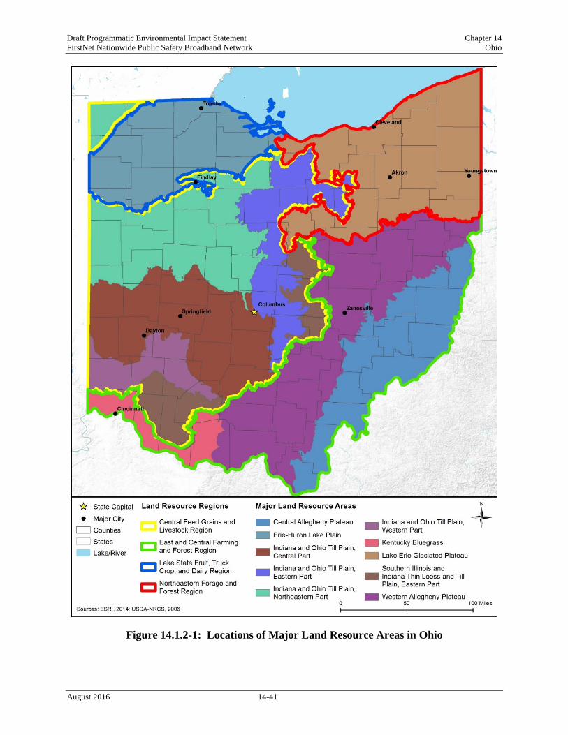
Draft Programmatic Environmental Impact Statement Chapter 14 FirstNet Nationwide Public Safety Broadband Network Ohio
Figure 14.1.2-1: Locations of Major Land Resource Areas in Ohio
August 2016 14-41
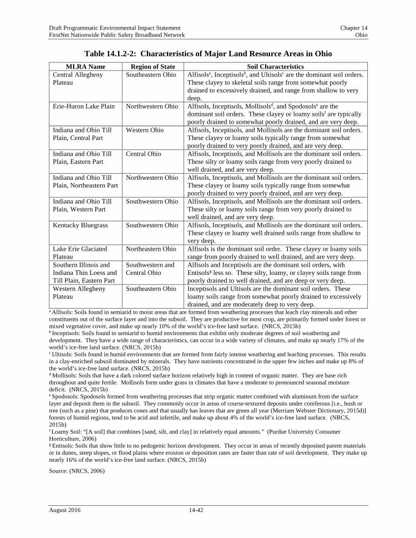
Draft Programmatic Environmental Impact Statement Chapter 14 FirstNet Nationwide Public Safety Broadband Network Ohio
Table 14.1.2-2: Characteristics of Major Land Resource Areas in Ohio MLRA Name Region of State Soil Characteristics
Central Allegheny Plateau
Southeastern Ohio Alfisolsa, Inceptisolsb, and Ultisolsc are the dominant soil orders. These clayey to skeletal soils range from somewhat poorly drained to excessively drained, and range from shallow to very deep.
Erie-Huron Lake Plain Northwestern Ohio Alfisols, Inceptisols, Mollisolsd, and Spodosolse are the dominant soil orders. These clayey or loamy soilsf are typically poorly drained to somewhat poorly drained, and are very deep.
Indiana and Ohio Till Plain, Central Part
Western Ohio Alfisols, Inceptisols, and Mollisols are the dominant soil orders. These clayey or loamy soils typically range from somewhat poorly drained to very poorly drained, and are very deep.
Indiana and Ohio Till Plain, Eastern Part
Central Ohio Alfisols, Inceptisols, and Mollisols are the dominant soil orders. These silty or loamy soils range from very poorly drained to well drained, and are very deep.
Indiana and Ohio Till Plain, Northeastern Part
Northwestern Ohio Alfisols, Inceptisols, and Mollisols are the dominant soil orders. These clayey or loamy soils typically range from somewhat poorly drained to very poorly drained, and are very deep.
Indiana and Ohio Till Plain, Western Part
Southwestern Ohio Alfisols, Inceptisols, and Mollisols are the dominant soil orders. These silty or loamy soils range from very poorly drained to well drained, and are very deep.
Kentucky Bluegrass Southwestern Ohio Alfisols, Inceptisols, and Mollisols are the dominant soil orders. These clayey or loamy well drained soils range from shallow to very deep.
Lake Erie Glaciated Plateau
Northeastern Ohio Alfisols is the dominant soil order. These clayey or loamy soils range from poorly drained to well drained, and are very deep.
Southern Illinois and Indiana Thin Loess and Till Plain, Eastern Part
Southwestern and Central Ohio
Alfisols and Inceptisols are the dominant soil orders, with Entisolsg less so. These silty, loamy, or clayey soils range from poorly drained to well drained, and are deep or very deep.
Western Allegheny Plateau
Southeastern Ohio Inceptisols and Ultisols are the dominant soil orders. These loamy soils range from somewhat poorly drained to excessively drained, and are moderately deep to very deep.
a Alfisols: Soils found in semiarid to moist areas that are formed from weathering processes that leach clay minerals and other constituents out of the surface layer and into the subsoil. They are productive for most crop, are primarily formed under forest or mixed vegetative cover, and make up nearly 10% of the world’s ice-free land surface. (NRCS, 2015b) b Inceptisols: Soils found in semiarid to humid environments that exhibit only moderate degrees of soil weathering and development. They have a wide range of characteristics, can occur in a wide variety of climates, and make up nearly 17% of the world’s ice-free land surface. (NRCS, 2015b) c Ultisols: Soils found in humid environments that are formed from fairly intense weathering and leaching processes. This results in a clay-enriched subsoil dominated by minerals. They have nutrients concentrated in the upper few inches and make up 8% of the world’s ice-free land surface. (NRCS, 2015b) d Mollisols: Soils that have a dark colored surface horizon relatively high in content of organic matter. They are base rich throughout and quite fertile. Mollisols form under grass in climates that have a moderate to pronounced seasonal moisture deficit. (NRCS, 2015b) e Spodosols: Spodosols formed from weathering processes that strip organic matter combined with aluminum from the surface layer and deposit them in the subsoil. They commonly occur in areas of course-textured deposits under coniferous [i.e., bush or tree (such as a pine) that produces cones and that usually has leaves that are green all year (Merriam Webster Dictionary, 2015d)] forests of humid regions, tend to be acid and infertile, and make up about 4% of the world’s ice-free land surface. (NRCS, 2015b) f Loamy Soil: “[A soil] that combines [sand, silt, and clay] in relatively equal amounts.” (Purdue University Consumer Horticulture, 2006) g Entisols: Soils that show little to no pedogenic horizon development. They occur in areas of recently deposited parent materials or in dunes, steep slopes, or flood plains where erosion or deposition rates are faster than rate of soil development. They make up nearly 16% of the world’s ice-free land surface. (NRCS, 2015b)
Source: (NRCS, 2006)
August 2016 14-42

Draft Programmatic Environmental Impact Statement Chapter 14 FirstNet Nationwide Public Safety Broadband Network Ohio
14.1.2.4. Soil Suborders Soil suborders are part of the soil taxonomy (a system of classification used to make and interpret soil surveys). Soil orders are the highest level in the taxonomy16; there are 12 soil orders in the world and they are characterized by both observed and inferred17 properties, such as texture, color, temperature, and moisture regime. Soil suborders are the next level down, and are differentiated within an order by soil moisture and temperature regimes, as well as dominant physical and chemical properties (NRCS, 2015c). The STATSGO218 soil database identifies 11 different soil suborders in Ohio (NRCS, 2015d). Figure 14.1.2-2 depicts the distribution of the soil suborders, and Table 14.1.2-3 provides a summary of the major physical-chemical characteristics of the various soil suborders found.
16 Taxonomy: “A formal representation of relationships between items in a hierarchical structure” (USEPA, 2015n). 17 “Soil properties inferred from the combined data of soil science and other disciplines (e.g., soil temperature and moisture regimes inferred from soil science and meteorology)” (NRCS, 2015c). 18 STATSGO2 is the Digital General Soil Map of the United States that shows general soil association units across the landscape of the nation. Developed by the National Cooperative Soil Survey, STATSGO2 supersedes the State Soil Geographic (STATSGO) dataset.
August 2016 14-43

Draft Programmatic Environmental Impact Statement Chapter 14 FirstNet Nationwide Public Safety Broadband Network Ohio
Figure 14.1.2-2: Ohio Soil Taxonomy Suborders
August 2016 14-44

Page Intentionally Left Blank.

Draft Programmatic Environmental Impact Statement Chapter 14 FirstNet Nationwide Public Safety Broadband Network Ohio
Table 14.1.2-3: Major Characteristics of Soil Subordersa Found in Ohio, as depicted in Figure 14.1.2-2
Soil Order Soil Suborder Ecological Site Description Soil Texture Slope
(%) Drainage Class Hydric Soilb
Hydrologic Group
Runoff Potential Permeabilityc Erosion Potential Compaction and
Rutting Potential Limitation for Construction
Alfisols Aqualfs
Generally have warm and aquic (saturated with water long enough to cause oxygen depletion) conditions. Aqualfs are used as cropland for growing corn, soybeans, and rice and most have some artificial drainage or other water control. Nearly all Aqualfs have likely supported forest vegetation in the past.
Clay loam, Gravelly loam, Loam, Sandy clay loam, Silt loam, Silty clay, Silty clay loam, Stratified very gravelly sand to gravelly loam, Unweathered bedrock
0-6 Very poorly drained to poorly drained No, Yes B, C, D Medium,
High Moderate, Low, Very Low
Medium to High, depending on slope
High, due to hydric soil and poor drainage conditions
Erosion and Compaction
Inceptisols Aquepts
Aquepts have poor or very poor natural drainage. If these soils have not been artificially drained, groundwater is at or near the soil surface at some time during normal years (although not usually in all seasons). They are used primarily for pasture, cropland, forest, or wildlife habitat. Many Aquepts have formed under forest vegetation, but they can have almost any kind of vegetation.
Muck, Silt loam, Stratified gravelly sand to silt loam
0-3 Very poorly drained to poorly drained No, Yes B, C, D Medium,
High Moderate, Low, Very Low
Medium to High, depending on slope
High, due to hydric soil and poor drainage conditions
Erosion and Compaction
Spodosols Aquods
Aquods are characterized by a shallow fluctuating water table, with water-loving vegetation, ranging from moss, shrubs, and trees in cold areas to mixed forests and palms in the warmest areas. Although some Aquods have been cleared and are used as cropland or pasture, most are used as forest or wildlife habitat, as they are naturally infertile (but they can be highly responsive to good management).
Loam, Loamy coarse sand, Loamy fine sand, Loamy sand, Sand, Sandy loam, Very fine sandy loam
0-6 Somewhat poorly drained No B, C Medium Moderate, Low Medium Low Erosion
Mollisols Aquolls
Aquolls support grass, sedge, and forb vegetation, as well as some forest vegetation. However, most have been artificially drained and utilized as cropland.
Clay loam, Coarse sandy loam, Loam, Loamy sand, Silt loam, Silty clay loam, Stratified sandy loam to clay
0-6 Very poorly drained to well drained No, Yes B, C, D Medium,
High Moderate, Low, Very Low
Medium to High, depending on slope
High, due to hydric soil and poor drainage conditions
Erosion and Compaction
Entisols Fluvents
Fluvents are mostly freely drained soils that form in recently deposited sediments on flood plains, fans, and deltas along rivers and small streams. Unless protected by dams or levees, these soils frequently flood. Fluvents are normally utilized as rangeland, forest, pasture, or wildlife habitat, with some also used for cropland.
Silt loam 0-2 Somewhat poorly drained No C, D Medium,
High Low, Very Low Medium to High, depending on slope Low Erosion
Entisols Orthents Orthents are commonly found on recent erosional surfaces and are used primarily as rangeland, pasture, or wildlife habitat.
Channery sandy loam, Channery silty clay loam, Silty clay loam
0-25 Well drained No B, C Medium Moderate, Low Medium Low Erosion
Entisols Psamments
Psamments are sandy in all layers. In some arid and semi-arid climates, they are among the most productive rangeland soils, and are primarily used as rangeland, pasture, or wildlife habitat. Those Psamments that are nearly bare are subject to wind erosion and drifting, and do provide good support for wheeled vehicles.
Fine sand, Loamy fine sand 0-12
Somewhat poorly drained to excessively drained
No A, B Low, Medium High, Moderate Low to Medium,
depending on slope Low Erosion
August 2016 14-45

Draft Programmatic Environmental Impact Statement Chapter 14 FirstNet Nationwide Public Safety Broadband Network Ohio
Soil Order Soil Suborder Ecological Site Description Soil Texture Slope
(%) Drainage Class Hydric Soilb
Hydrologic Group
Runoff Potential Permeabilityc Erosion Potential Compaction and
Rutting Potential Limitation for Construction
Histosols Saprists
Saprists have organic materials are well decomposed, and many support natural vegetation and are used as woodland, rangeland, or wildlife habitat. Some Saprists, particularly those with a mesicd or warmer temperature regime, have been cleared, drained, and used as cropland.
Muck 0-1 Very poorly drained Yes A Low High Low High, due to hydric soil and poor drainage conditions
Compaction
Alfisols Udalfs
Udalfs have an udic (humid or subhumid climate) moisture regime, and are believed to have supported forest vegetation at some time during development.
Channery loam, Channery silt loam, Channery silty clay loam, Clay, Clay loam, Gravelly clay loam, Gravelly loam, Gravelly sandy loam, Loam, Loamy fine sand, Loamy sand, Sandy clay, Silt loam, Silty clay, Silty clay loam, Stratified sandy loam to silty clay loam, Stratified very gravelly sand to gravelly loamy sand, Unweathered bedrock, Very gravelly sandy loam, Weathered bedrock
0-70 Somewhat poorly drained to well drained
No B, C, D Medium, High
Moderate, Low, Very Low
Medium to High, depending on slope Low Erosion
Inceptisols Udepts
Udepts have an udic or perudic (saturated with water long enough to cause oxygen depletion) moisture regime, and are mainly freely drained. Most of these soils currently support or formerly supported forest vegetation, with mostly coniferous forest in the northwest and mixed or hardwood forest in the east. Some also support shrub or grass vegetation, and in addition to being used as forest, some have been cleared and are used as cropland or pasture.
Channery loam, Channery silt loam, Gravelly loam, Silt loam, Stratified gravelly fine sand to silt loam, Very channery loam, Very flaggy silt loam, Weathered bedrock
0-70 Moderately well drained to somewhat excessively drained
No A, B, C, D Low, Medium, High
High, Moderate, Low, Very Low
Low to High, depending on slope Low Erosion
Mollisols Udolls
Udolls are found in humid climates. They are more or less freely drained, and have historically supported tall grass prairie. They are used as pasture or rangeland, and as cropland in areas with little slope.
Clay loam, Silt loam, Silty clay loam 0-2 Well drained No B Medium Moderate Medium Low Erosion
Ultisols Udults
Udults are more or less freely drained, relatively humus poor, and have an udic moisture regime. Most of these soils currently support or formerly supported mixed forest vegetation, and many have been cleared and used as cropland (mostly with the use of soil amendments).
Channery sandy loam, Channery silt loam, Fine sandy loam, Gravelly clay loam, Sandy loam, Silt loam, Silty clay loam, Unweathered bedrock, Very channery silty clay
3-70 Moderately well drained to well drained
No B, C, D Medium, High
Moderate, Low, Very Low
Medium to High, depending on slope Low Erosion
a Soil suborders constitute a broad range of soil types. Within each suborder, the range of soil types may have a range of properties across the state, which result in multiple values being displayed in the table for that suborder. b Hydric Soil: “A soil that formed under conditions of saturation, flooding or ponding long enough during the growing season to develop anaerobic conditions in the upper part” (NRCS, 2015e). Soil suborders constitute a broad range of soil types. Within each soil suborder, some specific soil types are hydric while others are not. c Based on Runoff Potential, described in Section 14.1.2.5, Runoff Potential. d Mesic: “Soil condition that is medium-wet” (USEPA, 2015n).
Sources: (NRCS, 2015d) (NRCS, 1999)
August 2016 14-46

Draft Programmatic Environmental Impact Statement Chapter 14 FirstNet Nationwide Public Safety Broadband Network Ohio
14.1.2.5. Runoff Potential
The NRCS uses four Hydrologic Soil Groups (A, B, C, and D) that are based on a soil’s runoff potential.19 Group A generally has the smaller runoff potential, whereas Group D generally has the greatest (Purdue University, 2015). Table 14.1.2-3 provides a summary of the runoff potential for each soil suborder in Ohio. Group A. Sand, loamy sand or sandy loam soils. This group of soils has “low runoff potential
and high infiltration rates20 even when thoroughly wetted. They consist chiefly of deep, well to excessively drained sands or gravels and have a high rate of water transmission” (Purdue University, 2015). Psamments, Saprists, and Udepts fall into this category in Ohio.
Group B. Silt loam or loam soils. This group of soils has a “moderate infiltration rate when thoroughly wetted and consists chiefly or moderately deep to deep, moderately well to well drained soils with moderately fine to moderately coarse textures” (Purdue University, 2015). This group has medium runoff potential. Aqualfs, Aquepts, Aquods, Aquolls, Orthents, Psamments, Udalfs, Udepts, Udolls, and Udults fall into this category in Ohio.
Group C. Sandy clay loam soils. This group of soils has “low infiltration rates when thoroughly wetted and consist chiefly of soils with a layer that impedes downward movement of water and soils with moderately fine to fine structure” (Purdue University, 2015). This group has medium runoff potential. Aqualfs, Aquepts, Aquolls, Fluvents, Orthents, Udalfs, Udepts, and Udults fall into this category in Ohio.
Group D. Clay loam, silty clay loam, sandy clay, silty clay, or clay soils. This group of soils “has the highest runoff potential. They have very low infiltration rates when thoroughly wetted and consist chiefly of clay soils with a high swelling potential, soils with a permanent high water table, soils with a claypan or clay layer at or near the surface and shallow soils over nearly impervious material” (Purdue University, 2015). Aqualfs, Aquepts, Aquolls, Fluvents, Udalfs, Udepts, and Udults fall into this category in Ohio.
14.1.2.6. Soil Erosion
“Soil erosion involves the breakdown, detachment, transport, and redistribution of soil particles by forces of water, wind, or gravity” (NRCS, 2015f). Water-induced erosion can transport soil into streams, rivers, and lakes, degrading water quality and aquatic habitat. When topsoil is eroded, organic material is depleted, creating loss of nutrients available for plant growth. Soil particles displaced by wind can cause human health problems and reduced visibility, creating a
19 Classifying soils is highly generalized and it is challenging to differentiate orders as soil properties can change with distance or physical properties. The soil suborders are at a high level, therefore soil groups may be found in multiple hydrologic groups within a state, as composition, topography, etc. varies in different areas. 20 Infiltration Rate: “The rate at which a soil under specified conditions absorbs falling rain, melting snow, or surface water expressed in depth of water per unit time.” (FEMA, 2010)
August 2016 14-47

Draft Programmatic Environmental Impact Statement Chapter 14 FirstNet Nationwide Public Safety Broadband Network Ohio
public safety hazard (NRCS, 1996a). Table 14.1.2-3 provides a summary of the erosion potential for each soil suborder in Ohio. Soils with medium to high erosion potential in Ohio include those in the Aqualfs, Aquepts, Aquods, Aquolls, Fluvents, Orthents, Psamments, Udalfs, Udepts, Udolls, and Udults suborders, which are found throughout most of the state.
14.1.2.7. Soil Compaction and Rutting
Soil compaction and rutting occurs when soil layers are compressed by machinery or animals, which decreases both open spaces in the soil, as well as water infiltration rates (NRCS, 1996b). Moist soils with high soil water content are most susceptible to compaction and rutting, as they lack the strength to resist deformation caused by pressure. When rutting occurs, channels form and result in downslope erosion (USFWS, 2009a). Other characteristics that factor into compaction and rutting risk include soil composition (i.e., low organic soil is at increased risk of compaction), amount of pressure exerted on the soil, and repeatability (i.e., the number of times the pressure is exerted on the soil). Machinery and vehicles that have axle loads greater than 10 tons can cause soil compaction of greater than 12 inches depth (NRCS, 1996b), (NRCS, 2003).
Loam, sandy loam, and sandy clay loam soils are most susceptible to compaction and rutting; silt, silty clay, silt loam, silty clay loam, and clay soils are more resistant to compaction and rutting (NRCS, 1996b). Table 14.1.2-3 provides a summary of the compaction and rutting potential for each soil suborder in Ohio. Soils with the highest potential for compaction and rutting in Ohio include those in the Aqualfs, Aquepts, Aquolls, and Saprists suborders, which are found primarily in northern areas of the state.
Geology
14.1.3.1. Definition of the Resource
The U.S. Geological Survey (USGS) is the primary government organization responsible for the nation’s geological resources. USGS defines geology as an interdisciplinary science with a focus on the following aspects of earth sciences: geologic hazards and disasters, climate variability and change, energy and mineral resources, ecosystem and human health, and ground-water availability. Several of these elements are discussed in other sections of this PEIS, including Water Resources (Section 14.1.4), Human Health and Safety (Section 14.1.15), and Climate Change (Section 14.1.14).
This section covers the six aspects of geology most relevant to the Proposed Action and Alternatives: • Section 14.1.3.3, Physiographic Regions21and Provinces22 • Section 14.1.3.4, Surface Geology • Section 14.1.3.5, Bedrock Geology23
21 Physiographic regions: Areas of the United States that share commonalities based on topography, geography, and geology (Fenneman, 1916). 22 Physiographic provinces: Subsets within physiographic regions (Fenneman, 1916). 23 Bedrock: Solid rock beneath the soil and superficial rock (USGS, 2015f).
August 2016 14-48

Draft Programmatic Environmental Impact Statement Chapter 14 FirstNet Nationwide Public Safety Broadband Network Ohio
• Section 14.1.3.6, Paleontological Resources24 • Section 14.1.3.7, Fossil Fuel and Mineral Resources • Section 14.1.3.8, Geologic Hazards25
14.1.3.2. Specific Regulatory Considerations
The Proposed Action must meet the requirements of NEPA and other applicable laws and regulations. A list of applicable state laws and regulations is included in Table 14.1.3-1.
Table 14.1.3-1: Relevant Ohio Geology Laws and Regulations State Law/Regulation Regulatory Agency Applicability
OAC 1501:41-3-12 Archaeological and historical features
State of Ohio A permit is required from the Ohio Division of Parks and Recreation to deface or remove any paleontological object found in any areas administered by the Division. (OAC, 2015a)
OAC 4101:1 Board of Building Standards: Ohio Building Code
State of Ohio Seismic requirements for construction of buildings. (OAC, 2015b)
14.1.3.3. Physiographic Regions and Provinces
The concept of physiographic regions was created in 1916 by geologist Nevin Fenneman as a way to describe areas of the United States based on common landforms (i.e., not climate or vegetation). Physiographic regions are areas of distinctive topography, geography, and geology. Important physiographic differences between adjacent areas are generally due to differences in the nature or structure of the underlying rocks. There are eight distinct physiographic regions in the continental United States: 1) Atlantic Plain, 2) Appalachian Highlands, 3) Interior Plains, 4) Interior Highlands, 5) Laurentian Upland, 6) Rocky Mountain System, 7) Intermontane Plateaus, and 8) Pacific Mountain System. Regions are further sub-divided into physiographic provinces based on differences observed on a more local scale (Fenneman, 1916).
Ohio has two physiographic regions: Appalachian Highlands (Appalachian Plateaus Province) and Interior Plains (Central Lowland and Interior Low Plateaus Provinces). The locations of these regions and provinces are shown in Figure 14.1.3-1 and their general characteristics summarized in the following subsections.
24 Paleontology: “Study of life in past geologic time based on fossil plants and animals” (USGS, 2015g). 25 Geologic Hazards: Any geological or hydrological process that poses a threat to people and/or their property, which includes but is not limited to volcanic eruptions, earthquakes, landslides, sinkholes, mudflows, flooding, and shoreline movements (NPS, 2013).
August 2016 14-49

Draft Programmatic Environmental Impact Statement Chapter 14 FirstNet Nationwide Public Safety Broadband Network Ohio
Figure 14.1.3-1: Physiographic Regions and Provinces of Ohio
August 2016 14-50

Draft Programmatic Environmental Impact Statement Chapter 14 FirstNet Nationwide Public Safety Broadband Network Ohio
Appalachian Highlands Region
The Appalachian Highlands Region extends from Canada to Alabama. This region is composed of layers of folded sedimentary rock,26 created when the North American plates collided with the Eurasian and African plates more than 500 million years ago (MYA). Once similar in height to the present-day Rocky Mountains,27 the Appalachian Highlands have eroded considerably, and most peaks are now under 5,000 feet above sea level (ASL). The current Appalachian Highlands Region is characterized by prime and unique farmlands and is rich in mineral resources. (USGS, 2013c)
As noted above, the Appalachian Highlands Region within Ohio is composed of the Appalachian Plateaus physiographic province (USGS, 2013c).
Appalachian Plateaus Province – The Appalachian Plateaus Province comprises the eastern third of Ohio. Within Ohio, the Appalachian Plateaus is divided into glaciated and unglaciated sections (ODNR, 1998). The eastern (unglaciated) section of the Appalachian Plateaus was not impacted by the Pleistocene glaciation, and is characterized by “deep valleys, high hills and winding streams” (ODNR, 2015a). This area is composed of Devonian to Pennsylvanian (416 to 299 MYA) shales, sandstones,28 siltstone,29 and conglomerate.30 Elevations range between 490 and 1,400 feet above sea level (ASL) throughout the eastern Appalachian Plateaus (ODNR, 1998).
The western (glaciated) section of the Appalachian Plateaus is underlain by sedimentary rocks of similar composition to the eastern portion of the Appalachian Plateaus, but is covered by glacial till31 (ODNR, 1998). “Carved by glaciers and ancient streams, this region is less hilly and lacks the rugged quality of the unglaciated landscape” (ODNR, 2015a). Elevations range between 600 and 1,505 feet ASL throughout the glaciated Appalachian Plateaus. Topographic relief can reach up to 200 feet this area of the state (ODNR, 1998).
Interior Plains Region
The Interior Plains Region extends across much of the interior of the United States, roughly between the western edge of the Appalachian Highlands (near states including Ohio, Tennessee, and Alabama), and the eastern edge of the Rocky Mountain System (including states such as Montana, Wyoming, and Colorado) (Fenneman, 1916). Metamorphic32 and igneous33 rocks
26 Sedimentary Rock: Rocks that “formed from pre-existing rocks or pieces of once-living organisms. They form from deposits that accumulate on the Earth’s surface. Sedimentary rocks often have distinctive layering or bedding.” (USGS, 2014h) 27 The Rocky Mountains exceed 14,000 feet above sea level. (USGS, 2015h) 28 Sandstone: “Sedimentary rock made mostly of sand-sized grains.” (USGS, 2015h) 29 Siltstone: “Sedimentary rock made mostly of silt-sized grains.” (USGS, 2015h) 30 Conglomerate: “A sedimentary rock made of rounded rock fragments, such as pebbles, cobbles, and boulders, in a finer-grained matrix. To call the rock a conglomerate, some of the constituent pebbles must be at least 2 mm (about 1/13th of an inch) across. (USGS, 2015h) 31 Till: “An unsorted and unstratified accumulation of glacial sediment, deposited directly by glacier ice. Till is a heterogeneous mixture of different sized material deposited by moving ice (lodgment till) or by the melting in-place of stagnant ice (ablation till). After deposition, some tills are reworked by water” (USGS, 2013b). 32 Metamorphic Rock: “A rock that has undergone chemical or structural changes produced by increase in heat or pressure, or by replacement of elements by hot, chemically active fluids.” (USGS, 2015h) 33 Igneous Rock: “Rock formed when molten rock (magma) that has cooled and solidified (crystallized).” (USGS, 2015h)
August 2016 14-51

Draft Programmatic Environmental Impact Statement Chapter 14 FirstNet Nationwide Public Safety Broadband Network Ohio
dating to the Precambrian Era (older than 542 MYA) underlie the entire region. There is minimal topographic relief throughout the region, except for the Black Hills of South Dakota. During the Mesozoic Era (251 to 66 MYA), much of the Interior Plains were covered by the oceans, resulting in the formation of sedimentary rocks, which lie on top of the Precambrian basement rocks. Erosion from the Rocky Mountains to the west and the Ozark/Ouachita Mountains to the east, also contributed to the formation of sandstone, mudstone,34 and clay (USGS, 2014a).
Within Ohio, the Interior Plains Region is composed of the Interior Low Plateaus and the Central Lowland provinces (USGS, 2013c).
Interior Low Plateaus – The Interior Low Plateaus Province comprises the extreme southwestern portion of the state. Within Ohio, this province is characterized as a “dissected plateau of carbonate rocks; in [the] east, caves and other karst features [are] relatively common; in [the] west, thin, early drift caps narrow ridges.” The Interior Low Plateaus Province in Ohio is underlain by carbonate35 sedimentary rocks, including Ordovician (488 to 444 MYA) and Silurian (444 to 416 MYA) dolomites36 and limestones37 (ODNR, 1998). Elevations within the Interior Low Plateaus generally range between 500 and 1,000 feet (NPS, 2014a), with topographic relief reaching 300 feet in certain areas (ODNR, 1998).
Central Lowland – The Central Lowland Province is separated from the Appalachian Plateaus to the east by the Allegheny Escarpment38 (ODNR, 1998). The Central Lowland includes much of western Ohio, with the exception of the Interior Low Plateaus in the southwestern portion of the state. The Central Lowland also extends into northeastern Ohio along Lake Erie. The Central Lowland is characterized as “a series of moraines,39 which are glacier-created mounds of rock and soil that are up to 100 feet high and 6 miles wide” (ODNR, 2015a). The Central Lowland Province is underlain by Ordovician to Mississippian (488 to 318 MYA) carbonate rocks that are capped with glacial till at the ground surface (ODNR, 1998). Ohio’s highest point, Campbell’s Hill at 1,549 feet ASL, is in the Central Lowland (ODNR, 2015a).
14.1.3.4. Surface Geology
Surficial geology is characterized by materials such as till, sand and gravel, or clays that overlie bedrock. The surface terrain, which can include bedrock outcrops, provides information on the rock compositions and structural characteristics of the underlying geology. Because surface materials are exposed, they are subject to physical and chemical changes due to weathering from
34 Mudstone: “A very fine-grained sedimentary rock formed from mud.” (USGS, 2015h) 35 Carbonate: “A sedimentary rock made mainly of calcium carbonate (CaCO3). Limestone and dolomite are common carbonate sedimentary rocks. (USGS, 2015h) 36 Dolomite: “A magnesium-rich carbonate sedimentary rock. Also, a magnesium-rich carbonate mineral (CaMgCO3).” (USGS, 2015h) 37 Limestone: “A sedimentary rock made mostly of the mineral calcite (calcium carbonate). Limestone is usually formed from shells of once-living organisms or other organic processes, but may also form by inorganic precipitation. (USGS, 2015h) 38 Escarpment (also called scarp): “A cliff formed by faulting, erosion, or landslides.” (USGS, 2015h) 39 Moraine: “A hill-like pile of rock rubble located on or deposited by a glacier. An end moraine forms at the terminus of a glacier. A terminal moraine is an end moraine at the farthest advance of the glacier. A lateral moraine forms along the sides of a glacier.” (USGS, 2015h)
August 2016 14-52

Draft Programmatic Environmental Impact Statement Chapter 14 FirstNet Nationwide Public Safety Broadband Network Ohio
precipitation (rain and snow), wind and other weather events, and human-caused interference. Depending on the structural characteristics and chemical compositions of the surface materials, heavy precipitation can cause slope failures,40 subsidence,41 and erosion (Thompson, 2015).
Most of the surficial materials in Ohio are from glacial moraine deposits that covered the Central Lowland Province in the northwestern two-thirds of Ohio. “[Glaciers] scoured and shaped the landscape and then covered it with thick layers of glacial till, comprised of sands, gravel, and clay” (ODNR, 2015a). Surface deposits throughout much of the Central Lowland have been recorded from both the Illinoian (300,000 to 130,000 years ago) and Wisconsinan (roughly 24,000 to 14,000 years ago) glaciations. Pre-Illinoian (older than 300,000 years) glacial deposits occur on the eastern and southeastern edges of the Central Lowland, while outwash,42 lake deposits, and colluvium43 are dominant throughout the Appalachian Plateaus. “Except for the continental deposits of the Pleistocene Ice Age and the sediments of the postglacial Recent, there is no observable record of Mesozoic and Cenozoic deposition in Ohio” (Coogan, 1996). Figure 14.1.3-2 depicts the main surficial composition of Ohio.
40 Slope failure, also referred to as mass wasting, is the downslope movement of rock debris and soil in response to gravitational stresses. (Idaho State University 2000) 41 Subsidence: “Gradual settling or sudden sinking of the Earth’s surface owing to subsurface movement of earth materials” (USGS, 2000). 42 Outwash: “Glacial outwash is the deposit of sand, silt, and gravel formed below a glacier by meltwater streams and rivers. An outwash plain is an extensive, relatively flat area of such deposits.” (USGS, 2015h) 43 Colluvium: “A general term applied to unconsolidated material deposited by rainwash or slow continuous downslope creep, usually collecting at the base of hillsides.” (USGS, 2002)
August 2016 14-53

Draft Programmatic Environmental Impact Statement Chapter 14 FirstNet Nationwide Public Safety Broadband Network Ohio
Figure 14.1.3-2: Generalized Surface Geology for Ohio
August 2016 14-54

Draft Programmatic Environmental Impact Statement Chapter 14 FirstNet Nationwide Public Safety Broadband Network Ohio
14.1.3.5. Bedrock Geology
Bedrock geology analysis, and “the study of distribution, position, shape, and internal structure of rocks” (USGS, 2015i) reveals important information about a region’s surface and subsurface characteristics (i.e., 3-dimensional geometry), including dip (slope of the formation),44 rock composition, and regional tectonism.45 These structural aspects of bedrock geology are often indicative of regional stability, as it relates to geologic hazards such as landslides, subsidence, earthquakes, and erosion (New Hampshire Department of Environmental Services, 2014).
In general, the bedrock geology of Ohio consists of gently dipping sedimentary rocks that date from the Ordovician (488 to 444 MYA) to the Permian Periods (299 to 251 MYA). The state’s oldest exposed bedrock occurs in southwestern Ohio, dates to the Ordovician Period, and consists of interbedded shale and limestone of marine origin. Silurian (444 to 416 MYA) bedrock is found to the north and east of the Ordovician layers, and is composed of dolomites with lesser amounts of shale. “Lower and Middle Devonian-age [(416 to 359 MYA)] strata are mainly carbonate rocks whereas Upper Devonian-age rocks consist mostly of clastic46 rocks… Mississippian [(359 to 318 MYA)] strata are mostly shales and sandstones that occur locally in various proportions. Pennsylvanian [(318 to 299 MYA)] strata consist mainly of a diverse array of alternating sandstones, siltstones, shales, mudstones, limestones, and underclays; economic coal beds occur also in portions of this sequence. “The youngest exposed bedrock in Ohio is found in the eastern and southeastern portions of the state and contains shale, sandstone, siltstone, mudstone, and minimal amounts of coal. Figure 14.1.3-3 shows the general bedrock geology for Ohio. (ODNR, 2006)47
44 Dip: “A measure of the angle between the flat horizon and the slope of a sedimentary layer, fault plane, metamorphic foliation, or other geologic structure” (NPS, 2000). 45 Tectonicisms: “Structure forces affecting the deformation, uplift, and movement of the earth’s crust.” (USGS, 2016c) 46 Clastic Rock: “A sedimentary rock composed of fragments (clasts) of pre-existing rock or fossils.” (USGS, 2015h) 47 The geologic time scale used by researchers and scientists varies (slightly) by each state geological survey. This PEIS uses the geologic time scale references of the University of California Museum of Paleontology for all states: http://www.ucmp.berkeley.edu/help/timeform.php.
August 2016 14-55

Draft Programmatic Environmental Impact Statement Chapter 14 FirstNet Nationwide Public Safety Broadband Network Ohio
Figure 14.1.3-3: Generalized Bedrock Geology for Ohio Source: (ODNR, 2006)
August 2016 14-56

Draft Programmatic Environmental Impact Statement Chapter 14 FirstNet Nationwide Public Safety Broadband Network Ohio
14.1.3.6. Paleontological Resources
At the beginning of the Paleozoic Era (542 to 251 million years ago [MYA]), Ohio was covered by shallow seas. Fossils of bryozoans, 48 brachiopods, 49 corals, and crinoids50 have been recorded in sediments deposited during the Ordovician Period (488 to 444 MYA) (The Paleontology Portal, 2015). Ohio’s state fossil, the Isotelus, was a large trilobite, 51 measuring up to two feet in some cases that lived between 480 and 430 MYA (Ohio Secretary of State, 2011). 52 By the Silurian Period (444 to 416 MYA), the majority of the sea that covered the state was mud-free. Fossils recovered from this time include brachiopods, corals, and stalked echinoderms53 (The Paleontology Portal, 2015). Towards the end of the Devonian Period (416 to 359 MYA), however, minimal marine life existed due to oxygen-poor conditions. In the Carboniferous Period (359 to 299 MYA), erosion from the Appalachian Mountains to the east created vast marine deposits of silt and mud, and brought about large deltas with swampy environments that formed coal deposits. Plant fossils can be found in these sediments. By the Permian Period (299 to 251 MYA), Ohio was a completely terrestrial environment. Fossils from horsetails and ferns have been recorded from Permian rocks. During the Cenozoic Era (66 MYA to present), glaciers advanced and retreated several times. Fossils of recorded from this time include mastodons, mammoths, giant beaver, ground sloths, and musk oxen, (The Paleontology Portal, 2015).
14.1.3.7. Fossil Fuel and Mineral Resources
Oil and Gas In 2015, Ohio produced more than 26.3M barrels of crude oil with 32 operating rotary rigs (EIA, 2015c). This level of production ranked 12th nationwide by total volume of production (EIA,
48 Bryozoan: “Common name for any member of the phylum Bryozoa. Bryozoans are invertebrate aquatic organisms most commonly found in large colonies.” (Smithsonian Institution, 2016) 49 Brachiopod: “Any member of a phylum of marine invertebrate animals called Brachiopoda. Brachiopods are sessile, bivalved organisms, but are more closely related to the colonial Bryozoa than the bivalved mollusks. Brachiopod diversity peaked in the Paleozoic, but some species survive.” (Smithsonian Institution, 2016) 50 Crinoid: “The common name for any echinoderm of the class Crinoidea, including sea lilies, feather stars, etc. Crinoids are common fossils in the Paleozoic and persist to the present. Many species have stalks and radiating arms and feed on particles in the water column.” (Smithsonian Institution, 2016) 51 Trilobite: “Any member of Trilobita, an extinct class of marine arthropods. Trilobites are known from the Cambrian to the Permian. They had segmented, oval-shaped bodies and were the first animals to have complex eyes (similar to the compound eyes in modern insects).” (Smithsonian Institution, 2016) 52 For consistency, this PEIS uses the University of California Berkeley Geologic Time Scale for all of the FirstNet PEIS state documents. Time scales differ among universities and researchers; FirstNet utilized a consistent time scale throughout, which may differ slightly from other sources. 53 Echinoderm: “The common name for members of the phylum Echinodermata. These organisms are characterized by bodies showing radial symmetry (usually in fives) and the presence of tube feet in most forms.” (Smithsonian Institution, 2016)
Ohio State Fossil Isotelus
Source: (ODNR, 2014)
August 2016 14-57

Draft Programmatic Environmental Impact Statement Chapter 14 FirstNet Nationwide Public Safety Broadband Network Ohio
2015d). Today, production is focused in the eastern portion of Ohio, particularly in sedimentary units dating between the Cambrian and Pennsylvanian Periods (542 to 299 MYA) (ODNR, 2004). Development of the Utica Shale formation in eastern Ohio could add significant oil production in the future (EIA, 2015e).
In 2014, Ohio produced 518,767 million cubic feet of natural gas, which accounted for 1.9 percent of the total nationwide production of natural gas (EIA, 2015e). Within Ohio, natural gas is mostly produced in the eastern portion of the state from the Silurian Period (444 to 416 MYA) in the Clinton/Medina sandstone and Packer Shell units (ODNR, 2004).
Minerals
Minerals produced in the state include cadmium (from spent nickel-cadmium batteries), industrial diamonds, common clay and shale, dimension stone,54 gypsum, peat, perlite, sulfur, vermiculite, aluminum, iron, ferroalloys, fire clay, graphite, industrial sand, iron oxide pigments, manganese, silicon metal, steel, titanium metal, and titanium pigments (USGS, 2015b) (USGS, 2016b). As of 2014, Ohio produced 22,252 thousand short tons of coal, and ranked 10th nationwide in 2013 (EIA, 2014). Coal is mined from Pennsylvanian (318 to 299 MYA) and Permian (299 to 251 MYA) source rocks, including sandstone, siltstone, mudstone, marine and freshwater limestone and shale, and. Belmont, Harrison, and Jefferson Counties in eastern Ohio are the top three coal producing jurisdictions within Ohio (ODNR, 2008).55
14.1.3.8. Geologic Hazards
The three major geologic hazards of concern in Ohio are earthquakes, landslides, and subsidence. Volcanoes do not occur in Ohio and therefore do not present a hazard to the state (USGS, 2015c). The subsections below summarize current geologic hazards in Ohio.
Earthquakes
Areas of greatest seismicity in Ohio are concentrated in the western portions of the state (Figure 14.1.3-4). Between 1973 and March 2012, there were 11 earthquakes of a magnitude 3.5 (on the Richter scale) or greater in Ohio or within Lake Erie directly adjacent to the state (USGS, 2014b). Earthquakes are the result of large masses of rock moving against each other along fractures called faults. Earthquakes occur when landmasses on opposite sides of a fault suddenly slip past each other; the grinding motion of each landmass sends out shock waves. The vibrations travel through the Earth and, if they are strong enough, they can damage manmade structures on the surface. Earthquakes can produce secondary flooding impacts resulting from dam failure (USGS, 2012a).
54 Dimension stone: “Natural rock material quarried for the purpose of obtaining blocks or slabs that meet specifications as to size (width, length, and thickness) and shape.” (USGS, 2016e) 55 The MYA time scale was determined by a common source (http://www.ucmp.berkeley.edu/help/timeform.php) for all states and may differ from this source.
August 2016 14-58
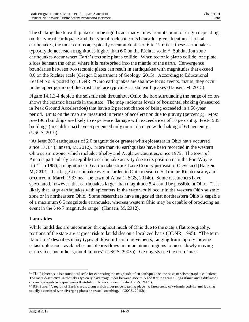
Draft Programmatic Environmental Impact Statement Chapter 14 FirstNet Nationwide Public Safety Broadband Network Ohio
The shaking due to earthquakes can be significant many miles from its point of origin depending on the type of earthquake and the type of rock and soils beneath a given location. Crustal earthquakes, the most common, typically occur at depths of 6 to 12 miles; these earthquakes typically do not reach magnitudes higher than 6.0 on the Richter scale.56 Subduction zone earthquakes occur where Earth’s tectonic plates collide. When tectonic plates collide, one plate slides beneath the other, where it is reabsorbed into the mantle of the earth. Convergence boundaries between two tectonic plates can result in earthquakes with magnitudes that exceed 8.0 on the Richter scale (Oregon Department of Geology, 2015). According to Educational Leaflet No. 9 posted by ODNR, “Ohio earthquakes are shallow-focus events, that is, they occur in the upper portion of the crust” and are typically crustal earthquakes (Hansen, M, 2015).
Figure 14.1.3-4 depicts the seismic risk throughout Ohio; the box surrounding the range of colors shows the seismic hazards in the state. The map indicates levels of horizontal shaking (measured in Peak Ground Acceleration) that have a 2 percent chance of being exceeded in a 50-year period. Units on the map are measured in terms of acceleration due to gravity (percent g). Most pre-1965 buildings are likely to experience damage with exceedances of 10 percent g. Post-1985 buildings (in California) have experienced only minor damage with shaking of 60 percent g. (USGS, 2010)
“At least 200 earthquakes of 2.0 magnitude or greater with epicenters in Ohio have occurred since 1776” (Hansen, M, 2012). More than 40 earthquakes have been recorded in the western Ohio seismic zone, which includes Shelby and Auglaize Counties, since 1875. The town of Anna is particularly susceptible to earthquake activity due to its position near the Fort Wayne rift.57 In 1986, a magnitude 5.0 earthquake struck Lake County just east of Cleveland (Hansen, M, 2012). The largest earthquake ever recorded in Ohio measured 5.4 on the Richter scale, and occurred in March 1937 near the town of Anna (USGS, 2014c). Some researchers have speculated, however, that earthquakes larger than magnitude 5.4 could be possible in Ohio. “It is likely that large earthquakes with epicenters in the state would occur in the western Ohio seismic zone or in northeastern Ohio. Some researchers have suggested that northeastern Ohio is capable of a maximum 6.5 magnitude earthquake, whereas western Ohio may be capable of producing an event in the 6 to 7 magnitude range” (Hansen, M, 2012).
Landslides
While landslides are uncommon throughout much of Ohio due to the state’s flat topography, portions of the state are at great risk to landslides on a localized basis (ODNR, 1995). “The term ‘landslide’ describes many types of downhill earth movements, ranging from rapidly moving catastrophic rock avalanches and debris flows in mountainous regions to more slowly moving earth slides and other ground failures” (USGS, 2003a). Geologists use the term “mass
56 The Richter scale is a numerical scale for expressing the magnitude of an earthquake on the basis of seismograph oscillations. The more destructive earthquakes typically have magnitudes between about 5.5 and 8.9; the scale is logarithmic and a difference of one represents an approximate thirtyfold difference in magnitude (USGS, 2014f). 57 Rift Zone: “A region of Earth’s crust along which divergence is taking place. A linear zone of volcanic activity and faulting usually associated with diverging plates or crustal stretching.” (USGS, 2015h)
August 2016 14-59

Draft Programmatic Environmental Impact Statement Chapter 14 FirstNet Nationwide Public Safety Broadband Network Ohio
movement” to describe a great variety of processes such as rock fall, creep, slump, mudflow, earth flow, debris flow, and debris avalanche regardless of the time scale (USGS, 2003a).
Landslides can be triggered by a single severe storm or earthquake, causing widespread damage in a short period. Most landslide events are triggered by water infiltration that decomposes and loosens rock and soil, lubricates frictional surfaces, adds weight to an incipient landslide, and imparts buoyancy to the individual particles. Intense rainfall, rapid snowmelt, freeze/thaw cycles, earthquakes, volcanic eruptions, and human alterations to the natural landscape can trigger mass land movements. Large landslides can dam rivers or streams, and cause both upstream and downstream flooding (USGS, 2003a).
According to the Ohio Department of Natural Resources, portions of Ohio are at risk of experiencing landslide events. “The Cincinnati area is one of the most active spots in the country for landslides and has among the highest per capita costs to prevent and mitigate their effects” (Potter, et al., 2013). Specifically, areas underlain by the Kope Formation, which is composed largely of highly weathered shale with minimal amounts of limestone, are particularly susceptible to landslides. Landslide event types include creep,58 translational,59 and rotational60 landslides (Potter, et al., 2013). Landslides are particularly common near Cincinnati where surface deposits overlie terrain with steep slopes. “The valley of the Cuyahoga River between Cleveland and Akron, in Cuyahoga and Summit Counties, is well known for rotational slumps in clays and silts deposited in lakes formed when glaciers of the Pleistocene Ice Age blocked various segments of the valley” (ODNR, 1995). Landslides are also common in the northeastern portion of the state along Lake Erie in areas that are underlain by unconsolidated glacial deposits (ODNR, 1995). Figure 14.1.3-5 shows landslide incidence and susceptibility throughout Ohio.
Subsidence
Land subsidence is a “gradual settling or sudden sinking of the Earth’s surface owing to subsurface movement of earth materials.” Land subsidence in Ohio is attributable to both sinkhole formation and mine subsidence (ODNR, 2015b). Nationwide, the primary causes of land subsidence are attributed to aquifer system compaction, drainage of organic soils, underground mining, sinkholes, and thawing permafrost. More than 80 percent of subsidence in the United States is a consequence of over-withdrawal of groundwater. In many aquifers, which are subsurface soil layers through which groundwater moves, water is pumped from pore spaces between sand and gravel grains. If an aquifer is confined by layers of silt or clay, which do not transport groundwater, the lowered water pressure in the sand and gravel causes slow drainage of water from the clay and silt beds. The reduced water pressure compromises support for the clay and silt beds, causing them to collapse on one another. The effects of this compression are seen in the permanent lowering of the land surface elevation (USGS, 2000).
58 Creep: “The imperceptibly slow, steady, downward movement of slope-forming soil or rock. Movement is caused by shear stress sufficient to produce permanent deformation, but too small to produce shear failure.” (USGS, 2004) 59 Translational Landslide: “The landslide mass moves along a roughly planar surface with little rotation or backward tilting.” (USGS, 2004) 60 Rotational Landslide: “A slide in which the surface of rupture is curved concavely upward and the slide movement is roughly rotational about an axis that is parallel to the ground surface and transverse across the slide.” (USGS, 2004)
August 2016 14-60

Draft Programmatic Environmental Impact Statement Chapter 14 FirstNet Nationwide Public Safety Broadband Network Ohio
Figure 14.1.3-4: Ohio 2014 Seismic Hazard Map
August 2016 14-61

Draft Programmatic Environmental Impact Statement Chapter 14 FirstNet Nationwide Public Safety Broadband Network Ohio
Figure 14.1.3-5: Ohio Landslide Incidence and Susceptibility Hazard Map61
61 Susceptibility hazards not indicated in Figure 14.1.3-5 where same or lower than incidence. Susceptibility to landslides is defined as the probable degree of response of areal rocks and soils to natural or artificial cutting or loading of slopes, or to
August 2016 14-62

Draft Programmatic Environmental Impact Statement Chapter 14 FirstNet Nationwide Public Safety Broadband Network Ohio
Land subsidence can result in altered stream elevations and slopes; detrimental effects to infrastructure and buildings; and collapse of wells due to compaction of aquifer sediments. Subsided areas can become more susceptible to inundation, both during storm events and non-events. Lowered terrain is more susceptible to inundation during high tides. Additionally, land subsidence can affect vegetation and land use (U.S. Geological Survey, 2013b).
In Ohio, a significant cause of land subsidence is the collapse of karst topography.62 “Sinkholes are the main hazard associated with karst landforms in Ohio, and there are thousands of them in the state.” Karst topography exists throughout parts of western Ohio in areas that are underlain by Devonian limestone and Silurian dolomite formations; sinkholes associated with this underlying geology generally deepen and widen at rates of a few inches per year. “When the bedrock is buried beneath more than about 25 [feet] of glacial material, sinkholes are not expressed at the land surface.” Karst topography is most dense in central Ohio, including portions of Highland, Adams, and Brown Counties (ODNR, 2015c).
Figure 14.1.3-6 shows Ohio areas susceptible to subsidence due to karst topography.
A second cause of land subsidence in Ohio is mine collapse. More than 8,000 abandoned mines – most of which were used to extract coal – exist in 41 counties throughout Ohio. Tuscarawas County in eastern Ohio has 455 abandoned mines. Mine subsidence is prevalent throughout Ohio due to the employment of room-and-pillar mining techniques throughout the state, whereby 50 percent of the underlying geology is left unmined. Any reduction in pillar support below this threshold increases the risk of collapse of the overlying geologic units. “However, coal operators in the nineteenth and twentieth centuries commonly mined the pillars, partially or wholly, as an area of the mine was abandoned,” which has heightened the risk of mine collapse in Ohio. In 1995, a portion of Interstate 70 collapsed in Guernsey County due to mine subsidence (ODNR, 2010).
Figure 14.1.3-7 displays the location of abandoned mines throughout Ohio.
anomalously high precipitation. High, moderate, and low susceptibility are delimited by the same percentages used in classifying the incidence of landslides. Some generalization was necessary at this scale, and several small areas of high incidence and susceptibility were slightly exaggerated. (USGS, 2014g) 62 Karst Topography: “A distinctive landscape (topography) that can develop where the underlying bedrock, often limestone or marble, is partially dissolved by surface or groundwater.” (USGS, 2015h)
August 2016 14-63

Draft Programmatic Environmental Impact Statement Chapter 14 FirstNet Nationwide Public Safety Broadband Network Ohio
Figure 14.1.3-6: Areas Susceptible to Subsidence due to Karst Topography in Ohio
August 2016 14-64
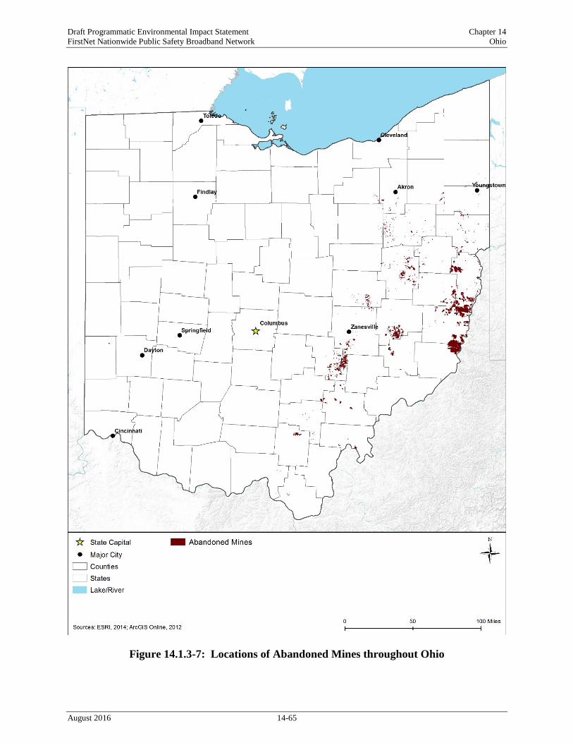
Draft Programmatic Environmental Impact Statement Chapter 14 FirstNet Nationwide Public Safety Broadband Network Ohio
Figure 14.1.3-7: Locations of Abandoned Mines throughout Ohio
August 2016 14-65

Draft Programmatic Environmental Impact Statement Chapter 14 FirstNet Nationwide Public Safety Broadband Network Ohio
Water Resources
14.1.4.1. Definition of the Resource
Water resources are defined as all surface water bodies and groundwater systems including streams, rivers, lakes, canals, ditches, estuarine waters, floodplains, aquifers, and other aquatic habitats (wetlands are discussed separately in Section 14.1.5, Wetlands). These resources can be grouped into watersheds, which are defined as areas of land whose flowing water resources (including runoff from rainfall) drain to a common outlet such as a river or ocean. The value and use of water resources are influenced by the quantity and quality of water available for use and the demand for available water. Water resources are used for drinking, irrigation, industry, recreation, and as habitat for wildlife. Some water resources that are particularly pristine, sensitive, or of great economic value enjoy special protections under federal and state laws. An adequate supply of water is essential for human health, economic wellbeing, and ecological health. (USGS, 2014d)
14.1.4.2. Specific Regulatory Considerations
Federal laws relevant to protecting the quality and use of water resources are summarized in Appendix C, Environmental Laws and Regulations. Table 14.1.4-1 identifies the relevant laws and regulations for water resources in Ohio.
Table 14.1.4-1: Relevant Ohio Water Laws and Regulations State Law/Regulation Regulatory Agency Applicability
Ohio Pollutant Discharge Elimination System Program
Ohio Environmental Protection Agency (OEPA)
Construction activities that disturb one or more acre of surface soil. Projects in the Big Darby Creek and Olentangy River watersheds are required to implement certain best management practices to protect the high quality waters in these watersheds. (OEPA, 2013b)
Clean Water Act (CWA) Section 404 permit, Nationwide Permit (NWP) Ohio regional conditions
U.S. Army Corps of Engineers (USACE), Buffalo, Huntington, Louisville, and Pittsburgh Districts
Stream work associated with aboveground utility lines and poles; water impacts greater than 0.1 acres associated with access roads activities must submit preconstruction notification to the USACE including a restoration plan describing how temporary fills and structures will be removed upon completion of the project. (USACE, 2012) All waters on the development site should be protected in perpetuity with a conservation easement, deed-restricted open space, or other comparable legal protection. (USACE, 2012) Preconstruction notification must be submitted to the USACE for activities in State Wild and Scenic Rivers; National Wild and Scenic Rivers; and Critical Resource Waters,63 which include waters along the shoreline, offshore islands, and rock outcrops in Lake Erie. (USACE, 2012)
63 “Critical resource waters include marine sanctuaries and marine monuments managed by the National Oceanic and Atmospheric Administration, and National Estuarine Research Reserves. District Engineers may designate additional critical resource waters, after notice and an opportunity for public comment.” (USACE, 2012)
August 2016 14-66

Draft Programmatic Environmental Impact Statement Chapter 14 FirstNet Nationwide Public Safety Broadband Network Ohio
State Law/Regulation Regulatory Agency Applicability CWA Section 401 permit OEPA In accordance with Section 401 of the CWA,
activities that may result in a discharge to waters of the U.S. require a Water Quality Certification from OEPA indicating that the proposed activity will not violate water quality standards. (OEPA, 2015j)
OAC Chapter 3745 OEPA, Division of Drinking and Ground Waters (DDAGW)
Includes rules regarding water well standards; underground injection control; primary drinking water standards; and secondary contaminant standards. (OEPA, 2016a)
14.1.4.3. Environmental Setting: Surface Water
Surface water resources are lakes, ponds, rivers, and streams, as well as estuarine.64 According to the Ohio Environmental Protection Agency (OEPA), Ohio has 58,343 miles of rivers and streams, 447 lakes, reservoirs, and ponds, and 290 miles of Lake Erie shoreline. These surface waters provide drinking water, recreation, industrial use, power generation, and irrigation (OEPA, 2014a).
Watersheds
Watersheds, or drainage areas, consist of surface water and all underlying groundwater, and encompass an area of land that drains streams and rainfall to a common outlet (e.g., reservoir, bay). Ohio’s waters (lakes, rivers, and streams) are divided into 23 major watersheds or drainage basins (Figure 14.1.4-1). Visit www.epa.state.oh.us/dsw/tmdl/OhioIntegratedReport.aspx for information and additional maps about each watershed (OEPA, 2014a).
The watersheds in northern Ohio drain to Lake Erie to the north and the remaining Ohio watersheds drain to the Ohio River to the south. The Maumee, Portage, Sandusky, Huron, Vermilion, Black, Rocky, Cuyahoga, Chagrin, Grand, and Ashtabula watersheds in northern Ohio drain to Lake Erie. The Mahoning, Little Beaver, Central Ohio Tributaries, Muskingum, Hocking, Southeast Ohio Tributaries, Scioto, Southwest Ohio Tributaries, Little Miami, Great Miami, Mill, and Wabash watersheds drain to the Ohio River (OEPA, 2014a).
64 Estuarine: related to an estuary, or a “partially enclosed body of water where fresh water from rivers and streams mixes with salt water from the ocean. It is an area of transition from land to sea.” (USEPA, 2015q)
August 2016 14-67

Draft Programmatic Environmental Impact Statement Chapter 14 FirstNet Nationwide Public Safety Broadband Network Ohio
Figure 14.1.4-1: Major Ohio Watersheds and Surface Waterbodies
August 2016 14-68

Draft Programmatic Environmental Impact Statement Chapter 14 FirstNet Nationwide Public Safety Broadband Network Ohio
Freshwater
Major rivers in Ohio include: Maumee, St. Marys, Great Miami, Little Miami, Scioto, Muskingum, Grand, Mahoning, Cuyahoga, Sandusky, Maumee, Auglze, Blanchard, Tiffin, Licking, Tuscarawas, Walhonding, Mohican, Wills Creek, Hocking, Raccoon Creek, Scioto, Paint Creek, Mad, Stillwater, Whitewater and Ohio. There are also four major creeks in Ohio: Little Darby, Big Darby, Old Woman, and Little Beaver. The Maumee, St. Marys, Sandusky, Cuyahoga, and Grand rivers flow into Lake Erie. The Great Miami, Little Miami, Scioto, Muskingum, and Mahoning rivers flow into the Ohio River. The Ohio River forms a 451-mile border between Ohio and West Virginia to the west and Ohio and Kentucky to the south. Ohio also contains 447 lakes and ponds with 7 major lakes and reservoirs (OEPA, 2014a) including Lake Erie, Indian Lake, Grand Lake, William H. Harsha Lake, Mohawk Reservoir, Pymatuning Reservoir, and Senecaville Lake (see Figure 14.1.4-1).
The Great Lakes form the largest surface freshwater system on the planet spanning more than 94,000 square miles of surface area (NOAA, 2015a). Lake Erie forms most of Ohio’s northern border with 290 miles of shoreline. The northern one-third of Ohio drains into Lake Erie. Lake Erie is used as a source for drinking water, recreation, aquatic habitat, irrigation, and industrial uses (OEPA, 2014a).
Estuarine Waters
Estuaries (including bays and tidal rivers) traditionally are bodies of water that provide transition zones between fresh river water and saline ocean water. In Ohio, there is no saltwater, but the chemical differences between Lake Erie and Old Woman Creek are different enough that they create a freshwater estuary or an area with a transition zone between the two water types. In addition, the tides of Lake Erie, while extremely small, also influence water levels in the estuary. A barrier beach separates the estuary from Lake Erie. (ODNR, 2015d)
14.1.4.4. Sensitive or Protected Waterbodies
Wild and Scenic Rivers
There are three National Wild and Scenic Rivers in Ohio: the Big and Little Darby Creeks, Little Beaver Creek, and Little Miami River (Figure 14.1.4-1). A portion of the Big and Little Darby Creeks is federally designed as a scenic river. The segment is in central Ohio and includes 85.9 miles. These streams have excellent water quality that support over 100 fish species and 44 mussel species, some of which are endangered or rare. (National Wild and Scenic Rivers System, 2015a)
A reach of the Little Beaver Creek is federally designated as a scenic river. The 33-mile segment is in northeastern Ohio. The stream supports a variety of fish, mammal, bird, reptile, and amphibian species including the endangered Hellbender salamander. The stream flows through deep valleys and includes swift flowing rapids and slow moving pools. (National Wild and Scenic Rivers System, 2015a) (ODNR, 2015e)
August 2016 14-69

Draft Programmatic Environmental Impact Statement Chapter 14 FirstNet Nationwide Public Safety Broadband Network Ohio
The Little Miami River is federally designated as scenic (18 miles) and recreational (76 miles). The 94-mile segment is in southwestern Ohio. The Little Miami River was the first designated scenic river in Ohio. The river supports a variety of fish, birds, mussels, and plant species. (National Wild and Scenic Rivers System, 2015a) (ODNR, 2015f)
In addition to federally designated Wild and Scenic Rivers, Ohio’s Scenic Rivers Act protects “Ohio’s remaining high quality streams for future generations.” Under the Scenic Rivers Act, a river is designated as wild, scenic, or recreational based on the outstanding qualities of the stream. Some of the qualities include length, water quality, present uses, and biological characteristics.
There are nine rivers designated as scenic, three rivers designated as wild and scenic, and two rivers designated as scenic and recreational in Ohio (ODNR, 2015g). The scenic rivers include: • Ashtabula; • Kokosing; • Olentangy; • Big and Little Darby; • Upper Cuyahoga.
• Chagrin; • Mohican; • Sandusky; • Little Miami; and
The wild and scenic rivers include: • Conneat; • Grand; and • Little Beaver.
The scenic and recreational rivers include: • Maumee; and • Stillwater/Greenville.
State Designated Critical Resource Waters Three areas in Ohio have been designated as critical resource waters. The first area consists of the shoreline and off shore islands in Lake Erie. The second and third areas are considered critical habitat for the piping plover (Charadrius melodus) and “are defined as lands 0.62 miles inland from normal high water land,” totaling approximately 2.5 miles in Ohio’s Erie and Lake counties (USACE, 2012). Additionally, the 573-acre Old Woman Creek estuary, located 3 miles east of Huron, OH has been designated as a National Estuarine Research Reserve (NERR). The area has been set aside for research, water quality monitoring, education, and resource protection. (ODNR, 2015d) (NOAA, 2015b)
14.1.4.5. Impaired Waterbodies
Water quality is evaluated by several constituents and attributes, including temperature, dissolved oxygen, suspended sediment, nutrients, metals, oils, pesticides water color, condition of stream banks and lake shores; observations of aquatic wildlife communities; and sampling of fish tissue or sediment. Under Section 303(d) of the Clean Water Act, states are required to
August 2016 14-70

Draft Programmatic Environmental Impact Statement Chapter 14 FirstNet Nationwide Public Safety Broadband Network Ohio
assess water quality and report a listing of impaired waters,65 the causes of impairment, and probable sources. Table 14.1.4-2 summarizes the water quality of Ohio’s assessed major waterbodies by category, percent impaired, designated use,66 cause, and probable sources. Figure 14.1.4-2 shows the Section 303(d) waters in Ohio as of 2014.
As shown in Table 14.1.4-2, various sources affect Ohio’s waterbodies, causing impairments. Almost all of Ohio’s river and streams are impaired. All of Ohio’s lakes, reservoirs, ponds, and Great Lakes shoreline that have been evaluated (approximately 93 percent) are impaired. Designated uses of these impaired waterbodies include aquatic life, human health, drinking water, and recreation. Probable sources for impairment of rivers and streams include agricultural use and upstream impoundments. No probable sources have been identified for lakes, rivers, ponds, and the Great Lakes shoreline. (USEPA, 2015o)
Table 14.1.4-2: Section 303(d) Impaired Waters of Ohio, 2010 Water Typea
Amount of Waters Assessedb (Percent)
Amount Impaired (Percent)
Designated Uses of Impaired Waters
Top Causes of Impairment
Top Probable Sources for Impairment
Rivers and Streams
90.1% 96.7% aquatic life, human health, public drinking, and recreation
sediment, habitat alterations, nutrients, organic enrichment, flow alteration, pathogensc
non-irrigated crop production, natural/wildlife, and hydromodifications (e.g., upstream impoundment)
Lakes, Reservoirs, and Ponds
100% 100% human health and public drinking
pesticides, mercury and polychlorinated biphenyls (PCBs)
no probable sources of impairment recordedd
Great Lakes shoreline
92.8% 100% aquatic life, human health and recreation
PCBs, exotic species, sediment, nutrients, pathogens, habitat alterations, organic enrichment
no probable sources of impairment recorded
a Some waters may be considered for more than one water type. b Ohio has not assessed all waterbodies within the state. c Pathogen: a bacterium, virus, or other microorganism that can cause disease (USEPA, 2015q). d Ohio has not reported probable sources of impairment (USEPA, 2015o).
Source: (USEPA, 2015o)
65 Impaired waters: waterways that do not meet state water quality standards. Under the CWA, Section 303(d), states, territories, and authorized tribes are required to develop prioritized lists of impaired waters. (USEPA, 2015q) 66 Designated Use: an appropriate intended use by humans and/or aquatic life for a waterbody. Designated uses may include recreation, shellfishing, or drinking water supply. (USEPA, 2015q)
August 2016 14-71

Draft Programmatic Environmental Impact Statement Chapter 14 FirstNet Nationwide Public Safety Broadband Network Ohio
Figure 14.1.4-2: Section 303(d) Impaired Waters of Ohio, 2014
August 2016 14-72

Draft Programmatic Environmental Impact Statement Chapter 14 FirstNet Nationwide Public Safety Broadband Network Ohio
While water quality in Ohio remains impaired, progress and improvements have been made. The most common contaminants are PCBs, sediment, nutrients, and mercury. PCB contamination is due to legacy sources. The state of Ohio is working with programs such as the Great Lakes Legacy Act, Superfund, and Resource Conservation Recovery Act (RCRA) to address these legacy sources. Mercury contamination is likely from aerial deposition from local, regional, and global sources. The state of Ohio is targeting these sources through legislation to ban the sale of products containing mercury. In addition, the state of Ohio is collaborating with local government, organizations, and the public to enhance water quality monitoring and improve public education about water quality. (OEPA, 2014a)
14.1.4.6. Floodplains
The Federal Emergency Management Agency (FEMA) defines a floodplain or flood-prone area as “any land area susceptible to being inundated by water from any source” (44 Code of Federal Regulations [CFR] 59.1) (FEMA, 2000). Through FEMA’s flood hazard mapping program, the agency identifies flood hazards and risks associated with the 100-year flood, which is defined as “a flood that has a 1 percent chance of occurring in any given year,” to allow communities to prepare and protect against flood events (FEMA, 2013).
Floodplains provide suitable and sometimes unique habitat for a wide variety of plants and animals, and are typically more biologically diverse than upland areas due to the combination of both terrestrial and aquatic ecosystems. Vegetation along stream banks provides shade, which helps to regulate water temperature for aquatic species. During flood events, sediment and debris settle out and collect on the floodplain, enriching the soil with additional nutrients. Pollutants from floodwater runoff are also filtered by floodplain vegetation and soils; thereby improving water quality. Furthermore, floodplains protect natural and built infrastructure by providing floodwater storage, erosion control, water quality maintenance, and groundwater recharge. Historically, floodplains have been favorable locations for agriculture, aquaculture, and forest production due to the relatively flat topography and nearby water supply. Floodplains can also offer recreational activities, such as boating, swimming, and fishing, as well as hiking and camping (FEMA, 2014a).
There are two primary types of floodplains in Ohio. • Riverine and lake floodplains occur along rivers, streams, or lakes where overbank flooding
may occur, inundating adjacent land areas. In mountainous areas, floodwaters can build and recede quickly, with fast moving and deep water. Flooding in these areas can cause greater damage than typical riverine flooding due to the high velocity of water flow, the amount of debris carried, and the broad area affected by floodwaters. Whereas, flatter floodplains may remain inundated for days or weeks, covered by slow-moving and shallow water (FEMA, 2014b).
• Coastal floodplains in Ohio border the shoreline of Lake Erie. Coastal flooding can occur when strong wind and storms increase water levels on the adjacent shorelines (FEMA, 2013). Lake coastal flooding can occur in Ohio when strong wind and storms increase water levels
August 2016 14-73

Draft Programmatic Environmental Impact Statement Chapter 14 FirstNet Nationwide Public Safety Broadband Network Ohio
on the shores of Lake Erie. In addition, a storm surge event that takes place during high tide can cause floodwaters to exceed normal tide levels.
Flooding is the leading cause for disaster declaration by the president in the U.S. (NOAA, 2015c) (Ohio Emergency Management Agency, 2014). There are several causes of flooding in Ohio, often resulting in loss of life and damage to property, infrastructure, agriculture, and the environment. These include severe rain events, rapid snowmelt, severe storm events, and high winds (Ohio Emergency Management Agency, 2014).
Although some areas, such as floodplains, are more prone to flooding than others, no area in the state is exempt from flood hazards. Based on historical flooding and flood disaster declarations, flood problems are most severe in the northwest region of Ohio. (Ohio Department of Public Safety, 2014)
Local communities often have floodplain management or zoning ordinances that restrict development within the floodplain. FEMA provides floodplain management assistance, including mapping of 100-year floodplain limits, to approximately 750 communities in Ohio through the National Flood Insurance Program (NFIP) (FEMA, 2014c). Established to reduce the economic and social cost of flood damage by subsidizing insurance payments, the NFIP encourages communities “to adopt and enforce floodplain management regulations and to implement broader floodplain management programs” and allows property owners in participating communities to purchase insurance protection against losses from flooding (FEMA, 2015). As an incentive, communities can voluntarily participate in the NFIP Community Rating System (CRS), which is a program that rewards communities for doing more than the minimum NFIP requirements for floodplain management. As of May 2014, Ohio had 15 communities participating in the CRS (FEMA, 2014d).67
14.1.4.7. Groundwater
Groundwater systems are sources of water that result from precipitation infiltrating the ground surface, and includes underground water that occupies pore spaces between sand, clay, or rock particles. An aquifer is a permeable geological formation that stores or transmits water to wells and springs. Groundwater is contained in either confined (bound by clays or nonporous bedrock) or unconfined (no layer to restrict the vertical movement of groundwater) aquifers (USGS, 1999). When the water table reaches the ground surface, groundwater will reappear as either
67 A list of the 15 CRS communities can be found in the most recent FEMA CRS report dated May 1, 2014 (http://www.fema.gov/media-library-data/1398878892102-5cbcaa727a635327277d834491210fec/CRS_Communites_May_1_2014.pdf) and additional program information is available from FEMA’s NFIP CRS website (www.fema.gov/national-flood-insurance-program-community-rating-system).
Flooding Along the Ohio River
In March 2015, the heavy rainfall combined with melting snow contributed to flooding along the Ohio River. During the first two weeks of March, Cincinnati received nearly five inches of rain, which raised the Ohio River to more than 57 feet. Ice jams backed up the rising river and caused flooding along roads and flood-prone communities. (NASA, 2015)
August 2016 14-74

Draft Programmatic Environmental Impact Statement Chapter 14 FirstNet Nationwide Public Safety Broadband Network Ohio
streams, surface bodies of water, or wetlands. This exchange between surface water and groundwater is an important feature of the hydrologic (water) cycle.
Ohio’s principal aquifers consist of carbonate-rock68 and sandstone aquifers69, and sand and gravel aquifers of alluvial and glacial origin.70 The major three uses for groundwater in Ohio include domestic use (60 percent), industrial and manufacturing use (33 percent), agricultural use (5 percent), and other uses (2 percent) (OEPA, 2014b). Generally, the water quality of Ohio’s aquifers is suitable for drinking and daily water needs. Statewide, the most serious threats to groundwater quality include fertilizer applications, storage tanks, landfills, septic systems, shallow injections wells, hazardous waste sites, pipelines and sewer lines, salt storage and road salting, urban runoff, and small-scale manufacturing and repair shops. (OEPA, 2014a)
Table 14.1.4-3 provides details on aquifer characteristics in the state; Figure 14.1.4-3 shows Ohio’s principal and sole source aquifers.
Table 14.1.4-3: Description of Ohio’s Principal Aquifers Aquifer Type and Name Location in State Groundwater Quality Aquifers of Alluvial and Glacial origin Sandstone, sand and gravel
Throughout Ohio with high concentrations in extreme northwest, east central and northeastern Ohio
Suitable for most uses. Water is generally hard with localized high levels of iron.
Mississippian aquifers Unconsolidated sand and gravel deposits of consolidated sandstone, limestone, and dolomite
Central lowlands of Ohio Water is moderately hard and is suitable for drinking water and agricultural use. Slight acidity in groundwater partially dissolves the limestone, thus increasing the concentrations of calcium and magnesium.
Pennsylvanian aquifers Sandstone and limestone
Eastern Ohio Water is soft to medium hard. Water use is mainly domestic and agricultural supply.
Silurian-Devonian aquifers Dolomite and limestone
West-central and northwestern Ohio except for extreme northwest
Water is hard and generally suitable for most uses. Water quality varies locally with localized concentrations of dissolved solids and iron.
Sources: (Moody, Carr, Chase, & Paulson, 1986) (Orville, 1995)
68 Carbonate-rock aquifers typically consist of limestone with highly variable water-yielding properties (some yield almost no water and others are highly productive aquifers) (Olcott, 1995a). 69 Sandstone aquifers form from the conversion of sand grains into rock caused by the weight of overlying soil/rock. The sand grains are rearranged and tightly packed, thereby reducing or eliminating the volume of pore space, which results in low-permeability rocks such as shale or siltstone. These aquifer types are limited in areal extent and yield small to moderate quantities of water but are significant sources for rural, domestic, industrial, and small-community supplies in their area of occurrence (Olcott, 1995b). 70 Sand and gravel aquifers of alluvial (sand, silt, or gravel materials left by river waters) and glacial origin are highly productive aquifers in the northern part of the country, consisting of mostly sand and gravel deposits formed by melting glaciers (USGS, 2015a).
August 2016 14-75

Draft Programmatic Environmental Impact Statement Chapter 14 FirstNet Nationwide Public Safety Broadband Network Ohio
Figure 14.1.4-3: Principal and Sole Source Aquifers of Ohio
August 2016 14-76

Draft Programmatic Environmental Impact Statement Chapter 14 FirstNet Nationwide Public Safety Broadband Network Ohio
Sole Source Aquifers
The U.S. Environmental Protection Agency (USEPA) defines a sole source aquifer (SSA) as one that “supplies at least 50 percent of the drinking water for its service area” (USEPA, 2015r). Ohio has four designated SSAs – Bass Island SSA (north), Allen County Combined SSA and Great Miami Buried Valley SSA (west), and Pleasant City SSA (east) (Figure 14.1.4-3).
Designating a groundwater resource as an SSA helps to protect the drinking water supply in that area and requires reviews for all federally funded proposed projects to ensure that the water source is not jeopardized (USEPA, 2015r).
Wetlands
14.1.5.1. Definition of the Resource
The Clean Water Act (CWA) defines wetlands as “those areas that are inundated or saturated by surface or groundwater at a frequency and duration sufficient to support, and that under normal circumstances do support, a prevalence of vegetation typically adapted for life in saturated soil conditions. Wetlands generally include swamps, marshes, bogs, and similar areas” (U.S. Government Publishing Office, 1993).
The USEPA estimates that “more than one-third of the United States’ threatened and endangered species live only in wetlands, and nearly half of such species use wetlands at some point in their lives” (USEPA, 1995). In addition to providing habitat for many plants and animals, wetlands also provide benefits to human communities. Wetlands store water during flood events, improve water quality by filtering polluted runoff, help control erosion by slowing water velocity and filtering sediments, serve as points of groundwater recharge, and help maintain base flow in streams and rivers. Additionally, wetlands provide recreation opportunities for people, such as hiking, bird watching, and photography.
14.1.5.2. Specific Regulatory Considerations
Appendix C, Environmental Laws and Regulations, describes the pertinent federal laws protecting wetlands in detail. Table 14.1.5-1 summarizes the major Ohio state laws and permitting requirements relevant to the state’s wetlands.
Table 14.1.5-1: Relevant Ohio Wetlands Laws and Regulations State Law/Regulation Regulatory Authority Applicability
Clean Water Act (CWA) Section 404 permit, Nationwide Permit (NWP) Ohio regional conditions
U.S. Army Corps of Engineers (USACE), Buffalo, Huntington, Louisville, and Pittsburgh Districts
For the following activities preconstruction notification must be submitted to the USACE including a restoration plan describing how temporary fills and structures will be removed upon completion of the project: temporary structures and discharges used for access fills or dewatering construction sites in wetlands, or perennial streams when the main project has been authorized by the USACE; any project impacting shrub/scrub and forested wetlands. Anti-seep collars or clay plugs must be used for trenching in wetlands. Manholes in wetlands are prohibited (USACE, 2012).
August 2016 14-77

Draft Programmatic Environmental Impact Statement Chapter 14 FirstNet Nationwide Public Safety Broadband Network Ohio
State Law/Regulation Regulatory Authority Applicability All waters on the development site should be protected in perpetuity with a conservation easement, deed-restricted open space, or other comparable legal protection (USACE, 2012). Activities that impacts bogs or fens cannot be authorized under NWPs in Ohio (USACE, 2012).
CWA Section 401 permit
Ohio Environmental Protection Agency (OEPA)
In accordance with Section 401 of the CWA, activities that may result in a discharge to waters of the U.S. require a Water Quality Certification from OEPA indicating that the proposed activity will not violate water quality standards (OEPA, 2015j).
Ohio Pollutant Discharge Elimination System Program
OEPA Construction activities that disturb one or more acre of surface soil. Projects in the Big Darby Creek and Olentangy River watersheds are required to implement certain best management practices due to the high quality waters in these watersheds (OEPA, 2013b).
Isolated Wetlands Permit Program
OEPA Any activity that places fill in an isolated wetland. Isolated wetlands are wetland that are not under the jurisdiction of the USACE, but are considered waters of the state of Ohio (OEPA, 2015k).
14.1.5.3. Wetland Types and Functions
The U.S. Fish and Wildlife Service’s (USFWS) National Wetlands Inventory (NWI) mapping adopted a national Wetlands Classification Standard (WCS) that classifies wetlands according to shared environmental factors, such as vegetation, soils, and hydrology (Cowardin, Carter, Golet, & LaRoe, 1979). The WCS includes five major wetland systems, Marine, Estuarine, Riverine, Lacustrine, and Palustrine (as detailed in Table 14.1.5-2). 71 The first four of these include both wetlands and deepwater habitats but the Palustrine includes only wetland habitats (USFWS, 2015a). • The Marine System consists of open ocean, continental shelf, including beaches, rocky
shores, lagoons, and shallow coral reefs. Normal marine salinity (saltiness) to hypersaline (more than 30 percent salty) water chemistry; minimal influence from rivers or estuaries. Where wave energy is low, mangroves, or mudflats may be present.
• “The Estuarine System consists of deepwater tidal habitats and adjacent tidal habitats that are usually semi enclosed by land but have open, partly obstructed, or sporadic access to the open ocean, and the ocean water is at least occasionally diluted by freshwater runoff from the land.”
71 The wetland acreages were obtained from the USFWS (2014) National Wetlands Inventory. Data from this inventory was downloaded by state at https://www.fws.gov/wetlands/. The wetlands data contains a wetlands classification code, which are a series of letter and number codes, adapted to the national wetland classification system in order to map from (e.g., PFO). Each of these codes corresponds to a larger wetland type; those wetland areas are rolled up under that wetlands type. The codes and associated acres that correspond to the deepwater habitats (e.g., those beginning with M1, E1, L1) were removed. The wetlands acres were derived from the geospatial datafile, by creating a pivot table to capture the sum of all acres under a particular wetland type. The maps reflect/show the wetland types/classifications and overarching codes; the symbolization used in the map is standard to these wetland types/codes, per the USFWS and Federal Geographic Data Committee.
August 2016 14-78

Draft Programmatic Environmental Impact Statement Chapter 14 FirstNet Nationwide Public Safety Broadband Network Ohio
• “Riverine System includes all wetlands and deepwater habitats contained within a channel with two exceptions (1) wetlands dominated by trees, shrubs, persistent emergents, emergent mosses, or lichens, and (2) habitats with water containing ocean-derived salts in excess of 0.5 ppt.”
• Lacustrine System includes inland water bodies that are situated in topographic depressions, lack emergent trees and shrubs, have less than 30 percent vegetation cover, and occupy greater than 20 acres. Includes lakes, larger ponds, sloughs, lochs, bayous, etc.
• “Palustrine includes all nontidal wetlands dominated by trees, shrubs, persistent emergents, or emergent mosses or lichens, and all such wetlands that occur in tidal areas where salinity due to ocean-derived salts is below 0.5 percent.” The System is characterized based on the type and duration of flooding, water chemistry, vegetation, or substrate characteristics (soil types). (Cowardin, Carter, Golet, & LaRoe, 1979)
Three of these systems – Palustrine, Lacustrine, and Riverine – are present in Ohio. The main type of wetlands are palustrine (freshwater) wetlands found on river and lake floodplains across the state. Lacustrine wetlands are also found throughout the state. Riverine wetlands comprise only approximately 6 percent (4,325 acres) of the total 694,986 acres of wetlands in the state (see Table 14.1.5-2). Therefore, due to the small amount of riverine wetlands present, they are not discussed in this PEIS.
Table 14.1.5-2 uses 2014 NWI data to characterize and map Ohio wetlands on a broad-scale. The data is not intended for site-specific analyses and is not a substitute for field-level wetland surveys, delineations, or jurisdictional determinations, which may be conducted, as appropriate, at the site-specific level once those locations are known. As shown in Figure 14.1.5-1, palustrine wetlands are found throughout the state, but are more concentrated in northern and northeastern areas of Ohio. The map codes and colorings in Table 14.1.5-2 correspond to the wetland types in the figures.
Table 14.1.5-2: Ohio Wetland Types, Descriptions, Location, and Amount, 2014
Wetland Type
Map Code and
Color
Descriptiona Occurrence Amount (acres)b
Palustrine forested wetland
PFO
PFO wetlands contain woody vegetation that are at least 20 feet tall. Floodplain forests, hardwood swamps are examples of PFO wetlands.
Throughout the state, concentrated in northern and northeastern areas
395,973
Palustrine scrub-shrub wetland PSS
Woody vegetation less than 20 feet tall dominates PSS wetlands. Thickets and shrub swamps are examples of PSS wetlands.
Palustrine emergent wetlands PEM
PEM wetlands have erect, rooted, green-stemmed, annual, water-loving plants present for most of the growing season in most years. PEM wetlands include freshwater marshes, wet meadows, fens, prairie potholes, and sloughs.
Throughout the state
111,536
August 2016 14-79

Draft Programmatic Environmental Impact Statement Chapter 14 FirstNet Nationwide Public Safety Broadband Network Ohio
Wetland Type
Map Code and
Color
Descriptiona Occurrence Amount (acres)b
Palustrine unconsolidated bottom PUB
PUB and PAB wetlands are commonly known as freshwater ponds, and includes all wetlands with at least 25% cover of particles smaller than stones and a vegetative cover less than 30%.
Throughout the state
139,121
Palustrine aquatic bed PAB
PAB wetlands include wetlands vegetated by plants growing mainly on or below the water surface line.
Other Palustrine wetland Misc.
Types
Farmed wetland, saline seep72, and other miscellaneous wetlands are included in this group.
Throughout the state
91
Riverine wetland
R
Riverine systems include rivers, creeks, and streams. They are contained in natural or artificial channels periodically or continuously containing flowing water.
Throughout the state
4,325
Lacustrine wetland
L2
Lacustrine systems are lakes or shallow reservoir basins generally consisting of ponded waters in depressions or dammed river channels, with sparse or lacking persistent emergent vegetation, but including any areas with abundant submerged or floating-leaved aquatic vegetation. These wetlands are generally less than 8.2 feet deep.
Throughout the state
43,940
TOTAL 694,986
Sources: (Cowardin, Carter, Golet, & LaRoe, 1979) (USFWS, 2015b) (FGDC, 2013) a The wetlands descriptions are based on information from the Federal Geographic Data Committee (FGDC)’s Classification of Wetland and Deepwater Habitats of the United States. Based on Cowardin, et.al, 1979, some data has been revised based on the latest scientific advances. The USFWS uses these standards as the minimum guidelines for wetlands mapping efforts. (FGDC, 2013) b All acreages are rounded to the nearest whole number. The maps are prepared from the analysis of high altitude imagery. A margin of error is inherent in the use of imagery. The accuracy of image interpretation depends on the quality of the imagery, the experience of the image analysts, the amount and quality of the collateral data and the amount of ground truth verification work conducted. (USFWS, 2015c)
72 Saline seep is an area where saline groundwater discharges at the soil surface. These wetland types are characterized by saline soils and salt tolerant plants (City of Lincoln, 2015).
August 2016 14-80

Draft Programmatic Environmental Impact Statement Chapter 14 FirstNet Nationwide Public Safety Broadband Network Ohio
Figure 14.1.5-1: Wetlands by Type, in Ohio, 2014
August 2016 14-81

Draft Programmatic Environmental Impact Statement Chapter 14 FirstNet Nationwide Public Safety Broadband Network Ohio
Palustrine Wetlands
In Ohio, palustrine wetlands encompass the majority of vegetated freshwater wetlands (freshwater marshes, swamps, bogs, and fens73). Freshwater marshes are fed by rain, melting snow, stream runoff, and underground springs, and are characterized by common plants such as cattails (Typha sp.) and water lilies (Nymphaeaceae sp.). Swamps are characterized by more woody vegetation, including deciduous74 trees and conifers. They are fed by flooded streams and rivers in the stream, and some dry up in the summer. Smaller swamps, called vernal pools, are also found in Ohio (ODNR, 2007).
It is estimated that prior to European settlement, wetlands covered about one-fifth of the state of Ohio. Since then, nearly 90 percent of wetlands have been lost to agriculture and development activities, including draining and filling of wetlands (ODNR, 2007).
Based on the USFWS NWI 2014 analysis, PFO/PSS was the dominant wetland type (57 percent) followed by PUB/PAB (ponds) (20 percent), PEM (16 percent), and other palustrine wetlands (1 percent). In total, in 2014, there were about 646,720 acres of palustrine (freshwater) wetlands in the state (USFWS, 2014b). Threats to Ohio’s wetlands include human impacts, such as drainage, dredging, and hydrological alteration, as well as natural impacts from erosion, water level rise, and drought (ODNR, 2007).
Lacustrine Wetlands
Lacustrine wetlands in Ohio, particularly those around Lake Erie, provide flood control by storing excess water during storms. They also stabilize shorelines by absorbing wave energy, and prevent erosion by binding stream banks (ODNR, 2007). Major threats to lacustrine wetlands, along with adjacent palustrine wetlands, include shoreline development, such as condominium and resort waterfront development, as well as construction of marinas. Nonpoint source pollution and agricultural activities also threaten lacustrine wetlands (ODNR, 2015i).
14.1.5.4. Wetlands of Special Concern or Value
In addition to protections under the state’s regulations and national CWA, Ohio considers certain wetland communities as areas of special value, or high quality, due to their scarcity, “unusual local importance,” or habitat they support. These include bogs and fens, wetlands associated with the Old Woman Creek NERR, and Magee Marsh in Ohio.
Bogs and Fens
In Ohio, areas classified as a bog or fen are protected under the USACE Nationwide permit and are considered high quality wetlands, but do not make up a majority of the wetlands in the state. Bogs are formed in depressions with no drainage. They are made up of saturated ground and decaying vegetation, known as peat, and are very acidic due to the lack of drainage and abundant decaying matter. These acidic conditions support little plant life. (ODNR, 2007)
73 See Section 14.1.5.4 for a description of bogs and fens. 74 Plants with leaves that are shed seasonally or at defined stages of development (Merriam Webster Dictionary, 2015c).
August 2016 14-82

Draft Programmatic Environmental Impact Statement Chapter 14 FirstNet Nationwide Public Safety Broadband Network Ohio
Fens are similar to bogs, but have a slow drainage that results in less acidic conditions. Fens support more plant life than bogs, and typically contain grasses (Poaceae sp.), sedges (Cyperaceae sp.), willows (Salix sp.), and cattails (Typha sp.). (ODNR, 2007) • Old Woman Creek National Estuarine
Research Reserve (NERR) is on the southern shore of Lake Erie (Figure 14.1.5-2). The NERR encompasses nearly 600 acres of freshwater estuary, characterized by riparian streams, upland forest, swamp forests, a barrier beach, and freshwater marsh. It provides important habitat for fish, including spawning and nursery grounds for channel catfish, crappie, and blue gill. (NOAA, 2015d)
• Magee Marsh contains over 2,000 acres of some of the highest quality wetlands remaining in Ohio. Located along Lake Erie, it provide important habitat for waterfowl, water and shorebirds, and songbirds. (ODNR, 2012a)
Other Important Wetland Sites in Ohio • Ohio Nature Preserves, managed by the Ohio DNR Division of Natural Areas and Preserves,
include wetland preserves such as the Kiser Lake Wetlands State Nature Preserve, an alkaline marsh and fen, and the Portage Lakes Wetland State Nature Preserve, a tall shrub sphagnum bog. More information on State Nature Preserves can be found at http://naturepreserves.ohiodnr.gov/findapreserve.
• National Natural Landmarks range in size from nearly 4 acres to nearly 13,000 acres, and are owned by the U.S. Forest Service, Ohio DNR, universities and colleges, Ohio Historical Society, Holden Arboretum, Metroparks, Cincinnati Museum, The Nature Conservancy, and private organization (NPS, 2015a). Section 14.1.8, Visual Resources, describes Ohio’s National Natural Landmarks.
• Other wetlands protected under easements or agreements through voluntary government programs and resource conservation groups are found across the state, including the Natural Resources Conservation Service (NRCS), and easements managed by natural resource conservation groups such as Western Reserve Land Conservancy, Three Valley Conservation Trust, and Black Swamp Conservancy. According to the National Conservation Easement Database, a national electronic repository of government and privately held conservation easements (http://conservationeasement.us/), NRCS holds more than 27,000 acres in conservation easements in Ohio (NCED, 2015).
Figure 14.1.5-2: Old Woman Creek NERR Source: (ODNR, 2012b)
August 2016 14-83

Draft Programmatic Environmental Impact Statement Chapter 14 FirstNet Nationwide Public Safety Broadband Network Ohio
Biological Resources
14.1.6.1. Definition of the Resource
This section describes the biological resources of Ohio. Biological resources include terrestrial75 vegetation, wildlife, fisheries and aquatic76 habitats, and threatened77 and endangered78 species, as well as species of conservation concern. Wildlife habitat and associated biological ecosystems are also important components of biological resources. Ohio supports a wide diversity79 of biological resources ranging from large tracts of contiguous hardwood forests in the southern portion of the state to wetlands, bogs, and prairies in the northern portion of the state. Each of these topics is discussed in more detail below. (USEPA, 2016a) (ODNR, 2016a)
14.1.6.2. Specific Regulatory Considerations
The proposed project must meet the requirements of NEPA and other applicable laws and regulations. Pertinent federal laws relevant to the protection and management of biological resources in Ohio are summarized in Appendix C, Environmental Laws and Regulations. Table 14.1.6-1 summarizes major state laws relevant to the biological resources of Ohio.
Table 14.1.6-1: Relevant Ohio Biological Resources Laws and Regulations State Law/Regulation Regulatory Agency Applicability
Wild Animal Regulations (OAC 1501:31-19)
ODNR Requires transport permits for certain species and deems it illegal possess, propagate, buy, sell, barter, trade, transfer, loan, or release into public or private waters prohibited exotic species.
Prohibited Noxious Weeds (OAC 901: 5-37)
Ohio Department of Agriculture (ODA)
Charges the Commissioner of the ODA as responsible for establishing and updating the list of prohibited and regulated noxious weeds. The Act also deems the Commissioner responsible for surveying for noxious weeds and when found taking the steps necessary to eradicate them.
Wild Animal Collecting (OAC 1501:31-25-04)
ODNR Regulates collection, take, and possession of reptiles and amphibians in Ohio.
Destructive or Dangerously Harmful Plant Pests (OAC 901: 5-42)
ODNR Prohibits collection, transportation, import, export, sale, distribution, propagation, or release of any living insect pests, plant diseases, or plant material infested with insect pests or plant diseases.
75 Terrestrial: “Pertaining to land.” (USEPA, 2015n) 76 Aquatic: “Pertaining to water.” (USEPA, 2015n) 77 Threatened species are “any species which is likely to become an endangered species within the foreseeable future throughout all or a significant portion of its range” (16 U.S.C. §1532(20)). 78 Endangered species are “any species which is in danger of extinction throughout all or a significant portion of its range” (16 U.S.C. §1532(6)). 79 Diversity: “An ecological measure of the variety of organisms present in a habitat.” (USEPA, 2015n)
August 2016 14-84

Draft Programmatic Environmental Impact Statement Chapter 14 FirstNet Nationwide Public Safety Broadband Network Ohio
14.1.6.3. Terrestrial Vegetation
The distribution of flora within a state is a function of the characteristic geology,80 soils, climate,81 and water of a given geographic area and correlates with distinct areas identified as ecoregions.82 Ecoregions are broadly defined areas that share similar characteristics, such as climate, geology, soils, and other environmental conditions and represent ecosystems of regional extent. The boundaries of an ecoregion are not fixed, but rather depict a general area with similar ecosystem types, functions, and qualities (National Wildlife Federation, 2015) (WWF, 2015) (USDA, 2015a).
Ecoregion boundaries often coincide with geographic regions of a state. In Ohio, the climate is roughly similar throughout the state. The four main geographic regions of Ohio include the Great Lakes Plains, the Till Plains, the Appalachian Plateau, and the Southern Hills and Lowlands. The Great Lakes Plains covers the northern edge of the state in proximity to the great lakes, the Till Plains covers the western half of Ohio, the Appalachian Plateau covers the eastern half of the state, and the Southern Hills and Lowlands covers a small area bordering the Ohio River in south central Ohio. The ecoregions mapped by the USEPA are the most commonly referenced, although individual states and organizations have also developed ecoregions that may differ slightly from those designated by the USEPA. The USEPA divides North America into 15 broad Level I ecoregions. These Level I ecoregions are further divided into 50 Level II ecoregions. These Level II ecoregions are further divided into 182 smaller Level III ecoregions. This Section provides an overview of the terrestrial vegetation resources for Ohio at USEPA Level III. (USEPA, 2016b)
As shown in Figure 14.1.6-1, the USEPA divides Ohio into six Level III ecoregions. The six ecoregions support a variety of different plant communities, and boundaries for these ecoregions are considered transitional. In general, the vegetation is more forested and the topography more rugged in the southern portion of the state, and prairie fauna and the topographical influences of glaciers are more common in the northern part of Ohio (ODNR, 2016a). Table 14.1.6-2 provides a summary of the general abiotic83 characteristics, vegetative communities, and the typical vegetation found within each of the six Ohio ecoregions.
80 Geology: “The study of the planet earth- the materials it is made of, the processes that act on those materials, the products formed, and the history of the planet and its life forms since its origin.” (USEPA, 2015n) 81 Climate: “The average weather conditions in a particular location or region at a particular time of the year. Climate is usually measured over a period of 30 years or more.” (USEPA, 2015n) 82 Ecoregion: “A relatively homogeneous ecological area defined by similarity of climate, landform, soil, potential natural vegetation, hydrology, or other ecologically relevant variables.” (USEPA, 2015n) 83 Abiotic: “Characterized by absence of life; abiotic materials include non-living environmental media (e.g., water, soils, sediments); abiotic characteristics include such factors as light, temperature, pH, humidity, and other physical and chemical influences.” (USEPA, 2016f)
August 2016 14-85

Draft Programmatic Environmental Impact Statement Chapter 14 FirstNet Nationwide Public Safety Broadband Network Ohio
Figure 14.1.6-1: USEPA Level III Ecoregions in Ohio
August 2016 14-86

Draft Programmatic Environmental Impact Statement Chapter 14 FirstNet Nationwide Public Safety Broadband Network Ohio
Table 14.1.6-2: USEPA Level III Ecoregions of Ohio
Ecoregion Number
Ecoregion Description Abiotic Characterization General Vegetative
Communities Typical Vegetation
Geographic Region: Great Lakes Plains
61 Erie Drift Plain Largely agricultural but historically forested; composed of hills, glaciated and unglaciated landscapes, wetlands84, and human urban and industrial development.
Historically Maple-Beech-Birch Forest, but now mostly agricultural
• Hardwood Trees – American beech (Fagus grandifolia); Maples (Acer spp.); Basswood (Tilia americana); American elm (Ulmus americana); Ironwood (Ostrya virginiana)
• Shrubs – Spicebush (Lindera benzoin)
57 Huron/Erie Lake Plains
A fertile flat plain containing scattered relic sand dunes and beach ridges. Natural soil drainage is poor and contained numerous elm-ash swamp forests before cropland conversion.
Elm-Ash Swamp Forest, Swamp Oak Forest
• Hardwood Trees – White Ash (Fraxinus americana), American elm swamp white oak (Quercus bicolor), silver maple, and bur oak (Quercus macrocarpa)
83 Eastern Great Lakes Lowlands
Composed of glaciated irregular plains bordered by hills, exhibiting more agricultural activity relative to adjacent ecoregions.
Beech-Maple; Pine-Oak-Heath Sandplain Forest; White Pine-Red Oak-Black Oak
• Hardwood Trees – American beech; Maples (Acer spp.); Oaks (Quercus spp.); Basswood; American elm; White ash (Fraxinus americana)
• Conifer Trees – White pine (Pinus strobus)
Geographic Region: Till Plains
55 Eastern Corn Belt Plains
A rolling glaciated plain with more natural tree cover and lighter colored soils compared to the Central Corn Belt Plains. Land use is dominated by extensive corn, soybean, and livestock production.
Beech Maple Forest • Hardwood Trees – Sugar maple, American beech (Fagus grandifolia), basswood,
84 Wetlands: “Areas that are inundated or saturated by surface or groundwater at a frequency and duration sufficient to support, and that under normal circumstances do support, a prevalence of vegetation typically adapted for life in saturated soil conditions. Wetlands generally include swamps, marshes, bogs and similar areas.” (USEPA, 2015d)
August 2016 14-87

Draft Programmatic Environmental Impact Statement Chapter 14 FirstNet Nationwide Public Safety Broadband Network Ohio
Ecoregion Number
Ecoregion Description Abiotic Characterization General Vegetative
Communities Typical Vegetation
Geographic Region: Appalachian Plateau
70 Western Allegheny Plateau
A rugged plateau composed of a mix of native forest, dairy, livestock, pasture and general farms dispersed throughout valleys and rounded hills. Slightly less rugged than the neighboring Central Appalachians.
Mesophytic Forest and Mixed Oak Forest.
• Deciduous Trees – American beech (Fagus grandifolia), yellow birch (Betula alleghaniensis), mountain maple (Acer spicatum), white oak, red oak, tulip-tree (Liriodendron tulipifera)
• Coniferous Trees – eastern hemlock
Geographic Region: Southern Hills and Lowlands
71 Interior Plateau Greater relief and elevation than other ecoregions in the state. Soils are primarily derived from loess and residuum of underlying sandstone, siltstone, shale, and limestone (glacial till uncommon). Remains mostly forested.
Oak-Hickory Forest • Hardwood Trees – black oak , white oak, bur oak, northern pin oak, chestnut oak, pignut hickory, bitternut hickory, shagbark hickory
Sources: (USEPA, 2015c)
August 2016 14-88

Draft Programmatic Environmental Impact Statement Chapter 14 FirstNet Nationwide Public Safety Broadband Network Ohio
Communities of Concern
Currently, no vegetative communities of concern are listed in the state of Ohio. While Ohio does not specifically identify vegetation communities of concern, several conservation opportunity areas are listed in the Ohio Wildlife Action Plan (OWAP) as priorities for restoration and management of wildlife habitat. Although these conservation opportunity areas are listed in the OWAP, currently, there is no ranking system in place to rate these areas based on rareness within the state (ODNR, 2015p).
Nuisance and Invasive Plants There are a large number of undesirable plant species that are considered nuisance and invasive plant85 species. Noxious weeds are typically non-native species that have been introduced into an ecosystem inadvertently; however, on occasion native species can be considered a noxious weed. Noxious weeds greatly affect agricultural areas, forest management, natural, and other open areas (Government Printing Office, 2011). The U.S. government has designated certain plant species as noxious weeds in accordance with the Plant Protection Act of 2000 (7 U.S.C. § 7701 et seq.). As of September 2014, 112 federally recognized noxious weed species have been catalogued in the U.S., 88 of which terrestrial, 19 aquatic, and 5 parasitic (USDA, 2014a).
Noxious weeds and other invasive plants pose a large threat to Ohio’s agricultural and natural resources. Noxious weeds can have adverse ecological and economic impacts to these resources by displacing native species, degrading wildlife habitat, and increasing soil erosion86. The state of Ohio regulates noxious weeds under the OAC 901: 5-37 Prohibited Noxious Weeds. Twenty-one state-listed noxious weeds/complexes are regulated in Ohio (OAC, 2012). Of these species/complexes, 20 of them are terrestrial and 1 is an aquatic species. The following species by vegetation type are regulated in Ohio: • Aquatic – purple loosestrife (Lythrum salicaria) • Terrestrial Forbs, Grasses, and Vines – Shatter cane (Sorghum bicolor), Russian thistle
(Salsola Kali var. tenuifolia), Johnsongrass (Sorghum halepense L. (Pers.)), Wild parsnip (Pastinaca sativa), Wild carrot (Queen Annes lace) (Daucus carota L.), Oxeye daisy (Chrysanthermum leucanthemum var. pinnatifidum), Wild mustard (Brassica kaber var. pinnatifida), Canada thistle (Cirsium arvense L. (Scop.), Poison hemlock (Conium maculatum), Cressleaf groundsel (Senecio glabellus), Musk thistle (Carduus nutans), Mile-A-Minute Weed (Polygonum perfoliatum), Giant Hogweed (Heracleum mantegazzianum), Apple of Peru (Nicandra physalodes), Marestail (Conyza canadensis), Kochia (Bassia scoparia), Palmer amaranth (Amaranthus palmeri), Kudzu (Pueraria montana var. lobata), Japanese knotweed (Polygonum cuspidatum), and grapevines (when growing in groups of
85 Invasive: “These are species that are imported from their original ecosystem. They can out-compete native species as the invaders often do not have predators or other factors to keep them in check.” (USEPA, 2015n) 86 Erosion: “The general process or the group of processes whereby the materials of Earth’s crust are loosened, dissolved, or worn away and simultaneously moved from one place to another, by natural agencies, which include weathering, solution, corrosion, and transportation.” (USEPA, 2015n)
August 2016 14-89

Draft Programmatic Environmental Impact Statement Chapter 14 FirstNet Nationwide Public Safety Broadband Network Ohio
one hundred or more and not pruned, sprayed, cultivated, or otherwise maintained for two consecutive years).
14.1.6.4. Terrestrial Wildlife
This section discusses the terrestrial wildlife species in Ohio, divided among mammals,87 birds,88 reptiles and amphibians,89 and invertebrates.90 Terrestrial wildlife consist of those species, and their habitats, that live predominantly on land. Terrestrial wildlife include common big game species, small game animals, furbearers,91 nongame animals, game birds, waterfowl, and migratory birds as well as their habitats within Ohio. A discussion of non-native and/or invasive terrestrial wildlife species is also included within this section. Information regarding the types and location of native and non-native/invasive wildlife is useful for assessing the importance of any impacts to these resources or the habitats they occupy. According to ODNR the state is home to approximately 57 mammal species, 45 reptile species, 39 amphibian species, 400 resident and migratory bird species, and an unknown number invertebrates (ODNR, 2015k) (Ohio Audubon Society, 2009).
Mammals
Common and widespread mammalian species in Ohio include the white-tailed deer (Odocoileus virginianus), raccoon (Procyon lotor), Virginia opossum (Didelphis virginiana), eastern cottontail (Sylvilagus floridana), groundhog (Marmota monax), and eastern chipmunk (Tamias striatus). Less common are the Black bear (Ursus americanus). Mammals such as the bobcat (Lynx rufus) and river otter (Lutra canadensis) are uncommon or rare in Ohio due to restricted habitat or behavior (ODNR, 2015k).
In Ohio, white-tailed deer are classified as big game species, whereas small game species include small mammals (e.g., squirrels and rabbits), furbearers, and upland and migratory game bird. The following 10 species of furbearers may be legally hunted or trapped in the Ohio: raccoon, red fox (Vulpes vulpes), gray fox (Urocyon cinereoargenteus), opossum, coyote (Canis latrans), muskrat (Ondatra zibethicus), long –tailed weasel (Mustella spp.), striped skunk (Mephitis mephitis), beaver (Castor canadensis), mink (Mustela vison), and river otter. Bobcats are protected species in Ohio (ODNR, 2015l).
Ohio has identified 56 mammals as Species of Greatest Conservation Need (SGCN). One of these species are federally listed as endangered under the ESA. Section 14.1.6.6, Threatened and Endangered Species, identifies these protected species. The SGCN list consists of at-risk species that are rare or declining, and State Wildlife Grants can provide funding for efforts to reduce
87 Mammals: “Warm-blooded vertebrates that give birth to and nurse live young; have highly evolved skeletal structures; are covered with hair, either at maturity or at some stage of their embryonic development; and generally have two pairs of limbs, although some aquatic mammals have evolved without hind limbs.” (USEPA, 2015n) 88 Birds: “Warm-blooded vertebrates possessing feathers and belonging to the class Aves.” (USEPA, 2015n) 89 Amphibian: “A cold-blooded vertebrate that lives in water and on land. Amphibians’ aquatic, gill-breathing larval stage is typically followed by a terrestrial, lung-breathing adult stage.” (USEPA, 2015n) 90 Invertebrates: “Animals without backbones: e.g. insects, spiders, crayfish, worms, snails, mussels, clams, etc.” (USEPA, 2015n) 91 Furbearer is the name given to mammals that traditionally have been hunted and trapped primarily for fur.
August 2016 14-90

Draft Programmatic Environmental Impact Statement Chapter 14 FirstNet Nationwide Public Safety Broadband Network Ohio
their potential to be listed as endangered. Although these species have been targeted for conservation they are not currently under legal protection, with the exception of those also listed under the ESA. The SGCN list is updated periodically and is used by the state of Ohio to focus their conservation efforts and as a basis for implementing their State Wildlife Action Plan (SWAP) (ODNR, 2015l) (ODNR, 2005).
Birds
The number of native bird species documented in Ohio varies according to the timing of the data collection effort, changes in bird taxonomy,92 and the reporting organization’s method for categorizing occurrence and determining native versus non-native status. Further, the diverse ecological communities (i.e., forests, prairies, large rivers and lakes, plains, etc.) found in Ohio support a large variety of bird species.
To date approximately 400 species of resident and migratory birds have been documented in Ohio (Ohio Audubon Society, 2009). Among the over 400 extant93 species in Ohio, 195 SGCN have been identified (ODNR, 2015l).
Ohio is within the Mississippi Flyway. Covering the entire state of Ohio, the Mississippi Flyway spans from the Gulf of Mexico to the Canadian boreal forest. Large numbers of migratory birds utilize this flyway and other migration corridors and pathways throughout the state each year during their annual migrations northward in the spring and southward in the fall. “The Migratory Bird Treaty Act (MBTA) makes it illegal for anyone to take, possess, import, export, transport, sell, purchase, barter, or offer for sale, purchase, or barter, any migratory bird, or the parts, nests, or eggs of such a bird except under the terms of a valid permit issued pursuant to Federal regulations” (USFWS, 2013a). The USFWS is responsible for enforcing the MBTA and maintaining the list of protected species. The migratory bird species protected under the MBTA are listed in 50 CFR 10.13 (USFWS, 2013a).
A number of Important Bird Areas (IBAs) have also been identified in Ohio (Figure 14.1.6-2). The IBA program is an international bird conservation initiative with goals of identifying the most important places for birds and conserving these areas. These IBAs are identified according to standardized, scientific criteria through a collaborative effort among state, national, and international conservation-oriented non-governmental organizations (NGOs), state and federal government agencies, local conservation groups, academics, grassroots environmentalists, and birders. These IBAs link global and continental bird conservation priorities to local sites that provide critical habitat for native bird populations.
92 Taxonomy: “A formal representation of relationships between items in a hierarchical structure.” (USEPA, 2015n) 93 Extant: “A species that is currently in existence (the opposite of extinct).” (USEPA, 2015n)
August 2016 14-91

Draft Programmatic Environmental Impact Statement Chapter 14 FirstNet Nationwide Public Safety Broadband Network Ohio
Figure 14.1.6-2: Important Bird Areas in Ohio
August 2016 14-92

Draft Programmatic Environmental Impact Statement Chapter 14 FirstNet Nationwide Public Safety Broadband Network Ohio
According to the Ohio chapter of the National Audubon Society (NAS), 66 IBAs have been identified in Ohio, including breeding94, migratory stopover, feeding, and over-wintering areas, and a variety of habitats such as native grasslands, forests, and wetland/riparian95 areas (National Audubon Society, 2015). These IBAs are widely distributed throughout the state, although the largest concentrations of IBAs in the region around Lake Erie and the southern border of Ohio near the Ohio River. Many of these IBAs are an important migration stop and breeding ground for many waterfowl species.
A number of threatened and endangered birds are in Ohio. Section 14.1.6.6, Threatened and Endangered Species, identifies these protected species.
Reptiles and Amphibians
Approximately 45 native reptile and 39 amphibian species occur in Ohio, including 23 salamanders, 15 frogs and toads, 12 turtles, 5 lizards, and 28 snakes (ODNR, 2015k). These species occur in a wide variety of habitats throughout the state. Some examples include the spiny softshell turtle (Apalone spinifera), butler’s gartersnake (Thamnophis butleri), common wall lizard (Podarcis muralis), american toad (Anaxyrus americanus) (ODNR, 2015k). Of the 84 native reptile and amphibian species, 39 amphibian and 44 reptile SGCN have been identified (ODNR, 2015l). Collection, take, and possession of Ohio reptile and amphibian species is regulated under OAC 1501:31-25-04 Wild Animal Collecting.
One threatened reptile species is known to occur in Ohio. Section 14.1.6.6, Threatened and Endangered Species, identifies this protected species.
Invertebrates
Ohio is home to a large number of invertebrates, including a wide variety of bees, hornets, wasps, butterflies, moths, beetles, flies, dragonflies, damselflies, spiders, mites, and nematodes. These invertebrates provide an abundant food source for mammals, birds, reptiles, amphibians, and other invertebrates. In the United States, one third of all agricultural output depends on pollinators.96 In natural systems, the size and health of the pollinator population is linked to ecosystem health, with a direct relationship between pollinator diversity and plant diversity. “Bees play an important role in natural and agricultural systems as pollinators of flowering plants that provide food, fiber, animal forage, and ecological services like soil and water conservation” (Delphia, O'Neill, & Prajzner, 2011). “As a group, native pollinators are threatened by habitat loss, pesticides, disease, and parasites” (NRCS, 2009). Life history, distribution, and abundance information is limited to a small number of Ohio’ invertebrates. Given this lack of information on invertebrate species within the state, Ohio has chosen to focus identification on SGCN.
Several federally listed invertebrate species known to occur in Ohio. Section 14.1.6.6, Threatened and Endangered Species, identifies these protected species.
94 Breeding range: “The area utilized by an organism during the reproductive phase of its lifecycle and during the time that young are reared.” (USEPA, 2015n) 95 Riparian: “Referring to the areas adjacent to rivers and streams with a differing density, diversity, and productivity of plant and animal species relative to nearby uplands.” (USEPA, 2015n) 96 Pollinators: “Animals or insects that transfer pollen from plant to plant.” (USEPA, 2015n)
August 2016 14-93

Draft Programmatic Environmental Impact Statement Chapter 14 FirstNet Nationwide Public Safety Broadband Network Ohio
Invasive Wildlife Species
Ohio has adopted regulations that prohibit or regulate the possession, transport, importation, sale, purchase, and introduction of select terrestrial wildlife species. Ohio regulations are limited to invasive insects. Invasive insects pose a large threat to Ohio’s forest and agricultural resources. Insect pests and plant diseases are regulated under OAC 901: 5-42 Destructive or Dangerously Harmful Plant Pests and specifically designates the Raccoon dog (Nyctereutes procyonoides), Monk parakeet (Miopsitta monachus), and Blacktail prairie dog (Cynomys ludovicianus) as such. However, the regulation applies to all insect pests and plant diseases and is not limited to specific species. Species such as the gypsy moth (Lymantria dispar), hemlock woolly adelgid (Adelges tsugae), and Asian longhorn beetle (Anoplophora glabripennis) are known to cause irreversible damage to native forests. Additionally, the walnut twig beetle (Pityophthorus juglandis) is a pest associated the thousand cankers disease per the OAC 901:5-58-01 Notice of quarantine. Feral hogs (Sus scrofa) in Ohio adversely impact several native large and small mammals as they feed on young mammals, destroy native vegetation resulting in erosion and water resource concerns, and could carry/transmit disease to livestock and humans (ODNR, 2015m). Also in Ohio, mute swans (Cygnus olor) could impact native waterfowl and wetland birds due to their aggressive behavior. Further, this invasive bird could lead to declines in submerged aquatic vegetation that support native fish and other wildlife (ODNR, 2015n).
14.1.6.5. Fisheries and Aquatic Habitat
This section discusses the aquatic wildlife species in Ohio, including freshwater fish and invertebrates. A summary of non-native and/or invasive aquatic species is also presented. A distinctive feature of the Ohio landscape with regard to aquatic wildlife is the large river ecosystem of the Ohio River. No essential fish habitat (EFH) identified by the Magnuson-Stevens Fishery Conservation and Management Act exists in the state of Ohio.
Freshwater Fish
Ohio is home to approximately 176 species of freshwater fish grouped into several families, ranging in size from small darters and minnows to larger species such as salmon and sturgeon. A brief description of those families that contain common species, notable sport fish species, or species of concern is listed below (ODNR, 2015k). ODNR designates 164 fish species as SGCN (ODNR, 2015l).
Ohio is home to 10 species of freshwater catfishes, including the brown bullhead (Ameiurus nebulosus), black bullhead (Ameriurus melas), and the yellow bullhead (Ameiurus natalis). In addition, Ohio is home to six species of madtom, all of which one is listed as SGCN. All are smaller members of the catfish family that rarely reach an adequate size to be targeted by fishermen. Larger members of the catfish family include the channel catfish (Ictalurus punctatus), flathead catfish (Pylodictis olivaris), and the blue catfish (Ictalurus furcatus). These species are widespread throughout the state and can be found in almost any habitat (ODNR, 2015k) (ODNR, 2015l).
August 2016 14-94

Draft Programmatic Environmental Impact Statement Chapter 14 FirstNet Nationwide Public Safety Broadband Network Ohio
The minnows/carps family contains approximately 50 species and is the largest family of fishes in Ohio. Forty of these species including 22 species of shiner are listed as SGCN. Common and widely distributed minnow species in Ohio include the common carp (Cyprinus carpio), creek chub (Semotilus atromaculatus), and common shiner (Notropis cornutus). Minnows are not typically a popular sportfish, but are a commercially important fish and an important prey source for larger fish and other wildlife (ODNR, 2015k) (ODNR, 2015l).
Twenty-four species of perches occur in Ohio, with 20 of these species being darters. All 20 species of darter are listed as SGCN. Darters are small members of the perch family, which are not considered sportfish. Walleye (Etheostoma fusiforme) and sauger (Sander canadensis) are larger members of the perch family and are important sport fish in Ohio. These species are common in the large rivers, lakes, and reservoirs throughout the state (ODNR, 2015k) (ODNR, 2015l).
Four species of pike occur in Ohio waters, the muskellunge (Esox masquinongy), northern pike (Esox Lucius), chain pickerel (Esox niger), and the grass pickerel (Esox americanus). Grass and chain pickerel are smaller members of the pike family and are typically found in weedy slews and backwaters. Northern pike and muskellunge are native to the Great Lakes and northern glacial lakes of Ohio, but were introduced into other areas of the state to create fishing opportunities and are now found in bays of lakes and reservoirs with dense weed growth and submerged logs. Both the muskellunge and northern pike have a voracious predatory which has made them excellent sport fish avidly sought after by fishermen (ODNR, 2015k) (ODNR, 2015l).
There are two species of the sturgeon family in Ohio: the shovelnose sturgeon (Scaphirhynchus platorynchus) and the lake sturgeon (Acipenser fulvescens). Both sturgeon species are listed as a SGCN. Because of their scarcity, sturgeon are no longer an important commercial fish species (Kraft, Carlson, & Carlson, 2006). The depression in populations of sturgeon is the result of over-collection of these species for caviar beginning in early colonial times and loss of habitat (ODNR, 2015k) (ODNR, 2015l).
The sunfish family includes approximately 17 species in Ohio, many of which are common throughout the state and highly popular with sport fishermen. Twelve species of sunfish are listed as a SGCN. The most commonly encountered species are the bluegill (Lepomis macrochirus), black crappie (Pomoxis nigromaculatus), largemouth bass (Micropterus salmoides), and smallmouth bass (Micropterus dolomieu). These sunfish species live in a wide variety of habitats, including rocky, cool lakes streams, and reservoirs (ODNR, 2015k) (ODNR, 2015l).
Ohio waters are home to nine species of the trout family including the brook trout (Salvelinus fontinalis), brown trout (Salmo trutta), rainbow trout (Oncorhynchus mykiss), and lake trout (Salvelinus namaycush). Ohio is also home to coho salmon (Oncorhynchus kisutch), pink salmon (Oncorhynchus gorbuscha), and Chinook salmon (Oncorhynchus tshawytscha). All nine species are listed as a SGCN in the state. The majority of these species inhabit the cold waters of Lake Michigan in northwestern Ohio. Trout and salmon are popular game fish avidly sought after by fishermen (ODNR, 2015k) (ODNR, 2015l).
August 2016 14-95

Draft Programmatic Environmental Impact Statement Chapter 14 FirstNet Nationwide Public Safety Broadband Network Ohio
Shellfish and Other Invertebrates
Freshwater mussels are an important food source for many wildlife species such as waterfowl, fish, muskrat, and other furbearers. Mussels are also important water quality indicators, as they often require streams with a high oxygen content that have not been degraded by sedimentation. In Ohio, 79 species of freshwater mussels are listed as SGCN. River diversions, impoundments, and dredging activities are the primary threats to freshwater mussel species (ODNR, 2005). Several federally listed mussels are known to occur in Ohio. Section 14.1.6.6, Threatened and Endangered Species, identifies these protected species.
Aside from a multitude of freshwater invertebrates whose adult forms are terrestrial insects (e.g., flies, beetles, etc.), other well-known Ohio freshwater invertebrates include a variety of crayfish, fairy shrimp, amphipods, and pillbug species. Twenty-one species of crayfish are listed as SGCN in Ohio (ODNR, 2015k) (ODNR, 2015l).
Invasive Aquatic Species
Ohio has adopted regulations that prohibit or regulate the possession, transport, importation, sale, purchase, and introduction of select aquatic invasive species. According to OAC 1501:31-19 Wild Animal Regulations, it is illegal to possess, sell, import, or release the following species into the waters of the state. • Aquatic Invertebrates – Zebra mussels (Dreissena polymorpha, D. bugensis), quagga
mussel (Drissena sp.), Killer shrimp (Dikerogammarus villosus), or Golden mussel (Limnoperna fortune)
• Fish – Walking catfish (Clarias batrachus), diploid white amur or diploid grass carp (Ctenopharyngodon idella), Black carp (Mylopharyngodaon piceus), European rudd (Scardinius erythophthalmus), Round goby (Neogobius melanostomus), Tubenose goby (Proterhinus marmoratus), Ruffe (Gymnocephalus cernuus), Silver carp (Hypophthalmichthys molitrix), Bighead carp (Hypophthalmichthys nobilis), snakeheads (Channa spp. and Parachanna spp.), white perch (Morone americana), three spine stickleback (Gasterosteusaculeatus), sea lamprey (Petromyzon marinus), eastern banded killifish (Fundulus diaphanus) , Marron (Cherax tenuimanus), Yabby (Cherax destructor), Rudd (Scardinius erythrophthalmus), Stone moroko (Pseudorasbora parva), Zander (Sander lucioperca), or Wels catfish (Silurus glanis)
14.1.6.6. Threatened and Endangered Species and Species of Conservation Concern
The USFWS is responsible for administering the ESA (16 U.S.C. §1531 et seq.) in Ohio. The USFWS Great Lakes Office has identified 16 federally endangered and 9 federally threatened species known to occur in Ohio (USFWS, 2015d). Of these 25 federally listed species, two of them, the piping plover (Charadrius melodus) and the rabbitsfoot (Quadrula cylindrical), have
August 2016 14-96

Draft Programmatic Environmental Impact Statement Chapter 14 FirstNet Nationwide Public Safety Broadband Network Ohio
designated critical habitat97 (USFWS, 2015e). One candidate98 species, the eastern massasauga rattlesnake (Sistrurus catenatus), is identified by USFWS as occurring within the state (USFWS, 2015f). Candidate species are not afforded statutory protection under the ESA. However, the USFWS recommends taking these species into consideration during environmental planning because they could be listed in the future (USFWS, 2014a). The 25 federally listed species include 2 mammals, 2 birds, 1 reptile, 1 fish, 13 invertebrates, and 6 plants, and are discussed in detail along with 1 candidate snake species under the following sections (USFWS, 2015d). Federal land management agencies maintain lists of species of concern for their landholdings; these lists are not discussed below as they are maintained independently from the ESA. For future site-specific analysis on those lands, consultation with the appropriate land management agency would be required.
Mammals
One endangered and one threatened mammal species are federally listed for Ohio, as summarized in Table 14.1.6-3. Both the Indiana bat (Myotis sodalis) and the northern long-eared bat (Myotis septentrionalis) can be found throughout all 88 counties in the state of Ohio. Information on the habitat, distribution, and threats to the survival and recovery of each of these species in Ohio is provided below.
Table 14.1.6-3: Federally Listed Mammal Species of Ohio
Common Name Scientific Name Federal Status a
Critical Habitat in
Ohio Habitat Description
Indiana Bat Myotis sodalis E No
Trees and snags, caves, and abandoned mines; found in 88 counties in Ohio.
Northern Long-eared Bat Myotis septentrionalis T No
Trees and snags, caves, and abandoned mines; found in 88 counties in Ohio.
a E = Endangered, T = Threatened
Source: (USFWS, 2015d)
97 Critical habitat includes “the specific areas (i) within the geographic area occupied by a species, at the time it is listed, on which are found those physical or biological features (I) essential to conserve the species and (II) that may require special management considerations or protection; and (ii) specific areas outside the geographic area occupied by the species at the time it is listed upon determination that such areas are essential to conserve the species” (16 U.S.C. §1532(5)(A)). 98 Candidate species are plants and animals that the USFWS has “sufficient information on their biological status and threats to propose them as endangered or threatened under the ESA, but for which development of a proposed listing regulation is precluded by other higher priority listing activities” (USFWS, 2014a).
August 2016 14-97

Draft Programmatic Environmental Impact Statement Chapter 14 FirstNet Nationwide Public Safety Broadband Network Ohio
Indiana Bat. The Indiana bat is a small, insectivorous mammal measuring approximately 3.0 to 3.5 inches in length with a wingspan of 9.5 to 10.5 inches. It has dull grayish chestnut fur and strongly resembles the more common little brown bat (Myotis lucifugus (USFWS, 2015g). The Indiana bat was originally federally listed as “in danger of extinction” under early endangered species legislation in 1967 (32 FR 4001, March 11, 1967) and was incorporated into the ESA as an endangered species (16 U.S.C. §1531 et seq.).In 2009, only 387,000 Indiana bats were known to exist in its range, less than half of the population of 1967 (USFWS, 2015h). Regionally, this species is found in the central portion of the eastern U.S., from Vermont west to Wisconsin, Missouri, and Arkansas, and south and east to northwest Florida. In Ohio, the Indiana bat is known to occur in 88 counties throughout the entire state (USFWS, 2015i).
In the fall, the Indiana bats migrate to their hibernation sites in caves and abandoned mines in order to mate and build up fat reserves for hibernation season in the winter. Upon emerging from hibernation, the bats feed near their hibernations sites (within 10 miles) before they migrate to their summer habitats, where the females roost (USFWS, 2015g). Some of these summer habitats can be as far as 300 miles away from their hibernation areas (USFWS, 2015j). Indiana bats roost in trees during the day and feed at night in a variety of habitats, although streams, floodplain forests, ponds, and reservoirs are preferred. Females roost together in maternity colonies under the loose bark of dead or dying trees, or under the loose bark of shaggy-barked trees, although the physical characteristics of individual trees appear to be more of a factor than the species of tree. Nevertheless, tree species that have been noted as preferred by Indiana bat include shagbark hickory (Carya ovata), white oak (Quercus alba), silver maple (Acer saccharinum), sugar maple (Acer saccharum), green ash (Fraxinus pennsylvanica), eastern cottonwood (Populus deltoides), and American elm (Ulmus rubra) (USFWS, 2012a).
The threats to this species include the disturbance and intentional killing of hibernating and maternity colonies, disturbances to air flow in caves from the improper installation of security gates, habitat fragmentation and degradation, the use of pesticides or other environmental contaminants, and White Nose Syndrome (USFWS, 2015g). White Nose Syndrome is a rapidly spreading fungal disease that afflicts hibernating bats (USGS, 2015d).
Northern Long-eared Bat. The northern long-eared bat is a brown, furred, insectivorous bat with long ears. This bat is medium-sized, relative to other members of the genus Myotis, reaching a total length of 3 to 3.7 inches in length (USFWS 2015f). The northern long-eared bat was listed as endangered in 2013 (78 FR 72058 72059, December 2, 2013) and was relisted as threatened in 2015 (80 FR 17973 18033, April 2, 2015). In the U.S., its range includes most of the eastern and north central states. In Ohio, the northern long-eared bat is known to occur in 88 counties throughout the entire state (USFWS, 2015k).
This species hibernates in caves and mines that exhibit constant temperatures, high humidity, and no air currents. In the summer, they roost singly or in colonies beneath bark, or in crevices or
Indiana bat Photo credit: USFWS
August 2016 14-98

Draft Programmatic Environmental Impact Statement Chapter 14 FirstNet Nationwide Public Safety Broadband Network Ohio
cracks of both live and dead trees. Although mating occurs in the fall, fertilization occurs following hibernation, from which pregnant females then migrate to summer areas where they roost in small colonies (USFWS, 2015l).
White Nose Syndrome is the leading cause for the decline of this species. The numbers of northern long-eared bats in hibernacula has decreased by 99 percent in the northeast U.S. (USFWS, 2015k). Other threats include temperature or air flow impacts to their hibernating habitat, forest management practices that are incompatible with this species’ habitat needs, habitat fragmentation, and wind farm operations (USFWS, 2015l).
Birds
One endangered and one threatened bird species are federally listed for Ohio as summarized in Table 14.1.6-4. Both the piping plover (Charadrius melodus) and the red knot (Calidris canutus rufa) can be found along the northern border of Ohio, on the banks of Lake Erie. Information on the habitat, distribution, and threats to the survival and recovery of each of these species in Ohio is provided below.
Table 14.1.6-4: Federally Listed Bird Species of Ohio
Common Name Scientific Name Federal Status a
Critical Habitat in Ohio
Habitat Description
Piping Plover Charadrius melodus E Yes, Ohio Keys in Lake Erie
Open, sparsely vegetated beaches composed of sand or gravel on islands or shorelines of inland lakes or rivers; found in 8 counties along the northern edge of Ohio, bordering Lake Erie.
Red Knot Calidris canutus rufa T No
Found along shallow water bodies in 8 counties along the northern coast of Ohio bordering Lake Erie.
a E = Endangered, T = Threatened
Source: (USFWS, 2015d)
Piping Plover. The piping plover (Charadrius melodus) is a small, pale-colored shorebird with a short beak and black band across the forehead. It was listed as endangered in 1985 for the Great Lakes watershed of both the U.S. and Canada, and as threatened in the remainder of its range in the United States including the U.S. Northern Great Plains, Atlantic and Gulf Coasts, Puerto Rico, and the Virgin Islands (50 FR 50726 50734, December 11, 1985). In Ohio, the piping plover can be found in eight counties along the northern edge of the state, bordering Lake Erie (USFWS, 2015m).
Critical habitat for the piping plover within Ohio has been designated within the Ohio Keys in Lake Erie. Piping plover are found on open, sandy beaches and on mudflats and sandflats along both coasts (USFWS, 2001). Suitable habitat consists of open, sparsely vegetated beaches
Piping plover Photo credit: USFWS
August 2016 14-99

Draft Programmatic Environmental Impact Statement Chapter 14 FirstNet Nationwide Public Safety Broadband Network Ohio
composed of sand or gravel on islands or shorelines of inland lakes or rivers. Nesting of the threatened piping plover population often occurs in wetlands in the Northern Great Plains. They feed on worms, fly larvae, beetles, crustaceans, and other macroinvertebrates. Current threats to this species include habitat loss and habitat degradation, human disturbance, pets, predation, flooding from coastal storms, and environmental contaminants (USFWS, 2015n) (USFWS, 2015o).
Red Knot. The threatened red knot is approximately 9 inches in length with a wingspan up to 20 inches, making it among the largest of the small sandpipers (USFWS, 2005). It was recently federally listed as a threatened species in 2014 (79 FR 73705 73748, December 11, 2014). The red knot migrates annually from its breeding grounds above the Arctic Circle to the tip of South America where it winters. During spring and fall migration, the red knot travels in “non-stop segments of 1,500 miles and more, ending at stop sites called “staging areas.” Some have been documented to fly more than 9,300 miles from south to north every spring and return south in autumn (USFWS, 2005) (USFWS, 2014c). In Ohio, it can be found in eight counties along the northern coast of the state bordering Lake Erie (USFWS, 2015p).
Red knots eat mussels and other mollusks most of the year (USFWS, 2005). Current threats to the red knot include sea level rise, climate change, and reduced food availability at their migration stopover sites (USFWS, 2014c).
Reptiles
One threatened and one candidate reptile species are federally listed for Ohio as summarized in Table 14.1.6-5. The copperbelly water snake (Nerodia erythrogaster neglecta) can be found in the northwest corner and central region of Ohio. The eastern massasauga rattlesnake (Sistrurus catenatus), a candidate species, can be found throughout Ohio. Information on the habitat, distribution, and threats to the survival and recovery of each of these species in Ohio is provided below.
Table 14.1.6-5: Federally Listed Reptile Species of Ohio
Common Name Scientific Name Federal Status a
Critical Habitat Habitat Description
Copperbelly Water Snake Nerodia erythrogaster neglecta T No
Wooded and permanently wet areas such as oxbows, sloughs, brushy ditches, and floodplain woods. Found in Defiance and Williams counties in the northwest corner of Ohio, and in Hardin County in central Ohio.
a T = Threatened
Source: (USFWS, 2015d)
August 2016 14-100

Draft Programmatic Environmental Impact Statement Chapter 14 FirstNet Nationwide Public Safety Broadband Network Ohio
Copperbelly Water Snake. The copperbelly water snake is a non-venomous snake that grows three to five feet in length. It has a solid, dark back and is named for the color of its belly, which is a bright red. Females of this snake species grow to be larger than the males, with animals measuring 30 inches being female (USFWS, 2015q). The northern population of the copperbelly water snake was listed as threatened in 1997 (62 FR 4183 4192, January 29, 1997) (USFWS, 2015r). These snakes inhabit shallow or floodplain wetland with nearby upland forests and hibernate from late October to early April underground, in forested wetlands, and nearby areas. They are known to travel from one wetland to the next, and require a large territory, perhaps requiring hundreds of acres (USFWS, 2008a). As the weather warms, the copperbelly water snakes emerge and become active, mating in the spring, and young are born in the late fall in or near the winter burrows (USFWS, 2015q).
This snake occurs in two geographic populations – the northern population, which is located in Ohio and protected by the ESA, and the southern population, which is not located in Ohio nor protected by the ESA. In Ohio, this species can be found in Defiance and Williams Counties in the northwest corner of the state and in Hardin County in central Ohio (USFWS, 2015r).
Threats to the copperbelly water snake are primarily related to habitat fragmentation, as wetland/upland habitats have been destroyed for development and agriculture (USFWS, 2015q). Wetland/upland habitat of sufficient size is an issue, as these snakes require wetland complexes that cover many acres. Human destruction and collection, road crossings and poor habitat management are also threats to this snake population (USFWS, 2008a).
Fish
One endangered fish species is federally listed for Ohio as summarized in Table 14.1.6-6. The Scioto madtom (Noturus trautmani) is likely to be extinct, but may to occur in Big Darby Creek in central Ohio. Information on the habitat, distribution, and threats to the survival and recovery of this species in Ohio is provided below.
Table 14.1.6-6: Federally Listed Fish Species of Ohio
Common Name Scientific Name Federal
Status a
Critical Habitat in Ohio
Habitat Description
Scioto Madtom Noturus trautmani E No
High quality and clear water in stream riffles over gravel bottoms in moderate current. Found in Big Darby Creek, a major tributary to the Scioto River, in Franklin, Madison, Pickaway, and Union counties in central Ohio.
a E = Endangered
Source: (USFWS, 2015d)
Copperbelly water snake Photo credit: USFWS
August 2016 14-101

Draft Programmatic Environmental Impact Statement Chapter 14 FirstNet Nationwide Public Safety Broadband Network Ohio
Scioto Madtom. The Scioto madtom is a small species of catfish that is an omnivorous bottom feeder, which eats a wide variety of plants and animals that it finds using its sensory barbels that hang down in front of its mouth. It has venomous glands in its spine that can irritate if touched (USFWS, 1997a) (USFWS, 2009b). The Scioto madtom was federally listed as endangered in 1975 (40 FR 44149 44151, September 25, 1975). This species was known to occur in Big Darby Creek, a major tributary to the Scioto River, in Franklin, Madison, Pickaway, and Union counties in central Ohio (USFWS, 2009b) (USFWS, 2015s).
The Scioto madtom inhabits high quality and clear water in stream riffles over gravel bottoms in moderate current. It is believed to spawn in the summer and migrate downstream in the fall. Only 18 individuals of this species were ever collected, and none have been observed since 1957, despite intensive surveys in Big Darby Creek. Though the species has not been observed since 1957, the threats to the Scioto madtom are thought to be habitat modification due to siltation and runoff and competition with the northern madtom (USFWS, 2009b).
Invertebrates
Twelve endangered and one threatened invertebrate species are federally listed for Ohio, as summarized in Table 14.1.6-7. The Karner blue butterfly (Lycaeides melissa samuelis), northern riffleshell (Epioblasma torulosa rangiana), rabbitsfoot (Quadrula cylindrical), and the white catspaw pearlymussel (Epioblasma obliquata perobliqua) occur in northwestern Ohio. The Mitchell’s satyr butterfly (Neonympha mitchellii) occurs in northeastern Ohio. The American burying beetle (Nicrophorus americanus) occurs in southeastern Ohio. The Snuffbox Mussel (Epioblasma triquetra) occurs in southern Ohio. The fanshell (Cyprogenia stegaria), pink mucket pearlymussel (Lampsilis abrupta), and sheepnose mussel (Plethobasus cyphyus) occur along the southern border of Ohio. The northern riffleshell (Epioblasma torulosa rangiana) occurs in south-central Ohio. The purple cat’s paw (Epioblasma obliquata) and the rabbitsfoot (Quadrula cylindrica) occur in central Ohio. The clubshell (Pleurobema clava) and the rayed bean (Villosa fabalis) occur throughout Ohio. The rabbitsfoot (Quadrula cylindrical) has a critical habitat designation, which includes Coshocton, Madison, Union, and Williams Counties in Ohio. Information on the habitat, distribution, and threats to the survival and recovery of each of these species in Ohio is provided below.
Table 14.1.6-7: Federally Listed Invertebrate Species of Ohio
Common Name Scientific Name
Federal Status a
Critical Habitat in
Ohio Habitat Description
American Burying Beetle
Nicrophorus americanus E No
Flat topography with forest litter and decomposing plant matter in the top layers of well-drained soil. Found in 8 counties in southeastern Ohio.
Clubshell Pleurobema clava E No
River and streams with clean, loose sand, and gravel found in 15 counties throughout the state.
August 2016 14-102

Draft Programmatic Environmental Impact Statement Chapter 14 FirstNet Nationwide Public Safety Broadband Network Ohio
Common Name Scientific Name
Federal Status a
Critical Habitat in
Ohio Habitat Description
Fanshell Cyprogenia stegaria E No
Large rivers with sand and gravel, and moderate current found in 13 counties along the southern border of Ohio.
Karner Blue Butterfly
Lycaeides melissa samuelis
E No
Pine barrens and oak savannas on sandy soils and containing wild lupines (Lupinus perennis), the only known food plant of larvae. Found in Lucas County, northwestern Ohio.
Mitchell’s Satyr Butterfly
Neonympha mitchellii E No
Wetlands that are low nutrient wetlands and receive carbonate rich groundwater; found in Portage County in northeastern Ohio.
Northern Riffleshell Epioblasma torulosa rangiana
E No
Clean, firmly packed, coarse sand and gravel in riffles and streams; found in nine counties in the northwest corner and south-central portion of the state.
Pink Mucket Pearlymussel
Lampsilis abrupta E No
Major rivers and their tributaries with mud and sand in shallow riffle areas; found in 11 counties along the southern border of Ohio.
Purple Cat’s Paw Epioblasma obliquata E/XN No
Shallow water on sand to boulder substrates in a swift current. Found in Coshocton County, central Ohio.
Rabbitsfoot Quadrula cylindrica T
Yes, Coshocton, Madison,
Union, and Williams
Counties, Ohio
Shallow area of streams and rivers with sand and gravel along the banks; found in six counties in the northwestern corner and central portions of Ohio.
Rayed Bean Villosa fabalis E No Small headwater creeks and wave-washed areas of glacial lakes with aquatic vegetation found in 30 counties throughout Ohio.
Sheepnose Mussel Plethobasus cyphyus E No
Large rivers and streams with moderate to swift currents and shallow shoal habitats found in 13 counties along the southern border of Ohio.
Snuffbox Mussel Epioblasma triquetra E No
Small to medium sized creeks, lakes, and rivers with shoal habitats and swift current found in 24 counties in southern Ohio.
White Catspaw Pearlymussel
Epioblasma obliquata perobliqua
E No
Fast flowing riffles and runs over coarse gravel and sand, in small to medium-sized streams. Found in Fish Creek in Defiance and Williams counties in the northwest corner of Ohio.
a E = Endangered, T = Threatened, XN = Non-Essential Experimental Population
Sources: (USFWS, 2015d)
August 2016 14-103

Draft Programmatic Environmental Impact Statement Chapter 14 FirstNet Nationwide Public Safety Broadband Network Ohio
American Burying Beetle. The American burying beetle is the largest carrion beetle in North America with a length of between 1 to 2 inches with a shiny black shell, smooth shiny black legs, pronounced orange markings on its body, and orange club shaped antennae. The beetle buries carcasses to feed its larvae and feed on while caring for its young. The species was listed as endangered in 1989 (54 FR 29652 29655, July 13, 1989) (USFWS, 1991).
The American burying beetle can be found in flat topography with forest litter and decomposing plant matter in the top layers of well-drained soil. Historically, the species ranged in more than 150 counties in 35 states of the eastern and central U.S. (USFWS, 1991), but today is found in five distinct populations across 10 states. In Ohio, the American burying beetle is found in eight counties in the southeastern portion of the state (USFWS, 2015t). Threats to the species include habitat loss, fragmentation, and overall loss of reduction of small vertebrates to host the species (USFWS, 1991).
Clubshell. The clubshell mussel is a small- to medium-sized mussel with a yellow- to brown-colored shell exterior. It was federally listed as an endangered species in 1993 (58 FR 5638 5642, January 22, 1993). Regionally, this species is known to occur from Michigan south to Tennessee and from Illinois east to New York, with an experimental population in Tennessee (66 FR 32250 32264, June 14, 2001). In Ohio, it can be found in 15 counties throughout the state (USFWS, 2015u).
The clubshell mussel prefers a habitat with clean, loose sand and gravel in medium to small rivers and streams. For their reproductive cycle, they require stable, undisturbed habitat and sufficient fish hosts. This species can live for up to 50 years (USFWS 1997b). The current threats to the clubshell mussels include water quality degradation, sedimentation from development, agricultural runoff, and pollution. Additionally, the Zebra mussel, a non-native species, is threatening clubshell populations in many regions (USFWS 2010a).
Fanshell. The fanshell is a medium-sized freshwater mussel with a subcircular, light green to yellow shell with green rays (USFWS 1991b). It was federally listed as endangered in 1990 (55 FR 25591 25595, June 21, 1990). Regionally, this species is believed or known to occur in Alabama, Illinois, Indiana, Kentucky, Ohio, Virginia, and West Virginia, with a non-essential experimental population established in Tennessee in 2007. In Ohio, it is found in 13 counties along the southern border of the state (USFWS 1991b, 2015s).
Suitable habitat for the fanshell consists of large rivers with sand and gravel and moderate current. For their reproductive cycle, these mussels require stable, undisturbed habitat and host fish to complete the mussel’s larvae development. The current threats to the fanshell include dams and reservoirs, as both dams and reservoirs flood suitable habitat location reducing the abundance of sand and gravel along with the presence of host fish. Additionally, water quality degradation is another threat to the survival of the fanshell. Silt and pollution from dredging, agriculture, and industrial runoff have become a major cause for the reduction of these mussels (USFWS 1997c). “Commercial harvesting may also be affecting this species, because only 3 of the 12 known populations are reproducing” (USFWS, 2015v).
August 2016 14-104

Draft Programmatic Environmental Impact Statement Chapter 14 FirstNet Nationwide Public Safety Broadband Network Ohio
Karner Blue Butterfly. The Karner blue butterfly is a small butterfly with a wingspan of about 1 inch. The male’s wings are a silvery or dark blue color, while the female’s wings are grayish brown on the outer portions of the wing to blue on the topside, with bands of orange crescents inside the narrow black border of the wing. The Karner blue butterfly was federally listed as endangered in 1992 (57 FR 59236 59244, December 14, 1992) (USFWS, 2015w). Regionally, its range extends across 12 states from Minnesota to Maine (USFWS, 2008b). In Ohio, it can be found in Lucas County, in the northwestern portion of the state (USFWS, 2015w).
Two hatches occur every year, one approximately in April and another in June. The Karner blue butterfly inhabits pine barrens and oak savannas on sandy soils that contain wild lupine (Lupinus perennis), the host plant for the larvae. This limited food source restricts the Karner blue butterfly’s distribution. Primary threats to this species include habitat loss and degradation from land development and a lack of natural disturbances from fire and grazing. These disturbances would normally maintain the early successional communities required by this species, including its host plant (USFWS, 2008b).
Mitchell’s Satyr Butterfly. The Mitchell’s satyr butterfly is a medium-sized butterfly that has a wingspan of approximately 1.75 inches. Its wings are mostly brown with multiple black circular spots with a silver center on the lower region of both wings (USFWS, 1999b). The Mitchell’s satyr butterfly was federally listed as endangered in 1991 (56 FR 28825 28828, June 25, 1991). It was regionally known to occur in 30 locations within the states in the Great Lakes region. It has since been extirpated from many locations but isolated populations have been documented in regions of Alabama, Indiana, Michigan, Mississippi, Ohio, and Virginia. In Ohio, it can be found in Portage County in the northeastern portion of the state (USFWS, 2015x). Additionally, it can be found in only 13 locations in Michigan and 2 locations in Indiana (USFWS, 2015y).
Suitable habitats for the Mitchell’s satyr butterfly are very restricted. These species require rare wetlands called fens. These wetlands are low nutrient wetlands that receive carbonate rich groundwater, which supports the host plants required by the Mitchell’s satyr caterpillars. Little is known about the reproductive cycle of this species, but it is similar to most butterflies. The eggs are laid in leaves and hatch into caterpillars in a week; caterpillars hibernate during winter and develop to butterflies in the spring. Current threats to the survival of this species include loss of habitat, pesticides and pollutants, and collection by butterfly enthusiasts. (USFWS, 1999b)
Northern Riffleshell. The northern riffleshell is a small, brownish-yellow to yellowish-green freshwater mussel that can grow up to three inches long. It was federally listed as endangered in 1993 (58 FR 5638 5642, January 22, 1993). It is regionally known to occur in Indiana, Kentucky, Michigan, Ohio, Pennsylvania, and West Virginia. In Ohio, it is known to occur in nine counties in the northwest corner and south-central portion of the state (USFWS, 2015z).
The preferred habitat for the northern riffleshell is clean, firmly packed, coarse sand and gravel in riffles and streams. Reproduction requires a stable, undisturbed habitat, and a sufficient source of host fish. Current threats to the survival of the northern riffleshell includes dams and reservoirs, which reduce sand and gravel substrate availability and affects the distribution of host
August 2016 14-105

Draft Programmatic Environmental Impact Statement Chapter 14 FirstNet Nationwide Public Safety Broadband Network Ohio
fish. The non-native zebra mussel has also become a major threat (USFWS, 2015z) (USFWS, 2010).
Pink Mucket. The pink mucket is a medium-sized mussel with a smooth and round yellowish-brown shell. This species was federally listed as endangered in 1976 (41 FR 24062 24067, June 14, 1976). The pink mucket was historically known to occur from Oklahoma east to Virginia and Illinois south to Louisiana. Today, this species is only known to occur in small populations in Alabama, Arkansas, Illinois, Kentucky, Louisiana, Missouri, Ohio, and Virginia. In Ohio, it is found in 11 counties along the southern border of the state (USFWS, 1985) (USFWS, 1997b) (USFWS, 2015aa).
Suitable habitat for the pink mucket consists of major rivers and their tributaries, with mud and sand in shallow riffle areas. Threats to the survival of this species include dams that disrupt the natural flow of rivers and water quality degradation. However, after an absence of nearly 75 years, new populations of the pink mucket have been found in the Ohio River, suggesting that this region’s water quality may have improved compared to earlier years. (USFWS, 1997b)
Purple Cat’s Paw. The purple cat’s paw is a freshwater mussel with a medium-sized shell that is that is almost square shape. The outer shell is smooth and shiny, has distinct growth lines, and is yellowish-green, yellow, or brownish in color with fine, faint, wavy green rays. The interior of the shell is purplish to deep purple in color (USFWS, 2015ab). The purple cat’s paw was federally listed as endangered in 1990 (55 FR 28209 28213, July 10, 1990), with a non-essential experimental population established in 2001 (66 FR 32250 32264, June 14, 2001). The endangered population of this species occurs in Alabama, Kentucky, and Ohio. The experimental population occurs in Alabama, Illinois, Kentucky, and Ohio. Within Ohio, it is found in Coshocton County in the central portion of the state (USFWS, 2015ab).
The purple cat’s paw inhabits shallow water on sand and boulder substrates in swift currents. Threats to the purple cat’s paw include reproduction difficulty due to its rarity, gravel dredging of rivers, pollution due to runoff from agricultural practices, and the spread of zebra mussels, an exotic invasive species (USFWS, 2015ab).
Rabbitsfoot. The rabbitsfoot mussel is a medium- to large-sized freshwater mussel that can grow up to 6 inches in length. The shell of the rabbitsfoot mussel is generally yellowish, greenish, or olive and becomes yellowish brown with age (USFWS, 2015ac). The rabbitsfoot mussel was federally listed as threatened in 2013 (78 FR 57076 57097, September 17, 2013). It has been estimated that these mussels have been eliminated from about 64 percent of its existing historical range and only about 11 of the populations that exist are considered to be large enough to be viable in the long term (USFWS, 2015ad). It occurs in 12 states; in Ohio, it is found in 6 counties in the northwestern corner and central portions of the state (USFWS, 2015ac). Critical habitat for this species can be seen in Figure 14.1.6-3.
The rabbitsfoot is a sedentary filter feeder that obtains its oxygen and food from the water column. The rabbitsfoot prefers the shallow area of streams and rivers with sand and gravel along the banks. These mussels seldom burrow and instead use the gravel along the banks as refuge in fast-moving rivers and streams. For reproduction, this species prefers stable,
August 2016 14-106

Draft Programmatic Environmental Impact Statement Chapter 14 FirstNet Nationwide Public Safety Broadband Network Ohio
undisturbed habitats with a sufficient population of host fish, which include shiners of the genera Cyprinella, Luxilus, and Notropis (USFWS, 2011a).
A critical habitat designation was recorded in 2015 at 31 stream segments where the mussels are known to occur (80 FR 24691 24774, April 30, 2015). Critical habitat for rabbitsfoot mussel is in the Ohio River, from the Tennessee River confluence to the Lock and Dam near Olmstead, and in the North Fork Vermillion River and Middle Branch North Fork Vermillion River. In Ohio, critical habitat was established in Coshocton, Madison, Union, and Williams Counties (USFWS, 2015e). The current threats to the rabbitsfoot mussels include loss of habitat, isolation of populations, range restrictions, sedimentation, and presence of exotic non-native species (USFWS, 2011a).
Rayed Bean. The rayed bean mussel is a small, freshwater mussel, usually less than 1.5 inches long. Its shell is green, yellowish-green, or brown with greenish lines (USFWS, 2015ae). The rayed bean mussel was federally listed as endangered in 2012 (77 FR 8632 8665, February 14, 2012). Its historical North American range included 115 streams and lakes, but current populations have reduced 76 percent and are only found in 31 streams and 1 lake in Indiana, Michigan, New York, Ohio, and Pennsylvania. In the lower Great Lakes systems, it is known to occur in 10 streams (USFWS, 2012b). In Ohio, it can be found in 30 counties throughout the state (USFWS, 2015ae).
The rayed bean mussel requires moving water, and inhabits small headwater creeks and wave-washed areas of glacial lakes. Threats to this species include sedimentation, dams that restrict natural flow, elimination of habitats, reduction of fish populations necessary for the mussels’ lifecycle, and invasive species of zebra mussel and round goby (Neogobius melanostomus) (USFWS, 2012b).
Sheepnose Mussel. The sheepnose mussel is a medium-sized freshwater mussel that grows to approximately 5 inches in length. The sheepnose shell is a light yellow to dull yellowish brown color with darker ridges and is reported to live up to 30 years (USFWS, 2012c). After multiple status reviews since 2004, the USFWS listed the sheepnose mussel as endangered in 2012 (77 FR 14914 14949, March 13, 2012). This species historically occurred mostly along the Mississippi River, and populations can now be found in Alabama, Illinois, Indiana, Iowa, Kentucky, Minnesota, Mississippi, Missouri, Ohio, Pennsylvania, Virginia, West Virginia, and Wisconsin (USFWS, 2012c) (USFWS, 2015af). In Ohio, it can be found in 13 counties along the southern border of the state (USFWS, 2015af).
The sheepnose mussel inhabits large rivers and streams with moderate to swift currents. They feed on suspended algae, bacteria, detritus, and microscopic animals. This species prefers shallow shoal habitats above course sand and gravel. For reproduction, the sheepnose prefers a stable, undisturbed habitat, and requires the presence of sauger (Sander Canadensis), its sole host fish. Threats to this species include sedimentation, dams that restrict natural flow, habitat reduction, water quality degradation, and invasive species of zebra mussels (USFWS, 2012c).
August 2016 14-107

Draft Programmatic Environmental Impact Statement Chapter 14 FirstNet Nationwide Public Safety Broadband Network Ohio
Figure 14.1.6-3: ESA Designated Critical Habitat for Rabbitsfoot in Ohio
August 2016 14-108

Draft Programmatic Environmental Impact Statement Chapter 14 FirstNet Nationwide Public Safety Broadband Network Ohio
Snuffbox Mussel. The snuffbox mussel is a small- to medium-sized freshwater mussel that usually grows from 1.8 to 2.8 inches in length. The snuffbox has a yellow, green, or brown triangular shell with green rays (USFWS, 2012d). This species was federally listed as endangered in 2012 (77 FR 8632 8665, February 14, 2012) (USFWS, 2015ag). The snuffbox has reduced by 62 percent from its historical range. Currently, this species only occurs in 79 lakes and streams across 14 states, compared to 210 streams and lakes in its historical range (USFWS, 2012d). It still occurs in 14 states and in Canada. In Ohio, it can be found in 24 counties in the southern portion of the state (USFWS, 2015ag).
The snuffbox mussel inhabits small- to medium-sized creeks, lakes, and rivers and feeds on suspended algae, bacteria, and dissolved organic material. This species prefers shoal habitats with swift current, and they usually burrow deep in sand. For reproduction, a stable and undisturbed habitat is require with a sufficient population of host fish such as logperch (Percina caprodes) and other species of darters (host fish). Current threats to this species include sedimentation, water quality degradation, dams that restrict natural flow, and invasive non-native species of zebra mussels (USFWS, 2012d).
White Catspaw Pearlymussel. The white catspaw is a small- to medium-sized freshwater mussel with a greenish yellow to greenish brown exterior shell with green rays, and a white interior shell. It is egg-shaped and has small, triangular hinge teeth (USFWS, 1990a). The white catspaw was federally listed as endangered in 1976 (41 FR 24062 24067, June 14, 1976). Regionally, this species is known to or is believed to occur in Indiana and Ohio. In Ohio, it can be found in Fish Creek in Defiance and Williams counties in the northwest corner of the state (USFWS, 2015ah). “Having only one known population, the white cat’s paw pearly mussel is one of the most critically endangered animals. Recovery may be impossible” (USFWS, 2015ai).
The white catspaw pearlymussel inhabits fast flowing riffles and runs with coarse gravel and sand substrate in small- to medium-sized streams. Threats to the white catspaw are channelization for flood control and gravel dredging, siltation from construction, and water quality degradation (USFWS, 1990a).
Plants
One endangered and five threatened plant species are federally listed for Ohio as summarized in Table 14.1.6-8. The eastern prairie fringed orchid (Platanthera leucophaea) and the lakeside daisy (Hymenoxys herbacea) occur in northern Ohio. The northern wild monkshood (Aconitum noveboracense) occurs in northeastern Ohio. The eastern prairie fringed orchid also occurs in central and western Ohio. The northern wild monkshood, small whorled pogonia (Isotria medeoloides), and the Virginia spiraea (Spiraea virginiana) occur in southern Ohio. The running buffalo clover (Trifolium stoloniferum) occurs in southwestern Ohio. Information on the habitat, distribution, and threats to the survival and recovery of each of these species in Ohio is provided below.
August 2016 14-109

Draft Programmatic Environmental Impact Statement Chapter 14 FirstNet Nationwide Public Safety Broadband Network Ohio
Table 14.1.6-8: Federally Listed Plant Species of Ohio
Common Name Scientific Name Federal Status a
Critical Habitat in Ohio Habitat Description
Eastern Prairie Fringed Orchid Platanthera leucophaea T No
Ranges from prairie to marsh edges and sedge meadows. Found in six counties in the northern, western, and central portions of Ohio.
Lakeside Daisy Hymenoxys herbacea T No
Outcrops of dolomite or limestone bedrock and on dry, gravelly prairies on terraces or on hills associated with river systems. Found in Erie and Ottawa counties in northern Ohio.
Northern Wild Monkshood
Aconitum noveboracense T No
Along cool sites of streams and cliffs found in Hocking, Portage, and Summit counties in the northeastern and southern portions of Ohio.
Running Buffalo Clover Trifolium stoloniferum E No
Disturbed mesic habitats with filtered sunlight found in 11 counties in southwestern Ohio.
Small Whorled Pogonia Isotria medeoloides T No
Mixed-deciduous/ coniferous forest found in Hocking and Scioto counties in southern Ohio.
Virginia Spiraea Spiraea virginiana T No
Rocky often flood scoured banks of high velocity streams and rivers found in Scioto County, in southern Ohio.
a E = Endangered, T = Threatened
Source: (USFWS, 2015d)
Eastern Prairie Fringed Orchid. The eastern prairie fringed orchid, also known as the eastern prairie orchid, was listed as threatened in 1989 (54 FR 39857 39863, September 28, 1989). It grows between 8 to 40 inches in height with a stalk of up to 40 white flowers, each with three fringed lips and a nectar tube (USFWS, 2015aj). Regionally, this species is known to occur sparsely from Maine south to Georgia and eastern to Illinois (USFWS, 1999a). In Ohio, it can be found in six counties in the northern, western, and central portions of the state (USFWS, 2015aj).
August 2016 14-110

Draft Programmatic Environmental Impact Statement Chapter 14 FirstNet Nationwide Public Safety Broadband Network Ohio
The prairie orchid grows in a variety of habitats, from wetlands to prairies, and requires full sun. Seedlings require soil fungi (called mycorrhizae) to establish themselves and develop more complete root systems. Seed capsules mature over the growing season and are dispersed by the wind from late August through September (USFWS, 2015ak). Plants may only flower once every few years. Threats to the eastern prairie orchid include altered hydrology, invasive plant species, succession to woody vegetation, foot traffic, and collection (USFWS, 1999a).
Lakeside Daisy. The Lakeside daisy is a perennial plant with bright yellow flowers that blooms from late April to early June (USFWS, 1990b). It was listed as threatened in 1988 (53 FR 23742 23745, June 23, 1988). Leaves are oblong or thin with a wider middle. Leaves are generally dark green, but may be paler during times of drought. Leaf length varies widely, from less than an inch to over 6 inches. Regionally, this species is known or believed to occur in Illinois, Michigan, and Ohio. In Ohio, it can be found in Erie and Ottawa counties in the northern part of the state (USFWS, 2015al).
The lakeside daisy requires full sun and occurs on outcrops of dolomite or limestone bedrock and on dry, gravelly prairies on terraces or on hills associated with river systems. The primary threats to the lakeside daisy are habitat loss due to quarries or other disturbances, such as mining activities and fill disposal, and habitat succession (USFWS, 1990b).
Northern Wild Monkshood. Northern wild monkshood is a herbaceous perennial of between 1 to 4 feet in height and has adapted for pollination by bumblebees with hood-shaped blue flowers of approximately 1 inch in length (USFWS, 2015am). The species was listed as threatened in 1978 (43 FR 17910 17916, April 26, 1978). The range for this species is interspersed from central Iowa to eastern New York between “three distinct regions: in and adjacent to the unglaciated portion of Iowa and Wisconsin, the northeastern Ohio glaciated area and the Catskill Mountains of New York” (USFWS, 1983). In Ohio, it can be found in Hocking, Portage, and Summit counties, in the northeastern and southern portions of the state (USFWS, 2015an).
The northern wild monkshood habitat occurs along cool sites of streams and cliffs (Peterson & McKenny, 1968). According to the USFWS, “Threats to northern monkshood include contamination and filling of sinkholes, grazing and trampling by livestock, human foot traffic, logging, maintenance of highways and powerlines, misapplication of pesticides, quarrying, and road building…Some populations have been adversely affect by scientific collection.” (USFWS, 1983).
Running Buffalo Clover. The running buffalo clover (Trifolium stoloniferum) is a perennial species with leaves exhibiting three leaflets and white flowers that are about 1 inch wide. This species produces runners which extend horizontally from the base of stems and can produce roots at every node (USFWS, 2015ao). The running buffalo clover was federally listed as endangered in 1987 (52 FR 21478 21481, June 5, 1987).
The running buffalo clover is known or believed to occur in Indiana, Kentucky, Missouri, Ohio, and West Virginia. In Ohio, it can be found in 11 counties in the southwestern part of the state (USFWS, 2015ap). This species prefers disturbed mesic habitats with filtered sunlight; however, this species has been in a variety of other habitat types. The main threat to this species is direct
August 2016 14-111

Draft Programmatic Environmental Impact Statement Chapter 14 FirstNet Nationwide Public Safety Broadband Network Ohio
and indirect human disturbance. Human disturbance that impacts this species includes development, removal of wildlife, and the introduction of non-native species (USFWS, 2011b). According to USFWS, “Running buffalo clover may have depended on bison to periodically disturb areas and create habitat, as well as to disperse its seeds. As bison were eliminated, vital habitat and a means of seed dispersal were lost.” (USFWS, 2015aq)
Small Whorled Pogonia. The small whorled pogonia is a member of the orchid family, and grows between 10 to 14 inches in height with greenish yellow flowers. It was federally listed as endangered in 1982 (47 FR 39827 39831, September 9, 1982) and in 1994 was reclassified as threatened (59 FR 50852 50857, October 6, 1994). This species occurs in mixed-deciduous or mixed-deciduous/coniferous forest of varying successional stages (USFWS, 1992). Regionally, this species is known to occur in sparse distributions from Maine south to Georgia and eastern to Illinois, in 18 eastern States (USFWS 2008c). In Ohio, it can be found in Hocking and Scioto Counties, in the southern part of the state (USFWS, 2015ar).
The small whorled pogonia occurs in hardwood stands that include beech, birch, maple, oak, hemlock, and hickory with have an open understory,99 preferring acidic soils along small streams that have a thick layer of litter (USFWS 2008c). One distinct feature of this species is that it can remain dormant underground for multiple years before reappearing (USFWS, 1992). Current threats to small whorled pogonia include habitat loss due to urban expansion and forestry practices (USFWS 2008c). As is typical of rare orchids, collection for commercial use is a vulnerability for the whorled pogonia (USFWS, 2015as).
Virginia spiraea. The Virginia spiraea is a perennial shrub species with many branches. The shrub ranges in height from 3 to 10 feet tall with alternating serrated singletooth leaves 1 to 6 inches long and 1 to 2 inches wide (USFWS, 2011c). White flowers appear in June and July at the ends of branches (USFWS, 2015at). The Virginia spiraea was first listed as threatened by endangered species legislation in 1990 (55 FR 24241 24247, June 15, 1990). Regionally, this species occurs along 24 stream systems in Alabama, Georgia, Tennessee, North Carolina, Kentucky, West Virginia, Virginia, and Ohio. It can be found in Scioto County, in southern Ohio (USFWS, 2015at). The Virginia spiraea inhabits rocky, scoured banks of high velocity streams and rivers that are prone to flooding. It is believed that scour is important to the species, as it discourages tree growth and prevents canopy closure. For this reason, flood frequency and intensity have a large influence on development of suitable habitat for the species. Major threats to the species include dam and reservoir construction that remove or eliminate the species habitat. Damage to the plants from people using the river for recreation is another common threat. Physical damage to the plant stems from hikers, fishermen, boaters, and rafters has been observed at many documented sites of Virginia spiraea. This activity is often a result of an attempt to clear the riverbank for fishing or camping sites. (USFWS, 2015at)
99 Understory: “The layer of forest located underneath the canopy. Here, smaller trees and shrubs grow, replacing older trees as they die.” (USEPA, 2015n)
August 2016 14-112

Draft Programmatic Environmental Impact Statement Chapter 14 FirstNet Nationwide Public Safety Broadband Network Ohio
Land Use, Recreation, and Airspace
14.1.7.1. Definition of the Resource
The following summarizes major land uses, recreational venues, and airspace considerations in Ohio, characterizing existing, baseline conditions for use in evaluating the potential environmental consequences resulting from implementing the Proposed Action or Alternatives.
Land Use and Recreation
Land use is defined as “the arrangements, activities and inputs people undertake in a certain land cover type to produce, change, or maintain it” (Di Gregorio & Jansen, 1998). A land use designation can include one or more pieces of land, and multiple land uses may occur on the same piece of land. Land use also includes the physical cover, observed on the ground or remote sensing and mapping, on the earth’s surface; land cover includes vegetation and manmade development (USGS, 2012b).
Recreational uses are activities in which residents and visitors participate. They include outdoor activities, such as hiking, fishing, boating, athletic events (e.g., golf), and other attractions (e.g., historic monuments and cultural sites) or indoor activities, such as museums and historic sites. Recreational resources can include trails, lakes, forests, beaches, recreational facilities, museums, historic sites, and other areas/facilities. Recreational resources are typically managed by federal, state, county, or local governments.
Descriptions of land uses are presented in three primary categories: forest and woodlands, agricultural, and developed. Descriptions of land ownership are presented in four main categories: private, federal, state, and tribal. Descriptions of recreational opportunities are presented for the Northwest, Northeast, Central, Southwest, Southeast recreational regions.
Airspace
Airspace is generally defined as the space lying above the earth, above a certain area of land or water, or above a nation and the territories that it controls, including territorial waters (Merriam Webster Dictionary, 2015a). Airspace is a finite resource that can be defined vertically and horizontally, as well as temporally, when discussing it in relation to aircraft activities. Airspace management addresses how and in what airspace aircraft fly. Air flight safety considers aircraft flight risks, such as aircraft mishaps and bird/animal-aircraft strikes. Federal Aviation Administration (FAA) is responsible for the safe and efficient use of the nation’s airspace and has established criteria and limits to its use.
The FAA operates a network of airport towers, air route traffic control centers, and flight service stations. The FAA also develops air traffic rules, assigns use of airspace, and controls air traffic in U.S. airspace. “The Air Traffic Organization (ATO) is the operational arm of the FAA responsible for providing safe and efficient air navigation services to approximately 30.2 million square miles of airspace. This represents more than 17 percent of the world’s airspace and includes all of the U.S. and large portions of the Atlantic and Pacific Oceans and the Gulf of
August 2016 14-113

Draft Programmatic Environmental Impact Statement Chapter 14 FirstNet Nationwide Public Safety Broadband Network Ohio
Mexico” (FAA, 2014). The ATO is comprised of Service Units (organizations) that support the operational requirements.
The FAA Air Traffic Services Unit (the Unit) manages the National Airspace System (NAS) and international airspace assigned to U.S. control and is responsible for ensuring efficient use, security, and safety of the nation’s airspace. FAA field and regional offices (e.g., Aircraft Certification Offices, Airports Regional Offices, Flight Standards District Offices [FSDOs], Regional Offices and Aeronautical Center, etc.) assist in regulating civil aviation to promote safety, and develop and carry out programs that control aircraft noise and other environmental effects (e.g., air pollutants) attributed from civil aviation (FAA, 2015d). The FAA works with state aviation officials and airport planners, military airspace managers, and other organizations in deciding how best to use airspace.
14.1.7.2. Specific Regulatory Considerations
Appendix C, Environmental Laws and Regulations, summarizes numerous federal environmental laws and regulations that, to one degree or another, may affect land use in Ohio. However, most site-specific land use controls and requirements are governed by local county, city, and village laws and regulations. Furthermore, many land use controls and requirements are implemented and enforced under the umbrella of land use planning, often with the help and support of state authorities.
Because the nation’s airspace is governed by federal laws, there are no specific Ohio state laws that would alter the existing conditions relating to airspace for this PEIS. There are state statutes that address aviation in the Ohio Revised Code, Title 45, §4561: Aeronautics (OAC, 2015c).
14.1.7.3. Land Use and Ownership For the purposes of this analysis, Ohio is classified into primary land use groups based on coverage type as agricultural land, forest and woodland, developed land, and surface water. Land ownership within Ohio has been classified into four main categories: private, federal, state, and tribal.
Land Use
Agricultural land comprises the largest portion of land use with 47 percent of Ohio’s total land area occupied by this category (Table 14.1.7-1 and Figure 14.1.7-1). Forest and woodland is the second largest area of land use with 31 percent of the total land area. Developed areas account for approximately 13 percent of the total land area (USGS, 2012c).
August 2016 14-114

Draft Programmatic Environmental Impact Statement Chapter 14 FirstNet Nationwide Public Safety Broadband Network Ohio
Table 14.1.7-1: Major Land Use in Ohio by Coverage Type Land Use Square Milesa Percent of Land
Forest and Woodland 13,543 31% Agricultural Land 20,909 47% Developed Land 5,793 13% Surface Water and other land covers 4,170 9%
a Square miles are rounded to the nearest whole number. The maps and tables are prepared from the analysis of GIS data and imagery; a margin of error may result in the use of imagery. The accuracy of image interpretation depends on the quality of the imagery, the experience of the image analysts, the amount and quality of the collateral data, and the amount of ground truth verification work conducted. Other federal or state data sources may have slightly different totals. Source: (USGS, 2012d) (USGS, 2014e)
Agricultural Land
Agricultural land exists in every region of the state, with the largest concentrations in the western half of the state (Figure 14.1.7-1). Almost half of Ohio’s total land area is classified as agricultural land (approximately 47 percent, or 20,909 square miles). In 2012, there were 75,462 farms in Ohio and most were owned and operated by small, family businesses, with the average farm size of less than 100 acres (USDA, 2012). Some of the state’s largest agricultural uses include corn, soybeans, wheat, and hay. Other agricultural uses include livestock for dairy and meat, goats, chickens, and hogs. For information by county, access the USDA Census of Agriculture website: www.agcensus.usda.gov/Publications/2012/Full_Report/Census_by_State/Ohio/.
Forest and Woodland
Forest and woodland areas can be found throughout the state, many of them interspersed with, and adjacent to, agricultural areas. The largest concentrations of forestland are in the eastern and southern portions of the state (Figure 14.1.7-1). Section 14.1.6, Biological Resources, presents additional information about terrestrial vegetation. The USDA Forest Service manages one national forest in Ohio, the Wayne National Forest. This forest covers over a quarter million acres of Appalachian foothills, with lakes, rivers, 300 miles of trails, and lands rich in natural scenery, history, and culture (USDA, 2015c).
State Forests and Nature Preserves
The Ohio Department of Natural Resources, Division of Forestry, manages 21 state forests covering more than 200,000 acres. “These forests are managed for multiple uses including sustainable timber production, wildlife habitat, soil and water protection, and recreation” (ODNR, 2015o).
There are 136 state nature preserves and natural areas in Ohio that protect rare species and landscapes. The majority of these preserves are managed by the Ohio Division of Natural Areas and Preserves, but other preserves are managed by local park districts, non-governmental agencies, and private landowners (ODNR, 2016b).
August 2016 14-115

Draft Programmatic Environmental Impact Statement Chapter 14 FirstNet Nationwide Public Safety Broadband Network Ohio
Figure 14.1.7-1: Major Land Use Distribution by Coverage Type
August 2016 14-116

Draft Programmatic Environmental Impact Statement Chapter 14 FirstNet Nationwide Public Safety Broadband Network Ohio
Private Forest and Woodland
Private forestlands indirectly provide some public benefit, including forest products, wildlife habitat, jobs, scenic beauty, and outdoor recreation opportunities. Scattered throughout the state, forests and woodlands on private lands often border agricultural fields, suburban neighborhoods, and state forest preserves. For additional information regarding forest and woodland areas, see Section 14.1.6, Biological Resources, and Section 14.1.8, Visual Resources.
Developed Land
Developed land in Ohio tends to be concentrated within major metropolitan areas and surrounding cities, towns, and suburbs (Figure 14.1.7-1). Although only 13 percent of Ohio land is developed, these areas are highly utilized for residential, commercial, industrial, recreational, and government purposes. Table 14.1.7-2 lists the top five developed metropolitan areas within the state and their associated population estimates, and Figure 14.1.7-1 shows where these areas are within the developed land use category.
Table 14.1.7-2: Top Five Developed Metropolitan Areas Metropolitan Area Population Estimate
Cleveland 1,780,673 Columbus 1,368,035 Cincinnati (OH/KY/IN) 1,286,542 Dayton 724,091 Akron 569,499 Total Estimated Population of Metropolitan Areas 5,728,840 Total State Estimated Population (2015) 11,613,423
Source: (U.S. Census Bureau, 2015x)
Land Ownership Land ownership within Ohio has been classified into four main categories: private, federal, state, and tribal.
Private Land
The majority of land in Ohio is privately owned, with most of this land falling under the land use categories of agricultural, forest and woodland, and developed (Table 14.1.7-1) (USGS, 2012e). Highly developed, urban, metropolitan areas transition into suburban, agriculture, and forest and woodland areas. Private land exists in all regions of the state.100
Federal Land The U.S. federal government manages 720.2 square miles (0.63 percent) of Ohio land with a variety of land types and uses, including national parks, monuments, historic sites, military bases, recreation areas, and national forests. Five federal agencies manage the majority of federal lands throughout the state (Table 14.1.7-3 and Figure 14.1.7-2) (USGS, 2012d) (USGS,
100 Total acreage of private land could not be obtained for the state.
August 2016 14-117

Draft Programmatic Environmental Impact Statement Chapter 14 FirstNet Nationwide Public Safety Broadband Network Ohio
2014e) (USACE, 2013).101 There may be other federal lands, but they are not shown on the map due to their small size relative to the entire state.
Table 14.1.7-3: Federal Land in Ohio Agency102 Square Miles Representative Type
U.S. Fish and Wildlife Service (USFWS) 5.9 Wildlife Refuges, Wilderness National Park Service103 (NPS) 45.7 National Monuments, National Parks, National
Historical Parks, National Memorials, National Historic Sites
Department of Defense (DoD) 146.0 Air Force Base, Arsenal U.S. Forest Service (USFS) 372.6 National Forest U.S. Army Corps of Engineers (USACE) 150 Recreation Areas Total 720.2
Sources: (USGS, 2012d) (USGS, 2014e) (USACE, 2013)
• The USFWS manages four NWRs in Ohio (USFWS, 2015au); • The NPS manages 45.7 square miles consisting of 13 National Park units (NPS, 2015k); • The DoD owns and manages 146 square miles used for Ravenna Arsenal, Wright-Patterson
Air Force Base, and the Defense Construction Supply Center (USGS, 2012d); • The USFS owns and manages 372.6 square miles set aside as the Wayne National Forest
(USDA, 2015c); and • The USACE manages 150 square miles including 30 recreational areas surrounding water
(USACE, 2013).
State Land104
The Ohio state government owns approximately 887.9 square miles of land comprised of forests and woodlands, historic sites, state offices, and recreation areas. Two main state agencies, the Department of Natural Resources and the State Land Board, manage 99 percent of state lands. (USGS, 2012d) (USGS, 2014e)
Table 14.1.7-4: State Land in Ohio a
Agency Square Miles Representative Type Department of Natural Resources 887.1 State Forests, Forest Preserves, Conservation
Easements, Wildlife Management Areas State Land Board 0.14 Miscellaneous
a Acres are not additive due to overlapping boundaries of the State Forests, State Parks and Recreation Areas, and Wildlife Management Areas.
Sources: (USGS, 2012d) (USGS, 2014e)
101 Land ownership data were retrieved from the Protected Areas Database of the United States (PAD-US), produced by USGS (http://gapanalysis.usgs.gov/padus/). This dataset categorizes lands across the U.S. by conservation, land management, planning, recreation, and ownership, as well as other uses. It is an extensive data set that contains large quantities of information relevant to the Proposed Action. The data was queried to show Owner and used USGS’ PAD-US ownership symbolization for consistency. The PADUS 1.3 geodatabase was downloaded in the summer of 2015, and used consistently throughout all these maps for each state and D.C. 102 Table identifies land wholly managed by the Agency; additional properties may be managed by or affiliated with the Agency. 103 Additional trails and corridors pass through Ohio that are affiliated with the National Park System. 104 State land use data for tables and narrative text were derived from specific state sources and may not correspond directly with USGS data that was used for developing maps and figures.
August 2016 14-118

Draft Programmatic Environmental Impact Statement Chapter 14 FirstNet Nationwide Public Safety Broadband Network Ohio
Figure 14.1.7-2: Land Ownership Distribution
August 2016 14-119
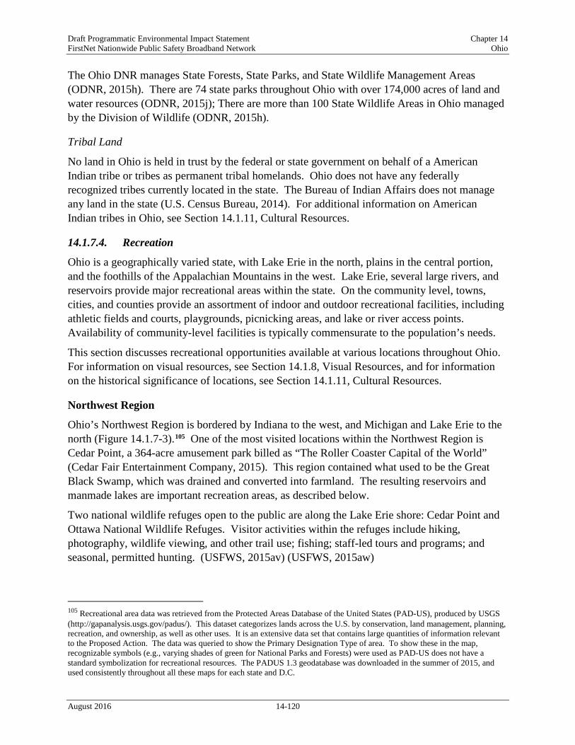
Draft Programmatic Environmental Impact Statement Chapter 14 FirstNet Nationwide Public Safety Broadband Network Ohio
The Ohio DNR manages State Forests, State Parks, and State Wildlife Management Areas (ODNR, 2015h). There are 74 state parks throughout Ohio with over 174,000 acres of land and water resources (ODNR, 2015j); There are more than 100 State Wildlife Areas in Ohio managed by the Division of Wildlife (ODNR, 2015h).
Tribal Land
No land in Ohio is held in trust by the federal or state government on behalf of a American Indian tribe or tribes as permanent tribal homelands. Ohio does not have any federally recognized tribes currently located in the state. The Bureau of Indian Affairs does not manage any land in the state (U.S. Census Bureau, 2014). For additional information on American Indian tribes in Ohio, see Section 14.1.11, Cultural Resources.
14.1.7.4. Recreation
Ohio is a geographically varied state, with Lake Erie in the north, plains in the central portion, and the foothills of the Appalachian Mountains in the west. Lake Erie, several large rivers, and reservoirs provide major recreational areas within the state. On the community level, towns, cities, and counties provide an assortment of indoor and outdoor recreational facilities, including athletic fields and courts, playgrounds, picnicking areas, and lake or river access points. Availability of community-level facilities is typically commensurate to the population’s needs.
This section discusses recreational opportunities available at various locations throughout Ohio. For information on visual resources, see Section 14.1.8, Visual Resources, and for information on the historical significance of locations, see Section 14.1.11, Cultural Resources.
Northwest Region
Ohio’s Northwest Region is bordered by Indiana to the west, and Michigan and Lake Erie to the north (Figure 14.1.7-3).105 One of the most visited locations within the Northwest Region is Cedar Point, a 364-acre amusement park billed as “The Roller Coaster Capital of the World” (Cedar Fair Entertainment Company, 2015). This region contained what used to be the Great Black Swamp, which was drained and converted into farmland. The resulting reservoirs and manmade lakes are important recreation areas, as described below.
Two national wildlife refuges open to the public are along the Lake Erie shore: Cedar Point and Ottawa National Wildlife Refuges. Visitor activities within the refuges include hiking, photography, wildlife viewing, and other trail use; fishing; staff-led tours and programs; and seasonal, permitted hunting. (USFWS, 2015av) (USFWS, 2015aw)
105 Recreational area data was retrieved from the Protected Areas Database of the United States (PAD-US), produced by USGS (http://gapanalysis.usgs.gov/padus/). This dataset categorizes lands across the U.S. by conservation, land management, planning, recreation, and ownership, as well as other uses. It is an extensive data set that contains large quantities of information relevant to the Proposed Action. The data was queried to show the Primary Designation Type of area. To show these in the map, recognizable symbols (e.g., varying shades of green for National Parks and Forests) were used as PAD-US does not have a standard symbolization for recreational resources. The PADUS 1.3 geodatabase was downloaded in the summer of 2015, and used consistently throughout all these maps for each state and D.C.
August 2016 14-120

Draft Programmatic Environmental Impact Statement Chapter 14 FirstNet Nationwide Public Safety Broadband Network Ohio
Figure 14.1.7-3: Ohio Recreation Resources
August 2016 14-121

Draft Programmatic Environmental Impact Statement Chapter 14 FirstNet Nationwide Public Safety Broadband Network Ohio
Recreational activities at reservoirs and manmade lakes, such as Grand Lake St. Marys, Indian Lake State Park, Independence Dam, and Van Buren State Park, include hiking, bicycling, cross-country skiing, snowmobiling, and other trail use; camping and picnicking; fishing, boating, water-skiing, ice-skating, and other water activities; and, licensed, seasonal hunting (Ohio State Parks, 2015a) (Ohio State Parks, 2015b) (Ohio State Parks, 2015c) (Ohio State Parks, 2015d).
Northeast Region
The Northeast Region is bordered on the north by Lake Erie and to the east by Pennsylvania (Figure 14.1.7-3). Topographically, this region contains the foothills of the Allegheny Mountains: lake beaches and forested hills are major recreational draws to this region.
The Cuyahoga Valley National Park is visited by more than 2 million patrons annually, and hosts events including the Ohio Special Olympics and a marathon (Figure 14.1.7-3). Recreational activities within the park include hiking, bicycling, horseback riding, and other trail use; camping, birdwatching, stargazing, golfing, and picnicking; and fishing, canoeing, kayaking, and other water activities. (NPS, 2015c)
Cleveland Metroparks is a conglomerate of 18 parks in the Cleveland area with 17 million recreational visits during 2014. Activities within the varied parks include hiking, bicycling, horseback riding, snowshoeing, and other trail use; golfing, zip-lining106, geocaching, and picnicking; and swimming, fishing, ice-fishing, boating, rowing, and other water activities. (Cleveland Metroparks, 2015)
Central Region
The Central Region consists mainly of the Columbus metropolitan area (Figure 14.1.7-3). Columbus is home to many museums, including COSI (Center of Science and Industry), the Early Television Museum, the Jack Nicklaus Museum, and the Motorcycle Hall of Fame Museum. Other popular attractions include outdoor activities including zip-lining and water recreation on the Scioto River. (Greater Columbus Convention and Visitors Bureau, 2015)
State parks in the Central Region are focused on recreational activities at reservoirs and lakes. Buckeye Lake, Delaware, Mt. Gilead, and Mosquito Lake State Parks have hiking, horseback riding, bicycling, and other trail use; camping, and picnicking; and swimming, fishing, boating, rowing, and other water activities; cross-country skiing, sledding, ice skating, ice fishing, and other winter activities; and licensed, seasonal hunting (Ohio State Parks, 2015e) (Ohio State Parks, 2015f) (Ohio State Parks, 2015g) (Ohio State Parks, 2015h).
Southwest Region
Ohio’s Southwest Region is bordered by Indiana to the west and the Ohio River and Kentucky to the south (Figure 14.1.7-3). The Dayton Aviation Heritage National Park, with over 57,000 visitors per year, contains locations associated with the aviation pioneers the Wright brothers and novelist Paul Laurence Dunbar; the park contains interpretive centers and guided tours of
106 Zip-lining: “[To use] a cable suspended above an incline to which a pulley and harness are attached for a rider.” (Merriam-Webster, 2016)
August 2016 14-122

Draft Programmatic Environmental Impact Statement Chapter 14 FirstNet Nationwide Public Safety Broadband Network Ohio
restored buildings (NPS, 2015d). The Hopewell Culture National Historical Park contains earthen mounds forming geometric structures built nearly 2,000 years ago by American Indian; the park has hiking, birdwatching, picnicking, and ranger-guided walks and canoe tours (NPS, 2015e).
Southeast Region
The Southeast Region is bordered the Ohio River to the east and south; Kentucky provides the southern border while West Virginia provides the eastern border (Figure 14.1.7-3). The region consists of the Appalachian foothills, a more rugged terrain than the rest of the state.
The Wayne National Forest is comprised of several areas within the Appalachian foothills (Figure 14.1.7-3). Areas of interest within the forest include lookout towers, a natural bridge, and areas with local significance, such as the Payne Cemetery (USDA, 2015c).
14.1.7.5. Airspace
The FAA uses the NAS to provide for aviation safety. The NAS includes Special Use Airspace (SUA) consisting of Restricted Areas, Warning Areas, and Military Operation Areas (MOAs). The FAA controls the use of the NAS with various procedures and practices (such as established flight rules and regulations, airspace management actions, and air traffic control procedures) to ensure the safety of aircraft and protection of the public.
Airspace Categories
There are two categories of airspace or airspace areas: 1) Regulatory airspace consists of controlled airspace (Class A, B, C, D, and E airspace
areas in descending order of restrictive operating rules), and restricted and prohibited areas.
2) Non-regulatory airspace consists of MOAs, warning areas, alert areas, and controlled firing areas.
Within each of these two categories, there are four types of airspace: controlled, uncontrolled, special use, and other airspace. The categories and types of airspace are dictated by the complexity or density of aircraft movements, the nature of the operations conducted within the airspace, the level of safety required, and the national and public interest. Figure 14.1.7-4 depicts the different classifications and dimensions for controlled airspace. Air Traffic Control (ATC)107 service is based on the airspace classification (FAA, 2008).
107 ATC – Approved authority service to provide safe, orderly, and expeditious flow of air traffic operations. (FAA, 2015e)
August 2016 14-123

Draft Programmatic Environmental Impact Statement Chapter 14 FirstNet Nationwide Public Safety Broadband Network Ohio
Figure 14.1.7-4: National Airspace Classification Profile Source: Derived from (FAA, 2008)
Controlled Airspace • Class A: Airspace from 18,000 feet to 60,000 feet Mean Sea Level (MSL).108 Includes the
airspace over waters off the U.S. coastlines (48 contiguous States and Alaska) within 12 Nautical Miles (NM). All operations must be conducted under Instrument Flight Rules (IFR).109
• Class B: Airspace from the surface up to 10,000 feet MSL near the busiest airports with heavy traffic operations. The airspace is tailored to the specific airport in several layers. An ATC clearance is required for all aircraft to operate in this area.
• Class C: Airspace from the surface to 4,000 feet above the airport elevation surrounding the airport. Applies to airports with an operational control tower, serviced by a radar approach control, and certain number of IFR operations or total number of passengers boarding aircrafts. Airspace is tailored in layers, but usually extends out to 10 NM from 1,200 feet to 4,000 feet above the airport elevation. Entering Class C airspace requires radio contact with the controlling ATC authority, and an ATC clearance is ultimately required for landing.
• Class D: Airspace from the surface to 2,500 feet above the airport elevation surrounding airports with an operational control tower. Airspace area is tailored. Aircraft entering the airspace must establish and maintain radio contact with the controlling ATC.
• Class E: Controlled airspace not designated as Class A, B, C, or D. Class E airspace extends upward from the surface or a designated altitude to the overlying or adjacent controlled airspace (FAA, 2008).
108 MSL – The average level of for the surface of the ocean; “The height of the surface of the sea midway between the average high and low tides.” (Merriam Webster Dictionary, 2015b). 109 IFR – Rules for the conduct of flights under instrument meteorological conditions (FAA, 2015e).
August 2016 14-124

Draft Programmatic Environmental Impact Statement Chapter 14 FirstNet Nationwide Public Safety Broadband Network Ohio
Uncontrolled Airspace • Class G: No specific definition. Refers generally to airspace not designated as Class A, B,
C, D, or E. Class G airspace is from the surface to the base of Class E airspace.
Special Use Airspace
SUA designates specific airspace that confines or imposes limitations on aircraft activities.
Table 14.1.7-2: SUA Designations SUA Type Definition
Prohibited Areas “Airspace of defined dimensions identified by an area on the surface of the earth within which the flight of aircraft is prohibited. Such areas are established for security or other reasons associated with the national welfare. These areas are published in the Federal Register and are depicted on aeronautical charts.”
Restricted Areas “Airspace identified by an area on the surface of the earth within which the flight of aircraft, while not wholly prohibited, is subject to restrictions. Activities within these areas must be confined because of their nature or limitations imposed upon aircraft operations that are not a part of those activities or both. Restricted areas denote the existence of unusual, often invisible, hazards to aircraft such as artillery firing, aerial gunnery, or guided missiles. Penetration of restricted areas without authorization from the using or controlling agency may be extremely hazardous to the aircraft and its occupants. Restricted areas are published in the Federal Register and constitute 14 CFR Part 73.”
Warning Areas “Airspace of defined dimensions, extending from three NM from the U.S. coast, which contains activity that may be hazardous to nonparticipating aircraft. The purpose of such warning areas is to warn non-participating pilots of the potential danger. A warning area may be located over domestic or international waters or both.”
MOAs “Airspace of defined vertical and lateral limits established for separating certain military activities (e.g., air combat maneuvers, air intercepts, testing, etc.) from IFR traffic. Whenever an MOA is in use, non-participating IFR traffic may be cleared through a MOA if IFR separation can be provided by ATC. Otherwise, ATC will reroute or restrict nonparticipating IFR traffic.”
Alert Areas “Depicted on aeronautical charts to inform non-participating pilots of areas that may contain a high volume of pilot training or an unusual type of aerial activity. Pilots should be particularly alert when flying in these areas. All activity within an alert area must be conducted in accordance with CFRs, without waiver, and pilots of participating aircraft and pilots transiting the area are responsible for collision avoidance.”
Controlled Firing Areas (CFAs)
“Activities that, if not conducted in a controlled environment, could be hazardous to nonparticipating aircraft. The distinguishing feature of the CFA, as compared to other special use airspace, is that its activities are suspended immediately when spotter aircraft, radar, or ground lookout positions indicate an aircraft might be approaching the area. There is no need to chart CFAs since they do not cause a nonparticipating aircraft to change its flight path.”
National Security Areas (NSA)
“Airspace of defined vertical and lateral dimensions established at locations where there is a requirement for increased security and safety of ground facilities. Pilots are requested to voluntarily avoid flying through the depicted NSA. When it is necessary to provide a greater level of security and safety, flight in NSAs may be temporarily prohibited by regulation under the provisions of 14 CFR Section 99.7. Regulatory prohibitions are issued by System Operations, System Operations Airspace and Aeronautical Information Manual (AIM) Office, Airspace and Rules, and disseminated via Notices to Airmen (NOTAM). Inquiries about NSAs should be directed to Airspace and Rules.”
Sources: (FAA, 2015e) (FAA, 2008)
August 2016 14-125

Draft Programmatic Environmental Impact Statement Chapter 14 FirstNet Nationwide Public Safety Broadband Network Ohio
Other Airspace Areas Other airspace areas, explained in Table 14.1.7-3, include Airport Advisory, Military Training Routes (MTRs), Temporary Flight Restrictions (TFRs), Parachute Jump Aircraft Operations, Published Visual Flight Rules (VFR) and IFRs, and Terminal Radar Service Areas.
Table 14.1.7-3: Other Airspace Designations Type Definition
Airport Advisory There are three types: • Local Airport Advisory – Operated within 10 statute miles of an airport where
there is a Flight Service Station (FSS) located on an airport, but no operational control tower. The FSS advises the arriving and departing aircraft on particular conditions.
• Remote Airport Advisory – Operated within 10 statute miles for specific high activity airports with no operational control tower.
• Remote Airport Information Service – Used for short-term special events. MTRs MTRs are for use by the military for training, specifically low level combat tactics
where low altitudes and high speed are needed. TFRs TFRs are established to:
• Protect people and property from a hazard; • Provide safety for disaster relief aircraft during operations; • Avoid unsafe aircraft congestion associated with an incident or public interest
event; • Protect the U.S. President, Vice President, and other public figures; • Provide safety for space operations; and • Protect in the state of Hawaii declared national disasters for humanitarian reasons. Only those TFRs annotated with an ending date and time of “permanent” are included in this Draft PEIS, since it indicates a longer, standing condition of the airspace. Other TFRs are typically a shorter duration of for a one-time specific event.
Parachute Jump Aircraft Operations
Parachute jump area procedures are in 14 CFR Part 105, while the U.S. parachute jump areas are contained in the regional Airport/Facility Directory.
Published VFRs and IRs These are established routes for moving around and through complex airspace, like Class B airspace. VFRs are procedures used to conduct flights under visual conditions. IFRs are procedures used to conduct flights with instruments and meteorological conditions.
Terminal Radar Service Areas
Airspace areas that are not one of the established U.S. airspace classes. These areas provide additional radar services to pilots.
Sources: (FAA, 2015e) (FAA, 2008)
Aerial System Considerations
Unmanned Aerial Systems
Unmanned Aerial Systems (UASs) are widely used by the military, private entities, public service, educational institutions, federal/state/local governments, and other agencies. The FAA’s Unmanned Aircraft Systems Integration Office integrates UAS into the NAS. The Integration of Civil Unmanned Aircraft Systems (UAS) in the National Airspace System (NAS) Roadmap of 2013 addresses the actions and considerations needed to integrate UAS into the NAS “without reducing existing capacity, decreasing safety, negatively impacting current operators, or
August 2016 14-126

Draft Programmatic Environmental Impact Statement Chapter 14 FirstNet Nationwide Public Safety Broadband Network Ohio
increasing the risk to airspace users or persons and property on the ground any more than the integration of comparable new and novel technologies” (FAA, 2013).
UAS at airports is a complex operational challenge with the need to separate UAS flight operations from mainstream air traffic. Separation can be achieved with specific UAS launch windows, special airports, or off-airport locations that allow the UAS to easily launch and recover. Special aviation procedures are applied to UAS flights. There must be the capability of Sense and Avoid (SAA) and Control and Communication (C2) during UAS operations. An Unmanned Aircraft (UA) must be able to see (or sense) other aircraft in the area and avoid the aircraft through corrected flight path changes. General equipment and operational requirements can include aircraft anti-collision lights, an altitude encoding transponder, cameras, sensors, and collision avoidance maneuvers. The C2 of the UA occurs with the pilot/operator, the UAS control station, and ATC. Research efforts, a component of the FAA’s UAS roadmap, continue to mature the technology for both SAA and C2 capabilities.
Balloons
Moored balloons and unmanned free balloons cannot be operated in a prohibited or restricted area unless approval is obtained from the controlling agency. Balloons also cannot be operated if they pose a hazard to people and their property.
Obstructions to Airspace Considerations
The Airports Division of the FAA is responsible for the evaluation and analysis of proposed construction or alterations on airports. The FAA Air Traffic Office is responsible for determining obstructions to air navigation as a result of construction off airports that may affect the safe and efficient use of navigable airspace and the operation of planned or existing air navigation and communication facilities. Such facilities include air navigation aids, communication equipment, airports, federal airways, instrument approach or departure procedures, and approved off-airway routes. An Obstruction Evaluation and Airport Airspace Analysis (OE/AAA) is required when there is the potential for airport construction/alteration of a facility that may impinge upon the NAS. Per 14 CFR Part 77.9, the FAA is to be notified about construction or alterations when: • “Any construction or alteration exceeding 200 ft. above ground level • Any construction or alteration:
o within 20,000 ft. of a public use or military airport which exceeds a 100:1 surface from any point on the runway of each airport with its longest runway more than 3,200 ft.
o within 10,000 ft. of a public use or military airport which exceeds a 50:1 surface from any point on the runway of each airport with its longest runway no more than 3,200 ft.
o within 5,000 ft. of a public use heliport which exceeds a 25:1 surface • Any highway, railroad, or other traverse way whose prescribed adjusted height would exceed
the above noted standards • When requested by the FAA • Any construction or alteration located on a public use airport or heliport regardless of height
or location.” (FAA, 2015f).
August 2016 14-127

Draft Programmatic Environmental Impact Statement Chapter 14 FirstNet Nationwide Public Safety Broadband Network Ohio
Construction or alternative facilities (such as towers) that are subject to FCC licensing requirements are also required to have an OE/AAA performed by the FAA Airport Division.
Ohio Airspace
The Ohio Office of Aviation is a division of the Ohio Department of Transportation (ODOT) and is comprised of three sections that include flight operations, aviation maintenance, and aviation programs. Airspace protection is a function of the aviation programs section (OAC, 2015d). There are three FAA FSDOs for Ohio in Cincinnati, Columbus, and Cleveland (FAA, 2015d).
Ohio airports are classified as those included in the State Aviation System Plan (SASP) and those that are not part of the SASP. The SASP addresses the strategic planning and future development for the state’s airport system, as well as addressing key associated with their airports. (National Association of State Aviation Officials (NASAO), 2015) Figure 14.1.7-5 presents the different aviation airports/facilities residing in Ohio, while Figure 14.1.7-6 and Figure 14.1.7-7 present the breakout by public and private airports/facilities. There are approximately 683 airports within Ohio as presented in Table 14.1.7-4 and Figure 14.1.7-5 through Figure 14.1.7-7 (USDOT, 2015a).
Table 14.1.7-4: Type and Number of Ohio Airports/Facilities Type of Airport or Facility Public Private
Airport 157 295 Heliport 8 217 Seaplane 2 1 Ultralight 0 0 Balloonport 0 1 Gliderport 0 2 Total 167 516
Source: (USDOT, 2015a)
August 2016 14-128

Draft Programmatic Environmental Impact Statement Chapter 14 FirstNet Nationwide Public Safety Broadband Network Ohio
Figure 14.1.7-5: Composite of Ohio Airports/Facilities
August 2016 14-129

Draft Programmatic Environmental Impact Statement Chapter 14 FirstNet Nationwide Public Safety Broadband Network Ohio
Figure 14.1.7-6: Public Ohio Airports/Facilities
August 2016 14-130

Draft Programmatic Environmental Impact Statement Chapter 14 FirstNet Nationwide Public Safety Broadband Network Ohio
Figure 14.1.7-7: Private Ohio Airports/Facilities
August 2016 14-131

Draft Programmatic Environmental Impact Statement Chapter 14 FirstNet Nationwide Public Safety Broadband Network Ohio
There are Class B, Class C, and Class D controlled airports in Ohio as follows: • Two Class B –
o Cleveland-Hopkins International o Cincinnati/Northern Kentucky International, Covington, KY (Class B airspace extends
into Ohio) • Four Class C –
o Akron-Canton Regional o Port Columbus International, Columbus o James M. Cox-Dayton International o Toledo Express
• Twelve Class D – o Akron-Canton Regional, Akron o Cincinnati Municipal Airport Lunken Field, Cincinnati o Burke Lakefront, Cleveland o Cuyahoga County, Cleveland o Bolton Field, Columbus o Ohio State University, Columbus o Rickenbacker International, Columbus o Wright-Patterson Air Force Base, Dayton o Mansfield Lahm Municipal, Mansfield o Springfield-Beckley Municipal, Springfield o Airborne Airpark, Wilmington o Youngstown-Warren Regional (FAA, 2015g)
SUAs (i.e., two restricted areas and two MOAs) in Ohio are as follows: • Lacarne (Restricted)
o R-5502A – Surface to 5,000 feet MSL o R-5502B – Surface to 23,000 feet MSL (FAA, 2012a)
The two MOAs for Ohio are as follows: • Brush Creek –
o 100 feet AGL up to, but not including 5,000 feet MSL • Buckeye –
o 5,000 feet MSL up to, but not including, FL 180 (FAA, 2015h)
The SUAs for Ohio are presented in Figure 14.1.7-8. There are no TFRs (FAA, 2015i). There is a National Security Area (NSA 0013)110 around Portsmouth with an altitude restriction of surface to 2,500 feet MSL (FAA, 2015h). The restrictions associated with this NSA, when active, may impact the airspace in the area. MTRs in Ohio, presented in Figure 14.1.7-9, consist of 7 Visual Routes, 4 Instrument Routes, and 14 Slow Routes.
110 National Security Area (NSA) consists of defined vertical and lateral dimensions in the airspace where there is increased security of ground facilities. Pilots are expected to voluntarily avoid flying through the NSA. Additional security levels may result in further restrictions of the NSA, which FAA Headquarters would issue and disseminate with a NOTAM. (FAA, 2016)
August 2016 14-132

Draft Programmatic Environmental Impact Statement Chapter 14 FirstNet Nationwide Public Safety Broadband Network Ohio
UAS Considerations
The National Park Service (NPS) signed a policy memorandum on June 20, 2014 that “directs superintendents nationwide to prohibit launching, landing, or operating unmanned aircraft on lands or waters administered by the National Park Service” (NPS, 2014b). There are 13 NPS units in Ohio that must comply with this agency directive (NPS, 2015k).
Obstructions to Airspace Considerations
Several references in the Ohio Revised Code address airspace hazards. As defined in OAC Title 45, Chapter 4561.01 (F), an airport hazard “means any structure, object of natural growth, or use of land, that obstructs the airspace required for the flight of aircraft in landing or taking off at any airport or landing field, or that otherwise is hazardous to such landing or taking off.” (OAC, 2015c). Paragraph 4561.31 of the Ohio Revised Code provides the authority to regulate structures affecting airspace within the state (OAC, 2015e).
August 2016 14-133

Draft Programmatic Environmental Impact Statement Chapter 14 FirstNet Nationwide Public Safety Broadband Network Ohio
Figure 14.1.7-8: SUAs in Ohio
August 2016 14-134

Draft Programmatic Environmental Impact Statement Chapter 14 FirstNet Nationwide Public Safety Broadband Network Ohio
Figure 14.1.7-9: MTRs in Ohio
August 2016 14-135

Draft Programmatic Environmental Impact Statement Chapter 14 FirstNet Nationwide Public Safety Broadband Network Ohio
Visual Resources
14.1.8.1. Definition of the Resource
Visual resources influence the human experience of a landscape. Various aspects combine to create visual resources, such as color, contrast, texture, line, and form. Features such as mountain ranges, city skylines, ocean views, unique geological formations, rivers, and constructed landmarks such as bridges, memorials, cultural resources, or statues are considered visual resources. For some, cityscapes are valued visual resources; for others, views of natural areas are valued visual resources. While many aspects of visual resources are subjective, evaluating potential impacts on the character and continuity of the landscape is a consideration when evaluating Proposed Actions for NEPA and National Historic Preservation Act (NHPA) compliance. The federal government does not have a single definition of what constitutes a visual resource; therefore, this PEIS will use the general definition of visual resources used by the Bureau of Land Management, “the visible physical features on a landscape (e.g., land, water, vegetation, animals, structures, and other features)” (BLM, 1984).
14.1.8.2. Specific Regulatory Considerations
Table 14.1.8-1 presents state and local laws and regulations that relate to visual resources for Ohio.
Table 14.1.8-1: Relevant Ohio Visual Resources Laws and Regulations
State Law/Regulation Regulatory Agency Applicability Ohio Revised Code (ORC), Section 149.30
Ohio History Connection
Establishes the Ohio history connection (a non-profit corporation) to promote a knowledge of history and archaeology by performing public functions such as serving as the State Historic Preservation Office.
ORC, Section 149.301 Ohio Historic Site Preservation Advisory Board
Establishes the membership of the Ohio historic site preservation advisory board and its responsibilities to assist the Ohio history connection with its preservation program, legislation, and national register of historic place designation.
ORC, Section 1503.011 Division of Forestry Ensures the conservation and development of forests within Ohio, for purposes such as “recreation, aesthetics, wildlife habitat development, and urban enhancement and for all benefits that forests provide.”
ORC, Section 1506 ODNR Establishes the Coastal Management Program to “preserve, protect, develop, restore, or enhance the resources of the coastal area and to ensure wise use of the land and water resources of the coastal area, giving attention to natural, cultural, historic, and aesthetic values.”
ORC, Section 1517.05 ODNR Establishes a set of nature preserves to “promote understanding and appreciation of the aesthetic, cultural, scientific, and spiritual values of such areas by the people of the state.”
ORC, Section 1547.81 Division of Watercraft Creates wild, scenic, or recreational rivers that possess “water conservation, scenic, fish, wildlife, historic, or outdoor recreation values that should be preserved.”
August 2016 14-136

Draft Programmatic Environmental Impact Statement Chapter 14 FirstNet Nationwide Public Safety Broadband Network Ohio
In addition to the state laws and regulations, local zoning laws may apply related to visual resources. Viewsheds and scenic vistas are increasingly important to the state’s towns, cities, and villages as they look at the future planning of their municipalities.
14.1.8.3. Character and Visual Quality of the Existing Landscape Ohio has a wide range of visual resources. There are sand dunes across Lake Erie’s shoreline, rolling hills and valleys in the Allegheny Plateau, and thousands of miles of rivers (NPS, 2007f). The northern portion of the state borders Lake Erie, while the Ohio River forms all of its southern border and much of its eastern border (see Figure 14.1.4 1). Ohio also has islands in Lake Erie, including the Bass Islands, which are small and mostly limestone, and Kelleys Island, which is the largest American island in Lake Erie (ODNR, 2016c). The vast majority of the state is characterized as forested, agricultural, or undeveloped (Figure 14.1.7-1 in Section 14.1.7, Land Use, Recreation, and Airspace).
According to the USDA’s Economic Research Center, croplands are the most prevalent visual resource within Ohio, comprising 47 percent of the total land cover. Forested areas are second, accounting for 31 percent of total land cover (Figure 14.1.7-1) (USDA, 2015b). Croplands consist of either row crops, closely sown crops or fallow land awaiting planting. Crops may include hay, silage, fruit trees, berries, tree nuts, vegetables, or melons (USDA, 2014b). Visual resources within forested areas are generally comprised of continuous, natural looking cover with gradual transitions of line and color. They are typically characterized by the lack of disturbance or disruption of the landscape. One aspect of importance for visual resources is to maintain the character of the area. For example, in a farm community, keeping the character of the town consistent with farm-style houses, barns, and silos could be important to maintaining the character of the community. In a more metropolitan area, there may be many different visual styles within each neighborhood, but keeping the character of the neighborhood might be important if new development were to occur.
While the state and many municipalities have some regulation of scenic and visual resources, not all scenic areas within the state have been identified or have policy or regulations for management or protection by the state. The areas listed below have some measure of management, significance, or protection through state or federal policy, as well as being identified as a visually significant area.
14.1.8.4. Visually Important Historic Properties and Cultural Resources Visual and aesthetic qualities of historic properties can contribute to the overall importance of a particular site. Such qualities relate to the integrity of the appearance and setting of these properties or resources. Viewsheds (the natural and manmade environment visible from one or more viewing points) can also contribute to the significance of historic properties or cultural resources (NASA, 2013). Viewsheds containing historic properties and cultural resources may be considered important because of their presence in the landscape. Figure 14.1.8-1 shows areas that are included in the National Register of Historic Places (NRHP) that may be considered visually sensitive. In Ohio, there are 3,924 NRHP listed sites, which include 72 National Historic Landmarks, 4 National Historic Sites, 2 National Historical Parks, 1 National
August 2016 14-137

Draft Programmatic Environmental Impact Statement Chapter 14 FirstNet Nationwide Public Safety Broadband Network Ohio
Monument, and 2 National Memorials (NPS, 2015j). Some State Historic Sites, State Heritage Areas, and State Historic Districts may also be included in the NRHP, whereas others are not designated at this time.
The Secretary of the Interior’s Standards for the Treatment of Historic Properties addresses four aspects: preservation, rehabilitation, restoration, and reconstruction, whereas The Guidelines for the Treatment of Cultural Landscapes, both authored by the NPS, provides guidance for applying protections to all aspects of the historic and cultural landscape, such as forests, gardens, trails, structures, ponds, and farming areas, to meet the Standards (NPS, 1995). The Standards ”require retention of the greatest amount of historic fabric, including the landscape’s historic form, features, and details as they have evolved over time,” which directly protects historic properties and the visual resources therein (NPS, 1995).
National Heritage Areas
National Heritage Areas (NHAs) are “places where natural, cultural, and historic resources combine to form a cohesive, nationally important landscape” (NPS, 2011). These areas help tell the history of the United States. Based on this criteria, NHAs in Ohio may contain scenic or aesthetic areas considered visual resources or visually sensitive. There are two NHAs in Ohio: National Aviation Heritage Area and Ohio and Erie National Heritage Corridor (Figure 14.1.8-1). The National Aviation Heritage Area is centered in Dayton, Ohio, the “Birthplace of Aviation,” and home of the Wright brothers (NPS, 2016a). The Ohio and Erie National Heritage Corridor highlights the canal linking Lake Erie and the Ohio River, including the commercial, agricultural, and industrial history of the area (NPS, 2016b).
National Historic Landmarks
National Historic Landmarks (NHLs) are defined as “nationally significant historic places designated by the U.S. Secretary of the Interior because they possess exceptional value or quality in illustrating or interpreting the heritage of the United States” (NPS, 2015k). Generally, NHLs may include “historic buildings, sites, structures, objects, and districts” (NPS, 2016c). Other types of historic properties include battlefields and canals. The importance of NHL-designated properties can be attributed to scenic or aesthetic qualities, among other attributes, that may be considered visual resources or visually sensitive at these sites. In Ohio, there are 72 NHLs, including sites such as Thomas A. Edison’s birthplace, James A. Garfield’s home, William McKinley’s tomb, and Oberlin College (Figure 14.1.8-1) (NPS, 2015f). By comparison, there are over 2,500 NHLs in the United States, with less than 3 percent of these in Ohio (NPS 2015b). Figure 14.1.8-1 provides a representative sample of some historic and cultural resources that may be visually sensitive.
August 2016 14-138

Draft Programmatic Environmental Impact Statement Chapter 14 FirstNet Nationwide Public Safety Broadband Network Ohio
Figure 14.1.8-1: Representative Sample of Some Cultural and Heritage Resources that May be Visually Sensitive
August 2016 14-139

Draft Programmatic Environmental Impact Statement Chapter 14 FirstNet Nationwide Public Safety Broadband Network Ohio
National Historic Sites and Historical Parks
Ohio has six National Historic Sites and Historical Parks, which are preserved by the NPS to “commemorate persons, events, and activities important in the nation’s history” (NPS, 2003). Parks are generally larger in size and complexity than sites (NPS, 2003). Three national historic sites (NHS) in Ohio, First Ladies NHS, James A. Garfield NHS, and William Howard Taft NHS, honor the birthplaces of U.S. presidents and their wives. Fallen Timbers Battlefield and Fort Miamis NHS marks the American quest for western expansion, the taking of American Indian lands, and the loss of British colonial territory. Dayton Aviation Heritage National Historical Park preserves the aviation history and legacies of the Wright Brothers and Paul Laurence Dunbar. Hopewell Culture National Historical Park marks the earthen mounds built by Hopewell Indians 2,000 years ago used for feasts, funerals, and rites of passage (NPS, 2015k). These sites may contain aesthetic and scenic values associated with history and are identified on the map in Figure 14.1.8-1.
National Monuments and Memorials
Ohio has one National Monument, which are “intended to preserve at least one nationally significant resource” (NPS, 2003). A national monument is usually smaller than a national park and lacks its diversity of attractions (NPS, 2003). Charles Young Buffalo Soldiers National Monument conserves and highlights the history and legacies of Colonel Charles Young and the first African Americans in the U.S. Army known as the “Buffalo Soldiers” (NPS, 2015k).
Ohio has two National Memorials, which are “most often used for areas that are primarily commemorative” (NPS, 2003). The David Berger Memorial honors the memory of David Berger, “an American citizen who was one of 11 Israeli athletes killed at the 1972 Olympic Games in Munich, Germany” (NPS, 2015k). Perry’s Victory and International Peace Memorial is a 352-foot Doric column “established to honor those who fought in the Battle of Lake Erie, during the War of 1812, and to celebrate the long-lasting peace among Britain, Canada and the U.S.” (NPS, 2015k). These sites may contain aesthetic and scenic values associated with history and are identified on the map in Figure 14.1.8-1.
State Historic Sites, Resources, and Parks
The Ohio History Connection, a nonprofit organization chartered in 1885, partners with the state of Ohio to provide history services, such as serving as the State Archives and State Historic Preservation Office. The Ohio History Connection manages 50 historic sites and museums throughout Ohio, including memorial parks, nature preserves, and historic homes (Ohio History Connection, 2016).
State Heritage Areas
Heritage Ohio is Ohio’s official historic preservation organization. “Heritage Ohio fosters economic development and sustainability through preservation of historic buildings, revitalization of downtowns and neighborhood commercial districts, and promotion of cultural tourism” (Heritage Ohio, 2015). Heritage Ohio also administers the Ohio Main Street Program, which helps communities revitalize their area for historic, cultural, or commercial purposes.
August 2016 14-140

Draft Programmatic Environmental Impact Statement Chapter 14 FirstNet Nationwide Public Safety Broadband Network Ohio
Designated Regional Heritage Areas are maintained by various non-profit preservation organizations across Ohio and can be found in Table 14.1.8-2. 111
Table 14.1.8-2: Ohio Designated Regional Heritage Areas
State Heritage Area Name Ohio and Erie Canal Corridor Ohio Lake Erie Heritage Area Ohio’s Hill Country Heritage Area Maumee Valley Heritage Area Ohio’s Historic West Miami and Erie Canal Heritage Area Ohio National Road Association
Source: (Rickey et al, 2008)
14.1.8.5. Parks and Recreation Areas
Parks and recreation areas often contain scenic resources and tend to be visited partly because of their associated visual or aesthetic qualities. Figure 14.1.7-3 in Section 14.1.7, Land Use, Recreation, and Airspace, identifies parks and recreational resources in Ohio.
National Park Service
National Parks are managed by the NPS and contain natural, historic, cultural, visual, ecological, and recreational resources of significance to the nation and are maintained for the public’s use. In Ohio, there are 13112 officially designated NPS units, such as National Heritage Areas. There is one National Park, two National Memorials, one National Monument, four National Historic Sites, two National Historical Parks, two National Heritage Areas, and one National Scenic Trail, (NPS, 2015k). Figure 14.1.8-2 and Table 14.1.8-3 identify the NPS units in Ohio.
Cuyahoga Valley National Park (Figure 14.1.8-3) contains native plants and wildlife, the winding Cuyahoga River, deep forests, rolling hills, and open farmlands. The Towpath Trail within the park follows the historic route of the Ohio and Erie Canal. Cuyahoga Valley National Park was established in 1974 as the Cuyahoga Valley National Recreation Area and was designated as a national park in 2000 (NPS, 1974) (Ohio History Connection, 2015a).
111 The natural areas data were retrieved from the Protected Areas Database of the United States (PAD-US), produced by USGS (http://gapanalysis.usgs.gov/padus/). This dataset categorizes lands across the U.S. by conservation, land management, planning, recreation, and ownership, as well as other uses. It is an extensive data set that contains large quantities of information relevant to the Proposed Action. The data was queried and further combined by the Primary Designation Type into classifications that fit the multiple types of land applicable for Natural Areas. For this map, recognizable symbols (e.g., varying shades of green for National Parks and Forests) were used as PAD-US does not have a standard symbolization for natural areas. The PADUS 1.3 geodatabase was downloaded in the summer of 2015, and used consistently throughout all these maps for each state and D.C. 112 This count is based on the NPS website “by the numbers” current as of 9/30/2014 (NPS, 2015k). Actual lists of parks and NPS affiliated areas may vary here depending on when areas are designated by Congress.
August 2016 14-141

Draft Programmatic Environmental Impact Statement Chapter 14 FirstNet Nationwide Public Safety Broadband Network Ohio
Figure 14.1.8-2: Natural Areas that May be Visually Sensitive
August 2016 14-142

Draft Programmatic Environmental Impact Statement Chapter 14 FirstNet Nationwide Public Safety Broadband Network Ohio
Figure 14.1.8-3: Brandywine Falls at Cuyahoga Valley National Park Source: (NPS, 2015g)
Table 14.1.8-3: Ohio National Parks and Affiliated Areas
Area Name Charles Young Buffalo Soldiers National Monument James A. Garfield National Historic Site Cuyahoga Valley National Park National Aviation Heritage Area David Berger National Memorial North Country National Scenic Trail Dayton Aviation Heritage National Historical Park Ohio and Erie National Heritage Corridor Fallen Timbers Battlefield and Fort Miamis National Historic Site Perry’s Victory and International Peace Memorial
First Ladies National Historic Site William Howard Taft National Historic Site Hopewell Culture National Historical Park
Source: (NPS, 2015k) (NPS, 2016a)
National Forests
The USDA Forest Service manages one National Forest in Ohio, the Wayne National Forest. This forest covers over a quarter million acres of Appalachian foothills, with lakes, rivers, 300 miles of trails, and lands rich in natural scenery, history, and culture (USDA, 2015c).
August 2016 14-143

Draft Programmatic Environmental Impact Statement Chapter 14 FirstNet Nationwide Public Safety Broadband Network Ohio
U.S. Army Corps of Engineers Recreation Areas
There are 38 U.S. Army Corps of Engineers (USACE) recreation areas within Ohio, including lakes, reservoirs, and dams (see Figure 14.1.8-2) (USACE, 2015b). These lakes are specifically managed by the USACE for scenic and aesthetic qualities in their planning guidance in addition to managing risks for floods (USACE, 1997).
State Parks
State parks contain natural, historic, cultural, and/or recreational resources of significance to Ohio residents and visitors. The Ohio Department of Natural Resources (ODNR) Division of Ohio State Parks manages 74 state parks throughout Ohio (Figure 14.1.8-2), with over 174,000 acres of land and water resources (ODNR, 2015j). Table 14.1.8-4 contains a sampling of state parks and their associated visual attributes. Shawnee State Park is in the 63,000-acre Shawnee State Forest, near the Appalachian foothills and Ohio River. The state park contains valleys, wooded hills, and wildflowers, earning it the nickname “The Little Smokies” (Figure 14.1.8-4) (ODNR, 2015q). For a complete list of state parks, visit the ODNR Division of Ohio State Parks website (ODNR, 2015j).
Table 14.1.8-4: Examples of Ohio State Parks and Associated Visual Attributes
State Park Visual Attributes Hocking Hills Towering cliffs, waterfalls, hemlock-lined gorges Hueston Woods Acton Lake vistas, 200-acre virgin forest, fossils
John Bryan Little Miami River Valley views, limestone gorge, Clifton Gorge State Nature Preserve, cliffs, boulders, wildflowers
Maumee Bay Lake Erie views, scenic meadows, wet woods, marshes, wildlife
Mohican Mohican State Forest and Clearfork Gorge views, hemlock forest, scenic Mohican River, wilderness
Source: (ODNR, 2015j)
Figure 14.1.8-4: Shawnee State Park Source: (ODNR, 2015q)
August 2016 14-144

Draft Programmatic Environmental Impact Statement Chapter 14 FirstNet Nationwide Public Safety Broadband Network Ohio
State Forests and Nature Preserves
The ODNR Division of Forestry manages 21 state forests covering more than 200,000 acres (Figure 14.1.8-2). “These forests are managed for multiple uses including sustainable timber production, wildlife habitat, soil and water protection, and recreation” (ODNR, 2015o). Table 14.1.8-5 identifies the state forests in Ohio and their relative size.
There are 136 state nature preserves and natural areas in Ohio that protect rare species and landscapes (ODNR, 2016b). The majority of these preserves are managed by the ODNR Division of Natural Areas and Preserves, but other preserves are managed by local park districts, non-governmental agencies, and private landowners.
Table 14.1.8-5: Ohio State Forests Forest Name Size
Beaver Creek 1,122 acres Blue Rock 4,578 acres Brush Creek 13,502 acres Dean 2,745 acres Fernwood 3,032 acres Gifford 320 acres Harrison 1,345 acres Hocking 9,696-acres Maumee 3,194 acres Mohican-Memorial 4,525 acres Perry 4,567 acres Pike 12,084 acres Richland Furnace 2,524 acres Scioto Trail 9,600 acres Shade River 2,859 acres Shawnee 63,747 acres Sunfish Creek 637 acres Tar Hollow 16,354 acres Vinton Furnace 12,089 acres Yellow Creek 756 acres Zaleski 26,827 acres
Source: (ODNR, 2015o)
State and Federal Trails
There are no state-designated trails such as heritage trails in Ohio. However, the Buckeye Trail is a 1,444-mile loop that circles around Ohio, from Lake Erie near Cleveland, to the Ohio River in Cincinnati, to Cuyahoga Valley National Park. The Buckeye Trail Association, a non-profit organization, promotes and maintains the trail (Buckeye Trail Association, 2015).
Designated under Section 5 of the National Trails System Act (16 U.S.C. 1241-1251, as amended), National Scenic Trails (NSTs) are defined as extended trails that “provide for maximum outdoor recreation potential and for the conservation and enjoyment of the nationally significant scenic, historic, natural, or cultural qualities of the areas though which they pass” (NPS, 2012a). There is one National Scenic Trail in Ohio, the North Country National Scenic Trail (see Figure 14.1.8-2), stretching from New York to North Dakota (NPS, 2015k).
August 2016 14-145

Draft Programmatic Environmental Impact Statement Chapter 14 FirstNet Nationwide Public Safety Broadband Network Ohio
In addition to National Scenic and Historic Trails, the National Trails System Act authorized the designation of National Recreational Trails near urban areas by either the Secretaries of the Interior or Agriculture, depending upon the ownership of the designated land (American Trails, 2015a). In Ohio, there are 23 National Recreation Trails administered by the USFS, USACE, USFWS, local and state governments, and non-profit organizations (American Trails, 2015b).
14.1.8.6. Natural Areas
Natural areas vary by state depending on the amount of public or state lands within each state. Although many areas may not be managed specifically for visual resources, these areas exist because of their natural resources, and the resulting management may also protect the scenic resources therein.
National Wilderness Areas
In 1964, Congress enacted the Wilderness Act of 1964 to “establish a National Wilderness Preservation System for the permanent good of the whole people” to provide “clean air, water, and habitat critical for rare and endangered plants and animals” (Wilderness.net, 2015a). This Act defined wilderness as land untouched by man and primarily affected only by the “forces of nature” and as that which “may also contain ecological, geological, or other features of scientific, education, scenic, or historical value” (Wilderness.net, 2015b). A designation as a National Wilderness Area is the highest level of conservation protection given by Congress to federal lands. Over 106 million acres of federal public lands have been designated as wilderness areas. Twenty-five percent of these federal lands are in 47 national parks (44 million acres) and part of the National Park System. Other designated wilderness areas are managed by the USFS, BLM, and USFWS (NPS, 2015h).
Ohio is home to one federally managed Wilderness Area, West Sister Island Wilderness, which is part of the West Sister Island National Wildlife Refuge. West Sister Island Wilderness is 77 acres and is closed to the public to protect wildlife and other natural resources (Figure 14.1.8-2) (Wilderness.net, 2015c).
Rivers Designated as National or State Wild, Scenic, or Recreational
National Wild, Scenic, or Recreational Rivers are those rivers designated by Congress or the Secretary of the Interior in accordance with the Wild and Scenic Rivers Act of 1968 (16 U.S.C. §§1271-1287). These rivers have outstanding natural, cultural, and recreational values, including potential visual resources. Ohio has approximately 29,113 miles of river, of which 212.9 miles are designated as wild and scenic (Figure 14.1.8-2), including Big and Little Darby Creeks (85.9 scenic miles), Little Beaver Creek (33 scenic miles), and Little Miami River (18.0 scenic miles and 76.0 recreational miles) (Figure 14.1.8-5) (National Wild and Scenic Rivers System, 2015a).
August 2016 14-146

Draft Programmatic Environmental Impact Statement Chapter 14 FirstNet Nationwide Public Safety Broadband Network Ohio
Figure 14.1.8-5: Little Miami River Wild and Scenic River Source: (National Wild and Scenic Rivers System, 2015b)
The ODNR Division of Watercraft manages 14 state scenic rivers in Ohio as shown in Figure 14.1.8-2 and Table 14.1.8-6. Ohio passed the nation’s first Scenic Rivers Act in 1968 “to protect Ohio’s remaining high quality streams for future generations” (ODNR, 2015r).
Table 14.1.8-6: Ohio State Scenic Rivers River Name Designation
Ashtabula 46 scenic miles Chagrin 71 scenic miles Big and Little Darby 82 scenic miles Conneaut 21 scenic miles and 16.4 wild miles Grand 33 scenic miles and 23 wild miles Kokosing 47.5 scenic miles Little Beaver 36 wild and scenic miles Little Miami Scenic Maumee 43 scenic miles and 53 recreational miles Mohican 32.3 scenic miles Olentangy 22 scenic miles Sandusky Scenic Stillwater River/ Greenville Creek
58 scenic and recreational miles 35 scenic and recreational miles
Upper Cuyahoga 25 scenic miles
Source: (ODNR, 2015g)
National Wildlife Refuges and State Wildlife Management Areas
National Wildlife Refuges (NWRs) are a network of lands and waters managed by the USFWS. These lands and waters are “set aside for the conservation, management and, where appropriate, restoration of fish, wildlife, and plant resources and their habitats” (USFWS, 2015ax). There are 4 NWRs in Ohio as shown in Figure 14.1.8-2 and Table 14.1.8-7. Visual resources within the NWRs include views and sites of the Lake Erie or Ohio River coasts, marshes, waterfowl and migratory birds, and naturally vegetated areas (USFWS, 2015au).
August 2016 14-147

Draft Programmatic Environmental Impact Statement Chapter 14 FirstNet Nationwide Public Safety Broadband Network Ohio
Table 14.1.8-7: Ohio National Wildlife Refuges NWR Name
Cedar Point NWR Ottawa NWR Ohio River Islands NWR West Sister Island NWR
Source: (USFWS, 2015ax)
There are more than 100 wildlife areas in Ohio managed by the ODNR Division of Wildlife (ODNR, 2015h). These areas are used for exploring, viewing, and researching wildlife species and their habitats. For additional information on wildlife refuges and management areas, see Section 14.1.6.4, Wildlife.
National Natural Landmarks
National Natural Landmarks (NNLs) are sites designated by the U.S. Secretary of the Interior that “contain outstanding biological and/or geological resources, regardless of land ownership, and are selected for their outstanding condition, illustrative value, rarity, diversity, and value to science and education” (NPS, 2014c). These landmarks may be considered visual resources or visually sensitive. In Ohio, 23 NNLs exist entirely or partially within the state (Figure 14.1.8-2 and Table 14.1.8-8). Some of the natural features within these areas include boreal acid bogs at Brown’s Lake Bog, the only known Cranberry Bog in existence, which is a “floating island” in Buckeye Lake, and a flood-plain swamp forest and cattail marshes at Mantua Swamp (NPS, 2015a). Another example, Serpent Mound Cryptoexplosive Structure, is a structure of undetermined origin exposed by differential erosion (Figure 14.1.8-6) (NPS, 2012b).
Figure 14.1.8-6: Serpent Mound Cryptoexplosive Structure Source: (NPS, 2012b)
August 2016 14-148

Draft Programmatic Environmental Impact Statement Chapter 14 FirstNet Nationwide Public Safety Broadband Network Ohio
Table 14.1.8-8: Ohio National Natural Landmarks NNL Name
Arthur B. Williams Memorial Woods Glen Helen Natural Area Blacklick Woods Goll Woods Brown’s Lake Bog Hazelwood Botantical Preserve Buzzardroost Rock – Lynx Prairie – The Wildnerness Highbanks Natural Area Cedar Bog Holden Natural Areas Clear Fork Gorge Hueston Woods Clifton Gorge Mantua Swamp Crall Woods Mentor Marsh Cranberry Bog Serpent Mound Cryptoexplosive Structure Dysart Woods Tinkers Creek Gorge Fort Hill State Memorial White Pine Bog Forest Glacial Grooves State Memorial
Source: (NPS, 2012b)
14.1.8.7. Additional Areas
State and National Scenic Byways
National Scenic Byways are resources designated specifically for scenic or aesthetic areas or qualities which would be considered visual resources or visually sensitive. Ohio has five designated National Scenic Byways: Amish Country Byway (76.2 miles), Historic National Road (824.2 miles), Lake Erie Coastal Ohio Trail (293.0 miles), Ohio and Erie Canalway (110.0 miles), and Ohio River Scenic Byway (943.0 miles) (Figure 14.1.8-2) (FHWA, 2015c). The Historic National Road is also designated an All-American Road, which are the most scenic byways with multiple inherent qualities (e.g., cultural, historic, scenic) (FHWA, 2012). The U.S. Department of Transportation, Federal Highway Administration, manages the National Scenic Byways Program.
Similar to National Scenic Byways, Ohio Scenic Byways are transportation corridors that are of particular statewide interest for historic and intrinsic reasons. There are 25 state scenic byways (Figure 14.1.8-2) managed by the Ohio Department of Transportation. The five National Scenic Byways listed above are all designated Ohio Scenic Byways as well (ODOT, 2015e).
Socioeconomics
14.1.9.1. Definition of the Resource
NEPA requires consideration of socioeconomics; specifically, Section 102(A) of NEPA requires federal agencies to “insure the integrated use of the natural and social sciences…in planning and in decision making” (42 U.S.C. § 4332(A)). Socioeconomics refers to a broad, social science-based approach to understanding a region’s social and economic conditions. It typically includes population, demographic descriptors, economic activity indicators, housing characteristics, property values, and public revenues and expenditures. When applicable, it includes qualitative factors such as community cohesion. Evaluation of Socioeconomic indicators provide important context for analysis of FirstNet projects, as FirstNet projects may affect the socioeconomic conditions of a region.
August 2016 14-149

Draft Programmatic Environmental Impact Statement Chapter 14 FirstNet Nationwide Public Safety Broadband Network Ohio
The choice of socioeconomic topics and depth of their treatment depends on the relevance of potential topics to the types of federal actions under consideration. FirstNet’s mission is to provide public safety broadband and interoperable emergency communications coverage throughout the nation. Relevant socioeconomic topics include population density and growth, economic activity, housing, property values, and state and local taxes. The financial arrangements for deployment and operation of the FirstNet network may also have socioeconomic implications. Section 1.1 frames some of the public expenditure and public revenue considerations specific to FirstNet; however this is not intended to be either descriptive or prescriptive of FirstNet’s financial model or anticipated total expenditures and revenues associated with the deployment of the Nationwide Public Safety Broadband Network (NPSBN). This socioeconomics section provides some additional, broad context, including data and discussion of state and local government revenue sources that FirstNet may affect.
Environmental justice is a related topic that specifically addresses the presence of minority populations (defined by race and Hispanic ethnicity) and low-income populations, in order to give special attention to potential impacts on those populations, per Executive Order 12898. This PEIS addresses environmental justice in a separate section (Section 14.1.10). This PEIS also addresses the following topics, sometimes included within socioeconomics, in separate sections: land use, recreation, and airspace (Section 14.1.7), infrastructure and public services (Section 14.1.1), and aesthetic considerations (Section 14.1.8).
Wherever possible, this section draws on nationwide datasets from federal sources such as the U.S. Census Bureau113 (Census Bureau) and U.S. Bureau of Labor Statistics (BLS). This ensures
113 For U.S. Census Bureau sources, a URL (see references section) that begins with “http://factfinder.census.gov” indicates that the American FactFinder (AFF) interactive tool can be used to retrieve the original source data via the following procedure. If the reference’s URL begins with “http://dataferrett.census.gov, significant socioeconomic expertise is required to navigate this interactive tool to the specific data. However, the data can usually be found using AFF. As of May 24, 2016, the AFF procedure is as follows: 1) Go to http://factfinder.census.gov. 2) Select “Advanced Search,” then “Show Me All.” 3) Select from “Topics” choices, select “Dataset,” then select the dataset indicated in the reference; e.g. “American Community Survey, 2013 1-Year Estimates” or “2012 Census of Governments.” Click “Close.” Note: ACS is the abbreviation in the AFF for the American Community Survey. SF is the abbreviation used with the 2000 and 2010 “Summary Files.” For references to the “2009-2013 5-Year Summary File,” choose “2013 ACS 5-year estimates” in the AFF. 4) Click the “Geographies” box. Under “Select a geographic type,” choose the appropriate type; e.g. “United States – 010” or “State – 040” or “..... County – 050” then select the desired area or areas of interest. Click “Add to Your Selections,” then “Close.” For Population Concentration data, select “Urban Area - 400” as the geographic type, then select 2010 under “Select a version” and then choose the desired area or areas. Alternatively, do not choose a version, and select “All Urban Areas within United States.” Regional values cannot be viewed in the AFF because the regions for this PEIS do not match Census Bureau regions. All regional values were developed by downloading state data and using the most mathematically appropriate calculations (e.g., sums of state values, weighted averages, etc.) for the specific data. 5) In “Refine your search results,” type the table number indicated in the reference; e.g. “DP04” or “LGF001.” The dialogue box should auto-populate with the name of the table(s) to allow the user to select the table number/name. Click “Go.” 6) In the resulting window, click the desired table under “Table, File, or Document Title” to view the results. If multiple geographies were selected, it is often easiest to view the data by clicking the “Download” button above the on-screen data table. Choose the desired comma-delimited format or presentation-ready format (includes a Microsoft Excel option). In some cases, the structure of the resulting file may be easier to work with under one format or another. Note that in most cases, the on-screen or downloaded data contains additional parameters besides those used in the FirstNet PEIS report table. Readers must locate the FirstNet PEIS-
August 2016 14-150

Draft Programmatic Environmental Impact Statement Chapter 14 FirstNet Nationwide Public Safety Broadband Network Ohio
consistency of data and analyses across the states examined in this PEIS. In all cases, this section uses the most recent data available for each geography at the time of writing. At the county, state, region, and United States levels, the data are typically for 2013 or 2014. For smaller geographic areas, this section uses data from the Census Bureau’s American Community Survey (ACS). The ACS is the Census Bureau’s flagship demographic estimates program for years other than the decennial census years. This PEIS uses the 2009-2013 ACS, which are based on surveys (population samples) taken across that five-year period; thus, it is not appropriate to attribute its data values to a specific year. It is a valuable source because it provides the most accurate and consistent socioeconomic data across the nation at the sub-county level.
The remainder of this section addresses the following subjects: regulatory considerations specific to socioeconomics in the state, communities and populations, economic activity, housing, property values, and taxes.
14.1.9.2. Specific Regulatory Considerations Research for this section did not identify any specific state, local, or tribal laws or regulations that are directly relevant to socioeconomics for this PEIS.
14.1.9.3. Communities and Populations This section discusses the population and major communities of Ohio (OH) and includes the following topics:
• Recent and projected statewide population growth, • Current distribution of the estimated population across the state, and • Identification of the largest estimated population concentrations in the state.
Statewide Population and Population Growth Table 14.1.9-1 presents the 2014 estimated population and 2014 population density of Ohio in comparison to the Central region114 and the nation. The estimated population of Ohio in 2015 was 11,613,423. The population density in 2014 was 284 persons per square mile (sq. mi.), more than four times the population density of the region (66 persons/sq. mi.) and more than triple that of the nation (90 persons/sq. mi.). In 2014, Ohio was the 35th largest by land area and had the 11th greatest population density (U.S. Census Bureau, 2015a; U.S. Census Bureau, 2015d).
specific data within the Census Bureau tables. In many cases, the FirstNet PEIS report tables contain data from multiple Census Bureau tables and sometimes incorporate other sources. 114 The Central region comprises the states of Colorado, Illinois, Ohio, Indiana, Kansas, Michigan, Minnesota, Missouri, Nebraska, Nebraska, North Dakota, Ohio, South Dakota, Utah, Wisconsin, and Wyoming. Throughout the Socioeconomics Section (Section 14.1.9), figures for the Central region represent the sum of the values for all states in the region, or an average for the region based on summing the component parameters. For instance, the population density of the Central region is the sum of the populations of all its states, divided by the sum of the land areas of all its states.
August 2016 14-151
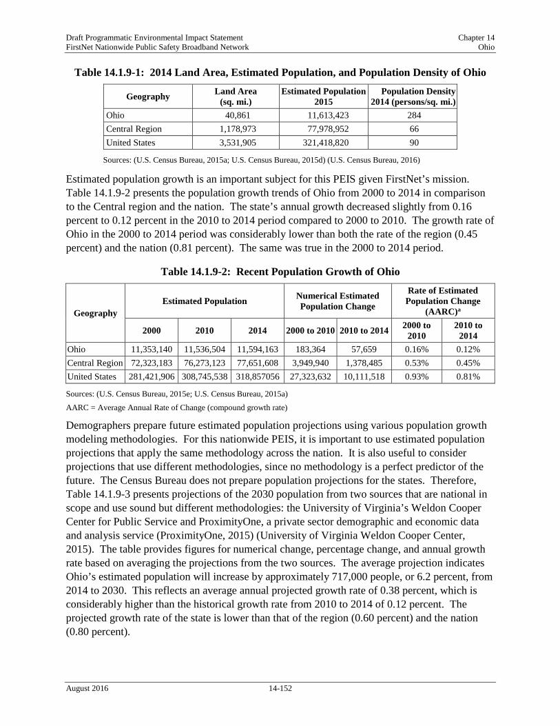
Draft Programmatic Environmental Impact Statement Chapter 14 FirstNet Nationwide Public Safety Broadband Network Ohio
Table 14.1.9-1: 2014 Land Area, Estimated Population, and Population Density of Ohio
Geography Land Area (sq. mi.)
Estimated Population 2015
Population Density 2014 (persons/sq. mi.)
Ohio 40,861 11,613,423 284 Central Region 1,178,973 77,978,952 66 United States 3,531,905 321,418,820 90
Sources: (U.S. Census Bureau, 2015a; U.S. Census Bureau, 2015d) (U.S. Census Bureau, 2016)
Estimated population growth is an important subject for this PEIS given FirstNet’s mission. Table 14.1.9-2 presents the population growth trends of Ohio from 2000 to 2014 in comparison to the Central region and the nation. The state’s annual growth decreased slightly from 0.16 percent to 0.12 percent in the 2010 to 2014 period compared to 2000 to 2010. The growth rate of Ohio in the 2000 to 2014 period was considerably lower than both the rate of the region (0.45 percent) and the nation (0.81 percent). The same was true in the 2000 to 2014 period.
Table 14.1.9-2: Recent Population Growth of Ohio
Geography Estimated Population Numerical Estimated
Population Change
Rate of Estimated Population Change
(AARC)a
2000 2010 2014 2000 to 2010 2010 to 2014 2000 to 2010
2010 to 2014
Ohio 11,353,140 11,536,504 11,594,163 183,364 57,659 0.16% 0.12% Central Region 72,323,183 76,273,123 77,651,608 3,949,940 1,378,485 0.53% 0.45% United States 281,421,906 308,745,538 318,857056 27,323,632 10,111,518 0.93% 0.81%
Sources: (U.S. Census Bureau, 2015e; U.S. Census Bureau, 2015a)
AARC = Average Annual Rate of Change (compound growth rate)
Demographers prepare future estimated population projections using various population growth modeling methodologies. For this nationwide PEIS, it is important to use estimated population projections that apply the same methodology across the nation. It is also useful to consider projections that use different methodologies, since no methodology is a perfect predictor of the future. The Census Bureau does not prepare population projections for the states. Therefore, Table 14.1.9-3 presents projections of the 2030 population from two sources that are national in scope and use sound but different methodologies: the University of Virginia’s Weldon Cooper Center for Public Service and ProximityOne, a private sector demographic and economic data and analysis service (ProximityOne, 2015) (University of Virginia Weldon Cooper Center, 2015). The table provides figures for numerical change, percentage change, and annual growth rate based on averaging the projections from the two sources. The average projection indicates Ohio’s estimated population will increase by approximately 717,000 people, or 6.2 percent, from 2014 to 2030. This reflects an average annual projected growth rate of 0.38 percent, which is considerably higher than the historical growth rate from 2010 to 2014 of 0.12 percent. The projected growth rate of the state is lower than that of the region (0.60 percent) and the nation (0.80 percent).
August 2016 14-152
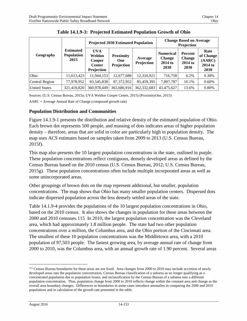
Draft Programmatic Environmental Impact Statement Chapter 14 FirstNet Nationwide Public Safety Broadband Network Ohio
Table 14.1.9-3: Projected Estimated Population Growth of Ohio
Sources: (U.S. Census Bureau, 2015a; UVA Weldon Cooper Center, 2015) (ProximityOne, 2015)
AARC = Average Annual Rate of Change (compound growth rate)
Population Distribution and Communities
Figure 14.1.9-1 presents the distribution and relative density of the estimated population of Ohio. Each brown dot represents 500 people, and massing of dots indicates areas of higher population density – therefore, areas that are solid in color are particularly high in population density. The map uses ACS estimates based on samples taken from 2009 to 2013 (U.S. Census Bureau, 2015f).
This map also presents the 10 largest population concentrations in the state, outlined in purple. These population concentrations reflect contiguous, densely developed areas as defined by the Census Bureau based on the 2010 census (U.S. Census Bureau, 2012; U.S. Census Bureau, 2015g). These population concentrations often include multiple incorporated areas as well as some unincorporated areas.
Other groupings of brown dots on the map represent additional, but smaller, population concentrations. The map shows that Ohio has many smaller population centers. Dispersed dots indicate dispersed population across the less densely settled areas of the state.
Table 14.1.9-4 provides the populations of the 10 largest population concentrations in Ohio, based on the 2010 census. It also shows the changes in population for these areas between the 2000 and 2010 censuses.115 In 2010, the largest population concentration was the Cleveland area, which had approximately 1.8 million people. The state had two other population concentrations over a million, the Columbus area, and the Ohio portion of the Cincinnati area. The smallest of these 10 population concentrations was the Middletown area, with a 2010 population of 97,503 people. The fastest growing area, by average annual rate of change from 2000 to 2010, was the Columbus area, with an annual growth rate of 1.90 percent. Several areas
115 Census Bureau boundaries for these areas are not fixed. Area changes from 2000 to 2010 may include accretion of newly developed areas into the population concentration, Census Bureau classification of a subarea as no longer qualifying as a concentrated population due to population losses, and reclassification by the Census Bureau of a subarea into a different population concentration. Thus, population change from 2000 to 2010 reflects change within the constant area and change as the overall area boundary changes. Differences in boundaries in some cases introduce anomalies in comparing the 2000 and 2010 populations and in calculation of the growth rate presented in the table.
Geography Estimated Population
2015
Projected 2030 Estimated Population Change Based on Average Projection
UVA Weldon Cooper Center
Projection
Proximity One
Projection
Average Projection
Numerical Change 2014 to
2030
Percent Change 2014 to
2030
Rate of Change (AARC) 2014 to
2030 Ohio 11,613,423 11,944,153 12,677,688 12,310,921 716,758 6.2% 0.38% Central Region 77,978,952 83,545,838 87,372,952 85,459,395 7,807,787 10.1% 0.60% United States 321,418,820 360,978,449 363,686,916 362,332,683 43,475,627 13.6% 0.80%
August 2016 14-153

Draft Programmatic Environmental Impact Statement Chapter 14 FirstNet Nationwide Public Safety Broadband Network Ohio
experienced population declines during this period, including the Akron, Cleveland, Lorain/Elyria, and Youngstown (Ohio portion) areas.
Table 14.1.9-4 also shows that the top 10 population concentrations in Ohio accounted for 61.7 percent of the state’s population in 2010. Further, population growth in the 10 areas from 2000 to 2010 amounted to 160.5 percent of the entire state’s growth. This figure of over 100 percent indicates that the population of the remainder of the state, as a whole, declined from 2000 to 2010.
Table 14.1.9-4: Population of the 10 Largest Population Concentrations in Ohio
Area Population Population Change
2000 to 2010
2000 2010 2009–2013 Rank in
2010 Numerical
Change Rate
(AARC)
Akron 570,215 569,499 569,594 5 (716) -0.01% Canton 266,595 279,245 280,071 8 12,650 0.46% Cincinnati (OH/KY/IN) (OH Portion)
1,218,389 1,286,542 1,288,861 3 68,153 0.55%
Cleveland 1,786,647 1,780,673 1,775,502 1 (5,974) -0.03% Columbus 1,133,193 1,368,035 1,389,322 2 234,842 1.90% Dayton 703,444 724,091 728,121 4 20,647 0.29% Lorain/Elyria 193,586 180,956 181,620 9 (12,630) -0.67% Middletown 94,355 97,503 96,233 10 3,148 0.33% Toledo (OH/MI) (OH Portion) 475,456 479,182 477,055 6 3,726 0.08% Youngstown (OH/PA) (OH Portion)
377,549 348,073 345,045 7 (29,476) -0.81%
Total for Top 10 Population Concentrations
6,819,429 7,113,799 7,131,424 NA 294,370 0.42%
Ohio (statewide) 11,353,140 11,536,504 11,549,590 NA 183,364 0.16% Top 10 Total as Percentage of State 60.1% 61.7% 61.7% NA 160.5% NA
Sources: (U.S. Census Bureau, 2012; U.S. Census Bureau, 2015h; U.S. Census Bureau, 2015i)
AARC = Average Annual Rate of Change (compound growth rate)
August 2016 14-154

Draft Programmatic Environmental Impact Statement Chapter 14 FirstNet Nationwide Public Safety Broadband Network Ohio
Figure 14.1.9-1: Estimated Population Distribution in Ohio, 2009–2013
August 2016 14-155

Draft Programmatic Environmental Impact Statement Chapter 14 FirstNet Nationwide Public Safety Broadband Network Ohio
14.1.9.4. Economic Activity, Housing, Property Values, and Government Revenues
This section addresses other socioeconomic topics that are potentially relevant to FirstNet. These topics include:
• Economic activity, • Housing, • Property values, and • Government revenues.
Social institutions – educational, family, political, public service, military, and religious – are present throughout the state. The institutions most relevant to FirstNet projects are public services such as medical and emergency medical services and facilities. This PEIS addresses public services in Section 14.1.1, Infrastructure. Project-level NEPA analyses may need to examine other institutions, depending on specific locations and specific types of actions.
Economic Activity
Table 14.1.9-5 compares several economic indicators for Ohio to the Central region and the nation. The table presents two indicators of income116 – per capita and median household – as income is a good measure of general economic health of a region.
Per capita income is total income divided by the total population. As a mathematical average, the very high incomes of a relatively small number of people tend to bias per capita income figures upwards. Nonetheless, per capita income is useful as an indicator of the relative income level across two or more areas. As shown in Table 14.1.9-5, the per capita income in Ohio in 2013 ($26,354) was $1,174 lower than that of the region ($27,528), and $1,830 lower than that of the nation ($28,184).
Household income is a useful measure, and often used instead of family income, because in modern society there are many single-person households and households composed of non-related individuals. Median household income (MHI) is the income at which half of all households have higher income, and half have lower income. Table 14.1.9-5 shows that in 2013, the MHI in Ohio ($48,138) was $3,907 lower than that of the region ($52,045), and $4,112 lower that of the nation ($52,250).
Employment status is a key socioeconomic parameter because employment is essential to the income of a large portion of the adult population. The federal government calculates the unemployment rate as the number of unemployed individuals who are looking for work divided
116 The U.S. Census Bureau defines income as follows: “‘Total income’ is the sum of the amounts reported separately for wage or salary income; net self-employment income; interest, dividends, or net rental or royalty income or income from estates and trusts; Social Security or Railroad Retirement income; Supplemental Security Income (SSI); public assistance or welfare payments; retirement, survivor, or disability pensions; and all other income. Receipts from the following sources are not included as income: capital gains, money received from the sale of property (unless the recipient was engaged in the business of selling such property); the value of income “in kind” from food stamps, public housing subsidies, medical care, employer contributions for individuals, etc.; withdrawal of bank deposits; money borrowed; tax refunds; exchange of money between relatives living in the same household; gifts and lump-sum inheritances, insurance payments, and other types of lump-sum receipts.” (U.S. Census Bureau, 2015m)
August 2016 14-156
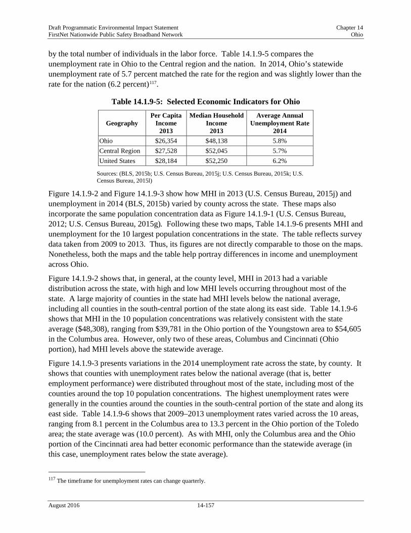
Draft Programmatic Environmental Impact Statement Chapter 14 FirstNet Nationwide Public Safety Broadband Network Ohio
by the total number of individuals in the labor force. Table 14.1.9-5 compares the unemployment rate in Ohio to the Central region and the nation. In 2014, Ohio’s statewide unemployment rate of 5.7 percent matched the rate for the region and was slightly lower than the rate for the nation (6.2 percent)117.
Table 14.1.9-5: Selected Economic Indicators for Ohio
Geography Per Capita
Income 2013
Median Household Income
2013
Average Annual Unemployment Rate
2014 Ohio $26,354 $48,138 5.8% Central Region $27,528 $52,045 5.7% United States $28,184 $52,250 6.2%
Sources: (BLS, 2015b; U.S. Census Bureau, 2015j; U.S. Census Bureau, 2015k; U.S. Census Bureau, 2015l)
Figure 14.1.9-2 and Figure 14.1.9-3 show how MHI in 2013 (U.S. Census Bureau, 2015j) and unemployment in 2014 (BLS, 2015b) varied by county across the state. These maps also incorporate the same population concentration data as Figure 14.1.9-1 (U.S. Census Bureau, 2012; U.S. Census Bureau, 2015g). Following these two maps, Table 14.1.9-6 presents MHI and unemployment for the 10 largest population concentrations in the state. The table reflects survey data taken from 2009 to 2013. Thus, its figures are not directly comparable to those on the maps. Nonetheless, both the maps and the table help portray differences in income and unemployment across Ohio.
Figure 14.1.9-2 shows that, in general, at the county level, MHI in 2013 had a variable distribution across the state, with high and low MHI levels occurring throughout most of the state. A large majority of counties in the state had MHI levels below the national average, including all counties in the south-central portion of the state along its east side. Table 14.1.9-6 shows that MHI in the 10 population concentrations was relatively consistent with the state average ($48,308), ranging from $39,781 in the Ohio portion of the Youngstown area to $54,605 in the Columbus area. However, only two of these areas, Columbus and Cincinnati (Ohio portion), had MHI levels above the statewide average.
Figure 14.1.9-3 presents variations in the 2014 unemployment rate across the state, by county. It shows that counties with unemployment rates below the national average (that is, better employment performance) were distributed throughout most of the state, including most of the counties around the top 10 population concentrations. The highest unemployment rates were generally in the counties around the counties in the south-central portion of the state and along its east side. Table 14.1.9-6 shows that 2009–2013 unemployment rates varied across the 10 areas, ranging from 8.1 percent in the Columbus area to 13.3 percent in the Ohio portion of the Toledo area; the state average was (10.0 percent). As with MHI, only the Columbus area and the Ohio portion of the Cincinnati area had better economic performance than the statewide average (in this case, unemployment rates below the state average).
117 The timeframe for unemployment rates can change quarterly.
August 2016 14-157

Draft Programmatic Environmental Impact Statement Chapter 14 FirstNet Nationwide Public Safety Broadband Network Ohio
Detailed employment data provides useful insights into the nature of a local, state, or national economy. Table 14.1.9-7 provides figures on employment percentages by type of worker and by industry based on surveys conducted in 2013 by the Census Bureau. By class of worker (type of worker: private industry, government, self-employed, etc.), the percentage of private wage and salary workers was higher in Ohio than in the Central region and the nation. The percentage of government workers and self-employed workers was lower in the state than in the region and nation.
By industry, Ohio has a mixed economic base and some notable figures in the table are as follows. Ohio in 2013 had a higher percentage of persons working in “manufacturing” and “educational services, and health care and social assistance” than did the region or the nation. It had a lower percentage of workers in “construction” and “professional, scientific, management, administrative, and waste management services” than the region or nation. The percentages for the remaining industries were within one percentage point of the regional and national values.
August 2016 14-158

Draft Programmatic Environmental Impact Statement Chapter 14 FirstNet Nationwide Public Safety Broadband Network Ohio
Figure 14.1.9-2: Median Household Income in Ohio, by County, 2013
August 2016 14-159

Draft Programmatic Environmental Impact Statement Chapter 14 FirstNet Nationwide Public Safety Broadband Network Ohio
Figure 14.1.9-3: Unemployment Rates in Ohio, by County, 2014
August 2016 14-160

Draft Programmatic Environmental Impact Statement Chapter 14 FirstNet Nationwide Public Safety Broadband Network Ohio
Table 14.1.9-6: Selected Economic Indicators for the 10 Largest Population Concentrations in Ohio, 2009–2013
Area Median Household Income
Average Annual Unemployment Rate
Akron $46,031 11.0% Canton $44,261 10.5% Cincinnati (OH/KY/IN) (OH Portion) $54,246 9.0% Cleveland $49,288 10.6% Columbus $54,605 8.1% Dayton $46,787 10.7% Lorain/Elyria $42,522 12.2% Middletown $44,135 12.5% Toledo (OH/MI) (OH Portion) $42,622 13.3% Youngstown (OH/PA) (OH Portion) $39,781 11.3% Ohio (statewide) $48,308 10.0%
Source: (U.S. Census Bureau, 2015y)
Table 14.1.9-7: Employment by Class of Worker and by Industry, 2013 Class of Worker and Industry Ohio Central
Region United States
Civilian Employed Population 16 Years and Over 5,347,801 36,789,905 145,128,676 Percentage by Class of Worker
Private wage and salary workers 82.7% 81.7% 79.7% Government workers 12.4% 12.8% 14.1% Self-employed in own not incorporated business workers 4.8% 5.3% 6.0% Unpaid family workers 0.1% 0.2% 0.2%
Percentage by Industry Agriculture, forestry, fishing and hunting, and mining 1.2% 2.2% 2.0% Construction 5.0% 5.6% 6.2% Manufacturing 15.6% 14.0% 10.5% Wholesale trade 2.7% 2.7% 2.7% Retail trade 11.7% 11.5% 11.6% Transportation and warehousing, and utilities 4.7% 4.9% 4.9% Information 1.8% 1.9% 2.1% Finance and insurance, and real estate and rental and leasing 6.4% 6.5% 6.6% Professional, scientific, management, administrative, and waste management services
9.1% 9.7% 11.1%
Educational services, and health care and social assistance 24.4% 23.4% 23.0% Arts, entertainment, and recreation, and accommodation and food services
9.3% 9.1% 9.7%
Other services, except public administration 4.4% 4.6% 5.0% Public administration 3.8% 3.9% 4.7%
Source: (U.S. Census Bureau, 2015n)
August 2016 14-161

Draft Programmatic Environmental Impact Statement Chapter 14 FirstNet Nationwide Public Safety Broadband Network Ohio
Table 14.1.9-8 presents employment shares for selected industries for the 10 largest population concentrations in the state. The table reflects survey data taken by the Census Bureau from 2009 to 2013. Thus, its figures for the state are slightly different from those in Table 14.1.9-7 for 2013.
Table 14.1.9-8: Employment by Selected Industries for the 10 Largest Population Concentrations in Ohio, 2009–2013
Area Construction
Transportation and
Warehousing, and Utilities
Information
Professional, Scientific,
Management, Administrative
and Waste Management
Services Akron 5.2% 4.6% 1.8% 9.3% Canton 4.9% 4.7% 1.7% 8.8% Cincinnati (OH/KY/IN) (OH Portion)
4.3% 4.1% 1.9% 11.9%
Cleveland 4.1% 4.2% 1.9% 10.5% Columbus 4.0% 4.8% 2.5% 12.0% Dayton 4.5% 3.9% 2.3% 10.7% Lorain/Elyria 4.8% 4.4% 2.0% 8.1% Middletown 4.7% 5.2% 1.2% 8.7% Toledo (OH/MI) (OH Portion)
4.2% 5.8% 1.5% 9.2%
Youngstown (OH/PA) (OH Portion)
5.0% 4.7% 2.1% 7.4%
Ohio (statewide) 5.2% 4.8% 1.8% 9.2%
Source: (U.S. Census Bureau, 2015y)
Housing
The housing stock is an important socioeconomic component of communities. The type, availability, and cost of housing in an area reflect economic conditions and affect quality of life. Table 14.1.9-9 compares Ohio to the Central region and nation on several common housing indicators.
As shown in Table 14.1.9-9, in 2013, Ohio had a slightly higher percentage of housing units that were occupied (89.1 percent) than the region (88.4 percent) or nation (87.6 percent). Of the occupied units, Ohio had a slightly lower percentage of owner-occupied units (66.1 percent) than the region (67.6 percent), and a higher percentage than the nation (63.5 percent). The percentage of detached single-unit housing (also known as single-family homes) in Ohio in 2013 (68.6 percent) was than both the region (67.7 percent) and nation (61.5 percent). The homeowner vacancy rate in Ohio (2.0 percent) was similar to the rate for the region (1.8 percent) and the nation (1.9 percent). This rate reflects “vacant units that are ‘for sale only” (U.S. Census Bureau,
August 2016 14-162

Draft Programmatic Environmental Impact Statement Chapter 14 FirstNet Nationwide Public Safety Broadband Network Ohio
2015m). The vacancy rate among rental units was similar in Ohio (6.1 percent) to the region (6.0 percent) and slightly lower than in the nation (6.5 percent).
Table 14.1.9-9: Selected Housing Indicators for Ohio, 2013 Geography Total
Housing Units
Housing Occupancy and Tenure Units in Structure
Occupied Housing
Owner-Occupied
Homeowner Vacancy
Rate
Rental Vacancy
Rate
1-Unit, Detached
Ohio 5,124,126 89.1% 66.1% 2.0% 6.1% 68.6% Central Region 33,580,411 88.4% 67.6% 1.8% 6.0% 67.7% United States 132,808,137 87.6% 63.5% 1.9% 6.5% 61.5%
Source: (U.S. Census Bureau, 2015o)
Table 14.1.9-10 provides housing indicators for the largest population concentrations in the state by survey data taken from 2009 to 2013. Thus, its figures are not directly comparable to the more recent data in the previous table. However, it does present variation in these indicators for population concentrations across the state and compared to the state average for the 2009 to 2013 period.
Table 14.1.9-10: Selected Housing Indicators for the 10 Largest Population Concentrations in Ohio, 2009–2013
Area Total Housing
Units
Housing Occupancy and Tenure Units in Structure
Occupied Housing
Owner-Occupied
Homeowner Vacancy
Rate
Rental Vacancy
Rate
1-Unit, Detached
Akron 259,280 89.1% 64.7% 2.4% 8.4% 68.2% Canton 125,554 90.7% 67.6% 1.5% 6.8% 72.3% Cincinnati (OH/KY/IN) (OH Portion)
567,672 88.9% 64.1% 2.2% 9.5% 61.1%
Cleveland 831,584 88.2% 65.4% 2.2% 8.6% 62.6% Columbus 607,953 89.3% 58.4% 2.4% 8.1% 56.4% Dayton 334,705 88.7% 62.9% 2.6% 7.1% 67.5% Lorain/Elyria 80,614 89.6% 64.5% 2.3% 6.2% 69.2% Middletown 43,341 87.8% 63.4% 2.7% 6.1% 73.1% Toledo (OH/MI) (OH Portion)
218,887 88.6% 62.3% 2.7% 8.4% 66.8%
Youngstown (OH/PA) (OH Portion)
164,775 88.1% 67.7% 4.0% 8.5% 74.3%
Ohio (statewide) 5,124,221 88.9% 67.5% 2.2% 7.8% 68.5%
Source: (U.S. Census Bureau, 2015p)
August 2016 14-163

Draft Programmatic Environmental Impact Statement Chapter 14 FirstNet Nationwide Public Safety Broadband Network Ohio
Property Values
Property values have important relationships to both the wealth and affordability of communities. Table 14.1.9-11 provides indicators of residential property values for Ohio and compares these values to values for the Central region and nation. The figures on median value of owner-occupied units are from the Census Bureau’s ACS, based on owner estimates of how much their property (housing unit and land) would sell for if it were for sale (U.S. Census Bureau, 2015m). The table shows that the median value of owner-occupied units in Ohio in 2013 ($127,000) was lower than the corresponding values for the Central region ($151,200) and for the nation ($173,900).
Table 14.1.9-11: Residential Property Values in Ohio, 2013
Geography Median Value of Owner-Occupied Units Ohio $127,000 Central Region $151,200 United States $173,900
Source: (U.S. Census Bureau, 2015o)
Table 14.1.9-12 presents residential property values for the largest population concentrations in the state. The table reflects survey data taken from 2009 to 2013. Thus, its figures are not directly comparable to the more recent data in the previous table. However, it does show variation in property values for population concentrations across the state and compared to the state average for the 2009 to 2013 period. The median property value for these 10 communities ranged from $89,300 in the Youngstown area (Ohio portion) to $161,800 in the Columbus area. The state value was $130,800. Both the lowest and highest property values were in the two areas – Youngstown (Ohio portion), and Columbus – that had the lowest and highest median household incomes, respectively (Table 14.1.9-6).
Table 14.1.9-12: Residential Property Values for the 10 Largest Population Concentrations in Ohio, 2009–2013
Area Median Value of Owner-Occupied Units
Akron $123,700 Canton $120,400 Cincinnati (OH/KY/IN) (OH Portion) $155,900 Cleveland $142,000 Columbus $161,800 Dayton $122,000 Lorain/Elyria $110,400 Middletown $114,300 Toledo (OH/MI) (OH Portion) $111,500 Youngstown (OH/PA) (OH Portion) $89,300 Ohio (statewide) $130,800
Source: (U.S. Census Bureau, 2015p)
August 2016 14-164

Draft Programmatic Environmental Impact Statement Chapter 14 FirstNet Nationwide Public Safety Broadband Network Ohio
Government Revenues
State and local governments obtain revenues from many sources. FirstNet projects may affect flows of revenue sources between different levels of government due to program financing and intergovernmental agreements for system development and operation. Public utility taxes are a subcategory of selective sales taxes that includes taxes on providers of land and mobile telephone, telegraph, cable, and internet services (U.S. Census Bureau, 2006). These service providers may obtain new taxable revenues from operation of components of the public safety broadband network. These revenue streams are typically highly localized and therefore are best considered in the deployment phase of FirstNet.
Table 14.1.9-13 presents total and selected state and local government revenue sources as reported by the Census Bureau’s 2012 Census of Governments. It provides both total dollar figures (in millions of dollars) and figures per capita (in dollars), based on total population for each geography. The per capita figures are particularly useful in comparing the importance of certain revenue sources in the state relative to other states in the region and the nation. State and local governments may obtain some additional revenues related to telecommunications infrastructure.
Table 14.1.9-13 shows that the state government in Ohio received more total revenue in 2012 on a per capita basis than its counterpart governments in the region and nation. Local governments in Ohio received more total revenue in 2012 on a per capita basis than their counterpart governments in the region and less than their counterparts in the nation. The Ohio state government had slightly higher levels per capita of intergovernmental revenues118 from the federal government than counterparts in the region and nation. Local governments in Ohio had higher levels per capita of intergovernmental revenues from the federal government than their regional counterparts, and somewhat lower levels when compared to counterpart governments in the nation. The Ohio state government obtained no revenue from property taxes. Local governments in Ohio obtained substantially higher levels of property taxes, per capita, than local governments in the region, and slightly lower levels than their counterparts in the nation. The Ohio state government reported slightly lower revenue from general sales taxes than its counterparts in the region and nation. Local governments in Ohio reported higher levels of general sales taxes, per capita, than local governments in the region, and lower levels than their counterparts in the nation. State and local governments in Ohio reported lower revenue per capita from selective sales taxes than their counterparts in the region, and nation. The state government in Ohio reported higher revenue per capita from public utilities taxes than the region and nation. Local governments in Ohio reported minimal revenue per capita from public utilities taxes. The state government in Ohio reported lower levels of individual and corporate income tax revenues, on a per capita basis than counterpart governments in the region and nation. Local governments in Ohio reported substantially higher levels of individual income tax revenues on a per capita basis, than their counterparts in the region and nation. Local governments in Ohio
118 Intergovernmental revenues are those revenues received by one level of government from another level of government, such as shared taxes, grants, or loans and advances (U.S. Census Bureau, 2006).
August 2016 14-165

Draft Programmatic Environmental Impact Statement Chapter 14 FirstNet Nationwide Public Safety Broadband Network Ohio
reported higher levels of corporate income tax revenues on a per capita basis than their regional counterparts, and similar levels to their counterparts in the nation.
Table 14.1.9-13: State and Local Government Revenues, Selected Sources, 2012
Type of Revenue
Ohio Region United States State Govt.
Amount
Local Govt.
Amount
State Govt.
Amount
Local Govt.
Amount
State Govt.
Amount
Local Govt.
Amount Total Revenue ($M)
Per capita $72,471 $54,533 $463,192 $231,980 $1,897,142 $1,618,611
$6,278 $4,724 $6,020 $3,015 $6,043 $5,156 Intergovernmental from Federal ($M)
Per capita $20,688 $2,556 $125,394 $9,383 $514,139 $70,989
$1,792 $221 $1,630 $122 $1,638 $226 Intergovernmental from State ($M)
Per capita $0 $17,960 $0 $76,288 $0 $469,741 $0 $1,556 $0 $992 $0 $1,496
Intergovernmental from Local ($M) Per capita
$588 $0 $2,721 $0 $13,492 $0 $51 $0 $35 $0 $43 $0
Property Taxes ($M) Per capita
$0 $13,561 $3,626 $61,015 $13,111 $434,009 $0 $1,175 $47 $793 $42 $1,383
General Sales Taxes ($M) Per capita
$8,277 $1,823 $58,236 $6,920 $244,627 $69,509 $717 $158 $757 $90 $779 $221
Selective Sales Taxes ($M) Per capita
$4,847 $213 $33,313 $2,191 $133,895 $28,513 $420 $18 $433 $28 $427 $91
Public Utilities Taxes ($M) Per capita
$1,052 $28 $3,627 $1,153 $14,539 $14,104 $91 $2 $47 $15 $46 $45
Individual Income Taxes ($M) Per capita
$9,029 $4,399 $72,545 $5,148 $280,614 $26,642 $782 $381 $943 $67 $894 $85
Corporate Income Taxes ($M) Per capita
$117 $234 $9,649 $310 $41,724 $7,210 $10 $20 $125 $4 $133 $23
Sources: (U.S. Census Bureau, 2015q; U.S. Census Bureau, 2015r)
Note: This table does not include all sources of government revenue. Summation of the specific source rows does not equal total revenue.
Environmental Justice
14.1.10.1. Definition of the Resource
E.O. 12898, Federal Actions to Address Environmental Justice in Minority Populations and Low-Income Populations, issued in 1994, sets out principles of environmental justice and requirements that federal agencies should follow to comply with the EO (see Section 1.8.12, Federal Actions to Address Environmental Justice in Minority Populations and Low-Income Populations). The fundamental principle of environmental justice is “fair treatment and meaningful involvement of all people regardless of race, color, national origin, or income with respect to the development, implementation, and enforcement of environmental laws, regulations, and policies” (USEPA, 2016c). Under the EO, each federal agency must “make
August 2016 14-166

Draft Programmatic Environmental Impact Statement Chapter 14 FirstNet Nationwide Public Safety Broadband Network Ohio
achieving environmental justice part of its mission by identifying and addressing, as appropriate, disproportionately high and adverse human health or environmental effects of its programs, policies, and activities on minority populations and low-income populations” (Executive Office of the President, 1994). In response to the EO, the Department of Commerce developed an Environmental Justice Strategy in 1995, and published an updated strategy in 2013 (U.S. Department of Commerce, 2013b).
In 1997, the Council on Environmental Quality (CEQ) issued Environmental Justice: Guidance under the National Environmental Policy Act (NEPA) to assist federal agencies in meeting the requirements of the EO (CEQ, 1997). Additionally, the USEPA’s Office of Environmental Justice (USEPA, 2015s) offers guidance on Environmental Justice issues and provides an “environmental justice screening and mapping tool,” EJSCREEN (USEPA, 2015t).
The CEQ guidance provides several important definitions and clarifications that this PEIS utilizes:
• Minority populations consist of “Individual(s) who are members of the following population groups: American Indian or Alaskan Native; Asian or Pacific Islander; Black, not of Hispanic origin; or Hispanic.”
• Low-income populations consist of individuals living in poverty, as defined by the U.S. Census Bureau (Census Bureau).
• Environmental effects include social and economic effects. Specifically, “Such effects may include ecological, cultural, human health, economic, or social impacts on minority communities, low-income communities, or Indian tribes when those impacts are interrelated to impacts on the natural or physical environment” (CEQ, 1997).
14.1.10.2. Specific Regulatory Considerations
Ohio does not have a formal environmental justice policy. The OEPA considers environmental justice issues during the environmental permitting or grant review process to ensure Title VI.936 compliance. (University of Caifornia, Hastings College of Law, 2010)
ODOT has issued an Environmental Justice Guidance document, last revised in 2015, to ensure compliance with EO 12898 and FHWA Order 6640.23. The main purpose of the document is to ensure environmental justice communities are not impacted in a disproportionate manner by projects sponsored by ODOT (ODOT, 2015d). According to FHWA Order 6640.23A, “a disproportionately high and adverse effect on a minority or low‐income population means the adverse effect is predominately borne by such population or is appreciably more severe or greater in magnitude on the minority or low‐income population than the adverse effect suffered by the non‐minority or non‐low‐income population.” (ODOT, 2015d)
14.1.10.3. Environmental Setting: Minority and Low-Income Populations
Table 14.1.10-1 presents 2013 data on the composition of Ohio’s estimated population by race and by Hispanic origin. The state’s estimated population has a higher percentage of individuals who identify as Black/African American (12.1 percent) than the estimated population of the
August 2016 14-167

Draft Programmatic Environmental Impact Statement Chapter 14 FirstNet Nationwide Public Safety Broadband Network Ohio
Central region (9.3 percent), but a slightly lower percentage when compared to the nation (12.6 percent). The state’s population has lower percentages of individuals who identify as Asian (1.8 percent) or Some Other Race (0.8 percent) than the populations of the Central region and the nation. Those percentages are for Asian, 2.8 percent for the Central region, and 5.1 percent for the nation; and for Some Other Race, 2.4 percent and 4.7 percent, respectively. The state’s estimated population of persons identifying as White (82.5 percent) is similar to that of the Central region (82.2 percent) and larger than that of the nation (73.7 percent).
The percentage of the estimated population in Ohio that identifies as Hispanic (3.3 percent) is considerably smaller than in the Central region (8.5 percent) and in the nation (17.1 percent). Hispanic origin is a different category than race; persons of any race may identify as also being of Hispanic origin.
The category All Minorities consists of all persons who consider themselves Hispanic or of any race other than White. Ohio’s All Minorities estimated population percentage (19.7 percent) is lower than that of the Central region (23.3 percent) or the nation (37.6 percent).
Table 14.1.10-2 presents the percentage of the estimated population living in poverty in 2013, for the state, region, and nation. The figure for Ohio (16.0 percent) is somewhat higher than that for the Central region (14.7 percent) and nearly matches the nation’s (15.8 percent).
Table 14.1.10-1: Estimated Population by Race and Hispanic Status, 2013
Geography Total
Estimated Population
Race
Hispanic All Minorities White
Black/ African
Am
Am. Indian/ Alaska Native
Asian
Native Hawaiian/
Pacific Islander
Some Other Race
Two or More Races
Ohio 11,570,808 82.5% 12.1% 0.2% 1.8% 0.0% 0.8% 2.6% 3.3% 19.7% Central Region
77,314,952 82.2% 9.3% 0.7% 2.8% 0.1% 2.4% 2.5% 8.5% 23.3%
United States 316,128,839 73.7% 12.6% 0.8% 5.1% 0.2% 4.7% 3.0% 17.1% 37.6%
Source: (U.S. Census Bureau, 2015s)
“All Minorities” is defined as all persons who consider themselves Hispanic or of any race other than White. Because some Hispanics identify as both Hispanic and of a non-White race, “All Minorities” is less than the sum of Hispanics and non-White races.
Table 14.1.10-2: Percentage of Estimated Population (Individuals) in Poverty, 2013 Geography Percent Below Poverty Level
Ohio 16.0% Central Region 14.7% United States 15.8%
Source: (U.S. Census Bureau, 2015t)
August 2016 14-168

Draft Programmatic Environmental Impact Statement Chapter 14 FirstNet Nationwide Public Safety Broadband Network Ohio
14.1.10.4. Environmental Justice Screening Results
Analysis of environmental justice in a NEPA document typically begins by identifying potential environmental justice populations in the project area. Appendix D, Environmental Justice Methodology, presents the methodology used in this PEIS to screen each state for the presence of potential environmental justice populations. The methodology builds on CEQ guidance and best practices used for environmental justice analysis. It uses data at the census-block group level; block groups are the smallest geographic units for which regularly updated socioeconomic data are readily available at the time of writing.
Figure 14.1.10-1 visually portrays the results of the environmental justice population screening analysis for Ohio. The analysis used block group data from the Census Bureau’s American Community Survey 2009-2013 5-Year Estimates (U.S. Census Bureau, 2015f; U.S. Census Bureau, 2015u; U.S. Census Bureau, 2015v; U.S. Census Bureau, 2015w) and Census Bureau urban classification data (U.S. Census Bureau, 2012; U.S. Census Bureau, 2015g).
Figure 14.1.10-1 shows that Ohio has many areas with high and moderate potential for environmental justice populations. These areas occur both within and outside of the 10 largest population concentrations. The south-central portion of the state has the highest proportion of area with high potential for environmental justice populations.
It is important to understand how the data behind Figure 14.1.10-1 affect the visual impact of this map. Block groups have similar populations (hundreds to a few thousand individuals) regardless of population density. In sparsely populated areas, a single block group may cover tens or even hundreds of square miles, while in densely populated areas, block groups each cover much less than a single square mile. Thus, while large portions of the state outside the areas defined as large population concentrations show Moderate or high potential for environmental justice populations, these low density areas reflect modest numbers of minority or low-income individuals compared to the potential environmental justice populations within densely populated areas. The overall effect of this relative density phenomenon is that the map visually shows large areas of the state having environmental justice potential, but this over-represents the presence of environmental justice populations.
It is also very important to note that Figure 14.1.10-1 does not definitively identify environmental justice populations. It indicates degrees of likelihood of the presence of populations of potential concern from an environmental justice perspective. Two caveats are important. First, environmental justice communities are often highly localized. Block group data may under or over-represent the presence of these localized communities. For instance, in the large block groups in sparsely populated regions of the state, the data may represent dispersed individuals of minority or low-income status rather than discrete, place-based communities. Second, the definition of the moderate potential category draws a wide net for potential environmental justice populations. As discussed in Appendix D, the definition includes some commonly used thresholds for environmental justice screening that tend to over-identify environmental justice potential. Before FirstNet deploys projects, additional site-specific analyses to identify specific, localized environmental justice populations may be warranted. Such analyses could tier-off the methodology of this PEIS.
August 2016 14-169

Draft Programmatic Environmental Impact Statement Chapter 14 FirstNet Nationwide Public Safety Broadband Network Ohio
Figure 14.1.10-1: Potential for Environmental Justice Populations in Ohio, 2009–2013
August 2016 14-170

Draft Programmatic Environmental Impact Statement Chapter 14 FirstNet Nationwide Public Safety Broadband Network Ohio
This map also does not indicate whether FirstNet projects would have actual impacts on environmental justice populations. An environmental justice effect on minority or low-income populations only occurs if the effect is harmful, significant (according to NEPA criteria), and “appreciably exceeds or is likely to appreciably exceed the risk or rate to the general population or other appropriate comparison group” (CEQ, 1997). The Environmental Consequences section (Section 14.2) addresses the potential for disproportionately high and adverse environmental or human health impacts on environmental justice populations.
Cultural Resources
14.1.11.1. Definition of Resource
For the purposes of this PEIS, cultural resources are defined as: Natural or manmade structures, objects, features, locations with scientific, historic, and cultural value, including those with traditional religious or cultural importance and any prehistoric or historic district, site, or building included in, or eligible for inclusion in, the National Register of Historic Places (NRHP).
This definition is consistent with the how cultural resources are defined in the: • Statutory language and implementing regulations for Section 106 of the NHPA, as amended,
formerly 16 U.S.C. 470a(d)(6)(A) (now 54 U.S.C. 306131(b)) and 36 CFR 800.16(l)(1); • Statutory language and Implementing regulations for the Archaeological Resources
Protection Act of 1979 (ARPA), 16 U.S.C. 470cc(c) and 43 CFR 7.3(a); • Statutory language and implementing regulations for the Native American Graves Protection
and Repatriation Act (NAGPRA), 25 U.S.C. 3001(3)(D) and 43 CFR 10.2(d); • NPS’s program support of public and private efforts to identify, evaluate, and protect
America’s historic and archeological resources (NPS, 2016a); and • Advisory Council on Historic Preservation’s (ACHP) guidance for protection and
preservation of sites and artifacts with traditional religious and cultural importance to Indian tribes or Native Hawaiian organizations (Advisory Council on Historic Preservation, 2004).
14.1.11.2. Specific Regulatory Considerations
The Proposed Action must meet the requirements of NEPA and other applicable laws and regulations that apply to Cultural Resources, such as the NHPA (detailed in Section 1.8, Overview of the Relevant Federal Laws and Executive Orders), the American Indian Religious Freedom Act (AIRFA), ARPA, and NAGPRA. Appendix C, Environmental Laws and Regulations, summarizes these pertinent federal laws.
Ohio does not have state regulations that parallel both NEPA and the NHPA. While federal agencies may take into account compatible state laws and regulations, their actions that are subject to federal environmental review under NEPA and NHPA are not subject to compliance with such state laws and regulations. Table 14.1.8-1 presents other state and local laws and regulations that relate to cultural resources.
August 2016 14-171

Draft Programmatic Environmental Impact Statement Chapter 14 FirstNet Nationwide Public Safety Broadband Network Ohio
Table 14.1.11-1: Relevant Ohio Cultural Resources Laws and Regulations
State Law/Regulation Regulatory Agency Applicability ORC, Section 149.30 Ohio History Connection Establishes the Ohio history connection (a non-profit
corporation) to promote a knowledge of history and archaeology by performing public functions such as serving as the State Historic Preservation Office.
ORC, Section 149.301 Ohio Historic Site Preservation Advisory Board
Establishes the membership of the Ohio Historic Site Preservation Advisory Board and its responsibilities to assist the Ohio History Connection with its preservation program, legislation, and National Register of Historic Places designations.
14.1.11.3. Cultural and Natural Setting
Human beings have inhabited the Ohio region for more than 12,000 years (The Archaeological Society of Ohio, 2011). The majority of evidence of Ohio’s early human habitation comes from the study of archeological sites of pre-European contact and historic populations. In addition to the hundreds of archaeological sites listed in the state’s inventory, there are 95 archaeological sites in Ohio listed on the NRHP: 15 are historic, 80 are prehistoric (NPS, 2015i).
Archaeologists typically divide large study areas into regions. As shown in Figure 14.1.3-1 (Section 14.1.3, Geology), the entire state occupies the physiographic region of the Interior Plains and the physiographic province Central Lowland.
Most archeological evidence in Ohio is found in relatively shallow deposits on the surface or within one to two feet of the surface. However, in some cases, natural factors have buried sites beneath multiple layers of sediment or organic materials, such as in floodplain deposits found along streams and rivers or peat deposits in wetlands. These alluvial deposits can range 1 to 10 feet below the current surface, with older sites in the deeper sediments. Disturbed ground, including urban areas, may contain archaeological resources in deeper or shallower strata than undisturbed areas.
The following sections provide additional detail about Ohio’s prehistoric periods (approximately 11500 B.C. to A.D. 1650) and the historic period since European contact in the late 1600s. There is some overlap between the prehistoric period and the historic period, as American Indians continued to carry on their traditional way of life in parts of Ohio after European contact. Section 14.1.11.4, Prehistoric Setting, presents an overview of the initial human habitation in Ohio and the cultural development that occurred before European contact. Section 14.1.11.5, Federally-recognized Tribes of Ohio, discusses the federally recognized American Indian Tribes with a cultural affiliation to the state. Section 14.1.11.6, Significant Archaeological Sites of Ohio, provides a current list of significant archaeological sites in Ohio and tools that the state has developed to ensure their preservation. Section 14.1.11.7, Historic Context, documents the historic context of the state since European contact, and Section 14.1.11.8, Architectural Context, summarizes the architectural context of the state during the historic period.
August 2016 14-172

Draft Programmatic Environmental Impact Statement Chapter 14 FirstNet Nationwide Public Safety Broadband Network Ohio
14.1.11.4. Prehistoric Setting
Archaeologists divide Ohio’s prehistoric past into four periods: Paleoindian Period (11500 - 8500 B.C.), Archaic Period (8500 - 800 B.C.), Woodland Period (800 B.C. - A.D. 1200), and Late Prehistoric Period (A.D. 1200 - 1650). Figure 14.1.11-1 shows a timeline representing these periods of early human habitation of present day Ohio. Evidence of human occupation is prevalent in each of Ohio’s physiographic regions. Due to advancements in archaeological techniques and the association of newly discovered artifacts with similar ones previously assigned to a particular range of the archaeological record, the dates associated with a particular phase in North American human development continue to become increasingly accurate (Pauketat, 2012; Haynes, Donahue, Jull, & Zabel, 1984; Haynes, Johnson, & Stafford, 1999).
Figure 14.1.11-1: Timeline of Prehistoric Human Occupation Sources: (Institute of Maritime History, 2015; Ohio History Connection, 2015b)
Paleoindian Period (11500 - 8500 B.C.)
The Paleoindian Period represents the earliest human habitation of the Ohio region. Paleoindians lived in small groups of nomadic hunters and gatherers that used chipped-stone tools, including the “fluted javelin head” arrow and spear points (referred to as the Clovis or Folsom fluted points). Studies show that such technology was prevalent in northeastern Asia, the Arabian Peninsula, and Spain prior to human arrival into North America (Charpentier & Inizan, 2002).
During the Paleoindian Period many large mammals that are now extinct, such as giant bison, mammoths, and ground sloths, were being hunted (Ritterbush, 2002; Ritterbush & Logan, 2000). As the technologies changed and the large animals decreased in numbers, the people began to exploit various other plant and animal species for sustenance (Redmond & Tankersley, 2015; Sciulli & Aument, 1987; Waters, Stafford, Redmond, & Tankersley, 2009).
Most of the oldest known evidence of human settlement in Ohio comes from the discovery of Clovis and Folsom fluted spear points. Out of the 11,257 projectile points discovered in the United States dating from the Paleoindian Period, only 135 are from Ohio (Anderson & Faught,
August 2016 14-173

Draft Programmatic Environmental Impact Statement Chapter 14 FirstNet Nationwide Public Safety Broadband Network Ohio
1998); 33 of the Clovis and Folsom fluted points from Ohio have been discovered in the Loess Hills of the southwestern part of the state. Most of the points were manufactured using locally sourced materials. A few points that were discovered intact were made from non-local materials (Redmond & Tankersley, 2015; Sciulli & Aument, 1987; Waters, Stafford, Redmond, & Tankersley, 2009).
Archaic Period (8500 - 800 B.C.)
It is believed that northern Ohio experienced a dual migration pattern of people during the Late Paleoindian and Early Archaic Periods from the central and southern portions of what is currently the United States. In northern Ohio, most of the lithic materials used for tool making were derived from quarry sources in the south during the Late Paleoindian Period. Some Early Archaic tools in this region are derived from materials originating in the south and central portions of the United States. As time went by, the people located and began to use local raw materials for tool making. Much debate continues over whether there was a dual or exclusively northern migration pattern. (Chidester, 2011). “During the Middle Archaic Period, Midwestern Archaic cultures evolved into [organized] societies…and created stone artifacts of elaborate and unique design, the finest examples of which are found in Ohio” (The Archaeological Society of Ohio, 2011).
Bison remained a major part of the subsistence strategy for the people of the Archaic Period. It was previously thought that there was a major shift from this pattern, however, re-analysis of archaeological sites have revealed that bison continued to be hunted extensively throughout the Early Archaic Period (Nance, 1987).
The lifestyle of the people in Ohio began to change around 5,000 years ago. The domestication and cultivation of plants became an important supplement to the diet of the hunter and gatherer culture, which continued to expand throughout the region. People began to settle into semi-permanent camps that they occupied depending upon the season and the availability of resources in an area (Widga, 2004).
Archaeological evidence of ceramics manufacturing during the early Archaic Period is limited, but development of pottery for food storage and ceremonial purposes appears to have begun about 3,000 years ago. In addition, the ceramics associated with the early Archaic Period (tempered and fired) are not directly related to those that were made later in the region during the Late Archaic and early Woodland Periods. Evidence suggests that the Late Archaic and Woodland Period pottery is not a continuation the types of Early Archaic pottery, but rather reflects the influence of various other eastern and western United States cultures (Nance, 1987; The Archaeological Society of Ohio, 2011).
In 1976, a dugout canoe was discovered approximately one meter below the surface during a commercial dredging project at Savannah Lake, Ashland County, OH, near the headwaters of Vermilion River. The discovery is significant because it provides evidence of transportation and trading in the region during the Archaic Period. The dugout canoe has been preserved and currently on display at the Cleveland Museum of Natural History (Brose & Greber, 1982).
August 2016 14-174

Draft Programmatic Environmental Impact Statement Chapter 14 FirstNet Nationwide Public Safety Broadband Network Ohio
In the Late Archaic Period, the Glacial Kame culture was prevalent in northwestern Ohio, and was defined by the practice of burials on top of glacial-deposited hills (The Archaeological Society of Ohio, 2011). Also at this time, the Maple Creek Culture was established in southwestern Ohio, including at the Houpt Site in Butler County, where there is radiocarbon dating and ethnobotanical evidence of a lithic resource extraction camp. Hundreds of Archaic Period artifacts have been recovered from the Houpt Site, including various types of tool making flakes, lithic shatter, cores, fire-cracked rock, various projectile points, hammerstones, cobble tools, and other lithic materials (Duerksen & Doershuk, 1998).
Woodland Period (800 B.C. - A.D. 1200)
During the early part of the Woodland Period, people primarily lived in seasonal camps much like during the late Archaic and hunted deer, bison, and other animals. The climate was much like the current conditions in Ohio.
A distinguishing element of the Woodland Period was the development of mortuary rituals, such as those practiced by the Adena culture, which is known for its mound building. The Adena culture “was formed in Ohio and along the Ohio River valley, and spread as far as the Atlantic Coast. The southern half of Ohio is dotted by thousands of Adena mounds” (The Archaeological Society of Ohio, 2011). The intensification of mortuary practices and rituals associated with burying the dead are the hallmark of the Adena culture. The Adena people imported exotic raw materials for the production of burial/ritual objects and ceramic vessels (The Archaeological Society of Ohio, 2011).
Horticulture increased during the Woodland Period, with native plants such as gourds, sumpweed, goosefoot, sunflower, knotweed, little barley, and maygrass being cultivated. These practices eventually led to cultivation of corn and beans (Keener & Nye, 2007).
Research conducted in the Middle Ohio River Valley provided particularly valuable information about the Adena culture. A total of 2,784 artifacts, 127 organic samples, and 17 prehistoric features were discovered during a study of this area in 2008. Diagnostic artifacts recovered included various types of projectile points and knives, and Adena pottery sherds (Hornum & Burks, 2011).
Mississippian Period (A.D. 1200 - A.D. 1650)
During the Mississippian Period, the population of present day Ohio increased, and the inhabitants became increasingly sedentary. The evidence of gardening (seeds and other agricultural material) and the tools associated with such activity is prevalent across the Interior Plains physiographic region. Permanent (or year-round) occupation of sites where gardening and agriculture was conducted have been well documented, based on discovery of a wide range of tools associated with these activities (Brose, Mensforth, & Belovich, 1993).
Elaborate burial practices continued throughout the Mississippian Period in Ohio. The Franks/Mill Hollow site in Lorain County contains one of three possible burial sites from this period. The site contained copper covered earplugs, which were made of a local stone core. The
August 2016 14-175
Draft Programmatic Environmental Impact Statement Chapter 14 FirstNet Nationwide Public Safety Broadband Network Ohio
locally sourced material indicates that the people may have been interacting with other groups of people in Illinois, but not necessarily trading with them (Brose, Mensforth, & Belovich, 1993).
14.1.11.5. Federally Recognized Tribes of Ohio
According to the Bureau of Indian Affairs and the National Conference of State Legislators, there are no federally recognized tribes in Ohio (National Conference of State Legislators, 2015; U.S. Government Publishing Office, 2015). Figure 14.1.11-2 shows the general locations of tribes known to have existed in this region of the United States, but that no longer have federal reservation or trust lands within the state.
14.1.11.6. Significant Archaeological Sites of Ohio
As previously mentioned in Section 14.1.11.3, Cultural and Natural Setting, there are 95 archaeological sites in Ohio listed on the NRHP. Table 14.1.11-2 lists the names of the sites, the city they are closest to, and type of site. Both prehistoric and historic archaeological sites are listed. Based on the relative location of the sites listed within the table, there is a high probability that other previously unknown sites in their vicinity may be present, especially in areas that may have or may not have been previously disturbed. A complete listing of NRHP sites can be found on the NRHP website at www.nps.gov/nr/ (NPS, 2014d).
Ohio State Cultural Resources Database and Tools
Ohio State Historic Preservation Office (SHPO)
The State Historic Preservation Office (www.ohiohistory.org/preserve/state-historic-preservation-office), which is part of the Ohio History Connection (formerly known as the State Historical Society), works to preserve the cultural resources of Ohio. The office is responsible for overseeing preservation programs and maintaining a significant amount of historical resources. The SHPO maintains the Ohio Historic Inventory, with information on over 100,000 previously recorded architectural resources, and the Ohio Archaeological Inventory; access to the inventories is available at the SHPO office in Columbus, OH.
August 2016 14-176

Draft Programmatic Environmental Impact Statement Chapter 14 FirstNet Nationwide Public Safety Broadband Network Ohio
Figure 14.1.11-2: Approximate Historic Boundaries of Major Tribes in Ohio
August 2016 14-177

Draft Programmatic Environmental Impact Statement Chapter 14 FirstNet Nationwide Public Safety Broadband Network Ohio
Table 14.1.11-2: Archaeological Sites on the National Register of Historic Places in Ohio Closest City Site Name Type of Site
Sandy Springs Adams County Paleoindian District Prehistoric Locust Grove Serpent Mound Prehistoric Athens Wolf Plains Prehistoric Barnesville Barnesville Petroglyph Prehistoric St. Clairsville Brokaw Site Prehistoric St. Clairsville Opatrny Village Site Prehistoric Barnesville Tower Site Prehistoric Aberdeen Aberdeen Mound Prehistoric Hamilton Fairfield Township Works I Historic Hamilton Fortified Hill Works Historic Middletown Great Mound Prehistoric Auburn Roberts Mound Prehistoric Maud Williamson Mound Archeological District Prehistoric Felicity Bullskin Creek Site Prehistoric Point Pleasant Clarke Farm Site Prehistoric Goshen Devanney Site Prehistoric Batavia East Fork Site Prehistoric Neville Ferris Site Prehistoric Milford Gatch Site Prehistoric Neville Snead Mound Prehistoric Sabina Beam Farm Woodland Archeological District Prehistoric Wilmington Cowan Creek Circular Enclosure Prehistoric Oakland Hillside Haven Mound Prehistoric Wilmington Keiter Mound Prehistoric North Olmsted Fort Hill Historic Defiance Brooke Site Prehistoric Powell Highbanks Metropolitan Park Mounds I and II Prehistoric Galena Spruce Run Earthworks Historical Delaware Ufferman Site Historical Carroll Coon Hunters Mound Prehistoric Carroll Ety Habitation Site Prehistoric Pickerington Fortner Mounds I, II Prehistoric Lithopolis Old Maid’s Orchard Mound Prehistoric Rushville Winegardner Village Prehistoric Pancoastburg Jackson Mound Prehistoric Columbus Berry Brothers Bolt Works Historic Yellow Springs Orators Mound Prehistoric Fairborn Wright-Patterson Air Force Base Mound Prehistoric Cincinnati Benham Mound Prehistoric Woodland Burchenal Mound Prehistoric
August 2016 14-178

Draft Programmatic Environmental Impact Statement Chapter 14 FirstNet Nationwide Public Safety Broadband Network Ohio
Closest City Site Name Type of Site Cincinnati Clough Creek and Sand Ridge Archeological
District Prehistoric
Dunlap Colerain Works Archeological District Historic Cleves Conrad Mound Archeological Site Prehistoric Cleves Dravo Gravel Site Prehistoric Dunlap Dunlap Archeological District Historic Newtown Hahn Field Archeological District Historic Evendale Mathew Mound Prehistoric Norwood Norwood Mound Prehistoric Newtown Odd Fellows’ Cemetery Mound Prehistoric Newtown and vicinity Perin Village Site Prehistoric Elizabethtown Rennert Mound Archeological District Prehistoric Cleves Shawnee Lookout Archeological District Historic Elizabethtown State Line Archeological District Historic Cincinnati Turpin Site Prehistoric Roundhead Zimmerman Kame Prehistoric Rainsboro Rocky Fork Park Site Prehistoric Laurelville Karshner Mound Prehistoric Coalton Leo Petroglyph Prehistoric Tiltonsville Hodgen’s Cemetery Mound Prehistoric Mount Vernon McLaughlin Mound Prehistoric Fredericktown Raleigh Mound Prehistoric Granville Alligator Effigy Mound Prehistoric Homer Dixon Mound Prehistoric Reynoldsburg Etna Township Mounds I And II Prehistoric Brownsville Flint Ridge State Memorial Prehistoric Huntsville Dunns Pond Mound Prehistoric Russells Point Lake Ridge Island Mounds Prehistoric Plain City Cary Village Site Prehistoric Chester Mound Cemetery Mound Prehistoric Alfred Reeves Mound Prehistoric Trotwood Wolf Creek Mound Prehistoric Duncan Falls Mound House Prehistoric Circleville Arledge Mounds I and II Prehistoric Tarlton Horn Mound Prehistoric Circleville Luthor List Mound Prehistoric Piketon Piketon Mounds Prehistoric Chillicothe Adena Mound Prehistoric Chillicothe Cedar-Bank Works Historic Chillicothe Gartner Mound and Village Site Prehistoric Chillicothe High Banks Works Historic Chillicothe Hopewell Mound Group Prehistoric
August 2016 14-179

Draft Programmatic Environmental Impact Statement Chapter 14 FirstNet Nationwide Public Safety Broadband Network Ohio
Closest City Site Name Type of Site South Salem Kinzer Mound Prehistoric Chillicothe Mound City Group National Monument Prehistoric Portsmouth Feurt Mounds And Village Site Prehistoric Portsmouth Portsmouth Foundry and Machine Works Historic West Portsmouth Tremper Mound And Works Historic Marysville Ellis Mounds Prehistoric Londonderry Ratcliffe Mound Prehistoric Otterbein Armco Park Mound I Prehistoric Otterbein Armco Park Mound II Prehistoric Oregonia Bone Mound II Prehistoric Oregonia Bone Stone Graves Prehistoric Morrow Moar Mound And Village Prehistoric Marietta Mound Cemetery Mound Prehistoric Bowling Green Dodge Site Prehistoric
Source: (NPS, 2014d)
14.1.11.7. Historic Context
By the 1640s, the French in Canada had heard reports of the Ohio River Valley from American Indians. It is not clear who the first European was to enter the area that is now the state, although it is often claimed that in 1670, Rene Robert Cavelier, Sieur de La Salle, a French farmer and fur trader, became the first European to explore there as he traveled down the Ohio River from Canada (Ohio History Connection, 2015c). A Dutch explorer from New York, Arnout Viele, explored the Ohio River Valley and entered Ohio in 1692-1693, accompanied by both Shawnee and Delaware Indian guides (Lincoln, 1997). In 1748, the Ohio Company was formed by wealthy colonists from Virginia, with the aim of settling the Ohio River Valley; however, the sparse settlement that occurred did so south and east of the Ohio River, rather than in present day Ohio. From 1754 to 1763, the French and Indian War was fought for control over North America, with a heavy focus being fur-trading territory in the Midwest (Ohio History Connection, 2015d). In 1787, “Congress enacted the Northwest Ordinance, establishing the Northwest Territory, which included modern-day Ohio,” and in 1788, the town of Marietta was settled, which was the first non-indigenous settlement in present day Ohio (Ohio History Connection, 2015e). “Other late 18th century settlements include Cincinnati, Gallipolis, Dayton, Chillicothe, Cleveland, Franklinton in Columbus, Steubenville, Youngstown and Warren” (Ohio SHPO, 2010).
On February 19, 1803, Ohio was admitted to the Union as the 17th state, with Ohio University, the state’s oldest institution of higher education, being founded in 1804. The capital was moved to Columbus in 1816, where it remains today (Ohio History Connection, 2015e). In 1825, work on an extensive system of canals was commenced, with the Ohio and Erie Canal being completed in 1833. Ohio’s canal system was extremely important to the state, as it connected Ohio to larger markets along the Atlantic seaboard and facilitated the state’s economic growth.
August 2016 14-180

Draft Programmatic Environmental Impact Statement Chapter 14 FirstNet Nationwide Public Safety Broadband Network Ohio
While the canal system was successful, railroads had surpassed the canal system in importance by the mid-19th century (Ohio History Connection, 2015f).
In 1861, the Ohio Statehouse was completed, which is still the seat of the Ohio government today. While only minor fighting occurred in Ohio during the Civil War, the state supplied troops and supplies to the Union in great numbers. General Ulysses S. Grant, who in 1864 became the supreme commander of the Union army, was from Ohio. Following the war, Grant would serve consecutive terms as president; eight presidents have been from Ohio (Ohio History Connection, 2015e).
During World War I (WWI), more than 200,000 Ohioans served overseas in the military, while citizens at home contributed in the form of agricultural and industrial production. In addition, Ohio’s Camp Sherman was “one of the largest military training camps in the United States” during WWI (Ohio History Connection, 2015g). During the Great Depression, many Ohio factory workers lost their jobs, with Cleveland and Toledo being hard hit due to the concentration of industry in those cities (Ohio History Connection, 2015h). During World War II (WWII), Ohio factories rebounded, and both men and women came from surrounding states to work at “companies like Willys-Overland Company, which produced jeeps for the military, and the Goodyear Aircraft Corporation, which produced airplanes” (Ohio History Connection, 2015i). While the economy continued to boom following WWII, the post-industrial economic slowdown that has occurred during the second half of the 20th century has resulted in the closure of many factories. Industrial cities like Cleveland, Cincinnati, and Toledo continue to be affected today.
Ohio has 3,924 NRHP listed sites, as well as 72 NHLs (NPS, 2015k). Ohio contains two National Heritage Areas (NHA), the National Aviation Heritage Area, and the Ohio and Erie National Heritage Canalway (NPS, 2016a). Ohio also has three State Heritage Areas (SHA): the Ohio’s Hill Country Heritage Area, the Ohio National Road Heritage Corridor, and the Ohio Lincoln Highway Historic Byway (Ohio History Connection, 2015j). Figure 14.1.11-3 shows the location of NHA and NRHP sites within the state of Ohio, and Figure 14.1.11-4 shows the location of SHAs.119
119 See Section 14.1.7, Land Use, Recreation, and Airspace for a more in-depth discussion of additional historic resources as they relate to recreational resources.
August 2016 14-181

Draft Programmatic Environmental Impact Statement Chapter 14 FirstNet Nationwide Public Safety Broadband Network Ohio
Figure 14.1.11-3: National Heritage Area (NHA) and National Register of Historic Places (NRHP) Sites in Ohio
August 2016 14-182

Draft Programmatic Environmental Impact Statement Chapter 14 FirstNet Nationwide Public Safety Broadband Network Ohio
Figure 14.1.11-4: State Heritage Areas in Ohio120
120 State recognized heritage corridors, such as the Historic National Road in Ohio, are in some instances also recognized as National Scenic Byways by the Federal Highway Administration.
August 2016 14-183

Draft Programmatic Environmental Impact Statement Chapter 14 FirstNet Nationwide Public Safety Broadband Network Ohio
14.1.11.8. Architectural Context
Existing historic architecture in Ohio dates from the late 18th century, with vestiges of early settlement including villages founded by religious groups and military outposts. The state’s canal systems, which was built largely by immigrant labor during the early 19th century, is also of great importance to the history of the state. Historic architecture is dominated by residential buildings with early structures built of logs, heavy timber framing, or masonry. The largest collection of historic houses dates to the early 20th century, which coincides with the growth of early suburbs during that time. Pre-20th century housing types include half-timber structures built by Swiss-Mennonites, housing influenced by southern U.S. traditions in the southwestern portion of the state (such as I-houses), and Greek Revival, Uprights, and Wing types in northeastern Ohio (Ohio SHPO, 2010).
Popular housing styles include the Federal style during the late 18th and early 19th centuries. There was overlap between the Federal and Greek Revival styles, which lasted into the 1850s. Romantic architecture was popular afterwards, with Gothic Revival, Italianate, Second Empire, Romanesque Revival, and Queen Anne being popular until the beginning of the 20th century. Revival architecture, often implemented through pattern books and mail-order houses, became popular during the early 20th century, with Classical Revival and Tudor Revival being among them. Following WWI, Craftsman and Prairie style houses were built, again often through mail order systems like that of the Sears and Roebuck Company, with minimal traditional houses and ranch houses being built after WWII. These houses were built in great numbers around larger cities whose industrial jobs drew residents to the area (Ohio SHPO, 2010).
Agricultural properties have a strong presence within the state, functioning as an important manifestation of Ohio’s agricultural past. The style of agricultural outbuildings buildings is often reflective of the ethnicity of the owner, or the use of the property. Dairy farms were common in northeastern Ohio, grain farming was more common in the south, and wineries appeared in the north. Increasing suburban growth continues to threaten historically rural agricultural lands, with many barns and farmhouses being destroyed as a result. The largest collection of these resources dates from the middle of the 19th century into the 1920s (Ohio SHPO, 2010). Because historic barns have become threatened resources, the State Historic Preservation Office has multiple programs meant to incentivize and aid with their repair and preservation (Ohio History Connection, 2015k).
Historic commercial buildings are common as well, with the earliest commercial buildings appearing along the Ohio River, and later along canal lines. As rail construction proliferated beginning in the mid-19th century, commercial buildings followed. Commercial buildings in Ohio “include banks, shops, offices, arcades, restaurants, saloons, hotels, and markets” (Ohio SHPO, 2010). Most of these buildings date to the second half of the 19th century and display the Italianate style. “It was during the Italianate period, especially the 1870s and 1880s, (the height of the state’s railroad building era) that Ohio towns reached their pinnacle of development and prosperity” (Ohio SHPO, 2010). Transportation related architecture is common and important to the development of the state, starting first with the canal systems, moving to railroads during the
August 2016 14-184

Draft Programmatic Environmental Impact Statement Chapter 14 FirstNet Nationwide Public Safety Broadband Network Ohio
second half of the 19th century, and eventually transitioning to highways during the Midcentury years (Ohio History Connection, 2015f) (Ohio History Connection, 2015l).
Additional important historic resource types include historic theaters dating to the mid-to-late 19th and early 20th centuries, which were followed by historic movie theaters. Amusement parks were popular around the larger cities; however, only a few of these have survived, with Cedar Point being an example. Early education facilities ranged from missionary schools for Indians, to 1-room log schoolhouses, to institutions of higher learning dating to the 19th century. Government buildings were built in large numbers during the 19th century, with the Ohio State House being an example of Greek Revival architecture. Industrial architecture includes early mills, coal mining operations, and 20th century industrial facilities associated with production around WWII and the automobile industry (Ohio SHPO, 2010). Ohio also includes a collection of Midcentury architecture, with styles ranging from International, to New Formalism, to Brutalism (Gray & Pape, Inc., 2010).
Figure 14.1.11-5: Representative Architectural Styles of Ohio Top Left – Terminal Tower Building (Cleveland, OH) – (Historic American Buildings Survey, 1933a) Top Right – Jones House (Jasper, OH) – (Historic American Buildings Survey, 1933b) Bottom Left – Barn in Central Ohio (Unknown, OH) – (Shahn, 1938) Bottom Middle – Ohio and Erie Canal (Valley View, OH) – (Historic American Engineering Record, 1968) Bottom Right – Dayton Courthouse (Dayton, OH) – (Detroit Publishing Company, 1902)
August 2016 14-185

Draft Programmatic Environmental Impact Statement Chapter 14 FirstNet Nationwide Public Safety Broadband Network Ohio
Air Quality
14.1.12.1. Definition of the Resource
Air quality in a geographic area is determined by the type and amount of pollutants emitted into the atmosphere, the size, and topography121 of the area, and the prevailing weather and climate conditions. The levels of pollutants and pollutant concentrations in the atmosphere are typically expressed in units of parts per million (ppm)122 or micrograms per cubic meter (μg/m3) determined over various periods of time (averaging time).123 This section discusses the existing air quality in Ohio. The USEPA designates areas within the United States as attainment,124 nonattainment,125 maintenance,126 or unclassifiable127 depending on the concentration of air pollution relative to ambient air quality standards. Information is presented regarding national and state ambient air quality standards and nonattainment areas that would be potentially more sensitive to impacts from implementation of the Proposed Action or alternatives.
14.1.12.2. Specific Regulatory Considerations
National and State Ambient Air Quality Standards
The Clean Air Act (CAA) establishes National Ambient Air Quality Standards (NAAQS) for six criteria pollutants: Carbon monoxide (CO), lead, oxides of nitrogen (NOX), particulate matter (PM2.5 and PM10), ozone (O3), and oxides of sulfur (SOX). The NAAQS establish various standards, either primary128 or secondary,129 for each pollutant with varying averaging times. Standards with short averaging times (e.g., 1-hour, 8-hour, and 24-hour) were developed to prevent the acute health effects from short-term exposure at high concentrations. Longer averaging periods (e.g., 3 months or annual) are intended to prevent chronic health effects from long-term exposure. A description of the NAAQS is presented in Appendix E.
In addition to the NAAQS, there are standards for hazardous air pollutants (HAP), which are those typically associated with specific industrial processes such as chromium electroplating (hexavalent chromium), dry cleaning (perchloroethylene), and solvent degreasing (halogenated solvents) (USEPA, 2016d). HAPs can have severe adverse impacts on human health and the environment, including increased risk of cancer, reproductive issues, or birth defects. HAPs are
121 Topography: The unique features and shapes of the land (e.g., valleys and mountains). 122 Equivalent to 1 milligram per liter (mg/L). 123 Averaging Time: “The period over which data are averaged and used to verify proper operation of the pollution control approach or compliance with the emissions limitation or standard.” (USEPA, 2015e) 124 Attainment areas: Any area that meets the national primary or secondary ambient air quality standard for the pollutant. (USEPA, 2015f) 125 Nonattainment areas: Any area that does not meet (or that contributes to ambient air quality in a nearby area that does not meet) the national primary or secondary ambient air quality standard for the pollutant. (USEPA, 2015f) 126 Maintenance areas: An area that was previously nonattainment, but has met the national primary or secondary ambient air quality standards for the pollutant, and has been designated as attainment. (USEPA, 2015f) 127 Unclassifiable areas: Any area that cannot be classified on the basis of available information as meeting the national primary or secondary air quality standard for a pollutant. (USEPA, 2015f) 128 Primary standard: The primary standard is set to provide public health protection, including protecting the health of sensitive populations such as asthmatics, children, and the elderly. (FAA, 2012b) 129 Secondary standards: The secondary standard is set to provide public welfare protection, including protection against decreased visibility and damage to animals, crops, vegetation, and buildings. (FAA, 2012b)
August 2016 14-186

Draft Programmatic Environmental Impact Statement Chapter 14 FirstNet Nationwide Public Safety Broadband Network Ohio
federally regulated under the CAA via the National Emission Standards for Hazardous Air Pollutants (NESHAPs). USEPA developed the NESHAPs for sources and source categories emitting HAPs that pose a risk to human health. Appendix E presents a list of federally regulated HAPs.
In conjunction with the federal NAAQS, Ohio maintains its own air quality standards. Table 14.1.12-1 presents an overview of the Ohio State Ambient Air Quality Standards as defined by OEPA.
Table 14.1.12-1: Ohio Ambient Air Quality Standards
Pollutant Averaging Time
Primary Standard
Secondary Standard Notes
μg/m3 ppm μg/m3 ppm
CO 8-hour - 9 - - Arithmetic mean concentration, not to be
exceeded more than once per year.
1-hour - 35 - - Arithmetic mean concentration, not to be exceeded more than once per year.
Lead 3-month 0.15 - Same as Primary Arithmetic mean concentration.
NO2 Annual - 0.053 Same as Primary Maximum annual arithmetic mean, not to be
exceeded in a calendar year. 1-hour - 0.100 - - Not to be exceeded.
PM10 24-hour 150 - Same as Primary Average concentration from midnight to midnight.
PM2.5 Annual 12.0 - 15.0 - Three-year average concentration.
24-hour 35 - Same as Primary Average concentration from midnight to midnight.
O3 8-hour - 0.075 Same as Primary Daily maximum 8-hour average.
SO2
Annual - 0.030 - - Annual arithmetic mean.
24-hour - 0.14 - - Maximum concentration, not to be exceeded more than once per year.
3-hour - - - 0.5 Maximum concentration, not to be exceeded more than once per year.
1-hour - 0.075 - - Three-year average of the annual (ninety-ninth percentile) of the daily maximum one-hour average concentrations.
Source: (OEPA, 2014c)
Title V Operating Permits/State Operating Permits
Ohio has authorization to issue CAA Title V operating permits on behalf of the USEPA, as outlined in 40 CFR 70. The Title V program refers to Title V of the CAA that governs permitting requirements for major industrial air pollution sources and consolidates all CAA requirements for the facility into one permit (USEPA, 2015u). The overall goal of the Title V program is to “reduce violations of air pollution laws and improve enforcement of those laws” (USEPA, 2015u). OAC 375-77-02 describes the applicability of Title V operating permits. Ohio requires Title V operating permits for any major source if it emits or has the potential to emit pollutants in excess of the major source thresholds (see Table 14.1.12-2). The permit issued
August 2016 14-187

Draft Programmatic Environmental Impact Statement Chapter 14 FirstNet Nationwide Public Safety Broadband Network Ohio
to a facility contains both state and federal portions and incorporates a reporting schedule (USEPA, 2014a).
In addition to Title V operating permits, Ohio EPA also issues a single permit to install and operate (PTIO), which is issued to non-Title V, or non-major sources. The applicability and requirements of PTIO are specified in OAC 3745-31-02. OAC 3745-31-03 authorizes permit-by-rule (PBR) provisions for certain types of low-emitting air pollution sources. Sources selecting PBR will be exempt from obtaining a PTIO. Sources with PBR provisions under OAC 3745-31-03 include emergency electrical generators, pumps and compressors, and natural gas fired boilers and heaters. (OEPA, 2016a)
Table 14.1.12-2: Major Air Pollutant Source Thresholds Any Criteria Pollutanta 100 Tons per Year (TPY) Single HAP 10 TPY Total/Cumulative HAPs 25 TPY
Source: (OEPA, 2013a) a Sources in nonattainment areas will have lower thresholds for some criteria pollutants depending on the classification of the nonattainment area.
Exempt Activities
These select activities, among others listed by OEPA, identified in OAC 3745-31-03 are exempt from obtaining a PTIO: • “The relocation of any portable source in the state of Ohio that meets the following
requirements: … o …the portable source was installed after January 1, 1974 and continues to comply with
any applicable [best available technology] and state or federal air pollution rule or law. • Natural gas compressor engines used for maintenance activities with a heat input rate of no
greater than ten million British thermal units per hour fired by natural gas, gasoline or distillate oil (with less than or equal to 0.5 percent by weight sulfur).
• Emergency electrical generators, emergency air compressors or emergency water pumps less than or equal to fifty horsepower that burn gasoline, natural gas, distillate oil (with less than or equal to 0.5 percent by weight sulfur), or liquid petroleum gas.
• Two-stroke or four-stroke, air-cooled, gasoline-powered engines no more than twenty horsepower used for lawnmowers, small electric generators, compressors, pumps, minibikes, snow throwers, garden tractors or other similar uses.
• Non-road engines.130 • Internal combustion engine(s) used for locomotion installed in a marine vessel, an aircraft, a
locomotive, a recreational vehicle, a motor vehicle (self-propelled vehicles designed for transporting persons or property on a street or highway), a vehicle used solely for competition, or an off-highway vehicle.
130 Does not apply to non-road engines emitting visible particulate emissions, pursuant to 40 CFR 60, Appendix C, method 9. (ODNR, 2010)
August 2016 14-188

Draft Programmatic Environmental Impact Statement Chapter 14 FirstNet Nationwide Public Safety Broadband Network Ohio
• The director, at his/her discretion, may exempt the installation and operation of an air contaminant source from the requirements to obtain a permit-to-install or PTIO to deal with an emergency situation involving immediate threats to human health, property or the environment…” (OEPA, 2010b).
In accordance with OAC 3745-31-33, the following site preparation activities, among others listed by OEPA, are allowed prior to obtaining a final PTIO: • Clearing the site of existing vegetation, old buildings, or old equipment. • Grading and clearing of land, stripping and stockpiling topsoil, earthwork cut and fill for
foundations in preparation for construction. • Installing temporary site access roadways and parking areas. • Installing temporary construction equipment storage areas. • Storing of construction equipment including temporary buildings and trailers for equipment
storage and for construction offices. • Exploratory excavation and borings to assess the suitability of a site for the intended building
or installation activities… • Installing temporary utilities for site construction including electricity, water, gas,
communication, and sanitary (OEPA, 2008).
Temporary Emissions Sources Permits
Under the general Title V operating permit program, temporary sources may be issued “a single permit authorizing emissions from similar operations by the same source…at multiple temporary locations. The operation must be temporary and involve at least one change of location during the term of the permit” (OEPA, 2010c).
Ohio does not have regulations for temporary emission source permitting of non-Title V sources. Any non-major temporary source should review the PTIO applicability and requirements, or contact the state for additional assistance.
State Preconstruction Permits Beginning “June 30, 2008, Ohio EPA began issuing a single PTIO for an air contaminant source rather than a Permit-to-Install (PTI), followed by a separate Permit-to-Operate (PTO) for” non-major sources (OEPA, 2015l). Therefore, preconstruction or construction permitting occurs concurrently with operating permit applications, sharing the same applicability.
General Conformity
Established under Section 176(c)(4) of the CAA, “the General Conformity Rule ensures that the actions taken by federal agencies in nonattainment and maintenance areas do not interfere with a state’s plans to meet national standards for air quality” outlined in the state implementation plan (SIP) (USEPA, 2013a).An action in designated nonattainment and maintenance areas would be evaluated for the emission of those particular pollutants under the General Conformity Rule through an applicability analysis. Pursuant to Title 40 CFR 93.153(d)(2) and (e), federal actions “in response to emergencies which are typically commenced on the order of hours or days after the emergency” and actions “which are part of part of a continuing response to emergency or
August 2016 14-189

Draft Programmatic Environmental Impact Statement Chapter 14 FirstNet Nationwide Public Safety Broadband Network Ohio
disaster” that are taken up to 6 months after beginning response activities, will be exempt from any conformity determinations (U.S. Government Publishing Office, 2010).
The estimated pollutant emissions are compared to de minimis131 levels. These values are the minimum thresholds for which a conformity determination must be performed (see Table 14.1.12-3). As a result, lower de minimis thresholds for VOCs and NOX could apply depending on the attainment status of a county.
Table 14.1.12-3: De Minimis Levels Pollutant Area Type TPY
Ozone (VOC or NOX) Serious Nonattainment 50 Severe Nonattainment 25 Extreme Nonattainment 10 Other areas outside an OTR 100
Ozone (NOX) Maintenance 100 Ozone (VOC) Maintenance outside an OTR 100 CO, SO2, NO2 All Nonattainment and Maintenance 100 PM10 Serious Nonattainment 70
Moderate Nonattainment and Maintenance 100 PM2.5 (Direct Emissions) (SO2) (NOX (unless determined not to be a significant precursor)) (VOC or ammonia (if determined to be significant precursors))
All Nonattainment and Maintenance 100
Lead All Nonattainment and Maintenance 25
Source: (U.S. Government Publishing Office, 2010)
If an action does not result in an emissions increase above the de minimis levels in Table 14.1.12-3, then a conformity determination is not required. If the applicability analysis shows that the total direct and indirect emissions are above the de minimis levels in Table 14.1.12-3, then the action must undergo a conformity determination. The federal agency must first show that the action would meet all SIP control requirements and that any new emissions would not cause a new violation of the NAAQS. To demonstrate conformity,132 the agency would have to fulfill one or more of the following: • Show any emissions increase is specifically identified and accounted for in the respective
state’s SIP; • Receive acknowledgement from the state that any increase in emissions would not exceed the
SIP emission budget; • Receive acknowledgement from the state to revise the SIP and include emissions from the
action;
131 de minimis: “USEPA states that “40 CFR 93 § 153 defines de minimis levels, that is, the minimum threshold for which a conformity determination must be performed, for various criteria pollutants in various areas.” (USEPA, 2016g) 132 Conformity: Compliance with the State Implementation Plan.
August 2016 14-190

Draft Programmatic Environmental Impact Statement Chapter 14 FirstNet Nationwide Public Safety Broadband Network Ohio
• Show the emissions would be fully offset by implementing reductions from another source in the same area; and
• Conduct air quality modeling that demonstrates the emissions would not cause or contribute to new violations of the NAAQS, or increase the frequency or severity of any existing violations of the NAAQS (USEPA, 2010).
State Implementation Plan Requirements
The Ohio SIP is composed of many related actions to ensure ambient air concentrations of the six criteria pollutants comply with the NAAQS. Ohio’s SIP is a conglomeration of separate actions taken for each of the pollutants. All of Ohio’s SIP actions are codified under 40 CFR Part 52 Subpart KK. A list of all SIP actions for all six criteria pollutants can be found on Ohio EPA’s website: www.epa.state.oh.us/dapc/sip/sip.aspx.
14.1.12.3. Environmental Setting: Ambient Air Quality
Nonattainment Areas
The USEPA classifies areas as attainment, nonattainment, maintenance, or unclassifiable for six criteria pollutants. When evaluating an area’s air quality against regulatory thresholds (i.e., permitting and general conformity), maintenance areas are often combined with nonattainment, while unclassifiable areas are combined with attainment areas. Figure 14.1.12-1 and Table 14.1.12-4 present the nonattainment areas in Ohio as of January 30, 2015. The year(s) listed in the table for each pollutant indicate when USEPA promulgated ambient air quality standard for that pollutant. Note certain pollutants have more than one standard in effect (e.g., PM2.5, O3, and SO2). The SIP indicates that Ohio is in nonattainment for Ozone, Sulfur Dioxide, and Lead but in attainment for PM2.5, Nitrogen Oxide, and Carbon Monoxide (OEPA, 2016b). Unlike Table 14.1.12-4, Figure 14.1.12-1 does not differentiate between standards for the same pollutant. Additionally, given that particulate matter is the criteria pollutant of concern, PM10 and PM2.5 are merged in the figure and presented as a single pollutant.
August 2016 14-191

Draft Programmatic Environmental Impact Statement Chapter 14 FirstNet Nationwide Public Safety Broadband Network Ohio
Figure 14.1.12-1: Nonattainment and Maintenance Counties in Ohio
August 2016 14-192
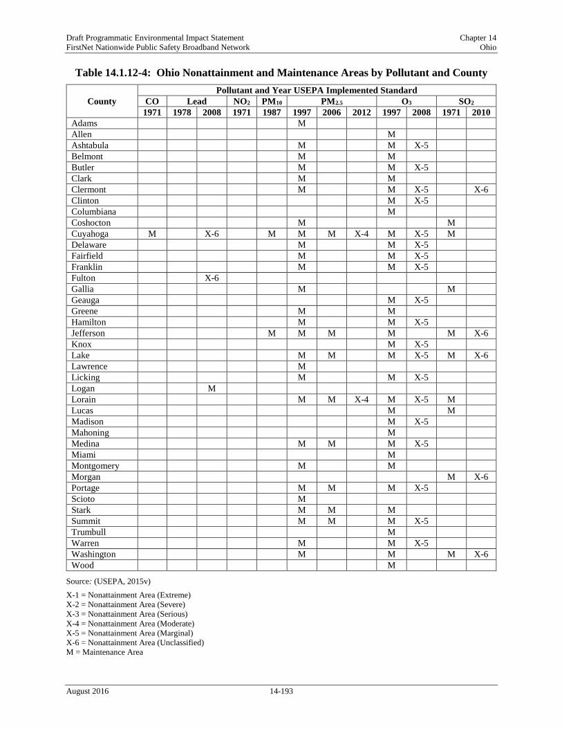
Draft Programmatic Environmental Impact Statement Chapter 14 FirstNet Nationwide Public Safety Broadband Network Ohio
Table 14.1.12-4: Ohio Nonattainment and Maintenance Areas by Pollutant and County
County Pollutant and Year USEPA Implemented Standard
CO Lead NO2 PM10 PM2.5 O3 SO2 1971 1978 2008 1971 1987 1997 2006 2012 1997 2008 1971 2010
Adams M Allen M Ashtabula M M X-5 Belmont M M Butler M M X-5 Clark M M Clermont M M X-5 X-6 Clinton M X-5 Columbiana M Coshocton M M Cuyahoga M X-6 M M M X-4 M X-5 M Delaware M M X-5 Fairfield M M X-5 Franklin M M X-5 Fulton X-6 Gallia M M Geauga M X-5 Greene M M Hamilton M M X-5 Jefferson M M M M M X-6 Knox M X-5 Lake M M M X-5 M X-6 Lawrence M Licking M M X-5 Logan M Lorain M M X-4 M X-5 M Lucas M M Madison M X-5 Mahoning M Medina M M M X-5 Miami M Montgomery M M Morgan M X-6 Portage M M M X-5 Scioto M Stark M M M Summit M M M X-5 Trumbull M Warren M M X-5 Washington M M M X-6 Wood M
Source: (USEPA, 2015v) X-1 = Nonattainment Area (Extreme) X-2 = Nonattainment Area (Severe) X-3 = Nonattainment Area (Serious) X-4 = Nonattainment Area (Moderate) X-5 = Nonattainment Area (Marginal) X-6 = Nonattainment Area (Unclassified) M = Maintenance Area
August 2016 14-193

Draft Programmatic Environmental Impact Statement Chapter 14 FirstNet Nationwide Public Safety Broadband Network Ohio
Air Quality Monitoring and Reporting
The Ohio EPA measures air pollutants at 153 sites across the state as part of the National Air Monitoring Stations Network and the State and Local Air Monitoring Stations Network. Nine local air agencies and five district offices in Ohio operate these monitoring sites and include: • Akron Regional Air Quality Management District; • City of Toledo – Division of Environmental Services; • Air Pollution Control Division – Canton City Health Department; • Mahoning-Trumbull APC Agency; • Department of Environmental Services – Southwestern Ohio Air Quality Agency; • Regional Air Pollution Control Agency – Montgomery County Health Department; • Cleveland Department of Public Health and Welfare – Division of Air Quality; • Lake County General Health District – Air Pollution Control; • Air Pollution Unit – Portsmouth City Health Department; • Ohio EPA – Central District Office; • Ohio EPA – Northeast District Office; • Ohio EPA – Northwest District Office; • Ohio EPA – Southeast District Office; and • Ohio EPA – Southwest District Office (OEPA, 2015m).
Ohio EPA prepares Annual Air Quality Reports, containing pollutant data summarized by region. Additionally, Ohio EPA reports real time air quality indices on wwwapp.epa.ohio.gov/gis/mapportal/index.html.
Throughout 2013, there were no exceedances of the state air quality standards or PM10, NO2, or CO NAAQS. The concentration of criteria pollutants in multiple counties exceeded the NAAQS, as shown in Table 14.1.12-5.
Table 14.1.12-5: Violations of NAAQS by Ohio Counties in 2013 County O3
(8-hour) Lead
(3-month) SO2
(1-hour) PM2.5
(Annual) Butler X X Clermont X Clinton X Cuyahoga X X X Franklin X Fulton X Hamilton X X X Jefferson X Lake X X Montgomery X Morgan X Stark X X Trumbull X Warren X
Source: (OEPA, 2014d)
August 2016 14-194

Draft Programmatic Environmental Impact Statement Chapter 14 FirstNet Nationwide Public Safety Broadband Network Ohio
Air Quality Control Regions
USEPA classified all land in the United States as a Class I, Class II, or Class III Federal Air Quality Control Region (AQCR). These are different from the air quality classification levels defined in Table 14.1.12-1 as part of the Ohio AAQS (42 U.S.C. §7470). Class I areas include international parks, national wilderness areas which exceed 5,000 acres in size, national memorial parks which exceed 5,000 acres in size, and national parks which exceed 6,000 acres in size. Class I areas cannot be re-designated as Class II or Class III and are intended to maintain pristine air quality. Although USEPA developed the standards for a Class III AQCR, to date they have not actually classified any area as Class III. Therefore, any area that is not classified as a Class I area is, by default, automatically designated as a Class II AQCR (42 U.S.C. 7472).
In a 1979 USEPA memorandum, the Assistant Administrator for Air, Noise, and Radiation (USEPA 1979) advised USEPA Regional Offices to provide notice to the Federal Land Manager (FLM) of any facility subject to the Prevention of Significant Deterioration (PSD) permit requirements and within 100 kilometers133 of a Class I area. “The USEPA’s policy is that FLMs should be notified by the Regional Office about any project that is within 100 kilometers of a Class I area. For sources having the capability to affect air quality at greater distances, notification should also be considered for Class I areas beyond 100 kilometers” (Page, 2012a). The 2005 USEPA guidelines for air quality modeling do not provide a precise modeling range for Class I areas.
PSD applies to new major sources or major modifications at existing sources for pollutants where the source is in an attainment or unclassifiable area. An air quality analysis is required for sources subject to PSD requirements and generally consists of using a dispersion model to evaluate emission impacts to the area. “Historically, the USEPA guidance for modeling air quality impacts under the PSD program has tended to focus more on the requirements for a Class II modeling analysis. Such guidance has advises that applicants need not model beyond the point of significant impact or the source or 50 kilometers134 (the normal useful range of USEPA-approved Gaussian plume models” (USEPA, 1992).
Ohio does not contain any Federal Class I areas; all land within the state is classified as Class II (USEPA, 2012a). If an action is considered major source and consequently subject to PSD requirements, the air quality impact analysis need only to analyze the impacts to air quality within 100 kilometers from the source (USEPA, 1992). Additionally, no other adjacent states have Class I areas within 100 kilometers of the Ohio border. Therefore, notification to FLM will not be required for actions with Ohio or adjacent states.
133 The memorandum and associated guidance use kilometers. 100 kilometers is equal to about 62 miles. 134 The memorandum and associated guidance use kilometers. 50 kilometers is equal to about 31 miles.
August 2016 14-195
Draft Programmatic Environmental Impact Statement Chapter 14 FirstNet Nationwide Public Safety Broadband Network Ohio
Noise This section presents a discussion of a basic understanding of environmental noise, background/ambient noise levels, noise standards, and guidelines.
14.1.13.1. Definition of the Resource Noise is a form of sound caused by pressure variations that the human ear can detect and is often defined as unwanted sound (USEPA, 2012b). Noise is one of the most common environmental issues that interferes with normal human activities and otherwise diminishes the quality of the human environment. Typical sources of noise that result in this type of interference in urban and suburban surroundings includes interstate and local roadway traffic, rail traffic, industrial activities, aircraft, and neighborhood sources like lawn mowers, leaf blowers, etc.
The effects of noise can be classified into three categories: • Noise events that result in annoyance and nuisance; • Interference with speech, sleep, and learning; and • Physiological effects such as hearing loss and anxiety.
Fundamentals of Noise
For environmental noise analyses, a noise metric refers to the unit that quantitatively measures the effect of noise on the environment. The unit used to describe the intensity of sound is the decibel (dB). Audible sounds range from 0 dB (“threshold of hearing”) to about 140 dB (“threshold of pain”) (OSHA, 2016a). The vibration frequency characteristics of the sound, measured as sound wave cycles per second [Hertz (Hz)], determines the pitch of the sound (FTA, 2006). The normal audible frequency range is approximately 20 Hz to 20 kHz (FAA, 2015g). The A-weighted scale, denoted as dBA, approximates the range of human hearing by filtering out lower frequency noises, which are not as damaging as the higher frequencies. The dBA scale is used in most noise ordinances and standards (OSHA, 2016a). Measurements and descriptions of noise (i.e., sounds) are based on various combinations of the following factors (FTA, 2006): • The total sound energy radiated by a source, usually reported as a sound power level; • The actual air pressure changes experienced at a particular location, usually measured as a
sound pressure level (SPL) (the frequency characteristics and SPL combine to determine the loudness of a sound at a particular location);
• The duration of a sound; and • The changes in frequency characteristics or pressure levels through time.
Figure 14.1.13-1 presents the sound levels of typical events that occur on a daily basis in the environment. For example, conversational speech is measured at about 55 to 60 dBA, whereas a band playing loud music may be as high as 120 dBA.
August 2016 14-196

Draft Programmatic Environmental Impact Statement Chapter 14 FirstNet Nationwide Public Safety Broadband Network Ohio
Figure 14.1.13-1: Sound Levels of Typical Sounds Prepared by: Booz Allen Hamilton Leq: Equivalent Continuous Sound Level
Source: (Sacramento County Airport System, 2015)
Because of the logarithmic unit of measurement, sound levels cannot be added or subtracted linearly. However, several methods of estimating sound levels can be useful in determining approximate sound levels. First, if two sounds of the same level are added, the sound level increases by approximately three dB (for example: 60 dB + 60 dB = 63 dB). Secondly, the sum of two sounds of a different level is slightly higher than the louder level (for example: 60 dB + 70 dB = 70.4 dB).
The changes in human response to changes in dB levels is categorized as follows (FTA, 2006): • A 3-dB change in sound level is considered a barely noticeable difference; • A 5-dB change in sound level will typically result in a noticeable community response; and • A 10-dB change, which is generally considered a doubling of the sound level, almost
certainly causes an adverse community response.
August 2016 14-197

Draft Programmatic Environmental Impact Statement Chapter 14 FirstNet Nationwide Public Safety Broadband Network Ohio
In general, ambient noise levels are higher during the day than at night and typically this difference is about 10 dB (USEPA, 1973). Ambient noise levels can differ considerably depending on whether the environment is urban, suburban, or rural.
14.1.13.2. Specific Regulatory Considerations
As identified in Appendix C, Environmental Laws and Regulations, the Noise Control Act of 1972, along with its subsequent amendments (e.g., Quiet Communities Act of 1978 [42 U.S.C. Parts 4901−4918]), delegates authority to the states to regulate environmental noise and directs government agencies to comply with local community noise statutes and regulations. Although no federal noise regulations exist, the USEPA has promulgated noise guidelines (USEPA, 1974). Similarly, most states have no quantitative noise-limit regulations. Ohio has several statewide noise regulations written into its general and permanent law, which are compiled under the Ohio Revised Code. They mainly apply to motor vehicle functions such as engine running, braking, and horns. Table 14.1.13-1 provides a brief summary of these regulations.
Table 14.1.13-1: Relevant Ohio Noise Laws and Regulations State Law/ Regulation
Regulatory Agency Applicability
OAC 4513.21 Ohio DOT Requires motor vehicles to be equipped with a horn and prohibits motor vehicles to be equipped with a siren, whistle, or bell.
OAC 4513.22 Ohio DOT Requires motor vehicles to be equipped with a muffler to prevent excessive or unusual noise.
OAC 4513.221 Ohio DOT Establishes maximum operational noise limits for motor vehicles and motorcycles.
Many cities and towns may have additional, local noise ordinances to further manage community noise levels. The noise limits specified in such ordinances are typically applied to define noise sources and specify a maximum permissible noise level. Large cities and towns, such as Cincinnati, Cleveland, and Columbus, are likely to have different regulations than rural or suburban communities largely due to the population density and difference in ambient noise levels (FHWA, 2011a).
14.1.13.3. Environmental Setting: Ambient Noise
The range and level of ambient noise in Ohio varies widely based on the area and environment of the area. The population of Ohio can choose to live and interact in areas that are large cities, rural or suburban communities, small towns, and national and state parks. Figure 14.1.13-1 illustrates noise values for typical community settings and events that are representative of what the population of Ohio may experience on a day-to-day basis. These noise levels represent a wide range and are not specific to Ohio. As such, this section describes the areas where the population of Ohio can potentially be exposed to higher than average noise levels.
• Urban Environments: Urban areas are likely to have higher noise levels on a daily basis due to highway traffic (70 to 90 dBA), construction noise (90 to 120 dBA), and outdoor
August 2016 14-198

Draft Programmatic Environmental Impact Statement Chapter 14 FirstNet Nationwide Public Safety Broadband Network Ohio
conversations (e.g., small/large groups of people) (60 to 90 dBA) (U.S. Department of Interior, Bureau of Reclamation, 2008). The urban areas that are likely to have the highest ambient noise levels in the state are Cincinnati, Cleveland, and Columbus.
• Airports: Areas surrounding airports tend to have higher noise levels due to aircraft operations that occur throughout the day. A jet engine aircraft can produce between 130 to 160 dBA in its direct proximity (FAA, 2007). However, commercial aircraft are most likely to emit noise levels between 70 to 100 dBA depending of the type of aircraft and associated engine (FAA, 2012b). This noise will be perceived differently based on the altitude of the aircraft and its distance to the point of measurement. Airport operations are primarily arrivals and departures of commercial aircraft, but based on the type of airport, can include touch-and-go operations that are typical of general aviation airports and military airfields. The location of most commercial airports is in proximity to urban communities resulting in noise exposures from aircraft operations (arrivals/departures) to surrounding areas at higher levels and with the potential for increased noise levels during peak operation times (early morning and evenings), when there is an increase in air traffic. The noise levels in areas surrounding commercial airports can have significantly higher ambient noise levels than in other areas. In Ohio, Cleveland-Hopkins International Airport (CLE), Port Columbus International Airport (CMH), and James M. Cox-Dayton International Airport (DAY) have combined annual operations of more than 308,000 flights (FAA, 2015j). These operations result in increased ambient noise levels in the surrounding communities. See Section 14.1.7, Land Use, Recreation, and Airspace, and Figure 14.1.7-8 for more information about airports in the state.
• Highways: Communities near major highways also experience higher than average noise levels when compared to areas that are not in close proximity to a highway (FHWA, 2015d). There are a number of major highways within the state that may contribute to higher ambient noise levels for residents living in those areas. The major highways in the state tend to have higher than average ambient noise levels on nearby receptors, ranging from 52 to 75 dBA (FHWA, 2015d). See Section 14.1.1.4, Public Safety Services, and Figure 14.1.1-1 for more information about the major highways in the state.
• Railways: Like highways, railways tend to have higher than average ambient noise levels for residents living in close proximity (FTA, 2006). Railroad operations can produce noise ranging from 70 dBA for an idling locomotive to 115 dBA when the locomotive engineer rings the horn while approaching a crossing (USDOT, 2015b). Ohio has multiple rail corridors with high levels of commercial and commuter rail traffic. The Ohio section of the Cardinal route stops in Cincinnati. The Ohio sections of the Capitol Limited and the Lake Shore Limited routes stops in Alliance, Cleveland, Elyria, Sandusky, and Toledo (ODOT, 2010d). See Section 14.1.1.4, Public Safety Services, and Figure 14.1.1-1 for more information about rail corridors in the state.
• National and State Parks: The majority of national and state parks are likely to have lower than average ambient noise levels given their size and location in wilderness areas. National and state parks, historic areas, and monuments are protected areas to preserve these areas in
August 2016 14-199

Draft Programmatic Environmental Impact Statement Chapter 14 FirstNet Nationwide Public Safety Broadband Network Ohio
their natural environment. These areas typically have lower noise levels, as low as 30 to 40 dBA (NPS, 2014e). Ohio has thirteen national park units (NPS, 2015k). Visitors to these areas expect lower ambient noise conditions than the surrounding urban areas. See Section 14.1.8, Visual Resources, and Figure 14.1.8-2 for more information about national and state parks for Ohio.
14.1.13.4. Sensitive Noise Receptors
Noise-sensitive receptors include residences, schools, medical facilities, places of worship, libraries, churches, nursing homes, concert halls, playgrounds, and parks. Sensitive noise receptors are typically areas where the intrusion of noise can disrupt the use of the environment. A quiet urban area usually has a typical noise level in the daytime of 50 dBA, and 40 dBA during the evening. Noise levels in remote wilderness and rural nighttime areas are usually 30 dBA (BLM, 2014). Most cities, towns, and villages in Ohio have at least one school, church, or park, in addition to likely having other noise-sensitive receptors. There are most likely thousands of sensitive receptors throughout the state of Ohio.
Climate Change
14.1.14.1. Definition of the Resource
Climate change, according to the Intergovernmental Panel on Climate Change (IPCC), is defined as “…a change in the state of the climate that can be identified (e.g., using statistical tests) by changes in the mean and/or the variability of its properties, and that persists for an extended period, typically decades or longer. It refers to any change in climate over time, whether due to natural variability or human activity.” (IPCC, 2007)
Accelerated rates of climate change are linked to an increase in atmospheric concentrations of greenhouse gas (GHG) caused by emissions from human activities such as burning fossil fuels to generate electricity (USEPA, 2012c). The IPCC is now 95 percent certain that humans are the main cause of current global warming (IPCC, 2013). Human activities result in emissions of four main GHGs: carbon dioxide (CO2), methane (CH4), nitrous oxide (N2O), and halocarbons (a group of gases containing fluorine, chlorine, or bromine) (IPCC, 2007). The common unit of measurement for GHGs is metric tons of CO2-equivalent135 (MT CO2e), which equalizes for the different global warming potential of each type of GHG. Where this document references emissions of CO2 only, the units are in million metric tons (MMT) CO2. Where the document references emissions of multiple GHGs, the units are in MMT CO2e.
“Global concentrations of these four GHGs have increased significantly since 1750” (USGCRP, 2014a). “Atmospheric concentrations of CO2 increased from 280 parts per million (ppm) of carbon in 1750 to 379 ppm of carbon in 2005” (USGCRP, 2014a). The atmospheric
135 CO2e refers to Carbon Dioxide Equivalent, “A metric measure used to compare the emissions from various greenhouse gases based upon their global warming potential (GWP). Carbon dioxide equivalents are commonly expressed as million metric tons of carbon dioxide equivalents (MMT CO2e). The carbon dioxide equivalent for a gas is derived by multiplying the tons of the gas by the associated GWP. MMT CO2e = (million metric tons of a gas) * (GWP of the gas)” (USEPA, 2015n).
August 2016 14-200

Draft Programmatic Environmental Impact Statement Chapter 14 FirstNet Nationwide Public Safety Broadband Network Ohio
concentration of CH4 has increased from a pre-industrial value of about 715 parts per billion (ppb) to 1774 ppb in 2005 (USGCRP, 2014a). “Atmospheric concentrations of N2O increased from a pre-industrial value of about 270 ppb to 319 ppb in 2005” (USGCRP, 2014a). “Many halocarbons have increased from a near-zero pre-industrial concentrations, primarily due to human activities” (USGCRP, 2014a).
Both the GHG emissions effects of the Proposed Action and Alternatives, and the relationships of climate change effects to the Proposed Action and Alternatives, are considered in this PEIS (see Section 14.2, Environmental Consequences). Therefore, to form the baseline against which to assess possible impacts from the Proposed Action, the existing climate conditions in the project area will be described first by state and sub-region, where appropriate, and then future projected climate scenarios will be described by state and sub-region. The discussion will focus on the following climate change impacts: 1) temperature; 2) precipitation; 3) sea level; and 4) severe weather events (including tropical storms, tropical cyclones, and hurricanes).
14.1.14.2. Specific Regulatory Considerations
The pertinent federal laws relevant to the protection and management of climate change are summarized in Appendix C, Environmental Laws and Regulations. Ohio has not established goals and regulations to reduce GHG emissions to combat climate change. However, Cleveland, one of the largest cities in Ohio has developed a Climate Action Plan as shown in Table 14.1.14-1.
Table 14.1.14-1: Relevant Ohio Climate Change Laws and Regulations State Law/Regulations Regulatory Agency Applicability
Cleveland Climate Action Plan, 2013
City of Cleveland: The Mayor’s Office of Sustainability
In 2013, the Mayor’s Office of Sustainability produced the “Cleveland Climate Action Plan: Building Thriving and Healthy Neighborhoods”, which set the following GHG reduction goals for the City of Cleveland: • 80 percent reduction below 2010 emissions by 2050; • 16 percent reduction below 2010 emissions by 2020; and • 40 percent reduction below 2010 emissions by 2030.
(Cleveland Mayor's Office of Sustainability, 2013)
14.1.14.3. Ohio Greenhouse Gas Emissions
Estimates of Ohio’s total GHG emissions vary. The Department of Energy’s Energy Information Agency (EIA) collects and disseminates data on national-level emissions of CO2 from fossil fuels by state. In addition, EIA maintains data on other GHGs such as CH4 and nitrous oxide (NOx), but these are not broken down by state (BLS, 2015c). The USEPA also collects and disseminates national-level GHG emissions data, but by economic sector, not by state (USEPA, 2015h). Individual states have developed their own GHG inventories and these are updated with different frequencies and trace GHG in different ways.
According to the EIA, Ohio emitted a total of 228.7 MMT of CO2 in 2013 from fossil fuels, with coal in the electric power sector as the dominant source at almost 40 percent of total CO2 emissions. Petroleum from the transportation sector is the next largest source (26 percent of CO2
August 2016 14-201

Draft Programmatic Environmental Impact Statement Chapter 14 FirstNet Nationwide Public Safety Broadband Network Ohio
emissions). Emissions between 1980 and 2013 are presented in Table 14.1.14-2 (EIA, 2015f). Ohio’s CO2 emissions decreased from 1980 to 1983, and then began a slow, intermittent increase until between 2003 and 2009 where emissions hovered around 260-270 MMT. From 2009 to 2012, they declined to their 2012 level of 215.2 MMT, their lowest level in this data set. Emissions increased in 2013 by 13.5 MMT, increases came mostly from the electric power and residential sectors (EIA, 2015f). Ohio was ranked 5th in the U.S. and District of Columbia in 2013 for total CO2 emissions from fossil fuels, and 20th for per-capita emissions (EIA, 2015i).
Table 14.1.14-2: Ohio CO2 Emissions from Fossil Fuels by Fuel Type and Source, 2013
Fuel Type (MMT) Source (MMT)
Coal 104.1 Residential 18.0
Petroleum Products 74.4 Commercial 10.9
Natural Gas 50.2 Industrial 38.3
Transportation 59.9
Electric Power 101.5
Total 228.7 Total 228.7
Source: (EIA, 2015f)
August 2016 14-202

Draft Programmatic Environmental Impact Statement Chapter 14 FirstNet Nationwide Public Safety Broadband Network Ohio
Figure 14.1.14-1: Ohio CO2 Emissions from Fossil Fuels by Fuel Type 1980-2013 Source: (EIA, 2015f)
The majority of Ohio’s GHG emissions is CO2. These emissions are the result of fossil fuel combustion for producing energy, mostly petroleum products from electric power generating facilities and coal-fired power plants. Other major GHGs emitted in Ohio are CH4, hydrofluorocarbons, NOx, sulfur hexafluoride (SF6) and perfluorocarbons (OEPA, 2015r).
Ohio does not currently have an official state-level greenhouse gas emission inventory. Total U.S. GHG greenhouse were 6,673 million metric tons (14.7 trillion pounds) in 2013 (USEPA, 2015a).
Over the past decade, Ohio has produced approximately 3 million barrels of crude oil annually. In 2013, oil drilling increased in Ohio, which resulted in the state producing 14 million barrels in 2014, and more than 26 million barrels in 2015 (EIA, 2015g). Ohio is a large petroleum consumer but it does not produce enough to meet the state’s demand therefore, Ohio receives oil from pipelines which is then refined in one of the state’s four refineries. “The state’s refineries have a combined capacity of 557,000 barrels of oil per day.” Ohio is consistently among the top 10 refining states in the nation” (EIA, 2015g).
Although natural gas production in Ohio has increased in the last three years, it does not produce enough to meet demands. A majority of natural gas enters the state from Indiana, West Virginia, and Pennsylvania, although only three tenths of the natural gas entering the state is used in Ohio.
August 2016 14-203

Draft Programmatic Environmental Impact Statement Chapter 14 FirstNet Nationwide Public Safety Broadband Network Ohio
The industrial and residential sectors continue to consume the bulk of Ohio’s natural gas, which is used for heating homes and for electric power generation (EIA, 2015g).
Ohio is a large producer of coal through surface and underground mines. Ohio consumes a large amount of coal for power generation and approximately two fifths of coal is shipped to other states. Because the Ohio coal mines do not meet the state’s demand, coal is imported from surrounding states. Although coal is the largest resource used for power generation, Ohio also has two nuclear power plants and continues to increase its wind generation potential, which may help reduce emissions. (EIA, 2015g)
14.1.14.4. Environmental Setting: Existing Climate
The National Weather Service defines climate as the “reoccurring average weather found in any particular place” (NWS, 2011a). The widely accepted division of the world into major climate categories is referred to as the Köppen-Geiger climate classification system. Climates within this system are classified based “upon general temperature profiles related to latitude” (NWS, 2011a). The first letter in each climate classification details the climate group. The Köppen-Geiger system further divides climates into smaller sub-categories based on precipitation and temperature patterns. The secondary level of classification details the seasonal precipitation, degree of aridity, and presence or absence of ice. The tertiary levels distinguish different monthly characteristics (NWS, 2011a).
The Köppen-Geiger climate classification system classifies southern regions of Ohio as climate group (C) (see Figure 14.1.14-2). Climates classified as (C) are generally warm, with humid summers and mild winters. During winter months, the mean climate feature is the mid-latitude cyclone (NWS, 2011a). Northern regions of Ohio are classified as climate group (D) (see Figure 14.1.14-2). Climates classified as (D) are “moist continental mid-latitudinal climates,” with “warm to cool summers and cold winters” (NWS, 2011a). In (D) climates, the “average temperature of the warmest month is greater than 50 degrees Fahrenheit (oF), while the coldest month is less than negative 22 °F” (NWS, 2011a). Winter months in (D) climate zones are cold and severe with “snowstorms, strong winds, and bitter cold from Continental Polar or Arctic air masses” (NWS, 2011a) (NWS, 2011b). In addition, there are many thunderstorms during summer months. Ohio has three sub-climate categories, which are described in the following paragraphs: Cfa – The Köppen-Geiger climate classification system classifies areas of southern Ohio, such as Cincinnati, as Cfa. Cfa climates are generally warm, with humid summers and mild winters. In this climate classification zone, the secondary classification indicates year-round rainfall, but it is highly variable; thunderstorms are dominant during summer months. In this climate classification zone, the tertiary classification indicates mild, hot summers with average temperature of warm months over 72 °F. Average temperatures of the coldest months are under 64 °F. (NWS, 2011a) (NWS, 2011b)
Dfa – The Köppen-Geiger climate classification system classifies areas of central and northern Ohio, such as Columbus, as Dfa. Climates classified as Dfa are characterized by warm and humid temperatures, with hot summers and precipitation occurring regularly throughout the year.
August 2016 14-204

Draft Programmatic Environmental Impact Statement Chapter 14 FirstNet Nationwide Public Safety Broadband Network Ohio
In this climate classification zone, the secondary classification indicates substantial precipitation during all seasons. In this climate classification zone, the tertiary classification indicates hot summer months, with warmer temperatures averaging above 71.6 °F. (NWS, 2011a) (NWS, 2011b)
Dfb – The Köppen-Geiger climate classification system classifies areas of northeastern Ohio, such as Cleveland, as Dfb. Climates classified as Dfb are fully humid climates, with warm summers and snowy winters. The secondary climate classification in this zone (f) indicates substantial precipitation during all seasons. The tertiary climate classification in this zone (b) indicates that at least four months out of the year average above 50 °F. (NWS, 2011a) (NWS, 2011b)
Figure 14.1.14-2: Köppen-Geiger Climate Classes for U.S. Counties Source: (Kottek, Grieser, Beck, Rudolf, & Rubel, 2006)
Air Temperature
Ohio’s climate is classified as a mid-latitude and continental, with cold winters and warm summers. The highest temperature to occur in Ohio was on July 21, 1934 with a record of 113
August 2016 14-205

Draft Programmatic Environmental Impact Statement Chapter 14 FirstNet Nationwide Public Safety Broadband Network Ohio
°F in Gallipolis (NOAA, 2015e). The lowest temperature to occur in Ohio was on February 10, 1899 with a record low of negative 39 °F (NOAA, 2015e).
Cfa – Cincinnati, in southwestern Ohio, is within the climate classification zone Cfa. (NOAA, 2015f). The average annual temperature in Cincinnati is approximately 54.3 °F; 33.5 °F during winter months; 74.0 °F during summer months; 53.6 °F during spring months; and 55.8 °F during autumn months. (NOAA, 2015g)
Dfa – Columbus, in central Ohio, is within the climate classification zone Dfa. The average annual temperature in Columbus is approximately 53.4 °F; 31.9 °F during winter months; 73.6 °F during summer months; 52.5 °F during spring months; and 55.4 °F during autumn months. (NOAA, 2015g)
Dfb – Cleveland, in northwestern Ohio, is within the climate classification zone Dfb. The average annual temperature in Cleveland is approximately 51.4 °F; 30.3 °F during winter months; 71.6 °F during summer months; 49.3 °F during spring months; and 54.2 °F during autumn months. (NOAA, 2015g)
Precipitation
Statewide, precipitation is fairly regular, with “most parts of the state [receiving] at least two inches of precipitation per month due to continuous Gulf of Mexico moisture influx” (Rogers, J., 2015). During summer months, heavy rains dominate the majority of Ohio’s counties. During winter months, winter cyclones from the Gulf of Mexico move northward and into the state. In the north, annual precipitation average approximately 43 inches, while areas in western Ohio average only 33 inches annually. “The major exception to the south to north crease lies in the hilly northeastern counties, east of Cleveland and just south of Lake Erie” (Rogers, J., 2015). The greatest 24-hour precipitation record occurred on August 7- 8, 1995 with a record accumulation of 10.75 inches near Lockington Dam (NOAA, 2015e).
In areas such as Chardon, annual snowfall totals approximately 108 inches, “forming the core of the Ohio lake-effect snow belt and producing annual precipitation up to 47 inches” (Rogers, J., 2015). In western Ohio, average snowfall totals begin to decrease with approximately 25 inches per year. In Ohio’s southernmost counties, snowfall totals typically do not exceed 20 inches. The greatest 24-hour snowfall record occurred on April 20, 1901 with a record accumulation of 30 inches in Warren (NOAA, 2015e) (Rogers, J., 2015).
Cfa – Cincinnati, in southwestern Ohio, is within the climate classification zone Cfa (NOAA, 2015f). The average annual precipitation accumulation in Cincinnati is 41.95 inches; 8.51 inches during winter months; 11.52 inches during summer months; 12.77 inches during spring months; and 9.14 inches during autumn months (NOAA, 2015g).
Dfa – Columbus, in central Ohio, is within the climate classification zone Dfa. The average annual precipitation accumulation in Columbus is 39.31 inches; 7.95 inches during winter months; 12.12 inches during summer months; 10.59 inches during spring months; and 8.65 inches during autumn months. (NOAA, 2015g)
August 2016 14-206

Draft Programmatic Environmental Impact Statement Chapter 14 FirstNet Nationwide Public Safety Broadband Network Ohio
Dfb – Cleveland, in northwestern Ohio, is within the climate classification zone Dfb. The average annual precipitation accumulation in Cleveland is 39.14 inches; 8.16 inches during winter months; 10.40 inches during summer months; 10.08 inches during spring months; and 10.50 inches during autumn months. (NOAA, 2015g)
Severe Weather Events
“Ohio has the climatological distinction of being one of the most active areas in the country for mid-summer thunderstorms producing severe winds exceeding 58 miles per hour” (Rogers, J., 2015). Thunderstorms in Ohio are most common during humid, summer months. During one of Ohio’s most destructive severe storms, Hurricane Ike, wind was the primary culprit of damage. On September 14, 2008, the hurricane passed over Ohio with winds reaching over 50 miles per hour (mph) for up to six hours. As a result, Ohio suffered approximately $1.25 billion in damages. Traveling winter cyclones are also common during winter months in Ohio, as the Gulf of Mexico brings moisture northward (Rogers, J., 2015).
Flooding in Ohio is also common, with the majority of floods occurring due to heavy rainfall, excessive or rapid snowmelt, or dam breaks and/or levee failures. During one of Ohio’s most deadly flooding events, excessive amounts of rain fell throughout the Ohio Valley in March of 1913. Statewide, every river in Ohio flooded its banks. As a result, 500 people died in Ohio, and approximately a quarter million were left homeless. Damages totaled in the hundreds of millions of dollars. This flooding event was one of the worst in the history of the U.S. (NWS, 2015a).
During another severe flooding event in 1964, thunderstorms originating over Lake Erie moved onshore bringing with them rainfall totals in excess of 10 inches. In addition to severe flooding, these thunderstorms “produced damaging winds, tornadoes, and prolific lightening” (NWS, 2015a). This storm “resulted in 41 fatalities, more than 500 injuries, and damaged or destroyed more than 10,000 homes and businesses” (NWS, 2015a). More recently, in 1990, deadly flash floods occurred in eastern Ohio. During these floods, more than three inches of rain fell along Pipe and Wegee Creeks within 2-hours. In total, 26 people were killed (NWS, 2015a).
Human Health and Safety
14.1.15.1. Definition of the Resource
The existing environment for health and safety is defined by occupational and environmental hazards likely to be encountered during the deployment, operation, and maintenance of towers, antennas, cables, utilities, and other equipment and infrastructure at existing and potential FirstNet telecommunication sites. There are two human populations of interest within the existing environment of health and safety, (1) telecommunication occupational workers and (2) the general public near telecommunication sites. Each of these populations could experience different degrees of exposure to hazards as a result of their relative access to FirstNet telecommunication sites and their function throughout the deployment of the FirstNet telecommunication network infrastructure.
August 2016 14-207

Draft Programmatic Environmental Impact Statement Chapter 14 FirstNet Nationwide Public Safety Broadband Network Ohio
The health and safety issues reviewed in this section include occupational safety for telecommunications workers, contaminated sites, and manmade or natural disaster sites. This section does not evaluate the health and safety risks associated with radio frequency (RF) radiation, vehicular traffic, or the transportation of hazardous materials and wastes. Vehicle traffic and the transportation of hazardous materials and wastes are evaluated in Section 14.1.1, Infrastructure.
14.1.15.2. Specific Regulatory Considerations
Federal organizations, such as the OSHA, USEPA, the U.S. Department of Health and Human Services, and others protect human health and the environment. In Ohio, this resource area is regulated by the Ohio Bureau of Workers’ Compensation (OBWC), and the OEPA regulates waste and environmental pollution. Health and safety of the general public is regulated by the Ohio Department of Health (ODH). Federal OSH regulations apply to workers through either OSHA, or stricter state-specific plans that must be approved by OSHA. Ohio does not have an OSHA-approved “State Plan.” Therefore, public and private sector occupational safety and health programs in the state of Ohio are enforced by OSHA.
Federal laws relevant to protecting occupational and public health and safety are summarized in Appendix C, Environmental Laws and Regulations. Table 14.1.15-1 summarizes the major Ohio laws relevant to the state’s occupational health and safety programs.
Table 14.1.15-1: Relevant Ohio Human Health and Safety Laws and Regulations State Law/Regulation Regulatory Agency Applicability
OAC Chapter 3745-1 OEPA Establishes minimum water quality standards for surface waters of the state to protect public health and welfare.
OAC Chapter 3745-33 OEPA Details state permitting requirements for point-source discharges of pollutants.
OAC Chapter 3745-54-90
OEPA Details the groundwater protection standard, which includes protection standards, hazardous constituents, compliance, and monitoring requirements.
OAC Chapter 3745-300 OEPA Describes eligibility requirements for the Voluntary Action Program (VAP), as well as standards for Phase I and II assessments, risk assessment, and remediation of contaminated sites.
OAC Chapter 1513 ODNR Details occupation worker standards for reclamation of abandoned mine lands (AML).
14.1.15.3. Environmental Setting: Existing Telecommunication Sites
There are many inherent health and safety hazards at telecommunication sites. Telecommunication site work is performed indoors, below ground level, on building roofs, over water bodies, and on communication towers. Tasks may also be performed at dangerous heights or in confined spaces, while operating heavy equipment, on energized equipment near underground and overhead utilities, and while using hazardous materials, such as flammable gases and liquids. Because telecommunication workers are often required to perform work outside, heat and cold exposure, precipitation, and lightning strikes also present hazard and risks
August 2016 14-208

Draft Programmatic Environmental Impact Statement Chapter 14 FirstNet Nationwide Public Safety Broadband Network Ohio
depending on the task, occupational competency, and work-site monitoring. A summary description of the health and safety hazards present in the telecommunication occupational work environment is listed below.
Working from height, overhead work, and slips, trips, or falls – At tower and building-mount sites, workers regularly climb structures using fixed ladders or step bolts to heights up to 2,000 feet above the ground’s surface (OSHA, 2015a). In addition to tower climbing hazards, telecommunication workers have restricted workspace on rooftops or work from bucket trucks parked on uneven ground. Cumulatively, these conditions present fall and injury hazards to telecommunication workers, and the general public who may be observing the work or transiting the area (International Finance Corporation, 2007).
Trenches and confined spaces –Installation of underground utilities, building foundations, and work in utility manholes136 are examples of when trenching or confined space work is necessary. Installation of telecommunication activities involves laying conduit and limited trenching (generally 6 to 12 inches in width) would occur. Confined space work can involve poor atmospheric conditions, requiring ventilation and rescue equipment. Additionally, when inside a confined space, worker movement is restricted and may prevent a rapid escape or interfere with proper work posture and ergonomics.
Heavy equipment and machinery – New and replacement facility deployment and maintenance can involve the use of heavy equipment and machinery. During the lifecycle of a telecommunication site, heavy equipment such as bulldozers, backhoes, dump trucks, cement trucks, and cranes are used to prepare the ground, transport materials and soil, and raise large sections of towers and antennas. Telecommunication workers may be exposed to the additional site traffic and often work near heavy equipment to direct the equipment drivers and to accomplish work objectives. Accessory machinery such as motorized pulley systems, hydraulic metal shears, and air driven tools present additional health and safety risks as telecommunication work sites. These pieces of machinery can potentially sever skin and bone, or cause other significant musculoskeletal injuries to the operator.
Energized equipment and existing utilities – Electrical shock from energized equipment and utilities is an elevated risk at telecommunication sites due to the amount of electrical energy required for powering communication equipment and broadcasting towers. Telecommunication cables are often co-located with underground and overhead utilities, which can further increase occupational risk during earth-breaking and aerial work.
Optical fiber safety – Optical fiber cable installation and repair presents additional risks to telecommunications workers, including potential eye or tissue damage, through ingestion, inhalation, or other contact with glass fiber shards. The shards are generated during termination and splicing activities, and can penetrate exposed skin (International Finance Corporation, 2007). Additionally, fusion splicing (to join optical fibers) in confined spaces or other environments
136 Manholes may be used for telecommunications activities, especially in cities and urban areas, depending on the location of other utilities. In cities, power, water, and telecommunication lines are often co-located; if access is through a manhole in the street, that access will be used.
August 2016 14-209

Draft Programmatic Environmental Impact Statement Chapter 14 FirstNet Nationwide Public Safety Broadband Network Ohio
with the potential for flammable gas accumulation (e.g., manholes) presents risk of fire or explosion (Fiber Optic Association, 2010).
Noise – Sources of excess noise at telecommunication sites include heavy equipment operation, electrical power generators and other small engine equipment, air compressors, electrical and pneumatic power tools, and road vehicles, such a diesel engine work trucks. The cumulative noise environment has the potential to exceed the OSHA acceptable level of 85 decibels (dB) per 8-hour time weighted average (TWA) (see Section 14.1.13, Noise) (OSHA, 2002). Fugitive noise may emanate beyond the telecommunication work site and impact the public living in the vicinity, observing the work, or transiting through the area.
Hazardous materials and hazardous waste – Work at telecommunication sites may require the storage and use of hazardous materials such as fuel sources for backup power generators and compressed gases used for welding and metal cutting (new towers only). In some cases, telecommunication sites require treatments, such as pesticide application. Secondary hazardous materials, like exhaust fumes, may be a greater health risk than the primary hazardous material (i.e., diesel fuel). Furthermore, the use of hazardous materials creates down-stream potential to generate hazardous waste. While it is unlikely that any FirstNet activities would involve the generation or storage of hazardous waste, older existing telecommunication structures and sites could have hazardous materials present, such as lead-based (exterior and interior) paint at outdoor structures or asbestos tiles and insulation in equipment sheds. The general public, unless a telecommunication work site allows unrestricted access, are typically shielded from hazardous materials and hazardous wastes that are components of telecommunication site work.
Aquatic environments – Installation of telecommunication lines may include laying, burying, or boring lines under wetlands and waterways, including lakes, rivers, ponds, and streams. Workers responsible for these activities operate heavy equipment from soft shorelines, boats, barges, and other unstable surfaces. There is potential for equipment and personnel falls, as well as drowning in waterbodies. Wet work conditions also increase risks of electric shock and hypothermia.
Outdoor elements – Weather conditions have the potential to quickly and drastically reduce safety, and increase hazards at telecommunication work sites. Excessive heat and cold conditions impact judgement, motor skills, hydration, and in extreme cases may lead to hyper or hypothermia. Precipitation, such as rain, ice, and snow, create slippery climbing conditions and wet or muddy ground conditions. Lightning strikes are risks to telecommunication workers climbing towers or working on top of buildings.
Telecommunication Worker Occupational Health and Safety
The U.S. Department of Labor, Bureau of Labor Statistics (BLS) uses established industry and occupational codes to classify telecommunications workers. For industry classifications, BLS uses the North American Industry Classification System (NAICS) codes, which identify the telecommunications industry (NAICS code 517XX) as being within the information industry (NAICS code 51). For occupational classifications, BLS uses the Standard Occupational Classification (SOC) system to identify workers as belonging to one of 840 occupations.
August 2016 14-210

Draft Programmatic Environmental Impact Statement Chapter 14 FirstNet Nationwide Public Safety Broadband Network Ohio
Telecommunications occupations are identified as either telecommunication equipment installers or repairers, except line installers (SOC code 49-2022), or telecommunication line installers and repairers (SOC code 49-9052). Both occupations are reported under the installation, maintenance and repair occupations (SOC code 49-0000).
As of May 2014, there were 7,960 telecommunication equipment installers and repairers, and 2,620 telecommunication line installers and repairers (Figure 14.1.15-1) working in Ohio (BLS, 2015d). As of May 2015, there were 7,610 telecommunication equipment installers and repairers, and 3,260 telecommunication line installers and repairers. Ohio has not reported any cases of nonfatal injuries within the telecommunications industry since 2012, when data are first available (BLS, 2015c). By comparison, there were 1.9 nonfatal occupational injury cases nationwide in both 2012 and 2013 per 100 full-time workers in the telecommunications industry (BLS, 2013).
Figure 14.1.15-1: Number of Telecommunication Line Installers and Repairers Employed per State, May 2014
Source: (BLS, 2015e)
Nationwide in 2014, there were 30 fatalities reported across the telecommunications industry (7 due to transportation incidents; and 14 due to slips, trips, or falls; 1 contact with objects and equipment; 4 from exposure to harmful substances or environment; and the remaining unspecified), with an hours-based fatal injury rate of 7.9 per 100,000 full-time equivalent workers (BLS, 2014). By comparison, Ohio had two fatalities in 2012 and 2013 within the
August 2016 14-211

Draft Programmatic Environmental Impact Statement Chapter 14 FirstNet Nationwide Public Safety Broadband Network Ohio
information industry (BLS, 2015c), but did not report specifically on the telecommunications industry.
Public Health and Safety
The general public is unlikely to encounter occupational hazards at telecommunication sites, due to limited access. Among the general public, trespassers entering telecommunication sites would be at the greatest risk for exposure to the anticipated health and safety hazards. ODH collects injury surveillance and fatality data among the general public through the Ohio Public Health Data Warehouse (Ohio Department of Health, 2015). Similar data are reported with more specificity at the federal level through the Center for Disease Control and Prevention Wide-ranging Online Data for Epidemiologic Research (WONDER). While the WONDER database cannot be searched for cases specific to telecommunication sites, many available injury categories are consistent with risks present at telecommunication sites. For example, between 1999 and 2013, there were 287 fatalities due to a falls from out of, or through a building or structure; 35 fatalities due to exposure to electric transmission lines; and 54 fatalities due to being caught, crushed, jammed or pinched in or between objects (CDC, 2015a).
14.1.15.4. Environmental Setting: Contaminated Properties at or near Telecommunication Sites
Existing and surrounding land uses, including landfills or redeveloped brownfields, near telecommunication sites have the potential to impact human health and safety. Furthermore, undocumented environmental practices of telecommunication site occupants, including practices before current environmental laws, could result in environmental contamination, affecting the quality of soil, sediments, groundwater, surface water, and air.
Contaminated property is typically classified by the federal environmental remediation or cleanup programs that govern them, such as sites administered through the Superfund Program137 or listed on the National Priorities List (NPL), as well as the Resource Conservation and Recovery Act (RCRA) Corrective Action sites and Brownfields. These regulated cleanup sites are known to contain environmental contaminants at concentrations exceeding acceptable human health exposure thresholds. Contact with high concentrations of contaminated media can result in adverse health effects, such as dermatitis, pulmonary and cardiovascular events, organ disease, central nervous system disruption, birth defects, and cancer. It generally requires extended periods of exposure over a lifetime for the most severe health effects to occur.
The OEPA’s Remedial Response Program is responsible for overseeing the cleanup of state superfund sites in the state of Ohio (OEPA, 2015n). As of September 2015, Ohio had 191
137 The Comprehensive Environmental Response, Compensation, and Liability Act (CERCLA) enacted in 1980, commonly referred to as the Superfund Program, governs abandoned hazardous waste sites, and collects a tax on chemical and petroleum industries. CERCLA was amended by the Superfund Amendments and Reauthorization Act (SARA) in 1986; see Appendix C, Environmental Laws and Regulations (USEPA, 2011).
August 2016 14-212

Draft Programmatic Environmental Impact Statement Chapter 14 FirstNet Nationwide Public Safety Broadband Network Ohio
RCRA Corrective Action sites,138 796 brownfields, and 43 proposed or final Superfund/NPL sites (USEPA, 2015i).139 Based on a November 2015 search of USEPA’s Cleanups in My Community (CIMC) database, there is one Superfund site in Ohio where contamination has been detected at an unsafe level, or a reasonable human exposure risk exists (Danton Cleaners/Copley Square Plaza site near Copley, OH) (USEPA, 2015b).
OEPA’s Site Assistance and Brownfield Revitalization (SABR) section oversees brownfield cleanup and redevelopment (OEPA, 2015o). OEPA also oversees the Voluntary Action Program, which allows responsible parties the flexibility to report and clean up a property following specific OEPA standards, and receive a “no further action” status (OEPA, 2015p). One example of a brownfield site is the McBee Systems site in Athens, OH, which conducted printing and manufacturing operations from the 1960’s until 2006. After operations ceased in 2006, volatile organic compound (VOC), total petroleum hydrocarbon (TPH), polychlorinated biphenyl (PCB), and metal contamination was identified in the soil throughout the site. About 82 tons of contaminated soil was removed from the site after OEPA approved plans to redevelop the 23-acre site into the State Side Technology Park (OEPA, 2015q).
In addition to contaminated properties, certain industrial facilities are permitted to release toxic chemicals into the air, water, or land. One such program is the Toxics Release Inventory (TRI), administered by the USEPA under the Emergency Planning and Community Right to Know Act (EPCRA) of 1986. The Toxic Release Inventory database is a measure of the industrial nature of an area and the over-all chemical use, and can be used to track trends in releases over time. The “releases” do not necessarily equate to chemical exposure by humans or necessarily constitute quantifiable health risks because they include all wastes generated by a facility – the majority of which are disposed of via managed, regulated processes that minimize human exposure and related health risks (e.g., in properly permitted landfills or through recycling facilities). As of 2013, Ohio had 1,392 TRI reporting facilities. The identification of a TRI facility does not necessarily indicate that the facility is actively releasing to the environment; the majority of TRI reports involve permitted disposal facilities. According to the USEPA, in 2013, the most recent data available, Ohio released 121.6M pounds of toxic chemicals through onsite and offsite disposal, transfer, or other releases, largely from the chemicals industry. This accounted for 3.4 percent of nationwide TRI releases, ranking Ohio 5 of 56 U.S. states and territories based on total releases per square mile (USEPA, 2015j).
Another USEPA program is the National Pollutant Discharge Elimination System (NPDES), which regulates the quality of stormwater and sewer discharge from industrial and manufacturing facilities. Permitted discharge facilities are potential sources of toxic constituents that are harmful to human health or the environment. As of November 12, 2015, Ohio had 301 permitted
138 Data gathered using USEPA’s Cleanups in My Community (CIMC) search on November 10, 2015, for all sites in the state of Ohio, where cleanup type equals ‘RCRA Hazardous Waste – Corrective Action,’ and excludes sites where cleanup phase equals ‘Construction Complete’ (i.e., no longer active). 139 To search on Cleanups in My Community, click on “Ohio” from the U.S. map. Then, select “State Territory” from the “Define your community” drop down menu and select “Ohio” from the “Select a State or Territory” drop-down menu. From the “Cleanup Types” drop-down menu, select either “RCRA Corrective Actions”, “Brownfields”, or “Superfund/NPL” and select “List It” to obtain results.
August 2016 14-213

Draft Programmatic Environmental Impact Statement Chapter 14 FirstNet Nationwide Public Safety Broadband Network Ohio
major discharge facilities registered with the USEPA Integrated Compliance Information System (USEPA, 2015k).
The National Institute of Health (NIH), U.S. National Library of Medicine, provides an online mapping tool called TOXMAP, which allows users to “visually explore data from the USEPA’s TRI and Superfund Program” (National Institutes of Health, 2015).
Figure 14.1.15-2 provides an overview of potentially hazardous sites in Ohio.
Telecommunication Worker Occupational Health and Safety
Telecommunications sites may be on or near contaminated land, industrial discharge facilities, or sites presenting additional hazards. Occupational exposure to contaminated environmental media can occur during activities like soil excavating, trenching, other earthwork, and working over water bodies. Indoor air quality may also be impacted from vapor intrusion infiltrating indoors from contaminated soil or groundwater that are present beneath a building’s foundation. As of October 2015, there are 14 USEPA-regulated telecommunications site in Ohio (USEPA, 2015l). Sites such as this are regulated under one or more environmental programs including NPDES compliance, Superfund/NPL status, and TRI releases.
According to BLS data, Ohio had 20 fatalities between 2003 and 2014 in the installation, maintenance, and repair occupations from exposure to “harmful substances or environments,” although these were not specific to telecommunications (BLS, 2015c). By comparison, the BLS reported three fatalities in 2011 and three fatalities in 2014 nationwide within the telecommunications industry (NAICS code 517), due to exposure to harmful substances or environments (BLS, 2015f). In 2014, BLS also reported 19 fatalities within the telecommunications line installers and repairers occupation (SOC code 49-9052), and 4 fatalities within the telecommunications equipment installers and repairers occupation (SOC code 49-2022) due to exposure to harmful substances or environments (BLS, 2014).140
140 BLS Census of Fatal Occupational Injuries data for 2014 is for preliminary reporting only. Final data is expected to be released in spring 2016 (BLS, 2015c).
August 2016 14-214

Draft Programmatic Environmental Impact Statement Chapter 14 FirstNet Nationwide Public Safety Broadband Network Ohio
Figure 14.1.15-2: TOXMAP Superfund/NPL and TRI Facilities in Ohio (2013)
August 2016 14-215

Draft Programmatic Environmental Impact Statement Chapter 14 FirstNet Nationwide Public Safety Broadband Network Ohio
Public Health and Safety
As described earlier, access to telecommunication sites is nearly always restricted to occupational workers. Although site access control is one of the major reasons telecommunication sites present an inherent low risk to non-occupational workers, the general public could be potentially exposed to contaminants and other hazards in a variety of ways. One example would be if occupational workers disturb contaminated soil while digging, causing hazardous chemicals to mix with an underlying groundwater drinking water sources. If a contaminant enters a drinking water source, the surrounding community could inadvertently ingest or absorb the contaminant when using that source of water for drinking, cooking, bathing, and swimming. By trespassing on a restricted property, a trespasser may come in contact with contaminated soil or surface water, or by inhaling harmful vapors.
The ODH conducts Public Health Assessments (PHAs) for hazardous waste sites in cooperation with the Agency for Toxic Substance and Disease Registry (Ohio Department of Health, 2014). At the federal level, the Center for Disease Control and Prevention, National Environmental
Spotlight on Ohio Superfund Sites: Copley Square Plaza
The Copley Square Plaza site is in a residential area of Copley Township, OH. In the 1990s, OEPA received complaints of an odor from wells near a dry cleaner facility and grocery store in the Copley Square Shopping Center. An initial investigation identified VOCs in the groundwater, which exceeded the state’s maximum concentrations. Further investigation identified that the onsite dry cleaning service was improperly disposing of the solvents containing VOCs in drums, which were leaking into the groundwater beneath the shopping center. After extensive testing, OEPA requested the assistance of the USEPA to protect residents near the site, and the site was placed on the NPL in 2005. (USEPA, 2014b)
As an emergency protective measure, the USEPA provided water filtration systems to several homes with affected wells. To protect public health, the USEPA and OEPA began working to provide public water main extensions to 23 homes near the shopping center in 2012 (USEPA, 2012f). Cleanup of shallow groundwater began in 2013 (Figure 14.1.15-3) and the USEPA has proposed cleanup plans for deeper groundwater and implementing land use controls to limit public exposure to the site (USEPA, 2015g).
August 2016 14-216
Draft Programmatic Environmental Impact Statement Chapter 14 FirstNet Nationwide Public Safety Broadband Network Ohio
Public Health Tracking Network, provides health, exposure, and hazard information, including known chemical contaminants, chronic diseases, and conditions based on geography (CDC, 2015b).
14.1.15.5. Environmental Setting: Abandoned Mine Lands at or near Telecommunications Sites
Another health and safety hazard in Ohio includes surface and subterranean mines. In 2016, the Ohio mining industry ranked 18th for non-fuel minerals (primarily copper, magnesium, gold, potash, and molybdenum concentrates), generating a value of $1.31B (USGS, 2016b). In 2014, Ohio had 38 coalmining operations (14 underground and 24 surface) (EIA, 2013). Health and safety hazards at active mines and abandoned mine lands (AML) include falling into open shafts, cave-ins from unstable rock and decayed support, deadly gases and lack of oxygen inside the mine, unused explosives and toxic chemicals, horizontal and vertical openings, high walls, and open pits (BLM, 2015). Among the general public, trespassers entering telecommunication sites would be at the greatest risk for exposure to health and safety hazards.
The Ohio Division of Natural Resources, Division of Mineral Resources administers the Abandoned Mine Land Program by grants from the Surface Mining Control and Reclamation Act (SMCRA). The AML section is responsible for managing AML health and safety hazards resulting from pre-1977 mining operations (ODNR, 2015s). Figure 14.1.15-3 shows the distribution of High Priority (Priority 1, 2 and adjacent Priority 3) AMLs in Ohio, where Priority 1 and 2 sites pose a significant risk to human health and safety, and Priority 3 sites pose a risk to the environment. As of November 2015, Ohio had 1,528 Priority 1 and 2 AMLs, with 1,054 unfunded problem areas (U.S. Department of the Interior, 2015a).
August 2016 14-217

Draft Programmatic Environmental Impact Statement Chapter 14 FirstNet Nationwide Public Safety Broadband Network Ohio
Figure 14.1.15-3: High Priority Abandoned Mine Lands in Ohio (2015) Source: (U.S. Department of the Interior, 2015b)
Telecommunication Worker Occupational Health and Safety
Telecommunications sites may be on or near AMLs or coalmine fires, presenting occupational exposure risks from fire, toxic gases, and subsidence during FirstNet deployment, operation, and maintenance activities. Because the locations of many abandoned mines are unknown or hidden, these mines pose a risk to telecommunications workers because they may be encountered during deployment and maintenance operations.
Public Health and Safety
Subterranean coalmines present additional health and safety risks to the general public, by generating toxic combustible gases, which can penetrate the surface through ground fractures, potentially seeping into residential structures. Additionally, coalmine fires can consume enough sub-surface material, that risk of subsidence increases. As a result, AMLs and coalmine fires in particular, can result in evacuations of entire communities (U.S. Department of the Interior, 2015c).
August 2016 14-218

Draft Programmatic Environmental Impact Statement Chapter 14 FirstNet Nationwide Public Safety Broadband Network Ohio
14.1.15.6. Environmental Setting: Natural and Manmade Disaster Sites
Natural and manmade disaster events can create health and safety risks, as well as present unique hazards, to telecommunication workers and the general public. Telecommunications, including public safety communications, can be unavailable (temporarily or permanently) during disaster events. Examples of manmade disasters are train derailments, refinery fires, or other incident involving the release of hazardous constituents. A common example of a natural disaster is flooding. Floodwaters damage transportation infrastructure (roads, railways, etc.) and utility lines (sewer, water, electric power, broadband, natural gas lines, etc.). Floodwaters are often contaminated by hazardous chemicals and sanitary wastes, which can cause headaches, skin rashes, dizziness, nausea, excitability, weakness, fatigue, and disease to exposed workers (OSHA, 2003).
Physical hazards may also be present at disaster sites, such as downed utility lines, debris blockage or road washout conditions, which increases exposure risks to telecommunication workers. Climbing and working from tower structures damaged by wind increases the risk of
Spotlight on Ohio Disaster Incident: Widespread Telephone Outage
On the evening of January 14, 2015, a steam pipe burst at the AT&T switching office in downtown Akron (Figure 14.1.15-4) and sprayed water onto electrical equipment, causing a communications outage that lasted through the night. The outage disrupted 9-1-1, landline, and cellular telephone service in five Ohio counties (Cuyahoga, Medina, Portage, Stark, and Summit). Both the emergency backup generators and battery backup systems also failed at the Akron switching office, requiring the use of handheld radios for first responders. In response, an emergency command center was established at the Stow Safety Center in Summit County, and new electrical equipment had to be installed, including at least one generator. (WKYC, 2015)
Source: (WKYC, 2015)
Figure 14.1.15-4: Power Outage at AT&T Switching Office (Akron, OH)
August 2016 14-219
Draft Programmatic Environmental Impact Statement Chapter 14 FirstNet Nationwide Public Safety Broadband Network Ohio
slips, trips, or falls. During natural and manmade disasters, access to the telecommunication sites can be obstructed by debris.
Telecommunication Worker Occupational Health and Safety
Telecommunication workers are often called upon to provide support to natural and manmade disaster response efforts because of the critical need to restore and maintain telecommunication capabilities. The need to enter disaster areas as part of the recovery effort exposes telecommunication workers to elevated risks because chemical, biological, and physical hazards might not have not been fully identified or assessed. Transportation infrastructure and utilities in the affected areas are often compromised and present unknown chemical and biologic hazards. Correspondingly, if telecommunication workers are injured during response and repair operations, their rescue and treatment might over-extend first responder staff and medical facilities that are delivering care to victims of the initial incident.
Currently, ODH and BLS do not report data specific to injuries or fatalities among telecommunication workers responding to natural or manmade disasters. However, the National Response Center (NRC), managed by the U.S. Coast Guard, compiles reports for oil spills, chemical releases, or other maritime security incidents and contains incident reports related to occupational health and safety. Of the 473 NRC-reported incidents for Illinois in 2015 with known causes, 33 incidents were attributed to natural disaster (e.g., natural phenomenon), while 440 incidents were attributed to manmade disasters (e.g., derailment, dumping, equipment failure, operator error, over pressuring, transport accident, or trespasser) or other indeterminate causes (USCG, 2015). According to the NRC, an incident in Toledo, OH, involved a discharge of transformer oil from a pole-mounted transformer – not located at a telecommunications site – due to a bad weather on April 9, 2015. Between 8 and 24 gallons of oil was released onto the ground and flowed into a nearby creek (USCG, 2015). Such incidents present unique, hazardous challenges to telecommunication workers during natural disasters.
Public Health and Safety
Hazards present during natural and manmade disasters are often far reaching, affecting large geographic areas and affecting all populations living within the area. Similar to telecommunication workers, the general public faces risks during these types of disasters, such as compromised transportation infrastructure and utilities, potential for exposure to unknown chemical and biologic hazards, and inadequate medical support. In 2014, Ohio experienced 1 fatality and 42 weather-related injuries (NWS, 2015b).
August 2016 14-220

Draft Programmatic Environmental Impact Statement Chapter 14 FirstNet Nationwide Public Safety Broadband Network Ohio
ENVIRONMENTAL CONSEQUENCES This section describes the potential environmental impacts, beneficial, or adverse, resulting from the Proposed Action and Alternatives. As this is a programmatic evaluation, site- and project-specific issues are not assessed. The categories of impacts are defined as potentially significant, less than significant with mitigation incorporated, less than significant, or no impact. Each resource area identifies the range of possible impacts on resources for the Proposed Action and Alternatives, including the No Action Alternative. The No Action Alternative provides a comparison to describe the effects of environmental resources of the existing conditions to the proposed Alternatives.
NEPA requires agencies to assess the potential direct and indirect impacts each alternative could have on the existing environment (as characterized earlier in this section). Direct impacts are those impacts that are caused by the Proposed Action and occur at the same time and place, such as soil disturbance. Indirect impacts are those impacts related to the Proposed Action but result from an intermediate step or process, such as changes in surface water quality because of soil erosion.
For each resource, the potential impact is assessed in terms of context of the action and the intensity of the potential impact, per CEQ regulations (40 CFR §1508.27). Context refers to the timing, duration, and where the impact could potentially occur (i.e., local vs. national; pristine vs. disturbed; common species vs. protected species). In terms of duration of potential impact, context is described as short or long term. Intensity refers to the magnitude or severity of the effect as either beneficial or adverse. Resource-specific significance rating criteria are provided at the beginning of each resource area section.
Infrastructure
14.2.1.1. Introduction
This section describes potential impacts to infrastructure in Ohio associated with construction, deployment, and operation of the Proposed Action and alternatives. Chapter 19, BMPs and Mitigation Measures, provides a listing of BMPs and mitigation measures that FirstNet and/or its partners would require, as practicable or feasible, to avoid or minimize potential impacts.
14.2.1.2. Impact Assessment Methodology and Significance Criteria
The impacts of the Proposed Action on infrastructure were evaluated using the significance criteria presented in Table 14.2.1-1. The categories of impacts are defined as potentially significant, less than significant with mitigation incorporated, less than significant, or no impact. Characteristics of each impact type, including magnitude or intensity, geographic extent, and duration or frequency, were used to determine the impact significance rating associated with each potential impact.
Given the nature of this programmatic evaluation, and because the Proposed Action could potentially cover a wide variety of actions that would take place in various landscapes, the
August 2016 14-221

Draft Programmatic Environmental Impact Statement Chapter 14 FirstNet Nationwide Public Safety Broadband Network Ohio
potential impacts to infrastructure addressed in this section are presented as a range of possible impacts.
August 2016 14-222

Draft Programmatic Environmental Impact Statement Chapter 14 FirstNet Nationwide Public Safety Broadband Network Ohio
Table 14.2.1-1: Impact Significance Rating Criteria for Infrastructure
Type of Effect Effect Characteristics
Impact Level
Potentially Significant
Less than Significant with
BMPs and Mitigation Measures
Incorporated
Less than Significant No Impact
Transportation system capacity and safety
Magnitude or Intensity
Creation of substantial traffic congestion/delay and/or a substantial increase in transportation incidents (e.g., crashes, derailments).
Effect that is potentially significant, but with mitigation is less than significant.
Minimal change in traffic congestion/delay and/or transportation incidents (e.g., crashes, derailments).
No effect on traffic congestion or delay, or transportation incidents.
Geographic Extent Regional impacts observed throughout the state/territory.
Effects realized at one or multiple isolated locations.
NA
Duration or Frequency
Permanent: Persisting indefinitely.
Short-term effects will be noticeable for up to the entire construction phase or a portion of the operational phase.
NA
Capacity of local health, public safety, and emergency response services
Magnitude or Intensity
Impacted individuals or communities cannot access health care and/or emergency services, or access is delayed, due to the project activities.
Effect is potentially significant, but with mitigation is less than significant.
Minor delays to access to care and emergency services that do not impact health outcomes.
No impacts on access to care or emergency services.
Geographic Extent Regional impacts observed (“regional” assumed to be at least a county or county-equivalent geographical extent, could extend to state).
Impacts only at a local/neighborhood level.
NA
Duration or Frequency
Duration is constant during construction and deployment phase.
Rare event during construction and deployment phase.
NA
August 2016 14-223

Draft Programmatic Environmental Impact Statement Chapter 14 FirstNet Nationwide Public Safety Broadband Network Ohio
Type of Effect Effect Characteristics
Impact Level
Potentially Significant
Less than Significant with
BMPs and Mitigation Measures
Incorporated
Less than Significant No Impact
Modifies existing public safety response, physical infrastructure, telecommunication practices, or level of service in a manner that directly affects public safety communication capabilities and response times
Magnitude or Intensity
Substantial adverse changes in public safety response times and the ability to communicate effectively with and between public safety entities.
Effect that is potentially significant, but with mitigation is less than significant.
Minimal change in the ability to communicate with and between public safety entities.
No perceptible change in existing response times or the ability to communicate with and between public safety entities.
Geographic Extent Local/City, County/Region, or State/Territory.
Local/City, County/Region, or State/Territory.
Local/City, County/Region, or State/Territory.
Duration or Frequency
Permanent or perpetual change in emergency response times and level of service.
Change in communication and/or the level of service is perceptible but reasonable to maintaining effectiveness and quality of service.
NA
Effects to commercial telecommunication systems, communications, or level of service
Magnitude or Intensity
Substantial adverse changes in level service and communications capabilities.
Effect that is potentially significant, but with mitigation is less than significant.
Minor changes in level of service and communications while transitioning to the new system.
No perceptible effect to level of service or communications while transitioning to the new system.
Geographic Extent Local/City, County/Region, or State/Territory.
Local/City, County/Region, or State/Territory.
Local/City, County/Region, or State/Territory.
Duration or Frequency
Persistent, long-term, or permanent effects to communications and level of service.
Minimal effects to level of service or communications lasting no more than a short period (minutes to hours) during the construction and deployment phase.
NA
August 2016 14-224

Draft Programmatic Environmental Impact Statement Chapter 14 FirstNet Nationwide Public Safety Broadband Network Ohio
Type of Effect Effect Characteristics
Impact Level
Potentially Significant
Less than Significant with
BMPs and Mitigation Measures
Incorporated
Less than Significant No Impact
Effects to utilities, including electric power transmission facilities and water and sewer facilities
Magnitude or Intensity
Substantial disruptions in the delivery of electric power or to physical infrastructure that results in disruptions, including frequent power outages or drops in voltage in the electrical power supply system (“brownouts”). Disruption in water delivery or sewer capacity, or damage to or interference with physical plant facilities that impact delivery of water or sewer systems.
Effect that is potentially significant, but with mitigation is less than significant.
Minor disruptions to the delivery of electric power, water, and sewer services, or minor modifications to physical infrastructure that result in minor disruptions to delivery of power, water, and sewer services.
There would be no perceptible impacts to delivery of other utilities and no service disruptions.
Geographic Extent Local/City, County/Region, or State/Territory.
Local/City, County/Region, or State/Territory.
Local/City, County/Region, or State/Territory.
Duration or Frequency
Effects to other utilities would be seen throughout the entire construction phase.
Effects to other utilities would be of short duration (minutes to hours) and would occur sporadically during the entire construction phase.
NA
NA = Not Applicable
August 2016 14-225

Draft Programmatic Environmental Impact Statement Chapter 14 FirstNet Nationwide Public Safety Broadband Network Ohio
14.2.1.3. Description of Environmental Concerns
Transportation System Capacity and Safety
The primary concerns for transportation system capacity and safety related to FirstNet activities would primarily occur during the construction phases of specific projects. Depending on the exact site locations and placement of new assets in the field, temporary impacts on traffic congestion, railway use, airport or harbor operations, or use of other transportation corridors could occur if site locations were near or adjacent to roadways and other transportation corridors, requiring temporary closures (lane closures on roadways, for example). Coordination may be necessary with the relevant transportation authority (i.e., departments of transportation, airport authorities, railway companies, and harbormasters) to ensure proper coordination during deployment. Based on the impact significance criteria presented in Table 14.2.1-1, such impacts would be less than significant due to the temporary nature of the construction activities, even if such impacts would be realized at one or more isolated locations. Such impacts would be noticeable during the deployment phase, but would be short-term, with no anticipated impacts continuing into the operational phase, unless any large-scale maintenance would become necessary during operations.
Capacity of Local Health, Public Safety, and Emergency Response Services
The capacity of local health, public safety, and emergency response services would experience less than significant impacts during construction or operation phases. During deployment and system optimization, existing services would likely remain operational in a redundant manner ensuring continued operations and availability of services to the public. The only potential impact would be extremely rare – and that is if emergency response services were using transportation infrastructure to respond to an emergency at the exact time that deployment activities were taking place. This type of impact would be isolated at the local or neighborhood level, and the likelihood of such an impact would be extremely low. Once operational, the new network would provide beneficial impacts to the capacity of local health, public safety, and emergency response services through enhanced communications infrastructure, thereby increasing capacity for and enhancing the ability of first responders to communicate during emergency response situations. Based on the impact significance criteria presented in Table 14.2.1-1, potential negative impacts would be less than significant. Substantial beneficial impacts are likely to result from implementation.
Modifies Existing Public Safety Response Telecommunication Practices, Physical Infrastructure, or Level of Service in a manner that directly affects Public Safety Communication Capabilities and Response Times
The Proposed Action and Alternatives contemplated by FirstNet would not cause negative impacts to existing public safety response telecommunication practices, physical infrastructure, or level of service in a manner that directly affects public safety communication capabilities and response times. Based on the impact significance criteria presented in Table 14.2.1-1, any potential impacts would be less than significant during deployment. As described above, during
August 2016 14-226

Draft Programmatic Environmental Impact Statement Chapter 14 FirstNet Nationwide Public Safety Broadband Network Ohio
deployment and system optimization, existing services would likely remain operational in a redundant manner ensuring continued operations and availability of services to the public. Once operational, state and local public safety organizations would need to evaluate telecommunication practices and standard operating procedures (SOPs). FirstNet’s mission is to complement such practices and SOPs in a positive manner; therefore, only beneficial or complementary impacts would be anticipated. Public safety communication capabilities and response times would be expected to also experience beneficial impacts through enhanced communications abilities. It is possible that FirstNet would be upgrading physical telecommunications infrastructure, thus the infrastructure would also experience a positive and beneficial impact. Disposal or reuse of old public safety communications infrastructure would also likely need to be considered once the specifics are known. Any negative impacts would be expected to be less than significant given the short-term nature of the deployment activities.
Effects to Commercial Telecommunication Systems, Communications, or Level of Service
Commercial telecommunication systems, communications, or level of service would experience no impacts, as such commercial assets would likely be using a different spectrum for communications. FirstNet has exclusive rights to use of the assigned spectrum, and only designated public safety organizations would be authorized to connect to FirstNet’s network. Depending on the use patterns of FirstNet’s spectrum, such spectrum use may be over-built or under-utilized.141 Anticipated impacts would be less than significant due to the limited extent and temporary nature of the deployment. Such leases would then have less than significant positive impacts on commercial telecommunication systems, communications, or level of service, per the impact significance criteria presented in Table 14.2.1-1.
Effects to Utilities, including Electric Power Transmission Facilities, and Water and Sewer Facilities
The activities proposed by FirstNet would have less than significant impacts on utilities, including electric power transmission facilities, and water and sewer facilities. Depending on the specific project contemplated, installation of new equipment could require connection with local electric sources, and use of site-specific local generators, on a temporary or permanent basis. Also, depending on the specific project contemplated, the draw or use of power from the transmission facilities may need to be examined; however, it is not anticipated that such use of power would have negative impacts, due to the local nature of the proposed activities and the widespread availability and use of the power grid in the United States.
14.2.1.4. Potential Impacts of the Preferred Alternative
The following section assesses potential impacts associated with implementation of the Preferred Alternative, including deployment, and operation activities.
141 Telecommunications equipment for specific spectrum use can be built where other equipment for other spectrum use already exists. If the new equipment and spectrum is not fully utilized, the geographic region may experience “over-build,” where an abundance of under-utilized equipment may exist in that geographic location. This situation can be caused by a variety of factors including changes in current and future use patterns, changes in spectrum allocation, changes in laws and regulations, and other factors.
August 2016 14-227

Draft Programmatic Environmental Impact Statement Chapter 14 FirstNet Nationwide Public Safety Broadband Network Ohio
Deployment Impacts
As described in Section 2.1.2, Proposed Action Infrastructure, implementation of the Preferred Alternative could result in the deployment of various types of facilities or infrastructure. Depending on the physical nature and location of the facility/infrastructure and the specific deployment requirements, some activities would result in potential impacts to infrastructure and others would not. In addition, and as explained in this section, the same type of Proposed Action infrastructure could result in a range of no impacts to less than significant impacts depending on the deployment scenario or site-specific conditions.
Activities Likely to Have No Impacts
Of the types of facilities or infrastructure deployment scenarios described in Section 2.1.2, Proposed Action Infrastructure, the following are likely to have no impacts to infrastructure under the conditions described below:
• Wired Projects
o Use of Existing Conduit – New Buried Fiber Optic Plant: Disturbance associated with the installation of fiber optic cable in existing conduit would be limited to entry and exit points of the existing conduit in previously disturbed areas. It is anticipated that there would be no impacts to infrastructure resources since the activities that would be conducted at these small entry and exit points are not likely to produce perceptible changes or disruption of transportation, telecommunications, or utility services.
o Use of Existing Buried or Aerial Fiber Optic Plant or Existing Submarine Cable: Lighting of dark fiber would have no impacts to infrastructure resources. If required, and if done in existing huts with no ground disturbance or development of new infrastructure, installation of new associated equipment would also have no impacts. Impacts to infrastructure resources associated with the construction of new poles to accept aerial fiber or on short to accept submarine cable are addressed below, and depend on the proximity of such infrastructure to the landing site.
• Satellites and Other Technologies
o Satellite-Enabled Devices and Equipment: It is anticipated that the use of portable devices that use satellite technology would not impact infrastructure resources because telecommunications in the local area or region would not be changed.
o Deployment of Satellites: FirstNet does not anticipate launching satellites as part of the deployment of the NPSBN; however, it may include equipment on satellites that are already being launched for other purposes. As adding equipment to an existing launch vehicle would be very unlikely to impact infrastructure resources, it is anticipated that this activity would have no impact on infrastructure resources.
Activities with the Potential to Have Impacts
Potential deployment-related impacts to infrastructure as a result of implementation of the Preferred Alternative would encompass a range of impacts that could occur as a result of direct
August 2016 14-228

Draft Programmatic Environmental Impact Statement Chapter 14 FirstNet Nationwide Public Safety Broadband Network Ohio
interface with existing infrastructure, most notably existing telecommunication infrastructure. The types of infrastructure deployment activities that could be part of the Preferred Alternative and result in potential impacts to infrastructure include the following:
• Wired Projects
o New Build – Buried Fiber Optic Plant: Plowing (including vibratory plowing), trenching, or directional boring and the construction of points of presence (POPs)142, huts, or other associated facilities or hand-holes to access fiber could result in potential impacts to infrastructure resources, depending on the specific assets connected on either end of the buried fiber. If a fiber optic plant is being used to tie into existing telecommunications assets, then localized impacts to telecommunications sites could occur during the deployment phase, however it is anticipated that this tie-in would cause less than significant impacts as the activity would be temporary and minor.
o New Build – Aerial Fiber Optic Plant: Installation of a new aerial fiber optic plant could impact new telecommunications infrastructure through the installation of new or replacement of existing telecommunications poles.
o Collocation on Existing Aerial Fiber Optic Plant: Similar to new build activities (above), collocation on existing aerial fiber optic plant could include installation of new or replacement towers requiring ground disturbance.
o New Build – Submarine Fiber Optic Plant: The installation of cables in or near bodies of water would not impact infrastructure resources because there would be no local infrastructure to impact, other than harbor operations. However, impacts to infrastructure resources could potentially occur as result of the construction of landings and/or facilities on shores or banks of waterbodies that accept submarine cable, depending on the exact site location and proximity to existing infrastructure.
• Wireless Projects
o New Wireless Communication Towers: Installation of new wireless towers and associated structures (generators, equipment sheds, fencing, security and aviation lighting, electrical feeds, and concrete foundations and pads) or access roads constitutes beneficial impacts and expansion of infrastructure at a local level. Such activities could enhance public safety infrastructure, and other telecommunications as the site could potentially be available for subsequent collocation.
o Collocation on Existing Wireless Tower, Structure, or Building: Collocation would involve mounting or installing equipment (such as antennas or microwave dishes) on an existing tower, which would result in localized impacts to that tower and tower site such as minor disruptions in services. As a result of collocation of equipment, the potential addition of power units, structural hardening, and physical security measures could potentially have beneficial impacts on existing infrastructure assets, depending on the site-specific plans.
142 Points of Presence are connections or access points between two different networks, or different components of one network.
August 2016 14-229

Draft Programmatic Environmental Impact Statement Chapter 14 FirstNet Nationwide Public Safety Broadband Network Ohio
o Deployable Technologies: Deployable technologies such as COWs, COLTs, and SOWs are comprised of cellular base stations, sometimes with expandable antenna masts, and generators that connect to utility power cables. Connecting the generators to utility power cables has the potential to disrupt electric power utility systems or cause power outages; however this is expected to be temporary and minor. Some staging or landing areas (depending on the type of technology) could require minor construction and maintenance within public road ROWs and utility corridors, heavy equipment movement, and minor excavation and paving near public roads, which have the potential to impact transportation capacity and safety as these activities could increase transportation congestion and delays. Implementation of deployable technologies could result in potential impacts to infrastructure resources in terms of infrastructure expansion, if deployment requires paving of previously unpaved surfaces or other new infrastructure build to accommodate the deployable technology. In addition, beneficial impacts could be realized, as deployable technologies are used when other infrastructure is impaired in some way; so deployable technologies could provide continuity of service during emergency events. Where deployable technologies would be implemented on existing paved surfaces and the acceptable load on those paved surfaces is not exceeded, or where aerial deployable technologies may be launched or recovered on existing paved surfaces, it is anticipated that there would be no impacts to infrastructure resources because there would be no disturbance of the natural or built environment.
In general, the abovementioned activities could potentially impact infrastructure resources in different ways, resulting in both potentially negative and potentially positive impacts. Potential negative impacts to infrastructure associated with deployment could include temporary disruption of various types of transportation corridors, temporary impacts on existing or new telecommunications sites, and more permanent impacts on utilities, if new infrastructure required tie-in to the electric grid. These impacts are expected to be less than significant as the deployment activities will likely be of short duration (generally a few hours to a few months depending on the activity), would be regionally based around the on-going phase of deployment, and minor. Chapter 19, BMPs and Mitigation Measures provides a listing of BMPs and mitigation measures that FirstNet and/or its partners would require, as practicable or feasible, to avoid or minimize potential impacts.
Positive impacts to infrastructure resources may result from the expansion of public safety and commercial telecommunications capacity and an improvement in public safety telecommunications coverage, system resiliency, response times, and system redundancy.
Operation Impacts
As described in Section 2.1.2, Proposed Action Infrastructure, operation activities associated with the Preferred Alternative would consist of routine maintenance and inspection of the facilities. Any major infrastructure replacement as part of ongoing system maintenance would result in potential impacts similar to the abovementioned deployment impacts. It is anticipated that there would be no impacts to infrastructure associated with routine inspections of the Preferred Alternative, assuming that the same access roads used for deployment are also used for
August 2016 14-230

Draft Programmatic Environmental Impact Statement Chapter 14 FirstNet Nationwide Public Safety Broadband Network Ohio
inspections. If usage of heavy equipment as part of routine maintenance or inspections occurs off of established access roads or corridors, or if further construction related activities are required along public road and utility ROWs, increased traffic congestion, current telecommunication system interruption, and utility interruptions could occur. These potential impacts would be expected to be minor and temporary as explained above.
Numerous beneficial impacts would be associated with operation of the NPSBN. The new system is intended to result in substantial improvements in public safety response times and the ability to communicate effectively with and between public safety entities, and would also likely result in substantial improvements in level of service and communications capabilities. Operation of the NPSBN is intended to involve high-speed data capabilities, location information, images, and eventually streaming video, which would likely significantly improve communications and the ability of the public safety community to effectively engage and respond. The NPSBN is also intended to have a higher level of redundancy and resiliency than current commercial networks to support the public safety community effectively, even in events of extreme demand. This improvement in the level of resiliency and redundancy is intended to increase the reliability of systems, communications, and level of service, and also minimize disruptions and misinformation resulting from limited or disrupted service. Chapter 19, BMPs and Mitigation Measures provides a listing of BMPs and mitigation measures that FirstNet and/or its partners would require, as practicable or feasible, to avoid or minimize potential impacts.
14.2.1.5. Alternatives Impact Assessment
The following section assesses potential impacts to infrastructure associated with the Deployable Technologies Alternative and the No Action Alternative.143
Deployable Technologies Alternative
Under the Deployable Technologies Alternative option, a nationwide fleet of mobile communications systems would provide temporary coverage in areas not covered by the existing, usable infrastructure. There would be no collocation of equipment and minimal new construction associated with wired or wireless projects discussed above under the Preferred Alternative. The specific infrastructure associated with the Deployable Technologies Alternative would be the same as the deployable technologies implemented as part of the Preferred Alternative but would likely be implemented in greater numbers, over a larger geographic extent, and used with greater frequency and duration. Therefore, potential impacts to infrastructure as a result of implementation of this alternative could be as described below.
Deployment Impacts
As explained above, implementation of deployable technologies could result in less than significant impacts to infrastructure even if deployment requires expansion of infrastructure,
143 As mentioned above and in Section 2.1.2, Proposed Action Infrastructure, the Preferred Alternative includes implementation of deployable technologies.
August 2016 14-231
Draft Programmatic Environmental Impact Statement Chapter 14 FirstNet Nationwide Public Safety Broadband Network Ohio
such as paving of previously unpaved surfaces or other new infrastructure build to support deployment. This is primarily due to the small amount of paving or new infrastructure that might have to be constructed to accommodate the deployables. The site-specific location of deployment would need to be considered, and any local infrastructure assets (transportation, telecommunications, or utilities) would need to be considered, planned for, and managed accordingly to try to avoid any negative impacts to such resources. Beneficial impacts could berealized, as deployable technologies are used when other infrastructure is impaired in some way; so deployable technologies could provide continuity of service during emergency events. These impacts are expected to be less than significant.
Operation Impacts
As explained above, operation activities would consist of implementation/running of the deployable technology and routine maintenance and inspections. As with the Preferred Alternative, it is anticipated that there would be no impacts to infrastructure resources associated with routine inspections of the deployable assets, assuming that the same access roads used for deployment are also used for inspections. If usage of heavy equipment, as part of routine maintenance or inspection occurs off an established access road or utility ROW, or if additional maintenance-related construction activities occur within public roads and utility ROWs, less than significant impacts would likely still occur to transportation systems or utility services due to the limited amount of new infrastructure needed to accommodate the deployables. Chapter 19, BMPs and Mitigation Measures provides a listing of BMPs and mitigation measures that FirstNet and/or its partners would require, as practicable or feasible, to avoid or minimize potential impacts.
No Action Alternative
Under the No Action Alternative, the NPSBN would not be deployed; therefore, there would be no associated deployment or installation of wired, wireless, deployable infrastructure or satellites and other technologies. As a result, there would be no impacts to infrastructure as a result of deployment and operation of the Proposed Action. Environmental conditions would therefore be the same as those described in Section 14.1.1, Infrastructure. The state also would not realize beneficial impacts to infrastructure resources described above.
Soils
14.2.2.1. Introduction
This section describes potential impacts to soil resources in Ohio associated with deployment and operation of the Proposed Action and Alternatives. Chapter 19, BMPs and Mitigation Measures, provides a listing of BMPs and mitigation measures that FirstNet and/or its partners would require, as practicable or feasible, to avoid or minimize potential impacts.
August 2016 14-232

Draft Programmatic Environmental Impact Statement Chapter 14 FirstNet Nationwide Public Safety Broadband Network Ohio
14.2.2.2. Impact Assessment Methodology and Significance Criteria
The impacts of the Proposed Action on soil resources were evaluated using the significance criteria presented in Table 14.2.2-1. As described in Section 14.2, Environmental Consequences, the categories of impacts are defined as potentially significant, less than significant with mitigation incorporated, less than significant, or no impact. Characteristics of each impact type, including magnitude or intensity, geographic extent, and duration or frequency, were used to determine the impact significance rating associated with each potential impact.
Given the nature of this programmatic evaluation, and because the Proposed Action could potentially cover a wide variety of actions that would take place in various landscapes, the potential impacts to soil resources addressed in this section are presented as a range of possible impacts.
August 2016 14-233

Draft Programmatic Environmental Impact Statement Chapter 14 FirstNet Nationwide Public Safety Broadband Network Ohio
Table 14.2.2-1: Impact Significance Rating Criteria for Soils
Type of Effect
Effect Characteristics
Impact Level
Potentially Significant Less than Significant with
BMPs and Mitigation Measures Incorporated
Less than Significant No Impact
Soil erosion
Magnitude or Intensity
Severe, widespread, and observable erosion in comparison to baseline, high likelihood of encountering erosion-prone soils.
Effect that is potentially significant, but with mitigation is less than significant.
Perceptible erosion in comparison to baseline conditions; low likelihood of encountering erosion-prone soil types.
No perceptible change in baseline conditions.
Geographic Extent State or territory. Region or county. NA
Duration or Frequency
Chronic or long-term erosion not likely to be reversed over several years.
Isolated, temporary, or short-term erosion that that is reversed over few months or less.
NA
Topsoil mixing
Magnitude or Intensity
Clear and widespread mixing of the topsoil and subsoil layers.
Effect that is potentially significant, but with mitigation is less than significant.
Minimal mixing of the topsoil and subsoil layers has occurred.
No perceptible evidence that the topsoil and subsoil layers have been mixed.
Geographic Extent State or territory. Region or county. NA Duration or Frequency NA NA NA
Soil compaction and rutting
Magnitude or Intensity
Severe and widespread, observable compaction and rutting in comparison to baseline. Effect that is potentially
significant, but with mitigation is less than significant.
Perceptible compaction and rutting in comparison to baseline conditions.
No perceptible change in baseline conditions.
Geographic Extent State or territory. Region or county. NA
Duration or Frequency
Chronic or long-term compaction and rutting not likely to be reversed over several years.
Isolated, temporary, or short term compaction and rutting that is reversed over a few months or less.
No perceptible change in baseline conditions.
NA = Not Applicable
August 2016 14-234

Draft Programmatic Environmental Impact Statement Chapter 14 FirstNet Nationwide Public Safety Broadband Network Ohio
14.2.2.3. Description of Environmental Concerns
Soil Erosion
Soil erosion is an environmental concern of nearly every construction activity that involves ground disturbance. Construction erosion typically only occurs in a small area of land with the actual removal of vegetative cover from construction equipment or by wind and water erosion. Of concern in Ohio and other states with similar geography and weather patterns is the erosion of construction site soils to natural waterways, where the sediment could impair water and habitat quality, and potentially affect aquatic plants and animals (USDA NRCS, 2000). Areas exist in Ohio that have steep slopes (i.e., greater than 20 percent) or where the erosion potential is medium to high, including locations with Aquepts, Fluvents, Aqualfs, Aquods, Aquolls, Orthents, Udalfs, Udepts, and Udults (see Section 14.1.2.4, Soil Suborders and Table 14.1.2.3).
Based on the impact significance criteria presented in Table 14.2.2-1, building of some of FirstNet’s network deployment sites could cause potentially significant erosion at locations with highly erodible soil and steep grades.
To the extent practicable, FirstNet would attempt to minimize ground-disturbing construction in areas with high erosion potential due to steep slopes or soil type. Where construction is required in areas with a high erosion potential, FirstNet could implement BMPs and mitigation measures to avoid or minimize impacts and minimize the periods when exposed soil is open to precipitation and wind (see Chapter 19, BMPs and Mitigation Measures).
Topsoil Mixing
The loss of topsoil (i.e., organic and mineral topsoil layers) by mixing is a potential impact at all ground disturbing construction sites, including actions requiring clearing, excavation, grading, trenching, backfilling, or site restoration/remediation work.
Based on impact significance criteria presented in Table 14.2.2-1, and due to the relatively small scale (less than 1 acre) of most FirstNet project sites, minimal topsoil mixing is anticipated. Potential impacts could be further minimized by implementing BMPs and Mitigation Measures (see Chapter 19).
Soil Compaction and Rutting
Soil compaction and rutting at construction sites could involve heavy land clearing equipment such as bulldozers and backhoes, trenchers and directional drill rigs to install buried fiber, and cranes to install towers and aerial infrastructure. Heavy equipment could cause perceptible compaction and rutting of susceptible soils, particularly if BMPs and mitigation measures are not implemented.
Soils with the highest potential for compaction or rutting were identified by using the STATSGO2 database (see Section 14.1.2.3, Soil Suborders). The most compaction susceptible soils in Ohio are hydric soils with poor drainage conditions, which include Aquepts; in addition Aqualfs, Aquolls, and Saprists all have high compaction rates and Udults have medium to high
August 2016 14-235

Draft Programmatic Environmental Impact Statement Chapter 14 FirstNet Nationwide Public Safety Broadband Network Ohio
compaction. These suborders constitute approximately 35 percent of Ohio’s land area,144 and are found across the state, particularly along coastal areas (see Figure 14.1.2-2). The potential for compaction or rutting impact would be generally low at FirstNet network deployment sites where other soil types predominate.
Based on impact significance criteria presented in Table 14.2.2-1, the risk of soil compaction and rutting resulting from FirstNet deployment activities would be less than significant due to the extent of susceptible soils in the state (see Chapter 19, BMPs and Mitigation Measures).
14.2.2.4. Potential Impacts of the Preferred Alternative
The following section assesses potential impacts associated with implementation of the Preferred Alternative, including deployment and operation activities.
Deployment Impacts
As described in Section 2.1.2, Proposed Action Infrastructure, implementation of the Preferred Alternative could deploy various types of facilities or infrastructure. Depending on the physical nature and location of FirstNet facilities or infrastructure and the specific action, some activities would result in potential impacts to soil resources and others would not. In addition, and as explained in this section, the same type of Proposed Action infrastructure could result in a range of no impacts to less than significant impacts depending on the deployment scenario or site-specific conditions.
Activities Likely to Have No Impacts
Of the types of facilities or infrastructure deployment scenarios described in Section 2.1.2, Proposed Action Infrastructure, the following are likely to have no impacts to soil resources under the conditions described below:
• Wired Projects
o Use of Existing Conduit – New Buried Fiber Optic Plant: Installation of fiber optic cable in existing conduit through existing hand-holes, pulling vaults, junction boxes, huts, and POP structures and because it would not produce perceptible changes to soil resources.
o Use of Existing Buried or Aerial Fiber Optic Plant or Existing Submarine Cable: Lighting of dark fiber would be conducted electronically through existing infrastructure, with no impacts to soil resources. If physical access is required to light dark fiber, it would be through existing hand holes, pulling vaults, junction boxes, huts, and similar existing structures.
• Satellites and Other Technologies
o Satellite-Enabled Devices and Equipment: Deployment of temporary or portable equipment that use satellite technology, including COWs, COLTs, SOWs, satellite
144 This percentage was calculated by dividing the acres of soils that fall within the suborders listed above by the total soil land cover for the state.
August 2016 14-236

Draft Programmatic Environmental Impact Statement Chapter 14 FirstNet Nationwide Public Safety Broadband Network Ohio
phones, and video cameras, would not impact soil resources because those activities would not require ground disturbance.
o Deployment of Satellites: FirstNet does not anticipate launching satellites as part of the deployment of the nationwide public safety broadband network (NPSBN); however, it could include equipment on satellites that are already being launched for other purposes. As adding equipment to an existing launch vehicle would be very unlikely to impact soil resources, it is anticipated that this activity would have no impact on soil resources.
Activities with the Potential to Have Impacts
Implementation of the Preferred Alternatives could include potential deployment-related impacts to soil resources resulting from ground disturbance activities, including soil erosion, topsoil mixing, and soil compaction and rutting. The types of deployment activities that could be part of the Preferred Alternative and result in potential impacts to soil resources include the following:
• Wired Projects
o New Build – Buried Fiber Optic Plant: New fiber optic cable installation usually requires trenching, plowing (including vibratory plowing), or directional boring, as well as construction of hand holes, pulling vaults, junction boxes, huts, and POP structures that require ground disturbance. Impacts from fiber optic plant installation and structure construction, as well as associated grading and restoration of the disturbed ground when construction is completed, could result in soil erosion, topsoil mixing, or soil compaction and rutting.
o New Build – Aerial Fiber Optic Plant: Installation of new utility poles, and replacement/upgrading of existing poles and structures could potentially impact soil resources resulting from ground disturbance for pole/structure installation (soil erosion and topsoil mixing), and heavy equipment use from bucket trucks operating on existing gravel or dirt roads (soil compaction and rutting). Potential impacts to soils are anticipated to be small-scale and short-term.
o New Build – Submarine Fiber Optic Plant: Installation of fiber optic plants in limited nearshore and inland bodies of water could potentially impact soil resources at and near the landings or facilities on shore to accept submarine cable. Soil erosion and topsoil mixing could potentially occur as result of grading, foundation excavation, or other ground disturbance activities. Perceptible soil compaction and rutting could potentially occur due to heavy equipment use during these activities depending on the duration of the construction activity.
o Collocation on Existing Aerial Fiber Optic Plant: Topsoil removal, soil excavation, and excavated material placement during the replacement of poles and structural hardening could result in soil erosion and topsoil mixing. Heavy equipment use associated with these activities as well as with installing new fiber on existing poles could result in soil compaction and rutting.
August 2016 14-237

Draft Programmatic Environmental Impact Statement Chapter 14 FirstNet Nationwide Public Safety Broadband Network Ohio
o Installation of Optical Transmission or Centralized Transmission Equipment: Installation of optical transmission equipment or centralized transmission equipment, including associated new utility poles, hand holes, pulling vault, junction box, hut, and POP structure installation, would require ground disturbance that could potentially impact soil resources. Potential impacts to soils resulting from soil erosion, topsoil mixing, soil compaction, and rutting are anticipated to be small-scale and short-term.
• Wireless Projects
o New Wireless Communication Towers: Installation of new wireless towers and associated structures, such as generators, equipment sheds, fencing, security and aviation lighting, electrical feeds, and concrete foundations and pads, or access roads could result in impacts to soil resources. Land/vegetation clearing, excavation activities, landscape grading, and other ground disturbance activities during the installation of new wireless towers and associated structures or access roads could result in soil erosion or topsoil mixing, and heavy equipment use during these activities could result in soil compaction and rutting.
o Collocation on Existing Wireless Tower, Structure, or Building: Collocation would involve mounting or installing equipment (such as antennas or microwave dishes) on an existing tower, which would not result in impacts to soils. However, if additional power units, structural hardening, and physical security measures required ground disturbance, such as grading, or excavation activities, impacts to soil resources could occur, including soil erosion and topsoil mixing, as well as soil compaction and rutting associated with heavy equipment use.
o Deployable Technologies: Implementation of deployable technologies could result in potential impacts to soil resources depending on the technology and location for deployment. Potential impacts may result if deployment of vehicles (i.e., SOWs, COWs, COLTs, or UAVs) occurs in unpaved areas, or if the implementation results in paving of previously unpaved surfaces. Some staging or landing areas (depending on the type of technology) may require land/vegetation clearing, excavation, and paving. These activities could result in soil erosion and topsoil mixing. Heavy equipment use associated with these activities may result in soil compaction and rutting. In addition, implementation of deployable technologies themselves could result in soil compaction and rutting if deployed in unpaved areas. Where technologies such as COWs, COLTs, and SOWs are deployed on existing paved surfaces, there would be no impacts to soil resources because there would be no ground disturbance.
In general, the abovementioned activities could potentially involve land/vegetation clearing, topsoil removal, excavation, excavated material placement, trenching or directional boring, construction of access roads and other impervious surfaces, landscape grading, and heavy equipment movement. Potential impacts to soil resources associated with deployment of this infrastructure could include soil erosion, topsoil mixing, or soil compaction and rutting. These impacts are expected to be less than significant as the activity would likely be short term, localized to the deployment locations, and would return to normal conditions as soon as
August 2016 14-238

Draft Programmatic Environmental Impact Statement Chapter 14 FirstNet Nationwide Public Safety Broadband Network Ohio
revegetation occurs, often by the next growing season. It is expected that heavy equipment would utilize existing roadways and utility rights-of-way for deployment activities. Chapter 19, BMPs and Mitigation Measures provides a listing of BMPs and mitigation measures that FirstNet and/or its partners would require, as practicable or feasible, to avoid or minimize potential impacts.
Operation Impacts
As described earlier, operation activities associated with the Preferred Alternative would consist of routine maintenance and inspection of the facilities. Any major infrastructure replacement as part of ongoing system maintenance would result in impacts similar to the abovementioned construction impacts. It is anticipated that there would be no impacts to soil resources associated with routine inspections of the Preferred Alternative, assuming that the same access roads used for deployment are also used for inspections. If usage of heavy equipment as part of routine maintenance or inspections occurs off established access roads or corridors, or if the acceptable load of the surface is exceeded, soil compaction and rutting impacts could result as explained above. These impacts are expected to be less than significant due to the temporary nature and small scale of operations activities with the potential to create impacts. Chapter 19, BMPs and Mitigation Measures provides a listing of BMPs and mitigation measures that FirstNet and/or its partners would require, as practicable or feasible, to avoid or minimize potential impacts.
14.2.2.5. Alternatives Impact Assessment
The following section assesses potential impacts to soils associated with the Deployable Technologies Alternative and the No Action Alternative.
Deployable Technologies Alternative
Under the Deployable Technologies Alternative option, a nationwide fleet of mobile communications systems would provide temporary coverage in areas not covered by the existing, usable infrastructure. There would be no collocation of equipment and minimal new construction associated with wired or wireless projects discussed above under the Preferred Alternative. Some limited construction could be associated with implementation such as land clearing or paving for parking or staging areas. The specific infrastructure associated with the Deployable Technologies Alternative would be the same as the deployable technologies implemented as part of the Preferred Alternative but would likely be implemented in greater numbers, over a larger geographic extent, and used with greater frequency and duration. Therefore, potential impacts to soil resources as a result of implementation of this alternative could be as described below.
Deployment Impacts
As explained above, implementation of deployable technologies could result in less than significant impacts to soil resources if deployment occurs in unpaved areas, or if the implementation results in paving of previously unpaved surfaces. In addition, impacts to soils could occur on paved surfaces if the acceptable load of the surface is exceeded. Some staging or
August 2016 14-239

Draft Programmatic Environmental Impact Statement Chapter 14 FirstNet Nationwide Public Safety Broadband Network Ohio
landing areas (depending on the type of technology) may require land/vegetation clearing, excavation, and paving. These activities could result in soil erosion and topsoil mixing. Heavy equipment use associated with these activities may result in soil compaction and rutting. In addition, implementation of deployable technologies themselves could also result in soil compaction and rutting if deployed in unpaved areas. However, these potential impacts are expected to be less than significant due to the small scale and short-term nature of the deployment. Chapter 19, BMPs and Mitigation Measures, provides a listing of BMPs and mitigation measures that FirstNet and/or its partners would require, as practicable or feasible, to avoid or minimize potential impacts.
Operation Impacts
As explained above, operation activities would consist of implementation/running of the deployable technology and routine maintenance and inspections. As with the Preferred Alternative, it is anticipated that there would be no impacts to soil resources associated with routine inspections of deployable assets, assuming that the same access roads used for deployment are also used for inspections. If usage of heavy equipment as part of routine maintenance or inspections occurs off established access roads or corridors, or if the acceptable load of the surface is exceeded, less than significant soil compaction and rutting impacts could result as previously explained above. Finally, if deployable technologies are parked and operated with air conditioning for extended periods, the condensation water from the air conditioner could result in minimal soil erosion. However, it is anticipated that the potential soil erosion would result in less than significant impacts as described above. Chapter 19, BMPs and Mitigation Measures, provides a listing of BMPs and mitigation measures that FirstNet and/or its partners would require, as practicable or feasible, to avoid or minimize potential impacts.
No Action Alternative
Under the No Action Alternative, the NPSBN would not be deployed. Therefore, there would be no associated construction or installation of wired, wireless, deployable infrastructure or satellites and other technologies. As a result, there would be no impacts to soil resources as a result of construction and operation of the Proposed Action. Environmental conditions would therefore be the same as those described in Section 14.1.2, Soils.
Geology
14.2.3.1. Introduction
This section describes potential impacts to Ohio geology resources associated with deployment and operation of the Proposed Action and alternatives. Chapter 19, BMPs and Mitigation Measures, provides a listing of BMPs and mitigation measures that FirstNet and/or its partners would require, as practicable or feasible, to avoid or minimize potential impacts.
August 2016 14-240

Draft Programmatic Environmental Impact Statement Chapter 14 FirstNet Nationwide Public Safety Broadband Network Ohio
14.2.3.2. Impact Assessment Methodology and Significance Criteria
The impacts of the Proposed Action on geology resources were evaluated using the significance criteria presented in Table 14.2.3-1. As described in Section 14.2, Environmental Consequences, the categories of impacts are defined as potentially significant, less than significant with mitigation incorporated, less than significant, or no impact. Characteristics of each impact type, including magnitude or intensity, geographic extent, and duration or frequency, were used to determine the impact significance rating associated with each potential impact.
Given the nature of this programmatic evaluation, and because the Proposed Action could potentially cover a wide variety of actions that would take place in various landscapes, the potential impacts to geology addressed in this section are presented as a range of possible impacts.
August 2016 14-241

Draft Programmatic Environmental Impact Statement Chapter 14 FirstNet Nationwide Public Safety Broadband Network Ohio
Table 14.2.3-1: Impact Significance Rating Criteria for Geology
Type of Effect Effect Characteristics
Impact Level
Potentially Significant Less than Significant with
BMPs and Mitigation Measures Incorporated
Less than Significant No Impact
Seismic Hazard Magnitude or Intensity
High likelihood that a project activity could be located within a high-risk earthquake hazard zone or active fault.
Effect that is potentially significant, but with mitigation is less than significant.
Low likelihood that a project activity could be located within an earthquake hazard zone or active fault.
No likelihood of a project activity being located in an earthquake hazard zone or active fault.
Geographic Extent Hazard zones or active faults are highly prevalent within the state/territory.
Earthquake hazard zones or active faults occur within the state/territory, but may be avoidable.
Earthquake hazard zones or active faults do not occur within the state/territory.
Duration or Frequency
NA NA NA
Volcanic Activity
Magnitude or Intensity
High likelihood that a project activity could be located near a volcano lava or mud flow area of influence.
Effect that is potentially significant, but with mitigation is less than significant.
Low likelihood that a project activity could be located near a volcanic ash area of influence.
No likelihood of a project activity located within a volcano hazard zone.
Geographic Extent Volcano lava flow areas of influence are highly prevalent within the state/territory.
Volcano ash areas of influence occur within the state/territory, but may be avoidable.
Volcano hazard zones do not occur within the state/territory.
Duration or Frequency
NA NA NA
Landslide Magnitude or Intensity
High likelihood that a project activity could be located within a landslide area.
Effect that is potentially significant, but with mitigation is less than significant.
Low likelihood that a project activity could be located within a landslide area.
No likelihood of a project activity located within a landslide hazard area.
Geographic Extent Landslide areas are highly prevalent within the state/territory.
Landslide areas occur within the state/territory, but may be avoidable.
Landslide hazard areas do not occur within the state/territory.
August 2016 14-242

Draft Programmatic Environmental Impact Statement Chapter 14 FirstNet Nationwide Public Safety Broadband Network Ohio
Type of Effect Effect Characteristics
Impact Level
Potentially Significant Less than Significant with
BMPs and Mitigation Measures Incorporated
Less than Significant No Impact
Duration or Frequency
NA NA NA
Land Subsidence Magnitude or Intensity
High likelihood that a project activity could be located within an area with a hazard for subsidence (e.g., karst terrain).
Effect that is potentially significant, but with mitigation is less than significant.
Low likelihood that a project activity could be located within an area with a hazard for subsidence.
Project activity located outside an area with a hazard for subsidence.
Geographic Extent Areas with a high hazard for subsidence (e.g., karst terrain) are highly prevalent within the state/territory.
Areas with a high hazard for subsidence occur within the state/territory, but may be avoidable.
Areas with a high hazard for subsidence do not occur within the state/territory.
Duration or Frequency
NA NA NA
Potential Mineral and Fossil Fuel Resource Impacts
Magnitude or Intensity
Severe, widespread, observable impacts to mineral and/or fossil fuel resources.
Effect that is potentially significant, but with mitigation is less than significant.
Limited impacts to mineral and/or fossil resources.
No perceptible change in mineral and/or fossil fuel resources.
Geographic Extent Regions of mineral or fossil fuel extraction areas are highly prevalent within the state/territory.
Mineral or fossil fuel extraction areas occur within the state/territory, but may be avoidable.
Mineral or fossil fuel extraction areas do not occur within the state/territory.
Duration or Frequency
Long-term or permanent degradation or depletion of mineral and fossil fuel resources.
Temporary degradation or depletion of mineral and fossil fuel resources.
NA
Potential Paleontological Resources Impacts
Magnitude or Intensity
Severe, widespread, observable impacts to paleontological resources.
Effect that is potentially significant, but with mitigation is less than significant.
Limited impacts to paleontological and/or fossil resources.
No perceptible change in paleontological resources.
August 2016 14-243

Draft Programmatic Environmental Impact Statement Chapter 14 FirstNet Nationwide Public Safety Broadband Network Ohio
Type of Effect Effect Characteristics
Impact Level
Potentially Significant Less than Significant with
BMPs and Mitigation Measures Incorporated
Less than Significant No Impact
Geographic Extent Areas with known paleontological resources are highly prevalent within the state/territory.
Areas with known paleontological resources occur within the state/territory, but may be avoidable.
Areas with known paleontological resources do not occur within the state/territory.
Duration or Frequency
NA NA NA
Surface Geology, Bedrock, Topography, Physiography, and Geomorphology
Magnitude or Intensity
Substantial and measurable degradation or alteration of surface geology, bedrock, topography, physiographic characteristics, or geomorphological processes.
Effect that is potentially significant, but with mitigation is less than significant.
Minor degradation or alteration of surface geology, bedrock, topography that do not result in measurable changes in physiographic characteristics or geomorphological processes.
No degradation or alteration of surface geology, bedrock, topography, physiographic characteristics, or geomorphologic processes.
Geographic Extent State/territory. State/territory NA Duration or Frequency
Permanent or long-term changes to characteristics and processes.
Temporary degradation or alteration of resources that is limited to the construction and deployment phase.
NA
NA = Not Applicable
August 2016 14-244

Draft Programmatic Environmental Impact Statement Chapter 14 FirstNet Nationwide Public Safety Broadband Network Ohio
14.2.3.3. Description of Environmental Concerns
Environmental concerns regarding geology can be viewed as two distinct types, those that would potentially provide impacts to the project, such as seismic hazards, and landslides, and those that would be impacts from the project, such as land subsidence, mineral and fossil fuel resources, paleontological resources, surface geology, bedrock, topography, physiography, and geomorphology. These concerns and their impacts on geology are discussed below.
Seismic Hazards
A concern related to deployment is placement of equipment in highly active seismic zones. Equipment that is exposed to earthquake activity is subject to misalignment, alteration, or, in extreme cases, destruction; all of these activities could result in connectivity loss.
Areas of greatest seismicity in Ohio are concentrated in the western portions of the state. Figure 14.1.3-4 depicts the seismic risk throughout Ohio. More than 40 earthquakes have been recorded in the western Ohio seismic zone, which includes Shelby and Auglaize Counties, since 1875. The town of Anna is particularly susceptible to earthquake activity due to its position near the Fort Wayne rift.145 “It is likely that large earthquakes with epicenters in the state would occur in the western Ohio seismic zone or in northeastern Ohio. Some researchers have suggested that northeastern Ohio is capable of a maximum 6.5 magnitude earthquake, whereas western Ohio may be capable of producing an event in the 6 to 7 magnitude range” (Hansen, M, 2012). Based on the impact significance criteria presented in Table 14.2.3-1, seismic impacts from deployment or operation of the Proposed Action would have no impact on seismic activity; however, seismic impacts to the Proposed Action could be potentially significant if FirstNet’s deployment locations were within high-risk earthquake hazard zones. Given the potential for earthquakes in or near Ohio, some amount of infrastructure could be subject to earthquake hazards, in which case BMPs and mitigation measures (see Chapter 19) could help avoid or minimize the potential impacts.
Volcanic Activity
Volcanoes were considered but not analyzed for Ohio, as they do not occur in Ohio; therefore, volcanoes do not present a hazard to the state.
Landslides
Similar to seismic hazards, another concern would be placement of equipment in areas that are highly susceptible to landslides. Equipment that is exposed to landslides is subject to misalignment, alteration, or, in extreme cases, destruction; all of these activities could result in connectivity loss.
As discussed in Section 14.1.3.8, the majority of Ohio is at low risk of experiencing landslide events. Based on the impact significance criteria presented in Table 14.2.3-1, potential impacts
145 Rift Zone: “A region of Earth’s crust along which divergence is taking place. A linear zone of volcanic activity and faulting usually associated with diverging plates or crustal stretching.” (USGS, 2015h)
August 2016 14-245

Draft Programmatic Environmental Impact Statement Chapter 14 FirstNet Nationwide Public Safety Broadband Network Ohio
associated with landslides from deployment or operation of the Proposed Action would have less than significant impacts as it is likely that the project would attempt to avoid areas that are prone to landslides; however, landslide impacts to the Proposed Action could be potentially significant if FirstNet’s deployment locations were within areas in which landslides are highly prevalent. Where infrastructure is subject to landslide hazards, BMPs and mitigation measures, as discussed in Chapter 19, could help avoid or minimize the potential impacts.
Land Subsidence
As discussed in Section 14.1.3.8, portions of Ohio are vulnerable to land subsidence due to karst topography. Based on the impact significance criteria presented in Table 14.2.3-1, potential impacts to soil subsidence from deployment or operation of the Proposed Action would have less than significant impacts. However, subsidence impacts to the Proposed Action could be potentially significant to the Proposed Action if FirstNet’s deployment locations were within areas at high risk to karst topography or mine areas. Equipment that is exposed to land subsidence, such as sinkholes created by karst topography could be subject to misalignment, alteration, or, in extreme cases, destruction. Significant long-term land subsidence, due to factors such as aquifer compaction, in coastal areas could lead to inundation of equipment. All of these activities could result in connectivity loss. To the extent practicable, FirstNet would likely avoid deployment in known areas of karst topography or in areas that are subject to sea level rise. However, where infrastructure is subject to landslide hazards, BMPs and mitigation measures, as discussed in Chapter 19, could help avoid or minimize the potential impacts.
Potential Mineral and Fossil Fuel Resource Impacts
As discussed in Section 14.1.3.8, portions of Ohio contain mineral resources. Equipment deployment near mineral and fossil fuel resources are not likely to affect these resources. Rather the new construction is only likely to limit access to extraction of these resources. Based on the impact significance criteria presented in Table 14.2.3-1, impacts to mineral and fossil fuel resources is unlikely as the Proposed Action could only be potentially significant if FirstNet’s deployment locations were to cause severe, widespread, observable impacts to mineral and/or fossil fuel resources. To the extent practicable, FirstNet would likely avoid construction in areas where these resources exist.
Potential Paleontological Resource Impacts
Equipment installation and construction activities that require ground disturbance could damage existing paleontological resources, which are both fragile and irreplaceable. Based on the impact significance criteria presented in Table 14.2.3-1, impacts to paleontological resources could be potentially significant if FirstNet’s buildout/deployment locations uncovered paleontological resources during construction activities. It is anticipated that potential impacts to specific areas known to contain paleontological resources would be avoided, minimized, or mitigated, and any potential impacts would be limited and localized. Potential impacts to fossil resources should be considered on a site-by-site basis, and BMPs and mitigation measures (see Chapter 19) could further help avoid or minimize the potential impacts.
August 2016 14-246

Draft Programmatic Environmental Impact Statement Chapter 14 FirstNet Nationwide Public Safety Broadband Network Ohio
Surface Geology, Bedrock, Topography, Physiography, and Geomorphology
Equipment installation and construction activities that degrade or alter surface geology, bedrock, or topography could cause measurable changes in physiographic characteristics of an area’s geology, topography, physiography, or geomorphology. Based on the impact significance criteria presented in Table 14.2.3-1, impacts would be less than significant if FirstNet’s deployment were to cause substantial and measurable degradation or alteration of surface geology, bedrock, topography, physiographic characteristics, or geomorphological processes. Construction activities related to the Proposed Action and Alternatives are likely to be minor and less than significant, as the proposed activities are not likely to require removal of significant volumes of terrain and any rock ripping would likely occur in discrete locations and would be unlikely to result in large-scale changes to the geologic, topographic, or physiographic characteristics. When ground disturbance is required, BMPs and mitigation measures (see Chapter 19) could be implemented to help avoid or minimize the potential impacts.
14.2.3.4. Potential Impacts of the Preferred Alternative
The following section assesses potential impacts associated with implementation of the Preferred Alternative, including deployment and operation activities.
Deployment Impacts
Implementation of the Preferred Alternative could result in the deployment of various types of facilities or infrastructure. Depending on the physical nature and location of the facility/infrastructure and the specific deployment requirements, some activities have the potential to be impacted by geologic hazards, some activities could result in potential impacts to geology, and other activities would have no impacts. In addition, and as explained in this section, the same type of Proposed Action infrastructure could result in a range of no impacts to less than significant impacts depending on the deployment scenario or site-specific conditions.
Activities Likely to Have No Impacts
Of the types of facilities or infrastructure deployment scenarios described in Section 2.1.2, Proposed Action Infrastructure, the following are likely to have no impacts to geology under the conditions described below:
• Wired Projects
o Use of Existing Conduit – New Buried Fiber Optic Plant: Disturbance associated with the installation of fiber optic cable in existing conduit would be limited to entry and exit points of the existing conduit in previously disturbed areas. In most cases, there would be no impacts to geologic resources since the activities that would be conducted at these small entry and exit points are not likely to produce perceptible changes.
o Use of Existing Buried or Aerial Fiber Optic Plant or Existing Submarine Cable: Lighting up of dark fiber would have no impacts to geologic resources because there would be no ground disturbance.
August 2016 14-247

Draft Programmatic Environmental Impact Statement Chapter 14 FirstNet Nationwide Public Safety Broadband Network Ohio
• Satellites and Other Technologies
o Deployment of Satellites: FirstNet does not anticipate launching satellites as part of the deployment of the NPSBN; however, it may include equipment on satellites that are already being launched for other purposes. As adding equipment to an existing launch vehicle would be very unlikely to impact geologic resources, it is anticipated that this activity would have no impact on geologic resources.
Activities with the Potential to Have Impacts
Potential deployment-related impacts to geologic resources, or resulting from geologic hazards due to implementation of the Preferred Alternative, would encompass a range of impacts that could occur as a result of ground disturbance activities, including loss of mineral and fuel resources and paleontological resources. The types of infrastructure development scenarios or deployment activities that could be part of the Preferred Alternative and result in potential impacts to geologic resources, or impacts from geologic hazards, include the following:
• Wired Projects
o New Build – Buried Fiber Optic Plant: Plowing (including vibratory plowing), trenching, or directional boring and the construction of POPs, huts, or other associated facilities or hand-holes to access fiber could result in potential impacts to geologic resources due to associated ground disturbance, such as impacts to fuel and mineral resources or paleontological resources. Where equipment is installed in locations that are susceptible to landslides, earthquakes, and other geologic hazards, it is possible that equipment could be affected by that hazard.
o New Build – Aerial Fiber Optic Plant: Installation of new utility poles, and associated use of heavy equipment during construction, could result in potential impacts to geologic resources due to associated ground disturbance. Where equipment is installed in locations that are susceptible to landslides, earthquakes, and other geologic hazards, it is possible that equipment could be affected by that hazard.
o Collocation on Existing Aerial Fiber Optic Plant: Replacement of utility poles and structural hardening, and associated use of heavy equipment during construction, could result in potential impacts to geologic resources due to associated ground disturbance. Where equipment is installed in locations that are susceptible to landslides, earthquakes, and other geologic hazards, it is possible that equipment could be affected by that hazard.
o New Build – Submarine Fiber Optic Plant: The installation of cables in or near bodies of water is not expected to impact geologic resources including marine paleontological resources. However, where landings and/or facilities for submarine cable are installed at locations that are susceptible to landslides, earthquakes, and other geologic hazards, it is possible that equipment could be affected by that hazard.
o Installation of Optical Transmission or Centralized Transmission Equipment: If installation of transmission equipment would occur in existing boxes or huts and require ground disturbance in locations that are susceptible to geologic hazards (e.g., land
August 2016 14-248
Draft Programmatic Environmental Impact Statement Chapter 14 FirstNet Nationwide Public Safety Broadband Network Ohio
subsidence, landslides, or earthquakes), it is possible that they could be affected by that hazard.
• Wireless Projects
o New Wireless Communication Towers: Installation of new wireless towers and associated structures (generators, equipment sheds, fencing, security and aviation lighting, electrical feeds, and concrete foundations and pads) or access roads could result in impacts to geologic resources. Land/vegetation clearing, excavation activities, landscape grading, and other ground disturbance activities during the installation of new wireless towers and associated structures or access roads could result in erosion or disturbance of geologic resources. Where equipment is installed in locations that are susceptible to landslides, earthquakes, and other geologic hazards, it is possible that equipment could be affected by that hazard.
o Collocation on Existing Wireless Tower, Structure, or Building: Collocation would involve mounting or installing equipment (such as antennas or microwave dishes) on an existing tower, which would not result in ground disturbance. However, if additional power units, structural hardening, and physical security measures required ground disturbance, such as grading, or excavation activities, impacts to geologic resources could occur due to ground disturbance. Where equipment is installed in locations that are susceptible to landslides, earthquakes, and other geologic hazards, it is possible that equipment could be affected by that hazard.
o Deployable Technologies: Implementation of deployable technologies could result in potential impacts to geologic resources depending on the technology and location proposed for deployment. Potential impacts may result if deployment of vehicles (i.e., SOWs, COWs, COLTs, or UAVs) occurs in unpaved areas, or if the implementation results in paving of previously unpaved surfaces. Some staging or landing areas (depending on the type of technology) may require land/vegetation clearing, excavation, and paving. Where deployable technologies would be implemented on existing paved surfaces, there would be no impacts to/from geologic resources because there would be no ground disturbance and mobile technologies could be moved to avoid geologic hazards.
• Satellites and Other Technologies
o Satellite-Enabled Devices and Equipment: In most cases, the installation of permanent equipment on existing structures, adding equipment to satellites launched for other purposes, or the use of portable devices that use satellite technology would not impact geologic resources because those activities would not require ground disturbance. However, where equipment is permanently installed in locations that are susceptible to landslides, earthquakes, and other geologic hazards, it is possible that they could be affected by that hazard. The use of portable satellite-enabled devices would not impact geologic resources nor would it be affected by geologic hazards because there would be no ground disturbance nor any impact to the built or natural environment.
August 2016 14-249

Draft Programmatic Environmental Impact Statement Chapter 14 FirstNet Nationwide Public Safety Broadband Network Ohio
In general, the abovementioned activities could potentially involve ground disturbance resulting from land/vegetation clearing, topsoil removal, excavation, excavated material placement, trenching or directional boring, construction of access roads and other impervious surfaces, landscape grading, and heavy equipment movement. Potential impacts to geological resources associated with deployment could include minimal removal of bedrock or mineral resources, or adverse impacts to installed equipment resulting from geologic hazards (e.g., seismic hazards, landslides, and land subsidence). Specific FirstNet projects are likely to be small scale; correspondingly, disturbance to geologic resources for those types of projects with the potential to impact geologic resources is also expected to be small scale. As a result, these potential impacts are expected to be less than significant. Chapter 19, BMPs and Mitigation Measures, provides a listing of BMPs and mitigation measures that FirstNet and/or its partners would require, as practicable or feasible, to avoid or minimize potential impacts.
Operation Impacts
As described in Section 2.1.2, Proposed Action Infrastructure, operation activities associated with the Preferred Alternative would consist of routine maintenance and inspection of the facilities. Any major infrastructure replacement as part of ongoing system maintenance would result in impacts similar to the abovementioned deployment impacts. It is anticipated that there would be no impacts to geological resources associated with routine inspections of the Preferred Alternative, assuming that the same access roads used for deployment are also used for inspections. The operation of the Preferred Alternative could be affected by geologic hazards including seismic activity, volcanic activity, landslides, and land subsidence. However, potential impacts would be anticipated to be less than significant as it is anticipated that deployment locations would avoid, as practicable and feasible, locations that are more likely to be affected by potential seismic activity, landslides, or land subsidence. Chapter 19, BMPs and Mitigation Measures, provides a listing of BMPs and mitigation measures that FirstNet and/or its partners would require, as practicable or feasible, to avoid or minimize potential impacts.
14.2.3.5. Alternatives Impact Assessment
The following section assesses potential impacts to geology associated with the Deployable Technologies Alternative and the No Action Alternative.
Deployable Technologies Alternative
Under the Deployable Technologies Alternative option, a nationwide fleet of mobile communications systems would provide temporary coverage in areas not covered by the existing, usable infrastructure. There would be no collocation of equipment and minimal new construction associated with wired or wireless projects discussed above under the Preferred Alternative. Some limited construction could be associated with implementation such as land clearing or paving for parking or staging areas. The specific infrastructure associated with the Deployable Technologies Alternative would be the same as the deployable technologies implemented as part of the Preferred Alternative but would likely be implemented in greater numbers, over a larger geographic extent, and used with greater frequency and duration.
August 2016 14-250

Draft Programmatic Environmental Impact Statement Chapter 14 FirstNet Nationwide Public Safety Broadband Network Ohio
Therefore, potential impacts to geology as a result of implementation of this alternative could be as described below.
Deployment Impacts
Implementation of deployable technologies on existing paved surfaces would not result in impacts to geologic resources (or from geologic hazards) as there would be no ground disturbance and mobile technologies could be moved to avoid geologic hazards. Potential impacts may result if deployment of vehicles (i.e., SOWs, COWs, COLTs, or UAVs) occurs in unpaved areas, or if the implementation results in paving of previously unpaved surfaces. Some staging or landing areas (depending on the type of technology) may require land/vegetation clearing, excavation, and paving. These impacts are expected to be less than significant due to the minor amount of paving or new infrastructure needed to accommodate the deployables. Chapter 19, BMPs and Mitigation Measures, provides a listing of BMPs and mitigation measures that FirstNet and/or its partners would require, as practicable or feasible, to avoid or minimize potential impacts.
Operation Impacts
As explained above, operation activities would consist of implementation/running of the deployable technology and routine maintenance and inspections. As with the Preferred Alternative, it is anticipated that there would be no impacts to geologic resources (or from geologic hazards) associated with routine inspections of the Preferred Alternative.
The operation of the Deployable Technologies Alternative could be affected by to geologic hazards including seismic activity, volcanic activity, landslides, and land subsidence. However, potential impacts would be anticipated to be less than significant as the deployment would be temporary and likely would attempt to avoid locations that were subject to increased seismic activity, landslides, and land subsidence. Chapter 19, BMPs and Mitigation Measures, provides a listing of BMPs and mitigation measures that FirstNet and/or its partners would require, as practicable or feasible, to avoid or minimize potential impacts.
No Action Alternative
Under the No Action Alternative, the NPSBN would not be deployed; therefore, there would be no associated construction or installation of wired, wireless, deployable infrastructure, or satellites and other technologies. As a result, there would be no impacts to geologic resources (or from geologic hazards) from construction and operation of the Proposed Action. Environmental conditions would therefore be the same as those described in Section 14.1.3, Geology.
Water Resources
14.2.4.1. Introduction
This section describes potential impacts to water resources in Ohio associated with deployment and operation of the Proposed Action and alternatives. Chapter 19, BMPs and Mitigation
August 2016 14-251

Draft Programmatic Environmental Impact Statement Chapter 14 FirstNet Nationwide Public Safety Broadband Network Ohio
Measures, provides a listing of BMPs and mitigation measures that FirstNet and/or its partners would require, as practicable or feasible, to avoid or minimize potential impacts.
14.2.4.2. Impact Assessment Methodology and Significance Criteria
The impacts of the Proposed Action on water resources were evaluated using the significance criteria presented in Table 14.2.4-1. The categories of impacts are defined as potentially significant, less than significant with mitigation incorporated, less than significant, or no impact. Characteristics of each impact type, including magnitude or intensity, geographic extent, and duration or frequency, were used to determine the impact significance rating associated with each potential impact.
Given the nature of this programmatic evaluation, and because the Proposed Action could potentially cover a wide variety of actions that would take place in various landscapes, the potential impacts to water resources addressed in this section are presented as a range of possible impacts.
August 2016 14-252

Draft Programmatic Environmental Impact Statement Chapter 14 FirstNet Nationwide Public Safety Broadband Network Ohio
Table 14.2.4-1: Impact Significance Rating Criteria for Water Resources
Type of Effect Effect Characteristics
Impact Level
Potentially Significant
Less than Significant with BMPs and
Mitigation Measures Incorporated
Less than Significant No Impact
Water Quality (groundwater and surface water) - sedimentation, pollutants, nutrients, water temperature
Magnitude or Intensity
Groundwater contamination creating a drinking quality violation, or otherwise substantially degrade groundwater quality or aquifer; local construction sediment water quality violation, or otherwise substantially degrade water quality; water degradation poses a threat to the human environment, biodiversity, or ecological integrity. Violation of various regulations including: CWA, SDWA.
Effect that is potentially significant, but with mitigation is less than significant.
Potential impacts to water quality, but potential effects to water quality would be below regulatory limits and would naturally balance back to baseline conditions.
No changes to water quality; no change in sedimentation or water temperature, or the presence of water pollutants or nutrients.
Geographic Extent/Context
Watershed level, and/or within multiple watersheds.
Watershed or subwatershed level. NA
Duration or Frequency
Chronic and long term changes not likely to be reversed over several years or seasons.
The impact is temporary, lasting no more than six months.
NA
Floodplain degradation*
Magnitude or Intensity
The use of floodplain fill, substantial increases in impervious surfaces, or placement of structures within a 500-year flood area that will impede or redirect flood flows or impact floodplain hydrology. High likelihood of encountering a 500-year floodplain within a state or territory.
Effect that is potentially significant, but with mitigation is less than significant.
Activities occur inside the 500-year floodplain, but do not use fill, do not substantially increase impervious surfaces, or place structures that will impede or redirect flood flows or impact floodplain hydrology, and do not occur during flood events. Low likelihood of encountering a 500-year floodplain within a state or territory.
Activities occur outside of floodplains and therefore do not increase fill or impervious surfaces, nor do they impact flood flows or hydrology within a floodplain.
August 2016 14-253

Draft Programmatic Environmental Impact Statement Chapter 14 FirstNet Nationwide Public Safety Broadband Network Ohio
Type of Effect Effect Characteristics
Impact Level
Potentially Significant
Less than Significant with BMPs and
Mitigation Measures Incorporated
Less than Significant No Impact
Geographic Extent
Watershed level, and/or within multiple watersheds.
Watershed or subwatershed level. NA
Duration or Frequency
Chronic and long term changes not likely to be reversed over several years or seasons.
The impact is temporary, lasting no more than one season or water year, or occurring only during an emergency.
NA
Drainage pattern alteration
Magnitude or Intensity
Alteration of the course of a stream of a river, including stream geomorphological conditions, or a substantial and measurable increase in the rate or amount of surface water or changes to the hydrologic regime.
Effect that is potentially significant, but with mitigation is less than significant.
Any alterations to the drainage pattern are minor and mimic natural processes or variations.
Activities do not impact drainage patterns.
Geographic Extent
Watershed level, and/or within multiple watersheds.
Watershed or subwatershed level. NA
Duration or Frequency
Impact occurs in perennial streams, and is ongoing and permanent.
The impact is temporary, lasting no more than six months.
NA
Flow alteration
Magnitude or Intensity
Consumptive use of surface water flows or diversion of surface water flows such that there is a measurable reduction in discharge. Effect that is potentially
significant, but with mitigation is less than significant.
Minor or no consumptive use with negligible impact on discharge.
Activities do not impact discharge or stage of waterbody.
Geographic Extent
Watershed level, and/or within multiple watersheds.
Watershed or subwatershed level. NA
Duration or Frequency
Impact occurs in perennial streams, and is ongoing and permanent.
Impact is temporary, not lasting more than six months.
NA
August 2016 14-254

Draft Programmatic Environmental Impact Statement Chapter 14 FirstNet Nationwide Public Safety Broadband Network Ohio
Type of Effect Effect Characteristics
Impact Level
Potentially Significant
Less than Significant with BMPs and
Mitigation Measures Incorporated
Less than Significant No Impact
Changes in groundwater or aquifer characteristics
Magnitude or Intensity
Substantial and measurable changes in groundwater or aquifer characteristics, including volume, timing, duration, and frequency of groundwater flow, and other changes to the groundwater hydrologic regime.
Effect that is potentially significant, but with mitigation is less than significant.
Any potential impacts to groundwater or aquifers are temporary, lasting no more than a few days, with no residual impacts.
Activities do not impact groundwater or aquifers.
Geographic Extent
Watershed level, and/or within multiple watersheds.
Watershed or subwatershed level. NA
Duration or Frequency Impact is ongoing and permanent.
Potential impact is temporary, not lasting more than six months.
NA
* - Since public safety infrastructure is considered a critical facility, project activities should avoid the 500-year floodplain wherever practicable, per the Executive Orders on Floodplain Management (EO 11988 and EO 13690). NA = Not Applicable
August 2016 14-255

Draft Programmatic Environmental Impact Statement Chapter 14 FirstNet Nationwide Public Safety Broadband Network Ohio
14.2.4.3. Description of Environmental Concerns
Potential Water Quality Impacts
Water quality impaired waterbodies are those waters that have been identified as not supporting their appropriate uses. Projects in watersheds of impaired waters may be subject to heightened permitting requirements. For example, the CWA requires states to assess and report on the quality of waters in their state. Section 303(d) of the CWA requires states to identify impaired waters. For these impaired waters, states must consider the development of a Total Maximum Daily Load (TMDL) or other strategy to reduce the input of the specific pollutant(s) restricting waterbody uses, in order to restore and protect such uses.
Almost all of Ohio’s river and streams are impaired. All of Ohio’s lakes, reservoirs, ponds, and Great Lakes shoreline that have been evaluated are impaired. Designated uses of these impaired waterbodies include aquatic life, human health, drinking water, and recreation. Probable sources for impairment of rivers and streams include agricultural use and upstream impoundments. No probable sources have been identified for lakes, rivers, ponds, and the Great Lakes shoreline. (USEPA, 2015o)
Deployment activities could contribute to water quality impacts in a number of ways but the primary manner is increased sediment in surface waters. Vegetation removal on site exposes soils to rain and wind that could increase erosion. Impacts to water quality may occur from post-construction vegetation management, such as herbicides, that may leach into groundwater or move to surface waters through soil erosion or runoff, spray drift, or inadvertent direct overspray. Fuel, oil, and other lubricants from equipment could contaminate groundwater and surface waters if carried in runoff. Other water quality impacts could include changes in temperature, pH or dissolved oxygen levels, water odor, color, or taste, or addition of suspended solids.
Soil erosion or the introduction of suspended solids into waterways from implementation of the Preferred Alternative could contribute to degradation of water quality. If the Proposed Action and Alternatives would disturb more than 1 acre of soil, a state or USEPA NPDES Construction General Permit (CGP) would be required. As part of the permit application for the CGP, a stormwater pollution prevention plan (SWPPP) would need to be prepared containing BMPs that would be implemented to prevent, or minimize the potential for, sedimentation and erosion. Adherence to the CGP and the BMPs would help prevent sediment and suspended solids from entering the waterways, and ensure that effects on water quality during construction would not be adverse.
Deployment activities associated with the Proposed Action have the potential to increase erosion and sedimentation around construction and staging areas. Grading activities associated with construction would potentially result in a temporary increase in the amount of suspended solids running off construction sites. If a storm event were to occur, construction site runoff could result in sheet erosion of exposed soil. If not adequately controlled, water runoff from these areas would have the potential to degrade surface water quality. Implementing BMPs and
August 2016 14-256

Draft Programmatic Environmental Impact Statement Chapter 14 FirstNet Nationwide Public Safety Broadband Network Ohio
mitigation measures (see Chapter 19) could help reduce potential impacts to surface water quality.
Expected deployment activities would not violate applicable state, federal (e.g., CWA, and Safe Drinking Water Act), or local regulations, cause a threat to the human environment, biodiversity, or ecological integrity through water degradation, or cause a sediment water quality violation from local construction, or otherwise substantially degrade water quality. Therefore, based on the impact significance criteria presented in Table 14.2.4-1, water quality impacts would likely be less than significant, and could be further reduced if BMPs and mitigation measures (see Chapter 19) were to be incorporated where practicable and feasible.
During implementation of the Proposed Action and Alternatives, there is the potential to encounter shallow groundwater due to clearing and grading activities, shallow excavation, or relocation of utility lines. This is unlikely, as trenching is not expected to exceed a 48-inch depth. However, groundwater contamination may exist in areas directly within or near the project area. If trenching146 or tower construction were to occur near or below the existing water table (depth to water), then dewatering would be anticipated at the location. Residual contaminated groundwater could be encountered during dewatering activities. Construction activities would need to comply with Ohio dewatering requirements. Any groundwater extracted during dewatering activities, or as required by a dewatering permit, may need to be treated prior to discharge or disposed of at a wastewater treatment facility.
Due to average thickness of most Ohio aquifers, there is little potential for groundwater contamination within a watershed or multiple watersheds. It is unlikely that the majority of FirstNet’s deployment locations would result in a drinking water quality violation, or otherwise substantially degrade groundwater quality in an aquifer, and based on the impact significance criteria presented in Table 14.2.4-1, there would likely be less than significant impacts on groundwater quality within most of the state. In areas where groundwater is close to the surface, site-specific analysis, BMPs, and mitigation measures, could be implemented to further reduce potential impacts.
Floodplain Degradation
Floodplains are low-lying lands next to rivers and streams. When left in a natural state, floodplain systems store and dissipate floods without adverse impacts on human beings, buildings, roads and other infrastructure. The 500-year floodplain is the area of minimal flood hazard, where there is a 0.2-percent-annual-chance of flooding. Some Proposed Action activities may be outside of a floodplain, but still be in an area with known flooding history.
Based on the impact significance criteria presented in Table 14.2.4-1, floodplain degradation impacts would be potentially less than significant since the majority of FirstNet’s likely deployment activities, on the watershed or subwatershed level, would occur inside the 500-year floodplain, would use minimal fill, would not substantially increase impervious surfaces, structures would not impede or redirect flood flows or impact floodplain hydrology, and would
146 Telecommunications activities involve laying conduit, with minimal trenching. Trenching activities would likely be at a minimal depth (less than 36 inches) and width (6 to 12 inches).
August 2016 14-257
Draft Programmatic Environmental Impact Statement Chapter 14 FirstNet Nationwide Public Safety Broadband Network Ohio
not occur during flood events with the exception of deployable technologies which may be deployed in response to an emergency. Additionally, any effects would likely be temporary, lasting no more than one season or water year, 147 or occur only during an emergency. Examples of activities that would have less than significant impacts include: • Construction of any structure in the 500-year floodplain that is built above base flood
elevation pursuant to floodplain management regulations. • Land uses that include pervious surfaces such as gravel parking lots. • Land uses that do not change the flow of water or drainage patterns. • Limited clearing or grading activities.
Implementation of BMPs and mitigation measures could help reduce the risk of additional impacts to floodplain degradation (see Chapter 19, BMPs and Mitigation Measures).
Drainage Pattern Alteration
Flooding and erosion from land disturbance could changes drainage patterns. Stormwater runoff causes erosion while construction activities and land clearing could change drainage patterns. Clearing or grading activities, or the creation of walls or berms, could alter water flow in an area or cause changes to drainage patterns. Drainage could be directed to stormwater drains, storage, and retention areas designed to slow water and allow sediments to settle out. Improperly handled drainage could cause increased erosion, changes in stormwater runoff, flooding, and damage to water quality. Existing drainage patterns could be modified by channeling (straightening or restructuring natural watercourses); creation of impoundments (detention basins, retention basins, and dams); stormwater increases; or altered flow patterns.
According to the significance criteria in Table 14.2.4-1, any temporary (lasting less than six months) alterations to drainage patterns that are minor and mimic natural processes or variations within the watershed or subwatershed level would be considered less than significant.
Example of projects that could have minor changes to the drainage patterns include: • Land uses with pervious surfaces that create limited stormwater runoff. • Where stormwater is contained on site and does not flow to or impact surface waterbodies
offsite on other properties. • Activities designed so that the amount of stormwater generated before construction is the
same as afterwards. • Activities designed using low impact development techniques for stormwater.
Since the proposed activities would not substantially alter drainage patterns in ways that alter the course of a stream or river; create a substantial and measurable increase in the rate and amount of surface water; or change the hydrologic regime; and any effects would be short-term; impacts to drainage patterns would be less than significant. BMPs and mitigation measures could be implemented to further reduce any potentially significant impacts.
147 A water year is defined as “the 12-month period October 1, for any given year through September 30, of the following year. The water year is designated by the calendar year in which it ends and which includes 9 of the 12 months.” (USGS, 2016d)
August 2016 14-258

Draft Programmatic Environmental Impact Statement Chapter 14 FirstNet Nationwide Public Safety Broadband Network Ohio
Flow Alteration
Flow alteration refers to the modification of flow characteristics, relative to natural conditions. Human activities may change the amount of water reaching a stream, divert flow through artificial channels, or alter the shape and location of streams. Surface water and groundwater withdrawals could alter flow by reducing water volumes in streams. Withdrawals may return to the surface/groundwater system at a point further downstream, be removed from the watershed through transpiration by crops, lawns or pastures, or be transferred to another watershed altogether (e.g., water transferred to a different watershed for drinking supply). Altered flow could increase flooding and introduce more erosion and potential for pollution. Alternatively, if water is diverted from its normal flow, the opposite may occur; wetlands and streams may not receive as much water as necessary to maintain the ecology and previous functions.
Activities that do not impact discharge or stage of waterbody (stream height) are not anticipated to have an impact on flow, according to Table 14.2.4-1. Projects that include minor consumptive use of surface water with less than significant impacts on discharge (do not direct large volumes of water into different locations) on a temporary (no more than six months) are likely to have less than significant impacts on flow alteration, on a watershed or subwatershed level. Examples of projects likely to have less than significant impacts include: • Construction of any structure in a 100-year or 500-year floodplain that is built above base
flood elevation pursuant to floodplain management regulations. • Land uses that are maintaining or increasing pervious surfaces. • Land uses that do not change the flow of water or drainage patterns offsite or into surface
water bodies that have not received that volume of stormwater previously. • Minor clearing or grading activities.
Since the proposed activities would not likely alter flow characteristics or change the hydrologic regime, impacts would be less than significant impacts to flow alteration. BMPs and mitigation measures could be implemented to further reduce any impacts.
Changes in Groundwater or Aquifer Characteristics
As described in Section 14.1.4.7, the major three uses for groundwater in Ohio include domestic use (60 percent), industrial and manufacturing use (33 percent), and agricultural use (5 percent). Generally, the water quality of Ohio’s aquifers is suitable for drinking and daily water needs. (OEPA, 2014b) Groundwater is an important natural resource used by industrial, commercial, agricultural, and residential uses for manufacturing, irrigation, and drinking water purposes. Once a groundwater supply is exhausted or contaminated, it is very expensive, and sometimes impossible, to replace. Water supply demand from the deployment activities is unlikely to exceed safe and sustainable withdrawal capacity rate of the local supply or aquifer.
Storage of generator fuel over groundwater or an aquifer would unlikely cause any impacts to water quality. Activities that may cause changes is groundwater or aquifer characteristics include: • Excavation or dredging during or after construction. • Any liquid waste, including but not limited to wastewater, generation.
August 2016 14-259

Draft Programmatic Environmental Impact Statement Chapter 14 FirstNet Nationwide Public Safety Broadband Network Ohio
• Bulk storage of petroleum or chemical products. • Use of pesticides, herbicides, or insecticides during or after construction of a commercial,
industrial, or recreational use. • Commercial generation, treatment, storage, or disposal of hazardous wastes.
Private and public water supplies often use groundwater as a water source. To maintain a sustainable system, the amount of water withdrawn from these groundwater sources must be balanced with the amount of water returned to the groundwater source (groundwater recharge).
Deployment activities would likely have less than significant impacts since they would not substantially deplete supplies of potable groundwater, as any construction dewatering would be short-term. The siting of deployment activities should, as practicable and feasible, be considered to avoid areas that would extract groundwater from potable groundwater sources in the area.
14.2.4.4. Potential Impacts of the Preferred Alternative
The following section assesses potential impacts associated with implementation of the Preferred Alternative, including deployment and operation activities.
Deployment Impacts
As described in Section 2.1.2, Proposed Action Infrastructure, implementation of the Preferred Alternative could result in the deployment of various types of facilities or infrastructure. Depending on the physical nature and location of the facility/infrastructure and the specific deployment requirements, some activities would result in potential impacts to water resources and others would not. In addition, and as explained in this section, the same type of Proposed Action infrastructure could result in a range of no impacts to potentially significant impacts depending on the deployment scenario or site-specific conditions. The impact on the water resources that could be affected would depend on the watershed, duration (chronic or short-term) and frequency (many years or a few months) the resource would be used, and the water resource’s current use (sole source for drinking water, considered exceptional value for recreation, or provides critical habitat for a species).
Activities Likely to Have No Impacts
Of the types of facilities or infrastructure deployment scenarios described in Section 2.1.2, Proposed Action Infrastructure, the following are likely to have no impacts to water resources under the conditions described below:
• Wired Projects
o Use of Existing Conduit – New Buried Fiber Optic Plant: Disturbance associated with the installation of fiber optic cable in existing conduit would be limited to entry and exit points of the existing conduit in previously disturbed areas. It is anticipated that there would be no impacts to water resources since the activities that would be conducted at these small entry and exit points are not likely to produce perceptible changes.
August 2016 14-260

Draft Programmatic Environmental Impact Statement Chapter 14 FirstNet Nationwide Public Safety Broadband Network Ohio
o Use of Existing Buried or Aerial Fiber Optic Plant or Existing Submarine Cable: Lighting up of dark fiber would have no impacts to water resources because there would be no ground disturbance.
• Satellites and Other Technologies
o Satellite-Enabled Devices and Equipment: It is anticipated that the installation of permanent equipment on existing structures, attached to satellites launched for other purposes, or the use of portable devices that use satellite technology would not impact water resources because those activities would not require ground disturbance.
o Deployment of Satellites: FirstNet does not anticipate launching satellites as part of the deployment of the NPSBN; however, it could include equipment on satellites that are already being launched for other purposes. As adding equipment to an existing launch vehicle would be very unlikely to impact water resources, it is anticipated that this activity would have no impact on water resources.
Activities with the Potential to Have Impacts
Potential deployment-related impacts to water resources because of implementation of the Preferred Alternative would encompass a range of impacts that could occur, including impaired water quality. The types of deployment activities that could be part of the Preferred Alternative and result in potential impacts to water resources include the following:
• Wired Projects
o New Build – Buried Fiber Optic Plant: Plowing (including vibratory plowing), trenching, or directional boring and the construction of POPs, huts, or other associated facilities or hand-holes to access fiber could result in potential impacts to water resources. Land/vegetation clearing and excavation activities, associated with construction of POPs, huts, or other associated facilities could result in direct and indirect impacts to water quality from a temporary increase in the amount of suspended solids running off construction sites. The amount of impact depends on the land area affected, installation technique, and location. Trenching would not be expected to occur near or below the existing water table (depth to water). Implementing BMPs and mitigation measures could reduce impact intensity.
o New Build – Submarine Fiber Optic Plant: The installation of cables in or near bodies of water would impact water resources from a short-term increase in suspended solids in the water. Site-specific impact assessment could be required for shoreline environments prior to installation, to fully assess potential impacts to lake or river coastal environments.
o New Build – Aerial Fiber Optic Plant: Potential impacts would be similar to Buried Fiber Optic Plant. Ground disturbance activities could cause impacts to water quality from increased suspended solids; groundwater impacts from trenching activities are not expected. If a new roadway were built, additional impervious surface would not be
August 2016 14-261

Draft Programmatic Environmental Impact Statement Chapter 14 FirstNet Nationwide Public Safety Broadband Network Ohio
expected to impact water resources or the overall amount of runoff and nonpoint pollution.
o Collocation on Existing Aerial Fiber Optic Plant: Replacement of poles or structural hardening could result in ground disturbance that could cause impacts to water quality from increased suspended solids.
o Installation of Optical Transmission or Centralized Transmission Equipment: If installation of transmission equipment required grading or other ground disturbance to install small boxes or huts, or access roads, there could potentially be direct and indirect impacts to water quality from a temporary increase in the amount of suspended solids running off construction sites. The amount of impact depends on the land area affected, installation technique, and location. Trenching would not be expected to occur near or below the existing water table (depth to water). Implementing BMPs and mitigation measures could reduce impact intensity. If installation of transmission equipment would occur in existing boxes or huts and require no ground disturbance, there would be no impacts to water resources.
• Wireless Projects
o New Wireless Communication Towers: Installation of new wireless towers and associated structures (generators, equipment sheds, fencing, security lighting, electrical feeds, and concrete foundations and pads) or access roads could result in potential direct and indirect impacts to water quality from a temporary increase in the amount of suspended solids running off construction sites. The amount of impact depends on the land area affected, installation technique, and location. Trenching would not be expected to occur near or below the existing water table (depth to water). Implementing BMPs could reduce impact intensity. If a new roadway were built, additional impervious surface would not be expected to impact water resources or the overall amount of runoff and nonpoint pollution.
o Collocation on Existing Wireless Tower, Structure, or Building: Collocation would involve mounting or installing equipment (such as antennas or microwave dishes) on an existing tower, which would not result in impacts to water resources. However, if the onsite delivery of additional power units, structural hardening, and physical security measures required ground disturbance, impacts to water resources could occur, including increased suspended solids leading to impaired water quality and impacts to groundwater from excavation.
o Deployable Technologies: Implementation of land-based deployable technologies could result in potential impacts to water resources if deployment involves movement of equipment through streams, occurs in riparian or floodplain areas, occurs in unpaved areas, or if the implementation results in paving of previously unpaved surfaces. Some staging or landing areas (depending on the type of technology) may require land/vegetation clearing, excavation, and paving. These activities could result in direct and indirect impacts to water quality from a temporary increase in the amount of
August 2016 14-262

Draft Programmatic Environmental Impact Statement Chapter 14 FirstNet Nationwide Public Safety Broadband Network Ohio
suspended solids running off construction sites or deployment in unpaved areas. The amount of impact depends on the land area affected, installation technique, and location. Implementing BMPs and mitigation measures could reduce impact intensity. The activities could also result in indirect impacts on water quality if fuels leak into surface or groundwater. Where deployable technologies would be implemented on existing paved surfaces, or where aerial and vehicular deployable technologies may be used on existing paved surfaces, it is anticipated that there would be no impacts to water resources because there would be no ground disturbance. Deployment of drones, balloons, blimps, or piloted aircraft could have indirect impacts on water quality if fuels spill or other chemicals seep into ground or surface waters. In general, the abovementioned activities could potentially involve land/vegetation clearing; excavation and trenching; installation of security/safety lighting and fencing; and deployment of aerial platforms. Potential impacts to water resources associated with deployment of this infrastructure could include water quality impacts, but are expected to be less than significant. Chapter 19, BMPs and Mitigation Measures provides a listing of BMPs and mitigation measures that FirstNet and/or its partners would require, as practicable or feasible, to avoid or minimize potential impacts.
In general, the abovementioned activities could potentially involve land/vegetation clearing; excavation and trenching; construction of access roads; installation or restructuring of towers or poles; installation of security/safety lighting and fencing; and deployment of aerial platforms. Potential impacts to water resources associated with deployment of this infrastructure could include water quality impacts. Based on the analysis above, impacts to water quality are expected to be less than significant due to the limited geographic scale of individual activities and would likely return to baseline conditions once revegetation of disturbed areas is complete. Chapter 19, BMPs and Mitigation Measures, provides a listing of BMPs and mitigation measures that FirstNet and/or its partners would require, as practicable or feasible, to avoid or minimize potential impacts.
Operation Impacts
As described in Section 2.1.2, Proposed Action Infrastructure, operation activities associated with the Preferred Alternative would consist of routine maintenance and inspection of the facilities, and are expected to have no impacts as there would be no ground disturbing activity and it is likely routine maintenance activities would be conducted along existing roads and utility rights-of-way. Impacts to water quality would likely be less than significant for operations and maintenance activities. Any major infrastructure replacement as part of ongoing system maintenance would result in impacts similar to the abovementioned construction impacts. Impacts to surface and groundwater quality from routine operations and maintenance, such as herbicide application to control vegetation, are not expected. Chapter 19, BMPs and Mitigation Measures, provides a listing of BMPs and mitigation measures that FirstNet and/or its partners would require, as practicable or feasible, to avoid or minimize potential impacts.
August 2016 14-263

Draft Programmatic Environmental Impact Statement Chapter 14 FirstNet Nationwide Public Safety Broadband Network Ohio
14.2.4.5. Alternatives Impact Assessment
The following section assesses potential impacts to water resources associated with the Deployable Technologies Alternative and the No Action Alternative.
Deployable Technologies Alternative
Under the Deployable Technologies Alternative option, a nationwide fleet of mobile communications systems would provide temporary coverage in areas not covered by the existing, usable infrastructure. There would be no collocation of equipment and minimal new construction associated with wired or wireless projects discussed above under the Preferred Alternative. Some limited construction could be associated with implementation such as land clearing or paving for parking or staging areas. The specific infrastructure associated with the Deployable Technologies Alternative would be the same as the deployable technologies implemented as part of the Preferred Alternative but would likely be implemented in greater numbers, over a larger geographic extent, and used with greater frequency and duration. Therefore, potential impacts to water resources as a result of implementation of this alternative could be as described below.
Deployment Impacts
As explained above, implementation of deployable technologies could result in less than significant impacts to water resources if those activities occurred on paved surfaces. Some staging or launching/landing areas (depending on the type of technology) may require land/vegetation clearing, excavation, and paving, however, these activities would be isolated and short term, and would likely return to baseline conditions once revegetation was complete. Additionally, project activities could result in direct and indirect impacts to water quality from a temporary increase in the amount of suspended solids running off construction sites. FirstNet activities could also result in indirect impacts on water quality if fuels leak into surface or into groundwater although these impacts are not expected to be significant. The amount of potential impact depends on the land area affected, installation technique, and location. Chapter 19, BMPs and Mitigation Measures, provides a listing of BMPs and mitigation measures that FirstNet and/or its partners would require, as practicable or feasible, to avoid or minimize potential impacts.
Operation Impacts
As described in Section 2.1.2, Proposed Action Infrastructure, operation activities associated with the Deployable Technologies Alternative would consist of routine maintenance and inspection of the deployable technologies. Any major infrastructure replacement as part of ongoing system maintenance would result in impacts similar to the abovementioned deployment impacts. The water resources impacts would depend on the watershed, duration (chronic or short-term) and frequency (many years or a few months) the resource would be used, and the water resource’s current use (sole source for drinking water, considered exceptional value for recreation, or provides critical habitat for a species).
August 2016 14-264

Draft Programmatic Environmental Impact Statement Chapter 14 FirstNet Nationwide Public Safety Broadband Network Ohio
It is anticipated that there would be less than significant impacts to water resources associated with routine inspections of the Deployable Technologies Alternative, assuming that the same access roads used for deployment are also used for inspections. If usage of heavy equipment as part of routine maintenance or inspections occurs off established access roads or corridors and near waterbodies, the resulting ground disturbance could increase sedimentation in waterbodies, potentially impacting water quality. It is assumed that routine maintenance would not include operation of vehicles or equipment in waterbodies. Finally, if ground-based deployable technologies are parked and operated with air conditioning for extended periods, the condensation water from the air conditioner could result in soil erosion that could potentially impact waterbodies if the deployables are adjacent to waterbodies, however, due to the limited and temporary nature of the deployable activities, it is anticipated that these potential impacts would be less than significant. Site maintenance, including mowing or herbicides, may result in less than significant effects to water quality, due to the small scale of expected FirstNet activities in any particular location. In addition, the presence of new access roads could increase the overall amount of impervious surface in the area, and increase runoff effects on water resources, as explained above. Chapter 19, BMPs and Mitigation Measures, provides a listing of BMPs and mitigation measures that FirstNet and/or its partners would require, as practicable or feasible, to avoid or minimize potential impacts.
No Action Alternative
Under the No Action Alternative, the NPSBN would not be deployed; therefore, there would be no associated construction or installation of wired, wireless, deployable infrastructure or satellites and other technologies. As a result, there would be no impacts to water resources as a result of construction and operation of the Proposed Action. Environmental conditions would therefore be the same as those described in Section 14.1.4, Water Resources.
Wetlands
14.2.5.1. Introduction
This section describes potential impacts to wetlands in Ohio associated with deployment and operation of the Proposed Action and alternatives. Chapter 19, BMPs and Mitigation Measures provides a listing of BMPs and mitigation measures that FirstNet and/or its partners would require, as practicable or feasible, to avoid or minimize potential impacts.
14.2.5.2. Impact Assessment Methodology and Significance Criteria
The impacts of the Proposed Action on wetlands were evaluated using the significance criteria presented in Table 14.2.5-1. The categories of impacts are defined as potentially significant, less than significant with mitigation incorporated, less than significant, or no impact. Characteristics of each impact type, including magnitude or intensity, geographic extent, and duration or frequency, were used to determine the impact significance rating associated with each potential impact.
August 2016 14-265

Draft Programmatic Environmental Impact Statement Chapter 14 FirstNet Nationwide Public Safety Broadband Network Ohio
Given the nature of this programmatic evaluation, and because the Proposed Action could potentially cover a wide variety of actions that would take place in various landscapes, the potential impacts to wetlands addressed in this section are presented as a range of possible impacts.
August 2016 14-266

Draft Programmatic Environmental Impact Statement Chapter 14 FirstNet Nationwide Public Safety Broadband Network Ohio
Table 14.2.5-1: Impact Significance Rating Criteria for Wetlands
Type of Effect Effect Characteristics
Impact Level
Potentially Significant
Less than Significant with BMPs and
Mitigation Measures Incorporated
Less than Significant No Impact
Direct wetland loss (fill or conversion to non-wetland)
Magnitude or Intensity
Substantial loss of high-quality wetlands (e.g., those that provide critical habitat for sensitive or listed species, are rare or a high-quality example of a wetland type, are not fragmented, support a wide variety of species, etc.); violations of Section 404 of the CWA.
Effect that is potentially significant, but with mitigation is less than significant.
Impacts to lower quality wetlands (e.g., not rare or unique, that have low productivity and species diversity, and those that are already impaired or impacted by human activity).
No direct loss of wetlands.
Geographic Extent/Context
Watershed level, and/or within multiple watersheds.
Watershed or subwatershed level.
NA
Duration or Frequency
Chronic and long term changes not likely to be reversed over several years or seasons.
Periodic and/or temporary loss reversed over 1-2 growing seasons with or without active restoration.
NA
Other direct effects: vegetation clearing; ground disturbance; direct hydrologic changes (flooding or draining); direct soil changes; water quality
Magnitude or Intensity
Substantial and measurable changes to hydrological regime of the wetland impacting salinity, pollutants, nutrients, biodiversity, ecological integrity, or water quality; introduction and establishment of invasive species to high quality wetlands.
Effect that is potentially significant, but with mitigation is less than significant.
Impacts to lower quality wetlands affecting the hydrological regime including salinity, pollutants, nutrients, biodiversity, ecological integrity, or water quality; introduction and establishment of invasive species to high quality wetlands.
No direct impacts to wetlands affecting vegetation, hydrology, soils, or water quality.
Geographic Extent
Watershed level, and/or within multiple watersheds.
Watershed or subwatershed level. NA
August 2016 14-267

Draft Programmatic Environmental Impact Statement Chapter 14 FirstNet Nationwide Public Safety Broadband Network Ohio
Type of Effect Effect Characteristics
Impact Level
Potentially Significant
Less than Significant with BMPs and
Mitigation Measures Incorporated
Less than Significant No Impact
degradation (spills or sedimentation) Duration or
Frequency
Long-term or permanent alteration that is not restored within 2 growing seasons, or ever.
Periodic and/or temporary loss reversed over 1-2 growing seasons with or without active restoration.
NA
Indirect effects: 2 change in function(s)3 change in wetland type
Magnitude or Intensity
Changes to the functions or type of high quality wetlands (e.g., those that provide critical habitat for sensitive or listed species, are rare or a high-quality example of a wetland type, are not fragmented, support a wide variety of species, etc.).
Effect that is potentially significant, but with mitigation is less than significant.
Impacts to lower quality wetlands (e.g., not rare or unique, that have low productivity and species diversity, and those that are already impaired or impacted by human activity).
No changes in wetland function or type.
Geographic Extent
Watershed level, and/or within multiple watersheds.
Watershed or subwatershed level. NA
Duration or Frequency Long-term or permanent.
Periodic and/or temporary loss reversed over 1-2 growing seasons with or without active restoration.
NA
1 “Magnitude” is defined based on the type of wetland impacted, using USACE wetland categories (USACE 2014). Category 1 are the highest quality, highest functioning wetlands 2 Indirect effects are those resulting from direct effects, but they occur elsewhere in space and/or time. Includes indirect hydrologic effects (wetting or drying) that in turn alters wetland function or type 3 Wetland functions include hydrologic, ecological, geomorphic, and social functions typically assessed for wetlands as part of USACE compensatory mitigation planning. Typical functions assessed may include flood attenuation, bank stabilization, water quality, organic matter input/transport, nutrient processing, wildlife habitat, T/E species habitat, biodiversity, recreational/social value. NA = Not Applicable
August 2016 14-268

Draft Programmatic Environmental Impact Statement Chapter 14 FirstNet Nationwide Public Safety Broadband Network Ohio
14.2.5.3. Description of Environmental Concerns
Potential Direct Wetland Loss (Fill or Conversion to Non-Wetland)
Construction-related impacts from several of the deployment activities have the potential for direct wetland impacts such as filling, draining, or conversion to a non-wetland. Examples include placement of fill in a wetland to construct a new tower, trenching through a wetland or directly connected waterway to install a cable, and placement of a structure (tower, building) within the wetland.
Wetlands regulate the quality and quantity of surface and groundwater supplies, reduce flood hazards by serving as retention basins for surface runoff, and maintain water supplies after floodwaters subside. If wetlands were filled, the entire area may be at risk for increased flooding. There could be a loss of open space to be enjoyed by the community, and decreased wildlife populations may be observed due to displacement and increased noise, light, and other human disturbance. To the extent practicable or feasible, FirstNet and/or their partners would avoid filling wetlands or altering the hydrologic regime so that wetlands would not be lost or converted to non-wetlands.
Loss of high and low-quality wetlands would be less than significant given the amount of land disturbance associated with the project locations (generally less than an acre) and the short time-frame of deployment activities. Additionally, all site-specific locations will be subject to an environmental review to help ensure environmental concerns are addressed. Potential wetlands impacts could be further reduced by implementing BMPs and mitigation measures (see Chapter 19).
There are currently about 646,720 acres of palustrine (freshwater) wetlands in Ohio (USFWS, 2014b). The main type of wetlands are palustrine (freshwater) wetlands found on river and lake floodplains, across the state but are more concentrated in northern and northeastern areas of Ohio, as shown in Figure 14.1.5-1. Lacustrine wetlands are also found throughout the state.
Based on the impact significance criteria presented in Table 14.2.5 1, the deployment activities would most likely have less than significant direct impacts on wetlands. Additionally, the deployment activities would be unlikely to violate applicable federal, state, and local regulations. In Ohio, as discussed in Section 14.1.5.4, Wetlands, regulated high quality wetlands include areas classified as a bog or fen, which are protected under the USACE Nationwide permit. Bogs are formed in depressions with no drainage. They are made up of saturated ground and decaying vegetation, known as peat, and are very acidic due to the lack of drainage and abundant decaying matter. These acidic conditions support little plant life. (ODNR, 2007) Fens are similar to bogs, but have a slow drainage that results in less acidic conditions. Fens support more plant life than bogs, and typically contain grasses (Poaceae spp.), sedges (Cyperaceae spp.), willows (salix spp.), and cattails (Typha spp.). (ODNR, 2007)
Based on the impact significance criteria presented in Table 14.2.5 1, the deployment activities would most likely have less than significant direct impacts on wetlands. Additionally, the
August 2016 14-269

Draft Programmatic Environmental Impact Statement Chapter 14 FirstNet Nationwide Public Safety Broadband Network Ohio
deployment activities would not violate applicable federal, state, and local regulations. In Ohio, as discussed in Section 14.1.5.4, Wetlands, there are no regulated high quality wetlands.
Potential Other Direct Effects
Direct impacts consist of altering the chemical, physical, or biological components of a wetland to the extent that changes to the wetland functions occur. However, direct impacts would not result in a loss of total wetland acreage. Changes, for example, could include conversion of a forested wetland system to a non-forested state through mechanical or hydrologic manipulation; altered hydrologic conditions (increases or decreases) such as stormwater discharges; or water withdrawals that alter the functions of the wetlands.
Based on the impact significance criteria presented in Table 14.2.5-1, construction-related deployment activities that result in long-term or permanent, substantial, and measurable changes to hydrological regime of the wetland (i.e., changes in salinity, pollutants, nutrients, biodiversity, ecological integrity, or water quality) could cause potentially significant impacts. In addition, introduction and establishment of invasive species to high quality wetlands within a watershed or multiple watersheds could be potentially significant. Other direct effects to high- and low-quality wetlands would be less than significant given the amount of land disturbance associated with the project locations (generally less than an acre) and the short time-frame of deployment activities and the application of federal, state, and local wetlands regulations. Additionally, site-specific locations will be subject to an environmental review to help ensure environmental concerns are addressed. Potential wetlands impacts could be further reduced by implementing BMPs and mitigation measures (see Chapter 19).
Examples of activities that could have other direct effects to wetlands in Ohio include: • Vegetation Clearing: removing existing vegetation by clearing forest and herbaceous
vegetation during construction activities, grading, seeding, and mulching. Clearing and grading may include increased soil erosion and a decrease in the available habitat for wildlife.
• Ground Disturbance: Increased amounts of stormwater runoff in wetlands could alter water level response times, depths, and duration of water detention. Reduction of watershed infiltration capacity could cause wetland water depths to rise more rapidly following storm events.
• Direct Hydrologic Changes (flooding or draining): Greater frequency and duration of flooding could destroy native plant communities, as could depriving them of their water supply. Hydrologic changes could make a wetland more vulnerable to pollution. Increased water depths or flooding frequency could distribute pollutants more widely through a wetland. Sediment retention in wetlands is directly related to flow characteristics, including degree and pattern of channelization, flow velocities, and storm surges.
• Direct Soil Changes: Changes in soil chemistry could lead to degradation of wetlands that have a specific pH range and/or other parameter, such as the acidic conditions of bogs and alkaline conditions of fens (which are high quality wetlands in Ohio).
• Water Quality Degradation (spills or sedimentation): The loss of wetlands results in a depletion of water quality both in the wetland and downstream. Filtering of pollutants by
August 2016 14-270

Draft Programmatic Environmental Impact Statement Chapter 14 FirstNet Nationwide Public Safety Broadband Network Ohio
wetlands is an important function and benefit. High levels of suspended solids (sedimentation) could reduce light penetration, dissolved oxygen, and overall wetland productivity. Toxic materials in runoff could interfere with the biological processes of wetland plants, resulting in impaired growth, mortality, and changes in plant communities.
Indirect Effects:148 Change in Function(s)149 or Change in Wetland Type
Indirect effects to wetlands could include change in wetland function or conversion of a resource to another type (i.e., wetland to an open body of water). The construction of curb and gutter systems diverts surface runoff and could cause flooding or wetlands to dry out, depending on the direction of diversion. Indirect effects to both high and low-quality wetlands would be less than significant given the amount of land disturbance associated with the project locations (generally less than an acre) and the short time-frame of deployment activities and the application of federal, state, and local wetlands regulations. Additionally, site-specific locations will be subject to an environmental review to help ensure environmental concerns are addressed. Potential wetlands impacts could be further reduced by implementing BMPs and mitigation measures (see Chapter 19).
Examples of functions related to wetlands in Ohio that could potentially be impacted from construction-related deployment activities include: • Flood Attenuation: Wetlands provide flood protection by holding excess runoff after storms,
before slowly releasing it to surface waters. While wetlands may not prevent flooding, they could lower flood peaks by providing detention of storm flows. Correspondingly, disturbance of the wetlands (e.g., dredging or filling) could proportionately reduce water storage function.
• Bank Stabilization: By reducing the velocity and volume of flow, wetlands provide erosion control, floodwater retention, and reduce stream sedimentation.
• Water Quality: Water quality impacts on wetland soils could eventually threaten a wetland’s existence. Where sediment inputs exceed rates of sediment export and soil consolidation, a wetland would gradually become filled.
• Nutrient Processing: Wetland forests retain ammonia during seasonal flooding. Wetlands absorb metals in the soils and by plant uptake via the roots. They also allow metabolism of oxygen-demanding materials and reduce fecal coliform populations. These pollutants are often then buried by newer plant material, isolating them in the sediments.
• Wildlife Habitat: Impacts on wetland hydrology and water quality affect wetland vegetation. While flooding could harm some wetland plant species, it promotes others. Shifts in plant communities because of hydrologic changes could have impacts on the preferred food supply and animal cover.
148 Indirect effects are those resulting from direct effects, but they occur elsewhere in space and/or time. Includes indirect hydrologic effects (wetting or drying) that in turn alters wetland function or type. 149 Wetland functions include hydrologic, ecological, geomorphic, and social functions typically assessed for wetlands as part of USACE compensatory mitigation planning. Typical functions assessed may include flood attenuation, bank stabilization, water quality, organic matter input/transport, nutrient processing, wildlife habitat, T/E species habitat, biodiversity, recreational/social value.
August 2016 14-271

Draft Programmatic Environmental Impact Statement Chapter 14 FirstNet Nationwide Public Safety Broadband Network Ohio
• Recreational Value: Wetlands provide recreation opportunities for people, such as hiking, bird watching, and photography.
• Groundwater Recharge: Wetlands retain water, allowing time for surface waters to infiltrate into soils and replenish groundwater.
According to the significance criteria defined in Table 14.2.5-1, impacts to lower quality wetlands (e.g., not rare or unique, that have low productivity and species diversity, and those that are already impaired or impacted by human activity), would be considered potentially less than significant. Since the majority of the 694,986 acres of wetlands in Ohio are not considered high quality, or wetlands of special concern, deployment activities would likely have less than significant indirect impacts on wetlands in the state. BMPs and mitigation measures could be implemented, as feasible and practicable, to reduce potential impacts to all wetlands.
In areas of the state with high quality wetlands, there could be potentially significant impacts at the project level that would be analyzed on a case-by-case basis. BMPs and mitigation measures could be implemented, as feasible and practicable, to reduce potential impacts to wetlands.
14.2.5.4. Potential Impacts of the Preferred Alternative
The following section assesses potential impacts associated with implementation of the Preferred Alternative, including deployment and operation activities. To determine the magnitude of potential impacts of site-specific activities, wetland delineations could be required to determine the exact location of all wetlands, including high quality wetlands, as well as a functional assessment by an experienced wetland delineator.
Deployment Impacts
As described in Section 2.1.2, Proposed Action Infrastructure, implementation of the Preferred Alternative could result in the deployment of various types of facilities or infrastructure. Depending on the physical nature and location of the facility/infrastructure and the specific deployment requirements, some activities would result in potential impacts to wetlands and others would not. In addition, and as explained in this section, the same type of Proposed Action infrastructure could result in a range of no impacts to potentially significant impacts depending on the deployment scenario or site-specific conditions.
Activities Likely to Have No Impacts
Of the types of facilities or infrastructure deployment scenarios described in Section 2.1.2, Proposed Action Infrastructure, the following are likely to have no impacts to wetlands under the conditions described below:
• Wired Projects
o Use of Existing Conduit – New Buried Fiber Optic Plant: Disturbance associated with the installation of fiber optic cable in existing conduit would be limited to entry and exit points of the existing conduit in previously disturbed areas. It is anticipated that there would be no impacts to wetlands since the activities that would be conducted at these small entry and exit points are not likely to produce perceptible changes.
August 2016 14-272

Draft Programmatic Environmental Impact Statement Chapter 14 FirstNet Nationwide Public Safety Broadband Network Ohio
o Use of Existing Buried or Aerial Fiber Optic Plant or Existing Submarine Cable: Lighting up of dark fiber would have no impacts to wetlands because there would be no ground disturbance.
• Satellites and Other Technologies
o Satellite-Enabled Devices and Equipment: It is anticipated that the installation of permanent equipment on existing structures and the use of portable devices that use satellite technology is not likely to impact wetlands since there would be no ground disturbance.
o Deployment of Satellites: FirstNet does not anticipate launching satellites as part of the deployment of the NPSBN; however, it may include equipment on satellites that are already being launched for other purposes. As adding equipment to an existing launch vehicle would be very unlikely to impact wetlands, it is anticipated that this activity would have no impact on wetlands.
Activities with the Potential to Have Impacts
Potential deployment-related impacts to wetlands because of implementation of the Preferred Alternative would encompass a range of impacts that could occur, including direct effects, other direct effects, and indirect effects on wetlands. The types of deployment activities that could be part of the Preferred Alternative and result in potential impacts to wetlands include the following:
• Wired Projects
o New Build – Buried Fiber Optic Plant: Plowing (including vibratory plowing), trenching, or directional boring and the construction of POPs, huts, or other associated facilities or hand-holes to access fiber could result in potential impacts to wetlands. Land/vegetation clearing and excavation activities, associated with construction of POPs, huts, or other associated facilities could result in direct and indirect impacts to wetlands. The amount of impact depends on the land area affected, installation technique, proximity to wetlands, and type of wetland that could be affected (e.g., high quality). Any ground disturbance could cause direct and/or indirect impacts wetlands, depending on the proximity to wetlands and type of wetlands that could be affected. Implementing BMPs and mitigation measures could reduce impact intensity.
o New Build – Submarine Fiber Optic Plant: The installation of cables in or near bodies of water would potentially impact wetlands found along shorelines. Additional project-specific environmental reviews would be required to assess potential impacts to wetland environments, including coastal environments.
o New Build – Aerial Fiber Optic Plant: Potential impacts would be similar to Buried Fiber Optic Plant. Any ground disturbance could cause direct and indirect impacts wetlands, depending on the proximity to wetlands and type of wetlands that could be affected.
August 2016 14-273

Draft Programmatic Environmental Impact Statement Chapter 14 FirstNet Nationwide Public Safety Broadband Network Ohio
o Collocation on Existing Aerial Fiber Optic Plant: Any ground disturbance could cause direct and indirect impacts to wetlands from increased suspended solids and runoff from activities, depending on the proximity to wetlands and type of wetlands that could be affected.
o Installation of Optical Transmission or Centralized Transmission Equipment: If installation of transmission equipment required grading or other ground disturbance to install small boxes or hunts, or access roads, there could potentially be direct and indirect impacts to wetlands. The amount of impact from a temporary increase in the amount of suspended solids running off construction sites and into wetlands, depends on the land area affected, installation technique, and location. If trenching were to occur near wetlands, it could cause impacts on wetlands. Implementing BMPs and mitigation measures could reduce impact intensity.
• Wireless Projects
o New Wireless Communication Towers: Installation of new wireless towers and associated structures (generators, equipment sheds, fencing, security and aviation lighting, electrical feeds, and concrete foundations and pads) or access roads could potentially cause direct and indirect impacts to wetlands. The activities could cause a temporary increase in the amount of suspended solids running off construction sites and into wetlands, depending on their proximity. The amount of impact depends on the land area affected, installation technique, and proximity to wetlands, and wetland type. If trenching were to occur near wetlands, it could cause impacts on wetlands. Implementing BMPs and mitigation measures (see Chapter 19) could help reduce impact intensity.
o Collocation on Existing Wireless Tower, Structure, or Building: Collocation would involve mounting or installing equipment (such as antennas or microwave dishes) on an existing tower, which would not result in impacts to wetlands. However, if additional power units, structural hardening, and physical security measures required ground disturbance, such as grading, or excavation activities, impacts to wetlands could occur near wetlands, it could cause impacts on wetlands. Implementing BMPs and mitigation measures could reduce impact intensity.
o Deployable Technologies: Implementation of deployable technologies could result in potential impacts to wetlands if deployment occurs in unpaved areas, or if the implementation results in paving of previously unpaved surfaces. Some staging or landing areas (depending on the type of technology) may require land/vegetation clearing, excavation, and paving. The amount of impact depends on the land area affected, installation technique, and location. Implementing BMPs and mitigation measures could reduce impact intensity. The activities could also result in other direct impacts on wetlands if fuels leak into nearby waterbodies or wetlands. Deployment of drones, balloons, blimps, or piloted aircraft could have other direct impacts on wetlands if fuels spill or other chemicals seep into nearby waterbodies or wetlands.
August 2016 14-274

Draft Programmatic Environmental Impact Statement Chapter 14 FirstNet Nationwide Public Safety Broadband Network Ohio
In general, the abovementioned activities could potentially involve land/vegetation clearing; excavation and trenching; construction of access roads; installation or restructuring of towers, poles, or underwater cables; installation of security/safety lighting and fencing; and deployment of aerial platforms. Depending on the deployment activity for this infrastructure, potential impacts to wetlands may occur. The amount of impact depends on the land area affected, installation technique, proximity to wetlands, and type of wetland that could be affected (e.g., high quality). Any ground disturbance could cause direct and indirect impacts wetlands, depending on the proximity to wetlands and type of wetlands that could be affected. Based on the analysis of proposed activities described above, direct and indirect impacts to wetlands would be expected to be less than significant due to the small amount of land disturbance (generally less than once acre) and the short timeframe of deployment activities. To minimize any potential impacts to wetlands, BMPs and mitigation measures would be implemented in compliance with any issued federal, state, and local permits. Chapter 19, BMPs and Mitigation Measures provides a listing of BMPs and mitigation measures that FirstNet and/or its partners would require, as practicable or feasible, to avoid or minimize potential impacts.
Operation Impacts
As described in Section 2.1.2, Proposed Action Infrastructure, operation activities associated with the Preferred Alternative would consist of routine maintenance and inspection of the facilities. Any major infrastructure replacement as part of ongoing system maintenance would result in impacts similar to the abovementioned construction impacts. It is anticipated that there could be ongoing other potential other direct impacts to wetlands if heavy equipment is used for routine operations and maintenance application of herbicides to control vegetation along all ROWs and near structures, depending on the proximity to wetlands. The intensity of the impact depends on the amount of herbicides used, frequency, and location of nearby sensitive wetlands. These impacts are expected to be less than significant due to the limited nature of deployment activities and it is anticipated that such herbicide applications would be intermittent and use a minimal amount of herbicides. It is also anticipated that routine maintenance activities would be conducted on existing roads and utility ROW. Chapter 19, BMPs and Mitigation Measures, provides a listing of BMPs and mitigation measures that FirstNet and/or its partners would require, as practicable or feasible, to avoid or minimize potential impacts.
14.2.5.5. Alternatives Impact Assessment
The following section assesses potential impacts to water resources associated with the Deployable Technologies Alternative and the No Action Alternative.
Deployable Technologies Alternative
Under the Deployable Technologies Alternative option, a nationwide fleet of mobile communications systems would provide temporary coverage in areas not covered by the existing, usable infrastructure. There would be no collocation of equipment and minimal new construction associated with wired or wireless projects discussed above under the Preferred Alternative. Some limited construction could be associated with implementation such as land
August 2016 14-275

Draft Programmatic Environmental Impact Statement Chapter 14 FirstNet Nationwide Public Safety Broadband Network Ohio
clearing or paving for parking or staging areas. The specific infrastructure associated with the Deployable Technologies Alternative would be the same as the deployable technologies implemented as part of the Preferred Alternative but would likely be implemented in greater numbers, over a larger geographic extent, and used with greater frequency and duration. Therefore, potential impacts to wetlands as a result of implementation of this alternative could be as described below.
Deployment Impacts
As explained above, implementation of deployable technologies could result in less than significant impacts to wetlands. Some staging or launching/landing areas (depending on the type of technology) may require land/vegetation clearing, excavation, and paving. These activities could result in direct and/or indirect impacts to wetlands from a temporary increase in the amount of suspended solids running off construction sites to nearby surface waters. The amount of impact depends on the land area affected, installation technique, and proximity to wetlands, and wetland type; however, impacts are expected to be less than significant due to the small scale and temporary duration of expected FirstNet deployment activities in any one location. To minimize any potential impacts to wetlands, BMPs and mitigation measures would be implemented in compliance with any issued federal, state, and local permits. Chapter 19, BMPs and Mitigation Measures provides a listing of BMPs and mitigation measures that FirstNet and/or its partners would require, as practicable or feasible, to avoid or minimize potential impacts.
Operation Impacts
As described in Section 2.1.2, Proposed Action Infrastructure, operation activities associated with the Deployable Technologies Alternative would consist of routine maintenance and inspection of the deployable technologies. Any major infrastructure replacement as part of ongoing system maintenance could result in impacts similar to the abovementioned deployment impacts. The wetlands impacts would depend on the watershed, duration (chronic or short-term) and frequency (many years or a few months) the resource would be used, and the wetland’s quality and function.
It is anticipated that there would be less than significant impacts to wetlands associated with routine inspections of the Deployable Technologies Alternative as it is likely existing roads and utility rights-of-way would be utilized for maintenance and inspection activities. Site maintenance, including mowing or herbicides, is anticipated to result in less than significant effects to wetlands, depending on the proximity to, wetland type, and amount of herbicides used, due to the limited nature of site maintenance activities, including mowing and application of herbicides. In addition, the presence of new access roads could increase the overall amount of impervious surface in the area, and increase runoff effects on wetlands, as explained above. Chapter 19, BMPs and Mitigation Measures, provides a listing of BMPs and mitigation measures that FirstNet and/or its partners would require, as practicable or feasible, to avoid or minimize potential impacts.
August 2016 14-276

Draft Programmatic Environmental Impact Statement Chapter 14 FirstNet Nationwide Public Safety Broadband Network Ohio
No Action Alternative
Under the No Action Alternative, the NPSBN would not be deployed; therefore, there would be no associated construction or installation of wired, wireless, deployable infrastructure or satellites and other technologies. As a result, there would be no impacts to wetlands from construction and operation of the Proposed Action. Environmental conditions would therefore be the same as those described in Section 14.1.5, Wetlands.
Biological Resources
14.2.6.1. Introduction
This section describes potential impacts to terrestrial vegetation, wildlife, fisheries and aquatic habitat, and threatened and endangered species in Ohio associated with deployment and operation of the Proposed Action and its alternatives. Chapter 19, BMPs and Mitigation Measures provides a listing of BMPs and mitigation measures that FirstNet and/or its partners would require, as practicable or feasible, to avoid or minimize potential impacts.
14.2.6.2. Impact Assessment Methodology and Significance Criteria
The impacts of the Proposed Action on terrestrial vegetation, wildlife, fisheries, and aquatic habitats were evaluated using the significance criteria presented in Table 14.2.6-1. The categories of impacts are defined as potentially significant, less than significant with mitigation incorporated, less than significant, or no impact. Characteristics of each impact type, including magnitude or intensity, geographic extent, and duration or frequency, were used to determine the impact significance rating associated with each potential impact.
Given the nature of this programmatic evaluation, and because the Proposed Action could potentially cover a wide variety of actions that would take place in various landscapes, the potential impacts to terrestrial vegetation, wildlife, and fisheries and aquatic habitat addressed in Sections 14.2.6.3, 14.2.6.4, and 14.6.2.5, respectively, are presented as a range of possible impacts.
Refer to Section 14.2.6.6 for impact assessment methodology and significance criterial associated with threatened and endangered species in Ohio.
August 2016 14-277

Draft Programmatic Environmental Impact Statement Chapter 14 FirstNet Nationwide Public Safety Broadband Network Ohio
Table 14.2.6-1: Impact Significance Rating Criteria for Terrestrial Vegetation, Wildlife, Fisheries, and Aquatic Habitats
Type of Effect Effect Characteristics
Impact Level
Potentially Significant
Less than Significant with BMPs
and Mitigation Measures
Incorporated
Less than Significant No Impact
Direct Injury/Mortality
Magnitude or Intensity
Population-level or sub-population injury/mortality effects observed for at least one species depending on the distribution and the management of said species. Events that may impact endemics, or concentrations during breeding or migratory periods. Violation of various regulations including: Marine Mammal Protection Act (MMPA), Magnuson Stevens Fishery Conservation And Management Act (MSFCMA), MBTA, and Bald and Golden Eagle Protection Act (BGEPA).
Effect that is potentially significant, but with mitigation is less than significant.
Individual mortality observed but not sufficient to affect population or sub-population survival.
No direct individual injury or mortality would be observed.
Geographic Extent
Regional effects observed Ohio for at least one species. Anthropogenic150 disturbances that lead to exclusion from nutritional or habitat resources, or direct injury or mortality of endemics or a significant portion of the population or sub-population located in a small area during a specific season.
Effects realized at one location when population is widely distributed, and not concentrated in affected area.
NA
150 Anthropogenic: “Made by people or resulting from human activities. Usually used in the context of emissions that are produced as a result of human activities.” (USEPA, 2016h)
August 2016 14-278

Draft Programmatic Environmental Impact Statement Chapter 14 FirstNet Nationwide Public Safety Broadband Network Ohio
Type of Effect Effect Characteristics
Impact Level
Potentially Significant
Less than Significant with BMPs
and Mitigation Measures
Incorporated
Less than Significant No Impact
Duration or Frequency
Chronic and long-term effects not likely to be reversed over several years for at least one species.
Temporary, isolated or short-term effects that are reversed within one to three years.
NA
Vegetation and Habitat Loss, Alteration, or Fragmentation
Magnitude or Intensity
Population-level or sub-population effects observed for at least one species or vegetation cover type, depending on the distribution and the management of the subject species. Impacts to terrestrial, aquatic, or riparian habitat or other sensitive natural community vital for feeding, spawning/breeding, foraging, migratory rest stops, refuge, or cover from weather or predators. Violation of various regulations including MMPA, MSFCMA, MBTA, and BGEPA.
Effect that is potentially significant, but with mitigation is less than significant.
Habitat alteration in locations not designated as vital or critical for any period. Temporary losses to individual plants within cover types, or small habitat alterations take place in important habitat that is widely distributed and there are no cover type losses or cumulative effects from additional projects.
Sufficient habitat would remain functional to maintain viability of all species. No damage or loss of terrestrial, aquatic, or riparian habitat from project would occur.
Geographic Extent
Regional effects observed within Ohio for at least one species. Anthropogenic disturbances that lead to the loss or alteration of nutritional or habitat resources for endemics or a significant portion of the population or sub-population located in a small area during a specific season.
Effects realized at one location. NA
August 2016 14-279

Draft Programmatic Environmental Impact Statement Chapter 14 FirstNet Nationwide Public Safety Broadband Network Ohio
Type of Effect Effect Characteristics
Impact Level
Potentially Significant
Less than Significant with BMPs
and Mitigation Measures
Incorporated
Less than Significant No Impact
Duration or Frequency
Chronic and long-term effects not likely to be reversed over several years for at least one species.
Temporary, isolated, or short-term effects that are reversed within one to three years.
NA
Indirect Injury/Mortality
Magnitude or Intensity
Population-level or sub-population effects observed for at least one species depending on the distribution and the management of said species. Exclusion from resources necessary for the survival of one or more species and one or more life stages. Anthropogenic disturbances, that lead to mortality, disorientation, the avoidance or exclusion from nutritional or habitat resources for endemics or a significant portion of the population or sub-population located in a small area during a specific season. Violation of various regulations including MMPA, MSFCMA, MBTA, and BGEPA.
Effect that is potentially significant, but with mitigation is less than significant.
Individual injury/mortality observed but not sufficient to affect population or sub-population survival. Partial exclusion from resources in locations not designated as vital or critical for any given species or life stage, or exclusion from resources that takes place in important habitat that is widely distributed. Anthropogenic disturbances are measurable but minimal as determined by individual behavior and propagation, and the potential for habituation or adaptability is high given time.
No stress or avoidance of feeding or important habitat areas. No reduced population resulting from habitat abandonment.
August 2016 14-280

Draft Programmatic Environmental Impact Statement Chapter 14 FirstNet Nationwide Public Safety Broadband Network Ohio
Type of Effect Effect Characteristics
Impact Level
Potentially Significant
Less than Significant with BMPs
and Mitigation Measures
Incorporated
Less than Significant No Impact
Geographic Extent
Regional or site-specific effects observed within Ohio for at least one species. Behavioral reactions to anthropogenic disturbances depend on the context, the time of year age, previous experience, and activity. Anthropogenic disturbances that lead to startle responses of large groupings of individuals during haulouts, resulting in injury or mortality.
Effects realized at one location. NA
Duration or Frequency
Chronic and long-term effects not likely to be reversed over several years for at least one species.
Temporary, isolated or short-term effects that are reversed within one to three years.
NA
Effects to Migration or Migratory Patterns
Magnitude or Intensity
Population-level or sub-population effects observed for at least one species depending on the distribution and the management of said species. Temporary or long-term loss of migratory pattern/path or rest stops due to anthropogenic activities. Violation of various regulations including MMPA, MSFCMA, MBTA, and BGEPA.
Effect that is potentially significant, but with mitigation is less than significant.
Temporary loss of migratory rest stops due to anthropogenic activities take place in important habitat that is widely distributed and there are no cumulative effects from additional projects.
No alteration of migratory pathways, no stress, or avoidance of migratory paths/patterns due to project.
August 2016 14-281

Draft Programmatic Environmental Impact Statement Chapter 14 FirstNet Nationwide Public Safety Broadband Network Ohio
Type of Effect Effect Characteristics
Impact Level
Potentially Significant
Less than Significant with BMPs
and Mitigation Measures
Incorporated
Less than Significant No Impact
Geographic Extent
Regional effects observed Ohio for at least one species. Anthropogenic disturbances that lead to exclusion from nutritional or habitat resources during migration, or lead to changes of migratory routes for endemics or a significant portion of the population or sub-population located in a small area during a specific season.
Effects realized at one location when population is widely distributed, and not concentrated in affected area.
NA
Duration or Frequency
Chronic and long-term effects not likely to be reversed over several years for at least one species.
Temporary, isolated, or short-term effects that are reversed within one to three years.
NA
Reproductive Effects
Magnitude or Intensity
Population or sub-population level effects in reproduction and productivity over several breeding/spawning seasons for at least one species depending on the distribution and the management of said species. Violation of various regulations including MMPA, MSFCMA, MBTA, and BGEPA.
Effect that is potentially significant, but with mitigation is less than significant.
Effects to productivity are at the individual rather than population level. Effects are within annual variances and not sufficient to affect population or sub-population survival.
No reduced breeding or spawning success.
August 2016 14-282

Draft Programmatic Environmental Impact Statement Chapter 14 FirstNet Nationwide Public Safety Broadband Network Ohio
Type of Effect Effect Characteristics
Impact Level
Potentially Significant
Less than Significant with BMPs
and Mitigation Measures
Incorporated
Less than Significant No Impact
Geographic Extent
Regional effects observed within Ohio for at least one species. Anthropogenic disturbances that lead to exclusion from prey or habitat resources required for breeding/spawning, or anthropogenic disturbances, that lead to stress, abandonment and loss of productivity for endemics or a significant portion of the population or sub-population located in a small area during the breeding/spawning season.
Effects realized at one location. NA
Duration or Frequency
Chronic and long-term effects not likely to be reversed over several breeding/spawning seasons for at least one species.
Temporary, isolated, or short-term effects that are reversed within one breeding season.
NA
Invasive Species Effects
Magnitude or Intensity
Extensive increase in invasive species populations over several seasons.
Effect that is potentially significant, but with mitigation is less than significant.
Mortality observed in individual native species with no measurable increase in invasive species populations.
No loss of forage and cover due to the invasion of exotic or invasive plants introduced to project sites from machinery or human activity.
August 2016 14-283

Draft Programmatic Environmental Impact Statement Chapter 14 FirstNet Nationwide Public Safety Broadband Network Ohio
Type of Effect Effect Characteristics
Impact Level
Potentially Significant
Less than Significant with BMPs
and Mitigation Measures
Incorporated
Less than Significant No Impact
Geographic Extent Regional impacts observed throughout Ohio. Effects realized at one location. NA
Duration or Frequency
Chronic and long-term changes not likely to be reversed over several years or seasons.
Periodic, temporary, or short-term changes that are reversed over one or two seasons.
NA
NA = Not Applicable
August 2016 14-284

Draft Programmatic Environmental Impact Statement Chapter 14 FirstNet Nationwide Public Safety Broadband Network Ohio
14.2.6.3. Terrestrial Vegetation
Impacts to terrestrial vegetation occurring in Ohio are discussed in this section.
Description of Environmental Concerns
Direct Injury/Mortality
Direct injury/mortality effects are physical injuries, extreme physiological stress, or death of an individual organism from interactions associated with the Proposed Action. The most common direct injuries are permanent or temporary loss or disturbance of individual plants. Based on the impact significance criteria presented in Table 14.2.6-1, direct injury or mortality impacts could be significant if population-level or sub-population effects were observed for at least one species depending on the distribution and the management of the subject species. Direct mortality/injury to plants could occur in construction zones from land clearing, excavation activities, or vehicle traffic; however, these events are expected to be relatively small in scale. The implementation of BMPs and mitigation measures and avoidance measures would help to minimize or altogether avoid potential impacts to plant population survival.
Vegetation and Habitat Loss, Alteration, or Fragmentation
Habitat impacts are primarily physical disturbances that result in alterations in the amount or quality of a habitat. As with all of the effects categories, the magnitude of the impact depends on the duration, location, and spatial scale of the system and associated activities. Habitat fragmentation is the loss or breaking down of continuous and connected habitat. About 47 percent of Ohio has experienced extensive land use change due to cropland creation and agricultural use and about 13 percent of the state has experienced extensive land use change due to urbanization. However, a portion of the state, about 31 percent, remains as unfragmented forest, particularly the Wayne National Forest. (USGS, 2011)
Construction of new infrastructure and long-term facility maintenance would result in the alteration of the type of vegetative communities in these localized areas, and in some instances the permanent loss of vegetation. Further, if proposed sites with sensitive or rare regional vegetative communities are unavoidable, BMPs and mitigation measures could be implemented to help minimize or avoid potential impacts.
Indirect Injury/Mortality
“Indirect effects” are effects that are caused by the action and are later in time or farther removed in distance, but are still reasonably foreseeable (40 CFR 1508.8[b]). Indirect injury/mortality could include stress related to disturbance. The alteration of soils or hydrology within a localized area could result in stress or mortality of plants. Construction activities that remove large quantities of soil in the immediate vicinity of trees could cause undue stress to trees from root exposure, although this is unlikely to occur due to the small size of expected FirstNet activities. Increasing or decreasing hydrology in an area as an indirect effect, could lead to moisture stress and/or mortality of plant species that are adapted to specific hydrologic regimes.
August 2016 14-285

Draft Programmatic Environmental Impact Statement Chapter 14 FirstNet Nationwide Public Safety Broadband Network Ohio
Indirect injury/mortality impacts vary depending on the species, time of year and duration of construction or deployment, though BMPs and mitigation measures could help to minimize or avoid the potential impacts.
Effects to Migration or Migratory Patterns
No effects to the long-term migration or migratory patterns for terrestrial vegetation (e.g., forest migration) are expected as a result of the Proposed Action, given the small scale of deployment activities.
Reproductive Effects
No reproductive effects to terrestrial vegetation are expected as a result of the Proposed Action given the small scale of deployment activities.
Invasive Species Effects
When human activity results in a species entering an ecosystem new to it, the species is classified as introduced or, depending on its ability to spread rapidly and outcompete native species, invasive. The introduction of invasive species could have a dramatic effect on natural resources and biodiversity.
When non-native species are introduced into an ecosystem in which they did not evolve, their populations sometimes increase rapidly. Natural or native community species evolve together into an ecosystem with many checks and balances that limit the population growth of any one species. These checks and balances include such things as predators, herbivores, diseases, parasites, and other organisms competing for the same resources and limiting environmental factors. However, when an organism is introduced into an ecosystem in which it did not evolve naturally, those limits may not exist and its numbers could sometimes dramatically increase. The unnaturally large population numbers could then have severe impacts to the environment, local economy, and human health. Invasive species could out-compete the native species for food and habitats and sometimes even cause their extinction. The state of Ohio regulates noxious weeds under the OAC 901: 5-37 Prohibited Noxious Weeds. Twenty-one state-listed noxious weeds/complexes are regulated in Ohio. Of these species/complexes, 20 of them are terrestrial and one are aquatic species.
The potential to introduce invasive plants within construction zones and during long-term site maintenance could occur from vehicles and equipment being transported from one region to another, or when conducting revegetation of a site after deployment activities are complete. BMPs and mitigation measures could help to minimize or avoid the potential for introducing invasive plant species during implementation of the Proposed Action.
Potential Impacts of the Preferred Alternative
The following section assesses potential impacts associated with implementation of the Preferred Alternative, including deployment and operational activities.
August 2016 14-286

Draft Programmatic Environmental Impact Statement Chapter 14 FirstNet Nationwide Public Safety Broadband Network Ohio
Deployment Impacts
As described in Section 2.1.2, Proposed Action Infrastructure, implementation of the Preferred Alternative could result in the deployment of various types of facilities or infrastructure. Depending on the physical nature and location of the facility/infrastructure and the specific deployment requirements, some activities would result in potential impacts to terrestrial vegetation resources and others would not. In addition, and as explained in this section, the same type of Proposed Action infrastructure could result in a range impacts, from no impacts to less than significant impacts, depending on the deployment scenario or site-specific conditions. The terrestrial vegetation that would be affected would depend on the ecoregion, the species’ phenology,151 and the nature as well as the extent of the habitats affected.
Activities Likely to Have No Impacts
Of the types of facilities or infrastructure deployment scenarios described in Section 2.1.2, Proposed Action Infrastructure, the following are expected to have no impacts to terrestrial vegetation under the conditions described below:
• Wired Projects
o Use of Existing Conduit – New Buried Fiber Optic Plant: Disturbance associated with the installation of fiber optic cable in existing conduit would be limited to entry and exit points of the existing conduit in previously disturbed areas. Although terrestrial vegetation could be impacted, it is anticipated that effects to vegetation would be minimal since the activities that would be conducted at these small entry and exit points are not likely to produce perceptible changes.
o Use of Existing Buried or Aerial Fiber Optic Plant or Existing Submarine Cable: Lighting up of dark fiber would have no impacts to terrestrial vegetation because there would be no ground disturbance.
• Satellites and Other Technologies
o Satellite-Enabled Devices and Equipment: It is anticipated that the installation of permanent equipment on existing structures, attaching equipment to satellite launches for other purposes, and the use of portable devices that use satellite technology would not impact terrestrial vegetation because those activities would not require ground disturbance.
o Deployment of Satellites: FirstNet does not anticipate launching satellites as part of the deployment of the NPSBN; however, it could include equipment on satellites that are already being launched for other purposes. As adding equipment to an existing launch vehicle would be very unlikely to impact biological resources, it is anticipated that this activity would have no impact on terrestrial vegetation.
151 Phenology is the seasonal changes in plant and animal lifecycles, such as emergence of insects or migration of birds.
August 2016 14-287

Draft Programmatic Environmental Impact Statement Chapter 14 FirstNet Nationwide Public Safety Broadband Network Ohio
Activities with the Potential to Have Impacts
Potential deployment-related impacts to terrestrial vegetation as a result of implementation of the Preferred Alternative would encompass a range of impacts that could occur, including direct injury/mortality; vegetation and habitat loss, alteration, or fragmentation; indirect injury/mortality; and invasive species effects. The types of infrastructure deployment activities that could be part of the Preferred Alternative and result in potential impacts to terrestrial vegetation include the following:
• Wired Projects
o New Build – Buried Fiber Optic Plant: Plowing, trenching, or directional boring and the construction of POPs, huts, or other associated facilities or hand-holes to access fiber could result in potential impacts to terrestrial vegetation. Land/vegetation clearing and excavation activities, associated with construction of POPs, huts, or other associated facilities could result in direct or indirect injury to plants; the loss, alteration, or fragmentation of vegetative communities; and invasive species effects. Implementation of BMPs and mitigation measures could help avoid or minimize potential impacts.
o New Build – Aerial Fiber Optic Plant: The installation of new poles and hanging cable and associated security, safety, or public lighting components on public right-of-ways (ROWs) or private easements as well as the construction of access roads, POPs, huts, or facilities to house outside plant equipment could result in potential impacts to terrestrial vegetation. Impacts may vary depending on the number or individual poles installed, but could include direct or indirect injury to plants; the loss, alteration, or fragmentation of vegetative communities; and invasive species effects. Implementation of BMPs and mitigation measures could help avoid or minimize potential impacts.
o Collocation on Existing Aerial Fiber Optic Plant: Land clearing and excavation during replacement of poles and structural hardening could result in direct or indirect injury to plants; the loss, alteration, or fragmentation of vegetative communities; and invasive species effects.
o New Build – Submarine Fiber Optic Plant: The installation of cables in or near bodies of water would not impact terrestrial vegetation. However, impacts to terrestrial vegetation could potentially occur as a result of the construction of landings and/or facilities on shore to accept submarine cables could potentially occur as a result of land clearing, excavation activities, and heavy equipment use. Effects could include direct or indirect injury to plants; the loss, alteration, or fragmentation of vegetative communities; and invasive species effects. Implementation of BMPs and mitigation measures could help avoid or minimize potential impacts.
o Installation of Optical Transmission or Centralized Transmission Equipment: If installation of transmission equipment required construction of access roads, trenching, and/or land clearing, such disturbance could result in direct or indirect injury to plants, vegetation loss, and invasive species effects.
August 2016 14-288

Draft Programmatic Environmental Impact Statement Chapter 14 FirstNet Nationwide Public Safety Broadband Network Ohio
• Wireless Projects
o New Wireless Communication Towers or Backhaul Equipment: Installation of new wireless towers and associated structures (generators, equipment sheds, fencing, security and aviation lighting, electrical feeds, and concrete foundations and pads), microwave facilities, or access roads could result in impacts to terrestrial vegetation. Land/vegetation clearing, excavation activities, landscape grading, and other disturbance activities during the installation of new wireless towers and associated structures or access roads could result in direct or indirect injury to plants; the loss, alteration, or fragmentation of vegetative communities; and invasive species effects.
o Collocation on Existing Wireless Tower, Structure, or Building: Collocation would involve mounting or installing equipment (such as antennas or microwave dishes) on an existing tower, which would not result in impacts to terrestrial vegetation. However, if new power units, replacement towers, structural hardening, and physical security measures require land clearing or excavation activities, impacts would be similar to new wireless construction.
o Deployable Technologies: Implementation of deployable technologies including COWs, COLTs, or SOWs could result in direct impacts to terrestrial vegetation if deployment occurs on vegetated areas, or the implementation results in paving of previously unpaved surfaces. Some staging or landing areas (depending on the type of technology) may require land/vegetation clearing, excavation, and paving. These activities could result in direct or indirect injury to plants; the loss, alteration, or fragmentation of vegetative communities; and invasive species effects. Deployment of drones, balloons, blimps, or piloted aircraft could potentially impact terrestrial vegetation if launching or recovery occurs on vegetated areas. Impacts would be similar to deployment of COWs, COLTs, and SOWs.
In general, the abovementioned activities could potentially involve land/vegetation clearing; topsoil removal; excavation and trenching; construction of access roads; installation or restructuring of towers, poles, or cables; heavy equipment movement; installation of security/safety lighting and fencing; and deployment of aerial platforms. Potential impacts to terrestrial vegetation associated with deployment of this infrastructure, depending on their scale, could include direct or indirect injury/mortality to plants; the loss, alteration, or fragmentation of vegetative communities; and invasive species depending on the ecoregion, the species’ phenology, and the nature and extent of the vegetation affected. These impacts are expected to be less than significant due to the small scale of expected deployment activities. Chapter 19, BMPs and Mitigation Measures provides a listing of BMPs and mitigation measures that FirstNet and/or its partners would require, as practicable or feasible, to avoid or minimize potential impacts.
Operation Impacts
As described in Section 2.1.2, Proposed Action Infrastructure, operational activities associated with the Preferred Alternative would consist of routine maintenance and inspection of the
August 2016 14-289

Draft Programmatic Environmental Impact Statement Chapter 14 FirstNet Nationwide Public Safety Broadband Network Ohio
facilities. Any major infrastructure replacement as part of ongoing system maintenance would result in impacts similar to the abovementioned deployment impacts. The terrestrial vegetation that would be affected would depend on the ecoregion, the species’ phenology, and the nature and extent of the habitats affected.
It is anticipated that there would be no impacts to terrestrial vegetation associated with routine inspections of the Preferred Alternative, assuming that the same access roads used for deployment are also used for inspections. Site maintenance, including mowing or herbicides, may result in less than significant effects to terrestrial vegetation due to the small-scale of expected activities. These potential impacts could result from accidental spills from maintenance equipment or release of herbicides and because these areas would not be allowed to revert to a more natural state. If usage of heavy equipment or land clearing activities occurs off established roads or corridors as part of routine maintenance or inspections, direct or indirect injury/mortality to plants; the loss, alteration, or fragmentation of vegetative communities; and invasive species could occur to terrestrial vegetation, however impacts are expected to be less than significant due to the small scale of expected activities. Chapter 19, BMPs and Mitigation Measures provides a listing of BMPs and mitigation measures that FirstNet and/or its partners would require, as practicable or feasible, to avoid or minimize potential impacts.
Alternatives Impact Assessment
The following section assesses potential impacts to terrestrial vegetation associated with the Deployable Technologies Alternative and the No Action Alternative.
Deployable Technologies Alternative
Under the Deployable Technologies Alternative option, a nationwide fleet of mobile communications systems would provide temporary coverage in areas not covered by the existing, usable infrastructure. There would be no collocation of equipment and minimal new construction associated with wired or wireless projects discussed above under the Preferred Alternative. Some limited construction could be associated with implementation such as land clearing or paving for parking or staging areas. The specific infrastructure associated with the Deployable Technologies Alternative would be the same as the deployable technologies implemented as part of the Preferred Alternative but would likely be implemented in greater numbers, over a larger geographic extent, and used with greater frequency and duration. Therefore, potential impacts to terrestrial vegetation as a result of implementation of this alternative could be as described below.
Deployment Impacts
As described above, implementation of deployable technologies could result in less than significant impacts from land/vegetation clearing, excavation, and paving activities. These activities could result in direct or indirect injury to plants; the loss, alteration, or fragmentation of vegetative communities; and invasive species effects. Greater frequency and duration of deployments could change the magnitude of impacts. However, impacts are expected to remain less than significant due to the relatively small scale of FirstNet activities at individual locations.
August 2016 14-290
Draft Programmatic Environmental Impact Statement Chapter 14 FirstNet Nationwide Public Safety Broadband Network Ohio
Chapter 19, BMPs and Mitigation Measures provides a listing of BMPs and mitigation measures that FirstNet and/or its partners would require, as practicable or feasible, to avoid or minimize potential impacts.
Operational Impacts
As described above, operational activities would consist of implementation/running of the deployable technology and routine maintenance and inspections. As with the Preferred Alternative, it is anticipated that there would be less than significant impacts to terrestrial vegetation associated with routine operations and maintenance due to the relatively small scale of likely FirstNet project sites. The impacts could vary greatly among species, vegetative community, and geographic region, but are expected to remain less than significant.
No Action Alternative
Under the No Action Alternative, the NPSBN would not be deployed; therefore, there would be no associated construction or installation of wired, wireless, deployable infrastructure or satellites and other technologies. As a result, there would be no impacts to terrestrial vegetation as a result of construction and operation of the Proposed Action. Environmental conditions would therefore be the same as those described in Section 14.1.6.3, Terrestrial Vegetation.
14.2.6.4. Wildlife
Impacts to amphibians and reptiles, terrestrial mammals, birds, and terrestrial invertebrates occurring in Ohio are discussed in this section.
Description of Environmental Concerns
Direct Injury/Mortality
Direct injury/mortality effects are physical injuries, extreme physiological stress, or death of an individual organism from interactions associated with the Proposed Action. The most common direct injuries are entanglement, vehicle or vessel strike, problems associated with accidental ingestion, and injuries incurred by sensitive animals from disturbance events. (USEPA, 2012d)
Based on the impact significance criteria presented in Table 14.2.6-1, less than significant impacts would be anticipated given the anticipated small size and nature of the majority of the proposed deployment activities. Although anthropogenic disturbances may be measurable (although minimal) for some FirstNet projects, impacts to individual behavior of animals would be short-term and direct injury or mortality impacts at the population-level or sub-population effects would not likely be observed.
Terrestrial Mammals
Vehicle strikes are common sources of direct mortality or injury to both small and large mammals in Ohio. Mammals are attracted to roads for a variety of reasons including use as a source of minerals, preferred vegetation along roadways, areas of insect relief, and ease of travel
August 2016 14-291

Draft Programmatic Environmental Impact Statement Chapter 14 FirstNet Nationwide Public Safety Broadband Network Ohio
along road corridors (FHWA, 2011b). Individual injury or mortality as a result of vehicle strikes associated with the Proposed Action could occur.
Entanglement in fences or other barriers could be a source of mortality or injury to terrestrial mammals, though entanglements would likely be isolated, individual events.
If tree-roosting bats, and particularly maternity colonies are present at a site location, removal of trees during land clearing activities could result in direct injury/mortality if bats are utilizing them as roost trees or for rearing young. The scale of this impact would be expected to be small and would be dependent on the location and type of deployment activity, and tree removal. Site avoidance measures could be implemented to help avoid disturbance to bats.
Birds
Mortalities from collisions or electrocutions with manmade cables and wires are environmental concerns for avian species and could violate MBTA and BGEPA. Generally, collision events occur to night-migrating birds, “poor” fliers (e.g., ducks), heavy birds (e.g., swans and cranes), and birds that fly in flocks; while species susceptible to electrocution are birds of prey, ravens, and thermal soarers, typically having large wing spans (FAA, 2012c) (Gehring, Kerlinger, & Manville, 2011).
Avian mortalities or injuries could also result from vehicle strikes, although typically occur as isolated events.
Direct injury and mortality of birds could occur to ground-nesting birds when nests are either disturbed or destroyed during land clearing, excavation, trenching, and other ground disturbing activities. Removal of trees during land clearing activities could also result in direct injury/mortality to forest dwelling birds if they are utilizing them as roost trees for resting or shelter from predators and inclement weather, or as nest trees for rearing young. The scale of this impact would be associated with the amount of tree removal and the abundance of forest-dwelling birds roosting/nesting in the area. These impacts could be particularly pronounced in IBAs within the state as these areas provide them with essential habitat that supports various life stages (Hill, D. et al., 1997). Direct injury/mortality are not anticipated to be widespread or affect bird populations due to the small scale of likely FirstNet actions.
Direct mortality and injury to birds of Ohio are not likely to be widespread or affect populations of species as a whole; individual species impacts may be realized depending on the nature of the deployment activity. If siting considerations and BMPs and mitigation measures are implemented (see Chapter 19, BMPs and Mitigation Measures) potential impacts could potentially be minimized. Additionally, potential impacts under MBTA and BGEPA could be addressed through BMPs and mitigation measures developed in consultation with USFWS.
Reptiles and Amphibians
In Ohio, reptiles and amphibians occur in a wide variety of habitat and are widespread throughout the state (ODNR, 2015j). Direct mortality to amphibians or reptiles could occur in
August 2016 14-292

Draft Programmatic Environmental Impact Statement Chapter 14 FirstNet Nationwide Public Safety Broadband Network Ohio
construction zones either by excavation activities or by vehicle strikes; however, these events are expected to be temporary and isolated, affecting only individual animals.
Environmental consequences pertaining to amphibians are discussed in Section 14.2.6.6, Threatened and Endangered Species and Species of Conservation Concern.
Terrestrial Invertebrates
The terrestrial invertebrate populations of Ohio are so widely distributed that injury/mortality events are not expected to affect populations of species as a whole.
Vegetation and Habitat Loss, Alteration, or Fragmentation
Habitat impacts are primarily physical disturbances that result in alterations in the amount or quality of a habitat. As with all of the effects categories, the magnitude of the impact depends on the duration, location, and spatial scale of the system and associated activities. Habitat fragmentation is the loss or breaking down of continuous and connected habitat, and impeding access to resources and mates. About 47 percent of Ohio has experienced extensive land use change due to cropland creation and agricultural use and about 13 percent of the state has experienced extensive land use change due to urbanization. However, a portion of the state, about 31 percent, remains as unfragmented forest, particularly the Wayne National Forest. (USGS, 2011)
Additionally, habitat loss could occur through exclusion, directly or indirectly, preventing an animal from accessing an optimal habitat (e.g., breeding, forage, or refuge), either by physically preventing use of a habitat or by causing an animal to avoid a habitat, either temporarily or long-term. It is expected that activities associated with the Proposed Action would cause exclusion effects only in very special circumstances, as in most cases an animal could fly, swim, or walk to a nearby area that would provide refuge.
Potential effects of vegetation and habitat loss, alteration, or fragmentation are described for Ohio’s wildlife species below.
Terrestrial Mammals
Mammals occupy a wide range of habitats throughout Ohio and may experience localized effects of habitat loss or fragmentation. Removal or loss of vegetation may impact large mammals (e.g., black bear) by decreasing the availability of forest for cover from predators or foraging. Loss of cover may increase predation on both breeding adults as well as their young. The loss, alteration, or fragmentation of forested habitat would also impact some small mammals (e.g., bats, foxes) that utilize these areas for roosting, foraging, sheltering, and for rearing their young. Loss of habitat or exclusions from these areas could be avoided or minimized by implementing BMPs and mitigation measures.
Birds
The direct removal of migratory bird nests is prohibited under the MBTA. The USFWS and the ODNR provide regional guidance on the most critical periods (e.g., breeding season) to avoid
August 2016 14-293

Draft Programmatic Environmental Impact Statement Chapter 14 FirstNet Nationwide Public Safety Broadband Network Ohio
vegetation clearing. The removal and loss of vegetation could affect avian species directly by loss of nesting, foraging, locations for stopover, and cover habitat.
Noise disturbance and human activity, as discussed previously, could directly restrict birds from using their preferred resources. Greater human activity of longer duration would increase the likelihood that birds would avoid the area, possibly being excluded from essential resources. These impacts could be particularly pronounced in IBAs within the state as birds may temporarily avoid these areas (Hill, D. et al., 1997).
The degree to which habitat exclusion affects birds depends on many factors. The impact to passerine152 species from disturbance or displacement from construction activities is likely to be short-term with minor effects from exclusion. Exclusion from resources concentrated in a small migratory stop area during peak migration could have major impacts to species that migrate in large flocks and concentrate at stopovers (e.g., shorebirds). BMPs and mitigation measures, including nest avoidance during construction-related activities, could help to avoid or minimize the potential impacts to birds from exclusion of resources, as appropriate.
Reptiles and Amphibians
Important habitats for Ohio’s amphibians and reptiles typically consist of wetlands and the surrounding upland forest. Impacts are expected to be less than significant given the short-term nature and limited geographic scope of individual activities. If proposed project sites were unable to avoid sensitive areas, BMPs and mitigation measures (see Chapter 19) could help to avoid or minimize the potential impacts. Filling or draining of wetland breeding habitat (see Section 14.2.4, Water Resources) and alterations to ground or surface water flow from development associated with the Proposed Action may also have effects on Ohio’s amphibian and reptile populations, though BMPs and mitigation measures (see Chapter 19) could help to avoid or minimize the potential impacts.153
Terrestrial Invertebrates
Habitat loss and degradation are the most common causes of invertebrate species’ declines; however, habitat for many common terrestrial invertebrates is generally assumed to be abundant and widely distributed across the state. Impacts to sensitive invertebrate species are discussed below in Section 14.2.6.6, Threatened and Endangered Species and Species of Concern.
Indirect Injury/Mortality
Indirect injury/mortality impacts vary depending on the species, time of year and duration of deployment, though BMPs and mitigation measures would help to avoid or minimize the potential impacts.
152Passerines are an order of “perching” birds that have four toes, three facing forward and one backward, which allows the bird to easily cling to both horizontal and nearly vertical perches. 153 See Section 14.2.5, Wetlands, for a discussion of BMPs for wetlands.
August 2016 14-294

Draft Programmatic Environmental Impact Statement Chapter 14 FirstNet Nationwide Public Safety Broadband Network Ohio
Terrestrial Mammals
Stress from repeated disturbances during critical time periods (e.g., roosting and mating) could reduce the overall fitness and productivity of young and adult terrestrial mammals. Indirect effects could occur to roosting bats from noise, light, or human disturbance causing them to leave their roosting locations or excluding them from their summer roosting/maternity colony roosts. For example, some bat species establish summer roosting or maternity colonies in the same general area that they return to year and after year. The majority of FirstNet deployment activities would be short-term in nature; therefore, repeated disturbances would be unlikely to occur. Depending on the project type and location, individual species may be disturbed resulting in less than significant impacts.
Birds
Repeated disturbance, especially during the breeding and nesting season, could cause stress to individuals lowering fitness and productivity. These impacts could be particularly pronounced in IBAs within the state if birds temporarily avoid those areas, since they provide essential habitat for various wildlife (Hill, D. et al., 1997). The majority of FirstNet deployment activities would be short-term in nature; therefore, repeated disturbances would not occur. Depending on the project type and location, individual species may be disturbed resulting in less than significant impacts.
Reptiles and Amphibians
Changes in water quality, especially during the breeding seasons, could cause stress resulting in lower productivity. The majority of FirstNet deployment activities would be short-term in nature; therefore, repeated disturbances would be unlikely to occur. Depending on the project type and location, individual species may be disturbed resulting in less than significant impacts.
Terrestrial Invertebrates
Terrestrial invertebrates could experience chronic stress, either by changes in habitat composition or competition for resources, resulting in lower productivity. Due to the large number of invertebrates distributed throughout the state, and given the short-term nature of most of the deployment activities, this impact would likely be less than significant.
Effects to Migration or Migratory Patterns
Migration is the regular movement of animals from one region to another and back again. Migratory patterns vary by species and sometimes within the same species. Potential effects to migration patterns of Ohio amphibians and reptiles, terrestrial and aquatic mammals, birds, and terrestrial invertebrates are described below.
Terrestrial Mammals
Some large mammals (e.g. black bears) will perform short seasonal migrations between foraging/breeding habitats and denning habitats. Some small mammals (e.g., bats) also have
August 2016 14-295

Draft Programmatic Environmental Impact Statement Chapter 14 FirstNet Nationwide Public Safety Broadband Network Ohio
migratory routes that include spring and fall roosting areas between their summer maternity roosts and hibernacula.154
Any clearance, drilling, and construction activities needed for network deployment, including noise associated with these activities, has the potential to divert mammals from these migratory routes. Impacts could vary depending on the species, time of year of construction/operation, and duration, but are generally expected to be less than significant given the short-term nature and limited geographic scope for individual activities. Implementation of BMPs and mitigation measures could help to avoid or minimize the potential impacts.
Birds
Because many birds have extremely long migrations, protection efforts for critical sites along migratory routes must be coordinated over vast distances often involving many different countries. For example, as a group, shorebirds migrating through Ohio undertake some of the longest-distance migrations of all animals. According to the Ohio chapter of the National Audubon Society (NAS), a total of 66 IBAs have been identified in Ohio, including breeding range155, migratory stop-over, feeding, and over-wintering areas, and a variety of habitats such as native grasslands, forests, and wetland/riparian156 areas (National Audubon Society, 2015). Many of these IBAs are an important migration stop and breeding ground for many waterfowl species. Many migratory routes are passed from one generation to the next. Impacts could vary (e.g., mortality of individuals or abandonment of stopover sites by whole flocks) depending on the species, time of year of construction/operation, and duration, and impacts are expected to be less than significant given the short-term nature and limited geographic scope for individual activities. BMPs and mitigation measures could help to further avoid or minimize effects to migratory pathways.
Reptiles and Amphibians
Several species of salamanders and frogs are known to seasonally migrate. For example, wood frogs (Rana sylvatica) use diverse vegetation types from grassy meadows to open forests. After they emerge from dormancy, wood frogs migrate up 900 feet to breeding pools, where they breed rapidly in early spring in permanent or ephemeral water (Homan et al. 2010). Mortality and barriers to movement could occur as result of the Proposed Action (Berven & Grudzien 1990; Calhoun & DeMaynadier 2007).
Species that use streams as dispersal or migratory corridors may be impacted if these waterways are restricted or altered, but impacts are expected to be less than significant given the short-term nature and limited geographic scope for individual activities. BMPs could help to further avoid or minimize the potential impacts.
154 A location chosen by an animal for hibernation. 155 Breeding range: “The area utilized by an organism during the reproductive phase of its lifecycle and during the time that young are reared.” (EPA 2015a) 156 Riparian: “Referring to the areas adjacent to rivers and streams with a differing density, diversity, and productivity of plant and animal species relative to nearby uplands.” (EPA 2015b)
August 2016 14-296

Draft Programmatic Environmental Impact Statement Chapter 14 FirstNet Nationwide Public Safety Broadband Network Ohio
Terrestrial Invertebrates
The proposed deployment activities would be expected to be short-term or temporary in nature. No effects to migratory patterns of Ohio’s terrestrial invertebrates are expected as a result of the Proposed Action.
Reproductive Effects
Reproductive effects are considered those that either directly or indirectly reduce an animal’s ability to produce offspring or reduce the rates of growth, maturation, and survival of offspring, which could affect the overall population of individuals.
Terrestrial Mammals
Restricted access to important winter hibernacula or summer maternity roosts for bats and dens for large mammals, such as the black bear, has the potential to negatively affect body condition and reproductive success of mammals in Ohio.
Disturbance from deployment and operations could also result in the abandonment of offspring leading to reduced survival, although these activities are expected to be small scale and impacts are expected to be less than significant. Reproductive effects as a result of displacement and disturbance could be minimized through the use of BMPs and mitigation measures.
Birds
Impacts due to Proposed Action deployment and operations could include abandonment of the area and nests due to disturbance. Disturbance (visual and noise) may displace birds into less suitable habitat and thus reduce survival and reproduction. These impacts could be particularly pronounced in IBAs within the state if birds temporarily avoid those areas, since they provide essential habitat for various life stages (Hill, D. et al., 1997). The majority of FirstNet deployment or operation activities are likely to be small scale in nature. BMPs and mitigation measures as defined through consultation with USFWS, if required, could help to avoid or minimize the potential impacts.
Reptiles and Amphibians
Reproductive effects to reptile nests may occur through direct loss or disturbance of nests. For example, the spiny softshell turtle (Apalone spinifera) will lay its eggs in exposed soil in late spring or summer (USGS, 2015e).
Reproductive effects to sub-populations of amphibians and reptiles may occur through the direct loss of vernal pools as breeding habitat if deployment activities occur near breeding pools, alter water quality through sediment infiltration, or obstruction of natural water flow to pools, though BMPs would help to avoid or minimize the potential impacts.
August 2016 14-297

Draft Programmatic Environmental Impact Statement Chapter 14 FirstNet Nationwide Public Safety Broadband Network Ohio
Terrestrial Invertebrates
The majority of FirstNet deployment or operation activities are likely to be short-term in nature; no reproductive effects to terrestrial invertebrates are expected as a result of the Proposed Action.
Invasive Species Effects
When human activity results in a species entering an ecosystem new to it, the species is classified as introduced or invasive. The introduction of invasive species could have a dramatic effect on natural resources. Ohio has adopted regulations that prohibit or regulate the possession, transport, importation, sale, purchase, and introduction of select terrestrial wildlife species. Ohio regulations are limited to invasive insects. Invasive insects pose a large threat to the forest and agricultural resources of Ohio. Insect pests and plant diseases are regulated under the OAC 901: 5-42 Destructive or Dangerously Harmful Plant Pests. The regulation applies to all insect pests and plant diseases and is not limited to specific species.
FirstNet deployment or operation activities could result in short-term or temporary changes to specific project sites, although these sites are expected to return to their natural state in a year or two. FirstNet deployment activities are not expected to introduce terrestrial mammal species to project sites as these activities are temporary and would not provide a mechanism for transport of invasive terrestrial mammals to project sites from other locations.
Potential invasive species effects to Ohio’s wildlife are described below.
Terrestrial Mammals
In Ohio, feral hogs (Sus scrofa) adversely impact several native large and small mammals. They feed on young mammals, destroy native vegetation resulting in erosion and water resource concerns, and could carry/transmit disease to livestock and humans. (ODNR, 2015m)
FirstNet deployment activities are not expected to introduce terrestrial mammal species to project sites, as these activities are temporary and would not provide a mechanism for transport of invasive terrestrial mammals to project sites from other locations.
Birds
Invasive plant and pest species directly alter the landscape or habitat to a condition that is more favorable for an invasive species and less favorable for native species and their habitats. For example, in Ohio, mute swans (Cygnus olor) could impact native waterfowl and wetland birds due to their aggressive behavior. Further, this invasive bird could lead to declines in submerged aquatic vegetation that support native fish and other wildlife (ODNR, 2015n). Although FirstNet deployment activities could result in short-term or temporary changes to specific project sites; these sites are expected to return to their natural state in a year or two. Invasive bird species are not expected to be introduced at project sites as part of the deployment activities. Invasive species effects to birds could be minimized or avoided following the BMPs described in Chapter 19.
August 2016 14-298

Draft Programmatic Environmental Impact Statement Chapter 14 FirstNet Nationwide Public Safety Broadband Network Ohio
Reptiles and Amphibians
Although FirstNet deployment activities could result in short-term or temporary changes to specific project sites, these sites are expected to return to their natural state in a year or two (or more quickly for some deployment activities). Invasive reptile or amphibian species are not expected to be introduced at project sites from machinery or laborers during deployment operations.
Terrestrial Invertebrates
Terrestrial invertebrate populations are susceptible to invasive plant species that may change or alter the community composition of specific plants on which they depend. Effects from invasive plant species to terrestrial invertebrates would be similar to those described for habitat loss and degradation.
Invasive insects could pose a threat to Ohio’s forest and agricultural resources. Species such as the gypsy moth (Lymantria dispar), hemlock woolly adelgid (Adelges tsugae), and Asian longhorn beetle (Anoplophora glabripennis) are known to cause irreversible damage to native forests. The potential to introduce invasive invertebrates within construction zones and during long-term site maintenance could occur from vehicles and equipment being transported from one region to another, or when conducting revegetation of a site after deployment activities are complete. BMPs and mitigation measures (see Chapter 19) could help to avoid or minimize the potential for introducing invasive plant species during implementation of the Proposed Action.
Potential Impacts of the Preferred Alternative
The following section assesses potential impacts associated with implementation of the Preferred Alternative, including deployment and operational activities.
Deployment Impacts
As described in Section 2.1.2, Proposed Action Infrastructure, implementation of the Preferred Alternative could result in the deployment of various types of facilities or infrastructure. Depending on the physical nature and location of the facility/infrastructure and the specific deployment requirements, some activities would result in potential impacts to wildlife resources and others would not. In addition, and as described in this section, infrastructure developed under the Preferred Alternative could result in a range of impacts, from no impacts to less than significant impacts, depending on the deployment scenario or site-specific conditions. The wildlife that would be affected would depend on the ecoregion, the species’ phenology, and the nature and extent of the habitats affected.
Activities Likely to Have No Impacts
Of the types of facilities or infrastructure deployment scenarios described in Section 2.1.2, Proposed Action Infrastructure, the following are expected to have no impacts to wildlife resources under the conditions described below:
August 2016 14-299

Draft Programmatic Environmental Impact Statement Chapter 14 FirstNet Nationwide Public Safety Broadband Network Ohio
• Wired Projects
o Use of Existing Conduit – New Buried Fiber Optic Plant: Disturbance associated with the installation of fiber optic cable in existing conduit would be limited to entry and exit points of the existing conduit in previously disturbed areas. Noise generated by equipment required to install fiber would be infrequent and of short duration, and unlikely to produce measurable changes in wildlife behavior. It is anticipated that effects to wildlife would be temporary and would not result in any perceptible change.
o Use of Existing Buried or Aerial Fiber Optic Plant or Existing Submarine Cable: Lighting up of dark fiber would have no impacts to wildlife resources because there would be no ground disturbance.
• Satellites and Other Technologies
o Satellite-Enabled Devices and Equipment: It is anticipated that the installation of permanent equipment on existing structures, attaching equipment to satellites launched for other purposes, and the use of portable devices that use satellite technology would not impact wildlife because those activities would not require ground disturbance.
o Deployment of Satellites: FirstNet does not anticipate launching satellites as part of the deployment of the NPSBN; however, it may include equipment on satellites that are already being launched for other purposes. As adding equipment to an existing launch vehicle would be very unlikely to impact wildlife resources, it is anticipated that this activity would have no impact on wildlife resources.
Activities with the Potential to Have Impacts
Potential deployment-related impacts to wildlife resources as a result of implementation of the Preferred Alternative would encompass a range of impacts that could occur, including direct injury/mortality; vegetation and habitat loss, alteration, or fragmentation; effects to migratory patterns; indirect injury/mortality; reproductive effects; and invasive species effects. The types of infrastructure development scenarios or deployment activities that could be part of the Preferred Alternative and result in potential impacts to wildlife resources include the following:
• Wired Projects
o New Build – Buried Fiber Optic Plant: Plowing, trenching, or directional boring and the construction of POPs, huts, or other associated facilities or hand-holes to access fiber could result in potential impacts to wildlife resources. Land/vegetation clearing and excavation activities, associated with construction of POPs, huts, or other associated facilities could result in direct injury/mortalities of wildlife that are not mobile enough to avoid construction activities (e.g. reptiles, small mammals, and young individuals), that utilize burrows (e.g., ground squirrels), or that are defending nest sites (such as ground-nesting birds). Disturbance, including noise, associated with the above activities involving heavy equipment or land clearing could result in habitat loss, effects to migration patterns, indirect injury/mortality, reproductive effects, and invasive species
August 2016 14-300

Draft Programmatic Environmental Impact Statement Chapter 14 FirstNet Nationwide Public Safety Broadband Network Ohio
effects. Implementation of BMPs and mitigation measures could help to avoid or minimize potential impacts.
o New Build – Aerial Fiber Optic Plant: The installation of new poles and hanging cable and associated security, safety, or public lighting components on public ROWs or private easements as well as the construction of access roads, POPs, huts, or facilitates to house outside plant equipment could result in potential impacts to wildlife resources. Impacts may vary depending on the number or individual poles installed and the extent of ground disturbance, but could include direct injury/mortality of individual species as described above; habitat loss, alteration, or fragmentation; effects to migratory patterns; indirect injury/mortality; and invasive species effects.
o Collocation on Existing Aerial Fiber Optic Plant: Land clearing and excavation during replacement of poles and structural hardening could result in direct injury/mortality, habitat loss or alteration, effects to migratory patterns, indirect injury/mortality, and invasive species effects. Noise disturbance from heavy equipment use associated with these activities as well as with installing new fiber on existing poles could result in migratory effects and indirect injury/mortality.
o New Build – Submarine Fiber Optic Plant: The installation of cables in or near bodies of water and construction of landings and/or facilities on the shore to accept submarine cables could potentially impact wildlife (see Section 14.2.4, Water Resources, for a discussion of potential impacts to water resources). Potential of effects could include direct injury/mortality, habitat loss, alteration, or fragmentation depending on the site location. If activities occurred during critical periods, effects to migratory patterns as well as reproductive effects and indirect injury/ mortality could occur.
o Installation of Optical Transmission or Centralized Transmission Equipment: If installation of transmission equipment required construction of access roads, trenching, and/or land clearing, such disturbance could result in direct injury/mortality of wildlife as described for other New Build activities. Habitat loss, alteration and fragmentation; effects to migration or migratory patterns, indirect injury/mortality, and invasive species effects could occur as a result of construction and resulting disturbance.
• Wireless Projects
o New Wireless Communication Towers: Installation of new wireless towers and associated structures (e.g., generators, equipment sheds, fencing, security and aviation lighting, electrical feeds, and concrete foundations and pads) or access roads could result in impacts to wildlife resources. Land/vegetation clearing, excavation activities, landscape grading, and other disturbance activities during the installation of new wireless towers and associated structures or access roads could result in direct injury/mortality, habitat loss, alteration or fragmentation, and effects to migratory patterns. Security lighting and fencing could result in direct and/or indirect injury or mortality, effects to migratory patterns, as well as reproductive effects. For a discussion of radio frequency emissions, refer to Section 2.4, Radio Frequency Emissions.
August 2016 14-301

Draft Programmatic Environmental Impact Statement Chapter 14 FirstNet Nationwide Public Safety Broadband Network Ohio
o Collocation on Existing Wireless Tower, Structure, or Building: Collocation would involve mounting or installing equipment (such as antennas or microwave dishes) on an existing tower, which would not result in impacts to wildlife. However, if new power units, replacement towers, or structural hardening are required, impacts would be similar to new wireless construction. For a discussion of radio frequency emissions, refer to Section 2.4, Radio Frequency Emissions.
o Deployable Technologies: Implementation of deployable technologies including COWs, COLTs, and SOWs could result in direct injury/mortalities to wildlife on roadways. If external generators are used, noise disturbance could potentially impact migratory patterns of wildlife. For a discussion of radio frequency emissions, refer to Section 2.4, Radio Frequency Emissions. Deployment of drones, balloons, blimps, and piloted aircraft could potentially impact wildlife by direct or indirect injury/mortality from collision, entanglement due to noise, or ingestion and effects to migratory patterns and reproductive effects from disturbance and/or displacement. The magnitude of these effects depends on the timing and frequency of deployments. However, deployment activities are expected to be temporary and isolated, and likely affecting only a small number of wildlife.
In general, the abovementioned activities could potentially involve land/vegetation clearing; excavation and trenching; construction of access roads; installation or restructuring of towers, poles; installation of security/safety lighting and fencing; and deployment of aerial platforms. Potential impacts to wildlife resources associated with deployment of this infrastructure are anticipated to be less than significant given the small scale of likely individual FirstNet projects; however, some deployment activities could include direct injury/mortality, habitat loss, indirect injury/mortality, effects to migration, reproductive effects, and effects of invasive species depending on the project type, location, ecoregion, the species’ phenology, and the nature and extent of the habitats affected. As stated above, these impacts would likely be limited to individual wildlife species and unlikely to cause population-level impacts. The specific deployment activity and where the deployment will take place will be determined based on location-specific conditions and the results of site-specific environmental reviews. Chapter 19, BMPs and Mitigation Measures provides a listing of BMPs and mitigation measures that FirstNet and/or its partners would require, as practicable or feasible, to avoid or minimize potential impacts,
Operation Impacts
As described in Section 2.1.2, Proposed Action Infrastructure, operational activities associated with the Preferred Alternative would consist of routine maintenance and inspection of the facilities. Any major infrastructure replacement as part of ongoing system maintenance would result in impacts similar to the abovementioned deployment impacts. The wildlife that would be affected would depend on the ecoregion, the species’ phenology, and the nature and extent of the habitats affected.
August 2016 14-302
Draft Programmatic Environmental Impact Statement Chapter 14 FirstNet Nationwide Public Safety Broadband Network Ohio
It is anticipated that there would be less than significant impacts to wildlife resources associated with routine inspections of the Preferred Alternative. Site maintenance would be infrequent, including mowing or limited application of herbicides, may result in less than significant effects to wildlife including direct injury/mortality to less mobile wildlife, or exposure to contaminants from accidental spills from maintenance equipment or release of pesticides.
During operations, direct injury/mortality of wildlife could occur from collisions and/or entanglements with transmission lines, towers, and aerial platforms.
Wildlife resources could be affected by the reduction in habitat quality associated with habitat fragmentation from the presence of access roads, transmission corridors, and support facilities. These features could also continue to disrupt movements of terrestrial wildlife, particularly during migrations between winter and summer ranges or in calving areas.
In addition, the presence of new access roads and transmission line ROWs may increase human use of the surrounding areas, which could increase disturbance to wildlife resulting in effects to migratory pathways, indirect injury/mortalities, reproductive effects, as well as the potential introduction and spread of invasive species as explained above. Wildlife may also be impacted if increased access leads to an increase in the legal or illegal take of biota. As stated above, these impacts would likely be limited to individual wildlife species and unlikely to cause population-level impacts, and therefore would likely be less than significant given the short-term nature and limited geographic scope for individual activities. Chapter 19, BMPs and Mitigation Measures provides a listing of BMPs and mitigation measures that FirstNet and/or its partners would require, as practicable or feasible, to avoid or minimize potential impacts.
Alternatives Impact Assessment
The following section assesses potential impacts to wildlife resources associated with the Deployable Technologies Alternative and the No Action Alternative.
Deployable Technologies Alternative
Under the Deployable Technologies Alternative option, a nationwide fleet of mobile communications systems would provide temporary coverage in areas not covered by the existing, usable infrastructure. There would be no collocation of equipment and minimal new construction associated with wired or wireless projects discussed above under the Preferred Alternative. Some limited construction could be associated with implementation such as land clearing or paving for parking or staging areas. The specific infrastructure associated with the Deployable Technologies Alternative would be the same as the deployable technologies implemented as part of the Preferred Alternative but would likely be implemented in greater numbers, over a larger geographic extent, and used with greater frequency and duration. Therefore, potential impacts to wildlife resources as a result of implementation of this alternative could be as described below.
August 2016 14-303

Draft Programmatic Environmental Impact Statement Chapter 14 FirstNet Nationwide Public Safety Broadband Network Ohio
Deployment Impacts
As described above, implementation of deployable technologies could result in less than significant impacts from direct and indirect injury or mortality events, changes in migratory patterns, disturbance, or displacement. Greater frequency and duration of deployments could change the magnitude of impacts depending on species, life history, and region of the state. However, impacts are expected to remain less than significant because deployment activities are expected to be temporary, likely affecting only a small number of wildlife. Chapter 19, BMPs and Mitigation Measures provides a listing of BMPs and mitigation measures that FirstNet and/or its partners would require, as practicable or feasible, to avoid or minimize potential impacts.
Operational Impacts
As described above, operational activities would consist of implementation/running of the deployable technology and routine maintenance and inspections. As with the Preferred Alternative, it is anticipated that there would be less than significant impacts because deployable activities are expected to be temporary and likely affecting only a small number of wildlife. The impacts could vary greatly among species and geographic region. Chapter 19, BMPs and Mitigation Measures provides a listing of BMPs and mitigation measures that FirstNet and/or its partners would require, as practicable or feasible, to avoid or minimize potential impacts.
No Action Alternative
Under the No Action Alternative, the nationwide, interoperable, public safety broadband network would not be deployed; therefore, there would be no associated construction or installation of wired, wireless, deployable infrastructure or satellites and other technologies. As a result, there would be no impacts to wildlife resources as a result of construction and operation of the Proposed Action. Environmental conditions would therefore be the same as those described in Section 14.1.6.4, Terrestrial Wildlife.
14.2.6.5. Fisheries and Aquatic Habitats
Impacts to fisheries and aquatic habitats occurring in Ohio are discussed in this section.
Description of Environmental Concerns
Direct Injury/Mortality
Direct injury/mortality effects are physical injuries, extreme physiological stress, or death of an individual organism from interactions associated with the Proposed Action. The most common direct injuries are entanglement, vessel strike, problems associated with accidental ingestion, and injuries incurred by sensitive animals from disturbance events (USEPA, 2012e).
Based on the impact significance criteria presented in Table 14.2.6-1, less than significant impacts would be anticipated given the size and nature of the majority of proposed deployment activities. Although anthropogenic disturbances may be measurable (although minimal) for some FirstNet projects, individual behavior of fish species would be short-term and direct injury
August 2016 14-304

Draft Programmatic Environmental Impact Statement Chapter 14 FirstNet Nationwide Public Safety Broadband Network Ohio
or mortality impacts at the population-level or sub-population effects would not likely be observed. BMPs and mitigation measures could help to avoid or minimize potential impacts to fisheries and aquatic invertebrate population survival.
Vegetation and Habitat Loss, Alteration, or Fragmentation
Habitat impacts are primarily physical disturbances that result in alterations in the amount or quality of a habitat. As with all of the effects categories, the magnitude of the impact depends on the duration, location, and spatial scale of the system and associated activities. Habitat fragmentation is the breaking down of continuous and connected habitat, and impeding access to resources and mates.
Depending on the location, construction of new infrastructure and long-term facility maintenance could result in the shoreline habitat alteration in localized areas; in some instances, the permanent loss of riparian vegetation could occur, which could lead to water quality impacts and in turn aquatic habitat alteration. Habitat loss is not likely to be widespread or affect populations of species as a whole; fish species would be expected to swim to a nearby location, depending on the nature of the deployment activity. Additionally, deployment activities with potential impacts to sensitive aquatic habitats could be addressed through BMPs and mitigation measures.
Indirect Injury/Mortality
Water quality impacts from exposure to contaminants from accidental spills from vehicles and equipment, and erosion or sedimentation from land clearing and excavation activities near or within riparian areas, floodplains, wetlands, streams, and other aquatic habitats could result in changes to habitat, food sources, or prey resulting in indirect mortality/ injury to fish and aquatic invertebrates. Indirect injury/mortality impacts vary depending on the species, time of year, and duration of deployment. These impacts are expected to be less than significant, and BMPs and mitigation measures to protect water resources (see Section 4.2.4, Water Resources) could help to minimize or avoid potential impacts.
Effects to Migration or Migratory Patterns
Migration is the regular movement of animals from one region to another and back again. Migratory patterns vary by species and sometimes within the same species. For example, restrictions or alterations to waterways could alter migration patterns, limit fish passage, or affect foraging and spawning site access. Impacts are expected to be less than significant, and are anticipated to be localized and at a small scale, and would vary depending on the species, time of year, and duration of deployment. Impacts to migration or migratory patterns are expected to be less than significant. BMPs and mitigation measures could help to further avoid or minimize the potential impacts.
Reproductive Effects
Reproductive effects are considered those that either directly or indirectly reduce an animal’s ability to produce offspring or reduce the rates of growth, maturation, and survival of offspring, which could affect the overall population of individuals. Restrictions to spawning/breeding areas
August 2016 14-305
Draft Programmatic Environmental Impact Statement Chapter 14 FirstNet Nationwide Public Safety Broadband Network Ohio
for fish and aquatic invertebrates and the alteration of water quality through sediment infiltration, obstruction of natural water flow, or loss of submerged vegetation resulting from the deployment of various types of infrastructure, are expected to be less than significant, though BMPs and mitigation measures could help to further avoid or minimize the potential impacts.
Invasive Species Effects
The potential to introduce invasive plants within construction zones could occur from vehicles and equipment being transported from one region to another, or when conducting revegetation of a site after deployment activities are complete. FirstNet deployment activities could result in short-term or temporary changes to specific project sites and these sites are expected to return to their natural state in a year or two. Invasive species are not expected to be introduced to project sites as part of the deployment activities from machinery or construction workers, therefore impacts are expected to be less than significant. BMPs and mitigation measures could help to avoid or minimize the potential for introducing invasive aquatic plant and animal species during implementation of the Proposed Action.
Potential Impacts of the Preferred Alternative
The following section assesses potential impacts associated with implementation of the Preferred Alternative, including deployment and operational activities.
Deployment Impacts
As described in Section 2.1.2, Proposed Action Infrastructure, implementation of the Preferred Alternative could result in the deployment of various types of facilities or infrastructure. Depending on the physical nature and location of the facility/infrastructure and the specific deployment requirements, some activities would result in potential impacts to fisheries and aquatic habitats and others would not. In addition, and as explained in this section, the same type of Proposed Action infrastructure could result in a range of no impacts to less than significant impacts depending on the deployment scenario or site-specific conditions. The fisheries and aquatic habitats that would be affected would depend on the ecoregion, the species’ phenology, and the nature and extent of the habitats affected.
Activities Likely to Have No Impacts
Of the types of facilities or infrastructure deployment scenarios described in Section 2.1.2, Proposed Action Infrastructure, the following are expected to have no impacts to fisheries and aquatic habitats under the conditions described below:
• Wired Projects
o Use of Existing Conduit – New Buried Fiber Optic Plant: Disturbance, including noise, associated with the installation of fiber optic cable in existing conduit would be limited to entry and exit points of the existing conduit in previously disturbed areas. It is anticipated that effects to fisheries would be temporary and would not result in any perceptible change.
August 2016 14-306

Draft Programmatic Environmental Impact Statement Chapter 14 FirstNet Nationwide Public Safety Broadband Network Ohio
o Use of Existing Buried or Aerial Fiber Optic Plant or Existing Submarine Cable: Lighting up of dark fiber would have no impacts to fisheries and aquatic habitats because there would be no ground disturbance.
• Satellites and Other Technologies
o Satellite-Enabled Devices and Equipment: It is anticipated that the installation of permanent equipment on existing structures and the use of portable devices that use satellite technology would not impact fisheries and aquatic habitats because those activities would not require ground disturbance.
o Deployment of Satellites: FirstNet does not anticipate launching satellites as part of the deployment of the NPSBN; however, it could include equipment on satellites that are already being launched for other purposes. As adding equipment to an existing launch vehicle would be very unlikely to impact fisheries, it is anticipated that this activity would have no impact on the aquatic environment.
Activities with the Potential to Have Impacts
Potential deployment-related impacts to fisheries and aquatic habitats as a result of implementation of the Preferred Alternative would encompass a range of impacts that could occur, including direct injury/mortality; vegetation and habitat loss, alteration, or fragmentation; effects to migratory patterns; indirect injury/mortality; reproductive effects; and invasive species effects. The types of infrastructure deployment activities that could be part of the Preferred Alternative and result in potential impacts to fisheries and aquatic habitats include the following:
• Wired Projects
o New Build – Buried Fiber Optic Plant: Plowing, trenching, or directional boring and the construction of POPs, huts, or other associated facilities or hand-holes to access fiber could result in potential impacts to fisheries and aquatic habitats. Land/vegetation clearing and excavation activities, associated with construction of POPs, huts, or other associated facilities, particularly if they occur adjacent to water resources that support fish, could result in habitat loss, alteration and fragmentation; indirect injury/mortality; and invasive species effects. Implementation of BMPs and mitigation measures could help to avoid or minimize potential impacts.
o New Build – Aerial Fiber Optic Plant: The installation of new poles and hanging cable and associated security, safety, or public lighting components on public ROWs or private easements as well as the construction of access roads, POPs, huts, or facilitates to house outside plant equipment could result in potential impacts to fisheries and aquatic habitats if activities occur near water resources that support fish. Impacts may vary depending on the number or individual poles installed or if access roads or stream crossings are needed, but could include habitat loss, alteration and fragmentation; indirect injury/mortality; and invasive species effects.
o Collocation on Existing Aerial Fiber Optic Plant: Land clearing and excavation during replacement of poles and structural hardening, if conducted near water resources that
August 2016 14-307

Draft Programmatic Environmental Impact Statement Chapter 14 FirstNet Nationwide Public Safety Broadband Network Ohio
support fish, could result in habitat loss, alteration and fragmentation; indirect injury/mortality; and invasive species effects.
o New Build – Submarine Fiber Optic Plant: The installation of cables in or near bodies of water and construction of landings and/or facilities on the shore to accept submarine cables could result in direct injury/mortalities of fisheries and aquatic invertebrates that are not mobile enough to avoid construction activities (e.g. mussels), that utilize burrows (e.g., crayfish), or that are defending nest sites (some fish). Disturbance, including noise, associated with the above activities could result in habitat loss, effects to migration patterns, indirect injury/mortality, reproductive effects, and invasive species effects.
o Installation of Optical Transmission or Centralized Transmission Equipment: If installation of transmission equipment required construction of access roads, trenching, and/or land clearing, particularly near water resources that support fish, such disturbance could result in habitat loss, alteration and fragmentation; indirect injury/mortality, and invasive species effects.
• Wireless Projects
o New Wireless Communication Towers: Installation of new wireless towers and associated structures (generators, equipment sheds, fencing, security and aviation lighting, electrical feeds, and concrete foundations and pads) or access roads could result in impacts to fisheries and aquatic habitats, if such actions were deployed near water resources. Land/vegetation clearing, excavation activities, landscape grading, and other disturbance activities during the installation of new wireless towers and associated structures or access roads, particularly if they occur near waterbodies could result in habitat loss or indirect injury/mortality, although highly unlikely. Refer to Section 2.4, Radio Frequency Emissions, for more information on RF emissions.
o Collocation on Existing Wireless Tower, Structure, or Building: Collocation would involve mounting or installing equipment (such as antennas or microwave dishes) on an existing tower, which would not result in impacts to fisheries and aquatic habitats. However, if new power units, replacement towers, or structural hardening are required, impacts would be similar to new wireless construction. For a discussion of radio frequency emissions, refer to Section 2.4, Radio Frequency Emissions.
o Deployable Technologies: Implementation of deployable technologies including COWs, COLTs, or SOWs could result in habitat loss, alteration and fragmentation; indirect injury/mortality, and invasive species effects if new access roads or other ground disturbing activities are necessary that generate erosion, sedimentation, or water quality impacts. For a discussion of radio frequency emissions, refer to Section 2.4, Radio Frequency Emissions.
o Deployment of drones, balloons, blimps, or piloted aircraft could potentially impact fisheries and aquatic habitat if deployment occurs within or adjacent to water resources. The magnitude of these effects depends on the timing and frequency of deployments, and
August 2016 14-308

Draft Programmatic Environmental Impact Statement Chapter 14 FirstNet Nationwide Public Safety Broadband Network Ohio
could result in result in habitat loss, alteration and fragmentation; indirect injury/mortality, and invasive species effects.
In general, the abovementioned activities could potentially involve land/vegetation clearing; excavation and trenching; construction of access roads; installation or restructuring of towers, poles, or underwater cables; installation of security/safety lighting and fencing; and deployment of aerial platforms. Potential impacts to fisheries and aquatic habitats associated with deployment of this infrastructure could include direct injury/mortality, habitat loss, indirect injury/mortality, effects to migration, reproductive effects, and effects of invasive species depending on the ecoregion, the species’ phenology, and the nature and extent of the habitats affected. These impacts are anticipated to be less than significant due to the small scale of deployment activities and the limited number of aquatic species expected to be impacted. Chapter 19, BMPs and Mitigation Measures provides a listing of BMPs and mitigation measures that FirstNet and/or its partners would require, as practicable or feasible, to avoid or minimize potential impacts.
Operation Impacts
As described in Section 2.1.2, Proposed Action Infrastructure, operational activities associated with the Preferred Alternative would consist of routine maintenance and inspection of the facilities. Any major infrastructure replacement as part of ongoing system maintenance would result in impacts similar to the abovementioned deployment impacts. The fisheries and aquatic habitats that would be affected would depend on the ecoregion, the species’ phenology, and the nature and extent of the habitats affected.
It is anticipated that there would be less than significant impacts to fisheries and aquatic habitats associated with routine inspections of the Preferred Alternative. Site maintenance that might include accidental spills from maintenance equipment or pesticide runoff near fish habitat are anticipated to result in less than significant effects to fisheries and aquatic habitats due to the limited nature of such activities and the likely small quantities of potentially harmful liquids used.
Fisheries and aquatic habitat could still be affected by the reduction in habitat quality associated with habitat fragmentation from the presence of access roads, transmission corridors, and support facilities. These features could also continue to disrupt movements of fish passage. In addition, the presence of new access roads and transmission line ROWs near water resources that support fish may increase human use of the surrounding areas, which could increase disturbance to fisheries and aquatic habitats resulting in effects to migratory pathways, indirect injury/mortalities, reproductive effects, as well as the potential introduction and spread of invasive species as explained above. Fisheries and aquatic habitat may also be impacted if increased access leads to an increase in the legal or illegal take of biota. However, impacts are expected to be less than significant due to the small scale of expected activities with the potential to affect fisheries and aquatic habitat. As a result of the small scale, only a limited number of individuals are anticipated to be impacted, furthermore, habitat impacts would also be minimal in scale. Chapter 19, BMPs and Mitigation Measures provides a listing of BMPs and mitigation
August 2016 14-309

Draft Programmatic Environmental Impact Statement Chapter 14 FirstNet Nationwide Public Safety Broadband Network Ohio
measures that FirstNet and/or its partners would require, as practicable or feasible, to avoid or minimize potential impacts.
Alternatives Impact Assessment
The following section assesses potential impacts to fisheries and aquatic habitats associated with the Deployable Technologies Alternative and the No Action Alternative.
Deployable Technologies Alternative
Under the Deployable Technologies Alternative option, a nationwide fleet of mobile communications systems would provide temporary coverage in areas not covered by the existing, usable infrastructure. There would be no collocation of equipment and minimal new construction associated with wired or wireless projects discussed above under the Preferred Alternative. Some limited construction could be associated with implementation such as land clearing or paving for parking or staging areas. The specific infrastructure associated with the Deployable Technologies Alternative would be the same as the deployable technologies implemented as part of the Preferred Alternative but would likely be implemented in greater numbers, over a larger geographic extent, and used with greater frequency and duration. Therefore, potential impacts to fisheries and aquatic habitats as a result of implementation of this alternative could be as described below.
Deployment Impacts
As explained above, implementation of deployable technologies could result in less than significant impacts from habitat loss, alteration and fragmentation, indirect injury/mortality, and invasive species effects. Greater frequency and duration of deployments could change the magnitude of impacts depending on species, life history, and region of the state. However, impacts are expected to remain less than significant due to the limited nature of expected deployment activities. Chapter 19, BMPs and Mitigation Measures provides a listing of BMPs and mitigation measures that FirstNet and/or its partners would require, as practicable or feasible, to avoid or minimize potential impacts.
Operational Impacts
Operational activities would consist of implementation/running of the deployable technology and routine maintenance and inspections. As with the Preferred Alternative, it is anticipated that there would be less than significant impacts to fisheries and aquatic habitats associated with routine operations and maintenance due to the limited nature of expected deployment activities. The impacts could vary greatly among species and geographic region but they are still expected to remain less than significant. Chapter 19, BMPs and Mitigation Measures provides a listing of BMPs and mitigation measures that FirstNet and/or its partners would require, as practicable or feasible, to avoid or minimize potential impacts.
August 2016 14-310

Draft Programmatic Environmental Impact Statement Chapter 14 FirstNet Nationwide Public Safety Broadband Network Ohio
No Action Alternative
Under the No Action Alternative, the nationwide, interoperable, public safety broadband network would not be deployed; therefore, there would be no associated construction or installation of wired, wireless, deployable infrastructure or satellites and other technologies. As a result, there would be no impacts to fisheries and aquatic habitats as a result of construction and operation of the Proposed Action. Environmental conditions would therefore be the same as those described in Section 14.1.6.5, Fisheries and Aquatic Habitats.
14.2.6.6. Threatened and Endangered Species and Species of Conservation Concern
This section describes potential impacts to threatened and endangered species in Ohio associated with deployment and operation of the Proposed Action and alternatives. BMPs and mitigation measures, as defined through consultation with the appropriate resource agency, would be implemented. Additional BMPs and mitigation measures, as defined in Chapter 19, may be implemented as appropriate to further minimize potential impacts.
Impact Assessment Methodology and Significance Criteria
The impacts of the Proposed Action on threatened and endangered species and their habitat were evaluated using the significance criteria presented in Table 14.2.6-2. The categories of impacts for threatened and endangered species and their habitats are defined as may affect, likely to adversely affect; may affect, not likely to adversely affect; and no effect. Characteristics of each effect type, including magnitude or intensity, geographic extent, and duration or frequency, were used to determine the impact significance rating associated with each potential impact.
Given the nature of this programmatic evaluation, and because the Proposed Action could potentially cover a wide variety of actions that would take place in various landscapes across the state, the potential impacts to threatened and endangered species addressed below are presented as a range of possible impacts.
August 2016 14-311

Draft Programmatic Environmental Impact Statement Chapter 14 FirstNet Nationwide Public Safety Broadband Network Ohio
Table 14.2.6-2: Impact Significance Rating Criteria for Threatened and Endangered Species
Type of Effect Effect Characteristics
Impact Level May Affect, Likely to Adversely Affect May Affect, Not Likely to Adversely Affect No Effect
Injury/Mortality of a Listed Species
Magnitude or Intensity
As per the ESA, this impact threshold applies at the individual level so applies to any mortality of a listed species and any impact that has more than a negligible potential to result in unpermitted take of an individual of a listed species. Excludes permitted take.
Does not apply in the case of mortality (any mortality unless related to authorized take falls under likely to adversely affect category). Applies to a negligible injury that does not meet the threshold of take due to its low level of effect and/or ability to fully mitigate the effect. Includes permitted take.
No measurable effects on listed species.
Geographic Extent
Any geographic extent of mortality or any extent of injury that could result in take of a listed species.
Any geographic extent that does not meet the threshold of take due to its low level of effect and/or ability to fully mitigate the effect. Typically applies to one or very few locations.
Duration or Frequency
Any duration or frequency that could result in take of a listed species.
Any duration or frequency that does not meet the threshold of take due to its low level of effect and/or ability to fully mitigate the effect. Typically applies to infrequent, temporary, and short-term effects.
Reproductive Effects
Magnitude or Intensity
Any reduction in breeding success of a listed species.
Changes in breeding behavior (e.g., minor change in breeding timing or location) that are not expected to result in reduced reproductive success.
No measurable effects on listed species.
Geographic Extent
Reduced breeding success of a listed species at any geographic extent.
Changes in breeding behavior at any geographic extent that are not expected to result in reduced reproductive success of listed species. Typically applies to one or very few locations.
Duration or Frequency
Any duration or frequency that could result in reduced breeding success of a listed species.
Infrequent, temporary, or short-term changes in breeding behavior that do not reduce breeding success of a listed species within a breeding season.
Behavioral Changes
Magnitude or Intensity
Disruption of normal behavior patterns (e.g., breeding, feeding, or sheltering) that could result in take of a listed species.
Minor behavioral changes that would not result in take of a listed species.
No measurable effects on listed species.
August 2016 14-312
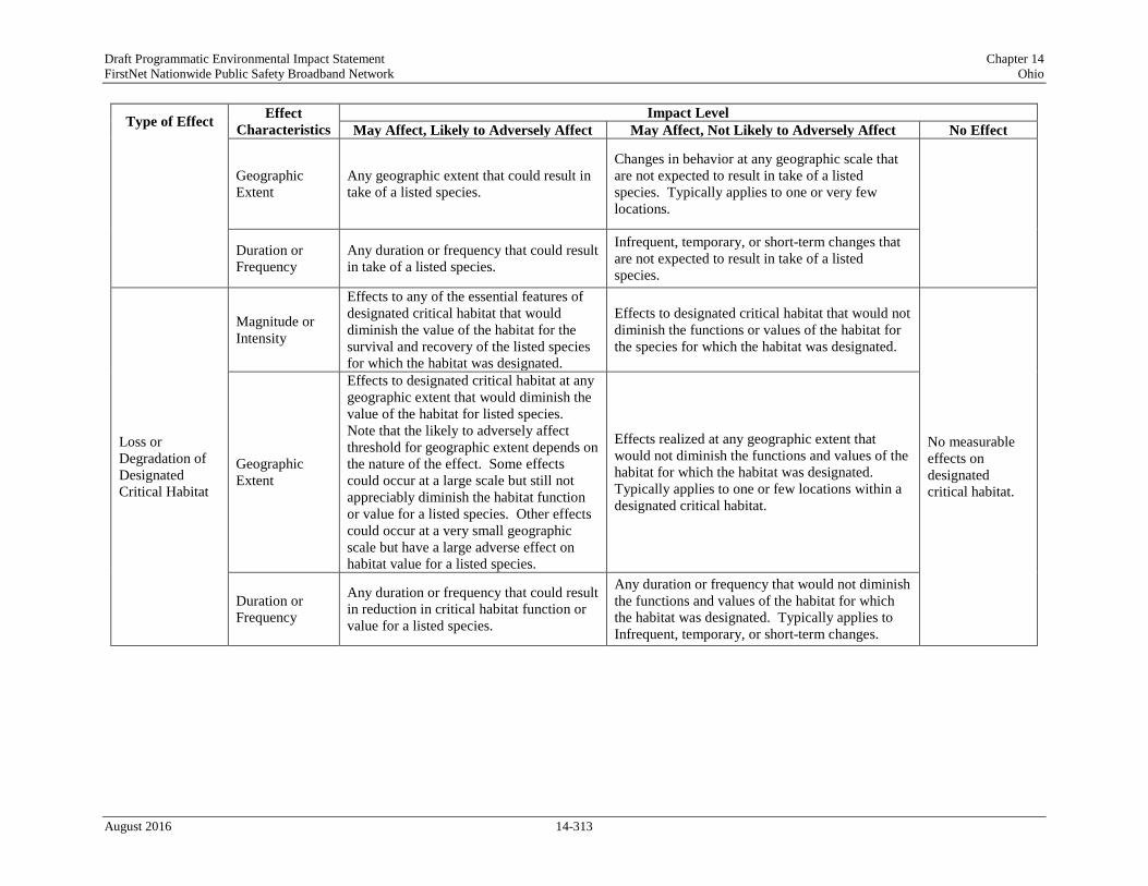
Draft Programmatic Environmental Impact Statement Chapter 14 FirstNet Nationwide Public Safety Broadband Network Ohio
Type of Effect Effect Characteristics
Impact Level May Affect, Likely to Adversely Affect May Affect, Not Likely to Adversely Affect No Effect
Geographic Extent
Any geographic extent that could result in take of a listed species.
Changes in behavior at any geographic scale that are not expected to result in take of a listed species. Typically applies to one or very few locations.
Duration or Frequency
Any duration or frequency that could result in take of a listed species.
Infrequent, temporary, or short-term changes that are not expected to result in take of a listed species.
Loss or Degradation of Designated Critical Habitat
Magnitude or Intensity
Effects to any of the essential features of designated critical habitat that would diminish the value of the habitat for the survival and recovery of the listed species for which the habitat was designated.
Effects to designated critical habitat that would not diminish the functions or values of the habitat for the species for which the habitat was designated.
No measurable effects on designated critical habitat.
Geographic Extent
Effects to designated critical habitat at any geographic extent that would diminish the value of the habitat for listed species. Note that the likely to adversely affect threshold for geographic extent depends on the nature of the effect. Some effects could occur at a large scale but still not appreciably diminish the habitat function or value for a listed species. Other effects could occur at a very small geographic scale but have a large adverse effect on habitat value for a listed species.
Effects realized at any geographic extent that would not diminish the functions and values of the habitat for which the habitat was designated. Typically applies to one or few locations within a designated critical habitat.
Duration or Frequency
Any duration or frequency that could result in reduction in critical habitat function or value for a listed species.
Any duration or frequency that would not diminish the functions and values of the habitat for which the habitat was designated. Typically applies to Infrequent, temporary, or short-term changes.
August 2016 14-313

Draft Programmatic Environmental Impact Statement Chapter 14 FirstNet Nationwide Public Safety Broadband Network Ohio
Description of Environmental Concerns
Injury/Mortality of a Listed Species
Direct injury/mortality effects are physical injuries, extreme physiological stress, or death of an individual organism from interactions associated with the Proposed Action. The most common direct injuries are entanglement, vehicle strike, problems associated with accidental ingestion, and injuries incurred by sensitive animals from disturbance events.
Based on the impact significance criteria presented in Table 14.2.6-2, any direct injury or mortality of a listed species at the individual-level could be potentially significant as well as any impact that has more than a negligible potential to result in unpermitted take of an individual species at any geographic extent, duration, or frequency. Direct injury/mortality environmental concerns pertaining to federally listed terrestrial and aquatic mammals, birds, reptiles and amphibians, fish, invertebrates, and plants with known occurrence in Ohio are described below.
Terrestrial Mammals
One endangered and one threatened mammal species are federally listed and known to occur in the state of Ohio; they include the Indiana bat (Myotis sodalist) and northern long-eared bat (Myotis septentrionalis). Direct mortality or injury to the federally listed Indiana bat or northern long-eared bat could occur if tree clearing activities occurred at roosting sites while bats were present (USFWS, 2012e). While projects would not likely directly affect winter hibernacula (e.g., caves), human disturbance in and around these sites when bats are present could lead to adverse effects to these species; when disturbed by noise or light, bats awaken resulting in a loss of body fat needed to help them survive in the spring (USFWS, 2015ay). BMPs and mitigation measures, as defined through consultation with the appropriate resource agency, would be implemented. Additional BMPs and mitigation measures, as defined in Chapter 19, may be implemented as appropriate to further minimize potential impacts.
Birds
One endangered and one threatened bird species are federally listed and known to occur in the state of Ohio; they include the piping plover (Charadrius melodus) and red knot (Calidris canutus rufa). Depending on the project type and location, direct mortality or injury to these birds could occur from collisions or electrocutions with manmade cables and wires, vehicle strikes, or by disturbance or destruction of nests during ground disturbing activities. BMPs and mitigation measures, as defined through consultation with the appropriate resource agency, would be implemented. Additional BMPs and mitigation measures, as defined in Chapter 19, may be implemented as appropriate to further minimize potential impacts.
Fish
One endangered fish species is federally listed and known to occur in the state of Ohio, the Scioto madtom (Noturus trautmani). The majority of FirstNet deployment projects would not occur in an aquatic environment. Direct mortality or injury to this species could occur from
August 2016 14-314

Draft Programmatic Environmental Impact Statement Chapter 14 FirstNet Nationwide Public Safety Broadband Network Ohio
vessel/boat strikes or entanglements resulting from the Proposed Action are unlikely as the majority of FirstNet deployment projects would not occur in the aquatic environment. BMPs and mitigation measures, as defined through consultation with the appropriate resource agency, would be implemented. Additional BMPs and mitigation measures, as defined in Chapter 19, may be implemented as appropriate to further minimize potential impacts.
Reptiles and Amphibians
One threatened reptile species are federally listed and known to occur in the state of Ohio; they include the copperbelly water snake (Nerodia erythrogaster neglecta) and the eastern massasauga (Sistrurus catenatus). The majority of FirstNet deployment projects would not occur in an aquatic environment. Direct mortality or injury to this species are unlikely but could occur from entanglements resulting from the Proposed Action. BMPs and mitigation measures, as defined through consultation with the appropriate resource agency, would be implemented. Additional BMPs and mitigation measures, as defined in Chapter 19, may be implemented as appropriate to further minimize potential impacts.
No federally listed amphibians occur in Ohio. Therefore, no injury or mortality effects to federally threatened and endangered amphibians are expected as a result of the Proposed Action.
Invertebrates
Twelve endangered and one threatened invertebrate species are federally listed and known to occur in the state of Ohio, as summarized in Table 14.1.6-7. Ten of the species are mollusks and three of these species are terrestrial invertebrates. The majority of FirstNet deployment projects would not occur in an aquatic environment. Direct mortality or injury to the mollusk species are unlikely but could occur from entanglements resulting from the Proposed Action. Direct mortality or injury could occur to these terrestrial invertebrate species if land clearing or excavation activities associated with the Proposed Action occur in an area inhabited by one of these species. BMPs and mitigation measures, as defined through consultation with the appropriate resource agency, would be implemented. Additional BMPs and mitigation measures, as defined in Chapter 19, may be implemented as appropriate to further minimize potential impacts.
Plants
One endangered and five threatened plant species are federally listed and known to occur in Ohio; they are the eastern prairie fringed orchid (Platanthera leucophaea), lakeside daisy (Hymenoxys herbacea), northern wild monkshood (Aconitum noveboracense), small whorled pogonia (Isotria medeoloides), Virginia spiraea (Spiraea virginiana), and running buffalo clover (Trifolium stoloniferum). Direct mortality to federally listed plants could occur if land clearing or excavation activities associated with the Proposed Action occur in an area inhabited by one of these species. BMPs and mitigation measures, as defined through consultation with the appropriate resource agency, would be implemented. Additional BMPs and mitigation measures, as defined in Chapter 19, may be implemented as appropriate to further minimize potential impacts.
August 2016 14-315

Draft Programmatic Environmental Impact Statement Chapter 14 FirstNet Nationwide Public Safety Broadband Network Ohio
Reproductive Effects
Reproductive effects are considered those that either directly or indirectly reduce the breeding success of a listed species either by altering its breeding timing or location, or reducing the rates of growth, maturation, and survival of offspring, which could affect the breeding success. Potential effects to federally listed terrestrial mammals, birds, terrestrial reptiles, fish, invertebrates, and plants with known occurrence in Ohio are described below.
Terrestrial Mammals
Noise, light, and other human disturbances associated with the Proposed Action could adversely affect federally listed terrestrial mammals within or near Project activities. Impacts would be directly related to the frequency, intensity, and duration of these activities. BMPs and mitigation measures, as defined through consultation with the appropriate resource agency, would be implemented. Additional BMPs and mitigation measures, as defined in Chapter 19, may be implemented as appropriate to further minimize potential impacts.
Birds
Noise, light, or human disturbance within nesting areas could cause federally listed birds to relocate to less desirable locations, or cause stress to individuals reducing survival and reproduction. BMPs and mitigation measures, as defined through consultation with the appropriate resource agency, would be implemented. Additional BMPs and mitigation measures, as defined in Chapter 19, may be implemented as appropriate to further minimize potential impacts.
Reptiles and Amphibians
Changes in water quality, especially during the breeding seasons, could cause stress to reptiles resulting in lower productivity. Further, land clearing activities, noise, and human disturbance during the critical periods (e.g., mating, nesting) could lower fitness and productivity. BMPs and mitigation measures, as defined through consultation with the appropriate resource agency, would be implemented. Additional BMPs and mitigation measures, as defined in Chapter 19, may be implemented as appropriate to further minimize potential impacts.
No federally listed amphibians are known to occur in Ohio. Therefore, no reproductive effects to federally threatened and endangered amphibians are expected as a result of the Proposed Action.
Fish
Deployment activities resulting in increased disturbance (e.g., humans, noise), especially during spawning activity, and changes in water quality could cause stress resulting in lower productivity (see Section 14.2.4, Water Resources, for a discussion of potential impacts to water resources). Effects to federally listed fish species in Ohio are unlikely as the majority of FirstNet deployment projects would not occur in an aquatic environment. BMPs and mitigation measures, as defined through consultation with the appropriate resource agency, would be implemented. Additional BMPs and mitigation measures, as defined in Chapter 19, may be implemented as appropriate to further minimize potential impacts.
August 2016 14-316

Draft Programmatic Environmental Impact Statement Chapter 14 FirstNet Nationwide Public Safety Broadband Network Ohio
Invertebrates
Changes in water quality from ground disturbing activities could cause stress resulting in lower productivity for the federally listed mollusks known to occur in Ohio. In addition, introduction of invasive aquatic species could indirectly affect mollusks as a result of fish populations that they rely on for their reproductive cycle being altered (USFWS 1997). Impacts to food sources utilized by the federally listed terrestrial invertebrates could lead to potential adverse effects on these species (USFWS 2014a). Impacts associated with deployment activities are expected to result in less than significant changes to water quality. BMPs and mitigation measures, as defined through consultation with the appropriate resource agency, would be implemented. Additional BMPs and mitigation measures, as defined in Chapter 19, may be implemented as appropriate to further minimize potential impacts.
Plants
No reproductive effects to federally listed plants are expected as a result of the Proposed Action as limited pesticides would be used and avoidance measures could be undertaken.
Behavioral Changes
Effects to normal behavior patterns that could lead to disruptions in breeding, feeding, or sheltering, resulting in take of a listed species would be considered potentially significant. Potential effects to federally listed terrestrial and aquatic mammals, birds, reptiles and amphibians, fish, invertebrates, and plants with known occurrence in Ohio are described below.
Terrestrial Mammals
Noise, light, and other human disturbances associated with the Proposed Action could adversely affect federally listed terrestrial mammals within or near Project activities. Impacts would be directly related to the frequency, intensity, and duration of these activities. BMPs and mitigation measures, as defined through consultation with the appropriate resource agency, would be implemented. Additional BMPs and mitigation measures, as defined in Chapter 19, may be implemented as appropriate to further minimize potential impacts.
Birds
Because many birds have extremely long migrations, protection efforts for critical sites along migratory routes must be coordinated over vast distances often involving many different countries. For example, the piping plover use sites throughout Ohio as stopover habitat during their migration from the Northern Great Plains and Great Lakes Area to the coastal habitats in the south. Stopover sites consist of shorelines that occur throughout the state along reservoirs, lakes, ponds, rivers, and wetlands (USFWS 2014b). Disturbance in stopover, foraging, or breeding areas (visual or noise) or habitat loss/fragmentation could cause stress to individuals causing them to abandon areas for less desirable habitat and potentially reduce over fitness and productivity. Activities related to the Proposed Action, such as aerial deployment or construction activities, could result in adverse effects to federally listed birds. BMPs and mitigation measures, as defined through consultation with the appropriate resource agency,
August 2016 14-317

Draft Programmatic Environmental Impact Statement Chapter 14 FirstNet Nationwide Public Safety Broadband Network Ohio
would be implemented. Additional BMPs and mitigation measures, as defined in Chapter 19, may be implemented as appropriate to further minimize potential impacts.
Reptiles and Amphibians
Habitat loss or alteration, particularly from fragmentation or invasive species, could adversely affect nesting and foraging sites of the federally listed reptile species, resulting in reduced survival and productivity; however, disturbances during deployment activities are not anticipated to stress federally listed reptiles. There are no federally listed amphibians in Ohio. BMPs and mitigation measures, as defined through consultation with the appropriate resource agency, would be implemented. Additional BMPs and mitigation measures, as defined in Chapter 19, may be implemented as appropriate to further minimize potential impacts.
Fish
Changes in water quality as a result of ground disturbing activities could impact food sources for the federally listed fish species in Ohio. Further, increased human disturbance, noise, and vessel traffic could cause stress to these species causing them to abandon spawning locations or alter migration patterns. BMPs and mitigation measures, as defined through consultation with the appropriate resource agency, would be implemented. BMPs and mitigation measures, as defined through consultation with the appropriate resource agency, would be implemented. Additional BMPs and mitigation measures, as defined in Chapter 19, may be implemented as appropriate to further minimize potential impacts.
Invertebrates
Changes in water quality, habitat loss or alternation, and introduction of aquatic invasive species could impact food sources for federally listed mussels resulting in lower productivity. Disturbances to food sources utilized by the federally listed terrestrial species, especially during the breeding season, could impact survival. BMPs and mitigation measures, as defined through consultation with the appropriate resource agency, would be implemented. Additional BMPs and mitigation measures, as defined in Chapter 19, may be implemented as appropriate to further minimize potential impacts.
Plants
No behavioral effects to federally listed plants are expected as a result of the Proposed Action.
Loss or Degradation of Designated Critical Habitat
Effects to designated critical habitat and any of its essential features that could diminish the value of the habitat for the listed species or its survival and recovery would be considered an adverse effect and could be potentially significant. Depending on the species or habitat, the adverse effect threshold would vary for geographic extent. FirstNet activities are generally expected to be small-scale in nature, therefore large-scale impacts are not expected; however, it is possible that small-scale changes could lead to potentially significant adverse effects for certain species. For example, impacts to designated critical habitat for a listed species that is
August 2016 14-318

Draft Programmatic Environmental Impact Statement Chapter 14 FirstNet Nationwide Public Safety Broadband Network Ohio
only known to occur in one specific location geographically. Potential effects to federally listed terrestrial mammals, birds, reptiles and amphibians, fish, invertebrates, and plants with designated critical habitat in Ohio are described below.
Terrestrial Mammals
There is no designated critical habitat occurs for terrestrial mammals in Ohio. Therefore, no effect to threatened and endangered species from the loss or degradation of designated critical habitat is expected as a result of the Proposed Action.
Birds
One of the federally listed bird species in Ohio has federally designated habitat. Critical habitat for the piping plover was designated within the Ohio Keys in Lake Erie. Land clearing, excavation activities, and other ground disturbing activities in this region of Ohio could lead to habitat loss or degradation, which could lead to adverse effects to the piping plover depending on the duration, location, and spatial scale of the associated activities. BMPs and mitigation measures, as defined through consultation with the appropriate resource agency, would be implemented. Additional BMPs and mitigation measures, as defined in Chapter 19, may be implemented as appropriate to further minimize potential impacts.
Reptiles and Amphibians
There is no designated critical habitat for the listed reptiles in Ohio and there are no federally-listed amphibians in Ohio. Therefore, no effect to threatened and endangered species from the loss or degradation of designated critical habitat is expected as a result of the Proposed Action.
Fish
There is no designated critical habitat occurs for fish in Ohio. Therefore, no effect to threatened and endangered species from the loss or degradation of designated critical habitat is expected as a result of the Proposed Action.
Invertebrates
One of the federally listed invertebrate species in Ohio has federally designated critical habitat. Critical habitat for the rabbitsfoot was designated in Coshocton, Madison, Union, and Williams counties. Land clearing, excavation activities, and other ground disturbing activities in these regions of Ohio could lead to habitat loss or degradation, which could lead to adverse effects to these invertebrates depending on the duration, location, and spatial scale of the associated activities. BMPs and mitigation measures, as defined through consultation with the appropriate resource agency, would be implemented. Additional BMPs and mitigation measures, as defined in Chapter 19, may be implemented as appropriate to further minimize potential impacts.
No critical habitat has been designated for the other federally listed invertebrate species in Ohio; therefore, no effect to these species from the loss or degradation of designated critical habitat is expected as a result of the Proposed Action.
August 2016 14-319

Draft Programmatic Environmental Impact Statement Chapter 14 FirstNet Nationwide Public Safety Broadband Network Ohio
Plants
There is no designated critical habitat occurs for plants in Ohio. Therefore, no effect to threatened and endangered species from the loss or degradation of designated critical habitat is expected as a result of the Proposed Action.
Potential Impacts of the Preferred Alternative
The following section assesses potential impacts associated with implementation of the Preferred Alternative, including deployment and operational activities.
Deployment Impacts
As described in Section 2.1.2, Proposed Action Infrastructure, implementation of the Preferred Alternative could result in the deployment of various types of facilities or infrastructure. Depending on the physical nature and location of the facility/infrastructure and the specific deployment requirements, some activities would result in potential impacts to threatened and endangered species and others would not. In addition, and as explained in this section, the same type of Proposed Action infrastructure could result in a range of no affect to may affect, but not likely to adversely affect depending on the deployment scenario or site-specific conditions. The threatened and endangered species that would be affected would depend on the ecoregion, the species’ phenology, and the nature and extent of the habitats affected.
Activities Likely to Have No Effect
Of the types of facilities or infrastructure deployment scenarios described in Section 2.1.2, Proposed Action Infrastructure, the following are expected to have no effect to threatened and endangered species or their habitat under the conditions described below:
• Wired Projects
o Use of Existing Conduit – New Buried Fiber Optic Plant: Disturbance, including noise, associated with the installation of fiber optic cable in existing conduit would be limited to entry and exit points of the existing conduit in previously disturbed areas. Although threatened and endangered species and their habitat could be impacted, it is anticipated that effects to threatened and endangered species would be temporary, infrequent, and likely not conducted in locations designated as vital or critical for any period.
o Use of Existing Buried or Aerial Fiber Optic Plant or Existing Submarine Cable: Lighting up of dark fiber would have no impacts to threatened and endangered species or their habitat because there would be no ground disturbance and very limited human activity.
• Satellites and Other Technologies
o Satellite-Enabled Devices and Equipment: It is anticipated that the installation of permanent equipment on existing structures and the use of portable devices that use satellite technology would not impact threatened or endangered species because those activities would not require ground disturbance.
August 2016 14-320

Draft Programmatic Environmental Impact Statement Chapter 14 FirstNet Nationwide Public Safety Broadband Network Ohio
o Deployment of Satellites: FirstNet does not anticipate launching satellites as part of the deployment of the NPSBN; however, it could include equipment on satellites that are already being launched for other purposes. As adding equipment to an existing launch vehicle would be very unlikely to impact protected species, it is anticipated that this activity would have no impact on protected species.
Activities with the Potential to Affect Listed Species
Potential deployment-related effects to threatened and endangered species and their habitats as a result of implementation of the Preferred Alternative would encompass a range of impacts that could occur, including direct injury/mortality, reproductive effects, behavioral changes, and loss/degradation of designated critical habitat. The types of infrastructure deployment activities that could be part of the Preferred Alternative and result in potential effects to threatened and endangered species include the following:
• Wired Projects
o New Build – Buried Fiber Optic Plant: Plowing, trenching, or directional boring and the construction of POPs, huts, or other associated facilities or hand-holes to access fiber could result in potential impacts to threatened and endangered species. Land/vegetation clearing and excavation activities, associated with construction of POPs, huts, or other associated facilities could result in direct injury/mortalities of threatened and endangered species that are not mobile enough to avoid construction activities (e.g. reptiles, mollusks, small mammals, and young), that utilize burrows (e.g., ground squirrels), or that are defending nest sites (e.g., ground-nesting birds). Disturbance, including noise, associated with the above activities could result in direct injury/mortality, reproductive effects, behavioral changes, and loss/degradation of designated critical habitat. Implementation of BMPs and mitigation measures developed through consultation with the appropriate resource agency, could help to avoid or minimize potential impacts.
o New Build – Aerial Fiber Optic Plant: The installation of new poles and hanging cable and associated security, safety, or public lighting components on public ROWs or private easements as well as the construction of access roads, POPs, huts, or facilitates to house outside plant equipment could result in potential impacts to threatened and endangered species and their habitat. Impacts may vary depending on the number or individual poles installed, but could include direct injury/mortality, reproductive effects, behavioral changes, and loss/degradation of designated critical habitat.
o Collocation on Existing Aerial Fiber Optic Plant: Land clearing and excavation during replacement of poles and structural hardening could result in direct injury/mortality, reproductive effects, behavioral changes, and loss/degradation of designated critical habitat to threatened and endangered species. Noise disturbance from heavy equipment use associated with these activities as well as with installing new fiber on existing poles could result in reproductive effects or behavior changes.
o New Build – Submarine Fiber Optic Plant: The installation of cables in or near bodies of water and construction of landings and/or facilities on the shore to accept submarine
August 2016 14-321

Draft Programmatic Environmental Impact Statement Chapter 14 FirstNet Nationwide Public Safety Broadband Network Ohio
cables could potentially impact threatened and endangered species and their habitat, particularly aquatic species (see Section 14.2.4, Water Resources, for a discussion of potential impacts to water resources). Effects could include direct injury/mortality, reproductive effects, behavioral changes, and loss/degradation of designated critical habitat. If activities occurred during critical periods, reproductive effects and behavioral changes could occur.
o Installation of Optical Transmission or Centralized Transmission Equipment: If installation of transmission equipment would occur in existing boxes or huts, there would be no impacts to threatened and endangered species or their habitats. If installation of transmission equipment required construction of access roads, trenching, and/or land clearing, such disturbance could result in direct injury/mortality of threatened and endangered species as described for other New Build activities. Reproductive effects, behavioral changes, and loss/degradation of designated critical habitat could also occur as a result of construction and resulting disturbance.
• Wireless Projects
o New Wireless Communication Towers: Installation of new wireless towers and associated structures (generators, equipment sheds, fencing, security and aviation lighting, electrical feeds, and concrete foundations and pads) or access roads could result in impacts to threatened and endangered species and their habitat. Land/vegetation clearing, excavation activities, landscape grading, and other disturbance activities during the installation of new wireless towers and associated structures or access roads could result in direct injury/mortality, reproductive effects, behavioral changes, and loss/degradation of designated critical habitat. Security lighting and fencing could result in direct injury/mortality, disruption of normal behavior patterns, as well as reproductive effects. For a discussion of radio frequency emissions, refer to Section 2.4, Radio Frequency Emissions.
o Collocation on Existing Wireless Tower, Structure, or Building: Collocation would involve mounting or installing equipment (such as antennas or microwave dishes) on an existing tower; FirstNet activities would be infrequent, temporary, or short-term in nature and are unlikely to result in direct injury/mortality or behavioral changes to threatened and endangered species. However, if replacement towers or structural hardening are required, impacts could be similar to new wireless construction. Hazards related security/safety lighting and fencing may produce direct injury/mortality, reproductive effects, and behavioral changes. For a discussion of radio frequency emissions, refer to Section 2.4, Radio Frequency Emissions.
o Deployable Technologies: Implementation of land-based deployable technologies including COWs, COLTs, or SOWs could result in direct injury/mortalities to threatened and endangered species on roadways. If external generators are used, noise disturbance could potentially result in reproductive effects or behavioral changes to threatened and endangered species. Deployment of drones, balloons, blimps, or piloted aircraft could potentially impact threatened and endangered species by direct injury/mortality,
August 2016 14-322

Draft Programmatic Environmental Impact Statement Chapter 14 FirstNet Nationwide Public Safety Broadband Network Ohio
reproductive effects, behavioral changes, and loss/degradation of designated critical habitat. The magnitude of these effects depends on the timing and frequency of deployments. For a discussion of radio frequency emissions, refer to Section 2.4, Radio Frequency Emissions.
In general, the abovementioned activities could potentially involve land/vegetation clearing; excavation and trenching; construction of access roads; installation or restructuring of towers, poles, or underwater cables; installation of security/safety lighting and fencing; and deployment of aerial platforms. Potential impacts to threatened and endangered species associated with deployment of this infrastructure could include direct injury/mortality, reproductive effects, behavioral changes, and loss/degradation of designated critical habitat depending on the species’ phenology and the nature and extent of the habitats affected. These impacts may affect, but are anticipated to not likely adversely affect protected species due to the small scale and limited nature of expected deployment activities and the implementation of BMPs and mitigation measures, as defined through consultation with the appropriate resource agency. Additional BMPs and mitigation measures, as defined in Chapter 19, may be implemented as appropriate to further minimize potential impacts.
Operation Impacts
As described in Section 2.1.2, Proposed Action Infrastructure, operational activities associated with the Preferred Alternative would consist of routine maintenance and inspection of the facilities. Any major infrastructure replacement as part of ongoing system maintenance would result in impacts similar to the abovementioned deployment impacts. The threatened and endangered species that would be affected would depend on the species’ phenology and the nature and extent of the habitats affected.
It is anticipated that operational impacts may affect, but are not likely to adversely affect threatened and endangered species due to routine inspections of the Preferred Alternative, assuming that the same access roads used for deployment are also used for inspections. Site maintenance, including mowing or application of herbicides, may affect, but are not likely to adversely affect, threatened and endangered species, as they would be conducted infrequently and in compliance with BMPs and mitigation measures developed through consultation with the appropriate resource agency.
During operations, direct injury/mortality of threatened and endangered species could occur from collisions and/or entanglements with transmission lines, towers, and aerial platforms. Listed species may be affected, but are not likely to be adversely affected. BMPs and mitigation measures, as defined through consultation with the appropriate resource agency, would be implemented. Additional BMPs and mitigation measures, as defined in Chapter 19, may be implemented as appropriate to further minimize potential impacts.
Threatened and endangered species may be affected, but are not likely to be adversely affected, by the reduction in habitat quality associated with habitat fragmentation from the presence of access roads, transmission corridors, and support facilities. These features could also continue to disrupt movements of some species, particularly during migrations between winter and summer
August 2016 14-323
Draft Programmatic Environmental Impact Statement Chapter 14 FirstNet Nationwide Public Safety Broadband Network Ohio
ranges. BMPs and mitigation measures, as defined through consultation with the appropriate resource agency, would be implemented. Additional BMPs and mitigation measures, as defined in Chapter 19, may be implemented as appropriate to further minimize potential impacts.
Alternatives Impact Assessment
The following section assesses potential impacts to threatened and endangered species associated with the Deployable Technologies Alternative and the No Action Alternative.
Deployable Technologies Alternative
Under the Deployable Technologies Alternative option, a nationwide fleet of mobile communications systems would provide temporary coverage in areas not covered by the existing, usable infrastructure. There would be no collocation of equipment and minimal new construction associated with wired or wireless projects discussed above under the Preferred Alternative. The specific infrastructure associated with the Deployable Technologies Alternative would be the same as the deployable technologies implemented as part of the Preferred Alternative but would likely be implemented in greater numbers, over a larger geographic extent, and used with greater frequency and duration. Therefore, potential impacts to threatened and endangered species as a result of implementation of this alternative could be as described below.
Deployment Impacts
As explained above, implementation of deployable technologies may affect, but is not likely to adversely affect, threatened and endangered species through direct injury/mortality, reproductive effects, behavioral changes, and loss/degradation of designated critical habitat. Greater frequency and duration of deployments could change the magnitude of impacts depending on species, life history, and region of the state. BMPs and mitigation measures, as defined through consultation with the appropriate resource agency, would be implemented. Additional BMPs and mitigation measures, as defined in Chapter 19, may be implemented as appropriate to further minimize potential impacts.
Operational Impacts
As explained above, operational activities would consist of implementation/running of the deployable technology and routine maintenance and inspections. As with the Preferred Alternative, it is anticipated that activities may affect, but are not likely to adversely affect, threatened and endangered species and their habitats as a result of routine operations, management, and monitoring. BMPs and mitigation measures, as defined through consultation with the appropriate resource agency, would be implemented. Additional BMPs and mitigation measures, as defined in Chapter 19, may be implemented as appropriate to further minimize potential impacts.
No Action Alternative
Under the No Action Alternative, the nationwide, interoperable, public safety broadband network would not be deployed; therefore, there would be no associated construction or installation of
August 2016 14-324

Draft Programmatic Environmental Impact Statement Chapter 14 FirstNet Nationwide Public Safety Broadband Network Ohio
wired, wireless, deployable infrastructure or satellites and other technologies. As a result, there would be no effects to threatened and endangered species as a result of construction and operation of the Proposed Action. Environmental conditions would therefore be the same as those described in Section 14.1.6.6, Threatened and Endangered Species and Species of Conservation Concern.
Land Use, Recreation, and Airspace
14.2.7.1. Introduction
This section describes potential impacts to land use, recreation, and airspace resources in Ohio associated with deployment and operation of the Proposed Action and alternatives. Chapter 19, BMPs and Mitigation Measures provides a listing of BMPs and mitigation measures that FirstNet and/or its partners would require, as practicable or feasible, to avoid or minimize potential impacts.
14.2.7.2. Impact Assessment Methodology and Significance Criteria
The impacts of the Proposed Action on land use, recreation, and airspace resources were evaluated using the significance criteria presented in Table 14.2.7-1. The categories of impacts are defined as potentially significant, less than significant with mitigation incorporated, less than significant, or no impact. Characteristics of each impact type, including magnitude or intensity, geographic extent, and duration or frequency, were used to determine the impact significance rating associated with each potential impact.
Given the nature of this programmatic evaluation, and because the Proposed Action could potentially cover a wide variety of actions that would take place in various landscapes, the potential impacts to land use, recreation, and airspace resources addressed in this section are presented as a range of possible impacts.
August 2016 14-325

Draft Programmatic Environmental Impact Statement Chapter 14 FirstNet Nationwide Public Safety Broadband Network Ohio
Table 14.2.7-1: Impact Significance Rating Criteria for Land Use, Recreation, and Airspace
Type of Effect
Effect Characteristics
Impact Level
Potentially Significant Less than Significant with
BMPs and Mitigation Measures Incorporated
Less than Significant No Impact
Direct land use change
Magnitude or Intensity
Change in designated/permitted land use that conflicts with existing permitted uses, and/or would require a change in zoning. Conversion of prime or unique agricultural lands. Effect that is potentially
significant, but with mitigation is less than significant.
Minimal changes in existing land use, or change that is permitted by-right, through variance, or through special exception.
No changes to existing development, land use, land use plans, or policies. No conversion of prime or unique agricultural lands.
Geographic Extent Regional impacts observed throughout the state or territory.
Effects realized at one or multiple isolated locations.
NA
Duration or Frequency
Permanent: Land use altered indefinitely.
Short-Term: Land use altered for as long as the entire construction phase or a portion of the operations phase.
NA
Indirect land use change
Magnitude or Intensity
New land use directly conflicts with surrounding land use pattern, and/or causes substantial restriction of land use options for surrounding land uses. Effect that is potentially
significant, but with mitigation is less than significant.
New land use differs from, but is not inconsistent with, surrounding land use pattern; minimal restriction of land use options for surrounding land uses.
No conflicts with adjacent existing or planned land uses.
Geographic Extent Regional impacts observed throughout the state or territory.
Effects realized at one or multiple isolated locations.
NA
Duration or Frequency
Permanent: Land use altered indefinitely.
Short-Term: Land use altered for as long as the entire construction phase or a portion of the operations phase.
NA
August 2016 14-326

Draft Programmatic Environmental Impact Statement Chapter 14 FirstNet Nationwide Public Safety Broadband Network Ohio
Type of Effect
Effect Characteristics
Impact Level
Potentially Significant Less than Significant with
BMPs and Mitigation Measures Incorporated
Less than Significant No Impact
Loss of access to public or private recreation land or activities
Magnitude or Intensity
Total loss of access to recreation land or activities.
Effect that is potentially significant, but with mitigation is less than significant.
Restricted access to recreation land or activities.
No disruption or loss of access to recreational lands or activities.
Geographic Extent Most or all recreational land/sites in a state or territory; recreational lands/sites that are of national significance.
Effects realized at one or multiple isolated locations; recreational lands that are not nationally significant, but that are significant within the state/territory.
NA
Duration or Frequency
Persists during the life of the project.
Persists for as long as the entire construction phase or a portion of the operations phase.
NA
Loss of enjoyment of public or private recreation land (due to visual, noise, or other impacts that make recreational activity less desirable)
Magnitude or Intensity
Total loss of enjoyment of recreational activities; substantial reduction in the factors that contribute to the value of the recreational resource, resulting in avoidance of activity at one or more sites. Effect that is potentially
significant, but with mitigation is less than significant.
Small reductions in visitation or duration of recreational activity.
No loss of enjoyment of recreational activities or areas; no change to factors that contribute to the value of the resource.
Geographic Extent Most or all recreational land/sites in a state or territory; recreational lands/sites that are of national significance.
Effects realized at one or multiple isolated locations; recreational lands that are not nationally significant, but that are significant within the state/territory.
NA
Duration or Frequency
Persists during or beyond the life of the project.
Persists for as long as the entire construction phase or a portion of the operations phase.
NA
August 2016 14-327

Draft Programmatic Environmental Impact Statement Chapter 14 FirstNet Nationwide Public Safety Broadband Network Ohio
Type of Effect
Effect Characteristics
Impact Level
Potentially Significant Less than Significant with
BMPs and Mitigation Measures Incorporated
Less than Significant No Impact
Use of airspace
Magnitude or Intensity
Measurable, substantial change in flight patterns and/or use of airspace.
Effect that is potentially significant, but with mitigation is less than significant.
Alteration to airspace usage is minimal.
No alterations in airspace usage or flight patterns.
Geographic Extent Regional impacts observed throughout the state or territory.
Effects realized at one or multiple isolated locations.
NA
Duration or Frequency
Permanent: Airspace altered indefinitely.
Short-Term: Airspace altered for as long as the entire construction phase or a portion of the operations phase.
NA
NA = Not Applicable
August 2016 14-328

Draft Programmatic Environmental Impact Statement Chapter 14 FirstNet Nationwide Public Safety Broadband Network Ohio
14.2.7.3. Description of Environmental Concerns
Direct Land Use Change
Changes in land use could be influenced by the deployment, operation, and maintenance of facilities or other infrastructure, and the acquisition of rights-of-way or easement. The deployment, operation, and maintenance of structures, towers, roads, and other permanent features could conflict with exiting development or land use. The installation of poles, towers, structures, or other aboveground facilities or assets could have short- or long-term effects to existing development or land use based on the characteristics of the structures or facilities, such as the location, type, or height. In addition, the acquisition of rights-of-way or easements and the construction of roads to access facilities and locations could influence changes in land use. The effects from these actions would depend on the geographic location; compatibility with existing land uses; and characteristics of the right-of-way, easement, or access road. These characteristics, such as the length, width, and location could change the existing land use to another category or result in the short- or long-term loss of the existing land use.
Based on the impact significance criteria presented in Table 14.2.7-1, less than significant impacts would be anticipated given the size and nature of the majority of the proposed deployment activities. Direct land use changes would be minimized and isolated at specific locations and all required permits would be obtained; only short-term impacts during the construction phase would be expected.
Indirect Land Use Change
Changes in surrounding land use patterns and options for surrounding land uses could be influenced by the deployment, operation, and maintenance of facilities and the acquisition of rights-of-way or easement. The deployment, operation, and maintenance of structures, towers, roads, and other permanent features could conflict with surrounding land use patterns and options for surrounding land uses. The installation of poles, towers, structures, or other aboveground facilities or assets could have short- or long-term effects to surrounding land use patterns or options for surrounding land uses based on the characteristics of the structures or facilities, such as the location, type, or height. In addition, the acquisition of ROWs or easements and the construction of roads to access facilities and locations could influence changes in surrounding land uses. The effects from these actions would depend on the geographic location; compatibility with surrounding land uses; and characteristics of the right-of-way, easement, or access road. These characteristics, such as the length, width, and location could conflict with surrounding land use patterns or restrict options for surrounding land uses.
Based on the impact significance criteria presented in Table 14.2.7-1, less than significant impacts would be anticipated as any new land use would be small scale;only short-term impacts during the construction phase would be expected.
August 2016 14-329
Draft Programmatic Environmental Impact Statement Chapter 14 FirstNet Nationwide Public Safety Broadband Network Ohio
Loss of Access to Public or Private Recreation Land or Activities
Access to public or private recreation land or activities could be influenced by the deployment, operation, and maintenance of facilities and the acquisition of ROW or easement. Localized, short-term accessibility to recreation land or activities could be impacted by the deployment and maintenance of structures, towers, roads, and other permanent features. In the long-term, the deployment and installation of poles, towers, structures, or other aboveground facilities could alter the types and locations of recreation activities.
Based on the impact significance criteria presented in Table 14.2.7-1, less than significant impacts would be anticipated as restricted access or a loss of access to recreation areas would not occur; only short-term impacts or small-scale limitations during the construction phase would be expected.
Loss of Enjoyment of Public or Private Recreation Land
The deployment of new towers, and the resulting built tower, could influence the enjoyment of public or private recreation land. Enjoyment of recreation land could be temporarily impacted by crews accessing the site during the deployment and maintenance of structures, towers, roads, and other permanent features. The deployment of poles, towers, structures, or other aboveground facilities could affect the enjoyment of recreational land based on the characteristics of the structures or facilities, including permanent impacts to scenery, short-term noise impacts, and the presence of deployment or maintenance crews.
Based on the impact significance criteria presented in Table 14.2.7-1, less than significant impacts would be anticipated as only small reductions, if any, in recreational visits or durations would occur due to the relatively small-scale nature of likely FirstNet activities. Only short-term impacts during the construction phase would be expected.
Use of Airspace
Primary concerns to airspace include the following: if aspects of the Proposed Action would result in violation of FAA regulations; undermine the safety of civilian, military, or commercial aviation; or infringe on flight activity and flight corridors. Impacts could include air routes or flight paths, available flight altitudes, disruption of normal flight patterns, and restrictions to flight activities. Construction of new towers or alternations to existing towers could obstruct navigable airspace depending on the tower location. Use of aerial technologies could result in SUA considerations.
Based on impact significance criteria presented in Table 14.2.7-1, airspace impacts are not likely to change or alter flight patterns or airspace usage. As drones, balloons, and piloted aircraft would likely only be deployed in an emergency and for a short period, FirstNet would not impact airspace resources.
14.2.7.4. Potential Impacts of the Preferred Alternative
The following section assesses potential impacts associated with implementation of the Preferred Alternative, including deployment and operation activities.
August 2016 14-330
Draft Programmatic Environmental Impact Statement Chapter 14 FirstNet Nationwide Public Safety Broadband Network Ohio
Deployment Impacts
As described in Section 2.1.2, Proposed Action Infrastructure, implementation of the Preferred Alternative could result in the deployment of various types of facilities or infrastructure. Depending on the physical nature and location of the facility/infrastructure, and the specific deployment requirements, some activities would result in potential impacts to land use, recreation, and airspace resources and others would not. In addition, and as explained in this section, the same type of Proposed Action infrastructure could result in a range of no impacts to less than significant impacts depending on the deployment scenario or site-specific conditions.
Activities Likely to Have No Impacts
Of the types of facilities or infrastructure deployment scenarios described in Section 2.1.2, Proposed Action Infrastructure, the following are likely to have no impacts to land use, recreation, and airspace resources under the conditions described below:
• Wired Projects
o New Build – Buried Fiber Optic Plant: Plowing (including vibratory plowing), trenching, or directional boring alongside the road in utility corridors or within public road ROW.
Land Use: See Activities Likely to Have Impacts below.
Recreation: See Activities Likely to Have Impacts below.
Airspace: No impacts to airspace would be anticipated since the activities would not affect flight patterns or cause obstructions that would require FAA and/or state review based on FAR 14 CFR, Part 77, Safe, Efficient Use, and Preservation of the Navigable Airspace (See Section 14.1.7.5 Obstructions to Airspace Considerations).
o Use of Existing Conduit – New Buried Fiber Optic Plant: Disturbance associated with the installation of fiber optic cable in existing conduit would be limited to entry and exit points of the existing conduit in previously disturbed areas.
Land Use: It is anticipated that there would be no impacts to land use since the activities that would be conducted would not directly or indirectly result in changes to existing and surrounding land uses.
Recreation: See Activities Likely to Have Impacts below.
Airspace: It is anticipated that there would be no impacts to airspace since the activities would not affect flight patterns or cause obstructions that would require FAA and/or state review based on FAR 14 CFR, Part 77, Safe, Efficient Use, and Preservation of the Navigable Airspace.
o New Build – Aerial Fiber Optic Plant: Installing new poles and hanging cables on previously disturbed or new (undisturbed) ROWs or easements and the potential construction of access roads.
Land Use: See Activities Likely to Have Impacts below.
August 2016 14-331

Draft Programmatic Environmental Impact Statement Chapter 14 FirstNet Nationwide Public Safety Broadband Network Ohio
Recreation: See Activities Likely to Have Impacts below.
Airspace: Installation of new poles would not have an effect on airspace because utility poles are an average of 40 feet in height and do not intrude into useable airspace.
o Collocation on Existing Aerial Fiber Optic Plant: Installation of new fiber on existing poles would be limited to previously disturbed areas.
Land Use: It is anticipated that there would be no impacts to land use since the activities that would be conducted would not directly or indirectly result in changes to existing and surrounding land uses.
Recreation: No impacts to recreation would be anticipated since the activities that would be conducted would not cause disruption or loss of access to recreational lands or activities or the enjoyment of those lands or activities.
Airspace: Airspace: No impacts are anticipated to airspace from collocations.
o Use of Existing Buried or Aerial Fiber Optic Plant or Existing Submarine Cable: Lighting of dark fiber and installation of new equipment in existing huts.
Land Use: It is anticipated that there would be no impacts to land use since the activities would not directly or indirectly result in changes to existing and surrounding land uses.
Recreation: Use of existing dark fiber would not impact recreation because it would not impede access to recreational resources.
Airspace: Lighting of dark fiber would have no impacts to airspace.
o New Build – Submarine Fiber Optic Plant: Installing cables in limited nearshore and inland bodies of water and the constructing landings and/or facilities on shore to accept submarine cable.
Land Use: See Activities Likely to Have Impacts below.
Recreation: See Activities Likely to Have Impacts below.
Airspace: The installation of cables in or near bodies of water and construction of landings/facilities would not impact flight patterns or cause obstructions that would require FAA and/or state review based on FAR 14 CFR, Part 77, Safe, Efficient Use, and Preservation of the Navigable Airspace (See Section 14.1.7.5 Obstructions to Airspace Considerations).
o Installation of Optical Transmission or Centralized Transmission Equipment: Installation of transmission equipment would occur in existing boxes or huts. The section below addresses potential impacts to land use, recreation resources, and airspace if deployment of new boxes, huts, or access roads is required.
Land Use: See Activities Likely to Have Impacts below.
August 2016 14-332

Draft Programmatic Environmental Impact Statement Chapter 14 FirstNet Nationwide Public Safety Broadband Network Ohio
Recreation: See Activities Likely to Have Impacts below.
Airspace: No impacts to airspace would be anticipated since the activities would not affect flight patterns or cause obstructions that would require FAA and/or state review based on FAR 14 CFR, Part 77, Safe, Efficient Use, and Preservation of the Navigable Airspace (See Section 14.1.7.5 Obstructions to Airspace Considerations).
• Wireless Projects
o Collocation on Existing Wireless Tower, Structure, or Building: Collocation would involve mounting or installing equipment (such as antennas or microwave dishes) on an existing tower, structure, or building.
Land Use: There would be no impacts to existing and surrounding land uses. The potential addition of power units, structural hardening, and physical security measures would not impact existing or surrounding land uses.
Recreation: See Activities Likely to Have Impacts below.
Airspace: See Activities Likely to Have Impacts below.
• Deployable Technologies
o Deployable Technologies: These technologies would be used where permanent, fixed infrastructure cannot be deployed due to a variety of factors such as the need to supplement coverage or to avoid or mitigate permanent impacts to sensitive resources or receptors.
Land Use: It is anticipated that there would be no impacts to existing or surrounding land uses because these technologies would be temporarily in areas compatible with other land uses.
Recreation: No impacts to recreation are anticipated, as deployable technologies would not affect the use or enjoyment of recreational lands.
Airspace: Use of land-based deployable technologies (COW, COLT, and SOW) is not expected to result in impacts to airspace, provided antenna masts do not exceed 200 feet Above Ground Level (AGL) or do not trigger any of the other FAA obstruction to airspace criteria listed in Section 14.1.7.5 Obstructions to Airspace Considerations.
• Satellites and Other Technologies
o Satellite-Enabled Devices and Equipment: Installation of permanent equipment on existing structures and the use of portable devices that use satellite technology.
Land Use: It is anticipated that there would be no impacts to existing or surrounding land uses because these technologies would be temporarily in areas compatible with other land uses.
August 2016 14-333

Draft Programmatic Environmental Impact Statement Chapter 14 FirstNet Nationwide Public Safety Broadband Network Ohio
Recreation: It is anticipated that there would be no impacts to recreational uses because these technologies would be temporarily deployed but would not restrict access to, or enjoyment of, recreational lands.
Airspace: It is anticipated that the installation of permanent equipment on existing structures and the use of portable devices that use satellite technology would not impact airspace because those activities would not result in changes to flight patterns and airspace usage or result in obstructions to airspace.
o Deployment of Satellites: FirstNet does not anticipate launching satellites as part of the deployment of the NPSBN; however, it could include equipment on satellites that are already being launched for other purposes. As adding equipment to an existing launch vehicle be very unlikely to impact to land use, it is anticipated that this activity would have no impact on land use.
Activities with the Potential to Have Impacts
Potential deployment-related impacts to land use, recreation resources, or airspace as a result of implementation of the Preferred Alternative would encompass a range of impacts that could occur, including changes to existing and surrounding land uses. The types of infrastructure deployment activities that could be part of the Preferred Alternative and result in potential impacts to land use resources include the following:
• Wired Projects
o New Build – Buried Fiber Optic Plant: Plowing (including vibratory plowing), trenching, or directional boring alongside the road in utility corridors or within public road rights-of-way.
Land Use: Construction activities could temporarily restrict existing and surrounding land uses at isolated locations.
Recreation: It is anticipated that plowing, trenching, or directional boring may cause temporary, localized restrictions to recreational land or activities, which may persist during the deployment phase. It is reasonable to anticipate that small reductions in visitation to localized areas may occur during the deployment phase.
Airspace: No impacts are anticipated – see previous section.
o Use of Existing Conduit – New Buried Fiber Optic Plant: Disturbance associated with the installation of fiber optic cable in existing conduit would be limited to entry and exit points of the existing conduit in previously disturbed areas.
Land Use: No impacts are anticipated - see previous section.
Recreation: Installation of fiber optic cable in existing conduits occurs in previously disturbed areas, which may include areas used for recreational purposes. It is possible that access to recreational lands or activities may be restricted during the deployment phase or a portion of the operations phase.
Airspace: No impacts are anticipated – see previous section.
August 2016 14-334

Draft Programmatic Environmental Impact Statement Chapter 14 FirstNet Nationwide Public Safety Broadband Network Ohio
o New Build – Aerial Fiber Optic Plant: Installing new poles and hanging cables on previously disturbed or new (undisturbed) rights-of-way or easements and the potential construction of access roads.
Land Use: These activities could result in term potential impacts to land uses. Construction activities could temporarily restrict existing and surrounding land uses at isolated locations. New structures, poles, or access roads on previously undisturbed rights-of-way or easements could have long-term impacts to existing and surrounding land uses. The magnitude of the impact would depend on the specific location and the compatibility of the new structures with existing and surrounding land uses.
Recreation: Deployment activities may cause temporary, localized restricted access to recreation land or activities, which may persist for the duration of the deployment phase. Small reductions to visitation during the deployment phase may be anticipated.
Airspace: No impacts are anticipated – see previous section.
o New Build – Submarine Fiber Optic Plant: Installing cables in limited nearshore and inland bodies of water and the constructing landings and/or facilities on shore to accept submarine cable.
Land Use: Construction activities could temporarily restrict existing and surrounding land uses at isolated locations. New landings and/or facilities on shore could have long-term impacts to existing and surrounding land uses. The magnitude of the impact would depend on the specific location and the compatibility of the new facilities with existing and surrounding land uses.
Recreation: Deployment may temporarily restrict recreation on or within limited nearshore and inland bodies of water and the surrounding area during the deployment phase. Reductions in visitation may result during deployment.
Airspace: No impacts are anticipated – see previous section.
o Installation of Optical Transmission or Centralized Transmission Equipment: Installation of equipment including construction of new boxes, huts, or access roads.
Land Use: Construction activities could temporarily restrict existing and surrounding land uses at isolated locations. New boxes, huts, or access roads could have long-term impacts to existing and surrounding land uses. The magnitude of the impact would depend on the specific location and the compatibility of the new facilities with existing and surrounding land uses.
Recreation: Deployment of installation equipment and the construction of boxes, huts, or access roads may restrict access to recreation land or activities. Reductions in visitation during deployment may occur.
Airspace: No impacts are anticipated – see previous section.
August 2016 14-335

Draft Programmatic Environmental Impact Statement Chapter 14 FirstNet Nationwide Public Safety Broadband Network Ohio
• Wireless Projects
o New Wireless Communication Towers: Installing new wireless towers, associated structures (generators, equipment sheds, fencing, security and aviation lighting, electrical feeds, and concrete foundations and pads) or access roads.
Land Use: Construction activities could temporarily restrict existing and surrounding land uses at isolated locations. New wireless towers, associated structures, or access roads could have long-term impacts to existing and surrounding land uses. The magnitude of the impact would depend on the specific location and the compatibility of the new facilities with existing and surrounding land uses.
Recreation: Deployment of new towers and associated structures could result in temporary, localized restricted access for recreation land or activities for the duration of the deployment phase. Reductions in visitation or duration of recreational activity may result from restricted access.
Airspace: Installation of new wireless towers could result in impacts to airspace if towers exceed 200 feet AGL or meets the other criteria listed in Section 14.1.7.5 Obstructions to Airspace Considerations. An OE/AAA could be required for the FAA to determine if the proposed construction does affect navigable airways or flight patterns of an airport if the aerial fiber optic plant is in proximity to one of Ohio’s airports.
o Collocation on Existing Wireless Tower, Structure, or Building: Collocation would involve mounting or installing equipment (such as antennas or microwave dishes) on an existing tower.
Land Use: No impacts are anticipated – see previous section.
Recreation: Installation of antennas or microwaves to existing towers may cause temporary, localized restricted access to recreation lands or activities during installation, which may cause small reductions in visitation for the duration of installation.
Airspace: Collocation of mounting or installing equipment (such as antennas or microwave dishes) on an existing tower, addition of power units, structural hardening, and physical security measures could result in impacts if near airports.
• Deployable Technologies
o Deployable Technologies: These technologies would be used where permanent, fixed infrastructure cannot be deployed due to a variety of factors such as the need to supplement coverage or to avoid or mitigate permanent impacts to sensitive resources or receptors.
Land Use: No impacts are anticipated – see previous section.
Recreation: No impacts are anticipated – see previous section.
August 2016 14-336
Draft Programmatic Environmental Impact Statement Chapter 14 FirstNet Nationwide Public Safety Broadband Network Ohio
Airspace: Implementation of Deployable Aerial Communications Architecture could result in potential impacts to airspace. Deployment of tethered systems (such as balloons or blimps) could pose an obstruction hazard if deployed above 200 feet and near Ohio airports (See obstruction criteria in Section 14.10.5.3 Obstructions to Airspace Considerations). Potential impacts to airspace (such as SUAs and MTRs) may be possible depending on the planned use of drones, piloted aircraft, untethered balloons, and blimps (e.g., frequency of deployment, altitudes, proximity to airports and airspaces classes/types, length of deployment, etc.). Coordination with the FAA would be required to determine the actual impact and the required certifications. It is expected that FirstNet would attempt to avoid changes to airspace and the flight profiles (boundaries, flight altitudes, operating hours, etc.).
• Satellites and Other Technologies
o Satellite-Enabled Devices and Equipment: The installation of permanent equipment on existing structures and the use of portable devices that use satellite technology.
Land Use: No impacts are anticipated – see previous section.
Recreation: It is anticipated the installation of equipment on existing structures may cause temporary, localized restricted access to recreation lands or activities during installation, which may cause small reductions in visitation for the duration of installation.
Airspace: It is anticipated that the installation of permanent equipment on existing structures and the use of portable devices that use satellite technology may impact airspace if equipment creates an obstruction.
In general, the abovementioned activities could potentially involve construction actvities, including the construction of access roads. Potential impacts to land uses associated with deployment of this infrastructure could include temporary restrictions to existing and surrounding land uses in isolated locations. Potential impacts to recreation land and activities could include temporary, localized restricted access and reductions in visitation or duration of recreational activities. Potential impacts to airspace are expected to be less than significant due to the temporary and small-scale nature of deployment activities. Additionally, FirstNet (or its network partners) would prepare an OE/AAA for any proposed tower that might affect navigable airways or flight patterns of an airport. Chapter 19, BMPs and Mitigation Measures provides a listing of BMPs and mitigation measures that FirstNet and/or its partners would require, as practicable or feasible, to avoid or minimize potential impacts.
Operation Impacts
As described in Section 2.1.2, Proposed Action Infrastructure, operation activities associated with the Preferred Alternative would consist of routine maintenance and inspection of the facilities. Any major infrastructure replacement as part of ongoing system maintenance would result in impacts similar to the abovementioned deployment impacts. It is anticipated that there would be no impacts to land use, recreation resources, or airspace associated with routine
August 2016 14-337

Draft Programmatic Environmental Impact Statement Chapter 14 FirstNet Nationwide Public Safety Broadband Network Ohio
inspections of the Preferred Alternative, assuming that the same access roads used for deployment are also used for temporary, short-term inspections because there would be no ground disturbance, no airspace activity, and no access restrictions to recreational lands. If routine maintenance or inspection activities would conflict with existing or surrounding land uses, impact recreation resources, or conflict with airspace, impacts could result as explained above. Operation of the Deployable Technologies options of the Preferred Alternative could result in the temporary presence of deployable vehicles and equipment (including airborne equipment), potentially for up to two years in some cases. The degree of change in the visual environment (see Section 14.2.8, Visual Resources)—and therefore the potential indirect impact on a landowner’s ability to use or sell of their land as desired—would be highly dependent on the specific deployment location and length of deployment. The use of deployable aerial communications architecture could temporarily add new air traffic or aerial navigation hazards. The magnitude of these effects would depend on the specific location of airborne resources along with the duration of their use. Chapter 19, BMPs and Mitigation Measures provides a listing of BMPs and mitigation measures that FirstNet and/or its partners would require, as practicable or feasible, to avoid or minimize potential impacts.
14.2.7.5. Alternatives Impact Assessment
The following section assesses potential impacts to land use, recreation resources, and airspace associated with the Deployable Technologies Alternative and the No Action Alternative.
Deployable Technologies Alternative
Under the Deployable Technologies Alternative option, a nationwide fleet of mobile communications systems would provide temporary coverage in areas not covered by the existing, usable infrastructure. There would be no collocation of equipment and minimal new construction associated with wired or wireless projects discussed above under the Preferred Alternative. Some limited construction could be associated with implementation such as land clearing or paving for parking or staging areas. The specific infrastructure associated with the Deployable Technologies Alternative would be the same as the deployable technologies implemented as part of the Preferred Alternative but would likely be implemented in greater numbers, over a larger geographic extent, and used with greater frequency and duration. Therefore, potential impacts to land use, recreation, and airspace resources as a result of implementation of this alternative could be as described below.
Deployment Impacts
As explained above, implementation of deployable technologies could result in less than significant impacts to land use if deployment occurs in areas with compatible land uses. While a single deployable technology may have imperceptible impact, multiple technologies operating in close proximity for longer periods could impact existing and surrounding land uses. There could be impacts to recreation activities during the deployment of technologies if such deployment were to occur within or near designated recreation areas. Enjoyment of activities dependent upon the visibility of wildlife or scenic vistas may be affected, however, impacts would be less
August 2016 14-338

Draft Programmatic Environmental Impact Statement Chapter 14 FirstNet Nationwide Public Safety Broadband Network Ohio
than significant due to the temporary nature of likely deployment activities. If deployment triggers any obstruction criterion or result in changes to flight patterns and airspace restrictions, FirstNet (or its partners) would consult with the FAA to determine how to proceed. Chapter 19, BMPs and Mitigation Measures provides a listing of BMPs and mitigation measures that FirstNet and/or its partners would require, as practicable or feasible, to avoid or minimize potential impacts.
Operation Impacts
As explained above, operation activities would consist of implementation/running of the deployable technology and routine maintenance and inspections. As with the Preferred Alternative, it is anticipated that there would be no impacts to land use, recreation resources, or airspace associated with routine inspections of the Deployable Technologies Alternative, assuming that the same access roads used for deployment are also used for inspections Operation of deployable technologies would result in land use, land ownership, airspace, and recreation (access and enjoyment) similar in type to those described for the Preferred Alternative. The frequency and extent of those potential impacts would be greater than for the Proposed Action because under this Alternative, deployable technologies would be the only options available. As a result, this alternative would require a larger number of terrestrial and airborne deployable vehicles and a larger number of deployment locations in—all of which would potentially affect a larger number of properties and/or areas of airspace. Overall, these potential impacts would be less than significant due to the temporary nature of deployment activities. Chapter 19, BMPs and Mitigation Measures provides a listing of BMPs and mitigation measures that FirstNet and/or its partners would require, as practicable or feasible, to avoid or minimize potential impacts.
No Action Alternative
Under the No Action Alternative, the NPSBN would not be deployed; therefore, there would be no associated construction or installation of wired, wireless, deployable infrastructure, or satellites and other technologies. As a result, there would be no impacts to land use, recreation resources, or airspace. Environmental conditions would therefore be the same as those described in Section 14.1.7, Land Use, Recreation, and Airspace.
Visual Resources
14.2.8.1. Introduction
This section describes potential impacts to visual resources in Ohio associated with deployment and operation of the Proposed Action and alternatives. Chapter 19, BMPs and Mitigation Measures provides a listing of BMPs and mitigation measures that FirstNet and/or its partners would require, as practicable or feasible, to avoid or minimize potential impacts.
August 2016 14-339

Draft Programmatic Environmental Impact Statement Chapter 14 FirstNet Nationwide Public Safety Broadband Network Ohio
14.2.8.2. Impact Assessment Methodology and Significance Criteria
The impacts of the Proposed Action on visual resources were evaluated using the significance criteria presented in Table 14.2.8-1. The categories of impacts are defined as potentially significant, less than significant with mitigation incorporated, less than significant, or no impact. Characteristics of each impact type, including magnitude or intensity, geographic extent, and duration or frequency, were used to determine the impact significance rating associated with each potential impact.
Given the nature of this programmatic evaluation, and because the Proposed Action could potentially cover a wide variety of actions that would take place in various landscapes, the potential impacts to visual resources addressed in this section are presented as a range of possible impacts.
August 2016 14-340

Draft Programmatic Environmental Impact Statement Chapter 14 FirstNet Nationwide Public Safety Broadband Network Ohio
Table 14.2.8-1: Impact Significance Rating Criteria for Visual Resources
Type of Effect
Effect Characteristics
Impact Level
Potentially Significant
Less than Significant with BMPs and
Mitigation Measures Incorporated
Less than Significant No Impact
Adverse change in aesthetic character of scenic resources or viewsheds
Magnitude or Intensity
Fundamental and irreversibly negative change in aesthetic character.
Effect that is potentially significant, but with mitigation is less than significant.
Intermittently noticeable change in aesthetic character that is marginally negative.
No visible effects.
Geographic Extent
Regional impacts observed throughout the state/territory.
Effects realized at one or multiple isolated locations.
No visible effects.
Duration or Frequency
Permanent or persistent changes to aesthetic character lasting throughout or beyond the construction or deployment phase.
Persisting through the construction and deployment phase, but aesthetics of the area would be returned to original state following the construction and deployment phase.
Transient or no visible effects.
Nighttime lighting
Magnitude or Intensity
Lighting dramatically alters night-sky conditions.
Effect that is potentially significant, but with mitigation is less than significant.
Lighting alters night-sky conditions to a degree that is only intermittently noticeable.
Lighting does not noticeably alter night-sky conditions.
Geographic Extent
Regional impacts observed throughout the state/territory.
Effects realized at one or multiple isolated locations.
No visible effects.
Duration or Frequency
Permanent or persistent changes to night-sky conditions lasting throughout or beyond the construction or deployment phase.
Persisting through the construction and deployment phase, but lighting would be removed and night-sky conditions would be returned to original state following the construction and deployment phase.
Transient or no visible effects.
August 2016 14-341

Draft Programmatic Environmental Impact Statement Chapter 14 FirstNet Nationwide Public Safety Broadband Network Ohio
14.2.8.3. Description of Environmental Concerns
Adverse Change in Aesthetic Character of Scenic Resources or Viewsheds
A primary concern during and following construction of structures, towers, roads or other permanent features is the long-term disruption of scenery and viewsheds. In Ohio, residents and visitors travel to many National Historic Landmarks, national parks, and state parks, such as Cuyahoga Valley National Park, to enjoy the forest views and hiking along the Cuyahoga River and explore the early history of the United States along the Ohio and Erie Canal. If lands considered visually significant or scenic were subject to vegetation loss or removal, short- or long-term effects to viewsheds or scenic resources could occur. Bare ground or interruption of a landscape due to vegetation removal could be considered an adverse change in the aesthetic character of scenic resources or viewsheds. New towers or structures constructed within scenic areas could disrupt the perceived aesthetic character or scenery of an area. Ohio regulates impacts to visual resources for historic properties through their State Historic Preservation Office Historic properties in Ohio are assessed prior to a proposed project to determine if any adverse effects to the integrity or historic significance could occur. If new towers were constructed to a height that required lighting, nighttime vistas could be affected in areas where the night skies do not have light disruptions or are within unpopulated areas.
Based on the impact significance criteria presented in Table 14.2.8-1, impacts to the aesthetic character of scenic resources or viewsheds would be considered potentially significant if landscapes were permanently removed or fragmented, or if damage to historic or cultural resources occurred. Given the small scale of likely FirstNet activities, impacts are expected to be less than significant.
Nighttime Lighting
If new towers or facilities were constructed to a height that required lighting, nighttime vistas could be affected in areas where the night skies do not have light disruptions or are within unpopulated areas. If nighttime lighting were necessary for the operation or function of a facility that caused regional impacts or permanent changes to night sky conditions, those effects could be considered potentially significant.
Based on the impact significance criteria presented in Table 14.2.8-1, lighting that illuminates the night sky, diminishes night sky viewing over long distances, and persists over the long-term would be considered potentially significant. Although likely FirstNet actions are expected to be small-scale, certain discrete locations may experience potentially significant impacts to night skies, although potentially minimized with the implementation of BMPs and mitigation measures. Chapter 19, BMPs and Mitigation Measures, provides a listing of BMPs and mitigation measures that FirstNet and/or its partner(s) would require, as practicable or feasible, to avoid or minimize potential impacts.
August 2016 14-342

Draft Programmatic Environmental Impact Statement Chapter 14 FirstNet Nationwide Public Safety Broadband Network Ohio
14.2.8.4. Potential Impacts of the Preferred Alternative
The following section assesses potential impacts associated with implementation of the Preferred Alternative, including deployment and operation activities.
Deployment Impacts
As described in Section 2.1.2, Proposed Action Infrastructure, implementation of the Preferred Alternative could result in the deployment of various types of facilities or infrastructure. Depending on the physical nature and location of the facility/infrastructure and the specific deployment requirements, some activities would result in potential impacts to visual resources and others would not. In addition, and as explained in this section, the same type of Proposed Action infrastructure could result in a range of no impacts to less than significant impacts depending on the deployment scenario or site-specific conditions.
Activities Likely to Have No Impacts
Of the types of facilities or infrastructure deployment scenarios described in Section 2.1.2, Proposed Action Infrastructure, the following are likely to have no impacts to visual resources under the conditions described below:
• Wired Projects
o Collocation on Existing Aerial Fiber Optic Plant: While the addition of new aerial fiber optic plant to an existing aerial fiber optic transmission system would likely be visible, the change associated with this option is so small as to be essentially imperceptible. This option would involve no new nighttime lighting and pole replacement would be limited.
o Use of Existing Conduit – New Buried Fiber Optic Plant: Disturbance associated with the installation of fiber optic cable in existing conduit would be limited to entry and exit points of the existing conduit in previously disturbed areas. It is anticipated that there would be no impacts to visual resources since the activities would be conducted at small entry and exit points and are not likely to produce perceptible changes, and would not require nighttime lighting.
o Use of Existing Buried or Aerial Fiber Optic Plant or Existing Submarine Cable: Lighting up of dark fiber would have no impacts to visual resources because there would be no ground disturbance, would not require nighttime lighting, and would not produce any perceptible changes.
• Satellites and Other Technologies
o Satellite-Enabled Devices and Equipment: It is anticipated that the installation of permanent equipment on existing structures and the use of portable devices that use satellite technology would not impact visual resources since those activities would not require ground disturbance or vegetation removal.
o Deployment of Satellites: FirstNet does not anticipate launching satellites as part of the deployment of the NPSBN; however, it could include equipment on satellites that are
August 2016 14-343

Draft Programmatic Environmental Impact Statement Chapter 14 FirstNet Nationwide Public Safety Broadband Network Ohio
already being launched for other purposes. As adding equipment to an existing launch vehicle would be very unlikely to impact visual resources, it is anticipated that this activity would have no impact on visual resources.
Activities with the Potential to Have Impacts
Potential deployment-related impacts to visual resources as a result of implementation of the Preferred Alternative would encompass a range of impacts that could occur as a result of ground disturbance, vegetation removal, or installation of permanent structures if development occurs in scenic areas. The types of deployment activities that could be part of the Preferred Alternative and result in potential impacts to visual resources include the following:
• Wired Projects
o New Build – Buried Fiber Optic Plant: Plowing (including vibratory plowing), trenching, or directional boring and the construction of POPs, huts, or other associated facilities or hand-holes to access fiber could result in potential impacts to visual resources. The degree of impact would depend on the timing, location, and type of the project; installation of a hut or POP would be permanent, whereas ground-disturbing activities would be short-term. In most cases, development next to existing roadways would not affect visual resources unless vegetation were removed or excavation occurred in scenic areas.
o New Build – Aerial Fiber Optic Plant: Construction and installation of new or replacement poles and hanging cables could result in impacts to the aesthetic character of scenic resources or viewsheds depending on the location of the installation. In most cases, development in public rights-of-ways would not affect visual resources unless vegetation were removed or construction occurred in scenic areas. If new lighting were necessary, impacts to night skies could occur. Construction of new roadways could result in linear disruptions to the landscape, surface disturbance, and vegetation removal, which could impact the aesthetic character of scenic resources or viewsheds, depending on the location of the installation.
o New Build – Submarine Fiber Optic Plant: The installation of cables in or near bodies of water would not impact visual resources. However, impacts to the aesthetic character of scenic resources or viewsheds could potentially occur as result of the construction of landings and/or facilities on shore to accept submarine cable.
o Installation of Optical Transmission or Centralized Transmission Equipment: If installation of transmission equipment required grading, vegetation removal, or other ground disturbance to install small boxes or huts, or access roads, potential impacts to visual resources could occur but effects would be temporary and localized.
• Wireless Projects
o New Wireless Communication Towers: Installation of new wireless towers and associated structures (generators, equipment sheds, fencing, security and aviation lighting, electrical feeds, and concrete foundations and pads) or access roads could result
August 2016 14-344
Draft Programmatic Environmental Impact Statement Chapter 14 FirstNet Nationwide Public Safety Broadband Network Ohio
in impacts to visual resources. Land/vegetation clearing, excavation activities, landscape grading, and other surface disturbing activities during the installation of new wireless towers and associated structures or access roads could result in the degradation of the aesthetic character of scenic resources or viewsheds. Impacts may be experienced by viewers if new towers were in or near a national park unit or other sensitive area. If new towers were constructed to a height that required aviation lighting, nighttime vistas could be impacted in areas where the night skies do not have light disruptions or are within unpopulated areas. If nighttime lighting were necessary for the operation or function of a facility, impacts to night sky conditions could occur.
o Collocation on Existing Wireless Tower, Structure, or Building: Collocation would involve mounting or installing equipment (such as antennas or microwave dishes) on an existing tower and would not likely result in additional impacts to visual resources. However, if additional power units, structural hardening, or physical security measures required ground disturbance or removal of vegetation, impacts to the aesthetic character of scenic resources or viewsheds could occur.
o Deployable Technologies: Implementation of deployable technologies could result in potential impacts to visual resources if long-term deployment occurs in scenic areas, or if the implementation results in vegetation removal, areas of surface disturbance, or additional nighttime lighting.
In general, the abovementioned activities could potentially involve land/vegetation clearing, and potential scenic intrusion of towers, poles, roads, infrastructure, and other structures. Potential impacts to visual resources associated with deployment could include interruptions of landscapes, degradation of the aesthetic character of scenic resources or viewsheds, and overall changes in valued scenic resources, particularly for permanent fixtures such as towers or facilities. These impacts are expected to be less than significant due to the temporary and small-scale nature of deployment activities, although certain discrete locations could have potentially greater impacts to night skies or as a result of new towers. Chapter 19, BMPs and Mitigation Measures provides a listing of BMPs and mitigation measures that FirstNet and/or its partners would require, as practicable or feasible, to avoid or minimize potential impacts.
Operation Impacts
As described in Section 2.1.2, Proposed Action Infrastructure, operation activities associated with the Preferred Alternative would consist of routine maintenance and inspection of the facilities. Any major infrastructure replacement as part of ongoing system maintenance would result in impacts similar to the abovementioned construction impacts. It is anticipated that there would be no impacts to visual resources associated with routine inspections of the Preferred Alternative, assuming that the same access roads used for deployment are also used for inspections. Nighttime lighting in isolated rural areas or if sited near a national park would be less than significant with BMPs and mitigation measures incorporated during operations. Additionally, FirstNet would work closely with the National Park Service (NPS) to address any concerns they might have if a tower needed to be placed in an area that might affect
August 2016 14-345

Draft Programmatic Environmental Impact Statement Chapter 14 FirstNet Nationwide Public Safety Broadband Network Ohio
the nighttime sky at a NPS unit. Chapter 19, BMPs and Mitigation Measures, provides a listing of BMPs and mitigation measures that FirstNet and/or its partners would require, as practicable or feasible, to avoid or minimize potential impacts.
14.2.8.5. Alternatives Impact Assessment
The following section assesses potential impacts to visual resources associated with the Deployable Technologies Alternative and the No Action Alternative.
Deployable Technologies Alternative
Under the Deployable Technologies Alternative option, a nationwide fleet of mobile communications systems would provide temporary coverage in areas not covered by the existing, usable infrastructure. There would be no collocation of equipment and minimal new construction associated with wired or wireless projects discussed above under the Preferred Alternative. Some limited construction could be associated with implementation such as land clearing or paving for parking or staging areas. The specific infrastructure associated with the Deployable Technologies Alternative would be the same as the deployable technologies implemented as part of the Preferred Alternative but would likely be implemented in greater numbers, over a larger geographic extent, and used with greater frequency and duration. Therefore, potential impacts to infrastructure as a result of implementation of this alternative could be as described below.
Deployment Impacts
As explained above, implementation of deployable technologies could result in potential impacts to visual resources if long-term deployment occurs in scenic areas. If staging or landing areas (depending on the type of technology) require surface disturbance or vegetation clearing, or if these areas were within scenic landscapes, impacts could occur to the aesthetic character of scenic resources or viewsheds. These impacts are expected to be less than significant as generally they would be limited to the deployment location and could potentially be screened or otherwise blocked from view. Chapter 19, BMPs and Mitigation Measures provides a listing of BMPs and mitigation measures that FirstNet and/or its partners would require, as practicable or feasible, to avoid or minimize potential impacts.
Operation Impacts
As explained above, operation activities would consist of implementation/running of the deployable technology and routine maintenance and inspections. As with the Preferred Alternative, it is anticipated that there would be no impacts to visual resources associated with routine inspections of the Preferred Alternative, assuming that the same access roads used for deployment are also used for inspections. The potential visual impacts—including aesthetic conditions and nighttime lighting—of the operation of deployable technologies would be less than significant given the limited geographic scope for individual activities. These potential impacts would be similar to the potential impacts described for the Deployable Technologies option of the Preferred Alternative, above, only likely with greater numbers of deployable units.
August 2016 14-346
Draft Programmatic Environmental Impact Statement Chapter 14 FirstNet Nationwide Public Safety Broadband Network Ohio
No Action Alternative
Under the No Action Alternative, the NPSBN would not be deployed; therefore, there would be no associated construction or installation of wired, wireless, deployable infrastructure or satellites and other technologies. As a result, there would be no impacts to visual resources as a result of construction and operation of the Proposed Action. Environmental conditions would therefore be the same as those described in Section 14.1.8, Visual Resources.
Socioeconomics
14.2.9.1. Introduction
This section describes potential impacts to socioeconomics in Ohio associated with deployment and operation of the Proposed Action and alternatives. Chapter 19, BMPs and Mitigation Measures provides a listing of BMPs and mitigation measures that FirstNet and/or its partners would require, as practicable or feasible, to avoid or minimize potential impacts.
14.2.9.2. Impact Assessment Methodology and Significance Criteria
The impacts of the Proposed Action on socioeconomics were evaluated using the significance criteria presented in Table 14.2.9-1. The categories of impacts are defined as potentially significant, less than significant with mitigation incorporated, less than significant, or no impact. Characteristics of each impact type, including magnitude or intensity, geographic extent, and duration or frequency, were used to determine the impact significance rating associated with each potential impact.
Given the nature of this programmatic evaluation, and because the Proposed Action could potentially cover a wide variety of actions that would take place in various landscapes, the potential impacts to socioeconomics addressed in this section are presented as a range of possible impacts.
August 2016 14-347

Draft Programmatic Environmental Impact Statement Chapter 14 FirstNet Nationwide Public Safety Broadband Network Ohio
Table 14.2.9-1: Impact Significance Rating Criteria for Socioeconomics
Type of Effect Effect Characteristics
Impact Level
Potentially Significant Less than Significant with
BMPs and Mitigation Measures Incorporated
Less than Significant No Impact
Impacts to real estate (could be positive or negative)
Magnitude or Intensity
Changes in property values and/or rental fees, constituting a significant market shift.
Effect that is potentially significant, but with mitigation is less than significant.
Indiscernible impact to property values and/or rental fees.
No impacts to real estate in the form of changes to property values or rental fees.
Geographic Extent
Regional impacts observed throughout the state/territory.
Effects realized at one or multiple isolated locations.
NA
Duration or Frequency
Persists during the life of the project.
Persists for as long as the entire construction phase or a portion of the operations phase.
NA
Changes to spending, income, industries, and public revenues
Magnitude or Intensity
Economic change that constitutes a market shift.
Effect that is potentially significant, but with mitigation is less than significant.
Indiscernible economic change.
No change to spending, income, industries, and public revenues.
Geographic Extent
Regional impacts observed throughout the state/ territory.
Effects realized at one or multiple isolated cities/towns.
NA
Duration or Frequency
Persists during or beyond the life of the project.
Persists for as long as the entire construction phase or a portion of the operations phase.
NA
Impacts to employment
Magnitude or Intensity
High level of job creation at the state or territory level.
Effect that is potentially significant, but with mitigation is less than significant.
Low level of job creation at the state/territory level.
No job creation due to project activities at the state/territory level.
Geographic Extent
Regional impacts observed throughout the state/territory.
Effects realized at one or multiple isolated cities/towns.
NA
August 2016 14-348

Draft Programmatic Environmental Impact Statement Chapter 14 FirstNet Nationwide Public Safety Broadband Network Ohio
Type of Effect Effect Characteristics
Impact Level
Potentially Significant Less than Significant with
BMPs and Mitigation Measures Incorporated
Less than Significant No Impact
Duration or Frequency
Persists during the life of the project.
Persists for as long as the entire construction phase or a portion of the operations phase.
NA
Changes in population number or composition
Magnitude or Intensity
Substantial increases in population, or changes in population composition (age, race, gender).
Effect that is potentially significant, but with mitigation is less than significant.
Minor increases in population or population composition.
No changes in population or population composition.
Geographic Extent
Regional impacts observed throughout the state or territory.
Effects realized at one or multiple isolated locations.
NA
Duration or Frequency
Persists during the life of the project.
Persists for as long as the entire construction phase or a portion of the operations phase.
NA
NA = Not Applicable
August 2016 14-349

Draft Programmatic Environmental Impact Statement Chapter 14 FirstNet Nationwide Public Safety Broadband Network Ohio
14.2.9.3. Description of Environmental Concerns
This section discusses at a high level the types of socioeconomic impacts that could result from deployment of the NPSBN. Socioeconomic impacts could be negative or positive. Subsections below address socioeconomic impacts in four general areas, following the breakdown of the significance rating criteria in the table above: • Impacts to Real Estate; • Economic Benefits or Adverse Impacts Related to Changes in Spending, Income, Industries,
and Public Revenues; • Impacts to Employment; and • Changes in Population Number or Composition.
In addition to the specific impacts noted below, the Proposed Action would likely have broad, beneficial impacts to all four areas in times of disaster, by improving the response of public safety personnel. Reduced damages and faster recovery would result. This would support property values; maintain corporate income, personal income, and government revenues; preserve jobs; and reduce disruptions to populations.
Impacts to Real Estate
Deployment of the NPSBN has the potential to improve property values in areas that have reduced property values due to below average public safety communication services. Improved services would reduce response times and improve responses. These effects would reduce the potential for economic losses and thus support investments in property and greater market value for property. Any increases in property values are most likely in areas that have low property values and below average public safety communication services. Increases are less likely in areas that already have higher property value. As discussed in Existing Environment, property values vary across Ohio. Median values of owner-occupied housing units in the 2009–2013 period ranged from nearly $162,000 in the greater Columbus area, to under $90,000 in the Youngstown area (Ohio portion). These figures are general indicators only. Property values are probably both higher and lower in specific localities. Any property value effects of deployment of the NPSBN would occur at a localized level.
Some telecommunications infrastructure, such as wireless communications towers, may adversely affect property values, depending on infrastructure location and other characteristics. Researchers believe these negative impacts relate to perceptions of the aesthetics of towers, or fears over electromagnetic radiation. Economists and appraisers have studied this issue and use a statistical analysis methodology known as hedonic pricing, or hedonic modelling, to assess how different attributes of properties such as distance from a tower affect property value (Bond, Sims, & Dent, 2013). Essentially, analysts compare the value of multiple properties while statistically controlling for differences in property attributes, in order to isolate the effect of a specific attribute such as proximity of a communications tower.
A recent literature review examined such studies in the United States, Germany, and New Zealand (Bond, Sims, & Dent, 2013). These studies all focused on residential properties. One
August 2016 14-350

Draft Programmatic Environmental Impact Statement Chapter 14 FirstNet Nationwide Public Safety Broadband Network Ohio
study identified a positive effect on price in one neighborhood due to the presence of a wireless communications tower. Most studies identified negative effects on price. Generally, these negative effects were small: an approximately 2 percent decrease in property price. In one case, the average reduction in price was 15 percent. In all cases, the effects declined rapidly with distance, with some cases showing no effect beyond 100 meters (328 feet) and one case showing effects up to about 300 meters (984 feet).
Based on review of the particulars of each study, the literature review authors hypothesize that many additional factors regarding communications towers, besides distance, may affect property value. These include the type, height, size, and appearance of communication towers; grouping of towers; the level of activity in the property market at the time properties are listed or sold; and, the level of negative local media focus on potential health effects of communication towers at the time properties are listed or sold.
Economic Benefits or Adverse Impacts Related to changes in Spending, Income, Industries, and Public Revenues
Developing the NPSBN may increase economic activity as governments and partners make expenditures to deploy, operate, and maintain telecommunications and broadband infrastructure. Funds for such expenditures would come primarily from federal, state, and local government sources or through private entities under a written agreement with such governmental entities. FirstNet has three primary sources of funding to carry out its mission: (1) up to $7 billion in cash funded by proceeds of incentive auctions authorized by the Act; (2) network user or subscriber fees; and (3) fees from covered leasing agreements that allow FirstNet to permit a secondary users to access network capacity on a secondary basis for non-public safety services only. The use of NPSBN capacity on a secondary basis for non-public safety services, including commercial services, by parties entering into a covered leasing agreement with FirstNet may also increase economic activity and generation of income for such party.
Direct spending of federal, state, and private sector funds to deploy and operate the NPSBN would likely represent new income to businesses that provide goods and services for the network, resulting in a positive impact. This direct impact would lead to indirect impacts (as directly impacted businesses purchase supporting goods and services) and induced impacts (as the employees of all affected businesses spend the wages they have earned). Because most FirstNet infrastructure investments would be dispersed across the nation, the business income and wages generated in any particular state or community would generally be small relative to the overall state or community economy, but measurable. Based on the significance criteria above, the business income and wage impacts would be considered positive and less than significant. It is also highly unlikely that these impacts would lead to significant market shifts or other significant changes to local/regional economic structure.
Spending and income generation related to developing the NPSBN would also result in changes to public revenues. Property taxes may change as property values increase or decrease due to the installation of new infrastructure. General and selective sales taxes may change (most likely increase), reflecting expenditures during system development and maintenance. Public utility
August 2016 14-351

Draft Programmatic Environmental Impact Statement Chapter 14 FirstNet Nationwide Public Safety Broadband Network Ohio
tax revenues may change. These taxes are a subcategory of selective sales taxes that includes taxes on providers of land and mobile telephone, telegraph, cable, and internet services (U.S. Census Bureau, 2006). These service providers may obtain new taxable revenues from operation of components of the public safety broadband network. In such cases, public utility tax revenues may increase, but they could also remain the same or decrease if providers are granted tax breaks in return for operating portions of the network. Individual and corporate income taxes may change as FirstNet infrastructure development and operation creates new taxable income for involved companies and workers.
FirstNet’s partner(s) may be given the right to use excess NPSBN capacity commercially. This would result in additional economic activity and generation of income. In turn, this could have revenue implications for federal and state governments, through taxes on sales and on corporate income generated by commercial use of the network.
FirstNet may have an additional, non-revenue benefit to the public sector. The network is likely to create operational cost savings and increased productivity for public safety personnel.
Impacts to Employment
Private companies and government organizations that receive income from deploying and operating the NPSBN would use portions of that income to hire the employees they need to provide their support to the network. This generation of new employment is a direct, beneficial impact of expenditures on FirstNet. Additional, indirect employment increases would occur as additional businesses hire workers to provide supporting goods and services. For instance, FirstNet partner(s) and their subcontractors and vendors would need engineers and information technology professionals, project managers, construction workers, manufacturing workers, maintenance workers, and other technical and administrative staff. Further employment gains would occur as businesses throughout the economy benefit from consumer spending by wage-earners in direct and indirectly affected businesses.
For the most part, employment gains in any particular state or community would generally be measurable, but small relative to the overall state or community economy. This is because FirstNet infrastructure investments would be dispersed across the nation. Based on the significance criteria above, the employment impacts would be considered positive and less than significant. However, even small employment gains are beneficial, and would be especially welcomed in areas that have high unemployment. As discussed in Affected Environment, concentrations could be important to specific communities - these and other employment impacts would still not be significant based on the criteria in Table 14.2.9-1 because they would not constitute a “high level of job creation at the state or territory level.”
Changes in Population Number or Composition
In general, changes in population numbers occur when employment increases or decreases to a degree that affects the decisions of workers on where they can find employment; that is, when workers and their families move to or leave an area because of employment opportunities or the lack thereof. As noted above, deployment and operation of the NPSBN is likely to generate new
August 2016 14-352

Draft Programmatic Environmental Impact Statement Chapter 14 FirstNet Nationwide Public Safety Broadband Network Ohio
employment opportunities (directly and indirectly), but employment changes would not be large enough in any state to be considered significant. Therefore, it is highly unlikely that the NPSBN would lead to significant changes in population numbers according to the significance criteria table above. Further, it is unlikely that the NPSBN would lead to any measurable changes in population numbers in any geographic areas, with the possible exception of cities where companies that win major NPSBN contracts establish centers for NPSBN deployment and operation activities. Smaller numbers of employees in any area would not produce measurable population changes because population is always in flux due to births, deaths, and in-migration and out-migration for other reasons.
Population composition refers to age, gender, race, ethnicity, and other characteristics of the individuals making up a population. Given the low potential for changes to population numbers, it is highly unlikely that the NPSBN would lead to any changes in population composition.
14.2.9.4. Potential Impacts of the Preferred Alternative
The following section assesses potential impacts associated with implementation of the Preferred Alternative, including deployment and operation activities.
Deployment Impacts
As described in Section 2.1.2, Proposed Action Infrastructure, implementation of the Preferred Alternative could deploy various types of facilities or infrastructure. Almost all deployment activities would have socioeconomic impacts, because they represent economic activity that would result, for instance, in expenditures and generation of income. These effects are measurable by economists, even if very small, but their significance is determined by application of the criteria in Table 14.2.9-1.
Activities Likely to Have No Impacts
• Satellites and Other Technologies
o Deployment of Satellites: FirstNet does not anticipate launching satellites as part of the deployment of the NPSBN; however, it could include equipment on satellites that are already being launched for other purposes. As adding equipment to an existing launch vehicle would be very unlikely to impact socioeconomics, it is anticipated that this activity would have no impact on socioeconomic resources.
Activities with the Potential to Have Impacts
Potential impacts to socioeconomics for the Preferred Alternative would encompass a range of impacts that could result from deployment activities. The discussion below summarizes how the four types of socioeconomic impacts discussed above and listed again here apply to each type of deployment activity. For greater detail on the nature of these impacts, see the Description of Environmental Concerns section above.
August 2016 14-353

Draft Programmatic Environmental Impact Statement Chapter 14 FirstNet Nationwide Public Safety Broadband Network Ohio
• Impacts to Real Estate; • Changes to Spending, Income, Industries, and Public Revenues; • Impacts to Employment; and • Changes in Population Number or Composition.
Positive impacts on property values would generally not result from one or a few particular activities, but instead would result from the totality of the new NPSBN infrastructure and operational systems that enable improved public safety services to currently underserved areas. Similarly, any change to population numbers in a few locations as discussed above would result from large contract awards and contractor decisions about employee locations, not from specific deployment activities. Therefore, these types of impacts are not included in the activity-focused discussions below.
• Wired Projects
o Use of Existing Conduit – New Buried Fiber Optic Plant: Installation of fiber optic cable in existing conduit would have the following types of socioeconomic impacts:
Changes to Spending, Income, Industries, and Public Revenues – Materials and labor for these projects would represent new expenditures that would generate income, help support industries, and may generate public revenues. All such effects would be small in scale relative to the regional and state economy and of limited duration; their impacts would be less than significant.
Impacts to Employment – Similarly, expenditures for these projects would generate temporarily a less than significant number of jobs regionally and statewide.
o Collocation on Existing Aerial Fiber Optic Plant: Collocation of new aerial fiber optic plant on existing utility poles and other structures would have the following types of socioeconomic impacts:
Changes to Spending, Income, Industries, and Public Revenues – Materials and labor for these projects would represent new expenditures that would generate income, help support industries, and may generate public revenues. All such effects would be small in scale relative to the regional and state economy and of limited duration; their impacts would be less than significant.
Impacts to Employment – Similarly, expenditures for these projects would generate temporarily a less than significant number of jobs regionally and statewide.
o Use of Existing Buried or Aerial Fiber Optic Plant or Existing Submarine Cable: Lighting of dark fiber would be conducted electronically through existing infrastructure, and would have the following types of socioeconomic impacts:
Changes to Spending, Income, Industries, and Public Revenues – Labor for these projects would represent new expenditures that would generate income, help support industries, and may generate public revenues. All such effects would be small in scale relative to the regional and state economy and of limited duration; their impacts would be less than significant.
August 2016 14-354

Draft Programmatic Environmental Impact Statement Chapter 14 FirstNet Nationwide Public Safety Broadband Network Ohio
Impacts to Employment – Similarly, expenditures for these projects would generate temporarily a less than significant number of jobs regionally and statewide.
o New Build – Submarine Fiber Optic Plant: The installation of cables in or near bodies of water, and associated onshore activities at existing or new facilities would have the following types of socioeconomic impacts:
Changes to Spending, Income, Industries, and Public Revenues – Materials and labor for these projects would represent new expenditures that would generate income, help support industries, and may generate public revenues. All such effects would be small in scale relative to the regional and state economy and of limited duration; their impacts would be less than significant.
Impacts to Employment – Similarly, expenditures for these projects would generate temporarily a less than significant number of jobs regionally and statewide.
o Installation of Optical Transmission or Centralized Transmission Equipment: Installation of transmission equipment through existing or new boxes or huts would have the following types of socioeconomic impacts:
Changes to Spending, Income, Industries, and Public Revenues – Materials and labor for these projects would represent new expenditures that would generate income, help support industries, and may generate public revenues. All such effects would be small in scale relative to the regional and state economy and of limited duration; their impacts would be less than significant.
Impacts to Employment – Similarly, expenditures for these projects would generate temporarily a less than significant number of jobs regionally and statewide.
o New Build – Buried Fiber Optic Plant: New fiber optic cable installation usually requires construction activities and would have the following types of socioeconomic impacts:
Changes to Spending, Income, Industries, and Public Revenues – Materials and labor for these projects would represent new expenditures that would generate income, help support industries, and may generate public revenues. All such effects would be small in scale relative to the regional and state economy and of limited duration; their impacts would be less than significant.
Impacts to Employment – Similarly, expenditures for these projects would generate temporarily a less than significant number of jobs regionally and statewide.
o New Build – Aerial Fiber Optic Plant: Pole/structure installation would have the following types of socioeconomic impacts:
Changes to Spending, Income, Industries, and Public Revenues – Materials and labor for these projects would represent new expenditures that would generate income, help support industries, and may generate public revenues. All such effects would be small in scale relative to the regional and state economy and of limited duration; their impacts would be less than significant.
August 2016 14-355

Draft Programmatic Environmental Impact Statement Chapter 14 FirstNet Nationwide Public Safety Broadband Network Ohio
Impacts to Employment – Similarly, expenditures for these projects would generate temporarily a less than significant number of jobs regionally and statewide.
• Wireless Projects
o New Wireless Communication Towers: Installation of new wireless towers and associated structures, such as generators, equipment sheds, fencing, security and aviation lighting, electrical feeds, and concrete foundations and pads, or access roads would have the following types of socioeconomic impacts:
Impacts to Real Estate – As discussed above, communication towers sometimes have adverse impacts on nearby property values (Bond, Sims, & Dent, 2013). Such impacts, if they occur, would be limited to a small area around each project and would generally be a small percentage reduction in property value; thus, the impacts would be less than significant.
Changes to Spending, Income, Industries, and Public Revenues – Materials and labor for these projects would represent new expenditures that would generate income, help support industries, and may generate public revenues. All such effects would be small in scale relative to the regional and state economy and of limited duration; their impacts would be less than significant.
Impacts to Employment – Similarly, expenditures for these projects would generate temporarily a less than significant number of jobs regionally and statewide.
o Collocation on Existing Wireless Tower, Structure, or Building: Collocation would include mounting or installing equipment (such as antennas) on an existing facility would have the following types of socioeconomic impacts. While communication towers sometimes have adverse impacts on nearby property values (Bond, Sims, & Dent, 2013), the impacts of existing wireless towers are presumably already factored into property values and would not be affected by the addition of new equipment.
Changes to Spending, Income, Industries, and Public Revenues – Materials and labor for these projects would represent new expenditures that would generate income, help support industries, and may generate public revenues. All such effects would be small in scale relative to the regional and state economy and of limited duration; their impacts would be less than significant.
Impacts to Employment – Similarly, expenditures for these projects would generate temporarily a less than significant number of jobs regionally and statewide.
o Deployable Technologies: COWs, COLTs, and SOWs and aerial deployable technologies require storage, staging, and (for aerial deployables) launch/landing areas. Development of such areas, or enlargement of existing areas to accommodate FirstNet equipment, would have the following types of socioeconomic impacts:
Impacts to Real Estate – It is possible that development or enlargement of storage, staging, and launch/landing areas could have adverse impacts on nearby property values. This is because such facilities may have adverse aesthetic aspects (e.g., large
August 2016 14-356

Draft Programmatic Environmental Impact Statement Chapter 14 FirstNet Nationwide Public Safety Broadband Network Ohio
areas of pavement and large numbers of parked vehicles), equipment maintenance activities at such facilities may generate noise, and operational activities may generate traffic. Such factors could affect nearby property values. These impacts, if they occur, would occur within a limited distance of each site, and would be limited to a relatively small number of sites within the region and state. Therefore, these impacts would be less than significant.
Changes to Spending, Income, Industries, and Public Revenues – Materials and labor for these projects would represent new expenditures that would generate income, help support industries, and may generate public revenues. All such effects would be small in scale relative to the regional and state economy and of limited duration; their impacts would be less than significant.
Impacts to Employment – Similarly, expenditures for these projects would generate temporarily a less than significant number of jobs regionally and statewide.
• Satellites and Other Technologies
o Satellite-Enabled Devices and Equipment: It is anticipated that the deployment of such devices and equipment would be similar to collocation of wireless equipment on existing wireless towers, structures, or buildings, and would have the following types of socioeconomic impacts:
Changes to Spending, Income, Industries, and Public Revenues – Materials and labor for these projects would represent new expenditures that would generate income, help support industries, and may generate public revenues. All such effects would be small in scale relative to the regional and state economy and of limited duration; their impacts would be less than significant.
Impacts to Employment – Similarly, expenditures for these projects would generate temporarily a less than significant number of jobs regionally and statewide.
In general, the abovementioned activities would have less than significant beneficial socioeconomic impacts. To the extent that certain activities could have adverse impacts to property values, those impacts are also expected to be less than significant, as described above. Chapter 19, BMPs and Mitigation Measures provides a listing of BMPs and mitigation measures that FirstNet and/or its partners would require, as practicable or feasible, to avoid or minimize potential impacts.
The discussion above characterized the impacts of each type of activity. The socioeconomic impacts of all activities considered together would also be less than significant. Even when considered together, the impacts would be very small relative to the total economic activity and property value of any region or the state. In addition, with the possible exception of property values, all deployment impacts would be limited to the construction phase.
August 2016 14-357

Draft Programmatic Environmental Impact Statement Chapter 14 FirstNet Nationwide Public Safety Broadband Network Ohio
Operation Impacts
Activities with the Potential to Have Impacts
As described in Section 2.1.2, Proposed Action Infrastructure, operation activities associated with the Preferred Alternative would consist of primarily of routine maintenance and inspection of fixed infrastructure. As with deployment activities, all operational activities would have socioeconomic impacts, because all represent economic activity. All operational activities would be conducted by public or private sector employees and, therefore, support employment and involve payment of wages. Even if these economic effects are a very small for each operational activity and not significant across the entire state, they are measurable socioeconomic impacts.
Potential socioeconomic impacts would primarily be beneficial, and generally of these types:
• Changes to Spending, Income, Industries, and Public Revenues – Operational activities would require expenditures, which then generate business income and employee wages, and may result in new public sector revenues such as taxes on sales and income. All such effects would be small in scale relative to the regional and state economy; their impacts would be less than significant.
• Impacts to Employment – Public and private sector organizations responsible for operating the NPSBN would sustain existing employees and/or hire new employees to carry out operational activities. They would generate a less than significant number of jobs regionally and statewide.
The potential negative impacts on property values mentioned above for deployment of new wireless communication towers and deployable technology storage, staging, and launch/landing areas may also apply in the operations phase. The ongoing presence of such facilities has aesthetic and other effects that may reduce nearby property values, relative to values in the absence of such facilities. These impacts, if they occur, would be less than significant as they would occur within a limited distance of each site, and would be limited to a relatively small number of sites within the region and state. Chapter 19, BMPs and Mitigation Measures provides a listing of BMPs and mitigation measures that FirstNet and/or its partners would require, as practicable or feasible, to avoid or minimize potential impacts.
14.2.9.5. Alternatives Impact Assessment
The following section assesses potential impacts to socioeconomics associated with the Deployable Technologies Alternative and the No Action Alternative.
Deployable Technologies Alternative
Under the Deployable Technologies Alternative, a nationwide fleet of mobile communications systems would provide temporary coverage in areas not covered by the existing, usable infrastructure. There would be no collocation of equipment and minimal new construction associated with wired or wireless projects discussed above under the Preferred Alternative. Some limited construction could be associated with implementation such as land clearing or paving for parking or staging areas. The specific infrastructure associated with the
August 2016 14-358

Draft Programmatic Environmental Impact Statement Chapter 14 FirstNet Nationwide Public Safety Broadband Network Ohio
Deployable Technologies Alternative would be the same as the deployable technologies implemented as part of the Preferred Alternative but would likely be implemented in greater numbers, over a larger geographic extent, and used with greater frequency and duration. Therefore, potential impacts to socioeconomics resulting from implementation of this alternative could be as described below.
Deployment Impacts
As explained above, all deployment activities represent economic activity and thus have socioeconomic impacts. These impacts would primarily be beneficial, such as generation of business income and employee wages, and creation or sustainment of jobs. The impacts would be small for each activity, and therefore less than significant based on the significance criteria table.
Deployable technologies such as COWs, COLTs, and SOWs, along with aerial deployable technologies, would require storage, staging, and launch/landing areas. Development or enlargement of these facilities could have adverse impacts on nearby property values. The potential for such impacts is higher under this alternative than the Preferred Alternative because it is likely that these facilities would be implemented in greater numbers and over a larger geographic extent. The potential adverse impacts of new wireless communication towers on property values would be avoided under the Deployable Technologies Alternative. These potential impacts are anticipated to be less than significant as described above. Chapter 19, BMPs and Mitigation Measures provides a listing of BMPs and mitigation measures that FirstNet and/or its partners would require, as practicable or feasible, to avoid or minimize potential impacts.
Operation Impacts
All operational activities represent economic activity and thus have socioeconomic impacts. These impacts would primarily be beneficial, and because they are small individually, overall impacts would be less than significant.
The ongoing presence of facilities for housing and maintaining deployable technologies may have adverse aesthetic aspects (e.g., large areas of pavement and large numbers of parked vehicles) or other aspects (e.g., noise and traffic) that could negatively affect the value of surrounding properties. The potential for such impacts is higher under this alternative than the Preferred Alternative because it is likely that these facilities would be more numerous, present over a larger geographic extent, and used with greater frequency and duration. These impacts, if they occur, would be less than significant as they would be limited to a relatively small number of sites within the region and state. Chapter 19, BMPs and Mitigation Measures provides a listing of BMPs and mitigation measures that FirstNet and/or its partners would require, as practicable or feasible, to avoid or minimize potential impacts.
No Action Alternative
Under the No Action Alternative, the NPSBN would not be deployed. Therefore, there would be no associated deployment or installation activities to deploy wired, wireless, deployable
August 2016 14-359

Draft Programmatic Environmental Impact Statement Chapter 14 FirstNet Nationwide Public Safety Broadband Network Ohio
infrastructure or satellites and other technologies. As a result, there would be no impacts to socioeconomics from deployment and operation of the No Action Alternative. Socioeconomic conditions would therefore be the same as those described in Section 14.1.9, Socioeconomics.
Environmental Justice
14.2.10.1. Introduction
This section describes potential impacts to environmental justice in Ohio associated with deployment and operation of the Proposed Action and alternatives. Chapter 19, BMPs and Mitigation Measures provides a listing of BMPs and mitigation measures that FirstNet and/or its partners would require, as practicable or feasible, to avoid or minimize potential impacts.
14.2.10.2. Impact Assessment Methodology and Significance Criteria
The impacts of the Proposed Action on environmental justice were evaluated using the significance criteria presented in Table 14.2.10-1. The categories of impacts are defined as potentially significant, less than significant with mitigation incorporated, less than significant, or no impact. Characteristics of each impact type, including magnitude or intensity, geographic extent, and duration or frequency, were used to determine the impact significance rating associated with each potential impact.
Given the nature of this programmatic evaluation, and because the Proposed Action could potentially cover a wide variety of actions that would take place in various landscapes, the potential impacts to environmental justice addressed in this section are presented as a range of possible impacts.
August 2016 14-360

Draft Programmatic Environmental Impact Statement Chapter 14 FirstNet Nationwide Public Safety Broadband Network Ohio
Table 14.2.10-1: Impact Significance Rating Criteria for Environmental Justice
Type of Effect Effect Characteristics
Impact Level
Potentially Significant
Less than Significant with BMPs and
Mitigation Measures Incorporated
Less than Significant No Impact
Effects associated with other resource areas (e. g., human health and safety, cultural resources, socioeconomics) that have a disproportionately high and adverse impact on low-income populations and minority populations
Magnitude or Intensity
Direct and disproportionately high and adverse effects on environmental justice communities (as defined by EO 12898) that cannot be fully mitigated. Effect that is
potentially significant, but with mitigation is less than significant.
Direct effects on environmental justice communities (as defined by EO 12898) that are not disproportionately high and adverse, and therefore do not require mitigation.
No direct effects on environmental justice communities, as defined by EO 12898.
Geographic Extent
Effects realized within counties at the Census Block Group level.
Effects realized within counties at the Census Block Group level.
Effects realized within counties at the Census Block Group level.
Duration or Frequency
Persists during the life of the project.
Persists for as long as the entire construction phase or a portion of the operations phase.
NA
NA = Not Applicable
August 2016 14-361
Draft Programmatic Environmental Impact Statement Chapter 14 FirstNet Nationwide Public Safety Broadband Network Ohio
14.2.10.3. Description of Environmental Concerns
Effects Associated with Other Resource Areas that have a Disproportionately High and Adverse Impact on Low-Income Populations and Minority Populations
EO 12898, Federal Actions to Address Environmental Justice in Minority Populations and Low-Income Populations (Executive Office of the President, 1994), and guidance from CEQ, require federal agencies to evaluate potential human health and environmental effects on environmental justice populations. Specifically, “Such effects may include ecological, cultural, human health, economic, or social impacts on minority communities, low-income communities, or Indian tribes when those impacts are interrelated to impacts on the natural or physical environment.” (CEQ, 1997) Thus, effects associated with other resource areas are of interest from an environmental justice perspective. This includes Human Health and Safety, Cultural Resources, Socioeconomics, Noise, Aesthetics and Visual Resources, and other resources.
Potential concerns noted in the impact analyses for these resources include dust, noise, traffic, and other adverse impacts of construction activities. New wireless communication towers sometimes have adverse impacts on nearby property values (Bond, Sims, & Dent, 2013). (See Socioeconomics Environmental Consequences for additional discussion.) The presence and operation of large storage, staging, and launch/landing areas for deployable technologies could raise environmental justice concerns as described below. Indian tribes are considered environmental justice populations (CEQ, 1997); thus, impacts on tribal cultural resources (for instance, due to construction) could be a concern from an environmental justice perspective.
Impacts are considered environmental justice impacts only if they are both “adverse” and “disproportionately high” in their incidence on environmental justice populations relative to the general population (CEQ, 1997). The focus in environmental justice impact assessments is always, by definition, on adverse effects. However, telecommunications projects, such as those proposed by FirstNet, could have beneficial effects. These effects may include better provision of police, fire, and emergency medical services; improvements in property values; and the generation of jobs and income. These impacts are considered in the Socioeconomics Environmental Consequences (Section 14.2.9).
Construction impacts are localized, and property value impacts of wireless telecommunications projects rarely extend beyond 300 meters (984 feet) of a communications tower (Bond, Sims, & Dent, 2013). In addition, impacts related to deployment are of short duration. The potential for significant environmental justice impacts from the FirstNet deployment activities would be limited. Most, but not all, of the FirstNet operational activities have very limited potential for impacts as these activities are limited in scale and short in their duration.
Before FirstNet deploys projects, additional site-specific analyses to identify specific environmental justice populations and assess specific impacts on those populations may be necessary. Such analyses could tier-off the methodology and results of this PEIS. The areas shown in the environmental-justice screening map of Existing Environment (Section 14.1.10.4) as having moderate potential or high potential for environmental justice populations would
August 2016 14-362

Draft Programmatic Environmental Impact Statement Chapter 14 FirstNet Nationwide Public Safety Broadband Network Ohio
particularly warrant further screening. As discussed in Section 14.1.10.3, Environmental Setting: Minority and Low-Income Populations, Ohio’s population generally has lower percentages of minorities than the region or the nation. The state has a higher rate of poverty than the region and a similar rate to the nation. Ohio has many areas with high and moderate potential for environmental justice populations. They occur within and outside of the 10 largest population concentrations. The south-central portion of the state has the highest proportion of area with high potential for environmental justice populations. Further analysis using the data developed for the screening analysis in Section 14.1.10.4, Environmental Justice Screening Results, may be useful. In addition, USEPA’s EJSCREEN tool and USEPA’s lists of environmental justice grant and cooperative agreement recipients may help identify local environmental justice populations (USEPA, 2015t) (USEPA, 2016e).
A site-specific analysis would also evaluate whether an actual environmental justice impact on those populations would be likely to occur. Analysts could use the evaluation presented below under “Activities with the Potential to Have Impacts” as a starting point. Analysts should bear in mind that any such activities that are problematic based on the adverse impact criterion of environmental justice may also have beneficial impacts on those same environmental justice communities.
14.2.10.4. Potential Impacts of the Preferred Alternative
The following section assesses potential impacts associated with implementation of the Preferred Alternative, including deployment and operation activities.
Deployment Impacts
As described in Section 2.1.2, Proposed Action Infrastructure, implementation of the Preferred Alternative could deploy various types of facilities or infrastructure. Depending on the physical nature and location of FirstNet facilities or infrastructure and the specific action, some activities would result in potential impacts to environmental justice communities and others would not. In addition, and as explained in this section, the same type of Proposed Action infrastructure could result in a range of no impacts to less than significant impacts depending on the deployment scenario or site-specific conditions.
Activities Likely to Have No Impacts
Of the types of facilities or infrastructure deployment scenarios described in Section 2.1.2, Proposed Action Infrastructure, the following are likely to have no impacts to environmental justice under the conditions described below:
• Wired Projects
o Use of Existing Conduit – New Buried Fiber Optic Plant: Installation of fiber optic cable in existing conduit would be through existing hand holes, pulling vaults, junction boxes, huts, and POP structures. Activities at these small entry points would be limited and temporary and thus are not likely to produce perceptible changes affecting any
August 2016 14-363

Draft Programmatic Environmental Impact Statement Chapter 14 FirstNet Nationwide Public Safety Broadband Network Ohio
surrounding communities. Therefore, they would not affect environmental justice communities.
o Use of Existing Buried or Aerial Fiber Optic Plant or Existing Submarine Cable: Lighting of dark fiber would be conducted electronically through existing infrastructure, and therefore would have no impacts to environmental justice. If physical access were required to light dark fiber, it would likely be through existing hand holes, pulling vaults, junction boxes, huts, and similar existing structures, with no resulting impacts on environmental justice communities.
• Wireless Projects
o Collocation on Existing Wireless Tower, Structure, or Building: Collocation would include mounting or installing equipment (such as antennas) on an existing facility. This activity would be small in scale, temporary, and highly unlikely to produce adverse human health or environmental impacts on the surrounding community. Thus, it would not impact environmental justice communities. Impacts associated with collocation requiring construction for additional power units or other equipment are addressed below.
• Satellites and Other Technologies
o Satellite-Enabled Devices and Equipment: It is anticipated that the deployment of such devices and equipment would not involve new ground disturbance, impacts to environmental justice communities would not occur. Impacts associated with satellite-enabled devices requiring construction activities are addressed below.
o Deployment of Satellites: FirstNet does not anticipate launching satellites as part of the deployment of the NPSBN; however, it may include equipment on satellites that are already being launched for other purposes. As adding equipment to an existing launch vehicle would be very unlikely to impact environmental justice, it is anticipated that this activity would have no impact on environmental justice.
Activities with the Potential to Have Impacts
Potential deployment-related impacts to environmental justice for the Preferred Alternative would encompass a range of impacts that could occur as a result of disturbance to communities from construction activities, such as noise, dust, and traffic. The types of infrastructure deployment activities that could be part of the Preferred Alternative and result in potential impacts to environmental justice communities include the following:
• Wired Projects
o New Build – Buried Fiber Optic Plant: New fiber optic cable installation usually requires construction activities such as trenching, plowing (including vibratory plowing), or directional boring, as well as construction of hand holes, pulling vaults, junction boxes, huts, and POP structures. These activities could temporarily generate noise and dust, or disrupt traffic. If such impacts occur disproportionately to environmental justice communities, they would be considered environmental justice impacts.
August 2016 14-364

Draft Programmatic Environmental Impact Statement Chapter 14 FirstNet Nationwide Public Safety Broadband Network Ohio
o New Build – Aerial Fiber Optic Plant: Pole/structure installation could temporarily generate noise and dust, or disrupt traffic. If these effects occur disproportionately in environmental justice communities, they would be considered environmental justice impacts.
o New Build – Submarine Fiber Optic Plant: The installation of cables in or near bodies of water would not impact environmental justice because there would be no ground disturbance or other impacts associated with this activity that would adversely impact communities. Associated onshore activities occurring at existing facilities such as staging of equipment and materials, or connection of cables, would be small in scale and temporary; thus, they would not impact environmental justice communities. Construction of new landings and/or facilities onshore to accept submarine cable could temporarily generate noise and dust, or disrupt traffic. If these effects occur disproportionately in environmental justice communities, they would be considered environmental justice impacts.
o Installation of Optical Transmission or Centralized Transmission Equipment: If installation of transmission equipment would occur in existing boxes or huts, there would be no adverse impacts on surrounding communities, and thus no potential for environmental justice impacts. Installation of optical transmission equipment or centralized transmission equipment requiring construction of new utility poles, hand holes, pulling vaults, junction boxes, huts, and POP structures could temporarily generate noise and dust, or disrupt traffic. If these effects occur disproportionately in environmental justice communities, they would be considered environmental justice impacts.
• Wireless Projects
o New Wireless Communication Towers: Installation of new wireless towers and associated structures, such as generators, equipment sheds, fencing, security and aviation lighting, electrical feeds, and concrete foundations and pads, or access roads requires construction activities that could temporarily generate noise and dust, or disrupt traffic. New communication towers sometimes have adverse impacts on nearby property values (Bond, Sims, & Dent, 2013). (See Socioeconomics Environmental Consequences for additional discussion.) If these effects occur disproportionately in environmental justice communities, they would be considered environmental justice impacts.
o Collocation on Existing Wireless Tower, Structure, or Building: Collocation would include mounting or installing equipment (such as antennas) on an existing facility. This activity would be small in scale, temporary, and highly unlikely to produce adverse human health or environmental impacts on the surrounding community. Thus, it would not impact environmental justice communities. If collocation requires construction for additional power units, structural hardening, and physical security measures, the construction activity could temporarily generate noise and dust and disrupt traffic. If these effects occur disproportionately in environmental justice communities, they would be considered environmental justice impacts.
August 2016 14-365

Draft Programmatic Environmental Impact Statement Chapter 14 FirstNet Nationwide Public Safety Broadband Network Ohio
o Deployable Technologies: COWs, COLTs, and SOWs and aerial deployable technologies require storage, staging, and (for aerial deployables) launch and landing areas. To the extent such areas require new construction, noise and dust could be temporarily generated, and traffic could be disrupted. If these effects occur disproportionately in environmental justice communities, they would be considered environmental justice impacts.
In general, impacts from the abovementioned activities would be short-term and could potentially involve objectionable dust, noise, traffic, or other localized impacts due to construction activities. In some cases, these effects and aesthetic effects could potentially impact property values, particularly from new towers. These impacts are expected to be less than significant, but are problematic from an environmental justice perspective if they occur disproportionately in environmental justice communities. Since environmental justice impacts occur at the site-specific level, analyses of individual proposed projects would help determine potential impacts to specific environmental justice communities. BMPs and mitigation measures may be required to address potential impacts to environmental justice communities at the site-specific level. Chapter 19, BMPs and Mitigation Measures provides a listing of BMPs and mitigation measures that FirstNet and/or its partners would require, as practicable or feasible, to avoid or minimize potential impacts.
Operation Impacts
Activities Likely to Have No Impacts
As described in Section 2.1.2, Proposed Action Infrastructure, operation activities associated with the Preferred Alternative would consist of primarily of routine maintenance and inspection of fixed infrastructure. It is anticipated that such activities would not result in environmental justice impacts, as the intensity of these activities would be low (low potential for objectionable effects such as noise and dust) and their duration would be very short. Routine maintenance and inspection would not adversely affect property values, for the same reasons.
Any major infrastructure replacement as part of ongoing system maintenance would result in impacts similar to the abovementioned deployment activities that involve construction.
Impacts are expected to be less than significant. Chapter 19, BMPs and Mitigation Measures provides a listing of BMPs and mitigation measures that FirstNet and/or its partners would require, as practicable or feasible, to avoid or minimize potential impacts.
14.2.10.5. Alternatives Impact Assessment
The following section assesses potential impacts to environmental justice associated with the Deployable Technologies Alternative and the No Action Alternative.
Deployable Technologies Alternative
Under the Deployable Technologies Alternative, a nationwide fleet of mobile communications systems would provide temporary coverage in areas not covered by the existing, usable
August 2016 14-366

Draft Programmatic Environmental Impact Statement Chapter 14 FirstNet Nationwide Public Safety Broadband Network Ohio
infrastructure. There would be no collocation of equipment and minimal new construction associated with wired or wireless projects discussed above under the Preferred Alternative. Some limited construction could be associated with implementation such as land clearing or paving for parking or staging areas. The specific infrastructure associated with the Deployable Technologies Alternative would be the same as the deployable technologies implemented as part of the Preferred Alternative but would likely be implemented in greater numbers, over a larger geographic extent, and used with greater frequency and duration. Therefore, potential impacts to environmental justice communities resulting from implementation of this alternative could be as described below.
Deployment Impacts
As explained above, deployable technologies such as COWs, COLTs, and SOWs, along with aerial deployable technologies, could require storage, staging, and launch/landing areas. To the extent such areas require new construction, noise and dust could be generated temporarily, and traffic could be disrupted. If these effects occur disproportionately in environmental justice communities, they would be considered environmental justice impacts. Impacts are expected to be less than significant because they would be temporary in nature. Chapter 19, BMPs and Mitigation Measures provides a listing of BMPs and mitigation measures that FirstNet and/or its partners would require, as practicable or feasible, to avoid or minimize potential impacts.
Operation Impacts
The ongoing presence of facilities for housing and maintaining deployable technologies may have adverse aesthetic aspects (e.g., large areas of pavement and large numbers of parked vehicles) that could negatively affect the value of surrounding properties. In addition, equipment maintenance activities at such facilities may temporarily generate noise, and operational activities may generate traffic. These effects may be adverse in themselves, and may impact property values. If these effects occur disproportionately in environmental justice communities, they would be considered environmental justice impacts. Impacts are expected to be less than significant as operations are expected to be temporary in nature. Chapter 19, BMPs and Mitigation Measures provides a listing of BMPs and mitigation measures that FirstNet and/or its partners would require, as practicable or feasible, to avoid or minimize potential impacts.
No Action Alternative
Under the No Action Alternative, the NPSBN would not be deployed. Therefore, there would be no associated construction or installation activities to deploy wired, wireless, deployable infrastructure or satellites and other technologies. As a result, there would be no impacts to environmental justice as a result of deployment and operation of the No Action Alternative. Environmental conditions would therefore be the same as those described in Section 14.1.10, Environmental Justice.
August 2016 14-367

Draft Programmatic Environmental Impact Statement Chapter 14 FirstNet Nationwide Public Safety Broadband Network Ohio
Cultural Resources
14.2.11.1. Introduction
This section describes potential impacts to cultural resources in Ohio associated with deployment and operation of the Proposed Action and alternatives. Chapter 19, BMPs and Mitigation Measures provides a listing of BMPs and mitigation measures that FirstNet and/or its partners would require, as practicable or feasible, to avoid or minimize potential impacts.
14.2.11.2. Impact Assessment Methodology and Significance Criteria
The potential impacts of the Proposed Action on cultural resources were evaluated using the significance criteria presented in Table 14.2.11-1. As described in Section 14.2, Environmental Consequences, the categories of impacts are defined as potentially significant, less than significant with mitigation incorporated, less than significant, or no impact. Characteristics of each impact type, including magnitude or intensity, geographic extent, and duration or frequency, were used to determine the impact significance rating associated with each potential impact.
Given the nature of this programmatic evaluation, and because the Proposed Action could potentially cover a wide variety of actions that would take place in various landscapes, the potential impacts to cultural resources addressed in this section are presented as a range of possible impacts.
August 2016 14-368

Draft Programmatic Environmental Impact Statement Chapter 14 FirstNet Nationwide Public Safety Broadband Network Ohio
Table 14.2.11-1: Impact Significance Rating Criteria for Cultural Resources
Type of Effect Effect Characteristics
Impact Level
Adverse Effect Mitigated Adverse Effect1
Effect, but Not Adverse No Effect
Physical damage to and/or destruction of historic properties2
Magnitude or Intensity
Effects to a contributing portion of a single or many historic properties.
Adverse effect that has been procedurally mitigated through Section 106 process.
Effects to a non-contributing portion of a single or many historic properties.
No direct effects to historic properties.
Geographic Extent Direct effects APE. Direct effects APE. Direct effects APE. Duration or Frequency
Permanent direct effects to a contributing portion of a single or many historic properties.
Permanent direct effects to a non-contributing portion of a single or many historic properties.
No direct effects to historic properties.
Indirect effects to historic properties (i.e. visual, noise, vibration, atmospheric)
Magnitude or Intensity
Effects to a contributing portion of a single or many historic properties.
Adverse effect that has been procedurally mitigated through Section 106 process.
Effects to a contributing or non-contributing portion of a single or many historic properties.
No indirect effects to historic properties.
Geographic Extent Indirect effects APE. Indirect effects APE. Indirect effects APE.
Duration or Frequency
Long-term or permanent indirect effects to a single or many historic properties.
Infrequent, temporary, or short- or long-term or permanent indirect effects to a single or many historic properties.
No indirect effects to historic properties.
Loss of character defining attributes of historic properties
Magnitude or Intensity
Effects to a contributing portion of a single or many historic properties.
Adverse effect that has been procedurally mitigated through Section 106 process.
Effects to a non-contributing portion of a single or many historic properties.
No direct or indirect effects to historic properties.
Geographic Extent Direct and/or indirect effects APE.
Direct and/or indirect effects APE.
Direct and/or indirect effects APE.
August 2016 14-369

Draft Programmatic Environmental Impact Statement Chapter 14 FirstNet Nationwide Public Safety Broadband Network Ohio
Type of Effect Effect Characteristics
Impact Level
Adverse Effect Mitigated Adverse Effect1
Effect, but Not Adverse No Effect
Duration or Frequency
Long-term or permanent loss of character defining attributes of a single or many historic properties.
Infrequent, temporary, or short-term changes to character defining attributes of a single or many historic properties.
No direct or indirect effects to historic properties.
Loss of access to historic properties
Magnitude or Intensity
Effects to a contributing portion of a single or many historic properties.
Adverse effect that has been procedurally mitigated through Section 106 process.
Effects to a non-contributing portion of a single or many historic properties.
No segregation or loss of access to historic properties.
Geographic Extent Any area surrounding historic properties that would cause segregation or loss of access to a single or many historic properties.
Any area surrounding historic properties that could cause segregation or loss of access to a single or many historic properties.
No segregation or loss of access to historic properties.
Duration or Frequency
Long-term or permanent segregation or loss of access to a single or many historic properties.
Infrequent, temporary, or short-term changes in access to a single or many historic properties.
No segregation or loss of access to historic properties.
1 Whereas mitigation measures for other resources discussed in this PEIS may be developed to achieve an impact that is “Less than Significant with Mitigation Incorporated,” historic properties are considered to be “non-renewable resources,” given their very nature. As such, any and all unavoidable adverse effects to historic properties, per Section 106 of the NHPA (as codified in 36 CFR Part 800.6), would require FirstNet to consult with the SHPO/THPO and other consulting parties, including Indian tribes and Native Hawaiian Organizations, to develop appropriate mitigation. 2 Per NHPA, a “historic property” is defined as any district, archaeological site, building, structure, or object that is either listed or eligible for listing in the NRHP. Cultural resources present within a project’s APE are not historic properties if they do not meet the eligibility requirements for listing in the NRHP. Sites of religious and/or cultural significance refer to areas of concern to Indian tribes and other consulting parties that, in consultation with the respective party(ies), may or may not be eligible for listing in the NRHP. These sites may also be considered TCPs. Therefore, by definition, these significance criteria only apply to cultural resources that are historic properties, significant sites of religious and/or cultural significance, or TCPs. For the purposes of brevity, the term historic property is used here to refer to either historic properties, significant sites of religious and/or cultural significance, or TCPs.
August 2016 14-370
Draft Programmatic Environmental Impact Statement Chapter 14 FirstNet Nationwide Public Safety Broadband Network Ohio
14.2.11.3. Description of Environmental Concerns
Physical Damage to and/or Destruction of Historic Properties
One of the primary environmental concerns during deployment activities is damage to or destruction of historic and cultural resources. Deployment involving ground disturbance has the potential to damage or destroy archaeological sites, and the attachment of communications equipment to historic building and structures has the potential to cause damage to features that are historically significant.
Based on the impact significance criteria presented in Table 14.2.11-1, direct deployment impacts could be potentially significant if FirstNet’s deployment locations were in areas with moderate to high probabilities for archaeological deposits, within historic districts, or at historic properties. To the extent practicable, FirstNet would attempt to minimize activities in areas with archaeological deposits or within historic districts. However, given that archaeological sites and historic properties are present throughout Ohio, some deployment activities may be in these same areas, in which case BMPs (see Chapter 19) would help avoid or minimize the potential impacts.
Indirect Effects to Historic Properties (i.e., visual, noise, vibration, atmospheric)
The potential for indirect effects to historic properties would be present during deployment of the proposed facilities/infrastructure and during trenching, grading, and/or foundation excavation activities. Indirect effects include the introduction of visual, noise, atmospheric, and/or vibration effects that diminish a property’s historic integrity. The greatest likelihood of potentially significant impacts from indirect effects would be from the deployment of equipment in areas that would cause adverse visual effects to historic properties. To the extent practicable, FirstNet would attempt to minimize activities in areas within or adjacent to historic districts or properties.
Loss of Character Defining Attributes of Historic Properties
Deployment of FirstNet equipment has the potential to cause the loss of character defining attributes of historic properties; such attributes are the features of historic properties that define their NRHP eligibility. Examples of such impacts would be the loss of integrity of archaeological sites through ground disturbing activities, and direct impacts to historic buildings from equipment deployment that adversely alter historic architectural features. Chapter 19, BMPs and Mitigation Measures provides a listing of BMPs and mitigation measures that FirstNet and/or its partners would require, as practicable or feasible, to avoid or minimize potential impacts.
Loss of Access to Historic Properties
The deployment of equipment requiring a secure area has the potential to cause the loss of access to historic properties. The highest potential for this type of significant impact would be from the deployment of equipment in secure areas that impact the access to sites of cultural importance to Native Americans. It is anticipated that FirstNet would identify potential impacts to such areas by conducting research on particular areas and through the NHPA consultation process, and would minimize deployment activities that would cause such loss of access.
August 2016 14-371

Draft Programmatic Environmental Impact Statement Chapter 14 FirstNet Nationwide Public Safety Broadband Network Ohio
14.2.11.4. Potential Impacts of the Preferred Alternative
The following section assesses potential impacts associated with implementation of the Preferred Alternative, including deployment and operation activities.
Deployment Impacts
As described in Section 2.1.2, Proposed Action Infrastructure, implementation of the Preferred Alternative could result in the deployment of various types of facilities or infrastructure. Depending on the physical nature and location of the facility/infrastructure and the specific deployment requirements, some activities would result in potential impacts to cultural resources, while others would not. In addition, and as explained in this section, the same type of Proposed Action infrastructure could result in a range of no impacts to less than significant impacts depending on the deployment scenario or site-specific conditions.
Activities Likely to Have No Impacts
Of the types of facilities or infrastructure deployment scenarios described in Section 2.1.2, Proposed Action Infrastructure, the following are likely to have no impacts to cultural resources under the conditions described below:
• Wired Projects
o Use of Existing Conduit – New Buried Fiber Optic Plant: Disturbance associated with the installation of fiber optic cable in existing conduit would be limited to entry and exit points of the existing conduit in previously disturbed areas. It is anticipated that there would be no impacts to cultural resources since the activities that would be conducted at these small entry and exit points are not likely to produce impacts.
o Use of Existing Buried or Aerial Fiber Optic Plant or Existing Submarine Cable: Lighting up of dark fiber would have no impacts to cultural. If required, and if done in existing huts with no ground disturbance, installation of new associated equipment would also have no impacts to cultural resources because there would be no ground disturbance and no perceptible visual changes.
• Satellites and Other Technologies
o Satellite-Enabled Devices and Equipment: It is anticipated that the installation of permanent equipment on existing structures and the use of portable devices that use satellite technology would not impact cultural resources because those activities would not require ground disturbance or create perceptible visual effects.
o Deployment of Satellites: FirstNet does not anticipate launching satellites as part of the deployment of the NPSBN; however, it could include equipment on satellites that arealready being launched for other purposes. As adding equipment to an existing launch vehicle would be very unlikely to impact cultural resources, it is anticipated that this activity would have no impact on cultural resources.
August 2016 14-372
Draft Programmatic Environmental Impact Statement Chapter 14 FirstNet Nationwide Public Safety Broadband Network Ohio
Activities with the Potential to Have Impacts
Potential deployment-related impacts to cultural resources as a result of implementation of the Preferred Alternative would encompass a range of impacts that could occur as a result of ground disturbance activities, including destruction of cultural or historic artifacts. The types of infrastructure deployment activities that could be part of the Preferred Alternative and result in potential impacts to cultural resources include the following:
• Wired Projects
o New Build – Buried Fiber Optic Plant: (including vibratory plowing), trenching, or directional boring and the construction of POPs, huts, or other associated facilities or hand-holes to access fiber could result in potential impacts to cultural resources. Soil disturbance and heavy equipment use associated with plowing, trenching, or directional boring as well as land/vegetation clearing, excavation activities, and landscape grading associated with construction of POPs, huts, or other associated facilities or hand-holes to access fiber could result in the disturbance of archaeological sites, and the associated structures could have visual effects on historic properties.
o New Build – Aerial Fiber Optic Plant: Ground disturbance during the installation of new utility poles and the use of heavy equipment during the installation of new utility poles and hanging of cables could result in the disturbance of archaeological sites, and the associated structures could have visual effects on historic properties.
o New Build – Submarine Fiber Optic Plant: The installation of cables in or near bodies of water could impact cultural resources, as coastal areas, shorelines and creek banks in Ohio have the potential to contain prehistoric archaeological sites, as well as sites associated with the state’s significant maritime history since European colonization, such as shipwrecks. Impacts to cultural resources could also potentially occur as result of the construction of landings and/or facilities on shore to accept submarine cable, which could result in the disturbance of archaeological and historical sites (archaeological deposits tend to be associated with bodies of water, and Ohio has numerous maritime and riverine archaeological sites associated with its 18th and 19th century commercial expansion), and the associated network structures could have visual effects on historic properties.
o Installation of Optical Transmission or Centralized Transmission Equipment: If installation of transmission equipment would occur in existing boxes or huts and require no ground disturbance, there would be no impacts to cultural resources. If installation of transmission equipment required grading or other ground disturbance to install small boxes or huts, or access roads, there could potentially be impacts to cultural resources. Ground disturbance could impact archaeological sites, and the associated structures could have visual effects on historic properties.
o Collocation on Existing Aerial Fiber Optic Plant: Soil excavation and excavated material placement during the replacement of poles and structural hardening could result in direct and indirect effects to cultural resources, although any effects to access would be short-
August 2016 14-373

Draft Programmatic Environmental Impact Statement Chapter 14 FirstNet Nationwide Public Safety Broadband Network Ohio
term. Heavy equipment use associated with these activities as well as with installing new fiber on existing poles could result in direct and indirect effects to cultural resources.
• Wireless Projects
o New Wireless Communication Towers: Deployment of new wireless towers and associated structures (generators, equipment sheds, fencing, security and aviation lighting, electrical feeds, and concrete foundations and pads) or access roads could result in impacts to historic properties. Land/vegetation clearing, excavation activities, landscape grading, and other ground disturbance activities during the deployment of new wireless towers and associated structures or access roads, could result in the disturbance of archaeological sites. The deployment of new wireless communication towers and their associated structures could result in visual impacts to historic properties or the loss of access to historic properties.
o Collocation on Existing Wireless Tower, Structure, or Building: Collocation would involve mounting or installing equipment (such as antennas or microwave dishes) on an existing tower could result in impacts to historic properties. Ground disturbance activities could result in impacts to archaeological sites, and the deployment of collocated equipment could result in visual impacts or physical damage to historic properties, especially in urban areas, such as Camden, that have larger numbers of historic buildings.
o Deployable Technologies: Implementation of deployable technologies could result in potential impacts to cultural resources if deployment occurs in unpaved areas, or if the implementation results in paving of previously unpaved surfaces. In addition, impacts to historic properties could occur if the deployment is long-term, or if the deployment involves aerial technologies with the potential for visual or other indirect impacts.
In general, the abovementioned activities could potentially involve ground disturbance, construction of access roads and other impervious surfaces, landscape grading, and heavy equipment movement. Potential impacts to cultural resources associated with deployment could include physical damage to or destruction of historic properties, indirect impacts including visual effects, the loss of access to historic properties, or the loss of character-defining features of historic properties. These activities could affect, but not adversely affect, cultural resources as the potential adverse effects would be temporary and limited to the area near individual Proposed Action deployment sites. Additionally, some equipment proposed to be installed on or near properties that are listed or eligible for listing on the NRHP could potentially be removed. Additionally as appropriate, FirstNet would engage in consultation as required under Section 106 of the NHPA. Chapter 19, BMPs and Mitigation Measures provides a listing of BMPs and mitigation measures that FirstNet and/or its partners would require, as practicable or feasible, to avoid or minimize potential impacts.
Operation Impacts
As described in Section 2.1.2, Proposed Action Infrastructure, operation activities associated with the Preferred Alternative would consist of routine maintenance and inspection of the facilities. Any major communications infrastructure replacement as part of ongoing system
August 2016 14-374
Draft Programmatic Environmental Impact Statement Chapter 14 FirstNet Nationwide Public Safety Broadband Network Ohio
maintenance would result in impacts similar to the abovementioned deployment impacts. It is anticipated that there would be no effect to cultural resources associated with routine inspections of the Preferred Alternative. If usage of heavy equipment as part of routine maintenance or inspections occurs off established access roads or corridors, or if the acceptable load of the surface is exceeded, ground disturbance impacts on archaeological sites could result as explained above. These potential impacts would be associated with ground disturbance or modifications of properties, however, due to the small scale of expected activities, these actions could affect but not likely adversely affect cultural resources. In the event that maintenance and inspection activities occur off existing roads, FirstNet would engage in consultation as required under Section 106 of the NHPA. Chapter 19, BMPs and Mitigation Measures provides a listing of BMPs and mitigation measures that FirstNet and/or its partners would require, as practicable or feasible, to avoid or minimize potential impacts.
14.2.11.5. Alternatives Impact Assessment
The following section assesses potential impacts to cultural resources associated with the Deployable Technologies Alternative and the No Action Alternative.
Deployable Technologies Alternative
Under the Deployable Technologies Alternative option, a nationwide fleet of mobile communications systems would provide temporary coverage in areas not covered by the existing, usable infrastructure. There would be no collocation of equipment and minimal new construction associated with wired or wireless projects discussed above under the Preferred Alternative. Some limited construction could be associated with implementation such as land clearing or paving for parking or staging areas. The specific infrastructure associated with the Deployable Technologies Alternative would be the same as the deployable technologies implemented as part of the Preferred Alternative but would likely be implemented in greater numbers, over a larger geographic extent, and used with greater frequency and duration. Therefore, potential impacts to cultural resources as a result of implementation of this alternative could be as described below.
Deployment Impacts
As explained above, implementation of deployable technologies could result in impacts to cultural resources if deployment occurs in unpaved areas, or if the implementation results in paving of previously unpaved surfaces. Some staging or landing areas (depending on the type of technology) may require land/vegetation clearing, excavation, and paving. These activities could result in impacts to archaeological sites. These activities could affect, but not adversely affect, cultural resources due to the limited amount of expected ground disturbing activities and the short-term nature of deployment activities. However, in the event that land/vegetation clearing is required, FirstNet would engage in consultation as required under Section 106 of the NHPA. Chapter 19, BMPs and Mitigation Measures provides a listing of BMPs and mitigation measures that FirstNet and/or its partners would require, as practicable or feasible, to avoid or minimize potential impacts.
August 2016 14-375

Draft Programmatic Environmental Impact Statement Chapter 14 FirstNet Nationwide Public Safety Broadband Network Ohio
Operation Impacts
As explained above, operation activities would consist of implementation/running of the deployable technology and routine maintenance and inspections. As with the deployment impacts, it is anticipated that there would be effects, but no adverse effects to historic properties associated with implementation/running of the deployable technology. No adverse effects would be expected to either site access or viewsheds due to the temporary nature of deployment activities. As with the Preferred Alternative, it is anticipated that there would be no effects to cultural resources associated with routine inspections of the Preferred Alternative, assuming that the same access roads used for deployment are also used for inspections. If usage of heavy equipment as part of routine maintenance or inspections occurs off established access roads or corridors, impacts to archaeological sites could occur, however, in the event that this is required, FirstNet would engage in consultation as required under Section 106 of the NHPA. Chapter 19, BMPs and Mitigation Measures provides a listing of BMPs and mitigation measures that FirstNet and/or its partners would require, as practicable or feasible, to avoid or minimize potential impacts.
No Action Alternative
Under the No Action Alternative, the NPSBN would not be deployed; therefore, there would be no associated construction or installation of wired, wireless, deployable infrastructure or satellites and other technologies. As a result, there would be no impacts to cultural resources as a result of deployment and operation of the Proposed Action. Environmental conditions would therefore be the same as those described in Section 14.1.11, Cultural Resources.
Air Quality
14.2.12.1. Introduction
This section describes potential impacts to Ohio’s air quality from deployment and operation of the Proposed Action and alternatives. Chapter 19, BMPs and Mitigation Measures provides a listing of BMPs and mitigation measures that FirstNet and/or its partners would require, as practicable or feasible, to avoid or minimize potential impacts.
14.2.12.2. Impact Assessment Methodology and Significance Criteria
The impacts of the Proposed Action on Ohio’s air quality were evaluated using the significance criteria presented in Table 14.2.12-1. The categories of impacts are defined as potentially significant, less than significant with mitigation incorporated, less than significant, or no impact. Characteristics of each impact type, including magnitude or intensity, geographic extent, and duration or frequency, were used to determine the impact significance rating associated with each potential impact.
Given the nature of this programmatic evaluation, and because the Proposed Action could potentially cover a wide variety of actions that would take place in various landscapes, the potential impacts to Ohio’s air quality addressed in this section are presented as a range of possible impacts.
August 2016 14-376

Draft Programmatic Environmental Impact Statement Chapter 14 FirstNet Nationwide Public Safety Broadband Network Ohio
Table 14.2.12-1: Impact Significance Rating Criteria for Ohio
Type of Effect
Effect Characteristics
Impact Level
Potentially Significant
Less than Significant with BMPs and
Mitigation Measures Incorporated
Less than Significant No Impact
Increased air emissions
Magnitude or Intensity
Pollutant concentrations would exceed one or more NAAQS in nonattainment and maintenance areas. Emissions in attainment areas would cause an area to be out of attainment for any NAAQS. Projects do not conform to the SIP covering nonattainment and maintenance areas.
Effect that is potentially significant, but with mitigation is less than significant.
Negligible emissions would occur for any criteria pollutants within an attainment area but would not cause a NAAQS exceedance.
Action would not cause pollutant concentrations to exceed the NAAQS in nonattainment and maintenance areas. Emissions in attainment areas would not cause air quality to go out of attainment for any NAAQS. Projects are de minimis or conform to the SIP covering nonattainment and maintenance areas.
Geographic Extent/Context NA NA NA
Duration or Frequency Permanent or long-term. Short term. Temporary.
NA = Not Applicable
August 2016 14-377

Draft Programmatic Environmental Impact Statement Chapter 14 FirstNet Nationwide Public Safety Broadband Network Ohio
14.2.12.3. Description of Environmental Concerns
Increased Air Emissions
The Proposed Action has the potential to generate air pollutant emissions. These emissions could be above what is typically generated in a given area and may alter ambient air quality. Deployment activities may involve the use of vehicles, heavy equipment, and other equipment that could emit exhaust and create fugitive dust in localized areas. During operations, routine maintenance and other use of generators at tower facilities may emit exhaust for specific durations (maintenance) or unpredictable timeframes (if power is lost to a site, for example). Impacts are likely to be less than significant due to the mobile nature of the sources and the temporary and short-term duration of deployment activities. Although unlikely, the emissions of criteria pollutants could impair the air quality of the region and potentially affect human health. Potential impacts to air quality from emissions may occur in areas where the current air quality exceeds, or has a history of exceeding, one or more NAAQS. Areas exist in Ohio that are in maintenance or nonattainment for one or more criteria pollutants, such as ozone, which is a statewide concern (see Section 14.1.12, Air Quality, and Figure 14.1.12-1). The majority of the counties in Ohio are designated as maintenance areas for one or more of the following pollutants: PM, SO2, and ozone (Table 14.1.12-5); counties containing the largest cities (Cincinnati, Columbus, Dayton, etc.) are designated nonattainment or maintenance for two NAAQS pollutants (Figure 14.1.12-1).
Based on the significance criteria presented in Table 14.2.12-1, would likely be less than significant given the size and nature of the majority of the proposed deployment activities. The majority of FirstNet’s deployment activities would not be in sensitive areas nor would a large number of emission sources be deployed/operated long-term in the same area from fixed or mobile sources or construction activities. Less than significant emissions could occur for any of the criteria pollutants within attainment areas in Ohio; however, NAAQS exceedances are not anticipated. Given that nonattainment areas are present throughout Ohio (Figure 14.1.12-1), FirstNet would try to minimize potential emissions where possible and would recommend the implementation of BMPs, where feasible and practicable, to avoid or minimize potential impacts.
14.2.12.4. Potential Impacts of the Preferred Alternative
The following section assesses potential impacts associated with implementation of the Preferred Alternative, including construction, deployment, and operation activities.
Deployment and Operation Impacts
As described in Section 2.1.2, Proposed Action Infrastructure, implementing the Preferred Alternative could result in deploying various types of facilities or infrastructure. Depending on the physical nature and location of the facility/infrastructure and the specific deployment requirements, some activities would result in potential impacts to air quality and others would not. The potential impacts could range from no impacts to less than significant impacts depending on the deployment scenario or site-specific conditions.
August 2016 14-378

Draft Programmatic Environmental Impact Statement Chapter 14 FirstNet Nationwide Public Safety Broadband Network Ohio
Activities Likely to Have No Impacts
Of the types of facilities or infrastructure deployment scenarios described in Section 2.1.2, Proposed Action Infrastructure, the following are likely to have no impacts to air quality under the conditions described below:
• Wired Projects
o Use of Existing Conduit – New Buried Fiber Optic Plant: Activities associated with the installation of fiber optic cable in existing conduit would be limited to entry and exit points of the existing conduit. Gaining access to the conduit and installing the cable may result in minor disturbance at entry and exit points; however, this activity would be temporary and infrequent, and is not expected to produce any perceptible changes in air emissions.
o Use of Existing Buried or Aerial Fiber Optic Plant or Existing Submarine Cable: Lighting up dark fiber would require no construction and have no short- or long-term emissions to air quality because it would create no new sources of emissions.
• Satellites and Other Technologies
o Satellite Enabled Devices and Equipment: The duration of construction activities associated with installing permanent equipment on existing structures would most likely be short-term. It is anticipated that insignificant concentrations of criteria pollutants would be emitted during installment of this equipment from the use of machinery. Deployment and operation of satellite-enabled devices and portable equipment are expected to have minimal to no impact on ambient air quality concentrations.
o Deployment of Satellites: FirstNet does not anticipate launching satellites as part of the deployment of the NPSBN; however, it may include equipment on satellites that are already being launched for other purposes. As adding equipment to an existing launch vehicle would be very unlikely to impact air quality resources, it is anticipated that this activity would have no impact on those resources.
Activities with the Potential to Impact Air Quality
Construction, deployment, and operation activities related to the Preferred Alternative could impact air quality by generating various quantities of criteria and air pollutant emissions. It is expected that such impacts would be less than significant due to the shorter duration and localized nature of the activities. The types of infrastructure deployment scenarios or deployment activities that could be part of the Preferred Alternative and result in potential impacts to air quality include the following:
• Wired Projects
o New Build – Buried Fiber Optic Plant: Plowing (including vibratory plowing), trenching, or directional boring and the construction of POPs, huts, or other associated facilities or hand-holes to access fiber as well as land/vegetation clearing, excavation
August 2016 14-379

Draft Programmatic Environmental Impact Statement Chapter 14 FirstNet Nationwide Public Safety Broadband Network Ohio
activities, and landscape grading could result in fugitive dust and products of combustion from the use of vehicles and heavy equipment.
o New Build – Aerial Fiber Optic Plant: The use of heavy equipment during the installation of new poles and hanging cables, as well as constructing access roads, POPs, huts, or other associated facilities to house plant equipment could result in products of combustion from the use of vehicles and machinery, as well as fugitive dust emissions from site preparation.
o Collocation on Existing Aerial Fiber Optic Plant: Excavation equipment used during pole replacement, and other heavy equipment used for structural hardening or reinforcement, could result in products of combustion from the use of vehicles and heavy equipment, as well as fugitive dust from site preparation.
o New Build – Submarine Fiber Optic Plant: The installation of cables in or near bodies of water could generate products of combustion from vessels used to lay the cable. In addition, the construction of landings and/or facilities on shore to accept submarine cable could result in products of combustion and fugitive dust from heavy equipment used for grading, foundation excavation, or other ground disturbing activities.
o Installation of Optical Transmission or Centralized Transmission Equipment: Emissions associated with the installation of optical transmission or centralized transmission equipment would be limited to the short-term, temporary use of vehicle and construction equipment. Long-term impacts are unlikely, as the power requirements for optical networks are relatively low.
• Wireless Projects
o New Wireless Communication Towers: Activities associated with installing new wireless towers and associated structures (e.g., generators, equipment sheds, fencing, security and aviation lighting, electrical feeds, and concrete foundations and pads) or access roads could result in products of combustion. Operating vehicles and other heavy equipment, running generators while conducing excavation activities, and landscape grading to install new wireless towers and associated structures or access roads could result in products of combustion and fugitive dust.
o Collocation on Existing Wireless Tower, Structure, or Building: Vehicles and equipment used to mount or install equipment, such as antennas or microwave dishes, on an existing tower could impact air quality. If the delivery of additional power units, structural hardening, and physical security measures required grading or excavation, then exhaust and fugitive dust from heavy equipment used for these activities could also result in increased air emissions.
o Deployable Technologies: The type of deployable technology used would dictate the types of air pollutants generated. For example, mobile equipment deployed via heavy trucks could generate products of combustion from the internal combustion engines associated with the vehicles and onboard generators. These units may also generate fugitive dust depending on the type of road traveled during deployment (i.e., paved
August 2016 14-380

Draft Programmatic Environmental Impact Statement Chapter 14 FirstNet Nationwide Public Safety Broadband Network Ohio
versus unpaved roads). Aerial platforms (e.g., UASs or other aircraft) would generate pollutants during all phases of flight.
In general, the pollutants of concern from the abovementioned activities would be products of combustion from burning fossil fuels in internal combustion engines and fugitive dust from site preparation activities and vehicles traveling on unpaved road surfaces. Any major infrastructure replacement as part of ongoing system maintenance would result in impacts similar to the construction impacts. These impacts are anticipated to be less than significant due to the limited nature of the deployment. Chapter 19, BMPs and Mitigation Measures provides a listing of BMPs and mitigation measures that FirstNet and/or its partners would require, as practicable or feasible, to avoid or minimize potential impacts.
Operation Impacts
As described in Section 2.1.2, Proposed Action Infrastructure, operation activities associated with the Preferred Alternative would consist of routine maintenance and inspection of the facilities. Any major communications infrastructure replacement as part of ongoing system maintenance would result in impacts similar to the abovementioned deployment impacts. It is anticipated that there would be less than significant impacts to air quality associated with routine inspections of the Preferred Alternative due to the limited nature of the activity. If usage of heavy equipment as part of routine maintenance or inspections occurs off established access roads or corridors additional air quality impacts may occur, however, they would be less than significant as they would still be limited in nature. Chapter 19, BMPs and Mitigation Measures provides a listing of BMPs and mitigation measures that FirstNet and/or its partners would require, as practicable or feasible, to avoid or minimize potential impacts.
14.2.12.5. Alternatives Impact Assessment
The following section assesses potential impacts to air quality associated with the Deployable Technologies Alternative and the No Action Alternative.
Deployable Technologies Alternative
Under the Deployable Technologies Alternative, a nationwide fleet of mobile communications systems would provide temporary coverage in areas not covered by the existing, usable infrastructure. There would be no collocation of equipment and minimal new construction associated with wired or wireless projects discussed above under the Preferred Alternative. Some limited construction could be associated with implementation such as land clearing or paving for parking or staging areas. The specific equipment associated with the Deployable Technologies Alternative could include heavy trucks with onboard generators, aerial vehicles (e.g., UASs or other aircraft), and ground support vehicles and other equipment for aerial deployment. The stand-alone Deployable Technologies Alternative differs from the Preferred Alterative in the number of mobile and aerial vehicles likely to deploy, the distances traveled from storage locations, and the duration of deployment. The potential impacts to air quality are as follows:
August 2016 14-381

Draft Programmatic Environmental Impact Statement Chapter 14 FirstNet Nationwide Public Safety Broadband Network Ohio
Deployment and Operation Impacts to Air Quality
Implementing deployable technologies could result in products of combustion from mobile equipment deployed via heavy trucks using internal combustion engines associated with the vehicles and onboard generators. While a single deployable vehicle may have an insignificant impact, multiple vehicles operating for longer periods, in close proximity, may have a greater cumulative impact although this is expected to be less than significant based on the defined significance criteria, since activities would be temporary and short-term. These vehicles may also produce fugitive dust if traveling on unpaved roads. Some staging or landing areas (depending on the type of technology) may require excavation, site preparation, and paving. Heavy equipment used for these activities could emit products of combustion as a result of burning fossil fuels in internal combustion engines. The deployment and operation of aerial technology is anticipated to generate pollutants during all phases of flight, except for Balloons. The concentrations and associated impacts would be dictated by the products of combustion from ground support vehicles, as well as the duration of ground support operations and travel between storage and deployment locations. Additionally, routine maintenance and inspections of the deployable technologies are anticipated to be less than significant, given that these activities are of low-intensity and short duration.
No Action Alternative
Under the No Action Alternative, FirstNet would not deploy the NPSBN and there would be no impact to ambient air quality. By not deploying NPSBN, FirstNet would avoid generating emissions from construction, installation, or operation of wired, wireless, or deployable infrastructure or technologies; satellites; and other technologies.
Noise
14.2.13.1. Introduction
This section describes potential noise impacts from construction, deployment, and operation of the Proposed Action and alternatives in Ohio. Chapter 19, BMPs and Mitigation Measures provides a listing of BMPs and mitigation measures that FirstNet and/or its partners would require, as practicable or feasible, to avoid or minimize potential impacts.
14.2.13.2. Impact Assessment Methodology and Significance Criteria
The noise impacts of the Proposed Action were evaluated using the significance criteria presented in Table 14.2.13-1. The categories of impacts are defined as potentially significant, less than significant with mitigation incorporated, less than significant, or no impact. Characteristics of each impact type, including magnitude or intensity, geographic extent, and duration or frequency, were used to determine the impact significance rating associated with each potential impact.
Given the nature of this programmatic evaluation, and because the Proposed Action could potentially cover a wide variety of actions that would take place in various landscapes, the
August 2016 14-382

Draft Programmatic Environmental Impact Statement Chapter 14 FirstNet Nationwide Public Safety Broadband Network Ohio
potential noise impacts to Ohio addressed in this section are presented as a range of possible impacts.
August 2016 14-383
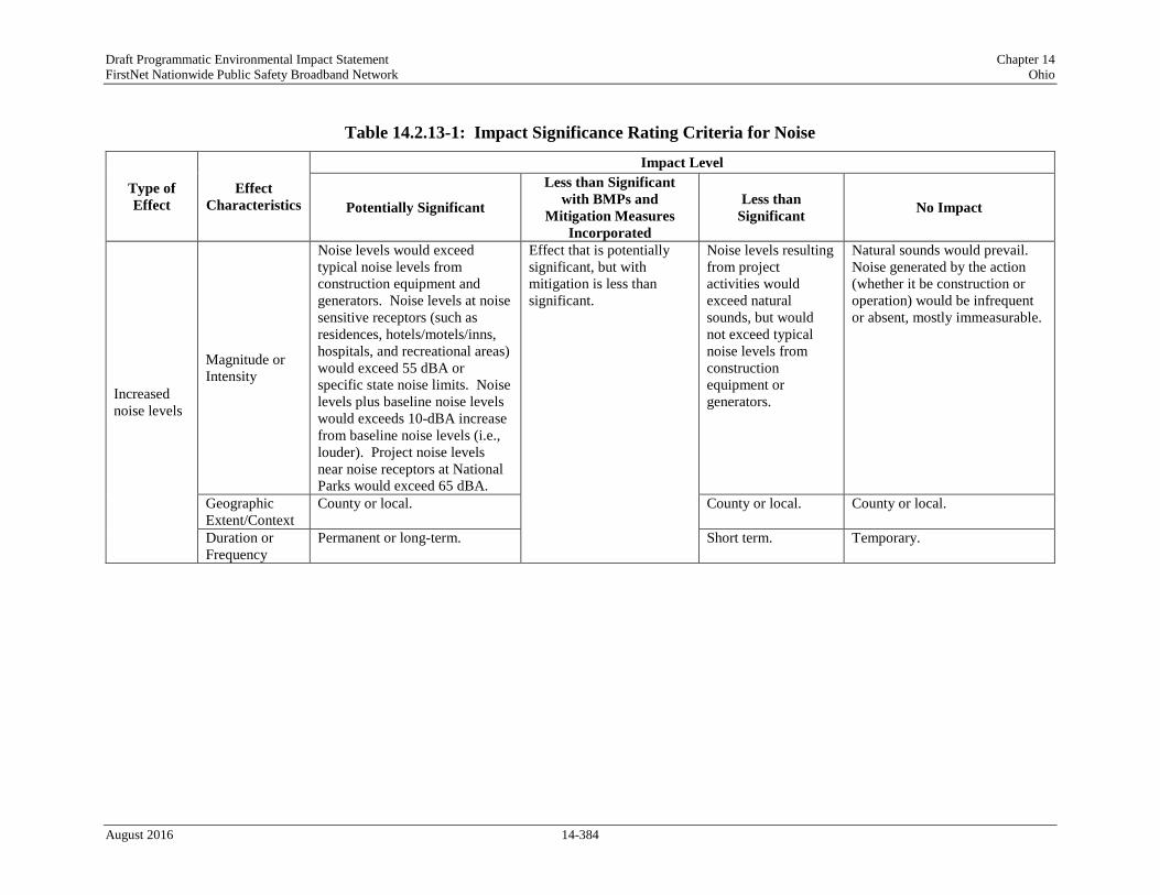
Draft Programmatic Environmental Impact Statement Chapter 14 FirstNet Nationwide Public Safety Broadband Network Ohio
Table 14.2.13-1: Impact Significance Rating Criteria for Noise
Type of Effect
Effect Characteristics
Impact Level
Potentially Significant
Less than Significant with BMPs and
Mitigation Measures Incorporated
Less than Significant No Impact
Increased noise levels
Magnitude or Intensity
Noise levels would exceed typical noise levels from construction equipment and generators. Noise levels at noise sensitive receptors (such as residences, hotels/motels/inns, hospitals, and recreational areas) would exceed 55 dBA or specific state noise limits. Noise levels plus baseline noise levels would exceeds 10-dBA increase from baseline noise levels (i.e., louder). Project noise levels near noise receptors at National Parks would exceed 65 dBA.
Effect that is potentially significant, but with mitigation is less than significant.
Noise levels resulting from project activities would exceed natural sounds, but would not exceed typical noise levels from construction equipment or generators.
Natural sounds would prevail. Noise generated by the action (whether it be construction or operation) would be infrequent or absent, mostly immeasurable.
Geographic Extent/Context
County or local. County or local. County or local.
Duration or Frequency
Permanent or long-term. Short term. Temporary.
August 2016 14-384
Draft Programmatic Environmental Impact Statement Chapter 14 FirstNet Nationwide Public Safety Broadband Network Ohio
14.2.13.3. Description of Environmental Concerns
Increased Noise Levels
The Proposed Action has the potential to generate noise during construction and operation of various equipment used for deployment. These noise levels could be above what is typically generated in a given area and may alter the ambient acoustical environment. If significant, the noise could cause impacts on residential areas, or other facilities that are sensitive to noise, such as churches, hospitals, or schools. The construction activities for deploying some of the various equipment evaluated under the Proposed Action could cause short-term impacts to nearby populations. However, it is likely that there would be less long-term effects from operational use of the proposed equipment.
Based on the significance criteria presented in Table 14.2.13-1, noise impacts would likely be less than significant given the size and nature of the majority of the proposed deployment activities. The majority of FirstNet’s deployment activities would not be in sensitive areas nor would a large number of noise sources be deployed/operated long-term in the same area. Noise levels from deployment activities are not expected to exceed typical noise levels for short-term/temporary construction equipment or generators. To the extent practicable, FirstNet would attempt to mitigate or minimize noise effects during construction or operation. BMPs and mitigation measures could help to limit impacts on nearby noise-sensitive receptors. However, given that much of the construction and setup of equipment would often occur in populated areas, FirstNet operations would not be able to completely avoid noise impacts due to construction and operations at various receptors.
14.2.13.4. Potential Impacts of the Preferred Alternative
The following section assesses potential impacts associated with implementation of the Preferred Alternative, including construction, deployment, and operation activities.
Deployment Impacts
As described in Section 2.1.2, Proposed Action Infrastructure, implementing the Preferred Alternative could result in deploying various types of facilities or infrastructure. Depending on the physical nature and location of the facility/infrastructure and the specific deployment requirements, some activities would result in potential noise impacts and while others would not.
In addition, the same type of Proposed Action infrastructure could result in a range of no impacts to less than significant impacts depending on the deployment scenario or site-specific conditions.
Activities Likely to Have No Impacts
Of the types of facilities or infrastructure deployment scenarios described in Section 2.1.2, Proposed Action Infrastructure, the following are likely to have no noise impacts under the conditions described below:
August 2016 14-385

Draft Programmatic Environmental Impact Statement Chapter 14 FirstNet Nationwide Public Safety Broadband Network Ohio
• Wired Projects
o Use of Existing Conduit – New Buried Fiber Optic Plant: Disturbance associated with the installation of fiber optic cable in existing conduit would be limited to entry and exit points of the existing conduit in previously disturbed areas. Noise generated by equipment required to install fiber would be infrequent and of short duration, and is not expected to create perceptible impacts.
o Use of Existing Buried or Aerial Fiber Optic Plant or Existing Submarine Cable: Lighting up dark fiber would require no construction and have no noise impacts. Impacts that may result if any construction activity is required are discussed below.
• Satellites and Other Technologies
o Satellite Enabled Devices and Equipment: The duration of construction activities associated with installing permanent equipment on existing structures would most likely be short-term. It is anticipated that insignificant levels of noise would be emitted during installment of this equipment. Noise caused by these construction and installation activities would be similar to other construction activities in the area, such as the installation of cell phone towers or other communication equipment. Deployment and operation of satellite-enabled devices and equipment are expected to have minimal to no impact to those resources.
o Deployment of Satellites: FirstNet does not anticipate launching satellites as part of the deployment of the NPSBN; however, it may include equipment on satellites that are already being launched for other purposes. As adding equipment to an existing launch vehicle would be very unlikely to impact noise resources, it is anticipated that this activity would have no impact on those resources.
Activities with the Potential for Noise Impacts
Construction, deployment, and operation activities related to the Preferred Alternative could create noise impacts from either the construction or operation of the infrastructure. The types of infrastructure deployment scenarios or deployment activities that could be part of the Preferred Alternative and result in potential impacts to air quality include the following:
• Wired Projects
o New Build – Buried Fiber Optic Plant: Plowing (including vibratory plowing), trenching, or directional boring and the construction of POPs, huts, or other associated facilities or hand-holes to access fiber as well as land/vegetation clearing, excavation activities, and landscape grading could result in high noise levels from the use of heavy equipment and machinery.
o New Build – Aerial Fiber Optic Plant: The use of heavy equipment during the installation of new poles and hanging cables, as well as constructing access roads, POPs, huts, or other associated facilities to house plant equipment would be short-term and could result in increased noise levels from the use of vehicles and machinery.
August 2016 14-386
Draft Programmatic Environmental Impact Statement Chapter 14 FirstNet Nationwide Public Safety Broadband Network Ohio
o Collocation on Existing Aerial Fiber Optic Plant: Excavation equipment used during potential pole replacement, and other heavy equipment used for structural hardening or reinforcement, could result in temporary increased in noise levels from the use of heavy equipment and machinery.
o Use of Existing Buried or Aerial Fiber Optic Plant or Existing Submarine Cable: Installation of new associated huts or equipment, if required, could result in short-term and temporarily higher noise levels if the activity required the use of heavy equipment for grading or other purposes.
o New Build – Submarine Fiber Optic Plant: The installation of cables in or near bodies of water could generate noise if vessels are used to lay the cable. In addition, the construction of landings and/or facilities on shore to accept submarine cable could result in short-term and temporarily increased noise levels to local residents and other noise sensitive receptors from heavy equipment used for grading, foundation excavation, or other ground disturbing activities.
o Installation of Optical Transmission or Centralized Transmission Equipment: Noise associated with the installation of optical transmission or centralized transmission equipment would be limited to the short-term, temporary use of vehicle and construction equipment. Long-term impacts are unlikely, as the noise emissions from optical networks are relatively low. Heavy equipment used to grade and construct access roads could generate increased levels of noise over baseline levels temporarily.
• Wireless Projects
o New Wireless Communication Towers: Activities associated with installing new wireless towers and associated structures (e.g., generators, equipment sheds, fencing, security and aviation lighting, electrical feeds, and concrete foundations and pads) or access roads could result in localized construction noise. Operating vehicles, other heavy equipment, and generators would be used on a short-term basis and could increase noise levels.
o Collocation on Existing Wireless Tower, Structure, or Building: Vehicles and equipment used to mount or install equipment, or to grade or excavate additional land on sites for installation of equipment, such as antennas or microwave dishes on an existing tower, could impact the local noise environment temporarily.
o Deployable Technologies: The type of deployable technology used would dictate the types of noise generated. For example, mobile equipment deployed via heavy trucks could generate noise from the internal combustion engines associated with the vehicles and onboard generators. With the exception of balloons, aerial platforms (e.g., UASs or other aircraft, except balloons) generate noise during all phases of flight, including takeoff, landing, and flight operations over necessary areas that could impact the local noise environment.
In general, noise from the abovementioned activities would be products of site preparation, installation, and construction activities, as well as additional construction vehicles traveling on
August 2016 14-387

Draft Programmatic Environmental Impact Statement Chapter 14 FirstNet Nationwide Public Safety Broadband Network Ohio
nearby roads and localized generator use. Any major infrastructure replacement as part of ongoing system maintenance would result in impacts similar to the construction impacts. These impacts are expected to be less than significant due to the temporary duration of deployment activities. Additionally, pre-existing noise levels would be achieved after some months (typically less than a year but could be a few hours for linear activities such as pole construction). Chapter 19, BMPs and Mitigation Measures provides a listing of BMPs and mitigation measures that FirstNet and/or its partners would require, as practicable or feasible, to avoid or minimize potential impacts.
Operation Impacts
Operation activities associated with the Preferred Alternative would be less than significant, and for routine maintenance and inspection of the facilities, because of the temporary nature of the activities would not create new permanent sources of noise. Any major infrastructure replacement as part of ongoing system maintenance would result in impacts similar to the abovementioned construction impacts. It is anticipated that potential noise impacts would be similar to or less than those described for the deployment activities. If usage of vehicles or heavy equipment as part of routine maintenance or inspections or onsite generator use occurs, potential noise impacts could result as explained above. Chapter 19, BMPs and Mitigation Measures provides a listing of BMPs and mitigation measures that FirstNet and/or its partners would require, as practicable or feasible, to avoid or minimize potential impacts.
14.2.13.5. Alternatives Impact Assessment
The following section assesses potential noise impacts associated with the Deployable Technologies Alternative and the No Action Alternative.
Deployable Technologies Alternative
Under the Deployable Technologies Alternative option, a nationwide fleet of mobile communications systems would provide temporary coverage in areas not covered by the existing, usable infrastructure. There would be no collocation of equipment and minimal new construction associated with wired or wireless projects discussed above under the Preferred Alternative. Some limited construction could be associated with implementation such as land clearing or paving for parking or staging areas. The specific equipment associated with the Deployable Technologies Alternative would be heavy trucks with onboard generators, aerial vehicles (e.g., UASs or other aircraft), and ground support vehicles and equipment for aerial deployment. The stand-alone Deployable Technologies Alternative differs from the Preferred Alterative in the number of mobile and aerial vehicles likely to deploy, the distances traveled from storage locations and the duration of deployment. The potential noise impacts are as follows:
Deployment Noise Impacts
Implementing deployable technologies could result in noise from mobile equipment deployed via heavy trucks, including not only onboard generators, but also the vehicles themselves. While a
August 2016 14-388

Draft Programmatic Environmental Impact Statement Chapter 14 FirstNet Nationwide Public Safety Broadband Network Ohio
single deployable vehicle may have an insignificant impact, multiple vehicles operating for longer periods, in close proximity, may increase localized noise levels. Several vehicles traveling together could also create short-term noise impacts on residences or other noise-sensitive receptors as they pass by. With the exception of balloons, the deployment of aerial technology is anticipated to generate noise during all phases of flight. Aerial technologies would have the highest level of noise impact if they are required to fly above residential areas, areas with a high concentration of noise-sensitive receptors (i.e., schools or churches), or over national parks or other areas where there is an expectation of quiet and serenity on their way to their final destinations. Residences near deployment areas for aerial technologies (i.e., airports or smaller airfields) could also be affected during takeoff and landing operations. Additionally, routine maintenance and inspections of the deployable technologies are anticipated to be less than significant, given that these activities are of low-intensity and short duration. Chapter 19, BMPs and Mitigation Measures provides a listing of BMPs and mitigation measures that FirstNet and/or its partners would require, as practicable or feasible, to avoid or minimize potential impacts.
Operation Impacts
Operation activities associated with the Deployable Technologies Alternative would be similar to several of the deployment activities related to routine maintenance and inspection of the facilities. Operation of generators could also generate noise in the area. However, deployable technologies could be deployed to areas with few existing facilities, so noise impacts could be minimal in these areas. Any major infrastructure replacement as part of ongoing system maintenance would result in impacts similar to the abovementioned construction impacts. It is anticipated that potential noise impacts would be the same as those described for the deployment activities. If usage of vehicles or heavy equipment as part of routine maintenance or inspections occurs, potential noise impacts could result as explained above.
Operational impacts from aerial technologies would include repeated flyovers by UAS vehicles while they are needed in the area. This could generate less than significant short-term impacts on any residential areas or other noise-sensitive receptors under the flight path of these vehicles. However, once these operations cease, noise levels would quickly return to baseline levels. Chapter 19, BMPs and Mitigation Measures provides a listing of BMPs and mitigation measures that FirstNet and/or its partners would require, as practicable or feasible, to avoid or minimize potential impacts.
No Action Alternative
Under the No Action Alternative, FirstNet would not deploy the NPSBN and there would be no impact to ambient noise. By not deploying the NPSBN, FirstNet would avoid generating noise from construction, installation, or operation of wired, wireless, deployable infrastructure or satellites and other technologies.
August 2016 14-389

Draft Programmatic Environmental Impact Statement Chapter 14 FirstNet Nationwide Public Safety Broadband Network Ohio
Climate Change
14.2.14.1. Introduction
This section describes potential impacts to climate and climate change-vulnerable FirstNet installations and infrastructure in Ohio associated with deployment and operation of the Proposed Action and alternatives. Chapter 19, BMPs and Mitigation Measures provides a listing of BMPs and mitigation measures that FirstNet and/or its partners would require, as practicable or feasible, to avoid or minimize potential impacts.
14.2.14.2. Impact Assessment Methodology and Significance Criteria
The impacts of the Proposed Action on climate and potential climate change impacts on the Proposed Action’s installations and infrastructure were evaluated using the significance criteria presented in Table 14.2.14-1. The categories of impacts are defined as potentially significant, less than significant with mitigation incorporated, less than significant, or no impact. Characteristics of each impact type, including magnitude or intensity, geographic extent, and duration or frequency, were used to determine the impact significance rating associated with each potential impact.
Given the nature of this programmatic evaluation, and because the Proposed Action could potentially cover a wide variety of actions that would take place in various landscapes, the potential impacts to climate and climate change-vulnerable resources addressed in this section are presented as a range of possible impacts.
CEQ requires the consideration of climate change from two perspectives. The first is the potential for impacts on climate change through GHG emissions resulting from the Proposed Action or alternatives. The second is related to the implications and possible effects of climate change on the environmental consequences of the Proposed Action or alternatives. This extends to the impacts of climate change on facilities and infrastructure that would be part of the Proposed Action or alternatives (CEQ, 2014).
CEQ has established the significance criteria for GHG emissions at 25,000 MT CO2e on an annual basis, with the requirement that if projected emissions exceed this threshold, a GHG emissions quantitative analysis is warranted (CEQ, 2014). Although 25,000 MT is a very small fraction (one 266,920th) of the total U.S. emissions of 6,673 MMT in 2013 (USEPA, 2015m), the sum of additional emissions as a consequence of the deployment of FirstNet, combined with multiple new sources of CO2 and other GHGs from other projects and human activities, could be significant.
CEQ guidance for the consideration of effects of climate change on the environmental consequences of the Proposed Action is more general. In addition to the consideration of climate change’s effects on environmental consequences, it also includes the impact that climate change may have on the projects themselves (CEQ, 2014). Projects in areas that are vulnerable to the effects of climate change (e.g., sea level rise) may be at risk. Analysis of these risks through the NEPA process could provide useful information to the project planning to ensure these projects are resilient to the impacts of climate change.
August 2016 14-390

Draft Programmatic Environmental Impact Statement Chapter 14 FirstNet Nationwide Public Safety Broadband Network Ohio
Table 14.2.14-1: Impact Significance Rating Criteria for Climate
NA = Not Applicable
Type of Effect
Effect Characteristics
Impact Level
Potentially Significant
Less than Significant with BMPs and
Mitigation Measures Incorporated
Less than Significant No Impact
Contribution to climate change through GHG emissions
Magnitude or Intensity
Exceedance of 25,000 metric tons of CO2e/year, and global level effects observed. Effect that is potentially
significant, but with mitigation is less than significant.
Only slight change observed.
No increase in greenhouse gas emissions or related changes to the climate as a result of project activities.
Geographic Extent Global impacts observed. Global impacts
observed. NA
Duration or Frequency
Long-term changes. Changes cannot be reversed in a short term.
Changes occur on a longer time scale. Changes cannot be reversed in the short term.
NA
Effect of climate change on FirstNet installations and infrastructure
Magnitude or Intensity
Climate change effects (such as sea level rise or temperature change) negatively impact FirstNet infrastructure. Effect that is potentially
significant, but with mitigation is less than significant.
Only slight change observed.
No measurable impact of climate change on FirstNet installations or infrastructure.
Geographic Extent
Local and regional impacts observed.
Local and regional impacts observed. NA
Duration or Frequency
Long-term changes. Changes cannot be reversed in a short term.
Changes occur on a longer time scale. Changes cannot be reversed in the short term.
NA
August 2016 14-391

Draft Programmatic Environmental Impact Statement Chapter 14 FirstNet Nationwide Public Safety Broadband Network Ohio
14.2.14.3. Projected Future Climate
Climate model forecasts of future temperatures are highly dependent on emissions scenarios (low versus high). By mid-century under a high emissions scenario, the total number of hottest days (days above 95 ºF) is projected to increase by mid-century (2041 – 2070) as compared to a 1971 – 2000 baseline in the Midwest with the number of hottest days increasing by 5 to 20 days per year in Ohio depending on the region of the state. Additionally, much of the Midwest is projected to observe a longer frost-free season by mid-century as compared to a 1971 – 2000 baseline, where a frost-free season is defined as the period between the last occurrence of 32 °F in the spring and the first occurrence of 32 °F in the fall. In Ohio, the frost-free season under a high emissions scenario may extend greater than 25 days longer than the baseline years. (USGCRP, 2014b)
Ohio is bordered by Lake Erie. The Great Lakes have recorded higher water temperatures and less ice cover as a result of changes in regional climate. Lake surface temperatures are projected to rise by as much as 7 °F by 2050 and 12.1°F by 2100. Higher temperatures, increases in precipitation, and lengthened growing seasons favor production of blue-green and toxic algae that could harm water quality and aquatic life. (USGCRP, 2014b)
Air Temperature
Figure 14.2.14-1 and Figure 14.2.14-2 illustrate the anticipated temperature changes for low and high GHG emission scenarios for Ohio from a 1969 to 1971 baseline.
Cfa – Figure 14.2.14-1 shows that by mid-century (2040 to 2059), temperatures in the entire state of Ohio under a low emissions scenario would increase by approximately 4 °F, and by the end of the century (2080 to 2099) under a low emissions scenario temperatures in the Cfa region of Ohio would increase by approximately 6 °F in the majority of the region while a very small southern portion is only expected to have an increase of 5 °F. (USGCRP, 2009)
Figure 14.2.14-2 shows that under a high emissions scenario for the period (2040 to 2059), temperatures would increase by approximately 5 °F. Under a high emissions scenario for the period (2080 to 2099) in the Cfa region of Ohio, temperatures would increase by approximately 9 °F. (USGCRP, 2009)
Dfa – Under a low emissions scenario, temperatures by mid-century are expected to increase at the same rate as the Cfa region. By the end of the century, temperatures in this region are expected to increase by approximately 6 °F. (USGCRP, 2009)
Temperatures in this region are expected to increase by mid-century (2040 to 2059) and by the end of the century (2080 to 2099) at the same rate as the Cfa region under a high emissions scenario. (USGCRP, 2009)
Dfb – Temperatures in this region are expected to increase by mid-century (2040 to 2059) and by the end of the century at the same rate as the Dfa region in both a low and high emissions scenario. (USGCRP, 2009)
August 2016 14-392
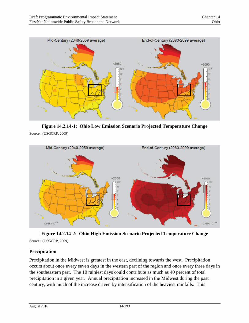
Draft Programmatic Environmental Impact Statement Chapter 14 FirstNet Nationwide Public Safety Broadband Network Ohio
Figure 14.2.14-1: Ohio Low Emission Scenario Projected Temperature Change Source: (USGCRP, 2009)
Figure 14.2.14-2: Ohio High Emission Scenario Projected Temperature Change Source: (USGCRP, 2009)
Precipitation
Precipitation in the Midwest is greatest in the east, declining towards the west. Precipitation occurs about once every seven days in the western part of the region and once every three days in the southeastern part. The 10 rainiest days could contribute as much as 40 percent of total precipitation in a given year. Annual precipitation increased in the Midwest during the past century, with much of the increase driven by intensification of the heaviest rainfalls. This
August 2016 14-393

Draft Programmatic Environmental Impact Statement Chapter 14 FirstNet Nationwide Public Safety Broadband Network Ohio
tendency towards more intense precipitation events is projected to continue in the future. (USGCRP, 2014b)
Snowfall varies across the region, comprising less than 10 percent of total precipitation in the southern portion of the Midwest, to more than half in the northern portion of the Midwest, with as much as two inches of water available in the snowpack at the beginning of spring melt in the northern reaches of the river basins. When this amount of snowmelt is combined with heavy rainfall, catastrophic, widespread flooding could occur. Trends towards a decline in the frequency of high magnitude snowfall, but an increase in lake effect snowfall have been observed. These divergent trends and their inverse relationships with air temperatures make overall projections of regional impacts of the associated snowmelt extremely difficult. Flooding could also occur due to extreme precipitation in the absence of snowmelt. These warm-season events are also projected to increase in magnitude in the future. (USGCRP, 2014b)
In Ohio, there is an expected 10 percent decrease in the number of consecutive dry days under a low emissions scenario. In most of Ohio, there is an expected 20 percent decrease in the number of consecutive dry days under a high emissions scenario by mid-century (2041 to 2070) as compared to the period (1971 – 2000). An increase in consecutive dry days could lead to drought. (USGCRP, 2014c)
Figure 14.2.14-3 and Figure 14.2.14-4 show predicted seasonal precipitation change for an approximate 30-year period of 2071 to 2099 compared to a 1970 to 1999 approximate 30-year baseline. Figure 14.2.14-3 show seasonal changes in a low emissions scenario, which assumes rapid reductions in emissions where rapid reductions means more than 70 percent cuts from current levels by 2050. (USGCRP, 2014c)
Figure 14.2.14-4 shows a high emissions scenario, which assumes continued increases in emissions, with associated large increases in warming and major precipitation changes. (Note: white areas in the figures indicate that the changes are not projected to be larger than could be expected from natural variability.) (USGCRP, 2014c)
Cfa - Figure 14.2.14-3 shows that in a low emissions scenario in the 30-year period for 2071 to 2099, precipitation will increase by 10 percent in winter and spring depending on the portion of the Cfa region. In spring, precipitation is expected to increase 10 percent. However, there are no expected changes in precipitation in fall other than fluctuations due to natural variability. (USGCRP, 2014c)
Figure 14.2.14-4 shows that if emissions continue to increase, winter and spring precipitation could increase as much as 20 percent over the period 2071 to 2099. In summer, precipitation in this scenario could increase as much as 10 percent in a very small southern portion of the region while the majority of precipitation in the Cfa region is expected to remain constant. No significant change to fall precipitation is anticipated over the same period. (USGCRP, 2014c)
Dfa – Under a low emissions scenario, precipitation is expected to increase 10 percent in winter and spring. There are no expected changes in precipitation in summer or fall. (USGCRP, 2009)
In winter under a high emissions scenario precipitation is expected to increase 20 to 30 percent depending on the portion of the Dfa region of Ohio. Spring precipitation is expected to increase
August 2016 14-394

Draft Programmatic Environmental Impact Statement Chapter 14 FirstNet Nationwide Public Safety Broadband Network Ohio
20 percent. There are no anticipated changes to summer or fall precipitation under a high emissions scenario. (USGCRP, 2009)
Dfb – Precipitation changes for the Dfb region are consistent with projected changes for the Dfa region of Ohio in both low and high emissions scenarios. (USGCRP, 2009)
Figure 14.2.14-3: Predicted Seasonal Precipitation Change for 2071 to 2099 Compared to 1970 to 1999 Baseline in a Low Emissions Scenario
Source: (USGCRP, 2014c)
August 2016 14-395

Draft Programmatic Environmental Impact Statement Chapter 14 FirstNet Nationwide Public Safety Broadband Network Ohio
Figure 14.2.14-4: Predicted Seasonal Precipitation Change for 2071 to 2099 Compared to 1970 to 1999 Baseline in a High Emissions Scenario
Source: (USGCRP, 2014c)
Severe Weather Events
It is difficult to forecast the impact of climate change on severe weather events such as winter storms and thunderstorms. Trends in thunderstorms are subject to greater uncertainties than trends in temperature and associated variables directly related to temperature such as sea level
August 2016 14-396

Draft Programmatic Environmental Impact Statement Chapter 14 FirstNet Nationwide Public Safety Broadband Network Ohio
rise. Climate scientists are studying the influences of climate change on severe storms. Recent research has yielded insights into the connections between warming and factors that cause severe storms. For example, atmospheric instability and increases in wind speed with altitude link warming with tornadoes and thunderstorms. Additionally, research has found a link between warming and conditions favorable for severe thunderstorms. However, more research is required to establish definitive links between severe weather events and climate change. (USGCRP, 2014d)
14.2.14.4. Description of Environmental Concerns
Greenhouse Gas Emissions
Increases in GHG emissions have altered the global climate, leading to generalized temperature increases, weather disruption, increased droughts and heatwaves, and may have potentially catastrophic long-term consequences for the environment. Although GHGs are not yet regulated by the federal government, many states have set various objectives related to reducing GHG emissions, particularly CO2 emissions from fossil fuels.
Based on the impact significance criteria presented in Table 14.2.14-1, climate change impacts as a result of GHG emissions could be significant and require a quantitative analysis if FirstNet’s deployment of technology was responsible for increased emissions of 25,000 MT/year or more. The GHG emissions resulting from FirstNet activities fall into two categories: short-term and long-term. Short-term emissions could be associated with deployment activities (vehicles and other motorized construction equipment) and would have no long-term or permanent impact on GHG emissions or climate change. Long-term (both temporary and permanent) emission increases could result from operations, including the use of grid-provided electricity by FirstNet equipment such as transmitters and optical fiber, and from the temporary use of portable or onsite electric generators (a less efficient, more carbon-intensive source of electricity), during emergency situations when the electric grid was down, for example after a hurricane.
A single large cell tower would typically require 20-60kW of power to operate (Balshe, 2011). The CO2 emissions associated with the operation of the tower would depend on whether it was supplied by a stand-alone power source, such as a generator, or from the grid, and whether it was operating at full power on a continuous basis. A standard 60kW 3-phase diesel generator consumes approximately 5.0 gallons of diesel per hour (Diesel Service & Supply, 2016). Diesel fuel combustion emits 22.38 lbs of CO2 per gallon (EIA, 2015h). A 60kW transmitter running on a generator would therefore be responsible for 1,221 kg of CO2/day. Running continuously, the tower would cause the emission of 446 MT of CO2 per year.
However, grid-provided electricity would result in less CO2 emissions than on-site provided energy. Using the average carbon intensity of grid-provided electricity of 1,136.53 lbs/MWh (USEPA, 2015p), the same transmitter would be responsible for approximately 271 MT of CO2
per year running continuously. Actual emissions would depend on the fuel mix and efficiency of the systems from which electricity was generated. Therefore, this scenario is a “worst-case” for GHG emissions. If the system deployment resulted in the operation of more than 50 60 kW towers operating at maximum power in remote locations on diesel generators on a continuous
August 2016 14-397

Draft Programmatic Environmental Impact Statement Chapter 14 FirstNet Nationwide Public Safety Broadband Network Ohio
basis, the 25,000 MT/year threshold may be exceeded and a quantitative analysis required. In comparison, optical fiber is considerably more energy efficient and consumes considerably less power than transmitters (Vereecken, et al., 2011), and would not impact GHG emissions in such a way as to require a quantitative analysis.
Impact of Climate Change on Project-Related Resource Effects
Climate change may impact project-related effects by magnifying or otherwise altering impacts in other resources areas. For example, climate change may impact air quality, water resource availability, and recreation. These effects would vary from state to state depending on the resources in question and their relationship to climate change.
For areas of Ohio at risk for flooding, climate change is projected to increase the frequency and severity of torrential downpours, which in turn may increase the potential for flash floods (USGCRP, 2014e). This, combined with increasing water temperatures in rivers and other water bodies such as the Great Lakes, may negatively impact water quality with increased sedimentation and agricultural runoff, and give rise to secondary effects such as harmful algal blooms, which would negatively impact ecosystems as well as human health (USGCRP, 2014b). Climate change may expose areas of Ohio increased intensity and duration of heat waves (USGCRP, 2014e) particularly in large population centers with the significant urban heat islands such as Cleveland that would greatly magnify these negative effects on air quality and human health (Sustainable Cleveland, 2013).
Impact of Climate Change on FirstNet Installations and Infrastructure
Climate change impacts on FirstNet installations and infrastructure will vary from state to state, depending on the placement and vulnerability of the installations and infrastructure, and the impacts that climate change is anticipated to have in that particular location.
Climate-change induced torrential rain and flooding (USGCRP, 2014e) would potentially negatively impact FirstNet installations and infrastructure in or near flood plains and other low-lying areas. The increased duration and intensity of heat waves may also increase general demand on the electric grid in the Midwest through increased use of electricity-consuming air conditioning, which together with high temperatures could impede the operation of the grid (DOE, 2015), and also potentially overwhelm the capacity of on-site equipment needed to keep microwave and other transmitters cool.
Based on the impact significance criteria presented in Table 14.2.14-1, climate change effects on FirstNet installations and infrastructure would be significant if they negatively affected the operation of these facilities.
14.2.14.5. Potential Impacts of the Preferred Alternative
Greenhouse Gas Emissions
The following section assesses potential GHG emission impacts associated with implementation of the Preferred Alternative in Ohio, including deployment and operation activities.
August 2016 14-398

Draft Programmatic Environmental Impact Statement Chapter 14 FirstNet Nationwide Public Safety Broadband Network Ohio
As described in Section 2.1.2, Proposed Action Infrastructure, implementation of the Preferred Alternative could result in the deployment and operation of various types of facilities or infrastructure. Depending on the physical nature and location of the facility/infrastructure and the specific deployment requirements, some activities would result in potential impacts to GHG emissions, climate impacts in other resource areas, and FirstNet infrastructure and operations, and others would not. In addition, and as explained in this section, the same type of Proposed Action infrastructure could result in a range of no impacts to less than significant impacts depending on the deployment scenario or site-specific conditions.
Activities Likely to Have No Impacts
Of the types of facilities or infrastructure deployment scenarios described in Section 2.1.2, Proposed Action Infrastructure, the following are likely to have no impacts to climate change under the conditions described below:
• Wired Projects
o Use of Existing Conduit – New Buried Fiber Optic Plant: There would be no short-term emissions associated with construction, as construction would not take place. The equipment required to blow or pull fiber through existing conduit would be used temporarily and infrequently, resulting in no perceptible generation of GHG emissions.
o Use of Existing Buried or Aerial Fiber Optic Plant or Existing Submarine Cable: Lighting up dark fiber would require no construction and have no short-term or long-term emissions.
• Satellites and Other Technologies
o Satellite Enabled Devices and Equipment: The installation of satellite-enabled equipment on existing structures, or the use of portable satellite-enabled devices would not create any perceptible changes in GHG emissions because they would not create any new emissions sources.
o Deployment of Satellites: FirstNet does not anticipate launching satellites as part of the NPSBN; however, it could include equipment on satellites that are already being launched for other purposes. Therefore it is anticipated that there would be no GHG emissions or any climate change effects on the project because these activities.
Activities with the Potential to Have Impacts
The deployment and use of energy-consuming equipment as a result of the implementation of the Preferred Alternative would result in GHG emissions whose significance would vary depending on their power requirements, duration and intensity of use, and number. The types of infrastructure deployment scenarios that could be part of the Preferred Alternative and result in potential impacts to GHG emissions and climate change include the following:
• Wireless Projects
o New Build - Buried Fiber Optic Plant: This activity would include plowing (including vibratory plowing), trenching, and directional boring, and could involve construction of
August 2016 14-399

Draft Programmatic Environmental Impact Statement Chapter 14 FirstNet Nationwide Public Safety Broadband Network Ohio
POPs, huts, or other facilities to house outside plant equipment or hand holes to access fiber. These activities could generate GHG emissions.
o New Build Aerial Fiber Optic Plant: These projects could require construction equipment for installing or replacing new poles and hanging cables as well as excavation and grading for new or modified right-of-ways or easements. It could also include construction of POPs, huts, or other facilities to house outside plant equipment. These activities could generate GHG emissions.
o Collocation on Existing Aerial Fiber Optic Plant: These projects would require equipment for replacement of existing wiring and poles. GHG emissions associated with these projects would arise from use of machinery and vehicles to complete these activities.
o New Build – Submarine Fiber Optic Plant: The deployment of small workboats with engines similar to recreational vehicle engines may be required to transport and lay cable. The emissions from these small boat sources would contribute to GHGs.
o Installation of Optical Transmission or Centralized Transmission Equipment: The construction of small boxes or huts or other structures would require construction equipment, which could generate GHG emissions.
• Wireless Projects
o New Wireless Tower Construction: Installation of new wireless towers and associated structures (generators, equipment sheds, fencing, security and aviation lighting, electrical feeds, and concrete foundations and pads) or access roads could result in short-term, temporary GHG emissions from vehicles and construction equipment. Long-term, permanent or temporary increases in GHG emissions would result from the electricity requirements of the towers (both grid-provided and backup), and would depend on their size, number, and the frequency and duration of their use.
o Collocation on Existing Wireless Tower, Structure, or Building: Collocation would involve mounting or installing equipment (such as antennas or microwave dishes) on existing towers. There would be no short-term GHG emissions associated with construction, as construction would not take place. Minor, short-term, temporary GHG emissions may result from any associated equipment used for installation, such as cranes or other equipment. Long-term, permanent or temporary increases in GHG emissions would result from the electricity requirements of the towers (both grid-provided and backup), and would depend on their size, number, and the frequency and duration of their use.
• Deployable Technologies
o COWs, COLTs, or SOWs: The long-term operations of these mobile systems have the potential to have GHG emission impacts in excess of 25,000 MT if operated in large numbers over the long-term. However, this would be highly dependent on their size, number, and the frequency and duration of their use. Emissions associated with the
August 2016 14-400

Draft Programmatic Environmental Impact Statement Chapter 14 FirstNet Nationwide Public Safety Broadband Network Ohio
deployment and maintenance of a complete network solution of this type may be significant if large numbers of piloted or unmanned aircraft were used for a sustained period of time (i.e. months to years). Emissions would depend on the type of platforms used, their energy consumption, and the duration of the network’s operation.
Potential climate change impacts associated with deployment activities as a result of implementation of the Preferred Alternative include increased GHG emissions. GHG emissions would arise from the combustion of fuel used by equipment during construction and changes in land use. Emissions occurring as a result of soil disturbance and loss of vegetation are expected to be less than significant due to the limited and localized nature of deployment activities. Chapter 19, BMPs and Mitigation Measures provides a listing of BMPs and mitigation measures that FirstNet and/or its partners would require, as practicable or feasible, to avoid or minimize potential impacts.
Climate Change Impacts on FirstNet Infrastructure or Operations
Climate change effects on the Preferred Alternative could be potentially significant to less than significant with BMPs and mitigation measures incorporated because climate change may potentially impact FirstNet installations or infrastructure during periods of extreme heat, severe storms, and other weather events. FirstNet installations should be evaluated in the design and planning phase through tiering to this analysis, in the context of their local geography and anticipated climate hazards to ensure they are properly hardened or there is sufficient redundancy to continue operations in a climate-affected environment. Mitigation measures could minimize or reduce the severity or magnitude of a potential impact resulting from the project, including adaptation, which refers to anticipating adverse effects of climate change and taking appropriate action to prevent and minimize the damage climate change effects could cause.
The anticipated impact of climate change on extreme weather events such as hurricanes or heat waves may increase the severity of the emergencies to which first responders are responding in vulnerable areas, and thus the extent and duration of their dependence on FirstNet resources. FirstNet would likely prepare to sustain these operations in areas experiencing climate and weather extremes through the design and planning process for individual locations and operations.
14.2.14.6. Alternatives Impact Assessment
The following section assesses potential impacts to climate associated with the Deployable Technologies Alternative and the No Action Alternative.
Deployable Technologies Alternative
Under the Deployable Technologies Alternative, a nationwide fleet of mobile communications systems would provide temporary coverage in areas not covered by the existing, usable infrastructure. There would be no collocation of equipment and minimal new construction associated with wired or wireless projects discussed above under the Preferred Alternative. Some limited construction could be associated with implementation such as land clearing or paving for parking or staging areas. The specific infrastructure associated with the
August 2016 14-401

Draft Programmatic Environmental Impact Statement Chapter 14 FirstNet Nationwide Public Safety Broadband Network Ohio
Deployable Technologies Alternative would be the same as the deployable technologies implemented as part of the Preferred Alternative but would likely be implemented in greater numbers, over a larger geographic extent, and used with greater frequency and duration.
Potential Deployment Impacts
As explained above, implementation of deployable technologies could involve use of fossil-fuel-powered vehicles, powered generators, and/or aerial platforms. There could be some emissions and soil and vegetation loss as a result of excavation and grading for staging and/or landing areas depending on the type of technology. GHG emissions are expected to be less than significant based on the defined significance criteria, since activities would be temporary and short-term.
Potential Operations Impacts
Implementing land-based deployable technologies (COW, COLT, SOW) could result in emissions from mobile equipment on heavy trucks using internal combustion engines associated with the vehicles and onboard generators. While a single deployable vehicle may have an insignificant impact, multiple vehicles operating for longer periods, in close proximity, may have a cumulative impact, although this impact is expected to be less than significant. Some staging or landing areas (depending on the type of technology) may require excavation, site preparation, and paving. Heavy equipment used for these activities could produce emissions as a result of burning fossil fuels in internal combustion engines. The deployment and operation of aerial technology is anticipated to generate pollutants during all phases of flight, except for balloons. These activities are expected to be less than significant due to the limited duration of deployment activities.
Additionally, routine maintenance and inspections of the deployable technologies are anticipated to be less than significant, given that these activities are of low-intensity and short duration.
Climate Change Impacts on FirstNet Deployable Infrastructure or Operations
As explained above, operation activities would consist of implementation/running of the deployable technology and routine maintenance and inspections. These projects may also consist of deploying aerial vehicles including, but not limited to, drones, balloons, blimps, and piloted aircraft, which could involve fossil fuel combustion. Climate change effects have the most noticeable impacts over a long period. Climate change effects have the most noticeable impacts over a long period. Climate change effects such as temperature, precipitation changes, and extreme weather during operations would be expected but could have little to no impact on the deployed technology due to the temporary nature of deployment. If there are no permanent structures, particularly near coastal areas, there would be little to no impacts as a result of sea-level rise. However, if these technologies are deployed continuously (at the required location) for an extended period of time, climate change effects on deployables could be similar to the Proposed Action, as explained above.
August 2016 14-402

Draft Programmatic Environmental Impact Statement Chapter 14 FirstNet Nationwide Public Safety Broadband Network Ohio
No Action Alternative
Under the No Action Alternative, the NPSBN would not be deployed; therefore, there would be no associated construction or installation of wired, wireless, deployable infrastructure, or satellites and other technologies. As a result, there would be no impacts to GHG emissions or climate as a result of deployment and operation of the Proposed Action. Environmental conditions would therefore be the same as those described in Section 14.1.14, Climate Change.
Human Health and Safety
14.2.15.1. Introduction
This section describes potential impacts to human health and safety in Ohio associated with deployment of the Proposed Action and alternatives. Chapter 19, BMPs and Mitigation Measures provides a listing of BMPs and mitigation measures that FirstNet and/or its partners would require, as practicable or feasible, to avoid or minimize potential impacts.
14.2.15.2. Impact Assessment Methodology and Significance Criteria
The impacts of the Proposed Action on human health and safety were evaluated using the significance criteria presented in Table 14.2.15-1. The categories of impacts are defined as potentially significant, less than significant with mitigation incorporated, less than significant, or no impact. Characteristics of each impact type, including magnitude or intensity, geographic extent, and duration or frequency, were used to determine the impact significance rating associated with each potential impact.
Given the nature of this programmatic evaluation, and because the Proposed Action could potentially cover a wide variety of actions that would take place in various landscapes, the potential impacts to human health and safety addressed in this section are presented as a range of possible impacts.
August 2016 14-403

Draft Programmatic Environmental Impact Statement Chapter 14 FirstNet Nationwide Public Safety Broadband Network Ohio
Table 14.2.15-1: Impact Significance Rating Criteria for Human Health and Safety
Type of Effect
Effect Characteristics
Impact Level
Potentially Significant
Less than Significant with BMPs and
Mitigation Measures Incorporated
Less than Significant No Impact
Exposure to Worksite Occupational Hazards as a Result of Activities at Existing or New FirstNet Sites
Magnitude or Intensity
Exposure to concentrations of chemicals above occupational regulatory limits and time-weighted averages (TWAs). A net increase in the amount of hazardous or toxic materials or wastes generated, handled, stored, used, or disposed of, resulting in unacceptable risk, exceedance of available waste disposal capacity and probable regulatory violations. Exposure to recognized workplace safety hazards (physical and chemical). Violations of various regulations including: OSHA, RCRA, CERCLA, TSCA, EPCRA.
Effect is potentially significant, but with mitigation is less than significant.
No exposure to chemicals above health-protective screening levels. Hazardous or toxic materials or wastes could be safely and adequately managed in accordance with all applicable regulations and policies, with limited exposures or risks. No exposure to unsafe working conditions or other workplace safety hazards.
No exposure to chemicals, unsafe working conditions, or other workplace safety hazards.
Geographic Extent
Regional impacts observed (“regional” assumed to be at least a county or county-equivalent geographical extent, could extend to state/territory).
Impacts only at a local/neighborhood level. NA
Duration or Frequency
Occasional frequency during the life of the project. Rare event. NA
August 2016 14-404

Draft Programmatic Environmental Impact Statement Chapter 14 FirstNet Nationwide Public Safety Broadband Network Ohio
Type of Effect
Effect Characteristics
Impact Level
Potentially Significant
Less than Significant with BMPs and
Mitigation Measures Incorporated
Less than Significant No Impact
Exposure to Hazardous Materials, Hazardous Waste, and Mine Lands as a Result of FirstNet Site Selection and Site-Specific Land Disturbance Activities
Magnitude or Intensity
Exposure to concentrations of chemicals above regulatory limits, or USEPA chemical screening levels protective of the general public. A net increase in the amount of hazardous or toxic materials or wastes generated, handled, stored, used, or disposed of, resulting in unacceptable risk, exceedance of available waste disposal capacity and probable regulatory violations. Site contamination conditions could preclude development of sites for the proposed use. Violations of various regulations including OSHA, RCRA, CERCLA, TSCA, EPCRA. Unstable ground and seismic shifting.
Effect is potentially significant, but with mitigation is less than significant.
No exposure to chemicals above health-protective screening levels. Hazardous or toxic materials or wastes could be safely and adequately managed in accordance with all applicable regulations and policies, with limited exposures or risks. No exposure to unstable ground conditions or other workplace safety hazards.
No exposure to chemicals, unstable ground conditions, or other workplace safety hazards.
Geographic Extent
Regional impacts observed (“regional” assumed to be at least a county or county-equivalent geographical extent, could extend to state/territory).
Impacts only at a local/neighborhood level. NA
Duration or Frequency
Occasional frequency during the life of the project. Rare event. NA
August 2016 14-405
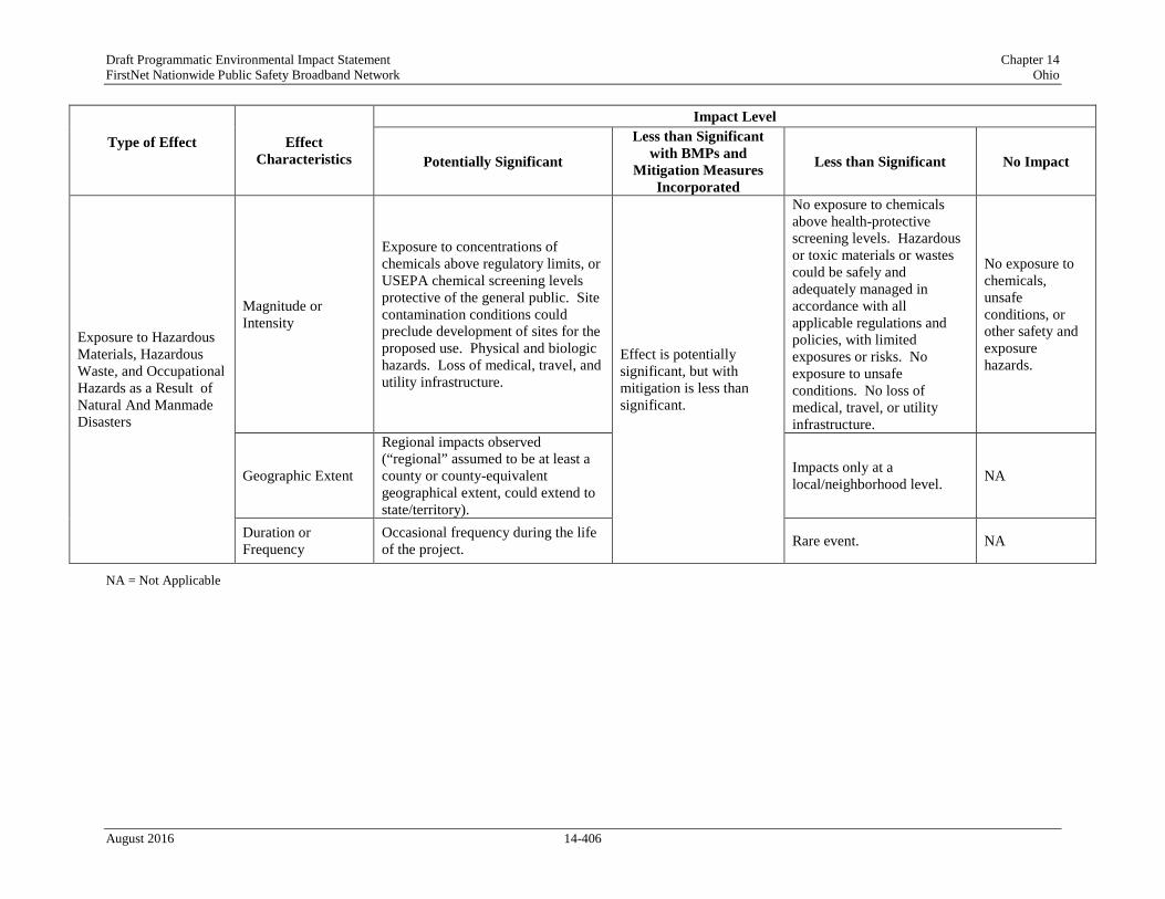
Draft Programmatic Environmental Impact Statement Chapter 14 FirstNet Nationwide Public Safety Broadband Network Ohio
Type of Effect
Effect Characteristics
Impact Level
Potentially Significant
Less than Significant with BMPs and
Mitigation Measures Incorporated
Less than Significant No Impact
Exposure to Hazardous Materials, Hazardous Waste, and Occupational Hazards as a Result of Natural And Manmade Disasters
Magnitude or Intensity
Exposure to concentrations of chemicals above regulatory limits, or USEPA chemical screening levels protective of the general public. Site contamination conditions could preclude development of sites for the proposed use. Physical and biologic hazards. Loss of medical, travel, and utility infrastructure.
Effect is potentially significant, but with mitigation is less than significant.
No exposure to chemicals above health-protective screening levels. Hazardous or toxic materials or wastes could be safely and adequately managed in accordance with all applicable regulations and policies, with limited exposures or risks. No exposure to unsafe conditions. No loss of medical, travel, or utility infrastructure.
No exposure to chemicals, unsafe conditions, or other safety and exposure hazards.
Geographic Extent
Regional impacts observed (“regional” assumed to be at least a county or county-equivalent geographical extent, could extend to state/territory).
Impacts only at a local/neighborhood level. NA
Duration or Frequency
Occasional frequency during the life of the project. Rare event. NA
NA = Not Applicable
August 2016 14-406

Draft Programmatic Environmental Impact Statement Chapter 14 FirstNet Nationwide Public Safety Broadband Network Ohio
14.2.15.3. Description of Environmental Concerns
Worksite Physical Hazards, Hazardous Materials, and Hazardous Waste
The human health and safety concern having the greatest likelihood to occur during FirstNet deployment activities is occupational injury to telecommunication workers. The nature of telecommunication work requires workers to execute jobs that are inherently dangerous. Telecommunication work activities present physical and chemical hazards to workers. The physical hazards have the potential to cause acute injury, long-term disabilities, or in the most extreme incidents, death. Other occupational activities such as handling hazardous materials and hazardous waste often do not result in acute injuries, but may compound over multiple exposures, resulting in increased morbidity. Based on the impact significance criteria presented in Table 14.2.15-1, occupational injury impacts could be potentially significant if the FirstNet deployment locations require performing occupational activities that have the highest relative potential for physical injury and/or chemical exposure. Examples of activities that may present increased risk and higher potential for injury include working from heights (i.e., from towers and roof tops), ground-disturbing activities like trenching and excavating, confined space entry, operating heavy equipment, and the direct handling of hazardous materials and hazardous waste. Predominately, these hazards are limited to occupational workers, but may impact the general public if there are trespassers or if any physical of chemical hazard extends beyond the restricted access of proposed FirstNet work sites. For example, if fuel is spilled from an onsite fuel tank, the spilled fuel could migrate down gradient and infiltrate underground drinking water sources. The general public may then be exposed to hazardous chemicals in their drinking water if they utilize the same groundwater aquifer.
To protect occupational workers, OSHA mandates that employers be required to protect their employees from occupational hazards that could result in injury. Depending on the source of the hazard and the site-specific work conditions, OSHA generally recommends the following hierarchy for protecting onsite workers (OSHA, 2015b).
• Engineering controls;
• Work practice controls;
• Administrative controls; and then
• Personal protective equipment (PPE).
Engineering controls are often physical barriers that prevent access to a worksite, areas of a worksite, or from idle and operating equipment. Physical barriers take many forms like perimeter fences, trench boxes,157 chain locks, bollards, storage containers (for storing equipment and chemicals), or signage and caution tape. Other forms of engineering controls could include machinery designed to manipulate the quality of the work environment, such as ventilation blowers. Whenever practical, engineering controls may result in the complete removal of the
157 Trench boxes are framed metal structures inserted into open trenches to support trench faces, to protect workers from cave-ins and similar incidents. (OSHA, 2016b)
August 2016 14-407

Draft Programmatic Environmental Impact Statement Chapter 14 FirstNet Nationwide Public Safety Broadband Network Ohio
hazard from the work site, an example of which would be the transport and offsite disposal of hazardous waste or asbestos containing materials.
Work practice controls could be implemented as abiding by specific OSHA industry standards, such as the Confined Space Entry standard (29 CFR 1910.146) or thru the development of employer specific workplace rules and operational practices (OSHA, 2015b). To the extent practicable, FirstNet partner(s) would likely implement and abide by work practice controls through employee safety training and by developing site-specific health and safety plans (HASP). The HASPs would identify all potential hazardous materials and hazardous wastes, potential physical hazards, and applicable mitigation steps. Other components of a HASP identifying appropriate PPE for each task and the location of nearby medical facilities. Safety Data Sheets (SDS) describing the physical and chemical properties of hazardous materials used during FirstNet deployment and maintenance activities, as well as the physical and health hazards, routes of exposure, and precautions for safe handling and use would be kept and maintained at all FirstNet project sites. In addition to HASPs and SDSs, standard operating procedures (SOP) would be developed and implemented by FirstNet partner(s) for critical and/or repetitive tasks that require attention to detail, specialized knowledge, or clear step-wise directions to prevent worker injury and to ensure proper execution.
Administrative controls are employer-initiated methods to reduce the potential for injury and physical fatigue (OSHA, 2015b). Administrative controls may take the form of limiting the number of hours an employee is allowed to work per day, requiring daily safety meetings before starting work, utilizing the buddy system for dangerous tasks and any other similar activity or process that is designed to identify and mitigate unnecessary exposure to hazards. When engineering controls, work practice controls, and administrative controls are not feasible or do not provide sufficient protection, employers must also provide appropriate PPE to their employees and ensure its proper use. PPE is the common term used to refer to the equipment worn by employees to minimize exposure to chemical and physical hazards. Examples of PPE include gloves, protective footwear, eye protection, protective hearing devices (earplugs, muffs), hard hats, fall protection, respirators, and full body suits. PPE is the last line of defense to prevent occupational injuries and exposure.
Hazardous Materials, Hazardous Waste, and Mine Lands
The presence of environmental contamination at FirstNet deployment sites has the potential to negatively impact health and safety of workers and the general public. Past or present contaminated media, such as soil and groundwater, may be present and become disturbed as a result of site activities. Mines may cause unstable surface and subsurface conditions as a result of underground shaft collapses or seismic shifting. Based on the impact significance criteria presented in Table 14.2.15-1, human health impacts could be significant if FirstNet deployment sites are near contaminated properties. Prior to the start of any FirstNet deployment project, potential site locations should be screened for known environmental contamination and/or mining activities using federal resources such as the USEPA Cleanups in My Community database and U.S. Department of Interior’s Abandoned Mine Lands inventory, or through an equivalent commercial resource.
August 2016 14-408

Draft Programmatic Environmental Impact Statement Chapter 14 FirstNet Nationwide Public Safety Broadband Network Ohio
By screening sites for environmental contamination, mining activities, and reported environmental liabilities, the presence of historic contamination and unsafe ground conditions could be evaluated and may influence the site selection process. In general, the lower the density of environmental contamination or mining activities, the more favorable the site will be for FirstNet deployment projects. If sites containing known environmental contamination (or mine lands) are selected for proposed FirstNet deployment activities it may be necessary to implement additional controls (e.g., engineering, work practice, administrative, and/or PPE) to ensure workers, and the general public, are not unnecessarily exposed to the associated hazards. Additionally, for any proposed FirstNet deployment site, it is possible undocumented environmental contamination is present.
During FirstNet deployment activities, if any soil or groundwater is observed to be stained or emitting an unnatural odor, it may be an indication of environmental contamination. When such instances are encountered, it may be necessary to stop work until the anomaly is further assessed through record reviews or environmental sampling. Proposed FirstNet deployment would attempt to avoid known contaminated sites. However, in the event that FirstNet is unable to avoid a contaminated site, then site analysis and remediation would be required under RCRA, CERCLA, and applicable Ohio state laws in order to protect workers and the general public from direct exposure or fugitive contamination.
Exposure assessments identify relevant site characteristics, temporal exposure parameters, and toxicity data to determine the likelihood of adverse health effects. More formally known as a human health risk assessment (HHRA), these studies provide mathematical justification for implementing controls at the site to protect human health. HHRAs help determine which level of PPE (i.e., Level D, Level C, Level B, or Level A) is necessary for a work activity. HHRAs take into account all exposure pathways: absorption, ingestion, inhalation, and injection. Therefore, specific protective measures (e.g., controls and PPE) that disrupt the exposure pathways could be identified, prioritized, and implemented.
Natural and Manmade Disasters
FirstNet is intended to improve connectivity among public safety entities during disasters, thereby improving their ability to respond more safely and effectively during such events. The addition of towers, structures, facilities, equipment, and other deployment activities is expected to allow for expedited responses during natural and manmade disasters. The impacts of natural and manmade disasters are likely to present unique health and safety hazards, as well as exacerbate pre-existing hazards, such as degrading occupational work conditions and disturbing existing environmental contamination. The unique hazards presented by natural and manmade disasters may include, fire, weather incidents (e.g., floods, tornadoes, hurricanes, etc.), earthquakes, vandalism, large- or small-scale chemical releases, utility disruption, community evacuations, or any other event that abruptly and drastically denudes the availability or quality of transportation infrastructure, utility infrastructure, medical infrastructure, and sanitation infrastructure. Additionally, such natural and manmade disasters could directly impact public safety communication infrastructure assets through damage or destruction.
August 2016 14-409

Draft Programmatic Environmental Impact Statement Chapter 14 FirstNet Nationwide Public Safety Broadband Network Ohio
Based on the impact significance criteria presented in Table 14.2.15-1, human health impacts could be significant if FirstNet deployment sites are in areas that that are directly impacted by natural and manmade disasters that could lead to exposure to hazardous wastes, hazardous materials, and occupational hazards. FirstNet’s emphasis on public safety-grade communications infrastructure may result in a less than significant beneficial impact, as new infrastructure could be deployed with additional structural hardening, and existing infrastructure may also be hardened as appropriate and feasible, in an effort to reduce the possibility of infrastructure damage or destruction to some degree.
Potential mitigation measures for natural disasters is to be aware of current weather forecasts, forest fire activities, seismic activities, and other news worthy events that may indicate upcoming disaster conditions. Awareness provides time and opportunity to plan evacuation routes, to relocate critical equipment and parts, and to schedule appropriate work activities preceding and after the natural disaster. These mitigation steps reduce the presence of workers and dangerous work activities to reduce the potential for injury or death. Manmade disasters could be more difficult to anticipate due to the unexpected or accidental nature of the disaster. Though some manmade disasters are due to malicious intentions, many manmade disasters result from human error or equipment failure. The incidence of manmade disasters affecting FirstNet deployment sites would be difficult to predict and diminish because the source of such disasters is most likely to originate from sources independent of FirstNet activities. Therefore, FirstNet partner(s) would develop disaster response plans that outline specific steps employees should take in the event of a natural or manmade disaster.
14.2.15.4. Potential Impacts of the Preferred Alternative
The following section assesses potential impacts associated with implementation of the Preferred Alternative, including deployment and maintenance activities.
Deployment Impacts
As described in Section 2.1.2, Proposed Action Infrastructure, implementation of the Preferred Alternative could result in the deployment of various types of facilities or infrastructure. Depending on the physical nature and location of the facility/infrastructure and the specific deployment requirements, some activities would result in potential impacts to human health and safety and others would not. In addition, and as explained in this section, the same type of Proposed Action infrastructure could result in a range of no impacts to less than significant with mitigation, depending on the deployment scenario or site-specific activities.
Activities Likely to Have No Impacts
Of the types of facilities or infrastructure deployment scenarios described in Section 2.1.2, Proposed Action Infrastructure, the following are likely to have no impacts to human health and safety under the conditions described below:
• Wired Projects
August 2016 14-410
Draft Programmatic Environmental Impact Statement Chapter 14 FirstNet Nationwide Public Safety Broadband Network Ohio
o Use of Existing Conduit – New Buried Fiber Optic Plant: the pulling or blowing of fiber optic cable would be performed through existing conduit. Use of mechanical equipment would be limited to pulley systems and blowers. Some locations with no existing power supply may require the use of electrical generators. Hazardous materials needed for this work would include fiber optical cable lubricants, mechanical oil/grease, and fuel for electrical generators although these materials are expected to be used infrequently and in small quantities. These activities are not likely to result in serious injury or chemical exposure, or surface disturbances since work would be limited to existing entry and exit points, would be temporary, and intermittent. It is anticipated that there would be no impacts to human health and safety.
o Use of Existing Buried or Aerial Fiber Optic Plant or Existing Submarine Cable: Lighting up of dark fiber would have no impacts to human health and safety because there would be no ground disturbance or heavy equipment used.
• Satellites and Other Technologies
o Deployment of Satellites: FirstNet does not anticipate launching satellites as part of the deployment of the NPSBN; however, it could include equipment on satellites that arealready being launched for other purposes. As adding equipment to an existing launch vehicle would be very unlikely to impact human health and safety resources, it is anticipated that this activity would have no impact on those resources.
Activities with the Potential to Have Impacts
Potential deployment-related impacts to human health and safety as a result of implementation of the Preferred Alternative would encompass a range of impacts that occur as a result of ground disturbance activities, construction activities, equipment upgrade activities, management of hazardous materials and/or hazardous waste, and site selection. The types of infrastructure development scenarios or deployment activities that could be part of the Preferred Alternative and result in potential impacts to human health and safety include the following:
• Wired Projects
o New Build – Buried Fiber Optic Plant: Plowing (including vibratory plowing), trenching, or directional boring and the construction of POPs, huts, or other associated facilities or hand-holes to access fiber would require the use of heavy equipment and hazardous materials. The additional noise and activity at the site would require workers to demonstrate a high level of situational awareness. Failure to follow OSHA and industry controls could result in injuries. Excavation of soil at proposed sites known to contain environmental contamination has the potential to expose workers to harmful chemicals or releases that could impact the general public in the immediate vicinity. Additionally, some of this work would likely be performed along road ROWs, increasing the potential for vehicle traffic to collide with site workers or equipment. If a proposed deployment activity involves the operation of heavy equipment, managing hazardous materials and hazardous waste management, or other site location challenges, there could be potential human health and safety impacts to consider.
August 2016 14-411

Draft Programmatic Environmental Impact Statement Chapter 14 FirstNet Nationwide Public Safety Broadband Network Ohio
o New Build – Aerial Fiber Optic Plant: Installation of new poles and fiber optic lines could require excavation activities, working from heights, use of hazardous materials, and site locations in ROWs. Hazards associated with the site work include injury from heavy equipment, fall hazards, chemical hazards, and the potential for vehicle traffic to collide with site workers or equipment. Excavation of soil at proposed sites known to contain environmental contamination has the potential to expose workers to harmful chemicals or releases that could impact the general public in the immediate vicinity. If a proposed deployment activity involves the operation of heavy equipment, hazardous materials and hazardous waste management, or other site location challenges, there could be potential human health and safety impacts to consider.
o Collocation on Existing Aerial Fiber Optic Plant: Installation of overhead fiber optic lines would require work from height. In some instances, new poles would be installed requiring excavation activities with heavy equipment. Hazards associated with the site work include injury from heavy equipment, fall hazards, chemical hazards, and the potential for vehicle traffic to collide with site workers or equipment. Excavation of soil at proposed sites known to contain environmental contamination has the potential to expose workers to harmful chemicals or releases that could impact the general public in the immediate vicinity. If a proposed deployment activity involves the operation of heavy equipment, hazardous materials and hazardous waste management, or other site location challenges, there could be potential human health and safety impacts to consider.
o New Build – Submarine Fiber Optic Plant: The installation of fiber optic cables in limited nearshore and inland bodies of water requires workers to operate over aquatic environments, which presents opportunities for drowning. When working over water exposure to sun, high or low temperatures, wind, and moisture could impact worker safety. Construction of landings and/or facilities on shore to accept submarine cable would require site preparation, construction, and management of hazardous materials and hazardous waste. Excavation of soils or sediments at proposed sites known to contain environmental contamination may result in workers being exposed to harmful chemicals or releases that could impact the general public in the immediate vicinity. If a proposed deployment activity involves the operation of heavy equipment, hazardous materials and hazardous waste management, or other site location challenges, there could be potential human health and safety impacts to consider.
o Installation of Optical Transmission or Centralized Transmission Equipment: Installation of transmission equipment would require site preparation, construction activities, and management of hazardous materials and hazardous waste. Excavation of soils at proposed sites known to contain environmental contamination may result in workers being exposed to harmful chemicals or releases that could impact the general public in the immediate vicinity. If a proposed deployment activity involves the operation of heavy equipment, hazardous materials and hazardous waste management, or other site location challenges, there could be potential human health and safety impacts to consider.
August 2016 14-412

Draft Programmatic Environmental Impact Statement Chapter 14 FirstNet Nationwide Public Safety Broadband Network Ohio
• Wireless Projects
o New Wireless Tower Construction: Installation of new wireless towers and associated structures (generators, equipment sheds, fencing, security and aviation lighting, electrical feeds, and concrete foundations and pads) or access roads could result in short-term, temporary GHG emissions from vehicles and construction equipment. Long-term, permanent or temporary increases in GHG emissions would result from the electricity requirements of the towers (both grid-provided and backup), and would depend on their size, number, and the frequency and duration of their use. If a proposed deployment activity involves the operation of heavy equipment, hazardous materials and hazardous waste management, or other site location challenges, there could be potential human health and safety impacts to consider. For a discussion of radio frequency emissions, refer to Section 2.4, Radio Frequency Emissions.
o Collocation on Existing Wireless Tower, Structure, or Building: Collocation would involve mounting or installing equipment (such as antennas or microwave dishes) on existing towers. There would be no short-term GHG emissions associated with construction as construction would not take place. Minor, short-term, temporary GHG emissions may result from any associated equipment used for installation, such as cranes or other equipment. Long-term, permanent or temporary increases in GHG emissions would result from the electricity requirements of the towers (both grid-provided and backup), and would depend on their size, number, and the frequency and duration of their use. If a proposed deployment activity involves the operation of heavy equipment, hazardous materials and hazardous waste management, or other site location challenges, there could be potential human health and safety impacts to consider. For a discussion of radio frequency emissions, refer to Section 2.4, Radio Frequency Emissions.
• Deployable Technologies
o The use of deployable technologies could result in soil disturbance if land-based deployables are deployed on unpaved areas or if the implementation results in paving of previously unpaved surfaces. The use of heavy machinery presents the possibility for spills and soil and water contamination, and noise emissions could potentially impact human health; and vehicles and heavy equipment present the risk of workplace and road traffic accidents that could result in injury. Set-up of a cellular base station contained in a trailer with a large expandable antenna mast is not expected to result in impacts to human health and safety. However, due to the larger size of the deployable technology, site preparation or trailer stabilization may be required to ensure the self-contained unit is situated safely at the site. Additionally, the presence of a dedicated electrical generator would produce fumes and noise. The possibility of site work and the operation of a dedicated electrical generator have the potential for impacts to human health and safety. For a discussion of radio frequency emissions, refer to Section 2.4, Radio Frequency Emissions. Use of aerial vehicles would not involve telecommunication site work. Prior to deployment and when not in use, the aerial vehicles would likely require preventive
August 2016 14-413
Draft Programmatic Environmental Impact Statement Chapter 14 FirstNet Nationwide Public Safety Broadband Network Ohio
maintenance. Workers responsible for these activities may handle hazardous materials, not limited to fuel, solvents, and adhesives.
• Satellites and Other Technologies
o Satellite-Enabled Devices and Equipment: The use of portable devices that utilize satellite technology would not impact human health and safety because there is no construction activities or use of hazardous materials. The installation of permanent equipment on existing structures may require workers to operate from heights or in sensitive environments. As a result, the potential for falling, overhead hazards, and falling objects is greater and there is a potential to impact human health and safety.
In general, the abovementioned FirstNet activities could potentially involve site preparation work, construction activities, work in potentially harmful environments (ROWs, work over water, environmental contamination, and mine lands), management of hazardous materials and hazardous waste, and weather exposure. Potential impacts to human health and safety associated with deployment of the Proposed Project could include injury from site preparation and operating heavy equipment, construction activities, falling/overhead hazards/falling objects, exposure and release of hazardous chemicals and hazardous waste, and release of historic contamination to the surrounding environment. It is anticipated that potential health impacts associated with human exposure to environmental hazardous materials in air, water, or soil, the risk of road traffic, workplace accidents and injuries, noise exposure, and risk of infectious disease transmission would be less than significant due to the small scale of likely FirstNet activities that would be temporary and of short duration. Chapter 19, BMPs and Mitigation Measures provides a listing of BMPs and mitigation measures that FirstNet and/or its partners would require, as practicable or feasible, to avoid or minimize potential impacts.
Operation Impacts
As described in Section 2.1.2, Proposed Action Infrastructure, operation activities associated with the Preferred Alternative would consist of routine maintenance and inspection of the facilities. Any major infrastructure replacement as part of ongoing system maintenance would result in impacts similar to the abovementioned construction impacts. It is anticipated that there would be less than significant impacts to human health and safety associated with routine inspections of the Preferred Alternative, assuming that the inspections do not require climbing towers or confined space entry. In those instances, PPE or other mitigation measures could be necessary to adequately protect workers. If usage of heavy equipment is part of routine maintenance, the potential for impacts to human health and safety would also increase. It isanticipated that potential health impacts associated with human exposure to environmental hazardous materials in air, water, or soil, the risk of road traffic, workplace accidents and injuries, noise exposure, and risk of infectious disease transmission would be less than significant due to the small scale of likely FirstNet activities that would be temporary and of short duration. Chapter 19, BMPs and Mitigation Measures provides a listing of BMPs and mitigation measures that FirstNet and/or its partners would require, as practicable or feasible, to avoid or minimize potential impacts.
August 2016 14-414

Draft Programmatic Environmental Impact Statement Chapter 14 FirstNet Nationwide Public Safety Broadband Network Ohio
14.2.15.5. Alternatives Impact Assessment
The following section assesses potential impacts to human health and safety associated with the Deployable Technologies Alternative and the No Action Alternative.
Deployable Technologies Alternative
Under the Deployable Technologies Alternative option, a nationwide fleet of mobile communications systems would provide temporary coverage in areas not covered by the existing, usable land-based infrastructure. There would be no collocation of equipment and minimal new construction associated with wired or wireless projects discussed above under the Preferred Alternative. Some limited construction could be associated with implementation such as land clearing or paving for parking or staging areas associated with wired or wireless projects discussed above under the Preferred Alternative. Some limited construction could be associated with implementation such as land clearing or paving for parking or staging areas. The specific infrastructure associated with the Deployable Technologies Alternative would be the same as the deployable technologies implemented as part of the Preferred Alternative but would likely be implemented in greater numbers, over a larger geographic extent, and used with greater frequency and duration. Therefore, potential impacts to human health and safety as a result of implementation of this alternative could be as described below.
Deployment Impacts
As explained above, implementation of deployable technologies could result in less than significant impacts to human health and safety. The largest of the land-based deployable technologies may require site preparation work or stabilization work to ensure the self-contained trailers are stable. Heavy equipment may be necessary to complete the site preparation work. However, in general, the deployable technologies are small mobile units that could be transported as needed. While in operation, the units are parked and operate off electrical generators or existing electrical power sources. Connecting deployable technology to a power supply may present increased electrocution risk during the process of connecting power. If the power source were an electrical generator, then there would also likely be a need to manage hazardous materials (fuel) onsite. These activities could result in less than significant impacts to human health and safety. It is anticipated that potential health impacts associated with human exposure to environmental hazardous materials in air, water, or soil, the risk of road traffic, workplace accidents and injuries, noise exposure, and risk of infectious disease transmission would be less than significant due to the small scale of likely FirstNet activities that would be temporary and of short duration. Chapter 19, BMPs and Mitigation Measures provides a listing of BMPs and mitigation measures that FirstNet and/or its partners would require, as practicable or feasible, to avoid or minimize potential impacts.
Operations Impacts
As explained above, operation activities would consist of implementation/running of the deployable technology and routine maintenance and inspections. As with the Preferred Alternative, it is anticipated that there would be no impacts to human health and safety
August 2016 14-415

Draft Programmatic Environmental Impact Statement Chapter 14 FirstNet Nationwide Public Safety Broadband Network Ohio
associated with routine inspections of the Preferred Alternative, assuming that the inspections do not require climbing towers or confined space entry. In those instances, PPE or other mitigation measures may be necessary to adequately protect workers. If usage of heavy equipment is part of routine maintenance, the potential for impacts to human health and safety would also increase. These impacts would be less than significant because of the small scale of likely FirstNet activities; activities associated would routine maintenance, inspection, and deployment of deployable technologies would be temporary and often of limited duration. Chapter 19, BMPs and Mitigation Measures provides a listing of BMPs and mitigation measures that FirstNet and/or its partners would require, as practicable or feasible, to avoid or minimize potential impacts.
No Action Alternative
Under the No Action Alternative, the NPSBN would not be deployed; therefore, there would be no associated construction or installation of wired, wireless, deployable infrastructure or satellites and other technologies. As a result, there would be no impacts to human health and safety as a result of construction and operation of the Proposed Action. Environmental conditions would therefore be the same as those described in Section 14.1.15, Human Health and Safety.
August 2016 14-416

Draft Programmatic Environmental Impact Statement Chapter 14 FirstNet Nationwide Public Safety Broadband Network Ohio
ACRONYMS Acronym Definition
AARC Average Annual Rate of Change ACHP Advisory Council on Historic Preservation ACS American Community Survey AGL Above Ground Level AIM Aeronautical Information Manual AML Abandoned Mine Lands APE Area of Potential Effect AQCR Air Quality Control Region ARPA Archaeological Resources Protection Act ASL Above Sea Level ASPM Aviation System Performacne Metrics ATC Air Traffic Control ATO Air Traffic Organization BGEPA Bald and Golden Eagle Protection Act BLM Bureau of Land Management BLS Bureau of Labor Statistics BNSF Burlington Northern and Santa Fe Railway CAA Clean Air Act CCD Common Core of Data CEQ Council on Environmental Quality CERCLA Comprehensive Environmental Response, Compensation, and Liability
Act CGP Construction General Permit CIMC Cleanups in My Community CIO Chief Information Officer CLE Cleveland-Hopkins International Airport CMH Columbus International Airport CO Carbon Monoxide CO2 Carbon Dioxide COLT Cell On Light Truck COLT Cell On Light Trucks COW Cell On Wheels CRS Community Rating System CWA Clean Water Act CWS Community Water Systems DMWM Division of Materials and Waste Management EDACS Enhanced Digital Access System EFH Essential Fish Habitat EIA Energy Information Agency EJ Environmental Justice EMS Emergency Medical Services EPCRA Emergency Planning and Community Right to Know Act FAA Federal Aviation Administration FCC Federal Communication Commission FEMA Federal Emergency Management Agency FGDC Federal Geographic Data Committee FLM Federal Land Manager FLPMA Federal Land Policy and Management Act of 1976 FSDO Flight Standards District Offices FSS Flight Service Station GHG Greenhouse Gas
August 2016 14-417
Draft Programmatic Environmental Impact Statement Chapter 14 FirstNet Nationwide Public Safety Broadband Network Ohio
Acronym Definition HAP Hazardous Air Pollutant HASP Health and Safety Plans HHRA Human Health Risk Assessment IFR Instrument Flight Rules IPCC Intergovernmental Panel On Climate Change LBS Locations-Based Services LCCS Land Cover Classification System LID Low Impact Development LMR Land Mobile Radio LRR Land Resource Regions LTE Long Term Evolution MARCS Multi-Agency Radio System MBTA Migratory Bird Treaty Act MDI Methylene Diphenyl Diisocyanate MHI Median Household Income MLRA Major Land Resource Areas MMPA Marine Mammal Protection Act MMT Million Metric Tons MSFCA Magnuson-Stevens Fisheries Conservation Act MSL Mean Sea Level MYA Million Years Ago N2O Nitrous Oxide NAAQS National Ambient Air Quality Standards NAGPRA Native American Graves Protection and Repatriation Act NAICS North American Industry Classification System NAS National Airspace System NASAO National Association of State Aviation Officials NEPA National Environmental Policy Act NERR National Estuarine Research Reserve NESCA Nongame and Endangered Species Conservation Act NFIP National Flood Insurance Program NHA National Heritage Areas NHL National Historic Landmarks NHPA National Historic Preservation Act NHS National Historic Site NIH National Institute of Health NIST National Institute of Standards and Technology NM Nautical Miles NNL National Natural Landmarks NOTAM Notices To Airmen NOX Oxides of Nitrogen NPDES National Pollutant Discharge Elimination System NPL National Priorities List NPS National Park Service NPSBN Nationwide Public Safety Broadband Network NPSPAC National Public Safety Planning Advisory Committee NRC National Response Center NRCS Natural Resources Conservation Service NRHP National Register of Historic Places NSA National Security Areas NTFI National Task Force On Interoperability NTNC Non-Transient Non-Community
August 2016 14-418

Draft Programmatic Environmental Impact Statement Chapter 14 FirstNet Nationwide Public Safety Broadband Network Ohio
Acronym Definition NWI National Wetlands Inventory NWP Nationwide Permit NWR National Wildlife Refuges OAA Omaha Airport Authority OBWC Ohio Bureau of Workers’ Compensation OCIO Office of the CIO ODA Ohio Department of Agriculture ODH Ohio Department of Health ODNR Ohio Department of Natural Resources ODOT Ohio Department of Transportation OE/AAA Obstruction Evaluation and Airport Airspace Analysis OEPA Ohio Environmental Protection Agency OH Ohio ORC Ohio Revised Code OWAP Ohio Wildlife Action Plan OSHA Occupational Safety and Health Administration OTR Ozone Transport Region PBR Permit-By-Rule PCB Polychlorinated Biphenyl PEIS Programmatic Environmental Impact Statement PEM Palustrine Emergent Wetlands PGA Peak Ground Acceleration POP Points of Presence PPE Personal Protective Equipment PSCR Public Safety Communications Research PSD Prevention of Significant Deterioration PTI Permit-To-Install PTIO Permit To Install and Operate PTO Permit-To-Operate PUCO Public Utilities Commission of Ohio PWS Public Water Systems RACOM Radio Communications RCRA Resource Conservation and Recovery Act RF Radio Frequency SAA Sense and Avoid SABR Site Assistance and Brownfield Revitalization SAIPE Small Area Income and Poverty Estimates SASP State Aviation System Plan SCEC State Climate Extremes Committee SCIP Statewide Communications Interoperable Plan SDS Safety Data Sheets SF6 Sulfur Hexafluoride SGCN Species of Greatest Conservation Need SHA State Heritage Areas SHPO State Historic Preservation Office SIP State Implementation Plan SMCRA Surface Mining Control and Reclamation Act SO2 Sulfur Dioxide SO3 Sulfur Trioxide SOC Standard Occupational Classification SOP Standard Operating Procedures SOW System On Wheels
August 2016 14-419

Draft Programmatic Environmental Impact Statement Chapter 14 FirstNet Nationwide Public Safety Broadband Network Ohio
Acronym Definition SOX Oxides of Sulfur SPL Sound Pressure Level SRS Statewide Radio System SSA Sole Source Aquifer SUA Special Use Airspace SWAP State Wildlife Action Plan SWPPP Storm Water Pollution Prevention Plan THPO Tribal Historic Preservation Office TMDL Total Maximum Daily Load TNC Transient Non-Community Systems TPH Total Petroleum Hydrocarbon TPY Tons Per Year TRI Toxics Release Inventory TWA Time Weighted Average UA Unmanned Aircraft UAS Unmanned Aircraft Systems UHF Ultra High Frequency USACE U.S. Army Corps of Engineers USEPA U.S. Environmental Protection Agency USFS U.S. Forest Service USFWS U.S. Fish and Wildlife Service USGS U.S. Geological Survey VAP Voluntary Action Program VFR Visual Flight Rules VHF Very High Frequency VOC Volatile Organic Compounds WCS Wetlands Classification Standard WMA Wildlife Management Areas WMD Wetland Management District WONDER Wide-Ranging Online Data For Epidemiologic Research WWI World War I WWII World War II
August 2016 14-420

Draft Programmatic Environmental Impact Statement Chapter 14 FirstNet Nationwide Public Safety Broadband Network Ohio
REFERENCES The citations in this Draft PEIS reflect the most recent information on the referenced site at the time the document was written. If the site was updated after that point, the more recent information will be incorporated into the final document, as feasible. Advisory Council on Historic Preservation. (2004, August 5). 36 CFR Part 800 - Protection of
Historic Properties. Retrieved July 21, 2015, from Advisory Council on Historic Preservation: http://www.achp.gov/regs-rev04.pdf
American Trails. (2015a, August 14). National Trails Training Partnership. Retrieved September 15, 2015, from http://www.americantrails.org/resources/feds/NatTrSysOverview.html
American Trails. (2015b). National Recreation Trails. Retrieved October 25, 2015, from National Recreation Trails Database: http://www.americantrails.org/NRTDatabase/trailList.php?usrTrailName=&usrTrailState=OH&usrTrailCounty=&usrTrailUse=
Amtrak. (2015, October). Northeast Train Routes. Retrieved October 28, 2015, from Amtrak: http://www.amtrak.com/northeast-train-routes
Anderson, D. G., & Faught, M. K. (1998). The Distribution of Fluted Paleoindian Projectile Points: Update 1998. Archaeology of Eastern North America, 26(1), 163-187. Retrieved November 2015, from http://www.jstor.org/stable/40897755
Association of American Railroads. (2016, June 9). U.S. Freight Railroad Industry Snapshot. Retrieved June 9, 2016, from https://www.aar.org/data-center/railroads-states#state/OH
Balshe, W. (2011). Power System Considerations for Cell Tower Applications. Cummins Power Generation. Retrieved from https://www.cumminspower.com/www/literature/technicalpapers/PT-9019-Cell-Tower-Applications-en.pdf
BLM. (1984). Manual 8400 - Visual Resource Managment. Washington: Department of the Interior, Bureau of Land Management.
BLM. (2014). DRECP Noise and Vibration. Retrieved 07 22, 2015, from http://www.blm.gov/style/medialib/blm/ca/pdf/pa/energy/drecp/draft_drecp.Par.37401.File.dat/III.21%20Noise%20and%20Vibration.pdf
BLM. (2015, May 7). Abandoned Mine Lands Portal. Retrieved September 28, 2015, from Department of the Interior, Bureau of Land Management: http://www.abandonedmines.gov/ss.html
BLS. (2013). Incidence rate and number of nonfatal occupational injuries by industry and ownership, 2013 (U.S.). Retrieved November 4, 2015, from http://www.bls.gov/iif/oshwc/osh/os/ostb3966.pdf
BLS. (2014). Table A-5. Fatal occupational injuries by occupation and event or exposure, all United States, 2014. Retrieved September 29, 2015, from 2014 Census of Fatal Occupational Injuries (preliminary data): http://www.bls.gov/iif/oshwc/cfoi/cftb0290.pdf
BLS. (2015a, May). U.S. Bureau of Labor Statistics. Retrieved from May 2015 State Occupational Employment and Wage Estimates Ohio: http://www.bls.gov/oes/current/oes_oh.htm
August 2016 14-421

Draft Programmatic Environmental Impact Statement Chapter 14 FirstNet Nationwide Public Safety Broadband Network Ohio
BLS. (2015b). Local Area Unemployment Statistics, Employment status of the civilian noninstitutional population, 1976 to 2014 annual averages. Retrieved April 2015, from Bureau of Labor Statistics: http://www.bls.gov/lau/rdscnp16.htm
BLS. (2015c, April 22). State Occupational Injuries, Illnesses, and Fatalities. Retrieved November 10, 2015, from Injuries, Illnesses, and Fatalities: http://www.bls.gov/iif/state_archive.htm#OH
BLS. (2015d, March 25). May 2014 State Occupational Employment and Wage Estimates, Ohio. Retrieved November 10, 2015, from Occupational Employment Statistics: http://www.bls.gov/oes/current/oes_OH.htm#49-0000
BLS. (2015e, March 25). Occupational Employment and Wages, May 2014: 49-9052 Telecommunications Line Installers and Repairers. Retrieved October 8, 2015, from Occupational Employment Statistics: http://www.bls.gov/oes/current/oes499052.htm
BLS. (2015f, September 21). Census of Fatal Occupational Injuries (2011 forward). Databases, Tables & Calculators by Subject. Retrieved September 18, 2015, from Census of FAtal Occupational Injuries (2011 forward): http://data.bls.gov/pdq/querytool.jsp?survey=fw
Bond, S., Sims, S., & Dent, P. (2013). Towers, Turbines, and Transmission Lines: Impacts on Property Value. Chichester, West Sussex, United Kingdom: Wiley-Blackwell.
Brose, D. S., & Greber, I. (1982). The Ringler Archaic Dugout from Savanah Lake, Ashland County, Ohio: With Speculation of Trade and Transmission in the Prehistory of the Eastern United States. Midcontinental Journal of Archaeology, 7(2). Retrieved November 2015, from http://www.jstor.org/stable/20707893
Brose, D. S., Mensforth, R. P., & Belovich, S. J. (1993). Early Mississippian Connections at the Late Woodland Mill Hollow Site in Lorain County, Ohio. Midcontinental Journal of Archaeology, 18(1), 97-130. Retrieved November 2015, from http://www.jstor.org/stable/20708343
Buckeye Trail Association. (2015). The Buckeye Trail Story. Retrieved Novemeber 10, 2015, from http://www.buckeyetrail.org/history.php
CDC. (2015a, September 17). CDC WONDER: Underlying Cause of Death, 1999-2013 Results. Retrieved November 10, 2015, from http://wonder.cdc.gov/controller/datarequest/D76
CDC. (2015b, September 25). National Environmental Public Health Tracking Network. Retrieved November 16, 2015, from http://ephtracking.cdc.gov/showHome.action
Cedar Fair Entertainment Company. (2015). Cedar Point Fun Facts. Retrieved November 2015, from https://www.cedarpoint.com/media-center/fun-facts
CEQ. (1997, December). Environmental Justice: Guidance Under the National Environmental Policy Act. Retrieved April 2015, from http://energy.gov/sites/prod/files/nepapub/nepa_documents/RedDont/G-CEQ-EJGuidance.pdf
CEQ. (2014). Draft NEPA Guidance on Consideration of the Effects of Climate Change and Greenhouse Gas Emissions. Retrieved June 2014, from https://www.whitehouse.gov/administration/eop/ceq/initiatives/nepa/ghg-guidance
Charpentier, V., & Inizan, F.-A. J. (2002). Fluting in the Old World: The Neolithic Projectile Points of Arabia. Lithic Technology, 27(1), 39-46. Retrieved August 2015, from http://www.jstor.org/stable/23273456
Chidester, R. C. (2011). Re-Evaluating Colinization and Cultural Change during the Early Archaic Period in Northwestern Ohio. Archaeology of Eastern North America, 39, 109-130. Retrieved November 2015, from http://www.jstor.org/stable/23265117
August 2016 14-422

Draft Programmatic Environmental Impact Statement Chapter 14 FirstNet Nationwide Public Safety Broadband Network Ohio
CIO Council. (2015). Data Center Consolidation and Optimization. Retrieved from https://cio.gov/drivingvalue/data-center-consolidation/
City of Ashtabula. (2015, November). Port Authority. Retrieved November 2015, from City of Ashtabula: http://cityofashtabula.com/port-authority/
City of Lincoln. (2015). What are Saline Wetlands? Retrieved July 2015, from http://lincoln.ne.gov/city/parks/parksfacilities/wetlands/wetlandsinfo.htm
Cleveland Mayor's Office of Sustainability. (2013). Cleveland Climate Action Plan. Retrieved 2015, from http://www.sustainablecleveland.org/resources/climate-action-plan/
Cleveland Metroparks. (2015). Come out and Play. Retrieved November 2015, from http://www.clevelandmetroparks.com/Main/Home.aspx
CMH. (2015, January 27). Traffic Report. Retrieved October 28, 2015, from http://flycolumbus.com/files/airline-info/monthly-stats/2014-stats/dec-2014-flycolumbus-stats.pdf
Coogan, A. (1996). Ohio's Surface Rocks and Sediments. Retrieved November 2015, from http://geosurvey.ohiodnr.gov/portals/geosurvey/PDFs/Misc_State_Maps&Pubs/OH_SurfaceRocks_Sediments.pdf
Cowardin, L. M., Carter, V., Golet, F. C., & LaRoe, E. T. (1979). Classification of wetlands and deepwater habitats of the United States, FWS/OBS-79/31. Retrieved April 5, 2015, from http://www.fws.gov/wetlands/Documents/classwet/index.html
CSC. (2007, March). Retrieved from Telecommunications Facilities: An Illustrated Primer on the Siting of Facilities within Connecticut and Throughout the Nation: http://www.ct.gov/csc/lib/csc/csc_tower_3_07.pdf
DAS. (2016). MARCS Services. Retrieved June 2016, from http://das.ohio.gov/Divisions/InformationTechnology/MARCSServices/tabid/124/Default.aspx
Delphia, C. M., O'Neill, K. M., & Prajzner, S. (2011). Montana Bee Identification Guide. Retrieved from http://pollinator.org/PDFs/MontanaBeeGuide-Final.pdf
Detroit Publishing Company. (1902). Court house, Dayton, Ohio. Library of Congress Prints and Photographs Online Collection. Dayton, Ohio: Library of Congress. Retrieved December 2015, from http://www.loc.gov/resource/det.4a09909/
Di Gregorio, A., & Jansen, L. J. (1998). Land Cover Classification System (LCCS): Classification Concepts and User Manual. Rome: Food and Agriculture Organization of the United Nations.
DOE. (2015). Climate Change and the U.S. Energy Sector: Regional Vulnerabilities and Resilience Solutions. Washington, DC: Department of Energy. Retrieved December 15, 2015, from http://energy.gov/epsa/downloads/climate-change-and-us-energy-sector-regional-vulnerabilities-and-resilience-solutions
Duerksen, K., & Doershuk, J. F. (1998). The Houpt Site and the Late Archaic in Southwestern Ohio. Midcontinental Journal of Archaeology, 23(1), 101-112. Retrieved November 2015, from http://www.jstor.org/stable/20708425
EIA. (2013). Annual Coal Report 2013 - Table 21. Coal Productivity by State and Mine Type, 2013 and 2012. Retrieved November 10, 2015, from http://www.eia.gov/coal/annual/pdf/table21.pdf
EIA. (2014). Annual Coal Report 2014. Retrieved June 10, 2016, from http://www.eia.gov/coal/annual/pdf/table6.pdf
August 2016 14-423

Draft Programmatic Environmental Impact Statement Chapter 14 FirstNet Nationwide Public Safety Broadband Network Ohio
EIA. (2015a, October). Electricity. Retrieved November 2015, from U.S. Energy Information Administration: http://www.eia.gov/electricity/data/state/
EIA. (2015b, November). Ohio Profile Overview. Retrieved November 2015, from U.S. Energy Information Administration: http://www.eia.gov/state/?sid=OH#tabs-2
EIA. (2015c). Petroleum & Other Liquids. Retrieved June 10, 2016, from http://www.eia.gov/dnav/pet/hist/LeafHandler.ashx?n=PET&s=MCRFPOH1&f=M
EIA. (2015d). Energy State Rankings. Retrieved June 10, 2016, from https://www.eia.gov/state/rankings/#/series/46
EIA. (2015e). Ohio State Energy Profile. Retrieved November 2015, from http://www.eia.gov/state/print.cfm?sid=OH
EIA. (2015f). State CO2 Emissions. Retrieved from http://www.eia.gov/environment/emissions/state/analysis/pdf/table1.pdf
EIA. (2015g, March 19). Ohio - State Profile and Energy Estimates. Retrieved September 18, 2015, from http://199.36.140.204/state/?sid=OH
EIA. (2015h, July 7). How much carbon dioxide is produced by burning gasoline and diesel fuel? Retrieved September 21, 2015, from http://www.eia.gov/tools/faqs/faq.cfm?id=307&t=11
EIA. (2015i, October 26). Energy-Related CO2 Emissions at the State Level, 2000-2013. Retrieved February 11, 2016, from http://www.eia.gov/environment/emissions/state/analysis/
EIA. (2016). Glossary - Electricity. Retrieved from U.S. Energy Information Administration: https://www.eia.gov/tools/glossary/?id=electricity
Executive Office of the President. (1994, February). Executive Order 12898, Federal Actions to Address Environmental Justice in Minority Populations and Low-Income Populations. Retrieved April 2015, from 59 Federal Register 7629: https://federalregister.gov/a/94-3685
FAA. (2007, 08 26). Hearing and Noise in Aviation. Retrieved 07 22, 2015, from https://www.faa.gov/pilots/safety/pilotsafetybrochures/media/hearing_brochure.pdf
FAA. (2008). Chapter 14 Airspace. Retrieved June 2015, from Pilot's Handbook of Aeronautical Knowledge: http://www.faa.gov/regulations_policies/handbooks_manuals/aviation/pilot_handbook/media/phak%20-%20chapter%2014.pdf
FAA. (2012a, August 6). FAA Air Traffic Organization Policy, JO 7400.9Z, Airspace Designations and Reporting Points. (F. A. U.S. Department of Transportation, Producer) Retrieved September 2015, from FAA, Regulations & Policies, Orders & Notices: http://www.faa.gov/documentLibrary/media/Order/7400.9.pdf
FAA. (2012b, 04 05). Advisory Circular AC 36-3H. Retrieved 07 22, 2015, from http://www.faa.gov/documentLibrary/media/Advisory_Circular/AC36-3H%20Chg%201.pdf
FAA. (2012c). Evaluation for new obstruction lighting techniques to reduce avian fatalities. Retrieved from http://www.tc.faa.gov/its/worldpac/techrpt/tctn12-9.pdf
FAA. (2013). Integration of Civil Unmanned Aircraft Systems (UAS) in the National Airspace System (NAS) Roadmap. Washington D.C.: U.S. Department of Transportation Federal Aviation Administration.
FAA. (2014, January). Federal Aviation Administration, Air Traffic Organization. Retrieved June 2015, from http://www.faa.gov/about/office_org/headquarters_offices/ato/
August 2016 14-424

Draft Programmatic Environmental Impact Statement Chapter 14 FirstNet Nationwide Public Safety Broadband Network Ohio
FAA. (2015a, June 25). Airport Data and Contact Information. Retrieved October 28, 2015, from http://www.faa.gov/airports/airport_safety/airportdata_5010/
FAA. (2015b, September 22). CY14 Passenger Boardings at Commerical Service Airports. Retrieved October 28, 2015, from http://www.faa.gov/airports/planning_capacity/passenger_allcargo_stats/passenger/media/cy14-commercial-service-enplanements.pdf
FAA. (2015c, September 22). All Cargo Data reported for CY14. Retrieved October 28, 2015, from http://www.faa.gov/airports/planning_capacity/passenger_allcargo_stats/passenger/media/cy14-cargo-airports.pdf
FAA. (2015d, March). Flight Standards District Offices (FSDO). Retrieved November 2015, from http://www.faa.gov/about/office_org/field_offices/fsdo/
FAA. (2015e). Aeronautical Information Manual. Retrieved 2015 August, from http://www.faa.gov/air_traffic/publications/media/aim.pdf
FAA. (2015f). Obstruction Evaluation / Airport Airspace Analysis (OE/AAA). Retrieved July 2015, from Federal Aviation Administration: https://oeaaa.faa.gov/oeaaa/external/portal.jsp
FAA. (2015g, August 6). FAA Air Traffic Organization Policy, JO 7400.9Z, Airspace Designations and Reporting Points. (F. A. U.S. Department of Transportation, Producer) Retrieved October 2015, from FAA, Regulations & Policies, Orders & Notices: http://www.faa.gov/regulations_policies/orders_notices/index.cfm/go/document.list/parentTopicID/10
FAA. (2015h). Air Traffic Organization Policy Order JO 7400.8X, Subject: Special Use Airspace. Federal Aviation Administration, Airspace Policy and Regulations Group. Retrieved July 2015, from http://www.faa.gov/documentlibrary/media/order/7400_8x_2015.pdf
FAA. (2015i). FAA TFR List. Retrieved November 2015, from http://tfr.faa.gov/tfr2/list.html FAA. (2015j). Aviation System Performance Metrics (ASPM) Database. Retrieved 07 22, 2015,
from https://aspm.faa.gov/apm/sys/AnalysisAP.asp FAA. (2016, February 5). Air Traffic Organization Policy Order JO 7400.8Y, Subject: Special
Use Airspace. Federal Aviation Administration, Airspace Policy and Regulations Group. Retrieved March 10, 2016, from http://www.faa.gov/documentLibrary/media/Order/7400.8Y_(2016).pdf
FCC. (2000, August). Deployment of Advanced Telecommunications Capability: Second Report. Retrieved Nov 16, 2015, from https://transition.fcc.gov/Bureaus/Common_Carrier/Orders/2000/fcc00290.pdf
FCC. (2012, March 13). Final Programmatic Environmental Assessment for the Antenna Structure Registration Program. Retrieved from https://apps.fcc.gov/edocs_public/attachmatch/DOC-312921A1.pdf
FCC. (2014a). Internet Access Services: Status as of December 31, 2013. Retrieved from https://transition.fcc.gov/Daily_Releases/Daily_Business/2013/db1224/DOC-324884A1.pdf
FCC. (2014b). Local Telephone Competition: Status as of December 31, 2013. Retrieved from https://apps.fcc.gov/edocs_public/attachmatch/DOC-329975A1.pdf
FCC. (2015a). Master PSAP Registry, V 2.0. PSAP Registry Data Report. Retrieved from https://www.fcc.gov/general/9-1-1-master-psap-registry
August 2016 14-425
Draft Programmatic Environmental Impact Statement Chapter 14 FirstNet Nationwide Public Safety Broadband Network Ohio
FCC. (2015b, June 17). Antenna Structure Registration. Retrieved June 17, 2015, from Federal Communications Commission: http://wireless2.fcc.gov/UlsApp/AsrSearch/asrRegistrationSearch.jsp
FCC. (2016a, March). National Broadband Plan Chapter 16 Public Safety. Retrieved March 29, 2016, from Broadband.gov: http://www.broadband.gov/plan/16-public-safety/
FCC. (2016b, June). Detail - Microwave. Retrieved from Application Search Help: http://wireless2.fcc.gov/helpfiles/applicationSearch/ad_microwave.html
FCC. (2016c, February 1). Tower and Antenna Siting. Retrieved February 10, 2016, from https://www.fcc.gov/general/tower-and-antenna-siting
FEMA. (2000). 44 CFR Section 59.1 of the National Flood Insurance Program (NFIP) Regulations: Definitions of NFIP Terms. Retrieved May 2015, from http://www.fema.gov/media-library/assets/documents/12437?id=3064
FEMA. (2010, March). Guidelines for Estimation of Percolation losses for NFIP Studies. Retrieved August 6, 2015, from FEMA: http://www.fema.gov/media-library-data/20130726-1731-25045-9495/dl_perc.pdf
FEMA. (2013). Unit 3: NFIP Flood Studies and Maps. Retrieved May 2015, from http://www.fema.gov/media-library-data/20130726-1539-20490-0241/nfip_sg_unit_3.pdf
FEMA. (2014a, May). Chapter 8: Floodplain Natural Resources and Functions. Retrieved May 2015, from https://training.fema.gov/hiedu/docs/fmc/chapter%208%20-%20floodplain%20natural%20resources%20and%20functions.pdf
FEMA. (2014b, May). Chapter 2: Types of Floods and Floodplains. Retrieved May 2015, from http://training.fema.gov/hiedu/docs/fmc/chapter%202%20-%20types%20of%20floods%20and%20floodplains.pdf
FEMA. (2014c, May). The National Flood Insurance Program Community Status Book. Retrieved May 2015, from http://www.fema.gov/national-flood-insurance-program/national-flood-insurance-program-community-status-book
FEMA. (2014d, May). Community Rating System. Retrieved May 2015, from http://www.fema.gov/media-library-data/1398878892102-5cbcaa727a635327277d834491210fec/CRS_Communites_May_1_2014.pdf
FEMA. (2015, April). Floodplain Management Fact Sheet. Retrieved May 2015, from https://www.fema.gov/floodplain-management-fact-sheet
Fenneman, N. (1916). Physiographic Subdivision of the United States. Retrieved April 2015, from http://www.pnas.org/content/3/1/17.full.pdf?ck=nck
FGDC. (2013, August). Classification of Wetlands and Deepwater Habitats of the United States. Retrieved April 17, 2015, from FGDC Subcommittee on Wetlands Data: http://www.fgdc.gov/standards/projects/FGDC-standards-projects/wetlands/nvcs-2013
FHWA. (2011a). Highway Traffic and Construction Noise. Retrieved 07 27, 2015, from fhwa.dot.gov: http://www.fhwa.dot.gov/environment/noise/regulations_and_guidance/probresp.cfm#appendix
FHWA. (2011b, July 14). Noise Effect on Wildlife. Retrieved February 2016, from http://www.fhwa.dot.gov/environment/noise/noise_effect_on_wildlife/effects/wild04.cfm
FHWA. (2012, September 14). Briefing Room / Press Releases. Retrieved August 31, 2015, from http://www.fhwa.dot.gov/pressroom/fhwa0227.cfm
FHWA. (2013, September 3). National Scenic Byways Program - Intrinsic Qualities: Identification and Distinctions. Retrieved May 2016, from
August 2016 14-426

Draft Programmatic Environmental Impact Statement Chapter 14 FirstNet Nationwide Public Safety Broadband Network Ohio
http://www.fhwa.dot.gov/hep/scenic_byways/byway_quality/analysis/iq_identification.cfm
FHWA. (2014, October 21). Public Road Length. Retrieved October 28, 2015, from http://www.fhwa.dot.gov/policyinformation/statistics/2013/hm10.cfm
FHWA. (2015a, May 28). Bridges by State and County 2014. Retrieved October 28, 2015, from http://www.fhwa.dot.gov/bridge/nbi/no10/county14c.cfm#oh
FHWA. (2015b, October). Route Log and Finder List. Retrieved October 28, 2015, from Federal Highway Administration: http://www.fhwa.dot.gov/planning/national_highway_system/interstate_highway_system/routefinder/index.cfm
FHWA. (2015c, October). Ohio. Retrieved October 28, 2015, from http://www.fhwa.dot.gov/byways/states/OH
FHWA. (2015d, 05 28). Highway Traffic Noise. Retrieved 07 22, 2015, from http://www.fhwa.dot.gov/environment/noise/regulations_and_guidance/faq_nois.cfm
Fiber Optic Association. (2010). Guide to Fiber Optics & Premises Cabling. Retrieved September 21, 2015, from Safety in Fiber Optic Installations: http://www.thefoa.org/tech/safety.htm
FTA. (2006). Transit Noise and Vibration Impact Assessment. FTA. GAO. (2013). Data Center Consolidation: Strengthened Oversight Needed to Achieve Billions of
Dollars in Savings. Retrieved from http://www.gao.gov/products/GAO-13-627T Gehring, J., Kerlinger, P., & Manville, A. M. (2011). The role of tower height and guy wires on
avian collisions with communication towers. Retrieved from http://onlinelibrary.wiley.com/doi/10.1002/jwmg.99/abstract
Government Printing Office. (2011). Title 7, Agriculture, Chapter 104 - Plant Protection. Retrieved from https://www.gpo.gov/fdsys/pkg/USCODE-2011-title7/pdf/USCODE-2011-title7-chap104.pdf
Gray & Pape, Inc. (2010). Ohio Modern: Preserving Our Recent. Columbus: Ohio Historic Preservation Office. Retrieved November 2015, from https://www.ohiohistory.org/preserve/state-historic-preservation-office/hpsurvey/ohio-modern-preserving-our-recent-past/statewide-historic-context
Greater Columbus Convention and Visitors Bureau. (2015). Experience Columbus. Retrieved November 2015, from http://www.experiencecolumbus.com/
Hansen, M. (2012). Earthquakes in Ohio. Retrieved November 2015, from http://geosurvey.ohiodnr.gov/portals/geosurvey/PDFs/Education/el09.pdf
Hansen, M. (2015). Earthquakes in Ohio by Michael C. Hansen. Retrieved June 10, 2016, from https://geosurvey.ohiodnr.gov/portals/geosurvey/PDFs/Education/el09.pdf
Haynes, C. V., Donahue, D., Jull, A., & Zabel, T. (1984). Application of Accelerator Dating to Fluted Point Paleoindian Sites. Archaeology of Eastern North America, 12, 184-191. Retrieved September 2015, from http://www.jstor.org/stable/40914238
Haynes, V. T., Johnson, E., & Stafford, T. W. (1999). AMS Radiocarbon Dating of the Type Plainview and Firstview (Paleoindian) Assemblages: The Agony and the Ecstasy. American Antiquity, 64(3), 444-454. Retrieved September 2015, from http://www.jstor.org/stable/2694144
Heritage Ohio. (2015). Our Mission. Retrieved November 16, 2015, from http://www.heritageohio.org/about-us/our-mission/
August 2016 14-427

Draft Programmatic Environmental Impact Statement Chapter 14 FirstNet Nationwide Public Safety Broadband Network Ohio
Hill, D. et al. (1997). Bird Disturbance: Improving the Quality and Utility of Disturbance Research. Journal of Applied Ecology, 34(2): 275-288.
Historic American Buildings Survey. (1933a). The Terminal Group From the SOHO Building, Termial Tower in Center, View North to South - Terminal Tower Building, Cleveland Union Terminal, 50 Public Square, Cleveland, Cuyahoga County, OH. Library of Congress Prints and Photographs Online Collection. Cleveland, Ohio: Library of Congress. Retrieved December 2015, from http://www.loc.gov/resource/hhh.oh1517.photos/?sp=1
Historic American Buildings Survey. (1933b). Historic American Buildings Survey, E.F. Schrand, A.R. Arend, Photographers November 27, 1936 North Elevation (Front). - Jones House (Stone), State Highway 24, Jasper, Pike County, OH. Library of Congress Prints and Photographs Online Collection. Jasper, Ohio: Library of Congress. Retrieved December 2015, from http://www.loc.gov/resource/hhh.oh0159.photos/?sp=1
Historic American Engineering Record. (1968). General View, Looking Southwest, At Right is a Reputed Lock Tender's House and Inn, Undergoing Restoration as Part of the Cuyahoga Valley National Recreation Area - Ohio & Erie Canal, Lock No. 38, Canal & Hillside Roads, Valley View, Cuyahoga County, OH. Library of Congress Prints and Photographs Online Collection. Valley View, Ohio: Library of Congress. Retrieved December 2015, from http://www.loc.gov/resource/hhh.oh1629.photos/?sp=1
Hornum, M. B., & Burks, J. (2011). An Early Woodland Adena Occupation in the Hocking River Floodplain. Archaeology of Eastern North America, 39, 1-23. Retrieved November 2015, from http://www.jstor.org/stable/23265112
Idaho State University. (2000). Environmental Geology. Retrieved March 20, 2016, from http://geology.isu.edu/wapi/EnvGeo/EG4_mass_wasting/EG_module_4.htm
Institute of Maritime History. (2015, August). Rainsford Island Archaeological Survey. Retrieved August 2015, from http://www.maritimehistory.org/content/rainsford-island-archaeological-survey
International Finance Corporation. (2007, April 30). Environmental, Health, and Safety Guidelines for Telecommunications. Retrieved from http://www.ifc.org/wps/wcm/connect/0985310048855454b254f26a6515bb18/Final+-+Telecommunications.pdf?MOD=AJPERES&id=1323152343828
IPCC. (2007). Climate Change 2007: Synthesis Report. Retrieved 2015, from Intergovernmental Panel on Climate Change: www.ipcc.ch/pdf/assessment-report/ar4/syr/ar4_syr.pdf
IPCC. (2013). Climate Change 2013: The Physical Science Basis. Intergovernmental Panel on Climate Change. Retrieved from https://www.ipcc.ch/report/ar5/wg1/
ITU-T. (2012). Series L: Construction, Installation and Protection of Cables and Other Elements of Outside Plant. International Telecommunication Union, Telecommunication Standardization Sector of ITU, Geneva.
Keener, C. S., & Nye, K. (2007). Early Woodland Upland Encampments of Central Ohio. Midcontinental Journal of Archaeology, 263-295. Retrieved November 2015, from http://www.jstor.org/stable/20708249
Kottek, M., Grieser, J., Beck, C., Rudolf, B., & Rubel, F. (2006). World Map of the Koppen-Geiger Climate Classification Updated. Global Precipitation Climatology Centre. Ofenbach: Deutscher Wetterdienst. Retrieved June 2015, from http://koeppen-geiger.vu-wien.ac.at/pdf/Paper_2006.pdf
August 2016 14-428

Draft Programmatic Environmental Impact Statement Chapter 14 FirstNet Nationwide Public Safety Broadband Network Ohio
Kraft, C., Carlson, D., & Carlson, M. (2006). Inland Fishes of New York. Retrieved from http://www2.dnr.cornell.edu/cek7/nyfish/index.html
Lincoln. (1997, December 27). North American Exploration, Vol. 2, A Continent Defined. In N. Lincoln. University of Nebraska Press, 1997. Retrieved June 11, 2016, from Cuyahoga Valley.
Lorain Port Authority. (2015a, November). Zoning Map. Retrieved November 2015, from Lorain Port Authority: http://www.lorainportauthority.com/development/zoning-map/
Lorain Port Authority. (2015b, November). Purchase Event Tickets. Retrieved November 2015, from Lorain Port Authority: http://www.lorainportauthority.com/purchase-event-tickets/
Merriam Webster Dictionary. (2015a). Airspace. Retrieved June 2015, from Merriam Webster Dictionary: http://www.merriam-webster.com/dictionary/airspace
Merriam Webster Dictionary. (2015b). Sea Level. Retrieved July 2015, from Merriam Webster Dictionary: http://www.merriam-webster.com/dictionary/sea%20level
Merriam Webster Dictionary. (2015c). Deciduous. Retrieved July 2015, from Merriam Webster Dictionary: http://www.merriam-webster.com/dictionary/deciduous
Merriam Webster Dictionary. (2015d). Coniferous. Retrieved July 2015, from Merriam Webster Dictionary: http://www.merriam-webster.com/dictionary/conifer
Merriam-Webster. (2016). Definition of Zip Line. Retrieved June 11, 2016, from Merriam Webster Dictionary: http://www.merriam-webster.com/dictionary/zip%20line
Moody, D. W., Carr, J., Chase, E. B., & Paulson, R. W. (1986). National Water Summary 1986 -- Hydrologic Events and Ground-Water Quality. Retrieved April 5, 2015, from http://pubs.er.usgs.gov/publication/wsp2325
Nance, J. D. (1987). The Archaic Sequence in the Lower Tennessee-Cumberland-Ohio Region. Southeastern Archaeology, 6(2), 129-140. Retrieved November 2015, from http://www.jstor.org/stable/40712852
NARP. (2015, July 7). Fact Sheet: Amtrak. Retrieved from National Association of Railroad Passengers: https://www.narprail.org/site/assets/files/1038/states_2015.pdf
NASA. (2013, July). Final Environmental Impact Statement: Sounding Rockets Program at Poker Flat Research Range. Wallops Island, VA. Retrieved July 1, 2016, from http://netspublic.grc.nasa.gov/main/NASA%20SRP%20at%20PFRR%20FEIS%20Volume%20I.pdf
NASA. (2015, March 17). Flooding Along the Ohio River. Retrieved from http://visibleearth.nasa.gov/view.php?id=85539
National Association of State Aviation Officials (NASAO). (2015). Resources NASAO National Association of State Aviation Officials. Retrieved July 2015, from NASAO National Association of State Aviation Officials: http://www.nasao.org/resources/state-system-plan-library/
National Audubon Society. (2015). Ohio important bird areas. Retrieved from http://netapp.audubon.org/iba/state/US-OH
National Conference of State Legislators. (2015, August). Federal and State Recognized Tribes. Retrieved August 2015, from http://www.ncsl.org/research/state-tribal-institute/list-of-federal-and-state-recognized-tribes.aspx#ny
National Institutes of Health. (2015, June). What is TOXMAP? Retrieved from http://toxmap.nlm.nih.gov/toxmap/faq/2009/08/what-is-toxmap.html
National League of Cities. (2007). Number of Municipal Governments & Population Distribution. (Census of Goverments) Retrieved May 21, 2015, from Subcounty,
August 2016 14-429
Draft Programmatic Environmental Impact Statement Chapter 14 FirstNet Nationwide Public Safety Broadband Network Ohio
General-Purpose Governments by Population-Size Group and State: http://www.nlc.org/build-skills-and-networks/resources/cities-101/city-structures/number-of-municipal-governments-and-population-distribution
National Wild and Scenic Rivers System. (2015a). Ohio. Retrieved November 6, 2015, from http://www.rivers.gov/ohio.php
National Wild and Scenic Rivers System. (2015b). Little Miami River, Ohio. Retrieved November 6, 2015, from http://www.rivers.gov/rivers/little-miami.php
National Wildlife Federation. (2015). Ecoregions. Retrieved August 27, 2015, from http://www.nwf.org/Wildlife/Wildlife-Conservation/Ecoregions.aspx
NCED. (2015). State of Ohio and All Easements. Retrieved November 2015, from National Conservation Easement Database: http://conservationeasement.us/reports/easements?report_state=Ohio&report_type=All
New Hampshire Department of Environmental Services. (2014). Geologic Mapping Program. Retrieved August 2015, from http://des.nh.gov/organization/commissioner/gsu/gmp/categories/overview.htm
NIST. (2015, March). Nationwide Public Safety Broadband Network Deployment: Network Parameter Sensitivity Analysis. U.S. Department of Commerce. National Institute of Standards and Technology (NIST), Wireless Networks Division, Communications Technology Laboratory. Retrieved from http://nvlpubs.nist.gov/nistpubs/ir/2015/NIST.IR.8039.pdf
NOAA. (2015a). About Our Great Lakes: Introduction. Retrieved July 1, 2015, from http://www.glerl.noaa.gov/pr/ourlakes/
NOAA. (2015b). Natural Estuarine Research Reserve System; Old Woman Creek National Estuarine Research Reserve. Retrieved November 2015, from http://nerrs.noaa.gov/reserves/old-woman-creek.html
NOAA. (2015c). Flood Related Hazards. Retrieved July 2015, from http://www.floodsafety.noaa.gov/hazards.shtml
NOAA. (2015d). Old Woman Creek NERR. Retrieved November 2015, from http://nerrs.noaa.gov/reserves/old-woman-creek.html
NOAA. (2015e). State Climate Extremes Committee. (N. O. Administration, Producer) Retrieved 2015, from National Climatic Data Center: http://www.ncdc.noaa.gov/extremes/scec/records
NOAA. (2015f). JetStream - Online School for Weather - Climate. Retrieved from National Oceanic and Atmospheric Administration: http://www.srh.noaa.gov/jetstream/global/climate.htm
NOAA. (2015g). Data Tools: 1981 - 2010 Normals. Retrieved from National Oceanic and Atmospheric Administration: http://www.ncdc.noaa.gov/cdo-web/datatools/normals
NPS. (1974, December 27). Laws & Policies. Retrieved June 11, 2016, from Cuyahoga Valley: https://www.nps.gov/cuva/learn/management/lawsandpolicies.htm
NPS. (1995, July 12). The Secretary of the Interior’s Standards for the Treatment of Historic Properties and the Guidelines for the Treatment of Cultural Landscapes. Retrieved September 4, 2015, from National Park Service: http://www.nps.gov/tps/standards/four-treatments/landscape-guidelines/index.htm
NPS. (2000). Geologic Glossary. Retrieved August 2015, from https://www.nature.nps.gov/geology/usgsnps/misc/glossaryDtoI.html#G
August 2016 14-430

Draft Programmatic Environmental Impact Statement Chapter 14 FirstNet Nationwide Public Safety Broadband Network Ohio
NPS. (2003, January 16). History E-Library. Retrieved October 20, 2015, from http://www.nps.gov/parkhistory/hisnps/NPSHistory/nomenclature.html
NPS. (2007). Great Lakes Shoreline Recreation Area Survey. Retrieved June 11, 2016, from Great Lakes Shoreline Recreation Area Survey: http://coastal.ohiodnr.gov/goleislands
NPS. (2011, May 19). Connecting with Native Americans. Retrieved April 12, 2015, from http://www.nps.gov/history/tribes/Heritage_Areas.htm
NPS. (2012a, July 17). The National Trails System Act. Retrieved April 12, 2015, from http://www.nps.gov/nts/legislation.html
NPS. (2012b, June 28). National Natural Landmarks Program Ohio. Retrieved October 29, 2015, from http://www.nature.nps.gov/nnl/state.cfm?State=OH
NPS. (2012c, June 28). Serpent Mound Cryptoexplosive Structure. Retrieved November 6, 2015, from http://www.nature.nps.gov/nnl/site.cfm?Site=SEMO-OH
NPS. (2013, December 10). Geologic Hazards. Retrieved September 1, 2015, from Geologic, Energy, and Mineral Resources: http://www.nature.nps.gov/geology/hazards/
NPS. (2014a). Earth Science Concepts - Geology by Region. Retrieved October 2015, from https://www.nature.nps.gov/geology/education/concepts/concepts_regional_geology.cfm
NPS. (2014b, June 19). Policy Memorandum 14-05, Unmanned Aircraft - Interim Policy. Policy Memorandum 14-05. Washington, DC: U.S. National Park Service. Retrieved June 2015, from https://www.nps.gov/gaar/learn/news/prohibition-of-unmanned-aircraft-in-national-parks.htm
NPS. (2014c, October 22). National Natural Landmarks Program. Retrieved April 21, 2015, from http://nature.nps.gov/nnl/index.cfm
NPS. (2014d, September). National Register of Historic Places Program: Research. Retrieved June 2015, from National Register of Historical Places: http://www.nps.gov/nr/research/
NPS. (2014e, June 16). National Park Service Science of Sound. Retrieved 07 22, 2015, from http://www.nature.nps.gov/sound/science.cfm
NPS. (2015a). Ohio. Retrieved November 2015, from National Natural Landmarks Program: http://www.nature.nps.gov/nnl/state.cfm?State=OH
NPS. (2015b, February 18). National Historic Landmarks Program. Retrieved May 2016, from https://www.nps.gov/nhl/
NPS. (2015c). Cuyahoga Valley National Park. Retrieved November 2015, from http://www.nps.gov/cuva/index.htm
NPS. (2015d). Dayton Aviation Heritage National Historical Park. Retrieved November 2015, from http://www.nps.gov/daav/index.htm
NPS. (2015e). Hopewell Culture National Historical Park. Retrieved November 2015, from http://www.nps.gov/hocu/index.htm
NPS. (2015f). Ohio National Historic Landmarks. Retrieved November 9, 2015, from www.nps.gov/nhl/find/statelists/oh/OH.pdf
NPS. (2015g, November 6). Photo Gallery Brandywine Falls. Retrieved November 6, 2015, from http://www.nps.gov/media/photo/gallery.htm?id=5D6643A2-155D-4519-3EBDF95E7E57B44C
NPS. (2015h). Wilderness. Retrieved September 2015, from http://wilderness.nps.gov/faqnew.cfm
NPS. (2015i, July). National Register of Historic Places: Listed Properties. Retrieved March 15, 2016, from http://www.nps.gov/nr/research/data_downloads/NRHP_Links_2015.xlsx
August 2016 14-431

Draft Programmatic Environmental Impact Statement Chapter 14 FirstNet Nationwide Public Safety Broadband Network Ohio
NPS. (2015j, July). National Register of Historic Places Program: Research - Data Downloads. Retrieved June 11, 2016, from National Register of Historic Places Program: https://www.nps.gov/nr/research/data_downloads.htm
NPS. (2015k, November 12). Ohio. Retrieved November 16, 2015, from http://www.nps.gov/state/oh/index.htm
NPS. (2016a). National Heritage Areas. Retrieved from http://www.nps.gov/maps/full.html?mapId=01a03739-ab0c-40eb-bc3d-6791d3bb67fa
NPS. (2016b). Ohio and Erie Canal National Heritage Corridor. Retrieved June 11, 2016, from Ohio and Erie Canal National Heritage Corridor: https://www.nps.gov/nr/travel/ohioeriecanal/
NPS. (2016c, June). National Historic Landmarks Program. Retrieved from https://www.nps.gov/nhl/learn/intro.htm
NRCS. (1996a). Soil Quality Resource Concerns: Soil Erosion. Retrieved September 2015, from http://www.nrcs.usda.gov/Internet/FSE_DOCUMENTS/nrcs142p2_051278.pdf
NRCS. (1996b). Soil Quality Resource Concerns: Compaction. Retrieved September 2015, from http://www.nrcs.usda.gov/Internet/FSE_DOCUMENTS/nrcs142p2_051594.pdf
NRCS. (1999). Soil Taxonomy A Basic System of Soil Classification for Making and Interpreting Soil Surveys. Retrieved from http://www.nrcs.usda.gov/Internet/FSE_DOCUMENTS/nrcs142p2_051232.pdf
NRCS. (2003). Soil Compaction: Detection, Prevention, and Alleviation. Retrieved September 2015, from http://www.nrcs.usda.gov/Internet/FSE_DOCUMENTS/nrcs142p2_053258.pdf
NRCS. (2006). Land Resource Regions and Major Land Resource Areas of the United States, the Caribbean, and the Pacific Basin. Retrieved May 2015, from Major Land Resource Area: http://www.nrcs.usda.gov/Internet/FSE_DOCUMENTS/nrcs142p2_051845.pdf
NRCS. (2009). Protecting Pollinators. Retrieved from http://www.nrcs.usda.gov/wps/portal/nrcs/detail/mt/newsroom/photos/?cid=nrcs144p2_057907
NRCS. (2015a). What is Soil? Retrieved June 2015, from Soil Education: http://www.nrcs.usda.gov/wps/portal/nrcs/detail/soils/edu/?cid=nrcs142p2_054280
NRCS. (2015b). Twelve Orders of Soil Taxonomy. Retrieved August 2015, from Soils: http://www.nrcs.usda.gov/wps/portal/nrcs/detail/soils/ref/?cid=nrcs142p2_053588
NRCS. (2015c). Using Soil Taxonomy to Identify Hydric Soils. Retrieved Nov 16, 2015, from http://www.nrcs.usda.gov/Internet/FSE_DOCUMENTS/nrcs143_010785.pdf
NRCS. (2015d). STATSGO2 Database. Retrieved June 2015, from http://www.nrcs.usda.gov/wps/portal/nrcs/detail/soils/survey/geo/?cid=nrcs142p2_053629
NRCS. (2015e). Hydric Soils -- Introduction. Retrieved June 2015, from http://www.nrcs.usda.gov/wps/portal/nrcs/detail/soils/use/hydric/?cid=nrcs142p2_053961
NRCS. (2015f). Erosion. Retrieved September 2015, from http://www.nrcs.usda.gov/wps/portal/nrcs/main/national/landuse/crops/erosion/
NTFI. (2005). Why Can't We Talk? Working Together to Bridge the Communications Gap to Save Lives: A Guide for Public Officials. U.S. Department of Justice, Office of Justice Programs, National Institute of Justice. National Task Force on Interoperability (NTFI). Retrieved from https://www.ncjrs.gov/pdffiles1/nij/204348.pdf
August 2016 14-432

Draft Programmatic Environmental Impact Statement Chapter 14 FirstNet Nationwide Public Safety Broadband Network Ohio
NTIA. (2005, October). Interference Protection Criteria Phase 1 - Compilation from Existing Sources. Retrieved January 6, 2016, from NTIA Report 05-432: https://www.ntia.doc.gov/files/ntia/publications/ipc_phase_1_report.pdf
NTIA. (2014). Download Data. Retrieved from National Broadband Map: http://www.broadbandmap.gov/data-download
NWS. (2011a, October 21). National Weather Service: JetStream Map. Retrieved from National Oceanic and Atmospheric Adminisration: http://www.srh.noaa.gov/jetstream//global/climate.htm#map
NWS. (2011b, October 21). National Weather Service: JetStream - Online School for Weather. Retrieved from National Oceanic and Atmospheric Administration: http://www.srh.noaa.gov/jetstream//global/climate_max.htm
NWS. (2015a). Flooding in Ohio. Retrieved from http://www.floodsafety.noaa.gov/states/oh-flood.shtml
NWS. (2015b, June 10). 2014 Summary of Hazardous Weather Fatalities, Injuries, and Damage by State. Retrieved October 6, 2015, from Office of Climate, Water, and Weather Services: http://www.nws.noaa.gov/om/hazstats/state14.pdf
OAC. (2008). Ohio Administrative Code. Retrieved November 9, 2015, from http://codes.ohio.gov/oac/
OAC. (2012). LAWriter Ohio Laws and Rules. Retrieved June 10 2016, from http://codes.ohio.gov/oac/901%3A5-37
OAC. (2015a). Ohio Administrative Code Chapter 1501:41-3-12 Archaeological and historical features. Retrieved November 2015, from http://codes.ohio.gov/oac/1501%3A41-3
OAC. (2015b). Ohio Administrative Code Chapter 4101:1 Board of Building Standards: Ohio Building Code. Retrieved November 2015, from http://codes.ohio.gov/oac/4101%3A1
OAC. (2015c). LA Writer Ohio Laws and Rules, Ohio Revised Code Title 45 XLV Motor Vehicles - Aeronautics - Watercraft, Chapter 4561: Aeronautics. Retrieved November 2015, from http://codes.ohio.gov/orc/4561
OAC. (2015d). Ohio Department of Transportation, Aviation Overview. Retrieved November 2015, from http://www.dot.state.oh.us/Divisions/Operations/Aviation/Pages/Overview.aspx
OAC. (2015e). LA Writer Ohio Laws and Rules, Ohio Revised Code, Title 45 XLV Motor Vehicles - Aeronautics - Watercraft, 4561.31 Optaining permit from department of transportation prior to changing structures affecting airport operations. Retrieved November 2015, from http://codes.ohio.gov/orc/4561.31
ODNR. (1995). Landslides in Ohio. Retrieved November 2015, from http://geosurvey.ohiodnr.gov/portals/geosurvey/PDFs/GeoFacts/geof08.pdf
ODNR. (1998). Physiographic Regions of Ohio. Retrieved November 2015, from http://geosurvey.ohiodnr.gov/portals/geosurvey/PDFs/Misc_State_Maps&Pubs/physio.pdf
ODNR. (2004). Oil and Gas Fields Map of Ohio. Retrieved November 2015, from http://geosurvey.ohiodnr.gov/portals/geosurvey/PDFs/Misc_State_Maps&Pubs/pg01.pdf
ODNR. (2005). Ohio comprehensive wildlife conservation strategy. Retrieved from http://www.fws.gov/midwest/federalaid/documents/01OHWAP06Dmjs.pdf
ODNR. (2006). Bedrock Geologic Map of Ohio. Retrieved November 2015, from http://geosurvey.ohiodnr.gov/portals/geosurvey/pdfs/bedrockgeology/bg-1_8.5x11.pdf
August 2016 14-433

Draft Programmatic Environmental Impact Statement Chapter 14 FirstNet Nationwide Public Safety Broadband Network Ohio
ODNR. (2007). Ohio's Wild Wetlands. Retrieved November 2015, from http://wildlife.ohiodnr.gov/portals/wildlife/pdfs/education/WetlandBook.pdf
ODNR. (2008). Coal. Retrieved November 2015, from http://minerals.ohiodnr.gov/portals/minerals/pdf/coal/el08.pdf
ODNR. (2010). Mine Subsidence. Retrieved November 2015, from http://geosurvey.ohiodnr.gov/Portals/geosurvey/PDFs/GeoFacts/geof12.pdf
ODNR. (2012a). Magee Marsh Wildlife Area. Retrieved November 2015, from http://wildlife.ohiodnr.gov/mageemarsh#tabr2
ODNR. (2012b). Old Woman Creek National Estuarine Research Reserve. Retrieved November 2015, from http://wildlife.ohiodnr.gov/oldwomancreek#
ODNR. (2014). Isotelus. Retrieved November 2015, from Division of Geological Survey: http://geosurvey.ohiodnr.gov/portals/geosurvey/images/photos/Isotelus-maximus.jpg
ODNR. (2015a). Physiographic Regions. Retrieved November 2015, from http://naturepreserves.ohiodnr.gov/natural-features-of-ohio/geologic-features/physiographic-regions
ODNR. (2015b). Geologic Hazards. Retrieved November 2015, from http://geosurvey.ohiodnr.gov/geologic-hazards/geohazards-home
ODNR. (2015c). Ohio Karst. Retrieved November 2015, from http://geosurvey.ohiodnr.gov/portals/geosurvey/PDFs/GeoFacts/geof31.pdf
ODNR. (2015d). Old Woman Creek State Nature Preserve & National Estuarine Research Reserve. Retrieved November 2015, from http://naturepreserves.ohiodnr.gov/oldwomancreek
ODNR. (2015e). Little Beaver Creek. Retrieved November 2015, from http://watercraft.ohiodnr.gov/littlebeaversr
ODNR. (2015f). Little Miami River. Retrieved November 2015, from http://watercraft.ohiodnr.gov/littlemiamisr
ODNR. (2015g). Map of Scenic Rivers in Ohio. Retrieved November 6, 2015, from Division of Watercraft: http://watercraft.ohiodnr.gov/scenicriversmap
ODNR. (2015h). Wildlife Area Maps. Retrieved November 6, 2015, from Division of Wildlife: http://wildlife.ohiodnr.gov/wildlifeareas
ODNR. (2015i). Ohio Coastal Management Program Ecologically Sensitive. Retrieved November 2015, from http://coastal.ohiodnr.gov/portals/coastal/pdfs/about/OCMP/Policies/Issue3.pdf
ODNR. (2015j). About the Division of Parks and Recreation. Retrieved November 10, 2015, from Division of State Parks: http://parks.ohiodnr.gov/about
ODNR. (2015k). Ohio species guide index. Retrieved from http://wildlife.ohiodnr.gov/species-and-habitats/species-guide-index
ODNR. (2015l). Ohio Species of Greatest Conservation Need. Retrieved from http://wildlife.ohiodnr.gov/portals/wildlife/pdfs/proposed%20rule%20changes/Species%20of%20Greatest%20Conservation%20Need.pdf
ODNR. (2015m). Feral swine in Ohio. Retrieved from http://ohiodnr.gov/feralswine ODNR. (2015n). Mute swan. Retrieved from http://wildlife.ohiodnr.gov/species-and-
habitats/species-guide-index/birds/mute-swan ODNR. (2015o). Find a State Forest. Retrieved November 16, 2015, from Division of Forestry:
http://forestry.ohiodnr.gov/findaforest
August 2016 14-434

Draft Programmatic Environmental Impact Statement Chapter 14 FirstNet Nationwide Public Safety Broadband Network Ohio
ODNR. (2015p). Ohio's Habitats. Retrieved from http://wildlife.ohiodnr.gov/portals/wildlife/pdfs/proposed%20rule%20changes/Ohio's%20habitats.pdf
ODNR. (2015q). Shawnee State Park. Retrieved November 10, 2015, from Division of Ohio State Parks: http://parks.ohiodnr.gov/shawnee
ODNR. (2015r). About Scenic Rivers: The Scenic Rivers Act. Retrieved November 6, 2015, from Division of Watercraft: http://watercraft.ohiodnr.gov/scenicrivers#Act
ODNR. (2015s). Abandoned Mine Land Reclamation Programs. Retrieved November 10, 2015, from Division of Mineral Resources: http://minerals.ohiodnr.gov/abandoned-mine-land-reclamation/aml-reclamation-programs
ODNR. (2016a). Ohio's Habitat. Retrieved June 2016, from http://wildlife.ohiodnr.gov/portals/wildlife/pdfs/proposed%20rule%20changes/Ohio's%20habitats.pdf
ODNR. (2016b). ODNR Natural Areas and Preserves. Retrieved June 11, 2016, from ODNR Natural Areas and Preserves: http://naturepreserves.ohiodnr.gov/about-contacts/what-is-a-state-nature-preserve
ODNR. (2016c). ODNR Office of Coastal Management. Retrieved June 11, 2016, from Lake Erie Islands: http://coastal.ohiodnr.gov/goleislands
ODOT. (2010a, May 10). Ohio Statewide Rail Plan Chapter 9. Retrieved October 28, 2015, from http://www.dot.state.oh.us/Divisions/Rail/Programs/StatewideRailPlan/Documents/Chapter%209%20-%20Passenger%20Rail%20Service%20in%20Ohio.pdf
ODOT. (2010b, May 10). Ohio Statewide Rail Plan Chapter 3. Retrieved October 28, 2015, from http://www.dot.state.oh.us/Divisions/Rail/Programs/StatewideRailPlan/Documents/Chapter%203%20-%20Ohio%20Freight%20Rail%20System%20Profile.pdf
ODOT. (2010c, June 10). ODOT Freight Study. Retrieved June 9, 2016, from https://www.dot.state.oh.us/Divisions/Planning/SPR/StatewidePlanning/Documents/150604_ODOT_FreightStudy_Draft.pdf
ODOT. (2010d, May 10). Ohio Statewide Rail Plan. Retrieved from Ohio Rail Development Commission: http://www.dot.state.oh.us/Divisions/Rail/Programs/StatewideRailPlan/Pages/default.aspx
ODOT. (2014). Ohio Rail Annual Report. Retrieved October 28, 2015, from http://www.dot.state.oh.us/Divisions/Rail/Documents/13-14-ORDC-Annual-Report.pdf
ODOT. (2015a, October). ODOT Strategic Plan. Retrieved October 28, 2015, from http://www.dot.state.oh.us/policy/ODOTStrategicPlan/Pages/default.aspx
ODOT. (2015b, October). Ohio Scenic Byways Program. Retrieved October 28, 2015, from http://www.dot.state.oh.us/OhioByways/Pages/Byways-Map.aspx
ODOT. (2015c). Transport Ohio: Comprehensive Freight Plan. Ohio Department of Transportation. Retrieved May 2016, from https://www.dot.state.oh.us/Divisions/Planning/SPR/StatewidePlanning/Documents/150604_ODOT_FreightStudy_Draft.pdf
ODOT. (2015d). ODOT’s Environmental Justice (EJ) Guidance. Retrieved November 2015, from http://www.dot.state.oh.us/Divisions/Planning/Environment/NEPA_policy_issues/ENVIRONMENTAL_JUSTICE/Documents/EJ_Guidance.pdf
August 2016 14-435
Draft Programmatic Environmental Impact Statement Chapter 14 FirstNet Nationwide Public Safety Broadband Network Ohio
ODOT. (2015e). Ohio Scenic Byways Program. Retrieved November 6, 2015, from http://www.dot.state.oh.us/OhioByways/Pages/default.aspx
ODOT. (2016a, May). Ohio Rail Tourism. Retrieved from Ohio Rail Development Commission: http://www.dot.state.oh.us/Divisions/Rail/Programs/tourism/Pages/RailTourism.aspx
ODOT. (2016b, May). Shipping, Ferry and Port Information. Retrieved from Ohio Department of Transportation: https://www.dot.state.oh.us/Services/Pages/Water.aspx
OEPA. (2008, June 30). Site Preparation Activities Prior to Obtaining a Final Permit-to-Install or PTIO. Retrieved November 5, 2015, from http://www.epa.state.oh.us/portals/27/regs/3745-31/3745-31-33f.pdf
OEPA. (2010a). State Solid Waste Management Plan 2009. Retrieved November 2015, from Ohio Environmental Protection Agency: http://epa.ohio.gov/portals/34/document/general/state_plan_2009.pdf
OEPA. (2010b, August 26). Exemptions and Permits-by-Rule. Retrieved November 5, 2015, from http://www.epa.state.oh.us/portals/27/regs/3745-31/3745-31-03_Final.pdf
OEPA. (2010c, February 14). Permit Content. Retrieved November 5, 2015, from http://www.epa.state.oh.us/portals/27/regs/3745-77/3745-77-07_Final.pdf
OEPA. (2013a). Air Permitting for Major Sources/Title V (Part 2). Retrieved April 20, 2015, from http://www.epa.ohio.gov/Portals/41/ca_conference/13/AirPermittingMajorSources-Part2_presentation.pdf
OEPA. (2013b). General Permit Authorization for Stormwater Discharges Associated with Construction Activity Under the National Pollutant Discharge Elimination System. Retrieved November 11, 2015, from http://www.epa.state.oh.us/Portals/35/permits/OHC000004_GP_Final.pdf
OEPA. (2014a). Ohio Integrated Water Quality Monitoring and Assessment Report. Retrieved November 2015, from http://www.epa.state.oh.us/Portals/35/tmdl/2014intreport/Section%20B%20-%20Ohio's%20Water%20Resources_03212014_Final.pdf
OEPA. (2014b, December). Ground Water in Ohio Fact Sheet. Retrieved November 2015, from http://epa.ohio.gov/Portals/28/documents/gwqcp/gwfactsht.pdf
OEPA. (2014c, November 21). Ambient Air Quality Standards. Retrieved November 5, 2015, from http://www.epa.state.oh.us/portals/27/regs/3745-25/3745-25-02_Final.pdf
OEPA. (2014d, October). Ohio Air Quality 2013. Retrieved November 5, 2015, from http://www.epa.state.oh.us/Portals/27/ams/2013AirQualityReport.pdf
OEPA. (2015a, November). Division of Drinking and Ground Waters. Retrieved November 2015, from Ohio Environmental Protection Agency: http://www.epa.ohio.gov/ddagw/DrinkingandGroundWaters.aspx#116665774-about-the-drinking-water-program
OEPA. (2015b, November). Public Water Systems (PWS). Retrieved November 2015, from Ohio Environmental Protection Agency: http://www.epa.ohio.gov/ddagw/pws.aspx
OEPA. (2015c, November). Source Water Assessment and Protection Program. Retrieved November 2015, from Ohio Environmental Protection Agency: http://www.epa.ohio.gov/ddagw/swap.aspx
OEPA. (2015d, November). Surface Water Permit Programs. Retrieved November 2015, from Ohio Environmental Protection Agency: http://www.epa.ohio.gov/dsw/permits/index.aspx
August 2016 14-436

Draft Programmatic Environmental Impact Statement Chapter 14 FirstNet Nationwide Public Safety Broadband Network Ohio
OEPA. (2015e, November). Certified Operators. Retrieved November 2015, from Ohio Environmental Protection Agency: http://www.epa.ohio.gov/ddagw/opcert.aspx#111262594-exam-information
OEPA. (2015f, November). How to Become a Certified Water or Wastewater Operator. Retrieved November 2015, from Ohio Environmental Protection Agency: http://www.epa.ohio.gov/Portals/28/documents/opcert/How%20to%20become%20operator%20factsheet.pdf
OEPA. (2015g, November). Division of Materials and Waste Management (DMWM). Retrieved November 2015, from Ohio Environmental Protection Agency: http://www.epa.ohio.gov/dmwm/Home.aspx#112772681-frequently-asked-questions
OEPA. (2015h, November). Solid Waste Management Planning. Retrieved November 2015, from Ohio Environmental Protection Agency: http://www.epa.ohio.gov/dmwm/Home/SWMgmtPlanning2.aspx#114302805-rules
OEPA. (2015i, November). 2014 Ohio Facility Data Report Tables. Retrieved November 2015, from Ohio Environmental Protection Agency: http://epa.ohio.gov/portals/34/document/general/2014%20FDR.pdf
OEPA. (2015j). Water Quality Certification and Isolated Wetland Permits. Retrieved November 11, 2015, from Ohio Environmental Protection Agency: http://www.epa.ohio.gov/dsw/401/permitting.aspx#149524498-water-quality-certifications
OEPA. (2015k). Water Quality Certification and Isolated Wetlands Permits. Retrieved November 11, 2015, from http://www.epa.ohio.gov/dsw/401/permitting.aspx#116695786-what-triggers-the-need-for-an-isolated-wetland-permit-application
OEPA. (2015l, November 5). Air Pollution Permitting in Ohio. Retrieved November 5, 2015, from Ohio Environmental Protection Agency: http://www.epa.state.oh.us/dapc/permits/permitdes.aspx#164664911-types-of-permit-documents
OEPA. (2015m, November 5). Air Monitoring - Data Analysis. Retrieved Novmeber 5, 2015, from http://www.epa.state.oh.us/Portals/27/ams/data.pdf
OEPA. (2015n). Remedial Response Program. Retrieved November 18, 2015, from http://epa.ohio.gov/derr/remedial/remedial.aspx
OEPA. (2015o). Site Assistance and Brownfield Revitalization. Retrieved November 10, 2015, from http://epa.ohio.gov/derr/SABR.aspx
OEPA. (2015p). Voluntary Action Program. Retrieved November 10, 2015, from http://www.epa.ohio.gov/derr/volunt/volunt.aspx
OEPA. (2015q). Ohio Brownfield Inventory. Retrieved November 9, 2015, from Success Stories: http://epa.ohio.gov/derr/SABR/brown_dtb/browndtb.aspx#153294748-success-stories
OEPA. (2015r, October 21). Early Stakeholder Outreach - OAC Rules 3745-31-34 and 3745-77-11 – Greenhouse Gas Tailoring Rules. Retrieved from Division of Air Pollution Control Rules and Laws: http://epa.ohio.gov/Portals/27/regs/3745-77/GHG_ESO_5yr_2015.pdf
OEPA. (2016a). Ohio Administrative Code (OAC) Chapter 3745-31, Permits-to-Install New Sources and Permit-to-Install and Operate Program. Retrieved June 11, 2016, from Ohio EPA: http://epa.ohio.gov/dapc/regs/3745_31.aspx
OEPA. (2016b). State Implementation Plan. Retrieved June 11, 2016, from Ohio EPA: http://www.epa.state.oh.us/dapc/sip/sip.aspx
August 2016 14-437

Draft Programmatic Environmental Impact Statement Chapter 14 FirstNet Nationwide Public Safety Broadband Network Ohio
Ohio Audubon Society. (2009). Ohio bird species. Retrieved from http://oh.audubon.org/bsc/index.html
Ohio Department of Health. (2014, October 17). Public Health Assessment (PHA). Retrieved November 18, 2015, from https://www.odh.ohio.gov/odhprograms/eh/hlth_as/pha2.aspx
Ohio Department of Health. (2015). Public Health. Retrieved November 17, 2015, from Health Data: http://ship.oh.networkofcare.org/ph/county-indicators.aspx#cat10
Ohio Department of Public Safety. (2014). Ohio Standard Hazard Mitigation Plan. Retrieved November 2015, from http://ohiosharpp.ema.state.oh.us/OhioSHARPP/Planning.aspx#shmp
Ohio Emergency Management Agency. (2014). State of Ohio Enhanced Hazard Mitigation Plan - Section 2: Hazard Identification & Risk Assessment. Retrieved March 11, 2016, from http://ohiosharpp.ema.state.oh.us/OhioSHARPP/Documents/OhioMitigationPlan/2014/Section_22_Flood.pdf
Ohio History Connection. (2015a). Cuyahoga Valley National Recreation Area. Retrieved November 16, 2015, from http://www.ohiohistorycentral.org/w/Cuyahoga_Valley_National_Recreation_Area
Ohio History Connection. (2015b). State Historic Preservation Office. Retrieved November 2015, from https://www.ohiohistory.org/give/sites-and-special-projects/give-state-historic-preservation-office
Ohio History Connection. (2015c, October). Ohio History Central: Rene R. de La Salle. Retrieved October 2015, from http://www.ohiohistorycentral.org/w/Rene_R._de_La_Salle
Ohio History Connection. (2015d, November). Ohio History Central: Ohio Company. Retrieved November 2015, from http://www.ohiohistorycentral.org/w/Ohio_Company
Ohio History Connection. (2015e, November). Ohio History Central: Timeline of Ohio History. Retrieved November 2015, from http://www.ohiohistorycentral.org/w/Timeline_of_Ohio_History
Ohio History Connection. (2015f, November). Ohio History Central: Ohio and Erie Canal. Retrieved November 2015, from http://www.ohiohistorycentral.org/w/Ohio_and_Erie_Canal
Ohio History Connection. (2015g, November). Ohio History Central: World War I. Retrieved November 2015, from http://www.ohiohistorycentral.org/w/World_War_I
Ohio History Connection. (2015h, November). Ohio History Central: Great Depression. Retrieved November 2015, from http://www.ohiohistorycentral.org/w/Great_Depression
Ohio History Connection. (2015i, November). Ohio History Central: World War II. Retrieved November 2015, from http://www.ohiohistorycentral.org/w/World_War_II
Ohio History Connection. (2015j, November). Ohio Heritage Areas. Retrieved November 2015, from https://www.ohiohistory.org/preserve/state-historic-preservation-office/hpplanning/ohio-heritage-areas
Ohio History Connection. (2015k, November). Historic Barns in Ohio. Retrieved November 2015, from https://www.ohiohistory.org/preserve/state-historic-preservation-office/hplocal/historic-barns-in-ohio
Ohio History Connection. (2015l, November). Ohio History Central: Railroads. Retrieved November 2015, from http://www.ohiohistorycentral.org/w/Railroads
Ohio History Connection. (2016, June 7). About Us. Retrieved from Ohio History Connection: https://www.ohiohistory.org/about-us
August 2016 14-438

Draft Programmatic Environmental Impact Statement Chapter 14 FirstNet Nationwide Public Safety Broadband Network Ohio
Ohio Secretary of State. (2011). State Fossil - Isotelus. Retrieved November 2015, from http://www.sos.state.oh.us/SOS/ProfileOhio/SymbolsofOhio/fossil.aspx
Ohio SHPO. (2010). A Future for Ohio's Past: A Historic Preservation Plan for Ohioans, 2010-2014. Columbus: Ohio Historic Preservation Office.
Ohio State Parks. (2015a). Grand Lake St. Marys State Park. Retrieved November 2015, from http://parks.ohiodnr.gov/grandlakestmarys
Ohio State Parks. (2015b). Indian Lake State Park. Retrieved November 2015, from http://parks.ohiodnr.gov/indianlake
Ohio State Parks. (2015c). Independence Dam State Park. Retrieved November 2015, from http://parks.ohiodnr.gov/independencedam
Ohio State Parks. (2015d). Van Buren State Park. Retrieved November 2015, from http://parks.ohiodnr.gov/vanburen
Ohio State Parks. (2015e). Buckeye Lake State Park. Retrieved November 2015, from http://parks.ohiodnr.gov/buckeyelake
Ohio State Parks. (2015f). Delaware State Park. Retrieved November 2015, from http://parks.ohiodnr.gov/delaware
Ohio State Parks. (2015g). Mt. Gilead State Park. Retrieved November 2015, from http://parks.ohiodnr.gov/mountgilead
Ohio State Parks. (2015h). Mosquito Lake State Parks. Retrieved November 2015, from http://parks.ohiodnr.gov/mosquitolake
Olcott, P. G. (1995a). Carbonate-Rock Aquifers, HA 730-M. Retrieved May 5, 2015, from http://pubs.usgs.gov/ha/ha730/ch_m/M-text4.html
Olcott, P. G. (1995b). Sandstone Aquifers, HA-730-M. Retrieved May 5, 2015, from http://pubs.usgs.gov/ha/ha730/ch_m/M-text5.html
Oregon Department of Geology. (2015). Earthquake Hazards in the Pacific Northwest. Retrieved March 2015, from http://www.oregongeology.org/sub/earthquakes/EQs.htm
Orville, L. B. (1995). Ground Water Altas of the United States, HA 730-K. Retrieved November 2015, from http://pubs.usgs.gov/ha/ha730/ch_k/index.html
OSHA. (2002). Occupational Safety & Health Administration We Can Help. Retrieved from Hearing Conservation: https://www.osha.gov/Publications/OSHA3074/osha3074.html
OSHA. (2003). Fact Sheets on Natural Disaster Recovery: Flood Cleanup. Retrieved December 2013, from https://www.osha.gov/OshDoc/data_Hurricane_Facts/Bulletin2.pdf
OSHA. (2015a). Communication Towers. Retrieved from https://www.osha.gov/doc/topics/communicationtower/index.html
OSHA. (2015b). Occupational Safety & Health Administration We Can Help. (S. L. OSHA Directorate of Technical Support and Emergency Management, & U. Salt Lake City, Editors) Retrieved September 22, 2015, from Safety & Health Managment System Tools: https://www.osha.gov/SLTC/etools/safetyhealth/comp3.html#Safe Work Practices
OSHA. (2016a). OSHA Technical Manual: Noise. Retrieved May 2016, from Section III: Chapter 5: https://www.osha.gov/dts/osta/otm/new_noise/
OSHA. (2016b, May 29). Section V: Chapter 2, Excavations: Hazard Recognition in Trenching and Shoring. Retrieved from https://www.osha.gov/dts/osta/otm/otm_v/otm_v_2.html
Page, S. D. (2012a, October 15). Timely Processing of Prevention of Significant Deterioration (PSD) Permits when EPA or a PSD-Delegated Air Agency Issues the Permit. Retrieved April 21, 2015, from https://www.epa.gov/nsr/timely-processing-prevention-significant-deterioration-psd-permits-when-epa-or-psd-delegated-air
August 2016 14-439

Draft Programmatic Environmental Impact Statement Chapter 14 FirstNet Nationwide Public Safety Broadband Network Ohio
Pauketat, T. R. (2012). The Oxford Handbook of North American Archaeology. New York, New York: Oxford University Press, Inc.
Peterson, R., & McKenny, M. (1968). A field guide to the wildflowers, northeastern and northcentral North America. Tech. rep., Houghton Mifflin Co, 420-420.
Port of Cleveland. (2015a, November). Facility Map. Retrieved November 2015, from Port of Cleveland: http://www.portofcleveland.com/maritime-logistics/facility-map/
Port of Cleveland. (2015b, November). Directions to the Port. Retrieved November 2015, from Port of Cleveland: http://www.portofcleveland.com/maritime-logistics/directions/
Port of Cleveland. (2015c, November). Rail Service. Retrieved November 2015, from Port of Cleveland: http://www.portofcleveland.com/maritime-logistics/rail-service/
Port of Cleveland. (2015d, November). Tonnage Reports. Retrieved November 2015, from Port of Cleveland: http://www.portofcleveland.com/maritime-logistics/tonnage-reports/
Potter, P., Bowers, M., Maynard, J., Crawford, M., Weisenfluh, G., & Agnello, T. (2013). Landslides and Your Property. Retrieved November 2015, from http://kgs.uky.edu/kgsweb/olops/pub/kgs/LandslidesBrochure.pdf
Project 25. (2015a, March). P25 Phase I FDMA System in service Mar. 2015. Retrieved from Project25: http://www.project25.org/images/stories/ptig/P25_Phase_1_FDMA_System_updated_May._2015.pdf
Project 25. (2015b, August 28). P25 Phase 1 TDMA System in Service June 2015. Retrieved August 28, 2015, from http://www.project25.org/images/stories/ptig/docs/P25_Phase_2_TDMA_Systems_Updated_June_2015.pdf
Project 25. (2015c, August 28). P25 Phase 1 FDMA System in Service (June 2015). Retrieved August 28, 2015, from http://www.project25.org/images/stories/ptig/docs/P25_Phase_1_FDMA_Systems_REV_2_update_June_2015.pdf
ProximityOne. (2015). State Population Projections, Outlook 2030. Retrieved March 2015, from https://proximityone.wordpress.com/2013/12/19/state-population-projections-2030/
PSCR. (2015). Location-Based Services R&D Roadmap. U.S. Department of Commerce, National Institute of Standards and Technology (NIST), Public Safety Communications Research (PSCR).
PUCO. (2015a, November). How the PUCO works for you. Retrieved November 2015, from The Public Utilities Commission of Ohio: http://www.puco.ohio.gov/puco/index.cfm/how-the-puco-works-for-you/#sthash.3H1CfP7G.dpbs
PUCO. (2015b, November). Electric Consumer Information. Retrieved November 2015, from Public Utilities Commission of Ohio: http://www.puco.ohio.gov/puco/index.cfm/information-by-industry/electric-consumer-information/#sthash.vDf8N1y7.dpbs
PUCO. (2015c, November). Regulated Company List. Retrieved November 2015, from Public Utilities Commission of Ohio: http://www.puco.ohio.gov/puco/index.cfm/docketing/regulated-company-list/?IndId=29#sthash.MgbcCtcw.dpbs
PUCO. (2015d, November). Water consumer information. Retrieved November 2015, from Public Utilities Commission of Ohio:
August 2016 14-440

Draft Programmatic Environmental Impact Statement Chapter 14 FirstNet Nationwide Public Safety Broadband Network Ohio
http://www.puco.ohio.gov/puco/index.cfm/information-by-industry/water-consumer-information/#sthash.F6yuY3i9.xe0kLavx.dpbs
PUCO. (2015e, November). Regulated Water Utilities. Retrieved November 2015, from Public Utilities Commission of Ohio: http://www.puco.ohio.gov/puco/index.cfm/docketing/regulated-company-list/?IndId=50#sthash.a5aX1fl0.dpbs
Purdue University. (2015). Hydrologic Soil Groups. Retrieved June 2015, from https://engineering.purdue.edu/mapserve/LTHIA7/documentation/hsg.html
Purdue University Consumer Horticulture. (2006). What is Loam? Retrieved May 19, 2016, from https://hort.purdue.edu/ext/loam.html
RadioReference.com. (2015b, November 3). State of Ohio Radio Reference - Trunked Systems. Retrieved November 3, 2015, from http://www.radioreference.com/apps/db/?stid=39&tab=trs
Redmond, B. G., & Tankersley, K. B. (2015, November). Evidence of Early Paleoindian Bone Modification and Use at the Sheriden Cave Site (33WY252), Wyandot County, Ohio. American Antiquity, 70(3), 503-526. Retrieved November 2015, from http://www.jstor.org/stable/40035311
Rickey et al. (2008, May). Ohio Historic Preservation Organizations. Columbus, Ohio. Retrieved November 16, 2015, from https://www.ohiohistory.org/OHC/media/OHC-Media/Documents/SHPO/section106/s106_preservation_orgs.pdf
Ritterbush, L. W. (2002). Drawn by the Bison: Late Prehistoric Native Migration into the Central Plains. Great Plains Quarterly, 22(4), 259-270. Retrieved November 2015, from http://www.jstor.org/stable/23533248
Ritterbush, L. W., & Logan, B. (2000, August). Late Prehistoric Oneota Population Movement into the Central Plains. Plains Anthropologist, 45(173), 257-272. Retrieved November 2015, from http://www.jstor.org/stable/25669669
Rogers, D. J., Olshansky, R., & Rogers, B. R. (2004). Damage to Foundations From Expansive Soils. Missouri University of Science and Technology. Retrieved March 23, 2015, from http://web.mst.edu/~rogersda/expansive_soils/DAMAGE%20TO%20FOUNDATIONS%20FROM%20EXPANSIVE%20SOILS.pdf
Rogers, J. (2015). Ohio's Climate the Cocorah's State Climate Series. Retrieved from Ohio's New Era of Climate Extremes: http://www.cocorahs.org/Media/docs/ClimateSum_OH.pdf
RTA. (2015, October). RTA System Map. Retrieved October 28, 2015, from http://www.riderta.com/sites/default/files/pdf/maps/System_Map_Rapid_Connect.pdf
RTA. (2016, May). RTA Facts. Retrieved October 28, 2015, from http://www.riderta.com/annual/2014#annual-report-tabs7
Sacramento County Airport System. (2015). Sacramento County Airport System Noise Page. Retrieved 6 10, 2015, from http://www.sacramento.aero/scas/environment/noise/noise_101/
Sciulli, P. W., & Aument, B. W. (1987). Paleodemography of the Duff Site [33LO111], Logan County, Ohio. Midcontinental Journal of Archaeology, 12(1), 117-144. Retrieved November 2015, from http://www.jstor.org/stable/20707979
Shahn, B. (1938). Barn in central Ohio. Library of Congress Prints and Photographs Online Collection. Unknow, Ohio: Library of Congress. Retrieved December 2015, from http://www.loc.gov/resource/fsa.8a18759/
August 2016 14-441

Draft Programmatic Environmental Impact Statement Chapter 14 FirstNet Nationwide Public Safety Broadband Network Ohio
Smithsonian Institution. (2016). Glossary -- Courtesy of the Department of Paleobiology, National Museum of Natural History, Washington, DC. Retrieved May 2016, from http://paleobiology.si.edu/geotime/main/glossary.html#T
State of Ohio. (2008). Ohio Statewide Communication Interoperability Plan. SCIP Report. State of Ohio. (2011). Profile Ohio. Retrieved September 14, 2015, from
http://www.sos.state.oh.us/sos/ProfileOhio/OhioBecomesaState.aspx State of Ohio. (2012, May 9). APCO/NENA Combined Chapter Business Meeting MARCS-IP.
MARCS-IP Business Plan/Rollout. PowerPoint Conference Presentation. Retrieved May 2016, from www.ohionena.org/MARCSIPOhioAPCO05092012.pptx
Sustainable Cleveland. (2013). Cleveland Climate Action Plan. Retrieved November 12, 2015, from http://www.sustainablecleveland.org/wp-content/uploads/2013/10/Cleveland-Climate-Action-Plan-Final2013-web.pdf
The Archaeological Society of Ohio. (2011). Ohio Archaeology Overview. Retrieved November 2015, from http://www.ohioarch.org/ohioarchoverview.html
The Ohio Chapter of APCO, Inc. (2012, May 21). MARCS Upgrade Approved. Retrieved June 2, 2016, from The Association of Public Safety Communications Officials: http://ohioapco.org/?p=1452
The Paleontology Portal. (2015). Ohio, US. Retrieved November 2015, from http://paleoportal.org/index.php?globalnav=time_space§ionnav=state&name=Ohio
Thompson, W. (2015). Surficial Geology Handbook for Southern Maine. Retrieved July 2015, from http://www.maine.gov/dacf/mgs/explore/surficial/sghandbook/surficial_geology_handbook_for_southern_maine.pdf
Toledo Seaport. (2015a, November). Port of Toledo. Retrieved November 2015, from Port of Toledo: http://www.toledoseaport.org/LinkClick.aspx?fileticket=0Oozumf0ZF0%3d&tabid=128&mid=457
Toledo Seaport. (2015b, November). General Cargo. Retrieved November 2015, from Toledo Seaport: http://www.toledoseaport.org/SeaportTerminals/GeneralCargo.aspx
U.S. Bureau of Justice Statistics. (2011, July 26). Census of State and Local Law Enforcement Agencies. Retrieved from http://www.bjs.gov/index.cfm?ty=pbdetail&iid=2216
U.S. Census Bureau. (2006). Government Finance and Employment Classification Manual. 2006_classification_manual. Retrieved July 2015, from http://www2.census.gov/govs/pubs/classification/2006_classification_manual.pdf
U.S. Census Bureau. (2012). 2010 Census Urban and Rural Classification and Urban Area Criteria. Retrieved June 2015, from Lists of 2010 Census Urban Areas: A national, state-sorted list of all 2010 urbanized areas and urban clusters for the U.S., Puerto Rico, and Island Areas first sorted by state FIPS code, then sorted by UACE code: http://www2.census.gov/geo/docs/reference/ua/ua_st_list_all.xls
U.S. Census Bureau. (2013, March 11). FT 920 - U.S. Merchandise Trade: Selected Highlights. Retrieved July 2015, from United States Census Bureau: http://www.census.gov/foreign-trade/Press-Release/2013pr/12/ft920/ft920.pdf
U.S. Census Bureau. (2014, November 15). Definitions of American Indian and Alaska Native Geographic Areas. Retrieved November 15, 2015, from https://www.census.gov/geo/partnerships/aian_tsap.html
August 2016 14-442

Draft Programmatic Environmental Impact Statement Chapter 14 FirstNet Nationwide Public Safety Broadband Network Ohio
U.S. Census Bureau. (2015a). Population Estimates Program, 2010-2014 Data. Retrieved March 2015, from http://www.census.gov/popest/data/national/totals/2014/NST-EST2014-alldata.html
U.S. Census Bureau. (2015b). Annual Estimates of the Resident Population: April 1, 2010 to July 1, 2014. Washington, D.C.: US. Census Bureau, Population Division. Retrieved May 2016, from http://factfinder.census.gov/bkmk/table/1.0/en/PEP/2014/PEPANNRES/0400000US39.16200
U.S. Census Bureau. (2015c, May 28). State and County Quickfacts. Retrieved May 21, 2015, from http://quickfacts.census.gov/qfd/states/39000.html
U.S. Census Bureau. (2015d). 2010 Census Summary File 1, Table GCT-PH1, Population, Housing Units, Area, and Density. Retrieved June 2015, from http://factfinder.census.gov/faces/tableservices/jsf/pages/productview.xhtml?pid=DEC_10_SF1_GCTPH1.US01PR&prodType=table
U.S. Census Bureau. (2015e). Resident Population of the 50 States, the District of Columbia, and Puerto Rico: Census 2000. File tab02.xls. Retrieved March 2015, from https://www.census.gov/population/www/cen2000/maps/respop.html
U.S. Census Bureau. (2015f). American Community Survey, 2009-2013 5-Year Summary File, Table B02001, Race. Retrieved April 2015, from http://dataferrett.census.gov/
U.S. Census Bureau. (2015g). 2010 Census Urban and Rural Classification and Urban Area Criteria. Retrieved June 2015, from Other Census Urban Area Information - Maps, Shapefiles & References: http://www.census.gov/geo/reference/ua/urban-rural-2010.html
U.S. Census Bureau. (2015h). Census 2000 Summary File 1 (SF 1), Table P001, Total Population. Retrieved July 2015, from http://factfinder.census.gov/faces/nav/jsf/pages/searchresults.xhtml?refresh=t
U.S. Census Bureau. (2015i). American Community Survey, 2009-2013 5-Year Estimates, Table DP05, Demographic and Housing Estimates. Retrieved August 2015, from http://factfinder.census.gov/faces/nav/jsf/pages/index.xhtml
U.S. Census Bureau. (2015j). Small Area Income and Poverty Estimates (SAIPE), 2013. Retrieved March 2015, from http://www.census.gov/did/www/saipe/data/statecounty/data/2013.html
U.S. Census Bureau. (2015k). American Community Survey, 2013 1-Year Estimates, Table DP02, Selected social characteristics. Retrieved April 2015, from http://factfinder.census.gov/faces/tableservices/jsf/pages/productview.xhtml?pid=ACS_13_1YR_DP02&prodType=table
U.S. Census Bureau. (2015l). American Community Survey, 2013 1-Year Estimates, Table S1902, Mean Income in the Past 12 Months (in 2013 Inflation-Adjusted Dollars). Retrieved April 2015, from http://factfinder.census.gov/faces/tableservices/jsf/pages/productview.xhtml?pid=ACS_13_1YR_S1902&prodType=table
U.S. Census Bureau. (2015m). American Community Survey and Puerto Rico Community Survey 2013 Subject Definitions. 2013_ACSSubjectDefinitions. Retrieved April 2015, from http://www2.census.gov/programs-surveys/acs/tech_docs/subject_definitions/2013_ACSSubjectDefinitions.pdf
U.S. Census Bureau. (2015n). American Community Survey, 2013 1-year Estimates, Table DP03, Selected economic characteristics. Retrieved June 2015, from
August 2016 14-443

Draft Programmatic Environmental Impact Statement Chapter 14 FirstNet Nationwide Public Safety Broadband Network Ohio
http://factfinder.census.gov/faces/tableservices/jsf/pages/productview.xhtml?pid=ACS_13_1YR_DP03&prodType=table
U.S. Census Bureau. (2015o). American Community Survey, 2013 1-Year Estimates, Table DP04, Selected housing characteristics. (Obtained via Census Bureau online American FactFinder tool) Retrieved April 2015, from http://factfinder.census.gov/faces/tableservices/jsf/pages/productview.xhtml?pid=ACS_13_1YR_DP04&prodType=table
U.S. Census Bureau. (2015p). American Community Survey, 2009-2013 5-year Estimates, Table DP04, Selected housing characteristics. Retrieved April, July 2015, from http://factfinder.census.gov/faces/tableservices/jsf/pages/productview.xhtml?pid=ACS_13_5YR_DP04&prodType=table
U.S. Census Bureau. (2015q). 2012 Census of Governments: Finance – Surveys of State and Local Government Finances, Table LGF001. Retrieved June 2015, from http://factfinder.census.gov/faces/tableservices/jsf/pages/productview.xhtml?pid=COG_2012_LGF001&prodType=table
U.S. Census Bureau. (2015r). American Community Survey, 2012 1-Year Estimates, Table B01003: Total Population. Retrieved June 2015, from http://factfinder.census.gov/faces/tableservices/jsf/pages/productview.xhtml?pid=ACS_12_1YR_B01003&prodType=table
U.S. Census Bureau. (2015s). American Community Survey, 2013 1-Year Estimates, Table DP05, Demographic and Housing Estimates. Retrieved August 31, 2015, from http://factfinder.census.gov/faces/tableservices/jsf/pages/productview.xhtml?pid=ACS_13_1YR_DP05&prodType=table
U.S. Census Bureau. (2015t). American Community Survey, 2013 1-Year Estimates, Table S1701: Poverty Status in the Past 12 Months. Retrieved August 31, 2015, from http://factfinder.census.gov/faces/tableservices/jsf/pages/productview.xhtml?pid=ACS_13_1YR_S1701&prodType=table
U.S. Census Bureau. (2015u). American Community Survey, 2009-2013 5-Year Summary File, Table B03002, Hispanic or Latino Origin by Race. Retrieved April 2015, from http://dataferrett.census.gov
U.S. Census Bureau. (2015v). American Community Survey, 2009-2013 5-Year Summary File, Table B17021, Poverty Status of Individuals in the Past 12 Months by Living Arrangement. Retrieved April 2015, from http://dataferrett.census.gov
U.S. Census Bureau. (2015w). American Community Survey, 2009-2013 5-Year Summary File, Table C17002, Ratio of Income to Poverty Level in the Past 12 Months. Retrieved May 2015, from http://dataferrett.census.gov
U.S. Census Bureau. (2015x, May). State and County Quickfacts. Retrieved May 2016, from http://www.census.gov/quickfacts/table/PST045215/39
U.S. Census Bureau. (2015y). 2009-2013 American Community Survey 5-Year Estimates, Table DP03: Selected economic characteristics. (Obtained via Census Bureau online American FactFinder tool) Retrieved April, July 2015, from http://factfinder.census.gov/faces/tableservices/jsf/pages/productview.xhtml?pid=ACS_13_5YR_DP03&prodType=table
U.S. Census Bureau. (2016, July). Quick Facts - United States. Retrieved from http://www.census.gov/quickfacts/table/PST045215/00
August 2016 14-444

Draft Programmatic Environmental Impact Statement Chapter 14 FirstNet Nationwide Public Safety Broadband Network Ohio
U.S. Department of Commerce. (2013a, February). Metropolitan Statistical Areas of Ohio. Retrieved October 28, 2015, from U.S. Census Bureau: http://www2.census.gov/geo/maps/metroarea/stcbsa_pg/Feb2013/cbsa2013_OH.pdf
U.S. Department of Commerce. (2013b, February 21). Department of Commerce Environmental Justice Strategy. Retrieved July 2015, from http://open.commerce.gov/sites/default/files/DOC_Environmental_Justice_Strategy.pdf
U.S. Department of Interior, Bureau of Reclamation. (2008). Navajo Reservoir RMP/FEA Appendix E Noise. Retrieved 07 22, 2015, from https://www.usbr.gov/uc/envdocs/ea/navajo/appdx-E.pdf
U.S. Department of the Interior. (2015a, November 10). e-AMLIS Advanced Query. Retrieved November 10, 2015, from http://amlis.osmre.gov/QueryAdvanced.aspx
U.S. Department of the Interior. (2015b, November 4). e-AMLIS, Abandoned Mine Land Inventory System, Office of Surface Mining Reclamation and Enforcement. Retrieved November 4, 2015, from http://amlis.osmre.gov/Map.aspx
U.S. Department of the Interior. (2015c, May 26). Mine Fires and Burning Refuse. Retrieved from Mine Fires: http://www.osmre.gov/programs/tdt/minefires.shtm
U.S. Fire Administration. (2015a, June 11). National Fire Department Census. Retrieved from http://apps.usfa.fema.gov/census-download/main/download
U.S. Government Publishing Office. (1993, August 25). 40 CFR 230.3(t) - Clean Water Act-Guidelines for Specification of Disposal Sites for Dredged or Fill Material. Retrieved April 6, 2015, from http://www.ecfr.gov/cgi-bin/text-idx?SID=7977290449ab243f2865159951305a77&node=40:25.0.1.3.24&rgn=div5
U.S. Government Publishing Office. (2010, April 5). Title 40 Code of Federal Regulations Part 93.153. Retrieved July 20, 2015, from http://www.ecfr.gov/cgi-bin/text-idx?SID=2028b268447f0bf79b396678569dac85&mc=true&node=se40.20.93_1153&rgn=div8
U.S. Government Publishing Office. (2015, June). Electronic Code of Federal Regulations. Retrieved June 2015, from U.S. Government Publishing Office: http://www.ecfr.gov/cgi-bin/text-idx?SID=6095c0db6bb5edb10c850334725dae34&mc=true&tpl=/ecfrbrowse/Title36/36tab_02.tpl
University of Caifornia, Hastings College of Law. (2010). Environmental Justice for All: A Fifty State Survey of Legislation, Policies and Cases, Fourth Edition. Retrieved August 2015, from http://gov.uchastings.edu/public-law/docs/ejreport-fourthedition1.pdf
University of Minnesota. (2001). Soils and Landscapes of Minnesota. Retrieved July 2015, from http://www.extension.umn.edu/agriculture/tillage/soils-and-landscapes-of-minnesota/
University of Virginia Weldon Cooper Center. (2015). University of Virginia Weldon Cooper Center for Public Service, National Population Projections, 2020-2040. Projections for the 50 States and D.C., one-click download of all files, file USProjections_2020to2040_all_data_udpated_noshapefile.zip. Retrieved March 2015, from http://www.coopercenter.org/demographics/national-population-projections
USACE. (1997, July 1). Planning and Gudiance Letter #97-09: Scenic and Aesthetic Considerations. Retrieved October 15, 2015, from http://planning.usace.army.mil/toolbox/library/MemosandLetters/pgl97-09.pdf
August 2016 14-445

Draft Programmatic Environmental Impact Statement Chapter 14 FirstNet Nationwide Public Safety Broadband Network Ohio
USACE. (2012). Nationwide Permits for the State of Ohio. Retrieved November 11, 2015, from http://www.lrh.usace.army.mil/Portals/38/docs/regulatory/nationwide/2012%20OH%20NWPs%20without%20401s%2003192012.pdf
USACE. (2013). Value to the Nation Fast Facts. Retrieved from State Level Report - Ohio: http://www.corpsresults.us/recreation/fastfacts/stateReport.cfml?State=41
USACE. (2015a, November). Harbor Infrastructure Inventories Ashtabula Harbor, Ohio. Retrieved November 2015, from US Army Corps of Engineers: http://www.lre.usace.army.mil/Portals/69/docs/Navigation/RiskCommunication/Ashtabula%20Harbor.pdf
USACE. (2015b, August). Corps Lakes Gateway Ohio. Retrieved November 6, 2015, from http://corpslakes.usace.army.mil/visitors/states.cfm?state=OH
USCG. (2015, December 31). National Response Center (2015 Reports). Retrieved March 24, 2016, from http://www.nrc.uscg.mil/FOIAFiles/CY15.xlsx
USDA. (2009, Sept 30). Chapter 90 Communications Site Management. Retrieved Nov 16, 2015, from Forest Service Handbook 2709.11 - Special Uses Handbook: http://www.fs.fed.us/specialuses/documents/Comm_Use_Policy_2709.11_90.doc
USDA. (2012, November 13). Table 8. Land: 2012 and 2007. Retrieved November 13, 2015, from http://www.agcensus.usda.gov/Publications/2012?Full Report/Volume 1, Chapter 1 State Level/Ohio/
USDA. (2014a). Federal Noxious Weed List. Retrieved from http://www.aphis.usda.gov/plant_health/plant_pest_info/weeds/downloads/weedlist.pdf
USDA. (2014b, February 14). Major Land Uses: Glossary. Retrieved November 2, 2015, from Economic Research Service: http://www.ers.usda.gov/data-products/major-land-uses/glossary.aspx#cropland
USDA. (2015a). Ecoregions of the United States. Retrieved August 27, 2015, from http://www.fs.fed.us/rm/ecoregions/products/map-ecoregions-united-states/
USDA. (2015b, April 9). Major Uses of Land in the United States, 2007. Retrieved November 16, 2015, from Economic Research Service: http://www.ers.usda.gov/data-products/major-land-uses/maps-and-state-rankings-of-major-land-uses.aspx
USDA. (2015c). Wayne National Forest. Retrieved November 6, 2015, from Forest Service: http://www.fs.usda.gov/wayne
USDA NRCS. (2000, March). Soil Quality - Urban Technical Note No. 1. Retrieved from Erosion and Sedimentation on Construction Sites: http://www.nrcs.usda.gov/Internet/FSE_DOCUMENTS/nrcs142p2_053285.pdf
USDOT. (2015a). National Transportation Atlas Database. Retrieved 2015 August, from http://www.rita.dot.gov/bts/sites/rita.dot.gov.bts/files/publications/national_transportation_atlas_database/index.html
USDOT. (2015b). Horn Noise FAQ. Retrieved 07 22, 2015, from Federal Railraod Administration: https://www.fra.dot.gov/Page/P0599
USDOT. (2016, May). Bureau of Transportation Statistics (BTS) Airport Data. Retrieved from http://www.transtats.bts.gov/airports.asp?pn=1
USEPA. (1973, 07 27). EPA.gov. Retrieved 08 05, 2015, from National Service Center for Environmental Publications - Impact Characterization of Noise: http://nepis.epa.gov/Exe/ZyNET.exe/9101DPQN.TXT?ZyActionD=ZyDocument&Client=EPA&Index=Prior+to+1976&Docs=&Query=&Time=&EndTime=&SearchMethod=1
August 2016 14-446

Draft Programmatic Environmental Impact Statement Chapter 14 FirstNet Nationwide Public Safety Broadband Network Ohio
&TocRestrict=n&Toc=&TocEntry=&QField=&QFieldYear=&QFieldMonth=&QFieldDay=&IntQFieldOp=0&ExtQFieldOp=0&XmlQuery=&F
USEPA. (1974). Information on Levels of Environmental Noise Requisite to Protect Public Health and Welfare with an Adequate Margin of Safety. Washington, D.C.: EPA.
USEPA. (1979, March 19). Notification to Federal Land Manager Under Section 165(d) of the Clean Air Act. Retrieved April 21, 2015, from http://www.epa.gov/sites/production/files/2015-07/documents/fdlndmgr.pdf
USEPA. (1992, October 19). Clarification of Prevention of Significant Deterioration (PSD) Guidance for Modeling Class I Area Impacts, Environmental Protection Agency. Retrieved from http://www.epa.gov/sites/production/files/2015-07/documents/class1.pdf
USEPA. (1995). America's wetlands: Our vital link between land and water. Retrieved April 21, 2015, from U.S. Environmental Protection Agency, EPA843-K-95-001: http://water.epa.gov/type/wetlands/fish.cfm
USEPA. (2010, March 24). Revisions to the General Conformity Regulations. Retrieved April 20, 2015, from https://www.epa.gov/general-conformity/final-revisions-general-conformity-regulations
USEPA. (2011, December 12). CERCLA Overview. Retrieved from EPA Superfund: http://www.epa.gov/superfund/policy/cercla.htm
USEPA. (2012a, May). List of 156 Mandatory Class I Federal Areas. Retrieved April 20, 2015, from Visibility: https://www.epa.gov/visibility/list-156-mandatory-class-i-federal-areas
USEPA. (2012b, July 16). Noise Pollution. Retrieved August 4, 2015, from http://www.epa.gov/sites/production/files/2015-07/documents/timely.pdf
USEPA. (2012c). Climate Change Indicators in the United States 2012. Retrieved 2015, from Environmental Protection Agency: http://www.epa.gov/climatechange/pdfs/climateindicators-full-2012.pdf
USEPA. (2012d). Marine debris impacts. Retrieved from http://www.epa.gov/learn-issues/water-resources#our-waters
USEPA. (2012e, November 01). Fact Sheet - Managing Ozone Air Quality: Findings on Failure to Submit Elements of 1997 Ozone NAAQS State Implementation Plan. Retrieved July 21, 2015, from http://www.epa.gov/groundlevelozone/fs20080317.html
USEPA. (2012f, March). Connections to Public Water. Retrieved November 10, 2015, from http://www3.epa.gov/region5/superfund/npl/sas_sites/ohio/OH0000563122.html
USEPA. (2013). General Conformity. Retrieved April 20, 2015, from https://www.epa.gov/general-conformity
USEPA. (2014a, October 28). Who Has to Obtain a Title V Permit. Retrieved April 20, 2015, from https://www.epa.gov/title-v-operating-permits/who-has-obtain-title-v-permit
USEPA. (2014b, January). Copley Square Plaza. Retrieved November 10, 2015, from http://www3.epa.gov/region5/superfund/npl/sas_sites/ohio/OH0000563122.html
USEPA. (2015a, June). U.S. Greenhouse Gas Emissions. Retrieved September 22, 2015, from http://www3.epa.gov/climatechange/science/indicators/ghg/us-ghg-emissions.html
USEPA. (2015b). Cleanups in My Community List Results. Retrieved November 10, 2015, from http://ofmpub.epa.gov/apex/cimc/f?p=102:35:9340468006231:::35:P35_State_code,P35_ADV_QUERY:OH,((SF_EI_HE_CODE=%27N%27))
USEPA. (2015c). Level III and Level IV Ecoregions of the Continental United States. Retrieved June 23, 2015, from http://www.epa.gov/wed/pages/ecoregions/level_iii_iv.htm#Level III
August 2016 14-447

Draft Programmatic Environmental Impact Statement Chapter 14 FirstNet Nationwide Public Safety Broadband Network Ohio
USEPA. (2015d). Section 404 of the Clean Water Act: How Wetlands are Defined and Identified. Retrieved from https://www.epa.gov/cwa-404/section-404-clean-water-act-how-wetlands-are-defined-and-identified
USEPA. (2015e, July 17). Technology Transfer Network - Basic Information. Retrieved July 17, 2015, from http://cfpub.epa.gov/oarweb/mkb/basic_information.cfm
USEPA. (2015f, January 30). Designations. Retrieved April 20, 2015, from http://www.epa.gov/airquality/greenbook/define.html
USEPA. (2015g, June). U.S. EPA Proposes Cleanup Plan for Deep Groundwater Contamination. Retrieved November 10, 2015, from http://www3.epa.gov/region5/superfund/npl/sas_sites/ohio/OH0000563122.html
USEPA. (2015h, April 7). Cleanups in my Community. Retrieved September 25, 2013, from http://ofmpub.epa.gov/apex/cimc/f?p=cimc:73:0:::71:P71_WELSEARCH:NJ%7CState%7CNJ%7C%7C%7Ctrue%7Ctrue%7Ctrue%7Ctrue%7Ctrue%7Ctrue%7C%7C-1%7Csites%7CN%7Cbasic
USEPA. (2015i). Cleanups in my Community. Retrieved November 10, 2015, from http://www2.epa.gov/cleanups/cleanups-my-community
USEPA. (2015j, March). 2013 TRI Analysis: State - Ohio. Retrieved November 10, 2015, from http://iaspub.epa.gov/triexplorer/tri_factsheet.factsheet_forstate?&pstate=OH&pyear=2013
USEPA. (2015k, November 12). Envirofacts - PCS-ICIS. Retrieved November 18, 2015, from http://www3.epa.gov/enviro/facts/pcs-icis/search.html
USEPA. (2015l, October 21). Envirofacts Search Results. Retrieved November 10, 2015, from http://www3.epa.gov/enviro/facts/multisystem.html
USEPA. (2015m, June). U.S. Greenhouse Gas Emissions. Retrieved September 22, 2015, from http://www3.epa.gov/climatechange/science/indicators/ghg/us-ghg-emissions.html
USEPA. (2015n). Terms & Acronyms Search Page. Retrieved from https://iaspub.epa.gov/sor_internet/registry/termreg/searchandretrieve/termsandacronyms/search.do
USEPA. (2015o). Water Quality Assessment and TMDL Information. Retrieved November 2015, from Assessment Data for 2012: http://ofmpub.epa.gov/tmdl_waters10/attains_state.control?p_state=OH
USEPA. (2015p, October 8). Emissions & Generation Resource Integrated Database (eGRID) Summary Table 1. Retrieved March 10, 2016, from http://www.epa.gov/energy/egrid-2012-summary-tables
USEPA. (2015q, January). Chesapeake Bay Glossary. Retrieved July 15, 2015, from http://ofmpub.epa.gov/sor_internet/registry/termreg/searchandretrieve/glossariesandkeywordlists/search.do?details=&glossaryName=Chesapeake%20Bay%20Glossary
USEPA. (2015r, May). Sole Source Aquifer Protection Program. Retrieved July 2015, from http://water.epa.gov/infrastructure/drinkingwater/sourcewater/protection/solesourceaquifer.cfm
USEPA. (2015s). Environmental Justice. Retrieved July 2015, from http://www.epa.gov/compliance/environmentaljustice/index.html
USEPA. (2015t). EJSCREEN: Environmental Justice Screening and Mapping Tool. Retrieved July 2015, from http://www2.epa.gov/ejscreen
USEPA. (2015u, July 14). Air Permit Programs. Retrieved April 20, 2015, from Air Quality Planning and Standards: http://www3.epa.gov/airquality/permjmp.html
August 2016 14-448

Draft Programmatic Environmental Impact Statement Chapter 14 FirstNet Nationwide Public Safety Broadband Network Ohio
USEPA. (2015v, April 21). The Green Book Nonattainment Areas for Criteria Pollutants. Retrieved April 21, 2015, from http://www.epa.gov/airquality/greenbook/
USEPA. (2016a). Ecoregions of Indiana and Ohio. Retrieved June 2016, from https://archive.epa.gov/wed/ecoregions/web/html/ohin_eco.html
USEPA. (2016b, February 21). Ecoregions of North America. Retrieved from Western Ecology Division: https://archive.epa.gov/wed/ecoregions/web/html/na_eco.html
USEPA. (2016c). Environmental Justice. Retrieved March 2016, from http://www3.epa.gov/environmentaljustice/
USEPA. (2016d, May 18). Hazardous Air Pollutants. Retrieved May 25, 2016, from https://www.epa.gov/haps
USEPA. (2016e, March). Grants and Programs. Retrieved March 2016, from http://www3.epa.gov/environmentaljustice/grants/index.html
USEPA. (2016f, May 28). Waste and Cleanup Risk Assessment Glossary. Retrieved from Vocabulary Catalog: https://ofmpub.epa.gov/sor_internet/registry/termreg/searchandretrieve/glossariesandkeywordlists/search.do?details=&glossaryName=Waste%20and%20Cleanup%20Risk%20Assess
USEPA. (2016g, May 19). De Minimis Levels. Retrieved from https://www3.epa.gov/airquality/genconform/deminimis.html
USEPA. (2016h, May 29). Glossary of Climate Change Terms. Retrieved from https://www3.epa.gov/climatechange/glossary.html
USFS. (2009). Soil-Disturbance Field Guide. Retrieved from http://www.fs.fed.us/t-d/pubs/pdf/08191815.pdf
USFWS. (1983). National recovery plan for northern monkshood (Acinotum noveboracense). National recovery plan for northern monkshood (Acinotum noveboracense). Retrieved from http://ecos.fws.gov/docs/recovery_plan/830923.pdf
USFWS. (1985). Pink mucket recovery plan. Pink mucket recovery plan. Retrieved from http://ecos.fws.gov/docs/recovery_plan/pink%20mucket%20rp.pdf
USFWS. (1990a). Recovery plan white catspaw pearlymussel. Recovery plan white catspaw pearlymussel. Retrieved from http://ecos.fws.gov/docs/recovery_plan/900125.pdf
USFWS. (1990b). Lakeside daisy recovery plan. Lakeside daisy recovery plan. Retrieved from https://www.fws.gov/midwest/ohio/documents/endangered_lakesidedaisy.pdf
USFWS. (1991). American burying beetle recovery plan. American burying beetle recovery plan. Retrieved from http://www.fws.gov/southdakotafieldoffice/ABBRecoveryPlan.pdf
USFWS. (1992). Small whorled pogonia recovery plan. Small whorled pogonia recovery plan. Retrieved from http://ecos.fws.gov/docs/recovery_plan/921113b.pdf
USFWS. (1997a). Fact sheet Scioto madtom. Retrieved from http://www.fws.gov/midwest/endangered/fishes/sciot_fc.html
USFWS. (1997b). Pink mucket fact sheet. Pink mucket fact sheet. Retrieved from http://www.fws.gov/midwest/endangered/clams/pdf/pink-mucket.pdf
USFWS. (1999a). Eastern prairie fringe orchid recovery plan. Eastern prairie fringe orchid recovery plan. Retrieved from http://www.fws.gov/midwest/endangered/plants/epfo/index.html
USFWS. (1999b). Mitchell's satyr butterfly fact sheet. Mitchell's satyr butterfly fact sheet. Retrieved from http://www.fws.gov/midwest/endangered/insects/pdf/mitchell-satyr.pdf
August 2016 14-449

Draft Programmatic Environmental Impact Statement Chapter 14 FirstNet Nationwide Public Safety Broadband Network Ohio
USFWS. (2001). Critical habitat piping plover. Retrieved from https://www.federalregister.gov/articles/2001/07/10/01-16905/endangered-and-threatened-wildlife-and-plants-final-determination-of-critical-habitat-for-wintering
USFWS. (2005). Red knot fact sheet. Retrieved from http://www.fws.gov/northeast/redknot/pdf/Redknot_BWfactsheet092013.pdf
USFWS. (2008a). Northern population segment of the copperbelly water snake recovery plan. Retrieved from http://ecos.fws.gov/docs/recovery_plan/081223.pdf
USFWS. (2008b). Karner blue butterfly (Lycaeides melissa samuelis). Karner blue butterfly (Lycaeides melissa samuelis). Retrieved from http://www.fws.gov/midwest/endangered/insects/kbb/pdf/kbbFactSheet.pdf
USFWS. (2009a). Soil-Disturbance Field Guide. Retrieved September 2015, from http://www.fs.fed.us/t-d/pubs/pdf/08191815.pdf
USFWS. (2009b). 5 year review Scioto madtom. Retrieved from https://www.fws.gov/Midwest/endangered/recovery/5yr_rev/pdf/scma5yr2009.pdf
USFWS. (2010). Northern riffleshell. Northern riffleshell. Retrieved from http://www.fws.gov/northeast/pafo/northern_riffleshell.html
USFWS. (2011a). Candidate conservation - rabbitsfoot. Candidate conservation - rabbitsfoot. Retrieved from http://www.fws.gov/northeast/pafo/rabbitsfoot.html
USFWS. (2011b). Five year review of running buffalo clover. Five year review of running buffalo clover. Retrieved from http://www.fws.gov/midwest/endangered/plants/pdf/RBC_5YrReview.pdf
USFWS. (2011c, December). Virginia Spiraea Fact Sheet. Retrieved June 10, 2016, from Virginia Spiraea Fact Sheet: http://www.fws.gov/asheville/pdfs/VirginiaSpiraea_factsheet.pdf
USFWS. (2012a). Guidance on Developing and Implementing an Indiana Bat Conservation Plan. Retrieved from http://www.fws.gov/northeast/pafo/pdf/IBATconservationplanguidance_PAFO_040412.pdf
USFWS. (2012b). Rayed bean freshwater mussel (Villosa fabalis). Rayed bean freshwater mussel (Villosa fabalis). Retrieved from http://www.fws.gov/midwest/endangered/clams/rayedbean/pdf/RayedBeanFactSheet.pdf
USFWS. (2012c). Sheepnose fact sheet. Sheepnose fact sheet. Retrieved from http://www.fws.gov/midwest/endangered/clams/sheepnose/SheepnoseFactSheetMarch2012.html
USFWS. (2012d). Snuffbox fact sheet. Snuffbox fact sheet. Retrieved from http://www.fws.gov/midwest/endangered/clams/snuffbox/SnuffboxFactSheet.html
USFWS. (2012e). Indiana bat - Pennsylvania Field Office - Northeast Region, USFWS. Retrieved from http://www.fws.gov/northeast/pafo/indiana_bat.html
USFWS. (2013). Birds Protected by the Migratory Bird Treaty Act. Retrieved from http://www.fws.gov/migratorybirds/regulationspolicies/mbta/mbtintro.html
USFWS. (2014a). Candidate species -- Section 4 of the Endangered Species Act. Retrieved from https://www.fws.gov/endangered/esa-library/pdf/candidate_species.pdf
USFWS. (2014b). National Wetlands Inventory website. Retrieved May 15, 2015, from http://www.fws.gov/wetlands/
August 2016 14-450
Draft Programmatic Environmental Impact Statement Chapter 14 FirstNet Nationwide Public Safety Broadband Network Ohio
USFWS. (2014c). Rufa red knot background information and threats assessment. Retrieved from http://www.fws.gov/northeast/redknot/pdf/20141125_REKN_FL_supplemental_doc_FINAL.pdf
USFWS. (2015a, January 26). Wetlands Mapper Legend Categories. Retrieved April 20, 2015, from National Wetland Inventory: http://www.fws.gov/wetlands/Data/Mapper-Wetlands-Legend.html
USFWS. (2015aa). Species profile for pink mucket (Lampsilis abrupta). Species profile for pink mucket (Lampsilis abrupta). Retrieved from http://ecos.fws.gov/speciesProfile/profile/speciesProfile.action?spcode=F00G
USFWS. (2015ab). Species profile for purple cat's paw (Epioblasma obliquata obliquata). Retrieved from https://ecos.fws.gov/tess_public/profile/speciesProfile.action?spcode=F006#recovery
USFWS. (2015ac). Species profile for rabbitsfoot (Quadrula cylindrica ssp. cylindrica). Retrieved from http://ecos.fws.gov/speciesProfile/profile/speciesProfile.action?spcode=F03X
USFWS. (2015ad). Rabbitsfoot mussel (Quadrula cylindrica cylindrica). Rabbitsfoot mussel (Quadrula cylindrica cylindrica). Retrieved from http://www.fws.gov/southeast/species/invertebrate/rabbitsfoot.html
USFWS. (2015ae). Species profile for rayed bean (Villosa fabalis). Retrieved from http://ecos.fws.gov/speciesProfile/profile/speciesProfile.action?spcode=F01A
USFWS. (2015af). Species profile for sheepnose mussel (Plethobasus cyphyus). Retrieved from http://ecos.fws.gov/speciesProfile/profile/speciesProfile.action?spcode=F046
USFWS. (2015ag). Species profile for snuffbox mussel (Epioblasma triquetra). Retrieved from http://ecos.fws.gov/speciesProfile/profile/speciesProfile.action?spcode=F03J
USFWS. (2015ah). Species profile for white catspaw (Epioblasma obliquata perobliqua). Retrieved from http://ecos.fws.gov/tess_public/profile/speciesProfile?spcode=F007#recovery
USFWS. (2015ai, April 14). White Cat's Paw (Epioblasma obliquata perobliqua). Retrieved June 6, 2016, from U.S. Fish & Wildlife Service Endangered Species: http://www.fws.gov/midwest/endangered/clams/white_fc.html
USFWS. (2015aj). Species profile for eastern prairie fringed orchid (Platanthera leucophaea). Retrieved from http://ecos.fws.gov/speciesProfile/profile/speciesProfile.action?spcode=Q2GG
USFWS. (2015ak). Eastern prairie fringed orchid fact sheet. Retrieved from http://www.fws.gov/midwest/endangered/plants/epfo.html
USFWS. (2015al). Species profile for lakeside daisy (Hymenoxys herbacea). Retrieved from http://ecos.fws.gov/tess_public/profile/speciesProfile.action?spcode=Q2U6
USFWS. (2015am). Species profile for northern wild monkshood (Aconitum noveboracense). Retrieved from http://ecos.fws.gov/speciesProfile/profile/speciesProfile.action?spcode=Q1SN
USFWS. (2015an). Northern wild monkshood. Retrieved from http://www.fws.gov/midwest/endangered/plants/monkshoo.html
USFWS. (2015ao). Running buffalo clover fact sheet. Retrieved from http://www.fws.gov/midwest/endangered/plants/runningb.html
USFWS. (2015ap). Species profile for running buffalo clover (Trifolium stoloniferum). Retrieved from http://ecos.fws.gov/tess_public/profile/speciesProfile.action?spcode=Q2RE
August 2016 14-451

Draft Programmatic Environmental Impact Statement Chapter 14 FirstNet Nationwide Public Safety Broadband Network Ohio
USFWS. (2015aq, April 14). Running buffalo clover Fact Sheet. Retrieved June 10, 2016, from Running buffalo clover Fact Sheet: http://www.fws.gov/midwest/endangered/plants/rbcl/runningb.html
USFWS. (2015ar). Species profile for small whorled pogonia (Isotria medeoloides). Retrieved from http://ecos.fws.gov/speciesProfile/profile/speciesProfile.action?spcode=Q1XL
USFWS. (2015as, April 14). Small Whorled Pagonia Fact Sheet. Retrieved June 10, 2016, from Small Whorled Pagonia Fact Sheet: http://www.fws.gov/midwest/endangered/plants/smallwhorledpogoniafs.html
USFWS. (2015at). Species profile for Virginia spiraea (Spiraea virginiana). Retrieved from http://ecos.fws.gov/speciesProfile/profile/speciesProfile.action?spcode=Q2R1
USFWS. (2015au). Ohio. Retrieved November 6, 2015, from http://www.fws.gov/refuges/refugeLocatorMaps/Ohio.html
USFWS. (2015av). Cedar Point National Wildlife Refuge. Retrieved November 2015, from http://www.fws.gov/refuge/Cedar_Point/
USFWS. (2015aw). Ottawa National Wildlife Refuge. Retrieved November 2015, from http://www.fws.gov/refuge/Ottawa/
USFWS. (2015ax, April). National Wildlife Refuge System. Retrieved April 17, 2015, from http://www.fws.gov/refuges/
USFWS. (2015ay). Indiana bat (Myotis sodalis). Retrieved from https://www.fws.gov/MIDWEST/Endangered/mammals/inba/index.html
USFWS. (2015b, January 26). Wetlands Mapper Legend Categories. Retrieved April 20, 2015, from National Wetland Inventory: http://www.fws.gov/wetlands/Data/Mapper-Wetlands-Legend.html
USFWS. (2015c, January 26). Data Limitations, Exclusions and Precautions. Retrieved May 11, 2015, from http://www.fws.gov/wetlands/Data/Limitations.html
USFWS. (2015d). Listed species believed to or known to occur in Ohio. Retrieved from http://ecos.fws.gov/tess_public/reports/species-listed-by-state-report?state=OH&status=listed
USFWS. (2015e). Critical habitat map for Ohio. Retrieved from http://fws.maps.arcgis.com/home/webmap/viewer.html?webmap=9d8de5e265ad4fe09893cf75b8dbfb77
USFWS. (2015f). Eastern Massasauga (Sistrurus catenatus). Retrieved from http://www.fws.gov/Midwest/endangered/reptiles/eama/index.html
USFWS. (2015g). Indiana Bat (Myotis sodalis) Fact Sheet. Retrieved August 25, 2015, from https://www.fws.gov/midwest/endangered/mammals/inba/inbafctsht.html
USFWS. (2015h). Endangered Indiana Bat (Myotis sodalis). Retrieved from https://www.fws.gov/MIDWEST/Endangered/mammals/inba/index.html","author
USFWS. (2015i). Species Profile for Indiana bat-(Myotis sodalis). Retrieved from http://ecos.fws.gov/speciesProfile/profile/speciesProfile?spcode=A000
USFWS. (2015j). Indiana Bat. Retrieved from http://www.fws.gov/northeast/pdf/indianabat.fs.pdf
USFWS. (2015k). Species profile for northern long-eared bat. Retrieved from http://ecos.fws.gov/speciesProfile/profile/speciesProfile.action?spcode=A0JE
USFWS. (2015l). Northern long-eared bat fact sheet. Retrieved from http://www.fws.gov/midwest/endangered/mammals/nleb/nlebFactSheet.html
August 2016 14-452

Draft Programmatic Environmental Impact Statement Chapter 14 FirstNet Nationwide Public Safety Broadband Network Ohio
USFWS. (2015m). Species profile for piping plover (Charadrius melodus). Retrieved from http://ecos.fws.gov/speciesProfile/profile/speciesProfile.action?spcode=B079#recovery
USFWS. (2015n). Piping plover (Charadrius melodus). Retrieved from http://www.fws.gov/charleston/pdf/PIPL_page.pdf
USFWS. (2015o). Piping plover, Atlantic Coast population. Retrieved from http://www.fws.gov/northeast/pipingplover/overview.html
USFWS. (2015p). Species profile for red knot (Calidris canutus rufa). Retrieved from http://ecos.fws.gov/speciesProfile/profile/speciesProfile.action?spcode=B0DM
USFWS. (2015q). Copperbelly water snake fact sheet. Retrieved from http://www.fws.gov/midwest/Endangered/reptiles/cws/pdf/NCWSFactSheetMay2015.pdf
USFWS. (2015r). Species profile for copperbelly water snake (Nerodia erythrogaster neglecta). Retrieved from http://ecos.fws.gov/tess_public/profile/speciesProfile.action?spcode=C03X
USFWS. (2015s). Species profile for Scioto madtom (Noturus trautmani). Retrieved from http://ecos.fws.gov/tess_public/profile/speciesProfile?spcode=E01T#recovery
USFWS. (2015t). Species profile for American burying beetle (Nicrophorus americanus). Retrieved from https://ecos.fws.gov/tess_public/profile/speciesProfile.action?spcode=I028#crithab
USFWS. (2015u). Species profile for clubshell (Pleurobema clava). Retrieved from http://ecos.fws.gov/speciesProfile/profile/speciesProfile.action?spcode=F01D
USFWS. (2015v, April 14). Species profile for Fanshell (Cyprogenia stegaria). Retrieved June 10, 2016, from Species profile for Fanshell (Cyprogenia stegaria): http://www.fws.gov/midwest/endangered/clams/fansh_fc.html
USFWS. (2015w). Species profile for Karner blue butterfly (Lycaeides melissa samuelis). Retrieved from http://ecos.fws.gov/speciesProfile/profile/speciesProfile?spcode=I00F
USFWS. (2015x). Species profile for Mitchell's satyr butterfly (Neonympha mitchellii mitchellii). Retrieved from http://ecos.fws.gov/speciesProfile/profile/speciesProfile.action?spcode=I00K
USFWS. (2015y, April 14). Mitchell's Satyr Fact Sheet. Retrieved June 10, 2016, from Mitchell's Satyr Fact Sheet: http://www.fws.gov/midwest/endangered/insects/misa/misa_fctsht.html
USFWS. (2015z). Species profile for northern riffleshell (Epioblasma torulosa rangiana). Species profile for northern riffleshell (Epioblasma torulosa rangiana). Retrieved from http://ecos.fws.gov/speciesProfile/profile/speciesProfile.action?spcode=F02Z
USGCRP. (2009). Global Climate Change Impacts in the United States. New York: Cambridge University Press. Retrieved from https://nca2009.globalchange.gov/national-climate-change/index.html
USGCRP. (2014a, April 27). National Climate Assessment. Retrieved from Northeast Impacts: http://nca2014.globalchange.gov/report/regions/northeast#intro-section-2
USGCRP. (2014b). National Climate Assessment: Midwest. Retrieved from U.S. Global Change Research Program: http://nca2014.globalchange.gov/report/regions/midwest#statement-16934
USGCRP. (2014c). U.S. Global Change Research Program: Precipitation Change. Retrieved from National Climate Assessment: http://nca2014.globalchange.gov/report/our-changing-climate/precipitation-change
August 2016 14-453

Draft Programmatic Environmental Impact Statement Chapter 14 FirstNet Nationwide Public Safety Broadband Network Ohio
USGCRP. (2014d). National Climate Assessment: Changes in Storms. Retrieved July 9, 2015, from U.S. Global Change Research Program: http://nca2014.globalchange.gov/report/our-changing-climate/changes-storms
USGCRP. (2014e). National Climate Assessment: Extreme Weather. Retrieved October 6, 2015, from http://nca2014.globalchange.gov/report/our-changing-climate/extreme-weather#intro-section-2
USGS. (1999). How Ground Water Occurs. Retrieved February 12, 2013, from U.S. Geological Survey General Interest Publication: http://pubs.usgs.gov/gip/gw/how_a.html
USGS. (2000). Land Subsidence in the United States (Fact Sheet 165-00). Retrieved September 2013, from http://water.usgs.gov/ogw/pubs/fs00165/SubsidenceFS.v7.PDF
USGS. (2002). Atlas of Water Resources in the Black Hills Area, South Dakota. Retrieved November 2015, from http://pubs.usgs.gov/ha/ha747/pdf/definition.pdf
USGS. (2003). National Landslide Hazards Mitigation Strategy – A Framework for Loss Reduction. Retrieved September 2013, from http://pubs.usgs.gov/circ/c1244/c1244.pdf
USGS. (2004). Landslide Types and Processes. Retrieved November 2015, from http://pubs.usgs.gov/fs/2004/3072/fs-2004-3072.html
USGS. (2010). What is "Peak Acceleration" or "Peak Ground Acceleration" (PGA)? Retrieved April 2015, from http://geohazards.usgs.gov/deaggint/2002/documentation/parm.php
USGS. (2011, August). Gap Analysis Program (GAP). Retrieved from National Land Cover, Version 2: http://gapanalysis.usgs.gov/gaplandcover/data/
USGS. (2012a). Earthquake Glossary - Earthquake. Retrieved July 2015, from http://earthquake.usgs.gov/learn/glossary/?term=earthquake
USGS. (2012b, December). The USGS Land Cover Institute. Retrieved August 2015, from http://landcover.usgs.gov/classes.php/
USGS. (2012c, November 15). Ohio Land Cover. Retrieved November 15, 2015, from http://landcover.usgs.gov/ohio.php
USGS. (2012d, October 12). Gap Analysis Program, Protected Areas Database of the United States (PADUS) v. 1.3 Fee. Retrieved October 12, 2015, from http://gapanalysis.usgs.gov/padus/
USGS. (2012e). Ohio Land Cover. Retrieved April 2015, from http://landcover.usgs.gov/ohio.php
USGS. (2013a, July 8). A Tapestry of Time and Terrain. Retrieved from Geology, Minerals, Energy, and Geophysics Science Center: http://pubs.usgs.gov/imap/i2720/
USGS. (2013b). Glossary of Glacier Terminology. Retrieved August 2015, from http://pubs.usgs.gov/of/2004/1216/text.html#tz
USGS. (2014a). Geologic Provinces of the United States - Interior Plain Province. Retrieved October 2015, from http://geomaps.wr.usgs.gov/parks/province/intplain.html
USGS. (2014b). Ohio Seismicity Map - 1973 to March 2012. Retrieved November 2015, from http://earthquake.usgs.gov/earthquakes/states/ohio/seismicity.php
USGS. (2014c). Historic Earthquakes -- Western Ohio. Retrieved November 2015, from http://earthquake.usgs.gov/earthquakes/states/events/1937_03_09.php
USGS. (2014d, November). Water Resources of the United States. Retrieved July 2015, from http://www.usgs.gov/water/
USGS. (2014e, October 15). National Atlas of the United States. Retrieved October 15, 2015, from http://nationalmap.gov/small_scale/printable/fedlands.html
August 2016 14-454

Draft Programmatic Environmental Impact Statement Chapter 14 FirstNet Nationwide Public Safety Broadband Network Ohio
USGS. (2014f). Measuring the Size of an Earthquake. Retrieved July 2015, from http://earthquake.usgs.gov/learn/topics/measure.php
USGS. (2014g). Landslide Overview Map of the Conterminous United States. Retrieved June 2015, from http://landslides.usgs.gov/hazards/nationalmap/
USGS. (2014h). Sedimentary Rocks. Retrieved July 2015, from http://geomaps.wr.usgs.gov/parks/rxmin/rock2.html
USGS. (2015a, April 14). Aquifer Basics: Sand and Gravel Aquifers of Alluvial and Glacial Origin. Retrieved July 2015, from http://water.usgs.gov/ogw/aquiferbasics/sandgravel.html
USGS. (2015b). 2010-2011 Minerals Yearbook Ohio. Retrieved November 2015, from http://minerals.usgs.gov/minerals/pubs/state/2010_11/myb2-2010_11-oh.pdf
USGS. (2015c). About U.S. Volcanoes. Retrieved August 2015, from http://volcanoes.usgs.gov/about/volcanoes/
USGS. (2015d). White-nose syndrome. Retrieved from National Wildlife Health Center: http://www.nwhc.usgs.gov/disease_information/white-nose_syndrome/
USGS. (2015e). Spiny softshell (Apalone spinifera) -- fact sheet. Retrieved from http://nas.er.usgs.gov/queries/factsheet.aspx?SpeciesID=1274
USGS. (2015f). Water Science Glossary of Terms. Retrieved June 2015, from http://water.usgs.gov/edu/dictionary.html#B
USGS. (2015g). Paleontology. Retrieved July 2015, from http://www.usgs.gov/science/science.php?term=861
USGS. (2015h). Geologic Glossary. Retrieved November 2015, from http://geomaps.wr.usgs.gov/parks/misc/glossarya.html
USGS. (2015i). Structural Geology. Retrieved July 2015, from http://www2.usgs.gov/science/science.php?thcode=2&code=1117
USGS. (2016a). Elevations and Distances in the United States. Retrieved Feb 15, 2016, from pubs.usgs.gov/gip/Elevations-Distances/elvadist.html
USGS. (2016b). Mineral Commodity Summaries. Reston: USGS. Retrieved from http://minerals.usgs.gov/minerals/pubs/mcs/
USGS. (2016c). Tectonic Processes. Retrieved from http://www.usgs.gov/science/science.php?code=1145&thcode=2
USGS. (2016d, February 10). Explanations for the National Water Conditions. Retrieved from Water Resources of the United States: http://water.usgs.gov/nwc/explain_data.html
USGS. (2016e). Tectonic Processes. Retrieved from http://www.usgs.gov/science/science.php?code=1145&thcode=2
UVA Weldon Cooper Center. (2015). University of Virginia Weldon Cooper Center for Public Service, National Population Projections, 2020-2040. Projections for the 50 States and D.C., one-click download of all files, file USProjections_2020to2040_all_data_udpated_noshapefile.zip. Retrieved March 2015, from http://www.coopercenter.org/demographics/national-population-projections
Vereecken, W., Heddeghem, W. V., Deruyck, M., Puype, B., Lannoo, B., & Joseph, W. (2011, July). Power Consumption in Telecommunications Networks: Overview and Reduction Strategies. IEEE Communications Magazine, pp. 62-69. Retrieved September 22, 2015, from http://www.researchgate.net/publication/228774201
August 2016 14-455

Draft Programmatic Environmental Impact Statement Chapter 14 FirstNet Nationwide Public Safety Broadband Network Ohio
Waters, M. R., Stafford, T. W., Redmond, B. G., & Tankersley, K. B. (2009). The Age of the Paleoindian Assemblage at Sheriden Cave, Ohio. American Antiquity, 74(1), 107-111. Retrieved November 2015, from http://www.jstor.org/stable/25470540
Widga, C. (2004, February). Early Archaic Subsistence in the Central Plains: The Spring Creek (25FT31) Fauna. Plains Anthropologist, 49(189), 25-58. Retrieved November 2015, from http://www.jstor.org/stable/25669873
Wilderness.net. (2015a). Wilderness Data Search Results. Retrieved September 27, 2015, from http://www.wilderness.net/NWPS/stateView?state=OH
Wilderness.net. (2015b). The Wilderness Act of 1964. Retrieved September 17, 2015, from http://www.wilderness.net/nwps/legisact
Wilderness.net. (2015c). West Sister Island Wilderness. Retrieved November 6, 2015, from http://www.wilderness.net/NWPS/wildView?WID=643
WKYC. (2015, January 14). AT&T, 911 services restored in Akron-Canton area. Retrieved November 18, 2015, from http://www.wkyc.com/story/news/local/northeast-ohio/2015/01/13/911-outages/21719669/
WorldAtlas. (2016, 07 08). Ohio . Retrieved from WorldAtlas: http://www.worldatlas.com/webimage/countrys/namerica/usstates/oh.htm
WWF. (2015). What is an Ecoregion? Retrieved August 27, 2015, from http://wwf.panda.org/about_our_earth/ecoregions/about/what_is_an_ecoregion/
GEOGRAPHIC INFORMATION SYSTEM (GIS) REFERENCES BIA. (2003, December). Cultural Resources: Approximate Historic Boundaries of Tribes. (GIS
Metadata) Retrieved August 2015, from http://sagemap.wr.usgs.gov/ftp/regional/ind3.html and http://www.arcgis.com/home/item.html?id=2e915ef3df48422283e5b2c7d89dfcba
DAFIF. (2015, June). Land Use, Recreation, and Airspace: MTRs. (GIS Metadata) Retrieved June 2015, from National Geospatial-Intelligence Agency: https://pki.geo.nga.mil/servlet/ShowHomepage?menu=Products and Services
DAFIF. (2015, June). Land Use, Recreation, and Airspace: SUAs. (GIS Metadata) Retrieved June 2015, from National Geospatial-Intelligence Agency: https://pki.geo.nga.mil/servlet/ShowHomepage?menu=Products and Services
Environmental Systems Research Institute (ESRI). (2014). All Maps. (GIS Metadata) Retrieved August 2015, from http://www.arcgis.com/home/group.html?owner=esri&title=ESRI%20Data%20%26%20Maps&content=all&_ga=1.174384612.712313298.1421186728&q=rivers&t=group&start=1
FAA. (2015). Land Use, Recreation, and Airspace: Public, Private, and Composite Airports/Facilities. (GIS Metadata) Retrieved June 2015, from Data is updated every 8 weeks.: http://www.faa.gov/airports/airport_safety/airportdata_5010/
FCC. (2015, June). Infrastructure: FCC Tower Structure Locations. (GIS Metadata) Retrieved August 2015, from Data was obtained through a more advanced search by BAH being in direct touch with Cavell, Mertz & Associates to obtain ALL the relevant data across the country.: http://wireless2.fcc.gov/UlsApp/AsrSearch/asrAdvancedSearch.jsp
FCC. (2015). Infrastructure: Fiber Provider Availability. (GIS Metadata) Retrieved August 2015, from http://www.broadbandmap.gov/data-download
August 2016 14-456

Draft Programmatic Environmental Impact Statement Chapter 14 FirstNet Nationwide Public Safety Broadband Network Ohio
FCC. (2015, June). Infrastructure: Wireless Provider Availability. (GIS Metadata) Retrieved August 2015, from David F. LaBranche, P.E. Geospatial Information Officer (GIO) OASD (EI&E) 571-372-6768 at Defense Installations Spatial Data Infrastructure (DISDI).: http://www.broadbandmap.gov/data-download
National Atlas and Interagency Wild and Scenic Rivers Coordinating Council. (2009). Water Resources: Major Watersheds and Surface Waterbodies. (GIS Metadata) Retrieved September 2015, from National Wild and Scenic Rivers Program, NPS, Department of Interior: https://www.rivers.gov/mapping-gis.php
National Audubon Society. (2015). Biological Resources: Important Bird Areas (IBAs). (GIS Metadata) Retrieved September 2015, from Web service, data is not saved locally: http://gis.audubon.org/arcgisweb/rest/services/NAS/ImportantBirdAreas_Poly/MapServer
National Conference of State Legislatures. (2010). Cultural Resources: Approximate Historic Boundaries of Tribes. (GIS Metadata) Retrieved August 2016, from http://www.ncsl.org/research/state-tribal-institute/list-of-federal-and-state-recognized-tribes.aspx#federal
National Heritage Areas Program Office. (2011, April). Cultural Resources: National Heritage Area (NHA) and National Register of Historic Places (NHRP) Sites. (GIS Metadata) Retrieved September 2015, from Department of Interior, NPS, National Heritage Areas Program Office: https://www.nps.gov/heritageareas/
National Heritage Areas Program Office. (2011). Visual Resources: Representative Sample of Some Historic and Cultural Resources that May be Visually Sensitive. (GIS Metadata) Retrieved August 2015, from Department of Interior, National Parks Service, National Heritage Areas Program Office: https://www.nps.gov/heritageareas/
National Register of Historic Places (NRHP). (2015). Cultural Resources: National Heritage Area (NHA) and National Register of Historic Places (NHRP) Sites. (GIS Metadata) Retrieved August 2015, from Stutts M. 2014. NRHP. National Register properties are located throughout the U.S. and their associated territories around the globe.: https://irma.nps.gov/DataStore/Reference/Profile/2210280
National Scenic Byways Program. (2015, August). Visual Resources: Natural Areas that May be Visually Sensitive. (GIS Metadata) Retrieved August 2015, from Data obtained by Gary A. Jensen, Research Implementation Team Leader, Office of Human Environment HEPH-30, Federal Highway Administration, 1200 New Jersey Avenue, SE Room E76-304, Washington, DC 20590, 202-366-2048, gary.je: http://www.fhwa.dot.gov/byways/
Native Languages of the Americas. (2015). Cultural Resources: Approximate Historic Boundaries of Tribes. (GIS Metadata) Retrieved August 2015, from http://www.native-languages.org/states.htm
NERR. (2012). Water Resources: Major Watersheds and Surface Waterbodies. (GIS Metadata) Retrieved August 2015, from NOAA, Office of Coastal Management, National Estuarine Research Reserve System (NERRS): http://cdmo.baruch.sc.edu/get/gis.cfm
NPS. (2011). Air Quality: Federal Class I Areas with Implications. (GIS Metadata) Retrieved August 2015, from http://science.nature.nps.gov/im/gis/index.cfm
NPS. (2015). Land Use, Recreation, and Airspace: Recreation Resources. (GIS Metadata) Retrieved September 2015, from United States Park, NPS, Department of Interior: http://www.arcgis.com/home/item.html?id=578968f975774d3fab79fe56c8c90941
August 2016 14-457

Draft Programmatic Environmental Impact Statement Chapter 14 FirstNet Nationwide Public Safety Broadband Network Ohio
NPS. (2015). Visual Resources: Natural Areas that May be Visually Sensitive. (GIS Metadata) Retrieved September 2015, from United States Park, NPS, Department of Interior [US Parks]: http://www.arcgis.com/home/item.html?id=578968f975774d3fab79fe56c8c90941
NRHP. (2015). Visual Resources: Representative Sample of Some Historic and Cultural Resources that May be Visually Sensitive. (GIS Metadata) Retrieved August 2015, from Stutts M. 2014. NRHP. National Register properties are located throughout the U.S. and their associated territories around the globe.: https://irma.nps.gov/DataStore/Reference/Profile/2210280
NTAD. (2015). Land Use, Recreation, and Airspace: Public, Private, and Composite Airports/Facilities. (GIS Metadata) Retrieved June 2015, from Airports; derived from the FAA’s National Airspace System Resource Aeronautical Data Product: http://osav.usdot.opendata.arcgis.com/
U.S. Bureau of Labor Statistics. (2015). Socioeconomics: Unemployment Rated. (GIS Metadata) Retrieved August 2015, from Local Area Unemployment Statistics, Employment status of the civilian noninstitutional population, 1976 to 2014 annual averages. State Data, Annual Average Series, Employment status of the civilian noninstitutional population, annual averages.: http://www.bls.gov/lau/rdscnp16.htm
U.S. Census Bureau. (2014). Infrastructure: Transportation Networks. (GIS Metadata) Retrieved June 2016, from http://www.census.gov/geo/maps-data/data/tiger-data.html
U.S. Census Bureau. (2015). Environmental Justice: Potential for Environmental Justice Populations. (GIS Metadata) Retrieved July 2915, from U.S. Environmental Protection Agency. “EJSCREEN Environmental Justice Mapping and Screening Tool: EJSCREEN Technical Documentation.”: http://www2.epa.gov/ejscreen/technical-documentation-ejscreen
U.S. Census Bureau. (2015). Socioeconomics: Estimated Population Distribution. (GIS Metadata) Retrieved August 2015, from American Community Survey and Puerto Rico Community Survey 2013 Subject Definitions. 2013_ACSSubjectDefinitions: http://www2.census.gov/programs-surveys/acs/tech_docs/subject_definitions/2013_ACSSubjectDefinitions.pdf
U.S. Census Bureau. (2015). Socioeconomics: Median Household Income. (GIS Metadata) Retrieved August 2015, from American Community Survey, 2009-2013 5-Year Summary File, Table B02001, Race. Obtained via Census Bureau online DataFerrett tool.: http://www.census.gov/geo/maps-data/data/tiger-data.html
U.S. Census Bureau. (Undated). Environmental Justice: Potential for Environmental Justice Populations. (GIS Metadata) Retrieved August 2015, from “2010 Census Urban and Rural Classification and Urban Area Criteria.” Lists of 2010 Census Urban Areas: A national, state-sorted list of all 2010 urbanized areas and urban clusters for the U.S., Puerto Rico, and Island Areas: http://www.census.gov/geo/maps-data/data/tiger-data.html
U.S. Census Bureau. (Undated). Socioeconomics: Estimated Population Distribution. (GIS Metadata) Retrieved August 2015, from “2010 Census Urban and Rural Classification and Urban Area Criteria.” Lists of 2010 Census Urban Areas: A national, state-sorted list of all 2010 urbanized areas and urban clusters for the U.S. first sorted by state FIPS code, then USACE code.: http://www.census.gov/geo/maps-data/data/tiger-data.html
U.S. Census Bureau. (Undated). Socioeconomics: Median Household Income. (GIS Metadata) Retrieved August 2015, from “2010 Census Urban and Rural Classification and Urban Area Criteria.” Lists of 2010 Census Urban Areas: A national, state-sorted list of all 2010
August 2016 14-458

Draft Programmatic Environmental Impact Statement Chapter 14 FirstNet Nationwide Public Safety Broadband Network Ohio
urbanized areas and urban clusters for the U.S., Puerto Rico, and Island Areas: http://www.census.gov/geo/maps-data/data/tiger-data.html
U.S. Census Bureau. (Undated). Socioeconomics: Unemployment Rated. (GIS Metadata) Retrieved August 2015, from “2010 Census Urban and Rural Classification and Urban Area Criteria.” Lists of 2010 Census Urban Areas: A national, state-sorted list of all 2010 urbanized areas and urban clusters for the U.S. first sorted by state FIPS code then by USACE code.: http://www.census.gov/geo/maps-data/data/tiger-data.html
U.S. DOT Bureau of Transportation Statistics NTAD. (2015). Infrastructure: Transportation Networks. (GIS Metadata) Retrieved August 2015, from Railroads, Major Highways data: http://www.rita.dot.gov/bts/sites/rita.dot.gov.bts/files/publications/national_transportation_atlas_database/2015/polyline
United States National Atlas. (2014). Visual Resources: Natural Areas that May be Visually Sensitive. (GIS Metadata) Retrieved September 2015, from http://nationalmap.gov/small_scale/
US National Atlas. (2014). Land Use, Recreation, and Airspace: Recreation Resources. (GIS Metadata) Retrieved September 2015, from http://nationalmap.gov/small_scale/
USDA-NRCS. (2006). Soils: Major Land Resource Areas. (GIS Metadata) Retrieved April 2015, from Both shapefiles for MLRA and LRR are created from the same zip file download: https://gdg.sc.egov.usda.gov/
USDA-NRCS STATSGO2. (2006). Soils: Soil Taxonomy Suborders. Retrieved April 2015, from Downloaded by state-level: https://gdg.sc.egov.usda.gov/
USEPA. (2011, March). Water Resources: Principal Aquifers. (GIS Metadata) Retrieved August 2015, from https://www.epa.gov/dwssa/map-sole-source-aquifer-locations
USEPA. (2013). Biological Resources: USEPA Level III Ecoregions. (GIS Metadata) Retrieved August 2015, from Level III and IV ecoregions of the continental United States. National Health and Environmental Effects Research Laboratory, Corvallis, Oregon, Map scale 1:3,000,000: http://www.epa.gov/wed/pages/ecoregions/level_iii_iv.htm
USEPA. (2013). Human Health and Safety: TOXMAP Superfund/NPL and TRI Facilities. (GIS Metadata) Retrieved September 2015, from Web service, data is not saved locally: https://map11.epa.gov/arcgis/rest/services/NEPAssist/NEPAVELayersPublic
USEPA. (2014). Water Resources: Section 303(d) Impaired Waters. (GIS Metadata) Retrieved August 2015, from https://www.epa.gov/waterdata/waters-geospatial-data-downloads
USEPA. (2015b, April). Air Quality: Nonattainment and Maintenance Counties. (GIS Metadata) Retrieved August 2015, from The Green Book Nonattainment Areas for Criteria Pollutants: https://www3.epa.gov/airquality/greenbook/gis_download.html
USFWS. (2014). Biological Resources: Designated Critical Habitat Map. Retrieved September 2015, from https://www.fws.gov/gis/data/national/
USFWS. (2014). Wetlands: Wetlands by Type. (GIS Metadata) Retrieved August 2015, from State level data layer: https://www.fws.gov/wetlands/Data/Data-Download.html
USFWS National Wildlife Refuge System, Realty Division. (2015). Visual Resources: Natural Areas that May be Visually Sensitive. (GIS Metadata) Retrieved September 2015, from http://www.arcgis.com/home/item.html?id=7b90f9c5e8044d189a5764758ce3775e
USFWS, Realty Division. (2015). Land Use, Recreation, and Airspace: Recreation Resources. (GIS Metadata) Retrieved September 2015, from National Wildlife Refuge Boundaries: http://www.arcgis.com/home/item.html?id=7b90f9c5e8044d189a5764758ce3775e
August 2016 14-459

Draft Programmatic Environmental Impact Statement Chapter 14 FirstNet Nationwide Public Safety Broadband Network Ohio
USGS. (2003, October). Water Resources: Principal Aquifers. (GIS Metadata) Retrieved August 2015, from http://water.usgs.gov/ogw/aquifer/map.html
USGS. (2010). Geology: Generalized Surface Geology. (GIS Metadata) Retrieved April 2015, from http://www.arcgis.com/home/item.html?id=2967ae2d1be14a8fbf5888b4ac75a01f
USGS. (2012). Geology: Landslide Incidence and Susceptibility Hazard Map. (GIS Metadata) Retrieved May 2015, from Web service, data is not saved locally: https://www.arcgis.com/home/item.html?id=b3fa4e3c494040b491485dbb7d038c8a
USGS. (2012). Geology: Physiographic Regions and Provinces. (GIS Metadata) Retrieved April 2015, from Physiographic provinces and regions are made from the same dataset; downloaded by state-level: http://services.arcgis.com/ZzrwjTRez6FJiOq4/arcgis/rest/services/US_PhysiographicProvinces/FeatureServer
USGS. (2013). Geology: Karst Topography. (GIS Metadata) Retrieved May 2015, from Two data layers within the same source show different varieties of Karst, and were published on different dates: http://services.arcgis.com/hoKRg7d6zCP8hwp2/arcgis/rest/services/Appalachian_Karst_Features/FeatureServer
USGS. (2014). Geology: Seismic Hazard Map. (GIS Metadata) Retrieved April 2015, from http://services.arcgis.com/VTyQ9soqVukalItT/arcgis/rest/services/USPGA_Seismic_Hazard/FeatureServer
USGS Gap Analysis Program (GAP). (2011, August). Land Use, Recreation, and Airspace: Major Land Use Distribution by Coverage Type. (GIS Metadata) Retrieved August 2015, from USGS GAP Analysis Land Cover, Version 2, National Land Cover Dataset; Landsat 7 ETM+; Imagery provided for Spring, Summer and Fall dates between 1999 and 2001: http://gapanalysis.usgs.gov/gaplandcover/data/download/
USGS, Protected Areas of the US (PADUS v1.3). (2012, November 30). Land Use, Recreation, and Airspace: Land Ownership Distribution. (GIS Metadata) Retrieved August 2015, from Data was updated in 5/5/2016. Maps were completed in December 2015 prior to this update: http://gapanalysis.usgs.gov/padus/data/download/
USGS, Protected Areas of the US (PADUS v1.3). (2012, November). Land Use, Recreation, and Airspace: Recreation Resources. (GIS Metadata) Retrieved September 2015, from Data was updated in 5/5/2016. Maps were completed in December 2015 prior to this update.: http://gapanalysis.usgs.gov/padus/data/download/
USGS, Protected Areas of the US (PADUS v1.3). (2012, November). Visual Resources: Natural Areas that May be Visually Sensitive. (GIS Metadata) Retrieved September 2015, from Data was updated in 5/5/2016. Maps were completed in December 2015 prior to this update.: http://gapanalysis.usgs.gov/padus/data/download/
August 2016 14-460

Page Intentionally Left Blank.