Chapter 1: Geography and History, 3000000 B.C.
30
An early globe Egyptian water clock 2 Place and Time c. 3,000,000 B.C. Paleolithic Age begins c. 1,500,000 B.C. Homo habilis appears c. 1,200,000 B.C. Homo erectus appears c. 250,000 B.C. Homo sapiens appears 1 UNIT 0 ° Prime Meridian 60° W 60° E 120°E 180° 180° 120°W Equator
-
Upload
khangminh22 -
Category
Documents
-
view
5 -
download
0
Transcript of Chapter 1: Geography and History, 3000000 B.C.

� An early globe
Egyptian water clock �
2
Place andTime
c. 3,000,000 B.C.Paleolithic Age
begins
c. 1,500,000 B.C.Homo habilis
appears
c. 1,200,000 B.C.Homo erectus
appears
c. 250,000 B.C.Homo sapiens
appears
1UNIT
0° P
rime
Mer
idia
n
60° W
60° E
120°
E
180°
180°
120°
W
Equator
0002-0031 CH01-846240 11/22/02 8:48 AM Page 2

TM
Summarizing Information Study Foldable Make this foldable journalabout geography and how it influenced history, and use it as a study guide.
Step 2 Fold it in half againfrom side to side and label asshown.
Step 1 Fold a sheet of paperin half from top to bottom.
Reading and Writing As youread the unit, use your “place andtime journal” to describe howgeography has affected earlycivilization settlements.
See pages 674–675 for another primarysource reading to accompany Unit 1.
Read “The Iceman” from theWorld History Primary Source
Document Library CD-ROM.
PRIMARY SOURCESPRIMARY SOURCES
LibraryLibrary
c. 6500 B.C.Catal Hüyükestablished
c. 8000 B.C.Neolithic Age begins
c. 100,000 B.C.Cro-Magnons
appear
Journal Notes
When did people appear on the
earth? What factors have influ-
enced where and how people have
lived? Note details as you read.
3
Place and
Time
0002-0031 CH01-846240 11/22/02 12:58 PM Page 3

CHAPTER
� Celtic bronze plaque
UNIT 1 PLACE AND TIME4
1Geography andHistory3,000,000 B.C.–Present
Stonehenge �
c. 1500 A.D. Archaeology
begins
1719 A.D. Archaeologists
uncover Pompeii
1799 A.D. Rosetta Stone
discovered
1832 A.D. Prehistory
organized intoperiods
1946 A.D. Carbon 14
method of datingdeveloped
0002-0031 CH01-846240 11/22/02 10:31 AM Page 4
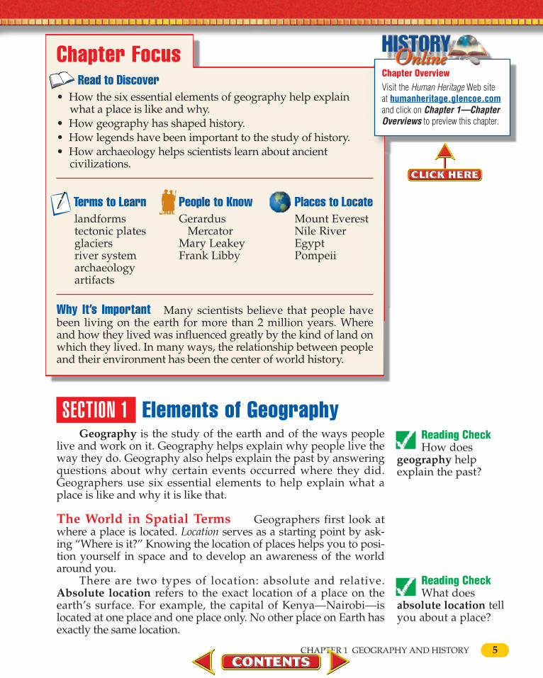
SECTION 1 Elements of GeographyGeography is the study of the earth and of the ways people
live and work on it. Geography helps explain why people live theway they do. Geography also helps explain the past by answeringquestions about why certain events occurred where they did.Geographers use six essential elements to help explain what aplace is like and why it is like that.
The World in Spatial Terms Geographers first look atwhere a place is located. Location serves as a starting point by ask-ing “Where is it?” Knowing the location of places helps you to posi-tion yourself in space and to develop an awareness of the worldaround you.
There are two types of location: absolute and relative.Absolute location refers to the exact location of a place on theearth’s surface. For example, the capital of Kenya—Nairobi—islocated at one place and one place only. No other place on Earth hasexactly the same location.
Chapter FocusRead to Discover
• How the six essential elements of geography help explainwhat a place is like and why.
• How geography has shaped history.• How legends have been important to the study of history.• How archaeology helps scientists learn about ancient
civilizations.
5CHAPTER 1 GEOGRAPHY AND HISTORY
Why It’s Important Many scientists believe that people havebeen living on the earth for more than 2 million years. Where and how they lived was influenced greatly by the kind of land onwhich they lived. In many ways, the relationship between peopleand their environment has been the center of world history.
Terms to Learnlandformstectonic platesglaciersriver systemarchaeologyartifacts
People to KnowGerardus
MercatorMary LeakeyFrank Libby
Places to LocateMount EverestNile RiverEgyptPompeii
Reading Check How does
geography helpexplain the past?
Reading Check What does
absolute location tellyou about a place?
Chapter OverviewVisit the Human Heritage Web siteat humanheritage.glencoe.comand click on Chapter 1—ChapterOverviews to preview this chapter.
0002-0031 CH01-846240 11/14/02 7:01 PM Page 5

6
Relative location refers to the position of a place in relationto other places. Nairobi is located north of Mt. Kilimanjaro, westof the Indian Ocean, and southeast of Lake Turkana. Using thisinformation, Nairobi can be found on a map of Africa if Mt.Kilimanjaro, the Indian Ocean, and Lake Turkana are located. Aplace may be described with many different relative locations.
Places and Regions Geographers also look at places andregions. Place includes those features and characteristics that givean area its own identity or personality. These can be physicalcharacteristics—such as landforms, climate, plants, and animals.Places can also be described by their human characteristics. Thesecharacteristics tell how many people live in a place, what languagethey speak, and what they do for a living. Knowing about a place’ssoil and about how its people make a living tells more about it thanjust its location. The physical and human characteristics of Nairobi,for example, make it a place that is different from Tokyo.
UNIT 1 PLACE AND TIME
PLACES AND REGIONS A place such as the Moi Avenue in Mombasa, Kenya,shown here can be described easily. It is the avenue with the huge crossed elephanttusks. What other details could be included in a description of this place?
Reading Check How do you
determine a place’srelative location?
Student Web ActivityVisit the Human Heritage Web site athumanheritage.glencoe.comand click on Chapter 1—Student Web Activities to findout more about the study of geography.
0002-0031 CH01-846240 11/14/02 7:02 PM Page 6
CHAPTER 1 GEOGRAPHY AND HISTORY
Reading Check What is a region?
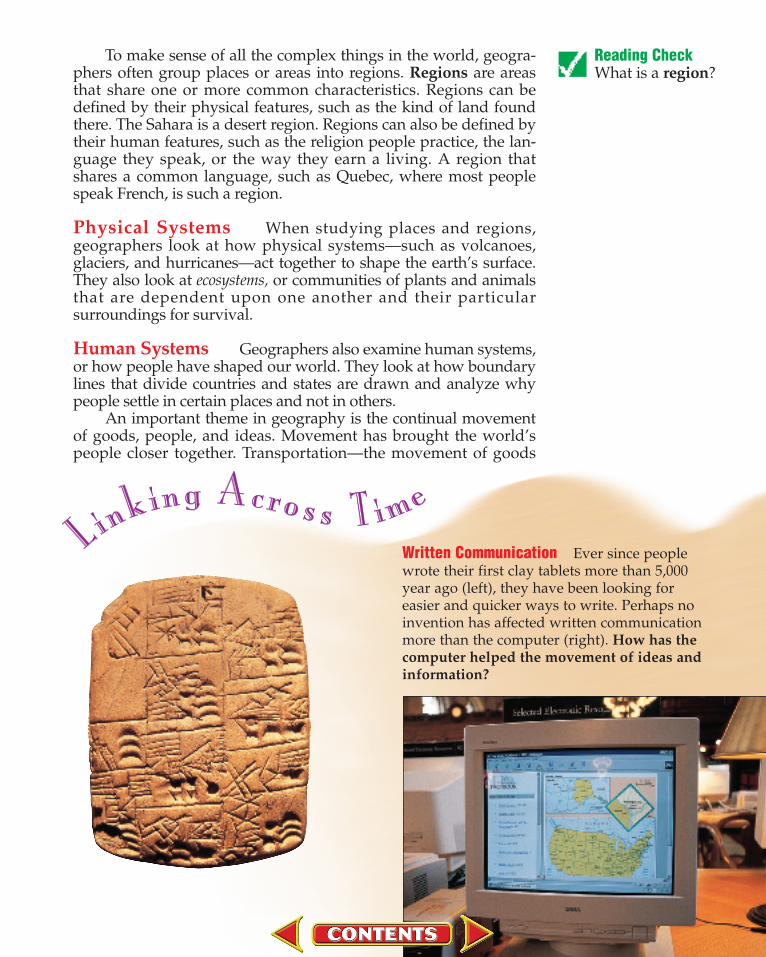
Written Communication Ever since peoplewrote their first clay tablets more than 5,000year ago (left), they have been looking for easier and quicker ways to write. Perhaps noinvention has affected written communicationmore than the computer (right). How has thecomputer helped the movement of ideas andinformation?
To make sense of all the complex things in the world, geogra-phers often group places or areas into regions. Regions are areasthat share one or more common characteristics. Regions can bedefined by their physical features, such as the kind of land foundthere. The Sahara is a desert region. Regions can also be defined bytheir human features, such as the religion people practice, the lan-guage they speak, or the way they earn a living. A region thatshares a common language, such as Quebec, where most peoplespeak French, is such a region.
Physical Systems When studying places and regions,geographers look at how physical systems—such as volcanoes,glaciers, and hurricanes—act together to shape the earth’s surface.They also look at ecosystems, or communities of plants and animalsthat are dependent upon one another and their particularsurroundings for survival.
Human Systems Geographers also examine human systems,or how people have shaped our world. They look at how boundarylines that divide countries and states are drawn and analyze whypeople settle in certain places and not in others.
An important theme in geography is the continual movementof goods, people, and ideas. Movement has brought the world’speople closer together. Transportation—the movement of goods
0002-0031 CH01-846240 11/22/02 10:33 AM Page 7

8
—allows people to use products made in places thousands of milesaway. Transportation also provides for the movement of people,which increases the exchange of ideas and cultures. Communica-tion—the movement of ideas and information—allows people tosee or hear what is happening in their community or in anotherpart of the world. Today, people receive almost instant informationby radio, television, and computer.
Environment and Society The study of geographyincludes looking at human/environment interaction, or how andwhy people change their surroundings. People respond to theirenvironment in different ways. Sometimes they adapt, or adjust, toit. For example, people wear light clothing in hot places and warmclothing in cold places. At other times, people modify, or change,their environment. They may irrigate dry land to grow crops orbuild a dam to keep a river from flooding.
The Uses of Geography People, businesses, andgovernments use geography and maps of all kinds on a daily basis.Geographic computer systems allow people to make betterdecisions about how to make the best use of places and regions.Understanding geography, and knowing how to use the tools andtechnology available to study it, prepares you for life in our modernsociety.
UNIT 1 PLACE AND TIME
ENVIRONMENT AND SOCIETY Many acres of American forests have been cut tosupply lumber products to a growing nation. Many new trees are planted to replacethose removed. How do people respond to their environment?
0002-0031 CH01-846240 11/22/02 10:33 AM Page 8

9
SECTION 2 Land, Water, and ClimatePhotographs of the earth taken from space show a contrast
of water and land beneath huge swirls of white clouds. Thesephotographs reflect three of the things geographers study: land,water, and climate.
Landforms Land covers about 30 percent of the surface ofthe earth. Land is made up of four main kinds of landforms, ornatural features of the earth’s land surface. These landforms aremountains, hills, plateaus, and plains. Geographers describe eachlandform by its elevation, or height above sea level, and itsrelief, or changes in height.
Mountains are the highest of the world’s landforms. Theyrise at least 2,000 feet, or 610 meters, above sea level. One of thepeaks in the Himalaya (him uh la’ uh) Mountains in central Asiais Mount Everest, the world’s highest mountain. It towers 29,035feet, or 8,852 meters, above sea level. Other mountain ranges, like the Appalachians (ap uh la’ chunz) in the eastern UnitedStates, are not as high. Mountains generally have high relief.
Hills are lower than mountains. They rise from 500 to 2,000feet, or 152 to 610 meters, above sea level. They generally havemoderate relief. Plateaus are raised areas of flat or almost flatland. Plateaus can vary in elevation from 300 to 3,000 feet, or 91to 914 meters, above sea level. Most of them have low relief.
Plains are large areas of flat or gently rolling land. They gen-erally rise less than 1,000 feet, or 305 meters, above sea level andhave low relief. The world’s largest plain is the North EuropeanPlain, which stretches for more than 1,000 miles, or 1,609 kilome-ters, from the western coast of France to the Ural Mountains inRussia.
CHAPTER 1 GEOGRAPHY AND HISTORY
Section 1 Assessment 1. Define: geography, absolute location,
relative location, place, region.2. What six essential elements do geogra-
phers use to study the earth?3. Why do geographers organize the world
into regions?
Critical Thinking4. Making Comparisons How does the
element of the world in spatial terms differfrom the element of places and regions?
Graphic Organizer Activity 5. Draw a diagram like this one, and use it
to summarize information about each ofthe six essential elements of geography.
Six Essential Elements
1. 2. 3. 4. 5. 6.
Reading Check What are the
four main kinds oflandforms?How do geographersuse elevation andrelief to describelandforms?
Island Tips Some of theworld’s islands are reallymountain summits—thetips of volcanoes that haverisen from the sea. Thehighest summit in Hawaii,Mauna Kea, rises 13,796feet, or 4,205 meters, abovesea level. However, whenmeasured from its base,Mauna Kea stands 32,000feet, or 9,750 meters—tallerthan Mount Everest.
0002-0031 CH01-846240 11/22/02 10:34 AM Page 9

10
Surface Changes From Inside the Earth The land sur-face of the earth is constantly changing. Most changes are causedby forces from deep within the earth, usually heat and pressure.
Heat and pressure are caused by the structure of the earthitself. The inside of the earth is made up of three separate layers.At the center of the earth is the core. The inner part of the core issolid rock, and the outer part of the core is made up of meltedrock. Around the core is the mantle, which is made up mostly ofhot, solid rock. Floating on the melted outer part of the mantle isa thin layer of rock, sand, and soil called the crust. The crust maybe from 3 to 30 miles, or 5 to 49 kilometers, thick.
Heat from the core—the hottest part of the earth—causes therock in the mantle to rise. This puts pressure on the crust andcauses it to move. In recent years, scientists have come to believethat the crust does not move in one piece but in separate sectionscalled tectonic (tek ton’ ik) plates. These plates move very slowly,about 0.8 to 2 inches, or 2 to 5 centimeters, a year. Plates canmove together, move apart, or slide past one another.
This movement of the plates explains what geographers callcontinental drift. Most geographers believe that about 220 mil-lion years ago, all the continents of the world formed one hugeland mass named Pangaea (pan j e ’ uh). Over time, the plates
UNIT 1 PLACE AND TIME
Major Landforms The Earth’s Structure
Reading Check What is the
connection betweentectonic plates andcontinental drift?
Reading Check What is the
composition of theearth’s core, mantle,and crust?

11
moved and Pangaea split into seven continents. Some plates,such as the ones on which Africa and South America are located,moved apart. Other plates, such as the plates on which India andmost of Asia are located, collided. The crust where these twoplates met was squeezed upward to form the Himalayas.
Plate movement also creates volcanoes. These are cone-shaped mountains made when melted rock called magma flowsup from the earth’s mantle through cracks in the crust and thencools into solid rock. The Hawaiian Islands, for example, wereformed by volcanoes that thrust up from the ocean floor.
Plate movements can also cause earthquakes, or suddenshifts in the earth’s crust. These often happen when tectonicplates slide past one another. About 800,000 earthquakes occureach year with only about 50,000 of them strong enough for peo-ple to even feel them. A strong earthquake, however, can causeloss of life and serious property damage.
Both volcanoes and earthquakes are generally found alongthe edges of the earth’s tectonic plates. They are so commonaround the Pacific Ocean that geographers call this area the“Ring of Fire.”
The tectonic plates are still moving. Most geographersbelieve that thousands of years from now, California, which is on
CHAPTER 1 GEOGRAPHY AND HISTORY
Tectonic Plates
Reading Check How are
volcanoes formed?What is a commoncause of earthquakes?
PHYSICAL SYSTEMSThe idea that the conti-nents were once joinedand then slowly driftedapart is called the conti-nental drift theory.Which plate is collidingwith the South Ameri-can plate along the westcoastofSouthAmerica?
MAP STUDYMAP STUDY
0002-0031 CH01-846240 11/22/02 10:34 AM Page 11

12
a different plate from most of the United States, will be locatedfar off the west coast of Canada.
Surface Changes From Outside the Earth Forces fromoutside the earth also cause changes on its surface. Three mainforces are wind, water, and ice. All three reshape the land by aprocess called erosion (i ro ’ zhuhn), in which rock and soil aremoved from one place on the earth’s surface to another. Theseforces can either help or hurt people.
An example of helpful wind erosion can be found in theplains of northern China, where large amounts of wheat and otherfood crops are grown. The plains are covered with a thick, rich,yellowish soil called loess (les) which was carried there by windsblowing from deserts to the west. During the 1930s, however,winds blew away so much of the soil in the central part of theUnited States that the area became known as the Dust Bowl.
Water erosion that is helpful can be seen in the Mekong(may’ kawng) River of Southeast Asia. This river carries rich soildown from the mountains and spreads it over the lowlands, creat-ing one of the most fertile areas in the world. Harmful water ero-sion occurs when the Huang Ho (hwong huh) in northern Chinaoverflows its banks and floods farms and homes.
Ice erosion has also caused changes on the earth’s surfaceand in people’s lives. Four times in the last 500,000 years, during
EARTHQUAKE DISASTERS Mexico has experienced many earthquakes thathave caused terrible loss of life and property. These earthquakes most often occurwithout warning. What causes an earthquake?
UNIT 1 PLACE AND TIME
0002-0031 CH01-846240 11/22/02 10:35 AM Page 12

13CHAPTER 1 GEOGRAPHY AND HISTORY
what are called the Ice Ages, great ice sheets called glaciersspread out from the North and South poles. The ice drove peopleand animals away, smoothed hills into plains, created lakes, anddug new channels for rivers.
Landforms in History Throughout history, landformshave played an important part in helping people decide where tolive. People stayed away from mountainous areas where travelwas difficult or where the air was so thin that it was hard tobreathe. Instead, people settled mostly in plains and hilly areaswhere the soil was rich enough for crops to grow.
Landforms also have made a big difference in the politicalrelationships of people. In ancient times the Greeks lived in manydifferent city-states. One reason the Greeks did not join togetherto form a nation was that their communities were separated fromone another by a landform—mountains.
Waterways About 70 percent of the earth’s surface is cov-ered with water. The largest waterways in the world are the fouroceans—the Atlantic, the Pacific, the Indian, and the Arctic.
Ice Ages
Reading Check How did glaciers
affect human andphysical geography?
PHYSICAL SYSTEMSScientists believe thatglaciers covered largeareas of the earth’s sur-face during the Ice Ages. What continentswere affected the mostby the Ice Ages?
MAP STUDYMAP STUDY
0002-0031 CH01-846240 11/14/02 7:19 PM Page 13

14
Smaller bodies of salt water are known as seas. They are usuallypartly surrounded by land. Bodies of water that are completelysurrounded by land are known as lakes. The world’s largest fresh-water lake is Lake Superior in North America. It is about 350 miles,or 563 kilometers, long and 160 miles, or 257 kilometers, wide.
Waterways that empty into another body of water areknown as rivers. Most rivers begin high in mountains or hills.A river and all the streams that flow into it make up a riversystem. The longest river system in the world is the Nile,which flows about 4,160 miles, or 6,693 kilometers, from itssource in the highlands of central Africa to its mouth on theMediterranean Sea.
Waterways in History Like landforms, waterways haveplayed an important part in helping people decide where to live.People’s earliest homes were along the banks of rivers and otherwaterways. These bodies of water provided them with a meansfor travel and trade, drinking water, and irrigation for crops asfarming developed. Thus, river valleys were often sites for vil-lages and cities. Animals also used waterways for food anddrinking water, so the riverbanks were good hunting grounds.
Climate and the Sun The pattern of the weather of aplace over many years is climate. The most important thing thatshapes climate is the sun. The sun provides the earth with heatand light. All parts of the earth, however, do not receive the sameamount of sunlight.
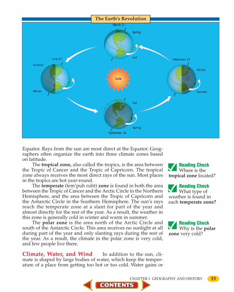
As the earth moves through space, it rotates, or spins like atop. Geographers say that it spins on its axis, an imaginary linethat runs through the earth’s center from the North Pole to theSouth Pole. It takes one day of 24 hours for the earth to spinaround completely.
Besides rotating, the earth moves around the sun in analmost circular path called an orbit. This motion, known as a rev-olution, takes one year of 3651⁄4 days to complete. It is the earth’srevolution around the sun that causes the seasons.
Seasons vary from one part of the world to another. Theearth’s axis, instead of being straight up and down, is tilted at anangle. This means that places in the Northern Hemisphere aretilted toward the sun from March to September. As a result, theseplaces have spring and summer at that time. During these samemonths, however, the Southern Hemisphere is tilted away fromthe sun. There it is fall and winter. Six months later, fromSeptember to March, conditions reverse, and the seasons are theopposite.
Climate Zones The amount of heat from the sun a placereceives depends on its latitude, or distance north or south of the
UNIT 1 PLACE AND TIME
Reading Check How can a
place’s latitude helpyou predict temper-atures in the area?
Reading Check How is climate
shaped by move-ments of the earth?
Reading Check What is the
longest river systemin the world?
0002-0031 CH01-846240 11/14/02 7:21 PM Page 14
15CHAPTER 1 GEOGRAPHY AND HISTORY
Equator. Rays from the sun are most direct at the Equator. Geog-raphers often organize the earth into three climate zones basedon latitude.
The tropical zone, also called the tropics, is the area betweenthe Tropic of Cancer and the Tropic of Capricorn. The tropicalzone always receives the most direct rays of the sun. Most placesin the tropics are hot year-round.
The temperate (tem’puh ruht) zone is found in both the areabetween the Tropic of Cancer and the Arctic Circle in the NorthernHemisphere, and the area between the Tropic of Capricorn andthe Antarctic Circle in the Southern Hemisphere. The sun’s raysreach the temperate zone at a slant for part of the year andalmost directly for the rest of the year. As a result, the weather inthis zone is generally cold in winter and warm in summer.
The polar zone is the area north of the Arctic Circle andsouth of the Antarctic Circle. This area receives no sunlight at allduring part of the year and only slanting rays during the rest ofthe year. As a result, the climate in the polar zone is very cold,and few people live there.
Climate, Water, and Wind In addition to the sun, cli-mate is shaped by large bodies of water, which keep the temper-ature of a place from getting too hot or too cold. Water gains or
The Earth’s Revolution
Reading Check Where is the
tropical zone located?
Reading Check What type of
weather is found ineach temperate zone?
Reading Check Why is the polar
zone very cold?
0002-0031 CH01-846240 11/14/02 7:21 PM Page 15
16
loses heat more slowly than land. Also, air over a lake is coolerthan air over the land.
Climate is also shaped by the movement of air and oceanwater. Air that moves is called wind. Some winds are known asprevailing (pri va’ leng) winds because they blow from a certaindirection almost all the time. Other winds are called monsoonsbecause they change direction according to the season of the year.Monsoons often bring heavy rainfall. Ocean water that flows in asteady stream is called an ocean current. Both winds and oceancurrents carry heat or cold and moisture all over the world.Ocean currents that flow from the Equator toward the poleswarm the lands they pass. Currents that flow from the poles tothe Equator cool the land they pass.
Climate and Altitude Climate is also shaped by altitude.The higher the altitude, the colder the climate. In the tropicalzone, people often prefer living in highlands rather than low-lands because the highland temperatures are more comfortable.The ancient Incas settled in the Andes Mountains of Peru insteadof along the Pacific coast for that reason. Mountains also affectprecipitation—the falling of moisture such as rain or snow. Asthe air rises over mountains, it cools and drops its moisture.
UNIT 1 PLACE AND TIME
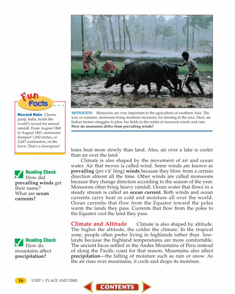
MONSOON Monsoons are very important to the agriculture of southern Asia. Thewet, or summer, monsoons bring moisture necessary for farming to the area. Here, anIndian farmer struggles to plow his fields in the midst of monsoon winds and rain.How do monsoons differ from prevailing winds?
Reading Check How did
prevailing winds gettheir name?What are oceancurrents?
Reading Check How do
mountains affectprecipitation?
Record Rain Cherra-punji, India, holds theworld’s record for annualrainfall. From August 1860to August 1861, monsoonsdumped 1,042 inches, or2,647 centimeters, on thetown. That’s a downpour!
0002-0031 CH01-846240 11/22/02 3:16 PM Page 16

Because Earth is a sphere, no flatmap can show its whole surface. Map-makers use different projections (pruhjek´ shuhns), or ways of representingEarth on a flat surface.
One projection used often is a Mer-cator (muhr kat´ uhr) projection. Namedafter Gerardus Mercator, a Flemish map-maker of the 1500s, it is made by wrap-ping paper around a globe. A lightshining from the center of the globe pro-jects Earth’s features onto the paper.This allows the map to be traced.
The parts of the map that are mostlike the earth are where the papertouches the globe, such as at the Equa-
tor. The parts thatare most distorted(dis tort´ ed), ortwisted out ofshape, are where the paper does nottouch the globe, such as near the poles.
Map Practice1. Which of the earth’s climate zones
is shown most accurately?2. Which is most distorted?3. Is the shape of North America
more accurate on this map or on aglobe? Why?
World Climate Zones
Understanding aMercator Projection
17

18
Climate in History Climate, like land and waterways,plays an important part in shaping history. It helps determinewhere people live, what kind of clothes they wear, what kind ofhouses they build, and what crops they grow. It also affects thespeed with which they work and the kinds of things they do forentertainment. Since climate is something humans cannot con-trol, it has affected civilizations since prehistoric times.
Sometimes climate affects the way a country behavestowards its neighbors. Climate has also helped decide the out-comes of wars. For example, many of Russia’s harbors stayfrozen during much of the year. In the past, Russia has often goneto war with other countries in order to capture land for warmwater ports. Climate was also one reason the Russians were ableto stop the invasions of French ruler Napoleon Bonaparte (nuhpo’ le uhn bo ’ nuh part) in the 1800s and German ruler AdolfHitler in the 1940s. The Russians were used to the bitter cold andsnow of their country’s winter, whereas the invaders were not.
COLD CLIMATE This buoy has become frozen in the St. Petersburg Harbor dur-ing the cold Russian winter. Such waterways have been important many times in Rus-sia’s history. What has the lack of warm water ports and harbors caused Russia to doin the past?
UNIT 1 PLACE AND TIME
Climate Early Greeksclassified climates based onwhat they knew aboutGreece and areas to thesouth and north. Theycalled their own climatetemperate because it posedfew problems of shelterand clothing. Theybelieved the area south ofthe Mediterranean Seabecame hotter, so theycalled these lands torrid.Cold winds from the northled them to call that areafrigid.
0002-0031 CH01-846240 11/14/02 7:37 PM Page 18

19
SECTION 3 Natural ResourcesNatural resources are materials found in nature. Some, such
as air, are found everywhere. Others, such as oil, are found onlyin certain areas. Some places have many natural resources, whileothers have few.
Kinds of Natural Resources There are different kinds ofnatural resources. Some resources helpful to people include air,water, soil, sunlight, minerals, fossil fuels, forests, and animal life.Some of these—air, water, soil, and sunlight—are essential forany kind of life to exist. They are the most important naturalresources.
Other natural resources, while not essential for life, areimportant because they enable people to live better. One suchresource is minerals, or nonliving substances found beneath theearth’s surface. Throughout history, people have used suchminerals as iron, copper, tin, gold, and silver to make tools,weapons, jewelry, and money. Fossil fuels, such as coal, oil, andnatural gas, provide the energy needed to heat homes and powermachines.
Natural resources become valuable only when people learnhow to use them. For example, during the 1200s Marco Polo lefthis native city of Venice, in present-day Italy, and traveled to
CHAPTER 1 GEOGRAPHY AND HISTORY
Section 2 Assessment 1. Define: landforms, elevation, relief,
core, mantle, crust, tectonic plates, conti-nental drift, volcanoes, earthquakes, ero-sion, glaciers, river system, climate,latitude, tropical zone, temperate zone,polar zone, prevailing winds, ocean cur-rent, precipitation.
2. What are some of the ways landformsand waterways have been important tohistory?
3. Into what climate zones do geographersoften organize the earth?
Critical Thinking4. Making Generalizations How does
climate affect the way that you live?
Graphic Organizer Activity 5. Draw a diagram like this one, label it
with the four kinds of landforms, andlist examples of each landform in yourcommunity, state, or region.
Reading Check What are some
examples of naturalresources?
Reading Check Why have
minerals beenimportant to peoplethroughout history?
0002-0031 CH01-846240 11/14/02 7:37 PM Page 19

20
China. A few years after returning home, he wrote a book aboutthe wonderful things he had seen on his journey. One of thesewas a black rock, now known as coal, which the Chinese dug outof the ground and burned to keep themselves warm. TheVenetians (vi ne’ shuhnz) doubted Marco Polo. They had notused coal as the Chinese had. People later changed their mindsabout coal when they began using it as a fuel to power steamengines and to process steel.
Some resources can be replaced as they are used. These arerenewable resources. For example, American farmers who livedin the Dust Bowl of the 1930s were able to get back their once-rich soil. To do this they used better ways of farming and plantedtrees to keep the soil from being blown away. Other naturalresources cannot be replaced as they are used. These arenonrenewable resources. For example, once fossil fuels and mostminerals are used up, they will be gone forever.
In recent years, people have become more and moreconcerned about making better use of the world’s naturalresources. Some countries have passed laws to slow down thepollution of the air, water, and soil. Scientists also are trying todevelop new sources of energy.
MINERALS Some natural resources are found beneath the ground and are calledminerals. Oil and coal are two minerals for which people drill and mine underground.The oil well shown here (left) is in the jungles of Nigeria. Coal mining in North Dakotais also shown (right). What are other examples of minerals?
UNIT 1 PLACE AND TIME
Reading Check How do
renewable resourcesand nonrenewableresources differ fromeach other?
0002-0031 CH01-846240 11/14/02 7:40 PM Page 20

21
Natural Resources in History Natural resources affectedthe location and growth of settlements throughout history. Thesharing of these resources has also been important. Rich soil andplenty of water made farming possible and led to the rise ofcities. Asians and Europeans came into contact with one anotherpartly because Europeans wanted the silks and spices of Asia.Modern industry started in countries that had large amounts ofcoal and iron ore for making steel. During the 1800s, the discov-ery of gold in California, South Africa, Australia, and Alaskacaused hundreds of thousands of people to move to those areas.
RENEWABLE RESOURCES Soil is considered a renewable resource. Some humanactivities, like the strip mining of coal (left), use up the land. With careful manage-ment, however, such areas can be reclaimed, or made productive again (right). Whatare some examples of nonrenewable resources?
CHAPTER 1 GEOGRAPHY AND HISTORY
Section 3 Assessment 1. Define: natural resources, minerals,
renewable resources, nonrenewableresources.
2. What resources are needed for life?
Critical Thinking3. Demonstrating Reasoned Judgment
Why do you think people have becomemore interested in making better use ofthe world’s natural resources?
Graphic Organizer Activity4. Create a diagram such as this one, and
use it to show examples of how naturalresources have helped shape history.
NaturalResources
and History
0002-0031 CH01-846240 11/14/02 7:46 PM Page 21

22
SECTION 4 LegendsPeople have always been interested in learning about the
past. Every group of people on the earth has legends, or folk-tales, that help to explain the past. These legends began as storiesthat were spoken or sung. People passed them down from gener-ation to generation.
A Chinese Legend The Chinese have a legend about thebeginnings of China. It says that the universe was a huge egg.When the egg split open, the upper half became the sky, and thelower half became the earth. Out of the split egg came P’an Gu(pan gu), the first man. Each day for 18,000 years P’an Gu grewtaller, the sky grew higher, and the earth grew thicker. Then P’anGu died. His head split and became the sun and the moon. Hisblood filled the rivers and the seas. His hair became the forestsand the meadows. His perspiration became the rain. His breathbecame the wind and his voice, the thunder.
UNIT 1 PLACE AND TIME
Reading Check What are the
purposes of legends?
0002-0031 CH01-846240 11/14/02 8:05 PM Page 22

23
An African Legend The Africans have a legend aboutwhy the sun shines more brightly than the moon. It says that Godcreated the Moon and then the Sun. Because the Moon was big-ger and brighter, the Sun became jealous and attacked the Moon.They fought and wrestled until the Sun begged for mercy. Thenthey wrestled again. This time the Sun threw the Moon into themud. Dirt splashed all over the Moon, and it was no longer asbright as before. To stop the fighting, God stepped in. He told theSun that from then on it would be brighter than the Moon andwould shine during the day for kings and workers. He told theMoon that from then on it would shine only at night for thievesand witches.
A Rumanian Legend The Rumanians have a legendabout the creation of mountains and valleys. It says that whenGod finished making the heavens, He measured them with alittle ball of thread. Then He started to create the earth to fitunder them. A mole came along and offered to help. So God letthe mole hold the ball of thread while He created the earth.
STONEHENGE Many legends have been told about the ancient ruins of Stone-henge in Great Britain, shown here. These stones are arranged in an unusual formationbelieved to date back to prehistoric times. How do modern people learn aboutancient legends such as the stories about Stonehenge?
CHAPTER 1 GEOGRAPHY AND HISTORY
0002-0031 CH01-846240 11/14/02 8:06 PM Page 23

24
While God was weaving and shaping the earth, the mole letout the thread little by little. God was too busy to notice that, attimes, the mole let out more thread than it should have. WhenGod was finished, He was amazed to find that the earth was toobig to fit under the heavens.
The mole, seeing what it had done, was afraid. It ran off andburied itself. God sent the bee to find the mole and ask it whatshould be done. But when the bee found the mole, it would notanswer the question.
The bee hid in a flower, hoping the mole would think it wasalone and start talking to itself. Soon, the mole thought out loud.It said that it would squeeze the earth so that the mountainswould stick up and the valleys would sink down. Then the earthwould be small enough to fit under the heavens. Upon hearingthis, the bee buzzed off. The mole heard the buzzing and becameangry. It put a curse on the bee, saying, “Henceforth, feed onyourself.”
The bee told God what the mole had said. God squeezed theflat earth so that the mountains rose up, the valleys sank down,and the earth fit under the heavens. God then turned the mole’scurse into a blessing. Ever since, the bee makes its own honey,while the mole lives underground and is afraid to come out.
Other Legends These Chinese, African, and Rumanian leg-ends are about the creation of the world. This is not true of alllegends. Many are about the deeds of godlike men and women orabout strange and wonderful lands. Other legends explain natur-al elements such as the placement of stars or why a maple treehas red leaves. Some even explain geographic features such asmountains and rivers.
After people developed writing more than 5,000 years ago,they wrote down their legends. Many came to be thought of asfact. In recent years, archaeologists, or scientists who study theremains of past human life, and anthropologists, or scientistswho study the origin and development of humans, became curi-ous about how much of certain legends was fiction and howmuch was fact. This led them to search out the truth of some ofthe legends.
UNIT 1 PLACE AND TIME
Reading Check What type of
work is done byarchaeologists?What do anthropolo-gists study?
Section 4 Assessment 1. Define: legends, archaeologists,
anthropologists.2. How did people learn legends?
Critical Thinking3. Analyzing Information
What legends do you know?
What do they try to explain?
Graphic Organizer Activity 4. Draw a diagram like this one, and use
it to show the order of events in one ofthe legends in this section.
0002-0031 CH01-846240 11/22/02 10:14 PM Page 24

25
SECTION 5 ArchaeologyArchaeology, or the study of the remains of past human life
and cultures, began about 500 years ago. At that time, someEuropeans dug up old marble statues and ornaments made bythe ancient Greeks and Romans and sold them for a great deal ofmoney. Scientists began to study these artifacts, or things madeby people. They found they could learn from the artifacts howpeople lived long ago. People who lived in ancient times did notleave many written records.
Artifacts do not have to be works of art. They can beanything made by people such as weapons, tools, or pottery. Theearliest artifacts are pieces of hard rock that were chipped intocutting or digging tools or into weapons.
EGYPTIAN ARTIFACTS Archaeologists have uncovered many artifacts in Egypt.This spearhead (left), from about 15,000 B.C., is one of the oldest objects found in theregion. The Rosetta Stone (right), from around 200 B.C., is one of the most famousarchaeological finds. On it is carved a decree issued by Egyptian priests to honor aleader. What kinds of objects can be considered artifacts?
CHAPTER 1 GEOGRAPHY AND HISTORY
Reading Check How did
archaeology get itsstart?
Reading Check What information
did scientists discoverfrom the study ofartifacts?
0002-0031 CH01-846240 11/14/02 8:08 PM Page 25

Mary Nicol Leakey1913–1996
PaleoanthropologistAt age 11, Mary NicolLeakey visited a cavefilled with prehistoricpaintings. The caveinspired her to becomea paleoanthropolo-gist—a person whostudies prehistorichumans and prehu-mans. She later leftEngland for EastAfrica. Here she dis-covered prehumanfootprints more than3.6 million years old!For more on this dis-covery, see pages674–675.
26
Archaeological Finds About 1700, some Italian farmersdiscovered they were living on top of an ancient Roman citynamed Herculaneum (huhr kyul l a ’ ne uhm) that had beenburied for more than 1,000 years. In 1719 archaeologists beganuncovering the city. After more than 50 years, they uncovered notonly Herculaneum but also another Roman city called Pompeii(pom pa’). These cities contained, among other things, finehouses, theaters, streets, and temples. More importantly, fromwhat they found, the archaeologists learned exactly how ancientRomans lived.
The discovery of Herculaneum and Pompeii was followed in1799 by one of the greatest of all archaeological discoveries. Thiswas the finding in Egypt of the Rosetta Stone, a slab of stone onwhich are carved ancient Egyptian picture-writing and its Greektranslation. Although scholars knew the Greek language well,they had not been able to decipher, or explain the meaning of, theancient Egyptian language. The Rosetta Stone was a two-
POMPEII The Roman city of Pompeii was buried under the mud and lava from avolcanic eruption in 79 A.D. Discovered in the 1700s, the site has provided much information about Roman life and art, such as this wall painting from a home. Whatother ancient Roman city was discovered in the 1700s?
UNIT 1 PLACE AND TIME
0002-0031 CH01-846240 12/10/02 1:43 PM Page 26

27
language dictionary that gave them the key to the meaning ofEgyptian picture-writing. Now they could learn much moreabout the history of Egypt and its people.
A great many archaeological finds have been made since thediscovery of the Rosetta Stone. For example, between 1850 and1950 archaeologists uncovered five lost civilizations. In 1988 theydiscovered the oldest known piece of cloth, woven 9,000 yearsago. Archaeologists continue to make discoveries in many partsof the world. This can be especially difficult because often onlysmall pieces of artifacts are found. Thus, archaeologists have onlyhints or clues about people of past civilizations.
Dating Archaeological Remains After archaeologistsexcavate, or dig into the earth, to uncover remains of the past,they have to date, or find the age of, the remains. In 1832 Christ-ian J. Thomsen, a Danish archaeologist, divided early human his-tory into three ages, or periods. These ages were based on the
CHAPTER 1 GEOGRAPHY AND HISTORY
Archaeological Sites
PLACES ANDREGIONS Archae-ologists carefully piecetogether informationgathered at archaeologi-cal sites. What archaeo-logical site is foundnear the Tigris andEuphrates rivers?
MAP STUDYMAP STUDY
0002-0031 CH01-846240 11/22/02 10:37 AM Page 27
28
material people used for making tools and weapons during them.Thomsen named these ages the Stone Age, the Bronze Age, andthe Iron Age. Later, scientists also divided the Stone Age into threeshorter periods of time—old, middle, and new. Scientists relied oncommon sense when unearthing artifacts. They assumed thatolder artifacts would be found beneath more recent ones.
Still later, archaeologists realized that the material used fortools and weapons was not as important as how people got theirfood. So they divided early human history into two general peri-ods. During the first period, people were food gatherers. Duringthe second period, they were food producers.
To tell the date of an archaeological find, scientists first usedtrees. Each year, trees form a new growth ring. Scientists countedthe number of rings in a wooden object, such as a house beam,and compared the pattern with the rings of a tree whose age theyknew. In that way, they could identify dates as far back as 3,000years earlier.
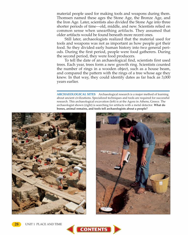
ARCHAEOLOGICAL SITES Archaeological research is a major method of learningabout ancient civilizations. Specialized techniques and tools are required for successfulresearch. This archaeological excavation (left) is at the Agora in Athens, Greece. Thearchaeologist shown (right) is searching for artifacts with a metal detector. What dobones, animal remains, and tools tell archaeologists about a people?
UNIT 1 PLACE AND TIME
0002-0031 CH01-846240 11/14/02 8:10 PM Page 28

29
You know that if you watch televi-sion instead of completing your home-work, you will receive poor grades. Thisis an example of a cause-and-effect rela-tionship. This cause—watching televi-sion instead of doing homework—leadsto an effect—poor grades.
When you look for why or how anevent or chain of events took place, youare developing the skill of understand-ing causes and effects.
Learning the Skill A cause is anyperson, event, or condition that makessomething happen. What happens as aresult is known as an effect. These guide-lines will help you identify cause andeffect:
• Look for "clue words" that alert you tocause and effect, such as because, led to,brought about, produced, and therefore.
• Look for logical relationships betweenevents, such as "She did this and thenthat happened."In a chain of historical events, one
effect often becomes the cause of othereffects. The chart on this page showssuch a chain of events.
UnderstandingCause and Effect
Skill PracticeStudy the cause-and-effect chart onthis page. Then answer the ques-tions below.
1. What were some of the causes ofthe start of archaeology?
2. What were some of the effects ofarchaeology upon history?
3. What effect do you think the dis-covery of lost civilizations hashad upon our view of the past?
CAUSES AND EFFECTS
CAUSES• Europeans dig up artifacts for sale.• Scientists study these artifacts.• Artifacts provide information on the past.
Start of Archaeology
EFFECTS• Lost civilizations are uncovered.• Early human history is divided into periods.• New methods of dating are devised.
➞➞
Glencoe’s SkillbuilderInteractive Workbook CD-ROM,Level 1, provides instruction and practice in key social studies skills.
0002-0031 CH01-846240 11/14/02 8:11 PM Page 29

30 UNIT 1 PLACE AND TIME
In 1946 an American scientist named Willard Frank Libbydiscovered that all living things contain a radioactive elementcalled carbon 14. After plants, animals, and humans die, the car-bon 14 gradually disappears. By measuring how much carbon 14a skeleton or the remains of a wooden boat contain today, scien-tists can figure out about how old the object is as far back asabout 30,000 years.
Section 5 Assessment 1. Define: archaeology, artifacts.2. Why did scientists begin to study arti-
facts?3. Why was the discovery of the Rosetta
Stone important?
Critical Thinking4. Predicting Consequences What
would you like about being an archae-ologist? What would you dislike?
Graphic Organizer Activity5. Draw a diagram like the one below,
and use it to show the three major peri-ods in early human history.
1. Geographers use six essential elementsto study the earth: the world in spatialterms, places and regions, physicalsystems, human systems, environmentand society, and the uses of geography.
2. Mountains, hills, plateaus, and plainsmake up 30 percent of the surface ofthe earth.
3. The surface of the earth is constantlyundergoing change.
4. About 70 percent of the earth’s sur-face is covered by water.
5. Climate is shaped by many factors,including winds, ocean currents, andaltitude.
6. Geographers divide the earth into cli-mate zones based on latitude.
7. Examples of natural resources includeair, water, sunlight, minerals, fossilfuels, forests, and animal life.
8. Renewable resources can be replaced.Nonrenewable resources are gone for-ever when used up.
9. Legends have helped people explainthe past.
10. Archaeologists study artifacts to learnhow people lived long ago.
11. Since 1946, scientists have used thecarbon 14 method of dating to identi-fy the age of artifacts.
Chapter Summary & Study Guide
Self-Check QuizVisit the Human Heritage Web site at humanheritage.glencoe.com and click on Chapter 1—Self-Check Quizto assess your understanding of this chapter.
0002-0031 CH01-846240 1/10/03 10:26 AM Page 30

Using Key Terms
Imagine you are writing an explana-tion for a younger student of how geogra-phy has shaped history. Use the followingwords to describe in a simple way howlandforms, waterways, and climate haveinfluenced history.
landforms tectonic plates glaciersclimate elevation river systemnatural archaeology artifactsresources erosion
Understanding Main Ideas
1. What are the four major kinds of land-forms?
2. What do geographers believe causedPangaea to split into seven continents?
3. How has erosion both helped and hurtpeople?
4. Why did early people settle along thebanks of waterways?
5. Why are air, water, soil, and sunlightimportant natural resources?
6. How have people’s views about natur-al resources changed in recent years?
7. How is the carbon 14 test used as adating tool?
Critical Thinking
1. In what climate zone would you preferto live? Why?
2. ”It is important to plan the use of theworld’s natural resources.” What isyour opinion of this statement?Explain.
3. Why is it important to identify thedate of artifacts as exactly as possible?
4. How do ideas about the past change asmore knowledge becomes available?
Graphic Organizer Activity
History Create a diagram like thisone, and use it to show some of thearchaeological finds that have changedhistory.
Geography in History
Physical Systems Look at the mapon page 13 that shows how far ice sheetsmoved during the Ice Ages. What descrip-tive statements could you make about themovement of ice north of the Equatorcompared to south of the Equator?
AssessmentCHAPTER
ArchaeologicalDiscoveries
Example
Example
Example
Example
31
Using Your Journal
Review any details you may
have noted about the geographi-
cal factors that have influenced
history. Choose three of these
factors and write a short essay
explaining how these factors in-
fluence your life today.
1
0002-0031 CH01-846240 11/14/02 8:12 PM Page 31