Chandra Prakash Bhongir, Civil Engr, May04 - TTU DSpace Home
216
HISTORICAL AND ARCHAEOLOGICAL RESEARCH INTO THE SINGER STORE, A FRONTIER LUBBOCK COMMERCIAL VENTURE by KAREN KAYE BILBREY HICKS, B.A. A THESIS IN INTERDISCIPLINARY STUDIES Submitted to the Graduate Faculty of Texas Tech University in Partial Fulfillment of the Requirements for the Degree of MASTER OF ARTS Approved Eileen Johnson Chairperson of the Committee Gary Elbow John White Accepted John Borrelli Dean of the Graduate School December, 2005
-
Upload
khangminh22 -
Category
Documents
-
view
1 -
download
0
Transcript of Chandra Prakash Bhongir, Civil Engr, May04 - TTU DSpace Home

HISTORICAL AND ARCHAEOLOGICAL RESEARCH INTO
THE SINGER STORE, A FRONTIER LUBBOCK
COMMERCIAL VENTURE
by
KAREN KAYE BILBREY HICKS, B.A.
A THESIS
IN
INTERDISCIPLINARY STUDIES
Submitted to the Graduate Faculty of Texas Tech University in
Partial Fulfillment of the Requirements for
the Degree of
MASTER OF ARTS
Approved
Eileen Johnson Chairperson of the Committee
Gary Elbow
John White
Accepted
John Borrelli Dean of the Graduate School
December, 2005

Copyright 2005, Karen Kaye Bilbrey Hicks

ACKNOWLEDGEMENTS
My efforts to expand understanding of the history of the Singer Store were
greatly facilitated by assistance from many parties. I am deeply grateful for the
support and guidance afforded me by Dr. Eileen Johnson. Not only did she
provide the opportunity, direction, and encouragement necessary for completion
of the research, but it is largely through her efforts that the Lubbock Lake
Landmark has become the world renowned research center that it is today. I am
also indebted to committee members John White and Dr. Gary Elbow for their
patience and interest in the project.
The archaeological aspect of the Singer research was entirely dependent
on the dedicated and cheerful work of the 1996-1998 field crews. I benefited not
only from their efforts in the field but from their camaraderie and shared
experience as well. Other technical support was provided by Lubbock Lake
Landmark and Museum of Texas Tech University staff members. Field
photography and artifact photographs were provided by Rebecca Hinrichs Lewis,
Dr. Mary Lee Bartlett, and Tara Johnson. Assistance with artifact analysis is
credited to Susan Baxevanis, Terri Carnes, and Jennifer Torres. Finishing detail
for some of the maps and figures was provided by draftsmen Scott Malone and
Marcus Hamilton. James Johnson of the Blackwell Museum, Felix Barbosa-
Retana, and Max Winn, provided insight that aided artifact identification.
ii

The field research was conducted under Texas Historical Commission
Permit for Archeological Investigations #1515 and supported by funding from the
Museum of Texas Tech University, Museum of Texas Tech University
Association, Office of the President of Texas Tech University, Southwestern Bell,
Summerlee Foundation, Plum Foundation, and Center for Field Research
(EARTHWATCH). Recovered artifacts were accessioned and cataloged and are
held with their associated documentation (field notes, photodocuments,
drawings) in the Anthropology Division of the Museum of Texas Tech University.
Among those assisting with the historical research, I am in debt to Dessie
Redwine and George Hawkins who shared with me their personal histories. The
archival research into the Singer history was facilitated by the staff of the
Southwest Collection, Texas Tech University, Lubbock, Texas; the Research
Center at Panhandle Plains Museum, Canyon, Texas; the Haley Memorial
Library and History Center, Midland, Texas; General Land Office of the State of
Texas, Austin; and the Reference Staff of the Chicago Public Library.
Finally, I am most deeply grateful for the enduring support and patience of
my family and their continuous encouragement.
iii

TABLE OF CONTENTS
ACKNOWLEDGEMENTS......................................................................................ii
LIST OF TABLES .................................................................................................vi
LIST OF FIGURES .............................................................................................vii
CHAPTER
I. INTRODUCTION ............................................................................... 1
II. THEORY............................................................................................ 7
III. BACKGROUND ............................................................................... 11
Environmental Context ............................................................ 12
Societal Context....................................................................... 21
Concluding Statement ............................................................. 31
IV. HISTORIC CONTEXT ..................................................................... 33
Concluding Statement ............................................................. 47
V. ARCHAEOLOGICAL RESEARCH................................................... 48
1996 Archaeological Survey .................................................... 50
Excavation ............................................................................... 57
Concluding Statement ............................................................. 85
VI. ARTIFACT ANALYSIS..................................................................... 87
Glass ....................................................................................... 87
Ceramic ................................................................................... 94
Metal........................................................................................ 98
iv

Miscellaneous Artifacts .......................................................... 138
Faunal Remains..................................................................... 145
Concluding Statement ........................................................... 148
VII. DISCUSSION ................................................................................ 149
Archaeological Findings......................................................... 150
Historic Association ............................................................... 160
Findings Summary................................................................. 162
Regional Comparisons .......................................................... 165
Concluding Statement ........................................................... 181
VIII. CONCLUSION............................................................................... 182
REFERENCES................................................................................................. 187
v

LIST OF TABLES
3.1 Species represented in material recovered from stratum 5, Lubbock Lake Landmark.......................................................................... 21 5.1 Artifacts recovered from the 1996 survey in the southwestern quadrant of the Lubbock Lake Landmark................................................. 56 5.2 Artifacts recovered from the 1997 test excavation at 41LU31 in the
southwestern quadrant of the Lubbock Lake Landmark .......................... 61 5.3 Artifacts recovered from Unit 53S8E during 1997 test excavation at 41LU1 Area 8 in the southwestern quadrant of the Lubbock Lake
Landmark................................................................................................. 69 5.4 Artifacts recovered from Unit 41S10E during 1997 test excavation at
41LU1 Area 8 in the southwestern quadrant of the Lubbock Lake Landmark................................................................................................. 69
5.5 Artifacts recovered from Unit 37S0E during 1997 test excavation at 41LU1 Area 8 in the southwestern quadrant of the Lubbock Lake
Landmark................................................................................................. 70 5.6 Artifacts recovered from Unit 35S10E during 1997 test excavation at
41LU1 Area 8 in the southwestern quadrant of the Lubbock Lake Landmark................................................................................................. 70
5.7 Artifacts recovered from Unit 27N1E during 1997 test excavation at 41LU1 Area 8 in the southwestern quadrant of the Lubbock Lake
Landmark................................................................................................. 71 5.8 Artifacts recovered from 1998 block excavation at 41LU1 Area 8 in the southwestern quadrant of the Lubbock Lake Landmark .................... 78 6.1 Bone recovered from 1997 and 1998 excavations at 41LU1 Area 8 in the southwestern quadrant of the Lubbock Lake Landmark............... 147
vi

LIST OF FIGURES
1.1 The marker commemorating the Singer Store is located in the southwest portion of the Lubbock Lake Landmark..................................... 3 3.1 Location of Southern High Plains in relation to Texas and the Great Plains ............................................................................................. 13 4.1 Map showing location of Estacado and Lubbock Lake Landmark in
Lubbock County....................................................................................... 35 4.2 The Plains Museum Society installed an historical marker at the site Of the Singer Store in 1932. Photograph courtesy of the Southwest
Collection/Special Collections Libraries, Texas Tech University, SWCPC 57(K)-E11 .................................................................................. 38 4.3 Roughly shaped caliche used as house foundation for early Lubbock
home. Photograph courtesy of the Southwest Collection/Special Collection Libraries, Texas Tech University, Dorothy Rylander
Photograph Collection, SWCPC 332-E1 #2............................................. 39 4.4 Receipt from Singer Store for goods purchased by XIT cowboys. XIT Ranch Collection, Panhandle-Plains Historical Museum Research Center, Canyon, Texas............................................................ 41 4.5 Image of Dequasie’s application for first Lubbock Post Office. Records of the Post Office Department, National Archives, Washington, D.C...................................................................................... 42 4.6. George Singer wrote this letter to Hank Smith asking for payment on his account. Hank Smith Papers, Panhandle-Plains Historical Museum Research Center, Canyon, Texas ............................................. 43 4.7 Map showing location of Lubbock Lake Landmark relative to first post office (Historic Marker) and to land claimed by George W. and Rachel Singer .......................................................................................... 44 4.8 The Singer Store in the original town of Lubbock was located at the corner of Singer Street and North First Street (now Buddy Holly Avenue and Main Street) ......................................................................... 46
vii

5.1 Areas of Lubbock Lake Landmark addressed in the Singer Store Research ................................................................................................. 51 5.2 Portion of Lubbock Lake Landmark covered in 1996 pedestrian Survey...................................................................................................... 52 5.3 Distribution of artifacts and remote sensing targets piece-point plotted during the 1996 field season Singer Store research survey at the Lubbock Lake Landmark................................................................ 53 5.4 Distribution of diagnostic historic artifacts located during the 1996 field season Singer Store research survey at the Lubbock Lake Landmark................................................................................................. 55 5.5 Plan view of excavation units opened during the test excavation at
41LU31 .................................................................................................... 60 5.6 Location of test units opened during the 1997 field season test excavation at 41LU1 Area 70................................................................... 63 5.7 Location of test excavation units opened during the 1997 field season at 41LU1 Area 8 .......................................................................... 66 5.8 Close-up of plan view of test excavation units opened during the 1997 field season at 41LU1 Area 8.......................................................... 68 5.9 Location of excavation units opened during the 1997 and 1998 field
seasons at 41LU1 Area 8 ........................................................................ 73 5.10 Profile of the north wall of units 2S4E to 2S10E during the 1998 field
season block excavation at 41LU1 Area 8............................................... 74 5.11 Horizontal distribution of artifacts from feature FA8-16 recovered during the 1997-1998 field season excavation at 41LU1 Area 8.............. 75 5.12 Detailed location of excavation units opened during the 1997 and 1998 field seasons at 41LU1 Area 8........................................................ 76 5.13 Close up view of artifact distribution in group A showing artifact
concentration in the area of anomalous sediment in units 4S0E, 5S0E, and 4S1E ...................................................................................... 80 5.14 Close-up of charcoal concentration in the northwest quadrant of unit 2N3E........................................................................................................ 82
viii

5.15 Vertical distribution of artifacts recovered from FA8-16 (historic debris scatter) during the 1998 field season block excavation at 41LU1 Area 8. Scale is not proportional ................................................. 84 6.1 Segments of a panel bottle (TTU-A93111, TTU-A93112, TTU-A93113, TTU-A93114, TTU-A93115) further broken in situ recovered from 1998 block excavation at 41LU1 Area 8 in the
southwestern quadrant of the Lubbock Lake Landmark ........................ 88 6.2 Distribution of melted glass shards recovered from 1997 and 1998
excavations at 41LU1 Area 8 in the southwestern quadrant of the Lubbock Lake Landmark.......................................................................... 92 6.3 Distribution of unmelted glass shards recovered from 1997 and 1998
excavations at 41LU1 Area 8 in the southwestern quadrant of the Lubbock Lake Landmark.......................................................................... 93 6.4 Distribution of ceramic sherds recovered from 1997 and 1998 excavations at 41LU1 Area 8 in the southwestern quadrant of the Lubbock Lake Landmark.......................................................................... 94 6.5 Two segments of a porcelain doorknob (TTU-93716, TTU-A 94161)
recovered from 1998 block excavation at 41LU1 Area 8 in the southwestern quadrant of Lubbock Lake Landmark ................................ 95
6.6 Very faint maker’s mark visible on right half of ceramic sherd TTU-A73384 recovered from 1998 block excavation at 41LU1 Area 8 in the southwestern quadrant of Lubbock Lake Landmark.................... 96 6.7 A “pie-crust” prosser button (TTU-A96340) recovered from 1998 block
excavation at 41LU1 Area 8 in the southwestern quadrant of the Lubbock Lake Landmark.......................................................................... 97 6.8 Cartridge casings (TTU-A90646, TTU-A95911, TTU-A95941, TTU-
A73495, TTU-A94799) recovered from 1998 block excavation at 41LU1 Area 8 in the southwestern quadrant of the Lubbock Lake
Landmark................................................................................................. 99 6.9 Distribution of cartridges recovered from central units of 1997 and 1998 excavations at 41LU1 Area 8 in the southwestern quadrant of the Lubbock Lake Landmark.................................................................. 100
ix

6.10 Distribution by caliber of cartridge casings recovered from 1997 and 1998 excavation at 41LU1 Area 8 in the southwestern quadrant of the Lubbock Lake Landmark.................................................................. 103
6.11 Remains of burned ammunition recovered from 1998 block excavation at 41LU1 Area 8 in the southwestern quadrant of the
Lubbock Lake Landmark........................................................................ 102 6.12 Hole-in-cap can (TTU-A85755) recovered during the 1996 survey of the southwestern quadrant of the Lubbock Lake Landmark .............. 104 6.13 Diagram showing horizontal distribution of all whole and fragmentary square nails recovered from 1997 and 1998 excavations at
41LU1 Area 8 in the Southwestern quadrant of the Lubbock Lake Landmark............................................................................................... 107 6.14 Type and size of whole nails recovered from 1997 and 1998 excavations at 41LU1 Area 8 in the southwestern quadrant of the Lubbock Lake Landmark.................................................................. 109 6.15 Distribution of shoe nails recovered from 1997 and 1998 excavations at 41LU1 Area 8 in the southwestern quadrant of the
Lubbock Lake Landmark........................................................................ 111 6.16 Screws (TTU-A94216, TTU-A94963, TTU-A73425, TTU-A93811, TTU-A94483) recovered from 1997 and 1998 excavations at 41LU1 Area 8 in the southwestern quadrant of the Lubbock Lake
Landmark............................................................................................... 113 6.17 Examples of Frentress’ Diamond barbs (TTU-A94880, TTU-A94881, TTU-A96104) recovered from 1997 and 1998 excavations at
41LU1 Area 8 in the southwestern quadrant of the Lubbock Lake Landmark............................................................................................... 115
6.18 Distribution of barbs recovered from 1997 and 1998 excavations at
41LU1 Area 8 in the southwestern quadrant of the Lubbock Lake Landmark............................................................................................... 116
6.19 Distribution of fence staples recovered from 1997 and 1998 excavations at 41LU1 Area 8 in the southwestern quadrant of the Lubbock Lake Landmark........................................................................ 118
x

6.20 Brass straight pins (TTU-A94336, TTU-A93845) recovered from 1997 and 1998 excavations at 41LU1 Area 8 in the southwestern quadrant of the Lubbock Lake Landmark............................................... 119 6.21 Horizontal distribution of brass straight pins recovered from 1997 and 1998 excavations at 41LU1 Area 8 in the southwestern quadrant of the Lubbock Lake Landmark............................................... 119 6.22 Pen nibs (TTU-A90799, TTU-A94187, TTU-A95720) recovered from 1997 and 1998 excavations at 41LU1 Area 8 in the southwestern quadrant of the Lubbock Lake Landmark ........................ 120 6.23 Horizontal distribution of rivets and rivet burrs recovered from 1997 and 1998 excavations at 41LU1 Area 8 in the southwestern quadrant of the Lubbock Lake Landmark............................................... 121 6.24 Horizontal distribution of metal buttons recovered from 1997 and 1998 excavations at 41LU1 Area 8 in the southwestern quadrant of the Lubbock Lake Landmark.............................................................. 123 6.25 Shield Nickel (TTU-A94855) recovered from 1998 block excavation at 41LU1 Area 8 in the southwestern quadrant of the Lubbock Lake
Landmark............................................................................................... 124 6.26. Selection of cast iron objects (TTU-A93788, TTU-A93006, TTU- A96288, TTU-A94853) recovered from 1998 block excavation at 41LU1 Area 8 in the southwestern quadrant of the Lubbock Lake
Landmark............................................................................................... 125 6.27 Diagram depicting artifact TTU-A94311 and an example of a platform scale showing the support element.......................................... 126 6.28 Both sides of an unidentified cast iron artifact (TTU-A94186) recovered from 1998 block excavation at 41LU1 Area 8 in the
southwestern quadrant of the Lubbock Lake Landmark ........................ 127 6.29 Adjacent cast iron corner fragments TTU-A90567 and TTU-A92907
recovered from 1997 and 1998 excavation at 41LU1 Area 8 in the southwestern quadrant of the Lubbock Lake Landmark, as seen
from the underside................................................................................. 127
xi

6.30 Bolt (TTU-A90577), cast iron (TTU-A90567), and square nail (TTU-A90582) recovered from unit 2S4E during 1997 test excavation at
41LU1 Area 8 in the southwestern quadrant of the Lubbock Lake Landmark............................................................................................... 128
6.31 Both sides of a knife (TTU-A85756) recovered during the 1996 survey of 41LU1 Area 8 at the Lubbock Lake Landmark ....................... 129 6.32 Flattened bell portion of brass funnel TTU-A94966 recovered from 1998 block excavation at 41LU1 Area 8 in the southwestern quadrant of the Lubbock Lake Landmark............................................... 130 6.33 Wire (TTU-A94932) resembling a hairpin recovered from 1998 block
excavation at 41LU1 Area 8 in the southwestern quadrant of the Lubbock Lake Landmark........................................................................ 131 6.34 Spoon bowl (TTU-A73390) recovered from 1998 block excavation at
41LU1 Area 8 in the southwestern quadrant of the Lubbock Lake Landmark............................................................................................... 131
6.35 Metal ring (TTU-A92039) recovered from unit 37S0E during 1997 test excavation at 41LU1 Area 8 in the southwestern quadrant of the Lubbock Lake Landmark........................................................................ 132 6.36 A T-shaped brass brad (TTU-A93823) recovered during 1998 block
excavation at 41LU1 Area 8 in the southwestern quadrant of the Lubbock Lake Landmark........................................................................ 133 6.37 Horseshoe remnant (TTU-A93719) recovered from unit 2S9E during 1998 block excavation at 41LU1 Area 8 in the southwestern quadrant of the Lubbock Lake Landmark............................................... 133 6.38 Buckles and a D-ring recovered during excavation at 41LU1 Area 8 in the southwestern quadrant of the Lubbock Lake Landmark............... 135 6.39 Chain fragment TTU-A94176 recovered during 1998 block excavation at 41LU1 Area 8 in the southwestern quadrant of the Lubbock Lake Landmark........................................................................ 136 6.40 Probable handles recovered during 1998 block excavation at 41LU1 Area 8 in the southwestern quadrant of the Lubbock Lake Landmark............................................................................................... 136
xii

6.41 Artifacts with “corkscrew” components recovered from 4S2E during 1998 block excavation at 41LU1 Area 8 in the southwestern quadrant of the Lubbock Lake Landmark............................................... 137 6.42 Unidentified iron artifact (TTU-A94533) recovered during 1998 block
excavation at 41LU1 Area 8 in the southwestern quadrant of the Lubbock Lake Landmark........................................................................ 138 6.43 Distribution of slate pencil fragments recovered from 1997 and 1998
excavations at 41LU1 Area 8 in the southwestern quadrant of the Lubbock Lake Landmark........................................................................ 139 6.44 Distribution of rubber artifacts recovered from 1997 and 1998 excavations at 41LU1 Area 8 in the southwestern quadrant of the Lubbock Lake Landmark........................................................................ 141 6.45 Distribution of caliche recovered from 1997 and 1998 excavations at
41LU1 Area 8 in the southwestern quadrant of the Lubbock Lake Landmark............................................................................................... 143
6.46 Unknown artifact TTU-A94623 that appears to be a fragment broken off of the original Singer Store Historical Marker........................ 146 7.1 Horizontal distribution of structure related artifacts recovered from 1997 and 1998 excavations at 41LU1 Area 8 in the southwestern quadrant of the Lubbock Lake Landmark............................................... 152 7.2 Horizontal distribution of ammunition related artifacts recovered from 1997 and 1998 excavations at 41LU1 Area 8 in the southwestern quadrant of the Lubbock Lake Landmark ........................ 156 7.3 Distribution of melted and unmelted glass recovered from 1997 and 1998 excavations at 41LU1 Area 8 in the southwestern quadrant of the Lubbock Lake Landmark.................................................................. 159 7.4 Topographic map of portion of the Lubbock Lake Landmark prepared by Green and depicting location of a small drainage below
railroad trestle along the southern edge (Kazcor, 1978) ........................ 163 7.5 Photograph of early Lubbock. The second building from the right is
reportedly the Singer Store (Bronwell, 1980). Photograph courtesy of the Southwest Collection/Special Collections Library, Texas Tech
University, Lubbock, Texas, Museum Photograph Collection, Box 1, Accession number 1948-7-9 .................................................................. 176
xiii

CHAPTER I
INTRODUCTION
The United States frontier reached the Southern High Plains of Texas only
in the latter part of the 19th century (Holden, 1936; 1962a). Since this time, the
area has undergone widespread agricultural development and local urbanization.
County histories, memoirs, and anecdotal accounts have preserved general
information and some details of settlement across this region. However,
cultivation and building activities have destroyed much of the physical fabric of
history (Sasser, 1993). Features such as dugouts, houses and other structures,
and the once ubiquitous windmill, largely have disappeared from the landscape
along with many artifacts. The Singer Store is one such element.
The Singer Store was an important component of the United States early
history on the Southern High Plains of Texas. Some considered the store, as an
early commercial venture, to be the beginning of the community of Lubbock
(Conner, 1962a; Johnson and Holliday, 1987). The young Singer family
represented the first American settlers to make the local area their home. They
arrived in the central portion of Lubbock County in the early 1880s and remained
at this location until 1886 when their store building burned. The Singers rebuilt
the store in a different location, and eventually moved to the new town of
Lubbock.
1

The story of the Singers and the Singer Store represents one phase of the
United States frontier as it developed on the Southern High Plains of Texas.
Information regarding the Singer occupation relates to the progression of the
frontier from the open-range ranching era to settlement. However, the historic
record of the Singers and the store is limited. Details such as the exact location
and the date when the Singers first arrived are in question. One reported
location of the store is on the southwest side of a small lake (Burns, 1923)
nestled in a meander of Yellowhouse Draw. A historic marker erected in 1932
commemorates the store at this reported location (Fig. 1.1). However, other
historic accounts (Truett, 1982) described another location for the store.
The historic marker location is now within the boundaries of Lubbock Lake
National Historic and State Archeological Landmark (Lubbock Lake Landmark),
an archaeological and natural history preserve (Johnson, 1987; Johnson and
Holliday, 1989). This circumstance affords a unique opportunity to apply
archaeological and historical investigation to reports of the Singer Store. The
primary research hypothesis of the study is that a 19th century Singer Store
located at the present-day Lubbock Lake Landmark would be represented in the
preserved archaeological record and that recoverable data would correlate to
historic accounts of the Singer Store. Previous archaeological investigations at
the Lubbock Lake Landmark have recovered limited 19th century material (Green,
1962; Kelley, 1974; Sierchula, 1974; Denton, 1977; Kazcor, 1978) in an area
(41LU1 Area 8) that would have been on the southwest side of the lake.
2

Figure 1.1. The marker commemorating the Singer Store is located in the
southwest portion of the Lubbock Lake Landmark.
3

The main research objective is the establishment of a definite location of
the store, chronology of the store’s history, and details regarding the specific
nature (i.e., stocked merchandise) of the store. The information will contribute to
the goal of understanding the Singer Store in relation to the progression of the
frontier. That understanding will in turn contribute to the formation of a database
for further study of the United States frontier on the Southern High Plains of
Texas. Information about the development of the frontier in this unique physical
and temporal environment constitutes a case study in comparative frontier
investigations that seek to understand the behavioral aspects of such processes
as modernization, globalization, industrialism, and the expansion of western
nations and their institutions. Information from this unique frontier can help
illustrate how the character of the core society is reflected in the frontier. In
combination with data from other sites on a regional scale, investigation of the
Singer Store can help examine frontier processes and document how the frontier
differs from the societal core (or cores) as well as how material culture within the
frontier changes as settlement, economies, and transportation systems develop.
The archaeological record is an important resource in examining change,
continuity, and interactions between social groups within a frontier setting (Orser
and Fagan, 1995). The archaeological focus area for the study is the
southwestern portion of the Lubbock Lake Landmark, encompassing both valley
margin and upland topography around a meander in Yellowhouse Draw where a
lake was located. Research has concentrated on this part of the Landmark due
4
to historic accounts describing the store’s location and the presence of 19th
century material in 41LU1 Area 8.
Archaeological work conducted during the Lubbock Lake Landmark
summer field seasons from 1996 through 1998 progressed through three phases
of investigation: pedestrian survey, subsurface testing, and block excavation.
Evidence recovered included artifacts and spatial information from the field that
underwent further analysis in the lab. Also uncovered were features that merit
future investigation in the field.
Research of text resources, including historic records, accounts, and oral
histories, assisted and expanded on information recovered from archaeological
work. An examination of Lubbock County deed records sought information that
would constrict further the area of archaeological investigation and a search was
made to find a map showing the location of the store. Accounts and oral
histories, while inherently limited by their subjective nature, contained
descriptions of the store and its contents that were significant in interpreting
recovered archaeological data.
Specific research questions addressed include whether appropriate 19th
century material persists in the archaeological record and, if so, whether the
material is in accord with historic accounts of the store’s construction,
dimensions, and contents. Evidence of store merchandise should reflect a
limited and specialized clientele specific to hunting and ranching frontiers.
Similarly, recovered information should be characteristic of a frontier tied to an
5

industrial society with an expanding transportation system, but one in which
conditions such as isolation and scarcity of goods persist as factors to be dealt
with by settlers.
6

CHAPTER II
THEORETICAL BACKGROUND
Expansion into new territories and habitats is a fundamental human
behavior, as evidenced by the global human presence. With this movement, the
boundaries (or frontier of a society) expand, often bringing the society into
contact with environments containing previously unknown elements, including
other societies. American expansion on the Southern High Plains represents a
frontier developing in a unique environment characterized by distinct social,
technological, and economic conditions. Frontier is a term applied to a specific
period within the continuum of development that moves through colonization,
settlement, and, sometimes, depopulation.
Frontier studies seek to understand the processes and patterns of human
behavior inherent in both the causes and consequences of such expansion
(Green and Perlman, 1985). Research on the Singer Store should make
available information about frontier conditions and responses on the Southern
High Plains. This information can contribute to comparisons with frontiers that
have developed in similar physical or sociological environments and serve to
assess the role of such factors in shaping frontier societies. In addition, data
specific to the Southern High Plains frontier can be compared to frontiers of
dissimilar environments in seeking developments that are independent of
environment.
7
Compared to the core society, the frontier region is less complex socially,
economically, and politically (Harris, 1977). The basic cultural assumption is that
inferences concerning the development from frontier to settled Anglo-American
society can be made from analysis of evidence inherent in artifacts and historic
documents.
Frontiers develop in systems composed of a number of components
(Wells, 1973) through several processes (Hardesty, 1985) including competition
with native people, animals, or plant communities, colonization, acculturation,
and adaptation. The basic component is a society that is engaged in expansion
into new territories. The expanding society includes elements such as
communication systems, economic systems, ideological systems, and
technology. Another component is the territory into which the society is
expanding. This territory comprises the physical environment and indigenous
societies as well as other expanding societies and factors subsumed within those
societies. These components are inherently complex as separate entities and
their interaction within a frontier also is complex.
The frontier itself is the area of expansion within which constituents of the
expanding society, any indigenous societies, and the environment interact. As
frontiers are open systems (Green and Perlman, 1985), outcomes from these
interactions will affect even the components outside of the actual area of
expansion including the core society. Characteristics of different frontiers derive
in part from specific factors within the societies involved (e.g., economic
8

conditions or technological abilities) and the environment (e.g., environmental
resources or difficult terrain).
Frontiers in different settings vary in character. This quality has led
researchers to designate various categories and types of frontiers, usually based
on economic characteristics (e.g., ranching or mining) (Steffen, 1979; Lewis,
1984; Hardesty, 1985). Steffen (1979, 1980), in examining change and
continuity on the Anglo-American frontier, distinguishes two categories of frontier,
that of insular and cosmopolitan. Insular frontiers are those with limited ties or
links to the core society. This isolation minimizes ameliorating support from the
core society and thus emphasizes the importance of adaptation to the local
environment in achieving success. The necessity to adapt to the local
environment combined with minimal influence from the core society results in
fundamental ideological change.
In contrast to insular frontiers are cosmopolitan frontiers in which change
is superficial, with the underlying ideological bases (e.g., economic, political, and
social views) remaining the same as those of the core society. Steffen (1980)
questions whether settlement on the Great Plains of North America should be
considered a frontier at all as he sees no fundamental change resulting from that
settlement. However, the qualifying conditions of insularity that engender
fundamental, indigenous changes derive from combined environmental and
societal factors (e.g., transportation and/or communication), not from the
processes of expansion and settlement that produce frontiers. Innovations in
9

transportation and communication technologies serve to reduce isolation and
preserve ties between the core society and frontier. Closer ties provide for
participation by the core society in finding solutions to frontier problems as the
core society has an interest in the success of the frontier.
The Singer occupation at Lubbock Lake occurred during the earliest part
of the period of Anglo-American colonization of the Southern High Plains.
Settlement of this region occurred late in the period of United States frontier
development. National territory already extended from the Atlantic to the Pacific
coast and urbanization and industrial development were underway in the East,
Mid-West, and West (Hine, 1984; Paul, 1988). American expansionist activity
preceding settlement on the Llano Estacado included 19th century exploration,
military action to complete the removal of Native Americans from the region, and
the extractive economic practice of buffalo hunting (Holden, 1962a). The battles
and buffalo hunting were also examples of competition with native inhabitants of
the region.
The Singer occupation on the Southern High Plains coincided with that of
the last of the American buffalo hunters, Hispanic sheepherders (pastores), and
finally, American cattle and sheep ranchers. The Singer Store, as a mercantile
venture, represented a specialized activity in its role as a link between the frontier
and the core society. The store served as this link by obtaining and distributing
goods produced in industrial regions and as a Post Office, by providing
communication within the frontier and with the core society.
10

CHAPTER III
BACKGROUND
Human cultures develop, persist, and adapt within a complex network of
components. The components consist of elements of the physical environment
such as landscape and climate as well as elements of the social environment
including relations between separate cultural groups, economic systems,
technologies, and belief systems. Understanding change within a specific human
society requires consideration of as many elements as possible (e.g., Steffen,
1979, 1980; Lewis, 1984; Hardesty, 1985). For frontier research, historic
attributes within the expanding society play a major role influencing frontier
development (Wells, 1973). Therefore, the history of an expanding society as
well as environmental factors provides important context for understanding the
frontier.
The history of the Singer Store unfolds in late 19th century Texas on the
Southern High Plains, a unique environment. United States expansion at this
point in the late 19th century resulted in competition and removal of competing
cultures and fauna from the region, preparing the way for settlement.
11

Environmental Context
The Southern High Plains, also known as the Llano Estacado or Staked
Plains and Caprock, is the southern part of the High Plains (Fig. 3.1; Johnson
and Holliday, 1993). The High Plains, in turn, are the central portion of the vast
Great Plains region of North America (Webb, 1931). Webb (1931:3) identifies
three fundamental features associated with a plains environment: absence of
trees, a sub-humid climate, and a relatively flat or plane surface. Each of these
factors can influence the nature of human/environmental interaction. Although
attributing "the cultural character of the Plains" to any region exhibiting two of the
three features, Webb (1931:4) recognizes the High Plains as the only North
American region characterized by all three factors.
Only the channels of dry riverbeds (draws), ephemeral lakes known as
playas or playa lakes, a few larger salinas or saline lakes, and localized fields of
sand dunes provide relief of the flat Southern High Plains' surface (Holliday,
1995). No extant rivers cross the region today; however, historically, a number of
springs were found along the escarpments, draws, and at salinas (Brune, 1981).
Flowing water was in the lower reaches of most of the draws (Holliday, 1995).
12

Figure 3.1. Location of Southern High Plains in relation to Texas and the Great
Plains. Figure drawn by the author.
13

The Southern High Plains is essentially a large tableland bounded on
three sides by sometimes steep and rugged escarpments rising 50 to 200m
above the surrounding land. Although flat, the land is not level and gently slopes
from a maximum of 1,500m above sea level in the northwest to 750m above sea
level in the southeast (Holliday, 1990). Fluvial erosion is a force that contributed
to the present form of the Southern High Plains. The escarpment to the east has
formed from headward erosion of tributaries of the Red, Colorado, and Brazos
rivers. The Canadian River Valley provides a northern border while similarly, to
the west in New Mexico, is the Pecos River Valley (Holliday, 1990). No well-
defined southern limit occurs. Instead, the High Plains to Edwards Plateau
transition is indicated only by the appearance of Edwards Limestone (Hunt,
1974).
Climate is a major factor influencing the nature of human economy in a
given region, imposing limits on both the natural environment and human use of
the environment. Sub-humid or arid climates are deficient in rainfall needed to
support the same agricultural practices of regions that are more humid (Webb,
1931). For the Southern High Plains, the regional continental climate was
established around 4,500 years ago. Its present expression began about 2,000
years ago (Holliday, 1995) and is classified as semi-arid. Average yearly
precipitation amounts vary from just under 20" (50cm) in the northeast to about
13" (33cm) in the southwest (Haragan, 1983; Bomar, 1995).
14

As important a variable as quantity is the distribution and nature of
precipitation events. The greatest portion of precipitation falls from
thunderstorms during the spring and summer months of May, June, July, and
August. Thunderstorms can deliver large amounts of rain in a short period
creating surface run-off. Thus, a significant portion of the moisture is not
absorbed into the ground (NOAA, 1982) but drains into local playa lakes.
Additionally, total precipitation fluctuates from year to year. Historically, periods
of above average precipitation and drought have played a role in shaping
economic success and settlement on the plains (Brooks and Emel, 2000).
Drought is a well-known and recurring event on the Southern High Plains (NOAA,
1982) with potentially severe environmental and economic consequences.
Average high summer temperatures on the Southern High Plains
generally are into the low 30s°C (90s°F). However, under conditions of
persistent high pressure, temperatures can rise to the upper 30s° (above 100°F).
These excessive high temperatures increase evaporation and suppress rainfall
events that, in dry years, can intensify drought conditions. Low temperatures for
January average about 5° below 0°C (low 20s°F)(Bomar, 1995). Blizzards occur
rarely but can have a devastating effect on the region (NOAA, 1982).
West of 96° longitude, average annual evapotranspiration exceeds annual
average rainfall (NOAA, 1982). Precipitation combined with the variables of
temperature, wind, and humidity yield net soil moisture. On the Southern High
Plains, hot summer temperatures with frequent wind and low humidity serve to
15

increase evaporation. The effect is a deficit of available soil moisture, an
important environmental factor influencing plant and animal communities as well
as viable agricultural technique.
Climate has played a significant role in determining the general soil types
found on the Southern High Plains. Soils primarily have formed within wind-
blown deposits that accumulated over the region during dry periods, blown-in by
high velocity northeast winds. Heavier particles have precipitated out of the
wind-blown material sooner than lighter particles, resulting in sandier soils in the
southern and western parts of the region and soils with higher clay content
occurring in the northern and eastern portions of the Southern High Plains
(Holliday, 1988). This difference in soils contributes to intra-regional variations of
native vegetation and influences human use of resources and settlement
patterns.
In general, the Southern High Plains climate favors native vegetation
dominated by grasses but shrubs and forbs also are part of the regional
vegetation. However, due to the effects of cultivation, urbanization and
development, and overgrazing that occurred since the late 1870s, no pre-
Columbian plant associations and communities remain unaffected and in their
original state. In general, present-day uncultivated land can include stands of
grass varieties including three-awns (Aristida spp.), sweet bluestem
(Bothriochola saccharoides) (Tharp, 1952), sideoats grama (Bouteloua
curtipendula), black grama (B. eriopoda), blue grama (B. gracilis), hairy grama
16

(B. hirsute), buffalograss (Buchlöe dactyloides), and sand or covered-spike
dropseed (Sporobolus cryptandrus) (Choate, 1991). Grass is less dense in the
sandy southern and western parts of the Plains where it can be accompanied by
shin oak (Quercus havardii), mesquite (Prosopsis glandulosa), and sand sage
(Artemisia filifolia) (Choate, 1991).
Historic accounts of 19th century vegetation of the Southern High Plains
were few and limited to local conditions. Charles Goodnight, an early cattle
rancher at the northern edge of the Southern High Plains, described tall western
wheat grass (Agroppyron smithii) growing around and in the playas (Tharp,
1952). Surveyors of the state’s Capitol Reservation land on the Southern High
Plains found much of the land occupied by mesquite, grama, sedge (Carex spp.
and Cyperus spp.), bunch, (little bluestem, three awn, and sand dropseed are
examples of bunch grass – this term describes growth habit), and bluestem
grasses (Spaight, 1882). Similarly, Holden (1962b), an historian acquainted with
some early settlers, described a turf of buffalograss and blue grama growing on
the level uplands with side oats grama, bluestem, and tall switch grass (Panicum
virgatum) growing in moist locations. Mesquite and cat’s claw acacia (Acacia
greggii) were among shrubby plants settlers encountered (Holden, 1962b).
Draws and the escarpment provided the only native timber with hackberry (Celtis
sp.) and cottonwood (Populus spp.) found in the draws (Tharp, 1939; Holden,
1962a; Thompson, 1987). Various junipers (Juniperus spp.) and cedars (Cedrus
spp.) were found along the escarpment (Tharp, 1939; Rathjen, 1973). Moist,
17

shaded areas within the canyons sheltered a number of vines including grapes
(Vitis spp.) and clematis (Clematis spp.) (Tharp, 1939), a flowering vine. Wild
plum (Prunus americana) was also found in the canyons (Tharp, 1939).
These historic accounts are supplemented by results of recent scientific
inquiry. Thompson (1987:33-34), reporting on plant macrofossils recovered from
archaeological investigation at Lubbock Lake Landmark in Yellowhouse Draw,
notes remains of bullrush (Scirpus spp.), devil’s claw (Proboscidea spp.), netleaf
hackberry (Celtus reticulata), prickly poppy (Argemone spp.), nightshade
(Solanum spp.), and mesquite (Prosopis spp.) in the most recent sediments
(stratum 5).
The dominant historic natural vegetation of the Southern High Plains is
grass (Choate, 1991) that supports many large and small herbivores and
associated predators. The grassland of the plains was part of a complex
ecosystem. Prior to 19th century American settlement of the Southern High
Plains when large expanses of grassland remained intact, these extensive
grasslands supported a diverse animal community. Bison (Bison bison) and
pronghorn antelope (Antilocapra americana) were the largest herbivores and
ranged across the Southern High Plains. White-tailed (Odocoileus virginianus)
and black-tailed or mule deer (O. hemionus) were reported from the extreme
northern portions of the Llano Estacado (Romero, 1946). Cottontails (Sylvilagus
spp.), jackrabbits (Lepus californicus), ground squirrels (Spermophilus spp.), and
prairie dogs (Cynomys ludovicianus) were among small animals noted by settlers
18
and hunted by coyotes (Canis latrans), lobo (gray) wolves (C. lupus), and the
swift fox (Vulpes velox). Holden (1962b) recorded two late 19th century
encounters with black bears (Ursus americanus) reported by cowboys working
on the Llano Estacado. Bailey (1905) also recounted a few reports of black
bears near the northeast escarpment or in Palo Duro Canyon. An 1884 letter
from R. J. Michel to Hank Smith in Blanco Canyon refers to a conversation
between Michel and Smith regarding antelope, deer, and bears (Michel, 1884).
Bird varieties included blue quail (Callipepia squamata), bobwhite quail
(Colinus virginianus), prairie chicken (Tympanuchus pallidicinctus), wild turkey
(Meleagris gallopavo), and, at canyon rims and the escarpment, an occasional
eagle (golden eagle - Aquila chysaetos, bald eagle - Haliaetus leucocephalus) or
buzzard (Cathartes aurateter). Ducks (Anatidae) and geese (Branta canadensis)
migrated through the area and some would stay the whole winter. Early settlers
also encountered a number of snakes including the beneficial bull snake
(Pituophis melanoleucus), coach whip (Masticophis flagellum), grass snakes
(possibly Thamnophis spp.), and rattlesnakes (Crotalus spp.) (Holden, 1962b).
The first exotic animals to colonize the Southern High Plains were the
mustangs, or wild horse. The horse herds of the Apache on the Southern High
Plains came from the Santa Fe area through trade and raid. The Comanche in
particular, had sizeable horse herds. The feral horses on the Southern High
Plains most likely descended from this stock as well as being joined by those
19

animals that escaped from the Spanish herds in New Mexico (Worcester, 1944;
Rathjen, 1973; Holden, 1962b; Choate, 1991; Davis and Schmidly, 1994).
Skeletal remains recovered from recent sediments (stratum 5; Table 3.1)
through archaeological investigation at Lubbock Lake supplement historic
accounts of the local Yellowhouse Draw faunal assemblage (Johnson, 1987:50-
63). The box turtle, cottontails, prairie dog, coyote, modern horse, pronghorn
antelope, and modern bison were recovered from lacustrine and valley margin
substrata, with other listed species (Table 3.1) recovered only from lacustrine
substrata.
The region’s lack of natural waterways to facilitate transportation and arid
climate served as limits to the mobility and commerce of potential settlers. To
American explorers unfamiliar with the region, ignorance of water sources lead to
the perception that lack of permanent reliable surface water also constituted a
barrier to 19th century American travel and settlement. Nineteenth century
American explorers who ventured onto the Southern High Plains reported game
to be scarce (Rathjen, 1973), another reason to avoid the region. Later,
however, others who had seen the great buffalo herds understood the region to
hold potential as grazing land for cattle.
20

Table 3.1. Species represented in material recovered from stratum 5, Lubbock Lake Landmark.
Common Name Speciesleopard frog Rana pipiensyellow mud turtle Kinosternon flavescens pond slider Chrysemys scriptabox turtle Terrapene ornataTexas horned lizard Phrynosoma cornutum ground snake Sonora semiannulata checkered garter snake Thamnophis cf. marcianus ribbon snake T. proximuspintail duck Anas acutagadwall duck A. streperaruddy duck Oxyura jamaicensis hawk Buteo spp.American coot Fulica AmericanaSays phoebe cf. Sayornis sayanorthern mocking bird Mimus polyglottisMexican freetail bat Tadarida brasiliensis Audobon cottontail Sylvilagus cf. audobonii cottontail Sylvilagus spp.blacktail jackrabbit Lepus californicusblacktail prairie dog Cynomys ludovicianus hispid pocket mouse Perognathus cf. hispidus pocket mouse Perognathus spp.coyote Canis latransgray wolf C. lupiscommon striped skunk Mephitis mephitismodern horse Equus caballuspronghorn antelope Antilocapra americana modern bison Bison bison
Societal Context
For thousands of years, humans also inhabited the Southern High Plains
(Holden, 1962a; Johnson and Holliday, 1995). These hunter-gatherers left traces
of their activities in the archaeological record. Researchers know little of the
earliest human societies in the region except what they infer from the
21

archaeological record. Much of the material recovered from the record relates to
subsistence, such as products or bi-products of stone tool manufacture or plant
processing technologies. The archaeological record also discloses cultural
constancy or change over time. Interpretations of change in the record include
innovation within a culture, diffusion of new ideas from outside the culture via
travel or trade networks, or displacement.
During the cool, moist late Pleistocene, Paleoindian peoples moved on to
the Southern High Plains, hunting the large mammals of the grassland. Finely
crafted stone implements, especially spear points, characterized Paleoindian
material culture. Environmental change to a warmer, drier climate that began at
the end of the Pleistocene was coincident with cultural change in the
archaeological record. Hunting continued to provide subsistence into the Archaic
period but stone tool technologies were changing and evidence for intense plant
food processing increased. By ca. 4,500 years ago, the climate had ameliorated
and become slightly more humid (Johnson and Holliday, 1995).
New technologies apparent in the archaeological record signal the
beginning of the Ceramic period ca. 2,000 years ago. Pottery and arrow points
attest to technological innovation and/or contact with other culture groups.
Typological change also occurs throughout the Ceramic period, with trade pottery
appearing later in the period (Johnson and Holliday, 1995).
The first precursor of globalization appeared in North America beginning
with late 15th century Spanish contact. On the Southern High Plains, this time
22

marks the start of the Protohistoric period. The Spanish called the native bison
hunters they first encountered in the region the Querechos and the Teyas. The
Querechos probably were the same people later Spaniards referred to as
Apache, and the Teyas may have been a Caddoan group but, more likely, also
were Apache (Newcomb, 1961). Historic accounts place the Apache on the
Southern High Plains by the 16th century (Wedel, 1961; Perry, 1991).
Archaeological evidence indicates an Apache presence before that time, as early
as the mid-15th century (Runkels, 1964; Johnson, et al., 1977).
Direct contact between European and native cultures is not evident in the
Southern High Plains archaeological record until the mid-16th century, although,
due to European expansion, contact and culture change is taking place in other
North American regions. Material yielded by the archaeological record continues
to be indicative of hunter-gatherer subsistence (Johnson and Holliday, 1995).
In 1540, Francisco Vásquez de Coronado began a journey of exploration
that started in Mexico and continued through portions of present-day Arizona,
New Mexico, and Kansas. Although scholars have proposed various routes for
Coronado’s journey across the High Plains (Morris, 1997), recent archaeological
recovery of 16th century Spanish artifacts from Blanco Canyon supports
conjecture of Coronado’s presence on the Southern High Plains (Holden, 1962a;
Blakeslee et al., 1997). This journey was the beginning of continued Spanish
activity in the region as parties occasionally crossed the plains en route between
23

New Mexico and the Concho Valley during the 16th and 17th centuries (Rathjen,
1973).
The Historic period begins on the Southern High Plains about 300 years
ago. Changes evident in the archaeological record of this time include the
appearance in aboriginal contexts of items originating in Europe, such as glass
trade beads, and the butchered remains of modern horse (Johnson and Holliday,
1995).
One significant consequence of Spanish expansion in North America was
the return of the horse and the introduction of horsemanship to native peoples,
especially to the bison-hunting groups of the Great Plains (Rathjen, 1973;
Newcomb, 1961). Apaches on the Southern High Plains acquired horses by the
middle 17th century particularly after the Pueblo Revolt of 1680. By the middle of
the 18th century, bands of Comanche began to migrate to the Southern Plains,
displacing the Apache and continuing to dominate this region until the late 19th
century (Worcherster, 1944; Newcomb, 1961).
Spaniards traveling between settlements in present-day New Mexico and
southern Texas occasionally crossed the Llano Estacado, acquiring some
familiarity with the region. Hispanic activity in the region continued after Mexico
gained its independence from Spain in 1821 (Rathjen, 1973) and included
hispanic buffalo hunters (Ciboleros), traders (Comancheros), and sheepherders
(Pastores) traveling between their homes in present-day New Mexico and the
grasslands of the plains.
24

Comancheros continued the trade between aboriginal peoples of the
Southern Plains and the Rio Grande pueblos (Levine, 1991). The traders,
Spanish settlers from New Mexico, dealt with Southern High Plains people for
buffalo meat and hides. In the mid-19th century, raiding by the Comanche
became an economic venture. The high demand by New Mexican ranchers for
cattle and horses created a lucrative market supplied by livestock stolen by the
Comanche and traded to the Comancheros. The Comanchero trade continued
until the United States removed the Comanche from the Southern High Plains in
the 1870s and placed them on a reservation in Oklahoma (Rathjen, 1973).
Pastores were sheepherders from New Mexico who began utilizing the
grassland of the Canadian River Valley and the Southern High Plains for their
sheep during the late 1870s after the Comanche had been removed from the
region, and the bison herds greatly diminished. Their initial use was seasonal as
they moved their flocks back and forth between Texas and New Mexico. In the
1880s, several pastores groups established settlements known as plazas near
the Canadian River. Pastore-built rock fences and corrals were located in a few
sheltered sites within Southern High Plains drainage systems (Hicks and
Johnson, 2000). The pastores largely abandoned sheep herding along the
Canadian River and drainages of the Southern High Plains during the late 1880s
as they faced increasing pressure and competition from free-range cattle
ranching. Some families returned to New Mexico while others remained in the
plazas and engaged in other business such as freighting (Rathjen, 1973).
25

The 19th century was a period of expansion for the United States. A
series of land acquisitions began early in the century with the purchase from
France of Louisiana. Texas, briefly an independent republic during the mid-19th
century, became a part of the United States in 1845. The addition of present-day
California, Arizona, New Mexico, Utah, and Nevada after the Mexican War
extended the United States territory to the Pacific (Hine, 1984). Explorative
expeditions into the new territory ensued.
Several expeditions followed along the Canadian River Valley at the
northern edge of the Southern High Plains but only briefly ventured onto the
upland surface (Rathjen, 1973). Marcy’s 1852 trek seeking the headwaters of
the Red River again only briefly touched onto the Llano Estacado proper as the
party’s travel was restricted to following the water into what is probably Palo Duro
Canyon. All parties considered the interior of the Southern High Plains to be a
dangerous desert, lacking water, with limited forage, no timber, and under
constant threat from aboriginal attack, with little to offer potential settlers
(Rathjen, 1973).
During the Civil War, United States military activity in the west decreased.
Due to increased Comanche raiding during this period, the frontier in Texas
retreated east about 100 miles (Holden, 1930). Not until the late 1870s would
social, technological, and economic factors develop to overcome the perceived
limitations of the Southern High Plains. National developments following the Civil
War contributed to an atmosphere in which settlement of the Southern High
26

Plains appeared a more attractive prospect. With the divisive issue of slavery
settled, a unified nation turned its interest to the new western lands.
The United States military played a crucial role in opening the Southern
High Plains to American and foreign business interests (Morgan, 1971). It was
through military capture of a Comanchero in 1872 that Americans first learned of
well-watered, passable routes across the Llano Estacado, long known to Native
Americans and hispanic hunters and traders.
Hunters, ranchers, and settlers wanting access to the land and resources
of the region saw Native peoples’ presence and resistance to the increasing
insurgence of Americans as an obstruction. The Red River War of 1874-1875
finally ended the Comanche and Kiowa traditional life on the Southern High
Plains (Rathjen, 1973). The military operations increased familiarity with the
resources of the region and helped establish transportation routes. The vast
herds of bison were now the only remaining obstacle to American ranching
interests.
Buffalo hunters exterminated the huge herds that once grazed across the
plains. The commercial buffalo hide market expanded rapidly in the early 1870s.
Hunters in western Kansas sent an initial shipment of 500 hides to a tannery in
England interested in trying the hides for making leather. A few years later,
hunter John W. Mooar convinced a New England tannery to try hides as well.
The success of the tannery ventures led to orders for as many hides as could be
obtained. The tanneries’ successes fueled a fury of commercial killing (Rathjen,
27

1973). By 1873, hunters moved into the Texas Panhandle in spite of the threat
of attack from native groups. Hunters may have been situated near Palo Duro
Canyon in the northern Southern High Plains in 1874 (Rathjen, 1973). The
Causey brothers established a camp in Yellowhouse Draw in Lamb County in
1876 (Holden, 1962a) where they killed over 7,000 buffaloes during the winter
(Crane, 1925). In just a few years, the hunters effectively depleted the buffalo.
By 1878, only a few small groups remained on the Southern High Plains. A few
captured animals kept by ranchers in the early 1880s constituted the remains of
the great bison herds (Holden, 1930).
The cattle industry in Texas was just beginning to develop at the end of
the Texas Revolution. Although conditions during the Civil War imposed a period
of dormancy on the cattle industry in Texas, the end of hostilities brought
circumstances that encouraged rapid expansion of ranching throughout the state.
A number of national and international factors contributed to the growth of the
cattle industry. The country experienced an increased demand for meat. The
Midwest was developing industrially and commercially, creating a larger market
for food (Paul, 1988). The mining industry was growing in the West, drawing an
increasing number of miners. The North experienced shortages of beef (Holden,
1930). New and distant markets were opened by technological developments of
refrigerated shipping (Holden, 1930; Paul, 1988) and better methods of food
processing such as improved canning techniques (Morgan, 1971). High beef
28

prices helped to promote foreign interest in the American ranching industry
beginning in the 1860s (Paul, 1988).
As with the ranching industry, developments associated with the Civil War
and post-war period played a role in shaping settlement on the Southern High
Plains. During the Civil War, a reduced work force contributed to improvement of
mechanical means of production. The resulting increase in mechanization of
farming techniques made possible cultivation of large tracts of land. Due to
limited moisture of the plains environment, each acre of land might be less
productive but farmers were able to farm more acres (Billington and Ridge,
1982), making the prospect of profitable agriculture more feasible. The federal
government provided homestead land grants to encourage settlement and
development of the Great Plains. Land also was given to railroads to encourage
building of rail lines across the country. As both producers and consumers,
settlers provided a market for railroad services.
By the 1870s, ranchers were operating east of the Llano Estacado
escarpment as well as to the west in New Mexico and Colorado. Many ranches
were owned by large cattle companies, some funded by foreign interests.
Charles Goodnight, moving his herds from Colorado, established the JA Ranch
in Palo Duro Canyon in 1876. Others rapidly followed, taking advantage of the
high profits available from free-range fodder (Haley, 1957). Crews of cowboys
and managers, scattered across the region in remote headquarters and line
29

camps, worked the ranches. Supplies came from Fort Griffin about 150 miles to
the east. In 1876, the nearest railroad was at Fort Worth (Hall, 1947).
Also in 1876, the State legislature passed legislation providing for the
exchange of over 3 million acres of Southern High Plains land for a new capitol
building (Haley, 1957). Results of a survey of this land included findings that
sandier portions of the surveyed land were appropriate for grazing while soil with
higher clay content would support grazing or cultivated agriculture. This land
would become the huge XIT Ranch that began moving cattle up Yellowhouse
Canyon in 1886 (Haley, 1957).
One ranch on the Southern High Plains was The Western Land and
Livestock Company’s IOA Ranch, started in 1884 with purchased and leased
land. The IOA was a large ranch with fenced pastures and windmills. It covered
the southern half of Lubbock County for several years, but failed due to high
expenses, drought, and low prices for cattle. The ranch sold off the last of its
cattle in 1896 and all remaining land by 1901 (Holden, 1962a). Stresses that
contributed to the failure of the IOA also were affecting the whole ranching
industry. Another annoyance for ranchers was growing pressure from those
wanting to settle and start farming.
Texas land laws that favored settlers over ranchers were similar to
homestead incentives enacted by the federal government to encourage
settlement and cultivated agriculture in other parts of the Great Plains. All of the
land of the Southern High Plains was public land retained by the state of Texas
30

upon entry into the United States. Part of this public land was given to railroad
companies as an incentive to build rail lines in Texas. The railroads were
required to sell the land within 12 years. The remaining land was sold by the
state according to the current land law. Because the railroad and state lands
were located in alternating sections, the price set by the state for its lands kept
prices low for all the land (Connor, 1962b). By the 1880s, Texas land laws had
changed to assist settlers’ purchases of Texas public land (Gammel, 1890),
making it more difficult for ranches to access large tracts of land through either
purchase or leasing. Low prices for land were one factor contributing to the influx
of settlers onto the Southern High Plains.
Concluding Statement
In the late 19th century, a number of events served to open the Southern
High Plains of Texas to incursion and settlement by Americans. They
encountered elevated, semi-arid grassland inhabited by a plains community of
plants and animals. In this place, for thousands of years, humans subsisted as
hunter-gatherers with relatively low population densities and limited affect on the
natural resources (Johnson and Holliday, 1995). The advance of the United
States frontier in the last half of the 19th century incorporated a new economy
and new perception of the land as commercial commodity. Wildlife that was
once a food source for Native Americans became perceived as competition, a
nuisance, or a predatory threat to settlers’ interests.
31

The Southern High Plains environment, as a component of frontier
development, served to limit the economy and settlement patterns. Settlers
introduced new economies and technologies to the region that, in turn, had a far-
reaching effect on the Southern High Plains environment.
32

CHAPTER IV
REGIONAL HISTORIC CONTEXT
Developments in late 19th century United States lead to conditions in
which perception of the Southern High Plains frontier shifted from that of an
uninhabitable wasteland to a land of potential prosperity. First ranchers and then
settlers seeking to establish small-scale agricultural endeavors began to look
favorably at the region. Most of the vast rangelands gradually came under
cultivation and, by the end of the 19th century, a number of small towns provided
the foundation for further development.
The first settler in the region was Hank Smith who came into possession
of a ranch in Blanco Canyon in 1877 in lieu of payment of a debt owed to him
(Hall, 1947). Smith completed construction of a house at the ranch, known as
the Rock House. He settled there with his family (Hall, 1947) and stocked the
ranch with a small herd of cattle. It was the first small-scale, individually owned
ranch operation in the region (Hall, 1947). Smith also experimented with
agriculture, planting fruit trees and testing different varieties of grain. In 1879, the
government established a post office at the Smith house (Hall, 1947), creating an
official communication link between the Southern High Plains and the rest of the
country. The Smiths ran a small commissary at their home (Spikes and Ellis,
1952). Hank Smith became an important contact for people wanting information
33

about the region. Paris Cox, a Quaker from Indiana, was among those seeking
Smith’s help (Holden, 1962a; Smythe, 1930; Hall, 1947).
Cox had owned a sawmill in Indiana that he traded for a certificate of
unlocated Texas railroad land. After a visit to the state in 1878, Cox had land in
Crosby County surveyed and recorded as his claim. Smith agreed to break out a
small farm plot and plant some crops for Cox who had returned to Indiana. This
field was the first farm established on the Southern High Plains. The farm and a
well Smith and Charles Hawse dug for Cox were a success and Cox, his
immediate family, and three other families settled on the Southern High Plains in
the fall of 1879 (Holden, 1962a) or spring of 1880 (Smythe, 1930).
Cox envisioned an agricultural society formed of his Quaker brethren “who
needed inexpensive homes and farms” where they could practice their faith
without intrusions (Cox, 1972). Cox arranged with the state to promote land
sales among Quakers (Cox, 1972). The resulting community became the little
town of Maryetta, later called Estacado (Fig. 4.1), the first true Anglo settlement
established on the Southern High Plains of Texas (Holden, 1932a, 1962a;
Smythe, 1930; Hall, 1947; Jenkins, 1951, 1986). The earliest families
experienced success and hardship. Some returned to their former homes, but
Cox and his family remained and were soon joined by others. Among those
arriving in 1880 were Harvey Underhill and his family, including his daughter
Rachel Underhill Singer, her husband George, and his young daughter Arena
(Smythe, 1930; Hall, 1947). The Singers traveled by railroad as far as possible,
34

and bought a wagon and horse or mule teams to complete the journey (Debler,
1959). Previously a schoolteacher, Singer became a shopkeeper in Texas,
operating stores in four different locations, all known as Singer’s Store. He
established the first store at Estacado by 1882 (Crosby County Tax Records,
1882; Singer, 1981; Debler, 1959). A letter dated September 30, 1882 from Mr.
W. M. Pearce (1882) to Hank Smith bears the handwritten heading “Singers
Store.”
Figure 4.1. Map showing location of Estacado and Lubbock Lake Landmark in
Lubbock County. Map by author based on General Highway Map of Lubbock County, Texas. State Department of Highways and Public Transportation, 1983.
35

Singer’s satisfaction with the territory seems evident in an 1882 letter to
the Texas Department of Insurance, Statistics, and History (now separated into
the Texas Department of Insurance and the Texas State Library and Archives
Commission) in which he described the land as good for farming or grazing,
supplying adequate feed for stock with some water available on every section
(Spaight, 1882). Soon, however, a competitor, possibly Charles Holmes, arrived
at Estacado and Singer went searching for a new location for his store. Family
members reported he was looking for where the two military trails crossed
(Singer, 1981; Debler, 1959). Two different military trails crossed at a point on
Yellowhouse Draw known as Long Lake. The crossing is an important
component of the history of the Singer Store.
Recorded accounts by contemporary observers are in conflict regarding
aspects such as the appearance and location of the second of Singer’s stores,
and the date when the store was established. One account by cowboy Rollie
Burns, describes the store situated in Yellowhouse Draw, alongside Long Lake
(now the Lubbock Lake Landmark) in 1879 (Holden, 1932a). Burns (1923;
Holden, 1932a) provides a number of different starting dates for the store, but
always described the location as at the headwaters of Yellowhouse, near a lake.
However, land surveyor W. D. Twichell who visited the store in February of 1886
while on his way to survey for the XIT (Gracy, 1945; Truett, 1982) describes the
store location as “…at the fork of the creek” (Truett, 1982:21) where Yellowhouse
Draw and Blackwater Draw converge (now Mackenzie Park) (Gracy, 1945).
36

Singer descendents believe the store was established in 1880 (Connor, 1962a),
but Rachel Singer’s sister, Lina (Perlina) Underhill Sherman, recalled the family
arriving in Estacado in 1880 and the Lubbock store beginning in 1883 (Sherman,
1935). J. B. Mobley (1927) also gives 1883 as the year Singer built the store.
Lubbock County Tax Records show 1883 as the first year the Singers are in
Lubbock County and include assessment on three hundred dollars worth of
goods and merchandise.
In 1932, the Plains Museum Society erected an historic marker within the
boundaries of the Landmark to mark the location of the Singer Store (Holden,
1932b; Fig. 4.2). Rollie Burns, manager of the IOA Ranch in the 1880s provided
the information on the marker and had marked the store location in 1930 (The
Plains Progress, 1930). A replica of that marker now stands in Area 8 of the
Landmark and the original is on exhibit in the Bob Nash Interpretive Center.
However, an informant has come forward with stories of how the marker was
moved to various locations in the intervening years, negating the usefulness of
the monument as an indicator of the store's location (George Hawkins, personal
communication, 1996). Abstract records (Texas General Land Office, 1942)
show the land where the marker now is located to be under the claim of Robert
Faussett in 1883. Faussett, a sheep rancher, is listed on tax records from 1881
to 1884 (Lubbock County Tax Records, 1881-1884).
37

Figure 4.2. The Plains Museum Society installed an historical marker at the site of the Singer Store in 1932. Photograph courtesy of the Southwest Collection/Special Collections Libraries, Texas Tech University, SWCPC 57(K)-E11.
Like details of date and location, the exact appearance of the store is not
known. Accounts agree the building was of box-and-strip construction (Mobley,
1927; Burns, 1923; Holden, 1932a; Singer, 1981; Truett, 1982), but do not agree
on the source of the lumber. Mobley (1923), a cowboy for the IOA Ranch,
recollects the wood was brought from Fort Worth. Singer’s son Charles (Singer,
1981), born in 1888, claims the wood came from the original store in Estacado.
Various dimensions for the store also are given. Singer (1981) estimates the
store to be about 16 feet by 24 feet. Max Coleman (1960), a companion to the
Singer children, relates similar dimensions of 18 feet by 20 feet and adds that the
long axis of the store was oriented from northeast to southwest. Twichell (Truett,
1982) describes the building as being about 20 feet by 30 feet. However, Mobley
38

(1927) recalls a later store the Singers built further down the draw to be 18x30
and it is probably this building referenced by Twichell.
Singer (1981) indicates that rocks from the draw (probably caliche) were
placed under the corners of the store as a foundation. A photograph of a house
being constructed in early Lubbock depicts a similar foundation (Fig. 4.3). Other
aspects of the store reported by Singer (1981) indicate the store had two doors,
one facing west and one facing north, and no windows. Singer’s oldest child
Perry, born in 1883, remembers a porch shading one side of the store (Burton,
1969). Informants do not discuss details of the store’s roof.
Figure 4.3. Roughly shaped caliche used as house foundation for early Lubbock home. Photograph courtesy of the Southwest Collection/Special Collection Libraries, Texas Tech University, Dorothy Rylander Photograph Collection, SWCPC 332-E1 #2.
The Singers also built a two-room house (Burns, 1923; Mobley, 1923;
Debler, 1959; Singer, 1981) about 300 yards west of the store (Irish, 1959;
Coleman, 1960). Coleman (1952) adds the house stood on the southwest side
of a spring-fed lake.
39
While exact details of the store’s origin and appearance are somewhat
ambiguous in the historic record, the store was an important place and even a
landmark on the Southern High Plains. Rollie Burns (Holden, 1932a:73)
described the store being located where trails from Fort Sumner to Fort Griffin
travelers on the former trail and primary customers at the store. In a 1927 letter
to Burns, Mrs. James (Della) McCommis recalls being on a cattle drive that
stopped at Lubbock in the spring of 1885. She reports obtaining supplies and
describes a “… store and PO there and I think a saloon in a dugout” (McCommis,
1927).
The headquarters of the XIT Yellow Houses division were up the draw
from the Singer Store. Many head of cattle on the ranch were brought from
southern Texas to the Yellow Houses division (Haley, 1953) via a route that
would pass near the Singers. Freighters would leave fencing materials from
Colorado City, including a four-point barb type of wire used on the southern
portions of the ranch (McCallum and McCallum, 1965), at Singer’s Store where
XIT fencing contractors would collect it and haul it to the Yellow Houses division
(Haley, 1953).
A receipt dated June 1886 (Fig. 4.4) showed purchases made by XIT
cowboys. Among merchandise in the store, Singer (1981) listed saddles, bridles,
halters, ropes, ammunition, guns, kerosene, flour, meal (cornmeal), and canned
goods (beans and meat). The store served also as the first post office in the
county. In 1884, the federal government accepted an application to establish a
40
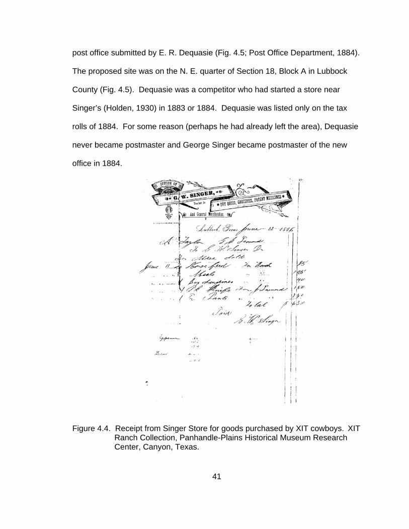
post office submitted by E. R. Dequasie (Fig. 4.5; Post Office Department, 1884).
The proposed site was on the N. E. quarter of Section 18, Block A in Lubbock
County (Fig. 4.5). Dequasie was a competitor who had started a store near
Singer’s (Holden, 1930) in 1883 or 1884. Dequasie was listed only on the tax
rolls of 1884. For some reason (perhaps he had already left the area), Dequasie
never became postmaster and George Singer became postmaster of the new
office in 1884.
Figure 4.4. Receipt from Singer Store for goods purchased by XIT cowboys. XIT Ranch Collection, Panhandle-Plains Historical Museum Research Center, Canyon, Texas.
41
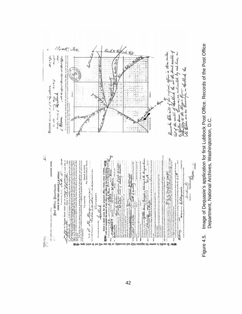
Figu
re 4
.5.
Im
age
of D
equa
sie’
s ap
plic
atio
n fo
r firs
t Lub
bock
Pos
t Offi
ce. R
ecor
ds o
f the
Pos
t Offi
ce
De p
artm
ent,
Nat
iona
l Arc
hive
s, W
ashi
ngto
nton
, D.C
.
42

Additionally, the Singers provided board for travelers, either in the store
building or in their home. Correspondence between George Singer and Hank
Smith in 1887 pertained to charges for board incurred by Smith (Singer, 1887;
Fig. 4.6), probably during his travels as Crosby County Tax Assessor. Smith
sent Singer a check to apply to his account (Smith, 1887).
Figure 4.6. George Singer wrote this letter to Hank Smith asking for payment on his account. Hank Smith Papers, Panhandle-Plains Historical Museum Research Center, Canyon, Texas.
An incident in the Singer Store history may help clarify conflicts of
information. In the fall of 1886, an intruder in the store refused to leave after
Singer confronted him. The two exchanged gunfire and, in the resulting
43
confusion, a fire started in the store. The building and its contents burned to the
ground (Holden, 1932a; Mobley, 1923; Debler, 1959; Singer, 1981).
In April of 1886, George and Rachel Singer each filed a claim on a half
section of survey 12, block A (Fig. 4.7; Texas General Land Office, 1942). After
the original store burned, the Singers constructed a new store on land down draw
with lumber from Colorado City (Connor, 1962a) “…on the west line of survey 12,
block A” (Mobley, 1923). The west line of survey 12, block A crossed
Yellowhouse Draw approximately ¼ mile east of the historic marker (Fig.4.7).
Figure 4.7. Map showing location of Lubbock Lake Landmark relative to first post
office (Historic Marker) and to land claimed by George W. and Rachel Singer. Map prepared by author.
44

Other reports (Mobley, 1923; Holden, 1932a) estimated the second store’s
distance from the original store at ½ mile (Fig. 4.7), near the point where Loop
289 crosses the draw. Either location within the draw would place the site of the
second store within the confines of the National Landmark boundaries. Singer
(1981) described the location of the store on the north side of the draw and both
the house and store as being on level prairie where “… you could take a field
glass and see 30 miles off – if the wind wasn’t blowing any.” Although Singer
(1981) makes no distinction, most likely this statement refers to the second store.
This description would indicate an upland setting for the second store rather than
the draw. The upland area had been modified by the development of the Burl
Huffman Athletic Complex. Modification to the rim in this area included a caliche
quarry and the infilling of the old quarry with debris left by the May 11, 1970
tornado. No accounts addressed whether the house also was moved when the
Singers built the second store. Debler (1959) recalled that after the second store
was moved into Lubbock, it was necessary to cross the draw to get supplies for
home use.
The third store (second in the immediate Lubbock area) remained in its
original location until 1891 when county residents organized the town of Lubbock
and the Singers moved the store to a new location there (fourth store; third in
Lubbock area). The different structures and locations of the store may account
for some of the discrepancies in recollections of it. However, Twitchell’s (Truell,
45

1982) recollection of the store at the confluence of the two draws (in Mackenzie
Park) cannot be reconciled by the historical documents.
Late in 1890, two factions competing to organize a town as the county
seat agreed on a location for the new town of Lubbock (Holden,1932a; Connor
1962b). In January or February of 1891, the Singers moved the store to lot 6,
block 105 of the original town of Lubbock (Mobley, 1923; Fig. 4.8) on Singer
Street. The present address of the location would be 802 Main at the corner of
Main and Buddy Holly Avenue. The Singers remained in Lubbock until 1896
when the family moved to Kansas (Singer, 1981).
Figure 4.8. The Singer Store in the original town of Lubbock was located at the
corner of Singer Street and North First Street (now Buddy Holly Avenue and Main Street). Map by author from copy of original plat of the town of Lubbock.
46

Concluding Statement
The establishment of the Singer Store was coincident with the beginning
of American settlement on the Southern High Plains of Texas and just a few
years prior to the declaration that the American frontier expansion had ended.
Conditions in established centers in the industrial east, the mid-west, the west,
and even abroad in Europe influenced the progression and character of the
Southern High Plains frontier.
The Singers’ arrival in the central Southern High Plains was just the
beginning of regional settlement. The modest little store was a harbinger of the
many changes coming to the plains. The vast herds of buffalo had virtually
disappeared, leaving only a few isolated individuals. Native Americans were
restricted to an occasional brief trip in the region that had once been their hunting
grounds and refuge. Free range ranching had been established, but within a few
years, the rangelands were enclosed with barbed wire. The railroad arrived in
Colorado City in 1881, reducing the distance to supplies, although still more than
100 miles distant. Cowboys working cattle on the Llano Estacado or travelers
passing through found the store stocked with goods from various manufacturing
centers and the post office providing a welcome link to other, settled regions of
the nation.
47

CHAPTER V
ARCHAEOLOGICAL RESEARCH
Archaeological investigation of historic events and processes provides a
means of recovering a singular type of information. Information recovered
through archaeology may be unique from that available in the historic record or
provide confirmation, clarification, or expansion of the historic record. Data
regarding frontier material culture can contribute to understanding limitations of
relative frontier isolation. Artifacts and other information recovered through
archaeology originate in cultural activity, and can provide detailed indications of
that activity (Orser and Fagan, 1995). Additionally, archaeological research and
interpretation can discover populations, activities, or events undocumented in
written history or records.
History regarding the Singer Store and the Southern High Plains frontier in
general is deficient of specific material remains from the period of earliest
American settlement. The special nature of the Lubbock Lake Landmark
presents an exceptional opportunity for archaeological investigation of reports of
the location of the Singer Store. Recovery of 19th century material also
contributes to a richer understanding of early settlement life on the Southern High
Plains.
Since 1936, various research conducted at the Landmark has revealed
over 100 archaeological areas (Johnson, 1983, 1987, 1993, 1995, 2002;
48

Johnson and Holliday, 1989, 2002). These areas comprise a record of cultural
and natural history that covers the last 12,000 years. The remains of 19th and
20th century Anglo-American activity found at the Landmark provide continuity
between the prehistoric archaeological record, historical documentation, and
present day occupation.
Cultural change associated with the late 19th century Anglo-American
frontier is examined in ongoing investigations at the Lubbock Lake Landmark.
The intrusion of the Anglo-American social system, itself an extension of
European society, into the Southern High Plains is reflected in cultural and
environmental changes revealed in the archaeological record. Trade items such
as glass beads in aboriginal contexts (Ladkin, 1995) are the first indication of
change resulting from intercultural contact. Changes in faunal evidence include
the disappearance of bison, their subsequent replacement by domesticated
cattle, and evidence of change in processing methods. Eventually, the
industrialized Anglo-American socio-politico-economic system entirely replaces
the indigenous hunter-gatherer system.
Previous archaeological research conducted in Area 8 at Lubbock Lake
(41LU1) during the 1959-1961 (Kazcor, 1978), 1974 (Sierchula, 1974), and 1977
field seasons (Denton, 1977) have recovered a number of historic artifacts from
substratum 5B. This designation is the uppermost stratigraphic unit of
archaeological sediments at the Lubbock Lake Landmark. Recovered items
include cut nails, can fragments, and empty cartridge casings. While it is
49

possible to attribute the cans and cartridge cases to travelers, buffalo hunters, or
cowboys, the cut nails indicate the remains of some type of structure, perhaps
the Singer Store.
Archaeological investigation focusing on the Singer Store began in the
1996 summer field season at the Landmark and progressed in three stages,
each successive stage building on previous results (Hicks, 2002). During the
1997 summer field season, the crew tested three areas (Figs. 5.1, 5.2) by
conducting limited excavation. Work in 1998 expanded on one of the test
excavations, focusing on the area in which testing revealed the greatest
concentration of artifacts. The objective of the 1998 excavations was to open a
broad horizontal area between test units that yielded 19th century material to
determine the extent of the artifact distribution and facilitate detection of any
significant patterns or features.
1996 Archaeological Survey
The 1996 survey represented preliminary investigation into the reported
late 19th century occupation of the Landmark, that of the Singer Store.
Objectives of the survey were to determine if any material remains from the time
period of the reported historic occupation were present on the surface at the
Landmark, to piece-point plot possible historic artifacts, and to collect appropriate
diagnostic artifacts from the surface.
50

Figure 5.1. Areas of Lubbock Lake Landmark addressed in the Singer Store
research. Map drawn by author.
51

Figure 5.2. Portion of Lubbock Lake Landmark covered in 1996 pedestrian
survey. Map drawn by author.
52
Survey Methodology
Survey methodology was by intensive pedestrian, piece-point-plotted
survey covering an area of approximately 18 hectares (45 acres). The first step
was a 100% pedestrian survey conducted over the southwest quadrant of the
Landmark (Fig. 5.2), the general location of the store as described in some
historic accounts. In addition, survey in Area 8, the area near the
commemorative marker, employed a metal detector to investigate the possibility
of subsurface metal artifacts. The surveys located three areas for further
research. A total of 1,277 items were located and plotted (Fig. 5.3) and 98
artifacts were collected.
Figure 5.3. Distribution of artifacts and remote sensing targets piece-point
plotted during the 1996 field season Singer Store research survey at the Lubbock Lake Landmark. Map drawn by author.
53

The survey was accomplished by personnel walking transects spaced at a
distance no greater than 3m apart. Visibility of the ground surface was limited
due to a high percentage of vegetative cover over much of the area. Therefore,
the crew surveyed the area twice; the first pass oriented E/W and the second
oriented N/S. Survey flags marked appropriate material. Mapping of the flagged
locations utilized a Pentax Total Station oriented to established datum points.
Due to the Landmark not having a Data Collector at this time, coordinate and
elevation information were recorded in the field on Transit Shot Record forms
and later transferred to a computer database.
One documented use of the Landmark during the early to middle 20th
century was for trash disposal. Three historic or modern dump sites with high
concentrations of artifacts were identified (O'Brien, 1995; O’Brien and Hicks,
2002) and a large quantity of historic and modern material is distributed on the
surface in much less dense scatters, especially in the southern third of the
Landmark. For the purposes of the survey, material identified as being of recent
manufacture or non-diagnostic artifacts in clear association with such material
was not marked or plotted. Material with diagnostic attributes that potentially
could be late 19th century historic were assigned field numbers and collected.
Material that did not exhibit diagnostic detail and, therefore, was not conclusively
historic or recent was plotted and only described on the Transit Shot Record
forms.
54

Survey Results
The survey identified potential late 19th century material in three broad
areas (Fig. 5.4; Table 5.1). The northernmost grouping of cans exhibiting
application of lead solder was within 41LU31 on the southernmost rim and in the
valley below this site. These cans were condensed milk cans with a soldered
vent hole on one end, known as “hole-in-top” cans. Rock (1984) noted the cans
were manufactured after 1900 and that evaporated milk was almost exclusively
contained in this type of can. 41LU31 (Figs.5.1, 5.2, 5.4), another southwestern
rim site, contained diagnostic 19th century artifacts, i.e., tin hole-in-cap cans, one
of which (TTU-A85755) was collected for analysis. Another surveyed area
(41LU1 Area 70; Figs 5.1, 5.2, 5.4) contained an unexplained colony of iris
plants.
Figure 5.4. Distribution of diagnostic historic artifacts located during the 1996 field season Singer Store research survey at the Lubbock Lake Landmark. Map drawn by author.
55

Table 5.1. Artifacts recovered from the 1996 survey in the southwestern quadrant of the Lubbock Lake Landmark.
Artifact Site/Area Quantity Clear glass shard 41LU1 Isolated find 16 Clear glass shard 41LU1 Area 28 35 Clear glass shard 41LU1 Area 56 1 Brown glass shard 41LU1 Area 30 9 Milkglass shard 41LU1 Isolated find 1 Aqua glass shard 41LU1 Area 28 2 Purple glass shard 41LU1 Area 72 1 Purple glass shard 41LU31 1 Glass bottle 41LU1 Isolated find 1 Ceramic sherd 41LU3 1 Stoneware sherd 41LU1 Area 28 7 Leather and metal 41LU1 Isolated find 1 Brush 41LU3 1 Metal lid 41LU1 Area 28 2 .22 Cartridge 41LU1 Isolated finds 2 .22 Cartridge 41LU1 Area 28 1 .22 Cartridge 41LU1 Area 30 6 .22 Cartridge 41LU3 1 .22 Cartridge 41LU32 1 12 Gauge shell end 41LU1 Area 30 1 Cartridge 41LU1 Area 30 1 .41 Cartridge 41LU1 Area 28 1 Hole-in-cap can 41LU31 1 Knife (metal and wood) 41LU1 Area 8 1 Biface segment 41LU1 Isolated find 1 Biface segment 41LU32 1 Biface 41LU1 Area 28 1 Total 98
The area with tin cans and the iris colony additionally were significant in
that they are, like the reported location of the Singer home, about 325 yards (ca.
300m) distant from the historic marker commemorating the Singer Store. One of
the Singer children remembered the house being situated about 300 yards west
of the store (Irish, 1959). The metal detector survey of Area 8, the location of the
historic marker, indicated over 600 possible subsurface artifacts.
56

Excavation
Consequent to the results of the 1996 survey, archaeological inquiry
proceeded to phases of subsurface investigation. The 1997 test excavations
were designed to investigate further surface occurrences of 19th century material
(hole-in-cap cans) associated with a mound of accumulated sediment within
41LU31, a ring of introduced iris plants in 41LU1 Area 70, and the numerous
indications of subsurface metal targets in 41LU1 Area 8. In addition to the
survey results, the test excavation areas were given significance by historic
accounts regarding the location of the Singer Store and Singer family home in
the area on the southwest side of the lake. Objectives were to determine if the
surface indications related to subsurface artifact deposits, and, if so, the extent
and nature of the deposits. As possible examples of early settlement activity, the
test locations also held the potential to contribute information to an understanding
of frontier processes at Lubbock Lake Landmark. Results from the test
excavations further refined the focus of the archaeological investigation.
Excavation efforts in 1998 were directed to expanding test excavations in 41LU1
Area 8 that yielded material appropriate to the late 19th century and potentially
supporting the history of the Singer Store. Results from the 1997 and 1998
excavations in 41LU1 Area 8 were combined for purposes of discussion.
57

Excavation Methodology
All 1997 test excavations and 1998 block excavations were conducted by
general Lubbock Lake Landmark excavation methods in 1x1m2 square units
aligned to a pre-existing, Landmark-wide, coordinate grid. Test excavation took
place in 10cm levels within each defined stratigraphic unit. For the 1998 block
excavation, excavation levels were 5cm within the defined stratigraphic units.
Excavation proceeded in 23 1x1m units (Fig. 5.8). All excavation took place
within the uppermost substrata of stratum 5 (5B2 and 5B1; Fig. 5.9). Crew
members recorded individual artifact piece-point plot coordinate and elevation
information on Lubbock Lake Landmark excavation field forms and maps. Matrix
was collected in bags, tagged with appropriate provenience information, and
water screened through nested ¼” and 1/16” wire mesh. Field records were
archived in the Anthropology Division of the Museum of Texas Tech University.
41LU31
Topographically, this site was located on the uplands west of the meander
where the draw turns to the east (Figs. 5.1, 5.2, 5.4). The earliest investigation
undertaken in 41LU31 consisted of survey and testing operations to clear an
area for the construction of a Department of Public Safety radio antenna (Barkes
and Johnson, 1978). The operation identified and mapped two concentrations of
burned caliche designated as features F31-1 and F31-2. Additional work
focused on pedestrian surveys (1981-1982, 1989-1990, 1992, 1993, 1996) and
58

excavation of feature F31-3 (a hearth) in 1993 (Johnson, 1983, 1993, 1995;
Baxevanis, 2002; Lewis et al., 2002). The 1997 excavation was located
approximately 98m northwest of the 1993 excavation and ca. 60m northwest of
the 1978 work.
Test excavations in 1997 focused on a mound of accumulated aeolian
sediments overlying the Blackwater Draw Formation, designated as stratum K.
The 1996 pedestrian survey had located several 19th century hole-in-cap cans
near the mound. Testing took place in four 1x1m units located on the mound of
sediment (Fig. 5.5). The depth of excavation in each unit varied with the position
of each unit on the mound. Excavation in all units ended at an elevation of
98250.0, just below the level of the original surface underlying the mound
deposits. Thirty-four artifacts were mapped-in and recovered from the
excavations (Table 5.2). Two hole-in-cap cans (TTU-A1-75065 and TTU-A1-
75067) were piece-point plotted and recovered from the surface near, but not
within, the excavation area.
Results
In addition to the artifacts, the test excavations uncovered numerous
lengths of mesquite branches. Several of these showed signs of burning, as did
some areas of sediment within unit 1S363W. Another area of metal and glass
fragments barely exposed from beneath another smaller area of aeolian
sediment was observed near the excavations as work was being completed.
59

Figure 5.5. Plan view of excavation units opened during the test excavation at
41LU31. Map drawn by author.
60

Table 5.2. Artifacts recovered from the 1997 test excavation at 41LU31 in the southwestern quadrant of the Lubbock Lake Landmark.
Artifact Quantity Barbed wire 1 Metal can rim fragment 6 Metal can fragment 5 Hole-in-cap can 5 Square can 1 Lead pellet 1 Burned wood 3 Brown glass shard 1 Embossed glass shard 4 Glass shard 1 Wood 1 Unknown wood (possible post) 1 Unknown wood (possible milled lumber) 1 Hearthstone 1 Lithic debris 1 Unknown 1 Total 34
41LU1 Area 70
Topographically, this area is on the outer reaches of the valley margin,
west of the meander where Yellowhouse Draw turns to the east (Figs. 5.1, 5.2,
5.4), just below the rim of the draw. Quarrying of caliche and other destructive
activities have removed much of the original surface and underlying sediments
between Area 70 and the draw axis. Area 70 is the portion of 41LU31 that
extends into the draw and is, therefore, within the boundaries of 41LU1 (Lubbock
Lake) (Johnson, 1995). The area designation is based on the results of several
pedestrian surveys (1981-1982, 1989-1990, 1992, 1993, 1996). Prior to 1997,
61

no excavation or subsurface testing had been conducted in Area 70 (Johnson,
1983; 1995; Lewis et al., 2002).
Test excavations in 1997 were intended to investigate the nature of a ring
of iris plants discovered in the course of the 1996 survey. The iris was not native
to the Landmark and, therefore, was introduced through human activity. An
aerial photograph taken in 1939 showed a residence located across the highway
from this portion of the Landmark (Johnson and Holliday, 1987:5). An alternate
explanation for the appearance of the plants would be that one or more tubers
had been discarded with other trash, possibly from the nearby residence, and
managed to establish a colony of plants. The circular distribution could result
from the outward spread of new shoots and the die-off of older plants in the
central part of the colony (Calkins, 1978). Lawton (1998:175) recommended
dividing iris clumps at least every five years as “the centers of the clumps begin
to be very crowded and the center rhizomes become less and less productive,
with less and less foliage.”
The majority of artifacts observed near the irises were on and just below
the surface and date to the middle 20th century. These artifacts consisted of a
mix of items (e.g., broken window glass, automotive fan belt, brick) that seem to
indicate an isolated dumping incident. Testing was to determine whether the
plants were associated with nearby recent (mid-20th century) material or if any
19th century material could be found.
62

Excavation (Fig. 5.6) was in aeolian sediments overlying the Blackwater
Draw Formation designated as stratum K. One unit (118S251W) dissected the
ring of iris plants; a second unit (120S248W) was set between the ring of iris
plants and a mound of caliche and wood scrap; and the third unit (137S257W)
was set-up over a long mound of sediment that roughly was parallel with the
road.
Figure 5.6. Location of test units opened during the 1997 field season test
excavation at 41LU1 Area 70. Map drawn by Marcus Hamilton from sketch map by author.
63

Test excavations in 41LU1 Area 70 revealed a locally very shallow depth
of sediment without archaeological potential. Excavation in the two southern
units only extended to a depth of 10-15cm before encountering bedrock caliche.
Recent artifacts (such as window glass, a Coke bottle, and an aluminum fork)
were removed from the surface of the units. Charcoal and ash in the root zone
indicated a recent grass fire. The only artifact recovered was a glass fragment
with indeterminate embossing, possibly from a panel bottle, from 118S251W at
an elevation of 98130.5, 0.5cm above closing elevation. Excavation in
137S257W revealed several fragments of modern plastic that indicated the
mound of dirt formed very recently, possibly in conjunction with road or highway
construction. The plastic was not collected for analysis or curation.
Results
No artifacts of early 20th century or 19th century origins were located. It
was concluded from the results of testing that the ring of iris plants was
associated with the scatter of recent trash on the surface and not with any 19th
century occupation or activity.
41LU1 Area 8
Topographically, this area was located in the valley margin near the valley
axis where the draw turns towards the east (Figs. 5.1, 5.2, 5.4). Sediments
64

removed from the valley axis during 1936 dredging activities (Johnson and
Holliday, 1987) were deposited in berms surrounding the area. Previous
excavations resulted in the designation of 15 features, some of which were
associated with Protohistoric period Garza projectile points (Johnson et al.,
1977). The 1959-1961 excavations recovered Historic material such as cut nails,
can fragments, and cartridge cases from the upper-most layers of these
excavations (Kazcor, 1978; Johnson, 1987).
1997 Excavation
Test excavations in 1997 focused on investigating a sample of the
subsurface metal indicated in the 1996 survey. Test units were located
according to the presence and density of subsurface material indicated by the
metal detector. Excavation took place in 10 test units (Fig. 5.7). Five units
(5S1E, 3S3E, 2S4E, 2S10E, 4N3E) were located within 12m of the replica of the
1933 historic marker commemorating the Singer Store; four units (35S10E,
37S0E, 41S1E, 53S8E) were nearer the older excavations (within 35m); and one
unit (27N1E) was 24m north of the historic marker. All excavations were within
5B2 and 5B1, the upper units of stratum 5. Excavation units were closed when
assay with a metal detector indicated no more metal below the surface and no
more glass or coal was being recovered.
65

Figure 5.7. Location of test excavation units opened during the 1997 field
season at 41LU1 Area 8.
66

Three units (5S1E, 3S3E, 4N3E) were not excavated completely in the
1997 season due to time limitations. The last level completed in each of these
units was within a concentration of historic material when closed at the end of the
field season.
The artifact yield of the one extreme northern unit (27N1E) and four
extreme southern units (35S10E, 37S0E, 41S1E, 53S8E) is addressed unit by
unit. The output of the remaining five units is related in conjunction with the
results of the 1998 excavations to preserve continuity of the assemblage in these
units.
For the four southernmost units (Fig. 5.7; Fig. 5.8), a barrel ring (TTU-
A92039) and a fragment from a rectangular, soldered can (TTU-A90520) were
the only undisputedly historic artifacts recovered from undisturbed sediments.
No historic artifacts were recovered from 27N1E. Unit 53S8E was excavated to
a maximum depth of 23cm. No dredge sediments overlaid substratum 5B in this
unit. A total of 31 artifacts were recovered from this unit (Table 5.3).
Unit 41S1E was excavated to a depth of 30cm including 15cm of disturbed
sediment re-deposited from the nearby dredge berms. A total of 24 artifacts
were recovered from this unit (Table 5.4). All glass recovered from this unit was
within re-deposited dredge. The material was not diagnostic but was collected
due to its potential to be historic material (at least 50 years old). No historic
material was encountered in intact substratum 5B deposits in this unit.
67
Figure 5.8. Close-up of plan view of test excavation units opened during the
1997 field season at 41LU1 Area 8. Map drawn by author.
68
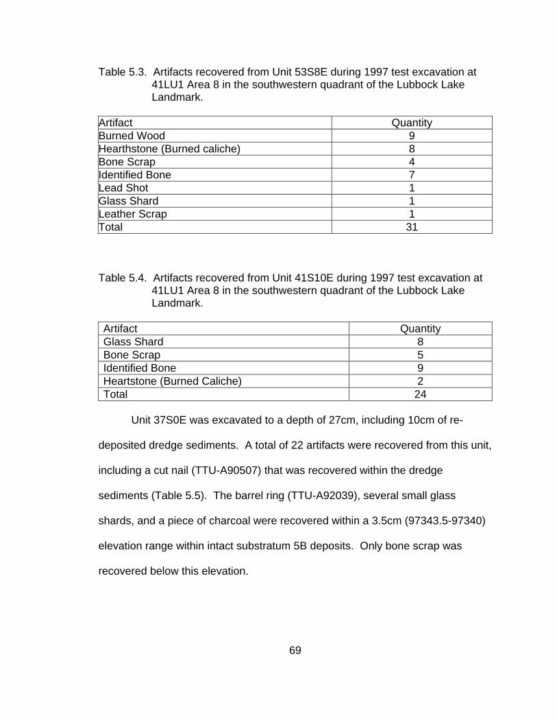
Table 5.3. Artifacts recovered from Unit 53S8E during 1997 test excavation at 41LU1 Area 8 in the southwestern quadrant of the Lubbock Lake Landmark.
Artifact Quantity Burned Wood 9 Hearthstone (Burned caliche) 8 Bone Scrap 4 Identified Bone 7 Lead Shot 1 Glass Shard 1 Leather Scrap 1 Total 31 Table 5.4. Artifacts recovered from Unit 41S10E during 1997 test excavation at
41LU1 Area 8 in the southwestern quadrant of the Lubbock Lake Landmark.
Artifact Quantity Glass Shard 8 Bone Scrap 5 Identified Bone 9 Heartstone (Burned Caliche) 2 Total 24
Unit 37S0E was excavated to a depth of 27cm, including 10cm of re-
deposited dredge sediments. A total of 22 artifacts were recovered from this unit,
including a cut nail (TTU-A90507) that was recovered within the dredge
sediments (Table 5.5). The barrel ring (TTU-A92039), several small glass
shards, and a piece of charcoal were recovered within a 3.5cm (97343.5-97340)
elevation range within intact substratum 5B deposits. Only bone scrap was
recovered below this elevation.
69

Table 5.5. Artifacts recovered from Unit 37S0E during 1997 test excavation at 41LU1 Area 8 in the southwestern quadrant of the Lubbock Lake Landmark.
Artifact Quantity Cut Nail 1 Cartridge 1 Metal Scrap 1 Barrel Ring 1 Glass Shard 5 Bone Scrap 12 Unknown 1 Total 22
. Unit 35S10E was excavated to a depth of 19cm. Re-deposited dredge
sediments were encountered in the uppermost 10cm of this unit. A fragment of a
cinder block was uncovered at a depth of 97330.0, 8cm below the surface. A
total of 25 artifacts were recovered from this unit (Table 5.6). The only historic
artifact recovered from this unit was fragments from a soldered, rectangular can
(TTU-A90520) at 97324.0 in intact substratum 5B sediments.
Table 5.6. Artifacts recovered from Unit 35S10E during 1997 test excavation at 41LU1 Area 8 in the southwestern quadrant of the Lubbock Lake Landmark.
Artifact Quantity Metal Can Fragment 12 Lithic Debris 1 Lithic Flake 2 Hearthstone (Burned Caliche) 1 Identified Bone 2 Bone Scrap 7 Total 25
Unit 27N1E was excavated to a depth of 14.5cm. No re-deposited dredge
sediments were apparent in this unit. The metal indicated in the metal detector
70

survey was revealed to be an aluminum can that was encountered near the
surface in the root zone. A total of 10 artifacts were recovered from this unit
(Table 5.7).
Table 5.7. Artifacts recovered from Unit 27N1E during 1997 test excavation at 41LU1 Area 8 in the southwestern quadrant of the Lubbock Lake Landmark.
Artifact Quantity Lithic Flake 1 Bone Scrap 5 Hearthstone (Burned Caliche) 4 Total 10
Results
Test excavations in 41LU1 Area 8 confirmed that at least some of the
targets indicated in the 1997 subsurface metal detector survey were indeed 19th
century artifacts. Most 19th century historic material was recovered from the five
units located near the historic marker (Figs. 5.7; 5.8). The distribution of the
artifacts was characterized by higher density in the central units near the historic
marker. The concentration of artifacts was defined as Feature FA8-16, a historic
debris scatter.
1998 Excavation
Following results from the 1997 test excavation, Singer Store research
proceeded to focus on 41LU1 Area 8 in conducting more extensive block
71

excavations. Two of the units (3S3E and 5S1E) not excavated completely
through feature FA8-16 during the 1997 field season were re-opened in 1998.
Twenty and one-quarter more units were opened during the 1998 field season
and excavation was incomplete in eight of the units opened in 1998 when the
field season concluded.
Results of testing completed in 1997 determined placement of the
excavation units. The objective of the 1998 excavations was to open a broad
horizontal area between the five units situated near the historic marker to
determine the extent of the historic artifact distribution and facilitate detection of
any significant patterns or features. The five units between 2S4E and 2S10E
(Fig. 5.9) were opened to examine possible changes between artifact densities,
elevations, any changes in sediment characteristics across this distance, and to
delineate the stratigraphic units (Fig. 5.10). Other units were placed adjacent to
units opened in 1997 in an attempt to trace the limits of the artifact concentration.
The five central units opened in 1997 and the 21 additional units opened in 1998
together yielded a total of 4,431 (Table 5.8; Fig. 5.11) artifacts mapped-in and
recovered from the excavations. To simplify discussion of excavation, the units
were grouped and identified by letters A, B, C, and D (Fig. 5.12).
72

Figure 5.9. Location of excavation units opened during the 1997 and 1998 field seasons at 41LU1 Area 8.
73

Figu
re 5
.10.
Pro
file
of th
e no
rth w
all o
f uni
ts 2
S4E
to 2
S10
E d
urin
g th
e 19
98 fi
eld
seas
on b
lock
exc
avat
ion
at
4
1LU
1 A
rea
8. D
raw
n b y
Mar
cus
Ham
ilton
.
74
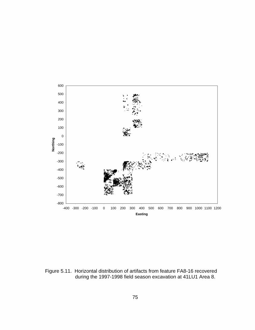
-800
-700
-600
-500
-400
-300
-200
-100
0
100
200
300
400
500
600
-400 -300 -200 -100 0 100 200 300 400 500 600 700 800 900 1000 1100 1200
Easting
Nor
thin
g
Figure 5.11. Horizontal distribution of artifacts from feature FA8-16 recovered during the 1997-1998 field season excavation at 41LU1 Area 8.
75

Figu
re 5
.12.
Det
aile
d lo
catio
n of
exc
avat
ion
units
ope
ned
durin
g th
e 19
97 a
nd19
98 fi
eld
seas
ons
at 4
1LU
1 A
rea
8.
76

Group A was a block of eight units (4S0E, 4S1E, 4S2E, 5S0E, 5S1E,
5S2E, 6S0E, and 6S2E) returning 2,444 artifacts (Table 5.8). Central to the
block was the unit 5S1E that was opened but not completed in 1997. Unit 5S1E
was the unit with the greatest artifact density of those excavated in 1997. Depth
below the surface to the historic debris ranged from 16cm in 4S0E and 5S0E on
the western side of the block to only 3cm in the eastern unit 5S2E. Units 6S0E,
6S2E, 5S1E, 5S2E, and 4S2E were excavated through the feature. In three
units (4S0E, 5S0E, and 4S1E), a very subtle change in sediment texture was
detected in the northwest portion of the units, with the break between textures
forming a straight line running southwest to northeast in 5S0E and 4S1E. In
5S0E and 4S1E, from the point at which this change was detected, only the
anomalous area was excavated. A distinct break between different sediment
textures was not as clearly apparent in 4S0E and the area of the whole unit was
excavated. However, the same line bordering the anomalous sediments in 5S0E
and 4S1E is visible in artifact distribution in 4S0E (Fig. 5.13).
77

Table 5.8. Artifacts recovered from 1998 block excavation at 41LU1 Area 8 in the southwestern quadrant of the Lubbock Lake Landmark.
Artifact Unit
Group AUnit
Group BUnit
Group C Unit
Group D Other Total Cut Nail and Nail fragments 316 125 100 11 1 553 Porcelain Doorknob fragments 3 3 Barb 2 5 7 Staple 15 5 20 Wire 13 5 3 21 Cartridge 64 19 11 1 95 Bullet 2 2 Percussion Cap 3 3 Funnel 1 1 Ball 1 1 1 3 Brass Paper Brad 1 1 Brass Straight Pin 55 9 64 Metal Button 37 30 2 69 Glass Button Brass Shoe Nail 24 3 1 28 Barrel Ring 1 1 Shield Nickel 1 1 Rubber Comb Tooth 1 2 3 Hairpin 1 1 Chain 1 1 Pen Nib 4 1 5 Slate Pencil 9 7 1 17 Cast Iron 1 1 1 3 Bolt with Nut 1 1 Ceramic, Stoneware 36 2 38 Ceramic, Whiteware 1 1 Spoon Bowl 1 1 Handle 2 1 3 Horseshoe 1 1 Horseshoe Nail 2 6 8 Buckle 1 1 2 Ring 1 1 2 Rivet 7 2 5 14 Rivet Burr 3 4 7 Glass Shard 750 149 181 40 12 1132 Can Fragments 102 15 17 29 1 164 Metal Scrap 359 254 76 90 1 780 Petrified Wood 1 1 Rim 1 1
78

Table 5.8. Continued.
Artifact Unit
Group AUnit
Group BUnit
Group C Unit
Group D Other Total Screw 5 5 Spring 2 2 Tack 15 4 2 21 Seed 151 151 Leather Scrap 1 1 Unknown 7 4 2 1 14 Unknown Metal 8 3 11 Unknown Brass 6 1 7 Unknown Cast Iron 6 2 1 9 Unknown Iron 2 1 3 Unknown Tin 3 3 Unknown Rubber 8 1 9 Wire Nail 1 1 Coal 142 45 14 201 Hematite 3 3 Caliche 4 1 2 7 Wood 1 1 2 Burned Wood 1 4 3 5 Hearthstone 188 88 72 3 15 366 Charcoal 27 2 40 69 Fire-Cracked Rock 1 1 Lithic Flake 4 6 3 13 Lithic Debris 3 3 1 7 Identified Bone 65 32 7 8 112 Bone Scrap 127 178 13 1 26 345 Total 2444 1160 577 174 76 4431
79

-700
-600
-500
-400
0 100 200 300
Easting
Nor
thin
g
Figure 5.13. Close up view of artifact distribution in group A showing artifact
concentration in the area of anomalous sediment in units 4S0E, 5S0E, and 4S1E.
Units in group B (Fig. 5.12; 3S2E, 3S3E, 3S4E, 2S4E, 2S5E, 2S6E, 2S7E,
2S8E, 2S9E, and 2S10E) provided a view of the material as it extends to the
east. These 10 units yielded a total of 1,160 artifacts in 1997 and 1998 (Table
5.8). The block included three units opened in 1997: 3S3E, 2S4E, and 2S10E.
Excavation in 3S3E was not completed in 1997 and this unit was re-opened in
1998. Unit 3S4E was opened in 1998 because it was adjacent to 2S4E where
one of the artifacts recovered in 1997 was a large cast iron fragment. Units
2S5E, 2S6E, 2S7E, 2S8E, and 2S9E connected two units excavated in 1997,
80

2S4E and 2S10E, resulting in a shallow trench. Of this unit group, only unit
3S2E, opened late in the season, was not excavated through the historic debris
feature. Although containing more excavated units, artifact density in Unit group
B was much lower than in group A units. Historic artifacts were encountered at
10-15cm below the surface. Large caliche cobbles were recovered from 3S3E in
1997. The material also followed a gradual slope downwards to the east in the
direction of the valley axis.
Group C consisted of seven units (Fig. 5.12). Six (4N2E, 3N2E, 3N3E,
2N3E, 1N3E, and 0N2E) units were opened in 1998 adjacent to 4N3E, a unit
opened but not completed in 1997. Units 2N3E, 1N3E, and 0N2E were placed to
begin a link between the southernmost and northernmost units. Unit 4N3E was
not opened for excavation in 1998 and only unit 1N3E was excavated completely
through the feature. A well-defined concentration of large segments of charcoal
was uncovered in the southern portion of 3N3E. Unit 2N3E was opened to follow
the limits of the concentration (Fig. 5.14). Only the northwest quadrant of unit
2N3E was excavated. However, the full extent of the concentration was not
evident by the end of the field season and the unit was closed. Another
concentration of charcoal was uncovered in 0N2E. These concentrations were
exposed near the end of the field season and, due to time constraints, excavation
in these units was halted to avoid exposing more charcoal. The objective was to
expose each concentration as a whole rather than collect the charcoal in a piece-
meal fashion.
81

Figure 5.14. Close-up of charcoal concentration in the northwest quadrant of unit 2N3E.
82

Historic material occurring with the charcoal concentrations included glass
shards and metal scraps in 0N2E and glass, metal, and cut nails in 2N3E.
Assessment of artifact density in this block of units was limited by the fact that
excavation of the historic debris was complete in only one unit. The seven units
produced 577 artifacts in 1997 and 1998 (Table 5.8). The historic artifacts were
encountered below the surface at depths ranging from 2 to 11.5cm.
Only one unit comprised group D (Fig. 5.12). Unit 3S2W was opened to
test the extent of the artifact concentration to the west. Results from the 1997
test excavations led to speculation that artifact density and size might increase to
the west. This unit was located on the berm of dredged sediments. These
sediments were removed by shovel scraping and the matrix was dry screened
through ¼” mesh. The dredge sediments displayed a mix of various strata from
the valley axis. Because some of these sediments had been pressed down into
the 1936 surface, it was difficult to identify a clear contact between the dredge
and the pre-1936 surface. A concentration of glass, metal, and burned caliche
was uncovered near the same level (97304.5) where clearly undisturbed deposits
were encountered. A total of 159 artifacts were removed before the unit was
closed due to time limitations that precluded complete excavation of the unit
through substratum 5B (Table 5.8).
Although not excavated completely in every unit, the historic debris scatter
(FA8-16) generally sloped from west to east following the topography of the
valley margin (Fig.5.15). Top elevations of the excavated feature ranged from
83

97339.0 to 97312.5 and ending elevations (where the feature was excavated
completely) ranged from 97320.0 to 97308.0. The artifact scatter was much
denser and the feature, as revealed to date, was thicker in its (known) western
limits (Fig. 5.10). Beginning elevations of the feature in each unit were based on
the elevation of the first 19th century artifact encountered in that unit, usually a cut
nail. In many units, metal scraps, probably the remains of cans, were
encountered just above the feature. However, these scraps did not have
diagnostic attributes and could not be dated. They were not taken as the
beginning of the 19th century historic debris feature. All the historic material was
included in one feature as no distinct areas of differential behavior or events have
yet been identified. Artifacts were not distributed evenly across the site.
97260
97320
97380
-300 -200 -100 0 100 200 300 400 500 600 700 800 900 1000 1100
Easting
Ele
vatio
n
Figure 5.15. Vertical distribution of artifacts recovered from FA8-16 (historic
debris scatter) during the 1998 field season block excavation at 41LU1 Area 8. Scale is not proportional.
84
Results
The Area 8 1998 excavations succeeded in opening a larger horizontal
area. A difference in artifact density was becoming apparent, but the limits of
artifact concentrations still are unknown. Some identifiable areas of activity may
be indicated by the concentrations of charcoal in unit group C and in the area of
anomalous sediments in unit group A. Based on field observations, it seemed
that the concentrations might have resulted from the material being moved
around when the artifacts still were exposed on the surface. The artifacts in
3S2W, the westernmost unit, indicated that the historic debris feature continues
to the west. However, more extensive excavations will be necessary to define
further the historic feature or features in this part of Area 8 and to gain a more
complete picture of the historic occupation.
Concluding Statement
The archaeological research program into historic accounts reporting the
location of the Singer Store at the Lubbock Lake Landmark progressed through
three stages, each subsequent stage building on positive results from the
previous year. Each stage succeeded in locating 19th century material confirming
the area as a locus of late 19th century activities. Excavations in Area 8
uncovered extensive concentrations of material relating to specific types of
activities significant to development of the frontier and to Singer Store history.
Beyond discovery of 19th century material, excavations in 41LU1 Area 8 revealed
85

within the broader limits of FA8-16, localized indications of specific events or
behavior represented by the areas of anomalous sediment and extensive
charcoal concentrations.
86
CHAPTER VI
ARTIFACT ANALYSIS
Analysis of artifacts recovered through the archaeological aspect of the
Singer Store research provides information critical to determining whether or not
the store stood somewhere on the southwestern portion of the Lubbock Lake
Landmark. Identification of artifacts assists in identifying behavior occurring at
the site, provides temporal information, and sheds light on the nature of the 19th
century U. S. frontier as it developed on the Southern High Plains of Texas.
The initial 1996 survey resulted in the collection of 98 artifacts (Table 5.1).
Test excavations in 1997 yielded 34 artifacts collected in 41LU31 (Table 5.2) and
only one artifact collected in 41LU1 Area 70. The majority (4,468) of artifacts in
the analysis came from excavations in Area 8 during the 1997 (Tables 5.3, 5.4,
5.5, 5.6, and 5.7) and 1998 field seasons (Table 5.8). The analysis did not
address aboriginal lithic artifacts or hearthstones.
Glass
Glass shards are common among the recovered artifacts with a total of
1218 shards collected during all phases of the archaeological research.
Information potentially obtainable from archaeological glass includes
manufacture date, type of products used, trade, and socio-economic class.
87

Attributes can include type of vessel, maker’s marks, and details relating to
manufacture technology such as mold seams and color.
Vessel Glass
Two jar bases of aqua glass (TTU-A85739 and TTU-A85741) recovered
during survey bore maker’s marks that were used from 1924 to 1954 (Toulouse,
1971). Survey also recovered a bottle (TTU-A85748) manufactured in the period
from 1947 to at least 1971 (Toulouse, 1971). No glass shards with identifiable
maker’s marks were recovered from test or block excavation. Three shards
(TTU-A93111, TTU-A93112, and TTU-A93113; Fig. 6.1.) recovered from unit
4S2E in 41LU1 Area 8 appeared to be the remnants of a portion of a panel bottle
that was further broken in-situ. No embossing or other markings were
discernible.
Figure 6.1. Segments of a panel bottle (TTU-A93111, TTU-A93112, TTU-
A93113, TTU-A93114, TTU-A93115) further broken in situ recovered from 1998 block excavation at 41LU1 Area 8 in the southwestern quadrant of the Lubbock Lake Landmark.
88

Two shards (TTU-A85751 and TTU-A1-76504) recovered during survey
(Fig. 5.4) were of purple, manganese-decolorized glass. One of the purple or
amethyst shards (TTU-A85751) was a base, probably from a canning jar. The
remaining shard (TTU-A1-76504) was recovered from 41LU31. From about
1880 to 1914, manufacturers added manganese to glass to counter the natural
aqua color resulting from iron oxides in the raw material. Over time, the
manganese in the glass exposed to sunlight reacted with the ultra-violet
frequencies to produce purple or amethyst colored glass (Kendrick, 1971). No
purple glass was recovered through test or block excavation. This situation did
not preclude the presence of manganese de-colorized glass in the excavated
assemblage but more likely is due to lack of ultra-violet exposure to the
subsurface glass shards.
A total of 17 shards with fragments of embossed letters or decorations
were collected during the 1996 survey. No fragments were sufficiently complete
to enable identification of the design or lettering. One glass shard collected from
excavation in 41LU31 was embossed. Two shards collected from excavation in
41LU1 Area 8 show evidence of embossing. The design or letters on TTU-
A94819 could not be identified. The letter “S” was visible on TTU-A94832. Both
shards were recovered from 6S2E in Unit Group A. Use of embossed letters on
glass was most prevalent during the period of 1860 to 1900 when they were
often labels on patent medicine bottles (Sellari and Sellari, 1989).
89

Although embossed lettering is not the dominant form of labeling, bottles
made even today can incorporate embossed elements such as logos, labels, or
other text. Because the practice of embellishing glass bottles with embossments
has been used over a long period of time, the mere presence of embossing on
small glass shards does not constitute a firm criterion for dating.
Window Glass
A quantity of glass shards (104) possessing the characteristics of window
glass come from excavation of FA8-16. Moir and Green (1988) note that window
glass can be distinguished from vessel glass by a number of characteristics.
Window glass exhibits flatness that varies from container shards. A
consequence of blown-glass manufacture of flat panel bottles is a characteristic
thicker glass in the center of the panel with thinner glass at the edges. The inner
surface of the panel, therefore, is curved and this unevenness is apparent in the
way the surface reflects light. Shards from flat panel bottles display this
unevenness and can be identified by the way light slides across the curved
surface. Truly flat glass like window glass produces a sharp reflection.
Additionally, much of container glass is clear while window glass exhibits a blue-
green, green, or gray-green tint.
Historical archaeological studies of window glass indicate glass thickness
increased during the 19th century. Complex statistical analysis has not been
attempted on the glass assemblage from 41LU1 Area 8. However, the predictive
90
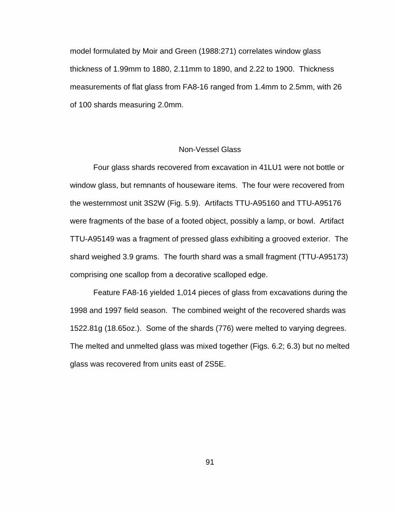
model formulated by Moir and Green (1988:271) correlates window glass
thickness of 1.99mm to 1880, 2.11mm to 1890, and 2.22 to 1900. Thickness
measurements of flat glass from FA8-16 ranged from 1.4mm to 2.5mm, with 26
of 100 shards measuring 2.0mm.
Non-Vessel Glass
Four glass shards recovered from excavation in 41LU1 were not bottle or
window glass, but remnants of houseware items. The four were recovered from
the westernmost unit 3S2W (Fig. 5.9). Artifacts TTU-A95160 and TTU-A95176
were fragments of the base of a footed object, possibly a lamp, or bowl. Artifact
TTU-A95149 was a fragment of pressed glass exhibiting a grooved exterior. The
shard weighed 3.9 grams. The fourth shard was a small fragment (TTU-A95173)
comprising one scallop from a decorative scalloped edge.
Feature FA8-16 yielded 1,014 pieces of glass from excavations during the
1998 and 1997 field season. The combined weight of the recovered shards was
1522.81g (18.65oz.). Some of the shards (776) were melted to varying degrees.
The melted and unmelted glass was mixed together (Figs. 6.2; 6.3) but no melted
glass was recovered from units east of 2S5E.
91
-700
-600
-500
-400
-300
-200
-100
0
100
200
300
400
500
600
-400 -300 -200 -100 0 100 200 300 400 500 600 700 800 900 1000 1100Easting
Nor
thin
g
Figure 6.2. Distribution of melted glass shards recovered from 1997 and 1998
excavations at 41LU1 Area 8 in the southwestern quadrant of the Lubbock Lake Landmark.
92

-700
-600
-500
-400
-300
-200
-100
0
100
200
300
400
500
600
-400 -300 -200 -100 0 100 200 300 400 500 600 700 800 900 1000 1100
Easting
Nor
thin
g
Figure 6.3. Distribution of unmelted glass shards recovered from 1997 and 1998
excavations at 41LU1 Area 8 in the southwestern quadrant of the Lubbock Lake Landmark.
93

Ceramic
Like glass, ceramic shards are often the remnants of some type of vessel.
Possible diagnostic attributes include ceramic type (pottery, earthenware, refined
earthenware, stoneware, or porcelain), maker’s mark, and type of decoration.
Two ceramic sherds were recovered from the surface during the survey.
Neither sherd possessed readily datable attributes. No ceramic artifacts were
recovered from test excavation in 41LU1 Area 70 or 41LU31. Thirty-nine
ceramic sherds were recovered from excavations in 41LU1 Area 8 (Fig. 6.4).
Three sherds (TTU-93716, TTU-A 94161, TTU-A95722) represent the remnants
of a white, soft-paste porcelain doorknob (Fig. 6.5).
-700
-600
-500
-400
-300
-200
-100
0
100
200
300
400
500
600
-400 -300 -200 -100 0 100 200 300 400 500 600 700 800 900 1000 1100
Easting
Nor
thin
g
Figure 6.4. Distribution of ceramic sherds recovered from 1997 and 1998
excavations at 41LU1 Area 8 in the southwestern quadrant of the Lubbock Lake Landmark.
94

Figure 6.5. Two segments of a porcelain doorknob (TTU-93716, TTU-A 94161) recovered from 1998 block excavation at 41LU1 Area 8 in the southwestern quadrant of Lubbock Lake Landmark.
Twenty-three sherds of stoneware were recovered. One sherd (TTU-
A73384; Fig. 6.6) from the body of a bottle bears the remnants of a maker’s
mark, too fragmentary to allow for identification. Twenty sherds are of a tan-
colored body. Twelve of these have a dark, brownish, exterior glaze. One of
these sherds (TTU-A94044) is a fragment from the area of a bottle where the
neck and shoulder join. Four more sherds are glazed in gray, one of which may
be from the base of a bottle. Two are of a tan body with an indeterminate glaze,
and two others exhibit a clearish glaze with dark speckles. Two of the sherds are
of a gray body and indeterminate glaze. Ceramic bottles have been used to hold
a variety of substances, including beer and wine. Generally, use of stoneware
for beer bottles had declined by the 1900 (Corran, 1975).
95
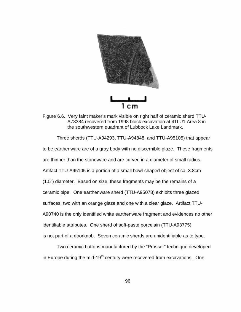
Figure 6.6. Very faint maker’s mark visible on right half of ceramic sherd TTU-
A73384 recovered from 1998 block excavation at 41LU1 Area 8 in the southwestern quadrant of Lubbock Lake Landmark.
Three sherds (TTU-A94293, TTU-A94848, and TTU-A95105) that appear
to be earthenware are of a gray body with no discernible glaze. These fragments
are thinner than the stoneware and are curved in a diameter of small radius.
Artifact TTU-A95105 is a portion of a small bowl-shaped object of ca. 3.8cm
(1.5”) diameter. Based on size, these fragments may be the remains of a
ceramic pipe. One earthenware sherd (TTU-A95078) exhibits three glazed
surfaces; two with an orange glaze and one with a clear glaze. Artifact TTU-
A90740 is the only identified white earthenware fragment and evidences no other
identifiable attributes. One sherd of soft-paste porcelain (TTU-A93775)
is not part of a doorknob. Seven ceramic sherds are unidentifiable as to type.
Two ceramic buttons manufactured by the “Prosser” technique developed
in Europe during the mid-19th century were recovered from excavations. One
96
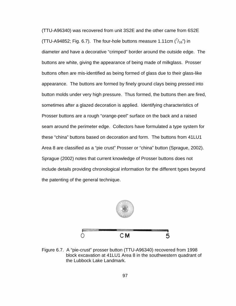
(TTU-A96340) was recovered from unit 3S2E and the other came from 6S2E
(TTU-A94852; Fig. 6.7). The four-hole buttons measure 1.11cm (7/16”) in
diameter and have a decorative “crimped” border around the outside edge. The
buttons are white, giving the appearance of being made of milkglass. Prosser
buttons often are mis-identified as being formed of glass due to their glass-like
appearance. The buttons are formed by finely ground clays being pressed into
button molds under very high pressure. Thus formed, the buttons then are fired,
sometimes after a glazed decoration is applied. Identifying characteristics of
Prosser buttons are a rough “orange-peel” surface on the back and a raised
seam around the perimeter edge. Collectors have formulated a type system for
these “china” buttons based on decoration and form. The buttons from 41LU1
Area 8 are classified as a “pie crust” Prosser or “china” button (Sprague, 2002).
Sprague (2002) notes that current knowledge of Prosser buttons does not
include details providing chronological information for the different types beyond
the patenting of the general technique.
Figure 6.7. A “pie-crust” prosser button (TTU-A96340) recovered from 1998 block excavation at 41LU1 Area 8 in the southwestern quadrant of the Lubbock Lake Landmark.
97
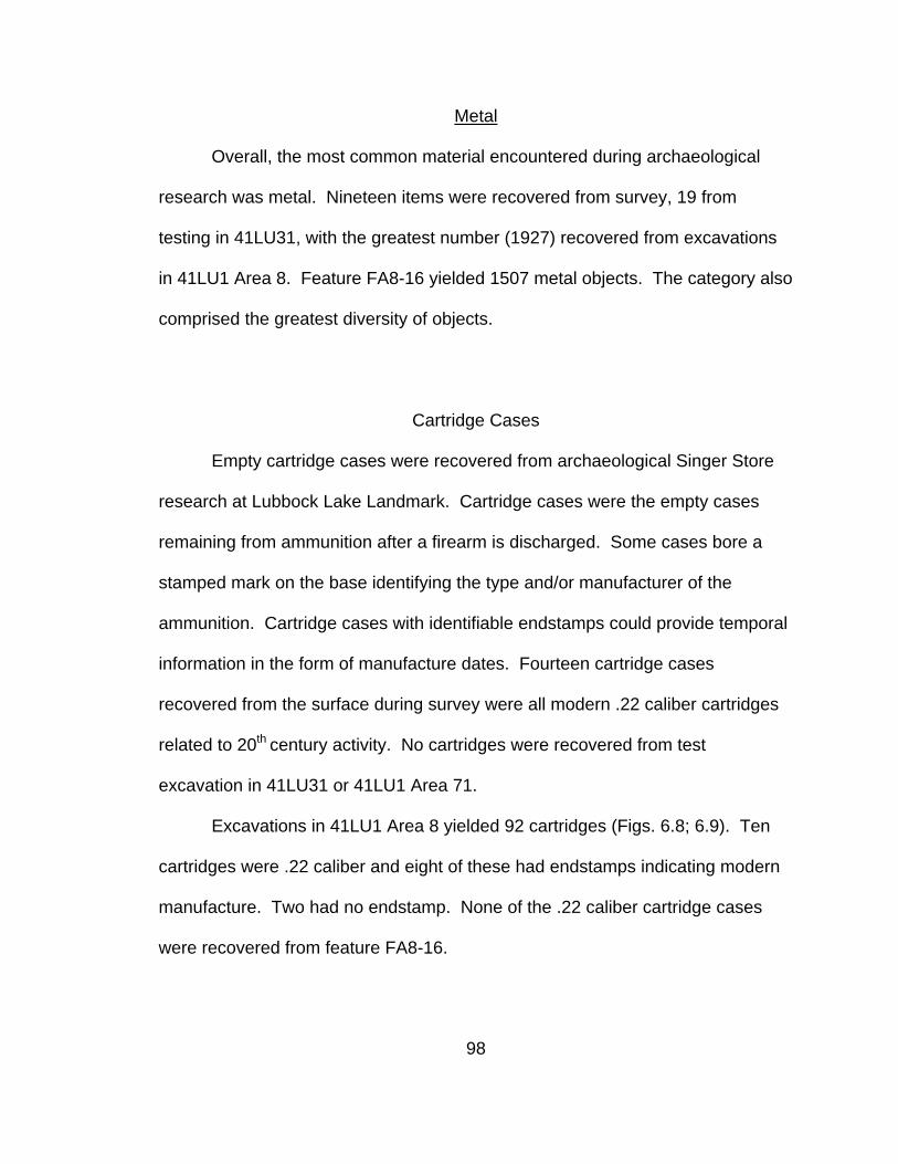
Metal
Overall, the most common material encountered during archaeological
research was metal. Nineteen items were recovered from survey, 19 from
testing in 41LU31, with the greatest number (1927) recovered from excavations
in 41LU1 Area 8. Feature FA8-16 yielded 1507 metal objects. The category also
comprised the greatest diversity of objects.
Cartridge Cases
Empty cartridge cases were recovered from archaeological Singer Store
research at Lubbock Lake Landmark. Cartridge cases were the empty cases
remaining from ammunition after a firearm is discharged. Some cases bore a
stamped mark on the base identifying the type and/or manufacturer of the
ammunition. Cartridge cases with identifiable endstamps could provide temporal
information in the form of manufacture dates. Fourteen cartridge cases
recovered from the surface during survey were all modern .22 caliber cartridges
related to 20th century activity. No cartridges were recovered from test
excavation in 41LU31 or 41LU1 Area 71.
Excavations in 41LU1 Area 8 yielded 92 cartridges (Figs. 6.8; 6.9). Ten
cartridges were .22 caliber and eight of these had endstamps indicating modern
manufacture. Two had no endstamp. None of the .22 caliber cartridge cases
were recovered from feature FA8-16.
98

Figu
re 6
.8.
Car
tridg
e ca
sing
s (T
TU-A
9064
6, T
TU-A
9591
1, T
TU-A
9594
1, T
TU-A
7349
5, T
TU-A
9479
9) re
cove
red
1998
blo
ck e
xcav
atio
n at
41L
U1
Are
a 8
in th
e so
uthw
este
rn q
uadr
ant o
f the
Lub
bock
Lak
e La
ndm
ark.
.
99

-700
-600
-500
-400
-300
-200
-100
0
100
200
300
400
500
600
-400 -300 -200 -100 0 100 200 300 400 500 600 700 800 900 1000 1100Easting
Nor
thin
g
igure 6.9. Distribution of cartridges recovered from central units of 1997 and 1998 excavations at 41LU1 Area 8 in the southwestern quadrant of the Lubbock Lake Landmark.
F
100
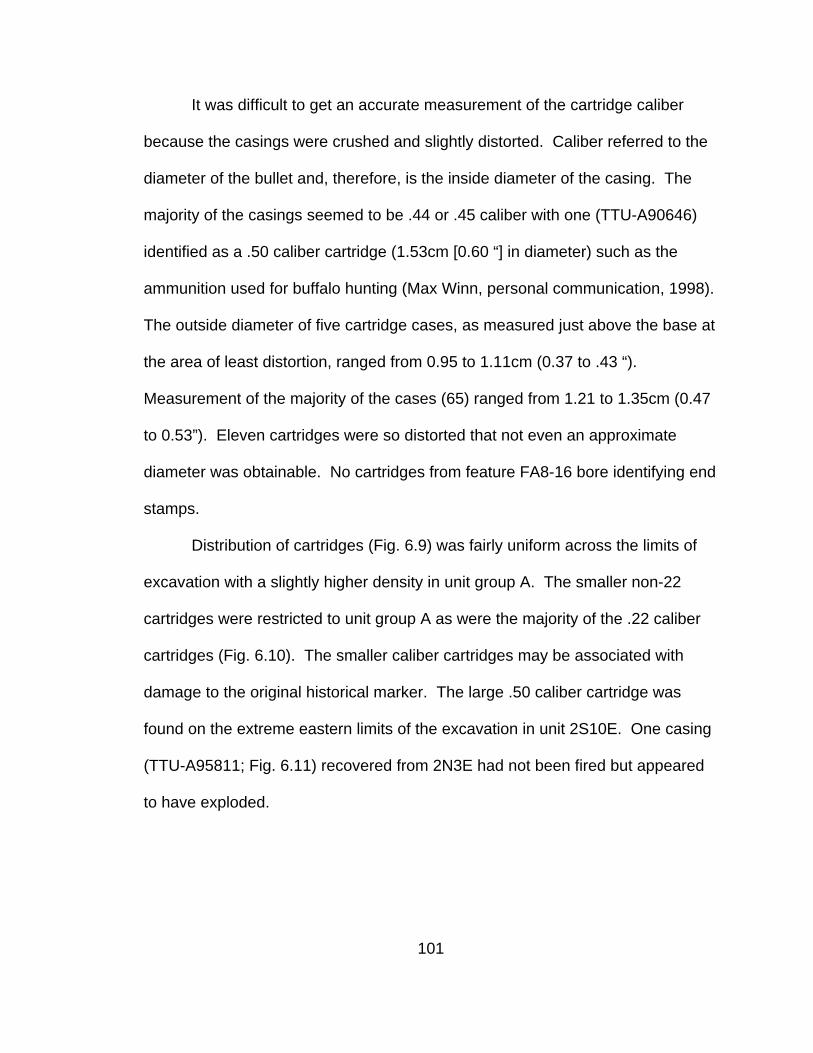
It was difficult to get an accurate measurement of the cartridge caliber
because the casings were crushed and slightly distorted. Caliber referred to the
diameter of the bullet and, therefore, is the inside diameter of the casing. The
majority of the casings seemed to be .44 or .45 caliber with one (TTU-A90646)
identified as a .50 caliber cartridge (1.53cm [0.60 “] in diameter) such as the
ammunition used for buffalo hunting (Max Winn, personal communication, 1998).
The outside diameter of five cartridge cases, as measured just above the base at
the area of least distortion, ranged from 0.95 to 1.11cm (0.37 to .43 “).
Measurement of the majority of the cases (65) ranged from 1.21 to 1.35cm (0.47
to 0.53”). Eleven cartridges were so distorted that not even an approximate
diameter was obtainable. No cartridges from feature FA8-16 bore identifying end
stamps.
Distribution of cartridges (Fig. 6.9) was fairly uniform across the limits of
excavation with a slightly higher density in unit group A. The smaller non-22
cartridges were restricted to unit group A as were the majority of the .22 caliber
cartridges (Fig. 6.10). The smaller caliber cartridges may be associated with
damage to the original historical marker. The large .50 caliber cartridge was
found on the extreme eastern limits of the excavation in unit 2S10E. One casing
(TTU-A95811; Fig. 6.11) recovered from 2N3E had not been fired but appeared
to have exploded.
101

-700
-600
-500
-400
-300
-200
-100
0
100
200
300
400
500
600
-400 -300 -200 -100 0 100 200 300 400 500 600 700 800 900 1000 1100
Easting
Nor
thin
g
.22 Caliber
.38 or .44 Caliber
.44 or .45 Caliber
.50 CaliberUnknow n Caliber
Figure 6.10. Distribution by caliber of cartridge casings recovered from 1997 and
1998 excavation at 41LU1 Area 8 in the southwestern quadrant of the Lubbock Lake Landmark.
102

Figure 6.11. Remains of burned ammunition recovered from 1998 block
excavation at 41LU1 Area 8 in the southwestern quadrant of the Lubbock Lake Landmark: (a) melted lead bullet (TTU-A95064) recovered from 1N3E; (b) melted and deformed cartridge case (TTU-A95811) with intact primer recovered from 2N3E.
Cans
One hole-in-cap can was recovered from surface survey of 41LU1 Area 8
(Fig. 6.12). Test excavations in 41LU31 recovered 11 metal scraps identified as
segments of hole-in-cap or rectangular, lead-soldered cans. Five hole-in-cap
cans were recovered from excavations or from the surface near excavations.
One rectangular “sardine” can with soldered seams was recovered from
excavations. During excavations in 41LU1 Area 8, 174 metal scraps identifiable
as can fragments were recovered. The fragments represented approximately 22
cans. Of the 22 occurrences of can fragments, 14 were recovered from feature
FA8-16, one (comprised of 29 fragments) was recovered from dredge sediments
in unit 3S2W, and one rectangular can was recovered from test unit 35S10E.
103

Due to its distance from the main concentration of artifacts, this latter can was
not considered to be a part of feature FA8-16, although it may be related to the
activity that formed the feature.
Figure 6.12. Hole-in-cap can (TTU-A85755) recovered during the 1996 survey of
the southwestern quadrant of the Lubbock Lake Landmark.
Artifact TTU-A73357, recovered from 3N3E, was from the L-shaped edge
of the top or bottom of a hole-in-cap or rectangular can. Artifact TTU-A90774
recovered from 4N3E was a fragment from a rectangular “sardine” can. Artifact
TTU-A90779 from 4N3E was the top and side portion of a can with evidence of
the top having been cut in an “X” in order to access the contents. Artifact TTU-
A93084 was a fragment of the cap part of a hole-in-cap can recovered from unit
3N3E. Artifact TTU-A93970 was a fragment of the top of a hole-in-cap can from
4S1E.
104

Tin containers were first made in England early in the 19th century (Rock,
1984). Hole-in-cap cans with machine soldering recovered on the Lubbock Lake
Landmark were diagnostic of a period from 1880 to ca. 1900. The walls of the
cans were formed when a rectangle of tin was rolled into a cylinder and the seam
secured with lead solder. The ends of the cans began as disks of tin pressed
into a cap-shape by machine. The two caps were placed over the ends of the
cylinder and soldered into place. One end cap was formed with a hole of about
2.5cm (1”) diameter in the center. The hole allowed for the placement of the food
into the can. After being filled, the opening was covered with a small flat disk that
was secured with solder. A vent hole in the center of this disk was left open until
after processing to allow steam to escape. After processing, the vent hole was
sealed with solder and the canning process was complete.
The earliest hole-in-cap cans were soldered by hand leaving rough
irregular seams. Manufacture of cans with machine-applied lead solder on
seams began in 1883. The sanitary can, formed with double-folded seams like
modern cans, gradually replaced hole-in-cap cans by the early 20th century
(Cobb, 1914; Berryman, 1983; Rock, 1984).
The rectangular “sardine” cans demonstrated similar construction in the
formation of the body, top, and bottom with L-shaped edges that overlapped the
sides, and lead solder sealing seams. After 1880, the sides and bottoms of
rectangular cans were formed from one piece of tin with only the top being a
separate addition. Manufacturing innovations were able to improve processing
105

by eliminating the need for venting by producing cans with a depressed top after
1884 (Fontana and Greenleaf, 1962). Designers first attempted to provide for
opening the cans with a strip-type opener in 1865 (Rock, 1984). It was not until
1895 that the familiar key and strip opener finally came into being (Fontana and
Greenleaf, 1962).
Nails
Nails were recovered only from excavations in 41LU1 Area 8. The
majority of nails recovered were cut nails (Fig. 6.13). Other nail types found
included horseshoe nails and brass nails used in shoe construction. Only two
wire nails were recovered.
Cut Nails
Hand-wrought nails were made for centuries, but late in the 18th century,
nail cutting machines were developed to produce cut square nails that
reduced the hand-work required to make nails. Additional technological
innovations continued to refine both the material and method of cut nail
production. Identification of these innovations provided a means for dating nails
produced between the late 18th century and ca. 1880.
106

-700
-600
-500
-400
-300
-200
-100
0
100
200
300
400
500
600
-400 -300 -200 -100 0 100 200 300 400 500 600 700 800 900 1000 1100 1200
Easting
Nor
thin
g
Figure 6.13. Diagram showing horizontal distribution of all whole and
fragmentary cut nails recovered from 1997 and 1998 excavations at 41LU1 Area 8 in the Southwestern quadrant of the Lubbock Lake Landmark.
107

Whole cut nails recovered from 41LU1 Area 8 have sharply squared
points while those that are highly corroded demonstrated splitting and breakage
along a lengthwise grain. Cut nails made of steel date to post-1885 and do not
exhibit a grain (Edwards and Wells, 1993). The recovered nails, then, were
manufactured after 1830 but before the middle 1880s.
One hundred ninety-seven nails were whole and could be classified by
type and size (Fig. 6.14). Different size and type nails had different applications.
According to the Tremont Nail Catalog (1983), common nails were used for
framing. Box nails were described as similar to, but lighter than, a common nail
and also used for framing. Finish nails were used for furniture or cabinet work,
casings, or counter tops. The larger common nails were used for framing
(Fontana and Greenleaf, 1962; Tremont Nail Catalog, 1983) while smaller sizes
held sheathing and siding. While 6d and 8d common nails were used in
construction of crates, 8d probably could be used for framing as well. The
largest common nails (10d and over) held door hinges and gates. Finish nails of
different sizes were used in applying interior finish work such as window and
door facings.
108

0
5
10
15
20
25
30
35
40
45
50
2d
2d/3
d 3d 4d 5d
>10d 10d 2d 3d
3d/4
d 4d 5d 6d 7d 8d 9d
3d 3d 4d 5d
Box Common Commonor box
Finish
Figure 6.14. Type and size of whole nails recovered from 1997 and 1998
excavations at 41LU1 Area 8 in the southwestern quadrant of the Lubbock Lake Landmark.
The naming convention of nail-sizes originated in medieval England where
nails were priced and sold by the hundred. This classification by price per
hundred eventually was standardized by size rather than price but the names
remained tied to price (Nelson, 1968). Standardized sizes now begin with 2d
nails that measure 2.54cm (1”) in length and increase 0.64cm (1/4’’) with each
increase in pennyweight, e.g. 3d=3.18cm (11/4 ”), 4d=3.82cm (11/2”) (Tremont
Nail Catalog, 1983).
109

Wire Nails
One complete 4d wire nail (TTU-A94809) was recovered from unit 6S2E
and a wire nail fragment (TTU-A93706) was recovered from unit 4S1E in 41LU1
Area 8. Both were included in feature FA8-16, but TTU-A93706 was only 2cm
(0.79”) below the start of the feature in unit 4S1E. Wire nails were first
developed late in the 19th century and began to be available commonly in 1890
(Edwards and Wells, 1993; Adams, 2002). Applications of wire nail types and
sizes were the same as cut nails. However, while cut nails held better, wire nails
were cheaper (Adams, 2002).
Shoe Nails
Twenty-eight brass shoe nails were recovered from excavations in 41LU1
Area 8 (Fig. 6.15). The majority (24) came from unit group A. Brass shoe nails
were not cut nails but were drawn of wire and were used in constructing shoe
soles. A machine patented in 1862 could form a nail from continuous brass wire,
drive it into the shoe, and finish by cutting off the excess (Anderson, 1968).
Length of shoe nails recovered from 41LU1 Area 8 varied from TTU-A73336 that
measured 1.23cm (0.48”) to TTU-A96051 that measured 1.75cm (0.69”). While
these two shoe nails represented extremes of the range, the majority of shoe
nails measured between 1.31-1.34cm (0.51-0.53”).
110
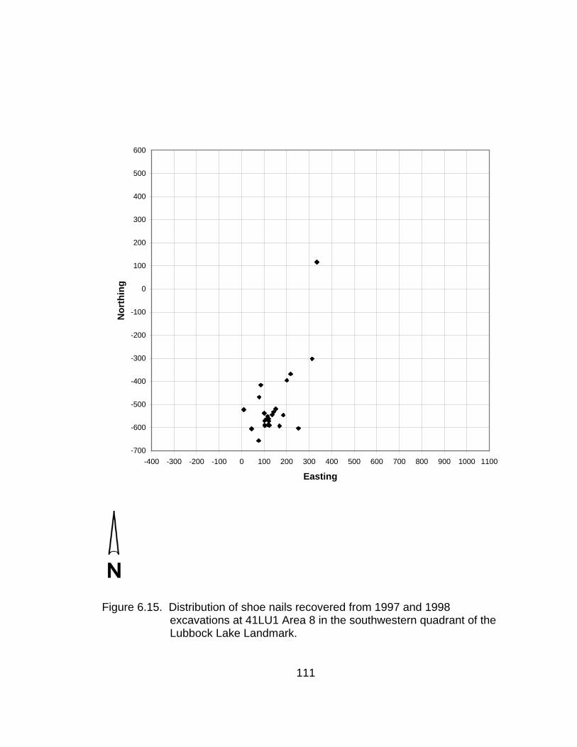
-700
-600
-500
-400
-300
-200
-100
0
100
200
300
400
500
600
-400 -300 -200 -100 0 100 200 300 400 500 600 700 800 900 1000 1100
Easting
Nor
thin
g
Figure 6.15. Distribution of shoe nails recovered from 1997 and 1998
excavations at 41LU1 Area 8 in the southwestern quadrant of the Lubbock Lake Landmark.
111

Horse Shoe Nails
Eight horseshoe nails were recovered from excavations in 41LU1 Area 8.
Six of these nails were broken and bent; an indication that they had been used
and discarded and were not from store stock. The two whole horseshoe nails
(TTU-A90580 and TTU-A92565) measured 5.96cm (2.35”) and 5.85cm (2.30”)
respectively. Horseshoe nails, like horseshoes, often were handmade or at least
fitted to individual animals and subject to more variation within type than
machine-made products (Fontana, 1967).
Tacks
Twenty-one tacks were recovered from excavations in 41LU1 Area 8.
These fasteners exhibited square shafts and measured 1.0cm (0.4”) in length.
Nine of the tacks were collected from 5S1E within a 1cm elevation range.
Fontana and Greenleaf (1962) categorized similar tacks as being used to fasten
barrel rings to barrels.
Screws
Five wood screws were recovered from excavations in 41LU1 Area 8 (Fig.
6.16). All of the screws were recovered from unit group A and all had slotted
heads. Three of the screws (TTU-A73425, TTU-A94483, TTU-A94963) came
from unit 4S0E. The first two had countersunk heads; the head of the third was
112

too corroded to indicate type. TTU-A73425 measured 3.3cm (1.30”), TTU-
A94483 measured 4.6cm (1.81”), and TTU-A94963 measured approximately
2.0cm (0.79”) in length. Screw TTU-A94216, a fragment measuring 1.2cm
(0.47”) along the shaft, came from 5S0E in unit group A. Artifact TTU-A93811
measured 1.92cm (3/4”) in length.
Figure 6.16. Screws (TTU-A94216, TTU-A94963, TTU-A73425, TTU-A93811,
TTU-A94483) recovered from 1997 and 1998 excavations at 41LU1 Area 8 in the southwestern quadrant of the Lubbock Lake Landmark.
The earliest screws were hand-made and date back at least to the Roman
period in Europe (Mercer, 1960; Rybczynski, 2000). In holding power, screws
were superior to round nails and did not have to be clinched as do cut nails.
Hand-wrought screws were much more expensive to manufacture than nails,
requiring hand labor to incise the threads. Factories for automatic manufacture
113

of screws first appeared in the late 18th century. The water-powered factory
produced cheaper screws of higher quality. However, unlike hand-made screws,
these screws had blunt ends and their use required a pilot hole to be drilled first
(Mercer, 1960; Rybczynski, 2000). These screws found many uses such as for
holding butt hinges and other attachments of thin pieces of wood including boat
manufacture, cabinetry, and furniture. Countersunk screws appeared early in the
19th century when slotted heads became standard as well. Phillips-head screws
were developed in the 1930s (Rybczynski, 2000).
Barbs or Barbed Wire
A length of barbed wire (TTU-A1-75161) was among the artifacts
uncovered during test excavation in 41LU31. The recovered wire measured over
1m (39.4”) in length and is a double strand with two-point wire barb type with the
barb wrapped around. Only a portion of the wire was collected after it broke
during excavation. More of the wire remains in-situ, extending into unexcavated
portions of the site.
Excavations in 41LU1 Area 8 yielded seven barbs that had fallen off
barbed wire. Five of the barbs were made of diamond-shaped sheet metal. Two
opposing corners of the diamond were split and bent in opposite directions
forming four points (Fig. 6.17). The arrangement of the points suggested a type
of wire known as Frentress’ Diamond patented in 1875 (Clifton, 1970), patent
114

reissued 1877 (Karolevitz, 1970). Two of the recovered barbs were of an
unidentified wire type.
Figure 6.17. Examples of Frentress’ Diamond barbs (TTU-A94880, TTU-A94881, TTU-A96104) recovered from 1997 and 1998 excavations at 41LU1 Area 8 in the southwestern quadrant of the Lubbock Lake Landmark.
Excavations recovered three Frentress barbs from 2S9E and one from
2S10E in unit group B (Fig. 6.18); the fifth Frentress barb came from 4S2E in unit
group A. One unidentified barb also came from 2S9E and the remaining barb
was found in unit group A in unit 5S1E. Use of wire with sheet metal barbs
began to decline by 1880 due to damage it and other types, now classified as
“vicious,” inflicted on stock (McCallum and McCallum, 1965). By 1892, the
United States Supreme Court’s favorable ruling for Joseph Glidden’s patent “The
Winner,” a two-prong wire-type barb barbed wire, was a formality underscoring
the market’s support of simple, moderate, barbed-wire as the wire of choice
(McCallum and McCallum, 1965).
115

-700
-600
-500
-400
-300
-200
-100
0
100
200
300
400
500
600
-400 -300 -200 -100 0 100 200 300 400 500 600 700 800 900 1000 1100Easting
Nor
thin
g
Figure 6.18. Distribution of barbs recovered from 1997 and 1998 excavations at
41LU1 Area 8 in the southwestern quadrant of the Lubbock Lake Landmark.
116

Staples
Twenty wire staples or staple fragments were recovered from excavations
in 41LU1 Area. These staples were formed from heavy-gauge wire bent into a
“U”-shape with both ends cut at an angle forming sharp points. Fence staples
were hammered into a post over a strand of wire to hold the wire to the post
Lengths of staples recovered from excavation in Area 8 ranged from 2.80 to
3.62cm (1.10-1.43”) with widths ranging from 1.40 to 1.63cm (0.55-0.64”). All
staples were recovered from feature FA8-16. The staples were found in two
general areas of excavation (Fig. 6.19), unit group A and unit group C.
Distribution of staples in unit group A suggested two roughly parallel southwest to
northeast trending linear patterns with one line corresponding to the limits of the
area of anomalous sediment.
Brass Straight Pins
The brass straight pins were recovered from six units in or near unit group A. Of
64 pins recovered, most were bent in the middle (Fig. 6.20) and some were
broken. One relatively straight specimen measured approximately 3cm (11/4”) in
length. Two of the pins came from above the feature FA8-16. The pins were
recovered from a limited area, with 41 found in 4S0E and 4S1E. Fourteen others
were from units in unit group A and the remainder came from unit 3S2E in unit
group B. Many were within the area of anomalous sediments in units 4S0E,
4S1E, and 5S0E (Fig. 6.21).
117

-700
-600
-500
-400
-300
-200
-100
0
100
200
300
400
500
600
-400 -300 -200 -100 0 100 200 300 400 500 600 700 800 900 1000 1100Easting
Nor
thin
g
Figure 6.19. Distribution of fence staples recovered from 1997 and 1998
excavations at 41LU1 Area 8 in the southwestern quadrant of the Lubbock Lake Landmark.
118

Figure 6.20. Brass straight pins (TTU-A94336, TTU-A93845) recovered from
1997 and 1998 excavations at 41LU1 Area 8 in the southwestern quadrant of the Lubbock Lake Landmark.
-700
-600
-500
-400
-300
-200
-100
0
100
200
300
400
500
600
-400 -300 -200 -100 0 100 200 300 400 500 600 700 800 900 1000 1100Easting
Nor
thin
g
Figure 6.21. Horizontal distribution of brass straight pins recovered from 1997
and 1998 excavations at 41LU1 Area 8 in the southwestern quadrant of the Lubbock Lake Landmark.
119

Pen Nibs
Four brass pen nibs were recovered from excavations in 41LU1 Area 8
(Fig. 6.22). The nibs were inscribed “C. M. Linington’s, Colorado, No. 2.”
Charles M. Linington was a Chicago businessman providing stationery supplies,
notions, and general merchandise to country merchants, largely through mail
orders. The firm enjoyed great growth and success following its inception in
1866 (Chicago Daily Tribune, 1876), but in 1895 was forced to liquidate its stock
to pay creditors (Chicago Daily Tribune, 1895). One nib was recovered from unit
2S10E while the remainder came from unit group A in units 4S1E, 5S2E, and
6S0E. The nibs measured 3.1cm (1.22”) in length by 0.9cm (.35”) at the widest
point.
Figure 6.22. Pen nibs (TTU-A90799, TTU-A94187, TTU-A95720) recovered
from 1997 and 1998 excavations at 41LU1 Area 8 in the southwestern quadrant of the Lubbock Lake Landmark.
120

Rivets
Excavations in 41LU1 Area 8 recovered whole rivets and rivet
components (Fig. 6.23). Three items were complete rivet and burr combinations
that occurred in units 5S2E and 6S2E. The separation between TTU-A95930
and 95934 in 6S2E was 2cm north to south and 0.5cm east to west. Rivet TTU-
94177 in 5S2E fell into the same east/west alignment with the other two,
separated by a 1.74m distance. The two rivets from 6S2E measured 1.0cm
(0.39”) in diameter at the head and 0.7cm (0.28”) in length. A larger rivet found
in 5S2E measured 1.0cm (0.39”) in diameter at the head and 1.0cm (0.39”) in
length. Rivet burrs fitted over the rivet shaft and were secured to lock the rivet in
place.
-800
-700
-600
-500
-400
-300
-200
-100
0
100
200
300
400
500
-400 -300 -200 -100 0 100 200 300 400 500 600 700 800 900 1000 1100
Easting
Nor
thin
g
Rivet Burr
Rivet
Rivet w ith Burr Figure 6.23. Horizontal distribution of rivets and rivet burrs recovered from 1997
and 1998 excavations at 41LU1 Area 8 in the southwestern quadrant of the Lubbock Lake Landmark.
121

Three burrs came from unit group A, one from unit group B, and four from
unit group C. The rivet burrs comprised two sizes, 0.92mm (0.36”) and 1.34mm
(0.53”). In units 6S2E, 5S0E, and 1N3E, two rivets occurred within less than 3cm
of each other at the same elevation. Fontana and Greenleaf (1962) ascribed
similar rivets recovered from the Johnny Ward’s Ranch site in Arizona to tack.
Buttons
The majority of buttons recovered from excavations in Area 8 were made
of brass in a simple, flat, four-hole design. A cross-hatch pattern was visible
around the outside edge of some of the buttons. Sizes represented include
1.27cm (½”), 1.59cm (5/8”), and 1.95cm (¾”) diameter. One button (TTU-
A93988) was a shank button made of metal and measured 1.59cm (¾”) in
diameter. All the buttons were of simple utilitarian design. Buttons TTU-A96058
and TTU-A96178 and fragment TTU-A96177 were recovered from unit 6S0E in
unit group A and were arranged in a line at an elevation range from 97337.0 to
97338.0. The average distance between buttons in this line was circa 10cm (4”),
appropriate spacing for buttons on a shirt. Buttons were distributed across most
areas of excavation (Fig. 6.24).
122
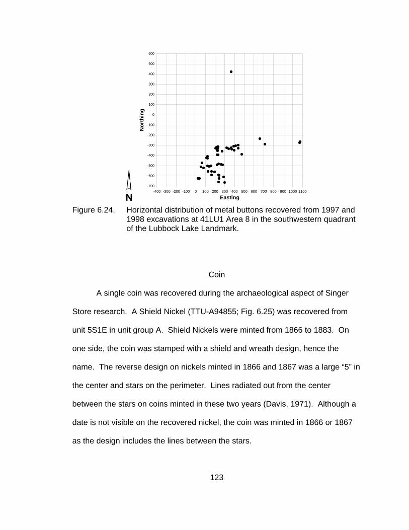
-700
-600
-500
-400
-300
-200
-100
0
100
200
300
400
500
600
-400 -300 -200 -100 0 100 200 300 400 500 600 700 800 900 1000 1100
Easting
Nor
thin
g
Figure 6.24. Horizontal distribution of metal buttons recovered from 1997 and
1998 excavations at 41LU1 Area 8 in the southwestern quadrant of the Lubbock Lake Landmark.
Coin
A single coin was recovered during the archaeological aspect of Singer
Store research. A Shield Nickel (TTU-A94855; Fig. 6.25) was recovered from
unit 5S1E in unit group A. Shield Nickels were minted from 1866 to 1883. On
one side, the coin was stamped with a shield and wreath design, hence the
name. The reverse design on nickels minted in 1866 and 1867 was a large “5” in
the center and stars on the perimeter. Lines radiated out from the center
between the stars on coins minted in these two years (Davis, 1971). Although a
date is not visible on the recovered nickel, the coin was minted in 1866 or 1867
as the design includes the lines between the stars.
123

Figure 6.25. Shield Nickel (TTU-A94855) recovered from 1998 block excavation
at 41LU1 Area 8 in the southwestern quadrant of the Lubbock Lake Landmark.
Cast Iron
Eighteen remnants of cast iron objects are from excavations in 41LU1
Area 8. Four of the fragments share characteristics appropriate to a flat platform-
like object (Fig. 6.26). The largest fragment (TTU-A93788) measures
20.1x14.3cm (7.9x5.6”). Two of the items are from corners. Artifact TTU-
A94853 measures 5.8x3.6cm (2.3x1.5”) and TTU-A96288 measures 8.0x9.7cm
(3.2x3.8”) with a support member that extends 5.0cm (1.97”) from the bottom.
The remaining flat cast iron remnant, TTU-A93006, measures 16.0x10.0cm
(6.3x3.9”). On both TTU-A93788 and TTU-A93006, one edge is a finished rim
like the two sides of the corner fragments.
124
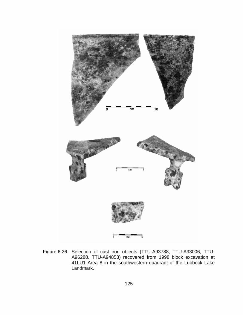
Figure 6.26. Selection of cast iron objects (TTU-A93788, TTU-A93006, TTU-A96288, TTU-A94853) recovered from 1998 block excavation at 41LU1 Area 8 in the southwestern quadrant of the Lubbock Lake Landmark.
125

Interpreted in conjunction with TTU-A94311 (Fig. 6.27), the four flat
fragments appear to represent the remains of a platform scale similar to one
listed in a 1902 Sears Catalog (Sears, Roebuck, and Company, 1902: 563; Fig.
6.27) with TTU-A94311 being a support and the flat pieces remnants of the
platform. Unidentified artifact TTU-94186 (Fig. 6.28) was recovered from 2S5E
in unit group B. A corner element (TTU-A92907; Fig. 6.29) recovered from 2S5E
conjoined with TTU-A90567 (Figs. 6.29; 6.30) recovered during 1997
excavations from 2S4E. The two pieces may be parts of a scale or some other
large cast iron object such as a stove. Twelve fragments were recovered from
unit group A, three from unit group B, and three from unit group C. The flat
pieces were from unit group A and TTU-94311 was recovered from the eastern
extremes of unit group B in unit 2S9E.
Figure 6.27. Diagram depicting artifact TTU-A94311 and an example of a
platform scale showing the support element.
126
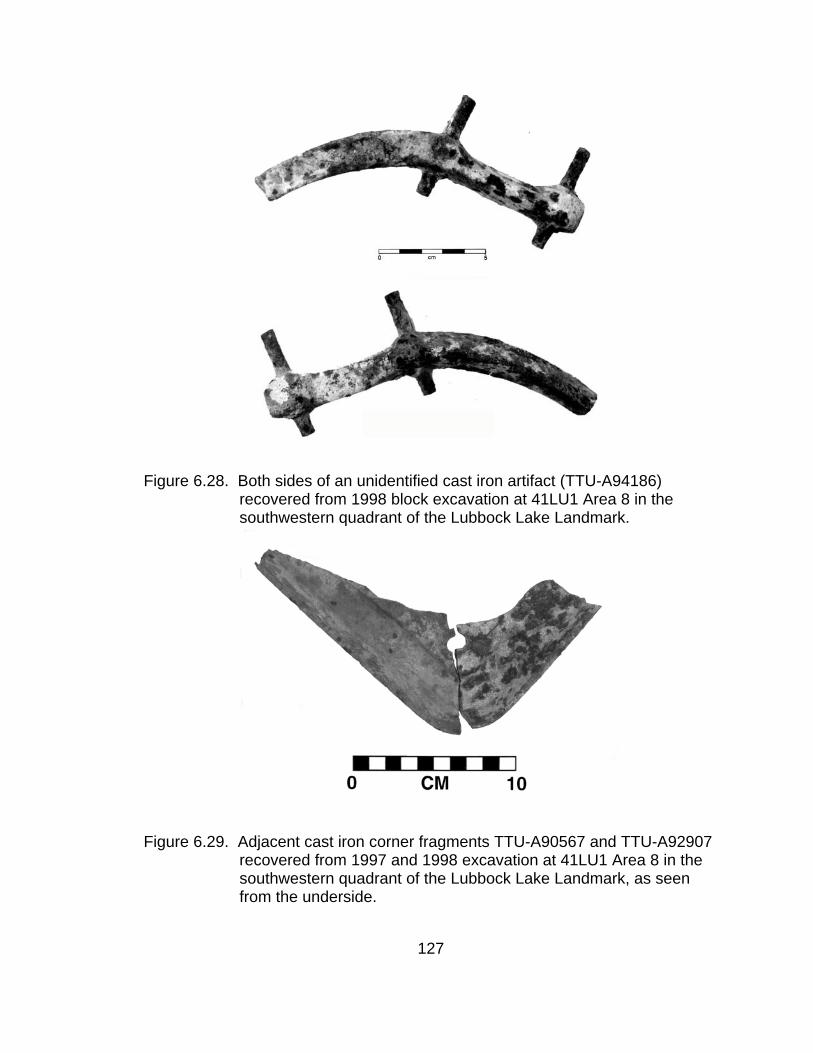
Figure 6.28. Both sides of an unidentified cast iron artifact (TTU-A94186) recovered from 1998 block excavation at 41LU1 Area 8 in the southwestern quadrant of the Lubbock Lake Landmark.
Figure 6.29. Adjacent cast iron corner fragments TTU-A90567 and TTU-A92907
recovered from 1997 and 1998 excavation at 41LU1 Area 8 in the southwestern quadrant of the Lubbock Lake Landmark, as seen from the underside.
127

Figure 6.30. Bolt (TTU-A90577), cast iron (TTU-A90567), and cut nail (TTU-A90582) recovered from unit 2S4E during 1997 test excavation at 41LU1 Area 8 in the southwestern quadrant of the Lubbock Lake Landmark.
Miscellaneous Metal Artifacts
A number of metal items represented limited occurrences of each type of
article. All but TTU-A85756 were recovered from excavations in Area 8. Artifact
TTU- A85756 was a knife (Figure 6.31) found during surface survey of 41LU1
Area 8. The knife measured 20.8x3.2x2.2cm (8.2x1.3x0.9”). Remnants of a
wooden handle extend along 11.0cm (4.3”) of the length. The construction of the
knife featured a metal blade, measuring 0.3cm (0.1”) at the widest point,
sandwiched between two wooden pieces for a handle. The parts were held
together along the handle by three rivets. The head of the rivets measured
1.0cm (0.39”). The tip of the knife blade was rounded and it is likely the length
128

was shorter than the original due to breakage and/or intensive sharpening. It
was similar in appearance and construction to those used for trade with the
Northern Plains tribes in the late 19th century (Hanson, 1975). Examination,
however, revealed no maker's mark on the knife and knifes today are constructed
in the same manner.
Figure 6.31. Both sides of a knife (TTU-A85756) recovered during the 1996 survey of 41LU1 Area 8 at the Lubbock Lake Landmark.
A lead bullet (TTU-A95064; Fig. 6.11a) was recovered from unit 1N3E,
adjacent to unit 2N3E where a casing (TTU-A95811; Fig. 6.11b) appeared to
have exploded. Bullet TTU-A90587 came from 4N3E in the same unit group (C).
Three primer caps (TTU-A93927, TTU-A96124, TTU-A96146) were found
in unit group A in units 5S0E, 4S0E, and 4S1E. An intact primer contained
gunpowder and was the part of a cartridge struck by a firearm’s hammer, setting
off the reaction that fired the bullet. A small brass object that appears to be a
funnel that has been flattened (TTU-A94966; Fig. 6.32) was recovered from
129

4S0E. Both the primers and a funnel could be used in the process of reloading,
or re-using spent cartridge casings.
Figure 6.32. Flattened bell portion of brass funnel TTU-A94966 recovered from
1998 block excavation at 41LU1 Area 8 in the southwestern quadrant of the Lubbock Lake Landmark.
In unit group C, fine-gauge wire (TTU-A94932; Fig. 6.33) bent similar to a
hairpin, with the appearance of crimping along a portion came from unit 0N2E.
The wire or hairpin was 5.5cm (2.2”) long. Another item recovered, from unit
3N3E, was the bowl portion of a spoon (TTU-A73390; Fig. 6.34). The spoon
measured 7.5x4.5cm (3.0x1.8”). The recovered portion bore no identifying
marks.
130
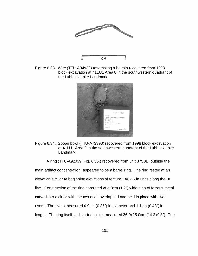
Figure 6.33. Wire (TTU-A94932) resembling a hairpin recovered from 1998
block excavation at 41LU1 Area 8 in the southwestern quadrant of the Lubbock Lake Landmark.
Figure 6.34. Spoon bowl (TTU-A73390) recovered from 1998 block excavation at 41LU1 Area 8 in the southwestern quadrant of the Lubbock Lake Landmark.
A ring (TTU-A92039; Fig. 6.35.) recovered from unit 37S0E, outside the
main artifact concentration, appeared to be a barrel ring. The ring rested at an
elevation similar to beginning elevations of feature FA8-16 in units along the 0E
line. Construction of the ring consisted of a 3cm (1.2”) wide strip of ferrous metal
curved into a circle with the two ends overlapped and held in place with two
rivets. The rivets measured 0.9cm (0.35”) in diameter and 1.1cm (0.43”) in
length. The ring itself, a distorted circle, measured 36.0x25.0cm (14.2x9.8”). One
131

edge of the metal strip was rolled, forming a smooth, finished rim. The ring
retained remnants of its connection to some container but the fasteners did not
appear to be cut nails or tacks. Although corroded, the heads and shafts of the
four extant fasteners appeared to be round. The fasteners extended 2.6cm (1.0”)
into the interior of the ring, were located 1.8cm (0.7”) from the rolled edge, and
were spaced at a distance of approximately 15cm (5.9”) apart.
Figure 6.35. Metal ring (TTU-A92039) recovered from unit 37S0E during 1997 test excavation at 41LU1 Area 8 in the southwestern quadrant of the Lubbock Lake Landmark.
A T-shaped brass brad (TTU-A93823; Fig. 6.36) used for holding papers
was collected from unit 4S0E. The brad measured 1.8cm (0.71”) in length. A
132

bolt with a nut (TTU-A90577; Fig. 6.31) was recovered from unit 2S4E. The bolt
measured 5.5cm (2.17”) in length and 1cm (0.39”) in diameter. The head of the
bolt was broken off and the threads extend along approximately 2.5cm (1.0”) of
the length. A single horseshoe (TTU-A93719; Fig. 6.37) was recovered from unit
9S2E in unit group B. The remnant measured 5.5x13.6cm (2.2x5.4”). Thickness
of the artifact ranged from 1.3cm (0.51”) at the back end to 0.3cm (0.12”) at the
beveled front edge of the center portion.
Figure 6.36. A T-shaped brass brad (TTU-A93823) recovered during 1998 block
excavation at 41LU1 Area 8 in the southwestern quadrant of the Lubbock Lake Landmark.
Figure 6.37. Horseshoe remnant (TTU-A93719) recovered from unit 2S9E during 1998 block excavation at 41LU1 Area 8 in the southwestern quadrant of the Lubbock Lake Landmark.
133

Excavations uncovered two metal buckles. Buckle TTU-A95190 (Fig.
6.38a), collected from unit 6S0E, consisted of a D-shaped frame formed of 0.2cm
(0.1”) thick wire or metal. The tongue was a straight piece of wire with one end
wrapped around the frame. The buckle measured 2.1cmx1.9cm (0.8x0.7”). A
larger buckle, TTU-A95044 (Fig. 6.38b), came from 1N3E. The rectangular
frame measured 4.5cmx3.0cm (1.8x1.2”) and was 0.5cm (0.2”) thick. A rolling
barrel or tube covered one of the short sides. A D-shaped metal ring (TTU-
A73422; Fig. 6.38c) recovered from 4S0E and measuring 2.54cm x 1.95cm
(1.0x0.8”) potentially was the frame of another buckle. An additional ring
fragment (TTU-A96073) came from unit 3N3E. The buckles and rings were
similar to fasteners found on items of tack or possibly a belt.
A chain (TTU-A94176; Fig 6.39) was recovered from unit 5S2E and
measured approximately 3.3cm (1.3”) in length. The chain remnant consisted of
seven links and measured 0.6cm (0.2”) wide. A short bar, circular in cross-
section, was attached to one end of the chain. Overall, the chain resembled a
watch chain.
134
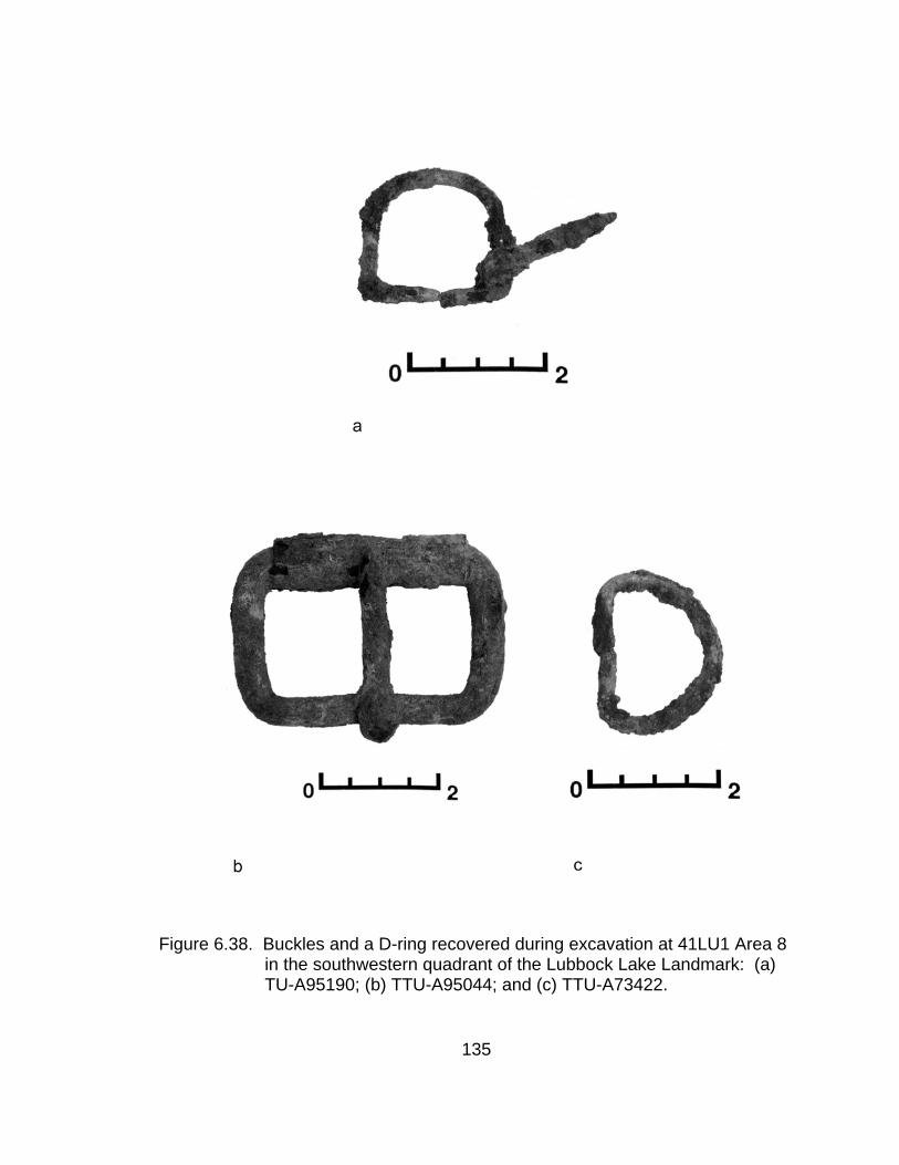
Figure 6.38. Buckles and a D-ring recovered during excavation at 41LU1 Area 8 in the southwestern quadrant of the Lubbock Lake Landmark: (a) TU-A95190; (b) TTU-A95044; and (c) TTU-A73422.
135

Figure 6.39. Chain fragment TTU-A94176 recovered during 1998 block
excavation at 41LU1 Area 8 in the southwestern quadrant of the Lubbock Lake Landmark.
Two probable handles were recovered from unit group A in 41LU1 Area 8
excavations. Artifact TTU-A94759 (Fig. 6.40a), an oval-shaped handle
measuring 8.96 x 4.35cm (3.5x1.7”), came from 4S0E and resembles handles
found on galvanized tubs. Unit 6S2E yielded handle-like, cast iron object TTU-
A95938 (Fig. 6.40b). In cross-section, the piece was circular, measured 0.8cm
(0.3”) diameter, and was curved into a semi-circle measuring 12.6cm
(5.0”)across. One end exhibited an apparent device for attaching the piece to
some larger object. The other end of the item was broken.
Figure 6.40. Probable handles recovered during 1998 block excavation at 41LU1 Area 8 in the southwestern quadrant of the Lubbock Lake Landmark: (a) TTU-A94759 and (b) TTU-A95938.
136
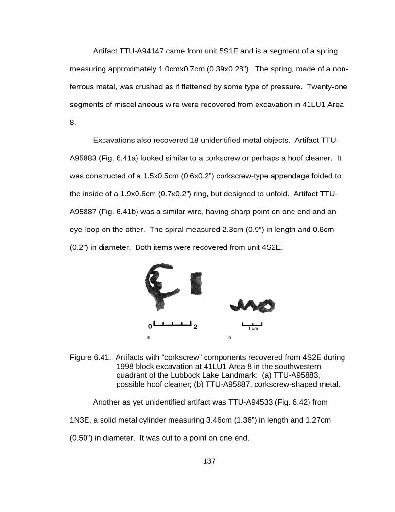
Artifact TTU-A94147 came from unit 5S1E and is a segment of a spring
measuring approximately 1.0cmx0.7cm (0.39x0.28”). The spring, made of a non-
ferrous metal, was crushed as if flattened by some type of pressure. Twenty-one
segments of miscellaneous wire were recovered from excavation in 41LU1 Area
8.
Excavations also recovered 18 unidentified metal objects. Artifact TTU-
A95883 (Fig. 6.41a) looked similar to a corkscrew or perhaps a hoof cleaner. It
was constructed of a 1.5x0.5cm (0.6x0.2”) corkscrew-type appendage folded to
the inside of a 1.9x0.6cm (0.7x0.2”) ring, but designed to unfold. Artifact TTU-
A95887 (Fig. 6.41b) was a similar wire, having sharp point on one end and an
eye-loop on the other. The spiral measured 2.3cm (0.9”) in length and 0.6cm
(0.2”) in diameter. Both items were recovered from unit 4S2E.
Figure 6.41. Artifacts with “corkscrew” components recovered from 4S2E during 1998 block excavation at 41LU1 Area 8 in the southwestern quadrant of the Lubbock Lake Landmark: (a) TTU-A95883, possible hoof cleaner; (b) TTU-A95887, corkscrew-shaped metal.
Another as yet unidentified artifact was TTU-A94533 (Fig. 6.42) from
1N3E, a solid metal cylinder measuring 3.46cm (1.36”) in length and 1.27cm
(0.50”) in diameter. It was cut to a point on one end.
137
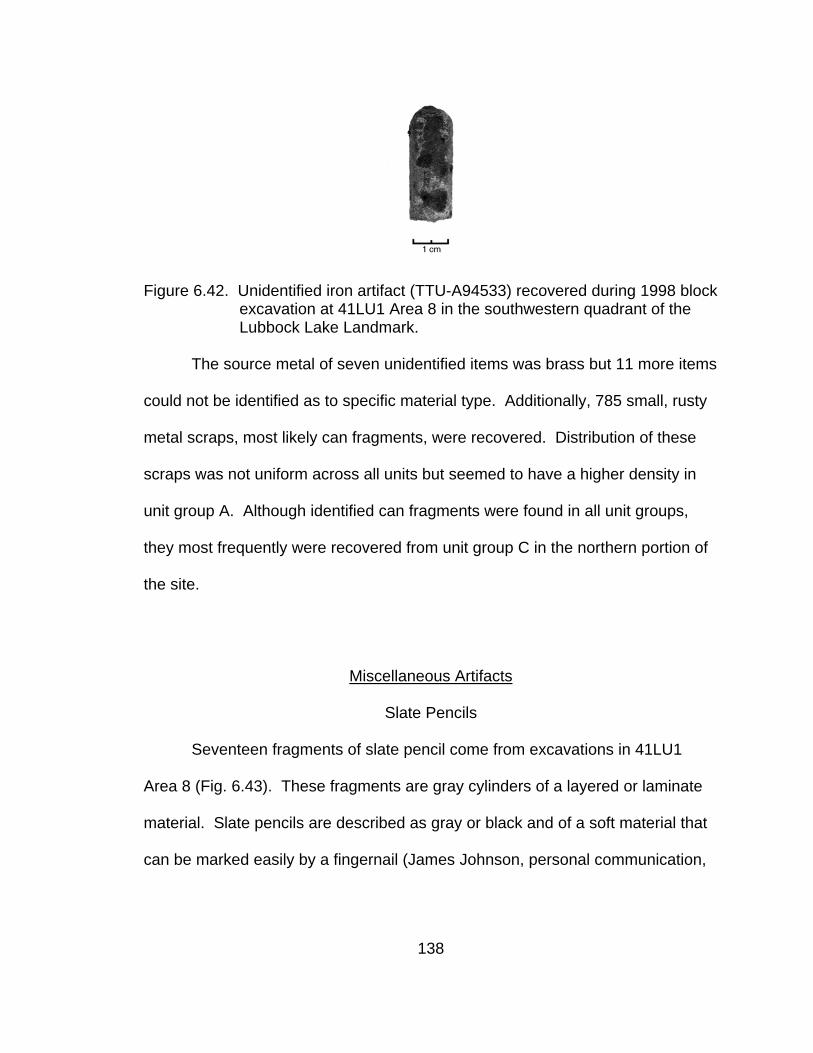
Figure 6.42. Unidentified iron artifact (TTU-A94533) recovered during 1998 block
excavation at 41LU1 Area 8 in the southwestern quadrant of the Lubbock Lake Landmark.
The source metal of seven unidentified items was brass but 11 more items
could not be identified as to specific material type. Additionally, 785 small, rusty
metal scraps, most likely can fragments, were recovered. Distribution of these
scraps was not uniform across all units but seemed to have a higher density in
unit group A. Although identified can fragments were found in all unit groups,
they most frequently were recovered from unit group C in the northern portion of
the site.
Miscellaneous Artifacts
Slate Pencils
Seventeen fragments of slate pencil come from excavations in 41LU1
Area 8 (Fig. 6.43). These fragments are gray cylinders of a layered or laminate
material. Slate pencils are described as gray or black and of a soft material that
can be marked easily by a fingernail (James Johnson, personal communication,
138

1999). The pencils are used with slate boards on which the pencils leave white
markings similar to chalk on a chalkboard. Although reliable historic information
regarding pencils of any sort is elusive, paper was expensive and students in
public school made use of slates and slate pencils throughout the 19th century.
School children in poorer regions still use slates and slate pencils today
(Petroski, 1990) and workers engaging in the production of slate pencils are
susceptible to developing silicosis.
-700
-600
-500
-400
-300
-200
-100
0
100
200
300
400
500
600
-400 -300 -200 -100 0 100 200 300 400 500 600 700 800 900 1000 1100
Easting
Nor
thin
g
Figure 6.43. Distribution of slate pencil fragments recovered from 1997 and 1998
excavations at 41LU1 Area 8 in the southwestern quadrant of the Lubbock Lake Landmark.
139

Coal and Charcoal
Numerous small pieces of coal (201) and charcoal (69) were recovered
(Table 5.8). Both Green (1962; personal communication, 1998) and Kelley
(1974) observed pieces of coal in historic sediments during the 1959-1960
excavations in Area 8. Presumably, coal would have served as fuel for a stove.
The majority of charcoal (32) came from the charcoal concentration in unit 0N2E,
left basically intact in-situ. Twenty-five pieces of charcoal came from the area of
anomalous sediment in unit 5S0E. No charcoal was collected for the purposes of
dating as the Radiocarbon Lab indicated an age would not be valid on such
recent wood (Herbert Haas, personal communication, 1998). Charcoal was
collected for tree identification purposes but not yet identified.
Seeds
The only floral material collected was 151 seeds, all from unit 2S9E. All of
the seeds but one came as a cluster from TTU-A94926. These were not yet
identified.
Rubber Artifacts
Eleven rubber artifacts, including three tooth segments from a hard rubber
comb (TTU-A94234, TTU-A91239, and TTU-A94883), were recovered from
excavation in 41LU1 Area 8 (Fig. 6.44). Unit group B yielded two of the comb
140
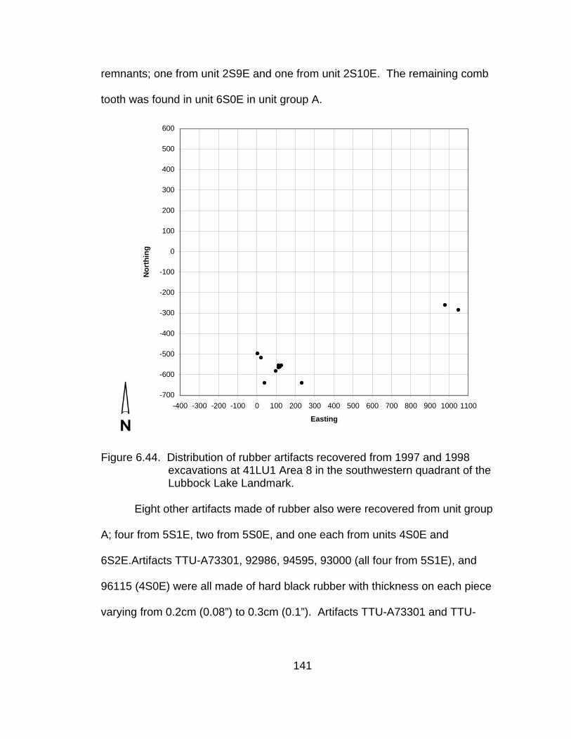
remnants; one from unit 2S9E and one from unit 2S10E. The remaining comb
tooth was found in unit 6S0E in unit group A.
-700
-600
-500
-400
-300
-200
-100
0
100
200
300
400
500
600
-400 -300 -200 -100 0 100 200 300 400 500 600 700 800 900 1000 1100
Easting
Nor
thin
g
Figure 6.44. Distribution of rubber artifacts recovered from 1997 and 1998
excavations at 41LU1 Area 8 in the southwestern quadrant of the Lubbock Lake Landmark.
Eight other artifacts made of rubber also were recovered from unit group
A; four from 5S1E, two from 5S0E, and one each from units 4S0E and
6S2E.Artifacts TTU-A73301, 92986, 94595, 93000 (all four from 5S1E), and
96115 (4S0E) were all made of hard black rubber with thickness on each piece
varying from 0.2cm (0.08”) to 0.3cm (0.1”). Artifacts TTU-A73301 and TTU-
141

A92986 conjoined to form part of a flat hexagon measuring approximately 2cm
(0.8”) across. A central hole measured 0.2cm (0.08”) in diameter. Wear
striations encircled the hole on one surface of the items. Artifacts TTU-A94594
and TTU-A93000 were similar in appearance to these items, having finished
edges indicative of a hexagon shape. Artifact TTU-A93000 exhibited indications
of a central hole. These items most likely were not buttons based on the nature
of the wear marks.
Caliche
Most of the recovered caliche cobbles came from unit group B (Fig. 6.45).
Three cobbles (TTU-A90744, TTU-A90745, and TTU-A90746) recovered from
3S3E in unit group B were very slightly burned on the side and upper surfaces.
Respective weights of the cobbles were 383.5g (13.5oz.), 393.4g (13.9oz.), and
434.0g (15.3oz.). Cobble TTU-A94310, recovered from the western portion of
5S0E in unit group A, weighed 454.7g (16.0oz.). Additional caliche partially
exposed in unit 5S0E remained in-situ in the unexcavated portion of the unit.
The distance, along a southwest to northeast line, between the cluster of caliche
in unit 3S3E and the 5S0E caliche was approximately 3.6m (11.8’).
142

-700
-600
-500
-400
-300
-200
-100
0
100
200
300
400
500
-400 -300 -200 -100 0 100 200 300 400 500 600 700 800 900 1000
1100
Easting
Nor
thin
g
Figure 6.45. Distribution of caliche recovered from 1997 and 1998 excavations
at 41LU1 Area 8 in the southwestern quadrant of the Lubbock Lake Landmark.
143
Wood
Two wooden artifacts were recovered from test excavation in 41LU31. An
apparent remnant of a post (TTU-A75070) measured 20cm (7.9”) in length and
7cm (2.8”) in diameter. A small angular fragment of wood (TTU-A75071)
measured 21.0x1.7x1.3cm (08.3x0.7x0.5”). One surface exhibited a smooth,
regular, planed appearance that suggested the remains of milled lumber. The
two other long-axis surfaces were broken.
Additionally, a number of partially burned lengths of some type of
branches were uncovered and mapped in units in 41LU31. Based on plotted
measurements from field maps, the branches ranged from 10cm to 30cm (3.9 to
11.8”) in length with 85% of branches measuring between 15cm and 25cm (5.9
and 9.8”). The wood was not collected because the charring exhibited by the
branches could be attributed to a grass fire and not cultural activity.
Excavations in Area 8 yielded two pieces of unburned and six pieces of
burned wood. Three pieces of burned wood came from unit 53S8E, outside the
main unit blocks and within the uppermost 6cm (2.4”) of excavation. Two pieces
of the burned wood came from 3N3E in unit group C, one of the units containing
a concentration of charcoal. The remaining piece of burned wood (TTU-A94366)
came from 6S0E in unit group A. One fragment of unburned wood (TTU-
A93051) with a single smooth, possibly milled face, was recovered from unit
2S9E above feature FA8-16; the second, TTU-A92584, came from feature FA8-
16 in 5S1E.
144
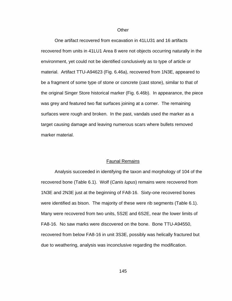
Other
One artifact recovered from excavation in 41LU31 and 16 artifacts
recovered from units in 41LU1 Area 8 were not objects occurring naturally in the
environment, yet could not be identified conclusively as to type of article or
material. Artifact TTU-A94623 (Fig. 6.46a), recovered from 1N3E, appeared to
be a fragment of some type of stone or concrete (cast stone), similar to that of
the original Singer Store historical marker (Fig. 6.46b). In appearance, the piece
was grey and featured two flat surfaces joining at a corner. The remaining
surfaces were rough and broken. In the past, vandals used the marker as a
target causing damage and leaving numerous scars where bullets removed
marker material.
Faunal Remains
Analysis succeeded in identifying the taxon and morphology of 104 of the
recovered bone (Table 6.1). Wolf (Canis lupus) remains were recovered from
1N3E and 2N3E just at the beginning of FA8-16. Sixty-one recovered bones
were identified as bison. The majority of these were rib segments (Table 6.1).
Many were recovered from two units, 5S2E and 6S2E, near the lower limits of
FA8-16. No saw marks were discovered on the bone. Bone TTU-A94550,
recovered from below FA8-16 in unit 3S3E, possibly was helically fractured but
due to weathering, analysis was inconclusive regarding the modification.
145

Figure 6.46. Unknown artifact TTU-A94623 that appears to be a fragment broken off of the original Singer Store Historical Marker: (a) possible granite fragment recovered from 1997 test excavation in 41LU1 Area 8 in the southwestern quadrant of the Lubbock Lake Landmark; (b) views of the original historical marker, now in the Bob Nash Interpretive Center at the Lubbock Lake Landmark, showing details of damage.
146

Table 6.1. Bone recovered from 1997 and 1998 excavations at 41LU1 Area 8 in the southwestern quadrant of the Lubbock Lake Landmark.
Taxon Element FA8-16 Non-Feature Total Bison bison Diaphysis 2 2 Bison bison Maxilla segment 1 1 Bison bison Skull segment 2 2 Bison bison Tooth segment 3 1 4 Bison bison Rib segment 48 1 49 Bison bison Caudal vertebrae 1 1 Bison bison Metapodial 1 1 Bison bison Diaphysis segment 1 1 Canis lupus Metatarsal (right) 2 2 Canis lupus Metatarsal segment 3 3 Canis lupus Metacarpal 1 1 Cf. canis Deciduous Molar 1 1 Turtle Carapace segment 1 1 Mammalia Appendicular segment 3 3 Mammalia Diaphysis 3 3 Mammalia Diaphysis segment 3 3 Mammalia Lunar (right) 1 1 Mammalia Phalange 1 1 Mammalia Tibia segment 6 6 Mammalia Tarsal segment 1 1 Mammalia Rib segment 10 2 12 Mammalia Skull segment 1 1 2 Mammalia Tooth segment 2 1 3 Total 83 21 104
147

Concluding Statement
Analysis results of the historic artifacts recovered during survey, testing,
and excavation phases of the Singer Store research reveal an assemblage
comprised of a variety of objects reflecting association with a variety of activities.
Most significantly, numerous architecturally related artifacts have been recovered
from testing and block excavation in 41LU1 Area 8. Diagnostically, the cut nails
display characteristics that provide a manufacture date appropriate to the
historically reported Singer occupation on Yellowhouse Draw. The range of nail
sizes and types among the recovered artifacts supports the presence of a
wooden structure and possible furnishings. Other artifacts relate to day-to-day
tasks of a commercial enterprise and provide some indication of frontier business
practices. The ranching frontier, of which the Singer occupation was a part, is
represented in the assemblage by the barbs from barbed wire and fencing
staples, artifacts exclusively related to ranching activities. Cowboys and other
ranch representatives also utilized other objects from store stock (Fig. 4.4; Truett,
1982). The temporal and functional attributes of material recovered during the
Singer Store research supports 41LU1 Area 8 as the location of the Singer Store.
148
CHAPTER VII
DISCUSSION
The primary objective of the Singer Store research was to acquire and
apply archaeological data in conjunction with historical data to the hypothesis
that the Lubbock Lake Landmark comprises the location of the first Singer Store
in Lubbock County. Positive correlation of the archaeological and historical
record requires the archaeological evidence to support known historic accounts
related to the Singer Store. Artifacts must be from the appropriate period,
confirm accounts describing a wooden structure, and reflect specialized behavior
related to a mercantile enterprise, including appropriate stock for a store on a
ranching frontier. Evidence from the site must be in accord with accounts of
specific events in the Singer Store history such as XIT fencing supplies
reportedly left at the store and the fire that destroyed the building in 1886.
Findings of the Singer Store research also address the research goal of
contributing to an understanding of how the 19th century United States frontier on
the Southern High Plains of Texas relates to the core society and how this
specific frontier illuminates study of frontier processes. Information about the
Singer occupation enables its placement in the progression of the frontier on the
Southern High Plains of Texas. Examining the frontier on the Southern High
Plains within the contemporaneous environmental and social context can
149

illuminate how the relationship between the frontier and core society influences
the expressed character of the frontier.
Archaeological Findings
Structure
Cut nails, window glass fragments, apparent remnants of lumber, and
pieces of a ceramic doorknob are artifacts that provide strong evidence for the
presence of a 19th century structure in 41LU1 Area 8 of the Lubbock Lake
Landmark. Based on exhibited manufacturing details, recovered cut nails
indicate a pre-1885 date for the structure. The variety of types and sizes of nails
reflect construction of a frame type structure. In box-and-strip construction,
longer common nails join together pieces of the frame. Nails of medium length
would be employed in attaching the 1”x12” lumber to the frame and the 1”x2”
lumber that covered the spaces between the 1”X12”s. Door or window frames
would require the use of finish nails and the largest common (9d or 10d) nails
could have functioned to hold hinges to doors or doorframes. The type of nail
occurring most frequently in the excavated assemblage is the common nail, used
for framing and siding. Many nails are broken or bent, indicating the nails had
been used in a structure rather than as supply or stock.
Large areas of charcoal and small pieces of wood that could be lumber
appear to represent structural remnants. Future testing for wood type would help
determine this. Pine is the most likely type of milled wood used in the
150
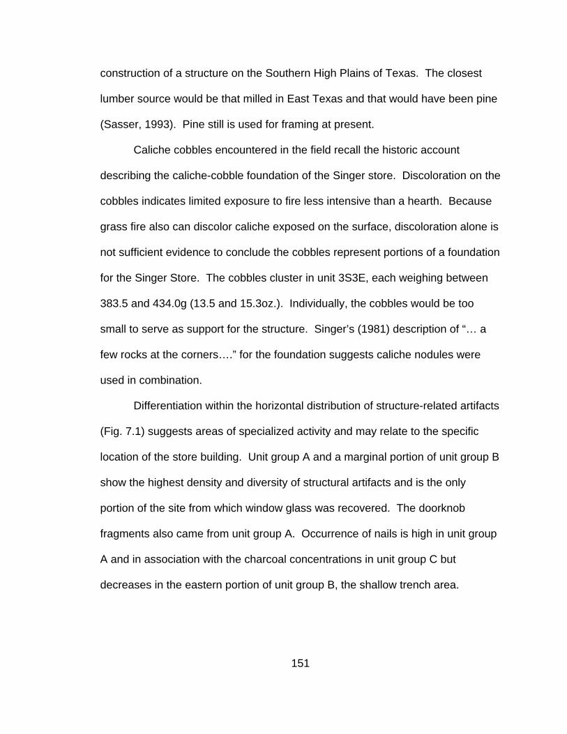
construction of a structure on the Southern High Plains of Texas. The closest
lumber source would be that milled in East Texas and that would have been pine
(Sasser, 1993). Pine still is used for framing at present.
Caliche cobbles encountered in the field recall the historic account
describing the caliche-cobble foundation of the Singer store. Discoloration on the
cobbles indicates limited exposure to fire less intensive than a hearth. Because
grass fire also can discolor caliche exposed on the surface, discoloration alone is
not sufficient evidence to conclude the cobbles represent portions of a foundation
for the Singer Store. The cobbles cluster in unit 3S3E, each weighing between
383.5 and 434.0g (13.5 and 15.3oz.). Individually, the cobbles would be too
small to serve as support for the structure. Singer’s (1981) description of “… a
few rocks at the corners….” for the foundation suggests caliche nodules were
used in combination.
Differentiation within the horizontal distribution of structure-related artifacts
(Fig. 7.1) suggests areas of specialized activity and may relate to the specific
location of the store building. Unit group A and a marginal portion of unit group B
show the highest density and diversity of structural artifacts and is the only
portion of the site from which window glass was recovered. The doorknob
fragments also came from unit group A. Occurrence of nails is high in unit group
A and in association with the charcoal concentrations in unit group C but
decreases in the eastern portion of unit group B, the shallow trench area.
151

-700
-600
-500
-400
-300
-200
-100
0
100
200
300
400
500
600
-400 -300 -200 -100 0 100 200 300 400 500 600 700 800 900 1000 1100
Easting
Nor
thin
g
NailsWindow glassDoorknobWood
Figure 7.1. Horizontal distribution of structure related artifacts recovered from
1997 and 1998 excavations at 41LU1 Area 8 in the southwestern quadrant of the Lubbock Lake Landmark.
152

Merchandise
Many recovered artifacts match-up well with historic descriptions of stock
carried in the Singer store and reflect items noted in Singer’s 1891 newspaper ad
touting a “…full line of ready made clothing, hats, caps, boots and shoes, ranch
and trail supplies” (Lubbock Leader, 1891). Other artifacts relate to activity of
keeping a store.
Can and bottle remnants represented supply type goods. Hole-in-cap
cans dating to a period between 1880 to about 1900 came from 41LU1 Area 8
and 41LU31. Survey revealed more hole-in-cap cans on the surface between
the two areas. The limited quantity of material from 41LU31 excluded the site as
a candidate for the store’s location. However, the location of hole-in-cap cans
between the two areas strongly suggested activity in 41LU31 was somehow
associated with the store.
The artifacts represented at least two types of cans and, therefore, at least
two types of foodstuffs. The flat, rectangular cans were the type containing meat
or seafood. The cylindrical cans were too fragmented or too crushed to
determine can size accurately but most likely contained meat, fruit, or
vegetables. Reports of the store’s holdings listed canned beans among the stock
(Singer, 1981). A barrel ring, from outside the main concentration of artifacts,
indicated the presence of a barrel. Barrels served to store or transport bulk food
items sold by the store, such as flour, cornmeal (Singer, 1981), or other supplies
such as gunpowder (Coleman, 1960).
153

Glass was the second most common material encountered. The majority
of glass fragments represented the remains of bottles. Rather than food, most
likely the bottles held patent medicine or alcohol. Ceramic stoneware bottle
fragments were similar to remains of a ginger beer bottle previously recovered
from excavations at the Lubbock Lake Landmark (Holliday, 1987:24). Stoneware
bottles also served to hold ink and the remains of the ceramic bottle may be
related to Singer’s record keeping activities. Although consumption of alcohol
was discouraged or forbidden by some ranch managers (Haley, 1953), beer and
alcohol would have been an appealing commodity to the ranching related
clientele of the Singer Store. Rollie Burns mentioned having a glass of whiskey
at the store before returning to his ranching duties (Holden, 1932a).
The brass shoe nails and button fragments echo the ad’s listing of ready
made clothing, boots, and shoes. The number and diversity of button types
indicate an assortment of clothing types available at the store. The XIT receipt
(Fig. 4.4) lists a pair of pants among the purchases. The “prosser” button may
have been from a shirt or underwear and the row of metal buttons recovered
from excavation also may represent the remains of a shirt or jacket. The small
rivets could have come from clothing items such as jeans while any of the rivets
could have been part of tack items.
The numerous cartridge casings located in FA8-16 could be associated
with a number of activities occurring at the lake including buffalo hunting.
Excavation revealed casings across the excavation area but occurrences were at
154

a slightly higher density in unit group A. Most of the recovered casings were of a
smaller caliber than ammunition used for buffalo hunting. Almost all the casings
were from fired ammunition as indicated by the discharged primers. The
recovery of separate, unfired primers along with empty casings and the small
crushed funnel suggested re-loading of ammunition may have been an activity at
the site. Historic accounts (Coleman, 1960) included gunpowder, also used in
re-loading, among the stock in the store. The horizontal distribution of
ammunition related artifacts was not uniform but varies across the excavated
areas (Fig. 7.2). Cartridge casings occurred over all areas but were most
common in unit group A in association with the funnel and percussion caps or
primers.
-800
-700
-600
-500
-400
-300
-200
-100
0
100
200
300
400
500
600
-400 -300 -200 -100 0 100 200 300 400 500 600 700 800 900 1000 1100
Easting
Nor
thin
g
Percussion CapFunnelCartridge
Figure 7.2. Horizontal distribution of ammunition related artifacts recovered from
1997 and 1998 excavations at 41LU1 Area 8 in the southwestern quadrant of the Lubbock Lake Landmark.
155

Other items could be part of the store’s merchandise but more likely
represent supplies used in the business of store keeping. The pins most likely
were not part of the store merchandise as their condition indicated use. In the
late 19th century, straight pins served to hold together papers. Land payment
receipts studied in the Texas General Land Office Archive were pinned together
with pins like those recovered in 41LU1 Area 8. Since Singer traded on credit, as
indicated by his letter to Hank Smith, he would have kept records and may have
used the pins to keep papers organized. On the other hand, they may have been
used by Rachel Singer in sewing projects. Similarly, the brass paper brad would
serve to attach papers. Singer probably used the pen nibs found in Area 8 for
record keeping, preparing receipts, and in his duties as Post Master. Distribution
of the pins was limited to unit group A and the westernmost units of unit group B
(Fig. 6.22).
Indications of furnishings in the store come from the cast iron fragments.
Some of the fragments were most likely the remains of a counter platform scale,
an essential item in a store selling bulk items by weight. Other fragments may be
remnants of a cast iron stove. The coal uncovered by excavations in Area 8
indicated the use of a stove. Rachel Singer most likely used a stove to prepare
meals served at the store. The remains of a broken spoon supported the
interpretation of cooking activities there, but could also be representative of
merchandise. Another indication of the presence of Rachel Singer was the
possible hairpin found in the same unit block as the spoon bowl.
156

The Shield nickel was the only currency item encountered in excavations.
The nickel rested near the bottom of a concentration of artifacts that gave the
appearance of being in a pile. The coin was minted 16 or 17 years prior to the
Singer’s arrival in Lubbock County. While money is a fundamental aspect of
storekeeping, limitations of the occurrence of currency items at the site could
include the confines of excavation, use of paper currency that would deteriorate
or be destroyed by fire, and economic conditions on the frontier or nationally that
could limit currency in circulation. Correspondence in the Hank Smith Collection
at Panhandle-Plains Museum dating from the 1870s and 1880s suggested cash
was not available readily and commerce relied heavily on credit transactions and
trade.
Distributions
The 1996 metal detector survey of 41LU1 Area 8 indicated subsurface
metal distributed across much of the area. Excavations in 1997 and 1998
investigated only a small portion of Area 8 and the targets identified by the metal
detector. Nevertheless, some differentiation in artifact distribution was evident.
Overall, the block of units surrounding the historic marker yielded a much higher
density of historic artifacts than outlying units. Metal targets in some outlying
units proved to be modern cans or scraps, demonstrating that not all the
subsurface metal targets were necessarily historic. Unit group A held the
157
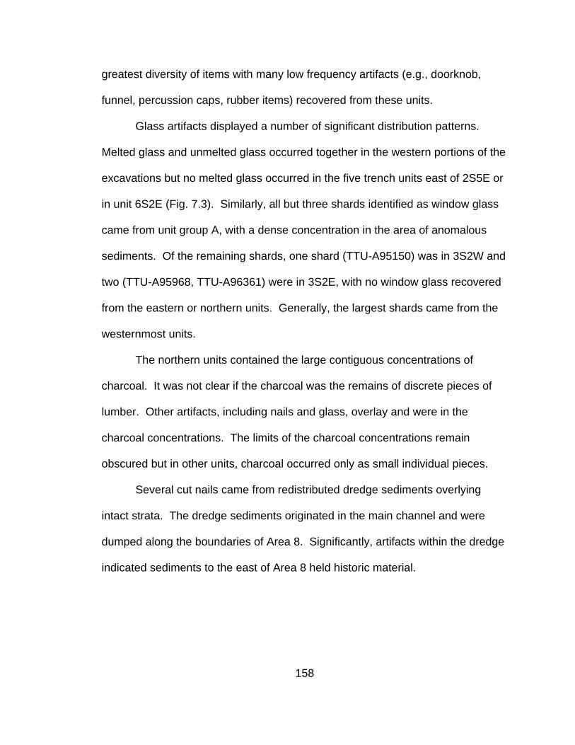
greatest diversity of items with many low frequency artifacts (e.g., doorknob,
funnel, percussion caps, rubber items) recovered from these units.
Glass artifacts displayed a number of significant distribution patterns.
Melted glass and unmelted glass occurred together in the western portions of the
excavations but no melted glass occurred in the five trench units east of 2S5E or
in unit 6S2E (Fig. 7.3). Similarly, all but three shards identified as window glass
came from unit group A, with a dense concentration in the area of anomalous
sediments. Of the remaining shards, one shard (TTU-A95150) was in 3S2W and
two (TTU-A95968, TTU-A96361) were in 3S2E, with no window glass recovered
from the eastern or northern units. Generally, the largest shards came from the
westernmost units.
The northern units contained the large contiguous concentrations of
charcoal. It was not clear if the charcoal was the remains of discrete pieces of
lumber. Other artifacts, including nails and glass, overlay and were in the
charcoal concentrations. The limits of the charcoal concentrations remain
obscured but in other units, charcoal occurred only as small individual pieces.
Several cut nails came from redistributed dredge sediments overlying
intact strata. The dredge sediments originated in the main channel and were
dumped along the boundaries of Area 8. Significantly, artifacts within the dredge
indicated sediments to the east of Area 8 held historic material.
158

-700
-600
-500
-400
-300
-200
-100
0
100
200
300
400
500
600
-400 -300 -200 -100 0 100 200 300 400 500 600 700 800 900 1000 1100
Easting
Nor
thin
g
Unmelted GlassMelted Glass
Figure 7.3. Distribution of melted and unmelted glass recovered from 1997 and
1998 excavations at 41LU1 Area 8 in the southwestern quadrant of the Lubbock Lake Landmark.
Excavations revealed areas of anomalous sediments in units 4S0E, 4S1E,
and 5S0E. Unit 4S0E was excavated completely but in units 4S1E and 5S0E,
after encountering the anomalous sediments, only that area was excavated.
Density of artifacts across the whole of units 4S1E and 5S0E is unknown.
However, in unit 4S0E, the artifact distribution delimited a boundary that aligned
with the limits of the anomalous sediments in units 4S1E and 5S0E. The artifact
concentration within the area of anomalous sediments was not representative of
159

the whole artifact assemblage but instead included only a few types of material.
Glass was the most common collected artifact in the concentration. Window,
melted, and unmelted glass occurred with the greatest frequency. Other
materials recovered from the area of anomalous sediment included ceramic
sherds, brass straight pins, and metal scraps. Slate pencil fragments, a few
metal buttons, and a fence staple aligned along the boundary. Cut nails did
occur within the area but in no greater density than in other portions of unit group
A.
Historic Association
The Singers arrived in Lubbock County near the end of the free-range
ranching era. They left Estacado and built their first Lubbock store sometime in
1883, prior to the year’s tax assessments. The two trails passing the store
brought traveling customers. Although no enclosed ranches were nearby,
cowboys from free-range area ranches passed by as they herded cattle during
cooperative roundups, pursued mustangs, or, as with the McCommis family,
crossed the Llano Estacado on their way to or from New Mexico.
The XIT ranch began erecting fences during 1885 or 1886. Freighters left
the XIT wire at the Singer Store for pick-up by the fence contractors. Wire used
on the southern portion of the ranch was “a rough, four-point type of wire”
(McCallum and McCallum, 1965:124), as were the barbs recovered from
excavations in Area 8.
160

Fence staples also were part of the artifact assemblage from 41LU1 Area
8. However, the staples were concentrated in unit group A and the four-point
barbs came from the trench unit group B and were loose, not attached to wire.
Given the respective distributions of these two types of artifacts, the staples may
have been store merchandise and the barbs derived from the XIT wire. Fence
staples would be part of supplies used by the ranching industry and stocked by
Singer.
In the fall of 1886, when the Singers’ daughter Pearl was about 6 months
old (Debler, 1959), the store and all its contents burned to the ground. The
Singers rebuilt the store in a different location. As a result, the site of the store
should display characteristics reflecting those events. Excavations in 41LU1
Area 8 revealed artifacts demonstrating effects of exposure to fire. Because the
Singers were at the site for only about three years, the quantity of remaining
material would be limited.
Melted items were the most common indication of fire. Excavation
recovered both melted glass and melted metal from the site. Additionally,
remains of burned ammunition in the form of a melted cartridge case and
separate bullet are the consequence of contact with great heat or flames. Other
strong evidence of fire lies in the concentrations of charcoal. Time restrictions
prevented full exposure of the limits of the charcoal, but they continued beyond
the excavated area. The uncovered charcoal was in association with glass,
nails, and other artifacts.
161

Findings Summary
Results of the archaeological and historical research of the Singer Store
established a general location and time frame for the first Lubbock County
mercantile undertaking, resolving inconsistencies in the previously known Singer
history. Archaeological work showed that the historical marker commemorating
the store is an accurate representation of the store's location. Document data
resolved discrepancies in the date of the Singer occupation listed on the marker
and in various accounts of the store. However, details of the store’s appearance
still were unknown.
Regardless of any travels it may have enjoyed in intervening years, the
marker now rests in close proximity to remains from the Singer Store. A map
prepared by Green in 1961 (Kazcor, 1978; Fig. 7.4) shows a drainage extending
between Yellowhouse Draw and a railroad trestle on the southwest border of the
Landmark preserve. A spring once issued from the area near the railroad trestle.
The spring and drainage would have been to the south and southwest of the first
Singer Store. Perhaps the confluence of this short side drainage with
Yellowhouse Draw accounts for surveyor Twichell’s placement of the store at the
convergence of the Yellowhouse and Blackwater draws.
162

Figure 7.4. Topographic map of portion of the Lubbock Lake Landmark prepared
by Green and depicting location of a small drainage below railroad trestle along the southern edge (Kazcor, 1978).
163

Discrepancies in the dates given for the Singer Store and included on the
marker originated with dates in Rollie Burns’ memoir (Holden, 1932a; Coleman,
1960). Burns was among those present at the original marker installation. The
Singer children, while constituting a reserve of family memory, were very young
or not yet born at the time the first store building burned. Therefore, information
from this source was limited and requires corroboration from other sources. Tax
records and other dated, written documents were a more reliable source of
temporal data and indicate the Singers were still in Estacado in 1882 but
operating a store in Lubbock County in 1883. The Singers filed on a section of
land to the east of the first store’s location in the spring of 1886 and the original
structure burned in the fall of 1886. Historic accounts agreed on the time of the
store’s destruction.
Information from the artifact assemblage was consistent with reports of
items in the store’s inventory and with historic events. The date range for
diagnostic artifacts fell within the appropriate late 19th century period.
Architectural items indicated the presence of a wooden structure but were
insufficient to provide details of the structure’s size or appearance. The
occurrence of window glass was contradictory to Singer’s (1981) description of
the store having no windows. The discrepancy could be due to an erroneous
memory; the glass could have been a commodity for sale or, as reported with the
barbed wire, left by freighters for some one else.
164

Regional Comparisons
Confirmation of the presence of the Singer Store along with correlation of
the historic and archaeological record of the occupation facilitates the use of the
Singers’ story in examining the relationship of the Singer enterprise to the
advance of the United States frontier onto the Southern High Plains of Texas in
the late 19th century. The chronicle of the Singer Store, along with other
documented episodes in frontier history, illustrates processes of cultural change
and continuity such as competition, colonization, acculturation, and adaptation as
well as illustrating the interrelationship and interaction of social and
environmental components of the frontier system and how they generate the
expressed character of a frontier region. A review of other regional sites
provides a sense of how the frontier advanced and characteristics of some
components of the frontier system on the Southern High Plains.
The ranching industry was the immediate economic successor to buffalo
hunting on the Southern High Plains. Three different types of ranching
enterprises soon followed the buffalo hunters onto the Llano Estacado: sheep
ranching, open range cattle ranching, and closed range cattle ranching.
Transhumance pastores originated in the New Mexico sheep industry and
responded to market influences by expanding into Texas (Hicks and Johnson,
2000). Large cattle ranches, some funded by non-resident business interests,
also emerged to take advantage of the opportunities presented by the newly
empty and open grassland and growing beef market. The cattle ranches
165

prevailed in their competition with the small pastores operations, but pressure
from settlers seeking land, natural disasters, and the collapse of the beef market
served to end the era of large, free-range ranches (Murrah, 1981). The large
free-range ranches that survived enclosed their titled land with fences and,
eventually, sold off much of the land to settlers (Dunn, 1962; Murrah, 1981). The
final phase of frontier expansion on the Southern High Plains was the period of
settlement with town-building continuing into the first quarter of the 20th century
(Brunson, 1970). The Singer Store occupation at Lubbock Lake Landmark
occupied the period when ranching was undergoing transition from open range to
closed range and settlers were just beginning to explore what opportunities the
resources of the Llano Estacado held for them.
In 1874, less than 10 years before the Singer family ventured out onto the
Llano Estacado, Dodge City merchants built Adobe Walls, a trading post on the
northern bank of the Canadian River in the Texas Panhandle, some 150 miles to
the southwest of Dodge City. The post supported the numerous buffalo hunters
who moved their hunting operations into Texas after depleting the herds near
Dodge City. The endeavor was a mutual operation formulated by some of the
buffalo hunters and the merchants as a solution to the problem posed by the
great distance between the location of the buffalo herds and Dodge City. The
buffalo hunters agreed to transport the goods to Texas and, in exchange, the
merchants were to charge no more for their goods than would be paid in Dodge
166

City. Estimates placed the value of the total merchandise freighted on the initial
trip at $70,000, a substantial quantity of goods (Baker and Harrison, 1986).
Structures comprising the site included two stores, a blacksmith shop, a
saloon, and corrals for animals. Isolation from Dodge City precluded using cut
lumber for most of the construction. Instead, the merchants used local materials
to make their buildings. Logs procured from trees growing along the Canadian
River provided for “picket” construction style walls for some buildings and a corral
while sod cut from the prairie served to form other buildings. The furnishings in
the buildings were simple, consisting of chairs, tables, counters, shelving, and
wood stoves. One store held a sleeping area for the couple that worked there.
The woman was the only female at the trading post (Baker and Harrison, 1986).
The hunters pursued the buffalo in the region around the Canadian River.
Hunters would kill the animals and crews of skinners would follow, removing the
hides for commercial trade. Hunting outfits exchanged hides, not cash, for goods
carried in the stores. Merchandise available for purchase included hunting
supplies like gunpowder, lead, cartridges and primers, patch paper, and gun oil.
Flour, baking powder, butter, bacon, sugar, coffee, canned tomatoes, soup, and
fruit, and fresh peaches, dried apples, crackers, tea, salt, pepper, pickles, and
syrup were some of the food goods available to the hunters. The stores
addressed hunters’ clothing needs by offering trousers, shirts, shoes, and socks
in their merchandise. Other supplies included chewing tobacco, gin, matches,
167

rope, knives, utensils, wolf poison, axle grease, soap, feed corn, beer from
Leavenworth in glass bottles, and clay pipes (Baker and Harrison, 1986).
The incursion of the American buffalo hunters onto the High Plains and
Southern High Plains of Texas initiated conflict with Native American groups.
The hunters and trading post came under attack early on June 27, 1874 by
members from various bands of Comanche, Kiowa, and Cheyenne tribes. Some
participants came off Indian Territory reservations established by the Medicine
Lodge treaties of 1867, although the Quahadi band of Comanches did not join in
ratifying the agreement (Rathjen, 1973; Baker and Harrison, 1986). The Dodge
City merchants responded by retrieving their goods and employees. A number of
buffalo hunters agreed to stay and defend the buildings, but by August, even they
had left. Some time between August and October, all buildings except the
saloon were destroyed, burned by Native Americans (Baker and Harrison, 1986).
Archaeological investigation into the site of Adobe Walls provided for a
comparison of material culture associated with the Singer Store. The remains
came from the refuse of the trading post or from items left behind after the Dodge
City merchants retrieved their stock. Glass bottles, fragments from metal cans,
ammunition refuse, and supplies for reloading ammunition dominated the artifact
assemblage. Fragments of window glass were among the recovered artifacts
relating to the structures at the site (Baker and Harrison, 1986). Window glass at
Adobe Walls demonstrated that the commodity was available on the frontier.
Indications of currency were limited although excavation produced Shield nickels
168

(Baker and Harrison, 1986). While both assemblages included remains of food
containers, clothing, ammunition, and architectural objects, only the Singer Store
artifacts included items related to the ranching industry. The difference reflected
the development of the frontier in a shift from short-term extractive hunting
industry to long-term development and management of Southern High Plains
resources inherent in the ranching industry.
The items at Adobe Walls reflected the 19th century connections to
industrialized parts of the country and the mass-produced goods manufactured
there. The assemblage consisted of items related to the hunter’s subsistence,
hunting supplies, or remains of the post’s structures. Although similar in
composition, the Adobe Walls occupation differed from the Singer Store in the
size of the source stock and number of buildings. In terms of resources, the
Adobe Walls merchants represented established, successful enterprises with
extensive assets while George Singer was an example of an individual of modest
means attempting to build a frontier business.
The Battle of Adobe Walls marked the beginning of the struggle between
the Native peoples and the interests of the United States for hegemony of
western Texas. Although ostensibly under the political control of Texas and the
United States, prior to the 1870s, raids and fear of raids had limited Anglo-
American expansion into much of western Texas. The ensuing series of
engagements collectively known as the Red River War effectively eliminated the
ability of the Native Americans to mount incursions into Anglo-American
169

settlements, opening the way for ranchers, settlers, and other economic interests
to develop fully throughout the state.
Commercial buffalo hunting ended with the depletion of the bison herds
(Rathjen, 1973). However, the American frontier continued its progression on the
Southern High Plains as the ranching industry expanded into the region. The
ranching expansion was an example of migration into a perceived under-utilized
resource. Pastores sheep herding and Anglo cattle ranching represented two
competing approaches to using the grassland of the Llano Estacado. The Anglo
ranching system eventually prevailed in competition between the two different
ranching traditions, due in part to its relationship to the Texas political and legal
systems (Carlson, 1982).
The pastores first initiated ranch use of the grassland of the Southern High
Plains, herding sheep along the river valleys as early as the mid-1860s (Taylor,
1980). In response to increased demand for mutton and wool, pastores sought
new grazing in Texas and some eventually established settlements (plazas)
along the Canadian River Valley. Stone corrals provided evidence that pastores
extensively utilized broad areas as far south as the central Southern High Plains
(Hicks and Johnson, 2000). The settlements remained until the late 1880s when
competition and pressure from Anglo-American ranchers and unfavorable land
laws led to the end of the plazas.
Similar market influences brought cattle ranching to the Southern High
Plains. Beef cattle ranching first began on the Southern High Plains of Texas in
170

the late 1870s (Dunn, 1962; Murrah, 1981). It began as an extension of ranching
industry instituted in other parts of Texas. Growth of new markets and use of the
open range meant little overhead and held the potential for substantial profits.
Economic setbacks, innovations in breeding and improvement of stock,
technological improvements in fencing and windmills, and pressure to open the
land for agricultural settlement led to the end of open range cattle ranching
(Murrah, 1981).
The systems of open range ranching and pastores herding each leave
behind distinctive physical features. The earliest structures built by either
tradition relied on locally available materials. Pastores used sandstone or caliche
boulders to form corrals and fence lines to control and/or protect the herds (Hicks
and Johnson, 2000). Earliest pastores occupation sites were transitory camps
made while on the seasonal grazing circuits. Such sites left little physical
evidence other than rock corrals. When pastores began colonizing along the
Canadian River, they constructed their plaza buildings from locally available
stone or adobe. Additional components of the plazas were outbuildings and
irrigation systems or acequias for limited subsistence agriculture (Taylor, 1980).
The earliest structures erected by cattle ranchers were dugouts used as line
camps and even ranch headquarters. Cowboys occupied line camps while
keeping watch over distant reaches of the range. Headquarter buildings were
replaced with masonry or lumber structures with lumber brought from the nearest
railroad terminus (Freeman, 1990a).
171

Recent archaeological investigation of pastores sites on the central Llano
Estacado recovered a sparse archaeological assemblage. The sites displayed
stone structures of typical pastores construction and were situated in settings
favored by the herders - a sheltered location with a supply of grass and water,
usually a spring (Hicks and Johnson, 2000). Material recovered from the surface
included cut nails, window glass fragments, pieces of a cast-iron stove, cartridge
casings, hole-in-cap cans, tack or wagon hardware, and sheep dung (Hicks and
Johnson, 2000; J. Kent Hicks, personal communication, 2004).
By the late 1870s and early 1880s (Dunn, 1962; Murrah, 1981), ranchers
and settlers were moving onto the Southern High Plains. Favoring similar locales
or because some infrastructure already was in place, ranchers sited
headquarters or other ranch structures in places previously used by pastores.
Archaeological investigation of historic Anglo-American ranching sites on
or near the Southern High Plains is rare. Sites associated with early regional
open-range ranching history have been investigated just to the southeast of the
Llano Estacado on the Rolling Plains (Freeman, 1990b). The investigation is
limited to survey and some testing of two dugouts and a line camp. One of the
dugouts (41GR474) has a pre-1900 occupation component, possibly dating as
early as the late 1880s. The artifact assemblage from this earliest historic
component of the site is limited to bone fragments and one leather remnant.
Another dugout (41KT150), in use by OS Ranch cowboys in the 1890s, might
have served earlier ranch interests (Freeman, 1990b). The line camp (41KT4)
172

consists of remnants of the stone foundation and fireplace. Use of the land is
limited to ranching activities for the duration of its documented history. Artifacts
found at the site include cut nails, wire staples, a bottle, and glass fragments
(Freeman, 1990b).
Investigation of the headquarters of the Las Escarbadas division of the
XIT ranch (Jackson, 1977) provided information on the early enclosure ranching
phase on the Southern High Plains. The XIT ranch was a corporate venture
initiated when the state of Texas exchanged public land to fund a new capital
building (Haley, 1953). The management divided the holdings into five divisions,
separated with barbed wire fence. The pasture divisions allowed separation of
cattle for different uses, i.e. a breeding pasture and greater control of cattle
characteristics and quality. The company located the headquarters for the
division in Deaf Smith County on Tierra Blanco Creek at Las Escarbadas
Springs. The main building, built in 1886, had outer walls of fieldstone with a
foundation and footings of stone joined with a mud mortar and caliche. The
building measured approximately 5.5x21.3m (18’x70’) and provided a living area,
kitchen space, and office space for the division foreman. Additional buildings in
the compound provided living space for cowboys and other staff, a milk house,
and a stone-lined cistern (Hogan and Buchalter, 1977; Jackson, 1977).
Archaeological investigation of the headquarters compound followed
removal of the main building and reassembly at the Ranching Heritage Center in
Lubbock. The recovered artifacts reflected the usage of the building.
173

Occupation of the headquarters building spanned the period from 1886 to 1940.
At times, inhabitants included women and children (Hogan and Buchalter, 1977).
Artifacts associated with the main building included remnants of pottery dishes,
decorated ceramic ware, glass tumblers, lamp chimney, stove parts, marbles,
and square and wire nails. Recovered ceramic insulators demonstrated the
installation of electricity in the building. Recovered coins consisted of two
pennies and an 1865 “Real.” Artifacts associated with outbuildings included
remnants of wagons and agricultural machinery and windmill parts. A trash
dump contained material dating to the 20th century. Extant construction details of
the milk house included 2x6 joists nailed into a 6x6 beam with 16d nails
(Jackson, 1977).
As with some other large ranches, the owners of the XIT began dividing
and selling off ranch holdings in the 1890s (Haley, 1953). Eventually, lands of
the ranch became the property of small ranches and farms as more settlers
moved into the region.
The Singers arrived on the Southern High Plains as part of the first
settlement, Estacado. By the time they built their store in Yellowhouse Draw in
1883, hunting had depleted the buffalo herds ending the buffalo hunting era.
Customers of the store were men associated with various ranching ventures.
First were cowboys following the trail across the Llano Estacado to New Mexico,
out on a roundup, gathering animals that had strayed from their home range, or
pursuing mustangs. Pastores may have ventured near as they moved their
174

flocks to seasonal pastures on the Southern High Plains. Lastly, before
settlement and town building began in earnest, cowboys and ranchers came to
work the fenced ranches.
Details of the Singer Store structure and stock reflected 19th century
frontier conditions of isolation encountered by those seeking to settle on the
Southern High Plains. In building their store, the Singers utilized a combination
of purchased, mass-produced materials such as lumber and cut nails in
conjunction with a foundation of locally available caliche. The expense of
purchased material and transportation difficulties may have influenced the
building’s dimensions, reportedly measuring less than 38m2 (400ft2) in area.
Structures built at Adobe Walls predated those built at Estacado and the Singer
Store and utilized more locally available resources, due in part to the readily
accessible timber resources along the Canadian River. The Las Escarbadas
headquarters building continued the practice of incorporating local material with
mass-produced parts manufactured in industrial centers and brought to supply
towns by rail.
The same hardships may have been factors limiting the quantity of
merchandise stocked by Singer. Remains of merchandise and other items
destroyed when the store burned in 1886 also attested to the character of the
19th century frontier on the Southern High Plains. Can and glass vessel
remnants constituted the greatest number of recovered artifacts. These and
175

other merchandise originated in the settled, industrial portions of the country and
transported to the frontier via the relatively new technology of railroads.
Within a few years, the Singers and their store became part of the new
community of Lubbock, when they moved the store building to the north side of
the town square (Fig. 7.5). The Singers did not remain in Lubbock long,
however. After transferring their land claim interest to James McGuire, the family
moved away in 1887, bringing to a close the history of the Singer Store in
Lubbock. Consequently, the Singers missed being participants in later growth
and development of the town that became the trading center of the Southern
High Plains.
Figure 7.5. Photograph of early Lubbock. The second building from the right is reportedly the Singer Store (Bronwell, 1980). Photograph courtesy of the Southwest Collection/Special Collections Library, Texas Tech University, Lubbock, Texas, Museum Photograph Collection, Box 1, Accession number 1948-7-9.
176

The Singers were participants in a frontier that progressed rapidly across
the Southern High Plains, with sequences of development occurring in quick
succession or even concurrently. Contributing factors included the degree of
economic and political development achieved in the core society and a
technological level that minimized isolation on the frontier. Historical and
archaeological research revealed the expression of such societal core
characteristics on the frontier.
The Southern High Plains frontier, in comparison with the core society,
was less complex in terms of population, institutions, and economic activity. The
participants in buffalo hunting, military actions, and ranching were predominantly
male. Until settlement, economies on the Southern High Plains such as buffalo
hunting and ranching were engaged in securing primary resources for interests
outside the frontier. No internal market system was in place prior to the growth of
settlements and most clients of the Singer Store were part of the ranching
industry. With limited population and industry, support for institutions such as
banking was lacking and no need existed for social institutions like schools or
churches. Prior to the organization of Crosby County, the closest government
offices were in Young County and residents had to travel there to tend to official
business or file documents for public record. As postmaster, George Singer was
the only government representative in Lubbock County.
Various forms of competition contributed to the character of the Southern
High Plains frontier. The pursuit of a common quarry by Native Americans and
177
Anglo buffalo hunters led to competition between native groups and the United
States military. Cattle ranchers were able to exclude pastores’ sheep herds from
the range. At the time cattle ranchers brought their herds to the ranges of the
Llano Estacado, the buffalo no longer constituted a challenge to grazing cattle.
However, ranchers targeted other animals considered foes. Campaigns against
predators helped eliminate wolf populations. Wolf poison was a stock item at
Adobe Walls (Baker and Harrison, 1986). Wolf remains recovered from the site
of the Singer Store occurred above or in the uppermost elevations of feature
FA8-16. These remains may represent an animal killed as part of this elimination
effort. The once vast prairie dog colonies suffered depletion as well. Ranchers
considered them pests competing with cattle for grass. Ranchers faced
competitive pressure from settlers also. Eventually, settlement pressure, losses
from unfavorable weather, and market conditions contributed to the end of the
large ranches on the Southern High Plains (Murrah, 1981). The Singer Store
originally served those engaged in ranching but was part of a small frontier town
when the Singer family left.
Unlike North American colonial frontiers, the 19th century United States
frontier on the Southern High Plains constituted a cosmopolitan frontier that
enjoyed close ties to its core society. Geographic relationship and technology
enhanced communication and commerce between the two regions and allowed
participants to take advantage of the frontier’s opportunities. By functioning as
178

the local Post Office, the Singer Store provided a communication link between
the frontier and other places.
Established markets in settled portions of the United States and even
Europe provided sufficient economic incentive to balance out the risks and
difficulties undertaken by buffalo hunters, merchants, and ranchers moving onto
the Llano Estacado. The core society provided capital to fund and provision the
earliest frontier enterprises of buffalo hunting and the large beef cattle ranches.
For the settlers of Estacado, high prices and limited availability of land in the
established portions of the country prohibited many from owning land. The
frontier represented a chance to become landowners.
Products manufactured in the industrial portions of the core society
provided support for the frontier and an expanding rail system made them
increasingly accessible to all regions of the country. Technological innovations
such as barbed wire and windmills originating in the core society helped shape
development of the frontier. Available mass-produced goods along with the
developing transportation system minimized the need to rely only on local
resources. Reports of the merchandise sold by the Singers (Holden, 1932a;
Coleman, 1960; Singer, 1981) and archaeological evidence illustrated the
frontier’s connection with industrial centers. Almost all food, tools, ammunition,
clothing, and building materials originated outside the Southern High Plains
frontier.
179

The connection is evident archaeologically through out the manifestation
of the Southern High Plains frontier as material brought in from manufacturing
centers dominated historic artifact assemblages. Although the assemblages vary
in character according to association with type of frontier component, they are
very similar in types of materials (e.g., canned goods, glass containers, and cut
nails).
The proximity and level of social and technological development of the
core society engendered a Southern High Plains frontier in which the degree of
isolation was much lower than in early European frontiers in North American.
While the character of the frontier and its relation to the core served to somewhat
alleviate hardship, pioneers still had to contend with uncertainty and unfamiliarity
in a strange environment and were taking risks in investing in a developing
production system. Even large ranch endeavors, backed by investor capital,
failed after the disastrous droughts and harsh winters of the mid-1880s (Murrah,
1981).
The Singer Store located in Yellowhouse Draw in Lubbock County
occupied a point on the Southern High Plains frontier continuum between the
simple, earliest economic activities of buffalo hunting and ranching and the
increasingly complex social and economic institutions associated with settlement.
George Singer, as a merchant, represented an increase in the complexity of the
frontier. The success of the Singer Store did not rely on an extractive activity like
buffalo hunting or ranching, but on service to those so engaged. As a supply
180

point and Post Office, the Singer Store served as a link between the frontier and
the settled, industrial core society. With the move of the Singer Store to the new
settlement of Lubbock, George Singer, and the Singer family entered the final
stages of frontier development on the Southern High Plains.
Concluding Statement
Archaeological and historic findings support Area 8 of the Lubbock Lake
Landmark as the site where George Singer built a store. Diagnostic artifacts
yield manufacture dates in accord with the reported range of occupation. The
artifact assemblage as a whole is consistent with reports of the structure,
merchandise, and associated events of the store’s history. Additionally,
discussion of regional historic archaeological sites bracketing the Singer Store
occupation demonstrate the position occupied by the Singers in the development
of the 19th century frontier on the Southern High Plains. Evidence from the sites
and their related histories emphasize the nature of the frontier and its relation to
the established portions of the nation and illustrate how the character of a frontier
is closely tied to the social and physical attributes of the local environment as
well as to conditions in the core society.
181

CHAPTER VIII
CONCLUSION
The Singer Store research utilized archaeological and historical
information to ascertain the location of the first commercial venture in central
Lubbock County. Additionally, information derived from the recovered artifacts
helped to place the occupation within a broader framework of regional frontier
developments and enhance the understanding of how the region progressed
from frontier to settlement. .
The primary hypothesis guiding the Singer Store research was that
evidence of a 19th century occupation reported at the present site of the Lubbock
Lake Landmark would be apparent in the archaeological record. The three
phases of archaeological investigation succeeded in identifying three areas
containing material from the late 19th or early 20th centuries. Testing in the three
areas further indicated 41LU1 Area 8 as having the greatest density of material
and the most likely site of long duration occupation.
Excavations in 41LU1 Area 8 recovered material appropriate to the period
of the Singer Store and in accord with events described in historical accounts.
Architectural artifacts in the assemblage included square nails, portions of a
ceramic doorknob, and window glass. Additionally, extensive areas of charcoal
182

were uncovered, indicative of a burning event. All these items indicated the past
presence of a wooden structure that had burned. The Singer Store burned to the
ground in 1886.
Other recovered material derived from supplies held in the store.
Numerous glass and metal fragments remained from containers holding food
provisions. Among these artifacts were segments from hole-in-cap cans
manufactured between 1880 and 1900. The recovery of brass shoe nails and
various sizes of brass rivets attested to the inclusion of shoes and clothing in the
store inventory. The larger brass rivets also could have been part of bridles or
other tack items. Numerous brass cartridge casings could have been
merchandise or indications of hunting behavior.
The presence of brass straight pins, pen nibs, slate pencil segments, and
a paper brad attest to other activities pursued at the site. An archived store
receipt and other documents prepared by George Singer provide examples of
record keeping activities that would have utilized some of the recovered artifacts.
Historical research clarifies the chronology of the Singer’s endeavors on
the Southern High Plains. Tax records demonstrate the Singers had a small
store in Crosby County in 1881 (Estacado store), but had moved to a Lubbock
County location by 1883. In the spring of 1886, the couple filed a claim on a
section of land east of the excavated store location. After fire destroyed the first
Lubbock County store, the second store would have been ¼ to ½ mile
downstream on Survey 12 Block A, the Singer’s section. This location may have
183

been in the draw and still within the Landmark boundaries. However, the new
store most likely has an upland location bordering the present National Landmark
boundary in an area greatly disturbed by modern activities. The Singers move
that rebuilt store into the new town of Lubbock in 1891.
Documents and artifacts uncovered during the research provided insight
into the role filled by the Singer Store on the Southern High Plains. By the time
the Singers came to Yellowhouse Draw, commercial hunting had decimated the
great buffalo herds. Ranching, the main economic enterprise of the region, was
undergoing a transformation from the practice of free-range grazing to an
enclosure system. Artifacts like fence staples and barbed-wire barbs as well as
documented dealings with cowboys reflected the Singers’ specific ties to
ranching. The Singer Store served as a supply depot for those traveling through
and about the Southern High Plains and, in its role as Post Office, as a link to
more distant places.
Events preceding and accompanying the arrival of the Singer family on the
Southern High Plains exemplify the action of a number of frontier processes
interacting with existing social and environmental factors to create cultural
change on the Southern High Plains. The process of competition, as
demonstrated in contests between American buffalo hunters along with the U. S.
military with Native Americans, domestic sheep and cattle with native bison,
Hispanic sheepherders with American ranchers, and ranching interests with
farming settlers, was a major factor in ushering in new stages of frontier
184

development. Finally, social and economic factors favoring agrarian interests
engendered the farm-dominated character of the region today.
Archaeological evidence from regional frontier-period sites helped
demonstrate the character of a frontier is related to social and technological
conditions in the core society. The majority of archaeological material at all sites
originated in manufacturing centers in other parts of the country, illustrating how
the settled portions of the country provided material support to facilitate frontier
advance. The predominance of material originating in other places also reflected
on the transportation system that enabled a trade network for distribution of
goods from manufacturing centers. Material culture on the Southern High Plains
frontier differed from that of the settled society in quantity and diversity, but many
items used on the frontier were the same as those found elsewhere. However,
the sparse character of the assemblages also attested to a small population
pursuing the very specialized industries of hunting and ranching. The Southern
High Plains frontier emerged on the periphery of a society with established
industrial centers, a rapidly progressing transportation system, and an increasing
and mobile population. In contrast, early North American frontiers were isolated
from their societal core and developed in a pre-industrial technological
environment (Lewis, 1984).
Specifics of the historical and archaeological research demonstrated that
frontier life on the Southern High Plains of Texas was simpler than that in settled
areas. Historic accounts and artifact data indicated the stock of the Singer Store
185

was limited and tailored to serve the ranching interests that dominated the
region’s economic subsistence. As Lubbock and Crosby counties were not yet
organized (1886 for Crosby County and 1891 for Lubbock County), political and
judicial institutions were far away in Young County. Similarly, social institutions
such as schools and churches did not exist on the frontier except for those
established at Estacado after sufficient number of settlers arrived. The lack of
social institutions had a direct affect on George Singer who had been a
schoolteacher before coming to Texas but adapted to frontier conditions by
becoming a merchant.
Evidence related to the Singer Store helps define the character of the
regional frontier at a given point in time. Further historic and archaeological
research at a regional level in conjunction with the Singer data serves to illustrate
how frontier processes acted to create the present Southern High Plains. The
experience of the Singer family on the Southern High Plains is notable for they
participated in a number of stages of frontier development. They arrive in the
region as part of the first settlement (Estacado) then ventured onto the plains as
a single family to provide supplies to those engaged in the ranching industry.
Finally, the family moves their store into the new town of Lubbock to contribute
to building the town and community. This unique history serves as a baseline for
other regional studies. Information from the Singer Store would compliment
studies of other frontier enterprises such as the towns of Estacado and early
Lubbock or the development of the IOA ranch.
186
REFERENCES Adams, William Hampton 2002 Machine-Cut Nails and Wire Nails: American Production and Use
for Dating 19th-Century and Early-20th-Century Sites. Historical Archaeology, 36(4):66-88.
Anderson, Adrienne 1968 The Archaeology of Mass-Produced Footwear. Historical
Archaeology, 56-65. Bailey, Vernon 1905 Biological Survey of Texas. U.S. Department of Agriculture,
Washington D.C. Baker, T. Lindsey and Billy R. Harrison 1986 Adobe Walls: The History and Archeology of the 1874 Trading
Post. Texas A&M Press, College Station, Texas. Barkes, Eunice and Eileen Johnson 1978 Report on the Survey and Testing of 41LU31 Lubbock County,
Texas. The Museum of Texas Tech University, Lubbock. Submitted to the Texas Antiquities Committee, Austin.
Baxevanis, Susan E. 2002 Test Excavation Program at 41LU31 for the 1993 Field Season. In:
Eileen Johnson (ed.), Holocene Investigations at the Lubbock Lake Landmark. The 1991 through 2000 Work. Museum of Texas Tech University, Lubbock Lake Landmark Quaternary Research Center Series, 11:243-246.
Berryman, Judy Ann 1983 Tin Can Alley: Suggested Typology for the Study of Tin Cans.
Unpublished masters thesis, San Diego State University, San Diego.
Billington, Ray Allen and Martin Ridge 1982 A History of the American Frontier. MacMillan Publishing Co., Inc.,
New York.
187

Blakeslee, Donald J., Richard Flint, and Jack Hughes 1997 Una Barranca Grande, Recent Archaeological Evidence and
Discussion of its Place in the Coronado Route. In: Richard Flint and Shirley Cushing Flint (eds.), The Coronado Expedition to Tierra Nueva: The 1540-1542 Route Across the Southwest, pp. 370-384. University Press of Colorado, Denver.
Bomar, George W. 1995 Texas Weather. Second edition, University of Texas Press, Austin. Bronwell, Nancy Brooker 1980 Lubbock: A Pictorial History. Donning Company, Virginia Beach,
Virginia.
Brooks, Elizabeth and Jacque Emel 2000 The Llano Estacado of the U.S. Southern High Plains:
Environmental Transformation and the Prospect for Sustainability. United Nations Press, New York.
Brune, Gunnar 1981 Springs of Texas. Branch-Smith, Inc. Fort Worth. Brunson, B. R. 1970 The Texas Land and Development Company: A Panhandle
Promotion, 1912-1956. University of Texas Press, Austin. Burns, R. C. 1923 First Buffalo Kill Brought Prestige to Young Texas Explorer.
Lubbock Avalanche Journal, December 2, 2(30):1-2. Burton, Gerry 1969 Singer Store Waits for New Future. Lubbock Avalanche Journal,
Morning Edition, June 25, 47th Year, Number 208, Section A, pp. 1 and 12.
Calkins, Carroll C. 1978 Illustrated Guide to Gardening. The Reader's Digest Association,
Inc., Pleasantville, New York. Carlson, Paul H. 1982 Texas Woolybacks: the Range Sheep and Goat Industry. Texas
A&M University Press, College Station.
188

Chicago Daily Tribune 1876 Recent Removals ProQuest Historical Newspapers Chicago
Tribune (1890-1984), pp. 5, Chicago Daily Tribune (1872-1963), May 21, 1876.
1895 C. M. Linington is Forced to Suspend, ProQuest Historical
Newspapers Chicago Tribune (1890-1984), pp. 9, Chicago Daily Tribune (1872-1963), Aug 17, 1895.
Choate, Larry L. 1991 Distribution and Natural History of Mammals on the Llano Estacado
of Western Texas and Eastern New Mexico. Unpublished master’s thesis, Texas Tech University, Lubbock, Texas.
Clifton, Robert T. 1970 Barbs, Prongs, Points, Prickers, and Stickers: A Complete and
Illustrated Catalogue of Antique Barbed Wire. University of Oklahoma Press, Norman.
Cobb, G. W. 1914 The Development of the Sanitary Can. In: Arthur I. Judge (ed.), A
History of the Canning Industry, pp. 94-97. The Canning Trade, Baltimore.
Coleman, Max 1952 From Mustanger to Lawyer. Craftsmen Printers, Lubbock, Texas. 1960 From Mustanger to Lawyer. Carleton Printing Co., San Antonio. Conner, Seymour V 1962a The First Settlers. In: Lawrence Graves (ed.), A History of
Lubbock, pp. 45-67. West Texas Museum Association, Lubbock. 1962b The Founding of Lubbock. In: Lawrence Graves (ed.), A History of
Lubbock, pp. 68-97. West Texas Museum Association, Lubbock. Corran, H. S. 1975 A History of Brewing. David and Charles, North Pomfret, Vermont. Cox, Mary 1972 History of Hale County. Plainview, Texas.
189
Crane, R. C. 1925 The Settlement of Indian Troubles in West Texas in 1874-5. West
Texas Historical Association Yearbook, 1:3-15. Crosby County Tax Records 1882 Crosby County Tax Records Davis, Norman M. 1971 The Complete Book of United States Coin Collecting. The
Macmillan Company, New York. Davis, William B. and David J. Schmidly 1994 The Mammals of Texas. Texas Parks and Wildlife Press, Austin. Debler, Pearl Singer 1959 Oral history interview on file at Southwest Collection, Texas Tech
University, Lubbock. Denton, Mark 1977 Field notes from the 1977 excavation in Area 8 at Lubbock Lake.
On file at the Museum of Texas Tech University, Lubbock. Dunn, Roy Sylvan 1962 Agriculture Builds a City. In: Lawrence Graves (ed.), A History of
Lubbock, pp. 239-299. West Texas Museum Association, Lubbock. Edwards, Jay D. and Tom Wells 1993 Historic Louisiana Nails: Aids to the Dating of Old Buildings.
Geosciences Publications, Louisiana State University, Baton Rouge. The Fred B. Kniffen Cultural Resources Laboratory Monograph Series, 2:1-83.
Fontana, Bernard L. 1967 The Archaeology of Post-18th Century Ranches in the United
States. Historical Archaeology, 1:60-63. Fontana, Bernard L. and John C. Greenleaf 1962 Johnny Ward’s Ranch. The Kiva, 1-115.
190

Freeman, Martha Doty 1990a Ranching on the Western Rolling Plains, 1877-1945. In: Martha
Doty Freeman and Douglas K. Boyd, Phase II Historical Investigations at Justiceburg Reservoir, Garza and Kent Counties, Texas. Prewitt and Associates, Austin, Reports of Investigations, 72: 51-97.
1990b Site Investigations. In: Martha Doty Freeman and Douglas K.
Boyd, Phase II Historical Investigations at Justiceburg Reservoir, Garza and Kent Counties, Texas. Prewitt and Associates, Austin, Reports of Investigations, 72:99-114.
Gammel, H. P. N. 1890 The Laws of Texas. Gammel Book Company, Austin. Gracy, Alice Duggan 1945 Willis Day Twichell, Civil Engineer. Panhandle Plains Historical
Review, 18:79-90. Green, F. E. 1962 The Lubbock Reservoir Site: 12,000 Years of Human Prehistory.
Museum Journal, 11:83-123, West Texas Museum Association, Lubbock.
Green, Stanton W. and Stephen M. Perlman 1985 Frontiers, Boundaries, and Open Social Systems. In: Stanton W.
Green and Stephen M. Perlman (ed.), The Archaeology of Frontiers and Boundaries, pp. 3-13. Academic Press, New York.
Haley, J. Evetts 1953 The XIT Ranch of Texas and the Early Days of the Llano Estacado.
Lakeside Press, Chicago. Hall, Claude V. 1947 The Early History of Floyd County. Panhandle-Plains Historical
Review, 20:1-147. Hanson, James 1975 Metal Weapons, Tools, and Ornaments of the Teton Dakota
Indians. University of Nebraska Press, Lincoln. Haragan, Donald R. 1983 Blue Northers to Sea Breezes: Texas Weather and Climate.
Hendrick Long Publishing Co., Dallas.
191

Hardesty, Donald L. 1985 Evolution on the Industrial Frontier. In: Stanton W. Green and
Stephen M. Perlman (ed.), The Archaeology of Frontiers and Boundaries, pp. 213-229. Academic Press, New York.
Harris, R. Cole 1977 Simplification of Europe Overseas. Annals of the Association of
American Geographers, 67(4): 469-483. Hicks, J. Kent and Eileen Johnson 2000 Pastores Presence on the Southern High Plains of Texas.
Historical Archaeology, 34(4):46-60. Hicks, Karen 2002 Singer Store Research Program for the 1996 through 1998 Field
Season. In: Eileen Johnson (ed.), Holocene Investigations at the Lubbock Lake Landmark: The 1991 through 2000 Work. Museum of Texas Tech University, Lubbock Lake Landmark Quaternary Research Center Series, 11:247-268.
Hine, Robert V. 1984 The American West: An Interpretive History. Harper Collins, New
York. Holden, William Curry 1930 Alkali Trails: or Social and Economic Movements of the Texas
Frontier 1846-1900. The Southwest Press, Dallas. 1932a Rollie Burns, or, an Account of the Ranching Industry on the South
Plains. The Southwestern Press, Dallas. 1932b Letter to L. F. Sheffy, Correspondence, General, 1932, January-
May and undated; W. C. Holden and Frances Mayhugh Holden Papers, 1836-1989 and undated, Southwest Collection/Special Collections Library, Texas Tech University, Lubbock, Texas.
1936 Our Romantic History. In: Anonymous, A Guide to the South
Plains of Texas, pp. 44-45. The Texas State Highway Department, Division No. 5, Lubbock.
1962a The Land. In: Lawrence Graves (ed.), A History of Lubbock, pp. 1-
16. West Texas Museum Association, Lubbock.
192

1962b Indians, Spaniards, and Anglos. In: Lawrence Graves (ed.), A History of Lubbock, pp. 17-44. West Texas Museum Association, Lubbock.
Holliday, Vance T. 1987 Cultural Chronology. In: Eileen Johnson (ed.), Lubbock Lake.
Late Quaternary Studies on the Southern High Plains, pp. 22-25. Texas A&M University Press, College Station.
1988 Genesis of Late Holocene Soils at the Lubbock Lake
Archaeological Site, Texas. Annals of the Association of American Geographers, 78:594-610.
1990 Soils and Landscape Evolution of Eolian Plains. The Southern
High Plains of Texas and New Mexico. In: P.L.K. Knuepfer and L.D. McFadden (eds.), Soil and Landscape Evolution. Geomorphology, 3: 489-515.
1995 Stratigraphy and Paleoenvironments of Late Quaternary Valley Fills
on the Southern High Plains. Geological Society of America Memoir, 181:1-136.
Hunt, Charles B. 1974 Natural Regions of the United States and Canada. W.H. Freeman
and Co., San Francisco. Irish, Kenneth 1959 Singer Descendent Pays Visit to Site of Father’s Old Store.
Lubbock Avalanche Journal, Evening Edition, September 8, 36(1)B:1, 4.
Jenkins, John Cooper 1986 Estacado: Cradle of Culture and Civilization on the Staked Plains
of Texas. Crosby County Pioneer Museum, Crosbyton, Texas. Johnson, Eileen 1983 Lubbock Lake Landmark Master Plan. National Endowment for the
Humanities, Washington, D.C. and the Texas Antiquities Committee, Austin.
1987a Lubbock Lake. Late Quaternary Studies on the Southern High
Plains. Texas A&M University Press, College Station.
193
1987b Vertebrate Remains. In: Eileen Johnson (ed.), Lubbock Lake. Late Quaternary Studies on the Southern High Plains, pp. 49-89. Texas A&M University Press, College Station.
1993 Late Holocene Investigations at the Lubbock Lake Landmark.
Volume 1. The 1988 Work. Museum of Texas Tech University, Lubbock Lake Landmark Quaternary Research Center Series, 5:1-243.
1995 Late Holocene Investigations at the Lubbock Lake Landmark.
Volume II. The 1989-1990 Work. Museum of Texas Tech University, Lubbock Lake Landmark Quaternary Research Center Series, 8:1-447.
2002 Holocene Investigations at the Lubbock Lake Landmark: The 1991
through 2000 Work. Museum of Texas Tech University, Lubbock Lake Landmark Quaternary Research Center Series, 11:1-324.
Johnson, Eileen and Vance T. Holliday 1987 Introduction. In: Eileen Johnson (ed), Lubbock Lake. Late
Quaternary Studies on the Southern High Plains, pp. 3-13. Texas A&M University Press, College Station, Texas.
1989a Introduction. In: Eileen Johnson (ed.), 1987 Fenceline Corridor
Survey and Testing Program. Museum of Texas Tech University, Lubbock Lake Quaternary Research Center Series, 1:1-41.
1989b Lubbock Lake: Late Quaternary Cultural and Environmental
Change on the Southern High Plains, U.S.A. Journal of Quaternary Science, 4(2):145-165
1993 Introduction. In: Eileen Johnson (ed.), Late Holocene
Investigations at the Lubbock Lake Landmark. Volume 1. The 1988 work. Museum of Texas Tech University, Lubbock Lake Landmark Quaternary Research Center Series, 5:1-22.
1995 Archaeology and Late Quaternary Environments of the Southern
High Plains. Bulletin of the Texas Archeological Society, 66:519-540.
Johnson, Eileen, Vance T. Holliday, Michael Kazcor, and Robert Stuckenrath 1977 The Garza Occupation at the Lubbock Lake Site. Bulletin of the
Texas Archeological Society, 48:83-111.
194
Kaczor, Michael 1978 A Correlative Study of the West Texas Museum Excavations at the
Lubbock Lake Site, 1959-1961: An Example of Applied Museum Collection Management Techniques within a Research Analysis Design. Unpublished Masters Thesis, Texas Tech University, Lubbock.
Kelley, Jane Holden 1974 A Brief Resume of Artifacts Collected at the Lubbock Lake Site
Prior to 1961. The Museum Journal, 15:43-78. West Texas Museum Association, Lubbock, Texas.
Kendrick, Grace 1971 The Antique Bottle Collector. Harcourt Brace Jovanovich, New
York. Ladkin, Nicola 1995 Analysis of Ceramics and Glass Seed Beads. In: Eileen Johnson
(ed.), Late Holocene Investigations at the Lubbock Lake Landmark. Volume II. The 1989 and 1990 Work. Museum of Texas Tech University, Lubbock Lake Landmark Quaternary Research Center Series, 5:313-330.
Lawton, Barbara Perry 1998 Magic of Irises. Fulcrum Publishing, Golden, Colorado. Levine, Francis 1991 Economic Perspectives on the Comanchero Trade. In: Katherine
Spielmann (ed.), Farmers, Hunters, and Colonists: Interaction Between the Southwest and the Southern Plains. University of Arizona Press, Tucson.
Lewis, Kenneth 1984 The American Frontier: An Archaeological Study of Settlement
Pattern and Process. Academic Press, Inc., Orlando. Lewis, Patrick, Matthew Gill, Briggs Buchanan, and Stuart Selwood 2002 Lubbock Lake Survey Program for the 1991 through 1997 Field
Seasons. In: Eileen Johnson (ed.), Holocene Investigations at the Lubbock Lake Landmark: The 1991 through 2000 Work. Museum of Texas Tech University, Lubbock Lake Landmark Quaternary Research Center Series, 11:19-48.
195

McCallum, Henry D. and Frances McCallum 1965 The Wire that Fenced the West. University of Oklahoma Press,
Norman. McCommis, Della 1927 Letter to R. C. Burns. R. C. Burns papers (microfilm) on file at the
Southwest Collection, Texas Tech University, Lubbock. Mercer, Henry C. 1960 Ancient Carpenters’ Tools. The Bucks County Historical Society,
Doylestown, Pennsylvania. Michel, R. J. 1884 Letter to Hank Smith. Hank Smith Papers, Folder 25, File #48.
Research Center at Panhandle-Plains Museum, West Texas A&M University, Canyon, Texas.
Mobely, John B. 1923 Cattle, Farms Led to Lubbock’s Birth. Lubbock Avalanche Journal,
December 9, 2(35)3:1, 8. 1927 Letter to J. Evetts Haley. J. Evetts Haley Collection, Haley
Memorial Library and History Center, Midland, Texas. Moir, Randall W. and Melissa M. Green 1988 Analysis of Historic Artifacts. In: David H. Jurney, Susan A. Lebo,
and Melissa M. Green (compilers), Historic Farming on the Hogwallow Prairies: Ethnoarchaeological Investigations of the Mountain Creek Area, North Central Texas. Institute for the Study of Earth and Man, Southern Methodist University, Dallas, Joe Pool Lake Archaeological Project, 2:235-249.
Morgan, H. Wayne 1971 Unity and Culture: The U. S., 1877-1960. The Penguin Press,
London. Morris, John Miller 1997 El Llano Estacado: Exploration and Imagination on the High Plains
of Texas and New Mexico, 1536-1860. Texas State Historical Association, Austin.
Murrah, David J. 1981 C. C. Slaughter: Rancher, Banker, Baptist, University of Texas
Press, Austin.
196

National Oceanic and Atmospheric Administration (NOAA) 1982 Climate of Texas. NOAA Environmental Data Service, National
Climatic Center, Asheville, North Carolina. Nelson, Lee H. 1968 Nail Chronology as an Aid to Dating Old Buildings. American
Association for State and Local History Technical Leaflet 48, History News, 24(11):1-12.
Newcomb, W. W. Jr. 1961 The Indians of Texas: From Prehistoric to Modern Times.
University of Texas Press, Austin. O'Brien, Karen L. 1995 Historic and Modern Dump Sites at Lubbock Lake Landmark. In:
Eileen Johnson (ed.), Late Holocene Investigations at the Lubbock Lake Landmark. Volume II. The 1989 and 1990 Work. Museum of Texas Tech University, Lubbock Lake Landmark Quaternary Research Center Series, 5:331-404.
O’Brien, Karen L. and Karen Hicks 2002 Test Excavation Program of Mid-Twentieth Century Dump Sites at
Lubbock Lake Landmark. In: Eileen Johnson (ed.), Holocene Investigations at the Lubbock Lake Landmark: The 1991 through 2000 Work. Museum of Texas Tech University, Lubbock Lake Landmark Quaternary Research Center Series, 11:281-284.
Orser, Charles E. Jr. and Brian M. Fagan 1995 Historical Archaeology. Harper-Collins College Publishers, New
York Paul, Rodman W. 1988 The Far West and Great Plains in Transition, 1859-1900. Harper
and Row, New York. Pearce, W. M. 1882 Letter to H. C. Smith. Hank Smith papers, Folder 23, File #44, on
file at the Research Center, Panhandle-Plains Museum, Canyon, Texas.
Perry, Richard J. 1991 Western Apache Heritage: People of the Mountain Corridor.
University of Texas Press, Austin.
197

Petroski, Henry 1990 The Pencil: a History of Design and Circumstance. Alfred A.
Knopf, New York. Post Office Department 1884 Records of the Post Office Department (POD), 1773-1976. On file
at the National Archives, record group # 28, Washington, D.C. Rathjen, Frederick W. 1973 The Texas Panhandle Frontier. University of Texas Press, Austin. Rock, James T. 1984 Cans in the Countryside. Historical Archaeology, 18:97-111. Romero, José Ynocencio 1946 Spanish Sheepmen on the Canadian at Old Tascosa. Panhandle-
Plains Historical Review, 19:45-72. Runkels, Frank A. 1964 The Garza Site: A Neo-American Campsite Near Post, Texas.
Bulletin of the Texas Archeological Society, 35:101-126. Rybczynski, Witold 2000 One Good Turn Deserves Another: A Natural History of the
Screwdriver and the Screw. Scribner, New York. Sasser, Elizabeth Skidmore 1993 Dugout to Deco: Building in West Texas, 1880-1930. Texas Tech
University Press, Lubbock. Sears, Roebuck and Company 1902 1902 Catalog. Sears, Roebuck, and Company. Boston. Sellari, Carlo and Dorothy Sellari 1989 The Standard Old Bottle Price Guide. Collector Books, Paducah,
Kentucky. Sherman, Perlina (Lina) Underhill 1935 Letter to George R. Bean. George Renshaw Bean Papers, 1854-
1967 and undated, Southwest Collection/Special Collections Library, Texas Tech University, Lubbock, Texas.
198

Sierchula, Mickey 1974 Field notes from the 1974 excavations in Area 8 at Lubbock Lake.
On file at the Museum of Texas Tech University, Lubbock. Singer, Charles 1981 Oral history interview on file at Southwest Collection, Texas Tech
University, Lubbock. Singer, George 1887 Letter to Hank Smith. Hank Smith papers, Folder 28, File #55, on
file at the Research Center, Panhandle-Plains Museum, Canyon, Texas.
Smith, H. C. 1887 Letter to George Singer. Hank Smith papers, Folder 28, File #55,
on file at the Research Center, Panhandle-Plains Museum, Canyon, Texas.
Smythe, Colonel R. P. 1930 The First Settlers and the Organization of Floyd, Hale, and Lubbock
Counties. West Texas Historical Association Year Book, 4:17-34. Spaight, A. W. 1882 The Resources, Soil, and Climate of Texas. Department of
Insurance, Statistics, and History, Austin Spikes, Nelly Witt and Temple Ann Ellis 1952 A History of Crosby County, Texas. The Naylor Company, San
Antonio. Sprague, Roderick 2002 China or Prosser Button Identification and Dating. Historical
Archaeology, 36(2):111-127. Steffen, Jerome 1979 The Frontier, Comparative Studies. University of Oklahoma Press,
Norman. 1980 Comparative Frontiers, a Proposal for Studying the American West.
University of Oklahoma Press, Norman. Tax Rolls of Crosby County 1881 Tax Rolls of Crosby County, microfilm. Texas State Library and
Archives, Genealogy Division, Austin.
199

Tax Rolls of Lubbock County 1883 Tax Rolls of Lubbock County, microfilm. Texas State Library and
Archives, Genealogy Division, Austin. Taylor, A. J. 1980 A Survey of New Mexican Pastores in the Panhandle-Plains, 1876-
1886. Texas Historical Foundation, Austin. Texas General Land Office. 1942 Abstract of All Original Texas Land Titles Comprising Grants and
Locations to August 31, 1942. Volume 5. Austin. Tharp, Benjamin Carroll 1939 The Vegetation of Texas. Texas Academy Publications in Natural
History, Anson Jones Press, Houston. 1952 Texas Range Grasses. University of Texas Press, Austin. Thompson, Jerome L. 1987 Modern, Historic, and Fossil Flora. In: Eileen Johnson (ed.),
Lubbock Lake. Late Quaternary Studies on the Southern High Plains, pp. 26-36. Texas A&M University Press, College Station.
Toulouse, Julian Harrison 1971 Bottle Makers and Their Marks. Thomas Nelson, Inc., Camden,
New Jersey. Tremont Nail Company 1983 11th Annual Catalog of General Merchandise. Tremont Nail
Company, Wareham, Massachusetts. Truett, Fred M. 1982 Texas Was His Land: Willis Day Twichell, Pioneer Surveyor. Eakin
Press, Austin. Webb, Walter Prescott 1931 The Great Plains. Grosset and Dunlap, New York. Wedel, Waldo 1961 Prehistoric Man on the Great Plains. University of Oklahoma
Press, Norman.
200
Wells, Robin 1973 Frontier Systems as a Sociocultural Type. University of Oklahoma
Papers in Anthropology, 14(1):6-15. Worcester, D. E. 1944 The Spread of Spanish Horses in the Southwest. New Mexico
Historical Review 19:225-232.
201
PERMISSION TO COPY
In presenting this thesis in partial fulfillment of the requirements for a master’s
degree at Texas Tech University or Texas Tech University Health Sciences Center, I
agree that the Library and my major department shall make it freely available for
research purposes. Permission to copy this thesis for scholarly purposes may be granted
by the Director of the Library or my major professor. It is understood that any copying
or publication of this thesis for financial gain shall not be allowed without my further
written permission and that any user may be liable for copyright infringement.
Agree (Permission is granted.)
_______________________________________________ _________________ Student Signature Date Disagree (Permission is not granted.) ______Karen K. Hicks_______________________________ November 25, 2005 Student Signature Date