CENTRAL PARK SUBPHASES B-2A AND B-2C - Public ...
141
CLERK'S CERTIFICATE OF PLAT RECORDING STATE OF FLORIDA COUNTY OF MANATEE NOTICE TO THE PUBLIC: PLEASE NOTE THE FOLLOWING SUBDIVISION HAS BEEN RECORDED IN THE PUBLIC RECORDS OF MANATEE COUNTY, FLORIDA: CENTRAL PARK, SUBPHASE B-2a & B-2c IN PLAT BOOK 55 PAGE(S) 139 THRU 145 R.B. SHORE CLERK OF CIRCUIT COURT MANATEE COUNTY, FLORIDA OWNER OF RECORD AS STATED ON PLAT: Central Park Lifestyles, LLC
-
Upload
khangminh22 -
Category
Documents
-
view
1 -
download
0
Transcript of CENTRAL PARK SUBPHASES B-2A AND B-2C - Public ...

CLERK'S CERTIFICATE OF PLAT RECORDING
STATE OF FLORIDA COUNTY OF MANATEE
NOTICE TO THE PUBLIC: PLEASE NOTE THE FOLLOWING SUBDIVISION HAS BEEN RECORDED IN THE PUBLIC RECORDS OF MANATEE COUNTY, FLORIDA:
CENTRAL PARK, SUBPHASE B-2a & B-2c
IN PLAT BOOK 55 PAGE(S) 139 THRU 145
R.B. SHORE CLERK OF CIRCUIT COURT MANATEE COUNTY, FLORIDA
OWNER OF RECORD AS STATED ON PLAT: Central Park Lifestyles, LLC

Clerk of the Circuit Court - Manatee County R.B. "Chips" Shore P.O. Box 25400 Bradenton FL 34206 Visit our website: .. www.manateeclerk.com ..
~
BOARD RECORDS '1,- ATTN: NITA REINHOLD
. AR PAYOR: Book# DOC TYPE: CALC AMOUNT:
FILE# .
Page# $0.00
Receipt:
PLT PAGES: 1 460010308 3/29/13 9:18AM
CODE RP RP
RECEIPT DESC. ADTL PAGES RECORD RECORDING PLAT
FUND 001 001
1111111111111111111111111111111111111111111111111111111111111111111111111111111111111
OFFICE HOURS *****8:30 AM - 5:00 PM
ACCOUNT 000000341100 000000341100
"Pride in Service with a Vision to the Future"
THIS RECEIPT MUST BE VALIDATED BY CENTRAL CASHIERING
RECEIPT #1 of #4
By: GH
QTY 6 6
Receipt# thru
Thank You - Rec.H 468818388 -468010388
Case No: 2013 RC 000003 - 2013 RC 808083 Bk./Py./Doc.H 2464/7104/3133101 -2464/7104/3133101 . 04/01/2013 08:30:51 scaranza RECORDING CASH BOOK CHfCK/"ON£Y 00001881 ORDER Total Receipt(s) Amount Change
RECEIPT TOTAL: GRAND TOTAL:
FEES 90.00 30.00
$120.00
120.00
128.00 120.08
0.00

CLERK'S CERTIFICATE OF PLAT RECORDING
STATE OF FLORIDA COUNTY OF MANATEE
NOTICE TO THE PUBLIC: PLEASE NOTE THE FOLLOWING DRAINAGE PLANS HAVE BEEN RECORDED IN THE PUBLIC RECORDS OF MANATEE COUNTY, FLORIDA:
CENTRAL PARK, SUBPHASE B-2a & B-2c
IN DRAINAGE PLAN BOOK
R.B. SHORE CLERK OF CIRCUIT COURT MANATEE COUNTY, FLORIDA
2
BY: ~~ DEPUTY CLERK
PAGE(S) 85

Clerk of the Circuit c'ourt - Manatee County R.B."Chips" Shore P.O. Box 25400 Bradenton FL 34206 Visit our "'i"ebsite: "www.manateeclerk.com"
BOARD RECORDS ,I ATTN: NITA REINHOLD
AR PAYOR: Book# DOC TYPE: PLT
PAGES: 1 460010309
CALC AMOUNT: Page#
$0.00 FILE#
Receipt: 3/29/13 9: 19AM
CODE RP RP
RECEIPT DESC. ADTL PAGES RECORD RECORDING PLAT
FUND 001 001
1111111111111111111111111111111111111111111111111111111111111111111111111111111111111
OFFICE HOURS *****8:30 AM - 5:00 PM
ACCOUNT 000000341100
, 000000341100
"Pride in Service with a Vision to the Future" ('
THIS RECEIPT MUST BE VALIDATED BY CENTRAL CASHIERING
RECEIPT #2 of #4
By: GH
QTY o o
Receipt# thru
Thank You - Rec.D 460810309 -460010309
Case No: 2013 RC 888883 - 2~13 RC 000883 Bk./Pg./Doc.H 2464/7105/3133102 -2464/7185/3133182 84/91/2813 88:39:51 scaranza RECORDING CASH BOOK CHECK/"OHEY 98981881 ORDER Total Receipt(s) Amount Change
RECEIPT TOTAL: GRAND TOTAL:
FEES 0.00 30.00
$30.00
39.88
38.88 38.88 8.88

,. ,
MORTGAGEE'S JOINDER IN AND RA TIFICA TION THE SUBDIVISION PLAT AND ALL DEDICATIONS AND RESERV
THEREON FOR CENTRAL PARK SUBPHASE, B-2a & B-2c
FC, L.L.C., a Florida Limited Liability Company, the owner and holder of that certain Mortgage and Security Agreement dated July 18, 2008, as recorded in Official Records Book 2267, Page 6435, as amended at OR Book 2275, Page 2910; OR Book 2275, Page 2910; OR Book 2277, Page 5104; OR Book 2293, Page 6337, and OR Book 2311 , Page 7253, all in and for the Public Records of Manatee County, Florida, covering all or some portion of the real property located in Manatee County, Florida, constituting the subdivision plat of CENTRAL PARK, SUBPHASE B-2a & B-2c, and described as follows:
(LEGAL DESCRIPTION ATTACHED AS EXHIBIT "A")
For good and valuable consideration in hand paid by the record owner of said real property, receipt whereof is hereby acknowledged, hereby specifically joins in and ratifies said subdivision plat and all dedications and reservations thereon, and releases from the lien of said mortgage all (streets, alleys, walks, thoroughfares, parks and other open spaces, required utilities, canals and drainage or other easements) dedicated to or reserved for the public on said subdivision plat.
DATED, this \VR day of (e.bftU&(l'1 , 2013
\
it ss Signature)
Br£o \ \;rok, (Print r Type Name)
~ (Print or Type Name)
~.-----
ACCEPTED IN OPEN SESSION ~a,& 1fd 12 BOARD OF COUNTY COMMISSIONEFlS, MANATEE COll~'~ ~

MORTGAGEE'S JOINDER
NOTAR Y ACKNOWLEDGMENT
STATE OF rLoi2.lr.JA COUNTY OF 5AlL.pt&'::>TA
T)-l The foregoing instrument was acknowledged before me this 1L day of
re.r.:,~t-(A~'-I ,2013, by Frank Cassata, as Manager ofFC, L.L.C., a Florida Limited \
Liability Company, on behalf of the company, who is personally known to me or who has
produced ______________ (Type of Identification) as identification.
NOTARY STAMP: NOTARY PUBLIC·STATE OF FLORIDA .1"'"'''''''' Margaret F. Morrison a. E Commission # DD903468 ~..", ....... l Expires: AUG.1?,2013 BONDED THRU ATLASTIC BONDING CO., INC.
******************************
Approved and accepted for and on behalf of the County of Manatee. Florida. this ~ ~ day of 'f(bvc.b ,2013.
BOARD OF COUNTY COMMISSIONERS ::MS?;;1k4-R.B. SHORE

EXHIBIT "A"
CENTRAL PARK, SUBPHASE B-2a & B-2c
LEGAL DESCRIPTION (as prepared by the certifying Surveyor and Mapper) :
A tract of land lying in Section 8, Township 35 South, Range 19 East, Manatee County, Florida and described as follows:
BEGIN at the northeast corner of the Plat of Central Park, Phase B-2b, recorded in Plat Book 54, Pages 121 through 125 in the Public Records of Manatee County, Florida; thence N.71 °16'27"W., a distance of 60.00 feet to the point of curve of a non-tangent curve to the right, of which the radius point lies N.71°16'27"W., a radial distance of 25.00 feet; thence westerly along the arc of said curve, through a central angle of 139°25'55", an arc distance of 60.84 feet to a point of reverse curve to the left having a radius of 488.00 feet and a central angle of 06°01'34"; thence northwesterly along the arc of said curve, an arc distance of 51 .33 feet; thence S.62°07'54"W. , a distance of 253.12 feet to the point of curve of a non-tangent curve to the right, of which the radius point lies S.59°38'18"W., a radial distance of 400.00 feet; thence southeasterly along the arc of said curve, through a central angle of 03°31'39", an arc distance of 24.63 feet; thence S.63°09'57"W., a distance of 152.00 feet to the point of curve of a non-tangent curve to the right, of which the radius point lies S.63°09'57"W., a radial distance of 248.00 feet; thence southerly along the arc of said curve, through a central angle of 18°48'29", an arc distance of 81.41 feet to a point of compound curve to the right having a radius of 25.00 feet and a central angle of 62°04'03"; thence southwesterly along the arc of said curve, an arc distance of 27.08 feet; thence S.35°57'31"E. , a distance of 51 .37 feet; thence S.08°55'20"W., a distance of 124.27 feet; thence N.81 °04'40"W., a distance of 3.25 feet; thence S.08°55'20"W., a distance of 50.00 feet; thence S.17°10'15"W., a distance of 131 .26 feet; thence S.71 °24'29"W., a distance of 61 .66 feet to the point of curve of a non-tangent curve to the right, of which the radius point lies S.61 °16'50"W., a radial distance of 25.00 feet; thence southerly along the arc of said curve, through a central angle of 63°48'42", an arc distance of 27.84 feet to a point of reverse curve to the left having a radius of 1,152.00 feet and a central angle of 03°43'25"; thence southwesterly along the arc of said curve, an arc distance of 74.87 feet to a point of reverse curve to the right having a radius of 447.34 feet and a central angle of 24 °21'28"; thence southwesterly along the arc of said curve, an arc distance of 190.17 feet to a point of reverse curve to the left having a radius of 1,152.00 feet and a central angle of 04°45'02"; thence southwesterly along the arc of said curve, an arc distance of 95.52 feet to a point of reverse curve to the right having a radius of 348.00 feet and a central angle of 05°21'16"; thence southwesterly along the arc of said curve, an arc distance of 32.52 feet to a point of compound curve to the right having a radius of 25.00 feet and a central angle of 59°20'28"; thence westerly along the arc of said curve, an arc distance of 25.89 feet; thence S.25°40'17"W., a distance of 54.92 feet; thence S.72°22'39"W., a distance of 122.20 feet; thence N.1r37'21"W., a distance of 38.91 feet; thence S.72°22'39"W., a distance of 175.00 feet; thence N.65°47'14"W., a distance of 46.51 feet to the point of curve of a non-tangent curve to the left, of which the radius

, t .... ,
point lies N.65°47'14"W., a radial distance of 30.00 feet; thence northerly along the arc cif said curve, through a central angle of 41°44'48", an arc distance of 21.86 feet to a point of compound curve to the left having a radius of 2,823.00 feet and a central angle of 06°43'54"; thence northerly along the arc of said curve, an arc distance of 331.67 feet to a point of compound curve to the left having a radius of 30.00 feet and a central angle of 78°30'15"; thence northwesterly along the arc of said curve, an arc distance of 41.10 feet to a point of reverse curve to the right having a radius of 977.00 feet and a central angle of 01 °06'49"; thence westerly along the arc of said curve, an arc distance of 18.99 feet to a point of reverse curve to the left having a radius of 30.00 feet and a central angle of 56°23'17"; thence southwesterly along the arc of said curve, an arc distance of 29.52 feet; thence N.6.8°02'40"W., a distance of 27.79 feet; thence N.82°19'34"W., a distance of 130.00 feet; thence N.Or40'26"E., a distance of 106.79 feet to a point of curve to the right having a radius of25.00 feet and a central angle of 7r28i43"; thence northeasterly along the arc of said curve an arc distance of 33,81 feet; thence N.04°50'51"W., a distance of 50.00 feet to the point of curve of a non4angent curve to the right, of which the radius point lies N.04°50'51"W., a radial distance of 800.00 feet; thence westerly along the arc of said curve, through a central angle of 06°08'26", an arc distance of 85.74 feet; thence N.01 °17'35i'E., a distance of 136.02 feet; thence N.53°46'15"E., a distance of 46.26 feet to the point of curve of anon:..tangent curve to the left, of which the radius point lies N.53°21'56"E., a radial distance of 25.00 feet; thence southeasterly along the arc of said curve, through a central angle of 5r16~02", an arc distance of 24.99 feet to a point of compound curve to the left having a radius of 648.00 feet and a cehtral angle of 57°52'27".; thence northeasterly along the arc of said curve, an arc distance of 654.54 feet to a point of reverse curve to the right having a radius of 477,00 feet and a central angle of 06°22'27"; thence northeasterly along the arc of said curve, an arc distance of 53.07 feet to a point of reverse curve to the left having a radius of 35.00 feet and a central angle of 78°30'40"; thence northerly along the arc of said curve, an arc distance of 47.96 feet; thence N.59°55'12"E., a distance of 231.42 feet to a point of curve to the right having a radius of 524.05 feet and a central angle of 12°53'49"; thence northeasterly along the arc of said curve an arc distance of 117,96 feet to a point of compound curve to the right having a radius of 468.00 feet and a central angle of 20°30'59"; thence easterly along the arC of said cLirve, an arc distance of 167.58 feet; thenceS.86°40'OO"E., a distance of 203.49 feet to' the point of curve of a non'-tangent curve to the right, of which the radius point lies S.6r54'58"E.,· a radial distance of 25.00 feet; thence northeasterly along the arc of said curve', through a central angle of 64°12'07", an arc distance of 28.01 feet; thence N.86°17'09"E., a distance of 316:01 feet to a pointof curve to the right having a radius bf 35.00 feet and a central angle of 11r46'48"; thence southeasterly along the arc of said curve an arc distance of 71.95 feet; thence S.65°56'03"E., a distance of 60.00 feet to the point of .curve of a rion-tangent curve to the left, of which the radius point lies S.65°56'03'iE., a radial distance of 2,930.00 feet; thence southerly along the arc of said curve, through a Central afigle bt-05°20'23", an arc distance of 273.07 feet to the POINT OF BEGINNING.
Said tract contains 1 ,091 ,667 square feet or 25,0612 acres, more or less.
Clerk of the Circuit Court - Manatee County R.B."Chips" Shore P.O. Box 25400 Bradenton FL 34206 Visit our website: "www.manateeclerk.com"
~ . BOARD RECORDS ATTN: NITA REINHOLD
AR PAYOR: Book# DOC TYPE: CALC AMOUNT:
FILE#
Page# $0.00
Receipt:
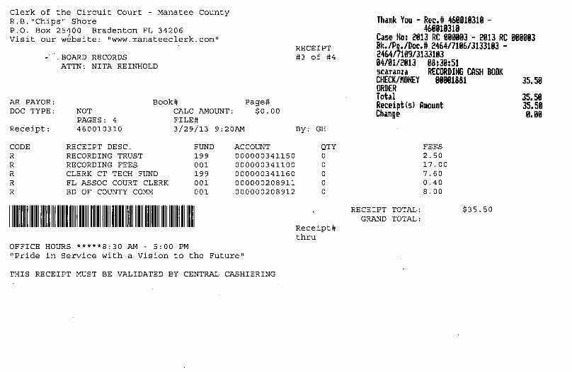
NOT PAGES: 4 460010310 3/29/13 9:20AM
CODE R R R R R
RECEIPT DESC. RECORDING TRUST RECORDING FEES CLERK CT TECH FUND FL ASSOC COURT CLERK BD OF COUNTY COMM
FUND 199 001 199 001 001
1111111111111111111111111111111111111111111111111111111111111111111111111111111111111
OFFICE HOURS *****8:30 AM - 5:00 PM
ACCOUNT 000000341150 000000341100 000000341160 000000208911 000000208912
"Pride in Service with a Vision to the Future"
THIS RECEIPT MUST BE VALIDATED BY CENTRAL CASHIERING
RECEIPT #3 of #4
By: GH
QTY 0 0 0 0 0
Receipt# thru
Thank You - Rec.D 468818318 -468818318
Case No: 2013 RC 880883 - 2813 RC 888883 Bk./Pg./Doc.D 2464/7186/3133183 -2464/7109/3133103 84/81/2813 88:38:51 scaranza RECORDING CASH BOOK CHECK/KONEY 88881881 ORDER Total Receipt(s) Amount Change
RECEIPT TOTAL: GRAND TOTAL:
FEES 2.50 17.00 7.60 0.40 8.00
$35.50
35.58
35.58 35.58 8.88

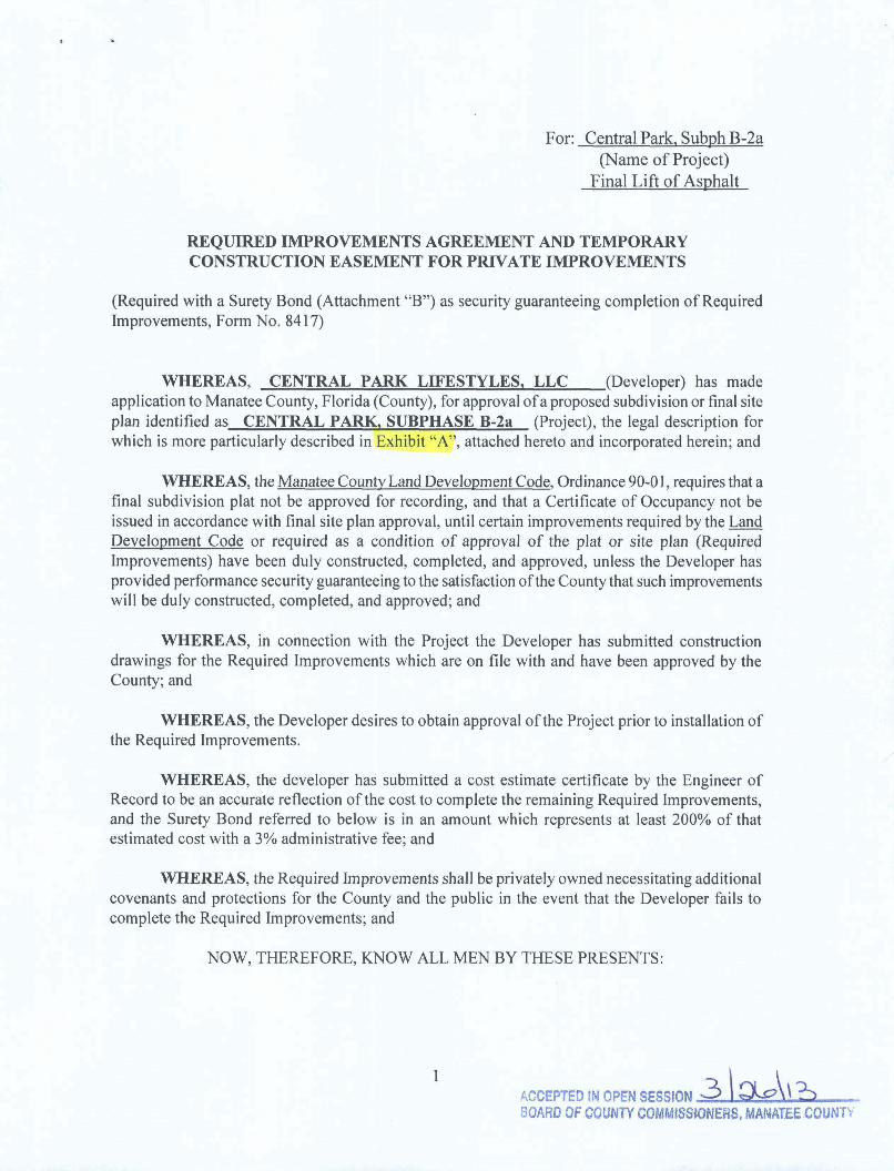
For: Central Park, Subph B-2a (Name of Project)
Paving/StormwaterlIrr
REQUIRED IMPROVEMENTS AGREEMENT AND TEMPORARY CONSTRUCTION EASEMENT FOR PRIVATE IMPROVEMENTS
(Required with a Surety Bond (Attachment "B") as security guaranteeing completion of Required Improvements, Form No. 8417)
WHEREAS, CENTRAL PARK LIFESTYLES, LLC (Developer) has made application to Manatee County, Florida (County), for approval of a proposed subdivision or final site plan identified as CENTRAL PARK, SUBPHASE B-2a (Project), the legal description for which is more particularly described in Exhibit "A", attached hereto and incorporated herein; and
WHEREAS, the Manatee County Land Development Code, Ordinance 90-01, requires that a final subdivision plat not be approved for recording, and that a Certificate of Occupancy not be issued in accordance with final site plan approval, until certain improvements required by the Land Development Code or required as a condition of approval of the plat or site plan (Required Improvements) have been duly constructed, completed, and approved, unless the Developer has provided performance security guaranteeing to the satisfaction of the County that such improvements will be duly constructed, completed, and approved; and
WHEREAS, in connection with the Project the Developer has submitted construction drawings for the Required Improvements which are on file with and have been approved by the County; and
WHEREAS, the Developer desires to obtain approval of the Project prior to instalJation of the Required Improvements.
WHEREAS, the developer has submitted a cost estimate certificate by the Engineer of Record to be an accurate reflection of the cost to complete the remaining Required Improvements, and the Surety Bond referred to below is in an amount which represents at least 200% of that estimated cost with a 3% administrative fee; and
WHEREAS, the Required Improvements shall be privately owned necessitating additional covenants and protections for the County and the public in the event that the Developer fails to complete the Required Improvements; and
NOW, THEREFORE, KNOW ALL MEN BY THESE PRESENTS:
',CCEPTED IN OPEN SESSIO~I~ a1J I?? JOARD OF COUNTY COMMISSIONEl1S. MANATEE COUNTY

J
(Pvt Impv Agree) For: Central Park, Subph B-2a (Name of Project)
l. That the Developer, in consideration ofthe County's approval ofthe proposed Project, and for other valuable consideration, hereby agrees to duly construct and complete the Required Improvements and to otherwise comply fully with the Land Development Code, any conditions of the Project's approval, and all other applicable regulations, requirements and agreements.
2. Developer and LEXON INSURANCE COMPANY ,a Surety Company duly authorized to transact business in the State of Florida (Surety) are held and firmly bound unto the County as obligee/owner in the amount of FOUR HUNDRED FORTY-THREE THOUSAND ONE HUNDRED SIXTEEN & 00/100 Dollars (words) $443,116.00 (numbers), and the Developer herewith tenders to the County a Surety Bond, No. 1083732 , dated JANUARY 25, 2013 with LEXON INSURANCE COMPANY, in the amount FOUR HUNDRED FORTY-THREE THOUSAND ONE HUNDRED SIXTEEN & 00/100 Dollars (words) $443,116.00 (numbers). Said Bond shall not expire until the Required Improvements guaranteed by this Bond has been accepted by the County.
3. That in consideration of the foregoing, it is hereby mutually AGREED as follows:
(a)
(b)
The Developer shall complete t~ satisfaction of th:huno al~eqUired Improvements on or before the day of \YD. 01 in accordance with the construction drawings or any amendments thereto approved by the County, and unless the County electsto proceed in accordance with Paragraph (b) below, the Surety, upon thirty (30) days written notice of the default from the County will cause to be completed the Required Improvements pay all costs, thereof, including without limitation all engineering, legal and contingent costs.
In the event the Developer should fail or refuse to fulfill within the time specified its obligations under this Agreement, the County, at its option, shall have the right to enter upon that portion of the Project property, as determined necessary by the County and take all actions required to construct and complete, or cause to be constructed the Required Improvements. In the event the County should exercise such right, the County shall have the unqualified right to draw funds for the purpose of construction and completing the Required Improvements, or causing the same to be done, and for paying co~ts incidental to the exercise of its rights hereunder, in such amount as the County shall in its sole discretion determine, in accordance with the terms of the Surety Bond. The Developer shall indemnify and save harmless the County against or from all claims, costs, expenses, damages, injury, or loss, either direct or consequential, including without limitation all engineering, legal, and contingent costs which the county may' sustain on account of the failure of the Developer to fulfill its obligations as described herein.
2

(Pvt Impv Agree) For: Central Park, Subph B-2a (Name of Project)
(c) The Developer, his successors and assigns, hereby grants a temporary easement over property in the Project as necessary to allow the County to complete the Required Improvements.
(d) Should it become necessary for the County to complete the Required Improvements, the Developer hereby appoints the. County as its agent for the purposes of using the approvals granted for the required improvements.
4. The Developer agrees that it is liable to the County for all costs and damages, as described above, that the County may incur in connection with constructing and completing the Required Improvements for the life of the Project, without regard to the amount of the Surety Bond identified above. Should the Developer Jailor refuse to complete the Required Improvements, as required, nothing herein shall be construed as affecting the County's right to resort to any and all legal and equitable remedies against the Developer, including specific performance, to which the Developer hereby agrees.
5. The Developer understands and agrees that in the event that the Required Improvements are not constructed or installed in the manner or time consistent with this Agreement, the County shall withhold further permits or approvals for the Project until the Required Improvements have been completed or adequate progress, as determined by the Board of County Commissioners, toward completion of the Required Improvements has been demonstrated.
6. Upon the County's completion of private improvements, the improvement shall be transferred to the Homeowner's Association or that entity set up in the deed restrictions to be responsible for ongoing maintenance ofthe improvements. Inno event shall public funds be used for the maintenance of private improvements, unless they are dedicated to and accepted by the County.
3

(Pvt Imp./Surety- Developer is Corp.) For: Central Park, Subph B-2a
SIGNED AND SEALED this ~ day of ~ ,20..L2
BY:~~ ______ ~ ______ __
~ Witness
ler~ "J,LndS Type or Print Name
Manager Title (If attorney-in-fact Attach Power of Attorney)
8210 Lakewood Ranch Blvd. Postal Address
Lakewood Ranch FL 34202 City State Zip
NOTARY ACKNOWLEDGMENT STATE OF: _ 1L-:-'1'->O<s>,---(" .=.....;14"--____ _ COUNTY OF: 5., ... 4$.'\ \..(
The foregoing instrument was acknowledged before me this S ~ day of f<-\?(~1 ' 20 n , by JAMES R. SCHIER , as MANAGER , (Title), on
behalf of the orporatlOn IdentIfied herem as Developer and who IS personally known to me or who has produced ..• \\\\11111111141' (Type of Identification) as identification . . ~'\\·s. QODDt;~II,/. NOTARY SEAL:
.~ .. ~ •••••••• '1/1-1 ~ .i§f."-;'SS\ON .:,r~~'" % §;;s .. r§ ~~\.20f6 ~ ... . ~
: :~~ ~ :. :: :::. .,.. . <= % • ~ <0<0 \~6.'O~~ j @ ~ SHERRY S DODDE~U. ;. \\~t;.. .0,::- J.;
\;t-;... ~~~~~ •. '!:!..~ Print Name of Notary -:, ~ '" rroyFa\ll\I":~' ~ 'V §
d ~'; 'lfyp ••••••• " 'is -£f'
" ~"!t UaLle. '5' \~~ Approved an accepted for and onlb~~tf'Sr Manatee County, Florida, this 4..Je ~~ ,20j;?
day of
BOARD OF COUNTY COMMISSIONERS OF MANATEE COUNTY, FLORIDA
BY~~ £ ~' C \~ ~\lY !}tIll,
{
. ,,"o\)Y:··· .p~.I'" \- ' ~"'(j... ..~~
A TTEST~ ..... Q.\ Deputy Clerk tff/ s EAL .. ~~ . B. Shore, Clerk of the CirCUit Court ~~:.. ':~$
\C) .. +,~ ~'.' 0f ......... 1'1 '. "-:1.l7;~~~' ••• ",~
IIII ·'·!" llfUfU\\\\\\\
4

EXHIBIT "A"
CENTRAL PARK, SUBPHASE B-2a & B-2c
LEGAL DESCRIPTION (as prepared by the certifying Surveyor and Mapper):
A tract of land lying in Section 8, Township 35 South, Range 19 East, Manatee County, Florida and described as follows:
BEGIN at the northeast corner of the Plat of Central Park, Phase B-2b, recorded in Plat Book 54, Pages 121 through 125 in the Public Records of Manatee County, Florida; thence N.71 °16'27"W., a distance of 60.00 feet to the point of curve of a non-tangent curve to the right, of which the radius point lies N.71°16'27"W., a radial distance of 25.00 feet; thence westerly along the arc of said curve, through a central angle of 139°25'55", an arc distance of 60.84 feet to a point of reverse curve to the left having a radius of 488.00 feet and a central angle of 06°01'34"; thence northwesterly along the arc of said curve, an arc distance of 51.33 feet; thence S.62°07'54"W. , a distance of 253.12 feet to the point of curve of a non-tangent curve to the right, of which the radius point lies S.59°38'18"W., a radial distance of 400.00 feet; thence southeasterly along the arc of said curve, through a central angle of 03°31'39", an arc distance of 24.63 feet; thence S.63°09'57"W. , a distance of 152.00 feet to the point of curve of a non-tangent curve to the right, of which the radius point lies S.63°09'57"W., a radial distance of 248.00 feet; thence southerly along the arc of said curve, through a central angle of 18°48'29", an arc distance of 81.41 feet to a point of compound curve to the right having a radius of 25.00 feet and a central angle of 62°04'03"; thence southwesterly along the arc of said curve, an arc distance of 27.08 feet; thence S.35°57'31"E. , a distance of 51 .37 feet; thence S.08°55'20"W. , a distance of 124.27 feet; thence N.81 °04'40"W. , a distance of 3.25 feet; thence S.08°55'20"W., a distance of 50.00 feet; thence S.1r10'15"W., a distance of 131.26 feet; thence S.71°24'29"W., a distance of61.66 feet to the point of curve of a non-tangent curve to the right, of which the radius point lies S.61°16'50"W., a radial distance of 25.00 feet; thence southerly along the arc of said curve, through a central angle of 63°48'42", an arc distance of 27.84 feet to a point of reverse curve to the left having a radius of 1,152.00 feet and a central angle of 03°43'25"; thence southwesterly along the arc of said curve, an arc distance of 74.87 feet to a point of reverse curve to the right having a radius of 447.34 feet and a central angle of 24°21'28"; thence southwesterly along the arc of said curve, an arc distance of 190.17 feet to a point of reverse curve to the left having a radius of 1,152.00 feet and a central angle of 04°45'02"; thence southwesterly along the arc of said curve, an arc distance of 95.52 feet to a point of reverse curve to the right having a radius of 348.00 feet and a central angle of 05°21'16"; thence southwesterly along the arc of said curve, an arc distance of 32.52 feet to a point of compound curve to the right having a radius of 25.00 feet and a central angle of 59°20'28"; thence westerly along the arc of said curve, an arc distance of 25.89 feet; thence S.25°40'17"W., a distance of 54.92 feet; thence S.72°22'39"W. , a distance of 122.20 feet; thence N.1r37'21"W., a distance of 38.91 feet; thence S.72°22'39"W., a distance of 175.00 feet; thence N.65°47'14"W., a distance of 46.51 feet to the point of curve of a non-tangent curve to the left, of which the radius

point lies N.65°47'14"W., a radial distance of 30.00 feet; thence northerly along the arc of said curve, through a central angle of 41 °44'48", an arc distance of 21.86 feet to a point of compound curve to the left having a radius of 2,823.00 feet and a central angle of 06°43'54"; thence northerly along the arc of said curve, an arc distance of 331.67 feet to a point of compound curve to the left having a radius of 30.00 feet and a central angle of 78°30'15"; thence northwesterly along the arc of said curve, an arc distance of 41.1 0 feet to a point of reverse curve to the right having a radius of 977.00 feet and a central angle of 01 °06'49"; thence westerly along the arc of said curve, an arc distance of 18.99 feet to a point of reverse curve to the left having a radius of 30.00 feet and a central angle of 56°23'17"; thence southwesterly along the arc of said curve, an arc distance of 29.52 feet; thence N.68°02'40"W., a distance of 27.79 feet; thence N.82°19'34"W., a distance of 130.00 feet; thence N.Or40'26"E., a distance of 106.79 feet to a point of curve to the right having a radius of 25.00 feet and a central angle of 7r28'43"; thence northeasterly along the arc of said curve an arc distance of 33.81 feet; thence N.04°50'51"W., a distance of 50.00 feet to the point of curve of a non-tangent curve to the right, of which the radius point lies, N.04°50'51"W., a radial distance of 800.00 feet; thence westerly along the arc of said curve, through a central angle of 06°08'26", an arc distance of 85.74 feet; thence N.01°17'35"E., a distance of 136.02 feet; thence N.53°46'15"E., a distance of 46.26 feet to the point of curve of a non-tangent curve to the left, of which the radius point lies N.53°21 '56"E., a radial distance of 25.00 feet; thence southeasterly along the arc of said curve, through a central angle of 5r16'02", an arc distance of 24.99 feet to a point of compound curve to the left having a radius of 648.00 feet and a central angle of 5r52'27"; thence northeasterly along the arc of said curve, an arc distance of 654.54 feet to a point of reverse curve to the right having a radius of 477.00 feet and a central angle of 06°22'27"; thence northeasterly along the arc of said curve, an arc distance of 53.07 feet to a point of reverse curve to the left having a radius of 35.00 feet and a central angle of 78°30'40"; thence northerly along the arc of said curve, an arc distance of 47.96 feet; thence N.59°55'12"E., a distance of 231.42 feet to a point of curve to the right having a radius of 524.05 feet and a central angle of 12°53'49"; thence northeasterly along,the arc of said curve an arc distance of 117.96 feet to a point of compound curve to the right having a radius of 468.00 feet and a central angle of 20°30'59"; thence easterly along the arc of said curve, an arc distance of 167.58 feet; thenceS.86°40'00"E., a distance of 203.49 feet to the point of curve of a ' non-tangent curve to the right, of which the radius point lies S.6r54'58"E., a radial ' distance of 25.00 feet; thence northeasterly along the arc of said curve, through a central angle of 64°12'07", an' arc distance of 28.01 feet; thence N.86°17'09"E., a distance of 316.01 feet to a point of curve to the right having a radius of 35.00 feet and a central angle of 11 r46'48"; thence southeasterly along the arc of said curve an arc distance of 71.95 feet; thence S.65°56'03"E., a distance of 60.00 feet to the point of curve of a non-tangent curve to the left, of which the radius point lies S.65°56'03"E., a radial distance of 2,930.00 feet; thence southerly along the arc of said curve, through a central angle of 05°20'23", an arc distance of 273.07 feet to the POINT OF BEGINNING.
Said tract contains 1,091,667 square feet or 25.0612 acres, more or less.

FORM NO. 8421 SURETY BOND
FOR PERFORMANCE OF REQUIRED PRIVATE IMPROVEMENTS (Attachment "B") BOND NO. 1083732 KNOW ALL MEN BY THESE PRESENT:
That the Developer, Central Park Lifestyles, LLC, 5800 Lakewood Ranch Blvd .. , Lakewood Ranch, FL 34240 as Principal, and Lexon Insurance Company, 900 S. Frontage Rd., Suite 250, Woodridge, IL 60517, a Surety Company, duly authorized to transact business in the State of Florida, are held and firmly bound unto the County of Manatee, State of Florida, as Obligee, in the sum of $443,116.00 (Numbers) Four Hundred Forty Three Thousand One Hundred Sixteen & 00/1 00 (Words) for the
payment of which we jointly and severally bind ourselves, our heirs, executors, administrators, successors and assigns, for the specific benefit of the County in accordance with the conditi.ons set forth herein and in the "Required Improvements Agreement" which is hereby incorporated herein by reference.
THE CONDIT~N , fthe above obligation is such that, Whereas the Principal has entered into a contract, dated.3 lo \ ?J (LEAVE BLANK - Board of County Commission approval date) with the obligation to do and perform certain work relating to Central Park Subpbase B-2a (Subdivision).
NOW THEREFORE, if the principal shall fully perform all the covenants and terms of said contract, then this obligation shall be null and void; otherwise this obligation shall remain in full force and effect, and Surety shall cause the contract to be fully performed or pay to obligee the cost of performing said contract in an amount not exceeding the said sum specified above. In the event such performance is not completed within the time specified in the attached "Required Improvements Agreement and Temporary Construction Easement for Private Improvements", the obligee shall be entitled to collection of this surety bond. Means of notification of intent to collect shall be by certified mail to the Surety at the address on page ~ {insert page number of surety's address}. Payment will be made to the County within 30 days by certified check drawn on behalf of the Board of County Commissioners at P. O. Box 1000, Bradenton, FL 34206.
The Surety does hereby consent to any and all alternations, extensions of time, or other modifications to the contract secured by this bond.
This Surety Bond shall be construed in accordance to the Laws of Florida, and any action of whatever nature, in connection with this Bond and the Required Improvements Agreement shall be filed in the Twelfth Judicial Circuit in and for Manatee County, Florida.
Page 1 of 3
A "'EPTEO IN OPEN SES~~ [; nO OF COUNTY COMMISSWNERS. MANATEE COL

' .. INSURANCE COMPANY SIGNATURE FORM
FOR: Central Park Subphase B-2a Earthwork, General, Paving, Drainage and Irrigation
(Name of Project) BOND NO. 1083732
SIGNED AND SEALED this 25th day of January, 2013
Lexon Insurance Company
n Surety C§OYName ~ By:~~~'~~~~~~'~~~~_' __ ~
Signature - As Agent Dawn L. Morgan, Attorney-In-Fact
Florida License No. P011322 Print Name & Title
900 S. Frontage Rd., Suite 250 Address
Woodridge, IL 60517 City State Zip
_VtaC-SSES OR CORPO~
Signature Si~ Donna Whalen -=B::;..:o:..:;n::..:;n:..:.ie::.....::.;Kr:::..::u~se:....... _______ _
Print Name Print Name NOTARY ACKNOWLEDGMENT
STATE OF: Illinois COUNTY OF DuPage
The foregoing instrument was acknowledged before e this 25th day of January, 2013, by Dawn L. Morgan as Attorney-In-Fact (Title), on behalf the Suretyidenti herein, and who is ersonall known to me or who has roduced NI A (T of Identificatio s identification.
NOTARYSE OFFICIAl SEAL
Tf.FlI~S'= M PISCIOTTO I\'onRY PIjI?LIC. STATE OF ILLINOIS MY COMMISSION EXPIRES 6/26/2014
Commission No. 560807 ------~------------
Notary Public Tariese M. Pisciotto
Print Name of Notary My Commission Expires: June 26, 2014
Page 2 of 3
. "
-N'

.. . .
DEVELOPER SIGNATURE FORM
FOR: Central Park Subphase B-2a Earthwork, General, Paving, Drainage and Irrigation
(Name of Project)
SIGNED AND SEALED this ~ day of , 2013 ~NO" 1083732 .
(If attorney-in-fact Attach Power of Attorney)
les LLC
Developer JAMESR.SCHmR ~
Print Name & Title 5800 Lakewood Ranch Blvd.
Postal Address Lakewood Ranch, FL 34240
City State Zip
-t-:~~"",-,-"",t L'--=T--T. ,--1:.=----= ~~ /h _WI_T_N_E_SSES OR CORPO~S'~ U )fpV2 ~~ 19natufe
Kathy Frey SANDrOWENS Print Name Print Name
NOTARY ACKNOWLEDGMENT STATE OF fl~ J.i..
~~----~-------
COUNTY OF ~~j\)..\-1I
"I The foregoing instrument was acknowledged before me this '2 <l-t> day of ~ , 20_\_..)_ , by JAMES R.8ClDER as ~ ~nbehalf of the PrincipallDeveloper identified herein, and who is personally known to me or who has produced
(Type ofIdentification) as identification. "~
NOTARY SEAL: __ ~~~~DJ~N4~~~~~==~~~~ ~,'~rR'f~"'" SHERRY S. DODDEMA Notary ~ublic {.rA-~:~ Cofl.lmlsslon # EE 194509 SHERRY S. DODDEMA 'f;;.-~~: Expires May 21,2016 P' N fN
•.. ;,.:, ,, .••. :: - BondedihruTroy Fainln_nceB00-3S~7019 nnt ame 0 otary Commission No. My Commission Expires: ________ -:--____ _ Approve~ and accepted for and on behalf of Manatee County, Florida, this 'J¥& day of ~---"-----=:::"""""'--'----___ , 20 l? .
BOARD OF COUNTY COMMISSIONERS
B~F~~A ~an
. Shore, Clerk of the Circuit Court
Page 3 of 3

.,' .P POWER OF ATTORNEY
Lexon Insurance Company Lx-119985
KNOW ALL MEN BY THESE PRESENTS, that LEXON INSURANCE COMPANY, a Texas Corporation, with its principal office in Louisville, Kentucky, does hereby constitute and appoint:
James L Moore, Bonnie Kruse, Stephen T. Kazmer, Dawn L. Morgan, Peggy Faust,***********
Kelly A. GardneI; Elaine Marcus, Jennifer 1. McComb, Melissa Schmidt, Donna Whalen, Tariese M. Pisciotto **************************.***********
its true and lawful Attorney(s)-In-Fact to make, execute, seal and deliver for, and on its behalf as surety, any and all bonds, undertakings or other writings obligatory in nature of a bond.
This authority is made under and by the authority of a resolution which was passed by the Board of Directors of LEXON INSURANCE COMPANY on the 1 st day of July, 2003 as follows:
Resolved, that the President of the Company is hereby authorized to appoint and empower any representative of the Company or other person or persons as Attorney-In-Fact to execute on behalf of the Company any bonds, undertakings, policies, contracts of indemnity or other writings obligatory in riature of a bond not to exceed $2,500,000.00, Two-million five hundred thousand dollars, which the Company
,might execute through its duly elected officers, and affix the seal of the Company thereto. Any said execution of such documents by an Attorney-In-Fact shall be as binding upon the Company as if they had been duly executed and acknowledged by the regularly elected officers of the Company. Any Attorney-In-Fact, so appointed, may be removed for good cause and the authority so granted may be revoked as specified in the Power of Attorney.
Resolved, that the signature of the President and the seal of the Company may be affixed by facsimile on any power of attorney granted, and the Signature of the Assistant Secretary, and the seal of the Company may be affixed by facsimile to any certificate of any such power and any such power or certificate bearing such facsimile signature and seal shall be valid and binding on the Company. Any such power so executed and sealed and certificate so executed and sealed shall, with respect to any bond of undertaking to which it is attached, continue to be valid and binding on the Company.
IN WITNESS THEREOF, LEXON INSURANCE COMPANY has caused this instrument to be signed by its President, and its Corporate Seal to be affixed this 21 st day of September, 2009.
LEXON INSURANCE COMPANY
By_a_0_' _~~_~------,-r_
ACKNOWLEDGEMENT
David E. Campbell President
On this 21st day of September, 2009, before me, personally came David E. Campbell to me known, who being duly sworn, did depose and say that he is the President of LEXON INSURANCE COMPANY, the corporation described in and which executed the above instrument; that he executed said instrument on behalf of the corporation by authority of his office under the By-laws of said corporation.
"OFFICIAL SEAL" MAUREENK.AYE
Notary Public, State of Illinois My Commission Expires 09/21113
CERTIFICATE
Vhj~t~ '= Maureen K. AYe Notary Public
I, the undersigned, Assistant Secretary of LEXON INSURANCE COMPANY, A Texas Insurance Company, DO HEREBY CERTIFY that the original Power of Attorney of which the foregoing is a true and correct copy, is in full force and effect and has not been revoked and the resolutions as set forth are now in force.
Signed and Sealed at Woodridge, Illinois this 25~h "' .··.Qay of January ,20_1_3 __ .' e )'6\~j'I;~f~~" ".-
'~;~4~;r~~L~ \\#:~'!!;i;.PJ':'"A::~;· : ;:;,-:.,.
t;{;i\~t\'r::~t· A~:rfnt"s;c~~r~ry "WARNING: Any person who knowingly and with intent"to def;'au~.·~ny insurance company or other person, files an application for insurance or statement of claim containing any materially false info'rmation, or conceals for the purpose of misleading, information concerning any fact material thereto, commits a fraudulent insurance act, which is a crime and subjects such person to criminal and civil penalties."
LX1
For: Central Park, Subph B-2a (Name of Project)
Final Lift of Asphalt
REQUIRED IMPROVEMENTS AGREEMENT AND TEMPORARY CONSTRUCTION EASEMENT FOR PRIVATE IMPROVEMENTS
(Required with a Surety Bond (Attachment "B") as security guaranteeing completion of Required Improvements, Form No. 8417)
WHEREAS, CENTRAL PARK LIFESTYLES, LLC (Developer) has made application to Manatee County, Florida (County), for approval ofa proposed subdivision or final site plan identified as CENTRAL PARK, SUBPHASE B-2a (Project), the legal description for which is more particularly described in Exhibit "A", attached hereto and incorporated herein; and
WHEREAS, the Manatee County Land Development Code, Ordinance 90-0 I, requires that a final subdivision plat not be approved for recording, and that a Certificate of Occupancy not be issued in accordance with final site plan approval, until certain improvements required by the Land Development Code or required as a condition of approval of the plat or site plan (Required Improvements) have been duly constructed, completed, and approved, unless the Developer has provided performance security guaranteeing to the satisfaction of the County that such improvements wilI be duly constructed, completed, and approved; and
WHEREAS, in connection with the Project the Developer has submitted construction drawings for the Required Improvements which are on file with and have been approved by the County; and
WHEREAS, the Developer desires to obtain approval ofthe Project prior to installation of the Required Improvements.
WHEREAS, the developer has submitted a cost estimate certificate by the Engineer of Record to be an accurate reflection ofthe cost to complete the remaining Required Improvements, and the Surety Bond referred to below is in an amount which represents at least 200% of that estimated cost with a 3% administrative fee; and
WHEREAS, the Required Improvements shall be privately owned necessitating additional covenants and protections for the County and the public in the event that the Developer fails to complete the Required Improvements; and
NOW, THEREFORE, KNOW ALL MEN BY THESE PRESENTS:
ACCEPTED IN OPEN SESSION 3 \ Q.e\ \ '?) BOARD OF COUNTY COMMISStONERS, MANATEE COUNT\'

(Pvt Impv Agree) For: Central Park, Subph B-2a (Name of Project)
1. That the Developer, in consideration ofthe County's approval ofthe proposed Project, and for other valuable consideration, herebyagreesto duly construct and complete the Required Improvements and to otherwise comply fully with the Land Development Code, any conditions ofthe Project's approval, and all other applicable regulations, requirements and agreements.
2. Developer and LEXON.INSURANCE COMPANY ,a Surety Company duly authorized to transact business in the State of Florida (Surety) are held and firmly bound unto the County as obligee/owner in the amount of TWENTY-ONE THOUSAND SIX HUNDRED FIFTY-NINE & 05/100 Dollars (words) $21,659.05 (numbers), and the Developer herewith tenders to the County a Surety Bond, No. 1083733 ,dated
JANUARY 25, 2013 with LEXON INSURANCE COMPANY , in the amount of TWENTY-ONE THOUSAND SIX HUNDRED FIFTY-NINE & 05/100 Dollars
(words) $21,659.05 (numbers). Said Bond shall not expire until the Required Improvements guaranteed by this Bond has been accepted by the County.
3. That in consideration of the foregoing, it is hereby mutually AGREED as follows:
(a)
(b)
The Developer shall complete ~ the satisfaction f/'r~e counlx)l~eqUired Improvements on or before th~l o'1h day of i vob I· in accordance with the construction drawings or any amendments thereto approved by the County, and unless the County elects to proceed in accordance with Paragraph (b) below, the Surety, upon thirty (30) days written notice ofthe default from the County will cause to be completed the Required Improvements pay all costs, thereof, including without limitation all engineering, legal and contingent costs.
In the event the Developer should fail 9r refuse tp fulfill within the time specified its obligations under this Agreement, the County, at its option, shall have the right to enter upon that portion of the Project property, as determined necessary by the County and take all actions required to construct and complete, or cause to be constructed the Required Improvements. In the event the County should exercise such right, the County shall have the unqualified right to draw funds for the purpose of construction and completing the Required Improvements, or causing the same to be done, and for paying costs incidental to the exercise of its rights hereunder, in such amount as the County shall in its sole discretion determine, in accordance with the terms of the Surety Bond. The Developer shall indemnify and save harmless the County against or from all claims, costs, expenses, damages, injury, or loss, either direct or consequential, including without limitation all engineering, legal, and contingent costs which the county may sustain on account of the failure of the Developer to fulfill its obligations as described herein.
2

(Pvt Impv Agree) For: Central Park, Subph B-2a (Name of Project)
(c) The Developer, his successors and assigns, hereby grants a temporary easement over property in the Project as necessary to allow the County to complete the Required Improvements.
(d) Should it become necessary for the County to complete the Required Improvements, the Developer hereby appoints the County as its agent for the purposes of using the approvals granted for the required improvements.
4. The Developer agrees that it is liable to the County for all costs and damages, as described above, that the County may incur in connection with constructing and completing the Required Improvements for the life ofthe Project, without regard to the amount of the Surety Bond identified above. Should the Developer fail or refuse to complete the Required Improvements, as required, nothing herein shall be construed as affecting the County's right to resort to any and all legal and equitable remedies against the Developer, including specific performance, to which the Developer hereby agrees.
5. The Developer understands and agrees that in the event that the Required Improvements are not constructed or installed in the manner or time consistent with this Agreement, the County shall withhold further permits or approvals for the Project until the Required Improvements have been completed or adequate progress, as determined by the Board of County Commissioners, toward completion of the Required Improvements has been demonstrated.
6. Upon the County's completion of private improvements, the improvement shall be transferred to the Homeowner's Association or that entity set up in the deed restrictions to be responsible for ongoing maintenance of the improvements. In no event shall public funds be used for the maintenance of private improvements, unless they are dedicated to and accepted by the County.
3

(Pvt Imp.lSurety- Developer is Corp.) For: Central Park, Subph B-2a
SIGNED AND SEALED this _5_-__ day Of----+-t:hry~ __ --I-__ , 20 /3
~TNESSES: ~ Q::ez~,
BY:~~ ______ ~~ ____ __
Type or Print Name Manager
Title (If attorney-in-fact Attach Power of Attorney) 8210 Lakewood Ranch Blvd.
Postal Address Lakewood Ranch FL 34202
City State Zip
NOTARY ACKNOWLEDGMENT STATE OF: --I.1....1.h~,f'....:...;, J4~ ______ _ COUNTY OF: £'a.r~\\,",
The foregoing instrument was acknowledged before me this 5 b..- day of Ewy,o..ry , 20\,3, ,by JAMES R. SCHIER ,as MANAGER, (Title), on
behalf of the cb rporation identified herein as Developer and who is personally known to we or who has produced \\\\1 II I!/II,., (Type of Identification) as identification.
~""\~?JW s. D 111111" ~ ~c::>~.··· .. ····q'a~~ ~. ~ NOTARY SEAL: ~ "'c,o~MISSIO-t'" ~ ~ s:__ ~ g .'~ ~'3.~ 21,<, ~' •• ~~ ...:......~~=\-\ -=--=------"-----if--
~ * f l7-d> ~.~ § Notary Public § 5: .... fJ) : g SHERRY S. DODDEMA ::: A • #££ 1945 • * :: ~~'" '1,~.th 09 ":"'''t"§ Print Name of Notary ~ A) e. -:Y~'!Jed ru • ~ ~ ~ 2h • •• qIfl1nsura[ffo •• ' ~ '* ~~~~§i;ji~t«~~f' rI ~
AP~~ccePt~~~.nd ot'f'wtM~H~~'t'\vlanatee County, Florida, this ~ day of
BOARD OF COUNTY COMMISSIONERS OF MANA TEE COUNTY, FLORIDA
BY: 't~~ ~
Chatrman
/ ~ \\\1111111111,//
, "I NiY C "I I _ ,','o'V •••••• ~~'",
A TTEST'1 Deputy Clerk ~i~'" .. ~~ :B:ShOre,CiefkOftheCircuit Court ~~:" SEAL y~¥
\'2>:' .:~ff -:;.\SI •• 1:,.1< ~ •• 0~ ~'" •. :r.~9?;' ••• ",~
"'llfll"" 1l1" \\\\\\\
4
--

EXHIBIT "A"
CENTRAL PARK, SUBPHASE B-2a & B-2c
LEGAL DESCRIPTION (as prepared by the certifying Surveyor and Mapper):
A tract of land lying in Section 8, Township 35 South, Range 19 East, Manatee County, Florida and described as follows:
BEGIN at the northeast corner of the Plat of Central Park, Phase B-2b, recorded in Plat Book 54, Pages 121 through 125 in the Public Records of Manatee County, Florida; thence N.71 °16'27"W., a distance of 60.00 feet to the point of curve of a non-tangent curve to the right, of which the radius point lies N.71°16'27"W., a radial distance of 25.00 feet; thence westerly along the arc of said curve, through a central angle of 139°25'55", an arc distance of 60.84 feet to a point of reverse curve to the left having a radius of 488.00 feet and a central angle of 06°01'34"; thence northwesterly along the arc of said curve, an arc distance of 51.33 feet; thence S.62°07'54"W., a distance of 253.12 feet to the point of curve of a non-tangent curve to the right, of which the radius point lies S.59°38'18"W., a radial distance of 400.00 feet; thence southeasterly along the arc of said curve, through a central angle of 03°31 '39", an arc distance of 24.63 feet; thence S.63°09'57"W., a distance of 152.00 feet to the point of curve of a non-tangent curve to the right, of which the radius point lies S.63°09'57"W., a radial distance of 248.00 feet; thence southerly along the arc of said curve, through a central angle of 18°48'29", an arc distance of 81.41 feet to a point of compound curve to the right having a radius of 25.00 feet and a central angle of 62°04'03"; thence southwesterly along the arc of said curve, an arc distance of 27.08 feet; thence S.35°57'31"E., a distance of 51.37 feet; thence S.08°55'20"W., a distance of 124.27 feet; thence N.81 °04'40"W., a distance of 3.25 feet; thence S.08°55'20"W., a distance of 50.00 feet; thence S.1r10'15"W., a distance of 131.26 feet; thence S.71°24'29"W., a distance of61.66 feet to the point of curve of a non-tangent curve to the right, of which the radius point lies S.61°16'50"W., a radial distance of 25.00 feet; thence southerly along the arc of said curve, through a central angle of 63°48'42", an arc distance of 27.84 feet to a point of reverse curve to the left having a radius of 1,152.00 feet and a central angle of 03°43'25"; thence southwesterly along the arc of said curve, an arc distance of 74.87 feet to a point of reverse curve to the right having a radius of 447.34 feet and a central angle of 24°21 '28"; thence southwesterly along the arc of said curve, an arc distance of 190.17 feet to a point of reverse curve to the left having a radius of 1,152.00 feet and a central angle of 04°45'02"; thence southwesterly along the arc of said curve, an arc distance of 95.52 feet to a point of reverse curve to the right having a radius of 348.00 feet and a central angle of 05°21'16"; thence southwesterly along the arc of said curve, an arc distance of 32.52 feet to a point of compound curve to the right having a radius of 25.00 feet and a central angle of 59°20'28"; thence westerly along the arc of said curve, an arc distance of 25.89 feet; thence S.25°40'17"W., a distance of 54.92 feet; thence S.72°22'39"W., a distance of 122.20 feet; thence N.1r37'21"W., a distance of 38.91 feet; thence S.72°22'39"W., a distance of 175.00 feet; thence N.65°47'14"W., a distance of 46.51 feet to the point of curve of a non-tangent curve to the left, of which the radius

point lies N.65°47'14"W., a radial distance of 30.00 feet; thence northerly along the arc of said curve, through a central angle of 41 °44'48", an arc distance of 21.86 feet to a point of compound curve to the left having a radius of 2,823.00 feet and a central angle of 06°43'54"; thence northerly along the arc of said curve, an arc distance of 331.67 feet to a point of compound curve to the left having a radius of 30.00 feet and a central angle of 78°30'15"; thence northwesterly along the arc of said curve, an arc distance of 41.10
. feet to a point of reverse curve to the right having a radius of 977.00 feet and a central angle of 01 °06'49"; thence westerly along the arc of said curve, an arc distance of 18.99 feet to a point of reverse curve to the left having a radius of 30.00 feet and a central angle of 56°23'17"; thence southwesterly along the arc of said curve, an arc distance of 29.52 feet; thence N.68°02'40"W., ,a distance of 27.79 feet; thence N.82°19'34"W., a distance of 130.00 feet; thence N.Or40'26"E., a distance of 106.79 feet to a point of curve to the right having a radius of 25.00 feet and a central angle of 7r28'43"; thence northeasterly along the arc of said curve an arc distance of 33.81 feet; thence N.04°50'51"W., a distance of 50.00 feet to the point of curve of a npn-tangent curve to the right, of which the radius point lies N.04°50'51"W., a radial distance of 800.00 feet; thence westerly along the arc of said curve, through a central angle of 06°08'26", an arc distance of 85.74 feet; thence N.01°17'35"E., a distance of 136.02 feet; thence N.53°46'15"E., a distance of 46.26 feet to the point of curve of a non-tangent curve to the left, of which the radius point lies N.53°21'56"E., a radial distance of 25.00 feet; thence southeasterly along the arc of said curve, through a central angle of 5r16'02", an arc distance of 24.99 feet to a point of compound curve to the left having a radius of 648.00 feet and a central angle of 5r52'27"; thence northeasterly along the arc of said curve, an arc distance of 654.54 feet to a point of reverse curve to the right having a radius of 477.00 feet and a central angle of 06°22'27"; thence northeasterly along the arc of said curve, an arc distance of 53.07 feet to a point of reverse curve to the left . having a radius of 35.00 feet and a central angle of 78°30'40"; thence northerly along the arc of said curve, an arc distance of 47.96 feet; thence N.59°55'12"E., a distance of 231.42 feet to a point of curve to the right having a radius of 524.05 feet and a central angle of 12°53'49"; thence northeasterly along the arc of said curve an arc distance of 117.96·feet to a point of compound curve to the right having a radius of 468.00 feet and a central angle of 20°30'59"; thence easterly along the arc of said curve, an arc distance of 167.58 feet; thence S.86°40'OOtlE., a distance of 203.49 feet to the point of curve of a non-tangent curve to the right, of which the radius point lies S.6r54'58"E., a radial distance of 25.00 feet; thence northeasterly along the arc of said curve, through a central angle of 64°12'07", an arc distance of 28.01 feet; thence N.86°17'09"E., a distance of 316.01 feet to a point of curve to the right having a radius of 35.00 feet and a central angle of 117°46'48"; thence southeasterly along the arc of said curve an arc
. distance of 71.95 feet; thence S.65°56'03"E., a distance of 60.00 feet to the point of curve of a non-tangent curve to the left, of which the radius point lies S.65°56'03"E., a radial distance of 2,930.00 feet; thence southerly along the arc of said curve, through a central angle of 05°20'23", an arc distance of 273.07 feet to the POINT OF BEGINNING. .
Said tract contains 1,091,667 square feet or 25.0612 acres, more or less.

FORM NO. 8421 SURETY BOND
FOR PERFORMANCE OF REQIDRED PRIVATE IMPROVEMENTS (Attachment "B") BOND NO. 1083733 KNOW ALL MEN BY THESE PRESENT:
That the Developer, Central Park Lifestyles, LLC, 5800 Lakewood Ranch Blvd .. , Lakewood Ranch, FL 34240 as Principal, and Lexon Insurance Company, 900 S. Frontage Rd., Suite 250, Woodridge, IL 60517, a Surety Company, duly authorized to transact business in the State of Florida, are held and firmly bound unto the County of Manatee, State of Florida, as Obligee, in the sum of $21,659.05 (Numbers) Twenty One Thousand Six Hundred Fifty Nine & 05/100 (Words) for the payment of which we jointly and severally bind ourselves, our heirs, executors, administrators, successors and assigns, for the specific benefit of the County in accordance with the conditions set forth herein and in the "Required Improvements Agreement" which is hereby incorporated herein by reference.
THE CONDI~$ o~ the above obligation is such that, Whereas the Principal has entered into a contract, dated ,::) !) \ ~ (LEAVE BLANK - Board of County Commission approval date) with the obligation to do and perform certain work relating to Central Park Subpbase B-2a (Subdivision).
NOW THEREFORE, if the principal shall fully perform all the covenants and terms of said contract, then this obligation shall be null and void; otherwise this obligation shall remain in full force and effect, and Surety shall cause the contract to be fully performed or pay to obligee the cost of performing said contract in an amount not exceeding- the said sum specified above. In the event such performance is not completed within the time specified in the attached "Required Improvements Agreement and Temporary Construction Easement for Private Improvements", the obligee shall be entitled to collection of this surety bond. Means of notification of intent to collect shall be by certified mail to the Surety at the address on page ~ {insert page number of surety's address}. Payment will be made to the County within 30 days by certified check drawn on behalf of the Board of County Commissioners at P. O. Box 1000, Bradenton, FL 34206.
The Surety does hereby consent to any and all alternations, extensions of time, or other modifications to the contract secured by this bond.
This Surety Bond shall be construed in accordance to the Laws of Florida, and any action of whatever nature, in connection with this Bond and the Required Improvements Agreement shall be filed in the Twelfth Judicial Circuit in and for Manatee County, Florida.
Page 1 of 3
ACCEPTED IN OPEN SESSION ·3W \ ~ BOARD OF COUNTY COMMISSIONERS. MANATEE COUNT '

INSURANCE COMPANY SIGNATURE FORM
FOR: Central Park Subphase B-2a Final Lift of Asphalt
(Name of Project) BOND NO. 1083733
SIGNED AND SEALED this 25th day of January, 2013
Lexon Insurance Company
~etycom~anYName By: ~ ~ _~
Signature - As Agent Dawn L. Morgan, Attorney-In-Fact
Florida License No. POI1322 Print Name & Title
900 S. Frontage Rd., Suite 250 Address
Woodridge, IL 60517 City State Zip
~1i~ES ORCORPO~~ ~ Signature ! Signature
Donna Whalen -=B::..:o:..::;n~m::;:,· e::::....:.;Kr=-=u~se::::..-_______ _ Print Name Print Name
NOTARY ACKNOWLEDGMENT STATE OF: Illinois COUNTY OF DuPage
The foregoing instrument was acknowledged before Dawn L. Morgan as Attorne -I - n behalf
~==~~~~o ~m::re',2I i~1:eJ!itproduced fA (Typ
e this 25th day of January, 2013, by the Surety identi herein, and who ofIdentification identification.
T"~:~SE M PiSC\01TO f,jOTAP:Pt~-8UG. 3T~\TE o~ ILLINOIS MY COMMISSION EXPIR.ES 6:26/2014 Notary Pu lic
Tariese M. Pisciotto Print Name of Notary
Commission No. --------------------560807 My Commission Expires: June 26, 2014
Page 2 of 3

DEVELOPER SIGNATURE FORM
FOR: Central Park Subphase B-2a Final Lift of Asphalt
(Name of Project) ~O.1083733
SIGNED AND SEALED this ~8 day of ---Jf'~="";""';"-+----l' 2013 f'
(If attorney-in-fact Attach Power of Attorney)
Central Park . les LLC
Developer JAMESR.SCHIml ~
Print Name & Title 5800 Lakewood Ranch Blvd.
Postal Address Lakewood Ranch, FL 34240
City State Zip
I",..~~~--",-,d~~_ (\=-:;k~/+-., _W_I_T_N_E_SSES OR CORPO~ rL.Mgn~ ~ig1}ature
Kathy Frey SANDI OWENS
Print Name Print Name
STATE OF COUNTY OF
NOTARY ACKNOWLEDGMENT
The foregoing instrument was acknowledged before me this 21'6.. day of ~ , 20~, by - JAMFSR.SCBIER as ~ (Title), bn behalf of the Principal/Developer identified herein, and who is personally !mown to me or who has produced ___________ (Type of Identification) as identification.
NOTARY SEAL: d:'h,~ ~ ~ .l'~~';~o;", SHERRY S. DODDEMA Notar; Public t*~'A'~f;~ Commission # EE 194509 SHERRY S. DODDEMA ~:.~.:~: Expires May 21 2016 ~l,t;;;",~~" BondedThru T"'YFainl~800-38S-7019 Print Name of Notary
"'flU"
Commission No. My Commission Expires: ---........------;r---
Approved and accepted for and on behalf of Manatee County, Florida, this <;kib day of rruvrb , 20 \6 . BOARD OF COUNTY COMMISSIONERS
OF~TEECD~A BY:
ATTEST: ' 6 - U (\ \,,,.1111,,,,,/ ~ ,"''. 'NTY C I"~"~ .. " ov •••••• ~~ ' ... . B. Shore, Clerk of the CIrcUIt Court ~\~.·· ' .. ~;::.
So - -. cp;'
~o:" SEAL :o~ : tr . :z= ~~~. .:~ff ~\S) "~1< ~.·0$
-:. ... ··~1J;E'CO ·· .·· .... " "'11/ • •••• • \ \""
"II"'II U\\\\\\
Page 3 of 3

.. .' . POWER OF ATTORNEY
Lexon Insurance Company Lx-119986
KNOW ALL MEN BY THESE PRESENTS, that LEXON INSURANCE COMPANY, a Texas Corporation, with its principal office in Louisville, Kentucky, does hereby constitute and appoint:
James I. Moore, Bonnie Kruse, Stephen T, Kazmer, Dawn L. Morgan, Peggy Faust," •••• _ •••••
Kelly A Gardne~ Elaine Marcus, Jennifer 1. McComb, Melissa Schmidt, Donna Whalen, Tariese M. Pisciotto ••••••••• * ............................ .
its true and lawful Attorney(s)-In-Fact to make, execute, seal and deliver for, and on its behalf as surety, any and all bonds, undertakings or other writings obligatory in nature of a bond,
This authority is made under and by the authority of a resolution which was passed by the Board of Directors of LEXON INSURANCE COMPANY on the 1 st day of July, 2003 as follows:
Resolved, that the President of the,Company is hereby authorized to appoint and empower any representative of the Company or other person or persons as Attorney-In-Fact to execute on behalf of the Company any bonds, undertakings, policies, contracts of indemnity or other writings obligatory in nature of a bond not to exceed $2,500,000.00, Two-million five hundred thousand dollars, which the Company might execute through its duly elected officers, and affix the seal of the Company thereto. Any said execution of such documents by an Attorney-In-Fact shall be as binding upon the Company as if they had been duly executed and acknowledged by the regularly elected officers of the Company. Any Attorney-In-Fact, so appointed, may be removed for good cause and the authority so granted may be revoked as specified in the Power of Attorney.
Resolved, that the signature of the President and the seal of the Company may be affixed by facsimile on any power of attorney granted, and the signature of the Assistant Secretary, and the seal of the Company may be affixed by facsimile to any certificate of any such power and any such power or certificate bearing such facsimile signature and seal shall be valid and binding on the Company. Any such power so executed and sealed and certificate so executed and sealed shall, with respect to any bond of undertaking to which it is attached, continue to be valid and binding on the Company,
IN WITNESS THEREOF, LEXON INSURANCE COMPANY has caused this instrument to be signed by its President, and its Corporate Seal to be affixed this 21 st day of September, 2009,
ACKNOWLEDGEMENT
LEXON INSURANCE COMPANY
By_a_~_· _~~_~-----,----r_ David E. Campbell
, President
On this 21 st day of September, 2009, before me, personally came David E, Campbell to me knoyvn, who being duly sworn, did depose and say that he is the President of LEXON INSU~ANCE COMPANY, the corporation described in and which executed the above instrument; that he executed said instrument on behalf of the corporation by authority of his office under the By-laws of said corporation.
"OFFICIAL SEAL" MAUREEN K. AYE
Notary Public, State of Illinois My Commission Expires 09121113
CERTIFICATE ~e:~
Notary Public
I, the undersigned, Assistant Secretary of LEXON INSURANCE COMPANY, A Texas Insurance Company, DO HEREBY CERTIFY that the original Power of Attorney of which the foregoing is a true and correct copy, is in full force and effect and has not been revoked and the resolutions as set forth are now in force. .
Signed and Sealed at Woodridge, Illinois this 25thj~~~~::",D~Y;' ',="" .. ""Jc;-a_n_ll_a_r_Y_,20 13 -----"--,t!77,~d ... ""~i'7-~/' .• f:;, ,~~ ~"l:: ...... r.'.~
Philip G. Lauer Assistant Secretary
"WARNING: Any person who knowingly and with intent to defraud any insurance company or other person, files an application for insurance or statement of claim containing any materially false information, or conceals for the purpose of misleading, information concerning any fact material thereto, commits a fraudulent insurance act, which is a crime and subjects such person to criminal and civil penalties."
LX1

For: Central Park, Ph B-2a (Name of Project)
AGREEMENT FOR FINAL WEARING COURSE OF ASPHALT ON ROADWAYS (Privately Maintained Roadways)
THIS AGREEMENT is made and entered into by and between Manatee County, a
political subdivision of the State of Florida (County), and CENTRAL PARK
LIFESTYLES, LLC (Developer), concerning the placement of the final wearing course of
asphalt on roadways.
RECITALS
WHEREAS, Developer has posted payment and performance bonds with the County
for the installation of certain subdivision improvements within the final subdivision plat
known as CENTRAL PARK PHASE B-2a . All such improvements are hereinafter
referred to as the "Required Improvements"; and
WHEREAS, Developer has completed said Required Improvements to the County's
satisfaction with the exception ofthe placement ofthe final wearing course of asphalt on the
roadways; and
WHEREAS, both the County anq Developer are desirous of delaying the installation
of the final wearing course of asphalt so that it is not marred by construction traffic.
NOW, THEREFORE, in consideration of the mutual covenants and promises set
forth below, and other good and valuable consideration, receipt of which is hereby
acknowledged, the parties agree to Paragraphs 1 through 4 as follows:
Page 1 of3

(Final Wearing Course Agree) For: Central Park, Ph B-2b (Name of Projyct)
1. Developer will post one or more new payment and performance bonds for the final wearing
course of asphalt which is to be installed by the Developer within one (I) year of the date of
the new payment and performance bonds unless otherwise extended by mutual consent ofthe
County and Developer.
2. The County agrees to release the existing Subdivision Completion Bonds, simultaneously
with the acceptance of the payment and performance bonds for the final wearing course of
asphalt.
3. Developer agrees to be responsible for the maintenance of the roadways until such time as
the final wearing course of asphalt is installed by the Developer and accepted for
maintenance by the Homeowner's Association.
4. County agrees to accept these measures as adequate security necessary to insure the
installation, guarantees, and maintenance of said improvements and to issue Final
Certificates of Occupancy for any units or other building that have been conditioned upon
completion of the Required Improvements.
Page 2 of3

(Final Wearing Course of Asphalt) For: Central Park, Ph B-2a (Project Name)
SIGNED AND SEALED this S- day Of---,-&::.:::...~,,---,-~+--__ , 20~
~ Wltnes Kathy Frey BY:~~~ __ ~ __ __
Type or Print Name Manager
Title (If attorney-in-fact Attach Power of Attorney) 8210 Lakewood Ranch Blvd.
Postal Address Bradenton FL 34202
City State Zip
NOTARY ACKNOWLEDGMENT STATE OF: _fl-llL..Woc.:....('I:..=...~=--______ _
COUNTY OF: cz,a.ClllO'k,
The foregoing instrument was acknowledged before me this .s 6 day of
1Jo.'\AJoI.:?j , 20jl, by JAMES R. SCHIER ,as MANAGER, (Title), on behalf of the corporatIOn IdentIfi~\~,bnrem as Developer and who IS personally known to me
\\,\\ "'111t. . . .. • or who has produced .. ~'~ :"R~qp~~~ (Type of IdentificatIOn) as IdentificatIOn:.
~.tf..·~\\SS\ON ~'~"'~ ~ ~ ~'. ~'" '2 ~~. ~ ~. '\. "-- I •. .A _
NOTARY SEAL: :~il~~~' O!6'~\*~ ~J.l :cJ?~Wf ::*: •.• :-.:: Nok ryPubhc ~ .... ". lItt '94509 .: @~ SHERRY S. DODDEMA -:::'·""0 . ...\.. C)~ ~ ?-. Bonde<l~"~ • «:"'~ ~z-1?>;:p':'!:~~~~cl<# Print Name of Notary
'/1.~1'IIF8L1C, S\ .... \\\"~ 11/111111\\\\\' rJ _
A~d and accepted for and on behalf of Manatee County, Florida, this,....::d'O=--=-_~da~yL.:o~f
lLUvch , 20 \~.
ATTEST.
BOARD OF COUNTY COMMISSIONERS OF MANATEE COUNTY, FLORIDA
BY: 'X~~ ~an
e u Director . B. Shore, Clerk of the Circuit Court
Page 3 of3

For: Central Park, Subph B-2c (Name of Project)
Paving/StormwaterlIrr
REQUIRED IMPROVEMENTS AGREEMENT AND TEMPORARY CONSTRUCTION EASEMENT FOR PRIV A TE IMPROVEMENTS
(Required with a Surety Bond (Attachment "B") as security guaranteeing completion of Required Improvements, Form No. 8417)
WHEREAS, CENTRAL PARK LIFESTYLES, LLC (Developer) has made application to Manatee County, Florida (County), for approval of a proposed subdivision or final site plan identified as CENTRAL PARK, SUBPHASE B-2c (Project), the legal description for which is more particularly described in Exhibit "A", attached hereto and incorporated herein; and
WHEREAS, the Manatee County Land Development Code, Ordinance 90-01, requires that a final subdivision plat not be approved for recording, and that a Certificate of Occupancy not be issued in accordance with final site plan approval, until certain improvements required by the Land Development Code or required as a condition of approval of the plat or site plan (Required Improvements) have been duly constructed, completed, and approved, unless the Developer has provided performance security guaranteeing to the satisfaction of the County that such improvements will be duly constructed, completed, and approved; and
WHEREAS, in connection with the Project the Developer has submitted construction drawings for the Required Improvements which are on file with and have been approved by the County; and
WHEREAS, the Developer desires to obtain approval of the Project prior to installation of the Required Improvements.
WHEREAS, the developer has submitted a cost estimate certificate by the Engineer of Record to be an accurate reflection of the cost to complete the remaining Required Improvements, and the Surety Bond referred to below is in an amount which represents at least 200% of that estimated cost with a 3% administrative fee; and
WHEREAS, the Required Improvements shall be privately owned necessitating additional covenants and protections for the County and the public in the event that the Developer fails to complete the Required Improvements; and
NOW, THEREFORE, KNOW ALL MEN BY THESE PRESENTS:
ACCEPTED IN OPEN SESSION ~~ ~ DOARD OF COUNTY COMMISSIONERS. MANATEE COUNTY

(Pvt Impv Agree) For: Central Park, Subph B-2c (Name of Project)
1. That the Developer, in consideration of the County's approval of the proposed Project, and for other valuable consideration, hereby agrees to duly construct and complete the Required Improvements and to otherwise comply fully with the Land Development Code, any conditions of the Project's approval, and all other applicable regulations, requirements and agreements.
2. Developer and LEXON INSURANCE COMPANY , a Surety Company duly authorized to transact business in the State of Florida (Surety) are held and firmly bound unto the County as obligee/owner in the amount of SEVEN HUNDRED ONE THOUSAND SEVEN HUNDRED THIRTY-FIVE & NO/I00 Dollars (words) $701,735.00 (numbers), and the Developer herewith tenders to the County a Surety Bond, No. 1083731 , dated JANUARY 25, 2013 with LEXON INSURANCE COMPANY, in the amount SEVEN HUNDRED ONE THOUSAND SEVEN HUNDRED THIRTY-FIVE & NO/I00 Dollars (words) $701,735.00 (numbers). Said Bond shall not expire until the Required
Improvements guaranteed by this Bond has been accepted by the County.
3. That in consideration of the foregoing, it is hereby mutually AGREED as follows:
(a)
(b)
The Developer shall complete t6 the, satisfaction of the .county, all ~eqUired Improvements on or before the DLJ~ day of ~. ru· in accordance with the constructiori drawings or any amendments thereto approved by the County, and unless the County elects to proceed in accordance with Paragraph (b) below, the Surety, upon thirty (30) days written notice ofthe default from the County will cause to be completed the Required Improvements pay all costs, thereof, including without limitation all engineering, legal and contingent costs.
In the event the Developer sh()uld fail or refuse to fulfill within the time specified its obligations under this Agreement, the, County, at its option, shall have the right to enter upon that portion of the Project property, as determined necessary by the County and take all actions required to construct and complete, or cause to be constructed the Required Improvements. In the event the County should exercise such right, the County shall have theunqualified right to draw funds for the purpose of construction and completing the Required Improvements, or causing the same to be done, and for paying costs incidental to the exercise of its rights hereunder, in such amount as the County shall in its sole discretion determine, in accordance with the terms of the Surety Bond. The Developer shall indemnifY and save harmless the County against or from all claims, costs, expenses, damages, injury, or loss, either direct or consequential, including without limitation all engineering, legal, and contingent costs which the county may sustain on account of the failure of the Developer to fulfill its obligations as described herein.
2

(Pvt Impv Agree) For: Central Park, Subph B-2c (Name of Project)
(c) The Developer, his successors and assigns, hereby grants a temporary easement over property in the Project as necessary to allow the County to complete the Required Improvements.
(d) Should it become necessary for the Courityto complete the Required Improvements, the Developer hereby appoints the County as its agent for the purposes of using the approvals granted for the required improvements.
4. The Developer agrees that it is liable to the County for all costs and damages, as described above, that the County may incur in connection with constructing and completing the Required Improvements for the life of the Project, without regard to the amount ofthe Surety Bond identified above. Should the Developer fail or refuse to complete the Required Improvements, as required, nothing herein shall be construed as affecting the County's right to resort to any and all legal and equitable remedies against the Developer, including specific performance, to which the Developer hereby agrees.
5. The Developer understands and agrees that in the event that the Required Improvements are not constructed or installed in the manner or time consistent with this Agreement, the County shall withhold further permits or approvals for the Project until the Required Improvements have been completed or adequate progress, as determined by the Board of County Commissioners, toward completion of the Required Improvements has been demonstrated.
6. Upon the County's completion of private improvements, the improvement shall be transferred to the Homeowner's Association or that entity set up in the deed restrictions to be responsible for ongoing maintenance ofthe improvements. In no event shall public funds be used for the maintenance of private improvements, unless they are dedicated to and accepted by the County.
3

(Pvt Imp./Surety- Developer is Corp.) For: Central Park, Subph B-2c
SIGNED AND SEALED this __ ~ __ day of r:-~ ,20 13
Itness Kathy Frey
Central Park Lifestyles, LLC Developer
BY: __________________ __
.... / Type or Print Name
0,1M1~(b Signature
James R. Schier Type or Print Name
Manager Typ or Prmt Name Title (If attorney-in-fact Attach Power of Attorney)
8210 Lakewood Ranch Blvd. Postal Address
Lakewood Ranch FL 34202 City State Zip
NOTARY ACKNOWLEDGMENT STATE OF: --1t --L\ ~==-'..:....:c' Lt.=--__ _ COUNTY OF: -,,~ ....... n-==r..~'\~-k-=---__ _
The foregoing instrument was acknowledged before me this ,5'-&..-- day of f iliuea ( ~ , 20 I) , by JAMES R. SCHIER , as MANAGER, (Title), on
behalf of th corporation identified herein as Developer and who is personally known to me or who has produced ' ''11 (Type of Identification) as identification .
NOTARY SEAL:
. :\~\W, .. i IItlil/.
~,\\'<.~'r.'{ S. Dof(I/~ & ~ ~ ~ ~'\,. ••••••• V/'I ~ # :"';\tI\;\ISSIO~"'~~~ ~ ... .~CJ "21 ~.'~~ fl* :.::t "'~J ·<o/: '%\' ~ Nota Public _ • 6" me -
§:z: : ••• U> : ~ SHERRY S. DODDEMA :::0' #£ • *-~~\ ;t94509 .:~§ Print Name of Notary ~ 7- ·.foy~~~tml ••• ~~ ",,ou$,·.~H//nsura~ •• ·~G ~ (\
APrrfrGh accePt~~~«~~tiI~fManatee County, Florida, thiSC)"QI!!l day of
BOARD OF COUNTY COMMISSIONERS OF MANA TEE COUNTY, FLORIDA
BY :~ £~ ~an • ~"'\O\)NTY 1111,
~. . - <' G •••••• 00· • ATTEST: /. ~)Q1 Deputy Clerlifo~,'" ' .. ~~
... (). .~" ~B. Shore, Clerk of the Circuit Court ~~[ S£.t1l, 16~ ";IS).\.. .~:: "\ •• ~ .:~§
",- •• ~co..~ •• C:J.$' "." .. . . .. \\", ... "'''Untll''''
4
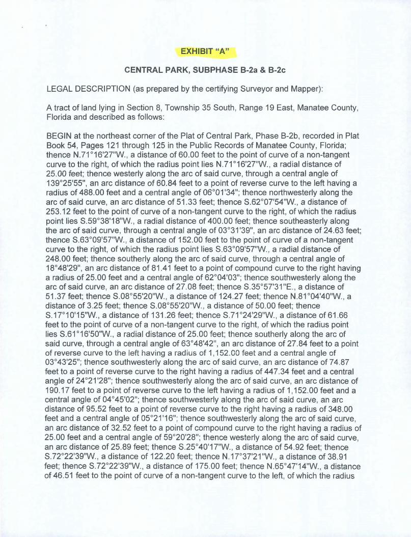
EXHIBIT "A"
CENTRAL PARK, SUBPHASE B-2a & B-2c
LEGAL DESCRIPTION (as prepared by the certifying Surveyor and Mapper):
A tract of land lying in Section 8, Township 35 South , Range 19 East, Manatee County, Florida and described as follows:
BEGIN at the northeast corner of the Plat of Central Park, Phase B-2b, recorded in Plat Book 54, Pages 121 through 125 in the Public Records of Manatee County, Florida; thence N.71 °16'27"W., a distance of 60.00 feet to the point of curve of a non-tangent curve to the right, of which the radius point lies N.71°16'27"W. , a radial distance of 25.00 feet; thence westerly along the arc of said curve, through a central angle of 139°25'55", an arc distance of 60.84 feet to a point of reverse curve to the left having a radius of 488.00 feet and a central angle of 06°01'34"; thence northwesterly along the arc of said curve, an arc distance of 51.33 feet; thence S.62°07'54"W., a distance of 253.12 feet to the point of curve of a non-tangent curve to the right, of which the radius point lies S.59°38'18"W., a radial distance of 400.00 feet; thence southeasterly along the arc of said curve, through a central angle of 03°31'39", an arc distance of 24.63 feet; thence S.63°09'57"W., a distance of 152.00 feet to the point of curve of a non-tangent curve to the right, of which the radius point lies S.63°09'57"W. , a radial distance of 248.00 feet; thence southerly along the arc of said curve, through a central angle of 18°48'29", an arc distance of 81.41 feet to a point of compound curve to the right having a radius of 25.00 feet and a central angle of 62°04'03"; thence southwesterly along the arc of said curve, an arc distance of 27.08 feet; thence S.35°57'31 "E. , a distance of 51.37 feet; thence S.08°55'20"W., a distance of 124.27 feet; thence N.81 °04'40"W., a distance of 3.25 feet; thence S.08°55'20"W., a distance of 50.00 feet; thence S.1r10'15"W., a distance of 131 .26 feet; thence S.71 °24'29"W. , a distance of61.66 feet to the point of curve of a non-tangent curve to the right, of which the radius point lies S.61°16'50"W. , a radial distance of 25.00 feet; thence southerly along the arc of said curve, through a central angle of 63°48'42", an arc distance of 27.84 feet to a point of reverse curve to the left having a radius of 1,152.00 feet and a central angle of 03°43'25"; thence southwesterly along the arc of said curve, an arc distance of 74.87 feet to a point of reverse curve to the right having a radius of 447.34 feet and a central angle of 24°21'28"; thence southwesterly along the arc of said curve, an arc distance of 190.17 feet to a point of reverse curve to the left having a radius of 1,152.00 feet and a central angle of 04°45'02"; thence southwesterly along the arc of said curve, an arc distance of 95.52 feet to a point of reverse curve to the right having a radius of 348.00 feet and a central angle of 05°21'16"; thence southwesterly along the arc of said curve, an arc distance of 32.52 feet to a point of compound curve to the right having a radius of 25.00 feet and a central angle of 59°20'28"; thence westerly along the arc of said curve, an arc distance of 25.89 feet; thence S.25°40'17"W., a distance of 54.92 feet; thence S.72°22'39"W., a distance of 122.20 feet; thence N.17°37'21"W., a distance of 38.91 feet; thence S.72°22'39"W. , a distance of 175.00 feet; thence N.65°47'14"W., a distance of 46.51 feet to the point of curve of a non-tangent curve to the left, of which the radius

'v
point lies N.65°47'14"W., a radial distance of 30.00 feet; thence northerly along the arc of said curve, through a central angle of 41 °44'48", an arc distance of 21.86 feet to a point of compound curve to the left having a radius of 2,823.00 feet and a central angle of 06°43'54"; 'thence northerly alarm the arc of said curve, an arc distance of 331.67 feet to a paint of compound curve to the left having a radius of 30.00 feet and a central angle of 78°30'15";-thence northwesterly along the arc of said curve, an arc distance of 4f 10 feet to a point of reverse curve to the right having a radius of 977.00 feet and a central angle of 01 °06'49"; thence westerly along the arc of said curve, an arc distance of 18.99 feet to a point of reverse curve to the left having a radius of 30.00 feet and a central angle of 56°23'17"; thence southwesterly along the arc of said curve, an arc distance of 29.52 feet; thence N.68°02'40"W., a distance of 27.79 feet; thence N.82°19'34"W., a distance of 130.00 feet; thence N.Or40'26"E., a distance of 106.79 feet to a point of curve to the right having a radius of 25.00 feet and a central angle of 7r28'43"; thence northeasterly along the arc of said curve an arc distance of 33.81 feet; thence N.04°50'51"W., a distance of 50.00 feet to the paint of curve ofa non-tangent curve to the right, of which the radius point lies N.04°50'51"W., a radial distance of 800.00 feet; thence westerly along the arc of said curve, through a central angle of 06°08'26", an arc distance of 85.74 feet; thence N.01°17'35"E., a distance of 136.02 feet; thence N.53°46'15"E., a distance of 46.26 feet to the point of curve of a non-tangent curve to the left, of which the radius point lies N.53°21'56"E., a radial distance of 25.00 feet; thence southeasterly along the arc of said curve, through a central angle of 5r16'02", an arc distance of 24.99 feet to a point of compound curve to the left having a radius of 648.00 feet and a central angle of 5r52'27"; thence northeasterly along the arc of said curve, an arc distance of 654.54 feet to a point of reverse curve to the right having a radius of 477.00 feet and a central angle of 06°22'27"; thence northeasterly along the arc of said curve, an arc distance of 53.07 feet to a point of reverse curve to the left having a radius of 35.00 feet and a central angle of 78°30'40"; thence northerly along the arc of said curve, an arc distance of 47.96 feet; thence N.59°55'12"E., a distance of 231.42 feet to a point of curve to the right having a radius of 524.05 feet and a central angle of 12°53'49"; thence northeasterly along the arc of said curve an arc distance of 117.96 feet to a point of compound curve to the right having a radius of 468.00 feet and a central angle of 20°30'59"; thence easterly along the arc of said curve, an arc distance of 167.58 feet; thence S.86°40'OO"E., a distance of 203.49 feet to the point of curve of a non-tangent curve to the right, of which the radius point lies S.6r54'58"E., a radial distance of 25.00 feet; thence northeasterly along the arc of said curve, through a central angle of 64°12'07", an arc distance of 28.01 feet; thence N.86°17'09"E., a distance of 316.01 feet to a point of curve to the right having a radius of 35.00 feet and a central angle of 11r46'48"; thence southeasterly along the arc of said curve an arc distance of 71.95 feet; thence S.65°56'03"E., a distance of 60.00 feet to the point of curve of a non-tangent curve to the left, of which the radius point lies S.65°56'03"E., a radial distance of 2,930.00 feet; thence southerly along the arc of said curve, through a central angle of 05°20'23", ~n arc distance of 273.07 feet to the POINT OF BEGINNING.
Said tract contains 1,091,667 square feet or 25.0612 acres, more or less.

FORM NO. 8421 SURETY BOND
FOR PERFORMANCE OF REQUIRED PRIVATE IMPROVEMENTS (Attachment "B") BOND NO. 1083731 KNOW ALL MEN BY THESE PRESENT:
That the Developer, Central Park Lifestyles, LLC, 5800 Lakewood Ranch Blvd .. , Lakewood Ranch, FL 34240 as Principal, and Lexon Insurance Company, 900 S. Frontage Rd., Suite 250, Woodridge, IL 60517, a Surety Company, duly authorized to transact business in the State of Florida, are held and firmly bound unto the County of Manatee, State of Florida, as Obligee, in the sum of $701,735.00 (Numbers) Seven Hundred One Thousand Seven Hundred Thirty Five & 001100 (Words) for the
payment of which we jointly and severally bind ourselves, our heirs, executors, administrators, successors and assigns, for the specific benefit of the County in accordance with the conditions set forth herein and in the "Required Improvements Agreement" which is hereby incorporated herein by reference.
THE COND~~ ~fthe above obligation is such that, Whereas the Principal has entered into a contract, dated.3 0 \ ~ (LEAVE BLANK - Board of County Commission approval date) with the obligation to do and perform certain work relating to Central Park Subpbase B-2c (Subdivision). .
NOW THEREFORE, if the principal shall fully perform all the covenants and terms of said contract, then this obligation shall be null and void; otherwise this obligation shall remain in full force and effect, and Surety shall cause the contract to be fully performed or pay to obligee the cost of performing said contract in an amount not exceeding the said sum specified above. In the event such performance is not completed within the time specified in the attached "Required Improvements Agreement and Temporary Construction Easement for Private Improvements", the obligee shall be entitled to collection ofthis surety bond. Means of notification of intent to collect shall be by certified mail to the Surety at the address on page 1. {insert page number of surety's address}. Payment will be made to the County within 30 days by certified check drawn on behalf ofthe Board of County Commissioners at P. O. Box 1000, Bradenton, FL 34206.
The Surety does hereby consent to any and all alternations, extensions of time, or other modifications to the contract secured by this bond.
This Surety Bond shall be construed in accordance to the Laws of Florida, and any action of whatever nature, in connection with this Bond and the Required Improvements Agreement shall be filed in the Twelfth Judicial Circuit in and for Manatee County, Florida.
Page I of 3 . ~O\\2 ACCEl'TED IN OPEN SES~?:SiONE:s:.;NAiEE COUNi'l BOARD OF COUNi'I COM

INSURANCE COMPANY SIGNATURE FORM
FOR: Central Park Subphase B-2c Earthwork, General, Paving, Drainage and Irrigation
(Name of Project) BOND NO. 1083731
SIGNED AND SEALED this 25th day of January, 2013 . .........
Signature - l\. its Agent Dawn L. Morgan, Attorney-ln-F@£.t
Florida License No. P011322 Print Name & Title
900 S. Frontage Rd., Suite 250 Address
Woodridge, IL 60517 City State Zip
~ WITNESSES OR CORPORATE SEAL
~1d;~ ~~ Signature Signature
Donna Whalen Bonnie Kruse Print Name Print Name
NOTARY ACKNOWLEDGMENT STATE OF: Illinois COUNTY OF DuPage
orF'ICIAI.. SEAL E M PISCIOTTO
: TP.RI~S r..TATE OF ILLINOIS NOTAR\' PU,~Uy . EXPIRES 6/26/2014 MY COMMISSION -
Commission No. 560807
Notary PublIc Tariese M. Pisciotto
Print Name of Notary My Commission Expires: June 26, 2014
Page 2 of 3

DEVELOPER SIGNATURE FORM
FOR: Central Park Subphase B-2c Earthwork, General, Paving, Drainage and Irrigation
(Name of Project)
t1_~~~ NO. 1083731 SIGNED AND SEALED this :<8 day of F==t ' 2013
(If attorney-in-fact Attach Power of Attorney)
les LLC
Developer lAMPS R SCHIER ~
Print Name & Title 5800 Lakewood Ranch Blvd.
Postal Address Lakewood Ranch, FL 34240
City State Zip
~ WITNESSES OR CORPORATE SEAL
Kathy Frey
Print Name ~AiM rintName NOTARY ACKNOWLEDGMENT
STATEOF ~f~\~~r~; _~~~~ __ __ COUNTY OF t?Afb~ ~~~b+-'
,.... The foregoing instrument was acknowledged before me this -z. f~ day of ~N , 20_ J_ , by lAMESR.SCHIER as ~ ~~onbehalf of the PrincipallDeveloper identified herein, and who is personally known to me or who has produced
(Type ofIdentification) as identification.
-N-O-T-AR--Y-S-E-AL-~~~-~~-:'f~"-"' .. - SH-E-RR-Y S.OODDEMA ~P~bl~ l .. 1"Ji.·;~;~ C0r1}mission # .EE 194509 SHERRY S. DODDEMA ;.:;.~.,l'i Expires May 21 , 2016 -----"". ~=~:.:..====-=------··t.5f..\~:t>~·· BonOOd Tlw Troy Faio1 JnsU'.""" 800-385-7019 Pnnt Name of Notary
Commission No. My Commission Expires: ---........ ---:-;T--APpr~ccepted for and on behalf of Manatee County, Florida, this ~ day of _-+-~~..:....:......._, 20 \ ~ .
BOARD OF COUNTY COMMISSIONERS OF MAN TEE CO TY FRIDA
BY: -~~~~~~~~~-----
Page 3 of 3

POWER OF ATTORNEY
Lexon Insurance Company LX -11 9984 ..
KNOW ALL MEN BY THESE PRESENTS, that LEXON INSURANCE COMPANY, a Texas Corporation, with its principal office in Louisville, Kentucky, does hereby constitute and appoint: .
James I. Moore, Bonnie Kruse, Stephen T. Kazmer, Dawn L. Morgan, Peggy Faust,.**** •• ** ••• Kelly A. GardneI; Elaine Marcus, Jennifer 1. McComb, Melissa Schmidt, Donna Whalen, Tariese M. Pisciotto ••••••••••••••••••••••• # •••••••• *** •••
its true and lawful Attorney(s)-In-Fact to make, execute, seal and deliver for, and on its behalf as surety, any and all bonds, undertakings or other writings obligatory in nature of a bond.
This authority is made under and by the authority of a resolution which was passed by the Board of Directors of LEXON INSURANCE COMPANY on the 1 st day of July, 2003 as follows:
Resolved, that the President of the Company is hereby authorized to appoint and empower any representative of the Company or other person or persons as Attorney-In-Fact to execute on behalfof the Company any bonds, undertakings, policies, contracts of indemnity or other writings obligatory in nature of a bond not to exceed $2,500,000.00, Two-million five hundred thousand dollars, which the Company might execute through its duly elected officers, and affix the seal of the Company thereto. Any said execution of such documents by an Attorney-In-Fact shall be as binding upon the Company as if they had been duly executed and acknowledged by the regularly elected officers of the Company. Any Attorney-In-Fact, so appointed, may be removed for good cause and the authority so granted may be revoked as specified in the Power of Attorney.
Resolved, that the signature of the President and the seal of the Company may be affixed by facsimile on any power of attorney granted, and the signature of the Assistant Secretary, and the seal of the Company may be affixed by facsimile to any certificate of any such power and any such power or certificate bearing such facsimile signature and seal shall be valid and binding on the Company. Any such power so executed and sealed and certificate so executed and sealed shall, with respect to any bond of undertaking to which it is attached, continue to be valid and binding on the Company.
IN WITNESS THEREOF, LEXON INSURANCE COMPANY has caused this instrument to be signed by its President, and its Corporate Seal to be affixed this 21 st day of September, 2009.
ACKNOWLEDGEMENT
LEXON INSURANCE COMPANY
r:?/~~ BY ____ ~--------------~---------
David E. Campbell President
On this 21 st day of September, 2009, before me, personally came David E. Campbell to me known, who being duly sworn, did depose and say that he is the President of LEXON INSURANCE COMPANY, the corporation described in and which executed the above instrument; that he executed said instrument on behalf of the corporation by authority of his office under the By-laws of said corporation.
"OFFICIAL SEAL'~ MAUREEN K. AYE
Notary Public, State ofIllinois My Commission Expires 09/21113
CERTIFICATE
~~~~ C Maureen K. AYe
Notary Public
I, the undersigned, Assistant Secretary of LEXON INSURANCE COMPANY, A Texas Insurance Company, DO HEREBY CERTIFY that the original Power of Attorney of which the foregoing is a true and correct copy, is in full force and effect and has not been revoked and the resolutions as set forth are now in force.
Signed and Sealed at Woodridge, Illinois this If,;,"!;" January, 20 13
Philip G. Lauer Assistant Secretary
statement of claim containing any materially false information, or conceals for the purpose of misleading, information concerning any fact material thereto, commits a fraudulent insurance act, which is a crime and subjects such person to criminal and civil penalties."
LX1

For: Central Park, Ph B-2c (Name of Project)
AGREEMENT FOR FINAL WEARING COURSE OF ASPHALT ON ROADWAYS (Privately Maintained Roadways)
THIS AGREEMENT is made and entered into by and between Manatee County, a
political subdivision of the State of Florida (County), and CENTRAL PARK
LIFESTYLES, LLC (Developer), concerning the placement of the final wearing course of
asphalt on roadways.
RECITALS
WHEREAS, Developer has posted payment and performance bonds with the County
for the installation of certain subdivision improvements within the final subdivision plat
known as CENTRAL PARK PHASE B-2c . All such improvements are hereinafter
referred to as the "Required Improvements"; and
WHEREAS, Developer has completed said Required Improvements to the County's
satisfaction with the exception of the placement ofthe final wearing course of asphalt on the
roadways; and
WHEREAS, both the County and Developer are desirous of delaying the installation
of the final wearing course of asphalt so that it is not marred by construction traffic.
NOW, THEREFORE, in consideration of the mutual covenants and promises set
forth below, and other good and valuable consideration, receipt of which is hereby
acknowledged, the parties agree to Paragraphs 1 through 4 as follows:
Page 1 of3
ACCEPTED IN OPEN SESSION ~ \9\0\ \ h BOARD OF COUNTY COMMISS1ONEf1S, MANATEE C('111N '

(Final Wearing Course Agree) For: Central Park, Ph B-2c (Name of Project)
1. . Developer will post .one or more new payment and performance bonds for the final wearing
course of asphalt which is to be installed by the Developer within one (1) year ofthe date of
the new payment and performance bonds unless otherwise extended by mutual consent of the
County and Developer.
2. The County agrees to release the existing Subdivision Completion Bonds, simultaneously
with the acceptance of the payment and performance bonds for the final wearing course of
asphalt.
3. Developer agrees to be responsible for the maintenance of the roadways until such time as
the final wearing course of asphalt is installed by the Developer and accepted for
maintenance by the Homeowner's Association.
4. County agrees to accept these measures as adequate security necessary to insure the
installation, guarantees, and maintenance of said improvements and to issue Final
Certificates of Occupancy for any units or other building that have been conditioned upon
completion of the Required Improvements.
Page 2 of3

(Final Wearing Course of Asphalt) For: Central Park, Ph B-2c s- (Project Name) SIGNED AND SEALED this ___ day of --j£'f---..c..:;~'--"'---'==----f ___ ' 20H
.!Y. ~'j1:NESSES:
~w~17 Kathy Frev
~ Type or Print Name
~!trrh Signature
James R. Schier, Type or Print Name
Manager T e or Pnnt Name Title (If attorney-in-fact Attach Power of Attorney)
8210 Lakewood Ranch Blvd. Postal Address
Bradenton FL 34202 City State Zip
NOTARY ACKNOWLEDGMENT STATE OF: ---,~,---:;I~t>~~k",,--__ _ COUNTY OF: ~Nc~D-k
Th;.. foregoing instrument was acknowledged before me this ::s 6 day of 'r~l.lQ..N , 20~, by JAMES R. SCHIER ,as MANAGER, (Title), on
behalf of the cbrporation identi,Thrl~,herein as Developer and wQo is personally known to me or who has produced ""'~\' DOD~~IIII~ (Type of Identification) as identification.!.
~ ~~ ............ <..~ ~ ~ ~:~ •• ·,,,\SSION~.t· •• ~ ~ ~ ~
,~~- 0 ~'" 1 2 ~ 0 ~ \
NOT ARY SEAL: ~ l",rSS ~~ ~ , 0,6' %'\ * ~ : .~ . ~ ~~==~I-----------
~*: •.• :...:~ Notary Public ~ . £<94509 0 Q~ ~~ ... 11£ \ ... g~ SHERRYS.DODDEMA ~ o~ 0 8onded«'-~ rtP • ~ ~ ~1~-1~;oo.~,!!~~«;f. •• cl<# Print Name of Notary
l'II,:U8L/C SI t-"\"," 1/11"11111\1\\\'" I) ~
A~d apd accepted for and on behalf of Manatee County, Florida, thiSc:;:ytff day of J\-LlivQ\ , 20G
BOARD OF COUNTY COMMISSIONERS OF NATEE COUNTY, FLORIDA
BY:
\\\IIU1U"" . "'\\u~TY C I"",
De u DIrect q.······Rt~~?
. B. Shore, Clerk of the Circuit Court i:o/ SEAL"~ -cr' '0= :<: :z: \0-.. ':~i '.P .~- ~ '0~ ';" ·!'!t~cO.· •• •• ~ Page 3 of 3 " ..••.• ~"
"~/11111', " It n'\\\\\\
ATTEST

For: Central Park, Subph B-2c (Name of Project)
Final Lift of Asphalt
REQUIRED IMPROVEMENTS AGREEMENT AND TEMPORARY CONSTRUCTION EASEMENT FOR PRIVATE IMPROVEMENTS
(Required with a Surety Bond (Attachment "B") as security guaranteeing completion of Required Improvements, Form No. 8417)
WHEREAS, CENTRAL PARK LIFESTYLES, LLC (Developer) has made application to Manatee County, Florida (County), for approval of a proposed subdivision or final site plan identified as CENTRAL PARK, SUBPHASE B-2c (Project), the legal description for which is more particularly described in Exhibit "A", attached hereto and incorporated herein; and
WHEREAS, the Manatee County Land Development Code, Ordinance 90-0 I, requires that a final subdivision plat not be approved for recording, and that a Certificate of Occupancy not be issued in accordance with final site plan approval, until certain improvements required by the Land Development Code or required as a condition of approval of the plat or site plan (Required Improvements) have been duly constructed, completed, and approved, unless the Developer has provided performance security guaranteeing to the satisfaction of the County that such improvements will be duly constructed, completed, and approved; and
WHEREAS, in connection with the Project the Developer has submitted construction drawings for the Required Improvements which are on file with and have been approved by the County; and
WHEREAS, the Developer desires to obtain approval of the Project prior to installation of the Required Improvements.
WHEREAS, the developer has submitted a cost estimate certificate by the Engineer of Record to be an accurate reflection of the cost to complete the remaining Required Improvements, and the Surety Bond referred to below is in an amount which represents at least 200% of that estimated cost with a 3% administrative fee; and
WHEREAS, the Required Improvements shall be privately owned necessitating additional covenants and protections for the County and the public in the event that the Developer fails to complete the Required Improvements; and
NOW, THEREFORE, KNOW ALL MEN BY THESE PRESENTS:
1

(Pvt Impv' Agree) For: Central Park, Subph B-2c (Name of Project)
1. That the Developer, in consideration of the County's approval of the proposed Project, and for other valuable consideration, hereby agrees to duly construct and complete the Required Improvements and to otherwise comply fully with the Land Development Code, any conditions of the Project's approval, and all other applicable regulations, requirements and agreements.
2. Developer and LEXON INSURANCE COMPANY ,a Surety Company duly authorized to transact business in the State of Florida (Surety) are held and firmly bound unto the County as obligee/owner in the amount of FORTY-NINE THOUSAND NINE HUNDRED TWENTY-TWO & 041100 Dollars (words) $49,922.04 (numbers), and the Developer herewith tenders to the County a Surety Bond, No. 1083730 ,dated
JANUARY 25, 2013 with LEXON INSURANCE COMPANY, in the amount of FORTY -NINE THOUSAND NINE HUNDRED TWENTY-TWO & 041100 Dollars
(words) $49,922.04 (numbers). Said Bond shall not expire until the Required Improvements guaranteed by this Bond has been accepted by the County.
3. That in consideration of the foregoing, it is hereby mutually AGREED as follows:
(a)
(b)
The Developer shall complete l the satisfaction~e Coun),y ~ Required Improvements on or before the.' ~ . day of ' ~jh 0101 in accordance with the construction drawings or any amendments thereto approved by the County, and unless the County elects to proceed in accordance with Paragraph (b) below, the Surety, upon thirty (30) days written notice of the default from the County will cause to be completed the Required Improvements pay all costs, thereof, including without limitation. all engineering, legal and contingent costs.
In the event the Developer should fail or refuse to fulfill within the time specified its obligations under this Agreement, the County, at its option, shall have the right to enter upon that portion of the Project property, as determined necessary by the County and take all actions required to construct and complete, or cause to be constructed the Required Improvements. In the event the County should exercise such right, the County shall have the unqualified right to draw funds for the purpose of construction and completing the Required Improvements, or causing the same to be done, and for paying costs incidental to the exercise of its rights hereunder, in such amount as the County shall in its sole discretion determine, in accordance with the terms of the., Surety Bond. The Developer shall indemnify and save harmless the County against or from all claims, costs, expenses, damages, injury, or loss, either direct or consequential, including without limitation all engineering, legal, an~ contingent costs which the county may sustain on account of the failure of the Developer to fulfill its obligations as described herein.
2 .

(Pvt Impv Agree) For: Central Park, Subph B-2c (Name of Project)
(c) The Developer, his successors and assigns, hereby grants a temporary easement over property in thy Project as necessary to allow the County to complete the Required Improvements.
(d) Should it become necessary for the County to complete the Required Improvements, the Developer hereby appoints the County as its agent for the purposes of using the approvals granted for the required improvements. "
4. The Developer agn~es that it is liable to the County for all costs and damages, as described above, that the County may incur in connection with constructing and completing the Required Improvements for the life of the Project, without regard to the amount of the Surety Bond identified above. Should the Developer fail or refuse to complete the Required Improvements, as required, nothing herein shall be construed as affecting the County's right to resort to any and all legal and equitable remedies against the Developer, including specific performance, to which the Developer hereby agrees.
"5. The Developer understands and agrees that in the event that the Required Improvements are not constructed or installed in the manner or time consistent with this Agreement, the County shall withhold further permits or approvals for the Project until the Required Improvements have been completed or adequate progress, as determined by the Board of County Commissioners, toward completion of the Required Improvements has been demonstrated.
6. Upon the County's completion of private improvements, the improvement shall be transferred to the Homeowner's Association or that entity set up in the deed restrictions to be responsible for ongoing maintenance of the improvements. In no event shall public funds be used for the maintenance of private improvements, unless they are dedicated to and accepted by the County.
3

(Pvt Imp./Surety- Developer is Corp.) For: Central Park, Subph B-2c
SIGNED AND SEALED this .s- day of ~ ,20 /3 --
W ess K athy Frey BY:~~=-_~~ ___ _
Signature James R. Schier
Type or Print Name Manager
Title (If attorney-in-fact Attach Power of Attorney) 8210 Lakewood Ranch Blvd.
Postal Address Lakewood Ranch FL 34202
City State Zip
f NOTARY ACKNOWLEDGMENT
STATE OF: \~\ M ~~~~--------
COUNTY OF: !?xkfll.\~
The foregoing instrument was acknowledged before me this S 1).. day of yo( b:!.UJ.(U , 20\~ , by JAMES R. SCHIER , as MANAGER, (Title), on
behalf ofthe lcorporation identified herein as Developer and who is personally known to .IJle or who has produced \i 'IIIIiI (Type of Identification) as identification.
'11.\"'\ I ifilll.' ~,~'\.{\"1 S. DODO","t~
~Itr;; '5.<>'" •••••••• <..~~ .i"c,.~ •• ~~\SSION !i:. "1 ~ ~ 'J'·c.;0 ,,'1.1,20;: ~". ~ ~ :~ ~*?i 6' ~. ~ ::: :::. u> ~*= =*: ..... : = -: ~ #EE 194509 : '" ~ ~~... ~\ l,@f Print Name of Notary
... -1.' l.;~.,,-~. '-' ~ .~ ?I/' •• IIJYFainll¢!.··;.<-<"§ ~~ ,flt!?······· '(,. tJ"' ~ "" -...k..
A~d and accepted f~fM"~rnl~~2tl't~fManatee County, Florida, thisc::>toL:-: day of -LlJovtb ,20
~~ Not Public SHERRY S. DODDEMA
NOTARY SEAL:
BOARD OF COUNTY COMMISSIONERS
4

EXHIBIT "A"
CENTRAL PARK, SUBPHASE B-2a & B-2c
LEGAL DESCRIPTION (as prepared by the certifying Surveyor and Mapper):
A tract of land lying in Section 8, Township 35 South , Range 19 East, Manatee County, Florida and described as follows:
BEGIN at the northeast corner of the Plat of Central Park, Phase B-2b, recorded in Plat Book 54, Pages 121 through 125 in the Public Records of Manatee County, Florida; thence N.71°16'27"W. , a distance of 60.00 feet to the point of curve of a non-tangent curve to the right, of which the radius point lies N.71°16'27"W., a radial distance of 25.00 feet; thence westerly along the arc of said curve, through a central angle of 139°25'55", an arc distance of 60.84 feet to a point of reverse curve to the left having a radius of 488.00 feet and a central angle of 06°01'34"; thence northwesterly along the arc of said curve, an arc distance of 51.33 feet; thence S.62°07'54"W., a distance of 253.12 feet to the point of curve of a non-tangent curve to the right, of which the radius point lies S.59°38'18"W. , a radial distance of 400.00 feet; thence southeasterly along the arc of said curve, through a central angle of 03°31'39", an arc distance of 24.63 feet; thence S.63°09'57"W., a distance of 152.00 feet to the point of curve of a non-tangent curve to the right, of which the radius point lies S.63°09'57"W., a radial distance of 248.00 feet; thence southerly along the arc of said curve, through a central angle of 18° 48'29", an arc distance of 81.41 feet to a point of compound curve to the right having a radius of 25.00 feet and a central angle of 62°04'03"; thence southwesterly along the arc of said curve, an arc distance of 27.08 feet; thence S.35°57'31"E., a distance of 51 .37 feet; thence S.08°55'20"W., a distance of 124.27 feet; thence N.81 °04'40"W., a distance of 3.25 feet; thence S.08°55'20"W., a distance of 50.00 feet; thence S.1r10'15"W., a distance of 131.26 feet; thence S.71°24'29"W., a distance of61.66 feet to the point of curve of a non-tangent curve to the right, of which the radius point lies S.61°16'50"W., a radial distance of 25.00 feet; thence southerly along the arc of said curve, through a central angle of 63°48'42", an arc distance of 27.84 feet to a point of reverse curve to the left having a radius of 1,152.00 feet and a central angle of 03°43'25"; thence southwesterly along the arc of said curve, an arc distance of 74.87 feet to a point of reverse curve to the right having a radius of 447.34 feet and a central angle of 24°21'28"; thence southwesterly along the arc of said curve, an arc distance of 190.17 feet to a point of reverse curve to the left having a radius of 1,152.00 feet and a central angle of 04°45'02"; thence southwesterly along the arc of said curve, an arc distance of 95.52 feet to a point of reverse curve to the right having a radius of 348.00 feet and a central angle of 05°21'16"; thence southwesterly along the arc of said curve, an arc distance of 32.52 feet to a point of compound curve to the right having a radius of 25.00 feet and a central angle of 59°20'28"; thence westerly along the arc of said curve, an arc distance of 25.89 feet; thence S.25°40'17"W., a distance of 54.92 feet; thence S.72°22'39"W., a distance of 122.20 feet; thence N.1r37'21"W., a distance of 38.91 feet; thence S.72°22'39"W., a distance of 175.00 feet; thence N.65°47'14"W., a distance of 46.51 feet to the point of curve of a non-tangent curve to the left, of which the radius

point lies N.65°4i14"W., a radial distance of 30.00 feet; thence northerly along the arc of said curve, through a central angle of 41 °44'48", an arc distance of 2·:1.86 feet to a point of compound curve to the left having a radius of 2,823.00 feet and a central angle of 06°43'54"; thence northerly along the arc of said curve, an arc distance of 331.67 feet
: to a point of compound curve to the left having a radius of 30.00 feet arid a central angle : of 78°30'15"; thence northwesterly along the arc of said curve, an arc distance of 41.1 0 feet to a point of reverse curve to the right having a radius of 977.00 feet and a central angle of 01 °06'49"; thence westerly along the arc of said curve, an arc distance of 18.99 feet to a point of reverse curve to the left having a radius of 30.00 feet and_a central angle of 56°23'17"; thence southwesterly along the arc of said curve, an arc distance of 29.52 feet; thence N.68°02'40"W., a distance of 27.79 feet; thence N.82°19'34"W., a distance of 130.00 feet; thence N.Or40'26"E., a distance of 106.79 feet to a point of curve to the right having a radius of 25.00 feet and a central angle of 7r28'43"; thence northeasterly along the arc of said curve an arc distance of 33.81 feet; thence N.04°50'51"W., a distance of 50.00 feet to the point of curve of a non-tangent curve to
. the right, of which-the radius point lies N.04°50'51"W., a radial distance of 800.00 feet; thence westerly along the arc of said curve, through a central angle of 06°08'26", an arc distance of 85.74 feet; thence N.01°17'35"E., a distance of 136.02 feet; thence N.53°46'15"E., a distance of 46.26 feet to the point of curve of a non-tangent curve to the left, of which the radius point lies N.53°21 '56"E., a radial distance of 25.00 feet; -thence southeasterly along the arc of said curve, through a central angle of 5r16'02", an arc distance of 24.99 feet to a point of compound curve to the left having a radius of 648.00 feet and a central angle of 5r52'27"; thence northeasterly along the arc of said curve, an arc distance of 654.54 feet to a point of reverse curve to the right having a radius of 477.00 feet and a central angle of 06°22'27"; thence northeasterly along the arc of said curve, an arc distance of 53.07 feet to a point of reverse curve to the left having a radius of 35.00 feet and a central angle of 78°30'40"; thence northerly along the arc of said curve, an arc distance of 47.96 feet; thence N.59°55'12"E., a distance of 231.42 feet to a point of curve to the right having a radius of 524.05 feet and a central angle of 12°53'49"; thence northeasterly along the arc of said curve an arc distance of 117.96 feet to a point of compound curve to the right having a radius of 468,00 feet and a central angle of 20°30'59"; thence easterly along the arc of said curve, an arc distance of 167.58 feet; thence S.86°40'00"E., a distance of 203.49 feet to the point of curve of a non-tangent curve to the right, of which the radius point lies S.6r54'58"E., a radial distance of 25.00 feet; thence northeasterly along the arc of said curve, through a central angle of 64°12'07", an arc distance of 28.01 feet; thence N.86°17'09"E., a distance of 316.01 feet to a point of curve to the right having a radius of 35.00 feet and a central angle of 11 r46'48"; thence southeasterly along the arc of said curve an arc distance of 71.95 feet; thence S.65°56'03"E., a distance of 60.00 feet to the point of curve of a non-tangent curve to the left, of which the radius point lies S.65°56'03"E., a radial distance of 2,930.00 feet; thence southerly along the arc of said curve, through a central angle of 05°20'23", an arc distance of 273.07 feet to the POINT OF BEGINNING.
Said tract contains 1,091,667 square feet or 25.0612 acres, more or less.

· ..
FORM NO. 8421 SURETY BOND
FOR PERFORMANCE OF REQUIRED PRIVATE IMPROVEMENTS (Attachment "B") BOND NO. 1083730 KNOW ALL MEN BY THESE PRESENT:
That the Developer, Central Park Lifestyles, LLC, 5800 Lakewood Ranch Blvd .. , Lakewood Ranch, FL 34240 as Principal, and Lexon Insurance Company, 900 S. Frontage Rd., Suite 250, Woodridge, IL 60517, a Surety Company, duly authorized to transact business in the State of Florida, are held and firmly bound unto the County of Manatee, State of Florida, as Obligee, in the sum of $49,922.04 (Numbers) Forty Nine Thousand Nine Hundred Twenty Two & 04/1 00 (Words) for the payment of
which we jointly and severally bind ourselves, our heirs, executors, administrators, successors and assigns, for the specific benefit of the County in accordance with the conditions set forth herein and in the "Required Improvements Agreement" which is hereby incorporated herein by reference.
THE CONDI~\ON\Ofthe above obligation is such that, Whereas the Principal has entered into a contract, dated 'J; {}o \~ (LEAVE BLANK - Board of County Commission approval date) with the obligation to do and perform certain work relating to Central Park Subpbase B-2c (Subdivision).
NOW THEREFORE, if the principal shall fully perform all the covenants and terms of said contract, then this obligation shall be null and void; otherwise this obligation shall remain in full force and effect, and Surety shall cause the contract to be fully performed or pay to obligee the cost of performing said contract in an amount not exceeding the said sum specified above. In the event such performance is not completed within the time specified in the attached "Required Improvements Agreement and Temporary Construction Easement for Private Improvements", the obligee shall be entitled to collection of this surety bond. Means of notification of intent to collect shall be by certified mail to the Surety at the address on page ~ {insert page number of surety's address}. Payment will be made to the County within 30 days by certified check drawn on behalf ofthe Board of County Commissioners at P. O. Box 1000, Bradenton, FL 34206.
The Surety does hereby consent to any and all alternations, extensions of time, or other modifications to the contract secured by this bond.
This Surety Bond shall be construed in accordance to the Laws of Florida, and any action of whatever nature, in connection with this Bond and the Required Improvements Agreement shall be filed in the Twelfth Judicial Circuit in and for Manatee County, Florida .
Page 1 of 3 ... . ~lo\~~ AccEFterJ iN OptN ~S~?ssiONk$. MANATEE COUNTY !:It'JARD OF COUNTY COM

, . INSURANCE COMPANY SIGNATURE FORM
FOR: Central Park Subphase B-2c Final Lift of Asphalt
(Name of Project) BOND NO. 1083730
SIGNED AND SEALED this 25th day of January, 2013 ,.
Lexon Insurance Comparu:: n suretYC~panYName
By: ~4lA1'\,. Y ~ Signature - 1\ its Agent
Dawn L. Morgan, Attorney-In-Fact Florida License No. P011322
Print Name & Title 900 S. Frontage Rd., Suite 250
Address Woodridge, IL 60517
City State Zip
WITNESSES OR CORPORATE SEAL
~~ ~ Signature Signature
Donna Whalen ..:B;:;.,;o:;.::n:.;:n:.;:i.:..e .:.;Kr=.=u:.=,se=---_______ _ Print Name Print Name
STATE OF: Illinois COUNTY OF DuPage
NOTARY ACKNOWLEDGMENT
The foregoing instrument was acknowledged befo me this 25th day of January, 2013, by Dawn L. Morgan as Attorney-In-Fact (Title), on beha ofthe Surety identified herein, and who is personally known to me or who has produced Nt A (T e ofIdentificati s identifi tion,
Ot:"FICIAL SEAL N t P bl' TAR,ESE Nt PiSCIOTTO 0 ary IC
NOTARY PUBLIC, ST.IlTE OF ILLINOIS Tariese M. Pisciotto MY Corlt1MlSS/ON EX?IRES 6/2&12014 Print Name of Notary
Commission rco~, ~~~~~~~~~~~ My Commission Expires: June 26, 2014
Page 2 of 3

· -. DEVELOPER SIGNATURE FORM
FOR: Central Park Subphase B-2c Final Lift of Asphalt
(Name of Project) If.. __ BON~ NO. 1083730
SIGNED AND SEALED this ::<.8' day of ~ ,2013
(If attorney-in-fact Attach Power of Attorney)
'fes leS);!£. ~ /
By: -n~ ______ r~(~~ ____ ~ ____ __
Dev~l:m~: JAMESR. ~ --------------------------Print Name & Title
5800 Lakewood Ranch Blvd. Postal Address
Lakewood Ranch, FL 34240 City State Zip
~~~~~~~~~~++--W--IT-N-E-SSESORCORPO~~fv~ ""~i~ ~ Signature Kathy Frey SANDI OWENS
Print Name Print Name
STATE OF COUNTY OF
NOTARY ACKNOWLEDGMENT
The foregoing instrument was acknowledged before me this ~ .... A(J « .... , '
20~,by JAMESR.SCH1ER as ~~(Title), onbehalf of the Principal/Developer identified herein, and who is personal!y known to me or who has produced _____________________ (Type of Identification) as identification.
NOTARY SEAL: ~\~ g~':?g~f:~ ~~~:~~~ ~~~~~~9 ~t~~t>DDEMA ~~~~.~~f Expires May 21, 2016
·;/f,iif.,i~~""·· Bonded Thou Troy Fain Insurance 800-38,.7019 Print Name of Notary
Commission No. My Commission Expires: ---------:::----n~--A~d rnd accepted for ~d on behalf of Manatee County, Florida, this M day of --'f-JLl-Jl--,--""",-~--=...L.----' 20 \ .
BOARD OF COUNTY COMMISSIONERS
B~F~~A ~an
Page 3 of 3

POWER OF ATTORNEY
Lexon Insurance Company Lx-119983
KNOW ALL MEN BY THESE PRESENTS, that LEXON INSURANCE COMPANY, a Texas Corporation, with its principal office in Louisville, Kentucky, does hereby constitute and appoint:
James I. Moore, Bonnie Kruse, Stephen T. Kazmer, Dawn L. Morgan, Peggy Faust,***********
Kelly A. GardneI; Elaine Marcus, Jennifer 1. McComb, Melissa Schmidt, Donna Whalen, Tariese M. Pisciotto ***********************>10**************
its true and lawful Attorney(s)-In-Fact to make, execute, seal and deliver for, and on its behalf as surety, any and all bonds, undertakings or other writings obligatory in nature of a bond.
This authority is made under and by the authority of a resolution which was passed by the Board of Directors of LEXON INSURANCE COMPANY on the 1 st day of July, 2003 as follows:
Resolved, that the President of the Company is hereby authorized to appoint and empower any representative of the Company or other person or persons as Attorney-In-Fact to execute on behalf of the Company any bonds, undertakings, policies, contracts of indemnity or other writings obligatory in nature of a bond not to exceed $2,500,000.00, Two-million five hundred thousand dollars, which the Company might execute through its duly elected officers, and affix the seal of the Company thereto. Any said execution of such documents by an Attorney-In-Fact shall be as binding upon the Company as if they had been duly executed and acknowledged by the regularly elected officers of the Company. Any Attorney-In-Fact, so appointed, may be removed for good cause and the authority so granted may be revoked as specified in the Power of Attorney.
Resolved, that the signature of the President and the seal of the Company may be affixed by facsimile on any power of attorney granted, and the signature of the Assistant Secretary, and the seal of the Company may be affixed by facsimile to any certificate of any such power and any such power or certificate bearing such facsimile signature and seal shall be valid and binding on the Company. Any such power so executed and sealed and certificate so executed and sealed shall, with respect to any bond of undertaking to which it is attached, continue to be valid and binding on the Company.
IN WITNESS THEREOF, LEXON INSURANCE COMPANY has caused this instrument to be signed by its President, and its Corporate Seal to be affixed this 21 st day of September, 2009.
LEXON INSURANCE COMPANY
By_a_~_· _~~_~-----'---~_
ACKNOWLEDGEMENT
David E. Campbell President
On this 21 st day of September, 2009, before me, personally came David E. Campbell to me known, who being duly sworn, did depose and say that he is the President of LEXON INSURANCE COMPANY, the corporation described in and which executed the above instrument; that he executed said instrument on behalf of the corporation by authority of his office under the By-laws of said corporation.
"OFFICIAL SEAL" MAUREEN K. AYE
Notary Public, State of Illinois My Commission Expires 09/21113
CERTIFICATE
~~t~ \=: Maureen K. AYe
Notary Public
I, the undersigned, Assistant Secretary of LEXON INSURANCE COMPANY, A Texas Insurance Company, DO HEREBY CERTIFY that the original Power of Attorney of which the foregoing is a true and correct copy, is in full force and effect and has not been revoked and the resolutions as set forth are now in force.
Signed and Sealed at Woodridge, Illinois thil>;i.h2;?;~~~:,;.. Day of January )~J." "c~:'"
~ANC . ,,{ ;t" •. ). 00 •••••••••• l2:,,~ .,.~, .,'l ~ •••• .._.~~.~\ >';l~.§' ".. A .. ',Jl.- w,. .;' <: ,,'.'" .... ~'"
,20 13
0: TEXA?, X: INSURAN ~\ COMPAN \ .~ ..
••• " .. !!i .' ...., .1,' • Philip G. Lauer ••••••••••• ~. ;:\':~i";':." . ,f ~';:. ,:"h;}'" Assistant Secretary
""""'It"""""r::P ...... ~ "\i.:~l,,,'- ti~~}i'.8~iJ.~~.:~~;~I!~~;~~{' 't, r., ,',' '~A~%~"t~~Ji,j' . ..~~;. ~J!
"WARNING: Any person who knowingly aridJ,W.!th'inteht\to defraud any insurance company or other person, files an application for insurance or statement of claim containing any materially false information, or conceals for the purpose of misleading, information concerning any fact material thereto, commits a fraudulent insurance act, which is a crime and subjects such person to criminal and civil penalties."
LX1

- l
rhi , Instrum<:nt Prepared h\'
Vog.kr ,\,l1ton. PLI .C ~-lll .-\ 'vIanilteC r\ \~ W~ , t
Bracicl1wn I'L .l-l205 9-l1 · 3H H·94 ()()
SUPPLEMENTAL AMENDMENT TO
DECLARATION OF COVENANTS, CONDITIO~S AND RESTRICTIONS FOR
CENTRAL PARK
TO ADD SllBPHASE B-2a & B-2c
M tH. 1 IS SUPPLEMENTAL AMENDMENT (the "Supplemental Amendment'") is made as orthe l if day of _Dtr~_. 2013. by CENTRAL PARK LIFESTYLES, LLC, a Florida limited liability company (the "Dec larant" or ··Developer· ').
RECITALS:
WHEREAS, Declarant has caused the Declaration of Covenants. Conditions and Restrictions For Central Park (the " Declaration") to be recorded in Official Records Book 2355. Page 2943 , Public Records of Manatee County. Florida, as same has been amended: and.
WH ERE AS. Declarant is actively developing the Subdivision: and is therefore empowered to amend lhe Declaration pur~uant W Article 2.0~ and Al1icle 12 .06 thereof: and.
WHEREAS. Decl arant desires. pursuant to Article 2.02 of the Declaration. to bring within the plan and operati on ofslI ch Declararion the addit io nal real property described below. together with the complementary additions and modifications as Se t forth belo\\: (the "SlIbphase 8-2a & B-2c Propert) ").
NOW TH E REFORE. for and in considerati on of the premises and tor other good and valuable considerations. the Declarant. for itself and ilS respective lega l representatives. successors and ass igns. hereby amends the Declaration as foll o\\5 :
I. Recitals . The foregoing recital s are true and correct and are hereby incorporated herelil.
2. Addition of Subphase B-2a & B-2e Property. Pursuant to the Declaration. and specifically Article 2.02 therein. Declarant does hereby include within and bring within the plan and operation of this Declaration the Subphase B~2a & B-2c Propelty, the legal description of which is attached hereto as Exhibit "A" and incorporated here in, the same of which shall also be)'~ected on the Plat for Central par\~~haSe B-2a & B-2c. as per the Plat thereof recorded in Plat Book '" . Pages ~~ through of the Public Records of Manatee County, Florida.
3. Right of Entry. The Ri ght of Entry ror the Subphase 8-2a & B-2c Propeny is attached as Exhib!!.J! and incorporated herein.
-I List of Holdings. The List of Holdings for the Subphase B-2a & B-2c Property is attached as Exhibit C an d incorp0rated herein.
S. Noti{:l~ TO Bu~'crs The Notice to Bu:-ers fo r the Subphase B-2a & B-2c Propen) is attached as Exhibit D and incorpl)rated herein .
- 1 -

6. Fiscal Program. A Fiscal Program representing the revised budget and expenses for the Subphase 8-2a & 13-2c Propcrt: is attached as ExhibilJ; and incorporated herein.
7. Maintenance Program . r-\ Maintenance Program. as set forth in the Declaration and specifically recorded In
O.R. Book 2~5:'. Page 3004. in and forthe Public Records of Manatee County. Florida. has been established ror the operation and care of the Central Park Subdivision. including this Subphase B-2a & B-2c Property. and all additions of property to the Subdivision and all supplemental amendments to the Declaration.
8. Effect on Remainder of Declaration. Except to the extent modified herein. all terms and conditions of the Declaration shall remain in full force and effect.
IN W ITN ESS WH EREOF. the parties hereunto set their hands and seals the day and year first above written.
K LIFESTYLES, LLC, a Florida
Bv: Name: Its:
STATE OF FLORIDA COll~TY OF SARASOTA J fI/,.
'I he Inrcgoing instrumenl \\ a~ ac~n(l\\kdged before 111C tili , /'y ~ay or~ 13. by .lames R. Schier. as \ 'limager ot'Ccnlra l l'ar~ I.ifes!; Ie;;. LLC a Flonda limited liahilily company. nn heilalr orlile Company. t "_"~ho is personall> kno\\n 10 l11e IH \ 1 who ila, pl'Oduc..:d ("-A as ide11tific~£ -- -, -~b~
._-- - ---G "IS"LLA G "EI" '\ Notary Public· State 01 Florida ,. 'j My Comm. Expires Mar 27.2017
ill CommiSSion II EE 857479 '''.J:it'''' Bonded Tnrougn National Notary Asln.
NOIarvPuhlic • '?J .. , -vb C~lIIlrni,sioll E\pir~s0#'1// 7
~ , I
PRISCILLA G. HElM
- 2 -

~ _ i
JOINDER OF ASSOCIATION
The CE~TR-\L PARK NEIGHBORHOOD ASSOCIATION, INC.. a Florida corporation not- forprofit hereby joins in and consents to this Supplemental Amendment for the purpose of accepting all rights, obligations and responsibilities of the Association as set forth therein.
IN WITNESS WHEREOF, the AssoC,ia" t, ion. by al,ldA, t thhrorouu~ i ilts Board of Directors, does hereby
approve and execute this Joinder on this __ /'[. __ ._day or_l~J3.
CENTRAL PARK NEIGHBORHOOD ASSOCIA INC., a Florida corporation nOI-for-profit
Bv : Name: Its:
ST,\ TE OF FLORIDA COLi\T\ OF SARASOTA I ~
Tht: l'OI'c:going inst rument \\ ,IS acknowledged hdor.: me this lY~~· or~~20U. hy .lam.:, R, Schier . .:;:Y PresiLicnt orCt:nlrall'ark '\eighborlH1o(1 Association. Inc .. a Florida no! for protit corpormion. (In hehalforthe Corporation. 1_""""_) I
\\1](\ is pcr;;onallv kIlO)\ n to l11e or ( ) who has produced ~ as idcnti,fir:illiOIl . ------ - -7J:"7/A ' / ~~
No(ary Puhl ic ~ • /. PRISCILLA G HElM My Commission Expires: J1// 7 .
I
.. ~ PRISCILLA G HElM ~v .~ MOWy Public • State of Florida to o· My Comm. Expires Mar 27. 2017 \~ Commission II EE 857479 0:,., ~
··'~.'r.,:ii' ~, Bonded Tluouoll National Notary Assn.
- 3 -

JOINDER OF STEWARDSHIP DISTRICT
The LAKEWOOD RANCH STEWARDSHIP DISTRICT, created by Local Bill No. 1429, codified at Chapter 2005-338, Laws of Florida, and pursuant to Chapter 189, Florida Statutes, either as a geographic area or as a political subdivision and government of the State of Florida, as the context requires, hereby joins in and consents to this Declaration for the sole purpose of accepting all rights, obligations and responsibilities of the District as set forth therein the Supplemental Amendment.
IN WITNESS WHEREOF, the Lakewood Ranch Stewardship District, by and through its Board, does hereby approve and execute this Joinder of Stewardship District on this 18 -t./;J day of U 14RCft , 2013.
Attes~_~ ~~~ ~ STATE OF FLORIDA COUNTY OF ~A fA n (l +- e e.
LAKEWOOD RANCH STEWARDSHIP DISTRICT DISTRICT, an in endent special district
By:
The foregoing instrument was acknowledged before me this la~ay of AA 14-'9 2013. by Re)( , iel1st'f]1S eM ~ tJ 11'\0 n of the Lakewood Ranch Stewardship District on behalf of the District, () who is personally known to me or ~ who has produced as identification.
o.,st ~~... Notary Public State of Florida ~ ~~ ": Mary Greene Lee ~ ~ I My Commil8ion EE040244 'OJ> O,.~O expire. 11120/2014
Itkl~ /j.t I &zt!2-~ Notary Pub c My Commission Expires: III 2£;' ZOt 4-
- 4 -

Exhibit "A" Exhibit "B" Exhibit "C" Exhibit "D" Exhibit "E"
Legal Description Right of Entry List of Holdings Notice to Buyer Fiscal Program
EXHIBITS

EXHIBIT "A"
CENTRAL PARK, SUBPHASE B-2a & B-2c
LEGAL DESCRIPTION (as prepared by the certifying Surveyor and Mapper):
A tract of land lying in Section 8, Township 35 South, Range 19 East, Manatee County, Florida and described as follows:
BEGIN at the northeast corner of the Plat of Central Park, Phase B-2b, recorded in Plat Book 54, Pages 121 through 125 in the Public Records of Manatee County, Florida; thence N. 71 °16'27"W., a distance of 60.00 feet to the point of curve of a non-tangent curve to the right, of which the radius point lies N.71°16'27"W., a radial distance of 25.00 feet; thence westerly along the arc of said curve, through a central angle of 139°25'55", an arc distance of 60.84 feet to a pOint of reverse curve to the left having a radius of 488.00 feet and a central angle of 06°01'34"; thence northwesterly along the arc of said curve, an arc distance of 51.33 feet; thence S.62°07'54"W., a distance of 253.12 feet to the point of curve of a non-tangent curve to the right, of which the radius point lies S.59°38'18"W., a radial distance of 400.00 feet; thence southeasterly along the arc of said curve, through a central angle of 03°31'39", an arc distance of 24.63 feet; thence S.63°09'57"W., a distance of 152.00 feet to the point of curve of a non-tangent curve to the right, of which the radius point lies S.63°09'57"W. , a radial distance of 248.00 feet; thence southerly along the arc of said curve, through a central angle of 18° 48'29", an arc distance of 81 .41 feet to a point of compound curve to the right having a radius of 25.00 feet and a central angle of 62°04'03"; thence southwesterly along the arc of said curve, an arc distance of 27.08 feet; thence S.35°57'31"E. , a distance of 51.37 feet; thence S.08°55'20"W., a distance of 124.27 feet; thence N.81°04'40"W. , a distance of 3.25 feet; thence S.08°55'20"W., a distance of 50.00 feet; thence S.1r10'15"W., a distance of 131.26 feet; thence S.71°24'29"W., a distance of61.66 feet to the point of curve of a non-tangent curve to the right, of which the radius point lies S.61°16'50"W., a radial distance of 25.00 feet; thence southerly along the arc of said curve, through a central angle of 63°48'42", an arc distance of 27.84 feet to a point of reverse curve to the left having a radius of 1,152.00 feet and a central angle of 03°43'25"; thence southwesterly along the arc of said curve, an arc distance of 74.87 feet to a point of reverse curve to the right having a radius of 447.34 feet and a central angle of 24°21'28"; thence southwesterly along the arc of said curve, an arc distance of 190.17 feet to a pOint of reverse curve to the left having a radius of 1,152.00 feet and a central angle of 04°45'02"; thence southwesterly along the arc of said curve, an arc distance of 95.52 feet to a point of reverse curve to the right having a radius of 348.00 feet and a central angle of 05°21'16"; thence southwesterly along the arc of said curve, an arc distance of 32.52 feet to a point of compound curve to the right having a radius of 25.00 feet and a central angle of 59°20'28"; thence westerly along the arc of said curve, an arc distance of 25.89 feet; thence S.25°40'17"W., a distance of 54.92 feet; thence S.72°22'39"W., a distance of 122.20 feet; thence N.1r37'21"W., a distance of 38.91 feet; thence S.72°22'39"W., a distance of 175.00 feet; thence N.65°47'14"W., a distance of 46.51 feet to the point of curve of a non-tangent curve to the left, of which the radius

point lies N.65.047'14"W., a radial distance of 30.00 feet; thence northerly along the arc: of said curve, through a central angle of 41 °44'48", an arc distance cif 21.86 feet to a point of compound curve to the left having ;:l radius of 2,823.00 feet and a central angle of 06°43'54"; thence northerly along the arc of said curve, an arc distance of 331.67 feet to a point of compound curve to the left having a ra<:lius of 30.00 feet and a central angle of 78°30'15"; thence northwesterly along th~ arc of said curve, an arc distance of 41. fo feet to a point ofreverse curve to the right having a radius of 977.00 feet and a central ~ngle of 01 °06'49"; thence westerly along the arc of said curve, an arc distance of 18.99 feet to a point of reverse curve to the left having a radius of 30.00 feet and (! central angle of 56°23'17"; thence southwesterly along the arc of s(!id curve, an arc distance of 29.52 feet; thence N.68°02'40,jW., a distance of 27.79 feet; thence N.82°19'34"W., a distance of 130.00 feet; thence N.Or40'26"E., a distance of 106.79 feet to a point of curve to the right having a radius of 25.00 feet and a central angle of 7r28'43"; thence northeasterly along the arc of said curve an arc distance of 33.81 feet; thence N.04°50'51"W., a distance of 50.00 feet to the point of curve of a non-tangent curve to the right, of which the radius point lies N.04°50'51"W., a radial distance of 800,00 feet; thence westerly along the arc of said curve, through a central angle of 06°08'26", an arc distance of 85.74 feet; thence N.01°17'35"E., a distance of 136.02 feet; thence N.53°46'15"E., a distance of 46.26 feet to the point of curve of a non.:.tangent curve to the left, of which the radius point lies N.53°21'56"E., a radial distance of 25.00 feet; thence southeasterly along the arc of sCiid cu·rve, through a central angle of 5r16'02", an arc distance of 24.99 feet to a point of compound curve to the left having a radius of 648.00 feet and a central angle of 5rS2'27";thence northeasterly along the arc of said curve, an arc distance of 654.54 feet to a point of reverse curve to the right having ~ radius of 477.00 feet and a central angle of 06°22'27"; thence northeasterly aiong the arc of said curve, an arc distance of 53,07' feet to a point of reverse curve to the left having a radiUs of 35.0"0 feet and a central angle of 78°30'40"; thence northerly along the arc of said curve, an arc distance of 47.96 feet; thence N.59°55'12"E., a distance of 231.42 feet to a point of curve to the right having a radius of 524.05 feet and a central angle of 12°53'49"; thence northeasterly along the arc of said curve an arc distance of 117.96 feet to a point ofcompound curve to the right having a radius of 468.00 feet and a central angle of 20°30'59"; thence easterly along the arc of said curve, an arc distance of 167.58 feet; thence S.86°40'OO"E., a distance of 203.49 feet to the point of curve of a non-tangent curve to the right, of which the radius point lies S.6r54'58"E., a radial distance of 25.00 feet; thence northeasterly along the arc of s;:lid curve, through a central angle of 64°12'07", an arc distance of 28.01 feet; thence N.86°17'09"E., a distance df 316.01 feet to a point of curve to the right having a radius of 35.00 feet and a central angle of 11r46'48"; thence southeasterly along the arc of said curve an arc distance of 71.95 feet; thence $.65°56'03"6:, a distance of 60.00 feet to the point of curve of a non-tangent curve to the lett, of which the radius point lies S.65°56!03'~I;., a radial distance of 2,930.00 feet; thence southerly along the arc of said curve, t!:trough a central angle of 05°20'23;', an arc distance of 273.07 feet to the POINT OF BEGINNING.
Said tract contains 1,091,667 square feet or 25.0612 acres, more or less.

EXHIBIT "B"
RIGHT OF ENTRY and
COMPLIANCE WITH MANATEE.COUNTY LAND DEVELOPMENT CODE
The Manatee County Land Development Code, Ordin(ince 90-01, adopted on July 25, 1990 by the Board of County Commissioners of Manatee County , Florida, requires adequate ownership and management measures be provided in residential developments to protect and perpetually maintain all common improvements and open space. The following provisions are stipulated in Chapter Nine of the Land Development Code (S·ubdivision Procedures and Standards), Section 909.5, and are hereby incorporated as part of the Declaration of Covenants, Conditions, and Restrictions for Central Park.
1. Right of Entry by County. The Manatee County law enforcement officers, health and pollution control personnel, emergency medical service personnel, and fire fighters, while in pursuit oftheir duties, are hereby granted authority to e,nter upon any and all portions of the Cqmmon property as may be necessary to perform those duties.
II. Ownership of the Community Common Areas. Notwithstandinganything.herein contained to the contrary, the Association shaH not dispose of any Common Property, by sale or otherwise, except to an organization conceived and organi?:edto own anej l11(lintain such Common Property, without first offering to dedicate the same to Manatee County or other appropriate governmental agency.
III. Disturbance of Common Areas. No lands in the Common Property shall be denuded, defaced, or otherwise disturbed in any manner at any time, except for maintenance or repair, without the prior written approval of the Manatee County Planning Director.
IV. Maintenance and Care. In the event'the Associatiori, or its successors fail to maintain the Common Property in reasonable order and congition, the provisions of the M(inateeCounty Land Development Code allow for Manatee County, upon notice and hearing, to enter said Common Property for the pU1~pose of maintaini l1gsame. The cost of such m.airitenance by the County shall be assessed proratedly and silch charges will be made payable by property Owners within sixty (60) days after receipt of Ii statement therefor, and shall become Ii lien on the property if unpaid at the end ofsuch period.
V. Violations. Notwithstanding any other provision of this Declaration, no violation offederal, state, or local law shall be permitted.
VI. AlIlendments, Notwithstanding any other provision of this Deciaratio.n relating to amendments, neither this Exhibit, nor any provisioil of this Declaration affecting this Exhibit, may be amended without the written consent of Manatee County.

EXHIBIT "C"
List of Holdings For
Central Park, Subpbase B-2a & B-2c
The following is a list of holdings at Central Park, Subphase B-2a & B-2c, which have been completed per approved final site plans and construction drawings; ownership, operation and maintenance of the holdings shall be as set forth in the Declaration (Tracts with a designation of "A" refer to tracts owned, operated or maintained by the Central Park Neighborhood Association, Inc. Tracts with a designation of "D" refer to tracts owned, operated or maintained by the Lakewood Ranch Stewardship District):
I . Tract 300A - Private Roadway Easement, District Drainage and Utility Easement (to be conveyed to Central Park Neighborhood Association, Inc. )
2. Tracts 400A and 401A- Open Space, Drainage and Utility Easement, Landscape Buffer and Non Vehicular Ingress-Egress Buffer, Except for Lake Maintenance (to be retained by Owner).
3. Tracts 520D, 522D, and 524D - Lake, Drainage, Utility , and Landscape Maintenance Easement.

- ,
EXHIBIT "D" CFa.~.e
NOTICE TO BUYERS
I 0-9 7)
To the Purchasers of Lots in the Central Park Subdivision, Manatee County, Florida:
YOU ARE HEREBY NOTIFIED that the purchase of your Lot is subject to:
I. The Declaration of Covenants, Conditions and Restrictions for Central Park, as amended from time to time, including all rules and regulations of the Central Park Neighborhood Association, Inc., (collectively the "Central Park Declaration"), a copy of which shall be provided upon execution of your contract to purchase.
2. Ownership of a Lot in said Subdivision automatically makes you a member of Central Park Neighborhood Association, Inc. , and you are subject to its By-Laws and rules and regulations made pursuant thereto. Each Lot entitles its Owner to one vote in the affairs of the Association.
3. Central Park Neighborhood Association, [nc., has the right and power to assess and collect, as provided in its By-Laws, the costs of maintenance of the landscaped Common Property under its ownership or maintenance control, which you have a right to enjoy, in accordance with the Declaration. A copy of the initial proposed assessments for Subphase B-2a & B-2c is attached hereto as Exhibit "E" to this Supplemental Declaration {B-2a and B-2c proposed assessments have been broken out and listed separately}, as same may be amended from time to time, and is in addition to any proposed assessments of the Association as set forth in the Declaration.
4. You are hereby notified that the Association may increase that amount as may be required to maintain the amenities of the Subdivision. There shall be a one time contribution (the "Capital Contribution") payable to the Association by each Owner who purchases a Lot from Declarant. The Capital Contribution shall be equal to the thencurrent annual Regular Assessment established for the Lot; and further provided, the Board may revise the Capital Contribution amount, at any time, to an amount not to exceed the then-current annual Regular Assessment established for the Lot. The Capital Contribution shall be established as of and paid at the time legal title to a Lot is conveyed by Declarant to such Owner. Capital Contributions shall be expended solely for regular Common Expenses. Capital Contributions are not advance payments of Assessments and shall not affect the liability of an Owner or a Lot for Assessments.
5. The Owner of each Lot shall be responsible for the planting and maintenance of replacement trees on such Lot as required by Manatee County pursuant to final site plan approval for Central Park and pursuant to Section 715.34 of the Manatee County Land Development Code (the "LDC"). Prior to Certificate of Occupancy for a Unit, one (I) canopy tree shall be planted within twenty-five (25) feet of the right-of-way of each local street within the Subdivision for every fifty (50) linear feet, or substantial fraction thereof. The number of trees to be planted and the location thereof shall be set forth on the Plans and Submissions approved by the ARC .Existing native trees can be used to fulfill these requirements whenever they meet spacing and size requirements as set forth herein. The Developer shall initially be responsible for the initial installation and maintenance of the trees until such time as the Lot is sold or transferred to a subsequent

Lot Owner, at which time that Lot Owner shall be fully responsible for the maintenance and replacement of any street trees, all as set forth herein. Any costs borne by the Developer associated with the installation and maintenance of the street trees may be passed on and charged to the subsequent Lot Owner. In the event a street tree dies or is removed, the Lot Owner is responsible for replacing the street tree (per the requirements set forth herein and the LDC) within thirty (30) days. If an Owner has failed to comply with the requirements of this Section 9.09, then after notice and compliance with the procedural requirements ofthis Declaration, the Association may take such action as is necessary to achieve compliance. All costs of the Association in so doing shall be assessed to the particular Owner and his Lot as a Special Assessment. Until so collected such costs shall be treated as a Common Expense. In no event shall Declarant or the Association be responsible, in any manner or form , for the natural growth of trees and other landscaping over time, or for any impact that such growth may impart on sidewalks, utilities, foundations or other improvements constructed on the Lots. The minimum canopy and trees size at planting of the street trees shall be as follows: Height: 10 feet; Caliper: 2.5 inches; Spread: 4 feet. No certificate of occupancy will be issued for any home to be constructed on a Lot until the conditions of this Section have been satisfied. ARC approval as required by this Article 9 shall be withheld until such time as the Plans and Submissions presented for each Lot comply with the replacement tree planting obligations provided for herein. Upon such initial planting, each Lot Owner shall be responsible for maintenance of the replacement trees and such trees may not be removed without appropriate permits and authorizations provided by Manatee County, Florida. Attached hereto as Schedule 1, is a street tree chart by lot.
6. The Lot Owner must install a sidewalk. The plans submitted to the ARC for the construction of the initial improvements on each Lot shall provide that the Owner install and construct at the time of initial improvement to the Lot, and prior to the receipt of a certificate of occupancy for such improvements, at the Owner 's expense, a five (5) foot wide sidewalk along the entire front Lot line (the exact location of which to be specified by Declarant or the ARC) in the area between the front Lot line and the paved surface of the roadway adjacent thereto. Following installation such sidewalk shall be maintained by Owner.
7. It shall be the responsibility of each Owner at the time of construction of a building, residence or structure, to comply with the requirements, if any , of the Manatee County Public Works Department to have the ability to connect into any system for reclaimed effluent irrigation which may be installed in the future .
8. The project site lies in flood zone X as shown on the Federal Emergency Management Agency (FEMA) Flood Insurance Rate Map (FIRM) Panel 1201530360C.
9. THE BUYER IS HEREBY NOTIFIED THAT THEIR MORTGAGE LENDER'S FLOOD DETERMINATION MAY DIFFER FROM THE DETERMINATION MADE BY THE MANATEE COUNTY BUILDING DEPARTMENT'S FLOODPLAIN SECTION THROUGH THE REVIEW OF THE FEMA FLOOD INSURANCE RATE MAP, MANATEE COUNTY GIS MAP, THE FINAL PLAT, AND THE APPROVED FINAL SITE PLAN.
See Drainage Plat Book ~ Page ~~ through ~ for proposed lot grading and drainage.

10. The following language is included as part of the deed restrictions for each Lot:
Unless otherwise specified by the terms of the applicable Southwest Florida Water Management District ("SWFWMD") permit, two copies of all information and reports required by the applicable permit shall be submitted to:
Sarasota Regulation Department Southwest Florida Water'Management District 670 Fruitville Road Sarasbta, FL 34240-9711
fhe applicable permit number, title of report or information and event (for recurring report or information submittal) shall be identified on all information, and reports submitted.
No Owner within the Subdivision may construct or maintain any building, residence, or structure, or undertake or perform any activity in the buffer area(s) and drainage easement(s) described in the approved permit and recorded Plat ofthe Subdivision; unless prior approval is received from the Southwest Florida Water Management District, Sarasota Regulation Department.
No construction activities may be conducted relative to any portion of the surface water management system facilities. Prohibited activities include, but are not limited to: digging or excavation; depositing fill, debris or any other material or item; constructing or altering any water control structure; or any other construction to modify the surface water management system facilities. If the Subdivision includes a wetland mitigation area, as defined .in Section 1.7.24, or a wet detention pond, no vegetation in these areas shall be re'moved, cut, trimmed or sprayed with herbicide without specific written approval from the SWFWMD. Construction and maintenance activities which are consistent with the design and permit conditions approved by the SWFWMP in the Environmental Resource Permit may be conducted without specific written approval from the SWFWMD.
The SWFWMD has the right to take enforcement measures, including a civil action for injunction anQ!or penalties, against the Association to compel it to correct any outstanding problems with the surface water management system facilities.
Any amendment of the declaration of protective covenants, deed restrictions or declaration of condominium affecting the surface water management system facilities.
If the Association ceases to exist, all of the Lot Owners, parcel owners or unit owners shall be jointly and severally responsible for operation and maintenance of tile surface water management system facilities in accordance with the requirements of the Environmental Resource Permit, unless and until an alternate entity assumes responsibility asexpla:ined in Subsection 2.6.2.2.4.h.
For Subdivisions which have on-site wetland mitigation as defined in Section 1.7.24, which requires on going monitoring and maintenance, the declaration of protective covenants, deed restrictions or declaration of condominium shall include a provision requiring the Association to allocate sufficient funds in its budget for monitoring and maintenance of the wetland mitigation area(s) each year until the SWFWMD determinesthat the area(s) is (are) successful in accordance with the Environmental Resource Permit.
Each property Owner within the Subdivision at the time of construction of a building, residence, or structure shall comply with the construction plans for the surface water management system approved and on file with the Southwest Florida Water Management District (SWFWMD).

The operation and mailltenance entity shall submit inspection reports in the form required by the SWFWMD, in accordance with the following schedule. .
; For systems utilizing retention or wet detention, the inspections shall be performed two (2) years after operation is authorized and every two (2) years thereafter.
The removal of littoral shelf vegetiltioh (inciudihg cattails) from wet detention ponds is prohibited unless otherwise approved by the SWFWMD. Removal includes dredging, the application of herbicide, cutting, andt/1e introdllction of grass carp. Any questions regarding authorized activities within the wet detention ponds shall be addressed to the SWFWMD's Regulation Manager, Sarasota Service Office.
All Lots abutting wet detention ponds shall have the following language (or similar language as approved in writing by the Sarasota Regulation Department) as part of the deed restrictions:
"The Lot Owners shall not remove native vegetation (including cattails) that becomes establish~d within the wet detention ponds abutting their property. Removal includes dredging, the application of herbicide, cutting, and the introduction of grass carp. Lot Owners shall address any questions regarding authorized activities within the wet detention ponds to SWFWMD, Sarasota Service Office, Regulation Manager."
11. Conservation Easements. The following acts and activities are e)l:pressly prohibited within the boundaries of the areas. designated on the Plat as Conservation Easements without the prior consent of Manatee County; provided however, all construction, activities an.d use of the Conservation Easement consistent with the approved Preliminary and Final Site Plans and Construction Drawings for the Property shall be
. permitted uses of the Conservation Easement area without further consent by Manatee County:
a) Construction or plaqing of buildings, roads, signs, bi IIboards or other ad vertisi ng, or other structures on or above the ground. .
b) Construction or placing of utilities on, below or above the ground without appropriate local, state and federal permits or other authorization.
c) Dumping or placing of soil or other substances or material as landfill or dumping or placing trash, waste., unsightly or offensive materials.
d) Removal, mowing, or trimming of trees, shrubs or other vegetiltion, except for permitted maintenance.
e) Excavation, dredging or removal ofloam, peat, gravel, soil, rock or other material substances in such manner as to affect the surface.
f) Surface use except for purposes that permit the land or water areas toremain in its natural condition,
g) Any activity detrimental to drainage, flood control, water conservation, erosion comrol, s.oil conservation or fish and wildlife habitCit preservation.

· .
/1) Acts ()r uses detrimental to such retention of land or water areas.
i) Application of fertilizers, pesticides, or herbicides
12. Each Lot Owner is encouraged to participate in the Florida Yards and NeighbOl'hood Program. This is a program. spof\sored in part by the Florida Department of State which describes how to minimize non-point source pollution from landscapes, especially residential ones. More detailed infonnati()f1 abounhis program can be obtained online at www.dep.st?-~e.tlus/water/nonpoilit!pubs.htm Or by contacting the Flodda Department of State at 850-245-8336.
U. The Association m.ay adopt an Integrated Pest Management Plan promoting safe pesticide and fertilizer use for all Property within the Subdivision, and all Lot .owners shall be required to empioy the Integrated Pest Management Plan for pest control and fertilizer use on their Lots.
14. All Lot Owners are put on notice that th~ Manatee County Board of County Commissionersocould impose an impact fee or special assessment for emergency shelter facilities against each Lot clue at the time ofCeliiflcate of Occupancy.
15. The lowest quality water possible shall be used for irrigation; and in-ground irrigation using Manatee County potable water supply shall be prohibited, including on individual Lots.
16. Lot Owners are hereby notified that neighboring agric;ultural uses of surrounding properties exists., \vhiCh,agritillhlral uses liuiy possibly include the use of pesticides and herbicides with possible odors associated with such uses.
17. Per the appr9ved final site plan for Central Park, the following additional disclosure are made to the Purchasers of Lots in the Central Park Subdivision:
a. Two future commercial areas are planned adjacent to and contiguous with Central Park, consisting of (i) an 11.52 acre parcel at the Southeast cqrner ·of Lakewood Ranch Blvd. and 44th A venue East, and (ii) a 5.42 acre parcel at the Southwest comer 0[44th Avenue East and Pope Road(future) .. Such areas may be used and developed ?s con1mefcial alld office facilities, with appurtenant facilities as authorized by applicable codes and ordinances.
b. The Lots within Central Park shall be connected to the commercial areas described .in subparagraph a above by inter neighborhood ties which provide for vehicular and pedestrian use and access.
c. Adjacent roadways are or will be constructed in the area within and surrounding Central Park, inciuding 0, 44th A venue East from Lakewood Ranch Blvd. east to and past Pope R()ad; (iDPope road extending from State Road 70 in a northerly direction past 44th Avenue East; (iii) M?lachite Drive from Lakewood Ranch Blvd eastto Pope Road; arid (iv) Center Ice Parkway frorh Lakewood Ranch Blvd east to Pope Road. 'These r()adways constitllie coliectol'Toadways and major streetthrough and adjacent to Central Park. .

18. Declarant andlor DevelQper reserve the tight to make any modifications, changes, or deletions to the landscaping and landscape buffers of the Property upon the addition of property to the Subdivision.
19. The Subdivision does not lie within a Manatee County Hurricane Evacuation Zone. Additional information regarding hurricane evacuation zones and routes may be obtained from Manatee County by calling 941-748-450-1 or visiting the website www.mvmanatee.org.
20. Commercial (office andlor retail) development within or adjacent to Central Park, as approved by all County and local governmental bodies, could be developed at a future date. Future extensions of 441h A venue, Pope Road, Center Ice Parkway and Malachite Drive could extend through Central Park. The Central Park subdivision will have interneighborhoQd ties which may permit future development roadways to connect to existing or planned roadways within the Subdivision. A copy of any current or future proposals for development within Central Park, including future roadway extensions and interneighborhood ties, may be'obtained by contacting the Association's office liaison to the Developer.
-21. All structures built on Lots 456-459, 515-523, 685-688, and 703-706 shall be limited to one (I ) story in height.
22. EXCLUSIVE OWNERSHIP AND CONTROL OF ALL SURFACE AND SUBSURFACE WATERS WITHIN THE SUBDIVISiON HA vB BEEN SEPARA TEL Y RESERVED BY DECLARANT. NO IRRlGA TION WELLS MAY BE INSTALLED NORANY OTHER USE OF THE SURFACE AND SUB-SURFACE WATERS MA Y BE MADE BY ANY LOT OWNER WITHIN THE SUBDIVISION. EACH LOT WITHIN THE SUBDIVISION SHALL BE REQUIRED TO HA VE AN AUTOMATED LA WN IRRlGATION SYSTEM THAT WILL BE CONNECTED TO A CENTRAL IRRIGA TION SYSTEM. THE CENTRAL IRRIGATION SYSTEM SHALL BE OWNED BY DECLARANT AND MAINTAINED BY THE ASSOCIATION. IRRIGATION WATER WILL BE OBTAINED BY THE ASSOCIATION VIA AGREEMENT WITH THE DECLARANT AND THEASSOCIA TION. IRRIGATION SYSTEM AND WATER SUPPLY RELATED EXPENSES INCURRED BY THE ASSOCIA TION WILL BE INCLUDED IN THEIR RESPECTIVE BUDGETS AND ASSESSED TO LOT OWNERS AS PART OF THEIR RESPECTIVE PERIODIC ASSESSMENT TOTALS.
23. JUST AS THIS DEVELOPMENT WILL IMPACT THE SURROUNDING AREAS, THE FUTURE DEVELOPMENT OF SURROUNDING AREAS WILL IMPACT THE SUBDIVISION AND YOUR USE AND ENJOYMENT OF YOUR PROPERTY. AS SURROUNDING AREAS ARE DEVELOpeD, PEOPLE LIVING IN THIS SUBDIVISION MAY BE IMPACTED BY NEW OR EXPANDED ROADWAYS, lNCREASEDPOPULA TION AND TRAFFIC, ADDITIONAL NOISE AND OTHER EFFECTS OF LAND AND ROADWA Y DEVELOPMENT.
24. Utility System Disclosure. The sewer and water utilities for Central Park Subphase AI a and Phase B-1 shall be constructed within easements granted by the Developer to Man~tee County and the Lakewood Ranch Stewardship District (the "District"). Initially, such utility systems shall be constructed by the Developer and owned by the

District; thereafter; within one hundred fifty (ISO) days foIlowing r,ecordation of each platforthe Subdivision, subjectto force-majeure, the l!tility systems shall betransferred t.o Manatee County for ownership and maintenance.
25. Lakewood Ranch Stewardship Distric~ Piscl,osure. AU property within Central Park is included within the independent speci;'ll district, Lakewood Ranch Stewardship District, created by Local Bill No. 1.429, codified at Chapter2005-338, Laws ofFlQrida, either as a geographic area or as a political subdivision and government of the St~te of Florida, as the context requires. TilE LAKEWOOD RANCH STEWARDSHIP DISTRICT (THE "DISTRICT") MAY IMPOSE AND LEVy TAXES OR ASSESSMENTS, OR BOTiI TAXES AND ASSESSMENTS, ON ALL PROPERTY WITHIN CENTRAL PARK. THESE TAXES AND ASSESSMENTS PAY ,FOR THE. CQNSTRUCTION, OPERATION, MAINTENANCE COSTS OF CERTAIN PUBLIC FACILITIES, AND, SERVICES OF THE DISTRICT. THESE TAXES AND ASSESSMENTSARE IN ADDITION TO STATE, COUNTY AND OTHER LOCAL GOVE~NMENT TAXES AND ASSESSMENTS AND ALL OTHER TAXES AND ASSESSMENTS PROVIDED FOR BY LAW. The Lakewood Ril,nch Stewardship Distri~t may adopt additional rules, regulations and ordinances which govern all property within Central Park. .
THE FOREGOING STATEMENTS ARE ONLY SUMMARY IN NATURE AND SHALL NOT BE DEEMED TO SUPERSEDE ORMODIFY THE P~OVISIONS OF THE DEC LARA TION, OR ANY LOT SALES CONTRACT BETWEEN BUYER AND DECLARANT.

lOTn
B-2a 1 Block A
2 Block A --
3 Block A
4 Block A
5 Block A
6 Block A
7 Block A
8 Block A
9 Block A
10 Block A
11 Block A - -
12 Block A
13 Block A
14 Block A
15 Block A
16 Block A
17 Block A
18 Block A
19 Block A
20 Block A - - t-
21 Block A
22 Block A
23 Block A
24 Block A
25 Block A
26 Block B
27 Block B
28 Block B
29 Block B r---~ - - - ---
30 Block E
31 Block E
32 Block E
33 Block E
34 Block H
35 Block H
36 Block H
37 Block H
38 Block H - -
SCHEDULE 1 TO EXHIBIT D CENTRAL PARK
SUBPHASE B-2a B-2c
3" CAL. TREES BY LOT
LIVE OAK 10'-15' HEIGHT
1
2
1
1
1
1
1
1
1
1
1
1
2
1
1
1
1
1
1
1
1
2
2
1
1
3 -
2
1
1
3
2
1
2
1
1
QUEEN PALM
(2 PALMS PER CANOPY TREE)
14"MIN. TRUNK DIAMETER
2
2
1
1
1
1
2
1
1
1 -
1
1
1
2
1
1
2 -
3
1
1
2
2
2
2
2
Queen Palm Trees are set in pairs to be counted as a canopy tree. Both trees may be on one lot,
or divided between two lots, if positioned on the property line between two lots.

LOTn
8-2c 1 Block C
2 Block C
3 Block C
4 Block C
5 Block C
6 Block C
7 Block C
8 Block D ~-
9 Block D
10 Block D
11 Block D
12 Block D
13 Block D
14 Block D
15 Block D
16 Block F
17 Block F
18 Block F
19 Block F
20 Block F
21 Block F
22 Block F
23 Block G - - ----~
24 Block G
25 Block G
26 Block G
27 Block G
28 Block G
SCHEDULE 1 TO EXHIBIT D CENTRAL PARK
SUBPHASE B-2a B-2c
3" CAL. TREES BY LOT
LIVE OAK 10'-15' HEIGHT
1
1
1
1
1
1
1
1
1
1
1
1
2
1
1
1
1
-
1
1
1
1
1
QUEEN PALM
(2 PALMS PER CANOPY TREE)
14"MIN. TRUNK DIAMETER
1
1
2
2
2
1
1
2
1
1
2
2 -
1
1
2
Queen Palm Trees are set in pairs to be counted as a canopy tree. Both trees may be on one lot,
or divided between two lots, if positioned on the property line between two lots.

EXHIBIT "E"
FISCAL PROGRAM
FOR
CENTRAL PARK, SUBPHASE B-2a & B-2c {listed separateLy]

CENTRAL PARI<',I~IIASKIl:2n
HOMEOWNERS"ASSOCIATION
ESTIMATED RUDGH FOR 2oi3 :TllROUGII 2022
,\NNUAL % 2019 U)20 2021 2022 TOTAL SALES
Allllun) 15. 1 13 28
CUhlulAtive 15 28 28 28 28 28 28, 28. 28 28 COSt of Living 1(0)Ofo . 103% 106% 109% IISP
/ o 118% 121% 127%
Annual Mscssm.ent
COMMUNITYASSESSMENTSJAII Lots) 1,030, S 1.060 S 1.090 S 1.120 S 1,150 $ 1;180· S 1.270
ESTIMATED REVENUES
Community Asses~men.ls 1;000 7,500 22.1~5 30,520 31,360 32,200 33.040 33,880 34.720 35.560
1,000 15,000 13.390, - TOTAL ASSESSMENTS 22.500 35,535 29,680 30.520 31.360 32,200 33,040 33,880, 34,720
ESTIMATED COMMUNITY EXPENSES
ADMINISTRATION
Management Fees 934 3.3% 751 1,185 1,018 1~046. j'.074 .1.102 '1.158 1.186
Audit/ Accounting. 56 0.2% 45 71 59 61 63 64 66 .68 69 71
Legal Fees 93 75 118 99 104 107 110. 118
559 450 710 593 610 627 643 660. 677 694
Filing Fees 52 0.2% 42 55 56 60 61' 63 64 66
. - MisceUufl:eous 187 0.7% 2]7 198 203 20.9 215 226 231
LANDSCAPE AND GROUNDS
Gate Repairs & Maintenance '746 2.7% 599 947 791 813 836 ,858 880 903 925
Gate Electric: 2.0% 450 710 593 610 627 643 660. 677 '694 711
$ 93 75 118 99 10.2 104 107 110 113 116 118
Gute Monitoring 2.238 8.0'% 2,372 2.440. 2.507 2.574 2.641 2.708. 2,775 2,842,
PockeiPark Repairs & Mailllc.l1ance 1.0% 225 355 297 305 313 322 330 33~ 347 35S
~idcwnlklPnvcr Rep"airs & Mllint~jlnni.::e 280 225 J5S 297 305 322 330 339 347 355,
StreetIPaver Repairs ~ MQjntenan~e 560 2,0.% 450' 710 593 610 627 643 .666' ,677 694 711
Street Light Repnirs & Maintenance 93 0.3% 75 118 99 162 104 116: 113 116 118'
St~t Ligbt"Electric. 187 0.7'"/<1 198 203 209 214 220 226 231 237
1.0",:" Vol,cage Lighti,ng Repairs & ~nintennn,e 178 148 IS2 157 161 165 169 173 178
H&rdscapello~enc:e Repairs & Mnintenance 187 0.7'% ISO 237 198 203 ,209 214 220. 226' ,23i 237
7:16 2.7<1/u 599 947 791 813 836 858 880 903 925
i::ake Water ~1aiiuenance, 1.492 S.J'%, 1.199 1.894 1.'182 1,626 1.671 '1.716 1.761 I,8US 1.850. 1.895
Lake Erosion Control 1.!~7 0.7"(0 ISO 198 203 209 214 220. 226 231' 237, '
Lnn~~(ape Mainten~nce Contra"., 6.528 23.3°/ .. 5.246 8.284 6.919 7.115 7,311 7.507 7,703 7.899 8,290,
PestlFtrl 899 1.420. 1.186 1.220. , 1.253 1.287 1.320' 1.421
MulCH I.~· 4,70/40 1,657 1,384 1.423 1.462 1.501 1.541. 1.580 1~619 1.658
TretlPalm'Replneements &·Maintenanrc. 560 2.0% 4SO 593 627 660 .694 711
Pfanl Rtpl.ncements . J.119 4.0*14 1;410 1.186 1.226 1.253 1.287 1'.320.' 1,354. 1,3!lS ' 1.421
'$ 877 .1.157 1~190 1;222 iJ.255 1·,288 1.321 1,386
Irrigation'Maintennnre 466 L7"/o 375 592 494 508 :5ii 536 550. 564 578 592
Irrigation Repairs 448 1.6%. 360 474 488 515 542, 568
2,238.' 8.0% 2,840 2.372 2,440 2,574 2.641 2.708 2.842

+ :.:i:> . -..c ,It(
W
PAliK SHARED EXPIiNSES
LkenSt!
Crounds Repnirs & Mni~l_,?!UlnC~
Supplies
Tf'(hf~iosk Attendanl
Wat~r ~ Fountain
Elt!ctrit· Foutnin. Pavilioo. Kiosk ;S
Teltpbone ;S
TOTAL COMMUNITY EXPENSES
TOTAL EXPENSES'
ANNUAl %
7 0,0%
373 1 .. 3"/0
373 1.3"/0
187j l O.1%~
1,865, , 6.7%
75: 0.3%
560 2.0%.
19 O.l~/o
28,000, 100.0%
CENTRALPARK PIIASE 8.2"
nOMEOWNERS' ASSOCIATION
ESTIMATED BUDGET FOR 2013T1IROUGW2022
SlJoiJ!(jlC) CI_I.ANG.~. \\'il"'IOlJT NOTlCE,8Y DEVEl-OPER AT ANY TIME
2013 20,14 2015 2016 2017
300 ,47~, 395' 407 418
3()O 473 395 407, 418
150 237' 198 203 209'
i;499 2,36,7 1,977) 2,033' 2,089
60, '9,5, 79" 8i 84
450 710 593 610 627
15 24 20, 20 21
22,500 35,5)5 29,680, 30,520 31,360'
22.500 35,5)5 29,680 30,520 31.360
2018 2019 2020 2021 2022 TOl~\1,
,~ 9, 9,
429 440 451 463 474
429 '440 4!if 463 474
21. 220 2.26 231 237·
2.145 2,201 2,257 2,3)3 2,369'
86 88 90 93 95'
643 660 677 694 7J1
2\ 22 13 23' 24
32,200 33,040 33,880 34,720 3:0.560
32,200 33~049! 33,8811 34.720 35,560

SALES
Cumulntivc
Cost or Living
A~'.t'~laJ Assessment
COMM IJNIT\',,\SSESSMENTS (All "t.01')"
ESTIMATED REVENUES
(Ommun.ity .~ssesstnt"nb
Capital Contribution
TOTALASSESSMEI'.'TS
ESTIMATED COMMUNITY EXPENSF,S
ADMINISTRATlOI'I
Managemenr fees
. Audit f Arc~u~iing t..gnl Fees
1nsurRllce
l.,u-Miscelllln~ous
Filing Fees
LANDSCAPE ANOGROUNDS
G~ie Repairs & f'tfainte'.'a~ce
Gale Electric
Gatc Phon~
Cale Monitor!ng
Pocket Pnrk Repairs & Maintenance
SlreetiPllver Repairs &'Maintenan'c~
St!"eet Light Repairs & Maintenance
~treet Light Elcctr;c
HnrdstnpeJFenee Repairs & Maintenance
~8_ke Water Maintenance
Lake Erosio~ <;onrrol Landscape Maintenance Conlrllct
Pest/Fe-rl
Tree/Palm'Replaccments'&,Mn.infenance
Plant Rrpla('ementli
'Irrigation Repairs
11r.rigntion-Wl).ler
I
,
$,
:$
s
$,
$'
s $
s s
ANNUAL
,1.100
1.100
84 0.2%.
835 2.0%
218 0.7%
139, 0.30;0
3,341 '8.0"10
418 1.0%
139 0.3'%
,278 0.7%.
209 0.5%
278 0.7.%
1,114 2.10/.
2.227 5j~.
9.745' 23.3"'/0
I ~67J 4.01>/0
-1.671 4.0%
i ,629 3:"9"'io 69~ 1.'''/. 668 1.6°!o
3,341 8.0%
CI(NTRAL PARK PHASE B·2<
1l0MEOWNI'R.~' ASSOCIATION
ESTIMAn:o BUDGH FOll201J TIlROlI(aJ 2022
2013 2014 20lS 2016 2011
15
15
100%
1'.100
8.250
24.150
826
50
82
495
46
165,
659
495
82
1.978
247
247
495
82
165
124
165
659'
1'.319
165
5.710
989
1.154,
495
989
396
1.978
18
l.f)3 $
21.'192
20.394
47.586
1.587
158'
951
88
317
1.268,
951
158
3.804
415
475
951
, 158
317
238
317
1.268
317
11.094
1.902
2.219
951
1.902
1.855
792
761
3.804
38
106%
1,166 S
41,393
, 5:665
41.058
1.570
94
157
940
87
314
1.254
940,
157
3.761
470
470
940
157
313
235
313
313
10.971,
1.881
2.194
1,881
1.834
784
15i
3.;~1
38
109%
f,199 S
45.562
1.520
91
152
910
84
304
1.214
152
3,642
455
455
910
152
,303
228
,303
Lll4
303
10.622
2.124
910
1,821
1.716
'159
3.642
38
1,232, $
46.816'
1.562
94
156'
935
81'
312
1.247
936'
156
3.742
468
·936
.156
312
312
1.241
2.495
312
10.914
1.871
2.183
936
1.871,
'1.825
780
2oi~
38
1.265 $
1.604
160
961
89
320
ii,281
961
160
3,842
480
480
961
.160
320
240
320
1.281
'2,562
320
11.207
2.241
961
;1.921
;1;874
800
768
3.&12
2019 '
38
1.298 ,S
. 490324
49,324
1.645
99
164
986
91'
329" '
1.314'
986
164
3.943
493
329
329
1.314
2.628,
329
11.499
1.971
2.300'
1.971
1.923'
821
789
~1.94J
2020
38
1210/"
1;331 S
50.578'
1.687
101
1.011
94
1,348,
1.011
168
4,043
505
1.011
168
253
337
2.695
337
11.792
2,021
1.011
1.021
1.971
842
4.043
,2021
38
124%
1.364
51.832,
51.832
104
113
1.036'
96'
345
1.381
1.036
173
4.143
sui ~18
1.03§
173
3;15
259
1.381
345
1l.084
2.072
2,417,
1.036
2.0n
2.020
863'
829
4.143
2022
,38
12"%~
1,391
53.086
1.771
106
177
1.061
98
354
1.414
1;061
177
4.24~
530
530
1.061
171
354
'265
354
1.414
2,829
12,316
'2.122
2,415
2.122
2.069
884
4.243
TOTAl,
38

CENTRAL PARK PIIASE 11·2<
1I0MEOWNERS' ASSOCIATION
ESTIMATEIl BUDGET 1'0112013 TIIROUGII2022
SUD.JP.CT TO CIIANGP. WITI"IOllT NOTlC£ BY D(!\'f.I.OPER AT AN\' TIME
ANNUAL % 2013 2014 2015 2016 2017 20lS 2019 2020 2021 2022 TOT,\L
I'ARK SIIARED'EXPENSES
License S 11 0.0"10 7 13 13 12, 12 13 13 13 14 14
Gro.und~ Rcpni.rs & Mainlcnnnt'C $ 557 1.3% 330 634 627 60i 624 640 657 614 691 707
Clell:ni!lg/Trnsh Pickup S 557 1.3-; .. 330 634 627 607 624' 640 657 674 691 707
Supplies S 278 0.1% 16$ 317 i13 303 312 320 329 337 345 354
TtchfKiosk Allendnnl $' 2.784 6.7% 1.6~.9 3.170' 3.135 3,035 3,IIS: 3,202 3,285 3.369 3,453 3.<36
Water R .'ouRlnin $ 111 0.3°/", 66 121 125 121 12S 128 131 135 138 141
E(('('lrie ~ Foulnin. PIn-ilion. Kiosk $ 835 2.0% 495 951 940 910 936 '961 986 1,011 1,036 1.061
Telephone $ 28 0.'"'/0 16 32 31 30 31 32 J3 34 35 35
TOTAL COMMUNITY F'xPENSES S 41.800 100.0% 24,150 47,586 47.058 45,562 46,816' 48,070 49,324 50,578 51,832 53,086
j
TOTAL EXPENSES 24,750 47,586 47,058 45,562 46.816 48.070 } 49,324 50.518 51,832_ 53,086
'-{ w

Clerk of the Circuit Court - Manatee County R. B. "9.nip~: IShore P.O. BOx 25400 Bradenton FL 34206 Visit our website: .. www.manateeclerk.com ..
BOARD RECORDS ATTN: NITA REINHOLD
AR PAYOR: Book# DOC TYPE: CALC AMOUNT:
FILE#
Page# $0.00
Receipt:
RST PAGES: 23 460010311 3/29/13 9:21AM
CODE R R R R R
RECEIPT DESC. RECORDING TRUST RECORDING FEES CLERK CT TECH FUND FL ASSOC COURT CLERK BD OF COUNTY COMM
FUND 199 001 199 001 001
1111111111111111111111111111111111111111111111111111111111111111111111111111111111111
OFFICE HOURS *****8:30 AM - 5:00 PM
ACCOUNT 000000341150 000000341100 000000341160 000000208911 000000208912
"Pride in Service with a Vision to the Future"
THIS RECEIPT MUST BE VALIDATED BY CENTRAL CASHIERING
RECEIPT #4 of #4
By: GH
QTY 0 0 0 0 0
Receipt#
Thank You - Rec.D 460010311 _ 468818311
Case No: 2813 RC 808803 - 2813 RC 880883 Bk./Pg./Doc.D 2464/7118/3133184 _ 2464/713213133184 84/81/2813 88:38:51 scaranza RECORDING CASH BOOK CHECK/KONEY 80881881 ORDER Total Receipt(s) Amount Change
RECEIPT TOTAL: GRAND TOTAL:
·FEES 12.00 93.00 43.70 2.30 46.00
$197.00 $382.50
197.88
197.88 197.88
8.88
460010308 thru 460010311
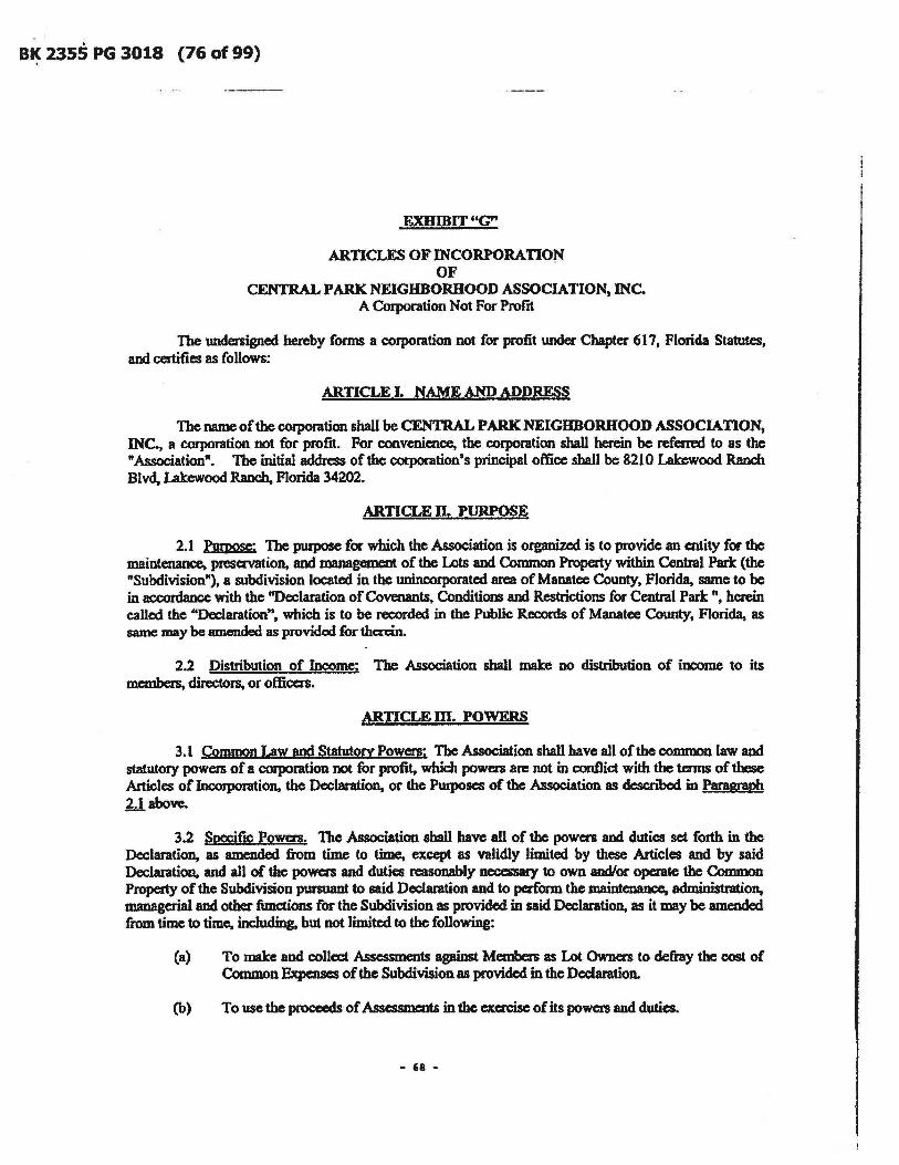
BK 2355 PG 3018 (76 of 99)
EXUmlT"G"
ARTICLES OF JNCORPORAnO~ OF
CENTRAL PARK NEIGHBORHOOD ASSOCIATION, INC. A COI]X1ration Not Foc Profrt
The undersigned hereby forms a corporation not for profit under Chapter 617, Florida Statutes, and certifies as follows:
ARTICLE I. NAME AND ADDRESS
The name of the corporation shall be CENTRAL PARK NEIGHBORHOOD ASSOCIATION, INC., a corporation not for profit. For convenience, the corporation shall herein be referred to as the "Association". The initial address of the corporation's principal office shall be 8210 Lakewood Ranch Blvd, Lakewood R.ancb. Florida 34202.
ARTICLE n. PURPOSE
2.1 Purpose: The purpose for which the Association is organized is to provide an entity for the maintenance, preservation, and management of the Lots and Common Property within Central Park: (the "Subdivision"), a subdivision located in the unincorporated area of Manatee County, Florida, same to be in accordance with the "Declaration of Covenants. Conditions and Restrictions for Central Park ". herein called the "Declaration", which is to be recorded in the Public Records of Manatee County, Florida, as same may be amended as provided for thc::rcin.
2.2 Distribution of Income: The Association shall make no distribution of income to its members, directors, or officers.
ARTICLE m. POWERS
3.1 Common Law and StatutOry Powers: The Association shall have all of the common law and statutory powers of a corporation not for profit, which powcn are not in conflict with the terms of these Articles of Incorporation, the Declaration, or the Purposes of the Association as described in Paragraph 2.1 above.
3.2 SpecifIC Powers. The Association shall have all of the powers and duties set forth in the Declaration, as amended from time to time, except as validly limited by these Articles and by said Declaration, and all of the powers and duties l'ClSOIUlbIy ncccssary to own and/or opaale the Common Property of the Subdivision pursuant to said Declaration and to perform the maintenance, administration, managerial and other functions for the Subdivision as provided in said Declaration, as it may be amended from time to time. including, but not limited to the following:
(a) To make and collect Assessments against Members as Lot Owners to defiay the cost of Common Expenses of the Subdivision as provided in the Declaration.
(b) To usc the proceeds of Assessments in the exercise of its powers and duties.
- 68 -

BK 2355 PG 3019 (77 of 99)
(c) To accept, hold title to, own, purchase, acquire, replace, improve, manage, maintain and administer the use of the Common Property of the Subdivision in accordance with the Declaration.
(d) To purchase insurance upon the Common Property, and for the protection of the Association and its Members.
(e) To reconstruct improvements to the Common Property after casualties and further to improve the Common Property in accordance with the Declaration.
(f) To adopt and amend reasonable rules and regulations respecting the use of the Common Property in accordance with the Declaration.
(g) To enforce by legal means against an Owner as defined in the Declaration, the provisions of the Declaration, the By-Laws of the Association and rules and reguJations duly adopted by the Association.
(b) To furnish or otherwise provide for private security. fife protection or such other services as the Board in its discretion determines necessary or appropriate.
(i) To pay any real and penonal property taxes and other charges assessed against tJ:le Common Property unless same are separately assessed to the Owners.
(j) To obtain all required utility and othec senices {or the Conunon Property.
(k) To maintain architectural control ovec the Subdivision in accordance with the Declaration.
(I) To operate and maintain the surface water management system facilities. including all inlets, ditches, swales, culverts, water conlrol structures, retention and detention areas, ponds, lakes, floodplain compensation areas, wetlands and any associated buffer areas, and wetland mitigation areas.
(m) To exercise such furthez authority as may be reasonably necessary to carty out each and every of the obligations of the Association set forth in the Declaration, these Articles or the By-Laws.
3.3 Assets Held in Trust: All funds and the title of all properties acquired by the Association and the proceeds thereof shall be held in trust for the Members, in accordance with the provisions of the Declaration, lhcsc Articles of Iocorponttion and the By-Laws of the Association. Upon the disaolution or winding up of this Association, its assets remaining after payment, or provision for payment, of all debts and liabilities of the Association shall be distributed pro-rata among all Members, or, alternatively, upon the affirmative vote of two thirds (213) of the Owners of Lots in tbe Subdivision, the assets of the Association may be conveyed or dedicated to (i) a public body willing to accept such assets; or (ii) a not for proftt organization located in Manatee County. Florida, or the one closest to the Association, if none are located in Manatee County,·having the same or similar purposes; provided that in the event of the dissolution of the Association, the property consisting of the surface water management system of the Subdivision shall be convcyccl to an appropriate agency of local govcmment. aud if not a<:c:eptcd, the surface walec management system shaI1 be dedicated to a similar non-profit corporation.
- 69 -

81( 2355 PG 3020 (78 of 99)
3.4 Limitation on Exercise of Powers: The powers of the Association shall be subject to and shall be exercised in accordance with the provisions of the laws of the State of Florida, the Declaration, these Articles and the Dy-Laws ofthe Association.
ARTICLE IV. MEMBERS
4.1 Members; 1be Members of the Association shall consist of all of the record Owners of Lots in the Subdivision subject to the Declaration and operated hereby.
4.2 Change of Membership: Change of membership in the Association shall be established by the m:ording in the Public Records of Manatee County. Florida, of a deed or other instrument establishing a change of record title to a Lot in the Subdivision. A copy of such instrument shan be delivered to the Association. The Owner designated in such instrument shall thcn::upon become a member of the Association and the membership of the prior owner shall thereupon be terminated, as provided in the By.Laws.
4.3 Limitation on 8 Transfer of Shares of Assets: The share of a Member in the funds and assets of the Association camot be assigned, hypothecated or transferred in any manner, except as an appurtenance to the Member's Lot.
4.4 Voting: Subject to the provisions of Section 3.02 of the Declaration, the Owner of each Lot shan be entitled to one vote as a member of the Association, provided. however, that the Declarant shall, during development, be entitled to the number of votes as provided in the Declaration, which votes may be apportioned to successor developers, or partial sua:essor developers, as provided in the Declaration. The manner of exercising voting rights shall be determined by the By-Laws of the Association. Subject to the provisions of Section 3.02 of tbe Declaration, Owners owning more than one Lot shan be entilled to one vote for each Lot owned.
ARTICLE V. DIRECfQRS
5.1 Board of Directors: The affairs of the Association sball be managed by a Board of Directors consisting of an odd number ofMcmbers determined from time to time in accordance with the By-Laws. In no event shall' the Board of Directol'S consist of fewer than three (3) directors. Directors shall be Members oCthe Association except as othenvise provided.
S.2 Election of Directors: Directors of the Association sball be elected at the annual meeting of the Memben, in the manner provided by the By·Laws. Directors may be removed and vacaocic:s on the Board shan be fined in the manner provided by the By-Laws.
S.3 FIrSt Board of Djrectors: The names and addresses of the initial Board of DiRx:tors, who have been selected by the Declarant and who sbaIl serve until their successors are dected and have qualified or until they resign or are removed, are as follows:
James R. Schier 8210 Lakewood Ranch Blvd. Lakewood Raocb, FL 34202
KarenBymcs 8210 Lakewood Ranch Blvd. I..akwood Ranch. FL 34202
- 10 -

81<; 2355 PG 3021 (79 of 99)
Priscilla Heim 8210 Lakewood Ranch Blvd. Lakewood Ranch, FL 34202
The initial Board of Directors designated by Declarant herein, and any directors subsequently designated or appointed or elected by Declarant need not be members of the Association. All other Board members shall be Members ofthc Association.
ARTICLE VL OFRCERS
6.1 Officers: The affairs of the Association shall be administered by a President, Vice President, Secretary. Treasurer and such other officers as may from time to time be created by the Board of Directors as pennitted by the By-Laws. Officers shall be elected by the Board of Directors at its IlI'St meeting following the annual meeting of the Association and shall serve at the pleasure of the Board. Offices may be combined as provided in the By-Laws. The names and addresses of the officem who shall serve until their successors are designated by the Board of Directors are as Tollows:
President:
Vice Presidentlfrcasurer:
Secretary:
James R. Schier 8210 Lakewood Ranch Blvd. Lakewood Ranch, FL 34202
Karen Byrnes , 8210 Lakewood Ranch Blvd. Lakewood Ranch, FL 34202
Priscllla Heinl 8210 Lakewood Ranch Blvd. Lakewood Ranch, FL 34202
ARTICLE VII. INDEMNIFICATION
7.1 Indemnification: Every director and every officer of the Association shall be indemnified by the Association against all expense and liabilities, including legal fees, reasonably in<:urred by. or imposed upon him in connection with any proceeding or the settlement of any proceeding to which he may be a party, or in which he may become involved by reason of his being or having been a director or officer of the AssoCiation, whethec or not he is a director or officer at the time such expenses are incurred, except when the director or officer is adjudged guilty of willful and wanton misfeasance or malfeasance in the perfOll1l8lJCC ofhis duties; provided that in the event of a settlement, the indemnification shall apply only when the Board of Diredors approves such settlement and reimbursement as being for the best interests of the Association. The fo~ing right of indemnification shaD be in addition to and not exclusive of all other rights to which such director or officer may be entitled.
7.2 Insurance: The Board of Directors of the Association may pwcbasc liability insurance to insure all directors, officers or agents. past and present, against all expenses and liabilities as set forth above. The premiums for such insurance shall be paid by the Members of the Association as part of the common expenses.
- 71 -

BK 2355 PG 3022 (SO of 99)
ARTICLE VIII. BY-LAWS
8.1 By-Laws: The first By-Laws of the Association shall be adopted by the Board of Directors, . and may be altered, amended or rescinded by a majority of the Board, except as otherwise may be provided by the By-Laws and the Declaration.
ARTICLE IX. AMENDMENTS
9.1 Amendments: These Articles may be altered, amended or modified upon the affinnative vote of the owners of two thirds (213) of the Lots in the Subdivision. Provided, however, that these Articles may be altered. amended or modified by Declarant, or its Suc:c:essor as such Declaran1. during the time that Declarant has the right to and does control the Association in accordance with the Declaration. Amendments may be proposed by resolution of the Board of Directors or by the owners of any three Lots. Provided, however, that no amendmmt affecting the Declarant, or its successors or assigns 8S the developer of the Subdivision.. as defined in the Dcclatation, shall be effective without the prior written consent of the Declarant. its successors or assigns as such Declarant Provided, further, that no amendment shall make any change in the qualification for membership nor the voting rights of Members without the approwl of all Members. No amendment shall be made which is in c:onfIict with the Declaration.
ARTICLE X. EXISTENCE
10.1 ~ The term ofthc Association shall be perpetual; provided. however. in the event that the Association is ever dissolved, the CODlrol or right of access to the Subdivision property containing the surface watet management system facilities sball be conveyed or dedicated to an appropriate govcmmental unit or public utility and that if not accepted. then the surface water management system facilities sball be conveyed to a non-profit corporation similar to the Association.
ARl1CLE XL INCORPORATOR
11.1 Incorporator: The name and address of the incorporator of this Corporation is as follows: Vogler Ashton, pu.c. 2411 - A Manatee Ave. West, Bradenton, Florida 34205.
ARTICLE xu. REGISTERED OFnCE AND AGENT
12.1- Registered Office and Agent; The Assocjation hereby appoints Central Pade Lifestyles, u.c, whose addras is 8210 Lakewood Ranch Blvd., Lakewood Ranch, Florida, 34202, as its Resident Agent under the Laws of Florida. By affixing its signature herda, the said R.cgistemi Agent does hereby accept said designation and appoinlment, and the office of the Resident Agent shall be at said address.
IN WITNESS WHEREOF, the incorporator has caused these Articles to be executed in its name by an officer themmto duly authorized this 6" day of April. 2010. .
ACCEPTANCE BY REGISTERED AGENT
Having been named as Registered Ageot and to accept service of process for the above atated colJ)Of3tion at the place designated in this catificatc, the undersigned hm:by acx:cpts the appointment as
- 72 -

BK 2355 PG 3024 (82 of 99)
Certificate of Status
I certify from the records of this of-fice that CENTRAL PARK NEIGHBORHOOD ASSOCIATION, INC. is a corporation organized under the laws of the State of Florida. filed electronically on April 06, 2010, effective April 06, 2010.
The document number of this corporation is N10000003464.
I further certify that said corporation has paid all fees due this office through December 31, 2010, and i~s status is active.
I further certify -that -said corporation has not fi~ed Articles of Dissolution.
I further certify that this is an electronically transmitted certificate authorized by section 15.16, Florida Sta-tutes, and authenticated by the code noted below.
Au,thencica~ion Code: 100407112450-50017471728511
Florida
this the
Given under my hand and the Great Seal of the State of
at Tallahassee, the Capital,
Seventh day of April, 2010
liu 6. Alrowmug 6etretarp of 6tate
EXIIIBIT "lIft
- 7' -

BK 2355 PG 3025 (83 of 99)
BY-LAWS OF
CENTRAL PARK NEIGHBORHOOD ASSOCIATION, INC.
A Corporation Not For Profrt
ARTICLE I. IDENTIFICATION
1.01 Identity: These are the By-Laws of CENTRAL PARK NEIGHBORHOOD ASSOCIATION, INC., a corporation not for profit orgamred and existing under the laws of Florida, hereinaftec called" Association".
1.02 Purpose: The Association has been organized for the purpose of maintaining. preserving. and managing the Lots and Common Property within Central Parle: (the "Subdivision"). a subdivision located in the unincorpomted area of Manatee County, Florida. same to be in accordance with the "Declaration of Covenants. Conditions and Restrictions for Central Park", herein called the "Declaration."
1.03 ~ The office of the Association shall be at 8210 Lakewood Ranch Blvd .• Lakewood Ranch, Florida 34202, until otherwise changed by the Board of Directors. .
1.04 Fiscal Year: The fiscal year of the Association shall be the calendar year.
1.05 Seal: The seal of the corporation shall bear the name of the corporation, the word "Florida", and the words "Corporation Not For Profit" and the year of incorporation.
ARTICLE n. MEMBERS
2.01 Qualification; The Members of the Association sball consist of all of the record Owners of Lots in the Subdivision which are subject to the Declaration, in accordanoe with the Declaration.
2.02 Change of Membership: Change of mcmbcnhip in the Association shall be established by the recording in the Public Records of Manatee County, Florida, of a deed or othel' instrument establishing a change of record title to a Lot in the Subdivision. A copy of such instrument shall be delivered to the Association. Upon recording, the own« established by such instrument of conveyance shall thereupon become a member of the Association and the mcmbcnhip of the prior owner shall thereupon be terminated.
2.03 Multiple Owners; When a Lot is owned by more than one person. whethea- as co-tmants. joint tenants. tenants by the entirety or otherwise, each owner sball be a member of the Association by virtue of being a record Owner of an interest in a Lot. Lessees of Lots sball not be members. All matters of voting shall, however. be determined on a Lot basis, as provided in Article m.
2.04 Restraint upon Assignment of MembcrshiR. Shares and Assets: The mcmbaship of an Owner, and the share of a member in the funds and assets of the Association shall not be assigned. hypothecated or transfeacd in any manner, except as an appurte:oance to his Lot.
2.05 Evidence of Membembin; There sbalI be DO stock or mcmbersbip certificates in the Association. Membenbip shaD bo determined by ownership as herein provided.
- 15 -

BK 2355 PG 3026 (84 of 99)
ARTICLE IlL VOTING
3.01 Voting Rights: The Member, Members, or Regular Members who are the record Ownct'S of each Lot in the Subdivision shall be collectively entitled to one ( I) vote for each such Lot, 8S provided in the Declaration and the Articles of Incorporation. Subject to Section 3.02 of the Declaration, if Members own more than one Lot, they shall be entitled to one vote for each Lot owned. A Lot vote may not be divided. As provided in Section 3.02 of the Declaration, and notwithstanding the number of Lots actually owned by the Declarant, the Declarant, together with any partial successor declarants, shall originally be entitled to three (3) times the total numba' of votes then held by Regular Members (as defmed in Section 3.02 of the Declaration), plus one additional vote. If there is more than one Declarant, they shall divide and apportion their votes as they may agree. The number of votes that the Declarant Member is entitled to cast shall be decreased from time to time as provided in the Declaration and any amendments thereto, until such time as the Declarant Member shall be deemed to be a Regular Member.
3.02 Voting Procedure: Subject to Section 3.02 of the Declaration, the single or multiple owners of each Lot who are Regular Members shall have one vote for each Lot, and the Declarant Member shall have the number of votes provided for in the Declaration. All dc:tenninations of requisite majorities and quonuns for all purposes under the Declaration, the Articles of Incorporation and these Bylaws shall be made by reference to the number of votes to which the Member is entitled. Decisions of the Association shall be made by a simple majority of votes entitled to be cast by Members represented at a meeting at which a quorum is present, unless a greater percentage is required by the Declaration, the Articles of Incorporation, or these By-Laws.
3.03 Quorum: A quorum sball exist when Members entitled to cast not less than twenty five percent (2S%) of all votes are present, either in person, by designated voting representative or by proxy.
3.04 Designation of Voting Representative: The right to cast the vote attributable to each Lot shall be determined, established and limited pursuant to the provisions of this Section:
(a) Single Owner: If the Lot is owned by one natural person, that person sball be entitled to cast the vote for his Lot.
(b) Multiple Owners: If a Lot is owned by more than one person. either as co-tenants or joint tenants, the person entitled to cast the vote for the Lot shall be designated by a certificate signed by all of the record Owners and filed with the Secrdary oftbe Association.
(c) Life Estate with Rqrutindq Interest: If a Lot is owned by a life tcoant, with others owning the remainder interest, the life tenant sball be entitled to cast the vot.e for the Lot. If the life estate is owned by more than one person, the authority to vote shall be determined as herein otherwise provided for voting by persons owning a Lot in fee in the same manner as the life tenants own the life estate.
(d) Corporations: If 8 Lot is owned by a corporation, the officers or emplo~ tb«eof entitled to cast the vote for the Lot shall be designated by a certificate executed by an executive officer of the corporation and attested by the Secrdary or an Assistant Secrdary. and rued with the Sccrdary ofthc Association.
(e) Partnership: If a Lot is owned by a general or limited partnenhiP. the general partner entitled to cast the vote for the Lot shall be designated by certificate executed by all general partners and filed with the Secretary of the Association.
- 76 -

BK 2355 PG 3027 (85 of 99)
(f) Trustees: If a Lot is owned by a trustee or trustees, such trustee or trustees shall be entitled 10 cast the vote for the Lot. Multiple trustees may designate a single trustcc, or a beneficiary entitled to possession, and a single trustee may likewise designate such beneficiary as the person entitled to cast 'the vote for the Lot by a certificate executed by all trustees and filed with the Secrc:tary of the Association.
(g) Estates and Guardianships: If a Lot is subject to administration by a duly authorized and acting Personal Representative or Guardian of the property, then such Personal Representative or Guardian shall be entitled to cast the vote for such Lot upon filing with the Secretary of the Association a current certified copy of his Letters of Administration or Guardianship.
(b) Tenants by the Entiretv: If a Lot is owned by a husband and wife as tenants by the entirety, they may designate a voting member in the same manner as other multiple owners. If no certificate designating 8 voting member is on file with the Association, and only one of the husband and wife is present at a meeting, he or she may cast the vote for their Lot without the CODCUITeDce of the other owner. If both spouses are present, they may jointly cast the vote for their Lot. but if they are unable to agree on the manner of casting such vote, they shaD lose their right to vote on such matter, although the Lot may still be counted for purposes of a quorum.
(i) Leases: If a Lot is leased, the owner-lessor shall be entitled to cast the vote for the Lot, except that the owner may designate a lessee as the person entitled to cast the vote for the Lot by a certificate executed by all owners and filed with the Secretary of the Association.
(j) Certificate: Whenever a certificate designating a voting representative is permitted or required, such certificate sball, once rued, be valid until revoked. In the absence of a valid certificate, a Lot shall not be counted in determining a quorum unless all owners required to e.xecute such certificate are present, in person or by proxy, and such Lot
, Owners shall lose their vote on any particular matter unless they concur on the ~ in which the vote of the Lot is to be cast on that matter.
3.05 Approval or DiS8J)J!f0V81 of Mattqs: Whenever the decision of a Lot Owner is required upon any matter, whether or not the subject of an Association meeting. such decision shall be expressed by the same person who would cast the vote of such Owner if at an Association meeting. unless the joinder of record Owners is specifically required by the Declaration or these By-Laws.
3.06 Proxies: Votes may be cast in person or by proxy. A proxy shall be in writing and signed by the designated voting representative. or the Owner, if no voting representative bas been designated. A proxy sball be valid only for the particular meeting designated in the proxy, and must be filed with the Secretary of the Association before the appointed time of the meeting or any adjournments thereof. A properly executed and delivered proxy may be revoked by a writing delivered to the Secretary prior to the appointed time of the meeting or any adjoUl'l1JlltDtS thereof, or by the attendance in person of the persons executing said proxy at any meeting or adjoummcot thereof. No one person may be designated to hold more than fifteen (IS) proxies. In no event shall a proxy be valid for a period longer than ninety (90) days aftec the date of the fust meeting for which it was given.
3.07 Method of Voting: Subject to the provisions of the Declaration, voting may be by roll caJJ, voice vote or by written baUot; provided, however, that whenever written approval is required by the
- 77 -

BK 2355 PG 3028 (86 of 99)
Declaratio~ or whenever any amendment to the Declaration is proposed, or when any borrowing of funds, pledge, or other disposition of common properties or assets is proposed, the voting shall be by written ballot. Routine matters such as approval of minutes, adjournment, acceptance of reports, parliamentaJy questions and social business may be determined by "Y cas" and "Nays" provided that any five.(5) voting Members. or the chainnan, may require a roll call vote or vote by written ballot.
ARTICLE IV. MEETINGS OF MEMBERS
4.01 Annual Meeting; The annual meeting of the Membc:rs shall be held during the month of November of each year on a day and at a time determined by the Board of Directors; provided that notice pursuant to Section 4.03 is given at least thirty (30) days prior to the date set for the annual meeting. The annual meeting shall be for the purpose of electing directors, and transacting any other business authorized to be transacted by the Members. No annual meeting shall be held until such time as the Regular Members are entitled to eJect a director pursuant to the provisions of the Declaration.
4.02 Special Meetings: Special meetings of the Members shall be held whenever called by the President or Vice President, or by a majority of the Board of Directors. and must be called by such officers upon receipt of a written request from voting members entitled to cast not fewer than fifteen peR:eDt (15%) of the total number of votes.
4.03 Notice of Meetings: Notice of all meetings of the Members, stating the time, place and subjects for which the meeting is called, shall be given by the President or Vice President or Secretary, unless waived in writing. All such notices sball be given in writing to each member's address, as it appears on the books of the Association; as the Member may have otherwise directed in writing; or as it appears upon the instrument of conveyancc establishing the membership inlen:st. The notice shall be mailed or delivered not fewer than ten (10) days, nor more than thirty (30) days, prior to the date of the meetipg. A duplicate notice sball be furnished to the designated voting representative if such voting representative is not also an Owner. The notice for any meeting at which assessments against Lot Owners are to be considered shall contain a statement of the nature of such assessments and that such assessments will be considered. Proof of such mailing or delivery shall be given by an Affidavit of the person .giving the notice. Notice of meetings may be waived in writing before, during or after meetings.
4.04 ~ Meetings of the Association Members shall be held at such place in Manatee County, Florida, as tho Board of Directors may designate in the Notice of Meeting.
4.05 Miournments: If any meeting of Members cannot be organized because a quorum has not attended, the Members who are present, either in person or by proxy. may adjourn the meeting from time to time until a quorum is present.
4.06 Order of Business: The order of business at annual meetings. and as far as practical at all special meetings, shall be:
<a) Election ofChairmanoCthemeeting(ifnecessary).
(b) Calling of the roll and certifying of the proxies.
(c) Proof of notice of the meeting or waivec of notice.
(d) Reading and disposal of any unapproved minutes.
- 78 -

B~ 2355 PG 3029 (87 of 99)
(e) Reports of officers.
(t) Reports of committees.
(g) Election of directors.
(h) Unfinished business.
(i) New business.
(j) Announcements.
(Ie) Adjournment.
4.07 Action Without Meeting: Whenever the affirmative vote or approval of the Members is required or permitted by the Declaration or these By-Laws. such action may be taken without a meeting if Members entitled to cast not fewer than seventy five pcICCllt (75%) of the votes if such meeting were held, shall agree in writing that such action be taken and waive the necessity of such meeting. Provided, however, that if a greater percentage approval is required, then not less than such pcreentage must so agree in writing. Provided further that the Declaration, Articles of Incorporation and these By-Laws may not be amended without a meeting. Notice of the adion so taken shaD be given in writing to all Members who did not -approve such action in writing within tm (10) days of such approwl.
4.08 Proviso: Provided, however, that until the Declarant has terminated its control of the Association and its affairs in accordance with the Declaration, the proceedings of all meetings of the Members of the Association shall have no effect unless approved by the Board of Directors, except for the rights of the Regular Members to elect directors.
ARTICLE V. DIRECI'ORS
5.01 Number: The affairs of the Association shall be managed by a Board of not less than three (3) DOr more than seven (7) directors (the "Directorsj the exact number to be determined by the Members from time to time prior to the annual election of DiR:ctors. The Board ofDirectol'S shall at aU times be comprised of an odd number of Members. Until otherwise determined by the Members. there sball be three (3) Directors.
manner: 5.02 Election of Directors: The election of Directors sbaH be conducted in the following
(a) Election of Directors shall be held at the amwal meeting of the Members. A nominating committee of not less than three (3) nor more than five (S) Members may be appointed by the Board of Directors not less than thirty (30) days prior to the annual 'meeting of the Members. The nominating committee shall nominate at least one (1) penon for each dire<:torship. Other nominations may be made nom the floor. and nominations for additional directonhips, if any. created at the meeting shall be made from the floor.
(b) The election shall be by ballots, unless dispensed with by unanimous consent. and by a plurality of the votes cast. each person voting being entitled to cast his votes for
- 79 -

'.
BK 2355 PG 3030 (88 of 99)
each of as many nominees as there are vacancies to be filled. There shall be no cumulative voting.
(c) Any Director may be recalled and removed from office, with or without cause, by the vote or agreement in writing by a majority of all Lot Owners. A special meeting of the Lot Owners to recall a Member or Members of the Board may be called by ten percent (looA) of the Lot Owners giving notice of the meeting as required for a meeting of Lot Owners, and the notice shall state the purpose of the meeting. The vacancy in the Board of Directors so created shall be filled by vote of the Members of the Association at the same meeting.
(d) The Declarant shall be vested with the powa' to designate the initial Board of Directors, the Members of which need not be owners of Lots. The initial Board of Directors shall serve until the first election of Din:ctors. Any vacancies occurring prior to the rust election ,ball be flIled by the remaining Directors.
(e) The first e1ection of Din:ctors shall be held when Declarant membership terminates.
(1) When Declarant membership tenninates and the Declarant Member is deemed to be a Regular Member pursuant to the Declaration, then the Declarant shall call a special meeting within sixty (60) days after such date, as provided in the Declaration. At such special meeting all Regular Members shall elect a Board of Directors, to serve until the next annual meeting. Thereafter, Directors shall be elected annually at the annual meeting.
(g) - Declarant may waive its right to elect or designate anyone or more Directors it otherwise has the right to designate under the Declaration and these By-Laws, which waiver shall, however, apply only to the specific election at which the waiver is made. IT Declarant does waive such right. the Regular Members shall elect the Board member or members who would otherwise have been elected or designated by Declarant.
5.03 Term: Subject to the provisions of Section 5.02. the term of each Director's service shall extend to the next annual -meeting of the Members and thereafter until his successor is duly elected and qualified, or until he is removed in the manner elsewhere provided.
5.04 Qualifications: All Directors shall be Members of the Association; provided, however, that any Director elected or designated by Declarant pursuant to these By-Laws need not be Members. An officer of any corporate owner and a general partner of any partnership owner shall be deemed Members for the purposes of qualifying for election to the Board ofDircctors.
5.05 Vacancies: _ Except as otherwise provided hCl'ein, if the office of any Director becomes vacant, whether by reason of death, resignation, retirement. disqualification, incapacity or otherwise, a majority of the remaining Directors shall select a successor, who shall hold the office for the unexpired tenn of the Director he is replacing. Vacancies following removal of office pursuant to Section S.OUcl sball be flIled as therein provided.
5.06 Disqualification and Resignation: Any Dim:tor may resign at any time by sending written notice to the 'Secretary of the Association. Such resignation shall take effect upon receipt by the Secretary. unless otherwise specified in the nsignation. Any ~il'ector who must be a member of the
- 80 -

81( 2355 PG 3031 (89 of 99)
Association &ball be deemed to have resigned if he transfers his Lot so that he ceases to be a member of the Association. After the Declarant membership status bas terminated pursuant to the Declaration. more than three (3) consecutive WlexCUSed absences from regular Board meetings shall be deemed a resignation, which shall be effective upon acceptance by the Board.
S.07 Voting: All voting for tbe election of Directors shall be as provided in Article m hereof. Notwithstanding the foregoing. Directors may not vote by proxy or by scc:rct ballot at Board meetings, except that secret ballots may be used in the election of Officers. A vote or abstention from voting on each matter voted upon for each Director present at a Board meeting must be recorded in the minutes.
5.08 Organization Meeting: The oipIlization meeting of a newly elected Board of Directors shall be held within thirty (30) days of its eJection, at such place and time as shall be fIXed by the Directors at the meeting at which they were dected, and no further notice of the organization meeting shall be necessary.
5.09 Regular Meetings: The Board may, from time to time. establish a schedule of regular meetings to be held at such time and place as the Board may designate. Any regular scheduled meetings may be dispensed with upon written concurrence of not less tban two-thirds (213) of the Members of the Board.
S.IO Spccw Meetings: Special Meetings of the Directors may be called by the President and must be called by the Secretary or an Assistant Secretary at the written request of one-third (113) of the Directors.
S.lI Notice:
(a) To-Directors: Notice of each regular or special meeting shall be given to each Director penonally or by mail, telephone or telegraph at least three (3) days prior to the meeting date. All notices shall stale the time and place of the meeting. and if a special meeting, the purposes thereof. Any Director may waive notice of a meeting before. during or after the meeting, and all such waivers shall be deemed equivalent to the giving of notice. Attendance by a Director at a meeting shall be deemed a waiver of notice by him.
(b) To Members: Notices of all Board meetings. and meetings of any committee or similar body of the Board, shall be posted in a conspicuous place in the Subdivision at least forty eight (48) hours in advance of the meetjng except in an emergency. In the alternative. if notice is oot posted in a conspialous place in the Subdivision. notice shall be mailed or delivered to each Member at least seven (7) days before the meeting, except in an emergency. Notwithstanding the foregoing. in the event the number of Members is in excess of l00, .a reasonable alternative to posting or mailing may be provided, including publication of notice or provision of a schedule of Board meetings. The nouce for any meeting at which assessments against Lot Owners are to be considered sball contain a statement of the nature of such assessments and that such assessments will be considered. Proof of such posting, mailing or delivery shaD be given by an Affidavit of the person giving the notice. Notice of meetings may be waived in writing before. during or after meetings.
5.12 Quorum: A quorum at Directors' meetings shall consist ofa majority oft.be entire Board of Directors. The acts approved by a majority of those present at a meeting at which a quorum is present
- 81 -

Bt( 2355 PG 3032 (90 of 99)
shall constitute the act of the Board of Directors; except where approval of a greater nwnber of Directors is required by the Declaration or these By-Laws.
5.13 Adjourned Meeting: If, at any meeting of tbe Board of Directors, there be less than a quorum present, the majority of those present may adjourn the meeting from time to time until a quonun is present. At any adjourned meeting any business which might have been transacted at the meeting as originally called may be transacted without further notice.
5.14 Joinder in Meeting by Approval of Minutes: The joinder of a Director in the action of a meeting. by signing and concuning in the minutes thereof shall constitute the COIlClDTeDCC of such Director for the purpose of determining requisite majorities on any action taken and reflected in such minutes or to create a quorum. Directors may join in minutes under this Section only after an open meeting, for the purposes herein provided.
5.15 Meetings Open: Meetings of the Board of Directors shall be open to all Members, ex.cc:pt for meetings between the Board and its attorney with respect to proposed or pending litigation where the contents of the discussion would be otherwise be governed by the attorncy/cliart privilege.
5.16 Presiding Officer: The presiding office£ at Directors' meetings shall be the President. In the absence of the President. the Vice President shall preside. In the absence of both, the Directors shall designate one of their Members to preside.
5.17 Directors' Fees: Directors shall not be entitled to receive Directors' fees, but may be reimbursed out of pocket expenses advanced by the Director.
'5.18 Order of Business: The order of business of Directors' meetings shall be:
(a) Roll call.
(b) Proof of notice of meeting or waiver of notice.
(e) Reading and disposal of any unapproved minutes.
(d) Reports of officers and committees.
(e) Election of officers. if any.
(t) Unfinished business.
(g) New business.
(h) Announcements.
(i) Adjourmncnt.
ARTICLE VI. POWERS AND DUTIES OF BOARD OF DIRECTORS
The Board of Directors shall have all powers, authority, discretion and duties necessary for the administration of the Association and operation of the Subdivision. except as may be reserved or granted to the Lot Owners, Declanmt or a specific committee or committees of the Association by the
- 82 -

· " 81( 2355 PG 3033 (91 of 99)
Declaration, Articles of Incorporation, or these By·Laws. The powers of the Board shall include, but shall not be limited to, the following:
6.01 General Powers: All powers specifically set forth in the Declaration, Articles of Incorporation and these By-Laws, and all powers incident thereto or reasonably to be inferred therefrom.
6.02 Enforcement: The Board of Directors shall, when deemc:d necessary by the Board, enforce by legal means, provisions of the Declaration, the Articles of Incorporation, the By-Laws and rules and regulations for the use of the Common Property_
6.03 Budget and Assessments: To adopt budgets and make assessments, and to use and expend assessments and other receipts of the Association to carry out the power'S and duties of the Association pursuant to the Declaration and these By-Laws.
6.04 Employment: To emploY, dismiss, control and contract for personnel and contractors for the administration of the Association, including but not limited to managers, maintenance personnel, attorneys, accountants and other professionals, by employment or contract, as the Board may determine.
6.05 Rules and Regulations: To adopt, amend and rescind reasonable rules and regulations relating to the administration of the Association and opemtion and use of any Common Property, subject to the Declaration and By-Laws. Provided, however. that any rules or regulations adopted by the Board may be supplemented, amended or rescinded by affirmative vote of the Owners of not less than two-thirds (213) of the Lots subject to the Declaration. Any such rules or regulations approved by the Owners shall not thereafter be amended or rescinded except upon affirmative vote of the Owners of not less than twothirds (213) of the Lots in the Subdivision subject to the Declaration.
6.06 Committees: To create and disband such committees as the Board may from time to time determine as reasonably neccswy or useful in and about the administration of the Association, and to delegate such authority to such committees as may be reasonable in connection with their purpose, subject always to the provisions of the Declaration, Articles of Incorporation and By-Laws. AlI·committees 'of the Association shall keep records and conduct meetings in the same manner, to the extent applicable, as is required ofthc Board of Directors.
ARTICLE VII. OFFICERS
7.01 Officers and Election: The officers of the Association shall be a President. who shall be a Director; a Vice President, who shall be a Director; a Treasurer, a Sec.retary and such other officers as may be determined from time to time by the Board, all ofwbom shall be elected annually by the Board of Directors. and who may be peremptorily removed by a majority vote of all Directors at any meeting. Any person may hold two offices except that .the President shall not also be the Secretary or an Assistant Secmary. The Board of Directors shall designate the powers and duties of such other officers as it may create.
7.02 President: The President shall be the chief executive officer of the Association. The President shall have all of the powen and duties which are usually vested in the office of President of an Association; including but not limited to the power to appoint advisory committees from time to time, from among the Members or others as he may in his discretion detcnninc appropriate, to assist in the conduct of the affairs of the Association. The President shall serve as Chairman at all Board and membership meetings.
- 83 -

BK 2355 PG 3034 (92 of 99)
7.03 Vice P~ident: The Vice President shall, in the absence or disability of the President. exercise the powers and perfOJDl the duties of the President. TIle Vice President shall also generally assist the President, and exercise such other powers and perform such other duties as shall be prescribed by the Directors.
7.04 Secretary and Assistant Secretary: The Secretary shall keep the minutes of all proccc:dings of the Directors and the Members. The seCretary shall attend to the .giving and serving of all notice to the Members and Directors. The Secretary shall keep the records of the Association, except those of the Treasurer, and shall perfonn all other duties incident to the office of SecretaJy of an Association, as may be required by the Directors or the President. The Assistant Secretary, if such office is created, shall perform the duties of the Secretary, when the Secretary is absent. The minutes of all meetings of the Members and the Board of Directors shall be kept in books available for inspection by Members, or their authorized tepresentativcs, and Board members at any reasonable time. All such records shall be retained for not less than seven (7) years.
7.0S Treasurer: The Treasurer shall have the custody of all the property of the Association including funds, securities and evidences of indebtedness. The Treasurer shall Ia:cp the books of the Association in accordance with good 8<:COunting practices. and provide for collection of assessments, and perform all other duties incident to the office of Treasurer.
7.06 Conwensation: The compensation of aU officers and employees of the Association shall be fixed by the Directors. 1be provisions that Directors' fees shan be detennined by Members shall not preclude the Board of Directors from employing a Director as an employee of the Association, nor preclude contracting with a Director for the management services. No officer who is a designee of the Declarant shall receive any compensation for his services.
7.07 Indemnification of Directors and Officers: Every Director and every officer of the Association shan be indemnified by the Association against all expenses and liabilities, including attorney's fees, reasonably incurred by or imposed upon him in connection with any proceeding to which such Director or officer may be a party or in which such Director or officer may become involved by reason of being or having been a Director or officer of the Association. whethc:r or not such Director or officer is a Director or officer at the time such expenses are incurred, except in such cases when the Director or officer is adjudged guilty of willful misfeasance or malfeasance in the perfonnance of such Director's or officer's duties. The foregoing right of indemnification shall be in addition to and not exclusi\'e of all other rights to which such Director or officer may be entitled.
7.08 Term: All officers shall hold office until their successors are chosen and qualify.
ARTICLE VIII. FISCAL MANAGEMENT
The provisions for fiscal management of the Association set forth in the Declaration shall be supplemented by the following provisions:
8.01 Accounting: Receipts and expenditures of the Association sball be credited and charged to Association ac:counts in accordance with gencnlly accepted accounting principles consistently applied.
8.02 Budget: The Board of Directors shall adopt a budget for each calendar year which shall include the estimated funds required to defray the current expenses and funds for required reserves if
- 8' -
I

BK 2355 PG 3035 (93 of 99)
deemed necessary by thc Board. The budget may provide funds for specifically proposed aod approved improvemmts.
8.03 Procedure: The Board of Directors shall adopt a budget in accordanoc with the Declaration.
8.04 Assessments: Regular annual assessments against a Lot Owner for such Owner's share of the items of the budget shall be made in advance on or before December 20 prcccding the year for which the assc:ssment is made. Such assessment shall be due either annually or, at thc discretion of the Board. in periodic installments, which shall come due on intervals established by the Board. If an amwa1 assessment is not made as required, an assessment shall be presumed to have been made in the amount of the last prior assessment and monthly payments thereon shall be due from the 1st day of each month until changed by an amended assessment. In the event the 8lUlual assessment proves to be insufficiCDl, the budget may be amended at any time by the Board and a supplementary assessment levied. The supplementary assessment shall be due on the 1st day of the month next following the month in which the supplementary assessment is made or as otherwise provided by the Board of Directors.
8.05 Acceleration of Assessments: Upon default in payment the Board may elect to accelerate remaining installments of any assessments in accordance with the Declaration.
8.06 Expenditures: All funds of the Association shall be expended only upon authorization of the Board of Directors. Approval of the budget shall be deemed authority to eJq)CDd funds for the items and contingency funds within the budget. Funds derived from special assessments and funds in specifically designated reserves shall be expended solely for the pwpose for which such assessment was made or reserve established. Contingency funds may be expended for any legitimate pwposc by action of the Board.
8.07 Depository: The depository of the Association sball be in such bank: or banks 8'S shall be designated&om time to time by the Directors, and in which the moneys of the Association shall be deposited. Withdrawal of moneys from such accounts shall be only by checks signed by such persons as arc authorized by approprime resolution of the Board of Directors. Funds of the Association may be comingled or kept in separate accounts, except as otherwise required by the Declaration.
8.08 ~: After Declarant transfers complete control of the Association, a report of the accounts of the Association sbal1 be made annually by the Board, and a copy of the report shall be furnished to each member not later than April 1 of the year following the year for which the report is made.
8.09 Fidelity Bonds: Fidelity Bonds may be required by the Board of Directors from aU persons handling or responsible for the Association's funds. The amounts of such bonds shall be determined by the Directors of the Association. The premiums on such bonds, if required by the Board, shall be paid by the Association as a Common Expense.
ARTICLE IX. PARLIAMENTARY RULES
Roberts Rules of -Order. the latest edition, shall govern the conduct of the meetings of the Association. the Board of Directors and Committees of the Association wbm not in conflict with the Declaration. Articles of Incorporation or these By-Laws.
ARTICLE X. AMENDMENT - 85 -

BK 2355 PG 3036 (.94 of 99)
ARTICLE X. AMENDMENT
These By-Laws may be amended by the Members of the Association at any regular or special meeting duly called for that purpose by the affirmative vote of an absolute majority of all votes entitled to be cast. Notwithstanding the foregoing. no amendment shall be made that is in conflict with the Declaration or the Articles of Incorporation. except as provided in said Declaration or Articles. Provided. however, that these By·Laws may be amended at any time by the Declarant Members during the time that the Declarant Members have and exercise the right to control the Association. provided that such amendment is not in conflict with the Declaration.
ARTICLE XI. MISCELLANEOUS
The provisions of these By-Laws shall be construed together with the Declaration and the Articles of Incorporation. In the event of a conflict between the provisions hereof and the provisions of the Declaration or Articles, the provisions of the Declaration or Articles shall control. Unless otherwise specifically provided. terms used herein shall have the meanings set forth in the Declaration. The provisions hereof shall be liberally construed to grant to the Association sutTtcient practical authority to implement its obligations and authorities under the Declaration. Whenever the context SO requires, the use of any gender herein shall be deemed to include all genders, and the use of the plural shall include the singular and the singular shall include the plural.
The fore~i~ was ado~ as the By-Laws of the A'SSOCiation at the first meeting of the Board of Directors on theDl_" _f_ day of ~K$r , 20 J~
NEIGHBORHOOD ASSOCIATION INC., a It -Corporal ion
By: y-~£,
- 81 -
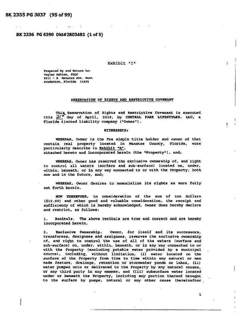
B~ 2355 PG 3037 (95 of 99)
BK 2336 PG 6390 Dkt#2803482 (1 of 5)
Prepared by and Return to, vogler ~hton. PLLC 2411 - A Manatee Ave. Neet Hradenton. Florida 34205
Exhibit "I"
RESBRVATJ:ON 9'! It:IGH'1'S _1JlD RBSTRIC'l'J:VE ~~
Tbi,. Reservation of Rights an4 Restrictive Covenant is .executed this ~l day of April, 2010, by CENTRAL PARlt LJ:PESTYLBS. LLC, a 'Florida iimi.eed liability company (-owner").
WITRBSSETH:
WHEREAS, owner is the fee simple ~itle holder and owner of that certain real property loeated in Manat-ee County I FIOl:'iCla, more particularly Clescribe in Exhibit.~A~, at~ached' her~o and incorporated herein (the 'tProperty·), and;
WHEREASi Owner has reserved the exclusive ownership of, anCl right to control all waters (surface and sub-surface) located on, under, wi·thin, benca.th, or in any way ~onnect.ed to or with the -Property, both now and in the future, and;
WRBRBAS, OWner desires .to mellloria.lize its cigbt:s a.s more -fully set -forth herein.
HOW 'l'HEUFOU, in consideration of the sum of ten dollars ($10.00' and other good and valuable conside-z:ation, the receipt and sufficiency of which is hereby acknowle4ged, owner does hereby declare and restrict, as follows:
1. Reci~alB. The above recitals are .c:.rue and cor~ct and are h~.eby incorpora.ted berein.
2. Bxclullive Ownership. OWner, ·for itself and its successors, transferees, designees and Assignees, reserves the exclusive ownership of, a11d right -to control the use of all of the waters (surface and sub-surface) on, unCler, within, beneath, or in any way connected to or with the Property (excluding potable water provided by a muniCipal source), including, without limitation, (i) wa~er located on the surface of the Property from time to time within any naeural or man made feature, drainage, retention or stormwater ponds or lakes, (ii) water pumped onto or delivered to the Property by any natural causes, or any third party in any manner, and (iii) subsurface water located under or beneath the Property, including any portion thereof brought to the surface by pumps, natural or any other cause (hereinafter.
1

BK 2355 PG 3038 (96 of 99)
BK 2336 PG 6391 (2 of 5)
"Water·'.
3 . R. •• tricstiol1ll. No use of the Water may be made by any person or entity which acquires an interest in the Property, or any oCher person or entity without OWner's prior written consent, which eonsent may be withheld for any rea:son deemed sufficient by Owner. No person or entity may PUlllp or otherwise remove any Water frcnn the Property or any natural or man made feature located thereon, or any pond, lake or stormwater retention area, or from any underground sources at any time
·for any purpose. Without limiting the for-egoing, Owner shall have the right, in its sole discc~ion, to: (a) grant nonexcluslve licenses to other persons or entities to use the Wa-tera ,for the benefit of improve1llents developed on the Property, or other proper~ies, whether or not - located within the Property, and i~ connection therewith, -to install electrical panels, wells, pumps and irrigation equipment to be used therefor; '(b) grant nonexclusive licenses ~o other persons or entities for the retention of st9~w.ter within the drainaqe, retention or stormwater ponds located on the P~op.rty Cor the benefit of development on -the Pro~ty, or other properties, whether or not located within the Property; and (e) increase or decrease the water level of the ponds, lakes or elements within the surfacewater management system of the Property frott time to time by any 1ft8ang,
including the installation, control, and use of: drainage - control devices and apparatus 1 additional lakes, potlds, swales, culverts, inlets, and outfalls; wells and pumpsJ and reclaimed water and rela~ed facilities. The grant by Owner ~ ad4itional licenses, if any, concerning the use of the Waeers shall be on such ~erms and conditions as OWner may approv.e, in its sole discretion. The rights of OWner to grant. additional licenses shall not be construed as an obligation ,to do so. The rights of owner set forth herein are for owner's sole benefit and may be exercised, waived, r.eleased, transferred or assigned, in whole or in part, in Owner's sale diacret:iotl. No person shall have any cause of a<:tion against OWner on account of OWner's exercise, fa-ilure - to exerclise, waiver, release, «ansfer, or assignment, in whole or in part, of any of such rights.
4. B.sements. owner hereby reserves easements for the benefit of owner, its employees, subcontractors, successors, transferees and assigns, in, on, under, through or over the Property, as .. ay be expedient or necessary for (1) access to and use of the Water as reserved herein and (11) access to, installation of, and maintenance of its equipment; including but not liaited to, irrigation lines and pumps, and connecting any water, or effluent water lines within the Property to additional properties, as Owner determines in 1ts sole discretion. The easements herein described shall be perpetual and at all times inure to the benefit of and be binding upon the owner, all of their grantees and respective successors, -transferees, designees, and assigns.
2

BK 2355 PG 3039 (97 of 99)
BK 2336 PG 6392 (3 of 5)
5. AttorJulY. Fe.. and CO'ate. In ·the ev.eDt: it beC:0I1Ie8 necessary .for owner to enforce· its rights under this document. the prevailing party shall be entitled to - recover the costs of such action or proceedings, including a reasonable attorneys (ee.
IN WZTHBSS WHERE07, the undersigned has caused this docume~ to be executed and delivered as of the day and year setcorth above.
WX'J."NESSES:
¢~~ S'ignature
SANDRA BRAlTON
~i(,~= , ture -SANDI OWENS
Printed NaIIle
STATE OF FLORIDA
COtJN!l'Y OF MANATEE
CEIft!JtA'L PAItIC -LXPBS".r.!'LBS, MrC, a Florida ~imited liabil~ty
coraptmy,
By:
Manager
The foregoing instrument was acknowledged before me thiS~~daY of April, 2010, by James R. Schier, as Manager of CBN'l'RAL pARJ: LlFES'l'YLES. LLC. a florida limited liability corapany, on behalf of the cOIIlpany, who is (v] personally known to U\e or [ ] has produced the follOWing a8 identific~ionl
(Notary Seal)
~~.fk. ,. Print Namel ,._ Commission NUmber: My coamtission expires: "~/p--iS
3
- .,' ._----------------------------

· BK 2355 PG 3040 (98 of 99)
BK 2336 PG 6393 (4 of 5)
LEGAL DESCRIPT70N (as prepared by the ce~ifying Surveyor and Mapper) :
A tract of land lying in Sections 7 and 8, Township 3S South, Range 19 East, Manatee County, Flocida a.nd de8'Cribed as .follows:
-CCAIIIlence a.-t the Southwest corner of section 8, Township 35 South, Range 19 Ea.st; thence S.89·34'3~·E., a distance of 4,473.76 -f-eet; -thence N.0002S'2S"E., a. distance of 1,865.88 -feet to the POINT OF -BSGINNING; thence S.82°5S'49-W., a distance of 734.17 feet to the point of curvature of a cueve to the left having- a -radius of 2,1.43.00 feet and a central angle of 34025'49°; thence southwesterly along the arc of said curve, an arc length of 1,287.78 feet to the point of reverse ~urvature of a curve to the right having a radius of 2,023.00 feet and a central angle of 44 037'24-; thence weeterly along the arc of said curve, an arc length of 1,575.56 feet ~o the point of tangency of said curve; thence N.86°S2'3S nW., a distance of 1; 131.57 feet to the point of curvature of a curve to the right having a radius of 50.00 -feet and a central angle of 910 33'16"; thence northwesterly along the arc of said curve, an arc length of 79.90 teet to the point of -tangency of ~aid ~urve, said point being a point on the east line of Lakewood Ranch Boulevard as recorded in Official R.ecoa:d Book l443,page 4980 of the PUblic Records of Manatee COunty, Florida; the following 2 -calls are along said east line of Lakewood Ranch Boulevard; thence N.OI·40 ' 41-E., a distance of 2,619.78 -feet ~o the point of curvature of a curve to the left having a radius of 2,060.00 feet and a central angle of 25 0 57'27"; thence northerly along the arc of said curve, an arc length of 933.27 feet to the point of reverse curvature of a curve to the right having a radius of 50.0f) feet and a central angle of 95°-4~'23": thence northeasterly along the arc of said curve, a distance of 83.~2 feet to the point of tangency of said curve; thence N.74·2S'37"B., a distance of 50.78 feet to the point of curvature of a curve to the right having a radius of 2,777.50 feet and a central angle of 14 0 53'05"; thence easterly along the arc of said curve, an arc length of 721.56 fe~t to the end of said curve; thence N.00041'18"W. along a line radial to the last described -curve, a distance of 12.50 feet to the point of curvature of a non-tangent curve to the right, of which the
4

B~ 2355 PG 3041 Filed It Recorded 10/8/10 1:39:38 PM R. B. "CHIPS" SHORE Clerk of Circuit Court Manatee County FL. (99 of 99)
BK 2336 PG 6394 Filed &. Recorded 4/27/10 2:06:23 PM R. 8. "CHIPS" SHORE Clerk of Circuit Court Manatee County FL (5 of 5)
radius point lies S.00041'lS 8 E., a radial distance of 2,790.00 feet; thence easterly along the arc of said curve, through a central angle of 13 0 12'59", an arc length of 643.S7 feet to the point of reverse curvature of a curve to the lett having a radius of 2,940.00 feet and a central angle of 41 0 16'07"; thence eas-terly along the arc of said curve, a distance of 2,117.61 feet to the point of reverse curvature of a curve to the right having a radius of 2,790.00 teet and a central angle of 16032'46"; thence .eas-terly along the arc of said curve. a dis-tance of 805.71 feet to the end of said curve; thence S-.12°11'41"E. along a line radial to the last desceibed -curve, a distance -of 12.50 feet to the point of curvature of a nontangent curve to the .:right, ot which the radius point lies S.12°11'41"E., a radial distance of 2.777.50 feet; thence easterly along the arc of said curve, -through a central angle of 13 004'19", an arc length of 633.-68 -feet to the point of -ta.ng.ency of said ~urve; thence S.89°07'21-E., a distance of 137.85 feet to the point of curvature of a curve to the eight -having a radius of 50.00 feet and a central angle ~f 89 0 22'24", thence southeasterly along the arc of said curve, an arc length of 77.99 feet - to the point of tangency of said ~rve; thence S.0001S'03"W., a distance of 359.01 feet to the :point of curva~ure of a curve to the right having a radius of 2,180.00 feet and a central angle of 01 0 37'40"; thence southerly along the arc of said curve, an arc length of 78.98 feet to the end of said curve; thence S.88°07'17"E. along a lin-e radial -to -the iLast described curve, a distance of 20.00 feet to the point of curvature of a non-tangent curve to the right, of which the radius point- lies N.88°07'17"W., a radial distance of 2,800.00 feet; thence southerly along the arc of said curve, through a central angle of 24·4~'23·, an arc length of 1,210.64 feet -to the point of reverse ~urvature of a curve to the left having a radius of 2,930.00 feet and a central angle of 3to 36'21 ft ; thence southerly along the arc ot said curve, an arc length of 1,616.27 feet to the point of reverse curvature of a curve to the right having a radius of SO.OO feet and a central angle of 87 0 53'04"; thence southwesterly along the arc of said curve, an arc length of 76.69 feet to -the POINT 01' BEGINNnfG.
Said. tract contains 16,204,397 square feet or 372.0018 acres, more or less.
5

Electronic Articles 'of Organization . Fo.r
Florida Limited LiabUity Company
Article I The name of the Limited Liability Company is:
CENTRAL PARK LIFESTYLES LLC
Article II
L080"O0036"473 FILED 8:00AM April 10",,2008 Sec. Of ~tate dbruce
The 'street address, of the principal office of the Limited Liability Company is: 8470 ENTERPRISE "CIRCLE SUITE 201 ' LAKEWOOD RANCH, FL. US 34202
The majJjog address of the ,Limited Liability Company is: . _. , .. ~ ..... M~ 4.... .
8470 ENTERPRISE CIRCLE SUITE 201 ' LAKEWOOD RANCH, FL. US 34202
Article III The purpose for which this Limite4 Liability Company is organized is:
ANY AND ALL LAWFUL BUSINESS.
Article IV . -'The name ,and Flonda street address of the registered. agent is:
J GEOFFREY PFLUGNER 8470 ENTERPRISE CIRCLE SUlTE201 LAKEWOOD RANCH, FL. 34202
: ',', ,HaVing been named as.registered agen~ and to accept'SelVice of p~s " "for the-aoove stated limited liability company at the place designated
~ in this certificate~.r hereby'accept the ~ppointmeli.t'as registered agent ' and,agree tc? act.~ this capacity. I further,agree to comply with the provisions of all statutes relating·to the proper arid complete performance . of my duti((S, :and. I am familiar with and accept the ohljgations of my position as registered agent '
Registered .,Ag~ Signa~: .J GEOFFREY PFLUQNER

Article V , The name and address of managing members/managers are:
Title: MOR FRANK CASSATA 7511 S TAMIAMI ~ SARASOTA, FL. 34231 US
Title: MOR PATRICKKNEAL 8210 LAKEWOOD RANCH BOULEVARD LAKEWOOD RANCH, FL. 34202 US
Title: MOR JIM SCHIER 8210 LAKEWOOD RANCH ,BOULEVARD LAKEWOOD RANCH, 'FL. 34202 US
Article VI The effective date for, this Limited Liability Company shall~:
04/10/2008
. Signatwe of member or·an authorized representative ora member signature: FRANK CASSATA
L08000036473 FILED 8:00 AM April10~008' Sec. Of· ~tate dbruce

March 26, 2013 - Regular Meeting Agenda Item #14
Subject FINAL PLAT - Central Park, Subphases B-2a & B-2c Briefings None Contact and/or Presenter Information Debbie Perron, Sr. Development Review Specialist, 6866 Action Requested
FORM OF MOTION:
1. Approval of, authorization for Chairman to execute, and authorization to record Final Subdivision Plat;
2. Acceptance of , and authorization to record Lot Drainage and Grading Plans;
3. Acceptance of, authorization for Chairman to execute, and authorization to record Mortgagee's Joinder in Declaration only from FC, L.L.C;
4. Acceptance of, and authorization for Chairman to execute Required Improvements Agreement and Temporary Construction Easement for Private Improvements; Re: Surety Bond No. 1083732 from Lexon Insurance Company;
5. Acceptance of, and authorization for Chairman to execute Surety Bond No. 1083732;
6. Acceptance of, and authorization for Chairman to execute Required Improvements Agreement and Temporary Construction Easement for Private Improvements; Re: Surety Bond No. 1083733 from Lexon Insurance Company;
7. Acceptance of, and authorization for Chairman to execute Surety Bond No. 1083733;
8. Acceptance of, and authorization for Chairman to execute Agreement for Final Wearing Course of Asphalt on Roadways for Central Park, Phase B-2a;
9. Acceptance of, and authorization for Chairman to execute Required Improvements Agreement and Temporary Construction Easement for Private Improvements; Re: Surety Bond No. 1083731 from Lexon Insurance Company;
10. Acceptance of, and authorization for Chairman to execute Surety Bond No. 1083731;
11. Acceptance of, and authorization for Chairman to execute Required Improvements Agreement and Temporary Construction Easement for Private Improvements; Re: Surety Bond No. 1083730 from Lexon Insurance Company;
Manatee County Government Administrative CenterCommission Chambers, First Floor
9:00 a.m. - March 26, 2013
qacevedo
New Stamp
qacevedo
Typewritten Text
March 26, 2013
qacevedo
Typewritten Text
qacevedo
Typewritten Text
qacevedo
Typewritten Text

12. Acceptance of, and authorization for Chairman to execute Surety Bond No. 1083730;
13. Acceptance of, and authorization for Chairman to execute Agreement for Final Wearing Course of Asphalt on Roadways for Central Park, Phase B-2c;
Enabling/Regulating Authority
● Manatee County Land Development Code, Ordinance 90-01, As Amended; ● Future Land Use Element Goal 2.4, Adequate Public Facilities In All Developed or Developing Areas.
The Developer has been issued a Certificate of Level of Service for Potable, Solid Waste, Sanitary Sewer, Transit, Drainage, Traffic and Fire Protection, Objective 2.4.2, Concurrency. The project was issued CLOS #07-093.
Background Discussion
● The final plat application is for a single-family private subdivision with 66 lots. ● The Developer has posted performance bonds for the remaining required improvements. ● All common areas will be maintained by Central Park Neighborhood Association, Inc. or the Lakewood
Ranch Stewardship District.
County Attorney Review Not Reviewed (No apparent legal issues) Explanation of Other Reviewing Attorney N/A Instructions to Board Records
Please record the following documents:
1. Final Plat (7 pages), 2. Lot Drainage and Grading Plans (1 page), 3. Mortgagee's Joinder from FC, L.L.C., 4. Supplemental Amendment.
Note: Please send Jane Oliver of PublicWorks, the bonds, accompanying required improvement agreements and two Agreements for Final Wearing Course of Asphalt on Roadways.
Manatee County Government Administrative CenterCommission Chambers, First Floor
9:00 a.m. - March 26, 2013
JReinhold
Typewritten Text
JReinhold
Typewritten Text
JReinhold
Typewritten Text
JReinhold
Typewritten Text
JReinhold
Typewritten Text
Bonds to Jane Oliver 3/26/13/jr
JReinhold
Typewritten Text
JReinhold
Typewritten Text
Original DOC to Developer 3/29/13/jr
Cost and Funds Source Account Number and Name n/a Amount and Frequency of Recurring Costs n/a Attachment: C P PLat Application.pdf Attachment: Central Pk Bonds Agreements.pdf Attachment: Supplemental Amendment CP B2a B2c.pdf
Manatee County Government Administrative CenterCommission Chambers, First Floor
9:00 a.m. - March 26, 2013

MANATEE COUNTY GOVERNMENT PLANNING DEPARTMENT
...---______ L_A_N_D_D_E_V_EL_O_P_M_E_N_T_A_P_P_L_IC_A_T_I0_ N~j)....L.__~__.;O_.:.J__=3~O(J~;;;L
Date: 2-)2UC'MJ:3 FileName: Cc
FOR STAFFF'SE ONLY - /J File Number: ..DmU-tJ5 -Ot:? 3' -5 -() 7{ F
18 - V-This application shal be used fo all land development
rezone or comprehensive plan amendment request. Please attach appropriate standards or supplementary information, as applicable.
NAME OF THE PROJECT: Central Park, Subphases B-2a and B-2c
TYPE OF APPROVAL DESIRED: _R_e_cO_rd_P_la_t ____________________ _
LIST CASE NUMBERS OF PREVIOUS APPROVALS: _P_D_M_U_-O_5-O_9/_12_-S_-_10_<_P)_' F_S_P_-O_6_-1_4_9<_R_8) ____ _
1.
2.
3.
4.
5.
7.
B.
9.
10.
11 .
12.
13.
A. Property Information See attached Legal Description: ____________________________ _
D. P. Number(s):_57_9_6_00_9_0_9 _________________________ _
8 35 South Section: _________ ....LT.>./ownship: _______ ---"R""'ange: 19 East
Subdivision Name (if Platted) : -------_________________ _
Lot: N/A 6 Block: N/A
Address or Location of Property (See Address Coordinator, if physical address is needed): None
PDMUI WPEI ST Present Zoning Classification: -----------------------__
(If Rezone) Proposed Zoning Classification : N/A
(If Comprehensive Plan Map Amendment) Proposed Future Land Use Category: __ Nl_A _____ _ N/A
Future Land Use Category:------------------------__ "X"
Flood Zone Category: __________ ... MllLCIap/Panel Numbers: 1201530360 C
:t 25.1 acres Property Size (to the nearest tenth of acre or sq. ft.: --------_________ _
14. Existing Use(s) of Subject Property (Le.: vacant, residence, commercial, etc.): _V_ac_a_n_t ______ _
15. Surrounding Land Use(s) (Le.: vacant, residence, commercial, etc.):
a. North: Vacant c. East: __ R_e_si_d_en_ti_a_1 _______ _
Residential b. Sou~ : --------------
Residential d. West:-----------__
16. Description of Proposed Activi!y or Use (Attach separate Sheet if Necessary): Plat for residential use - {P4e kiJ:t:s
215600133\Shared\correspondence\apps-forms\frm_cp _subph _ b-2a_ b2-c_mc-plannin9_land-dev-app _B-1 .pdf
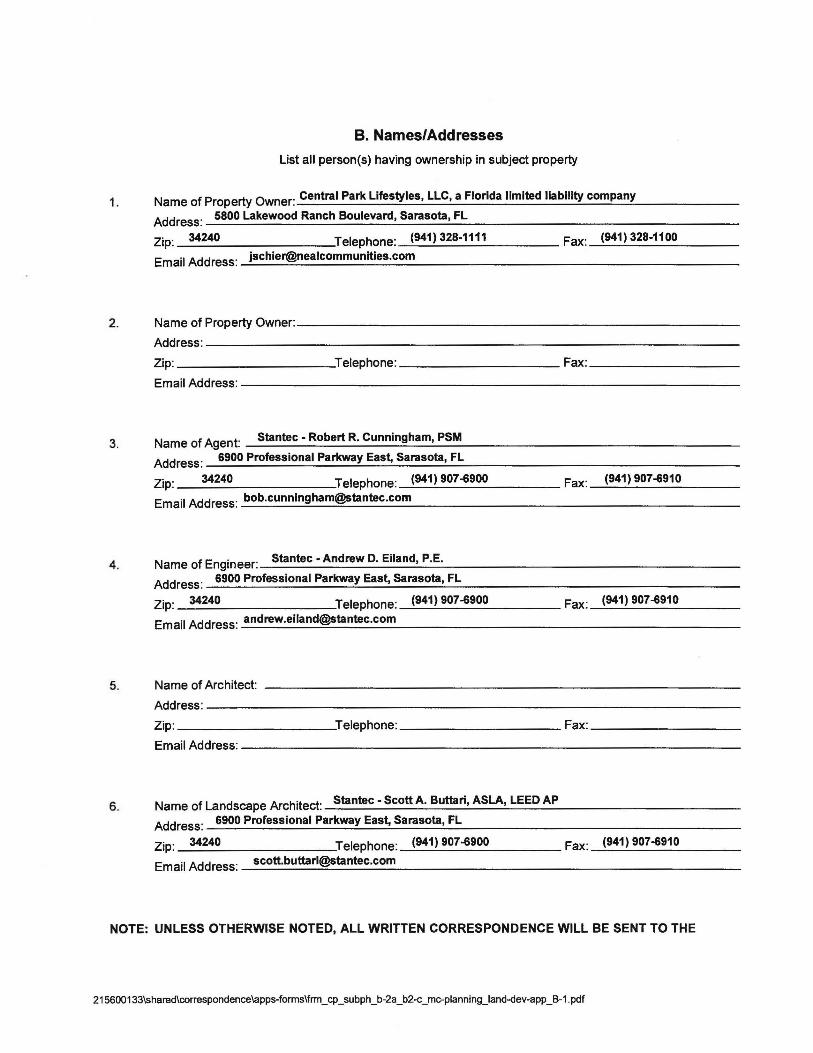
B. Names/Addresses
List all person(s) having ownership in subject property
1. Name of Property Owner: Central Park Lifestyles, LLC, a Florida limited liability company
Address: 5800 Lakewood Ranch Boulevard, Sarasota, FL
Zip: 34240 Telephone: (941) 328-1111 Fax: (941) 328-1100
Email Address:[email protected]
2. Name of Property Owner: ___________________________ _
3.
4.
Address:-----------------------------------Zip: ___________ Telephone: ___________ Fax: __________ _
Email Address: --------------------------------
Name of Agent: Stantec - Robert R. Cunningham, PSM
Address: __ 6_9_0_0_P_ro_fu_s_s_io_n_a_I_Pa_~ __ ay~E_as_~~S_a_ra_so_ta_,~F_L _________________ _
Zip: 34240 Telephone: (941) 907-6900
Email Address:[email protected]
Name of Engineer: Stantec - Andrew D. Eiland, P.E.
Address: 6900 Professional Parkway East, Sarasota, FL
Zip: 34240 Telephone: (941) 907-6900
Email Address:[email protected]
Fax: (941) 907-6910
Fax: (941) 907-6910
5. Name of Architect: --------______________________ _
Address:-----------------------------------Zip: ___________ Teiephone: ___________ Fax: _________ _
Email Address: ---____________________________ _
6. Name of Landscape Architect: Stantec - Scott A. Buttari, ASLA, LEED AP
Address: 6900 Professional Parkway Eas~ Sarasota, FL
Zip: 34240 Telephone: (941) 907-6900 Fax: (941) 907-6910
Email Address:[email protected]
NOTE: UNLESS OTHERWISE NOTED, ALL WRITTEN CORRESPONDENCE WILL BE SENT TO THE
215600133\Shared\correspondence\apps-forms\frm _ cp _ subph_ b-2a _ b2-c_mc-plannin9_land-dev-app _ B-1 .pdf

AGENT. IF THERE IS NO AGENT, COMMENTS WILL BE SENT TO THE PROPERTY OWNER.
C. Signature I hereby certify that the information in this application is true and correct. I have read this application and understand that other review processes and fees may be required prior to applying for and receiving Building Permits and/or Final Development Approval.
By executing this application, I acknowledge that I am familiar with the Rules of Procedure which the boards or commissions which will act on my application and that I have re n Rules of Procedures.
Rev. 2/8/10
Additional Information
CONTACT:
Planning Department 1112 Manatee Avenue West, Fourth Floor 34205
P. O. Box 1000, Bradenton, FL 34206
Telephone: (941) 748-4501, Extension 6871 Fax Number: (941) 708-6152
http://www.mymanatee.org
215600133\Shared\correspondence\apps-forms\frm_cp_subph_b-2a_b2-c_mc-planningJand-dev-app _B-1 .pdf

point lies N.65~7'14'W., a radial distance of 30.00 feet; thence northerly along the arc of said curve, through a central angle of 41 ~'48", a n arc distance of 21.86 feet to a point of compound curve to the left having a radius of 2,823.00 feet and a central angle of 06~3'54"; thence northerly along the arc of said cur ve, an arc distance of 331.67 feet to a point of compound curve to the left having a radius of 30.00 feet and a central angle of 78'30'15"; thence northwesterly along the arc of said curve, an arc distance of 41.10 feet to a point of reverse curve to the right having a radius of 977.00 feet and a central angle of 01 '06'49"; thence westerly along the arc of sai d curve, an arc distance of 18.99 feet to a point of reverse curve to the left having a radius of 30.00 feet and a central angle of 56'23'17"; thence southwesterly along the arc of said curve, an arc distance of 29.52 feet; thence N.68'02'40'W., a distance of 27.79 feet; thence N.82"19'34'W., a distance of 130.00 feet; thence N.Or40'26"E., a distan ce of 106.79 feet to a point of curve to the right having a radius of 25.00 feet and a central angle of 77'28'43"; thence northeasterly along the arc of said curve an arc distance of 33.81 feet; thence N.04'50'51'W., a distance of 50.00 feet to the point of curve of a non-tangent curve to the right, of which the radius point lies N.04'50'51'W ., a radial distance of 800.00 feet; thence westerly along the arc of said curve, through a central angle of 06'08'26", an arc distance of 85.74 feet; thence N.01"17'35"E., a distan ce of 136.02 feet; thence N.53~6'15"E., a distance of 46.26 feet to the point of curve of a non-tangent curve to the left, of which the radius point lies N.53'21 '56"E. , a radial distance of 25.00 feet; thence southeasterly along the arc of said curve, through a central angle of 57"16'02", an arc distance of 24.99 feet to a point of compound curve to the left having a radius of 648.00 feet and a central angle of 57'52'27"; thence northeasterly along the arc of said curve, an arc distance of 654.54 feet to a point of reverse curve to the right having a radius of 477.00 feet and a central angle of 06'22'2 7"; thence northeasterly along the arc of said curve, an arc distance of 53.07 feet to a point of reverse curve to the left having a radius of 35.00 feet and a central angle of 78'30'40"; thence northerly along the arc of said curve, an arc distance of 47.96 feet; thence N.59'55'12"E., a distance of 231.42 feet to a point of curve to the right having a radius of 524.05 feet and a central angle of 12'53'49"; thence northeasterly along the arc of said curve an arc distance of 117.96 feet to a point of compound curve to the right having a radius of 468.00 feet and a central angle of 20'30'59"; thence easterly along th e arc of said curve, an arc distance of 167.58 feet; thence S.86°40'00"E., a distance of 20 3.49 feet to the pOint of curve of a non-tangent curve to the right, of which the radius point lies S.67'54'58"E., a radial distance of 25.00 feet; thence northeasterly along the arc of said curve, through a central angle of 64"12'07", an arc distance of 28.01 feet; thence N.86"17'09"E., a distance of 316.01 feet to a point of curve to the right having a radius of 35.00 feet and a central angle of 11 r46'48"; thence southeasterly alon g the arc of said curve an arc distance of 71.95 feet; thence S.65'56'03"E., a distan ce of 60.00 feet to the point of curve of a non-tangent curve to the left, of which the radius pOint lies S.65'56'03"E., a radial distance of 2,930.00 feet; thence southerly along the arc of said curve, through a central angle of 05'20'23", an arc distance of 273.07 feet to the POINT OF BEGINNING.
Said tract contains 1,091,667 square feet or 25.0612 acres, more or less.

EXHIBIT "A"
CENTRAL PARK, SUBPHASE B-2a & B-2c
LEGAL DESCRIPTION (as prepared by the certifying Surveyor and Mapper):
A tract of land lying in Section 8, Township 35 South, Range 19 East, Manatee County, Florida and described as follows:
BEGIN at the northeast corner of the Plat of Central Park, Phase B-2b, recorded in Plat Book 54, Pages 121 through 125 in the Public Records of Manatee County, Florida; thence N. 71 "16'27'W., a distance of 60.00 feet to the point of curve of a non-tangent curve to the right, of which the radius point lies N.71°16'27'W., a radial distance of 25.00 feet; thence westerly along the arc of said curve, through a central angle of 139'25'55", an arc distance of 60.84 feet to a point 0 f reverse curve to the left having a radius of 488.00 feet and a central angle of 06'01'3 4"; thence northwesterly along the arc of said curve, an arc distance of 51.33 feet; thence S.62'07'54'W., a distance of 253.12 feet to the point of curve of a non-tangent curve to the right, of which the radius point lies S.59'38'18'W., a radial distance of 400.00 feet; thence southeasterly along the arc of said curve, through a central angle of 03'31' 39", an arc distance of 24.63 feet; thence S.63'09'57"W., a distance of 152.00 feet to the point of curve of a non-tangent curve to the right, of which the radius point lies S.63°09'57'W., a radial distance of 248.00 feet; thence southerly along the arc of said curve, through a central angle of 18°48'29", an arc distance of 81.41 feet to a point of compound curve to the right having a radius of 25.00 feet and a central angle of 62'04' 03"; thence southwesterly along the arc of said curve, an. arc distance of 27.08 feet; thence S.35'57'31 "E., a distance of 51 .37 feet; thence S.08'55'20"W., a distance of 124.27 feet; thence N.81 '04'40'W., a distance of 3.25 feet; thence S.08'55'20"W., a distance of 50.00 feet; thence S.17"10'15"W., a distance of 131.26 feet; thence S.71° 24'29'W., a distance of 61.66 feet to the point of curve of a non-tangent curve to the right, of which the radius pOint lies S.61 "16'50''W., a radial distance of 25.00 feet; t hence southerly along the arc of said curve, through a central angle of 63"48'42", an a rc distance of 27.84 feet to a pOint of reverse curve to the left having a radius of 1,152.00 feet and a central angle of 03"43'25"; thence southwesterly along the arc of said cu rve, an arc distance of 74.87 feet to a point of reverse curve to the right having a radius of 447.34 feet and a central angle of 24'21 '28"; thence southwesterly along the arc of said curve, an arc distance of 190.17 feet to a point of reverse curve to the left having a radius of 1,152.00 feet and a central angle of 04"45'02"; thence southwesterly along the arc of said curve, an arc distance of 95.52 feet to a point of reverse curve to the right having a radius of 348.00 feet and a central angle of 05'21'16"; thence southwe sterly along the arc of said curve, an arc distance of 32.52 feet to a pOint of compound curve to the right having a radius of 25.00 feet and a central angle of 59'20'28"; thence westerly along the arc of said curve, an arc distance of 25.89 feet; thence S.25"40'17"W., a distance of 54.92 feet; thence S.72'22'39"W., a distance of 122.20 feet; thence N.1r 37'21'W., a distance of 38.91 feet; thence S.72'22'39"W., a distance of 175.00 feet; thence N.65"47'14'W., a distance of 46.51 feet to the point of curve of a non-tangent curve to the left, of which the radius

MANATEE COUNTY PLANNING DEPARTMENT AFFIDAVIT OF OWNERSHIP/AGENT AUTHORIZATION AFFIDAVIT
Property Owner (Company or individual) (print) : Central Par\( Lifestyles, LLC a Florida limited liability company
Mailing Address (print) : 5800 Lakewood Ranch Blvd, Sarasota, Florida 34240
Officer's Name and Title (print) : James R. Schier, Manager --------~--~-------------------------
Being first duly sworn, depose(s) and say(s):
1. That I am (we are) the owner's and record title holder(s) of the following described property legal description, to wit: _(:....se_e_a_tta_c_he_d.:...l _____________________________ _
2. That this property constitutes the property for which a request for _F_in_al_R_e_co_rd_P_la_t. ________ _
(Type of Application Approval Requested) Is being applied for to Manatee County, Florida;
3. That the undersigned has (have) appointed and does (do) appoint Stantec Consulting Services, Inc.
(Robert R. Cunningham, PSM) as
agent(s) to execute any petitions or other documents necessary to affect such petition; and request that you accept my agent(s) signature as representing my agreement of all terms and conditions of the approval process;
4. That this affidavit has been executed to induce Manatee County, Florida to consider and act on the foregoing request;
5. rsigned authorit , hereby certify that the foregoing is true and correct.
~-t~~~~~~:...!./t~.-L~~--=::::==:=:::::::......-=-.,....-......,...--,I James R. Schier, Manager
Owner's SignaturelPrint Title
-----------~--~-_~~~--.I----____ ---Owner's SignaturelPrint Title
STATE OF FLORIDA COUNTY OF SARASOTA
The foregoing instrument was acknowledged before me this ---=:!~~~~~4-~.I...!:( .l=-___ by
lAMBS R. SCHIER
(name of person acknowledging)
has produced ________ ---:-:--_-::-:--:----:-:::--~---:---------- as identification. (type of identification)
My Commission Expires: ________ __
SHERRY S. DODDEMA Name
Title or Rank Rev 2/8/10 B2

EXHIBIT "A"
CENTRAL PARK, SUBPHASE B-2a & B-2c
LEGAL DESCRIPTION (as prepared by the certifying Surveyor and Mapper):
A tract of land lying in Section 8, Township 35 South, Range 19 East, Manatee County, Florida and described as follows:
BEGIN at the northeast corner of the Plat of Central Park, Phase B-2b, recorded in Plat Book 54, Pages 121 through 125 in the Public Records of Manatee County, Florida; thence N.71 "16'27'W., a distance of 60.00 feet to the point of curve of a non-tangent curve to the right, of which the radius paint lies N.71°16'27'W., a radial distance of 25.00 feet; thence westerly along the arc of said curve, through a central angle of 139'25'55", an arc distance of 60.84 feet to a point a f reverse curve to the left having a radius of 488.00 feet and a central angle of 06'01 '3 4"; thence northwesterly along the arc of said curve, an arc distance of 51.33 feet; thence S.62'07'54'W., a distance of 253.12 feet to the point of curve of a non-tangent curve to the right, of which the radius point lies S.59'38'18'W., a radial distance of 400.00 feet; thence southeasterly along the arc of said curve, through a central angle of 03'31' 39", an arc distance of 24.63 feet; thence S.63'09'57"W., a distance of 152.00 feet to the point of curve of a non-tangent curve to the right, of which the radius point lies S.63°09'57'W., a radial distance of 248.00 feet; thence southerly along the arc of said curve, through a central angle of 18~8'29", an arc distance of 81.41 feet to a point of compound curve to the right having a radius of 25.00 feet and a central angle of 62'04' 03"; thence southwesterly along the arc of said curve, an arc distance of 27.08 feet; thence S.35'57'31 "E., a distance of 51.37 feet; thence S.08'55'20'W., a distance of 124.27 feet; thence N.81 '04'40'W., a distance of 3.25 feet; thence S.08'55'20'W., a distance of 50.00 feet; thence S.17"1 0'15"W., a distance of 131.26 feet; thence S.71° 24'29'W., a distance of 61.66 feet to the point of curve of a non-tangent curve to the right, of which the radius point lies S.61 "16'50'W., a radial distance of 25.00 feet; t hence southerly along the arc of said curve, through a central angle of 63~8'42", an a rc distance of 27.84 feet to a point of reverse curve to the left having a radius of 1,152.00 feet and a central angle of 03~3'25"; thence southwesterly along the arc of said cu rve, an arc distance of 74.87 feet to a point of reverse curve to the right having a radius of 447.34 feet and a central angle of 24'21'28"; thence southwesterly along the arc of said curve, an arc distance of 190.17 feet to a point of reverse curve to the left having a radius of 1,152.00 feet and a central angle of 04°45'02"; thence southwesterly along the arc of said curve, an arc distance of 95.52 feet to a point of reverse curve to the right having a radius of 348.00 feet and a central angle of 05'21 '16"; thence southwe sterly along the arc of said curve, an arc distance of 32.52 feet to a paint of compound curve to the right having a radius of 25.00 feet and a central angle of 59'20'28"; thence westerly along the arc of said curve, an arc distance of 25.89 feet; thence S.25~0'17"W., a distance of 54.92 feet; thence S.72'22'39'W., a distance of 122.20 feet; thence N.1r 37'21'W., a distance of 38.91 feet; thence S.72'22'39"W., a distance of 175.00 feet; thence N .65~7'14'W., a distance of 46.51 feet to the point of curve of a non-tangent curve to the left, of which the radius

point lies N.65~T14'W., a radial distance of 30.00 feet; thence northerly along the arc of said curve, through a central angle of 41 ~4'48", a n arc distance of 21.86 feet to a point of compound curve to the left having a radius of 2,823.00 feet and a central angle of 06~3'54"; thence northerly along the arc of said cur ve, an arc distance of 331.67 feet to a point of compound curve to the left having a radius of 30.00 feet and a central angle of 78'30'15"; thence northwesterly along the arc of said curve, an arc distance of 41.10 feet to a point of reverse curve to the right having a radius of 977.00 feet and a central angle of 01 '06'49"; thence westerly along the arc of sai d curve, an arc distance of 18.99 feet to a point of reverse curve to the left having a radius of 30.00 feet and a central angle of 56'23'17"; thence southwesterly along the arc of said curve, an arc distance of 29.52 feet; thence N.68'02'40'W., a distance of 27.79 feet; thence N.82"19'34'W., a distance of 130.00 feet; thence N.07°40'26"E., a distan ce of 106.79 feet to a point of curve to the right having a radius of 25.00 feet and a central angle of 77'28'43"; thence northeasterly along the arc of said curve an arc distance of 33.81 feet; thence N.04'50'51'W., a distance of 50.00 feet to the point of curve of a non-tangent curve to the right, of which the radius point lies N.04'50'51'W ., a radial distance of 800.00 feet; thence westerly along the arc of said curve, through a central angle of 06'08'26", an arc distance of 85.74 feet; thence N.01"1T35"E., a distan ce of 136.02 feet; thence N.53~6'15"E., a distance of 46.26 feet to the point of curve of a non-tangent curve to the left, of which the radius point lies N.53'21'56"E., a radial distance of 25.00 feet; thence southeasterly along the arc of said curve, through a central angle of 57' 6'02", an arc distance of 24.99 feet to a point of compound curve to the left having a radius of 648.00 feet and a central angle of 57'52'27"; thence northeasterly along the arc of said curve, an arc distance of 654.54 feet to a point of reverse curve to the right having a radius of 477.00 feet and a central angle of 06'22'27"; thence northeasterly along the arc of said curve, an arc distance of 53.07 feet to a point of reverse curve to the left having a radius of 35.00 feet and a central angle of 78'30'40"; thence northerly along the arc of said curve, an arc distance of 47.96 feet; thence N.59'55'12"E., a distance of 231.42 feet to a point of curve to the right having a radius of 524.05 feet and a central angle of 12'53'49"; thence northeasterly along the arc of said curve an arc distance of 117.96 feet to a point of compound curve to the right having a radius of 468.00 feet and a central angle of 20'30'59"; thence easterly along th e arc of said curve, an arc distance of 167.58 feet; thence S.86~O'OO"E., a distance of 203.49 feet to the point of curve of a non-tangent curve to the right, of which the radius pOint lies S.67'54'58"E., a radial distance of 25.00 feet; thence northeasterly along the arc of said curve, through a central angle of 64'2'07", an arc distance of28.01 feet; thence N.86"1T09"E., a distance of 316.01 feet to a pOint of curve to the right having a radius of 35.00 feet and a central angle of 117°46'48"; thence southeasterly alon g the arc of said curve an arc distance of 71.95 feet; thence S.65'56'03"E., a distan ce of 60.00 feet to the point of curve of a non-tangent curve to the left, of which the radius pOint lies S.65'56'03"E., a radial distance of 2,930.00 feet; thence southerly along the arc of said curve, through a central angle of 05'20'23", an arc distance of 273.07 feet to the POINT OF BEGINNING.
Said tract contains 1,091,667 square feet or 25.0612 acres, more or less.

"CONCURRENCY" CERTIFICATE OF LEVEL OF SERVICE COMPLIANCE Public Works Department Manatee County, Florida
Public facilities must serve land development adequately according to adopted level-ofservice standards. This certificate verifies adequacy or exemption and will reserve impacts unless expired. It offers no other assurance, does not approve any development order and does not grant any development rights. It applies only to the identified proposed project and must accompany development order(s) for the project.
Date Issued: November 1. 2007 Expiration Date: March 22, 2026**
CERTIFICATE NUMBER: ...;.C=L~0~S~#O.;;..;7;....-0;;..;;9...;.3 _______________ _
Project Name: NORTHWEST SECTOR DRI #26
Project File No.: LDA-10-01/0rdinance 07-68/PDMU-05-19(Z)(G)
Type of Development Order: LDAIDRI/GENERAL DEVELOPMENT PLAN
Location: Sec. 7-9.15.16 Twp. 35 Range 1i-
DP# SEE APPLICATION Land Acres 1518.9±
ADDRESS E OF LKWD RANCH BLVD. S OF 44TH AVE EXT. N OF SR 70. W OF LORRAINE RD. SCT WATER TREATMENT PLANT SE
MUST THE DEVELOPMENT ORDER CONTAIN CONDITIONS AND AGREEMENTS TO ASSURE COMPLIANCE? YES XX NO
Project must comply with conditions listed in LDA-10-01 and DRI approval documents.
APPROVAL:
This development complies with the Comprehensive Plan Concurrency requirements:
~ Approved by: Public Works Dept., Transportation Planning Division (Traffic circulation, mass transit, drainage, solid waste; parks)
*200,000 sq ft retail, 105,000 sq ft office, 2,650 single family units, 350 multifamily units, 9.2 acre park
Revised 3/17/09 (rescind Central Park CLOS, all development shown under NW Sector DRI) Revised 5/19/09 to include two year extension granted with R-09-089 Revised to reflect approval of LDA-10-D1 Revised 11/14/2011 to reflect extension of phasing build out dates per letter from L. Barrett to T. Pokrywa dated 10/20/2011 (HB 7207 request) Revised 02/23/2012 to reflect extension of phasing build out dates per letter from L. Barrett to T. Pokrywa dated 02/10/2012 (F.S. 252.363 request EO's 11-128, 11-172 & 11-202) **Revised 1/18/2013 to include one year and 121 day extension granted with F.S. 252.363 request (Debby - EO's 12-140, 12-192, and 12-217; Isaac - EO 12-199)
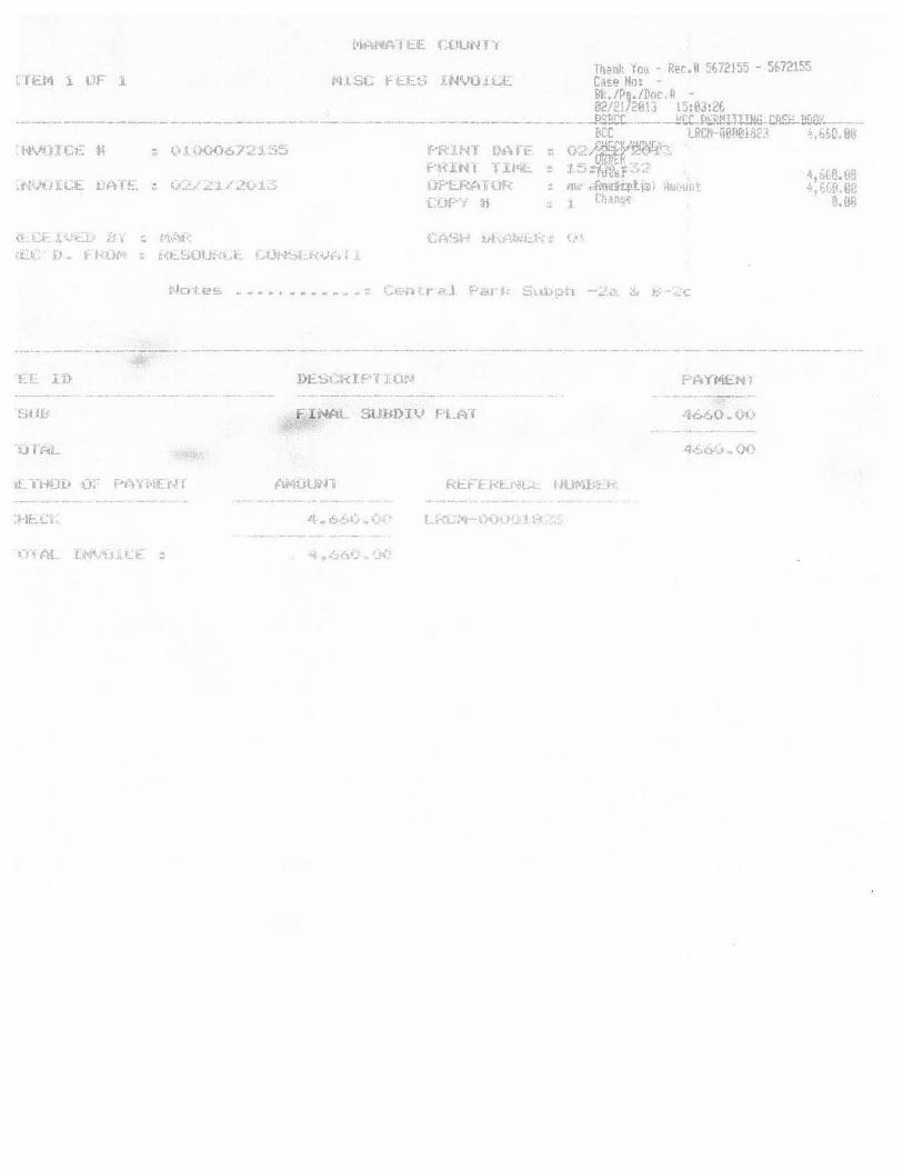
tft.f<1 i L~r 1
(~, C~ .. '"t, ;~~ I :. 1~~lF
j;·iHf.wd t:.E. LUUN t ·1
fortiN) IUHf f'~<lN I l.l.Ij ,L. Of"U<Ar.lIR UJf' »
(I.':"t 0.. f kUf' ~ t,;t-_SOU:·" 1:-. "~IJ1-l~Lk-vf ••
FI NAL SUDDIV PLAT
Of... .'.

CENTRAL PARK, SUBPHASE & B-2c A SUBDIVISION
IN SECTION 8. TOWNSIDP 35 SOUTH. RANGE 19 EAST MANATEE COUNTY. FLORIDA
GULF
OF
MEXICO
B-2a

TITLE CERTIFICATION
SUBDIVISION NAME: CENTRAL PARK, SUBPHASE B-2a & B-2c
LEGAL DESCRIPTION: Attached as Exhibit "A"
I, Kimberly D. Ashton, Attorney-at-Law, hereby confinn that apparent record title to the land described in the above and shown on the plat for CENTRAL PARK, SUBPHASE B-2a & B-2c is in the name of CENTRAL PARK LIFESYYLES, LLC, a Florida limited liability company, the organization executing the offer of dedication appearing on the above plat. All property taxes due and payable have been paid on the land described as of the date of certification. All mortgagees or liens not satisfied or released of record are as follows:
MORTGAGEES:
FC, L.L.C., a Florida
Limited Liability Company
LIENS:
ADDITIONAL ITEMS:
OFFICIAL RECORD BOOK AND PAGE (S):
OR Book 2267, Page 6435 as amended at
OR Book 2275, Page 2910; OR Book 2275, Page 2910;
OR Book 2277, Page 5104; OR Book 2293, Page 6337,
And OR Book 2311, Page 7253, all of the Public
Records of Manatee County, Florida
NONE
All property within CENTRAL PARK, SUBPHASE B-2a & B-2c is included within the independent special district, Lakewood Ranch Stewardship District, created by Local Bill No. 1429, codified at Chapter 2005-338, Laws of Florida, either as a geographic area or as a political subdivision and government of the State of Florida, as the context requires (the "Stewardship District"). All taxes and assessments levied and/or issued by the Stewardship District, which are currently due and payable, have been paid on the land described as of the date of certificati on.
WITNESS my hand and official seal at Manatee County, Florida, this 11 th day of February, 2013
Signature ~ beet/' 0 0.J1 ~ Kimberly D. Ashton, Esq.
Vogler Ashton, PLLC
2411 - A Manatee Ave. West
Bradenton, FL 34205
941.388-9400
FL. Bar No. 0485039
EXHIBIT "A"
CENTRAL PARK, SUBPHASE B-2a & B-2c
LEGAL DESCRIPTION (as prepared by the certifying Surveyor and Mapper):
A tract of land lying in Section 8, Township 35 South, Range 19 East, Manatee County, Florida and described as follows:
BEGIN at the northeast corner of the Plat of Central Park, Phase B-2b, recorded in Plat Book 54, Pages 121 through 125 in the Public Records of Manatee County, Florida; thence N.71 °16'27"W., a distance of 60.00 feet to the point of curve of a non-tangent curve to the right, of which the radius point lies N.71°16'27"W., a radial distance of 25.00 feet; thence westerly along the arc of said curve, through a central angle of 139°25'55", an arc distance of 60.84 feet to a point of reverse curve to the left having a radius of 488.00 feet and a central angle of 06°01 '34"; thence northwesterly along the arc of said curve, an arc distance of 51.33 feet; thence S.62°07'54"W., a distance of 253.12 feet to the point of curve of a non-tangent curve to the right, of which the radius point lies S.59°38'18"W., a radial distance of 400.00 feet; thence southeasterly along the arc of said curve, through a central angle of 03°31 '39", an arc distance of 24.63 feet; thence S.63°09'57"W., a distance of 152.00 feet to the point of curve of a non-tangent curve to the right, of which the radius point lies S.63°09'57"W., a radial distance of 248.00 feet; thence southerly along the arc of said curve, through a central angle of 18°48'29", an arc distance of 81.41 feet to a point of compound curve to the right having a radius of 25.00 feet and a central angle of 62°04'03"; thence southwesterly along the arc of said curve, an arc distance of 27.08 feet; thence S.35°57'31 "E., a distance of 51.37 feet; thence S.08°55'20"W., a distance of 124.27 feet; thence N.81°04'40"W., a distance of 3.25 feet; thence S.08°55'20"W., a distance of 50.00 feet; thence S.17°10'15"W., a distance of 131.26 feet; thence S.71°24'29"W., a distance of61.66 feet to the point of curve of a non-tangent curve to the right, of which the radius point lies S.61 °16'50"W., a radial distance of 25.00 feet; thence southerly along the arc of said curve, through a central angle of 63°48'42", an arc distance of 27.84 feet to a point of reverse curve to the left having a radius of 1,152.00 feet and a central angle of 03°43'25"; thence southwesterly along the arc of said curve, an arc distance of 74.87 feet to a point of reverse curve to the right having a radius of 447.34 feet and a central angle of 24 °21 '28"; thence southwesterly along the arc of said curve, an arc distance of 190.17 feet to a point of reverse curve to the left having a radius of 1,152.00 feet and a central angle of 04°45'02"; thence southwesterly along the arc of said curve, an arc distance of 95.52 feet to a point of reverse curve to the right having a radius of 348.00 feet and a central angle of 05°21 '16"; thence southwesterly along the arc of said curve, an arc distance of 32.52 feet to a point of compound curve to the right having a radius of 25.00 feet and a central angle of 59°20'28"; thence westerly along the arc of said curve, an arc distance of 25.89 feet; thence S.25°40'17"W., a distance of 54.92 feet; thence S.72°22'39"W., a distance of 122.20 feet; thence N.17°37'21"W., a distance of 38.91 feet; thence S.72°22'39"W., a distance of 175.00 feet; thence N.65°47'14"W., a distance of 46.51 feet to the point of curve of a non-tangent curve to the left, of which the radius

point lies N.65°47'14"W., a radial distance of 30.00 feet; thence northerly along the arc of said curve, through a central angle of 41 °44'48", an arc distance of 21.86 feet to a point of compound curve to the left having a radius of 2,823.00 feet and a central angle of 06°43'54"; thence northerly along the arc of said curve, an arc distance of 331.67 feet to a point of compound curve to the left having a radius of 30.00 feet and a central angle of 78°30'15"; thence northwesterly along the arc of said curve, an arc distance of 41.10 feet to a point of reverse curve to the right having a radius of 977.00 feet and a central angle of 01 °06'49"; thence westerly along the arc of said curve, an arc distance of 18.99 feet to a point of reverse curve to the left having a radius of 30.00 feet and a central angle of 56°23'17"; thence southwesterly along the arc of said curve, an arc distance of 29.52 feet; thence N.68°02'40"W., a distance of 27.79 feet; thence N.82°19'34"W., a distance of 130.00 feet; thence N.07°40'26"E., a distance of 106.79 feet to a point of curve to the right having a radius of 25.00 feet and a central angle of 77°28'43"; thence northeasterly along the arc of said curve an arc distance of 33.81 feet; thence N.04°50'51"W., a distance of 50.00 feet to the point of curve of a non-tangent curve to the right, of which the radius point lies N.04°50'51"W., a radial distance of 800.00 feet; thence westerly along the arc of said curve, through a central angle of 06°08'26", an arc distance of 85.74 feet; thence N.01°17'35"E., a distance of 136.02 feet; thence N.53°46'15"E., a distance of 46.26 feet to the point of curve of a non-tangent curve to the left, of which the radius point lies N.53°21'56"E., a radial distance of 25.00 feet; thence southeasterly along the arc of said curve, through a central angle of 57°16'02", an arc distance of 24.99 feet to a point of compound curve to the left having a radius of 648.00 feet and a central angle of 57°52'27"; thence northeasterly along the arc of said curve, an arc distance of 654.54 feet to a point of reverse curve to the right having a radius of 477.00 feet and a central angle of 06°22'27"; thence northeasterly along the arc of said curve, an arc distance of 53.07 feet to a point of reverse curve to the left having a radius of 35.00 feet and a central angle of 78°30'40"; thence northerly along the arc of said curve, an arc distance of 47.96 feet; thence N.59°55'12"E., a distance of 231.42 feet to a point of curve to the right having a radius of 524.05 feet and a central angle of 12°53'49"; thence northeasterly along the arc of said curve an arc distance of 117.96 feet to a point of compound curve to the right having a radius of 468.00 feet and a central angle of 20°30'59"; thence easterly along the arc of said curve, an arc distance of 167.58 feet; thence S.86°40'00"E., a distance of 203.49 feet to the point of curve of a non-tangent curve to the right, of which the radius point lies S.67°54'58"E., a radial distance of 25.00 feet; thence northeasterly along the arc of said curve, through a central angle of 64°12'07", an arc distance of 28.01 feet; thence N.86°17'09"E., a distance of 316.01 feet to a point of curve to the right having a radius of 35.00 feet and a central angle of 117°46'48"; thence southeasterly along the arc of said curve an arc distance of 71.95 feet; thence S.65°56'03"E., a distance of 60.00 feet to the point of curve of a non-tangent curve to the left, of which the radius point lies S.65°56'03"E., a radial distance of 2,930.00 feet; thence southerly along the arc of said curve, through a central angle of 05°20'23", an arc distance of 273.07 feet to the POINT OF BEGINNING.
Said tract contains 1,091,667 square feet or 25.0612 acres, more or less.

MANATEE COUNTY
January 18,2013
Mr. Andrew D. Eiland, Jr., P.E. WilsonMiller I Stantec 6900 Professional Parkway East Suite #100 Sarasota, FL 34240
FLORIDA
RE: CENTRAL PARK - PHASE B-2a (pDMU-05-09/FSP-06-149) - (DTS #20060547) - (PW #929) Performance Cost Estimate Required Private Improvements Reason - (paving-Stormwater-Irrigation)
Dear Mr. Eiland:
Your cost estimate for the above referenced bond, dated January 08, 2013, for the completion of site improvements to serve the above referenced development, is approved for the appropriate surety.
A Private Improvement Performance Security in the amount ofS443,116.00, which is 200%, plus a 3% administrative fee, of the submitted estimated cost, would be sufficient to assure the County completion of the required private improvements.
Ifwe can be of further assistance, please contact me at (941) 708-7462.
Sincerely,
eputy Director - Engineering Services
SMlmmljh
cc: Record Management Jane Oliver, Sr. Administrative Specialist, Public Works Carmen Mosley, Fiscal Operations Division Manager, Public Works Andy Fischer, Infrastructure Inspection Division Manager, Public Works Mark G. Mayer, Senior Development Review Specialist, Public Works Debbie Perron, Sr. Development Review Specialist, Building and Development Services
Manatee County Public Works Department I Engineering Services Mailing Address: P. O. Box 1000 Street Address: 1022 26th Avenue East, Bradenton, FL 34206-1000
WEB: www.mymanalee.org • PHONE: 941.708.7462 FAX: 941.708.7475
LARRY BUSTLE • MICHAEL GALLEN • JOHN R. CHAPPlE • ROBIN DISABATINO • VANESSA BAUGH * CAROL WHITMORE • BETSV BENAC District I Db trict 2 Dis/riet 3 District 4 District 5 District 6 District 7

Engineers Opinion of Cost - for Performance Security Resource Conservation of Manatee, LLC
Central Park B-2a
B·2a Private Improvements
Item Category Category Total
I)
2)
3 )
4)
S)
B-2a Earthwork 521,560
B-2a General S9,550
B-2a Paving 576.442
B-2a Drainage $80,465
B·2a Irrigation 527,088
Central Park B·2a Grand Total: $215,105
Total x 200% (Private Improvements): $430,210
+ 3% Administrative Fee (Private hnprovements): $12,906 --------~~~-------
Total Required Performance Security: $443,116
Certificate of Cost Estimate
I, Andrew D. Eiland, Jr., P.E. , hereby submit that my opinion of cost for the improvements itemized herein is Two Hundred Fifteen Thousand One Hundred Five Dollars and No Cents ($215,'05.00).
Furthennore, as required by Manatee County Land Development Code Section 722.3.2.2., 200% of these costs plus the required administrative fee, speCifically, Four Hundred Forty Three Thousand One Hundred Sixteen Dollars and No Cents ($443,116.00) , is the required amount of the perfonnance security.
Signed: -*3:~~;:f:::;--;:-"",ii-------~~~----Andre • nd, Jr., P.E : ,., ::
Flori i~ai°Sngi&elMcf6~6 /,":f : #t~O. • ~ 4110 ~ ~oo ~ ~ 0 ~ ~
'-" ~ 0 00 i. 0 R \ O. 0 oOr~ ..... ., '''.~'' 0
0 00 ~v , ~, u"'8 ••••••• ~~ ... '
"II ION A\.. V ,,\' 111,""",,\\
V:12156\acliveI2156001331civlI\c0$Iopinlonlsch eopc central·parll·fl.2a_2012·12·13 .• SIn • fl.2a Private Improvements 11812013 • 11 :08 AM 1 of 1

~ Stantec Engineers Opinion of Cost - for Perfonnance Security
Resource Conservation of Manatee, LLC Central Park B-2a
B-2a Earthwork
Item Description Unit Quantity (est.) Unit Price
I) BMPs - Silt Barrier Installation, Maintenance, Removal;
LS $3,458.00 SWPPP Prep & FDEP NOI filing
2) Excavation LS $6,850.00
3) Embankment - Fill lots to rough grade 8" below minimum
CCY 3,458 $2.40 finished floor elevation. (Compacted Measure)
4) Sodding - Lake Banks SY 380 $1.85
5) Sodding - Swales, R-O-W Areas SY 1,216 $1.85
B-2a Earthwork Total:
V:\2156\actlve\215600133\civil\cost opinion\sch_8opc_central-park-B-2s_2012-12-13.xlsm - 8-2a Earthwork
Total
$3,458.00
$6,850.00
$8,299.20
$703.00
$2,249.60
$21 .s59.80
1nl2013 - 2:00 PM 1 "I J:;

B-2a General
Item Description
• Stantec Engineers Opinion of Cost - for Perfonnance Security
Resource Conservation of Manatee, LLC Central Park B-2a
Unit Quantity (est.) Unit Price
1) Construction Stakeout and Record Drawing LS $9,550.00
B-la General Total:
V:\2156\actlve\215600133\civiJ\cost opinion\Sch_eopc_central-park-B-2a_2012-12-13.xlsm - B-2a General
Total
$9,550.00
59,550.00
1nl2013 - 2:00 PM ? nf"

~ Stantec Engineers Opinion of Cost - for Perfonnance Security
Resource Conservation of Manatee, LLC Central Park B-2a
B-2a Paving
Item Description Unit Quantity (est.) Unit Price
1) 3/4" Asphaltic Concrete Type S-III (initial lift) SY 2434 $4.15
2) 6" Thick Cement Treated Shell Base (per Manatee County
SY 2434 $8.35 Index 403.1) LB R of 100
3) 12" Stabilized Subgrade Compacted to 98% AASHTO T -180,
SY 3083 $2.45 LBR40
4) 5f Concrete Sidewalk LF 1826 $10.50
5) 2' Valley Curb LF 1826 $7.60
6) Traffic Control Striping and Pavement Markings (Includes
LS $413.00 Temporary Paint Markings on Initial Lift)
7) Permanent Control Points LS $5,000.00
B-2a Paving Total:
V:\2156\active\215600133\civil\cost oplmon\Sch_eopc_central-park-B-2a_2012-12-13.xlsm - B-2a Paving
Total
$\0,101.10
$20,323.90
$7,553.35
$19,173.00
$13,877.60
$413.00
$5,000.00
$76.441.95
1nl2013 - 2:00 PM

B-2a Drainage
Item Description
1) 15"RCP
2) 18" RCP
3) 24" RCP
4) 30" RCP
5) 24" A2000
6) 30" A2000
7) 24" RCP Endwall (Includes Rip Rap)
8) 30" RCP Endwall (Includes Rip Rap)
9) Throat Inlet
10) Stonn Manhole
II) Compaction testing
~ Stantec Engineers Opinion of Cost - for Perfonnance Security
Resource Conservation of Manatee, LLC Central Park B-2a
Unit Quantity (est.) Unit Price
LF 31 $22.00
LF 255 $23.90
LF 293 $32.00
LF 393 $46.70
LF 38 $32.00
LF 74 $46.70
EA $1,015.00
EA $1,400.00
EA 7 $2,370.00
EA 8 $2,755.00
LS $243.00
B-2a Drainage Total:
V;\2156\active\215600133\Civil\cost oplnion\Sch_eopc_central-park-B-2a_2012-12-13.xlsm - 8 -2a Drainage
Total
$682.00
$6,094.50
$9,376.00
$18,353. IO
$1,216.00
$3,455.80
$1,015.00
$1,400.00
$16,590.00
$22,040.00
$243.00
$80,465.40
11712013 - 2:00 PM A ,..f,.

B-2a Irrigation
Item Description
I) 6" PVC Irrigation Main
2) Blow Off Assembly
3) Irrigation Service
4) Connect to Existing Irrigation Main
• Stantec Engineers Opinion of Cost - for Performance Security
Resource Conservation of Manatee, LLC Central Park B-2a
Unit Quantity (est.) Unit Price
LF 919 $12.25
EA 2 $1,080.00
EA 16 $670.00
EA 2 $650.00
5) Irrigation Main Testing Per Manatee County Standards LS $1,650.00
8-2a Irrigation Total:
V:\2156\active\215600133\civil\cost opinion\Sch_eopc_centraJ-park-B-2a_2012-12-13.xlsm - B-2a Irrigation
Total
$11,257.75
$2,160.00
$10,720.00
$1,300.00
$1,650.00
527,087.75
1fi/2013 - 2:00 PM

MANATEE COUNTY FLORIDA
January 18, 2013
Mr. Andrew D. Eiland, Jr., P.E. WilsonMiller / Stantec 6900 Professional Parkway East Suite #100 Sarasota, FL 34240
RE: CENTRAL PARK-PHASEB-2a (PDMU-05-09/FSP-06-149) - (DTS #20060547) - (PW #929) Performance Cost Estimate Required Private Improvements Reason - (Final Lift-Asphalt)
Dear Mr. Eiland:
Your cost estimate for the above referenced bond, dated January 07, 2013, for the completion of site improvements to serve the above referenced development, is approved for the appropriate surety.
A Private Improvement Performance Security in the amount of $21,659.05, which is 200%, plus a 3% administrative fee, of the submitted estimated cost, would be sufficient to assure the County completion of the required private improvements.
Ifwe can be of further assistance, please contact me at (941) 708-7462.
Sincerely,
~~t(Jllanazar, P.E. eputy Director - Engineering Services
SMlmmljh
cc: Record Management Jane Oliver, Sr. Administrative Specialist, Public Works Carmen Mosley, Fiscal Operations Division Manager, Public Works Andy Fischer, Infrastructure Inspection Division Manager, Public Works Mark G. Mayer, Senior Development Review Specialist, Public Works Debbie Perron, Sr. Development Review Specialist, Building and Development Services
Manatee County Public Works Department I Engineering Services Mailing Address: P. O. Box 1000 Street Address: 1022 26,h Avenue East, Bradenton, FL 34206· 1000
WEB: www.mymallalee.org * PHONE: 941.708.7462 FAX: 941.708.7475
LARRY BUSTLE * MICHAEL GALLEN • JOHN R. CHAPPlE * ROBIN DISABATINO * VANESSA BAUGH * CAROL WHITMORE * BETSY BENAC District I District 2 District 3 District 4 District 5 District 6 District 7

Final Lift of Asphalt
SubTotal x 200% (Private)
3% Administrative Fee
GRAND TOTAL
~ Stantec Engineer's Opinion of Probable Cost
Central Park B-2a For Performance Security for Final Uft of Asphalt
SIte Development Summary Cost Breakdown
$10,514.10
$21,028.20
$630.85
$21,659.05
Certificate of Cost Estimate
I, Andrew D. Eiland, Jr.,P.E. , hereby submit that my opinion of cost for the improvements itemized herein is Ten Thousand Five Hundred Fourteen Dollars and Ten Cents ($10,514.10).
Furthermore, as required by Manatee County Land Development Code Section 722.3.2.2.,200% of this amount, plus a 3% administrative fee or Twenty One Thousand Six Hundred Fifty Nine Dollars and Five Cents ($21,659.05) I is the required amount of the performance security.
Signed and sealed this 7th day of January, 2013
Signed: -"7"-~-;'~~-:-:~~*--~
V:\2156\active\215600133\civil\cost opinion\anLopC_8sphaIUinal-lifCB-2s_2013-1-7.xlsm 11712013

,.
Stantec Engineer's Opinion of Probable Cost
Central Park 8-2a
Description 3/4" Asphaltic Concrete Type S-III (Final Lift)
Striping (Thermoplastic)*
Estimated Quantity
2.434
1
Unit SY
LS
Unit-Price Total $4.15 $10.101.10
$413.00 $413.00
TOTAL PAVING = $10,514.10
V:\2156\active\215600133\Civil\cost oplnlon\anLopc_asphaIUinal-lift_B-2a_2013-1-7 .xlsmile] 1 (712013

MANATEE COUNTY
January 14, 2013
Mr. Andrew D. Eiland, Jr., P.E. WilsonMiller I Stantec 6900 Professional Parkway East Suite #100 Sarasota, FL 34240
FLORIDA
(andrew.ellandl[@stantec.com.
RE: CENTRAL PARK - PHASE B-2c (pDMU-05-09/FSP-06-149) - (DTS #20060547) - (PW #929) Performance Cost Estimate Required Private Improvements Reason - (Paving-Stormwater-Irrigation)
Dear Mr. Eiland:
Your cost estimate for the above referenced bond, dated January 08, 2013, for the completion of site improvements to serve the above referenced development, is approved for the appropriate surety.
A Private Improvement Perfonnance Security in the amount of $701,735.00, which is 200%, plus a 3% administrative fee, of the submitted estimated cost, would be sufficient to assure the County completion of the required private improvements.
Ifwe can be of further assistance, please contact me at (941) 708-7462.
o lanazar, P.E. Deputy Director - Engineering Services
SMlmrnljh
cc: Record Management Jane Oliver, Sr. Administrative Specialist, Public Works Carmen Mosley, Fiscal Operations Division manager, Public Works Andy Fischer, Infrastructure Inspection Division Manager, Public 'Works Mark G. Mayer, Senior Development Review Specialist, Public Works Debbie Perron, Sr. Development Review Specialist, Building and Development Services
Manatee County Public Works Department I Engineering Services Mailing Address: P. O. Box 1000 Street Address: 1022 26th Avenue East, Bradenton, FL 34206-1000
WEB: www.mymanatee.org • PHONE: 941.708.7462 FAX: 941.708.7475
LARRY BUSTLE * MICHAEL GALLEN * JOHN R. CHAPPlE * ROBIN DISABATINO * VANESSA BAUGH * CAROL WHITMORE • BETSY BENAC District I Districll District 3 Dis/rict4 District 5 District 6 District ?

fe Stantec Engineers Opinion of Cost - for Performance Security
Resource Conservation of Manatee. llC Central Park B-2c
B-le Private Improvements
Item Category Caleaory Total
I)
2)
3)
4)
51
B-2e Eanhwork $28.666
B-2eGenernl 59.550
B·2ePaving 5174.455
B·2c Drainage 561.258
B-2e: Irrigalion 566.719
Central Park B-2e Grand Total: $340,648
Total x 1OO~ (Private Improvements): $681,296
+ 3~ Adminlstratlve Fee (Private Improvements): $20,439 --------~~--------
Total Required Perfonnance Security: $701,735
Certificate of Cost Estimate
I, Andrew D. Eiland, Jr .• P.E. , hereby submit that my opinion of cost for the improvements itemized herein is Three Hundred Forty Thousand Six Hundred Forty Eight Dollars and No Cents ($340,648.00).
Furthermore, as required by Manatee County Land Development Code Section 722.3.2.2., 200"k of these costs plus the required administrative fee, specifically. Seven Hundred One Thousand Seven Hundred Thirty Five Dollars and No Cents ($701,735.00) , is the required amount of the performance security.
V:121S6'actlveI21S600133lclvll\cosl op "!on\sc~ _eopc_cenltll l·patk·B-2c 2012·12-13 .Ism· B-2c Privalalmprovemenls 118/2013 - 11 :08 AM 1 of 1

• Stantec Engineers Opinion of Cost - for Perfonnance Security
Resource Conservation of Manatee, LLC Central Park B-2c
B-2c Earthwork
Item Description Unit Quantity (est.) Unit Price
1) BMPs - Silt Barrier Installation, Maintenance, Removal;
LS $3,458.00 SWPPP Prep & FDEP NOI filing
2) Excavation LS $6,850.00
3) Embankment - Fill lots to rough grade 8" below minimum
CCY 5,642 $2.40 finished floor elevation. (Compacted Measure)
4) Sodding - Lake Banks SY 620 $1.85
5) Sodding - Swales, R-O-W Areas SY 1,984 $1.85
B-lc Earthwork Total:
V:\2156\active\215600133\civil'tcost oplnion\sch_eopc_central-park-B-2c_2012-12-13.x1sm - B·2c Earthwork
Total
$3,458.00
$6,850.00
$13,540.80
$1,147.00
$3,670.40
$18,666.10
11712013 - 2:02 PM 1 of 5

B-2c General
Item Description
• Stantec Engineers Opinion of Cost - for Perfonnance Security
Resource Conservation of Manatee, LLC Central Park B-2c
Unit Quantity (est.) Unit Price
1) Construction Stakeout and Record Drawing LS $9,550.00
B-2c General Total:
V:\2156\active\215600133\civil\cost opinion\sch_eopc_central-park-B-2c_2012-12-13.xlsm - B-2c General
Total
$9,550.00
$9.550.00
11712013 - 2:02 PM 2of5

~ Stantec Engineers Opinion of Cost - for Performance Security
Resource Conservation of Manatee, LLC Central Park B-2c
B-2c Paving
Item Description Unit Quantity (est.) Unit Price
I) 3/4" Asphaltic Concrete Type S-lII (initial lift) SY 5740 $4.15
2) 6" Thick Cement Treated Shell Base (per Manatee County
SY 5740 $8.35 Index 403.1) LBR oft 00
3) 12" Stabilized Subgrade Compacted to 98% AASHTO T-180,
SY 7223 $2.45 LBR40
4) Handicap Ramp (Complete with Tactile Surface) EA 12 $585.00
5) 5' Concrete Sidewalk LF 3521 $10.50
6) 2' Valley Curb LF 3360 $7.60
7) F mod Curb LF 895 SI1.25
8) Traffic Control Striping and Pavement Markings (Includes
LS $413.00 Temporary Paint Markings on Initial Lift)
9) Permanent Control Points LS $5,000.00
B-Zc Paving Total:
V:\2156\actlve\215600133\Civil'cost opinion\SCh_eopc_central-par1<-B-2c_2012-12-13.xlsm - B-2c Paving
Total
$23,821.00
$47,929.00
$17,696.35
$7,020.00
$36,970.50
$25,536.00
SIO,068.75
$413.00
55,000.00
5174,454.60
11712013 - 2:02 PM 30f5

B-2c Drainage
Item Description
1) 15" RCP
2) 18" RCP
3) 24" RCP
4) 18" A2000
5) 24" A2000
6) Throat Inlet
7) Stonn Manhole
8) Compaction Testing
• Stantec Engineers Opinion of Cost - for Perfonnance Security
Resource Conservation of Manatee, LLC Central Park B-2c
Unit Quantity (est.) Unit Price
LF 61 $22.00
LF 330 $23.90
LF 354 $32.00
LF 27 $23.90
LF 49 $32.00
EA 8 $2,370.00
EA 7 $2,755.00
LS $243.00
B-2c DrainaGe Total:
V:\2156\adive\215600133\civil\COSt opinion\sch_eopc_central.park-B-2c_2012-12-13.xlsm - B-2c Drainage
Total
$1,342.00
$7,887.00
$11,328.00
$645.30
$1,568.00
$18,960.00
$19,285.00
$243.00
$61,258.30
11712013 - 2:02 PM 40f5

B-2c Irrigation
Item Description
1) 6" PVC Irrigation Main
2) 8" PVC Irrigation Main
3) 6" Gate Valve
4) 8" Gate Valve
5) 8 x 3 Tee (Future)
6) 4" Blow Off Assembly
7) Irrigation Service
8) Irrigation Fittings
9) Connect to Existing Irrigation Main
• Stantec Engineers Opinion of Cost - for Perfonnance Security
Resource Conservation of Manatee, LLC Central Park B-2c
Unit Quantity (est.) Unit Price
LF 349 $12.25
LF 1,916 $16.30
EA 2 $815.00
EA 2 $1.150.00
EA $1.140.00
EA $1.080.00
EA 38 $475.00
LS $4,063.00
EA 2 $650.00
10) Irrigation Main Testing Per Manatee County Standards LS $1,650.00
B-lc Irrigation Total:
V:\2156\active\215600133Icivil\cost opinion\sch_eopc_central-park-B-2c_2012-12-13.xlsm - B·2c lnigation
Total
$4,275.25
$31,230.80
$1,630.00
$2,300.00
$1.140.00
$1,080.00
$18.050.00
$4,063.00
$1,300.00
$1,650.00
$66,719.05
1n12013 - 2:02 PM 50fS

MANATEE COUNTY FLORIDA
January 18, 2013
Mr. Andrew D. Eiland, Jr., P.E. WilsonMiller I Stantec 6900 Professional Parkway East Suite #100 Sarasota, FL 34240
RE: CENTRAL PARK - PHASE B-2c (pDMU-0S-09/FSP-06-149) - (DTS #20060547) - (PW #929) Performance Cost Estimate Required Private Improvements Reason - (Final Lift-Asphalt)
Dear Mr. Eiland:
(andrew.ellandir@stantee·com)
Your cost estimate for the above referenced bond, dated January 07, 2013, for the completion of site improvements to serve the above referenced development, is approved for the appropriate surety.
A Private Improvement Performance Security in the amount of $49,922.04, which is 200%, plus a 3% administrative fee, of the submitted estimated cost, would be sufficient to assure the County completion of the required private improvements.
If we can be of further assistance, please contact me at (941) 708-7462.
Sincerely,
SMimm/jh
cc: Record Management Jane Oliver, Sr. Administrative Specialist, Public Works Carmen Mosley, Fiscal Operations Division Manager, Public Works Andy Fischer, Infrastructure Inspection Division Manager, Public Works Mark G. Mayer, Senior Development Review Specialist, Public Works Debbie Perron, Sr. Development Review Specialist, Building and Development Services
Manatee County Public Works Department I Engineering Services Mailing Address: P. O. Box 1000 Street Address: 1022 26th Avenue East, Bradenton, FL 34206-1000
WEB: www.mymanalee.org '" PHONE: 941.708.7462 FAX: 941.708.7475
LARRY BUSTLE * MICHAEL GALLEN * JOHN R. CHAPPlE * ROBIN DISABATINO * VANESSA BAUGH * CAROL WHITMORE * BETSY BENAC District I District 1 District 3 District 4 District j District 6 District 7

Final Lift of Asphalt
SubTotal x 200% (Private)
3% Administrative Fee
GRAND TOTAL
~ Stantec Engineer's Opinion of Probable Cost
Central Park B-2c For Performance Security for Final Lift of Asphalt
Site Development Summary Cost Breakdown
$24,234.00
$48,468.00
$1,454.04
$49,922.04
Certificate of Cost Estimate
I, Andrew D. Eiland, Jr.,P.E. , hereby submit that my opinion of cost for the improvements itemized herein is Twenty Four Thousand Two Hundred Thirty Four Dollars and No Cents ($24,234.00).
Furthermore, as required by Manatee County Land Development Code Section 722.3.2.2.,200% of this amount, plus a 3% administrative fee or Forty Nine Thousand Nine Hundred Twenty Two Dollars and Four Cents ($49,922.04) , is the required amount of the performance security.
Signed and sealed this 7th day of January, 2013
V:\215S\active\215S00133\civil\cost oplnion\an,-opc_asphaIUinal-lifCB-2c_2013-1-7.xlsm 11712013

Stantec Engineer's Opinion of Probable Cost
Central Park B·2c
Description 3/4" Asphaltic Concrete Type 5-111 (Final Uft)
Striping (Thermoplastic)·
Estimated Quantity
5,740
1
Unit SY
LS
Unlt·Price Total $4.15 $23,821.00
$413.00 $413.00
TOTAL PAVING = $24,234.00
V:\2156\active\215600133\Civil\cost opinion\anLopc_asphaIUinal-lift_B-2c_2013-1-7 .xlsmile) 11712013


![Crítica à Execução Penal [2a edição]](https://static.fdokumen.com/doc/165x107/631ae641d43f4e176304a750/critica-a-execucao-penal-2a-edicao.jpg)