Cenozoic evolution of the Pamir plateau based on stratigraphy, zircon provenance, and stable...
13
Cenozoic evolution of the Pamir plateau based on stratigraphy, zircon provenance, and stable isotopes of foreland basin sediments at Oytag (Wuyitake) in the Tarim Basin (west China) John Bershaw a,⇑ , Carmala N. Garzione a , Lindsay Schoenbohm b , George Gehrels c , Li Tao d a Department of Earth and Environmental Sciences, University of Rochester, 227 Hutchison Hall, Rochester, NY 14627, USA b Department of Chemical and Physical Sciences, University of Toronto Mississauga, 3359 Mississauga Road N., Mississauga, Ontario, Canada L5L 1C6 c Department of Geosciences, University of Arizona, Gould-Simpson Blgd. #77, 1040 E 4th St., Tucson, AZ 85721, USA d State Key Laboratory of Earthquake Dynamics, Institute of Geology, China Earthquake Administration, Beijing, China article info Article history: Received 31 August 2010 Received in revised form 16 March 2011 Accepted 18 April 2011 Available online 29 April 2011 Keywords: Provenance Pamir plateau Himalaya Tibetan plateau Tarim Basin U–Pb ages Detrital zircons Stable isotopes Paleoaltimetry Paleoclimate Stratigraphy abstract The Pamir salient is the western expression of mountain growth related to Indo-Eurasian convergence. Though a rough framework has emerged describing the tectonic evolution of the Pamir, detailed knowl- edge of the spatial and temporal evolution of Cenozoic deformation is necessary to determine how strain progressed through the orogenic belt. Here we present new stratigraphic, zircon provenance, and stable isotope data from Jurassic to Miocene strata along the Pamir’s northeastern margin near the town of Oytag (Wuyitake) in the Tarim Basin (west China). Prominent 40 Ma peaks in Oligocene to early Miocene detrital zircon grains record the erosion of an Eocene belt of shoshonitic rocks in the central to southeastern Pamir. This is roughly coincident with an 4‰ shift in the oxygen isotopic composition (d 18 O) of carbonates during the Eocene and/or Oligocene (from an average of 8.7‰ to 12.6‰), suggest- ing a reorganization of atmospheric circulation during that time. This could have been caused by uplift of Tarim Basin-bounding ranges and/or retreat of the Paratethys Sea. A subsequent change from Eocene to Jurassic aged detrital zircon grains in the early to middle Miocene indicates provenance shifted from source rocks in the central and/or SE Pamir to the hanging wall of the Main Pamir Thrust (MPT), coincident with prograding facies at that time. This suggests deformation progressed outward toward the northeast margin of the Pamir plateau in the early to middle Miocene. Our results corroborate outward advancement of Himalayan deformation, affecting all margins of the Tarim Basin by the middle Miocene. Ó 2011 Elsevier Ltd. All rights reserved. 1. Introduction The Cenozoic evolution of the Pamir plateau, like the Tibetan plateau, is tied to Indo-Eurasian convergence (Fig. 1). At an average elevation in excess of 4 km, the Pamir plateau impedes westerly atmospheric flow, contributing to the arid climate presently ob- served in the western Tarim Basin. A detailed history of plateau deformation is necessary to understand when the Pamir became a significant topographic barrier and how crustal heterogeneities have affected the style and spatial distribution of deformation through time. Better constraints on the timing of Pamir deforma- tion will also provide insight into its genetic relationship to the neighboring Tibetan plateau and the Tian Shan. The Pamir is composed of along-strike equivalents of Himala- yan and Tibetan plateau tectonic terranes that accreted onto Eurasia during the Paleozoic and Mesozoic (Burtman and Molnar, 1993; Schwab et al., 2004; Robinson, 2009). Significant contraction during the Cenozoic has resulted in thrust and strike-slip faulting that generally follows the arcuate trend of the Pamir salient (Figs. 1 and 2). Thrusting of the Pamir’s leading edge over the Tian Shan to the north along the Main Pamir Thrust (MPT) continues today (Coutand et al., 2002), accommodating 10% of the present conver- gence between India and Eurasia (Arrowsmith and Strecker, 1999). The data presented in this study come from the Pamir’s north- eastern margin, an area where major thrust, normal, and strike-slip faults coexist. The direction, timing, and magnitude of offset along many of these faults is still not well constrained. Temporal changes in the provenance of detrital zircons within foreland basin sedimentary rocks can be used to infer significant shifts in the assemblage of source terranes from which sediments are derived (e.g. Gehrels and Dickinson, 1995; Bruguier et al., 1997; Ireland et al., 1998). Here we present detrital zircon data from a previously measured stratigraphic section of Mesozoic sedimentary rocks (e.g. Sobel, 1995) and newly measured and described Cenozoic rocks on 1367-9120/$ - see front matter Ó 2011 Elsevier Ltd. All rights reserved. doi:10.1016/j.jseaes.2011.04.020 ⇑ Corresponding author. Tel.: +1 585 275 5713; fax: +1 585 244 5689. E-mail address: [email protected] (J. Bershaw). Journal of Asian Earth Sciences 44 (2012) 136–148 Contents lists available at ScienceDirect Journal of Asian Earth Sciences journal homepage: www.elsevier.com/locate/jseaes
Transcript of Cenozoic evolution of the Pamir plateau based on stratigraphy, zircon provenance, and stable...

Journal of Asian Earth Sciences 44 (2012) 136–148
Contents lists available at ScienceDirect
Journal of Asian Earth Sciences
journal homepage: www.elsevier .com/locate / jseaes
Cenozoic evolution of the Pamir plateau based on stratigraphy, zirconprovenance, and stable isotopes of foreland basin sediments at Oytag(Wuyitake) in the Tarim Basin (west China)
John Bershaw a,⇑, Carmala N. Garzione a, Lindsay Schoenbohm b, George Gehrels c, Li Tao d
a Department of Earth and Environmental Sciences, University of Rochester, 227 Hutchison Hall, Rochester, NY 14627, USAb Department of Chemical and Physical Sciences, University of Toronto Mississauga, 3359 Mississauga Road N., Mississauga, Ontario, Canada L5L 1C6c Department of Geosciences, University of Arizona, Gould-Simpson Blgd. #77, 1040 E 4th St., Tucson, AZ 85721, USAd State Key Laboratory of Earthquake Dynamics, Institute of Geology, China Earthquake Administration, Beijing, China
a r t i c l e i n f o a b s t r a c t
Article history:Received 31 August 2010Received in revised form 16 March 2011Accepted 18 April 2011Available online 29 April 2011
Keywords:ProvenancePamir plateauHimalayaTibetan plateauTarim BasinU–Pb agesDetrital zirconsStable isotopesPaleoaltimetryPaleoclimateStratigraphy
1367-9120/$ - see front matter � 2011 Elsevier Ltd. Adoi:10.1016/j.jseaes.2011.04.020
⇑ Corresponding author. Tel.: +1 585 275 5713; faxE-mail address: [email protected] (J. Bershaw).
The Pamir salient is the western expression of mountain growth related to Indo-Eurasian convergence.Though a rough framework has emerged describing the tectonic evolution of the Pamir, detailed knowl-edge of the spatial and temporal evolution of Cenozoic deformation is necessary to determine how strainprogressed through the orogenic belt. Here we present new stratigraphic, zircon provenance, and stableisotope data from Jurassic to Miocene strata along the Pamir’s northeastern margin near the town ofOytag (Wuyitake) in the Tarim Basin (west China). Prominent �40 Ma peaks in Oligocene to earlyMiocene detrital zircon grains record the erosion of an Eocene belt of shoshonitic rocks in the centralto southeastern Pamir. This is roughly coincident with an �4‰ shift in the oxygen isotopic composition(d18O) of carbonates during the Eocene and/or Oligocene (from an average of �8.7‰ to �12.6‰), suggest-ing a reorganization of atmospheric circulation during that time. This could have been caused by uplift ofTarim Basin-bounding ranges and/or retreat of the Paratethys Sea.
A subsequent change from Eocene to Jurassic aged detrital zircon grains in the early to middle Mioceneindicates provenance shifted from source rocks in the central and/or SE Pamir to the hanging wall of theMain Pamir Thrust (MPT), coincident with prograding facies at that time. This suggests deformationprogressed outward toward the northeast margin of the Pamir plateau in the early to middle Miocene.Our results corroborate outward advancement of Himalayan deformation, affecting all margins of theTarim Basin by the middle Miocene.
� 2011 Elsevier Ltd. All rights reserved.
1. Introduction
The Cenozoic evolution of the Pamir plateau, like the Tibetanplateau, is tied to Indo-Eurasian convergence (Fig. 1). At an averageelevation in excess of 4 km, the Pamir plateau impedes westerlyatmospheric flow, contributing to the arid climate presently ob-served in the western Tarim Basin. A detailed history of plateaudeformation is necessary to understand when the Pamir becamea significant topographic barrier and how crustal heterogeneitieshave affected the style and spatial distribution of deformationthrough time. Better constraints on the timing of Pamir deforma-tion will also provide insight into its genetic relationship to theneighboring Tibetan plateau and the Tian Shan.
The Pamir is composed of along-strike equivalents of Himala-yan and Tibetan plateau tectonic terranes that accreted onto
ll rights reserved.
: +1 585 244 5689.
Eurasia during the Paleozoic and Mesozoic (Burtman and Molnar,1993; Schwab et al., 2004; Robinson, 2009). Significant contractionduring the Cenozoic has resulted in thrust and strike-slip faultingthat generally follows the arcuate trend of the Pamir salient (Figs. 1and 2). Thrusting of the Pamir’s leading edge over the Tian Shan tothe north along the Main Pamir Thrust (MPT) continues today(Coutand et al., 2002), accommodating �10% of the present conver-gence between India and Eurasia (Arrowsmith and Strecker, 1999).
The data presented in this study come from the Pamir’s north-eastern margin, an area where major thrust, normal, and strike-slipfaults coexist. The direction, timing, and magnitude of offset alongmany of these faults is still not well constrained. Temporal changesin the provenance of detrital zircons within foreland basinsedimentary rocks can be used to infer significant shifts in theassemblage of source terranes from which sediments are derived(e.g. Gehrels and Dickinson, 1995; Bruguier et al., 1997; Irelandet al., 1998). Here we present detrital zircon data from a previouslymeasured stratigraphic section of Mesozoic sedimentary rocks (e.g.Sobel, 1995) and newly measured and described Cenozoic rocks on

Fig. 1. Map of Asia showing the Pamir relative to Tibet and the Himalayan front with locations of major basins (cross-hatched) and regional-scale structures. TFF = Talas-Fergana fault. MPT = Main Pamir Thrust fault. Figure adapted from Burtman (2000), Cowgill (2010), Robinson et al. (2007), Schwab et al. (2004) and Yin et al. (2002).
Fig. 2. Map of eastern Pamir including major geologic units overlain on shaded relief topography derived from satellite data (SRTM from http://srtm.csi.cgiar.org/). Locationshown in Fig. 1. U–Pb sample locations (red dots with prefix ‘‘PMR-’’) represent source terranes. All other U–Pb samples were collected from the stratigraphic section nearOytag (Fig. DR1). Surface water samples were collected from tributaries to the Gez River (blue dots with prefix ‘‘PW-’’). Coordinates for all samples are presented in Tables 1, 2,and Table DR1. Place names are in Uygur with Chinese Pinyin in parentheses. Figure adapted from Cowgill (2010), Robinson et al. (2007), Schwab et al. (2004), and Sobel andDumitru (1997). (For interpretation of the references to colour in this figure legend, the reader is referred to the web version of this article.)
J. Bershaw et al. / Journal of Asian Earth Sciences 44 (2012) 136–148 137
the northeastern flank of the Pamir in the Tarim Basin near Oytag(Wuyitake, west China) (Fig. 2). Observed changes in detrital zirconprovenance along with prograding sedimentary facies and an in-crease in sediment accumulation rate suggest Pamir deformationpropagated outward (north–northeastward) in early to middleMiocene time.
Shifts in the isotopic composition (d18O) of sedimentary carbon-ates have been used to constrain changes in regional topography,climate, and/or source(s) of moisture (Chamberlain and Poage,2000; Garzione et al., 2000; Rowley et al., 2001; Kent-Corsonet al., 2009). To evaluate the effects of outward growth of the Pamirplateau on regional climate, we examine the d18O values of

138 J. Bershaw et al. / Journal of Asian Earth Sciences 44 (2012) 136–148
sedimentary carbonates in the western Tarim Basin. Our d18O re-sults from carbonates collected in the Oytag stratigraphic sectionsuggest that there was a reorganization of atmospheric circulationsometime during the Eocene or Oligocene, possibly related to sur-face uplift in the central to southeast Pamir, prior to the onset ofMiocene deformation along the Pamir’s northeastern flank.
2. Geologic history
Much like the Tibetan plateau, the Pamir consist of a series ofterranes that accreted onto Eurasia with collisional ages that youngsouthward (Burtman and Molnar, 1993; Matte et al., 1996; Schwabet al., 2004). The northern-most Pamir was emplaced in the latePaleozoic with subsequent stages of convergence recurringthroughout the Mesozoic. Periods of continental accretion andmagmatic arc development in the late Paleozoic and Mesozoicwere interspersed with rift basin development and the depositionof volcaniclastics, often mantling ophiolite belts (Burtman andMolnar, 1993; Schwab et al., 2004).
Thermobarometry of lower crustal xenoliths suggest the south-ern Pamir plateau was substantially thickened by 50 Ma (Duceaet al., 2003; Hacker et al., 2005; Searle et al., 2010), not long afterthe initiation of Indo-Eurasian convergence in the western Hima-laya at �54 Ma (Rowley, 1996; Searle et al., 1997). Apatite fis-sion-track data from the Pamir’s eastern margin suggest Cenozoicshortening initiated in the middle to late Paleogene and continuesthrough the present (Sobel and Dumitru, 1997; Yin et al., 2002).This is corroborated by (U–Th)/He cooling ages of apatite andzircon that suggest pulses of exhumation have occurred duringEocene and early to mid-Miocene time in the northern Pamir(Amidon and Hynek, 2010).
Dextral strike-slip movement in the east along the Karakorumfault and Kashgar-Yecheng transfer system accommodates up to�280 km of internal shortening and northward translation of thePamir relative to the Tarim Basin (Sobel and Dumitru, 1997;Murphy et al., 2000; Robinson, 2009; Cowgill, 2010). Paleomag-netic data suggest the Tajik depression off the Pamir’s westernmargin was rotated �52� counter-clockwise since the Miocene(Thomas et al., 1994; Burtman, 2000). Sinistral strike-slip move-ment along the Darvaz fault in the west may have translated thewestern Pamir northward relative to the Tadjik basin (Burtmanand Molnar, 1993), though Thomas et al. (1994) show the Darvazas a thrust fault. East–west extension began in the late Miocenealong the Kongur Shan normal fault (Robinson et al., 2004),possibly the result of radial expansion of thickened crust underthe plateau. Global Positioning System (GPS) data show the north-ern Pamir is currently converging with the Tian Shan at a rate of13 ± 4 mm/a (Reigber et al., 2001).
3. Stable isotopes as a proxy for elevation and climate
We use the isotopic composition of modern water and sedimen-tary carbonates to infer changes in surface topography,atmospheric circulation, and climate throughout the Pamir andthe western Tarim Basin. Following is a general description of thetypes of samples analyzed for stable isotopes in this study. Theresults are presented in Section 6.2.
3.1. Oxygen and hydrogen isotopes of meteoric water
Surface elevation may be estimated in regions that conform to asimple Rayleigh distillation model of air mass depletion with adefinable relationship between the isotopic composition of mete-oric water (d18Ow, d2Hw) and elevation (Gonfiantini et al., 2001;Quade et al., 2007; Rowley and Garzione, 2007). This relationship
may be complicated by subcloud and surface water evaporationin arid environments (Gat, 1996). Considering that annual precip-itation on the Pamir plateau is <300 mm with most sites on theeastern margin and west Tarim receiving <100 mm annually(IAEA/WMO, 2006; NOAA/NCDC, 2010), evaporation and recyclingof meteoric water under low relative humidity is significant. Thisintroduces a kinetic effect which causes more fractionation thanwould occur under equilibrium conditions, resulting in relativelyhigh d18Ow and d2Hw values of meteoric water (Gat, 1996; Clarkand Fritz, 1997) which may obscure the relationship between iso-topic composition and elevation (Quade et al., 2007).
3.2. Oxygen isotopes of sedimentary carbonates
The isotopic composition of oxygen from carbonate (d18Oc) is areflection of the environment in which it formed. As soil carbon-ates mineralize, they incorporate oxygen from soil water. The abso-lute depth of carbonate formation in the soil is variable, dependingon precipitation amount and infiltration rate, but normally is con-centrated in the lower B horizon (or Bk sublayer) (Gile et al., 1966).Cemented carbonate nodules form over tens of thousands of yearsproviding an isotopic record of soil water during this time. Becausesoil water often correlates with meteoric water, d18Oc values ofpaleosol carbonates are used to estimate the d18O of ancient mete-oric water (d18Ow). This correlation may break down in regions ofexceptional aridity, where the annual rainfall amount is <30 mm/year (Cerling and Quade, 1993; Quade et al., 2007). In these regionssoil water may reflect significantly higher d18Ow values associatedwith evaporative enrichment of 18O. Palustrine (ponds or marsheswithin flood plain settings) carbonates reflect both meteoric waterand groundwater across a watershed. Evaporation may cause anincrease in d18Ow values, particularly in closed basins where wateris lost by infiltration and evaporation (Talbot, 1990). Thus, only themost negative values are likely to reflect local rainfall composi-tions. Matrix cements (carbonates) from fluvial sandstones andmudstones integrate rainfall, surface water, and/or groundwaterisotopic compositions (Mack et al., 2000). They precipitate duringperiods of waning flow and like palustrine carbonates, are subjectto evaporative enrichment in arid settings. Pedogenic carbonatesand shallow groundwater cements are isotopically similar (Quadeand Roe, 1999). Because of their sensitivity to climate, the isotopiccomposition of sedimentary carbonates have been used to infer thetiming of aridification of the Tarim Basin (e.g. Graham et al., 2005;Kent-Corson et al., 2009), whereby relatively high d18Oc values maybe associated with an increase in evaporative conditions.
Secondary matrix cements may also precipitate from ground-water movement sometime after deposition. Care must be usedwhen sampling as carbonates may be diagenetically altered underhigher temperatures that can significantly modify the originalisotopic composition, generally toward more negative values(Garzione et al., 2004).
4. Stratigraphy
Over 3700 m of Jurassic through Miocene sedimentary rocks(Fig. 3) are exposed by a major tributary to the Gez river that runsoff the northeast flank of the Pamir plateau, joins the Gez river nearOytag, and continues into the Tarim Basin (Figs. 2 and DR1). Thesection unconformably overlies Triassic volcanics and forms theoverturned western limb of a north plunging syncline (Sobel andDumitru, 1997). The section itself is generally conformable withsubvertical, overturned bedding orientations throughout.
The ages of widespread sedimentary rock formations through-out the western Tarim Basin have been loosely constrainedthrough biostratigraphy of marine rocks using calcareous

Fig. 3. Stratigraphic section of Mesozoic through Cenozoic rocks near Oytag (see Figs. 2 and DR1 for location). Mesozoic section (columns IV and V) from Sobel (1999) andPaleocene through Eocene section (column III) from Sobel (1995) (including paleocurrent data). Newly measured section shown by columns I–II. Formation names are basedon lithostratigraphic units described through the Tarim Basin (Mao and Norris, 1988; Sobel, 1995; Jia et al., 2004). The Wulagen Formation is not represented which suggestsa gap in measured section exists between columns II and III. Formation ages are loosely constrained through biostratigraphy of marine rocks (Hao et al., 1982; Mao and Norris,1988; Zhong, 1989; Lan and Wei, 1995; Yang et al., 1995) and palynology of non-marine rocks (Zhou and Chen, 1990).
J. Bershaw et al. / Journal of Asian Earth Sciences 44 (2012) 136–148 139
nannofossils, bivalves, ostracods, dinoflagellate cysts, benthicforaminifera (Hao et al., 1982; Mao and Norris, 1988; Zhong,1989; Lan and Wei, 1995; Yang et al., 1995) and palynology ofnon-marine rocks (Zhou and Chen, 1990). Cenozoic strata exposedat Oytag (Wuyitake) consist of the Kashi Group, which can be sub-divided into the Aertashi, Qimugen, Kalataer, Wulagen, andBashibulake formations (Mao and Norris, 1988; Jia et al., 2004),and the younger Wuqia Group (Sobel, 1995).
Determining the presence of these formations in our measuredsection was done by comparing our results to stratigraphic sec-tions from the literature for rocks at Oytag and other localities inthe southwest Tarim Basin (i.e. Sobel, 1995; Yin et al., 2002; Jinet al., 2003). Correlation was supported by conspicuous markersincluding a prominent limestone unit at the K/T boundary, thickbeds of gypsum with limestone interbeds in Paleocene and Eoceneunits and a fault contact/unconformity between the Bashibulakeand Wuqia Group (Liu, 1990). A characteristic coarsening upwardinto terrestrial red-beds of the Oligo-Miocene Wuqia Group wasalso observed (Sobel, 1995). We know that the section at Oytag(Wuyitake) is older than �20 Ma based on apatite fission trackexhumation ages (Sobel and Dumitru, 1997) with maximum sedi-mentary rock ages derived from our own detrital zircon samples(Fig. 4; Table DR1).
4.1. Jurassic through early Eocene stratigraphy
Here, we include a brief summary of the Mesozoic and earlyPaleogene stratigraphy described and interpreted by Sobel (1999)
and Sobel (1995) respectively with sections included in Fig. 3 (col-umns III–V). The Oytag section begins with green, organic-rich con-glomerates of the Early Jurassic. The section fines upward into redand green, Middle and Late Jurassic mudstones and sandstonesoverlain by clast-supported conglomerate. These deposits areinterpreted by Sobel (1999) to represent a braided fluvial environ-ment proximal to its source. Paleocurrents were toward thesoutheast. Cretaceous strata include red fining upward sandstoneswith interbedded paleosols interpreted to be braided fluvialdeposits (Sobel, 1999). Paleocurrents were generally toward thenorth and east. These deposits are overlain by gypsum-bearingmudstones followed by marine limestone in the Late Cretaceous.An unconformity marks the K-T boundary, above which �80 m offluvial conglomerates are deposited. This is followed by additionalgypsum-bearing mudstone, limestone, and fan-delta conglomer-ates, suggesting a marine environment persisted into the latePaleocene and early Eocene (Sobel, 1995).
4.2. Oligocene through Miocene stratigraphy
Though our Oligocene through Miocene stratigraphic section be-gins approximately where Sobel’s (1995) ends, the Wulagen Forma-tion is missing which suggests a gap in measured section existsbetween columns II and III (Fig. 3). We have divided Oligocenethrough Miocene rocks (columns I and II) into three facies associa-tions [F1–F3] using conventions from Miall (1985) and Uba et al.(2005). Facies associations (described in Section 4.2.1) are includedin our stratigraphic section (Fig. 3 columns I and II) and summarized

Fig. 4. Zircon age relative probability plot. Samples labeled Kunlun terrane were collected from the Muji Valley. Other samples are from the Oytag stratigraphic section(Figs. 3 and DR1). n = the number of zircon grains analyzed per sample.
140 J. Bershaw et al. / Journal of Asian Earth Sciences 44 (2012) 136–148
in Table 3. Paleoflow directions were estimated using the dip and dipdirections of at least 10 clasts within imbricated conglomerates.
4.2.1. Facies associations[F1] Lenticular sandstone beds pinch out over 10s of meters and
are interbedded with lenticular beds of conglomerate (2–6 mthick) that are poorly sorted, clast-supported, with sub-roundedclasts, and often show cross-bedding. Thick successions (>100 m)of red, fine-grained cross-bedded sandstone with burrows(Fig. 5A) and laterally continuous red mudstone beds are present.The [F1] facies association coincides with previous descriptionsof the Bashibulake formation at Oytag (Sobel, 1995). Fossil assem-blages in the Bashibulake formation suggest a neritic environment(Hao and Zeng, 1980). We interpret this to be a marginal marinelower to upper delta plain setting, consisting of sandy channel fillsand mud-sized overbank deposits (Jones et al., 2001; Mack et al.,2003; Uba et al., 2005).
[F2] Brown, green, and red sandstone beds pinch out over 10s to100s of meters. They are thickly bedded and usually horizontallylaminated to massive and occasionally interbedded withsub-meter thick conglomerate that pinches out over 10s of meters.Asymmetric ripples (Fig. 5B), cross-bedding, dewatering structures,occasional pebbly layers, and scoured bases are also observedwithin fining upward sandstone beds. Massive, laterally continu-
ous mudstone beds are also present but are less frequent. Sand-stones are interpreted to represent channel fill deposits within ameandering river environment, while mudstones represent over-bank deposits (Miall, 1996; Jones et al., 2001; Mack et al., 2003;Uba et al., 2005; Nichols and Fisher, 2007).
[F3] Conglomerate beds stack to form multistory lenticularbodies that fine upward over 10–20 meters. Pebble to cobble con-glomerates are clast-supported, often imbricated, and are typicallyoverlain by fine- to coarse-grained red and brown sandstone withfloating pebbles (Fig. 5C; Fig. 5D). These successions may be sepa-rated by thick intervals (up to 60 m) of medium-grained sandstonewith massive, laterally continuous red mudstone interbeds. Thesefacies are interpreted to represent a braided fluvial fan made upof gravelly bars, sandstone bar-top deposits, and sheet-flooddeposits consisting of laterally continuous mudstone (DeCelleset al., 1991; Miall, 1996; Jones et al., 2001; Nichols and Fisher,2007). Fining upward successions likely result from waning flowassociated with channel abandonment (Uba et al., 2005).
5. Analytical methods
We sampled five sedimentary rocks from our measured sectionat Oytag, one sedimentary rock sample that unconformably over-lies the section (PMR-01), and 2 meta-sedimentary rocks from
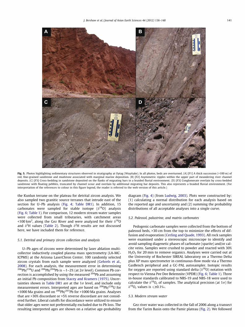
Fig. 5. Photos highlighting sedimentary structures observed in stratigraphy at Oytag (Wuyitake). In all photos, beds are overturned. (A) [F1] A thick succession (>100 m) ofred, fine-grained sandstone and mudstone associated with marginal marine deposition. (B) [F2] Asymmetric ripples within the upper part of meandering river channeldeposits. (C) [F3] Cross-bedding in sandstone deposited on the flanks of migrating bars in a braided fluvial environment. (D) [F3] Conglomerate overlain by cross-beddedsandstone with floating pebbles, truncated by channel scour and overlain by additional migrating bar deposits. This also represents a braided fluvial environment. (Forinterpretation of the references to colour in this figure legend, the reader is referred to the web version of this article.)
J. Bershaw et al. / Journal of Asian Earth Sciences 44 (2012) 136–148 141
the Kunlun terrane on the plateau for detrital zircon analysis. Wealso sampled two granitic source terranes that intrude east of thesection for U–Pb analysis (Fig. 4; Table DR1). In addition, 15carbonates were sampled for stable isotope (d18O) analysis(Fig. 6; Table 1). For comparison, 12 modern stream water sampleswere collected from small tributaries, with catchment areas<100 km2, along the Gez River and were analyzed for their d18Oand d2H values (Table 2). Though d2H results are not discussedhere, we have included them for reference.
5.1. Detrital and primary zircon collection and analysis
U–Pb ages of zircons were determined by laser ablation multi-collector inductively coupled plasma mass spectrometry (LA-MC-ICPMS) at the Arizona LaserChron Center. 100 randomly selectedzircon crystals from each sample were analyzed (Gehrels et al.,2008). For each analysis, the measurement error in determining206Pb/238U and 206Pb/204Pb is �1–2% (at 2r level). Common Pb cor-rection is accomplished by using the measured 204Pb and assumingan initial Pb composition from Stacey and Kramers (1975). Uncer-tainties shown in Table DR1 are at the 1r level, and include onlymeasurement errors. Interpreted ages are based on 206Pb/238U for<1000 Ma grains and on 206Pb/207Pb for >1000 Ma grains. Analysesthat are >30% discordant or >5% reverse discordant are not consid-ered further. Liberal cutoffs for discordance were utilized to ensurethat older ages were not preferentially excluded due to Pb loss. Theresulting interpreted ages are shown on a relative age-probability
diagram (Fig. 4) (from Ludwig, 2003). Plots were constructed by:(1) calculating a normal distribution for each analysis based onthe reported age and uncertainty and (2) summing the probabilitydistributions of all acceptable analyses into a single curve.
5.2. Paleosol, palustrine, and matrix carbonates
Pedogenic carbonate samples were collected from the bottom ofpaleosol beds, >30 cm from the top to minimize the effects of dif-fusion and evaporation (Cerling and Quade, 1993). All rock sampleswere examined under a stereoscopic microscope to identify andavoid sampling diagenetic phases of carbonate (sparite) and/or cal-cite veins. Samples were crushed to powder and reacted with 30%H2O2 for 20 min to remove organics. Analyses were carried out atthe University of Rochester SIREAL laboratory on a Thermo Deltaplus XP mass spectrometer in continuous-flow mode via a ThermoGasBench peripheral and a GC-PAL autosampler. Isotopic resultsfor oxygen are reported using standard delta (d18O) notation withrespect to Vienna Pee Dee Belemnite (VPDB) (Fig. 6; Table 1). Threein-house standards calibrated to NBS-19 and NBS-18 were used tocalculate the d18Oc of samples. The analytical precision (at 1r) ford18Oc values is 6±0.1‰.
5.3. Modern stream water
Gez river water was collected in the fall of 2006 along a transectfrom the Tarim Basin onto the Pamir plateau (Fig. 2). We followed

Fig. 6. d18Oc (VPDB) values from carbonate samples collected from the stratigraphic section at Oytag (Figs. 3 and DR1). PW-30 is a modern stream water sample collectedfrom a small tributary near Oytag and converted to calcite for comparison to carbonate samples. Horizontal error bar represents the range of local, low elevation (<2500 m)surface water d18Ow values converted to calcite (Table 2). Vertical shading represents age uncertainty of carbonate samples based on formation ages (refer to Section 4 for adetailed explanation), apatite fission track exhumation ages (Sobel and Dumitru, 1997), and our own detrital zircon grain ages (Fig. 4; Table DR1). Sample ages withinformations are estimated from their absolute position within the stratigraphic section. Samples PMR-02 and PMR-03 are from strata structurally above the stratigraphicsection, with no upper age constraints. Aertashi carbonate data (small grey circles) from Kent-Corson et al. (2009). Sediment accumulation rates are based on measuredsection thickness and formation ages assuming constant sediment accumulation rates within formations.
142 J. Bershaw et al. / Journal of Asian Earth Sciences 44 (2012) 136–148
the approach of Garzione et al. (2000) by sampling small catch-ments (<100 km2) in order to minimize the elevation range andcatchment area represented by each water sample. The isotopicanalyses were conducted at the University of Rochester SIREAL lab-oratory. For oxygen analyses, �0.5 mL of each water sample was
loaded into a 12 mL Exetainer™ and flushed with a mixture of0.3% CO2 and UHP helium. Tubes were allowed to equilibrate forat least 18 h at ambient room temperature prior to analysis. Head-space CO2 gas was then drawn into a Thermo Delta plus XP massspectrometer in continuous-flow mode via a Thermo Gas Bench

Table 1Agesa, locality, and d18O results from carbonate samples.
Sample ID d18OVPDB Age Sampletype
Latitude Longitude
PMR-02 �11.66 Miocene (?) Mudstone 38.9937 75.5434PMR-03 �10.98 Mio-Pliocene (?) Mudstone 38.9663 75.4494PMR-27 �1.04 Late Cretaceous Limestone 38.9521 75.5061PMR-29 �8.24 Cretaceous Paleosol 38.9790 75.4780PMR-30 �11.78 Miocene Mudstone 38.9817 75.5215PMR-31 �13.15 Miocene Mudstone 38.9827 75.5194PMR-34 �11.25 Early Miocene Mudstone 38.9841 75.5152PMR-37 �12.39 Oligocene Sandstone 38.9858 75.5054PMR-38 �13.26 Oligocene Sandstone 38.9861 75.5037PMR-41 �12.42 Oligocene Sandstone 38.9868 75.4969PMR-42 �9.40 Paleocene Mudstone 38.9878 75.4806PMR-43 �1.97 Cretaceous Mudstone 38.9808 75.4814PMR-44 �8.44 Eocene Mudstone 38.9825 75.4881PMR-47 �14.25 Miocene Sandstone 38.9888 75.5384PMR-48 �12.33 Miocene Sandstone 38.9883 75.5347
a Refer to Section 4 for an explanation of age determinations.
J. Bershaw et al. / Journal of Asian Earth Sciences 44 (2012) 136–148 143
peripheral and a GC-PAL autosampler for analysis. d18O results arecalculated using internal laboratory standards calibrated to ViennaStandard Mean Ocean Water (VSMOW) and Standard Light Antarc-tic Precipitation (SLAP) with 1r analytical precision 60.10‰.Hydrogen analyses were run in continuous-flow mode via a Ther-mo Electron TC/EA peripheral. Approximately 200 nL of samplewater was injected into the TC/EA during three successive injec-tions. The reactor was set at a temperature of 1450 �C and theGC oven was set at 90 �C. The average of four injections indicatesa 1r error of <2.0‰ and values are reproducible within 4‰ in rep-licate analyses (Table 2).
6. Results
6.1. Zircon ages and provenance
Of eight samples analyzed, two are primary igneous rocks(PMR-08 and PMR-23) (Fig. 2). Some zircon crystals from PMR-08are interpreted to have been affected by Pb loss given an inversecorrelation between young 206Pb/238U age and higher U concentra-tion (Fig. DR2). We have excluded crystals with U concentration>800 ppm from age calculations as lead loss results in erroneouslyyoung ages. For both igneous samples, most crystal ages are be-tween 240 and 260 Ma, resulting in mean ages of 244 ± 4 Ma(PMR-08) and 258 ± 6 Ma (PMR-23) (Fig. DR3A and B, andTable DR1). These results are consistent with previously publishedU–Pb ages (245 ± 5 Ma from Robinson et al., 2004) and a bit youn-ger than K–Ar ages (267 Ma from Chang, 1994) for the same plu-tons. These rocks are part of the Kunlun terrane which extendsfrom the northern Pamir across to northeast Tibet and is madeup of both Paleozoic and Triassic aged volcanic arcs (Yin andHarrison, 2000; Schwab et al., 2004).
Table 2Catchment size, locality information, and stable isotope results for tributaries along the G
Sample ID VSMOW d2HVSMOW Elevation (m)
PW-02 �8.08 �45.06 2088PW-05 �8.80 �51.35 2399PW-08 �12.47 �82.27 2595PW-11 �5.33 �26.58 3053PW-14 �10.94 �68.32 3249PW-17 �14.29 �97.17 3454PW-20 �13.02 �96.63 3486PW-23 �12.23 �82.72 4075PW-24 �10.99 �71.43 3363PW-28 �6.70 �37.51 3179PW-30 �10.00 �62.31 1969PW-35 �11.57 �72.48 2704
Samples PMR-13 and PMR-20 are meta-sedimentary rocks fromthe Pamir hinterland (Fig. 2; Table DR1). Both samples containdetrital zircon ages clustered around �440 Ma (Fig. 4), correspond-ing to older Kunlun terrane volcanics (Yin and Harrison, 2000;Schwab et al., 2004). Sample PMR-13 also has a population ofgrains at �220 Ma with relatively low U/Th ratios (<4), suggestingit samples the younger volcanic arc of the Kunlun terrane as well.Sample PMR-20 does not contain any Triassic ages. Detrital grainage populations also exist at �950 Ma, �1.9 Ga, and �2.5 Ga.
Five of the ten samples represent detrital zircons from theJurassic through Miocene stratigraphic section near Oytag (Figs. 3and DR1). The oldest of these, sample PMR-25 (Jurassic) shows aconspicuous peak at �250 Ma that coincides with Triassic magma-tism recorded in Kunlun terrane rocks (Fig. 4). Cretaceous samplePMR-26 has a more equal distribution of grain ages including bothTriassic volcanics and Paleozoic meta-sedimentary rocks. An�40 Ma peak becomes prominent in Oligocene to early Miocenesamples PMR-40 and PMR-33, consistent with their designationas members of the Eocene–Oligocene Bashibulake Formation andMiocene Wuqia Group respectively (Fig. 3) (Hao and Zeng, 1980;Hao et al., 1982; Zhong, 1989; Lan and Wei, 1995). U/Th ratios ofthese grains are very low (<2), indicating they are primary igneousages, not metamorphic (e.g. Hoskin and Black, 2000). No othersamples from this study include zircons of this age. The source ofthese zircons may be the central to southeastern Pamir as U/Pbages of shoshonitic rocks from the Muskol Antiform (Fig. 2) are lateEocene to early Oligocene in age (Ratschbacher, unpublished data).In addition, Budanov et al. (1999) report a 200 km long belt of lateEocene shoshonitic rocks dated using the palynology of interbed-ded sedimentary rocks trending southeast from the central Pamirnear Murgab, though their exact location is not apparent from thispublication. Early Eocene alkaline volcanics dated using 40Ar/39Ar(Zhang et al., 1996) that outcrop in the Tashkorgan Valley maybe an extension of this belt (Fig. 2). Igneous rock grains �39 Main age have also been documented in western Pamir sediments de-rived from the central Pamir (Lukens et al., 2009). It is also possiblethat the source of these �40 Ma grains in the Oytag stratigraphicsection has since been removed by erosion or is not yet docu-mented, as high resolution mapping and geochronology in manyparts of the Pamir is nonexistent. This makes interpretation ofthe source of these grains highly speculative.
The youngest sample from the Oytag section (PMR-46) does notcontain detrital zircon grains younger than 200 Ma (Fig. 4). Rather,it shows a prominent peak at �250 Ma, similar to the Jurassic-agedsample PMR-25. This suggests that �40 Ma volcanic sources werecut off from the basin in association with renewed exhumation ofthe Kunlun terrane’s Triassic volcanic arc. Sample PMR-01 was col-lected from strata that unconformably overlies the Oytag section(Fig. DR1), but lacks upper age limit constraints. Like PMR-46, itdoes not contain�40 Ma zircon grains, but shows more distributedsource terrane ages, all older than 200 Ma.
ez River.
Catchment size (km2) Latitude Longitude
90.7 38.8116 75.444710.6 38.7840 75.285153.7 38.7685 75.2308
1.2 38.7490 75.13954.8 38.7432 75.04928.4 38.9791 74.5296
18.2 38.9855 74.434342.5 39.1704 74.5539
8.3 38.8405 74.848381.9 38.7516 75.099726.0 38.8723 75.484457.1 38.9014 75.2102
144 J. Bershaw et al. / Journal of Asian Earth Sciences 44 (2012) 136–148
6.2. Isotopic compositions of modern and paleo-waters
Of 15 carbonate samples that were analyzed for d18O, eight arefluvial mudstone cements, five are fluvial sandstone cements, oneis a paleosol, and one is limestone (Figs. 6 and DR1; Table 1). Withthe exception of PMR-43 and PMR-27, the d18Oc values of Creta-ceous through early Eocene paleosol and mudstone samples arefairly consistent (average �8.7 ± 0.6‰). Of the two exceptions,PMR-27 is a marine limestone with a relatively positive d18Oc valueof �1.0‰ and PMR-43 is a calcareous mudstone with a comparabled18Oc value of �2.0‰, suggesting its carbonate precipitated frommarine water. A negative shift of �4‰ occurred sometime in Eo-cene to Oligocene time between the deposition of samples PMR-41 and PMR-44. Although Oligo-Miocene fluvial sandstones andmudstones show more variation (average �12.6 ± 3‰), all aremore negative than older samples.
Water sampled from a small tributary near the stratigraphicsection (PW-30) has a d18Ow (VSMOW) value of �10‰ (Table 2).We converted this to calcite (d18Oc VPDB = �11.1‰) using the tem-perature-dependent fractionation equation (Kim and O’Neil, 1997)for comparison to carbonate samples. A mean annual temperatureof 19 �C is assumed, which is the average temperature for relativelydry months (July, September and October) following a weakly bi-modal rainy season in Kashgar (Kashi) (NOAA/NCDC, 2010). Driermonths reflect the time period during which carbonates are mostlikely to precipitate (Breecker et al., 2009). The average d18Oc valueof samples Oligocene and younger is �1.5‰ more negative (d18Oc
VPDB = �12.6 ± 3‰) than calcite calculated from modern meteoricwater nearby (Fig. 6).
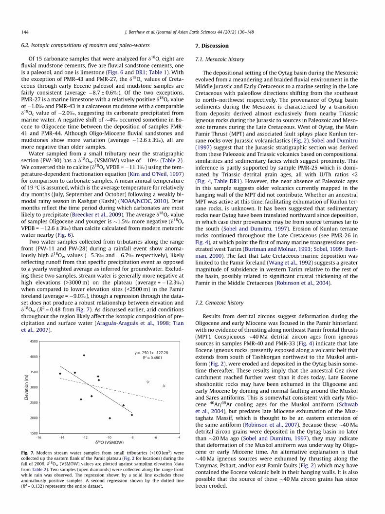
Two water samples collected from tributaries along the rangefront (PW-11 and PW-28) during a rainfall event show anoma-lously high d18Ow values (�5.3‰ and �6.7‰ respectively), likelyreflecting runoff from that specific precipitation event as opposedto a yearly weighted average as inferred for groundwater. Exclud-ing these two samples, stream water is generally more negative athigh elevations (>3000 m) on the plateau (average = �12.3‰)when compared to lower elevation sites (<2500 m) in the Pamirforeland (average = �9.0‰), though a regression through the data-set does not produce a robust relationship between elevation andd18Ow (R2 = 0.48 from Fig. 7). As discussed earlier, arid conditionsthroughout the region likely affect the isotopic composition of pre-cipitation and surface water (Araguás-Araguás et al., 1998; Tianet al., 2007).
Fig. 7. Modern stream water samples from small tributaries (<100 km2) werecollected up the eastern flank of the Pamir plateau (Fig. 2 for locations) during thefall of 2006. d18Ow (VSMOW) values are plotted against sampling elevation (datafrom Table 2). Two samples (open diamonds) were collected along the range frontwhile rain was observed. The regression shown by a solid line excludes theseanomalously positive samples. A second regression shown by the dotted line(R2 = 0.132) represents the entire dataset.
7. Discussion
7.1. Mesozoic history
The depositional setting of the Oytag basin during the Mesozoicevolved from a meandering and braided fluvial environment in theMiddle Jurassic and Early Cretaceous to a marine setting in the LateCretaceous with paleoflow directions shifting from the southeastto north–northwest respectively. The provenance of Oytag basinsediments during the Mesozoic is characterized by a transitionfrom deposits derived almost exclusively from nearby Triassicigneous rocks during the Jurassic to sources in Paleozoic and Meso-zoic terranes during the Late Cretaceous. West of Oytag, the MainPamir Thrust (MPT) and associated fault splays place Kunlun ter-rane rocks over Jurassic volcaniclastics (Fig. 2). Sobel and Dumitru(1997) suggest that the Jurassic stratigraphic section was derivedfrom these Paleozoic and Triassic volcanics based on compositionalsimilarities and sedimentary facies which suggest proximity. Thisinference is partly supported by sample PMR-25 which is domi-nated by Triassic detrital grain ages, all with U/Th ratios <2(Fig. 4, Table DR1). However, the near absence of Paleozoic agesin this sample suggests older volcanics currently mapped in thehanging wall of the MPT did not contribute. Whether an ancestralMPT was active at this time, facilitating exhumation of Kunlun ter-rane rocks, is unknown. It has been suggested that sedimentaryrocks near Oytag have been translated northward since deposition,in which case their provenance may be from source terranes far tothe south (Sobel and Dumitru, 1997). Erosion of Kunlun terranerocks continued throughout the Late Cretaceous (see PMR-26 inFig. 4), at which point the first of many marine transgressions pen-etrated west Tarim (Burtman and Molnar, 1993; Sobel, 1999; Burt-man, 2000). The fact that Late Cretaceous marine deposition waslimited to the Pamir foreland (Wang et al., 1992) suggests a greatermagnitude of subsidence in western Tarim relative to the rest ofthe basin, possibly related to significant crustal thickening of thePamir in the Middle Cretaceous (Robinson et al., 2004).
7.2. Cenozoic history
Results from detrital zircons suggest deformation during theOligocene and early Miocene was focused in the Pamir hinterlandwith no evidence of thrusting along northeast Pamir frontal thrusts(MPT). Conspicuous �40 Ma detrital zircon ages from igneoussources in samples PMR-40 and PMR-33 (Fig. 4) indicate that lateEocene igneous rocks, presently exposed along a volcanic belt thatextends from south of Tashkorgan northwest to the Muskol anti-form (Fig. 2), were eroded and deposited in the Oytag basin some-time thereafter. These results imply that the ancestral Gez rivercatchment reached further west than it does today. Late Eoceneshoshonitic rocks may have been exhumed in the Oligocene andearly Miocene by doming and normal faulting around the Muskoland Sares antiforms. This is somewhat consistent with early Mio-cene 40Ar/39Ar cooling ages for the Muskol antiform (Schwabet al., 2004), but predates late Miocene exhumation of the Muz-taghata Massif, which is thought to be an eastern extension ofthe same antiform (Robinson et al., 2007). Because these �40 Madetrital zircon grains were deposited in the Oytag basin no laterthan �20 Ma ago (Sobel and Dumitru, 1997), they may indicatethat deformation of the Muskol antiform was underway by Oligo-cene or early Miocene time. An alternative explanation is that�40 Ma igneous sources were exhumed by thrusting along theTanymas, Pshart, and/or east Pamir faults (Fig. 2) which may havecontained the Eocene volcanic belt in their hanging walls. It is alsopossible that the source of these �40 Ma zircon grains has sincebeen eroded.

J. Bershaw et al. / Journal of Asian Earth Sciences 44 (2012) 136–148 145
These results preclude significant exhumation along the MPTnear Oytag at this time as late Eocene igneous rocks have not beenfound anywhere in the MPT hanging wall (Sobel and Dumitru,1997; Robinson et al., 2007; Cowgill, 2010). The lack of exhumationon the MPT in late Eocene time is inconsistent with the interpreta-tion by Yin et al. (2002) that an increase in basin subsidence�150 km southeast at Aertashi (Fig. 2) at �37 Ma was associatedwith activity along frontal thrusts like the MPT.
Oytag basin provenance and stratigraphy document propaga-tion of deformation from the central and southeastern Pamir inthe Oligocene to the MPT and associated frontal thrust faults some-time in the Miocene. Convergent deformation in the southeasternPamir had already formed thick crust (70 km) by �50 Ma (Duceaet al., 2003; Hacker et al., 2005; Searle et al., 2010). Our results sug-gest that the central Pamir continued to experience exhumationthroughout the Eocene as detrital zircon grains from 40 Ma igne-ous rocks in the central to southeast Pamir are found in Oytag sed-iments. In the Miocene, late Eocene zircon grains disappear fromOytag strata and Triassic ages from the Kunlun terrane becomedominant again (sample PMR-46 in Fig. 4). A likely source is thehanging wall of the MPT and associated fault splays, suggestingthat thrusting initiated or was reactivated in the Miocene, consis-tent with thermochronologic evidence (Sobel and Dumitru, 1997;Robinson et al., 2007) and a coeval change in provenance at Aert-ashi (Yin et al., 2002).
A basin-ward propagation of deformation during the early tomid-Miocene is corroborated by stratigraphy at Oytag which re-cords a transition from marine to continental sedimentation fromlate Eocene to early Miocene time. Following the deposition ofmarine limestone in the Eocene, the Eocene–Oligocene Bashibu-lake Formation shifts to a marginal marine environment with athick succession of mudstone and sandstone ([F1] in Fig. 3 andTable 3). The stratigraphic succession coarsens upward over�1 km into continental braided stream and/or alluvial fan faciesof the Wuqia Group [F3]. Prograding facies at Oytag coincide witha marine regression interpreted throughout the Tarim Basin(Watson et al., 1987; Bosboom et al., 2010). Paleoflow directionsare consistently east-northeastward throughout the Cenozoic(Fig. 3). We interpret Oytag stratigraphy to represent a progradingsuccession of transverse river systems along the western margin ofthe Tarim Basin with sources in the Pamir, much like the modernGez and Tashkorgan river systems (Fig. 2). Stratigraphy at Aertashishows a similar trend from marine rocks in the middle Eocene toterrestrial fluvial and alluvial fan deposits in the Miocene (Sobel,1995; Yin et al., 2002). Though poorly constrained, an increase in
Table 3Description and interpretation of sedimentary facies (after Miall, 1985; Uba et al., 2005).
Faciesassociation
Faciescodes
Description
F1 Gt, Sh, Sl,Ss, St, Fb
Sandstone and mudstone (pinching out over 10s of meterinterbedded with Lenticular beds of conglomerate (2–6 m tare poorly sorted, clast supported, sub-rounded, and oftencross-bedding. Thick successions (>100 m) of red, fine-grasandstone and mudstone with some cross-beds and burroobserved
F2 Gt, Sh, Sl,Sm, Sml,Sr, St, Fl
Brown, green, and red sandstone and mudstone beds pinc10s–100s of meters, both thickly bedded and laminated, woccasional �2 m thick conglomerate interbeds (pinching ometers). Asymmetric ripples, cross-bedding, dewatering soccasional pebbly layers, conspicuous calcite veins, and scbases observed throughout
F3 Gm, Gt, Sh,St, Fl
Fining-upward successions (�10–20 m thick) of pebble toclast and matrix supported, often imbricated, conglomeratby fine to coarse grained red and brown, often cross-beddsandstone and mudstone with floating pebbles. Successiooften separated by thick intervals (up to 130 m) of red mand medium-grained sandstone
sediment accumulation rate accompanies this facies transition atOytag from more than 30 m/Ma during the Oligocene to at least75 m/Ma in the Miocene (Fig. 6). This may be due to increasedcrustal loading and exhumation along the MPT and Kashgar-Yech-eng Transfer System (Fig. 2).
7.2.1. Oxygen isotopesOxygen isotope values (d18Oc) of matrix cements from Oytag re-
cord an �4‰ shift to more negative values during Eocene or Oligo-cene time (Fig. 6). Though this is roughly synchronous with atransition from marine to non-marine facies throughout westernTarim (Yin et al., 2002; Heermance et al., 2007), the observationthat limestone d18Oc (PMR-27) is significantly more positive thanearly Paleogene matrix cements indicates that Paleogene carbon-ates were not precipitating from marine water. However, a marineregression could cause the source of water vapor to shift from local(Paratethys) to more distal (proto-Atlantic and/or Indian Ocean),resulting in a decrease in the d18O value of rainfall during the Oligo-cene. A negative shift in d18Oc values could also be caused by Paleo-gene surface uplift of basin-bounding ranges as inferred for sitesacross the southern Tarim Basin (Kent-Corson et al., 2009). Thisinterpretation is consistent with erosion of the central to southeastPamir inferred from 40 Ma detrital zircons in Oligo-Miocene sedi-mentary rocks from our stratigraphic section. It also slightly pre-cedes the onset of aridification throughout the Tarim Basin andcentral Asian interior inferred from loess deposits in late Oligoceneand/or early Miocene time (Guo et al., 2002; Sun et al., 2010).
The d18Ow of a small tributary near Oytag (PW-30) converted tod18Oc VPDB (�11.1‰) is �1.5‰ more positive than d18Oc values inrocks younger than �40 Ma (average = �12.6 ± 3‰) suggestingthat d18Ow of precipitation has not varied dramatically in westTarim since the Oligocene (Fig. 6). This implies that high reliefwas already established in the Pamir by this time and thatdeformation along the MPT, beginning in the Miocene, did not sig-nificantly affect local climate or atmospheric circulation. Unfortu-nately, low sample density and age uncertainty in Neogene rocksdoes not allow us to resolve more recent trends.
7.2.2. Regional implicationsOur data suggest that central and/or southeast Pamir igneous
rocks were eroded during Oligocene and early Miocene time,synchronous with widespread deformation across northern Tibet.The Altyn-Tagh fault, located along Tibet’s northwest margin(Fig. 1), has been active since the latest Oligocene (Yin et al.,2002; Ritts et al., 2004; Yue et al., 2005) and Eocene deformation
Interpretation
s)hick) thatshow
inedws
Marginal marine to lower fan delta plain environment consisting ofsandy channel fills (Sl, Sh, Ss, St, Gt) and mud-sized overbankdeposits (Fb). Fossil assemblages suggest a neritic environment (Haoand Zeng, 1980)
h out overithut over
tructures,oured
Meandering stream environment with crevasse splay or sandy mudflows (Sm), waning-stage channel deposits (St, Sr, Sl, Sh and Fl), sandbar (St), and overbank deposits (Fl)
cobble,e overlained
ns areudstone
Braided fluvial fan with gravelly bars (Gt and St), bar-top deposits(Sh and St), sheet-flood deposits (Fl), occasional mud flow and/orriver flood deposits (Gm)

146 J. Bershaw et al. / Journal of Asian Earth Sciences 44 (2012) 136–148
and exhumation in northeast Tibet has been documented alongfaults (Clark et al., 2010) and in basin development (Fang et al.,2003; Horton et al., 2004; Dai et al., 2006). In the Pamir, deformationpropagated toward the Tarim Basin to the MPT by middle Miocenetime, concurrent with deformation along the south and southeastmargins of the Tarim Basin (George et al., 2001; Jolivet et al., 2001;Ritts et al., 2008) and the far northeastern edge of the Tibetan plateau(Zheng et al., 2006). Significant deformation further north through-out the Tian Shan also began in the middle Miocene (Sobel andDumitru, 1997; Abdrakhmatov et al., 2001; Bullen et al., 2001; Heer-mance et al., 2007), at the same time that deformation propagatedfrom the central and southeast Pamir toward the Tarim Basin. Thissuggests that stress along the flanks of the Pamir and Tibetan pla-teaus were quickly transferred across the relatively rigid Tarim plateto the Tian Shan. Our results do not preclude deformation in the cen-tral Pamir during this time, leaving open the possibility of synchro-nous Miocene deformation throughout the Pamir plateau, as isobserved in Tibet (Kapp et al., 2007). However, deformation seemsto have propagated northeastward from the Oligocene into the Mio-cene, resulting in outward growth of the Pamir plateau.
8. Conclusions
Conspicuous �40 Ma detrital zircon grains in sedimentary rocksfrom the Pamir foreland indicate that deformation was focused inthe central to southeast Pamir during the Oligocene to early Mio-cene (Fig. 4). There is no evidence of thrusting along northeast Pa-mir frontal thrusts (MPT) at this time as late Eocene intrusive rocksare absent from the MPT hanging wall (Sobel and Dumitru, 1997;Robinson et al., 2007; Cowgill, 2010). Oligocene to early Miocenedeformation of the central Pamir was roughly coincident with an�4‰ shift to more negative d18O values in sandstone and mud-stone cements from the same stratigraphic section (Fig. 6). Thisshift in d18O may have been related to surface uplift of the centralto southeast Pamir and other Tarim basin-bounding ranges duringthe Paleogene (Kent-Corson et al., 2009). It is also consistent with amarine regression at Oytag (Wuyitake) as suggested by a transitionfrom marine rocks in the Eocene (Sobel, 1999) to terrestrial,braided fluvial deposits in the early Miocene (Fig. 3, Table 3), andprograding facies throughout the Tarim Basin (Watson et al.,1987; Bosboom et al., 2010).
In the early to middle Miocene, detrital zircons sourced from lateEocene igneous rocks disappeared from Oytag strata and Triassicdetrital zircon grains eroded from Kunlun terrane rocks becomeprominent. This change in provenance indicates that Pamir frontalthrusts, such as the MPT, began accommodating convergence be-tween the Pamir and the Tarim plate by early to middle Miocenetime. Both provenance changes and prograding facies recorded inthe Oytag stratigraphy (Fig. 3; Table 3) suggest Pamir deformationpropagated toward the Tarim Basin from the Oligocene into the Mio-cene. This is consistent with thermochronologic data at Oytag (Sobeland Dumitru, 1997) and similar facies and compositional changesobserved at Aertashi (Yin et al., 2002). Considered with Miocenecrustal shortening on the northern margin of the Tibetan plateau(George et al., 2001; Jolivet et al., 2001; Zheng et al., 2006; Rittset al., 2008) and the Tian Shan (Hendrix et al., 1994; Sobel and Dumi-tru, 1997; Yin et al., 1998; Abdrakhmatov et al., 2001; Bullen et al.,2001; Heermance et al., 2007), these results corroborate observa-tions of the outward advancement of Indo-Eurasian deformation,affecting all margins of the Tarim Basin by middle Miocene time.
Acknowledgements
We are grateful to Chen Jie for help in the field. We would liketo thank Alex Robinson, Ed Sobel, and Lothar Ratschberger, for
insightful discussions and suggestions. We are grateful to PennyHiggins for assistance with stable isotope lab work at the Univer-sity of Rochester and Alex Pullen for help running zircon samplesat the University of Arizona. This work was supported by NSFGrants EAR 0506575 and EAR 0908778 to Garzione and EAR0732436 to Gehrels (for support of the Arizona LaserChron Center)and a GSA Graduate Student Research Grant to Bershaw.
Appendix A. Supplementary data
Supplementary data associated with this article can be found, inthe online version, at doi:10.1016/j.jseaes.2011.04.020.
References
Abdrakhmatov, K. et al., 2001. Onset, style, and current rate of shortening in thecentral Tien Shan (Kyrgyzstan). Russian Geology and Geophysics, 1502.
Amidon, W.H., Hynek, S.A., 2010. Exhumational history of the north central Pamir.Tectonics 29 (5), TC5017.
Araguás-Araguás, L., Froehlich, K., Rozanski, K., 1998. Stable isotope composition ofprecipitation over southeast Asia. Journal of Geophysical Research-Atmospheres 103 (D22).
Arrowsmith, J., Strecker, M., 1999. Seismotectonic range-front segmentation andmountain-belt growth in the Pamir-Alai region, Kyrgyzstan (India–Eurasiacollision zone). Geological Society of America Bulletin 111 (11), 1665.
Bosboom, R.E. et al., 2010. Late Eocene sea retreat from the Tarim Basin (west China)and concomitant Asian paleoenvironmental change. Palaeogeography,Palaeoclimatology, Palaeoecology.
Breecker, D., Sharp, Z., McFadden, L., 2009. Seasonal bias in the formation and stableisotopic composition of pedogenic carbonate in modern soils from central NewMexico, USA. Geological Society of America Bulletin 121 (3–4), 630.
Bruguier, O., Lancelot, J., Malavieille, J., 1997. U–Pb dating on single detrital zircongrains from the Triassic Songpan–Ganze flysch (Central China): provenance andtectonic correlations. Earth and Planetary Science Letters 152 (1–4), 217–231.
Budanov, V., Volkova, N., Dronov, V., 1999. Petrochemistry of a rhyodacite–trachyteseries in a Paleogene volcanoplutonic belt in the Southeastern Pamirs. RussianGeology and Geophysics 40 (5), 648–654.
Bullen, M., Burbank, D., Garver, J., Abdrakhmatov, K., 2001. Late Cenozoic tectonicevolution of the northwestern Tien Shan: new age estimates for the initiation ofmountain building. Geological Society of America Bulletin 113 (12), 1544.
Burtman, V., 2000. Cenozoic crustal shortening between the Pamir and Tien Shanand a reconstruction of the Pamir–Tien Shan transition zone for the Cretaceousand Palaeogene. Tectonophysics 319 (2), 69–92.
Burtman, V., Molnar, P., 1993. Geological and Geophysical Evidence for DeepSubduction of Continental Crust Beneath the Pamir. Geological Society ofAmerica.
Cerling, T.E., Quade, J., 1993. Stable carbon and oxygen isotopes in soil carbonates.Geophysical Monograph – American Geophysical Union 78, 217.
Chamberlain, C., Poage, M., 2000. Reconstructing the paleotopography of mountainbelts from the isotopic composition of authigenic minerals. Geology 28 (2), 115.
Chang, C., 1994. Tectonic evolution of western Tibetan Plateau. In: Proceedings ofthe International Symposium on the Karakorum and Kunlun Mountains. ChinaMeteorol., Beijing, pp. 11–22.
Clark, I., Fritz, P., 1997. Environmental Isotopes in Hydrogeology. CRC Press/LewisPublishers.
Clark, M.K., Farley, K.A., Zheng, D., Wang, Z., Duvall, A.R., 2010. Early Cenozoicfaulting of the northern Tibetan Plateau margin from apatite (U–Th)/He ages.Earth and Planetary Science Letters 296 (1–2), 78–88.
Coutand, I. et al., 2002. Late Cenozoic tectonic development of the intramontaneAlai Valley, (Pamir-Tien Shan region, central Asia): an example ofintracontinental deformation due to the Indo-Eurasia collision. Tectonics 21(6), 1053.
Cowgill, E., 2010. Cenozoic right-slip faulting along the eastern margin of the Pamirsalient, northwestern China. Geological Society of America Bulletin 122 (1–2),145–161.
Dai, S. et al., 2006. Magnetostratigraphy of Cenozoic sediments from the XiningBasin: tectonic implications for the northeastern Tibetan Plateau. Journal ofGeophysical Research 111 (B11), B11102.
DeCelles, P. et al., 1991. Kinematic history of a foreland uplift from Paleocenesynorogenic conglomerate, Beartooth Range, Wyoming and Montana.Geological Society of America Bulletin 61 (4).
Ducea, M. et al., 2003. Building the Pamirs: the view from the underside. Geology 31(10), 849.
Fang, X., Garzione, C., Van der Voo, R., Li, J., Fan, M., 2003. Flexural subsidence by29 Ma on the NE edge of Tibet from the magnetostratigraphy of Linxia Basin,China. Earth and Planetary Science Letters 210 (3–4), 545–560.
Garzione, C.N., Quade, J., DeCelles, P.G., English, N.B., 2000. Predictingpaleoelevation of Tibet and the Himalaya from d18O vs. altitude gradients inmeteoric water across the Nepal Himalaya. Earth and Planetary Science Letters183 (1–2), 215–229.
J. Bershaw et al. / Journal of Asian Earth Sciences 44 (2012) 136–148 147
Garzione, C., Dettman, D., Horton, B., 2004. Carbonate oxygen isotopepaleoaltimetry: evaluating the effect of diagenesis on paleoelevationestimates for the Tibetan plateau. Palaeogeography, Palaeoclimatology,Palaeoecology 212 (1–2), 119–140.
Gat, J., 1996. Oxygen and hydrogen isotopes in the hydrologic cycle. Annual Reviewof Earth and Planetary Sciences 24 (1), 225–262.
Gehrels, G., Dickinson, W., 1995. Detrital zircon provenance of Cambrian to Triassicmiogeoclinal and eugeoclinal strata in Nevada. American Journal or Science 295,18–48.
Gehrels, G., Valencia, V., Ruiz, J., 2008. Enhanced precision, accuracy, efficiency, andspatial resolution of U–Pb ages by laser ablation–multicollector–inductivelycoupled plasma–mass spectrometry. Geochemistry Geophysics Geosystems 9(3), Q03017.
George, A., Marshallsea, S., Wyrwoll, K., Jie, C., Yanchou, L., 2001. Miocene coolingin the northern Qilian Shan, northeastern margin of the Tibetan Plateau,revealed by apatite fission-track and vitrinite-reflectance analysis. Geology 29(10), 939.
Gile, L.H., Peterson, F.F., Grossman, R.B., 1966. Morphological and genetic sequencesof carbonate accumulation in desert soils. Soil Science 101 (5), 347–360.
Gonfiantini, R., Roche, M.A., Olivry, J.C., Fontes, J.C., Zuppi, G.M., 2001. The altitudeeffect on the isotopic composition of tropical rains. Chemical Geology 181 (1–4),147–167.
Graham, S. et al., 2005. Stable isotope records of Cenozoic climate and topography,Tibetan Plateau and Tarim Basin. American Journal of Science 305 (2), 101.
Guo, Z. et al., 2002. Onset of Asian desertification by 22 Myr ago inferred from loessdeposits in China. Nature 416 (6877), 159–163.
Hacker, B. et al., 2005. Near-ultrahigh pressure processing of continental crust:Miocene crustal xenoliths from the Pamir. Journal of Petrology 46 (8), 1661–1688.
Hao, Y., Zeng, X., 1980. Early Tertiary Foraminifera from the Kashi basin of Xinjiang.Acta Palaeontologica Sinica 19, 152–169.
Hao, Y., Zeng, X., Qiu, S., He, X., 1982. Miocene foraminifera of Tarim Basin, Xinjiang,and their geological significance. Bulletin of Chinese Academy of GeologicalSciences 4, 70–79.
Heermance, R., Chen, J., Burbank, D., Wang, C., 2007. Chronology and tectoniccontrols of Late Tertiary deposition in the southwestern Tian Shan foreland, NWChina. Basin Research 19 (4), 599.
Hendrix, M., Dumitru, T., Graham, S., 1994. Late Oligocene-early Miocene unroofingin the Chinese Tian Shan: an early effect of the India–Asia collision. Geology 22(6), 487.
Horton, B. et al., 2004. Mesozoic–Cenozoic evolution of the Xining-Minhe andDangchang basins, northeastern Tibetan Plateau: magnetostratigraphic andbiostratigraphic results. Journal of Geophysical Research 109 (B04402), 1–15.
Hoskin, P., Black, L., 2000. Metamorphic zircon formation by solid-staterecrystallization of protolith igneous zircon. Journal of Metamorphic Geology18 (4), 423–440.
IAEA/WMO, 2006. Global Network of Isotopes in Precipitation. <http://isohis.iaea.org>.
Ireland, T., Flöttmann, T., Fanning, C., Gibson, G., Preiss, W., 1998. Development ofthe early Paleozoic Pacific margin of Gondwana from detrital-zircon ages acrossthe Delamerian orogen. Geology 26 (3), 243.
Jia, C., Zhang, S., Wu, S., 2004. Stratigraphy of the Tarim basin and Adjacent Areas,vol. 1. Science Press, Beijing.
Jin, X., Wang, J., Chen, B., Ren, L., 2003. Cenozoic depositional sequences in thepiedmont of the west Kunlun and their paleogeographic and tectonicimplications. Journal of Asian Earth Sciences 21 (7), 755–765.
Jolivet, M. et al., 2001. Mesozoic and Cenozoic tectonics of the northern edge ofthe Tibetan plateau: fission-track constraints. Tectonophysics 343 (1–2),111–134.
Jones, S., Frostick, L., Astin, T., 2001. Braided stream and flood plain architecture: theRio Vero Formation, Spanish Pyrenees. Sedimentary Geology 139 (3–4), 229–260.
Kapp, P., DeCelles, P., Gehrels, G., Heizler, M., Ding, L., 2007. Geological records ofthe Lhasa–Qiangtang and Indo-Asian collisions in the Nima area of central Tibet.Geological Society of America Bulletin 119 (7–8), 917.
Kent-Corson, M. et al., 2009. Stable isotopic constraints on the tectonic, topographic,and climatic evolution of the northern margin of the Tibetan Plateau. Earth andPlanetary Science Letters 282 (1–4), 158–166.
Kim, S., O’Neil, J., 1997. Equilibrium and nonequilibrium oxygen isotope effects insynthetic carbonates. Geochimica et Cosmochimica Acta 61 (16), 3461–3475.
Lan, X., Wei, J., 1995. Late Cretaceous–Early Tertiary Marine Bivalve Fauna from theWestern Tarim Basin. Chinese Science Publishing House, Beijing.
Liu, W., 1990. Contact relationship between Upper and Lower Tertiary and ageownership of Wuqia Group in the southwest depression of Tarim Basin.Xinjiang Petroleum Geology 11, 20–24.
Ludwig, K., 2003. User’s manual for Isoplot 3.00: a geochronological toolkit forMicrosoft Excel. Berkeley Geochronology Center Special Publication 4, 70.
Lukens, C., Carrapa, B., Schoenbohm, L., Singer, B., Jicha, B., 2009. Tectono-thermalEvolution of the Western Pamir Mountains, Using 40Ar/39Ar Thermochronologyon Modern River Sands, p. 2099.
Mack, G., Cole, D., Treviño, L., 2000. The distribution and discrimination of shallow,authigenic carbonate in the Pliocene–Pleistocene Palomas Basin, southern RioGrande rift. Geological Society of America Bulletin 112 (5), 643.
Mack, G., Leeder, M., Perez-Arlucea, M., Bailey, B., 2003. Early Permian silt-bedfluvial sedimentation in the Orogrande basin of the Ancestral Rocky Mountains,New Mexico, USA. Sedimentary Geology 160 (1–3), 159–178.
Mao, S., Norris, G., 1988. Late Cretaceous – Early Tertiary Dinoflagellates andAcritarchs from the Kashi Area, Tarim Basin, Xinjiang Province, China. LifeScience Contributions, vol. 150. Royal Ontario Museum, p. 93.
Matte, P. et al., 1996. Tectonics of Western Tibet, between the Tarim and the Indus.Earth and Planetary Science Letters 142 (3), 311–316.
Miall, A., 1985. Architectural-element analysis: a new method of facies analysisapplied to fluvial deposits. Earth Science Reviews 22, 261–308.
Miall, A., 1996. The Geology of Fluvial Deposits. Sedimentary Facies, Basin Analysis,and Petroleum Geology. Springer, Berlin, p. 582.
Murphy, M. et al., 2000. Southward propagation of the Karakoram fault system,southwest Tibet: timing and magnitude of slip. Geology 28, 451.
Nichols, G., Fisher, J., 2007. Processes, facies and architecture of fluvial distributarysystem deposits. Sedimentary Geology 195 (1–2), 75–90.
NOAA/NCDC, 2010. National Oceanic and Atmospheric Administration and NationalClimatic Data Center, Asheville, North Carolina. <http://www.ncdc.noaa.gov>.
Quade, J., Roe, L., 1999. The stable-isotope composition of early ground-watercements from sandstone in paleoecological reconstruction. Journal ofSedimentary Research 69 (3), 667.
Quade, J., Garzione, C., Eiler, J., 2007. Paleoelevation reconstruction using pedogeniccarbonates. Reviews in Mineralogy and Geochemistry 66 (1), 53.
Reigber, C. et al., 2001. New space geodetic constraints on the distribution ofdeformation in Central Asia. Earth and Planetary Science Letters 191 (1–2),157–165.
Ritts, B., Yue, Y., Graham, S., 2004. Oligocene Miocene Tectonics and sedimentationalong the Altyn Tagh Fault, Northern Tibetan Plateau: analysis of the Xorkol,Subei, and Aksay Basins. The Journal of Geology 112, 207–229.
Ritts, B. et al., 2008. From sea level to high elevation in 15 million years: uplifthistory of the northern Tibetan Plateau margin in the Altun Shan. AmericanJournal of Science 308 (5), 657.
Robinson, A., 2009. Geologic offsets across the northern Karakorum fault:implications for its role and terrane correlations in the western Himalayan–Tibetan orogen. Earth and Planetary Science Letters 279 (1–2), 123–130.
Robinson, A. et al., 2004. Tectonic evolution of the northeastern Pamir: constraintsfrom the northern portion of the Cenozoic Kongur Shan extensional system,western China. Bulletin of the Geological Society of America 116 (7–8), 953–973.
Robinson, A. et al., 2007. Cenozoic evolution of the eastern Pamir: implications forstrain-accommodation mechanisms at the western end of the Himalayan–Tibetan orogen. Geological Society of America Bulletin 119 (7–8), 882.
Rowley, D., 1996. Age of initiation of collision between India and Asia: a review ofstratigraphic data. Earth and Planetary Science Letters 145 (1–4), 1–13.
Rowley, D.B., Garzione, C.N., 2007. Stable isotope-based paleoaltimetry. AnnualReview of Earth and Planetary Sciences 35 (1), 463–508.
Rowley, D.B., Pierrehumbert, R.T., Currie, B.S., 2001. A new approach to stableisotope-based paleoaltimetry: implications for paleoaltimetry andpaleohypsometry of the High Himalaya since the Late Miocene. Earth andPlanetary Science Letters 188 (1–2), 253–268.
Schwab, M. et al., 2004. Assembly of the Pamirs: age and origin of magmatic beltsfrom the southern Tien Shan to the southern Pamirs and their relation to Tibet.Tectonics 23 (4).
Searle, M., Corfield, R., Stephenson, B., McCarron, J., 1997. Structure of the NorthIndian continental margin in the Ladakh–Zanskar Himalayas: implications forthe timing of obduction of the Spontang ophiolite, India–Asia collision anddeformation events in the Himalaya. Geological Magazine 134 (03), 297–316.
Searle, M. et al., 2010. Anatomy, age and evolution of a collisional mountain belt:the Baltoro granite batholith and Karakoram Metamorphic Complex, PakistaniKarakoram. Journal of Geological Society 167 (1), 183.
Sobel, E., 1995. Basin Analysis and Apatite Fission-track Thermochronology of theJurassic–Paleogene Southwest Tarim Basin, Northwest China. Ph. D. Thesis,Stanford, California, Stanford University.
Sobel, E.R., 1999. Basin analysis of the Jurassic-Lower Cretaceous Southwest TarimBasin, Northwest China. Geological Society of America Bulletin 111 (5), 709–724.
Sobel, E., Dumitru, T., 1997. Thrusting and exhumation around the margins of thewestern Tarim basin during the India–Asia collision. Journal of GeophysicalResearch 102, 5043–5064.
Stacey, J., Kramers, J., 1975. Approximation of terrestrial lead isotope evolution by atwo-stage model. Earth and Planetary Science Letters 26, 207.
Sun, J. et al., 2010. Late Oligocene–Miocene mid-latitude aridification and windpatterns in the Asian interior. Geology 38 (6), 515.
Talbot, M.R., 1990. A review of the palaeohydrological interpretation of carbon andoxygen isotopic ratios in primary lacustrine carbonates. Chemical Geology 80,261–279.
Thomas, J. et al., 1994. Paleomagnetic evidence for Cenozoic block rotations in theTadjik depression (Central Asia). Journal of Geophysical Research-Solid Earth 99(B8).
Tian, L. et al., 2007. Stable isotopic variations in west China: a consideration ofmoisture sources. Journal of Geophysical Research 112, D10112.
Uba, C.E., Heubeck, C., Hulka, C., 2005. Facies analysis and basin architecture of theNeogene Subandean synorogenic wedge, southern Bolivia. SedimentaryGeology 180 (3–4), 91–123.
Wang, Q., Nishidai, T., Coward, M., 1992. The Tarim Basin, NW China: formation andaspects of petroleum geology. Journal of Petroleum Geology 15 (1), 5–34.
Watson, M., Hayward, A., Parkinson, D., Zhang, Z., 1987. Plate tectonic history, basindevelopment and petroleum source rock deposition on shore China. Marine andPetroleum Geology 4 (3), 205–225.

148 J. Bershaw et al. / Journal of Asian Earth Sciences 44 (2012) 136–148
Yang, H., Jiang, X., Lin, S., 1995. Late Cretaceous – Early Tertiary Ostracod Faunafrom Western Tarim Basin. South Xinjiang, China, Beijing, p. 173.
Yin, A., Harrison, T., 2000. Geologic evolution of the Himalayan–Tibetan orogen.Annual Review of Earth and Planetary Sciences 28 (1), 211–280.
Yin, A. et al., 1998. Late Cenozoic tectonic evolution of the southern Chinese TianShan. Tectonics 17 (1).
Yin, A. et al., 2002. Tectonic history of the Altyn Tagh fault system in northern Tibetinferred from Cenozoic sedimentation. Geological Society of America Bulletin114 (10), 1257.
Yue, Y., Graham, S., Ritts, B., Wooden, J., 2005. Detrital zircon provenance evidencefor large-scale extrusion along the Altyn Tagh fault. Tectonophysics 406 (3–4),165–178.
Zhang, Y., Xie, Y., Xu, R., Vidal, P., Arnaud, N., 1996. Geochemistry of Granitoid Rocks.Geological Evolution of the Karakorum and Kunlun Mountains. SeismologicalPress, Beijing, pp. 94–136.
Zheng, D. et al., 2006. Rapid exhumation at 8 Ma on the Liupan Shan thrust faultfrom apatite fission-track thermochronology: implications for growth of thenortheastern Tibetan Plateau margin. Earth and Planetary Science Letters 248,198–208.
Zhong, S.-l., 1989. Significance of Calcareous Nannofossil Assemblage fromBashibulake Formation (Paleogene) in Western Tarim Basin, Xinjiang. ActaPalaeontologica Sinica, 1.
Zhou, Z., Chen, P., 1990. Biostratigraphy and Geologic Evolution: Petroleum Geologyof Tarim Basin. Science Press, Beijing, p. 366.