Experimental modelling of forearc basin development during accretionary wedge growth
Upload
khangminh22Category
view
0download
0
Convenors:
Christine YallupHalliburton
Rachel RoundHalliburton
Michael AbramsImperial College London
Friedemann BaurChevron
David GardinerIGI
Rachel GaveyAPT (UK)
Daniel PalmowskiSchlumberger
Will Prendergast Independent Consultant
Dani SchmidGeomodelling Solutions
Robert NewbouldPremier Oil
Corporate Supporters:
Basin and Petroleum Systems Modelling
Best Practices, Challenges and New Techniques
28 - 30 September 2021
The Geological Society, London and Virtually
At the forefront of energy geoscience
www.geolsoc.org.uk/energygroup #EGPetroSystemsModelling21

Basin and Petroleum Systems Modelling: Best Practices, Challenges and New Techniques
28-30 September 2021
Hybrid Conference, The Geological Society and Zoom, BST
Corporate Supporters

CONTENTS PAGE
Conference Programme Pages 3-6
Oral Presentation Abstracts Pages 7-53
Code of Conduct and Health & Safety Pages 54-56
Energy Group Conferences Pages 57

Programme
Day One
08.30 Registration
08.45 Welcome
09.00 IN PERSON Keynote: High Definition Petroleum Systems Modeling: Chances and Challenges in Technology and Applications Thomas Hantschel, Schlumberger
Session One: Data and Technology 1 Chairs - Friedemann Baur, Chevron & Daniel Palmowski, Schlumberger
09.45 VIRTUAL Investigation of migration dynamics in Sergipe-Alagoas Basin (Brazil): insights from a global sensitivity analysis powered by machine learning Mathieu Ducros, Kognitus
10.15 IN PERSON Kerogen typing from residual carbon data utilising a novel Rock-Eval programmed pyrolysis derived plot Michael Sims, Imperial College London
10.45 VIRTUAL Application of natural molecular tracers to estimation of volume of hydrocarbons in place Constantin Sandu, Aramco
11.15 BREAK
Session Two: Data and Technology 2 Chairs - Friedemann Baur, Chevron & Daniel Palmowski, Schlumberger
11.45 IN PERSON Pressure Lithotype Uncertainty Modelling and Evaluation (PLUME) – applying a stochastic approach to basin modelling and its implications for carrying subsurface uncertainty
Herbert Volk, BP
12.15 VIRTUAL How to Reduce the Exploration Risk? A New Tool for Global Uncertainty Management Alcide Thebault & Marie Callies, Beicip-Franlab, Rueil-Malmaison, France
12.45 VIRTUAL Constraining the thermal history of the Exmouth Sub-basin (North West Shelf, Australia) Oliver Schenk, Schlumberger
13.15 LUNCH
Session Three: Integrating Data and Processes in BPSM – new challenges and new approaches in rift margins Chair - Tiago Cunha, IGI
14.15 IN PERSON Basin modeling of thermicity and diachronism of South Atlantic rifted margin: an example from the presalt of Brazil Johannes Wendebourg, Total E&P Americas
14.45 VIRTUAL Automated Basin modelling of the Vøring volcanic margin Sébastien Gac, University of Oslo

15.15 IN PERSON Estimating Net Erosion in Sedimentary Basins: Examples from the Barents Sea Karthik Iyer, GeoModelling Solutions GmbH, Zurich, Switzerland
15.45 BREAK
16.00 Panel Discussion - Basin modelling philosophies Session leader - Julian Moore, APT
17.00 End of day one
Day Two
08.45 Registration
Session Four: Using subsurface data and basin modelling to predict source rock characteristics
Chair - Qusay Abeed, Halliburton
09.15 IN PERSON Integration of Seismic Inversion and Petroleum Systems modeling - Mapping the Kudu Source Rock in the Walvis and Orange Basins, Offshore Namibia Christian Nino, Galp
09.45 IN PERSON Prediction of Aptian to Albian-aged potential source rocks, offshore Suriname, from integration of local and regional subsurface data Andrew Dyson, Cairn Energy
10.15 BREAK
Session Five: Breaking convention: Biogenic and unconventional modelling case Studies Chairs - Rachel Round, Halliburton & Christine Yallup, Halliburton
10.45 VIRTUAL Biogenic gas source rock potential evaluation. Case study: Block AD7 Myanmar Carolina Olivares, CGG
11.15 IN PERSON Modelling Biogenic Gas Production at the Basin Scale: Application to the Bay of Biscay Martina Torelli, Sorbonne University
11.45 VIRTUAL Discrepancies in petroleum systems modeling and petroleum production within liquid rich unconventional resource plays: Understanding external contribution and fluid chemistry Michael Abrams, Imperial College London
12.15 VIRTUAL Maturation history modeling of the petroleum systems of the Williston Basin, USA Sarah Gelman, USGS
12.45 LUNCH
13.45 VIRTUAL Keynote: Top-down Petroleum System Analysis and Fluid Property Prediction Zhiyong He, Zetaware
Session Six: Communicating results - dealing with predicted risk & uncertainty Chair - David Rajmon, GeoSophix

14.30 VIRTUAL Probabilistic BPSM for decision making – Where is the balance between complexity, uncertainty, and practicality?
Martin Neumaier, ArianeLogiX
15.00 VIRTUAL Some novel thoughts on risk analysis Douglas Waples, Sirius Exploration Geochemistry
15.30 BREAK
Session Six Continued: Communicating results - interactive exercise Chair - David Rajmon, GeoSophix
15.45 VIRTUAL MINE THE GAP (Cognitive therapy for basin modellers) Guy Loftus, K2V
17.00 Social Event - Please join us to network and casually discuss the future of subsurface geo-process modeling In Person – Lower Library Virtual – Zoom
Day Three
Registration
08.30 Welcome
08.45 VIRTUAL Keynote: Drivers for the Future of Basin and Petroleum Systems Modelling - Challenges & Opportunities in an Accelerating Energy Transition Neil Frewin, Shell
Session Seven: Linking basin modelling with other disciplines - novel applications of BPSM techniques
Chair - Dani Schmid, Geomodelling Solutions
09.30 IN PERSON Choices in benchmarks, models, and guestimates of hydrocarbon columns Ebbe Hartz, AkerBP
10.00 VIRTUAL Petroleum system modeling approaches for marine mineral systems Lars Rüpke, GEOMAR Helmholtz Center for Ocean Research Kiel
10.30 VIRTUAL Recent advances in computational geosciences Boris Kaus, Institute of Geosciences, Johannes-Gutenberg University Mainz & SmartTectonics GmbH
11.00 BREAK
Session Eight: Basin modelling for CO2 and CCS Chair - Will Prendergast, CNOOC
11.15 VIRTUAL Multi-scale cap rock assessment for CO2 storage, insights from the Northern Lights project (Norwegian Continental Shelf) Renata Meneguolo, Equinor
11.45 VIRTUAL Time-lapse seismic imaging and fluid dynamics of CO2 storage at the Sleipner Field, North Sea Nicky White, University of Cambridge

12.15 VIRTUAL The Impacts in Pressure Stabilization and Leasing Acreage for CO2 Storage from Utilizing Oil Migration Concepts Melianna Ulfah, Jackson School of Geosciences, The University of Texas Austin
12.45 IN PERSON Applying hydrocarbon migration modelling principle to the simulation of the capillary-dominated flow of sequestered CO2 in saline aquifers: Case study from the Sleipner storage operation Geovani C. Kaeng, Halliburton
13.15
LUNCH
Session Nine: Geothermal, hydrogen and other applications Chair - David Gardiner, IGI & Helen Doran, Ola Geoscience
14.15 VIRTUAL Energy transition as a new challenge for basin modelling Marie-Christine Cacas-Stentz, IFPEN
14.45 VIRTUAL Probabilistic Modelling of Present-Day Geothermal Heat Flow: Lessons for Future Exploration Alex Dickinson, Newcastle University
15.15 IN PERSON The simulation of hydrogen storage in saline aquifers Niklas Heinemann, University of Edinburgh
15.45 Break
16.00 Meeting wrap up discussion – The role of basin modelling in exploration in 2021 and beyond Session leaders - Neil Piggott, VP Exploration Global Strategy, Hess, Micheal Abrams, Imperial College London, Rachel Round, Halliburton
17.00 End of Conference

Presentation Abstracts (Presentation order)

Session One: Data and Technology 1

Investigation of migration dynamics in Sergipe-Alagoas Basin (Brazil): insights from a global sensitivity analysis powered by machine learning Mathieu Ducros Kognitus F. T. T. Gonçalves [Kognitus], M. Mano [Global Oil Finder], C. Aristizabal [UFRJ/Coppe/Lamce], C. H. Beisl [Geoespaço], L. Landau [UFRJ/Coppe/Lamce], D. Ferreira [UFRJ/Coppe/Lamce], P. Cabrera Jr. [UFRJ/Coppe/Lamce], M. Martins [UFRJ/Coppe/Lamce], C. Gonçalves [Petrogal] In the last decade, a series of light oil and gas discoveries renewed interest among oil industry players in the deep and ultra-deep-waters of the Sergipe-Alagoas (SEAL) Basin (Rodriguez et al., 2017). Some oil seeps are observed in the basin and could be used to guide the exploration. Although oil seeps are considered a strong indicator of the presence of a working petroleum system, they often cannot be unequivocally associated with a particular petroleum accumulation, notably in offshore areas. In this study, we used a combination of 3D Petroleum System Modeling with a machine learning-powered global sensitivity analysis to investigate the occurrence and geologic controls of oil seeps in the deep offshore SEAL basin. The integration of SAR images and oceanographic modeling (Mano et al. 2014), and piston core data provide the basis for locating the oil seeps in the seafloor. The global sensitivity analysis was performed using a modern machine learning approach to account for geological uncertainties and rank the main geological features responsible for the observations (Ducros & Nader, 2020; Ducros & Gonçalves, 2020). The analysis accounted for several input parameters, such as the organic richness of source rocks, effectiveness of seals, and nature of the overburden sequence. The results indicate that hydrocarbon charge is not a limiting factor in the area. The quality of the Campanian-Maastrichtian seals appears to control the volume of accumulated hydrocarbons in the known fields. Seeps occurrences generally occur associated with prominent structural highs and seem strongly influenced by the sealing capacity of the overburden. Only one observed seep can be unequivocally related to a known petroleum accumulation. The origin of all the other seeps can be explained without the existence of an underlying hydrocarbon occurrence. Therefore, although seeps in the study area cannot be used as direct indicators of petroleum accumulations, they can be employed to constrain better the sealing effectiveness of the overburden. The results further indicate that a more detailed risk analysis integrating the geometrical uncertainties related to time to depth conversion and the distribution of the reservoir bodies, for instance, would help in constraining the sealing capacity of the Campanian-Maastrichtian layer. Risk analyses also show that a better understanding of the seal properties would help to reduce the uncertainty on the prediction of trapped hydrocarbons properties (GOR and API). This study demonstrates how a robust sensitivity and risk analysis powered by machine learning can bring valuable insights into petroleum system risk assessments more efficiently than classical scenario testing approaches.

Kerogen typing from residual carbon data utilising a novel Rock-Eval programmed pyrolysis derived plot Michael Sims Imperial College London Alastair J Fraser (Imperial College London) Mark A Sephton (Imperial College London) Jonathan S Watson (Imperial College London) Chris Vane (British Geological Survey) Programmed pyrolysis is a mainstay in the process of mudstone evaluation for conventional and unconventional hydrocarbon studies. The success of the methodology is related to the ease of sample preparation and the output data, which users may apply through a series of pre-defined but easily replicated cross plots. These plots relate results derived from the S2 and S3 peaks to trends observed from the four conventionally defined kerogen types. Understanding kerogen type and thus the kinetic pathways followed, is key to understanding the hydrocarbon generation potential of a basin’s source rock intervals and provides insight into the environment of deposition. The Rock-Eval 6 methodology includes a post pyrolytic oxidative combustion phase, where CO2 and CO products are recorded over a set heating rate. This forms the S4 peak and is influenced by thermal carbonate degradation, as well as combustion of residual carbon from the pyrolysis process. The wt. % of residual carbon (RC) is an often-overlooked parameter which contributes to the Total Organic Carbon (TOC) measurement. However, if residual carbon is considered as being part of the kerogen chemical structure and reflective of organic carbon that cannot be dissociated to free hydrocarbons by anhydrous pyrolysis, then the parameter may have further application to source rock kerogen type evaluation. In order to determine the applicability of residual carbon to kerogen type evaluation, a series of crossplots were produced using published results from geological surveys, academic papers and new analysis. Trends comparable with conventional Rock-Eval plots were recognised when residual carbon was studied against the S2 peak, pyrolysable carbon and Hydrogen Index (HI). HI provided the clearest kerogen type trends, the majority of data points were found to separate into kerogen type ‘pathways’ akin to those drawn on a Pseudo Van Krevelen Diagram. The HI/RC plot made it easier to distinguish between lacustrine and marine sourced mudstones in comparison to the conventionally used plots. The findings are consistent with the expected relationship between kerogen chemical structure and residual carbon. It is proposed that this plot is used alongside the previously defined Rock-Eval plots by the basin modeller to aid in selection of the correct source rock inputs.

Application of natural molecular tracers to estimation of volume of hydrocarbon in place
Constantin Sandu Aramco Americas Khaled Arouri (Saudi Aramco), Ibrahim Atwah (Saudi Aramco) Estimating the volumes of hydrocarbons initially in place (HCIIP) before new fields are developed is important for properly designing the development program and for efficiently allocating the resources for production. The volumes accumulated in reservoirs of conventional plays are a result of migration of fluid hydrocarbons from source to the trap location, often over considerable travel distances. As oil and gas migrate and accumulate in the trap, the increasing volume of hydrocarbons is also accompanied by changes in physical properties of fluids as a result of differential migration and accumulation of various components forming the fluids. The current methods employed for initial assessment of HCIIP are based on geological models that integrate the rock properties of the reservoirs over the structural geometry of the trap determined from petrophysical and seismic interpretations. Initial wells may be drilled for testing the nature of fluids, and for confirming the presence of hydrocarbons. However, they typically do not place constraints on the volume of hydrocarbon accumulation. More detailed methods, based on material balance or production history for example, can only be applied after an initial production flow is established. We present a method to estimate HCIIP based on a set of molecular tracers naturally occurring in crude oil. In the case described here, the tracers are a set of nitrogen compounds from carbazole and benzocarbazole families that are generated from source rocks along with the oil. The tracers accumulate in reservoir along with the migrating oil, and their composition progressively evolves with oil accumulation. Carbazoles are a family of polar compounds, and as a result they are highly reactive with the mineral substrates. The changes in composition of the tracers result from their differential generation rate and from interaction of the tracers with the migration channel environment and within the reservoir. The relation between the final composition of the tracers in the accumulated oil and the volume of oil is used for estimates. The composition of tracers can be measured in small samples of oil collected from a test well drilled in the new prospect or can be extrapolated from offset wells. The measured composition is then used to constrain a tracer migration and accumulation model whose output can predict the volume of oil accumulated. A set of synthetic models was used to simulate the evolution of tracer composition in a potential accumulation. A correlation function specific to the accumulation parameters is constructed from a suite of basin simulations having the accumulation volume as a free parameter and the tracer composition predicted by simulations. The correlation function is then being interpolated for volume by using values of tracer composition measured in the field.

Session Two: Data and Technology 2

Pressure Lithotype Uncertainty Modelling and Evaluation (PLUME) – applying a stochastic approach to basin modelling and its implications for carrying subsurface uncertainty Herbert Volk1*, Mark Mansfield2, Lawrence Gill1, Jeff Winterbourne2, Nazim Abdullayev1 and Mark Osborne1
1) bp, Production and Operations 2) bp, Innovation and Engineering
Basin modelling generally predicts model outcomes by applying forward modelling on discrete sets of input parameters, starting with the framing of credible conceptual models. Simulation outcomes are then compared to calibration data and new sets of discrete input parameters are then manually chosen to optimise match quality or explore sensitivity to input parameters. Match quality is generally assessed visually on a model by model basis. This can become a very tedious and subjective process, especially as more calibration data, spatial and temporal dimensions and calculated attributes are considered. The highly multivariate nature of models is an additional challenge for sensitivity analyses. This general approach has remained largely unchanged for decades and makes it difficult to explore credible subsurface uncertainty in a time-efficient manner. Since it is time-consuming and manual to find a model with input parameters consistent with the calibration data, there is often a reluctance to deviate from a calibrated model too widely in search of truly alternative models. Such reluctance induces significant bias. To overcome this bias and for probing a wider range of alternative models bp developed the Pressure Lithotype Uncertainty Modelling and Evaluation (PLUME) tool.
Simulating the production of oil, gas and water in reservoir models was an equally time-consuming and manual process in bp before converting the bottom-up approach into an automated top-down solution using workflows under the umbrella of the Top-Down Reservoir Modelling (TDRM™) philosophy. Ongoing developments using this TDRM approach now allow efficient, automated, assisted history matching of reservoir models, sometimes using very large ensembles of models. Learnings from this reservoir engineering approach have now been applied to programmatically modify and vary input parameters of PetroMod® 2D and 1D models and automatically exploring model outcomes. PLUME now enables us to use automatic stochastic basin modelling to create model ensembles with reduced bias by the generation of multiple credible geological models, rather than anchoring interpretation onto a smaller number of models.
Scripts originally created for interacting with input and output of reservoir models and comparison to production history data now interact with input, output and calibration data of PetroMod®. Initial work was carried out in PetroMod® 2D and used a bespoke approach interacting with specific models. For 1D, PLUME offers a more general workflow that allows basin modellers to access scripts through web-based Jupyter Notebooks linking to bp’s High Performance Computing facility. A set of input parameters such as lithology or pressure boundary conditions can be varied and explored using different model iterators (e.g. Tornado, Monte Carlo, Genetic Algorithm) with automated match quality assessment and optimisation. Matching models can be preserved for more in-depth exploration in PetroMod® format. The variation of input parameters and processing of different output attributes can be expanded as needed to support specific business decisions. This approach of ensemble basin modelling enables us to take advantage of modern concepts of data science. It would be impossible to create, objectively judge and optimise a similar set of models manually. In addition to the very large time saving achieved by automation, PLUME also significantly reduces bias and hence may lead to a greater uptake of basin modelling in a modernised toolkit.

How to Reduce the Exploration Risk? A New Tool for Global Uncertainty Management
Alcide Thebault[1], Marie Callies[1]
1. Beicip-Franlab, Rueil-Malmaison, France.
A petroleum system model is the result of a deterministic approach, based on a single set of parameters, and yet there is no unique answer to a problem. If several models match calibration data, they may critically differ in unconstrained areas and understanding the system’s main drivers appear critical for informed decision making. Nevertheless, short timelines often push explorationists to ignore or oversimplify basin models’ uncertainties. A reference model, alongside with its pessimistic and optimistic versions, at best, is used to estimate the risk. There is no time to run dozens of models, or even more through a Monte-Carlo approach, very popular in reservoir simulation, and which would still under-sample the geological reality. This presentation introduces an affordable methodology to model the uncertainty of a petroleum system model at basin scale while limiting the time required to perform the study. In this proven approach, a set of simulations, the experimental design, is used to compute response surfaces that provide instantaneous estimations of the simulator outputs for any parameter values. A limited number of simulations is generally sufficient to obtain very reliable estimations. The uncertainty study is then conducted from the response surface predictions only, generating tens of thousands of samples and thus characterizing the full uncertainty space in a quantified way. This approach, historically available to study a single location (a cell or a group of cells) and pseudo-wells has been extended to the analysis of the whole study area. It generates sensitivity and risk maps per stratigraphic unit for the whole basin, given as percentile maps (P10/P50/P90) or probability of success maps that can also be combined for totally customized analysis. Once the response surfaces are built, results of any potential model can be obtained in a few seconds, allowing for a very efficient exploration of the uncertainty space. Several applications are used to illustrate the workflow, from source rock maturity estimation to pore pressure prediction or hydrocarbon accumulation assessment, showing the added value of such approach to turn deterministic models into probabilistic analyses.

Constraining the thermal history of the Exmouth Sub-basin (North West Shelf, Australia) Schenk, O.1, Dempsey, C.2, Benson, R.3, Cheng, M.3, Tewari, S.4, Karvelas, A.5, Palmowski, D.1, Bancalà, G.6 1 Schlumberger, Aachen, Germany 2 BHP Petroleum, Perth, Australia 3 BHP Petroleum, Houston, USA 4 Schlumberger, Cairo, Egypt 5 Schlumberger, Perth, Australia 6 Schlumberger, Milan, Italy Predicting the thermal history of sedimentary basins is key to assess petroleum systems, but often remains the most important uncertainty. Basin models require considering the geodynamic processes, such as evolution of lithospheric thicknesses and its impact on subsidence and the thermal history. The quality and the confidence in the results of predictive workflows are highly dependent on being consistent with all geological and geophysical observations and well data. We present a case study from the Exmouth Sub-basin. This basin forms part of the Northern Carnarvon Basin (North West Shelf, Australia) and has undergone a complex tectonic history with multiple phases of uplift, erosion, inversion, and magmatic activity. Hydrocarbon exploration resulted in discovering a variety of oil and gas accumulations; however, the related petroleum systems are still poorly understood. The new basin-wide, long-offset, broadband Exmouth 3D multiclient seismic data set (MC3D) allowed an updated understanding of the structural and depositional evolution. We built a regional 3D basin and petroleum system model that integrates this updated structural and stratigraphic framework with the results from potential field modelling (lithospheric thicknesses). This allowed us to a) improve our understanding of the thermal history and petroleum charge, b) assess critical parameters and processes impacting the petroleum systems, and c) evaluate additional exploration risks such as biodegradation. Based on our new understanding of the tectonic evolution, the post-Paleozoic extension was restricted to the Latest Triassic (Rhaetian) (Figure 1), followed by only smaller reactivations that are assumed to be related to far-field tectonics and not to the underlying lithospheric stretching. We postulate that the observed mantle plume represents a thermal anomaly as a result of Late Jurassic/Early Cretaceous regional magmatic underplating. We also consider this magmatic underplating to be the source of igneous intrusions that have been tied to specific Tithonian/Berriasian intervals. To first quantify the Rhaetian extension, we subtracted the mantle plume portion from the present-day lithospheric mantle thickness map and calculated 1) lithospheric stretching maps for the Rhaetian extension period, and 2) lithospheric mantle and crustal thicknesses of syn- and post-rift based on isostatic inversion of the tectonic subsidence. In a second step, we considered the postulated magmatic-underplating-related plume thickness to thin the previously calculated post-rift lithospheric mantle during the Late Jurassic (period of emplacement) before it slowly reached again the post-rift lithospheric mantle thickness as the result of cooling of the magmatic body until the Valanginian/Hauterivian (Figure 1b). The model was calibrated to data from more than 30 wells including porosity, pore pressure, capillary pressure, vitrinite reflectance, and corrected temperature data.

Figure 1: Calculated heat flow maps (a) based on a crustal-modelling-derived basal heat flow history considering Latest Triassic (Rhaetian) extension and Late Jurassic/Early Cretaceous magmatic underplating as shown in (b). The thermal calibration of the 3D model is generally in good agreement with data from many wells. The most important value is provided by the geological calibration (the lithospheric model is consistent with all present-day observations) that represents the foundation for predictive evaluation of the individual petroleum systems, e.g., understanding hydrocarbon generation and expulsion, and their timing across the Exmouth Sub-basin with reduced uncertainties. The thermal model also enables assessing biodegradation risk. The predicted reservoir temperature histories explain the differences in the level of petroleum biodegradation. The results agree with published data, enabling us to extract risk maps for individual reservoir rocks.

Session Three: Integrating Data and Processes in BPSM – New Challenges and New
Approaches in Rift Margins

Basin modeling of thermicity and diachronism of South Atlantic rifted margins: an example from the presalt of Brazil Johannes Wendebourg1, Bruno David1, Matthieu Pellerin1, Fernando Correa1, Adrienne Duarte1, Michael Denis2, Elena Voronina2, Felipe Medellin3
1 TotalEnergies E&P Americas, LLC, Houston, TX, USA, 2 TotalEnergies SE, France, 3 Beicip Inc, Houston, TX, USA
Rifted margins contain prolific petroleum systems due to their unique crustal evolution which oftentimes causes very favorable combination of source rock deposition, heat flow evolution and structural/stratigraphic trap configuration. In the South Atlantic, the occurrence of a large salt basin during break up had a profound effect on source rock maturity and on trap formation. Hydrocarbon accumulations are found both in presalt and postsalt reservoirs, charged from either marine postsalt or lacustrine presalt source rocks. While the proximal parts of these passive margins have been explored for several decades, their distal parts are only emerging as a new petroleum province. This is mainly due to the recent availability of long-offset seismic profiles that allow imaging to Moho, as well as new wells that have been drilled in these ultra-deepwater zones. In TotalEnergies, the approach to margins is based on margin structural domain mapping combined with geodynamic evolution in time and space. It enables a better understanding of the thermal evolution, more particularly of the outboard area of the presalt basins where a hyper-extension tectonic process is dominant and can cause the sub-continental mantle to exhume. Structural restoration and basin modeling help understand observed geometries and thermal data. The observations suggest a strong diachronism between heat flow and structuring/faulting, thus affecting the maturity and timing of HC expulsion from source rocks. Grasping the time and space transient nature of the rift is key to unravel the exploration potential of these distal zones. These concepts and their implications are highlighted by an example from the presalt Campos basin in offshore Brazil where a basin model has been constructed that couples the spatial and temporal evolution of the lithosphere with the depositional history of synrift and postrift sediments, including thick packages of salt. This is needed as transient effects from the heatflow variations due to the rifting history and the evolving halokinesis have an important effect on the maturity distribution of presalt source rocks. Prolific upper synrift and lower sag source rocks are the main contributors to multi-billion barrel oil fields in presalt and postsalt reservoirs but their maturity varies spatially as a function of salt thickness, geodynamic position along the margin, and SR quality which itself is a function of paleogeographic position. The distal zones are of particular interest as remaining potential is high but well data are sparse. Major uncertainties for the basin model are peak heatflow magnitude, and timing , presence and quality of source rocks. As rifting proceeds in time from proximal to distal position, deeper synrift source rocks are less probable and source rock quality of upper synrift and sag sediments may deteriorate. Figure 1 shows a cross section through the regional model of the Campos basin which consists or 13 regional horizons, including top and base salt, and which has been calibrated with thermal data from more than 50 wells. Figure 2 shows the resulting heatflow maps through time that have been extracted from the model at the base of the sedimentary column. The paper discusses the implications for basin modelers and exploration geologists who are exploring in these deepwater settings.

Figure 1: Regional cross section through Campos Basin model, with mapped stratigraphic horizons (position of section is indicated in Figure 2). Necking zone is clearly indicated by
significant thinning of continental crust, and outer high is indicated by thickening of continental crust and thinning of presalt sequence below thick salt. Oceanic crust is to E outside of model
area.
Figure 2: Evolution of heat flow of Campos basin through geologic time at base of sediments. Dashed line at 136 Ma indicates position of cross section of Figure 1. Shortening and basalt
emplacement marks the beginning of the rift, with decreasing heat flow in the Lower Cretaceous. Necking and crustal thinning during Aptian leads to increased heatflow in the distal
part of the margin which continues after breakup in Albian times before the onset of thermal relaxation which subsequently yields only minor additional cooling during the Tertiary.

Automated Basin modelling of the Vøring volcanic margin Sébastien GAC University of Oslo Mansour M. ABDELMALAK (University of Oslo) Jan Inge FALEIDE (University of Oslo) Daniel W. SCHMID (Geomodelling Solutions) Dmitry ZASTROZHNOV (A.P. Karpinsky Russian Geological Research Institute) The Vøring Margin offshore Norway is a typical example of volcanic passive margin. The evolution of the inner Vøring Margin is well explained by standard models of lithosphere extension (McKenzie, 1978). Basin modelling tools based on the assumption of lithosphere extension then satisfactorily simulate the tectonic and thermal evolution of the inner margin. However, models of extension fail to reproduce key observations at the outer (volcanic) domain of the Vøring Margin. These specific observations include high vitrinite vlaues, uplift at time of breakup, the presence of subaerially emplaced lava flows (SDRs) and magma additions at the base of the lower crust usually referred as the lower crustal body and interpreted as magma underplating or highly intruded lower crust. Additional processes are required to explain these observations. Excess magmatism and uplift of the outer margin during the breakup time has been explained by the arrival of the hot Icelandic mantle “plume” (Skogseid et al., 2000) or by other sublithospheric processes such as small-scale convection (van Wijk et al., 2001). Melt retention in the asthenosphere has also been proposed to explain uplift at passive margins (Quirk & Rüpke, 2018). At last, mantle phase transitions caused by pressure and temperature changes in the mantle during extension may contribute to uplift (Simon & Podladchikov, 2008). These processes must be included in the basin modelling procedure to reliably simulate the evolution of the volcanic margin. We use the Tecmod2d modelling suite (Rüpke et al., 2008) to simulate the tectono-thermal evolution along one crustal transect crossing the Vøring Margin. Tecmod uses an automated inversion scheme approach. Additional processes such as magmatic underplating, melt retention, mantle phase transitions, and differential thinning are tested during the simulation procedure. Our results shows that models incorporating a plume emplaced at Eocene time and taking into account magmatic processes (melt retention and magmatic underplate) satisfactorily reproduce the specific observations of the outer (volcanic) margin. This result supports the contribution of the hot Iceland plume on the evolution of the Vøring Margin. References McKenzie, D. (1978) Some remarks on development of sedimentary basins. Earth Planet. Sci. Lett., 40, 25-32. Quirk, D.G., Rüpke, L.H. Melt-induced buoyancy may explain the elevated rift-rapid sag paradox during breakup of continental plates. Sci Rep 8, 9985 (2018). https://doi.org/10.1038/s41598-018-27981-2

Estimating Net Erosion in Sedimentary Basins: Examples from the Barents Sea
Karthik Iyer GeoModelling Solutions GmbH, Zurich, Switzerland Ebbe H. Hartz (Aker BP ASA, Norway; CEED, University of Oslo, Norway) Daniel W. Schmid (GeoModelling Solutions GmbH, Zurich, Switzerland; Njord, University of Oslo, Norway)
Net erosion, the difference between the present-day and maximum burial depths of a reference unit, affects all the components of a petroleum system, from source rock to reservoir to seal, which makes it crucial to determine the extent of erosion as accurately as possible. In most cases, methods using vitrinite reflectance (VR), temperature and sonic velocity data, which are often readily available, are used to determine net erosion in a region based on the thermal and mechanical evolution of sedimentary layers with burial. However, these methods can return widely varying estimates from the different datasets if applied without careful consideration. We revisit these methods and datasets to highlight these difficulties. We also present a fully automated, process-driven method that combines a 1D thermal basin model with a multi-objective optimization algorithm that takes all three datasets into account to arrive at a consistent erosion estimate by minimizing the fit between measured data and model results for VR, temperature and sonic velocity at a well. One of the benefits of this method is that it objectively evaluates large ranges of scenarios and finds configurations that may lie outside the borders of preconceived notions. The method is also useful in regions where temperature data required to constrain VR data is either missing or unreliable as it determines the average (paleo)-geothermal gradient required to generate the observed VR response. Even when temperature data is available, corrections to the observed present-day geothermal gradient may be required to best explain maturity due to the time-temperature dependency of VR data. The biggest upside of this method is that it evaluates multiple datasets together to find the optimum solution that best fits all the data. This will be reflected in a low fit error value if the datasets are internally consistent. Conversely, a high fit error value draws attention to the fact that erosion estimated from the different datasets individually may diverge. Such datasets can then be revisited to check their feasibility and arrive at a more consistent erosion estimate. Using examples from the well-studied Norwegian Barents Sea, we show that such differences can be reconciled to within 100m by critically examining the datasets and the regional geology. The methods described above can be also used in atypical cases such as the Vestbakken Volcanic Province where sills play an important role in the thermal history of the basin. However, the simple 1D basin model cannot be used in such situations. We integrate the sill model based on Silli1D (Iyer et al., 2018) to successfully obtain the optimal emplacement timing, temperature and paleo-thermal gradient as well as the net erosion estimate in such atypical regions. Thus, using a combination of complementary methods and datasets, a more refined estimate of net erosion can be obtained which plays a crucial role in the petroleum systems analysis, especially in frontier regions where little to no data is available. This would help better constrain source rock maturation, hydrocarbon generation and expulsion, and diagenetic processes that affect both reservoir and seal in a prospect.
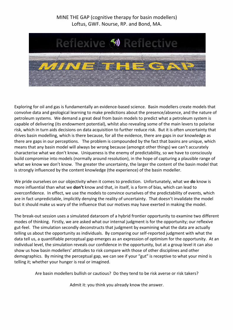
MINE THE GAP (cognitive therapy for basin modellers) Loftus, GWF. Nourse, RP. and Bond, MA.
Exploring for oil and gas is fundamentally an evidence-based science. Basin modellers create models that convolve data and geological learning to make predictions about the presence/absence, and the nature of petroleum systems. We demand a great deal from basin models to predict what a petroleum system is capable of delivering (its endowment potential), whilst also revealing some of the main levers to polarise risk, which in turn aids decisions on data acquisition to further reduce risk. But it is often uncertainty that drives basin modelling, which is there because, for all the evidence, there are gaps in our knowledge as there are gaps in our perceptions. The problem is compounded by the fact that basins are unique, which means that any basin model will always be wrong because (amongst other things) we can’t accurately characterise what we don’t know. Uniqueness is the enemy of predictability, so we have to consciously build compromise into models (normally around resolution), in the hope of capturing a plausible range of what we know we don’t know. The greater the uncertainty, the larger the content of the basin model that is strongly influenced by the content knowledge (the experience) of the basin modeller.
We pride ourselves on our objectivity when it comes to prediction. Unfortunately, what we do know is more influential than what we don’t know and that, in itself, is a form of bias, which can lead to overconfidence. In effect, we use the models to convince ourselves of the predictability of events, which are in fact unpredictable, implicitly denying the reality of uncertainty. That doesn’t invalidate the model but it should make us wary of the influence that our motives may have exerted in making the model.
The break-out session uses a simulated dataroom of a hybrid frontier opportunity to examine two different modes of thinking. Firstly, we are asked what our internal judgment is for the opportunity; our reflexive gut-feel. The simulation secondly deconstructs that judgment by examining what the data are actually telling us about the opportunity as individuals. By comparing our self-reported judgment with what the data tell us, a quantifiable perceptual gap emerges as an expression of optimism for the opportunity. At an individual level, the simulation reveals our confidence in the opportunity, but at a group level it can also show us how basin modellers’ attitudes to risk compare with those of other disciplines and other demographics. By mining the perceptual gap, we can see if your “gut” is receptive to what your mind is telling it; whether your hunger is real or imagined.
Are basin modellers bullish or cautious? Do they tend to be risk averse or risk takers?
Admit it: you think you already know the answer.

Session Four: Using Subsurface Data and Bain Modelling to Predict Source Rock
Characteristics

Integration of Seismic Inversion and Petroleum Systems modeling - Mapping the Kudu Source Rock in the Walvis and Orange Basins, Offshore Namibia.
Christian Niño GALP Teresa Martins (GALP), Astrid Fernandez (GALP), Sergio Cersosimo (GALP), Sara Pestana (GALP), Daniel Rodrigues (GALP), & Martin Zubiri (GALP)
Hydrocarbon exploration in frontier and emerging basins rarely count with data from source rock penetrations in the basin. Therefore, there are many uncertainties regarding the source rock geochemical properties (e.g. %TOC, HI), thickness, organofacies and overall, their Ultimate Expulsion Potential (UEP). So, when a Petroleum System Model is built the source rock properties are generally assumed after seeps, shows or basin analogs. In like manner, mapping of the source rocks has not always been a priority for seismic interpreters or exploration teams in small or mid-size companies. But, when the source rock has been drilled and geochemically characterized, mapping of the source rock should be a priority to track their areal extension, and variations in thickness and UEP. During the last decade the use of seismic inversion has proven to be of great help in this effort (Løseth et al, 2011; Broadhead et al. 2016; Niño-Guiza et al. 2016; Davison et al. 2018). Offshore Namibia, in the Walvis and Orange basins, the Wingat-1, Murombe-1 and Moosehead-1 wells drilled the whole section of the Aptian/Barremian Kudu source rock, providing an opportunity to study its regional changes in organofacies, UEP and maturity. Sampled %TOC values were plotted against P-Impedance values from wireline logs evidencing a relationship between high %TOC and low P-Impedance values (third degree inverse relationship), as reported in other basins by Løseth et al. (2011). On 3D data, the source rock signature can be clearly traced across the Walvis and Orange basins. A constrained sparse spike inversion was run, and the inverted P-Impedance volume was used as input for generating %TOC distribution maps within the area covered by 3D data. In the Walvis basin, the map reproduces the decrease in %TOC observed between Murombe-1 and Wingat-1 (from distal to more proximal basin positions), but interestingly it also suggests the continuity of very good %TOC values and thickness towards the north, where the basin depocenter is located. In the Orange basin, the results allow to track the excellent source rock facies drilled at Moosehead-1 and shows a region where it has been partially eroded. It was also observed an increase in P-Impedance than seems to be related more with a change in lithology (more marls and carbonates) than with a decrease in %TOC. The thickness and %TOC map obtained were integrated into the petroleum systems modeling to estimate the original UEP of the Kudu source rock, its present-day maturity and to define the areas where more oil should have been expelled. The workflow allowed identifying basin sweet spots where the risk of encountering a rich and mature source rock expelling hydrocarbon has been significantly reduced.

Prediction of Aptian to Albian-aged potential source rocks, offshore Suriname, from integration of local and regional subsurface data Andrew Dyson Cairn Energy Offshore Suriname forms part of an emerging petroleum province, with several recent and historical hydrocarbon discoveries. The oil in the recent offshore discoveries and existing onshore fields is believed to be sourced from the Latest Albian to Turonian-aged Canje Formation. A geological model for the deposition and preservation of an older Aptian to Albian aged source rock has been developed. During the Lower Cretaceous the geology of the basin was influenced by the ongoing transform margin rifting that was occurring throughout the Equatorial Atlantic. This episode resulted in a series of discrete rift basins in the eastern area of the offshore, unconformable with the underlying Central Atlantic drift sequence. Well penetrations within this rift sequence in Northeast Brazil show a good to excellent quality, restricted marine organic-rich interval. Previous authors have dated this stratigraphy as Late Aptian to Early Albian and related the high organic content to Oceanic Anoxic Event 1b. Source rocks of Lower Cretaceous age have also been documented on the conjugate African margin. At regional scale, the deposition and source potential of this interval appears to be controlled by tectonics and the resulting paleogeography, with the thickest and highest quality source facies within the depocentre of the rift basins. This interval has been interpreted on recently acquired 2D seismic data offshore Suriname, and the spatial distribution of these rifts has been mapped. There are limited well penetrations within this sequence, with only one historical exploration well intersecting the interval at the proximal edge of one of the mapped rifts. This well recorded oil shows through the section corresponding to the Late Aptian to Early Albian. Geological, geophysical and geochemical data were integrated to build a basin model which predicts that the observed hydrocarbon occurrences were mostly likely sourced by a nearby Aptian to Albian aged source kitchen. This suggests the presence of an active Lower Cretaceous petroleum system in the offshore area, which could deliver future hydrocarbon discoveries.

Session Five: Breaking Convention: Biogenic and Unconvenotional Modelling Case
Studies

Biogenic gas source rock potential evaluation. Case study: Block AD7 Myanmar Carolina Olivares1, Attila Juhász1, Jaehee Lee2, Kyong-Jin-Kim2 1 CGG Services (UK) Limited, Llandudno, North Wales, LL30 1SA, United Kingdom 2 Posco International, 165, Convensia-daero, Yeonsu-gu, Incheon, 21998, Korea Biogenic gas is becoming important as an exploration target in the petroleum industry because it occurs in geologically predictable circumstances and in large quantities at shallow depth (Rice, 1992). Accumulations of biogenic gas result from a subtle synchronisation between early generation and early trapping. To investigate the biogenic CH4 potential in a particular basin, a different petroleum system analysis approach is required than that used for conventional thermogenic gas, which is generated from kerogen and oil by cracking at high temperature. Methane also forms as a by-product of anaerobic microbial metabolism. Biogenic gases are characterised by exceptionally low concentrations of ethane and heavier hydrocarbons, and isotopically light methane carbon. The conditions needed to generate biogenic (microbial) gas are well documented. Methanogen microbes (Mesophiles) require organic matter and anoxic sulphate-free conditions at temperatures less than 75°C, which is assumed to be the pasteurisation threshold (Rice, 1992: Wilhelms et al., 2001). The remains of organisms that accumulated within sediments close to the surface are the main source of organic matter in these systems. A model of biogenic gas generation and accumulation has been developed in Myanmar (block AD7) using a combination of two modelling tools (Trinity and Petromod). The aim of the model is to understand petroleum system mechanisms at block scale and through geological time, incorporating geological and geochemical processes, in order to support exploration strategies and evaluate trapped biogenic gas resources. Block AD7 is located in the Rakhine Basin, offshore Myanmar in the Bay of Bengal and has a Tertiary clastic sedimentary fill of several kilometres. The Rakhine is subdivided into a structurally complex onshore and offshore shelf area and a poorly structured deepwater area. There are potential natural gas reserves discovered at depth offshore of the studied block, therefore an understanding of the biogenic generation process in areas with thick and relatively young Cenozoic stratigraphy is critical to properly evaluating offshore Myanmar gas potential Analysis of the thermal gradient and sedimentation rate allows the potential biogenic gas source rock to be defined. Sedimentation rates, geothermal gradients and heating rate maps within a Neogene sequence were generated according to the biogenic gas generation model (Clayton, 1992) (Figure 1). Structural grids from key horizons (seabed to basement), together with well data to calibrate the thermal model and rock properties, were used in order to build the model. Geochemistry data was utilised to characterise the gas discovery in the block and extract source rock properties. Three 1D models were run to produce the thermal history and calibrate compaction/pressure. Then, a high resolution 3D model was constructed (Figure 1), incorporating depth maps (55) covering time steps from 0-100 Ma, horizons (40), events (55) and lithofacies (14). This provided an appropriate thermal model to generate temperature, heating rate and biogenic potential maps. A classic heat flow model of rifting and subsequent cooling through time, together with several paleo-water depth and sediment water interface maps (top of the main horizons) was created as part of the boundary conditions requirement. Several biogenic source rock intervals ranging in age from Pleistocene to Late Miocene were identified. A pseudo-kinetic first order reaction (Zetaware-Kinex) modelling the temperature range of the biogenic gas generation was incorporated to each of the source rocks modelled, with Trinity and Petromod tools used to obtain temperature and heating rate maps. The thermal gradient and sedimentation rate maps were multiplied to generate a heating rate map for each source rock interval. These maps display an overview of the biogenic gas generation potential. To discriminate zones with or without biogenic gas potential, heating rates

(7°C/Ma-18°C/Ma) and temperature thresholds (~50°C) from the Clayton (1992) model were applied to the respective maps. A ‘traffic light’ criteria using those threshold values was generated and applied to the maps: green zones represent a high probability of biogenic gas occurrence, yellow-orange a probable occurrence while red indicates no biogenic potential. According to the simulations, the shallow biogenic gas source rocks (mostly Pliocene) at present day exhibit the highest probability of biogenic gas generation in the whole block. On the contrary, the Miocene source rocks (deepest) have less chance of biogenic gas generation, with limited potential in patchy areas within the block. Notably, some of the Miocene source rocks are beyond the pasteurisation temperature. The simulated hydrocarbon composition indicated that the gas (biogenic) dominates the shallow plays from the Pliocene to Late Miocene. Other factors, such as trap formation timing, seal effectiveness and reservoir presence need to be taken into account to fully evaluate and quantify biogenic gas prospects.
Figure 1: Workflow showing the different steps and models (Clayton, 1992, 1D & 3D) used/built to obtain and evaluate the source rock biogenic gas potential in block AD7. References Clayton, C., 1992. Source volumetrics of biogenic gas generation. In: Vially, R. (ed.), Bacterial gas. Paris, Editions Technip, 191-204. Rice, D.O., 1992. Controls, habitat and resource potential of ancient bacterial gas. In: Vialy, R. (ed.), Bacterial gas. Paris, Editions Technip, 91-118. Wilhelms, A., Larter, S.R., Head, I., Farrimond, P., Di Primio, R., Zwach, C., 2001. Biodegradation of oil in uplifted basins prevented by deep-burial sterilization. Nature, 411, 1034-1037.

Modelling Biogenic Gas Production at the Basin Scale: Application to the Bay of Biscay Martina Torelli1, Isabelle Kowalewski1, Veronique Gervais1, Johannes Wendebourg2, Sylvie Wolf1, Stéphanie Dupré3, Claude Gout4, Eric Deville1 1 IFP Energies Nouvelles, Geology Department, Geosciences Division, 1 & 4 Av. de Bois-Préau, 92852 Rueil-Malmaison Cedex, France 2 TotalEnergies, Exploration Americas, Houston, TX, 77027, USA 3 Ifremer, Marine Geoscience Division, 29280 Plouzané Cedex, France 4 Total, Exploration and Production, Research and Development, Pau cedex, France Biogenic gas has received increasing attention in the last few decades as a major and cleaner fossil energy source (Rice 1992; Katz 2011). Despite the growing interest for biogenic methane gas, its generation mechanisms are still not well understood. It is accepted that biogenic methane formation is controlled by primary productivity, thermal gradient and sedimentation rate (Clayton 1992) as well as environmental conditions of microorganisms mediating the reaction (Boetius et al. 2000). However, the efficiency of the production process is largely determined by biogeochemical mechanisms at the sea bottom that depend on the quality and quantity of the Sedimentary Organic Matter (SOM). Numerical modelling experiments are a relevant means to study the interaction of the various processes leading up to biogenic gas generation and accumulation. It can be used to critically evaluate and discuss the meaning and the role of the main parameters of biogenic gas occurrence. Here, we apply a new numerical approach to simulate biogenic methane production at the basin scale (modified after Pujol et al. 2016) to the Bay of Biscay (south-western coast of France) where methane gas seeps have been discovered at 140-220 m of water-depth (Dupré et al. 2014). The carbon isotope signature of this methane indicates that the system is charged by biogenic gas generated from CO2 reduction (Ruffine et al. 2017). However, the amount of emitted gas along different sites of the shelf break is extremely heterogeneous which might be linked to the variable quality and content of the bedrock, to temperature variations and/or to transport/migration processes. The main objective of this study is to better understand the evolution of methane generation and migration at the basin scale using numerical modelling of biogenic gas production applied to an extensional basin. Possible origins of the methane are discussed (present-day active system or ancient accumulation) and the total amount of emitted gas over time is assessed. The conceptual approach to simulate biogenic gas production accounts for (1) the degradation of a labile-SOM fraction to methane (2) the first order kinetics for the activation and degradation of a thermo-labile-SOM fraction into labile fraction at greater burial and (3) the decrease of reactivity of SOM with time. Finally, the generated gas is distributed in the basin as either adsorbed in the organic matter, dissolved in water, or as free gas in a vapor phase (in decreasing order of importance). One of the main difficulty of this approach is to assess the distribution of the labile and thermo-labile TOC in terms of SOM quality. In order to better describe the organic matter deposited in the study area, Rock-Eval analyses were performed on cuttings collected from different wells. Results show that the system is charged by gas from a type III continental-derived SOM which is very immature (Tmax < 425°C). A sensitivity analysis was also performed on the model input critical parameters to discriminate and quantify their impact on the final biogenic gas production and expulsion/migration processes. This was achieved using machine learning techniques to limit simulation times (Gervais et al., 2018). 2 The 3D basin model of the Bay of Biscay covering an area of 2800 km² is built with 29 main horizons that were created from seismic interpretations and well log correlations. The horizontal resolution of the model is 1x1 km². The thermal and pressure history of the basin is constrained by bottom hole temperature, vitrinite data and pressure measurements from exploration wells. The shallower layers were characterized by the deposition of methane derived-authigenic carbonates over time to mimic the effect of the Anaerobic Oxidation of Methane (AOM) during the methane upward migration. The source rocks are modeled in the Plio-Pleistocene and Miocene layers (Michel 2017), ranging from 350 m to 1500 m depth below the present-day seafloor, with different initial TOC values derived from Rock-Eval data.

Our results show that the generated methane is mainly transported as dissolved phase in water formation and released as free gas phase at the water-sediment interface. Migration pathways are mainly sub-vertical, from the Plio-Pleistocene source rocks directly to the seafloor controlled mainly by sediment permeability. The model can reproduce observed natural processes such as gas migration along the seepage area. The origins of the biogenic methane, which is charged by a present-day active system sourced by Miocene to Plio-Pleistocene sediments are discussed and a first quantification of the total amount of emitted gas into the water column over time is assessed and compared with estimates from in situ bubbling sites (Dupre et al. 2020). References Boetius, A.; Ravenschlag, K.; Schubert, C. J.; Rickert, D.; Widdel, F.; Gieseke, A. et al. (2000): A marine microbial consortium apparently mediating anaerobic oxidation of methane. In Nature 407 (6804), pp. 623–626. DOI: 10.1038/35036572. Clayton, C. (1992): Source Volumetrics of Biogenic Gas Generation. In Bacterial Gas, 1992, pp. 191–204. Dupré, S.; Berger, L.; Le Bouffant, N.; Scalabrin, C.; Bourillet, J.F. (2014): Fluid emissions at the Aquitaine Shelf (Bay of Biscay, France). A biogenic origin or the expression of hydrocarbon leakage? In Continental Shelf Research 88, pp. 24–33. DOI: 10.1016/j.csr.2014.07.004. Dupré, S. Loubrieu, B. Pierre, C. Scalabrin, C. Guérin, C. Ehrhold, A. Ogor, A. Gautier, E. Ruffine, L. Biville, R. Saout, J. Breton, C. Floodpage, J. Lescanne, M. (2020) The Aquitaine Shelf Edge (Bay of Biscay): A Primary Outlet for Microbial Methane Release. Geophysical Research Letters 47 (7):e2019GL084561. doi:10.1029/2019gl084561. Gervais, V.; Ducros, M.; Granjeon, D. (2018): Probability maps of reservoir presence and sensitivity analysis in stratigraphic forward modeling. In AAPG Bulletin, 102(4), pp. 613-628, DOI: 10.1306/0913171611517242 Katz, B. J. (2011): Microbial Processes and Natural Gas Accumulations. In TOGEOJ 5 (1), pp. 75–83. DOI: 10.2174/1874262901105010075. Michel, G. (2017): Mise en place et pérennisation d'un vaste système fluide microbien sur le plateau aquitain. Caractérisation et facteurs de contrôle. Paris 6. Pujol, A.; Rouchon, V.; Ravin, A.; Wolf, S.; Blanchet, D.; Ducros, M.; Maurand, N. (2016): Simulation of Anaerobic SOM Biodegradation and Biogenic Methane Production for Basin Modeling. AAPG Hedberg Conference. Santa Barbara, California, 2016. Rice, D. D. (1992): Controls, habitat, and resource potential of ancient bacterial gas. In Bacterial Gas, 1992, pp. 91–118. Ruffine, L.; Donval, J.P.; Croguennec, C.; Bignon, L.; Birot, D.; Battani, A. et al. (2017): Gas Seepage along the Edge of the Aquitaine Shelf (France). Origin and Local Fluxes. In Geofluids 2017 (66), pp. 1–13. DOI: 10.1155/2017/4240818.

Discrepancies in petroleum systems modeling and petroleum production within liquid rich unconventional resource plays: Understanding external contribution and fluid chemistry Michael Abrams Imperial College London The unconventional resource (UCR) play concept assumes that either the petroleum source and reservoir are the same, or the thermally mature source rock is inter-bedded and/or juxtaposed to a tight reservoir. Hence no traditional traps or long distance migration is required, just an organic rich source within the optimal maturity window. Examination of long term production histories for multiple prolific UCR plays indicate production GOR and petroleum type do not always match the petroleum system predictive models. Possible explanations for these production discrepancies include uncertainties in source rock character, primary migration fractionation, fractionation related to storage, and/or production fractionation. Examination of regional geochemical data and petroleum systems modeling suggests that off-structure generated petroleum contribution can be a significant factor in liquid rich UCR production. Evaluation of production fluids and rock maturity data from the Woodford Shale Anadarko Basin unconventional play demonstrate these discrepancies. The produced fluids contain middle boiling point hydrocarbons interpreted to be from a high maturity source. In contrast, interpretation of the high molecular weight fraction suggests a mid-mature source. Data from both fractions are consistent with a Woodford Shale Type II source rock facies. The production GOR and well head fluid gravities are more typical of a gas-condensate system. Regional maturity maps based on multiple measurements indicate the local Woodford Shale maturity is within the low to middle maturity window. The fluid geochemical data does not support sampling/storage problems or production phase separation. The significant discrepancies between components of the produced oil, source/reservoir rock maturity, and production is best explained by the addition of external off-structure charging. Low permeability reservoirs are more sensitive to reservoir phase changes. In a single phase reservoir system (above saturation pressure), production GOR will increase significantly once the reservoir pressure falls below saturation pressure and becomes a two phase system. The gas is preferentially produced due to relative permeability resulting in a significant decrease in liquid production and ultimate recovery. Saturation pressure is controlled by fluid chemistry and hence will be impacted by the mixing of in-situ generated petroleum enriched in the higher molecular weight compounds and off-structure petroleum enriched in the lighter boiling point compounds. A UCR petroleum systems model based on the local source rock organic matter type and maturity may not correctly predict production type and ultimate recovery. If the liquid rich UCR play is a well behaved (produced petroleum locally generated), then the generation product can be estimated with an understanding of the local organic matter type and level of maturity. But if the UCR play is a not well behaved (mix of local and off-structure charge), then a more complicated petroleum systems charge model will be required to estimate production rates (fluid type and production GOR) as well as ultimate recover. Liquid rich UCR plays are not always a simple self sourcing organic rich source rock reservoirs. If your petroleum system models do not take this complexity into account, it will fall short when predicting reservoir phase, in place liquid volumes, and ultimate recovery.

Maturation history modeling of the petroleum systems of the Williston Basin, USA SarahGelman USGS Kristen Marra (USGS) The Williston Basin hosts the world-class unconventional Devonian-Mississippian Bakken petroleum system, in addition to several other postulated and proven source rocks. Hydrocarbons generated from these various sources (including the Ordovician Icebox Formation and kukersites of the Red River Formation, the Devonian Winnipegosis Formation, the Devonian-Mississippian Bakken Formation, the Mississippian Madison Formation, and Pennsylvanian Tyler Formation) have been produced in reservoirs spanning nearly all sedimentary strata in the basin, from oil and gas in the Cambrian-Ordovician Deadwood Formation to shallow gas in the Upper Cretaceous Pierre Formation. To support updated assessments of potential undiscovered hydrocarbon resources in the Williston Basin, a 3D petroleum systems model has been constructed, focusing on the thermal and maturation history of these stacked source rocks. While modern heat flow can be calibrated from tens of thousands of wells with temperature data, paleo-maturation history and peak maturation are strongly influenced by poorly-constrained assumptions of Laramide-age erosion. To better calibrate peak burial, the maturity of the upper and lower source rocks of the Bakken was calibrated to a large database composed of public and USGS Rock Eval data, with scenarios and implications for appropriate source-rock kinetics. Dependent on the modeled timing and amount of erosion, hydrocarbon generation from the Bakken generally peaks by the onset of Laramide-associated erosion in the Eocene, then declines to negligible generation at present-day. Modeled Bakken oil saturates the middle part of the Bakken and underlying Three Forks Formation in areas geographically comparable to oil production from those respective reservoirs. Results from the model and its scenarios provide additional suggestions and controls for either mixing or isolation of various petroleum systems (including the Cambrian-Ordovician Deadwood-Winnipeg, Ordovician Red River, Devonian Winnipegosis and Duperow, Mississippian Madison and Pennsylvanian Tyler) in the Paleozoic section.

KEYNOTE: Top-down Petroleum System Analysis and Fluid Property Prediction Zhiyong He1, Andrew Murray2, Julian Moore3 1. ZetaWare, Inc. Sugar Land, Texas, USA 2. Murray Partners PPSA Pty. Ltd. Perth, Australia. 3. APT UK limited, United Kingdom Recent studies based on large fluid datasets in the geo-spatial petroleum system context have demonstrated that the dominant control on properties of HC fluids are the source rock organo-facies and migration fractionation under PVT conditions (He and Murray 2019, Murray and He 2019, He and Murray, 2020). Source rock maturity only plays a tertiary role, and only important in unconventional settings.
Figure 1 Left: Global GOR vs depth trends. Right: GOR vs depth for the North Sea. These trends are consistent with global pvt date that they are a result of phase separation and migration fractionation and argue against the general notion that gas is a high maturity product. After it is generated, the petroleum fluid undergoes many secondary processes that change both its composition and properties: expulsion fractionation, fractionation of fluid properties due to phase separation, compositional grading, and charge disequilibrium, and other secondary effects such as secondary cracking, biodegradation and water washing. Many of these processes are not well understood, and not considered in basin models. Thus, predicting fluid phase and properties in a prospect is impossible using the traditional the bottom-up deterministic approach. In this paper, we present several example studies of the Top-down Petroleum System Analysis approach we have been advocating, to demonstrate its practical application, and compare with traditional basin modeling. The West of Shetland basin is a system dominated by the oil prone (organo-facies B) Kimmeridge source rock. But it has a complex geological history that involves significant igneous activities. Previous basin modeling work has shown that the source rock generated oil in the late Cretaceous and has been in gas window and over mature since then. The dilemma is that significant oil accumulations are found in reservoirs deposited post oil generation, and the system is dominantly oil with a system GOR of ~1800, with only some small gas discoveries. We will show that it is natural for such systems to have low system GORs regardless of maturity, and migration lag concept calls for ongoing secondary migration. We will also show that the GOR of the oil accumulations, and the CGR of the gas pools are consistent with phase separation process, so the gas is separated from oil as a function of pressure, rather than a product of high maturity. This also leads to the ability to predict GOR and CGR in prospects, based on the

current burial depth. The Sales 1997 models can also be used to predict the chance of finding oil vs gas in a given prospect. The ongoing exploration in the Guyana-Suriname basin have shown complexities in the fluid types found so far, from heavy oil, black oil, volatile oil and gas condensate. Compiling and analyzing press release information and other public source data into a Top-down PSA geospatial database, we can arrive at several important conclusions about the petroleum system. From a PVT/phase perspective, based on the depth (estimated pressure) of the gassy reservoirs, they would likely plot far away from the dew point curve, and not likely phase separated, but from a different gassy source (no, it is not maturity related). The press releases also describe near critical fluids, with odd API/GOR pairs, another indicator of mixed source. The geo-spatial extent of the fluid types and their relationship to the geological controls also tell a story about biodegradation, charge focusing, main trapping style and charge risks in the different blocks. Select References: He, Zhiyong, and Andrew Murray, 2019, Keynote presentation, Top-Down Petroleum Systems Analysis and Geospatial Patterns of Petroleum Phase and Properties. Celebrating the life of Chris Cornford (1948-2017): Petroleum Systems Analysis ‘Science or Art?’ The Geological Society, 24 - 25 April 2019 He, Zhiyong, and Andrew Murray, 2019, Top Down Petroleum System Analysis, Exploiting Geospatial Patterns of Petroleum Phase and Properties. AAPG Annual Convention, San Antonio, May 19-21, 2019 Murray, Andrew and Zhiyong He, 2019, Keynote presentation, Oil vs. gas: What are the limits to prospect-level hydrocarbon phase prediction? AAPG Hedberg Conference, The Evolution of Petroleum Systems Analysis, March 4-6, 2019 – Houston, Texas He, Zhiyong, and Andrew Murray, 2020, Migration Loss, Lag and Fractionation: Implications for Fluid Properties and Charge Risk, AAPG Annual Convention and Exhibition, September 202, Houston, Texas Krawczynski, Lukasz, Andrew Murray and Zhiyong He, Oil Potential in Gas Prone dominated Petroleum Systems, May 2021, Geosciences Technology Workshop Advanced Petroleum Systems Analysis, Perth Australia Murray, Andrew, and Zhiyong He, Keynote presentation, Oil by exception: Where and why oil occurs in the gassy petroleum systems of the NW Shelf of Australia, May 2021, Geosciences Technology Workshop Advanced Petroleum Systems Analysis, Perth Australia

Session Six: Communicating Results: Dealing with
Predicted Risk & Uncertainty
Probabilistic BPSM for decision making – Where is the balance between complexity, uncertainty, and practicality?
Martin Neumaier (1), Ben Kurtenbach (1), Arnold Neumaier (2) (1) ArianeLogiX, Germany (2) University of Vienna, Austria
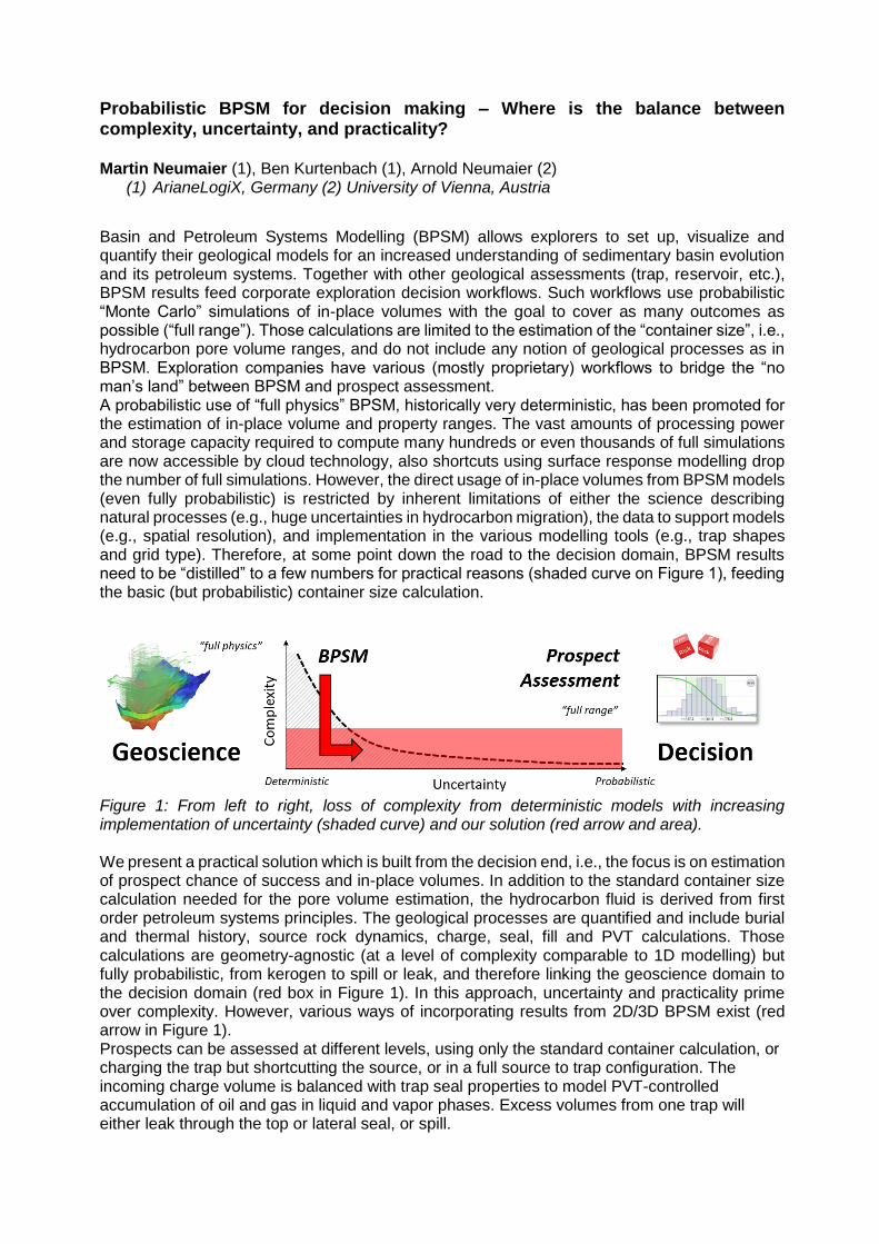
Basin and Petroleum Systems Modelling (BPSM) allows explorers to set up, visualize and quantify their geological models for an increased understanding of sedimentary basin evolution and its petroleum systems. Together with other geological assessments (trap, reservoir, etc.), BPSM results feed corporate exploration decision workflows. Such workflows use probabilistic “Monte Carlo” simulations of in-place volumes with the goal to cover as many outcomes as possible (“full range”). Those calculations are limited to the estimation of the “container size”, i.e., hydrocarbon pore volume ranges, and do not include any notion of geological processes as in BPSM. Exploration companies have various (mostly proprietary) workflows to bridge the “no man’s land” between BPSM and prospect assessment. A probabilistic use of “full physics” BPSM, historically very deterministic, has been promoted for the estimation of in-place volume and property ranges. The vast amounts of processing power and storage capacity required to compute many hundreds or even thousands of full simulations are now accessible by cloud technology, also shortcuts using surface response modelling drop the number of full simulations. However, the direct usage of in-place volumes from BPSM models (even fully probabilistic) is restricted by inherent limitations of either the science describing natural processes (e.g., huge uncertainties in hydrocarbon migration), the data to support models (e.g., spatial resolution), and implementation in the various modelling tools (e.g., trap shapes and grid type). Therefore, at some point down the road to the decision domain, BPSM results need to be “distilled” to a few numbers for practical reasons (shaded curve on Figure 1), feeding the basic (but probabilistic) container size calculation.
Figure 1: From left to right, loss of complexity from deterministic models with increasing implementation of uncertainty (shaded curve) and our solution (red arrow and area).
We present a practical solution which is built from the decision end, i.e., the focus is on estimation of prospect chance of success and in-place volumes. In addition to the standard container size calculation needed for the pore volume estimation, the hydrocarbon fluid is derived from first order petroleum systems principles. The geological processes are quantified and include burial and thermal history, source rock dynamics, charge, seal, fill and PVT calculations. Those calculations are geometry-agnostic (at a level of complexity comparable to 1D modelling) but fully probabilistic, from kerogen to spill or leak, and therefore linking the geoscience domain to the decision domain (red box in Figure 1). In this approach, uncertainty and practicality prime over complexity. However, various ways of incorporating results from 2D/3D BPSM exist (red arrow in Figure 1). Prospects can be assessed at different levels, using only the standard container calculation, or charging the trap but shortcutting the source, or in a full source to trap configuration. The incoming charge volume is balanced with trap seal properties to model PVT-controlled accumulation of oil and gas in liquid and vapor phases. Excess volumes from one trap will either leak through the top or lateral seal, or spill.

Those leak and spill volumes can feed other traps. This requires specifying the geometrical relationship between traps via possible migration pathways. In our approach, such a fluid migration network is set up is similar to drawing scenarios on a whiteboard, in a map view on top of a base map or along a cross section (Figure 2). The reasoning behind the fluid migration network might be based on BPSM results, or simply a conceptual model, backed up with seismic data where carrier beds, faults, gas chimneys etc. are visible.
Figure 2: Simplified fluid migration network in map view (A) and cross section view (B). The quantification of the parameters for different sources and traps is done in a dashboard where all inputs and output puts can be viewed, organized along a process-oriented “Ariane’s thread” (Figure 3). Usually, the calculations are first done deterministically to understand the interaction between parameters, and to model different scenarios. Then uncertainty can be assigned to any input (e.g., maximum burial, initial TOC, migration losses, seal capacity, trap and reservoir parameters, etc.) and a full Monte Carlo simulation is triggered. This results in probabilistic output such as charge volume and composition, in-place volume, leak and spill amounts, etc. as well as frequencies (e.g., how often there is a gas cap). Such an assessment with naturally occurring fluid dependencies are a great step forward in the integration of petroleum systems processes in consistent and transparent prospect assessment workflows.
Figure 3: Dashboard view of a trap along an Ariane’s thread.

Some novel thoughts on risk analysis Douglas Waples Sirius Exploration Geochemistry, Denver, CO USA The most-important input for risk analysis is, perhaps surprisingly, words (and the ideas they represent), rather than numbers. Quantification of a risk-analysis narrative is, of course, expected and essential, but numbers are not the focus of this talk. Nevertheless, two crucial points about numbers are worth mentioning here, but without further elaboration. The first point is that any quantitative analysis must be based on Bayesian principles, in which the Base Rate is our starting point, and quantity, quality, and relevance of all information (data and ideas) are used properly to justify all deviations from the Base Rate. Any approach that fails to honor the spirit of Bayesian statistics is inherently inferior. Words are the key to molding ideas into a clear narrative, which in turn provides the foundation on which any risk analysis should be constructed. The human System 1 cognition is capable of creating fascinating and valuable narratives, but the building blocks that System 1 uses are best sorted, QC’d, and linked into manageable and meaningful bundles by our rational System 2. It is these edited packages that System 1 should be using to construct the foundational narrative. Without a coherent, comprehensive, and factually accurate narrative, any risk analysis is at best simply guesswork, analogous to the proverbial monkey playing with a typewriter. At worst, if the creation of an incorrect narrative is intentional or the result of professional negligence, the error could be viewed much more unfavorably. No, I’m not kidding. Thus, the second crucial point about quantitative risk analysis is that it must be honest, scientific, and completely free from political pressures. Equal respect must be paid to negative and positive answers. There must be no predetermined outcome that biases or distorts the statistical analysis. Donald Rumsfeld famously referred to the dangers of “unknown unknowns”. This valuable characterization should have served as a wake-up call for the BPSM community, that it is not enough to worry simply about numerical risk factors. One should be constructing and utilizing a complete and coherent narrative that enables us to see interrelationships among all the chapters in the story. The main focus of this talk is to show the value of creating a sound narrative as an early step in petroleum-system analysis and risk evaluation. First, in my opinion we should discard any name for this process that includes the term “petroleum system”, because that name is too limiting, and causes us to focus too early and too much on hydrocarbon generation and migration, as well as on other isolated components of the system, such as reservoir, seal, and trap. Instead, we should think simultaneously about all aspects of the geological history of the study area; on the common threads that link those various aspects; and on the narrative that emerges when we carefully assemble those pieces. I call this process “Integrated Geohistory Analysis” (IGA) because it makes eustatic geohistory plots the central focus of the narrative and analysis, and weaves together the entire story (including plate and local tectonics; analysis of sediment sources and types through time; depositional and erosional processes, including causes and rates; eustasy and isostasy; heat-flow histories; diapirism and related processes; and igneous and hydrothermal events) in a coherent and meaningful way. IGA can be carried out by any exploration geologist who has been properly trained in the new ways of thinking that are required by this approach. This presentation provides an example of the IGA approach illustrated in a full exploration context for the Corozal Basin of northern Belize, Central America. This example shows how IGA was able to correct numerous incorrect earlier assumptions and interpretations (resulting in a much-more comprehensive and powerful narrative), and to use that narrative and the corresponding conceptual model to move forward with an improved exploration program. The new model can then be used for better risk analysis than was possible in the past with a greatly inferior geological model.

Eustatic geohistory plot of the San Marcos-1 well in Belize. Red line is tectonic subsidence; black line is total subsidence. Cyan shows sea water; top of cyan (or cyan line during non-marine periods) shows sea level variation through time. Yellow layer is the non-marine/marginally marine Red Bank group. Sandstone reservoirs are within the lilac Upper Triassic strata near the bottom of the section. Surface exposure during the Cenozoic was caused by a long fall in sea level rather than by uplift.
Eustatic geohistory plot with tectonic subsidence

KEYNOTE: Drivers for the Future of Basin and Petroleum Systems Modelling - Challenges & Opportunities in an Accelerating Energy Transition
Neil Frewin Shell International Ltd.
Basin and petroleum systems modelling technologies founded on fundamental geoscience have been under development since the mid-nineties. The forward modelling of basin histories, including the physics and chemistry of long-term geological processes, have been transformative in the prediction of rock properties and fluid evolution. The exploration for new resources has been particularly well served by forward modelling at a basin, play and prospect scale, and as computational capacity has increased.
Nevertheless, the energy industry is rapidly transitioning as the impact of carbon emissions on climate change is becoming ever more apparent. The net zero emissions goals established by the inter-governmental Paris Agreement call for robust action in a world where demand for cheap, plentiful energy remains strong and where hydrocarbons constitute over 50% of global energy supply. With a pivot away from the exploration and development of hydrocarbon resources being driven by governmental policy, company strategy and societal pressure in an increasing number of jurisdictions, is our historical investment in a detailed understanding of a petroleum system now being rendered redundant?
Arguably, the geodynamic foundations alongside advances in 3D rock property and fluid flow simulations inherent in modern basin models will continue to lend themselves to an understanding of the subsurface across a range of applications in an energy transition. From carbon-optimised oil and gas portfolios (“advantaged hydrocarbons”), to carbon capture & energy storage, to geothermal, the tools developed to sustain a predictive understanding of the subsurface could be of huge value.

Session Seven: Linking Basin Modelling with Other Disciplines – Novel Applications of
BPSM Techniques

Choices in benchmarks, models, and guestimates of hydrocarbon columns Ebbe H. Hartz Aker BP Peder Aursand (Aker BP) Yuriy Ivanov (Aker BP) As researchers or explorationists we make numerous deliberate on unconscious choices in our technical evaluations. Our postulate is that these choices have an under-communicated effect on the results of most aspects of Earth analysis (perhaps science in general) but here we illustrate this by focusing on hydrocarbon columns in fault sealed traps. A classical benchmark dilemma is ensuring that we compare ‘apples to apples’. Even when benchmarking columns in discoveries we are faced with fundamental choices, beyond the classic topics of oil/gas up and down to situations, and all of these choices can fertilize ‘base rate neglect’ (ignoring experience) or skewed by over-optimism or confirmation bias. Most fundamental, what is a column and how should it be quantified? Yes, we found 90 m with oil, but is it a 90m column, or 3 columns of 30 meters? Is meters hydrocarbon column even a useful benchmark quantification? Should we rather use buoyancy pressure (bP), bP* interfacial tension or maybe m3 hydrocarbon per m2 area? What controls these parameters, how can they be compared and what should the be plotted against? Depth, if so, what kind of depth? These choices re-emerge in predictive models of fault-sealed columns which typically focus on the shale content in the fault (shale gauge ratio, SGR). Often the modeler will choose a model tying SGR to bP, yet these published models will return highly different results depending on depth and hydrocarbon type. Our postulate is that the influence of hydrocarbon parameters is under-communicated in most of these analyses and suggest that at least a hydrocarbon phase diagram is a prerequisite for proper column estimates. Furthermore, we point to the availability bias in that that low SGR (low capillary entry pressure), may not be the reason hydrocarbons leak out of fault traps. As a test of how a group of trained explorationists guestimate columns, we presented producing fields (with known parameters) disguised as prospects, and asked participants to draw their column estimate as a distribution on a given x-axis. Half of the audience had 800 m as max on the x-axis and half had 400 m. Overall, the column estimates were reasonable, but the two groups column estimates were clearly skewed towards the center of the axis. The audience was then grouped to discuss the estimates, but it did not mitigate the anchoring bias. It may not surprise that human factors, in form of choices, have a strong influence on quantitative evaluations in pre-well models, and even discovery evaluations, but how do we mitigate this? Perhaps the first step is the awareness that choices and the bias (or ignorance) they are based on, influence us all. Naturally it would be good if we could eliminate some choices by correctly agreeing to the ‘right choice’, but debating what the ‘right choice’ is fundamental to science, so we argue that one should at least carefully present the choices that represent the premise for the given analysis, along with the analysis, and then keep discussing the science behind our choices.

Petroleum system modeling approaches for marine mineral systems Lars Ruepke GEOMAR Helmholtz Center for Ocean Research Kiel, Germany, Governments and private companies are progressively turning towards the seabed for securing future demands in raw materials. Naturally, the petroleum industry with its expertise in offshore exploration is also evaluating options. For marine mining to become reality, major environmental, regulatory, and technical challenges need to be resolved. Most pressing is a lack in robust and comprehensive environmental baseline studies and studies addressing possible mining impacts – but we are also lacking reliable assessments of the total metal endowment and tools for finding specific targets within larger exploration areas for making informed decisions. In oil and gas exploration, such assessments are supported by the use of basin and petroleum system modeling (BPSM). The analogous Mineral Systems Modelling (MSM) concept is, however, still in its infancy - although there are remarkable similarities in the underlying concepts: generation/expulsion, secondary migration, and trap/top seal in the case of oil & gas vs. metal mobilization from source rocks by hot fluids, metal transport by the fluid, and metal re-deposition in the case of mineral systems. In this talk, I will outline and discuss the potential and possible limitations of bringing BPSM to marine mineral systems using submarine massive sulfide (SMS) deposits, a special type of ore deposits rich in Copper, Zinc, Gold and Silver and formed by high-temperature submarine hydrothermal systems, as an example. I will review the state of existing concepts for metal mobilization, transport, and deposition and outline possible pathways towards BPSM-inspired mineral system modeling.

Recent advances in computational geosciences Boris Kaus Institute of Geosciences, Johannes-Gutenberg University Mainz (Germany) & SmartTectonics GmbH Tobias Baumann (SmartTectonics GmbH & Institute of Geosciences JGU Mainz) Anton Popov (Institute of Geosciences, JGU Mainz & SmartTectonics GmbH) Georg Reuber (Institute of Geosciences, JGU Mainz) Arne Spang (Institute of Geosciences, JGU Mainz) Lukas Holbach (Institute of Mathematics, JGU Mainz) Martin Hanke-Bourgeois (Institute of Mathematics, JGU Mainz) Our ability to model geological processes such as basin formation, rifting, salt tectonics or lithospheric collision has dramatically improved in recent years. As a result, it is now possible to simulate scenarios in 3D while taking the visco-elasto-plastic rheology of rocks into account. Yet, challenges remain as 1) the resulting forward simulations rarely reproduce observed data and 2) typical simulations involve a lot of uncertain model parameters and the effect of such uncertainties on the model outcome often remains unclear. Here, we give an overview of recent progress that allow addressing both challenges. First, geodynamic inverse modelling approaches have been developed that allow for a direct coupling of forward models with data, using either Bayesian or gradient-based inversion methods. Second, adjoint-based methods to compute gradients of the model results with respect to their parameters can be shown to be a powerful and computationally efficient way to automatically assess the sensitivity of model results to parameter uncertainties. Combined, this gives us new tools to perform physics-based models of geological processes and determine which model parameters are of key importance and which only play a second-order role. It also allows fitting models to observations using inverse approaches. We will discuss examples of doing this for salt tectonics, to estimate stresses within sedimentary basins and to understand magmatic systems.

Session Eight: Basin Modelling for C02 and CCS

Multi-scale cap rock assessment for CO2 storage, insights from the Northern Lights project (Norwegian Continental Shelf) Renata Meneguolo Equinor ASA, Stavanger, Norway Nicholas Thomson (Equinor ASA, Trondheim, Norway) , Anja Sundal (Department of Geosciences, University of Oslo, Norway), Helge Hellevang (Department of Geosciences, University of Oslo, Norway) Evaluation of a geological CO2 storage site relies on a detailed characterisation of the cap rock to assess storage resource and integrity, and to define operational limits. The sequestration concept for the Northern Lights CO2 transport and storage project in the Norwegian North Sea is injection down dip in a sloping semi-regional saline aquifer, with the sandstones of the Early Jurassic Cook and Johansen formations as storage units capped by the Drake Fm. shales and mudstones (Dunlin Group). The multi-scale assessment of the top seal included the examination of its seismic response as proxy for its presence and properties, dedicated data acquisition and testing program in the verification well 31/5-7 (Eos). Extended leak-off testing (XLOT) for in situ stress measurements was performed, and one geological core was collected (3.2 m) to determine the cap rock mechanical behaviour. In the cap rock succession, a vertical variation in the stress regime is suggested from sonic logs. This postulated stress contrasts are reflected in the seismic response and is postulated to be the product of a change in composition and subsequent rock mechanical processes, shifting from kaolinite-rich in the lower and upper part with an illite-rich interval in the middle part. Clay minerals assemblage and relative amount in the central part of the Drake Fm. is considered within the range for creeping rock mechanical behaviour. This leads to a more isotropic in-situ stress condition and subsequently higher minimum principal stress within this zone. Furthermore, compositional results were also implemented in geochemical simulations with the aim to investigate the interaction of the cap rock minerals with CO2-enriched brine. The presence of Fe-chlorite combined with the brine chemical composition and relatively high temperatures indicates high geochemical reactivity, providing positive indications for top-side sealing potential. The assumed lateral persistence of the positive rock mechanical behaviour coupled with potential for self-healing result in strong indications of good sealing capacity, compatible not only for the initial phase of the Northern Lights project but also for the upscaling ambition of the world's first open-source CO2 transport and storage infrastructure.

Time-Lapse Seismic Imaging and Fluid Dynamics of CO2 Storage at the Sleipner Field, North Sea Nicky White & Jerome Neufeld University of Cambridge Time-lapse, three-dimensional (3D) seismic surveys have imaged an accumulation of injected CO2 at the Sleipner field of the North Sea basin. In this long-running experiment, changing patterns of reflectivity suggests that CO2 has been accumulating within interbedded sandstones and mudstones beneath a thick caprock of mudstone. Nine reflective horizons of the reservoir have been mapped on seven surveys acquired between 1999 and 2010. Horizons have approximately elliptical planforms with eccentricities ranging between two and four. In the top half of the reservoir, horizon areas linearly grow as a function of time. In the bottom half, horizon areas linearly grow for about eight years and then progressively shrink. The central portions of deeper reflective horizons appear to dim with time. Amplitude analysis of horizons above, within, and below the reservoir show that this dimming is not only caused by acoustic attenuation but is partly attributable to CO2 migration and/or CO2 dissemination. There is considerable interest in developing a quantitative and predictive understanding of the fluid dynamics of CO2 through storage reservoirs. At the Sleipner Field, the nine mapped layers are too thin to be seismically resolvable by direct measurement. At Cambridge, we have developed and applied an inverse method for measuring thickness changes of the shallowest layers. Our approach exploits differences in travel time down to a given reflection together with amplitude measurements to determine layer thickness. Synthetic forward models were used to test the robustness of our inverse approach and to quantify uncertainties. In the presence of realistic ambient noise, layer thicknesses of 1–6 m are retrievable with an uncertainty of ±0.5 m. We used this approach to generate a thickness map of the shallowest layer nine. Its calculated volume of CO2 increases at a rate that is quadratic in time, despite an approximately constant injection rate into the base of the reservoir. This result is consistent with a diminished growth rate of the areal extent of underlying layers. Finally, the relationship between caprock topography and layer thickness can be explored and potential migration pathways that charge layer nine identified. Previous attempts exploited Darcy flow simulators to model CO2 migration through this layer, given the volume of injection with time and the locus of the injection point. Due primarily to computational limitations that inhibit comprehensive exploration of model parameter space, these simulations usually fail to match the observed distribution of CO2 as a function of space and time. To circumvent these limitations, we develop a verticallyintegrated fluid flow simulator that is based upon the theory of topographically controlled, porous gravity currents. This computationally efficient scheme is used to invert for the spatial variation of reservoir permeability required to minimize differences between observed and calculated CO2 distributions. When a uniform reservoir permeability is assumed, inverse modeling does not adequately match migration pathways of CO2 at the top of the reservoir. If, however, the width and permeability of a mapped channel deposit are permitted to independently vary, a satisfactory match between observed and calculated CO2 distributions is obtained. Finally, the ability of this algorithm to forecast the flow of CO2 at the top of the reservoir is assessed. By dividing the complete set of seismic reflection surveys into training and validation subsets, we find that the spatial pattern of permeability required to match the training subset can successfully predict CO2 migration for the validation subset. This ability suggests that it might be feasible to forecast migration patterns with some degree of confidence. Nevertheless, our analysis highlights the difficulty in estimating reservoir parameters away from the region swept by CO2 without additional observational constraints. Our combined results show that quantitative mapping and analysis of time-lapse seismic surveys yield fluid dynamical insights which are testable, shedding light on the general problem of CO2 sequestration.

The Impacts in Pressure Stabilization and Leasing Acreage for CO2 Storage from Utilizing Oil Migration Concepts MeliannaUlfah Jackson School of Geosciences, The University of Texas Austin Susan Hovorka, Alex Bump, Seyyed Hosseini, Sahar Bakhshian, Dallas Dunlap [Gulf Coast Carbon Center, Bureau of Economic Geology, The University of Texas Austin] Favorable geological storage for CO2 has long been pictured as large anticlines with thick sandstones, similar to oil reservoirs in the petroleum system. Unlike oil, however, stored CO2 does not need to be recoverable, which opens the possibility of using dissolution and pore-throat trapping to augment the capacity of buoyant traps and tap more of the bulk rock volume. The work presented builds on that idea, asking the following question: If we inject CO2 down to the syncline – analogous to the carrier bed in the petroleum system – how would this injection mechanism impact storage capacity and plume shape, migration, and stabilization? To address these questions, we built a reservoir model, based on seismic interpretation of Middle Miocene strata, offshore Galveston, Texas. 3-D seismic and well logs were used to characterize key intervals. The reservoirs chosen for modeling are progradational-aggradational sands with mud intercalation and have a higher degree of heterogeneity than the more conventional reservoirs commonly targeted for CO2 storage. Modeling investigated how far the CO2 plume would migrate under two scenarios: injecting CO2 at the base of the salt withdrawal basin (syncline scenario) and injecting CO2 at the base of the structural closure, similar to common injection well location for EOR purpose (base scenario). For each scenario, we separately simulated the injection of 30 MT of CO2 and 60 MT of CO2 continuously for 30 years and observe the plume and pressure evolution 100 years after the injection stops. The simulation shows that injecting the CO2 into the syncline limits the vertical migration of CO2, thus making synclinal injection more secure. In the syncline scenario, the geological layer around the injection point is more heterogeneous than the base scenario, thus the CO2 tends to migrate laterally. Additionally, in the syncline scenario, the plume barely reaches the upper part of the anticline, allowing us to safely store an additional amount of CO2 into the reservoir. Moreover, the simulation also shows that with the syncline scenario, the times needed for the reservoir to reach its stabilized pressure after the end of injections are faster. To summarize, CO2 injection at the base of the syncline could provide additional storage, increase the safety of the project from the limited vertical plume migration, and expedite plume stabilization, which could result in the decrease of monitoring frequency as the project runs, and also impact the budget for the project in the long run.

Applying hydrocarbon migration modelling principle to the simulation of the capillary-dominated flow of sequestered CO2 in saline aquifers: Case study from the Sleipner storage operation. Geovani C. Kaeng, Kate Evans, Florence Bebb Halliburton CO2 migration and trapping in saline aquifers involves the injection of a non-wetting fluid that displaces the in-situ brine, a process that is often termed drainage in the reservoir flow dynamics context. With respect to simulation however, this process is more typical of regional basin modelling and percolating hydrocarbon migration process. In this study we applied the invasion percolation method commonly used in the hydrocarbon migration modelling to the CO2 injection operation at the Sleipner Storage to establish the governing flow physics and geological controls of the CO2 plume migration. The geological and geophysical analysis of the Sleipner CO2 plume anatomy, as observed from the seismic data, suggested that the distribution of CO2 was strongly affected by the geological heterogeneity of the storage formations. This suggests that the flow dynamics were dominantly controlled by gravity and capillarity. Existing studies using traditional reservoir simulators based on viscous-dominated flow regime assumed in Darcy flow struggle to represent proper mechanism of CO2migration and trapping as the CO2injection rate is low enough for the Darcy flow. Other drawbacks of these simulators are: 1) the inherent problem with low model resolution to represent geology of the formation in sufficient detail; and 2) the long simulation run-times. We applied a CO2migration model that was simulated using a modified invasion percolation algorithm which states that migration occurs in a state of capillary equilibrium in a flow regime dominated by buoyancy (driving) and capillary (restrictive) forces. The model honoured geological heterogeneity by taking the original seismic volume as the base grid and run ultra-fast simulation in a matter of seconds or minutes, which allowed multiple realizations and scenarios to be performed for uncertainty analysis. It was then calibrated to the CO2 plume distribution observed on seismic, and achieved an accurate match. The model predicted that the CO2remained trapped within the storage after the injection has stopped. It is, thus, argued that this method is most suitable for the regional site screening and characterization, as well as for site-specific injectivity and containment analysis in saline aquifers. Suggested Abstract Structure Applying hydrocarbon migration modelling principle to the simulation of the capillary-dominated flow of sequestered CO2 in saline aquifers: Case study from the Sleipner storage operation. Scope of Work (Please describe the objectives and scope of the proposed paper (25-75 words) Accurate modelling of the behaviour of CO2 in the subsurface is needed to ensure the success of CO2 sequestration, which is needed for the energy transition. A study of the Sleipner CO2 injection operation is presented, which highlights the differences between the flow of CO2 and hydrocarbons, demonstrating how traditional workflows used in the hydrocarbon industry can be adapted for CO2 storage. Methods, technology, process description (Briefly explain the overall approach, including the methods used, technologies and processes. (75-100 words) When injected into saline aquifers, CO2acts as a non-wetting fluid that displaces the in-situ brine. Analysis of the Sleipner CO2 plume on seismic data, suggested that the distribution of CO2 was strongly affected by the geological heterogeneity of the storage formations. This suggested that the flow dynamics were dominantly controlled by buoyancy and capillarity, rather than by viscous forces (Darcy flow).

We applied a migration model to the Sleipner plume that used a modified invasion percolation algorithm. It assumed that CO2 migration occurs in a state of capillary equilibrium in a flow regime dominated by buoyancy and capillary forces. The model honoured the geological heterogeneity of the subsurface by taking the original seismic volume as the base grid. It was calibrated to the CO2 plume distribution observed on seismic. Each simulation took only seconds or minutes to run, which allowed multiple scenarios to be tested for uncertainty analysis. Results and conclusions (Please describe the main results and conclusions presented in this paper. (100-200 words) The migration model predicted that the CO2remained trapped within the storage after the injection has stopped. It achieved an accurate match to the seismic data, demonstrating that this method is suitable for the regional site screening and characterization, and for site-specific injectivity and containment analysis. The method presented enables superior CO2 migration modelling. Traditional simulators based on a viscous-dominated flow regime struggle to represent CO2migration and trapping.. Furthermore, these simulators are unable to represent the geology of the formation in sufficient detail, and they take a long time to run. The achievements of the paper (Description of how the paper will present novel (new) or additive information and / or achievements obtained as a result of works, as well as their contribution to the global knowledge base of the oil and gas industry. (25-75 words)

Session Nine: Geothermal, Hydrogen and Other
Applications

Energy transition as a new challenge for basin modeling Marie-Christine Cacas-Stentz IFPEN
Claude Gout [TOTAL], Andre Brüch [IFPEN], Jérémy Frey [IFPEN], Daniele Colombo [IFPEN], Josselin Berthelon, Adriana Lemgruber-Traby [IFPEN], Tristan Cornu [TOTAL], Renaud Traby [TOTAL] With the increasing demand for renewable energies, the mastering of the deep subsurface will become crucial. Massive CO2 storage in deep saline aquifers, geothermal energy exploitation and exploration for new essential ressources including lithium, native hydrogen or helium, are examples of new activities requiring in-depth knowledge of hydrodynamic, thermal, geochemical and geomechanical processes at great depth. These processes are interacting all together, making it difficult to identify the best spots basinwide where to consider an exploitation. Numerical basin modeling offers a read-made framework for the simulation of these processes, and thus to assist these new industries in screening for best spots. Indeed, numerical basin modeling can currently simulate precisely pressure , fluid flow and heat transfer all over a sedimentary basin. One of the screening criteria of these industries consists in minimizing industrial hazards, namely seal leakage through faults and fractures in the case of CO2 or energy storage, or fault reactivation in the case of CO2 storage and geothermal energy exploitation. To better assess these risks, it becomes critical for basin modeling to simulate precisely the basin geomechanics and its interaction with tectonic stresses and fluid pressure. We are developing a new basin modeling simulator coupled with a geomechanical calculator which makes it possible to compute the 3D stress field all over a sedimentary basin, and through long and short term geological time. This code is now operational for modeling 3D basins with limited tectonic deformation. We used it for simulating the natural fracturing history of a Vaca Muerta formation in the Neuqùen basin, Argentina. This coupled simulation can predict natural fracturing much more reliably than usual basin models which are based on a 1-dimensional geomechanical approximation and more physically than a simple present day wellbore stress field interpolation. This makes this new simulation tool a good candidate for the screening of the best seals for CO2 storage. Tailoring basin modeling methods, usually designed for oil and gas exploration, for energy transition will also lead in the near future to better model faults and their control on stress field, mechanical stability, seismicity and fluid flow paths at present and at basin scale. Finally, it should be noted that the modeling of source and migration of dissolved geochemical spieces is another area where basin simulation can potentially bring new breakthroughs with reasonable development efforts.

Probabilistic Modelling of Present-Day Geothermal Heat Flow: Lessons for Future Exploration AlexDickinson Newcastle University Mark Ireland (Newcastle University)
Geothermal energy has considerable potential to decarbonise heating and to be used for electricity generation if temperatures are high enough. However, widespread adoption of geothermal energy systems is hindered by high capital costs and exploration risk associated with drilling deep wells. Exploitation of petroleum-industry legacy data, including direct measurements of temperature and thermal conductivity, is key to constraining present-day subsurface temperatures and thus reducing exploration risk. An updated approach to numerical modelling of heat flow using legacy data is illustrated using a dataset from northern England. First, existing borehole measurements of temperature and thermal conductivity are compiled and standardised, with particular focus on characterising uncertainty in values of thermal conductivity. Second, values of vertical heat flow within these boreholes are estimated. Third, these values are used as constraints for inverse modelling of heat flow within a three-dimensional stratigraphic model. The approach to heat-flow estimation and modelling is distinguished from previous work by rigorous quantification of uncertainty in results. This quantification allows assessment of the reliability of models in identifying geothermal exploration targets. The project demonstrates the utility of maintaining a standardised database that can be used to parametrise thermal modelling, since significant effort can otherwise be expended on compiling poorly archived legacy data. It shows that development of a computational workflow which minimises subjective choice of key parameters can help improve the reliability and reproducibility of results. This workflow is easily applied to other geographical regions. Most importantly, this work shows that integration of measurement uncertainty into models is crucial to yielding reliable estimates of heat flow and temperature estimations that form a key part of geothermal exploration workflows. While the project focus is on understanding present-day heat flow, its outcomes are applicable to basin modelling more widely. The approach could be extended to time-dependent models of basin evolution, which often do not fully consider the effects of variation in input parameters.

The simulation of hydrogen storage in saline aquifers Niklas Heinemann University of Edinburgh Jonathan Scafidi (University of Edinburgh) Gillian Pickup (Heriot-Watt University) Mark Wilkinson (University of Edinburgh) The 2018 IPCC’s 1.5 °C Report states that hydrogen must play a significant role as a fuel substitute to limit global warming and that it will lead to emission reductions in energy-intensive industries. Stored hydrogen energy can help alleviate the main drawbacks of renewable energy generation, notably their intermittency and their seasonal and geographical constraints. To supply energy in the GWh/TWh-range over several weeks to months, subsurface storage of hydrogen in salt caverns and porous media is needed. Gas storage in porous rocks has been conducted for natural gas and town gas for decades. Currently, there are over 500 gas storage sites in porous rocks worldwide, the majority in depleted gas and oil fields and less than 100 in saline aquifers. Despite the fact that hydrogen storage in compartmentalised depleted gas fields is an option that offers many advantages, saline aquifers can be a valuable alternative. This study investigates the injection, storage and production of hydrogen in a simplified open saline aquifer anticline using the industry standard reservoir engineering software. The aquifer model is characterised by horizontal open flow boundaries that allow injection and production induced pressure build-up and decline to equilibrate. The main uncertainties of hydrogen storage in porous media discussed is the amount of cushion gas that is required for a successful injection and reproduction operation. Cushion gas in a subsurface storage site is required to maintain operational pressure and maintain desired production levels. It is an upfront investment and an accurate determination of the cushion gas volume required is crucial for a reliable estimation of the total storage cost. In storage scenarios with flowing water present, such as open saline aquifers, it will also prevent excessive water production. The results of this study show that using one well it is possible to inject and reproduce enough hydrogen to cover 25 % of the annual hydrogen energy required to decarbonise the domestic heating of East Anglia (UK). The limiting factor of most of the simulations is the injection of the working gas. As the hydrogen has a low density, large volumes have to be injected which results in a rapid increase in pressure. The production process is generally very efficient. The study shows that the volume of cushion gas directly influences the injection and production of hydrogen, and hence the cushion gas to working gas ratio is also dependent on how much hydrogen should be injected and produced. Additionally, the ratio of required cushion gas to working gas depends strongly on parameters such as the reservoir depth, the shape of the anticline, and the reservoir permeability.

GSL CODE OF CONDUCT FOR MEETINGS AND OTHER EVENTS
INTRODUCTION The Geological Society of London is a professional and learned society, which, through its members, has a duty in the public interest to provide a safe, productive and welcoming environment for all participants and attendees of our meetings, workshops, and events regardless of age, gender, sexual orientation, gender identity, race, ethnicity, religion, disability, physical appearance, or career level.
This Code of Conduct applies to all participants in Society related activities, including, but not limited to, attendees, speakers, volunteers, exhibitors, representatives to outside bodies, and applies in all GSL activities, including ancillary meetings, events and social gatherings.
It also applies to members of the Society attending externally organised events, wherever the venue.
BEHAVIOUR The Society values participation by all attendees at its events and wants to ensure that your experience is as constructive and professionally stimulating as possible.
Whilst the debate of scientific ideas is encouraged, participants are expected to behave in a respectful and professional manner - harassment and, or, sexist, racist, or exclusionary comments or jokes are not appropriate and will not be tolerated.
Harassment includes sustained disruption of talks or other events, inappropriate physical contact, sexual attention or innuendo, deliberate intimidation, stalking, and intrusive photography or recording of an individual without consent. It also includes discrimination or offensive comments related to age, gender identity, sexual orientation, disability, physical appearance, language, citizenship, ethnic origin, race or religion.
The Geological Society expects and requires all participants to abide by and uphold the principles of this Code of Conduct and transgressions or violations will not be tolerated.
BREACH OF THE CODE OF CONDUCT The Society considers it unprofessional, unethical and totally unacceptable to engage in or condone any kind of discrimination or harassment, or to disregard complaints of harassment from colleagues or staff.
If an incident of proscribed conduct occurs either within or outside the Society’s premises during an event, then the aggrieved person or witness to the proscribed conduct is encouraged to report it promptly to a member of staff or the event’s principal organiser.
Once the Society is notified, staff or a senior organiser of the meeting will discuss the details first with the individual making the complaint, then any witnesses who have been identified, and then the alleged offender, before determining an appropriate course of action. Confidentiality will be maintained to the extent that it does not compromise the rights of others. The Society will co-operate fully with any criminal or civil investigation arising from incidents that occur during Society events.

Burlington House Fire Safety Information
If you hear the Alarm Alarm Bells are situated throughout the building and will ring continuously for an evacuation. Do not stop to collect your personal belongings. Leave the building via the nearest and safest exit or the exit that you are advised to by the Fire Marshal on that floor. Fire Exits from the Geological Society Conference Rooms Lower Library: Exit via main reception onto Piccadilly, or via staff entrance onto the courtyard. Lecture Theatre Exit at front of theatre (by screen) onto Courtyard or via side door out to Piccadilly entrance or via the doors that link to the Lower Library and to the staff entrance. Main Piccadilly Entrance Straight out door and walk around to the Courtyard. Close the doors when leaving a room. DO NOT SWITCH OFF THE LIGHTS. Assemble in the Courtyard in front of the Royal Academy, outside the Royal Astronomical Society. Event organizers should report as soon as possible to the nearest Fire Marshal on whether all event participants have been safely evacuated. Please do not re-enter the building except when you are advised that it is safe to do so by the Fire Brigade. First Aid All accidents should be reported to Reception and First Aid assistance will be provided if necessary. Facilities The ladies toilets are situated in the basement at the bottom of the staircase outside the Lecture Theatre. The Gents toilets are situated on the ground floor in the corridor leading to the Arthur Holmes Room.

The cloakroom is located along the corridor to the Arthur Holmes Room.
STAFF
ONLY
MAIN
RECEPTION
MAIN ENTRANCE TO GEOLOGICAL
SOCIETY

Convenors:
Josh SpringettExxonMobil
Neil HodgsonSearcher
Phil ThompsonShell
Edward PrescottImpact Oil & Gas - Chair
Thomas Maurin TotalTina LohrERCE
The Geological Society London
There has been a significant increase in interest towards the Southern South Atlantic by the exploration community in the past few years. Significant resources have been discovered in Falklands/Malvinas (Sea Lion, 2010) and South Africa (Brulpadda & Luiperd, 2019 & 2020) as well as commercial success in the 1st Argentina offshore licensing round (2018).
This two-day conference aims to bring together both academic and industry geoscientists to discuss the current state of understanding of the geology and petroleum systems in this emerging petroleum province. Topics ranging from plate- to prospect-scale will be covered.
Keynote Speskers include: - Jon Teasdale, Geognostics- Juan Pable Lovecchio, YPF- Nicky White, Cambridge University-Graeme Bagley, Westwood-Javier Hernandez-Molina, Royal Holloway University of London
For further information or to register please contact: Sarah Woodcock, The Geological Society, Burlington House, Piccadilly, London W1J 0BG. Email: [email protected]://www.geolsoc.org.uk/10-Energy-Group-Southern-South-Atlantic
Registration Open
Petroleum Geology of the Southern South Atlantic
6-7 October 2021
Corporate Supporters:
Sponsored by:
At the forefront of energy geoscience www.geolsoc.org.uk/energygroup
#EGSouthAtlantic21
Tine LaerdalEquinor

Convenors:
David TownsendTownRock Energy
Helen RobinsonUniversity of Glasgow
Jon Gluyas
Durham Energy Institute
Guy MacPherson-GrantEGS Energy Ltd.
Richard Day
Eden Geothermal Ltd.
David McNamara University of Liverpool
8th UK Geothermal Symposium17th November 2021
The Geological Society, Burlington House, Piccadilly London
and Virtual
Development of the UK’s geothermal resources to provide heat and power is gaining
pace in-line with demands for urgent climate action. Headlining from Cornwall, two much anticipated commercial deep geothermal energyprojects are being developed
following over a decade of preparation.
Mine water thermal energy is also gaining major traction across the former coal
mining areas of the country with NE England taking the lead. The first mine water heating project is delivering MW’s of low-carbon heat to Lanchester Wines in
Gateshead and two more will be operational within 24 months. Innovation in
repurposing of oil and gas industry assets is becoming a reality. Examples of hot sedimentary aquifer exploration and development in Ireland and Northern Ireland
have been driven by a great example of linked up policy and research agendas.
The 8th UK Geothermal Symposium will showcase the latest developments in the UK’s
geothermal sector:
• Theme one will show-case four examples of the three main resource types: granites, sedimentary basins and flooded coal mines.
• Theme two will walk the audience through the de-risking processes related to
geological uncertainty, drilling risk and commercial and financial risk in geothermal systems.
• Theme three will highlight the latest examples of pioneering research being carried out by industry-academic partnerships in the UK.
• Theme four will present an interactive discussion panel with leaders from the public
sector to debate the current and future policy and regulatory landscape for the industry in the UK.
This Symposium is for everyone who wants an update on the latest and largest
developments in the UK geothermal sector, and is aimed at investors, developers,
industrial energy users, policy makers and geological researchers.
Registration: https://www.geolsoc.org.uk/11-EG-Geothermal
For further information please contact:
Sarah Woodcock, The Geological Society, Burlington House, Piccadilly, London W1J 0BG.
Email: [email protected]
At the forefront of energy geoscience
www.geolsoc.org.uk/energygroup
#EGGeothermal21
Keynotes:
Ryan LawGeothermal Engineering Ltd.
Gioia Falcone
University of Glasgow
Alison MonaghanBritish Geological Survey
Robert Winsloe
Eavor
Conference Sponsors:
CorporateSupporters:

Convenors:
Emma Jude
BP
Mads Huuse
The University of
Manchester
Sean McQuaid
ERC Evolution
Alex Reid
Equinor
Mark Wood
Shell
Applicability of Hydrocarbon
Subsurface Workflows to CCS
28-29 April 2022
The Geological Society, Burlington House, Piccadilly London
The IPCC recommends large-scale carbon capture and storage programmes as part of the
suite of measures taken to limit global warming in line with the Paris Agreement and
subsequent more ambitious targets. It is widely recognised within the geological community that
the successful implementation of carbon capture and storage programmes will be crucial to
meeting global climate targets, and that geologists currently working within traditional
hydrocarbon activities hold many of the key skills required. But which skills, and how are they
applied?
This two-day meeting presents an opportunity to examine current and planned CCS projects
and activities, and where well-established workflows in hydrocarbon production and exploration
are helping to deliver them. Abstracts are invited on all elements of the E&P cycle, from basin
screening to reservoir modelling and surveillance. These are likely to cover current projects
under execution, as well as conceptual studies. Through a broad range of keynote speakers
and session themes, the meeting will provide an opportunity to understand and share practical
and focused examples of the value of skills built and lessons learned in oil and gas activities to
the energy transition.
Session themes include:
• Managing stakeholders
• Regional screening for CCS opportunities
• Petroleum systems applications
• Reservoir modelling
• Changes to the conventional subsurface risk and uncertainty framework
• Overburden studies
• Well integrity assessment
• Sedimentology and structural geology
• Long-term monitoring techniques
For further information please contact:
Sarah Woodcock, The Geological Society, Burlington House, Piccadilly, London W1J 0BG.
Email: [email protected]
At the forefront of energy geoscience
www.geolsoc.org.uk/energygroup
#EGCCS22
Call for abstracts – Deadline Monday 3 December 2021Corporate
Supporters:
Conference
Supporters:
© Copyright Alan Murray-Rust and licensed for reuse

Convenors:
Ben Kilhams
Shell
David Gardiner
IGI
Simon Gozzard
Ion Geophysical
Simon Holford
University of Adelaide
Charlotte McLean
CASP
David McNamara
Liverpool University
Scott Thackrey
Total Energies
Douglas Watson
University of Aberdeen
The impacts of volcanism on
sedimentary basins and their
energy resources
8 - 9 September 2022
The Geological Society, Burlington House, Piccadilly London
A large number of global sedimentary basins are impacted by igneous systemsin the form of
extrusives, intrusives and volcaniclastics. Considerable research regarding the impact of these
volcanics on hydrocarbon plays has been completed in recent years including the role of
intrusions in basinal heat flow and fluid migration, diversion of sediment pathways in volcanic
terrains, and influence of igneous material on sealing units and reservoir quality. Sub-basalt
stratigraphy also continues to be an enigma in many parts of the world both in terms of seismic
imaging and play element definition. There is now an opportunity to disseminate and share
learnings globally, which could unlock energy opportunities in in other hydrocarbon basins
impacted by volcanism. Increasingly these concepts can also help to develop geothermal plays
or delineate carbon capture and hydrogen storage. For example, the knowledge built up by the
hydrocarbon industry on reservoir and seal characterisation in volcanically affected basins will
have a strong influence on geothermal opportunities and gas storage site definition. The aim of
the conference is to encourage global submissions to applied problems across the span of the
energy transition. In particular the committee encourage expressions of interest for submissions
regarding:
Margin and basin-wide examples of volcanic systems and their impact on resource plays
(hydrocarbons, geothermal, hydrogen, CCUS)
Global examples of the impact of volcanics on reservoirs and seals from pore to basin-
scale
The influence of volcanics on basinal heat flow and our understanding of geothermal
gradients, hydrocarbon charge and impact on geothermal systems.
Examples of new tools to aid our understanding of volcanic impacted basins (at all scales
from seismic imaging to diagenetic analysis).
For further information please contact:
Sarah Woodcock, The Geological Society, Burlington House, Piccadilly, London W1J 0BG.
Email: [email protected]
At the forefront of energy geoscience
www.geolsoc.org.uk/energygroup
#EGVolcanism22
Call for abstracts – Deadline Friday 25 March 2022Corporate
Supporters:
Keynotes:
John Underhill
GeoNetZero
Heriot Watt University
Sandra
Snaebjörnsdóttir
Carbfix
Nick Schofield
University of Aberdeen
Craig Magee
University of Leeds
Monia Procesi
Istituto Nazionale de
Geofisica e
Vulcanologia
Copyright © 2022 FDOKUMEN