Determinants of Forestry Investment and Extent of Forestry Expansion by Smallholders in New Zealand
Upload
khangminh22Category
view
1download
0
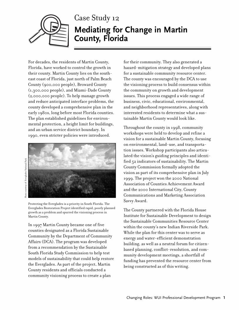
Changing Roles: WUI Professional Development Program 1
The southern pine beetle (Dendroctonusfrontalis)(SPB) is a bark beetle native to thesoutheastern United States. The SPB disperseswidely and can attack multiple host trees in abeetle's lifetime. An infested spot can spread 50to 70 feet per day, allowing unmanaged infesta-tions to lead quickly to an outbreak. Adultfemales bore through the tree’s inner bark(phloem), lay eggs, and release pheromonesthat, in combination with chemicals from thedamaged tree, attract more beetles. The adultfemales then resurface and go on to infest newtrees. They leave behind larvae that feed on thephloem for about two weeks, pupate in theouter bark, and emerge after another twoweeks, often flying several miles before infest-ing a new tree. Stressed, dying, or recently deadpines are most vulnerable to SPB infestation. Amass attack of SPB can kill a tree in less thanthree days.
Southern pine beetles, native to the southern United States, cancause great damage to pine forests in a short time.
Pine beetle outbreaks are natural occurrencesthat can drastically alter forest composition,increase risk of wildfire, and destroy habitat forsome types of wildlife. Socio-economic impactscan include: the disruption of forest manage-ment plans, property damage and safety risks
Case Study 1The Challenge of Controversial ResourceIssues: Southern Pine Beetle
from falling trees, law suits in response to thespread of SPB from one property to another,changes in property use and value, and loss ofpotential timber. Pine beetle outbreaks inurban and interface areas are also problematicbecause they can create hazards and result indamage to infrastructure. Therefore most localgovernments and natural resource agencies feelthey must take measures to suppress them.
In the spring of 1994 the city of Gainesville,Florida, and surrounding areas experienced anunprecedented outbreak of SPB. It had beennearly 50 years since there had been any sign ofthe beetles in the area. The conditions wereideal for an outbreak: dense stands of matureloblolly pines and a severe drought followed bya warm winter. Generally, stands with a basalarea above 120 ft have increased susceptibilityto SPB. The Gainesville area was struck again in2001 by another outbreak, this time moresevere and widespread.
Recognizing and quickly responding to signs ofinfestation are essential for controlling beetlepopulations and minimizing damage.Management strategies to control SPB infesta-tions include (1) cutting, removing, and pro-cessing infested trees (2) cutting and sprayinginfested trees with insecticides (Lindane andChlorpyrifos were used in the 1994 and 2001but are now largely unavailable), (3) cuttingtrees and burning the debris, and (4) using acut-and-leave technique that may disruptexpansion of infestations in forest stands whentree removal is not feasible.
In response to the 1994 pine beetle outbreak,Gainesville’s local government implemented anaggressive suppression program. The program
Phot
oby
:Dav
idT.
Alm
quis
t
2 The Challenge of Controversial Resource Issues: Southern Pine Beetle
Case Study 1
goal was to rapidly and thoroughly treat allinfested trees to reduce the subsequent infesta-tion and tree mortality. Containing the out-break largely depended on how quickly andeffectively private landowners and managers ofpublic lands responded to infestations. TheFlorida Division of Forestry (DOF), with federalsupport, worked with the City of Gainesvilleand Alachua County to contact landowners andmanage infestations. One of the program’sstrengths was the collaboration of multipleagencies and experts on a Technical AdvisoryCommittee (TAC). TAC members includedarborists, entomologists, tree physiologists,and other specialists.
The suppression program used severalapproaches for detecting infestations: aerialsurveys, a telephone hotline for reporting sus-pected infestations, and ground checks by DOFwith follow-up visits. Public education effortsabout beetle detection and management includ-ed radio, television, and print media releasesand interviews; expert lectures; and workshops.TAC members met regularly to review assess-ments and make recommendations. The cityand county offered cost-share programs to helplandowners remove infested trees. They cut andsprayed trees for a reduced fee, but landownerswere responsible for debris removal. Cost-share programs encouraged prompt responsesto infestations and reduced the financial bur-den to individual property owners.
Key elements that helped the program achieveits goals included interagency cooperation,commitment, USDA Forest Service-fundedcost-share components, and the timber indus-try’s cooperation in responding quickly toinfestations. The city government’s willingnessto search for and assist with solutions was alsoan essential element of the program.
The program encountered several challenges,such as poor access to remote areas, price-gouging by some tree surgeons, slow responsefrom some natural resource agencies, and con-
flicts with reluctant landowners. Illegal dump-ing of infested wood debris threatened tospread beetles and dumping of insecticide-treated logs jeopardized water quality. In addi-tion, there was a shortage of people to respondto the barrage of phone calls and requests thehotline received during the outbreak.
During the 2001 outbreak most of the sametechniques were used to alert residents, coordi-nate agency efforts, and respond to requests. Inaddition, some experts encouraged the state’sagricultural commissioner to declare a state ofemergency. While most area residents cooper-ated with the voluntary suppression program,some opposed the suppression strategies, sug-gesting that the beetle infestations occur natu-rally and should therefore be allowed to runtheir course. Absentee landowners also con-tributed to management issues by not beingnearby to check and manage their property.
A declaration of emergency would have allowedauthorities to enter properties where infesta-tions were not being managed properly and,after a review process, allow them to treat orremove trees at the landowner’s expense. Thisproposal outraged some community memberswho argued that such actions would be unrea-sonable and even illegal. They advocated publiceducation about SPB and the availability of vol-untary management programs for residentswith severe infestations. Although a state ofemergency was never declared, the suggestiongenerated divisive debate within the communi-ty, exemplifying some of the complex chal-lenges that can emerge from such an issue.
Police arrested one Gainesville man forattempting to disrupt beetle management oncity property. The man argued that the processwas natural and provided woodpecker habitat;he said that “poisoning” and cutting the treeswas wrong. Foresters maintained that the out-break threatened natural resources, publicsafety, and infrastructure. Another residentcommented on the city’s efforts to suppress the
Changing Roles: WUI Professional Development Program 3
Case Study 1
beetles in an editorial for the local newspaper.She said, “It looks like a frenzy to me. We’recutting down all the pines (and every other treethat’s in the way) so the borers won’t have anytrees left to infest, is that it? I’m just glad theseforestry people aren’t doctors.”
Conflicts also arose from neighbors of a localpreserve who thought preserve managersallowed an infestation to spread onto privateproperty. Some experts agree that the preserve’sresponse was delayed and ineffective. Someresidents even sued the preserve, claiming thatits negligence led to infestations within thenearby residential development. The 6,000-acre preserve lost 15,000 trees to SPB, andalthough it may have played a role in the spreadof infestations to the private development, thisclaim is difficult to prove. Suppression programorganizers suggest that an inflexible manage-ment philosophy, poor accessibility, andbureaucratic obstacles contributed to theagency’s ineffective response.
Before the 1994 outbreak there was no protocolfor dealing with SPB outbreaks in theGainesville area. During the 1994 outbreak,public lands within Alachua County lost an esti-mated 29,000 trees and private residents lostmore than 8,000 trees and spent a total of about$1.4 million for removal, even with the cost-share program. Despite the severity of beetle-related damage, the organizers of the suppres-sion program consider it a success. They claimit helped preserve thousands of trees in thearea’s urban forest and minimized economicand ecological effects, while avoiding watercontamination. The program’s educationalefforts not only helped mitigate the problem atthe time, but prepared residents to be able torecognize infestations in the future.
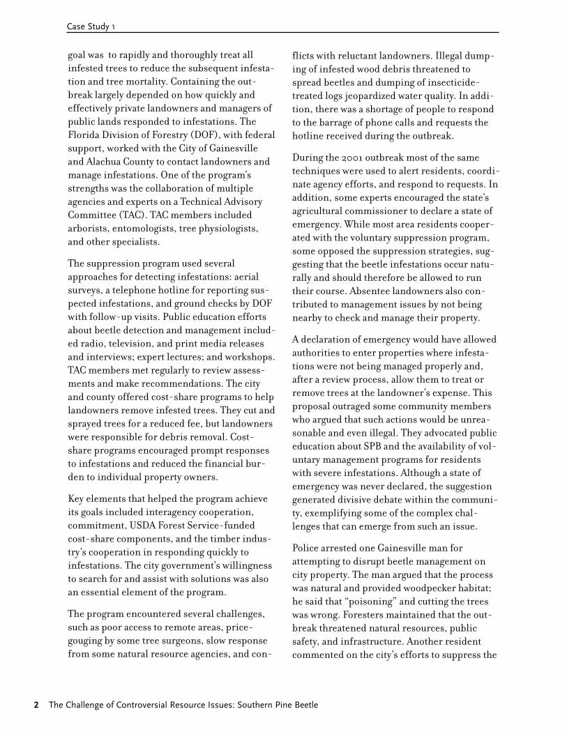
In response to the SPB epidemics in AlachuaCounty (and northern Florida)in 1994 and2001, statewide prevention and educationefforts have been implemented, including abillboard campaign, state-wide landowner
workshops, and brochures distributed to non-industrial private forest (NIPF) landowners often acres or more in several high-risk counties.These efforts emphasize that pine forestsshould be managed to promote forest healthand decrease susceptibility to SPB attack. Statecost-share programs that provide partial reim-bursement to NIPF landowners for preventativemanagement practices (such as pre-commer-cial thinning and prescribed burning) have alsobeen implemented. Members of the TAC sug-gest that further action be taken to preventfuture SPB outbreaks. They recommend pre-ventative resource management, continuededucation efforts, incentives, and possiblymandates requiring beetle management in theevent of an outbreak.
The Florida Division of Forestry used these billboards to raiseawareness about SPB prevention activities.
Source
This case study was written with the help of BudMayfield, Ph.D., DOF Forest Entomologist;Edward L. Barnard, Ph.D., DOF ForestPathologist and Supervisor of the Forest HealthProgram; John Foltz, Ph.D., Associate Professorof Entomology and Nematology at theUniversity of Florida; and Dr. Carol L.Lippincott.
Photocourtesy
ofww
w.forestryim
ages.org


Changing Roles: WUI Professional Development Program 1
South Carolina’s coastline is a maze of tidalflats, marshes, islands, and uplands. Most ofthe highland areas have been planted in corn,cotton, potatoes, or pine at some point duringthe last two centuries. Overgrown hardwoodhammocks, the lack of road access, and the bar-rage of sporadic hurricanes make developmentand resource management challenging. Areasthat people have managed to develop, however,are rapidly expanding. New subdivisions andgolf course communities are cropping up nearHilton Head Island and Charleston.Advertisements draw people from across thenation to come take advantage of the ‘lasthomesites now being sold’ because ‘peopleneed refuge too.’ Typical developments providelarge homes on mid-sized lots and communitydesigns that isolate residents from nature andrequire them to drive to enjoy recreationalactivities.
Some developers are beginning to offer alterna-tives to typical development, creating designsthat aim to create balance between people’sdesire to live in beautiful, natural places andthe protection of those natural places. One suchproject is the Sewee Preserve, which is about 25minutes from downtown Charleston.
Once completed, Sewee will include 30 houseson a 90-acre parcel with more than 400 acresleft undeveloped. All of the homes will be builtalong the bay, conserving the remaining landfor wildlife observation and seven miles oftrails for hiking, biking, and horseback riding.The development also includes a 45-acrestocked lake for fishing and boating. There isalso an on-site working farm, managed by alocal farmer, providing property owners withaccess to freshly-grown vegetables like squash,
sweet corn, potatoes, tomatoes, and beansthrough their farmer's market.
Conservation subdivisions generally cluster home lots in onearea and leave a portion of natural area undeveloped.
In this example, wealth acquires access tonature and simultaneously aims to protect it;lots in the preserve start at $625,000. TheWetlands America Trust retains a land preser-vation agreement for the 400-plus acres ofundeveloped land. This easement provides akey link in the Santee Corridor, which runsfrom Mount Pleasant to the Santee River delta,connecting the Cape Romain National WildlifeRefuge and Francis Marion National Forest. Thepreserve has also established guidelines forenvironmentally-sensitive homebuilding andlighting technologies and encourages home-owners to use native plants for landscaping.
The preserve provides habitat for a variety ofwildlife species, including many birds. Thepreserve developed the Sewee Partnership for
Case Study 2Conservation Development in South Carolina
Draw
ingfrom
Sewee
Preserve

2 Conservation Development in South Carolina
Case Study 2
Birds of Prey in cooperation with the SouthCarolina Center for Birds of Prey. This partner-ship works to enhance habitat in the area forspecies such as hawks, osprey, owls, and eagles.Sewee property owners are offered honorarymemberships to the center, which rehabilitatesand releases hundreds of birds every year.
The Sewee Preserve offers beautiful scenery and recreationalopportunities to its residents.
The Sewee Preserve is one model for alternativeresidential development. While the cost to livethere makes it an inaccessible option for mostpeople, it fills a niche that might otherwise becomprised of pavement and golf courses. It setsan example and provides ideas for future devel-opment that might meet the needs of middleand lower-middle class home buyers.Developments like Sewee also provide opportu-nities for natural resource professionals to per-form outreach activities and, in some cases,provide management for commonly-ownednatural areas.
Source
Sewee Preserve website,www.seweepreserve.com (accessed October 5,2005).
Phot
oco
urte
syof
Sew
eePr
eser
ve

Changing Roles: WUI Professional Development Program 1
Forest Cooperatives (co-ops) are an increasing-ly popular means for family forest owners toreap the benefits of pooling resources andexperience. Co-ops are generally created toincrease the financial return to producers offorest products by marketing products and/orreducing the cost of supplies. Co-ops can, how-ever, serve other functions such as workingtoward common environmental, ecological, andsocial objectives. Some co-ops are createdspecifically to enable private landowners toengage in sustainable timber production. Co-ops can increase the value of landowners’ rawmaterials, helping forest stewardship activitiespay for themselves. Although forest landownercooperatives are more prevalent in the upperMidwest and Northeast, they are beginning toappear in the South.
Forest cooperatives can help members effectively market theirforest products and reduce production and management costswhile achieving other objectives, such as sustainability.
In southwestern Virginia, the Blue Ridge ForestLandowner Cooperative (BRFC) is working toprovide similar benefits for its members. TheBRFC’s mission is to, help forest landownerspractice profitable, sustainable forestry. Theco-op provides forest management assistanceand other services to its members and pools
resources to enable the production of value-added products such as molding and flooring.Members of the co-op help determine whatassistance and services the co-op needs to pro-vide. The BRFC also works to protect ecosys-tems on a regional scale while improving thepublic’s access to sustainable forestry products.The group has adopted the standards of theForest Stewardship Council (FSC), an organiza-tion that analyzes and provides guidelines con-cerning the economic, social, and environmen-tal aspects of forestry. The BRFC’s goal is toassist all of its members in becoming certifiedby the council. “We see our forests as a majorasset of our personal wealth, but not only as aneconomic asset. We desire to manage ourforests for multiple purposes including aesthet-ics, wildlife habitat, peaceful refuge, big oldtrees, wealth creation, a legacy for our childrenand grandchildren, or just an attractive place tolive,” say the founders of the cooperative.
The idea for the BRFC started in 2003 at ameeting about sustainable forestry in MountainLake, Virginia. In October of 2004 the co-opbecame officially incorporated. Five boardmembers and a chief executive officer wereappointed and the group began soliciting mem-bers. The co-op has approximately 900 acresbut expects to grow to approximately 10,000acres. Membership in the cooperative requiresthe purchase of one share of common stock.Currently, a share costs about $500. To be eligi-ble for membership, landowners must also beVirginia residents who own at least 20 acres ofwoodland, and they must agree to abide by theguiding documents of the co-op.
Case Study 3Cooperation is the Key: Blue RidgeForest Landowner Cooperative
Phot
oby
:Har
ryG
root

2 Cooperation’s the Key: Blue Ridge Forest Landowner Cooperative
Case Study 3
The Blue Ridge Forest Co-op is using newsletters, information-al meetings, and word-of-mouth to raise awareness and recruitnew members.
To gather support and enlist new members, theBRFC produces a newsletter providing infor-mation about the benefits of forest cooperativesand mails it to interested families and mem-bers. Other marketing and recruitment activi-ties have included word-of-mouth, sponsor-ship of workshops on sustainable forest man-agement practices, and informational meetings.Meetings generally attract middle to upper-middle class forest landowners; however, theboard is working to increase accessibility forlower income families by adopting the mostaffordable certification process possible.
To get started, the cooperatives need technical,educational, and financial resources. Foresters,Incorporated, a local forestry company special-izing in sustainable forestry, and NextGeneration Woods, Incorporated, a local woodproducts distributor, provided much of thetechnical assistance for the co-op. The co-op’sfounders also attended workshops hosted bythe Community Forestry Resource Center,Cooperative Development Services, and RapidImprovement Associates, LLC. The SouthernStates Co-op Foundation, the CommunityForestry Resource Center, and the AppalachianForest Resource Center have provided grants tohelp the co-op get started.
The BRFC’s biggest challenge has been a lack ofcapital. Start-up costs for a forest landownercooperative that is FSC certified and producesvalue-added products are high. It costs money
to become legally incorporated, to purchaseharvesting and processing equipment, to certifyland, and to hire staff. The BRFC is dedicated totaking things slowly and seeking grants to assistits start-up and for special projects.
Co-ops can make it financially and technically feasible formembers to produce value-added products, such as wood flooring.
In the wildland-urban interface, where small-acreage, family forest landowners are becomingmore common, forest landowner cooperatives,like the BRFC, are especially relevant. Well-operated cooperatives can help reduce manyinterface issues in several ways. Co-ops enableparticipating landowners to manage theirforests effectively for multiple objectives andhelp keep land in forestry by making it prof-itable, and in this case, sustainable.Cooperatives can also provide an opportunityfor natural resource professionals to work withlandowners to promote forest health. Resourceprofessionals can be a valuable resource forlandowners interested in starting a cooperative,by providing information about co-op forma-tion, technical assistance, and by helping net-work interested landowners. One challenge isthat cooperatives must be initiated by a group ofvery motivated landowners and resource pro-fessionals cannot force the concept onlandowners, no matter how advantageous theyconsider them to be. Cooperatives will not meetthe needs of every landowner in rural areas orthe interface, but they are a growing phenome-non. Resource professionals must be preparedto provide information about co-ops and
Phot
oby
:Har
ryG
root Photo
by:JimBerkem
eier

Changing Roles: WUI Professional Development Program 3
Case Study 3
should take advantage of opportunities to pro-vide landowner assistance.
Written by Sarah Ashton, Virginia PolytechnicInstitute and State University.
Sources
Graham, J. W. “Finding Hope for Local Forests.”The Roanoke Times, April 13, 2005.
Next Generation Woods, Inc. Undated. BlueRidge Forest Landowner Co-op. Hiwassee VA: NextGeneration Woods, Inc.,http://nextgenwoods.com/blue_ridge_forest_landowner_coop.htm (accessed October 10,2005).


Changing Roles: WUI Professional Development Program 1
People often move to the wildland-urban inter-face to enjoy the peace and beauty of neighbor-ing natural areas. Those same people may besurprised and upset by the annoyance, destruc-tion, and danger that local wildlife present totheir neighborhoods. Human-wildlife conflictcan be challenging on an individual scale butwhen it begins to affect entire communities, itcan become very complex.
One example of this complexity is the over-abundance of deer in the community of SeaPines Plantation on, Hilton Head Island, SouthCarolina. Designated by the South Carolina leg-islature as a state wildlife sanctuary in 1971, SeaPines Plantation is now scattered with homes,resorts, restaurants, and shops. Abundantwhite-tailed deer in Sea Pines, a wealthy 2,137-hectare residential/resort development insouthern Hilton Head, have contributed toincreasing numbers of deer-vehicle collisions,landscape plant damage, fears of Lyme disease,and other concerns. The number of deer-vehi-cle collisions increased from 18 in 1993 to 61 in1999. Deer were sleeping on people’s patios andwalking through parking lots. The same peoplewho moved to the community to be close towildlife were upset by the problems the deerwere creating. Ironically, those very residentshelped create conditions that led to the herd’ssuccessful reproduction and their preferencefor the Sea Pines Plantation landscaping.
In May 1998, the University of Georgia (UGA)and the South Carolina Department of NaturalResources (SCDNR) concluded a three-yearresearch project on the Sea Pines deer herd andfound that the population in the Sea Pines areawas approximately four times larger than that ofmost undeveloped barrier islands. Researchers
suggested that lush landscape plants throughoutthe community were providing a plentiful buf-fet for the deer, keeping them in prime condi-tion for rapid reproduction. Based on theirfindings, the researchers recommended thepopulation be managed by a combination ofexperimental fertility control and sharpshoot-ing. Without first reducing the herd by 100-150deer, the logistics and cost ($800 to $1,100 perdeer annually) of delivering contraceptives tostabilize the population were simply not feasi-ble and even then, could take five to 10 yearsbefore the population declined. This conclusionwas not exactly what local natural resourcemanagers wanted to hear. Not only wouldadministering the fertility control be extremelycostly, the sharpshooting element was sure totrigger controversy.
Many Sea Pines Plantation residents were frustrated with deergrazing on their landscaping plants.
While the majority of Sea Pines residentsexpressed their approval of the managementrecommendations in a mail survey, local, state,and federal animal rights groups bitterlyprotested. They argued that killing the deer wasunethical and that nature should be allowed torun its course. They insisted that people should
Case Study 4Deer Debate in Hilton Head,South Carolina
Photoby:Lynda
Lester,NationalCenter
forA
tmospheric
Research

2 Deer Debate in Hilton Head, South Carolina
Case Study 4
accept the deer as part of living in a natural areaand adapt by driving slower and using deer-resistant landscape plants. The groups printedbumper stickers, wrote local and state politi-cians, and threatened to protest at the twonationally televised sporting tournaments heldannually in Sea Pines. Community leaders heldpublic meetings and education seminars todemonstrate to the public the complicated anddifficult decisions facing them. Eventually, fivelocal, state, and national animal rights organi-zations (the plaintiffs) filed a lawsuit againstUGA, SCDNR, and the Sea Pines CommunityServices Association (the defendants). Theywon a temporary restraining order which pre-vented SCDNR from issuing scientific collect-ing permits to kill deer in the Sea Pines area.
The number of deer-vehicle collisions increased dramaticallybetween 1993 and 1999 in Sea Pines Plantation.
Two lower-level courts ruled in favor of thedefendants; the case was appealed and went tothe South Carolina Supreme Court. In July 2001the Supreme Court upheld the lower court’s rul-ings. After three years and more than $200,000in litigation expenses, the Sea PinesCommunity Services Association implementeda deer-management program. Sharpshootersreduced the herd by 500 deer over the course ofthree years. Deer densities dropped from sevenacres/deer to 40 acres/deer. Deer-vehicle colli-sions were reduced from over 60 per year toless than 10. A wildlife manager was hired forSea Pines to manage the deer and otherwildlife. Following the Court’s ruling there hasbeen little opposition to the program.
The Hilton Head deer controversy attractednational and international media attention,including coverage from National Public Radio,Fox News, The Economist, and NBC News.Several other coastal communities with deerpopulation problems contacted the UGAresearchers for guidance, hoping to avoid asimilar controversy. The challenges experi-enced by these researchers, wildlife managers,and local government leaders illustrate thecomplexity of interface issues. As developmentcontinues to encroach on natural areas,human-wildlife conflicts are likely to increase.Natural resource professionals may be respon-sible for responding to these conflicts, eitherthrough management, research, or educationalprograms. Juggling public opinion, public safe-ty, and natural resource objectives can beextremely challenging.
Sources
Fosgate, H. 2001. “The Great Hilton Head DeerDebate.” The Log Alumni Magazine. Spring Issue.
Henderson, D. W., Warren, R. J., Ruth, C. R.1999. Urban Deer Research in Sea Pines, HiltonHead Island, South Carolina: Public, Political, andLegal Hurdles. Proceedings, 6th AnnualConference, the Wildlife Society, Austin, Texas.
Phot
oby
:Car
olyn
eBu
tler

Changing Roles: WUI Professional Development Program 1
The University of the South in Sewanee,Tennessee, is located on 11,000 acres, 40 milesnorth of Chattanooga. The central campus area,student housing, and 8,000 acres of forestedland, referred to as the Domain sit on thesouthern Cumberland Plateau in Franklin andMarion counties. The forested land is mostlyoak with some hickory, yellow poplar, and othereastern hardwood species. In 1898, GiffordPinchot, the head of the burgeoning U.S.Division of Forestry (currently called the USDAForest Service), helped create the Domain’sfirst management plan. Since then, the planhas been rewritten and revised many times torespond to changing conditions, needs, andobjectives.
The Domain has more plant diversity thanalmost any region in the continental UnitedStates. It is home to more than 700 species ofnative and naturalized plants including morethan 70 tree species as well as a variety of verte-brate and invertebrate species that have yet tobe cataloged. It is also home to more than 275historical sites including prehistoric NativeAmerican settlements, European settlements,Civil War sites, and sites of historical signifi-cance to the university. Almost 500 acres offorest in the Domain have been set aside forpreservation without any forest management.Over 36 miles of mostly private residentialproperty surrounds the Domain. Many stu-dents, faculty, staff, and local residents use theDomain for recreation. Multiple users andstakeholders influence the Domain, creatingcomplexities that cross residential and univer-sity-owned land. Consequently there is a hostof wildland-urban interface issues found here.
Students can observe and participate in sustainable timber har-vesting on part of the Domain.
The university has designated about 350 acresto be harvested using ecologically responsiblelogging techniques. Loggers leave enoughnative hardwoods to ensure regeneration andare not allowed to construct new roads. In addi-tion to income, the sustainable logging providesa unique opportunity for university classes tohelp with the planning process and studyregeneration. Income generated from timbersales covers the costs of obtaining a third-partysustainable forest practices certification.
Natural resource managers working in theDomain face many resource and human-relatedchallenges. Recreational pressures representone of those challenges. Many people use theDomain for hiking, biking, caving, horsebackriding, picnicking, climbing, and camping.Heavy recreational use requires increasedmaintenance of trails, overlooks, climbingareas, and fire lanes. Overuse in popular areasresults in litter, soil compaction, vegetativedamage, and soil erosion, particularly in morefragile areas such as stream banks and bluffedges. The affects of recreation are consistentlymonitored and the management plan calls for
Case Study 5The Domain: Managing InterfaceForests in Tennessee
Photocourtesy
ofUniversity
oftheSouth

2 The Domain: Managing Interface Forests in Tennessee
Case Study 5
managers to regulate, prohibit, and segregatecertain activities as necessary to protect theintegrity of the ecosystems.
The Domain’s accessibility to the public makesit vulnerable to illegal and destructive activities.All-terrain vehicles and other four-wheel drivevehicles tear up vegetation and damage soil andstream banks. Dumping, land theft, and arson,while less problematic than in the past, remainconcerns. More recent problems include mari-juana cultivation and theft of historical arti-facts. Managers are also concerned aboutmethamphetamine labs, which have become aproblem in other remote areas of the state.These labs use dangerous, explosive chemicalsto produce a highly addictive narcotic and couldpose a threat to the ecological health of the areaand the safety of students and recreators. Theharvest of various non-timber forest productssuch as mushrooms, seeds, and plants has beenincreasing and managers are concerned aboutthe resulting impacts of potential overharvest-ing on forest ecosystems. Wildflower and gin-seng collection have been particularly problem-atic and while plant removal is prohibited,enforcement is difficult to implement.
Poaching has been a long-standing problem inthe Domain. Hunting pressure during the late1800s and early 1900s nearly wiped out localdeer and turkey populations. Hunting has beenprohibited for many years and reestablishmentprograms for deer and turkey have been suc-cessful. In fact there is an overpopulation ofdeer on the Domain and an annual controlledhunt is conducted every winter. Poachingremains a concern because of visitor safety. Toincrease security and reduce illegal activity, themanagement plan recommends that specificroads and fire lanes that serve as entry pointsinto the Domain be patrolled. The plan recom-mends that people found trespassing withmotor vehicles, poaching wildlife and plants, orstealing artifacts be prosecuted. The local sher-iff patrols the Domain for illegal activity, on apart-time basis.
Another issue in the Domain is water quality. Tosupply water for the increasing populations ofthe university and the Sewanee Utility District,three reservoirs were created in the Domain:Lake O’Donnell, Lake Jackson, and LakeDimmick. Lake Dimmick has only beenpumped once in 1987 during a severe drought,and Lake Jackson is pumped only three or fourtimes a year. The university owns the entire,mostly forested watershed around LakeO’Donnell, but water quality must be closelymonitored because underground storage tanksfrom a neighboring airport and a close-bylandfill are potential sources of contamination.The university owns 303 of the 493 acres com-prising Lake Jackson’s watershed, while theremaining acreage is mostly residential neigh-borhoods. Domain managers are concernedabout potential pollution from septic tanks,agricultural fields, or land-use changes in theseareas. Recognizing that undeveloped, forestedwatersheds provide the highest water quality,the management plan calls for the protection ofthe reservoirs and their watersheds from hous-ing development and activities that may jeop-ardize water quality.
Insect pests present the greatest threat to foresthealth in the Domain. Managers are most con-cerned about the gypsy moth and Asian long-horned beetle. Managers work to protect theforest from these pests by careful monitoringand keeping forests healthy, vigorous, anddiverse. This strategy helps forests resist andrecover from potential infestations. Southernpine bark beetle, a native insect to the region,has also infested some areas in the Domain.Trees that have been killed by pine beetle andremoved for control purposes have been refor-ested with pine and hardwood seedlings and theOffice of Domain Management carefully moni-tors and records seedling and sapling mortalityas well as natural regeneration.

Changing Roles: WUI Professional Development Program 3
Case Study 5
Multiflora rose is one of several invasive species that theDomain management plan addresses.
A member of the Tennessee Exotic Pest PlantCouncil helped management identify the 13most problematic non-native invasive plants inthe Domain. These include tree of heaven,mimosa, Nepal grass, privet, kudzu, multiflorarose, and others. Invasives typically proliferatein recently cut or cleared areas such as roads,yards, and trails. Managers carefully monitorinvasives and use manual clearing tools such aschainsaws, brush hooks, and axes along withherbicides to control them.
The Natural Resource Advisory Committee(NRAC) controls land-use decisions outside ofthe campus area. NRAC is made up of theprovost, university treasurer, domain manger,forestry and geology chair, university forester, arepresentative from the biology department,and a community member with land-manage-ment experience. The committee realizes howintegral the Domain is to the surrounding com-munity and values public support for its man-agement activities. Community council meet-ings, university-wide e-mails, and announce-ments in the local newspaper are used to informthe public about major projects such as harvest-ing or intense clearing.
Although the Domain’s main purpose remainsproviding teaching and research opportunities,the current management plan recognizes thatthere are a variety of stakeholder interests,needs, and objectives required of the Domain.Issues in the Domain, like in other wildland-
urban interface areas, tend to be interconnect-ed. For instance, pest and invasive plant prob-lems may threaten forest health, wildlife habitator food sources, and forest aesthetics. Poachingand other illegal activities create safety hazardsfor recreational visitors, students, andresearchers, while also impacting wildlife andecosystem health. Setting aside forested areasthat are protected from harvesting and develop-ment also helps ensure clean drinking water,wildlife habitat, attractive recreation areas, andhealthy forest systems. Balancing the needs andobjectives of multiple users is always challeng-ing and the Domain management plan clearlyoutlines management priorities and strategiesfor meeting multiple goals. Efforts to preservespecific lands not only conserve the aestheticsand ecological health of the Domain, but alsoprotect cultural heritage, and increase the for-est’s capacity as a research and educationalfacility. The management plan also recognizesthe increasing need for additional universityhousing and the importance of placing newdevelopment in areas of the Domain that willnot jeopardize forest health, recreation, educa-tional and research value, and water quality.Recreational amenities in the Domain will con-tinue to be managed by protecting and main-taining areas and trails used by visitors.
The Domain is a valuable educational resource for theUniversity of the South.
The Domain provides a lot of value to the uni-versity and local community and its managersare faced with a variety of changing issues that
Phot
oco
urte
syof
Uni
vers
ity
ofM
isso
uri
Photocourtesy
ofUniversity
oftheSouth

4 The Domain: Managing Interface Forests in Tennessee
Case Study 5
impact its beauty, health, and functionality.Like other interface areas, many of the potentialthreats exist on private property that is beyondmanager control. Developing a managementplan that carefully identifies and prioritizesissues and defines strategies for monitoringand mitigating problems, while adjusting tochanging needs and issues, is essential. Whilemanagers may not be able to regulate what goeson beyond their jurisdiction, effective monitor-ing and on-site management are helpful toolsin facing these challenges.
Source
Smith, K, Domain Forest Manager, Universityof the South. Personal interview, January 2005.

Changing Roles: WUI Professional Development Program 1
Located between the Blue Ridge and theVirginia Allegheny Highlands, Roanoke hasbecome a center for industry, finance, educa-tion, travel, and entertainment in westernVirginia. A result of this popularity has been arapid increase in population and development,which has affected the health of Roanoke’surban forest.
The health of Roanoke’s urban forest was at risk due to rapidurban development.
To help protect the urban forest, the state UrbanForestry Council collaborated with the ValleyBeautiful Foundation (a nonprofit organization)and Roanoke city staff to obtain funding for astudy of the city’s tree canopy loss. The fundswere awarded by the USDA Forest Service andadministered through the Virginia Departmentof Forestry. The group contracted withAmerican Forests (a nonprofit organization inWashington, DC) to prepare an UrbanEcosystem Analysis for the Roanoke Valley. Thestudy measured changes in tree cover, identi-fied ecological services such as storm-watercontrol and air filtration provided by tree cover,and calculated what it would cost to build theinfrastructure needed to provide equivalentservices. The results revealed a 25 percent lossin tree cover in the region between 1973 and1997.
Roanoke's urban forester and members of theRoanoke Valley Urban Forestry Council report-ed to the city council on the Urban EcosystemAnalysis findings. They stressed that urban treeloss affects the city’s air quality, storm-watermanagement, economy through tourism, andquality of life. The city council responded byappointing an Urban Forestry Task Force to cre-ate an Urban Forestry Plan for the city.Members of the task force membership includ-ed local business owners, neighborhood repre-sentatives, parks and recreation staff, and a citycouncil liaison. With the Urban EcosystemAnalysis as background information, the taskforce prepared an Urban Forestry Plan with anoverall goal of increasing the city's tree canopyfrom 32 percent to 40 percent within 10 years.The 40 percent goal was recommended byAmerican Forests' as the minimum amount oftree cover necessary for a healthy urban com-munity.
The Urban Forestry Plan recommended a com-bination of strategies including launching edu-cational programs for children and adults, des-ignating funds for planting public trees places,encouraging tree planting on private land, andupdating local landscaping and zoning ordi-nances. Draft plans were mailed out to a varietyof individuals and organizations including stateand federal agencies located in Roanoke, citydepartments, and environmental groups. A let-ter signed by the city manager that encouragedcomments on the plan was included. A briefingwas held to notify the public about the plan.Two public hearing were conducted: one withthe Planning Commission and one with the CityCouncil. Most of the feedback about the plancame from the mailings. At the public hearings,
Case Study 6Improving the Urban Forest inRoanoke, Virginia
Phot
oco
urte
syof
:Vir
gini
apla
ces.
org

2 Improving the Urban Forest in Roanoke, Virginia
Case Study 6
all of the suggestions were discussed one-by-one and if possible, incorporated into the plan.Although the two public hearings did not drawlarge crowds, those who attended were sup-portive of the plan. The city council adopted theUrban Forestry Plan as part of the city’s com-prehensive plan in April 2003.
While the process of developing a plan torestore and enhance Roanoke’s urban forest wasnot without challenges, everything flowed welldue to proper preparation and execution. Informing the task force, the city council selectedmembers that had demonstrated an ability towork closely with government staff to resolveproblems. A good working relationshipbetween staff and professional experts frombeginning to end was also critical. It is easy fora diverse group to lose sight of the project goal.Task force co-chairs were selected from amongthe citizen members, but staff added expertiseand guidance at every meeting. The real key wasthe balance of support for the initiative fromcitizens, community organizations, staff, cityadministration, and the city council.
A commemorative tree planting celebrates the new UrbanForestry Plan.
The urban forest planner for Roanoke summedup the value of their urban forest, “Trees andother vegetation represent both an environ-
mental resource and an important landscapefeature in the quality of life in the city.Maintaining and increasing the city’s treecanopy will have a beneficial impact on airquality, storm-water control, noise levels, tem-perature, and visual appearance.”
Since the plan has been adopted, urban forestrystaff has assisted city planning staff in draftingnew landscaping and tree canopy minimumsfor an upcoming zoning ordinance revision.During the public review of the first zoningdraft, some local developers and homebuildersnoted that there would be an increased costfrom additional planting. The staff was able tocounter this concern by noting that studiesindicate that the presence of healthy treesaround a building increase its value. An addi-tional study is underway to identify and evaluateforest fragments within the city. Strategies topreserve forested areas and their associate ben-efits will be developed using information fromthis study.
Sources
Smythers, H. Roanoke Urban Forestry Planner,Roanoke Department of Parks and Recreation.Personal interview, August 2004.
Smythers, H. ed. 2003. Urban Forestry Plan: AnElement of the Vision Plan. Roanoke VA: City ofRoanoke Government, Roanoke Department ofParks and Recreation, Urban Forestry TaskForce. http://www.roanokeva.gov/WebMgmt/ywbase61b.nsf/CurrentBaseLink/09DB22A1D86CBD0F85257090006AC331/$File/Urban%20Forestry%20Plan.pdf. (accessed October 12,2005).
Phot
oby
:Hel
enSm
ythe
rs

Changing Roles: WUI Professional Development Program 1
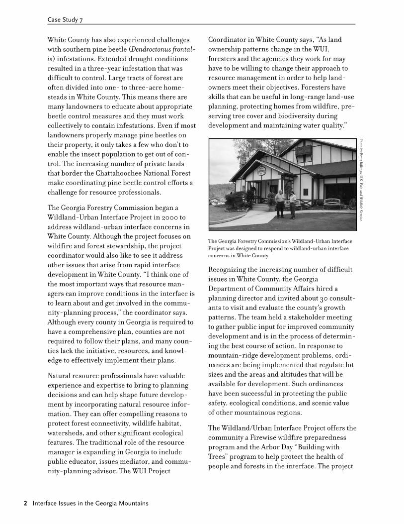
According to its local chamber of commerce,White County, Georgia, is ‘where the good life iseven better.’ White County is located in thebeautiful Blue Ridge Mountains at the base ofthe Appalachian range in northern Georgia. Itis 80 miles from Atlanta and is home to the cityof Helen, a popular tourist destination thatresembles a modern alpine village. Helen hostsseveral festivals every year including an AnnualTrout Tournament, Oktoberfest, and a Hot AirBalloon Race. The Chattahoochee NationalForest comprises 27 percent of White County,which helps protect the county’s famous naturalbeauty. White County’s natural features offerrecreation and nature-based tourism such asfishing, hiking, rafting, tubing, and camping.Beautiful fall foliage draws leaf lookers from allover the country.
Helen, Georgia, a modern-day alpine village, is a populartourist destination.
White County’s population has almost doubledsince 1990, expanding from 13,000 residents toalmost 23,000 in 2003. Many people move toWhite County to enjoy its mountain beauty andrelaxed pace. While most past developmentoccurred on flatter lands that were suitable foragriculture, new construction is creeping intothe mountain ridges as developers strive to
provide home buyers with a desirable view.Unfortunately, this type of development candegrade the resource, blocking or altering vistasso that others’ views are no longer available orattractive.
With development encroaching on forestedridges, natural resource managers and emer-gency personnel are facing new challenges. Forinstance, managing wildfire outbreaks in WhiteCounty’s forests used to be a less complicatedtask for firefighters and forest rangers than it istoday. Although fighting wildfire is always adangerous undertaking, the difficulty of thetask increased vastly when homes became com-mon in remote areas, particularly on steep ter-rain. Now when wildfire occurs in White Countyand firefighters ask, “Are there any housesnearby?” the answer is almost always “yes.”This makes containing the fire more urgent andincreases risks to residents, wildlife, andforests. It also often requires structural fire-fighters to team up with forest rangers to prior-itize what needs to be saved.
Rapid population growth and sprawling devel-opment are also affecting water quantity andquality in White County. White County sharesits water, the Chattahoochee River, with theMetropolitan Atlanta region. As populations inboth areas continue to grow, concerns overwater shortages and pollution are rising. Whennew homes are built in the mountain ridges ofWhite County, more roads are developed andnonpoint source pollution increases. Theecosystem services that help protect waterresources, such as nutrient cycling and infiltra-tion, will decline as forested land is cleared fordevelopment.
Case Study 7Interface Issues in the GeorgiaMountains
Phot
oby
:Bre
ttBi
lling
s,U
.S.F
ish
and
Wild
life
Serv
ice
2 Interface Issues in the Georgia Mountains
Case Study 7
White County has also experienced challengeswith southern pine beetle (Dendroctonus frontal-is) infestations. Extended drought conditionsresulted in a three-year infestation that wasdifficult to control. Large tracts of forest areoften divided into one- to three-acre home-steads in White County. This means there aremany landowners to educate about appropriatebeetle control measures and they must workcollectively to contain infestations. Even if mostlandowners properly manage pine beetles ontheir property, it only takes a few who don’t toenable the insect population to get out of con-trol. The increasing number of private landsthat border the Chattahoochee National Forestmake coordinating pine beetle control efforts achallenge for resource professionals.
The Georgia Forestry Commission began aWildland-Urban Interface Project in 2000 toaddress wildland-urban interface concerns inWhite County. Although the project focuses onwildfire and forest stewardship, the projectcoordinator would also like to see it addressother issues that arise from rapid interfacedevelopment in White County. “I think one ofthe most important ways that resource man-agers can improve conditions in the interface isto learn about and get involved in the commu-nity-planning process,” the coordinator says.Although every county in Georgia is required tohave a comprehensive plan, counties are notrequired to follow their plans, and many coun-ties lack the initiative, resources, and knowl-edge to effectively implement their plans.
Natural resource professionals have valuableexperience and expertise to bring to planningdecisions and can help shape future develop-ment by incorporating natural resource infor-mation. They can offer compelling reasons toprotect forest connectivity, wildlife habitat,watersheds, and other significant ecologicalfeatures. The traditional role of the resourcemanager is expanding in Georgia to includepublic educator, issues mediator, and commu-nity-planning advisor. The WUI Project
Coordinator in White County says, “As landownership patterns change in the WUI,foresters and the agencies they work for mayhave to be willing to change their approach toresource management in order to help land-owners meet their objectives. Foresters haveskills that can be useful in long-range land-useplanning, protecting homes from wildfire, pre-serving tree cover and biodiversity duringdevelopment and maintaining water quality.”
The Georgia Forestry Commission’s Wildland-Urban InterfaceProject was designed to respond to wildland-urban interfaceconcerns in White County.
Recognizing the increasing number of difficultissues in White County, the GeorgiaDepartment of Community Affairs hired aplanning director and invited about 30 consult-ants to visit and evaluate the county's growthpatterns. The team held a stakeholder meetingto gather public input for improved communitydevelopment and is in the process of determin-ing the best course of action. In response tomountain-ridge development problems, ordi-nances are being implemented that regulate lotsizes and the areas and altitudes that will beavailable for development. Such ordinanceshave been successful in protecting the publicsafety, ecological conditions, and scenic valueof other mountainous regions.
The Wildland/Urban Interface Project offers thecommunity a Firewise wildfire preparednessprogram and the Arbor Day “Building withTrees” program to help protect the health ofpeople and forests in the interface. The project
Photoby:BrettBillings,U
.S.Fishand
Wildlife
Service

Changing Roles: WUI Professional Development Program 3
Case Study 7
coordinator has found residents and builders tobe very receptive to these programs. He saysthat many new landowners are politically active,helping stir community support for positivechanges. Many have moved to White County toenjoy the unique ‘good life’ it has to offer andare personally invested in protecting the beautyand health of the area.
White County’s story is a prime example of thevariety of issues that can arise from wildland-urban interface development and how severalagencies and the community can begin toaddress these issues. Rapid land developmentand the fragmentation of the forest in WhiteCounty are creating challenges for naturalresource professionals including increased riskof wildfire, water quality and quantity concerns,and southern pine beetle infestations. TheGeorgia Forestry Commission is beginning torespond to these and other related challengesby developing its programs through theWildland/Urban Interface Project. Programsaim to identify important interface issues,improve awareness, facilitate action in theinterface, and expand the roles of naturalresource professionals to address a variety ofproblems. With a broad foundation in agencyassistance and expertise, White County is iden-tifying and addressing interface problems andtaking preventative measures to protect thehealth, safety, and beauty of the community.
Source
White, G. Wildland/Urban InterfaceCoordinator. Georgia Forestry CommissionPersonal interview, June 2004.


Changing Roles: WUI Professional Development Program 1
Wildland-urban interface issues create uniquechallenges on islands because there may be fewerfeasible solutions and a greater sense of urgencythan in areas with more available land andresources. In addition, islands often grapple withproblems created by rapid and poorly-planneddevelopment. Because space is limited on islands,prudent planning and wise use of space is imper-ative. Natural resource professionals, residents,and government officials on islands like PuertoRico and the Virgin Islands must work together toprevent and mitigate interface issues quickly andeffectively.
Because space and resources are limited on islands, interfaceissues can be more urgent and complicated than on the mainland.
Puerto Rico is approximately 100 miles by 35miles and is home to nearly 4 million people. Itdepends heavily on its natural beauty andresources to sustain its primary industries: agri-culture, tourism, and pharmaceutical plants. Theisland is home to the Caribbean National Forest,also known as El Yunque. The forest’s name comesfrom the Taino Indian word, yuke, which meanswhite lands, referring to its cloud-covered moun-tains. The Taino Indians, a subgroup of theArawakan Indians, considered the mountainrange within the forest to be the sacred home oftheir supreme god.
El Yunque was set aside as a reserve by Spain in1876. With about 28,000 acres, it is one of thesmallest forests in the National Forest System.However, it has the greatest biodiversity and isthe only tropical rainforest in the National ForestSystem, receiving 160 to 200 inches of annualrainfall. It has more tree species (about 250) thanall the 192 million acres of the other nationalforests combined. It contains more than 1,000plant species, including more than 100 types offerns and 50 native orchids. It has 79 differentbirds (including the endangered Puerto Ricanparrot), 11 different bat species, and 13 species ofcoquí, a tree frog that is a well-known part ofPuerto Rican heritage.
El Yunque is the only tropical rainforest in the National ForestSystem.
Many of Puerto Rico’s urban areas show evidenceof urban sprawl. Development is chiseling away atforest boundaries, recreational pressures areincreasing, non-native invasive species are flour-ishing, water resources are at risk, and wildfire isa growing concern on some parts of the island.These interface issues are complex and requireswift and innovative responses that can be adapt-able and can evolve as conditions continue tochange.
Case Study 8Island Interface Issues: Puerto Ricoand the Virgin Islands
Phot
oco
urte
stof
:Car
ibbe
anN
atio
nalF
ores
tPhoto
courtesyo f:U
SDA
ForestService
2 Island Interface Issues: Puerto Rico and the Virgin Islands
Case Study 8
Almost 30 years ago, a 9,300-acre greenbelt ofagricultural lands was established by Puerto Ricanlegislature to create a buffer around El Yunque.Since then nearly 18 percent of the buffer zonehas been depleted both by clandestine develop-ment and zoning exceptions made by the govern-ment. A report from the USDA Forest Servicestates that El Yunque’s forest ecosystem is beingseriously damaged by urban development. Theerosion of the greenbelt is reducing El Yunque’sability to support wildlife populations and isaffecting forest temperatures and rainfall.
Forest ecosystems in Puerto Rico are also threat-ened by non-native invasives, often introducedby urbanization. Cats, dogs, iguanas, mongooses,and rats prey on native birds, amphibians, andreptiles and may out-compete native species forfood or habitat.
The forest is also experiencing recreational pres-sures. With nearly 900,000 visitors every year, ElYunque is a popular destination for tourists andrecreationalists. About half of the visitors comefrom all over the world, the other half live on theisland. The forest offers hiking, swimming, pic-nicking, and interpretive and ecotourism tours.
In addition to providing recreation, El Yunquesupplies 20 percent of the water used in PuertoRico (about 50 million gallons per day). Withrapid population growth and the cost of waterclimbing, protecting water resources is an impor-tant priority for resource professionals and gov-ernmental officials. In April 2005 officialsannounced that a Comprehensive RiverManagement Plan (CRMP) would be developed toprotect and enhance the water quality and free-flowing conditions of the Rio Mameyes, Rio de LaMina, and Rio Icacos. These three rivers were des-ignated part of the National Wild and Scenic RiverSystem by the Caribbean National Forest Wild andScenic Rivers Act of 2002 and were identified asproviding remarkable scenic, biological, hydro-logical, and historic and cultural values. Togetherthese three rivers’ watersheds cover nearly 20percent of the forest and contribute significantly
to Puerto Rico’s water supply.
Because El Yunque receives ample rainfall, it haslittle risk of fire. However other parts of PuertoRico are not immune to fire risk. During thethree-month dry season in 2004, Puerto Ricoexperienced almost 1,500 fires and during thesame time period in 2005, there were more than5,000 fires. Most fires are caused by brush burn-ing or outdoor cooking and quickly get out of con-trol. The Maricao Forest Reserve on the westernside of the island has been damaged by severalbrush fires. Much drier than El Yunque (3 to 4inches of rain per month in the dry season), theReserve is more vulnerable to fires that spreadfrom urban areas. During the 2005 dry season,hundreds of acres were burned and several thou-sand trees were lost from multiple brush fires.Unlike other interface areas where wildfires inforests threaten the safety of people and property,these fires usually start in urban settings andmove out into neighboring forests.
Puerto Rico is no stranger to interface issues.Like much of the southern United States, it isexperiencing rapid population growth and subse-quent development pressures. Urbanization con-tributes to many issues in El Yunque and otherforests on the island. Natural resource profes-sionals and government officials are faced withbalancing urban development, a growing popula-tion’s need for resources, and the need to protectthe health of the island’s forest ecosystems.
The U.S. Virgin Islands deal with issues similar toPuerto Rico. While rapid urbanization is not asprevalent in the Virgin Islands, unmanagedgrowth and urban sprawl are beginning to createproblems. Sprawl is contributing to issues such asnonpoint source pollution, run-off, erosion, andloss of forest canopy. The Virgin IslandCooperative Extension Service is working toreduce problems by promoting Smart Growthprinciples and encouraging low-impact develop-ment through public outreach efforts. High levelsof tourism are also affecting the natural resourcesof the Virgin Islands. The islands are heavily

Changing Roles: WUI Professional Development Program 3
Case Study 8
dependent on fishing and tourism, both of whichadd to the depletion of resources and threaten toendanger both of these economically viable activities.
Land-use planning is especially important on islands, where landand resources are limited.
Water quantity is also a major concern in theVirgin Islands. Because the Virgin Islands are at alower elevation and are smaller, they tend toreceive less rainfall and retain less fresh waterthan Puerto Rico. There are no year-roundstreams and ground water supplies are limited.Population growth and the conversion of forestsfor other land uses are negatively affecting thenatural water cycles and water supply. Reservoirsare filling with sediments due to erosion,groundwater is being contaminated, and watersupplies are being overexploited. Leaky septictanks and inadequate sewage-treatment facilitiesalso threaten groundwater quality. An increase inimpervious surfaces from development and pave-ment impedes storm-water absorption, leadingto runoff and increasing flood risks. Thirteenpercent of the drinking water in the VirginIslands comes from rooftop catchments, 22 per-cent from groundwater supplies, and 65 percentfrom salt water desalination. Due to frequent andsevere drought conditions and the costly desalin-ization process, the Virgin Islands have the mostexpensive publicly supplied water in the UnitedStates.
Islands experience similar interface issues asmainland areas but the intensity and urgency ofproblems are often much greater. Natural
resource professionals who work on islands mustbe equipped with cutting-edge strategies foraddressing and preventing interface problems.They must be able to implement effective man-agement strategies, provide public outreach, andwork with local leaders and decision makers toreduce issues.
Sources
Brown, M. H. “Island's Rainforest Under Siege asPuerto Rico's Urban Sprawl Grows,Environmental Protections Falter.” Puerto RicoHerald, April 25, 2005.
Bosworth, D. 2005. “El Yunque: A Century ofLeading the Way.” Speech presented at theCentennial Ceremony, Caribbean National Forest,El Yunque, Puerto Rico.
Dombrowski, J. “En Fuego! Fires Wreak Havoc onDry Puerto Rican Forest.” Wildland Firefighter,June, 2005, 48-50.
Letter to the public from the USDA Forest Serviceconcerning a Comprehensive River ManagementPlan for the Caribbean National Forest,http://www.fs.fed.us/r8/caribbean/natural-resources/wilderness/letter.doc (accessed April11, 2005).
Martinuizzi, S.; W. A. Gould; and O. M. Ramos-Gonzales. 2005. “Land Development, HumanLand Use, and Urban Sprawl in Puerto Rico: AnIsland-Wide Approach from Geotechnologies.”Conference Proceedings from the EmergingIssues Along Urban/Rural Interfaces: LinkingScience and Society, Atlanta, Georgia.
McPhaul, J. “Forest Service Report Says El YunqueEndangered by Peripheral Development, RecentUrban Incursions Afflict Regulated Area.”Caribbean Business, March, 2005.
Virgin Island Cooperative Extension. 2005.Service Low Impact Development.http://rps.uvi.edu/CES/CESWQ/wqpresenta-tions/LID/ (accessed October 5, 2005).
Phot
oby
:Ana
ndR
anga
nath
an


Changing Roles: WUI Professional Development Program 1
The Ozarks region of Arkansas, Oklahoma, andMissouri is well-known for cold-water springs,sinkholes, caves, and forested hills. These fea-tures are made possible by the limestone anddolomite that underpins this region, known askarst geology. Like other valuable naturalresources, this water-rich system is threatenedby human activity, but the damage is not soobvious. The bellwether of change, like thecanary in the coalmine, is the rich variety ofunderground species (e.g., crayfish, bats, andcavefish) that reside in the caves and under-ground streams.
The Ozarks feature unique karst topography with caves, sink-holes, and springs.
These underground aquatic habitats are threat-ened by a host of above-ground activities.Nutrients from chicken farms and septic tanks,pollutants from chemical spills, and volatileorganics from leaking gas tanks can travelthrough the fissures in the bedrock and con-taminate underground streams within hours oftheir release. As communities aroundFayetteville expand, the effects could be devas-tating.
The U.S. Fish and Wildlife Service’s ArkansasField Office (FWS) began working on restoringthe karst habitat in the northern third of the
state through an outreach campaign that linkedcitizen health and welfare, groundwater quality,and karst resources. They began by identifyingthe stakeholders who should be a part of thecampaign: private landowners of property con-taining karst resources, citizens who use karstlandscapes, federal and state agencies withkarst-related responsibilities, karst geologistselected officials, industry, agriculture, and cav-ing clubs. They also developed a vision for theoutreach program, aiming to achieve conserva-tion goals without regulations. Their mission:work cooperatively with others to plan, imple-ment, and monitor karst conservation in theOzark Plateau.
The FWS team created a name for their effort,aiming for simplicity, memorability, andunique identity: Karst Resources Support Team(KaRST). Their next step was to win adminis-trative support within the FWS at the local,regional, and national levels. A series of pre-sentations, fact sheets, and a bumper stickerwere delivered to each participant.
After gaining internal FWS support, projectcoordinators began talking to other agencies,conservation groups, universities, caving clubs,and private landowners. The basic presentationwas modified for each group, emphasizing theways they could be involved in the program.University scientists learned about fundingopportunities for research, biological surveys,and recharge area delineations. When present-ed to caving clubs, the presentation highlightedhow the participants could help with mappingprojects. At each presentation participants wereasked to join the effort and become a memberof the Karst Resources Support Team.
Case Study 9Karst Habitat Restoration inArkansas
Phot
oco
urte
syof
:U.S
.Fis
han
dW
ildlif
eSe
rvic
e

2 Karst Habitat Restoration in Arkansas
Case Study 9
A number of stakeholders have been organized to help restoreand monitor the karst habitat.
Team members were eligible to attend meet-ings, held throughout the three-state region.Information on karst issues was presented atmeetings and groups were encouraged to dis-cuss conservation strategies that could beemployed locally. Some teams planned andimplemented cave gates, sinkhole cleanup, andhabitat restoration on private land. Ideasmoved from teams to agencies in proposals forfunding. More landowners were invited to par-ticipate and provide input. Once funding wasavailable for assistance, the word spread.
Today the program has broadened to includemore partners at the state and federal level,including U.S. Forest Service, National ParkService, Missouri Department of Conservation,Arkansas Game and Fish Commission,Oklahoma Department of WildlifeConservation, Neosho National Fish Hatchery,Speleological Society, The Nature Conservancy,University of Arkansas, Arkansas StateUniversity, Arkansas State Parks, Ozark-St.Francis National Forest, and others.
Like most programs, this one was not withoutits share of challenges. Efforts to compile aregional database to designate high-priorityconservation areas were squelched by data-sharing issues. Some partners were reluctant toshare data and were uncomfortable with a per-ceived loss of control. Lack of trust led to the
abandonment of certain projects and reducedthe program’s overall ability to fulfill its originalobjectives. Despite these challenges, KaRSTcontinues to serve as an informal, technical-information exchange network.
Adapted from Public Outreach and Education:Overview and Planning, April 2004, Division ofEducation Outreach, National ConservationTraining Center, U.S. Fish and Wildlife Service,with help from Dr. David Kampwerth, U.S. Fish &Wildlife Service Arkansas Field Office.
Phot
oby
:Dav
idK
ampw
erth

Changing Roles: WUI Professional Development Program 1
Different agencies have different tools toaddress problems in the wildland-urban inter-face. For example, some agencies are in theposition to acquire or facilitate the acquisitionof conservation easements (or land-preserva-tion agreements). Conservation easements(voluntary donations or purchases of propertyrights for the purpose of restricting develop-ment) can be a powerful tool for conservingnatural resources, improving managementopportunities, and protecting connectivity ininterface areas. The Suwannee River WaterManagement District (SRWMD) is one agencythat is using this tool with great success. Thedistrict is one of five regional water manage-ment districts in Florida. It was created by theFlorida legislature through the Water ResourcesAct of 1972. The objectives of this agency are tomanage water and related natural resources innorth central Florida by providing water qualityand quantity monitoring, research, regulation,land acquisition and management, and floodprotection. The SRWMD aims to balance publicaccess, recreational use, and restoration andprotection of natural lands when making man-agement decisions.
Conservation easements allow resource agencies to createbuffers around management areas and conserve resourceswithout the high cost of purchasing land outright.
In 1999 the Florida Forever land acquisitionprogram was founded. This program aims toconserve and protect natural resources byacquiring and protecting land on behalf of thecitizens of Florida. Under the sponsorship ofthe Florida Forever program, SRWMD pro-motes conservation easements as a cost-effec-tive means to protect natural resources andprovide buffers for their management areas. Aconservation easement enables a landowner toretain the title to his or her property but trans-fers subdivision and development rights to thedistrict, and restricts certain land uses. In mostcases, landowners can still manage their landsfor products and services, such as timber pro-duction and wildlife habitat enhancement, butthey must agree to develop annual managementplans in cooperation with the district.According to the projects coordinator at for theSRWMD, Acquisition and ManagementProgram, conservation easements are an attrac-tive mechanism for both landowners and theagency. Landowners are able to preserve theirproperty by selling the development rights andcontinuing to own it and the agency is not sad-dled with a purchase of the entire property.
Conservation easements have many advantages.One advantage is that the landowner is stillresponsible for managing the land, as opposedto the fee simple purchase of land in which thedistrict then becomes responsible for landmanagement. Another advantage is that con-servation easements serve as buffers for thelands the district has conserved by outrightpurchase. Purchasing development rights isalso significantly less expensive than purchas-ing land outright, enabling the district to con-serve more land with its funds.
Case Study 10Land Conservation along theSuwannee River
Phot
oco
urte
syof
Flor
ida
DEP

2 Land Conservation along the Suwannee River
Case Study 10
The Suwannee River Water Management District's Acquisitionand Management Program has successfully protected over
150,000 acres of land from development.
The SRWMD conservation easement programhas contributed to many ecological improve-ments in a short time, including the hydrologi-cal restoration of Mallory Swamp, the conserva-tion of the floodplain of the Suwannee River inthe Suwannee Swamp and Oak Hammock, andthe creation of a greenway linking ManateeSprings State Park and the Lower SuwanneeNational Wildlife Refuge that serves as a wildlifecorridor. The district relies primarily on word-of-mouth to promote this program but also dis-tributes brochures and speaks to civic organiza-tions. As of early 2005, the district had success-fully purchased the development rights of over154,000 acres of conservation easements.
Sources
Demott, T., Projects Coordinator forAcquisition and Management Program,Suwannee River Water Management District.Personal interview, April 5, 2005.
Florida Forever. 2004. Work Plan online.http://www.srwmd.state.fl.us/resources/2004+florida+forever+work+plan-for+pdf.pdf(accessed April 5, 2005).
Florida Forever website.http://www.dep.state.fl.us/lands/acquisition/FloridaForever/default.htm (accessed April 5,2005).
Suwannee River Water Management Districtwebsite. http://flwaterpermits.com/home/srwmd_inside.jsp (accessed September 2004).
Phot
oco
urte
syof
Flor
ida
DEP

Changing Roles: WUI Professional Development Program 1
Tucked along the edge of the Colorado River,the small town of Bastrop, Texas struggles tobalance historic preservation and developmentpressures. While the city (pop. 5,340) hasretained a small-town feel with features suchas quaint shops, a riverfront park, and oldhomes, the surrounding county (pop. 63,934) isgrowing by leaps and bounds. Bastrop is in theLost Pines, an isolated, timbered region ofloblolly pines and hardwoods. At only 30 milesfrom Austin, Bastrop is a reasonable commutefor an increasing number of people in search ofthe benefits of a small town. Bastrop County’sgrowing population has put it among the fastestgrowing counties in the nation, growing 51 per-cent between 1990 and 2000.
Downtown Bastrop has a small town feel with features such asquaint shops and old homes.
There are several interconnected wildland-urban interface issues in the Bastrop area.Predominant issues include fire, land-useplanning and subdivision design, endangeredspecies, recreation, water quantity, and privateproperty rights. Fire is a particularly importantissue and one that relates to all of the others.The flammable cedars, loblollies, and yauponholly in the Lost Pines make the area prone towildfire. However, the increasing developmentsand forested homesites have led to increased
fuel loads since wildfires have been necessarilysuppressed. The reduction of fuel loads byusing prescribed fire is difficult due to theincreased number of people in the surroundingarea. In 1998 a severe drought and observationsof Florida’s extensive fire season prompted theTexas Forest Service (TFS) to preemptively sta-tion a team of Hot Shot firefighters in Bastrop.While they waited to pounce on a fire, they con-ducted hazard assessments. These eventuallygrew into a significant educational effort whencoupled with follow-up neighborhood meet-ings, which were carried out by the TFS andvolunteer fire departments (VFD). TFS andVFD crews have successfully conducted pre-scribed burns on large ranches and camps inrecent years.
The design of several subdivisions in the countyalso increases residents’ risk in the event offire. Blind hills, complicated street names, andshort radius turns make it a challenge for fire-fighters to get to fires. Limited entrances andnarrow feeder roads make evacuations difficultas well. To reduce the risk of fire spreadingthrough a community, residents have beenencouraged to create defensible space and con-duct structural improvements. Through fielddays and demonstration areas, residents havebegun to work on selected properties and toshow others what can be done.
The historical lack of zoning in Bastrop has ledto many of the area’s existing fire problems.One positive step, however, is that the city ofBastrop has a large “extra-territorial jurisdic-tion,” which allows the city to zone areas out-side its limits in order to plan for futuregrowth. This has enabled the city to look atwildland fire design issues before the buildingbegins at the subdivision review stage. Housing
Case Study 11Life on the Edge: Interface Issues inBastrop, Texas
Phot
oby
:Mar
tha
C.M
onro
e

2 Life on the Edge: Interface Issues in Bastrop, Texas
Case Study 11
developments that are located in fire-proneareas have mitigation requirements built intothe planning stages of subdivisions.
Blind hills are one challenge that firefighters face in Bastrop.
Water supply issues are also of concern inBastrop. Water rights do not automatically comewith property and most developments purchasewater from one of several water companies.These companies rarely use water mains thatare large enough or produce enough pressure toprovide water to hydrants for fire fighting.
Recreation is a major business for Bastropsince Bastrop State Park is one of the most vis-ited parks in the state park system and staysbusy year-round. This means that there is alarge population of recreation enthusiasts inthis highly flammable environment, creating ahigh potential for ignitions from sources suchas campfires and cigarettes. To add to the com-plexity, there are several large subdivisionsadjacent to the park, which pose a risk to bothlife and property. In response, the park has ini-tiated an aggressive prescribed burning pro-gram to reduce risks to neighboring communi-ties. The park has hosted several interactivepublic education programs addressing both firesafety and fire ecology to help increase aware-ness of the benefits of the prescribed burningprogram.
Bastrop State Park and nearby forests are hometo the Houston toad (Bufo houstonensis), a des-ignated endangered species. On the one hand,the use of prescribed burning or vegetationremoval for the reduction of wildfire risk can
disturb the breeding habitat of these toads orresult in toad mortality. On the other hand,increased fuel loads due to prolonged periodsof fire suppression can result in very hot firesthat are even more detrimental to this species.Prescribed fire also helps maintain the herba-ceous vegetation layer that the Houston toadneeds for cover and foraging habitat. Additionalresearch is needed to determine the effects ofprescribed burning programs on toad popula-tions. Sharp toad population declines areattributed to development, drought, soil ero-sion, cattle grazing, and pesticide runoff, all ofwhich limit the suitability of breeding ponds.Research sponsored by the University of Texasindicates that the toad population fluctuateswith drought. If habitat can be protected or cre-ated on private property, the population maystabilize and rise.
A culture of independence pervades the Texanlegal system, fostering strong support of indi-viduals’ right to do what they want on their ownland. This means that any educational programsabout how to reduce wildfire risk and protectendangered species on private property or howto better design new developments or retrofitexisting developments must proceed with care:building knowledge, engaging citizens, andhelping them realize what they might do toimprove their quality of life.
Bastrop is a good example of a community, likeothers across the South, that is experiencingrapid population growth and increased landdevelopment. Several steps are being taken toaddress the natural resource issues that existin the interface, but there are still many issuesleft unresolved.
Adapted from "Bastrop, Texas: Steps to improvecommunity preparedness for wildfire" Case Study#12 in the Community Preparedness Case StudySeries, published by the USDA Forest Service, NorthCentral Research Station, St. Paul MN,http://www.ncrs.fs.fed.us/4803/Highlights.htm(accessed August 31, 2005).
Phot
oby
:Mar
tha
C.M
onro
e
Changing Roles: WUI Professional Development Program 1
For decades, the residents of Martin County,Florida, have worked to control the growth intheir county. Martin County lies on the south-east coast of Florida, just north of Palm BeachCounty (900,000 people), Broward County(1,300,000 people), and Miami-Dade County(2,000,000 people). To help manage growthand reduce anticipated interface problems, thecounty developed a comprehensive plan in theearly 1980s, long before most Florida counties.The plan established guidelines for environ-mental protection, a height limit for buildings,and an urban service district boundary. In1990, even stricter policies were introduced.
Protecting the Everglades is a priority in South Florida. TheEverglades Restoration Project identified rapid, poorly plannedgrowth as a problem and spurred the visioning process inMartin County.
In 1997 Martin County became one of fivecounties designated as a Florida SustainableCommunity by the Department of CommunityAffairs (DCA). The program was developedfrom a recommendation by the SustainableSouth Florida Study Commission to help testmodels of sustainability that could help restorethe Everglades. As part of the project, MartinCounty residents and officials conducted acommunity visioning process to create a plan
for their community. They also generated a hazard-mitigation strategy and developed plansfor a sustainable community resource center.The county was encouraged by the DCA to usethe visioning process to build consensus withinthe community on growth and developmentissues. This process engaged a wide range ofbusiness, civic, educational, environmental,and neighborhood representatives, along withinterested residents to determine what a sus-tainable Martin County would look like.
Throughout the county in 1998, communityworkshops were held to develop and refine avision for a sustainable Martin County, focusingon environmental, land-use, and transporta-tion issues. Workshop participants also articu-lated the vision’s guiding principles and identi-fied 52 indicators of sustainability. The MartinCounty Commission formally adopted thevision as part of its comprehensive plan in July1999. The project won the 2000 NationalAssociation of Counties Achievement Awardand the 2000 International City, CountyCommunications and Marketing AssociationSavvy Award.
The County partnered with the Florida HouseInstitute for Sustainable Development to designthe Sustainable Communities Resource Centerwithin the county’s new Indian Riverside Park.While the plan for this center was to serve asenergy and water-efficient demonstrationbuilding, as well as a neutral forum for citizen-based planning, conflict-resolution, and com-munity development meetings, a shortfall offunding has prevented the resource center frombeing constructed as of this writing.
Case Study 12Mediating for Change in MartinCounty, Florida
Phot
oco
urte
syof
:Eve
rgla
des
Nat
iona
lPar
k

2 Mediating for Change in Martin County, Florida
Case Study 12
The Sustainable Communities pilot project ledto the creation of the Sustainable MartinAlliance. This nonprofit group assisted indeveloping plans for the resource center,helped with a project to determine indicators ofsustainability, and promoted public educationon concepts of sustainability. The group alsohelped develop “Martin 101: It’s DifferentHere,” an educational program that providesnew and long-term residents with an overviewof the natural and built characteristics, as wellas economic, environmental, and social issuesin the county.
A member of the Sustainable Martin Allianceand former county commissioner founded anonprofit organization called Friends of MartinCounty in 2004. The organization aims to offercommunity members a nonpartisan, nonpoliti-cal forum for discussing the county’s growth-management issues and options, assuming thata desirable future requires broad, active partic-ipation from the public. The organization’sobjectives include creating grassroots supportto implement a county land acquisition pro-gram. The group’s steering committee includesthe founder, an officer of the local AudubonSociety Chapter, a hospital executive, and adeveloper. After struggling with conflictingperspectives, the group asked a professionalmediator from the University of Florida tofacilitate its meetings. During the first facilitat-ed meeting between the steering committeeand local stakeholders, the group discussedeach participant’s interests and concerns relat-ed to land use in the county; defined and dis-cussed the ground rules and characteristics ofthe group; and decided to include expert pre-sentations by the county planner, tax assessor,and water manager in future meetings. Oncethe ground rules became habit, everyone wasable to listen and work together. Each stake-holder was given a chance to speak and all par-ticipants vowed to listen.
Through this process the group learned thatsteering committees must be representative ofthe stakeholders, the facilitator must be neutral
and enforce group ground rules, and the processmust reveal all views of the group members.Expectations of the group grew more reasonableas they gained more knowledge about land-useissues. Involving stakeholders in the visioningand decision-making process was a strategy thatserved everyone and encouraged group coopera-tion. The Friends group continues to guidegrowth in Martin County and protect naturalresources through collaborative and cooperativecommunity effort. They have also assisted thedevelopment of the “Martin 101: It’s DifferentHere” program.
Unplanned growth can contribute to a number of naturalresource challenges.
Martin County has been pro-active in managingits growth issues and is committed to involving asmany stakeholder perspectives as possible in dis-cussions and decisions. They have made a varietyof efforts to promote sustainable developmentwithin their community.
Sources
Carriker, R. “Building Consensus with Multi-Stakeholder Groups: Lessons from a FloridaCounty-Level Experience.”http://srdc.msstate.edu/cred/scde/session2/car-riker.htm (accessed July 15, 2005).
“Martin County 101: It’s Different Here.” 2005.http://www.sustainabletc.org/documents/MC101cstcpresentation.pdf (accessed October 6, 2005).
Martin County Sustainable Communities.http://www.martin.fl.us/GOVT/depts/gmd/sus-tain/ (accessed July 15, 2005).
Photoby:Larry
Kohrnak

Changing Roles: WUI Professional Development Program 1
The State of Kentucky is initiating aCommonwealth Water Education Project toteach Kentucky residents about nonpointsource water pollution. Like in most places,water is an important resource in Kentucky.Ninety percent of its rural population relies ongroundwater for their water supply. With nearly90,000 miles on rivers and streams, more than630,000 acres of wetlands, and 55 percent of itsland underlain by karst topography, Kentuckyhas reasons to be concerned about protectingits water quality.
In 2004 a statewide survey of environmentalknowledge and attitudes in adults identifiedwater quality as the number one concern. Thesame survey revealed that only 17 percent ofrespondents could identify the major source ofwater pollution. The Commonwealth WaterEducation Program is designed to engender inthe public a desire to know more about howthey influence water quality. It aims to help ful-fill the Kentucky Environmental EducationCouncil’s 1999 master plan recommendationthat state agencies collaborate on improvingadult environmental literacy.
Like most states, Kentucky’s water supply is vital to the well-being of its residents.
The degree of multi-agency collaborationmakes this program unique. The project devel-opment team of more than 20 agencies, led bythe Kentucky Environmental Education Councilincludes state universities, the Division ofWater, Kentucky Education Television, Leagueof Cities, the Association of Counties, and theTransportation Cabinet. Several partners aredeveloping products such as a logo, workshopmaterials for local officials, workshop materialson watersheds for high school teachers, and avirtual watershed field trip. A documentaryabout water issues in Kentucky is being madeand radio, newspaper, and television advertise-ments will promote the program messages.While challenging at times, involving so manypartners in the project has provided manyadvantages. It helped project developers identi-fy and understand audience characteristics andneeds, it increased the capacity for dissemina-tion, and helped establish credibility.
The five-year program will concentrate on twomajor state watersheds each year.Dissemination efforts will target area churches,Lions’ Clubs, Kiwanas, and other groups.Special outreach efforts will be made to bringthe documentary and other materials to resi-dents living in interface and rural areas.Although the program is still in its develop-mental stages, Jane Eller of the KentuckyEnvironmental Education Council said,“Organizing such a far-reaching programinvolving so many groups can be challenging.With multiple partners, moving through thedevelopment process can be cumbersome andsometimes slower than expected. Having clearlydefined objectives and good communication areessential when working with so many agencies
Case Study 13A Multi-Agency Initiative: WaterEducation in Kentucky
Phot
oby
:Lar
ryK
orhn
ak

2 A Multi-Agency Initiative: Water Education in Kentucky
Case Study 13
and organizations and that has often been diffi-cult.” One problem is the long turn-aroundtime between when the proposal is submittedand MOA’s are actually written to each partner.A significant delay could result in changes inpersonnel or organizational agendas, making itdifficult to maintain clear goals.
Developing a program with multiple targetaudiences is also challenging. The project aimsto reach the general adult population, local offi-cials, and teachers. Project designers talked topartner agencies that work with these groups toget ideas on the best ways to reach them. Theproject’s general messages are consistentamong all audiences: that Kentucky’s water isbecoming polluted, an explanation of the causesof pollution, and why people should care.However, messages concerning what people cando about water pollution is different for the dif-ferent groups. For instance, teachers learn howto teach about it, local officials learn how tomake educated policy decisions concerningwater, and the general population learns aboutsimple actions they can take and best manage-ment practices (BMPs) they can follow to pro-tect water quality.
The Commonwealth Water Education Program is designed toincrease people’s awareness about water quality and teach themhow they can protect and improve it.
The project’s messages are pro-active and posi-tive. According to the project director mostKentuckians appreciate water as a resource andknow that it is polluted. The project elicits asense of pride in Kentucky’s beauty and helps
people to understand how the water gets pollut-ed and what they can do to improve it.
In order to be effective, an education program’smessage must be clear and consistent and mul-tiple communication channels must be used.The Commonwealth Water Education Projectuses video, television and radio, workshops,community presentations, an electronic fieldtrip, and a website to present accurate and con-sistent information. The project addressescommon misconceptions about water, forinstance that factories are the only source ofwater pollution, or that water cleans itself.
Sources
Eller, J. Executive Director, KentuckyEnvironmental Education Council. Personalinterview, February 24, 2005.
Kentucky State Government. 2005.http://www.water.ky.gov/homepage_reposito-ry/overview.htm (accessed July 18, 2005).
Phot
oby
:Lar
ryK
orhn
ak

Changing Roles: WUI Professional Development Program 1
Duany Plater-Zyberk & Co., the planners for theHabersham Land Company in South Carolina,boast that the town was built ‘in the tradition ofbeautiful coastal towns.’ Habersham is locatedoff coastal marshes, one hour south ofCharleston, South Carolina, and one hour northof Savannah, Georgia. The development’sdesign aims to blend community goals andpublic spaces to create, according to their web-site, “a place of sustainable character andcharm, a place that protects the present whilepreserving the values for future generations tocome.” Before designing Habersham, plannerstoured historic southern towns to study thedetails that make up their aesthetic and func-tional character and incorporated these detailsinto the development’s new-urbanism concept.The result is a town with a traditional feel, anawareness of natural resources, and a tight-knitsense of community.
Homes in Habersham are designed to capture the feel of oldersouthern communities.
Following the “new-urbanism concept”Habersham was designed with Smart Growthprinciples. Habersham developers worked withgreat conscience to preserve the natural envi-ronment while still meeting the needs of home-owners. Clustered housing intermixed withurban parks and trails allows for condenseddevelopment while preserving the estuaries and buffer areas creating open space and recre-ational opportunities. Lots are priced from$75,000 to $500,000, providing prospectivehomebuilders with a wide range of opportunities.
Prior to the development plan, natural resourceprofessionals helped perform a survey of35,000 trees and developed topographical, aer-ial, and archeological maps of the area.Numerous parks and walking paths along themarsh increase access to the natural landscape.Bob Turner, one of the town’s founders hasbeen featured in Coastal Living, Southern Living,Southern Accents, and The Wall Street Journal. In1996, Habersham was recognized by theCongress for New Urbanism as one of the topTen Traditional Neighborhood designs in thecountry.
Design codes foster distinctive, attractivehomes with a strong sense of place. Codes alsoencourage materials and finishes that withstandthe salt marsh environment, look good for yearsto come, and require minimal maintenance.With this mix of quality design, proportion, andindigenous materials, the homes of Habershamembrace a sense of southern elegance typical ofthe older communities in the low country.
With urban sprawl increasing traffic and loss ofnatural areas, the Habersham design incorpo-
Case Study 14New Urbanism in South Carolina
Phot
oby
:Mar
tha
C.M
onro
e

2 New Urbanism in South Carolina
Case Study 14
rated a different street plan and opportunitiesfor alternate transportation. Habersham fea-tures a gently curving grid of tree-lined, narrowstreets that slows traffic and invites walking orbiking. Building setbacks, street widths, curbradii, sidewalk widths, and other features weredesigned to optimize traffic flow and walkabili-ty. With the community-oriented design,homes are within walking distance of a tradi-tional town center, multiple forested areas,waterfront parks, and an activity center includ-ing a pool, river pavilion, a dock, a bed andbreakfast inn, and rental cottages. The commu-nity also features a post office, fitness facilities,and restaurants. Of the 283 total acres in theproject, nearly 75 acres are dedicated to shared,public space.
Front porches for relaxing and sidewalks for strolling foster afriendly, tight-knit community.
Habersham is zoned for 700 single-family and300 multi-family units. Compact buildingdesigns and a range of housing opportunitiesare incorporated in the downtown area. Thetown center is zoned to allow loft apartmentsabove commercial spaces to enable people tolive close to work and shopping. This designhelps decrease traffic and the need for parkinglot space, while contributing to the vibrancy ofthe town center.
A sense of community is the core characteristicof the Habersham design. Neighborhoods aredesigned with central gathering places andparks are scattered throughout the town toserve as social gathering spaces. Every home inHabersham is required to have a front porch
and be sited close to the street, creating oppor-tunities for people to interact, get to know theirneighbors, and walk throughout their commu-nity. The continuous presence of peoplethroughout neighborhoods and parks helpscreate an inherent sense of security.
Environmentally sensitive shorelines are protected as parksand public areas.
Habersham’s design provides one possiblemodel for conserving natural areas, providing asense of community, encouraging pedestrianactivity and reducing urban sprawl. Naturalresource professionals helped Habersham’splanners create a design that would meet theseobjectives. The result is a pleasant communitythat connects people to their neighbors andtheir environment.
Residents are encouraged to enjoy the natural beauty of thecoastal marsh.
Source
Habersham website, www.habershamsc.com(accessed April 5, 2005).
Phot
oby
:Mar
tha
C.M
onro
ePhoto
by:Martha
C.Monroe
Photoby:M
arthaC.M
onroe
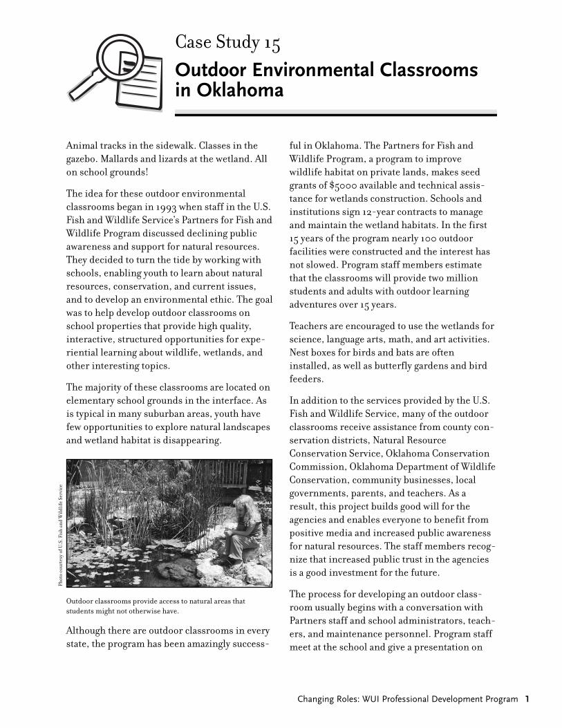
Changing Roles: WUI Professional Development Program 1
Animal tracks in the sidewalk. Classes in thegazebo. Mallards and lizards at the wetland. Allon school grounds!
The idea for these outdoor environmentalclassrooms began in 1993 when staff in the U.S.Fish and Wildlife Service’s Partners for Fish andWildlife Program discussed declining publicawareness and support for natural resources.They decided to turn the tide by working withschools, enabling youth to learn about naturalresources, conservation, and current issues,and to develop an environmental ethic. The goalwas to help develop outdoor classrooms onschool properties that provide high quality,interactive, structured opportunities for expe-riential learning about wildlife, wetlands, andother interesting topics.
The majority of these classrooms are located onelementary school grounds in the interface. Asis typical in many suburban areas, youth havefew opportunities to explore natural landscapesand wetland habitat is disappearing.
Outdoor classrooms provide access to natural areas that students might not otherwise have.
Although there are outdoor classrooms in everystate, the program has been amazingly success-
ful in Oklahoma. The Partners for Fish andWildlife Program, a program to improvewildlife habitat on private lands, makes seedgrants of $5000 available and technical assis-tance for wetlands construction. Schools andinstitutions sign 12-year contracts to manageand maintain the wetland habitats. In the first15 years of the program nearly 100 outdoorfacilities were constructed and the interest hasnot slowed. Program staff members estimatethat the classrooms will provide two millionstudents and adults with outdoor learningadventures over 15 years.
Teachers are encouraged to use the wetlands forscience, language arts, math, and art activities.Nest boxes for birds and bats are ofteninstalled, as well as butterfly gardens and birdfeeders.
In addition to the services provided by the U.S.Fish and Wildlife Service, many of the outdoorclassrooms receive assistance from county con-servation districts, Natural ResourceConservation Service, Oklahoma ConservationCommission, Oklahoma Department of WildlifeConservation, community businesses, localgovernments, parents, and teachers. As aresult, this project builds good will for theagencies and enables everyone to benefit frompositive media and increased public awarenessfor natural resources. The staff members recog-nize that increased public trust in the agenciesis a good investment for the future.
The process for developing an outdoor class-room usually begins with a conversation withPartners staff and school administrators, teach-ers, and maintenance personnel. Program staffmeet at the school and give a presentation on
Case Study 15Outdoor Environmental Classroomsin Oklahoma
Phot
oco
urte
syof
U.S
.Fis
han
dW
ildlif
eSe
rvic
e

2 Outdoor Environmental Classrooms in Oklahoma
Case Study 15
the potential uses of outdoor classrooms. Theyencourage teachers to visit nearby sites to bet-ter understand how to develop and maintaintheir site. When there is agreement and supportfor the concept, school officials sign a privatelands agreement stipulating the wetland will bemaintained for wildlife for 12 years.
Community volunteers and agency staff work with school per-sonnel to create a wetland habitat on school grounds.
Teachers, parents, and administrators develop abudget for their site and leverage the seed grantinto $20,000 to $25,000 in donations and in-kind services. USFWS provides blueprints forconstruction, labor and materials are oftendonated. State agencies provide teacher train-ing and lesson plans for the outdoor class-rooms, and project partners are tapped to givepresentations to students and attend specialevents.
The opportunity for positive media attention iswell-utilized in many communities. Newspaperarticles and TV stories cover the fund-raisingactivities and grand opening events. State andfederal legislators are aware of the program’ssuccess and local officials are pleased to beinvolved.
The Oklahoma coordinators are strong believ-ers in the concept of outdoor environmentalclassrooms as a public education tool for bothyouth and adults. Jontie Aldrich, the PrivateLands Coordinator with the USFWS, comments,“It is a great way to help students learn aboutthe environment and at the same time build
community support and recognition for ouragencies.”
Adapted from Public Outreach and Education:Overview and Planning, April 2004, Division ofEducation Outreach, National ConservationTraining Center, U.S. Fish and Wildlife Service.
Phot
oco
urte
syof
U.S
.Fis
han
dW
ildlif
eSe
rvic
e

Changing Roles: WUI Professional Development Program 1
Development in coastal areas can create a wild-land-urban interface that is unique in manyways, while sharing similar challenges withother types of interface. Like many states withcoastline, Louisiana is experiencing rapidgrowth that is encroaching on coastal wetlandsand forests. Wetlands are important toLouisiana’s ecology, economy, infrastructure,and safety. Ambitious restoration efforts andeffective land-use planning are essential totheir protection.
Louisiana’s coastal wetlands support its booming fishing andshrimping industries and provide a variety of other benefits.
Coastal wetlands and wetland forests also pro-vide numerous environmental benefits. Theyimprove water quality, provide critical wildlifehabitat, store carbon, and stabilize soil. Theyalso provide economically valuable resources.Much of Louisiana’s economy is based on com-mercial fishing, shrimping, wild fur trade, andrecreation. Coastal wetlands contain a richdiversity of vegetation, wildlife, and fisheriesthat support vital commercial markets andtourism. The National Marine Fisheries Servicefound that from 1984 to 1991, commercial fish-ing in coastal Louisiana made up about 20 per-
cent of the national harvest. In addition,Louisiana’s wetlands support the largest wildfur and hide industry in the nation, generatingnearly $20 million annually.
Perhaps the most important function ofLouisiana’s coastal wetlands is their ability tobuffer inland areas from hurricanes and flood-ing. Coastal wetlands and barrier islands havehistorically provided Louisiana’s coastal citieswith hurricane protection. Researchers discov-ered that every mile of wetland and barrierisland that lies between a hurricane and inlanddevelopment before landfall results in propor-tional decreases of wind speed and storm surge.Every continuous mile of wetland can reducestorm surges by three to eight inches, helpingreduce the overall severity of hurricane impact.
Because of these numerous benefits,Louisiana’s wetland coastal areas are ofimmense regional and national importance.The destruction of wetlands by rapid andunplanned coastal development threatens peo-ple’s property, sustenance, culture, and way oflife. Activities that are affected include fishing,wildlife, shrimping, and oyster industries; oil,gas, and chemical industries; recreation, hunt-ing, and tourism. The greatest threat to coastalwetlands is urbanization. Wetland loss has alsobeen the result of storms; canals created fornavigation and oil and gas drilling and trans-port; and nutria, an invasive marsh rat thatovergrazes on marsh-stabilizing grasses. All ofthese factors can also contribute to salt waterintrusion, further weakening the wetlands andmarsh stability.
The potential effects of wetland destruction aremany. The U.S. Army Corps of Engineers esti-
Case Study 16Restoring Coastal Wetlands inLouisiana
Phot
oco
urte
syof
NO
AA

2 Restoring Coastal Wetlands in Louisiana
Case Study 16
mates that commercial fish and shellfish har-vests will decline by 30 percent by the year2040 if nothing is done to protect coastal wet-lands. Louisiana is losing coastal wetlands atnearly 25 square miles per year. During the past40 years, at least 600,000 acres are estimatedto have been lost. Between 50 and 75 percent ofstate residents live within 50 miles of the coast,making urban and industrial expansion intowetland areas inevitable. Loss of wetlands alsoincreases catastrophic effects of storms andflooding such as those that ravaged New Orleansand other near-coastal development during thesummer of 2005.
In 1989, the Louisiana legislature establishedfunding for wetlands restoration, and citizensapproved a constitutional amendment to helpensure funding for wetland restoration andprotection. The Coastal Wetlands Planning,Protection, and Restoration Act was created,empowering various government and scientificagencies, private industry, and concerned citi-zens to preserve the coastal wetlands. Since1991, more than 50,000 acres of wetlands havebeen protected or restored and $33 million to$62 million a year in federal funding has beengiven to coastal projects. Regular public meet-ings held by the Army Corps of Engineers andthe Louisiana Department of Natural Resourceshelp ensure that citizens play a key role in therestoration effort.
The Coastal Wetlands Planning, Protection, and Restoration Actwas designed to foster wetlands restoration and protection in
Louisiana.
Without proper land-use planning, develop-ment will continue to chip away at coastal wet-lands. Natural resource professionals who studyand manage wetlands, wetland forests, andrelated systems can provide local leaders andplanners with information about the role ofwetlands in storm and flood mitigation, ecosys-tem services they provide, and their currentconditions. Resource professionals can helpdecision makers prioritize areas for protectionand articulate possible consequences of wet-lands destruction. Strategically-planned devel-opment decisions are essential to protectingcoastal interface and the many benefits theseareas provide.
Sources
Army Corps of Engineers, Louisiana CoastalArea Restoration Project website,http://www.mvn.usace.army.mil/prj/lca/faq.asp(accessed October 5, 2005).
Conservation, Protection and Utilization ofLouisiana’s Coastal Wetland Forests Final Report tothe Governor of Louisiana from the Coastal WetlandForest Conservation and Use Science Working Group.http://www.coastalforestswg.lsu.edu/SWG_FinalReport.pdf (accessed October 5, 2005).
LA Coast website. 2005. Various links,http://www.lacoast.gov/reports/cwcrp/1993/resrc.htm (accessed October 5, 2005).
Lipton, D. W.; K. Wellman; I. C. Sheifer; and R.F. Weiher. 1998. Case Study 7: Wetland restorationin Louisiana. Economic Valuation of NaturalResources: A Guidebook for Coastal ResourcesPolicymakers. NOAA Coastal Ocean ProgramDecision Analysis Series No. 5,http://www.mdsg.umd.edu/Extension/valuation/PDF/15-CS-07.pdf (accessedOctober 5, 2005).
Phot
oco
urte
syof
NO
AA

Changing Roles: WUI Professional Development Program 1
Just north of the Dallas-Fort WorthInternational Airport and just beyond the milesof shopping plazas that characterize the Dallassuburbs, lies the town of Flower Mound.Despite the recent population growth (226 per-cent from 1990 to 2000) and the steady streamof new building permits (nearly 1,200 per year),the community has been able to retain ruralviews, natural areas for recreation, and anurban tree canopy. Their story may help othercommunities recognize opportunities and worktoward a vision that reflects their values.
Chimney Rock is one of Flower Mound's premiere conservationdevelopments.
Flower Mound’s town manager admits that theircurrent success did not happen overnight, norcould it have been possible ten years ago. A bigpart of their ability to control and steer devel-opment was the process they used to engage thepublic; listen to the community vision; andestablish a comprehensive, community-basedgrowth management strategy. The town’s grow-ing population required strategic developmentplanning while also providing a larger tax base.
In January 1999, the community officiallyadopted a set of Smart Growth principles andstarted the visioning process with a series ofpublic meetings. Hundreds of residents voiced
their opinions and helped community leadersrecognize exactly what residents value. Thisprocess resulted in a set of goals that are used tomake decisions and develop policies.
Flower Mound Smart Growth Goals –January 1999
• Mitigate the effects of rapid and intenseurbanization
• Ensure growth is served with adequatepublic infrastructure
• Ensure growth contributes to the attain-ment of the community character andquality of life objectives established in the master plan
• Preserve open lands, natural landscapes,farmland, sensitive ecological resources,and scenic vistas
• Integrate the built and natural environ-ments and contribute to a sense of place
• Ensure growth does not occur at theexpense of environmental quality, com-munity character, or quality of life
The land development code is closely linkedwith the town’s comprehensive growth-man-agement plan and includes zones for urban,industrial, and rural development. When plansare proposed, an interdisciplinary team reviewsthem together. Staff with expertise in urbanforestry, engineering, landscape architecture,and transportation meet with the developers tohammer out agreements and negotiate conces-
Case Study 17Smart Growth Blossoms in FlowerMound, Texas
Phot
oco
urte
syof
Tow
nof
Flow
erM
ound

2 Smart Growth Blossoms in Flower Mound, Texass
Case Study 17
sions before the permits are granted. They use avariety of tools and policies to achieve thetown’s Smart Growth goals:
Conservation development – In land zonedAgricultural, the net density is one home pertwo acres. Developers receive significantincentives, however, if their plan conservesgreen space by reducing lot size. They canmaintain the same number of homes and con-serve 40 to 50 percent of the land area withinthe development. This gives the developers andplanners flexibility in applying the conserva-tion goals to each individual parcel.
Floodplain preservation – Developers carvethe floodplain out of land available for sale anduse these corridors for recreation and wildlife.The area of floodplain is not included in a plat-ted lot or in the density calculations.
Tree preservation – Trees larger than 6 inchesin diameter at breast height (DBH) on buildingsites are measured and recorded; the public isnotified if these trees are to be removed.Developers may be required to replace trees ofsimilar size and species.
Topographic slope protection – Developmentis not permitted on slopes greater than 12 per-cent. Slopes from 5 to 12 percent cannot bealtered beyond five feet from the building foot-print. This preserves riparian corridors, habi-tat, natural vegetation, and greenways.
Urban design plan – Integrates business,technology, and the environment to harmonizethe natural and built environment. The plan hasresulted in hidden parking facilities, trees inparking lots, vegetated water retention areas,and a more desirable community.
Viewshed protection – To retain the appear-ance of a rural landscape and reduce erosion,developers are encouraged with incentives tonot build on areas near public roads. Scenicroads have been established where views areprotected.
Shared areas for recreation and relaxation enhance quality of lifein Flower Mound.
While many communities might have thesepolicies available to them, Flower Mound is ableto use them successfully because the politicalleadership is aware of the public’s desire for areasonable blend of conservation and develop-ment. Their experience suggests that it is notenough to have an urban forester, he or shemust also have a place at the table when devel-opments are discussed and must have the politi-cal power to negotiate for conservation.
All of this is made easier in a town with a fairlyhomogeneous, passionate, and engaged com-munity. Their commitment to environmentalprotection to enhance the quality of their livesand their community demonstrates that suchgoals can be met while still encouraging andaccepting development. The developers who arewilling to find strategies that work in FlowerMound are the ones that Flower Mound resi-dents wish to encourage. To date there has beenno shortage of developers.
Sources
James, V. 2003. "Smart Growth and Environ-mental Urbanism: Tools for Investing in GreenInfrastructure." Presentation at 2003 NationalUrban Forest Conference in San Antonio, TX.
Urban Tree Inventory Program: Phase 1 Report.2003. Town of Flower Mound TX:Environmental Resources Division,Development and Environmental ServicesDepartment.
Photocourtesy
ofTown
ofFlower
Mound

Changing Roles: WUI Professional Development Program 1
Discussions occurring today at county and citylevels in west Georgia are focused on land-usechanges, zoning, and urban growth manage-ment. This is especially true in rural HarrisCounty, the ‘moving front’ of the wildland-urban interface in Georgia, where residentsface rapid population growth rates and rapiddevelopment. Interest in zoning and land-useregulation has been at the center of discussionsand debates among residents, landowners,developers, planners, and policy makers.
Land-use changes in Muscogee and Harriscounties center around conversion of forest,agricultural, and older industrial and urbanzones into residential subdivisions and multi-zoned commercial centers. Zoning debatesoccurring at regular public planning hearings inboth counties reveal residents’ concerns, devel-opers’ interests, patterns of land-use change,and political strategies used by all interestedgroups.
This case study focuses on how the process ofcitizen-government debate occurs in westGeorgia and examines the juncture pointsaround which interested parties come together.Rezoning requests and the debates that theyspur represent the primary juncture points,shedding light on how developers, citizens, andpolicy makers interact to influence land-usepolicy.
Thus far, Harris County residents have stronglysupported minimum lot size policies as a keygrowth-management strategy. While this hasbeen met with resistance from some develop-ers, other more established developers haveused the policies to their advantage, marketingtheir developments as conservation develop-
ments, maintaining greenspace and the ruralcharacter of the area. This case study gives anintroduction to how various stakeholders inwest Georgia contest, cooperate on, and ulti-mately decide land-use policy, and in theprocess guide and shape urbanization andgrowth.
Study Area
Columbus, Georgia, is the third largest city inthe state and the largest urban center in theregion of west-central Georgia. During the pastdecade, its metropolitan area has steadilyexpanded northward. Columbus is located inMuscogee County, a predominantly urbancounty in contrast to the more sparsely popu-lated, rural counties of Harris and Meriwether.However, the rural landscapes of Harris County,in particular, are being rapidly transformed bythe growth of subdivisions and other residentialfacilities, driven by a population growth rate of33 percent between 1990 and 2000. HarrisCounty’s growth is a direct result of its proximi-ty to north Columbus. This rapid growth is not,at the moment, occurring in MeriwetherCounty, but it will likely spread there if currenttrends continue.
Since 1960, insurance, banking, and digitaltechnology firms have taken the lead role in thelocal economy. Also located partially inMuscogee County is the Fort Benning MilitaryReservation, which employs a large civilianworkforce. In the surrounding areas, timberproduction dominates and some areas arebecoming retirement centers that boast prox-imity to the military base and the health andsocial services of the city. Callaway Gardens,
Case Study 18Stakeholders in the Planning andZoning Process in Georgia

2 Stakeholders in the Planning and Zoning Process in Georgiaa
Case Study 18
one of the largest tourist and recreation attrac-tions in the state of Georgia, is located in HarrisCounty, and development is rapidly expandingin its vicinity.
Land-Use Planning and Zoning
Zoning ordinances produce, over time, a seriesof categories that set out permitted, restricted,and conditional land uses. Zoning determinesthe types of activities that can occur on the land,regulating, for example, the density of housingor timber harvesting activities. While an areamay be zoned for a particular land use, some orall of that area may not be used the same (anexample would be an area zoned for residentialuse that is still partially in agricultural use). Assuch, zoning designations reflect both currentand anticipated conditions.
In looking at zoning regulations for a particulararea and their impact on natural resource man-agement, the following relevant questionsshould be asked: What are the zones used mostoften in these counties or municipalities today?What are the accompanying restrictions andallowances for each zoning designation? Howdo residents and developers attempt to workaround particular restrictions and allowanceswhile remaining in one zone or attempting toswitch to another? Are variances to theserestrictions and allowances obtainable andhow? How are requests for rezoning debatedand decided?
Zoning ordinances are relatively new in therapidly developing, rural Harris County, whilethey are older in the more urban MuscogeeCounty, where the first ordinances passed in1972. Before 1980, there were no regulations onland use and residents had a strong distrust forland-use regulations in Harris County. Howeverin the mid-1980s, as county residents began toencounter interests from residents and non-residents to develop the county landbase,Harris County was mapped and zoned.
In both counties, zoning decisions go through aprocess involving citizen and city staff reviewand a final vote by the city council or board ofcommissioners. At the center of the planningadvisory commission hearings in MuscogeeCounty and Harris County is the comprehensiveplan, the county-wide planning document onexisting and projected future uses for all land inthe county. But zoning decisions are not basedsolely on these plans, nor are these plans bind-ing in any concrete way.
Depending on location, the planning advisorycommission hearings and the city councilmeetings in Muscogee County, and the planningcommission and board of commissionersmeetings in Harris County represent the plat-forms in which interests collide and decisionsare made regarding land use in the two coun-ties. The decisions occur mainly in piecemealfashion, based on decisions pertaining to indi-vidual properties. However, these smallchanges accrue over time, and can lead to dra-matic shifts in land use over a period of years.In most cases, land-use conflicts are betweenindividuals or concern primarily one neighbor-hood and a small group of citizens with littlecommunity-wide interest. However, there areoccasions when larger interests are at stake,and different groups align according to eco-nomic and political stakes.
In Harris County, quality of life issues are in theforefront of public debates concerning urban-ization and development. Interestingly, theconcern for maintenance of “rural character” inthe county has resulted in strong efforts tomaintain relatively high minimum lot sizes fornew developments, and a strong resistance tohigh density developments.
Stakeholders and Conflicts inDevelopment and Urbanization
In rapidly growing Harris County, there is citi-zen debate over requests to rezone large tracts

Changing Roles: WUI Professional Development Program 3
Case Study 18
of land for residential subdivision develop-ment. By and large, requests to rezone tracts ofland under 100 acres are approved while all buttwo requests for plots over 100 acres, have beendeclined in the last three years. Many fear thedomino effect of rezoning, but precedent playsa large role, and commissioners are reluctant toturn down a request if other similar requestshave been approved.
There were a considerable number of approvedrequests that involved converting timber, pas-ture, and agricultural land to residential subdi-visions. As subdivisions become more concen-trated, residents and county commissioners aretalking more concertedly about the advantagesand disadvantages of this kind of development.Many residents complain that subdivisions donot provide enough revenue in property taxes ifplots are too small. They argue that residentialgrowth of this kind creates significant costs forthe county for services such as schools, roads,and water. Decision makers and stakeholdersare discussing options for controlling growthsuch as limits on lot size and the number of lotsallowed in subdivision plans.
The “Community-Minded”Developer
T. R. Milton, a pseudonym for a MuscogeeCounty based company, owns many businessesin the area, but is primarily known for its realestate development projects. They have a largepresence in Muscogee County and in the sur-rounding counties. A representative character-izes the company as a private “community-minded” organization. The company arguesthat they are on the forefront of “environmen-tal-friendly” development, going beyond thecurrent requirements to ensure better controlof soil erosion and other environmentalimpacts during construction. They have devel-oped green spaces in their commercial com-plexes in Columbus, and have several residen-tial subdivisions under construction inMuscogee County that are based on single fami-
ly housing around green and surface waterspaces. The plots sell for $70,000–$210,000,with lot sizes of 3–8 acres, placing them at thehighest end of the residential real estate marketin the county.
Representatives of T. R. Milton use a strategy oftalking to neighbors, church groups, businessleaders, and other stakeholders in the areabefore attempting to rezone a property that theyplan to develop. Company representatives saidthat they want to go into the zoning hearingknowing the outcome, and according to manyinvolved in the process, they are fairly success-ful at their preliminary networking with resi-dents and business owners in their target proj-ect areas. The company also comments onexisting ordinances and plays a role in encour-aging and advocating change of existing policiesand laws. For instance, they have been instru-mental in maintaining minimum lot sizes atone acre and have resisted efforts by otherdevelopers to reduce the minimum lot size tohalf and quarter acre-lots. They want to main-tain their hold on the market for large lot sizehomesites, and they couch this fight in terms ofmaintaining rural character and preserving theenvironment. All stakeholders interviewed forthe case study expressed admiration for thecompany’s ability to influence public opinionand policy in specific cases related to theirprojects.
The Tree Ordinance
In 2000, the city manager’s office in MuscogeeCounty chose representatives from an identi-fied set of stakeholder groups to constitute a27-member Tree Ordinance Committee.Members represented commercial and resi-dential developers, foresters, landscape archi-tects, engineers, citizens, Georgia Power, thetree service industry, and planners. At the time,political will for a tree ordinance was fairly welldeveloped. The citizen’s movement to saveexisting trees in urban Columbus began well

4 Stakeholders in the Planning and Zoning Process in Georgiaa
Case Study 18
4 Stakeholders in the Planning and Zoning Process in Georgia
before this in Lake Bottom Park. In a well-pub-licized event, residents tied crime-scene tapearound existing trees that were slated forremoval in order to build a larger parking lot.The event sparked a city-wide debate, primarilyplayed out in the local newspaper, on the disap-pearing urban tree cover.
The Tree Ordinance Committee worked withTrees Columbus, a citizens’ organization estab-lished to address the problem of loss of urbanforest and green space, as well as four “green”developers to draw up a draft ordinance, guidedby ordinances they had collected from otherU.S. cities. In general, participants cited thegood working relationship between stakehold-ers during this process for constructing anordinance that satisfied all major stakeholders.The committee then put a draft of the ordinanceonline on the city’s website and advertised apublic meeting to discuss it.
Suggestions during these meetings were used tomodify the draft before a final version was sub-mitted to the city council. The city council thendeliberated and held a public hearing.Reporters were very interested in these eventsand followed the story closely in the local press.A final ordinance was passed and went intoeffect in October 2002.
The discussions surrounding the tree ordinanceprovoked the realization that zoning, in manycases, promotes urban sprawl and that plannersneed to be more specific about zoning cate-gories. At present, however, the tree ordinancestands alone in Muscogee County as one of sev-eral policy statements to which a zoning requestshould comply.
But the tree ordinance resulted in large meas-ure out of the interaction between citizengroups, developers, and county governmentemployees.
Conclusion
Residents’ individual land uses and interests inland-use change drive the bulk of the land-userezoning requests in Muscogee and Harriscounties through incremental changes. Thoughsmaller in number, the requests of developersand industries to rezone and redesign largertracts of land also drive rezoning and some-times lead to substantial discussion on policychanges. Maintenance of minimum lot sizes isviewed by many residents of Harris County as akey to controlling development and growth.While the county is under tremendous pressurefrom some developers and business leaders toloosen those restrictions, the residents of thecounty have demonstrated the political will tokeep current restrictions in place. The requestsin Muscogee County, in contrast, are concernedwith smaller plots and less ambitious landscapechange plans, reflecting the fact that there isless of what is called “raw land” in MuscogeeCounty. The case study presents examples ofhow different developers have confronted thispolitical reality with varying degrees of success.The key lesson from the case study is that land-use policy is determined in the points of inter-action among stakeholders, and that eachstakeholder group has particular strategies forapproaching the policy process. Understandinghow key stakeholders engage decision makersand influence their decisions is fundamental tounderstanding points of entry for influencingpolicy.
Written by Josh McDaniel, School of Forestry andWildlife Sciences and Kelly Alley, Department ofAnthropology, both of Auburn University.

Changing Roles: WUI Professional Development Program 1
Alabama has more than 23 million acres offorestland that provides ecosystem services thatdirectly and indirectly contribute to the qualityof life of its residents. Forests support the pro-duction of forest products, the state’s numberone manufacturing industry, and also sustainwildlife, purify the air and water, protect top-soil, and provide recreational opportunities.Approximately 95 percent of Alabama's forestsare privately owned and landowners often needassistance in making effective managementdecisions.
In a state where 95 percent of forestland is privately owned, it isessential that natural resource agencies engage in outreach edu-cation and provide incentives to landowners for appropriatemanagement.
To help protect these forestlands and the bene-fits they provide, the Alabama ForestryPlanning Committee developed the TREASUREForest Program in 1974. It was considered amodel program for the National StewardshipProgram. TREASURE is an acronym for Timber,Recreation, Environment, Aesthetics, for aSustained Usable Resource. Through the pro-gram, natural resource agencies help conservenatural resources and reduce problems in thewildland-urban interface by providing forestmanagement guidance to landowners. The
program, similar to other state forest steward-ship programs, is designed to promote foreststewardship by private forest landowners. Theprogram provides voluntary guidelines forresponsible forest management and formallyrecognizes qualifying forest landowners whopractice active stewardship on their land. Inaddition, the program provides importantopportunities for landowners and naturalresource professionals to work together toaddress forest management and interface chal-lenges. More than 2,000 landowners have beencertified through the TREASURE ForestProgram and 1.89 million acres are being man-aged according to its guidelines.
Since its implementation, air and water qualityin the state have improved, forest regenerationhas increased, and the state’s general environ-mental and economic well-being has improved.
The forestry commission provides incentivesfor responsible forest management through theCertified TREASURE Award Program.Landowners must own at least 10 acres offorestland to qualify, and winners are selectedfrom nominations sent in by individuals, coun-ty forestry planning committees or governmentagencies. Landowners must identify a primary,and at least one secondary management objec-tive for their land from the following list: tim-ber production, environmental education,recreational opportunities, wildlife, and aes-thetics. A written multiple-use managementplan for the property is also required (resourceprofessionals from the Alabama ForestryCommission provide assistance when needed).Finally, there must be evidence of active, multi-ple-use management on the property.
Case Study 19Treasuring Forests in Alabama
Phot
oby
:Ala
bam
aFo
rest
ryCo
mm
issi
on

2 Treasuring Forests in Alabama
Case Study 19
Landowners can get more information aboutactive management requirements from the localforestry commission office. A registeredforester or wildlife biologist must inspect theland to verify that it complies with programrequirements. The TREASURE ForestSubcommittee of the Alabama ForestryPlanning Committee reviews and approves allnominations.
The Alabama TREASURE Forest Association(AFTA) is a related nonprofit association dedi-cated to promoting responsible forest manage-ment and stewardship values. AFTA promotesthe Alabama Forestry Commission’s CertifiedTREASURE Award Program. In addition to itsother activities, ATFA also holds special eventsjust for women, such as A Woman’s Story of theLand: Tour and Workshop for Women ForestLandowners. These functions provide informa-tion, encouragement, and hands-on instructionto assist women forest landowners with landmanagement. Events are open to females 18years or older and teach about tree farms, hur-ricane recovery, wetlands, invasive exoticplants, and prescribed burning. Participantsoften tour local TREAUSRE forests owned bywomen. Some workshops also teach outdoorskills such as hunting, fishing, archery, shoot-ing, and plant identification.
The Alabama TREASURE Forest Association holds events toencourage women to engage in outdoor skill-building and for-est stewardship.
The Alabama TREASURE Forest Program andATFA help respond to challenges in the wild-land-urban interface by providing guidance tolandowners who want to know more aboutactive forest management and promoting stew-ardship ethics. Participants in the TREASUREForest Program and in AFTA influence thedevelopment of natural resource programs,policies, regulations, and incentives.
Sources
Alabama Forestry Commission. 2005. TREA-SURE Forest: Minimum Standards and BasicGuidelines. Montgomery AL: Alabama ForestryCommission,http://www.forestry.state.al.us/TF_Requirements.htm (accessed October 5, 2005).
Alabama TREASURE Forest Association. 2005.Mobile AL: Alabama TREASURE ForestAssociation, http://www.atfa.net (accessed:October 5, 2005).
Phot
oby
:Ala
bam
aFo
rest
ryCo
mm
issi
on

Changing Roles: WUI Professional Development Program 1
Each year nearly two million acres of Americanfarmland are lost to sprawling urban develop-ment. Nowhere in Kentucky is the threat ofurban sprawl more real than in the BluegrassRegion—world famous for its natural beauty,horse farms, southern hospitality, and livinghistory. This region is home to Fayette Countyand Lexington, the state’s second largest citywith more than 260,000 people.
Called the “Horse Capital of the World,”Lexington depends heavily on agriculture for itsrevenue. Agriculture generates $260 millionannually to the economy and also creates jobs,stimulates farm-related industry, and providesthe vistas that create opportunities for tourism(horse farms, tobacco farms, and the Bluegrassregion). The people and government officials ofthe Lexington-Fayette area wanted to maintaina sense of place; use existing infrastructureefficiently; protect cultural, environmental, andhistorical resources; and maintain thrivingagricultural and tourism industries. To achievethese objectives, the city government in 1958created the first urban service boundary in theUnited States.
The Bluegrass Region is famous for its horse farms and ruralbeauty.
Originally the urban service boundary was usedas a tool to limit development to urban areasserved by sanitary sewers. This boundary creat-ed an urban service area of 85 square miles (30percent of the county) and a rural service areaof 200 square miles (70 percent of the county).Despite these efforts, urban expansion contin-ued to consume rural lands. Over 4,700 acres ofland within the rural service area was lost tourbanization between 1990 and 1998.
The Lexington-Fayette Urban CountyGovernment (the city and county governmentswere combined in 1974) is implementing newstrategies to protect farmland from urbaniza-tion. The community adopted a Rural ServiceArea Land Management Plan in 1999 and addedan ordinance in 2000 that created the Purchaseof Development Rights Program (PDR) and theRural Land Management Board. FayetteCounty's PDR Program is the first AgriculturalConservation Easement program implementedby a local government in Kentucky. The PDRProgram aims to help the region sustain itsrural agricultural heritage while working tobuild a strong and diverse economy. The PDRprogram provides financial incentives to farm-ers who agree to permanently protect their landfrom development and to keep it as farmland.
The PDR program supports the reduction ofexpensive expansions of infrastructure andpublic services, such as water treatment facili-ties and emergency services; the concentration of development within urbanareas; the protection of the agricultural andtourism industries; and the conservation ofhistoric, agricultural, scenic, and naturalresources. The county’s goal is to protect
Case Study 20Where Rural Reigns: Purchase ofDevelopment Rights Program in Kentucky
Phot
oco
urte
syof
Ken
tuck
yD
epar
tmen
tofA
gric
ultu
re

2 Where Rural Reigns: Purchase of Development Rights Program in Kentucky
Case Study 20
50,000 acres of land in the rural service areaduring the next 20 years with the use of conser-vation easements.
Fayette County’s PDR program protects rural land from urbandevelopment, preserving the region’s sense of place and con-serving natural resources.
Principles of the PDR Program
The PDR Program is based on the followingguidelines.
• Voluntary program that helps protect landfrom development and preserve it forfarming.
• Funds may help farmers meet financialneeds, pay off debts, expand operations,or purchase equipment.
• Land is prioritized based on an objectivepoint ranking system.
• Farmers retain the ownership of land.
• Land preserved in perpetuity (rare excep-tions permitted).
• Program is not anti-growth—rather it ispro-infill, pro-agriculture, pro-rural, andpro-downtown redevelopment.
The PDR program is funded by $15 million instate grant matching funds, more than $4 mil-lion in federal grant matching funds, and $2million annually from the Lexington-FayetteUrban County Government. These funds are
used to purchase the development rights ofinterested rural landowners and to create con-servation easements. Payment to a participantin the program is based on the estimated valueof the property’s development rights. The RuralLand Board retains an independent certifiedreal estate appraiser to complete an appraisal ofthe development rights for the land.Landowners retain all other rights to the prop-erty. The land may be farmed, rented, sold, orpassed on to heirs, and any agricultural build-ings may be built on the land.
In order to be eligible, parcels must be morethan 40 acres and development rights for atleast two 10-acre pieces must be available forpurchase by the program. Lands are rankedaccording to a point system, based on charac-teristics such as soil quality, length of owner-ship, potential for enhancing other preserva-tion efforts, environmental sensitivity, and his-toric or scenic qualities. A rural land manage-ment board evaluates and nominates specificlands for purchase. The board includes mem-bers of the local chamber of commerce, histori-cal preservation group, natural resource agents,and farming and thoroughbred groups. Theprogram has conserved more than 10,000 acreson more than 80 farms, varying from generalagriculture, to horse farms, to grass and treefarms.
The Lexington-Fayette PDR program helpsmaintain urban-rural distinctions, enhancesrural economies, protects environmentally-sensitive areas, and preserves unique rural andhistorical qualities of the area. The programalso helps preserve the historic resources andrural character of the area. Programs such asthese provide important incentives for landconservation in the wildland-urban interface.
Written by Terri Mashour, School of Forest Resourcesand Conservation, University of Florida.
Phot
oco
urte
syof
Ken
tuck
yD
ivis
ion
ofCo
nser
vati
on

Changing Roles: WUI Professional Development Program 3
Case Study 20
Sources
American Farmland Trust online press release.September 1999. “Protecting Farmland MakesTax Sense for Lexington-Fayette CountyResidents, Study Shows Farms and Open LandCost Communities Less than ResidentialDevelopment,” http://www.farmland.org/news/092399.htm (accessed July 13, 2005).
Ferguson, M., phone interview. April 22, 2005.
Kentucky Environmental Quality Commissionwebsite, http://www.eqc.ky.gov/NR/exeres/DAB4A51E-EFD1-4D85-93E0-EFF181075060.htm (accessed July 13, 2005).
Lexington-Fayette Urban County Government,www.lfucg.com/pdr (accessed July 13, 2005).
Lexington-Fayette Urban County Government.2005. Selling Your Development Rights: A UniqueWay to Invest in the Future of Your Farm,http://ftp.lfucg.com/AdminSvcs/PDR/King_Info.pdf (accessed July 13, 2005).


Changing Roles: WUI Professional Development Program 1
The pine savanna ecosystem in southernMississippi is home to the Mississippi SandhillCrane National Wildlife Refuge and about135,000 people living in the surrounding com-munities, according to 2004 census data.Located between Biloxi and Mobile, the area isanticipating growth and hoping to accommo-date the region’s natural resource heritage.
When residents live next to public lands, resource agenciesmust make special efforts to educate them about interfaceissues and develop working relationships with them.
Wildland fire is an important element in thispine savanna and wildfires have occurred atregular intervals in recent years. Thus far, mostfires have been small and no lives have beenlost, but resource professionals are well awareof the potential for a disastrous fire duringdrought years. The understory has becomeovergrown in places. Refuge staff are commit-ted to restoring the longleaf pine savanna byreducing fuel loads. They are working with TheNature Conservancy (TNC), the MississippiForestry Commission (MFC), the U.S.Department of Agriculture Forest Service, localfire departments, and the Mississippi StateUniversity Extension Service to conduct bothmitigation and education projects.
Case Study 21Wildfire Preparedness in Mississippi
Several inter agency strategies have beensuccessful in Jackson County. Fuel reductionactivities on the Refuge have included bothprescribed burns and mechanical tech-niques, with assistance from MFC and TNC.Refuge and TNC crews routinely help MFCwith wildfire suppression. Both planned andunplanned fires are used as training for vol-unteer fire fighters from the nearby commu-nities. Grants from federal agencies are alsoused to send volunteer fire fighters to wild-fire training programs and to purchase pro-tective gear. The Gulf Coast WildfireAcademy was recently established to providetraining for volunteer and fire personnel inwildfire suppression and the IncidentCommand System, the management systemfor the command, control, and coordinationof emergency scenes.
Cooperation and communication betweenagencies and organizations are maintainedby strong networks operating in the region.The South Mississippi Environmental andAgricultural Coordination Organization(SMEACO) meets four times a year to shareresources, update others on activities, andpromote environmental education. The Tri-County Cooperative is organized by MFC topromote prescribed burns in wildland-urban interface areas on public and privatelands.
Public education is a high priority for theseagencies. They work to help communitiesunderstand their risk of wildfire in areasnear the Refuge. Wildfire issues have beenincorporated into existing programs andpromoted with short-term awareness cam-
Phot
oco
urte
syof
U.S
.Fis
han
dW
ildlif
eSe
rvic
e

2 Wildfire Preparedness in Mississippi
Case Study 21
paigns. Extension programs such as theMississippi Master Naturalist program,Teachers’ Coastal Wetland Diversity Workshop,the annual Earth Science Day, and NatureWise,an educational summer program for adults,include information about the role of fire inmaintaining forest ecosystems. The Refugeconducts programs on fire, and TNC holds pre-scribed burn workshops for landowners.Extension and MFC have jointly conducted fielddays for landowners covering fire management.Prior to prescribed burns, TNC and Refuge staffdistribute flyers to neighbors by going door-to-door.
Education efforts that direct homeowners toreduce their risk of wildfire are planned jointlyby community leaders, civic organizations, andland management agencies. Additional fuelreduction activities such as prescribed burningare planned for private lands, where fuel loadsare significant. On-going training andincreased funding for fire-fighting equipmentare also on the horizon. Through partnershipsand public education, natural resource agenciesin southern Mississippi are working to reducewildfire risk, conserve natural resources, andestablish relationships with residents.
Adapted from “Communities Near the SandhillCrane National Wildlife Refuge” Case Study #10 inthe Community Preparedness Case Study Series,published by the USDA Forest Service, North CentralResearch Station, St. Paul MN,http://ncrs.fs.fed.us/pubs/bro/sandhill.pdf.(accessed August 10, 2005).

Changing Roles: WUI Professional Development Program 1
The town of Newbirth, South Carolina, wasincorporated in 1992 in response to the urbanexpansion that was making its way northwardfrom metropolitan Charleston, South Carolinainto the rural counties. Rural residents in thethen unincorporated rural area believed theircommunity would be consumed by the upscaledevelopment that had transformed nearby ruralareas into a suburban bedroom city ofCharleston.
Newbirth is contained within 8.6 square miles(about 5,500 acres) along a major U.S. highway.It lies approximately 5 miles inland from theAtlantic Ocean and the barrier islands off theSouth Carolina coast. The town consists of threeresidential and commercial pods. The town issurrounded by the 250,000-acre FrancisMarion National Forest. Small parcels of forestland are actually located in the town.Immediately adjacent to Newbirth are a nationalwildlife refuge, a coastal reserve, and a statepark. Newbirth has approximately 1,200 resi-dents, the majority of whom are AfricanAmerican (65 percent); the remaining third areWhite. The town is rural according to censusdefinitions and place characteristics.
Several years ago, Newbirth residents passed areferendum for municipally supplied water. Thetown’s mostly black town council and mayorpointed to the fact that many of the town’s resi-dents (particularly African Americans) lived insubstandard housing with unsafe drinkingwater and sanitation. Town leaders argued that amunicipal water system would deliver safe, reli-able drinking water to residents.
There were concerns, however, from some resi-dents that public water would encourage subur-
ban and urban-style development. These oppo-sitions came mainly from white residents, someof whom were newcomers to the area. Theseresidents moved to Newbirth because theywanted to live in a rural environment wherethey would not have to contend with the possi-bility of nearby development. Those opposingthe water system cited examples of other localareas that had been consumed by developmentwhen the towns’ infrastructures changed toinclude public water and sewer lines.
System proponents (mostly African American),on the other hand, have said opponents to thesystem exaggerate the extent of developmentthat a water line might promote. Proponentsalso concede that a limited amount of develop-ment would be good for Newbirth because ofthe very limited job opportunities in the townand surrounding areas. They observe thatNewbirth is in a position to gain economicallyfrom the demand for resort-style developmentin the Charleston area.
Newbirth has two options for a municipal watersystem. The town can construct its own systemor pipe water in from a town approximately fivemiles to the south. The least expensive optionwould be to import the water; however, thetown would need to obtain a right of way fromthe U.S. Forest Service to do this. The mostdirect route from the town south of Newbirthwould be directly through 1.5 miles of the for-est. Newbirth administrators have petitionedthe Forest Service to allow Newbirth to con-struct a water line on the forest lands. Townleaders maintain that the forest has an obliga-tion to aid small, economically struggling com-munities in their development. Opponents,again, argue that if the agency allows the water
Case Study 22Working with Diverse Stakeholders inNewbirth, South Carolina

2 Working with Diverse Stakeholders in Newbirth, South Carolina
Case Study 22
line to be run through federal property, theagency would contribute indirectly to urbansprawl. Opponents feel strongly that such addedinfrastructure is but the beginnings of develop-ment in Newbirth. When asked about the ForestService’s position on this issue, public affairsofficers are directed to explain that there areincreasing demands on the Francis Marionstemming from an expanding human popula-tion in counties in and neighboring the forest.The Forest Service’s goal is to be sensitive to therole the forest plays in addressing the needs oflocal communities by 1) contributing to thesocial, economic, and environmental well-being of local communities; 2) contributing tothe long-term economic stability of local com-munities through conservation and use of forestresources; and 3) cooperating in theurban/rural development of the area.
Town residents were not satisfied with thisresponse and have requested that the forestsupervisor and district ranger attend a citizen’smeeting at the town hall to discuss this issuepublicly.
Written by Cassandra Johnson, USDA ForestService, Southern Research Station.

Changing Roles: WUI Professional Development Program 1
Case Study 23Zoning to Conserve Greenspace inDavidson, North Carolina
Smart Growth is an increasingly popularapproach for responding to a range of commu-nity problems such as urban sprawl, trafficcongestion, and loss of greenspace. A SmartGrowth America poll conducted in September2000 revealed that 78 percent of Americansfavor both the concept of Smart Growth and thestrategies necessary to implement it. The pollexplained that “the term Smart Growth refers togiving priority to improving services, such asschools, roads, affordable housing, and publictransportation in existing communities ratherthan encouraging new housing and commercialdevelopment and new highways in the country-side (Smart Growth America 2005).” In the2000 elections, 83 percent of the 209 ballotinitiatives nationwide to protect greenspace,control development, and otherwise implementSmart Growth policies were approved. Realestate trends also reveal a preference for SmartGrowth. According to leading real estate ana-lysts, home buyers increasingly favor living inneighborhoods that are convenient and have astrong sense of community.
Smart Growth is a powerful tool for conservingnatural resources, improving quality of life, andcreating affordable housing. Davidson, NorthCarolina, is just one community in the Southwhere Smart Growth is taking off. Davidson wasthe 2004 winner of the U.S. EnvironmentalProtection Agency’s Overall Excellence in SmartGrowth Award. Just north of metropolitanCharlotte, Davidson and neighboring commu-nities are under significant development pres-sures. While many of these communities advo-cate Smart Growth principles, local zoningordinances often fail to protect significant openspace. Even with well-funded land acquisition
programs, contiguous tracts of greenspace arebecoming scarcer. The people of Davidsondecided that protecting greenspace was impor-tant to maintain the town’s sense of place andthe rural character of the countryside. In 1999the town put a moratorium on growth andincreased the zoning requirement for openspace from 10 percent to 50 percent. Initiallythe ordinance upset developers, but some arerealizing the benefits of including large green-space in their designs. Developer Frank Jacobushad a 50-acre site under contract when theordinance was passed. “I was disappointed andconcerned because we had a lot at stake finan-cially. But I’m very excited about the project. Itis a beautiful project, a great design. People willenjoy living there,” Jacobus said.
Many new developments in Davidson promoteopen space as their prime amenity, which illus-trates how important home buyers consider it.New neighborhoods are made up a variety of lotsizes and are required to include 12.5 percentaffordable housing (new homes start at$100,000). Many new subdivisions in the areahave a neighborhood park within a five-minutewalk and all new developments are required toinclude plans for pedestrian, bicycle, and streetcirculation.
Tree-lined streets, sidewalks on both sides ofthe street, narrow travel lanes, and on-streetparking are also required to encourage walkingand biking. The following advertisement for theBradford neighborhood, one of Davidson’sSmart Growth subdivisions, illustrates howimportant these amenities are to builders, realestate professionals, and prospective buyers.

2 Zoning to Conserve Greenspace in Davidson, North Carolina
Case Study 23
Parks and Trails Weave into Davidson’s Open Space.
Step out your door and find fresh air, trees, androom to roam. Almost half of the Bradford neigh-borhood is set aside as open space– one of thethemes in the Davidson, NC Town Vision Plan.Follow the path of serene stream through a four-acre park that has been described as a “cathedral oftrees”– with sycamores, poplars, huge oaks, per-simmons, and other native species… Stroll or pedalon Bradford’s winding sidewalks and bike trails,then continue downtown or to school on Davidson’spedestrian-friendly walks and trails… If you couldchoose your dream home and place it in the idealtown, Bradford is that place.
Sources
Cedarcroft Homes, Davidson NC, website,http://www.cedarcrofthomes.com (accessedAugust 10, 2005).
EPA Smart Growth Awards website,http://www.epa.gov/smartgrowth/sg_awards_publication_2004.htm (accessed August 10,2005).
Smart Growth America. 2005. Online brochure,http://www.smartgrowthamerica.org/SGBOOK.pdf (accessed August 18, 2005).
Town of Davidson website. PlanningAnnouncements, http://www.ci.davidson.nc.us/eventdetail.asp?scheduleitemid=851 (accessedAugust 18, 2005).
Copyright © 2022 FDOKUMEN