Caraterização hidrogeológica da Nascente sagrada de Gihon, Jerusalém: Uma nascente cársica...
15
Characterization of the hydrogeology of the sacred Gihon Spring, Jerusalem: a deteriorating urban karst spring Ronit Benami Amiel & Tamir Grodek & Amos Frumkin Abstract The Gihon Spring, Jerusalem, is important for the major monotheistic religions. Its hydrogeology and hydrochemistry is studied here in order to understand urbanization effects on karst groundwater resources, and promote better water management. High-resolution mon- itoring of the spring discharge, temperature and electrical conductivity, was performed, together with chemical and bacterial analysis. All these demonstrate a rapid response of the spring to rainfall events and human impact. A complex karst system is inferred, including conduit flow, fissure flow and diffuse flow. Electrical conductivity, Na + and K + values (2.0mS/cm, 130 and 50mg/l respectively) are very high compared to other nearby springs located at the town margins (0.6mS/cm, 15 and <1mg/l respectively), indicating considerable urban pollution in the Gihon area. The previously cited pulsating nature of the spring was not detected during the present high-resolution monitoring. This phenomenon may have ceased due to additional water sources from urban leakage and irrigation feeding the spring. The urbanization of the recharge catchment thus affects the spring water dramatically, both chemically and hydrologically. Appropriate measures should therefore be undertaken to protect the Gihon Spring and other karst aquifers threatened by rapid urbanization. Keywords Urban groundwater . Spring hydrograph . Hydrochemistry . Contamination . Israel Introduction History of Gihon spring Gihon Spring (31°46′23 N 35°14′11 E, 635 meters above sea level, masl), the only large perennial water source in Jerusalem, determined the site of the city founded some 3,800 years ago (Amiran 1976). The spring is located on the western side of the Qidron Valley at the foot of the City of David, south of the Temple Mount (Fig. 1). The spring was first mentioned as the inauguration site of King Solomon according to the Bible ca. 3,000 years ago (I Kings 1, 33–45). About 300 years later, King Hezekiah diverted the spring into the city through the artificial Siloam Tunnel (Frumkin et al. 2003). Archaeo- logical excavation exposed earlier water systems and a public fortified pool (Vincent 1911; Reich and Shukrun 1998, 2004). Later the spring became the traditional site of drawing water for the libation ceremony during the Feast of the Tabernacles (Babylonian Talmud, Sukkah Tractate). The spring is known in western languages as the ‘Virgin Fountain’ or ‘Virgin’ s Well’ (Fountain de la Vierge, or Marienquelle), reportedly the site where The Virgin washed her son’ s clothes (e.g. Vincent 1911). The Moslems erected a mosque mahreb (prayer niche) on the spring’s entrance. A possible source of ritual traditions was the perennial flow of pure water and the strange ebb and flow (pulsating) character of the spring (e.g. Robinson and Smith 1838; Warren and Conder 1884; Vincent 1911). Despite the historic and urban importance, little is known about the spring’ s hydro- geology and chemistry. In this study, the hydrochemical characteristics of the Gihon Spring are investigated, and particularly the anthropogenic impact of the urban area situated on the spring catchment. Regional implications and sources of contamination, as well as perspectives for water management, are discussed. Characteristics of karst aquifers and springs Karst aquifers are major water sources for the world’ s population. These aquifers are highly vulnerable to contamination due to possible rapid transport of pollutants in the conduit systems with minimal filtration (e.g. Birk et al. 2004; Ford and Williams 2007; Misstear et al. 2009; Pronk et al. 2009). Hydrochemical analysis of karst springs is a useful method for inferring karst flow properties, promoting more understanding of the vulnerability of this natural resource under anthropogenic influence (e.g. Shuster and White 1971; Milanovic 1981; Appelo and Postma 1994; Burg 1998; Grasso and Jeannin 2002; Grasso et al. 2003; Perrin et al. 2003; Vesper and White Received: 4 July 2009 / Accepted: 5 March 2010 © Springer-Verlag 2010 R. B. Amiel : T. Grodek : A. Frumkin ()) Geography Department, The Hebrew University of Jerusalem, 91905, Jerusalem, Israel e-mail: [email protected] Tel.: +972-2-5883352 Fax: +972-2-5820549 Hydrogeology Journal DOI 10.1007/s10040-010-0600-6
Transcript of Caraterização hidrogeológica da Nascente sagrada de Gihon, Jerusalém: Uma nascente cársica...
Characterization of the hydrogeology of the sacred Gihon Spring,Jerusalem: a deteriorating urban karst spring
Ronit Benami Amiel & Tamir Grodek & Amos Frumkin
Abstract The Gihon Spring, Jerusalem, is important forthe major monotheistic religions. Its hydrogeology andhydrochemistry is studied here in order to understandurbanization effects on karst groundwater resources, andpromote better water management. High-resolution mon-itoring of the spring discharge, temperature and electricalconductivity, was performed, together with chemical andbacterial analysis. All these demonstrate a rapid responseof the spring to rainfall events and human impact. Acomplex karst system is inferred, including conduit flow,fissure flow and diffuse flow. Electrical conductivity, Na+
and K+ values (2.0mS/cm, 130 and 50mg/l respectively)are very high compared to other nearby springs located atthe town margins (0.6mS/cm, 15 and <1mg/l respectively),indicating considerable urban pollution in the Gihon area.The previously cited pulsating nature of the spring was notdetected during the present high-resolution monitoring.This phenomenon may have ceased due to additional watersources from urban leakage and irrigation feeding thespring. The urbanization of the recharge catchment thusaffects the spring water dramatically, both chemically andhydrologically. Appropriate measures should therefore beundertaken to protect the Gihon Spring and other karstaquifers threatened by rapid urbanization.
Keywords Urban groundwater . Spring hydrograph .Hydrochemistry . Contamination . Israel
Introduction
History of Gihon springGihon Spring (31°46′23 N 35°14′11 E, 635 meters abovesea level, masl), the only large perennial water source in
Jerusalem, determined the site of the city founded some3,800 years ago (Amiran 1976). The spring is located onthe western side of the Qidron Valley at the foot of theCity of David, south of the Temple Mount (Fig. 1). Thespring was first mentioned as the inauguration site ofKing Solomon according to the Bible ca. 3,000 yearsago (I Kings 1, 33–45). About 300 years later, KingHezekiah diverted the spring into the city through theartificial Siloam Tunnel (Frumkin et al. 2003). Archaeo-logical excavation exposed earlier water systems and apublic fortified pool (Vincent 1911; Reich and Shukrun1998, 2004). Later the spring became the traditional siteof drawing water for the libation ceremony during theFeast of the Tabernacles (Babylonian Talmud, SukkahTractate). The spring is known in western languages asthe ‘Virgin Fountain’ or ‘Virgin’s Well’ (Fountain de laVierge, or Marienquelle), reportedly the site where TheVirgin washed her son’s clothes (e.g. Vincent 1911). TheMoslems erected a mosque mahreb (prayer niche) onthe spring’s entrance. A possible source of ritualtraditions was the perennial flow of pure water and thestrange ebb and flow (pulsating) character of the spring(e.g. Robinson and Smith 1838; Warren and Conder1884; Vincent 1911). Despite the historic and urbanimportance, little is known about the spring’s hydro-geology and chemistry. In this study, the hydrochemicalcharacteristics of the Gihon Spring are investigated, andparticularly the anthropogenic impact of the urban areasituated on the spring catchment. Regional implicationsand sources of contamination, as well as perspectivesfor water management, are discussed.
Characteristics of karst aquifers and springsKarst aquifers are major water sources for the world’spopulation. These aquifers are highly vulnerable tocontamination due to possible rapid transport of pollutantsin the conduit systems with minimal filtration (e.g. Birk etal. 2004; Ford and Williams 2007; Misstear et al. 2009;Pronk et al. 2009). Hydrochemical analysis of karst springsis a useful method for inferring karst flow properties,promoting more understanding of the vulnerability of thisnatural resource under anthropogenic influence (e.g.Shuster and White 1971; Milanovic 1981; Appelo andPostma 1994; Burg 1998; Grasso and Jeannin 2002;Grasso et al. 2003; Perrin et al. 2003; Vesper and White
Received: 4 July 2009 /Accepted: 5 March 2010
© Springer-Verlag 2010
R. B. Amiel : T. Grodek :A. Frumkin ())Geography Department,The Hebrew University of Jerusalem,91905, Jerusalem, Israele-mail: [email protected].: +972-2-5883352Fax: +972-2-5820549
Hydrogeology Journal DOI 10.1007/s10040-010-0600-6
2004; Raeisi et al. 2007; Doctor 2008). Pronk et al. (2006)studied the dynamics of organic carbon (OC), turbidity,fecal indicator bacteria and physicochemical parameters,suggesting that dissolved organic carbon is a betterindicator for bacterial contamination than turbidity.
Within karstic aquifers, a pressure wave may first pushwater out of the aquifer system (piston flow), before thenew recharge water arrives at the spring. Water flow withinkarst hydrological systems demonstrate an extreme dualitybetween slow, diffuse flow on one end of the continuum,and fast conduit flow on the other end. Together, the diffuse
fissure and conduit flows make up the flow properties,including discharge, chemistry and temperature (Bonacci1987). Diffuse flow can be extremely slow (∼0.0001 m/s)compared to conduit flow that can reach ∼1 m/s (Atkinson1977; Gale 1984), rapidly transporting pollution. Fissureflow rates are in between these values. The temporalvariation of dissolved solids, electrical conductivity andwater temperatures depend largely on the relative propor-tion of these three flow components. Diffuse flow has betterand longer contact with rock matrix, thereby stabilizingwater temperatures and chemical composition (Ford and
c
Temple Mount
Qidron ValleyCity of David
Rock unit
old city
modern city
Gihon Spring
Menuha Formation
MiziHilu
Mizi Ahmar
Meleke
MiziYehudi
DirYasini
DeadSea
Jerusalem
MediterraneanSea
ISRAEL
JORDAN
LEBANON
EGYPT
a
Gaza
50 km
GihonSpring
JudeanDesert
WestBank
Gihon Spring(projected)
1000 mEW
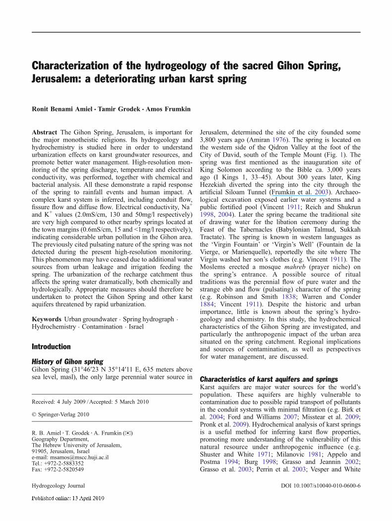
Fig. 1 Gihon Spring research area with probable underground catchment, covering 7.5 km2. a Location of the study area; b Geologicalcross section, modified after Picard (1956). 1–4 Senonian Menuha and Mishash Formations; 5–6 Turonian Bina-Mizi Hilu; 7 TuronianBina-Meleke; 8 Cenomanian Bina-Mizi Ahmar; 9 Cenomanian: Weradim-Mizi Yehudi; 10 Cenomanian Kefar Shaul-Dir Yasini. cGeological map; the entire catchment lies within the urbanized area of Jerusalem. The Old City is the white ‘undefined’ area in the center.L-type arrows in the upper part indicate cross-section location
Hydrogeology Journal DOI 10.1007/s10040-010-0600-6
Williams 2007). Recession curve analysis of a springhydrograph (Tobarov 1976; Milanovic 1981; Ford andWilliams 2007) can elucidate the relation between the threeflows regime. A high-resolution Gihon Spring hydrographis recorded and analyzed here for the first time.
Effects of urbanizationUrban environments significantly alter the nature ofrecharge to underlying aquifers. The natural soil coverchanges in favor of urban elements and, therefore, rainfallno longer recharges the system naturally in quantity andquality (e.g. Barret et al. 1999). Modern city constructionsuch as paving roads/parking lots and buildings candecrease groundwater recharge by lessening the amountof percolation areas (e.g. Kondoh and Nishiyama 2000).In addition, groundwater level may decrease by pumping.On the other hand, a modern city may also increaserecharge through park irrigation as well as leaking watersupply and sewage networks (e.g. Lerner 1986; Schot andvan der Wal 1992).
The inter-relations between anthropogenic land use andnatural recharge processes influence the chemical compo-sition of a spring. One may find in the water traces ofheavy metals from industrial areas, organic material fromdamaged infrastructure, excessive nitrate from agriculturalareas, and acid rain components from urban air pollution(e.g. Appelo and Postma 1994). A high-resolutionhydraulic and physico-chemical analysis of urban karstsprings is important for understanding of the vulnerabilityof these water resources (Birk et al. 2004).
Setting
GeologyJerusalem is located in a structural and topographic saddle inthe Jerusalem Hills (20 km around Jerusalem), at the centerof the Judea and Samaria Mountain range. The spur of theCity of David is a step faulted block in which the stratal dipis 10–15° to the southeast (Gill 1997). Regional bedrockis Late Cretaceous limestone, dolomite and chalk. Thespring catchment is within the Judea Group (Cenomanian-Turonian), exposed west of the Qidron Valley (Fig. 1). TheJudea Group outcrop in Jerusalem is subdivided into sixunits (Gill 1997; Picard 1956; Itzhaki et al. 1964), whosenames are given here in geological and local terms (Fig. 1):(1) Kefar Shaul Formation (Dir Yasini, 0–76 m thick)–chalkand well-bedded limestone acting as aquitard; (2) WeradimFormation (Mizi Yehudi, 25–100 m thick)-massive coarsecrystalline, dense dolomite acting as aquifer; (3) lower BinaFormation (Mizi Ahmar, 40–60 m thick)-bedded fine-crystalline, dense dolomite acting as aquifer; (4) mid-BinaFormation (Meleke, 10–24 m thick)-massive, porous bio-sparitic limestone acting as aquifer; (5) upper BinaFormation (Mizi Hilu, 60–90 m thick)-well-bedded densebiomicritic limestone acting as aquifer; (6) Menuha For-mation (25-80 m thick)–chalk acting as aquitard. MiziAhmar and Meleke rock units are exposed on the hill of the
City of David (Gill 1997). East of the Qidron Valley, beyondthe spring catchment, the biomicritic chalk of SenonianMenuha Formation (of Mount Scopus Group) is exposedabove the Mizi Hilu.
The Gihon Spring emerges 635 masl within a phreaticcave, 3 m below the current Qidron Valley level, which isfilled with thick debris. The spring emerges in MiziAhmar unit (Gill 1997). Few karst voids are truncated bythe ancient waterworks of the City of David. The naturalvadose Warren’s Shaft was even used within an ancientwater system (Frumkin et al. 2003). The Mizi Ahmar rockmatrix appears to be impervious with an average porosityof 2.6% and permeability of 0.13 md (millidarcy).Composed of fossiliferous limestone, the Meleke is charac-terized by much higher matrix porosity (30%) and perme-ability (135 md; Gill 1997). Structural fissuring anddissolution features, recognized throughout the JerusalemHills, enhance the initial perforation of these rocks, oftencreating enlarged cavities (Frumkin and Fischhendler 2005)and drastically increasing the overall rock permeability.
ClimateJerusalem is located at the boundary between the temperateMediterranean climatic belt to the west and the rainshadowJudean Desert to the east. Mean annual temperature is 18°C,and precipitation averages 550 mm/year, falling during thecool winter (October–May), when potential evaporation is∼2 mm/day. The summer (June–September) is hot and drywith potential evaporation ∼7 mm/day (Goldreich 1998).During December–January about two-thirds of the annualrainfall occurs, typically concentrated in rainfall eventslasting from a few hours to several days. August is thehottest month with an average temperature of 24°C, whilethe winter average is 10°C.
The urbanization of JerusalemDuring the second millennium Before the Common Era(BCE), Jerusalem occupied ∼0.04 km2 on the hill abovethe Gihon Spring. The area increased to ∼1 km2 in ∼700BCE, and to ∼2 km2 during the Roman period (firstcentury CE). Following the Arab conquest, the citycontracted to ∼0.85 km2, within the presently walled OldCity (Ben-Aryeh 1977), covering only a small portion ofthe Gihon Spring catchment. This was followed by rapidgrowth outside the walls of the Old City, since the midnineteenth century. Population has increased from 4,700 in1525 CE, through 45,000 in 1896, to 720,000 in 2007.
Today, Jerusalem covers ∼125 km2 (Kaplan et al.2000), including the entire Gihon Spring catchment. Openspace accounts for 65% of the land-use within themunicipal area of the city (JISS 2006–2007). Land usesin the catchment include small industrial areas, archaeo-logical parks, public administration buildings, religiouscompounds and mostly residential quarters. The mainanthropogenic activities that pose a threat to the quality ofgroundwater are small industry and human residencewhere sewage infrastructure is old.
Hydrogeology Journal DOI 10.1007/s10040-010-0600-6
Field work and analysis methods
Background dataTen-minute resolution rainfall data (official Jerusalemgauging station, 1.6 km northwest of the Gihon Spring)is used for background analysis. Monthly spring dischargeand seasonal chloride concentrations had been monitoredby the Hydrological Service of Israel from 1975–1976through 1998–1999 (Hydrological Year-Books of Israel).Data on the May 2002 extreme spring pollution event wasused to resolve the vadose zone flow components andrecharge area. This event occurred due to leakage from asewage pipeline about 1.2 km from the spring.
Methods and measurementsThe monitoring program of the present study at the GihonSpring included continuous recording of water head (withdischarge calculation), electrical conductivity and temper-ature throughout the hydrological year of 2004–2005,with time resolution of minutes. Water head was measuredby means of a rectangular thin-plate weir and a Druckpressure transducer, collected in a Hobo data logger everyminute, and computed using a field-calibrated ratingcurve. Head accuracy is 5 mm. Head monitoring waschecked by manual measurements. Discharge (Q) wascalculated using the Kindsvater-Carter formula (IHS-ISO2008):
Q ¼ 2=3Cdbffiffiffiffiffiffiffiffiffiffiffiffiffi2gh3=2
q
Where the constant Cd = 0.61, b is weir width in m, g isEarth gravitation, h is the water head in m, and Q is givenin m3/s.
Electrical conductivity (EC) and temperature weremeasured every 15 min with a Solinst logger model3001, with accuracy of 0.001 mS/cm and 0.01° respec-tively. Measurements were checked with a manualthermometer and a Corning MHO 109 conductivity meterwith 1% accuracy. The pH was measured in situ periodi-cally during the dry seasons and throughout winter stormsusing a Sentron 1001 pH-System with accuracy of 0.01pH units. It was calibrated prior to each measurement withpH 7 and 10 buffers.
Spring water samples (collected during and followingrainstorms) were analyzed for major ions and trace elementsat the Hebrew University. Chemical analyses were con-ducted on portions of the solution, versus standards fromMerck. The anions fluoride, chloride, nitrite, bromide,nitrate, phosphate and sulfate were determined using a DX-300 Ion Chromatograph (Dionex Corporation, Sunnyvale,California), with an AS4A analytical column and guardcolumn, and an Anion Micromembrane Suppressor. Mea-surements were calibrated using standards from Dionex andAltech. Carbonate and bicarbonate were determined using aFormacHT TOC analyzer, from Skalar Analytical B.V.Breda. The instrument was calibrated with sodium bicar-bonate standards. The elements Ag, Al, As, B, Ba, Cd, Co,
Cr, Cu, Fe, Hg, Li, Mg, Mo, Ni, P, Pb, S, Sb, Se, Si, Sn, Sr,Ti, V and Zn were determined by Inductively CoupledPlasma Atomic Emission Spectrometry. An ICP/AES modelSpectroflame Modula E (Spectro GMBH, Kleve) was used.The pH in the laboratory was determined with a combinedelectrode linked to an Orion pH-meter. Fecal coliformbacteria were analyzed using heterotrophic plate count inBactochem Laboratory (Chapelle 2001).
Data processingVarious methods have been used to analyze karstic springs(e.g. Civita 2008; Sepúlveda 2009). For this study theclassic recession curve analysis is used (Tobarov 1976;Civita 2008; Sepúlveda 2009) which enables one todifferentiate between the karstic flow regimes and com-pare the Gihon data to other carbonate springs in theregion studied by a similar method (Burg 1998; Amit2000).
Recession curve function:
Q ¼XNi¼1
Q0ie�ait ð1Þ
where Q is the discharge (m3/s), Q0 is the discharge attime zero (peak discharge of the recession), e is the baseof the Naperian logarithms, ai is the recession coefficientper segment i expressed as 1/T (where T is time expressedin minutes or days) and t is the time elapsed between Qt
and Q0. On a semi-logarithmic scale, the curve is astraight line with slope a (Ford and Williams 2007).Monthly flow records from 1970 onward were used toexamine the general flow regime related to seasonalchanges (summer–winter; dry–wet years).
Results
Recharge catchmentKarst catchment boundaries are hard to delineate, as theyoften diverge from the subaerial catchments (Birk et al.2004). In this study, the catchment is defined according tostratigraphy, stratal dip and topography. Field observation,geological maps and sections (Fig. 1; Itzhaki et al. 1964;Picard 1956; Yisraeli 1973; Gill 1997), show that stataldip in Jerusalem promotes south-eastward subterraneanflow from the city towards the Gihon Spring. The historicGihon Spring emerged west of and above the QidronValley streambed (subsequently filled with a few meters ofrubble). The Qidron Valley therefore delineates the easternboundary of the catchment.
Using the 2002 sewage pollution as a tracer, a minimalextent of the spring catchment to the north is constrained.A small east–west trending anticline (Itzhaki and Arkin1964) north of the leaking sewer is presumably thenorthernmost boundary of the catchment. The westerndivide is defined at the Mizi Ahmar-Mizi Yehudi outcropcontact. The proposed recharge area marked in Fig. 1 is
Hydrogeology Journal DOI 10.1007/s10040-010-0600-6
0
20
40
60
80
100
120
140
10 11 12 1 2 3 4 5 6 7 8 9
month
mo
nth
ly v
ol.
(10
3 m3 )
dry year: 1985/86- 324 mm
dry year: 1990/91- 379 mm
wet year: 1982/83- 857 mm
wet year: 1991/92- 1114 mm
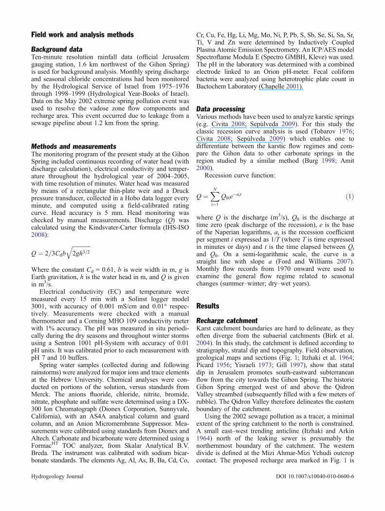
Fig. 2 Gihon Spring monthly discharge for chosen dry and wet years (Hydrological Year-Books of Israel). Annual precipitation of eachyear is given in mm
a
b
c
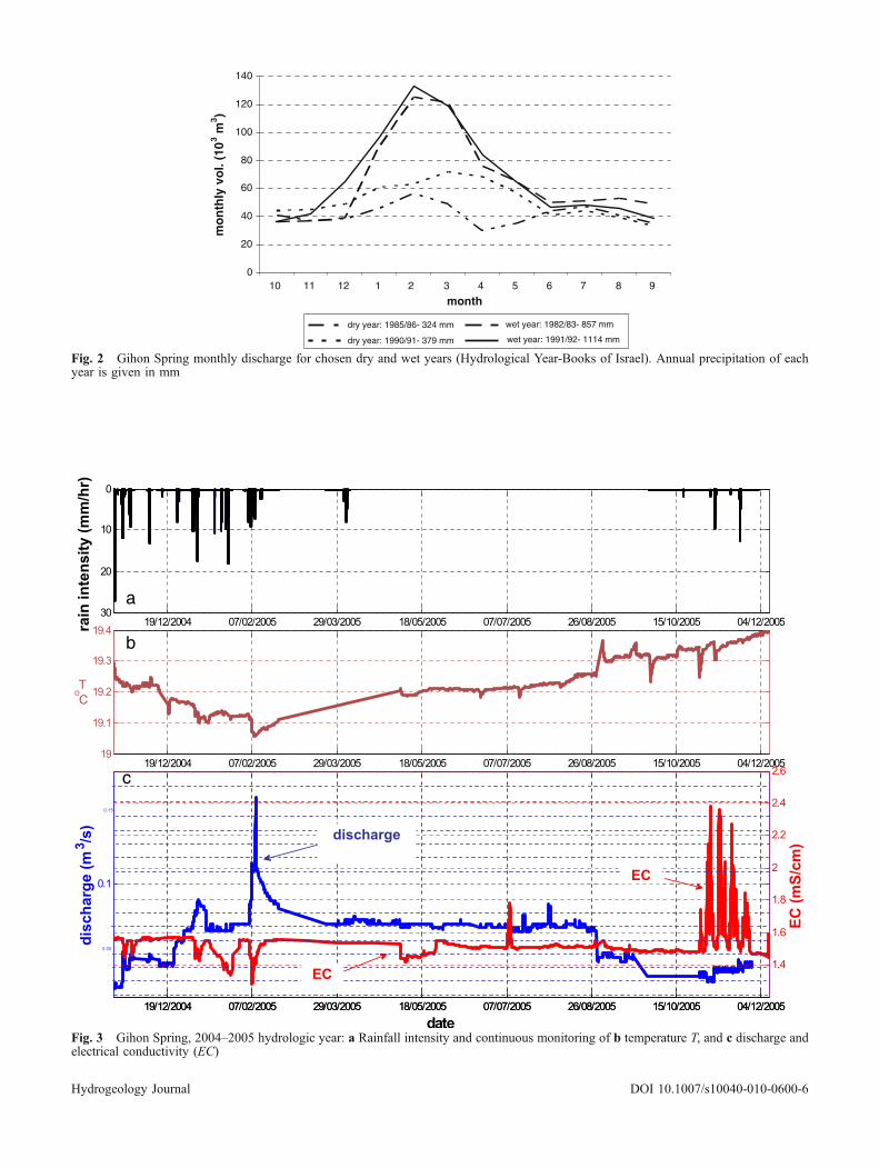
Fig. 3 Gihon Spring, 2004–2005 hydrologic year: a Rainfall intensity and continuous monitoring of b temperature T, and c discharge andelectrical conductivity (EC)
Hydrogeology Journal DOI 10.1007/s10040-010-0600-6
7.5 km2. The effective groundwater recharge in the regionwas previously estimated ∼35% of the annual precipita-tion (Gvirtzman 2002).
Spring flow analysis of existing recordsLong-term monthly flow records (Water CommissionHydrological Service 1970–1998) indicate that dischargeincreases within the wet season (Fig. 2) with a delay of∼1–1.5 months (commonly, peak rainfall is in January andpeak spring discharge in February–March). The springreturns to baseflow condition in around June (∼0.012–0.015 m3/s) and the discharge remains stable during thedry summer.
During an average (ave) year (e.g. 1980–1981;542 mm precipitation), spring discharge peaked at0.022 m3/s, about twice the baseflow. In comparison,during an extremely rainy season (1991–1992; 1,114 mmprecipitation) the spring discharge peaked at 0.051 m3/s,
about three times the baseflow. Four months later, the flowreturned to the normal baseflow. Similar baseflow wasrecorded also during dry years (1985–1986; 325 mmprecipitation). The ratio Qmin:Qave:Qmax was 0.6:1:2.2respectively, but the monthly measurement did notrepresent the extreme high discharge values.
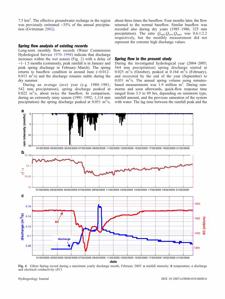
Spring flow in the present studyDuring the investigated hydrological year (2004–2005;564 mm precipitation) spring discharge started at0.025 m3/s (October), peaked at 0.164 m3/s (February),and recovered by the end of the year (September) to0.031 m3/s. The annual spring volume using minutes-based measurements was 1.9 million m3. During rain-storms and soon afterwards, quick-flow response timeranged from 3.5 to 89 hrs, depending on rainstorm type,rainfall amount, and the previous saturation of the systemwith water. The lag time between the rainfall peak and the
01/02/2005 03/02/2005 05/02/2005 07/02/2005 09/02/2005 11/02/2005 13/02/2005 15/02/2005 17/02/2005 19/02/2005 21/02/2005
0
5
10
15
date
01/02/2005 03/02/2005 05/02/2005 07/02/2005 09/02/2005 11/02/2005 13/02/2005 15/02/2005 17/02/2005 19/02/2005 21/02/200519
19.05
19.1
19.15
0.1
0.16
01/02/2005 03/02/2005 05/02/2005 07/02/2005 09/02/2005 11/02/2005 13/02/2005 15/02/2005 17/02/2005 19/02/2005 21/02/2005
1300
1400
1500
1600
date
0.08
0.12
0.14
discharge
EC
rain
inte
nsi
ty (
mm
/hr)
dis
char
ge
(m3 /s
)
EC
(m
S/c
m)
ToC
a
b
c
EC
Fig. 4 Gihon Spring record during a maximum yearly discharge month, February 2005: a rainfall intensity; b temperature; c dischargeand electrical conductivity (EC)
Hydrogeology Journal DOI 10.1007/s10040-010-0600-6
hydrograph peak are in the range of 15 to 31 hrs. In somecases, the rainfall peaks are temporally close to each other,rendering it difficult to differentiate the exact lag times. Insuch cases, the hydrograph and chemographs are rela-tively complicated, integrating the response to more thanone rainfall peak.
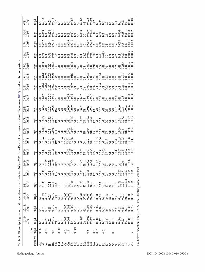
Chemical, temperature and bacterial resultsThe spring water analysis results are summarized inTables 2 and 3. The average spring water EC is relativelyhigh (1.54 mS/cm) compared with other springs aroundJerusalem, especially those in natural open areas(∼0.6 mS/cm). Maximal EC (2.39 mS/cm) was recordedat the end of the dry season (Fig. 3; see discussion insection Urban contributions) and minimal EC (1.278 mS/cm) in February (Fig. 4). Temperature of the water is morestable–between 19.03°C during wintertime (February) andup to 19.42°C at the end of the dry season (September).
Water temperature and EC minima are closely asso-ciated with rainfall peaks (Fig. 4). EC and temperaturevalues began to decline 9–18 hrs after rainfall began, andreached minimum values 8–48 hrs later. After about8 days, both values recovered to their initial values.
The dominant dissolved ions are Ca2+ (103 mg/l), Na+
(125 mg/l), Cl−(191 mg/l) and HCO3−(245 mg/l). Mean
NO3−concentration is 112.3 mg/l, much higher than the
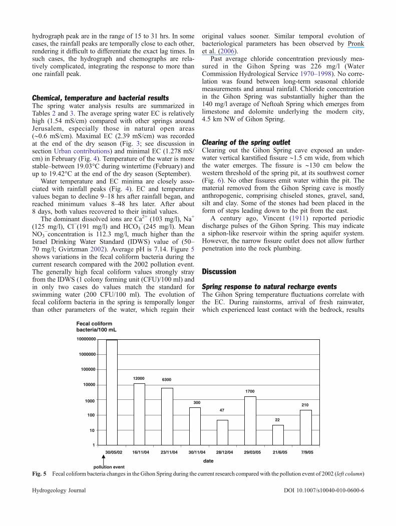
Israel Drinking Water Standard (IDWS) value of (50–70 mg/l; Gvirtzman 2002). Average pH is 7.14. Figure 5shows variations in the fecal coliform bacteria during thecurrent research compared with the 2002 pollution event.The generally high fecal coliform values strongly strayfrom the IDWS (1 colony forming unit (CFU)/100 ml) andin only two cases do values match the standard forswimming water (200 CFU/100 ml). The evolution offecal coliform bacteria in the spring is temporally longerthan other parameters of the water, which regain their
original values sooner. Similar temporal evolution ofbacteriological parameters has been observed by Pronket al. (2006).
Past average chloride concentration previously mea-sured in the Gihon Spring was 226 mg/l (WaterCommission Hydrological Service 1970–1998). No corre-lation was found between long-term seasonal chloridemeasurements and annual rainfall. Chloride concentrationin the Gihon Spring was substantially higher than the140 mg/l average of Neftoah Spring which emerges fromlimestone and dolomite underlying the modern city,4.5 km NW of Gihon Spring.
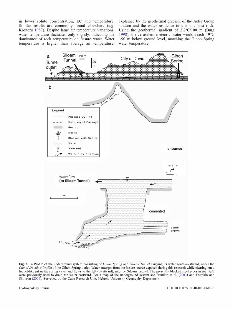
Clearing of the spring outletClearing out the Gihon Spring cave exposed an under-water vertical karstified fissure ∼1.5 cm wide, from whichthe water emerges. The fissure is ∼130 cm below thewestern threshold of the spring pit, at its southwest corner(Fig. 6). No other fissures emit water within the pit. Thematerial removed from the Gihon Spring cave is mostlyanthropogenic, comprising chiseled stones, gravel, sand,silt and clay. Some of the stones had been placed in theform of steps leading down to the pit from the east.
A century ago, Vincent (1911) reported periodicdischarge pulses of the Gihon Spring. This may indicatea siphon-like reservoir within the spring aquifer system.However, the narrow fissure outlet does not allow furtherpenetration into the rock plumbing.
Discussion
Spring response to natural recharge eventsThe Gihon Spring temperature fluctuations correlate withthe EC. During rainstorms, arrival of fresh rainwater,which experienced least contact with the bedrock, results
12000
300
1700
22
21047
630010000
100000
1000000
10000000
30/05/02 16/11/04 23/11/04 30/11/04 28/12/04 29/03/05 21/6/05 7/9/05
datepollution event
1000
100
10
1
Fecal coliform bacteria/100 mL
Fig. 5 Fecal coliform bacteria changes in the Gihon Spring during the current research comparedwith the pollution event of 2002 (left column)
Hydrogeology Journal DOI 10.1007/s10040-010-0600-6
in lower solute concentration, EC and temperature.Similar results are commonly found elsewhere (e.g.Kroitoru 1987). Despite large air temperature variations,water temperature fluctuates only slightly, indicating thedominance of rock temperature on fissure water. Watertemperature is higher than average air temperature,
explained by the geothermal gradient of the Judea Groupstratum and the water residence time in the host rock.Using the geothermal gradient of 2.2°C/100 m (Burg1998), the Jerusalem meteoric water would reach 19°C∼90 m below ground level, matching the Gihon Springwater temperature.
cemented
(to Siloam Tunnel)
20 m
20m
City of David GihonSpring
Siloam Tunnel
a
b
Tunneloutlet
entranceWater level
Fig. 6 a Profile of the underground system consisting of Gihon Spring and Siloam Tunnel carrying its water south-westward, under theCity of David; b Profile of the Gihon Spring outlet. Water emerges from the fissure source exposed during this research while clearing out afunnel-like pit in the spring cave, and flows to the left (westward), into the Siloam Tunnel. The presently blocked steel pipes at the rightwere previously used to drain the water eastward. For a map of the underground system see Frumkin et al. (2003) and Frumkin andShimron (2006). Surveyed by the Cave Research Unit, Hebrew University Geography Department
Hydrogeology Journal DOI 10.1007/s10040-010-0600-6
Worthington (2005) suggested that flow path, length,stratal dip and elevation range could reasonably explainconduit flow depth with the following empirical equation:
D ¼ 0:18 Lqð Þ0:81 ð2Þ
where D is the mean conduit depth in m, L is the flow pathlength in m, θ is the dimensionless stratal dip. Consideringthe recharge boundaries and stratal dip of the GihonSpring aquifer, the mean conduit flow depth would be∼44 m below the spring. The regional Mountain Aquiferwater table in Jerusalem is estimated to be at ∼460 masl(Gvirtzman 2002), based on boreholes ∼4 km west of theGihon Spring. This implies that the Gihon Spring aquiferis perched well above the regional aquifer and that deepflow paths do not affect the spring water temperature. This‘partial’ perching appears to be associated with thedevelopment of karstified fissures controlled by theQidron Valley local base level, because no significantimpermeable layer is known in the lithological sequenceunderlying the spring.
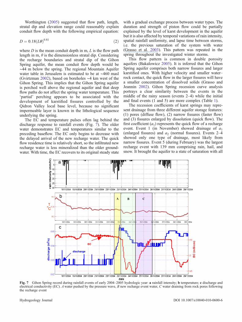
The EC and temperature pulses often lag behind thedischarge response to rainfall events (Fig. 7). The olderwater demonstrates EC and temperatures similar to thepreceding baseflow. The EC only begins to decrease withthe delayed arrival of the new recharge water. The quickflow residence time is relatively short, so the infiltrated newrecharge water is less mineralized than the older ground-water. With time, the EC recovers to its original steady state
with a gradual exchange process between water types. Theduration and strength of piston flow could be partiallyexplained by the level of karst development in the aquiferbut it is also affected by temporal variations of rain intensity,spatial rainfall uniformity, and lapse time between storms,i.e. the previous saturation of the system with water(Grasso et al. 2003). This pattern was repeated in thespring throughout the investigated winter storms.
This flow pattern is common in double porosityaquifers (Bakalowicz 2005). It is inferred that the GihonSpring aquifer comprises both narrow fissures and largerkarstified ones. With higher velocity and smaller water–rock contact, the quick flow in the larger fissures will havea smaller concentration of dissolved solids (Grasso andJeannin 2002). Gihon Spring recession curve analysisportrays a clear similarity between the events in themiddle of the rainy season (events 2–4) while the initialand final events (1 and 5) are more complex (Table 1).
The recession coefficients of karst springs may repre-sent drainage from three different aquifer storage features:(1) pores (diffuse flow), (2) narrow fissures (faster flow)and (3) fissures enlarged by dissolution (quick flow). Thefirst coefficient (a1) represents the quick flow of a rechargeevent. Event 1 (in November) showed drainage of a1(enlarged fissures) and a2 (normal fissures). Events 2–4showed only one type of drainage, most likely fromnarrow fissures. Event 5 (during February) was the largestrecharge event with 139 mm comprising rain, hail, andsnow. It brought the aquifer to a state of saturation with all
A B C
EC
discharge
a
b
c
ToC
Fig. 7 Gihon Spring record during rainfall events of early 2004–2005 hydrologic year: a rainfall intensity; b temperature; c discharge andelectrical conductivity (EC). Awater pushed by the pressure wave, B new recharge event water, C water draining from rock pores followingthe recharge event
Hydrogeology Journal DOI 10.1007/s10040-010-0600-6
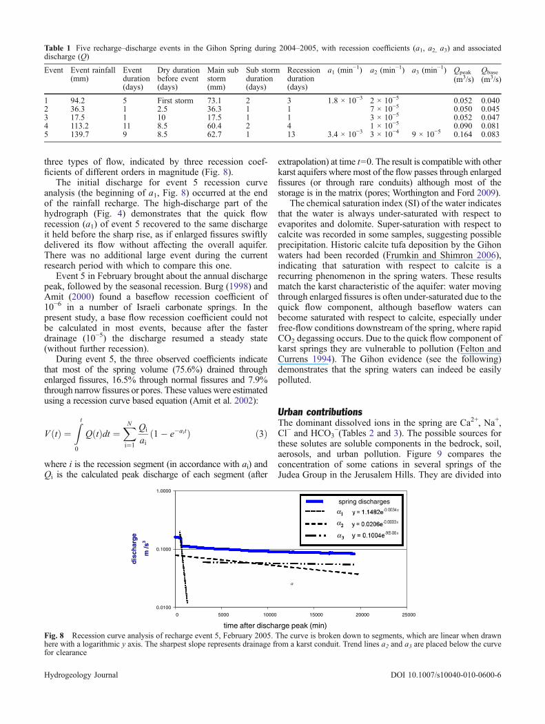
three types of flow, indicated by three recession coef-ficients of different orders in magnitude (Fig. 8).
The initial discharge for event 5 recession curveanalysis (the beginning of a1, Fig. 8) occurred at the endof the rainfall recharge. The high-discharge part of thehydrograph (Fig. 4) demonstrates that the quick flowrecession (a1) of event 5 recovered to the same dischargeit held before the sharp rise, as if enlarged fissures swiftlydelivered its flow without affecting the overall aquifer.There was no additional large event during the currentresearch period with which to compare this one.
Event 5 in February brought about the annual dischargepeak, followed by the seasonal recession. Burg (1998) andAmit (2000) found a baseflow recession coefficient of10−6 in a number of Israeli carbonate springs. In thepresent study, a base flow recession coefficient could notbe calculated in most events, because after the fasterdrainage (10−5) the discharge resumed a steady state(without further recession).
During event 5, the three observed coefficients indicatethat most of the spring volume (75.6%) drained throughenlarged fissures, 16.5% through normal fissures and 7.9%through narrow fissures or pores. These values were estimatedusing a recession curve based equation (Amit et al. 2002):
V ðtÞ ¼Z t
0
QðtÞdt ¼XNi¼1
Qi
ai1� e�aitð Þ ð3Þ
where i is the recession segment (in accordance with ai) andQi is the calculated peak discharge of each segment (after
extrapolation) at time t=0. The result is compatible with otherkarst aquifers where most of the flow passes through enlargedfissures (or through rare conduits) although most of thestorage is in the matrix (pores; Worthington and Ford 2009).
The chemical saturation index (SI) of the water indicatesthat the water is always under-saturated with respect toevaporites and dolomite. Super-saturation with respect tocalcite was recorded in some samples, suggesting possibleprecipitation. Historic calcite tufa deposition by the Gihonwaters had been recorded (Frumkin and Shimron 2006),indicating that saturation with respect to calcite is arecurring phenomenon in the spring waters. These resultsmatch the karst characteristic of the aquifer: water movingthrough enlarged fissures is often under-saturated due to thequick flow component, although baseflow waters canbecome saturated with respect to calcite, especially underfree-flow conditions downstream of the spring, where rapidCO2 degassing occurs. Due to the quick flow component ofkarst springs they are vulnerable to pollution (Felton andCurrens 1994). The Gihon evidence (see the following)demonstrates that the spring waters can indeed be easilypolluted.
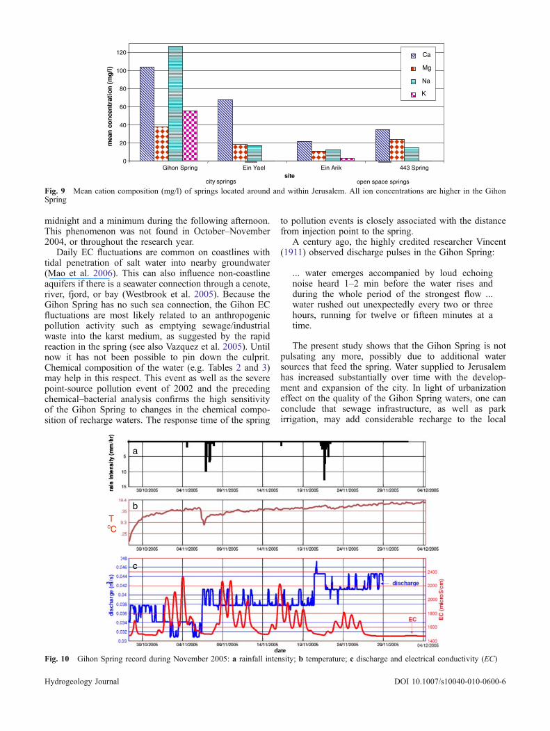
Urban contributionsThe dominant dissolved ions in the spring are Ca2+, Na+,Cl− and HCO3
−(Tables 2 and 3). The possible sources forthese solutes are soluble components in the bedrock, soil,aerosols, and urban pollution. Figure 9 compares theconcentration of some cations in several springs of theJudea Group in the Jerusalem Hills. They are divided into
time after discharge peak (min)
a
0.0100
0.1000
1.0000
0 5000 10000 15000 20000 25000
dis
char
ge
m /s
3
1
2
3
1
2
3
1
2
3
spring discharges
α
α
α
Fig. 8 Recession curve analysis of recharge event 5, February 2005. The curve is broken down to segments, which are linear when drawnhere with a logarithmic y axis. The sharpest slope represents drainage from a karst conduit. Trend lines a2 and a3 are placed below the curvefor clearance
Table 1 Five recharge–discharge events in the Gihon Spring during 2004–2005, with recession coefficients (a1, a2, a3) and associateddischarge (Q)
Event Event rainfall(mm)
Eventduration(days)
Dry durationbefore event(days)
Main substorm(mm)
Sub stormduration(days)
Recessionduration(days)
a1 (min−1) a2 (min−1) a3 (min−1) Qpeak
(m3/s)Qbase
(m3/s)
1 94.2 5 First storm 73.1 2 3 1.8 × 10⁻³ 2 × 10⁻⁵ 0.052 0.0402 36.3 1 2.5 36.3 1 1 7 × 10⁻⁵ 0.050 0.0453 17.5 1 10 17.5 1 1 3 × 10⁻⁵ 0.052 0.0474 113.2 11 8.5 60.4 2 4 1 × 10⁻⁵ 0.090 0.0815 139.7 9 8.5 62.7 1 13 3.4 × 10⁻³ 3 × 10⁻⁴ 9 × 10⁻⁵ 0.164 0.083
Hydrogeology Journal DOI 10.1007/s10040-010-0600-6
two categories: city springs and natural open space springsin unpopulated areas, according to the main land use inthe recharge catchment. Ein Yael (6.5 km SW of GihonSpring) is a perched city spring draining the partlyurbanized Gilo neighborhood in Jerusalem (6 km SW ofGihon Spring; Burg 1998). Ein Arik spring (17 km NWofGihon Spring), drains an unpopulated area. Spring 443(13 km NW of Gihon Spring) emerges from dolomitestrata at the bottom of an unsettled hillock. Soluteconcentration is highest in the Gihon Spring, followedthen by Ein Yael spring. The high solute concentrations inthe Gihon waters is attributed to anthropogenic pollutionin the urbanized older part of Jerusalem. The water isparticularly rich in Na+ content as well as other solutes.The high Na+ concentration in the Gihon water, comparedwith other carbonate aquifers, cannot be attributed tomarine salt, due to the distance from the coast and lowamount of salt in rainfall, dew and dry fallout in Jerusalem(Yaalon and Ganor 1968). It cannot be attributed tohighway salting, because this is practiced in Jerusalemonly rarely, during extremely heavy snowfall. Urbananthropogenic pollution is the most probable origin, butits exact nature has yet to be determined by surveyingpossible human contributions in the catchment. These areprobably associated with old, leaking and sometimesabsent sewage infrastructure in the Old City of Jerusalem.
Ca2+ concentrations are higher than in other nearbysprings (Fig. 9 and Frumkin 1993), albeit not by globalstandards (Ford and Williams 2007). Rain water and roadrunoff analyses indicate that the relatively high Ca2+
concentrations do not originate from rain solutes orvehicle emissions. Other research has also found that therain hardly adds solutes to groundwater (Todd 1959).Jerusalem is growing rapidly with many building sites.This creates a limestone powder available to dissolutionand infiltration. This can explain the relatively high Ca2+
concentrations. Ein Yael, which drains a new neighbor-hood with modern sewage and drainage infrastructure,shows lower solute concentrations, but still higher thansprings draining open, unpopulated landscapes.
Salus (2001) conducted research on limestone anddolomite springs in the area of Ramallah (north ofJerusalem) and found that Ein Mutzbah, located insidethe city of Ramallah, demonstrated high concentrations ofCa2+, Mg2+ and Na+. Salus associated the high Na+ to
anthropogenic contributions especially when compared tothe nearby Ein El Balad Surda located outside the city.
Relatively high nitrate concentrations (83–117 mg/l)were measured in the Gihon Spring. Salus (2001)measured lower NO3
−concentrations of 3–32 mg/l (during1999–2000), with highest values in Ein El Balad Surdaand Ein Mutzbah. High concentrations (90 mg/l), similarto the Gihon water, were also found in Kfar Bara, whichhas had cesspits for many years. In 1992, a new sewageinfrastructure reduced Kfar Bara nitrate level within a fewmonths to 30 mg/l (Gvirtzman 2002). The high nitrateconcentrations demonstrate the high vulnerability of urbankarst aquifers to pollution, particularly from leakingsewage.
Concentrations of fecal coliform bacteria in the GihonSpring (Fig. 5) demonstrate: (1) the major impact of the2002 pollution event and the pollution hazard of thekarstic aquifer; (2) the first winter rains brought about asharp decrease, by ∼3 orders of magnitude, from12,000 CFU/100 ml in November to 47 in December2004; (3) the rise in March 2005 by two orders ofmagnitude (1,700 CFU/100 ml) may indicate a flushing ofbacteria by the maximal annual discharge, but this singlemeasurement is not conclusive enough, especially whennone of the other coeval parameters showed exception-ality. Fecal coliform bacteria were not analyzed prior tothe 2002 pollution event. During the extreme pollutionevent of 2002, fecal coliform concentrations in the springwere very similar to sewage pipe concentrations (4 × 10⁶
and 2.5 × 10⁶ respectively). Despite the overall dramaticdecrease since the pollution event, the water is still notpotable and sometimes not even fit for swimming.
The high EC value is compared with other nearby openarea carbonate springs such as Ein Se’adim and EinBikkura (11 km WSW and 10 km W of Gihon Spring,with 0.855 and 0.461 mS/cm respectively). The Gihonwater EC indicates that it is continuously polluted,according to the classification of Krawczyk and Ford(2008). In particular, during November 2005, sharp ECfluctuations in the Gihon Spring were observed at timeswith very little rain or none at all, and without matchingtrends in the discharge and temperature. During thisperiod, the recorded EC reached peaks above 2 mS/cm.The EC record (Fig. 10) reflects a 5-day cycle withrepetitive daily peaks: maximal EC was reached around
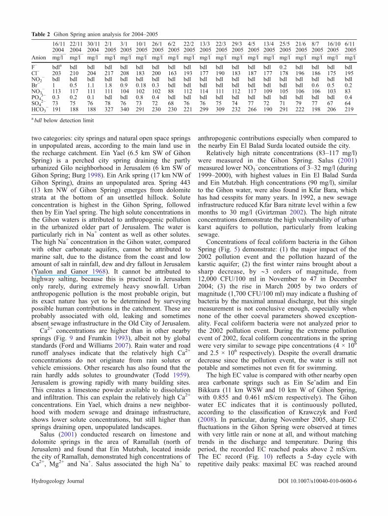
Table 2 Gihon Spring anion analysis for 2004–2005
16/112004
22/112004
30/112004
2/12005
3/12005
10/12005
26/12005
6/22005
22/22005
13/32005
22/32005
29/32005
4/52005
13/42005
25/52005
21/62005
8/72005
16/102005
6/112005
Anion mg/l mg/l mg/l mg/l mg/l mg/l mg/l mg/l mg/l mg/l mg/l mg/l mg/l mg/l mg/l mg/l mg/l mg/l mg/l
F− bdla bdl bdl bdl bdl bdl bdl bdl bdl bdl bdl bdl bdl bdl 0.2 bdl bdl bdl bdlCl− 203 210 204 217 208 183 200 163 193 177 190 183 187 177 178 196 186 175 195NO2
− bdl bdl bdl bdl bdl bdl bdl bdl bdl bdl bdl bdl bdl bdl bdl bdl bdl bdl bdlBr− 1 0.5 1.1 1.8 0.9 0.18 0.3 bdl bdl bdl bdl bdl bdl bdl bdl bdl 0.6 0.5 0.2NO3
− 113 117 111 111 104 102 102 88 112 114 111 112 117 109 105 106 106 103 83PO4
3− 0.3 0.2 0.1 bdl bdl 0.8 0.4 bdl bdl bdl bdl bdl bdl bdl bdl bdl bdl bdl 0.4SO4
2− 73 75 76 78 76 73 72 68 76 76 75 74 77 72 71 79 77 67 64HCO3
− 191 188 188 327 340 291 230 230 221 299 309 232 266 190 291 222 198 206 219
a bdl below detection limit
Hydrogeology Journal DOI 10.1007/s10040-010-0600-6
Tab
le3
Gihon
Springcatio
nandtraceelem
entanalysisfor20
04–200
5.Israel’sdrinking
water
standard
(Gvirtzm
an20
02)isaddedforcomparison
16/11/
2004
22/11/
2004
30/11/
2004
2/1/
2005
3/1/
2005
10/1/
2005
26/1/
2005
6/2/
2005
22/2/
2005
13/3/
2005
22/3/
2005
29/3/
2005
5/4/
2005
13/4/
2005
25/5/
2005
21/6/
2005
8/7/
2005
16/10/
2005
6/11/
2005
IDWS
Elementmg/l
mg/l
mg/l
mg/l
mg/l
mg/l
mg/l
mg/l
mg/l
mg/l
mg/l
mg/l
mg/l
mg/l
mg/l
mg/l
mg/l
mg/l
mg/l
mg/l
Ag
0.08
bdl
bdl
bdl
bdl
bdl
bdl
bdl
bdl
bdl
bdl
bdl
bdl
bdl
bdl
bdl
bdl
bdl
bdl
bdl
Al
bdl
0.01
0.02
20.03
30.03
6bd
l0.04
0.28
60.01
80.01
30.05
40.02
20.01
40.01
40.00
90.21
0.02
20.05
90.05
2As
0.05
0.02
bdl
0.01
3bd
lbd
l0.01
7bd
lbd
lbd
lbd
lbd
lbd
l0.01
40.00
7bd
lbd
lbd
lbd
lbd
lB
0.22
0.18
0.23
0.24
0.22
0.22
50.28
0.19
0.24
0.23
30.22
10.22
80.22
0.22
30.22
0.56
0.24
0.22
40.21
Ba
0.7
0.07
20.07
70.07
90.08
0.07
70.07
90.10
50.08
50.07
80.07
70.07
60.07
80.07
30.07
60.07
50.08
0.07
80.07
10.07
3Ca
9110
210
3115
112
106
106
108
111
104
102
9710
010
598
109
101
8910
7Cd
0.00
5bd
lbd
lbd
lbd
lbd
lbd
lbd
lbd
lbd
lbd
lbd
lbd
lbd
lbd
lbd
lbd
lbd
lbd
lbd
lCo
bdl
bdl
bdl
bdl
bdl
bdl
bdl
0.00
4bd
lbd
lbd
lbd
lbd
lbd
lbd
lbd
lbd
lbd
lbd
lCr
0.05
0.00
20.00
20.00
2bd
lbd
lbd
lbd
l0.00
3bd
lbd
lbd
lbd
lbd
lbd
lbd
lbd
lbd
lbd
lbd
lCu
1.4
0.00
30.00
80.00
6bd
lbd
lbd
l0.00
30.00
80.00
3bd
l0.00
60.00
5bd
lbd
lbd
lbd
l0.00
3bd
lbd
lFe
1bd
l0.00
90.01
80.03
60.03
10.00
40.04
70.23
80.01
90.01
50.04
90.02
40.00
90.01
60.00
80.21
0.01
90.03
10.08
3Hg
0.00
1bd
lbd
lbd
lbd
lbd
lbd
lbd
lbd
lbd
lbd
lbd
lbd
lbd
lbd
lbd
lbd
lbd
lbd
lbd
lK
6063
5556
5452
5034
5357
5859
6060
5650
6155
59Li
0.00
23bd
l0.00
20.00
30.00
30.00
20.00
2bd
lbd
l0.00
20.00
20.00
2bd
lbd
lbd
lbd
lbd
l0.00
30.00
3Mg
3840
37.4
3737
3838
3440
3838
3838
3838
38.7
4036
41Mn
0.5
0.00
150.00
50.00
40.00
50.00
60.00
20.00
70.22
70.01
40.01
20.01
50.011
0.00
80.00
80.00
70.05
30.00
70.00
90.02
3Mo
0.00
60.00
90.00
7bd
lbd
l0.00
80.00
4bd
lbd
l0.00
50.00
40.00
7bd
lbd
lbd
l0.05
0.03
50.00
50.00
5Na
0.2
128
135
128
126
126
128
127
9313
312
813
312
812
612
812
012
013
112
014
2Ni
0.05
0.00
20.00
20.00
3bd
lbd
l0.00
5bd
l0.00
50.00
3bd
lbd
lbd
lbd
lbd
lbd
lbd
lbd
lbd
lbd
lP
0.27
0.29
0.28
0.27
0.26
0.21
0.28
0.36
60.24
0.27
0.26
0.29
0.34
60.14
40.3
0.44
0.28
0.29
0.32
Pb
0.01
bdl
bdl
bdl
bdl
bdl
bdl
0.00
5bd
lbd
lbd
lbd
lbd
lbd
lbd
lbd
l0.01
3bd
lbd
lbd
lS
24.5
2624
.823
2327
2723
.327
2625
2930
.430
.430
3924
2427
Sb
bdl
bdl
bdl
bdl
bdl
bdl
bdl
bdl
bdl
bdl
bdl
bdl
bdl
bdl
bdl
bdl
bdl
bdl
bdl
Se
0.01
0.02
bdl
0.02
bdl
bdl
bdl
bdl
bdl
bdl
bdl
bdl
bdl
bdl
bdl
bdl
bdl
bdl
bdl
bdl
Si
6.8
7.2
7.2
6.8
6.4
76.94
7.14
7.3
7.2
7.15
17.2
5.5
5.7
5.2
4.7
7.6
7.5
5.1
Sn
0.00
80.01
0.01
0.00
80.00
7bd
l0.00
70.00
50.00
60.01
0.00
6bd
lbd
lbd
lbd
lbd
l0.00
70.00
4bd
lSr
0.25
0.28
0.28
0.28
0.27
0.26
0.28
0.27
50.26
0.27
20.26
0.28
0.26
10.27
10.28
30.29
0.3
0.28
0.28
Ti
bdl
bdl
bdl
0.00
120.00
1bd
l0.00
2bd
lbd
lbd
l0.00
2bd
lbd
lbd
lbd
lbd
lbd
lbd
lbd
lV
0.00
80.00
80.00
80.00
60.00
50.00
60.00
80.00
80.00
60.00
70.00
60.00
80.00
40.00
50.00
60.01
30.00
60.00
80.00
8Zn
50.02
0.05
70.03
60.00
60.00
6bd
l0.00
30.011
0.00
40.00
30.00
40.00
30.00
30.00
80.00
30.01
30.00
30.00
20.00
4
bdlbelow
detectionlim
it;ID
WSIsrael
drinking
water
standard
Hydrogeology Journal DOI 10.1007/s10040-010-0600-6
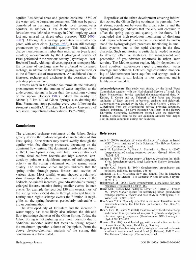
midnight and a minimum during the following afternoon.This phenomenon was not found in October–November2004, or throughout the research year.
Daily EC fluctuations are common on coastlines withtidal penetration of salt water into nearby groundwater(Mao et al. 2006). This can also influence non-coastlineaquifers if there is a seawater connection through a cenote,river, fjord, or bay (Westbrook et al. 2005). Because theGihon Spring has no such sea connection, the Gihon ECfluctuations are most likely related to an anthropogenicpollution activity such as emptying sewage/industrialwaste into the karst medium, as suggested by the rapidreaction in the spring (see also Vazquez et al. 2005). Untilnow it has not been possible to pin down the culprit.Chemical composition of the water (e.g. Tables 2 and 3)may help in this respect. This event as well as the severepoint-source pollution event of 2002 and the precedingchemical–bacterial analysis confirms the high sensitivityof the Gihon Spring to changes in the chemical compo-sition of recharge waters. The response time of the spring
to pollution events is closely associated with the distancefrom injection point to the spring.
A century ago, the highly credited researcher Vincent(1911) observed discharge pulses in the Gihon Spring:
... water emerges accompanied by loud echoingnoise heard 1–2 min before the water rises andduring the whole period of the strongest flow ...water rushed out unexpectedly every two or threehours, running for twelve or fifteen minutes at atime.
The present study shows that the Gihon Spring is notpulsating any more, possibly due to additional watersources that feed the spring. Water supplied to Jerusalemhas increased substantially over time with the develop-ment and expansion of the city. In light of urbanizationeffect on the quality of the Gihon Spring waters, one canconclude that sewage infrastructure, as well as parkirrigation, may add considerable recharge to the local
ToC
a
b
c
Fig. 10 Gihon Spring record during November 2005: a rainfall intensity; b temperature; c discharge and electrical conductivity (EC)
mea
n co
ncen
trat
ion
(mg/
l)
0
20
40
60
80
100
120
Gihon Spring Ein Yael Ein Arik 443 Springsite
Ca
Mg
Na
K
open space springs city springs
Fig. 9 Mean cation composition (mg/l) of springs located around and within Jerusalem. All ion concentrations are higher in the GihonSpring
Hydrogeology Journal DOI 10.1007/s10040-010-0600-6
aquifer. Residential areas and gardens consume ∼55% ofthe water sold to Jerusalem consumers. This can be partlyconsidered as recharge that feeds local groundwateraquifers. In addition, 11.1% of the water supplied toJerusalem was defined as wastage in 2005, implying waterlost and unused for direct urban purposes (JISS 2006–2007). Although this wastage percentage is small com-pared with other cities (Lerner 1986), it can still rechargegroundwater by a substantial quantity. This study’s dis-charge measurement is higher than most earlier (yearly andmonthly) measurements by the Hydrological Service ofIsrael performed in the previous century (Hydrological Year-Books of Israel). Although direct comparison is not possible,the increase of discharge may be attributed to increasedrecharge, in addition to the different gaging system used, orto the different site of measurement. An additional clue toincreased recharge and discharge is the cessation of thepulsating phenomenon.
Excess water in the aquifer can terminate the pulsatingphenomenon when the amount of water supplied to theunderground storage is larger than the maximum volumeof the siphon (Bonacci 1987). Indeed, the nearby EinMabua (13 km NE of Gihon Spring), also draining theBina Formation, stops pulsating every year following thestrongest rainfall (A. Frumkin, The Hebrew University ofJerusalem, unpublished observations, 1975–2010).
Conclusions
The urbanized recharge catchment of the Gihon Springgreatly affects the hydrogeological characteristics of thiskarst spring. Karst waters may travel swiftly through theaquifer with few filtering processes, depending on thedominant flow regime. The dominant dissolved ions foundin the Gihon Spring along with high concentrations ofnitrate, fecal coliform bacteria and high electrical con-ductivity point to a significant impact of anthropogenicactivity in the spring catchment on the spring waterquality. The recession curve analysis indicates that thespring drains through pores, fissures and cavities ofvarious sizes. Most rainfall events showed a relativelyslow drainage through narrow fissures and pores of thebedrock. As rainfall increases, groundwater drains throughenlarged fissures, inactive during smaller events. In suchevents (for example the recorded 139 mm event), most ofthe spring water (75%) drains through enlarged fissures.During such high-discharge events the filtration is negli-gible, so the spring becomes particularly vulnerable tourban contamination.
The developed city of Jerusalem and the increase inwater supply has most likely also affected the ebb andflow (pulsating) character of the Gihon Spring. Today, theGihon Spring is not pulsating any more, possibly due toadditional imported water that feeds the spring, beyondthe maximum operation volume of the siphon. From theabove physico-chemical analysis of the spring, thisconclusion is substantiated.
Regardless of the urban development covering infiltra-tion zones, the Gihon Spring continues its perennial flow.A strong correlation between the urban activity and thespring hydrology indicates that the city will continue toaffect the spring quality and quantity in the future. It isconcluded that high-resolution monitoring of dischargeand physico-chemical parameters is essential to under-stand the hydrogeological processes functioning in smallkarst systems, due to the rapid changes in the flowcharacter. Such monitoring is particularly needed in orderto develop effective strategies for management andprotection of groundwater resources in urban karstterrains. The Mediterranean region, highly dependent onkarst aquifers, experiences rapid urbanization, watershortage and pollution. Detailed, high-resolution monitor-ing of Mediterranean karst aquifers and springs such aspresented here, is still lacking in most countries, and ishighly recommended.
Acknowledgements This study was funded by the Israel WaterCommission together with the Hydrological Service of Israel. TheIsrael Meteorology Service supplied the meteorological data. N.Keshet, E. Cohen and A. Tzippori of the Parks and NatureAuthority of Israel assisted in bacterial analyses and fieldwork.Cooperation was granted by the City of David Visitors’ Center. M.Zilberbrand from the Hydrological Service provided laboratoryanalysis assistance. The Cave Research Unit team of the HebrewUniversity Geography Department assisted with the fieldwork.Finally, a special thank to the late Achikam Amichai who helpeda lot in harsh conditions during our fieldwork.
References
Amit H (2000) Analysis of water discharge of springs in Israel,MSC Thesis, Institute of Earth Sciences, The Hebrew Univer-sity of Jerusalem, Israel
Amit H, Lyakhovsky V, Katz A, Starinsky A, Burg A (2002)Interpretation of spring recession curves. Ground Water 40(5):543–552
Amiran R (1976) The water supply of Israelite Jerusalem. In: YadinY (ed) Jerusalem revealed. Israel Exploration Society, Jerusalem,pp 75–78
Appelo CAJ, Postma D (1994) Geochemistry, groundwater andpollution. Balkema, Rotterdam, 536 pp
Atkinson TC (1977) Diffuse flow and conduit flow in limestoneterrain in the Mendip Hills Somerset (Great Britain). J Hydrol35:93–110
Bakalowicz M (2005) Karst groundwater: a challenge for newresources. Hydrogeol J 13:148–160
Barret MH, Hiscock KM, Pedley S, Lerner DN, Tellam JH, FrenchMJ (1999) Marker species for identifying urban groundwaterrecharge sources: a review and case study in Nottingham, UK.Water Res 33:3083–3097
Ben-Aryeh Y (1977) A city reflected in its times: Jerusalem in thenineteenth century, the Old City (in Hebrew). Yad Ben-Zvi,Jerusalem
Birk S, Liedl R, Sauter M (2004) Identification of localized rechargeand conduit flow by combined analysis of hydraulic and physico-chemical spring responses (Urenbrunnen, SW-Germany). JHydrol 286:179–193
Bonacci O (1987) Karst hydrology, with special reference to theDinaric Karst. Springer, Heidelberg, Germany
Burg A (1998) Geochemistry and hydrology of perched carbonateaquifers in northern and central Israel (in Hebrew). PhD Thesis,The Hebrew University of Jerusalem, Israel
Hydrogeology Journal DOI 10.1007/s10040-010-0600-6
Civita MV (2008) An improved method for delineating sourceprotection zones for karst springs based on analysis of recessioncurve data. Hydrogeol J 16(5):855–869
Chapelle FH (2001) Ground-water microbiology and geochemistry.Wiley, New York
Doctor DH (2008) Hydrologic connections and dynamics of watermovement in the classical karst (kras) aquifer: evidence fromfrequent chemical and stable isotope sampling. Acta Carsolog37:101–123
Felton GK, Currens JC (1994) Peak flow rate and recession curvecharacteristics of a karst spring in the inner bluegrass, centralKentucky. J Hydrol 162(1–2):99–118
Ford DC, Williams PW (2007) Karst hydrogeology and geo-morphology. Wiley, Chichester, UK
Frumkin A (1993) Karst origin of the upper erosion surface in thenorthern Judean Mountains, Israel. Isr J Earth Sci 41:169–176
Frumkin A, Fischhendler I (2005) Morphometry and distribution ofisolated caves as a guide for phreatic and confined paleohydro-logical conditions. Geomorphology 67:457–471
Frumkin A, Shimron A (2006) Tunnel engineering in the Iron Age:geoarchaeology of the Siloam Tunnel, Jerusalem. J ArchaeolSci 33:227–237
Frumkin A, Shimron A, Rosenbaum J (2003) Radiometric dating ofthe Siloam Tunnel, Jerusalem. Nature 425:169–171
Gale SJ (1984) The hydraulics of conduit flow in carbonateaquifers. J Hydrol 70:309–327
Gill D (1997) The geology of the City of David and its ancientsubterranean waterworks, Qedem, 35, Monographs of Institutionof Archaeology, Hebrew University of Jerusalem, vol IV, pp 1–28
Goldreich Y (1998) The climate of Israel: observations, research andapplications (in Hebrew). Bar Ilan University, Ramat Gan, Israel
Grasso DA, Jeannin P-Y (2002) A global experimental systemapproach of Karst Springs’ hydrographs and chemographs.Ground Water 40(6):608–618
Grasso DA, Jeannin P-Y, Zwahlen F (2003) A deterministicapproach to the coupled analysis of karst springs’ hydrographsand chemographs. J Hydrol 271:65–76
Gvirtzman H (2002) Israel Water Resources: chapters in hydrologyand environmental sciences (in Hebrew). Yad Ben-Zvi, Jerusalem
IHS-ISO (2008) Hydrometry-open channel flow measurementsusing thin-plate weirs, 2nd edn. IHS-ISO, Englewood, NJ
Itzhaki Y, Arkin Y (1964) Structural map of Israel: Jerusalem-BetShemesh, 1:50,000. Geological Survey of Israel, Jerusalem
Itzhaki Y, Arkin Y, Braun M, Lasman N (1964) Geology Map ofIsrael: Jerusalem-Bet Shemesh, 1:50,000. Geological Survey ofIsrael, Jerusalem
JISS (Jerusalem Institute for Israel Studies) (2006–2007) Statisticalyearbook of Jerusalem, JISS, Jerusalem. www.jiis.org.il. Cited 6Aug 2007
Kaplan M, Kimhi I, Choshen M (2000) The Jerusalem Hills and theJudea Coastal Plain: policy for land conservation and sustain-able development (in Hebrew). Keter, Jerusalem
Kondoh A, Nishiyama J (2000) Changes in hydrological cycle dueto urbanization in the suburb of Tokyo metropolitan area, Japan.Adv Space Res 26:1173–1176
Kroitoru L (1987) The characterization of flow systems in carbonaticrocks defined by the ground water parameters: Central Israel, PhDThesis, Weizmann Institute of Science, Rehovot, Israel
Krawczyk WE, Ford DC (2008) Correlating specific conductivitywith total hardness in limestone and dolomite karst waters.Earth Surf Proc Landf 31:221–234
Lerner DN (1986) Leaking pipes recharge groundwater. GroundWater 24:654–662
Mao X, Enot P, Barry DA, Li L, Binley A, Jeng D-S (2006) Tidalinfluence on behavior of a coastal aquifer adjacent to a low-relief estuary. J Hydrol 327(1–2):110–127
Milanovic PT (1981) Karst hydrogeology. Water Resources,Littleton, CO
Misstear BDR, Brown L, Daly D (2009) A methodology for makinginitial estimates of groundwater recharge from groundwatervulnerability mapping. Hydrogeol J 17(2):275–285
Perrin J, Jeannin P-Y, Zwahlen F (2003) Implications of the spatialvariability of infiltration-water chemistry for the investigation ofa karst aquifer: a field study at Milandre test site, Swiss Jura.Hydrogeol J 11:673–686
Picard LA (1956) Geology, the book of Jerusalem: Jerusalem, itsnatural conditions, history and development from its origins tothe present day (in Hebrew), vol 1. The Bialik Institute,Jerusalem, pp 35–44
Pronk M, Goldscheider N, Zopfi J (2006) Dynamics and interactionof organic carbon, turbidity and bacteria in a karst aquifersystem. Hydrogeol J 14:473–484
Pronk M, Goldscheider N, Zopfi J, Zwahlen F (2009) Percolationand particle transport in the unsaturated zone of a karst aquifer.Ground Water 47(3):361–369
Raeisi E, Groves C, Meiman J (2007) Effects of partial and full pipeflow on hydrochemographs of Logsdon River, Mammoth CaveKentucky USA. J Hydrol 337:1–10
Reich R, Shukrun E (1998) New excavations in the City of David:innovations in Jerusalem Research (in Hebrew). Bar IlanUniversity Conference New Studies on Jerusalem, Ramat Gan,Israel, 10 December 1998
Reich R, Shukrun E (2004) The history of the Gihon Spring inJerusalem. Levant 36:211–223
Robinson E, Smith E (1838) Biblical researches in Palestine, vol 2.University of Michigan Library, Ann Arbor, MI
Salus M (2001) The impact of enhanced urbanization in Ramallahon adjacent groundwater (in Hebrew). MSc Thesis, The HebrewUniversity of Jerusalem, Israel
Schot PP, van der Wal J (1992) Human impact on regionalgroundwater composition through intervention in natural flowpatterns and changes in land use. J Hydrol 134:297–313
Sepúlveda N (2009) Analysis of methods to estimate spring flows ina karst aquifer. Ground Water 47(3):337
Shuster ET, White WB (1971) Seasonal fluctuations in the chemistryof limestone springs: a possible means of characterizingcarbonate aquifers. J Hydrol 14:93–128
Tobarov K (1976) Estimation of permeability and effective porosityin karst on the basis of recession curve analysis. In: Yevjevich V(ed) Karst hydrology and water resources, vol 1, karsthydrology. Water Resources, Littleton, CO
Todd DK (1959) Ground water hydrology, 1st edn. Toppan, TokyoVazquez S, Sanchez-Vila EX, Carrera J (2005) Introductory review
of specific factors influencing urban groundwater, an emergingbranch of hydrogeology, with reference to Barcelona, Spain.Hydrogeol J 13:522–533
Vesper DJ, White WB (2004) Storm pulse chemographs ofsaturation index and carbon dioxide pressure: implications forshifting recharge sources during storm events in the karstaquifer at Fort Campbell, Kentucky/Tennessee, USA. HydrogeolJ 12:135–143
Vincent LH (1911) Underground Jerusalem: discoveries on the Hillof Ophel (1909–11). Cox, London
Warren C, Conder CR (1884) Survey of western Palestine. PalestineExploration Fund, London
Water Commission Hydrological Service (1970–1998) Hydro-logical Year-Books of Israel, Ministry of Agriculture, WCHS,Jerusalem
Westbrook SJ, Rayner JL, Davis GB, Clement TP, Bjerg PL, FisherSJ (2005) Interaction between shallow groundwater, salinesurface water and contaminant discharge at a seasonally andtidally forced estuarine boundary. J Hydrol 302:255–269
Worthington SRH (2005) Hydraulic and geological factors influenc-ing conduit flow depth. Speleog Evol Karst Aquifers 3(1):1–19.www.speleogenesis.info. Cited February 2009
Worthington SRH, Ford DC (2009) Self-organized permeability incarbonate aquifers. Ground Water 47(3):326–336
Yaalon DH, Ganor E (1968) Chemical composition of dew and dryfallout in Jerusalem, Israel. Nature 217:1139–1140
Yisraeli A (1973) A Study of the geo-engineering features of theJerusalem rock foundation: Geo-Technical Mapping (in Hebrew).MSc Thesis, The Hebrew University of Jerusalem, Israel
Hydrogeology Journal DOI 10.1007/s10040-010-0600-6