Building for a Healthy Life - Creating Excellence
47
Building for a Healthy Life A Design Code for neighbourhoods, streets, homes and public spaces
-
Upload
khangminh22 -
Category
Documents
-
view
3 -
download
0
Transcript of Building for a Healthy Life - Creating Excellence

Building for a Healthy LifeA Design Code for neighbourhoods, streets, homes and public spaces

33
Th
e 12
co
nsi
der
ati
on
s
Building for a Healthy Life is a Design Code to help people improve the design of new and growing neighbourhoods.
BHL has been created to allow a broad range of people to use it easily – from members of a local community, local councillors, developers to local authorities – allowing those involved in a proposed new development to focus their thoughts, discussions and efforts on the things that matter most when creating good places to live.
Organised across three headings, 12 considerations are presented to help those involved in new developments to think about the qualities of successful places and how these can be best applied to the individual characteristics of a site and its wider context. These three headings will guide you from macro through to micro scale considerations.
Each consideration is illustrated with clear written and visual prompts helping you to identify good practice and avoid common pitfalls.
BHL can help local communities to set clear expectations of new developments by offering a series of easy to understand considerations that will also allow local communities to more easily identify the qualities (or deficiencies) of development proposals.
Front cover image: A street at Trumpington Meadows, Cambridge reflects many of the qualities championed by BHL.
Homes England is the national housing accelerator.
Building for a Healthy Life is Homes England’s key measure of design quality.
As we approached the publication of BHL, Coronavirus (COVID-19) reached our country. The text had been agreed with Homes England, NHS England and the Ministry of Housing, Communities and Local Government before any restrictions were imposed. The need to be able to cycle or walk to essential services and work had been proposed to minimise traffic and mitigate climate change. The virus then made designing for active travel and access to green space vital. We began to think about the impact on the design of neighbourhoods, streets, homes and public spaces. It became obvious to us that design choices that help people feel disposed to walk or ride a bicycle in their streets and neighbourhoods were also critical to supporting a sense of wellbeing from outdoor exercise during the pandemic. These emerging thoughts have been added to BHL – and are easily identified by the symbol .
14 INTEGRATED NEIGHBOURHOODS
Natural connections
Walking, cycling and public transport
Facilities and services
Homes for everyone
38 DISTINCTIVE PLACES
Making the most of what’s there
A memorable character
Well defined streets and spacesEasy to find your way around
62 STREETS FOR ALL
Healthy streets
Cycle and car parking
Green and blue infrastructureBack of pavement, front of home
Building for a Healthy Life is the latest edition of - and new name for - Building for Life 12.
Building for a Healthy Life (BHL) updates England’s most widely known and most widely used design tool for creating places that are better for people and nature. The original 12 point structure and underlying principles within Building for Life 12 are at the heart of BHL. The new name reflects changes in legislation as well as refinements which we’ve made to the 12 considerations in response to good practice and user feedback.
The new name also recognises that this latest edition has been written in partnership with Homes England, NHS England and NHS Improvement. BHL integrates the findings of the three-year Healthy New Towns Programme led by NHS England and NHS Improvement (please see page 12 for more details about ‘Putting Health into Place’).
Many local authorities across the country have cited Building for Life 12 in their Local Plans and Supplementary Planning Documents. As BHL is the new name for Building for Life 12, local authorities can use BHL without having to rewrite existing policy documents.
55
Th
e 12
co
nsi
der
ati
on
s
Building for a Healthy Life’s 12 considerations move away from the 12 questions in Building for Life 12. This is a tactical shift in emphasis. Questions demand a quick response whereas good design requires more time, analysis and thought.
BHL offers written and visual prompts directing you to the components of successful places. You will notice that photographs are free of annotations and descriptions to encourage you to think about why a particular image has been included and help you to better recognise well designed (and less well designed) places.
The 12 considerations capture the areas of design and placemaking that need most attention but are often the most overlooked.
If you already use or are familiar with Building for Life 12 you will recognise that the basic principles are the same. If you’re a local authority and you’ve cited Building for Life 12 in your Local Plan or other policy documents a useful table1 has been provided to allow you to understand where changes have been made and see that the basic principles are the same.
When using BHL it is important that local authorities and developers discuss the 12 considerations at the very start of the design process, agreeing what is required to achieve a green light against each consideration. It is also recommended that the considerations are also used to frame discussions with local communities and other stakeholders. This approach is much more effective than having these discussions later on when a site layout has been produced - and when a considerable amount of time and money will have been spent. It is simply more effective to use the 12 considerations as a basis for discussion and design exploration before progressing proposals too far - a tenet which distinguishes community engagement from community consultation.
1See pages 86-88.
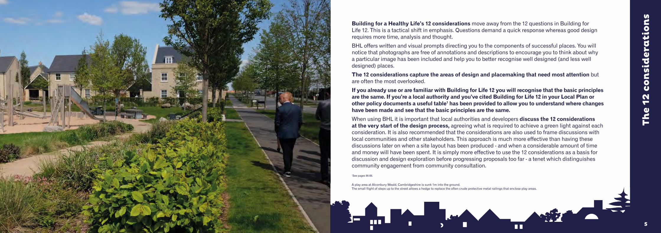
A play area at Alconbury Weald, Cambridgeshire is sunk 1m into the ground. The small flight of steps up to the street allows a hedge to replace the often crude protective metal railings that enclose play areas.
77
Using Building for a Healthy Life BHL works best where it is used as a ‘golden strand’ running through the development and planning process. This involves:
- Local authorities embedding BHL considerations into Local Plans, Local Design Codes, Supplementary Planning Documents and site specific briefs. The 12 considerations are a very effective way of structuring pre-application discussions relating to design quality2.
- Highways Authorities adopting the Manual for Streets principles and thinking. - Developers adopting BHL, using it as a design tool for new developments from the inception of a scheme, rather
than after (or towards the end of) the design process.- Local authorities, developers, local communities and other stakeholders using BHL as a way to set expectations
of new developments. The larger the scale of the development, the broader the engagement needs to be and to help develop a strong understanding of the site and its wider context alongside the needs of the local community.
- Planning Committees and local councillors using BHL to assist with decision making allowing them to more easily identify the design qualities (or weaknesses) of proposed new developments.
- Public health partners in local areas working closely with local planning authorities and developers. By building partnerships with local planning authorities and developers, public health partners (such as those working for Clinical Commissioning Groups and/or local Directors of Public Health) could become more involved in shaping new development at pre-application stage (subject to local planning authority and applicant agreement).
Developers, local authorities and local communities can also use BHL to review the quality of completed developments, helping them to understand areas of success alongside areas for improvement.
Homes England endorse Building for a Healthy Life. Homes England have used BFL12 since 2019 and are now using BHL. Homes England use the 12 considerations as part of its evaluation process for selecting bidders for its land disposal programme. Procurement panel partners whose designs ignore BHL considerations are marked down in the bidding process.
2BHL generally works for developments of around ten homes or more. For smaller developments, the considerations can be useful prompts although not all of them might be appropriate for the scale of the scheme.
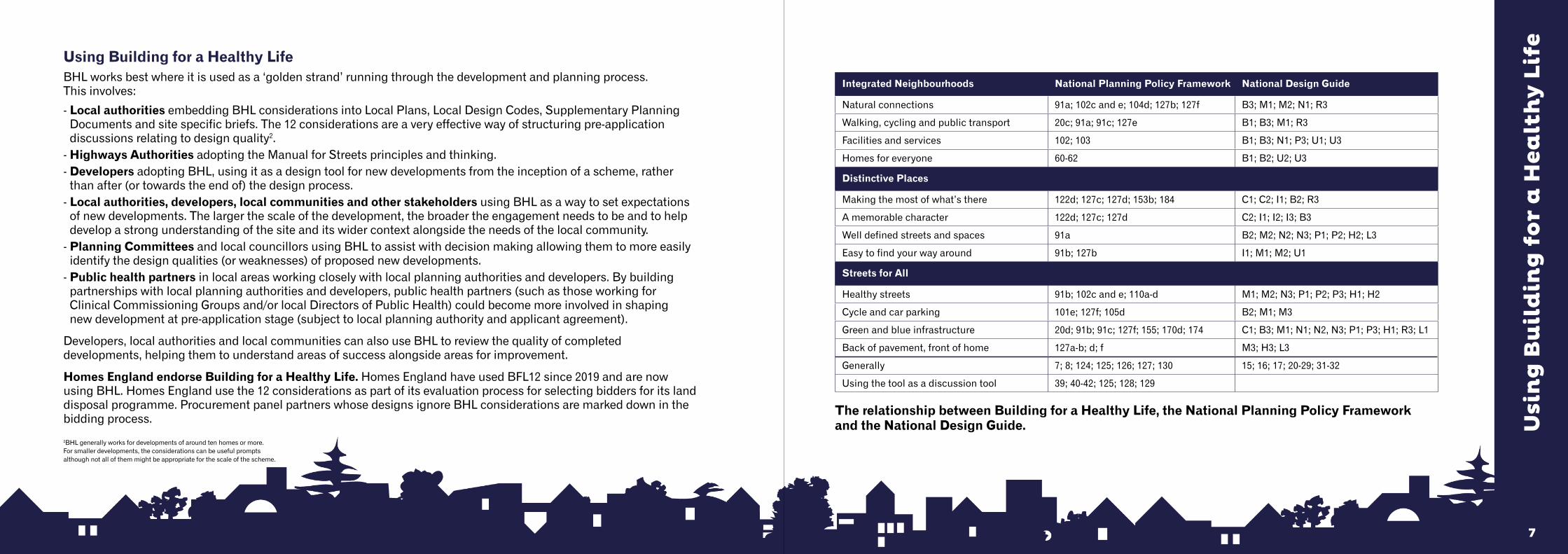
Integrated Neighbourhoods National Planning Policy Framework National Design Guide
Natural connections 91a; 102c and e; 104d; 127b; 127f B3; M1; M2; N1; R3
Walking, cycling and public transport 20c; 91a; 91c; 127e B1; B3; M1; R3
Facilities and services 102; 103 B1; B3; N1; P3; U1; U3
Homes for everyone 60-62 B1; B2; U2; U3
Distinctive Places
Making the most of what’s there 122d; 127c; 127d; 153b; 184 C1; C2; I1; B2; R3
A memorable character 122d; 127c; 127d C2; I1; I2; I3; B3
Well defined streets and spaces 91a B2; M2; N2; N3; P1; P2; H2; L3
Easy to find your way around 91b; 127b I1; M1; M2; U1
Streets for All
Healthy streets 91b; 102c and e; 110a-d M1; M2; N3; P1; P2; P3; H1; H2
Cycle and car parking 101e; 127f; 105d B2; M1; M3
Green and blue infrastructure 20d; 91b; 91c; 127f; 155; 170d; 174 C1; B3; M1; N1; N2, N3; P1; P3; H1; R3; L1
Back of pavement, front of home 127a-b; d; f M3; H3; L3
Generally 7; 8; 124; 125; 126; 127; 130 15; 16; 17; 20-29; 31-32
Using the tool as a discussion tool 39; 40-42; 125; 128; 129
Usi
ng
Bu
ild
ing
fo
r a
Hea
lth
y L
ife
The relationship between Building for a Healthy Life, the National Planning Policy Framework and the National Design Guide.

99
There may be circumstances where amber lights cannot be avoided due to circumstances beyond the control of the local authority and/or the developer.
For instance, third-party land ownership may prevent optimal connectivity from being achieved (See Natural Connections, page 14). Here an amber light might be justified if the layout of streets and spaces does not prevent you from improving the scheme’s connections in the future.
BHL reflects Manual for Streets (2007) in the Healthy Streets consideration (see page 62). It is recognised that a number of local highway authorities have not adopted (or have not fully adopted) the principles set out in Manual for Streets. This can make it very difficult for developers to secure a green light against Healthy Streets. Where this is the case, an amber light is considered justified. This means the developer should not be penalised for not being able to secure a green light against this particular consideration.
BHL promotes more innovative practices adopted by some Highway Authorities to encourage other authorities to reconsider current practice. In 2020, Homes England will publish a set of street details that meet the expectations of both urban designers and highways officers. These more innovative approaches to street design encourage slower vehicle speeds, higher levels of walking and cycling; improving levels of physical activity and local air quality.
Usi
ng
Bu
ild
ing
fo
r a
Hea
lth
y L
ife
Myatt’s Field, Lambeth.
Achieving the best outcome
BHL is foremost a design process structure, not a scoring system. For this reason we list and illustrate examples of good practice highlighted by a green light. Poor practice is highlighted with a red light.
Where an element of design is considered to fall between a green and a red traffic light, an amber light can be assigned to a particular consideration. An amber light does not mean that the design scores ‘half a point’. Instead it cautions that an aspect of a scheme is not fully resolved. In many cases it is possible to rethink and redesign an aspect of a scheme to achieve a better outcome.
The more green lights a proposed development secures, the better it will be. The objective is to minimise the number of amber lights and avoid red lights. A red light suggests that one or more aspects of a scheme need to be reconsidered.
BHL offers a process for collaborative working between developers, local authorities, communities and other stakeholders by providing principles for creating better places and focusing attention on them. Successful placemaking comes from talking, discussing and exploring ideas, workshops, drawing and modelling.
The best way to use BHL is to use the 12 considerations as a starting point and for those involved to agree what is needed to secure a green light against each consideration. It is particularly helpful if local authorities clearly explain what is expected to secure a green light against a particular consideration. red = stop & rethink green = go aheadamber = try & turn to green
11
Who decides what is a green, amber or red light?By using BHL you can better understand the qualities of well-designed developments. The written and visual guidance against each consideration will help you understand how a green light scheme looks and functions – and how a red light scheme looks and functions.
The more you use BHL, the more confident and knowledgeable you will become. References3 signpost you to other useful publications.
If you need help, advice or training this can be found from the authors of BHL and also the nationwide Design Network4 whose members are based locally.
Building for a Healthy Life Commendations
If a development secures at least nine green lights (and no red lights), you can apply for BHL Commendation. A Commendation will allow you to use BHL logo on the development and help you showcase its qualities to prospective home buyers.
Step One: Contact your local Design Network partner and request a BHL Review (fees apply). If the BHL Review agree that you secure at least nine green lights (and no red lights), you will be issued with a short report confirming this. The local Design Network partner will send a copy of this report to Design for Homes.
If the BHL Review do not agree that your development merits at least nine green lights, you will still receive a report that will clearly explain where the issues are and how you can either resolve these issues or better consider these on a future development.
At least two people will conduct the BHL Review with more people on larger developments.
Step Two: Contact Design for Homes. You will be issued with your BHL Commendation e-certificate and branding pack (fee applies).
“Building for a Healthy Life is a process of designing in quality from the start, rather than trying to fix problems later which leads to delays.
It’s our choice of design principles for the many different locations and markets we operate in”
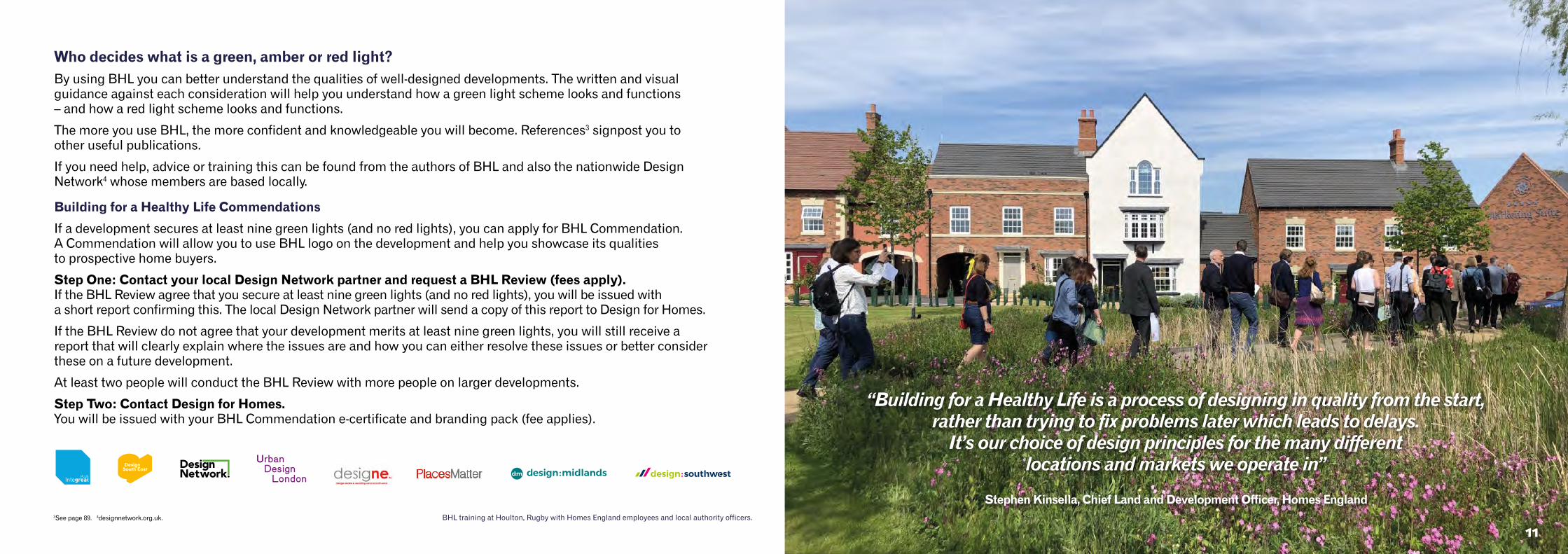
Stephen Kinsella, Chief Land and Development Officer, Homes England BHL training at Houlton, Rugby with Homes England employees and local authority officers.3See page 89. 4designnetwork.org.uk.
1313
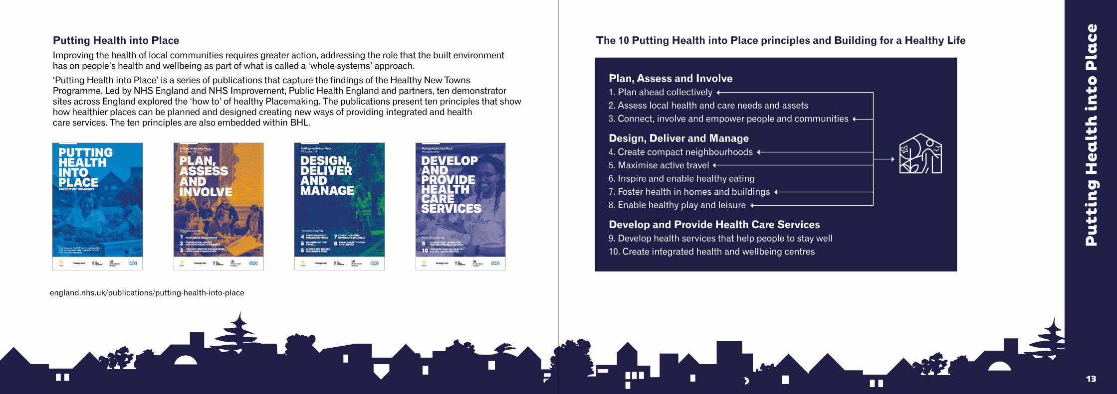
The 10 Putting Health into Place principles and Building for a Healthy Life
Plan, Assess and Involve1. Plan ahead collectively2. Assess local health and care needs and assets3. Connect, involve and empower people and communities
Design, Deliver and Manage4. Create compact neighbourhoods5. Maximise active travel6. Inspire and enable healthy eating7. Foster health in homes and buildings8. Enable healthy play and leisure
Develop and Provide Health Care Services9. Develop health services that help people to stay well10. Create integrated health and wellbeing centres
Putting Health into PlaceImproving the health of local communities requires greater action, addressing the role that the built environment has on people’s health and wellbeing as part of what is called a ‘whole systems’ approach.
‘Putting Health into Place’ is a series of publications that capture the findings of the Healthy New Towns Programme. Led by NHS England and NHS Improvement, Public Health England and partners, ten demonstrator sites across England explored the ‘how to’ of healthy Placemaking. The publications present ten principles that show how healthier places can be planned and designed creating new ways of providing integrated and health care services. The ten principles are also embedded within BHL.
Pu
ttin
g H
ealt
h i
nto
Pla
ce
england.nhs.uk/publications/putting-health-into-place

151514
Na
tura
l co
nn
ecti
on
s
What’s needed:
• Look beyond the red line that marks the extent of your site. Ordnance Survey maps along with satellite mapping software such as Google Earth are useful tools to help you understand the wider context and how you can best stitch a new development into a place.
• Identify the places, facilities and services you need to connect to.
• Draw points of connection into and through your site - creating a strong and direct street, path and open space network.
• Create well-connected street and path networks, providing opportunities for these to be extended beyond the site boundary in the future.
• Research and respond to how water flows and nature moves across your site and the wider surroundings.
Create places that are well integrated into the site and their wider natural and built surroundings. Avoid creating isolated and disconnected places that are not easy places to move through and around.
INT
EG
RA
TE
D N
EIG
HB
OU
RH
OO
DS
Filtered permeability. Aura, Great Kneighton, Cambridge.
Photo credit: Timothy Soar
1717
Na
tura
l co
nn
ecti
on
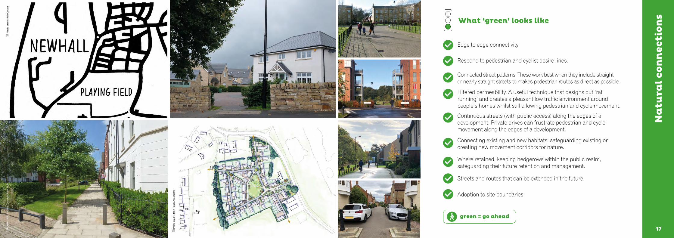
s What ‘green’ looks like
Edge to edge connectivity.
Respond to pedestrian and cyclist desire lines.
Connected street patterns. These work best when they include straight or nearly straight streets to makes pedestrian routes as direct as possible.
Filtered permeability. A useful technique that designs out ‘rat running’ and creates a pleasant low traffic environment around people’s homes whilst still allowing pedestrian and cycle movement.
Continuous streets (with public access) along the edges of a development. Private drives can frustrate pedestrian and cycle movement along the edges of a development.
Connecting existing and new habitats; safeguarding existing or creating new movement corridors for nature.
Where retained, keeping hedgerows within the public realm, safeguarding their future retention and management.
Streets and routes that can be extended in the future.
Adoption to site boundaries.
green = go ahead
Pho
to c
redi
t: R
ob C
owan
Pho
to c
redi
t: J
ohn
Par
dy A
ssoc
iate
s
Pho
to c
redi
t: A
ndre
w C
amer
on A
ssoc
iate
s
1919
Na
tura
l co
nn
ecti
on
s
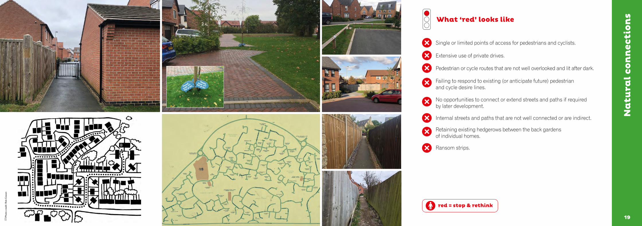
red = stop & rethink
What ‘red’ looks like
Single or limited points of access for pedestrians and cyclists.
Extensive use of private drives.
Pedestrian or cycle routes that are not well overlooked and lit after dark.
Failing to respond to existing (or anticipate future) pedestrian and cycle desire lines.
No opportunities to connect or extend streets and paths if required by later development.
Internal streets and paths that are not well connected or are indirect.
Retaining existing hedgerows between the back gardens of individual homes.
Ransom strips.
Pho
to c
redi
t: R
ob C
owan
212120
Wa
lkin
g, c
ycli
ng
an
d p
ub
lic
tra
nsp
ort
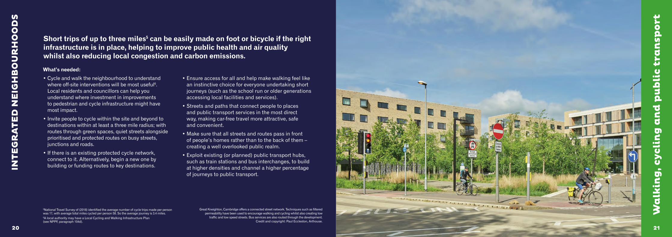
What’s needed:
• Cycle and walk the neighbourhood to understand where off-site interventions will be most useful6. Local residents and councillors can help you understand where investment in improvements to pedestrian and cycle infrastructure might have most impact.
• Invite people to cycle within the site and beyond to destinations within at least a three mile radius; with routes through green spaces, quiet streets alongside prioritised and protected routes on busy streets, junctions and roads.
• If there is an existing protected cycle network, connect to it. Alternatively, begin a new one by building or funding routes to key destinations.
• Ensure access for all and help make walking feel like an instinctive choice for everyone undertaking short journeys (such as the school run or older generations accessing local facilities and services).
• Streets and paths that connect people to places and public transport services in the most direct way, making car-free travel more attractive, safe and convenient.
• Make sure that all streets and routes pass in front of people’s homes rather than to the back of them – creating a well overlooked public realm.
• Exploit existing (or planned) public transport hubs, such as train stations and bus interchanges, to build at higher densities and channel a higher percentage of journeys to public transport.
Short trips of up to three miles5 can be easily made on foot or bicycle if the right infrastructure is in place, helping to improve public health and air quality whilst also reducing local congestion and carbon emissions.
INT
EG
RA
TE
D N
EIG
HB
OU
RH
OO
DS
5National Travel Survey of (2018) identified the average number of cycle trips made per person was 17, with average total miles cycled per person 58. So the average journey is 3.4 miles. 6A local authority may have a Local Cycling and Walking Infrastructure Plan (see NPPF, paragraph 104d).
Great Kneighton, Cambridge offers a connected street network. Techniques such as filtered permeability have been used to encourage walking and cycling whilst also creating low
traffic and low speed streets. Bus services are also routed through the development. Credit and copyright: Paul Eccleston, Arthouse.
2323
Wa
lkin
g, c
ycli
ng
an
d p
ub
lic
tra
nsp
ortWhat ‘green’ looks like
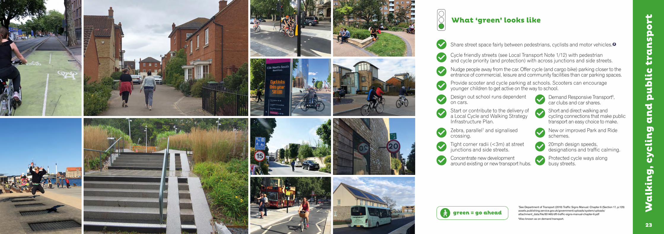
Share street space fairly between pedestrians, cyclists and motor vehicles.
Cycle friendly streets (see Local Transport Note 1/12) with pedestrian and cycle priority (and protection) with across junctions and side streets.
Nudge people away from the car. Offer cycle (and cargo bike) parking closer to the entrance of commercial, leisure and community facilities than car parking spaces.
Provide scooter and cycle parking at schools. Scooters can encourage younger children to get active on the way to school.
Design out school runs dependent on cars.
Demand Responsive Transport8, car clubs and car shares.
Start or contribute to the delivery of a Local Cycle and Walking Strategy Infrastructure Plan.
Short and direct walking and cycling connections that make public transport an easy choice to make.
Zebra, parallel7 and signalised crossing.
New or improved Park and Ride schemes.
Tight corner radii (<3m) at street junctions and side streets.
20mph design speeds, designations and traffic calming.
Concentrate new development around existing or new transport hubs.
Protected cycle ways along busy streets.
green = go ahead7See Department of Transport (2019) Traffic Signs Manual: Chapter 6 (Section 17, p.129) assets.publishing.service.gov.uk/government/uploads/system/uploads/ attachment_data/file/851465/dft-traffic-signs-manual-chapter-6.pdf8Also known as on demand transport.
2525
Wa
lkin
g, c
ycli
ng
an
d p
ub
lic
tra
nsp
ort
red = stop & rethink
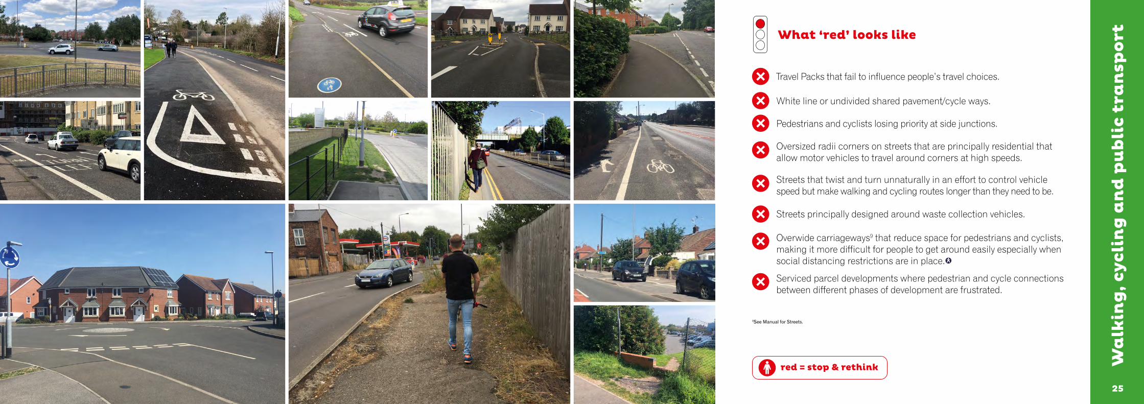
What ‘red’ looks like
Travel Packs that fail to influence people’s travel choices.
White line or undivided shared pavement/cycle ways.
Pedestrians and cyclists losing priority at side junctions.
Oversized radii corners on streets that are principally residential that allow motor vehicles to travel around corners at high speeds.
Streets that twist and turn unnaturally in an effort to control vehicle speed but make walking and cycling routes longer than they need to be.
Streets principally designed around waste collection vehicles.
Overwide carriageways9 that reduce space for pedestrians and cyclists, making it more difficult for people to get around easily especially when social distancing restrictions are in place.
Serviced parcel developments where pedestrian and cycle connections between different phases of development are frustrated.
9See Manual for Streets.
272726
Fa
cili
ties
an
d S
erv
ices
What’s needed:
• Developments that provide community facilities, such as shops, schools, workplaces, health facilities, co-working spaces, parks, play spaces, cafés and other meeting places that respond to local community needs.
• Locate any new facilities in the best location for those walking, cycling and using public transport.
• Consider whether improving existing facilities will add more value to the local community than adding new ones.
• Assess or identify what sport and leisure provision there is for people of all ages, paying particular attention to the needs of children, teenagers and older people.
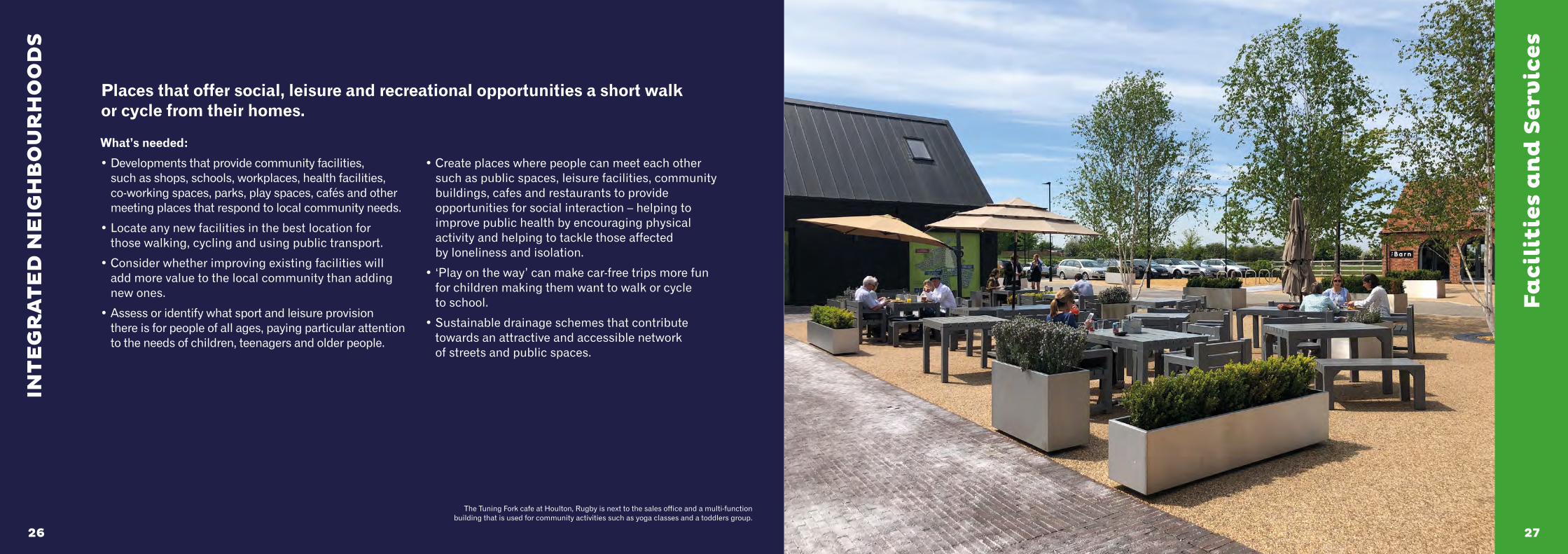
• Create places where people can meet each other such as public spaces, leisure facilities, community buildings, cafes and restaurants to provide opportunities for social interaction – helping to improve public health by encouraging physical activity and helping to tackle those affected by loneliness and isolation.
• ‘Play on the way’ can make car-free trips more fun for children making them want to walk or cycle to school.
• Sustainable drainage schemes that contribute towards an attractive and accessible network of streets and public spaces.
Places that offer social, leisure and recreational opportunities a short walk or cycle from their homes.
INT
EG
RA
TE
D N
EIG
HB
OU
RH
OO
DS
The Tuning Fork cafe at Houlton, Rugby is next to the sales office and a multi-function building that is used for community activities such as yoga classes and a toddlers group.

2929
Fa
cili
ties
an
d S
erv
ices
What ‘green’ looks like
Intensifying development in locations that benefit from good public transport accessibility, in particularly around public transport hubs such as train stations and bus interchanges.
Reserving land in the right locations for non-residential uses.
Active frontages.
Clear windows along the ground floor of non-residential buildings (avoid obscure windows).
Mixing compatible uses vertically, such as placing supported accommodation at the heart of new developments above active ground floor uses.
Giving places where routes meet a human scale and create public squares.
Frequent benches can help those with mobility difficulties to walk more easily between places.
green = go ahead
3131
Fa
cili
ties
an
d S
erv
ices
red = stop & rethink
What ‘red’ looks like
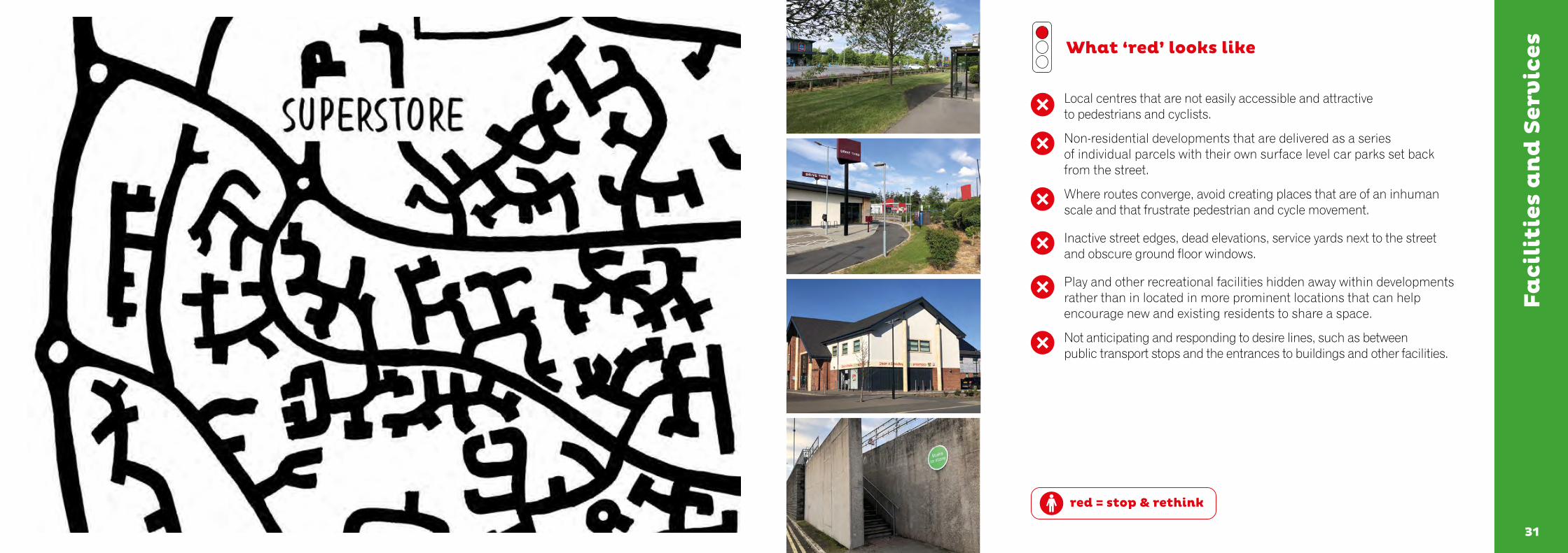
Local centres that are not easily accessible and attractive to pedestrians and cyclists.
Non-residential developments that are delivered as a series of individual parcels with their own surface level car parks set back from the street.
Where routes converge, avoid creating places that are of an inhuman scale and that frustrate pedestrian and cycle movement.
Inactive street edges, dead elevations, service yards next to the street and obscure ground floor windows.
Play and other recreational facilities hidden away within developments rather than in located in more prominent locations that can help encourage new and existing residents to share a space.
Not anticipating and responding to desire lines, such as between public transport stops and the entrances to buildings and other facilities.
333332
Ho
mes
fo
r ev
eryo
ne
What’s needed:
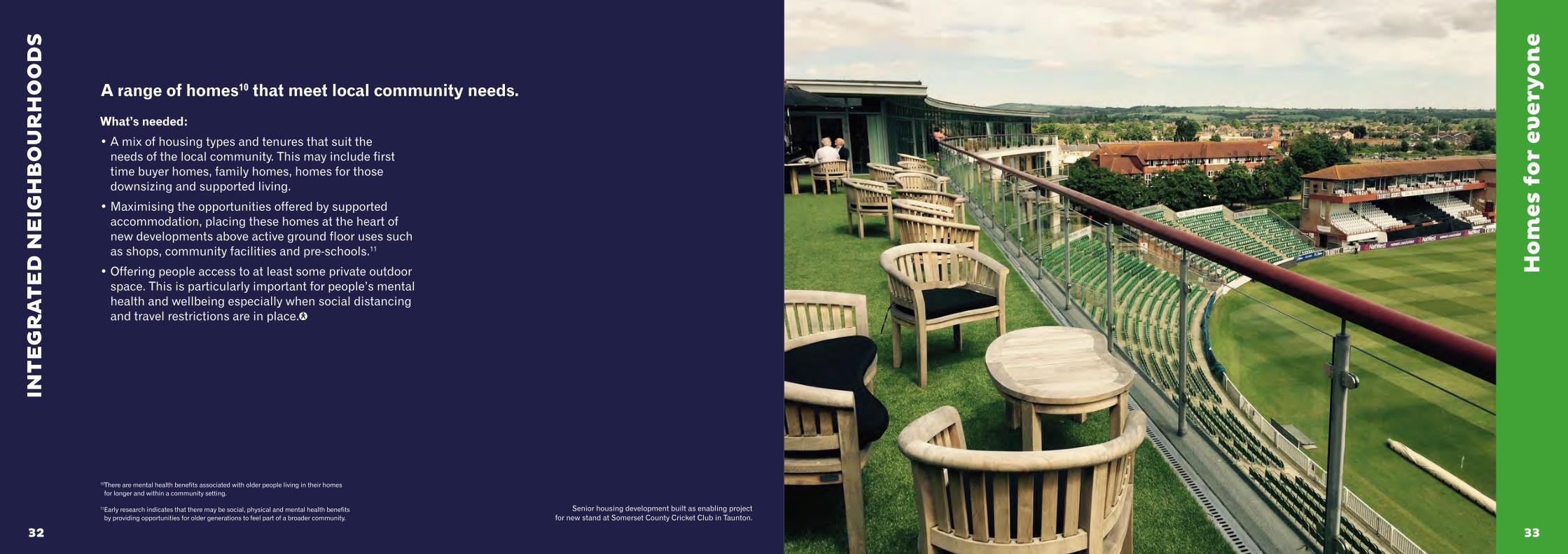
• A mix of housing types and tenures that suit the needs of the local community. This may include first time buyer homes, family homes, homes for those downsizing and supported living.
• Maximising the opportunities offered by supported accommodation, placing these homes at the heart of new developments above active ground floor uses such as shops, community facilities and pre-schools.11
• Offering people access to at least some private outdoor space. This is particularly important for people’s mental health and wellbeing especially when social distancing and travel restrictions are in place.
A range of homes10 that meet local community needs.
INT
EG
RA
TE
D N
EIG
HB
OU
RH
OO
DS
10 There are mental health benefits associated with older people living in their homes for longer and within a community setting.
11 Early research indicates that there may be social, physical and mental health benefits by providing opportunities for older generations to feel part of a broader community.
Senior housing development built as enabling project for new stand at Somerset County Cricket Club in Taunton.
3535
Ho
mes
fo
r ev
eryo
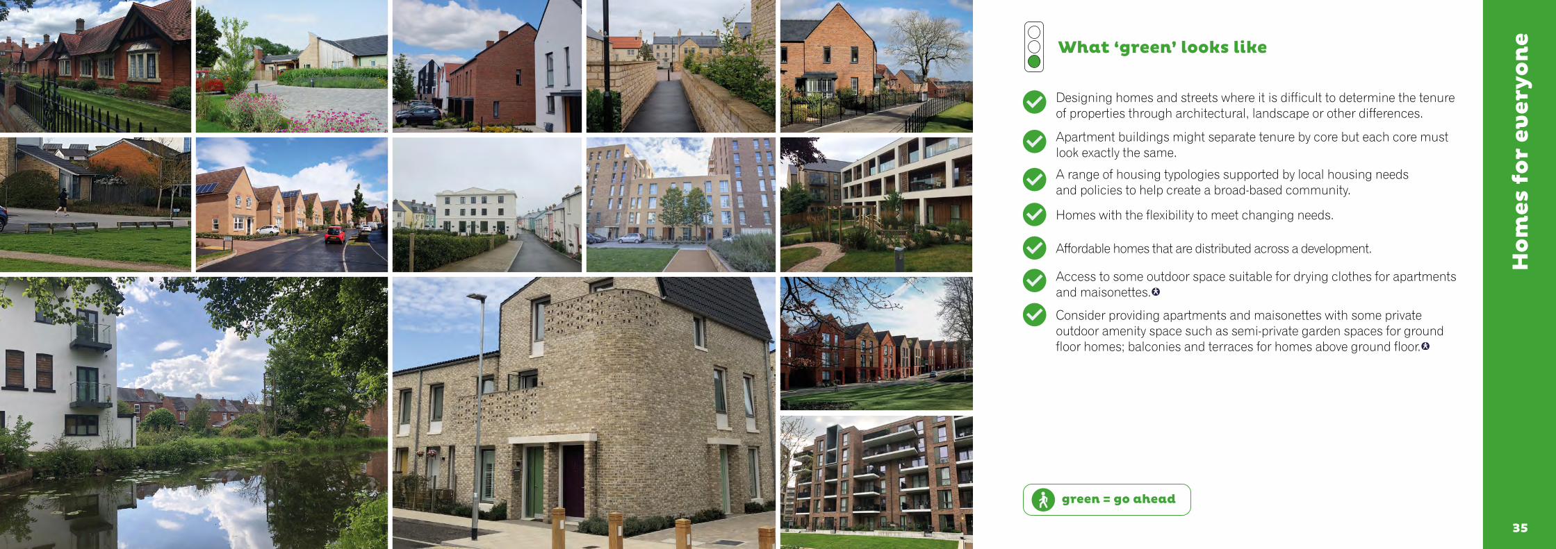
ne What ‘green’ looks like
Designing homes and streets where it is difficult to determine the tenure of properties through architectural, landscape or other differences.
Apartment buildings might separate tenure by core but each core must look exactly the same.
A range of housing typologies supported by local housing needs and policies to help create a broad-based community.
Homes with the flexibility to meet changing needs.
Affordable homes that are distributed across a development.
Access to some outdoor space suitable for drying clothes for apartments and maisonettes.
Consider providing apartments and maisonettes with some private outdoor amenity space such as semi-private garden spaces for ground floor homes; balconies and terraces for homes above ground floor.
green = go ahead

3737
Ho
mes
fo
r ev
eryo
ne
red = stop & rethink
What ‘red’ looks like
Grouping affordable homes in one place (except on smaller developments).
Dividing places and facilities such as play spaces by tenure.
Revealing the different tenure of homes through architecture, landscape, access, car parking, waste storage or other design features.
Not using the space around apartment buildings to best effect and where these could easily be used to create small, semi-private amenity spaces allocated to individual ground floor apartments.
393938
Ma
kin
g t
he
mo
st o
f w
ha
t’s
ther
e
What’s needed:
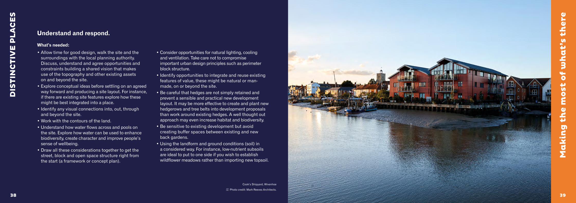
• Allow time for good design, walk the site and the surroundings with the local planning authority. Discuss, understand and agree opportunities and constraints building a shared vision that makes use of the topography and other existing assets on and beyond the site.
• Explore conceptual ideas before settling on an agreed way forward and producing a site layout. For instance, if there are existing site features explore how these might be best integrated into a place.
• Identify any visual connections into, out, through and beyond the site.
• Work with the contours of the land. • Understand how water flows across and pools on
the site. Explore how water can be used to enhance biodiversity, create character and improve people’s sense of wellbeing.
• Draw all these considerations together to get the street, block and open space structure right from the start (a framework or concept plan).
• Consider opportunities for natural lighting, cooling and ventilation. Take care not to compromise important urban design principles such as perimeter block structure.
• Identify opportunities to integrate and reuse existing features of value, these might be natural or man-made, on or beyond the site.
• Be careful that hedges are not simply retained and prevent a sensible and practical new development layout. It may be more effective to create and plant new hedgerows and tree belts into development proposals than work around existing hedges. A well thought out approach may even increase habitat and biodiversity.
• Be sensitive to existing development but avoid creating buffer spaces between existing and new back gardens.
• Using the landform and ground conditions (soil) in a considered way. For instance, low-nutrient subsoils are ideal to put to one side if you wish to establish wildflower meadows rather than importing new topsoil.
Understand and respond.
DIS
TIN
CT
IVE
PL
AC
ES
Cook’s Shipyard, Wivenhoe
Photo credit: Mark Reeves Architects.
4141
What ‘green’ looks like
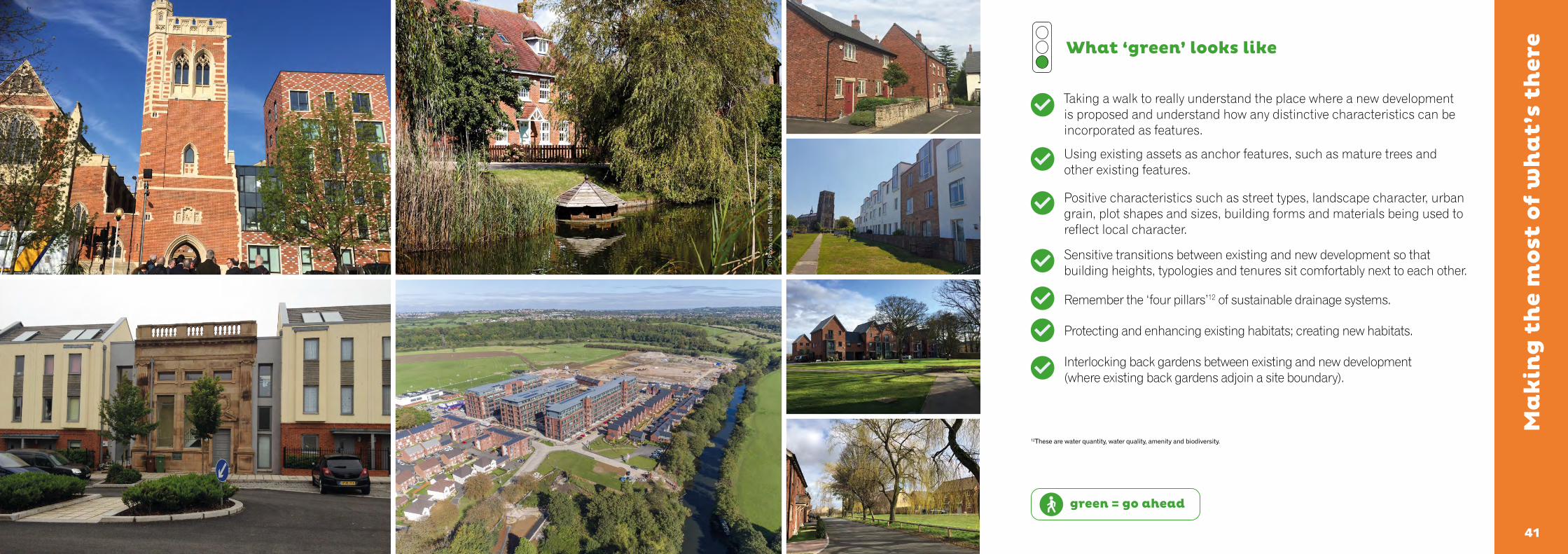
Taking a walk to really understand the place where a new development is proposed and understand how any distinctive characteristics can be incorporated as features.
Using existing assets as anchor features, such as mature trees and other existing features.
Positive characteristics such as street types, landscape character, urban grain, plot shapes and sizes, building forms and materials being used to reflect local character.
Sensitive transitions between existing and new development so that building heights, typologies and tenures sit comfortably next to each other.
Remember the ‘four pillars’12 of sustainable drainage systems.
Protecting and enhancing existing habitats; creating new habitats.
Interlocking back gardens between existing and new development (where existing back gardens adjoin a site boundary).
green = go ahead
Ma
kin
g t
he
mo
st o
f w
ha
t’s
ther
e
12These are water quantity, water quality, amenity and biodiversity.
Pho
to c
redi
t: M
ark
Ree
ves
Arc
hite
cts.
4343
red = stop & rethink
What ‘red’ looks like
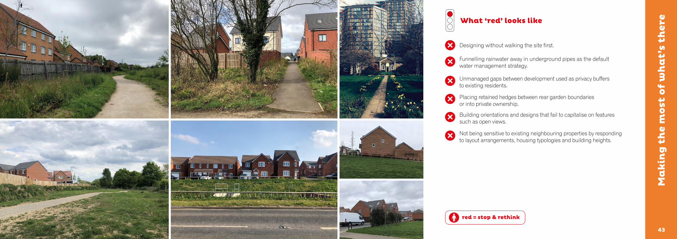
Designing without walking the site first.
Funnelling rainwater away in underground pipes as the default water management strategy.
Unmanaged gaps between development used as privacy buffers to existing residents.
Placing retained hedges between rear garden boundaries or into private ownership.
Building orientations and designs that fail to capitalise on features such as open views.
Not being sensitive to existing neighbouring properties by responding to layout arrangements, housing typologies and building heights.
Ma
kin
g t
he
mo
st o
f w
ha
t’s
ther
e

454544
A M
emo
rab
le C
ha
ract
er
What’s needed:
• Create a place with a locally inspired or otherwise distinctive character.
• Review the wider area for sources of inspiration. If distinctive local characteristics exist, delve deeper than architectural style and details. Where the local context is poor or generic, do not use this as a justification for more of the same. Inspiration may be found in local history and culture.
• Understand where positive local character comes from: streets, blocks and plots (urban grain), green and blue infrastructure, land uses, building form, massing and materials often underpin the essence of the distinctive character of settlements rather than architectural style and details.
• Using a local materials palette (where appropriate) can be a particularly effective way to connect a development to a place. This is often more achievable and credible than mimicking traditional architectural detailing which can be dependent on lost crafts.
• Brownfield sites can offer sources of inspiration for new development. Greenfield and edge of settlement locations often require more creativity and inspiration to avoid creating places that lack a sense of local or otherwise distinctive character.
• Character can also be created through the social life of public spaces. Create the physical conditions for activity to happen and bring places to life.
Create places that are memorable.
DIS
TIN
CT
IVE
PL
AC
ES
Where there are no local sources of inspiration be creative and find ways to give a place a more distinctive and memorable character. A Dutch gable on an existing building inspired a more creative approach at Manor Kingsway, Derby.

4747
What ‘green’ looks like
A strong, hand drawn design concept. To find the right solution a number of different ideas and options might need to be explored.
Drawing inspiration from local architectural and/or landscape character.
Reflecting character in either a traditional or contemporary style.
Structural landscaping as a way to create places with a memorable character.
Memorable spaces and building groupings.
Place names that have a connection to the locality can help stimulate ideas and design thought. A place name like ‘Valley View’ will always be more helpful on larger, multi-developer developments than generic terms such as ‘Parcel R5.1’.
green = go ahead
A M
emo
rab
le C
ha
ract
er
Pho
to c
redi
t: P
aul W
ater
field

4949
red = stop & rethink
What ‘red’ looks like
Using a predetermined sequence of house types to dictate a layout.
Attempting to create character through poor replication of architectural features or details.
Arranging buildings next to each other in a way that does not create a cohesive street scene.
Referencing generic or forgettable development nearby to justify more of the same.
A M
emo
rab
le C
ha
ract
er

515150
Wel
l d
efin
ed s
tree
ts a
nd
sp
ace
s
What’s needed:
• A strong framework of connected and well overlooked streets and spaces.
• Look beyond the plan and illustrative street scenes; what will you actually see and experience walking along the street?
• Perimeter blocks with clearly defined public fronts and private backs.
• Active frontages. Front doors, balconies, terraces, front gardens and bay windows are a good way to enliven and add interest to the street and create a more human scale to larger buildings such as apartments and supported living accommodation.
• Carefully considered street corners.
• Three dimensional models (physical or computer generated) and simple, hand drawn street cross sections can be particularly useful tools to understand and test the spatial qualities of a place.
Create a network of streets and spaces that are well enclosed by buildings and/or structural landscaping, taking care to ensure that front doors and the principal facades of buildings face streets and public spaces.
DIS
TIN
CT
IVE
PL
AC
ES
120
Upton, Northampton.
Photo credit: Garry Hall.
5353
Wel
l d
efin
ed s
tree
ts a
nd
sp
ace
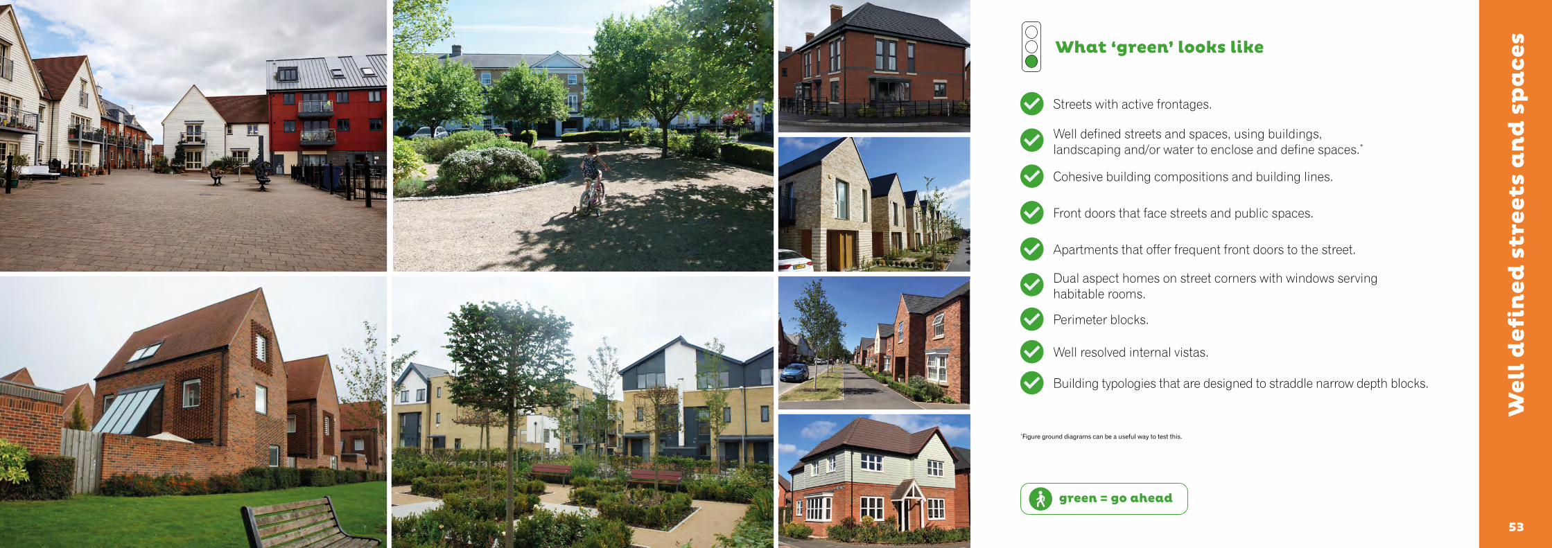
sWhat ‘green’ looks like
Streets with active frontages.
Well defined streets and spaces, using buildings, landscaping and/or water to enclose and define spaces.*
Cohesive building compositions and building lines.
Front doors that face streets and public spaces.
Apartments that offer frequent front doors to the street.
Dual aspect homes on street corners with windows serving habitable rooms.
Perimeter blocks.
Well resolved internal vistas.
Building typologies that are designed to straddle narrow depth blocks.
green = go ahead
*Figure ground diagrams can be a useful way to test this.
5555
Wel
l d
efin
ed s
tree
ts a
nd
sp
ace
s
red = stop & rethink
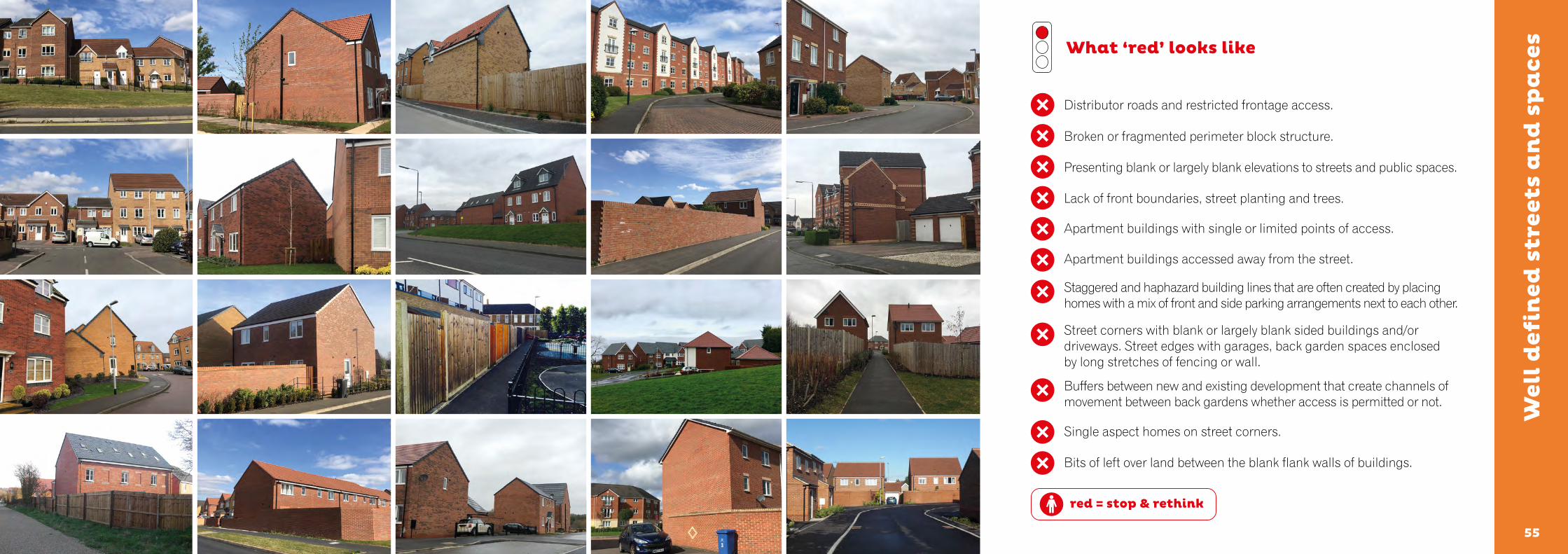
What ‘red’ looks like
Distributor roads and restricted frontage access.
Broken or fragmented perimeter block structure.
Presenting blank or largely blank elevations to streets and public spaces.
Lack of front boundaries, street planting and trees.
Apartment buildings with single or limited points of access.
Apartment buildings accessed away from the street.
Staggered and haphazard building lines that are often created by placing homes with a mix of front and side parking arrangements next to each other.
Street corners with blank or largely blank sided buildings and/or driveways. Street edges with garages, back garden spaces enclosed by long stretches of fencing or wall.
Buffers between new and existing development that create channels of movement between back gardens whether access is permitted or not.
Single aspect homes on street corners.
Bits of left over land between the blank flank walls of buildings.

575756
Ea
sy t
o f
ind
yo
ur
wa
y a
rou
nd
What’s needed:
• Streets that connect with one another.
• Streets that are as straight and as direct as possible.
• Use street types, buildings, spaces, non-residential uses, landscape, water and other features to help people create a ‘mental map’ of a place.
• Streets with clearly different characters are more effective than ‘character areas’ in helping people grasp whether they are on a principal or secondary street.
• For larger sites, it will be necessary to use streets and spaces with different characters to help people to find their way around.
Use legible features to help people find their way around a place.
DIS
TIN
CT
IVE
PL
AC
ES
An existing tree is the focal point of Southwell Square, Carlisle.

5959
What ‘green’ looks like
Designing for legibility when creating a concept plan for a place.
Using streets as the main way to help people find their way around a place. For instance, principal streets can be made different to more minor streets through the use of different spatial characteristics, building typologies, building to street relationships, landscape strategies and boundary treatments.
Navigable features for those with visual, mobility or other limitations.
Frame views of features on or beyond a site.
Create new legible elements or features on larger developments – further reinforce legible features where necessary through the landscape strategy, building and layout design, hard landscaping and boundaries.
Simple street patterns based on formal or more relaxed grid patterns.
green = go ahead
Ea
sy t
o f
ind
yo
ur
wa
y a
rou
nd
6161
red = stop & rethink
What ‘red’ looks like
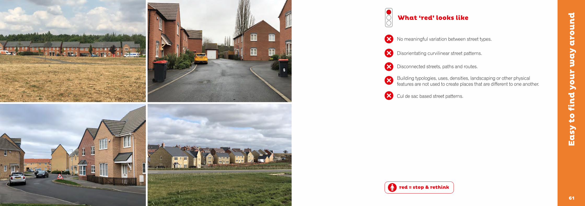
No meaningful variation between street types.
Disorientating curvilinear street patterns.
Disconnected streets, paths and routes.
Building typologies, uses, densities, landscaping or other physical features are not used to create places that are different to one another.
Cul de sac based street patterns.
Ea
sy t
o f
ind
yo
ur
wa
y a
rou
nd

636362
Hea
lth
y s
tree
ts
What’s needed:
• Low-speed streets and neighbourhoods with pedestrian and cycle priority.
• The right balance between movement and place functions.
• Rethinking the way we distribute street space. At times of more relaxed social distancing, demand for better quality cycle provision is expected to increase as public transport capacity reduces. Congestion caused by motor vehicles will make it unattractive for people to switch from public transport to cars creating a unique opportunity to change the way we move around our cities, towns and villages.
• Healthy streets improve people’s physical and mental health. Encouraging walking, cycling, outdoor play and streets where it is safe for younger children to cycle (or scooter) to school can create opportunities for social interaction and street life bringing wider social benefits.
• Street trees.
• Avoid streets that are just designed as routes for motor vehicles to pass through and for cars to park within.
• Boulevards and streets with active edges rather than distributor roads and bypasses with no (or limited) frontage access.
• Streets that are easy to cross; providing priority for pedestrians and cyclists across junctions and accesses.
• Well overlooked streets with front doors facing streets and public spaces.
• Provide conditions for cycling appropriate to the speed and volume of motor traffic.
• Inclusive design: think about how people with visual, mobility or other limitations will be able to use the street confidently and safely.
Streets are different to roads. Streets are places where the need to accommodate the movement of motor vehicles is balanced alongside the need for people to move along and cross streets with ease. Activity in the street is an essential part of a successful public realm.
ST
RE
ET
S F
OR
AL
L
Great Kneighton, Cambridge.
Photo credit: Proctor and Matthews Architects.

6565
What ‘green’ looks like
Streets for people.
20mph (or lower) design speeds; 20mph designations.
Tree lined streets. Make sure that trees have sufficient space to grow above and below ground, with long term management arrangements in place.
Tight corner radii (3m or less).
Places to sit, space to chat or play within the street.
Pavements and cycleways that continue across side streets.
Anticipating and responding to pedestrian and cycle ‘desire lines’ (the most direct routes between the places people will want to travel between).
Landscape layers that add sensory richness to a place – visual, scent and sound.
green = go ahead
Hea
lth
y s
tree
ts
6767
red = stop & rethink
What ‘red’ looks like
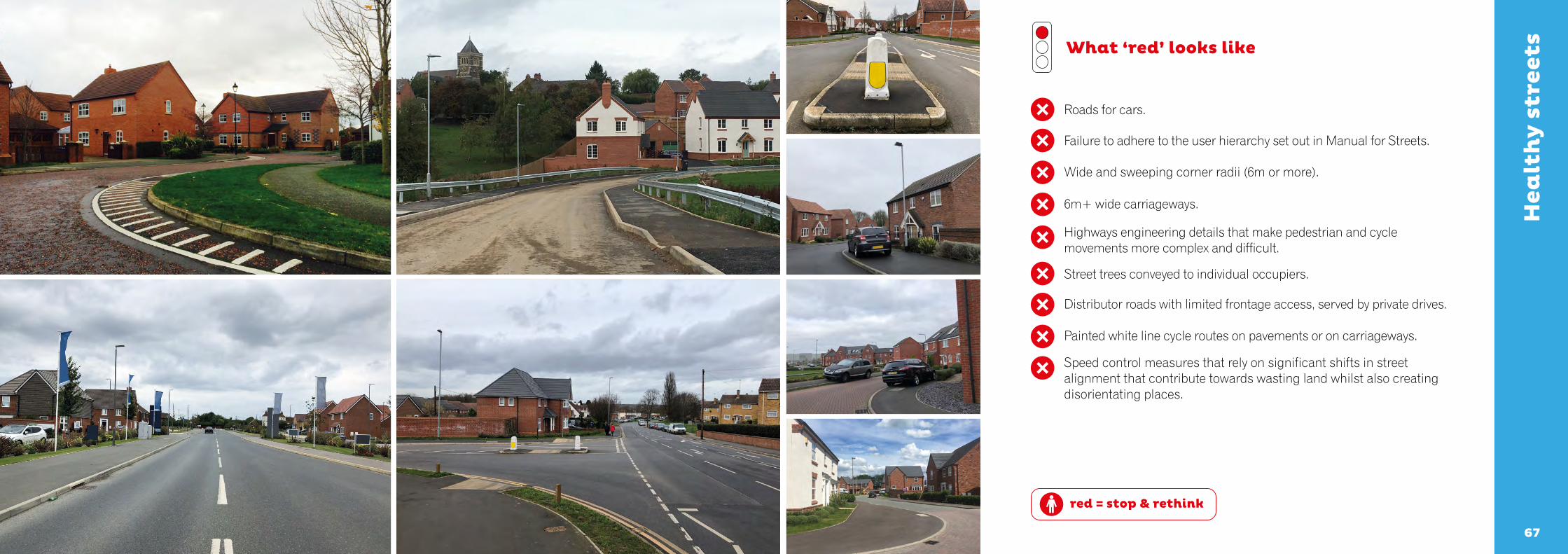
Roads for cars.
Failure to adhere to the user hierarchy set out in Manual for Streets.
Wide and sweeping corner radii (6m or more).
6m+ wide carriageways.
Highways engineering details that make pedestrian and cycle movements more complex and difficult.
Street trees conveyed to individual occupiers.
Distributor roads with limited frontage access, served by private drives.
Painted white line cycle routes on pavements or on carriageways.
Speed control measures that rely on significant shifts in street alignment that contribute towards wasting land whilst also creating disorientating places.
Hea
lth
y s
tree
ts
696968
Cyc
le a
nd
ca
r p
ark
ing
What’s needed:
• Provide secure cycle storage close to people’s front doors so that cycles are as convenient to choose as a car for short trips.
• Integration of car parking into the street environment.
• Anticipate realistic levels of car parking demand, guarding against displaced and anti-social parking; thinking about the availability and frequency of public transport.
• Avoid confusing car ownership with car usage.
• Creative solutions for attractive, convenient and safe cycle parking or higher density developments (such as apartment buildings).
• Generous landscaping to settle frontage car parking into the street.
• Shared and unallocated parking.
Well-designed developments will make it more attractive for people to choose to walk or cycle for short trips helping to improve levels of physical activity, air quality, local congestion and the quality of the street scene. Well-designed streets will also provide sufficient and well-integrated car parking.
ST
RE
ET
S F
OR
AL
L
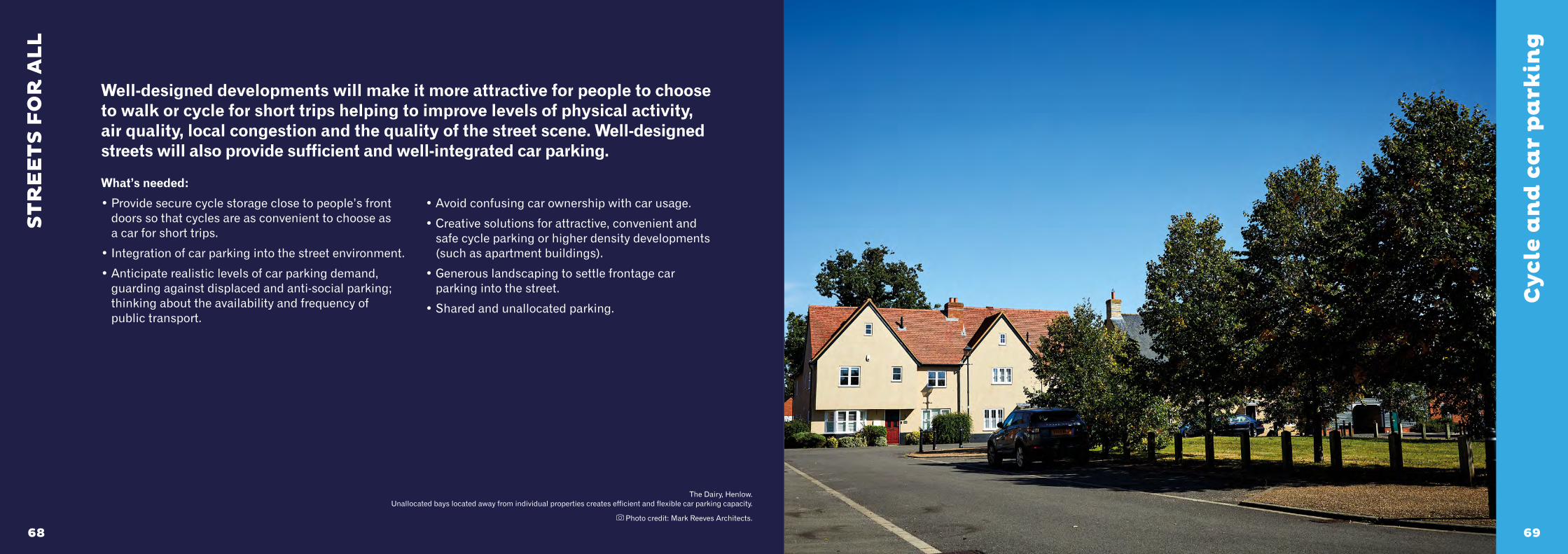
The Dairy, Henlow. Unallocated bays located away from individual properties creates efficient and flexible car parking capacity.
Photo credit: Mark Reeves Architects.
7171
What ‘green’ looks like
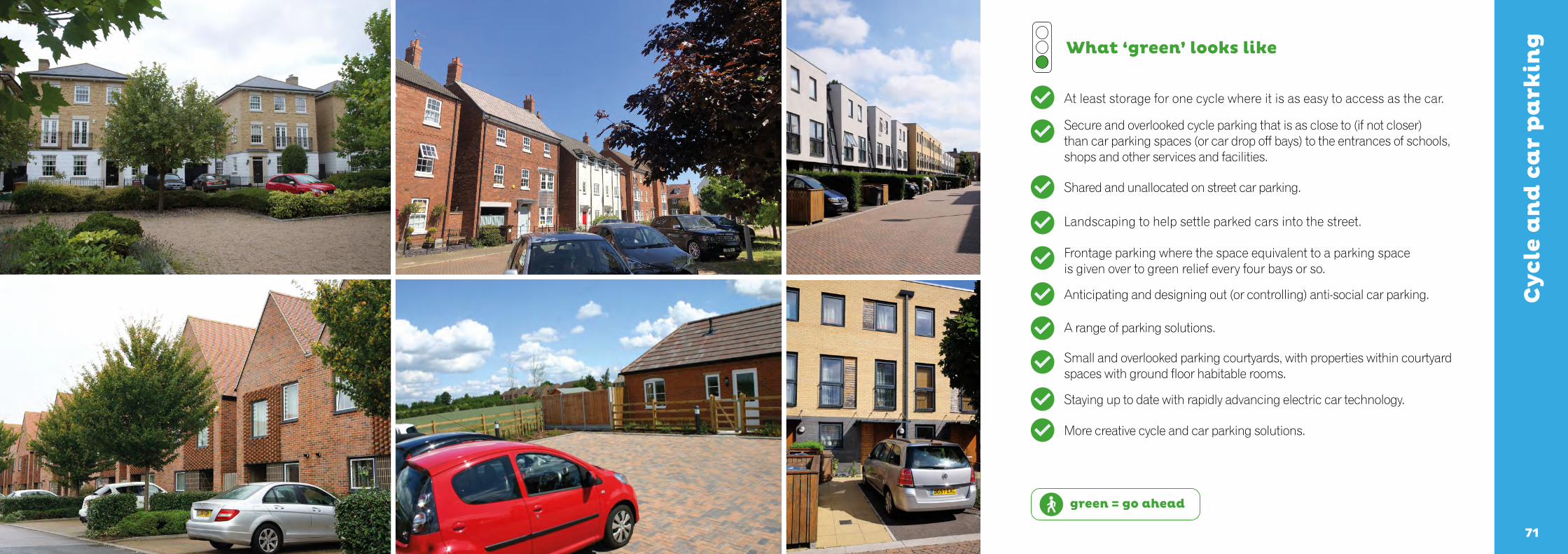
At least storage for one cycle where it is as easy to access as the car.
Secure and overlooked cycle parking that is as close to (if not closer) than car parking spaces (or car drop off bays) to the entrances of schools, shops and other services and facilities.
Shared and unallocated on street car parking.
Landscaping to help settle parked cars into the street.
Frontage parking where the space equivalent to a parking space is given over to green relief every four bays or so.
Anticipating and designing out (or controlling) anti-social car parking.
A range of parking solutions.
Small and overlooked parking courtyards, with properties within courtyard spaces with ground floor habitable rooms.
Staying up to date with rapidly advancing electric car technology.
More creative cycle and car parking solutions.
green = go ahead
Cyc
le a
nd
ca
r p
ark
ing
7373
red = stop & rethink
What ‘red’ looks like
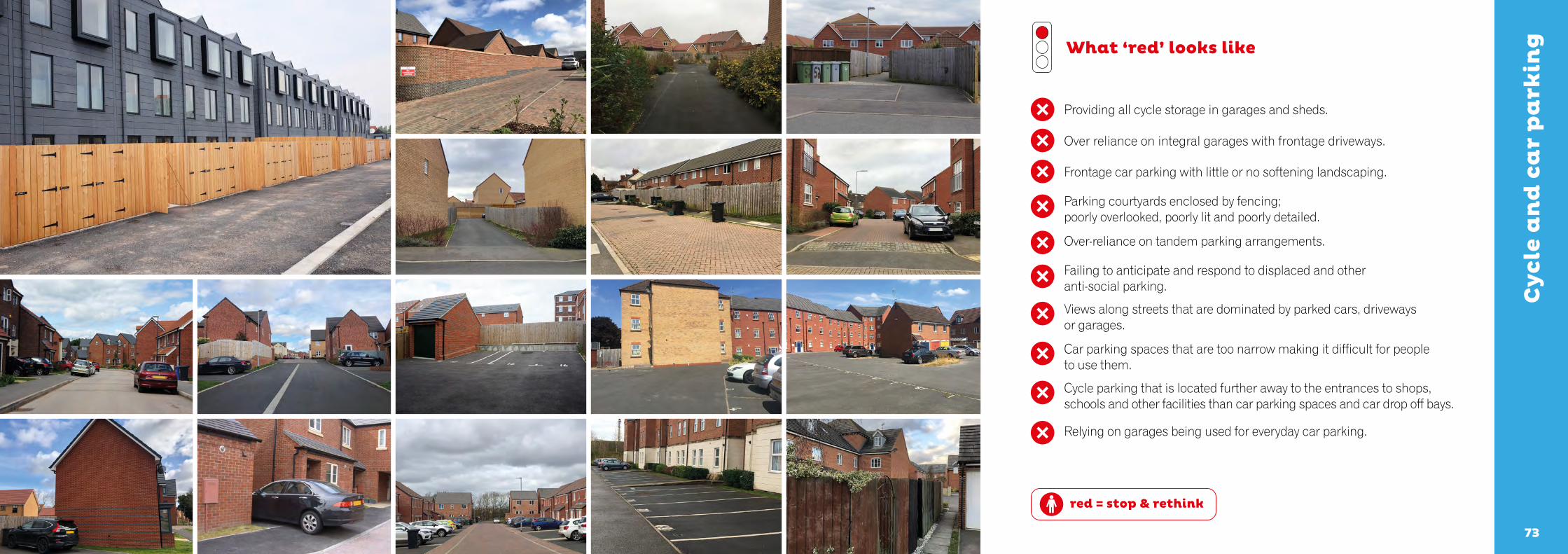
Providing all cycle storage in garages and sheds.
Over reliance on integral garages with frontage driveways.
Frontage car parking with little or no softening landscaping.
Parking courtyards enclosed by fencing; poorly overlooked, poorly lit and poorly detailed.
Over-reliance on tandem parking arrangements.
Failing to anticipate and respond to displaced and other anti-social parking.
Views along streets that are dominated by parked cars, driveways or garages.
Car parking spaces that are too narrow making it difficult for people to use them.
Cycle parking that is located further away to the entrances to shops, schools and other facilities than car parking spaces and car drop off bays.
Relying on garages being used for everyday car parking.
Cyc
le a
nd
ca
r p
ark
ing

757574
Gre
en a
nd
blu
e in
fra
stru
ctu
re
What’s needed:
• Create a strong landscape strategy that has impact from ‘day one’. Don’t ‘layer’ landscape onto a scheme at the end of the process. Landscape changes can offer opportunities to reintroduce lost habitats and species.
• Create a network of different types of spaces.
• Weave opportunities for habitat creation throughout the development. Plan these as movement corridors to support biodiversity.
• Create food growing opportunities such as allotments and orchards on larger developments.
• Have a sustainable drainage ‘treatment train’ thinking about the ‘four pillars’. Capture water as close as possible to where it falls. Be creative with rain gardens, ponds and swales and avoid steeply-sided or fenced holes in the ground.
• Well-designed multi-functional sustainable drainage will incorporate play and recreational opportunities.
• Well-overlooked public open spaces with strong levels of natural surveillance.
• Robust management and long term stewardship.
Creative surface water management such as rills, brooks and ponds enrich the public realm and help improve a sense of wellbeing and offer an interaction with nature. As the richest habitat for a range of flora and fauna, they are also a key play in achieving the net gain in biodiversity sought by the 2020 Environment Bill.
ST
RE
ET
S F
OR
AL
L
A multi-functional sustainable drainage scheme at Forest Way School, Coalville, Leicestershire.

7777
What ‘green’ looks like
green = go ahead
Gre
en a
nd
blu
e in
fra
stru
ctu
re
Biodiversity net gain.
Movement and feeding corridors for wildlife, such as hedgehog highways. Bird boxes, swift nesting bricks and bat bricks may be appropriate.
Plans that identify the character of new spaces, such as ‘parks’, ‘woodland’, ‘allotments’, ‘wildflower meadows’ rather than ‘P.O.S.’. Be more specific about the function and character of public open spaces.
Create Park Run ready routes on larger developments and other ways to encourage physical activity and social interaction.
Capturing and managing water creatively and close to where it falls using features such as rain gardens and permeable surfaces. Allow people to connect with water.
Create a habitat network providing residents with opportunities to interact with nature on a day to day basis. Wildlife does not flourish within disconnected back gardens, artificial lawns and tightly mown grass.
Provide natural surveillance opportunities.
A connected and accessible network of public open spaces with paths and other routes into and through.
Species rich grasslands.
Well considered management arrangements whether public or privately managed.
Pho
to c
redi
t: G
arry
Hal
l.

7979
red = stop & rethink
What ‘red’ looks like
Surface water management by way of a large, steep sided and fenced holes in the ground.
Small pieces of land (typically grassed over) that offer little or no public, private or biodiversity value that over time become neglected and forgotten.
Large expanses of impervious surfaces.
Not designing paths and routes through open spaces where it is difficult for people to create distance between themselves and other people when social distancing restrictions are in place.
Buildings that turn away from open spaces.
Poor quality finishing, detailing and maintenance.
Gre
en a
nd
blu
e in
fra
stru
ctu
re

818180
Ba
ck o
f p
av
emen
t, f
ron
t o
f h
om
e
What’s needed:
• Clearly define private spaces through strong boundary treatments.
• Manage changes in level in a way that does not compromise the qualities of the street.
• Design the space between the back of the pavement and building façades carefully to integrate services, waste storage and utilities cabinets (meter boxes) so their impact is reduced.
• Avoid pieces of ‘leftover’ land that serve no useful public or private function. Homes with shallow street backs need careful thought as it is not uncommon to see these spaces poorly resolved with small pieces of grass turf or gravel.
• Outdoor amenity space for apartment buildings, such as a balcony for relaxing or the drying of clothes.
Garden cities, towns and suburbs used hedges to define public and private spaces, helping to create characterful and biodiverse places. The space between the back of the pavement and the face of buildings has a significant impact on the quality of a place. Clear demarcations between public and private spaces can encourage people to personalise the front of their homes whilst also offering opportunities to integrate level changes, utility boxes and waste storage.
ST
RE
ET
S F
OR
AL
L
Upper Tuesley, Milford.
8383
What ‘green’ looks like
green = go ahead
Ba
ck o
f p
av
emen
t, f
ron
t o
f h
om
e
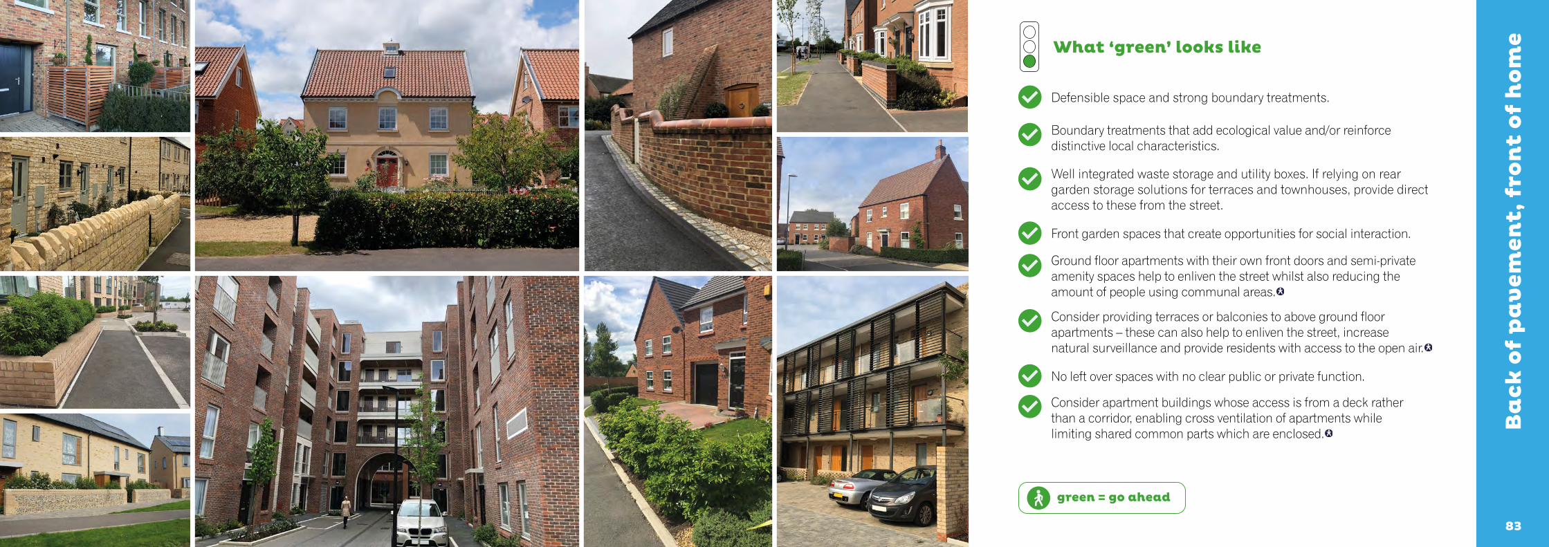
Defensible space and strong boundary treatments.
Boundary treatments that add ecological value and/or reinforce distinctive local characteristics.
Well integrated waste storage and utility boxes. If relying on rear garden storage solutions for terraces and townhouses, provide direct access to these from the street.
Front garden spaces that create opportunities for social interaction.
Ground floor apartments with their own front doors and semi-private amenity spaces help to enliven the street whilst also reducing the amount of people using communal areas.
Consider providing terraces or balconies to above ground floor apartments – these can also help to enliven the street, increase natural surveillance and provide residents with access to the open air.
No left over spaces with no clear public or private function.
Consider apartment buildings whose access is from a deck rather than a corridor, enabling cross ventilation of apartments while limiting shared common parts which are enclosed.

8585
red = stop & rethink
What ‘red’ looks like
Ba
ck o
f p
av
emen
t, f
ron
t o
f h
om
e
Poorly considered spaces between the back of the pavement and the face of buildings that erode the quality of the street environment.
Narrow and small grass frontage strips for space between the back of the street and the façades of buildings that are impractical to maintain.
Waste storage solutions for terraced homes that rely on residents storing bins and crates in rear garden spaces and instead often sees bins and crates placed next to front doors.
Slab on edge.
Concrete screed with pebbles.
Prominent external pipes, flues and utility boxes.
Pieces of left over land between or to the side of buildings with no clear public or private function.
Poorly resolved changes in level.

86 878786
Moving from Building for Life 12 to Building for a Healthy LifeWe recognise that many local planning authorities refer to BFL12 in their Local Plans and other policy documents. BFL12 and BHL share the same principles and structure. For this reason, we consider that local planning authorities will be able to switch from BFL12 to BHL providing that this is made clear at the start of pre-application discussions.
Local authorities may well choose to keep using the previous edition of BFL12 and this is a decision best made locally. If a local planning authority chooses to use BHL but a prospective planning applicant expresses reservations, we suggest using the previous edition of BFL12 as the next best alternative.
The differences between the editions (BFL12 and BHL) are set out and explained here.
Building for Life 12(2018 edition)
Building for a Healthy Life(2020 edition)
The title change reflects the greater emphasis on healthier and more active lifestyles. NHS England and NHS Improve-ment have chosen to use the tool as an effective way to reach a broader audience and share the findings of the Healthy New Towns Programme.
Integrating into the neighbourhood Integrated neighbourhoods Remarks
1. Connections 1. Natural connections Greater emphasis and advice relating to connecting places.
2. Facilities and services 2. Walking, cycling and public transport
Greater emphasis on active travel (walking and cycling) to reflect good practice (such as ‘Putting Health into Place’); reinforcing efforts by government and the NHS to improve the nation’s health and wellbeing through the way in which new developments are planned and designed.
3. Public transport 3. Facilities and services Moved from being the second to the third consideration; improved written and visual guidance.
4. Meeting local housing requirements 4. Homes for everyone No change; improved written and visual guidance.
Creating a place Distinctive Places
5. Character 5. Making the most of what’s there
Moved from being the sixth to the fifth consideration. A distinctive or locally inspired identity will only be created when the time is taken to understand the site and its wider context.
6. Working with the site and its context 6. A memorable character This consideration has been switched from position 5 to position 6.
7. Creating well defined streets and spaces
7. Well defined streets and spaces
No change; improved written and visual guidance.
8. Easy to find your way around 8. Easy to find your way around. No change; improved written and visual guidance.
Street and home Streets for All
9. Streets for all 9. Healthy streets Improved written and visual guidance. Renaming this consideration further highlights the importance of street design and the impact this has on people’s travel choices, levels of physical activity and public health. Good street design prioritises pedestrians and cyclists, encouraging active travel modes; in turn improving people’s health and wellbeing. Additional prompts encourage street space to be shared more fairly between pedestrians, cyclists and motor vehicles allowing carriageway space to be redistributed; allowing protected cycle ways and wider pavements to be created. Pedestrians can then be offered more space to allow for social distancing whilst protected cycle ways will allow more people to cycle safely and confidently, ensuring that reduced public transport capacity (at times of social distancing) does not lead to greater private car usage (leading to further congestion, increased energy usage and reductions in air quality).
Street and home Streets for All
10. Car parking 10. Cycle and car parking Emphasising the importance of thinking about cycle parking design as a key factor in encouraging people to choose to cycle rather than drive for shorter trips.

88 898988
References and further reading: Alexander, C. (1978) A pattern language: towns, buildings and construction, OUP, USA.
Alcock, A., Bentley, I., McGlynn, S., Murrain, P. and Smith, G. (1985) Responsive Environments: a manual for designers, Routledge, London.
Arnstein, R. (1969) ‘A Ladder of Citizen Participation’, Journal of the American Planning Association, 35: 4, 216 — 224.
Birkbeck, D. and Kruczkowski, S. (2018) Building for Life 12: the sign of a good place to live.
Birkbeck, D. and Kruczkowski, S. Collins. P (ed.) (2015) Adeliladu am Oes 12 Cymru: Arwydd o le da I fyw ynddo, Welsh Government.
CIRIA SuDS Manual (2015) Available at ciria.org.
Cowan, R. (2021) Essential Urban Design, RIBA Publishing.
Cullen, G. (1961) The concise townscape, Routledge, London.
Department of Transport and Department of Communities and Local Government (2007) Manual for Streets.
Department of Transport (2012) Local Transport Note: 1/12, London.
Duany, A. et al, (2000) Suburban nation: the rise of sprawl and the decline of the American Dream, North Point Press, New York.
Duany, A., Plater-Zyberk, E. and Speck, J. (2001) Suburban Nation. Farrar, Straus and Giroux, New York.
11. Public and private spaces 11. Green and blue infrastructure
Focuses on public space only with private space consideration being moved into the last consideration. The change in title to ‘green and blue infrastructure’ reflects forthcoming changes in legislation that place a greater emphasis on improved habitat creation and better water management.
12. External storage and amenity space 12. Back of pavement; front of home
The emphasis of this consideration has been directed to focus more on the space between the back of the pavement and the façade of individual buildings. These spaces are very often poorly resolved and have a significant impact on the quality of the street environment.
Developments that perform well against this consideration will also resolve storage issues relating to waste and recycling containers.
The consideration also highlights the need to consider providing some amenity space for apartments and maisonettes. This is in direct response to the challenges experienced by those living in apartments and maisonettes during lockdown, recognising the importance of being able to sit outside in the open air to people’s mental wellbeing.
English Partnerships and the Housing Corporation (2000) Urban Design Compendium 1, London.
English Partnerships and the Housing Corporation (2007) Urban Design Compendium 2, London.
English Partnerships (2006) Car parking: what works where, London.
Gehl, J. (1971) Life between buildings: using public space, Island Press, Washington D.C.
Gehl (2010) Cities for people, Island Press, Washington D.C.
Lynch, K (1960) The image of the city, MIT Press, Mass.
Meeda, B, Parkyn, N. and Walton, D.S. (2016) Graphics for urban design, ICE Publishing, London.
Miller, M. (2010) English Garden Cities, English Heritage, Swindon.
Ministry of Housing, Communities and Local Government (2019) National Design Guide.
Ministry of Housing, Communities and Local Government (2019) National Planning Policy Framework.
Montgomery, C. (2013) Happy city: transforming our lives through urban design, Penguin, London.
NHBC (2015) Avoiding rubbish design: providing bin storage on new housing developments, London.
NHS England and NHS Improvement (2019) Putting Health into Place.
Speck, J. (2013) Walkable City, North Point Press.
Speck, J. (2018) Walkable city rules, Island Press, London.
Public Health England (2017) Spatial Planning for Health: An evidence resource for planning and designing healthier places.
Public Health England (2020) Using the planning system to promote healthy weight environments: guidance and supplementary planning document template for local authority public health and planning teams.
State of Nature Partnership (2019), State of Nature 2019.
Town and Country Planning Association (2013) Creating garden cities and suburbs today: a guide for councils, London.
Town and Country Planning Association (2015) Public health in planning: good practice guide, London.
Urban Design Group (2020) Highways Measures under the Covid 19 Crisis: Fast urban change – a how to guide, London.
Walker, P. (2017) Bike Nation, Penguin Random House, London.
90 919190
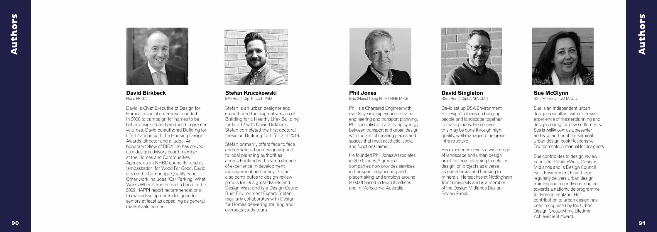
David Birkbeck Hons FRIBA
David is Chief Executive of Design for Homes, a social enterprise founded in 2000 to campaign for homes to be better designed and produced in greater volumes. David co-authored Building for Life 12 and is both the Housing Design Awards’ director and a judge. An honorary fellow of RIBA, he has served as a design advisory board member at the Homes and Communities Agency, as an NHBC councillor and as ‘ambassador’ for Wood For Good. David sits on the Cambridge Quality Panel. Other work includes “Car Parking: What Works Where” and he had a hand in the 2009 HAPPI report recommendations to make developments designed for seniors at least as appealing as general market-sale homes.
Au
tho
rs
Au
tho
rs
Phil Jones BSc (Hons) CEng FCIHT FIHE MICE
Phil is a Chartered Engineer with over 35 years’ experience in traffic engineering and transport planning. Phil specialises in achieving synergy between transport and urban design, with the aim of creating places and spaces that meet aesthetic, social and functional aims.
He founded Phil Jones Associates in 2003; the PJA group of companies now provides services in transport, engineering and placemaking and employs around 80 staff based in four UK offices and in Melbourne, Australia.
David Singleton BSc (Hons) DipLA MA CMLI
David set up DSA Environment + Design to focus on bringing people and landscape together to make places. He believes this may be done through high quality, well-managed blue-green infrastructure.
His experience covers a wide range of landscape and urban design practice, from planning to detailed design, on projects as diverse as commercial and housing to minerals. He teaches at Nottingham Trent University and is a member of the Design:Midlands Design Review Panel.
Sue McGlynn BSc (Hons) DipUD MAUD
Sue is an independent urban design consultant with extensive experience of masterplanning and design coding for new settlements. Sue is wellknown as a presenter and is co-author of the seminal urban design book Responsive Environments: A manual for designers.
Sue contributes to design review panels for Design:West, Design: Midlands and is Design Council Built Environment Expert. Sue regularly delivers urban design training and recently contributed towards a nationwide programme for Homes England. Her contribution to urban design has been recognised by the Urban Design Group with a Lifetime Achievement Award.
Stefan Kruczkowski
BA (Hons) DipTP (Dist) PhD
Stefan is an urban designer and co-authored the original version of Building for a Healthy Life - Building for Life 12 with David Birkbeck. Stefan completed the first doctoral thesis on Building for Life 12 in 2018.
Stefan primarily offers face to face and remote urban design support to local planning authorities across England with over a decade of experience in development management and policy. Stefan also contributes to design review panels for Design:Midlands and Design:West and is a Design Council Built Environment Expert. Stefan regularly collaborates with Design for Homes delivering training and overseas study tours.

Building for a Healthy Life is the latest edition of and new name for Building for Life 12.
The original 12 point structure and underlying principles within Building for Life 12 are at the heart of Building for a Healthy Life.
Building for a Healthy Life is about how to assemble neighbourhoods and new settlements by thinking about and applying 12 key considerations. Designed to frame discussions between local authorities, developers, local communities and other stakeholders Building for a Healthy Life will help you to create better places for people and nature.
Building for a Healthy Lifec/o Design for HomesThe Old ForgeAudley End Business CentreLondon RoadSaffron WaldenCB11 4JL
Birkbeck, D., Kruczkowski, S. with Jones, P., McGlynn, S. and Singleton, D.
ISBN: 978-1-5272-6432-8 June 2020
Endorsed by: