Booysendal South Expansion Project Phase 2 Soil, Land Use ...
96
Booysendal South Expansion Project Phase 2 Soil, Land Use and Land Capability Report Submitted by TerraAfrica Consult cc 02 April 2018
-
Upload
khangminh22 -
Category
Documents
-
view
1 -
download
0
Transcript of Booysendal South Expansion Project Phase 2 Soil, Land Use ...

Booysendal South Expansion Project Phase 2
Soil, Land Use and Land Capability Report Submitted by TerraAfrica Consult cc
02 April 2018

Booysendal EMP Amendment
Soil, Land Use and Land Capability Assessment
BOOYSENDAL_PHASE 2_SOIL LU AND LC REPORT_FINAL_20180512.DOCX
Amec Foster Wheeler ©2015 Amec Foster Wheeler. All Rights Reserved. i
CONTENTS
Section 1: Baseline Assessment
1.1 Introduction ........................................................................................................................................... 21.2 Purpose of the Study ............................................................................................................................ 31.3 Relevance of study components ........................................................................................................... 31.4 NEMA Requirements for specialist assessment reports ....................................................................... 52.1 Study objectives .................................................................................................................................... 62.2 Delineation of Study Area ..................................................................................................................... 62.3 Relevance of seasonality to Soil, Land Use and Land Capability properties of the study area ............ 72.4 Gaps, assumptions and limitations ....................................................................................................... 73.1 South African Legislation ...................................................................................................................... 83.2 International Finance Corporation (IFC) Guidelines ............................................................................. 85.1 Desktop study and literature review ...................................................................................................... 95.2 Site survey .......................................................................................................................................... 105.3 Laboratory analysis of samples .......................................................................................................... 105.4 Incorporation of historic soil data ........................................................................................................ 105.5 Predictive digital soil mapping ............................................................................................................ 105.6 Land capability classification .............................................................................................................. 125.7 Assessment of ecosystem services .................................................................................................... 136.1 Soil forms ............................................................................................................................................ 146.2 Chemical soil properties ..................................................................................................................... 256.3 Land capability .................................................................................................................................... 266.4 Land Use and Agricultural Potential ................................................................................................... 316.5 Ecosystem Services Assessment ....................................................................................................... 317.1 Monitoring and Progress Reporting .................................................................................................... 357.2 Identification of potential impacts ........................................................................................................ 397.3 Impact Significance Rating ................................................................................................................. 407.4 Identification of cumulative impacts .................................................................................................... 487.5 Alternative impact identification .......................................................................................................... 498.1 Areas highly sensitive to impacts (no-go areas) (209.9 ha) ................................................................ 518.2 Areas with medium-high to high sensitivity (1393.8 ha) ..................................................................... 528.3 Medium to low sensitivity to project impacts (350.6 ha) ..................................................................... 548.4 Low sensitivity to project impacts, land rehabilitation required (310.2 ha) .......................................... 54

Booysendal EMP Amendment
Soil, Land Use and Land Capability Assessment
BOOYSENDAL_PHASE 2_SOIL LU AND LC REPORT_FINAL_20180512.DOCX
Amec Foster Wheeler ©2015 Amec Foster Wheeler. All Rights Reserved. ii
Appendix 1 Declaration of Specialist
Appendix 2 Curriculum Vitae of Specialist
Appendix 3 Declaration of Specialist’s Independence
Appendix 4 Soil Chemical Analysis Results
Appendix 5 Soil Management Plan

Booysendal EMP Amendment
Soil, Land Use and Land Capability Assessment
BOOYSENDAL_PHASE 2_SOIL LU AND LC REPORT_FINAL_20180512.DOCX
Amec Foster Wheeler ©2015 Amec Foster Wheeler. All Rights Reserved. 1
Section 1: Baseline Assessment

Booysendal EMP Amendment
Soil, Land Use and Land Capability Assessment
BOOYSENDAL_PHASE 2_SOIL LU AND LC REPORT_FINAL_20180512.DOCX
Amec Foster Wheeler ©2015 Amec Foster Wheeler. All Rights Reserved. 2
1. Introduction
Amec Foster Wheeler Pty Ltd appointed TerraAfrica Consult to conduct the soil, land use and land
capability study as part of the Environmental Authorisation processes for the Booysendal South
Expansion Project Phase 2. The data was collected with four site visits since January 2016 with the
final site visit conducted in December 2018. This report will provide a description of the baseline soil
properties and associated land capabilities of the entire area while the impact assessment is focused
on the areas to be affected by the Phase 2 project layout. The entire baseline area includes areas that
were part of a previous Section 24G environmental authorization application that was authorised as well
as areas that was previously part of the Aquarius Everest Platinum Mine (Booysendal South Mining
Right). For the Booysendal Phase 2 project, the direct area of influence is defined as the project
footprint and a 100m buffer zone around the footprint while the indirect area of influence includes the
Groot Dwars River valley and 500m around BS4.
1.1 Introduction
The Booysendal South Expansion Project Phase 2 Soil, Land Use and Land Capability Study includes
the following infrastructure developments (Figure 1-1):
• Portals with surface infrastructure at BCM1 and BCM2;
• An Emergency Escape Portal;
• An aerial rope conveyor (ARC);
• Water pipelines between BS1/2 and BN; and
• A Backfill Plant with surface pipelines at BS4.
• The Valley Boxcut
The first phase of the Booysendal South Expansion Project involved the development of a portal
complex at BS1/2, two adits at BCM1 and BCM2, upgrade of stormwater management measures,
reworking of the tailings and backfilling of the underground workings at BS4 and linear infrastructure
components (road, aerial rope conveyor, 132kVA powerline) between the operational areas.
Environmental authorisation (EA) for this Phase 1 of the Booysendal South Expansion Project was
granted on 05 January 2018. The impact of these activities was assessed as part of the Section 24G
application.
The proposed new developments and activities will result in clearing of vegetation from soil surfaces as
well as traversing over the surface with vehicles and equipment. This will have an impact on the
baseline soil properties. In addition, cumulative impacts will result from the current operations in areas
already authorised for previous phases of the environmental authorisation process. The authorised
projects that will result in cumulative associated with the Booysendal Project are:
• Existing operational activities at Booysendal North.
• Existing care and maintenance obligations at BS4 (part of Booysendal South).
• Expansion of mining activities at BS1/2 as part of the Section 24G application.
• Expansion of the Booysendal South project (BS4, BCM1 and BCM2 Adits, various linear
infrastructure components).

Booysendal EMP Amendment
Soil, Land Use and Land Capability Assessment
BOOYSENDAL_PHASE 2_SOIL LU AND LC REPORT_FINAL_20180512.DOCX
Amec Foster Wheeler ©2015 Amec Foster Wheeler. All Rights Reserved. 3
Further possible cumulative regional impacts occur as a result of other mining developments in an area
that was traditionally used for conservation and agriculture.
1.2 Purpose of the Study
The purpose of the Soil, Land Use and Land Capability study is to fulfill the requirements of the most
recent South African Environmental Legislation with reference to the assessment and management of
soil and its associated land capabilities (stipulated in Section 3 below). The key components of the
assessment include determining and describing the baseline soil properties, the land capabilities and
land uses associated with it within the proposed project’s direct and indirect areas of influence (AoI)
(defined on page 2) (refer to Figure 1) from on-site investigations and data currently available.
From this baseline data, the current and anticipated future impacts of the proposed developments for
the entire Booysendal Mine area can be predicted and mitigation and management measures can be
recommended to minimise negative impacts and maximise land rehabilitation success towards
successful closure at the end of the project life.
1.3 Relevance of study components
The study consists of three components that are linked intrinsically i.e. soil, land capability and land
use. The importance of each of these components towards a thorough understanding of the baseline
conditions of the proposed project area are listed below:
• Soil - forms the base of any ecosystem since the inherent soil properties such as salinity, texture,
water-holding capacity and soil profile depth will naturally favour vegetation best adapted to these
conditions. Soil properties also indicate current pedogenic processes such as clay alluviation along
the riverbanks. Any impacts on the soil properties as a result of the proposed project will also affect
these aspects and have an impact on the larger landscape and the ecosystems it supports.
• Land capability is the inherent capacity of land to be productive under sustained use and specific
management methods. The land capability of an area is the combination of the inherent soil
properties and the climatic conditions as well as other landscape properties such as slope and
drainage patterns that may have resulted in the development of wetlands as an example. Land
capability has strong influence on socio-economic aspects of human settlements. Baseline land
capabilities are also used as a benchmark for rehabilitation of land in the case of project
decommissioning.
• Even though land use is intrinsically linked to soil and land capability of an area, it is also largely a
function of the economic climate and availability of resources additional to productive land. The
economic aspects of land use will mainly be discussed in the socio-economic study while this report
deals with the dependency of land users (including fauna) in the project area on the specific soil
and land capability properties present and how project impacts may induce land use changes.

Booysendal EMP Amendment
Soil, Land Use and Land Capability Assessment
BOOYSENDAL_PHASE 2_SOIL LU AND LC REPORT_FINAL_20180512.DOCX
Amec Foster Wheeler ©2015 Amec Foster Wheeler. All Rights Reserved. 4
Figure 1-1: Layout map of the Booysendal project areas
Booysendal EMP Amendment
Soil, Land Use and Land Capability Assessment
BOOYSENDAL_PHASE 2_SOIL LU AND LC REPORT_FINAL_20180512.DOCX
Amec Foster Wheeler ©2015 Amec Foster Wheeler. All Rights Reserved. 5
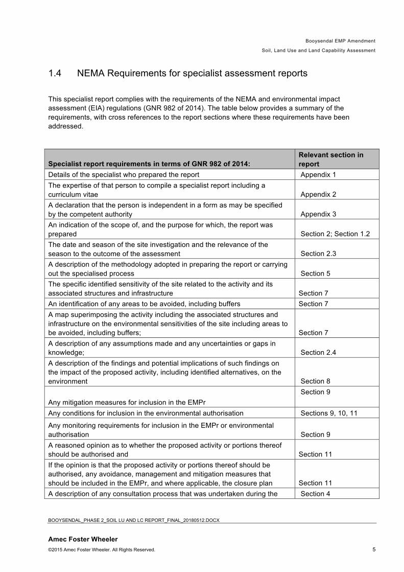
1.4 NEMA Requirements for specialist assessment reports
This specialist report complies with the requirements of the NEMA and environmental impact
assessment (EIA) regulations (GNR 982 of 2014). The table below provides a summary of the
requirements, with cross references to the report sections where these requirements have been
addressed.
Specialist report requirements in terms of GNR 982 of 2014: Relevant section in report
Details of the specialist who prepared the report Appendix 1
The expertise of that person to compile a specialist report including a
curriculum vitae Appendix 2
A declaration that the person is independent in a form as may be specified
by the competent authority Appendix 3
An indication of the scope of, and the purpose for which, the report was
prepared Section 2; Section 1.2
The date and season of the site investigation and the relevance of the
season to the outcome of the assessment Section 2.3
A description of the methodology adopted in preparing the report or carrying
out the specialised process Section 5
The specific identified sensitivity of the site related to the activity and its
associated structures and infrastructure Section 7
An identification of any areas to be avoided, including buffers Section 7
A map superimposing the activity including the associated structures and
infrastructure on the environmental sensitivities of the site including areas to
be avoided, including buffers; Section 7
A description of any assumptions made and any uncertainties or gaps in
knowledge; Section 2.4
A description of the findings and potential implications of such findings on
the impact of the proposed activity, including identified alternatives, on the
environment Section 8
Any mitigation measures for inclusion in the EMPr
Section 9
Any conditions for inclusion in the environmental authorisation Sections 9, 10, 11
Any monitoring requirements for inclusion in the EMPr or environmental
authorisation Section 9
A reasoned opinion as to whether the proposed activity or portions thereof
should be authorised and Section 11
If the opinion is that the proposed activity or portions thereof should be
authorised, any avoidance, management and mitigation measures that
should be included in the EMPr, and where applicable, the closure plan Section 11
A description of any consultation process that was undertaken during the Section 4

Booysendal EMP Amendment
Soil, Land Use and Land Capability Assessment
BOOYSENDAL_PHASE 2_SOIL LU AND LC REPORT_FINAL_20180512.DOCX
Amec Foster Wheeler ©2015 Amec Foster Wheeler. All Rights Reserved. 6
course of carrying out the study
A summary and copies if any comments that were received during any
consultation process Section 4
2. Scope of works The scope of works provides a description of the study objectives, the delineation of the study area, the
relevance of seasonality and seasonal assessments to the field of study as well as a list of the study
gaps and assumptions and limitations made during the study process.
2.1 Study objectives
Study objectives were identified during the scoping phase to ensure that all relevant baseline data is
gathered and existing information incorporated, while mitigation and management measures are
sufficiently updated and adjusted to ensure optimal protection of the valuable soil resource on site. The
Soil, Land Use and Land Capability Assessment had the following objectives:
• Survey the anticipated direct and indirect areas of influence (AoI) based on the
characteristics of the landscape and the project description.
• Determine the current soil properties, land capabilities and land uses of land in the
proposed project area.
• Identify and delineate soil forms that are sensitive to degradation as a result of the
proposed project.
• Identify and assess anticipated future impacts that will be caused by the project.
• Identify cumulative impacts on soil, land use and land capability as a result of activities
already authorised as a result of the Phase 1 and Section 24G applications and existing
operations.
• Recommend mitigation and management measures to minimise negative impacts and
maximise land rehabilitation success towards successful mine closure at the end of the
project life.
• Follow the plan of study and the methodology as compiled during the scoping phase for
the detailed soil and land use impact assessment.
2.2 Delineation of Study Area
Soil and the associated land capabilities and land uses will be directly affected wherever the soil
surface is disturbed by vegetation removal and earth-moving activities. This includes areas in close
proximity to construction areas where the construction materials are temporarily stored or where
construction and other vehicles drive.
The indirect area of influence stretches all the way to the Der Brochen dam in the north and in a buffer
zone around the entire direct area of influence. The indirect area of influence is mainly determined by
waterways and preferential flow paths in the landscape since eroded soil from direct area of influence
may move with the surface water to lower lying areas and result in siltation.

Booysendal EMP Amendment
Soil, Land Use and Land Capability Assessment
BOOYSENDAL_PHASE 2_SOIL LU AND LC REPORT_FINAL_20180512.DOCX
Amec Foster Wheeler ©2015 Amec Foster Wheeler. All Rights Reserved. 7
The proposed zones of influence for the Soil, Land Use and Land Capability study is illustrated in
Figure 1.
2.3 Relevance of seasonality to Soil, Land Use and Land Capability
properties of the study area
The first survey of the new Booysendal areas was conducted from 26 to 30 January 2016. This falls in
the South African summer season during which rain events occur. It has already rained in the area
before the survey was conducted and therefore it was possible to detect and delineate any areas with
hydromorphic soils (should there be present). The soil assessment of the previous Project Fairway
area (BS3) was conducted during October of 2011 (Pienaar, January 2012), the last month of spring
(the onset of the rainy season).
With the onset of construction activities that were included in a Section 24G application and the
inclusion of new project areas that were previously part of the Booysendal South Mining Right (ex-
Everest Mine), another site survey became necessary. The second site visit was conducted from 7 to
10 November 2016. This was at the onset of the South African summer. There were a number of
rainfall events before the survey and this was sufficient to illuminate hydromorphic (wetland) soil forms
present in the landscape. The last two site visits were conducted on 6 and 19 December 2018, with
good rainfall between these site visits.
However, season of survey is not a determining factor for soil assessment. As soils develop over
thousands of years, season do not influence the soil properties present, especially in areas with low to
average rainfall, such as that of the project site. Even impacts on soil properties as a result of
hydropedology, occurs over several years and are not influenced by the season of the assessment
within a year or a few years.
2.4 Gaps, assumptions and limitations
All studies have certain gaps, assumptions and limitations that frame the conclusions made in the study
report. These are identified below.
2.4.1 Study gaps
No soil quality monitoring reports of the current soil management practices at Booysendal Mine were
evaluated for this specialist study in support of the environmental authorisations and EMP amendment
applications. The scope of the study did not include for contamination assessment that may possibly
result from nearby mining activities. The scope for that will necessitate a separate study.
2.4.2 Assumptions
The following assumptions have been made in this study:
• It is assumed that the baseline data gathered and then updated with follow-up site visits are still
relevant and have not been altered by unauthorised activities.

Booysendal EMP Amendment
Soil, Land Use and Land Capability Assessment
BOOYSENDAL_PHASE 2_SOIL LU AND LC REPORT_FINAL_20180512.DOCX
Amec Foster Wheeler ©2015 Amec Foster Wheeler. All Rights Reserved. 8
• It was also assumed that the data obtained from the Project Fairway area is still relevant and
that no other soil disturbance activities have occurred since the soil assessment in 2011.
• It is further assumed that current activities on site pre-approval of the process of which this Soil
Study is part, will follow precautionary soil management measures to avoid soil loss through
erosion and minimise compaction.
2.4.3 Limitations
Soil profiles in greenfields areas were observed using a 1.5m hand-held soil auger. A description of the
soil characteristics deeper than 1.5m cannot be given. Profiles that could be observed to greater depth
were found at road cuttings. The difficulty of the terrain (steep, rocky slopes) affected the sampling and
survey points density in certain areas and the planned sampling strategy had to be adapted.
3. Legal context of study
Both South African legislation and international best practice guidelines such as that of the International
Finance Corporation (IFC) were considered for the study.
3.1 South African Legislation
The most recent South African Environmental Legislation that needs to be considered for any new or
expanding development with reference to management of soil and land use includes:
• Soils and land capability are protected under the National Environmental Management Act 107
of 1998, the Minerals and Petroleum Development Act 28 of 2002 and the Conservation of
Agricultural Resources Act 43 of 1983.
• The National Environmental Management Act 107 of 1998 requires that pollution and
degradation of the environment be avoided, or, where it cannot be avoided be minimised and
remedied.
• The Conservation of Agricultural Resources (Act 43 of 1983) states that the degradation of the
agricultural potential of soil is illegal.
• The Conservation of Agriculture Resources Act 43 of 1983 also requires the protection of land
against soil erosion and the prevention of water logging and salinization of soils by means of
suitable soil conservation works to be constructed and maintained.
• Government Notice R983 of 4 December 2014. The purpose of this Notice is to identify
activities that would require environmental authorisation prior to commencement of that activity.
3.2 International Finance Corporation (IFC) Guidelines
In addition to South African Environmental Legislation, the study also aligns to fulfil the IFC
Performance Standards on Environmental and Social Sustainability that became effective on 1 January,
2012. With regards to the Soil, Land Use and Land Capability assessment, the following standards
and guidelines are of most relevance:
Booysendal EMP Amendment
Soil, Land Use and Land Capability Assessment
BOOYSENDAL_PHASE 2_SOIL LU AND LC REPORT_FINAL_20180512.DOCX
Amec Foster Wheeler ©2015 Amec Foster Wheeler. All Rights Reserved. 9
• IFC Performance Standard 3: Resource Efficiency and Pollution Prevention provides guidelines
on project-level approach to resource efficiency and pollution prevention, in this case
specifically for land management.
• IFC Guidelines for Mining which recommend practices for sustainable land use and topsoil
management.
• IFC General Environmental, Health and Safety Guidelines: Contaminated Land for the
detection, remediation and monitoring of contaminated land, should it be present.
4. Consultation and addressing of comments At this stage of the study, no consultation with current land users and surrounding land users have
been conducted to obtain additional information. Consultation with surrounding land users is being
undertaken as part of the overall public consultation process for the Project. So far, no comments on
the Soil, Land Use and Land Capability Assessment has been received through the Public Participation
process. Once comments and questions have been received, it will be addressed before the final
report is submitted.
5. Methodology The study followed a phased approach that commenced during the scoping phase that consisted of
desktop study work. The detailed study included a site survey, interpretation and mapping of results
and incorporation of the existing Project Fairway baseline data.
5.1 Desktop study and literature review
The following data was obtained and studied for the desktop study and literature review to provide
background information for the study:
• Existing reports and studies for the area;
• Land type data for the site was obtained from the Institute for Soil, Climate and Water (ISCW) of
the Agricultural Research Council (ARC).
• Broad geological, soil depth and soil description classes obtained from the Department of
Environmental Affairs were studied. This data forms part of the Environmental Potential Atlas
(ENPAT) of South Africa.
• The most recent aerial photography of the area available from Google Earth was obtained. The
aerial photography analysis was used to determine areas of existing impact, land uses within
the project area as well as the larger landscape, wetland areas and preferential flow paths.
• Infrastructure Environmental Impact Assessment for Booysendal South-Central Complex,
submitted by DRA Projects SA (Pty) Ltd on 3 July 2015.
• Annexure B1 – Soil, Land Use and Land Capability Assessment for Booysendal, compiled by
Mariné Pienaar in March 2009 for Ivuzi.
• Soil survey for proposed extension of mining activities at BS4 near Lydenburg. Report compiled
by J.G. Dreyer and D.G. Paterson of the ARC in February 2007.
• Project Fairway Soil Report submitted by Mariné Pienaar to Metago in January 2012.
• Project Fairway Land Use Report submitted by Mariné Pienaar to Metago in January 2012.

Booysendal EMP Amendment
Soil, Land Use and Land Capability Assessment
BOOYSENDAL_PHASE 2_SOIL LU AND LC REPORT_FINAL_20180512.DOCX
Amec Foster Wheeler ©2015 Amec Foster Wheeler. All Rights Reserved. 10
5.2 Site survey
A systematic soil survey was undertaken with sampling points between 100 m and 250 m apart in the
study area, depending on accessibility. The first survey was conducted in the South African summer,
from 26 to 30 January and the second survey from 7 to 10 November 2016. The last two site visits were
conducted on 6 and 19 December respectively. The soil profiles were examined to a maximum depth
of 1.5m using an auger and deeper where road cuttings made it possible to see the depth of underlying
subsurface horizons deeper than 1.5m. Soil survey points are included in Figure 2.
Observations were made regarding soil texture, structure, colour and soil depth at each survey point. A
cold 10% hydrochloric acid solution was used on site to test for the presence of carbonates in the soil.
The soils are described using the S.A. Soil Classification Taxonomic System (Soil Classification
Working Group, 1991). For soil mapping, the soils were grouped into classes with relatively similar soil
characteristics.
The soil properties of the Project Fairway area that was used for the surface infrastructure associated
with the BS3 underground mine have already been surveyed in detail and this information was added to
the baseline description (discussed in Section 5.4). Although this section is not relevant to any
proposed development it provides a wider baseline of the project area.
5.3 Laboratory analysis of samples
Nineteen soil samples (twelve topsoil and seven subsoil) were collected in the entire Booysendal
Project Area during the different site visits. Sampling points were evenly distributed throughout the
sites in order to be representative of the different soil forms identified (therefore representing modal soil
profiles). Soil samples were sealed in soil sampling plastic bags and sent to Nvirotek Labs at
Hartbeespoortdam for analyses. The samples were analysed for pH (KCl and H2O), phosphorous (Bray
1), exchangeable cations (calcium, magnesium, potassium, sodium), organic carbon (Walkley-Black)
and texture classes (relative fractions of sand, silt and clay).
5.4 Incorporation of historic soil data
The shapefiles of the soil classification map of the Project Fairway baseline assessment was obtained
and incorporated to the new soil survey map, using ArcGIS. Wherever soil data points were missing,
predictive digital soil mapping techniques were used to merge the data and produce an accurate soil
map for the BS3 area. Tthe soil classification data for the original soil survey or the Booysendal North
area was considered although the mining activities have changed the soil properties to that of anthropic
soil forms.
5.5 Predictive digital soil mapping
Once the project layout was finalised, predictive soil mapping techniques were used to include small
portions of land on the periphery of the direct area of influence to ensure all areas are covered. The

Booysendal EMP Amendment
Soil, Land Use and Land Capability Assessment
BOOYSENDAL_PHASE 2_SOIL LU AND LC REPORT_FINAL_20180512.DOCX
Amec Foster Wheeler ©2015 Amec Foster Wheeler. All Rights Reserved. 11
data used include existing soil classification data as well as land type data as obtained from the
Agricultural Research Council (ARC).
Figure 5-1: Survey points map of the soil, land use and land capability study

Booysendal EMP Amendment
Soil, Land Use and Land Capability Assessment
BOOYSENDAL_PHASE 2_SOIL LU AND LC REPORT_FINAL_20180512.DOCX
Amec Foster Wheeler ©2015 Amec Foster Wheeler. All Rights Reserved. 12
5.6 Land capability classification
Land capability classes were determined using the guidelines outlined in Section 7 of “The Chamber of
Mines Handbook of Guidelines for Environmental Protection (Volume 3, 1981)”. The Chamber of Mines
pre-mining land capability system was utilized, given that this is the dominant capability classification
system used for the mining industry. Table 1 indicates the set of criteria as stipulated by the Chamber
of Mines to group soil forms into different Land capability classes.
Table 1 Criteria used for land capability classification
Criteria for
Wetland
Ø Land with organic soils or
Ø A horizon that is gleyed throughout more than 50 % of its volume and is
significantly thick, occurring within 750mm of the surface.
Criteria for
Arable Land
Ø Land, which does not qualify as a wetland,
Ø The soil is readily permeable to the roots of common cultivated plants to
a depth of 750mm,
Ø The soil has a pH value of between 4,0 and 8.4,
Ø The soil has a low salinity and Sodium Adsorption Ratio (SAR)
Ø The soil has a permeability of at least 1,5-mm per hour in the upper
500-mm of soil,
Ø The soil has less than 10 % (by volume) rocks or pedocrete fragments
larger than 100-mm in diameter in the upper 750-mm,
Ø Has a slope (in %) and erodibility factor (K) such that their product is
<2.0,
Ø Occurs under a climatic regime, which facilitates crop yields that are at
least equal to the current national average for these crops, or is
currently being irrigated successfully.
Criteria for
Grazing Land
Ø Land, which does not qualify as wetland or arable land,
Ø Has soil, or soil-like material, permeable to roots of native plants, that is
more than 250-mm thick and contains less than 50 % by volume of
rocks or pedocrete fragments larger than 100-mm,
Ø Supports, or is capable of supporting, a stand of native or introduced
grass species, or other forage plants, utilizable by domesticated
livestock or game animals on a commercial basis.
Criteria for
Wilderness
Land
Ø Land, which does not qualify as wetland, arable land or grazing land.
In addition to the land capability classes specified above, a fifth class was used that is not specified by
this system called “Industrial/Non-productive land”. Land on site that has been significantly altered by
previous mining activities or are currently being altered significantly are currently non-productive and
cannot be classified as Wilderness potential which includes shallow soil on steep slopes that support
sparser vegetation than grazing land.

Booysendal EMP Amendment
Soil, Land Use and Land Capability Assessment
BOOYSENDAL_PHASE 2_SOIL LU AND LC REPORT_FINAL_20180512.DOCX
Amec Foster Wheeler ©2015 Amec Foster Wheeler. All Rights Reserved. 13
5.7 Assessment of ecosystem services
Ecosystem services (ES) are benefits that ecosystems provide to people, businesses, plants and
animals as well as transporting materials (e.g. water, carbon) and energy (heat) around the planet. The
Millennium Ecosystem Assessment (2005) provides a classification scheme of these services:
• Provisioning Services – these are goods or products obtained from ecosystems, such as food,
water, timber and other products from plants such as fibre;
• Regulating Services – these include benefits obtained from an ecosystem’s control of natural
processes, such as climate regulation, disease control, erosion prevention, water flow
regulation, and protection from natural hazards;
• Cultural Services – are the non-material benefits obtained from ecosystems, such as recreation,
spiritual values, and aesthetic enjoyment; and
• Supporting Services – are the natural processes such as soil formation, nutrient cycling and
primary productivity that maintain other ecosystem services.
The drivers of ecosystem change either involve direct, indirect or secondary drivers. The most
significant direct drivers identified by the World Resources Institute (2011) are as follows:
Changes in local land use and land cover;
• Harvest and resource consumption;
• Pollution;
• Introduction of invasive species; and
• Climate change.
Significant indirect drivers include the following:
• Demographic;
• Economic;
• Socio-political; and
• Religious or scientific, technological factors.
For this assessment, Ecosystem Services provided by the soil in the larger landscape was considered.
In addition to this, the following was also considered for this assessment:
• The likely distance at which the proposed mine including infrastructure will impact the
availability and functionality of ecosystem services;
• The likely distance that people are willing to travel to utilise natural resources on a regular basis
if existing ES are disturbed or removed due to the mine; and
• Water catchment areas likely to be affected by the mine.
6. Baseline results The Booysendal operation consists of two mining rights, namely the Booysendal MR (LP 30/5/1/3/2/1
(188) EM); and the Booysendal South MR (MP 30/5/1/2/3/2/1 (127) EM). For operational purposes the
Booysendal Operations is divided into two main operational areas, namely Booysendal North (BN),
which falls in Limpopo Province and Booysendal South (BS), which falls in the Mpumalanga Province

Booysendal EMP Amendment
Soil, Land Use and Land Capability Assessment
BOOYSENDAL_PHASE 2_SOIL LU AND LC REPORT_FINAL_20180512.DOCX
Amec Foster Wheeler ©2015 Amec Foster Wheeler. All Rights Reserved. 14
and which consists of the entire Booysendal South MR and the southern section of the Booysendal MR.
BN is in the northern section of the Booysendal MR and is a fully operational underground PGM and
Merensky mine, whilst the development of BS is ongoing. BS is further subdivided into BS1/2, BS4 (ex-
Everest Mine) and two new Merensky south adit expansions (BCM1 and BCM2) just north of BS1/2.
BS1/2 and the BCM1 and BCM2 adits form part of the Booysendal MR, while BS4 and its associated
developments forms the Booysendal South MR.
The pre-project soil, land capabilities, soil ecosystem services and land uses for the entire project have
been determined with surveys during as the Booysendal operation developed and is depicted in Figure
3. For the purpose of the Phase 2 application, the proposed infrastructure is depicted in Figures 4 to 6.
6.1 Soil forms
The landscape of the largest part of the Booysendal project site is mountainous and characterised by
hill tops, steep slopes and valley bottoms where drainage lines and preferential water flow paths are
located. The eastern portion of the consolidated area (where BS4 is located) has flat to slightly
undulating surfaces suitable for agricultural production in between rocky hills. The texture of the soil is
dominated by clay-loam and soil is weakly to moderately strongly structured. The hill slopes are mainly
characterised by shallow, rocky lithic soils where pedogenesis is still active (all areas except BS4). The
areas that were part of the Section 24G application had undergone drastic disturbance as a result of
construction activities. This has led to a change in soil forms since the first site visit in January 2016.
Since this site visit, all soil in the areas already disturbed by construction now belongs to the Witbank
soil form. This is described in more detail below. Fourteen different soil forms were identified within the
study area as illustrated in Figure 3. Below follows a description of each of these soil forms:
6.1.1 Arcadia (40.1 ha or 1.82% of study area)
These dark brown to black vertic soils have deep A-horizons (80 cm deep on site) and are high in clay
content with swelling-shrinking properties under conditions of water content changes. These expansive
materials have a characteristic appearance: structure is strongly developed, ped faces are shiny, and
consistence is highly plastic when moist and sticky when wet. The swell-shrink potential is manifested
typically by the formation of conspicuous vertical cracks in the dry state and the presence, at some
depth, of slickensides (polished or grooved glide planes produced by internal movement). The Arcadia
soils on site have high grazing potential and very palatable, nutritious (sweet) grazing occurs on these
soils.
6.1.2 Bainsvlei (59.8 ha or 2.71% of study area)
The Bainsvlei soil form consists of an orthic A horizon overlying a red apedal B horizon that is underlain
by soft plinthite. Red soil colours in both the moist and dry states dominate the colouration of this
horizon. The depth of the orthic A-horizons of the Bainsvlei profiles surveyed on site was 35 cm and
the restrictive layers of soft plinthite that have signs of wetness were found from 120 cm deep. The
oxides present in this soil form (it belongs to a larger group of oxidic soils) provide a micro-aggregating
effect that reduces the dispersibility of fine particles and reduces erosion risk. This makes topsoil
stripped from the Bainsvlei soil form highly suitable for land rehabilitation purposes. Bainsvlei soils with
no restrictions shallower than 500mm are generally good for crop production and the Bainsvlei soils on

Booysendal EMP Amendment
Soil, Land Use and Land Capability Assessment
BOOYSENDAL_PHASE 2_SOIL LU AND LC REPORT_FINAL_20180512.DOCX
Amec Foster Wheeler ©2015 Amec Foster Wheeler. All Rights Reserved. 15
site have arable land capability. Special care should be taken in footprint areas where Bainsvlei soil is
present to strip and stockpile this for closure or concurrent rehabilitation.
6.1.3 Bonheim (12.6 ha or 0.57% of study area)
The Bonheim soil form identified consists of a melanic A horizon (15 cm deep in study area), overlying
a pedocutanic B horizon that is distinguished on the basis of an increase in clay as a result primarily of
illuviation and accumulation and visually expressed as cutans. These soils are found in the study area
in similar topographic positions as vertic soils but commonly are slightly higher upslope. The B horizon
of Bonheim soils may have a plasticity index that would qualify it as vertic if it was a topsoil horizon.
The melanic A horizon lacks slickensides that are diagnostic of vertic horizons but has structure that is
strong enough so that the mayor part of the horizon is not both massive and hard or very hard when
dry. The Bonheim soil form on site has grazing land capability and the natural high nutrient content of
these soils is ideal as growing medium for sweet grazing.
6.1.4 Clovelly (3.2 ha or 0.15% of study area)
The Clovelly soil forms consist of a sandy-loam orthic A horizon on a well-drained yellow-brown apedal
B horizon overlying unspecified material where limited pedogenesis has taken place. Soil depths of the
Clovelly profiles surveyed on site was 100 cm deep. Manganese concretions were observed in less
than 5 % of the profile from 100 cm. Clovelly soils with no restrictions shallower than 50 cm are
generally good for crop production. The high quality orthic A and yellow-brown apedal B-horizons make
it a suitable soil form for annual crop production (good rooting medium) and use as ‘topsoil’, having
favourable structure (weak blocky to apedal) and consistence (slightly firm to friable). The Clovelly soil
form is present in the south-eastern part of the study area and comprises only 0.15% of the total study
area. It has arable land capability and is suitable for crop production. The soil chemical properties of
this soil form was determined from the Project Fairway baseline analysis.
6.1.5 Griffin (17.1 ha or 0.77% of study area)
The Griffin soil form consists of an orthic A horizon (20 to 45 cm deep on study site) on a yellow-brown
apedal B1 horizon overlying a red apedal B2 at a depth of 70 to 140 cm deep at different survey points
on the study site (Figure 7B). Both yellow-brown apedal B1 and red apedal B2 horizons are
structureless to moderately structure. It is only the colour changing from red to yellow that differentiates
between the horizons. The Griffin soil has loamy texture with moderate organic matter status and is
well drained. It is usually acidic and extremely low in bases. Phosphate status is low and phosphorus
(P) sorption capacity is moderate to high. Dolomitic lime would be needed to achieve good crop yields
and fertilizer containing Zn would also be advisable. The soil is highly suited to dry land crop
production, subject to appropriate chemical amelioration. This soil form has arable land capability.
6.1.6 Hutton (271.6 ha or 12.31% of study area)
The Hutton soil forms consist of an orthic A horizon on a red apedal B horizon overlying unspecified
material. The red apedal soils B1-horizon has more or less uniform "red" soil colours in both the moist

Booysendal EMP Amendment
Soil, Land Use and Land Capability Assessment
BOOYSENDAL_PHASE 2_SOIL LU AND LC REPORT_FINAL_20180512.DOCX
Amec Foster Wheeler ©2015 Amec Foster Wheeler. All Rights Reserved. 16
and dry states and has weak structure or is structureless in the moist state. The range of red colors that
is a key identification tool in differentiating between a red apedal and yellow-brown apedal is defined by
the Soil Classification Working Group Book, 1991. Some of the defining red soil colors identified on the
sites are bleached (10R 3/6), while some are bright red. The clay content of Hutton soils identified is
between 10% and 25%.
Soil depths of the Hutton profiles surveyed on site ranged between 130cm and 150cm and deeper with
restrictive layers of unspecified material without signs of wetness. Hutton soils with no restrictions
shallower than 50cm are generally good for crop production. All Hutton profiles are structureless or
have very weakly developed structure. The high quality orthic A and red apedal B-horizons make it a
suitable soil form for annual crop production (good rooting medium) and use as ‘topsoil’, having
favourable structure (weak blocky to apedal) and consistence (slightly firm to friable). These topsoils
are ideal for stripping and stockpiling for rehabilitation purposes for they are deep and have a favorable
structure.
Soil samples BS01 (topsoil) and BS02 (subsoil) represents the chemical properties of the site with
acidic pH levels between 4,25 and 4,40, very low phosphate levels (at 1mg/kg) and cation levels (Mg,
Ca, K and Na) within acceptable ranges for successful crop production. The Hutton soil form occurs in
the BS4 development area and the northern portion of it has previously been planted with kiwifruit
orchards. Some of the kiwi trees are still present. This soil form has high arable land capability.
6.1.7 Hydromorphic soils (71.6 ha or 3.24% of study area)
Hydromorphic soils have been identified on the eastern portion of the study site. These soils are
underlain by a G-horizon underneath a vertic, melanic or orthic A horizon. The blue-greyish colours of
the G-horizon as well as the yellow and red mottles observed for these profiles, indicate temporary to
permanent periods of water saturation – an indicator for wetland ecosystems. This area differs from the
preferential flowpath (25.1 ha or 1.7% of the study area) that is primarily made up of rock beds and
sand and where water flow takes place as a result of the landscape position. It also differs from the
river and riparian zone that is underlain in some areas by a combination of Katspruit and Kroonstad soil
forms (as described in Section 6.1.10) but where water flow is actively happening on the surface. The
hydromorphic soils have wetland sensitivity and is considered highly sensitive (see Figure 6) to the
development, therefore a no-go area for any mining activities.
6.1.8 Inhoek (211.6 ha or 9.59% of study area)
The Inhoek soil form identified in the study area consists of a melanic A horizon (35 cm to 45 cm deep),
overlying unconsolidated sediments in which soil formation has not progressed sufficiently far to
produce one of the following diagnostic horizons: G horizon, pedocutanic B horizon or a soft or hardpan
carbonate horizon. In general, melanic soils are fertile but require irrigation to be highly productive.
Natural veld on these soils provides sweet grazing and ecosystems dominated by melanic soils are
highly productive. Although the Inhoek soil form has fewer constraints like shallow depth, wetness,
excessive alkalinity and slope and is considered one of the most productive soils within its climatic area,
the topography of the study area render it not worthwhile to cultivate the pockets of the Inhoek soil form
present. Therefore, the Inhoek soil form within the study area has grazing land capability.
Booysendal EMP Amendment
Soil, Land Use and Land Capability Assessment
BOOYSENDAL_PHASE 2_SOIL LU AND LC REPORT_FINAL_20180512.DOCX
Amec Foster Wheeler ©2015 Amec Foster Wheeler. All Rights Reserved. 17
6.1.9 Katspruit/Kroonstad (52.5 ha or 2.38% of study area)
On the eastern portion of the site, a very small section of Katspruit and Kroonstad forms occur together
in such close proximity that they were grouped together. Since both of these soil forms have wetland
land capability and function as such in this landscape, they have been combined into one soil
classification unit. Below follows a description of each of these forms:
• The Katspruit soil form consists of an orthic A horizon and in the study area on a calcareous G
horizon and thus belonging to the Slangspruit family. The A horizon surveyed on site is non-
calcareous and enriched with clay in the top 15 cm. It has a dark greyish-brown colour with
medium faint grey mottles. The texture is a medium sandy loam. The G horizon is saturated
with water for long periods and is dominated by grey, low chroma matrix colours. This soil form
is associated with wetland land capability and usually indicates the presence of seasonal or
permanent wetlands.
• The Kroonstad soil form consists of an orthic A horizon overlying an E horizon that is underlain
by a G horizon. The orthic A horizon is grey (10YR5/1) when dry and very dark grey (10YR3/1)
when moist and has a loamy medium sand, single grain, loose texture. The main difference
from the Katspruit soil form is the presence of a prominent sandy E horizon overlying a gleyed
sandy clay loam G horizon. Soil depths of the Kroonstad profiles surveyed on site ranged
between 45 cm and 60 cm before reaching the restrictive gleyed G horizon. The Kroonstad soil
form supports wetland land capability although it is used for crop production in many areas as a
result of its water-holding capacity that is useful during dry periods. On the study site crop
production will not be practical and this area is better conserved for wetland functioning.
6.1.10 Lithic soils (679.3 ha or 30.78% of study area)
The lithic soil group consists of rock or its weathered form (saprolite) the dominates the profiles. These
soil forms occur in the study area on steep slopes and is at place clearly visible in the landscape as
exposed rock surfaces. On steep slopes, natural erosion occurs faster than weathering of rock and
therefore the domination of the solum by unweathered rock components. The lithic soils on site
consisted of the Glenrosa and Mispah forms in combination with rocky outcrops and patches of hard
rock
The Glenrosa soil form consists of an orthic A horizon underlain by a hard lithocutanic B horizon. The
lithocutanic B horizon (distinguished from hard rock by not only consistence and degree of weathering
but also tonguing and cutanic character) may itself be ’hard or not hard’ (Soil Classification Working
Group 1991). To be called hard more than 70% must be parent rock, fresh or partly weathered with a
hard consistence in the dry, moist and wet states. The cutanic character of the B horizon of the
Glenrosa soil form as was visible in open profiles in the study area, take the form of tongues of topsoil
extending into the partly weathered parent rock. The Glenrosa soil profiles on site are very shallow and
situated on steep slopes. Topsoil stripping for stockpiling will result in very little topsoil to be stored for
rehabilitation purposes.
The Mispah soil form consists of shallow, rocky soils are dominated by rock or saprolite (weathered
rock). These soils have a very shallow (as shallow as 1cm) layer of soil on hard rock. The orthic A-
horizon of this lithic soil group is unsuitable for annual cropping or forage plants (poor rooting medium
since the low total available moisture causes the soil to be drought prone). These topsoils are not ideal

Booysendal EMP Amendment
Soil, Land Use and Land Capability Assessment
BOOYSENDAL_PHASE 2_SOIL LU AND LC REPORT_FINAL_20180512.DOCX
Amec Foster Wheeler ©2015 Amec Foster Wheeler. All Rights Reserved. 18
for rehabilitation purposes for they are too shallow and/or too rocky to strip. Topsoil stripping and
stockpiling of these ‘shallow’ soils should only be attempted where the surface is not too rocky.
6.1.11 Mayo (15.1 ha or 0.68% of study area)
The Mayo soil form identified consists of a melanic A horizon (15 cm to 25 cm deep in the study area),
overlying a lithocutanic B horizon. More than 70% by volume of the hard lithocutanic B horizon consists
of parent bedrock, fresh or partly weathered, with a hard consistence in the dry, moist and wet states.
The melanic A horizon lacks slickensides that are diagnostic of vertic horizons but has structure that is
strong enough so that the major part of the horizon is not both massive and hard or very hard when dry.
Land use is normally confined to livestock grazing or wildlife conservation. Such soils are highly prized
for the nutritious grazing which they sustain. The Mayo soil form on site has grazing land capability.
6.1.12 Oakleaf (17.1 ha or 0.77% of study area)
The Oakleaf soil form identified in the Booysendal study area consists of an orthic A horizon of 80 cm
deep, overlying a neocutanic B horizon on unspecified material. The neocutanic horizon has non-
uniform colouring and cutans and channel infillings area visible. Oakleaf soils have high agricultural
production potential and are rather well-drained permitting that the rainfall and slope allows crop
production. The fine sandy loam will be prone to both wind and water erosion when vegetation cover is
removed or when stripped and stockpiled during mining activities. The Oakleaf soil on site has grazing
land capability.
6.1.13 Shortlands (81.6 ha or 3.70% of study area)
The Shortlands form consists of an orthic A horizon on a red structured B horizon (Figure 7a). The red
structured (pedorhodic) B horizon, although of mixed clay mineralogy, is strongly dominated by kaolinite
with a high proportion of iron oxides which explains the red colour. A combination of higher clay content
and drier climate explain the strong blocky structure.
The Shortlands soil form (a pedorhodic oxidic soil) is a fertile soil once the P status has been corrected
and is at its productive best under irrigation where slope and the availability of irrigation water permits.
The high clay content however makes the Shortlands soil form less stable and more susceptible to
erosion and its position in the study area, either next to the river or on steep slopes, cause it to be less
suitable for crop production. The susceptibility to erosion is a fact which should be kept in mind when
stripping and stockpiling topsoil during mining operations. Due to the position in the landscape and the
nature of the terrain, the Shortlands forms on site have grazing land capability.
6.1.14 Sterkspruit (34.9 ha or 1.58% of study area)
The Sterkspruit soil form consists of an orthic A horizon overlying a prismacutanic B horizon. The clay
content of the prismacutanic B horizon show an absolute increase of at least 20% higher clay content
than the overlying layer. This horizon accommodates the classical concept of solodized solonetz B in
which prismatic or columnar structure has developed under an abrupt transition and cutanic character

Booysendal EMP Amendment
Soil, Land Use and Land Capability Assessment
BOOYSENDAL_PHASE 2_SOIL LU AND LC REPORT_FINAL_20180512.DOCX
Amec Foster Wheeler ©2015 Amec Foster Wheeler. All Rights Reserved. 19
(clay skins) is conspicuous. Certain chemical peculiarities, namely a high exchangeable sodium and/or
magnesium percentage, are regularly associated with this morphology. The B horizon is commonly an
impediment to root growth and water movement and duplex soils have thus a shallow effective depth.
Because of the high erodibility of the topsoil which is caused by clay dispersion, it should best be used
for grazing and natural vegetation be kept intact. When stockpiling during mining activities it should be
kept in mind that the surface soil is prone to crusting and generally highly erodible. The Sterkspruit soil
has grazing land capability.

Booysendal EMP Amendment
Soil, Land Use and Land Capability Assessment
BOOYSENDAL_PHASE 2_SOIL LU AND LC REPORT_FINAL_20180512.DOCX
Amec Foster Wheeler ©2015 Amec Foster Wheeler. All Rights Reserved. 20
Figure 6-1: Soil map for the Booysendal Study Area

Booysendal EMP Amendment
Soil, Land Use and Land Capability Assessment
BOOYSENDAL_PHASE 2_SOIL LU AND LC REPORT_FINAL_20180512.DOCX
Amec Foster Wheeler ©2015 Amec Foster Wheeler. All Rights Reserved. 21
Figure 6-2 Phase 2 infrastructure superimposed on soil map (northern part)

Booysendal EMP Amendment
Soil, Land Use and Land Capability Assessment
BOOYSENDAL_PHASE 2_SOIL LU AND LC REPORT_FINAL_20180512.DOCX
Amec Foster Wheeler ©2015 Amec Foster Wheeler. All Rights Reserved. 22
Figure 6-3 Phase 2 infrastructure superimposed on soil map (central part)

Booysendal EMP Amendment
Soil, Land Use and Land Capability Assessment
BOOYSENDAL_PHASE 2_SOIL LU AND LC REPORT_FINAL_20180512.DOCX
Amec Foster Wheeler ©2015 Amec Foster Wheeler. All Rights Reserved. 23
Figure 6-4 Phase 2 2 infrastructure superimposed on soil map (eastern part)
Booysendal EMP Amendment
Soil, Land Use and Land Capability Assessment
BOOYSENDAL_PHASE 2_SOIL LU AND LC REPORT_FINAL_20180512.DOCX
Amec Foster Wheeler ©2015 Amec Foster Wheeler. All Rights Reserved. 24
6.1.15 Swartland (110.4 ha or 5.00% of study area)
The Swartland soil form identified in the study area consists of a 20 cm orthic A horizon on a strongly
developed angular blocky structured pedocutanic B horizon overlying saprolite. Duplex soils have in
common the development of strong structure in the B horizon and a marked increase in clay compared
to the overlying horizon. The B horizon is often sufficiently hard and dense to be an impediment to both
root growth and water movement and these soils commonly exhibit a high susceptibility to erosion.
Besides the duplex morphology of the Swartland soil form, the shallow depth to saprolite is the key
feature of this soil which has more in common with soils of the lithic group than of any other. Erosivity,
aridity and shallow effective depth are the major limitations to this soil’s land capability. Swartland soil
on site has grazing land capability.
This soil form’s susceptibility to erosion should also be kept in mind during mining operations.
6.1.16 Tukulu (2.1 ha or 0.10% of study area)
The Tukulu soil form was only found on a small portion of land on the far eastern side of the
Booysendal study area. This soil form consists of an orthic A horizon of 35 cm deep, overlying a
neocutanic B horizon that is underlain by unspecified materials with signs of wetness. The neocutanic
horizon has non-uniform colouring and cutans and channel infillings area visible. Tukulu soils have high
agricultural production potential and are rather well-drained permitting that the rainfall and slope allows
crop production. The fine sandy loam will be prone to both wind and water erosion when vegetation
cover is removed or when stripped and stockpiled during mining activities. The Tukulu soil on site has
arable land capability.
6.1.17 Valsrivier (187.9 ha or 8.51% of study area)
The Valsrivier soil form is also a duplex soil. It consists of an orthic A horizon, overlying a pedocutanic B
horizon which is underlain by unconsolidated material without signs of wetness. This profile consists of
a deep clay loam (50 to 70 cm in the study area), formed in gneissic colluvium, containing nodules of
secondary lime in the B horizon and showing no evidence of wetness at depth. The B-horizon have
become enriched in clay by illuviation (a pedogenic process which involves downward movement of fine
materials by, and deposition from, water to give rise to cutanic character) and that have developed
moderate or strong blocky character. Neither salinity nor sodicity are prevalent. Zinc (Z) levels are
markedly deficient and extractable P is also very low. Such soils can be productively used under
irrigation but the duplex nature means that artificial drainage would have to be taken into consideration.
Hard setting and erodibility are two physical conditions to be taken into consideration when stockpiling
topsoil during mining activities. The Valsrivier soil form has grazing land capability.
6.1.18 Witbank (310.2 ha or 14.06% of study area)
The Witbank soil form has been found in portions of land across the study area that has already been
impacted upon by mining activities. The areas measured exclude the sections currently under
construction that is part of the Section 24G application. These areas will be discussed in Section 6.7.
Witbank is the only soil form that describes the anthropic group of soils in South Africa. Anthropic soils
are those soils that have been so profoundly affected by human disturbance that their natural genetic
character (i.e. their link to the natural factors of soil formation) has largely been destroyed or has had

Booysendal EMP Amendment
Soil, Land Use and Land Capability Assessment
BOOYSENDAL_PHASE 2_SOIL LU AND LC REPORT_FINAL_20180512.DOCX
Amec Foster Wheeler ©2015 Amec Foster Wheeler. All Rights Reserved. 25
insufficient time to express itself. The areas where the Witbank form occurs have wilderness land
capability.
Figure 6-5: Photographic examples of the Shortlands soil form (a) and the Griffin soil form (b) identified on site
6.2 Chemical soil properties
The results of the soil chemical analysis are presented in Appendix 4. The samples analysed after the
first site visit are BD01 to BD011 and the second site visit’s samples ranged from BS01 to BS08. The
pH levels of the analyzed soil samples in the study area for soil profiles featuring the original horizon
organization (undisturbed soil profiles) ranges from extremely acidic of 3,83 (as identified in the eastern
portion of the site in hydromorphic soils) to 5.98. The low acidity here may also be as a result of
chemical pollution caused by agricultural fertilizer used in the kiwifruit orchards or as a result of mining
activities. For successful crop production, a pH of between 5.8 and 7.5 is optimum and crops produced
in soils with lower pH may suffer aluminum (Al) toxicities if toxic levels of Al are present. The danger of
Al toxicity only exists when the pH (KCl) is lower than 4.5. For the purpose of land rehabilitation, the pH
levels in the area with arable land capability, will have to be amended with calcitic lime to reach average
levels of pH 5.5 to 6.0.
Phosphorous levels were as low as expected for natural veld conditions and in soils which are strongly
acid (ranging between 1 mg/kg and 2 mg/kg P). The clay plus silt content in the top 15 cm of soil ranges
between 16 % to 89 %. For crop production optimum extractable P levels in the soil according to Bray 1
are 29 mg/kg P for sandy soils (16 % clay plus silt) such as the Oakleaf and Clovelly soil forms and
14.6 mg/kg for soils with a clay plus silt content of more than 60%. The calcium (Ca) and magnesium
(Mg) levels are high in samples of the duplex soils [Valsrivier (samples BD08 and 09), Sterkspruit
(samples BD04 and 05) and Swartland forms) but well-balanced at rates sufficient for crop production in
the Hutton soil (BS03 and BS04). The topsoil of the shallow melanic topsoils over hard rock lithocutanic
B-horizons (Mayo) (sample BS05) and pedocutanic horizons (Bonheim) (samples BS05 and BS06) are
also very high in calcium and magnesium content. The cation exchange complex of the clay particles is
dominated by Ca and Mg ions, therefore suppressing potassium uptake by higher plants but this
imbalance between these three cations can be corrected with chemical fertilizer during the land
rehabilitation process.

Booysendal EMP Amendment
Soil, Land Use and Land Capability Assessment
BOOYSENDAL_PHASE 2_SOIL LU AND LC REPORT_FINAL_20180512.DOCX
Amec Foster Wheeler ©2015 Amec Foster Wheeler. All Rights Reserved. 26
No serious soil chemical issues such as soil salinity or sodicity occur in the study area. Where the
sodium (Na) concentration is more than 15 % of the sum of all cations, crop production may be
impaired. However, the sodium concentration at all the sampling points ranges from 0.45 % to 10.09 %.
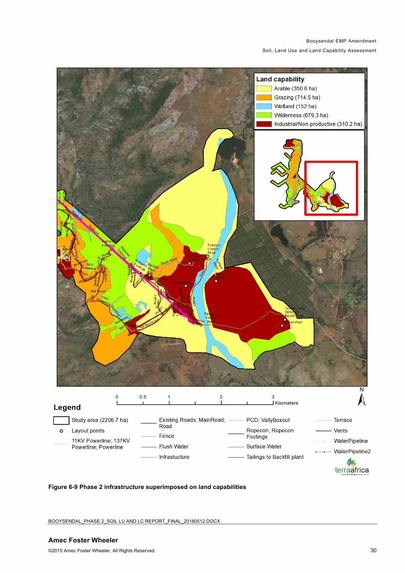
6.3 Land capability
Following the classification system above in Section 5.5, the soil and land types identified in the area of
the Booysendal operations could all be classified into five different land capability classes (Figure 8).
For the purpose of clarity, the infrastructure of the proposed Phase 2 expansion was superimposed on
the land capabilities and illustrated in Figures 9 to 11. The largest portion of land has wilderness land
capability (610.7 ha). The wilderness land capability consists of the very shallow soil forms such as
Mispah and Glenrosa on steep slopes. These areas have little topsoil available for stripping and the
soil regeneration potential is low. Land with this land capability is most suited for low density grazing or
game farming.
A slightly smaller section of land has grazing land capability (569.6 ha). This land is suitable for game
farming and/or cattle grazing although the area is traditionally a conservation area as a result of the
high biodiversity and the uniqueness of the ecosystem present. The eastern portion of the site (BS4) is
dominated by land with arable land capability (350.6 ha) that is suitable for both dryland and irrigated
crop production. The hydromorphic soils, areas in the valley bottoms as well as the small section of
Katspruit/Kroonstad have wetland land capability (125.6 ha). Land with wetland capability serve as a
water purification and storage system in the landscape and should be conserved.
The land capability of the Section 24G areas as well as areas already affected by mining activities have
industrial or non-productive land capability. In these areas, land have been cleared of vegetation as a
result of construction and on-going operational activities. As a result of these drastic changes, soil in
these areas is currently not supporting ecosystems or production activities. It is foreseen that land
rehabilitation activities may be able to restore the land capability back to wilderness land capability and
in best case scenarios, grazing land capability.

Booysendal EMP Amendment
Soil, Land Use and Land Capability Assessment
BOOYSENDAL_PHASE 2_SOIL LU AND LC REPORT_FINAL_20180512.DOCX
Amec Foster Wheeler ©2015 Amec Foster Wheeler. All Rights Reserved. 27
Figure 6-6: Land capabilities of the study area

Booysendal EMP Amendment
Soil, Land Use and Land Capability Assessment
BOOYSENDAL_PHASE 2_SOIL LU AND LC REPORT_FINAL_20180512.DOCX
Amec Foster Wheeler ©2015 Amec Foster Wheeler. All Rights Reserved. 28
Figure 6-7 Phase 2 infrastructure superimposed on land capabilities (northern part)

Booysendal EMP Amendment
Soil, Land Use and Land Capability Assessment
BOOYSENDAL_PHASE 2_SOIL LU AND LC REPORT_FINAL_20180512.DOCX
Amec Foster Wheeler ©2015 Amec Foster Wheeler. All Rights Reserved. 29
Figure 6-8 Phase 2 infrastructure superimposed on land capabilities (central part)
Booysendal EMP Amendment
Soil, Land Use and Land Capability Assessment
BOOYSENDAL_PHASE 2_SOIL LU AND LC REPORT_FINAL_20180512.DOCX
Amec Foster Wheeler ©2015 Amec Foster Wheeler. All Rights Reserved. 30
Figure 6-9 Phase 2 infrastructure superimposed on land capabilities

Booysendal EMP Amendment
Soil, Land Use and Land Capability Assessment
BOOYSENDAL_PHASE 2_SOIL LU AND LC REPORT_FINAL_20180512.DOCX
Amec Foster Wheeler ©2015 Amec Foster Wheeler. All Rights Reserved. 31
6.4 Land Use and Agricultural Potential
The BS4 area of the project site showed evidence of both grain and fruit crop production. The north-
eastern portion of the BS4 area has been planted with kiwi fruit orchards and although it has been
neglected over the past several years since the care-and-maintenance of BS4, some of the trees have
remained inside the mine property. On the southern side of the BS4 portion, evidence was found of
dryland production of maize. This was also the case on neighboring farms to this area. As a result of
the high natural soil fertility in these areas as well as the climate (the average annual rainfall is 750mm),
the BS4 area is highly suitable for dryland and irrigated crop production.
For the remainder of the site, there was no evidence of historical or current crop production. Although
some of the soils in this area are well-drained and deep enough for tillage, the slope of the land is in
most parts greater than 12% which is not suitable for crop production because of the danger of soil
erosion.
The grazing capacity of a specified area for domestic herbivores is given either in large stock units per
hectare or in hectare per large stock unit (LSU). One LSU is regarded as a steer of 450 kg whose
weight increases by 500g per day on veld with a mean energy digestibility of 55%. The grazing capacity
of the veld for the study area is 7 to 10 hectares per large stock unit. The proposed project area can
thus provide grazing for 78 head of cattle or large stock units. The large stock units can further be
converted to include small grazers and browsers. The terrain of the study area is very rocky in large
parts and the slopes are very steep, which makes it more suitable for game farming.
The current land use in the area of the Booysendal operations and the immediate surrounds can be
broadly defined as livestock farming, game farming, eco-tourism and mining. Game farming is a viable
long term land use of the study area as long as the field quality is maintained by never exceeding the
grazing capacity. Post-mining land use should aim to re-establish the game farming potential of the
land.
6.5 Ecosystem Services Assessment
The understanding of the ecosystem services provided by soil is still in a development phase and
research on this topic indicate the complexities associated with the measuring of these services. Below
follows and explanation and summary of the three main ecosystem services identified at the
Booysendal Project site:
• Soil provides nutrients to plants through complex nutrient cycles including the carbon and nitrogen
cycle that is dependent on soil microorganisms. The project area is located in the sensitive
Sekhukhune Centre of Endemism; therefore, the soil nutrient cycle to support this is important.
• Soil has a water storage function that is affected by the structural and textural properties of the soil.
Hydromorphic soils have been identified in areas in the landscape that store large volumes of water
and support wetland habitats. Other roles related to water management include the purification of
water as well as flood mitigation (a very important feature on the proposed project site, especially
also in terms of water retention during heavy rainfall events).

Booysendal EMP Amendment
Soil, Land Use and Land Capability Assessment
BOOYSENDAL_PHASE 2_SOIL LU AND LC REPORT_FINAL_20180512.DOCX
Amec Foster Wheeler ©2015 Amec Foster Wheeler. All Rights Reserved. 32
• In a structural role, the soil surface provides physical support to living organisms including
microorganisms, plants, animals and humans.
Table 2 Description of soil ecosystem services
Service ES Category Description
Additional information (including threats, and availability of alternatives to ES)
Relevant habitats (landscape position)
Importance to Beneficiaries Replacability
Water storage
and flood
mitigation
(provided by
the
hydromorphic
soil forms as
depicted in
Figure 4)
Regulating Even though
soil may
appear dry
on the
surface, it
stores large
volumes of
water in the
vadose
zone. Soil
porosity
allows
infiltration of
rainwater
and buffers
area with
steep slopes
against flood
events.
Analysis of satellite
imagery shows that
mining developments in
the larger project area
has resulted in land
clearing and surface
sealing of soil with
infrastructure. This
leads to reduced ability
of soil for water storage
and flood mitigation.
Steep
slopes and
valley
bottoms
High – soil
water storage
is important to
maintain the
ecosystems
present on
site.
Low – the water
storage function of
soil is very difficult
to restore,
especially once
compaction has
occurred.
Nutrient
cycling
process
Supporting Soil provides
nutrients to
plants
through
complex
nutrient
cycles
including the
carbon and
nitrogen
cycle that is
dependent
on soil
microorganis
ms.
The project is located in
the sensitive
Sekhukhune Centre of
Endemism. Soil in this
area has a unique
mineral and metal
content to which this
vegetation has adapted
most suitably.
All
habitats
on site
High – a
disturbance in
the nutrient
cycle may
deem the soil
of rehabilitated
areas less
suitable for
establishment
of natural
vegetation.
Moderate - removal of natural
vegetation during
topsoil stripping
will increase
mobilisation of
nutrients.
Nutrients lost can
be replaced with
commercial
fertilizer to some
extent, however, it
may not be
possible to restore
the initial nutrient
balance and
restoration of
nutrient cycles
may take a few
years.
Service ES Category Description
Additional information (including threats, and availability of alternatives to ES)
Relevant habitats
Importance to Beneficiaries Replacability
Habitat for soil
micro-
organisms as
Provisioning Soil is
habitat to
thousands of
An impact on this soil
ecosystem service will
occur wherever the soil
All
habitats
on site
Essential –
soil organisms
are adapted to
Low – spatial
alternatives are
available provided

Booysendal EMP Amendment
Soil, Land Use and Land Capability Assessment
BOOYSENDAL_PHASE 2_SOIL LU AND LC REPORT_FINAL_20180512.DOCX
Amec Foster Wheeler ©2015 Amec Foster Wheeler. All Rights Reserved. 33
well as other
organisms
organisms,
including
micro-
organisms
that aids the
decompositi
on of dead
plant and
animal
material. It
is also
habitat to
burrowing
animals
such as
moles.
surface is disturbed and
the habitat of these
organisms destroyed.
only survive in
soil and soil is
essential to
their existence
that the area of
impact is kept to a
minimum.

Booysendal EMP Amendment
Soil, Land Use and Land Capability Assessment
BOOYSENDAL_PHASE 2_SOIL LU AND LC REPORT_FINAL_20180512.DOCX
Amec Foster Wheeler ©2015 Amec Foster Wheeler. All Rights Reserved. 34
Section 2: Impact Assessment and
Management

Booysendal EMP Amendment
Soil, Land Use and Land Capability Assessment
BOOYSENDAL_PHASE 2_SOIL LU AND LC REPORT_FINAL_20180512.DOCX
Amec Foster Wheeler ©2015 Amec Foster Wheeler. All Rights Reserved. 35
7. Impact assessment This section explains the methodology that was followed to determine the impacts of the proposed
project on the Soil, Land Use and Land Capability properties of the Areas of Influence. It is important
that interactions that could lead to potential impacts which may be result from the Project aspects, or
interactions that could lead to potential impacts which may be intensified as a result of the Project
aspects, be identified (including potential areas of impact).
7.1 Monitoring and Progress Reporting
All possible impacts related to mining activities and the activities associated therewith in the area of
influence (AoI) of soil, land use and land capability have been included in the assessment.
In terms of the International Finance Corporation Performance Standards the AoI is defined as:
The area likely to be affected by: • the project and the client’s activities and facilities that are directly owned, operated or managed
(including by contractors) and that are a component of the project;
• impacts from unplanned but predictable developments caused by the project that may occur later or at a different location;
• indirect project impacts on biodiversity or on ecosystem services upon which Affected Communities’ livelihoods are dependent;
• Associated facilities, which are facilities that are not funded as part of the project and that would not have been constructed or expanded if the project did not exist and without which the project would not be viable.
• Cumulative impacts that result from the incremental impact, on areas or resources used or directly impacted by the project, from other existing, planned or reasonably defined developments at the time the risks and impacts identification process is conducted.
Impacts can be direct, indirect or cumulative and needs to be related to all activities and associated,
including direct third party activities.
• Direct impacts – interactions and impacts which could be caused by an activity or action and occur
at the same time and place (e.g. direct footprint of project infrastructure locations);
• Indirect impacts – interactions and impacts caused by an action and occur later in time or farther
removed in distance, or which may cause an impact on another environmental or social receptor or
component but are still reasonably foreseeable, e.g. soil erosion due to exposure of surfaces is the
direct impact and siltation of surface water as a result of the erosion, is there are indirect impacts;
and

Booysendal EMP Amendment
Soil, Land Use and Land Capability Assessment
BOOYSENDAL_PHASE 2_SOIL LU AND LC REPORT_FINAL_20180512.DOCX
Amec Foster Wheeler ©2015 Amec Foster Wheeler. All Rights Reserved. 36
• Cumulative impacts - impact on the environment, which results from the incremental impact of the
action when added to other past, present, associated and reasonably foreseeable future actions
regardless of what agency or person undertakes such other actions. Where cumulative impacts
can be expected, e.g. increase in noise may be caused as a result of the project, this together with
the noise levels associated with the Booysendal North and proposed BS4 operations will cause a
cumulative impact related to noise.
Impact significance rating The significance of an impact is a combination of the consequence of the impact occurring, and the
probability that the impact will occur.
The criteria used to determine impact consequence are:
• Likelihood / probability
• Duration
• Extent
• Magnitude and
• Receptor sensitivity.
Impacts can be either rated as negative or as positive.
Impact Significance Rating Definitions
Likelihood, duration, extent, magnitude, sensitivity and significant ratings where based on the following
scoring scheme:
Likelihood: 1 = Unlikely 2 = Possible 3 = Likely 4 = Definite
Likelihood
Low to no probability of
occurrence with the
implementation of
management
measures
Possible that impact may
occur from time to time
Distinct / realistic
possibility that impacts
will occur if not
managed and
monitored
Impacts will occur even
with the implementation
of management
measures
Duration: 1 = Temporary 2 = Short Term 3 = Long Term 4 = Permanent
Possible to within a
short period of time
mitigate / immediate
or fairly quick progress
with management
Impacts reversible within
a short period of time +3
to 5 yrs
Impacts will only cease
after the operational life
+/- 50 yrs
Long term, beyond
mine closure or
irreplaceable

Booysendal EMP Amendment
Soil, Land Use and Land Capability Assessment
BOOYSENDAL_PHASE 2_SOIL LU AND LC REPORT_FINAL_20180512.DOCX
Amec Foster Wheeler ©2015 Amec Foster Wheeler. All Rights Reserved. 37
implementation <3 yr
Extent: 1 = Localised 2 = Site 3 = Area of Influence 4 = Regional/
Provincial/ National
Localised to specific
area of activities
Confined to the site The extent of the
impacts will affect the
wider area of Influence
Importance of the
impact is of regional
provincial or national
importance
Magnitude (negative): -1 = Low -2 = Minor -3 = Moderate -4 = High
Deterioration of
baseline conditions or
functions are
negligible
Nuisance
Will not cause any
material change to the
value or function of the
receptor/s of
Emissions will comply
with legal limits
Emissions contained
within footprint within
limits
Moderate deterioration,
partial loss of habitat /
biodiversity/ social
functions or resources,
Emissions at times
exceed legal limits
Emissions reach outside
project footprint
Reversible although
substantial illness,
injury, loss of habitat,
loss of resources
Notable deterioration of
functions
Impact on biodiversity
Causes a change in the
value or function of
receptor but does not
fundamentally
affect its overall viability
Emissions regularly
exceed legal limits
Emissions will affect the
wider region
Livelihood of sensitive
receptors are impacted
Mainly irreversible
Causes a significant
change in the
environment affecting
the viability, value and
function of the
receptors
Substantial impact and
loss of biodiversity
Death/ loss of receptors
Loss of livelihood
Emissions do not
comply with regulations
Impact on listed
species
Magnitude (positive):
+1 = Low +2 = Minor +3 = Moderate +4 = High
Slight enhancement of
baseline conditions or
functions
Potential pollution
sources are removed
Minor enhancement, of
habitat / biodiversity/
social functions or
resources,
Better control of
Substantial
improvement in human
health habitat, and
ecosystem services
Notable improvement of
Significant positive
change in the
environment viability,
value and function
Substantial impact and

Booysendal EMP Amendment
Soil, Land Use and Land Capability Assessment
BOOYSENDAL_PHASE 2_SOIL LU AND LC REPORT_FINAL_20180512.DOCX
Amec Foster Wheeler ©2015 Amec Foster Wheeler. All Rights Reserved. 38
Slight positive change
to the value or function
of the receptor/s
Project controls
assists in Emissions
will comply with legal
limits
Emissions contained
within footprint within
limits
emissions
Project assist in
management and control
of emissions
functions
Moderate improvement
of biodiversity
Causes a change in the
value or function of
receptor and improves
overall viability
Emissions regularly
improves
Livelihood of sensitive
receptors are improved
improvement of
biodiversity
Better protection of
receptors
Development of
livelihood
Emissions improve to
comply with regulations
Protection of listed
species
Sensitivity:
1 = Low 2 = Moderate Low 3 = Moderate 4 = High
Areas already
subjected to significant
degradation
Non-designated or
locally designated
sites/habitats
Non-sensitive receptor
with regards to the
impact type (e.g. noise
receptors)
No vulnerable
communities
Partially degraded area
Sensitive receptors
present
Small number of
vulnerable communities
present
Regionally designated
sites / habitats
Regionally rare or
endangered species
Moderately sensitive
receptor with regard to
the impact type
Some vulnerable
communities present
Nationally or
internationally
designated
sites/habitats
Species protected
under national or
international laws /
conventions
High sensitivity with
regard to the impact
type
High number of
vulnerable communities
present
High dependency
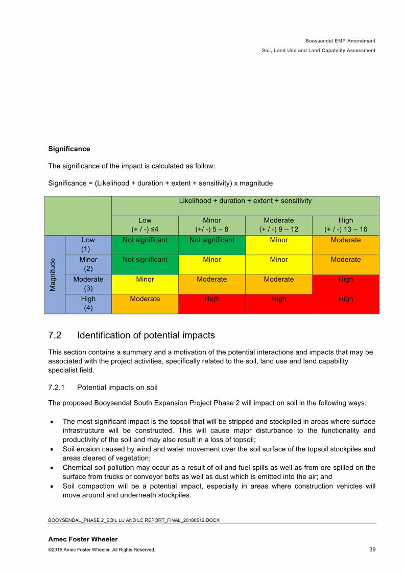
Booysendal EMP Amendment
Soil, Land Use and Land Capability Assessment
BOOYSENDAL_PHASE 2_SOIL LU AND LC REPORT_FINAL_20180512.DOCX
Amec Foster Wheeler ©2015 Amec Foster Wheeler. All Rights Reserved. 39
Significance
The significance of the impact is calculated as follow:
Significance = (Likelihood + duration + extent + sensitivity) x magnitude
Likelihood + duration + extent + sensitivity
Low
(+ / -) ≤4
Minor
(+/ -) 5 – 8
Moderate
(+ / -) 9 – 12
High
(+ / -) 13 – 16
Ma
gn
itu
de
Low
(1)
Not significant Not significant Minor Moderate
Minor
(2)
Not significant Minor Minor Moderate
Moderate
(3)
Minor Moderate Moderate High
High
(4)
Moderate High High High
7.2 Identification of potential impacts
This section contains a summary and a motivation of the potential interactions and impacts that may be
associated with the project activities, specifically related to the soil, land use and land capability
specialist field.
7.2.1 Potential impacts on soil
The proposed Booysendal South Expansion Project Phase 2 will impact on soil in the following ways:
• The most significant impact is the topsoil that will be stripped and stockpiled in areas where surface
infrastructure will be constructed. This will cause major disturbance to the functionality and
productivity of the soil and may also result in a loss of topsoil;
• Soil erosion caused by wind and water movement over the soil surface of the topsoil stockpiles and
areas cleared of vegetation;
• Chemical soil pollution may occur as a result of oil and fuel spills as well as from ore spilled on the
surface from trucks or conveyor belts as well as dust which is emitted into the air; and
• Soil compaction will be a potential impact, especially in areas where construction vehicles will
move around and underneath stockpiles.

Booysendal EMP Amendment
Soil, Land Use and Land Capability Assessment
BOOYSENDAL_PHASE 2_SOIL LU AND LC REPORT_FINAL_20180512.DOCX
Amec Foster Wheeler ©2015 Amec Foster Wheeler. All Rights Reserved. 40
7.2.2 Potential impacts on land uses
The main impact on land use will be the change of land use characteristics from grazing for livestock
and game to that of mining and supporting infrastructure. The cumulative impact on land use is that
large portions of land that was previously used for agriculture and in the region are converted into
mines which result in loss of agricultural land use on a regional scale.
7.2.3 Potential impacts on land capability
The land capability of the areas where the proposed mining infrastructure will be constructed will
change from grazing and possibly wilderness land capability to mining. Should the area not be
rehabilitated again to pre-mining land capability after mining operations have ceased, the land capability
may be reduced to wilderness.
7.3 Impact Significance Rating
Below follows the rating of the significance of each of the anticipated impacts:
Table 3: Impact significance for soil layer inversion and disruption of soil profiles Impact Component Impact 1 Significance
prior to Mitigation
Significance with Mitigation
Activity Earthworks will include clearing of vegetation from the surface, drilling and
blasting for the initial box cut, stripping and stockpiling of topsoil for mine
infrastructure and the construction of access roads.
Risk/ Impact These activities are the most disruptive to natural soil horizon distribution and
cause soil mixing and layer inversion. It will impact on the current soil
hydrological properties and functionality of the soil and may also result in a
loss of topsoil.
Project Phase (during
which impact will be
applicable) CO =
construction, OP =
operational, CL =
Closure and post-
closure
CO, OP
Nature of Impact Negative
Type of Impact Direct: earthworks will directly lead to impact
Likelihood/ probability Definite 4 4

Booysendal EMP Amendment
Soil, Land Use and Land Capability Assessment
BOOYSENDAL_PHASE 2_SOIL LU AND LC REPORT_FINAL_20180512.DOCX
Amec Foster Wheeler ©2015 Amec Foster Wheeler. All Rights Reserved. 41
Impact Component Impact 1 Significance prior to Mitigation
Significance with Mitigation
Duration Permanent
The impact is considered to be
permanent since it is impossible to re-
create original soil profile distribution.
However, carefully conducting topsoil
stripping, the impact may only last as
long as the operational phase
continues (project life)
4 3
Extent Localised
The impact will be localised within the
site boundary.
1 1
Magnitude High
The impact on soil functionality is
mainly irreversible. With the
minimisation of the project footprint
and protection of topsoil stockpiles,
the magnitude can be reduced to
moderate.
4 3
Receptor Sensitivity Soils has a high sensitivity to
earthworks. By minimising the
footprint of the surface disturbance,
sensitivity can be reduced to
moderate.
4 3
Impact Significance The impact is considered to have high
significance without mitigation
measures. Implementing mitigation
measures (as stipulated in Section 9,
will reduced the impact after mitigation
to moderate.
52 33
Required Management
Measures
Minimise project footprint as far as possible. Manage location of stockpiles,
topsoil stripping and stockpiling, demarcation of topsoil stockpiles and
prevention of stockpile erosion and contamination.
Required Monitoring
(if any)
Monitoring the revegetation of topsoil stockpiles and the prevention of
contamination and erosion thereof.
Responsibility for
implementation
Mine management
Impact Finding
Impact can be managed through protection of topsoil stockpiles to keep it
viable for rehabilitation purposes.

Booysendal EMP Amendment
Soil, Land Use and Land Capability Assessment
BOOYSENDAL_PHASE 2_SOIL LU AND LC REPORT_FINAL_20180512.DOCX
Amec Foster Wheeler ©2015 Amec Foster Wheeler. All Rights Reserved. 42
Table 4: Impact significance for soil erosion
Impact Component Impact 1 Significance prior to Mitigation
Significance with Mitigation
Activity Soil erosion is anticipated due to steep slopes and vegetation clearance
Risk/ Impact The impacts are the reduction in soil quality which results from the loss of
the nutrient-rich upper layers of the soil and the reduced water-holding
capacity of severely eroded soils. Soil erosion also causes the disruption of
riparian ecosystems and sedimentation.
Project Phase (during
which impact will be
applicable) CO =
construction, OP =
operational, CL =
Closure and post-
closure
CO, OP, CL
Nature of Impact Negative
Type of Impact Direct: erosion by wind and water lead to the loss of soil.
Indirect: off-site indirect impacts of soil erosion includes riparian ecosystem
disruption and sedimentation.
Cumulative: loss of soils can impact on the sensitive Sekhukhune Center of
Plant Endemism vegetation
Likelihood/ probability Likely and with erosion prevention
measures, still possible
3 2
Duration Without proper mitigation measures,
soil erosion will be a permanent
impact. Implementing proper
erosion control measures will reduce
the duration of the risk to the life of
mine (until all operations have
ceased).
4 3
Extent Localised
Although there are off-site indirect
impacts associated with erosion, the
impact is mainly considered to be
local.
1 1
Magnitude High
The impact on soil functionality is
mainly irreversible. With proper
erosion control on stockpiles and
minimising bare soil surfaces
stability, the magnitude can be
reduced to moderate.
4 3
Receptor Sensitivity Soils has a high sensitivity to
erosion. With the implementation of
embedded controls (geotextiles for
4 3

Booysendal EMP Amendment
Soil, Land Use and Land Capability Assessment
BOOYSENDAL_PHASE 2_SOIL LU AND LC REPORT_FINAL_20180512.DOCX
Amec Foster Wheeler ©2015 Amec Foster Wheeler. All Rights Reserved. 43
Impact Component Impact 1 Significance prior to Mitigation
Significance with Mitigation
erosion control) it can reduced to
moderate.
Impact Significance Without any mitigation, soil erosion
will have high significance,
especially since the site is highly
sensitive to erosion impacts. With
proper mitigation measures, the
significance can be reduced to
moderate.
48 27
Required Management
Measures
Stripping of topsoil should not be done earlier than required, reduce slope
gradients as far as possible along road cuts, using drainage control
measures and culverts to manage surface runoff and revegetate topsoil
stockpiles as soon as possible.
Required Monitoring
(if any)
Monitoring the revegetation of topsoil stockpiles and the functioning of
drains and the maintenance of roads.
Responsibility for
implementation
Mine management
Impact Finding
Impact can be managed through revegetation of topsoil stockpiles and the
management of surface runoff.
Table 5: Impact significance for chemical soil pollution
Impact Component Impact 1 Significance prior to Mitigation
Significance with Mitigation
Activity Soil chemical pollution as a result of potential oil, fuel and ore spillages and
dust emissions.
Risk/ Impact These activities will lead to a deterioration of the soil resource.
Project Phase (during
which impact will be
applicable) CO =
construction, OP =
operational, CL =
Closure and post-
closure
CO, OP, CL
Nature of Impact Negative
Type of Impact Direct: spillages will directly lead to impact
Likelihood/ probability Likely, with prevention measures,
possible
3 2
Duration Temporary, the impact can be
mitigated and cleared up in < 3 years.
1 1
Extent Localised
The impact will be localised within the
1 1

Booysendal EMP Amendment
Soil, Land Use and Land Capability Assessment
BOOYSENDAL_PHASE 2_SOIL LU AND LC REPORT_FINAL_20180512.DOCX
Amec Foster Wheeler ©2015 Amec Foster Wheeler. All Rights Reserved. 44
Impact Component Impact 1 Significance prior to Mitigation
Significance with Mitigation
site boundary.
Magnitude Moderate
The impact lead to a moderate
deterioration of the soil resource. With
waste management and immediate
clean-up of spills, it can be reduced to
minor.
3 2
Receptor Sensitivity Soils has a moderate sensitivity to
chemical pollution.
3 3
Impact Significance The impact is considered to have
moderate significance if left
unmitigated. With immediate clean-up
and proper waste management,
significance can be reduced to minor.
24 14
Required Management
Measures
Losses of fuel and lubricants from vehicles to be contained, use of
biodegradable drilling fluids, avoid waste disposal on site, containing
potentially contaminating fluids and other waste and cleaning up areas of
spillage of potentially contaminating fluids and solids.
Required Monitoring
(if any)
Monitoring storage inventories, waste removal, maintenance of vehicles and
equipment, maintenance of drains and intercept drains and incidents of
spillage and the immediate clean-up thereof.
Responsibility for
implementation
Mine management
Impact Finding
Impact can be managed through waste management and the immediate
clean-up of accidental spills.
Table 6: Impact significance for soil compaction
Impact Component Impact 1 Significance prior to Mitigation
Significance with Mitigation
Activity The commuting of heavy vehicles on existing and new roads, earth moving
machinery while clearing areas for construction, erection of infrastructure and
the development of stockpile all lead to the compaction of soil.
Risk/ Impact Soil compaction leads to the crushing of large micro-pores into smaller pores
which reduces the amount of water available to plants, limits root penetration
and reduce the water infiltration rate and results in aggravation of runoff erosion.
Project Phase
(during which
impact will be
applicable) CO =
construction, OP =
operational, CL =
Closure and post-
closure
CO, OP, CL

Booysendal EMP Amendment
Soil, Land Use and Land Capability Assessment
BOOYSENDAL_PHASE 2_SOIL LU AND LC REPORT_FINAL_20180512.DOCX
Amec Foster Wheeler ©2015 Amec Foster Wheeler. All Rights Reserved. 45
Impact Component Impact 1 Significance prior to Mitigation
Significance with Mitigation
Nature of Impact Negative
Type of Impact Direct and cumulative
Likelihood/
probability
Definite 4 4
Duration Long term
The impact is usually considered to be
permanent but the lithic soils on site are
not affected much by compaction and
the vertic and melanic soils recover
naturally after a period of time because
of their swelling and shrinking
characteristics.
3 3
Extent Localised
The impact will be localised within the
site boundary.
1 1
Magnitude Minor
The impact is considered to be high on
sandy soils, but the lithic soils on site
are not affected much by compaction
and the vertic and melanic soils recover
naturally because of their swelling and
shrinking characteristics.
2 2
Receptor Sensitivity The soils in the Booysendal study area
has a moderate low sensitivity to
earthworks. The sensitivity can be
reduced through reducing the areas of
impact by restricting traffic to existing
haul roads as far as possible.
2 1
Impact Significance The impact is of minor significance both
before and after mitigation because of
the properties of the soil forms in the
study area. Even though the mitigation
measures aim to reduce the areas
affected, soil compaction can only be
alleviated to a certain extent with
rehabilitation techniques.
20 18
Required
Management
Measures
Minimise project footprint as far as possible. Existing established roads should
be used. Where possible, roads that will carry heavy duty traffic should be
designed in areas previously disturbed. Avoid as far as possible areas with
sandy soil.
Required Monitoring
(if any)
Monitor the activities of construction contractors to ensure that construction work
will be restricted to the clearly defined limits of the construction site.
Responsibility for
implementation
Mine management
Impact Finding
Impact can be managed through limitation of the construction footprint and
construction on mainly lithic, vertic and melanic soils.

Booysendal EMP Amendment
Soil, Land Use and Land Capability Assessment
BOOYSENDAL_PHASE 2_SOIL LU AND LC REPORT_FINAL_20180512.DOCX
Amec Foster Wheeler ©2015 Amec Foster Wheeler. All Rights Reserved. 46
Impact Component Impact 1 Significance prior to Mitigation
Significance with Mitigation
Table 7: Significance of impact on land use (change in land use) Impact Component Impact 1 Significance
prior to Mitigation
Significance with Mitigation
Activity Mining activities
Risk/ Impact Change of land use from wilderness with habitat to game and other
animals, to that of mining and supporting infrastructure.
Project Phase (during which
impact will be applicable) CO =
construction, OP = operational,
CL = Closure and post-closure
CO, OP
Nature of Impact Negative
Type of Impact Direct and cumulative
Likelihood/ probability Definite 4 4
Duration Without mitigation, the impacts last
even after the mining project has
ceased. With mitigation (proper
land rehabilitation), the impact will
prevail for the life of the operation
(long term)
4 3
Extent Without erosion and pollution
control, the mining operations may
have land use impacts outside the
site boundary. With mitigation, the
impact will be localised within the
site boundary.
3 2
Magnitude The impact is considered to be
high without mitigation because
there is a complete change of land
use within the footprint area. With
mitigation the impact can be
reduced to moderate.
4 3
Receptor Sensitivity Moderate Sensitivity: the change in
land use is regional
3 3
Impact Significance Without any mitigation measures,
the impact on land use will be
highly significant. With proper land
rehabilitation techniques and
minimising the planned footprint of
the operations, the impact on land
use can be reduced to moderate
significance.
56 36

Booysendal EMP Amendment
Soil, Land Use and Land Capability Assessment
BOOYSENDAL_PHASE 2_SOIL LU AND LC REPORT_FINAL_20180512.DOCX
Amec Foster Wheeler ©2015 Amec Foster Wheeler. All Rights Reserved. 47
Impact Component Impact 1 Significance prior to Mitigation
Significance with Mitigation
Required Management Measures Minimise project footprint as far as possible.
Required Monitoring
(if any)
Monitor the mining activities to ensure that mining operations will be
restricted to the clearly defined limits of the project footprint.
Responsibility for implementation Mine management
Impact Finding
Impact can be managed through limitation of the project footprint.
Table 8: Significance of impact on land capability
Impact Component Impact 1 Significance prior to Mitigation
Significance with Mitigation
Activity Mining activities
Risk/ Impact Through the mining activities, the land capability will change from
arable, grazing, wetland and wilderness to industrial.
Project Phase (during which
impact will be applicable) CO =
construction, OP = operational,
CL = Closure and post-closure
CO, OP
Nature of Impact Negative
Type of Impact Direct and cumulative
Likelihood/ probability Definite 4 4
Duration Without mitigation, the impacts will
be permanent. With rehabilitation
and proper mitigation measures,
the impacts will last until the end of
the project life.
4 3
Extent Without mitigation, the impact on
land capability can extend outside
the site boundaries.
With strictly following mitigation
measures, the impact can be
confined to only site specific
localities.
3 1
Magnitude The impact prior mitigation is
considered to be high because
there is a complete change of land
capability within the footprint area.
With proper land rehabilitation
techniques, it can be reduced to
moderate.
4 3
Receptor Sensitivity Moderate Sensitivity: the change in
land capability is in previously
undegraded portions of land.
3 3

Booysendal EMP Amendment
Soil, Land Use and Land Capability Assessment
BOOYSENDAL_PHASE 2_SOIL LU AND LC REPORT_FINAL_20180512.DOCX
Amec Foster Wheeler ©2015 Amec Foster Wheeler. All Rights Reserved. 48
Impact Component Impact 1 Significance prior to Mitigation
Significance with Mitigation
Impact Significance Without mitigation measures, the
impact will have high significance.
When the change in land capability
is mitigated through a reduced
project footprint and thorough
rehabilitation, the significance of
the change in land capability will be
moderate.
56 33
Required Management Measures Minimise project footprint as far as possible.
Required Monitoring
(if any)
Monitor the mining activities to ensure that mining operations will be
restricted to the clearly defined limits of the project footprint.
Responsibility for implementation Mine management
Impact Finding
Impact can be managed through limitation of the project footprint.
7.4 Identification of cumulative impacts
This section discusses the cumulative impacts on the soil properties, land uses and land capability of
the entire Booysendal Mine Right area. Consideration of the impact of the development of the mining
industry in the areas surrounding the Booysendal area, is also given. Within the Booysendal Mine Right
area, the cumulative impacts are caused by the following:
• Existing operational activities at Booysendal North
• Existing care and maintenance obligations at BS4 (part of Booysendal South)
• Expansion of mining activities at BS1/2 as part of the Section 24G application
7.4.1 Cumulative impacts on soil
The proposed Booysendal Phase 2 Expansion Project will cause definite soil horizon inversion and
compaction and potentially soil erosion and pollution. Inversion of in situ soil horizon organisation and
soil compaction is a permanent impact that alters the physical soil properties to the extent that the
pedohydrological functioning of not only the footprint areas but also the surrounding areas, is affected.
As new roads and other surface infrastructure is developed, the areas permanently affected by soil
compaction and the disturbance of in situ profiles, increase. These cumulative impacts can only be
mitigated by keeping the development footprint as small as possible within the Mine Right areas.
While soil erosion and pollution is easier to prevent, mitigate and manage, its negative effects are more
likely to migrate outside of the surface footprint areas. Most of the Booysendal Mine Right area terrain
is highly susceptible to soil erosion and cumulative impacts are caused by the additional areas of
vegetation to be cleared for the proposed Phase 2 expansion in addition to the areas at BN, BS4, BS1,
BS2.

Booysendal EMP Amendment
Soil, Land Use and Land Capability Assessment
BOOYSENDAL_PHASE 2_SOIL LU AND LC REPORT_FINAL_20180512.DOCX
Amec Foster Wheeler ©2015 Amec Foster Wheeler. All Rights Reserved. 49
7.4.2 Cumulative impact on land uses
As the Booysendal project keeps expanding its surface footprint within both mining right areas, the
areas converted from grazing for livestock and game to that of mining and supporting infrastructure
increases. Within the regional context, the cumulative impact on land use is that large portions of land
that was previously used for agriculture and conservation in the region are converted into mines. The
proposed Phase 2 project will add additional cumulative negative impacts on the land use.
7.4.3 Cumulative impacts on land capability
The land capability of the existing Booysendal project areas, such as BN, BS1/2, and BS4 has already
been changed to industrial/mining where surface activities have resulted in disturbance of the in situ soil
profiles. The proposed Phase 2 infrastructure, will result in additional negative cumulative impacts on
the land capability of the Mine Right areas as well as the larger area.
7.5 Alternative impact identification
Booysendal Platinum (Pty) Ltd has considered both technology and locality alternatives for the
Booysendal South Expansion Project within the Booysendal Mining Right Area. This section makes
provision for an analysis of potential interactions associated with the Project location and technology
alternatives specifically focused on soil, land use and land capability. The following alternatives were
considered:
• Process and potable water pipeline alternative route;
• Locality alternatives for the BCM2 (southern Merensky Adit) development; and
• Alternative technologies for the transport of ore.
7.5.1 BS1/2 to BN Pipeline
Two alternative routes were considered for the process and potable water line between BS1/2 and BN.
The purpose of the process water line is to pump excess water from the PCD at BS1/2 during high
rainfall events to BN, thereby avoiding overtopping and spillage into the Groot Dwars River. Alternative
2 will have the least impact on the in situ profiles while Alternative 1 will have highly significant impacts
in an area very sensitive to the anticipated impacts. The alternative locations for the pipeline is as
follows:
• Alternative 1: Pipelines to run along the existing gravel access road next to the Groot Dwars River;
• Alternative 2: Pipelines to run along the main access road; and
• No-go Option: Existing PVC water supply line along the Groot Dwars River remains with no
changes.

Booysendal EMP Amendment
Soil, Land Use and Land Capability Assessment
BOOYSENDAL_PHASE 2_SOIL LU AND LC REPORT_FINAL_20180512.DOCX
Amec Foster Wheeler ©2015 Amec Foster Wheeler. All Rights Reserved. 50
Table 9: Potential Impacts Associated with the Pipeline Alternatives
Alternative 1 – Pipelines to run along the existing gravel access road next to the Groot Dwars River
Alternative 2 – Pipelines to run along the main access road
No-go Option – Existing PVC water supply line along the Groot Dwars River remains with no changes
Disturbance of hydromorphic soil
properties and functionality of
soils in the area around the
Groot Dwars River
No additional impacts on soil
compaction and horizon
inversion as the main road has
already resulted in major
impacts.
No additional impacts on soil,
land use and land capability.
7.5.2 BCM2 location
Two alternatives were considered for the location of BCM2. Both these two options will have similar
impacts on soil but Alternative 1 has already been approved as part of the S24G EA and will result in
fewer cumulative impacts as the area is just north of the approved BS1/2 complex. Alternative 2 will be
located in a new position and therefore increase the surface disturbance footprint and cause additional
areas of compaction. Alternative 1 is the preferred alternative with regards to soil and land capability
impacts.
Table 7: Potential Impacts Associated with the BCM 2 location Alternatives
Alternative 1 – BCM2 located in area already approved for
Alternative 2 – New area
Soil compaction as a result of heavy vehicles
traversing over the soil surface
Soil compaction as a result of heavy vehicles
traversing over the soil surface not only in the
proposed BCM2 area but also the surrounding
area as a result of construction activities.
Chemical soil pollution as a result of fuel and oil
spills by vehicles on road
Larger areas that can be affected by chemical
soil pollution as a result of fuel and oil spills by
vehicles on road.
Soil erosion as a result of rainwater runoff over
compacted soil surfaces
Higher risk of soil erosion as a result of rainwater
runoff over compacted soil surfaces and
increased areas of vegetation clearance.
7.5.3 Transport of ore
Three alternatives have been considered for the transportation of ore from BCM1, BCM2 to either the
Process Plant at BN or the Process Plant at BS4:
• Alternative 1: Transport of ore via the proposed road between BCM1/2 and BN;
• Alternative 2: Transport of ore via an ARC;
• Alternative 3: Transport of ore via overland conveyor; and
• No-go option: No transportation of ore.

Booysendal EMP Amendment
Soil, Land Use and Land Capability Assessment
BOOYSENDAL_PHASE 2_SOIL LU AND LC REPORT_FINAL_20180512.DOCX
Amec Foster Wheeler ©2015 Amec Foster Wheeler. All Rights Reserved. 51
Alternative 1 is the preferred alternative with regards to soil and land capability impacts as it will result
in minimal to no additional impacts on soil properties whereas Alternatives 1 and 2 will cause areas of
additional vegetation clearance that increase erosion risk as well as increased soil compaction.
Table 7: Potential Impacts Associated with the BCM 2 location Alternatives
Alternative 1 – Transport via existing road between BCM1/2 and BN
Alternative 2 – Aerial Rope Conveyor
Alternative 3 – Overland conveyor
Minimal to no additional soil
impacts.
Soil compaction as a result of
heavy vehicles traversing over
the soil surface
Soil compaction as a result of
heavy vehicles traversing over
the soil surface for the purpose
of construction activities.
Increased risk of oil and fuel
spills on the road that can result
in soil chemical pollution
Chemical soil pollution as a result
of fuel and oil spills by vehicles
on road
Large areas that can be
affected by chemical soil
pollution as a result of fuel and
oil spills by vehicles on road.
Soil erosion as a result of
rainwater runoff over compacted
soil surfaces
High risk of soil erosion as a
result of rainwater runoff over
compacted soil surfaces and
increased areas of vegetation
clearance.
7.5.4 Tailings backfill material at Booysendal South Mining Right Alternatives
The alternative technologies proposed for the backfill material to be used here will not have significantly
different impacts on soil, land use or land capability properties of this area.
8. Site sensitivity to the proposed development
Apart from the impacts usually associated with the construction and operation of mining infrastructure,
the project site is susceptible to specific impacts that should better be avoided than mitigated. A
discussion of the sensitivities to the proposed development follows below:
8.1 Areas highly sensitive to impacts (no-go areas) (209.9 ha)
All areas on site that has wetland land capability, have high sensitivity to the proposed development.
The sensitivity of these areas are related to the impact that construction activities (specifically topsoil
stripping) has on the pedohydrological properties of these soils. Once the soil has been stockpiled,
these soil forms lose the ability to store and recycle water. These areas should be avoided at all cost
and infrastructure layouts should be designed outside of wetlands. In addition to this, all the wetland
areas are very sensitive to sedimentation as a result of soil particle movement from higher laying areas

Booysendal EMP Amendment
Soil, Land Use and Land Capability Assessment
BOOYSENDAL_PHASE 2_SOIL LU AND LC REPORT_FINAL_20180512.DOCX
Amec Foster Wheeler ©2015 Amec Foster Wheeler. All Rights Reserved. 52
in the landscape once vegetation clearance has taken place. Proper soil management measures like
slope stabilisation should be considered to avoid such significant impacts on the wetlands.
Within the entire baseline area studied for the Booysendal projects, an area of 209.9 ha is highly
sensitive with regards to impacts on the pedohydrology of these areas. The proposed Alternative 1
alignment of the BS1/2 to BN pipeline falls within an area that is highly sensitive with regards to soil
impacts. It is recommended that Alternative 2 along the existing main road rather be used for this
alignment.
8.2 Areas with medium-high to high sensitivity (1393.8 ha)
Data on sediment delivery potential of the study area was obtained from the ARC. The sediment
delivery potential was derived from sediment yield values (derived from reservoir surveys, river gauging
stations and recorded sediment data. These data sets were used in conjunction with an erosion index
map (based on soil type, slope, leaching status, soil erodibility ratings and the availability of soil
materials to yield sediments), energy gradients, sediment transport capacities, a broad land-use map
and a rainfall erosivity map. The sediment delivery potential data indicated that the largest portion of
the site infrastructure is on land with high sediment delivery potential.
The largest portion of the site have high sensitivity to impacts that cause sedimentation. These include
the areas for the proposed aerial rope conveyor, emergency escape portal, valley boxcut, BCM1 and
BCM2.
In addition to this, severe soil erosion in areas covered by shallow soils on hard rock or hard pedocretes
(e.g. Mispah soil form) can result in a total and permanent loss of the soil resource. Other areas are
occupied by shallow soils on weathered rock, relatively soft geological sediments, clays or soft
pedocretes (other soils ≤ 400 mm deep). In these areas soil can still be regenerated, although soil-
forming processes are too slow for regeneration to be substantial within a number of human lifetimes.
The areas on site with high water erosion potential coincide with areas identified to have low soil
regeneration potential.
The areas with medium-high to high sensitivity to project impacts are those with grazing and
wilderness land capability.

Booysendal EMP Amendment
Soil, Land Use and Land Capability Assessment
BOOYSENDAL_PHASE 2_SOIL LU AND LC REPORT_FINAL_20180512.DOCX
Amec Foster Wheeler ©2015 Amec Foster Wheeler. All Rights Reserved. 53
Figure 8-1: Sensitivity of the Booysendal project area impacts associated with the project

Booysendal EMP Amendment
Soil, Land Use and Land Capability Assessment
BOOYSENDAL_PHASE 2_SOIL LU AND LC REPORT_FINAL_20180512.DOCX
Amec Foster Wheeler ©2015 Amec Foster Wheeler. All Rights Reserved. 54
8.3 Medium to low sensitivity to project impacts (350.6 ha)
A portion of the area proposed for the backfill plant with the surface pipelines at BS4 as well as a
portion of the proposed aerial rope conveyor alignment, has medium to low sensitivity to the proposed
project. These areas consist of deeper soils in flat areas or with slight slope. Areas with arable land
capability are still sensitive to project impacts but have better capacity to buffer these impacts and
therefore only have medium to low sensitivity to project impacts. Larger volumes of topsoil can be
recovered from these areas for the purposes of rehabilitation.
8.4 Low sensitivity to project impacts, land rehabilitation required (310.2
ha)
These areas include those that have already been impacted upon by mining activities such as those at
BN, the BS4 area (previously Everest) as well as the areas that have already been affected by Section
24G activities. Such areas are still sensitive to ongoing operational impacts such as compaction but the
impacts such as soil horizon inversion has already occurred and land rehabilitation is required to
restore soil functions.
9. Mitigation and management measures The mitigation measures and soil management plan is part of Appendix 5.
10. Environmental Impact Statement
A portion of the proposed Booysendal direct area of influence has already been impacted upon by
current mining activities. In these areas, land have been cleared and haul roads are used for
transportation between surface infrastructure areas. The additional planned project infrastructure will
result in additional impacts on the current soil and land capability properties of the site. Potential
impacts on soil includes erosion, chemical soil pollution, soil compaction and inversion of current soil
form horizons. Cumulative impacts are also related to increase in the surface footprint. These impacts
can be reduced by keeping the footprint minimised where possible and strictly following soil
management measures pertaining to topsoil stripping, stockpiling and conservation of the soil quality of
topsoil stockpiles. The site has high sensitivity to water erosion and sedimentation of wetlands should
water erosion occur. Surface infrastructure development associated with this project should aim to
avoid these areas of high sensitivity. It is also of high importance that the best soil management
practices be applied on site.

Booysendal EMP Amendment
Soil, Land Use and Land Capability Assessment
BOOYSENDAL_PHASE 2_SOIL LU AND LC REPORT_FINAL_20180512.DOCX
Amec Foster Wheeler ©2015 Amec Foster Wheeler. All Rights Reserved. 55
11. A Reasoned Opinion to Whether the Activity Should be Authorised
The proposed Booysendal Phase 2 Project expansion falls within the Booysendal North and
Booysendal South Mine Right areas and a larger area of mining projects intermixed with natural habitat
used for conservation and livestock farming (often subsistence) and settlement (Burgersfort, Steelpoort,
larger Sekhukhune settlement areas). The land capability and soil quality of land affected by the
surface footprint of mining activities will be compromised; the proposed operation area will impact on
current wilderness land.
However, if soil management measures are followed as outlined in this report and the land be
rehabilitated to the highest standard possible, the land capability may be restored back to grazing and
wilderness. It is highly unlikely that the small section of arable land capability will be restored, should it
be affected.
Infrastructure development in close proximity to the Groot Dwarsrivier (as proposed for Alternative 1 of
the water pipeline betweenBS1/2 and BN) should be avoided at all cost and an alternative locality
should be used in closed proximity to an existing road where it will not result in the major impacts as
anticipated for Alternative 1 location.
It is therefore of my opinion that the activity should be authorised, permitting that these environmental
sensitivities are taken into careful consideration. It follows that the recommendations as set out in this
report should form part of the conditions of the environmental authorisation for the proposed project.
The following monitoring strategies should be requirements that form part of the environmental
authorisation:
• Sensitive areas as outlined in Figure 6 above must be avoided and not used for the proposed
project infrastructure;
• A proper soil quality audit should be conducted every second year that will measure the following
soil quality parameters;
• The status of land degradation, including visual evidence whether soil erosion has increased and if
proper erosion management techniques are in place;
• Any areas where bare soil surfaces are not covered by either vegetation or geotextiles to prevent
future soil erosion incidences;
• Areas outside the planned mining footprint affected by mining activities that leads to increased
compaction and soil layer inversion;
• Soil chemical sampling of topsoil stockpiles as well as surrounding undisturbed areas to determine
the soil fertility levels of the stockpiles for rehabilitation purposes; and
• The soil management plan must be adhered to.
In addition to this, it is recommended that the baseline soil metal levels be determined prior to mining
activities and that a follow-up soil metal- and pollutant assessment be conducted once every five years.
Booysendal EMP Amendment
Soil, Land Use and Land Capability Assessment
BOOYSENDAL_PHASE 2_SOIL LU AND LC REPORT_FINAL_20180512.DOCX
Amec Foster Wheeler ©2015 Amec Foster Wheeler. All Rights Reserved. 56
12. Reference List
Chamber of Mines of South Africa. (1981). Handbook of Guidelines for Environmental Protection, Volume 3/1981.
Dreyer, J.G. and Patterson, D.G., 2007. Soil survey for proposed extension of mining activities as
Everest Platinum Mine, near Lydenburg. Fey, M. (2010). Soils of South Africa. Cambridge. Cape Town.
The Soil Classification Working Group (1991). Soil Classification – Taxonomic System for South Africa. Dept. of Agric., Pretoria.
Pienaar, M., 2009. Soil, Land Use and Land Capability Assessment for Booysendal. Compiled for Ivuzi.
Pienaar, M., 2012. Project Fairway Soil Report. Compiled for Metago.
Pienaar, M., 2012. Project Fairway Land Use Report. Compiled for Metago

Booysendal EMP Amendment
Soil, Land Use and Land Capability Assessment
BOOYSENDAL_PHASE 2_SOIL LU AND LC REPORT_FINAL_20180512.DOCX
Amec Foster Wheeler ©2015 Amec Foster Wheeler. All Rights Reserved.
Appendix 1 Details of Specialist
Details of Specialist
Report author: M Pienaar
Contact number: 082 828 3587
Email address: [email protected]
Professional affiliation: SACNASP
Fields of registration: Soil Science and Agricultural Science
SACNASP Registration Number: 400274/10

Booysendal EMP Amendment
Soil, Land Use and Land Capability Assessment
BOOYSENDAL_PHASE 2_SOIL LU AND LC REPORT_FINAL_20180512.DOCX
Amec Foster Wheeler ©2015 Amec Foster Wheeler. All Rights Reserved.
Appendix 2 Curriculum Vitae of Specialist
A. Personal Details
Last name: Pienaar First name: Mariné
Nationality: South African
Employment: Self-employed (Consultant)
B. Contact Details
Email address: [email protected]
Mailing address: PO Box 433, Ottosdal, 2610
Telephone: +27828283587
Address: Nr 8, 10th Street, Linden, Johannesburg, Republic of South Africa
Current Job: Lead Consultant and Owner of Terra Africa Consult
C. Concise biography
Mariné Pienaar is a professionally registered agricultural scientist who has consulted extensively in the
fields of soil, agriculture and land use in several African countries. These countries include South
Africa, Liberia, Ghana, DRC, Mozambique, Botswana, Angola, Malawi and Swaziland. She is currently
part of a team of specialist scientists selected by the South African Government to conduct a strategic
assessment on the impact of shale gas development on the Karoo (specifically soil quality and
agricultural production).
She is a guest lecturer at the University of the Witwatersrand, Johannesburg on the topic of “Soil and
the Extractive Industries” as well as a contributing author on issues of soil quality and food security to
the Bureau for Food and Agricultural Policy (BFAP) report. Mariné presented at the First Global Soil
Week and organised sessions at the Second and Third Global Soil Weeks in Berlin, Germany. Mariné
has also attended several international conferences and courses including the World Resources Forum
in Davos, Switzerland and Conference on Environmental Toxicology and Chemistry, Barcelona.
D. Areas of expertise
s Strategic assessment of land quality, soil properties and agricultural production as part of a multi-disciplinary team for large development projects
s Classification of soils according to their properties, genesis, use and environmental significance
s Sustainable land use and soil management s Restoration of degraded soils s Soil contamination assessment and remediation methods

Booysendal EMP Amendment
Soil, Land Use and Land Capability Assessment
BOOYSENDAL_PHASE 2_SOIL LU AND LC REPORT_FINAL_20180512.DOCX
Amec Foster Wheeler ©2015 Amec Foster Wheeler. All Rights Reserved.
s Agricultural potential assessment s Resettlement planning s Food production systems s Assessment of ecosystem services and natural capital
E. Qualifications Academic Qualifications: s BSc (Agric) Plant Production and Soil Science; University of Pretoria, South Africa, 2004 s Senior Certificate / Matric; Wolmaransstad High School, South Africa, 2000
Courses Completed: s World Soils and their Assessment; ISRIC – World Soil Information, Wageningen, 2015
s Intensive Agriculture in Arid- and Semi-Arid Environments – Gilat Research Centre,
Israel, 2015
s Hydrus Modelling of Soil-Water-Leachate Movement; University of KwaZulu-Natal,
South Africa, 2010
s Global Sustainability Summer School 2012; Institute for Advanced Sustainability Studies,
Potsdam, Germany, 2012
s Wetland Rehabilitation; University of Pretoria, South Africa, 2008
s Enviropreneurship Institute; Property and Environment Research Centre [PERC],
Montana, U.S.A., 2011
s Youth Encounter on Sustainability; ACTIS Education [official spin-off of ETH Zürich],
Switzerland, 2011
s Environmental Impact Assessment │Environmental Management Systems – ISO 14001:2004 │Environmental Law; University of Potchefstroom, South Africa, 2008
s Carbon Footprint Analyst Level 1; Global Carbon Exchange Assessed, 2011
s Negotiation of Financial Transactions; United Nations Institute for Training and
Research, 2011
s Food Security: Can Trade and Investment Improve it? United Nations Institute for
Training and Research, 2011
F. Language ability
Perfectly fluent in English and Afrikaans (native speaker of both) and conversant in French.
G. Professional Experience
Name of firm Terra Africa Environmental Consultants
Designation Owner | Principal Consultant
Period of work December 2008 to Date
Successful Project Summary:
[Comprehensive project dossier available on request]

Booysendal EMP Amendment
Soil, Land Use and Land Capability Assessment
BOOYSENDAL_PHASE 2_SOIL LU AND LC REPORT_FINAL_20180512.DOCX
Amec Foster Wheeler ©2015 Amec Foster Wheeler. All Rights Reserved.
2015: s Buffelsfontein Gold Mine, Northwest Province, South Africa: Soil and land contamination risk
assessment for as part of a mine closure application. Propose soil restoration strategies.
s Bauba A Hlabirwa Moeijelik Platinum mine [proposed] project, Mpumalanga, South Africa: soil, land
use and land capability assessment and impact on agricultural potential of soil.
s Commissiekraal Coal Mine [proposed] project, KwaZulu-Natal, South Africa: sustainable soil
management plans, assessment of natural resource and agricultural potential and study of the
possible impacts of the proposed project on current land use. Soil conservation strategies included
in soil management plan.
s Cronimet Chrome Mine [proposed] project, Limpopo Province, South Africa: soil, land use and land
capability of project area and assessment of the impacts of the proposed project.
s Grasvally Chrome (Pty) Ltd Sylvania Platinum [proposed] Project, Limpopo Province, South Africa: Soil, land use and agricultural potential assessment.
s Jeanette Gold mine project [reviving of historical mine], Free State, South Africa: Soil, land use and
agricultural potential assessment.
s Kangra Coal Project, Mpumalanga, South Africa: Soil conservation strategies proposed to mitigate
the impact of the project on the soil and agricultural potential.
s Mocuba Solar Photovoltaic Power Plant, Zambezia, Mozambique: soil, land use and land capability
studies.
2014:
s Italthai Railway & Macuse Port [proposed] Projects, Tete & Zambezia, Mozambique: soil, land use
and land capability assessments.
s Eskom Kimberley Strengthening Phase 4 Project, Northern Cape & Free State, South Africa: soil,
agricultural potential and land capability assessment.
s Richards Bay Integrated Development Zone Project, South Africa [future development includes an
additional 1500 ha of land into industrial areas on the fringes of Richards Bay]: natural resource and
agricultural potential assessment, including soil, water and vegetation.
s TFM Mining Operations [proposed] Integrated Development Zone, Katanga, DRC [part of mining
concession between Tenke and Fungurume]: soil and agricultural impact assessment study.
s Exxaro Belfast Coal Mine [proposed] infrastructure development projects [linear: road and railway
upgrade | site-specific coal loading facilities]: soil, land capability and agricultural potential
assessment.
s Marikana In-Pit Rehabilitation Project of Aquarius Platinum, South Africa: soil, land capability and
land use assessment.
2013:
s Eskom Bighorn Substation proposed upgrades, South Africa: soil, land capability and agricultural
potential assessment.
s Exxaro Leeuwpan Coal Mining Right Area, South Africa: consolidation of all existing soil and
agricultural potential data. Conducted new surveys and identified and updated gaps in historic data
sets.
s WCL [proposed] development projects, Liberia: Soil, land use and land capability study.
s ESIA for [proposed] Musonoi Mine, Kolwezi area, Katanga, DRC: soil, land use and land capability
assessment. s Camutue Mining Concession, Angola: Land use and agricultural assessment.
s Manica Mining Project, Mozambique: soil, land use and agricultural assessment. s AQPSA Marikana Mine, South Africa: soil, land use and land capability data consolidation as part of
the EMP consolidation process.

Booysendal EMP Amendment
Soil, Land Use and Land Capability Assessment
BOOYSENDAL_PHASE 2_SOIL LU AND LC REPORT_FINAL_20180512.DOCX
Amec Foster Wheeler ©2015 Amec Foster Wheeler. All Rights Reserved.
2012:
s Banro Namoya Mining Operation, DRC: soil, land use and agricultural scientist for field survey and
reporting of soil potential, current land use activities and existing soil pollution levels, including
proposed project extension areas and progressive soil and land use rehabilitation plan.
s Bomi Hills Mining Project, Liberia: soil, land use and agricultural scientist for field survey and
reporting of soil potential, current land use activities and existing soil pollution levels, as well as
associated infrastructure upgrades of the port, road and railway.
s Kumba Iron Ore’s Sishen Mine, Northern Cape, South Africa: soil, land use and agricultural scientist | Western Waste Rock Dumps [proposed] Project: soil, land use and agricultural potential
assessment, including recommendations regarding stripping/stockpiling and alternative uses for the
large calcrete resources available.
s Vetlaagte Solar Development Project, De Aar, South Africa: soil, land use and agricultural scientist.
Soil, land use and agricultural potential assessment for proposed new 1500 ha solar development
project, including soil management plan.
s Lunda Norte kimberlite diamond mining operation, Angola: land restoration specialist for the
assessment of current soil environmental issues. Development of agricultural plans for mine closure
and social contribution. Design of sediment control measures and bamboo plantations for land
restoration purposes.
H. Prior Tenures
Integrated Development Expertise; Junior Land Use Consultant [July 2006 to October 2008]
Omnia Fertilizer (Pty) Ltd; Horticulturist and Extension Specialist [January 2005 to June 2006]
I. Professional Affiliations s South African Council for Natural Scientific Professions [SACNASP]
s Society for Environmental Toxicology and Chemistry [SETAC]
s International Society for Sustainability Professionals [ISSP]
s Soil Science Society of South Africa [SSSA]
s South African Soil Surveyors’ Organisation [SASSO]
s South African Society for Crop Production [SASCP]
s International Association for Impact Assessment, South Africa [IAIAsa]
s Environmental Law Association [ELA] s Soil Science Society of America [SSSA]

Booysendal EMP Amendment
Soil, Land Use and Land Capability Assessment
BOOYSENDAL_PHASE 2_SOIL LU AND LC REPORT_FINAL_20180512.DOCX
Amec Foster Wheeler ©2015 Amec Foster Wheeler. All Rights Reserved.
Appendix 3 Declaration of Specialist’s Independence
Declaration of Independence I, Mariné Pienaar, hereby declare that TerraAfrica Consult, an independent consulting firm, has no
interest or personal gains in this project whatsoever, except receiving fair payment for rendering an
independent professional service.
I further declare that I was responsible for collecting data and compiling this report. All assumptions,
assessments and recommendations are made in good faith and are considered to be correct to the best
of my knowledge and the information available at this stage.
TerraAfrica Consult cc represented by M Pienaar
March 2018

Booysendal EMP Amendment
Soil, Land Use and Land Capability Assessment
BOOYSENDAL_PHASE 2_SOIL LU AND LC REPORT_FINAL_20180512.DOCX
Amec Foster Wheeler ©2015 Amec Foster Wheeler. All Rights Reserved.
Appendix 4 Soil Chemical Analysis Results
Lab No Ref No pH (KCl) PBray1 K Na Ca Mg EA.KCl %Ca %Mg %K %Na ACID SATmg/kg mg/kg mg/kg mg/kg mg/kg cmol(c)/kg % % % % %
62391 Bd01 Top 4.36 2 136 24 2010 1097 0.06 51.39 45.98 1.78 0.52 0.3362392 Bd02 Top 5.49 1 130 21 2473 881 0.00 61.78 36.10 1.67 0.45 0.0062393 Bd03 Sub 5.60 1 80 24 2610 775 0.00 66.20 32.23 1.04 0.53 0.0062394 Bd04 Top 5.61 2 93 15 1116 300 0.00 66.89 29.48 2.86 0.78 0.0062395 Bd05 Sub 5.85 1 30 22 1187 320 0.00 67.97 30.05 0.88 1.11 0.0062396 Bd06 Top 5.56 1 32 60 2487 552 0.00 71.87 26.17 0.47 1.50 0.0062397 Bd07 Sub 5.85 2 30 72 2089 530 0.00 68.83 28.60 0.50 2.07 0.0062398 Bd08 Top 5.50 2 146 14 1097 284 0.00 66.50 28.23 4.51 0.76 0.0062399 Bd09 Sub 5.44 1 72 9 569 145 0.00 66.78 27.93 4.35 0.94 0.0062400 Bd010 Top 5.98 1 49 25 1992 625 0.00 65.03 33.45 0.82 0.71 0.0062401 Bd011 Top 5.23 1 47 28 1783 494 0.00 67.51 30.67 0.92 0.91 0.00

Booysendal EMP Amendment
Soil, Land Use and Land Capability Assessment
BOOYSENDAL_PHASE 2_SOIL LU AND LC REPORT_FINAL_20180512.DOCX
Amec Foster Wheeler ©2015 Amec Foster Wheeler. All Rights Reserved.
Lab No Ref No Ca:Mg (Ca+Mg)/K Mg:K S-Value Na:K T Density S AmAc EC Clay Silt Sand C1.5-4.5 10.0-20.0 3.0-4.0 cmol(+)/kg cmol(c)/kgg/cm3 mg/kg ms/m %
62391 Bd01 Top 1.12 54.81 25.88 19.49 0.30 19.56 0.87 14.78 9.94 50 5 44 0.8062392 Bd02 Top 1.71 58.77 21.68 20.01 0.27 20.01 0.91 14.73 47.20 46 17 37 2.3262393 Bd03 Sub 2.05 94.82 31.05 19.71 0.51 19.71 0.96 30.18 40.96 22 10 68 1.1962394 Bd04 Top 2.27 33.67 10.30 8.34 0.27 8.34 1.16 6.26 31.57 28 9 63 1.0262395 Bd05 Sub 2.26 111.67 34.23 8.73 1.26 8.73 1.13 7.35 26.75 54 26 20 0.8062396 Bd06 Top 2.75 209.11 55.82 17.30 3.19 17.30 1.01 25.21 23.47 50 27 23 0.9062397 Bd07 Sub 2.41 194.79 57.18 15.18 4.14 15.18 1.05 39.88 28.00 18 6 76 0.6062398 Bd08 Top 2.36 20.99 6.26 8.25 0.17 8.25 1.23 4.81 34.24 14 2 84 0.7662399 Bd09 Sub 2.39 21.77 6.42 4.26 0.22 4.26 1.37 5.90 11.42 32 17 51 0.5162400 Bd010 Top 1.94 120.34 40.87 15.31 0.86 15.31 1.15 9.83 37.28 56 18 26 1.5262401 Bd011 Top 2.20 107.12 33.46 13.21 0.99 13.21 0.87 40.98 29.76 31 58 11 0.56
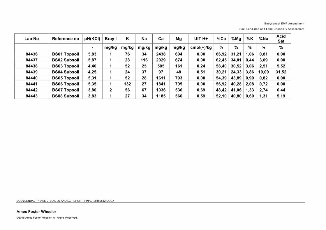
Booysendal EMP Amendment
Soil, Land Use and Land Capability Assessment
BOOYSENDAL_PHASE 2_SOIL LU AND LC REPORT_FINAL_20180512.DOCX
Amec Foster Wheeler ©2015 Amec Foster Wheeler. All Rights Reserved.
Lab No Reference no pH(KCl) Bray I K Na Ca Mg UIT H+ %Ca %Mg %K %Na Acid Sat
- mg/kg mg/kg mg/kg mg/kg mg/kg cmol(+)/kg % % % % %
84436 BS01 Topsoil 5,83 1 76 34 2438 694 0,00 66,92 31,21 1,06 0,81 0,00 84437 BS02 Subsoil 5,87 1 28 116 2029 674 0,00 62,45 34,01 0,44 3,09 0,00 84438 BS03 Topsoil 4,40 1 52 25 505 161 0,24 58,40 30,52 3,06 2,51 5,52 84439 BS04 Subsoil 4,25 1 24 37 97 48 0,51 30,21 24,33 3,86 10,09 31,52 84440 BS05 Topsoil 5,31 1 52 28 1611 793 0,00 54,39 43,89 0,90 0,82 0,00 84441 BS06 Topsoil 5,35 1 132 27 1841 795 0,00 56,92 40,28 2,08 0,72 0,00 84442 BS07 Topsoil 3,80 2 56 67 1036 536 0,69 48,42 41,06 1,33 2,74 6,44 84443 BS08 Subsoil 3,83 1 27 34 1185 566 0,59 52,10 40,80 0,60 1,31 5,19

Booysendal EMP Amendment
Soil, Land Use and Land Capability Assessment
BOOYSENDAL_PHASE 2_SOIL LU AND LC REPORT_FINAL_20180512.DOCX
Amec Foster Wheeler ©2015 Amec Foster Wheeler. All Rights Reserved.
Lab No Reference no S-Waarde Na:K T Density S AmAC Clay Silt Sand C Walkley Black EC
cmol(+)/kg - cmol(+)/kg g/cm3 mg/kg % % % % mS/m
84436 BS01 Topsoil 18,22 0,76 18,22 1,05 6,42 42 12 46 0,03 31,50 84437 BS02 Subsoil 16,24 7,07 16,24 0,94 9,57 44 16 40 8,65 16,69 84438 BS03 Topsoil 4,08 0,82 4,32 1,02 33,42 44 10 46 2,90 8,44 84439 BS04 Subsoil 1,10 2,62 1,61 0,99 12,92 56 13 31 1,23 5,71 84440 BS05 Topsoil 14,81 0,90 14,81 1,15 0,50 38 18 44 0,01 1,84 84441 BS06 Topsoil 16,17 0,34 16,17 0,91 2,40 42 28 30 1,36 5,53 84442 BS07 Topsoil 10,01 2,05 10,69 0,63 93,99 26 63 11 6,44 9,14 84443 BS08 Subsoil 10,79 2,18 11,38 0,96 0,47 62 4 34 5,37 10,22

Booysendal - Soil Management Plan Page i
Appendix 5 Soil, Land Use and Land Capability Management Plan

Booysendal - Soil Management Plan Page ii
TableofcontentsPage
1. Introduction ......................................................................................................................................... 11.1 Overview ............................................................................................................................................... 11.2 Scope .................................................................................................................................................... 11.3 Booysendal Policies .............................................................................................................................. 11.4 Purpose and Objectives ........................................................................................................................ 2
2. Site Background ................................................................................................................................. 42.1 Socio-Environmental Setting ................................................................................................................ 42.2 Description of Existing and Proposed Activities .................................................................................... 5
3. Statutory Requirements ..................................................................................................................... 73.1 National Legislation, Standards and Policy .......................................................................................... 73.2 International Finance Corporation (IFC) Guidelines ............................................................................. 83.2.1 Relevant Guidelines ........................................................................................................................... 8
4. Soil and Land Capability Impacts ..................................................................................................... 84.1 Potential Impacts on soils ..................................................................................................................... 84.1.1 Soil erosion ........................................................................................................................................ 84.1.2 Soil chemical pollution ....................................................................................................................... 84.1.3 Soil Compaction ................................................................................................................................. 94.1.4 Destruction of soils in terms of diagnostic layer sequence ................................................................ 94.1.5 Loss of land use ................................................................................................................................. 94.1.6 Loss of land capability ....................................................................................................................... 94.2 Potential Impacts on soils at each stage of mine life .......................................................................... 104.2.1 Construction Phase Impacts ............................................................................................................ 104.2.2 Operation Phase Impacts ................................................................................................................ 104.2.3 Decommissioning Phase Impacts .................................................................................................... 104.2.4 Existing Impacts (as a result of Section 24G activities) ................................................................... 11
5. Roles and Responsibilities .............................................................................................................. 115.1 Organisational Structures ................................................................................................................... 115.2 Responsible Parties .............................................................................................................................. 1
6. Mitigation and Control ........................................................................................................................ 16.1 Overarching Strategy ............................................................................................................................ 16.2 Design Control Measures ..................................................................................................................... 26.2.1 Construction Phase ........................................................................................................................... 26.2.2 Operational Phase ............................................................................................................................. 46.2.3 Decommissioning and Rehabilitation Phase ..................................................................................... 5
7. Monitoring ........................................................................................................................................... 6

Booysendal - Soil Management Plan Page iii
7.1 Objectives and Targets ......................................................................................................................... 67.2 Monitoring Locations ............................................................................................................................. 67.3 Monitoring Methodologies ..................................................................................................................... 77.3.1 Weather ............................................................................................................................................. 77.3.2 Observations ...................................................................................................................................... 77.4 Monitoring records ................................................................................................................................ 77.5 Response .............................................................................................................................................. 87.5.1 Management of short-term episodes and cumulative impacts .......................................................... 8
8. Assurance ........................................................................................................................................... 88.1 Analytical Parameters ........................................................................................................................... 88.2 Inspections ............................................................................................................................................ 88.3 Audits .................................................................................................................................................... 9
9. Reporting ............................................................................................................................................. 99.1.1 Internal reporting ................................................................................................................................ 99.1.2 External reporting ............................................................................................................................ 10
10. Review and Updating of Management Plan ................................................................................... 10

Booysendal - Soil Management Plan Page iv
List of figures
Figure 1-1: Framework Process of Developing an Environmental Management Plan .......................... 4Figure 2-1: Survey points map of the soil, land use and land capability study .................................... 11Figure 2-2: Booysendal Operation Location, Operational Division and Surface and Mining Rights e 20Figure 2-3 Booysendal MR Expansion Activities ..................................................................................... Figure 5-1 Organisational Structure for Environmental and H&S Management at Booysendal .......... 12
List of tables
Table 1-1 Relevant Northam Platinum Limited Policies ........................................................................ 2Table 2-1 Booysendal Operations – List of Activities ............................ Error! Bookmark not defined.Table 3-1 Applicable South African Environmental Legislation for Booysendal Operations ......... Error!
Bookmark not defined.Table 5-1 Roles and Responsibilities for the Environmental Management Plan ................................... 1

Booysendal - Soil Management Plan Page 1
1. Introduction
1.1 Overview
Booysendal Platinum (Pty) Ltd (Booysendal) is an operational platinum group metal (PGM) mining complex located in the mining belt of the Eastern Limb Igneous Complex in South Africa. Development of the Booysendal operation commenced in 2010 initially focused on mining the Upper Group 2 (UG2) reef from two portals with associated supporting infrastructure and processes. Northam Platinum Limited (Northam), a mid-tier Platinum Group Metal (PGM) mining company, listed on the Johannesburg Stock Exchange (JSE), purchased the Booysendal section of the Der Brochen Mining Operation from Rustenburg Platinum Mines Limited (Anglo Platinum) early in 2008. Booysendal then purchased the neighbouring Everest Platinum Mine (BS4) from Aquarius Platinum in 2014 which has been incorporated into the Booysendal operations. As part of the environmental approval process selected management plans have been prepared to address the impacts identified in the Environmental Management Programme report (EMPr). These plans will be implemented as part of the Booysendal management system which provides a protocol to manage the mitigation and control of the operations’ impacts.
1.2 Scope
This Soil Management Plan (SMP) aims to ensure a proactive approach to the effective management of soil erosion, chemical soil pollution and compaction of soil during construction, mining operations and after mining ceases. It prescribes procedures and protocols that will ensure compliance with national environmental legislation, environmental contractual requirements and other environmental obligations. It covers all phases of the operations from construction, operation, decommissioning to closure. Measures are presented that will eliminate, offset or reduce adverse environmental impacts, prevent excessive deterioration of the soil resource and sedimentation through erosion of sensitive receptors like wetlands within the operation’s area of influence. This management plan includes reporting procedures, an approach to addressing complaints, monitoring programmes and compliance processes applicable to the Booysendal Operations.
1.3 Booysendal Policies
Northam Platinum Limited has signed the following policies that set the framework for environmental management for their operations, such as at Booysendal. All visitors, contractors and employees are required to comply with the requirements of the policies.

Booysendal - Soil Management Plan Page 2
Table 1-1 Relevant Northam Platinum Limited Policies Policy Commitments
Sustainable Development
► Implement and maintain sound systems of corporate governance, taking cognisance of recognised global governance guidelines
► Ensure that ethical business practices and decisions are upheld, and to maintain an appropriate whistle-blowing system to counter any transgressions
► Take appropriate responsibility for a safe working environment, and to strive for continual improvement in our health and safety performance
► Recognise and uphold the rights of employees and community members, and to guard against any discriminatory practices
► Safeguard natural resources, to minimise resource usage and waste, to protect biodiversity and optimise the usage of the land within our custodianship, and to seek continual improvement in our environmental performance.
► Contribute to the social and economic upliftment of local communities through positive engagement and contributions in support of sustainable projects and programmes.
Safety, Health and Environmental
► Develop, implement and maintain an integrated safety, health and environment management system to comply with Northam Platinum Limited targets and commitments
► Drive continual improvement through setting objectives and targets based on sound risk management methodologies, conduct regular reviews of the system and measure our performance through management self-audits
► Comply with all applicable legislations, company policies and procedures and project objectives
► Apply relevant international best practices to our local conditions as part of our commitment to continual improvement
► Promote awareness of potential safety, health, environment and quality impacts of each person's activities, and our business processes on an ongoing basis
► Conserve natural resources such as water, energy and land by encouraging employees, contractors and stakeholders to minimise consumption of resources and prevent pollution through proactively implementing mitigating measures through responsible and accountable construction of the mine
► Take due care to prevent process loss, property damage, work related injuries and ensure that activities are safe for employees, contractors, and stakeholders who enter our work environment
► Adopt a clear vision of future business decisions, harnessing best available technologies, processes, materials, products and management practices which improve safety, health and environment performances
► Train employees and contractors on issues of safety, health and environment management to ensure sustainable performance;
► Strive to deliver all milestones on time through proactive planning, contingency planning and risk management
► Place people at the centre of our business through the implementation of People Based Safety principles
► Establish and promote a culture of mutual interest and care between employees, to ensure that all our employees and contractors take due care and cognisance of the impact of our own acts, and these of others on the safety and health of fellow workers and the environment.
Environmental
► Compliance with accepted environmental practices ► Meeting or exceeding applicable legal requirements ► Striving for continual improvement in our environmental management and business systems ► Adopting appropriate technological and engineering responses to environmental concerns ► Raising awareness of environmental concerns among the workforce through appropriate
training and communications ► Encouraging our suppliers and business partners to adopt similar principles
1.4 Purpose and Objectives
The purpose of the management plan is to set out a clear set of actions and responsibilities for the control of impacts affecting the soil, land use and land capability within the operations’ area of influence. It is a living document that will be amended and updated as circumstances change and knowledge is gained. The objectives of the management plan are to: ► Prevent adverse impacts from occurring or to keep impacts that do occur within acceptable levels.

Booysendal - Soil Management Plan Page 3
► Identify the mitigation measures, actions and procedures to reduce the impacts of targeted parameters.
► Outline the requirements for an inclusive monitoring programme, specifying environmental indicators to monitor the effectiveness of the mitigation measures.
► Define the roles and responsibilities for implementing the management plan.
Management of impacts on the soils on the soils at each phase of the operations’ activities: ► Construction Phase –provides specific environmental guidance for the implementation and
construction phase of a project. Construction activities can incur impacts at start up (e.g. site clearing, erection of the construction camp) to actual construction (i.e. erosion, pollution of water courses, noise, dust).
► Operational Phase - provides specific environmental guidance related to the operational activities associated with the mine development and ongoing operation.
► Decommissioning and Rehabilitation Phase – provides environmental guidance on the risks and residual impacts that may remain after operations have ceased (i.e. contamination of soil and groundwater, stock that has been abandoned (oil drums, scrap equipment, old chemicals) and old (unserviceable structures)); the positive environmental opportunities associated with the return of the land for alternative use and the cessation of impacts associated with operational activities; and the management of these risks and impacts.
Figure 1-1 Framework Process of Developing an Environmental Management Plan1
1 DEAT (2004) Environmental Management Plans, Information Series 12

Booysendal - Soil Management Plan Page 4
2. Site Background
2.1 Socio-Environmental Setting
Booysendal Platinum Propriety Limited (“Booysendal”) is a platinum group metal (PGM) mine approximately 33km west of Mashishing (Lydenburg), 40km south-southwest of Steelpoort, 32km north of Dullstroom and 21km northeast of Roossenekal, as illustrated in The mine consists of two mining rights (MR), Booysendal MR (LP 30/5/1/3/2/1 (188) EM) and Booysendal South MR (MP 30/5/1/2/3/2/1 (127) EM together forming the Booysendal Operation. The Booysendal South MR (previously known as Everest) was acquired from Aquarius Platinum Propriety Limited in 2015. Although the two MRs is not consolidated, it is managed as one integrated operations, the Booysendal Operation. The area occupied by Booysendal is largely undeveloped, with grazing as the main land use capability. Culturally the area is rich in archaeological and recent history of heritage resources. Figure 2-1 Location of Booysenda operationsl
The landscape of the region is mountainous traversed by deep river valleys in the vicinity of BCM1, BCM2 and the Emergency Escape Portal. The Steenkampsberge lies to the east, south and west of the Booysendal Operation. The valley areas are approximately 1 052 metres above mean sea level (mamsl) and the Steenkampsberg 2 024 mamsl (BS4).

Booysendal - Soil Management Plan Page 5
The soil characteristics in the area are dominated by clay-loam and the soil is weakly to moderately strongly structured. The hill slopes are mainly shallow, rocky lithic soils where pedogenesis is still active. The largest portion of land has grazing land capability while a slightly smaller section of land has wilderness land capability. The areas in the valley bottoms have wetland land capability with a small area near BS4 having an arable land capability. There is currently little active land use in the river valley with some areas cleared for proposed mine expansions and dirt access roads for the management of the area. Buttonshope Trust was earmarked as a biodiversity offset area within the valley, and much of the valley vegetation has not been disturbed by any development. The northern part of the valley (in the higher lying areas) has mining (BN) as a land use, as well as in the south east (BS4). Outside and close to the valley agriculture (grazing and crop farming) is practiced, together with tourism and mixed land uses. This is a summer rainfall area with average annual precipitation of between 648mm to 721mm and temperatures ranging from 22.9ºC in summer to 9.5ºC in winter. The prevailing winds are from the northeast in summer and the southwest in winter with the north-south valley topography entraining winds along the valley according to season. Ambient air quality is characteristic of agricultural areas combined with mining, with dust emissions from vehicular entrainment and from wind erosion from un-vegetated, bare surfaces. The Booysendal area falls within three vegetation types, namely the Sekhukhune Mountain Bushveld, Lydenburg Montane Grassland and Sekhukhune Montane Grassland, with an ecological corridor running along the Groot Dwars River. It is an area of considerable conservation importance in terms of aquatic and terrestrial biodiversity, falling within the Sekhukhuneland Centre of Plant Endemism (SCPE) (the third richest in ultramafic induced endemic plant species in South Africa) and the National Freshwater Ecosystem Priority Area (NFEPA). The Mpumalanga Biodiversity Conservation Plan (MBCP) identifies this area as significant and irreplaceable and the Mpumalanga Tourism and Parks Agency (MTPA) conservation plan classifies the area as irreplaceable. Two veld types exist in the Groot Dwars River (according to Acocks, 1953), namely the Sourish Mixed Bushveld (19) at the lower end of the valley changing to the north eastern Sandy Highveld (57). Critically important for conservation are the landscapes situated along the foothills and high lying areas of the escarpment. The river and associated catchment are currently in a good to pristine state and are important for the maintenance of threatened or near-threatened fish species. A number of sites of archaeological, cultural and historical significance have been recorded in the valley and surrounds. There are various Iron Age sites, ruins, cemeteries and graveyards as well as stone cairns and terracing. Whilst the sites are of importance to the history and culture of the country, none were considered to have outstanding significance. There are also no visible fossil-bearing strata in the area.
2.2 Description of Existing and Proposed Activities
For operational purposes the Booysendal Operations is divided into two main operational areas, namely Booysendal North (BN), which falls in Limpopo Province and Booysendal South (BS), which falls in the Mpumalanga Province and which consists of the entire Booysendal South MR and the southern section of the Booysendal MR. BN is in the northern section of the Booysendal MR and is a fully operational underground PGM and Merensky mine, whilst the development of BS is ongoing. BS

Booysendal - Soil Management Plan Page 6
is further subdivided into BS1/2, BS4 (ex-Everest Mine) and two new Merensky south adit expansions (BCM1 and BCM2) just north of BS1/2. BS1/2 and the BCM1 and BCM2 adits form part of the Booysendal MR, while BS4 and its associated developments forms the Booysendal South MR (Figure 2-2).
Figure 2-2 Booysendal Operation Location, Operational Division and Surface and Mining Rights
The layout of the proposed Booysendal MR expansion is included in Figure 2-3 and involves: ► Development of surface infrastructure at the two Merensky Adits (BCM 1 and BCM2);
► Development of an Emergency Escape Portal to serve BCM1, BCM2 and the BS1/2 underground complex
► Retaining a 11VA powerline from BN to BS1/2;
► Process and clean water pipelines between BS1/2 and BN;
► Access roads to the BCM1 and BCM2 Adits and ARC; an
► An Arial Rope Conveyor (ARC) system from BS1/2 to BN.

Booysendal - Soil Management Plan Page 7
Figure 2-3 Booysendal MR Expansion Activities
3. Statutory Requirements
3.1 National Legislation, Standards and Policy The most recent South African Environmental Legislation that needs to be considered for any new or expanding development regarding management of soil and land use includes:
• Soils and land capability are protected under the National Environmental Management Act 107 of 1998, the Minerals Act 28 of 2002 and the Conservation of Agricultural Resources Act 43 of 1983.
• The National Environmental Management Act 107 of 1998 requires that pollution and degradation of the environment be avoided, or, where it cannot be avoided be minimised and remedied.
• The Conservation of Agricultural Resources (Act 43 of 1983) states that the degradation of the agricultural potential of soil is illegal.
• The Conservation of Agriculture Resources Act 43 of 1983 requires the protection of land against soil erosion and the prevention of water logging and salinization of soils by means of suitable soil conservation works to be constructed and maintained. The utilisation of marshes, water sponges and watercourses are also addressed. Government Notice R983 of 4 December 2014. The purpose of this Notice is to identify activities that would require environmental authorisation prior to commencement of that activity.

Booysendal - Soil Management Plan Page 8
3.2 International Finance Corporation (IFC) Guidelines
3.2.1 Relevant Guidelines In addition to South African Environmental Legislation, this study also aligns to fulfil the IFC Performance Standards on Environmental and Social Sustainability that became effective on 1 January, 2012. With regards to the Soil, Land Use and Land Capability assessment, the following standards and guidelines are of most relevance:
• IFC Performance Standard 3: Resource Efficiency and Pollution Prevention provides guidelines on project-level approach to resource efficiency and pollution prevention, in this case specifically for land management.
• IFC Guidelines for Mining which recommend practices for sustainable land use and topsoil management.
• IFC General Environmental, Health and Safety Guidelines: Contaminated Land for the detection, remediation and monitoring of contaminated land, should it be present.
4. Soil and Land Capability Impacts
4.1 Potential Impacts on soils
4.1.1 Soil erosion
The impacts of soil erosion are both direct and indirect. The direct impacts are the reduction in soil quality which results from the loss of the nutrient-rich upper layers of the soil and the reduced water-holding capacity of severely eroded soils. The off-site indirect impacts of soil erosion include the disruption of riparian ecosystems and sedimentation. Soil erosion is a permanent impact for once the resource has been lost from the landscape it cannot be recovered. The causes of soil erosion in the Booysendal environment are: ► Wind erosion from exposed areas such as the cleared areas and topsoil stockpiles.
► Water erosion due to cleared areas on steep slopes.
► Unpaved access roads, especially on steep slopes can cause severe erosion by run-off during rain storms.
4.1.2 Soil chemical pollution
Soil chemical pollution is considered to be a moderate deterioration of the soil resource. This impact will be localised within the site boundary, The sources of soil chemical pollution are: ► Oil and fuel spillages from vehicles and machinery.
► Building materials and different kinds of waste.
► Effluent from washing bays and storm-water run-off from fuel storage areas and workshops.

Booysendal - Soil Management Plan Page 9
► Sewage.
► Dust from blasting and from TSFs.
4.1.3 Soil Compaction
Soil compaction is the process in which a stress applied to a soil causes densification as air is displaced from the pores between soil grains. Soil compaction is most likely on access roads and heavily utilised areas of construction camp and offloading areas, which will be subject to repeated vehicle movements. The effects of soil compaction are: ► Increase in bulk density;
► The porosity of soil decreases because compaction crushes the macropores and large micropores into smaller pores;
► The destruction of soil structure and the formation of a more massive soil. Well structured soil resist erosion because the aggregates are very stable and infiltration is high;
► Negative effect on the habitat of soil organisms by reducing pore size and changing the physical soil environment;
► A much lower water infiltration rate into the soil as well as a decrease in saturated hydraulic conductivity; and
► Restricted root growth.
4.1.4 Destruction of soils in terms of diagnostic layer sequence
Earthworks are the most disruptive activities to natural soil horizon distribution and will impact on the current soil hydrological properties and functionality of soil Earthworks will include the following: ► Clearing of vegetation from the surface;
► Stripping and stockpiling of topsoil
► Excavation, drilling and blasting for the initial box cut;
► Construction of new access roads; and
► Excavation and laying foundations to host construction.
4.1.5 Loss of land use
Land use will be converted from natural veld grazing to mining and related activities. In areas with
permanent changes such as road upgrades, the land use will be lost permanently.
4.1.6 Loss of land capability

Booysendal - Soil Management Plan Page 10
Land capability will be affected by the mining operations due to loss of topsoil (for infrastructure),soil erosion, soil contamination and changes to the topography.
4.2 Potential Impacts on soils at each stage of mine life
The following impacts on soil, land use and land capability are associated with the current expansions:
4.2.1 Construction Phase Impacts The following activities may result in impact during the construction phase: ► Soil erosion triggered from existing stockpiles and construction operations.
► Change to physical, chemical and biological properties of soil within soil stockpiles.
► Contamination of topsoil and stockpiled soil due to dust fallout from construction operations.
► Contamination of topsoil and soil stockpiles due to oil and fuel spills.
► Soil horizon mixing during stripping and stockpiling
► Land use converted from natural veld to mining and related activities.
► Land capability will be affected by construction operations due to loss of topsoil (for surface infrastructure), soil erosion, soil contamination and changes in topography.
4.2.2 Operation Phase Impacts The following activities may result in impact during the operation phase: ► Soil erosion triggered from existing stockpiles and recently rehabilitated areas
► Change to physical, chemical and biological properties of soil within soil stockpiles due to long terms storage during the operational phase.
► Contamination of topsoil and soil stockpiles due to oil and fuel spills.
► Land use converted from natural veld to mining and related activities.
► Land capability will be altered due to removal of topsoil (for surface infrastructure), natural surfaces which made way for mining infrastructure, soil erosion, soil contamination and changes in topography.
4.2.3 Decommissioning Phase Impacts The following activities may result in impact during the decommissioning phase: ► Soil compaction due to increased traffic of heavy vehicles and removal and placement of soil
stockpiles.
► Contamination of topsoil due to oil and fuel spills.
► Soil contamination due to irresponsible dumping of waste material generated during decommissioning activities

Booysendal - Soil Management Plan Page 11
► Following rehabilitation, the soils replaced at construction areas are not likely to have sufficient soil depth and properties for adequate vegetative growth.
4.2.4 Existing Impacts (as a result of Section 24G activities)
During the site visit in November 2016, it was observed that topsoil stripping and stockpiling is executed without separation of topsoil from overburden. This has resulted in loss of topsoil quality that will make it less suitable for use in rehabilitation. The topsoil stockpiles are uncovered with erosion barriers such as geotextiles. Some of these stockpiles are bordering on the river and riparian areas which can result in significant sedimentation during rainfall events. Apart from that, vegetation has been removed from all surfaces where construction is currently taking place, exposing these surfaces to wind and water erosion. Vehicles are traversing on these areas, causing soil compaction. 5. Roles and Responsibilities
5.1 Organisational Structures
The overall organisational structure for environmental management at Booysendal is Figure 5-1. This environmental management plan will be integrated into Booysendal’s routine operations through their environmental management system and standard operating procedures. As required with all environmental management at Booysendal, all levels of management and the workforce will be required to commit to this management plan.

Booysendal - Soil Management Plan Page 12
Figure 5-1 Organisational Structure for Environmental and H&S Management at Booysendal

Booysendal - Soil Management Plan Page 1
5.2 Responsible Parties
Booysendal has the responsibility for ensuring that specific soil quality management and monitoring responsibilities are allocated and implemented. In addition, Booysendal’s employees and contracted third parties shall be trained and aware of the soil quality standards and procedures.
Table 5-1 Roles and Responsibilities for the Environmental Management Plan Responsible Party Roles and Responsibilities
General Manager – Booysendal ► Assure that the SHEQ has resources, information
and authority to implement the measures outlined in Management Plan
Safety,Health, Environment, Quality (SHEQ) Manager - Booysendal
► Enforcement of all measures outlined in the Management Plan.
► Provision of Management Plan training and awareness to all employees and contractors.
► Reporting of compliance with Management Plan to Booysendal General Manager.
Senior Environmental Officer - Booysendal
► Enforcement of the management and monitoring measures in the Management Plan.
► Ensuring that all training and awareness is undertaken for all employees and contractors.
► Reporting of compliance with Management Plan to Booysendal SHEQManager.
Community Liaison Officer - Booysendal
► Stakeholder engagement and community liaison applicable to the Management Plan.
► Provide communities with awareness training where needed.
► Provide support in the implementation of the company transparent recruitment process.
► Management and reporting in terms of the Complaints Procedure.
Project Director – Booysendal Expansion Project
► Assure that the EPCM has resources, information, knowledge and authority to implement the measures outlined in Management Plan.
► Report on the Management Plan compliance to Booysendal and the Northam Board.
EPCM Project Manager – Booysendal Expansion Project
► Adhere to procedures and requirements of the Management Plan.
► Staffing, planning and day-to-day execution of the measures in the Management Plan.
► Adherence of all contractors to the Management Plan measures and requirements.
► Reporting on compliance and monitoring as required by the Management Plan.
Environmental Control Officer – Booysendal Expansion Project
► An independent soil scientist should be appointed to conduct annual soil monitoring procedures.
► Assurance of compliance (monitoring and verifying) with legal requirements and the Management Plan on a day-to-day basis.
► Report on compliance and monitoring to the EPCM Project Manager and the Project Director, Booysendal Expansion Project.
6. Mitigation and Control
6.1 Overarching Strategy
The environmental guideline is outlined in the Northam procedure BSD-SHEQ-ENV-PRC-009, which applies to construction other similar activities. This procedure includes environmental management

Booysendal - Soil Management Plan Page 2
measures from environmental authorisation documents as well as for the conditions issued by the various authorities and is applicable to all employees, contractors, subcontractors and their employees working at Booysendal Platinum Limited.
6.2 Design Control Measures
The design control measures stipulated below are to ensure the protection of soils.
6.2.1 Construction Phase
6.2.1.1 Minimise mining infrastructure footprint ► Keep to the existing pre-construction mine layout and design to minimise the area to be occupied by
mine infrastructure to be as small as practically possible.
► All footprint areas should be clearly defined and demarcated and edge effects beyond these areas should also be clearly defined. Access to areas outside of the demarcated areas should be treated as no-go areas
► Restrict the activities of construction workers and employees to the planned areas. Instructions must be included in contracts that will restrict construction work and construction workers to clearly defined limits of the construction site. Compliance to these conditions must be monitored.
► Photo records of preconstruction areas
6.2.1.2 Stripping and stockpiling of topsoil ► Delineate areas to be stripped and place soil stockpiles outside of sensitive areas. Construction activities
should remain within the delineated areas and not proceed outside of this.
► When stripping with excavators and dump trucks, the excavator should only operate on the topsoil layer and the dump trucks must only operate on the basal/non-soil layer and their wheels must not run on soil layers.
► Soil stripping operations should not start until the required soil moisture levels are reached. If significant rainfall occurs during operations the stripping must be suspended.
► The operation must follow a detailed stripping plan showing soil units to be stripped, haul routes and the phasing of vehicle movements.
► Wherever possible, stripping and replacing of soils should be done in a single action. This is both to reduce compaction and also to increase the viability of the seed bank contained in the stripped surface soil horizons.
► Locate all topsoil stockpiles in areas where they will not have to be relocated prior to replacement for final rehabilitation.
► To minimise compaction associated with stockpile creation, it is recommended that the height of stockpiles be restricted between 4 – 5 metres maximum. For extra stability and erosion protection, the stockpiles may be benched.
► Ensure all topsoil stockpiles are clearly and permanently demarcated and located in defined no-go areas. As the mining, will last over several years it is important to have well defined maps of stockpile locations that correlate with these demarcated areas as re-vegetated stockpiles may easily be mistaken for something else.
► These topsoil stockpiles should be maintained for rehabilitation purposes and topsoil should never be used as a filling material for roads, etc.
► Prevent the contamination of topsoil stockpiles by dumping of waste next to or on the stockpiles, Contamination can also be caused by dust from product stockpiles, or dust suppression with contaminated water.

Booysendal - Soil Management Plan Page 3
6.2.1.3 Management of terrain stability to minimise erosion potential ► All wetland areas must be avoided and not stripped of topsoil
► Stripping of topsoil should not be conducted earlier than required (maintain vegetation cover for as long as possible) in order to prevent the erosion (wind and water) of organic matter, clay and silt.
► Reduce slope gradients as far as possible along road cuts and disturbed areas to gradients at or below the angle of repose of those disturbed surfaces,
► Use drainage control measures and culverts to manage the natural flow of surface runoff.
► Soil stockpiles must be sampled, ameliorated (if necessary) and re-vegetated as soon after construction as possible. This is to limit raindrop and wind energy, as well as to slow and trap runoff, and thereby reducing soil erosion.
6.2.1.4 Management of access and haulage roads. ► Existing established roads should be used wherever possible to minimise footprint and soil compaction.
► Where possible, roads that will carry heavy-duty traffic should be designed in areas previously disturbed rather than clearing new areas.
► No-go areas should be avoided – refer to Figure 6.
► The moisture content of access road surface layers must be maintained through routine spraying or the use of an appropriate dust suppressant.
► Access roads should be designed with a camber to avoid ponding and to encourage drainage to side drains. Where necessary, culverts should be installed to permit free drainage of existing water courses.
► The side drains of the roads should be protected with sediment traps and/or gabions to reduce the erosive velocity of water during storm events.
► Geo-membrane lining can be used where necessary to prevent erosion.
6.2.1.5 Prevention of soil contamination ► Losses of fuel, lubricants and hydraulic fluids from vehicles and equipment should be contained using
drip trays filled with absorbent material.
► Use biodegradable drilling fluids, use lined sumps for collection of drilling fluids, recover drilling muds and treat them off-site, and securely store dried waste mud by burying it in a purpose-built containment area.
► Avoid waste disposal at the site wherever possible by segregating, trucking out and recycling waste.
► Contain potentially contaminating fluids and other waste.
► Clean up areas of spillage of potentially contaminating liquids and solids.
6.2.1.6 Revegetation / rehabilitation ► Develop a rehabilitation and revegetation plan that includes the management of soil. Apply this plan to all
revegetation and rehabilitation activities throughout mine life.
► Revegetate earthworks and exposed areas/soil stockpiles, with non-invasive vegetation, to stabilise surfaces as soon as practicable.
► Photo records of soil rehabilitation measures
► Cover berms and soil stockpiles effectively with non-invasive vegetation. or clad with hessian, mulches or tackifiers where it is not possible to re-vegetate as soon as possible.

Booysendal - Soil Management Plan Page 4
► Minimise the height of topsoil stockpiles to 5m wherever possible.
► Cover and seed completed long-term stockpiles as soon as is practicable in order to stabilise surfaces.
6.2.2 Operational Phase
6.2.2.1 Minimise mining infrastructure footprint ► Keep to the existing mine layout to minimise the area to be occupied by mine infrastructure.
► No new access roads should be constructed
► Existing access roads which are not in use should be rehabilitated
► All footprint areas should be clearly defined and demarcated and edge effects beyond these areas should also be clearly defined.
► Restrict the activities of construction workers and employees to the planned areas. Compliance to these restrictions must be monitored.
6.2.2.2 Stripping and stockpiling of topsoil ► All above soil management measures mentioned under the Construction Phase should be maintained for
similar activities during the Operational Phase
► It is recommended that concurrent rehabilitation techniques be followed to prevent topsoil from being stockpiled too long and losing its inherent fertility.
6.2.2.3 Management of terrain stability to minimise erosion potential ► It is recommended that vegetation removed during land clearance be composted during the operational
phase and that this compost be used as soil ameliorant for soil rehabilitation purposes.
► The vegetative (grass and non-invasive plants) cover on the soil stockpiles and berms must be continually monitored in order to maintain high basal cover. Such maintenance will limit soil erosion by both mediums of water (runoff) and wind (dust).
► Maintain drainage control measures and culverts to manage the natural flow of surface runoff.
► Corrective rehabilitation measures should be implemented where at least 75% of rehabilitated measures have not been achieved within two years after construction. This can include cladding and additional upstream stormwater control measures.
6.2.2.4 Management of access and haulage roads. ► Maintain access and haulage roads to avoid ponding and improve drainage.
► Maintain side drains of the roads and the sediment traps and/or gabions to reduce the erosive velocity of water during storm events.
► Maintain and/or replace geo-membrane lining where necessary to prevent erosion.
6.2.2.5 Prevention of soil contamination ► Stockpiles are managed so they do not become contaminated and then need additional handling or
disposal.
► A storage inventory must be held to reduce the potential volume of material that could be accidentally released or spilled.
► Processing areas should be contained and systems designed to effectively manage and dispose of contained stormwater, effluent and solids.
► Storage tanks of fuels, oils or other chemicals stored are above ground, preferable with inspectable bottoms, or with bases designed to minimise corrosion. Aboveground (rather than in-ground) piping

Booysendal - Soil Management Plan Page 5
systems should be provided. Containment bunds should be sealed to prevent spills contaminating the soil and groundwater.
► Equipment and vehicle maintenance and wash-down areas, are contained and appropriate means provided for treating and disposing of liquids and solids.
► Air pollution control systems avoid release of fines to the ground.
► Solids and slurries are disposed of in a manner consistent with the nature of the material by recognising and avoiding contamination.
► Effluent and processing drainage systems avoid leakage to the ground.
6.2.2.6 Revegetation / rehabilitation ► Develop a rehabilitation and revegetation plan that includes the management of soil resources. Apply
this plan to all revegetation and rehabilitation activities throughout mine life.
► Revegetate earthworks and exposed areas/soil stockpiles with non-invasive vegetation, to stabilise surfaces as soon as practicable.
► Cover berms and soil stockpiles effectively with non-invasive vegetation or cover with hessian, mulches or tackifiers where it is not possible to re-vegetate as soon as possible.
► Minimise the height of topsoil stockpiles to 5m wherever possible.
► Cover and seed completed long-term stockpiles and waste facilities (such as TSFs and WRDs) as soon as is practicable in order to stabilise surfaces.
► Concurrent rehabilitation of TSF and disturbed areas
6.2.3 Decommissioning and Rehabilitation Phase
6.2.3.1 Management and supervision of decommissioning teams ► The activities of decommissioning contractors or employees will be restricted to the planned areas.
Instructions must be included in contracts that will restrict decommissioning workers to areas demarcated for decommissioning. Compliance to these conditions must be monitored.
6.2.3.2 Decommissioning and removing facilities ► All buildings, structures and foundations which is not part of the post closure plan must be demolished
and removed from site in a phased approach to avoid exposure of large areas of soil.
6.2.3.3 Site preparation ► Once the site has been cleared of infrastructure and potential contamination, the slope must be re-
graded in order to approximate the pre-mining aspect and contours.
► The previous infrastructure footprint area must be ripped a number of times in order to reduce soil compaction.
► The area must then be covered with topsoil material from the stockpiles. How much topsoil?
6.2.3.4 Prevention of soil contamination

Booysendal - Soil Management Plan Page 6
► Losses of fuel and lubricants from the oil sumps and steering racks of vehicles and equipment should be contained using a drip tray or other appropriate leak-free container filled with absorbent material
► Use biodegradable drilling fluids, use lined sumps for collection of drilling fluids, recover drilling muds and treat them off-site, and securely store dried waste mud by burying it in a purpose-built containment area.
► Avoid waste disposal at the site wherever possible by segregating, trucking out and recycling waste.
► Contain potentially contaminating fluids and other waste.
► Clean up areas of spillage of potentially contaminating liquids and solids.
6.2.3.5 Revegetation / rehabilitation ► Execute the remaining activities of the approved rehabilitation and revegetation plan, to establish a
vegetative cover on disturbed soil as a means to control erosion and restore disturbed areas to beneficial uses as quickly as possible.
► Reshape and revegetate exposed areas with non-invasive vegetation Indigenous plant species will be used for re-vegetation, the exact species will be chosen based on research available and then experience as the further areas are revegetated.
7. Monitoring
Monitoring of the soil management plan should include the monitoring of relevant mitigation measures.
7.1 Objectives and Targets
The objectives of the monitoring of soil resource management is to: ► Assess compliance with mitigation and control measures within the main impact zone of the operations.
► Facilitate the measurement of progress against environmental targets (and KPIs) within the main impact zone of the operations.
► Analyse the temporal trends to determine the potential for nuisance impacts within the main impact zone of the operations.
► Track progress of pollution control measure implementation within the main impact zone of the operations.
► Inform the management, regulator and I&APs, as required, of the extent of different impacts on soil resources occurring in the vicinity of the operations.
The environmental targets will be reviewed annually or when triggered by changes in soil quality regulations.
7.2 Monitoring Locations
Monitoring should be done everywhere within the impact zone of mining operations and related activities with special attention to the following areas: ► Where active and stockpiling of topsoil occurs.
► Topsoil stockpiles.
► Along established and new access roads to monitor compaction, pollution and erosion.

Booysendal - Soil Management Plan Page 7
► At areas with high possibility of pollution like storage areas, fuel depots, salvage yards, parking areas, etc.
► At the edges of development footprints
► Where rehabilitation was done
7.3 Monitoring Methodologies
7.3.1 Weather Since soil moisture levels are critical during soil stripping operations to minimise compaction, the stripping must be suspended if significant rainfall occurs. It is therefore important to monitor the amount and intensity of precipitation. Prior to work commencing a weather forecast should be considered for potential rainfall interruptions.
7.3.2 Observations
Monitoring of the following activities should be done to ensure that best management practices are followed.
7.3.2.1 Topsoil stripping
Adhere topsoil stripping guidelines and have qualified supervision. This practice should be monitored daily.
7.3.2.2 Prevention of erosion of soils and construction stockpiles.
Minimise soil erosion through stockpile maintenance and rehabilitate finished areas following construction. Manage the physical, chemical and biological properties of stockpiled soils. Rehabilitate finished areas following construction. These practices should be monitored weekly by the ECO.
7.3.2.3 Surface infrastructure development of mining operations
During the construction and decommissioning phases contractors and employees must be monitored to stay within predetermined boundaries. This practice should be monitored daily by the ECO.
7.3.2.4 Prevention of soil contamination
Prevent soil contamination from spills of hazardous materials. (Daily monitoring). Ensure pollution sources are isolated through clean and dirty water separation. (Weekly monitoring)
7.4 Monitoring records
All monitoring records required under this management plan will be kept on file in the SHEQ Department for a period of not less than five years following measurement. After this period the records will be safely stored in an archive. Analysed data will be captured on the Booysendal Environmental Database. This is the responsibility of the Senior Environmental Office.

Booysendal - Soil Management Plan Page 8
7.5 Response
7.5.1 Management of short-term episodes and cumulative impacts
Short term episodic events which can influence soil management practices: ► Significant rainfall
► Accidental spills of hazardous material; and
► Erosion of disturbed soils.
The procedures to manage short term episodic events are:
► Significant rainfall:
► Stripping of topsoil must be suspended and ► where the soil profile has been disturbed it should be removed to base level.
► Accidental spill of hazardous material: ► Contaminated soil should be placed in a sealed container and treated off-site; ► and the cause of the spill should be remedied.
► Erosion of disturbed soils: ► Cover bare soil with geotextiles until revegetation has stabilised the soil;
8. Assurance
8.1 Analytical Parameters
Due to the intensity and size of the project and sensitivity to surrounding environment receptors it is recommended to conduct an annual monitoring frequency. The prescribed analytical parameters for soils below will ensure measurement and quantification of the following potential irregularities. ► Acidification (low pH) – increase solubility and mobility of heavy metals ► Alkalinisation (high pH) – hydrolysis of sodium. ► Sodification (if sodium in the soil solution exceeds 15% of the total cation exchange capacity it causes
dispersion anomalies which increase the erodibility of the soil) ► Salinisation (if soil electrical conductivity (EC) is higher than 450 mSm-1 it has a detrimental effect on
plant growth) ► Eutrophication (excess nitrates and phosphorous in the soil solution) ► Toxicity (maximum concentrations of elements for environmental receptors. ► Erosion (gully formation and loss of sediment due to lack of erosion control measures and chemical
pollution causing dispersion) ► Compaction (increase in bulk density >1.750 kg/m3)
8.2 Inspections
Visual inspections will be undertaken at fixed intervals by a SHEQ officer, trained and appointed by the site manager. Daily visual inspections will be carried out as part of the area monitoring of activities. As part of the visual inspection of the soil the nominated person will: ► Record all inspections of the routes around the site, the site entrance and the haul routes used on the
site and any subsequent action on an observation sheet.

Booysendal - Soil Management Plan Page 9
► Increase the frequency of site inspections when activities with a high potential to produce compaction, chemical pollution or erosion are being carried out, such as during construction, earthworks activities or during prolonged windy conditions or rain storms.
SHEQ site inspections will be scheduled through the Booysendal system, B’SMART2, on a monthly basis.
8.3 Audits
The environmental performance of all the operations (including soil resources) will be systematically assessed through the following audits: ► An Independent Environmental Audit will be performed annually by an independent third party as
required by NEMA. This audit will assess the site’s performance against the requirements of the EMP/EIA, the conditions of any other applicable approvals/licences and any other legal requirements. The NEMA
► An Internal Environmental Audit will be performed every 90 days with the same objectives of the above mentioned NEMA audit.
► Contractors visual soil management audits will be carried out on a daily basis for the period of the construction phase.
The findings from the audits are captured in the B’SMART with action plans. Any high potential incidents are presented to the management team at the weekly and monthly meetings. The findings from each audit should be closed out before the next audit.
Both performance assessments/audits are submitted to the applicable local NEMA office and the DMR office as per the licence requirements.
9. Reporting
9.1.1 Internal reporting
The following reports will be produced: ► Weekly construction reports by all contractors to the Booysendal Management;
► Monthly Report to management;
► Quarterly Report to management; and
► Annual sustainability data submission to Head Office for annual integrated report.
9.1.1.1 Soil chemistry report ►
► pH (H2O) – Standard method
► CEC+Ca+Mg+K+Na – (NH4Ac extraction method)
► EC + SO4 + NO3 + B – (Saturated distilled water extract)
► P – (Bray !-extract)
► Heavy metals – (ICP Scan – saturated distilled water extract)
2 Software tool locally developed to track issues and ensure close out of findings.

Booysendal - Soil Management Plan Page 10
► Lime requirement – (SMP Double Buffer Titration)
9.1.1.2 Soil compaction report ► Soil compaction and bulk density should be measured and reported on annually. Standard method
used with penetrometer.
9.1.2 External reporting
The environmental performance of the Booysendal operations, that will include soil monitoring, will be reported as follows:
► Integrated Environmental Report as part of Booysendal’s external reporting. ► Sustainable Development as part of Northam’s external reporting. ► Dustfall Monitoring Report to DMR as per the licence requirements.
10. Review and Updating of Management Plan
This management plan will be reviewed periodically (at least every three years) as well as following any incidents on site, changes in site operations or if any release/emission occurs over a prolonged period, which requires a change of the management plan. Any updates will be agreed between the SHEQ Manager, the General Manager of Booysendal and the relevant local authority.

Booysendal - Soil Management Plan Page 1